Embed Size (px)
Citation preview
1
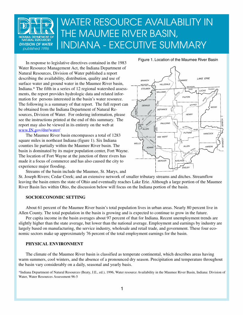
Figure 1. Location of the Maumee River BasinIn response to legislative directives contained in the 1983
Water Resource Management Act, the Indiana Department ofNatural Resources, Division of Water published a reportdescribing the availability, distribution, quality and use ofsurface water and ground water in the Maumee River basin,Indiana.* The fifth in a series of 12 regional watershed assess-ments, the report provides hydrologic data and related infor-mation for persons interested in the basin’s water resource.The following is a summary of that report. The full report canbe obtained from the Indiana Department of Natural Re-sources, Division of Water. For ordering information, pleasesee the instructions printed at the end of this summary. Thereport may also be viewed in its entirety on the web atwww.IN.gov/dnr/water/
The Maumee River basin encompasses a total of 1283square miles in northeast Indiana (figure 1). Six Indianacounties lie partially within the Maumee River basin. Thebasin is dominated by its major population center, Fort Wayne.The location of Fort Wayne at the junction of three rivers hasmade it a focus of commerce and has also caused the city toexperience major flooding.
Streams of the basin include the Maumee, St. Marys, andSt. Joseph Rivers; Cedar Creek; and an extensive network of smaller tributary streams and ditches. Streamflowleaving the basin enters the state of Ohio and eventually reaches Lake Erie. Although a large portion of the MaumeeRiver Basin lies within Ohio, the discussion below will focus on the Indiana portion of the basin.
SOCIOECONOMIC SETTING
About 61 percent of the Maumee River basin’s total population lives in urban areas. Nearly 80 percent live inAllen County. The total population in the basin is growing and is expected to continue to grow in the future.
Per capita income in the basin averages about 97 percent of that for Indiana. Recent unemployment trends areslightly higher than the state average, but lower than the national average. Employment and earnings by industry arelargely based on manufacturing, the service industry, wholesale and retail trade, and government. These four eco-nomic sectors make up approximately 76 percent of the total employment earnings for the basin.
PHYSICAL ENVIRONMENT
The climate of the Maumee River basin is classified as temperate continental, which describes areas havingwarm summers, cool winters, and the absence of a pronounced dry season. Precipitation and temperature throughoutthe basin vary considerably on a daily, seasonal and yearly basis.
*Indiana Department of Natural Resources (Beaty, J.E., ed.), 1996, Water resource Availability in the Maumee River Basin, Indiana: Division ofWater, Water Resources Assessment 96-5
WATER RESOURCE AVAILABILITY INTHE MAUMEE RIVER BASIN,INDIANA - EXECUTIVE SUMMARYDIVISION OF WATER
published 1996
2
Figure 2. Extent of major ice lobes in Indiana
Annual potential evapotranspiration in the Maumee Riverbasin accounts for approximately 26.43 inches of the 34.5 inchesof normal annual precipitation. The theoretical average annualwater surplus of more than 8 inches is considered adequate forthe basin as a whole; however, the variability of rainfall and itsuneven geographic distribution can occasionally limit crops andwater surplus.
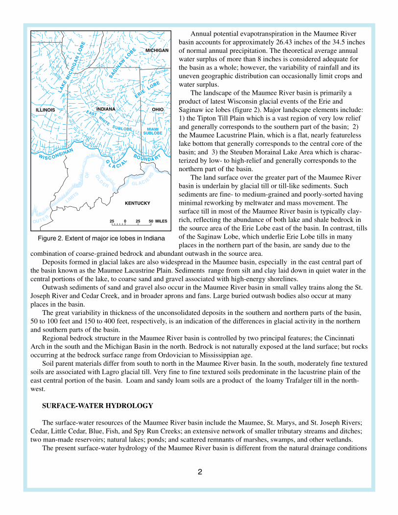
The landscape of the Maumee River basin is primarily aproduct of latest Wisconsin glacial events of the Erie andSaginaw ice lobes (figure 2). Major landscape elements include:1) the Tipton Till Plain which is a vast region of very low reliefand generally corresponds to the southern part of the basin; 2)the Maumee Lacustrine Plain, which is a flat, nearly featurelesslake bottom that generally corresponds to the central core of thebasin; and 3) the Steuben Morainal Lake Area which is charac-terized by low- to high-relief and generally corresponds to thenorthern part of the basin.
The land surface over the greater part of the Maumee Riverbasin is underlain by glacial till or till-like sediments. Suchsediments are fine- to medium-grained and poorly-sorted havingminimal reworking by meltwater and mass movement. Thesurface till in most of the Maumee River basin is typically clay-rich, reflecting the abundance of both lake and shale bedrock inthe source area of the Erie Lobe east of the basin. In contrast, tillsof the Saginaw Lobe, which underlie Erie Lobe tills in manyplaces in the northern part of the basin, are sandy due to the
combination of coarse-grained bedrock and abundant outwash in the source area.Deposits formed in glacial lakes are also widespread in the Maumee basin, especially in the east central part of
the basin known as the Maumee Lacustrine Plain. Sediments range from silt and clay laid down in quiet water in thecentral portions of the lake, to coarse sand and gravel associated with high-energy shorelines.
Outwash sediments of sand and gravel also occur in the Maumee River basin in small valley trains along the St.Joseph River and Cedar Creek, and in broader aprons and fans. Large buried outwash bodies also occur at manyplaces in the basin.
The great variability in thickness of the unconsolidated deposits in the southern and northern parts of the basin,50 to 100 feet and 150 to 400 feet, respectively, is an indication of the differences in glacial activity in the northernand southern parts of the basin.
Regional bedrock structure in the Maumee River basin is controlled by two principal features; the CincinnatiArch in the south and the Michigan Basin in the north. Bedrock is not naturally exposed at the land surface; but rocksoccurring at the bedrock surface range from Ordovician to Mississippian age.
Soil parent materials differ from south to north in the Maumee River basin. In the south, moderately fine texturedsoils are associated with Lagro glacial till. Very fine to fine textured soils predominate in the lacustrine plain of theeast central portion of the basin. Loam and sandy loam soils are a product of the loamy Trafalger till in the north-west.
SURFACE-WATER HYDROLOGY
The surface-water resources of the Maumee River basin include the Maumee, St. Marys, and St. Joseph Rivers;Cedar, Little Cedar, Blue, Fish, and Spy Run Creeks; an extensive network of smaller tributary streams and ditches;two man-made reservoirs; natural lakes; ponds; and scattered remnants of marshes, swamps, and other wetlands.
The present surface-water hydrology of the Maumee River basin is different from the natural drainage conditions
3
10,000
1000
100
10
1
10,000
1000
100
10
1
DIS
CH
AR
GE
IN C
UB
IC F
EE
T P
ER
SE
CO
ND
PERCENT OF TIME INDICATED DISCHARGEATED DISCHARGE A WAS EQWAS EQW UALED OR EXCEEDED
100,000 100,000
ST.T. T MARYS RIVER NEAR FORT WAYNE (1957-1993)AYNE (1957-1993)A
MAUMEE RIVER AT NEW HAVEN (1957-1993AVEN (1957-1993A )
0.1 1 10 50 95 99.5 99.99
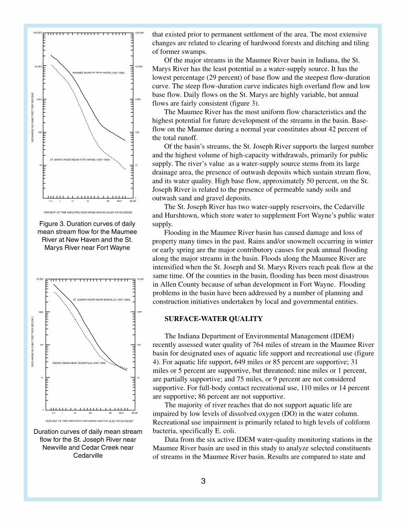
Figure 3. Duration curves of dailymean stream flow for the Maumee
River at New Haven and the St.Marys River near Fort Wayne
Duration curves of daily mean streamflow for the St. Joseph River nearNewville and Cedar Creek near
Cedarville
10,000
1000
100
10
1
10,000
1000
100
10
1
ST.T. T JOSEPH RIVER NEAR NEWVILLE (1957-1993)
CEDAR CREEK NEAR CEDARVILLERVILLE R (1957-1993)
DIS
CH
AR
GE
IN C
UB
IC F
EE
T P
ER
SE
CO
ND
PERCENT OF TIME INDICATED DISCHARGEATED DISCHARGE A WAS EQUWAS EQUW ALED OR EXCEEDED
0.1 1 10 50 95 99.5 99.99
that existed prior to permanent settlement of the area. The most extensivechanges are related to clearing of hardwood forests and ditching and tilingof former swamps.
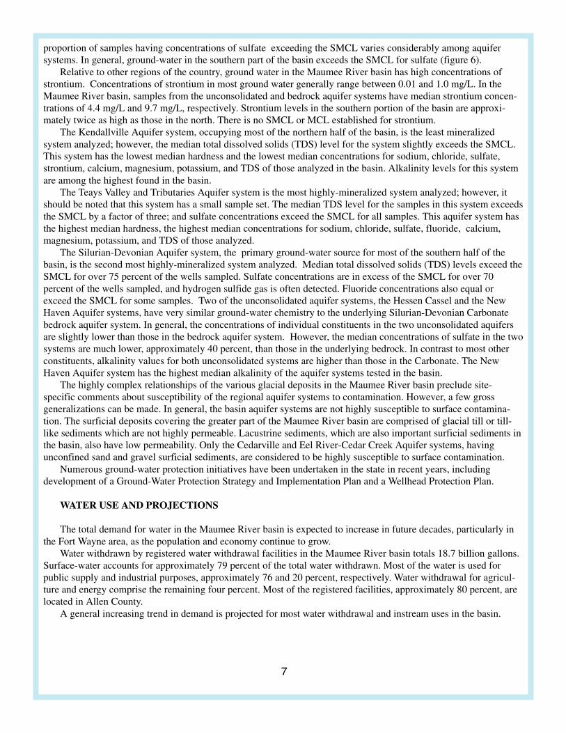
Of the major streams in the Maumee River basin in Indiana, the St.Marys River has the least potential as a water-supply source. It has thelowest percentage (29 percent) of base flow and the steepest flow-durationcurve. The steep flow-duration curve indicates high overland flow and lowbase flow. Daily flows on the St. Marys are highly variable, but annualflows are fairly consistent (figure 3).
The Maumee River has the most uniform flow characteristics and thehighest potential for future development of the streams in the basin. Base-flow on the Maumee during a normal year constitutes about 42 percent ofthe total runoff.
Of the basin’s streams, the St. Joseph River supports the largest numberand the highest volume of high-capacity withdrawals, primarily for publicsupply. The river’s value as a water-supply source stems from its largedrainage area, the presence of outwash deposits which sustain stream flow,and its water quality. High base flow, approximately 50 percent, on the St.Joseph River is related to the presence of permeable sandy soils andoutwash sand and gravel deposits.
The St. Joseph River has two water-supply reservoirs, the Cedarvilleand Hurshtown, which store water to supplement Fort Wayne’s public watersupply.
Flooding in the Maumee River basin has caused damage and loss ofproperty many times in the past. Rains and/or snowmelt occurring in winteror early spring are the major contributory causes for peak annual floodingalong the major streams in the basin. Floods along the Maumee River areintensified when the St. Joseph and St. Marys Rivers reach peak flow at thesame time. Of the counties in the basin, flooding has been most disastrousin Allen County because of urban development in Fort Wayne. Floodingproblems in the basin have been addressed by a number of planning andconstruction initiatives undertaken by local and governmental entities.
SURFACE-WATER QUALITY
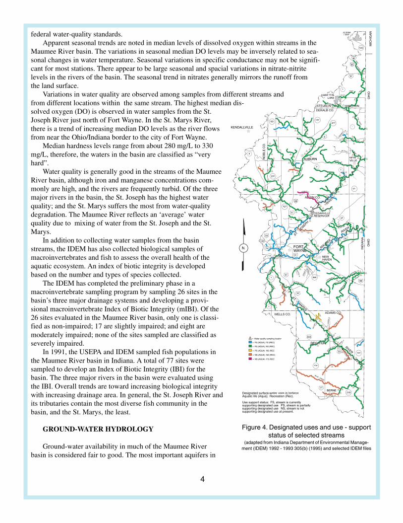
The Indiana Department of Environmental Management (IDEM)recently assessed water quality of 764 miles of stream in the Maumee Riverbasin for designated uses of aquatic life support and recreational use (figure4). For aquatic life support, 649 miles or 85 percent are supportive; 31miles or 5 percent are supportive, but threatened; nine miles or 1 percent,are partially supportive; and 75 miles, or 9 percent are not consideredsupportive. For full-body contact recreational use, 110 miles or 14 percentare supportive; 86 percent are not supportive.
The majority of river reaches that do not support aquatic life areimpaired by low levels of dissolved oxygen (DO) in the water column.Recreational use impairment is primarily related to high levels of coliformbacteria, specifically E. coli.
Data from the six active IDEM water-quality monitoring stations in theMaumee River basin are used in this study to analyze selected constituentsof streams in the Maumee River basin. Results are compared to state and
4
Designated surface-water uses in Indiana:Aquatic life (Aqua); Recreation (Rec).
Use support status: FSsupporting designated use; , stream is partiallysupporting designated use; , stream is not supporting designated use at present.
N
CLEARLAKE
HAAMILTL ONTONTLAKEL
NEW-VILLE
1
427
101
8
205
327
327127
14
101
124
218
30
24
27
27
224
33
24
6
27
90
80
20
69
1
8
33
1
30
1
37
469
24
120
n
A) FS (REC)
A) NS (REC)
A) NS (REC)
A) NS (REC)
A) FS (REC)
Figure 4. Designated uses and use - supportstatus of selected streams
(adapted from Indiana Department of Environmental Manage-ment (IDEM) 1992 - 1993 305(b) (1995) and selected IDEM files
federal water-quality standards.Apparent seasonal trends are noted in median levels of dissolved oxygen within streams in the
Maumee River basin. The variations in seasonal median DO levels may be inversely related to sea-sonal changes in water temperature. Seasonal variations in specific conductance may not be signifi-cant for most stations. There appear to be large seasonal and spacial variations in nitrate-nitritelevels in the rivers of the basin. The seasonal trend in nitrates generally mirrors the runoff fromthe land surface.
Variations in water quality are observed among samples from different streams andfrom different locations within the same stream. The highest median dis-solved oxygen (DO) is observed in water samples from the St.Joseph River just north of Fort Wayne. In the St. Marys River,there is a trend of increasing median DO levels as the river flowsfrom near the Ohio/Indiana border to the city of Fort Wayne.
Median hardness levels range from about 280 mg/L to 330mg/L, therefore, the waters in the basin are classified as “veryhard”.
Water quality is generally good in the streams of the MaumeeRiver basin, although iron and manganese concentrations com-monly are high, and the rivers are frequently turbid. Of the threemajor rivers in the basin, the St. Joseph has the highest waterquality; and the St. Marys suffers the most from water-qualitydegradation. The Maumee River reflects an ‘average’ waterquality due to mixing of water from the St. Joseph and the St.Marys.
In addition to collecting water samples from the basinstreams, the IDEM has also collected biological samples ofmacroinvertebrates and fish to assess the overall health of theaquatic ecosystem. An index of biotic integrity is developedbased on the number and types of species collected.
The IDEM has completed the preliminary phase in amacroinvertebrate sampling program by sampling 26 sites in thebasin’s three major drainage systems and developing a provi-sional macroinvertebrate Index of Biotic Integrity (mIBI). Of the26 sites evaluated in the Maumee River basin, only one is classi-fied as non-impaired; 17 are slightly impaired; and eight aremoderately impaired; none of the sites sampled are classified asseverely impaired.
In 1991, the USEPA and IDEM sampled fish populations inthe Maumee River basin in Indiana. A total of 77 sites weresampled to develop an Index of Biotic Integrity (IBI) for thebasin. The three major rivers in the basin were evaluated usingthe IBI. Overall trends are toward increasing biological integritywith increasing drainage area. In general, the St. Joseph River andits tributaries contain the most diverse fish community in thebasin, and the St. Marys, the least.
GROUND-WATER HYDROLOGY
Ground-water availability in much of the Maumee Riverbasin is considered fair to good. The most important aquifers in
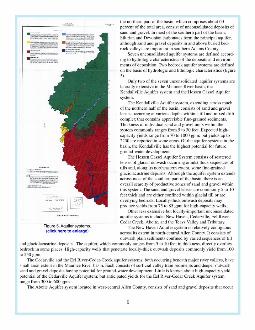
5
Figure 5. Aquifer systems.(click here to enlarge)
the northern part of the basin, which comprises about 60percent of the total area, consist of unconsolidated deposits ofsand and gravel. In most of the southern part of the basin,Silurian and Devonian carbonates form the principal aquifer,although sand and gravel deposits in and above buried bed-rock valleys are important in southern Adams County.
Seven unconsolidated aquifer systems are defined accord-ing to hydrologic characteristics of the deposits and environ-ments of deposition. Two bedrock aquifer systems are definedon the basis of hydrologic and lithologic characteristics (figure5).
Only two of the seven unconsolidated aquifer systems arelaterally extensive in the Maumee River basin; theKendallville Aquifer system and the Hessen Cassel Aquifersystem.
The Kendallville Aquifer system, extending across muchof the northern half of the basin, consists of sand and gravellenses occurring at various depths within a till and mixed driftcomplex that contains appreciable fine-grained sediments.Thickness of individual sand and gravel units within thesystem commonly ranges from 5 to 30 feet. Expected high-capacity yields range from 70 to 1000 gpm; but yields up to2250 are reported in some areas. Of the aquifer systems in thebasin, the Kendallville has the highest potential for futureground-water development.
The Hessen Cassel Aquifer System consists of scatteredlenses of glacial outwash occurring amidst thick sequences oftills and, along its northeastern extent, some fine-grainedglaciolacustrine deposits. Although the aquifer system extendsacross most of the southern part of the basin, there is anoverall scarcity of productive zones of sand and gravel withinthis system. The sand and gravel lenses are commonly 5 to 10feet thick and are either confined within glacial till or areoverlying bedrock. Locally-thick outwash deposits mayproduce yields from 75 to 85 gpm for high-capacity wells.
Other less extensive but locally-important unconsolidatedaquifer systems include: New Haven, Cedarville, Eel River-Cedar Creek, Aboite, and the Teays Valley and Tributary.
The New Haven Aquifer system is relatively contiguousacross its extent in north-central Allen County. It consists ofoutwash plain sediments confined by varied sequences of till
and glaciolacustrine deposits. The aquifer, which commonly ranges from 5 to 10 feet in thickness, directly overliesbedrock in some places. High-capacity wells that penetrate locally-thick outwash deposits commonly yield from 100to 250 gpm.
The Cedarville and the Eel River-Cedar-Creek aquifer systems, both occurring beneath major river valleys, havesmall areal extent in the Maumee River basin. Each consists of surficial valley train sediments and deeper outwashsand and gravel deposits having potential for ground-water development. Little is known about high-capacity yieldpotential of the Cedarville Aquifer system; but anticipated yields for the Eel River-Cedar Creek Aquifer systemrange from 300 to 600 gpm.
The Aboite Aquifer system located in west-central Allen County, consists of sand and gravel deposits that occur
6
Explanation
UNCONSOLIDATEDATED A BEDROCK WELLS
< 100 mg/L
101-250 mg/L
> 400 mg/L
251-400 mg/L
Bedrock water quality notmapped north of Allen
County line
N
Figure 6. Generalized areal distribution for Sulfate
at several horizons within thick, clayey till deposits. The system is comprised of two distinct parts which exhibitsomewhat different geohydrologic characteristics.
Sand and gravel deposits are more sporadic and less numerous in the northern part of the Aboite aquifer systemthan in the south. In addition, the productive deposits in the north do not have good hydraulic connection with thecarbonate bedrock aquifer beneath them; whereas in the south, many such deposits directly overlie the carbonate.Common thickness of the individual aquifers that comprise the Aboite Aquifer system ranges from about 5 feet to 20feet. Expected high-capacity yields range from 200 to 600 gpm, but yields up to 1000 gpm are reported in someareas.
The Teays Valley and Tributary Aquifer system consists of unconsolidated deposits in a buried pre-glacialbedrock in southern Adams County. In places, tills and outwash sediments above the bedrock valley exceed 385 feetin thickness. Outwash deposits of sand and gravel range from 5 to 185 feet in thickness in the main valley; and high-capacity wells may yield as much as 2100 gpm.
The Silurian-Devonian Carbonate bedrock aquifer system is the most utilized aquifer system in the southern partof the Maumee River basin. However, water-yielding capabilities of the aquifer system are not uniform throughoutits extent. It is comprised of limestone, dolomite, and dolomitic limestone and is the only bedrock aquifer in the basincapable of supporting high-capacity pumpage. Yields from high-capacity wells range from 100 to 500 gpm, buthigher yields may occur in areas where several feet of sand and gravel are present just above the bedrock surface.
GROUND-WATER QUALITY
Ground water in the Maumee Riverbasin is generally hard to very hard andneutral to slightly alkaline. Ground-waterchemistry in the northern part of the basin isdominated by calcium, magnesium, andbicarbonate; whereas, it is dominated bycalcium, magnesium, and sulfate in thesouth. In general, ground water in the northis less mineralized than in the south.
Ground water in most of the basin meetsdrinking-water standards, although ironcommonly exceeds the Secondary MaximumContaminant Level (SMCL). Other constitu-ents that commonly exceed SMCLs includemanganese and total dissolved solids (TDS).Fluoride also equals or exceeds the SMCL infour samples from the bedrock and onesample from the Hessen Cassel Aquifersystem; however, no sample exceeds theMaximum Contaminant Level (MCL) forfluoride.
Nitrate concentrations in the basin aregenerally below 1 mg/L except for threewells in Allen County and one in Adams.One of the ground-water samples from AllenCounty exceeds the MCL for nitrate.
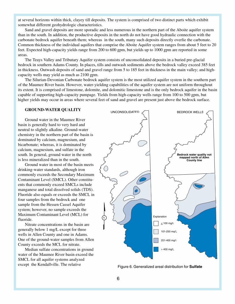
Median sulfate concentrations in groundwater of the Maumee River basin exceed theSMCL for all aquifer systems analyzedexcept the Kendallville. The relative
7
proportion of samples having concentrations of sulfate exceeding the SMCL varies considerably among aquifersystems. In general, ground-water in the southern part of the basin exceeds the SMCL for sulfate (figure 6).
Relative to other regions of the country, ground water in the Maumee River basin has high concentrations ofstrontium. Concentrations of strontium in most ground water generally range between 0.01 and 1.0 mg/L. In theMaumee River basin, samples from the unconsolidated and bedrock aquifer systems have median strontium concen-trations of 4.4 mg/L and 9.7 mg/L, respectively. Strontium levels in the southern portion of the basin are approxi-mately twice as high as those in the north. There is no SMCL or MCL established for strontium.
The Kendallville Aquifer system, occupying most of the northern half of the basin, is the least mineralizedsystem analyzed; however, the median total dissolved solids (TDS) level for the system slightly exceeds the SMCL.This system has the lowest median hardness and the lowest median concentrations for sodium, chloride, sulfate,strontium, calcium, magnesium, potassium, and TDS of those analyzed in the basin. Alkalinity levels for this systemare among the highest found in the basin.
The Teays Valley and Tributaries Aquifer system is the most highly-mineralized system analyzed; however, itshould be noted that this system has a small sample set. The median TDS level for the samples in this system exceedsthe SMCL by a factor of three; and sulfate concentrations exceed the SMCL for all samples. This aquifer system hasthe highest median hardness, the highest median concentrations for sodium, chloride, sulfate, fluoride, calcium,magnesium, potassium, and TDS of those analyzed.
The Silurian-Devonian Aquifer system, the primary ground-water source for most of the southern half of thebasin, is the second most highly-mineralized system analyzed. Median total dissolved solids (TDS) levels exceed theSMCL for over 75 percent of the wells sampled. Sulfate concentrations are in excess of the SMCL for over 70percent of the wells sampled, and hydrogen sulfide gas is often detected. Fluoride concentrations also equal orexceed the SMCL for some samples. Two of the unconsolidated aquifer systems, the Hessen Cassel and the NewHaven Aquifer systems, have very similar ground-water chemistry to the underlying Silurian-Devonian Carbonatebedrock aquifer system. In general, the concentrations of individual constituents in the two unconsolidated aquifersare slightly lower than those in the bedrock aquifer system. However, the median concentrations of sulfate in the twosystems are much lower, approximately 40 percent, than those in the underlying bedrock. In contrast to most otherconstituents, alkalinity values for both unconsolidated systems are higher than those in the Carbonate. The NewHaven Aquifer system has the highest median alkalinity of the aquifer systems tested in the basin.
The highly complex relationships of the various glacial deposits in the Maumee River basin preclude site-specific comments about susceptibility of the regional aquifer systems to contamination. However, a few grossgeneralizations can be made. In general, the basin aquifer systems are not highly susceptible to surface contamina-tion. The surficial deposits covering the greater part of the Maumee River basin are comprised of glacial till or till-like sediments which are not highly permeable. Lacustrine sediments, which are also important surficial sediments inthe basin, also have low permeability. Only the Cedarville and Eel River-Cedar Creek Aquifer systems, havingunconfined sand and gravel surficial sediments, are considered to be highly susceptible to surface contamination.
Numerous ground-water protection initiatives have been undertaken in the state in recent years, includingdevelopment of a Ground-Water Protection Strategy and Implementation Plan and a Wellhead Protection Plan.
WATER USE AND PROJECTIONS
The total demand for water in the Maumee River basin is expected to increase in future decades, particularly inthe Fort Wayne area, as the population and economy continue to grow.
Water withdrawn by registered water withdrawal facilities in the Maumee River basin totals 18.7 billion gallons.Surface-water accounts for approximately 79 percent of the total water withdrawn. Most of the water is used forpublic supply and industrial purposes, approximately 76 and 20 percent, respectively. Water withdrawal for agricul-ture and energy comprise the remaining four percent. Most of the registered facilities, approximately 80 percent, arelocated in Allen County.
A general increasing trend in demand is projected for most water withdrawal and instream uses in the basin.
8
-74
-72
-70
-68
-66
-64
-62
-60
-58
-56
Dep
th to
gro
und
wat
er le
vel (
ft)
0
10
20
30
40
50
60
Wat
er u
se (
MG
)
1988 1989 1990 1991 1992 1993 1994 1995 Year
monthly water use
ground-water level
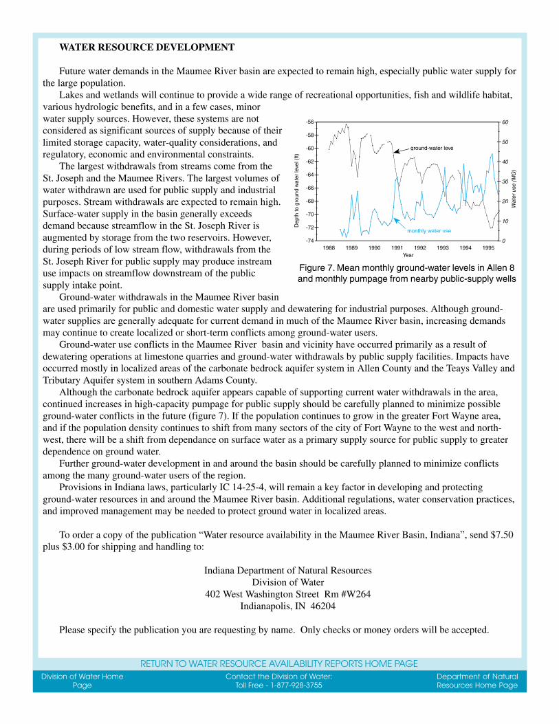
Figure 7. Mean monthly ground-water levels in Allen 8and monthly pumpage from nearby public-supply wells
WATER RESOURCE DEVELOPMENT
Future water demands in the Maumee River basin are expected to remain high, especially public water supply forthe large population.
Lakes and wetlands will continue to provide a wide range of recreational opportunities, fish and wildlife habitat,various hydrologic benefits, and in a few cases, minorwater supply sources. However, these systems are notconsidered as significant sources of supply because of theirlimited storage capacity, water-quality considerations, andregulatory, economic and environmental constraints.
The largest withdrawals from streams come from theSt. Joseph and the Maumee Rivers. The largest volumes ofwater withdrawn are used for public supply and industrialpurposes. Stream withdrawals are expected to remain high.Surface-water supply in the basin generally exceedsdemand because streamflow in the St. Joseph River isaugmented by storage from the two reservoirs. However,during periods of low stream flow, withdrawals from theSt. Joseph River for public supply may produce instreamuse impacts on streamflow downstream of the publicsupply intake point.
Ground-water withdrawals in the Maumee River basinare used primarily for public and domestic water supply and dewatering for industrial purposes. Although ground-water supplies are generally adequate for current demand in much of the Maumee River basin, increasing demandsmay continue to create localized or short-term conflicts among ground-water users.
Ground-water use conflicts in the Maumee River basin and vicinity have occurred primarily as a result ofdewatering operations at limestone quarries and ground-water withdrawals by public supply facilities. Impacts haveoccurred mostly in localized areas of the carbonate bedrock aquifer system in Allen County and the Teays Valley andTributary Aquifer system in southern Adams County.
Although the carbonate bedrock aquifer appears capable of supporting current water withdrawals in the area,continued increases in high-capacity pumpage for public supply should be carefully planned to minimize possibleground-water conflicts in the future (figure 7). If the population continues to grow in the greater Fort Wayne area,and if the population density continues to shift from many sectors of the city of Fort Wayne to the west and north-west, there will be a shift from dependance on surface water as a primary supply source for public supply to greaterdependence on ground water.
Further ground-water development in and around the basin should be carefully planned to minimize conflictsamong the many ground-water users of the region.
Provisions in Indiana laws, particularly IC 14-25-4, will remain a key factor in developing and protectingground-water resources in and around the Maumee River basin. Additional regulations, water conservation practices,and improved management may be needed to protect ground water in localized areas.
To order a copy of the publication “Water resource availability in the Maumee River Basin, Indiana”, send $7.50plus $3.00 for shipping and handling to:
Indiana Department of Natural ResourcesDivision of Water
402 West Washington Street Rm #W264Indianapolis, IN 46204
Please specify the publication you are requesting by name. Only checks or money orders will be accepted.
Division of Water HomePage
Contact the Division of Water:Toll Free - 1-877-928-3755
Department of NaturalResources Home Page
RETURN TO WATER RESOURCE AVAILABILITY REPORTS HOME PAGE