Embed Size (px)
Citation preview
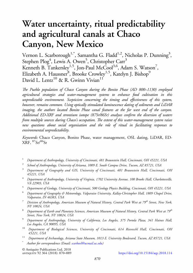
Water uncertainty, ritual predictabilityand agricultural canals at ChacoCanyon, New MexicoVernon L. Scarborough1,*, Samantha G. Fladd1,2, Nicholas P. Dunning3,Stephen Plog4, Lewis A. Owen5, Christopher Carr3
Kenneth B. Tankersley1,5, Jon-Paul McCool3,6, Adam S. Watson7,Elizabeth A. Haussner8, Brooke Crowley1,5, Katelyn J. Bishop9
David L. Lentz10 & R. Gwinn Vivian11
The Pueblo population of Chaco Canyon during the Bonito Phase (AD 800–1130) employedagricultural strategies and water-management systems to enhance food cultivation in thisunpredictable environment. Scepticism concerning the timing and effectiveness of this system,however, remains common. Using optically stimulated luminescence dating of sediments and LiDARimaging, the authors located Bonito Phase canal features at the far west end of the canyon.Additional ED-XRF and strontium isotope (87Sr/86Sr) analyses confirm the diversion of watersfrom multiple sources during Chaco’s occupation. The extent of this water-management system raisesnew questions about social organisation and the role of ritual in facilitating responses toenvironmental unpredictability.
Keywords: Chaco Canyon, Bonito Phase, water management, OSL dating, LiDAR, ED-XRF, 87Sr/86Sr
1 Department of Anthropology, University of Cincinnati, 481 Braunstein Hall, Cincinnati, OH 45221, USA2 School of Anthropology, University of Arizona, 1009 E. South Campus Drive, Tucson, AZ 85721, USA3 Department of Geography and GIS, University of Cincinnati, 401 Braunstein Hall, Cincinnati, OH
45221, USA4 Department of Anthropology, University of Virginia, 1702 University Avenue, 100 Brooks Hall, Charlottesville,
VA 22903, USA5 Department of Geology, University of Cincinnati, 500 Geology Physics Building, Cincinnati, OH 45221, USA6 Department of Geography & Meteorology, Valparaiso University, Kallay-Christopher Hall, 1809 Chapel Drive,
Valparaiso, IN 46383, USA7 Division of Anthropology, American Museum of Natural History, Central Park West at 79th Street, New York,
NY 10024, USA8 Department of Earth and Planetary Sciences, American Museum of Natural History, Central Park West at 79th
Street, New York, NY 10024, USA9 Department of Anthropology, University of California, Los Angeles, 375 Portola Plaza, 341 Haines Hall,
Los Angeles, CA 90095, USA10 Department of Biological Sciences, University of Cincinnati, 614 Rieveschl Hall, Cincinnati, OH
45221, USA11 Department of Archaeology, Arizona State Museum, 1013 E. University Boulevard, Tucson, AZ 85721, USA* Author for correspondence (Email: [email protected])
© Antiquity Publications Ltd, 2018antiquity 92 364 (2018): 870–889 https://doi.org/10.15184/aqy.2018.114
870
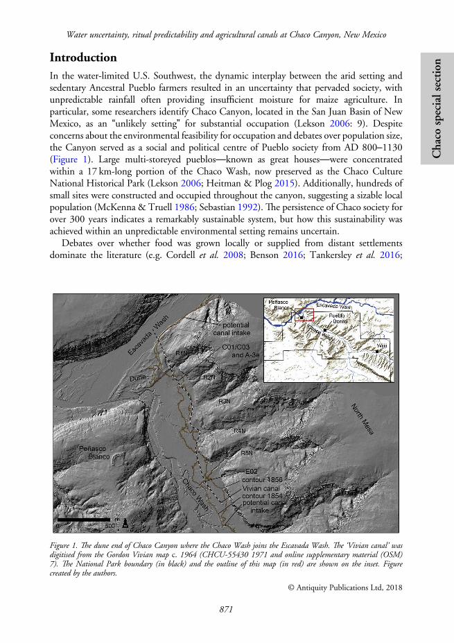
IntroductionIn the water-limited U.S. Southwest, the dynamic interplay between the arid setting andsedentary Ancestral Pueblo farmers resulted in an uncertainty that pervaded society, withunpredictable rainfall often providing insufficient moisture for maize agriculture. Inparticular, some researchers identify Chaco Canyon, located in the San Juan Basin of NewMexico, as an “unlikely setting” for substantial occupation (Lekson 2006: 9). Despiteconcerns about the environmental feasibility for occupation and debates over population size,the Canyon served as a social and political centre of Pueblo society from AD 800–1130(Figure 1). Large multi-storeyed pueblos—known as great houses—were concentratedwithin a 17 km-long portion of the Chaco Wash, now preserved as the Chaco CultureNational Historical Park (Lekson 2006; Heitman & Plog 2015). Additionally, hundreds ofsmall sites were constructed and occupied throughout the canyon, suggesting a sizable localpopulation (McKenna & Truell 1986; Sebastian 1992). The persistence of Chaco society forover 300 years indicates a remarkably sustainable system, but how this sustainability wasachieved within an unpredictable environmental setting remains uncertain.
Debates over whether food was grown locally or supplied from distant settlementsdominate the literature (e.g. Cordell et al. 2008; Benson 2016; Tankersley et al. 2016;
Figure 1. The dune end of Chaco Canyon where the Chaco Wash joins the Escavada Wash. The ‘Vivian canal’ wasdigitised from the Gordon Vivian map c. 1964 (CHCU-55430 1971 and online supplementary material (OSM)7). The National Park boundary (in black) and the outline of this map (in red) are shown on the inset. Figurecreated by the authors.
Water uncertainty, ritual predictability and agricultural canals at Chaco Canyon, New Mexico
© Antiquity Publications Ltd, 2018
871
Chaco
specialsection
McCool et al. 2018). Arguments for the importation of maize, the staple crop, centre on twolimiting factors: soil quality and water scarcity. Here, we examine the issue of wateravailability. Given the scarcity and unreliability of rainfall, technological advancements inwater management were necessary for successful local agricultural production (Scarborough2003). While the presence of complex canal systems has long been noted (e.g. Vivian 1990),the difficulty in dating these constructions has led to doubts over their existence and utility(e.g. Benson 2016; Wills 2017). Our recent fieldwork on one canal network definitivelydates it to Chaco’s Bonito Phase occupation (AD 800–1130), using optically stimulatedluminescence (OSL) dating supplemented with AMS radiocarbon dates (onlinesupplementary material (OSM) 1). We address the implications of this canal system(as well as others studied by R.G. Vivian) for the complexity of Chaco Canyon occupation, aswater-flow coordination required flexible and quick responses from the local population.Pueblo social and political organisation, both past and present, is heavily integrated withritual practices that help structure responses to the uncertain environment, includingorganising the labour necessary to maintain water-management infrastructure.
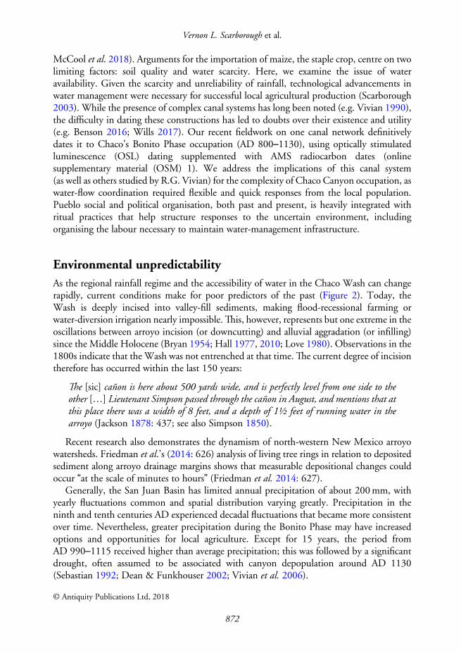
Environmental unpredictabilityAs the regional rainfall regime and the accessibility of water in the Chaco Wash can changerapidly, current conditions make for poor predictors of the past (Figure 2). Today, theWash is deeply incised into valley-fill sediments, making flood-recessional farming orwater-diversion irrigation nearly impossible. This, however, represents but one extreme in theoscillations between arroyo incision (or downcutting) and alluvial aggradation (or infilling)since the Middle Holocene (Bryan 1954; Hall 1977, 2010; Love 1980). Observations in the1800s indicate that the Wash was not entrenched at that time. The current degree of incisiontherefore has occurred within the last 150 years:
The [sic] cañon is here about 500 yards wide, and is perfectly level from one side to theother […] Lieutenant Simpson passed through the cañon in August, and mentions that atthis place there was a width of 8 feet, and a depth of 1½ feet of running water in thearroyo (Jackson 1878: 437; see also Simpson 1850).
Recent research also demonstrates the dynamism of north-western New Mexico arroyowatersheds. Friedman et al.’s (2014: 626) analysis of living tree rings in relation to depositedsediment along arroyo drainage margins shows that measurable depositional changes couldoccur “at the scale of minutes to hours” (Friedman et al. 2014: 627).
Generally, the San Juan Basin has limited annual precipitation of about 200mm, withyearly fluctuations common and spatial distribution varying greatly. Precipitation in theninth and tenth centuries AD experienced decadal fluctuations that became more consistentover time. Nevertheless, greater precipitation during the Bonito Phase may have increasedoptions and opportunities for local agriculture. Except for 15 years, the period fromAD 990–1115 received higher than average precipitation; this was followed by a significantdrought, often assumed to be associated with canyon depopulation around AD 1130(Sebastian 1992; Dean & Funkhouser 2002; Vivian et al. 2006).
Vernon L. Scarborough et al.
© Antiquity Publications Ltd, 2018
872
Agricultural strategiesPotential agricultural productivity within Chaco Canyon remains a debated topic(e.g. Vivian 1974, 1990; Sebastian 1992; Dorshow 2012; Benson 2016; Wills 2017).Questions about agricultural feasibility are linked, in part, with the salinity of the floodplainsoils. A thorough review of arguments concerning salinity can be found in other papers
Figure 2. Two views of the ‘horseshoe-bend’ of the Chaco Wash showing about a 1.5m water rise. Although thephotographs were taken 11 days apart, the water rise occurred overnight. Photographs and figure created by theauthors.
Water uncertainty, ritual predictability and agricultural canals at Chaco Canyon, New Mexico
© Antiquity Publications Ltd, 2018
873
Chaco
specialsection
(e.g. Wills & Dorshow 2012; Benson 2016), but our research contends that modern salinitylevels are low enough to permit farming and, given their susceptibility to spatial and temporalfluctuations, ultimately provide a poor measure of past agricultural potential (Tankersleyet al. 2016; McCool et al. 2018). The recent revival of interest in Chaco agriculture, however,has highlighted the utilisation of a variety of past water-management systems that either havebeen documented archaeologically or were practised historically by Navajo farmers. Theseinclude floodplain, slope wash and ak chin (floodwater) farming (Vivian & Watson 2015:35–54). Archaeological features include terraces, check dams and canals (Vivian 1990; Wills& Dorshow 2012; Vivian & Watson 2015: 36–42).
On the floodplain, Vivian’s (1974, 1990) excavations revealed multiple elaborate canalsystems, largely concentrated on the north side of the canyon. These systems involveddiversion gates of masonry, canals and fields—including a gridded field system first identifiedby Gordon Vivian, and located near the Chetro Ketl great house (Vivian & Mathews 1965:12). Sturm (2016) has found multiple overlaid field configurations in the area using ground-penetrating radar, while Wills et al. (2016) have identified a large channel that divertedfloodwaters away from Pueblo Bonito, the central great house. Despite documentation ofcanal systems, the timing and effectiveness of these constructions for agriculture is oftenquestioned—due in part to the lack of direct dating (e.g. Benson 2016;Wills 2017). We useda multi-faceted approach to address these concerns and to advance our understanding of thevaried agricultural systems that supported the local population during the Bonito Phase.
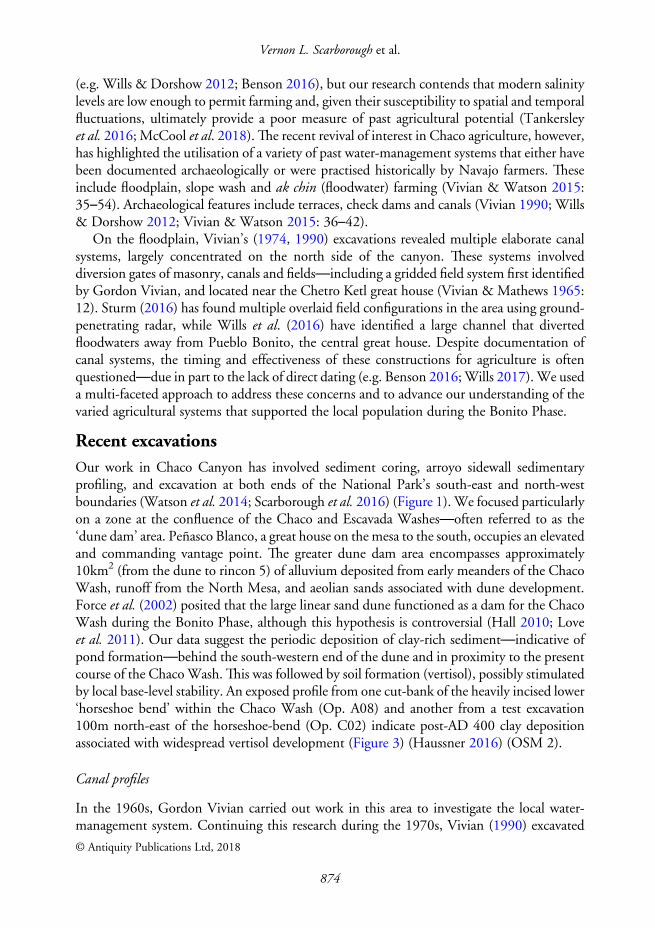
Recent excavationsOur work in Chaco Canyon has involved sediment coring, arroyo sidewall sedimentaryprofiling, and excavation at both ends of the National Park’s south-east and north-westboundaries (Watson et al. 2014; Scarborough et al. 2016) (Figure 1). We focused particularlyon a zone at the confluence of the Chaco and Escavada Washes—often referred to as the‘dune dam’ area. Peñasco Blanco, a great house on the mesa to the south, occupies an elevatedand commanding vantage point. The greater dune dam area encompasses approximately10km2 (from the dune to rincon 5) of alluvium deposited from early meanders of the ChacoWash, runoff from the North Mesa, and aeolian sands associated with dune development.Force et al. (2002) posited that the large linear sand dune functioned as a dam for the ChacoWash during the Bonito Phase, although this hypothesis is controversial (Hall 2010; Loveet al. 2011). Our data suggest the periodic deposition of clay-rich sediment—indicative ofpond formation—behind the south-western end of the dune and in proximity to the presentcourse of the ChacoWash. This was followed by soil formation (vertisol), possibly stimulatedby local base-level stability. An exposed profile from one cut-bank of the heavily incised lower‘horseshoe bend’ within the Chaco Wash (Op. A08) and another from a test excavation100m north-east of the horseshoe-bend (Op. C02) indicate post-AD 400 clay depositionassociated with widespread vertisol development (Figure 3) (Haussner 2016) (OSM 2).
Canal profiles
In the 1960s, Gordon Vivian carried out work in this area to investigate the local water-management system. Continuing this research during the 1970s, Vivian (1990) excavated
Vernon L. Scarborough et al.
© Antiquity Publications Ltd, 2018
874
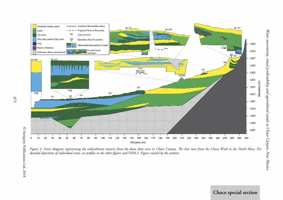
Figure 3. Fence diagram representing the soil/sediment textures from the dune dam area in Chaco Canyon. The line runs from the Chaco Wash to the North Mesa. Fordetailed depictions of individual units, see profiles in the other figures and OSM 2. Figure created by the authors.
Water
uncertainty,ritualpredictabilityand
agriculturalcanalsatChaco
Canyon,N
ewMexico
©Antiquity
PublicationsLtd,2018
875
Chaco special section
several canal profiles running between the Chaco Wash and the North Mesa. The mostrevealing profile (Op. C01/C03) from our recent work consists of two 2 × 1m excavationunits that re-exposed a set of canals originally revealed in Vivian’s A-3e profile (1971)(Figure 4). Vivian’s long trench also exposed a smaller channel immediately to the south(Figure 5). The lowest unit (K) identified in Op. C01 comprises sterile sands and silts—probably a former floodplain surface. Unit K, underlying the smaller channel visible inVivian’s profile, produced an OSL age of AD 900±100 (OSM 3).
The smaller channel is a natural shallow extension of a rincon drainage (an incised,erratically flowing seasonal channel pouring off the flanks of an exposed bedrock mesa)extending onto the floodplain that was culturally modified by berm construction, or an earlyopportunistically constructed canal. Unit J is the first fluvial deposition layer encountered inOp. C01 within a second larger, more recently constructed canal. The creation of this canalsuggests increasing water demands tied to agricultural intensification. In Vivian’s excavation(1971), the southern margin of the initial phase of the larger canal was revealed as a 0.5–6m-high sandy berm with a clay cap. This same berm forms the northern margins of the adjacentsmaller channel; the two canals may have been briefly contemporaneous. Most of the largerchannel, however, formed after the abandonment of the smaller channel. Gravel and sanddeposits within the smaller channel indicate that it experienced a period of high-energy flowprior to abandonment. Post-abandonment, the smaller channel infilled further, and thesouthern berm of the larger northern canal was elevated.
Unit I in the large canal consists of stratified fluvial sands deposited during a period ofmoderately swift water movement. This was followed by a prolonged period of well-controlledwater flow during which stratified clay and clay loam fluvial sediments were laid down (unitsG-1 & G-2). The overlying unit F comprised cross-bedded silts and sands resulting from aeoliandeposition—a period during which the canal was not in use. The final aeolian deposit was adistinct brittle silt cap (unit E), which was absent at the southern extreme of Op. C01, wherelater scouring probably removed it along with a small portion of unit F. The scouring marked therenewal of water flow, which then resulted in the successive deposition of stratified silty fine sandof unit D. Unit D produced an OSL age of AD 900±100 (OSM 3).
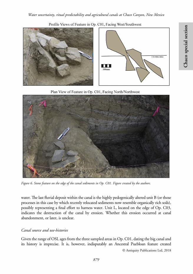
Subsequently, the canal was modified by the construction of a series of successive berms(units C-3 & C-4). These berms significantly narrowed the width of the canal as the elevationof the floor continued to rise via aggradation—chiefly from the clay loam sediments of unitsC-1 and C-2 that indicate slower water flow. Vertically positioned flagstone slabs to divertwater were also encountered at this level. These probably served to spread irrigation waters(Figure 6). Unit C-4 produced an OSL age of AD 1000±100 and an AMS radiocarbon age of985±20 BP (UCIAMS-167243: AD 997–1150 at 95.4%; date modelled in CALIB v.7.10,using the CALIB radiocarbon calibration curve) (Stuiver et al. 2017) (OSM 3–4).The narrowing of the canal and return to clay-rich sediments (units C-1 & C-2) probablyindicates efforts to maintain flow as water availability dropped.
The use-history of the canal becomes increasingly hard to discern in the uppermost parts ofOps. C01/C03 due to later erosion and soil-formation processes, including bioturbation (e.g.rodent burrows, ant nests and plant roots). Thin lenses of clay loam fluvial sediment (theuppermost examples of C-1 and C-2) were embedded within a narrowing channel formed of siltand sand (unit C-3). The increased narrowing further suggests greater difficulty in harnessing
Vernon L. Scarborough et al.
© Antiquity Publications Ltd, 2018
876
Figure 4. Profile of Ops. C01/C03 showing stratigraphy, sediment sourcing (uncoloured layers sourced to the Chaco Wash/rincons), and the locations of OSL/AMS ages. Thenumbers next to the OSL ages refer to Chaco 2015-XX in OSM 3. The numbers next to the AMS ages refer to DD-XX in OSM 4. Figure created by the authors.
Water
uncertainty,ritualpredictabilityand
agriculturalcanalsatChaco
Canyon,N
ewMexico
©Antiquity
PublicationsLtd,2018
877
Chaco special section
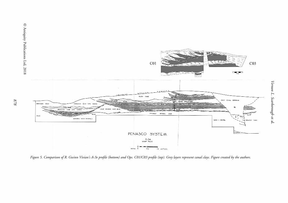
Figure 5. Comparison of R. Gwinn Vivian’s A-3e profile (bottom) and Ops. C01/C03 profile (top). Grey layers represent canal clays. Figure created by the authors.
Vernon
L.Scarboroughetal.
©Antiquity
PublicationsLtd,2018
878
water. The last fluvial deposit within the canal is the highly pedogenically altered unit B (or thoseprocesses in this case by which recently relocated sediments now resemble organically rich soils),possibly representing a final effort to harness water. Unit L, located on the edge of Op. C03,indicates the destruction of the canal by erosion. Whether this erosion occurred at canalabandonment, or later, is unclear.
Canal source and use-histories
Given the range of OSL ages from the three sampled areas in Op. C01, dating the big canal andits history is imprecise. It is, however, indisputably an Ancestral Puebloan feature created
Figure 6. Stone feature on the edge of the canal sediments in Op. C01. Figure created by the authors.
Water uncertainty, ritual predictability and agricultural canals at Chaco Canyon, New Mexico
© Antiquity Publications Ltd, 2018
879
Chaco
specialsection
sometime after AD 800, and was in use possibly as late as the early twelfth century. The similarityof the three OSL samples and their overlapping age ranges suggest that the system evolved fairlyquickly, perhaps in as little as a century. The young AMS ages from Ops. C01/C03 (Figures 4 &6) are disputable given the significant bioturbation in the upper units of the profile. The oldradiocarbon AMS age was derived from charcoal probably introduced by water flow through thechannel. To assess whether water sources can be distinguished, modern alluvium and waterscollected from the ChacoWash, North Mesa rincons and the EscavadaWash were analysed withenergy-dispersive X-ray fluorescence spectrometry (ED-XRF), and strontium isotopes (87Sr/86Sr)were measured. ED-XRF revealed two distinct signatures: the Escavada Wash and ChacoCanyon, the latter comprising the samples collected from the Chaco Wash and the North Mesarincons. Comparing these signatures to sediment samples collected fromOps. C01/C03 indicatesthat the majority of the layers derive from the Chaco Wash or the adjacent rincons; three layers,however, source to the Escavada Wash, suggesting that the canals tapped multiple water sourcesover time (OSM5). Unit C-2, which is closely interbeddedwith unit C-1, sources to the EscavadaWash, and represents a period during which multiple sources were tapped, probably in quicksuccession. These deposits were deliberately embanked by relocating mixed matrices from withinthe canal or the nearby Escavada Wash (unit C-4). Unit B—the final fluvial deposit within thecanal—also sources to the Escavada Wash, perhaps denoting a last attempt to harness this moredependable water source. Vivian (CHCU 55430 1971) suggested that the Escavada Wash waspartially diverted up-canyon in this dune zone (Figure 1). Our ground-truth and LiDARassessments indicate that such a diversion was possible, although the present linear dune blowingoff themost westernmargins of theNorthMesa and down the EscavadaWash obscures any directevidence for such a diversion.
Strontium isotope data also corroborate multiple diversion strategies. Waters collected fromthe Chaco and Escavada Washes just above their confluence are isotopically distinct, with twonearby sampled rincons having intermediate ratios (OSM 6). A similar isotopic range is observedin core sediments that were collected from the edge of the bend in the ChacoWash. At a depth of2.09–2.19m, sediments isotopically resemble the Chaco Wash. At depths of 0.9–1m and 0.4–0.5m, however, sediments have higher ratios, suggesting an influx of material from the EscavadaWash and possibly the rincons—a similar stratigraphic sourcing history to the well-defined canaldeposition discussed above. Future isotopic analyses of canal sediments may further disentanglephases of water diversion and sediment deposition.
Other canals
Waters from both the ChacoWash and the NorthMesa rincons were probably channelled bythe Ops. C01/C03 canals. Today, water intake from the ChacoWash appears unfeasible, butits current incised course—about 7m below and 150m to the south-west of Ops. C01/C03—probably differs from that in the past, given the dynamic environmental setting. A LiDAR-derived hillshade image of the dune dam area indicates several probable canal paths traversingthe local landscape (Figure 7). The LiDAR-derived contour lines at 1856 and 1854mdemonstrate the hydrological plausibility of canals feeding from either the Escavada or ChacoWashes (Figure 1). These paths follow gentle gradients of about 1 per cent; the precisegradient of any canal, however, is difficult to determine due to the disruptive effects of
Vernon L. Scarborough et al.
© Antiquity Publications Ltd, 2018
880
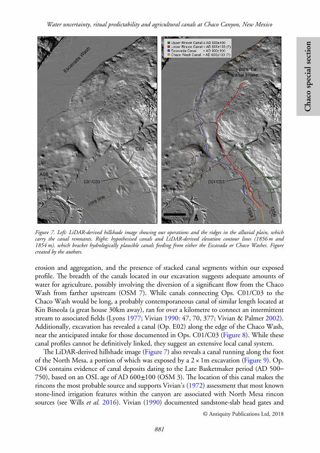
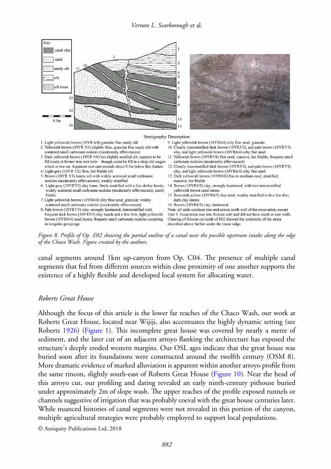
erosion and aggregation, and the presence of stacked canal segments within our exposedprofile. The breadth of the canals located in our excavation suggests adequate amounts ofwater for agriculture, possibly involving the diversion of a significant flow from the ChacoWash from farther upstream (OSM 7). While canals connecting Ops. C01/C03 to theChaco Wash would be long, a probably contemporaneous canal of similar length located atKin Bineola (a great house 30km away), ran for over a kilometre to connect an intermittentstream to associated fields (Lyons 1977; Vivian 1990: 47, 70, 377; Vivian & Palmer 2002).Additionally, excavation has revealed a canal (Op. E02) along the edge of the Chaco Wash,near the anticipated intake for those documented in Ops. C01/C03 (Figure 8). While thesecanal profiles cannot be definitively linked, they suggest an extensive local canal system.
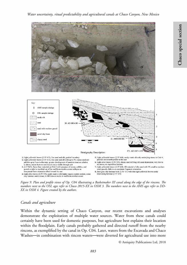
The LiDAR-derived hillshade image (Figure 7) also reveals a canal running along the footof the North Mesa, a portion of which was exposed by a 2 × 1m excavation (Figure 9). Op.C04 contains evidence of canal deposits dating to the Late Basketmaker period (AD 500–750), based on an OSL age of AD 600±100 (OSM 3). The location of this canal makes therincons the most probable source and supports Vivian’s (1972) assessment that most knownstone-lined irrigation features within the canyon are associated with North Mesa rinconsources (see Wills et al. 2016). Vivian (1990) documented sandstone-slab head gates and
Figure 7. Left: LiDAR-derived hillshade image showing our operations and the ridges in the alluvial plain, whichcarry the canal remnants. Right: hypothesised canals and LiDAR-derived elevation contour lines (1856m and1854m), which bracket hydrologically plausible canals feeding from either the Escavada or Chaco Washes. Figurecreated by the authors.
Water uncertainty, ritual predictability and agricultural canals at Chaco Canyon, New Mexico
© Antiquity Publications Ltd, 2018
881
Chaco
specialsection
canal segments around 1km up-canyon from Op. C04. The presence of multiple canalsegments that fed from different sources within close proximity of one another supports theexistence of a highly flexible and developed local system for allocating water.
Roberts Great House
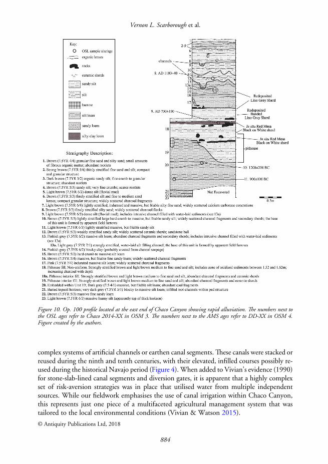
Although the focus of this article is the lower far reaches of the Chaco Wash, our work atRoberts Great House, located near Wijiji, also accentuates the highly dynamic setting (seeRoberts 1926) (Figure 1). This incomplete great house was covered by nearly a metre ofsediment, and the later cut of an adjacent arroyo flanking the architecture has exposed thestructure’s deeply eroded western margins. Our OSL ages indicate that the great house wasburied soon after its foundations were constructed around the twelfth century (OSM 8).More dramatic evidence of marked alluviation is apparent within another arroyo profile fromthe same rincon, slightly south-east of Roberts Great House (Figure 10). Near the head ofthis arroyo cut, our profiling and dating revealed an early ninth-century pithouse buriedunder approximately 2m of slope wash. The upper reaches of the profile exposed runnels orchannels suggestive of irrigation that was probably coeval with the great house centuries later.While nuanced histories of canal segments were not revealed in this portion of the canyon,multiple agricultural strategies were probably employed to support local populations.
Figure 8. Profile of Op. E02 showing the partial outline of a canal near the possible upstream intake along the edgeof the Chaco Wash. Figure created by the authors.
Vernon L. Scarborough et al.
© Antiquity Publications Ltd, 2018
882
Canals and agriculture
Within the dynamic setting of Chaco Canyon, our recent excavations and analysesdemonstrate the exploitation of multiple water sources. Water from these canals couldcertainly have been used for domestic purposes, but agriculture best explains their locationwithin the floodplain. Early canals probably gathered and directed runoff from the nearbyrincons, as exemplified by the canal in Op. C04. Later, waters from the Escavada and ChacoWashes—in combination with rincon waters—were diverted for agricultural use into more
Figure 9. Plan and profile views of Op. C04 illustrating a Basketmaker III canal along the edge of the rincons. Thenumbers next to the OSL ages refer to Chaco 2015-XX in OSM 3. The numbers next to the AMS ages refer to DD-XX in OSM 4. Figure created by the authors.
Water uncertainty, ritual predictability and agricultural canals at Chaco Canyon, New Mexico
© Antiquity Publications Ltd, 2018
883
Chaco
specialsection
complex systems of artificial channels or earthen canal segments. These canals were stacked orreused during the ninth and tenth centuries, with their elevated, infilled courses possibly re-used during the historical Navajo period (Figure 4). When added to Vivian’s evidence (1990)for stone-slab-lined canal segments and diversion gates, it is apparent that a highly complexset of risk-aversion strategies was in place that utilised water from multiple independentsources. While our fieldwork emphasises the use of canal irrigation within Chaco Canyon,this represents just one piece of a multifaceted agricultural management system that wastailored to the local environmental conditions (Vivian & Watson 2015).
Figure 10. Op. 100 profile located at the east end of Chaco Canyon showing rapid alluviation. The numbers next tothe OSL ages refer to Chaco 2014-XX in OSM 3. The numbers next to the AMS ages refer to DD-XX in OSM 4.Figure created by the authors.
Vernon L. Scarborough et al.
© Antiquity Publications Ltd, 2018
884
Discussion and conclusionsEvidence from our fieldwork confirms the long-suspected operation of canal irrigation inportions of Chaco Canyon between AD 800 and 1130. Quick social responses to thedynamic setting were necessary to harness multiple water sources through the canal systembelow Peñasco Blanco—probably drawing upon labour provided by occupants of the greathouses and the numerous small sites throughout the canyon. To combat environmentalunpredictability and coordinate the construction and maintenance of the hydrologicalinfrastructure, social responses must have been structured through leaders, whose actionsreduced risk and uncertainty.
Most explanations for the management of food production within Chaco concentrate on theoccupants of the great houses, as these sites were located close to desirable agricultural settings(e.g. Dorshow 2012; Wills & Dorshow 2012; cf. Fendon 1959). North American ethnographicresearch suggests that the societal emphasis on horticulture—often involving substantial femalelabour investment—correlates with matrilineality and matrilocal residence (Driver & Massey1957: 432).Ware (2014) also suggests that ethnographic explanations for bothmatrilineality andmatrilocality revolve around a localised agricultural base controlled by women (cf. Steward1955). Supporting the potential link between agricultural production and matrilineality, a recentarchaeogenomic study of a rich burial cluster from within Pueblo Bonito identified a matrilinealconnection among the burials. These date from the founding of the great house and continuethroughout much of its occupation (Plog & Heitman 2010; Kennett et al. 2017). The existenceof prominent matrilineal groups who could oversee, if not direct, the farming efforts may explainthe successful adaptation of the canal system to highly uncertain environmental conditions. Thisassociation persists in the U.S. Southwest today, as ties between Pueblo ritual leaders and watermanagement are recorded ethnographically (e.g. Parsons 1939; Ortiz 1969: 106).
Additional support for the linkage between ritual leadership, matrilineality and water-management systems tied to agricultural resources can be found in the material assemblageswithin or near the Pueblo Bonito burial cluster. In addition to a range of non-local materialssuggesting long-distance ties and ritual authority (Neitzel 2003; Crown&Hurst 2009;Watsonet al. 2015), many of the materials are ethnographically documented symbols of moisture andfertility throughout the Southwest, such as turquoise and frog/tadpole effigies (Plog 2003,2011). These symbols suggest that links to water and agricultural success were important aspectsof ritual practice tied to the elite occupants of great houses. Ritual is intimately intertwined witheconomics and politics in the Pueblo Southwest (e.g. Fowles 2013), and potentially marked orlegitimised the matriline’s authority in water-management decisions. Ritual practice, economicaccess and political authority tied to moisture and fertility almost certainly allowed for thedeployment and management of a labour force that responded quickly to environmentalchange. The centralisation of leadership may, in part, have sustained the Chaco social system byestablishing certainty in the face of unpredictable environmental factors.
Many forces surely triggered the cascading social developments within Chaco Canyon(Watson et al. 2015; Kennett et al. 2017). The dynamic interplay of rapid sedimentation,reciprocal erosional processes and the necessity of monitoring and containing soils forcropping must have markedly influenced how labour deployed. The social context for thisdynamism necessitated attempts to reduce risk in order to produce an adequate food supply.
Water uncertainty, ritual predictability and agricultural canals at Chaco Canyon, New Mexico
© Antiquity Publications Ltd, 2018
885
Chaco
specialsection
Due to the erratic rainfall patterns, diverse strategies were employed to increase thepredictability of water availability for farming. Our data suggest that rincon runoff sourceswere initially diverted, while more formal distributary canalisation sourced from both nearbywashes developed later as Puebloan infrastructure advanced. Nevertheless, uncertainty wasalways a concern. The development of social controls to monitor diverse water sources anddeploy labour in order to maintain established water-management systems was necessary toensure quick responses to the dynamic local environmental conditions—responses that werefundamental to the success of Chaco society.
Acknowledgements
Funding from the University of Cincinnati Research Council, the Charles Phelps Taft Foundation, and theDeans of the College and Graduate School of Arts and Sciences at the University of Virginia and the University ofCincinnati supported this study. We are especially grateful to the National Park Service, Chaco Culture NationalHistorical Park, the New Mexico Office of Archaeological Studies, the Navajo Nation and members of theAmerican Indian Advisory Council to the National Park Service. This work was accomplished under U.S.department of the interior permit 15-CHCU-01. We are equally grateful to Gideon Bartov and Tom Johnson(UIUC) for assisting with the Sr isotope analysis. We also owe special thanks to Warren Huff, Venicia Slotten,Jessica Thress, Josh Miller and Douglas Dvoracek for their assistance and insights. Our team appreciates thecareful assessment from the editors at Antiquity and the external reviewers, and extends special thanks to BarbaraMills for her invitation to submit to this recent research on Chaco Canyon in this special section.
Supplementary materialTo view supplementary material for this article, please visit https://doi.org/10.15184/aqy.2018.114
References
Benson, L.V. 2016. The Chuska Slope as anagricultural alternative to Chaco Canyon. Journalof Archaeological Research 16: 456–71.https://doi.org/10.1016/j.jasrep.2016.10.017
Bryan, K. 1954. The geology of Chaco Canyon, NewMexico in relation to the life and remains of theprehistoric peoples of Pueblo Bonito (SmithsonianMiscellaneous Collections 122). Washington, D.C. Smithsonian Institution.
CHCU 55430. 1971. Escavada Wash water controlsystem, plan and sections of Escavada Washcanal, w/ gates, spillway. National Park Service,Chaco Culture National HistoricalPark, Gwinn Vivian Collection (0030)-CHCU55430.
Cordell, L.S., H.W. Toll, M.S. Toll & T.C.
Windes. 2008. Archaeological corn from PuebloBonito, Chaco Canyon, New Mexico: dates,contexts, sources. American Antiquity 73:491–511.https://doi.org/10.1017/S0002731600046837
Crown, P.L. & W.J. Hurst. 2009. Evidence ofcacao use in the preHispanic AmericanSouthwest. Proceedings of the National Academy ofSciences of the USA 106: 2110–13.https://doi.org/10.1073/pnas.0812817106
Dean, J.S. & G. Funkhouser. 2002.Dendroclimatology and fluvial chronology inChaco Canyon, in E.R. Force, R.G. Vivian, T.C.Windes & J.S. Dean (ed.) Relation of ‘Bonito’paleo-channels and base-level variations to Anasazioccupation, Chaco Canyon, New Mexico (ArizonaState Museum Archaeological Series 194): 39–41. Tucson: Arizona State Museum.
Dorshow, W.B. 2012. Modeling agriculturalpotential in Chaco Canyon during the BonitoPhase: a predictive geospatial approach. Journalof Archaeological Science 39: 2098–115.https://doi.org/10.1016/j.jas.2012.02.004
Driver, H.E. &W.C. Massey. 1957. Comparativestudies of North American Indians. Transactionsof the American Philosophical Society 47:165–460.https://doi.org/10.2307/1005714
Vernon L. Scarborough et al.
© Antiquity Publications Ltd, 2018
886
Fendon JR, E.N. 1959. Agricultural potential andthe development of cultures. SouthwesternJournal of Anthropology 15: 1–19.https://doi.org/10.1086/soutjanth.15.1.3629000
Force, E.R., R.G. Vivian, T.C. Windes & J.S.
Dean (ed.). 2002. Relation of ‘Bonito’ paleo-channels and base-level variations to Anasazioccupation, Chaco Canyon, New Mexico (ArizonaState Museum Archaeological Series 194).Tucson: Arizona State Museum.
Fowles, S. 2013. An archaeology of doings: secularismand the study of Pueblo religion. Santa Fe (NM):SAR.
Friedman, J.M., K.R. Vincent, E.R. Griffin,M.L. Scott, P.B. Shafroth & G.T. Auble.2014. Processes of arroyo filling in northern NewMexico, USA. Geological Society of AmericaBulletin 127(3–4): 621–40.https://doi.org/10.1130/B31046.1
Hall, S.A. 1977. Late Quaternary sedimentationand paleoecologic history of Chaco Canyon,New Mexico. Geological Society of AmericaBulletin 88: 1593–618.https://doi.org/10.1130/0016-7606(1977)88<1593:LQSAPH>2.0.CO;2
– 2010. New interpretations of alluvial andpaleo-vegetation records from Chaco Canyon,New Mexico, in J.E. Fassett, K.E. Zeigler &V. Lueth (ed.) New Mexico Geological Societyguidebook, 61st Field Conference, Four CornersCountry: 231–46. Socorro: New MexicoGeological Society.
Haussner, E.A. 2016. A revised Middle to LateHolocene alluvial chronology of Chaco Canyon,New Mexico. Unpublished MS dissertation,University of Cincinnati.
Heitman, C.C. & S. Plog (ed.). 2015. Chacorevisited: new research on the prehistory of ChacoCanyon, New Mexico. Tucson: University ofArizona Press.
Jackson, W.H. 1878. Report on the ancient ruinsexamined in 1875–1877 (10th Annual Report,U.S. Geologic and Geographic Survey ofTerritories for the Year 1878). Washington,D.C.: Government Printing Office.
Kennett, D.J., S. Plog, R.J. George, B.J.Culleton, A.S. Watson, P. Skoglund,N. Rohland, S. Mallick, K. Stewardson,L. Kistler, S.A. LeBlanc, P.M. Whiteley,D. Reich&G.H. Perry. 2017. Archaeogenomic
evidence reveals prehistoric matrilineal dynasty.Nature Communications 8.https://doi.org/10.1038/ncomms14115
Lekson, S.H. (ed.). 2006. The archaeology of ChacoCanyon: an eleventh-century Pueblo regionalcenter. Santa Fe (NM): SAR.
Love, D.W. 1980. Quaternary geology of ChacoCanyon, northwestern New Mexico.Unpublished PhD dissertation, University ofNew Mexico.
Love, D.W., M.L. Gillam, L.V. Benson, R.Friedman, P.L. Miller&K.R. Vincent. 2011.Geomorphology, hydrology, and alluvialstratigraphy in lower Chaco Canyon do notsupport the possible existence of prehistoric sand-dammed ephemeral lakes. New Mexico Geology33: 107–23.
Lyons, T.R. 1977. Notes concerning test excavationsof the linear features adjacent to Tear Drop Mesa,Kin Bineola (Report prepared for Chaco Center).Albuquerque (NM): National Park Service.
McCool, J.P., S.G. Fladd, V.L. Scarborough,S. Plog, N.P. Dunning, L.A. Owen, A.S.Watson, K.J. Bishop, B.E. Crowley, E.A.Haussner, K.B. Tankersley, D. Lentz, C.Carr & J.L. Thress. 2018. Soil salinity indiscussions of agricultural feasibility for ancientcivilizations: a critical review of the data anddebate at Chaco Canyon, New Mexico. PLoSOne 13: e0198290.http://doi.org/10.1371/journal.pone.0198290
McKenna, P.J. & M.L. Truell. 1986. Small sitearchitecture of Chaco Canyon (Publications inArcheology 18D, Chaco Canyon Studies). SantaFe (NM): National Park Service.
Neitzel, J.E. (ed.). 2003. Pueblo Bonito: center of theChacoan world. Washington, D.C.: SmithsonianInstitution.
Ortiz, A. 1969. The Tewa world: space, time, being,and becoming in a Pueblo society. Chicago (IL):University of Chicago Press.
Parsons, E.C. 1939. Pueblo Indian religion. Chicago(IL): University of Chicago Press.
Plog, S. 2003. Exploring the ubiquitous throughthe unusual: color symbolism in Pueblo black-on-white pottery. American Antiquity 68: 665–95.https://doi.org/10.2307/3557067
– 2011. Ritual and cosmology in the Chaco era in D.M. Glowacki & S. van Keuren (ed.) Religioustransformation in the late pre-Hispanic Pueblo world:50–65. Tucson: University of Arizona Press.
Water uncertainty, ritual predictability and agricultural canals at Chaco Canyon, New Mexico
© Antiquity Publications Ltd, 2018
887
Chaco
specialsection
Plog, S. & C.C. Heitman. 2010. Hierarchyand social inequality in the AmericanSouthwest, A.D. 800–1200. Proceedings of theNational Academy of Sciences of the USA 107:19619–26.https://doi.org/10.1073/pnas.1014985107
Roberts JR, F.H.H. 1926. Field notes (Reportprepared for the National Geographic Society).Washington, D.C.: Smithsonian Archives ofAnthropology.
Scarborough, V.L. 2003. The flow of power: ancientwater systems and landscapes. Santa Fe (NM):SAR.
Scarborough, V.L., C. Carr, N. Dunning,S. Fladd, K. Bishop, J.P. McCool, E.Haussner, J. Thress, L. Owen, K. Tankersley,A.Watson& S. Plog. 2016. An interdisciplinaryinvestigation of climate and environmental changein an Early Puebloan society: permit15-CHCU-01. Report prepared for National ParkService, Albuquerque.
Sebastian, L. 1992. The Chaco Anasazi: sociopoliticalevolution in the prehistoric Southwest. Cambridge:Cambridge University Press.
Simpson, J.H. 1850. Journal of a militaryreconnaissance from Santa Fe, New Mexico, to theNavajo Country in 1849 (Report of the Secretaryof War, 31st Congress, 1st Session, Senate Ex 64):56–168.
Steward, J.H. 1955. Theory of culture change: themethodology of multilinear evolution. Urbana:University of Illinois Press.
Stuiver, M., P.J. Reimer & R.W. Reimer. 2017.CALIB 7.1. Available at:http://calib.org (accessed 26 June 2018).
Sturm, J.O. 2016. Using ground-penetrating radarto re-evaluate the Chetro Ketl field area in ChacoCanyon, New Mexico. Journal of ArchaeologicalScience: Reports 7: 238–46.https://doi.org/10.1016/j.jasrep.2016.04.018
Tankersley, K.B., N.P. Dunning, J. Thress, L.A.Owen, W.D. Huff, S.G. Fladd, K.J. Bishop,S. Plog, A.S. Watson, C. Carr & V.L.
Scarborough. 2016. Evaluating soil salinityand water management in Chaco Canyon,New Mexico. Journal of Archaeological Research:Reports 9: 94–104.https://doi.org/10.1016/j.jasrep.2016.07.014
Vivian, G. & T.W. Mathews. 1965. Kin Kletso: aPueblo III community in Chaco Canyon, New
Mexico (Technical Series 6). Globe (AZ):Southwest Parks and Monuments Association.
Vivian, R.G. 1971. Chaco Canyon Water ControlProject—general feature forms. National ParkService, Chaco Culture National HistoricalPark, Gwinn Vivian Collection (0030)-CHCU-85920; VA 2064 Vivian II. Available at:http://www.chacoarchive.org/bibl_database/cdi_accessions/show/20279?public=true(accessed 26 June 2018).
– 1972. Final technical report for prehistoric waterconservation in Chaco Canyon. NSF grant no.GS-3100. National Park Service, Chaco CultureNational Historical Park, Archives of the Chacocollection.
– 1974. Conservation and diversion: water controlsystems in the Anasazi Southwest, in T.E. Downing& M. Gibson (ed.) Irrigation’s impact on society(Anthropological Papers of the University of Arizona25): 95–112. Tucson: University of Arizona.
– 1990. The Chacoan prehistory of the San Juan Basin.New York: Academic.
Vivian, R.G. & D. Palmer. 2002. Kin Bineolawater control system. Unpublished notes atChaco Archive, Albuquerque.
Vivian, R.G. & A.S. Watson. 2015. Reevaluatingandmodeling agricultural potential in theChaco core,inC.C.Heitman&S. Plog (ed.)Chaco revisited: newresearch on the prehistory of Chaco Canyon, NewMexico: 30–65. Tucson: University of Arizona Press.
Vivian, R.G., C.R. van West, J.S. Dean, N.J.
Akins, M.S. Toll & T.C. Windes. 2006.Ecology and economy, in S.H. Lekson (ed.) Thearchaeology of Chaco Canyon: an eleventh-centuryPueblo regional center: 45–65. Santa Fe (NM):SAR.
Ware, J.A. 2014. A Pueblo social history: kinship,sodality, and community in the northern Southwest.Santa Fe (NM): SAR.
Watson, A.S., A. Holeman, S. Fladd, K. Bishop,M. Conger & S. Morrow. 2014. Damageassessment and data recovery at 29SJ 2384,Roberts’ Great House July–August 2013. Reportprepared for the National Park Service, ChacoCulture National Historical Park.
Watson, A.S., S. Plog, B.J. Culleton, P.A.Gilman, S.A. LeBlanc, P.M. Whiteley, S.Claramunt & D.J. Kennett. 2015. Earlyprocurement of scarlet macaws and theemergence of social complexity in Chaco
Vernon L. Scarborough et al.
© Antiquity Publications Ltd, 2018
888
Canyon, NM. Proceedings of the NationalAcademy of Sciences of the USA 112: 8238–43.https://doi.org/10.1073/pnas.1509825112
Wills, W.H. 2017. Water management and thepolitical economy of Chaco Canyon duringthe Bonito Phase (ca. AD 850–1200). Kiva83: 369–413.https://doi.org/10.1080/00231940.2017.1343109
Wills, W.H. &W.B. Dorshow. 2012. Agricultureand community in Chaco Canyon: revisiting
Pueblo Alto. Journal of AnthropologicalArchaeology 31: 138–55.https://doi.org/10.1016/j.jaa.2011.11.002
Wills, W.H., D.E. Love, S.J. Smith, K.R. Adams,M.R. Palacios-Fest, W.B. Dorshow, B.G.Murphy,H.V. Mattson& P.L. Crown. 2016.Water management at Pueblo Bonito: evidencefrom the National Geographic Society trenches.American Antiquity 81: 449–70.https://doi.org/10.1017/S0002731600003942
Received: 29 September 2017; Revised: 14 February 2018; Accepted: 27 February 2018
Water uncertainty, ritual predictability and agricultural canals at Chaco Canyon, New Mexico
© Antiquity Publications Ltd, 2018
889
Chaco
specialsection