Embed Size (px)
Citation preview
Western Washington University Institutional Master Plan
An Addendum to the Western Washington University Neighborhood Plan
Adopted by the City of Bellingham, September 24, 2001Ordinance #2001-09-068
Approved by WWU Board of Trustees, October 5, 2001

Blank page
9/24/01 Acknowledgements
Western Washington University Institutional Master Plan
Acknowledgements
Institutional Master Plan Advisory Committee (IMPAC)Dan Warner (Chair), Professor, Management
Terry Bornemann, Sehome Neighborhood RepresentativeSarah Clark-Langager, Western Gallery Director
Victor Cox, President, Associated Students (Fall 1999-Fall 2000)Barbara DeFreytas, Sehome Neighborhood Representative
Amy Finkbonner, President, Associated Students (Fall 2000-Fall 2001)Dunham Gooding, Happy Valley Neighborhood Representative
Lynda Goodrich, Director, AthleticsDan Hagen, Associate Professor, Economics
April Markiewicz, President, Staff Employees CouncilDale Monroe, Director, Purchasing
Kay Rich, Director, University ResidencesRon Riggins, Acting Dean, Fairhaven College/Professor, Physical Education, Health & Recreation
Wendy Scherrer, Happy Valley Neighborhood RepresentativeBrad Smith, Dean, Huxley College
Sarah Steves, President, Associated Students (Fall 1998-Fall 1999)Robert Stoops, Professor, Liberal Studies
David Toyer, Vice-President, Legislative and Community Affairs, Associated Students(Fall 1999-Fall 2000)
Susan Trimingham, South Hill Neighborhood RepresentativeStacey Valentin, Vice-President, Legislative and Community Affairs,
Associated Students (Fall 2000-Fall 2001)
Ex-Officio MembersPatricia Decker, Director, City of Bellingham Planning Department
Rick Benner, Assistant Director for Planning, Planning, Facilities and OperationsRobert Bruce, Special Assistant to the University President
Rick Gordon, Director, Service Development, Whatcom Transportation AuthorityLynne Masland, Director, Public Information Office
Judy McNickle, Assistant to the University President, External AffairsRenée Roberts, Director, Capital Budget
Gordon Rogers, Whatcom County Council of GovernmentsJames Shaw, DIrector, Public Safety
Philip Sun, Director, Planning, Facilities and Operations (June 1998-July 2000)
Western Washington University AdministrationDr. Karen W. Morse, President
Dr. George Pierce, Vice-President, Business and Financial Affairs
9/24/01Acknowledgements
Western Washington University Institutional Master Plan
Western Washington University Planning StaffKaren Bovenkamp, Secretary Lead, Planning, Facilities and Operations (May 1998-June 2000)Heather Hansen, Planning Project Manager, Planning, Facilities and Operations (November 1999-March 2000)Gail Kuromiya, Planner II, Planning Facilities and OperationsEd Simpson, Planning Project Manager, Planning, Facilities and OperationsDan Sweaney, Cost Estimator, Planning, Facilities and OperationsSherrie White, Planning Project Manager, Planning, Facilities and OperationsJeff Winslow, Planner II, Planning, Facilities and Operations
City of BellinghamMark Asmundson, MayorGreg Aucutt, Senior PlannerClark Williams, Transportation ManagerChris Behee, GIS Analyst
Bellingham City Council Bellingham Planning CommissionLeslie Langdon, President Fred Wagner, ChairmanBob Ryan Mary PassmoreGene Knutson Michael KohlJohn Watts Doug StarcherTerry Bornemann Joan BeardsleyBarbara Ryan Chris MorganLouise Bjornson
Western Washington University Students and FacultyEnvironmental Studies 499S, Campus Planning SeminarWinter, Spring, and Fall Quarters 1999 - Winter, Spring, and Fall Quarters 2000Greg Kuhn, Graduate Student, Computer ScienceGene Myers, Assistant Professor, Geography/Environmental Social Sciences (Winter and SpringQuarters 1999)Nick Zaferatos, Assistant Professor, Geography/Environmental Social Sciences (Fall, Winter, andSpring Quarters 1999-2000)
ConsultantsMichael Durbin, David Evans & AssociatesBill Johnson, NBBJRon Kasprisin, Kasprisin Pettinari DesignRolfe Kellor, Kellor AssociatesKenichi Nakano, Nakano AssociatesVince Vergel de Dios, NBBJ
9/24/01 Table of Contents
Western Washington University Institutional Master Plan 1
Table of Contents
I. INTRODUCTION
A. Background/History
B. Institutional Master Plan Advisory Committee
C. Intent of the Institutional Master Plan
D. Life of the Institutional Master Plan
E. Scope of Institutional Master Plan
F. Expansion Beyond the Main Campus
G. The Institutional Master Plan’s OverarchingPrinciples and Themes
II. LAND USE and OPEN SPACE
A. Land Use and Open Space Principles/Patternsto be Reinforced
B. Land Use District Definitions
C. Institutional Project Review Process
D. Non-Institutional Project Review Process
E. Determination of Space Needs
F. Determination of Space Needs Summary
G. IMP Districts 1 - 23
H. Open Space
III. CIRCULATION
A. Introduction
B. Circulation Principles/Patterns to be Reinforced
C. Existing Circulation Facilities
D. Existing Problems and Proposed Solutions
E. Additional Circulation Issues
F. Traffic Impact Fees
9/24/01Table of Contents
Western Washington University Institutional Master Plan2
G. Summary of Circulation Plans
1. Pedestrian Circulation
2. Bicycle Circulation
3. Transit Circulation
4. Vehicular Circulation and Parking
H. Parking
IV. UTILITIES
A. City Utilities
B. Non-City Utilities
V. PHASED DEVELOPMENT SCHEDULE
A. Introduction
B. Phased Development Table
C. Phased Development Summary
D. Plan Completion
VI. STANDARDS
A. Compatibility with Adjacent Neighborhoods
B. Building Heights, Setbacks, and Site Coverage
C. Landscaping and Buffering
D. Crime Prevention Through EnvironmentalDesign
E. Parking
F. Streets
G. Signs
H. Access for the Physically Challenged
9/24/01 Table of Contents
Western Washington University Institutional Master Plan 3
VII. APPENDICES
A. Western Washington University Role andMission Statement
B. Methodology for Projecting Building SpaceNeeds
C. Plan Alternatives

Blank page
9/24/01
Western Washington University Institutional Master Plan
Introduction

Blank page
9/24/01 Introduction
Western Washington University Institutional Master Plan I-1
Background/History
In 1989, Western Washington University PresidentMortimer directed university planning staff to developa comprehensive master plan for the physical develop-ment of campus. Out of those efforts, the 1997 DraftComprehensive Master Plan (DCMP) document wascompleted and provided a framework for future campusdevelopment. While the DCMP was developed as aninternal, university planning document, the conceptsand intent of the document were used as a basis for thecooperative development of the Western WashingtonUniversity Neighborhood Plan which was approved andadopted by the City of Bellingham in September 1998as part of the City’s comprehensive planning activitiesunder the State Growth Management Act. In addition,the City’s Land Use Development Ordinance requiresthat areas such as Western’s campus that are zoned“institutional,” must submit an Institutional Master Plan(IMP) to the City for approval and adoption. The Uni-versity and the City agreed to jointly develop this IMP.
As required by Chapter 20.40 of the Bellingham Munic-ipal Code, this Institutional Master Plan was prepared byWestern Washington University and the City of Bell-ingham and adopted by the City as an addendum tothe 1998 Western Washington University NeighborhoodPlan. The Institutional Master Plan provides more defini-tive standards to ensure that the campus evolves in a“planned and coordinated manner,” 1 while maintain-ing the campus character and academic mission (see“Appendix A: University Role and Mission Statement”).These standards include appropriate land uses, circula-tion and parking requirements, infrastructure improve-ments, building heights, setbacks, buffering andlandscaping requirements, and other guidelines for thedevelopment of campus.
1.Bellingham Municipal Code, Section 20.40.000 Institutional Development
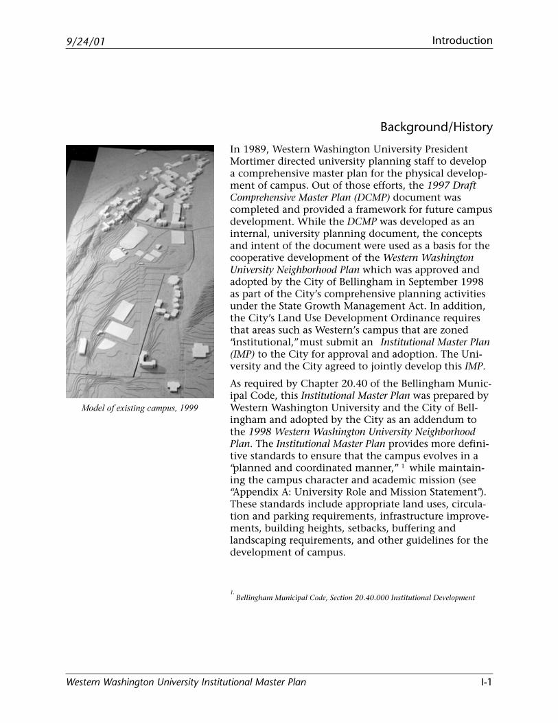
Model of existing campus, 1999
9/24/01Introduction
Western Washington University Institutional Master PlanI-2
Institutional Master Plan AdvisoryCommittee
The Institutional Master Plan (IMP) was developed withthe invaluable assistance and input of a diverse adviso-ry committee formed in November of 1998 by Presi-dent Karen Morse and Mayor Mark Asmundson.Representatives from adjacent neighborhoods, the Cityand campus comprised the Institutional Master PlanAdvisory Committee (IMPAC) that was charged to servein a review and advisory capacity to the President ofWestern and to the Mayor of Bellingham in the devel-opment and adoption of the IMP. (See the Acknowl-edgements page for a list of the IMPAC members.)
Intent of the Institutional Master Plan
The results of the Institutional Master Plan AdvisoryCommittee’s months of work, the input of the Westernplanning staff and Western planning students, and therecommendations of Bellingham’s Planning Commis-sion and City Council are contained within this IMPdocument. The intent is that this document not onlyfulfill the land use ordinance requirements set by theCity and State but also reinforce and support a healthyrelationship between Western and the surroundingneighborhoods and Bellingham community. The IMPprovides a framework for the future development ofcampus to accommodate the projected growth to12,500 full time equivalent (FTE) students, withoutcompromising the character of campus or of the adja-cent neighborhoods.
9/24/01 Introduction
Western Washington University Institutional Master Plan I-3
Life of the Institutional Master Plan
This Institutional Master Plan establishes a range of newbuilding square footage that can be accommodated oncampus. As described in more detail in the Land Usesection to follow, this IMP establishes a maximum offour million square feet of building space (2,721,000existing + 1,287,000 proposed). Western may seek cityapproval of IMP amendments or a new IMP at any time,but Western must get city approval of a new IMP if itproposes new construction that would exceed fourmillion square feet of total building space on campus.This building square foot maximum includes newspace, after deductions for demolished building spaceand it does not include parking garages. The City may,at the discretion of the Planning Commission or CityCouncil, initiate an amendment or an update to theIMP at any time during the life of the plan, consistentwith BMC 20.40.040.F.
Scope of the Institutional Master Plan
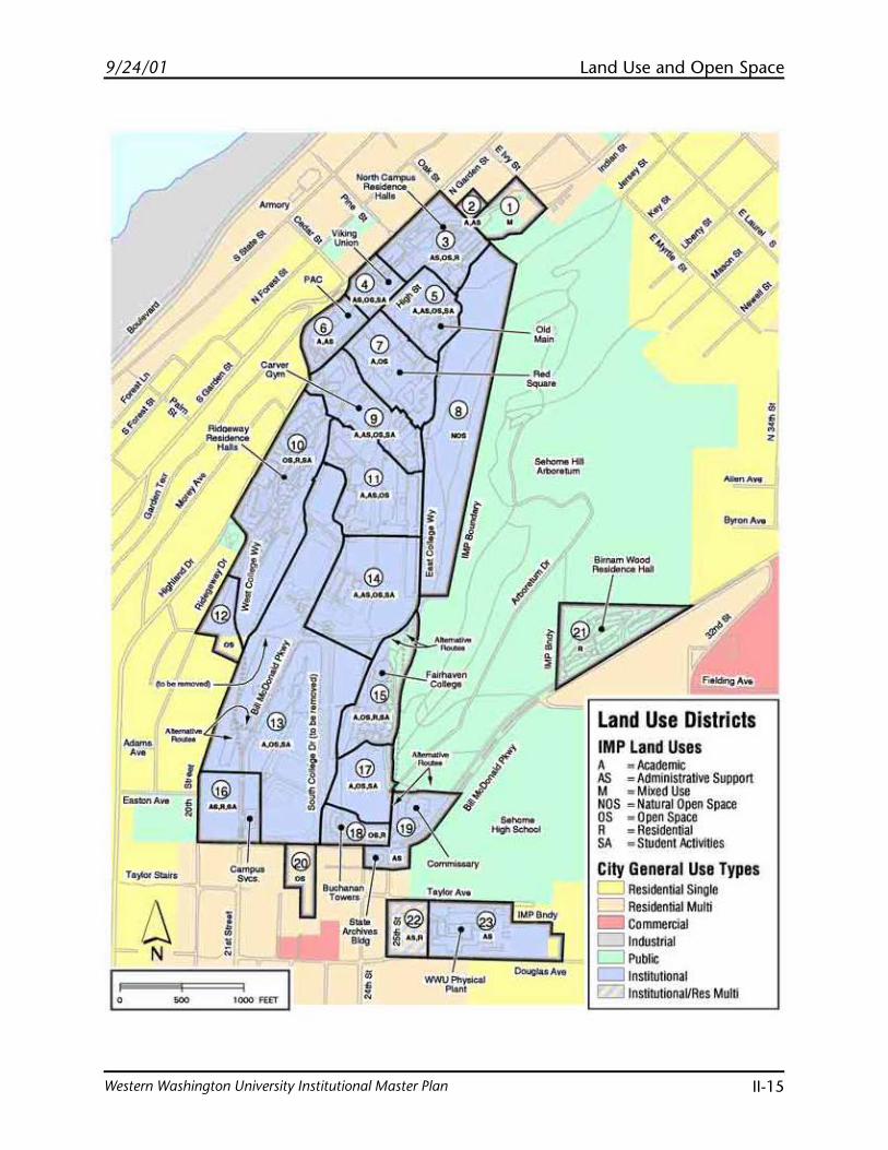
This document divides the Western campus and adja-cent areas into a number of land use “Districts” (seemap on page II-15). These districts fall into one of twocategories:
1. Institutionally Zoned Areas – The IMP regulatesdevelopment for institutionally zoned areas. Devel-opment projects must comply with the use limita-tions, development standards and other provisionscontained in this plan.
2. Non-Institutionally Zoned Areas – Some districts(such as District 1) have zoning other than Institu-tional. Proposed development in these districtsmust comply with the underlying zoning. The uselimitations, development standards and otherprovisions of this plan are advisory only, unless theproperty is rezoned to Institutional through astandard rezone process.
9/24/01Introduction
Western Washington University Institutional Master PlanI-4
As indicated in the Background/History section, theBellingham Municipal Code requires that the IMP:
• specify appropriate land uses,• identify required circulation and utility improve-
ments,• set standards for building heights, setbacks, land-
scape and buffering, parking and signage.
The IMP is not intended to be a concise site plan withspecific building footprints, but rather, a framework forthe development of campus.
Expansion Beyond the Main Campus
This Institutional Master Plan applies to the main cam-pus area and, in an advisory capacity, to some otherareas as described in the Scope of the IMP. As explainedin the Land Use section to follow, not all of Western’sfuture space needs for 12,500 full time equivalent (FTE)students can be accommodated on the main campus. Ifthe densities and development patterns outlined in thisplan are followed, it may become necessary to locatesome uses in areas beyond the current campus bound-aries. An alternatives analysis process including anadvisory committee will be used to advise the City andWestern where campus expansion would be mostappropriate. The committee should be staffed by West-ern and include an equal number of Western and non-university representatives. Neighborhoodrepresentatives will be appointed by the mayor, prefera-bly from a list of candidates submitted by the Sehome,South Hill, Happy Valley and CBD neighborhoodassociations. The mayor should also appoint citizenswho will lend a city-wide or “big picture” perspective tothe process. Western representatives should be appoint-ed by the university president. After an initial scopingprocess to determine the sites to be evaluated, thecommittee could be expanded to include representa-tives from other neighborhoods where campus expan-sion is being considered. Each site selected for
9/24/01 Introduction
Western Washington University Institutional Master Plan I-5
evaluation could be analyzed to determine appropriateinstitutional uses, densities, characteristics, develop-ment and performance standards designed to minimizeimpacts and compliment neighborhood character. Thecommittee shall include the public in its processthrough use of public notices, press releases, work-shops, public hearings, and/or other means to seekpublic participation.
9/24/01Introduction
Western Washington University Institutional Master PlanI-6
The Institutional Master Plan’sOverarching Principles and Themes
• Optimize Use of Land While Maintaining Character
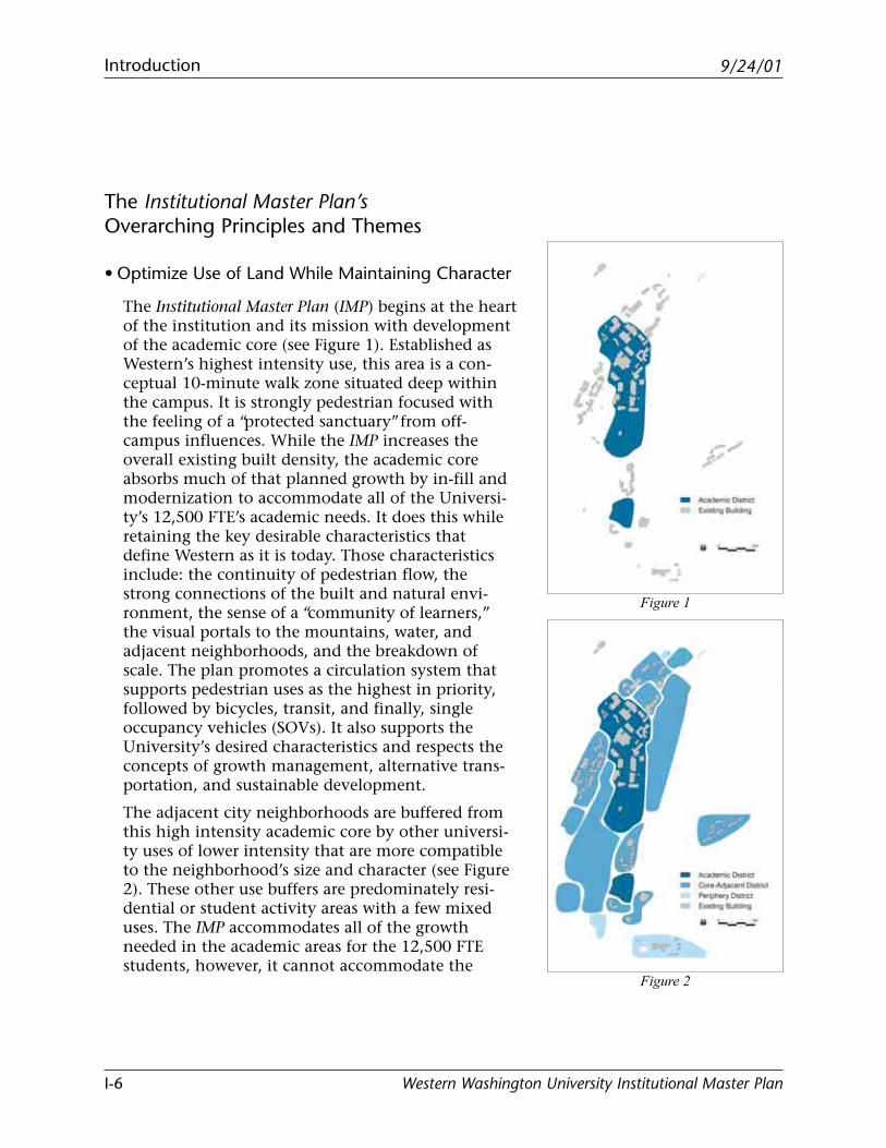
The Institutional Master Plan (IMP) begins at the heartof the institution and its mission with developmentof the academic core (see Figure 1). Established asWestern’s highest intensity use, this area is a con-ceptual 10-minute walk zone situated deep withinthe campus. It is strongly pedestrian focused withthe feeling of a “protected sanctuary” from off-campus influences. While the IMP increases theoverall existing built density, the academic coreabsorbs much of that planned growth by in-fill andmodernization to accommodate all of the Universi-ty’s 12,500 FTE’s academic needs. It does this whileretaining the key desirable characteristics thatdefine Western as it is today. Those characteristicsinclude: the continuity of pedestrian flow, thestrong connections of the built and natural envi-ronment, the sense of a “community of learners,”the visual portals to the mountains, water, andadjacent neighborhoods, and the breakdown ofscale. The plan promotes a circulation system thatsupports pedestrian uses as the highest in priority,followed by bicycles, transit, and finally, singleoccupancy vehicles (SOVs). It also supports theUniversity’s desired characteristics and respects theconcepts of growth management, alternative trans-portation, and sustainable development.
The adjacent city neighborhoods are buffered fromthis high intensity academic core by other universi-ty uses of lower intensity that are more compatibleto the neighborhood’s size and character (see Figure2). These other use buffers are predominately resi-dential or student activity areas with a few mixeduses. The IMP accommodates all of the growthneeded in the academic areas for the 12,500 FTEstudents, however, it cannot accommodate the
Figure 1
Figure 2

9/24/01 Introduction
Western Washington University Institutional Master Plan I-7
programmatic needs of all of the other areas whilemaintaining the campus’ key desirable characteris-tics. It must grow beyond its existing contiguousboundaries. One additional regulation size field anda percentage of non-academic needs must be accom-modated beyond the existing campus boundaries.The determination of where this additional need isto be accommodated isn’t addressed in this docu-ment. It awaits further analysis and investigation ofoptions.
• Maximize Alternative Transportation While Accom-modating Parking
In order to maximize the available land on-campusfor university uses and minimize the impacts to theadjacent neighborhoods, the IMP strives to presentan aggressive approach regarding alternative trans-portation and university single occupancy vehicle(SOV) parking needs (see Figure 3). This approach isconsistent with the University’s TransportationManagement Program. The IMP places priority onpedestrian circulation, followed by bicycle circula-tion and parking, transit and shuttle circulationand destinations, carpools and vanpools, and lastly,SOV circulation and parking. While emergencyvehicles have access to all parts of the campus, SOVsare primarily relegated to the periphery of campusdirectly adjacent to the primary arrival path. Uponarrival to campus, SOVs are to park. Parking isaccommodated through development of structuresand landscaped/paved lots dispersed along the mainarrival path. The structures reduce the amount ofland needed for parking, thereby increasing theopportunity for other uses. Transit and shuttles areallowed to penetrate further into the campus thanSOVs. The High Street corridor is maintained as amajor transit hub. A second hub on the south edgeof the academic core will be developed.
Figure 3
9/24/01Introduction
Western Washington University Institutional Master PlanI-8
Bicycles have access to all but the most denselypopulated pedestrian areas in the academic core.Bicycle pathways should be improved and linked tocity bicycle paths. Additional bicycle storage shouldbe created to accommodate bicycle commuting.
Pedestrian circulation is given the highest priorityto support the plan’s principles of honoring thecentral pedestrian routes and spaces, emphasizingpedestrian activity, and maintaining the sense of avillage. It also supports sustainable developmentconcepts by reducing use of SOVs and decreasingthe need for impervious surface area. Finally, pedes-trian pathways with appropriate improvements willbe developed on-campus with improved links to cityand neighborhood walking corridors.
• Optimize Transitions, Blending, and Buffering toSustain Adjacent Neighborhoods
The IMP reduces potential impacts to adjacentneighborhoods through transitions, blending, andbuffering guidelines for development. Transitions,blending, and buffering are achieved through adja-cent compatible university uses, structures that areconsistent with the adjacent scale, density, architec-tural characteristics, and landscaping of the neigh-borhoods, and setbacks that also step-back inheight recognizing adjacent densities and preserv-ing, where possible, solar orientation.
• Optimize Communication between Western, theCity and Adjacent Neighborhood Associations
The effectiveness of the IMP relies on a mechanismto exchange ideas and concerns between representa-tives of Western, the City and the adjacent neigh-borhood associations.
9/24/01 Introduction
Western Washington University Institutional Master Plan I-9
The IMP provides an effective mechanism whereby acitizen and/or student can be properly informed of,and able to address, all phases of proposed projectsincluding planning, associated studies, construc-tion, and long term effects after completion.
Toward this end, the University shall appoint aWestern representative to serve as the official con-tact person for the Happy Valley, Sehome, andSouth Hill Neighborhood Associations. This repre-sentative will participate in neighborhood associa-tion meetings and activities, and serve to cutthrough “red tape” to communicate neighborhoodconcerns to the University and expedite responsesfrom Western.

Blank page
9/24/01
Western Washington University Institutional Master Plan
Land Use and Open Space

Blank page
Land Use and Open Space
II-1
9/24/01
Western Washington University Institutional Master Plan
Land Use and Open Space Principles/Patterns to be Reinforced
Three guiding principles are carried forward from the1997 Western Washington University Draft ComprehensiveMaster Plan. These principles are preservation, enhance-ment, and accommodation. These principles, alongwith the character patterns listed below, are the pri-mary qualitative elements used to evaluate land useand open space.
• Preservation
- Maintain the central part of campus as the“academic core.”
- Maintain the north part of campus as residentialin character.
- Maintain close natural/people and built rela-tionships without having structures whichoverpower the natural surroundings.
- Continue to provide settings for campus art.
- Maintain “visual portals” that link campuswith natural surroundings and adjacent neigh-borhoods.
- Continue tradition of incorporating significantnatural open spaces.
• Enhancement
- Promote existing intimacy and breakdown ofscale that creates a sense of a “village/commu-nity.”
- Facilitate ease of wayfinding and promote a senseof edges to maintain campus as a “protectedsanctuary.”
- Site buildings so that they contribute to anddefine adjacent spaces/plazas.
- Orient plazas and open space to capture the sun.
- Align buildings along key organizing lines.
- Provide multiple “front doors” to campus.
Land Use and Open Space
II-2
9/24/01
Western Washington University Institutional Master Plan
• Accommodation
- Provide compatible transitions with commu-nity edges and appropriate neighborhoodconnections.
- Accommodate future academic growth pre-dominantly within the 10-minute walk zoneadjacent to Parks Hall.
- Provide clear building “front doors” and pres-ence on public space.
Land Use and Open Space
II-3
9/24/01
Western Washington University Institutional Master Plan
Land Use District Definitions
For planning purposes, the IMPAC divided the campusinto a number of land use districts. Each district wasthen given a classification based on the existing landuse and proposed future use. Next, goals and develop-ment recommendations related to the character andtypes of anticipated development were created for eachdistrict. The six land use district classifications aredefined below.
1. Academic – classrooms, laboratories, computer labs,faculty offices, college and departmental offices,centers, institutes, libraries, research areas, foodservices, parking facilities, and related uses.
2. Residential – residence halls, dining halls, apart-ments, University Residences and Dining administra-tive functions, conferences, resident fitness centers,resident computer centers, outdoor recreation areas,parking facilities, and related uses.
3. Student Activities – programmed outdoor sportactivity areas, playfields, tennis courts, runningtracks, campus recreation facilities, Associated Stu-dent functions, student union functions, administra-tive offices such as admissions, counseling, registrar,career services and general student support, parkingfacilities, and related uses.
4. Administrative/Support – administrative offices,utility systems support functions, Physical Plant,recycling, copying services, business functions,archival functions, environmental health and safetyfunctions, parking facilities, and related uses.
5. Open Space – educational or recreational functions,native growth protection areas, plazas, art (includingoutdoor sculpture), landscaping, walkways, kiosks,and related uses.
6. Mixed Use – any combination of the above uses.
Land Use and Open Space
II-4
9/24/01
Western Washington University Institutional Master Plan
Accessory Uses – Western is allowed to establish acces-sory uses that are customarily subordinate to the pri-mary use of a building. Examples of accessory usesinclude a small coffee shop located in an office buildingor a computer lab located in a residence hall.
Building Across Boundary Lines – The existence ofdistrict boundary lines does not preclude the construc-tion of a building across boundary lines so long as: 1)not more than 49% of the structure will be in a districtin which the proposed use is not permitted; and 2) onproperty abutting or across the right-of-way from a non-institutional land use district, the non-permitted useshall not exceed 15% of the total district area.
Land Use and Open Space
II-5
9/24/01
Western Washington University Institutional Master Plan
Institutional Project Review Process
This IMP regulates development in the land use districtsthat are designated “Institutional” in the applicableneighborhood plan. (See Land Use Districts map, pageII-15.) Projects proposed in these districts must beconsistent with the review process, use limitations,development standards, and performance standardscontained herein.
Individual projects in these areas will be reviewed bythe City using either the planned development processfor significant projects or the regular building/land usepermit process for non-significant projects.
Significant Projects
Examples of projects the City will consider significantinclude new buildings, parking lots or parking struc-tures, and new major and secondary vehicle routes. Aproject should be deemed significant if both of thefollowing apply:
1. The project is located in a land use district on ornear the perimeter of campus, including districts 3,4, 6, 8, 10, 12, 13, 16, 17, 18, 19, 23, and
2. The project is not “exempt” from State Environmen-tal Policy Act (SEPA) review under BMC 16.04.180 asamended.
Projects deemed significant shall use the planneddevelopment process contained in BMC 20.40.060 asnow or hereafter amended. This process includes aneighborhood meeting and the option for a publicmeeting conducted by the Planning Commission.Significant projects will be reviewed for consistencywith this IMP and with other applicable developmentregulations.
Land Use and Open Space
II-6
9/24/01
Western Washington University Institutional Master Plan
Non-Significant Projects
Proposed projects in Institutionally designated areasthat do not meet the above criteria shall be deemednon-significant. Examples of non-significant projectsinclude: new buildings in the core districts of thecampus (districts 5, 7, 9, 11, 14, 15) interior improve-ment or renovation of existing buildings, exteriorrenovation and minor additions to existing buildings,minor roadway improvements, utility improvements orrenovations, safety improvements, landscaping,signage, off-street pedestrian or bicycle paths, installa-tion of art sculptures. Non-significant projects shall bereviewed for consistency with this IMP and with appli-cable development regulations using the standardbuilding or land use permit process rather than theplanned development process.
Land Use and Open Space
II-7
9/24/01
Western Washington University Institutional Master Plan
Project Review Process inNon-Institutional Zoning Districts
Several land use districts in this IMP have a non-institu-tional designation in their applicable neighborhoodplan. Development in these districts must comply withthe underlying zoning, regardless of ownership. Theprovisions of this plan are advisory only in these dis-tricts unless and until the zoning is changed to Institu-tional through a rezone process.
Projects in areas not zoned Institutional shall followthe review process established in the Land Use Devel-opment Ordinance for the underlying zone. For ex-ample, a proposed project in a Residential-Multi zoneshall follow the application and review process in BMC20.32 as amended. Projects in non-Institutional zonedareas shall be reviewed for compatibility with this IMP,and for compliance with neighborhood plan provisionsand other applicable City of Bellingham developmentregulations.
Land Use and Open Space
II-8
9/24/01
Western Washington University Institutional Master Plan
Determination of Space Needs
The Institutional Master Plan Advisory Committee(IMPAC) went through an extensive process to deter-mine current and future space needs for academic andadministrative/support uses, residential units and otherfacilities. Existing building space by primary land usecategory was calculated. Projected building space needswere based on a projected student enrollment of 12,500full-time equivalent (FTE) students. Deductions weremade based upon increased classroom space utilizationand e-learning. In addition, building space needsreflected the University’s current compaction, andprojected program needs. By deducting the existingsquare footage from the adjusted need projectionfigure, an IMPAC approved range of space needed tofulfill the future 12,500 FTE enrollment was estab-lished.
The methodology is explained in full in the Appendix.A summary of the conclusions is shown below.
FINAL IMPAC RECOMMENDED BUILDING SPACE PROJECTION RANGE (1/25/00)
Existing Square Feet
Low Medium High Low Medium HighAcademic 1,279,000 737,000 843,000 949,000 2,016,000 2,122,000 2,228,000
Residential 977,000 206,000 268,000 331,000 1,183,000 1,245,000 1,308,000Student Support 198,000 170,000 189,000 209,000 368,000 387,000 407,000
University Support 159,000 137,000 153,000 168,000 295,000 311,000 326,000Administration 108,000 91,000 102,000 112,000 199,000 210,000 220,000
TOTAL* 2,721,000 1,341,000 1,555,000 1,769,000 4,062,000 4,276,000 4,489,000
Exterior Programmatic Needs Include:12 Tennis Courts 86,0001 Hammer Throw Field 31,0001 Fastpitch Field 152,0003 Regulation Soccer Fields 234,0001 All-Weather Track & Field 136,0002 Regulation Football Fields 108,000
747,000Numbers are rounded to nearest 1,000
Approved Range of Additional Need to Accommodate 12,500 FTE
Adjusted Total Need Projection Approved Range (+/-5%)
Land Use and Open Space
II-9
9/24/01
Western Washington University Institutional Master Plan
Once the demonstrated need was established, staff andthe IMPAC determined what uses could be accommo-dated within the existing boundaries of campus andwhich uses could be shifted beyond the existing cam-pus boundaries. Existing land use, density and charac-teristics in each district were analyzed to determinehow much infill could be accommodated within cam-pus boundaries without jeopardizing those overalldesirable characteristics and character patterns thatmake Western unique.
A summary of the conclusions is shown on the follow-ing page.
Land Use and Open Space
II-10
9/24/01
Western Washington University Institutional Master Plan
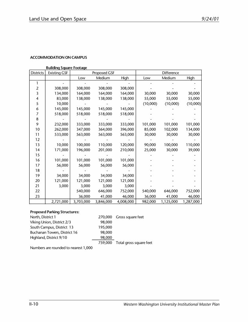
ACCOMMODATION ON CAMPUS
Building Square FootageDistricts Existing GSF Difference
Low Medium High Low Medium High1 - - - - - - - 2 308,000 308,000 308,000 308,000 - - - 3 134,000 164,000 164,000 164,000 30,000 30,000 30,000 4 83,000 138,000 138,000 138,000 55,000 55,000 55,000 5 10,000 - - - (10,000) (10,000) (10,000) 6 145,000 145,000 145,000 145,000 - - - 7 518,000 518,000 518,000 518,000 - - - 8 - - - - - - - 9 232,000 333,000 333,000 333,000 101,000 101,000 101,000 10 262,000 347,000 364,000 396,000 85,000 102,000 134,000 11 533,000 563,000 563,000 563,000 30,000 30,000 30,000 12 - - - - - - - 13 10,000 100,000 110,000 120,000 90,000 100,000 110,000 14 171,000 196,000 201,000 210,000 25,000 30,000 39,000 15 - - - - - - - 16 101,000 101,000 101,000 101,000 - - - 17 56,000 56,000 56,000 56,000 - - - 18 - - - - - - - 19 34,000 34,000 34,000 34,000 - - - 20 121,000 121,000 121,000 121,000 - - - 21 3,000 3,000 3,000 3,000 - - - 22 540,000 646,000 752,000 540,000 646,000 752,000 23 36,000 41,000 46,000 36,000 41,000 46,000
2,721,000 3,703,000 3,846,000 4,008,000 982,000 1,125,000 1,287,000
Proposed Parking Structures:North, District 1 270,000 Gross square feetViking Union, District 2/3 98,000 South Campus, District 13 195,000 Buchanan Towers, District 16 98,000 Highland, District 9/10 98,000
759,000 Total gross square feetNumbers are rounded to nearest 1,000
Proposed GSF
Land Use and Open Space
II-11
9/24/01
Western Washington University Institutional Master Plan
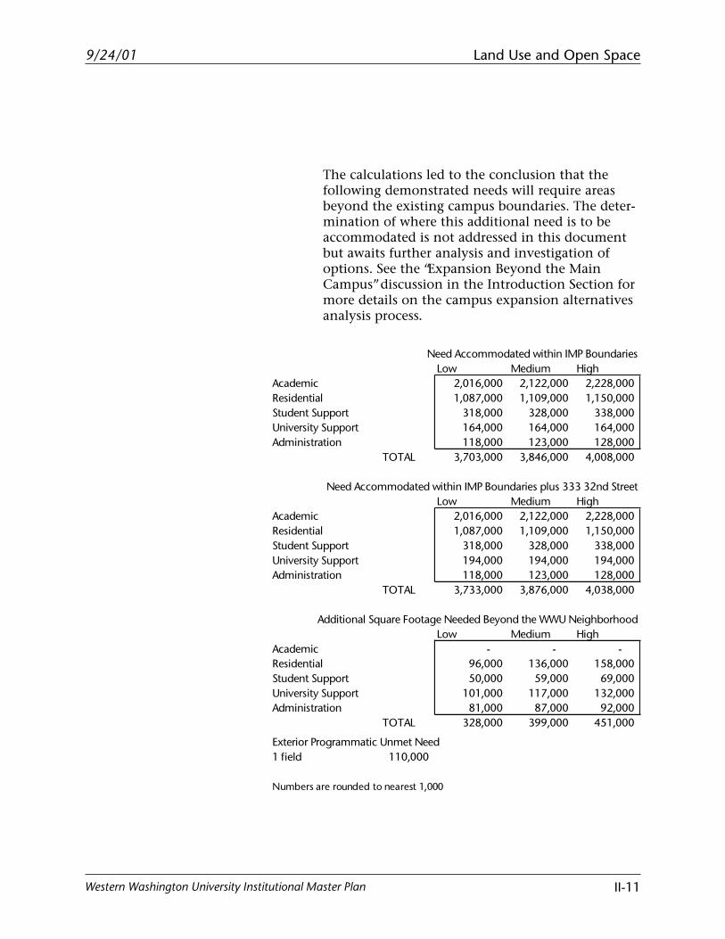
The calculations led to the conclusion that thefollowing demonstrated needs will require areasbeyond the existing campus boundaries. The deter-mination of where this additional need is to beaccommodated is not addressed in this documentbut awaits further analysis and investigation ofoptions. See the “Expansion Beyond the MainCampus” discussion in the Introduction Section formore details on the campus expansion alternativesanalysis process.
Need Accommodated within IMP BoundariesLow Medium High
Academic 2,016,000 2,122,000 2,228,000Residential 1,087,000 1,109,000 1,150,000Student Support 318,000 328,000 338,000 University Support 164,000 164,000 164,000 Administration 118,000 123,000 128,000
TOTAL 3,703,000 3,846,000 4,008,000
Need Accommodated within IMP Boundaries plus 333 32nd StreetLow Medium High
Academic 2,016,000 2,122,000 2,228,000Residential 1,087,000 1,109,000 1,150,000Student Support 318,000 328,000 338,000 University Support 194,000 194,000 194,000 Administration 118,000 123,000 128,000
TOTAL 3,733,000 3,876,000 4,038,000
Additional Square Footage Needed Beyond the WWU NeighborhoodLow Medium High
Academic - - - Residential 96,000 136,000 158,000 Student Support 50,000 59,000 69,000 University Support 101,000 117,000 132,000 Administration 81,000 87,000 92,000
TOTAL 328,000 399,000 451,000
Exterior Programmatic Unmet Need1 field 110,000
Numbers are rounded to nearest 1,000
Land Use and Open Space
II-12
9/24/01
Western Washington University Institutional Master Plan
Category Building Area (sf)Footprint Assume 3
Stories (sf) BAR Range Land Area Required (sf)
Residential 136,000 45,330 0.19 - 0.24 188,880 - 238,580
Student Support 59,000 19,670 0.4 - 0.5 39,340 - 49,180
University Support 117,000 39,000 0.05 - 0.15 260,000 - 780,000
Administration 87,000 29,000 0.05 - 0.15 193,330 - 580,000
TOTAL 681,550 - 1,647,760
Estimated Off-Campus Acres 16 - 38
Playfield Acres 3
Total Estimated Off-Campus Acres Required 19 - 41
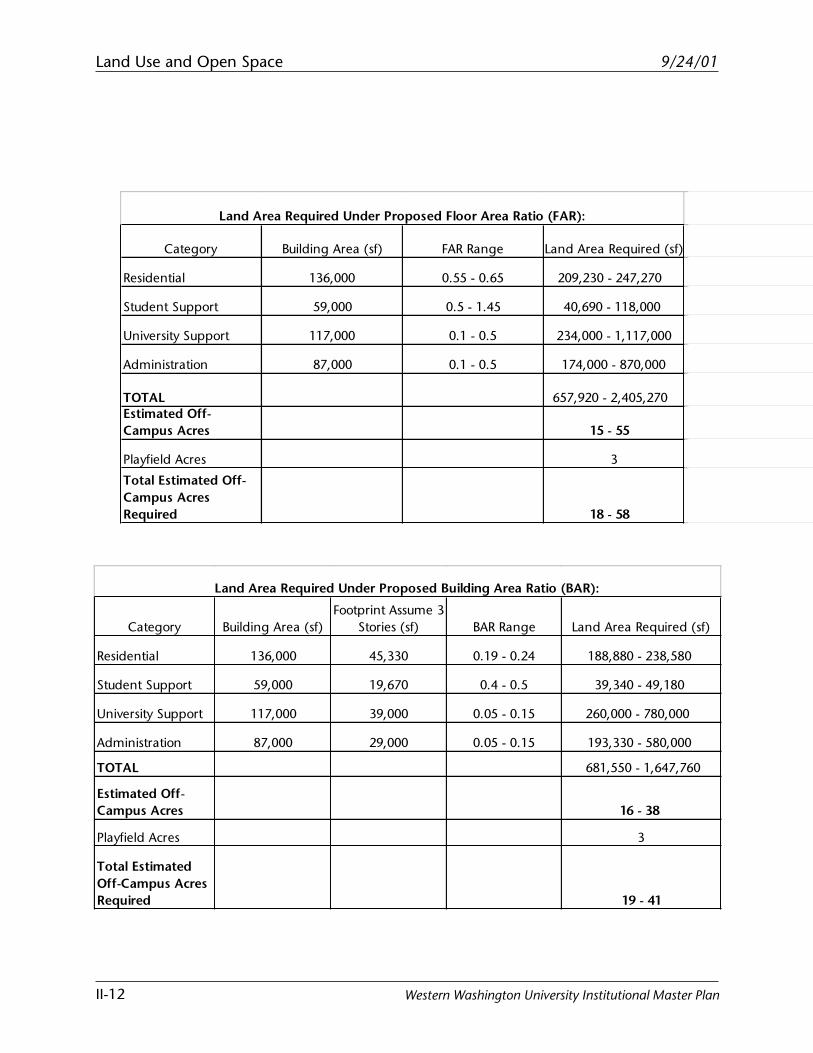
Land Area Required Under Proposed Building Area Ratio (BAR):
Category Building Area (sf) FAR Range Land Area Required (sf)
Residential 136,000 0.55 - 0.65 209,230 - 247,270
Student Support 59,000 0.5 - 1.45 40,690 - 118,000
University Support 117,000 0.1 - 0.5 234,000 - 1,117,000
Administration 87,000 0.1 - 0.5 174,000 - 870,000
TOTAL 657,920 - 2,405,270 Estimated Off-Campus Acres 15 - 55
Playfield Acres 3
Total Estimated Off-Campus Acres Required 18 - 58
Land Area Required Under Proposed Floor Area Ratio (FAR):
Land Use and Open Space
II-13
9/24/01
Western Washington University Institutional Master Plan
Determination of Space Needs Summary
• This Institutional Master Plan estimates that an addi-tional 1.55 million square feet of building space,760,000 square feet of parking structure space, and747,000 square feet of athletic field space will beneeded during the life of this plan. 55% of theadditional space is needed to accommodate theincreased enrollment and 45% is needed to ad-equately accommodate the current enrollment.
• Of the total space need, 1.125 million square feet ofbuilding space and 637,000 of athletic field space,and all of the structured parking space is beingaccommodated on the existing campus under thisplan. (See Accommodation on Campus table on pageII-10.)
• The “unmet need” that cannot be accommodated onthe existing campus under this plan is estimated tobe 400,000 square feet of building space and 1 ath-letic field. (See Estimated Off-Campus Area Require-ments table on page II-11.) It is estimated that theland area required to satisfy the unmet need rangesfrom 20 to 60 acres, depending on the density. (SeeAdditional Square Footage table on page 12).
• This IMP locates 75% of the additional buildingspace and 85% of the additional athletic field spaceneeded to accommodate 12,500 FTE on the existingcampus.
• 90% of the TOTAL building space (existing plusproposed) needed to accommodate 12,500 FTE willbe located on the existing campus under this IMP.
Land Use and Open Space
II-14
9/24/01
Western Washington University Institutional Master Plan
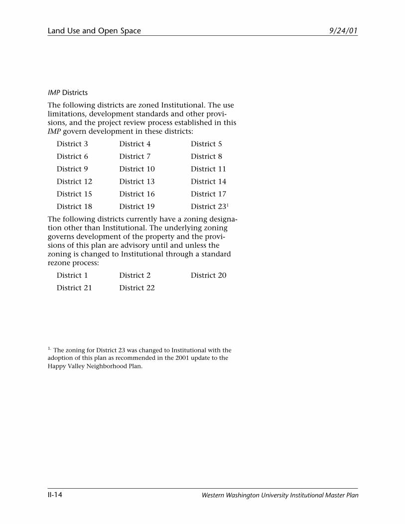
IMP Districts
The following districts are zoned Institutional. The uselimitations, development standards and other provi-sions, and the project review process established in thisIMP govern development in these districts:
District 3 District 4 District 5
District 6 District 7 District 8
District 9 District 10 District 11
District 12 District 13 District 14
District 15 District 16 District 17
District 18 District 19 District 231
The following districts currently have a zoning designa-tion other than Institutional. The underlying zoninggoverns development of the property and the provi-sions of this plan are advisory until and unless thezoning is changed to Institutional through a standardrezone process:
District 1 District 2 District 20
District 21 District 22
1. The zoning for District 23 was changed to Institutional with theadoption of this plan as recommended in the 2001 update to theHappy Valley Neighborhood Plan.
Land Use and Open Space
II-15
9/24/01
Western Washington University Institutional Master Plan
Old ... in
Rod -· -&ehomti HIH ....... .,,,,
~ I • D 1 8 ~ J <t;
@ w ,IA.I,?
"""""" ily!onAw
BimamWood Aeslditnce Hall
Land Use Districts IMP land Uses A • Academic AS = Mmlnlstradve Support M a Mixed Use NOS =Natural O~n Space OS = Open Space R = Residential SA = S1Uden1 Ac1lvlties
City General Use Types ~ Residential Single CJ Residential Multi Q Commercial CJ Industrial CJ PuDllc D lnstilUtlonal CJ lnstiwlionaVRes Mulli
Ill
~I z
Land Use and Open Space
II-16
9/24/01
Western Washington University Institutional Master Plan
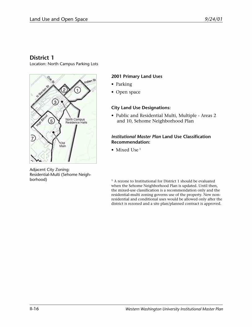
District 1Location: North Campus Parking Lots
2001 Primary Land Uses
• Parking
• Open space
City Land Use Designations:
• Public and Residential Multi, Multiple - Areas 2and 10, Sehome Neighborhood Plan
Institutional Master Plan Land Use ClassificationRecommendation:
• Mixed Use 1
1. A rezone to Institutional for District 1 should be evaluatedwhen the Sehome Neighborhood Plan is updated. Until then,the mixed-use classification is a recommendation only and theresidential-multi zoning governs use of the property. New non-residential and conditional uses would be allowed only after thedistrict is rezoned and a site plan/planned contract is approved.
Adjacent City Zoning:Residential-Multi (Sehome Neigh-borhood)
Land Use and Open Space
II-17
9/24/01
Western Washington University Institutional Master Plan
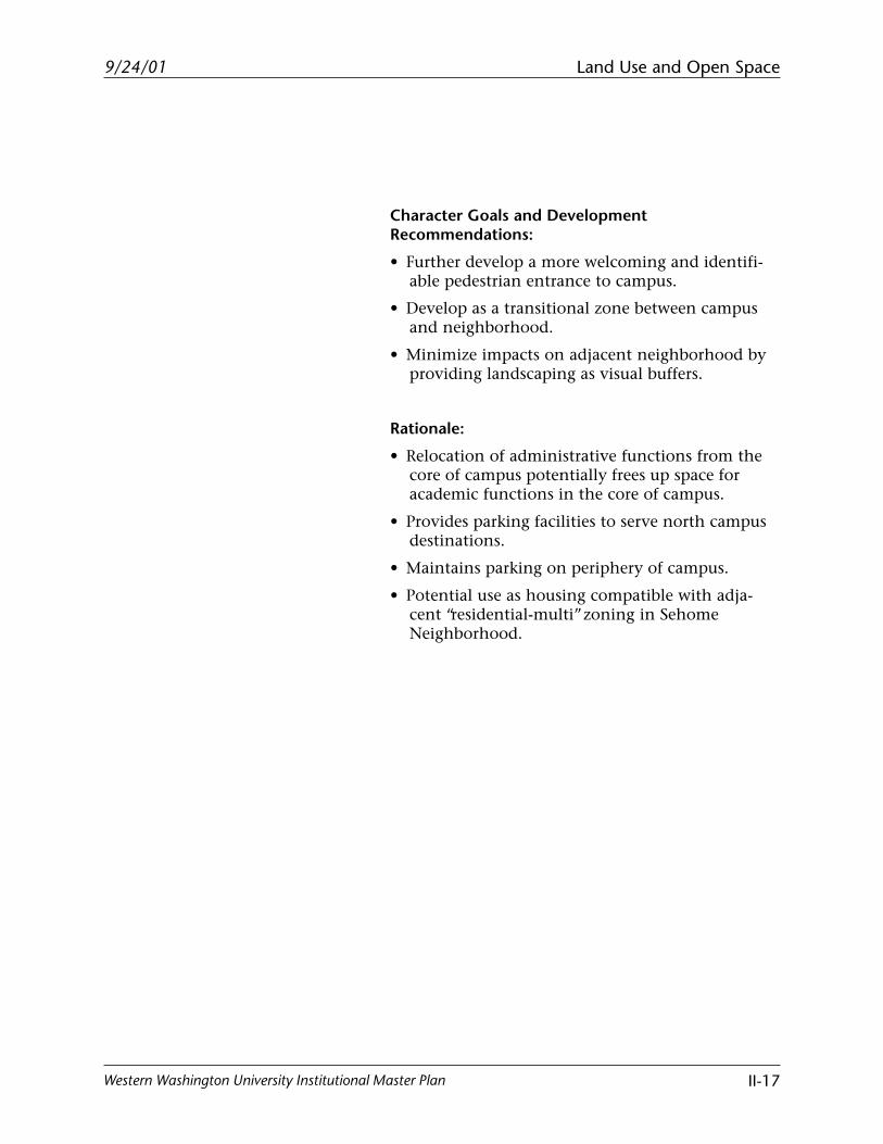
Character Goals and DevelopmentRecommendations:
• Further develop a more welcoming and identifi-able pedestrian entrance to campus.
• Develop as a transitional zone between campusand neighborhood.
• Minimize impacts on adjacent neighborhood byproviding landscaping as visual buffers.
Rationale:
• Relocation of administrative functions from thecore of campus potentially frees up space foracademic functions in the core of campus.
• Provides parking facilities to serve north campusdestinations.
• Maintains parking on periphery of campus.
• Potential use as housing compatible with adja-cent “residential-multi” zoning in SehomeNeighborhood.
Land Use and Open Space
II-18
9/24/01
Western Washington University Institutional Master Plan
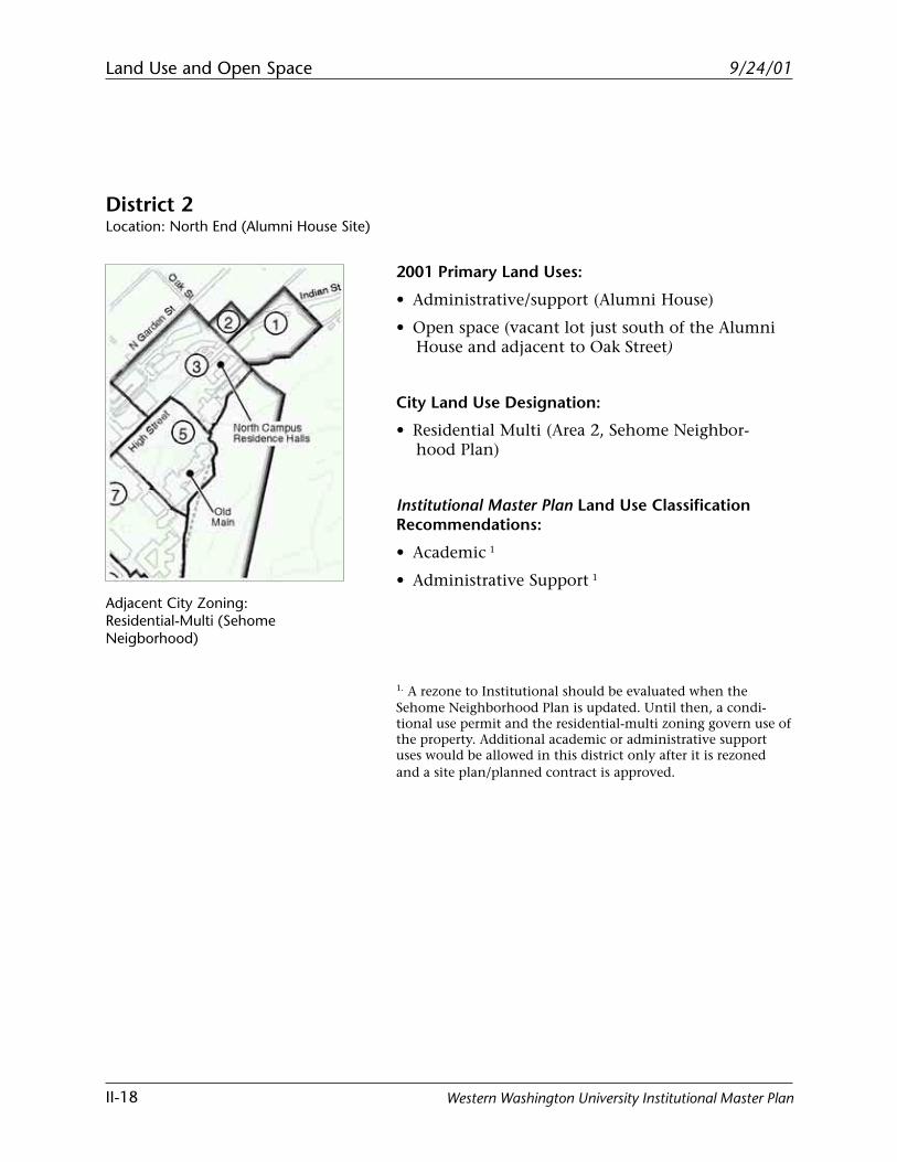
District 2Location: North End (Alumni House Site)
2001 Primary Land Uses:
• Administrative/support (Alumni House)
• Open space (vacant lot just south of the AlumniHouse and adjacent to Oak Street)
City Land Use Designation:
• Residential Multi (Area 2, Sehome Neighbor-hood Plan)
Institutional Master Plan Land Use ClassificationRecommendations:
• Academic 1
• Administrative Support 1
1. A rezone to Institutional should be evaluated when theSehome Neighborhood Plan is updated. Until then, a condi-tional use permit and the residential-multi zoning govern use ofthe property. Additional academic or administrative supportuses would be allowed in this district only after it is rezonedand a site plan/planned contract is approved.
Adjacent City Zoning:Residential-Multi (SehomeNeigborhood)
Land Use and Open Space
II-19
9/24/01
Western Washington University Institutional Master Plan
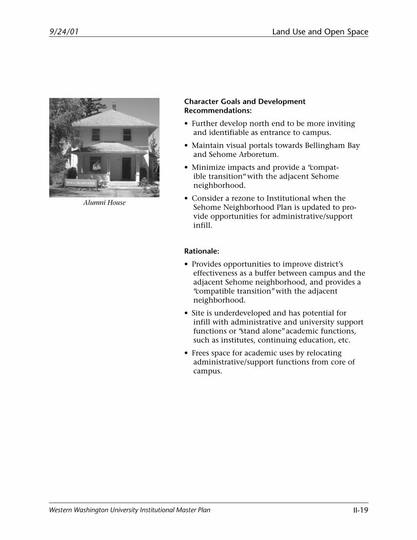
Alumni House
Character Goals and DevelopmentRecommendations:
• Further develop north end to be more invitingand identifiable as entrance to campus.
• Maintain visual portals towards Bellingham Bayand Sehome Arboretum.
• Minimize impacts and provide a “compat-ible transition“ with the adjacent Sehomeneighborhood.
• Consider a rezone to Institutional when theSehome Neighborhood Plan is updated to pro-vide opportunities for administrative/supportinfill.
Rationale:
• Provides opportunities to improve district’seffectiveness as a buffer between campus and theadjacent Sehome neighborhood, and provides a“compatible transition” with the adjacentneighborhood.
• Site is underdeveloped and has potential forinfill with administrative and university supportfunctions or “stand alone” academic functions,such as institutes, continuing education, etc.
• Frees space for academic uses by relocatingadministrative/support functions from core ofcampus.
Land Use and Open Space
II-20
9/24/01
Western Washington University Institutional Master Plan
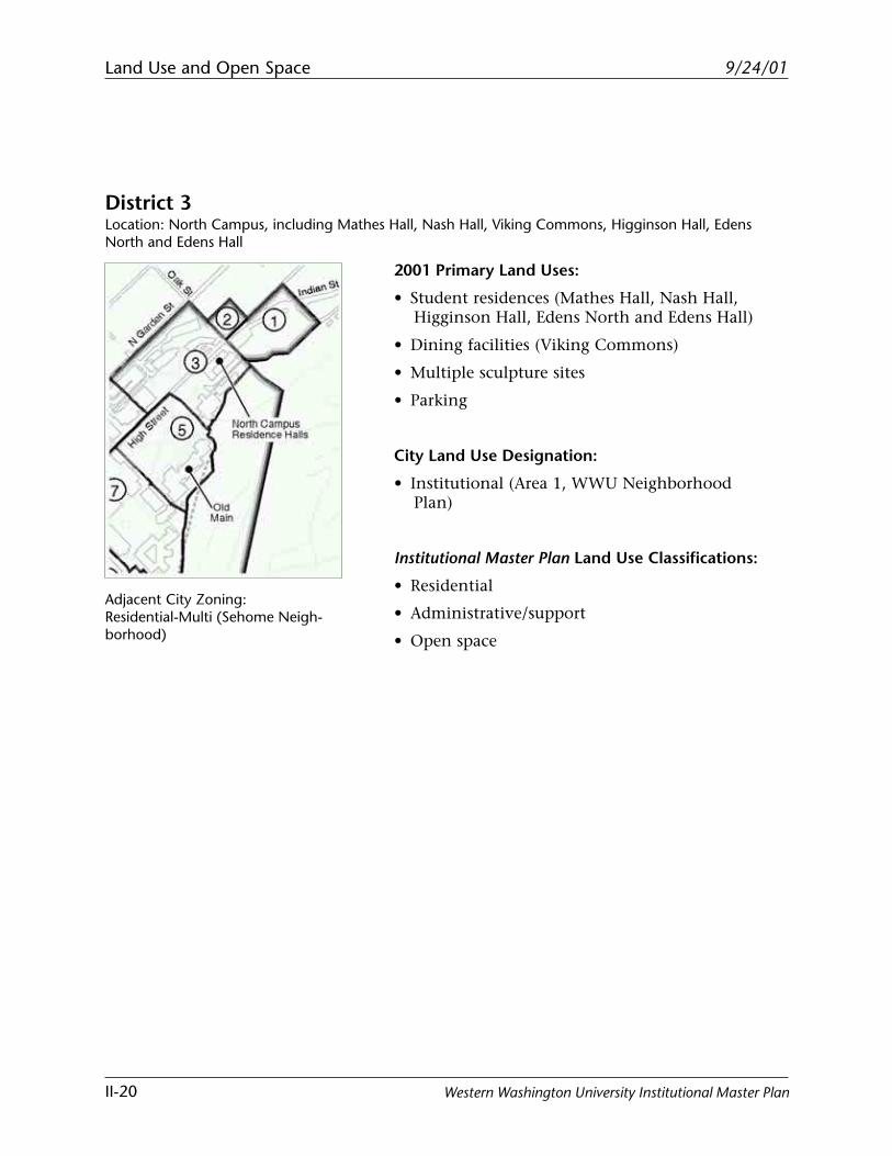
District 3Location: North Campus, including Mathes Hall, Nash Hall, Viking Commons, Higginson Hall, EdensNorth and Edens Hall
2001 Primary Land Uses:
• Student residences (Mathes Hall, Nash Hall,Higginson Hall, Edens North and Edens Hall)
• Dining facilities (Viking Commons)
• Multiple sculpture sites
• Parking
City Land Use Designation:
• Institutional (Area 1, WWU NeighborhoodPlan)
Institutional Master Plan Land Use Classifications:
• Residential
• Administrative/support
• Open space
Adjacent City Zoning:Residential-Multi (Sehome Neigh-borhood)
Land Use and Open Space
II-21
9/24/01
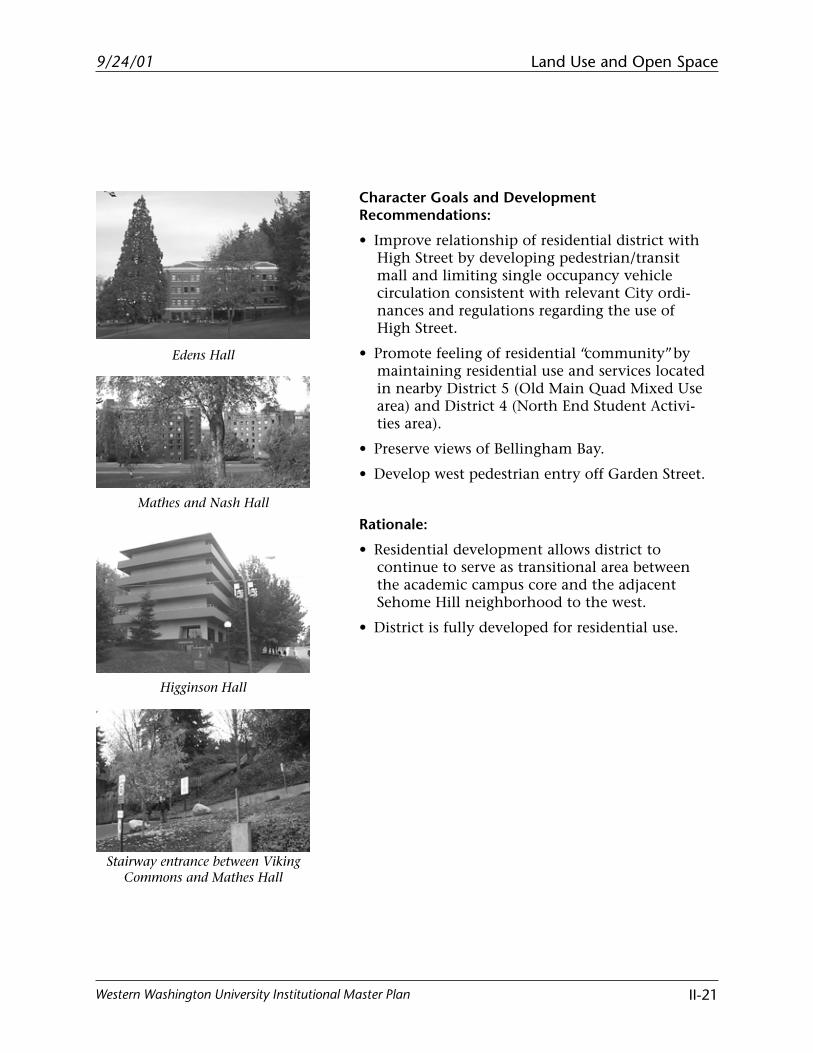
Western Washington University Institutional Master Plan
Stairway entrance between VikingCommons and Mathes Hall
Higginson Hall
Mathes and Nash Hall
Edens Hall
Character Goals and DevelopmentRecommendations:
• Improve relationship of residential district withHigh Street by developing pedestrian/transitmall and limiting single occupancy vehiclecirculation consistent with relevant City ordi-nances and regulations regarding the use ofHigh Street.
• Promote feeling of residential “community” bymaintaining residential use and services locatedin nearby District 5 (Old Main Quad Mixed Usearea) and District 4 (North End Student Activi-ties area).
• Preserve views of Bellingham Bay.
• Develop west pedestrian entry off Garden Street.
Rationale:
• Residential development allows district tocontinue to serve as transitional area betweenthe academic campus core and the adjacentSehome Hill neighborhood to the west.
• District is fully developed for residential use.
Land Use and Open Space
II-22
9/24/01
Western Washington University Institutional Master Plan
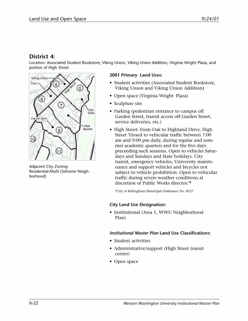
District 4:Location: Associated Student Bookstore, Viking Union, Viking Union Addition, Virginia Wright Plaza, andportion of High Street
2001 Primary Land Uses:
• Student activities (Associated Student Bookstore,Viking Union and Viking Union Addition)
• Open space (Virginia Wright Plaza)
• Sculpture site
• Parking (pedestrian entrance to campus offGarden Street, transit access off Garden Street,service deliveries, etc.)
• High Street: From Oak to Highland Drive, HighStreet “closed to vehicular traffic between 7:00am and 9:00 pm daily, during regular and sum-mer academic quarters and for the five dayspreceeding such sessions. Open to vehicles Satur-days and Sundays and State holidays. Citytransit, emergency vehicles, University mainte-nance and support vehicles and bicycles notsubject to vehicle prohibition. Open to vehiculartraffic during severe weather conditions atdiscretion of Public Works director.”*
*City of Bellingham Municipal Ordinance No. 8527
City Land Use Designation:
• Institutional (Area 1, WWU NeighborhoodPlan)
Institutional Master Plan Land Use Classifications:
• Student activities
• Administrative/support (High Street transitcenter)
• Open space
Adjacent City Zoning:Residential-Multi (Sehome Neigh-borhood)
Land Use and Open Space
II-23
9/24/01
Western Washington University Institutional Master Plan
Character Goals and DevelopmentRecommendations:
• Enlarge and enhance student center includingnew parking facility.
• Provide visual buffers for adjacent South Hillneighborhood.
• Consider shadow effects on adjacent residentialareas and minimize further impact.
• Preserve views of Bellingham Bay from VikingUnion and Virginia Wright Plaza.
• Improve service vehicle circulation below VikingUnion/Commons.
• Improve pedestrian entrance to the VikingUnion Addition from Garden Street.
• Develop High Street into pedestrian/transitmall and limit single occupancy vehiclecirculation consistent with relevant City ordi-nances and regulations regarding the use ofHigh Street.
• Support High Street as one of the campus’ pri-mary gathering places, activity centers, andcommercial areas with a “main street” feel.
Rationale:
• Current use of district as a center of student ac-tivities will be strengthened with the VikingUnion renovation project.
• Maintains parking on the periphery of campus.
• Renovation of Viking Union Complex shouldprovide a more compatible visual interface withthe adjacent South Hill neighborhood, as well asa more welcoming entrance to campus off Gar-den Street.
• The development of the High Street pedestrian/transit mall addresses issues of safety and acces-sibility.
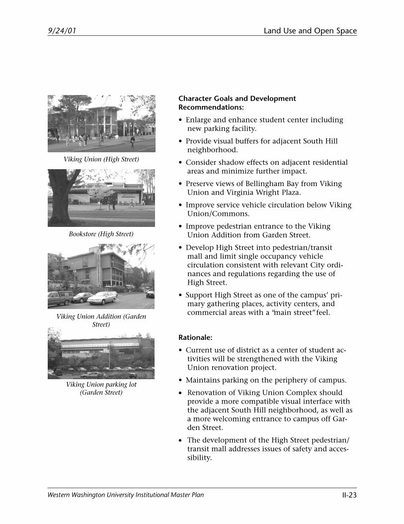
Viking Union Addition (GardenStreet)
Viking Union parking lot(Garden Street)
Bookstore (High Street)
Viking Union (High Street)
Land Use and Open Space
II-24
9/24/01
Western Washington University Institutional Master Plan
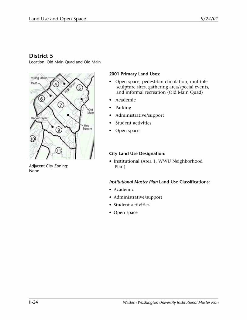
District 5Location: Old Main Quad and Old Main
2001 Primary Land Uses:
• Open space, pedestrian circulation, multiplesculpture sites, gathering area/special events,and informal recreation (Old Main Quad)
• Academic
• Parking
• Administrative/support
• Student activities
• Open space
City Land Use Designation:
• Institutional (Area 1, WWU NeighborhoodPlan)
Institutional Master Plan Land Use Classifications:
• Academic
• Administrative/support
• Student activities
• Open space
Adjacent City Zoning:None

Land Use and Open Space
II-25
9/24/01
Western Washington University Institutional Master Plan
Memory Lane
Old Main (west elevation)
High Street in front of Old Main
Old Main (partial east elevation)
Character Goals and DevelopmentRecommendations:
• Preserve and enhance all views of quad.
• Preserve and enhance quad and all features ofhistorical significance: Memory Lane, CarriageWalk, Bird Sanctuary, Mt. Baker AvalancheMemorial.
• Soften edges formed by High Street by develop-ing pedestrian/transit mall.
• Limit parking behind Old Main.
• Enhance and improve the area east of Old Main.
• Improve the backside of Old Main.
• Maintain Old Main as multi-use building.
Rationale:
• Old Main Quad and the historical character andsignificance of the buildings that form its edgeare to be preserved per the January 1997 DraftComprehensive Master Plan.
• Maintains contiguous academic core and fallswithin the 10-minute walk radius.
• District is fully developed for multi-use.
Land Use and Open Space
II-26
9/24/01
Western Washington University Institutional Master Plan
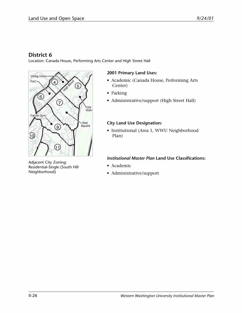
District 6Location: Canada House, Performing Arts Center and High Street Hall
2001 Primary Land Uses:
• Academic (Canada House, Performing ArtsCenter)
• Parking
• Administrative/support (High Street Hall)
City Land Use Designation:
• Institutional (Area 1, WWU NeighborhoodPlan)
Institutional Master Plan Land Use Classifications:
• Academic
• Administrative/support
Adjacent City Zoning:Residential-Single (South HillNeighborhood)
Land Use and Open Space
II-27
9/24/01
Western Washington University Institutional Master Plan
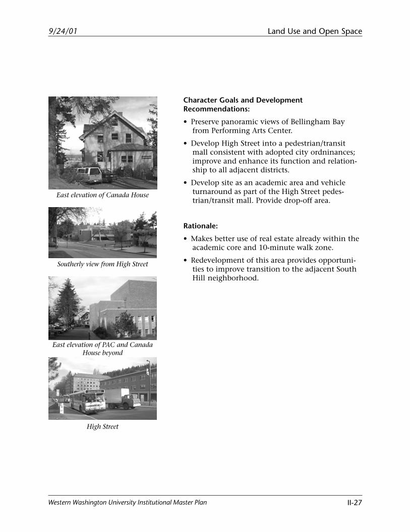
High Street
East elevation of PAC and CanadaHouse beyond
Southerly view from High Street
East elevation of Canada House
Character Goals and DevelopmentRecommendations:
• Preserve panoramic views of Bellingham Bayfrom Performing Arts Center.
• Develop High Street into a pedestrian/transitmall consistent with adopted city ordninances;improve and enhance its function and relation-ship to all adjacent districts.
• Develop site as an academic area and vehicleturnaround as part of the High Street pedes-trian/transit mall. Provide drop-off area.
Rationale:
• Makes better use of real estate already within theacademic core and 10-minute walk zone.
• Redevelopment of this area provides opportuni-ties to improve transition to the adjacent SouthHill neighborhood.
Land Use and Open Space
II-28
9/24/01
Western Washington University Institutional Master Plan
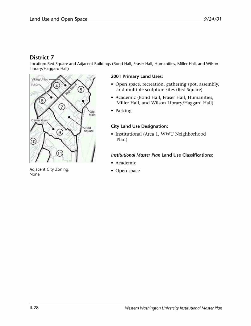
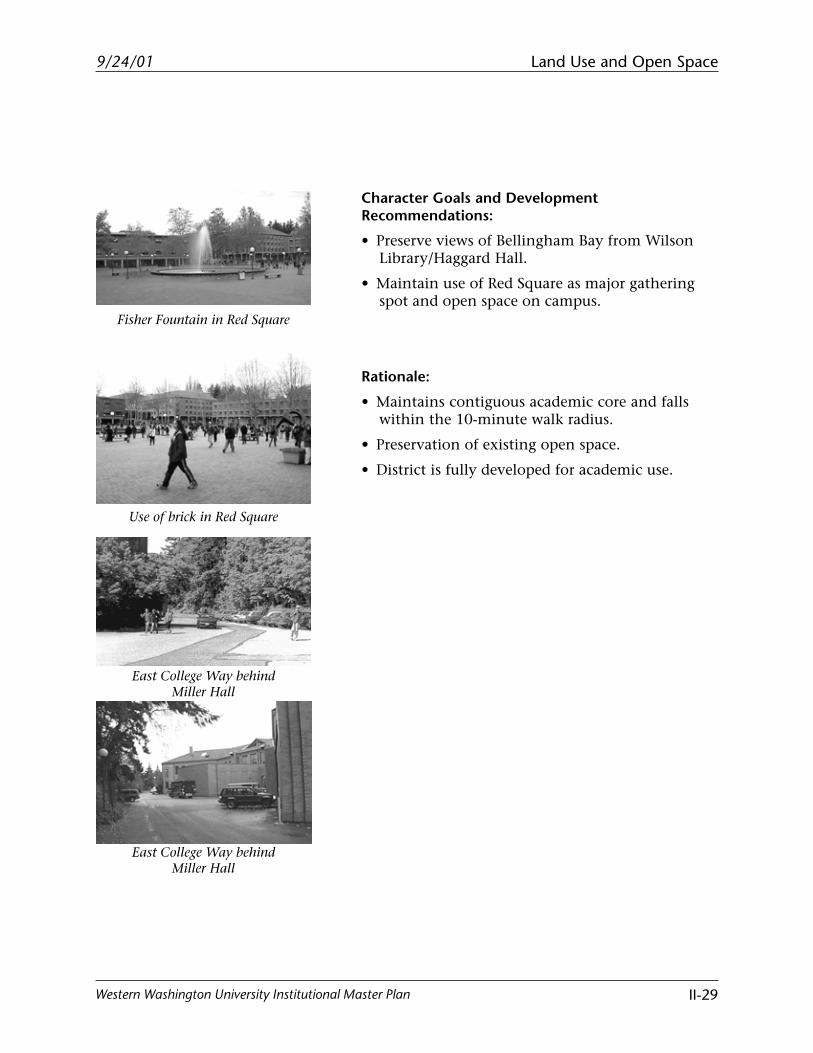
District 7Location: Red Square and Adjacent Buildings (Bond Hall, Fraser Hall, Humanities, Miller Hall, and WilsonLibrary/Haggard Hall)
2001 Primary Land Uses:
• Open space, recreation, gathering spot, assembly,and multiple sculpture sites (Red Square)
• Academic (Bond Hall, Fraser Hall, Humanities,Miller Hall, and Wilson Library/Haggard Hall)
• Parking
City Land Use Designation:
• Institutional (Area 1, WWU NeighborhoodPlan)
Institutional Master Plan Land Use Classifications:
• Academic
• Open spaceAdjacent City Zoning:None
Land Use and Open Space
II-29
9/24/01
Western Washington University Institutional Master Plan
East College Way behindMiller Hall
Use of brick in Red Square
Fisher Fountain in Red Square
East College Way behindMiller Hall
Character Goals and DevelopmentRecommendations:
• Preserve views of Bellingham Bay from WilsonLibrary/Haggard Hall.
• Maintain use of Red Square as major gatheringspot and open space on campus.
Rationale:
• Maintains contiguous academic core and fallswithin the 10-minute walk radius.
• Preservation of existing open space.
• District is fully developed for academic use.
Land Use and Open Space
II-30
9/24/01
Western Washington University Institutional Master Plan
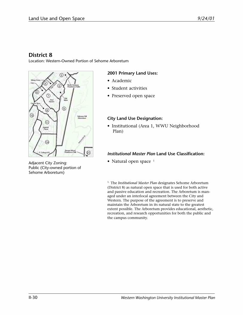
District 8Location: Western-Owned Portion of Sehome Arboretum
2001 Primary Land Uses:
• Academic
• Student activities
• Preserved open space
City Land Use Designation:
• Institutional (Area 1, WWU NeighborhoodPlan)
Institutional Master Plan Land Use Classification:
• Natural open space 1
1. The Institutional Master Plan designates Sehome Arboretum(District 8) as natural open space that is used for both activeand passive education and recreation. The Arboretum is man-aged under an interlocal agreement between the City andWestern. The purpose of the agreement is to preserve andmaintain the Arboretum in its natural state to the greatestextent possible. The Arboretum provides educational, aesthetic,recreation, and research opportunities for both the public andthe campus community.
Adjacent City Zoning:Public (City-owned portion ofSehome Arboretum)
Land Use and Open Space
II-31
9/24/01
Western Washington University Institutional Master Plan
Entrance to Sehome Arboretum
Sehome Arboretum
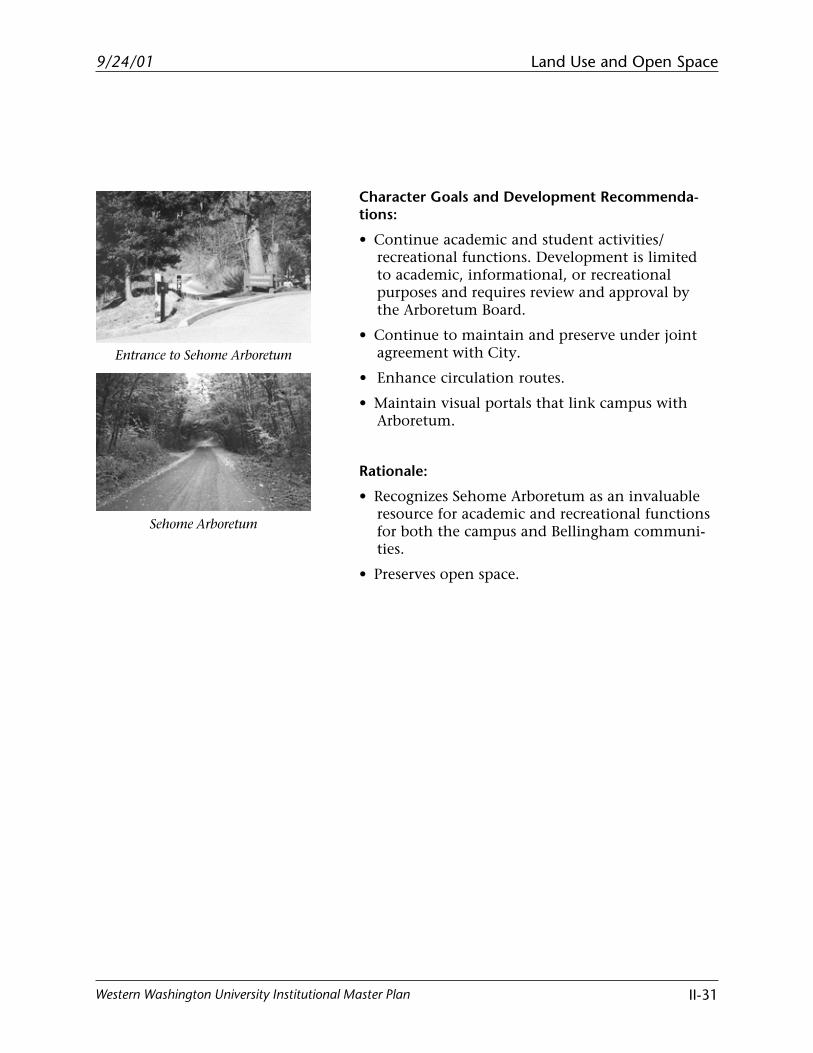
Character Goals and Development Recommenda-tions:
• Continue academic and student activities/recreational functions. Development is limitedto academic, informational, or recreationalpurposes and requires review and approval bythe Arboretum Board.
• Continue to maintain and preserve under jointagreement with City.
• Enhance circulation routes.
• Maintain visual portals that link campus withArboretum.
Rationale:
• Recognizes Sehome Arboretum as an invaluableresource for academic and recreational functionsfor both the campus and Bellingham communi-ties.
• Preserves open space.
Land Use and Open Space
II-32
9/24/01
Western Washington University Institutional Master Plan
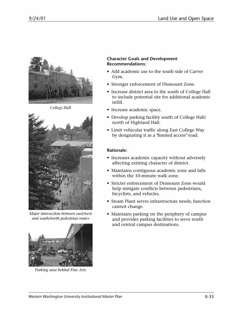
District 9Location: Parking Area South of College Hall, Art Annex, Carver Gym, College Hall, Fine Arts, and SteamPlant
2001 Primary Land Uses:
• Academic (Art Annex, Carver Gym, College Hall,Fine Arts)
• Student activities (Carver Gym)
• Administrative/support (Steam Plant)
• Parking
City Land Use Designation:
• Institutional (Area 1, WWU NeighborhoodPlan)
Institutional Master Plan Land Use Classifications:
• Academic
• Student activities
• Administrative/support
• Open space
Adjacent City Zoning:Residential-Single (South HillNeighborhood)
Land Use and Open Space
II-33
9/24/01
Western Washington University Institutional Master Plan
Major intersection between east/westand south/north pedestrian routes
College Hall
Parking area behind Fine Arts
Character Goals and DevelopmentRecommendations:
• Add academic use to the south side of CarverGym.
• Stronger enforcement of Dismount Zone.
• Increase district area to the south of College Hallto include potential site for additional academicinfill.
• Increase academic space.
• Develop parking facility south of College Hall/north of Highland Hall.
• Limit vehicular traffic along East College Wayby designating it as a “limited access” road.
Rationale:
• Increases academic capacity without adverselyaffecting existing character of district.
• Maintains contiguous academic zone and fallswithin the 10-minute walk zone.
• Stricter enforcement of Dismount Zone wouldhelp mitigate conflicts between pedestrians,bicyclists, and vehicles.
• Steam Plant serves infrastructure needs; functioncannot change.
• Maintains parking on the periphery of campusand provides parking facilities to serve northand central campus destinations.
Land Use and Open Space
II-34
9/24/01
Western Washington University Institutional Master Plan
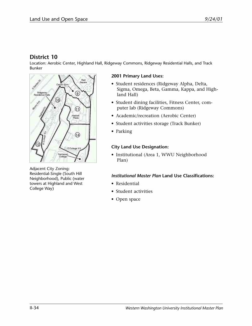
District 10Location: Aerobic Center, Highland Hall, Ridgeway Commons, Ridgeway Residential Halls, and TrackBunker
2001 Primary Land Uses:
• Student residences (Ridgeway Alpha, Delta,Sigma, Omega, Beta, Gamma, Kappa, and High-land Hall)
• Student dining facilities, Fitness Center, com-puter lab (Ridgeway Commons)
• Academic/recreation (Aerobic Center)
• Student activities storage (Track Bunker)
• Parking
City Land Use Designation:
• Institutional (Area 1, WWU NeighborhoodPlan)
Institutional Master Plan Land Use Classifications:
• Residential
• Student activities
• Open space
Adjacent City Zoning:Residential-Single (South HillNeighborhood), Public (watertowers at Highland and WestCollege Way)
Land Use and Open Space
II-35
9/24/01
Western Washington University Institutional Master Plan
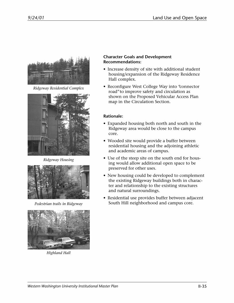
Character Goals and DevelopmentRecommendations:
• Increase density of site with additional studenthousing/expansion of the Ridgeway ResidenceHall complex.
• Reconfigure West College Way into “connectorroad” to improve safety and circulation asshown on the Proposed Vehicular Access Planmap in the Circulation Section.
Rationale:
• Expanded housing both north and south in theRidgeway area would be close to the campuscore.
• Wooded site would provide a buffer betweenresidential housing and the adjoining athleticand academic areas of campus.
• Use of the steep site on the south end for hous-ing would allow additional open space to bepreserved for other uses.
• New housing could be developed to complementthe existing Ridgeway buildings both in charac-ter and relationship to the existing structuresand natural surroundings.
• Residential use provides buffer between adjacentSouth Hill neighborhood and campus core.Pedestrian trails in Ridgeway
Ridgeway Residential Complex
Ridgeway Housing
Highland Hall
Land Use and Open Space
II-36
9/24/01
Western Washington University Institutional Master Plan
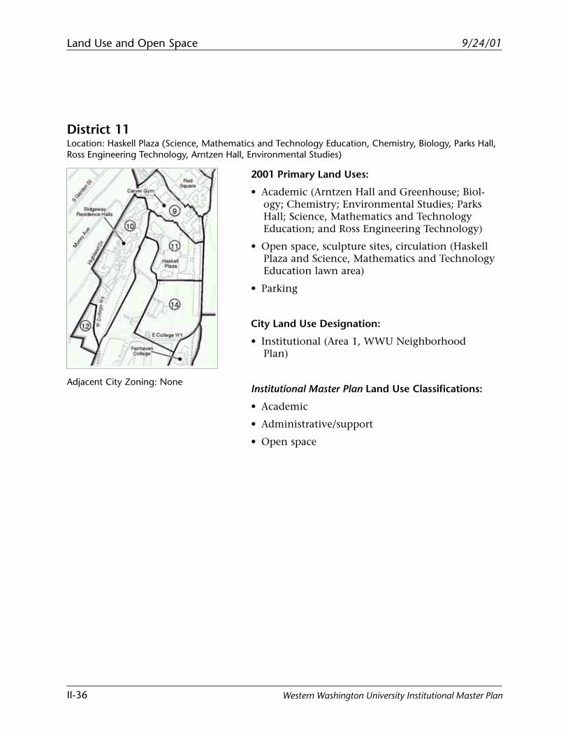
District 11Location: Haskell Plaza (Science, Mathematics and Technology Education, Chemistry, Biology, Parks Hall,Ross Engineering Technology, Arntzen Hall, Environmental Studies)
2001 Primary Land Uses:
• Academic (Arntzen Hall and Greenhouse; Biol-ogy; Chemistry; Environmental Studies; ParksHall; Science, Mathematics and TechnologyEducation; and Ross Engineering Technology)
• Open space, sculpture sites, circulation (HaskellPlaza and Science, Mathematics and TechnologyEducation lawn area)
• Parking
City Land Use Designation:
• Institutional (Area 1, WWU NeighborhoodPlan)
Institutional Master Plan Land Use Classifications:
• Academic
• Administrative/support
• Open space
Adjacent City Zoning: None
Land Use and Open Space
II-37
9/24/01
Western Washington University Institutional Master Plan
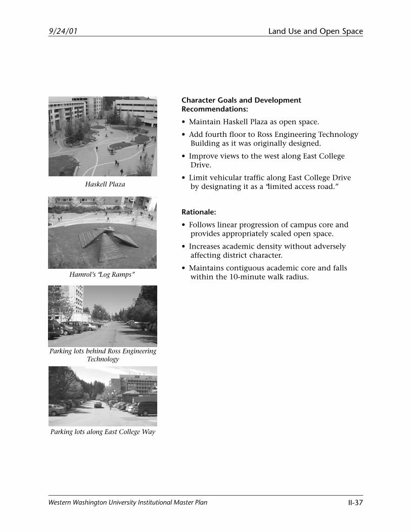
Character Goals and DevelopmentRecommendations:
• Maintain Haskell Plaza as open space.
• Add fourth floor to Ross Engineering TechnologyBuilding as it was originally designed.
• Improve views to the west along East CollegeDrive.
• Limit vehicular traffic along East College Driveby designating it as a “limited access road.”
Rationale:
• Follows linear progression of campus core andprovides appropriately scaled open space.
• Increases academic density without adverselyaffecting district character.
• Maintains contiguous academic core and fallswithin the 10-minute walk radius.
Haskell Plaza
Hamrol’s “Log Ramps”
Parking lots behind Ross EngineeringTechnology
Parking lots along East College Way
Land Use and Open Space
II-38
9/24/01
Western Washington University Institutional Master Plan
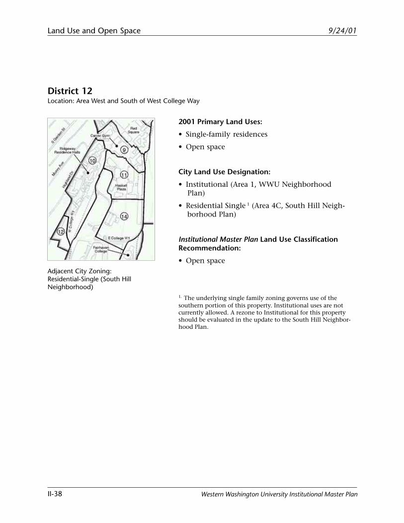
District 12Location: Area West and South of West College Way
2001 Primary Land Uses:
• Single-family residences
• Open space
City Land Use Designation:
• Institutional (Area 1, WWU NeighborhoodPlan)
• Residential Single 1 (Area 4C, South Hill Neigh-borhood Plan)
Institutional Master Plan Land Use ClassificationRecommendation:
• Open space
1. The underlying single family zoning governs use of thesouthern portion of this property. Institutional uses are notcurrently allowed. A rezone to Institutional for this propertyshould be evaluated in the update to the South Hill Neighbor-hood Plan.
Adjacent City Zoning:Residential-Single (South HillNeighborhood)
Land Use and Open Space
II-39
9/24/01
Western Washington University Institutional Master Plan
West College Way
West College Way
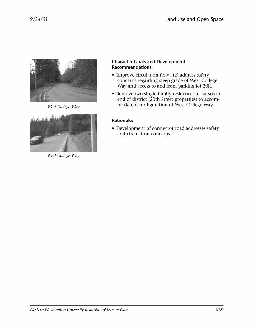
Character Goals and DevelopmentRecommendations:
• Improve circulation flow and address safetyconcerns regarding steep grade of West CollegeWay and access to and from parking lot 20R.
• Remove two single-family residences at far southend of district (20th Street properties) to accom-modate reconfiguration of West College Way.
Rationale:
• Development of connector road addresses safetyand circulation concerns.
Land Use and Open Space
II-40
9/24/01
Western Washington University Institutional Master Plan
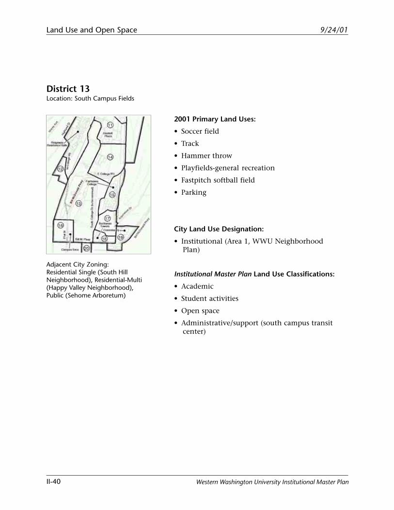
District 13Location: South Campus Fields
Adjacent City Zoning:Residential Single (South HillNeighborhood), Residential-Multi(Happy Valley Neighborhood),Public (Sehome Arboretum)
2001 Primary Land Uses:
• Soccer field
• Track
• Hammer throw
• Playfields-general recreation
• Fastpitch softball field
• Parking
City Land Use Designation:
• Institutional (Area 1, WWU NeighborhoodPlan)
Institutional Master Plan Land Use Classifications:
• Academic
• Student activities
• Open space
• Administrative/support (south campus transitcenter)
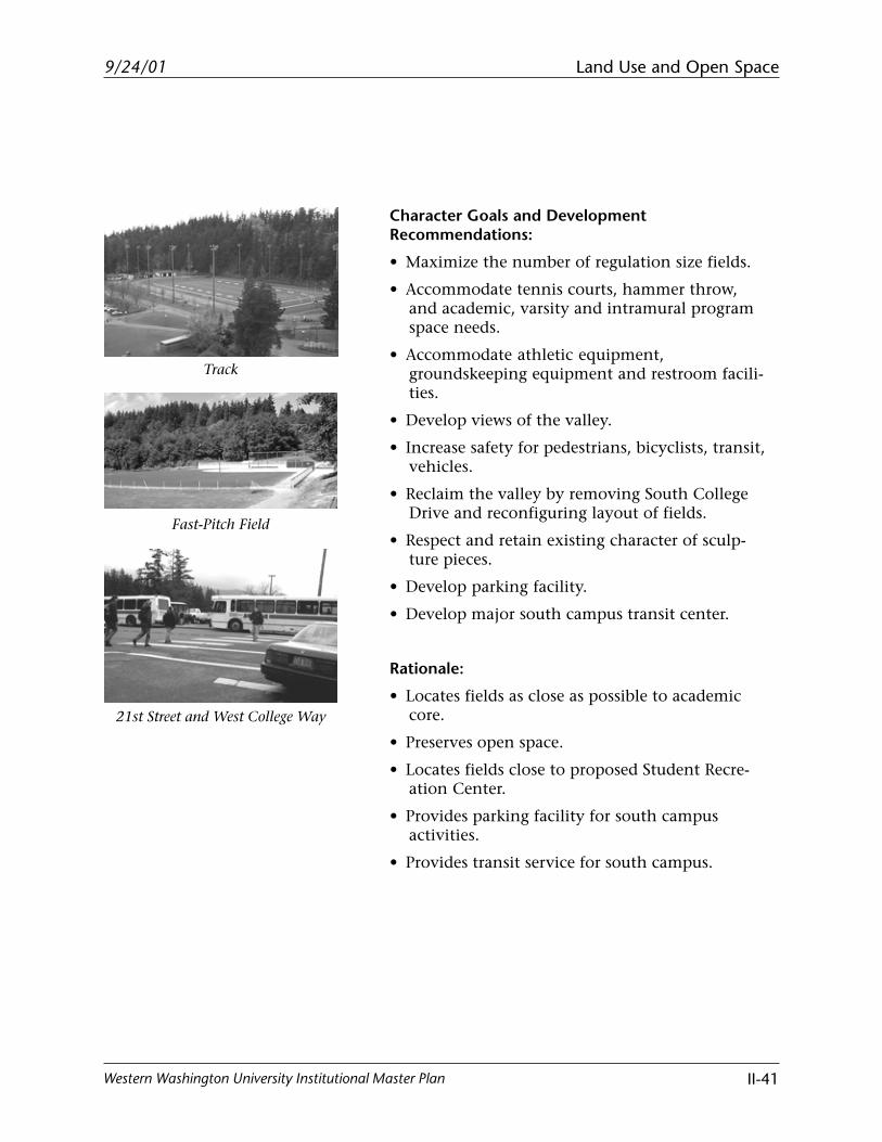
Land Use and Open Space
II-41
9/24/01
Western Washington University Institutional Master Plan
Track
Fast-Pitch Field
Character Goals and DevelopmentRecommendations:
• Maximize the number of regulation size fields.
• Accommodate tennis courts, hammer throw,and academic, varsity and intramural programspace needs.
• Accommodate athletic equipment,groundskeeping equipment and restroom facili-ties.
• Develop views of the valley.
• Increase safety for pedestrians, bicyclists, transit,vehicles.
• Reclaim the valley by removing South CollegeDrive and reconfiguring layout of fields.
• Respect and retain existing character of sculp-ture pieces.
• Develop parking facility.
• Develop major south campus transit center.
Rationale:
• Locates fields as close as possible to academiccore.
• Preserves open space.
• Locates fields close to proposed Student Recre-ation Center.
• Provides parking facility for south campusactivities.
• Provides transit service for south campus.
21st Street and West College Way
Land Use and Open Space
II-42
9/24/01
Western Washington University Institutional Master Plan
District 14Location: Proposed Academic Quad South of Environmental Studies and Parks Hall
2001 Primary Land Uses:
• General recreation (playfields)
• Administrative/support (Public Safety/Mailroomand Visitor Information Center)
• Multiple sculpture sites
• Circulation and parking
City Land Use Designation:
• Institutional (Area 1, WWU NeighborhoodPlan)
Institutional Master Plan Land Use Classifications:
• Academic
• Administrative/support
• Open space
• Student activities
Adjacent City Zoning:Public (Sehome Arboretum to theeast)
Land Use and Open Space
II-43
9/24/01
Western Washington University Institutional Master Plan
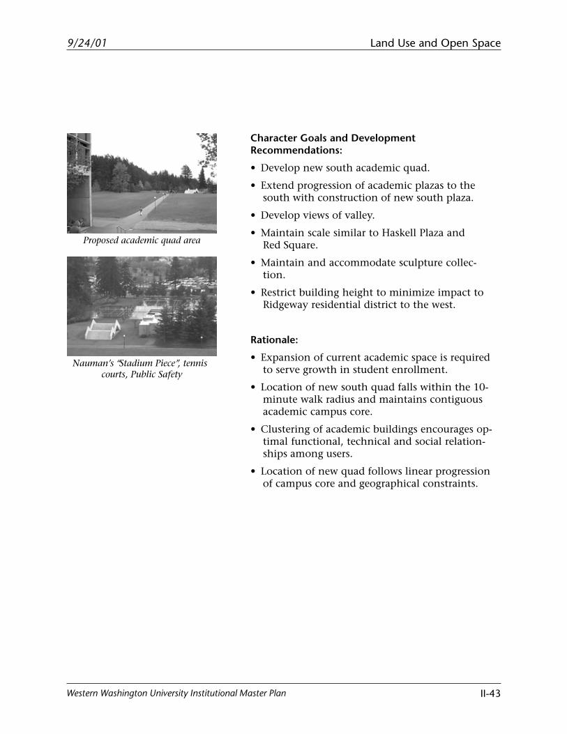
Character Goals and DevelopmentRecommendations:
• Develop new south academic quad.
• Extend progression of academic plazas to thesouth with construction of new south plaza.
• Develop views of valley.
• Maintain scale similar to Haskell Plaza andRed Square.
• Maintain and accommodate sculpture collec-tion.
• Restrict building height to minimize impact toRidgeway residential district to the west.
Rationale:
• Expansion of current academic space is requiredto serve growth in student enrollment.
• Location of new south quad falls within the 10-minute walk radius and maintains contiguousacademic campus core.
• Clustering of academic buildings encourages op-timal functional, technical and social relation-ships among users.
• Location of new quad follows linear progressionof campus core and geographical constraints.
Proposed academic quad area
Nauman’s “Stadium Piece”, tenniscourts, Public Safety
Land Use and Open Space
II-44
9/24/01
Western Washington University Institutional Master Plan
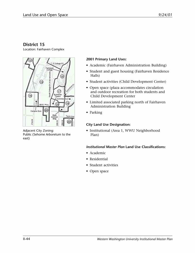
2001 Primary Land Uses:
• Academic (Fairhaven Administration Building)
• Student and guest housing (Fairhaven ResidenceHalls)
• Student activities (Child Development Center)
• Open space (plaza accommodates circulationand outdoor recreation for both students andChild Development Center
• Limited associated parking north of FairhavenAdministration Building
• Parking
City Land Use Designation:
• Institutional (Area 1, WWU NeighborhoodPlan)
Institutional Master Plan Land Use Classifications:
• Academic
• Residential
• Student activities
• Open space
Adjacent City Zoning:Public (Sehome Arboretum to theeast)
District 15Location: Fairhaven Complex
Land Use and Open Space
II-45
9/24/01
Western Washington University Institutional Master Plan
Character Goals and DevelopmentRecommendations:
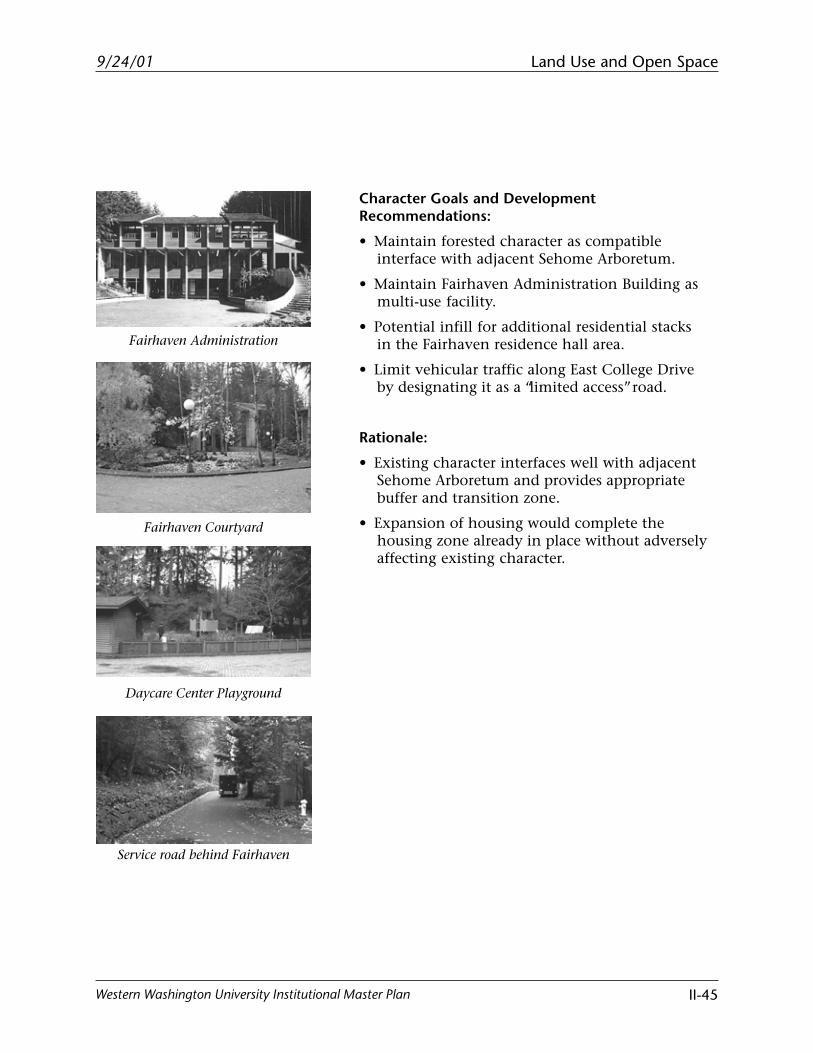
• Maintain forested character as compatibleinterface with adjacent Sehome Arboretum.
• Maintain Fairhaven Administration Building asmulti-use facility.
• Potential infill for additional residential stacksin the Fairhaven residence hall area.
• Limit vehicular traffic along East College Driveby designating it as a “limited access” road.
Rationale:
• Existing character interfaces well with adjacentSehome Arboretum and provides appropriatebuffer and transition zone.
• Expansion of housing would complete thehousing zone already in place without adverselyaffecting existing character.
Fairhaven Administration
Fairhaven Courtyard
Service road behind Fairhaven
Daycare Center Playground
Land Use and Open Space
II-46
9/24/01
Western Washington University Institutional Master Plan
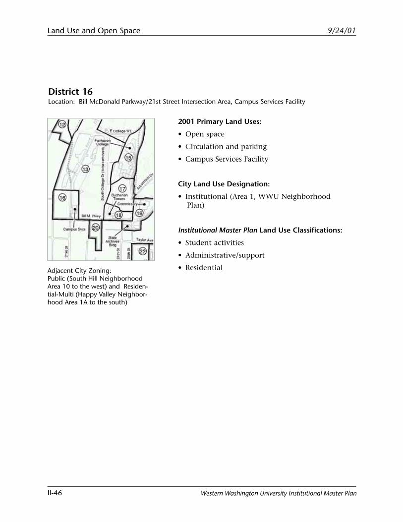
District 16Location: Bill McDonald Parkway/21st Street Intersection Area, Campus Services Facility
2001 Primary Land Uses:
• Open space
• Circulation and parking
• Campus Services Facility
City Land Use Designation:
• Institutional (Area 1, WWU NeighborhoodPlan)
Institutional Master Plan Land Use Classifications:
• Student activities
• Administrative/support
• ResidentialAdjacent City Zoning:Public (South Hill NeighborhoodArea 10 to the west) and Residen-tial-Multi (Happy Valley Neighbor-hood Area 1A to the south)
Land Use and Open Space
II-47
9/24/01
Western Washington University Institutional Master Plan
Character Goals and DevelopmentRecommendations:
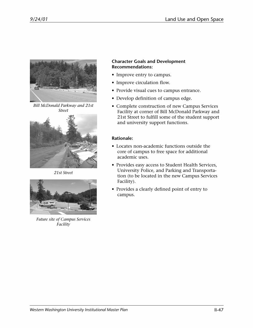
• Improve entry to campus.
• Improve circulation flow.
• Provide visual cues to campus entrance.
• Develop definition of campus edge.
• Complete construction of new Campus ServicesFacility at corner of Bill McDonald Parkway and21st Street to fulfill some of the student supportand university support functions.
Rationale:
• Locates non-academic functions outside thecore of campus to free space for additionalacademic uses.
• Provides easy access to Student Health Services,University Police, and Parking and Transporta-tion (to be located in the new Campus ServicesFacility).
• Provides a clearly defined point of entry tocampus.
Bill McDonald Parkway and 21stStreet
21st Street
Future site of Campus ServicesFacility
Land Use and Open Space
II-48
9/24/01
Western Washington University Institutional Master Plan
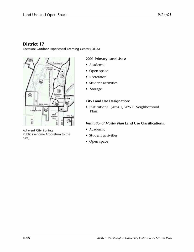
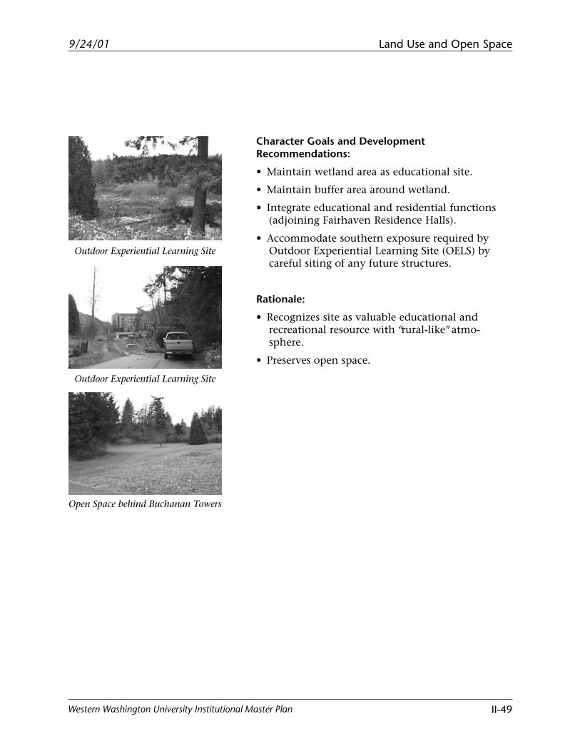
District 17Location: Outdoor Experiential Learning Center (OELS)
Adjacent City Zoning:Public (Sehome Arboretum to theeast)
2001 Primary Land Uses:
• Academic
• Open space
• Recreation
• Student activities
• Storage
City Land Use Designation:
• Institutional (Area 1, WWU NeighborhoodPlan)
Institutional Master Plan Land Use Classifications:
• Academic
• Student activities
• Open space
Land Use and Open Space
II-49
9/24/01
Western Washington University Institutional Master Plan
Outdoor Experiential Learning Site
Outdoor Experiential Learning Site
Open Space behind Buchanan Towers
Character Goals and DevelopmentRecommendations:
• Maintain wetland area as educational site.
• Maintain buffer area around wetland.
• Integrate educational and residential functions(adjoining Fairhaven Residence Halls).
• Accommodate southern exposure required byOutdoor Experiential Learning Site (OELS) bycareful siting of any future structures.
Rationale:
• Recognizes site as valuable educational andrecreational resource with “rural-like” atmo-sphere.
• Preserves open space.
Land Use and Open Space
II-50
9/24/01
Western Washington University Institutional Master Plan
District 18Location: Buchanan Towers Area North of Bill McDonald Parkway
2001 Primary Land Uses:
• Student housing (Buchanan Towers)
• Associated circulation and parking
• Open space (north of Buchanan Towers)
City Land Use Designation:
• Institutional (Area 1, WWU NeighborhoodPlan)
Institutional Master Plan Land Use Classifications:
• Residential
• Open space
Adjacent City Zoning:Residential-Multi (Happy ValleyNeighborhood to the south)
Land Use and Open Space
II-51
9/24/01
Western Washington University Institutional Master Plan
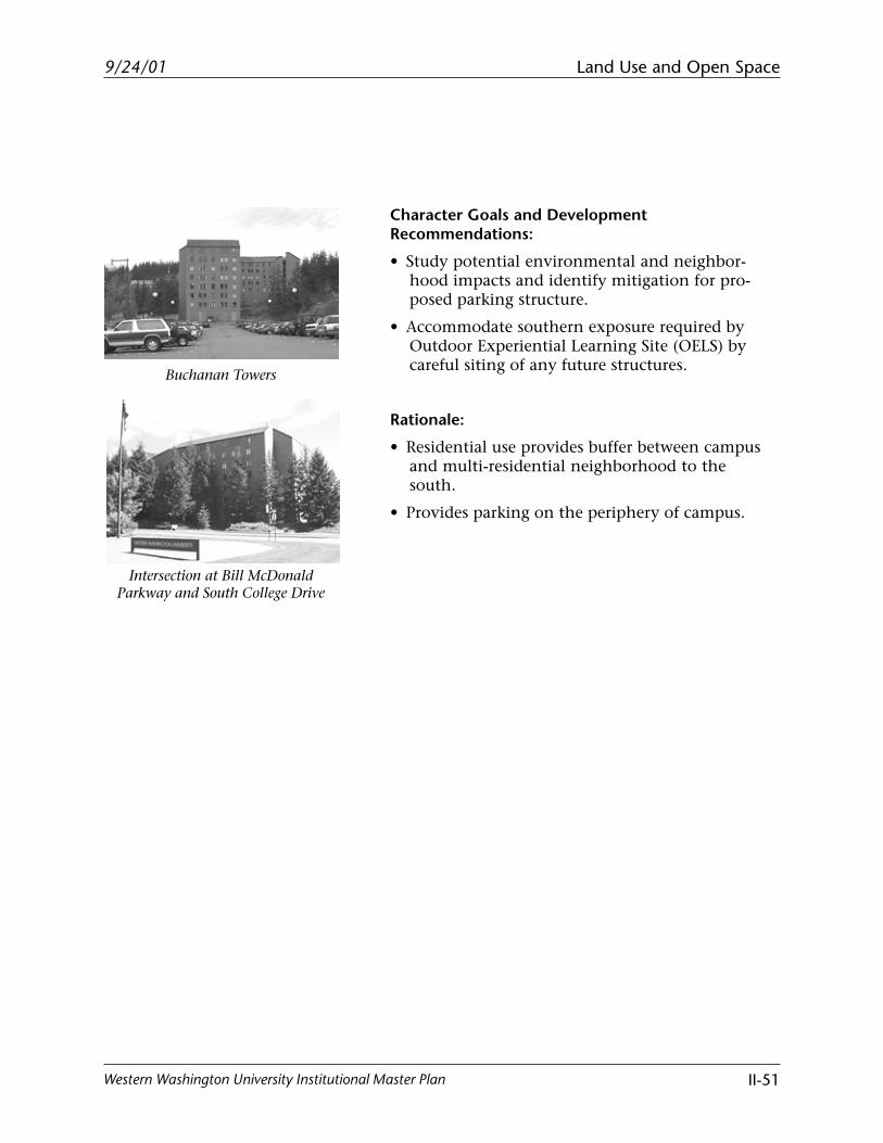
Buchanan Towers
Intersection at Bill McDonaldParkway and South College Drive
Character Goals and DevelopmentRecommendations:
• Study potential environmental and neighbor-hood impacts and identify mitigation for pro-posed parking structure.
• Accommodate southern exposure required byOutdoor Experiential Learning Site (OELS) bycareful siting of any future structures.
Rationale:
• Residential use provides buffer between campusand multi-residential neighborhood to thesouth.
• Provides parking on the periphery of campus.
Land Use and Open Space
II-52
9/24/01
Western Washington University Institutional Master Plan
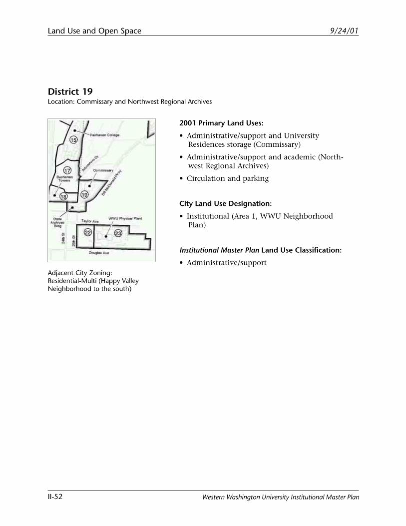
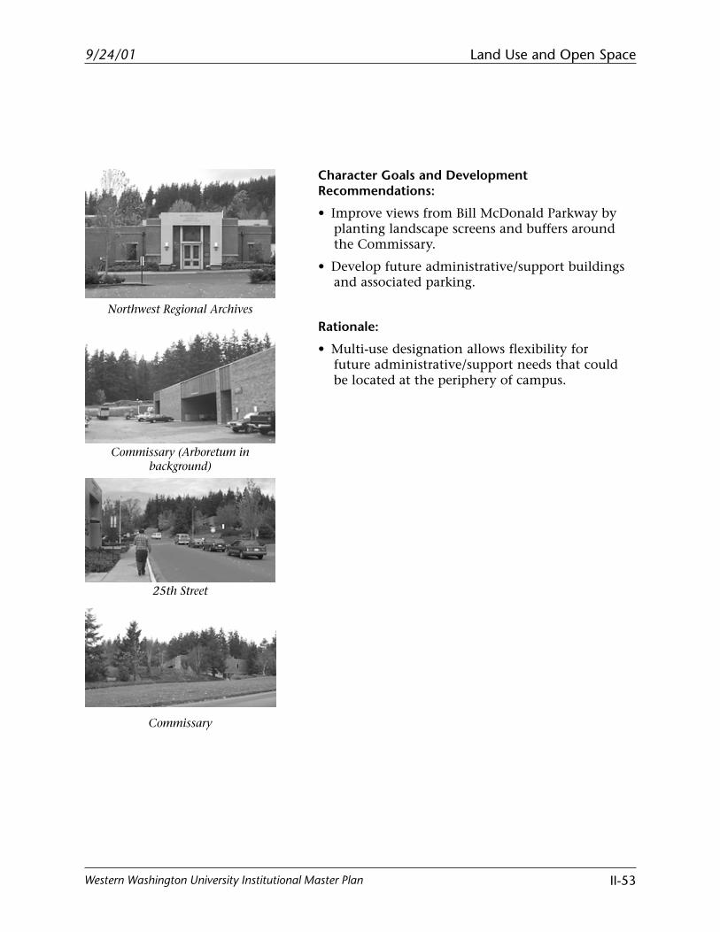
District 19Location: Commissary and Northwest Regional Archives
Adjacent City Zoning:Residential-Multi (Happy ValleyNeighborhood to the south)
2001 Primary Land Uses:
• Administrative/support and UniversityResidences storage (Commissary)
• Administrative/support and academic (North-west Regional Archives)
• Circulation and parking
City Land Use Designation:
• Institutional (Area 1, WWU NeighborhoodPlan)
Institutional Master Plan Land Use Classification:
• Administrative/support
Land Use and Open Space
II-53
9/24/01
Western Washington University Institutional Master Plan
Northwest Regional Archives
Commissary (Arboretum inbackground)
25th Street
Commissary
Character Goals and DevelopmentRecommendations:
• Improve views from Bill McDonald Parkway byplanting landscape screens and buffers aroundthe Commissary.
• Develop future administrative/support buildingsand associated parking.
Rationale:
• Multi-use designation allows flexibility forfuture administrative/support needs that couldbe located at the periphery of campus.
Land Use and Open Space
II-54
9/24/01
Western Washington University Institutional Master Plan
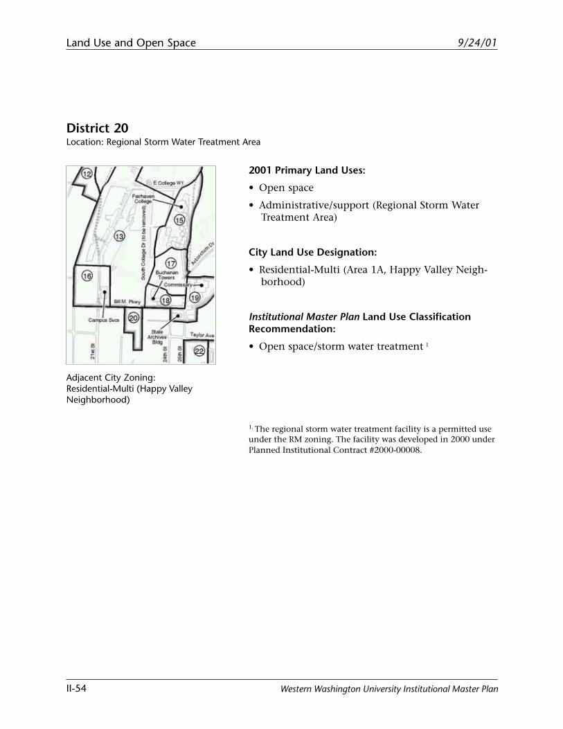
District 20Location: Regional Storm Water Treatment Area
Adjacent City Zoning:Residential-Multi (Happy ValleyNeighborhood)
2001 Primary Land Uses:
• Open space
• Administrative/support (Regional Storm WaterTreatment Area)
City Land Use Designation:
• Residential-Multi (Area 1A, Happy Valley Neigh-borhood)
Institutional Master Plan Land Use ClassificationRecommendation:
• Open space/storm water treatment 1
1. The regional storm water treatment facility is a permitted useunder the RM zoning. The facility was developed in 2000 underPlanned Institutional Contract #2000-00008.
Land Use and Open Space
II-55
9/24/01
Western Washington University Institutional Master Plan
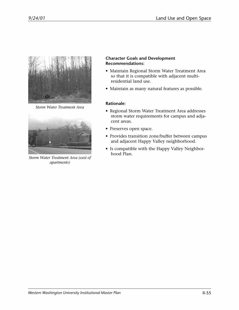
Storm Water Treatment Area
Storm Water Treatment Area (east ofapartments)
Character Goals and DevelopmentRecommendations:
• Maintain Regional Storm Water Treatment Areaso that it is compatible with adjacent multi-residential land use.
• Maintain as many natural features as possible.
Rationale:
• Regional Storm Water Treatment Area addressesstorm water requirements for campus and adja-cent areas.
• Preserves open space.
• Provides transition zone/buffer between campusand adjacent Happy Valley neighborhood.
• Is compatible with the Happy Valley Neighbor-hood Plan.
Land Use and Open Space
II-56
9/24/01
Western Washington University Institutional Master Plan
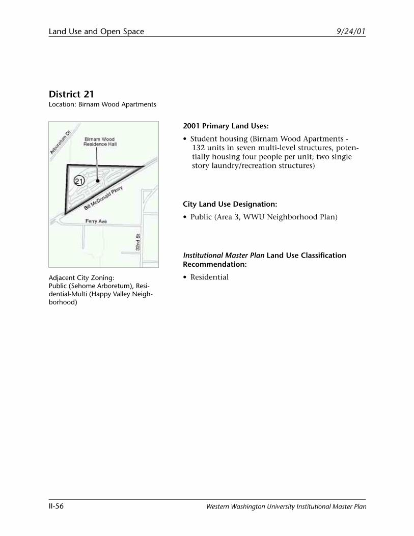
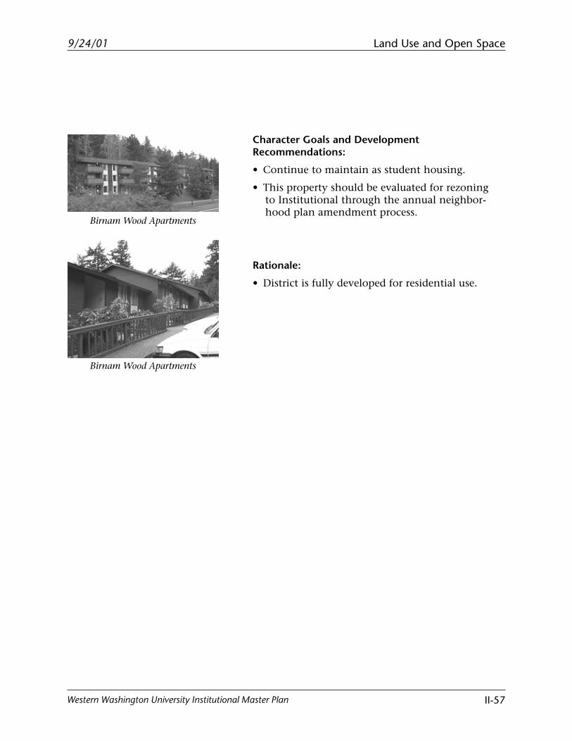
District 21Location: Birnam Wood Apartments
2001 Primary Land Uses:
• Student housing (Birnam Wood Apartments -132 units in seven multi-level structures, poten-tially housing four people per unit; two singlestory laundry/recreation structures)
City Land Use Designation:
• Public (Area 3, WWU Neighborhood Plan)
Institutional Master Plan Land Use ClassificationRecommendation:
• ResidentialAdjacent City Zoning:Public (Sehome Arboretum), Resi-dential-Multi (Happy Valley Neigh-borhood)
Land Use and Open Space
II-57
9/24/01
Western Washington University Institutional Master Plan
Birnam Wood Apartments
Birnam Wood Apartments
Character Goals and DevelopmentRecommendations:
• Continue to maintain as student housing.
• This property should be evaluated for rezoningto Institutional through the annual neighbor-hood plan amendment process.
Rationale:
• District is fully developed for residential use.
Land Use and Open Space
II-58
9/24/01
Western Washington University Institutional Master Plan
District 22Location: Block West of Physical Plant Bounded by 25th, 26th, Taylor, and Douglas
Adjacent City Zoning:Residential-Multi (Area 1A, HappyValley Neighborhood)
2001 Primary Land Uses:
• Open space
City Land Use Designation:
• Residential Multi (Area 1A, Happy Valley Neigh-borhood)
Institutional Master Plan Land Use ClassificationRecommendations:
• Residential
• Administrative/support 1
1. Western Washington University non-residential and condi-tional uses are allowed in this district only if it is rezoned toInstitutional through the annual neighborhood plan amend-ment process and a site plan/planned contract is approved.Until then, the Residential Multi zoning governs use of theproperty. Applications for planned development and rezone toInstitutional should be processed concurrently if possible.
Land Use and Open Space
II-59
9/24/01
Western Washington University Institutional Master Plan
Character Goals and DevelopmentRecommendations:
• If rezoned to Institutional, permitted uses shouldbe limited to residential and non-industrialadministrative support uses as defined herein.Warehouse and maintenance shop facilities andoutdoor storage of construction or other materi-als shall not be located in this district.
• Appropriate development and performancestandards should be established in the rezoneand planned contract process.
• As part of the planned contract process, vacatingthe 26th Street right-of-way should be consideredin exchange for an equal dedication of land foropen space on the east side of 25th Street. If thisoccurs, Western should be required to perma-nently own and maintain the open space.
• Parking in this district could serve uses located inArea 23. Parking for uses north of Bill McDonaldParkway is prohibited.
Rationale:
• This block, once completely owned by Westernand rezoned to Institutional, is appropriate forexpansion of office and other administrativesupport uses to free space on the main campusfor academic use.
Land Use and Open Space
II-60
9/24/01
Western Washington University Institutional Master Plan
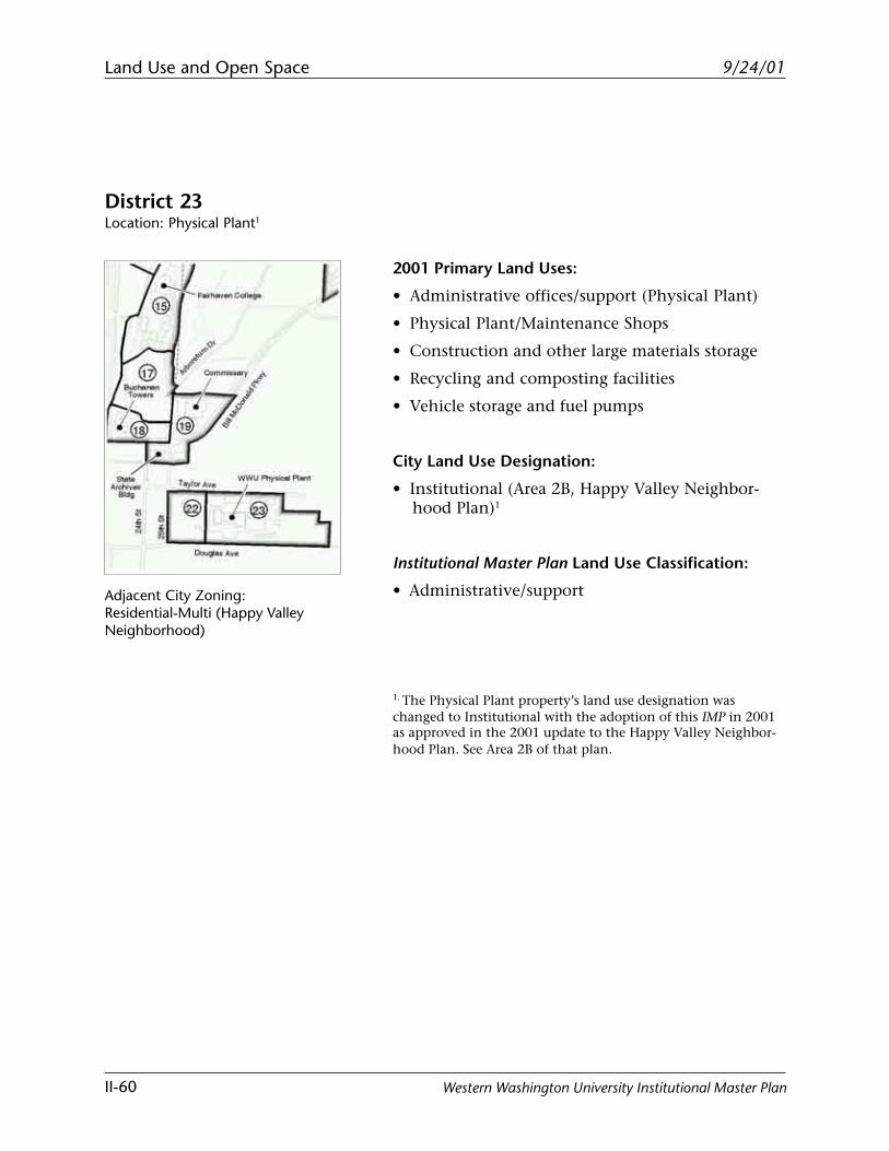
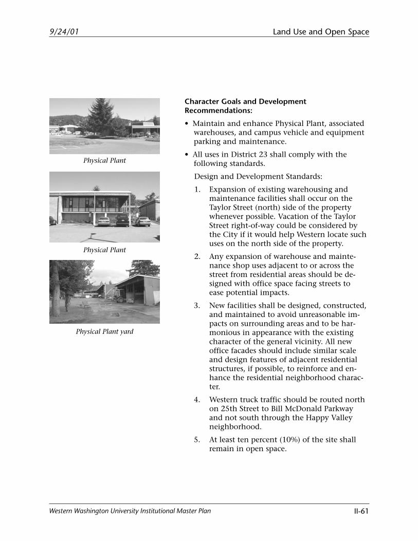
District 23Location: Physical Plant1
Adjacent City Zoning:Residential-Multi (Happy ValleyNeighborhood)
2001 Primary Land Uses:
• Administrative offices/support (Physical Plant)
• Physical Plant/Maintenance Shops
• Construction and other large materials storage
• Recycling and composting facilities
• Vehicle storage and fuel pumps
City Land Use Designation:
• Institutional (Area 2B, Happy Valley Neighbor-hood Plan)1
Institutional Master Plan Land Use Classification:
• Administrative/support
1. The Physical Plant property’s land use designation waschanged to Institutional with the adoption of this IMP in 2001as approved in the 2001 update to the Happy Valley Neighbor-hood Plan. See Area 2B of that plan.
Land Use and Open Space
II-61
9/24/01
Western Washington University Institutional Master Plan
Physical Plant
Physical Plant yard
Physical Plant
Character Goals and DevelopmentRecommendations:
• Maintain and enhance Physical Plant, associatedwarehouses, and campus vehicle and equipmentparking and maintenance.
• All uses in District 23 shall comply with thefollowing standards.
Design and Development Standards:
1. Expansion of existing warehousing andmaintenance facilities shall occur on theTaylor Street (north) side of the propertywhenever possible. Vacation of the TaylorStreet right-of-way could be considered bythe City if it would help Western locate suchuses on the north side of the property.
2. Any expansion of warehouse and mainte-nance shop uses adjacent to or across thestreet from residential areas should be de-signed with office space facing streets toease potential impacts.
3. New facilities shall be designed, constructed,and maintained to avoid unreasonable im-pacts on surrounding areas and to be har-monious in appearance with the existingcharacter of the general vicinity. All newoffice facades should include similar scaleand design features of adjacent residentialstructures, if possible, to reinforce and en-hance the residential neighborhood charac-ter.
4. Western truck traffic should be routed northon 25th Street to Bill McDonald Parkwayand not south through the Happy Valleyneighborhood.
5. At least ten percent (10%) of the site shallremain in open space.
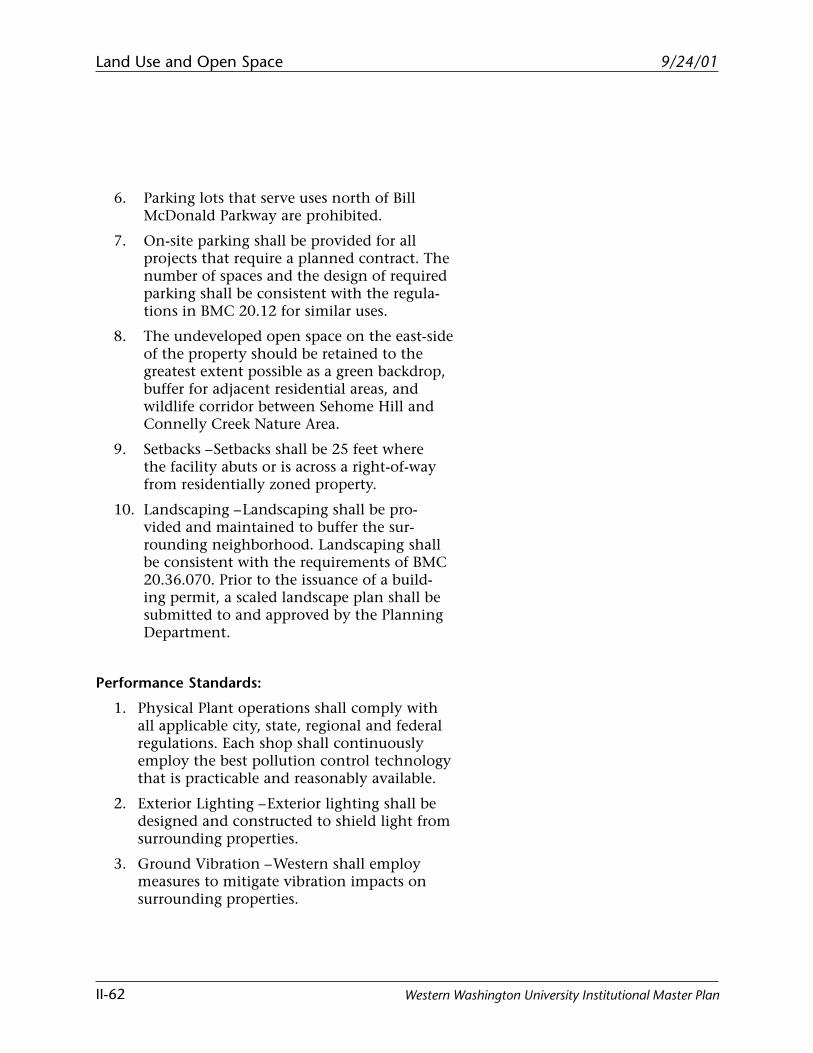
Land Use and Open Space
II-62
9/24/01
Western Washington University Institutional Master Plan
6. Parking lots that serve uses north of BillMcDonald Parkway are prohibited.
7. On-site parking shall be provided for allprojects that require a planned contract. Thenumber of spaces and the design of requiredparking shall be consistent with the regula-tions in BMC 20.12 for similar uses.
8. The undeveloped open space on the east-sideof the property should be retained to thegreatest extent possible as a green backdrop,buffer for adjacent residential areas, andwildlife corridor between Sehome Hill andConnelly Creek Nature Area.
9. Setbacks – Setbacks shall be 25 feet wherethe facility abuts or is across a right-of-wayfrom residentially zoned property.
10. Landscaping – Landscaping shall be pro-vided and maintained to buffer the sur-rounding neighborhood. Landscaping shallbe consistent with the requirements of BMC20.36.070. Prior to the issuance of a build-ing permit, a scaled landscape plan shall besubmitted to and approved by the PlanningDepartment.
Performance Standards:
1. Physical Plant operations shall comply withall applicable city, state, regional and federalregulations. Each shop shall continuouslyemploy the best pollution control technologythat is practicable and reasonably available.
2. Exterior Lighting – Exterior lighting shall bedesigned and constructed to shield light fromsurrounding properties.
3. Ground Vibration – Western shall employmeasures to mitigate vibration impacts onsurrounding properties.
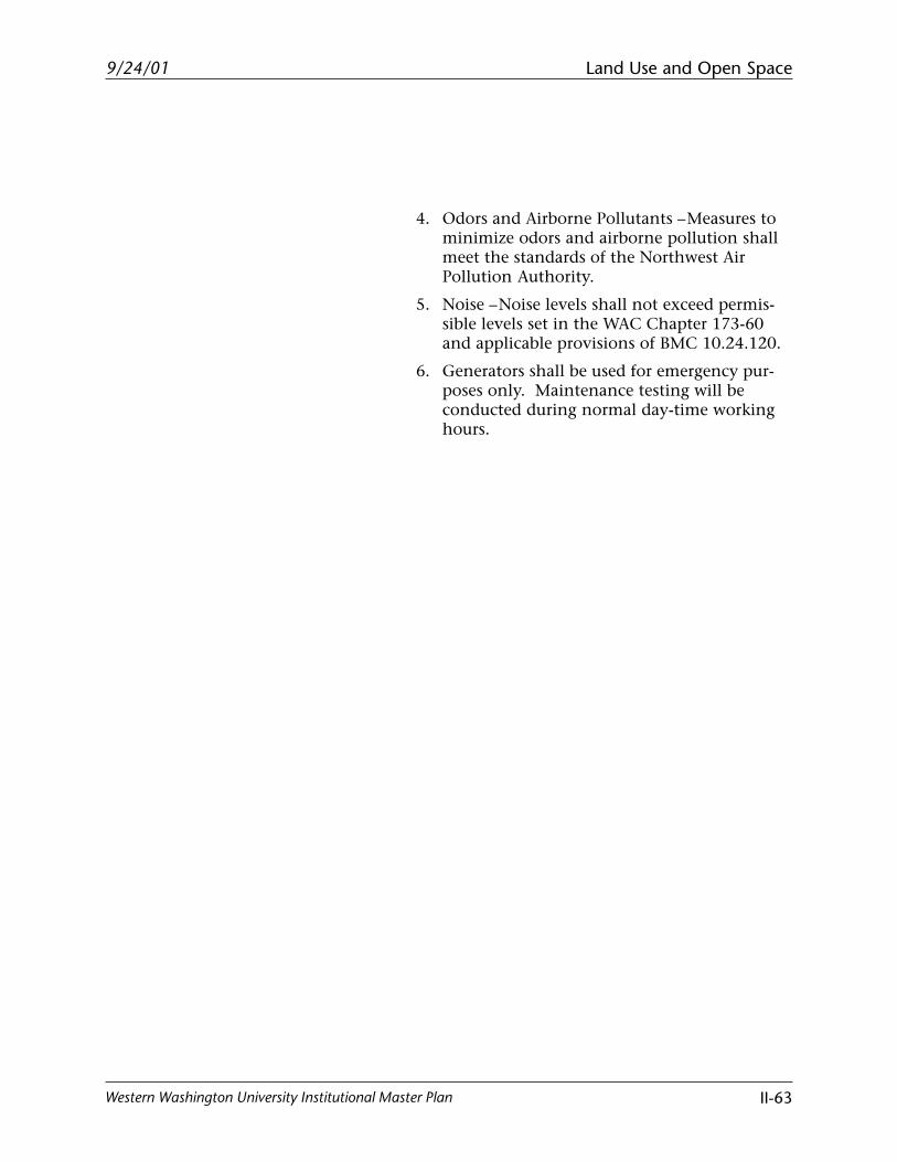
Land Use and Open Space
II-63
9/24/01
Western Washington University Institutional Master Plan
4. Odors and Airborne Pollutants – Measures tominimize odors and airborne pollution shallmeet the standards of the Northwest AirPollution Authority.
5. Noise – Noise levels shall not exceed permis-sible levels set in the WAC Chapter 173-60and applicable provisions of BMC 10.24.120.
6. Generators shall be used for emergency pur-poses only. Maintenance testing will beconducted during normal day-time workinghours.
Land Use and Open Space
II-64
9/24/01
Western Washington University Institutional Master Plan
This page intentionally left blank.
Land Use and Open Space
II-65
9/24/01
Western Washington University Institutional Master Plan
Open Space
The City’s Institutional Master Plan ordinance definesopen space as areas which are landscaped or natural.The landscaped areas can be designated for either activeor passive use.
Landscaped, active use, and open spaces on campus areprogrammed to serve specific educational or recre-ational functions such as classroom space or playfields.These programmed open spaces would not generally bepotential sites for development unless alternative sitesare identified to serve those same functions.
Landscaped, active use, open spaces on campus includethe following:
• The Arntzen Hall Environmental Garden located eastof Arntzen Hall is proposed to remain as an academicfunction.
• The soccer field located west of the Biology buildingis not regulation size, so a new regulation all-weathersurface soccer field is proposed to be located north ofthe softball field. However, the existing soccer fieldwould be retained as one of four required playfields.
• The track and all-weather playfield located west of21st Street is used by PEHR (Physical Education,Health & Recreation), Campus Recreation, andAthletics. It also serves as a buffer between the pro-posed academic core and the Ridgeway Residencecomplex.
• Eight existing tennis courts will be relocated outsideof the academic core, along with four additionalcourts (for a total of twelve courts). The courts areused by PEHR.
• The existing hammer throw/shot-put field locatedsouth of the all-weather track/playfield is proposedto be relocated outside of the home run fence of thesoftball field. This relocation allows for constructionof the Student Recreation Center.
Land Use and Open Space
II-66
9/24/01
Western Washington University Institutional Master Plan
• There are currently four playfields that are notregulation size. These include two fields south ofEnvironmental Studies and Parks Hall, and two fieldsnorth of the softball field. The development of fourregulation sized fields in this area will require theclosure of South College Drive as described in theCirculation section.
• The softball field located north of Bill McDonaldParkway is proposed to be retained.
• The Water Quality Treatment Facility located southof Bill McDonald Parkway is required to meetstormwater quality standards and also serves anacademic function.
Western’s landscaped, passive use open space includesthe following:
• Old Main Quad, Virginia Wright Plaza, Red Square,and Haskell Plaza are vital open space areas and actas nodes for pedestrian circulation. The linkage ofthe quads is what forms the pedestrian circulationspine. A new quad is proposed to be developed inthe new Academic District 14 to extend the pedes-trian spine and create a stronger connection toFairhaven College.
• Western’s Outdoor Sculpture Collection is interna-tionally known and includes approximately 25pieces. New development should respect existingpieces and new settings should be developed toenhance the pedestrian experience.
Western’s natural open space that is used for bothactive and passive use includes the following:
• Sehome Arboretum is owned and managed under aninter-local cooperative agreement between theUniversity and the City of Bellingham. The principleof the agreement is to preserve and maintain theArboretum in its natural state to the greatest extent
Land Use and Open Space
II-67
9/24/01
Western Washington University Institutional Master Plan
possible. The Arboretum provides educational,aesthetic, recreational and research opportunities forboth the public and campus community.
• The Outdoor Experiential Learning Site/Wetland(OELS) located south of the Fairhaven Complex isproposed to be preserved for academic and studentactivity use.
Natural, passive use open space on campus includesbackgrounds, buffers, enframements and primitiveareas. Vegetation in these areas is generally left in itsnatural state. These spaces are valuable in serving asbinding elements that provide continuity to the overallfabric of the University’s spatial composition.
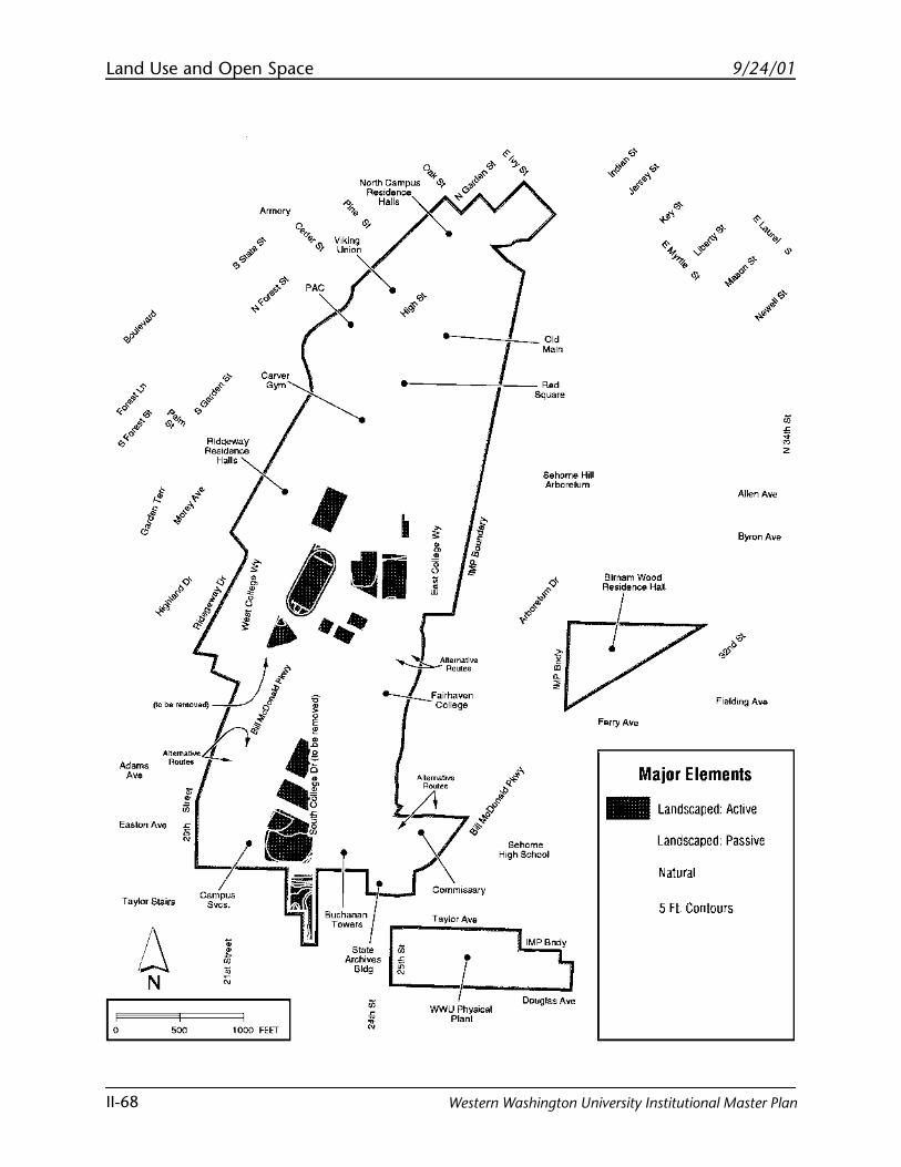
Land Use and Open Space
II-68
9/24/01
Western Washington University Institutional Master Plan
Adams
"'
Taylor Stairs
6 N
Armory
North Campus
0
~ .. , Res•dence -.
Halls
Viking Union x.
• Attet"~tl,,. I , .... --t-....._FairhaV<!n
College
Taylor Ave
"" Square
Sehome Hill Arboretum
Sehome High School
.__f-_5---..J'""''' WWU Physical Douglas Ave
Plant
Allen Ave
Byron Ave
Birnamwood
"!"~""'
Ferry Ave
Major Elements
- Landscaped: Active
Landscaped: Passive
Natural
5 Ft Contours
• ~ 2
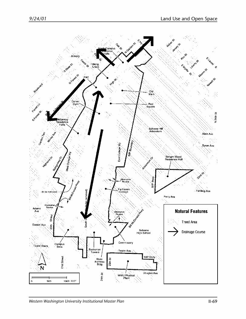
Land Use and Open Space
II-69
9/24/01
Western Washington University Institutional Master Plan
i '
WO 1000 FEET I
·. ~
:",
'<' • Alt~r~ah:.., j ""'"
~Fairhaven College
·, 'Old Main
' Red Square
, 'Sehome Hill'', , _Arboretum
AllenAv'e
. ~.-~i~,~-9 ~v"
Fefry Ave
DO"!Jla:s Ave
·.
Natural Features
Treed Area
-7 Drainage Course
•

Blank page
9/24/01
Western Washington University Institutional Master Plan
Circulation

Blank page
9/24/01 Circulation
Western Washington University Institutional Master Plan III-1
Introduction
The Circulation section contains principles that guidedthe preparation of the circulation plan. In summary,the principles promote moving vehicular access to theperimeter of campus. The principles set up a hierarchyto facilitate pedestrian and bicycle access to campus asthe highest priority, then transit and carpool access,and finally single occupant vehicle access as the lowestpriority.
The Circulation section also contains a description ofthe identified problems with the current system andproposes a number of solutions to address the prob-lems.
Finally, this section contains a summary of the existingand proposed major and secondary campus routes forpedestrians, bicycles, transit vehicles, and private cars.The plans identify the major access points to campusfor each mode, major transit stops, and parking areas.
Circulation Principles/Patterns to beReinforced
Many of the principles relating to circulation previous-ly identified in the January 1997 WWU Draft Compre-hensive Master Plan also apply to the Institutional MasterPlan. These principles, combined with desirable charac-ter patterns identified during the IMP process, guidethe proposed circulation plans. All circulation princi-ples and patterns support the goal of prioritizing modesof transportation in the following order: 1) pedestrian,2) bicycles, 3) transit, and 4) vehicles.
The following general principles and patterns relate tocirculation:
• Provide convenient, safe, and accessible access oncampus for students, staff, faculty and visitors.
• Work with the City to ensure that all on-campusand off-campus circulation plans are complementa-ry and reinforce circulation connections betweenWestern and adjacent neighborhoods.
9/24/01Circulation
Western Washington University Institutional Master PlanIII-2
• Separate pedestrian, bicycle, and transit circulationfrom private and service vehicles where feasible andappropriate.
• Provide multiple “front doors” to campus.
• Discourage cross campus through-traffic, promotetraffic calming devices, and minimize adverse circu-lation effects on neighborhoods.
To promote priority of pedestrian access, the planshould:
• Locate future academic zones within a 10-minutewalk from central campus to support a pedestrianoriented campus.
• Increase the number of students, staff, and facultywho walk to campus.
• Maximize convenient, well-lighted and safe pedes-trian access and circulation on campus; keep pedes-trians separate from bicycles and vehicles wheneverpossible.
• Relocate the majority of parking to the periphery ofcampus.
• Design pedestrian paths so they are accessible to thedisabled and sufficient to carry required volumes ofpedestrian traffic.
• Support the City’s efforts to provide convenient andsafe pedestrian access to campus.
• Convert High Street to a pedestrian/transit mallbetween West Campus Way and Oak Street to im-prove pedestrian and transit accessibility and reducecurrent conflicts between pedestrians and vehicles.Limit single occupancy vehicle circulation consis-tent with relevant City ordinances and regulationsregarding the use of High Street.
• Maximize a pedestrian campus and minimize theuse of limited campus land for roads.
9/24/01 Circulation
Western Washington University Institutional Master Plan III-3
• In accordance with “Recommendation #9” from theWWU Neighborhood Plan, work with city staff “toensure that city pedestrian improvement planscomplement on-campus facilities.”
To promote bicycle commuting and access:
• Improve bicycle security and bicycle facilities oncampus.
• Provide safe, convenient bicycle pathways on cam-pus separate from pedestrians and vehicles wheneverpossible.
• Consider development of continuous north/southbicycle routes to create safer circulation conditionson both edge of campus.
• In accordance with “Recommendation #12” fromthe WWU Neighborhood Plan, continue to work withcity staff “to ensure that city bicycle improvementplans complement on-campus facilities.”
To promote transit use and to reduce the use of singleoccupancy vehicles:
• Provide for safe transit circulation to access majordestination points, passenger drop zones, parkingareas, and key pedestrian circulation routes.
• Enhance and promote the bus pass program forstudents, staff, and faculty.
• Convert High Street to a pedestrian/transit mall aspreviously discussed in “Pedestrian Circulation.”
• Provide transit facilities that make transit serviceattractive, usable, and efficient for students, staff,faculty, and visitors.
• Explore demand for nighttime service.
9/24/01Circulation
Western Washington University Institutional Master PlanIII-4
To address vehicular access issues efforts should bemade to:
• Provide adequate infrastructure on all roadways toand from campus through the joint efforts of theCity and University to encourage pedestrians, bicy-clists, and transit.
• Separate private and service vehicles from pedestrian,bicycle, and transit circulation whenever possible.
• Provide road design standards (pavement, drainage,and sidewalks) and arterial upgrading that promote arational flow of traffic.
• Provide for safe vehicular circulation to access majordestination points, passenger drop zones, parkingareas, and key pedestrian circulation routes throughthe joint efforts of the City and University.
• Locate roadways to maximize a pedestrian campusand minimize the use of limited campus and forvehicular circulation in order to accommodate asmany campus facilities and functions as possiblewithin current boundaries and maintain the campus’key characteristics.
To address parking issues efforts should be made to:
• Minimize the demand for additional parkingthrough a transportation management program andthe increased usage of alternative modes of transpor-tation, while providing adequate parking to meet theUniversity’s need without increased reliance onneighborhood on-street parking.
• Develop on-campus parking structures to reduceland consumed for surface parking lots.
• Recognize and promote the use of off-campus park-ing areas (such as Civic Field) with shuttle transitservice.
• Ensure that on-campus events (public lectures,performances, athletic events, etc.) are accessible tothe community.
9/24/01 Circulation
Western Washington University Institutional Master Plan III-5
Existing Circulation Facilities
As required by the City of Bellingham Land Use Develop-ment Ordinance for Institutional Development, the size andcondition of developed streets and sidewalks wereinventoried. All developed streets within and directlyadjacent to the area boundary were included in theinventory along with information such as provisionsfor bicycle lanes, median strips, on-street parking, andposted speed limits (see “Appendix C: Existing Circula-tion Facilities”).
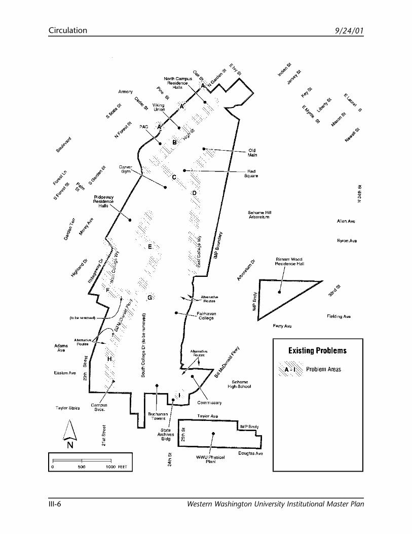
9/24/01Circulation
Western Washington University Institutional Master PlanIII-6
I,
Adams
"' Easton Ave
Taylor Stairs
6 N
ii
" " N
000
' -~'> H ' ~ ~>::
-t' Campus
Svcs.
• ~ ;; N
1000 FEfT I
• Attet"~tl,,. I , .... --t-....._Fa1rhaven
College
·~~:· .I_~·----!-~ wwu,.,,Physical
rant
Sehome Hill Arboretum
Douglas Ave
Allen Ave
Byron Ave
Birnamwood
"!'"~""'
Ferry Ave
Existing Problems
··~"'' >:A'I~ ;:(~ .. ~· Problem Areas
• ~ 2
9/24/01 Circulation
Western Washington University Institutional Master Plan III-7
Existing Problems and Proposed Solutions
Transportation and parking issues were recognized askey elements in the January 1997 WWU Draft Compre-hensive Master Plan. They remain major issues in theInstitutional Master Plan, which reconfirms the goal togive high priority to pedestrian circulation, followed bybicyclists, transit circulation, and, lastly, vehicularcirculation.
General circulation conflicts involve the interaction ofpedestrians with bicyclists, transit, and vehicles alongwith inadequate sidewalks and lighting. Not all conflictareas can be fully resolved, but an attempt should bemade to mitigate conflicts where possible. The follow-ing on-campus areas were identified as being of primaryconcern:
A. Garden/Cedar, Garden/Pine and Garden/OakIntersections
Contributing factors:• Pedestrians must cross heavy vehicular traffic• Poor visibility• Transit stop located close to intersection at Garden
and Cedar Streets• Heavy vehicular traffic along Garden Street
Proposed Solutions:
• Work with Whatcom Transportation Authority (WTA)to relocate the transit stop away from the intersection atGarden and Cedar Streets.
• Work with WTA, the Pedestrian and Bicycle AdvisoryCommittee, and City staff to consolidate and improvepedestrian crossings and implement traffic calming.
• Work with City to restrict on-street parking adjacent tointersections to increase the vision triangle areas andimprove safety.
• Install parking structure as part of parking manage-ment plan and to support public use facilities such asPerforming Arts Center, Carver Gym, and the book-store.
9/24/01Circulation
Western Washington University Institutional Master PlanIII-8
B. High Street
Contributing factors:• High volume of pedestrian, bicycle, and transit
traffic• Primary access route for service vehicles• Pedestrians forced to interact with service vehicles,
transit, and bicyclists• Arterial “splits” campus• “Streetlike” character of High Street implies prior-
ity of vehicles over pedestrians
Proposed Solutions:• Separate pedestrians from bicyclists, service vehicles,
and transit per the proposed pedestrian/transit mall.• Restrict vehicular access consistent with adopted city
ordinances.• Improve access for disabled.• Improve “streetscape” and change character of open
space to encourage pedestrian use.• Provide transit staging area and clearly identify transit
routes.• Provide bicycle lanes.
C. East/West Corridor from High Street to MillerHall/Fine Arts
Contributing factors:• Major campus crossroad with the highest volume
of pedestrians during class change periods• East/west bound pedestrians, bicyclists, and service
vehicles cross the major flow of north/south pedes-trian and bicycle traffic
• Brick surface with no provisions to separate thevarious modes of travel
Proposed Solutions:
• Reduce conflicts through signage, bike policy, andrerouting of bicycle traffic.
• Provide adequate bicycle storage in convenient, safelocations.
9/24/01 Circulation
Western Washington University Institutional Master Plan III-9
D. East College Way north of the Steam Plant
Contributing factors:• Poor separation between pedestrians and vehicular
traffic• Pedestrians forced to cross East College Way where
visibility is poor and vehicular traffic is heavy• Pedestrians mix with parked vehicles as well as
moving traffic• Moderate vehicular traffic
Proposed Solutions:
• Implement pedestrian pathway improvements alongEast College Way.
• Redirect some pedestrian traffic through the “valley”with developed pedestrian pathways.
• Relocate Old Main administrative departments that donot need to be in the campus core to the perimeter ofcampus or off-campus to reduce vehicular traffic.
• Restrict vehicular traffic on East College Way.
E. 21st Street/West College Way Intersection and21st Street north of West College Way
Contributing factors:• Transit buses, vehicles, pedestrians and bicyclists all
converge at intersection• Heavy volume of pedestrian, bicycle, transit, and
vehicular traffic• Inadequate space for buses• Poor condition and narrow width of sidewalks• Poor separation between vehicular, bicycle, and
pedestrian traffic• Narrow road
Proposed Solutions:• Close 21st Street north of West College Way to vehicular
traffic except for service vehicles.• Maintain 21st Street north of West College Way as a
major bicycle entrance.• Modify the curve where West College Way turns into
21st Street to better accommodate buses and reconstructtheintersection for easier circulation and safer pedestriancrossing.
9/24/01Circulation
Western Washington University Institutional Master PlanIII-10
• Improve traffic flow with the realignment of WestCollege Way.
• Provide safe, convenient bus drop-off and loading areas.
F. Highland Drive/West College Way Intersection& West College Way
Contributing factors:• Inadequate room for transit stops• Steep grade and curve in West College Way
Proposed Solutions:• Relocate transit stops further from the intersection and
install transit pullouts wherever possible.• Realign West College Way to eliminate existing curve
and reduce steep grade and install sidewalks and bikelanes.
• Provide traffic lights as required by traffic analysis andtraffic calming devices (paving treatments, roadwaywidths, etc.).
• Provide safe, convenient bus drop-off and loading areas.
G. South College Drive/West College Way Intersec-tion
Contributing factors:• Limited staging area at Visitor Information Center• Overflow vehicles interfere with cross traffic• Poor identification of access to the Visitor Infor-
mation Center• Lack of directional signs
Proposed Solutions:• Eliminate intersection by vacating South College Drive
and directing incoming traffic to 21st Street as the mainentry to campus, where the new Campus Services Facilitywill be located. South College Drive should not be va-cated until an alternative route to the east-side of cam-pus is in place.
• Direct non-campus traffic around campus via the re-alignment of West College Way.
9/24/01 Circulation
Western Washington University Institutional Master Plan III-11
H. 21st Street between Bill McDonald Parkway andWest College Way
Contributing factors:• Road and sidewalks in poor condition• Narrow road and sidewalk• Lack of designated bike lanes• High volume of pedestrians, bicyclists, and vehicles• Lack of separation between vehicles and pedestrians
Proposed Solutions:• Improve 21st Street with wider vehicular lanes, desig-
nated bicycle lanes, and wider sidewalks that separatepedestrians from vehicular traffic with a planted buffer.
• Provide transit pullouts wherever possible.• Add parking structure to meet future growth needs and to
reduce land area taken up by surface parking lots.• Add pedestrian crossings from parking lots located on the
uphill side of 21st Street.
I. Bill McDonald Parkway/25th Street Intersection
Contributing factors:• High volume of traffic on Bill McDonald Parkway,
the main entrance to campus• Pedestrians, bicyclists, transit, and vehicles access-
ing Bill McDonald Parkway from 25th Street• Pedestrians and bicyclists accessing Bill McDonald
Parkway from 24th Street• Western students who live south of campus• Sehome High School students• Physical Plant traffic• Visitors to Northwest Regional Archives Building• General city traffic• Poor visibility and limited identification of cross-
walk
Proposed Solutions:
• Relocate pedestrian crossing closer to South College Driveto allow easier pedestrian access to designated sidewalksand a more direct passage to campus.
9/24/01Circulation
Western Washington University Institutional Master PlanIII-12
• Work with City to develop treatments that reduce trafficspeed along Bill McDonald Parkway.
• Re-examine intersection at 25th Street and BillMcDonald Parkway and road configurations to addresssafety issues and vehicular circulation (see “ProposedVehicular Access & Parking”, page III-23).
• Install parking structure to serve Buchanan Towers andFairhaven College to replace parking loss due to relocatedfields.
Additional Circulation Issues
This plan contains an appropriate level of detail aboutmost of the proposed circulation system improvementson the Western campus. Future feasibility and impactanalysis, and mitigation identification will be neededprior to issuance of a planned contract for the follow-ing projects:
• The proposed 25th Street extension north of BillMcDonald Parkway shown as a study area on themap on page III-23.
• The proposed parking garages.
Further traffic analysis by Western will also be requiredto analyze the impacts of projected student, faculty,and staff population growth on off-campus facilities.Elements that Western should evaluate in a review ofoff-site impacts include but are not limited to:
• An O&D study to determine what percentage ofWestern related vehicle traffic impacts the City’sarterial street system.
• Identified mitigating measures to preserve arterialstreet capacity, pedestrian safety, and bicyclemobility.
• A definition of the threshold that triggers the imple-mentation of the mitigating measures.
9/24/01 Circulation
Western Washington University Institutional Master Plan III-13
Transportation Impact Fees
The University shall be required to pay TransportationImpact Fees in accordance with adopted city ordi-nances at the time of building permit issuance for anynew facilities.
9/24/01Circulation
Western Washington University Institutional Master PlanIII-14
Summary of Circulation Plans
Key circulation elements of the IMP are the eliminationof South College Drive and East College Way between21st Street and the Arboretum to allow reconfigurationof the fields and the creation of the new south aca-demic district. To accomplish this, the University isdependent on City cooperation to vacate these roads.This cooperation minimizes the impacts of develop-ment on adjacent neighborhoods by maximizingbuildable area on campus. Circulation routes then fallinto place with new pedestrian pathways establishedalong field layouts and vehicular traffic guided aroundcampus instead of running through the “valley.”
The following circulation plans show existing andproposed major and secondary routes for pedestrians,bicycles, transit and vehicles. The plans identify themajor access points to campus for each mode of trans-portation, major transit stops, and parking for bicyclesand vehicles.
Pedestrian Circulation
• High, Garden and Cedar Streets will remain themajor pedestrian access points to campus on thenorth end. Pedestrian routes within the north endof campus follow the existing configurations withsome routes gaining heavier foot traffic (routebetween Haggard Hall and Wilson Library and thecorridor between Haggard Hall/Bond Hall andCollege Hall/Carver Gym).
• In order to increase pedestrian and transit accessi-bility, High Street will be converted to a pedes-trian/transit mall consistent with adopted city or-dinances. The concept of the pedestrian/transitmall supports the circulation principles by placinghigh priority on pedestrian and transit circulationand separating vehicular and pedestrian traffic.The mall will provide safe and convenient bicycle
9/24/01 Circulation
Western Washington University Institutional Master Plan III-15
access via separate bicycle lanes and bicycleamenities (covered bike storage across from thebookstore). Safe and convenient passenger dropzones will be located at the north and south endsof the mall to reinforce the concept of providingmultiple “front doors” to campus for both thecampus community and visitors. The developmentof the mall will also provide opportunities forenhancing the campus interface with adjacentneighborhoods and for improving the streetscapeaesthetics with improved signs, lighting, paving,and other landscape elements. The Campus Infra-structure Development (CID) project is looking ateliminating the need for access to High Street forneighbors during inclement weather by creating anappropriate alternate route to the downtown areafrom Highland Drive.
• Major pedestrian access points to campus on thesouth end of campus also remain the same as theexisting pedestrian access points (21st Street, theformer South College Drive at 23rd Street, 25thStreet, and Bill McDonald Parkway), but internalpedestrian routes will differ. Sidewalks along 21stStreet will be improved and separated from vehicu-lar traffic by a planting strip, but pedestrians willbe encouraged to use the pedestrian path furthereast (along the fields) for their primary route forincreased safety and further separation from bicy-clists and vehicular traffic. The major access pointat the south end of the former South College Drive(23rd Street) will connect to a north/south pedes-trian route through campus that separates pedestri-ans from vehicles for most of its length.
• Pedestrians entering campus from 25th Street andBill McDonald Parkway will merge at the south endof the Fairhaven Complex, continue throughFairhaven Plaza and join the major north/southpedestrian route.
9/24/01Circulation
Western Washington University Institutional Master PlanIII-16
Bicycle Circulation
• Major access points remain the same as the exist-ing bicycle access points: Indian Street, GardenStreet, Oak Street, Cedar Street, Highland Drive,21st Street, the former South College Drive (23rdStreet), and Bill McDonald Parkway.
• Major access points link up with major bicycleroutes through campus (primarily north/southroutes).
• Bicycle lanes will be provided along the realigned21st Street.
• Secondary bicycle routes provide east/west routesthrough campus. Some secondary bicycle routeswithin the core of campus are restricted in use.(The bicycle dismount zone is enforced through thePublic Safety office.)
• The proposed secondary bicycle route shown eastof Old Main and Edens Hall would provide a con-tinuous north/south route on campus, but willrequire further study and analysis in conjunctionwith the Sehome Arboretum Board.
• In general, major bicycle parking with amenitiessuch as covered storage are located at the ends ofthe east/west routes so that bicyclists can parkbicycles and store equipment at the edge of campusand access the campus core by foot.
• Bicycle parking facilities will be provided at a rateof at least one bicycle space for each ten FTE stu-dents.
Transit Circulation
• Two major transit centers are proposed: one in thenorth campus area on High Street as part of thepedestrian/transit mall and one in the south cam-pus area, close to the proposed student recreationcenter and adjacent to the proposed academicdistrict.
• The campus shuttle service shall continue to oper-ate.
9/24/01 Circulation
Western Washington University Institutional Master Plan III-17
Vehicular Circulation
• The key element in the IMP is the elimination ofSouth College Drive to free up the “valley” for thedevelopment of new fields and the new southacademic district. With the City’s cooperation,vacation of South College Drive and other streetrights-of-way will allow the consolidation of Uni-versity property to reconfigure circulation flow andoptimize land use.
• Major vehicular access points are Garden Street,21st Street, 25th Street, and Bill McDonald Park-way.
• Conversion of High Street to a pedestrian/transitmall will address aesthetic and safety issues whilestill recognizing the need for visitor access in accor-dance with adopted city ordinances.
• Elimination of the south “leg” of East College Wayfrees up land for development of the new academicdistrict.
• The Fairhaven access road intersection at BillMcDonald Parkway needs to be re-examined toaddress safety issues and vehicular circulation (see“Proposed Vehicular Circulation Access,” page III-23).
• 21st Street will be realigned to address safety issueson the existing West College Way and will allownon-campus traffic to bypass campus.
• 21st Street will be improved for safety, circulatoryefficiency, and aesthetics.
• A limited access road off West College Drive pro-vides access to the campus core (behind the sciencecomplex).
• The existing road behind the Fairhaven Complexwill be reserved for pedestrians and limited vehicu-lar access.
• The feasibility of the proposed east access roadshould be explored with the City and ArboretumBoard.
9/24/01Circulation
Western Washington University Institutional Master PlanIII-18
Parking
• Alternative modes of transportation, such as tran-sit and carpooling, bicycling and walking, will beencouraged to reduce the demand for parkingfacilities. Structured parking facilities may be uti-lized to meet parking requirements on campus.(See “Parking Standards” section.)
• The University should expand incentives for theuse of alternative modes of transportation to fac-ulty, students, and staff in order to reduce use ofsingle occupancy vehicles (SOVs) on campus.
• A minimum of 3,400 parking spaces is required tobe provided on campus to meet current parkingdemand. Provisions to increase or decrease thenumber of required parking spaces, as studentenrollment or demand for parking changes, is inthe “Parking Standards” section of this document.
• A portion of university parking will need to beaccommodated in structured facilities. Potentialsites for parking structures locates major parking atthe periphery of campus. Potential sites (see Pro-posed Vehicular Access and Parking map, page III-23) include the existing parking lot at Oak andIndian Streets, the Viking Union, the area north ofHighland Hall, south of the proposed studentrecreation center, and east of Buchanan Towers.1
• Off-campus parking facilities may be utilized tomeet a portion of the minimum parking require-ments subject to city zoning and city approval. (See“Parking Standards,” page VI-6.)
• The University and the City of Bellingham arenegotiating the continuance of an interlocal agree-ment for Residential Parking Zones (RPZs)around campus. Western will partner with the Cityto continue to fund a residential parking zoneprogram around the campus. A well designed andaggressively enforced RPZ program is a key compo-nent of efforts to mitigate campus impacts on the
9/24/01 Circulation
Western Washington University Institutional Master Plan III-19
surrounding neighborhoods. Future expansion ofthe RPZ may be required to mitigate the impacts ofenrollment increases projected in this plan.Western’s continued participation in the fundingof an RPZ program will be a prerequisite for consid-ering any requests from Western for reductions ofon-campus parking spaces. The City recognizes thatWestern’s continued funding of the RPZ Program isa component of Western’s mitigation of impactsresulting from past and future construction andother activities.
1. The feasibility and cost of providing structured parking on thesesites is being evaluated by the University, with the assistance of Richand Associates, Inc., a nationally known parking consultant. Thepreliminary results of this study indicate that the proposed parkingstructures are feasible without state funding or university subsidies,but would require fairly substantial increases in university parkingfees. For example, it may be necessary to increase existing parkingfees campus-wide by approximately 20 percent to construct a 300space parking garage adjacent to the Viking Union, or 40 percent toconstruct a 550 space garage south of the proposed student recre-ation center. The University will continue to explore financingalternatives that could reduce the cost of constructing parkingstructures, including the use of tax exempt bond financing. TheUniversity will also continue to study the costs of transportationmanagement program improvements that could substantiallyreduce the need for structured parking. It is expected that theanalyses of the costs of constructing structured parking and improv-ing the transportation management program will be an on-goingeffort during the implementation of the Institutional Master Plan.
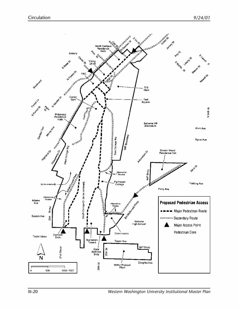
9/24/01Circulation
Western Washington University Institutional Master PlanIII-20
Easton Ave
Taylor Stairs
6 N
R1doeway Residence
Halls
Armory
Sehome Hill Arboretum
Sehome High School
• ~ 2
Allen Ave
Byron Ave
Ferry Ave
Proposed Pedestrian Access
• • • • Major Pedestrian Route
0000000 Secondary Route
A Major Access Point
Pedestrian Core
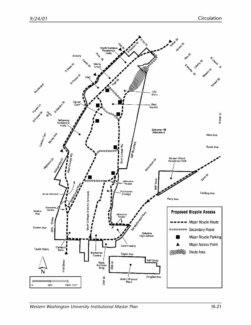
9/24/01 Circulation
Western Washington University Institutional Master Plan III-21
Easton Ave
Taylor Stairs
6 N
WO
RidQeway Residence
Halls
Campus I Svcs. I
"
Armory
1000 FEET I
J>. 0
,, ~,,
; «i'- 'z. North.Campus J& ; ~"'" <I'}
Residence ..._ "'; ,.,..,,-~· Halls ~"' ,,
WWU Physical Plant
Sehome Hill Arboretum
D0'1glas Ave
Allen Ave
Byron Ave
Fefry Ave
Proposed Bicycle Access
-----00000000
• "
Major Bicycle Route
Secondary Route
Major Bicycle Parking
Major Access Point
Study Area
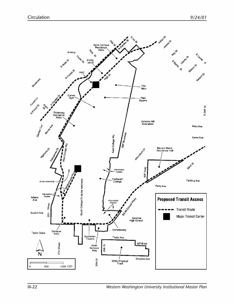
9/24/01Circulation
Western Washington University Institutional Master PlanIII-22
Easton Ave
Taylor Stairs
/\ w N
Armory
-
1000 FEET I
North campus '° Residence 0. Halls
• ~
I o" Main
A-' Square
Sehome Hill Arboretum
Allen Ave
Byron Ave
BimamWood
~
r---Rf,.s1dence Hall
• , Ferry Ave
Proposed Transit A ccess
----- Transit Route
• Major Transit Center
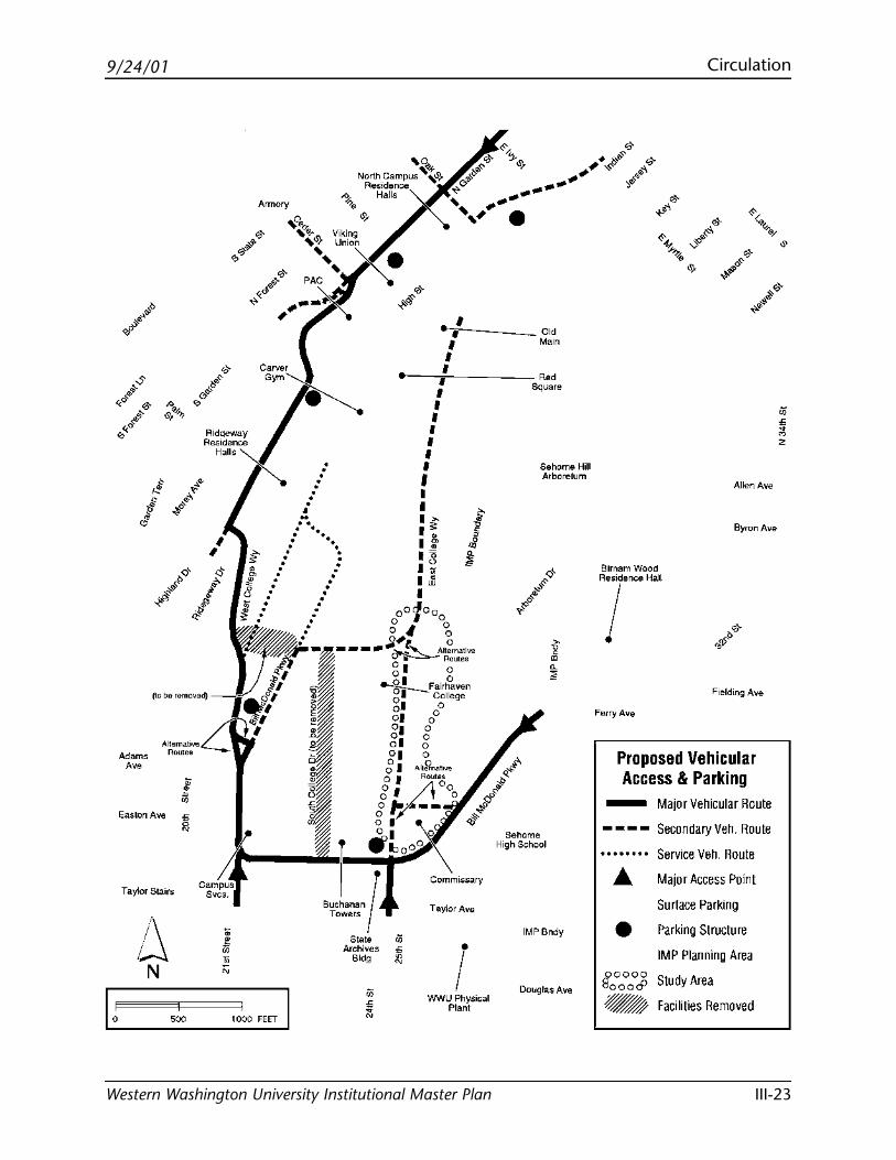
9/24/01 Circulation
Western Washington University Institutional Master Plan III-23
Taylor Stairs
6 N
RldQeway Residence
Halls
! WWU Physical
Plant
Sehome Hill Arboretum
Sehome High School
IMPBndy
Douglas Ave
Allen Ave
Byron Ave
Birnam Wood
"!'"~""'
Ferry Ave
Proposed Vehic_ular Access & Parking
- Major Vehicular Route
----
•
Secondary Veh. Route
Service Veh. Route
Major Access Point
Surface Parking
Parking Structure
IMP Planning Area
9 0000 Study Area l:'.Jooo& d - Facilities Remo"
• ~ 2

Blank page
9/24/01
Western Washington University Institutional Master Plan
Utilities

Blank page
9/24/01 Utilities
Western Washington University Institutional Master Plan IV-1
City Utilities
Both City and University utility systems were analyzedfor the condition and capacities of existing lines as wellas the various system capacities to provide requiredservices for the proposed development. As the campusgrows, provisions will be made for the extension and/orimprovements of all utility systems so that the campusand adjacent areas are not adversely affected.
Water
• Water is supplied to the campus by the City of Bell-ingham from the tank on Highland Drive and areservoir on Sehome Hill above Oak Street.
• Water pressure is limited in some areas of campus,and fire flow water pressure is a concern.
• Fire pumps have been provided in several buildingsto meet code requirements.
• Backup power is being provided to the pump stationthat services the reservoirs near the campus. After2001, the pump station will not have an issue withpower outages. Consequently, water supply to theUniversity and the outlying areas will be constant.
• It is proposed that the waterlines serving southcampus and down 21st Street from the Highlandtank be increased in size. Additionally, a portion ofthe university waterline is to be modified and indi-vidual meters installed in the buildings. These revi-sions would meet existing and future requirementsand improve fire flow to the campus.
9/24/01Utilities
Western Washington University Institutional Master PlanIV-2
Sanitary Sewer
• The campus sanitary sewer system is served by theCity of Bellingham sewage collection system anddirected to the Post Point treatment facility.
• There are three main sanitary sewer lines. One sys-tem serves the north campus and flows to the north.Two lines on the south campus flow south.
• Existing Western owned on-campus lines are of ade-quate size though some of the piping needs mainte-nance. The existing line from Carver Gym to 21stStreet is in poor condition and is in need of replace-ment.
• The Campus Infrastructure Development (CID) pre-design project calls for a revision of the sanitarysewer lines leaving south campus. The lines wouldbe upgraded and rerouted to run along roadways.The analysis at that time showed that the plannedgrowth would bring the City system near its capaci-ty. Actual flow analysis from the campus system isplanned to confirm that the City system will not beoverloaded.
Storm Water Systems
• The campus storm water is served by the City ofBellingham storm water collection system. Thenorth campus, Ridgeway area, and track flows northand then west to Bellingham Bay. The south campussystem flows south through the City system toPadden Creek.
• The City of Bellingham main line serving the northcampus that runs west from the campus is at capaci-ty. Any new load to this system will require upgrad-ing the size of this line or providing on-sitedetention facilities on campus.
• The storm water system serving the south campushas been improved. A treatment facility has beendeveloped south of Bill McDonald Parkway to treatstorm water leaving campus before it flows into the
9/24/01 Utilities
Western Washington University Institutional Master Plan IV-3
City system. A series of detention vaults were placedjust north of Bill McDonald Parkway to meet newstorm water management guidelines. This systemwas designed and built with the capacity to servethe planned growth in the south campus area.
• The CID pre-design project developed a preliminaryplan of the storm water system leaving the southcampus. The lines would be upgraded and reroutedto run along roadways. Analysis showed that theplanned growth would not exceed the city system.
• Existing on-campus lines are adequately sizedalthough some need maintenance.
Non-City Utilities
Tunnel System
• The existing tunnel crosses campus from north tosouth and carries steam/condensate piping, chilledwater piping, compressed air, high voltage cables,telecommunications, fire and life safety systems, andbuilding automation and control systems.
• The tunnel system supports sustainable developmentby precluding the need to disturb the landscape inorder to access infrastructure systems.
• For the most part the tunnel is dry, secure, and welllit.
• Communications and electrical trays are congestedin several sections.
• A new section of tunnel is required to loop theproposed south campus academic district to establishsteam and electrical system loops.
• New tunnels should be sized to include space forfuture chilled water lines.
9/24/01Utilities
Western Washington University Institutional Master PlanIV-4
Chilled Water
• An existing moth-balled system of chilled waterpipes was installed in the tunnel system. It is recom-mended that reactivation of the chilled water systembe undertaken with chillers that serve portions ofcampus.
Electricity
• The campus is served with two main electrical sys-tems. The north campus is fed with a 4,160 voltsystem. The south campus is fed with a 12,470 voltsystem.
• The 12,470 volt loop electrical system is at capacity.(A loop allows electrical service from two directions.In case there is a short of loss of a service, the systemcan still function from the second source.) A newfeeder and service is required to maintain the loopedservice. If the loop service is broken, there is addi-tional electrical capacity, but the campus would thenbe served by radial feeds. (A radial feed is a singleelectrical line. There is no secondary service in theevent of emergency failure.)
• The campus needs to complete the 12,470 volt loopto the Steam Plant from Haggard Hall.
• It is proposed that in the future all of campus wouldbe converted to 12,470 volt redundant loops.
• Some of the high voltage cables are at their expect-ed life.
• The campus also needs to complete the loop con-nection on north campus.
Fire and Life Safety Systems/Building Controls andAutomation Systems
• All campus buildings are served with fire and lifesafety systems and building control and automationsystems through the tunnel and ductbanks (concreteencased conduit) systems.
9/24/01 Utilities
Western Washington University Institutional Master Plan IV-5
• The building controls and automation system wasrecently upgraded and utilizes the Integrated SignalDistribution System (ISDS) fiber optic cable system.This system is centrally monitored and controlled atthe Physical Plant.
• The fire and life safety systems are planned to beupgraded to be served through the ISDS fiber opticcable system. They currently run on copper cableand are monitored by University Police.
Natural Gas
• The University is a natural gas utility provider withgas serving the Steam Plant and various buildings forheat or lab purposes. Stand-alone gas service is pro-vided to the Physical Plant, the Archives building,the three main kitchen facilities and other facilitieslocated long distances from the steam system.
• Gas supplied to campus is capable of handling futuredemand but is considered an interruptible source.For this reason the Steam Plant has the capacity toconvert to oil when needed.
• No future need is expected in the academic core.Minor lab needs could easily be served from thecampus system.
• In the academic core, gas is typically needed forexperiments and the firing of ceramic kilns andmetal foundry.
• Gas for buildings developed south of the proposedAcademic District 14 may be necessary. New facilitiesshould go through a life-cycle study to determinewhether natural gas is the best fuel source.
Steam
• The campus uses a central steam plant to supplybuilding heat and hot water to all campus buildingsexcept the Physical Plant, Armory, Public Safety,
9/24/01Utilities
Western Washington University Institutional Master PlanIV-6
Parking and Transportation, Visitors InformationCenter, Alumni House, and High Street Hall.
• Steam is distributed primarily in the tunnel systemwith some radial feeds in utilidors.
• The Steam Plant has capacity for expected growth.
• The condensate system in many areas is at the end ofits expected life and should be replaced within 20years. (Condensate is the hot water return system forthe steam.)
• The anticipated growth may require increasing steampressure in the existing lines to meet future needs.
• Increasing pressure would increase maintenancerequirements and may require changing condensatepiping, insulation, and pressure reducing valvesettings.
• It is recommended that buildings south of the Aca-demic Zone District not be served with steam due tothe decrease in efficiency levels.
Telecommunications
• The University is in the process of completing itsIntegrated Signal Distribution System (ISDS). Thissystem is a fiber optic backbone for transportinginformation.
• The ISDS lines are fiber optic cables and carry datacommunications, fire and life safety communica-tions, building controls and automation communica-tion, and television.
• The telecommunication systems are run throughcampus in the tunnel system or ductbanks to allbuildings.
• The telephone system (voice communications) runson copper cable to a main switch in Bond Hall.Private companies currently provide public switchednetwork access and long-distance carrier services.
9/24/01 Utilities
Western Washington University Institutional Master Plan IV-7
• A satellite communication system is also located atthe Physical Plant and connects to the ISDS system.
• The campus has an emergency telephone systemthroughout campus. The emergency phones use celltechnology and connect to University Police.
• There is a need for cellular telephone and communi-cation technology to serve the campus and neigh-bors.
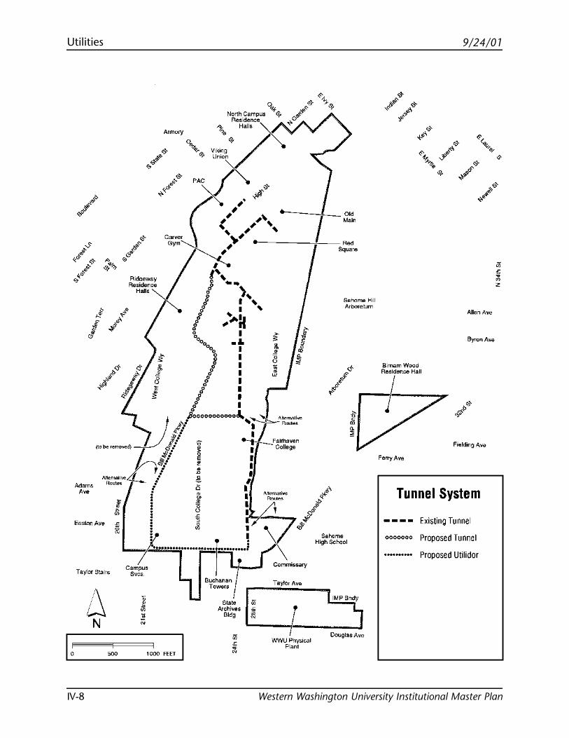
9/24/01Utilities
Western Washington University Institutional Master PlanIV-8
Ridoeway Residence
Halls
0 N~th.Campus "'+<9. ,,,,,,.& i;I> e~~~~cex~ .;;;. cf~,.,-"""'~/ Union
eAC /~ o'
Annory
,, ( , .. °'' Main (
>< ,. ~ c('{;,N-.''' "-. I
I / .. '' ----1--,;.';',.
0 .. ~ ~~
g ~ o/ I"" Sehome Hill
Arboretum
I ... I " g ,.-.11 '% I
0% .&.
g : 8
Allen Ave
Byron Ave
I 3 I
o'
01 : fef B1mamWood
....-tf'~~ r---ofesidenoe Hall
/ I o I
,t,··'ooooooooooo.\.. ll. / ' • Anemalh;e
~o be removed) t J/ i; : J ~.,., ~/ ~ ~Fairhaven ~.· " I College
Altema11.,, / ~ I
Routes l 1t I I g I : ts ,, : "' l
.
! ~ I Anemallve A : 8 I ~.,.. 0-<'
k......... l r ; x~.;l' 7- ........... :::;••• .. i ,./ 9
•"•m• Como"' L :......J ' "''" ""°"
Easton Ave
Taylor Stairs
uchanan
" • ~
6, 9000
9
t Comm"~" ;;• T ow..ra ir--"T:::.::.:_ __ _
/. ,;7j State 1- aylor Ave
N ;; '""'"'' • ~' r;;;:::::=----=N~-- "'' • ::; I ,;~~~~~';;;,;;;;;;;;;;;;•ooo HCT I i N wwct~·,~-,--~,·.·.·,·,,·,-,J .. Plant ·~
Fielding Av&
Ferry Ave
Tunnel System
----0000000
E . 1· xis mg Tunnel
Proposed Tunnel
Proposed Utilidor
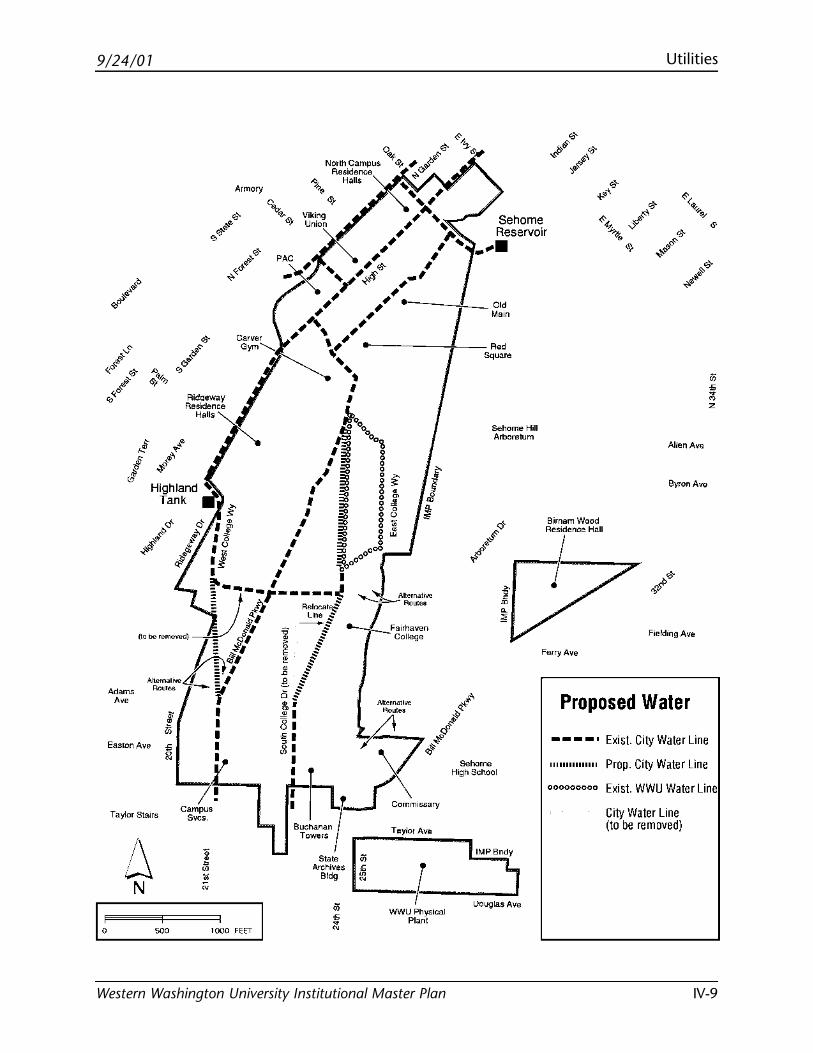
9/24/01 Utilities
Western Washington University Institutional Master Plan IV-9
Easton Ave
Taylor Stairs
RidQeway Residence
Halls
Armory
Sehome Hill Arboretum
Allen Ave
Byron Ave
Bimam Wood '1 '"' "°'' Fefry Ave
Proposed Water
----· 111111111111111
000000000
Exist. City Water Line
Prop. City Water Line
Exist. WWU Water Line
City Water Line (to be removed)
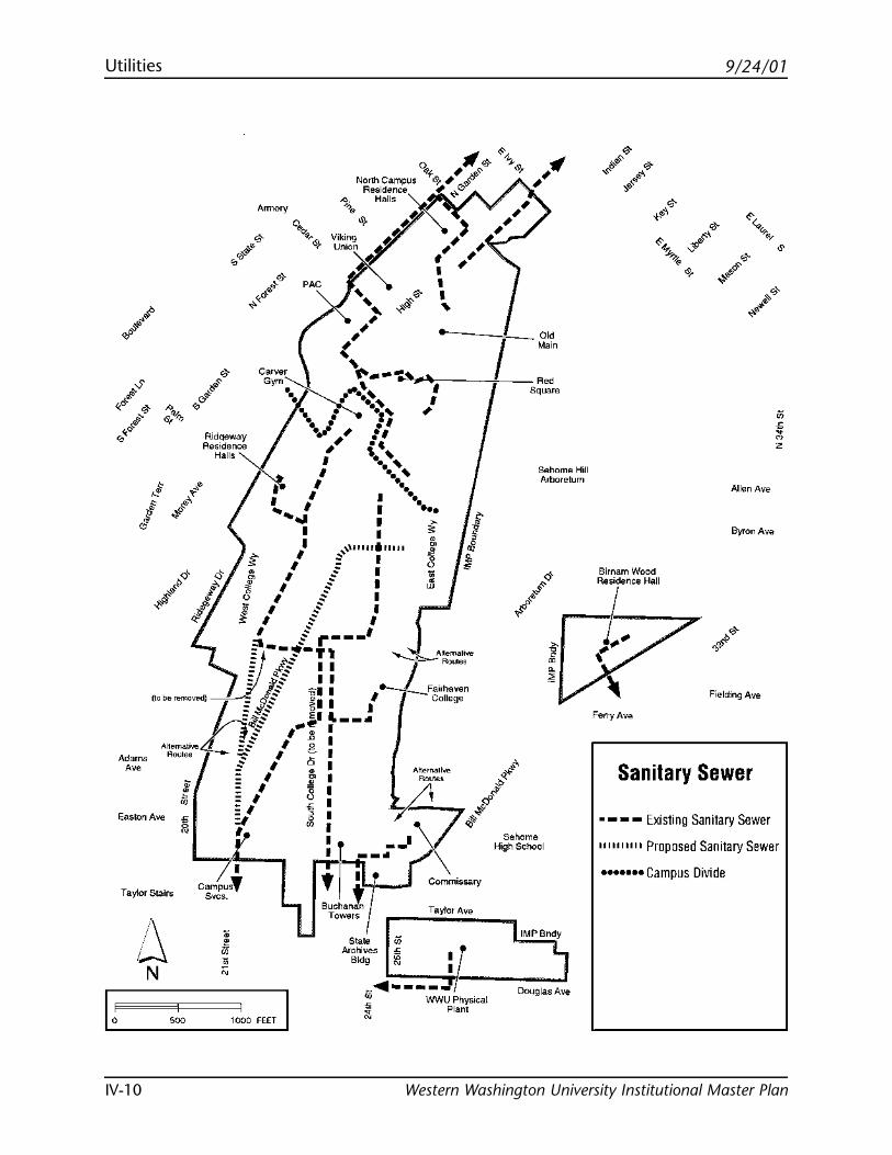
9/24/01Utilities
Western Washington University Institutional Master PlanIV-10
Armory
...... ;'
,' .. o" Main
Carver '- I """~::--~·' ....... ,.,,---1--., R~ •. I •.
1, ,' sqLJare
Ridqew<1 Res1denJ
Halls
. .,, , ·' , .. , ; .. I '•' I ••'
I I ._' I I .. ...... I I .. .... I •.
I I •••
I
I I -; #: ~,,u 11 1rl11 111 "'
• 1' .-.. I ~o· j ~ I ~ ,,,,'$ .... ~ <
11 f I ~
:s. $ I I o I
" . ::: -- ... ~- ,.---'
Sehome Holl Arboretum
Birnam Wood
r---R~sjdenoe Hall
f l~-
Allen Ave
Byron Ave
•o T' ~$ I I .
~o be removed) !J _I I /
fl-fl~ -gl I .__ I ::: ~$ E;I I ,- -..-_Fa11haven ~$ EI .. I College
- (
Fielding Aw;
Anemative § ,-'! I--• Roul"" ....... t~I $ I c I
::: I O I Adams
"'
Easton Ave
T aylot Stairs
/\ w N
;: II ~o~ I Attem.ilve =' _, "'""' .l
r' ~ l ~ .. <f1 '--~- I ·)( •' o~~g,~~ !1.tt-~omm,.~o "'~;~:;;;o,
o; Towers ~ '"''°' ,,, IMPBndy
State .;:; Atoh1ves ""
Bldg ~ :1-,jj..,... _ - - - - ___ ..., ___ J ~ WWU Physical Douglas Av•
Plant
Ferry Ave
Sanitary Sewer
-- - Existing Sanitary S 1111111111 p ewer
roposed Sanitary S ••••••• C ewer
ampus Divide
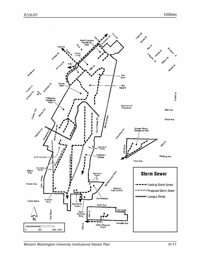
9/24/01 Utilities
Western Washington University Institutional Master Plan IV-11
North campus o.,.f '1f,,. & Annory Residence 6J.;; #~
'II..'.: i; Halls ~~0 ' "';." ' ;.'" ~
.._e"" ,""{.,. ~/ ~ # ... 6). Viking ,,.;. ... <;, ... Unoon ;. ~ ' ~ ,, ,.,_J"_,
•' •' "' ~' I ; ' ; , ' ,,., ... ,,, ~.,,, • .__J
'~··· ' , ", ' °'' ""~', ~-::'----jL- ::n Ridoeway Residence
Halls I ,----) :' ''""" I .-•••• I
I ," "o I II : I ••.
Sehome Hill Arboretum
I • I .. I I I ...
"'"" I I I • 1'•': I I:~ I # .._.: I I :S.:
.,. •I I 1: I I j °' I 1• I I .,_, 11 ,8
o •• 1• I I " o; •• 11 I Jl ~ ••• .• I I
:; I •-.• I ;1
= '--; r---t.,, lJ.,11 : = • A~emalh;e
~o be removed) .g/ § J Roule• -
t = cf1 "" :: : :/I !!:I E .~Fairhaven
#I ~I ::: College
Altemali"" 1 ~· .§ I Routes I .ol $ I :I &i :: I
-:°'"' ! I
Easton Ave
Taylor Stairs
/\ w N
I $ , I lJ , '::0~;:• A I '( ,-<'
i---.:: "-r--=r .. : \I ~.;l''·"·m· c~~ra~s f i'Jt -""\ High School
B~~~P Commissary
I Tu·-State iii
Archives Bldg ~ f-N I _. ~ ..,. ___________ J ~ WWU Physical
Plant
IMP Bndy
N
Douglas Ave
1000 FEET I
Allen Ave
Byron Ave
Fielding Av&
Ferry Ave
·--Storm Sewer
- .. Existing Storm S ewer
llllllllllll p roposed Storm S ••••• ewer ••• c ampus Divide

Blank page
9/24/01
Western Washington University Institutional Master Plan
Phased Development Schedule

Blank page
9/24/01 Phased Development Schedule
Western Washington University Institutional Master Plan V-1
Introduction
The complete build-out of the Institutional Master Planoccurs in phases of development, as funding becomesavailable and as completed renovation or new projectsprovide the domino steps needed for the next stage ofdevelopment to occur. Historically, funding for academ-ic, administration, university support, and componentsof student support have come from legislative funds.Residential and the remaining components of studentsupport have been covered through the issuance ofrevenue bonds. The University will need to look forfunding from those traditional sources, as well as seekfunding from systems not previously explored in orderto implement the Institutional Master Plan.
The table on the next page represents phased develop-ment planned to meet the entire need for facilities,both within and outside of the campus boundaries.
The first step to most of the development is the instal-lation of the needed utilities and roadway infrastruc-ture, predominately in the south campus area. MostCity of Bellingham roadway and utility systems arealready in place to accommodate these universityimprovements. The table shows development in the2000-2005 column during and after the infrastructureimprovements in all categories except for administra-tion. In addition, the table shows a relocation of thehammer throw/shot-put area to accommodate locationof the Student Recreation Center (included in studentactivities) and the first parking facility. The parkingfacility would not be completed until the later part ofthe 2000-2005 time frame and may not be needed untilthe 2005-2010 phase, depending on the IMP parkingrequirement methodology.
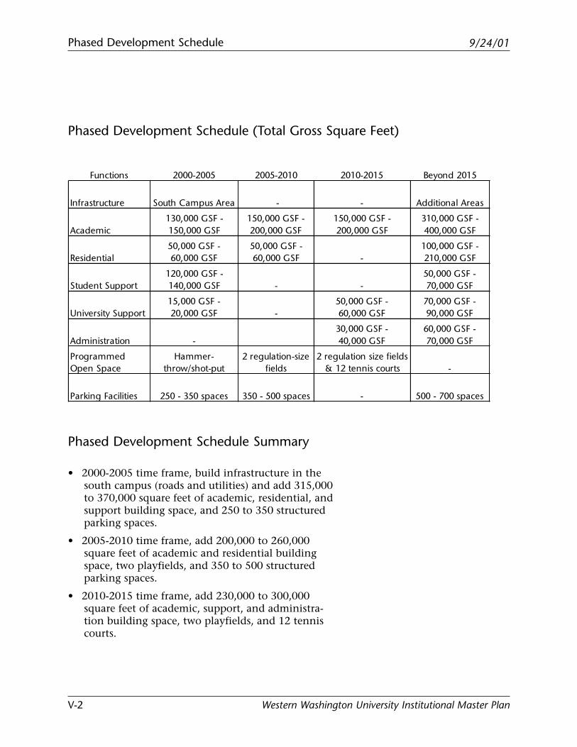
9/24/01Phased Development Schedule
Western Washington University Institutional Master PlanV-2
Phased Development Schedule (Total Gross Square Feet)
Phased Development Schedule Summary
• 2000-2005 time frame, build infrastructure in thesouth campus (roads and utilities) and add 315,000to 370,000 square feet of academic, residential, andsupport building space, and 250 to 350 structuredparking spaces.
• 2005-2010 time frame, add 200,000 to 260,000square feet of academic and residential buildingspace, two playfields, and 350 to 500 structuredparking spaces.
• 2010-2015 time frame, add 230,000 to 300,000square feet of academic, support, and administra-tion building space, two playfields, and 12 tenniscourts.
Functions 2000-2005 2005-2010 2010-2015 Beyond 2015
Infrastructure South Campus Area - - Additional Areas
Academic130,000 GSF - 150,000 GSF
150,000 GSF - 200,000 GSF
150,000 GSF - 200,000 GSF
310,000 GSF - 400,000 GSF
Residential50,000 GSF - 60,000 GSF
50,000 GSF - 60,000 GSF -
100,000 GSF - 210,000 GSF
Student Support120,000 GSF - 140,000 GSF - -
50,000 GSF - 70,000 GSF
University Support15,000 GSF - 20,000 GSF -
50,000 GSF - 60,000 GSF
70,000 GSF - 90,000 GSF
Administration -30,000 GSF - 40,000 GSF
60,000 GSF - 70,000 GSF
Programmed Open Space
Hammer- throw/shot-put
2 regulation-size fields
2 regulation size fields & 12 tennis courts -
Parking Facilities 250 - 350 spaces 350 - 500 spaces - 500 - 700 spaces
9/24/01 Phased Development Schedule
Western Washington University Institutional Master Plan V-3
• Following the 2000-2005 time frame, developmentphasing focuses on academic programs, residentialfacilities, playfields, and parking.
• The parking facilities shown in the 2005-2010 timeframe are primarily dependent on the third regula-tion field development in the south campus areashown in the 2010-2015 column.
• In addition to the development shown in the tableabove, the University will be renovating its existingfacilities to accommodate both programmaticchanges and internal systems upgrades. Continuingand associated improvements for bicycle paths,pedestrian circulation, transit routes and shelterswill also occur.
Plan Completion
Western will be required to produce a new or updatedinstitutional master plan once 1.28 million square feetof new building space (4 million square feet totalbuilding space) needed to accommodate 12,500 FTE iscompleted.

Blank page
9/24/01
Western Washington University Institutional Master Plan
Standards

Blank page
9/24/01 Standards
Western Washington University Institutional Master Plan VI-1
Introduction
In order to preserve the vision of this InstitutionalMaster Plan, the University shall design projects anddevelop the campus in accordance with the followingstandards.
Compatibility with Adjacent Neighborhoods
An important consideration when adding new develop-ment to campus is locating the more intensive usesinternal to the campus and creating a transition areawith less intensive institutional and residential uses atthe perimeter. The edges of campus are particularlyimportant and new development should be designed toaccomplish this transition and to be compatible withadjacent residential neighborhoods. The IMP has beenwritten with these considerations in mind. More specif-ically, the following principles have guided the prepara-tion of the IMP including the Standards section:
• In establishing the permitted uses in each land usedistrict, an effort was made to buffer adjacent cityneighborhoods from the high intensity academiccore by other uses of lower intensity that are morecompatible to the neighborhood’s size and charac-ter. Permitted uses at the edge of campus are pre-dominately residential or student activity areaswith the potential for a few appropriate mixed uses.
• In establishing the development standards in thissection, an effort was made to reduce the IMP’spotential impacts on adjacent neighborhoodsthrough the use of transitions, blending, landscape,and acoustical buffering. Transitions, blending, andbuffering are achieved by designing structures thatare consistent with the adjacent scale, density,architectural characteristics, and landscaping of the
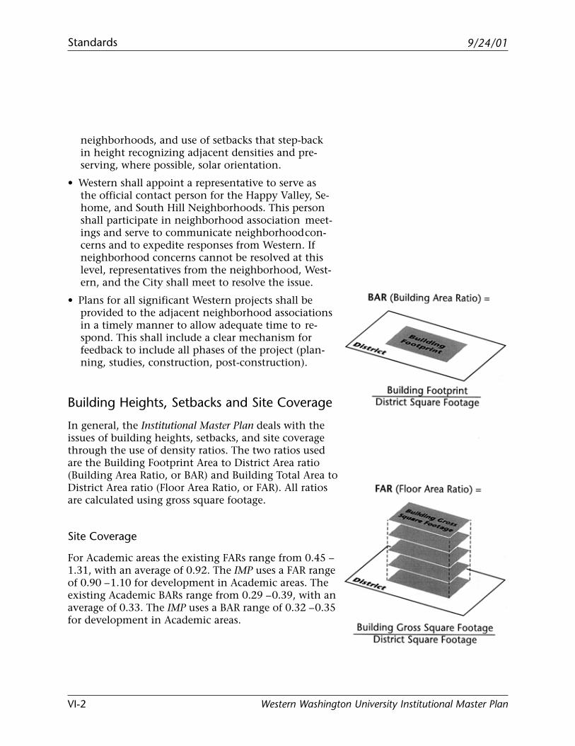
9/24/01Standards
Western Washington University Institutional Master PlanVI-2
neighborhoods, and use of setbacks that step-backin height recognizing adjacent densities and pre-serving, where possible, solar orientation.
• Western shall appoint a representative to serve asthe official contact person for the Happy Valley, Se-home, and South Hill Neighborhoods. This personshall participate in neighborhood association meet-ings and serve to communicate neighborhoodcon-cerns and to expedite responses from Western. Ifneighborhood concerns cannot be resolved at thislevel, representatives from the neighborhood, West-ern, and the City shall meet to resolve the issue.
• Plans for all significant Western projects shall beprovided to the adjacent neighborhood associationsin a timely manner to allow adequate time to re-spond. This shall include a clear mechanism forfeedback to include all phases of the project (plan-ning, studies, construction, post-construction).
Building Heights, Setbacks and Site Coverage
In general, the Institutional Master Plan deals with theissues of building heights, setbacks, and site coveragethrough the use of density ratios. The two ratios usedare the Building Footprint Area to District Area ratio(Building Area Ratio, or BAR) and Building Total Area toDistrict Area ratio (Floor Area Ratio, or FAR). All ratiosare calculated using gross square footage.
Site Coverage
For Academic areas the existing FARs range from 0.45 –1.31, with an average of 0.92. The IMP uses a FAR rangeof 0.90 – 1.10 for development in Academic areas. Theexisting Academic BARs range from 0.29 – 0.39, with anaverage of 0.33. The IMP uses a BAR range of 0.32 – 0.35for development in Academic areas.
9/24/01 Standards
Western Washington University Institutional Master Plan VI-3
For Residential areas the existing FARs range from 0.34– 0.76, with an average of 0.48. The IMP uses a FARrange of 0.55 – 0.65 for development in Residentialareas. The existing Residential BARs range from 0.11 –0.19, with an average of 0.17. The IMP uses a BAR rangeof 0.19 – 0.24 for development in Residential areas.
For Administration/Support and Mixed-Use areas thatcurrently have functions within them, the existingFARs range from 0.06 – 0.52, with an average of 0.22.The IMP uses a FAR range of 0.10 – 0.50 for develop-ment in Administration/Support and Mixed-Use areas.The existing Administration/Support and Mixed-UseBARs range from 0.04 – 0.18, with an average of 0.12.The IMP uses a BAR range of 0.05 – 0.15 for develop-ment in Administration/Support and Mixed-Use areas.
For Student Activity areas the calculation of FARs andBARs is modified slightly to include exterior pro-grammed spaces, such as playfields, as single flooredfacilities. The existing FARs range from 0.36 – 0.92,with an average of 0.40. The IMP uses a FAR range of0.50 – 1.45 for development in Student Activity areas.The existing Student Activity BARs range from 0.35 –0.42, with an average of 0.36. The IMP uses a BAR rangeof 0.40 – 0.50 for development in Student Activityareas.
For each building project, Western shall demonstrate tothe City’s satisfaction that the proposed projects meetsthe applicable district FARs and BARs, including report-ing the total of the existing plus proposed BARs andFARs.
Building Height
In addition to these density ratios, the IMP limitsbuilding height to 60 feet, as defined under the Belling-ham Municipal Code 20.08.020, for any developmentwithin 100 feet of a property line abutting a residentialzoned property or within 70 feet of a property line thatis across a right-of-way from residential zoned property.
9/24/01Standards
Western Washington University Institutional Master PlanVI-4
Further consideration of transition from institutionalareas to adjacent residential neighborhoods shouldinclude consideration of view corridors and sun/shad-ow effects as specified in the Character Goals andDevelopment Recommendations of each district.
Setbacks
When development in the Institutional zone is abut-ting or across a right-of-way from non-institutionalzoned areas, the development should comply withsetback requirements of the non-institutional district,provided that no portion of a structure’s facade shall beless than ten feet from the edge of a public right-of-wayrequiring a setback. The setback requirements shall notapply to non-structural elements such as fences, free-standing walls, bulkheads, ramps, signs, and entrancecanopies.
Nonconforming Structures
Structures existing prior to the adoption of the IMP thatdo not meet the development standards of the IMPshall be considered nonconforming. Nonconformingstructures may remain without alterations or may bealtered in a manner that does not increase the degree ofnonconformity. If a nonconforming structure is de-stroyed by fire, act of nature, or other causes beyondthe control of the University, it may be rebuilt to thesame or smaller configuration existing immediatelyprior to the time the structure was destroyed.
9/24/01 Standards
Western Washington University Institutional Master Plan VI-5
Landscaping and Buffering
Where appropriate, landscaping on the periphery ofcampus shall take into consideration the followingprinciples:
• Use plantings to minimize noise and visual impactson adjacent districts and neighborhoods.
• Provide street trees as recommended in the Belling-ham Street Tree Plan along campus periphery road-ways to buffer adjacent neighborhoods.
• Use sustainable development to select and positionlandscape materials to aid in achieving energy effi-ciency.
• Use native or well-adapted plant material whereappropriate.
• Where possible, take advantage of trees to reducecooling loads and use hedge rows or shrubbery toblock cold winter winds or help channel cool sum-mer breezes into buildings.
• Use plant material and site design features to slowand absorb water runoff, filter sediments and facili-tate water infiltration.
• Maximize pervious surfaces that are conducive towater filtration and use natural drainage ways wherepossible.
• Minimize use of herbicides, pesticides, and fertilizerthrough plant selection and design.
• Minimize need for irrigation by plant selection andby grouping plant material with similar wateringneeds.
When development occurs at the edges of campus,other methods of buffering one land use from a higherintensity land use shall be considered to accomplishthe buffering and transition discussed above.
• Scale of buildings: design to reduce the impacts oftall and large buildings along the periphery of cam-pus.

9/24/01Standards
Western Washington University Institutional Master PlanVI-6
• Open space: use open space to buffer developmentand maintain desirable BARs.
• Architectural design: use architectural design ele-ments to blend with surroundings and to obscureunsightly building mechanical systems.
• Building System Noise: when development occurs atthe edge of campus, use acoustical engineeringtechniques where appropriate to properly abatenoise resulting from campus building systems sothat noise levels do not exceed adopted city andstate standards.
• Site design: use sustainable design methods appro-priate to the project.
• Circulation patterns: use buildings to define andenhance circulation and open space.
• Climate control: consider shadowing and climateimpacts on adjacent neighborhoods resulting fromcampus structures.
• Lighting: minimize lighting impacts on adjacentdistricts and neighborhoods while still providingadequate lighting for safety.
Crime Prevention Through EnvironmentalDesign
Western should incorporate appropriate Crime Preven-tion Through Environmental Design (CPTED) princi-ples in all projects.
Parking
1. The minimum parking requirement for WesternWashington University shall be 3,400 spaces, unlessreductions are approved by the City of BellinghamPlanning Director, in accordance with section Cityof Bellingham Land Use DevelopmentOrdinance,20.12.010 B. Additional spaces shall be required ifthe occupancy of the University’s on-campus park-
9/24/01 Standards
Western Washington University Institutional Master Plan VI-7
ing lots and garages during peak periods exceeds 90percent for two consecutive years, as determined bya comprehensive parking survey of on-campusparking facilities, which shall be conducted by theUniversity during the peak occupancy periods ofeach academic year. Theamount of additionalparking required shall be 0.3 spaces for each FTE(full-time equivalent) student in excess of theaverage of the FTE enrollment during the first yearin which parking utilization exceeds 90 percent andthe previous year. No additional on-campus parkingshall be required for university employees andvisitors. For purposes of determining current park-ing requirements, the enrollment shall be based onthe fall quarter FTE enrollment of students on theBellingham campus. For purposes of determiningfuture parking requirements, State of WashingtonFTE enrollment targets for Western WashingtonUniversity shall be utilized, with adjustments made,if necessary, to identify the projected fall quarterenrollment (vs. average annual enrollment targetsor projections).
2. A reduction in the minimum vehicle parking re-quirements, not to exceed 30 percent, may beapproved by the City of Bellingham PlanningDirector, if the University can demonstratethrough a comprehensive transportation and park-ing study that: 1) the increased use of alterna-tive modes of transportation, including transit,carpools, bicycles and walking, has reduced theactual demand for parking to an amount less thanthe minimum requirements, and 2) that no signif-icant adverse impact on the surrounding neigh-borhoods will occur. Percentage reductions in therequirements that are equivalent to any percent-age reductions in the number of the University’ssingle occupant vehicle (SOV) commuters, as deter-mined through a mode split survey that comparesthe mode split with that determined in the 1998transportation survey conducted by the University,shall be granted automatically, provided that the
9/24/01Standards
Western Washington University Institutional Master PlanVI-8
peak utilization of all on-campus parking spacesremains below 90 percent. The 1998 transportationsurvey showed that 27 percent of the universitycommuters traveled to campus by single occupantvehicles, which shall be used as the basis for thecalculation of any reductions in the amount ofrequired parking.
Western shall provide at least two weeks notice tothe City of Bellingham Planning Department ofthe time period during which the peak periodparking utilization surveys are to be scheduled and,if requested, shall allow a representative of theDepartment to observe or participate in the survey.In addition, the results of all transportation andparking studies shall be made available to thepublic, including neighborhood representatives,and Western shall work with the City and neigh-borhood representatives to identify and respondto any concerns with the studies.
3. A minimum of six percent of the vehicle parkingspaces shall be available for short-term parking(defined as parking designated for visitors, meteredparking, or other parking having with time limitsof four hours or less).
4. Off-campus parking may be utilized to meet up to amaximum of twenty percent of the minimumuniversity parking requirements if it is availableduring peak periods of parking utilization and islocated within 500 feet of the campus boundaries,or beyond 500 feet when it serves university off-campus uses located on the same or adjacent site(s)or is connected to the campus by free or low costtransit service operating during peak periods. If off-campus parking areas serve other, non-universityuses, a joint parking agreement specifying rightsand/or operating times must be signed by all partic-ipants and the City of Bellingham’s Planning Direc-tor and filed in the County Auditor’s Office. Anyoff-campus parking must be consistent with Cityland use and zoning requirements and approved bythe City of Bellingham’s Planning Director.
9/24/01 Standards
Western Washington University Institutional Master Plan VI-9
5. BMC 20.12.010 C (4) and (9) not withstanding, theUniversity may continue to make revisions to itsexisting parking facilities without City approval,in ways that do not require a City permit, so longas the University does not decrease the totalamount of off-street parking spaces below theminimum requirements.
6. BMC 20.12.010 E (1) notwithstanding, the Cityand the University may agree that new parkingfacilities may utilize surfacing other than hardsurfacing.
7. Off street parking dimensions shall meet the re-quirements of BMC 20.12.010 C (6), (7), and (8),unless waivers of the requirements are approved bythe City of Bellingham Director of Planning andCommunity Development, with concurrence bythe Director of Public Works.
8. Parking facilities shall meet the design require-ments of BMC 20.12.010 D, unless waivers areapproved by the City of Bellingham PlanningDirector, with concurrence by the Public WorksDirector.
9. The University shall provide bicycle parking facili-ties containing a minimum of one bicycle parkingspaces for each 10 FTE students, provided thatadditional spaces shall not be required if it can bedemonstrated that the peak occupancy of existingbicycle parking facilities does not exceed 90 per-cent.
10. Western’s continued partnership with the City infunding a comprehensive residential parking zoneprogram shall be required before the City willconsider any future reductions to the approximate-ly 3,400 existing on-campus parking spaces.
11. New parking lots and structures shall be located soas to minimize, as much as possible, the impact ofvehicle traffic going through surrounding neigh-borhoods.
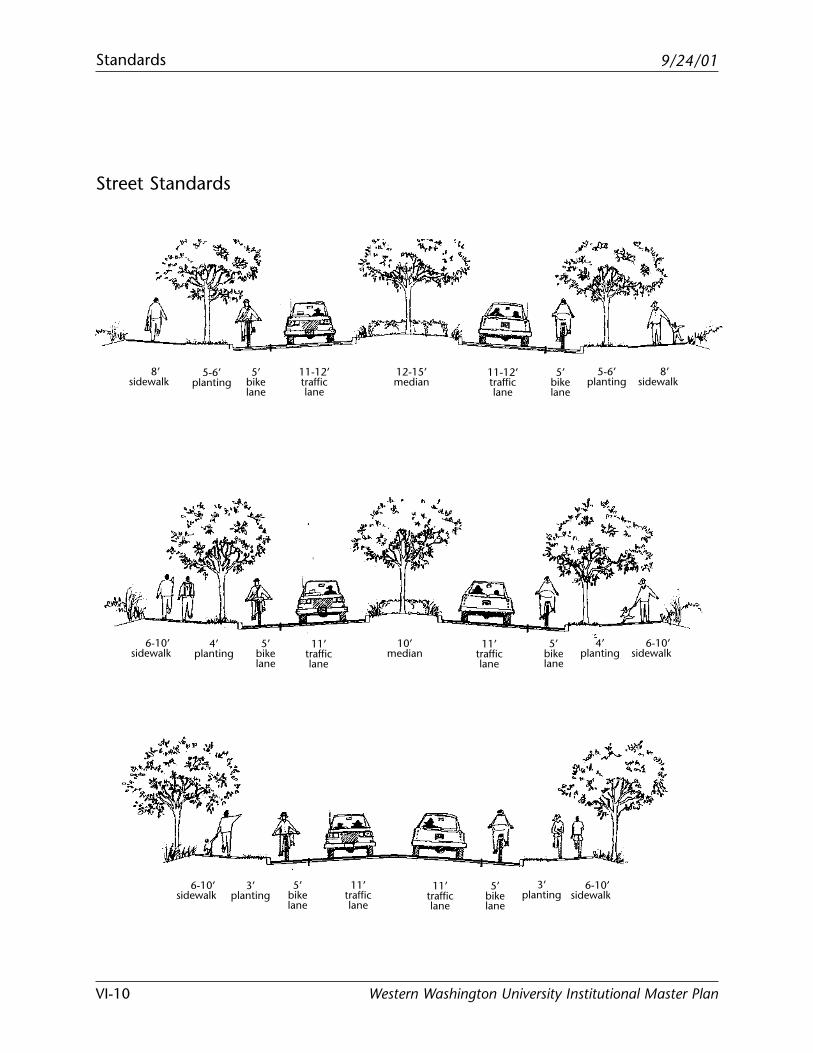
9/24/01Standards
Western Washington University Institutional Master PlanVI-10
Street Standards
8’sidewalk
5’bikelane
5-6’planting
11-12’trafficlane
12-15’median
11-12’trafficlane
5’bikelane
5-6’planting
8’sidewalk
6-10’sidewalk
5’bikelane
4’planting
11’trafficlane
10’median
11’trafficlane
5’bikelane
4’planting
6-10’sidewalk
6-10’sidewalk
5’bikelane
3’planting
11’trafficlane
11’trafficlane
5’bikelane
3’planting
6-10’sidewalk
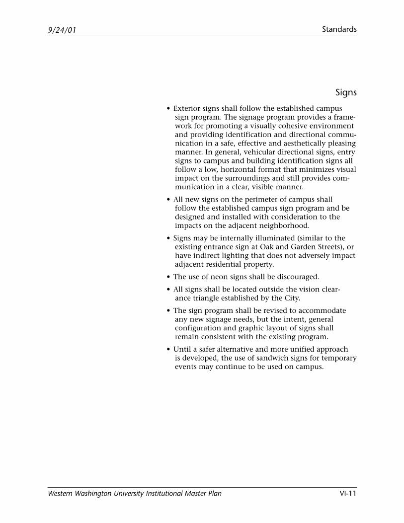
9/24/01 Standards
Western Washington University Institutional Master Plan VI-11
Signs
• Exterior signs shall follow the established campussign program. The signage program provides a frame-work for promoting a visually cohesive environmentand providing identification and directional commu-nication in a safe, effective and aesthetically pleasingmanner. In general, vehicular directional signs, entrysigns to campus and building identification signs allfollow a low, horizontal format that minimizes visualimpact on the surroundings and still provides com-munication in a clear, visible manner.
• All new signs on the perimeter of campus shallfollow the established campus sign program and bedesigned and installed with consideration to theimpacts on the adjacent neighborhood.
• Signs may be internally illuminated (similar to theexisting entrance sign at Oak and Garden Streets), orhave indirect lighting that does not adversely impactadjacent residential property.
• The use of neon signs shall be discouraged.
• All signs shall be located outside the vision clear-ance triangle established by the City.
• The sign program shall be revised to accommodateany new signage needs, but the intent, generalconfiguration and graphic layout of signs shallremain consistent with the existing program.
• Until a safer alternative and more unified approachis developed, the use of sandwich signs for temporaryevents may continue to be used on campus.
9/24/01Standards
Western Washington University Institutional Master PlanVI-12
Access for the Physically Challenged
• All new development shall conform to standards setfor access for the physically challenged as outlined inlocal building codes and standards.
• Nonconforming existing facilities shall be upgradedbased on priority of need, feasibility and as fundingis available.

9/24/01
Western Washington University Institutional Master Plan
Appendices

Blank page
9/24/01 Appendix A: University’s Role and Mission Statement
Western Washington University Institutional Master Plan
Appendix AWestern Washington University’s Role and Mission Statement

Blank page
9/24/01 Appendix A: University’s Role and Mission Statement
Western Washington University Institutional Master Plan
Western Washington University’s
Role and Mission Statement
University Role:
Western Washington University’s objective is to provide high quality undergraduate education with a core focus on
the liberal arts; programs of a practical and applied nature directed to the educational and professional needs of state
residents; and selected graduate programs through the master’s degree.
University Mission Statement:
As a public comprehensive university focusing primarily on serving undergraduate students throughout the region,
the University is dedicated to the pursuit of truth, learning and the dissemination and development of knowledge, and
service to the community.
Its programs contribute to the educational, economic and cultural needs of its community which centers on Washing-
ton state and extends to the world beyond. This mission is addressed principally through teaching which embraces
the liberal arts and professional preparation.
The University nurtures the intellectual, ethical, social, physical and emotional development of each student. It aims
to teach learning skills useful in a rapidly changing and highly technical world and to develop a consciousness of the
challenges and responsibilities of living in a diverse and pluralistic society.
It strives for graduates who are skilled communicators, able to critically analyze and use information, able to
recognize and address the complex issues of the modern world, and who are willing to serve as responsible stewards
of natural resources.
In its research, the University strives to develop new knowledge and to apply that knowledge, where appropriate, to
the solution of problems. The goal of its cultural programs is to enrich the lives of all people touched by them.
Through all of its programs, on and off campus, the University seeks to improve the life of the community by
teaching people to solve problems and meet the challenges of a complex world.
VIIA-1

Blank page
9/24/01 Appendix B: Methodology for Projecting Building Space Needs
Western Washington University Institutional Master Plan
Appendix B Methodology for Projecting Building Space Needs

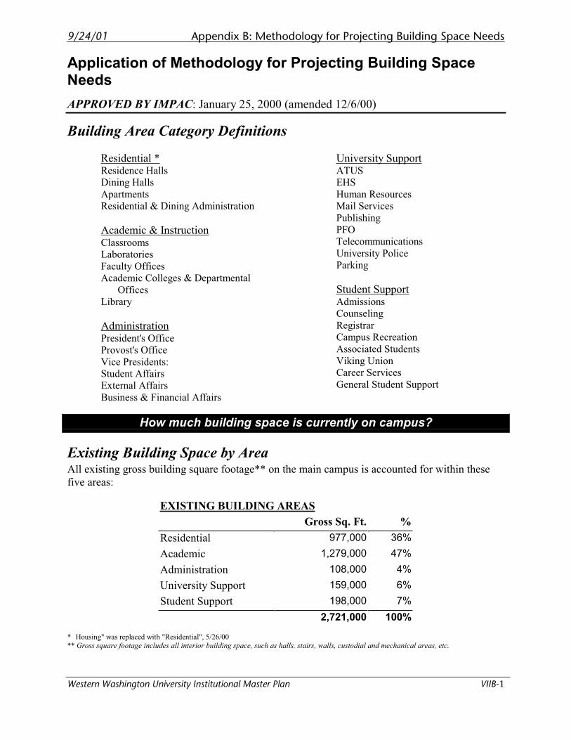
9/24/01 Appendix B: Methodology for Projecting Building Space Needs
Western Washington University Institutional Master Plan VIIB-1
Application of Methodology for Projecting Building Space Needs
APPROVED BY IMPAC: January 25, 2000 (amended 12/6/00)
Building Area Category Definitions
Residential *Residence Halls
Dining Halls
Apartments
Residential & Dining Administration
Academic & InstructionClassrooms
Laboratories
Faculty Offices
Academic Colleges & Departmental
Offices
Library
AdministrationPresident's Office
Provost's Office
Vice Presidents:
Student Affairs
External Affairs
Business & Financial Affairs
University SupportATUS
EHS
Human Resources
Mail Services
Publishing
PFO
Telecommunications
University Police
Parking
Student SupportAdmissions
Counseling
Registrar
Campus Recreation
Associated Students
Viking Union
Career Services
General Student Support
How much building space is currently on campus?
Existing Building Space by Area All existing gross building square footage** on the main campus is accounted for within these
five areas:
EXISTING BUILDING AREAS
Gross Sq. Ft. %
Residential 977,000 36%
Academic 1,279,000 47%
Administration 108,000 4%
University Support 159,000 6%
Student Support 198,000 7%
2,721,000 100%
* Housing" was replaced with "Residential", 5/26/00
** Gross square footage includes all interior building space, such as halls, stairs, walls, custodial and mechanical areas, etc.
Appendix B: Methodology for Projecting Building Space Needs 9/24/01
VIIB-2 Western Washington University Institutional Master Plan
Does the current space adequately meet the needs of the existingcampus population?
On the Western campus today, there are many examples of building spaces that are
inadequate both physically and functionally for their intended purpose. Examples
of results of inadequate building space include:
• Extended period of time to complete degrees
• Faculty and staff working in spaces too cramped to conduct their work in an
effective or efficient manner
• Spaces without adequate lighting, heating or ventilation
• Spaces that are too noisy
• Insufficient space for undergraduate research
These deficiencies, or compaction effects, impact the quality of education, the
overall college and work experience, the accessibility of building space, the
capacity to respond to changing needs, the ability to meet state and federal
standards, and the productivity of staff.
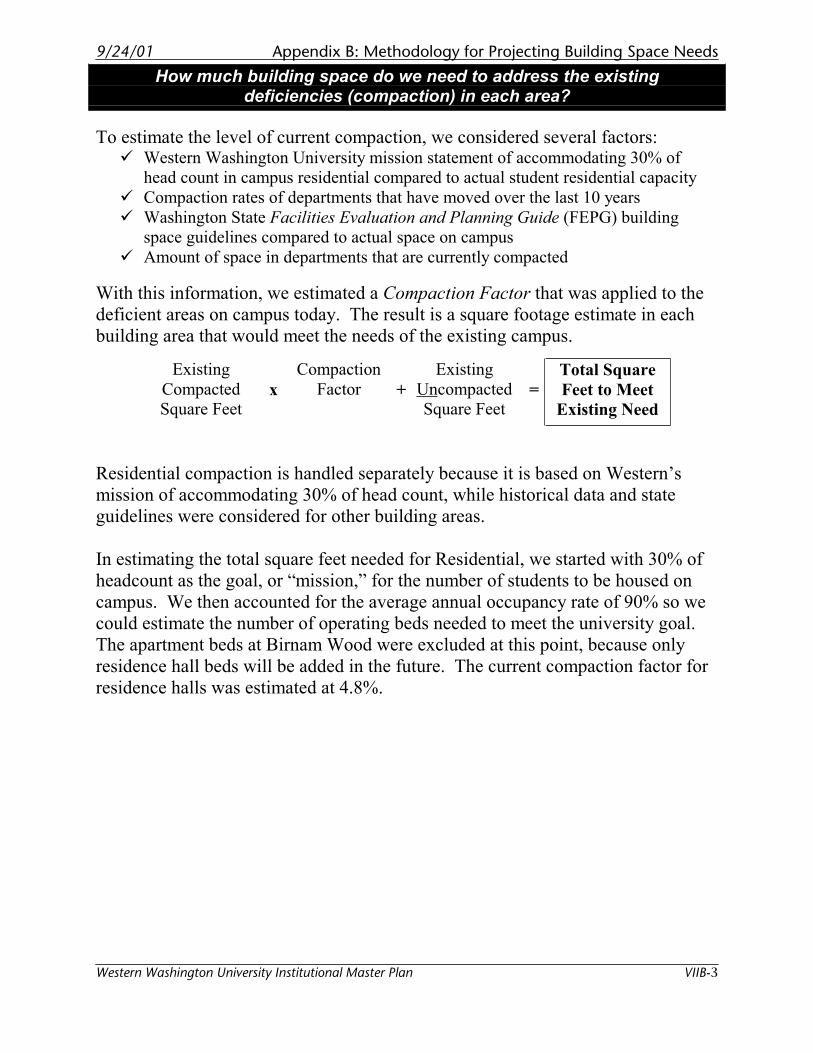
9/24/01 Appendix B: Methodology for Projecting Building Space Needs
Western Washington University Institutional Master Plan VIIB-3
How much building space do we need to address the existingdeficiencies (compaction) in each area?
To estimate the level of current compaction, we considered several factors: � Western Washington University mission statement of accommodating 30% of
head count in campus residential compared to actual student residential capacity
� Compaction rates of departments that have moved over the last 10 years
� Washington State Facilities Evaluation and Planning Guide (FEPG) building
space guidelines compared to actual space on campus
� Amount of space in departments that are currently compacted
With this information, we estimated a Compaction Factor that was applied to the
deficient areas on campus today. The result is a square footage estimate in each
building area that would meet the needs of the existing campus.
Existing
Compacted
Square Feet x
Compaction
Factor +
Existing
Uncompacted
Square Feet=
Total Square
Feet to Meet
Existing Need
Residential compaction is handled separately because it is based on Western’s
mission of accommodating 30% of head count, while historical data and state
guidelines were considered for other building areas.
In estimating the total square feet needed for Residential, we started with 30% of
headcount as the goal, or “mission,” for the number of students to be housed on
campus. We then accounted for the average annual occupancy rate of 90% so we
could estimate the number of operating beds needed to meet the university goal.
The apartment beds at Birnam Wood were excluded at this point, because only
residence hall beds will be added in the future. The current compaction factor for
residence halls was estimated at 4.8%.
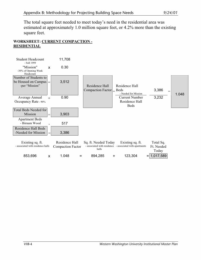
Appendix B: Methodology for Projecting Building Space Needs 9/24/01
VIIB-4 Western Washington University Institutional Master Plan
The total square feet needed to meet today’s need in the residential area was
estimated at approximately 1.0 million square feet, or 4.2% more than the existing
square feet.
WORKSHEET: CURRENT COMPACTION -
RESIDENTIAL
Student Headcount
- Fall 1999
11,708
"Mission"-30% of Opening Week
Headcount
x 0.30
Number of Students to
be Housed on Campus -per “Mission”
= 3,512 Residence Hall
Beds- Needed for Mission
3,386
Average Annual
Occupancy Rate - 90%
÷ 0.90
Residence Hall
Compaction Factor =
Current Number
Residence Hall
Beds
3,232
=1.048
Total Beds Needed for
Mission = 3,903
Apartment Beds - Birnam Wood - 517
Residence Hall Beds
-Needed for Mission = 3,386
Existing sq. ft. - associated with residence halls
Residence Hall
Compaction Factor
Sq. ft. Needed Today - associated with residence
halls
Existing sq. ft. - associated with apartments
Total Sq.
Ft. Needed
Today
853,696 x 1.048 = 894,285 + 123,304 = 1,017,589
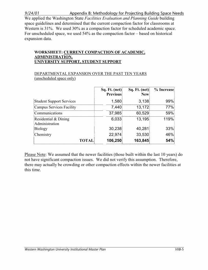
9/24/01 Appendix B: Methodology for Projecting Building Space Needs
Western Washington University Institutional Master Plan VIIB-5
We applied the Washington State Facilities Evaluation and Planning Guide building
space guidelines and determined that the current compaction factor for classrooms at
Western is 31%. We used 30% as a compaction factor for scheduled academic space.
For unscheduled space, we used 54% as the compaction factor – based on historical
expansion data.
WORKSHEET: CURRENT COMPACTION OF ACADEMIC,
ADMINISTRATION,
UNIVERSITY SUPPORT, STUDENT SUPPORT
DEPARTMENTAL EXPANSION OVER THE PAST TEN YEARS
(unscheduled space only)
Sq. Ft. (net)
Previous
Sq. Ft. (net)
New
% Increase
Student Support Services 1,580 3,138 99%
Campus Services Facility 7,440 13,172 77%
Communications 37,985 60,529 59%
Residential & Dining
Administration 6,033 13,195 119%
Biology 30,238 40,281 33%
Chemistry 22,974 33,530 46%
TOTAL 106,250 163,845 54%
Please Note: We assumed that the newer facilities (those built within the last 10 years) do
not have significant compaction issues. We did not verify this assumption. Therefore,
there may actually be crowding or other compaction effects within the newer facilities at
this time.
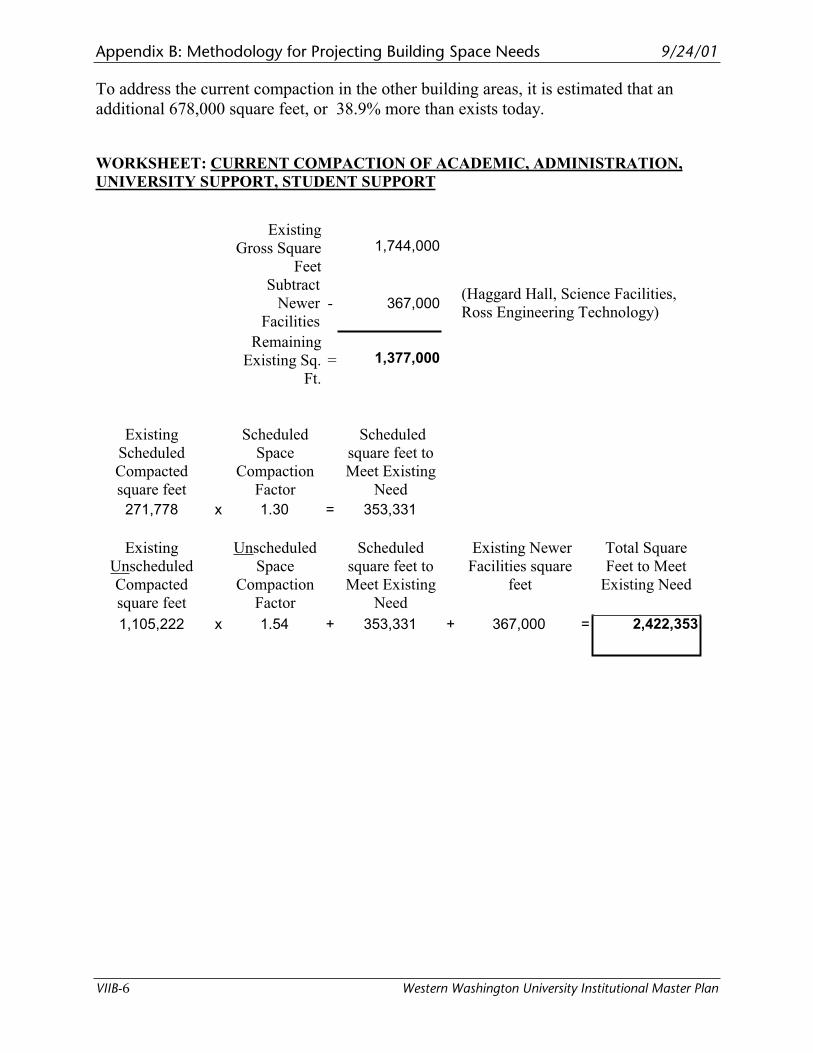
Appendix B: Methodology for Projecting Building Space Needs 9/24/01
VIIB-6 Western Washington University Institutional Master Plan
To address the current compaction in the other building areas, it is estimated that an
additional 678,000 square feet, or 38.9% more than exists today.
WORKSHEET: CURRENT COMPACTION OF ACADEMIC, ADMINISTRATION,
UNIVERSITY SUPPORT, STUDENT SUPPORT
Existing
Gross Square
Feet
1,744,000
Subtract
Newer
Facilities
- 367,000 (Haggard Hall, Science Facilities,
Ross Engineering Technology)
Remaining
Existing Sq.
Ft.
= 1,377,000
Existing
Scheduled
Compacted
square feet
Scheduled
Space
Compaction
Factor
Scheduled
square feet to
Meet Existing
Need
271,778 x 1.30 = 353,331
Existing
Unscheduled
Compacted
square feet
Unscheduled
Space
Compaction
Factor
Scheduled
square feet to
Meet Existing
Need
Existing Newer
Facilities square
feet
Total Square
Feet to Meet
Existing Need
1,105,222 x 1.54 + 353,331 + 367,000 = 2,422,353
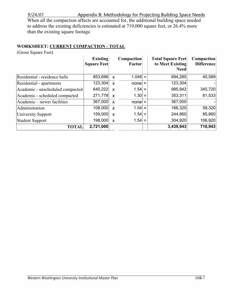
9/24/01 Appendix B: Methodology for Projecting Building Space Needs
Western Washington University Institutional Master Plan VIIB-7
When all the compaction affects are accounted for, the additional building space needed
to address the existing deficiencies is estimated at 719,000 square feet, or 26.4% more
than the existing square footage.
WORKSHEET: CURRENT COMPACTION - TOTAL
(Gross Square Feet)
Existing
Square Feet
Compaction
Factor
Total Square Feet
to Meet Existing
Need
Compaction
Difference
Residential - residence halls 853,696 x 1.048 = 894,285 40,589
Residential - apartments 123,304 x none = 123,304 -
Academic - unscheduled compacted 640,222 x 1.54 = 985,942 345,720
Academic - scheduled compacted 271,778 x 1.30 = 353,311 81,533
Academic – newer facilities 367,000 x none = 367,000 -
Administration 108,000 x 1.54 = 166,320 58,320
University Support 159,000 x 1.54 = 244,860 85,860
Student Support 198,000 x 1.54 = 304,920 106,920
TOTAL 2,721,000 3,439,943 718,943
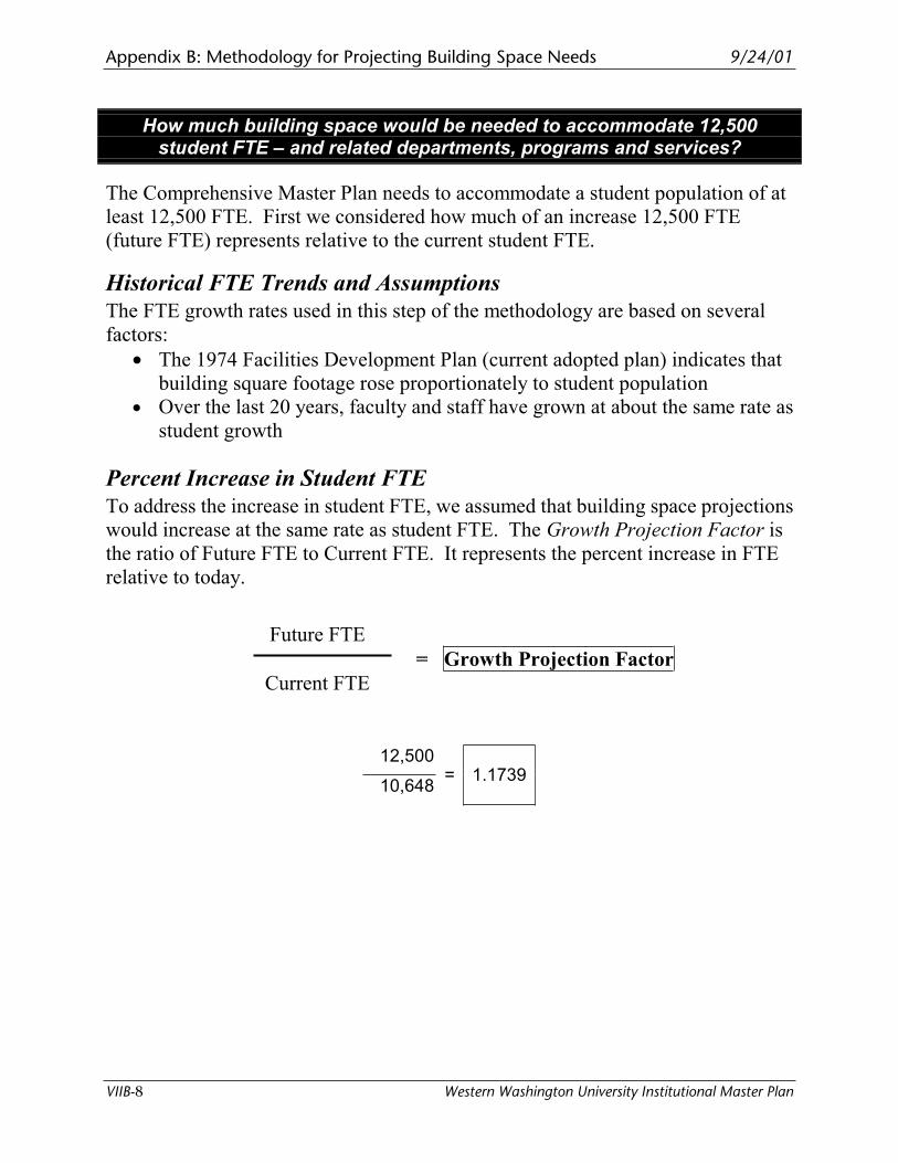
Appendix B: Methodology for Projecting Building Space Needs 9/24/01
VIIB-8 Western Washington University Institutional Master Plan
How much building space would be needed to accommodate 12,500 student FTE – and related departments, programs and services?
The Comprehensive Master Plan needs to accommodate a student population of at
least 12,500 FTE. First we considered how much of an increase 12,500 FTE
(future FTE) represents relative to the current student FTE.
Historical FTE Trends and Assumptions
The FTE growth rates used in this step of the methodology are based on several
factors:
• The 1974 Facilities Development Plan (current adopted plan) indicates that
building square footage rose proportionately to student population
• Over the last 20 years, faculty and staff have grown at about the same rate as
student growth
Percent Increase in Student FTE
To address the increase in student FTE, we assumed that building space projections
would increase at the same rate as student FTE. The Growth Projection Factor is
the ratio of Future FTE to Current FTE. It represents the percent increase in FTE
relative to today.
Future FTE
= Growth Projection Factor
Current FTE
12,500
10,648= 1.1739
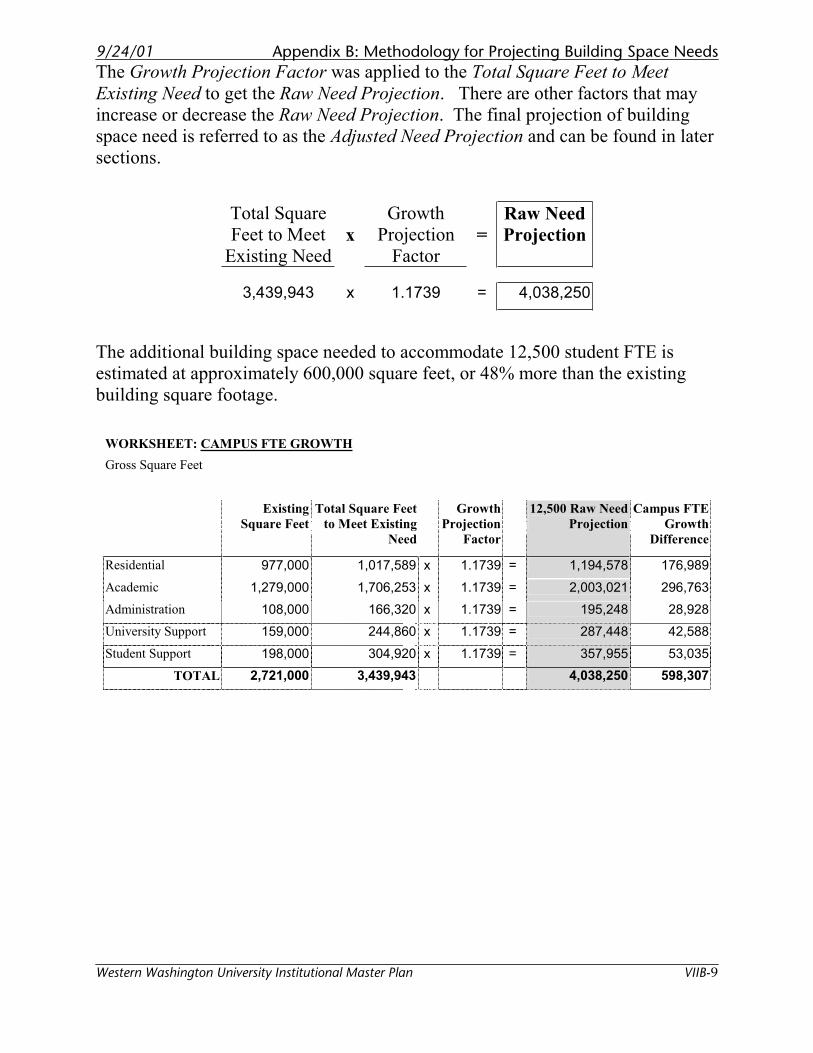
9/24/01 Appendix B: Methodology for Projecting Building Space Needs
Western Washington University Institutional Master Plan VIIB-9
The Growth Projection Factor was applied to the Total Square Feet to Meet
Existing Need to get the Raw Need Projection. There are other factors that may
increase or decrease the Raw Need Projection. The final projection of building
space need is referred to as the Adjusted Need Projection and can be found in later
sections.
Total Square
Feet to Meet
Existing Needx
Growth
Projection
Factor=
Raw Need
Projection
3,439,943 x 1.1739 = 4,038,250
The additional building space needed to accommodate 12,500 student FTE is
estimated at approximately 600,000 square feet, or 48% more than the existing
building square footage.
WORKSHEET: CAMPUS FTE GROWTH
Gross Square Feet
Existing
Square Feet
Total Square Feet
to Meet Existing
Need
Growth
Projection
Factor
12,500 Raw Need
Projection
Campus FTE
Growth
Difference
Residential 977,000 1,017,589 x 1.1739 = 1,194,578 176,989
Academic 1,279,000 1,706,253 x 1.1739 = 2,003,021 296,763
Administration 108,000 166,320 x 1.1739 = 195,248 28,928
University Support 159,000 244,860 x 1.1739 = 287,448 42,588
Student Support 198,000 304,920 x 1.1739 = 357,955 53,035
TOTAL 2,721,000 3,439,943 4,038,250 598,307
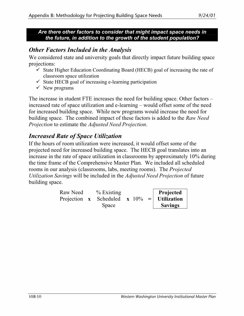
Appendix B: Methodology for Projecting Building Space Needs 9/24/01
VIIB-10 Western Washington University Institutional Master Plan
Are there other factors to consider that might impact space needs inthe future, in addition to the growth of the student population?
Other Factors Included in the Analysis
We considered state and university goals that directly impact future building space
projections: � State Higher Education Coordinating Board (HECB) goal of increasing the rate of
classroom space utilization
� State HECB goal of increasing e-learning participation
� New programs
The increase in student FTE increases the need for building space. Other factors –
increased rate of space utilization and e-learning – would offset some of the need
for increased building space. While new programs would increase the need for
building space. The combined impact of these factors is added to the Raw Need
Projection to estimate the Adjusted Need Projection.
Increased Rate of Space Utilization
If the hours of room utilization were increased, it would offset some of the
projected need for increased building space. The HECB goal translates into an
increase in the rate of space utilization in classrooms by approximately 10% during
the time frame of the Comprehensive Master Plan. We included all scheduled
rooms in our analysis (classrooms, labs, meeting rooms). The Projected
Utilization Savings will be included in the Adjusted Need Projection of future
building space.
Raw Need
Projection x
% Existing
Scheduled
Spacex 10% =
Projected
Utilization
Savings
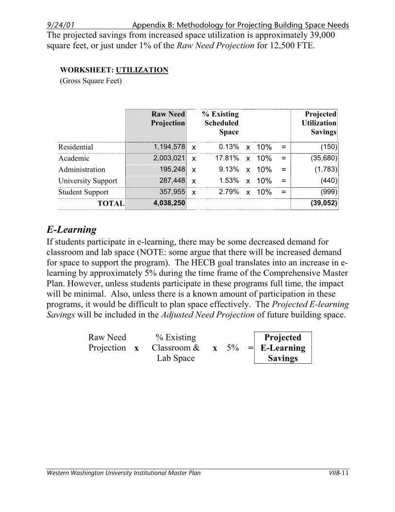
9/24/01 Appendix B: Methodology for Projecting Building Space Needs
Western Washington University Institutional Master Plan VIIB-11
The projected savings from increased space utilization is approximately 39,000
square feet, or just under 1% of the Raw Need Projection for 12,500 FTE.
WORKSHEET: UTILIZATION
(Gross Square Feet)
Raw Need
Projection
% Existing
Scheduled
Space
Projected
Utilization
Savings
Residential 1,194,578 x 0.13% x 10% = (150)
Academic 2,003,021 x 17.81% x 10% = (35,680)
Administration 195,248 x 9.13% x 10% = (1,783)
University Support 287,448 x 1.53% x 10% = (440)
Student Support 357,955 x 2.79% x 10% = (999)
TOTAL 4,038,250 (39,052)
E-Learning
If students participate in e-learning, there may be some decreased demand for
classroom and lab space (NOTE: some argue that there will be increased demand
for space to support the program). The HECB goal translates into an increase in e-
learning by approximately 5% during the time frame of the Comprehensive Master
Plan. However, unless students participate in these programs full time, the impact
will be minimal. Also, unless there is a known amount of participation in these
programs, it would be difficult to plan space effectively. The Projected E-learning
Savings will be included in the Adjusted Need Projection of future building space.
Raw Need
Projection x
% Existing
Classroom &
Lab Space x 5% =
Projected
E-Learning
Savings
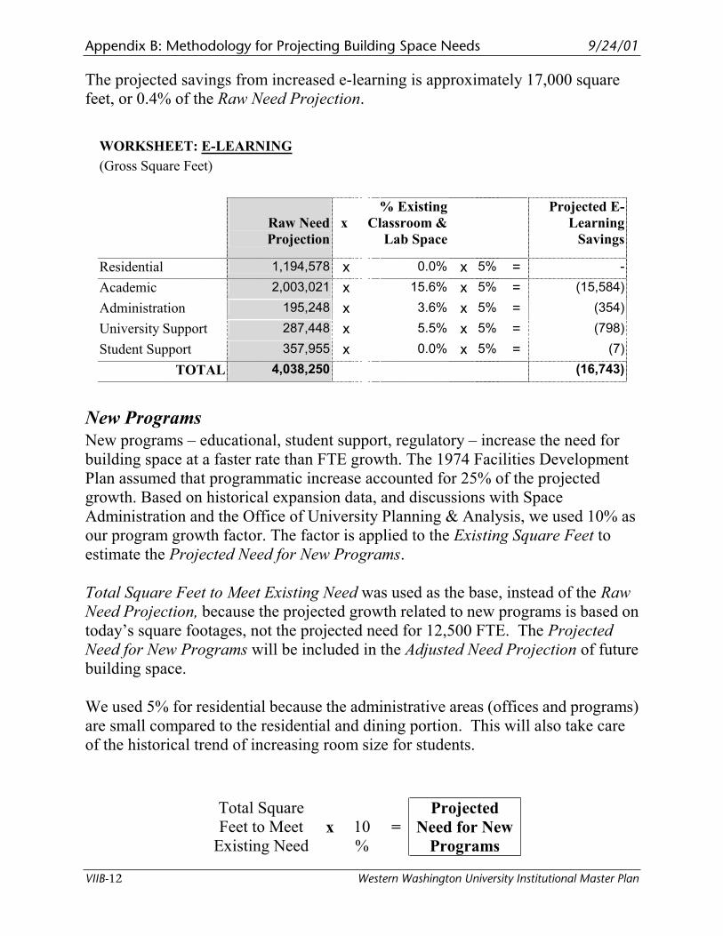
Appendix B: Methodology for Projecting Building Space Needs 9/24/01
VIIB-12 Western Washington University Institutional Master Plan
The projected savings from increased e-learning is approximately 17,000 square
feet, or 0.4% of the Raw Need Projection.
WORKSHEET: E-LEARNING
(Gross Square Feet)
Raw Need
Projection
x
% Existing
Classroom &
Lab Space
Projected E-
Learning
Savings
Residential 1,194,578 x 0.0% x 5% = -
Academic 2,003,021 x 15.6% x 5% = (15,584)
Administration 195,248 x 3.6% x 5% = (354)
University Support 287,448 x 5.5% x 5% = (798)
Student Support 357,955 x 0.0% x 5% = (7)
TOTAL 4,038,250 (16,743)
New Programs
New programs – educational, student support, regulatory – increase the need for
building space at a faster rate than FTE growth. The 1974 Facilities Development
Plan assumed that programmatic increase accounted for 25% of the projected
growth. Based on historical expansion data, and discussions with Space
Administration and the Office of University Planning & Analysis, we used 10% as
our program growth factor. The factor is applied to the Existing Square Feet to
estimate the Projected Need for New Programs.
Total Square Feet to Meet Existing Need was used as the base, instead of the Raw
Need Projection, because the projected growth related to new programs is based on
today’s square footages, not the projected need for 12,500 FTE. The Projected
Need for New Programs will be included in the Adjusted Need Projection of future
building space.
We used 5% for residential because the administrative areas (offices and programs)
are small compared to the residential and dining portion. This will also take care
of the historical trend of increasing room size for students.
Total Square
Feet to Meet
Existing Need x 10
%=
Projected
Need for New
Programs
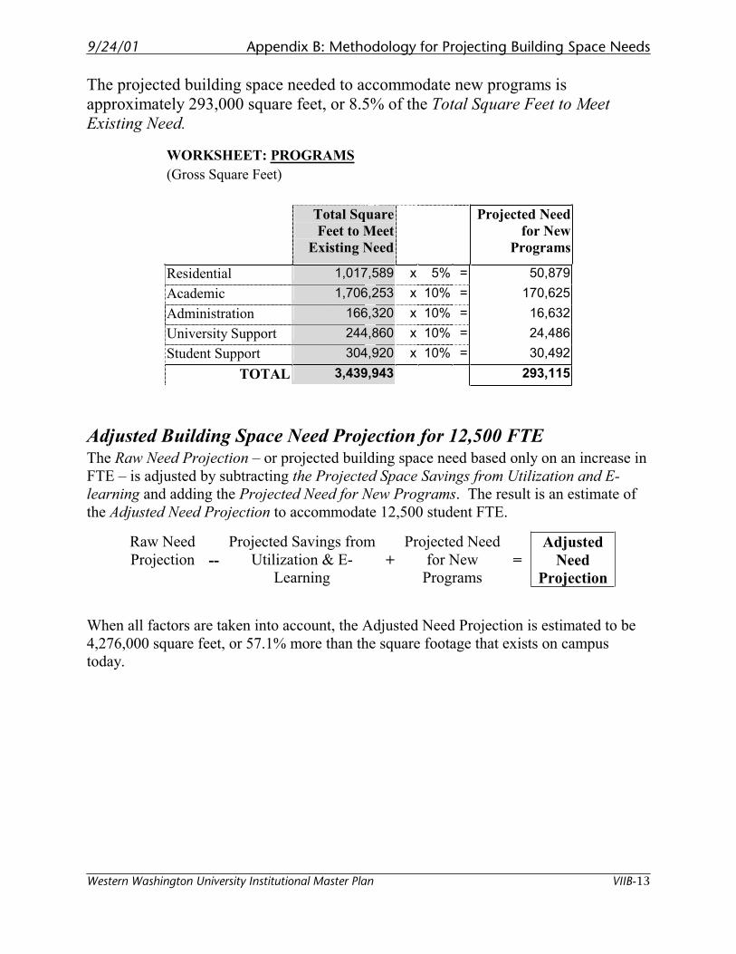
9/24/01 Appendix B: Methodology for Projecting Building Space Needs
Western Washington University Institutional Master Plan VIIB-13
The projected building space needed to accommodate new programs is
approximately 293,000 square feet, or 8.5% of the Total Square Feet to Meet
Existing Need.
WORKSHEET: PROGRAMS
(Gross Square Feet)
Total Square
Feet to Meet
Existing Need
Projected Need
for New
Programs
Residential 1,017,589 x 5% = 50,879
Academic 1,706,253 x 10% = 170,625
Administration 166,320 x 10% = 16,632
University Support 244,860 x 10% = 24,486
Student Support 304,920 x 10% = 30,492
TOTAL 3,439,943 293,115
Adjusted Building Space Need Projection for 12,500 FTE The Raw Need Projection – or projected building space need based only on an increase in
FTE – is adjusted by subtracting the Projected Space Savings from Utilization and E-
learning and adding the Projected Need for New Programs. The result is an estimate of
the Adjusted Need Projection to accommodate 12,500 student FTE.
Raw Need
Projection --
Projected Savings from
Utilization & E-
Learning+
Projected Need
for New
Programs =
Adjusted
Need
Projection
When all factors are taken into account, the Adjusted Need Projection is estimated to be
4,276,000 square feet, or 57.1% more than the square footage that exists on campus
today.
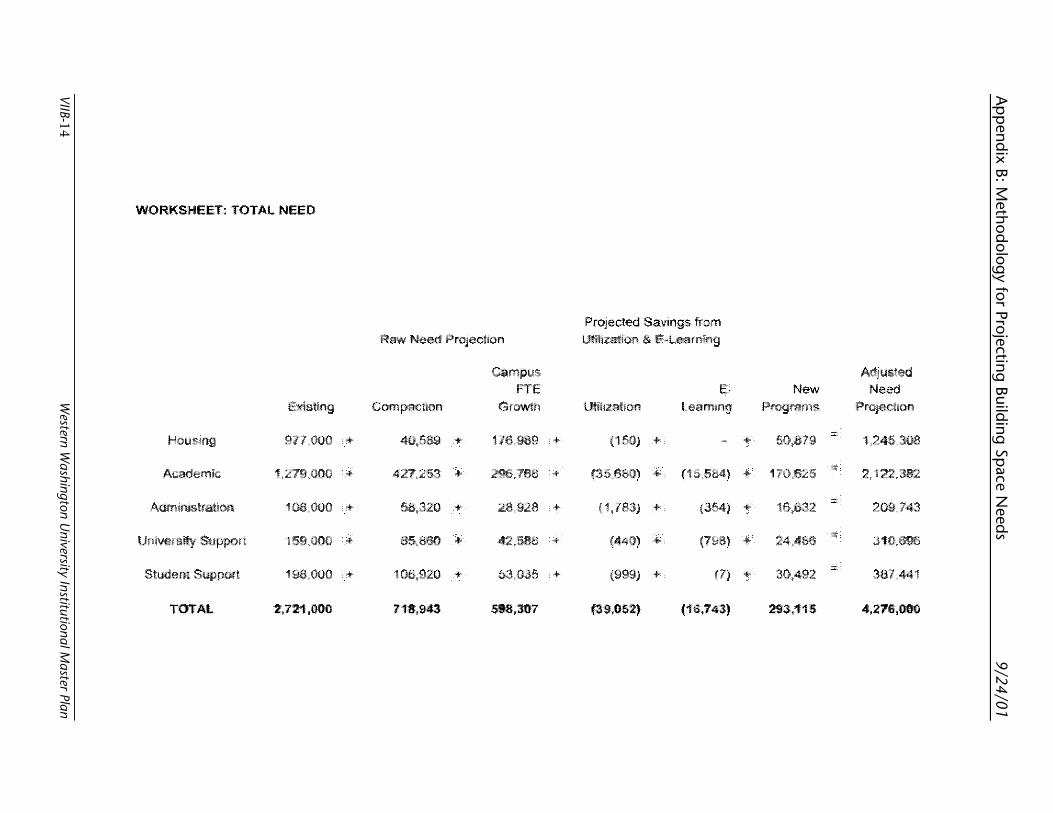
Ap
pend
ix B: Method
ology for Projecting
Building
Space N
eeds
9/24/01
VIIB-14 W
estern Washington U
niversity Institutional Master Plan
WORKSHEET: TOTAL NEED
Raw Need
FTE E, New Need Growth Ulilizaliori
977,000 + 40,589 + 176~989 + (1 + ' + 50,879 1,245,306
Academic 1,279,000 + 427~253 + 296,756 + + + 1 2, 122,362
Adminislralion 106,000 + 56,320 + 28~928 + + + 10,032 209,743
159,000 + 85~850 + 42,586 + + + 310,696
Student Su1mort 196,000 + 106,920 + 53~035 + + + 30,492 367,441
TOTAL 7111,943 293,115
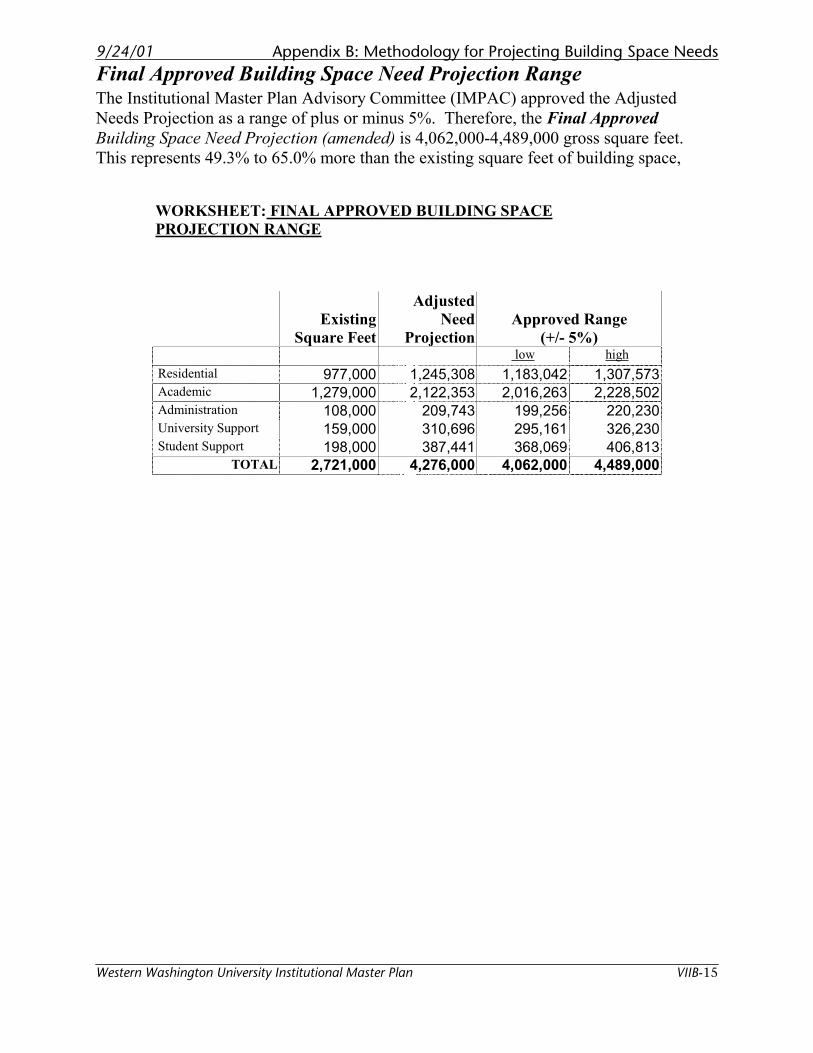
9/24/01 Appendix B: Methodology for Projecting Building Space Needs
Western Washington University Institutional Master Plan VIIB-15
Final Approved Building Space Need Projection Range The Institutional Master Plan Advisory Committee (IMPAC) approved the Adjusted
Needs Projection as a range of plus or minus 5%. Therefore, the Final Approved
Building Space Need Projection (amended) is 4,062,000-4,489,000 gross square feet.
This represents 49.3% to 65.0% more than the existing square feet of building space,
WORKSHEET: FINAL APPROVED BUILDING SPACE
PROJECTION RANGE
Existing
Square Feet
Adjusted
Need
Projection
Approved Range
(+/- 5%) low high
Residential 977,000 1,245,308 1,183,042 1,307,573 Academic 1,279,000 2,122,353 2,016,263 2,228,502 Administration 108,000 209,743 199,256 220,230 University Support 159,000 310,696 295,161 326,230 Student Support 198,000 387,441 368,069 406,813
TOTAL 2,721,000 4,276,000 4,062,000 4,489,000

Page left blank
9/24/01 Appendix C: Plan Alternatives
Western Washington University Institutional Master Plan
Appendix CPlan Alternatives

Blank page
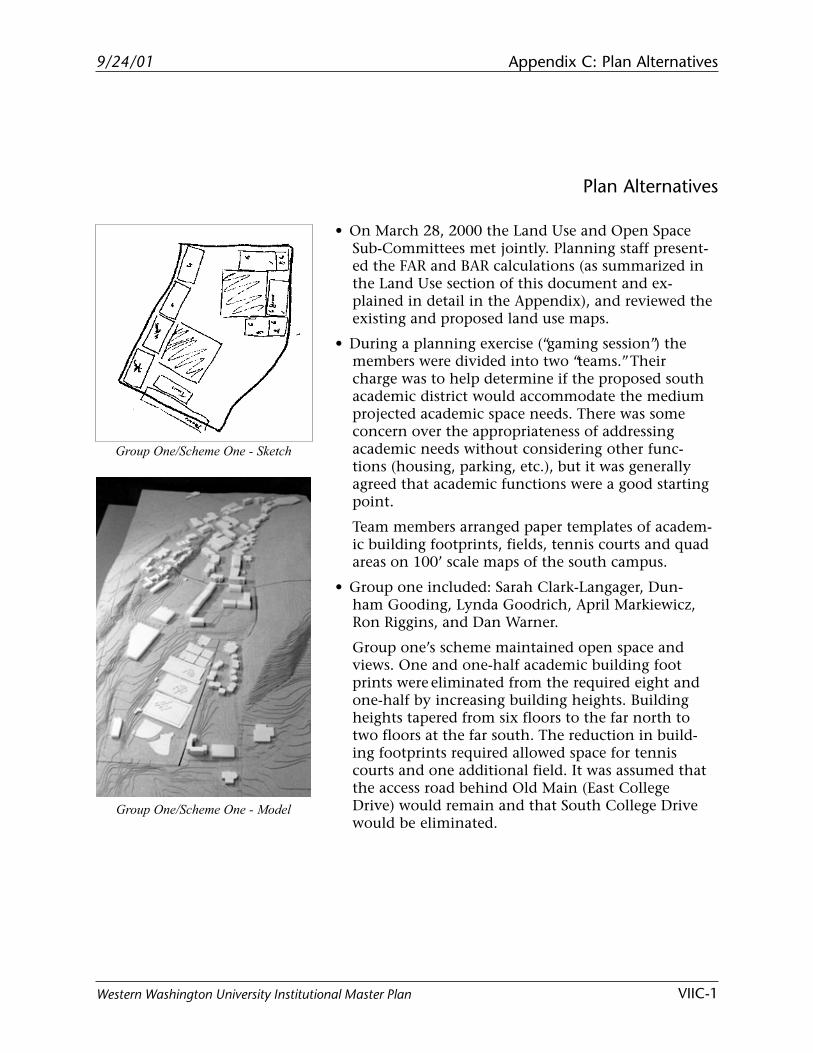
9/24/01 Appendix C: Plan Alternatives
VIIC-1Western Washington University Institutional Master Plan
Plan Alternatives
• On March 28, 2000 the Land Use and Open SpaceSub-Committees met jointly. Planning staff present-ed the FAR and BAR calculations (as summarized inthe Land Use section of this document and ex-plained in detail in the Appendix), and reviewed theexisting and proposed land use maps.
• During a planning exercise (“gaming session”) themembers were divided into two “teams.” Theircharge was to help determine if the proposed southacademic district would accommodate the mediumprojected academic space needs. There was someconcern over the appropriateness of addressingacademic needs without considering other func-tions (housing, parking, etc.), but it was generallyagreed that academic functions were a good startingpoint.
Team members arranged paper templates of academ-ic building footprints, fields, tennis courts and quadareas on 100’ scale maps of the south campus.
• Group one included: Sarah Clark-Langager, Dun-ham Gooding, Lynda Goodrich, April Markiewicz,Ron Riggins, and Dan Warner.
Group one’s scheme maintained open space andviews. One and one-half academic building footprints were eliminated from the required eight andone-half by increasing building heights. Buildingheights tapered from six floors to the far north totwo floors at the far south. The reduction in build-ing footprints required allowed space for tenniscourts and one additional field. It was assumed thatthe access road behind Old Main (East CollegeDrive) would remain and that South College Drivewould be eliminated.
Group One/Scheme One - Model
Group One/Scheme One - Sketch
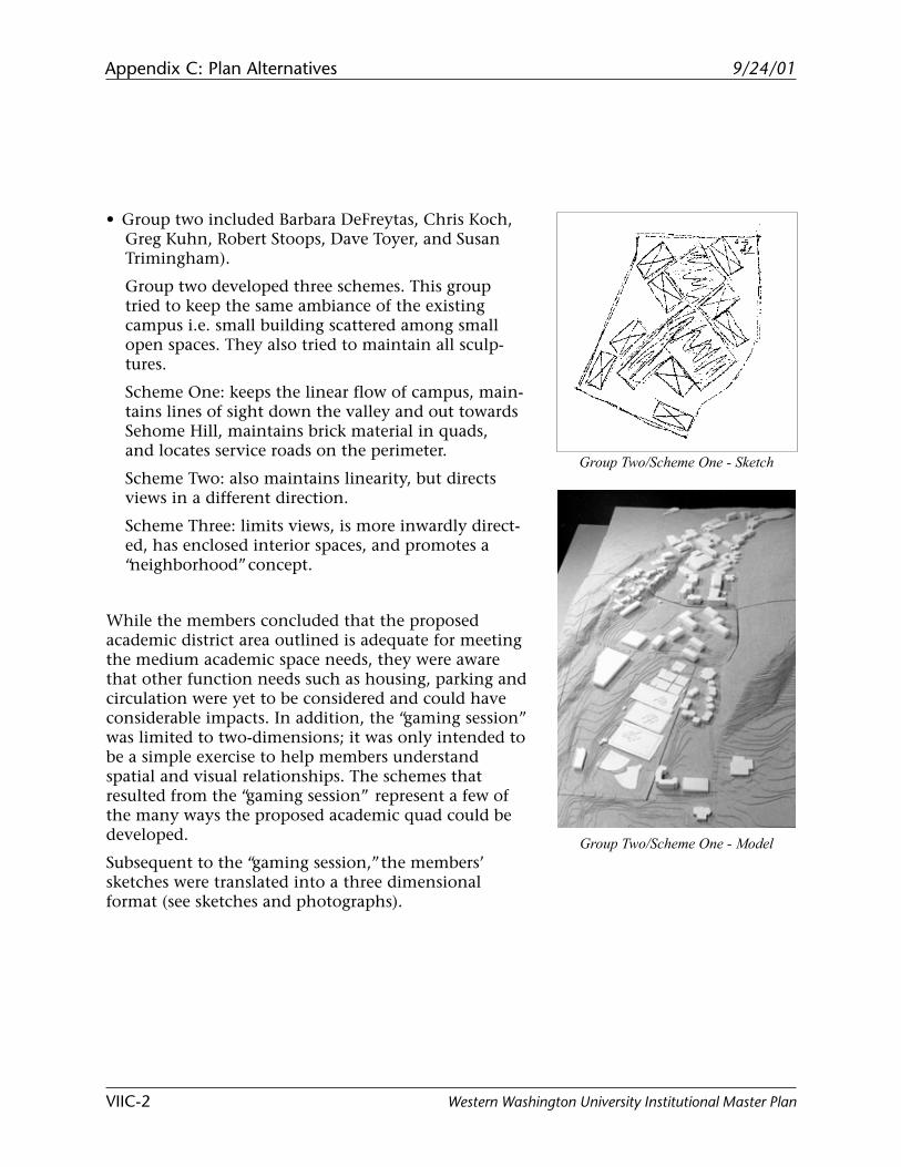
9/24/01Appendix C: Plan Alternatives
VIIC-2 Western Washington University Institutional Master Plan
• Group two included Barbara DeFreytas, Chris Koch,Greg Kuhn, Robert Stoops, Dave Toyer, and SusanTrimingham).
Group two developed three schemes. This grouptried to keep the same ambiance of the existingcampus i.e. small building scattered among smallopen spaces. They also tried to maintain all sculp-tures.
Scheme One: keeps the linear flow of campus, main-tains lines of sight down the valley and out towardsSehome Hill, maintains brick material in quads,and locates service roads on the perimeter.
Scheme Two: also maintains linearity, but directsviews in a different direction.
Scheme Three: limits views, is more inwardly direct-ed, has enclosed interior spaces, and promotes a“neighborhood” concept.
While the members concluded that the proposedacademic district area outlined is adequate for meetingthe medium academic space needs, they were awarethat other function needs such as housing, parking andcirculation were yet to be considered and could haveconsiderable impacts. In addition, the “gaming session”was limited to two-dimensions; it was only intended tobe a simple exercise to help members understandspatial and visual relationships. The schemes thatresulted from the “gaming session” represent a few ofthe many ways the proposed academic quad could bedeveloped.
Subsequent to the “gaming session,” the members’sketches were translated into a three dimensionalformat (see sketches and photographs).
Group Two/Scheme One - Model
Group Two/Scheme One - Sketch
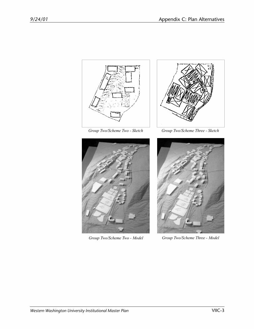
9/24/01 Appendix C: Plan Alternatives
VIIC-3Western Washington University Institutional Master Plan
Group Two/Scheme Three - Model
Group Two/Scheme Three - Sketch
Group Two/Scheme Two - Model
Group Two/Scheme Two - Sketch

Blank page
9/24/01 Appendix D: Existing Circulation Facilities
VIID-1Western Washington University Institutional Master Plan
Appendix DExisting Circulation Facilities
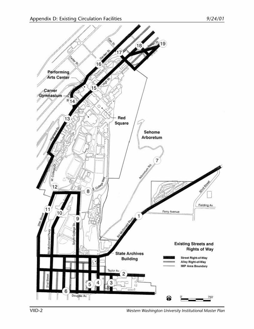
Appendix D: Existing Circulation Facilities 9/24/01
VIID-2 Western Washington University Institutional Master Plan
\
Sehome Arboretum
~
State Arch· 1ves Building
Existing St . reels and
-- Rights of Way
Street Alghl..Of•Wa Alley Right y IMP ~f·Way
Arca Boundary
9/24/01 Appendix D: Existing Circulation Facilities
VIID-3Western Washington University Institutional Master Plan
Existing Circulation Facilities
As required by the City of Bellingham Land Use Develop-ment Ordinance for Institutional Development, the size andcondition of developed streets and sidewalks wereinventoried. All developed streets within and directlyadjacent to the area boundary were included in theinventory along with information such as provisionsfor bicycle lanes, median strips, on-street parking andposted speed limits.
Bill McDonald Parkway• Two-lane, secondary arterial.• Street width: 37’-8”• Planted median strips: 10 feet wide median from I-5
to the intersection at South College Drive.• Bicycle lanes: 5’-0” on both sides of street.• Sidewalks: 5’ wide on the south side of Bill
McDonald Parkway between I-5 and South CollegeDrive in good condition. Seven foot wide sidewalkon part of the north side separated from vehicles by7’ wide planting strip. Sidewalk veers away fromstreet shortly before the Commissary building.
• On-street parking: none permitted.• Posted speed limit: 25 mph in front of Sehome
High School to 21st Street and 35 mph elsewhere.
Taylor Avenue• Street width: 34’-8”• Bicycle lanes: none.• Sidewalks: none.• On-street parking: both sides.• Posted speed limit: none posted.
26th Street• Street width: 21 feet• Bicycle lanes: none.• Sidewalks: none.• On-street parking: on west side of block in front of
Physical Plant; on both sides just south of thePhysical Plant.
1
2
3
Appendix D: Existing Circulation Facilities 9/24/01
VIID-4 Western Washington University Institutional Master Plan
25th Street• Collector arterial (per Happy Valley Neighborhood
Plan).• Street width: 21 feet• Bicycle lanes: none.• Sidewalks: 5’-8” on both west and east sides in
excellent condition.• On-street parking: on west side of street.• Posted speed limit: None posted.
24th Street• Street width: 21 feet• Bicycle lanes: none.• Sidewalks: 5’-2” in poor condition on east side;
13’-9” wide planting strip on east side has culvertand on-street parking.
• On-street parking: yes.• Posted speed limit: 20 mph (school zone).
Douglas Avenue• Street width: 22 feet• Bicycle lanes: none.• Sidewalks: none.• On-street parking: south side in front of apartment
complexes.
Arboretum Road• Street width: 18’-9”• Bicycle lanes: none.• Sidewalks: None.• On-street parking: none.• Posted speed limit: none posted.
East College Way• Street width: 23’ 8”• Bicycle lanes: none.• Sidewalks: 6’-2” on east side in good condition, 2’-
2” paved path on west side in good condition.• On-street parking: none.• Posted speed limit: 25 mph (10mph from Steam
Plant north)
4
5
6
7
8
9/24/01 Appendix D: Existing Circulation Facilities
VIID-5Western Washington University Institutional Master Plan
South College Drive• Street width: 50’-8” two-lane secondary arterial
(confirm) with a 15’-7” wide planted median strip.Connects East College Way/West College Way toBill McDonald Parkway. Ends at Visitor Info Center.
• Bicycle lanes: none.• Sidewalks: 5’-8” wide sidewalks on east side of
South College in good condition. Sidewalk sepa-rated from vehicles by 5’-8” wide planting strip.
• On-street parking: None.• Bus shelters/pull-outs: three bus stops and one bus
shelter located along this arterial.• Posted speed limit: 25 mph.
21st Street• Street width: 30’-7• Two-lane road terminates behind Science, Math-
ematics, and Technology Education building(SMATE).
• Bicycle lanes: none.• Sidewalks: vary from 5’-0” to 8’-6”.• On-street parking: both sides.• Posted speed limit: 25 mph (20 mph by the tennis
courts).
20th Street• Street width: 18’-2”• Bicycle lanes: none.• Sidewalks: none.• On-street parking: east side.• Posted speed limit: 25 mph.
West College Way• Steep two-lane, secondary arterial (confirm).• Street width: 28 feet.• Bicycle lanes: none.• Sidewalks: 4’-3” sidewalk recently added to north
side, raised curb separates sidewalk from road.
9
10
11
12
Appendix D: Existing Circulation Facilities 9/24/01
VIID-6 Western Washington University Institutional Master Plan
13
14
15
16
• Bus shelters/pull-outs: bus stop at the junction ofWest College Way and Highland Drive has no pull-off area.
• On-street parking: none permitted.• Posted speed limit: 25 mph.
Highland Drive• Street width: 24’-10”• Bicycle lanes: none.• Sidewalks: 5’-10” on east side in good condition.• On-street parking: angled, parallel parking on west
side of street.• Posted speed limit: 25 mph.
West Campus Way• Street width: 26’-8”, two-lane secondary arterial
that connects High Street/Highland Drive withGarden Street.
• Bicycle lane: bicycle lanes on both sides weredelineated in summer of 1999. Bicycle lanes endwhere West Campus Way turns into Garden Street.
• Sidewalks: sidewalks on both sides of the street (3’5” east in excellent condition & 5’-8” west in poorcondition).
• On-street parking: none permitted.
High Street• Street width: varies from 25’-0” to 40’-0”.• Bicycle lanes: none.• Sidewalks: width varies. 5’-6” on east side in excel-
lent condition; 4’-6” on west side in good condi-tion.
• Sidewalk on west side separated from road by 4’-6”w x 58’-3” planting strip
• On-street parking: west side.
Garden Street• Street width: 31’-8” wide, two-lane secondary
arterial from West Campus Way to its northerly
9/24/01 Appendix D: Existing Circulation Facilities
VIID-7Western Washington University Institutional Master Plan
17
18
19
terminus at East Champion Street (confirm). FromWest Campus Way south, Garden Street is classifiedas a collector arterial (confirm).
• Bicycle lanes: none.• Sidewalks: sidewalks adjacent to campus are in
good condition and are provided on both sides ofthe street. The sidewalks on the east side are 6’-2”;the west side sidewalks are 6’-9”. In some areas,separated by planting strips on the east side (14’-7”)and on the west side (14’-11”).
• On street parking: permitted on the east side of theportion of Garden Street that abuts campus (be-tween Oak and Cedar Streets); Residential ParkingZones located further south on Garden Street.
• Posted speed limit: 25 mph.
Oak Street• Street width: 17’-6”• Bicycle lanes: none.• Sidewalks: 5 feet on the south side in good condi-
tion with a 10’-6” planting strip; 5’-2” on the northside in good condition with a 4’-7” planting strip.
• On-street parking: on north side.• Posted speed limit: none.
Ivy Street• Street width: 23’-3”• Bicycle lanes: None.• Sidewalks: None.• On-street parking: Both sides.
Indian Street• Street width: 41 feet• Bicycle lanes: none.• Sidewalks: east side = 5’-8” in good condition; west
side = 5’-6” in good condition.• On-street parking: both sides of street.• Posted speed limit: none.