Embed Size (px)
Citation preview
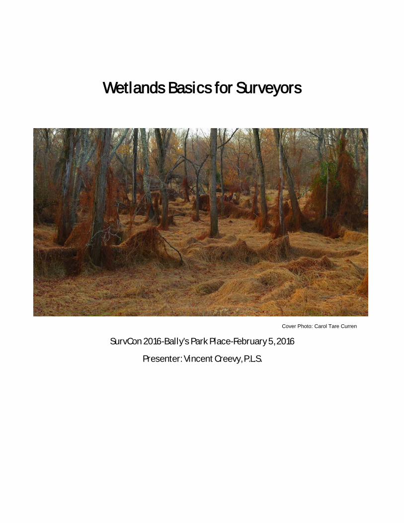
Wetlands Basics for Surveyors
Cover Photo: Carol Tare Curren
SurvCon 2016-Bally’s Park Place-February 5, 2016
Presenter: Vincent Creevy, P.L.S.
What is the definition of a Wetland?
As defined in the 1989 Federal Manual wetlands are: “Those areas that are inundated
or saturated by surface or groundwater at a frequency and duration sufficient to support,
and that under normal circumstances do support, a prevalence of vegetation typically
adapted for life in saturated soil conditions. Wetlands generally include swamps,
marshes, bogs and similar areas.”
Wetlands often occur along the edges of rivers, lakes, ponds and other freshwater
bodies. They are also found in low lying depressional areas which are surrounded by
uplands. In the latter case, the uplands supply the runoff and sufficient drainage area to
maintain these depressional wetlands. Therefore, wetlands hydrology can range from
permanent to periodic inundation.
Wetlands create a varied set of environmental conditions. These varied environmental
conditions require plants that are tolerant of wet conditions. The conditions vary
depending on the season.
A wetland under normal environmental conditions will typically exhibit the following
characteristics:
a) Hydrophytic vegetation
Hydrophytic vegetation simply put are plants which have adapted to living in a
wet environment. The degree of this wetness can vary considerably.
For the purposes of wetland delineation and determination, five classifications
have been assigned to vegetation available on the National List of Wetland
Plant Species. They are as follows:
Obligate (OBL) occurs greater than 99% of the time in a wetland.
Facultative wetland (FACW) occurs 67% to 99% of the time in a wetland.
Facultative (FAC) occurs 34% to 66% of the time in a wetland.
Facultative upland (FACU) occurs 1% to 33% of the time in a wetland.
Upland (UPL) occurs less than 1% of the time in a wetland.
While it is not the intent of this presentation to go into a detailed explanation
of the plant sampling methods and criteria outlined in the Federal Manual, it is
safe to say that if greater than 50% of the vegetation in a plant community is
either Obligate, Facultative Wetland or Facultative, this is a reasonably good
indication of a wetland. This would apply to trees, shrubs, vines and
herbaceous plant strata. Another even stronger indicator of a wetland is the
visual observation of primarily Obligate or Facultative Wetland plants rather
than Facultative vegetation within a plant community. Some of the common
and more easily identifiable wetland plants are shown in Appendix- A
b) Hydric soils
What follows is the hydric soil criteria directly from the National Technical
Committee for Hydric Soils (NTCHS).
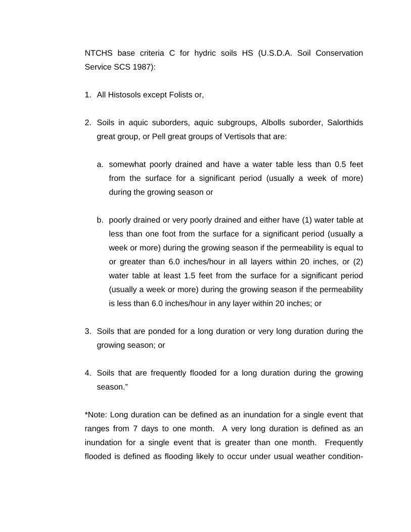
NTCHS base criteria C for hydric soils HS (U.S.D.A. Soil Conservation
Service SCS 1987):
1. All Histosols except Folists or,
2. Soils in aquic suborders, aquic subgroups, Albolls suborder, Salorthids
great group, or Pell great groups of Vertisols that are:
a. somewhat poorly drained and have a water table less than 0.5 feet
from the surface for a significant period (usually a week of more)
during the growing season or
b. poorly drained or very poorly drained and either have (1) water table at
less than one foot from the surface for a significant period (usually a
week or more) during the growing season if the permeability is equal to
or greater than 6.0 inches/hour in all layers within 20 inches, or (2)
water table at least 1.5 feet from the surface for a significant period
(usually a week or more) during the growing season if the permeability
is less than 6.0 inches/hour in any layer within 20 inches; or
3. Soils that are ponded for a long duration or very long duration during the
growing season; or
4. Soils that are frequently flooded for a long duration during the growing
season.”
*Note: Long duration can be defined as an inundation for a single event that
ranges from 7 days to one month. A very long duration is defined as an
inundation for a single event that is greater than one month. Frequently
flooded is defined as flooding likely to occur under usual weather condition-
more than 50% chance of flooding in any year or more than 50 times in 100
years.
We will not be reviewing highly technical aspects of hydric soils. Instead we
will be covering three more easily understandable elements:
1. A list of hydric soils in New Jersey which can be found in Appendix –B of
this handout, coupled with the use of county soils surveys;
2. Common characteristics of organic hydric soils;
3. Common characteristics of mineral hydric soils.
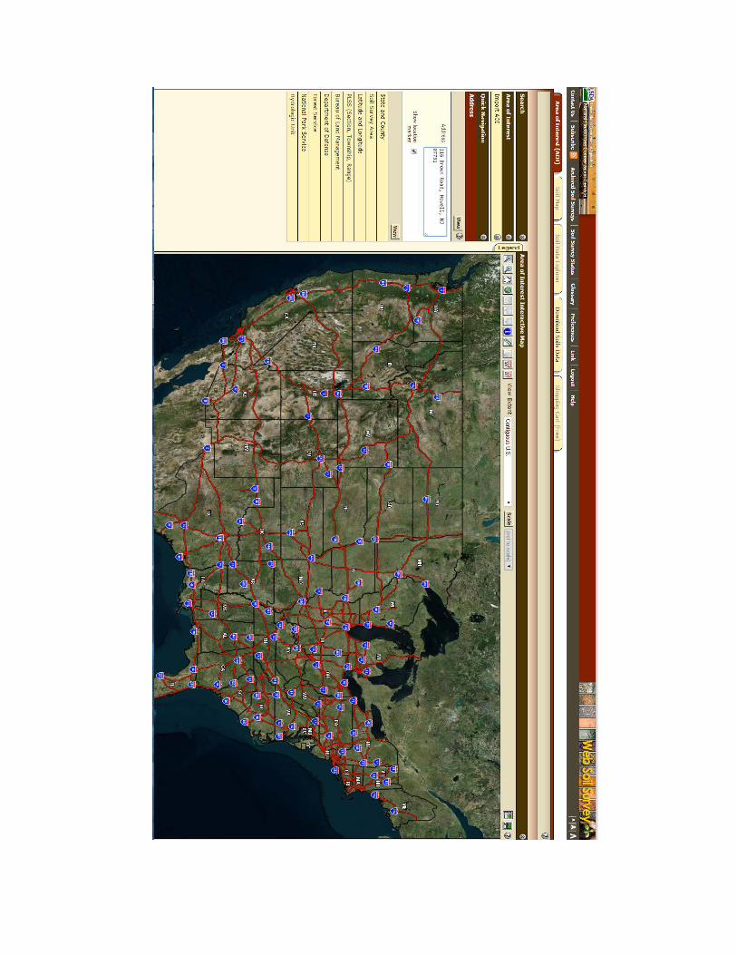
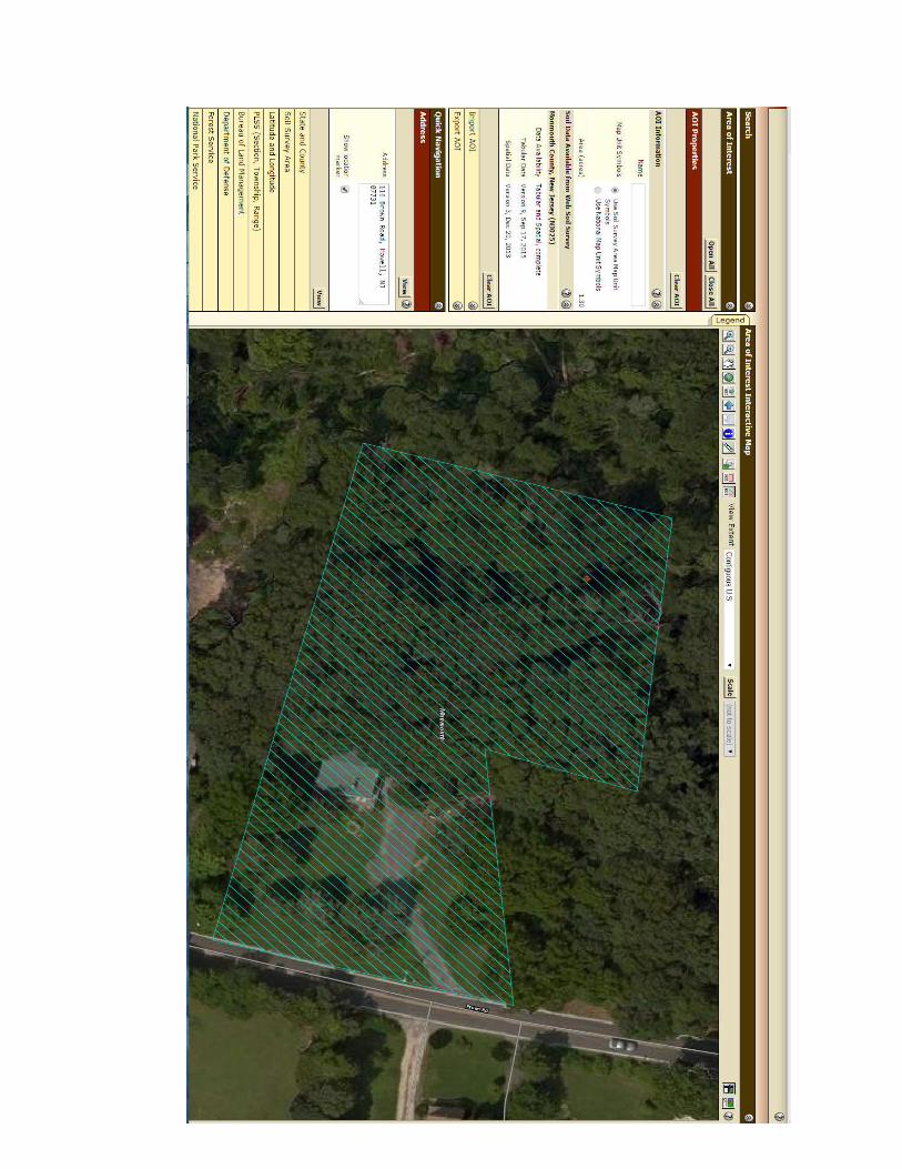
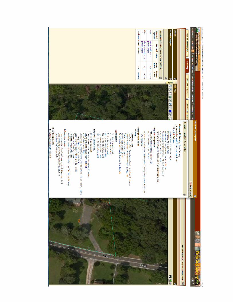
A great resource for identifying soils on a property is the USDA Web Soil
Survey. http://websoilsurvey.sc.egov.usda.gov/App/HomePage.htm
With an address you can easily find out a great deal about the soil conditions
on any site right at your computer. You can easily outline your area of interest
and download a reasonably detailed site specific soil report for the property in
question before you ever visit the site.

Start here with the above link:
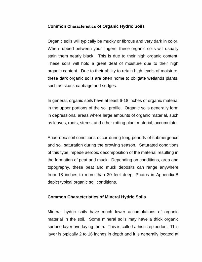
Common Characteristics of Organic Hydric Soils
Organic soils will typically be mucky or fibrous and very dark in color.
When rubbed between your fingers, these organic soils will usually
stain them nearly black. This is due to their high organic content.
These soils will hold a great deal of moisture due to their high
organic content. Due to their ability to retain high levels of moisture,
these dark organic soils are often home to obligate wetlands plants,
such as skunk cabbage and sedges.
In general, organic soils have at least 6-18 inches of organic material
in the upper portions of the soil profile. Organic soils generally form
in depressional areas where large amounts of organic material, such
as leaves, roots, stems, and other rotting plant material, accumulate.
Anaerobic soil conditions occur during long periods of submergence
and soil saturation during the growing season. Saturated conditions
of this type impede aerobic decomposition of the material resulting in
the formation of peat and muck. Depending on conditions, area and
topography, these peat and muck deposits can range anywhere
from 18 inches to more than 30 feet deep. Photos in Appendix-B
depict typical organic soil conditions.
Common Characteristics of Mineral Hydric Soils
Mineral hydric soils have much lower accumulations of organic
material in the soil. Some mineral soils may have a thick organic
surface layer overlaying them. This is called a histic epipedon. This
layer is typically 2 to 16 inches in depth and it is generally located at
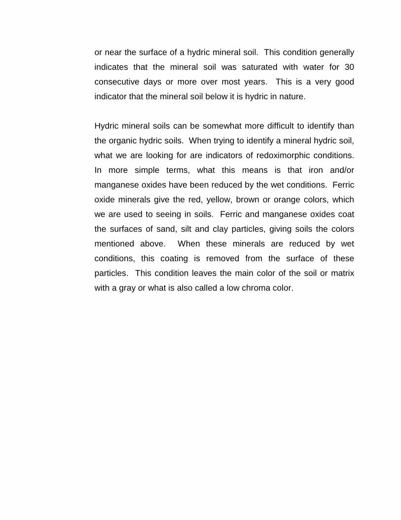
or near the surface of a hydric mineral soil. This condition generally
indicates that the mineral soil was saturated with water for 30
consecutive days or more over most years. This is a very good
indicator that the mineral soil below it is hydric in nature.
Hydric mineral soils can be somewhat more difficult to identify than
the organic hydric soils. When trying to identify a mineral hydric soil,
what we are looking for are indicators of redoximorphic conditions.
In more simple terms, what this means is that iron and/or
manganese oxides have been reduced by the wet conditions. Ferric
oxide minerals give the red, yellow, brown or orange colors, which
we are used to seeing in soils. Ferric and manganese oxides coat
the surfaces of sand, silt and clay particles, giving soils the colors
mentioned above. When these minerals are reduced by wet
conditions, this coating is removed from the surface of these
particles. This condition leaves the main color of the soil or matrix
with a gray or what is also called a low chroma color.
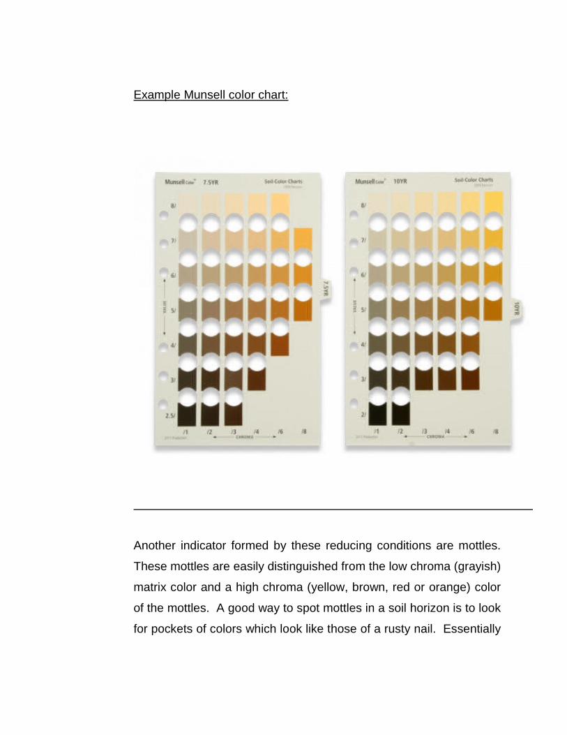
Example Munsell color chart:
Another indicator formed by these reducing conditions are mottles.
These mottles are easily distinguished from the low chroma (grayish)
matrix color and a high chroma (yellow, brown, red or orange) color
of the mottles. A good way to spot mottles in a soil horizon is to look
for pockets of colors which look like those of a rusty nail. Essentially
what is going on in the formation of mottles is a similar chemical
action.
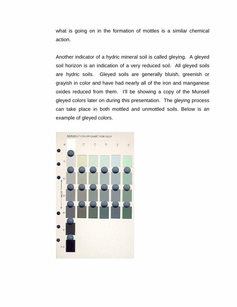
Another indicator of a hydric mineral soil is called gleying. A gleyed
soil horizon is an indication of a very reduced soil. All gleyed soils
are hydric soils. Gleyed soils are generally bluish, greenish or
grayish in color and have had nearly all of the iron and manganese
oxides reduced from them. I’ll be showing a copy of the Munsell
gleyed colors later on during this presentation. The gleying process
can take place in both mottled and unmottled soils. Below is an
example of gleyed colors.
Another good indication of a mineral hydric soil is the presence of
what is called oxidized root zones. If this condition is present, you
will notice rusty colored deposits around the roots of plants or
around the root channels left along the root channels of
decomposed roots.
The chief thing to keep in mind when trying to identify a hydric
mineral soil is that the main color of the soil (matrix) will tend to be
grayish and mottles ranging from a yellowish to a dark brown will be
present within 18 inches of the surface. If these two conditions are
present, it is very likely that you are looking at a hydric soil and,
therefore, likely in a wetland. Photos of mineral hydric soil indicators
can be found in Appendix-B
c) Wetlands hydrology
The driving force in the formation of wetlands is wetlands hydrology.
Simply put, this is the mechanism by which a wetland is supplied with
inundation or soil saturation for the necessary time (usually a week or
more) during the growing season. This inundation or saturation of soils
can be provided by periodic flooding along a river, lake, stream or
estuary, or by being part of a surface water drainage way.
The wetness of any area is influenced by several factors. These can
include precipitation, topography, soil permeability and plant cover.
The frequency and duration of inundation or soil saturation play a
significant role in wetland hydrology and the formation of wetlands. The
duration of an inundation is usually considered to be the more important
factor of the two. This is illustrated when we look at areas of lower
elevation within a flood plain or other areas subject to periodic
inundation. When flooded, these areas will remain wet for longer
periods of time than those areas which are of a higher elevation. Also,
such areas are subject to more frequent events of flooding than those
areas of a higher elevation. Very simply put, water runs downhill.
Soil permeability and groundwater depth also contribute to the duration
of inundation and soil saturation. Clayey soils absorb water at a much
slower rate than sandy or sandy loam soils. Therefore, a soil with a
higher clay content will remain saturated for a significantly longer period
of time than a soil with a higher sand content. Regardless of the type of
soil, a high water table (generally 1.5 feet or less from the surface) will
contribute to wetlands hydrology being present.
Areas with thick and abundant plant cover will tend to increase the
duration of inundation or soil saturation in an area and thus, contribute
to wetlands hydrology in that area. It should be noted, however, that
plant cover can work in the opposite direction as transpiration rates can
tend to be higher in areas of abundant plant cover and may actually
reduce the duration of soil saturation.
All of these varying conditions will contribute to a positive wetland
hydrology.
When trying to determine whether wetland hydrology is present on a
site prior to a field visit, it is very useful to review any topographic
survey data and aerial photography available. Also a review of any
wetland maps, flood maps, flood data or other hydrologic data that is
available is quite useful.
When reviewing topographic data available, we should be looking for
depressional areas and low flat areas along any streams, rivers, or
other bodies of water which may be associated with a flood plain.
When reviewing aerial photography, it is best to review photography
taken during the early spring. This will allow the direct observation of
areas which are flooded or ponded.
State and Federal wetlands mapping, which are readily available on
line, will identify areas currently mapped as wetlands but are subject to
field verification.
Field indicators can be observed by visual observation on-site. These
would include the following:
1. Visual observation of inundation. Obviously, if we visit our site and
observe a ponded area during the growing season or a swampy
area, it would be obvious to us that this particular location is wet.
2. Visual observation of soil saturation. This is accomplished by
walking over a site and observing any areas which are soggy or
mucky underfoot. Beyond this, soil borings are required to a depth
of 18 to 24 inches. This will allow us to observe any standing
groundwater. Also, observations would be made at the soil boring
regarding soil color and depth to mottles. Soils should also be
examined for saturation by squeezing them. If water can be
squeezed out of a soil sample taken within 18 inches of the surface,
it should be considered saturated at that depth.
3. Oxidized root channels. Oxidized root channels, previously
mentioned in the hydric soils section of this course, should also be
noted during the soil boring. Once again, these are the iron
concentrations (dark orangish or reddish brown) which form along
the channels of roots.
4. Water marks. Water marks are found on the trunks of trees and
other woody vegetation. These will be seen as stains on bark or
other fixed objects such as a fence post.
5. Drift lines. These can be found adjacent to streams, other water
courses or along the edges of tidal marshes. Drift lines are deposits
of debris which become tangled with vegetation, trees or other fixed
objects. Debris will consist of litter, vegetation remains or sediment
and will be deposited generally parallel to the direction of water flow.
Drift lines are an indication of the minimum extent of a flooding
event. The maximum extent of flooding is generally beyond the drift
line.
6. Waterborne sediment deposits. Waterborne sediment deposits are
usually thin layers or coatings of mineral or organic matter which is
left behind on plant surfaces or other vertical objects. A good
example of this would be when the water recedes from a flooded
area leaving an algae coating on the base of plants.
7. Water stained leaves. These will be found in forested wetlands
which have been inundated for a significant period of time. These
leaves will usually be blackish or grayish in color.
8. Surface scoured areas. This occurs along flood plains where
flooding erodes sediments at the bases of trees leaving areas
where no leaf litter is present as it has been washed away by the
flooding conditions.
9. Wetland drainage patterns. These are visually observed as
meandering or braided drainage patterns throughout an area, i.e.,
channels.
10. Morphological plant adaptations. These are adaptations which the
plant life in an area has made in response to the inundation or soil
saturation on-site. Good examples of these are shallow roots,
buttress tree trunks, and multiple tree trunks.
11. Hydric soil characteristics. The hydric soil characteristics were
previously discussed.
Any or all of these field indicators of hydrology may be present on a
given site. However, the most easily observable signs of wetland
hydrology will be visual observation of low topography, surface water,
wetland drainage patterns and the morphological plant adaptations
mentioned previously. Photos of examples wetland hydrology field
indicators can be found in Appendix-C
• How are the Extents of the Wetlands Determined and Measured?
The extents of wetlands on a given site are usually determined by an
environmentalist and then field located and mapped by a licensed land
surveyor.
To first determine the extents of wetlands on a project, the
environmentalist will utilize two procedures. First the off-site procedure,
and second, on-site procedures. Before visiting the site and conducting
any on-site procedures, the environmentalist would first review all
available published data which might indicate the presence of wetlands
on the subject site. This would include U.S.G.S. Maps, available State
and Federal Wetlands Mapping, soil survey maps, recent aerial
photography, and any available site specific information, such as a
topographic survey map. If there is a prior Environmental Impact
Statement available for the site, this would also be very useful.
One of the most useful tools in determining the potential presence of
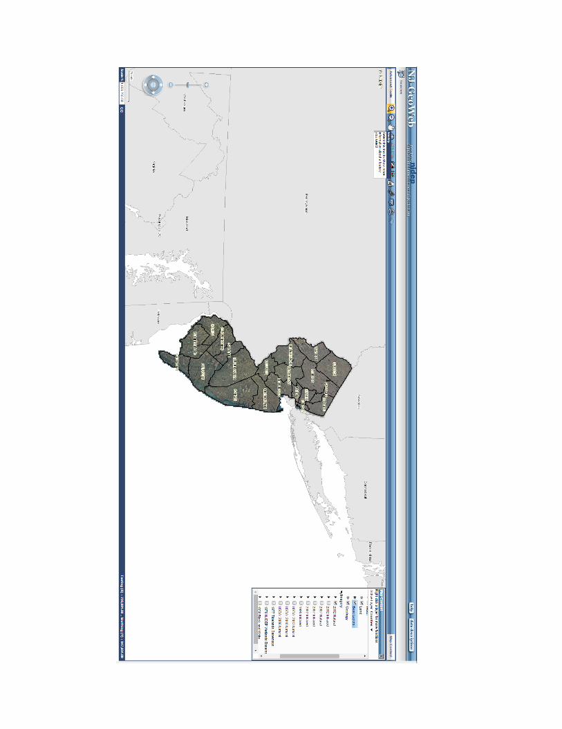
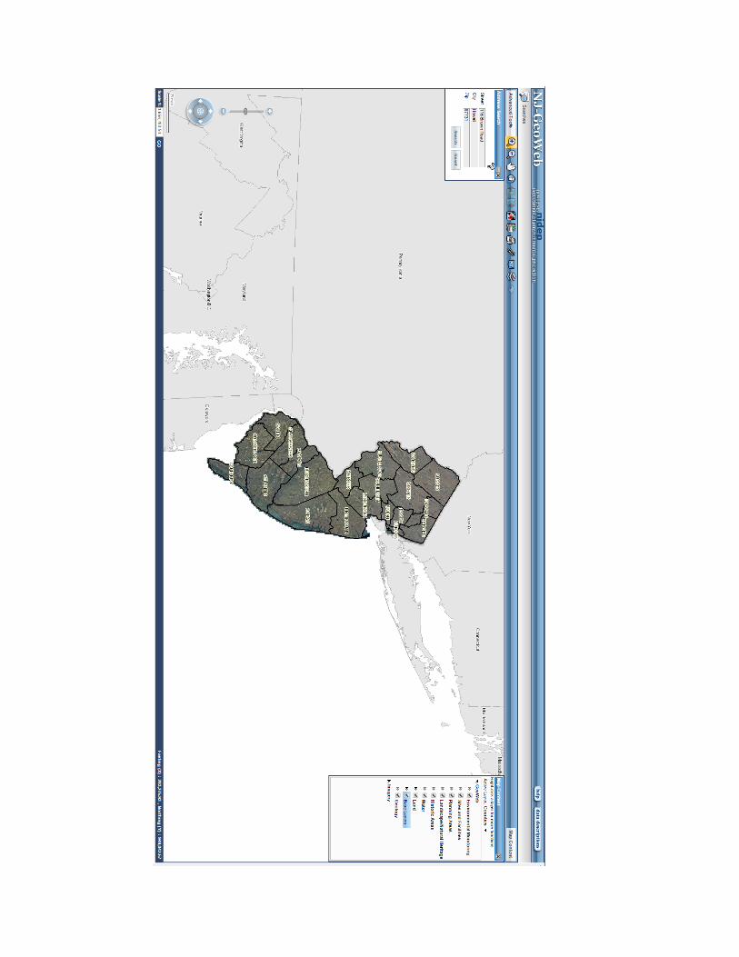
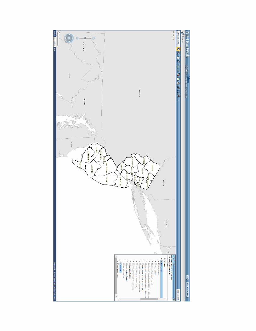
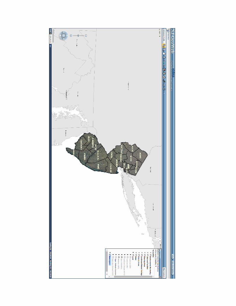
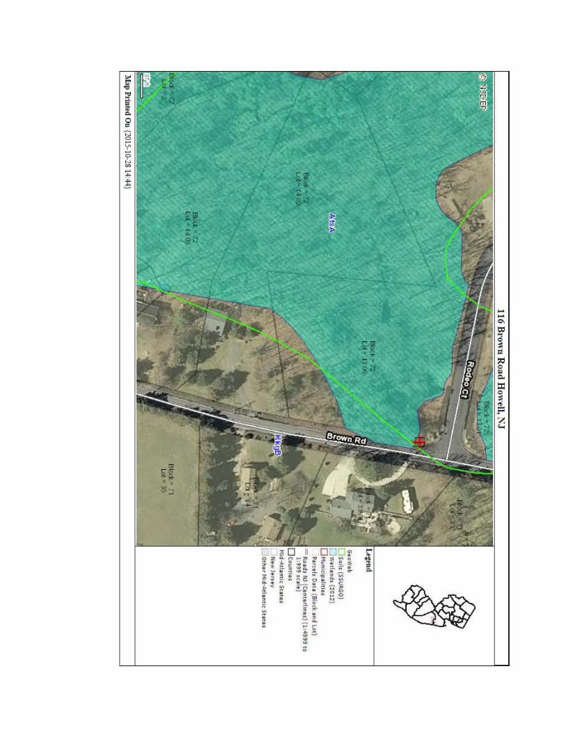
wetlands on a site is the NJDEP NJ-GeoWeb located at:
http://njwebmap.state.nj.us/NJGeoWeb/WebPages/Map/FundyViewer.a
spx?THEME=Sapphire&UH=True&RIDZ=635827768348750320 . This
mapping tool provides an easy view of those areas on your site that the
NJDEP has map as wetlands along with a wide variety of other
environmental information.
Start here with the above web address:
Once all available data has been reviewed, the environmentalist will
decide what areas on-site will be the most likely candidates for the
presence of wetlands. The environmentalist will carry out an on-site
delineation of the wetlands limits utilizing the three parameters of
hydrophytic vegetation, hydric soils and wetland hydrology are used in
order to flag a line between wetlands and uplands areas of the site.
Whether using a tax map or an existing outbound survey, the
environmentalist will begin in an obvious wetland area. At this sampling
point, data will be collected on the plant community, wetland hydrology
along with soil boring data. Once this data point has been established
to be within a wetland community, the environmentalist will pick another
sampling point in an obvious upland plant community as close as
possible to the wetland community. The same data will be collected at
the upland data point making a positive identification of that point as an
upland. Once a positive wetland point and upland point have been
established, the environmentalist will evaluate soils and vegetation
between the two and flag a point somewhere in-between delineating the
wetland boundary. This procedure is repeated across the entire length
of the project to a point where the wetland line either leaves the
property or closes on itself. This procedure is generally carried out at
approximately 500 foot intervals along the length of the wetland
boundary. These sampling points may be stretched out or brought
closer together depending upon the existing field conditions. On
relatively smooth lines flags are tied every 60 feet. When the wetlands
line becomes more meandering, it will be necessary to tie flags much
closer together or even use lath to mark the wetland line. Once the
environmentalist’s work is complete and the wetlands line has been
flagged in the field, the measurement of this line is undertaken by a
land surveyor. The surveyor must locate all wetlands flags along the
along with all boring locations. This information is then transferred to a
topographic survey map which will eventually be used for an application
to the NJDEP for a Regulatory Line Verification L.O.I. or wetlands
permitting.
Once the mapping has been approved through the Letter of
Interpretation issued by the NJDEP, the wetlands line and/or buffer
associated with it can be described as a metes and bounds and shown
on future plans. Many municipalities in the State of New Jersey now
require that the wetlands limits and its associated buffer be shown on
final plats. Additionally, some municipalities are requiring that the
wetland line itself or the buffer line be staked with iron pins and caps,
such as Freehold Township in Monmouth County to reflect the position
of the wetlands line physically in the field as approved by the NJDEP.
Holmdel Township in Monmouth County takes this a step farther and
requires that the buffer line itself be monumented along its metes and
bounds with monuments reflecting that this is a conservation line.
Who Has Jurisdiction Over Wetlands in New Jersey?
The State of New Jersey has jurisdiction over freshwater wetlands within
the State of New Jersey. This is under the authority of the Federal
Clean Water Act Section 404. On March 2, 1994, the State of New
Jersey assumed the administration of the 404 program for New Jersey
with some variations. Those being that any major discharge would
require a joint Federal, State review and wetlands within 1,000 feet of
tidal waters are not assumable and are under the oversight of the
USEPA (Section 10 of Rivers and Harbors Act). The Pinelands
Commission has stricter and somewhat modified regulations within their
jurisdictional borders. Areas that are exempt from the Freshwater
Protection Act in New Jersey are those waters as follows:
Coastal wetlands under the Wetlands Act of 1970.
HMDC jurisdiction (Hackensack Meadowlands).
As outlined above, all wetlands within the State of New Jersey, other
than the exception of the coastal wetlands and the Hackensack
Meadowlands, are under the jurisdiction of the State of New Jersey. As
such, the State regulates most activities that take place within them.
There are very few activities which are not regulated within wetlands.
They are as follows:
1. Surveying or wetlands investigation activities, for the purpose of
establishing or reestablishing a boundary line or points, which use only
hand held equipment and do not involve the use of motorized vehicles
to either clear vegetation or extract soil borings. The clearing of
vegetation along the survey line or around the survey points will not
exceed three feet in width or diameter respectively and will not be kept
clear or maintained once the survey or delineation is completed;
2. The placement of temporary structures (such as observation blinds,
waterfowl blinds, artificial nesting structures, or sign posts) for
observing, managing, or harvesting fish or wildlife, provided the
structures:
i. Do not have permanent foundations;
ii. Do not require the deposition of fill material; and
iii. Have a footprint no larger than 32 square feet;
3. Placement of one or more small guy anchors that screw into the ground
to secure a guy wire supporting a utility pole, provided that the area of
disturbance caused by each guy anchor is no more than 15 inches in
diameter;
4. Hand trimming of trees or other vegetation, provided the trimming does
not alter the character of the freshwater wetland; and
5. The driving of one or more pilings in a State open water, if the pilings
are not regulated by the ACOE under the Federal 404 program. The
ACOE regulates the placement of pilings if the placement would have
the effect of a discharge of fill material. Examples of activities that are
and are not regulated by the ACOE are:
i. Activities that generally do not have the effect of a discharge of fill
material and thus are not regulated are:
(A) Placing pilings for linear projects, such as bridges, elevated walkways,
and utility line structures; and
(B) Placement of pilings for piers or docks;
ii. Activities that generally do have the effect of a discharge of fill material
and thus are regulated include, but are not limited to:
(A) Projects where the pilings are so closely spaced that sedimentation
rates would be increased;
(B) Projects in which the pilings themselves effectively would replace the
bottom of a water body;
(C) Projects involving the placement of pilings that would reduce the reach
or impair the flow or circulation of waters of the United States;
(D) Projects involving the placement of pilings which would result in the
adverse alteration or elimination of aquatic functions; and
(E) Projects where the pilings are intended to be used for structural
support of a building such as a commercial or residential structure.
Regulated activities include the following:
1. The removal, excavation, disturbance or dredging of soil, sand, gravel,
or aggregate material of any kind;
2. The drainage or disturbance of the water level or water table so as to
alter the existing elevation of groundwater or surface water, regardless
of the duration of such alteration, by:
i. Adding or impounding a sufficient quantity of stormwater or other water
to modify the existing vegetation, values or functions of the wetland; or
ii. Draining, ditching or otherwise causing the depletion of the existing
groundwater or surface water so as to modify the existing vegetation,
values or functions of the wetland;

3. The dumping, discharging or filling with any materials;
4. The driving of pilings;
5. The placing of obstructions, including depositing, constructing, installing
or otherwise situating any obstacle which will affect the values or
functions of a freshwater wetland; and
6. The destruction of plant life which would alter the character of a
freshwater wetland, including killing vegetation by applying herbicides
or by other means, the physical removal of wetland vegetation, and/or
the cutting of trees.
Wetlands transition areas (buffers) are regulated similarly to the
wetlands as described above. However, permitting rules regulating
activities in a transition area are somewhat less stringent than in a
wetland.
As you can see, the limits placed on land use by regulation of the
activities in and around wetlands are extensive. Proceed with caution
when undertaking any activity in or around a wetland.
How the Wetlands & Buffers Can Impact Your Project
• Limiting the usable lot area.
• Limiting access to portions of the site.
• Limiting the use of a site.
• Limiting the Usable Lot Area
Once a wetlands limits has been identified, delineated and approved by the NJDEP on a site, most activities in or near the wetlands will be regulated by the NJDEP under the rules and regulations adopted in the Freshwater Wetlands Protection Act N.J.A.C. 7:7A. As previously discussed, almost any construction activity is prohibited within the wetlands area without a permit. In some cases, all construction activity would be prohibited within the wetlands area. For instance, if a 200’ x 200’ lot with a continuous wetland line running through the rear half of the property, with a 100 foot width along with a 50 foot buffer, the usable area on the lot would now be reduced to a 200’ x 50’ strip along the front portion of the lot. If this situation were reversed and the wetlands began at the road and extended 100 feet into the property, this would require the use of not only a Transition Area Waiver, but a General Permit for crossing the wetlands in order to access the remaining portion in the rear of the property. If the same site had wetlands that were judged to be of exceptional resource value, it would then have a 150 foot wetlands buffer. In essence, this would make the entire lot unbuildable unless the owner was granted an Individual Permit.
• Limiting Access to Portions of the Site
Another problem that can arise from the presence of wetlands on a site is the limiting of access to portions of the site. If a band of wetlands, a ditch or a swale located near or along the front portion of a site, access to any of the upland portions beyond the wetlands, will necessitate the use of some type of permit. When the width of a wetland area exceeds 100 feet, access to uplands located beyond the wetlands limits becomes more limited. Once the upland, which one wishes to gain access to, is separated from the roadway or other upland by a distance of 100 feet or more, access under a general permit may could mitigation which can be quite expensive. The NJDEP now requires 1:1 mitigation on certain General Permits.
• Limiting Use of the Site
Wetlands and their buffers can also limit the use of the site. An example of this would be if a client were to purchase a large farm with the hope of developing most of the fields and open areas. After making a wetlands investigation, it’s entirely possible that a very large percentage of the fields may be found to be wetlands. As an ongoing farm which would be eligible for a farmland tax assessment, it would be exempt from the requirement for Freshwater Wetlands Permits provided normal farming activities, such as silvaculture, ranching, plowing, seeding, cultivating or harvesting of food or other crops, were being carried out. However, once the farming activity ceased or another activity began to take place in the areas previously farmed, these activities would then be subject to all wetlands regulations.
Wetlands and their associated buffers can have considerable impacts on a property by limiting the usable lot area, limiting the access to portions of the site and by limiting the very use of the site. Now that we have identified ways that the wetlands boundaries and buffers can impact the use of a site, we will look at some ways that we can reduce these impacts by utilizing Letters of Interpretation (L.O.I.) General Permits and buffer reduction.
• Using L.O.I.s to Reduce Wetlands Impacts on Property
The NJDEP issues three different types of L.O.I.s. These can be very useful when determining what can be done with a piece of property. They are as follows:
1. Wetlands Presence/Absence L.O.I.
A wetlands presence/absence determination is the simplest level of L.O.I. The NJDEP will determine whether or not any freshwater wetlands, State open waters or transition areas (regulated Features) exist on a site or a portion of a site (Footprint of Disturbance) and provide resource value classification of freshwater wetlands and transition areas. The wetlands presence/absence L.O.I. will not determine the location of any wetlands on a given site, but will only state whether a regulated feature exists. The NJDEP will issue a presence/absence L.O.I. for a site of any size. The NJDEP will issue a presence/absence L.O.I. for a

portion of a site (Footprint of Disturbance). The NJDEP limits the size of a Footprint of Disturbance to no larger than 1 acre and will approve a maximum of three Footprints of Disturbance on a site
Prior to a State inspection for a footprint of disturbance, it is necessary to have all limits of disturbance flagged in the field, numbered and the flagged limits of disturbance shown on an outbound survey.
Obviously a wetlands presence/absence L.O.I. is of limited use. This type of L.O.I. is most useful in cases where it is nearly a certainty that no wetlands are present at the location where improvements would take place and an official State document supporting this is desirable to obtain.
2. A delineation under an acre L.O.I.
For smaller parcels of an acre or less, the NJDEP will provide an on-site delineation and a letter of interpretation defining the limits of any wetlands, State open water or transition areas present on a site of one acre or less. This method can be quite useful when dealing with an individual building lot of an acre or less which may have wetlands located on-site.
With this type of L.O.I., the State provides all field work necessary to flag the wetlands on-site. This line as flagged by the NJDEP would then have to be field surveyed and shown on any subsequent plot plan and/or survey of the property.
3. Regulatory line verification.
Regulatory line verification – This is the type of L.O.I. which would be used for larger tracts of land containing wetlands, State open water or transition areas. It is required that all wetlands lines be field delineated using the three parameter approach, flagged, numbered, field located and be shown on an outbound survey plan or site plan of the property. If the site is located in Mercer or Middlesex County or north of these counties, the survey must include topography depicting
contours at no greater than 5 foot intervals. For counties south of Middlesex and Mercer, the survey must include topography depicting, at a minimum, 2 foot contours.
The delineated line will be inspected by the NJDEP, who may recommend repositioning of some of the flagged points. Once any adjustments to the flagged wetlands line are completed, they should be relocated and revised accordingly on all plans. A revised survey should then be resubmitted to the NJDEP. It will be referenced in the L.O.I. All subsequent plans should reflect the date of the approved L.O.I. along with NJDEP file numbers.
This type of L.O.I. is useful in planning what portion of a site can be improved. Development of a buffer averaging plan would also require this information.
• What Determines the Resource Value of a Wetland?
Per the Freshwater Wetlands Protection Act, freshwater wetlands are divided into three classifications based on their resource value. The first is freshwater wetlands of an exceptional resource value which are all those wetlands that exhibit any of the following characteristics.
1) All those wetlands that discharge into FW1 or FW2 trout production waters or their tributaries; or 2) those wetlands which are present habitats for threatened or endangered species or those which are documented habitats for threatened or endangered species and which remain suitable for breeding, resting or feeding by these species during the normal period which these species would use the habitat.
The second resource value which can be designated to a freshwater wetland is that of ordinary resource value. These are freshwater wetlands which do not exhibit the characteristics outlined above and which are:
1. Isolated wetlands which are more than 50% surrounded by development and less than 5,000 square feet in size. For the purpose of clarification, the term development is defined as the following uses which were legally existing prior to July 1, 1988 or were permitted under the Act:
a. lawns
b. maintained landscaping
c. impervious surfaces
d. active railroad rights-of-way
e. graveled or stoned parking/storage areas and roads.
Further, this development must occupy more than 50% of the area within 50 feet of the wetland boundary in order for the wetland to meet the criteria of more than 50% surrounded by development.
2. Drainage ditches
3. Swales
4. Detention facilities.
The third and most common freshwater wetlands resource value designation is that of intermediate resource value. This designation is given to all freshwater wetlands not defined as exceptional or ordinary.
• Using Wetlands Permits to Reduce Wetlands Impacts on Property
There are several General Permits available from the NJDEP for various activities in and around wetlands. Most of these wetlands permits also apply to the same activities with wetland transition areas. Five of the more common permits are covered to demonstrate their use on a property that has wetlands
located on same but can be useful in construction of improvements. They are as follows:
1. A General Permit #1 Maintenance and repair of existing features 2. A General Permit #6 for filling of Isolated wetlands. 3. A General Permit #7 for filling of Ditches and swales. 4. A General Permit #8 for House additions 5. A General Permit #10A or #10B for Minor road crossings.
General Permit # 1
A General Permit # 1 allows for activities in freshwater wetlands and State open waters, required for the repair, rehabilitation, replacement, maintenance or reconstruction of a previously authorized, currently serviceable structure, fill, roadway, utility line, active irrigation or drainage ditch, or stormwater management facility lawfully existing prior to July 1, 1988.
This permit is very helpful in cases where a wetland area was filled and built on legally but is failing or becoming a wetland again over time. While there is no acreage limit on disturbance with this permit there are some restrictions. The previously authorized use cannot change from the use that was previously approved. Also there can be no expansion of the use.
General Permit # 6
A General Permit #6 can be useful in land development. One must keep in mind that this permit now requires 1:1 mitigation for permanent loss and/or disturbance of less than 0.1 acres of freshwater wetlands or State open waters that are also waters of the United States unless the applicant demonstrates to the Department that all activities have been designed to avoid and minimize impacts to wetlands. From the NJDEP’s point of view, “minimize” means that the project is configured so that most or all of it is contained in the uplands on the site, and that the wetlands are avoided to the greatest extent possible. An applicant is not required to reduce the scope of the project or to consider offsite alternatives to comply with this requirement.
This permit allows for fill of up to one acre in any isolated wetlands, with some conditions. The definition of an isolated wetland is any wetland that is not part of a surface water tributary. To define this further, this type of wetland must be completely cut off by uplands from any other wetland body. This connection
would include any type of ditch, swale, channel or even a piped connection to another water course or wetlands body. Therefore, even if there were only a small piece of wetlands on your property but was connected by 2,000 feet of pipe to a ditch downstream, it would not be considered an isolated wetland.
With the term isolated wetland properly defined, here is a review of some of the standards which must be adhered to in order to comply with the conditions of the General Permit #6. One of the most important things to consider when applying for a fill permit is to demonstrate that the fill is project related. An example of a project related fill would be the construction of a structure or impervious surface over the isolated wetland or grading necessary to the particular construction activity. Merely filling the wetland in order to do away with it, would not be acceptable.
Other approval standards which must be considered when applying for a General Permit #6 require that the isolated wetland to be filled not be classified as either USEPA priority wetlands, State open water that is a special aquatic site, State open water that is larger than one acre or wetlands of exceptional resource value. If the isolated wetland in question has been assigned either of the above mentioned designations, a General Permit #6 is prohibited. Also, as previously mentioned, the wetland fill cannot exceed one acre. Ideally it should be less than one acre.
General Permit # 7
A General Permit #7 allows for the filling of a ditch of human construction or swales in a headwater. The restrictions of this permit are very similar to those for the General Permit #6 described above. In addition to the approval standards of being project related, fill less than an acre, not of exceptional resource value, not EPA priority, the following additional items must be considered. They are as follows:
1. The ditch or swale to be filled must be located in the headwater area of the ditch or swale. "Headwater" means a water or wetland that is upstream of the point on a non-tidal stream where the average annual flow is less than five cubic feet per second and a drainage area of less than 50 acres.
2. The proposed activity will not result in a disruption of a surface water connection and the isolation of adjacent wetlands or State open waters.
General Permit # 8
A General Permit # 8 allows for the construction of additions or appurtenant improvements to residential dwellings lawfully existing prior to July 1, 1988, provided that the improvements or additions require less than a cumulative surface area of 750 square feet of fill and/or disturbance and will not result in new alterations to a freshwater wetlands outside of the 750 square foot area.
This permit can also be used in conjunction with the replacement a legally existing dwelling (built prior to July 1, 1988) to provide an expansion of the original footprint or a garage.
The main restrictions with this permit are:
1. No more than a total 750 SF 2. Proof of position the lawful existence prior to July 1, 1988 3. Improvements must be within 100’ of the residential dwelling
General Permit # 10A & 10B
A General Permit #10A allows for very minor road crossings of wetlands or transition areas as follows:
1. Construction of one or more new road crossings, including attendant features such as shoulders, sidewalks and embankments;
2. Expansion, widening, or upgrading of one or more existing paved or unpaved roads or drives; and
3. Activities necessary to reduce horizontal curves in an existing paved road to comply with New Jersey Department of Transportation safety regulations.
The NJDEP will issue a general permit 10A authorization only if the activities comply with the limits in one of the following scenarios:
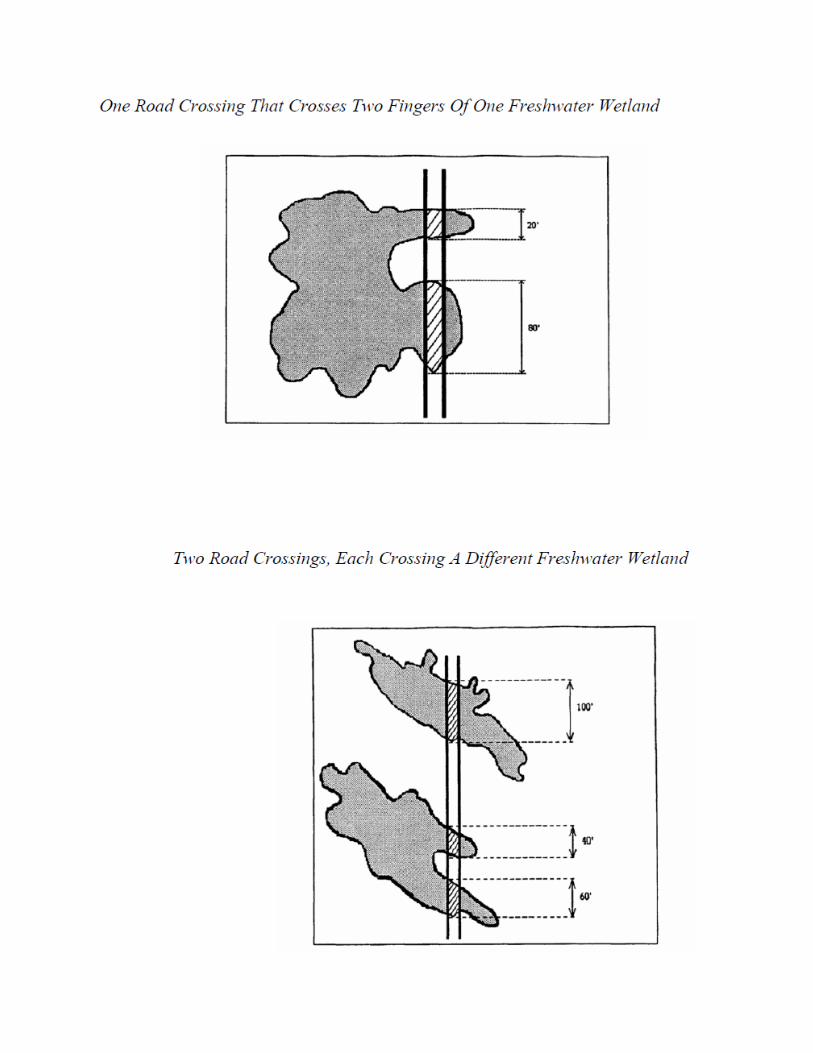
1. Short crossing scenario:
i. The disturbance of freshwater wetlands and/or State open waters is no longer than 100 feet for each crossing, as calculated under (e) below; and
ii. The total cumulative disturbance of freshwater wetlands, transition area, and State open waters onsite under general permit 10A is one quarter acre or less; or
2. Long crossing scenario: The total cumulative disturbance of freshwater wetlands, transition area, and State open waters onsite under general permit 10A is one eighth acre or less. Under the long crossing scenario, the length of the crossing is not limited.
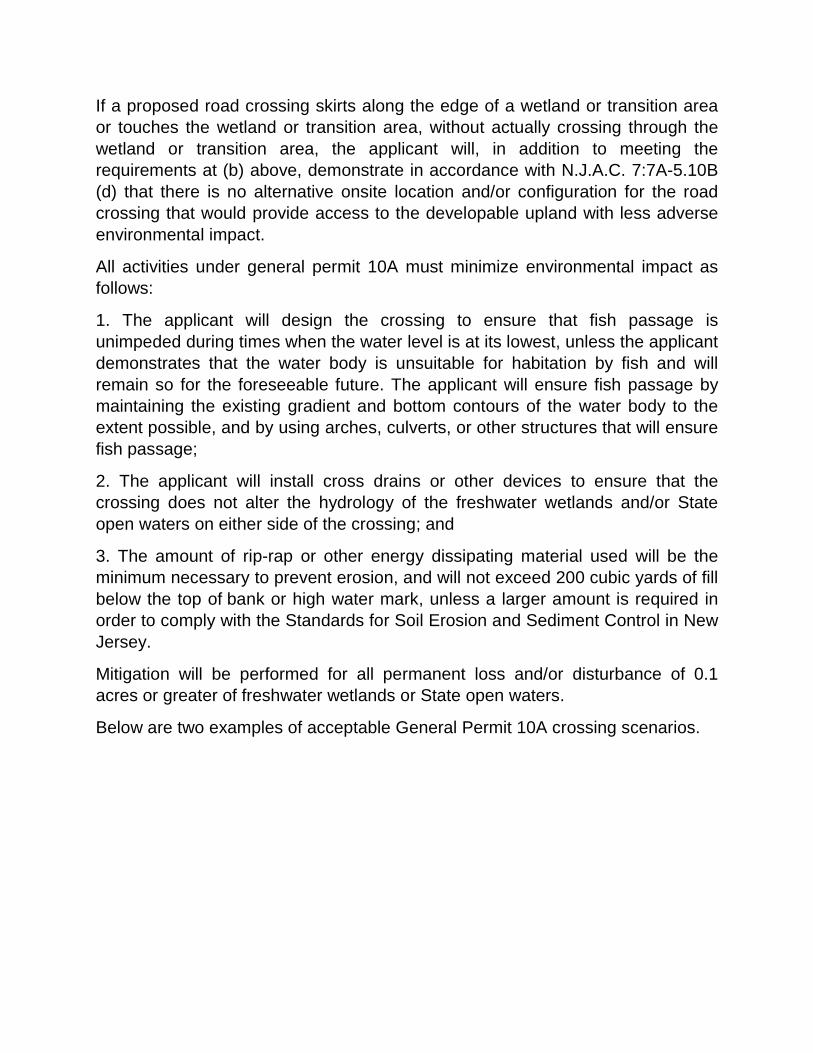
If a proposed road crossing skirts along the edge of a wetland or transition area or touches the wetland or transition area, without actually crossing through the wetland or transition area, the applicant will, in addition to meeting the requirements at (b) above, demonstrate in accordance with N.J.A.C. 7:7A-5.10B (d) that there is no alternative onsite location and/or configuration for the road crossing that would provide access to the developable upland with less adverse environmental impact.
All activities under general permit 10A must minimize environmental impact as follows:
1. The applicant will design the crossing to ensure that fish passage is unimpeded during times when the water level is at its lowest, unless the applicant demonstrates that the water body is unsuitable for habitation by fish and will remain so for the foreseeable future. The applicant will ensure fish passage by maintaining the existing gradient and bottom contours of the water body to the extent possible, and by using arches, culverts, or other structures that will ensure fish passage;
2. The applicant will install cross drains or other devices to ensure that the crossing does not alter the hydrology of the freshwater wetlands and/or State open waters on either side of the crossing; and
3. The amount of rip-rap or other energy dissipating material used will be the minimum necessary to prevent erosion, and will not exceed 200 cubic yards of fill below the top of bank or high water mark, unless a larger amount is required in order to comply with the Standards for Soil Erosion and Sediment Control in New Jersey.
Mitigation will be performed for all permanent loss and/or disturbance of 0.1 acres or greater of freshwater wetlands or State open waters.
Below are two examples of acceptable General Permit 10A crossing scenarios.
A general Permit 10B is much the same as a 10A and has all of the same requirements but carries additional restrictions due to the fact that this permit has the potential for more environmental impact. These extra restrictions are outlined below:
1. The cartway, shoulder, and side slopes of the roadway shall be the minimum necessary for the crossing and shall not exceed the limits in the New Jersey Department of Community Affairs' Residential Site Improvement Standards at N.J.A.C. 5:21. If the project is not a residential development, the cartway, shoulder, and side slopes of the roadway shall be the minimum necessary for safety.
2. The applicant will be required to provide an alternative analysis of other possible on site locations for disturbance that would have lesser environmental impact to wetlands areas as follows: 1. Disturbance of a non-transition area upland would have less adverse environmental impact than disturbance of a transition area, State open water or freshwater wetland; 2. Disturbance of a transition area would have less adverse environmental impact than disturbance of a freshwater wetland or State open water; 3. Disturbance of a freshwater wetland would have less adverse environmental impact than disturbance of a State open water; 4. Expansion or upgrading of an existing and currently serviceable drive or crossing would have less adverse environmental impact than placement of a new crossing; and 5. Placement of a new crossing in an area that is already significantly disturbed would have less adverse environmental impact than disturbance of a previously undisturbed wetland and/or State open water.
Once again this permit requires mitigation for total permanent disturbance once you have reached 0.1 acres of disturbance.
• Making an application to the NJDEP
This is an outline of the basic application requirements for any type of application to the NJDEP.
1. A completed LURP- form. This form must be filled out in its entirety. A brief description of the project is included on Page 1, which should include what type of L.O.I. or General Permit is being applied for along with a description of the disturbance.
All signatures required on the LURP form will need to be addressed. This will include the current owner of the project, which may not be your client, along with the owner’s unconditional consent for entry.
2. A USGS Quad Map showing the project in question.
3. New Jersey State Plane Coordinates for the center of the project (northing/easting).
4. Certified list of property owners within 200’ of the site.
5. A copy of the written notice sent to all required recipients. (Wording is detailed within the “Freshwater Wetlands Protection Act.”)
6. Proof of notification of all required recipients.
7. Fees as per N.J.A.C. 7:7A-16 for all application items.
For an L.O.I. application additional items will be required as follows:
• A tax map with the property outlined.
• A location map (county map, Hagstrom map, or other local street map).
• A copy of the county soils survey map with the property outlined to scale.
• Photographs of the site.
• Photo location map showing numbered photos and the directions at which the photo was taken.
ADDITIONAL REQUIREMENTS FOR DIFFERENT L.O.I.s
PRESENCE/ABSENCE FOOTPRINT OF DISTURBANCE:
• Survey (scale of 1” = 50 or larger) showing the limits of all proposed footprint of disturbance on-site. (No more than 3 - 1 acre or less footprints per property)
• The limits of each footprint of disturbance must be flagged on-site.
DELINEATION UNDER AN ACRE:
• Outbound survey or site plan of the project.
REGULATORY LINE VERIFICATION:
• Topographic survey with contours (two foot contours for Middlesex County or south, five foot contours for north of Middlesex County) showing the location of the wetlands line and all soil borings.
• Soil boring data sheets.
• Vegetative species data sheets.
• Wetland line must be flagged in the field with corresponding numbers shown on the topographic survey.
Along with the above contents for a complete application package, a cover letter detailing the contents along with your calculation of the fee should be included. For a more comprehensive review of application package requirements review the L.O.I. Checklist included in Appendix-D.
For a General Permit or Transition Area Waiver application additional items will be required as follows:
• Color photographs of the area to be disturbed.
• Site plan showing the following:
a. All proposed activities and disturbances along with the areas of same.
b. If no L.O.I. has been issued on the property, copies of soil data sheets and vegetation data sheets for the area to be disturbed must be included.
c. For a General Permit application, the site plan must detail all items to be constructed along with any associated grading.
d. For a buffer averaging plan, the site plan should clearly show the areas of all proposed transition area reductions along with all areas of proposed transition area compensation. The areas in square feet/acres be shown on both buffer reduction areas and buffer compensation areas. A statement of compliance detailing how all site related activities comply with the conditions of the particular General Permit or buffer reduction being applied for.
* It should be noted that in some municipalities within the State of New Jersey the application must include a signed statement from the applicant, certifying that the proposed activities will not result in any direct or indirect adverse impacts to swamp pink (helonias bullata) and/or bog turtles (Glyptemys muhlenbergii).
BIBLIOGRAPHY:
The following materials were used in the preparation of this course and handout.
1. Federal Manual for Identifying and Delineating Jurisdictional Wetlands. January 1989.
2. Freshwater Wetlands Protection Act Rules N.J.A.C. 7:7A amended to February 2, 2015.
3. Cook College Continuing Education:
a. Course Materials: “Freshwater Wetlands”
b. Course Materials: “Vegetation Identification for Wetland Delineation, Southern Section.”
c. Course Materials: “Methodology of Delineating Wetlands.”
4. The Coordinate Winter 1989.

5. USDA Web Soil Survey. http://websoilsurvey.sc.egov.usda.gov/App/HomePage.htm
6. NJDEP NJ-GeoWeb located at:
http://njwebmap.state.nj.us/NJGeoWeb/WebPages/Map/FundyViewer.aspx?THEME=Sapphire&UH=True&RIDZ=635827768348750320


![No. 6288. LAND SURVEYORS ACT 1958.1958. Land Surveyors. No. 6288 837 No. 6288. LAND SURVEYORS ACT 1958. An Act to consolidate the Law relating to Surveyors. [30th September, 1958.]](https://img.pdfslide.net/doc/110x75/5e94498d234c4b210e568874/no-6288-land-surveyors-act-1958-1958-land-surveyors-no-6288-837-no-6288.jpg)