Embed Size (px)
Citation preview

The Cultural Landscape Foundation connecting people to places™
tclf.org
What’s Out There®
Indianapolis
3www.tclf.org2 The Cultural Landscape Foundation
Photo by Carol M. Highsm
ith
Indianapolis, Indiana
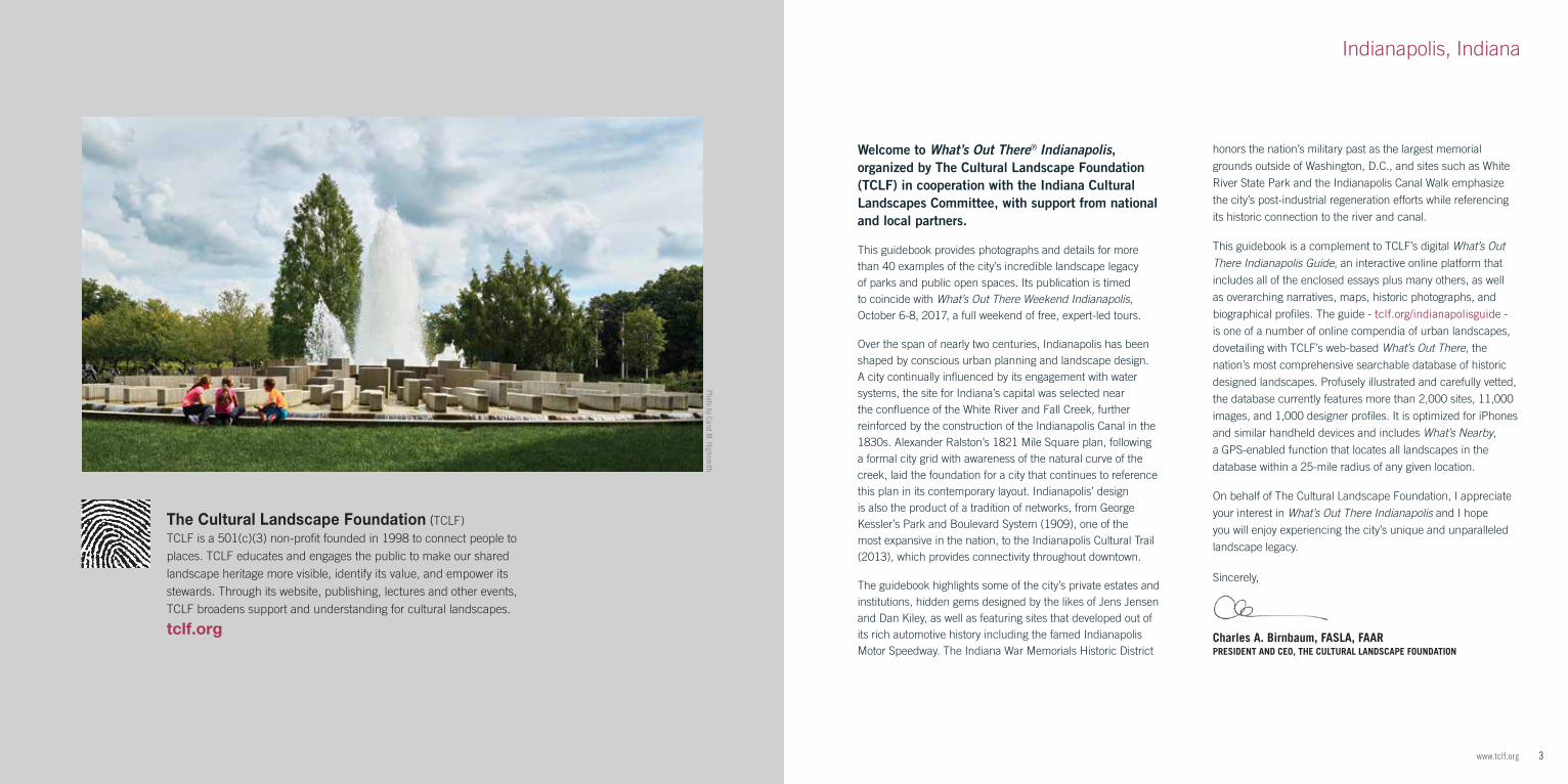
Welcome to What’s Out There® Indianapolis, organized by The Cultural Landscape Foundation (TCLF) in cooperation with the Indiana Cultural Landscapes Committee, with support from national and local partners.
This guidebook provides photographs and details for more than 40 examples of the city’s incredible landscape legacy of parks and public open spaces. Its publication is timed to coincide with What’s Out There Weekend Indianapolis, October 6-8, 2017, a full weekend of free, expert-led tours.
Over the span of nearly two centuries, Indianapolis has been shaped by conscious urban planning and landscape design. A city continually influenced by its engagement with water systems, the site for Indiana’s capital was selected near the confluence of the White River and Fall Creek, further reinforced by the construction of the Indianapolis Canal in the 1830s. Alexander Ralston’s 1821 Mile Square plan, following a formal city grid with awareness of the natural curve of the creek, laid the foundation for a city that continues to reference this plan in its contemporary layout. Indianapolis’ design is also the product of a tradition of networks, from George Kessler’s Park and Boulevard System (1909), one of the most expansive in the nation, to the Indianapolis Cultural Trail (2013), which provides connectivity throughout downtown.
The guidebook highlights some of the city’s private estates and institutions, hidden gems designed by the likes of Jens Jensen and Dan Kiley, as well as featuring sites that developed out of its rich automotive history including the famed Indianapolis Motor Speedway. The Indiana War Memorials Historic District
honors the nation’s military past as the largest memorial
grounds outside of Washington, D.C., and sites such as White
River State Park and the Indianapolis Canal Walk emphasize
the city’s post-industrial regeneration efforts while referencing
its historic connection to the river and canal.
This guidebook is a complement to TCLF’s digital What’s Out There Indianapolis Guide, an interactive online platform that
includes all of the enclosed essays plus many others, as well
as overarching narratives, maps, historic photographs, and
biographical profiles. The guide - tclf.org/indianapolisguide -
is one of a number of online compendia of urban landscapes,
dovetailing with TCLF’s web-based What’s Out There, the
nation’s most comprehensive searchable database of historic
designed landscapes. Profusely illustrated and carefully vetted,
the database currently features more than 2,000 sites, 11,000
images, and 1,000 designer profiles. It is optimized for iPhones
and similar handheld devices and includes What’s Nearby,
a GPS-enabled function that locates all landscapes in the
database within a 25-mile radius of any given location.
On behalf of The Cultural Landscape Foundation, I appreciate
your interest in What’s Out There Indianapolis and I hope
you will enjoy experiencing the city’s unique and unparalleled
landscape legacy.
Sincerely,
Charles A. Birnbaum, FASLA, FAAR PRESIDENT AND CEO, THE CULTURAL LANDSCAPE FOUNDATION
The Cultural Landscape Foundation (TCLF)TCLF is a 501(c)(3) non-profit founded in 1998 to connect people to places. TCLF educates and engages the public to make our shared landscape heritage more visible, identify its value, and empower its stewards. Through its website, publishing, lectures and other events, TCLF broadens support and understanding for cultural landscapes.
tclf.org
5www.tclf.org
➊ Monument Circle - Soldiers' and Sailors' Monument
➋ Indiana War Memorials Historic District
➌ University Park
➍ Indiana World War Memorial
➎ Veteran's Memorial Plaza
➏ American Legion Mall
➐ Fall Creek Parkway
➑ Garfield Park
➒ Garfield Park Conservatory and Sunken Garden
➓ Indianapolis Canal Walk
⓫ White River State Park
⓬ Congressional Medal of Honor Memorial
⓭ Ball Nurses' Sunken Garden and Convalescent Park
⓮ The Commonground and Sky Farm at Eskenazi Health Hospital
⓯ Indianapolis Cultural Trail: A Legacy of Gene and Marilyn Glick
⓰ Massachusetts Avenue Commercial District
⓱ Georgia Street
⓲ Woodruff Place Historic District
⓳ Central Canal Towpath
⓴ Butler University - Holcomb Gardens
•• Christian Theological Seminary
•• Sloan House
•• Tarkington Park
•• Oldfields - Lilly House & Gardens at Newfields
•• Indianapolis Museum of Art at Newfields
•• Newfields' Westerley House & Gardens
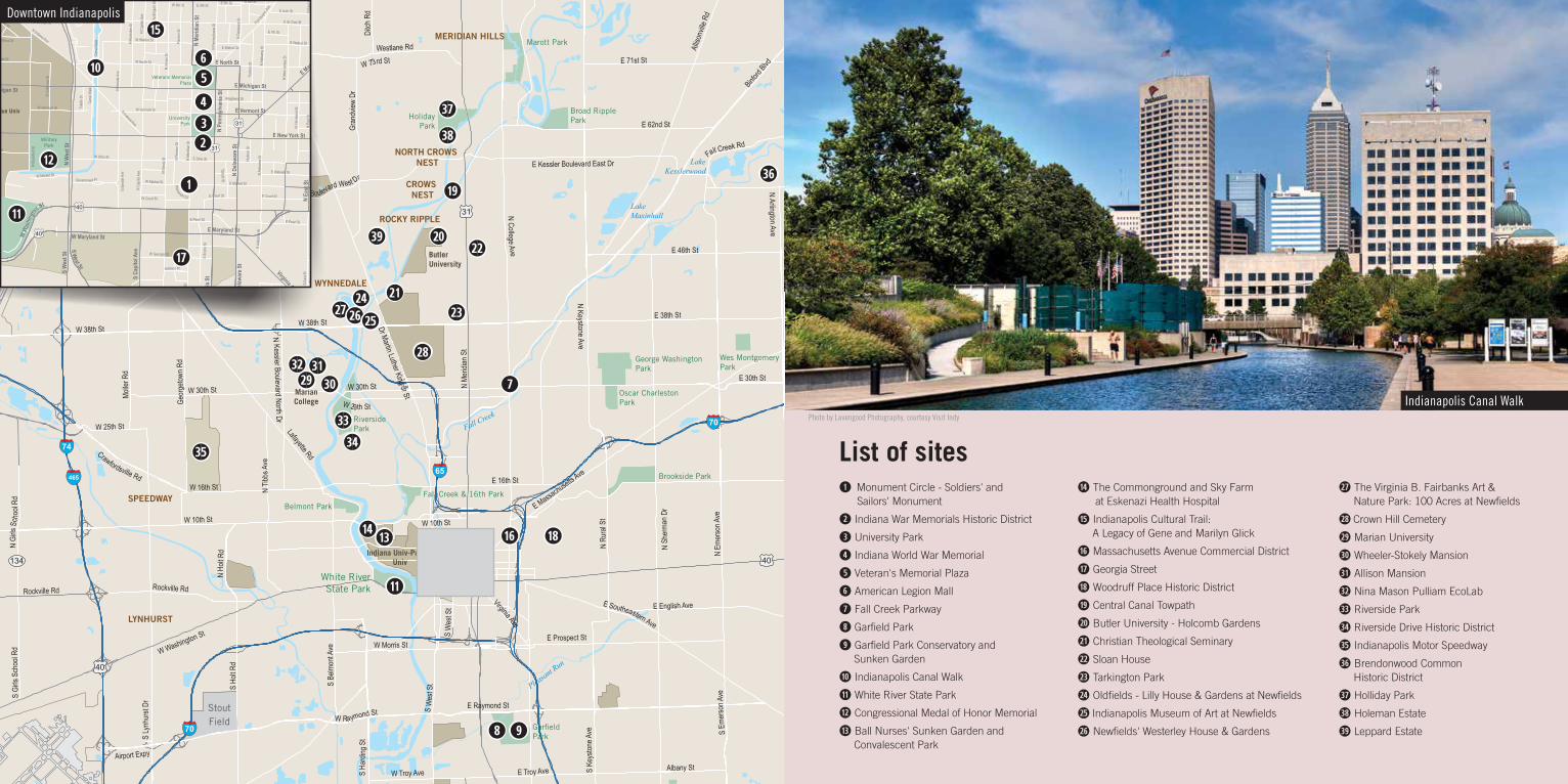
List of sites
Indianapolis Canal Walk
•• The Virginia B. Fairbanks Art & Nature Park: 100 Acres at Newfields
•• Crown Hill Cemetery
•• Marian University
•• Wheeler-Stokely Mansion
•• Allison Mansion
•• Nina Mason Pulliam EcoLab
•• Riverside Park
•• Riverside Drive Historic District
•• Indianapolis Motor Speedway
•• Brendonwood Common Historic District
•• Holliday Park
•• Holeman Estate
•• Leppard Estate
Photo by Lavengood Photography, courtesy Visit Indy
LakeKesslerwood
LakeMaxinhall
LakeWoodland
EagleCreek
Reservoir
Franklin TownshipCommunity Park
Beech GrovePark
WestPark
William S SahmPark
DubarryPark
Skiles TestNature Park
Marott Park
HolidayPark
Broad RipplePark
NorthwestwayPark
LawrenceCommunity Park
SouthwestwayRegional Park
Belmont Park
Eagle CreekPark
Brookside Park
Fall Creek & 16th Park
George WashingtonPark
Oscar CharlestonPark
Wes MontgomeryPark
RiversidePark
GarfieldPark
White RiverState Park
MarianCollege
ButlerUniversity
University Of Indianapolis
Indiana Univ-PurdueUniv
IndianapolisInt'l
Airport
Post Air Airport
Indianapolis MetropolitanAirport
Eagle CreekAirpark
StoutField
Big E
agle
Cree
k
White R
iver
Fall Creek
Pleasant R
un
Lick Creek
Fall Creek
S W
est S
t
S Michigan Rd
Emer
son A
ve
Dr Martin Luther King Jr St
E 86th St
S Em
erso
n Ave
Rockville Rd
E 82nd St
E Pendleton Pike
N Em
erso
n Ave
S Ea
st St
Crawfordsville RdW 16th St
W 71st St
S Kentuck
y Ave
E 38th St
Binford
Blvd
W 38th St
E Washington St
N Michigan Rd
N Ke
yston
e Ave
W Washington St
N Me
ridian
St
N Me
ridian
St
W 10th St
N Co
oper
Rd
W 25th St
W 38th St
W 30th St
E Raymond St
W Camby Rd
Virginia Ave
Ditch
Rd
N H o
lt Rd
Mulberry St
E 16th St
Wes
tfield
Blvd
W 116th St
Gran
dview
Dr
W Oak St
W Troy Ave
S W
est S
t
Albany St
W New York St
S Gi
rls S
choo
l Rd
N Ge
orge
town R
d
E Massachusetts A
ve
Molle
r Rd
E Brookville Rd
S Hi
ckor
y Rd
Ditch
Rd
W Morris St
N Ru
ral S
tEnglish Ave
S Be
lmon
t Ave
S Meridian St
Cumb
erlan
d Rd
W 29th St
E English Ave
W 73rd St
N Keystone Ave
E Troy Ave
S Me
ridian
St
Wes
tfield
Rd
Rockville Rd
E Hanna Ave
Westlane Rd
E 82nd St
N G
irls S
c hoo
l Rd
E 62nd St
Fall Creek Rd
Geor
getow
n Rd
N Tib
bs A
ve
S Fr
ankli
n Rd
S Ho
lt Rd
Town
e Rd
N Fr
ankli
n Rd
E Prospect St
W Raymond St
W Kessler Boulevard West Dr
W Michigan St
E 38th St
W 30th St
Geor
getow
n Rd
N Lafayette Rd
E Shelbyville Rd
Crawfordsville Rd
N Sargen
t Rd
S Sh
elby S
t
S Em
erso
n Ave
W 62nd StS
Lynh
urst
Dr
E 71st St
E 96th St
E Southeastern Ave
S Ha
rding
St
E Kessler Boulevard East Dr
E 56th St
Fall Creek Rd
N Kessler Boulevard North Dr
Mann
Rd
E Southeastern Ave
S Po
st Rd
W Southport Rd
S Kentucky Ave
N Sh
erma
n Dr
E 46th St
E 16th St
N Po
st Rd
N Shadeland Ave
S Madison Ave
Madison Ave
S Fiv
e Poin
ts Rd
N Arlington Ave
W 56th St
Bluff
Rd
S Ke
yston
e Ave
Lafayette Rd
W 10th St
W 86th St
E Thompson Rd
E Southport Rd
E 30th St
E 116th St
Alliso
nville
Rd
N College Ave
Airport Expy
N Me
ridian
St
135
134
37
67
37
135
431
334
37
67
37
37
37
52
36
36
421
421
136
40
40
421
421
421
31
31
31
52
52
52
74
865
74
69
70
70
7474
74
65
65
65
465
465
465
465
465
465
C a m b y
ROCKY RIPPLE
WYNNEDALE
ZIONSVILLE
WILLIAMSCREEK
MERIDIAN HILLS
CROWS NEST
LYNHURST
SPEEDWAY
SOUTHPORT
HOMECROFT
BEECH GROVE
WARRENPARK
NORTH CROWS NEST
INDIANAPOLIS
LAWRENCE
CARMEL
FISHERS
MilitaryPark
UniversityPark
Veterans MemorialPlaza
HendrickPark
Fall Creek&
16th Park
White RiverState Park
IndianaUniversity-Purdue Univ
RileyHospital
ForChildren
Methodist Hospital
Indiana UniversityMedical Center
Indiana UniversityMedical Center
WishardMemorialHospital
ChevroletMotor
Division
LillyCorporate
Center
W h i t e R i v e r
F a l l C r e e k
Elm St
Blak
e St
Mill S
t
E Ray St
Alig
St
Daly StDaly St
Blak
e St
Sprin
g St
N Pi
ne S
t
Leon
St
Abbott St
E 12th St
Huds
on S
t
E 7th St
E 15th St
E 9th St
Jackson Pl
Toled
o St
W Court St
Puryear St
E Pearl St
E 9th StW 9th St
Lord St
Herm
an S
t
Orange St
E Ray St
W 13th StHo
lly A
ve
Abbott St
Hoyt Ave
Spann Ave
Deloss StGr
eer S
t
Reno St
E 9th St
E Court St
N Br
ooks
St
Holly Ave
Puryear St
Silver A
ve
W Wilkins St
W Henry St
W Henry St
Carro
llton A
ve
S Ol
ive S
t
Conc
ordia
St
Union
St
E 13th St
E 15th St
N W
ilson
St
Wrig
ht St
Broo
k Ln
Yand
es S
t
E Walnut St
Orange St
S Illi
nois
St
S Ch
arles
St
Gree
r St
N Sc
ioto S
t
Buchanan St
S Illi
nois
St
E Court St
S W
est S
t
E 9th St
Willa
rd S
t
N Indiana Ave
Lord St
E Norwood St
Woodlawn Ave
E 9th St
E Merrill St
Hadley Dr
Sand St
W Farber St
Lord St
Yand
es S
t
Talbott St
E Walnut St
Harrison St
N Bl
ake S
t
E Empire St
Step
han C
ir
Noble
St
Meike
l St
Union
St
Lockefield St
E Allegheny St
W Market St
Dreier Pl
W Market St
Wrig
ht St
S Ch
urch
St
Broo
ks S
t
S Ke
nwoo
d Ave
E New York St
E Arch St
Harm
on S
t
N Mi
ssou
ri St
S Se
nate
Ave
Lexington Ave
W Walnut St
Russell Ave
S Pine
St
W McCarty St
N Paca St
Vermont Pl
Government Pl
S Ca
pitol
Ave
N Bl
ake S
t
N Camp St
Sanders St
N California St
Stevens St
W Henry St
S Al
abam
a St
W Arizona St
Allegheny St
E Court St
W 12th St
Patte
rson S
t
E Henry St
W Georgia St
Lexington Ave
Elm St
N Missouri St
Bridg
e St
Vincenn
es S
t
S Ca
pitol
Ave
Sanders St
Parkway AveS Da
kota
St
S Ea
st St
W Ransom St
S Se
nate
Ave
Monument Cir
Chad
wick
St
E Miami St
W Drake St
Ohio St
W Vermont St
Grove A
ve
Dorman St
S Ta
lbott S
t
W Ray St
W Ray St
E 12th St
E 15th St
W Sahm St
E 11th St
W 13th St
Drov
er S
t
Gardner Ln
W Vermont St
Sanders St
Parkway Ave
E 10th St
N Fayette St
Orange StOrange St
N Pi
erso
n St
Leon
ard S
t
W 13th St
N Stadium Dr
E Michigan St
Orange St
Mario
n Ave
S Ol
ive S
tS
Olive
St
Pier
son S
t
Nordyke
Ave
E Sahm St
Birch Ave
Char
les S
t
E Walnut St
Union
St
S Ne
w Je
rsey S
t
S Da
vidso
n St
N Pa
rk Av
e
Huds
on S
t
Broa
dway
St
E Louisiana St
N Ta
lbott S
t
E St Joseph St
N Ca
liforn
ia St
E Pearl St
N Cl
evela
nd S
t
Bicking St
Huds
on S
t
E Merrill St
S Sc
ioto S
t
E 14th St
E English Ave
W Wilkins St
N Da
vidso
n St
E 11th St
River A
ve
W Vermont St
W 15th St
Hosbrook St
Milbu
rn S
t
E McCarty St
E Market St
W 12th St
Fulto
n St
W North St
W Walnut St
Sprin
g St
W North St
E 15th St
E Wabash St
Kansas St
Peck
St
Musk
ingum
St
E Ohio St
S Me
ridian
St
W Walnut St
Broa
dway
St
Calva
ry St
S Pi
ne S
t
W 9th St
E Vermont St
E 10th St
Bates St
Fort Wayn
e Ave
Barn
hill D
r
E McCarty St
N Pa
rk Av
e
S Al
abam
a St
W 14th St Lewi
s St
N Ne
w Je
rsey S
t
N Me
ridian
St
Dorm
an S
t
N Og
den S
t
Wisconsin St
N Ro
anok
e St
E North St
Oliver Ave
Fall C
reek P
arkway
East
Dr
W Ohio St
Wishard Blvd
N Ne
w Je
rsey S
t
N Bl
ackfo
rd S
t
S W
hite R
iver P
arkw
ay E
ast D
r
E 13th St
Centr
al Av
e
E Georgia St
N Indiana Ave
N Pa
rk Av
e
W Merrill St
W St Clair St
S Illi
nois
St
N Ea
st St
N Ea
st St
W McCarty St
S Me
ridian
St
S Me
ridian
St
S Ea
st St
S Ea
st St
N Pe
nnsy
lvania
St
N Pe
nnsy
lvania
St
N De
lawar
e St
N De
lawar
e St
Cana
l Walk
Cana
l Walk
E St Clair StE St Clair St
N University Blvd
N Un
iversi
ty Bl
vd
S W
hite R
iver P
ky W
est D
r
S W
hite R
iver P
ky W
est D
r
N Se
nate
Ave
N Se
nate
Ave
N Se
nate
Ave
N Ca
pitol
Ave
N Ca
pitol
Ave
N Capitol Ave
N Illi
nois
StN
Illino
is St
N Illi
nois
StN
Illino
is St
N Al
abam
a St
N Al
abam
a St
N Alabama St
E 11th St
E North St
N Ea
st S
t
E Market St
E Ohio St
N Pi
ne S
t
E Maryland St
E Market St
E Ohio StN W
est S
t
N Pe
nnsy
lvani
a St
N De
lawar
e St
S Madison Ave
S Pe
nnsy
lvan i
a St
W Maryland StS
Delaw
are S
t
N Me
ridian
St
S W
est S
t
S Mi
ssou
ri St
S West St
E Washington St
W 16th St
W W
ashin
gto
n St
S Ea
st S
t
E Vermont St
Shelby St
N Da
vidso
n St
S W
est S
t
E Morris St
W 10th St
E 10th St
E South StW South StFletcher Ave
E Morris St
S Co
llege
Ave
E Massach
usetts A
ve
S Ca
pito
l Ave
W 11th St
E Michigan St
E New York St
E Prospect St
S Ken
tucky
Ave
W 10th St
E 16th St
S Shelby St
W Morris St
W New York St
W Michigan St
Virginia Ave
N Co
llege
Ave
N Co
llege
Ave
40
31
31
40
40
31
31
31
70
70
70
65
65
65
65
86˚10'0"W
86˚10'0"W
86˚9'0"W
86˚9'0"W
39˚45'0"N39˚45'0"N
39˚46'0"N39˚46'0"N
39˚47'0"N39˚47'0"N
0 0.25 0.5 Mile0.125
0 0.25 0.5 KM0.125
Downtown Indianapolis
••
⓰
⓯
⓳
⓮
••
➐
➊
••
⓱
➍
➓
⓲
••
⓭
➌
••
➎
➑
••
➏
⓴
⓬➋
••
••
••
➒
⓫
••
••
••
••
••••
••
••••
••
⓫
7www.tclf.org6 The Cultural Landscape Foundation
Photo by Carol M. Highsmith
Downtown Indianapolis
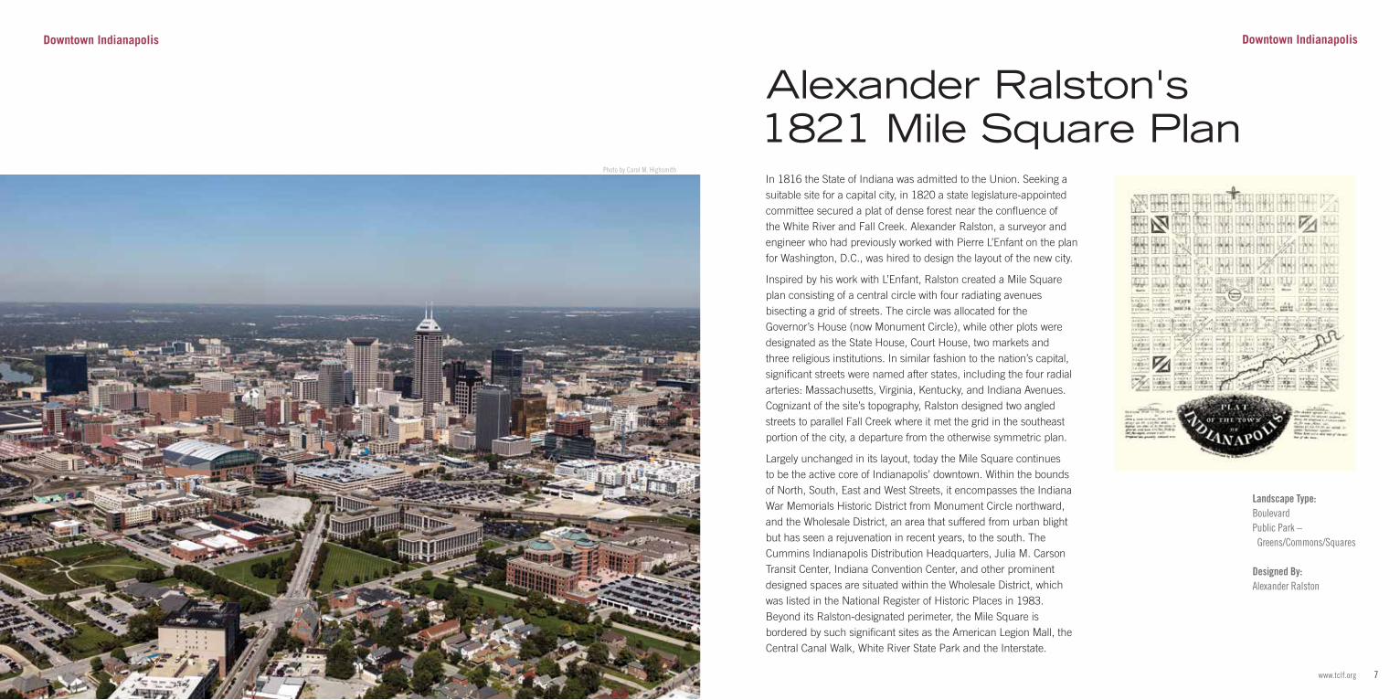
In 1816 the State of Indiana was admitted to the Union. Seeking a suitable site for a capital city, in 1820 a state legislature-appointed committee secured a plat of dense forest near the confluence of the White River and Fall Creek. Alexander Ralston, a surveyor and engineer who had previously worked with Pierre L’Enfant on the plan for Washington, D.C., was hired to design the layout of the new city.
Inspired by his work with L’Enfant, Ralston created a Mile Square plan consisting of a central circle with four radiating avenues bisecting a grid of streets. The circle was allocated for the Governor’s House (now Monument Circle), while other plots were designated as the State House, Court House, two markets and three religious institutions. In similar fashion to the nation’s capital, significant streets were named after states, including the four radial arteries: Massachusetts, Virginia, Kentucky, and Indiana Avenues. Cognizant of the site’s topography, Ralston designed two angled streets to parallel Fall Creek where it met the grid in the southeast portion of the city, a departure from the otherwise symmetric plan.
Largely unchanged in its layout, today the Mile Square continues to be the active core of Indianapolis’ downtown. Within the bounds of North, South, East and West Streets, it encompasses the Indiana War Memorials Historic District from Monument Circle northward, and the Wholesale District, an area that suffered from urban blight but has seen a rejuvenation in recent years, to the south. The Cummins Indianapolis Distribution Headquarters, Julia M. Carson Transit Center, Indiana Convention Center, and other prominent designed spaces are situated within the Wholesale District, which was listed in the National Register of Historic Places in 1983. Beyond its Ralston-designated perimeter, the Mile Square is bordered by such significant sites as the American Legion Mall, the Central Canal Walk, White River State Park and the Interstate.
Downtown Indianapolis
Alexander Ralston's 1821 Mile Square Plan
Landscape Type:BoulevardPublic Park – Greens/Commons/Squares
Designed By:Alexander Ralston
9www.tclf.org8 The Cultural Landscape Foundation
Photo courtesy Detroit Publishing Company Photograph Collection, Library of Congress
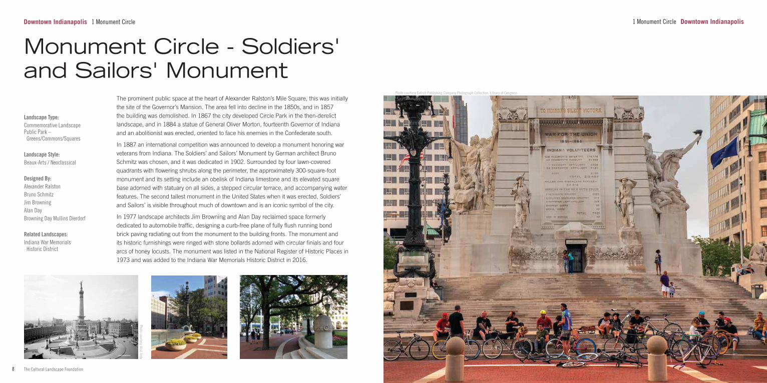
1 Monument Circle Downtown Indianapolis
Landscape Type:Commemorative LandscapePublic Park – Greens/Commons/Squares
Landscape Style:Beaux-Arts / Neoclassical
Designed By:Alexander RalstonBruno SchmitzJim BrowningAlan DayBrowning Day Mullins Dierdorf Related Landscapes:Indiana War Memorials Historic District
The prominent public space at the heart of Alexander Ralston’s Mile Square, this was initially the site of the Governor’s Mansion. The area fell into decline in the 1850s, and in 1857 the building was demolished. In 1867 the city developed Circle Park in the then-derelict landscape, and in 1884 a statue of General Oliver Morton, fourteenth Governor of Indiana and an abolitionist was erected, oriented to face his enemies in the Confederate south.
In 1887 an international competition was announced to develop a monument honoring war veterans from Indiana. The Soldiers’ and Sailors’ Monument by German architect Bruno Schmitz was chosen, and it was dedicated in 1902. Surrounded by four lawn-covered quadrants with flowering shrubs along the perimeter, the approximately 300-square-foot monument and its setting include an obelisk of Indiana limestone and its elevated square base adorned with statuary on all sides, a stepped circular terrace, and accompanying water features. The second tallest monument in the United States when it was erected, Soldiers’ and Sailors’ is visible throughout much of downtown and is an iconic symbol of the city.
In 1977 landscape architects Jim Browning and Alan Day reclaimed space formerly dedicated to automobile traffic, designing a curb-free plane of fully flush running bond brick paving radiating out from the monument to the building fronts. The monument and its historic furnishings were ringed with stone bollards adorned with circular finials and four arcs of honey locusts. The monument was listed in the National Register of Historic Places in 1973 and was added to the Indiana War Memorials Historic District in 2016.
Monument Circle - Soldiers' and Sailors' Monument
Downtown Indianapolis 1 Monument Circle
Photo courtesy Visit Indy
11www.tclf.org10 The Cultural Landscape Foundation
Photo by Carol M. Highsmith
Downtown Indianapolis
Landscape Type:Commemorative LandscapePlaza
Landscape Style:Beaux-Arts / Neoclassical
Designed By:Frank B. WalkerHarry E. WeeksGeorge E. KesslerHenry Hering Related Landscapes:American Legion MallIndiana World War MemorialMonument Circle - Soldiers’ and Sailors’ MonumentUniversity ParkVeteran’s Memorial Plaza
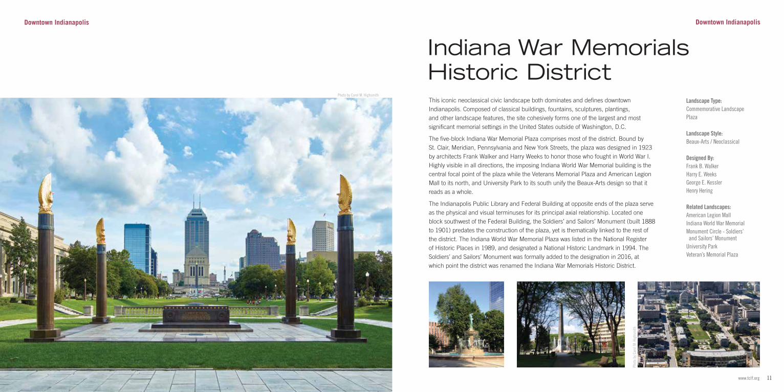
This iconic neoclassical civic landscape both dominates and defines downtown Indianapolis. Composed of classical buildings, fountains, sculptures, plantings, and other landscape features, the site cohesively forms one of the largest and most significant memorial settings in the United States outside of Washington, D.C.
The five-block Indiana War Memorial Plaza comprises most of the district. Bound by St. Clair, Meridian, Pennsylvania and New York Streets, the plaza was designed in 1923 by architects Frank Walker and Harry Weeks to honor those who fought in World War I. Highly visible in all directions, the imposing Indiana World War Memorial building is the central focal point of the plaza while the Veterans Memorial Plaza and American Legion Mall to its north, and University Park to its south unify the Beaux-Arts design so that it reads as a whole.
The Indianapolis Public Library and Federal Building at opposite ends of the plaza serve as the physical and visual terminuses for its principal axial relationship. Located one block southwest of the Federal Building, the Soldiers’ and Sailors’ Monument (built 1888 to 1901) predates the construction of the plaza, yet is thematically linked to the rest of the district. The Indiana World War Memorial Plaza was listed in the National Register of Historic Places in 1989, and designated a National Historic Landmark in 1994. The Soldiers’ and Sailors’ Monument was formally added to the designation in 2016, at which point the district was renamed the Indiana War Memorials Historic District.
Indiana War Memorials Historic District
Phot
o by
Car
ol M
. Hig
hsm
ith
Downtown Indianapolis
13www.tclf.org12 The Cultural Landscape Foundation
Landscape Type:Commemorative LandscapePublic Park – Greens/Commons/Squares
Landscape Style:Beaux-Arts / Neoclassical
Designed By:George E. KesslerFrank B. WalkerHarry E. Weeks Related Landscapes:Indiana War Memorials Historic District
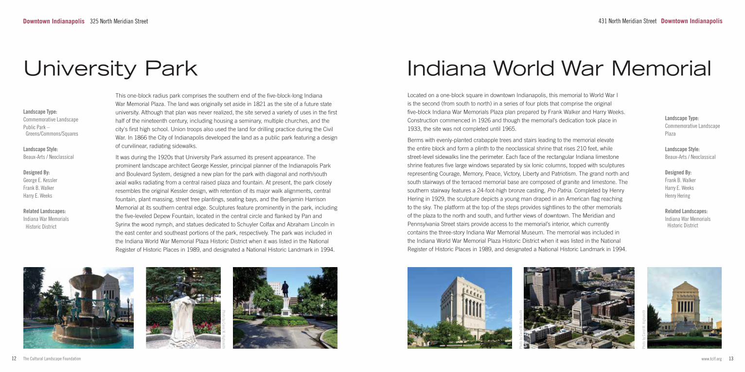
This one-block radius park comprises the southern end of the five-block-long Indiana War Memorial Plaza. The land was originally set aside in 1821 as the site of a future state university. Although that plan was never realized, the site served a variety of uses in the first half of the nineteenth century, including housing a seminary, multiple churches, and the city's first high school. Union troops also used the land for drilling practice during the Civil War. In 1866 the City of Indianapolis developed the land as a public park featuring a design of curvilinear, radiating sidewalks.
It was during the 1920s that University Park assumed its present appearance. The prominent landscape architect George Kessler, principal planner of the Indianapolis Park and Boulevard System, designed a new plan for the park with diagonal and north/south axial walks radiating from a central raised plaza and fountain. At present, the park closely resembles the original Kessler design, with retention of its major walk alignments, central fountain, plant massing, street tree plantings, seating bays, and the Benjamin Harrison Memorial at its southern central edge. Sculptures feature prominently in the park, including the five-leveled Depew Fountain, located in the central circle and flanked by Pan and Syrinx the wood nymph, and statues dedicated to Schuyler Colfax and Abraham Lincoln in the east center and southeast portions of the park, respectively. The park was included in the Indiana World War Memorial Plaza Historic District when it was listed in the National Register of Historic Places in 1989, and designated a National Historic Landmark in 1994.
University Park
Photo by Carol M. Highsm
ith Phot
o by
Car
ol M
. Hig
hsm
ith
Phot
o by
Car
ol M
. Hig
hsm
ith
Landscape Type:Commemorative LandscapePlaza
Landscape Style:Beaux-Arts / Neoclassical
Designed By:Frank B. WalkerHarry E. WeeksHenry Hering Related Landscapes:Indiana War Memorials Historic District
Located on a one-block square in downtown Indianapolis, this memorial to World War I is the second (from south to north) in a series of four plots that comprise the original five-block Indiana War Memorials Plaza plan prepared by Frank Walker and Harry Weeks. Construction commenced in 1926 and though the memorial’s dedication took place in 1933, the site was not completed until 1965.
Berms with evenly-planted crabapple trees and stairs leading to the memorial elevate the entire block and form a plinth to the neoclassical shrine that rises 210 feet, while street-level sidewalks line the perimeter. Each face of the rectangular Indiana limestone shrine features five large windows separated by six Ionic columns, topped with sculptures representing Courage, Memory, Peace, Victory, Liberty and Patriotism. The grand north and south stairways of the terraced memorial base are composed of granite and limestone. The southern stairway features a 24-foot-high bronze casting, Pro Patria. Completed by Henry Hering in 1929, the sculpture depicts a young man draped in an American flag reaching to the sky. The platform at the top of the steps provides sightlines to the other memorials of the plaza to the north and south, and further views of downtown. The Meridian and Pennsylvania Street stairs provide access to the memorial’s interior, which currently contains the three-story Indiana War Memorial Museum. The memorial was included in the Indiana World War Memorial Plaza Historic District when it was listed in the National Register of Historic Places in 1989, and designated a National Historic Landmark in 1994.
Indiana World War Memorial
431 North Meridian Street Downtown IndianapolisDowntown Indianapolis 325 North Meridian Street
15www.tclf.org14 The Cultural Landscape Foundation
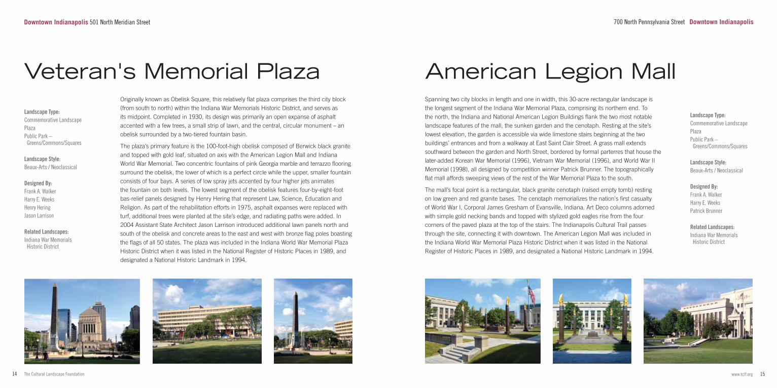
Originally known as Obelisk Square, this relatively flat plaza comprises the third city block (from south to north) within the Indiana War Memorials Historic District, and serves as its midpoint. Completed in 1930, its design was primarily an open expanse of asphalt accented with a few trees, a small strip of lawn, and the central, circular monument – an obelisk surrounded by a two-tiered fountain basin.
The plaza’s primary feature is the 100-foot-high obelisk composed of Berwick black granite and topped with gold leaf, situated on axis with the American Legion Mall and Indiana World War Memorial. Two concentric fountains of pink Georgia marble and terrazzo flooring surround the obelisk, the lower of which is a perfect circle while the upper, smaller fountain consists of four bays. A series of low spray jets accented by four higher jets animates the fountain on both levels. The lowest segment of the obelisk features four-by-eight-foot bas-relief panels designed by Henry Hering that represent Law, Science, Education and Religion. As part of the rehabilitation efforts in 1975, asphalt expanses were replaced with turf, additional trees were planted at the site’s edge, and radiating paths were added. In 2004 Assistant State Architect Jason Larrison introduced additional lawn panels north and south of the obelisk and concrete areas to the east and west with bronze flag poles boasting the flags of all 50 states. The plaza was included in the Indiana World War Memorial Plaza Historic District when it was listed in the National Register of Historic Places in 1989, and designated a National Historic Landmark in 1994.
Landscape Type:Commemorative LandscapePlazaPublic Park – Greens/Commons/Squares
Landscape Style:Beaux-Arts / Neoclassical
Designed By:Frank A. WalkerHarry E. WeeksHenry HeringJason Larrison Related Landscapes:Indiana War Memorials Historic District
Veteran's Memorial Plaza
Landscape Type:Commemorative LandscapePlazaPublic Park – Greens/Commons/Squares
Landscape Style:Beaux-Arts / Neoclassical
Designed By:Frank A. WalkerHarry E. WeeksPatrick Brunner Related Landscapes:Indiana War Memorials Historic District
Spanning two city blocks in length and one in width, this 30-acre rectangular landscape is the longest segment of the Indiana War Memorial Plaza, comprising its northern end. To the north, the Indiana and National American Legion Buildings flank the two most notable landscape features of the mall, the sunken garden and the cenotaph. Resting at the site’s lowest elevation, the garden is accessible via wide limestone stairs beginning at the two buildings’ entrances and from a walkway at East Saint Clair Street. A grass mall extends southward between the garden and North Street, bordered by formal parterres that house the later-added Korean War Memorial (1996), Vietnam War Memorial (1996), and World War II Memorial (1998), all designed by competition winner Patrick Brunner. The topographically flat mall affords sweeping views of the rest of the War Memorial Plaza to the south.
The mall’s focal point is a rectangular, black granite cenotaph (raised empty tomb) resting on low green and red granite bases. The cenotaph memorializes the nation's first casualty of World War I, Corporal James Gresham of Evansville, Indiana. Art Deco columns adorned with simple gold necking bands and topped with stylized gold eagles rise from the four corners of the paved plaza at the top of the stairs. The Indianapolis Cultural Trail passes through the site, connecting it with downtown. The American Legion Mall was included in the Indiana World War Memorial Plaza Historic District when it was listed in the National Register of Historic Places in 1989, and designated a National Historic Landmark in 1994.
700 North Pennsylvania Street Downtown Indianapolis
American Legion Mall
Downtown Indianapolis 501 North Meridian Street
17www.tclf.org16 The Cultural Landscape Foundation
Landscape Type:Public ParkPark System
Landscape Style:Beaux-Arts / NeoclassicalPicturesque
Designed By:George E. KesslerJoseph EarnshawJohn Charles OlmstedLawrence V. Sheridan Related Landscapes:Fall Creek ParkwayGarfield ParkGarfield Park Conservatory and Sunken GardenRiverside Park
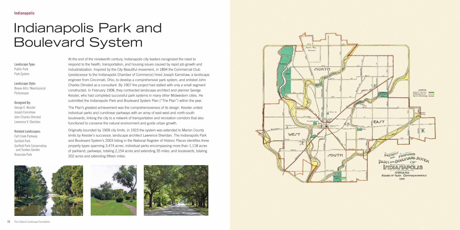
At the end of the nineteenth century, Indianapolis city leaders recognized the need to respond to the health, transportation, and housing issues caused by rapid job growth and industrialization. Inspired by the City Beautiful movement, in 1894 the Commercial Club (predecessor to the Indianapolis Chamber of Commerce) hired Joseph Earnshaw, a landscape engineer from Cincinnati, Ohio, to develop a comprehensive park system, and enlisted John Charles Olmsted as a consultant. By 1907 the project had stalled with only a small segment constructed. In February 1908, they contracted landscape architect and planner George Kessler, who had completed successful park systems in many other Midwestern cities. He submitted the Indianapolis Park and Boulevard System Plan (“The Plan”) within the year.
The Plan’s greatest achievement was the comprehensiveness of its design. Kessler united individual parks and curvilinear parkways with an array of east-west and north-south boulevards, linking the city to a network of transportation and recreation corridors that also functioned to conserve the natural environment and guide urban growth.
Originally bounded by 1909 city limits, in 1923 the system was extended to Marion County limits by Kessler's successor, landscape architect Lawrence Sheridan. The Indianapolis Park and Boulevard System’s 2003 listing in the National Register of Historic Places identifies three property types spanning 3,474 acres: individual parks encompassing more than 1,118 acres of parkland; parkways, totaling 2,154 acres and extending 35 miles; and boulevards, totaling 202 acres and extending fifteen miles.
Indianapolis
Indianapolis Park and Boulevard System
19www.tclf.org18 The Cultural Landscape Foundation
Landscape Style:Beaux-Arts / Neoclassical
Designed By:H.W. KlausmannJ. Clyde PowerGeorge E. Kessler
Related Landscapes:Indianapolis Park and Boulevard System
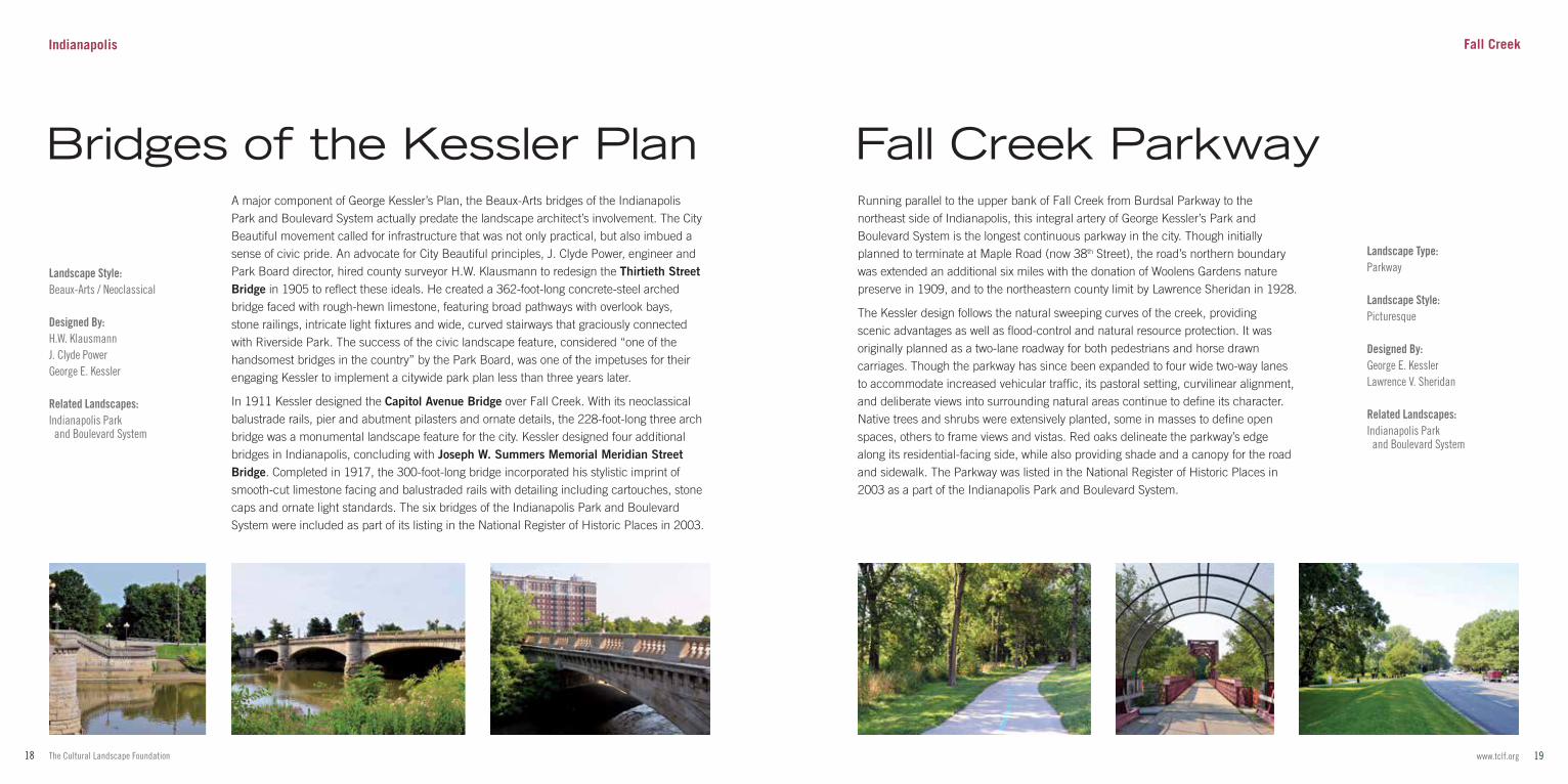
A major component of George Kessler’s Plan, the Beaux-Arts bridges of the Indianapolis Park and Boulevard System actually predate the landscape architect’s involvement. The City Beautiful movement called for infrastructure that was not only practical, but also imbued a sense of civic pride. An advocate for City Beautiful principles, J. Clyde Power, engineer and Park Board director, hired county surveyor H.W. Klausmann to redesign the Thirtieth Street Bridge in 1905 to reflect these ideals. He created a 362-foot-long concrete-steel arched bridge faced with rough-hewn limestone, featuring broad pathways with overlook bays, stone railings, intricate light fixtures and wide, curved stairways that graciously connected with Riverside Park. The success of the civic landscape feature, considered “one of the handsomest bridges in the country” by the Park Board, was one of the impetuses for their engaging Kessler to implement a citywide park plan less than three years later.
In 1911 Kessler designed the Capitol Avenue Bridge over Fall Creek. With its neoclassical balustrade rails, pier and abutment pilasters and ornate details, the 228-foot-long three arch bridge was a monumental landscape feature for the city. Kessler designed four additional bridges in Indianapolis, concluding with Joseph W. Summers Memorial Meridian Street Bridge. Completed in 1917, the 300-foot-long bridge incorporated his stylistic imprint of smooth-cut limestone facing and balustraded rails with detailing including cartouches, stone caps and ornate light standards. The six bridges of the Indianapolis Park and Boulevard System were included as part of its listing in the National Register of Historic Places in 2003.
Landscape Type:Parkway
Landscape Style:Picturesque
Designed By:George E. KesslerLawrence V. Sheridan
Related Landscapes:Indianapolis Park and Boulevard System
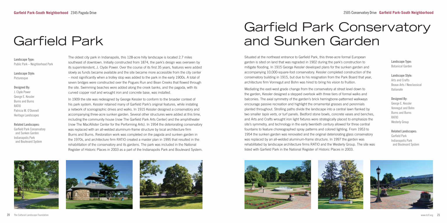
Running parallel to the upper bank of Fall Creek from Burdsal Parkway to the northeast side of Indianapolis, this integral artery of George Kessler’s Park and Boulevard System is the longest continuous parkway in the city. Though initially planned to terminate at Maple Road (now 38th Street), the road’s northern boundary was extended an additional six miles with the donation of Woolens Gardens nature preserve in 1909, and to the northeastern county limit by Lawrence Sheridan in 1928.
The Kessler design follows the natural sweeping curves of the creek, providing scenic advantages as well as flood-control and natural resource protection. It was originally planned as a two-lane roadway for both pedestrians and horse drawn carriages. Though the parkway has since been expanded to four wide two-way lanes to accommodate increased vehicular traffic, its pastoral setting, curvilinear alignment, and deliberate views into surrounding natural areas continue to define its character. Native trees and shrubs were extensively planted, some in masses to define open spaces, others to frame views and vistas. Red oaks delineate the parkway’s edge along its residential-facing side, while also providing shade and a canopy for the road and sidewalk. The Parkway was listed in the National Register of Historic Places in 2003 as a part of the Indianapolis Park and Boulevard System.
Fall Creek Parkway
Fall CreekIndianapolis
Bridges of the Kessler Plan
21www.tclf.org20 The Cultural Landscape Foundation
Situated at the northeast entrance to Garfield Park, this three-acre formal European garden is sited on land that was regraded in 1902 during the park’s construction to mitigate flooding. In 1915 George Kessler developed plans for the sunken garden and accompanying 10,000-square-foot conservatory. Kessler completed construction of the conservatory building in 1915, but due to his resignation from the Park Board that year, architecture firm Vonnegut and Bohn was hired to bring his vision to fruition.
Mediating the east-west grade change from the conservatory at street level down to the garden, Kessler designed a stepped overlook with three tiers of formal walks and balconies. The axial symmetry of the garden’s brick herringbone-patterned walkways encourage passive recreation and highlight the ornamental grasses and perennials planted throughout. Strolling paths divide the landscape into a central lawn flanked by two smaller tapis verts, or turf panels. Bedford stone bowls, concrete vases and benches, and Arts and Crafts wrought iron light fixtures were strategically placed to emphasize the site’s symmetry, and technology in the early twentieth century allowed for three central fountains to feature choreographed spray patterns and colored lighting. From 1953 to 1954 the sunken garden was renovated and the original deteriorating glass conservatory was replaced by an all-welded aluminum-frame structure. In 1997 the garden was rehabilitated by landscape architecture firms RATIO and the Westerly Group. The site was listed with Garfield Park in the National Register of Historic Places in 2003.
Landscape Type:Public Park – Neighborhood Park
Landscape Style:Picturesque
Designed By:J. Clyde PowerGeorge E. KesslerBurns and BurnsRATIOPatricia M. O'DonnellHeritage Landscapes
Related Landscapes:Garfield Park Conservatory and Sunken GardenIndianapolis Park and Boulevard System
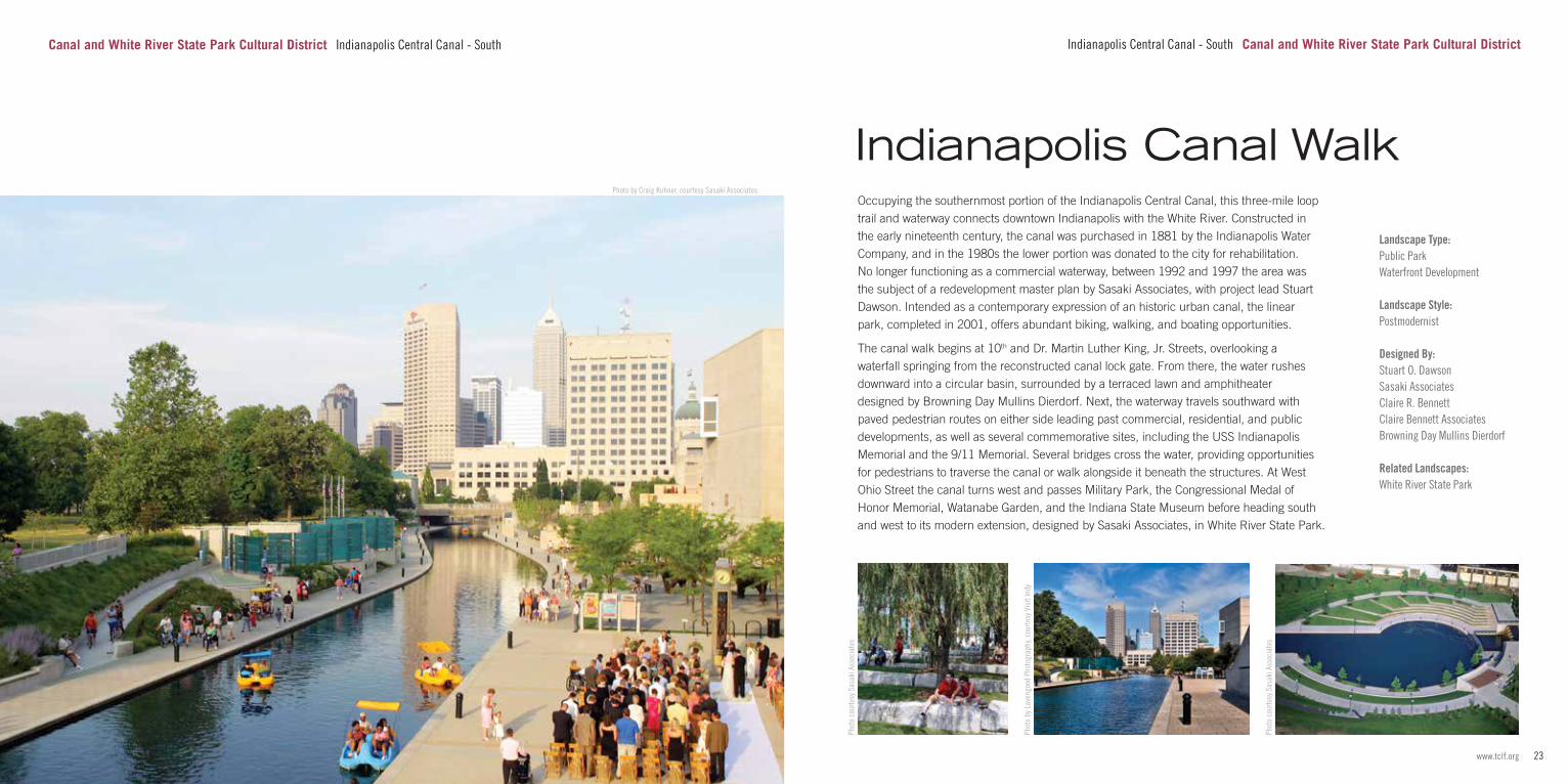
The oldest city park in Indianapolis, this 128-acre hilly landscape is located 2.7 miles southeast of downtown. Initially constructed from 1874, the park’s design was overseen by its superintendent, J. Clyde Power. Over the course of its first 35 years, features were added slowly as funds became available and the site became more accessible from the city center – most significantly when a trolley stop was added to the park in the early 1900s. A total of seven bridges were constructed over the Pogues Run and Bean Creeks that flowed through the site. Swimming beaches were added along the creek banks, and the pagoda, with its curved copper roof and wrought iron and concrete base, was installed.
In 1909 the site was redesigned by George Kessler to conform to the broader context of his park system. Kessler retained many of Garfield Park’s original features, while instating a network of scenographic drives and walks. In 1915 Kessler designed a conservatory and accompanying three-acre sunken garden. Several other structures were added at this time, including the community house (now The Garfield Park Arts Center) and the amphitheater (now The MacAllister Center for the Performing Arts). In 1954 the deteriorating conservatory was replaced with an all-welded aluminum-frame structure by local architecture firm Burns and Burns. Restoration work was completed on the pagoda and sunken garden in the 1970s, and architecture firm RATIO created a master plan in 1995 that resulted in the rehabilitation of the conservatory and its gardens. The park was included in the National Register of Historic Places in 2003 as a part of the Indianapolis Park and Boulevard System.
Landscape Type:Botanical Garden
Landscape Style:Arts and CraftsBeaux-Arts / NeoclassicalItalianate
Designed By:George E. KesslerVonnegut and Bohn Burns and BurnsRATIOWesterly Group Related Landscapes:Garfield ParkIndianapolis Park and Boulevard System
Garfield Park Conservatory and Sunken Garden
2505 Conservatory Drive Garfield Park-South NeighborhoodGarfield Park-South Neighborhood 2345 Pagoda Drive
Garfield Park
23www.tclf.org22 The Cultural Landscape Foundation
Photo by Craig Kuhner, courtesy Sasaki Associates
Canal and White River State Park Cultural District Indianapolis Central Canal - South
Landscape Type:Public ParkWaterfront Development
Landscape Style:Postmodernist
Designed By:Stuart O. DawsonSasaki AssociatesClaire R. BennettClaire Bennett AssociatesBrowning Day Mullins Dierdorf
Related Landscapes:White River State Park
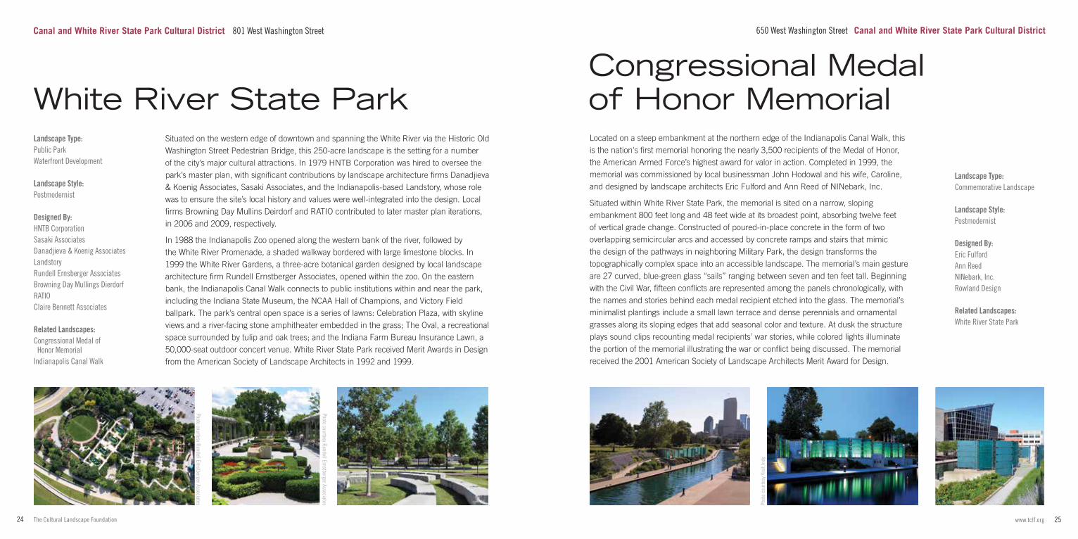
Occupying the southernmost portion of the Indianapolis Central Canal, this three-mile loop trail and waterway connects downtown Indianapolis with the White River. Constructed in the early nineteenth century, the canal was purchased in 1881 by the Indianapolis Water Company, and in the 1980s the lower portion was donated to the city for rehabilitation. No longer functioning as a commercial waterway, between 1992 and 1997 the area was the subject of a redevelopment master plan by Sasaki Associates, with project lead Stuart Dawson. Intended as a contemporary expression of an historic urban canal, the linear park, completed in 2001, offers abundant biking, walking, and boating opportunities.
The canal walk begins at 10th and Dr. Martin Luther King, Jr. Streets, overlooking a waterfall springing from the reconstructed canal lock gate. From there, the water rushes downward into a circular basin, surrounded by a terraced lawn and amphitheater designed by Browning Day Mullins Dierdorf. Next, the waterway travels southward with paved pedestrian routes on either side leading past commercial, residential, and public developments, as well as several commemorative sites, including the USS Indianapolis Memorial and the 9/11 Memorial. Several bridges cross the water, providing opportunities for pedestrians to traverse the canal or walk alongside it beneath the structures. At West Ohio Street the canal turns west and passes Military Park, the Congressional Medal of Honor Memorial, Watanabe Garden, and the Indiana State Museum before heading south and west to its modern extension, designed by Sasaki Associates, in White River State Park.
Phot
o co
urte
sy S
asak
i Ass
ocia
tes
Phot
o by
Lav
engo
od P
hoto
grap
hy, c
ourte
sy V
isit
Indy
Phot
o co
urte
sy S
asak
i Ass
ocia
tes
Indianapolis Central Canal - South Canal and White River State Park Cultural District
Indianapolis Canal Walk
25www.tclf.org24 The Cultural Landscape Foundation
Located on a steep embankment at the northern edge of the Indianapolis Canal Walk, this is the nation's first memorial honoring the nearly 3,500 recipients of the Medal of Honor, the American Armed Force’s highest award for valor in action. Completed in 1999, the memorial was commissioned by local businessman John Hodowal and his wife, Caroline, and designed by landscape architects Eric Fulford and Ann Reed of NINebark, Inc.
Situated within White River State Park, the memorial is sited on a narrow, sloping embankment 800 feet long and 48 feet wide at its broadest point, absorbing twelve feet of vertical grade change. Constructed of poured-in-place concrete in the form of two overlapping semicircular arcs and accessed by concrete ramps and stairs that mimic the design of the pathways in neighboring Military Park, the design transforms the topographically complex space into an accessible landscape. The memorial’s main gesture are 27 curved, blue-green glass “sails” ranging between seven and ten feet tall. Beginning with the Civil War, fifteen conflicts are represented among the panels chronologically, with the names and stories behind each medal recipient etched into the glass. The memorial’s minimalist plantings include a small lawn terrace and dense perennials and ornamental grasses along its sloping edges that add seasonal color and texture. At dusk the structure plays sound clips recounting medal recipients’ war stories, while colored lights illuminate the portion of the memorial illustrating the war or conflict being discussed. The memorial received the 2001 American Society of Landscape Architects Merit Award for Design.
Phot
o co
urte
sy V
isit
Indy
Landscape Type:Commemorative Landscape
Landscape Style:Postmodernist
Designed By:Eric FulfordAnn ReedNINebark, Inc.Rowland Design Related Landscapes:White River State Park
Congressional Medal of Honor Memorial
650 West Washington Street Canal and White River State Park Cultural District
Landscape Type:Public ParkWaterfront Development
Landscape Style:Postmodernist
Designed By:HNTB CorporationSasaki AssociatesDanadjieva & Koenig AssociatesLandstoryRundell Ernsberger AssociatesBrowning Day Mullings DierdorfRATIOClaire Bennett Associates Related Landscapes:Congressional Medal of Honor MemorialIndianapolis Canal Walk
Situated on the western edge of downtown and spanning the White River via the Historic Old Washington Street Pedestrian Bridge, this 250-acre landscape is the setting for a number of the city’s major cultural attractions. In 1979 HNTB Corporation was hired to oversee the park’s master plan, with significant contributions by landscape architecture firms Danadjieva & Koenig Associates, Sasaki Associates, and the Indianapolis-based Landstory, whose role was to ensure the site’s local history and values were well-integrated into the design. Local firms Browning Day Mullins Deirdorf and RATIO contributed to later master plan iterations, in 2006 and 2009, respectively.
In 1988 the Indianapolis Zoo opened along the western bank of the river, followed by the White River Promenade, a shaded walkway bordered with large limestone blocks. In 1999 the White River Gardens, a three-acre botanical garden designed by local landscape architecture firm Rundell Ernstberger Associates, opened within the zoo. On the eastern bank, the Indianapolis Canal Walk connects to public institutions within and near the park, including the Indiana State Museum, the NCAA Hall of Champions, and Victory Field ballpark. The park’s central open space is a series of lawns: Celebration Plaza, with skyline views and a river-facing stone amphitheater embedded in the grass; The Oval, a recreational space surrounded by tulip and oak trees; and the Indiana Farm Bureau Insurance Lawn, a 50,000-seat outdoor concert venue. White River State Park received Merit Awards in Design from the American Society of Landscape Architects in 1992 and 1999.
White River State Park
Canal and White River State Park Cultural District 801 West Washington Street
Photo courtesy Rundell Ernstberger Associates
Photo courtesy Rundell Ernstberger Associates
27www.tclf.org26 The Cultural Landscape Foundation
Nestled between the confluence of the White River and Fall Creek and Indiana University-Purdue University Indianapolis, this contemporary wellness plaza complements and contrasts with the adjacent neoclassical healing garden, the Olmsted Brothers-designed Ball Nurses’ Sunken Garden and Convalescent Park. Designed in 2014 by David Rubin of Land Collective, the 1.5-acre Commonground and accompanying rooftop Sky Farm sit within the ten-acre Eskenazi campus on the site of Indiana’s oldest public hospital.
The Commonground is a contemplative and healing space featuring the sound, motion, and microclimates of water with two fountains designed in collaboration with Fluidity Design Consultants. Along its northern border is Healing Waters, a scrim fountain situated at grade and free of barriers, for visitors to immerse their hands and feet. The pooling waters rise and recede by way of 45 spray jets to reveal a poem inscribed within the fountain coping. To the south, moveable seating under Kentucky coffeetrees is buffered from the street by Falls Fountain, a cascade of seven waterfalls rushing over locally sourced limestone interspersed with wetland plantings. Central to the landscape, a 456-foot-long suspended geometric metal trellis by Diller Scofidio + Renfro parses the main lawn into four garden “rooms” containing a collective 5,000 perennials and over 80 vine species. Sky Farm, a harvestable public garden on the Outpatient Care Center’s roof, produces 2,000 pounds of produce yearly for patients' meals, and a café. Envisioned by Eric Fulford of NINebark, Inc., it was executed by RATIO after Fulford’s passing in collaboration with David Rubin and his team.
Landscape Type:CampusInstitutional Grounds – Medical Institution
Landscape Style:Beaux-Arts / Neoclassical
Designed By:Percival GallagherOlmsted BrothersRundell Ernstberger Associates
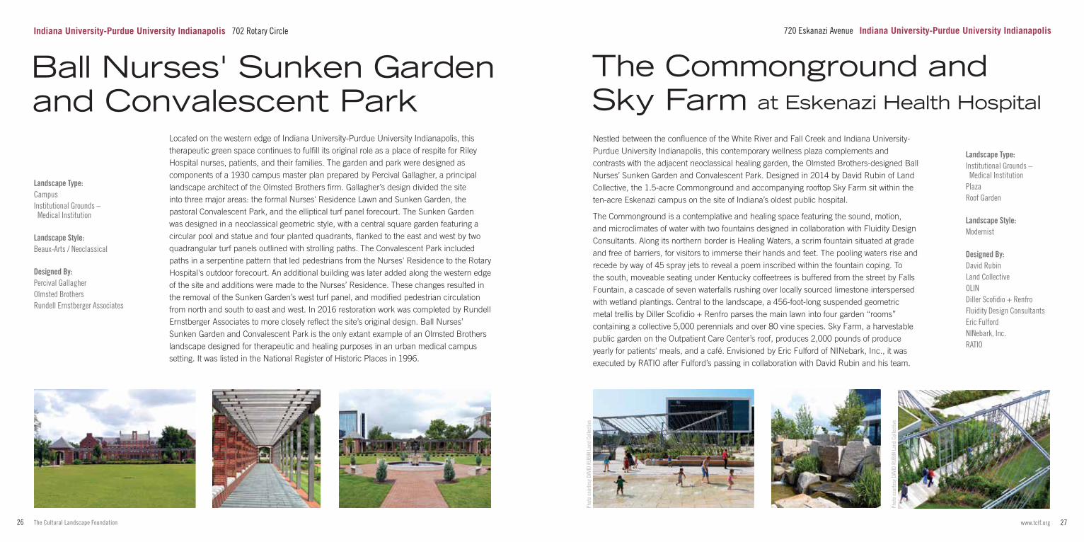
Located on the western edge of Indiana University-Purdue University Indianapolis, this therapeutic green space continues to fulfill its original role as a place of respite for Riley Hospital nurses, patients, and their families. The garden and park were designed as components of a 1930 campus master plan prepared by Percival Gallagher, a principal landscape architect of the Olmsted Brothers firm. Gallagher’s design divided the site into three major areas: the formal Nurses' Residence Lawn and Sunken Garden, the pastoral Convalescent Park, and the elliptical turf panel forecourt. The Sunken Garden was designed in a neoclassical geometric style, with a central square garden featuring a circular pool and statue and four planted quadrants, flanked to the east and west by two quadrangular turf panels outlined with strolling paths. The Convalescent Park included paths in a serpentine pattern that led pedestrians from the Nurses' Residence to the Rotary Hospital's outdoor forecourt. An additional building was later added along the western edge of the site and additions were made to the Nurses’ Residence. These changes resulted in the removal of the Sunken Garden’s west turf panel, and modified pedestrian circulation from north and south to east and west. In 2016 restoration work was completed by Rundell Ernstberger Associates to more closely reflect the site’s original design. Ball Nurses’ Sunken Garden and Convalescent Park is the only extant example of an Olmsted Brothers landscape designed for therapeutic and healing purposes in an urban medical campus setting. It was listed in the National Register of Historic Places in 1996.
Phot
o co
urte
sy D
AVID
RUB
IN L
and
Colle
ctiv
e
Phot
o co
urte
sy D
AVID
RUB
IN L
and
Colle
ctiv
e
Landscape Type:Institutional Grounds – Medical InstitutionPlazaRoof Garden
Landscape Style:Modernist
Designed By:David RubinLand CollectiveOLINDiller Scofidio + RenfroFluidity Design ConsultantsEric FulfordNINebark, Inc.RATIO
The Commonground and Sky Farm at Eskenazi Health Hospital
Ball Nurses' Sunken Garden and Convalescent Park
Indiana University-Purdue University Indianapolis 702 Rotary Circle 720 Eskanazi Avenue Indiana University-Purdue University Indianapolis
29www.tclf.org28 The Cultural Landscape Foundation
Radiating northeast from Monument Circle, the avenue central to this district was one of the four diagonal thoroughfares laid out in the 1821 Ralston Plan for the city. Its growth as a commercial corridor began in the 1870s with the expansion of a streetcar line into the neighborhood, and the area continued to thrive into the 1930s, when its primary facilities included small retail shops and neighborhood services. A period of decline followed, and improvements were not seen until the 1980s when city planning efforts began to refocus on the northeast quadrant of Indianapolis.
Massachusetts Avenue interrupts the city grid, bisecting streets at a 45-degree angle, thereby creating six-way intersections with triangular plots of land. Commonly referred to as “Mass Ave,” the character of the six-block section stretching from New York Street to Bellefontaine Street is defined by the size, scale, and building materials of its ubiquitous two- to five-story brick commercial and residential structures built from the mid-nineteenth through the early twentieth centuries, many of which have since been restored. Several privately owned open spaces along the corridor afford opportunities for public gathering, including Davlan Park, the courtyard at Lockerbie Marketplace, and the Professional Firefighters Art Park(ing) Court. The Indianapolis Cultural Trail runs along portions of the avenue, reinforcing its connectivity to downtown. In 1982 the Massachusetts Avenue Commercial District was listed in the National Register of Historic Places.
Massachusetts Avenue Commercial District
Designed By:Storrow Kinsella AssociatesRundell Ernstberger Associates
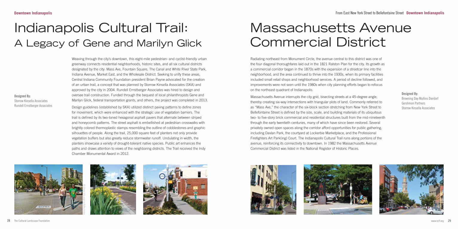
Weaving through the city’s downtown, this eight-mile pedestrian- and cyclist-friendly urban greenway connects residential neighborhoods, historic sites, and all six cultural districts designated by the city: Mass Ave, Fountain Square, The Canal and White River State Park, Indiana Avenue, Market East, and the Wholesale District. Seeking to unify these areas, Central Indiana Community Foundation president Brian Payne advocated for the creation of an urban trail, a concept that was planned by Storrow Kinsella Associates (SKA) and approved by the city in 2004. Rundell Ernstberger Associates was hired to design and oversee trail construction. Funded through the bequest of local philanthropists Gene and Marilyn Glick, federal transportation grants, and others, the project was completed in 2013.
Design guidelines (established by SKA) utilized distinct paving patterns to define zones for movement, which were enhanced with the strategic use of vegetation barriers. The trail is defined by its two-toned hexagonal asphalt pavers that alternate between striped and honeycomb patterns. The street asphalt is embellished at pedestrian crosswalks with brightly colored thermoplastic stamps resembling the outline of cobblestones and graphic silhouettes of people. Along the trail, 25,000 square feet of planters not only provide vegetation buffers but also greatly reduce stormwater runoff. Undulating in width, the planters showcase a variety of drought-tolerant native species. Public art enhances the paths and draws attention to views of the neighboring districts. The Trail received the Indy Chamber Monumental Award in 2012.
All photos this page by Kelley Jordan
Downtown Indianapolis
Indianapolis Cultural Trail: A Legacy of Gene and Marilyn Glick
From East New York Street to Bellefontaine Street Downtown Indianapolis
Designed By:Browning Day Mullins DierdorfGershman PartnersStorrow Kinsella Associates
31www.tclf.org30 The Cultural Landscape Foundation
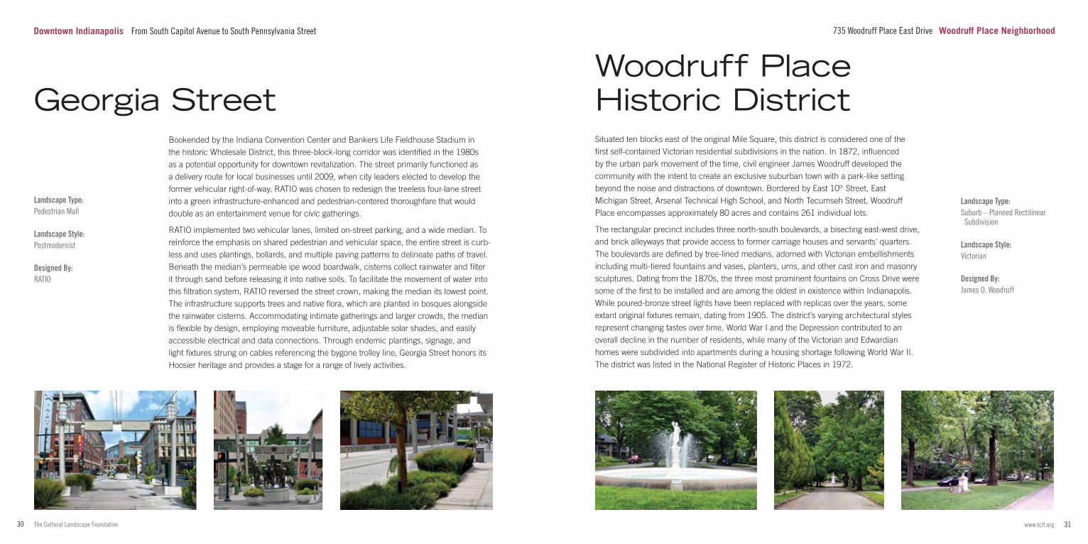
Situated ten blocks east of the original Mile Square, this district is considered one of the first self-contained Victorian residential subdivisions in the nation. In 1872, influenced by the urban park movement of the time, civil engineer James Woodruff developed the community with the intent to create an exclusive suburban town with a park-like setting beyond the noise and distractions of downtown. Bordered by East 10th Street, East Michigan Street, Arsenal Technical High School, and North Tecumseh Street, Woodruff Place encompasses approximately 80 acres and contains 261 individual lots.
The rectangular precinct includes three north-south boulevards, a bisecting east-west drive, and brick alleyways that provide access to former carriage houses and servants' quarters. The boulevards are defined by tree-lined medians, adorned with Victorian embellishments including multi-tiered fountains and vases, planters, urns, and other cast iron and masonry sculptures. Dating from the 1870s, the three most prominent fountains on Cross Drive were some of the first to be installed and are among the oldest in existence within Indianapolis. While poured-bronze street lights have been replaced with replicas over the years, some extant original fixtures remain, dating from 1905. The district’s varying architectural styles represent changing tastes over time. World War I and the Depression contributed to an overall decline in the number of residents, while many of the Victorian and Edwardian homes were subdivided into apartments during a housing shortage following World War II. The district was listed in the National Register of Historic Places in 1972.
Landscape Type:Suburb – Planned Rectilinear Subdivision
Landscape Style:Victorian
Designed By:James O. Woodruff
Woodruff Place Historic District
735 Woodruff Place East Drive Woodruff Place Neighborhood
Landscape Type:Pedestrian Mall
Landscape Style:Postmodernist
Designed By:RATIO
Bookended by the Indiana Convention Center and Bankers Life Fieldhouse Stadium in the historic Wholesale District, this three-block-long corridor was identified in the 1980s as a potential opportunity for downtown revitalization. The street primarily functioned as a delivery route for local businesses until 2009, when city leaders elected to develop the former vehicular right-of-way. RATIO was chosen to redesign the treeless four-lane street into a green infrastructure-enhanced and pedestrian-centered thoroughfare that would double as an entertainment venue for civic gatherings.
RATIO implemented two vehicular lanes, limited on-street parking, and a wide median. To reinforce the emphasis on shared pedestrian and vehicular space, the entire street is curb-less and uses plantings, bollards, and multiple paving patterns to delineate paths of travel. Beneath the median’s permeable ipe wood boardwalk, cisterns collect rainwater and filter it through sand before releasing it into native soils. To facilitate the movement of water into this filtration system, RATIO reversed the street crown, making the median its lowest point. The infrastructure supports trees and native flora, which are planted in bosques alongside the rainwater cisterns. Accommodating intimate gatherings and larger crowds, the median is flexible by design, employing moveable furniture, adjustable solar shades, and easily accessible electrical and data connections. Through endemic plantings, signage, and light fixtures strung on cables referencing the bygone trolley line, Georgia Street honors its Hoosier heritage and provides a stage for a range of lively activities.
Georgia Street
Downtown Indianapolis From South Capitol Avenue to South Pennsylvania Street
33www.tclf.org32 The Cultural Landscape Foundation
Photo by Marc Ancel
Indianapolis Central Canal - North Midtown Indianapolis
Landscape Type:Public Park
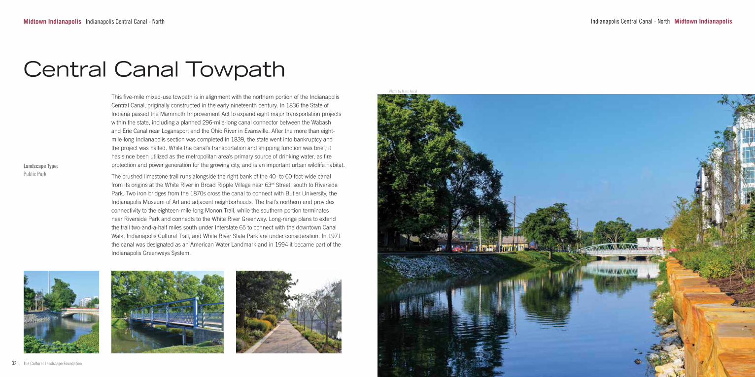
This five-mile mixed-use towpath is in alignment with the northern portion of the Indianapolis Central Canal, originally constructed in the early nineteenth century. In 1836 the State of Indiana passed the Mammoth Improvement Act to expand eight major transportation projects within the state, including a planned 296-mile-long canal connector between the Wabash and Erie Canal near Logansport and the Ohio River in Evansville. After the more than eight-mile-long Indianapolis section was completed in 1839, the state went into bankruptcy and the project was halted. While the canal’s transportation and shipping function was brief, it has since been utilized as the metropolitan area’s primary source of drinking water, as fire protection and power generation for the growing city, and is an important urban wildlife habitat.
The crushed limestone trail runs alongside the right bank of the 40- to 60-foot-wide canal from its origins at the White River in Broad Ripple Village near 63rd Street, south to Riverside Park. Two iron bridges from the 1870s cross the canal to connect with Butler University, the Indianapolis Museum of Art and adjacent neighborhoods. The trail’s northern end provides connectivity to the eighteen-mile-long Monon Trail, while the southern portion terminates near Riverside Park and connects to the White River Greenway. Long-range plans to extend the trail two-and-a-half miles south under Interstate 65 to connect with the downtown Canal Walk, Indianapolis Cultural Trail, and White River State Park are under consideration. In 1971 the canal was designated as an American Water Landmark and in 1994 it became part of the Indianapolis Greenways System.
Central Canal Towpath
Midtown Indianapolis Indianapolis Central Canal - North
35www.tclf.org34 The Cultural Landscape Foundation
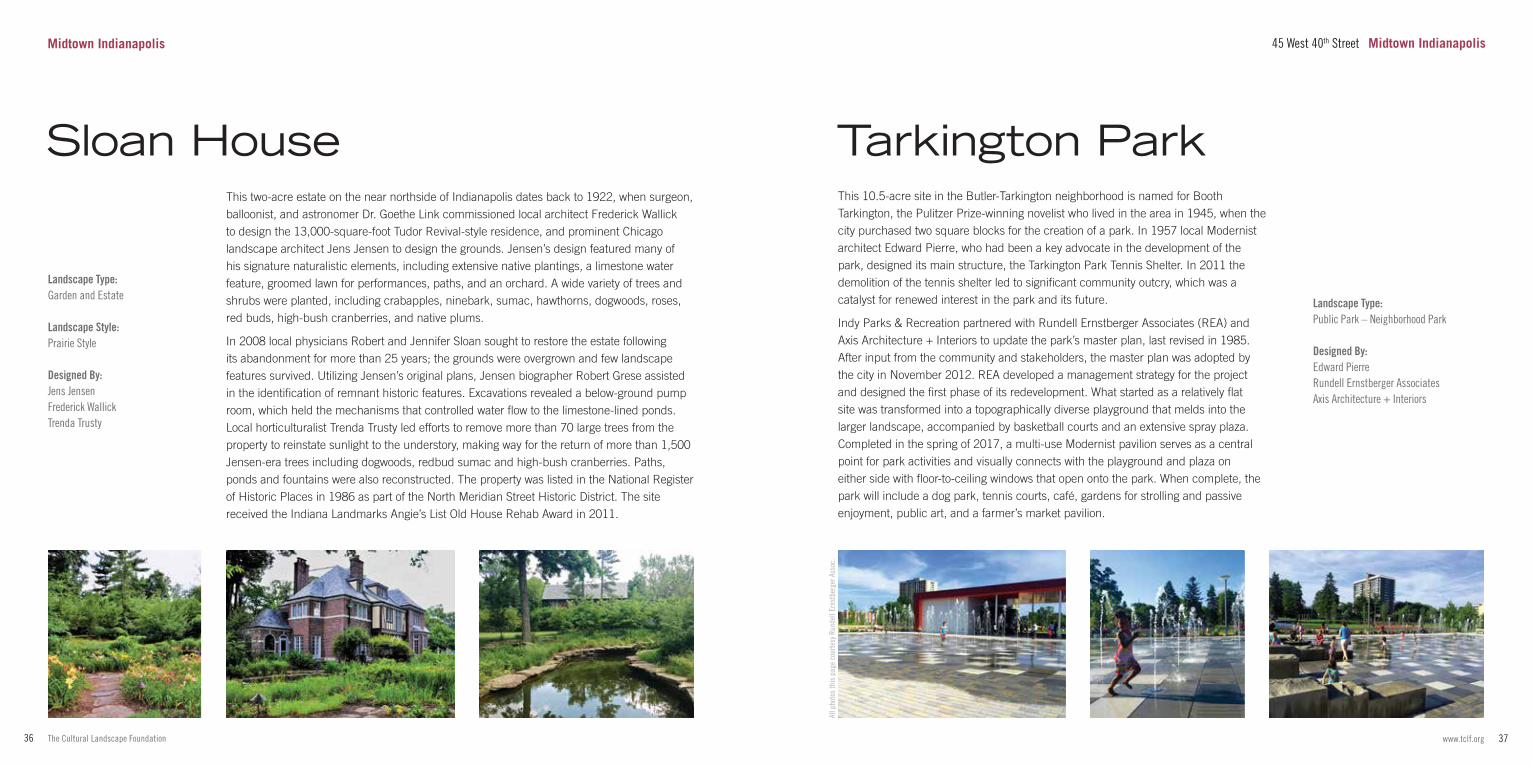
Situated on the northwest side of Indianapolis along the southeast bank of the Indianapolis Central Canal, this ecumenical seminary was commissioned in 1961, funded in part by a two-million-dollar donation from the Irwin-Sweeney-Miller Foundation. J. Irwin Miller, a major patron of Modern art, architecture and landscape architecture recommended Dan Kiley be engaged to design the seminary grounds. Kiley had been involved in many projects for the philanthropist, including his own private residence and some 30 sites in Columbus, Indiana. Edward Barnes was hired as lead architect for the seminary at the suggestion of Eero Saarinen, a trusted advisor to Miller.
The gently sloping 35-acre campus was constructed in phases from 1964 to 1987. It features a series of buildings designed in a continuous S-shape and incorporates two original homes, one Colonial Revival and the other Tudor, that predate the establishment of the seminary. Kiley’s landscape design unites the campus and its various stages of development. His grand courtyard is bookended to the southeast and north by two prominent Barnes structures: the Modernist classroom building and the Postmodern Sweeney Chapel and bell tower (added 1984-1987), which hangs dramatically over a bluff facing the Central Canal and White River. The courtyard’s internal pedestrian circulation is axial, creating formal turf gardens linked to sidewalks that connect with perimeter paths and drives lined with double allées of London plane trees. The campus is the only example of Kiley’s work in the city.
Landscape Type:Picturesque Garden
Landscape Style:Picturesque
Designed By:James I. HolcombArthur Lindberg
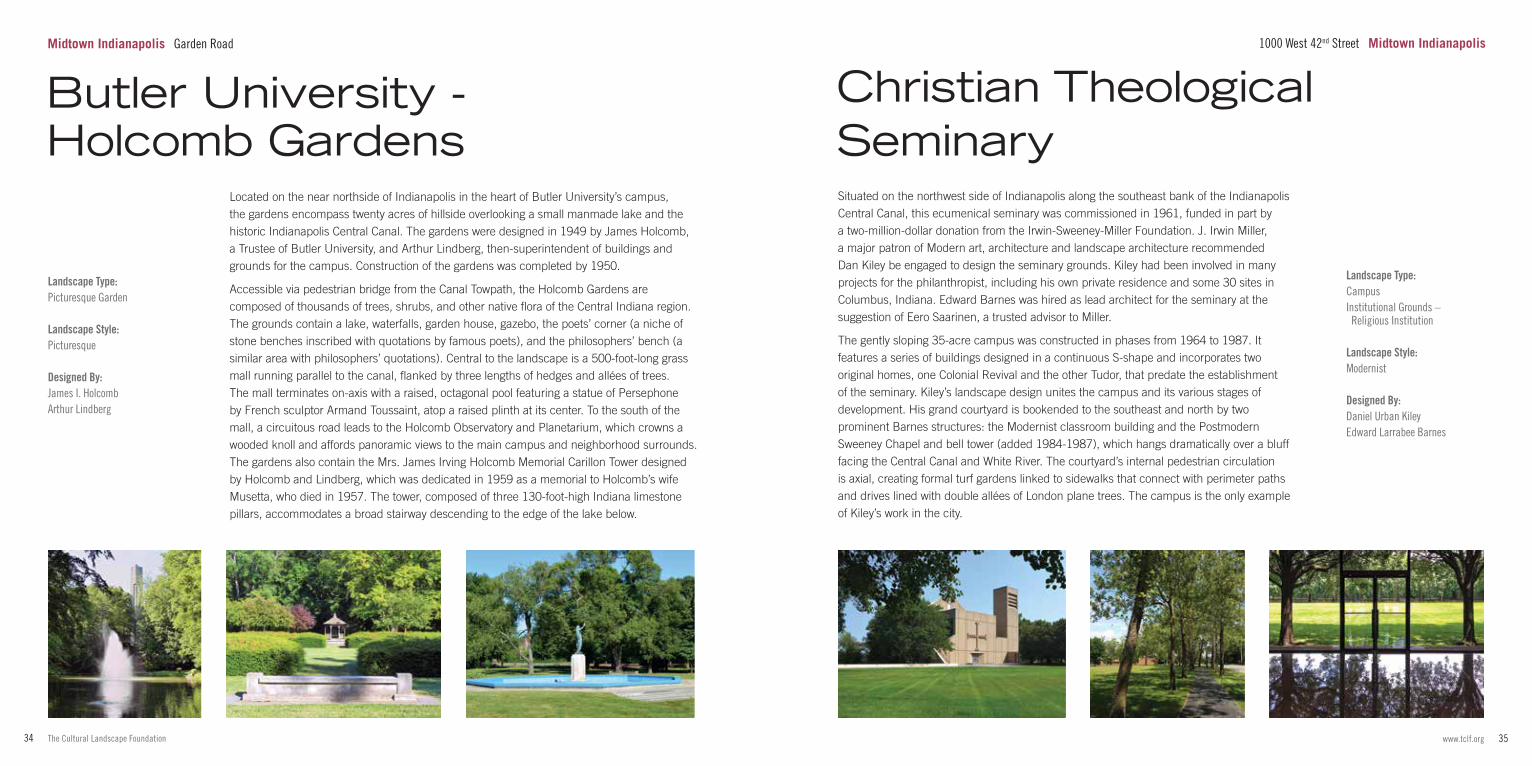
Located on the near northside of Indianapolis in the heart of Butler University’s campus, the gardens encompass twenty acres of hillside overlooking a small manmade lake and the historic Indianapolis Central Canal. The gardens were designed in 1949 by James Holcomb, a Trustee of Butler University, and Arthur Lindberg, then-superintendent of buildings and grounds for the campus. Construction of the gardens was completed by 1950.
Accessible via pedestrian bridge from the Canal Towpath, the Holcomb Gardens are composed of thousands of trees, shrubs, and other native flora of the Central Indiana region. The grounds contain a lake, waterfalls, garden house, gazebo, the poets’ corner (a niche of stone benches inscribed with quotations by famous poets), and the philosophers’ bench (a similar area with philosophers’ quotations). Central to the landscape is a 500-foot-long grass mall running parallel to the canal, flanked by three lengths of hedges and allées of trees. The mall terminates on-axis with a raised, octagonal pool featuring a statue of Persephone by French sculptor Armand Toussaint, atop a raised plinth at its center. To the south of the mall, a circuitous road leads to the Holcomb Observatory and Planetarium, which crowns a wooded knoll and affords panoramic views to the main campus and neighborhood surrounds. The gardens also contain the Mrs. James Irving Holcomb Memorial Carillon Tower designed by Holcomb and Lindberg, which was dedicated in 1959 as a memorial to Holcomb’s wife Musetta, who died in 1957. The tower, composed of three 130-foot-high Indiana limestone pillars, accommodates a broad stairway descending to the edge of the lake below.
Landscape Type:CampusInstitutional Grounds – Religious Institution
Landscape Style:Modernist
Designed By:Daniel Urban KileyEdward Larrabee Barnes
Christian Theological Seminary
Butler University - Holcomb Gardens
Midtown Indianapolis Garden Road 1000 West 42nd Street Midtown Indianapolis
37www.tclf.org36 The Cultural Landscape Foundation
All p
hoto
s th
is p
age
cour
tesy
Run
dell
Erns
tber
ger A
ssoc
.
Landscape Type:Garden and Estate
Landscape Style:Prairie Style
Designed By:Jens JensenFrederick WallickTrenda Trusty
This two-acre estate on the near northside of Indianapolis dates back to 1922, when surgeon, balloonist, and astronomer Dr. Goethe Link commissioned local architect Frederick Wallick to design the 13,000-square-foot Tudor Revival-style residence, and prominent Chicago landscape architect Jens Jensen to design the grounds. Jensen’s design featured many of his signature naturalistic elements, including extensive native plantings, a limestone water feature, groomed lawn for performances, paths, and an orchard. A wide variety of trees and shrubs were planted, including crabapples, ninebark, sumac, hawthorns, dogwoods, roses, red buds, high-bush cranberries, and native plums.
In 2008 local physicians Robert and Jennifer Sloan sought to restore the estate following its abandonment for more than 25 years; the grounds were overgrown and few landscape features survived. Utilizing Jensen’s original plans, Jensen biographer Robert Grese assisted in the identification of remnant historic features. Excavations revealed a below-ground pump room, which held the mechanisms that controlled water flow to the limestone-lined ponds. Local horticulturalist Trenda Trusty led efforts to remove more than 70 large trees from the property to reinstate sunlight to the understory, making way for the return of more than 1,500 Jensen-era trees including dogwoods, redbud sumac and high-bush cranberries. Paths, ponds and fountains were also reconstructed. The property was listed in the National Register of Historic Places in 1986 as part of the North Meridian Street Historic District. The site received the Indiana Landmarks Angie’s List Old House Rehab Award in 2011.
Sloan House
Landscape Type:Public Park – Neighborhood Park
Designed By:Edward PierreRundell Ernstberger AssociatesAxis Architecture + Interiors
This 10.5-acre site in the Butler-Tarkington neighborhood is named for Booth Tarkington, the Pulitzer Prize-winning novelist who lived in the area in 1945, when the city purchased two square blocks for the creation of a park. In 1957 local Modernist architect Edward Pierre, who had been a key advocate in the development of the park, designed its main structure, the Tarkington Park Tennis Shelter. In 2011 the demolition of the tennis shelter led to significant community outcry, which was a catalyst for renewed interest in the park and its future.
Indy Parks & Recreation partnered with Rundell Ernstberger Associates (REA) and Axis Architecture + Interiors to update the park’s master plan, last revised in 1985. After input from the community and stakeholders, the master plan was adopted by the city in November 2012. REA developed a management strategy for the project and designed the first phase of its redevelopment. What started as a relatively flat site was transformed into a topographically diverse playground that melds into the larger landscape, accompanied by basketball courts and an extensive spray plaza. Completed in the spring of 2017, a multi-use Modernist pavilion serves as a central point for park activities and visually connects with the playground and plaza on either side with floor-to-ceiling windows that open onto the park. When complete, the park will include a dog park, tennis courts, café, gardens for strolling and passive enjoyment, public art, and a farmer’s market pavilion.
Tarkington Park
45 West 40th Street Midtown IndianapolisMidtown Indianapolis
39www.tclf.org38 The Cultural Landscape Foundation
Photo by Marc Ancel
Midtown Indianapolis 4000 Michigan Road
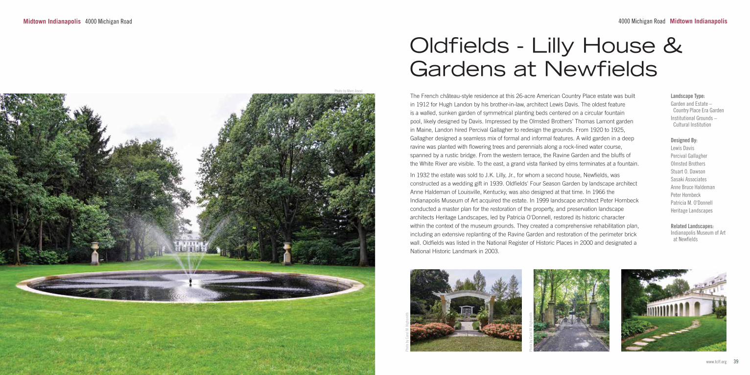
The French château-style residence at this 26-acre American Country Place estate was built in 1912 for Hugh Landon by his brother-in-law, architect Lewis Davis. The oldest feature is a walled, sunken garden of symmetrical planting beds centered on a circular fountain pool, likely designed by Davis. Impressed by the Olmsted Brothers’ Thomas Lamont garden in Maine, Landon hired Percival Gallagher to redesign the grounds. From 1920 to 1925, Gallagher designed a seamless mix of formal and informal features. A wild garden in a deep ravine was planted with flowering trees and perennials along a rock-lined water course, spanned by a rustic bridge. From the western terrace, the Ravine Garden and the bluffs of the White River are visible. To the east, a grand vista flanked by elms terminates at a fountain.
In 1932 the estate was sold to J.K. Lilly, Jr., for whom a second house, Newfields, was constructed as a wedding gift in 1939. Oldfields' Four Season Garden by landscape architect Anne Haldeman of Louisville, Kentucky, was also designed at that time. In 1966 the Indianapolis Museum of Art acquired the estate. In 1999 landscape architect Peter Hornbeck conducted a master plan for the restoration of the property, and preservation landscape architects Heritage Landscapes, led by Patricia O'Donnell, restored its historic character within the context of the museum grounds. They created a comprehensive rehabilitation plan, including an extensive replanting of the Ravine Garden and restoration of the perimeter brick wall. Oldfields was listed in the National Register of Historic Places in 2000 and designated a National Historic Landmark in 2003.
Phot
o by
Car
ol M
. Hig
hsm
ith
Landscape Type:Garden and Estate – Country Place Era GardenInstitutional Grounds – Cultural Institution
Designed By:Lewis DavisPercival GallagherOlmsted BrothersStuart O. DawsonSasaki AssociatesAnne Bruce HaldemanPeter HornbeckPatricia M. O'DonnellHeritage Landscapes Related Landscapes:Indianapolis Museum of Art at Newfields
Oldfields - Lilly House & Gardens at Newfields
4000 Michigan Road Midtown Indianapolis
Phot
o by
Car
ol M
. Hig
hsm
ith
41www.tclf.org40 The Cultural Landscape Foundation
Landscape Type:Institutional Grounds – Cultural Institution
Landscape Style:PicturesquePostmodernist
Designed By:Stuart O. DawsonSasaki, Dawson & DeMaySasaki Associates.Johnson Johnson & Roy, Inc.Claire R. BennettBrowning Day Mullins Dierdorf Related Landscapes:Lilly House & Gardens at NewfieldsThe Virginia B. Fairbanks Art & Nature Park: 100 Acres at NewfieldsNewfields’ Westerley Home & Gardens
Established in 1883 as the Art Association of Indianapolis, the museum relocated from downtown in 1970 after Ruth and Josiah Lilly donated Oldfields, their Country Place Era estate and its accompanying 52 acres. The institution acquired an additional 100 acres bordering the White River around the same time, and Sasaki, Dawson & DeMay was commissioned to plan the extensive landscape.
Located four miles northwest of the city center, the grounds, inclusive of the 52-acre main campus and 100-acre Virginia B. Fairbanks Art and Nature Park (completed in 2010), function as both an art museum and botanical garden. East of the main museum building is the Sutphin Mall and Fountain, located at the site’s original entrance. Renovated in 1998, the year-round fountain was designed by Stuart Dawson of Sasaki, Dawson & DeMay in 1972 with more than 450 blocks of irregular-sized Indiana bluff limestone and 27 high-spraying jets, surrounded by dawn redwoods.
In collaboration with the museum’s Horticultural Society, Sasaki Associates completed a master plan in 1980 while Johnson Johnson & Roy Inc., of Ann Arbor, Michigan, contributed an additional long-term master plan in 1987. The museum’s main pavilion entrance is fronted by Nonie’s Garden, a circular garden bed planted in 2008, featuring columnar sweetgums, blue cedars, yews, dogwoods, and hundreds of spring tulips. Another notable landscape feature is the Garden for Everyone, a wheelchair-accessible sensory garden designed in 1993 by landscape architect Claire Bennett.
Indianapolis Museum of Art at Newfields
Photo courtesy Indianapolis Museum
of Art All p
hoto
s th
is p
age
cour
tesy
Indi
anap
olis
Mus
eum
of A
rt
Landscape Type:Garden and Estate – Country Place Era GardenInstitutional Grounds – Cultural Institution
Landscape Style:Prairie Style
Designed By:Jens JensenMark M. Holeman Related Landscapes:Indianapolis Museum of Art at Newfields
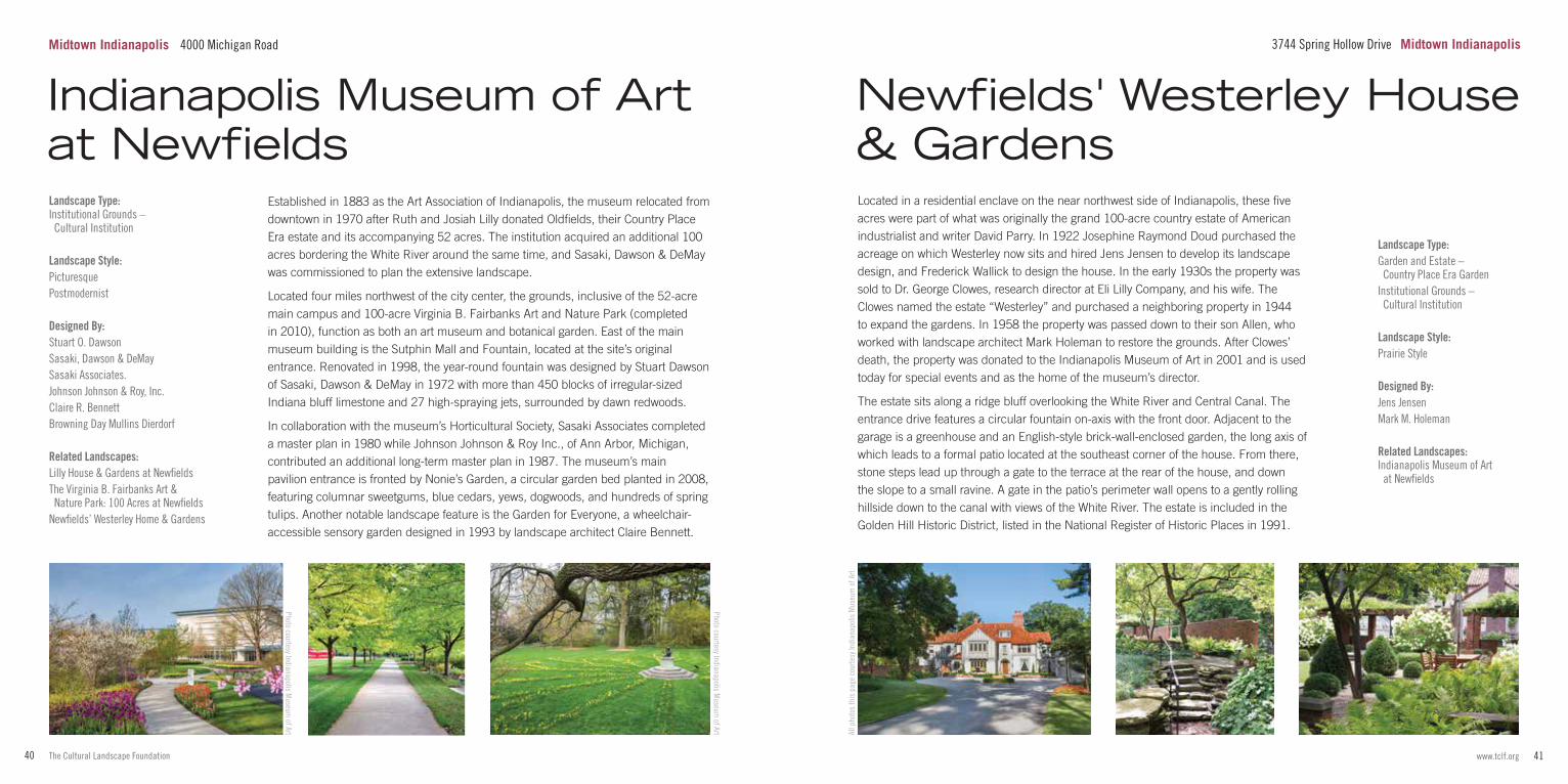
Located in a residential enclave on the near northwest side of Indianapolis, these five acres were part of what was originally the grand 100-acre country estate of American industrialist and writer David Parry. In 1922 Josephine Raymond Doud purchased the acreage on which Westerley now sits and hired Jens Jensen to develop its landscape design, and Frederick Wallick to design the house. In the early 1930s the property was sold to Dr. George Clowes, research director at Eli Lilly Company, and his wife. The Clowes named the estate “Westerley” and purchased a neighboring property in 1944 to expand the gardens. In 1958 the property was passed down to their son Allen, who worked with landscape architect Mark Holeman to restore the grounds. After Clowes’ death, the property was donated to the Indianapolis Museum of Art in 2001 and is used today for special events and as the home of the museum’s director.
The estate sits along a ridge bluff overlooking the White River and Central Canal. The entrance drive features a circular fountain on-axis with the front door. Adjacent to the garage is a greenhouse and an English-style brick-wall-enclosed garden, the long axis of which leads to a formal patio located at the southeast corner of the house. From there, stone steps lead up through a gate to the terrace at the rear of the house, and down the slope to a small ravine. A gate in the patio’s perimeter wall opens to a gently rolling hillside down to the canal with views of the White River. The estate is included in the Golden Hill Historic District, listed in the National Register of Historic Places in 1991.
Newfields' Westerley House & Gardens
3744 Spring Hollow Drive Midtown IndianapolisMidtown Indianapolis 4000 Michigan Road
Photo courtesy Indianapolis Museum
of Art
43www.tclf.org42 The Cultural Landscape Foundation
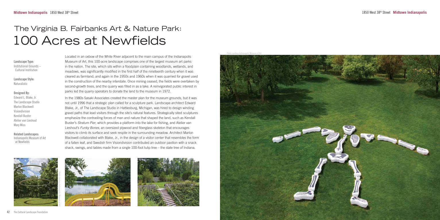
Landscape Type:Institutional Grounds – Cultural Institution
Landscape Style:Naturalistic
Designed By:Edward L. Blake, Jr.The Landscape Studio Marlon BlackwellVisiondivisionKendall BusterAtelier van LieshoutMary Miss Related Landscapes:Indianapolis Museum of Art at Newfields
Located in an oxbow of the White River adjacent to the main campus of the Indianapolis Museum of Art, this 100-acre landscape comprises one of the largest museum art parks in the nation. The site, which sits within a floodplain containing woodlands, wetlands, and meadows, was significantly modified in the first half of the nineteenth century when it was cleared as farmland, and again in the 1950s and 1960s when it was quarried for gravel used in the construction of the nearby interstate. Once mining ceased, the fields were overtaken by second-growth trees, and the quarry was filled in as a lake. A reinvigorated public interest in parks led the quarry operators to donate the land to the museum in 1972.
In the 1980s Sasaki Associates created the master plan for the museum grounds, but it was not until 1996 that a strategic plan called for a sculpture park. Landscape architect Edward Blake, Jr., of The Landscape Studio in Hattiesburg, Michigan, was hired to design winding gravel paths that lead visitors through the site’s natural features. Strategically sited sculptures emphasize the contrasting forces of man and nature that shaped the land, such as Kendall Buster’s Stratum Pier, which provides a platform into the lake for fishing, and Atelier van Lieshout’s Funky Bones, an oversized plywood and fiberglass skeleton that encourages visitors to climb its surface and seek respite in the surrounding meadow. Architect Marlon Blackwell collaborated with Blake, Jr., in the design of a visitor center that resembles the form of a fallen leaf, and Swedish firm Visiondivision contributed an outdoor pavilion with a snack shack, swings, and tables made from a single 100-foot tulip tree – the state tree of Indiana.
Midtown Indianapolis 1850 West 38th Street 1850 West 38th Street Midtown Indianapolis
The Virginia B. Fairbanks Art & Nature Park: 100 Acres at Newfields
Photo courtesy Indianapolis Museum of Art
Photo courtesy Indianapolis Museum
of Art
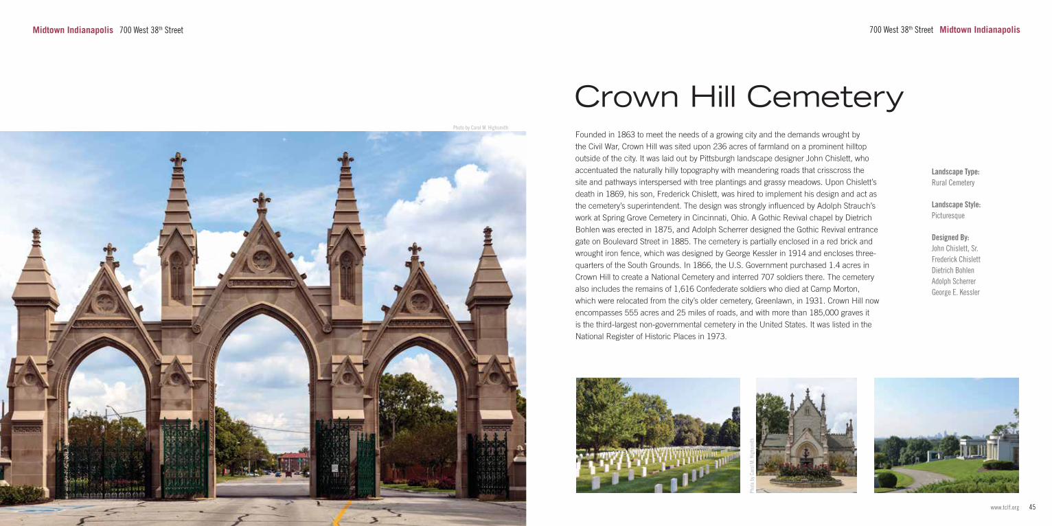
45www.tclf.org44 The Cultural Landscape Foundation
Photo by Carol M. Highsmith
Midtown Indianapolis 700 West 38th Street
Landscape Type:Rural Cemetery
Landscape Style:Picturesque
Designed By:John Chislett, Sr.Frederick ChislettDietrich BohlenAdolph ScherrerGeorge E. Kessler
Founded in 1863 to meet the needs of a growing city and the demands wrought by the Civil War, Crown Hill was sited upon 236 acres of farmland on a prominent hilltop outside of the city. It was laid out by Pittsburgh landscape designer John Chislett, who accentuated the naturally hilly topography with meandering roads that crisscross the site and pathways interspersed with tree plantings and grassy meadows. Upon Chislett’s death in 1869, his son, Frederick Chislett, was hired to implement his design and act as the cemetery’s superintendent. The design was strongly influenced by Adolph Strauch’s work at Spring Grove Cemetery in Cincinnati, Ohio. A Gothic Revival chapel by Dietrich Bohlen was erected in 1875, and Adolph Scherrer designed the Gothic Revival entrance gate on Boulevard Street in 1885. The cemetery is partially enclosed in a red brick and wrought iron fence, which was designed by George Kessler in 1914 and encloses three-quarters of the South Grounds. In 1866, the U.S. Government purchased 1.4 acres in Crown Hill to create a National Cemetery and interred 707 soldiers there. The cemetery also includes the remains of 1,616 Confederate soldiers who died at Camp Morton, which were relocated from the city’s older cemetery, Greenlawn, in 1931. Crown Hill now encompasses 555 acres and 25 miles of roads, and with more than 185,000 graves it is the third-largest non-governmental cemetery in the United States. It was listed in the National Register of Historic Places in 1973.
Crown Hill Cemetery
700 West 38th Street Midtown Indianapolis
Phot
o by
Car
ol M
. Hig
hsm
ith
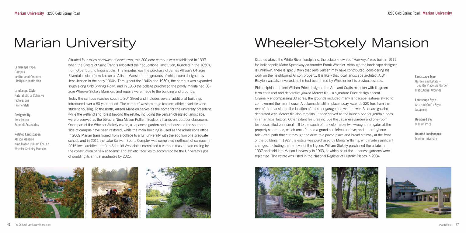
47www.tclf.org46 The Cultural Landscape Foundation
Landscape Type:CampusInstitutional Grounds – Religious Institution
Landscape Style:Naturalistic or CohesivePicturesquePrairie Style
Designed By:Jens JensenSchmidt Associates Related Landscapes:Allison MansionNina Mason Pulliam EcoLabWheeler-Stokeley Mansion
Situated four miles northwest of downtown, this 200-acre campus was established in 1937 when the Sisters of Saint Francis relocated their educational institution, founded in the 1850s, from Oldenburg to Indianapolis. The impetus was the purchase of James Allison’s 64-acre Riverdale estate (now known as Allison Mansion), the grounds of which were designed by Jens Jensen in the early 1900s. Throughout the 1940s and 1950s, the campus was expanded south along Cold Springs Road, and in 1963 the college purchased the poorly maintained 30-acre Wheeler-Stokely Mansion, and repairs were made to the building and grounds.
Today the campus reaches south to 30th Street and includes several additional buildings introduced over a 60-year period. The campus’ western edge features athletic facilities and student housing. To the north, Allison Mansion serves as the home for the university president, while the wetland and forest beyond the estate, including the Jensen-designed landscape, were preserved as the 55-acre Nina Mason Pulliam Ecolab, a hands-on, outdoor classroom. Once part of the Wheeler-Stokely estate, a Japanese garden and teahouse on the southern side of campus have been restored, while the main building is used as the admissions office. In 2009 Marian transitioned from a college to a full university with the addition of a graduate school, and in 2011 the Lake Sullivan Sports Complex was completed northeast of campus. In 2015 local architecture firm Schmidt Associates completed a campus master plan calling for the construction of new academic and athletic facilities to accommodate the University’s goal of doubling its annual graduates by 2025.
Marian University
Photo courtesy Marian University
Landscape Type:Garden and Estate – Country Place Era GardenInstitutional Grounds
Landscape Style:Arts and Crafts StyleJapanese
Designed By:William Price Related Landscapes:Marian University
Situated above the White River floodplains, the estate known as “Hawkeye” was built in 1911 for Indianapolis Motor Speedway co-founder Frank Wheeler. Although the landscape designer is unknown, there is speculation that Jens Jensen may have contributed, considering his work on the neighboring Allison property. It is likely that local landscape architect A.W. Brayton was also involved, as he had been hired by Wheeler for his previous estates.
Philadelphia architect William Price designed the Arts and Crafts mansion with its green terra cotta roof and decorative glazed Mercer tile – a signature Price design accent. Originally encompassing 30 acres, the grounds included many landscape features styled to complement the main house. A colonnade, still in place today, extends 320 feet from the rear of the mansion to the location of a former garage and water tower. A square gazebo decorated with Mercer tile also remains. It once served as the launch pad for gondola rides in an artificial lagoon. Other extant features include the Japanese garden and one-room teahouse, sited on a small hill to the south of the colonnade; two wrought iron gates at the property’s entrance, which once framed a grand semicircular drive; and a herringbone brick axial path that cut through the drive to a paved plaza and broad stairway at the front of the building. In 1927 the estate was purchased by Monty Williams, who made significant changes, including the removal of the lagoon. William Stokely purchased the estate in 1937 and sold it to Marian University in 1963, at which point the Japanese gardens were replanted. The estate was listed in the National Register of Historic Places in 2004.
Wheeler-Stokely Mansion
3200 Cold Spring Road Marian UniversityMarian University 3200 Cold Spring Road
Photo courtesy Marian University
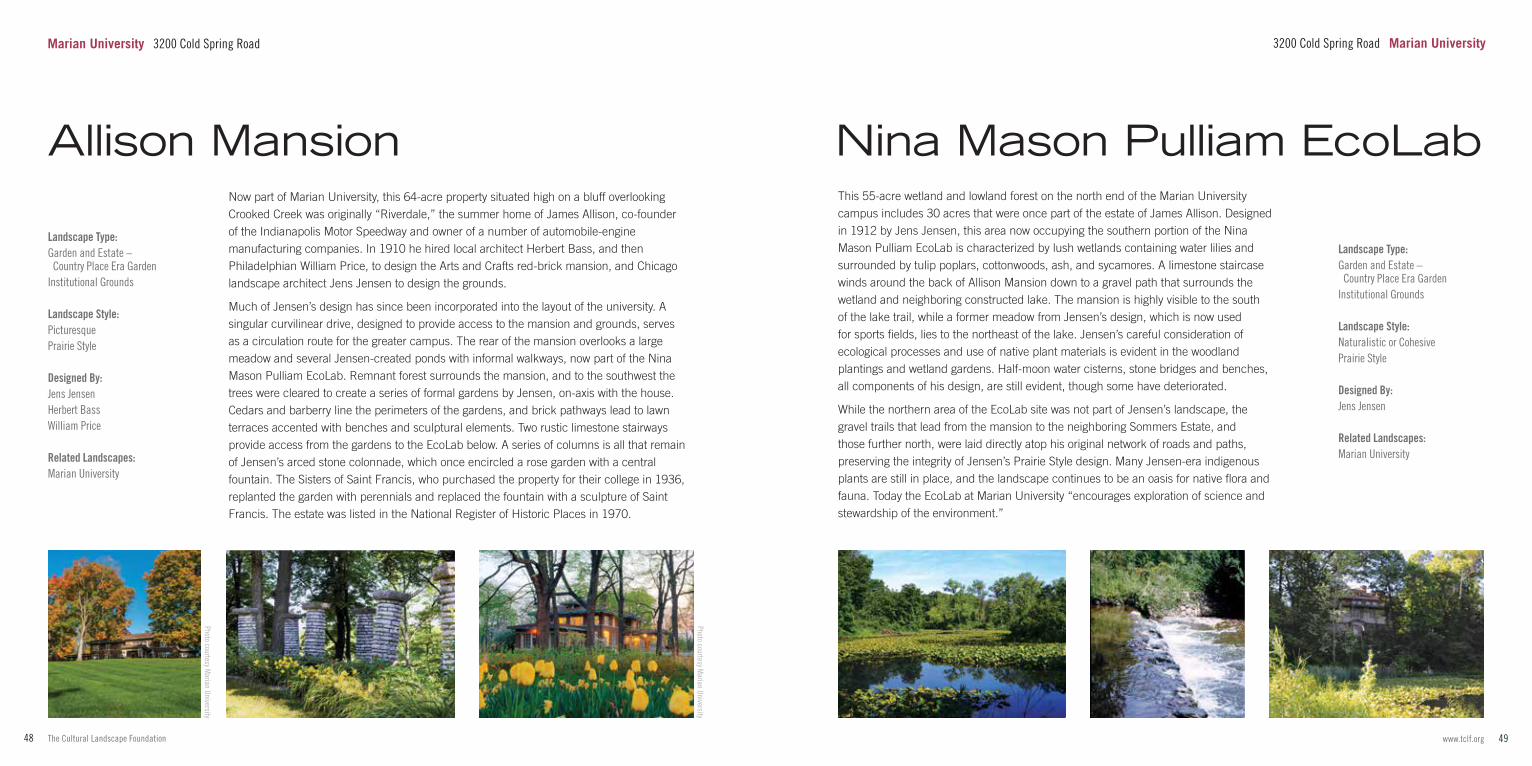
49www.tclf.org48 The Cultural Landscape Foundation
Landscape Type:Garden and Estate – Country Place Era GardenInstitutional Grounds
Landscape Style:PicturesquePrairie Style
Designed By:Jens JensenHerbert BassWilliam Price Related Landscapes:Marian University
Now part of Marian University, this 64-acre property situated high on a bluff overlooking Crooked Creek was originally “Riverdale,” the summer home of James Allison, co-founder of the Indianapolis Motor Speedway and owner of a number of automobile-engine manufacturing companies. In 1910 he hired local architect Herbert Bass, and then Philadelphian William Price, to design the Arts and Crafts red-brick mansion, and Chicago landscape architect Jens Jensen to design the grounds.
Much of Jensen’s design has since been incorporated into the layout of the university. A singular curvilinear drive, designed to provide access to the mansion and grounds, serves as a circulation route for the greater campus. The rear of the mansion overlooks a large meadow and several Jensen-created ponds with informal walkways, now part of the Nina Mason Pulliam EcoLab. Remnant forest surrounds the mansion, and to the southwest the trees were cleared to create a series of formal gardens by Jensen, on-axis with the house. Cedars and barberry line the perimeters of the gardens, and brick pathways lead to lawn terraces accented with benches and sculptural elements. Two rustic limestone stairways provide access from the gardens to the EcoLab below. A series of columns is all that remain of Jensen’s arced stone colonnade, which once encircled a rose garden with a central fountain. The Sisters of Saint Francis, who purchased the property for their college in 1936, replanted the garden with perennials and replaced the fountain with a sculpture of Saint Francis. The estate was listed in the National Register of Historic Places in 1970.
Photo courtesy Marian University
Landscape Type:Garden and Estate – Country Place Era GardenInstitutional Grounds
Landscape Style:Naturalistic or CohesivePrairie Style
Designed By:Jens Jensen Related Landscapes:Marian University
This 55-acre wetland and lowland forest on the north end of the Marian University campus includes 30 acres that were once part of the estate of James Allison. Designed in 1912 by Jens Jensen, this area now occupying the southern portion of the Nina Mason Pulliam EcoLab is characterized by lush wetlands containing water lilies and surrounded by tulip poplars, cottonwoods, ash, and sycamores. A limestone staircase winds around the back of Allison Mansion down to a gravel path that surrounds the wetland and neighboring constructed lake. The mansion is highly visible to the south of the lake trail, while a former meadow from Jensen’s design, which is now used for sports fields, lies to the northeast of the lake. Jensen’s careful consideration of ecological processes and use of native plant materials is evident in the woodland plantings and wetland gardens. Half-moon water cisterns, stone bridges and benches, all components of his design, are still evident, though some have deteriorated.
While the northern area of the EcoLab site was not part of Jensen’s landscape, the gravel trails that lead from the mansion to the neighboring Sommers Estate, and those further north, were laid directly atop his original network of roads and paths, preserving the integrity of Jensen’s Prairie Style design. Many Jensen-era indigenous plants are still in place, and the landscape continues to be an oasis for native flora and fauna. Today the EcoLab at Marian University “encourages exploration of science and stewardship of the environment.”
Nina Mason Pulliam EcoLab
Photo courtesy Marian University
Allison Mansion
Marian University 3200 Cold Spring Road 3200 Cold Spring Road Marian University
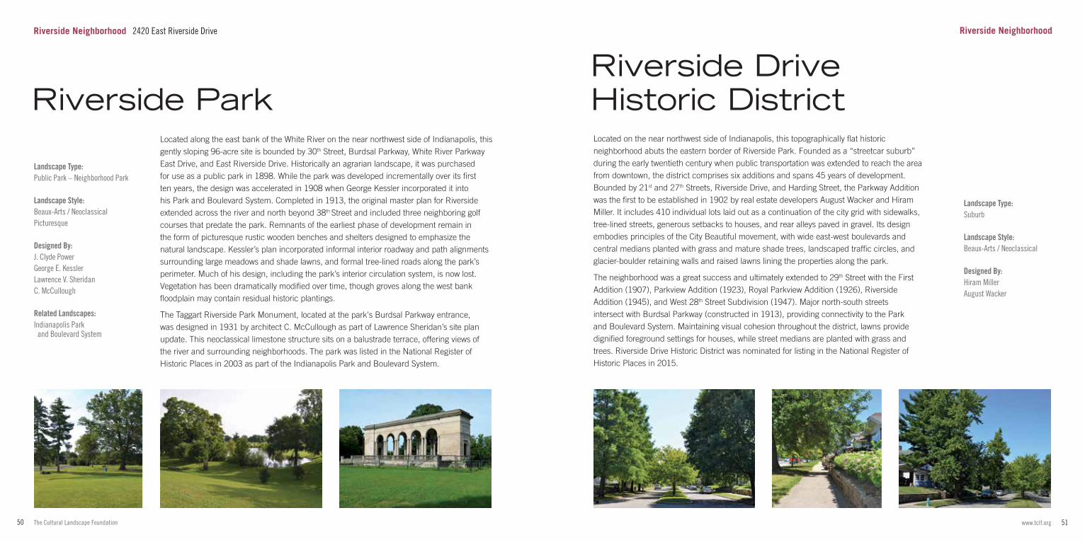
51www.tclf.org50 The Cultural Landscape Foundation
Landscape Type:Public Park – Neighborhood Park
Landscape Style:Beaux-Arts / NeoclassicalPicturesque
Designed By:J. Clyde PowerGeorge E. KesslerLawrence V. SheridanC. McCullough Related Landscapes:Indianapolis Park and Boulevard System
Located along the east bank of the White River on the near northwest side of Indianapolis, this gently sloping 96-acre site is bounded by 30th Street, Burdsal Parkway, White River Parkway East Drive, and East Riverside Drive. Historically an agrarian landscape, it was purchased for use as a public park in 1898. While the park was developed incrementally over its first ten years, the design was accelerated in 1908 when George Kessler incorporated it into his Park and Boulevard System. Completed in 1913, the original master plan for Riverside extended across the river and north beyond 38th Street and included three neighboring golf courses that predate the park. Remnants of the earliest phase of development remain in the form of picturesque rustic wooden benches and shelters designed to emphasize the natural landscape. Kessler’s plan incorporated informal interior roadway and path alignments surrounding large meadows and shade lawns, and formal tree-lined roads along the park’s perimeter. Much of his design, including the park’s interior circulation system, is now lost. Vegetation has been dramatically modified over time, though groves along the west bank floodplain may contain residual historic plantings.
The Taggart Riverside Park Monument, located at the park's Burdsal Parkway entrance, was designed in 1931 by architect C. McCullough as part of Lawrence Sheridan’s site plan update. This neoclassical limestone structure sits on a balustrade terrace, offering views of the river and surrounding neighborhoods. The park was listed in the National Register of Historic Places in 2003 as part of the Indianapolis Park and Boulevard System.
Landscape Type:Suburb
Landscape Style:Beaux-Arts / Neoclassical
Designed By:Hiram MillerAugust Wacker
Located on the near northwest side of Indianapolis, this topographically flat historic neighborhood abuts the eastern border of Riverside Park. Founded as a “streetcar suburb” during the early twentieth century when public transportation was extended to reach the area from downtown, the district comprises six additions and spans 45 years of development. Bounded by 21st and 27th Streets, Riverside Drive, and Harding Street, the Parkway Addition was the first to be established in 1902 by real estate developers August Wacker and Hiram Miller. It includes 410 individual lots laid out as a continuation of the city grid with sidewalks, tree-lined streets, generous setbacks to houses, and rear alleys paved in gravel. Its design embodies principles of the City Beautiful movement, with wide east-west boulevards and central medians planted with grass and mature shade trees, landscaped traffic circles, and glacier-boulder retaining walls and raised lawns lining the properties along the park.
The neighborhood was a great success and ultimately extended to 29th Street with the First Addition (1907), Parkview Addition (1923), Royal Parkview Addition (1926), Riverside Addition (1945), and West 28th Street Subdivision (1947). Major north-south streets intersect with Burdsal Parkway (constructed in 1913), providing connectivity to the Park and Boulevard System. Maintaining visual cohesion throughout the district, lawns provide dignified foreground settings for houses, while street medians are planted with grass and trees. Riverside Drive Historic District was nominated for listing in the National Register of Historic Places in 2015.
Riverside Drive Historic District Riverside Park
Riverside Neighborhood 2420 East Riverside Drive Riverside Neighborhood
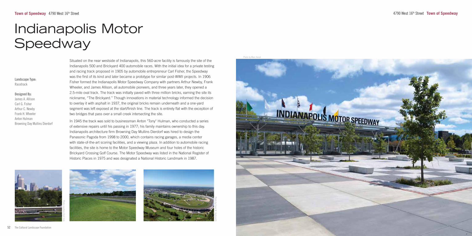
53www.tclf.org52 The Cultural Landscape Foundation
Photo by Marc Ancel
4790 West 16th Street Town of Speedway
Landscape Type:Racetrack
Designed By:James A. AllisonCarl G. FisherArthur C. NewbyFrank H. WheelerAnton HulmanBrowning Day Mullins Dierdorf
Situated on the near westside of Indianapolis, this 560-acre facility is famously the site of the Indianapolis 500 and Brickyard 400 automobile races. With the initial idea for a private testing and racing track proposed in 1905 by automobile entrepreneur Carl Fisher, the Speedway was the first of its kind and later became a prototype for similar post-WWII projects. In 1906 Fisher formed the Indianapolis Motor Speedway Company with partners Arthur Newby, Frank Wheeler, and James Allison, all automobile pioneers, and three years later, they opened a 2.5-mile oval track. The track was initially paved with three million bricks, earning the site its nickname, “The Brickyard.” Though innovations in material technology informed the decision to overlay it with asphalt in 1937, the original bricks remain underneath and a one-yard segment was left exposed at the start/finish line. The track is entirely flat with the exception of two bridges that pass over a small creek intersecting the site.
In 1945 the track was sold to businessman Anton "Tony" Hulman, who conducted a series of extensive repairs until his passing in 1977; his family maintains ownership to this day. Indianapolis architecture firm Browning Day Mullins Dierdorf was hired to design the Panasonic Pagoda from 1998 to 2000, which contains racing garages, a media center with state-of-the-art scoring facilities, and a viewing plaza. In addition to automobile racing facilities, the site is home to the Motor Speedway Museum and four holes of the historic Brickyard Crossing Golf Course. The Motor Speedway was listed in the National Register of Historic Places in 1975 and was designated a National Historic Landmark in 1987.
Town of Speedway 4790 West 16th Street
Photo courtesy Visit Indy
Photo by Carol M. Highsm
ith
Indianapolis Motor Speedway
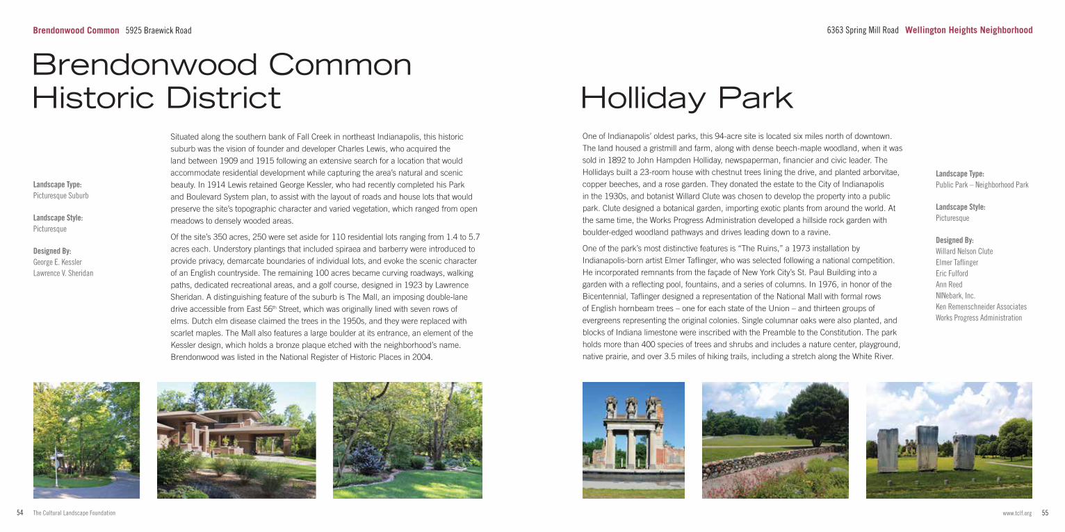
55www.tclf.org54 The Cultural Landscape Foundation
Landscape Type:Public Park – Neighborhood Park
Landscape Style:Picturesque
Designed By:Willard Nelson CluteElmer TaflingerEric FulfordAnn ReedNINebark, Inc.Ken Remenschneider AssociatesWorks Progress Administration
One of Indianapolis’ oldest parks, this 94-acre site is located six miles north of downtown. The land housed a gristmill and farm, along with dense beech-maple woodland, when it was sold in 1892 to John Hampden Holliday, newspaperman, financier and civic leader. The Hollidays built a 23-room house with chestnut trees lining the drive, and planted arborvitae, copper beeches, and a rose garden. They donated the estate to the City of Indianapolis in the 1930s, and botanist Willard Clute was chosen to develop the property into a public park. Clute designed a botanical garden, importing exotic plants from around the world. At the same time, the Works Progress Administration developed a hillside rock garden with boulder-edged woodland pathways and drives leading down to a ravine.
One of the park’s most distinctive features is “The Ruins,” a 1973 installation by Indianapolis-born artist Elmer Taflinger, who was selected following a national competition. He incorporated remnants from the façade of New York City’s St. Paul Building into a garden with a reflecting pool, fountains, and a series of columns. In 1976, in honor of the Bicentennial, Taflinger designed a representation of the National Mall with formal rows of English hornbeam trees – one for each state of the Union – and thirteen groups of evergreens representing the original colonies. Single columnar oaks were also planted, and blocks of Indiana limestone were inscribed with the Preamble to the Constitution. The park holds more than 400 species of trees and shrubs and includes a nature center, playground, native prairie, and over 3.5 miles of hiking trails, including a stretch along the White River.
6363 Spring Mill Road Wellington Heights Neighborhood
Holliday Park
Landscape Type:Picturesque Suburb
Landscape Style:Picturesque
Designed By:George E. KesslerLawrence V. Sheridan
Situated along the southern bank of Fall Creek in northeast Indianapolis, this historic suburb was the vision of founder and developer Charles Lewis, who acquired the land between 1909 and 1915 following an extensive search for a location that would accommodate residential development while capturing the area’s natural and scenic beauty. In 1914 Lewis retained George Kessler, who had recently completed his Park and Boulevard System plan, to assist with the layout of roads and house lots that would preserve the site’s topographic character and varied vegetation, which ranged from open meadows to densely wooded areas.
Of the site’s 350 acres, 250 were set aside for 110 residential lots ranging from 1.4 to 5.7 acres each. Understory plantings that included spiraea and barberry were introduced to provide privacy, demarcate boundaries of individual lots, and evoke the scenic character of an English countryside. The remaining 100 acres became curving roadways, walking paths, dedicated recreational areas, and a golf course, designed in 1923 by Lawrence Sheridan. A distinguishing feature of the suburb is The Mall, an imposing double-lane drive accessible from East 56th Street, which was originally lined with seven rows of elms. Dutch elm disease claimed the trees in the 1950s, and they were replaced with scarlet maples. The Mall also features a large boulder at its entrance, an element of the Kessler design, which holds a bronze plaque etched with the neighborhood’s name. Brendonwood was listed in the National Register of Historic Places in 2004.
Brendonwood Common Historic District
Brendonwood Common 5925 Braewick Road
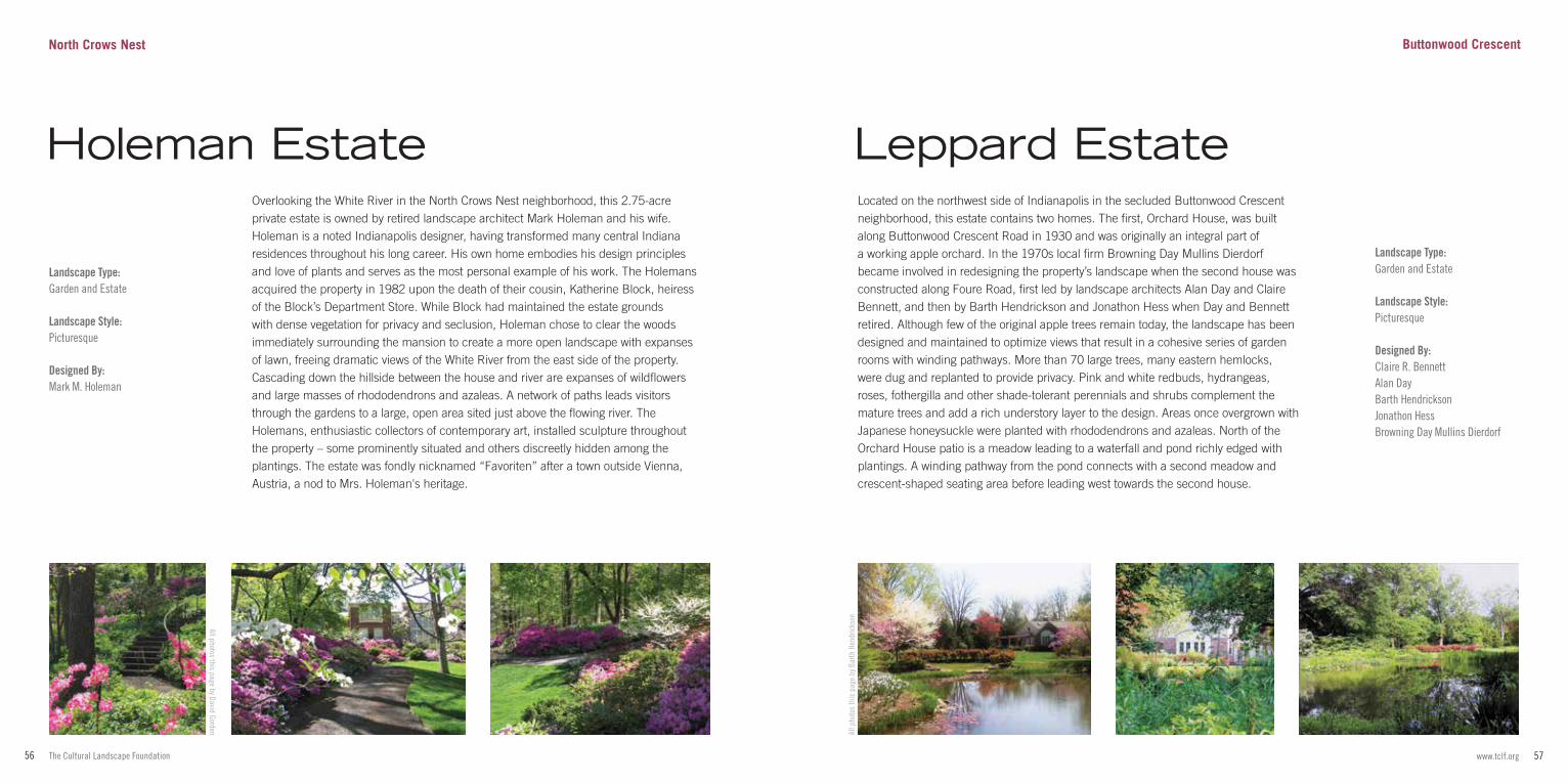
57www.tclf.org56 The Cultural Landscape Foundation
Landscape Type:Garden and Estate
Landscape Style:Picturesque
Designed By:Mark M. Holeman
Overlooking the White River in the North Crows Nest neighborhood, this 2.75-acre private estate is owned by retired landscape architect Mark Holeman and his wife. Holeman is a noted Indianapolis designer, having transformed many central Indiana residences throughout his long career. His own home embodies his design principles and love of plants and serves as the most personal example of his work. The Holemans acquired the property in 1982 upon the death of their cousin, Katherine Block, heiress of the Block’s Department Store. While Block had maintained the estate grounds with dense vegetation for privacy and seclusion, Holeman chose to clear the woods immediately surrounding the mansion to create a more open landscape with expanses of lawn, freeing dramatic views of the White River from the east side of the property. Cascading down the hillside between the house and river are expanses of wildflowers and large masses of rhododendrons and azaleas. A network of paths leads visitors through the gardens to a large, open area sited just above the flowing river. The Holemans, enthusiastic collectors of contemporary art, installed sculpture throughout the property – some prominently situated and others discreetly hidden among the plantings. The estate was fondly nicknamed “Favoriten” after a town outside Vienna, Austria, a nod to Mrs. Holeman's heritage.
All p
hoto
s th
is p
age
by B
arth
Hen
dric
kson
Landscape Type:Garden and Estate
Landscape Style:Picturesque
Designed By:Claire R. BennettAlan DayBarth HendricksonJonathon HessBrowning Day Mullins Dierdorf
Located on the northwest side of Indianapolis in the secluded Buttonwood Crescent neighborhood, this estate contains two homes. The first, Orchard House, was built along Buttonwood Crescent Road in 1930 and was originally an integral part of a working apple orchard. In the 1970s local firm Browning Day Mullins Dierdorf became involved in redesigning the property’s landscape when the second house was constructed along Foure Road, first led by landscape architects Alan Day and Claire Bennett, and then by Barth Hendrickson and Jonathon Hess when Day and Bennett retired. Although few of the original apple trees remain today, the landscape has been designed and maintained to optimize views that result in a cohesive series of garden rooms with winding pathways. More than 70 large trees, many eastern hemlocks, were dug and replanted to provide privacy. Pink and white redbuds, hydrangeas, roses, fothergilla and other shade-tolerant perennials and shrubs complement the mature trees and add a rich understory layer to the design. Areas once overgrown with Japanese honeysuckle were planted with rhododendrons and azaleas. North of the Orchard House patio is a meadow leading to a waterfall and pond richly edged with plantings. A winding pathway from the pond connects with a second meadow and crescent-shaped seating area before leading west towards the second house.
Leppard Estate
All photos this page by David Gorden
Holeman Estate
North Crows Nest Buttonwood Crescent
59www.tclf.org58 The Cultural Landscape Foundation
What’s Out There® is the most comprehensive searchable database of North America's historic designed landscapes, with thousands of sites and images, and optimized for iPhones and similar handheld devices. It includes What’s Nearby, a GPS-enabled function that locates all landscapes in the database within a 25-mile radius of any given location.
tclf.org/landscapes Go online to learn more about the sites in this guide and What’s Out There.
tclf.org/publications Get more guidebooks in the What's Out There series.
Designed by Oviatt Media, this guidebook is the result of the scholarly support and photography provided by Charles A. Birnbaum, Marc Ancel, Margo Barajas, Barrett Doherty, Dena Tasse-Winter, Nord Wennerstrom, and special thanks to the Indiana Cultural Landscapes Committee, Meg Storrow, FASLA, Chair.
All photos by The Cultural Landscape Foundation, unless otherwise noted. Cover: Photo courtesy Indianapolis Museum of Art Right: Photo by Craig Kuhner, courtesy Sasaki Associates
Leading and Presenting Sponsors
Annual Sponsor Partner in Education
tclf.org/indianapolisguide for more about What's Out There Indianapolis
Friend
ASLA Indiana Chapter
IMA Horticultural Society
Supporting Sponsors
David Gorden
Jo Ellen Myers Sharp
MKSK
Mark Zelonis
Julie Donnell & John Shoaff