Embed Size (px)
Citation preview

WWilshire
Historic Districts, Planning Districts and Multi-Property Resources – 01/26/15
Page 939 of 1035
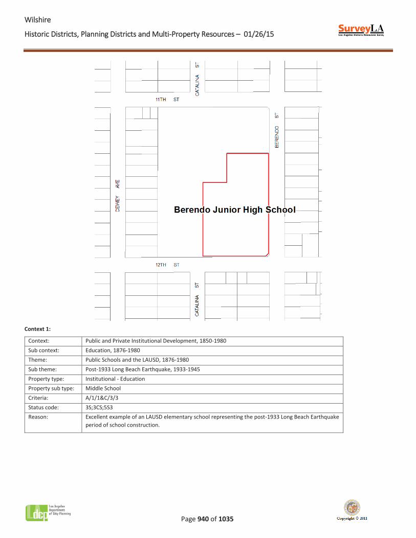
Name: Berendo Junior High School
Description:
Berendo Junior High School is located at 1157 South Berendo Street in the Koreatown area of central Los Angeles. Sited on a rectangular, roughly 18-acre parcel, it is bounded by West 11th Street, West 12th Street, South Berendo Street and South Kenmore Avenue. The campus today consists of roughly 15 buildings; however, the original campus is composed of six buildings at the corner of South Berendo Street and West 12th Street. Of the six buildings on the original campus, four (the administrative building, auditorium, cafeteria, and gymnasium) were constructed in the Streamline Moderne style as part of Los Angeles Unified School District rebuilding efforts after the 1933 Long Beach earthquake. The campus was extended by two and a half blocks westward to include larger play areas, parking lots and classroom buildings, beginning in the 1950s and continuing through the 1980s.
Significance:
Berendo Junior High School is significant as an excellent example of an LAUSD junior high school campus that was built in response to the substantial damage school campuses incurred during the 1933 Long Beach earthquake. The school’s location was originally occupied by the Pico Heights School, built in 1896 to serve the area’s rapidly growing population. Shortly after its construction, the school burned down. It was rebuilt in 1911 as Berendo Street Elementary School; its name was changed circa 1915 to Berendo Intermediate School, and then to Berendo Junior High School circa 1922. The school is now referred to as Berendo Middle School.
In 1933, the Long Beach earthquake severely damaged most of the school’s buildings. One 1923 classroom building survived, but it was demolished in 1954. Like most schools built prior to 1933, Berendo Junior High was provided funding to rebuild the campus out of reinforced concrete. An amount of $230,000 was provided to construct a new auditorium, cafeteria, administration building and physical education building; architects Edward Cray Taylor and Ellis Wing Taylor designed the new buildings in the Streamline Moderne style. While the cafeteria and auditorium are one story in height, the administration and physical education buildings are two stories. The administration, cafeteria and auditorium buildings are connected by covered walkways.
Beginning in the 1950s, the school’s campus was enlarged, and new buildings were constructed. In 1954, an addition was erected at the north end of the administration building, along South Berendo Street; a classroom building from 1923 was demolished to make way for the addition. From the mid 1950s through the 1980s, the campus was extended westward by two and a half blocks to include a larger playground, parking lots and additional classroom buildings. With the exception of the addition to the administration building, the post-1933 buildings are largely intact, with little to no alterations. The period of significance for Berendo Junior High School begins in 1936, when the school obtained funding for its rebuilding program, and ends in 1937, when the post-1933 campus was complete.
WWilshire
Historic Districts, Planning Districts and Multi-Property Resources – 01/26/15
Page 940 of 1035
Context 1:
Context: Public and Private Institutional Development, 1850-1980 Sub context: Education, 1876-1980 Theme: Public Schools and the LAUSD, 1876-1980 Sub theme: Post-1933 Long Beach Earthquake, 1933-1945 Property type: Institutional - Education Property sub type: Middle School Criteria: A/1/1&C/3/3 Status code: 3S;3CS;5S3 Reason: Excellent example of an LAUSD elementary school representing the post-1933 Long Beach Earthquake
period of school construction.
WWilshire
Historic Districts, Planning Districts and Multi-Property Resources – 01/26/15
Page 941 of 1035
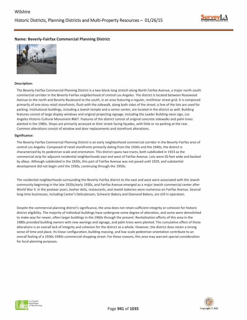
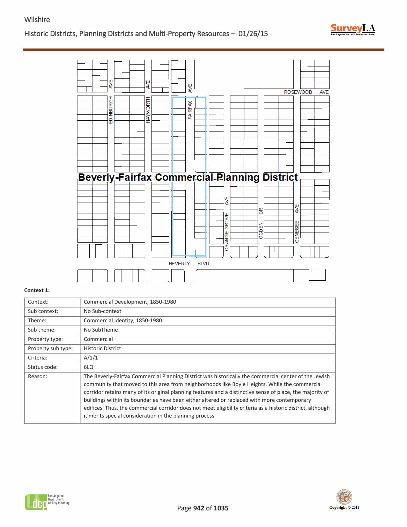
Name: Beverly-Fairfax Commercial Planning District
Description:
The Beverly-Fairfax Commercial Planning District is a two-block-long stretch along North Fairfax Avenue, a major north-south commercial corridor in the Beverly-Fairfax neighborhood of central Los Angeles. The district is located between Rosewood Avenue to the north and Beverly Boulevard to the south, in an area featuring a regular, rectilinear street grid. It is composed primarily of one-story retail storefronts, flush with the sidewalk, along both sides of the street; a few of the lots are used for parking. Institutional buildings, including a Jewish temple and a senior center, are located in the district as well. Building features consist of large display windows and original projecting signage, including the Leader Building neon sign, Los Angeles Historic-Cultural Monument #667. Features of the district consist of original concrete sidewalks and palm trees planted in the 1980s. Shops are primarily accessed at their street-facing façades, with little or no parking at the rear. Common alterations consist of window and door replacements and storefront alterations.
Significance:
The Beverly-Fairfax Commercial Planning District is an early neighborhood commercial corridor in the Beverly-Fairfax area of central Los Angeles. Composed of retail storefronts primarily dating from the 1930s and the 1940s, the district is characterized by its pedestrian scale and orientation. This district spans two tracts, both subdivided in 1923 as the commercial strip for adjacent residential neighborhoods east and west of Fairfax Avenue. Lots were 50 feet wide and backed by alleys. Although subdivided in the 1920s, this part of Fairfax Avenue was not paved until 1929, and substantial development did not begin until the 1930s, continuing through the 1950s.
The residential neighborhoods surrounding the Beverly-Fairfax district to the east and west were associated with the Jewish community beginning in the late 1920s/early 1930s, and Fairfax Avenue emerged as a major Jewish commercial center after World War II. In the postwar years, kosher delis, restaurants, and Jewish bakeries were numerous on Fairfax Avenue. Several long-time businesses, including Canter’s Delicatessen, Schwartz Bakery and Diamond Bakery, are still in operation.
Despite the commercial planning district’s significance, the area does not retain sufficient integrity or cohesion for historic district eligibility. The majority of individual buildings have undergone some degree of alteration, and some were demolished to make way for newer, often larger buildings in the 1960s through the present. Revitalization efforts of this area in the 1980s provided building owners with new awnings and signage, and palm trees were planted. The cumulative effect of these alterations is an overall lack of integrity and cohesion for the district as a whole. However, the district does retain a strong sense of time and place. Its linear configuration, building massing, and low-scale pedestrian orientation contribute to an overall feeling of a 1930s-1940s commercial shopping street. For these reasons, this area may warrant special consideration for local planning purposes.
WWilshire
Historic Districts, Planning Districts and Multi-Property Resources – 01/26/15
Page 942 of 1035
Context 1:
Context: Commercial Development, 1850-1980 Sub context: No Sub-context Theme: Commercial Identity, 1850-1980 Sub theme: No SubTheme Property type: Commercial Property sub type: Historic District Criteria: A/1/1 Status code: 6LQ Reason: The Beverly-Fairfax Commercial Planning District was historically the commercial center of the Jewish
community that moved to this area from neighborhoods like Boyle Heights. While the commercial corridor retains many of its original planning features and a distinctive sense of place, the majority of buildings within its boundaries have been either altered or replaced with more contemporary edifices. Thus, the commercial corridor does not meet eligibility criteria as a historic district, although it merits special consideration in the planning process.
WWilshire
Historic Districts, Planning Districts and Multi-Property Resources – 01/26/15
Page 943 of 1035
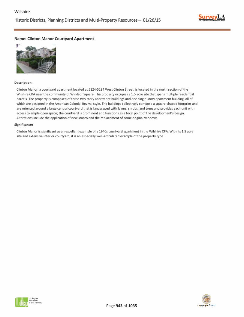
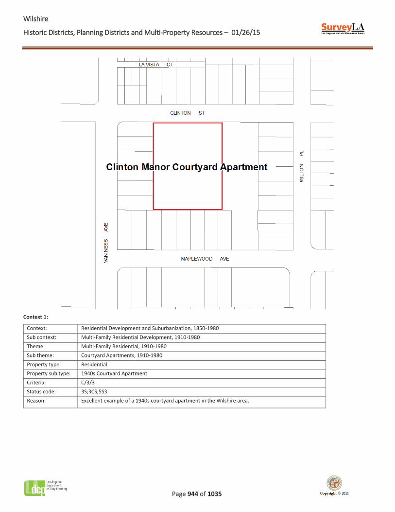
Name: Clinton Manor Courtyard Apartment
Description:
Clinton Manor, a courtyard apartment located at 5124-5184 West Clinton Street, is located in the north section of the Wilshire CPA near the community of Windsor Square. The property occupies a 1.5 acre site that spans multiple residential parcels. The property is composed of three two-story apartment buildings and one single-story apartment building, all of which are designed in the American Colonial Revival style. The buildings collectively compose a square-shaped footprint and are oriented around a large central courtyard that is landscaped with lawns, shrubs, and trees and provides each unit with access to ample open space; the courtyard is prominent and functions as a focal point of the development’s design. Alterations include the application of new stucco and the replacement of some original windows.
Significance:
Clinton Manor is significant as an excellent example of a 1940s courtyard apartment in the Wilshire CPA. With its 1.5 acre site and extensive interior courtyard, it is an especially well-articulated example of the property type.
WWilshire
Historic Districts, Planning Districts and Multi-Property Resources – 01/26/15
Page 944 of 1035
Context 1:
Context: Residential Development and Suburbanization, 1850-1980 Sub context: Multi-Family Residential Development, 1910-1980 Theme: Multi-Family Residential, 1910-1980 Sub theme: Courtyard Apartments, 1910-1980 Property type: Residential Property sub type: 1940s Courtyard Apartment Criteria: C/3/3 Status code: 3S;3CS;5S3 Reason: Excellent example of a 1940s courtyard apartment in the Wilshire area.
WWilshire
Historic Districts, Planning Districts and Multi-Property Resources – 01/26/15
Page 945 of 1035
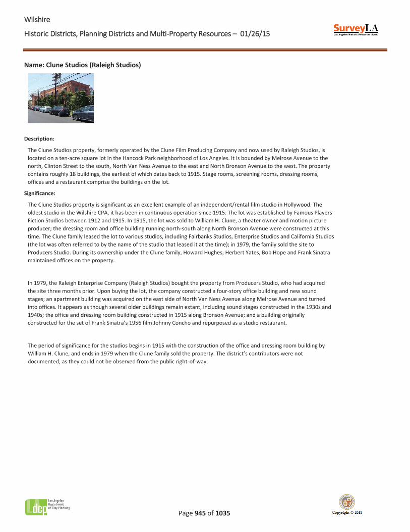
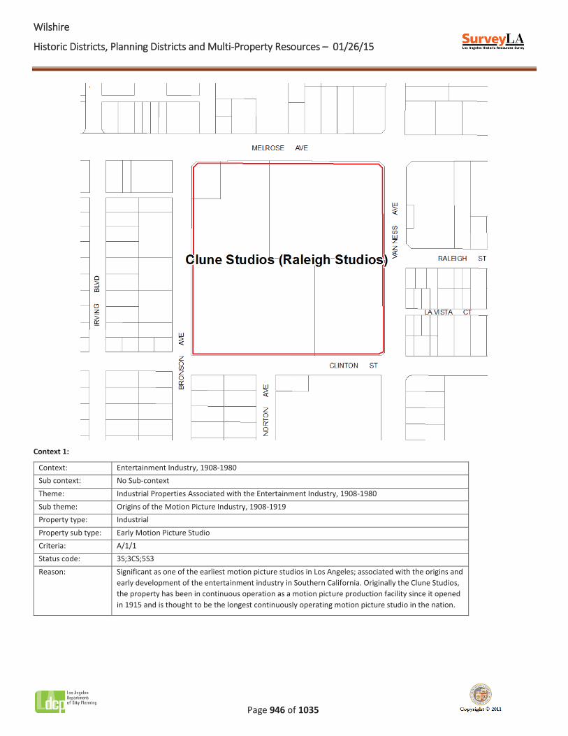
Name: Clune Studios (Raleigh Studios)
Description:
The Clune Studios property, formerly operated by the Clune Film Producing Company and now used by Raleigh Studios, is located on a ten-acre square lot in the Hancock Park neighborhood of Los Angeles. It is bounded by Melrose Avenue to the north, Clinton Street to the south, North Van Ness Avenue to the east and North Bronson Avenue to the west. The property contains roughly 18 buildings, the earliest of which dates back to 1915. Stage rooms, screening rooms, dressing rooms, offices and a restaurant comprise the buildings on the lot.
Significance:
The Clune Studios property is significant as an excellent example of an independent/rental film studio in Hollywood. The oldest studio in the Wilshire CPA, it has been in continuous operation since 1915. The lot was established by Famous Players Fiction Studios between 1912 and 1915. In 1915, the lot was sold to William H. Clune, a theater owner and motion picture producer; the dressing room and office building running north-south along North Bronson Avenue were constructed at this time. The Clune family leased the lot to various studios, including Fairbanks Studios, Enterprise Studios and California Studios (the lot was often referred to by the name of the studio that leased it at the time); in 1979, the family sold the site to Producers Studio. During its ownership under the Clune family, Howard Hughes, Herbert Yates, Bob Hope and Frank Sinatra maintained offices on the property.
In 1979, the Raleigh Enterprise Company (Raleigh Studios) bought the property from Producers Studio, who had acquired the site three months prior. Upon buying the lot, the company constructed a four-story office building and new sound stages; an apartment building was acquired on the east side of North Van Ness Avenue along Melrose Avenue and turned into offices. It appears as though several older buildings remain extant, including sound stages constructed in the 1930s and 1940s; the office and dressing room building constructed in 1915 along Bronson Avenue; and a building originally constructed for the set of Frank Sinatra’s 1956 film Johnny Concho and repurposed as a studio restaurant.
The period of significance for the studios begins in 1915 with the construction of the office and dressing room building by William H. Clune, and ends in 1979 when the Clune family sold the property. The district’s contributors were not documented, as they could not be observed from the public right-of-way.
WWilshire
Historic Districts, Planning Districts and Multi-Property Resources – 01/26/15
Page 946 of 1035
Context 1:
Context: Entertainment Industry, 1908-1980 Sub context: No Sub-context Theme: Industrial Properties Associated with the Entertainment Industry, 1908-1980 Sub theme: Origins of the Motion Picture Industry, 1908-1919 Property type: Industrial Property sub type: Early Motion Picture Studio Criteria: A/1/1 Status code: 3S;3CS;5S3 Reason: Significant as one of the earliest motion picture studios in Los Angeles; associated with the origins and
early development of the entertainment industry in Southern California. Originally the Clune Studios, the property has been in continuous operation as a motion picture production facility since it opened in 1915 and is thought to be the longest continuously operating motion picture studio in the nation.

WWilshire
Historic Districts, Planning Districts and Multi-Property Resources – 01/26/15
Page 947 of 1035
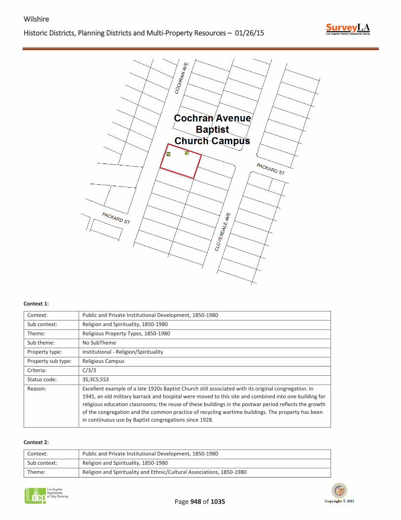
Name: Cochran Avenue Baptist Church Campus
Description:
The Cochran Avenue Baptist Church Campus is a church and K-8 school located at 1304 South Cochran Avenue, in the Mid-Wilshire area of central Los Angeles. The buildings share two parcels in a slightly hilly area at the southeast corner of South Cochran Avenue and Packard Street. A parking lot associated with the campus is located across the street and is excluded from the district.
The two-story church was designed in the Spanish Colonial Revival style in 1928. Decorative elements include a rectangular bell tower and stained glass windows. The school consists of a former army hospital and barrack building that were moved to the site in 1945 and adjoined by a two-story addition that fronts Packard Street. The school is vernacular in style and features stucco cladding and double-hung wood windows. Together, the church and school form a rectangular courtyard at the center of the campus.
Significance:
The Cochran Avenue Baptist Church Campus is significant as one of the earliest Baptist churches in the Survey Area to maintain its original affiliation, and as an institution associated with the local African American community. The church was constructed in 1928 by the Los Angeles Baptist Mission Society for the newly-formed congregation. In 1945, a former army hospital and barrack were moved from 119th Street and Inglewood Avenue to the church campus and were combined into a single building to serve as Sunday school classrooms, reflecting the congregation’s increased involvement in the surrounding community. By 1963, the Sunday school had become a primary school. In the 1960s and 1970s, the church’s African American population grew, representing the African American community’s move westward from other areas of Los Angeles. The property's period of significance begins in 1928 when it was established; the campus remains in use as a Baptist church and school.
WWilshire
Historic Districts, Planning Districts and Multi-Property Resources – 01/26/15
Page 948 of 1035
Context 1:
Context: Public and Private Institutional Development, 1850-1980 Sub context: Religion and Spirituality, 1850-1980 Theme: Religious Property Types, 1850-1980 Sub theme: No SubTheme Property type: Institutional - Religion/Spirituality Property sub type: Religious Campus Criteria: C/3/3 Status code: 3S;3CS;5S3 Reason: Excellent example of a late 1920s Baptist Church still associated with its original congregation. In
1945, an old military barrack and hospital were moved to this site and combined into one building for religious education classrooms; the reuse of these buildings in the postwar period reflects the growth of the congregation and the common practice of recycling wartime buildings. The property has been in continuous use by Baptist congregations since 1928.
Context 2:
Context: Public and Private Institutional Development, 1850-1980 Sub context: Religion and Spirituality, 1850-1980 Theme: Religion and Spirituality and Ethnic/Cultural Associations, 1850-1980
WWilshire
Historic Districts, Planning Districts and Multi-Property Resources – 01/26/15
Page 949 of 1035
Sub theme: No SubTheme Property type: Institutional - Religion/Spirituality Property sub type: Religious Campus Criteria: A/1/1 Status code: 3S;3CS;5S3 Reason: Significant as a religious institution long associated with the local African American community.
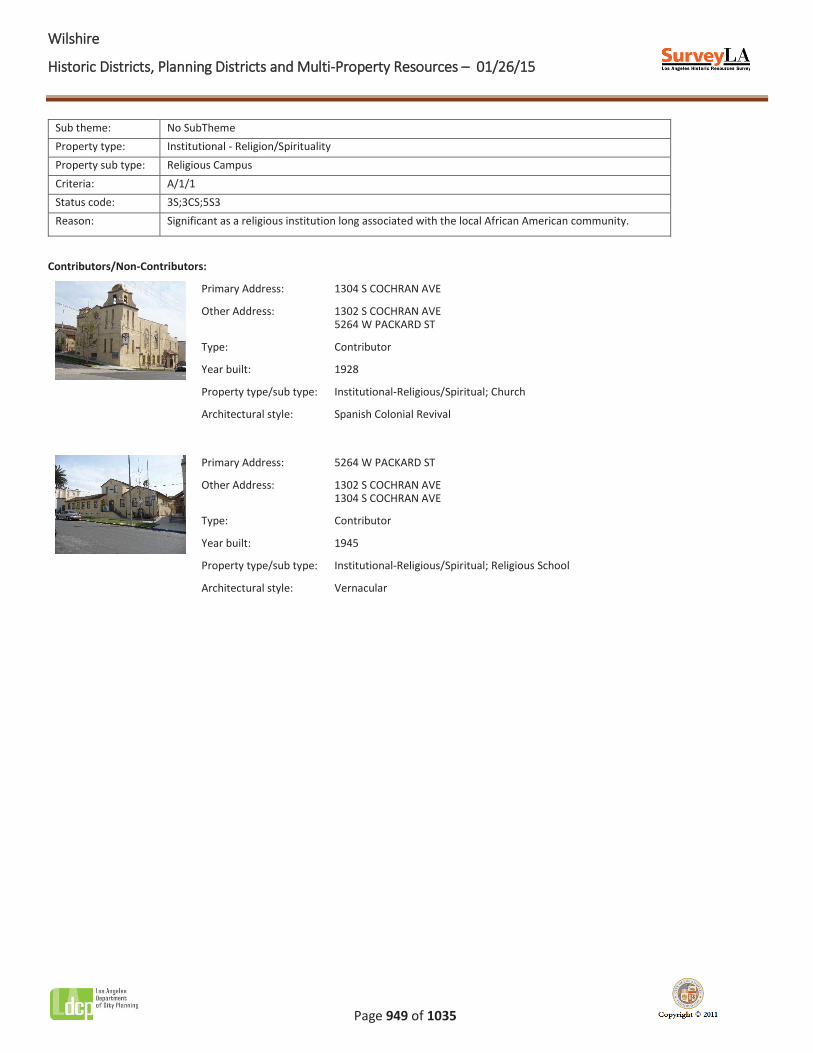
Contributors/Non-Contributors:
Primary Address: 1304 S COCHRAN AVE
Other Address: 1302 S COCHRAN AVE 5264 W PACKARD ST
Type: Contributor
Year built: 1928
Property type/sub type: Institutional-Religious/Spiritual; Church
Architectural style: Spanish Colonial Revival
Primary Address: 5264 W PACKARD ST
Other Address: 1302 S COCHRAN AVE 1304 S COCHRAN AVE
Type: Contributor
Year built: 1945
Property type/sub type: Institutional-Religious/Spiritual; Religious School
Architectural style: Vernacular
WWilshire
Historic Districts, Planning Districts and Multi-Property Resources – 01/26/15
Page 950 of 1035
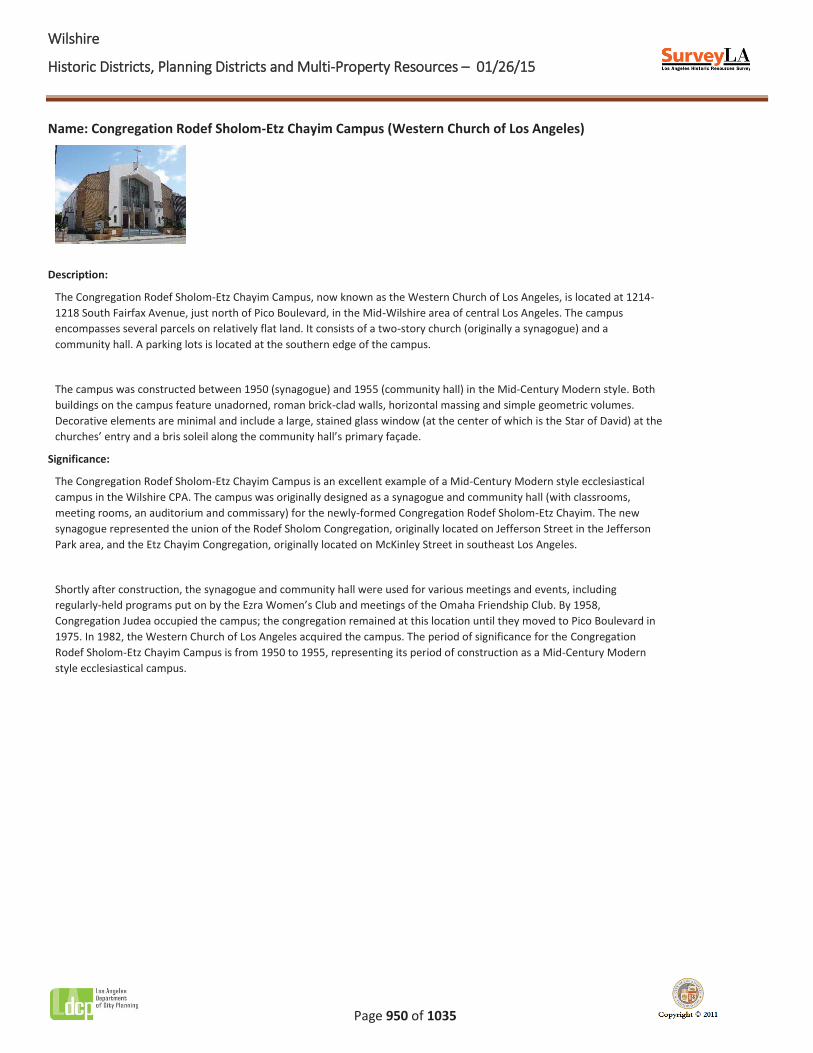
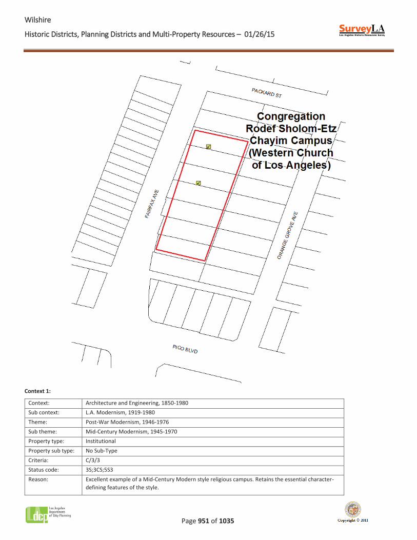
Name: Congregation Rodef Sholom-Etz Chayim Campus (Western Church of Los Angeles)
Description:
The Congregation Rodef Sholom-Etz Chayim Campus, now known as the Western Church of Los Angeles, is located at 1214-1218 South Fairfax Avenue, just north of Pico Boulevard, in the Mid-Wilshire area of central Los Angeles. The campus encompasses several parcels on relatively flat land. It consists of a two-story church (originally a synagogue) and a community hall. A parking lots is located at the southern edge of the campus.
The campus was constructed between 1950 (synagogue) and 1955 (community hall) in the Mid-Century Modern style. Both buildings on the campus feature unadorned, roman brick-clad walls, horizontal massing and simple geometric volumes. Decorative elements are minimal and include a large, stained glass window (at the center of which is the Star of David) at the churches’ entry and a bris soleil along the community hall’s primary façade.
Significance:
The Congregation Rodef Sholom-Etz Chayim Campus is an excellent example of a Mid-Century Modern style ecclesiastical campus in the Wilshire CPA. The campus was originally designed as a synagogue and community hall (with classrooms, meeting rooms, an auditorium and commissary) for the newly-formed Congregation Rodef Sholom-Etz Chayim. The new synagogue represented the union of the Rodef Sholom Congregation, originally located on Jefferson Street in the Jefferson Park area, and the Etz Chayim Congregation, originally located on McKinley Street in southeast Los Angeles.
Shortly after construction, the synagogue and community hall were used for various meetings and events, including regularly-held programs put on by the Ezra Women’s Club and meetings of the Omaha Friendship Club. By 1958, Congregation Judea occupied the campus; the congregation remained at this location until they moved to Pico Boulevard in 1975. In 1982, the Western Church of Los Angeles acquired the campus. The period of significance for the Congregation Rodef Sholom-Etz Chayim Campus is from 1950 to 1955, representing its period of construction as a Mid-Century Modern style ecclesiastical campus.
WWilshire
Historic Districts, Planning Districts and Multi-Property Resources – 01/26/15
Page 951 of 1035
Context 1:
Context: Architecture and Engineering, 1850-1980 Sub context: L.A. Modernism, 1919-1980 Theme: Post-War Modernism, 1946-1976 Sub theme: Mid-Century Modernism, 1945-1970 Property type: Institutional Property sub type: No Sub-Type Criteria: C/3/3 Status code: 3S;3CS;5S3 Reason: Excellent example of a Mid-Century Modern style religious campus. Retains the essential character-
defining features of the style.
WWilshire
Historic Districts, Planning Districts and Multi-Property Resources – 01/26/15
Page 952 of 1035
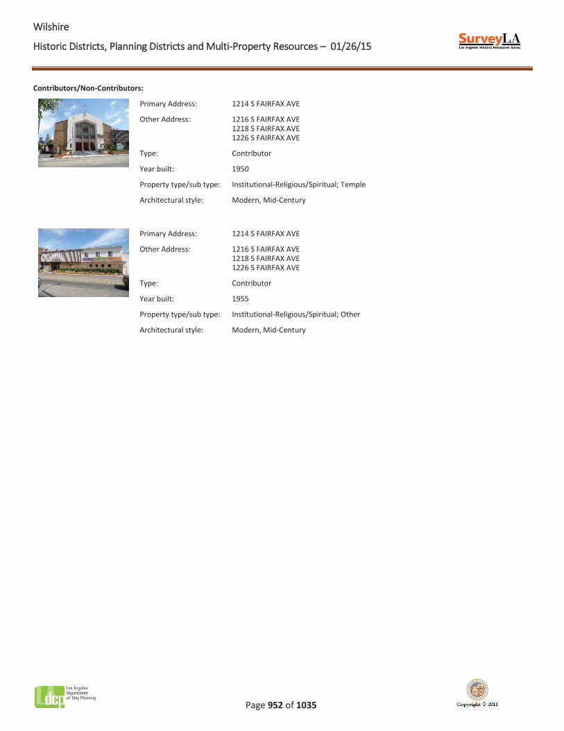
Contributors/Non-Contributors:
Primary Address: 1214 S FAIRFAX AVE
Other Address: 1216 S FAIRFAX AVE 1218 S FAIRFAX AVE 1226 S FAIRFAX AVE
Type: Contributor
Year built: 1950
Property type/sub type: Institutional-Religious/Spiritual; Temple
Architectural style: Modern, Mid-Century
Primary Address: 1214 S FAIRFAX AVE
Other Address: 1216 S FAIRFAX AVE 1218 S FAIRFAX AVE 1226 S FAIRFAX AVE
Type: Contributor
Year built: 1955
Property type/sub type: Institutional-Religious/Spiritual; Other
Architectural style: Modern, Mid-Century
WWilshire
Historic Districts, Planning Districts and Multi-Property Resources – 01/26/15
Page 953 of 1035
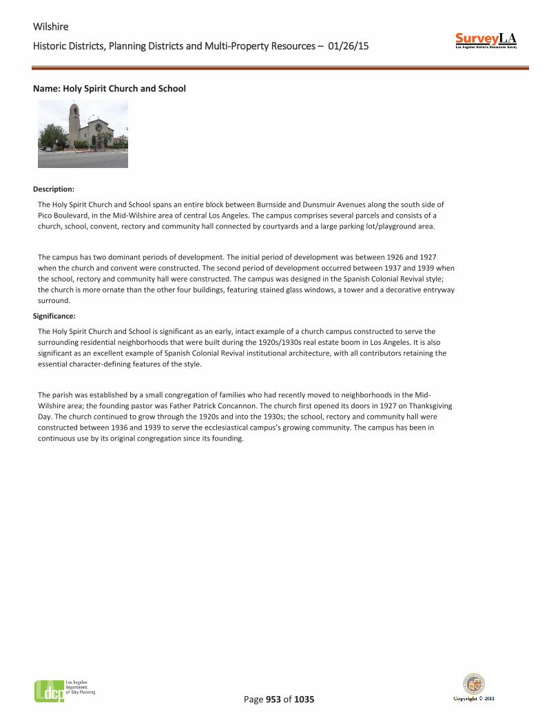
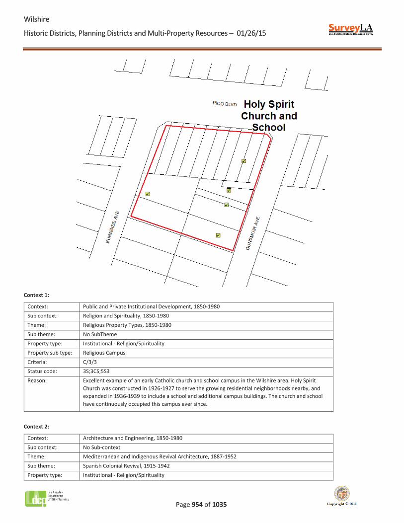
Name: Holy Spirit Church and School
Description:
The Holy Spirit Church and School spans an entire block between Burnside and Dunsmuir Avenues along the south side of Pico Boulevard, in the Mid-Wilshire area of central Los Angeles. The campus comprises several parcels and consists of a church, school, convent, rectory and community hall connected by courtyards and a large parking lot/playground area.
The campus has two dominant periods of development. The initial period of development was between 1926 and 1927 when the church and convent were constructed. The second period of development occurred between 1937 and 1939 when the school, rectory and community hall were constructed. The campus was designed in the Spanish Colonial Revival style; the church is more ornate than the other four buildings, featuring stained glass windows, a tower and a decorative entryway surround.
Significance:
The Holy Spirit Church and School is significant as an early, intact example of a church campus constructed to serve the surrounding residential neighborhoods that were built during the 1920s/1930s real estate boom in Los Angeles. It is also significant as an excellent example of Spanish Colonial Revival institutional architecture, with all contributors retaining the essential character-defining features of the style.
The parish was established by a small congregation of families who had recently moved to neighborhoods in the Mid-Wilshire area; the founding pastor was Father Patrick Concannon. The church first opened its doors in 1927 on Thanksgiving Day. The church continued to grow through the 1920s and into the 1930s; the school, rectory and community hall were constructed between 1936 and 1939 to serve the ecclesiastical campus’s growing community. The campus has been in continuous use by its original congregation since its founding.
WWilshire
Historic Districts, Planning Districts and Multi-Property Resources – 01/26/15
Page 954 of 1035
Context 1:
Context: Public and Private Institutional Development, 1850-1980 Sub context: Religion and Spirituality, 1850-1980 Theme: Religious Property Types, 1850-1980 Sub theme: No SubTheme Property type: Institutional - Religion/Spirituality Property sub type: Religious Campus Criteria: C/3/3 Status code: 3S;3CS;5S3 Reason: Excellent example of an early Catholic church and school campus in the Wilshire area. Holy Spirit
Church was constructed in 1926-1927 to serve the growing residential neighborhoods nearby, and expanded in 1936-1939 to include a school and additional campus buildings. The church and school have continuously occupied this campus ever since.
Context 2:
Context: Architecture and Engineering, 1850-1980 Sub context: No Sub-context Theme: Mediterranean and Indigenous Revival Architecture, 1887-1952 Sub theme: Spanish Colonial Revival, 1915-1942 Property type: Institutional - Religion/Spirituality
WWilshire
Historic Districts, Planning Districts and Multi-Property Resources – 01/26/15
Page 955 of 1035
Property sub type: Church Criteria: C/3/3 Status code: 3S;3CS;5S3 Reason: Excellent example of Spanish Colonial Revival institutional architecture in the Wilshire area. The
district contributors retain all essential character defining features of the style.
Contributors/Non-Contributors:
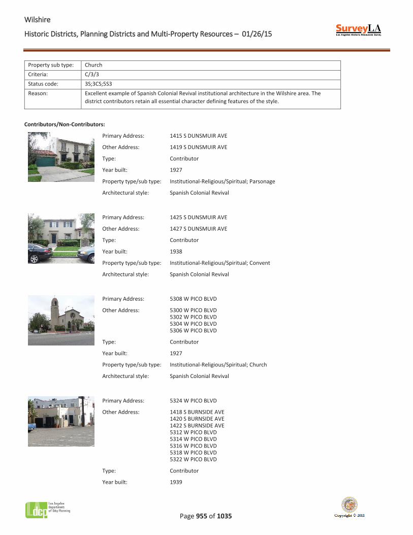
Primary Address: 1415 S DUNSMUIR AVE
Other Address: 1419 S DUNSMUIR AVE
Type: Contributor
Year built: 1927
Property type/sub type: Institutional-Religious/Spiritual; Parsonage
Architectural style: Spanish Colonial Revival
Primary Address: 1425 S DUNSMUIR AVE
Other Address: 1427 S DUNSMUIR AVE
Type: Contributor
Year built: 1938
Property type/sub type: Institutional-Religious/Spiritual; Convent
Architectural style: Spanish Colonial Revival
Primary Address: 5308 W PICO BLVD
Other Address: 5300 W PICO BLVD 5302 W PICO BLVD 5304 W PICO BLVD 5306 W PICO BLVD
Type: Contributor
Year built: 1927
Property type/sub type: Institutional-Religious/Spiritual; Church
Architectural style: Spanish Colonial Revival
Primary Address: 5324 W PICO BLVD
Other Address: 1418 S BURNSIDE AVE 1420 S BURNSIDE AVE 1422 S BURNSIDE AVE 5312 W PICO BLVD
5314 W PICO BLVD 5316 W PICO BLVD 5318 W PICO BLVD 5322 W PICO BLVD
Type: Contributor
Year built: 1939
WWilshire
Historic Districts, Planning Districts and Multi-Property Resources – 01/26/15
Page 956 of 1035
Property type/sub type: Institutional-Religious/Spiritual; Other
Architectural style: Spanish Colonial Revival
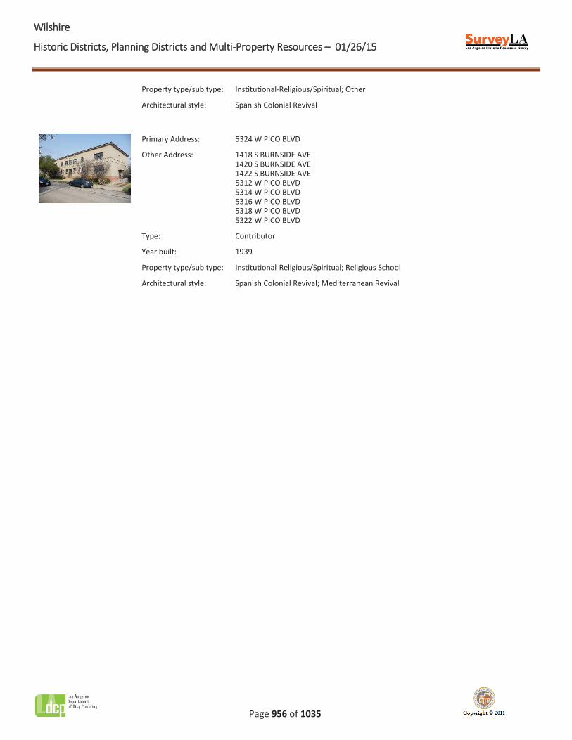
Primary Address: 5324 W PICO BLVD
Other Address: 1418 S BURNSIDE AVE 1420 S BURNSIDE AVE 1422 S BURNSIDE AVE 5312 W PICO BLVD
5314 W PICO BLVD 5316 W PICO BLVD 5318 W PICO BLVD 5322 W PICO BLVD
Type: Contributor
Year built: 1939
Property type/sub type: Institutional-Religious/Spiritual; Religious School
Architectural style: Spanish Colonial Revival; Mediterranean Revival
WWilshire
Historic Districts, Planning Districts and Multi-Property Resources – 01/26/15
Page 957 of 1035
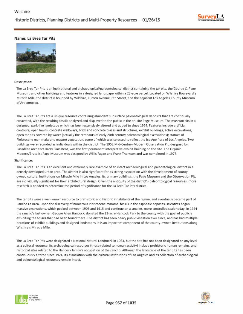
Name: La Brea Tar Pits
Description:
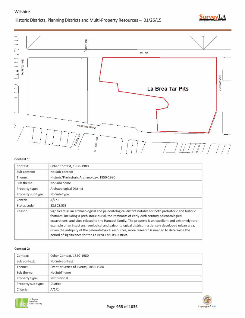
The La Brea Tar Pits is an institutional and archaeological/paleontological district containing the tar pits, the George C. Page Museum, and other buildings and features in a designed landscape within a 23-acre parcel. Located on Wilshire Boulevard’s Miracle Mile, the district is bounded by Wilshire, Curson Avenue, 6th Street, and the adjacent Los Angeles County Museum of Art complex.
The La Brea Tar Pits are a unique resource containing abundant subsurface paleontological deposits that are continually excavated, with the resulting fossils analyzed and displayed to the public in the on-site Page Museum. The museum sits in a designed, park-like landscape which has been extensively altered and added to since 1924. Features include artificial contours; open lawns; concrete walkways; brick and concrete plazas and structures; exhibit buildings; active excavations; open tar pits covered by water (actually the remnants of early 20th century paleontological excavations); statues of Pleistocene mammals; and mature vegetation, some of which was selected to reflect the Ice Age flora of Los Angeles. Two buildings were recorded as individuals within the district. The 1952 Mid-Century Modern Observation Pit, designed by Pasadena architect Harry Sims Bent, was the first permanent interpretive exhibit building on the site. The Organic Modern/Brutalist Page Museum was designed by Willis Fagan and Frank Thornton and was completed in 1977.
Significance:
The La Brea Tar Pits is an excellent and extremely rare example of an intact archaeological and paleontological district in a densely developed urban area. The district is also significant for its strong association with the development of county-owned cultural institutions on Miracle Mile in Los Angeles. Its primary buildings, the Page Museum and the Observation Pit, are individually significant for their architectural design. Given the antiquity of the district’s paleontological resources, more research is needed to determine the period of significance for the La Brea Tar Pits district.
The tar pits were a well-known resource to prehistoric and historic inhabitants of the region, and eventually became part of Rancho La Brea. Upon the discovery of numerous Pleistocene mammal fossils in the asphaltic deposits, scientists began massive excavations, which peaked between 1905 and 1915 and continue on a smaller, more controlled scale today. In 1924 the rancho’s last owner, George Allen Hancock, donated the 23-acre Hancock Park to the county with the goal of publicly exhibiting the fossils that had been found there. The district has seen heavy public visitation ever since, and has had multiple iterations of exhibit buildings and designed landscapes. It is an important component of the county-owned institutions along Wilshire’s Miracle Mile.
The La Brea Tar Pits were designated a National Natural Landmark in 1963, but the site has not been designated on any level as a cultural resource. Its archaeological resources (those related to human activity) include prehistoric human remains, and historical sites related to the Hancock family’s occupation of the rancho. Although the landscape of the tar pits has been continuously altered since 1924, its association with the cultural institutions of Los Angeles and its collection of archeological and paleontological resources remain intact.
WWilshire
Historic Districts, Planning Districts and Multi-Property Resources – 01/26/15
Page 958 of 1035
Context 1:
Context: Other Context, 1850-1980 Sub context: No Sub-context Theme: Historic/Prehistoric Archaeology, 1850-1980 Sub theme: No SubTheme Property type: Archaeological District Property sub type: No Sub-Type Criteria: A/1/1 Status code: 3S;3CS;5S3 Reason: Significant as an archaeological and paleontological district notable for both prehistoric and historic
features, including a prehistoric burial, the remnants of early 20th century paleontological excavations, and sites related to the Hancock family. The property is an excellent and extremely rare example of an intact archaeological and paleontological district in a densely developed urban area. Given the antiquity of the paleontological resources, more research is needed to determine the period of significance for the La Brea Tar Pits District.
Context 2:
Context: Other Context, 1850-1980 Sub context: No Sub-context Theme: Event or Series of Events, 1850-1980 Sub theme: No SubTheme Property type: Institutional Property sub type: District Criteria: A/1/1
WWilshire
Historic Districts, Planning Districts and Multi-Property Resources – 01/26/15
Page 959 of 1035
Status code: 3S;3CS;5S3 Reason: Significant for its association with the development of county-owned cultural institutions along
Miracle Mile in Los Angeles. George Allen Hancock donated this parcel to the county in 1924, and the district has been open to the public ever since.
WWilshire
Historic Districts, Planning Districts and Multi-Property Resources – 01/26/15
Page 960 of 1035
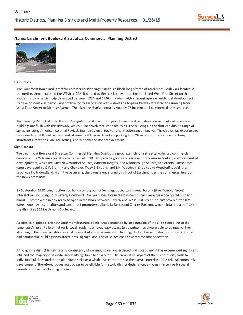
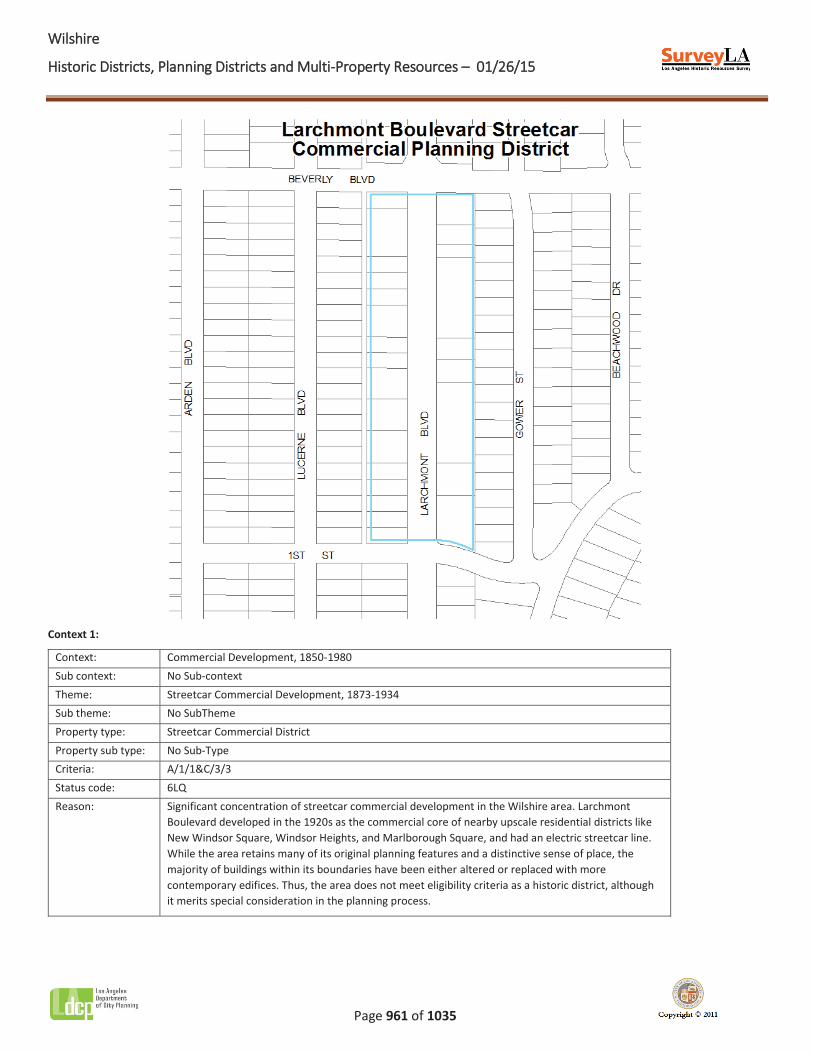
Name: Larchmont Boulevard Streetcar Commercial Planning District
Description:
The Larchmont Boulevard Streetcar Commercial Planning District is a block-long stretch of Larchmont Boulevard located in the northeastern section of the Wilshire CPA. Bounded by Beverly Boulevard on the north and West First Street on the south, this commercial strip developed between 1920 and 1930 in tandem with adjacent upscale residential development. Its development was particularly notable for its association with a short Los Angeles Railway streetcar line running from West Third Street to Melrose Avenue. The planning district contains roughly 27 buildings, all commercial or mixed-use.
The Planning District fits into the area’s regular, rectilinear street grid. Its one- and two-story commercial and mixed-use buildings are flush with the sidewalk, which is lined with mature shade trees. The buildings in the district exhibit a range of styles, including American Colonial Revival, Spanish Colonial Revival, and Mediterranean Revival. The district has experienced some modern infill, and replacement of some buildings with surface parking lots. Other alterations include additions, storefront alterations, wall recladding, and window and door replacement.
Significance:
The Larchmont Boulevard Streetcar Commercial Planning District is a good example of a streetcar-oriented commercial corridor in the Wilshire area. It was established in 1920 to provide goods and services to the residents of adjacent residential developments, which included New Windsor Square, Windsor Heights, and Marlborough Square, and others. These areas were developed by O.F. Brant, Harry Chandler, Tracy E. Shoults, and S.H. Woodruff; Shoults and Woodruff would later subdivide Hollywoodland. From the beginning, the owners envisioned this block of Larchmont as the commercial heart of the new community.
By September 1920, construction had begun on a group of buildings at the Larchmont-Beverly (then Temple Street) intersection, including 5210 Beverly Boulevard. One year later, lots in the business district were “practically sold out” and about 30 stores were nearly ready to open in the block between Beverly and West First Street. At least seven of the lots were owned by local realtors and Larchmont promoters Julius J. La Bonte and Charles Ransom, who maintained an office in the district at 132 Larchmont Boulevard.
As soon as it opened, the new Larchmont business district was connected by an extension of the Sixth Street line to the larger Los Angeles Railway network. Local residents enjoyed easy access to downtown, and were able to do most of their shopping in their own neighborhood. As a result of streetcar-oriented planning, the Larchmont district includes mixed-use and commercial buildings with storefronts, signage, and sidewalks designed to accommodate pedestrians.
Although the district largely retains consistency of massing, scale, and architectural vocabulary, it has experienced significant infill and the majority of its individual buildings have been altered. The cumulative impact of these alterations, both to individual buildings and to the planning district as a whole, has compromised the overall integrity of the original commercial development. Therefore, it does not appear to be eligible for historic district designation, although it may merit special consideration in the planning process.
WWilshire
Historic Districts, Planning Districts and Multi-Property Resources – 01/26/15
Page 961 of 1035
Context 1:
Context: Commercial Development, 1850-1980 Sub context: No Sub-context Theme: Streetcar Commercial Development, 1873-1934 Sub theme: No SubTheme Property type: Streetcar Commercial District Property sub type: No Sub-Type Criteria: A/1/1&C/3/3 Status code: 6LQ Reason: Significant concentration of streetcar commercial development in the Wilshire area. Larchmont
Boulevard developed in the 1920s as the commercial core of nearby upscale residential districts like New Windsor Square, Windsor Heights, and Marlborough Square, and had an electric streetcar line. While the area retains many of its original planning features and a distinctive sense of place, the majority of buildings within its boundaries have been either altered or replaced with more contemporary edifices. Thus, the area does not meet eligibility criteria as a historic district, although it merits special consideration in the planning process.
WWilshire
Historic Districts, Planning Districts and Multi-Property Resources – 01/26/15
Page 962 of 1035
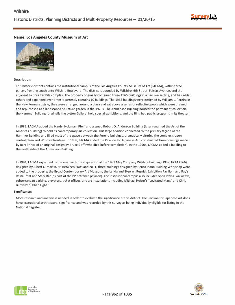
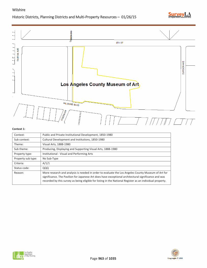
Name: Los Angeles County Museum of Art
Description:
This historic district contains the institutional campus of the Los Angeles County Museum of Art (LACMA), within three parcels fronting south onto Wilshire Boulevard. The district is bounded by Wilshire, 6th Street, Fairfax Avenue, and the adjacent La Brea Tar Pits complex. The property originally contained three 1965 buildings in a pavilion setting, and has added others and expanded over time; it currently contains 10 buildings. The 1965 buildings were designed by William L. Pereira in the New Formalist style; they were arranged around a plaza and sat above a series of reflecting pools which were drained and repurposed as a landscaped sculpture garden in the 1970s. The Ahmanson Building housed the permanent collection, the Hammer Building (originally the Lytton Gallery) held special exhibitions, and the Bing had public programs in its theater.
In 1986, LACMA added the Hardy, Holzman, Pfeiffer-designed Robert O. Anderson Building (later renamed the Art of the Americas building) to hold its contemporary art collection. This large addition connected to the primary façade of the Hammer Building and filled most of the space between the Pereira buildings, dramatically altering the complex’s open central plaza and Wilshire frontage. In 1988, LACMA added the Pavilion for Japanese Art, constructed from drawings made by Bart Prince of an original design by Bruce Goff (who died before completion). In the 1990s, LACMA added a building to the north side of the Ahmanson Building.
In 1994, LACMA expanded to the west with the acquisition of the 1939 May Company Wilshire building (1939, HCM #566), designed by Albert C. Martin, Sr. Between 2008 and 2011, three buildings designed by Renzo Piano Building Workshop were added to the property: the Broad Contemporary Art Museum, the Lynda and Stewart Resnick Exhibition Pavilion, and Ray’s Restaurant and Stark Bar (as part of the BP entrance pavilion). The institutional campus also includes open lawns, walkways, subterranean parking, elevators, ticket offices, and art installations including Michael Heizer’s “Levitated Mass” and Chris Burden’s “Urban Light."
Significance:
More research and analysis is needed in order to evaluate the significance of this district. The Pavilion for Japanese Art does have exceptional architectural significance and was recorded by this survey as being individually eligible for listing in the National Register.
WWilshire
Historic Districts, Planning Districts and Multi-Property Resources – 01/26/15
Page 963 of 1035
Context 1:
Context: Public and Private Institutional Development, 1850-1980 Sub context: Cultural Development and Institutions, 1850-1980 Theme: Visual Arts, 1888-1980 Sub theme: Producing, Displaying and Supporting Visual Arts, 1888-1980 Property type: Institutional - Visual and Performing Arts Property sub type: No Sub-Type Criteria: A/1/1 Status code: QQQ Reason: More research and analysis is needed in order to evaluate the Los Angeles County Museum of Art for
significance. The Pavilion for Japanese Art does have exceptional architectural significance and was recorded by this survey as being eligible for listing in the National Register as an individual property.
WWilshire
Historic Districts, Planning Districts and Multi-Property Resources – 01/26/15
Page 964 of 1035
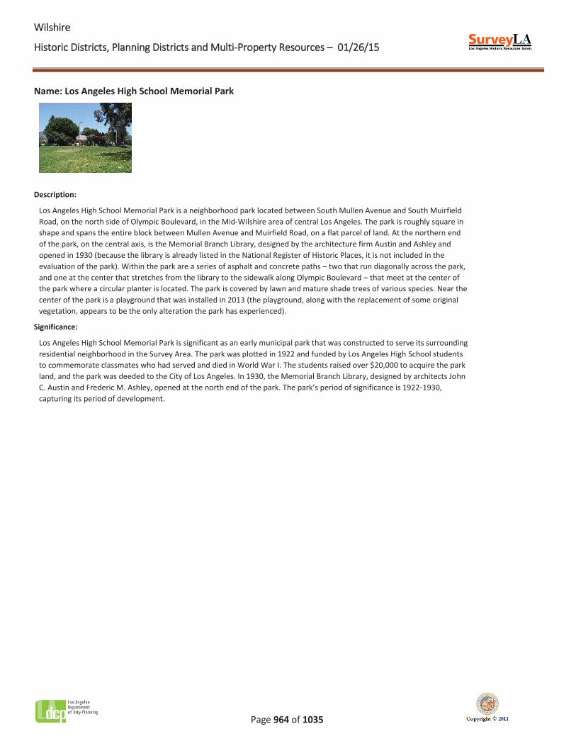
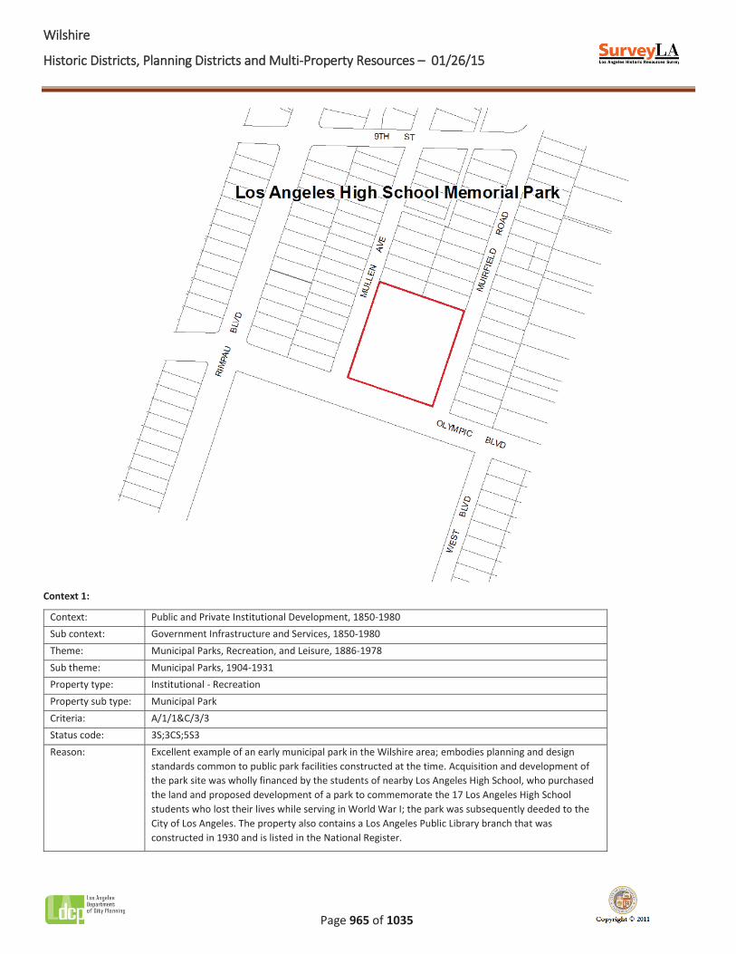
Name: Los Angeles High School Memorial Park
Description:
Los Angeles High School Memorial Park is a neighborhood park located between South Mullen Avenue and South Muirfield Road, on the north side of Olympic Boulevard, in the Mid-Wilshire area of central Los Angeles. The park is roughly square in shape and spans the entire block between Mullen Avenue and Muirfield Road, on a flat parcel of land. At the northern end of the park, on the central axis, is the Memorial Branch Library, designed by the architecture firm Austin and Ashley and opened in 1930 (because the library is already listed in the National Register of Historic Places, it is not included in the evaluation of the park). Within the park are a series of asphalt and concrete paths – two that run diagonally across the park, and one at the center that stretches from the library to the sidewalk along Olympic Boulevard – that meet at the center of the park where a circular planter is located. The park is covered by lawn and mature shade trees of various species. Near the center of the park is a playground that was installed in 2013 (the playground, along with the replacement of some original vegetation, appears to be the only alteration the park has experienced).
Significance:
Los Angeles High School Memorial Park is significant as an early municipal park that was constructed to serve its surrounding residential neighborhood in the Survey Area. The park was plotted in 1922 and funded by Los Angeles High School students to commemorate classmates who had served and died in World War I. The students raised over $20,000 to acquire the park land, and the park was deeded to the City of Los Angeles. In 1930, the Memorial Branch Library, designed by architects John C. Austin and Frederic M. Ashley, opened at the north end of the park. The park’s period of significance is 1922-1930, capturing its period of development.
WWilshire
Historic Districts, Planning Districts and Multi-Property Resources – 01/26/15
Page 965 of 1035
Context 1:
Context: Public and Private Institutional Development, 1850-1980 Sub context: Government Infrastructure and Services, 1850-1980 Theme: Municipal Parks, Recreation, and Leisure, 1886-1978 Sub theme: Municipal Parks, 1904-1931 Property type: Institutional - Recreation Property sub type: Municipal Park Criteria: A/1/1&C/3/3 Status code: 3S;3CS;5S3 Reason: Excellent example of an early municipal park in the Wilshire area; embodies planning and design
standards common to public park facilities constructed at the time. Acquisition and development of the park site was wholly financed by the students of nearby Los Angeles High School, who purchased the land and proposed development of a park to commemorate the 17 Los Angeles High School students who lost their lives while serving in World War I; the park was subsequently deeded to the City of Los Angeles. The property also contains a Los Angeles Public Library branch that was constructed in 1930 and is listed in the National Register.
WWilshire
Historic Districts, Planning Districts and Multi-Property Resources – 01/26/15
Page 966 of 1035
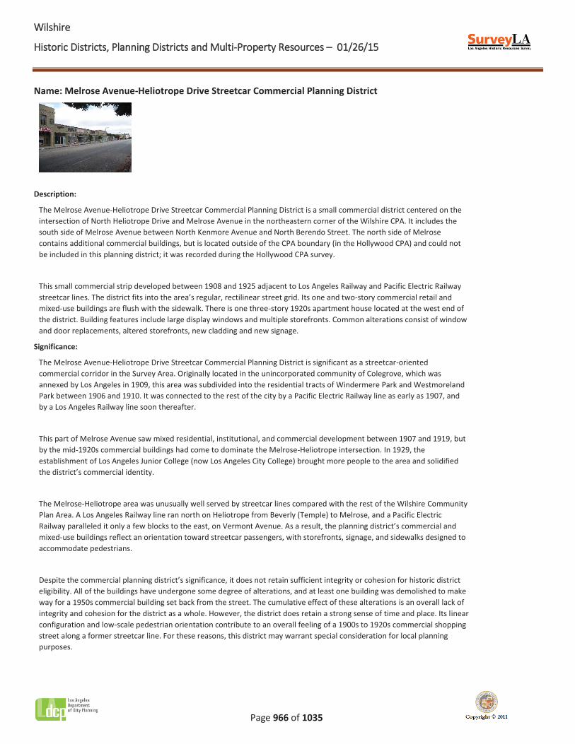
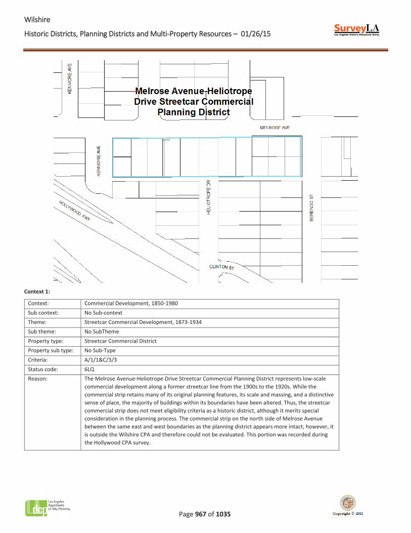
Name: Melrose Avenue-Heliotrope Drive Streetcar Commercial Planning District
Description:
The Melrose Avenue-Heliotrope Drive Streetcar Commercial Planning District is a small commercial district centered on the intersection of North Heliotrope Drive and Melrose Avenue in the northeastern corner of the Wilshire CPA. It includes the south side of Melrose Avenue between North Kenmore Avenue and North Berendo Street. The north side of Melrose contains additional commercial buildings, but is located outside of the CPA boundary (in the Hollywood CPA) and could not be included in this planning district; it was recorded during the Hollywood CPA survey.
This small commercial strip developed between 1908 and 1925 adjacent to Los Angeles Railway and Pacific Electric Railway streetcar lines. The district fits into the area’s regular, rectilinear street grid. Its one and two-story commercial retail and mixed-use buildings are flush with the sidewalk. There is one three-story 1920s apartment house located at the west end of the district. Building features include large display windows and multiple storefronts. Common alterations consist of window and door replacements, altered storefronts, new cladding and new signage.
Significance:
The Melrose Avenue-Heliotrope Drive Streetcar Commercial Planning District is significant as a streetcar-oriented commercial corridor in the Survey Area. Originally located in the unincorporated community of Colegrove, which was annexed by Los Angeles in 1909, this area was subdivided into the residential tracts of Windermere Park and Westmoreland Park between 1906 and 1910. It was connected to the rest of the city by a Pacific Electric Railway line as early as 1907, and by a Los Angeles Railway line soon thereafter.
This part of Melrose Avenue saw mixed residential, institutional, and commercial development between 1907 and 1919, but by the mid-1920s commercial buildings had come to dominate the Melrose-Heliotrope intersection. In 1929, the establishment of Los Angeles Junior College (now Los Angeles City College) brought more people to the area and solidified the district’s commercial identity.
The Melrose-Heliotrope area was unusually well served by streetcar lines compared with the rest of the Wilshire Community Plan Area. A Los Angeles Railway line ran north on Heliotrope from Beverly (Temple) to Melrose, and a Pacific Electric Railway paralleled it only a few blocks to the east, on Vermont Avenue. As a result, the planning district’s commercial and mixed-use buildings reflect an orientation toward streetcar passengers, with storefronts, signage, and sidewalks designed to accommodate pedestrians.
Despite the commercial planning district’s significance, it does not retain sufficient integrity or cohesion for historic district eligibility. All of the buildings have undergone some degree of alterations, and at least one building was demolished to make way for a 1950s commercial building set back from the street. The cumulative effect of these alterations is an overall lack of integrity and cohesion for the district as a whole. However, the district does retain a strong sense of time and place. Its linear configuration and low-scale pedestrian orientation contribute to an overall feeling of a 1900s to 1920s commercial shopping street along a former streetcar line. For these reasons, this district may warrant special consideration for local planning purposes.
WWilshire
Historic Districts, Planning Districts and Multi-Property Resources – 01/26/15
Page 967 of 1035
Context 1:
Context: Commercial Development, 1850-1980 Sub context: No Sub-context Theme: Streetcar Commercial Development, 1873-1934 Sub theme: No SubTheme Property type: Streetcar Commercial District Property sub type: No Sub-Type Criteria: A/1/1&C/3/3 Status code: 6LQ Reason: The Melrose Avenue-Heliotrope Drive Streetcar Commercial Planning District represents low-scale
commercial development along a former streetcar line from the 1900s to the 1920s. While the commercial strip retains many of its original planning features, its scale and massing, and a distinctive sense of place, the majority of buildings within its boundaries have been altered. Thus, the streetcar commercial strip does not meet eligibility criteria as a historic district, although it merits special consideration in the planning process. The commercial strip on the north side of Melrose Avenue between the same east and west boundaries as the planning district appears more intact; however, it is outside the Wilshire CPA and therefore could not be evaluated. This portion was recorded during the Hollywood CPA survey.
WWilshire
Historic Districts, Planning Districts and Multi-Property Resources – 01/26/15
Page 968 of 1035
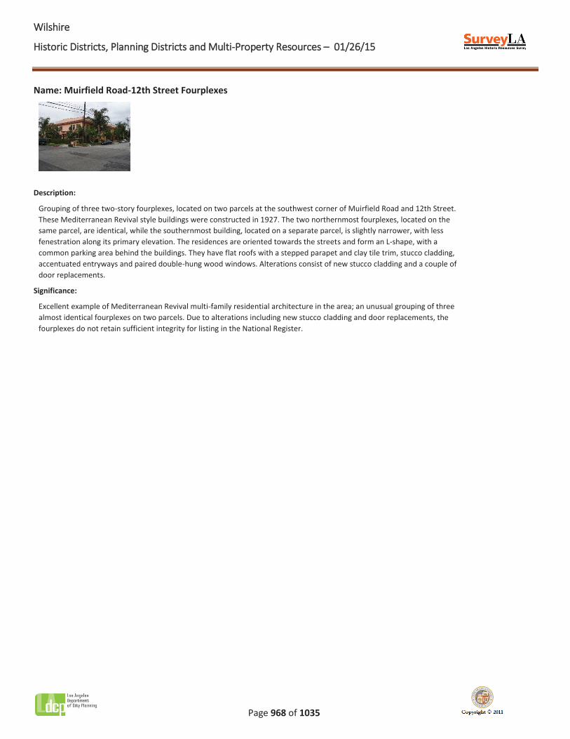
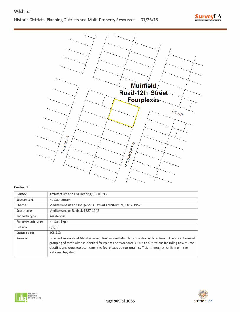
Name: Muirfield Road-12th Street Fourplexes
Description:
Grouping of three two-story fourplexes, located on two parcels at the southwest corner of Muirfield Road and 12th Street. These Mediterranean Revival style buildings were constructed in 1927. The two northernmost fourplexes, located on the same parcel, are identical, while the southernmost building, located on a separate parcel, is slightly narrower, with less fenestration along its primary elevation. The residences are oriented towards the streets and form an L-shape, with a common parking area behind the buildings. They have flat roofs with a stepped parapet and clay tile trim, stucco cladding, accentuated entryways and paired double-hung wood windows. Alterations consist of new stucco cladding and a couple of door replacements.
Significance:
Excellent example of Mediterranean Revival multi-family residential architecture in the area; an unusual grouping of three almost identical fourplexes on two parcels. Due to alterations including new stucco cladding and door replacements, the fourplexes do not retain sufficient integrity for listing in the National Register.
WWilshire
Historic Districts, Planning Districts and Multi-Property Resources – 01/26/15
Page 969 of 1035
Context 1:
Context: Architecture and Engineering, 1850-1980 Sub context: No Sub-context Theme: Mediterranean and Indigenous Revival Architecture, 1887-1952 Sub theme: Mediterranean Revival, 1887-1942 Property type: Residential Property sub type: No Sub-Type Criteria: C/3/3 Status code: 3CS;5S3 Reason: Excellent example of Mediterranean Revival multi-family residential architecture in the area. Unusual
grouping of three almost identical fourplexes on two parcels. Due to alterations including new stucco cladding and door replacements, the fourplexes do not retain sufficient integrity for listing in the National Register.

WWilshire
Historic Districts, Planning Districts and Multi-Property Resources – 01/26/15
Page 970 of 1035
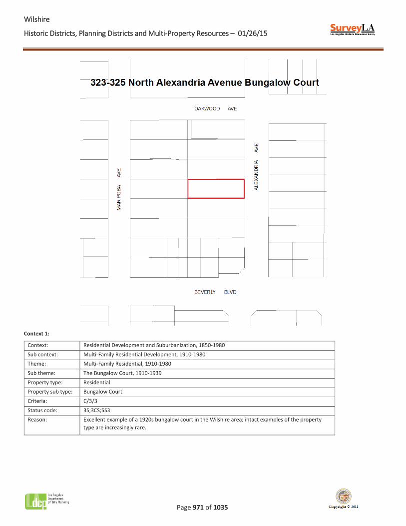
Name: 323-325 North Alexandria Avenue Bungalow Court
Description:
The 323-325 North Alexandria Avenue Bungalow Court occupies a single residential parcel in the northeast section of the Wilshire CPA. The property consists of four single-story Spanish Colonial Revival style bungalows that are oriented inward, and one two-story Spanish Colonial Revival style bungalow that spans the rear of the property and faces the street. The buildings open into a narrow central court that provides access to individual units; the court is landscaped with shrubs and groundcover, bisected by a concrete path, and accessed by a set of concrete steps. Alterations include the addition of a perimeter fence and the replacement of some windows and doors.
Significance:
The 323-325 North Alexandria Avenue Bungalow Court is an excellent example of an intact 1920s bungalow court in the Wilshire CPA. Once a common residential property type in Los Angeles, bungalow courts that remain intact are increasingly rare. Constructed in 1927, this bungalow court is one of few remaining examples in the area that retains its original site plan, landscape and hardscape elements, and architectural features.
WWilshire
Historic Districts, Planning Districts and Multi-Property Resources – 01/26/15
Page 971 of 1035
Context 1:
Context: Residential Development and Suburbanization, 1850-1980 Sub context: Multi-Family Residential Development, 1910-1980 Theme: Multi-Family Residential, 1910-1980 Sub theme: The Bungalow Court, 1910-1939 Property type: Residential Property sub type: Bungalow Court Criteria: C/3/3 Status code: 3S;3CS;5S3 Reason: Excellent example of a 1920s bungalow court in the Wilshire area; intact examples of the property
type are increasingly rare.
WWilshire
Historic Districts, Planning Districts and Multi-Property Resources – 01/26/15
Page 972 of 1035
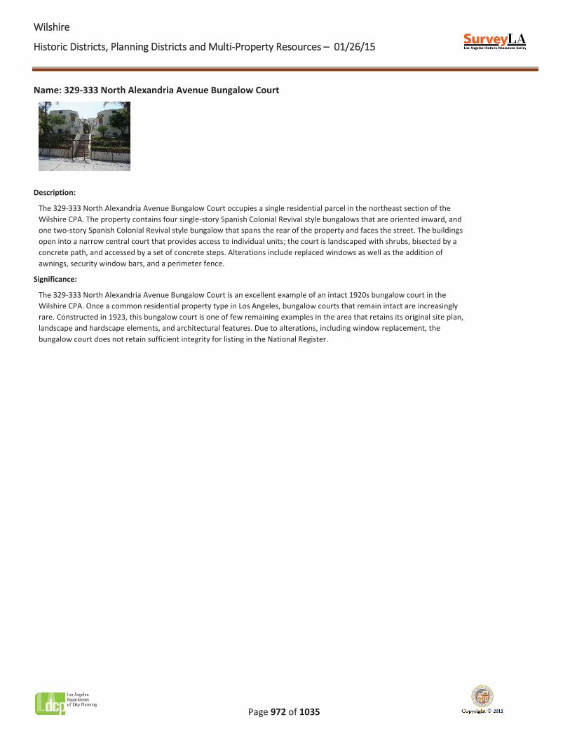
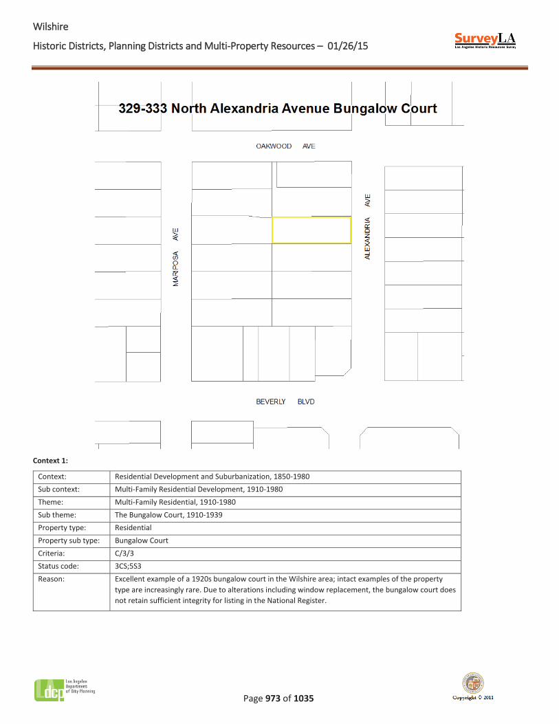
Name: 329-333 North Alexandria Avenue Bungalow Court
Description:
The 329-333 North Alexandria Avenue Bungalow Court occupies a single residential parcel in the northeast section of the Wilshire CPA. The property contains four single-story Spanish Colonial Revival style bungalows that are oriented inward, and one two-story Spanish Colonial Revival style bungalow that spans the rear of the property and faces the street. The buildings open into a narrow central court that provides access to individual units; the court is landscaped with shrubs, bisected by a concrete path, and accessed by a set of concrete steps. Alterations include replaced windows as well as the addition of awnings, security window bars, and a perimeter fence.
Significance:
The 329-333 North Alexandria Avenue Bungalow Court is an excellent example of an intact 1920s bungalow court in the Wilshire CPA. Once a common residential property type in Los Angeles, bungalow courts that remain intact are increasingly rare. Constructed in 1923, this bungalow court is one of few remaining examples in the area that retains its original site plan, landscape and hardscape elements, and architectural features. Due to alterations, including window replacement, the bungalow court does not retain sufficient integrity for listing in the National Register.
WWilshire
Historic Districts, Planning Districts and Multi-Property Resources – 01/26/15
Page 973 of 1035
Context 1:
Context: Residential Development and Suburbanization, 1850-1980 Sub context: Multi-Family Residential Development, 1910-1980 Theme: Multi-Family Residential, 1910-1980 Sub theme: The Bungalow Court, 1910-1939 Property type: Residential Property sub type: Bungalow Court Criteria: C/3/3 Status code: 3CS;5S3 Reason: Excellent example of a 1920s bungalow court in the Wilshire area; intact examples of the property
type are increasingly rare. Due to alterations including window replacement, the bungalow court does not retain sufficient integrity for listing in the National Register.
WWilshire
Historic Districts, Planning Districts and Multi-Property Resources – 01/26/15
Page 974 of 1035
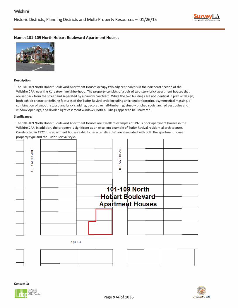
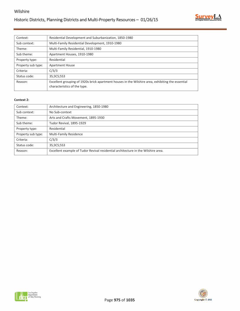
Name: 101-109 North Hobart Boulevard Apartment Houses
Description:
The 101-109 North Hobart Boulevard Apartment Houses occupy two adjacent parcels in the northeast section of the Wilshire CPA, near the Koreatown neighborhood. The property consists of a pair of two-story brick apartment houses that are set back from the street and separated by a narrow courtyard. While the two buildings are not identical in plan or design, both exhibit character defining features of the Tudor Revival style including an irregular footprint, asymmetrical massing, a combination of smooth stucco and brick cladding, decorative half-timbering, steeply pitched roofs, arched vestibules and window openings, and divided light casement windows. Both buildings appear to be unaltered.
Significance:
The 101-109 North Hobart Boulevard Apartment Houses are excellent examples of 1920s brick apartment houses in the Wilshire CPA. In addition, the property is significant as an excellent example of Tudor Revival residential architecture. Constructed in 1922, the apartment houses exhibit characteristics that are associated with both the apartment house property type and the Tudor Revival style.
Context 1:
WWilshire
Historic Districts, Planning Districts and Multi-Property Resources – 01/26/15
Page 975 of 1035
Context: Residential Development and Suburbanization, 1850-1980 Sub context: Multi-Family Residential Development, 1910-1980 Theme: Multi-Family Residential, 1910-1980 Sub theme: Apartment Houses, 1910-1980 Property type: Residential Property sub type: Apartment House Criteria: C/3/3 Status code: 3S;3CS;5S3 Reason: Excellent grouping of 1920s brick apartment houses in the Wilshire area, exhibiting the essential
characteristics of the type.
Context 2:
Context: Architecture and Engineering, 1850-1980 Sub context: No Sub-context Theme: Arts and Crafts Movement, 1895-1930 Sub theme: Tudor Revival, 1895-1929 Property type: Residential Property sub type: Multi-Family Residence Criteria: C/3/3 Status code: 3S;3CS;5S3 Reason: Excellent example of Tudor Revival residential architecture in the Wilshire area.

WWilshire
Historic Districts, Planning Districts and Multi-Property Resources – 01/26/15
Page 976 of 1035
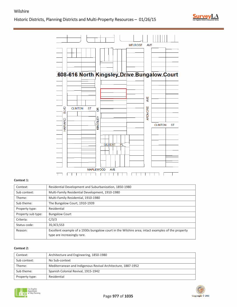
Name: 608-616 North Kingsley Drive Bungalow Court
Description:
The 608-616 North Kingsley Drive Bungalow Court occupies three adjacent residential parcels in the northeast section of the Wilshire CPA. The property consists of four two-story Spanish Colonial Revival style bungalows that are oriented inward, and one two-story Spanish Colonial Revival style bungalow that spans the length of the property and faces the street. The buildings open into a central court that provides access to individual units; the court is planted with mature vegetation and features two parallel concrete paths. An archway functions as the portal to the central court. Alterations include the addition of security window bars and a perimeter fence, as well as the replacement of some windows.
Significance:
The 608-616 North Kingsley Drive Bungalow Court is an excellent example of an intact 1930s bungalow court in the Wilshire CPA. The property is also significant as an excellent example of Spanish Colonial Revival residential architecture. Once a common residential property type in Los Angeles, bungalow courts that remain intact are increasingly rare. Constructed in 1930, this bungalow court is one of few remaining examples in the area that retains its original site plan, landscape and hardscape elements, and architectural features.
WWilshire
Historic Districts, Planning Districts and Multi-Property Resources – 01/26/15
Page 977 of 1035
Context 1:
Context: Residential Development and Suburbanization, 1850-1980 Sub context: Multi-Family Residential Development, 1910-1980 Theme: Multi-Family Residential, 1910-1980 Sub theme: The Bungalow Court, 1910-1939 Property type: Residential Property sub type: Bungalow Court Criteria: C/3/3 Status code: 3S;3CS;5S3 Reason: Excellent example of a 1930s bungalow court in the Wilshire area; intact examples of the property
type are increasingly rare.
Context 2:
Context: Architecture and Engineering, 1850-1980 Sub context: No Sub-context Theme: Mediterranean and Indigenous Revival Architecture, 1887-1952 Sub theme: Spanish Colonial Revival, 1915-1942 Property type: Residential
WWilshire
Historic Districts, Planning Districts and Multi-Property Resources – 01/26/15
Page 978 of 1035
Property sub type: Bungalow Court Criteria: C/3/3 Status code: 3S;3CS;5S3 Reason: Excellent example of Spanish Colonial Revival residential architecture in the Wilshire area.
WWilshire
Historic Districts, Planning Districts and Multi-Property Resources – 01/26/15
Page 979 of 1035
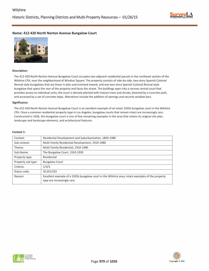
Name: 412-420 North Norton Avenue Bungalow Court
Description:
The 412-420 North Norton Avenue Bungalow Court occupies two adjacent residential parcels in the northeast section of the Wilshire CPA, near the neighborhood of Windsor Square. The property consists of side-by-side, two-story Spanish Colonial Revival style bungalows that are linear in plan and oriented inward, and one two-story Spanish Colonial Revival style bungalow that spans the rear of the property and faces the street. The buildings open into a narrow central court that provides access to individual units; the court is densely planted with mature trees and shrubs, bisected by a concrete path, and accessed by a set of concrete steps. Alterations include the addition of awnings and security window bars.
Significance:
The 412-420 North Norton Avenue Bungalow Court is an excellent example of an intact 1920s bungalow court in the Wilshire CPA. Once a common residential property type in Los Angeles, bungalow courts that remain intact are increasingly rare. Constructed in 1926, this bungalow court is one of few remaining examples in the area that retains its original site plan, landscape and hardscape elements, and architectural features.
Context 1:
Context: Residential Development and Suburbanization, 1850-1980 Sub context: Multi-Family Residential Development, 1910-1980 Theme: Multi-Family Residential, 1910-1980 Sub theme: The Bungalow Court, 1910-1939 Property type: Residential Property sub type: Bungalow Court Criteria: C/3/3 Status code: 3S;3CS;5S3 Reason: Excellent example of a 1920s bungalow court in the Wilshire area; intact examples of the property
type are increasingly rare.

WWilshire
Historic Districts, Planning Districts and Multi-Property Resources – 01/26/15
Page 980 of 1035
Name: 424-430 North Norton Avenue Bungalow Court
Description:
The 424-430 North Norton Avenue Bungalow Court occupies two adjacent residential parcels in the northeast section of the Wilshire CPA, near the neighborhood of Windsor Square. The property consists of four single-story Spanish Colonial Revival style bungalows that are oriented inward, and one two-story Spanish Colonial Revival style bungalow that spans the rear of the property and faces the street. The buildings open into a narrow central court that provides access to individual units; the court is planted with shrubs, bisected by parallel concrete paths, and accessed by a set of concrete steps. Alterations include the addition of awnings and security doors.
Significance:
The 424-430 North Norton Avenue Bungalow Court is an excellent example of an intact 1920s bungalow court in the Wilshire CPA. Once a common residential property type in Los Angeles, bungalow courts that remain intact are increasingly rare. Constructed in 1924, this bungalow court is one of few remaining examples in the area that retains its original site plan, landscape and hardscape elements, and architectural features.
Context 1:
Context: Residential Development and Suburbanization, 1850-1980 Sub context: Multi-Family Residential Development, 1910-1980
WWilshire
Historic Districts, Planning Districts and Multi-Property Resources – 01/26/15
Page 981 of 1035
Theme: Multi-Family Residential, 1910-1980 Sub theme: The Bungalow Court, 1910-1939 Property type: Residential Property sub type: Bungalow Court Criteria: C/3/3 Status code: 3S;3CS;5S3 Reason: Excellent example of a 1920s bungalow court in the Wilshire area; intact examples of the property
type are increasingly rare.
WWilshire
Historic Districts, Planning Districts and Multi-Property Resources – 01/26/15
Page 982 of 1035
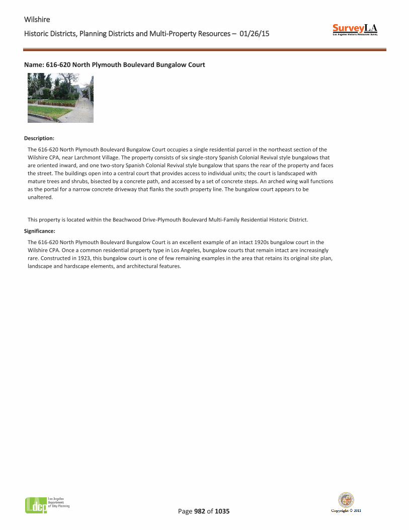
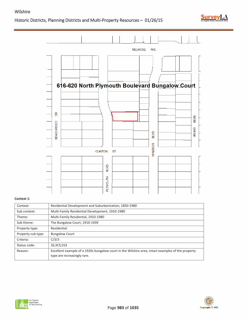
Name: 616-620 North Plymouth Boulevard Bungalow Court
Description:
The 616-620 North Plymouth Boulevard Bungalow Court occupies a single residential parcel in the northeast section of the Wilshire CPA, near Larchmont Village. The property consists of six single-story Spanish Colonial Revival style bungalows that are oriented inward, and one two-story Spanish Colonial Revival style bungalow that spans the rear of the property and faces the street. The buildings open into a central court that provides access to individual units; the court is landscaped with mature trees and shrubs, bisected by a concrete path, and accessed by a set of concrete steps. An arched wing wall functions as the portal for a narrow concrete driveway that flanks the south property line. The bungalow court appears to be unaltered.
This property is located within the Beachwood Drive-Plymouth Boulevard Multi-Family Residential Historic District.
Significance:
The 616-620 North Plymouth Boulevard Bungalow Court is an excellent example of an intact 1920s bungalow court in the Wilshire CPA. Once a common residential property type in Los Angeles, bungalow courts that remain intact are increasingly rare. Constructed in 1923, this bungalow court is one of few remaining examples in the area that retains its original site plan, landscape and hardscape elements, and architectural features.
WWilshire
Historic Districts, Planning Districts and Multi-Property Resources – 01/26/15
Page 983 of 1035
Context 1:
Context: Residential Development and Suburbanization, 1850-1980 Sub context: Multi-Family Residential Development, 1910-1980 Theme: Multi-Family Residential, 1910-1980 Sub theme: The Bungalow Court, 1910-1939 Property type: Residential Property sub type: Bungalow Court Criteria: C/3/3 Status code: 3S;3CS;5S3 Reason: Excellent example of a 1920s bungalow court in the Wilshire area; intact examples of the property
type are increasingly rare.
WWilshire
Historic Districts, Planning Districts and Multi-Property Resources – 01/26/15
Page 984 of 1035
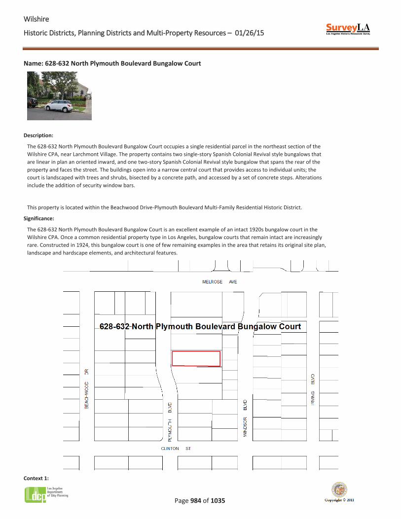
Name: 628-632 North Plymouth Boulevard Bungalow Court
Description:
The 628-632 North Plymouth Boulevard Bungalow Court occupies a single residential parcel in the northeast section of the Wilshire CPA, near Larchmont Village. The property contains two single-story Spanish Colonial Revival style bungalows that are linear in plan an oriented inward, and one two-story Spanish Colonial Revival style bungalow that spans the rear of the property and faces the street. The buildings open into a narrow central court that provides access to individual units; the court is landscaped with trees and shrubs, bisected by a concrete path, and accessed by a set of concrete steps. Alterations include the addition of security window bars.
This property is located within the Beachwood Drive-Plymouth Boulevard Multi-Family Residential Historic District.
Significance:
The 628-632 North Plymouth Boulevard Bungalow Court is an excellent example of an intact 1920s bungalow court in the Wilshire CPA. Once a common residential property type in Los Angeles, bungalow courts that remain intact are increasingly rare. Constructed in 1924, this bungalow court is one of few remaining examples in the area that retains its original site plan, landscape and hardscape elements, and architectural features.
Context 1:

WWilshire
Historic Districts, Planning Districts and Multi-Property Resources – 01/26/15
Page 985 of 1035
Context: Residential Development and Suburbanization, 1850-1980 Sub context: Multi-Family Residential Development, 1910-1980 Theme: Multi-Family Residential, 1910-1980 Sub theme: The Bungalow Court, 1910-1939 Property type: Residential Property sub type: Bungalow Court Criteria: C/3/3 Status code: 3S;3CS;5S3 Reason: Excellent example of a 1920s bungalow court in the Wilshire area; intact examples of the property
type are increasingly rare.
WWilshire
Historic Districts, Planning Districts and Multi-Property Resources – 01/26/15
Page 986 of 1035
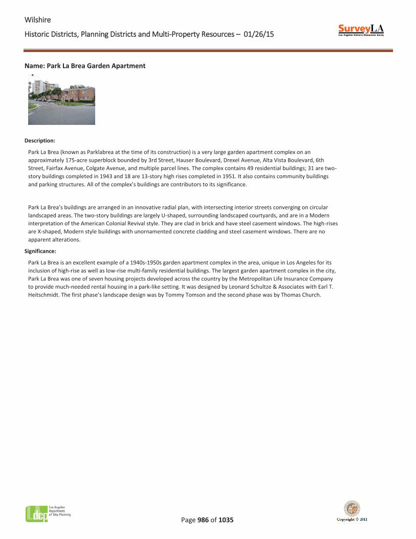
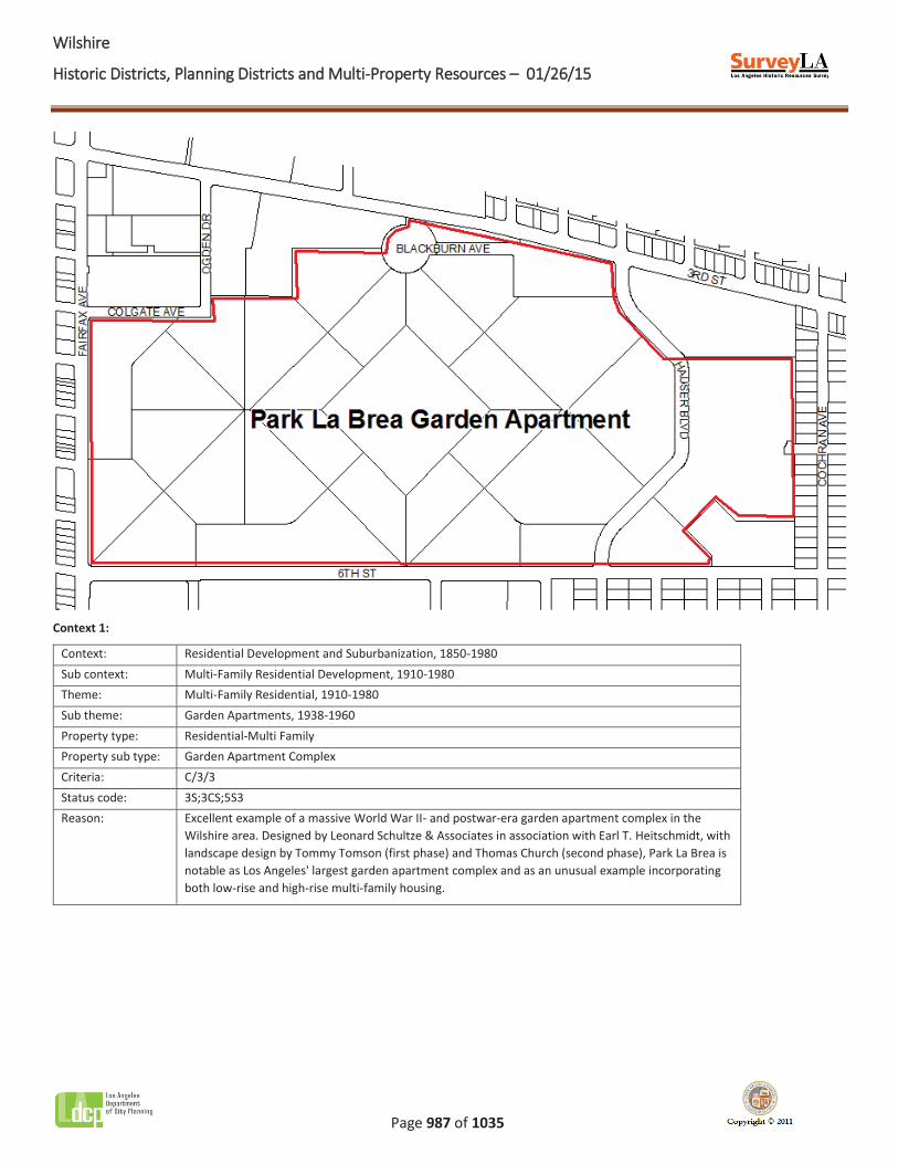
Name: Park La Brea Garden Apartment
Description:
Park La Brea (known as Parklabrea at the time of its construction) is a very large garden apartment complex on an approximately 175-acre superblock bounded by 3rd Street, Hauser Boulevard, Drexel Avenue, Alta Vista Boulevard, 6th Street, Fairfax Avenue, Colgate Avenue, and multiple parcel lines. The complex contains 49 residential buildings; 31 are two-story buildings completed in 1943 and 18 are 13-story high rises completed in 1951. It also contains community buildings and parking structures. All of the complex’s buildings are contributors to its significance.
Park La Brea’s buildings are arranged in an innovative radial plan, with intersecting interior streets converging on circular landscaped areas. The two-story buildings are largely U-shaped, surrounding landscaped courtyards, and are in a Modern interpretation of the American Colonial Revival style. They are clad in brick and have steel casement windows. The high-rises are X-shaped, Modern style buildings with unornamented concrete cladding and steel casement windows. There are no apparent alterations.
Significance:
Park La Brea is an excellent example of a 1940s-1950s garden apartment complex in the area, unique in Los Angeles for its inclusion of high-rise as well as low-rise multi-family residential buildings. The largest garden apartment complex in the city, Park La Brea was one of seven housing projects developed across the country by the Metropolitan Life Insurance Company to provide much-needed rental housing in a park-like setting. It was designed by Leonard Schultze & Associates with Earl T. Heitschmidt. The first phase’s landscape design was by Tommy Tomson and the second phase was by Thomas Church.
WWilshire
Historic Districts, Planning Districts and Multi-Property Resources – 01/26/15
Page 987 of 1035
Context 1:
Context: Residential Development and Suburbanization, 1850-1980 Sub context: Multi-Family Residential Development, 1910-1980 Theme: Multi-Family Residential, 1910-1980 Sub theme: Garden Apartments, 1938-1960 Property type: Residential-Multi Family Property sub type: Garden Apartment Complex Criteria: C/3/3 Status code: 3S;3CS;5S3 Reason: Excellent example of a massive World War II- and postwar-era garden apartment complex in the
Wilshire area. Designed by Leonard Schultze & Associates in association with Earl T. Heitschmidt, with landscape design by Tommy Tomson (first phase) and Thomas Church (second phase), Park La Brea is notable as Los Angeles' largest garden apartment complex and as an unusual example incorporating both low-rise and high-rise multi-family housing.
WWilshire
Historic Districts, Planning Districts and Multi-Property Resources – 01/26/15
Page 988 of 1035
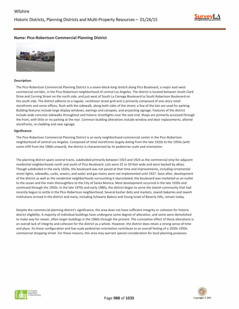
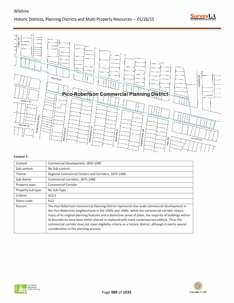
Name: Pico-Robertson Commercial Planning District
Description:
The Pico-Robertson Commercial Planning District is a seven-block-long stretch along Pico Boulevard, a major east-west commercial corridor, in the Pico-Robertson neighborhood of central Los Angeles. The district is located between South Clark Drive and Corning Street on the north side, and just west of South La Cienega Boulevard to South Robertson Boulevard on the south side. The district adheres to a regular, rectilinear street grid and is primarily composed of one-story retail storefronts and some offices, flush with the sidewalk, along both sides of the street; a few of the lots are used for parking. Building features include large display windows, awnings and canopies, and projecting signage. Features of the district include wide concrete sidewalks throughout and historic streetlights near the east end. Shops are primarily accessed through the front, with little or no parking at the rear. Common building alterations include window and door replacements, altered storefronts, re-cladding and new signage.
Significance:
The Pico-Robertson Commercial Planning District is an early neighborhood commercial center in the Pico-Robertson neighborhood of central Los Angeles. Composed of retail storefronts largely dating from the late 1920s to the 1950s (with some infill from the 1960s onward), the district is characterized by its pedestrian scale and orientation.
The planning district spans several tracts, subdivided primarily between 1923 and 1924 as the commercial strip for adjacent residential neighborhoods north and south of Pico Boulevard. Lots were 25 to 50 feet wide and were backed by alleys. Though subdivided in the early 1920s, the boulevard was not paved at that time and improvements, including ornamental street lights, sidewalks, curbs, sewers, and water and gas mains were not implemented until 1927. Soon after, development of the district as well as the residential neighborhoods surrounding it skyrocketed; the boulevard was marketed as an outlet to the ocean and the main thoroughfare to the City of Santa Monica. Most development occurred in the late 1920s and continued through the 1950s. In the late 1970s and early 1980s, the district began to serve the Jewish community that had recently begun to settle in the Pico-Robertson neighborhood. Several kosher delis and markets, Jewish bakeries and Jewish institutions arrived in the district and many, including Schwartz Bakery and Young Israel of Beverly Hills, remain today.
Despite the commercial planning district’s significance, the area does not have sufficient integrity or cohesion for historic district eligibility. A majority of individual buildings have undergone some degree of alteration, and some were demolished to make way for newer, often larger buildings in the 1960s through the present. The cumulative effect of these alterations is an overall lack of integrity and cohesion for the district as a whole. However, the district does retain a strong sense of time and place. Its linear configuration and low-scale pedestrian orientation contribute to an overall feeling of a 1920s-1950s commercial shopping street. For these reasons, this area may warrant special consideration for local planning purposes.
WWilshire
Historic Districts, Planning Districts and Multi-Property Resources – 01/26/15
Page 989 of 1035
Context 1:
Context: Commercial Development, 1850-1980 Sub context: No Sub-context Theme: Regional Commercial Centers and Corridors, 1875-1980 Sub theme: Commercial Corridors, 1875-1980 Property type: Commercial Corridor Property sub type: No Sub-Type Criteria: A/1/1 Status code: 6LQ Reason: The Pico-Robertson Commercial Planning District represents low-scale commercial development in
the Pico-Robertson neighborhood in the 1930s and 1940s. While the commercial corridor retains many of its original planning features and a distinctive sense of place, the majority of buildings within its boundaries have been either altered or replaced with more contemporary edifices. Thus, the commercial corridor does not meet eligibility criteria as a historic district, although it merits special consideration in the planning process.
WWilshire
Historic Districts, Planning Districts and Multi-Property Resources – 01/26/15
Page 990 of 1035
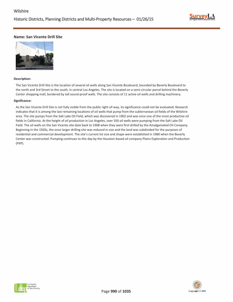
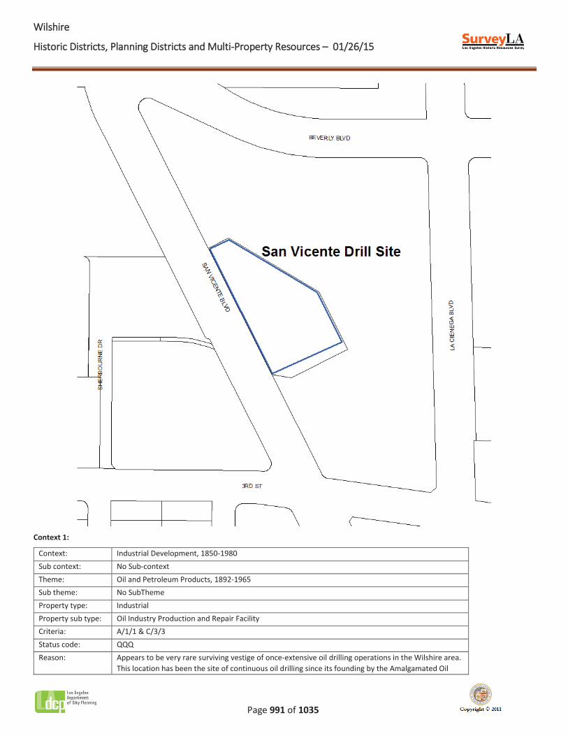
Name: San Vicente Drill Site
Description:
The San Vicente Drill Site is the location of several oil wells along San Vicente Boulevard, bounded by Beverly Boulevard to the north and 3rd Street to the south, in central Los Angeles. The site is located on a semi-circular parcel behind the Beverly Center shopping mall, bordered by tall sound-proof walls. The site consists of 11 active oil wells and drilling machinery.
Significance:
As the San Vicente Drill Site is not fully visible from the public right-of-way, its significance could not be evaluated. Research indicates that it is among the last remaining locations of oil wells that pump from the subterranean oil fields of the Wilshire area. The site pumps from the Salt Lake Oil Field, which was discovered in 1902 and was once one of the most productive oil fields in California. At the height of oil production in Los Angeles, over 350 oil wells were pumping from the Salt Lake Oil Field. The oil wells on the San Vicente site date back to 1908 when they were first drilled by the Amalgamated Oil Company. Beginning in the 1920s, the once larger drilling site was reduced in size and the land was subdivided for the purposes of residential and commercial development. The site’s current lot size and shape were established in 1980 when the Beverly Center was constructed. Pumping continues to this day by the Houston-based oil company Plains Exploration and Production (PXP).
WWilshire
Historic Districts, Planning Districts and Multi-Property Resources – 01/26/15
Page 991 of 1035
Context 1:
Context: Industrial Development, 1850-1980 Sub context: No Sub-context Theme: Oil and Petroleum Products, 1892-1965 Sub theme: No SubTheme Property type: Industrial Property sub type: Oil Industry Production and Repair Facility Criteria: A/1/1 & C/3/3 Status code: QQQ Reason: Appears to be very rare surviving vestige of once-extensive oil drilling operations in the Wilshire area.
This location has been the site of continuous oil drilling since its founding by the Amalgamated Oil
WWilshire
Historic Districts, Planning Districts and Multi-Property Resources – 01/26/15
Page 992 of 1035
Company in 1908. However, the property is not fully visible from the public right-of-way and therefore could not be evaluated for significance.
WWilshire
Historic Districts, Planning Districts and Multi-Property Resources – 01/26/15
Page 993 of 1035
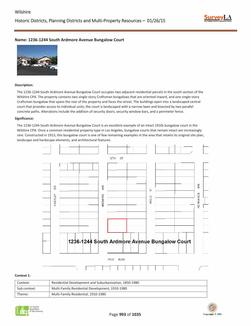
Name: 1236-1244 South Ardmore Avenue Bungalow Court
Description:
The 1236-1244 South Ardmore Avenue Bungalow Court occupies two adjacent residential parcels in the south section of the Wilshire CPA. The property contains two single-story Craftsman bungalows that are oriented inward, and one single-story Craftsman bungalow that spans the rear of the property and faces the street. The buildings open into a landscaped central court that provides access to individual units; the court is landscaped with a narrow lawn and bisected by two parallel concrete paths. Alterations include the addition of security doors, security window bars, and a perimeter fence.
Significance:
The 1236-1244 South Ardmore Avenue Bungalow Court is an excellent example of an intact 1910s bungalow court in the Wilshire CPA. Once a common residential property type in Los Angeles, bungalow courts that remain intact are increasingly rare. Constructed in 1913, this bungalow court is one of few remaining examples in the area that retains its original site plan, landscape and hardscape elements, and architectural features.
Context 1:
Context: Residential Development and Suburbanization, 1850-1980 Sub context: Multi-Family Residential Development, 1910-1980 Theme: Multi-Family Residential, 1910-1980

WWilshire
Historic Districts, Planning Districts and Multi-Property Resources – 01/26/15
Page 994 of 1035
Sub theme: The Bungalow Court, 1910-1939 Property type: Residential Property sub type: Bungalow Court Criteria: C/3/3 Status code: 3S;3CS;5S3 Reason: Excellent example of a 1910s bungalow court in the Wilshire area; intact examples of the property
type are increasingly rare.
WWilshire
Historic Districts, Planning Districts and Multi-Property Resources – 01/26/15
Page 995 of 1035
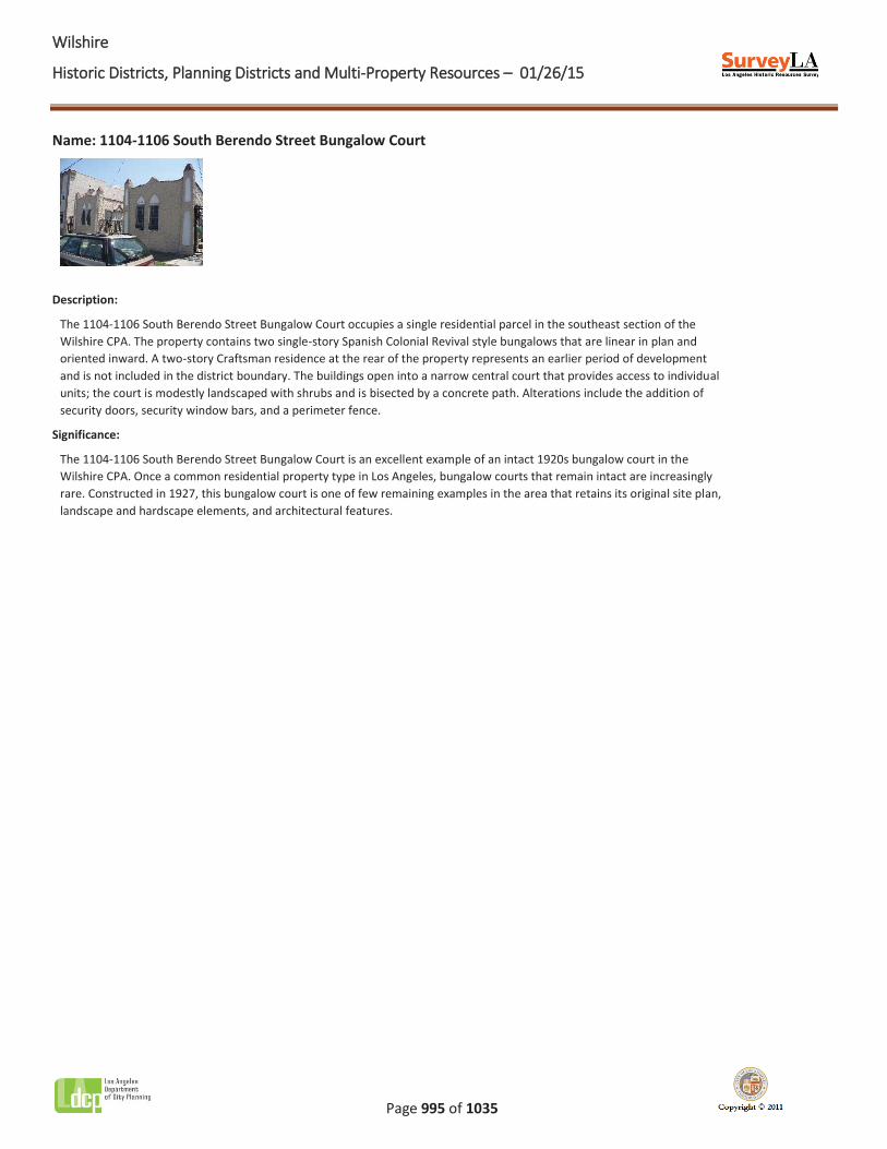
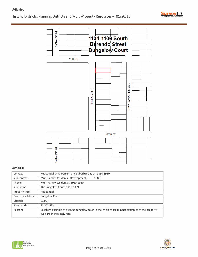
Name: 1104-1106 South Berendo Street Bungalow Court
Description:
The 1104-1106 South Berendo Street Bungalow Court occupies a single residential parcel in the southeast section of the Wilshire CPA. The property contains two single-story Spanish Colonial Revival style bungalows that are linear in plan and oriented inward. A two-story Craftsman residence at the rear of the property represents an earlier period of development and is not included in the district boundary. The buildings open into a narrow central court that provides access to individual units; the court is modestly landscaped with shrubs and is bisected by a concrete path. Alterations include the addition of security doors, security window bars, and a perimeter fence.
Significance:
The 1104-1106 South Berendo Street Bungalow Court is an excellent example of an intact 1920s bungalow court in the Wilshire CPA. Once a common residential property type in Los Angeles, bungalow courts that remain intact are increasingly rare. Constructed in 1927, this bungalow court is one of few remaining examples in the area that retains its original site plan, landscape and hardscape elements, and architectural features.
WWilshire
Historic Districts, Planning Districts and Multi-Property Resources – 01/26/15
Page 996 of 1035
Context 1:
Context: Residential Development and Suburbanization, 1850-1980 Sub context: Multi-Family Residential Development, 1910-1980 Theme: Multi-Family Residential, 1910-1980 Sub theme: The Bungalow Court, 1910-1939 Property type: Residential Property sub type: Bungalow Court Criteria: C/3/3 Status code: 3S;3CS;5S3 Reason: Excellent example of a 1920s bungalow court in the Wilshire area; intact examples of the property
type are increasingly rare.
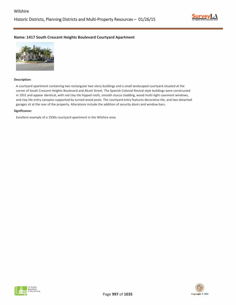
WWilshire
Historic Districts, Planning Districts and Multi-Property Resources – 01/26/15
Page 997 of 1035
Name: 1417 South Crescent Heights Boulevard Courtyard Apartment
Description:
A courtyard apartment containing two rectangular two-story buildings and a small landscaped courtyard situated at the corner of South Crescent Heights Boulevard and Alcott Street. The Spanish Colonial Revival style buildings were constructed in 1931 and appear identical, with red clay tile hipped roofs, smooth stucco cladding, wood multi-light casement windows, and clay tile entry canopies supported by turned wood posts. The courtyard entry features decorative tile, and two detached garages sit at the rear of the property. Alterations include the addition of security doors and window bars.
Significance:
Excellent example of a 1930s courtyard apartment in the Wilshire area.
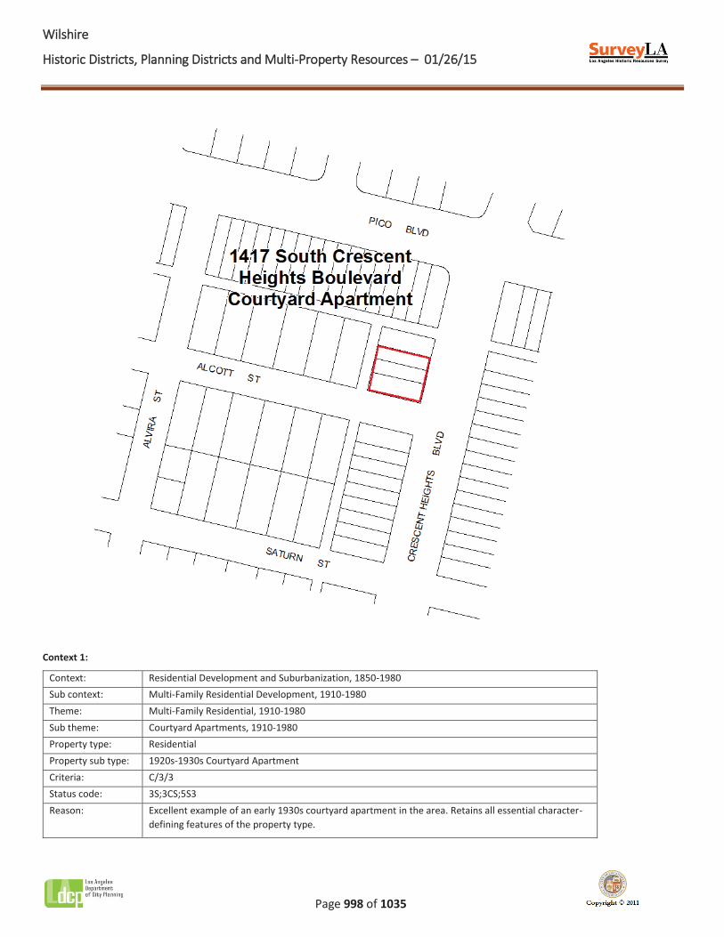
WWilshire
Historic Districts, Planning Districts and Multi-Property Resources – 01/26/15
Page 998 of 1035
Context 1:
Context: Residential Development and Suburbanization, 1850-1980 Sub context: Multi-Family Residential Development, 1910-1980 Theme: Multi-Family Residential, 1910-1980 Sub theme: Courtyard Apartments, 1910-1980 Property type: Residential Property sub type: 1920s-1930s Courtyard Apartment Criteria: C/3/3 Status code: 3S;3CS;5S3 Reason: Excellent example of an early 1930s courtyard apartment in the area. Retains all essential character-
defining features of the property type.
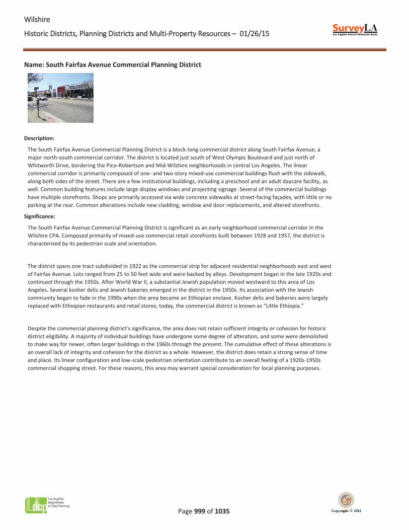
WWilshire
Historic Districts, Planning Districts and Multi-Property Resources – 01/26/15
Page 999 of 1035
Name: South Fairfax Avenue Commercial Planning District
Description:
The South Fairfax Avenue Commercial Planning District is a block-long commercial district along South Fairfax Avenue, a major north-south commercial corridor. The district is located just south of West Olympic Boulevard and just north of Whitworth Drive, bordering the Pico-Robertson and Mid-Wilshire neighborhoods in central Los Angeles. The linear commercial corridor is primarily composed of one- and two-story mixed-use commercial buildings flush with the sidewalk, along both sides of the street. There are a few institutional buildings, including a preschool and an adult daycare facility, as well. Common building features include large display windows and projecting signage. Several of the commercial buildings have multiple storefronts. Shops are primarily accessed via wide concrete sidewalks at street-facing façades, with little or no parking at the rear. Common alterations include new cladding, window and door replacements, and altered storefronts.
Significance:
The South Fairfax Avenue Commercial Planning District is significant as an early neighborhood commercial corridor in the Wilshire CPA. Composed primarily of mixed-use commercial retail storefronts built between 1928 and 1957, the district is characterized by its pedestrian scale and orientation.
The district spans one tract subdivided in 1922 as the commercial strip for adjacent residential neighborhoods east and west of Fairfax Avenue. Lots ranged from 25 to 50 feet wide and were backed by alleys. Development began in the late 1920s and continued through the 1950s. After World War II, a substantial Jewish population moved westward to this area of Los Angeles. Several kosher delis and Jewish bakeries emerged in the district in the 1950s. Its association with the Jewish community began to fade in the 1990s when the area became an Ethiopian enclave. Kosher delis and bakeries were largely replaced with Ethiopian restaurants and retail stores; today, the commercial district is known as “Little Ethiopia.”
Despite the commercial planning district’s significance, the area does not retain sufficient integrity or cohesion for historic district eligibility. A majority of individual buildings have undergone some degree of alteration, and some were demolished to make way for newer, often larger buildings in the 1960s through the present. The cumulative effect of these alterations is an overall lack of integrity and cohesion for the district as a whole. However, the district does retain a strong sense of time and place. Its linear configuration and low-scale pedestrian orientation contribute to an overall feeling of a 1920s-1950s commercial shopping street. For these reasons, this area may warrant special consideration for local planning purposes.
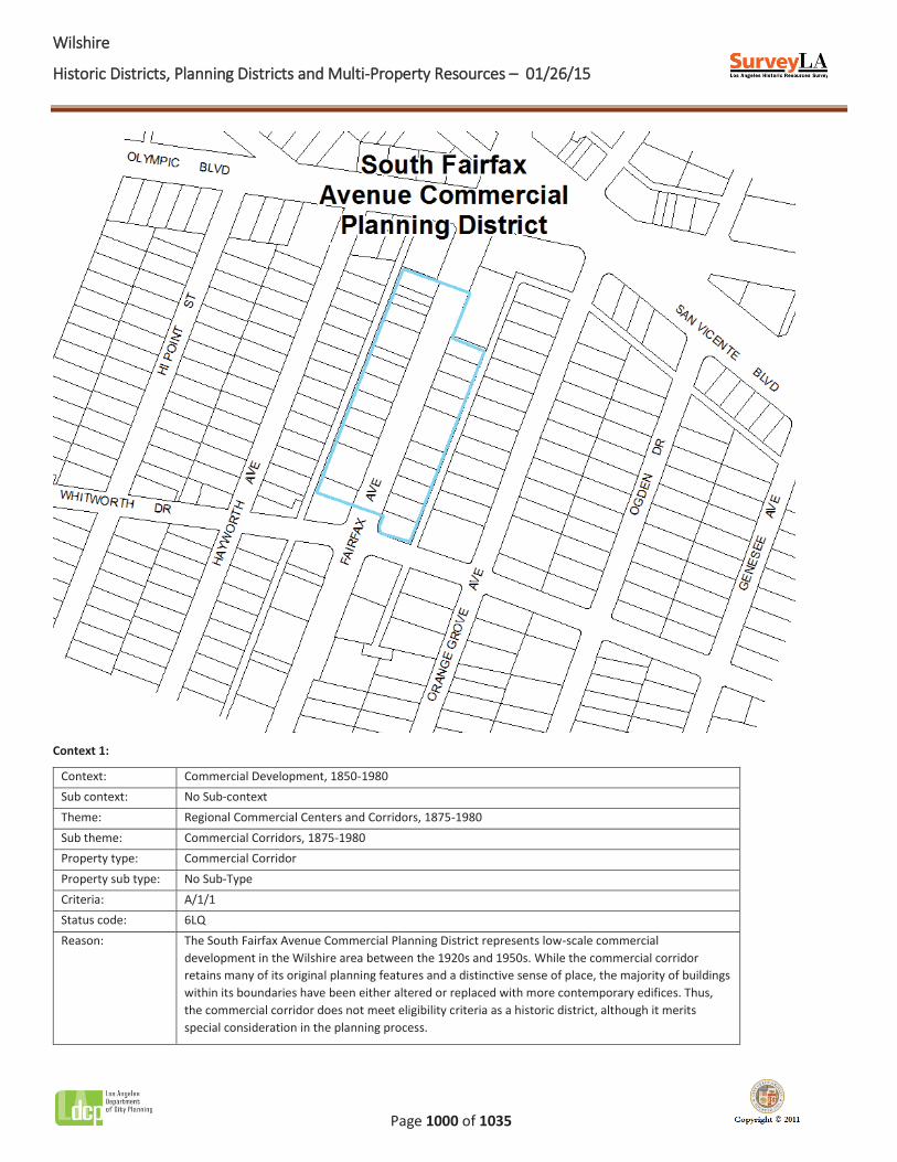
WWilshire
Historic Districts, Planning Districts and Multi-Property Resources – 01/26/15
Page 1000 of 1035
Context 1:
Context: Commercial Development, 1850-1980 Sub context: No Sub-context Theme: Regional Commercial Centers and Corridors, 1875-1980 Sub theme: Commercial Corridors, 1875-1980 Property type: Commercial Corridor Property sub type: No Sub-Type Criteria: A/1/1 Status code: 6LQ Reason: The South Fairfax Avenue Commercial Planning District represents low-scale commercial
development in the Wilshire area between the 1920s and 1950s. While the commercial corridor retains many of its original planning features and a distinctive sense of place, the majority of buildings within its boundaries have been either altered or replaced with more contemporary edifices. Thus, the commercial corridor does not meet eligibility criteria as a historic district, although it merits special consideration in the planning process.
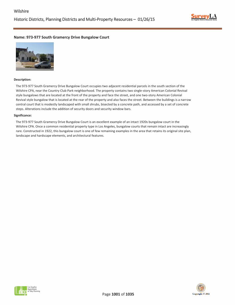
WWilshire
Historic Districts, Planning Districts and Multi-Property Resources – 01/26/15
Page 1001 of 1035
Name: 973-977 South Gramercy Drive Bungalow Court
Description:
The 973-977 South Gramercy Drive Bungalow Court occupies two adjacent residential parcels in the south section of the Wilshire CPA, near the Country Club Park neighborhood. The property contains two single-story American Colonial Revival style bungalows that are located at the front of the property and face the street, and one two-story American Colonial Revival style bungalow that is located at the rear of the property and also faces the street. Between the buildings is a narrow central court that is modestly landscaped with small shrubs, bisected by a concrete path, and accessed by a set of concrete steps. Alterations include the addition of security doors and security window bars.
Significance:
The 973-977 South Gramercy Drive Bungalow Court is an excellent example of an intact 1920s bungalow court in the Wilshire CPA. Once a common residential property type in Los Angeles, bungalow courts that remain intact are increasingly rare. Constructed in 1922, this bungalow court is one of few remaining examples in the area that retains its original site plan, landscape and hardscape elements, and architectural features.
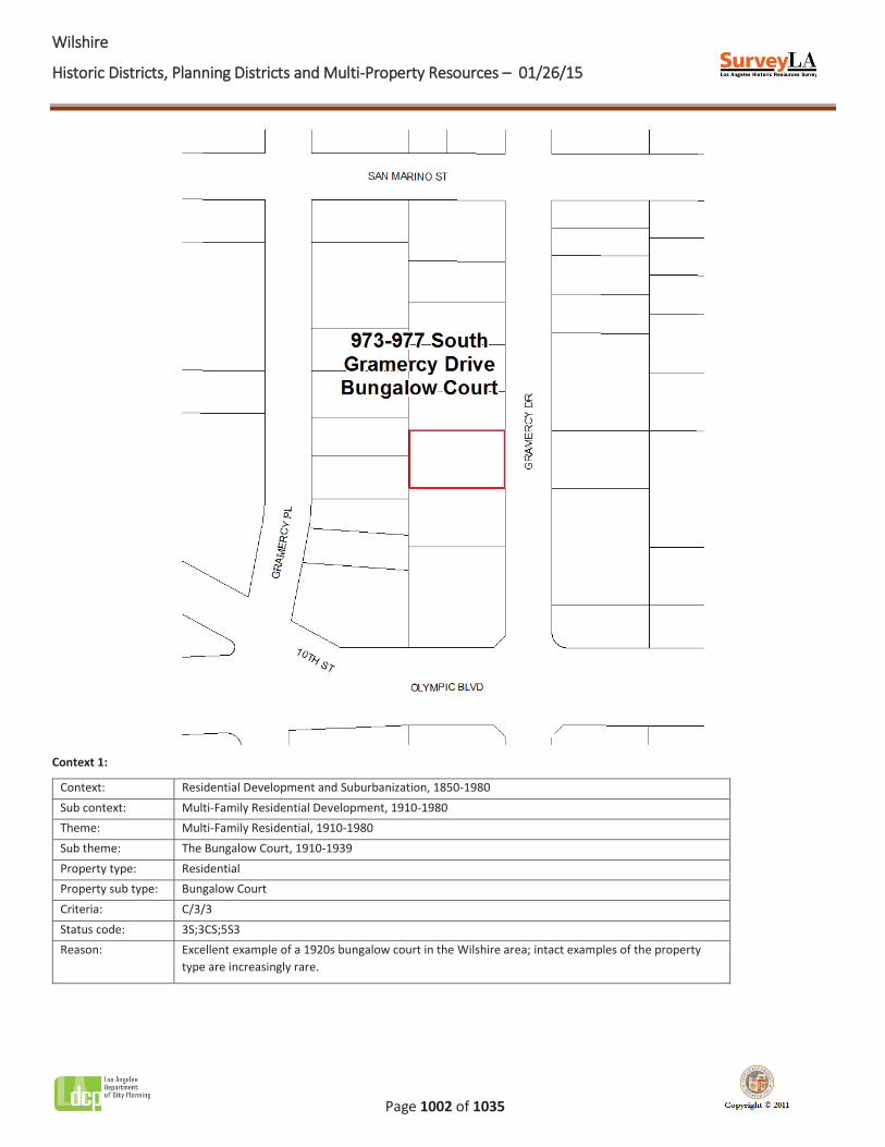
WWilshire
Historic Districts, Planning Districts and Multi-Property Resources – 01/26/15
Page 1002 of 1035
Context 1:
Context: Residential Development and Suburbanization, 1850-1980 Sub context: Multi-Family Residential Development, 1910-1980 Theme: Multi-Family Residential, 1910-1980 Sub theme: The Bungalow Court, 1910-1939 Property type: Residential Property sub type: Bungalow Court Criteria: C/3/3 Status code: 3S;3CS;5S3 Reason: Excellent example of a 1920s bungalow court in the Wilshire area; intact examples of the property
type are increasingly rare.
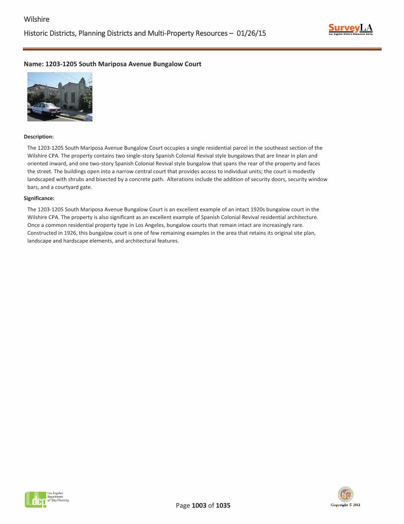
WWilshire
Historic Districts, Planning Districts and Multi-Property Resources – 01/26/15
Page 1003 of 1035
Name: 1203-1205 South Mariposa Avenue Bungalow Court
Description:
The 1203-1205 South Mariposa Avenue Bungalow Court occupies a single residential parcel in the southeast section of the Wilshire CPA. The property contains two single-story Spanish Colonial Revival style bungalows that are linear in plan and oriented inward, and one two-story Spanish Colonial Revival style bungalow that spans the rear of the property and faces the street. The buildings open into a narrow central court that provides access to individual units; the court is modestly landscaped with shrubs and bisected by a concrete path. Alterations include the addition of security doors, security window bars, and a courtyard gate.
Significance:
The 1203-1205 South Mariposa Avenue Bungalow Court is an excellent example of an intact 1920s bungalow court in the Wilshire CPA. The property is also significant as an excellent example of Spanish Colonial Revival residential architecture. Once a common residential property type in Los Angeles, bungalow courts that remain intact are increasingly rare. Constructed in 1926, this bungalow court is one of few remaining examples in the area that retains its original site plan, landscape and hardscape elements, and architectural features.
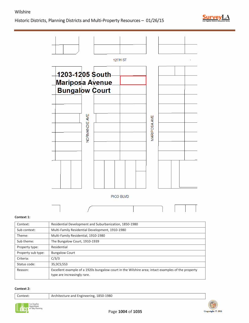
WWilshire
Historic Districts, Planning Districts and Multi-Property Resources – 01/26/15
Page 1004 of 1035
Context 1:
Context: Residential Development and Suburbanization, 1850-1980 Sub context: Multi-Family Residential Development, 1910-1980 Theme: Multi-Family Residential, 1910-1980 Sub theme: The Bungalow Court, 1910-1939 Property type: Residential Property sub type: Bungalow Court Criteria: C/3/3 Status code: 3S;3CS;5S3 Reason: Excellent example of a 1920s bungalow court in the Wilshire area; intact examples of the property
type are increasingly rare.
Context 2:
Context: Architecture and Engineering, 1850-1980
WWilshire
Historic Districts, Planning Districts and Multi-Property Resources – 01/26/15
Page 1005 of 1035
Sub context: No Sub-context Theme: Mediterranean and Indigenous Revival Architecture, 1887-1952 Sub theme: Spanish Colonial Revival, 1915-1942 Property type: Residential Property sub type: Bungalow Court Criteria: C/3/3 Status code: 3S;3CS;5S3 Reason: Excellent example of Spanish Colonial Revival residential architecture in the Wilshire area.

WWilshire
Historic Districts, Planning Districts and Multi-Property Resources – 01/26/15
Page 1006 of 1035
Name: 1216-1218 South Mullen Avenue Bungalow Court
Description:
The 1216-1218 South Mullen Avenue Bungalow Court occupies a single residential parcel in the south section of the Wilshire CPA. The property contains two single-story Spanish Colonial Revival style bungalows that are linear in plan and oriented inward. The buildings open into a narrow central court that provides access to individual units; the court is modestly landscaped with shrubs and bisected by a concrete walkway. A stucco archway functions as the portal to the central court. Alterations include the addition of security doors, security window bars, and a perimeter fence.
Significance:
The 1216-1218 South Mullen Avenue Bungalow Court is an excellent example of an intact 1920s bungalow court in the Wilshire CPA. Once a common residential property type in Los Angeles, bungalow courts that remain intact are increasingly rare. Constructed in 1923, this bungalow court is one of few remaining examples in the area that retains its original site plan, landscape and hardscape elements, and architectural features.
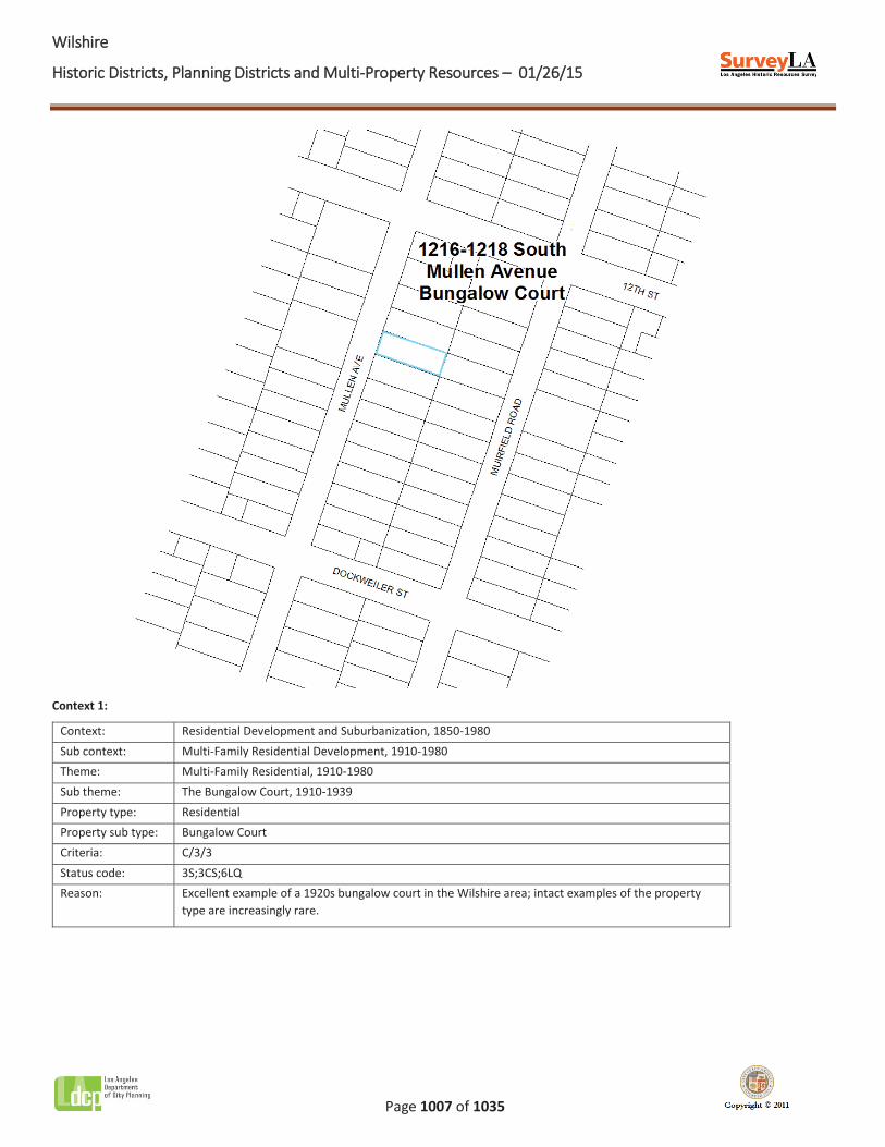
WWilshire
Historic Districts, Planning Districts and Multi-Property Resources – 01/26/15
Page 1007 of 1035
Context 1:
Context: Residential Development and Suburbanization, 1850-1980 Sub context: Multi-Family Residential Development, 1910-1980 Theme: Multi-Family Residential, 1910-1980 Sub theme: The Bungalow Court, 1910-1939 Property type: Residential Property sub type: Bungalow Court Criteria: C/3/3 Status code: 3S;3CS;6LQ Reason: Excellent example of a 1920s bungalow court in the Wilshire area; intact examples of the property
type are increasingly rare.
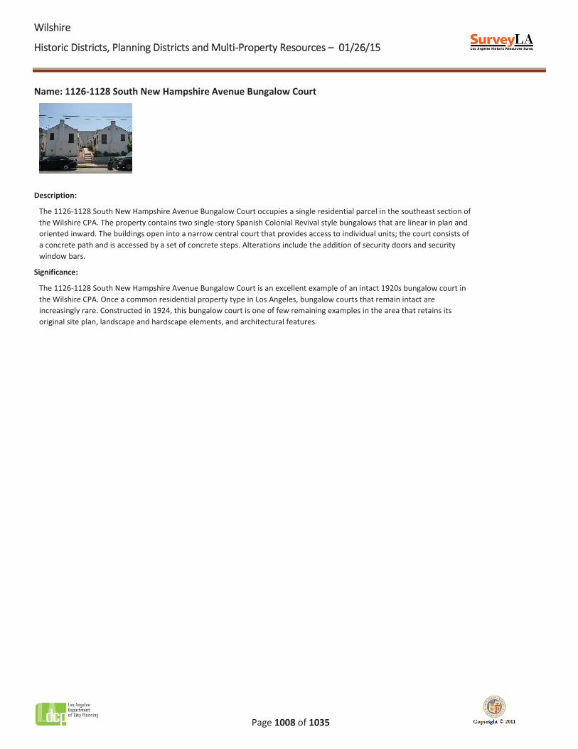
WWilshire
Historic Districts, Planning Districts and Multi-Property Resources – 01/26/15
Page 1008 of 1035
Name: 1126-1128 South New Hampshire Avenue Bungalow Court
Description:
The 1126-1128 South New Hampshire Avenue Bungalow Court occupies a single residential parcel in the southeast section of the Wilshire CPA. The property contains two single-story Spanish Colonial Revival style bungalows that are linear in plan and oriented inward. The buildings open into a narrow central court that provides access to individual units; the court consists of a concrete path and is accessed by a set of concrete steps. Alterations include the addition of security doors and security window bars.
Significance:
The 1126-1128 South New Hampshire Avenue Bungalow Court is an excellent example of an intact 1920s bungalow court in the Wilshire CPA. Once a common residential property type in Los Angeles, bungalow courts that remain intact are increasingly rare. Constructed in 1924, this bungalow court is one of few remaining examples in the area that retains its original site plan, landscape and hardscape elements, and architectural features.
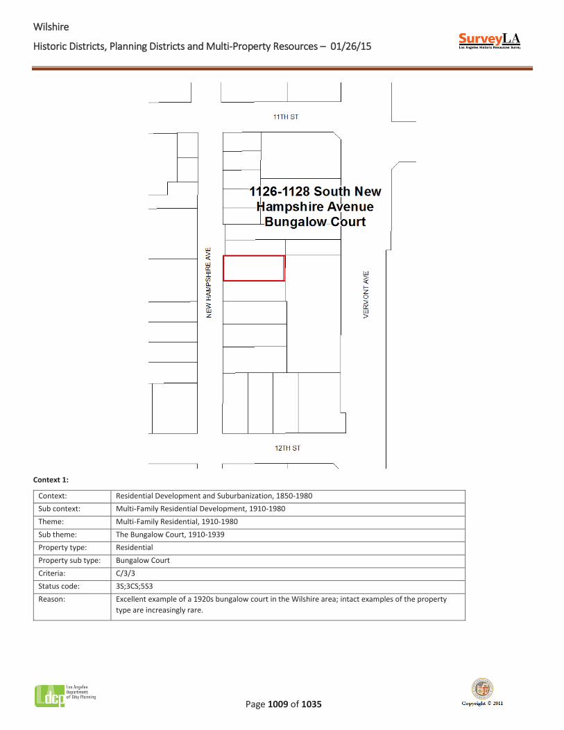
WWilshire
Historic Districts, Planning Districts and Multi-Property Resources – 01/26/15
Page 1009 of 1035
Context 1:
Context: Residential Development and Suburbanization, 1850-1980 Sub context: Multi-Family Residential Development, 1910-1980 Theme: Multi-Family Residential, 1910-1980 Sub theme: The Bungalow Court, 1910-1939 Property type: Residential Property sub type: Bungalow Court Criteria: C/3/3 Status code: 3S;3CS;5S3 Reason: Excellent example of a 1920s bungalow court in the Wilshire area; intact examples of the property
type are increasingly rare.
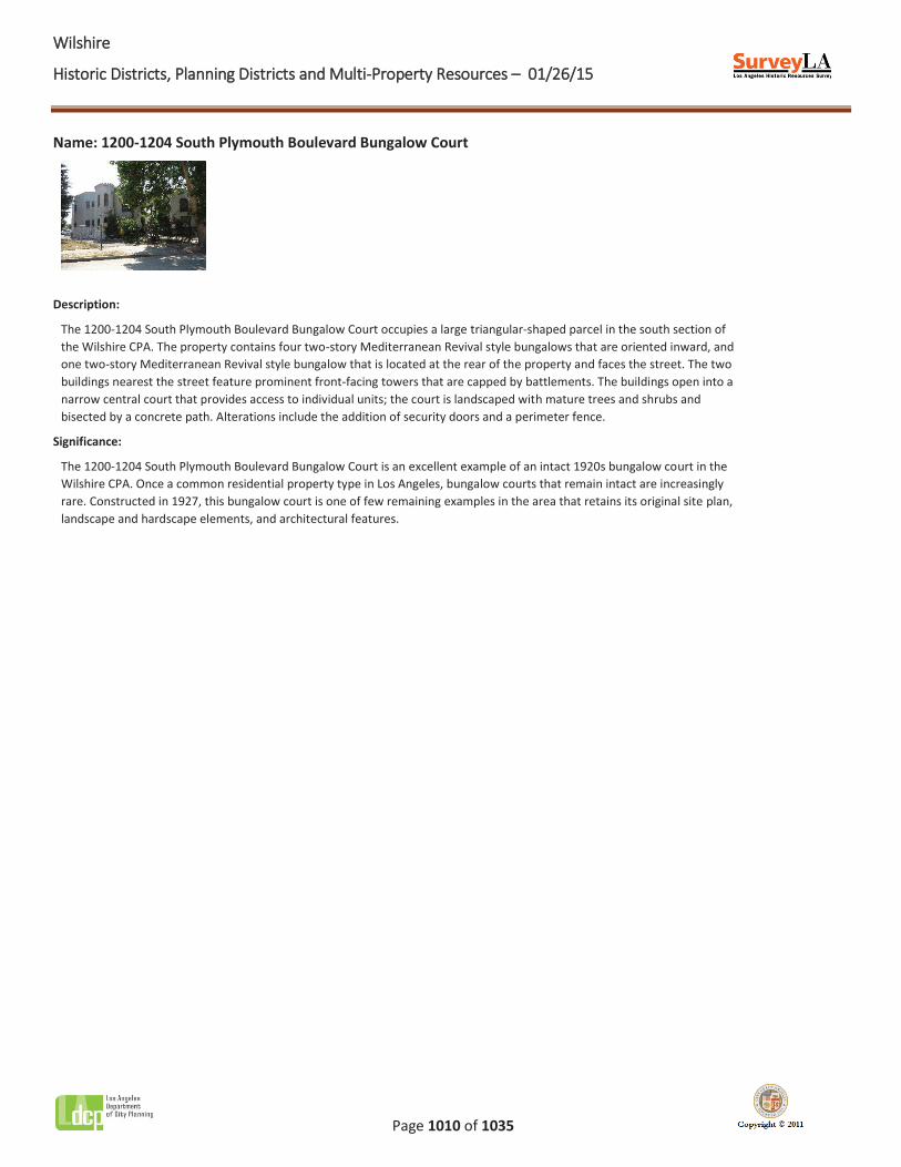
WWilshire
Historic Districts, Planning Districts and Multi-Property Resources – 01/26/15
Page 1010 of 1035
Name: 1200-1204 South Plymouth Boulevard Bungalow Court
Description:
The 1200-1204 South Plymouth Boulevard Bungalow Court occupies a large triangular-shaped parcel in the south section of the Wilshire CPA. The property contains four two-story Mediterranean Revival style bungalows that are oriented inward, and one two-story Mediterranean Revival style bungalow that is located at the rear of the property and faces the street. The two buildings nearest the street feature prominent front-facing towers that are capped by battlements. The buildings open into a narrow central court that provides access to individual units; the court is landscaped with mature trees and shrubs and bisected by a concrete path. Alterations include the addition of security doors and a perimeter fence.
Significance:
The 1200-1204 South Plymouth Boulevard Bungalow Court is an excellent example of an intact 1920s bungalow court in the Wilshire CPA. Once a common residential property type in Los Angeles, bungalow courts that remain intact are increasingly rare. Constructed in 1927, this bungalow court is one of few remaining examples in the area that retains its original site plan, landscape and hardscape elements, and architectural features.
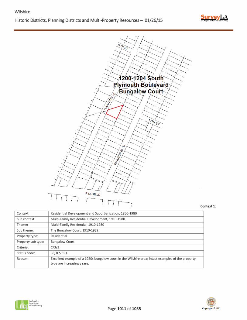
WWilshire
Historic Districts, Planning Districts and Multi-Property Resources – 01/26/15
Page 1011 of 1035
Context 1:
Context: Residential Development and Suburbanization, 1850-1980 Sub context: Multi-Family Residential Development, 1910-1980 Theme: Multi-Family Residential, 1910-1980 Sub theme: The Bungalow Court, 1910-1939 Property type: Residential Property sub type: Bungalow Court Criteria: C/3/3 Status code: 3S;3CS;5S3 Reason: Excellent example of a 1920s bungalow court in the Wilshire area; intact examples of the property
type are increasingly rare.
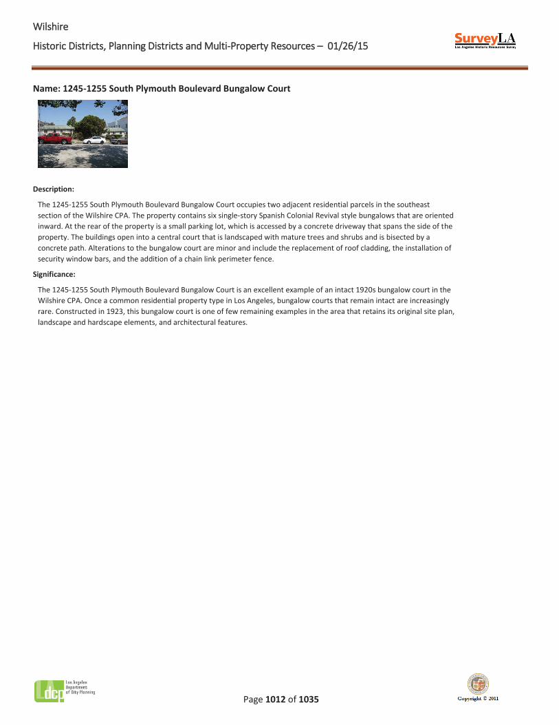
WWilshire
Historic Districts, Planning Districts and Multi-Property Resources – 01/26/15
Page 1012 of 1035
Name: 1245-1255 South Plymouth Boulevard Bungalow Court
Description:
The 1245-1255 South Plymouth Boulevard Bungalow Court occupies two adjacent residential parcels in the southeast section of the Wilshire CPA. The property contains six single-story Spanish Colonial Revival style bungalows that are oriented inward. At the rear of the property is a small parking lot, which is accessed by a concrete driveway that spans the side of the property. The buildings open into a central court that is landscaped with mature trees and shrubs and is bisected by a concrete path. Alterations to the bungalow court are minor and include the replacement of roof cladding, the installation of security window bars, and the addition of a chain link perimeter fence.
Significance:
The 1245-1255 South Plymouth Boulevard Bungalow Court is an excellent example of an intact 1920s bungalow court in the Wilshire CPA. Once a common residential property type in Los Angeles, bungalow courts that remain intact are increasingly rare. Constructed in 1923, this bungalow court is one of few remaining examples in the area that retains its original site plan, landscape and hardscape elements, and architectural features.
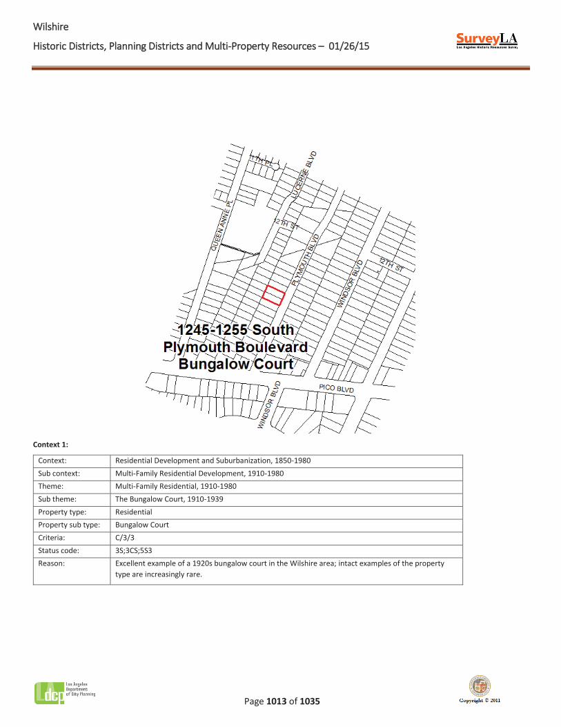
WWilshire
Historic Districts, Planning Districts and Multi-Property Resources – 01/26/15
Page 1013 of 1035
Context 1:
Context: Residential Development and Suburbanization, 1850-1980 Sub context: Multi-Family Residential Development, 1910-1980 Theme: Multi-Family Residential, 1910-1980 Sub theme: The Bungalow Court, 1910-1939 Property type: Residential Property sub type: Bungalow Court Criteria: C/3/3 Status code: 3S;3CS;5S3 Reason: Excellent example of a 1920s bungalow court in the Wilshire area; intact examples of the property
type are increasingly rare.
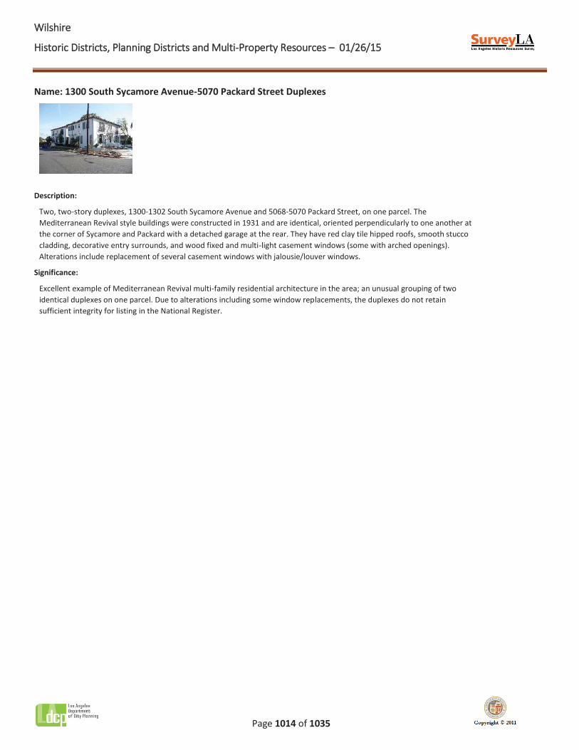
WWilshire
Historic Districts, Planning Districts and Multi-Property Resources – 01/26/15
Page 1014 of 1035
Name: 1300 South Sycamore Avenue-5070 Packard Street Duplexes
Description:
Two, two-story duplexes, 1300-1302 South Sycamore Avenue and 5068-5070 Packard Street, on one parcel. The Mediterranean Revival style buildings were constructed in 1931 and are identical, oriented perpendicularly to one another at the corner of Sycamore and Packard with a detached garage at the rear. They have red clay tile hipped roofs, smooth stucco cladding, decorative entry surrounds, and wood fixed and multi-light casement windows (some with arched openings). Alterations include replacement of several casement windows with jalousie/louver windows.
Significance:
Excellent example of Mediterranean Revival multi-family residential architecture in the area; an unusual grouping of two identical duplexes on one parcel. Due to alterations including some window replacements, the duplexes do not retain sufficient integrity for listing in the National Register.
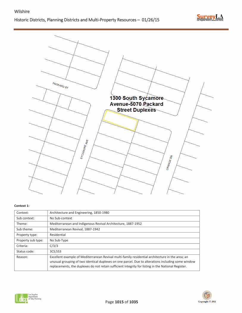
WWilshire
Historic Districts, Planning Districts and Multi-Property Resources – 01/26/15
Page 1015 of 1035
Context 1:
Context: Architecture and Engineering, 1850-1980 Sub context: No Sub-context Theme: Mediterranean and Indigenous Revival Architecture, 1887-1952 Sub theme: Mediterranean Revival, 1887-1942 Property type: Residential Property sub type: No Sub-Type Criteria: C/3/3 Status code: 3CS;5S3 Reason: Excellent example of Mediterranean Revival multi-family residential architecture in the area; an
unusual grouping of two identical duplexes on one parcel. Due to alterations including some window replacements, the duplexes do not retain sufficient integrity for listing in the National Register.
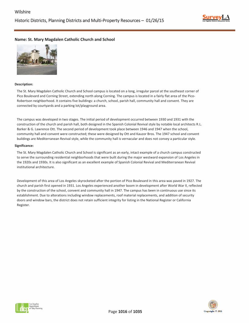
WWilshire
Historic Districts, Planning Districts and Multi-Property Resources – 01/26/15
Page 1016 of 1035
Name: St. Mary Magdalen Catholic Church and School
Description:
The St. Mary Magdalen Catholic Church and School campus is located on a long, irregular parcel at the southeast corner of Pico Boulevard and Corning Street, extending north along Corning. The campus is located in a fairly flat area of the Pico-Robertson neighborhood. It contains five buildings: a church, school, parish hall, community hall and convent. They are connected by courtyards and a parking lot/playground area.
The campus was developed in two stages. The initial period of development occurred between 1930 and 1931 with the construction of the church and parish hall, both designed in the Spanish Colonial Revival style by notable local architects R.L. Barker & G. Lawrence Ott. The second period of development took place between 1946 and 1947 when the school, community hall and convent were constructed; these were designed by Ott and Kauzor Bros. The 1947 school and convent buildings are Mediterranean Revival style, while the community hall is vernacular and does not convey a particular style.
Significance:
The St. Mary Magdalen Catholic Church and School is significant as an early, intact example of a church campus constructed to serve the surrounding residential neighborhoods that were built during the major westward expansion of Los Angeles in the 1920s and 1930s. It is also significant as an excellent example of Spanish Colonial Revival and Mediterranean Revival institutional architecture.
Development of this area of Los Angeles skyrocketed after the portion of Pico Boulevard in this area was paved in 1927. The church and parish first opened in 1931. Los Angeles experienced another boom in development after World War II, reflected by the construction of the school, convent and community hall in 1947. The campus has been in continuous use since its establishment. Due to alterations including window replacements, roof material replacements, and addition of security doors and window bars, the district does not retain sufficient integrity for listing in the National Register or California Register.
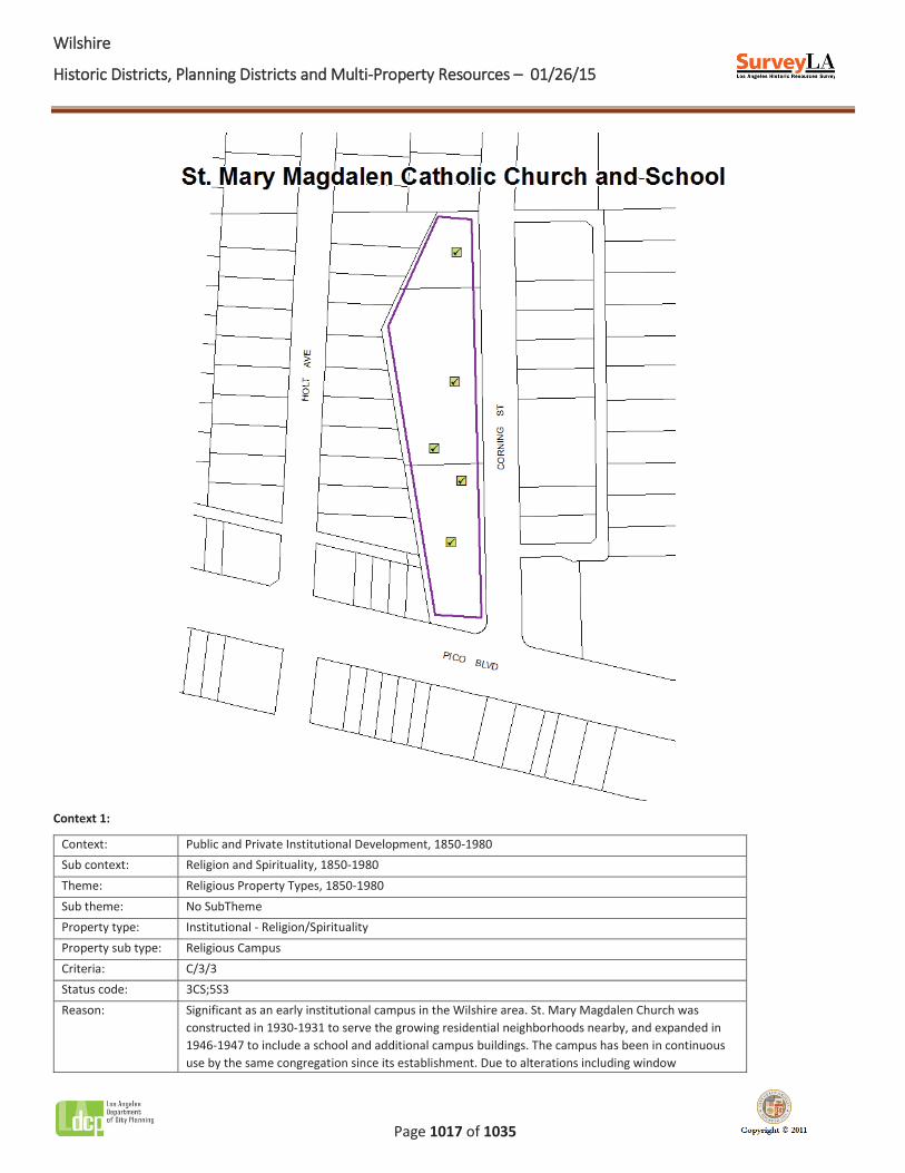
WWilshire
Historic Districts, Planning Districts and Multi-Property Resources – 01/26/15
Page 1017 of 1035
Context 1:
Context: Public and Private Institutional Development, 1850-1980 Sub context: Religion and Spirituality, 1850-1980 Theme: Religious Property Types, 1850-1980 Sub theme: No SubTheme Property type: Institutional - Religion/Spirituality Property sub type: Religious Campus Criteria: C/3/3 Status code: 3CS;5S3 Reason: Significant as an early institutional campus in the Wilshire area. St. Mary Magdalen Church was
constructed in 1930-1931 to serve the growing residential neighborhoods nearby, and expanded in 1946-1947 to include a school and additional campus buildings. The campus has been in continuous use by the same congregation since its establishment. Due to alterations including window
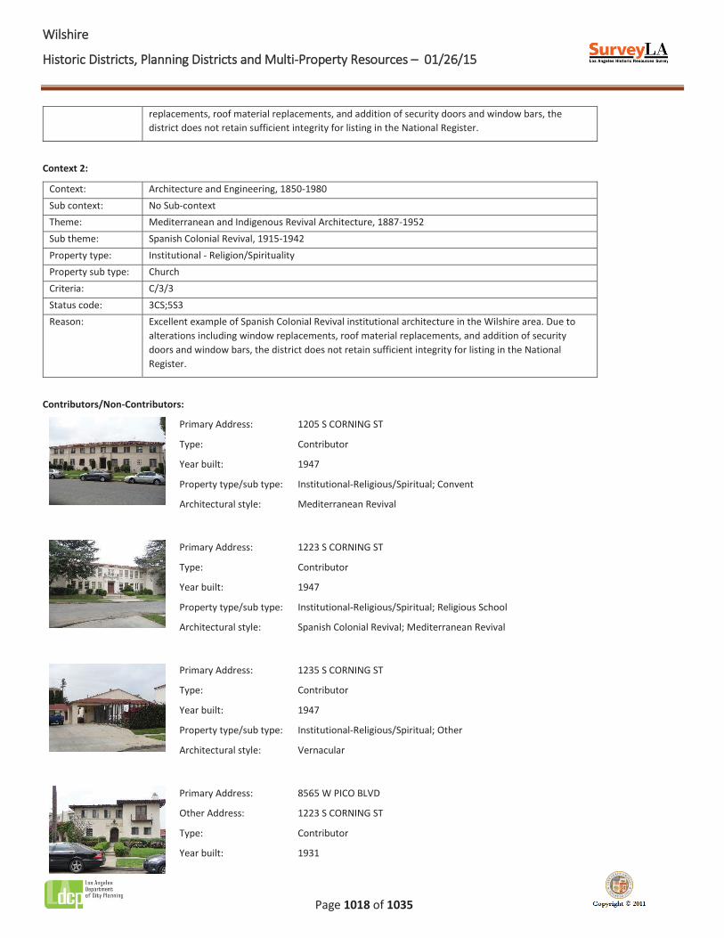
WWilshire
Historic Districts, Planning Districts and Multi-Property Resources – 01/26/15
Page 1018 of 1035
replacements, roof material replacements, and addition of security doors and window bars, the district does not retain sufficient integrity for listing in the National Register.
Context 2:
Context: Architecture and Engineering, 1850-1980 Sub context: No Sub-context Theme: Mediterranean and Indigenous Revival Architecture, 1887-1952 Sub theme: Spanish Colonial Revival, 1915-1942 Property type: Institutional - Religion/Spirituality Property sub type: Church Criteria: C/3/3 Status code: 3CS;5S3 Reason: Excellent example of Spanish Colonial Revival institutional architecture in the Wilshire area. Due to
alterations including window replacements, roof material replacements, and addition of security doors and window bars, the district does not retain sufficient integrity for listing in the National Register.
Contributors/Non-Contributors:
Primary Address: 1205 S CORNING ST
Type: Contributor
Year built: 1947
Property type/sub type: Institutional-Religious/Spiritual; Convent
Architectural style: Mediterranean Revival
Primary Address: 1223 S CORNING ST
Type: Contributor
Year built: 1947
Property type/sub type: Institutional-Religious/Spiritual; Religious School
Architectural style: Spanish Colonial Revival; Mediterranean Revival
Primary Address: 1235 S CORNING ST
Type: Contributor
Year built: 1947
Property type/sub type: Institutional-Religious/Spiritual; Other
Architectural style: Vernacular
Primary Address: 8565 W PICO BLVD
Other Address: 1223 S CORNING ST
Type: Contributor
Year built: 1931
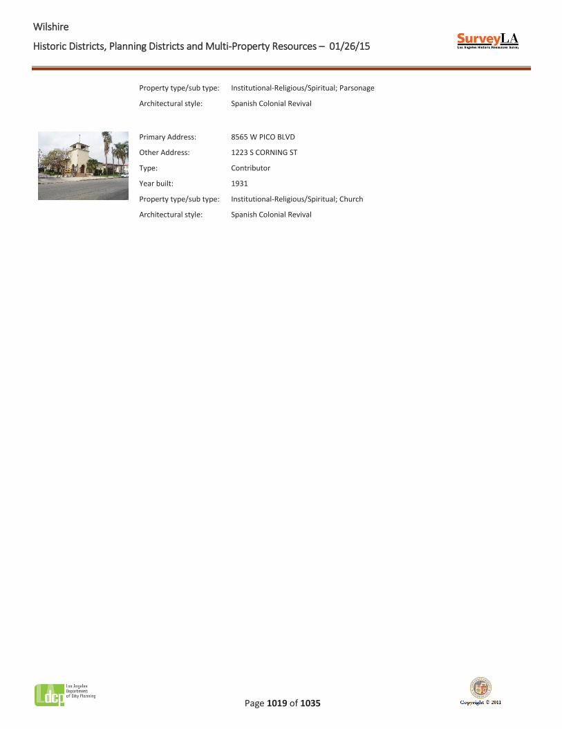
WWilshire
Historic Districts, Planning Districts and Multi-Property Resources – 01/26/15
Page 1019 of 1035
Property type/sub type: Institutional-Religious/Spiritual; Parsonage
Architectural style: Spanish Colonial Revival
Primary Address: 8565 W PICO BLVD
Other Address: 1223 S CORNING ST
Type: Contributor
Year built: 1931
Property type/sub type: Institutional-Religious/Spiritual; Church
Architectural style: Spanish Colonial Revival
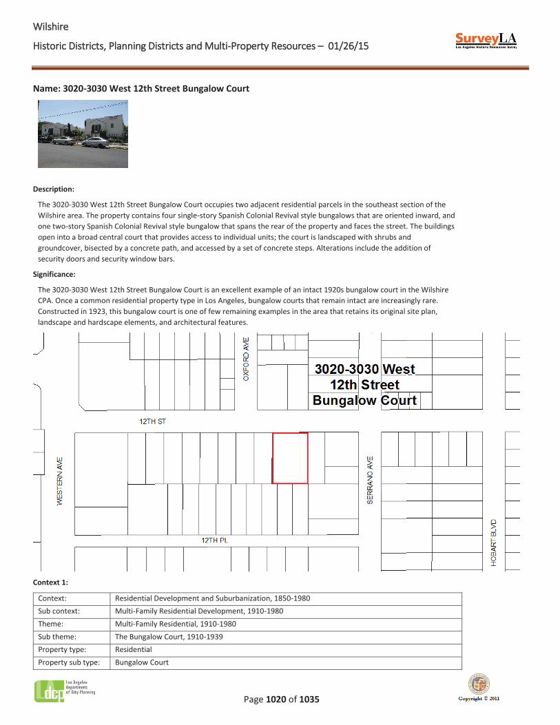
WWilshire
Historic Districts, Planning Districts and Multi-Property Resources – 01/26/15
Page 1020 of 1035
Name: 3020-3030 West 12th Street Bungalow Court
Description:
The 3020-3030 West 12th Street Bungalow Court occupies two adjacent residential parcels in the southeast section of the Wilshire area. The property contains four single-story Spanish Colonial Revival style bungalows that are oriented inward, and one two-story Spanish Colonial Revival style bungalow that spans the rear of the property and faces the street. The buildings open into a broad central court that provides access to individual units; the court is landscaped with shrubs and groundcover, bisected by a concrete path, and accessed by a set of concrete steps. Alterations include the addition of security doors and security window bars.
Significance:
The 3020-3030 West 12th Street Bungalow Court is an excellent example of an intact 1920s bungalow court in the Wilshire CPA. Once a common residential property type in Los Angeles, bungalow courts that remain intact are increasingly rare. Constructed in 1923, this bungalow court is one of few remaining examples in the area that retains its original site plan, landscape and hardscape elements, and architectural features.
Context 1:
Context: Residential Development and Suburbanization, 1850-1980 Sub context: Multi-Family Residential Development, 1910-1980 Theme: Multi-Family Residential, 1910-1980 Sub theme: The Bungalow Court, 1910-1939 Property type: Residential Property sub type: Bungalow Court

WWilshire
Historic Districts, Planning Districts and Multi-Property Resources – 01/26/15
Page 1021 of 1035
Criteria: C/3/3 Status code: 3S;3CS;5S3 Reason: Excellent example of a 1920s bungalow court in the Wilshire area; intact examples of the property
type are increasingly rare.
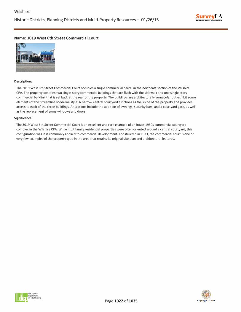
WWilshire
Historic Districts, Planning Districts and Multi-Property Resources – 01/26/15
Page 1022 of 1035
Name: 3019 West 6th Street Commercial Court
Description:
The 3019 West 6th Street Commercial Court occupies a single commercial parcel in the northeast section of the Wilshire CPA. The property contains two single-story commercial buildings that are flush with the sidewalk and one single-story commercial building that is set back at the rear of the property. The buildings are architecturally vernacular but exhibit some elements of the Streamline Moderne style. A narrow central courtyard functions as the spine of the property and provides access to each of the three buildings. Alterations include the addition of awnings, security bars, and a courtyard gate, as well as the replacement of some windows and doors.
Significance:
The 3019 West 6th Street Commercial Court is an excellent and rare example of an intact 1930s commercial courtyard complex in the Wilshire CPA. While multifamily residential properties were often oriented around a central courtyard, this configuration was less commonly applied to commercial development. Constructed in 1933, the commercial court is one of very few examples of the property type in the area that retains its original site plan and architectural features.
WWilshire
Historic Districts, Planning Districts and Multi-Property Resources – 01/26/15
Page 1023 of 1035
Context 1:
Context: Other Context, 1850-1980 Sub context: No Sub-context Theme: Design/Construction, 1850-1980 Sub theme: No SubTheme Property type: Commercial Property sub type: No Sub-Type Criteria: C/3/3 Status code: 3S;3CS;5S3 Reason: Excellent and rare example of a 1930s courtyard commercial complex in the Wilshire area. Although
courtyards were commonly incorporated into multifamily residential buildings, commercial developments that are oriented around a central courtyard and lack amenities for the automobile are rare in the city.
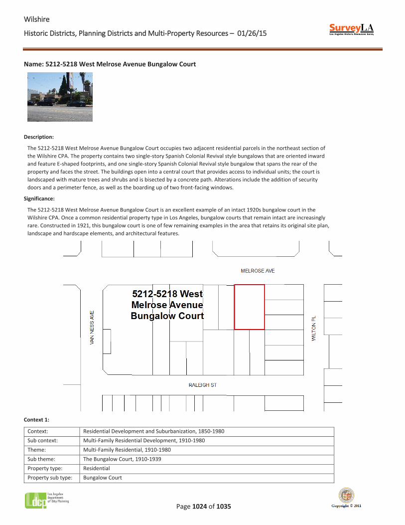
WWilshire
Historic Districts, Planning Districts and Multi-Property Resources – 01/26/15
Page 1024 of 1035
Name: 5212-5218 West Melrose Avenue Bungalow Court
Description:
The 5212-5218 West Melrose Avenue Bungalow Court occupies two adjacent residential parcels in the northeast section of the Wilshire CPA. The property contains two single-story Spanish Colonial Revival style bungalows that are oriented inward and feature E-shaped footprints, and one single-story Spanish Colonial Revival style bungalow that spans the rear of the property and faces the street. The buildings open into a central court that provides access to individual units; the court is landscaped with mature trees and shrubs and is bisected by a concrete path. Alterations include the addition of security doors and a perimeter fence, as well as the boarding up of two front-facing windows.
Significance:
The 5212-5218 West Melrose Avenue Bungalow Court is an excellent example of an intact 1920s bungalow court in the Wilshire CPA. Once a common residential property type in Los Angeles, bungalow courts that remain intact are increasingly rare. Constructed in 1921, this bungalow court is one of few remaining examples in the area that retains its original site plan, landscape and hardscape elements, and architectural features.
Context 1:
Context: Residential Development and Suburbanization, 1850-1980 Sub context: Multi-Family Residential Development, 1910-1980 Theme: Multi-Family Residential, 1910-1980 Sub theme: The Bungalow Court, 1910-1939 Property type: Residential Property sub type: Bungalow Court

WWilshire
Historic Districts, Planning Districts and Multi-Property Resources – 01/26/15
Page 1025 of 1035
Criteria: C/3/3 Status code: 3S;3CS;5S3 Reason: Excellent example of a 1920s bungalow court in the Wilshire area; intact examples of the property
type are increasingly rare.
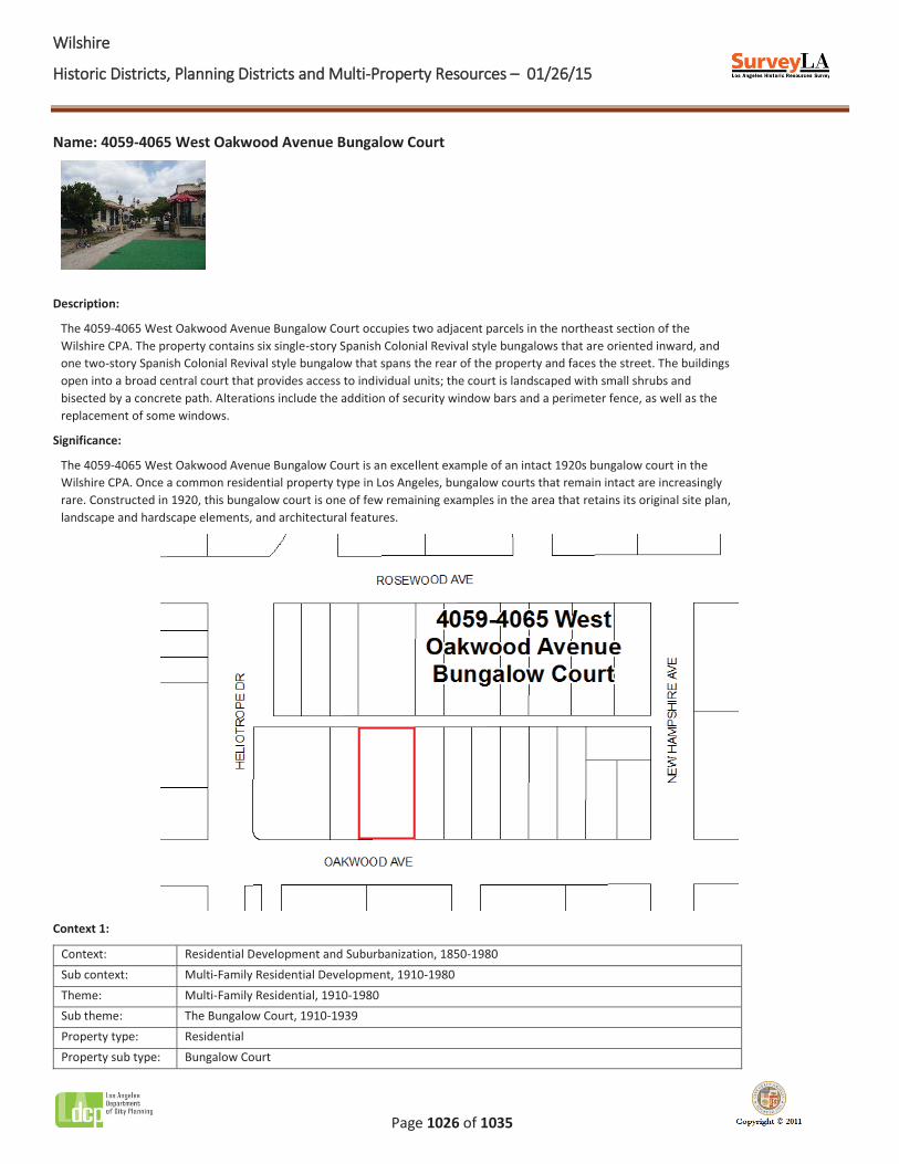
WWilshire
Historic Districts, Planning Districts and Multi-Property Resources – 01/26/15
Page 1026 of 1035
Name: 4059-4065 West Oakwood Avenue Bungalow Court
Description:
The 4059-4065 West Oakwood Avenue Bungalow Court occupies two adjacent parcels in the northeast section of the Wilshire CPA. The property contains six single-story Spanish Colonial Revival style bungalows that are oriented inward, and one two-story Spanish Colonial Revival style bungalow that spans the rear of the property and faces the street. The buildings open into a broad central court that provides access to individual units; the court is landscaped with small shrubs and bisected by a concrete path. Alterations include the addition of security window bars and a perimeter fence, as well as the replacement of some windows.
Significance:
The 4059-4065 West Oakwood Avenue Bungalow Court is an excellent example of an intact 1920s bungalow court in the Wilshire CPA. Once a common residential property type in Los Angeles, bungalow courts that remain intact are increasingly rare. Constructed in 1920, this bungalow court is one of few remaining examples in the area that retains its original site plan, landscape and hardscape elements, and architectural features.
Context 1:
Context: Residential Development and Suburbanization, 1850-1980 Sub context: Multi-Family Residential Development, 1910-1980 Theme: Multi-Family Residential, 1910-1980 Sub theme: The Bungalow Court, 1910-1939 Property type: Residential Property sub type: Bungalow Court
WWilshire
Historic Districts, Planning Districts and Multi-Property Resources – 01/26/15
Page 1027 of 1035
Criteria: C/3/3 Status code: 3S;3CS;5S3 Reason: Excellent example of a 1920s bungalow court in the Wilshire area; intact examples of the property
type are increasingly rare.
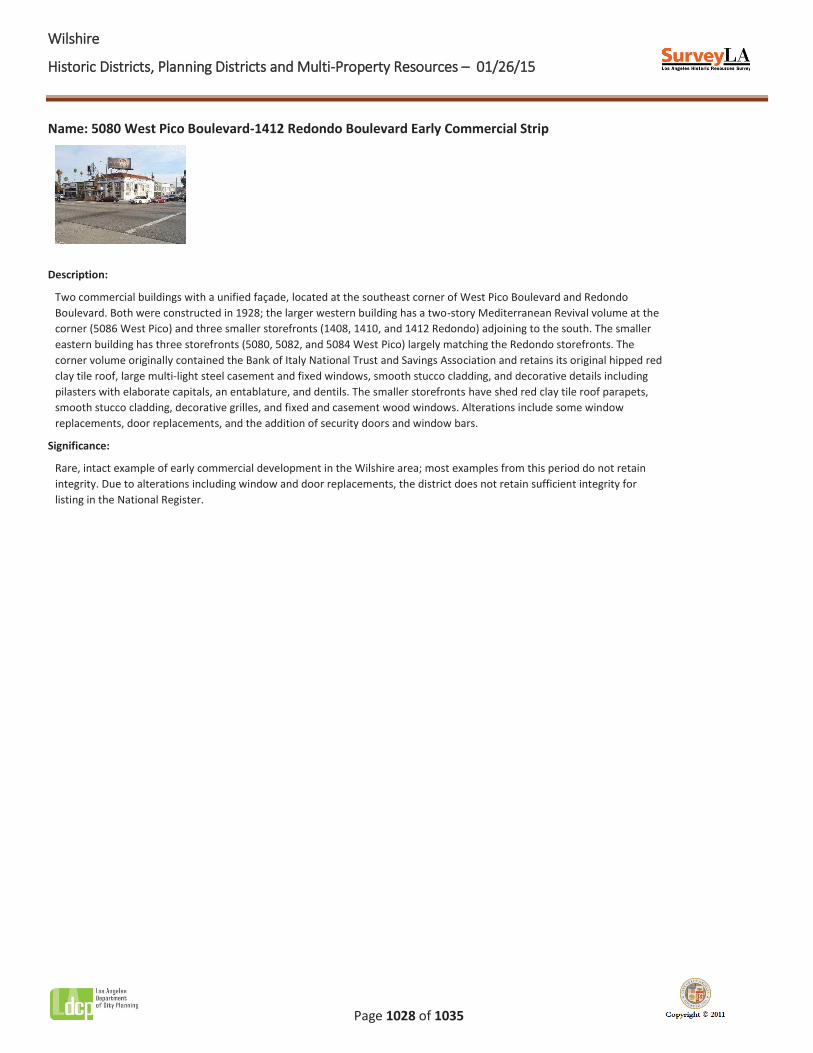
WWilshire
Historic Districts, Planning Districts and Multi-Property Resources – 01/26/15
Page 1028 of 1035
Name: 5080 West Pico Boulevard-1412 Redondo Boulevard Early Commercial Strip
Description:
Two commercial buildings with a unified façade, located at the southeast corner of West Pico Boulevard and Redondo Boulevard. Both were constructed in 1928; the larger western building has a two-story Mediterranean Revival volume at the corner (5086 West Pico) and three smaller storefronts (1408, 1410, and 1412 Redondo) adjoining to the south. The smaller eastern building has three storefronts (5080, 5082, and 5084 West Pico) largely matching the Redondo storefronts. The corner volume originally contained the Bank of Italy National Trust and Savings Association and retains its original hipped red clay tile roof, large multi-light steel casement and fixed windows, smooth stucco cladding, and decorative details including pilasters with elaborate capitals, an entablature, and dentils. The smaller storefronts have shed red clay tile roof parapets, smooth stucco cladding, decorative grilles, and fixed and casement wood windows. Alterations include some window replacements, door replacements, and the addition of security doors and window bars.
Significance:
Rare, intact example of early commercial development in the Wilshire area; most examples from this period do not retain integrity. Due to alterations including window and door replacements, the district does not retain sufficient integrity for listing in the National Register.
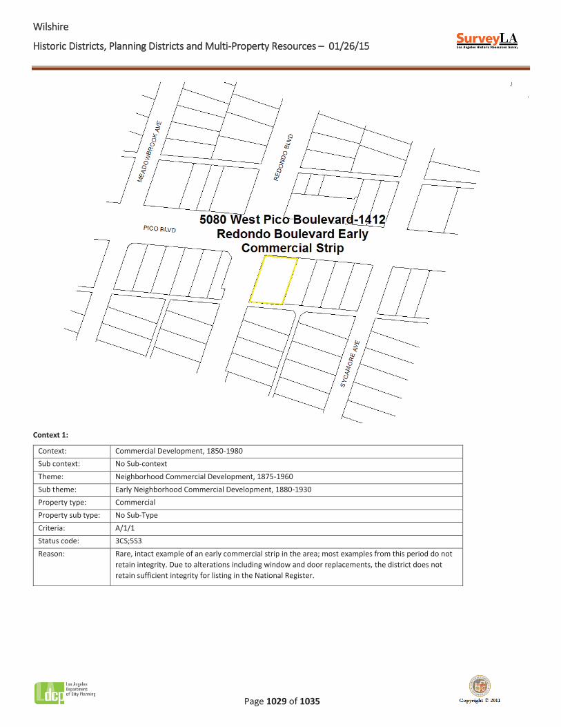
WWilshire
Historic Districts, Planning Districts and Multi-Property Resources – 01/26/15
Page 1029 of 1035
Context 1:
Context: Commercial Development, 1850-1980 Sub context: No Sub-context Theme: Neighborhood Commercial Development, 1875-1960 Sub theme: Early Neighborhood Commercial Development, 1880-1930 Property type: Commercial Property sub type: No Sub-Type Criteria: A/1/1 Status code: 3CS;5S3 Reason: Rare, intact example of an early commercial strip in the area; most examples from this period do not
retain integrity. Due to alterations including window and door replacements, the district does not retain sufficient integrity for listing in the National Register.
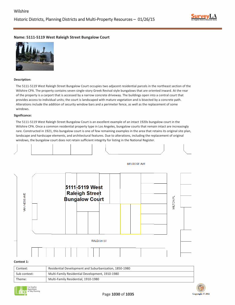
WWilshire
Historic Districts, Planning Districts and Multi-Property Resources – 01/26/15
Page 1030 of 1035
Name: 5111-5119 West Raleigh Street Bungalow Court
Description:
The 5111-5119 West Raleigh Street Bungalow Court occupies two adjacent residential parcels in the northeast section of the Wilshire CPA. The property contains seven single-story Greek Revival style bungalows that are oriented inward. At the rear of the property is a carport that is accessed by a narrow concrete driveway. The buildings open into a central court that provides access to individual units; the court is landscaped with mature vegetation and is bisected by a concrete path. Alterations include the addition of security window bars and a perimeter fence, as well as the replacement of some windows.
Significance:
The 5111-5119 West Raleigh Street Bungalow Court is an excellent example of an intact 1920s bungalow court in the Wilshire CPA. Once a common residential property type in Los Angeles, bungalow courts that remain intact are increasingly rare. Constructed in 1921, this bungalow court is one of few remaining examples in the area that retains its original site plan, landscape and hardscape elements, and architectural features. Due to alterations, including the replacement of original windows, the bungalow court does not retain sufficient integrity for listing in the National Register.
Context 1:
Context: Residential Development and Suburbanization, 1850-1980 Sub context: Multi-Family Residential Development, 1910-1980 Theme: Multi-Family Residential, 1910-1980
WWilshire
Historic Districts, Planning Districts and Multi-Property Resources – 01/26/15
Page 1031 of 1035
Sub theme: The Bungalow Court, 1910-1939 Property type: Residential Property sub type: Bungalow Court Criteria: C/3/3 Status code: 3CS;5S3 Reason: Excellent example of a 1920s bungalow court in the Wilshire area; intact examples of the property
type are increasingly rare. Due to alterations, including window replacement, the bungalow court does not retain sufficient integrity for listing in the National Register.
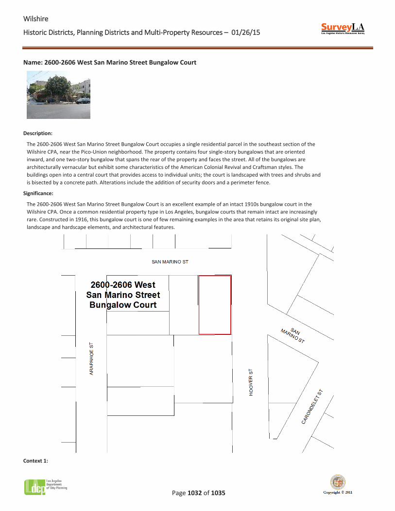
WWilshire
Historic Districts, Planning Districts and Multi-Property Resources – 01/26/15
Page 1032 of 1035
Name: 2600-2606 West San Marino Street Bungalow Court
Description:
The 2600-2606 West San Marino Street Bungalow Court occupies a single residential parcel in the southeast section of the Wilshire CPA, near the Pico-Union neighborhood. The property contains four single-story bungalows that are oriented inward, and one two-story bungalow that spans the rear of the property and faces the street. All of the bungalows are architecturally vernacular but exhibit some characteristics of the American Colonial Revival and Craftsman styles. The buildings open into a central court that provides access to individual units; the court is landscaped with trees and shrubs and is bisected by a concrete path. Alterations include the addition of security doors and a perimeter fence.
Significance:
The 2600-2606 West San Marino Street Bungalow Court is an excellent example of an intact 1910s bungalow court in the Wilshire CPA. Once a common residential property type in Los Angeles, bungalow courts that remain intact are increasingly rare. Constructed in 1916, this bungalow court is one of few remaining examples in the area that retains its original site plan, landscape and hardscape elements, and architectural features.
Context 1:
WWilshire
Historic Districts, Planning Districts and Multi-Property Resources – 01/26/15
Page 1033 of 1035
Context: Residential Development and Suburbanization, 1850-1980 Sub context: Multi-Family Residential Development, 1910-1980 Theme: Multi-Family Residential, 1910-1980 Sub theme: The Bungalow Court, 1910-1939 Property type: Residential Property sub type: Bungalow Court Criteria: C/3/3 Status code: 3S;3CS;5S3 Reason: Excellent example of a 1910s bungalow court in the Wilshire area; intact examples of the property
type are increasingly rare.

WWilshire
Historic Districts, Planning Districts and Multi-Property Resources – 01/26/15
Page 1034 of 1035
Name: 2650-2698 West San Marino Street Courtyard Apartments
Description:
The 2650-2698 West San Marino Street Courtyard Apartments occupy four adjacent residential parcels in the southeast section of the Wilshire CPA, near the Pico-Union neighborhood. The property is composed of five two-story Minimal Traditional apartment houses with L-shaped footprints; all of the buildings are oriented around a series of landscaped courtyards. A surface parking lot is located at the rear of the property. Alterations include the replacement of some windows and the addition of a perimeter fence.
Significance:
The 2650-2698 West San Marino Street Courtyard Apartments is an excellent example of an intact 1940s courtyard apartment development in the Wilshire area. Designed to take full advantage of Southern California’s temperate climate and provide residents with access to shared outdoor space, courtyard apartments were an important multifamily housing type in both pre- and post-World War II Los Angeles; intact examples are increasingly rare. Constructed in 1949, this property represents 1940s-era courtyard apartment development and is one of few remaining examples in the area that retains its original site plan and architectural features.
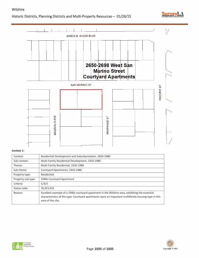
WWilshire
Historic Districts, Planning Districts and Multi-Property Resources – 01/26/15
Page 1035 of 1035
Context 1:
Context: Residential Development and Suburbanization, 1850-1980 Sub context: Multi-Family Residential Development, 1910-1980 Theme: Multi-Family Residential, 1910-1980 Sub theme: Courtyard Apartments, 1910-1980 Property type: Residential Property sub type: 1940s Courtyard Apartment Criteria: C/3/3 Status code: 3S;3CS;5S3 Reason: Excellent example of a 1940s courtyard apartment in the Wilshire area, exhibiting the essential
characteristics of the type. Courtyard apartments were an important multifamily housing type in this area of the city.