Embed Size (px)
Citation preview
Wilson cycles, tectonic inheritance, and rifting of the North American Gulf of Mexico continental margin
Audrey D. Huerta1 and Dennis L. Harry2
1Department of Geological Sciences, Central Washington University, Ellensburg, Washington 98926-7418, USA2Department of Geosciences, Colorado State University, Fort Collins, Colorado 80523, USA
ABSTRACT
The tectonic evolution of the North Amer-ican Gulf of Mexico continental margin is characterized by two Wilson cycles, i.e., repeated episodes of opening and closing of ocean basins along the same structural trend. This evolution includes (1) the Pre-cambrian Grenville orogeny; (2) formation of a rift-transform margin during late Pre-cambrian opening of the Iapetus Ocean; (3) the late Paleozoic Ouachita orogeny dur-ing assembly of Pangea; and (4) Mesozoic rifting during opening of the Gulf of Mexico. Unlike the Atlantic margins, where Wilson cycles were fi rst recognized, breakup in the Gulf of Mexico did not initially focus within the orogen, but was instead accommodated within a diffuse region adjacent to the oro-gen. This variation in location of rifting is a consequence of variations in the prerift architecture of the orogens. The Appala-chian-Caledonian orogeny involved substan-tial crustal shortening and formation of a thick crustal root. In contrast, the Ouachita orogeny resulted in minimal crustal short-ening and thickening. In addition, rather than a crustal root, the Ouachita orogen was underlain by the lower plate of a relatively pristine Paleozoic subduction system that is characterized by a shallow mantle. A fi nite element model simulating extension on the margin demonstrates that this preexisting structure exerted fundamental controls on the style of Mesozoic rifting. The shallow mantle created a strong lithosphere beneath the orogen, causing extension to initiate adjacent to, rather than within, the orogen. On the Atlantic margins, the thick crustal root resulted in a weak lithosphere and ini-tiation of extension within the interior of the orogen. Major features of the modern Gulf of Mexico margin, including the Interior Salt Basin, outboard unextended Wiggins arch, and an unusually broad region of extension
beneath the coastal plain and continental shelf, are direct consequences of the prerift structure of the margin.
INTRODUCTION
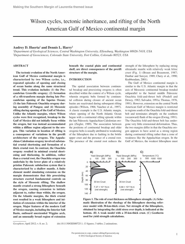
The spatial association between continen-tal breakup and preexisting orogens is often described within the context of a Wilson cycle, wherein orogenic belts formed by continen-tal collision during closure of ancient ocean basins are reactivated during subsequent rifting episodes (Wilson, 1966; Vauchez et al., 1997). A classic example is the U.S. Atlantic margin, where opening of the North Atlantic Ocean began with a continental rifting episode within the late Paleozoic Appalachian-Caledonian oro-gen (Ziegler, 1989). The association between the positions of continental breakup and older orogenic belts is usually attributed to weakening of the lithosphere due to faulting in the brittle upper crust and the presence of a crustal root. The presence of the crustal root reduces the
strength of the lithosphere by replacing strong ultramafi c mantle with relatively weak felsic crust (Fig. 1) (Braun and Beaumont, 1987; Dunbar and Sawyer, 1989; Chery et al., 1990; Krabbendam , 2001).
The Gulf of Mexico continental margin is similar to the U.S. Atlantic margin in that the axis of Mesozoic continental breakup trended subparallel to the buried middle Paleozoic Ouachita fold-and-thrust belt (Pindell and Dewey, 1982; Salvador, 1991a; Thomas, 1976, 1991). However, extension on the central North American Gulf of Mexico margin is restricted to regions south of the Ouachita fold-and-thrust belt and terminates abruptly on the southern (oceanward) fl ank of the orogen (Ewing, 1991). The Ouachita fold-and-thrust belt has under-gone very little extensional deformation. Thus, the two margins differ in that the Ouachita oro-gen appears to have acted as a strong region during continental rifting rather than a zone of weakness like the Appalachian orogen. In the Gulf of Mexico, the weakest lithosphere must
For permission to copy, contact [email protected]© 2012 Geological Society of America
1
Geosphere; April 2012; v. 8; no. 2; p. 1–12; doi:10.1130/GES00725.1; 13 fi gures; 3 tables; 2 animations.
0 500 1000 1500Temperature (°C)
35 km Crust
Yield Strength (MPa)0 100 200 300
5.68 × 10¹² N-m
30 km Crust
7.37 × 10¹² N-m
Yield Strength (MPa)0 100 200 300
(net strength) (net strength)
0
20
40
60
80
100
120
140
Dep
th (k
m)
A) B) C)
Figure 1. The role of crust thickness on lithosphere strength. (A) Sche-matic illustration of the rheology of the lithosphere showing refer-ence model with 30-km-thick crust. Net strength of the lithosphere, obtained by integrating the yield stress over depth, is indicated at the bottom. (B) A weak model with a 35-km-thick crust. (C) Geotherm used for yield strength calculations.
Making the Southern Margin of Laurentia themed issue
Huerta and Harry
2 Geosphere, April 2012
have been outboard of the orogenic belt, within the alloch thonous terrane that was accreted to the southern North American continent dur-ing the Ouachita orogeny.
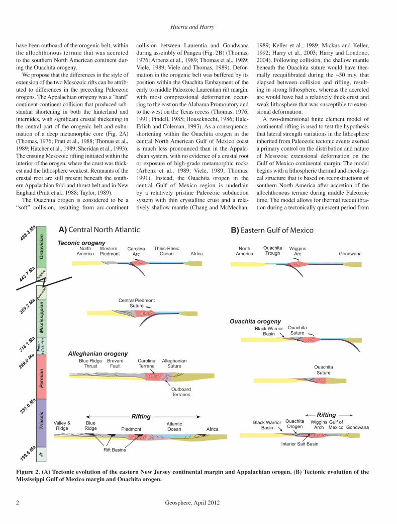
We propose that the differences in the style of extension of the two Mesozoic rifts can be attrib-uted to differences in the preceding Paleozoic orogens. The Appalachian orogeny was a “hard” continent-continent collision that produced sub-stantial shortening in both the hinterland and internides, with signifi cant crustal thickening in the central part of the orogenic belt and exhu-mation of a deep metamorphic core (Fig. 2A) (Thomas, 1976; Pratt et al., 1988; Thomas et al., 1989; Hatcher et al., 1989; Sheridan et al., 1993). The ensuing Mesozoic rifting initiated within the interior of the orogen, where the crust was thick-est and the lithosphere weakest. Remnants of the crustal root are still present beneath the south-ern Appalachian fold-and-thrust belt and in New England (Pratt et al., 1988; Taylor, 1989).
The Ouachita orogen is considered to be a “soft” collision, resulting from arc-continent
collision between Laurentia and Gondwana during assembly of Pangea (Fig. 2B) (Thomas, 1976; Arbenz et al., 1989; Thomas et al., 1989; Viele, 1989; Viele and Thomas, 1989). Defor-mation in the orogenic belt was buffered by its position within the Ouachita Embayment of the early to middle Paleozoic Laurentian rift margin, with most compressional deformation occur-ring to the east on the Alabama Promontory and to the west on the Texas recess (Thomas, 1976, 1991; Pindell, 1985; Houseknecht, 1986; Hale-Erlich and Coleman, 1993). As a consequence, shortening within the Ouachita orogen in the central North American Gulf of Mexico coast is much less pronounced than in the Appala-chian system, with no evidence of a crustal root or exposure of high-grade metamorphic rocks (Arbenz et al., 1989; Viele, 1989; Thomas, 1991). Instead, the Ouachita orogen in the central Gulf of Mexico region is underlain by a relatively pristine Paleozoic subduction system with thin crystalline crust and a rela-tively shallow mantle (Chang and McMechan,
1989; Keller et al., 1989; Mickus and Keller, 1992; Harry et al., 2003; Harry and Londono, 2004). Following collision, the shallow mantle beneath the Ouachita suture would have ther-mally reequilibrated during the ~50 m.y. that elapsed between collision and rifting, result-ing in strong lithosphere, whereas the accreted arc would have had a relatively thick crust and weak lithosphere that was susceptible to exten-sional deformation.
A two-dimensional fi nite element model of continental rifting is used to test the hypothesis that lateral strength variations in the lithosphere inherited from Paleozoic tectonic events exerted a primary control on the distribution and nature of Mesozoic extensional deformation on the Gulf of Mexico continental margin. The model begins with a lithospheric thermal and rheologi-cal structure that is based on reconstructions of southern North America after accretion of the allochthonous terrane during middle Paleozoic time. The model allows for thermal reequilibra-tion during a tectonically quiescent period from
Valley &Ridge
BlueRidge acirfAtnomdeiP
AtlanticOcean
Rift Basins
GondwanaWiggins
ArchGulf ofMexico
OuachitaOrogen
Interior Salt Basin
Black WarriorBasin
Rifting Rifting
Alleghanian orogenyBrevard
FaultBlue Ridge
ThrustCarolinaTerrane
OutboardTerranes
AlleghanianSuture Ouachita
Suture
Central PiedmontSuture
OuachitaSuture
Ouachita orogenyBlack Warrior
Basin
NorthAmerica
CarolinaArc Africa
Theic-RheicOcean
Taconic orogenyWesternPiedmont
NorthAmerica
WigginsArc
OuachitaTrough Gondwana
A) Central North Atlantic B) Eastern Gulf of Mexico
Ord
ovic
ian
M
issi
ssip
pian
Penn
-sy
lvan
ian
Perm
ian
Tria
ssic
199.6
Ma
251.0
Ma
299.0
Ma
318.1
Ma
359.2
Ma
443.7
Ma
488.3
Ma
JrSilu
rian
Devo
nian
Figure 2. (A) Tectonic evolution of the eastern New Jersey continental margin and Appalachian orogen. (B) Tectonic evolution of the Mississippi Gulf of Mexico margin and Ouachita orogen.
Rifting of the Gulf of Mexico
Geosphere, April 2012 3
late Paleozoic through Early Triassic time, prior to the onset of extensional deformation that led to opening of the Gulf of Mexico during the Early Jurassic. The model results are consistent with the geologic and geophysical features of the region, including the distribution of major extensional structures, the amount and location of crustal thinning, and the duration of rifting on the central Gulf of Mexico margin.
REGIONAL GEOLOGY
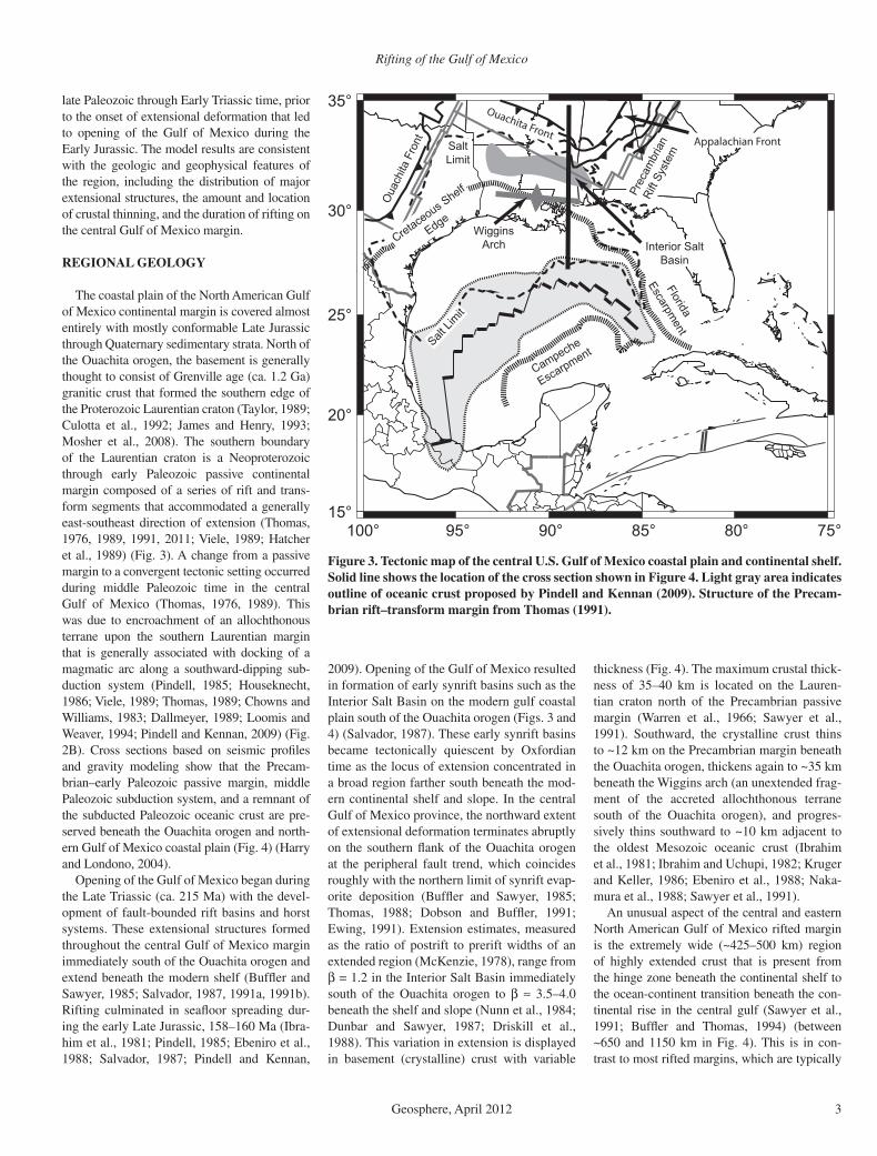
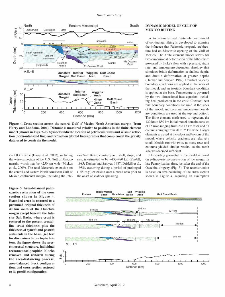
The coastal plain of the North American Gulf of Mexico continental margin is covered almost entirely with mostly conformable Late Jurassic through Quaternary sedimentary strata. North of the Ouachita orogen, the basement is generally thought to consist of Grenville age (ca. 1.2 Ga) granitic crust that formed the southern edge of the Proterozoic Laurentian craton (Taylor, 1989; Culotta et al., 1992; James and Henry, 1993; Mosher et al., 2008). The southern boundary of the Laurentian craton is a Neoproterozoic through early Paleozoic passive continental margin composed of a series of rift and trans-form segments that accommodated a generally east-southeast direction of extension (Thomas, 1976, 1989, 1991, 2011; Viele, 1989; Hatcher et al., 1989) (Fig. 3). A change from a passive margin to a convergent tectonic setting occurred during middle Paleozoic time in the central Gulf of Mexico (Thomas, 1976, 1989). This was due to encroachment of an allochthonous terrane upon the southern Laurentian margin that is generally associated with docking of a magmatic arc along a southward-dipping sub-duction system (Pindell, 1985; Houseknecht, 1986; Viele, 1989; Thomas, 1989; Chowns and Williams, 1983; Dallmeyer, 1989; Loomis and Weaver, 1994; Pindell and Kennan, 2009) (Fig. 2B). Cross sections based on seismic profi les and gravity modeling show that the Precam-brian–early Paleozoic passive margin, middle Paleozoic subduction system, and a remnant of the subducted Paleozoic oceanic crust are pre-served beneath the Ouachita orogen and north-ern Gulf of Mexico coastal plain (Fig. 4) (Harry and Londono, 2004).
Opening of the Gulf of Mexico began during the Late Triassic (ca. 215 Ma) with the devel-opment of fault-bounded rift basins and horst systems. These extensional structures formed throughout the central Gulf of Mexico margin immediately south of the Ouachita orogen and extend beneath the modern shelf (Buffl er and Sawyer, 1985; Salvador, 1987, 1991a, 1991b). Rifting culminated in seafl oor spreading dur-ing the early Late Jurassic, 158–160 Ma (Ibra-him et al., 1981; Pindell, 1985; Ebeniro et al., 1988; Salvador, 1987; Pindell and Kennan,
2009). Opening of the Gulf of Mexico resulted in formation of early synrift basins such as the Interior Salt Basin on the modern gulf coastal plain south of the Ouachita orogen (Figs. 3 and 4) (Salvador, 1987). These early synrift basins became tectonically quiescent by Oxfordian time as the locus of extension concentrated in a broad region farther south beneath the mod-ern continental shelf and slope. In the central Gulf of Mexico province, the northward extent of extensional deformation terminates abruptly on the southern fl ank of the Ouachita orogen at the peripheral fault trend, which coincides roughly with the northern limit of synrift evap-orite deposition (Buffl er and Sawyer, 1985; Thomas, 1988; Dobson and Buffl er, 1991; Ewing, 1991). Extension estimates, measured as the ratio of postrift to prerift widths of an extended region (McKenzie, 1978), range from β = 1.2 in the Interior Salt Basin immediately south of the Ouachita orogen to β ≈ 3.5–4.0 beneath the shelf and slope (Nunn et al., 1984; Dunbar and Sawyer, 1987; Driskill et al., 1988). This variation in extension is displayed in basement (crystalline) crust with variable
thickness (Fig. 4). The maximum crustal thick-ness of 35–40 km is located on the Lauren-tian craton north of the Precambrian passive margin (Warren et al., 1966; Sawyer et al., 1991). Southward, the crystalline crust thins to ~12 km on the Precambrian margin beneath the Ouachita orogen, thickens again to ~35 km beneath the Wiggins arch (an unextended frag-ment of the accreted allochthonous terrane south of the Ouachita orogen), and progres-sively thins southward to ~10 km adjacent to the oldest Mesozoic oceanic crust (Ibrahim et al., 1981; Ibrahim and Uchupi, 1982; Kruger and Keller, 1986; Ebeniro et al., 1988; Naka-mura et al., 1988; Sawyer et al., 1991).
An unusual aspect of the central and eastern North American Gulf of Mexico rifted margin is the extremely wide (~425–500 km) region of highly extended crust that is present from the hinge zone beneath the continental shelf to the ocean-continent transition beneath the con-tinental rise in the central gulf (Sawyer et al., 1991; Buffl er and Thomas, 1994) (between ~650 and 1150 km in Fig. 4). This is in con-trast to most rifted margins, which are typically
100° 95° 90° 85° 80° 75°15°
20°
25°
30°
35°
Campeche
Escarpment
Prec
ambr
ian
Rift
Syst
em
Oua
chita
Fro
nt
Cretaceous Shelf
EdgeWiggins
Arch Interior SaltBasin
SaltLimit
Salt Li
mit
Florida
Escarpment
Ouachita FrontAppalachian Front
Figure 3. Tectonic map of the central U.S. Gulf of Mexico coastal plain and continental shelf. Solid line shows the location of the cross section shown in Figure 4. Light gray area indicates outline of oceanic crust proposed by Pindell and Kennan (2009). Structure of the Precam-brian rift–transform margin from Thomas (1991).
Huerta and Harry
4 Geosphere, April 2012
<~300 km wide (Harry et al., 2003), including the western portion of the U.S. Gulf of Mexico margin, which may be <250 km wide (Mickus et al., 2009). The total Mesozoic extension on the central and eastern North American Gulf of Mexico continental margin, including the Inte-
rior Salt Basin, coastal plain, shelf, slope, and rise, is estimated to be ~400–480 km (Pindell, 1985; Dunbar and Sawyer, 1987; Driskill et al., 1988), occurring during a period of prolonged (~55 m.y.) extension over a broad area prior to the onset of seafl oor spreading.
DYNAMIC MODEL OF GULF OF MEXICO RIFTING
A two-dimensional fi nite element model of continental rifting is developed to examine the infl uence that Paleozoic orogenic architec-ture had on Mesozoic opening of the Gulf of Mexico. The fi nite element model solves for two-dimensional deformation of the lithosphere governed by Stoke’s fl ow with a pressure, strain rate, and temperature-dependent rheology that simulates brittle deformation at shallow depths and ductile deformation at greater depths (Dunbar and Sawyer, 1989). Constant velocity boundary conditions are applied at the sides of the model, and an isostatic boundary condition is applied at the base. Temperature is governed by the two-dimensional heat equation, includ-ing heat production in the crust. Constant heat fl ux boundary conditions are used at the sides of the model, and constant temperature bound-ary conditions are used at the top and bottom. The fi nite element mesh used to represent the 120 km × 850 km initial model domain consists of 15 rows ranging from 2 to 15 km thick and 35 columns ranging from 20 to 25 km wide. Larger elements are used at the edges and bottom of the model, where velocity gradients are relatively small. Models run with twice as many rows and columns yielded similar results, so the mesh size was deemed suffi cient.
The starting geometry of the model is based on palinspastic reconstruction of the margin in late Pennsylvanian time, just after the end of the Ouachita orogeny (Fig. 5). The reconstruction is based on area balancing of the cross section shown in Figure 4, requiring an assumption
slaG
m –50
0
50Observed Calculated Error
V.E.=5
)mk(
htpeD
50
25
0
V.E.=1
(projected)
North AmericanCrust
Allochthonous Crystalline Crust
L. Cr. – TertiaryJr. – M. Cr.
Pz Oceanic Crust
Mz OceanicCrust
Mz Rift Pillow
OuachitaFacies
Late PzSediments
Mantle
TriassicSediments
InteriorSalt Basin
WigginsArch
Gulf CoastBasin
OuachitaOrogen
shoreline
Eastern MississippiNorth South
water
0 200 400 600 800 1000
tsurC
)mk(
ssenkcihT
Distance (km)
50
25
0
InteriorSalt Basin
WigginsArch
Gulf CoastBasin
OuachitaOrogen
V.E.=1
1200
HingeZone
Figure 4. Cross section across the central Gulf of Mexico North American margin (from Harry and Londono, 2004). Distance is measured relative to positions in the fi nite element model (shown in Figs. 7–9). Symbols indicate location of petroleum wells and seismic refl ec-tion (horizontal solid line) and refraction (dotted lines) profi les that complement the gravity data used to constrain the model.
0 200 400 600 800 1000Distance (km)
1200
Bet
a
0
4
8
Figure 5. Area-balanced palin-spastic restoration of the cross section shown in Figure 4. Extended crust is restored to a presumed original thickness of 40 km south of the Ouachita orogen except beneath the Inte-rior Salt Basin, where crust is restored to the present crystal-line crust thickness plus the thickness of synrift and postrift sediments in the basin (see text for discussion). From top to bot-tom, the fi gure shows the pres-ent crustal structure, individual tectonostratigraphic blocks removed and restored during the area-balancing process, area-balanced block confi gura-tion, and cross section restored to its prerift confi guration.
Rifting of the Gulf of Mexico
Geosphere, April 2012 5
regarding the prerift thickness of the crust in each block used in the restoration. In this case, restoration must account for extension in the Gulf of Mexico Basin (south of the Wiggins arch) and in the Interior Salt Basin (between the Wiggins arch and the southern edge of the Ouachita orogen). The minimal postrift (post-Jurassic) subsidence on the northern fl ank of the Wiggins arch, as indicated by the shallow base-ment, suggests that the crust has undergone rel-atively little extension in this region. The crust here is 40 km thick, assumed to be the thickness of the Wiggins terrane prior to Mesozoic rifting. Consequently, the area-balanced reconstruction assumes a prerift thickness of 40 km for the Wiggins arch and all regions southward. The prerift thickness in the Interior Salt Basin is less certain, but as a minimum it is assumed to equal the present crystalline crust thickness plus the thickness of synrift and postrift sediments fi lling the basin. The reconstruction results in a pre-dicted net extension of 386 km, somewhat lower than previous estimates of 400–480 km (Pindell, 1985; Dunbar and Sawyer, 1987; Driskill et al.,
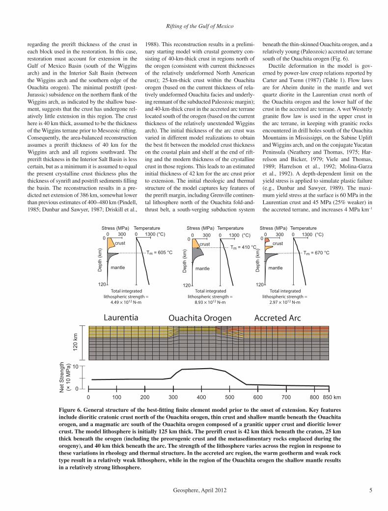
1988). This reconstruction results in a prelimi-nary starting model with crustal geometry con-sisting of 40-km-thick crust in regions north of the orogen (consistent with current thicknesses of the relatively undeformed North American crust); 25-km-thick crust within the Ouachita orogen (based on the current thickness of rela-tively undeformed Ouachita facies and underly-ing remnant of the subducted Paleozoic margin); and 40-km-thick crust in the accreted arc terrane located south of the orogen (based on the current thickness of the relatively unextended Wiggins arch). The initial thickness of the arc crust was varied in different model realizations to obtain the best fi t between the modeled crust thickness on the coastal plain and shelf at the end of rift-ing and the modern thickness of the crystalline crust in those regions. This leads to an estimated initial thickness of 42 km for the arc crust prior to extension. The initial rheologic and thermal structure of the model captures key features of the prerift margin, including Grenville continen-tal lithosphere north of the Ouachita fold-and-thrust belt, a south-verging subduction system
beneath the thin-skinned Ouachita orogen, and a relatively young (Paleozoic) accreted arc terrane south of the Ouachita orogen (Fig. 6).
Ductile deformation in the model is gov-erned by power-law creep relations reported by Carter and Tsenn (1987) (Table 1). Flow laws are for Aheim dunite in the mantle and wet quartz diorite in the Laurentian crust north of the Ouachita orogen and the lower half of the crust in the accreted arc terrane. A wet Westerly granite fl ow law is used in the upper crust in the arc terrane, in keeping with granitic rocks encountered in drill holes south of the Ouachita Mountains in Mississippi, on the Sabine Uplift and Wiggins arch, and on the conjugate Yucatan Peninsula (Neathery and Thomas, 1975; Har-relson and Bicker, 1979; Viele and Thomas, 1989; Harrelson et al., 1992; Molina-Garza et al., 1992). A depth-dependent limit on the yield stress is applied to simulate plastic failure (e.g., Dunbar and Sawyer, 1989). The maxi-mum yield stress at the surface is 60 MPa in the Laurentian crust and 45 MPa (25% weaker) in the accreted terrane, and increases 4 MPa km–1
Laurentia Ouachita Orogen Accreted Arc
120
km
0
10
Dep
th (k
m)
00 300
120
0 1300 (°C)
Tm = 605 °C
Stress (MPa)
crust
mantle
Temperature
Dep
th (k
m)
00 300
120
0 1300 (°C)
Tm = 410 °C
Stress (MPa)
crust
mantle
Temperature
Dep
th (k
m)
00 300
120
0 1300 (°C)
Tm = 670 °C
Stress (MPa)
crust
mantle
Temperature
Total integratedlithospheric strength =
4.49 × 10¹² N-m
Total integratedlithospheric strength =
8.93 × 10¹² N-m
Total integratedlithospheric strength =
2.97 × 10¹² N-m
Net
Stre
ngth
(× 1
0 M
Pa)
0 100 200 300 400 500 600 700 800 850 km
Figure 6. General structure of the best-fi tting fi nite element model prior to the onset of extension. Key features include dioritic cratonic crust north of the Ouachita orogen, thin crust and shallow mantle beneath the Ouachita orogen, and a magmatic arc south of the Ouachita orogen composed of a granitic upper crust and dioritic lower crust. The model lithosphere is initially 125 km thick. The prerift crust is 42 km thick beneath the craton, 25 km thick beneath the orogen (including the preorogenic crust and the metasedimentary rocks emplaced during the orogeny), and 40 km thick beneath the arc. The strength of the lithosphere varies across the region in response to these variations in rheology and thermal structure. In the accreted arc region, the warm geotherm and weak rock type result in a relatively weak lithosphere, while in the region of the Ouachita orogen the shallow mantle results in a relatively strong lithosphere.
Huerta and Harry
6 Geosphere, April 2012
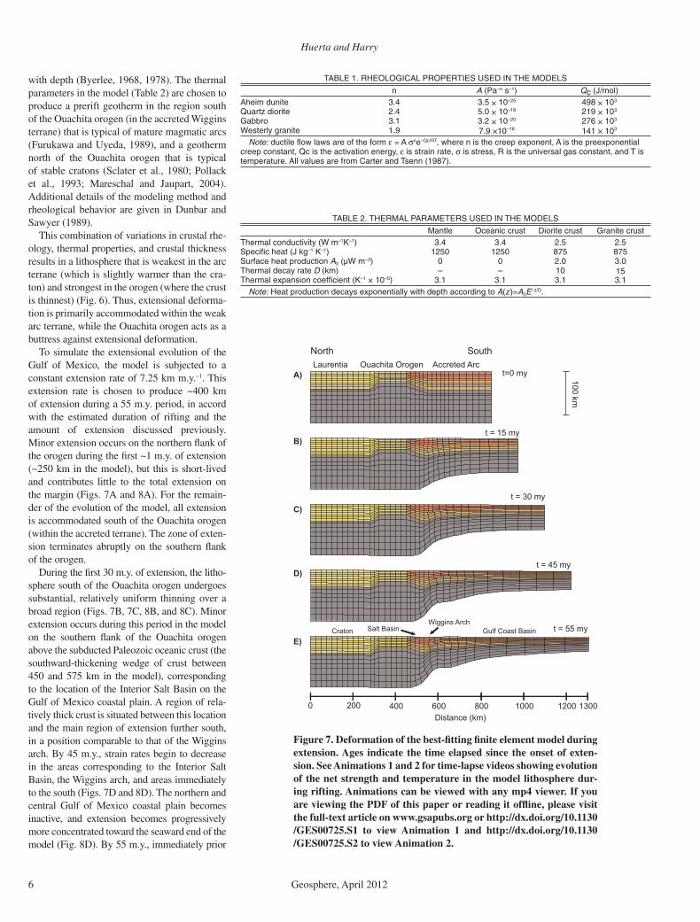
with depth (Byerlee, 1968, 1978). The thermal parameters in the model (Table 2) are chosen to produce a prerift geotherm in the region south of the Ouachita orogen (in the accreted Wiggins terrane) that is typical of mature magmatic arcs (Furukawa and Uyeda, 1989), and a geotherm north of the Ouachita orogen that is typical of stable cratons (Sclater et al., 1980; Pollack et al., 1993; Mareschal and Jaupart, 2004). Additional details of the modeling method and rheological behavior are given in Dunbar and Sawyer (1989).
This combination of variations in crustal rhe-ology, thermal properties, and crustal thickness results in a lithosphere that is weakest in the arc terrane (which is slightly warmer than the cra-ton) and strongest in the orogen (where the crust is thinnest) (Fig. 6). Thus, extensional deforma-tion is primarily accommodated within the weak arc terrane, while the Ouachita orogen acts as a buttress against extensional deformation.
To simulate the extensional evolution of the Gulf of Mexico, the model is subjected to a constant extension rate of 7.25 km m.y.–1. This extension rate is chosen to produce ~400 km of extension during a 55 m.y. period, in accord with the estimated duration of rifting and the amount of extension discussed previously. Minor extension occurs on the northern fl ank of the orogen during the fi rst ~1 m.y. of extension (~250 km in the model), but this is short-lived and contributes little to the total extension on the margin (Figs. 7A and 8A). For the remain-der of the evolution of the model, all extension is accommodated south of the Ouachita orogen (within the accreted terrane). The zone of exten-sion terminates abruptly on the southern fl ank of the orogen.
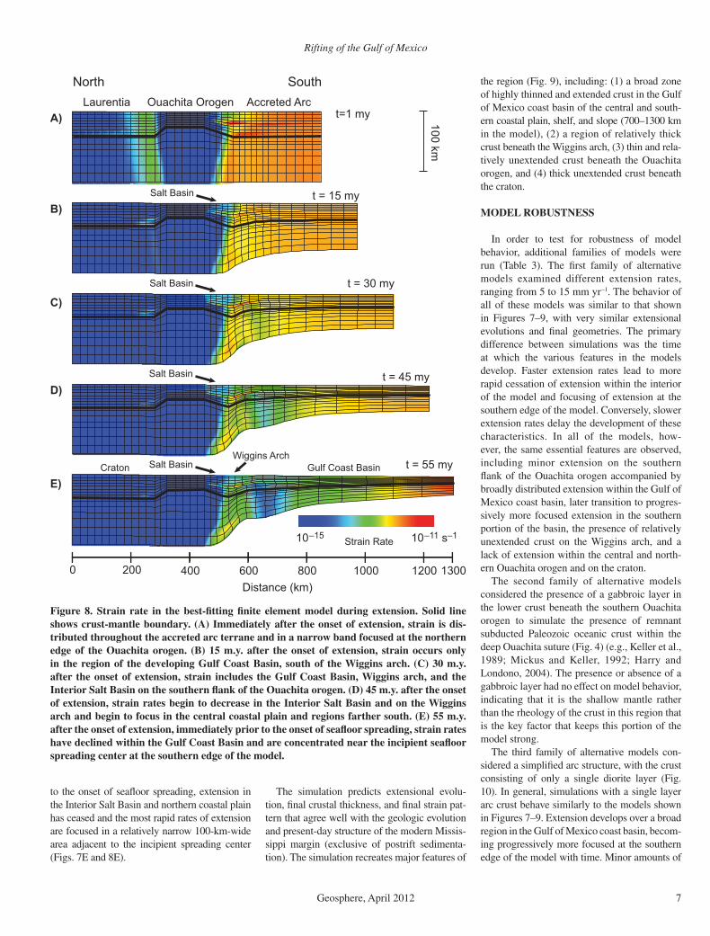
During the fi rst 30 m.y. of extension, the litho-sphere south of the Ouachita orogen undergoes substantial, relatively uniform thinning over a broad region (Figs. 7B, 7C, 8B, and 8C). Minor extension occurs during this period in the model on the southern fl ank of the Ouachita orogen above the subducted Paleozoic oceanic crust (the southward-thickening wedge of crust between 450 and 575 km in the model), corresponding to the location of the Interior Salt Basin on the Gulf of Mexico coastal plain. A region of rela-tively thick crust is situated between this location and the main region of extension further south, in a position comparable to that of the Wiggins arch. By 45 m.y., strain rates begin to decrease in the areas corresponding to the Interior Salt Basin, the Wiggins arch, and areas immediately to the south (Figs. 7D and 8D). The northern and central Gulf of Mexico coastal plain becomes in active, and extension becomes progressively more concentrated toward the seaward end of the model (Fig. 8D). By 55 m.y., immediately prior
100 km
0 200 400 1200600 1000800 1300
t=0 my
t = 15 my
t = 30 my
t = 45 my
t = 55 my
Laurentia Ouachita Orogen Accreted ArcA)
B)
C)
D)
E)
Distance (km)
North South
Salt BasinWiggins Arch
Gulf Coast BasinCraton
Figure 7. Deformation of the best-fi tting fi nite element model during extension. Ages indicate the time elapsed since the onset of exten-sion. See Animations 1 and 2 for time-lapse videos showing evolution of the net strength and temperature in the model lithosphere dur-ing rifting. Animations can be viewed with any mp4 viewer. If you are viewing the PDF of this paper or reading it offl ine, please visit the full-text article on www.gsapubs.org or http://dx.doi.org/10.1130/GES00725.S1 to view Animation 1 and http://dx.doi.org/10.1130/GES00725.S2 to view Animation 2.
TABLE 1. RHEOLOGICAL PROPERTIES USED IN THE MODELS
n A (Pa–n s–1) Qc (J/mol)5.34.3etinudmiehA × 10–25 498 × 103
0.54.2etiroidztrauQ × 10–18 219 × 103
2.31.3orbbaG × 10–20 276 × 103
9.1etinargylretseW 7.9 ×10⁻¹⁶ 141 × 103
Note: ductile fl ow laws are of the form ε = A σne–Qc/RT, where n is the creep exponent, A is the preexponential creep constant, Qc is the activation energy, ε is strain rate, σ is stress, R is the universal gas constant, and T is temperature. All values are from Carter and Tsenn (1987).
TABLE 2. THERMAL PARAMETERS USED IN THE MODELS
Mantle Oceanic crust Diorite crust Granite crustThermal conductivity (W m–1K–1) 3.4 3.4 2.5 2.5Specifi c heat (J kg–1 K–1 57857805210521)Surface heat production A0 (µW m–3) 0 0 2.0 3.0Thermal decay rate D 01––)mk( 15Thermal expansion coeffi cient (K–1 × 10⁻⁵) 3.1 3.1 3.1 3.1
Note: Heat production decays exponentially with depth according to A(z)=A0E–z/D.
Rifting of the Gulf of Mexico
Geosphere, April 2012 7
to the onset of seafl oor spreading, extension in the Interior Salt Basin and northern coastal plain has ceased and the most rapid rates of extension are focused in a relatively narrow 100-km-wide area adjacent to the incipient spreading center (Figs. 7E and 8E).
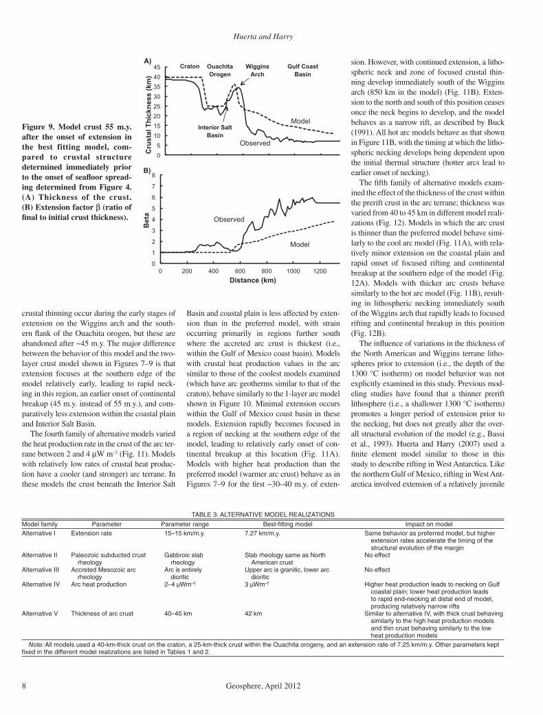
The simulation predicts extensional evolu-tion, fi nal crustal thickness, and fi nal strain pat-tern that agree well with the geologic evolution and present-day structure of the modern Missis-sippi margin (exclusive of postrift sedimenta-tion). The simulation recreates major features of
the region (Fig. 9), including: (1) a broad zone of highly thinned and extended crust in the Gulf of Mexico coast basin of the central and south-ern coastal plain, shelf, and slope (700–1300 km in the model), (2) a region of relatively thick crust beneath the Wiggins arch, (3) thin and rela-tively unextended crust beneath the Ouachita orogen, and (4) thick unextended crust beneath the craton.
MODEL ROBUSTNESS
In order to test for robustness of model behavior, additional families of models were run (Table 3). The fi rst family of alternative models examined different extension rates, ranging from 5 to 15 mm yr–1. The behavior of all of these models was similar to that shown in Figures 7–9, with very similar extensional evolutions and fi nal geometries. The primary difference between simulations was the time at which the various features in the models develop. Faster extension rates lead to more rapid cessation of extension within the interior of the model and focusing of extension at the southern edge of the model. Conversely, slower extension rates delay the development of these characteristics. In all of the models, how-ever, the same essential features are observed, including minor extension on the southern fl ank of the Ouachita orogen accompanied by broadly distributed extension within the Gulf of Mexico coast basin, later transition to progres-sively more focused extension in the southern portion of the basin, the presence of relatively unextended crust on the Wiggins arch, and a lack of extension within the central and north-ern Ouachita orogen and on the craton.
The second family of alternative models considered the presence of a gabbroic layer in the lower crust beneath the southern Ouachita orogen to simulate the presence of remnant subducted Paleozoic oceanic crust within the deep Ouachita suture (Fig. 4) (e.g., Keller et al., 1989; Mickus and Keller, 1992; Harry and Londono, 2004). The presence or absence of a gabbroic layer had no effect on model behavior, indicating that it is the shallow mantle rather than the rheology of the crust in this region that is the key factor that keeps this portion of the model strong.
The third family of alternative models con-sidered a simplifi ed arc structure, with the crust consisting of only a single diorite layer (Fig. 10). In general, simulations with a single layer arc crust behave similarly to the models shown in Figures 7–9. Extension develops over a broad region in the Gulf of Mexico coast basin, becom-ing progressively more focused at the southern edge of the model with time. Minor amounts of
100 km
0 200 400 1200600 1000800 1300
t=1 my
t = 15 my
t = 30 my
t = 45 my
t = 55 my
Laurentia Ouachita Orogen Accreted Arc
10–15 10–11 s–1
A)
B)
C)
D)
E)
Distance (km)
North South
Salt BasinWiggins Arch
Gulf Coast BasinCraton
Strain Rate
Salt Basin
Salt Basin
Salt Basin
Figure 8. Strain rate in the best-fi tting fi nite element model during extension. Solid line shows crust-mantle boundary. (A) Immediately after the onset of extension, strain is dis-tributed throughout the accreted arc terrane and in a narrow band focused at the northern edge of the Ouachita orogen. (B) 15 m.y. after the onset of extension, strain occurs only in the region of the developing Gulf Coast Basin, south of the Wiggins arch. (C) 30 m.y. after the onset of extension, strain includes the Gulf Coast Basin, Wiggins arch, and the Interior Salt Basin on the southern fl ank of the Ouachita orogen. (D) 45 m.y. after the onset of extension, strain rates begin to decrease in the Interior Salt Basin and on the Wiggins arch and begin to focus in the central coastal plain and regions farther south. (E) 55 m.y. after the onset of extension, immediately prior to the onset of seafl oor spreading, strain rates have declined within the Gulf Coast Basin and are concentrated near the incipient seafl oor spreading center at the southern edge of the model.
Huerta and Harry
8 Geosphere, April 2012
crustal thinning occur during the early stages of extension on the Wiggins arch and the south-ern fl ank of the Ouachita orogen, but these are abandoned after ~45 m.y. The major difference between the behavior of this model and the two-layer crust model shown in Figures 7–9 is that extension focuses at the southern edge of the model relatively early, leading to rapid neck-ing in this region, an earlier onset of continental breakup (45 m.y. instead of 55 m.y.), and com-paratively less extension within the coastal plain and Interior Salt Basin.
The fourth family of alternative models varied the heat production rate in the crust of the arc ter-rane between 2 and 4 μW m–3 (Fig. 11). Models with relatively low rates of crustal heat produc-tion have a cooler (and stronger) arc terrane. In these models the crust beneath the Interior Salt
Basin and coastal plain is less affected by exten-sion than in the preferred model, with strain occurring primarily in regions further south where the accreted arc crust is thickest (i.e., within the Gulf of Mexico coast basin). Models with crustal heat production values in the arc similar to those of the coolest models examined (which have arc geotherms similar to that of the craton), behave similarly to the 1-layer arc model shown in Figure 10. Minimal extension occurs within the Gulf of Mexico coast basin in these models. Extension rapidly becomes focused in a region of necking at the southern edge of the model, leading to relatively early onset of con-tinental breakup at this location (Fig. 11A). Models with higher heat production than the preferred model (warmer arc crust) behave as in Figures 7–9 for the fi rst ~30–40 m.y. of exten-
sion. However, with continued extension, a litho-spheric neck and zone of focused crustal thin-ning develop immediately south of the Wiggins arch (850 km in the model) (Fig. 11B). Exten-sion to the north and south of this position ceases once the neck begins to develop, and the model behaves as a narrow rift, as described by Buck (1991). All hot arc models behave as that shown in Figure 11B, with the timing at which the litho-spheric necking develops being dependent upon the initial thermal structure (hotter arcs lead to earlier onset of necking).
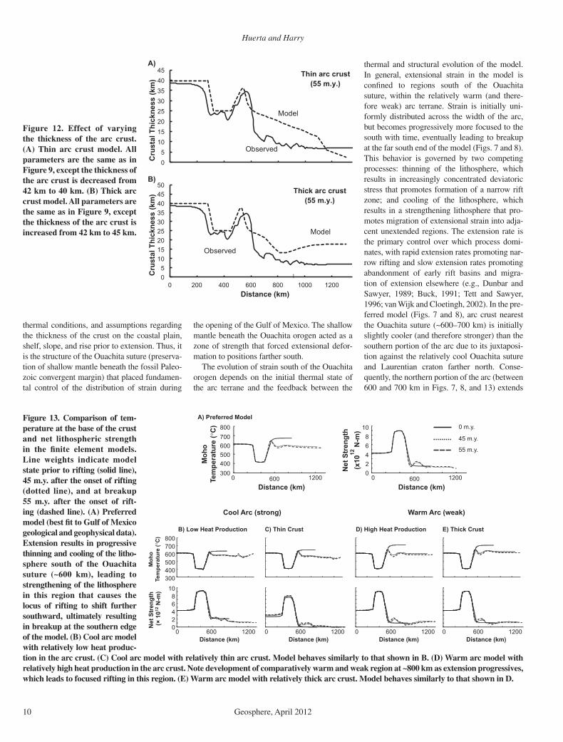
The fi fth family of alternative models exam-ined the effect of the thickness of the crust within the prerift crust in the arc terrane; thickness was varied from 40 to 45 km in different model reali-zations (Fig. 12). Models in which the arc crust is thinner than the preferred model behave simi-larly to the cool arc model (Fig. 11A), with rela-tively minor extension on the coastal plain and rapid onset of focused rifting and continental breakup at the southern edge of the model (Fig. 12A). Models with thicker arc crusts behave similarly to the hot arc model (Fig. 11B), result-ing in lithospheric necking immediately south of the Wiggins arch that rapidly leads to focused rifting and continental breakup in this position (Fig. 12B).
The infl uence of variations in the thickness of the North American and Wiggins terrane litho-spheres prior to extension (i.e., the depth of the 1300 °C isotherm) on model behavior was not explicitly examined in this study. Previous mod-eling studies have found that a thinner prerift lithosphere (i.e., a shallower 1300 °C isotherm) promotes a longer period of extension prior to the necking, but does not greatly alter the over-all structural evolution of the model (e.g., Bassi et al., 1993). Huerta and Harry (2007) used a fi nite element model similar to those in this study to describe rifting in West Antarctica. Like the northern Gulf of Mexico, rifting in West Ant-arctica involved extension of a relatively juvenile
0
1
2
3
4
5
6
7
8
0 200 400 600 800 1000 1200
Bet
a
Distance (km)
0 5
10 15 20 25 30 35 40 45
Cru
stal
Thi
ckne
ss (k
m)
WigginsArch
A)
B)
Model
Model
Observed
Observed
Craton OuachitaOrogen
Gulf CoastBasin
Interior SaltBasin
Figure 9. Model crust 55 m.y. after the onset of extension in the best fitting model, com-pared to crustal structure determined immediately prior to the onset of seafl oor spread-ing determined from Figure 4. (A) Thickness of the crust. (B) Extension factor β (ratio of fi nal to initial crust thickness).
TABLE 3. ALTERNATIVE MODEL REALIZATIONS
ledomnotcapmIBest-fitting modelegnarretemaraPretemaraPylimafledoMAlternative I Extension rate 15–15 km/m.y. 7.27 km/m.y rehgihtub,ledomderreferpsaroivahebemaS.
extension rates accelerate the timing of the structural evolution of the margin
Alternative II Paleozoic subducted crust rheology
Gabbroic slab rheology
Slab rheology same as North American crust
No effect
Alternative III Accreted Mesozoic arc rheology
Arc is entirely dioritic
Upper arc is granitic, lower arc dioritic
No effect
Alternative IV Arc heat production 2–4 µWm–3 3 µWm–3 Higher heat production leads to necking on Gulf coastal plain; lower heat production leads to rapid end-necking at distal end of model, producing relatively narrow rifts
Alternative V Thickness of arc crust 40–45 km 42 km Similar to alternative IV, with thick crust behaving similarly to the high heat production models and thin crust behaving similarly to the low heat production models
Note: All models used a 40-km-thick crust on the craton, a 25-km-thick crust within the Ouachita orogeny, and an extension rate of 7.25 km/m.y. Other parameters kept fi xed in the different model realizations are listed in Tables 1 and 2.
Rifting of the Gulf of Mexico
Geosphere, April 2012 9
terrane accreted to the edge of the older East Ant-arctica craton. The models presented here (ini-tially broad necking within the arc terrane and a later shift to focused necking at the edge of the model) behave similarly to Huerta and Harry’s (2007) Class iii model, which they found to be robust behavior over a wide range of lithosphere thicknesses as long as the prerift temperature at the base of the crust was <~680 °C. At higher temperatures, the models of Huerta and Harry (2007) generally underwent prolonged exten-sion in the arc terrane without ever developing a focused rift axis (their Class ii model) except in a narrow set of circumstances (which lead to formation of a rift neck at the suture between the craton and arc terrane).
DISCUSSION
The evolution of strain in the preferred simulation agrees well both temporally and spatially with geologic and geophysical obser-vations from the central North American Gulf of Mexico margin (Fig. 4). Modeled strain dur-ing the fi rst 45 m.y. is distributed throughout the accreted terrane, from the southern edge of the Ouachita suture to the southern edge of the model, coinciding with the distribution of fault-bounded rift structures that developed on the southern coastal plain, shelf, slope, and rise between Late Triassic and Callovian time (Salvador, 1987, 1991a, 1991b; Driskill et al., 1988; Marton and Buffl er, 1994). The spatial extent of this stage of extension terminates on the southern fl ank of the Ouachita orogen in a
position that coincides with the location of the peripheral fault trend and the northern limit of synrift evaporite and clastic deposits. A region of relatively thick crust in the model south of the Ouachita orogen agrees in location and crustal thickness with the structure of the Wiggins arch (Rhodes and Maxwell, 1993; Montgomery, 2000). After ~45 m.y. of modeled extension, strain in the vicinity of the Ouachita suture wanes and becomes progressively more focused further to the south, coinciding with cessation of
extensional tectonism in the Interior Salt Basin and coastal plain and rapid deepening of the central Gulf of Mexico in late Callovian–early Oxfordian time (Salvador, 1987, 1991a, 1991b; Driskill et al., 1988; Marton and Buffl er, 1994). After 50 m.y. of modeled extension, lithospheric necking is well established at the southern edge of the model. The crust in this region thins rap-idly thereafter as extensional strain becomes progressively more focused. By 55 m.y. after the onset of extension, the thickness of the crust in the rift axis has decreased to 5 km and the thickness of the lithosphere to 25 km, which by comparison to modern ocean spreading ridges and other rift margins is taken to mark breakup and the onset of seafl oor spreading. The 55 m.y. period of modeled extension agrees with the timing of rifting in the Gulf of Mexico that began in Late Triassic and ended in latest Callo-vian–early Oxfordian time (Pindell and Kennan, 2009). The modeled short time span (~5 m.y.) between the formation of a well-developed rift axis and the onset of seafl oor spreading is in accord with the short period of time elapsed between widespread deposition of evaporite deposits on the modern coastal plain and shelf during Callovian time and the onset of sea-fl oor spreading in the deep Gulf of Mexico by early Oxfordian time (Salvador, 1987; Buffl er and Thomas, 1994; Marton and Buffl er, 1994; Pindell and Kennan, 2009).
Alternative simulations (Figs. 10–12) also show a lack of strain within the central Ouachita orogen and positions farther north, demonstrat-ing that the major features of the model are robust under a range of extension rates, rheologies,
0
1
2
3
4
5
6
7
8
0 200 400 600 800 1000 1200
Bet
a
Distance (km)
0 5
10 15 20 25 30 35 40 45
Cru
stal
Thi
ckne
ss (k
m)
Model
Observed
1-layer arc crust(55 m.y.)
ModelObserved
B)
A)
Maximum � = 24 at1300 km
Figure 10. Alternative model with single layer arc crust, composed entirely of diorite. (A) Thickness of the crust. (B) Extension factor β (ratio of fi nal to initial crust thickness).
0 5
10 15 20 25 30 35 40 45
Cru
stal
Thi
ckne
ss (k
m)
0 5
10 15 20 25 30 35 40 45
0 200 400 600 800 1000 1200
Cru
stal
Thi
ckne
ss (k
m)
Distance (km)
A)
B)
Model
Model
Observed
Observed
Warm arc crust(55 m.y.)
Warm arc crust(55 m.y.)
Figure 11. Effect of varying heat production in the arc crust. (A) Cooler arc model. All param-eters are the same as in Figure 9, except surface heat production is reduced from 3 to 2 mW m–3. (B) Warmer arc model. All parameters are the same as in Figure 9, except surface heat production is increased from 3 to 4 mW m–3.
Huerta and Harry
10 Geosphere, April 2012
thermal conditions, and assumptions regarding the thickness of the crust on the coastal plain, shelf, slope, and rise prior to extension. Thus, it is the structure of the Ouachita suture (preserva-tion of shallow mantle beneath the fossil Paleo-zoic convergent margin) that placed fundamen-tal control of the distribution of strain during
the opening of the Gulf of Mexico. The shallow mantle beneath the Ouachita orogen acted as a zone of strength that forced extensional defor-mation to positions farther south.
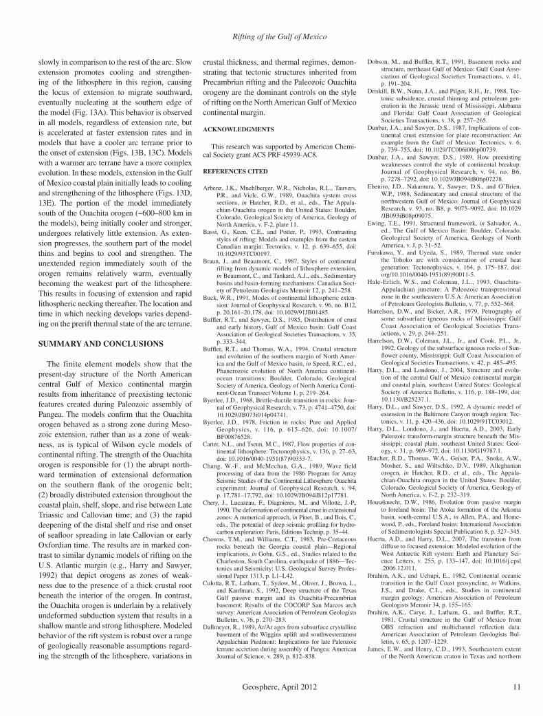
The evolution of strain south of the Ouachita orogen depends on the initial thermal state of the arc terrane and the feedback between the
thermal and structural evolution of the model. In general, extensional strain in the model is confi ned to regions south of the Ouachita suture, within the relatively warm (and there-fore weak) arc terrane. Strain is initially uni-formly distributed across the width of the arc, but becomes progressively more focused to the south with time, eventually leading to breakup at the far south end of the model (Figs. 7 and 8). This behavior is governed by two competing processes : thinning of the lithosphere, which results in increasingly concentrated deviatoric stress that promotes formation of a narrow rift zone; and cooling of the lithosphere, which results in a strengthening lithosphere that pro-motes migration of extensional strain into adja-cent unextended regions. The extension rate is the primary control over which process domi-nates, with rapid extension rates promoting nar-row rifting and slow extension rates promoting abandonment of early rift basins and migra-tion of extension elsewhere (e.g., Dunbar and Sawyer , 1989; Buck, 1991; Tett and Sawyer, 1996; van Wijk and Cloetingh, 2002). In the pre-ferred model (Figs. 7 and 8), arc crust nearest the Ouachita suture (~600–700 km) is initially slightly cooler (and therefore stronger) than the southern portion of the arc due to its juxtaposi-tion against the relatively cool Ouachita suture and Laurentian craton farther north. Conse-quently, the northern portion of the arc (between 600 and 700 km in Figs. 7, 8, and 13) extends
0 5
10 15 20 25 30 35 40 45 50
0 200 400 600 800 1000 1200
Cru
stal
Thi
ckne
ss (k
m)
Distance (km)
!
0 5
10 15 20 25 30 35 40 45
Cru
stal
Thi
ckne
ss (k
m)
A)
B)
Model
Model
Observed
Observed
Thin arc crust(55 m.y.)
Thick arc crust(55 m.y.)
Figure 12. Effect of varying the thickness of the arc crust. (A) Thin arc crust model. All parameters are the same as in Figure 9, except the thickness of the arc crust is decreased from 42 km to 40 km. (B) Thick arc crust model. All parameters are the same as in Figure 9, except the thickness of the arc crust is increased from 42 km to 45 km.
Figure 13. Comparison of tem-perature at the base of the crust and net lithospheric strength in the fi nite element models. Line weights indicate model state prior to rifting (solid line), 45 m.y. after the onset of rifting (dotted line), and at breakup 55 m.y. after the onset of rift-ing (dashed line). (A) Preferred model (best fi t to Gulf of Mexico geological and geophysical data). Extension results in progressive thinning and cooling of the litho-sphere south of the Ouachita suture (~600 km), leading to strengthening of the lithosphere in this region that causes the locus of rifting to shift further southward, ultimately resulting in breakup at the southern edge of the model. (B) Cool arc model with relatively low heat produc-tion in the arc crust. (C) Cool arc model with relatively thin arc crust. Model behaves similarly to that shown in B. (D) Warm arc model with relatively high heat production in the arc crust. Note development of comparatively warm and weak region at ~800 km as extension progressives, which leads to focused rifting in this region. (E) Warm arc model with relatively thick arc crust. Model behaves similarly to that shown in D.
)kaew(crAmraW)gnorts(crAlooC
0 m.y.
45 m.y.
55 m.y.
300400500600700800
0 600 1200
Moh
oTe
mpe
ratu
re (
C)
Distance (km)
A) Preferred Model
02468
10
Net
Str
engt
h(x
10N
-m)
12
0 600 1200Distance (km)
B) Low Heat Production
300400500600700800
Moh
oTe
mpe
ratu
re (
C)
0 600 1200Distance (km)
02468
10
Net
Str
engt
h(×
1012
N-m
)
C) Thin Crust
0 600 1200Distance (km)
D) High Heat Production
0 600 1200Distance (km)
E) Thick Crust
0 600 1200Distance (km)
Rifting of the Gulf of Mexico
Geosphere, April 2012 11
slowly in comparison to the rest of the arc. Slow extension promotes cooling and strengthen-ing of the lithosphere in this region, causing the locus of extension to migrate southward, eventually nucleating at the southern edge of the model (Fig. 13A). This behavior is observed in all models, regardless of extension rate, but is accelerated at faster extension rates and in models that have a cooler arc terrane prior to the onset of extension (Figs. 13B, 13C). Models with a warmer arc terrane have a more complex evolution. In these models, extension in the Gulf of Mexico coastal plain initially leads to cooling and strengthening of the lithosphere (Figs. 13D, 13E). The portion of the model immediately south of the Ouachita orogen (~600–800 km in the models), being initially cooler and stronger, undergoes relatively little extension. As exten-sion progresses, the southern part of the model thins and begins to cool and strengthen. The unextended region immediately south of the orogen remains relatively warm, eventually becoming the weakest part of the lithosphere. This results in focusing of extension and rapid lithospheric necking thereafter. The location and time in which necking develops varies depend-ing on the prerift thermal state of the arc terrane.
SUMMARY AND CONCLUSIONS
The finite element models show that the present-day structure of the North American central Gulf of Mexico continental margin results from inheritance of preexisting tectonic features created during Paleozoic assembly of Pangea. The models confi rm that the Ouachita orogen behaved as a strong zone during Meso-zoic extension, rather than as a zone of weak-ness, as is typical of Wilson cycle models of continental rifting. The strength of the Ouachita orogen is responsible for (1) the abrupt north-ward termination of extensional deformation on the southern fl ank of the orogenic belt; (2) broadly distributed extension throughout the coastal plain, shelf, slope, and rise between Late Triassic and Callovian time; and (3) the rapid deepening of the distal shelf and rise and onset of seafl oor spreading in late Callovian or early Oxfordian time. The results are in marked con-trast to similar dynamic models of rifting on the U.S. Atlantic margin (e.g., Harry and Sawyer, 1992) that depict orogens as zones of weak-ness due to the presence of a thick crustal root beneath the interior of the orogen. In contrast, the Ouachita orogen is underlain by a relatively undeformed subduction system that results in a shallow mantle and strong lithosphere. Modeled behavior of the rift system is robust over a range of geologically reasonable assumptions regard-ing the strength of the lithosphere, variations in
crustal thickness, and thermal regimes, demon-strating that tectonic structures inherited from Precambrian rifting and the Paleozoic Ouachita orogeny are the dominant controls on the style of rifting on the North American Gulf of Mexico continental margin.
ACKNOWLEDGMENTS
This research was supported by American Chemi-cal Society grant ACS PRF 45939-AC8.
REFERENCES CITED
Arbenz, J.K., Muehlberger, W.R., Nicholas, R.L., Tauvers, P.R., and Viele, G.W., 1989, Ouachita system cross sections, in Hatcher, R.D., et al., eds., The Appala-chian-Ouachita orogen in the United States: Boulder, Colorado, Geological Society of America, Geology of North America, v. F-2, plate 11.
Bassi, G., Keen, C.E., and Potter, P., 1993, Contrasting styles of rifting: Models and examples from the eastern Canadian margin: Tectonics, v. 12, p. 639–655, doi: 10.1029/93TC00197.
Braun, J., and Beaumont, C., 1987, Styles of continental rifting from dynamic models of lithosphere extension, in Beaumont, C., and Tankard, A.J., eds., Sedimentary basins and basin-forming mechanisms: Canadian Soci-ety of Petroleum Geologists Memoir 12, p. 241–258.
Buck, W.R., 1991, Modes of continental lithospheric exten-sion: Journal of Geophysical Research, v. 96, no. B12, p. 20,161–20,178, doi: 10.1029/91JB01485.
Buffl er, R.T., and Sawyer, D.S., 1985, Distribution of crust and early history, Gulf of Mexico basin: Gulf Coast Association of Geological Societies Transactions, v. 35, p. 333–344.
Buffl er, R.T., and Thomas, W.A., 1994, Crustal structure and evolution of the southern margin of North Amer-ica and the Gulf of Mexico basin, in Speed, R.C., ed., Phanero zoic evolution of North America continent-ocean transitions: Boulder, Colorado, Geological Society of America, Geology of North America Conti-nent-Ocean Transect Volume 1, p. 219–264.
Byerlee, J.D., 1968, Brittle-ductile transition in rocks: Jour-nal of Geophysical Research, v. 73, p. 4741–4750, doi: 10.1029/JB073i014p04741.
Byerlee, J.D., 1978, Friction in rocks: Pure and Applied Geophysics, v. 116, p. 615–626, doi: 10.1007/BF00876528.
Carter, N.L., and Tsenn, M.C., 1987, Flow properties of con-tinental lithosphere: Tectonophysics, v. 136, p. 27–63, doi: 10.1016/0040-1951(87)90333-7.
Chang, W.-F., and McMechan, G.A., 1989, Wave field processing of data from the 1986 Program for Array Seismic Studies of the Continental Lithosphere Ouachita experiment: Journal of Geophysical Research, v. 94, p. 17,781–17,792, doi: 10.1029/JB094iB12p17781.
Chery, J., Lucazeau, F., Diagnieres, M., and Villotte, J.-P., 1990, The deformation of continental crust in extensional zones: A numerical approach, in Pinet, B., and Bois, C., eds., The potential of deep seismic profi ling for hydro-carbon exploration: Paris, Editions Technip, p. 35–44.
Chowns, T.M., and Williams, C.T., 1983, Pre-Cretaceous rocks beneath the Georgia coastal plain—Regional implications, in Gohn, G.S., ed., Studies related to the Charleston, South Carolina, earthquake of 1886—Tec-tonics and Seismicity: U.S. Geological Survey Profes-sional Paper 1313, p. L1–L42.
Culotta, R.T., Latham, T., Sydow, M., Oliver, J., Brown, L., and Kaufman, S., 1992, Deep structure of the Texas Gulf passive margin and its Ouachita-Precambrian basement: Results of the COCORP San Marcos arch survey: American Association of Petroleum Geologists Bulletin, v. 76, p. 270–283.
Dallmeyer, R., 1989, Ar/Ar ages from subsurface crystalline basement of the Wiggins uplift and southwesternmost Appalachian Piedmont: Implications for late Paleozoic terrane accretion during assembly of Pangea: American Journal of Science, v. 289, p. 812–838.
Dobson, M., and Buffl er, R.T., 1991, Basement rocks and structure, northeast Gulf of Mexico: Gulf Coast Asso-ciation of Geological Societies Transactions, v. 41, p. 191–204.
Driskill, B.W., Nunn, J.A., and Pilger, R.H., Jr., 1988, Tec-tonic subsidence, crustal thinning and petroleum gen-eration in the Jurassic trend of Mississippi, Alabama and Florida: Gulf Coast Association of Geological Societies Transactions, v. 38, p. 257–265.
Dunbar, J.A., and Sawyer, D.S., 1987, Implications of con-tinental crust extension for plate reconstruction: An example from the Gulf of Mexico: Tectonics, v. 6, p. 739–755, doi: 10.1029/TC006i006p00739.
Dunbar, J.A., and Sawyer, D.S., 1989, How preexisting weaknesses control the style of continental breakup: Journal of Geophysical Research, v. 94, no. B6, p. 7278–7292, doi: 10.1029/JB094iB06p07278.
Ebeniro, J.D., Nakamura, Y., Sawyer, D.S., and O’Brien, W.P., 1988, Sedimentary and crustal structure of the northwestern Gulf of Mexico: Journal of Geophysical Research, v. 93, no. B8, p. 9075–9092, doi: 10.1029/JB093iB08p09075.
Ewing, T.E., 1991, Structural framework, in Salvador, A., ed., The Gulf of Mexico Basin: Boulder, Colorado, Geological Society of America, Geology of North America, v. J, p. 31–52.
Furukawa, Y., and Uyeda, S., 1989, Thermal state under the Tohoko arc with consideration of crustal heat generation: Tectonophysics, v. 164, p. 175–187, doi: org/10.1016/0040-1951(89)90011-5.
Hale-Erlich, W.S., and Coleman, J.L., 1993, Ouachita-Appalachian juncture: A Paleozoic transpressional zone in the southeastern U.S.A: American Association of Petroleum Geologists Bulletin, v. 77, p. 552–568.
Harrelson, D.W., and Bicker, A.R., 1979, Petrography of some subsurface igneous rocks of Mississippi: Gulf Coast Association of Geological Societies Trans-actions, v. 29, p. 244–251.
Harrelson, D.W., Coleman, J.L., Jr., and Cook, P.L., Jr., 1992, Geology of the subsurface igneous rocks of Sun-fl ower county, Mississippi: Gulf Coast Association of Geological Societies Transactions, v. 42, p. 485–495.
Harry, D.L., and Londono, J., 2004, Structure and evolu-tion of the central Gulf of Mexico continental margin and coastal plain, southeast United States: Geological Society of America Bulletin, v. 116, p. 188–199, doi: 10.1130/B25237.1.
Harry, D.L., and Sawyer, D.S., 1992, A dynamic model of extension in the Baltimore Canyon trough region: Tec-tonics, v. 11, p. 420–436, doi: 10.1029/91TC03012.
Harry, D.L., Londono, J., and Huerta, A.D., 2003, Early Paleozoic transform-margin structure beneath the Mis-sissippi; coastal plain, southeast United States: Geol-ogy, v. 31, p. 969–972, doi: 10.1130/G19787.1.
Hatcher, R.D., Thomas, W.A., Geiser, P.A., Snoke, A.W., Mosher, S., and Wiltschko, D.V., 1989, Alleghanian orogen, in Hatcher, R.D., et al., eds., The Appala-chian-Ouachita orogen in the United States: Boulder, Colorado, Geological Society of America, Geology of North America, v. F-2, p. 232–319.
Houseknecht, D.W., 1986, Evolution from passive margin to foreland basin: The Atoka formation of the Arkoma basin, south-central U.S.A., in Allen, P.A., and Home-wood, P., eds., Foreland basins: International Association of Sedimentologists Special Publication 8, p. 327–345.
Huerta, A.D., and Harry, D.L., 2007, The transition from diffuse to focused extension: Modeled evolution of the West Antarctic Rift system: Earth and Planetary Sci-ence Letters, v. 255, p. 133–147, doi: 10.1016/j.epsl.2006.12.011.
Ibrahim, A.K., and Uchupi, E., 1982, Continental oceanic transition in the Gulf Coast geosyncline, in Watkins, J.S., and Drake, C.L., eds., Studies in continental margin geology: American Association of Petroleum Geologists Memoir 34, p. 155–165.
Ibrahim, A.K., Carye, J., Latham, G., and Buffl er, R.T., 1981, Crustal structure in the Gulf of Mexico from OBS refraction and multichannel refl ection data: American Association of Petroleum Geologists Bul-letin, v. 65, p. 1207–1229.
James, E.W., and Henry, C.D., 1993, Southeastern extent of the North American craton in Texas and northern
Huerta and Harry
12 Geosphere, April 2012
Chihuahua as revealed by Pb isotopes: Geological Soci-ety of America Bulletin, v. 105, p. 116–126, doi: 10.1130/0016-7606(1993)105<0116:SEOTNA>2.3.CO;2.
Keller, G.R., Braile, L.W., McMechan, G.A., Thomas, W.A., Harder, S.H., Chang, W.F., and Jardine, W.G., 1989, Paleo-zoic continent-ocean transition in the Ouachita mountains imaged from PASSCAL wide-angle seismic refl ection-refraction data: Geology, v. 17, p. 119–122, doi: 10.1130/0091-7613(1989)017<0119:PCOTIT>2.3.CO;2.
Krabbendam, M., 2001, When the Wilson cycle breaks down: How orogens can produce strong lithosphere and inhibit their future reworking, in Miller, J.A., et al., eds., Continental reactivation and reworking: Geological Society of London Special Publication 184, p. 57–75, doi: 10.1144/GSL.SP.2001.184.01.04.
Kruger, J., and Keller, G., 1986, Interpretation of regional gravity anomalies in the Ouachita Mountains and adja-cent gulf coastal plain: American Association of Petro-leum Geologists Bulletin, v. 70, p. 667–689.
Loomis, J., and Weaver, H.B., 1994, Geochemistry of Mis-sissippian tuffs from the Ouachita Mountains, and implications for the tectonics of the Ouachita oro-gen, Oklahoma and Arkansas: Geological Society of America Bulletin, v. 106, p. 1158–1171, doi: 10.1130/0016-7606(1994)106<1158:GOMTFT>2.3.CO;2.
Mareschal, J.C., and Jaupart, C., 2004, Variations of surface heat fl ow and lithospheric thermal structure beneath the North American craton: Earth and Planetary Science Letters, v. 223, p. 65–77, doi: 10.1016/j.epsl.2004.04.002.
Marton, G., and Buffl er, R.T., 1994, Jurassic reconstruction of the Gulf of Mexico: International Geology Review, v. 36, p. 545–586, doi: 10.1080/00206819409465475.
McKenzie, D.P., 1978, Some remarks on the development of sedimentary basins: Earth and Planetary Science Letters, v. 40, p. 25–32, doi: 10.1016/0012-821X(78)90071-7.
Mickus, K.L., and Keller, G.R., 1992, Lithospheric struc-ture of the south-central United States: Geology, v. 20, p. 335–338, doi: 10.1130/0091-7613(1992)020<0335:LSOTSC>2.3.CO;2.
Mickus, K.L, Stern, R.J., Keller, G.R., and Anthony, E.Y., 2009, Potential fi eld evidence for a volcanic rifted margin along the Texas Gulf Coast: Geology, v. 37, p. 387–390, doi:10.1130/G25465A.1.
Molina-Garza, R.S., Van der Voo, R., and Urratia-Fucugauchi , J., 1992, Paleomagnetism of the Chiapas Massif, southern Mexico: Evidence for rotation of the Maya Block and implications for the opening of the Gulf of Mexico: Geological Society of America Bulletin, v. 104, p. 1156–1168, doi: 10.1130/0016-7606(1992)104<1156:POTCMS>2.3.CO;2.
Montgomery, S.L., 2000, Wiggins Arch, southern Missis-sippi: New exploratory data from 3-D seismic: Ameri-can Association of Petroleum Geologists Bulletin, v. 84, p. 299–313.
Mosher, S., Levine, J.S.F., and Carlson, W.D., 2008, Meso-proterozoic plate tectonics: A collisional model for the Grenville-aged orogenic belt in the Llano uplift, central Texas: Geology, v. 36, p. 55–58, doi: 10.1130/G24049A.1.
Nakamura, Y., Sawyer, D.S., Shaub, F.J., MacKenzie, K., and Oberst, J., 1988, Deep crustal structure of the northwestern Gulf of Mexico: Gulf Coast Asso-ciation of Geological Societies Transactions, v. 38, p. 207–215.
Neathery, T.L., and Thomas, W.A., 1975, Pre-Mesozoic base-ment rocks of the Alabama coastal plain: Gulf Coast
Association of Geological Societies Transactions, v. 25, p. 86–99.
Nunn, J.A., Scardina, A.D., and Pilger, R.H., Jr., 1984, Ther-mal evolution of the north-central Gulf coast: Tecton-ics, v. 3, p. 723–740, doi: 10.1029/TC003i007p00723.
Pindell, J., 1985, Alleghenian reconstruction and subse-quent evolution of the Gulf of Mexico, Bahamas and proto-Caribbean: Tectonics, v. 4, p. 1–39, doi: 10.1029/TC004i001p00001.
Pindell, J., and Dewey, J.F., 1982, Permo-Triassic reconstruc-tion of western Pangea and the evolution of the Gulf of Mexico/Caribbean region: Tectonics, v. 1, p. 179–211, doi: 10.1029/TC001i002p00179.
Pindell, J.L., and Kennan, L., 2009, Tectonic evolution of the Gulf of Mexico, Caribbean and northern South America in the mantle reference frame: An update, in James, K.H., et al., eds., The origin and evolution of the Caribbean plate: Geological Society of London Special Publication 328, p. 1–55, doi: 10.1144/SP328.1.
Pollack, H.N., Hurter, S.J., and Johnson, J.R., 1993, Heat fl ow from the Earth’s interior: Analysis of the global data set: Reviews of Geophysics, v. 31, p. 267–280, doi: 10.1029/93RG01249.
Pratt, T.L., Coruh, C., Costain, J.K., and Glover, L., 1988, A geophysical study of the Earth’s crust in central Vir-ginia: Implications for Appalachian crustal structure: Journal of Geophysical Research, v. 93, p. 6649–6667, doi: 10.1029/JB093iB06p06649.
Rhodes, J., and Maxwell, G., 1993, Jurassic stratigraphy of the Wiggins arch, Mississippi: American Association of Petroleum Geologists Bulletin, v. 77, p. 1598.
Salvador, A., 1987, Late Triassic–Jurassic paleogeography and origin of Gulf of Mexico basin: American Associa-tion of Petroleum Geologists Bulletin, v. 71, p. 419–451.
Salvador, A., 1991a, Origin and development of the Gulf of Mexico basin, in Salvador, A., ed., The Gulf of Mex-ico Basin: Boulder, Colorado, Geological Society of America, Geology of North America, v. J, p. 389–444.
Salvador, A., 1991b, Triassic-Jurassic, in Salvador, A., ed., The Gulf of Mexico Basin: Boulder, Colorado, Geo-logical Society of America, Geology of North Amer-ica, v. J, p. 131–180.
Sawyer, D.S., Buffl er, R.T., and Pilger, R.H., Jr., 1991, The crust under the Gulf of Mexico basin, in Salvador, A., ed., The Gulf of Mexico Basin: Boulder, Colorado, Geological Society of America, Geology of North America, v. J, p. 53–72.
Sclater, J.G., Jaupart, C., and Galson, D., 1980, The heat fl ow through oceanic and continental crust and the heat loss of the Earth: Reviews of Geophysics and Space Physics, v. 18, p. 269–311, doi: 10.1029/RG018i001p00269.
Sheridan, R.E., Musser, D.L., Glover, L., Talwani, M., Ewing, J.I., Holbrook, W.S., Purdy, G.M., Hawman, R., and Smithson, S., 1993, Deep seismic refl ection data of EDGE U.S. mid-Atlantic continental-margin experiment: Implications for Appalachian sutures and Mesozoic rifting and magmatic underplating: Geology, v. 21, p. 563–567, doi: 10.1130/0091-7613(1993)021<0563:DSRDOE>2.3.CO;2.
Taylor, S.R., 1989, Geophysical framework of the Appa-lachians and adjacent Grenville province, in Pakiser, L.C., and Mooney, W.D., eds., Geophysical framework of the continental United States: Geological Society of America Memoir 172, p. 317–348.
Tett, D.L., and Sawyer, D.S., 1996, Dynamic models of multiphase continental rifting and their implications for the Newfoundland and Iberia conjugate margins,
in Whitmarsh, R.B., et al., eds., Proceedings of the Ocean Drilling Program, Scientifi c results, Volume 149: College Station, Texas, Ocean Drilling Program, p. 635–648.
Thomas, W., 1976, Evolution of the Ouachita-Appala-chian continental margin: Journal of Geology, v. 84, p. 323–342.
Thomas, W.A., 1988, Early Mesozoic faults of the northern Gulf Coastal Plain in the context of opening of the Atlantic Ocean, in Hatcher, R.D., Jr., et al., eds., The Appalachian-Ouachita orogen in the United States: Boulder, Colorado, Geological Society of America, Geology of North America, v. F-2, p. 537–553.
Thomas, W.A., 1989, The Appalachian-Ouachita orogen beneath the Gulf Coastal plain between the outcrops in the Appalachian and Ouachita mountains, in Hatcher, R.D., et al., eds., The Appalachian-Ouachita orogen in the United States: Boulder, Colorado, Geological Society of America, Geology of North America, v. F-2, p. 537–553.
Thomas, W.A., 1991, The Appalachian-Ouachita rifted mar-gin of southeastern North America: Geological Society of America Bulletin, v. 103, p. 415–431, doi: 10.1130/0016-7606(1991)103<0415:TAORMO>2.3.CO;2.
Thomas, W.A., 2011, The Iapetan rifted margin of southern Laurentia: Geosphere, v. 7, p. 97–120, doi: 10.1130/GES00574.1.
Thomas, W.A., Chowns, T.M., Daniels, D.L., Neathery, T.L., Glover, L., III, and Gleason, R.J., 1989, The subsur-face Appalachians beneath the Atlantic Gulf Coastal plains, in Hatcher, R.D., et al., eds., The Appala-chian-Ouachita orogen in the United States: Boulder, Colorado, Geological Society of America, Geology of North America, v. F-2, p. 445–458.
Van Wijk, J.W., and Cloetingh, S.A.P.L., 2002, Basin migra-tion caused by slow lithospheric extension: Earth and Planetary Science Letters, v. 198, p. 275–288.
Vauchez, A., Barruol, G., and Tommas, A., 1997, Why do continents break-up parallel to ancient orogenic belts?: Terra Nova, v. 9, p. 62–66, doi: 10.1111/j.1365-3121.1997.tb00003.x.
Viele, G.W., 1989, The Ouachita orogenic belt, in Hatcher, R.D., et al., eds., The Appalachian-Ouachita orogen in the United States: Boulder, Colorado, Geological Society of America, Geology of North America, v. F-2, p. 555–561.
Viele, G.W., and Thomas, W.A., 1989, Tectonic synthe-sis of the Ouachita orogenic belt, in Hatcher, R.D., et al., eds., The Appalachian-Ouachita orogen in the United States: Boulder, Colorado, Geological Soci-ety of America, Geology of North America, v. F-2, p. 695–728.
Warren, D., Healy, J., and Jackson, W., 1966, Crustal seismic measurements in southern Mississippi: Journal of Geo-physical Research, v. 71, p. 3437–3458, doi: 10.1029/JZ071i014p03437.
Wilson, J.T., 1966, Did the Atlantic close and then re-open?: Nature, v. 211, p. 676–681, doi: 10.1038/211676a0.
Ziegler, P.A., 1989, Evolution of the North Atlantic—An overview, in Tankard, A.J., and Balkwill, H.R., eds., Extensional tectonics and stratigraphy of the North Atlantic margins: American Association of Petroleum Geologists Memoir 46, p. 111–129.
MANUSCRIPT RECEIVED 22 MAY 2011REVISED MANUSCRIPT RECEIVED 9 NOVEMBER 2011MANUSCRIPT ACCEPTED 19 NOVEMBER 2011