Embed Size (px)
Citation preview
March - June 2011
Wiltshire Cabinet reports and key decisions Minerals Site Allocations DPD site selection process

Table of contents
Overview of site selection process and work to-date
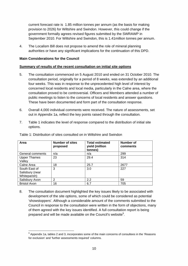
1
Initial site selection process
1
Initial Site Option Consultation 2010
2
Cabinet 22 March 2011 – Following Initial Site Option Consultation 2010
2
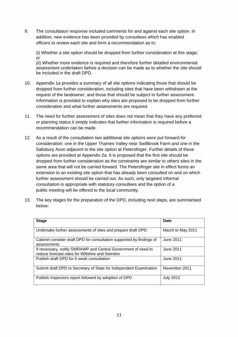
Cabinet 14 June 2011 – Following completion of detailed site assessments
3
Appendices – Cabinet reports and supporting documents
5
Appendix 1 - Cabinet Report 22 March 2011 7 Appendices of March 2011 Cabinet report
Appendix 1a – Summary Tables for Site Options withdrawn, excluded or subject to further assessment
15
Appendix 2a – Additional Site Options
28
Appendix 2 - Cabinet Report 14 June 2011 32 Appendices of June 2011 Cabinet report
Appendix 1b - A summary of the results of the assessments and how they relate to sustainability criteria
40
Appendix 2b - Site options that would be carried forward into Minerals Sites DPD
66
Public Participation 74

1
Introduction
This report details the stages undertaken and progress made in the development of the proposed Wiltshire and Swindon Aggregate Minerals Site Allocations DPD. The proposed Aggregate Minerals Site Allocations DPD sets out a schedule of minerals sites that are deemed suitable to meet Wiltshire and Swindon’s annualised provision requirements during the plan period up to 2026.
Overview of site selection process and work to-date
Wiltshire Council and Swindon Borough Council started the process of consultation and engaging local communities in the development of the Minerals Local Development Framework process back in 2005. Early work involved an initial series of meetings and workshops1 which sought to present information to stakeholders and the public on minerals planning issues affecting Wiltshire, Swindon and the sub-regional area. The workshops were facilitated by a company called Adams Hendry and invitations for Forum membership were sent out to a range of people on the councils’ consultation database. The key focus for the Forum was to assist the councils in reviewing the adopted Wiltshire and Swindon Minerals Local Plan and thereby meeting the challenge of planning for the release of aggregate minerals in accordance with new policy drivers and forecast provision rates. The outputs from the initial Forum meetings were collated and presented to the councils in a report for use in developing the scope of the Local Plan review process. Initial site selection process Wiltshire and Swindon Councils initially undertook a focused ‘call for sites’ in April 2004 by writing to mineral operators and landowners known to have an interest in sand and gravel extraction. This resulted in a number of sites being put forward for consideration. However, the estimated yield from these sites was insufficient to meet forecast demand at the time of 1.85 million tonnes per annum. The councils issued a further call for sites in 2006 through a newsletter issued to every contact on the councils’ consultation database. However, as a result of this work, no additional land was put forward for consideration. Following on from the development of the Wiltshire and Swindon Minerals Core Strategy, a series of workshops were held in the autumn of 2007 to begin the process of site identification and to help inform Issues and Options work for the sites DPD. This work included the development of topic papers covering the key Mineral Resource Zones (MRZs), as identified in the emerging Minerals Core Strategy; and a series of workshops focussing on the site identification process, which were advertised and hosted in settlements close to, or within, the proposed MRZs. Following the adoption of the Minerals Core Strategy it was decided that the strategic areas of search (the Mineral Resource Zones) should be examined in detail to begin the process of identifying specific sites and / or preferred areas.
So, taking forward the initial work from 2004, 2006 and 2007 the councils embarked on a methodical sieving exercise of the un-worked areas of the five Mineral Resource Zones during 2009/2010. This work embedded key criteria from the councils
1 Wiltshire and Swindon Minerals Development Framework Forum - Report of Forum Process and Outcomes. Adams Hendry Consulting Ltd (2005).
2
Sustainability Appraisal framework and thereby assisting with the critical process of removing the most constrained areas from further consideration. Landowners within the remaining areas were then identified and contacted to see whether they would consider putting their land forward for sand and gravel extraction. Initial Site Option Consultation 2010 Following the initial site sieving process2, initial site appraisal and analysis3 and communication with landowners, an informal (Regulation 254) consultation on 62 initial site options for sand and gravel extraction in Wiltshire and Swindon took place between 5 August and 31 October 20105. The purpose of this consultation was to provide an early opportunity for stakeholders to review the site options presented by landowners for consideration and comment on the key issues identified for each site option to help determine the scope of any further assessments. Two additional site options were submitted as part of the consultation. These site options were situated at: Petersfinger, near Salisbury (proposed extension to a site option previously submitted); and Swillbrook Farm, near the Cotswold Water Park. The Petersfinger site option was considered suitable for further assessment and appropriate local consultation. During the consultation eight site options and parts of two site options were withdrawn from further consideration at the request of the landowners. Cabinet 22 March 2011 – Following Initial Site Option Consultation 2010 Following the analysis of comments received during the consultation period between 5 August and 31 October 20106, a report was prepared for Cabinet on 22 March 2011. This report suggested that a further 32 site options be excluded at this stage of the process as they were unlikely to be deliverable given constraints to development. The Cabinet report recommended that the 22 remaining site options should be subject to further evidence gathering and assessment to ensure that any decision on their suitability is based on robust evidence and qualified professional judgement. This report, and supporting documents, identified the status of each site option at this time indicating whether they have been dropped or taken forward for further assessment, and the requirements for further assessment for each site taken forward. The Cabinet resolved to approve the recommendations outlined within the report. This report and supporting documents are provided in Appendix 1 of this document.
2 Wiltshire & Swindon Aggregate Minerals Site Allocations DPD - Evidence Report. The results of a constraints sieving exercise applied to remaining sand and gravel resources in Wiltshire and Swindon (March 2010). 3 Wiltshire and Swindon Minerals and Waste Development Framework: Summary of minerals site appraisal matrices (November 2011). 4 Town & Country Planning (Local Development)(England) Regulations, 2004 (as amended); Regulation 25.
5 Initial Site Options Report for the Wiltshire and Swindon Aggregate Minerals Site Allocations DPD (August 2010). 6 Wiltshire and Swindon Aggregate Minerals Site Allocations DPD: A report of the results of consultation on initial site options for sand and gravel extraction (August – October 2010).
3
Cabinet 14 June 2011 – Following completion of detailed site assessments Following the completion of the detailed assessments on the 22 remaining sites, and after considering the extensive evidence base7 for each remaining site option, a report was prepared for Cabinet on 14 June 2011. This report provided Members with the results of the detailed appraisals on the remaining 22 site options and recommended a schedule of site options for inclusion within the Proposed Submission Draft Wiltshire and Swindon Aggregate Minerals Site Allocations DPD. From the findings of the detailed assessments it is clear that Wiltshire and Swindon’s contribution to national and regional forecasts for sand and gravel, at 1.85 million tonnes per annum, cannot be met. The results of the assessments, recent levels of production and focussed dialogue with the minerals industry indicate that a local forecast provision rate of 1.2 million tonnes per annum should be used as the basis for finalising the list of site options in the emerging Aggregate Minerals Site Allocations DPD. This local forecast rate was proposed to Cabinet through the Cabinet Report prepared for 14 June 2011 and the Cabinet resolved to approve the recommendations of this report. This report and supporting documents are provided in Appendix 2 of this document.
7 Detailed assessment work and a complete evidence base to support site selection can be at: http://www.wiltshire.gov.uk/aggregatemineralssiteallocations

4

5
Appendices – Cabinet reports and supporting documents

6
7
Appendix 1 - Cabinet Report 22 March 2011
Wiltshire Council Cabinet 22 March 2011
Subject: Cabinet Member:
Aggregate Minerals Site Allocations DPD: Results of Recent Consultation on Initial Site Options and Next Steps Councillor John Brady – Economic Development, Planning and Housing
Key Decision: No
Executive Summary
This report summarises the results of the consultation on 62 initial site options for sand and gravel extraction in Wiltshire and Swindon, which took place from 5 August to 31 October 2010. The purpose was to provide an early opportunity for stakeholders to review the site options presented by landowners for consideration and comment on the key issues identified for each site option to help determine the scope of any further assessments. The consultation generated over 4,000 comments, most of which related to the site options for the Calne area. Although many of the comments were written in the form of objections, they often reaffirmed the key environmental issues identified by the Council. Two additional site options were submitted as part of the consultation. It is proposed that one should be considered for further assessment and appropriate consultation. During the consultation 8 site options and parts of 2 site options were withdrawn from further consideration at the request of the landowners. It is recommended that a further 32 site options are excluded at this stage of the process. The remaining 22 should be subject to further assessment. Although the estimated yield for the 22 remaining site options is sufficient, in principle to meet forecast demand for aggregate minerals to 2026, many of the remaining site options are highly constrained. Further assessments may show that sites should be excluded, either in full or in part. This could lead to Wiltshire and Swindon being unable to meet forecast demand. Any reduction in provision in Wiltshire and Swindon is likely to lead to increased pressure in neighbouring authority areas, and will require notification to, and the agreement of, the South West Regional Aggregates Working Party (SWRAWP) and Central Government.
8
MARK BODEN Corporate Director Department for Neighbourhood and Planning
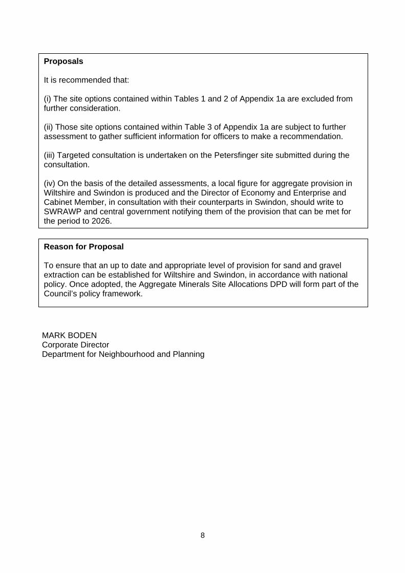
Proposals It is recommended that: (i) The site options contained within Tables 1 and 2 of Appendix 1a are excluded from further consideration. (ii) Those site options contained within Table 3 of Appendix 1a are subject to further assessment to gather sufficient information for officers to make a recommendation. (iii) Targeted consultation is undertaken on the Petersfinger site submitted during the consultation. (iv) On the basis of the detailed assessments, a local figure for aggregate provision in Wiltshire and Swindon is produced and the Director of Economy and Enterprise and Cabinet Member, in consultation with their counterparts in Swindon, should write to SWRAWP and central government notifying them of the provision that can be met for the period to 2026.
Reason for Proposal To ensure that an up to date and appropriate level of provision for sand and gravel extraction can be established for Wiltshire and Swindon, in accordance with national policy. Once adopted, the Aggregate Minerals Site Allocations DPD will form part of the Council’s policy framework.
9
WILTSHIRE COUNCIL
CABINET 22 March 2011
Purpose of Report 1. The purpose of this report is to:
(i) Inform Cabinet of the results of the consultation on initial site options for future sand and gravel extraction in Wiltshire and Swindon. (ii) Seek Cabinet approval that, based on the information received during the consultation, a number of site options should be dropped from further consideration and on one of the new sites submitted further consultation undertaken. (iii) Seek Cabinet approval that detailed assessments are undertaken on the other site options to determine which should be carried forward into the draft Aggregate Minerals Site Allocations DPD. (iv) Seek Cabinet approval to use the results of (iii) to inform the preparation of a local figure for aggregates provision in Wiltshire and Swindon (for the period to 2026).
Background 2. Following Cabinet approval on 27 July 2010, consultation on the initial site options for
inclusion within the draft Aggregate Minerals Site Allocations Development Plan Document (DPD) was undertaken. The purpose of the consultation was to provide local communities and stakeholders with an opportunity early in the plan process to comment on the suitability of the initial site options (proposed by the minerals industry and landowners, including Wiltshire Council) as mineral extraction sites and gather further evidence to support the preparation of the Site Allocations DPD. In total 62 sites were consulted on. None of the sites included in the document had any planning or ‘preferred’ status.
3. National policy (Mineral Planning Statement 1 (MPS1)) requires mineral planning authorities to ‘test’ the environmental acceptability of meeting forecast rates for aggregate provision, as prepared by the South West Regional Aggregates Working Party (SWRAWP)8 and ratified by central Government. The preparatory work leading to the development of the draft site allocations DPD can fulfil this requirement. The
8 The Department for Communities and Local Government has confirmed that, in the absence of Regional Assemblies, the SWRAWP is responsible for preparing aggregate mineral forecasts for the south west (subregional apportionment).
Subject:
Subject: Cabinet Member:
Aggregate Minerals Site Allocations DPD: Results of Recent Consultation on Initial Site Options and Next Steps Councillor John Brady – Economic Development, Planning and Housing
K D i iNo
10
current forecast rate is 1.85 million tonnes per annum (as the basis for making provision to 2026) for Wiltshire and Swindon. However, this could change if the government formally agrees revised figures submitted by the SWRAWP in September 2010. For Wiltshire and Swindon, this is 1.41million tonnes per annum.
4. The Localism Bill does not propose to amend the role of mineral planning authorities or have any significant implications for the continuation of this DPD.
Main Considerations for the Council Summary of results of the recent consultation on initial site options 5. The consultation commenced on 5 August 2010 and ended on 31 October 2010. The
consultation period, originally for a period of 8 weeks, was extended by an additional four weeks. This was in response to the unprecedented high level of interest by concerned local residents and local media, particularly in the Calne area, where the consultation proved to be controversial. Officers and Members attended a number of public meetings to listen to the concerns of local residents and answer questions. These have been documented and form part of the consultation response.
6. Overall 4,000 individual comments were received. The nature of assessments, set out in Appendix 1a, reflect the key points raised through the consultation.
7. Table 1 indicates the level of response compared to the distribution of initial site options.
Table 1: Distribution of sites consulted on in Wiltshire and Swindon Area Number of sites
proposed Total estimated yield (million tonnes)
Number of comments
General comments n/a n/a 299 Upper Thames Valley
23 29.4 314
Calne Area 18 25.7 2677 South East of Salisbury (near Whiteparish)
3 3.0 227
Salisbury Avon 2 2.2 59 Bristol Avon 16 6.7 705
8. The consultation document highlighted the key issues likely to be associated with
development of the site options, some of which could be considered as potential ‘showstoppers’. Although a considerable amount of the comments submitted to the Council in response to the consultation were written in the form of objections, many of them agreed with the key issues identified. A full consultation report is being prepared and will be made available on the Council’s website9.
9 Appendix 1a, tables 2 and 3, incorporates some of the main concerns of consultees in the ‘Reasons for exclusion’ and ‘further assessments required’ columns.
11
9. The consultation response included comments for and against each site option. In addition, new evidence has been provided by consultees which has enabled officers to review each site and form a recommendation as to:
(i) Whether a site option should be dropped from further consideration at this stage; or (ii) Whether more evidence is required and therefore further detailed environmental assessment undertaken before a decision can be made as to whether the site should be included in the draft DPD.
10. Appendix 1a provides a summary of all site options indicating those that should be dropped from further consideration, including sites that have been withdrawn at the request of the landowner, and those that should be subject to further assessment. Information is provided to explain why sites are proposed to be dropped from further consideration and what further assessments are required.
11. The need for further assessment of sites does not mean that they have any preferred or planning status it simply indicates that further information is required before a recommendation can be made.
12. As a result of the consultation two additional site options were put forward for consideration: one in the Upper Thames Valley near Swillbrook Farm and one in the Salisbury Avon adjacent to the site option at Petersfinger. Further details of these options are provided at Appendix 2a. It is proposed that the first site should be dropped from further consideration as the constraints are similar to others sites in the same area that will not be carried forward. The Petersfinger site in effect forms an extension to an existing site option that has already been consulted on and on which further assessment should be carried out. As such, only targeted informal consultation is appropriate with statutory consultees and the option of a public meeting will be offered to the local community.
13. The key stages for the preparation of the DPD, including next steps, are summarised below:
Stage Date
Undertake further assessments of sites and prepare draft DPD March to May 2011
Cabinet consider draft DPD for consultation supported by findings of assessments
June 2011
If necessary, notify SWRAWP and Central Government of need to reduce forecast rates for Wiltshire and Swindon
June 2011
Publish draft DPD for 6 week consultation June 2011
Submit draft DPD to Secretary of State for Independent Examination November 2011
Publish Inspectors report followed by adoption of DPD July 2012
12
Testing forecast rates for aggregate provision 14. It is the responsibility of each minerals planning authority to test the capacity of their
area to meet their forecast contribution to national supply.
15. For Wiltshire and Swindon there are a number of early signs that there may be a need to present a case to the SWRAWP and central government that a reduced level of supply should be planned for. Over time this may lead to an increase in production outside of the county to compensate. The reasons behind this view are as follows:
Prior to (and in response to) the consultation, the minerals industry has not put forward enough sites to meet forecast requirements. Nor has the industry indicated any interest in the sites put forward by landowners except for two sites in the Upper Thames Valley (sites U22 and U23). This suggests that the appetite for minerals working in Wiltshire and Swindon is lower than indicated by the forecast requirements prepared by SWRAWP.
Past production has only met the proposed figure of 1.41 million tonnes in one year (2003) since 1991. The general trend for sand and gravel production in Wiltshire and Swindon is downwards and annual production is currently below 1 million tonnes (450,000 tonnes in 2009).
Applications for sand and gravel extraction determined by the Council in the past five years have not been sufficient to keep up with forecast provision requirements. This has resulted in a landbank that has consistently been below the 7 year minimum (as prescribed by MPS1), since 2000.
Many of the sites in the initial site options consultation document are highly constrained. A number of these are now proposed to be dropped from further consideration. Remaining sites subject to further assessment may prove to be unsuitable for inclusion in the Site Allocations DPD.
16. However, despite these early indications of a need to review the current aggregates supply pattern in the Plan area, there is currently insufficient evidence to present a robust case to the SWRAWP and central government for a reduced or local forecast provision rate. Whilst there are some sites within the initial site options report that clearly should not be carried forward into the site allocations document, further work will need to be undertaken to demonstrate whether the remaining sites are appropriate in environmental, social and economic terms. This will ensure that the testing of the forecast rate will have been thoroughly and objectively undertaken in line with national policy and reduce the risk of being open to challenge once a submission draft DPD is presented to the Secretary of State for Independent Examination.
17. If further assessments show that these initial signs prove to be correct, the Councils will need to write to the SWRAWP and central government presenting a robust case for the preparation of a locally derived provision rate in accordance with MPS1.
13
Environmental and Climate Change Considerations 18. The proposals contained in this report relate to the need to undertake further
assessments to ensure that site options that could be carried forward into a development plan are environmentally acceptable. This proposal is, and will continue to be, subject to sustainability appraisal to ensure that environmental and climate change implications will have been fully considered and minimised and that effects of a changing climate will be taken into account.
Equalities Impact of the Proposal 19. There are considered to be no equality impacts arising as a result of the proposals in
this report. An Equalities Impact Assessment (EIA) is not required at this stage of the plan making process, but will be completed once the final document is submitted to government.
Risk Assessment 20. The purpose of undertaking further assessments is to ensure that there is sufficient
evidence to justify the decision behind whether particular site options should be included in the Site Allocations DPD. Without sufficient evidence the Council could be open to challenge on two fronts:
(a) The Site Allocations DPD could be challenged at the Independent Examination into the soundness of the DPD on the basis that there is insufficient evidence to support the inclusion or exclusion of sites. This could result in the DPD being found unsound.
(b) If insufficient sites are identified to meet Wiltshire and Swindon’s contribution to national need for aggregates, the Secretary of State could reject the Council’s view that a local forecast and provision rate should be made, based on insufficient evidence being provided to justify that approach. This could also result in the DPD being found unsound, again resulting in additional costs to the Council.
21. Officers at Wiltshire Council are fully qualified to assess the site options. External
consultants may need to be used to verify that the work undertaken by the Council has been undertaken objectively. Given the concerns raised during the consultation about objectivity regarding Council owned land, independent verification may be necessary.
Financial Implications 22. The cost of preparing the DPD will be met by existing and planned budget
commitments. As highlighted in the risks section above, by using inhouse resources the financial implications of the proposals should be minimal. It might be necessary to buy in additional data from external sources to inform and support the assessments. This expense has also been taken into account in the spatial planning budget.
14
Legal Implications 23. The project is currently at the Regulation 25 stage of the Town and Country Planning
(Local Development) (England) 2004 Regulations (as amended). The requirements of this stage are essentially to gather evidence and consult those likely to have an interest in the proposed DPD. The purpose of this evidence gathering stage is to ensure that a draft DPD, when submitted to the Secretary of State, represents the most appropriate option having considered all reasonable alternatives, and can be considered sound. The Regulation 25 stage does not end until the Council prepares a draft DPD for consultation. The steps undertaken to date and those proposed in this report are fully compliant with legal requirements.
Options Considered 24. The consultation document presented the initial options for sand and gravel
extraction. Further assessments will be undertaken on the remaining options to determine their suitability for inclusion in a draft DPD. Without further assessments being undertaken the Councils will be in a weaker position, in terms of an evidence base, to develop a case for a local sand and gravel provision rate, or to demonstrate that a draft DPD is sound.
Conclusions 25. The consultation on initial site options resulted in further information being provided
by consultees. This information has enabled officers to recommend the exclusion of some site options at this stage. However, in order to be confident that environmental, social and economic impacts for the remaining site options have been fully considered, further assessments should be undertaken on the remaining site options as per Table 3 of Appendix 1a.
26. Further assessments are also required to provide an evidence base to develop a case for a local provision rate. It is important to continue to up to date planning policy for minerals in order to ensure an up to date development plan for Wiltshire.
MARK BODEN Corporate Director Department of Neighbourhood and Planning Report Author: Alistair Cunningham Service Director – Economy & Enterprise The following unpublished documents have been relied on in the preparation of this Report: None Appendices: Appendix 1a – Summary Tables for Site Options withdrawn, excluded or subject to further assessment Appendix 2a – Additional Site Options
15
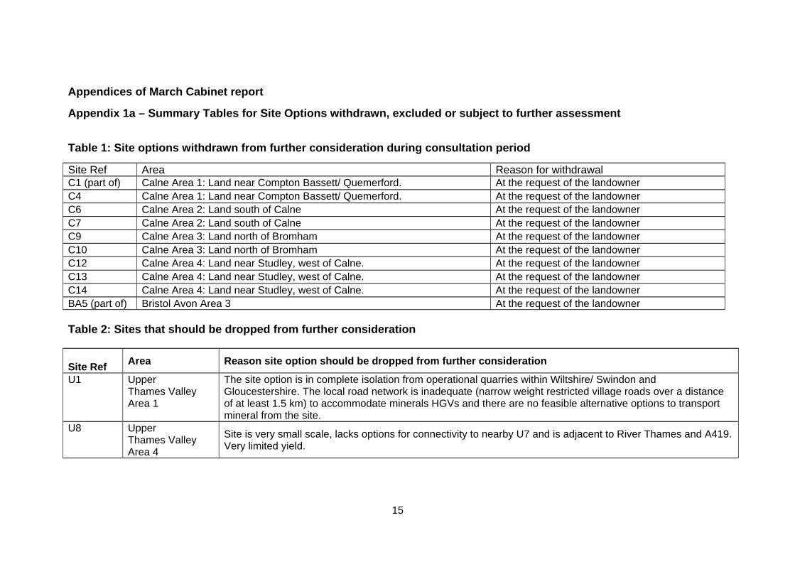
Appendices of March Cabinet report
Appendix 1a – Summary Tables for Site Options withdrawn, excluded or subject to further assessment
Table 1: Site options withdrawn from further consideration during consultation period
Site Ref Area Reason for withdrawal C1 (part of) Calne Area 1: Land near Compton Bassett/ Quemerford. At the request of the landowner C4 Calne Area 1: Land near Compton Bassett/ Quemerford. At the request of the landowner C6 Calne Area 2: Land south of Calne At the request of the landowner C7 Calne Area 2: Land south of Calne At the request of the landowner C9 Calne Area 3: Land north of Bromham At the request of the landowner C10 Calne Area 3: Land north of Bromham At the request of the landowner C12 Calne Area 4: Land near Studley, west of Calne. At the request of the landowner C13 Calne Area 4: Land near Studley, west of Calne. At the request of the landowner C14 Calne Area 4: Land near Studley, west of Calne. At the request of the landowner BA5 (part of) Bristol Avon Area 3 At the request of the landowner Table 2: Sites that should be dropped from further consideration Site Ref
Area Reason site option should be dropped from further consideration
U1 Upper Thames Valley Area 1
The site option is in complete isolation from operational quarries within Wiltshire/ Swindon and Gloucestershire. The local road network is inadequate (narrow weight restricted village roads over a distance of at least 1.5 km) to accommodate minerals HGVs and there are no feasible alternative options to transport mineral from the site.
U8 Upper Thames Valley Area 4
Site is very small scale, lacks options for connectivity to nearby U7 and is adjacent to River Thames and A419. Very limited yield.
16
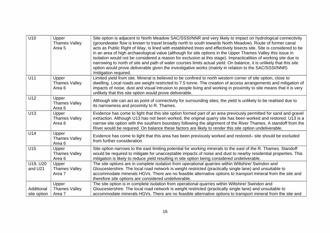
U10 Upper Thames Valley Area 5
Site option is adjacent to North Meadow SAC/SSSI/NNR and very likely to impact on hydrological connectivity (groundwater flow is known to travel broadly north to south towards North Meadow). Route of former canal acts as Public Right of Way, is lined with established trees and effectively bisects site. Site is considered to be in an area of high archaeological value (although for site options in the Upper Thames Valley this issue in isolation would not be considered a reason for exclusion at this stage). Impracticalities of working site due to narrowing to north of site and path of water courses limits actual yield. On balance, it is unlikely that this site option would prove deliverable given the investigative works (mainly in relation to the SAC/SSSI/NNR) /mitigation required.
U11 Upper Thames Valley Area 6
Limited yield from site. Mineral is believed to be confined to north western corner of site option, close to dwelling. Local roads are weight restricted to 7.5 tonne. The creation of access arrangements and mitigation of impacts of noise, dust and visual intrusion to people living and working in proximity to site means that it is very unlikely that this site option would prove deliverable.
U12 Upper Thames Valley Area 6
Although site can act as point of connectivity for surrounding sites, the yield is unlikely to be realised due to its narrowness and proximity to R. Thames.
U13 Upper Thames Valley Area 6
Evidence has come to light that this site option formed part of an area previously permitted for sand and gravel extraction. Although U13 has not been worked, the original quarry site has been worked and restored. U13 is a narrow site option with the southern boundary following the alignment of the River Thames. A standoff from the River would be required. On balance these factors are likely to render this site option undeliverable.
U14 Upper Thames Valley Area 6
Evidence has come to light that this area has been previously worked and restored– site should be excluded from further consideration
U15 Upper Thames Valley Area 6
Site option narrows to the east limiting potential for working minerals to the east of the R. Thames. Standoff would be required to mitigate for unacceptable impacts of noise and dust to nearby residential properties. This mitigation is likely to reduce yield resulting in site option being considered undeliverable.
U19, U20 and U21
Upper Thames Valley Area 7
The site options are in complete isolation from operational quarries within Wiltshire/ Swindon and Gloucestershire. The local road network is weight restricted (practically single lane) and unsuitable to accommodate minerals HGVs. There are no feasible alternative options to transport mineral from the site and therefore site options are considered undeliverable.
Additional site option
Upper Thames Valley Area 7
The site option is in complete isolation from operational quarries within Wiltshire/ Swindon and Gloucestershire. The local road network is weight restricted (practically single lane) and unsuitable to accommodate minerals HGVs. There are no feasible alternative options to transport mineral from the site and
17
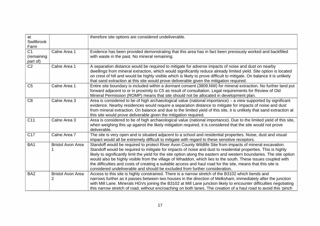
at Swillbrook Farm
therefore site options are considered undeliverable.
C1 (remaining part of)
Calne Area 1 Evidence has been provided demonstrating that this area has in fact been previously worked and backfilled with waste in the past. No mineral remaining.
C2 Calne Area 1 A separation distance would be required to mitigate for adverse impacts of noise and dust on nearby dwellings from mineral extraction, which would significantly reduce already limited yield. Site option is located on crest of hill and would be highly visible which is likely to prove difficult to mitigate. On balance it is unlikely that sand extraction at this site would prove deliverable given the mitigation required.
C5 Calne Area 1 Entire site boundary is included within a dormant consent (3809.NW) for mineral extraction. No further land put forward adjacent to or in proximity to C5 as result of consultation. Legal requirements for Review of Old Mineral Permission (ROMP) means that site should not be allocated in development plan.
C8 Calne Area 3 Area is considered to be of high archaeological value (national importance) – a view supported by significant evidence. Nearby residences would require a separation distance to mitigate for impacts of noise and dust from mineral extraction. On balance and due to the limited yield of this site, it is unlikely that sand extraction at this site would prove deliverable given the mitigation required.
C11 Calne Area 3 Area is considered to be of high archaeological value (national importance). Due to the limited yield of this site, when weighing this up against the likely mitigation required, it is considered that the site would not prove deliverable.
C17 Calne Area 7 The site is very open and is situated adjacent to a school and residential properties. Noise, dust and visual impact would all be extremely difficult to mitigate with regard to these sensitive receptors.
BA1 Bristol Avon Area 1
Standoff would be required to protect River Avon County Wildlife Site from impacts of mineral excavation. Standoff would be required to mitigate for impacts of noise and dust to residential properties. This is highly likely to significantly limit the yield for the site option along the eastern and western boundaries. The site option would also be highly visible from the village of Whaddon, which lies to the south. These issues coupled with the difficulties and costs of creating a suitable access and haul road for the site, means that this site is considered undeliverable and should be excluded from further consideration.
BA2 Bristol Avon Area 2
Access to this site is highly constrained. There is a narrow stretch of the B3102 which bends and narrows further as it passes between two houses in the direction of Melksham, immediately after the junction with Mill Lane. Minerals HGVs joining the B3102 at Mill Lane junction likely to encounter difficulties negotiating this narrow stretch of road, without encroaching on both lanes. The creation of a haul road to avoid this ‘pinch
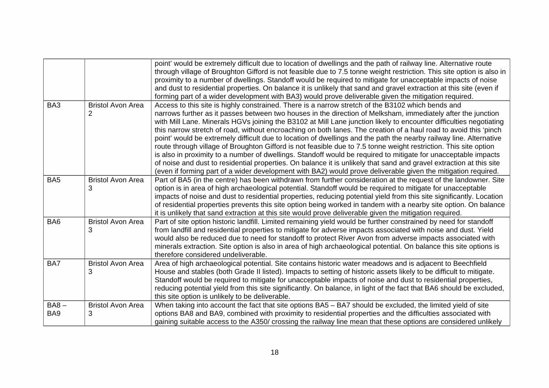
18
point’ would be extremely difficult due to location of dwellings and the path of railway line. Alternative route through village of Broughton Gifford is not feasible due to 7.5 tonne weight restriction. This site option is also in proximity to a number of dwellings. Standoff would be required to mitigate for unacceptable impacts of noise and dust to residential properties. On balance it is unlikely that sand and gravel extraction at this site (even if forming part of a wider development with BA3) would prove deliverable given the mitigation required.
BA3 Bristol Avon Area 2
Access to this site is highly constrained. There is a narrow stretch of the B3102 which bends and narrows further as it passes between two houses in the direction of Melksham, immediately after the junction with Mill Lane. Minerals HGVs joining the B3102 at Mill Lane junction likely to encounter difficulties negotiating this narrow stretch of road, without encroaching on both lanes. The creation of a haul road to avoid this ‘pinch point’ would be extremely difficult due to location of dwellings and the path the nearby railway line. Alternative route through village of Broughton Gifford is not feasible due to 7.5 tonne weight restriction. This site option is also in proximity to a number of dwellings. Standoff would be required to mitigate for unacceptable impacts of noise and dust to residential properties. On balance it is unlikely that sand and gravel extraction at this site (even if forming part of a wider development with BA2) would prove deliverable given the mitigation required.
BA5 Bristol Avon Area 3
Part of BA5 (in the centre) has been withdrawn from further consideration at the request of the landowner. Site option is in area of high archaeological potential. Standoff would be required to mitigate for unacceptable impacts of noise and dust to residential properties, reducing potential yield from this site significantly. Location of residential properties prevents this site option being worked in tandem with a nearby site option. On balance it is unlikely that sand extraction at this site would prove deliverable given the mitigation required.
BA6 Bristol Avon Area 3
Part of site option historic landfill. Limited remaining yield would be further constrained by need for standoff from landfill and residential properties to mitigate for adverse impacts associated with noise and dust. Yield would also be reduced due to need for standoff to protect River Avon from adverse impacts associated with minerals extraction. Site option is also in area of high archaeological potential. On balance this site options is therefore considered undeliverable.
BA7 Bristol Avon Area 3
Area of high archaeological potential. Site contains historic water meadows and is adjacent to Beechfield House and stables (both Grade II listed). Impacts to setting of historic assets likely to be difficult to mitigate. Standoff would be required to mitigate for unacceptable impacts of noise and dust to residential properties, reducing potential yield from this site significantly. On balance, in light of the fact that BA6 should be excluded, this site option is unlikely to be deliverable.
BA8 – Bristol Avon Area When taking into account the fact that site options BA5 – BA7 should be excluded, the limited yield of site BA9 3 options BA8 and BA9, combined with proximity to residential properties and the difficulties associated with
gaining suitable access to the A350/ crossing the railway line mean that these options are considered unlikely
19
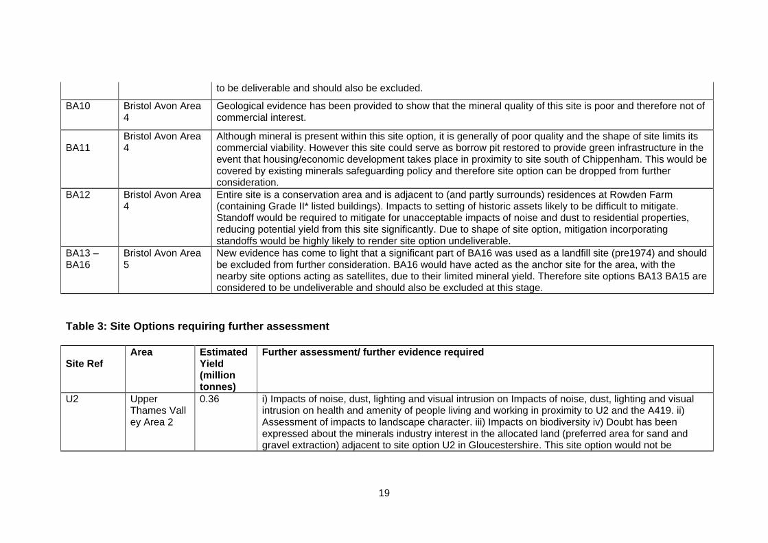
to be deliverable and should also be excluded.
BA10 Bristol Avon Area 4
Geological evidence has been provided to show that the mineral quality of this site is poor and therefore not of commercial interest.
BA11
Bristol Avon Area 4
Although mineral is present within this site option, it is generally of poor quality and the shape of site limits its commercial viability. However this site could serve as borrow pit restored to provide green infrastructure in the event that housing/economic development takes place in proximity to site south of Chippenham. This would be covered by existing minerals safeguarding policy and therefore site option can be dropped from further consideration.
BA12 Bristol Avon Area 4
Entire site is a conservation area and is adjacent to (and partly surrounds) residences at Rowden Farm (containing Grade II* listed buildings). Impacts to setting of historic assets likely to be difficult to mitigate. Standoff would be required to mitigate for unacceptable impacts of noise and dust to residential properties, reducing potential yield from this site significantly. Due to shape of site option, mitigation incorporating standoffs would be highly likely to render site option undeliverable.
BA13 – BA16
Bristol Avon Area 5
New evidence has come to light that a significant part of BA16 was used as a landfill site (pre1974) and should be excluded from further consideration. BA16 would have acted as the anchor site for the area, with the nearby site options acting as satellites, due to their limited mineral yield. Therefore site options BA13 BA15 are considered to be undeliverable and should also be excluded at this stage.
Table 3: Site Options requiring further assessment
Site Ref
Area Estimated Yield (million tonnes)
Further assessment/ further evidence required
U2 Upper Thames Valley Area 2
0.36 i) Impacts of noise, dust, lighting and visual intrusion on Impacts of noise, dust, lighting and visual intrusion on health and amenity of people living and working in proximity to U2 and the A419. ii) Assessment of impacts to landscape character. iii) Impacts on biodiversity iv) Doubt has been expressed about the minerals industry interest in the allocated land (preferred area for sand and gravel extraction) adjacent to site option U2 in Gloucestershire. This site option would not be
20
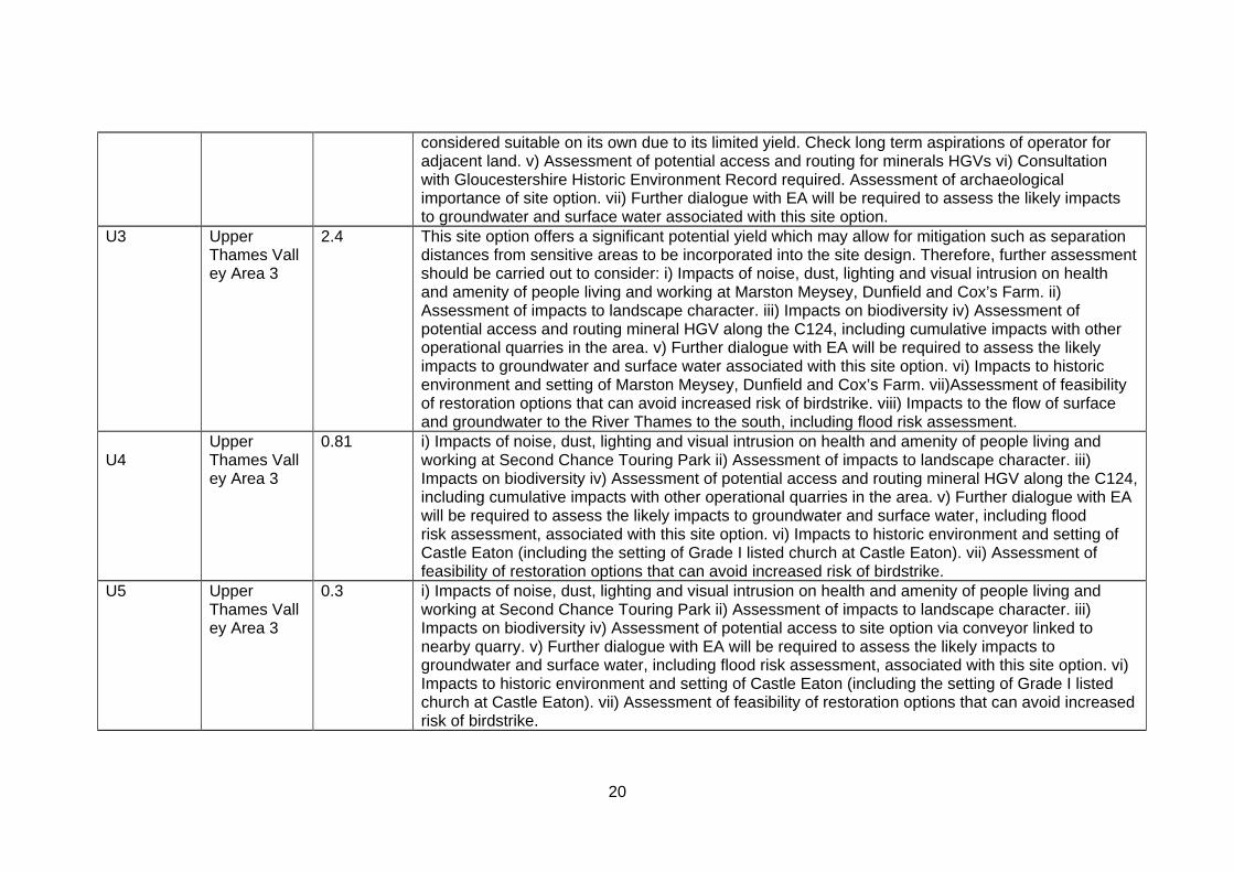
considered suitable on its own due to its limited yield. Check long term aspirations of operator for adjacent land. v) Assessment of potential access and routing for minerals HGVs vi) Consultation with Gloucestershire Historic Environment Record required. Assessment of archaeological importance of site option. vii) Further dialogue with EA will be required to assess the likely impacts to groundwater and surface water associated with this site option.
U3 Upper Thames Valley Area 3
2.4 This site option offers a significant potential yield which may allow for mitigation such as separation distances from sensitive areas to be incorporated into the site design. Therefore, further assessment should be carried out to consider: i) Impacts of noise, dust, lighting and visual intrusion on health and amenity of people living and working at Marston Meysey, Dunfield and Cox’s Farm. ii) Assessment of impacts to landscape character. iii) Impacts on biodiversity iv) Assessment of potential access and routing mineral HGV along the C124, including cumulative impacts with other operational quarries in the area. v) Further dialogue with EA will be required to assess the likely impacts to groundwater and surface water associated with this site option. vi) Impacts to historic environment and setting of Marston Meysey, Dunfield and Cox’s Farm. vii)Assessment of feasibility of restoration options that can avoid increased risk of birdstrike. viii) Impacts to the flow of surface and groundwater to the River Thames to the south, including flood risk assessment.
U4
Upper Thames Valley Area 3
0.81 i) Impacts of noise, dust, lighting and visual intrusion on health and amenity of people living and working at Second Chance Touring Park ii) Assessment of impacts to landscape character. iii) Impacts on biodiversity iv) Assessment of potential access and routing mineral HGV along the C124, including cumulative impacts with other operational quarries in the area. v) Further dialogue with EA will be required to assess the likely impacts to groundwater and surface water, including flood risk assessment, associated with this site option. vi) Impacts to historic environment and setting of Castle Eaton (including the setting of Grade I listed church at Castle Eaton). vii) Assessment of feasibility of restoration options that can avoid increased risk of birdstrike.
U5 Upper Thames Valley Area 3
0.3 i) Impacts of noise, dust, lighting and visual intrusion on health and amenity of people living and working at Second Chance Touring Park ii) Assessment of impacts to landscape character. iii) Impacts on biodiversity iv) Assessment of potential access to site option via conveyor linked to nearby quarry. v) Further dialogue with EA will be required to assess the likely impacts to groundwater and surface water, including flood risk assessment, associated with this site option. vi) Impacts to historic environment and setting of Castle Eaton (including the setting of Grade I listed church at Castle Eaton). vii) Assessment of feasibility of restoration options that can avoid increased risk of birdstrike.
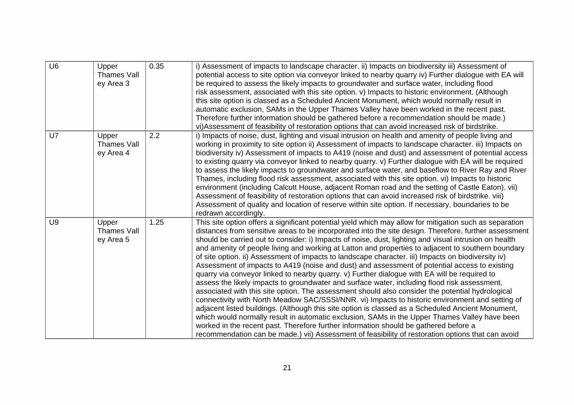
21
U6 Upper Thames Valley Area 3
0.35 i) Assessment of impacts to landscape character. ii) Impacts on biodiversity iii) Assessment of potential access to site option via conveyor linked to nearby quarry iv) Further dialogue with EA will be required to assess the likely impacts to groundwater and surface water, including flood risk assessment, associated with this site option. v) Impacts to historic environment. (Although this site option is classed as a Scheduled Ancient Monument, which would normally result in automatic exclusion, SAMs in the Upper Thames Valley have been worked in the recent past. Therefore further information should be gathered before a recommendation should be made.) vi)Assessment of feasibility of restoration options that can avoid increased risk of birdstrike.
U7 Upper Thames Valley Area 4
2.2 i) Impacts of noise, dust, lighting and visual intrusion on health and amenity of people living and working in proximity to site option ii) Assessment of impacts to landscape character. iii) Impacts on biodiversity iv) Assessment of impacts to A419 (noise and dust) and assessment of potential access to existing quarry via conveyor linked to nearby quarry. v) Further dialogue with EA will be required to assess the likely impacts to groundwater and surface water, and baseflow to River Ray and River Thames, including flood risk assessment, associated with this site option. vi) Impacts to historic environment (including Calcutt House, adjacent Roman road and the setting of Castle Eaton). vii) Assessment of feasibility of restoration options that can avoid increased risk of birdstrike. viii) Assessment of quality and location of reserve within site option. If necessary, boundaries to be redrawn accordingly.
U9 Upper Thames Valley Area 5
1.25 This site option offers a significant potential yield which may allow for mitigation such as separation distances from sensitive areas to be incorporated into the site design. Therefore, further assessment should be carried out to consider: i) Impacts of noise, dust, lighting and visual intrusion on health and amenity of people living and working at Latton and properties to adjacent to southern boundary of site option. ii) Assessment of impacts to landscape character. iii) Impacts on biodiversity iv) Assessment of impacts to A419 (noise and dust) and assessment of potential access to existing quarry via conveyor linked to nearby quarry. v) Further dialogue with EA will be required to assess the likely impacts to groundwater and surface water, including flood risk assessment, associated with this site option. The assessment should also consider the potential hydrological connectivity with North Meadow SAC/SSSI/NNR. vi) Impacts to historic environment and setting of adjacent listed buildings. (Although this site option is classed as a Scheduled Ancient Monument, which would normally result in automatic exclusion, SAMs in the Upper Thames Valley have been worked in the recent past. Therefore further information should be gathered before a recommendation can be made.) vii) Assessment of feasibility of restoration options that can avoid
22
increased risk of birdstrike.
U16 Upper Thames Valley Area 6
1.98 This site option offers a significant potential yield which may allow for mitigation such as separation distances from sensitive areas to be incorporated into the site design. Therefore, further assessment should be carried out to consider: i) Impacts of noise, dust, lighting and visual intrusion on health and amenity of people living in proximity to site option (on both eastern and western boundaries). ii) Assessment of impacts to landscape character. iii) Impacts on biodiversity iv) Assessment of suitability of access to and use of the B4696. Impacts on numerous PRoWs which cross this site option. v) Further dialogue with EA will be required to assess the likely impacts to groundwater and surface water, including flood risk assessment, associated with this site option. vi) Impacts to historic environment and setting of nearby listed buildings (including Leigh All Saints Grade II* listed building, Waterhay Farmhouse, and the Chancel (located within the site), and Ashton Keynes Conservation Area. vii) Assessment of feasibility of restoration options that can avoid increased risk of birdstrike. viii) Assessment of location/ quality of resource on this site (only 25% within Mineral Resource Zone).
U17 Upper Thames Valley Area 6
0.68 i) Impacts of noise, dust, lighting and visual intrusion on health and amenity of people living in proximity to site option. ii) Assessment of impacts to landscape character. iii) Impacts on biodiversity iv) Assessment of suitability of access to and use of B4696. v) Further dialogue with EA will be required to assess the likely impacts to groundwater and surface water, including flood risk assessment, associated with this site option. vi) Impacts to historic environment and setting of nearby listed buildings and Ashton Keynes Conservation Area. vii) Assessment of feasibility of restoration options that can avoid increased risk of birdstrike.
U18 Upper Thames Valley Area 6
1.78 This site option offers a significant potential yield which may allow for mitigation such as separation distances from sensitive areas to be incorporated into the site design. Therefore, further assessment should be carried out to consider: i) Impacts of noise, dust, lighting and visual intrusion on health and amenity of people living in proximity to site option. ii) Assessment of impacts to landscape character. iii) Impacts on biodiversity iv) Assessment of suitability of access to and use of B4696. v) Further dialogue with EA will be required to assess the likely impacts to groundwater and surface water, including flood risk assessment, associated with this site option. vi) Impacts to historic environment and setting of nearby listed buildings and Ashton Keynes Conservation Area. vii) Assessment of feasibility of restoration options that can avoid increased risk of birdstrike. viii) Assessment of location/ quality of resource on this site (only 60% within Mineral Resource Zone).
23
U22
Upper Thames Valley Area 8
1.26 This site option (particularly when considered in combination with site option U23) offers a significant potential yield which may allow for mitigation such as separation distances from sensitive areas to be incorporated into the site design. Therefore, further assessment should be carried out to consider: i) Impacts of noise, dust, lighting and visual intrusion on health and amenity of people living and working in proximity to site option at Cotswold Community (Although this site option is in close proximity to a community school, the owners of the school put the land forward for consideration. It is therefore worth assessing this option further). ii) Assessment of impacts to landscape character. iii) Impacts on biodiversity iv) Assessment of suitability of access to and use of B4696. v) Further dialogue with EA will be required to assess the likely impacts to groundwater and surface water, including flood risk assessment, associated with this site option. vi) Impacts to historic environment and setting of nearby listed buildings. vii) Assessment of feasibility of restoration options that can avoid increased risk of birdstrike.
U23 Upper Thames Valley Area 8
1.73 This site option (particularly when considered in combination with site option U22) offers a significant potential yield which may allow for mitigation such as separation distances from sensitive areas to be incorporated into the site design. Therefore, further assessment should be carried out to consider: i) Impacts of noise, dust, lighting and visual intrusion on health and amenity of people living and working in proximity to site option at Cotswold Community (Although this site option is in close proximity to a community school, the owners of the school put the land forward for consideration. It is therefore worth assessing this option further). ii) Assessment of impacts to landscape character. iii) Impacts on biodiversity iv) Assessment of suitability of access to and use of B4696. v) Further dialogue with EA will be required to assess the likely impacts to groundwater and surface water, including flood risk assessment, associated with this site option. vi) Impacts to historic environment and setting of nearby listed buildings and SAM (although this site option is classed as a Scheduled Ancient Monument, which would normally result in automatic exclusion, SAMs in the Upper Thames Valley have been worked in the recent past. Therefore further information should be gathered before a recommendation should be made). vii) Assessment of feasibility of restoration options that can avoid increased risk of birdstrike.
C3
Calne Area 1 0.45 i) Impacts of noise, dust, lighting and visual intrusion on health and amenity of people living at High Penn. ii) Assessment of impacts to landscape character. iii) Impacts on biodiversity iv) Assessment of suitability of access to site option from adjacent quarry and the impacts of any potential increase in minerals HGVs on the local road network. v) Further dialogue with EA will be required to assess the likely impacts to groundwater and surface water (including Abberd Brook), and flood risk
24
assessment will need to be undertaken. vi) Assessment of feasibility of restoration options that can avoid increased risk of birdstrike.
C15 Calne Area 5 3.0 This site option offers a significant potential yield which may allow for mitigation such as separation distances from sensitive areas to be incorporated into the site design. Therefore, further assessment should be carried out to consider: i) Impacts of noise, dust, lighting and visual intrusion on health and amenity of people living adjacent to site option boundary and at Derry Hill, and visual impact on those with views of site option in Chippenham. ii)Assessment of impacts to landscape character iii) Impacts on biodiversity iv) Assessment of suitability of access to and use of the A342 and the impacts of any potential increase in minerals HGVs on the local road network (including safety considerations for all road users and consideration of impacts of vehicles moving north or south from site and/or through Calne). v) Further dialogue with EA will be required to assess the likely impacts to groundwater and surface water (including potential for changes in water table to impact upon growth of nearby crops and stability of nearby buildings) and flood risk assessment will need to be undertaken. vi) Assessment of feasibility of restoration options that can avoid increased risk of birdstrike. vii) Impacts to historic assets at Bowood, Spye Park, the Conservation Areas at Sandy Lane and Derry Hill and listed building at Loxwell Farm. More evidence/assessment required on the historical/ archaeological value of this site option. viii) Assessment of impacts to Best and Most Versatile Agricultural Land and feasibility of restoration options to restore agricultural land to high enough standards.
C16 Calne Area 6 0.5 i) Impacts of noise, dust, lighting and visual intrusion (site is currently very open) on health and amenity of people living in proximity to site at Sandridge Lane, Westbrook and Sandridge Park.. ii)Assessment of impacts to landscape character. iii) Impacts on biodiversity iv) Assessment of suitability of access to site option from adjacent former quarry and the impacts of any potential increase in minerals HGVs on the local road (A3102/A342) network, including consideration to safety of other road users. v) Further dialogue with EA will be required to assess the likely impacts to groundwater and surface water (including potential for changes in water table to impact upon growth of nearby crops and stability of nearby buildings) and flood risk assessment will need to be undertaken. vi) Assessment of feasibility of restoration options that can avoid increased risk of birdstrike. viii) Assessment of impacts on PRoW.
25
C18 Calne Area 7 7.15 This site option offers a significant potential yield which may allow for mitigation such as separation distances from sensitive areas to be incorporated into the site design. Therefore, further assessment should be carried out to consider: i) Impacts of noise, dust, lighting and visual intrusion on health and amenity of people living and working in proximity to site option at Bromham, St Ediths Marsh and Rowde (including consideration of impacts to Rowdeford School). ii)Assessment of impacts to landscape character. iii) Impacts on biodiversity iv) Assessment of suitability of access to and use of the A342 and the impacts of any potential increase in minerals HGVs on the local road network (including safety considerations for all road users and consideration of impacts of vehicles moving north or south from site and/or through Calne or Devizes). v) Further dialogue with EA will be required to assess the likely impacts to groundwater and surface water (including potential for changes in water table to impact upon growth of nearby crops and stability of nearby buildings) and flood risk assessment will need to be undertaken. vi) Assessment of feasibility of restoration options that can avoid increased risk of birdstrike. viii) Assessment of impacts on PRoWs. viii) Assessment of impacts to Best and Most Versatile Agricultural Land and feasibility of restoration options to restore agricultural land to high enough standards. ix) Assessment of location/likely quality of mineral (60% within Mineral Resource Zone) x) Impacts to historic assets/ historic landscape.
SE1 South East of Salisbury Area 1
1.28 This site option offers a significant potential yield which may allow for mitigation such as separation distances from sensitive areas to be incorporated into the site design. Therefore, further assessment should be carried out to consider: i) Impacts of noise, dust, lighting and visual intrusion on health and amenity of people living and working in proximity to site option, including those along A27, A36 and at Whiteparish ii)Assessment of impacts to landscape character ( with particular regard to the New Forest National Park) . iii) Impacts on biodiversity iv) Assessment of suitability of access to and use of the A36/A27 and the impacts of any potential increase in minerals HGVs on the local road network (including safety considerations for all road users), and potential impacts of vibration caused by HGVs on nearby properties. Assessment of feasibility of linking SE1 to Brickworth quarry via conveyor. v) Further dialogue with EA will be required to assess the likely impacts to groundwater and surface water and flood risk assessment will need to be undertaken. vi) Assessment of impacts to Best and Most Versatile Agricultural Land and feasibility of restoration options to restore agricultural land to high enough standards. vii) Assessment of impacts to setting of village of Whiteparish. viii) Assess quality / quantity of viable mineral resource for SE1.
26
SE2 South East of Salisbury Area 1
0.7 i) Impacts of noise, dust, lighting and visual intrusion on health and amenity of people living and working in proximity to site option (including at Newton Lane and Whiteparish). ii)Assessment of impacts to landscape character ( with particular regard to the New Forest National Park) . iii) Impacts on biodiversity iv) Assessment of impacts of any potential increase in minerals HGVs on the local road network (including safety considerations for all road users). v) Further dialogue with EA will be required to assess the likely impacts to groundwater and surface water and flood risk assessment will need to be undertaken. vi) Assessment of impacts to ancient woodland and feasibility of restoration options to restore agricultural land to high enough standards. vii) Assessment of impacts to historic environment including setting of village of Whiteparish. viii) Assessment of impacts to PRoW.
SE3 South East of Salisbury Area 1
1.25 i) Impacts of noise, dust, lighting and visual intrusion on health and amenity of people living and working in proximity to site option (including at Newton Lane and Whiteparish). ii)Assessment of impacts to landscape character ( with particular regard to the New Forest National Park) . iii) Impacts on biodiversity iv) Assessment of impacts of any potential increase in minerals HGVs on the local road network (including safety considerations for all road users). v) Further dialogue with EA will be required to assess the likely impacts to groundwater and surface water and flood risk assessment will need to be undertaken. vi) Assessment of impacts to ancient woodland and feasibility of restoration options to restore agricultural land to high enough standards. vii) Assessment of impacts to historic environment including setting of village of Whiteparish. viii) Assessment of impacts to PRoW.
SA1
Salisbury Avon Area 1
0.22 i) Impacts of noise, dust, lighting and visual intrusion on health and amenity of people living and working in proximity to site option. ii) Assessment of impacts to landscape character iii) Impacts on biodiversity (including impacts to River Avon SAC) iv) Assessment of feasibility of access to A36 and impacts of any potential increase in minerals HGVs on the local road network (including safety considerations for all road users). v) Further dialogue with EA will be required to assess the likely impacts to groundwater and surface water and flood risk assessment will need to be undertaken. vii) Assessment of impacts to historic environment. viii) Assessment of impacts to operations at sewerage works.
27
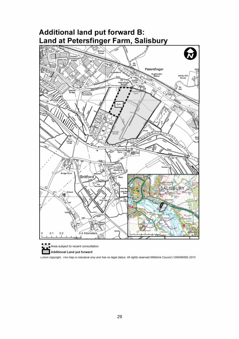
Additional site option at Petersfinger
Salisbury Avon Area 1
1.13 i) Impacts of noise, dust, lighting and visual intrusion on health and amenity of people living and working in proximity to site option. ii) Assessment of impacts to landscape character iii) Impacts on biodiversity (including impacts to River Avon SAC) iv) Assessment of feasibility of access to A36 and impacts of any potential increase in minerals HGVs on the local road network (including safety considerations for all road users). v) Further dialogue with EA will be required to assess the likely impacts to groundwater and surface water and flood risk assessment will need to be undertaken. vii) Assessment of impacts to historic environment. viii) Assessment of impacts to operations at sewerage works.
SA2 Salisbury Avon Area 2
2.0 This site option offers a significant potential yield which may allow for mitigation to be incorporated into the site design. Therefore, further assessment should be carried out to consider: i) Impacts of noise, dust, lighting and visual intrusion on health and amenity of people living and working in proximity to site option (including those impacts associated with use of potential haul route that emerges at Whaddon) . ii) Assessment of impacts to landscape character iii) Impacts on biodiversity (including impacts to River Avon SAC) iv) Assessment of feasibility of access to A36 (by crossing Witherington Road and using haul road to emerge at Whaddon Business Park) and impacts of any potential increase in minerals HGVs on the local road network (including safety considerations for all road users). v) Further dialogue with EA will be required to assess the likely impacts to groundwater and surface water and flood risk assessment will need to be undertaken. vii) Assessment of impacts to historic environment, including impacts to setting of Longford Grade II* Historic Park and Garden. viii) Assessment of potential impacts to Best and Most Versatile Agricultural Land.
BA4
Bristol Avon Area 3
0.5 i) Impacts of noise, dust, lighting and visual intrusion on health and amenity of people living and working in proximity to site option. ii) Assessment of impacts to landscape character iii) Impacts on biodiversity iv) Assessment of feasibility of access to A350 and impacts of any potential increase in minerals HGVs on the local road network (including safety considerations for all road users). v) Further dialogue with EA will be required to assess the likely impacts to groundwater and surface water and flood risk assessment will need to be undertaken. vii) Assessment of impacts to historic environment. viii) Assessment of potential impacts to Best and Most Versatile Agricultural Land.
Total estimated yield 33.28 mt
28
Appendices of report
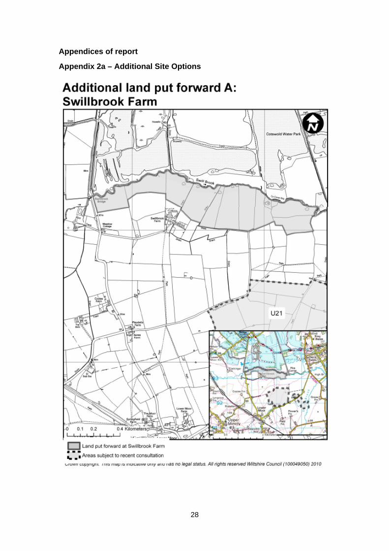
Appendix 2a – Additional Site Options
29
30
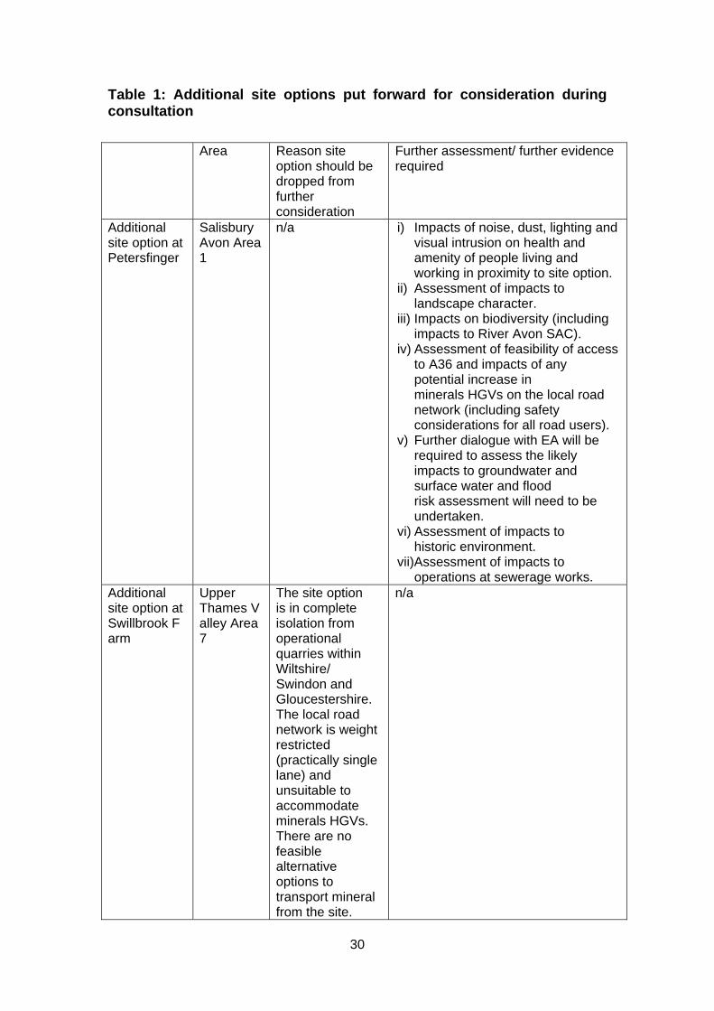
Table 1: Additional site options put forward for consideration during consultation
Area Reason site option should be dropped from further consideration
Further assessment/ further evidence required
Additional site option at Petersfinger
Salisbury Avon Area 1
n/a i) Impacts of noise, dust, lighting and visual intrusion on health and amenity of people living and working in proximity to site option.
ii) Assessment of impacts to landscape character.
iii) Impacts on biodiversity (including impacts to River Avon SAC).
iv) Assessment of feasibility of access to A36 and impacts of any potential increase in minerals HGVs on the local road network (including safety considerations for all road users).
v) Further dialogue with EA will be required to assess the likely impacts to groundwater and surface water and flood risk assessment will need to be undertaken.
vi) Assessment of impacts to historic environment.
vii)Assessment of impacts to operations at sewerage works.
Additional site option at Swillbrook Farm
Upper Thames Valley Area 7
The site option is in complete isolation from operational quarries within Wiltshire/ Swindon and Gloucestershire. The local road network is weight restricted (practically single lane) and unsuitable to accommodate minerals HGVs. There are no feasible alternative options to transport mineral from the site.
n/a

31
32
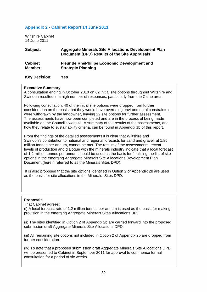
Appendix 2 - Cabinet Report 14 June 2011 Wiltshire Cabinet 14 June 2011 Subject: Aggregate Minerals Site Allocations Development Plan
Document (DPD) Results of the Site Appraisals
Cabinet Member:
Fleur de RhéPhilipe Economic Development and Strategic Planning
Key Decision: Yes
Executive Summary A consultation ending in October 2010 on 62 initial site options throughout Wiltshire and Swindon resulted in a high number of responses, particularly from the Calne area. Following consultation, 40 of the initial site options were dropped from further consideration on the basis that they would have overriding environmental constraints or were withdrawn by the landowner, leaving 22 site options for further assessment. The assessments have now been completed and are in the process of being made available on the Council’s website. A summary of the results of the assessments, and how they relate to sustainability criteria, can be found in Appendix 1b of this report. From the findings of the detailed assessments it is clear that Wiltshire and Swindon’s contribution to national and regional forecasts for sand and gravel, at 1.85 million tonnes per annum, cannot be met. The results of the assessments, recent levels of production and dialogue with the minerals industry indicate that a local forecast of 1.2 million tonnes per annum should be used as the basis for finalising the list of site options in the emerging Aggregate Minerals Site Allocations Development Plan Document (herein referred to as the Minerals Sites DPD). It is also proposed that the site options identified in Option 2 of Appendix 2b are used as the basis for site allocations in the Minerals Sites DPD.
Proposals That Cabinet agrees: (i) A local forecast rate of 1.2 million tonnes per annum is used as the basis for making provision in the emerging Aggregate Minerals Sites Allocations DPD.
(ii) The sites identified in Option 2 of Appendix 2b are carried forward into the proposed submission draft Aggregate Minerals Site Allocations DPD. (iii) All remaining site options not included in Option 2 of Appendix 2b are dropped from further consideration. (iv) To note that a proposed submission draft Aggregate Minerals Site Allocations DPD will be presented to Cabinet in September 2011 for approval to commence formal consultation for a period of six weeks.
33
MARK BODEN Corporate Director Department of Neighbourhood and Planning
Reason for Proposals
To ensure that an appropriate level of provision for sand and gravel extraction is established for Wiltshire and Swindon, in accordance with national and local policy and sufficient sites are identified to meet this requirement. Once adopted, the Aggregate Minerals Site Allocations DPD will form part of the Council’s policy framework.
34
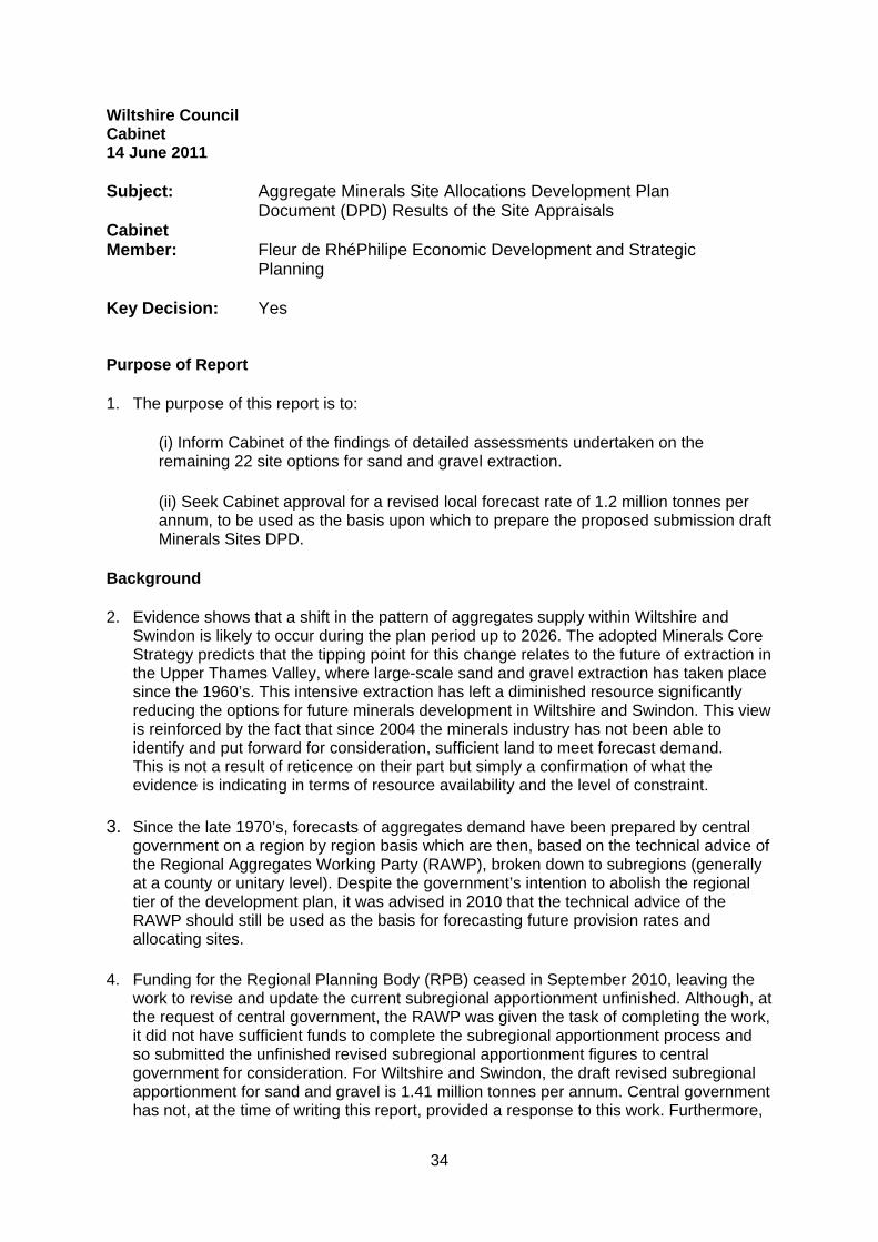
Wiltshire Council Cabinet 14 June 2011 Subject: Cabinet Member:
Aggregate Minerals Site Allocations Development Plan Document (DPD) Results of the Site Appraisals Fleur de RhéPhilipe Economic Development and Strategic Planning
Key Decision: Yes Purpose of Report
1. The purpose of this report is to:
(i) Inform Cabinet of the findings of detailed assessments undertaken on the remaining 22 site options for sand and gravel extraction.
(ii) Seek Cabinet approval for a revised local forecast rate of 1.2 million tonnes per annum, to be used as the basis upon which to prepare the proposed submission draft Minerals Sites DPD.
Background
2. Evidence shows that a shift in the pattern of aggregates supply within Wiltshire and Swindon is likely to occur during the plan period up to 2026. The adopted Minerals Core Strategy predicts that the tipping point for this change relates to the future of extraction in the Upper Thames Valley, where large-scale sand and gravel extraction has taken place since the 1960’s. This intensive extraction has left a diminished resource significantly reducing the options for future minerals development in Wiltshire and Swindon. This view is reinforced by the fact that since 2004 the minerals industry has not been able to identify and put forward for consideration, sufficient land to meet forecast demand. This is not a result of reticence on their part but simply a confirmation of what the evidence is indicating in terms of resource availability and the level of constraint.
3. Since the late 1970’s, forecasts of aggregates demand have been prepared by central government on a region by region basis which are then, based on the technical advice of the Regional Aggregates Working Party (RAWP), broken down to subregions (generally at a county or unitary level). Despite the government’s intention to abolish the regional tier of the development plan, it was advised in 2010 that the technical advice of the RAWP should still be used as the basis for forecasting future provision rates and allocating sites.
4. Funding for the Regional Planning Body (RPB) ceased in September 2010, leaving the work to revise and update the current subregional apportionment unfinished. Although, at the request of central government, the RAWP was given the task of completing the work, it did not have sufficient funds to complete the subregional apportionment process and so submitted the unfinished revised subregional apportionment figures to central government for consideration. For Wiltshire and Swindon, the draft revised subregional apportionment for sand and gravel is 1.41 million tonnes per annum. Central government has not, at the time of writing this report, provided a response to this work. Furthermore,
35
funding for the RAWPs has now been withdrawn as of 31 March 2011. This essentially means that the South West RAWP ceases to exist, unless alternative funding can be sourced by RAWP members (the industry and local authorities), from this point forward.
5. In order to determine whether the regional forecast rate can be maintained, or whether there is a need for a lower level of delivery in Wiltshire, the Councils undertook an extensive constraints sieving exercise of the five mineral resources zones in Wiltshire and Swindon to identify further initial site options in addition to those put forward by the minerals industry. The results of the sieving exercise demonstrated that significant areas of unexploited resource are highly constrained and/or inaccessible. However, through this exercise owners of potentially mineral bearing land were contacted and a total of 62 site options were put forward for consideration.
6. The consultation undertaken during 2010 on these 62 site options resulted in a high
number of responses, particularly around the Calne area. By consulting on all site options, the Councils are in a strong position to develop evidence to justify an appropriate level of apportionment for Wiltshire and Swindon. This has allowed the Council to fully test Wiltshire’s and Swindon’s ability to make full provision at a rate of the current 1.85 million tonnes or revised draft rate of 1.41 million tonnes per annum.
7. Following consultation, 40 of the initial site options were dropped from further
consideration on the basis that they would have overriding environmental constraints or were withdrawn by the landowner, leaving 22 site options for further assessment. Those assessments have now been completed and are in the process of being made available on the Council’s website. A summary of the results of the assessments, and how they relate to sustainability criteria, can be found in Appendix 1b of this report.
8. Evidence used to support the Minerals Core Strategy demonstrated that a decline in
production in the Upper Thames Valley is unlikely to be met entirely by other resources within the plan area and that the minerals industry are likely to look to areas outside of Wiltshire and Swindon where better quality resource with a higher yield per hectare could be achieved. This view has been reaffirmed through dialogue with representatives of the minerals industry; through the results of the sieving exercise; and the consultation in 2010. Therefore any shift in the current pattern of supply will almost certainly result in a permanent decline in levels of sand and gravel extraction from within the plan area compared to that of the past 20 years. Ultimately, the pressure to meet any shortfall in supply from Wiltshire and Swindon is likely to be felt in neighbouring authorities. It is important that the impact of this change is managed effectively, so that other areas are able to manage any increase in demand arising as a result of Wiltshire delivering lower levels. The Council will therefore need to continue to work with neighbouring authorities and the minerals industry to ensure that any negative effects are minimised.
Main Considerations for the Council 9. National policy states that subregional apportionments should not be regarded
as inflexible and requires minerals planning authorities to “test the practicality and environmental acceptability of policy proposals at the local level” (see Minerals Policy Statement 1, paragraph 3.8). The councils have taken all reasonable steps to ensure that the capacity of the plan area to deliver the requirements of the subregional apportionment has been fully tested against relevant sustainability criteria. The further assessments represent the final stage in testing the suitability of the site options before a draft Minerals Sites DPD can be prepared. From this it is clear that the current sub-regional apportionment of 1.85 million tonnes per annum for the period 2010 – 2026
36
cannot be met without the allocation of highly constrained and potentially unsuitable sites.
10. During the past nineteen 10
years production in Wiltshire and Swindon has not come close to matching the current subregional apportionment of 1.85 million tonnes per annum. The average annual production for this period equates to 1.09 million tonnes per annum. In the absence of the Regional Planning Body and subsequently the RAWP, the Minerals Products Association (representing the majority of minerals companies operating in Wiltshire and Swindon) has recently suggested that it would support an approach whereby local authorities base their provision rate on the average of the past 10 years production11. For Wiltshire and Swindon, this would equate to a local forecast rate of 1.2 million tonnes per annum. It is therefore reasonable to conclude that a local forecast of 1.2 million tonnes per annum more closely reflects recent demand than figures derived from national and regional forecasts.
11. However, those site options that are considered suitable for extraction and have industry
support, at this time, would only provide approximately 60% of the overall need required to meet a local forecast rate of 1.2 million tonnes per annum. Therefore, in order to meet the local forecast rate it will be necessary to include sites which do not currently have industry backing. Although this approach could potentially be seen as undermining the overall deliverability of the Minerals Sites DPD, it offers a practical solution by providing the necessary plan led steer for the minerals industry, should circumstances change during the plan period. The alternative would be to identify fewer sites which could mean that speculative applications are brought forward in areas outside of those considered to be the most suitable for development. These two options can be summarised as:
Option 1 Allocate only those sites that are considered suitable with minerals industry support.
Option 2 Allocate sites that are considered suitable with industry support together with those site options which the Council believe to be the most suitable for development that are not currently being promoted by the industry.
Details of what the above options would mean in terms of site allocations are provided in appendix 2b of this cabinet report.
12. It is recommended that option 2 should be taken forward on the basis that it will ensure that the Councils can plan to meet a reasonable apportionment and will provide greater certainty for local communities and developers as to where new sites should come forward. It is also considered to better reflect actual demand, taking into account a gradual, managed decline in production in the Upper Thames Valley as predicted in the Minerals Core Strategy.
10 The Council’s record of production covers the period 1991 – 2009
11 Minutes of South West RAWP meeting dated 14 March 2011
37
Next Steps
13. It is recommended that a proposed submission draft Minerals Sites DPD is presented to Cabinet in September 2011 for approval to commence formal consultation. This would meet with the requirements of the Adopted Statement of Community Involvement and thereby avoid consulting during the summer holiday period. However, the proposal would still offer sufficient time, following consultation, to submit the draft Minerals Sites DPD to government for independent examination by the end of the year, as timetabled.
Environmental and Climate Change Considerations 14. The proposals in this report have been, and will continue to be, subject to sustainability
appraisal to ensure that environmental and climate change implications will have been fully considered and minimised and that effects of a changing climate will be taken into account.
Equalities Impact of the Proposal 15. There are considered to be no equality impacts arising as a result of the proposals in
this report. An Equalities Impact Assessment (EIA) is not required at this stage of the plan making process, but will be completed once the final document is submitted to government.
Risk Assessment 16. The key risks associated with the preparation of this Minerals Sites DPD are:
(i) The Government may not accept the proposal to reduce the provision rate within Wiltshire and Swindon. This could delay proceeding to examination due to insufficient sites being found. However, in taking an evidence based approach to establishing a reasonable new rate of aggregates provision for Wiltshire and Swindon, this risk can be reduced. (ii) Following independent examination, a legal challenge could be made on the process leading to the adoption of the Minerals Sites DPD.
17. Between now and the publication of the proposed submission draft Minerals Sites DPD, a full audit of the process and evidence will be undertaken to ensure full compliance with planning policy and legislation and minimise the risk of the Minerals Sites DPD being found unsound or subject to legal challenge.
Financial Implications 18. The cost of preparing the Minerals Sites DPD will be met by existing and planned budget
commitments.
Legal Implications 19. The project is currently at the Regulation 25 stage of the Town and Country Planning
(Local Development) (England) 2004 Regulations (as amended). The requirements of this stage are essentially to gather evidence and consult those likely to have an interest in the proposed Minerals Sites DPD. The purpose of this evidence gathering stage is to ensure that a draft Minerals Sites DPD, when submitted to the Secretary of State,
38
represents the most appropriate option having considered all reasonable alternatives, and can be considered sound. The Regulation 25 stage does not end until the Council prepares the proposed submission draft Minerals Sites DPD for consultation. The steps undertaken to date and those proposed in this report are fully compliant with legal requirements.
Options Considered 20. Two Options have been considered in this report:
(i) Option 1 Allocate only those sites that are considered suitable with minerals industry support. This option is most likely to be deliverable but the resultant output will be significantly short of the requirement of the current subregional apportionment rate and the proposed local forecast of future demand. It reflects the views of the minerals industry, at this point in time, and is unlikely to result in unnecessary local concern in the shortterm. However, the factors that determine the viability of sites can also change over time. Therefore, the promotion of this option is likely to lead to a greater chance that unanticipated applications for mineral extraction could be submitted outside of the allocated sites.
(ii) Option 2 Allocate sites with industry support plus those site options which the Council believe to be suitable should the need arise during the plan period. This offers the most pragmatic approach and should result in a provision that more closely matches the local forecast rate of 1.2 million tonnes per annum. This option should also provide a good basis for managing proposals for minerals development outside of the allocated sites i.e. by providing an alternative, preferred location. However, even industry supported sites are not guaranteed to come forward within a given plan period. This means that less confidence can be afforded to those sites in a plan that does not have industry support. If this option is chosen, it is proposed that it is clearly indicated which sites are considered to be of interest to the minerals industry and therefore are deliverable and those which are not currently supported by the industry but could come forward for development, should circumstances change.
Conclusions The evidence clearly shows that Wiltshire and Swindon cannot make provision at 1.85 million tonnes per annum. Option 2 should be taken forward on the basis that it will ensure that the Councils can plan to meet a reasonable apportionment and will provide greater certainty for local communities and developers as to where new sites should come forward. It also reflects a gradual, managed decline in production in the Upper Thames Valley in real terms (as opposed to regional forecast rates), as predicted in the Minerals Core Strategy. In line with the resolution of Cabinet on the 22 March 2011, the Director of Economy and Enterprise and Cabinet Member, in consultation with their counterparts in Swindon, should now write to Central Government notifying them of the provision that can be met for the period to 2026. MARK BODEN Corporate Director Department of Neighbourhood and Planning
39
Report Authors: Alistair Cunningham Service Director – Economy & Enterprise Mark Henderson Senior Planner – Minerals and Waste Policy Background Papers The following unpublished documents have been relied on in the preparation of this report: None Appendices Appendix 1b – a summary of the results of the assessments. And how they relate to sustainability criteria Appendix 2b – Site options that would be carried forward to Minerals Sites DPD
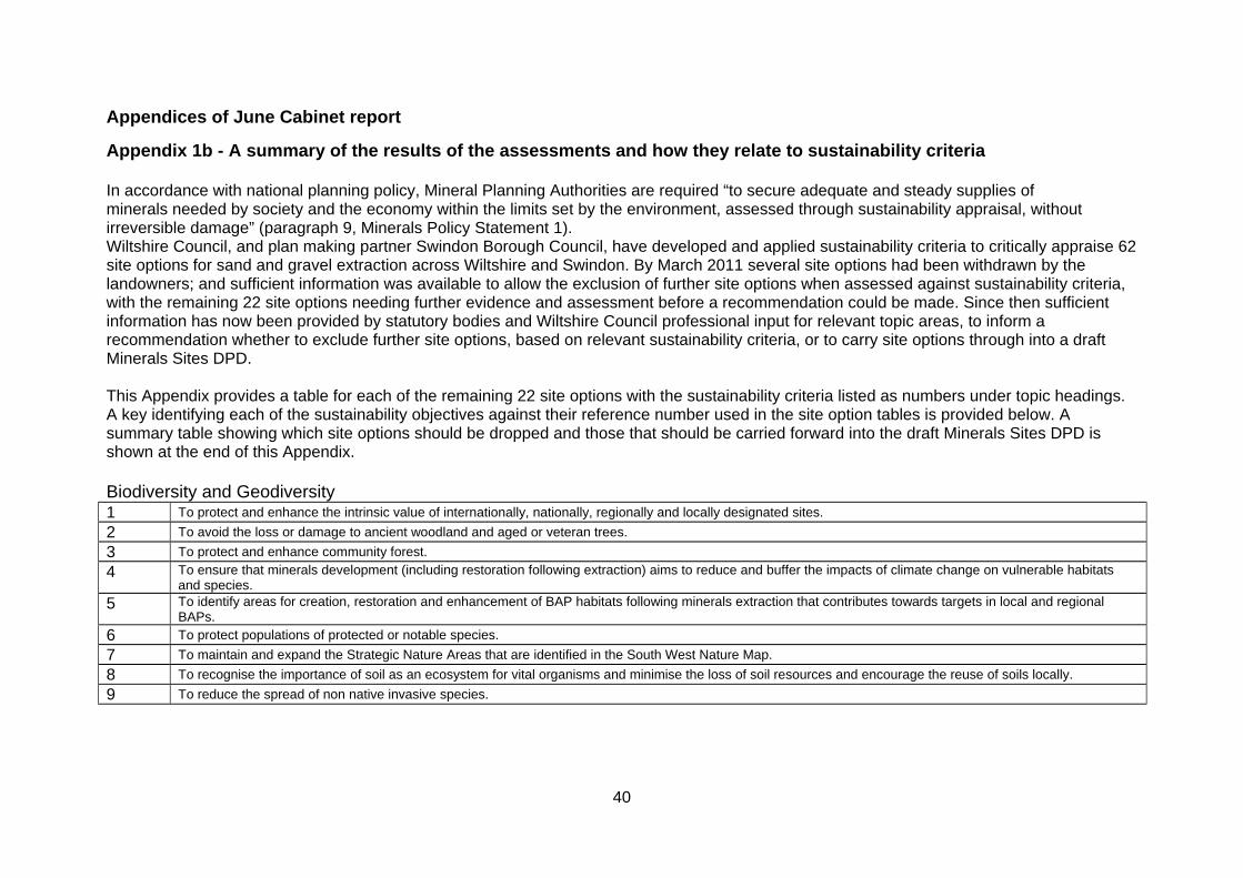
40
Appendices of June Cabinet report
Appendix 1b - A summary of the results of the assessments and how they relate to sustainability criteria In accordance with national planning policy, Mineral Planning Authorities are required “to secure adequate and steady supplies of minerals needed by society and the economy within the limits set by the environment, assessed through sustainability appraisal, without irreversible damage” (paragraph 9, Minerals Policy Statement 1). Wiltshire Council, and plan making partner Swindon Borough Council, have developed and applied sustainability criteria to critically appraise 62 site options for sand and gravel extraction across Wiltshire and Swindon. By March 2011 several site options had been withdrawn by the landowners; and sufficient information was available to allow the exclusion of further site options when assessed against sustainability criteria, with the remaining 22 site options needing further evidence and assessment before a recommendation could be made. Since then sufficient information has now been provided by statutory bodies and Wiltshire Council professional input for relevant topic areas, to inform a recommendation whether to exclude further site options, based on relevant sustainability criteria, or to carry site options through into a draft Minerals Sites DPD. This Appendix provides a table for each of the remaining 22 site options with the sustainability criteria listed as numbers under topic headings. A key identifying each of the sustainability objectives against their reference number used in the site option tables is provided below. A summary table showing which site options should be dropped and those that should be carried forward into the draft Minerals Sites DPD is shown at the end of this Appendix. Biodiversity and Geodiversity 1 To protect and enhance the intrinsic value of internationally, nationally, regionally and locally designated sites.
2 To avoid the loss or damage to ancient woodland and aged or veteran trees.
3 To protect and enhance community forest.
4 To ensure that minerals development (including restoration following extraction) aims to reduce and buffer the impacts of climate change on vulnerable habitats and species.
5 To identify areas for creation, restoration and enhancement of BAP habitats following minerals extraction that contributes towards targets in local and regional BAPs.
6 To protect populations of protected or notable species.
7 To maintain and expand the Strategic Nature Areas that are identified in the South West Nature Map.
8 To recognise the importance of soil as an ecosystem for vital organisms and minimise the loss of soil resources and encourage the reuse of soils locally.
9 To reduce the spread of non native invasive species.
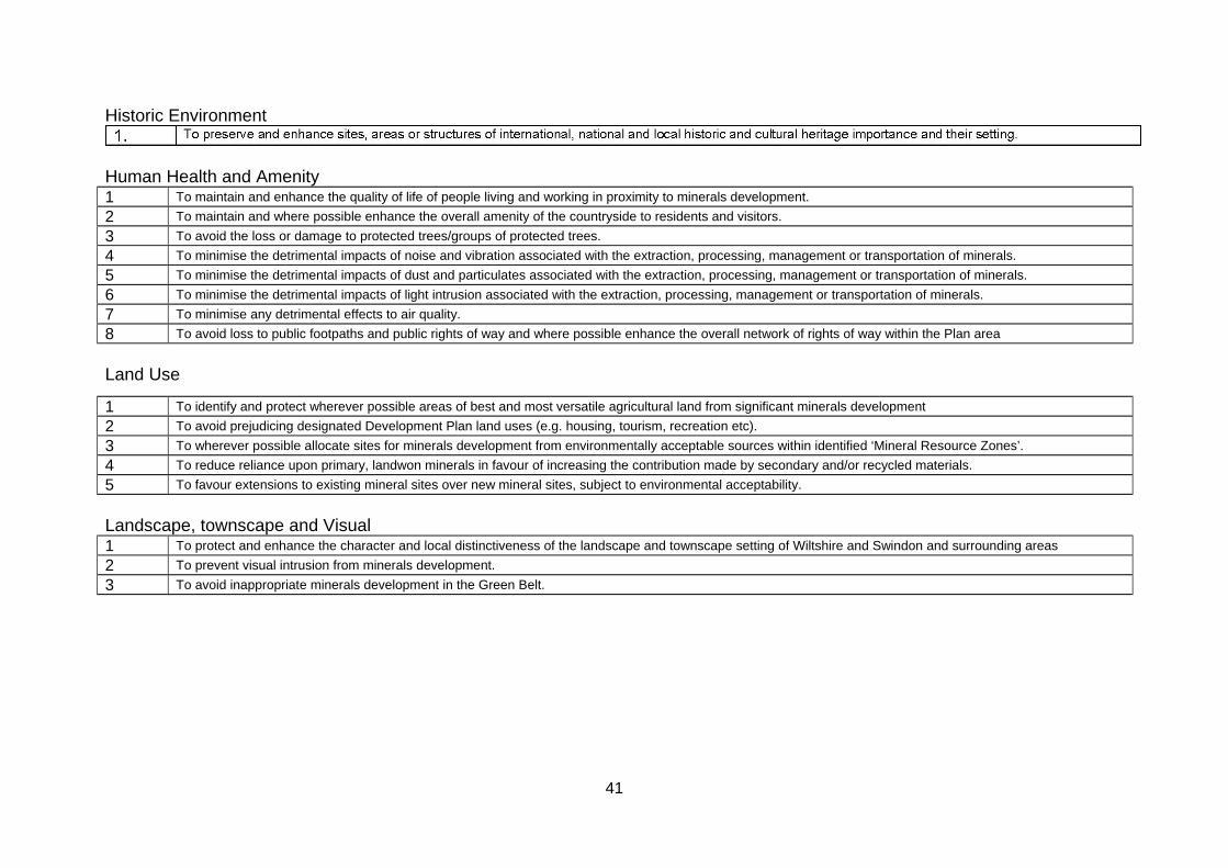
41
Historic Environment
Human Health and Amenity 1 To maintain and enhance the quality of life of people living and working in proximity to minerals development.
2 To maintain and where possible enhance the overall amenity of the countryside to residents and visitors.
3 To avoid the loss or damage to protected trees/groups of protected trees.
4 To minimise the detrimental impacts of noise and vibration associated with the extraction, processing, management or transportation of minerals.
5 To minimise the detrimental impacts of dust and particulates associated with the extraction, processing, management or transportation of minerals.
6 To minimise the detrimental impacts of light intrusion associated with the extraction, processing, management or transportation of minerals.
7 To minimise any detrimental effects to air quality.
8 To avoid loss to public footpaths and public rights of way and where possible enhance the overall network of rights of way within the Plan area
Land Use
Landscape, townscape and Visual 1 To protect and enhance the character and local distinctiveness of the landscape and townscape setting of Wiltshire and Swindon and surrounding areas
2 To prevent visual intrusion from minerals development.
3 To avoid inappropriate minerals development in the Green Belt.
1 To identify and protect wherever possible areas of best and most versatile agricultural land from significant minerals development
2 To avoid prejudicing designated Development Plan land uses (e.g. housing, tourism, recreation etc).
3 To wherever possible allocate sites for minerals development from environmentally acceptable sources within identified ‘Mineral Resource Zones’.
4 To reduce reliance upon primary, landwon minerals in favour of increasing the contribution made by secondary and/or recycled materials.
5 To favour extensions to existing mineral sites over new mineral sites, subject to environmental acceptability.
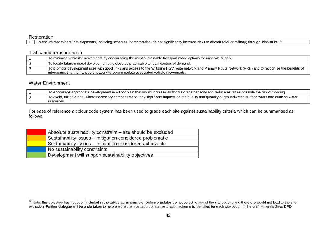
42
Restoration 1 To ensure that mineral developments, including schemes for restoration, do not significantly increase risks to aircraft (civil or military) through ‘bird-strike’.12
Traffic and transportation 1 To minimise vehicular movements by encouraging the most sustainable transport mode options for minerals supply.
2 To locate future mineral developments as close as practicable to local centres of demand.
3 To promote development sites with good links and access to the Wiltshire HGV route network and Primary Route Network (PRN) and to recognise the benefits of interconnecting the transport network to accommodate associated vehicle movements.
Water Environment
For ease of reference a colour code system has been used to grade each site against sustainability criteria which can be summarised as follows: Absolute sustainability constraint – site should be excluded Sustainability issues – mitigation considered problematic Sustainability issues – mitigation considered achievable No sustainability constraints Development will support sustainability objectives
12 Note: this objective has not been included in the tables as, in principle, Defence Estates do not object to any of the site options and therefore would not lead to the site exclusion. Further dialogue will be undertaken to help ensure the most appropriate restoration scheme is identified for each site option in the draft Minerals Sites DPD
1 To encourage appropriate development in a floodplain that would increase its flood storage capacity and reduce as far as possible the risk of flooding.
2 To avoid, mitigate and, where necessary compensate for any significant impacts on the quality and quantity of groundwater, surface water and drinking water resources.
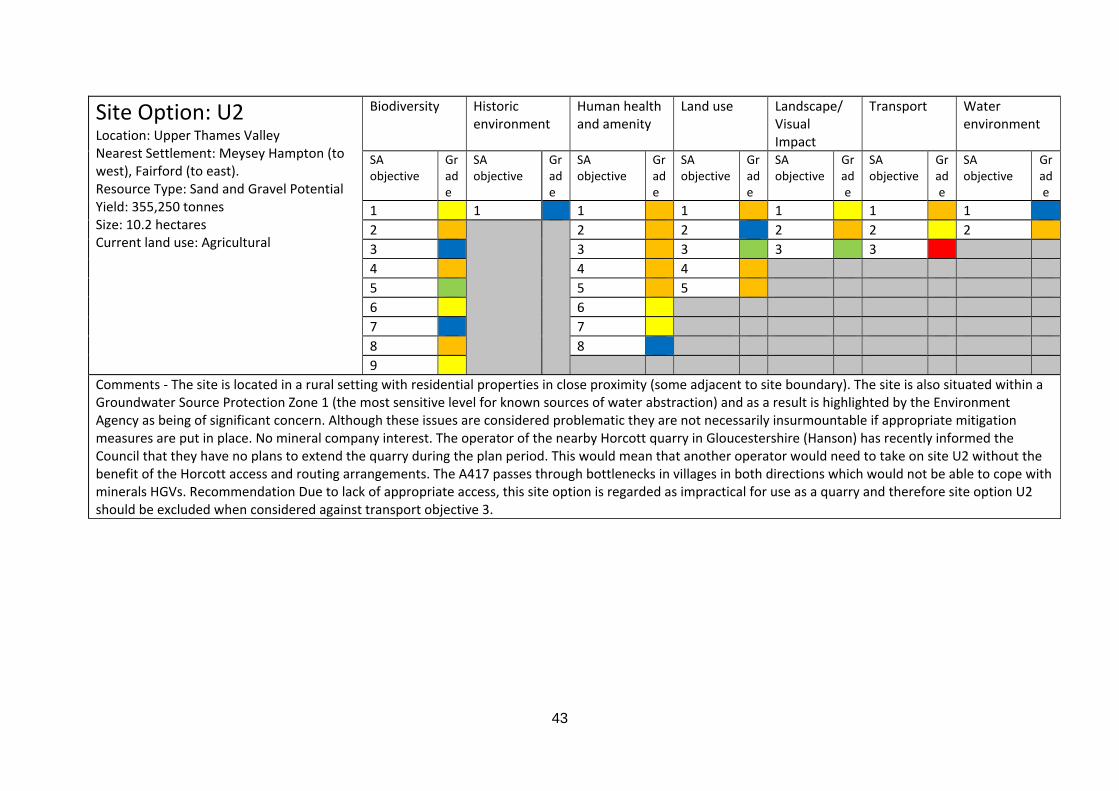
43
Site Option: U2 Location: Upper Thames Valley Nearest Settlement: Meysey Hampton (to west), Fairford (to east). Resource Type: Sand and Gravel Potential Yield: 355,250 tonnes Size: 10.2 hectares Current land use: Agricultural
Biodiversity Historic environment
Human health and amenity
Land use Landscape/ Visual Impact
Transport Water environment
SA objective
Grade
SA objective
Grade
SA objective
Grade
SA objective
Grade
SA objective
Grade
SA objective
Grade
SA objective
Grade
1 1 1 1 1 1 1 2 2 2 2 2 2 3 3 3 3 3 4 4 4 5 5 5 6 6 7 7 8 8 9
Comments ‐ The site is located in a rural setting with residential properties in close proximity (some adjacent to site boundary). The site is also situated within a Groundwater Source Protection Zone 1 (the most sensitive level for known sources of water abstraction) and as a result is highlighted by the Environment Agency as being of significant concern. Although these issues are considered problematic they are not necessarily insurmountable if appropriate mitigation measures are put in place. No mineral company interest. The operator of the nearby Horcott quarry in Gloucestershire (Hanson) has recently informed the Council that they have no plans to extend the quarry during the plan period. This would mean that another operator would need to take on site U2 without the benefit of the Horcott access and routing arrangements. The A417 passes through bottlenecks in villages in both directions which would not be able to cope with minerals HGVs. Recommendation Due to lack of appropriate access, this site option is regarded as impractical for use as a quarry and therefore site option U2 should be excluded when considered against transport objective 3.
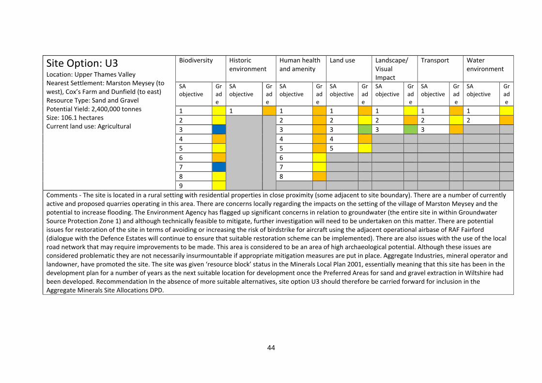
44
Site Option: U3 Location: Upper Thames Valley Nearest Settlement: Marston Meysey (to west), Cox’s Farm and Dunfield (to east) Resource Type: Sand and Gravel Potential Yield: 2,400,000 tonnes Size: 106.1 hectares Current land use: Agricultural
Biodiversity Historic environment
Human health and amenity
Land use Landscape/ Visual Impact
Transport Water environment
SA objective
Grade
SA objective
Grade
SA objective
Grade
SA objective
Grade
SA objective
Grade
SA objective
Grade
SA objective
Grade
1 1 1 1 1 1 1 2 2 2 2 2 2 3 3 3 3 3 4 4 4 5 5 5 6 6 7 7 8 8 9
Comments ‐ The site is located in a rural setting with residential properties in close proximity (some adjacent to site boundary). There are a number of currently active and proposed quarries operating in this area. There are concerns locally regarding the impacts on the setting of the village of Marston Meysey and the potential to increase flooding. The Environment Agency has flagged up significant concerns in relation to groundwater (the entire site in within Groundwater Source Protection Zone 1) and although technically feasible to mitigate, further investigation will need to be undertaken on this matter. There are potential issues for restoration of the site in terms of avoiding or increasing the risk of birdstrike for aircraft using the adjacent operational airbase of RAF Fairford (dialogue with the Defence Estates will continue to ensure that suitable restoration scheme can be implemented). There are also issues with the use of the local road network that may require improvements to be made. This area is considered to be an area of high archaeological potential. Although these issues are considered problematic they are not necessarily insurmountable if appropriate mitigation measures are put in place. Aggregate Industries, mineral operator and landowner, have promoted the site. The site was given ‘resource block’ status in the Minerals Local Plan 2001, essentially meaning that this site has been in the development plan for a number of years as the next suitable location for development once the Preferred Areas for sand and gravel extraction in Wiltshire had been developed. Recommendation In the absence of more suitable alternatives, site option U3 should therefore be carried forward for inclusion in the Aggregate Minerals Site Allocations DPD.
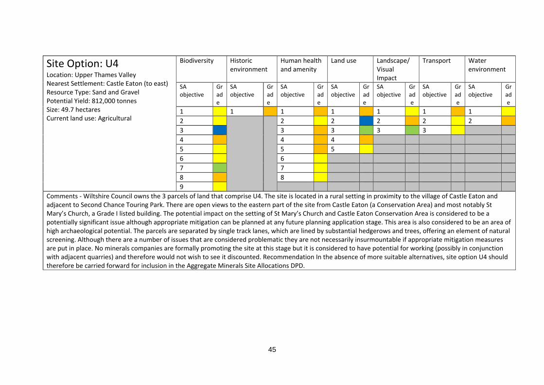
45
Site Option: U4 Location: Upper Thames Valley Nearest Settlement: Castle Eaton (to east) Resource Type: Sand and Gravel Potential Yield: 812,000 tonnes Size: 49.7 hectares Current land use: Agricultural
Biodiversity Historic environment
Human health and amenity
Land use Landscape/ Visual Impact
Transport Water environment
SA objective
Grade
SA objective
Grade
SA objective
Grade
SA objective
Grade
SA objective
Grade
SA objective
Grade
SA objective
Grade
1 1 1 1 1 1 1 2 2 2 2 2 2 3 3 3 3 3 4 4 4 5 5 5 6 6 7 7 8 8 9
Comments ‐ Wiltshire Council owns the 3 parcels of land that comprise U4. The site is located in a rural setting in proximity to the village of Castle Eaton and adjacent to Second Chance Touring Park. There are open views to the eastern part of the site from Castle Eaton (a Conservation Area) and most notably St Mary’s Church, a Grade I listed building. The potential impact on the setting of St Mary’s Church and Castle Eaton Conservation Area is considered to be a potentially significant issue although appropriate mitigation can be planned at any future planning application stage. This area is also considered to be an area of high archaeological potential. The parcels are separated by single track lanes, which are lined by substantial hedgerows and trees, offering an element of natural screening. Although there are a number of issues that are considered problematic they are not necessarily insurmountable if appropriate mitigation measures are put in place. No minerals companies are formally promoting the site at this stage but it is considered to have potential for working (possibly in conjunction with adjacent quarries) and therefore would not wish to see it discounted. Recommendation In the absence of more suitable alternatives, site option U4 should therefore be carried forward for inclusion in the Aggregate Minerals Site Allocations DPD.
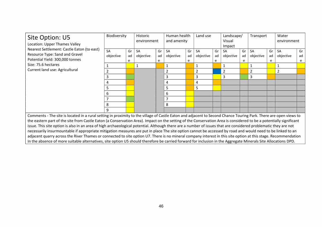
46
Site Option: U5 Location: Upper Thames Valley Nearest Settlement: Castle Eaton (to east) Resource Type: Sand and Gravel Potential Yield: 300,000 tonnes Size: 75.6 hectares Current land use: Agricultural
Biodiversity Historic environment
Human health and amenity
Land use Landscape/ Visual Impact
Transport Water environment
SA objective
Grade
SA objective
Grade
SA objective
Grade
SA objective
Grade
SA objective
Grade
SA objective
Grade
SA objective
Grade
1 1 1 1 1 1 1 2 2 2 2 2 2 3 3 3 3 3 4 4 4 5 5 5 6 6 7 7 8 8 9
Comments ‐ The site is located in a rural setting in proximity to the village of Castle Eaton and adjacent to Second Chance Touring Park. There are open views to the eastern part of the site from Castle Eaton (a Conservation Area). Impact on the setting of the Conservation Area is considered to be a potentially significant issue. This site option is also in an area of high archaeological potential. Although there are a number of issues that are considered problematic they are not necessarily insurmountable if appropriate mitigation measures are put in place The site option cannot be accessed by road and would need to be linked to an adjacent quarry across the River Thames or connected to site option U7. There is no mineral company interest in this site option at this stage. Recommendation In the absence of more suitable alternatives, site option U5 should therefore be carried forward for inclusion in the Aggregate Minerals Site Allocations DPD.
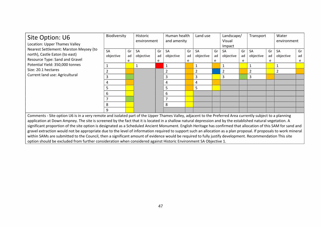
47
Site Option: U6 Location: Upper Thames Valley Nearest Settlement: Marston Meysey (to north), Castle Eaton (to east) Resource Type: Sand and Gravel Potential Yield: 350,000 tonnes Size: 20.1 hectares Current land use: Agricultural
Biodiversity Historic environment
Human health and amenity
Land use Landscape/ Visual Impact
Transport Water environment
SA objective
Grade
SA objective
Grade
SA objective
Grade
SA objective
Grade
SA objective
Grade
SA objective
Grade
SA objective
Grade
1 1 1 1 1 1 1 2 2 2 2 2 2 3 3 3 3 3 4 4 4 5 5 5 6 6 7 7 8 8 9
Comments ‐ Site option U6 is in a very remote and isolated part of the Upper Thames Valley, adjacent to the Preferred Area currently subject to a planning application at Down Ampney. The site is screened by the fact that it is located in a shallow natural depression and by the established natural vegetation. A significant proportion of the site option is designated as a Scheduled Ancient Monument. English Heritage has confirmed that allocation of this SAM for sand and gravel extraction would not be appropriate due to the level of information required to support such an allocation as a plan proposal. If proposals to work mineral within SAMs are submitted to the Council, then a significant amount of evidence would be required to fully justify development. Recommendation This site option should be excluded from further consideration when considered against Historic Environment SA Objective 1.

48
Site Option: U7 Location: Upper Thames Valley Nearest Settlement: Castle Eaton (to northeast), Cricklade (to west). Resource Type: Sand and Gravel Potential Yield: 2,200,000 tonnes Size: 172.6 hectares Current land use: Agricultural
Biodiversity Historic environment
Human health and amenity
Land use Landscape/ Visual Impact
Transport Water environment
SA objective
Grade
SA objective
Grade
SA objective
Grade
SA objective
Grade
SA objective
Grade
SA objective
Grade
SA objective
Grade
1 1 1 1 1 1 1 2 2 2 2 2 2 3 3 3 3 3 4 4 4 5 5 5 6 6 7 7 8 8 9
Comments ‐ Although this site option is large in size, the mineral is not evenly distributed within the site boundary. This has been taken into account in the original estimate of yield, although the exact quality and quantity of sand and gravel within this site option is unknown. There are listed buildings in proximity to site option and the area is considered to be of medium archaeological potential, however, mitigation is considered achievable. Access to this site via a new junction from the A419 is considered inappropriate if it were to be operated as a standalone quarry. Ideally it would be worked as an extension to the quarries currently operating in close proximity to the site to the north. The Environment Agency has expressed significant concern regarding the proximity of the site option to North Meadow Special Area of Conservation and the River Thames. The site is substantial in size and therefore in principle can accommodate options for controlling groundwater surface water flow and standoffs from the river. At this stage no detailed hydrological and hydrogeological information has been provided and this will be required to support the allocation moving forward. Although there are a number of issues that are considered problematic they are not necessarily insurmountable if appropriate mitigation measures are put in place. No mineral company has expressed an interest in this site at this stage. Recommendation In the absence of more suitable alternatives, site option U7 should therefore be carried forward for inclusion in the Aggregate Minerals Site Allocations DPD.

49
Site Option: U9 Location: Upper Thames Valley Nearest Settlement: Latton (to north) Resource Type: Sand and Gravel Potential Yield: 1,250,000 Size: 42.1 hectares Current land use: Agricultural
Biodiversity Historic environment
Human health and amenity
Land use Landscape/ Visual Impact
Transport Water environment
SA objective
Grade
SA objective
Grade
SA objective
Grade
SA objective
Grade
SA objective
Grade
SA objective
Grade
SA objective
Grade
1 1 1 1 1 1 1 2 2 2 2 2 2 3 3 3 3 3 4 4 4 5 5 5 6 6 7 7 8 8 9
Comments ‐ This option is located adjacent to the village of Latton which could potentially lead to issues with noise and dust. However it should be noted that the A419, as a source of noise, contributes significantly to background noise levels at Latton. The Environment Agency has expressed significant concern regarding the proximity of the site option to North Meadow Special Area of Conservation. No formal mineral company interest in this site option at this stage. A significant proportion of the site option is designated as a Scheduled Ancient Monument. English Heritage has confirmed that allocation of this SAM for sand and gravel extraction would not be appropriate due to the level of information required to support such an allocation as a plan proposal. If proposals to work mineral within SAMs are submitted to the Council, then a significant amount of evidence would be required to fully justify development. Recommendation Therefore site option U9 should be excluded from further consideration when considered against Historic Environment SA Objective 1.
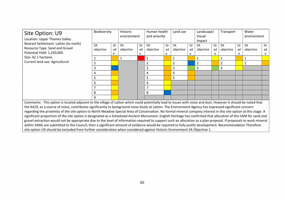
50
Site Option: U9 Location: Upper Thames Valley Nearest Settlement: Latton (to north) Resource Type: Sand and Gravel Potential Yield: 1,250,000 Size: 42.1 hectares Current land use: Agricultural
Biodiversity Historic environment
Human health and amenity
Land use Landscape/ Visual Impact
Transport Water environment
SA objective
Grade
SA objective
Grade
SA objective
Grade
SA objective
Grade
SA objective
Grade
SA objective
Grade
SA objective
Grade
1 1 1 1 1 1 1 2 2 2 2 2 2 3 3 3 3 3 4 4 4 5 5 5 6 6 7 7 8 8 9
Comments ‐ This option is located adjacent to the village of Latton which could potentially lead to issues with noise and dust. However it should be noted that the A419, as a source of noise, contributes significantly to background noise levels at Latton. The Environment Agency has expressed significant concern regarding the proximity of the site option to North Meadow Special Area of Conservation. No formal mineral company interest in this site option at this stage. A significant proportion of the site option is designated as a Scheduled Ancient Monument. English Heritage has confirmed that allocation of this SAM for sand and gravel extraction would not be appropriate due to the level of information required to support such an allocation as a plan proposal. If proposals to work mineral within SAMs are submitted to the Council, then a significant amount of evidence would be required to fully justify development. Recommendation Therefore site option U9 should be excluded from further consideration when considered against Historic Environment SA Objective 1.
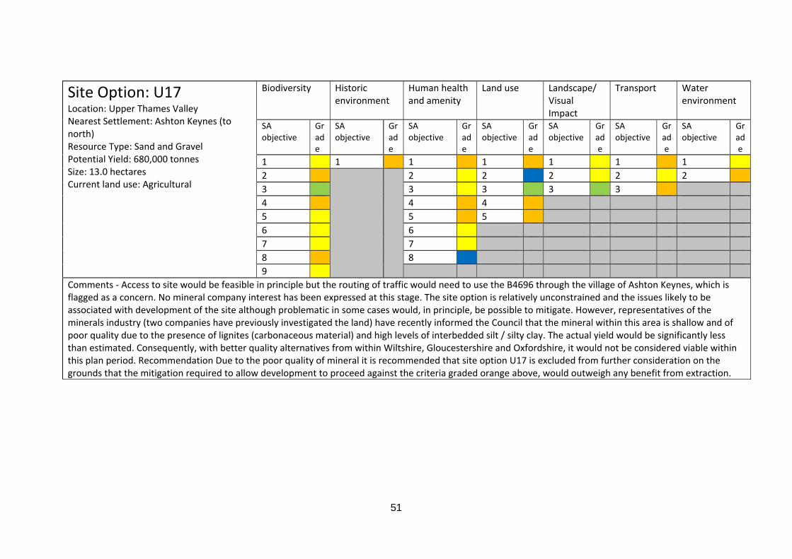
51
Site Option: U17 Location: Upper Thames Valley Nearest Settlement: Ashton Keynes (to north) Resource Type: Sand and Gravel Potential Yield: 680,000 tonnes Size: 13.0 hectares Current land use: Agricultural
Biodiversity Historic environment
Human health and amenity
Land use Landscape/ Visual Impact
Transport Water environment
SA objective
Grade
SA objective
Grade
SA objective
Grade
SA objective
Grade
SA objective
Grade
SA objective
Grade
SA objective
Grade
1 1 1 1 1 1 1 2 2 2 2 2 2 3 3 3 3 3 4 4 4 5 5 5 6 6 7 7 8 8 9
Comments ‐ Access to site would be feasible in principle but the routing of traffic would need to use the B4696 through the village of Ashton Keynes, which is flagged as a concern. No mineral company interest has been expressed at this stage. The site option is relatively unconstrained and the issues likely to be associated with development of the site although problematic in some cases would, in principle, be possible to mitigate. However, representatives of the minerals industry (two companies have previously investigated the land) have recently informed the Council that the mineral within this area is shallow and of poor quality due to the presence of lignites (carbonaceous material) and high levels of interbedded silt / silty clay. The actual yield would be significantly less than estimated. Consequently, with better quality alternatives from within Wiltshire, Gloucestershire and Oxfordshire, it would not be considered viable within this plan period. Recommendation Due to the poor quality of mineral it is recommended that site option U17 is excluded from further consideration on the grounds that the mitigation required to allow development to proceed against the criteria graded orange above, would outweigh any benefit from extraction.
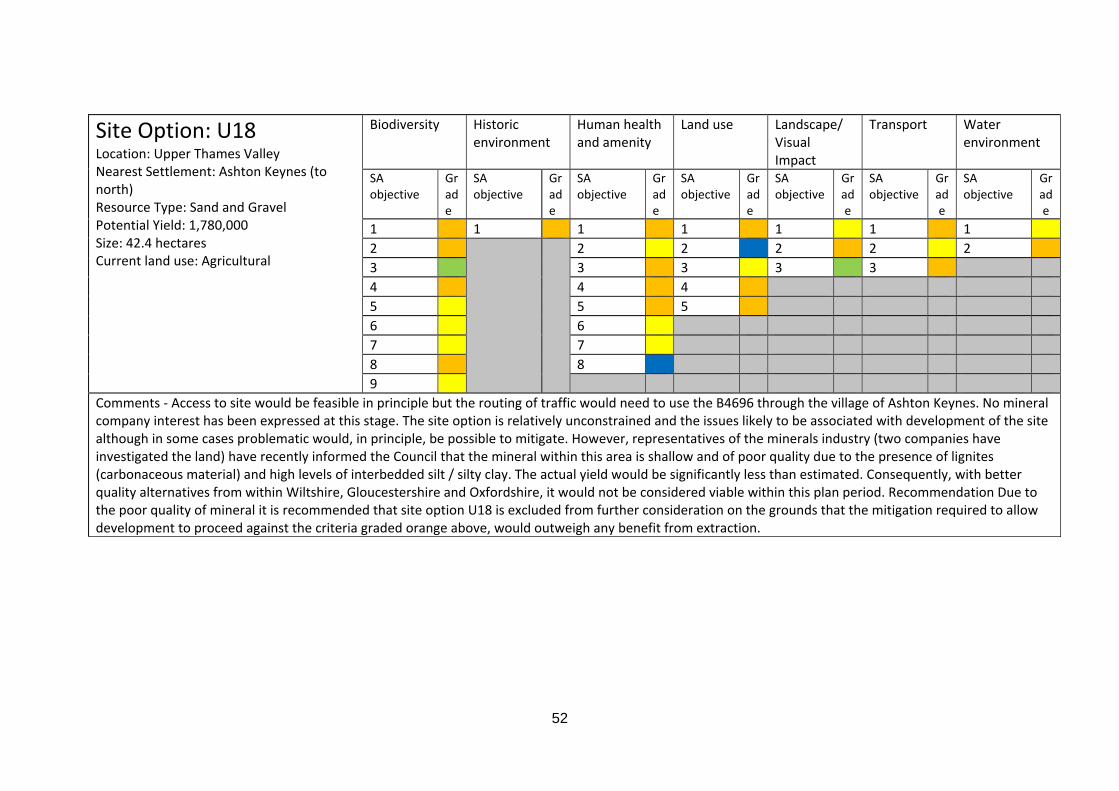
52
Site Option: U18 Location: Upper Thames Valley Nearest Settlement: Ashton Keynes (to north) Resource Type: Sand and Gravel Potential Yield: 1,780,000 Size: 42.4 hectares Current land use: Agricultural
Biodiversity Historic environment
Human health and amenity
Land use Landscape/ Visual Impact
Transport Water environment
SA objective
Grade
SA objective
Grade
SA objective
Grade
SA objective
Grade
SA objective
Grade
SA objective
Grade
SA objective
Grade
1 1 1 1 1 1 1 2 2 2 2 2 2 3 3 3 3 3 4 4 4 5 5 5 6 6 7 7 8 8 9
Comments ‐ Access to site would be feasible in principle but the routing of traffic would need to use the B4696 through the village of Ashton Keynes. No mineral company interest has been expressed at this stage. The site option is relatively unconstrained and the issues likely to be associated with development of the site although in some cases problematic would, in principle, be possible to mitigate. However, representatives of the minerals industry (two companies have investigated the land) have recently informed the Council that the mineral within this area is shallow and of poor quality due to the presence of lignites (carbonaceous material) and high levels of interbedded silt / silty clay. The actual yield would be significantly less than estimated. Consequently, with better quality alternatives from within Wiltshire, Gloucestershire and Oxfordshire, it would not be considered viable within this plan period. Recommendation Due to the poor quality of mineral it is recommended that site option U18 is excluded from further consideration on the grounds that the mitigation required to allow development to proceed against the criteria graded orange above, would outweigh any benefit from extraction.

53
Site Option: U22 Location: Upper Thames Valley Nearest Settlement: Ashton Keynes (to south) Resource Type: Sand and Gravel Potential Yield: 1,260,000 tonnes Size: hectares Current land use: Agricultural
Biodiversity Historic environment
Human health and amenity
Land use Landscape/ Visual Impact
Transport Water environment
SA objective
Grade
SA objective
Grade
SA objective
Grade
SA objective
Grade
SA objective
Grade
SA objective
Grade
SA objective
Grade
1 1 1 1 1 1 1 2 2 2 2 2 2 3 3 3 3 3 4 4 4 5 5 5 6 6 7 7 8 8 9
Comments ‐ The site is located adjacent to a residential school (Cotswold Community School). The school is closing and will be vacant from the end of term 6 in July 2011 and therefore use as a school should not be considered as a sensitive receptor. A number of Grade II listed buildings are located within the boundary of the school and mitigation would be required to ensure the setting of the listed buildings in question is not compromised. This area is also considered to be an area of high archaeological potential but it is considered that appropriate mitigation could be designed and applied at an application stage. Due to the closure of the school additional land within the area can now be considered (the landowner for site options U22 and U23 also owns the land associated with the school), which is estimated to increase the potential yield for this site by at least 1.5 million tonnes (initial calculations indicate that up to 2 million tonnes additional resource could be available) if the non‐scheduled part of U23 is incorporated into this option (please refer to site option U23 below). Access to the local road network is considered to be problematic. Therefore this site would ideally be linked to an adjacent quarry to the north. Although there are a number of issues that are considered problematic they are not necessarily insurmountable if appropriate mitigation measures are put in place. Although there is no formal mineral company support for this site option at this stage, it has been indicated by representatives of the minerals industry that this would be a feasible option for a quarry. Recommendation In the absence of more suitable alternatives, site option U22 should therefore be carried forward for inclusion in the Aggregate Minerals Site Allocations DPD, including a revised estimate of resource.
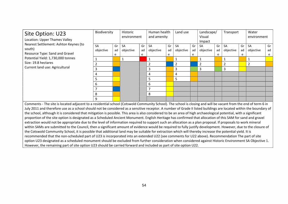
54
Site Option: U23 Location: Upper Thames Valley Nearest Settlement: Ashton Keynes (to south) Resource Type: Sand and Gravel Potential Yield: 1,730,000 tonnes Size: 19.8 hectares Current land use: Agricultural
Biodiversity Historic environment
Human health and amenity
Land use Landscape/ Visual Impact
Transport Water environment
SA objective
Grade
SA objective
Grade
SA objective
Grade
SA objective
Grade
SA objective
Grade
SA objective
Grade
SA objective
Grade
1 1 1 1 1 1 1 2 2 2 2 2 2 3 3 3 3 3 4 4 4 5 5 5 6 6 7 7 8 8 9
Comments ‐ The site is located adjacent to a residential school (Cotswold Community School). The school is closing and will be vacant from the end of term 6 in July 2011 and therefore use as a school should not be considered as a sensitive receptor. A number of Grade II listed buildings are located within the boundary of the school, although it is considered that mitigation is possible. This area is also considered to be an area of high archaeological potential, with a significant proportion of the site option is designated as a Scheduled Ancient Monument. English Heritage has confirmed that allocation of this SAM for sand and gravel extraction would not be appropriate due to the level of information required to support such an allocation as a plan proposal. If proposals to work mineral within SAMs are submitted to the Council, then a significant amount of evidence would be required to fully justify development. However, due to the closure of the Cotswold Community School, it is possible that additional land may be suitable for extraction which will thereby increase the potential yield. It is recommended that the non‐scheduled part of U23 is incorporated into an extended U22 (see comments for U22 above). Recommendation The part of site option U23 designated as a scheduled monument should be excluded from further consideration when considered against Historic Environment SA Objective 1. However, the remaining part of site option U23 should be carried forward and included as part of site option U22.
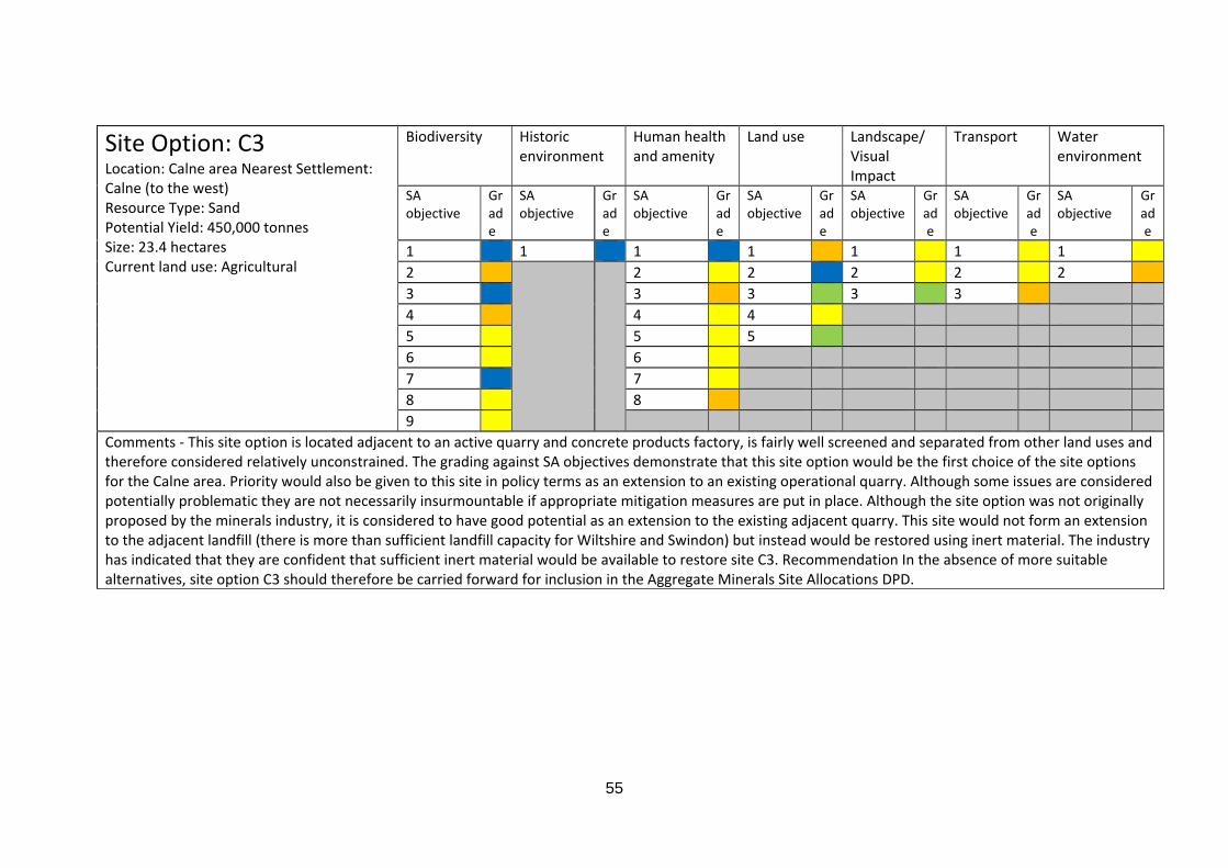
55
Site Option: C3 Location: Calne area Nearest Settlement: Calne (to the west) Resource Type: Sand Potential Yield: 450,000 tonnes Size: 23.4 hectares Current land use: Agricultural
Biodiversity Historic environment
Human health and amenity
Land use Landscape/ Visual Impact
Transport Water environment
SA objective
Grade
SA objective
Grade
SA objective
Grade
SA objective
Grade
SA objective
Grade
SA objective
Grade
SA objective
Grade
1 1 1 1 1 1 1 2 2 2 2 2 2 3 3 3 3 3 4 4 4 5 5 5 6 6 7 7 8 8 9
Comments ‐ This site option is located adjacent to an active quarry and concrete products factory, is fairly well screened and separated from other land uses and therefore considered relatively unconstrained. The grading against SA objectives demonstrate that this site option would be the first choice of the site options for the Calne area. Priority would also be given to this site in policy terms as an extension to an existing operational quarry. Although some issues are considered potentially problematic they are not necessarily insurmountable if appropriate mitigation measures are put in place. Although the site option was not originally proposed by the minerals industry, it is considered to have good potential as an extension to the existing adjacent quarry. This site would not form an extension to the adjacent landfill (there is more than sufficient landfill capacity for Wiltshire and Swindon) but instead would be restored using inert material. The industry has indicated that they are confident that sufficient inert material would be available to restore site C3. Recommendation In the absence of more suitable alternatives, site option C3 should therefore be carried forward for inclusion in the Aggregate Minerals Site Allocations DPD.
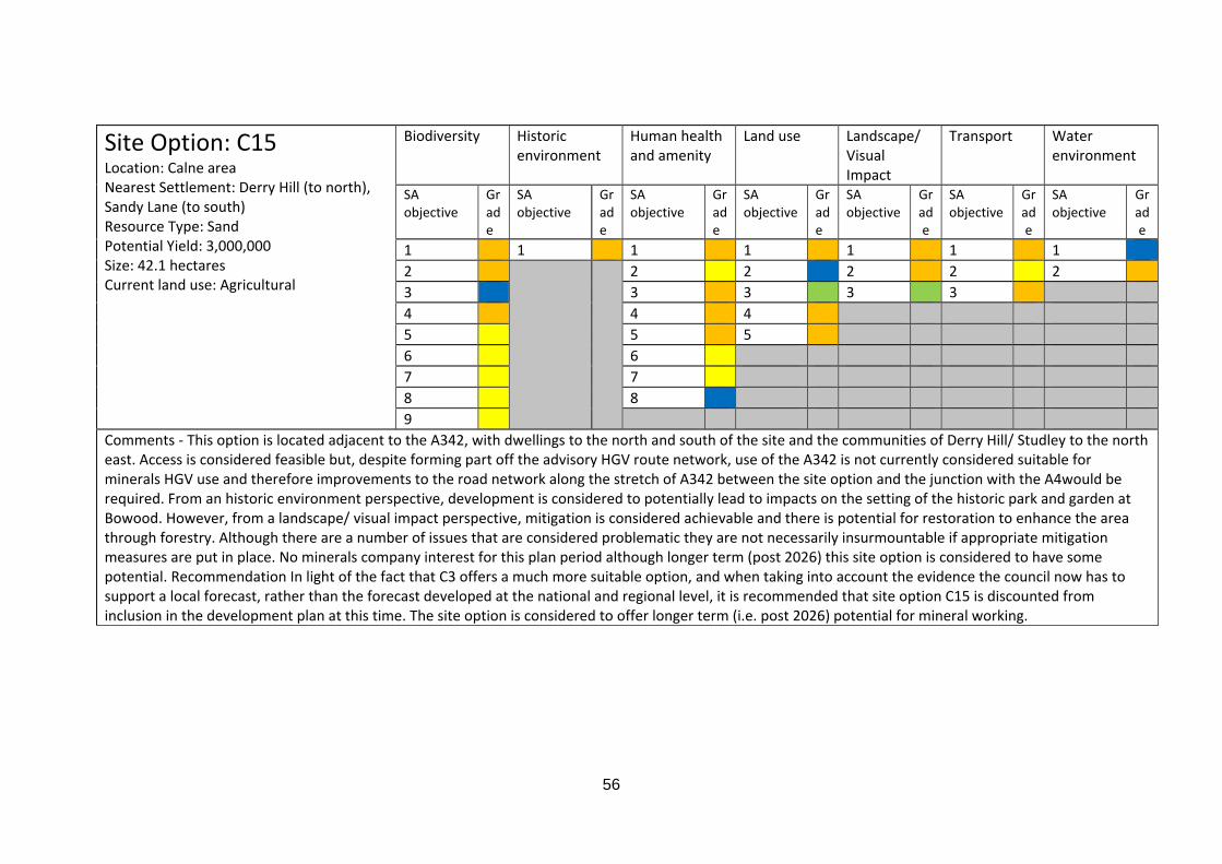
56
Site Option: C15 Location: Calne area Nearest Settlement: Derry Hill (to north), Sandy Lane (to south) Resource Type: Sand Potential Yield: 3,000,000 Size: 42.1 hectares Current land use: Agricultural
Biodiversity Historic environment
Human health and amenity
Land use Landscape/ Visual Impact
Transport Water environment
SA objective
Grade
SA objective
Grade
SA objective
Grade
SA objective
Grade
SA objective
Grade
SA objective
Grade
SA objective
Grade
1 1 1 1 1 1 1 2 2 2 2 2 2 3 3 3 3 3 4 4 4 5 5 5 6 6 7 7 8 8 9
Comments ‐ This option is located adjacent to the A342, with dwellings to the north and south of the site and the communities of Derry Hill/ Studley to the north east. Access is considered feasible but, despite forming part off the advisory HGV route network, use of the A342 is not currently considered suitable for minerals HGV use and therefore improvements to the road network along the stretch of A342 between the site option and the junction with the A4would be required. From an historic environment perspective, development is considered to potentially lead to impacts on the setting of the historic park and garden at Bowood. However, from a landscape/ visual impact perspective, mitigation is considered achievable and there is potential for restoration to enhance the area through forestry. Although there are a number of issues that are considered problematic they are not necessarily insurmountable if appropriate mitigation measures are put in place. No minerals company interest for this plan period although longer term (post 2026) this site option is considered to have some potential. Recommendation In light of the fact that C3 offers a much more suitable option, and when taking into account the evidence the council now has to support a local forecast, rather than the forecast developed at the national and regional level, it is recommended that site option C15 is discounted from inclusion in the development plan at this time. The site option is considered to offer longer term (i.e. post 2026) potential for mineral working.

57
Site Option: C16 Location: Calne area Nearest Settlement: Westbrook (to east) Resource Type: Sand Potential Yield: 500,000 tonnes Size: 10.4 hectares Current land use: Agricultural
Biodiversity Historic environment
Human health and amenity
Land use Landscape/ Visual Impact
Transport Water environment
SA objective
Grade
SA objective
Grade
SA objective
Grade
SA objective
Grade
SA objective
Grade
SA objective
Grade
SA objective
Grade
1 1 1 1 1 1 1 2 2 2 2 2 2 3 3 3 3 3 4 4 4 5 5 5 6 6 7 7 8 8 9
Comments ‐ The site is poorly screened from the road to the south and the properties to the east. Although access is considered achievable, the local road network is not part of the Wiltshire advisory HGV network and not considered suitable for minerals HGV use without significant upgrading. This site option was originally put forward for consideration by Tarmac in 2003. Since 2003 an application for a concrete batching plant at this site was submitted and subsequently refused by the then Wiltshire County Council at Sahara Sandpit. It has recently been confirmed that there is no longer mineral company interest in this site option. Recommendation Due to lack of appropriate access to the advisory HGV network, site option C16 should be excluded when considered against transport objective 3.
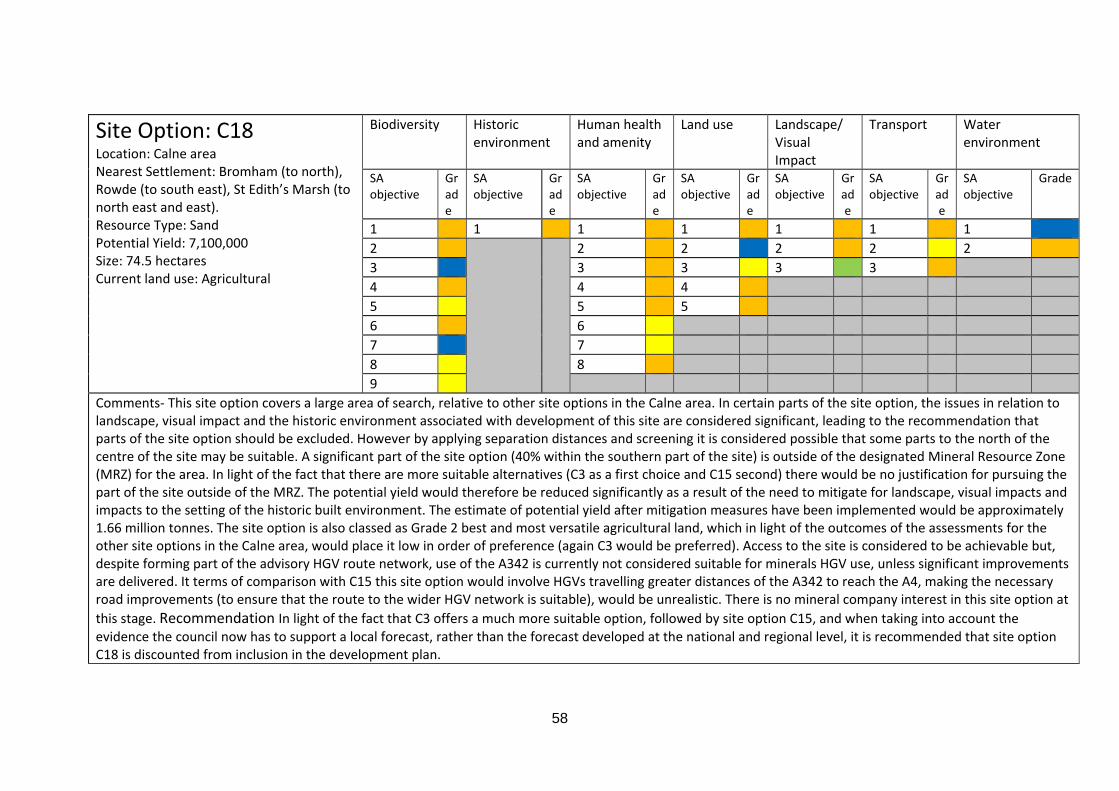
58
Site Option: C18 Location: Calne area Nearest Settlement: Bromham (to north), Rowde (to south east), St Edith’s Marsh (to north east and east). Resource Type: Sand Potential Yield: 7,100,000 Size: 74.5 hectares Current land use: Agricultural
Biodiversity Historic environment
Human health and amenity
Land use Landscape/ Visual Impact
Transport Water environment
SA objective
Grade
SA objective
Grade
SA objective
Grade
SA objective
Grade
SA objective
Grade
SA objective
Grade
SA objective
Grade
1 1 1 1 1 1 1 2 2 2 2 2 2 3 3 3 3 3 4 4 4 5 5 5 6 6 7 7 8 8 9
Comments‐ This site option covers a large area of search, relative to other site options in the Calne area. In certain parts of the site option, the issues in relation to landscape, visual impact and the historic environment associated with development of this site are considered significant, leading to the recommendation that parts of the site option should be excluded. However by applying separation distances and screening it is considered possible that some parts to the north of the centre of the site may be suitable. A significant part of the site option (40% within the southern part of the site) is outside of the designated Mineral Resource Zone (MRZ) for the area. In light of the fact that there are more suitable alternatives (C3 as a first choice and C15 second) there would be no justification for pursuing the part of the site outside of the MRZ. The potential yield would therefore be reduced significantly as a result of the need to mitigate for landscape, visual impacts and impacts to the setting of the historic built environment. The estimate of potential yield after mitigation measures have been implemented would be approximately 1.66 million tonnes. The site option is also classed as Grade 2 best and most versatile agricultural land, which in light of the outcomes of the assessments for the other site options in the Calne area, would place it low in order of preference (again C3 would be preferred). Access to the site is considered to be achievable but, despite forming part of the advisory HGV route network, use of the A342 is currently not considered suitable for minerals HGV use, unless significant improvements are delivered. It terms of comparison with C15 this site option would involve HGVs travelling greater distances of the A342 to reach the A4, making the necessary road improvements (to ensure that the route to the wider HGV network is suitable), would be unrealistic. There is no mineral company interest in this site option at
this stage. Recommendation In light of the fact that C3 offers a much more suitable option, followed by site option C15, and when taking into account the evidence the council now has to support a local forecast, rather than the forecast developed at the national and regional level, it is recommended that site option C18 is discounted from inclusion in the development plan.
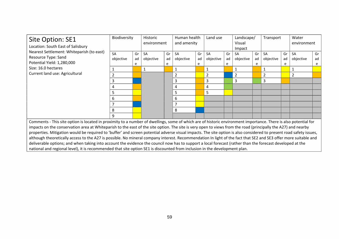
59
Site Option: SE1 Location: South East of Salisbury Nearest Settlement: Whiteparish (to east) Resource Type: Sand Potential Yield: 1,280,000 Size: 16.0 hectares Current land use: Agricultural
Biodiversity Historic environment
Human health and amenity
Land use Landscape/ Visual Impact
Transport Water environment
SA objective
Grade
SA objective
Grade
SA objective
Grade
SA objective
Grade
SA objective
Grade
SA objective
Grade
SA objective
Grade
1 1 1 1 1 1 1 2 2 2 2 2 2 3 3 3 3 3 4 4 4 5 5 5 6 6 7 7 8 8 9
Comments ‐ This site option is located in proximity to a number of dwellings, some of which are of historic environment importance. There is also potential for impacts on the conservation area at Whiteparish to the east of the site option. The site is very open to views from the road (principally the A27) and nearby properties. Mitigation would be required to ‘buffer’ and screen potential adverse visual impacts. The site option is also considered to present road safety issues, although theoretically access to the A27 is possible. No mineral company interest. Recommendation In light of the fact that SE2 and SE3 offer more suitable and deliverable options; and when taking into account the evidence the council now has to support a local forecast (rather than the forecast developed at the national and regional level), it is recommended that site option SE1 is discounted from inclusion in the development plan.
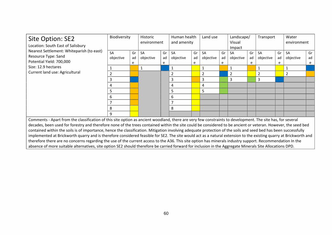
60
Site Option: SE2 Location: South East of Salisbury Nearest Settlement: Whiteparish (to east) Resource Type: Sand Potential Yield: 700,000 Size: 12.9 hectares Current land use: Agricultural
Biodiversity Historic environment
Human health and amenity
Land use Landscape/ Visual Impact
Transport Water environment
SA objective
Grade
SA objective
Grade
SA objective
Grade
SA objective
Grade
SA objective
Grade
SA objective
Grade
SA objective
Grade
1 1 1 1 1 1 1 2 2 2 2 2 2 3 3 3 3 3 4 4 4 5 5 5 6 6 7 7 8 8 9
Comments ‐ Apart from the classification of this site option as ancient woodland, there are very few constraints to development. The site has, for several decades, been used for forestry and therefore none of the trees contained within the site could be considered to be ancient or veteran. However, the seed bed contained within the soils is of importance, hence the classification. Mitigation involving adequate protection of the soils and seed bed has been successfully implemented at Brickworth quarry and is therefore considered feasible for SE2. The site would act as a natural extension to the existing quarry at Brickworth and therefore there are no concerns regarding the use of the current access to the A36. This site option has minerals industry support. Recommendation In the absence of more suitable alternatives, site option SE2 should therefore be carried forward for inclusion in the Aggregate Minerals Site Allocations DPD.
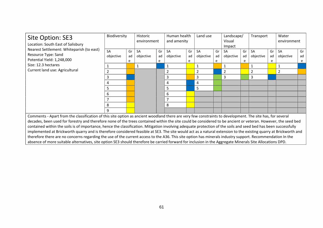
61
Site Option: SE3 Location: South East of Salisbury Nearest Settlement: Whiteparish (to east) Resource Type: Sand Potential Yield: 1,248,000 Size: 12.3 hectares Current land use: Agricultural
Biodiversity Historic environment
Human health and amenity
Land use Landscape/ Visual Impact
Transport Water environment
SA objective
Grade
SA objective
Grade
SA objective
Grade
SA objective
Grade
SA objective
Grade
SA objective
Grade
SA objective
Grade
1 1 1 1 1 1 1 2 2 2 2 2 2 3 3 3 3 3 4 4 4 5 5 5 6 6 7 7 8 8 9
Comments ‐ Apart from the classification of this site option as ancient woodland there are very few constraints to development. The site has, for several decades, been used for forestry and therefore none of the trees contained within the site could be considered to be ancient or veteran. However, the seed bed contained within the soils is of importance, hence the classification. Mitigation involving adequate protection of the soils and seed bed has been successfully implemented at Brickworth quarry and is therefore considered feasible at SE3. The site would act as a natural extension to the existing quarry at Brickworth and therefore there are no concerns regarding the use of the current access to the A36. This site option has minerals industry support. Recommendation In the absence of more suitable alternatives, site option SE3 should therefore be carried forward for inclusion in the Aggregate Minerals Site Allocations DPD.
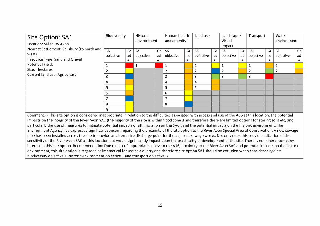
62
Site Option: SA1 Location: Salisbury Avon Nearest Settlement: Salisbury (to north and west) Resource Type: Sand and Gravel Potential Yield: Size: hectares Current land use: Agricultural
Biodiversity Historic environment
Human health and amenity
Land use Landscape/ Visual Impact
Transport Water environment
SA objective
Grade
SA objective
Grade
SA objective
Grade
SA objective
Grade
SA objective
Grade
SA objective
Grade
SA objective
Grade
1 1 1 1 1 1 1 2 2 2 2 2 2 3 3 3 3 3 4 4 4 5 5 5 6 6 7 7 8 8 9
Comments ‐ This site option is considered inappropriate in relation to the difficulties associated with access and use of the A36 at this location; the potential impacts on the integrity of the River Avon SAC (the majority of the site is within flood zone 3 and therefore there are limited options for storing soils etc, and particularly the use of measures to mitigate potential impacts of silt migration on the SAC); and the potential impacts on the historic environment. The Environment Agency has expressed significant concern regarding the proximity of the site option to the River Avon Special Area of Conservation. A new sewage pipe has been installed across the site to provide an alternative discharge point for the adjacent sewage works. Not only does this provide indication of the sensitivity of the River Avon SAC at this location but would significantly impact upon the practicality of development of the site. There is no mineral company interest in this site option. Recommendation Due to lack of appropriate access to the A36, proximity to the River Avon SAC and potential impacts on the historic environment, this site option is regarded as impractical for use as a quarry and therefore site option SA1 should be excluded when considered against biodiversity objective 1, historic environment objective 1 and transport objective 3.
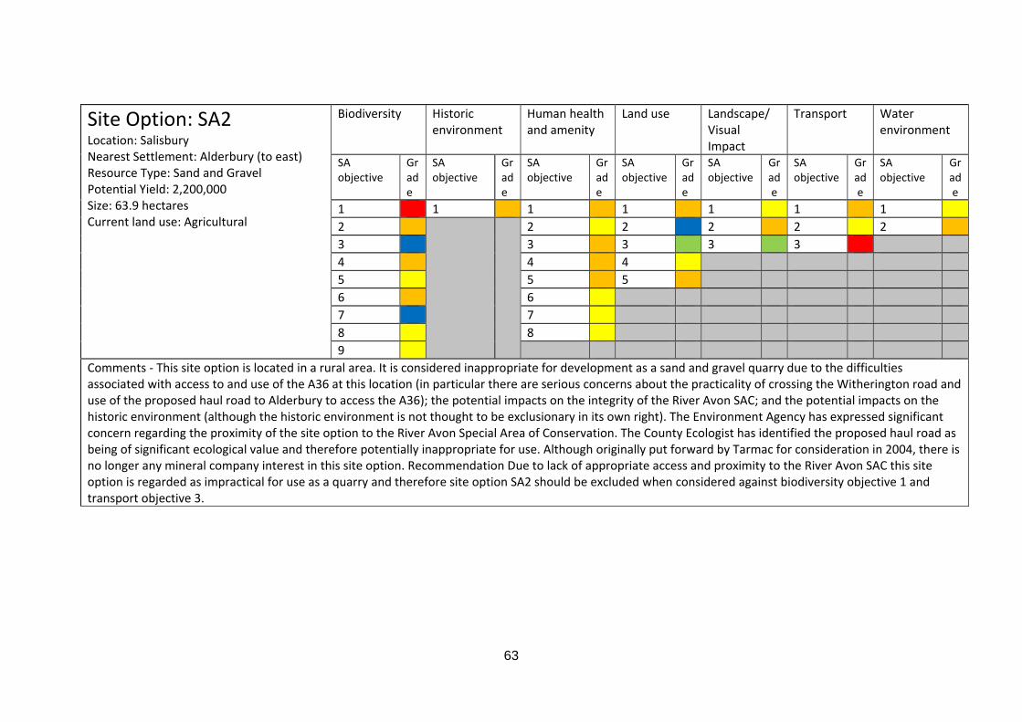
63
Site Option: SA2 Location: Salisbury Nearest Settlement: Alderbury (to east) Resource Type: Sand and Gravel Potential Yield: 2,200,000 Size: 63.9 hectares Current land use: Agricultural
Biodiversity Historic environment
Human health and amenity
Land use Landscape/ Visual Impact
Transport Water environment
SA objective
Grade
SA objective
Grade
SA objective
Grade
SA objective
Grade
SA objective
Grade
SA objective
Grade
SA objective
Grade
1 1 1 1 1 1 1 2 2 2 2 2 2 3 3 3 3 3 4 4 4 5 5 5 6 6 7 7 8 8 9
Comments ‐ This site option is located in a rural area. It is considered inappropriate for development as a sand and gravel quarry due to the difficulties associated with access to and use of the A36 at this location (in particular there are serious concerns about the practicality of crossing the Witherington road and use of the proposed haul road to Alderbury to access the A36); the potential impacts on the integrity of the River Avon SAC; and the potential impacts on the historic environment (although the historic environment is not thought to be exclusionary in its own right). The Environment Agency has expressed significant concern regarding the proximity of the site option to the River Avon Special Area of Conservation. The County Ecologist has identified the proposed haul road as being of significant ecological value and therefore potentially inappropriate for use. Although originally put forward by Tarmac for consideration in 2004, there is no longer any mineral company interest in this site option. Recommendation Due to lack of appropriate access and proximity to the River Avon SAC this site option is regarded as impractical for use as a quarry and therefore site option SA2 should be excluded when considered against biodiversity objective 1 and transport objective 3.

64
Site Option: BA4 Location: Bristol Avon Nearest Settlement: Beanacre (to south), Lacock (to north) Resource Type: Sand and Gravel Potential Yield: 500,000 Size: 33.3 hectares Current land use: Agricultural
Biodiversity Historic environment
Human health and amenity
Land use Landscape/ Visual Impact
Transport Water environment
SA objective
Grade
SA objective
Grade
SA objective
Grade
SA objective
Grade
SA objective
Grade
SA objective
Grade
SA objective
Grade
1 1 1 1 1 1 1 2 2 2 2 2 2 3 3 3 3 3 4 4 4 5 5 5 6 6 7 7 8 8 9
Comments ‐ This site options is located adjacent to the A350. However, it is considered that, due to the curve and geometry of the road along the frontage boundary of the site, there are no suitable places for safe access/egress. The site is also considered to be of high archaeological potential due to the route of a Roman road which passes through the site on an east‐west alignment. A significant part of the site is classified as ancient woodland, although a large portion of the area is also in agricultural use. There is no mineral company interest in this site option. Recommendation Due to lack of safe access to the A350, it is considered inappropriate to allocate this site option for development as a quarry and therefore site option BA4 should be excluded when considered against transport objective 3.
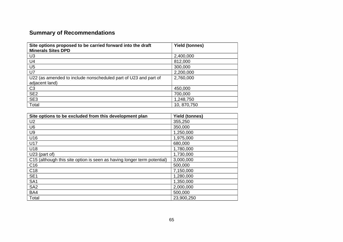
65
Summary of Recommendations Site options proposed to be carried forward into the draft Minerals Sites DPD
Yield (tonnes)
U3 2,400,000 U4 812,000 U5 300,000 U7 2,200,000 U22 (as amended to include nonscheduled part of U23 and part of adjacent land)
2,760,000
C3 450,000 SE2 700,000 SE3 1,248,750 Total 10, 870,750 Site options to be excluded from this development plan Yield (tonnes) U2 355,250 U6 350,000 U9 1,250,000 U16 1,975,000 U17 680,000 U18 1,780,000 U23 (part of) 1,730,000 C15 (although this site option is seen as having longer term potential) 3,000,000 C16 500,000 C18 7,150,000 SE1 1,280,000 SA1 1,350,000 SA2 2,000,000 BA4 500,000 Total 23,900,250
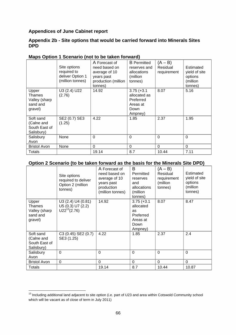
66
Appendices of June Cabinet report
Appendix 2b - Site options that would be carried forward into Minerals Sites DPD Maps Option 1 Scenario (not to be taken forward)
Site options required to deliver Option 1 (million tonnes)
A Forecast of need based on average of 10 years past production (million tonnes)
B Permitted reserves and allocations (million tonnes)
(A – B) Residual requirement
Estimated yield of site options (million tonnes)
Upper Thames Valley (sharp sand and gravel)
U3 (2.4) U22 (2.76)
14.92 3.75 (+3.1 allocated as Preferred Areas at Down Ampney)
8.07 5.16
Soft sand (Calne and South East of Salisbury)
SE2 (0.7) SE3 (1.25)
4.22 1.85 2.37 1.95
Salisbury Avon
None 0 0 0 0
Bristol Avon None 0 0 0 0 Totals 19.14 8.7 10.44 7.11
Option 2 Scenario (to be taken forward as the basis for the Minerals Site DPD) Site options
required to deliver Option 2 (million tonnes)
A Forecast of need based on average of 10 years past production (million tonnes)
B Permitted reserves and allocations (million tonnes)
(A – B) Residual requirement (million tonnes)
Estimated yield of site options (million tonnes)
Upper Thames Valley (sharp sand and gravel)
U3 (2.4) U4 (0.81) U5 (0.3) U7 (2.2) U2213(2.76)
14.92 3.75 (+3.1 allocated as Preferred Areas at Down Ampney)
8.07 8.47
Soft sand (Calne and South East of Salisbury)
C3 (0.45) SE2 (0.7) SE3 (1.25)
4.22 1.85 2.37 2.4
Salisbury Avon
0 0 0 0 0
Bristol Avon 0 0 0 0 0 Totals 19.14 8.7 10.44 10.87
13 Including additional land adjacent to site option (i.e. part of U23 and area within Cotswold Community school which will be vacant as of close of term in July 2011)
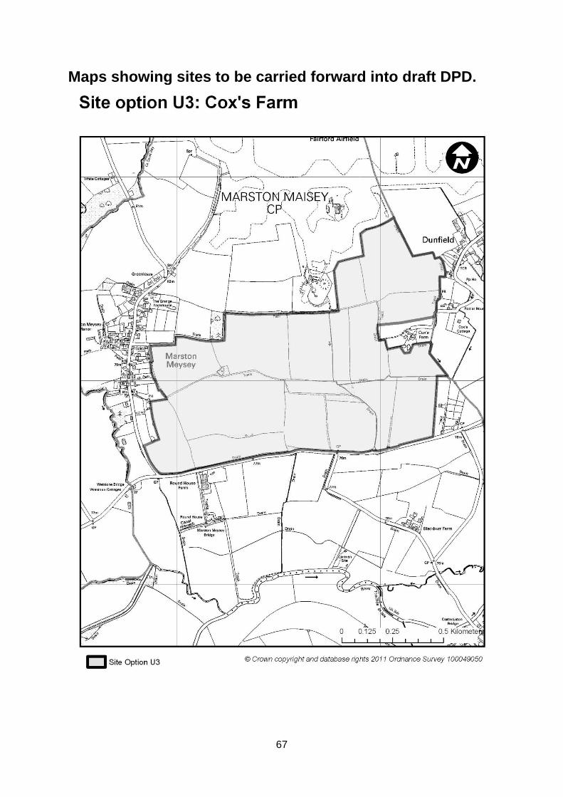
67
Maps showing sites to be carried forward into draft DPD.
68
69
70
71
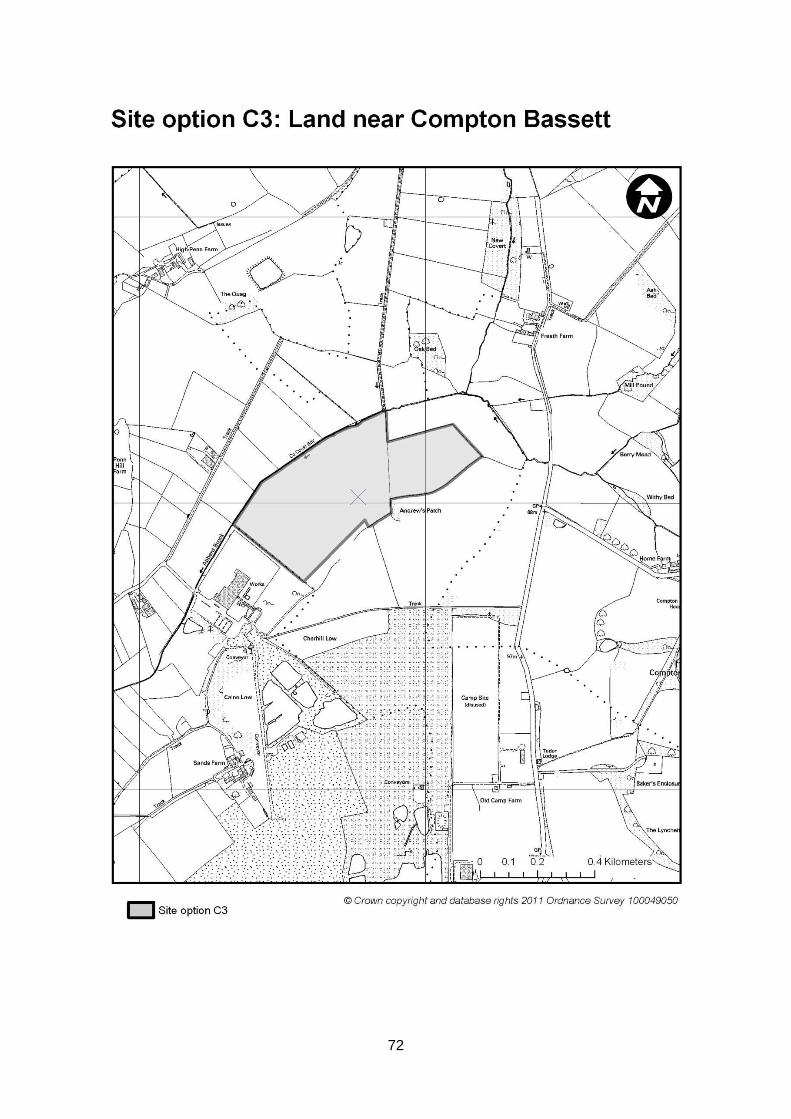
72
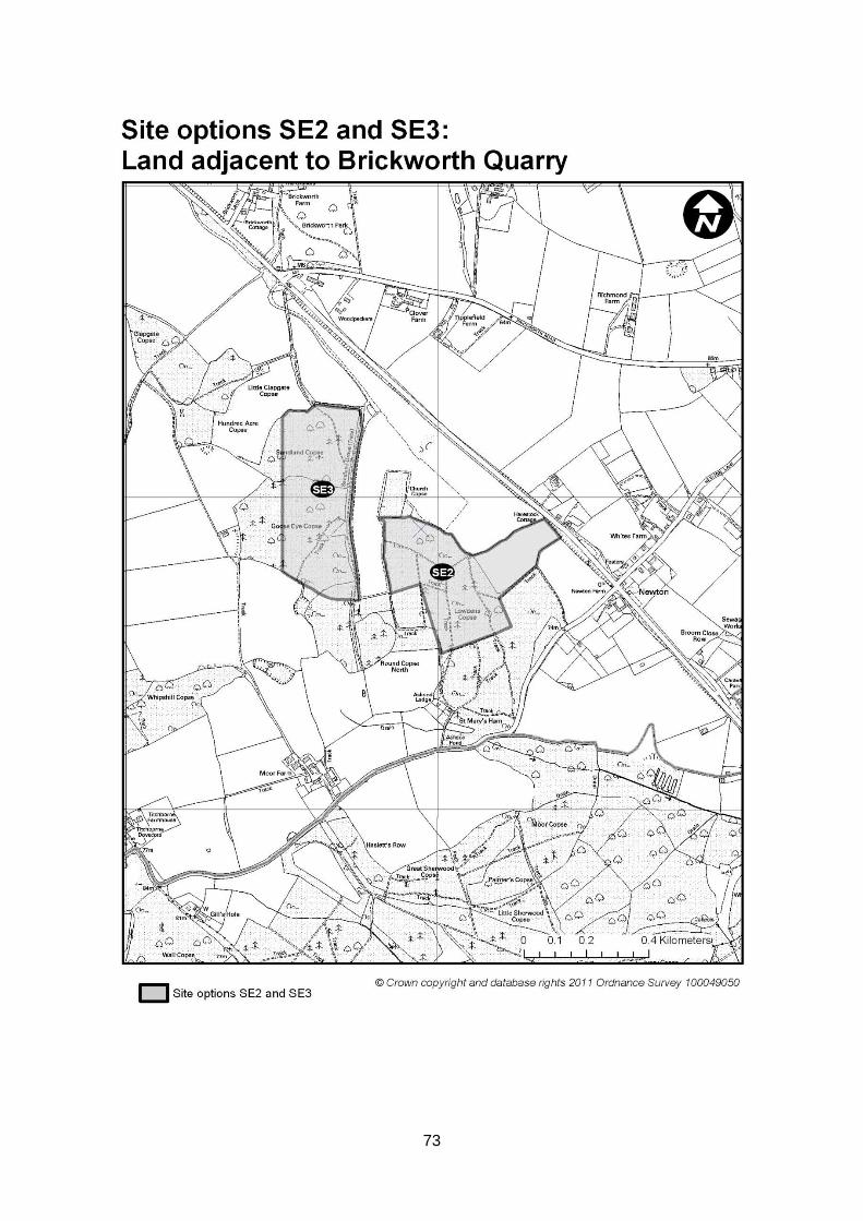
73
74
Wiltshire Council Cabinet 14 June 2011 Public Participation From Ginny Scrope Aggregate Minerals Site Allocations Development Plan Document (DPD) Results of the Site Appraisals Question On behalf of the Bromham community we would request that the members of the Council Cabinet for the future of the Bromham area consider assuring and protecting that the C18 site will not be put forward again for any future mining consideration and that it will remain Grade 2 best and most versatile agricultural land and core to the Council's agricultural policy. Statement On behalf of the Bromham Quarry Campaign action group and the Bromham area we have campaigned on behalf of the residents against the mining of C18 and have worked together with the Parish Council and Wiltshire Council to provide evidence for C18 to be removed from the mining plan. We are very pleased to read the officers report. We sincerely hope that this will be endorsed today by members of the cabinet Response Cabinet acknowledges the motion submitted by the Bromham Quarry Campaign. However, for the reasons set out below, it would not be appropriate for Cabinet to accede to the proposed request in respect of Site Option C18. The Council has a statutory duty to prepare development plans containing policies and proposals for the use of land within its area. In accordance with statute, the appropriate mechanism for allocating land and applying policies for the control and use of land is through the Local Development Framework (LDF) system. Therefore, for the Council (or any part of the Council) to attempt to introduce (and approve) policy to control the use of land outside of the LDF system and the statutory procedures, would unlawfully fetter the discretion of the local planning authority to appropriately plan for its area, and indeed conflict with its duty to keep such policies and allocations under review.