Embed Size (px)
Citation preview
Windsor Bridge Replacement Project | AAJV
WINDSOR BRIDGE
REPLACEMENT
PROJECT PROJECT NUMBER: 140604-2
Historical and Maritime Archaeological Research Design
AAJV (an AUSTRAL & AHMS Joint Venture)
2/729 Elizabeth Street Waterloo NSW 2017 ABN 39 785 858 339
Windsor Bridge Replacement Project | AAJV i
Project Name: Windsor Bridge Replacement Project
Historical and Maritime Archaeological Research Design
PROJECT NUMBER: 140604-2
4 October 2016
Authors: Matthew Kelly, Peter Douglas, Anita Yousif, Cos Coroneos
Reviewed: MacLaren North, Justin McCarthy
Prepared by AAJV on behalf of NSW Roads and Maritime Services
Cover page: George William Evans, watercolour 1807, Hordern House, Colonial Paintings catalogue,
1994, Item 4.
Windsor Bridge Replacement Project | AAJV ii
Document Control Page
AUTHOR/HERITAGE ADVISORS:
CLIENT: NSW Roads and Maritime Services
PROJECT NAME: Windsor Bridge Replacement Project
REAL PROPERTY DESCRIPTION:
4 October 2016
AAJV INTERNAL REVIEW/SIGN OFF
WRITTEN BY DATE VERSION REVIEWED APPROVED
AY, MK, PD, CC 11.05.16 1.0 M North
J McCarthy 11.05.16
AY 26.05.16 1.1 M North 26.05.16
CC 18.07.16 1.2 K Christian 18.07.16
TS 04.10.16 1.3 M North 04.10.16
Copyright and Moral Rights
Historical sources and reference materials used in the preparation of this report are acknowledged and referenced in figure captions or in text citations. Reasonable effort has been made to identify, contact, acknowledge and obtain permission to use material from the relevant copyright owners.
Unless otherwise specified in the contract terms for this project AAJV:
Vests copyright of all material produced by AAJV (but excluding pre-existing material and material in which copyright is held by a third party) in the client for this project (and the client’s successors in title);
Retains the use of all material produced by AAJV for this project for AAJV ongoing business and for professional presentations, academic papers or publications.
Windsor Bridge Replacement Project | AAJV iii
CONTENTS
1 INTRODUCTION .................................................................................................. 2
Background and Context ........................................................................................................... 2
Location ..................................................................................................................................... 2
Statutory Context and Heritage Listings .................................................................................... 2
Description of Development ...................................................................................................... 3
Relevant Reports ....................................................................................................................... 3
Objectives .................................................................................................................................. 3
Limitations ................................................................................................................................. 3
Authors ...................................................................................................................................... 4
2 SITE HISTORY ..................................................................................................... 9
Introduction ................................................................................................................................ 9
Historical Overview .................................................................................................................... 9
3 HISTORICAL ARCHAEOLOGICAL POTENTIAL AND SIGNIFICANCE .......... 27
Introduction .............................................................................................................................. 27
Archaeological Potential .......................................................................................................... 27
Statement of Archaeological Significance ............................................................................... 31
4 RESEARCH FRAMEWORK AND METHODOLOGY ........................................ 34
Introduction .............................................................................................................................. 34
Excavation Strategy ................................................................................................................ 34
Excavation Methodology ......................................................................................................... 40
Personnel ................................................................................................................................ 42
Reporting ................................................................................................................................. 42
Workplace Health and Safety Requirements .......................................................................... 43
Public Information and Interpretation ...................................................................................... 43
Research Questions ................................................................................................................ 43
Research Themes ................................................................................................................... 47
Action Plan ............................................................................................................................ 48
5 REFERENCES ................................................................................................... 50
APPENDIX A – HISTORIC MAP OVERLAYS ......................................................... 51
Windsor Bridge Replacement Project | AAJV iv
LIST OF FIGURES
Figure 1 - The regional context of the project area, including nearby locations. .................................... 5
Figure 2 - The town of Windsor with the approximate location of the project area indicated. ................ 6
Figure 3 - Map of the WBRP project area .............................................................................................. 7
Figure 4 - Key elements of the WBRP project. (Source: SKM, WBRP EIS November 2012) ................ 8
Figure 5 - Windsor in 1812: the government precinct, Thompson’s lease and, in the upper section, the
area round the later Bridge Street. The marked buildings include the schoolhouse/chapel (1), the
‘Granary & Store’ (2), the Government Cottage (3), the replacement military barracks (4), Assistant
Surgeon’s residence (5), Baker Jnr’s lot (6) and Thompson’s lots (7). North is at the bottom of the
map (Source: James Meehan, surveyor, signed by Governor Macquarie, SRNSW Map SZ 529.) ..... 12
Figure 9 - The Government Domain (right) and Thompson Square in 1831. Government buildings are
coloured red. The privately owned buildings which define the south-west side of Thompson Square
are in blue. The beds of the government garden are carefully surveyed just south of the letters ‘IV’ in
‘River’. (Source: Surveyor Abbott, SRNSW, Map 1816, detail.) ........................................................... 15
Figure 10 - Survey of Thompson Square by Charles Scrivener, December 1894. Cf. the aerial
photograph of 1929, Figure 12. (Source: Surveyor Charles Scrivener, LPI, Crown Plan, R.6026.1603.)
.............................................................................................................................................................. 16
Figure 11 - Thompson Square, beaching facilities for small boats in 1812-1813. (Source: Slaeger, ‘A
View of Part of the Town of Windsor’, published by West, 1813.) ........................................................ 17
Figure 12 - The punt-master’s cottage adjacent to Thompson Square. It is the small rectangle
between the Doctors’ House (no.31) and the river. (Source: Map of Windsor by Thompson, 1827,
SRNSW, SZ 526, detail.) ...................................................................................................................... 18
Figure 13 - The Windsor punt in 1835, shown in a detailed footprint map including the study area.
(Source: Map of Windsor, SRNSW Map 5968.).................................................................................... 19
Figure 14 - The first depiction of a road through Thompson Square, 1842. (Source: Laban White,
auctioneer, ‘123 Building and 24 Cultivation Allotments …’) ................................................................ 20
Figure 15 - Thompson Square, the wharf and Windsor Bridge around 1900. All four buildings in the
centre of the photograph still survive with reasonable integrity. (Source: State Library of NSW, Mitchell
Library, Small Picture File.) ................................................................................................................... 21
Figure 16 - Thompson Square in 1929, from the north, showing some plantings in the two reserves,
29900 (upper) and 29901 (lower). (Source: Aerial photograph, courtesy of Carol Roberts, from the
collection of her mother, the late Iris Cammack. Photographer, Frederick Halpin Willson, RAAF,
1929.) .................................................................................................................................................... 21
Figure 17 - Plan of Main Road 182, through Thompson Square, 12 December 1946. (Source:
Surveyor Charles Seccombe, LPI, Crown Plan , R.23477.1603.) ........................................................ 22
Figure 18 - In the foreground, the paling fence and part of a building on Whittons Farm, portion 69,
Wilberforce parish, painted in c1810/1811. (Source: George William Evans, watercolour, Windsor
Head of Navigation Hawkesbury, Mitchel Library, SV1B/Wind/6.) ....................................................... 23
Windsor Bridge Replacement Project | AAJV v
Figure 19 - The Squatters Arms on Whittons Farm, shown as ‘house’ in 1878, in the right angle
between Wilberforce Road and Freemans Reach Road. The north end of Windsor Bridge is shown in
the lower part of this detail of the plan. (Source: LPI, Crown Plan R1533.1603.) ............................... 25
Figure 20 - Bridge Street in 1835, between George and Court Streets. The upper cross street on the
left is George, the lower Macquarie. The Macquarie Arms is shown on the corner of Thompson
Square. (Source: Map of Windsor, SRNSW Map 5968.) ...................................................................... 26
Figure 21 -The project area overlain with the 1812 Meehan Plan (green) and the 1831 Abbott Plan
(orange). The map also shows the location of previous archaeological testings undertaken in the area.
.............................................................................................................................................................. 30
Figure 22 - The Settlement on the Green Hills, Hawksburgh [i.e. Hawkesbury] River N.S.Wales, 1809.
The structures shown in the painting are as follows: 1 Government House; 2 School/Chapel; 3 Brick
Store; 4 Thompsons First House; 5 Log Granary; 6 Govt. Stables; 7 Wharf (behind the boat) 8 Two
Government House Stores; 9 remains of Boat Slip; 10 Govt. Wharf (?); 11 Bakers Farm. Approximate
boundary of the project area is outlined in green. ................................................................................. 31
Figure 23 - The site aerial showing the proposed locations of both the Aboriginal and historical
archaeological test trenches. ................................................................................................................ 37
Windsor Bridge Replacement Project | AAJV 1
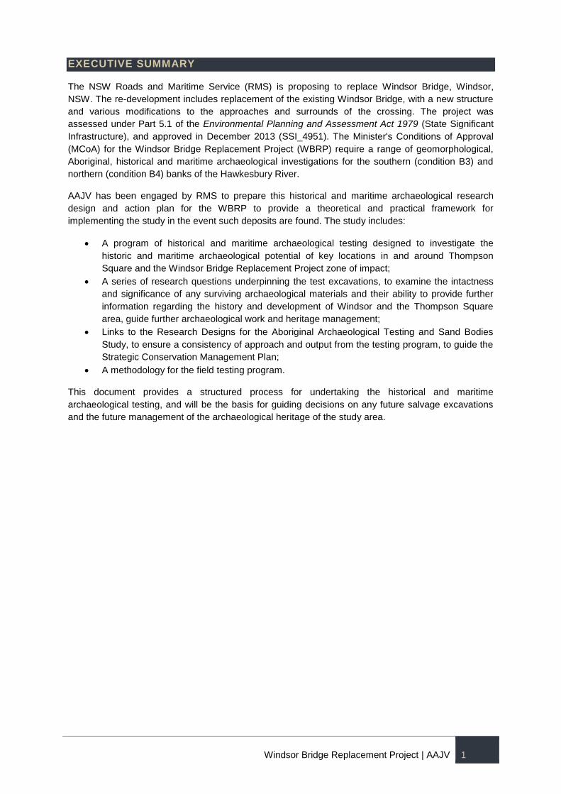
EXECUTIVE SUMMARY
The NSW Roads and Maritime Service (RMS) is proposing to replace Windsor Bridge, Windsor,
NSW. The re-development includes replacement of the existing Windsor Bridge, with a new structure
and various modifications to the approaches and surrounds of the crossing. The project was
assessed under Part 5.1 of the Environmental Planning and Assessment Act 1979 (State Significant
Infrastructure), and approved in December 2013 (SSI_4951). The Minister's Conditions of Approval
(MCoA) for the Windsor Bridge Replacement Project (WBRP) require a range of geomorphological,
Aboriginal, historical and maritime archaeological investigations for the southern (condition B3) and
northern (condition B4) banks of the Hawkesbury River.
AAJV has been engaged by RMS to prepare this historical and maritime archaeological research
design and action plan for the WBRP to provide a theoretical and practical framework for
implementing the study in the event such deposits are found. The study includes:
A program of historical and maritime archaeological testing designed to investigate the
historic and maritime archaeological potential of key locations in and around Thompson
Square and the Windsor Bridge Replacement Project zone of impact;
A series of research questions underpinning the test excavations, to examine the intactness
and significance of any surviving archaeological materials and their ability to provide further
information regarding the history and development of Windsor and the Thompson Square
area, guide further archaeological work and heritage management;
Links to the Research Designs for the Aboriginal Archaeological Testing and Sand Bodies
Study, to ensure a consistency of approach and output from the testing program, to guide the
Strategic Conservation Management Plan;
A methodology for the field testing program.
This document provides a structured process for undertaking the historical and maritime
archaeological testing, and will be the basis for guiding decisions on any future salvage excavations
and the future management of the archaeological heritage of the study area.
Windsor Bridge Replacement Project | AAJV 2
1 INTRODUCTION
Background and Context
The NSW Roads and Maritime Service (RMS) has engaged AAJV (a joint venture of Austral
Archaeology and Extent Heritage (formerly AHMS)) to prepare an Archaeological Research Design
(ARD) for the integrated Aboriginal and non-Aboriginal (European) archaeological test excavation
associated with the redevelopment of Windsor Bridge, Windsor, NSW, also known as the Windsor
Bridge Replacement Project (WBRP). The redevelopment includes replacement of the existing
Windsor Bridge, with a new structure and various modifications to the approaches and surrounds of
the crossing.
The project has been approved as State Significant Infrastructure (SSI_4951) under Part 5.1 of the
Environmental Planning and Assessment Act 1979. The approval was issued on 20 December 2013
subject to the Minister's Conditions of Approval (MCoA). Part B - Pre-Construction Conditions of the
MCoA includes a number of conditions (B1-B8) pertinent to the conservation of cultural heritage
values of the project area. Conditions B3 and B4 require a range of geomorphological, Aboriginal,
historical and maritime archaeological investigation works for both the southern and northern banks of
the Hawkesbury River prior to commencement of pre-construction and construction works.
In 2013 AAJV prepared an Integrated Archaeological Research Design for the WBRP (AHMS 2013).
The report was prepared in response to the requirement set out by the NSW Heritage Branch (now
the Heritage Division) as follows:
Proposed research design and methodology for physical archaeological works needs to be reviewed
by the Department of Planning and Infrastructure and the Heritage Council, prior to commencement,
to check that strategies are appropriate and in accordance with standard archaeological practice for
State listed sites and areas.
Following a further refinement of the WBRP design and the issue of the SSI MCoAs, a need to update
the existing Integrated ARD has been identified. Given the complexity of a project area that includes
several archaeological components, i.e. Aboriginal, historical (terrestrial) and maritime archaeologies
it has been decided to prepare a separate ARD document for each archaeological component.
This report has been prepared to provide a theoretical and practical framework for the historical and
maritime archaeological components of the integrated test excavation. A research framework to guide
the Aboriginal archaeological component of the test excavation is provided in two separate ARDs.
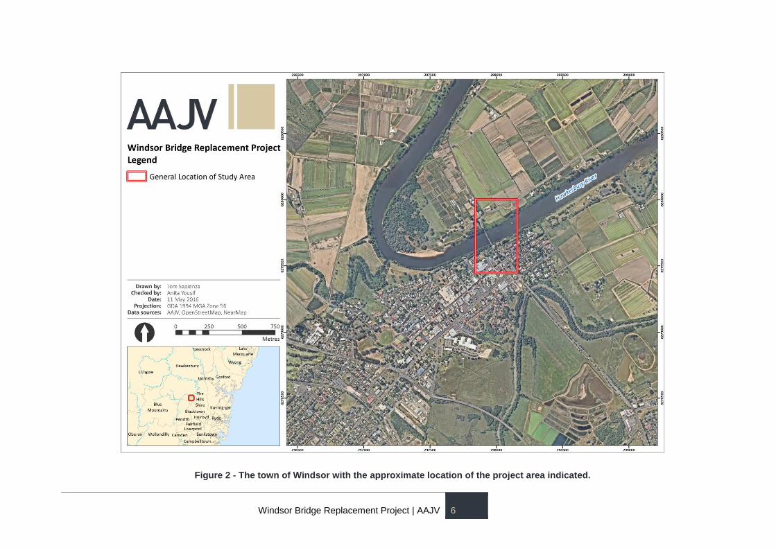
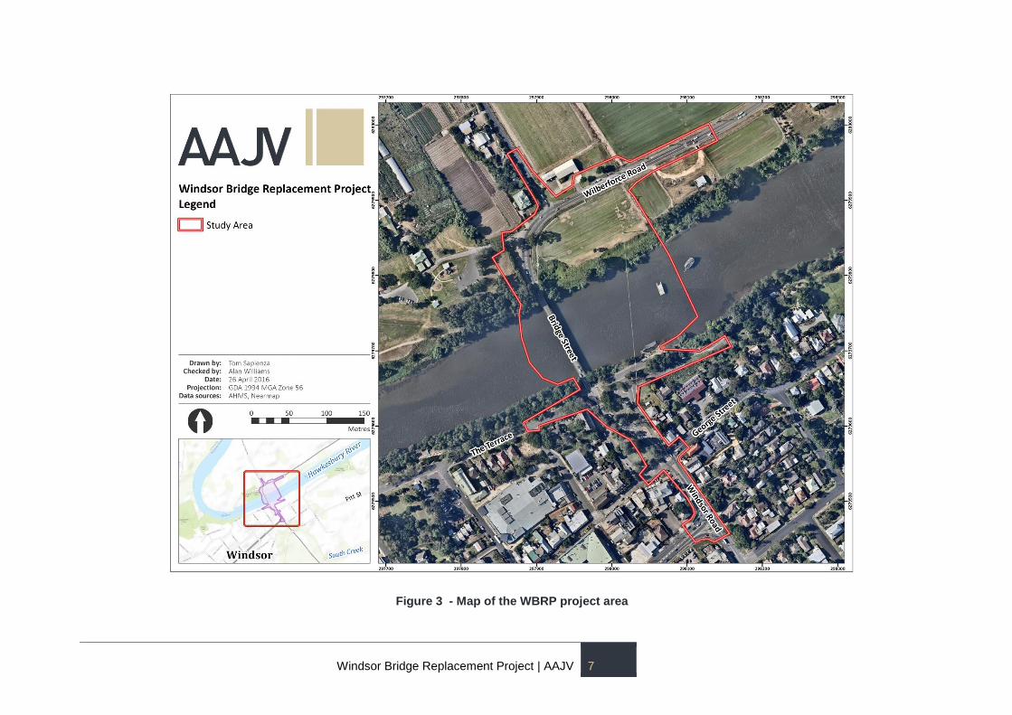
Location
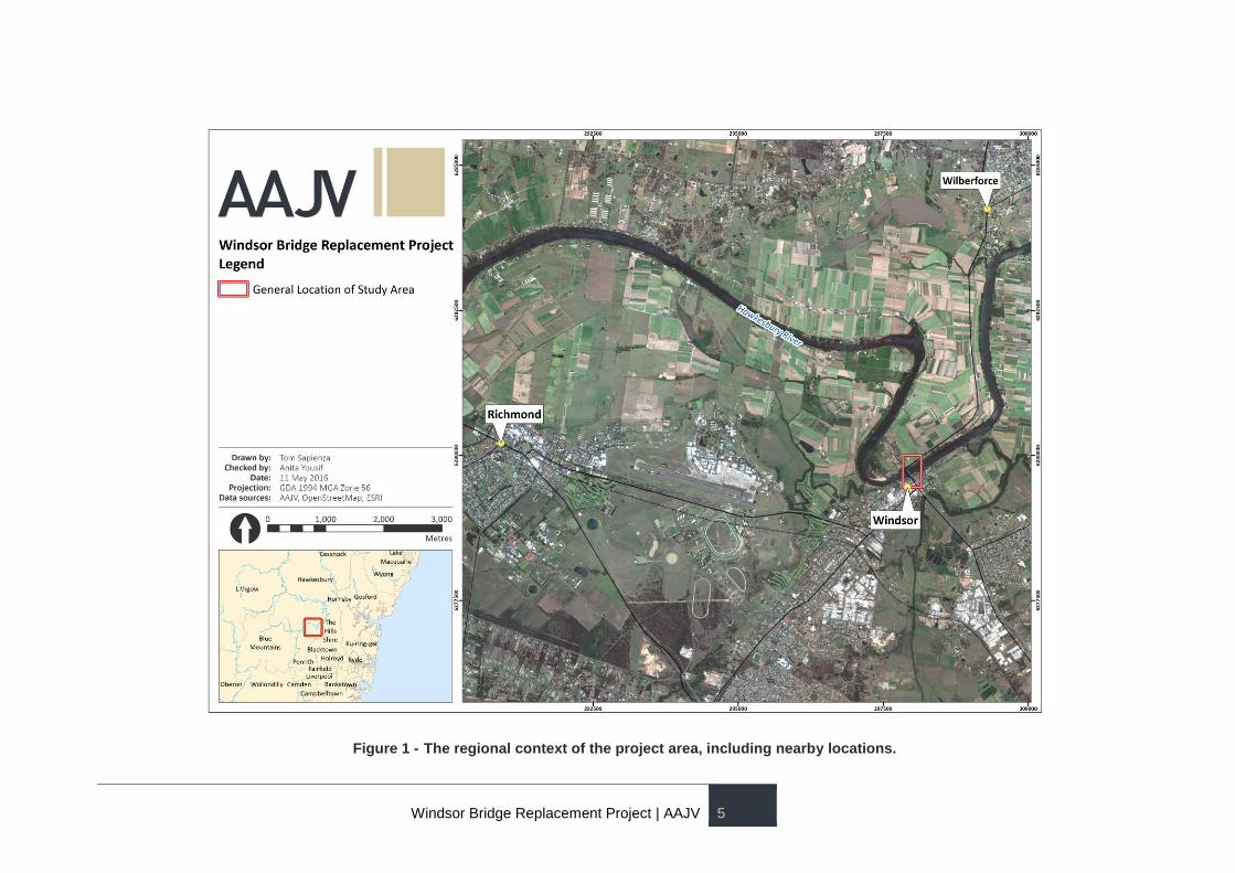
The project area is located at Windsor, within the Hawkesbury Local Government Area (LGA),
approximately 57 kilometres north-west of Sydney. The town is situated on the southern bank of the
Hawkesbury River, close to the foothills of the Blue Mountains (Figure 1).
The project area incorporates the area covered by the bridge works and associated road works, and it
extends from the intersection of Freemans Reach Road and Wilberforce Road in the north to the
intersection of Bridge Street and Macquarie Street in the south (Figures 2 and 3).
Statutory Context and Heritage Listings
The WBRP has been assessed as a SSI project and as such does not fall into the ambit of the NSW
heritage legislation for the protection of historical and maritime archaeological relics. All work is being
undertaken in accordance with the Minister’s Conditions of Approval for the SSI.
Windsor Bridge Replacement Project | AAJV 3
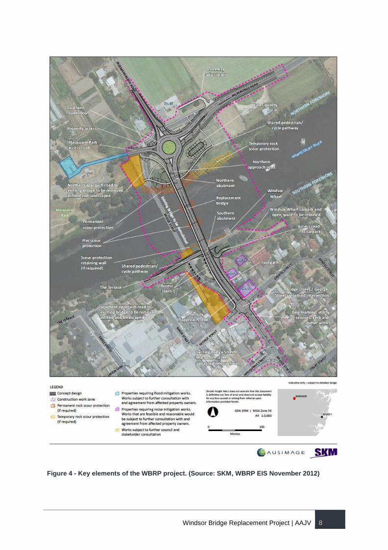
Description of Development
The WBRP includes the construction of a replacement bridge approximately 35 metres east
(downstream) of the existing bridge. This will require the construction of new southern and northern
approach roads in order to access the proposed new bridge. The proposed re-alignment of Bridge
Street will commence at the roundabout of George and Bridge streets, with the new carriageway then
extending north across the replacement bridge. New underground services will also be constructed
during the project and will be installed beneath Bridge Street, running from Macquarie Street to the
proposed roundabout connecting Freemans Reach Road with Wilberforce Road on the northern side
of the Hawkesbury River. Areas previously disturbed by utilities will be used for installation of new
conduit.
The development is shown in Figure 4.
Relevant Reports
A number of heritage reports have been prepared for the project area. This report mainly draws on
the following works:
Windsor Bridge Replacement Windsor, Integrated Archaeological Research Design, Austral and
AHMS Joint Venture (AAJV), October 2013;
Windsor Bridge Replacement Project Independent Heritage Review, Dr Mary Casey (Casey & Lowe),
Craig Burton (CAB Consulting) and Alex Been (Mott MacDonald), August 2013; and
Evaluation of Historical Images for Additional Archaeological Potential, Windsor Bridge Proposal,
AHMS (Archaeological & Heritage Management Solutions), July 2013; and
Windsor Bridge Replacement Project - Historic Heritage Assessment & Statement of Heritage Impact,
Biosis and Cultural Resources Management, 2012.
Objectives
The main objectives of the historical and maritime archaeological test excavation are:
to identify the extent, nature and level of preservation of the potential archaeological resource
that may be impacted by the WBRP and other developments within this corridor;
to determine if any archaeological salvage of remains that would be impacted by construction
is warranted;
to inform the Strategic Conservation Management Plan (SCMP) currently in preparation for
the project; and
to direct future heritage activities including mitigation of development impacts for the WBRP, if
required.
Limitations
This ARD has bee prepared for the management of the historical and maritime archaeological
resources of the WBRP.
The Aboriginal archaeological component of the project is addressed in the following reports:
Windsor Bridge Replacement Project | AAJV 4
Aboriginal Archaeological Research Design and Excavation Methodology Windsor Bridge – Windsor
Bridge Replacement, AAJV, May 2016; and
Hawkesbury Region Sand Body Study – Research Design, AAJV, May 2016.
Authors
This report has been prepared by:
Historical archaeology: Matthew Kelly, Anita Yousif, Peter Douglas
Maritime archaeology: Cosmos Coroneos
Review: MacLaren North, Justin McCarthy
Windsor Bridge Replacement Project | AAJV 5
Figure 1 - The regional context of the project area, including nearby locations.
Windsor Bridge Replacement Project | AAJV 6
Figure 2 - The town of Windsor with the approximate location of the project area indicated.
Windsor Bridge Replacement Project | AAJV 7
Figure 3 - Map of the WBRP project area
Windsor Bridge Replacement Project | AAJV 8
Figure 4 - Key elements of the WBRP project. (Source: SKM, WBRP EIS November 2012)
Windsor Bridge Replacement Project | AAJV 9
2 SITE HISTORY
Introduction
This section provides the history of the site that has been summarised from the 2012 Biosis report
and the draft history prepared by Dr Ian Jack for the SCMP. This historical background for the site
focuses on the historical sequence relevant for historical and maritime archaeology. Further historical
research is being undertaken as part of the preparation of the SCMP. The draft history below
concentrates on the earliest phases of the development of Windsor and the Thompson Square area.
A more detailed history of Aboriginal occupation in the area is provided in the 2016 Aboriginal ARD.
Historical Overview
2.2.1 ENVIRONMENTAL AND ETHNOHISTORICAL CONTEXT
2.2.1.1 GEOLOGY AND SOILS
The Hawkesbury River, upon which the project area is situated, is one of the most significant fluvial
systems on the eastern coast of Australia. Geomorphologically, the area has a complex history of
fluvial and aeolian processes, resulting in the landscape evident today. Studies to the south at
Cranebrook Terrace suggest that the banks and surrounds of the river are situated on Tertiary clays
and gravels (>2.6million years old), and have formed over the last 100,000 years. Sand deposits
associated with the river investigated at Pitt Town and the site of the Windsor Museum similarly
suggest initial deposition by ~150,000 years (Austral Archaeology, 2011; Williams et al., 2012, 2014).
These deposits are vast, with deposits at Cranebrook Terrace over 20m thick, and sand bodies at Pitt
Town some 2.5m deep and deposited over 20m above the river surface.
With specific reference to the project area, the northern portion of the site is situated on Quaternary
alluvium, which other parts of the river having shown to extend 4-8m below the land surface
(Groundtruth Consulting, 2010). These deposits may also extend to the immediate banks on the south
side of the river as well. Recent archaeological works discussed below, suggest that these deposits
formed quickly, and may be less than 15,000 years in age. To the south of the project area, the land
is characterised by a natural ridge of Tertiary clay. Excavations in 2012 indicate that this is overlain by
a yellow brown loamy sand (KNC, 2012) up to 80cm deep, similar to the deposits at Pitt Town and the
Windsor Museum, and likely formed through a combination of low-energy flooding and aeolian re-
working. These sand deposits are disparate due to the undulating Tertiary clay, and extensive
historical and more recent activities resulting in a range of shallower and more disturbed soil profiles
across the area.
2.2.1.2 EVIDENCE OF ABORIGINAL OCCUPATION
Archaeologically, the Hawkesbury River corridor contains some of the earliest evidence of Aboriginal
occupation in Australia. While disputed, the recovery of five flaked pebbles from the base of the
Cranebrook Terrace, and dating to ~40,000 years BP, represent the earliest evidence of past activity
(Nanson et al., 1987; Stockton and Holland 1974). More compelling evidence of Aboriginal use of the
river is provided by excavations undertaken in advance of residential development at Pitt Town.
These excavations, totalling ~250m2 across a kilometre section of the ridgeline (PT-12) over-looking
the river, recovered over 10,000 stone artefacts from depths up to 1.3m below surface, and dating to
between 36,000 and 8,000 years ago (Williams et al., 2012, 2014). Similar findings were made in
advance of the Windsor Museum, where a 1.8m deep sand body, recovered 12,000 stone artefacts
dating to ~34,000 – 8,500 years ago (Austral Archaeology, 2011). Recent excavations on the banks of
Peachtrees Creek (near Penrith CBD) recovered a handful of stone artefacts at a depth of 4m below
Windsor Bridge Replacement Project | AAJV 10
surface, and dating to ~15,000 years ago (AHMS, 2014). These assemblages were all dominated by
indurated mudstone, tuff and/or volcanic raw materials, and suggest that Aboriginal populations were
small, highly mobile, and exploiting the river corridor during periods of climatic aridity and generally
poorer resources (Williams et al., 2015). More practically, they also demonstrate that cultural
materials along the river corridor can be found at significant depths below the present day land
surface.
While the early Holocene (~8-5,000 years BP) is poorly understood, with some evidence of
abandonment of the region (Williams et al., 2014), a strong record of occupation and activity is
present in the last 5,000 years. This is most evident through the extensive ‘surface workshops’ of
stone artefacts and grinding groove patches documented by McCarthy (1978) between Castlereagh
and Emu Plains. Excavations at Lapstone Creek rockshelter and KII rockshelter immediately west of
the river also contain dense records of occupation over the last 4,000 years (McCarthy, 1978; Kohen
et al., 1984), as does the upper 50cm of PT-12 (Williams et al., 2014). These assemblages are
dominated by silcrete and quartz raw materials, and typically more complex, indicative of increasingly
sedentary and technologically invested societies driven by regional demographic pressure hindering
mobility across the landscape (Williams et al., 2015).
Excavations undertaken within the project area in 2012 contain several elements of the
archaeological story presented above. To the north, excavations were too shallow to determine the
past use of the area, but the deposits appear similar to those at Peachtrees Creek. To the south, the
sand deposits investigated are very similar, albeit much shallower, to those observed at the Windsor
Museum and PT-12, both of which contained extensive and significant cultural materials of great
antiquity. The assemblage recovered in 2012 was small, and contained a mixture of tuff, indurated
mudstone and silcrete raw materials. Interpretations by KNC (2012) suggest that the assemblage was
likely only dated to the last few thousand years, but based on the evidence the potential for older
cultural materials (possibly inter-mixed with later activity) cannot be entirely ruled out.
Both the river and the quaternary alluvium down by the south bank of the river and over all the study
area on the north side of the Hawkesbury constituted a useful source of indigenous food supply.
2.2.2 EARLY EUROPEAN SETTLEMENT (1794 – 1800)
In the first years after European settlement of New South Wales began in 1788, there was a recurrent
shortage of food in the colony and in 1794 grants were made along the upper Hawkesbury, where the
soils of the flood-plain were superior to those already exploited around Sydney, Parramatta and
Toongabbie. By the beginning of 1795 85 of the 118 initially promised land grantees had established
farms, the overwhelming majority of them ex-convicts.
At the beginning the early settlement was known as Green Hills, but Lieutenant Governor Grose
called it Mulgrave Place and the early grants were described as being in ‘the District of Mulgrave
Place”(Biosis 2012, p44).
A government presence was necessary and a site at the head of navigation, where stores could be
brought in by boat and wheat and maize taken back to Sydney, had been retained in crown hands.
This Government Precinct of some 40 acres was bounded on the north-east by Samuel Wilcox’s
grant, which ended at the present Arndell Street; on the south-east by South Creek; on the south-west
by the present Baker Street, the approximate edge of a grant to Whitehouse, soon sold to William
Baker, the government storekeeper; and on the north-west by the Hawkesbury River. Except for the
strip of alluvial soil along the riverbank, the new government area occupied higher and less fertile land
than the local farms.
Within the Government Precinct the area known as Thompson Square after 1811 sloped conveniently
down to the river. The slope was cleared of vegetation and a wharf was erected early in 1795, along
Windsor Bridge Replacement Project | AAJV 11
with a store-house, housing a small guard. Other soldiers arrived in the winter and were
accommodated close to the store in a barracks built late in 1795. A major flood in 1799 washed away
the store and wharf, so both were replaced, with the store resited to higher ground. Better soldiers’
accommodation was constructed in 1796 on the western side of the Square and moved to higher
ground by 1800.
In addition to the store, the wharf and the barracks, the fourth basic facility was a granary for local
cereal: the 1795 granary was replaced by Governor Hunter in 1796 by a more substantial wooden
building in the middle of the eastern side of the present Square and a second similar granary was
added by 1800.
In 1796 a cottage for the Commandant was erected near the north-eastern edge of the Government
Precinct, adjacent to the study area. A small, thatched watch-house was built in the Square near the
Commandant’s house by 1798.
Adjacent to the 1796 granary, to its east, was a small cottage built for the local constable. This was
Andrew Thompson (a model citizen who was to become the first ex-convict to become a magistrate in
the colony), on the cusp of an extraordinary career. In 1799 Thompson was given the exceptional
right to have a lease within the government precinct: he held the cottage and an acre of surrounding
land down to the river bank for a period of fourteen years, which had not elapsed when he died in
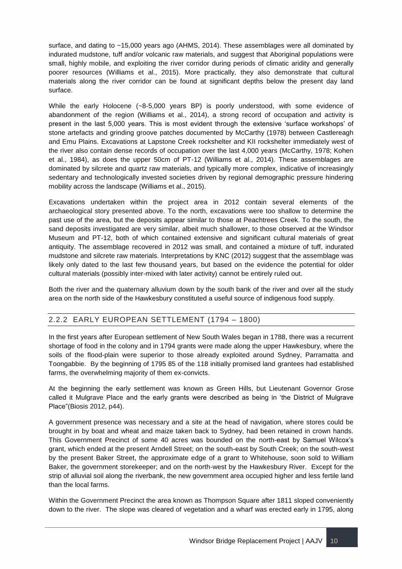
1810. The map prepared by Meehan in 1812 (Figure 5), with the Hawkesbury at the bottom and
South Creek at the top, shows only government buildings. Thompson’s lease and his former small
cottage are clearly shown.
2.2.3 TOWN EXPANSION (1800 – 1810)
In 1803, under Governor King, the earlier log and thatch granaries were soon replaced by a three-
storey brick building on top of the ridge to the south-east of the Square.
“A very spacious Brick Granary with Three Floors, is now completed at the Hawkesbury for the Public
Use – I have employed the people in that quarter to burn bricks for building a large school house (100
ft by 24) and Offices with Garden etc. For a House of Public Instruction for the Male Youth of this
Colony – In the course of three Months I hope to see it finished”.1
“Built a Brick Granary at the Hawkesbury of the following dimensions length 101 feet, breadth 25 feet,
Height to Wall Plate 23 Feet, with Three floors: Burning Bricks for a Public School for Boys”.2
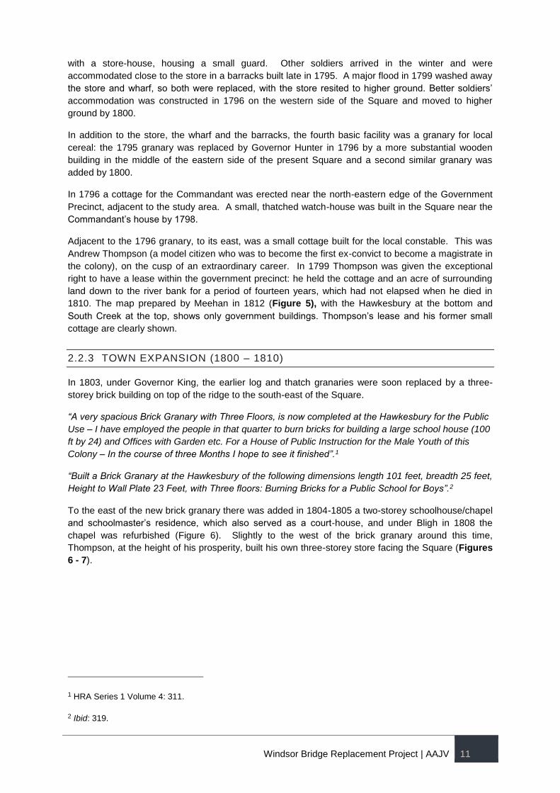
To the east of the new brick granary there was added in 1804-1805 a two-storey schoolhouse/chapel
and schoolmaster’s residence, which also served as a court-house, and under Bligh in 1808 the
chapel was refurbished (Figure 6). Slightly to the west of the brick granary around this time,
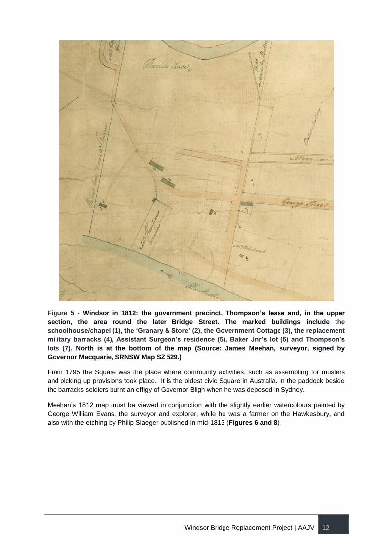
Thompson, at the height of his prosperity, built his own three-storey store facing the Square (Figures
6 - 7).
1 HRA Series 1 Volume 4: 311.
2 Ibid: 319.
Windsor Bridge Replacement Project | AAJV 12
Figure 5 - Windsor in 1812: the government precinct, Thompson’s lease and, in the upper
section, the area round the later Bridge Street. The marked buildings include the
schoolhouse/chapel (1), the ‘Granary & Store’ (2), the Government Cottage (3), the replacement
military barracks (4), Assistant Surgeon’s residence (5), Baker Jnr’s lot (6) and Thompson’s
lots (7). North is at the bottom of the map (Source: James Meehan, surveyor, signed by
Governor Macquarie, SRNSW Map SZ 529.)
From 1795 the Square was the place where community activities, such as assembling for musters
and picking up provisions took place. It is the oldest civic Square in Australia. In the paddock beside
the barracks soldiers burnt an effigy of Governor Bligh when he was deposed in Sydney.
Meehan’s 1812 map must be viewed in conjunction with the slightly earlier watercolours painted by
George William Evans, the surveyor and explorer, while he was a farmer on the Hawkesbury, and
also with the etching by Philip Slaeger published in mid-1813 (Figures 6 and 8).
Windsor Bridge Replacement Project | AAJV 13
Figure 6 - The Government Precinct at Green Hills in 1807, with a boat, the ‘Governor Bligh’,
under construction just below the central log granary. (Source: George William Evans,
watercolour, Hordern House, Colonial Paintings catalogue, 1994, item 4)
Figure 7 - Thompson’s store, at the top of Thompson Square, facing south-west across the
Square, drawn in 1820. (Source: State Library of NSW, Mitchell Library, Bonwick Transcripts,
box 10 p.4259.)
Windsor Bridge Replacement Project | AAJV 14
Figure 8 - The Government Precinct at Windsor in 1812 or 1813. (Source: Philip Slaeger, ‘A
View of Part of the Town of Windsor’, etching published by Absalom West, Sydney 1813.)
The Evans paintings of 1807 (Figure 6), 1809 (Figure 22) and 1811 were all sketched from the same
location on the north side of the river, approximately where Windsor Bridge was to span the river in
1874. Evans’ vantage-point was Whittons Farm, which is within the present study area. Slaeger
sketched the scene sitting slightly to the north-east of Evans’ favoured place (Figure 8).
2.2.4 THE MACQUARIE PERIOD AND ITS AFTERMATH IN THOMPSON
SQUARE (1810 – 1840S)
In December 1810 Governor Macquarie held a dinner in the Government Cottage where he
announced the creation of five new towns on high land along the Hawkesbury-Nepean River.
Windsor was to be the principal town. Unlike the other new towns, Pitt Town, Wilberforce, Richmond
and Castlereagh, Windsor already had a rudimentary urban development. Macquarie recognised that
there was already a civic Square in existence in Windsor. In 1811 he named this Square after his
friend Andrew Thompson who had died in October 1810. Since Thompson Square was at one end of
the elevated land on which the grid pattern of Windsor was laid out in 1811, a second Square was laid
out closer to the centre of the new town, adjacent to the new cemetery, where Thompson was already
buried, and where St Matthew’s Anglican church was built between 1817 and 1822.
Thompson Square remained the commercial and administrative focus of Windsor for another half
century. The lease held by Thompson within the Square reverted to the Crown on his death, the area
was tidied up and Macquarie redefined the south-west boundary of the civic space by making four
town grants in 1811. The Macquarie Arms inn (which is still extant) was built at once, and opened in
1815. No regular title-deeds seem to have been issued for these plots, where Howe’s House
(Thompson Square no.7), Thompson Square no. 5 and the Doctors’ House (Thompson Square nos 1-
3) were later built, but the private ownership of all the land abutting the square on the south-west was
recognised from Macquarie’s time onwards.
Windsor Bridge Replacement Project | AAJV 15
The Thompson lease, shown in Meehan’s map (Figure 5) became the government garden in 1811.
In the sketch-map of the area drawn by John Abbott in 1831, the government buildings then in use
are shown in red, while the footprints of privately owned buildings are in blue (Figure 9). The clean-
cut definition of the south-west side of Thompson Square is particularly evident in Abbott’s map. The
numerous private houses along George Street and Macquarie Street are not shown.
George Street did not extend north-east beyond Thompson Square. The old granary was by 1831
known as the Commissariat Stores, marked ‘c’ by Abbott. Beside the government garden there were
police and convict barracks, with stables behind (‘g’, ‘f’ and ‘e’). The schoolhouse/church of 1804-
1805 was still standing just east of the Commissariat Stores, although St Matthew’s had since 1822
taken over its religious functions. A new watch-house had been built on Bridge Street close to the
Store and is shown as ‘d’. Further south-east on Bridge Street the military barracks (‘a’) had been
built in 1817-1818. Bridge Street itself had been created in 1814 to replace the road from the original
South Creek crossing, further to the east, as shown on Meehan’s map of 1812 (Figure 5). Bridge
Street, however, ended at George Street: there was no defined road through early Thompson Square.
Figure 6 - The Government Domain (right) and Thompson Square in 1831. Government
buildings are coloured red. The privately owned buildings which define the south-west side of
Thompson Square are in blue. The beds of the government garden are carefully surveyed just
south of the letters ‘IV’ in ‘River’. (Source: Surveyor Abbott, SRNSW, Map 1816, detail.)
Windsor Bridge Replacement Project | AAJV 16
2.2.5 A FRINGE AREA: 1850S ONWARD
The government presence on the eastern side of the Square diminished in the early Victorian period.
The fully developed, privately owned western side of today’s Thompson Square, begun in 1811, was
in place by the 1850s. Across the Square, the earlier buildings, shown in Figure 5, had disappeared
and Government stables had been built at the northern corner of Bridge Street and George Street.
These stables were demolished after Lilburn Hall (10 Bridge Street) was built in the 1850s.
Below Lilburn Hall, the former government garden had been abandoned in 1852 so that the
Presbyterian Church could build a manse. Although the church never built upon this flood-prone land,
the realignment of the property boundaries straightened what is currently known (misleadingly) as Old
Bridge Street, until the resumption of a triangle of land to enhance the vehicular turn into the wharf
area in 1896 (Figure 10). The sandstock brick wall which survives below the house at 4 Bridge Street
(built in 1955) does not seem to have been accurately surveyed, but is likely to have been part of the
garden delimitation of the government garden.
Figure 7 - Survey of Thompson Square by Charles Scrivener, December 1894. Cf. the aerial
photograph of 1929, Figure 12. (Source: Surveyor Charles Scrivener, LPI, Crown Plan,
R.6026.1603.)
Further east along George Street, the old Government House (which had survived intact with additions
since 1796) survived in increasing disrepair until 1921, when, despite widespread protests, it was
Windsor Bridge Replacement Project | AAJV 17
finally pulled down. Although a house (41 George Street) was built over part of the eighteenth-century
foundations, there remains high archaeological potential on the site.
2.2.6 WHARVES AND ROADWAYS
Wharfage was a cardinal consideration at Thompson Square from the beginning in 1795. The earliest
wharves seem to have been destroyed in a series of severe floods after 1799 and the only landing
facility was the edge of the river where small boats could be pulled up just beyond the water-line, as
vividly shown in Slaeger’s 1812-1813 etching (Figure 7). This was also the area of the Square where
the schooner named ‘Governor Bligh’ was built and launched in 1807 (Figure 2): this was one of the
earliest ships built in Australia for the significant sealing trade.
Figure 8 - Thompson Square, beaching facilities for small boats in 1812-1813. (Source:
Slaeger, ‘A View of Part of the Town of Windsor’, published by West, 1813.)
Macquarie in August 1814 commissioned the local entrepreneurs John Howe and James McGrath to
construct a new wharf 50 feet long, projecting 18 feet into the river and supported by piles ‘16 to 18
inches thick’. Almost as soon as this wharf had been constructed, a further contract was issued in
April 1815 commissioning a larger wharf three feet higher than the existing one and apparently over it.
Severe criticism of the materials and workmanship of the new wharf led to Francis Greenway, the
Acting Colonial Architect, being commissioned in November 1816 to design a new wharf and to direct
Howe and McGrath during its erection. The high floods of June 1816 and February 1817 finally
removed the wharves of 1815-1816, but payment for the Greenway wharf was not finalised until 1820,
probably because of another 46-foot flood in 1819. The location and dimensions of the Greenway
wharf are shown on the north-east side of Thompson Square in an anonymous map of 1835 (Figure
9).
Howe and McGrath had also contracted in 1814 to do significant works within Thompson Square.
The steepness of the slope shown in the Evans and Slaeger views was to be diminished by putting
Windsor Bridge Replacement Project | AAJV 18
piles in the lower sector of the square near the river and then using fill to reduce it ‘into a gradual
slope’ down from the major store on top of the ridge.
The contractors also made between 120,000 to 150,000 bricks to construct drainage works in 1814-
1815. They were to build either one ‘sewer’ in the middle of the square or two ‘sewers one on each
side of the Square’. Remnants of a substantial brick drain have been uncovered on various
occasions in the nineteenth and twentieth centuries and were the subject of archaeological interest
more recently. These observations seem to confirm that the contractors chose to build a single
central drain in 1814-1815.
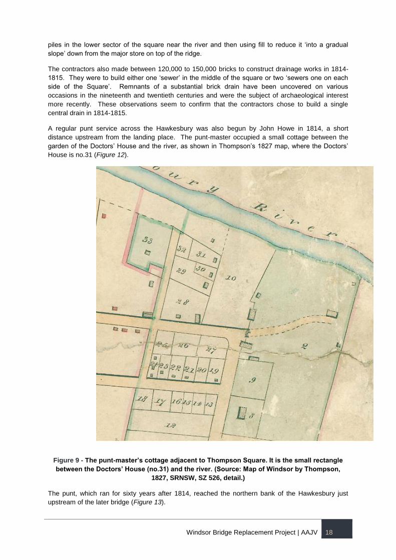
A regular punt service across the Hawkesbury was also begun by John Howe in 1814, a short
distance upstream from the landing place. The punt-master occupied a small cottage between the
garden of the Doctors’ House and the river, as shown in Thompson’s 1827 map, where the Doctors’
House is no.31 (Figure 12).
Figure 9 - The punt-master’s cottage adjacent to Thompson Square. It is the small rectangle
between the Doctors’ House (no.31) and the river. (Source: Map of Windsor by Thompson,
1827, SRNSW, SZ 526, detail.)
The punt, which ran for sixty years after 1814, reached the northern bank of the Hawkesbury just
upstream of the later bridge (Figure 13).
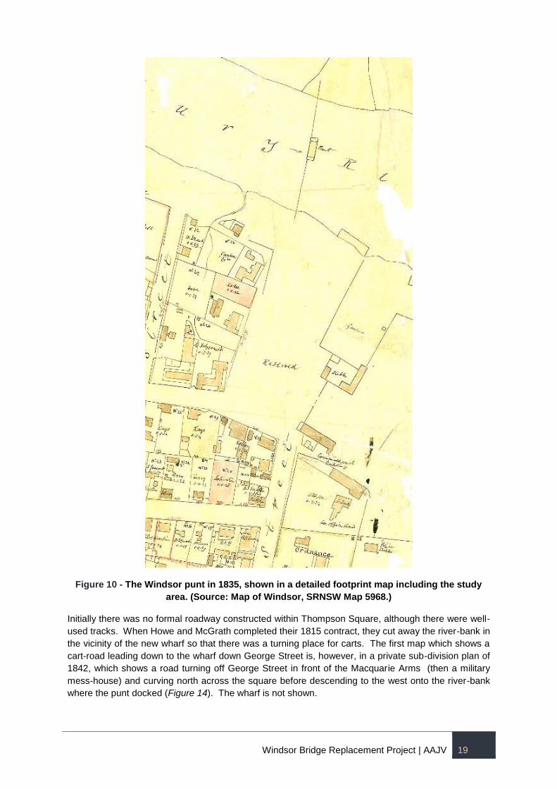
Windsor Bridge Replacement Project | AAJV 19
Figure 10 - The Windsor punt in 1835, shown in a detailed footprint map including the study
area. (Source: Map of Windsor, SRNSW Map 5968.)
Initially there was no formal roadway constructed within Thompson Square, although there were well-
used tracks. When Howe and McGrath completed their 1815 contract, they cut away the river-bank in
the vicinity of the new wharf so that there was a turning place for carts. The first map which shows a
cart-road leading down to the wharf down George Street is, however, in a private sub-division plan of
1842, which shows a road turning off George Street in front of the Macquarie Arms (then a military
mess-house) and curving north across the square before descending to the west onto the river-bank
where the punt docked (Figure 14). The wharf is not shown.
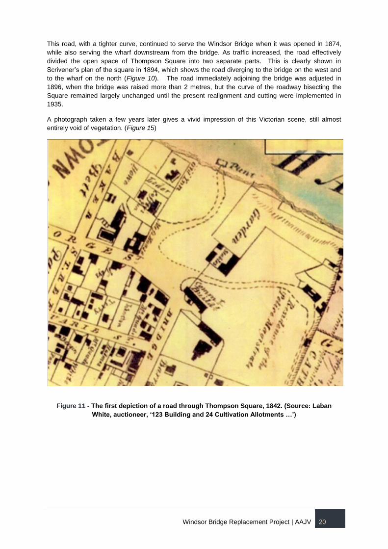
Windsor Bridge Replacement Project | AAJV 20
This road, with a tighter curve, continued to serve the Windsor Bridge when it was opened in 1874,
while also serving the wharf downstream from the bridge. As traffic increased, the road effectively
divided the open space of Thompson Square into two separate parts. This is clearly shown in
Scrivener’s plan of the square in 1894, which shows the road diverging to the bridge on the west and
to the wharf on the north (Figure 10). The road immediately adjoining the bridge was adjusted in
1896, when the bridge was raised more than 2 metres, but the curve of the roadway bisecting the
Square remained largely unchanged until the present realignment and cutting were implemented in
1935.
A photograph taken a few years later gives a vivid impression of this Victorian scene, still almost
entirely void of vegetation. (Figure 15)
Figure 11 - The first depiction of a road through Thompson Square, 1842. (Source: Laban
White, auctioneer, ‘123 Building and 24 Cultivation Allotments …’)
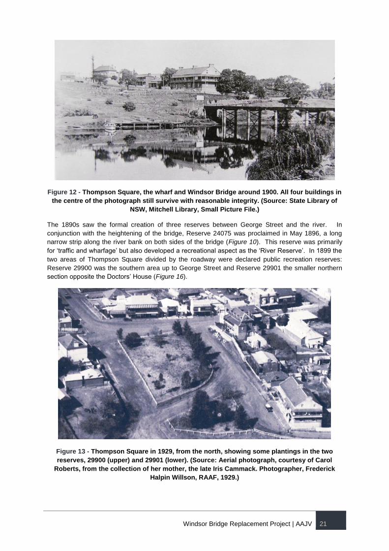
Windsor Bridge Replacement Project | AAJV 21
Figure 12 - Thompson Square, the wharf and Windsor Bridge around 1900. All four buildings in
the centre of the photograph still survive with reasonable integrity. (Source: State Library of
NSW, Mitchell Library, Small Picture File.)
The 1890s saw the formal creation of three reserves between George Street and the river. In
conjunction with the heightening of the bridge, Reserve 24075 was proclaimed in May 1896, a long
narrow strip along the river bank on both sides of the bridge (Figure 10). This reserve was primarily
for ‘traffic and wharfage’ but also developed a recreational aspect as the ‘River Reserve’. In 1899 the
two areas of Thompson Square divided by the roadway were declared public recreation reserves:
Reserve 29900 was the southern area up to George Street and Reserve 29901 the smaller northern
section opposite the Doctors’ House (Figure 16).
Figure 13 - Thompson Square in 1929, from the north, showing some plantings in the two
reserves, 29900 (upper) and 29901 (lower). (Source: Aerial photograph, courtesy of Carol
Roberts, from the collection of her mother, the late Iris Cammack. Photographer, Frederick
Halpin Willson, RAAF, 1929.)
Windsor Bridge Replacement Project | AAJV 22
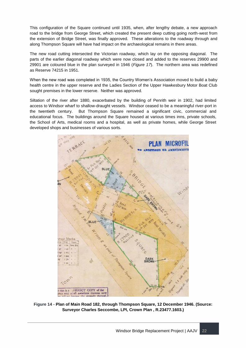
This configuration of the Square continued until 1935, when, after lengthy debate, a new approach
road to the bridge from George Street, which created the present deep cutting going north-west from
the extension of Bridge Street, was finally approved. These alterations to the roadway through and
along Thompson Square will have had impact on the archaeological remains in there areas.
The new road cutting intersected the Victorian roadway, which lay on the opposing diagonal. The
parts of the earlier diagonal roadway which were now closed and added to the reserves 29900 and
29901 are coloured blue in the plan surveyed in 1946 (Figure 17). The northern area was redefined
as Reserve 74215 in 1951.
When the new road was completed in 1935, the Country Women’s Association moved to build a baby
health centre in the upper reserve and the Ladies Section of the Upper Hawkesbury Motor Boat Club
sought premises in the lower reserve. Neither was approved.
Siltation of the river after 1880, exacerbated by the building of Penrith weir in 1902, had limited
access to Windsor wharf to shallow-draught vessels. Windsor ceased to be a meaningful river-port in
the twentieth century. But Thompson Square remained a significant civic, commercial and
educational focus. The buildings around the Square housed at various times inns, private schools,
the School of Arts, medical rooms and a hospital, as well as private homes, while George Street
developed shops and businesses of various sorts.
Figure 14 - Plan of Main Road 182, through Thompson Square, 12 December 1946. (Source:
Surveyor Charles Seccombe, LPI, Crown Plan , R.23477.1603.)
Windsor Bridge Replacement Project | AAJV 23
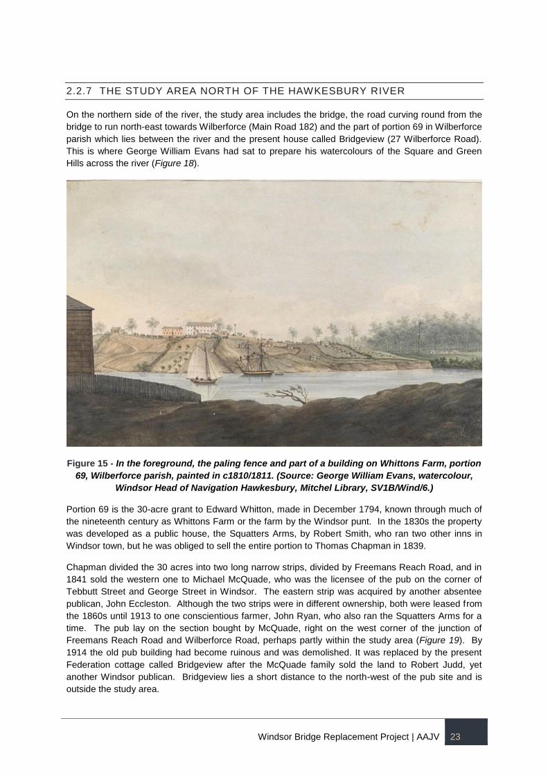
2.2.7 THE STUDY AREA NORTH OF THE HAWKESBURY RIVER
On the northern side of the river, the study area includes the bridge, the road curving round from the
bridge to run north-east towards Wilberforce (Main Road 182) and the part of portion 69 in Wilberforce
parish which lies between the river and the present house called Bridgeview (27 Wilberforce Road).
This is where George William Evans had sat to prepare his watercolours of the Square and Green
Hills across the river (Figure 18).
Figure 15 - In the foreground, the paling fence and part of a building on Whittons Farm, portion
69, Wilberforce parish, painted in c1810/1811. (Source: George William Evans, watercolour,
Windsor Head of Navigation Hawkesbury, Mitchel Library, SV1B/Wind/6.)
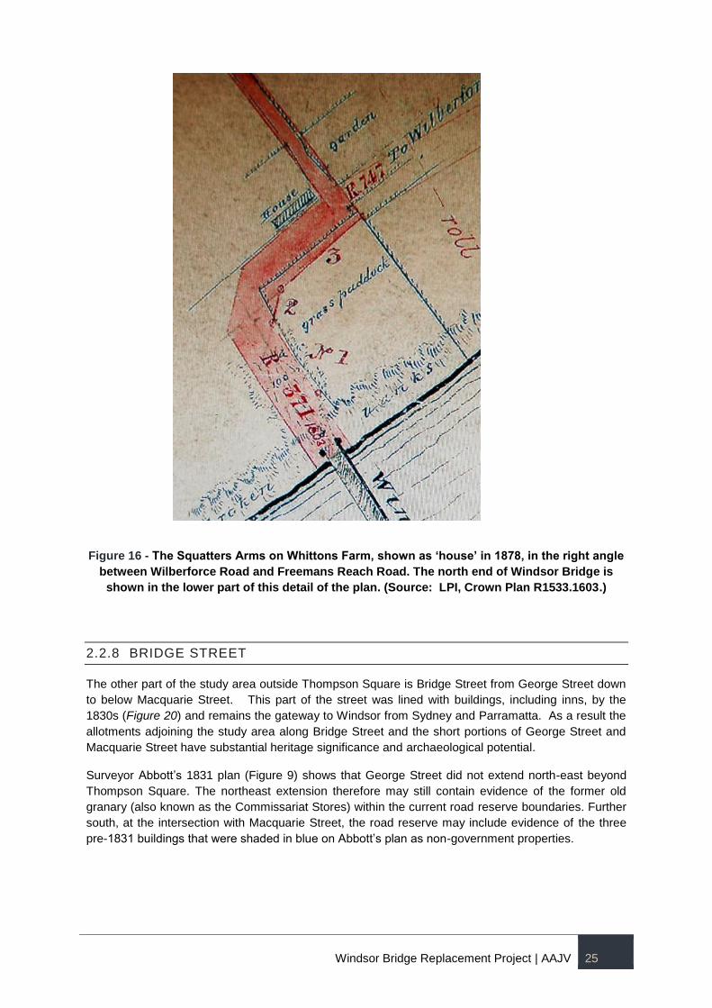
Portion 69 is the 30-acre grant to Edward Whitton, made in December 1794, known through much of
the nineteenth century as Whittons Farm or the farm by the Windsor punt. In the 1830s the property
was developed as a public house, the Squatters Arms, by Robert Smith, who ran two other inns in
Windsor town, but he was obliged to sell the entire portion to Thomas Chapman in 1839.
Chapman divided the 30 acres into two long narrow strips, divided by Freemans Reach Road, and in
1841 sold the western one to Michael McQuade, who was the licensee of the pub on the corner of
Tebbutt Street and George Street in Windsor. The eastern strip was acquired by another absentee
publican, John Eccleston. Although the two strips were in different ownership, both were leased from
the 1860s until 1913 to one conscientious farmer, John Ryan, who also ran the Squatters Arms for a
time. The pub lay on the section bought by McQuade, right on the west corner of the junction of
Freemans Reach Road and Wilberforce Road, perhaps partly within the study area (Figure 19). By
1914 the old pub building had become ruinous and was demolished. It was replaced by the present
Federation cottage called Bridgeview after the McQuade family sold the land to Robert Judd, yet
another Windsor publican. Bridgeview lies a short distance to the north-west of the pub site and is
outside the study area.
Windsor Bridge Replacement Project | AAJV 24
Anecdotal evidence indicates that the land on the north bank of the river was used as a Chinese
market garden around the end of the nineteenth and beginning of the twentieth century. 3 Market
gardening was common in the area and, according to oral histories, two Chinese men were known to
grow the market garden located within the boundaries of the current project area. 4
In addition to the crop cultivation (especially wheat), for which the Hawkesbury was renowned from
the early days of the colony, the area also produced fruit and and vegetables. Towards the end of the
nineteenth and beginning of the twentieth century, the Hawkesbury became the major supplier of
vegetables (potatoes, cauliflower, cabbage, corn and broccoli) to the Sydney market.
Toward the end of the twentieth century, the northern bank experienced a shift from vegetable market
gardens and orchards to turf farms, particularly along the flood prone lower land. Turf was more
resistant to being covered with floods with minimal impacts to the product. The northern portion of the
project area present has been used as a turf farm since 1991.5
3 Biosis 2012, p107.
4 Ibid, p108.
5 Ibid, p108.
Windsor Bridge Replacement Project | AAJV 25
Figure 16 - The Squatters Arms on Whittons Farm, shown as ‘house’ in 1878, in the right angle
between Wilberforce Road and Freemans Reach Road. The north end of Windsor Bridge is
shown in the lower part of this detail of the plan. (Source: LPI, Crown Plan R1533.1603.)
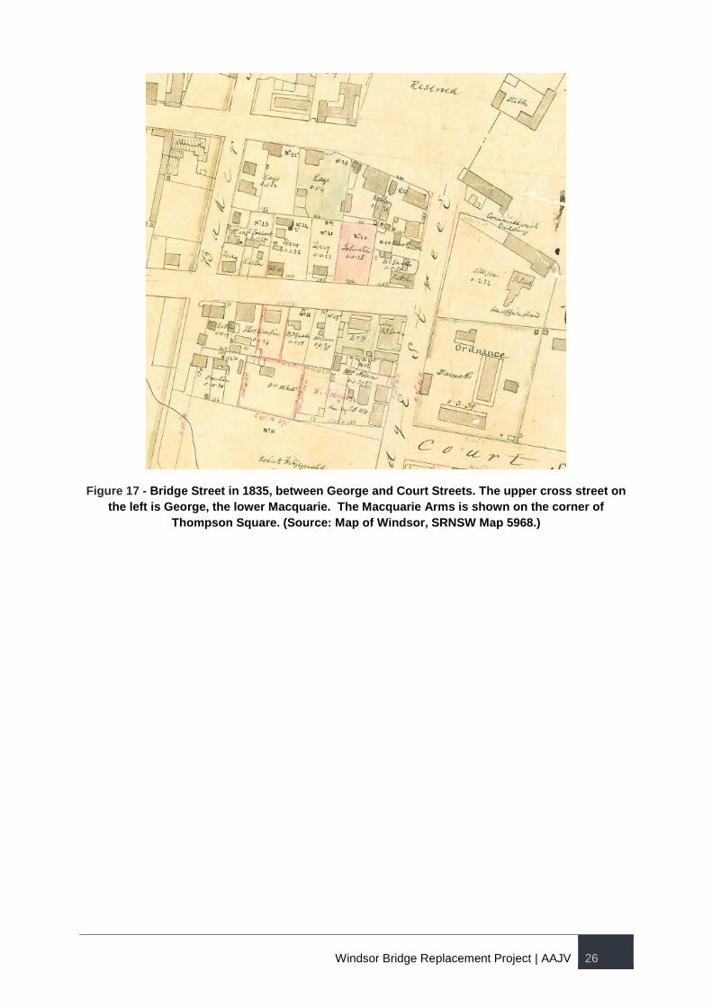
2.2.8 BRIDGE STREET
The other part of the study area outside Thompson Square is Bridge Street from George Street down
to below Macquarie Street. This part of the street was lined with buildings, including inns, by the
1830s (Figure 20) and remains the gateway to Windsor from Sydney and Parramatta. As a result the
allotments adjoining the study area along Bridge Street and the short portions of George Street and
Macquarie Street have substantial heritage significance and archaeological potential.
Surveyor Abbott’s 1831 plan (Figure 9) shows that George Street did not extend north-east beyond
Thompson Square. The northeast extension therefore may still contain evidence of the former old
granary (also known as the Commissariat Stores) within the current road reserve boundaries. Further
south, at the intersection with Macquarie Street, the road reserve may include evidence of the three
pre-1831 buildings that were shaded in blue on Abbott’s plan as non-government properties.
Windsor Bridge Replacement Project | AAJV 26
Figure 17 - Bridge Street in 1835, between George and Court Streets. The upper cross street on
the left is George, the lower Macquarie. The Macquarie Arms is shown on the corner of
Thompson Square. (Source: Map of Windsor, SRNSW Map 5968.)
Windsor Bridge Replacement Project | AAJV 27
3 HISTORICAL ARCHAEOLOGICAL POTENTIAL AND SIGNIFICANCE
Introduction
This section of the report presents the summary of archaeological potential and summary statement
of significance, as identified in the 2013 Evaluation of Historical Images for the Additional Bridge
proposal and the 2012 Biosis report.
Archaeological Potential
The table below provides the identified site features and types of potential archaeological remains that
may still be preserved within the project area. The site features and their archaeological potential is
presented in accordance with the phasis of historical development. Figures 21 and 22 show the
potential site features and their approximate location.
Phasing and Date
Site Features Types of Archaeological Evidence
Phase1 - Early European Settlement:
1794-1800
Early Environment/Clearance and farming
Tracks
First guard house (1795)
First wharf (1795)
First boat slip
Log granaries (1795-1800)
Two government houses
Storehouses, granaries, officers’ dwellings, public brick buildings and a lock-up
A triangular sliver of the western portion and the river frontage of the Thompson allotment including orchards
Whitton’s Farm (north of river)
Tree bowls, stumps and evidence of burning; plough marks; palynological evidence.
Compacted dirt surfaces, wheel ruts, side drains.
Structural remains – postholes, brick, stone, timber foundations; underfloor deposits.
Evidence of timber piers, trusses, fences, hinges, cleats, surfaces and other structural elements associated with the wharf and boat slip
Evidence of fence posts, yard/work surfaces, garden beds and edges, tree bowls and seeds.
Deeper subsurface features such as wells, privies and drains.
Artefact scatters/rubbish pits.
Phase 2 – Town Expansion:
1800-1810
1803 store house (west end only within development footprint)
Brick burning areas
Track to Government Reserve
Cottages, paths, drains fences etc. associated with allotments outside project area
Structural remains – postholes, brick, stone, timber foundations; underfloor deposits.
Scorched clays, clay pits, evidence of burning, etc.
Evidence of fence posts, yard/work surfaces, garden beds and edges,
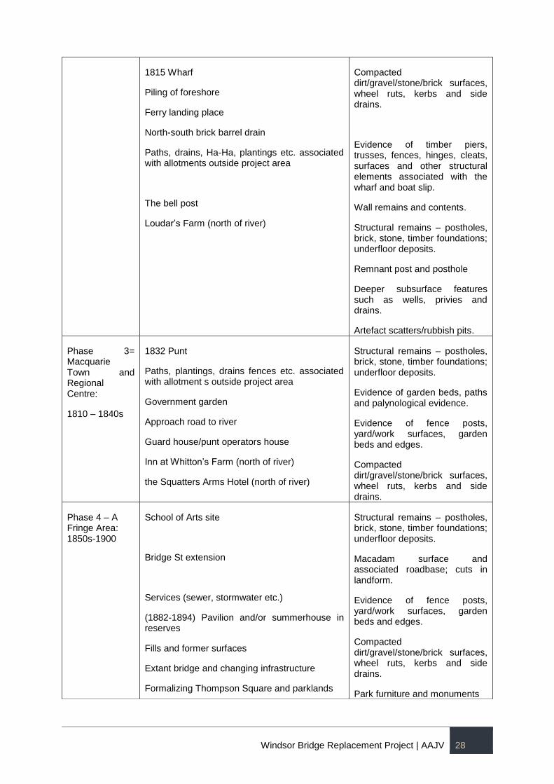
Windsor Bridge Replacement Project | AAJV 28
1815 Wharf
Piling of foreshore
Ferry landing place
North-south brick barrel drain
Paths, drains, Ha-Ha, plantings etc. associated with allotments outside project area
The bell post
Loudar’s Farm (north of river)
Compacted dirt/gravel/stone/brick surfaces, wheel ruts, kerbs and side drains.
Evidence of timber piers, trusses, fences, hinges, cleats, surfaces and other structural elements associated with the wharf and boat slip.
Wall remains and contents.
Structural remains – postholes, brick, stone, timber foundations; underfloor deposits.
Remnant post and posthole
Deeper subsurface features such as wells, privies and drains.
Artefact scatters/rubbish pits.
Phase 3= Macquarie Town and Regional Centre:
1810 – 1840s
1832 Punt
Paths, plantings, drains fences etc. associated with allotment s outside project area
Government garden
Approach road to river
Guard house/punt operators house
Inn at Whitton’s Farm (north of river)
the Squatters Arms Hotel (north of river)
Structural remains – postholes, brick, stone, timber foundations; underfloor deposits.
Evidence of garden beds, paths and palynological evidence.
Evidence of fence posts, yard/work surfaces, garden beds and edges.
Compacted dirt/gravel/stone/brick surfaces, wheel ruts, kerbs and side drains.
Phase 4 – A Fringe Area: 1850s-1900
School of Arts site
Bridge St extension
Services (sewer, stormwater etc.)
(1882-1894) Pavilion and/or summerhouse in reserves
Fills and former surfaces
Extant bridge and changing infrastructure
Formalizing Thompson Square and parklands
Structural remains – postholes, brick, stone, timber foundations; underfloor deposits.
Macadam surface and associated roadbase; cuts in landform.
Evidence of fence posts, yard/work surfaces, garden beds and edges.
Compacted dirt/gravel/stone/brick surfaces, wheel ruts, kerbs and side drains.
Park furniture and monuments
Windsor Bridge Replacement Project | AAJV 29
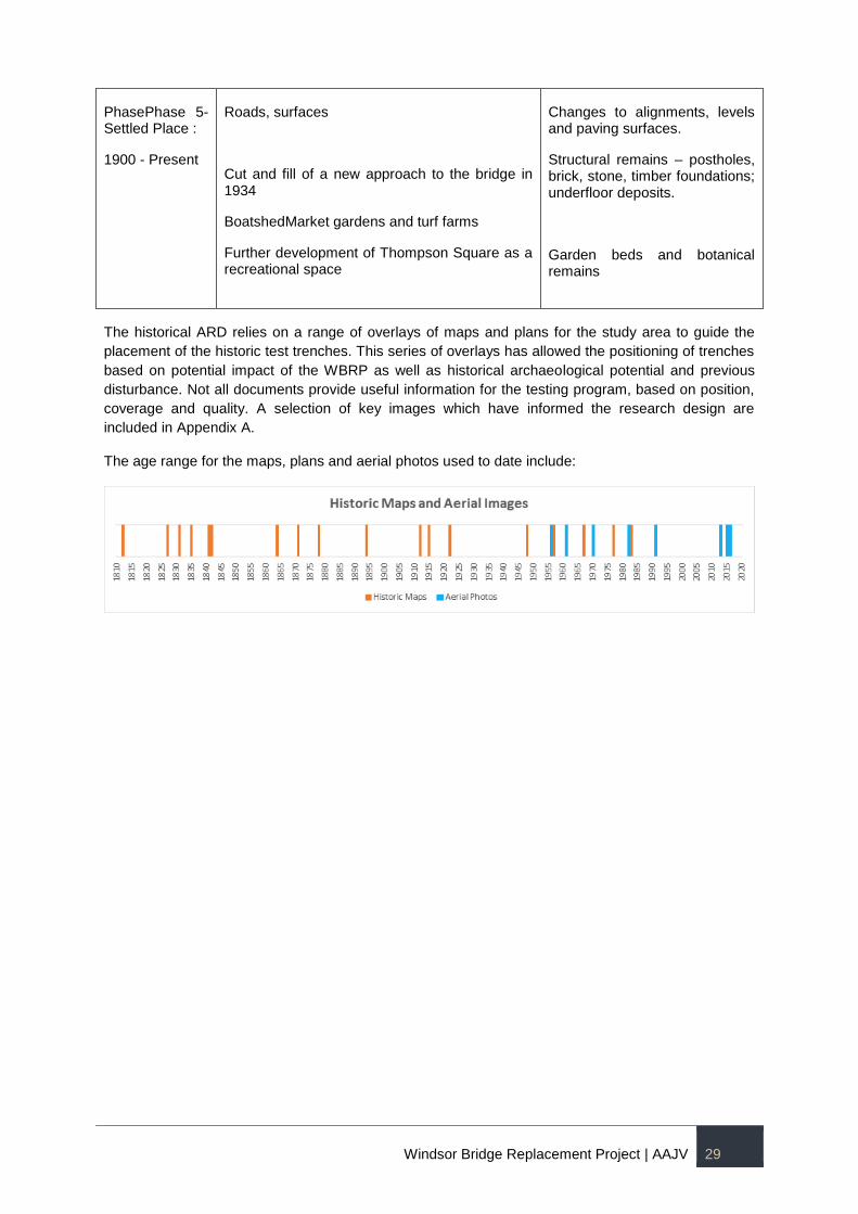
The historical ARD relies on a range of overlays of maps and plans for the study area to guide the
placement of the historic test trenches. This series of overlays has allowed the positioning of trenches
based on potential impact of the WBRP as well as historical archaeological potential and previous
disturbance. Not all documents provide useful information for the testing program, based on position,
coverage and quality. A selection of key images which have informed the research design are
included in Appendix A.
The age range for the maps, plans and aerial photos used to date include:
PhasePhase 5- Settled Place :
1900 - Present
Roads, surfaces
Cut and fill of a new approach to the bridge in 1934
BoatshedMarket gardens and turf farms
Further development of Thompson Square as a recreational space
Changes to alignments, levels and paving surfaces.
Structural remains – postholes, brick, stone, timber foundations; underfloor deposits.
Garden beds and botanical remains
Windsor Bridge Replacement Project | AAJV 30
Figure 18 -The project area overlain with the 1812 Meehan Plan (green) and the 1831 Abbott Plan (orange). The map also shows the location of
previous archaeological testings undertaken in the area.
Windsor Bridge Replacement Project | AAJV 31
Figure 19 - The Settlement on the Green Hills, Hawksburgh [i.e. Hawkesbury] River N.S.Wales,
1809. The structures shown in the painting are as follows: 1 Government House; 2
School/Chapel; 3 Brick Store; 4 Thompsons First House; 5 Log Granary; 6 Govt. Stables; 7
Wharf (behind the boat) 8 Two Government House Stores; 9 remains of Boat Slip; 10 Govt.
Wharf (?); 11 Bakers Farm. Approximate boundary of the project area is outlined in green.
Statement of Archaeological Significance
The following statement of significance has been reproduced form the 2012 Biosis report:
The historical analysis, archaeological assessment and evidence from preliminary testing and past
works demonstrate that there is likely to be a complex and chronologically deep archaeological profile
within Thompson Square and to a lesser degree on the northern river bank. It is impossible to isolate
the resource that could exist within the project area and assess its significance. It must be assumed
that the evidence contained within the project area will have the same values and significance as the
rest of Thompson Square even if specific elements within both may vary from each other. The
significance of the archaeological resource within the project area is the same as that for the resource
across all of Thompson Square and this cultural significance must be assessed on several levels.
Windsor is the third settlement in Australia after Sydney and Parramatta. These are the places that
made long-term European settlement possible and their histories inform us of the circumstances, the
pressures and visions that would shape our history and the way we live. Apart from its importance as
one of our first permanent settlements, Windsor also has added status as a Macquarie town, one of
only five places in the Hawkesbury that were specifically selected and influenced by arguably our
most important Governor, Lachlan Macquarie. A number of the improvements and designs for
Thompson Square are a direct result of Macquarie’s involvement. Thompson Square has direct
associations with outstanding people in the development of the town and region particularly Andrew
Windsor Bridge Replacement Project | AAJV 32
Thompson, who lived and worked here. The archaeological resource could provide tangible links or
associations with significant historical figures by revealing works or improvements that have been
created for, on behalf of, or by these figures.
Thompson Square is the single place that links the earliest settlement on the Hawkesbury with the
Macquarie-era town. This site was used as a civic precinct to service the first farms established on the
river from 1794. It evolved into a small village in its own right that also provided the services and
administration for the region. It is the seminal place of the town’s evolution. It was this village that was
incorporated into the Macquarie planned town of Windsor; it was the only town to incorporate this
earlier layer of settlement. It is unique. If Windsor and Thompson Square are important then
archaeological evidence that can better document or reveal the history of use and development that is
unique to this place and provide evidence of its associations is also significant. The below ground
resources are likely to provide evidence of the earliest years of settlement, pre-dating the fabric that
survives above ground. Archaeological evidence is also likely to provide evidence of events and
processes that were specific to Thompson Square but are representative of the development of this
town.
The principal value of the potential archaeological profile in Thompson Square is its cumulative value.
It has the potential to document events, processes, improvements and places that span the full history
of European development in this place from 1794 to the present day. It is likely to be the only place in
Windsor or its environs that can do so. The archaeological profile of the project area on the south
bank is completely unique to it. Because of the potential chronological depth of the profile it may
include sites that are rare beyond the specific history of this place.
Apart from the potential to document and demonstrate the changing town and the place of Thompson
Square in it over a long period of time the archaeological profile of Thompson Square can be
evaluated for different levels of significance that are largely relevant to their rarity either through age
or singular uses. In particular, evidence that relates to the founding settlement of 1794 up to and
inclusive of Macquarie-era works is assessed to be of exceptional significance for its importance
within the town, its rarity and its contribution to documenting the growth of the colony in its formative
years. For the earliest years of settlement this resource would be the only fabric that survives in the
town; there is no evidence above ground that predates 1811. It is comparable to only a very small
number of other places in New South Wales that have the same depth of development such as
Sydney or Parramatta.
As well as works from the first decades of the town’s growth the project area is also likely to
encompass important improvements from the middle and later years of the nineteenth century that
reflect the changing status and role of the town and Thompson Square. These include the
development of the bridge across the river to link the two communities. Many of these processes are
not evident in above ground resources. These are resources that can make a substantial addition to
the evidence that survives above ground; they have value for the town.
Evidence that derives from the early to middle years of the twentieth century is less significant. These
processes are still evident in other forms and they have impacted on earlier and very rare resources.
Evidence from the later years of the twentieth century onwards which is still largely intact above
ground and has acted to remove or disturb older or very rare elements is considered to have little
individual significance but is recognised as an integral component in the complex profile.
The northern area of the project area across the river also has a history of settlement that dates back
to 1794 with a farm established here by the ex-convict, Edward Whitton, in that year. Apart from his
pioneer status Whitton’s contribution is representative of the thousands of people who worked to
develop the region.
Archaeology in the northern part of the project area is unlikely to have the same complexity of
resources as Thompson Square because of the nature of settlement here; largely pastoralism and
Windsor Bridge Replacement Project | AAJV 33
agriculture. It has value as a comparison to the complex history of Thompson Square but its individual
components are likely to be less significant; the exception would be the site of a long-standing
landmark inn although its precise location cannot be determined. The resource in the northern part of
the project area, with few exceptions, is likely to be more representative of the agricultural/pastoral
development that characterised this side of the river.
The archaeological resource is likely to provide a depth of historical layering and sense of place to the
acknowledged visual qualities of Thompson Square. These are qualities and resources that can be
valued by the community. It has the ability to provide unique, rare and representative components for
this place and for New South Wales. The cumulative profile recording evidence of works and change
over two centuries is unique. Within that overall profile evidence of the Green Hills period of
development and Macquarie-era works would be of State significance; evidence contained within it,
above and below ground that can be determined to have a direct association with the Green Hills
Settlement or the period of expansion under the direction of Governor Lachlan Macquarie would
potentially be of National significance. The remainder of the archaeological profile has local
significance.
Windsor Bridge Replacement Project | AAJV 34
4 RESEARCH FRAMEWORK AND METHODOLOGY
Introduction
Archaeological research designs provide an outline of both the research framework which guides the
archaeological work on site and the methodologies which are to be employed to realise the research
potential of the subject site. While they set out a series of general and specific research questions,
research designs are not designed to be prescriptive. The work undertaken at an archaeological site
must remain flexible enough and confident in its own reasoning to enable the reworking or the
discarding of research objectives should it become apparent that the archaeological resource cannot
sustain them.
Previous archaeological investigations in the Windsor area have revealed a highly complex
archaeological landscape containing evidence of over 30,000 years of Aboriginal occupation and over
200 years of historical occupation. At least 21 buildings and associated town infrastructure were
constructed from the early days of the settlement, the remains of which may still survive in or near the
site. In order to obtain meaningful information from the archaeological testing, a program of integrated
Aboriginal, historical and maritime archaeological investigation has been designed. The aim of the
testing program is to create an understanding of the human history of Thompson Square from multiple
sources of evidence. This will inform the future management of the significant archaeological
resource, should it be identified, in both the project area and the greater context of Thompson Square
and Windsor. The results of the testing will be used to guide potential further excavation, project
impact mitigation and long-term management measures. It will also be informed by engagement with
stakeholders and the broader community identifying the overlay of social significance.
The strategy to the testing program involves a focused research framework structured around a
holistic methodology that gives equal weight to the disciplines involved. It is designed to adhere to the
planning and conservation principles of best practice archaeological heritage management.
Excavation Strategy
4.2.1 GENERAL PRINCIPLES
Historical archaeological test excavation will precede Aboriginal archaeological excavation work.
Following the mechanical removal of turf, topsoil and fills, the historical archaeologists will then
manually excavate the designated test trenches until they expose either significant historical
archaeological relics or other identifiable deposits, including sand body, which may contain Aboriginal
cultural material. If neither the significant historical archaeological / Aboriginal relics nor sand body are
identified during the historical archaeological program the excavation will proceed until culturally
sterile natural deposits are exposed at which point investigation at such locations would be
discontinued and the trenches backfilled to specifications. Structural remains will be left in situ.
Proposed maritime archaeological investigation within the project area will be undertaken concurrently
with the historical archaeological program. If significant deposits or structures associated with past
riverine activity are exposed during the historical archaeological excavations, the nominated
excavation director will consult with the project’s maritime archaeologist to appropriately plan the
identified items and determine the relationship between the maritime and terrestrial archaeological
investigations.
The Aboriginal excavation will be undertaken concurrent with the historical archaeological work. The
initial excavation of each Aboriginal test pit will be undertaken under the historical archaeological
supervision. This will ensure that potential historical archaeological remains are appropriately
identified and recorded and that all of the national and/or state significant relics remain undisturbed.
Windsor Bridge Replacement Project | AAJV 35
Depending on the level of significance and integrity of the exposed historical archaeological relics,
Aboriginal test pits may require relocation. Excavation restructured by utilities may also require
relocation of both historical and Aboriginal test trenches/pits.
As the historical, Aboriginal and maritime excavations will be occurring simultaneously, the specialist
teams will be able to consult with each other in relation to the most appropriate locations and findings
in general.
4.2.2 HISTORICAL ARCHAEOLOGY
Based on the nature of the project area the archaeological testing will be generally divided into two
main areas of works: the southern and northern sides of the Hawkesbury River. While the focus of the
historical archaeological testing will be on archaeological potential located on the southern side (SH
1-10), a limited number of historical test trenches (NH 1-5) have been positioned on the northern side
of the river. These trenches, as the associated research design, are a contingency only, and are not
presently planned to be excavated.
The rationale behind this is that, although the northern riverbank has been assed of having limited
potential to contain significant relics, verifying such potential early in the project would significantly
reduce risks associated with delays of established timing and interruption during the construction
phase of works, especially if they deemed to be well preserved and capable of providing additional
information relevant for the history of Windsor. The test excavation on the northern side of the project
area will be provisional upon finding historical archaeological evidence in the Aboriginal test pits.
Figure 23 sets out proposed locations for historical archaeological investigation across the southern
and northern parts of the project area. While some trenches have been set out to allow investigation
of identified historic features or areas considered to have archaeological potential, the cumulative
information gathered from such excavations is designed to answer the questions related to the
location, extent and nature of the potential archaeological resource. The need to answer the question
of general intactness and depth identified by Casey in the 2013 Independent Heritage Review may,
by necessity, require test excavations to occur beyond the limit and depth of predicted impacts from
the WBP, but will be required to satisfy the NSW Heritage Council that the testing program will
provide confirmed results.
4.2.2.1 SOUTHERN AREA
The test trenches have been strategically positioned to test for the following:
SH1 Two Government houses shown in the 1809 image and the small structure shown in
the 1831 Abbott Plan at the river front, on the west side of the project area. The trench will
also investigate archaeological deposits associated with the river frontage and road
construction. The trench is expected to measure 10 x 2 metres;
SH2 Potential for archaeological deposits associated with pre-1810 features at the western
edge of the project area. The trench is expected to measure 3 x 2 metres.
SH3 As with trench 2, this trench will also investigate the potential for archaeological
deposits associated with pre-1810 features at the western edge of the project area. The
trench is expected to measure 3 x 2 metres;
SH4 As with trench 2 and trench 3, this trench will also investigate the potential for
archaeological deposits associated with pre-1810 features at the western edge of the project
area. The trench is expected to measure 3 x 2 metres.
Windsor Bridge Replacement Project | AAJV 36
SH5 Designed to test for archaeological potential associated with the Commissariat
building at the top of the ridge, the presence of the road and the extent or otherwise of
truncation in this area. The trench is expected to measure 15 x 1.5 metres.
SH6 The extent of archaeological potential or otherwise of truncation in this area. The
trench is expected to measure 15 x 1.5 metres.
SH7 Potential for archaeological deposits along the riverfront adjacent to the current
bridge and the presence of the brick vaulted drain. The trench is expected to measure 10 x 2
metres.
SH8 Potential for archaeological deposits along the riverfront, filling and road surfaces.
The trench is expected to measure 10 x 2 metres;
SH9 Presence of archaeological deposits along the riverfront across the alignment of
Thompson’s garden. The trench is expected to measure 10 x 2 metres.
SH10 and 10A Two trenches will be opened to test for the presence of structures indicated
on the overlay at the corner of Bridge and Macquarie Streets. The need for the excavation of
two trenches was dictated by the limitations of the busy intersection and presence of
numerous services in the southwest corner footpath. The two trenches, sited in the pedestrian
island and southwest corner footpath are expected to measure 5 x 1.5 metres (SH10) and 4.5
x 2 metres (SH10A).
4.2.2.2 NORTHERN AREA
A contingency has been allowed within the project for the optional testing of five historical
archaeological test trenches in the northern project area. These trenches are all located in grassed
areas beside the roadway or within the current turf farm area, which will partially contain the site
compound. The excavation of these trenches will commence, when and if historical archaeological
evidence has been identified in the northern Aboriginal test pits.
As further work is currently required to confirm both the presence and the nature of the archaeological
resource within the northern project area, the historical archaeological investigation (if undertaken
under the contingency provisions) will use a systematic layout of trenches to provide data from across
the entirety of the project area. As such, trenches are located to test for the historical archaeological
potential of features and deposits associated with the early settlement of the northern riverbank.
The trenches are expected to measure as follows:
NH1 6 x 2 metres;
NH2 6 x 2 metres;
NH3 10 x 2 metres;
NH4 2 x 2 metres; and
NH5 6 x 2 metres;
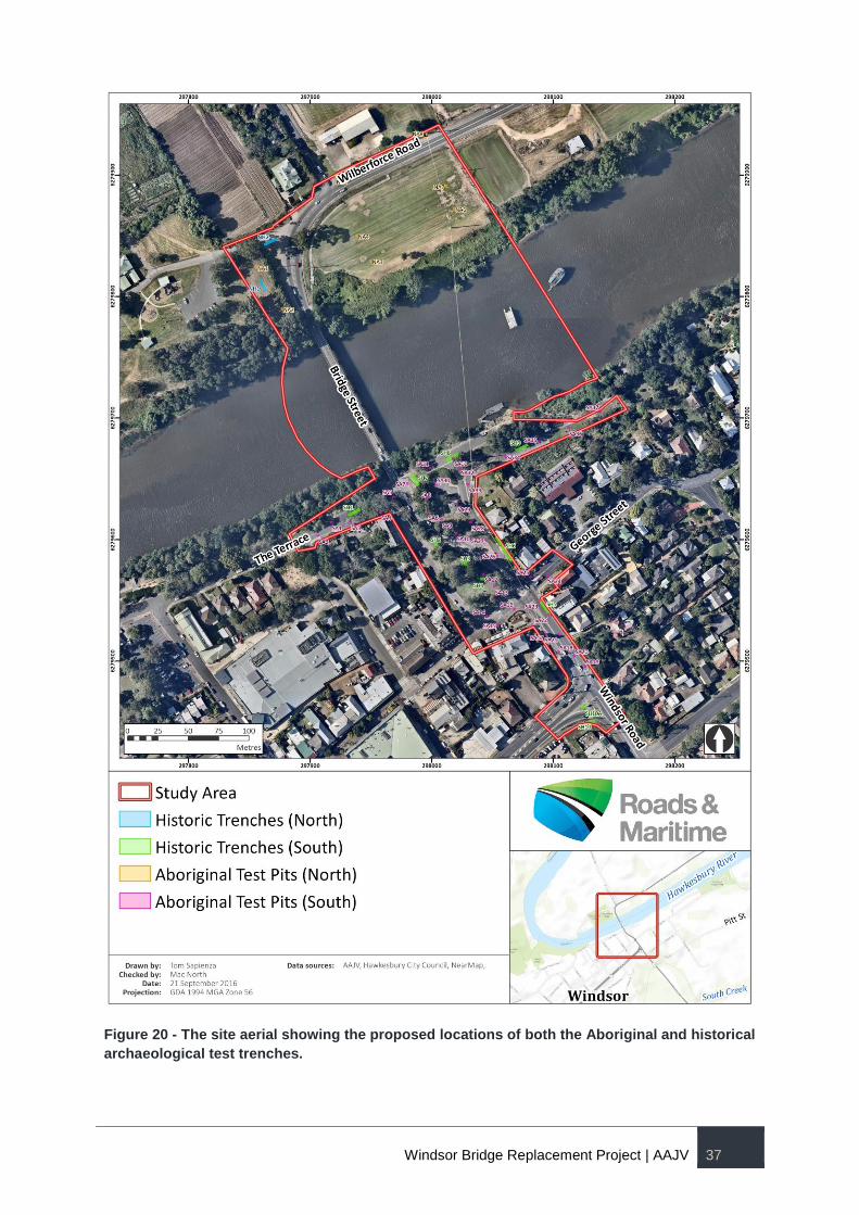
Windsor Bridge Replacement Project | AAJV 37
Figure 20 - The site aerial showing the proposed locations of both the Aboriginal and historical
archaeological test trenches.
Windsor Bridge Replacement Project | AAJV 38
4.2.3 MARITIME ARCHAEOLOGY
Cosmos Archaeology examined maritime archaeological potential for the site in detail in two reports in
2012. The Final Report for that phase of maritime archaeological assessment concluded there were
two principal areas of maritime archaeological sensitivity, the location of the original wharf on the
southern river embankment (at the site of the present wharf) and the potential landing spot for the
punt, located just west of the northern abutment of the existing bridge. These are the areas in which
maritime testing will be concentrated.
The proposed test excavation methodology will attempt to obtain data that will better inform the
management, during and after, the implementation of the detailed design of the new bridge on the
cultural heritage significance of the maritime infrastructure – above and below water - and other
submerged archaeological remains of colonial period Windsor.
Management of the submerged cultural remains during the implementation of the detailed design
refers to the effects of piling, bank stabilisation (if occurring) as well as anchoring and propeller jet
turbulence.
Management of the submerged cultural remains after the implementation of the detailed design refers
to the effects of potential scouring arising from changed conditions on the river bed.
The most significant of the identified underwater archaeological remains are those associated with the
late 18th/early 19th jetty. Our knowledge of this site is confined to a compact expanse (ca. 55 m x 12
m) of rounded cobbles close to the southern river bank which has been interpreted as being ballast
which weighed down the timber piles and bed logs which formed part of the jetty.
To better understand the type and scale of the potential impacts to the significance of this site the
following information is required:
What is the exact extent of the site? This would be done with more detailed mapping than has
previously been done involving divers working with land based total station, augmented by remote
sensing. This would determine the extent and provide the basis for recommendations about avoiding
and minimising disturbance.
How compact is the ballast mound? The degree of compactness of this feature will assist in
assessing whether the site is sufficiently robust so as to withstand long term impacts of any predicted
scouring.
What archaeological remains are within and under the ballast mound? Understanding the cultural
heritage significance of artefacts and structure currently protected by the ballast mound will provide
critical information which will be used to avoid and minimise loss to the site’s cultural heritage
significance.
The detailed survey work to be undertaken as part of the DAR will answer question 1. This survey will
be undertaken immediately prior to the test excavation.
The test excavation will attempt to answer questions 2 and 3 by providing details regarding:
The depth and compact nature of the rubble ballast that is present on the site;
The nature of the strata present immediately below the ballast deposit, and subsequent strata
on site;
The compactness of the site and potential to be impacted from long term indirect impacts, such
as from increased water velocity, and the potential for scouring or deflation to occur;
Further understand the archaeological potential within the ballast deposit; and,
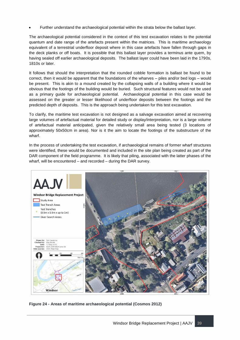
Windsor Bridge Replacement Project | AAJV 39
Further understand the archaeological potential within the strata below the ballast layer.
The archaeological potential considered in the context of this test excavation relates to the potential
quantum and date range of the artefacts present within the matrices. This is maritime archaeology
equivalent of a terrestrial underfloor deposit where in this case artefacts have fallen through gaps in
the deck planks or off boats. It is possible that this ballast layer provides a terminus ante quem, by
having sealed off earlier archaeological deposits. The ballast layer could have been laid in the 1790s,
1810s or later.
It follows that should the interpretation that the rounded cobble formation is ballast be found to be
correct, then it would be apparent that the foundations of the wharves – piles and/or bed logs – would
be present. This is akin to a mound created by the collapsing walls of a building where it would be
obvious that the footings of the building would be buried. Such structural features would not be used
as a primary guide for archaeological potential. Archaeological potential in this case would be
assessed on the greater or lesser likelihood of underfloor deposits between the footings and the
predicted depth of deposits. This is the approach being undertaken for this test excavation.
To clarify, the maritime test excavation is not designed as a salvage excavation aimed at recovering
large volumes of artefactual material for detailed study or display/interpretation, nor is a large volume
of artefactual material anticipated, given the relatively small area being tested (3 locations of
approximately 50x50cm in area). Nor is it the aim to locate the footings of the substructure of the
wharf.
In the process of undertaking the test excavation, if archaeological remains of former wharf structures
were identified, these would be documented and included in the site plan being created as part of the
DAR component of the field programme. It is likely that piling, associated with the latter phases of the
wharf, will be encountered – and recorded – during the DAR survey.
Figure 24 - Areas of maritime archaeological potential (Cosmos 2012)
Windsor Bridge Replacement Project | AAJV 40
Excavation Methodology
4.3.1 HISTORICAL ARCHAEOLOGY
Prior to archaeological testing being undertaken, services will be located using both current service
plans and service detecting remote sensing. Where services have been identified within trench areas,
potholing to locate services shall be undertaken. Where sufficient clearance cannot be achieved
between services and the test trenches, minor relocations of the test trenches may occur
Excavation of the test trenches will proceed via a series of shallow scrapes with a mechanical
excavator so that the exposed surface in the pit or trench is progressively reduced in a
controlled manner. This process will continue until the extent of archaeological remains in the
trench has been identified.
Concurrent with this, targeted manual excavation will occur where required by qualified
archaeologists. Small hand tools such as picks, shovels, pointing trowels, brushes and pans
will be used in manual excavation, either for cleaning up excavated areas or revealing
exposed features or deposits. Where an in situ historic feature that is the target of the
excavation is located, mechanical excavation will cease. The feature will then be cleaned up
by hand and recorded. The archaeologist will endeavour to expose and identify all significant
historic features and deposits. In the event that structural fabric is not located, excavation will
stop when natural (including sand body) and/or culturally sterile deposits have been reached.
Spoil will be stockpiled adjacent to the trench during the archaeological testing.
Provenance data and fabric descriptions will be recorded on numbered context recording
sheets and the vertical and horizontal positions of all significant deposits and features will be
recorded with reference to a permanent site datum. This survey information will be transferred
to scaled site plans showing the spatial relationships between features revealed during the
course of the investigation. Documentary records of the excavation will be supplemented by
the preparation of Context Schedules and a Harris Matrix for the excavation area (where
significant stratigraphic relationships are identified).
All significant elements will be photographed with a scale bar. Digital media will be used for
general photographic recording.
Any artefacts found within the test excavation areas will be collected, cleaned and catalogued
in accordance with the proposed test excavation methodology and best archaeological
practice. Artefact bearing deposits may be wet sieved to optimise recovery. All artefacts will
be stored in a secure storage facility, location subject to confirmation. During the day,
artefacts will be relocated from the test trenches to the proposed site compound north of the
river, for cleaning and cataloguing. Artefacts will be relocated to the nominated secure storage
area each evening following the completion of archaeological works.
Artefacts will be bagged in suitable polyethylene or paper bags, double tagged with Tyvek (or
similar) labels and put in an agreed temporary secure storage location. At the conclusion of
the project they will be handed over to the client for retention in accordance with an artefact
management plan that will be developed to identify artefacts with the various levels of
attributes as follows:
a) display potential;
b) research potential; and
c) those that have reasonably exhausted archaeological research potential.
Windsor Bridge Replacement Project | AAJV 41
The labels will be annotated with the trench or pit number as well as the context or layer
number using permanent ink pens. All artefacts will be subjected to a detailed, post
excavation statistical analysis in order to fully answer the research questions, which guide the
archaeological investigation.
Standard conditions for historical archaeological investigations identify the permit applicant
(usually the developer) as responsible for organising the long-term curation of the artefact
collection. The artefacts remain the property of the site owner. AAJV may assist the client with
the investigation of potential repositories for the collection.
The position of all Aboriginal artefacts (if any) which are present in historic contexts will be
recorded and keyed into the overall archaeology site grid and the nature of their identified
context will be noted (i.e., re-deposited sand or a cesspit).
In the event that Aboriginal cultural material is identified on the surface of the natural ground
surface following the completion of the historical archaeological investigation, then the
nominated archaeologist will record the location and nature of the cultural material and collect
it. Depending on artefact frequency, the location of any high density artefact concentrations
may be subjected to the excavation of an Aboriginal archaeological test pit, which will be
undertaken in addition to the test pit locations, as deemed necessary..
Any Aboriginal artefacts recovered outside of Aboriginal test excavations, such as glass
displaying potential use wear or surpassed knapping, will be separated from the historic
and/or maritime artefact analysis and, while their presence in a historic context will be noted
and cross-referenced for provenance data, they will be subject to examination by a lithics
specialist along with artefacts recovered from the Aboriginal test excavations.
4.3.2 MARITIME ARCHAEOLOGY
The proposed test excavation methodology is as follows:
Establish a notional grid across the site outlining the upper (close to the bank) middle
and lower (outer toe of the site) zones;
Position three trenches to be excavated, one within each zone, as outlined above, in
multiple areas across the site, being the upstream, middle and downstream side of
the archaeological site (see figure below);
The test trenches are to measure 0.5 m x 0.5 m by up to 1 m in depth;
Remove and record ballast rubble by hand within each test trench;
Record the strata present immediately below the ballast remains;
Excavate strata with the use of a diver operated water induction dredge to determine
the composition, and depth of the deposit; and,
Determine the likely depth of the archaeological deposits within each zone on the
site.
Artefacts will be recovered either from within concretions which have formed on the
ballast or deposited onto an on-board sieve as a result of the dredging.
Artefacts will be assigned a context on the basis of which trench they were recovered
and from whether they were recovered from the ballast stratum or the strata below.
As it is anticipated that relatively few artefacts will be recovered, each artefact will be
registered, briefly described and photographed for post excavation analysis.
At the completion of the excavation recovered artefacts will be placed in plastic bags
with their context identification written on tags placed in the bags. The bagged
Windsor Bridge Replacement Project | AAJV 42
artefacts will be returned to their respective trenches and covered with the ballast
that had been removed from the trenches.
4.3.3 ARTEFACT MANAGEMENT AND CONSERVATION
The historical terrestrial and maritime archaeological works will require the involvement of an artefact
specialist/conservator on-site. The artefact specialist/conservator will:
Liaise with the historical archaeological and maritime excavation directors regarding
excavated material during the course of the excavation, providing services and advice related
to artefact treatment and handling, washing and storage;
Samples of timber and other materials may be cut for species identification and dating;
Prepare the space for temporary holding of artefacts (especially those raised from the river);
Conduct ongoing conservation during project to ensure the artefacts from the river do not
deteriorate while in temporary storage; and
Undertake measures for short-term storage of any artefacts required in the course of the post-
excavation analysis.
Personnel
Maritime Archaeological Investigations: Cosmos Coroneos, Chris Lewczak and Danielle Wilkinson of
Cosmos Archaeology. The team would include the wet worker leader who would ensure all dive
records are maintained and kept and would also undertake survey work and mapping requirements;
Boat leader - Dry Work (TBC); The Boat Leader would organise the artefact registrar and run
the sieve;
Maritime Archaeologists - 2 ADAS qualified divers who would be working off of the punt; and
Commercial Dive Team - 3 divers (TBC) who would maintain gear run the dives and be
technical dive supervisors.
Reporting
Following the completion of the archaeological investigations, the AAJV excavation team will prepare
a preliminary report, for the purpose of informing the management recommendations of the SCMP.
The AAJV will subsequently undertake a post-excavation analysis of the data in order to produce final
archaeological test excavation reports, which will fully document the archaeological works
undertaken, their results and the potential effects of any archaeological findings on future works.
These reports will serve to meet MCoA Condition C5. Production of the reports will require:
analysis of any Aboriginal and historical cultural material identified during the excavation;
examination of the results from soil and chronological sampling strategies in order to identify
the age and formation history of the deposits;
digitisation of all records to provide a permanent record of the works undertaken;
consideration of the works undertaken, information on the location, extent and significance of
any archaeological deposits, and guidance on the future management of them; and
development of a detailed salvage strategy for subsequent stages of the project.
The final test excavation reports will meet the MCoA and will include but not be limited to:
Windsor Bridge Replacement Project | AAJV 43
An introduction and executive summary.
Planning framework.
Site history.
Archaeological background & collated research.
Archaeological investigation methodology, results and site recordings.
Analysis and catalogue detailing all Aboriginal and historical cultural material recovered.
Maps and site plans etc. that identify areas and levels of cultural sensitivity.
Re-assessments of significance.
Comparison of the dataset against comparable sites.
Conclusions and recommendations.
Workplace Health and Safety Requirements
The responsibilities of the full time HSEQ compliance officer will be to ensure compliance with the
Work Health and Safety Act 2011, to develop and to manage the WH&S requirements for the
archaeological team in conjunction with the WBA WH&S plan and managers. The AAJV has adopted
the Extent Heritage Work, Health Safety and Environment Plan.
Public Information and Interpretation
Public information on the archaeological program will be managed in accordance with the RMS
Community and Stakeholder Engagement Plan for the WBRP. At this stage, no formal public
engagement is proposed during the testing program, however RMS is investigating options for
keeping the community informed during test excavations. This may include information posted on the
project website, community notifications, etc.
Results from the testing program will be used to inform the Interpretation Strategy for the WBRP and
study area.
Research Questions
4.8.1 BROAD RESEARCH QUESTIONS
An archaeological Research Design can be formulated to answer general questions about any
deposits or features exposed during excavation work at any given site. These general questions are
applicable to the investigation of most archaeological sites and they are typically focused upon
smaller scale questions related to specific site development. However the ability to answer even these
questions is critical to developing information related to broader research objectives. These general
questions that are typically asked about a site are:
What features or deposits are present on the site?
What is the nature and extent of these features and deposits?
How intact are they?
What is their significance?
What are their depths below the current surface?
Windsor Bridge Replacement Project | AAJV 44
What date or occupation phase can be assigned to them? and,
How does this information compare to available historical information relating to the site?
4.8.2 SITE SPECIFIC QUESTIONS
The following site-specific questions can be asked of the archaeological remains of the Windsor site.
They have been set out below based on the chronology identified in the archaeological assessment
for the site. As the current archaeological program involves targeted, small scale testing only,
evidence for all research questions may not be found during works, and the testing may result in
different or expanded research questions for future archaeological works as a part of the WBRP or
beyond.
The results of the testing will be used to inform and refine the policies and recommendations for the
future management of the archaeology of Thompson Square and surrounds in the SCMP.
4.8.2.1 LANDSCAPE
Is there evidence for flooding or other erosional effects from the site's proximity to the river?
Can historically attested floods be discerned?
What palynological evidence is there for the changes to the local flora from pre- to post-
colonisation?
Is the first clearance of the site evident and what effects did it have on the site?
Was the area of the square stabilised, cut, filled or otherwise altered to serve its purpose as a
landing place and then public space?
4.8.2.2 CONTACT ARCHAEOLOGY (1791-1820S)
Is there evidence for the initial period of contact between the local Aboriginal people and
Europeans?
4.8.2.3 EUROPEAN OCCUPATION
What is the earliest evidence for the European presence on the site?
Is it related to the river or other activities?
Is there any evidence of for the first settlers of Green Hills/Mulgrave Place?
What evidence is there for Baker's and Thompson's occupations on the south side of the
river?
Is there any remaining evidence of the government buildings, which occupied the western
portion of the site?
What materials were they constructed from?
is there any evidence for early paths and tracks to access areas on both the north and south
sides of the river?
Is there evidence for an early alignment (pre-1810) of George Street?
Is there evidence for Howe's brick barrel drain(s) in the square?
Is there evidence for the heavy military presence at Windsor on the south side of the river?

Windsor Bridge Replacement Project | AAJV 45
Are any other structures or occupation evidence remaining at the intersection of the
Wilberforce and Freemans Reach Roads?
modification
s and development to Thompson Square and adjacent areas?
What is the evidence of the late nineteenth/early century modifications across the site? How
have these later modifications affected the survivability of the historical archaeological
resource?
What did vacant space mean in the context of Windsor over 200 years and how is this
manifested at Thompson Square? Was it a place to dump refuse or was it treated as a civic
space?
4.8.2.4 RIVERINE ELEMENTS
How was the first jetty constructed?
Is there any evidence of early ship construction?
What can it tell us about the engineering skills available to the colony within the first five years
of settlement?
Was ballast used to stabilise the jetty, and which jetty phase was the ballast used for?
How was the risk of flooding managed?
What was the quality of the materials used in the jetty? (i.e. was copper sheathing used?
Spacing of piles, size and standard of fastenings). Does this say something about the
availability of materials or the level of importance placed on the jetty by the authorities,
through comparison with other contemporary jetty sites?
Was the jetty constructed on bed logs or piled directly into the riverbed?
How was the 1814/15 (second) jetty constructed and how was it modified and altered
throughout the 19th century?
What do the river artefacts tell us about the use of the wharf and the commercial contacts
over time?
Is there any evidence for the operations of the ferry on either side of the river?
Are there new facilities for the punt (cable tie etc.) where the new road meets the water?
4.8.2.5 SITE-SPECIFIC THEMATIC RESEARCH QUESTIONS
The following are thematically based research questions, which may help direct the longer-term
archaeological investigation of Thompson Square and the Windsor area. Given the scale of the
current testing program, it is unlikely sufficient evidence will be found to meaningfully address the
majority of these questions, but they provide a guiding framework for future archaeological work.
The environmental characteristics of the site are an important feature of understanding the place.
They should not be seen, however, as a passive background to human activity here, neither should
they be seen as the main external determinant governing those actions. An understanding of the river,
soils and climate largely determined the prospects for a successful life here and guided both
Aboriginal and European attempts to inhabit this place.
Have the environmental conditions at the site contributed to or influenced the development of
Windsor Bridge Replacement Project | AAJV 46
human occupation here?
What changes has the river made to the site over time?
How does the Aboriginal occupation at Windsor compare to similar sites - such as Parramatta and/or Rouse Hill?
How does the European occupation at Windsor compare to similar sites - such as Parramatta River, Port Essington, Risdon Cove, Coal (Hunter) River and Swan River etc.?
When did this site become a focus for the local agricultural community?
Traditional Life and Structures
In April 1791, Governor Phillip along with 21 others, including Colbee and Boladeree, searched for the
junction of the Hawkesbury and Nepean rivers. This track took them along the south bank of the
Hawkesbury through the future area of Windsor. Based on Tench's account, some have suggested
that for a part of this trip along the riverbank, the party were able make use of an Aboriginal pathway.6
The question of the tribal localities and boundaries in the Sydney basin at the beginning of European
settlement has been problematic based on the reported information. In 1821, the Reverend Walker
referred to nine tribes of the area - one of which was the Windsor Tribe.7 The identification of such
groups in this manner reflects much about how Europeans observed and recorded people based on
preconceptions rather than on accurate information. Ross places the Darug astride the Hawkesbury
River, known as Deerubin to the Aboriginal inhabitants, in the vicinity of Windsor but this is by no
means certain.8
Can the archaeological information related to the site assist us in developing a picture of the local Aboriginal people?
The river may reflect a boundary between the Darug and Darkinung. Can archaeological work provide any evidence to support or refute that theory?
How connected was this region with other places and is there any evidence of trade with the coast, the Hunter region or the mountains?
Does the evidence support the model that people of the hinterland only utilised freshwater resources?
What is the suite of materials and technologies evident in the lithic assemblage and how does this site compare with excavations conducted at Pitt Town and Parramatta?
Meeting of occupants and newcomers
18th and 19th century European colonial expansion brought settlers and colonisers to new shores as
widely dispersed as the America's, Africa, New Zealand and the Pacific Islands. The profound effects
of the new arrivals upon the locals have been recognised by many since first contact and have been
often asked in studies of cross-cultural contact.
We may also ask what effect did the locals have upon the newcomers?
How does the contact period at Windsor conform or differ from similar places of contact across the globe?
What were the efforts at integration and did they change over time related to local circumstances or through larger scale changes in attitudes to indigenous peoples?
Can the contact between locals and the European newcomers be compared with other such first places of contact elsewhere in contemporary colonial encounters such as those at Sydney Cove, Port Essington (Northern Territory), Hunter River, Risdon Cove (Tasmania), Hutt River (New Zealand) and Cape Colony (South Africa) etc?
6 Tench, W, 1961, Sydney's First Four Years: Comprising A narrative of the exhibition to Botany Bay and A complete account
of the settlement at Port Jackson , L Fitzhardinge, [ed.], p.223ff. 7 Attenbrow, V, 2002, Sydney's Aboriginal Past , UNSW Press, p.21. 8 Ross, A, 1988, "Tribal and Linguistic Boundaries: A Reassessment of the Evidence" in, G Aplin, Sydney Before Macquarie:
A Difficult Infant , UNSW Press, fig 2.3.
Windsor Bridge Replacement Project | AAJV 47
Windsor - English Town?
Windsor commenced as an unplanned river crossing and port in the late 18th century. Its later history
was shaped by the execution of a township model by Governor Macquarie based on his
understanding of contemporary urban structures.
Can Windsor's development be placed in a wider context, not only of Macquarie's five towns, but also his experiences in North America, Jamaica and India?
How much can Windsor be considered an English town imposed on the antipodean landscape?
The River, the Bridge, the Wharf, the Town
Windsor owed its position to the river being accessible for crossing and offloading of produce at this
point. In its early life, this access was reflected in informal inlets and beach access that were soon
formalised through the construction of wharves. The wharves became the pivot upon which early
agricultural produce turned with the transport of the agricultural surplus to the market in the south, the
critical element in the early success of the town. The early crossing of the river using the punt, by
comparison, reflected the relatively low importance of the connection to the north. The wharves
remained as the primary transport hub for the first half of the 19th century. Other activities also take
advantage of the presence of a wharf in the local area, including recreational uses (e.g. fishing) that
occur on a more local level. Active uses of a wharf change as its primary role changes or ceases.
Are the wide range of activities associated with the river, bridges and wharves represented in the archaeology?
Can we discern changes in these uses over time?
Did the construction of the Bridge change the way Thompson Square was used?
The wharves were the nexus between the river transport route and the settlement at Windsor, and the construction of the wharves and their changing fortunes reflected the success and priorities of the town.
How do the maritime infrastructure sites demonstrate aspects of the local and greater regional trade network?
Can the changes over time in Windsor also be read in the interplay between the bridge, wharves and people of the town?
How does the current development fit into the history of the development of access to the river here? Is the development of Windsor and its relationship with the river reflected in the histories of similar sites in Australia such as:
Are the histories of Windsor comparable with those of similar sites in Australia, such as Swan River (Western Australia), Coal (Hunter) River, Parramatta and Risdon Cove (Tasmania)?
Research Themes
In addition to the above general and specific questions, more detailed research questions can be
framed through an understanding of the specific activities associated with the site. To assist in
providing general contexts for historical and archaeological research, a series of National and State
level themes have been developed by both Commonwealth and State heritage agencies to provide
guidance and to assist in structuring research. The WBRP area has the potential to contribute to the
following National and State Research Themes:
Tracing the natural evolution of Australia.
Peopling Australia. Aboriginal cultures and interactions with other cultures;
Convict; Promoting settlement; and, Fighting for land.
Developing local, regional and national economies. Developing primary production;
Commerce; Establishing communication; Environment - cultural landscape;Making
economic use of inland waterways; Building and maintaining roads; Altering the
Windsor Bridge Replacement Project | AAJV 48
environment - Regulating waterways; and Developing an Australian engineering and
construction industry - Building to suit Australian conditions.
Building settlements, towns and cities. Planning urban settlements - Selecting township
sites; Land Tenure; Supplying urban services; andMaking settlements to serve rural
Australia.
Governing. Governing Australia as a province of the British Empire; and Administering
Australia - Policing Australia.
Developing Australia's Cultural Life. Organising recreation - Developing public parks and
gardens; Organising recreation - Enjoying the natural environment; Living in and around
Australian homes; and Living in the country and rural settlements.
Action Plan
The following action plan has been developed for implementation should significant historical and
maritime relics be identified within the WBRP.
The action plan is divided into two sub-sections:
i) tasks required at the conclusion of the testing program, to inform any salvage excavation
within the WBRP;
ii) tasks requires to inform the future long-term management of archaeological resource of
Thompson Square and central Windsor.
Results of the testing phase
The testing program proposed here involves 8 to 12 weeks of historic testing (depending on whether
the northern archaeological testing is undertaken) and 6 days of maritime archaeological testing.
The conclusions from these testing programs will be used to inform impact mitigation measures for
the construction phase of the WBRP, as well as the long-term management of the archaeological
resources under the SCMP.
While many specific impacts of the construction program are known, additional or unforeseen impacts
may be identified during detailed design, which may or may not have ramifications for the
archaeological resources. Throughout the testing program, the project team will be in contact with the
bridge design team and RMS, to provide progressive information regarding the findings in the field,
and the potential implications for the project.
On completion of the testing program, two weeks have been allowed to prepare a Preliminary
Archaeological Testing Report, which covers all archaeological disciplines, and provides an
assessment of the findings of the testing, the potential impacts of the WBRP on identified
archaeological resources and recommendations for mitigation.
Significant archaeological deposits may be identified outside of the direct construction impact zone of
the project, and one of the considerations for RMS and the consent authority will be whether any
archaeological works are undertaken outside of the impact zone.
A two-week period has been allowed for the RMS and the consent authority to review the results of
the Preliminary Testing Report and resolve what additional archaeological works will be required
before construction commences.
Subject to agreement, it is anticipated that any amendments required to the ARDs will be prepared
concurrently and salvage excavation would proceed immediately following agreement between RMS
and the consent authority.

Windsor Bridge Replacement Project | AAJV 49
Further details regarding the salvage excavation scope, research design and methodology are
pending the outcomes of the testing program and agency review.
It is also anticipated that there will be further archaeological protocols built into the Construction
Environmental Management Plan (CEMP) for the project, to set out a process for managing
unexpected finds during construction works.
Inputs to the Strategic Conservation Management Plan
The Strategic Conservation Management Plan for Thompson Square and the adjacent areas is
concerned not other with the mitigation of project impacts, but the long-term management of all
heritage resources, including Aboriginal, historic and maritime archaeology, within the study area.
The results of the testing program will inform the SCMP in several areas:
Refining the history of the place, based on physical evidence;
Assessment of historical archaeological significance;
Identifying opportunities for the interpretation and presentation of archaeological remains and
results;
Establishing areas of archaeological sensitivity across the study area;
Providing management policies, recommendations and procedures for managing
archaeological resources;
Identifying further research questions and a regional research framework which can be sued
to guide future archaeological investigations in the immediate study area and the wider
vicinity;
A process to guide future decision makers regarding the acceptability of archaeological
impacts within the study area.
These elements will be designed based on the results of the testing and qualified with appropriate
limitations, so as to not be overly prescriptive but able to provide a robust framework for the future
protection and management of archaeological heritage.
Windsor Bridge Replacement Project | AAJV 50
5 REFERENCES
AHMS (Archaeological & Heritage Management Solutions) (July 2013) Evaluation of Historical
Images for Additional Archaeological Potential, Windsor Bridge Proposal.
AHMS Pty Ltd (2014) Aboriginal Cultural Heritage Assessment: Peach Tree Creek Stablisation
Works, Penrith, NSW (Penrith LGA). Unpublished Report to Penrith City Council.
Austral Archaeology Pty Ltd (2011) Windsor Museum, NSW: Aboriginal archaeological and cultural
salvage excavation. AHIP #2119. Report to Hawkesbury City Council.
Austral and AHMS Joint Venture (AAJV) (2013) Windsor Bridge Replacement Windsor, Integrated
Archaeological Research Design.
Biosis and Cultural Resources Management (2012) Windsor Bridge Replacement Project - Historic
Heritage Assessment & Statement of Heritage Impact.
Dr Mary Casey (Casey & Lowe), Craig Burton (CAB Consulting) and Alex Been (Mott MacDonald),
(August 2013) Windsor Bridge Replacement Project Independent Heritage Review.
Groundtruth Consulting Pty Ltd (2010) Gemorphology and soils in relation to archaeological
investigations on the Cranebrook Terrace, Penrith Lakes, NSW. Unpublished Report to Comber
Consultants Pty Ltd.
KNC (2012) Windsor Bridge Replacement Project - Aboriginal Cultural Heritage - Cultural Heritage
Assessment Report. Unpbulished Report to NSW Roads and Maritime Services.
Kohen, J.L., Stockton, E.D. Williams, M.A.J. (1984) Shaws Creek KII Rockshelter: A prehistoric
occupation site in the Blue Mountains piedmont, eastern New South Wales. Archaeology in Oceania
19(2):57-73.
McCarthy, F. (1978) New light on the Lapstone Creek excavation. Australian Archaeology 8:49-60.
Nanson, G.C., Young, R.W., Stockton, E.D. (1987) Chronology and palaeoenvironment of the
Cranebrook Terrace, near Sydney, containing artefacts more than 40,000 years old. Archaeology in
Oceania 22:72-78.
Stockton, E.D., Holland, W.(1974) Cultural sites and their environment in the Blue Mountains.
Archaeology and Physical Anthropology in Oceania 9(1): 36-65.
Williams, A.N., Mitchell, P., Wright, R.V.S., Toms, P. (2012) A Terminal Pleistocene open site on the
Hawkesbury River, Pitt Town, NSW. Australian Archaeology 74, 85-97.
Williams, A.N., Atkinson, F., Lau, M., Toms, P. (2014) A Glacial cryptic refuge in southeast Australia:
Human occupation and mobility from 36,000 years ago in the Sydney Basin, New South Wales.
Journal of Quaternary Science, 29(8): 735-748.
Williams, A.N., Veth, P.M., Steffen, W., Ulm, S., Turney, C.S.M., Reeves, J. Phipps, S, Smith, M.,
(2015) A Continental Narrative: Human Settlement Patterns and Australian Climate Change over the
last 35,000 Years. Quaternary Science Reviews 123, 91-112.
Windsor Bridge Replacement Project | AAJV 51
APPENDIX A – HISTORIC MAP OVERLAYS