Embed Size (px)
Citation preview
WORLD GEOGRAPHYVIRGINA SOL
CURRICULUM FRAMEWORK2008 Edition
WORLD GEOGRAPHYVIRGINA SOL
CURRICULUM FRAMEWORK2008 Edition
WORLD GEOGRAPHY
CURRICULUM FRAMEWORK
Emily Cook – Spring 2010
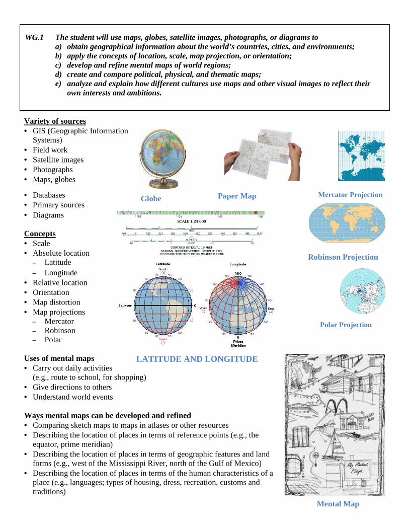
WG.1 The student will use maps, globes, satellite images, photographs, or diagrams to a) obtain geographical information about the world’s countries, cities, and environments; b) apply the concepts of location, scale, map projection, or orientation; c) develop and refine mental maps of world regions; d) create and compare political, physical, and thematic maps; e) analyze and explain how different cultures use maps and other visual images to reflect their
own interests and ambitions.
Variety of sources • GIS (Geographic Information
Systems) • Field work • Satellite images • Photographs • Maps, globes
• Databases • Primary sources • Diagrams Concepts • Scale • Absolute location
– Latitude – Longitude
• Relative location • Orientation • Map distortion • Map projections
– Mercator – Robinson – Polar
Uses of mental maps • Carry out daily activities
(e.g., route to school, for shopping) • Give directions to others • Understand world events Ways mental maps can be developed and refined • Comparing sketch maps to maps in atlases or other resources • Describing the location of places in terms of reference points (e.g., the
equator, prime meridian) • Describing the location of places in terms of geographic features and land
forms (e.g., west of the Mississippi River, north of the Gulf of Mexico) • Describing the location of places in terms of the human characteristics of a
place (e.g., languages; types of housing, dress, recreation, customs and traditions)
Paper Map Globe Mercator Projection
Robinson Projection
Polar Projection
LATITUDE AND LONGITUDE
Mental Map
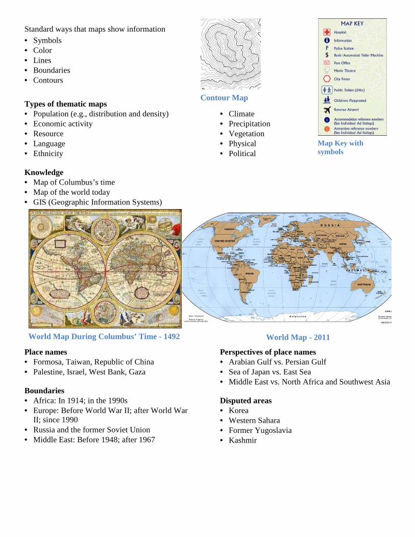
Standard ways that maps show information • Symbols • Color • Lines • Boundaries • Contours
Types of thematic maps • Population (e.g., distribution and density) • Economic activity • Resource • Language • Ethnicity
• Climate • Precipitation • Vegetation • Physical • Political
Knowledge • Map of Columbus’s time • Map of the world today • GIS (Geographic Information Systems)
Place names • Formosa, Taiwan, Republic of China • Palestine, Israel, West Bank, Gaza Boundaries • Africa: In 1914; in the 1990s • Europe: Before World War II; after World War
II; since 1990 • Russia and the former Soviet Union • Middle East: Before 1948; after 1967
Perspectives of place names • Arabian Gulf vs. Persian Gulf • Sea of Japan vs. East Sea • Middle East vs. North Africa and Southwest Asia Disputed areas • Korea • Western Sahara • Former Yugoslavia • Kashmir
Contour Map
Map Key with symbols
World Map During Columbus’ Time - 1492 World Map - 2011
WG.2 The student will analyze how selected physical and ecological processes shape the Earth’s surface by a) identifying regional climatic patterns and weather phenomena and their effects on people
and places; b) describing how humans influence the environment and are influenced by it; c) explaining how technology affects one’s ability to modify the environment and adapt to it.
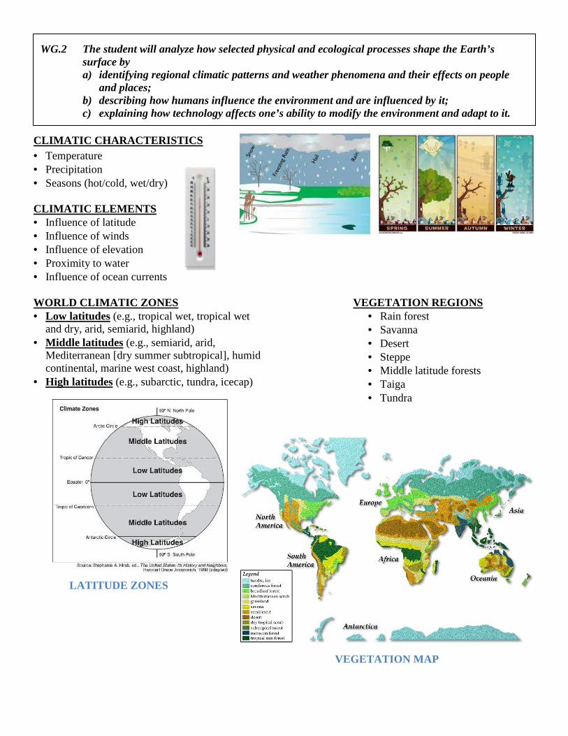
CLIMATIC CHARACTERISTICS • Temperature • Precipitation • Seasons (hot/cold, wet/dry) CLIMATIC ELEMENTS • Influence of latitude • Influence of winds • Influence of elevation • Proximity to water • Influence of ocean currents WORLD CLIMATIC ZONES • Low latitudes (e.g., tropical wet, tropical wet
and dry, arid, semiarid, highland) • Middle latitudes (e.g., semiarid, arid,
Mediterranean [dry summer subtropical], humid continental, marine west coast, highland)
• High latitudes (e.g., subarctic, tundra, icecap)
VEGETATION REGIONS • Rain forest • Savanna • Desert • Steppe • Middle latitude forests • Taiga • Tundra
VEGETATION MAP
LATITUDE ZONES
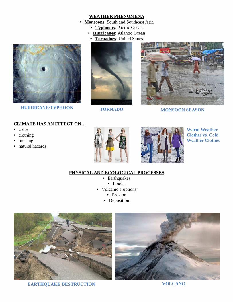
WEATHER PHENOMENA • Monsoons: South and Southeast Asia
• Typhoons: Pacific Ocean • Hurricanes: Atlantic Ocean • Tornadoes: United States
CLIMATE HAS AN EFFECT ON… • crops • clothing • housing • natural hazards.
PHYSICAL AND ECOLOGICAL PROCESSES
• Earthquakes • Floods
• Volcanic eruptions • Erosion
• Deposition
HURRICANE/TYPHOON TORNADO MONSOON SEASON
EARTHQUAKE DESTRUCTION VOLCANO
Warm Weather Clothes vs. Cold Weather Clothes
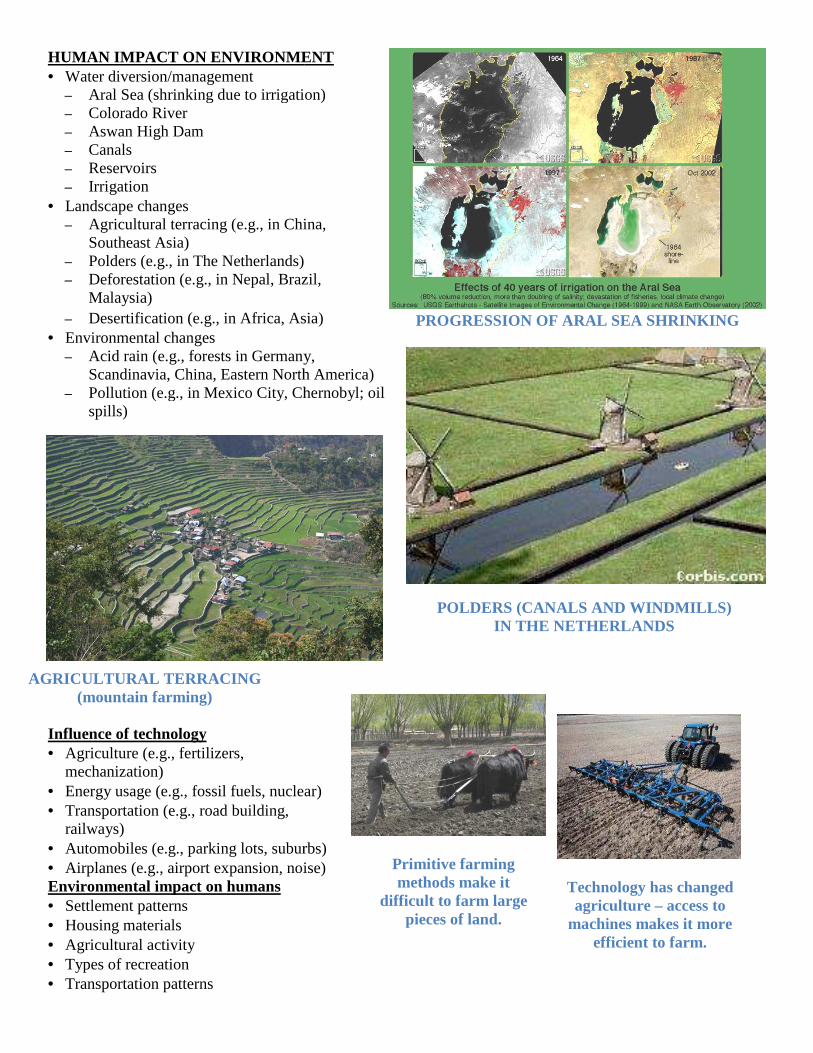
HUMAN IMPACT ON ENVIRONMENT• Water diversion/management
– Aral Sea (shrinking due to irrigation)– Colorado River – Aswan High Dam – Canals – Reservoirs – Irrigation
• Landscape changes – Agricultural terracing (e.g., in China,
Southeast Asia) – Polders (e.g., in The Netherlands)– Deforestation (e.g., in Nepal, Brazil,
Malaysia) – Desertification (e.g., in Africa, Asia)
• Environmental changes – Acid rain (e.g., forests in Germany,
Scandinavia, China, Eastern North America)– Pollution (e.g., in Mexico City, Chernobyl; oil
spills)
Influence of technology • Agriculture (e.g., fertilizers,
mechanization) • Energy usage (e.g., fossil fuels, nuclear)• Transportation (e.g., road building,
railways) • Automobiles (e.g., parking lots, suburbs)• Airplanes (e.g., airport expansion, noise)Environmental impact on humans • Settlement patterns • Housing materials • Agricultural activity • Types of recreation • Transportation patterns
AGRICULTURAL TERRACING (mountain farming)
HUMAN IMPACT ON ENVIRONMENT
(shrinking due to irrigation)
Agricultural terracing (e.g., in China,
Polders (e.g., in The Netherlands) Deforestation (e.g., in Nepal, Brazil,
Desertification (e.g., in Africa, Asia)
Acid rain (e.g., forests in Germany, Scandinavia, China, Eastern North America) Pollution (e.g., in Mexico City, Chernobyl; oil
Energy usage (e.g., fossil fuels, nuclear)
Automobiles (e.g., parking lots, suburbs) Airplanes (e.g., airport expansion, noise)
PROGRESSION OF ARAL SEA SHRINKING
POLDERS (CANALS AND WINDMILLS) IN THE NETHERLANDS
Technology has changed agriculture
machines makes it more efficient to farm.
Primitive farming methods make it
difficult to farm large pieces of land.
PROGRESSION OF ARAL SEA SHRINKING
POLDERS (CANALS AND WINDMILLS) IN THE NETHERLANDS
Technology has changed agriculture – access to
machines makes it more efficient to farm.
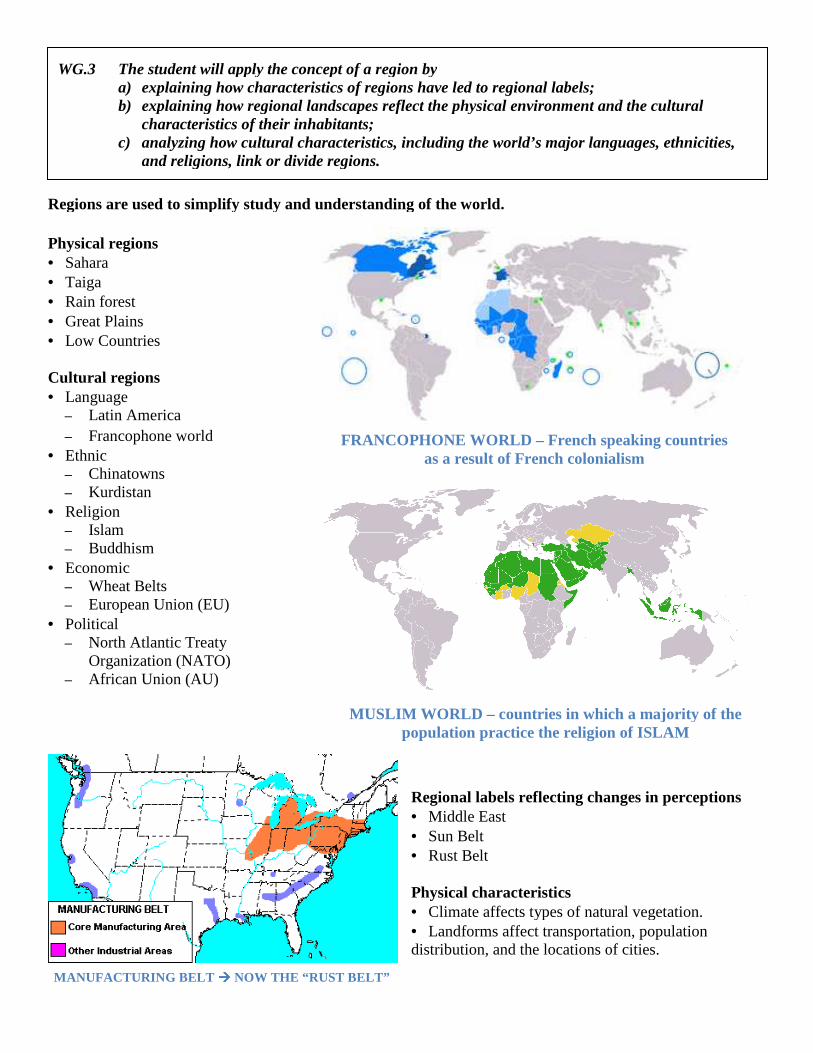
MANUFACTURING BELT ���� NOW THE “
WG.3 The student will apply the concept of a region bya) explaining how characteristics of regions have led to regional labels;b) explaining how regional landscapes reflect the physical
characteristics of their inhabitants;c) analyzing how cultural characteristics, including the world’s major languages, ethnicities,
and religions, link or divide regions.
Regions are used to simplify study and understanding Physical regions • Sahara • Taiga • Rain forest • Great Plains • Low Countries Cultural regions • Language
– Latin America – Francophone world
• Ethnic – Chinatowns – Kurdistan
• Religion – Islam – Buddhism
• Economic – Wheat Belts – European Union (EU)
• Political – North Atlantic Treaty
Organization (NATO) – African Union (AU)
NOW THE “ RUST BELT”
The student will apply the concept of a region by explaining how characteristics of regions have led to regional labels; explaining how regional landscapes reflect the physical environment and the cultural characteristics of their inhabitants; analyzing how cultural characteristics, including the world’s major languages, ethnicities, and religions, link or divide regions.
Regions are used to simplify study and understanding of the world.
Regional labels reflecting changes in perceptions• Middle East • Sun Belt • Rust Belt Physical characteristics • Climate affects types of natural vegetation.• Landforms affect transportation, population distribution, and the locations of cities.
FRANCOPHONE WORLD – French speaking countries as a result of French colonialism
MUSLIM WORLD – countries in which a majority of the population practice the religion of ISLAM
environment and the cultural
analyzing how cultural characteristics, including the world’s major languages, ethnicities,
reflecting changes in perceptions
Climate affects types of natural vegetation. Landforms affect transportation, population
distribution, and the locations of cities.
French speaking countries as a result of French colonialism
countries in which a majority of the population practice the religion of ISLAM
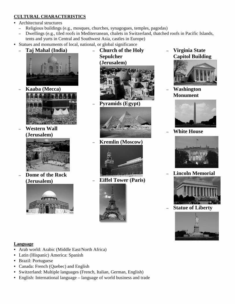
CULTURAL CHARACTERISTICS • Architectural structures
– Religious buildings (e.g., mosques, churches, synagogues, temples, pagodas)– Dwellings (e.g., tiled roofs in Mediterranean, chalets in Switzerland, thatched roofs in Pacific Islands,
tents and yurts in Central and Southwest Asia, castles in Europe)• Statues and monuments of local, national, or global significance
– Taj Mahal (India)
– Kaaba (Mecca)
– Western Wall
(Jerusalem)
– Dome of the Rock
(Jerusalem)
Language • Arab world: Arabic (Middle East/North Africa)• Latin (Hispanic) America: Spanish • Brazil: Portuguese • Canada: French (Quebec) and English• Switzerland: Multiple languages (French, Italian, German, English)• English: International language – language of world business and trade
Religious buildings (e.g., mosques, churches, synagogues, temples, pagodas) Dwellings (e.g., tiled roofs in Mediterranean, chalets in Switzerland, thatched roofs in Pacific Islands,
yurts in Central and Southwest Asia, castles in Europe) Statues and monuments of local, national, or global significance
– Church of the Holy Sepulcher (Jerusalem)
– Pyramids (Egypt)
– Kremlin (Moscow)
– Eiffel Tower (Paris)
– Virginia State Capitol Building
– Washington Monument
– White House
– Lincoln Memorial
– Statue of Liberty
(Middle East/North Africa)
and English (French, Italian, German, English) language of world business and trade
Dwellings (e.g., tiled roofs in Mediterranean, chalets in Switzerland, thatched roofs in Pacific Islands,
Virginia State Capitol Building
Washington Monument
White House
Lincoln Memorial
Statue of Liberty
Ethnic heritage • Former Yugoslavia: Serbs, Croats, Bosnians, Albanians • Burundi and Rwanda: Hutus and Tutsis • United States, Switzerland: Multiple ethnicities united in one
country • Korea, Japan: Predominantly single ethnicity • Cyprus: Greeks and Turks Religion as a unifying force • Hinduism • Buddhism • Judaism • Christianity • Islam
Religious Conflicts • Conflict between Hindus and Muslims in Pakistan
and India • Conflict between Catholics and Protestants in
Northern Ireland • Jews, Christians, and Muslims all claim Jerusalem
as a religious heritage site • Conflicts between Sunni and Shi’a Muslims
MAP OF WORLD RELIGIONS
Symbols of major world religions
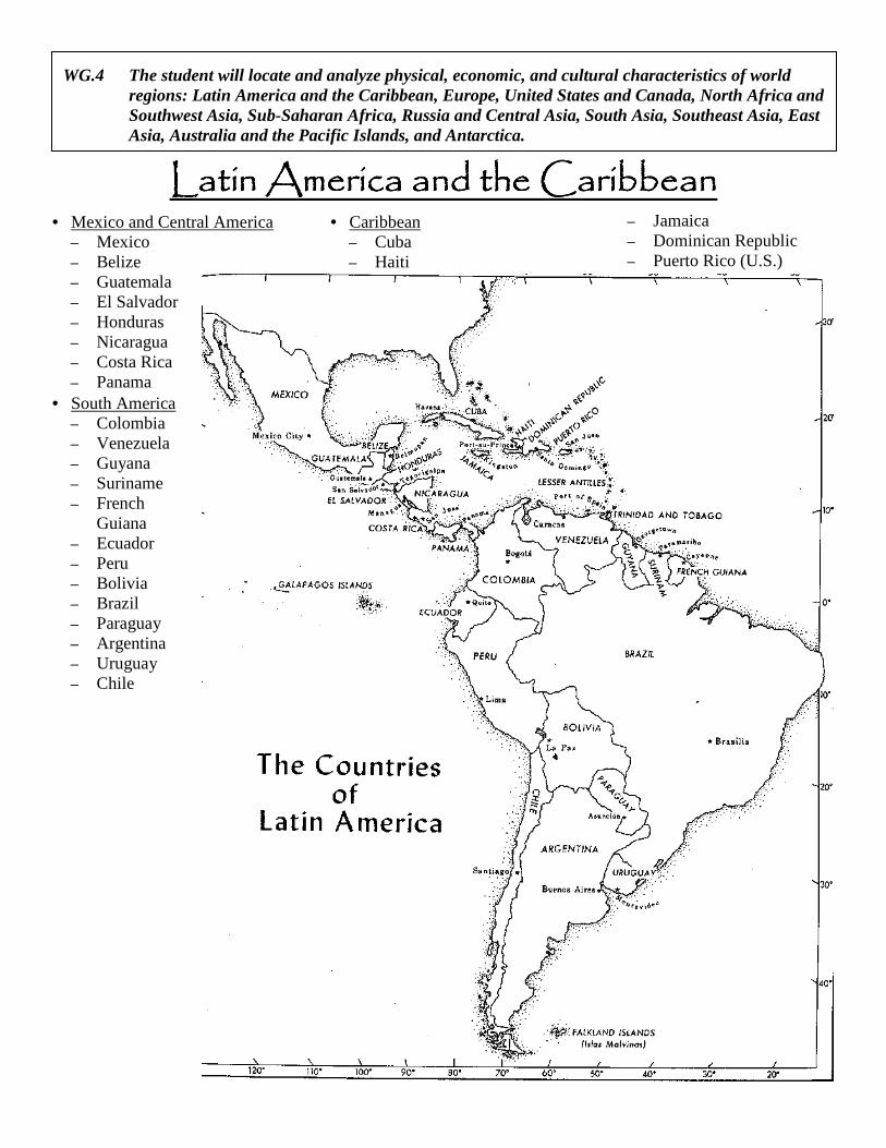
Latin America and the CaribbeanLatin America and the CaribbeanLatin America and the CaribbeanLatin America and the Caribbean • Mexico and Central America
– Mexico – Belize – Guatemala – El Salvador – Honduras – Nicaragua – Costa Rica – Panama
• South America – Colombia – Venezuela – Guyana – Suriname – French
Guiana – Ecuador – Peru – Bolivia – Brazil – Paraguay – Argentina – Uruguay – Chile
• Caribbean – Cuba – Haiti
– Jamaica – Dominican Republic – Puerto Rico (U.S.)
WG.4 The student will locate and analyze physical, economic, and cultural characteristics of world regions: Latin America and the Caribbean, Europe, United States and Canada, North Africa and Southwest Asia, Sub-Saharan Africa, Russia and Central Asia, South Asia, Southeast Asia, East Asia, Australia and the Pacific Islands, and Antarctica.
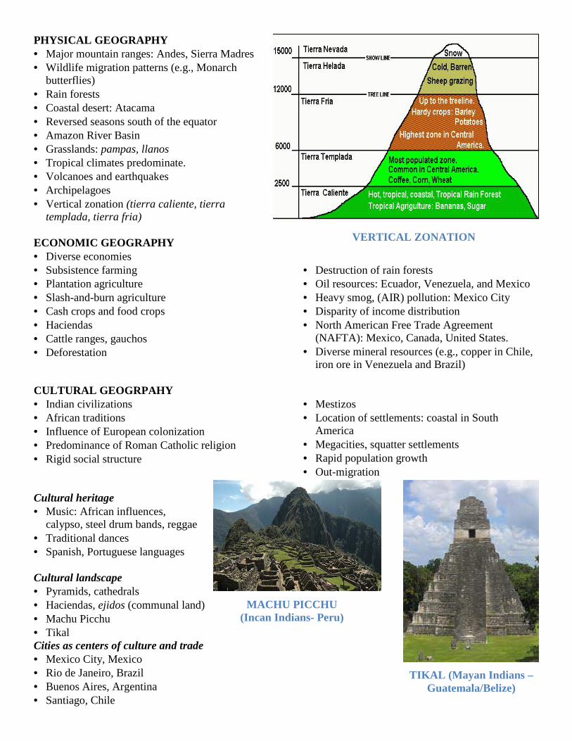
PHYSICAL GEOGRAPHY • Major mountain ranges: Andes, Sierra Madres • Wildlife migration patterns (e.g., Monarch
butterflies) • Rain forests • Coastal desert: Atacama • Reversed seasons south of the equator • Amazon River Basin • Grasslands: pampas, llanos • Tropical climates predominate. • Volcanoes and earthquakes • Archipelagoes • Vertical zonation (tierra caliente, tierra
templada, tierra fria) ECONOMIC GEOGRAPHY • Diverse economies • Subsistence farming • Plantation agriculture • Slash-and-burn agriculture • Cash crops and food crops • Haciendas • Cattle ranges, gauchos • Deforestation
• Destruction of rain forests • Oil resources: Ecuador, Venezuela, and Mexico • Heavy smog, (AIR) pollution: Mexico City • Disparity of income distribution • North American Free Trade Agreement
(NAFTA): Mexico, Canada, United States. • Diverse mineral resources (e.g., copper in Chile,
iron ore in Venezuela and Brazil) CULTURAL GEOGRPAHY • Indian civilizations • African traditions • Influence of European colonization • Predominance of Roman Catholic religion • Rigid social structure
• Mestizos • Location of settlements: coastal in South
America • Megacities, squatter settlements • Rapid population growth • Out-migration
Cultural heritage • Music: African influences,
calypso, steel drum bands, reggae • Traditional dances • Spanish, Portuguese languages Cultural landscape • Pyramids, cathedrals • Haciendas, ejidos (communal land) • Machu Picchu • Tikal Cities as centers of culture and trade • Mexico City, Mexico • Rio de Janeiro, Brazil • Buenos Aires, Argentina • Santiago, Chile
VERTICAL ZONATION
MACHU PICCHU (Incan Indians- Peru)
TIKAL (Mayan Indians – Guatemala/Belize)
EUROPE Location of countries, with particular emphasis on the countries listed below (selected on the basis of their per capita GDP, land size, and population) • GDP
– Norway – Switzerland – Luxembourg
• Land size – Ukraine – France – Spain
• Population – Germany – United Kingdom – Italy – France
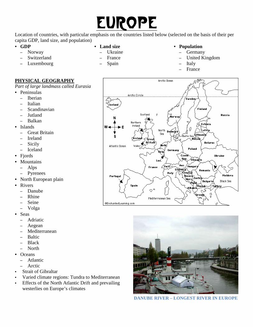
PHYSICAL GEOGRAPHY Part of large landmass called Eurasia • Peninsulas
– Iberian – Italian – Scandinavian – Jutland – Balkan
• Islands – Great Britain – Ireland – Sicily – Iceland
• Fjords • Mountains
– Alps – Pyrenees
• North European plain • Rivers
– Danube – Rhine – Seine – Volga
• Seas – Adriatic – Aegean – Mediterranean – Baltic – Black – North
• Oceans – Atlantic – Arctic
• Strait of Gibraltar • Varied climate regions: Tundra to Mediterranean • Effects of the North Atlantic Drift and prevailing
westerlies on Europe’s climates
DANUBE RIVER – LONGEST RIVER IN EUROPE
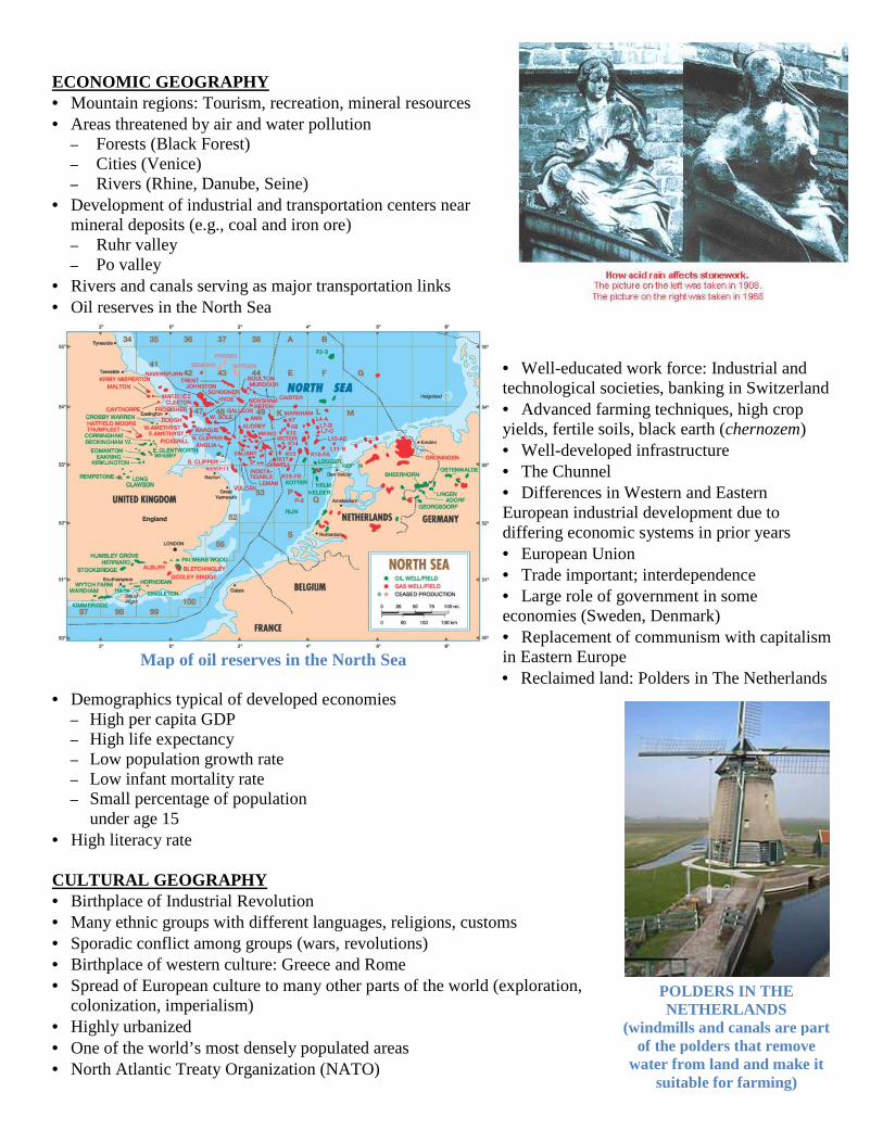
ECONOMIC GEOGRAPHY • Mountain regions: Tourism, recreation, mineral resources• Areas threatened by air and water pollution
– Forests (Black Forest) – Cities (Venice) – Rivers (Rhine, Danube, Seine)
• Development of industrial and transportation centers near mineral deposits (e.g., coal and iron ore)– Ruhr valley – Po valley
• Rivers and canals serving as major transportation links• Oil reserves in the North Sea
• Demographics typical of developed economies– High per capita GDP – High life expectancy – Low population growth rate – Low infant mortality rate – Small percentage of population
under age 15 • High literacy rate CULTURAL GEOGRAPHY • Birthplace of Industrial Revolution • Many ethnic groups with different languages, religions, customs• Sporadic conflict among groups (wars, revolutions)• Birthplace of western culture: Greece and Rome• Spread of European culture to many other parts of the world (exploration,
colonization, imperialism) • Highly urbanized • One of the world’s most densely populated areas• North Atlantic Treaty Organization (NATO)
Map of oil reserves in the North Sea
Mountain regions: Tourism, recreation, mineral resources Areas threatened by air and water pollution
Development of industrial and transportation centers near mineral deposits (e.g., coal and iron ore)
Rivers and canals serving as major transportation links
• Well-educated work force: Industrial and technological societies, banking in Switzerland• Advanced farming techniques, high crop yields, fertile soils, black earth (• Well-developed infrastructure• The Chunnel • Differences in Western and EaEuropean industrial development due to differing economic systems in prior years• European Union • Trade important; interdependence• Large role of government in some economies (Sweden, Denmark)• Replacement of communism with capitalism in Eastern Europe • Reclaimed land: Polders in The Netherlands
Demographics typical of developed economies
Many ethnic groups with different languages, religions, customs Sporadic conflict among groups (wars, revolutions) Birthplace of western culture: Greece and Rome Spread of European culture to many other parts of the world (exploration,
of the world’s most densely populated areas North Atlantic Treaty Organization (NATO)
PO
(windmills and canals are part of the polders that remove
water from land and make it suitable for farming)
Map of oil reserves in the North Sea
educated work force: Industrial and technological societies, banking in Switzerland
Advanced farming techniques, high crop yields, fertile soils, black earth (chernozem)
developed infrastructure
Differences in Western and Eastern European industrial development due to differing economic systems in prior years
Trade important; interdependence Large role of government in some
economies (Sweden, Denmark) communism with capitalism
Reclaimed land: Polders in The Netherlands
POLDERS IN THE NETHERLANDS
(windmills and canals are part of the polders that remove
water from land and make it suitable for farming)
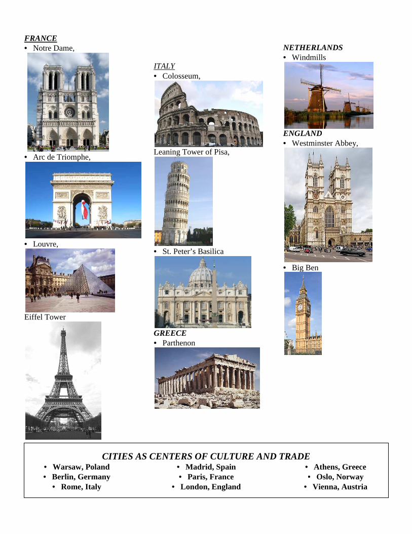
FRANCE • Notre Dame,
• Arc de Triomphe,
• Louvre,
Eiffel Tower
ITALY•
Leaning Tower of Pisa,
•
GREECE•
CITIES AS CENTERS OF CULTURE AND TRADE• Warsaw, Poland • Berlin, Germany
• Rome, Italy
ITALY • Colosseum,
Leaning Tower of Pisa,
• St. Peter’s Basilica
GREECE • Parthenon
NETHERLANDS• Windmills
ENGLAND• Westminster Abbey,
• Big Ben
CITIES AS CENTERS OF CULTURE AND TRADE
• Madrid, Spain • Paris, France
• London, England
••
•
NETHERLANDS Windmills
ENGLAND Westminster Abbey,
Big Ben
CITIES AS CENTERS OF CULTURE AND TRADE • Athens, Greece • Oslo, Norway Vienna, Austria
United States And CanadaUnited States And CanadaUnited States And CanadaUnited States And Canada• United States • Canada
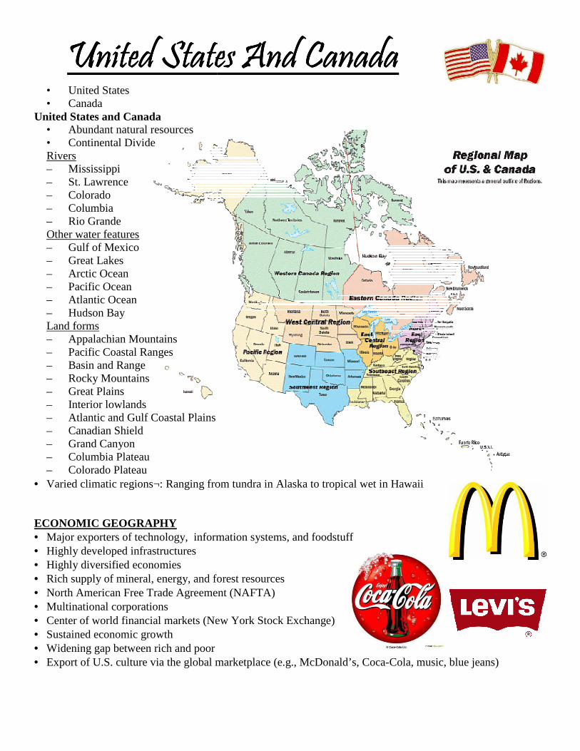
United States and Canada • Abundant natural resources • Continental Divide Rivers – Mississippi – St. Lawrence – Colorado – Columbia – Rio Grande Other water features – Gulf of Mexico – Great Lakes – Arctic Ocean – Pacific Ocean – Atlantic Ocean – Hudson Bay Land forms – Appalachian Mountains – Pacific Coastal Ranges – Basin and Range – Rocky Mountains – Great Plains – Interior lowlands – Atlantic and Gulf Coastal Plains – Canadian Shield – Grand Canyon – Columbia Plateau – Colorado Plateau
• Varied climatic regions¬: Ranging from tundra in Alaska to tropical wet in Hawaii
ECONOMIC GEOGRAPHY • Major exporters of technology, information systems, and foodstuff• Highly developed infrastructures • Highly diversified economies • Rich supply of mineral, energy, and forest resources• North American Free Trade Agreement (NAFTA)• Multinational corporations • Center of world financial markets (New• Sustained economic growth • Widening gap between rich and poor • Export of U.S. culture via the global marketplace (e.g., McDonald’s, Coca
United States And CanadaUnited States And CanadaUnited States And CanadaUnited States And Canada
Varied climatic regions¬: Ranging from tundra in Alaska to tropical wet in Hawaii
mation systems, and foodstuff
Rich supply of mineral, energy, and forest resources North American Free Trade Agreement (NAFTA)
Center of world financial markets (New York Stock Exchange)
Export of U.S. culture via the global marketplace (e.g., McDonald’s, Coca-Cola, music, blue jeans)Cola, music, blue jeans)
CULTURAL GEOGRAPHY• Colonized by the Europeans • Multicultural societies • Increasingly diverse populations • High literacy rate • High standards of living • Highly urbanized • Canada’s struggle to maintain a national identity
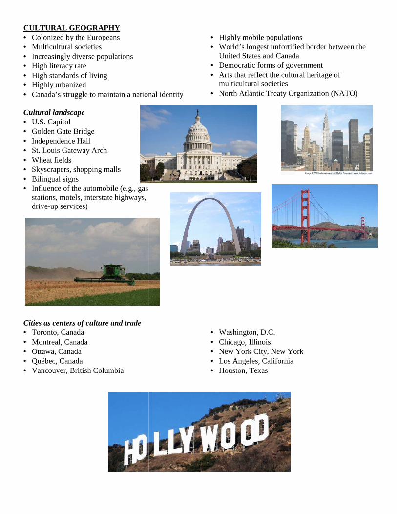
Cultural landscape • U.S. Capitol • Golden Gate Bridge • Independence Hall • St. Louis Gateway Arch • Wheat fields • Skyscrapers, shopping malls • Bilingual signs • Influence of the automobile (e.g., gas
stations, motels, interstate highways, drive-up services)
Cities as centers of culture and trade • Toronto, Canada • Montreal, Canada • Ottawa, Canada • Québec, Canada • Vancouver, British Columbia
Canada’s struggle to maintain a national identity
• Highly mobile populations• World’s longest unfortified border between the
United States and Canada• Democratic forms of government• Arts that reflect the cultural heritage of
multicultural societies • North Atlantic Treaty Organization (NATO)
Influence of the automobile (e.g., gas
• Washington, D.C. • Chicago, Illinois • New York City, New York• Los Angeles, California • Houston, Texas
Highly mobile populations World’s longest unfortified border between the
nd Canada Democratic forms of government Arts that reflect the cultural heritage of
North Atlantic Treaty Organization (NATO)
, New York
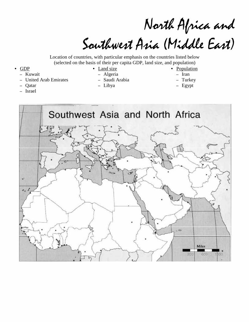
North Africa and Southwest Asia (Middle East)
Location of countries, with particular emphasis on the countries listed below (selected on the basis of their per capita GDP, land size, and population)
• GDP – Kuwait – United Arab Emirates – Qatar – Israel
• Land size – Algeria – Saudi Arabia – Libya
• Population – Iran – Turkey – Egypt
PHYSICAL GEOGRAPHY • Crossroads of Europe, Africa, and Asia • Desert and semiarid climates: Sahara, sahel, steppes • Mountains
– Atlas – Taurus – Zagros
• Water features – Mediterranean Sea – Red Sea – Black Sea – Arabian Sea – Persian/Arabian Gulf – Strait of Hormuz – Bosporus Strait – Dardanelles Strait – Nile River
– Tigris River – Euphrates River – Jordan River
• Seasonal flooding, alluvial soils, delta regions, oases, wadis ECONOMIC GEOGRAPHY • Heavy reliance on primary economic activity - oil drilling, agriculture, pastoralism • Major producer of world’s oil • Oil revenues: pays for infrastructure,
education, etc. • Water: The region’s most precious
resource • Great variation in standards of living,
ranging from very high to poverty-stricken
• Regional conflicts, political unrest that affects tourism
• Aswan High Dam: Positive and negative effects • Suez Canal: Enhanced shipping routes in the region • Guest workers • Trade important to region from earliest time • Wide range of per capita incomes and levels of development • Contemporary trade routes (sea lanes) • Organization of Petroleum Exporting Countries (OPEC)
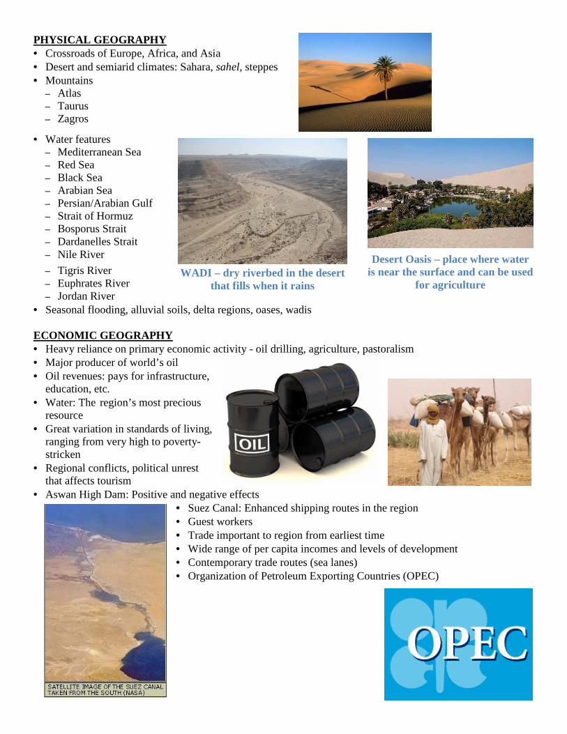
WADI – dry riverbed in the desert that fills when it rains
Desert Oasis – place where water is near the surface and can be used
for agriculture
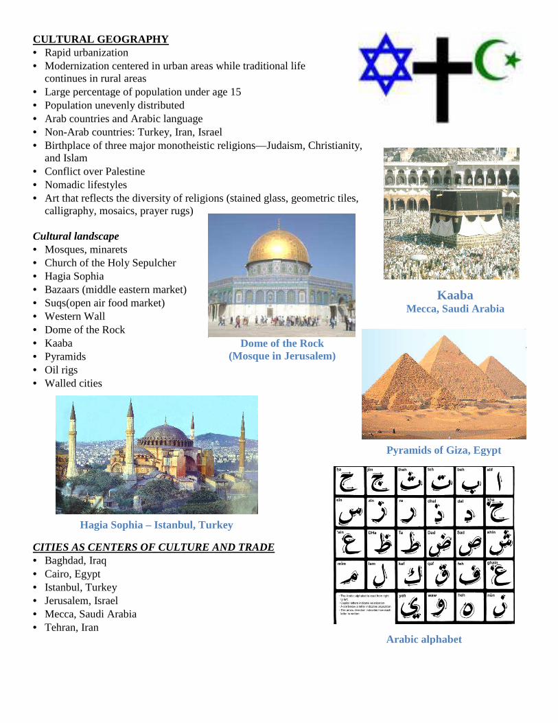
CULTURAL GEOGRAPHY • Rapid urbanization • Modernization centered in urban areas while traditional life
continues in rural areas • Large percentage of population under age 15• Population unevenly distributed • Arab countries and Arabic language • Non-Arab countries: Turkey, Iran, Israel• Birthplace of three major monotheistic religions
and Islam • Conflict over Palestine • Nomadic lifestyles • Art that reflects the diversity of religions (stained glass, geometric tiles,
calligraphy, mosaics, prayer rugs) Cultural landscape • Mosques, minarets • Church of the Holy Sepulcher • Hagia Sophia • Bazaars (middle eastern market) • Suqs(open air food market) • Western Wall • Dome of the Rock • Kaaba • Pyramids • Oil rigs • Walled cities CITIES AS CENTERS OF CULTURE AND TRADE• Baghdad, Iraq • Cairo, Egypt • Istanbul, Turkey • Jerusalem, Israel • Mecca, Saudi Arabia • Tehran, Iran
Hagia Sophia – Istanbul, Turkey
Modernization centered in urban areas while traditional life
Large percentage of population under age 15
Arab countries: Turkey, Iran, Israel
Birthplace of three major monotheistic religions—Judaism, Christianity,
Art that reflects the diversity of religions (stained glass, geometric tiles,
CITIES AS CENTERS OF CULTURE AND TRADE
Mecca, Saudi Arabia
Dome of the Rock (Mosque in Jerusalem)
Pyramids of Giza, Egypt
Istanbul, Turkey
Arabic alphabet
Kaaba Mecca, Saudi Arabia
Pyramids of Giza, Egypt
Arabic alphabet
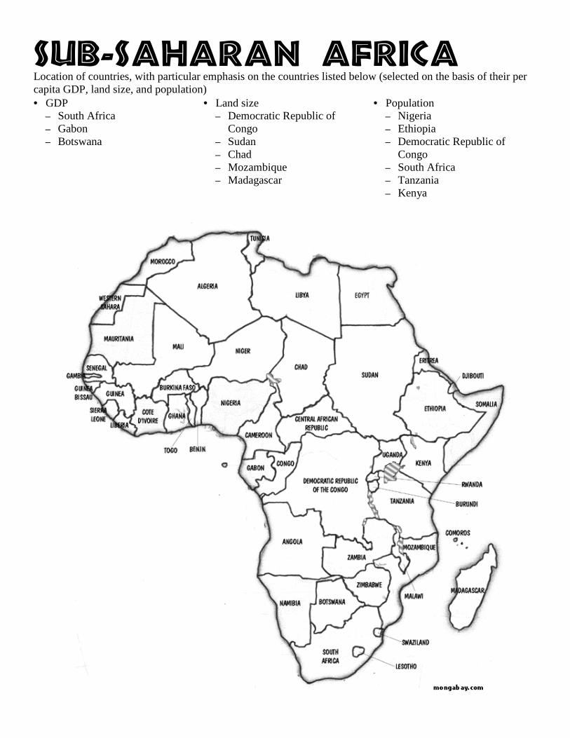
Tvc.Tbibsbo!Bgsjdb!Location of countries, with particular emphasis on the countries listed below (selected on the basis of their per capita GDP, land size, and population) • GDP
– South Africa – Gabon – Botswana
• Land size – Democratic Republic of
Congo – Sudan – Chad – Mozambique – Madagascar
• Population – Nigeria – Ethiopia – Democratic Republic of
Congo – South Africa – Tanzania – Kenya
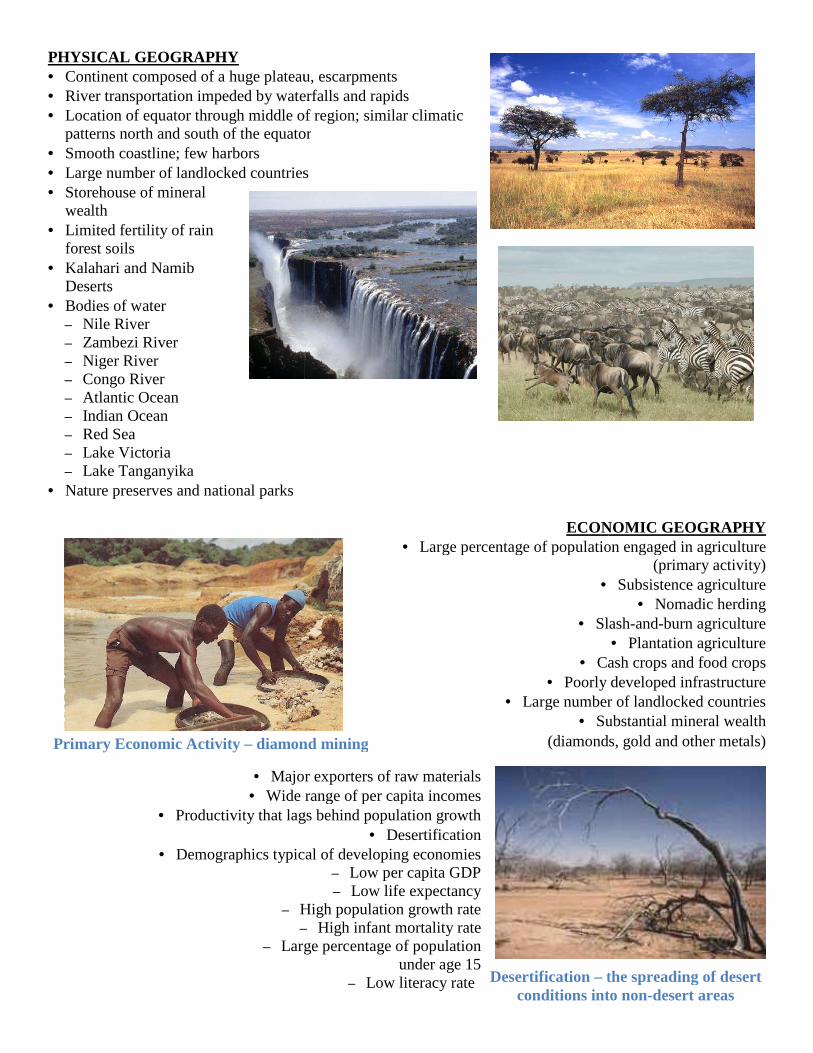
PHYSICAL GEOGRAPHY • Continent composed of a huge plateau, escarpments• River transportation impeded by waterfalls and rapids• Location of equator through middle of region; similar climatic
patterns north and south of the equator• Smooth coastline; few harbors • Large number of landlocked countries• Storehouse of mineral
wealth • Limited fertility of rain
forest soils • Kalahari and Namib
Deserts • Bodies of water
– Nile River – Zambezi River – Niger River – Congo River – Atlantic Ocean – Indian Ocean – Red Sea – Lake Victoria – Lake Tanganyika
• Nature preserves and national parks
• Major exporters of raw materials• Wide range of per capita incomes
• Productivity that lags behind population growth
• Demographics typical of developing economies
– High population growth rate–
– Large percentage of population
Primary Economic Activity – diamond mining
Continent composed of a huge plateau, escarpments River transportation impeded by waterfalls and rapids Location of equator through middle of region; similar climatic patterns north and south of the equator
Large number of landlocked countries
ECONOMIC GEOGRAPHY• Large percentage of population engaged in agriculture
•
• Slash
• Cash crops and food crops• Poorly developed infrastructure
• Large number of landlocked countrie• Substantial mineral wealth
(diamonds, gold and other metals)
Major exporters of raw materials Wide range of per capita incomes
Productivity that lags behind population growth • Desertification
typical of developing economies – Low per capita GDP – Low life expectancy
High population growth rate – High infant mortality rate
Large percentage of population under age 15
– Low literacy rate
diamond mining
Desertification – the spreading of desert conditions into non
ECONOMIC GEOGRAPHY Large percentage of population engaged in agriculture
(primary activity) Subsistence agriculture
• Nomadic herding Slash-and-burn agriculture
• Plantation agriculture Cash crops and food crops
Poorly developed infrastructure Large number of landlocked countries
Substantial mineral wealth (diamonds, gold and other metals)
the spreading of desert conditions into non-desert areas
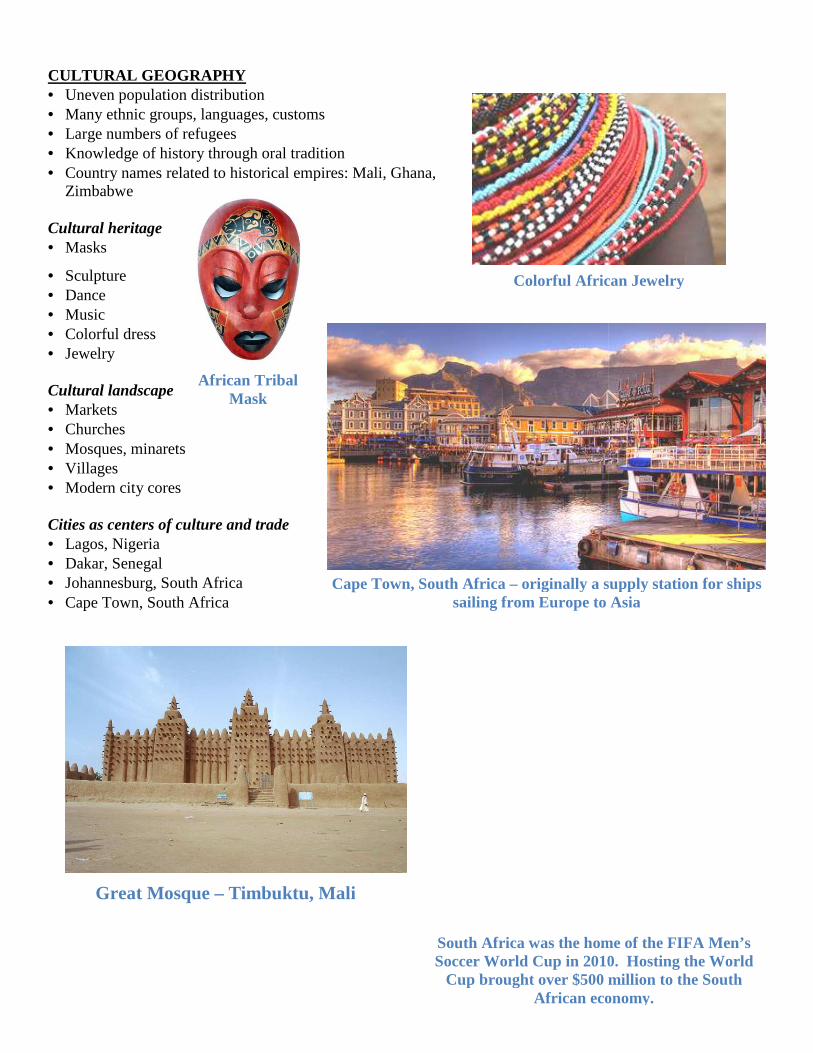
CULTURAL GEOGRAPHY • Uneven population distribution • Many ethnic groups, languages, customs• Large numbers of refugees • Knowledge of history through oral tradition• Country names related to historical empires: Mali,
Zimbabwe Cultural heritage • Masks
• Sculpture • Dance • Music • Colorful dress • Jewelry Cultural landscape • Markets • Churches • Mosques, minarets • Villages • Modern city cores Cities as centers of culture and trade • Lagos, Nigeria • Dakar, Senegal • Johannesburg, South Africa • Cape Town, South Africa
Great Mosque – Timbuktu, Mali
African Tribal Mask
Many ethnic groups, languages, customs
Knowledge of history through oral tradition Country names related to historical empires: Mali, Ghana,
Cape Town, South Africa – originally a supply station for ships sailing from Europe to Asia
Timbuktu, Mali
South Africa was the home of the FIFA Men’s Soccer World Cup in 2010. Hosting the World
Cup brought over $500 million to the South African economy.
Colorful African Jewelry
originally a supply station for ships sailing from Europe to Asia
South Africa was the home of the FIFA Men’s 2010. Hosting the World
Cup brought over $500 million to the South African economy.
Colorful African Jewelry
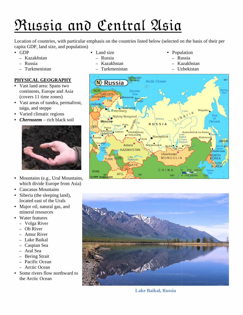
Russia and Central AsiaLocation of countries, with particular emphasis on the countries listed below (selected on the basis of their per capita GDP, land size, and population) • GDP
– Kazakhstan – Russia – Turkmenistan
•
PHYSICAL GEOGRAPHY • Vast land area: Spans two
continents, Europe and Asia (covers 11 time zones)
• Vast areas of tundra, permafrost, taiga, and steppe
• Varied climatic regions • Chernozem – rich black soil
• Mountains (e.g., Ural Mountains, which divide Europe from Asia)
• Caucasus Mountains • Siberia (the sleeping land),
located east of the Urals • Major oil, natural gas, and
mineral resources • Water features
– Volga River – Ob River – Amur River – Lake Baikal – Caspian Sea – Aral Sea – Bering Strait – Pacific Ocean – Arctic Ocean
• Some rivers flow northward to the Arctic Ocean
Russia and Central Asia Location of countries, with particular emphasis on the countries listed below (selected on the basis of their per
• Land size – Russia – Kazakhstan – Turkmenistan
• Population– Russia– Kazakhstan– Uzbekistan
Lake Baikal, Russia
Location of countries, with particular emphasis on the countries listed below (selected on the basis of their per
Population Russia Kazakhstan Uzbekistan
Russian Ballet
ECONOMIC GEOGRAPHY • Transition from communist to free market
economy • Farming and industry concentrated in the Fertile
Triangle region, rich chernozem soils (wheat farming)
• Infrastructure: Trans-Siberian Railroad, systems of rivers, canals, and railroads
• Energy resources: Hydroelectric power, oil, natural gas
• Russian natural resources not fully developed due to climate, limited transportation links, and vastness of the country
• Foreign competition for investment in the region (oil pipelines)
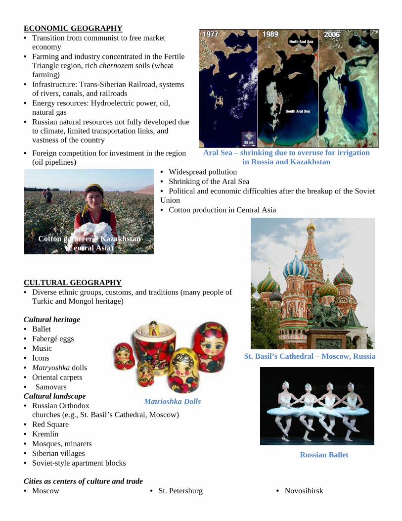
• Widespread pollution • Shrinking of the Aral Sea • Political and economic difficulties after the breakup of the Soviet Union • Cotton production in Central Asia
CULTURAL GEOGRAPHY • Diverse ethnic groups, customs, and traditions (many people of
Turkic and Mongol heritage) Cultural heritage • Ballet • Fabergé eggs • Music • Icons • Matryoshka dolls • Oriental carpets
• Samovars Cultural landscape • Russian Orthodox
churches (e.g., St. Basil’s Cathedral, Moscow) • Red Square • Kremlin • Mosques, minarets • Siberian villages • Soviet-style apartment blocks Cities as centers of culture and trade • Moscow • St. Petersburg • Novosibirsk
St. Basil’s Cathedral – Moscow, Russia
Aral Sea – shrinking due to overuse for irrigation in Russia and Kazakhstan
Cotton gatherer – Kazakhstan (Central Asia)
Matrioshka Dolls
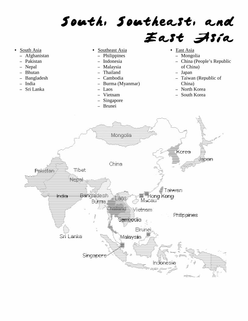
South, Southeast, and
• South Asia – Afghanistan – Pakistan – Nepal – Bhutan – Bangladesh – India – Sri Lanka
•
South, Southeast, and
East Asia• Southeast Asia
– Philippines – Indonesia – Malaysia – Thailand – Cambodia – Burma (Myanmar) – Laos – Vietnam – Singapore – Brunei
• East Asia– Mongolia– China (People’s Republic
of China)– Japan– Taiwan (Republic of
China)– North Korea– South Korea
South, Southeast, and
East Asia East Asia
Mongolia China (People’s Republic of China) Japan Taiwan (Republic of China) North Korea South Korea
ECONOMIC GEOGRAPHY • Varied economies in the region, ranging from subsistence/
commercial agriculture to high-tech industrial manufacturing• Participation in global markets
• Newly industrialized countries: South Korea, Taiwan, Singapore• Japan: Economic leader• China in transition from a centrally planned econ• Agricultural advancements and technology, enabling greater food production: “Green Revolution”• Environmental degradation• Deforestation• Fishing
• ASEAN (Association of Southeast Asian Nations)• Rice, tropical crops
Rice Paddy – terraced farming in Indonesia
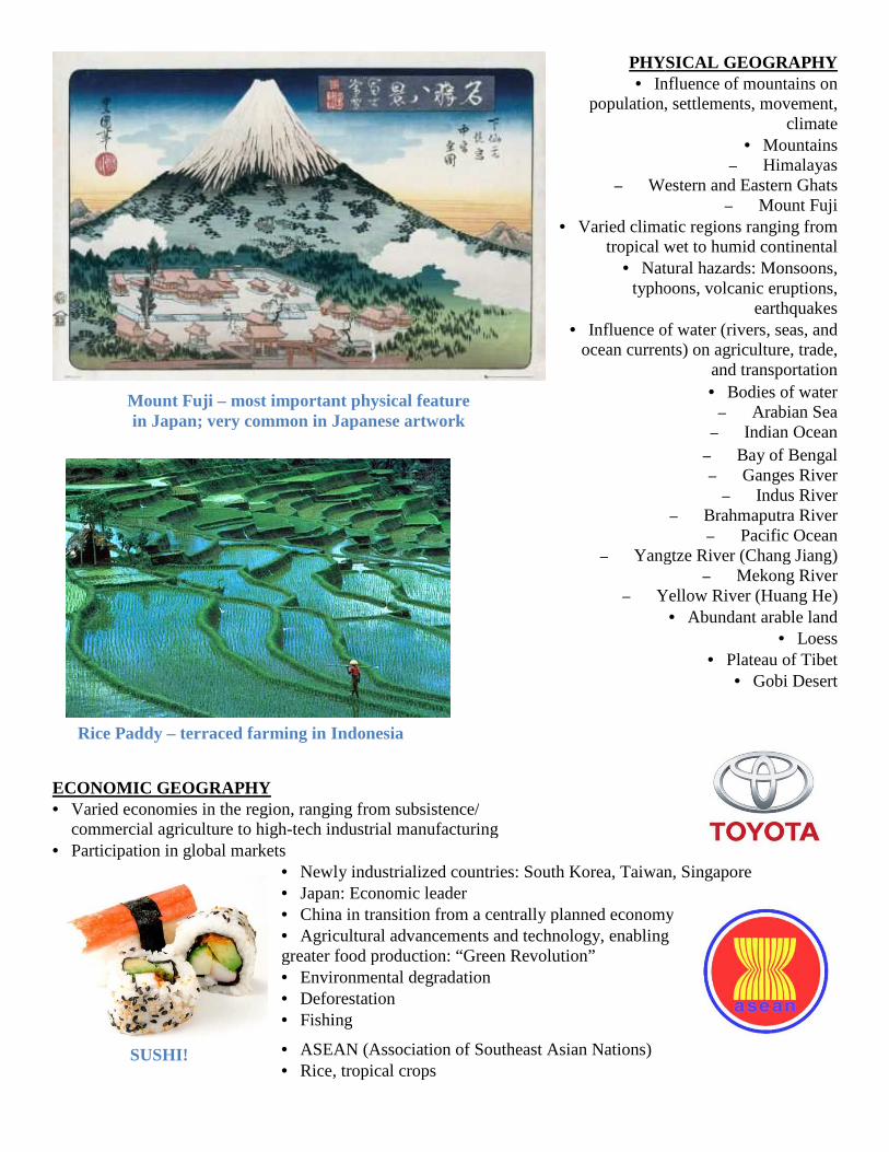
Mount Fuji – most important physical feature in Japan; very common in Japanese artwork
SUSHI!
PHYSICAL GEOGRAPHY• Influence of mountains
population, settlements, movement,
– Western and Eastern Ghats
• Varied climatic regions ranging from tropical wet to humid continental
• Natural hazards: Monsoons, typhoons, volcanic eruptions,
• Influence of ocean currents) on agriculture, trade,
– Yangtze River (Chang Jiang)
– Yellow River (Huang He)
ranging from subsistence/ tech industrial manufacturing
Newly industrialized countries: South Korea, Taiwan, SingaporeJapan: Economic leader China in transition from a centrally planned economyAgricultural advancements and technology, enabling
greater food production: “Green Revolution” Environmental degradation Deforestation Fishing
ASEAN (Association of Southeast Asian Nations) Rice, tropical crops
terraced farming in Indonesia
most important physical feature in Japan; very common in Japanese artwork
PHYSICAL GEOGRAPHY Influence of mountains on
population, settlements, movement, climate
• Mountains – Himalayas
Western and Eastern Ghats – Mount Fuji
Varied climatic regions ranging from tropical wet to humid continental
Natural hazards: Monsoons, typhoons, volcanic eruptions,
earthquakes Influence of water (rivers, seas, and
ocean currents) on agriculture, trade, and transportation • Bodies of water
– Arabian Sea – Indian Ocean
– Bay of Bengal – Ganges River
– Indus River – Brahmaputra River
– Pacific Ocean Yangtze River (Chang Jiang)
– Mekong River Yellow River (Huang He)
• Abundant arable land • Loess
• Plateau of Tibet • Gobi Desert
Newly industrialized countries: South Korea, Taiwan, Singapore
omy Agricultural advancements and technology, enabling
CULTURAL GEOGRAPHY • Areas of extremely dense and of sparse population • Contrast between rural and urban areas • Religious diversity: Hinduism, Islam, Buddhism,
Christianity, Taoism, Shinto, Confucianism • Respect for ancestors • Religious conflicts (Hindu vs. Muslim)
Cultural heritage • Silks • Batik • Wood and ivory carvings • Ideograms, unique alphabets • Jewels
Cultural landscape • Taj Mahal • Angkor Wat • Great Wall of China • Floating markets • Mosques, minarets • Pagodas • Temples and shrines • Terraced rice fields Cities as centers of culture and trade • Tokyo, Japan • Beijing, China • New Delhi, India
Taj Mahal - India
Great Wall of China
Buddhist Pagoda
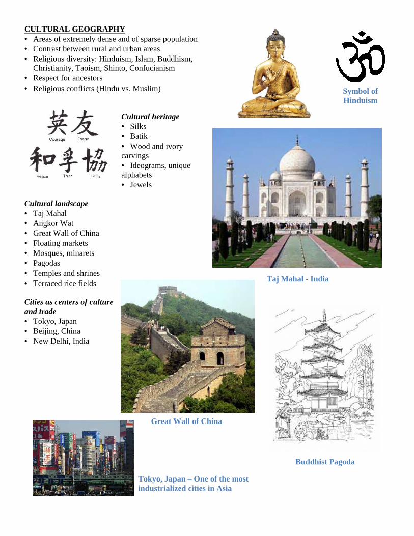
Symbol of Hinduism
Tokyo, Japan – One of the most industrialized cities in Asia
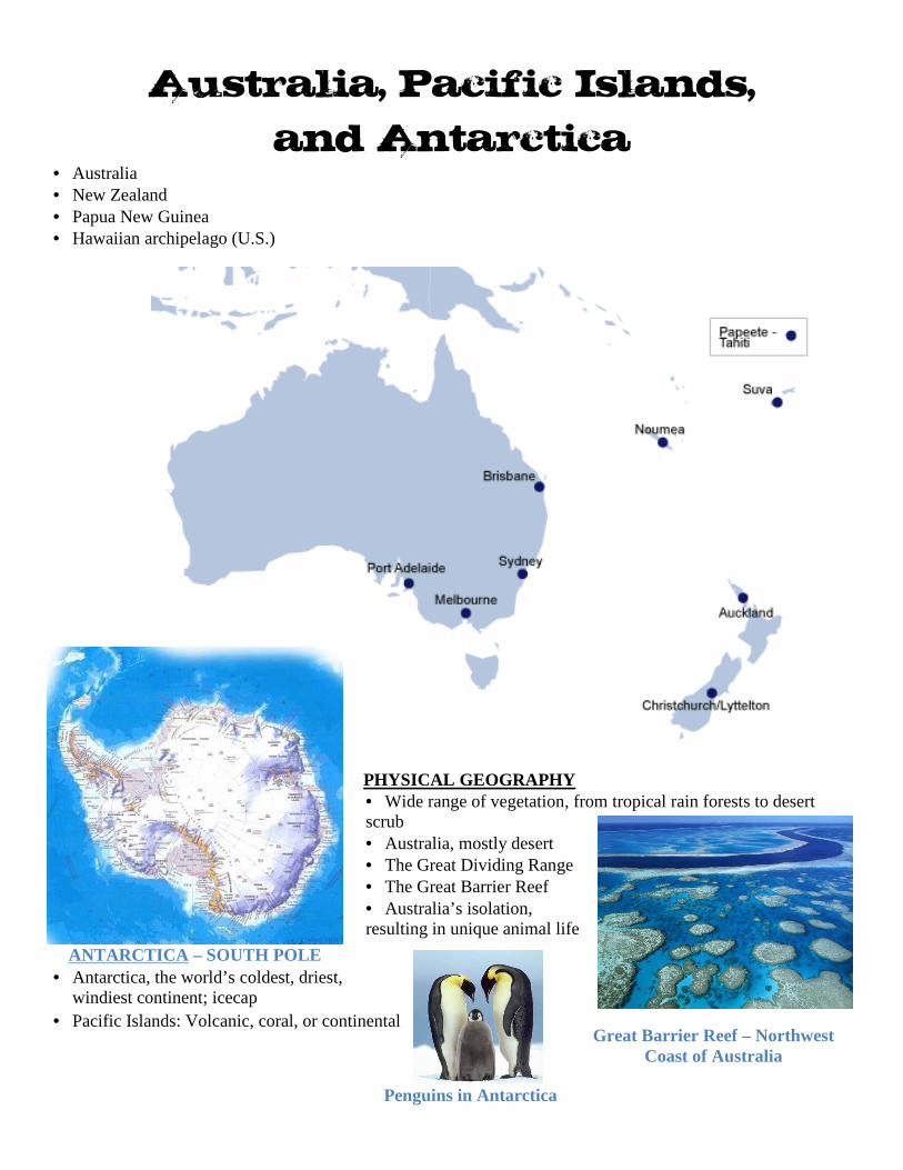
Australia, Pacific Islands,
and Antarctica • Australia • New Zealand • Papua New Guinea • Hawaiian archipelago (U.S.)
PHYSICAL GEOGRAPHY • Wide range of vegetation, from tropical rain forests to desert scrub • Australia, mostly desert • The Great Dividing Range • The Great Barrier Reef • Australia’s isolation, resulting in unique animal life
• Antarctica, the world’s coldest, driest, windiest continent; icecap
• Pacific Islands: Volcanic, coral, or continental
ANTARCTICA – SOUTH POLE
Great Barrier Reef – Northwest Coast of Australia
Penguins in Antarctica
ECONOMIC GEOGRAPHY • Air and water travel that bring goods and services to remote areas • Dry areas of Australia well suited to cattle and sheep ranching • Upset of environmental balance, caused by the introduction of non-native plants and animals • Ranching, mining (primary activities) • Communication and financial services (tertiary activities) CULTURAL GEOGRAPHY • Pacific Islands are sparsely populated. • Most of Australia’s population lives near the coasts. • Traditional culture continues to shape life in the Pacific
Islands. • Lifestyles range from subsistence farming to modern
city living. • Cultures reflect the mix of European and indigenous
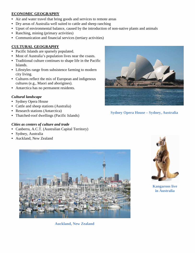
cultures (e.g., Maori and aborigines). • Antarctica has no permanent residents. Cultural landscape • Sydney Opera House • Cattle and sheep stations (Australia) • Research stations (Antarctica) • Thatched-roof dwellings (Pacific Islands) Cities as centers of culture and trade • Canberra, A.C.T. (Australian Capital Territory) • Sydney, Australia • Auckland, New Zealand
Sydney Opera House – Sydney, Australia
Auckland, New Zealand
Kangaroos live in Australia
Factors that influence population distribution • Natural resources (e.g., oil, arable land, water) • Climate (hot/cold; wet/dry) • Economic development • Government policy • Rural/urban settlement patterns • Capital resources (transportation, technology) • Conflicts (refugees) Characteristics of human populations • Birth and death rates (war, disease, migration) • Age distribution • Male/female distribution • Life expectancy • Infant mortality rate • Urban/rural distribution • GDP • Ethnicities • Language • Religion • Education Factors that influence population growth rates • Modern
medicine and hygiene
• Education • Industrialization
and urbanization
• Economic development • Government policy • Role of women in society
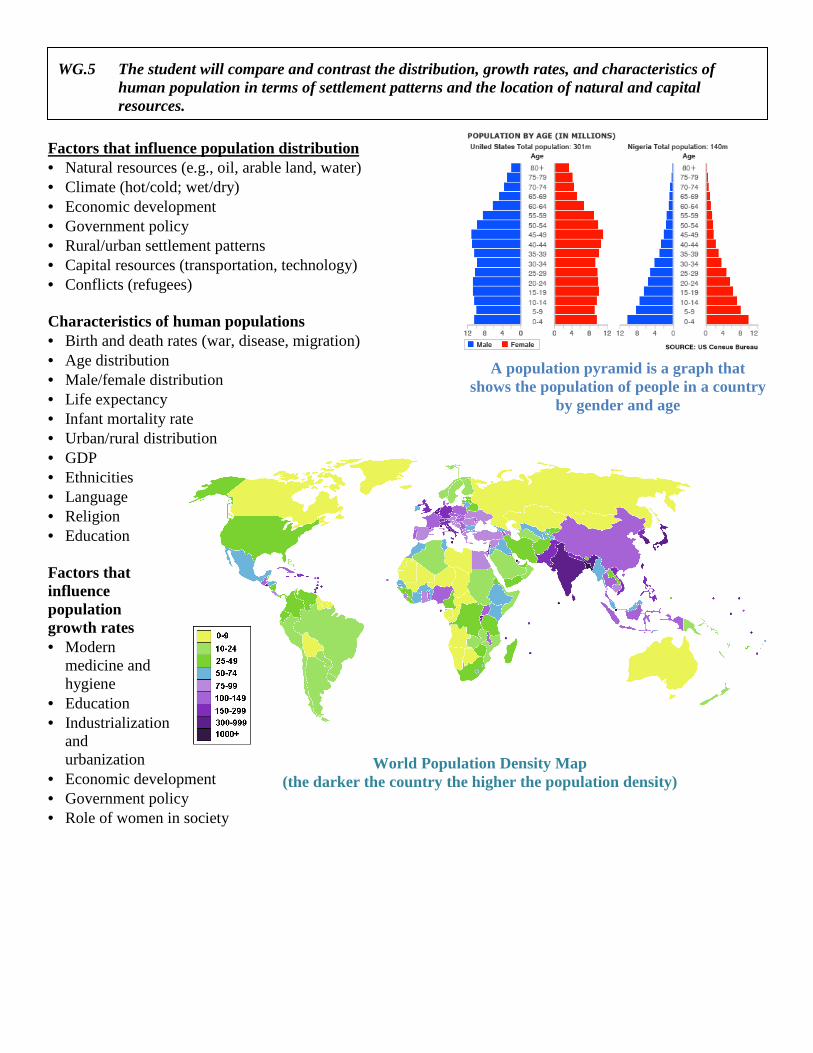
World Population Density Map (the darker the country the higher the population density)
A population pyramid is a graph that shows the population of people in a country
by gender and age
WG.5 The student will compare and contrast the distribution, growth rates, and characteristics of human population in terms of settlement patterns and the location of natural and capital resources.
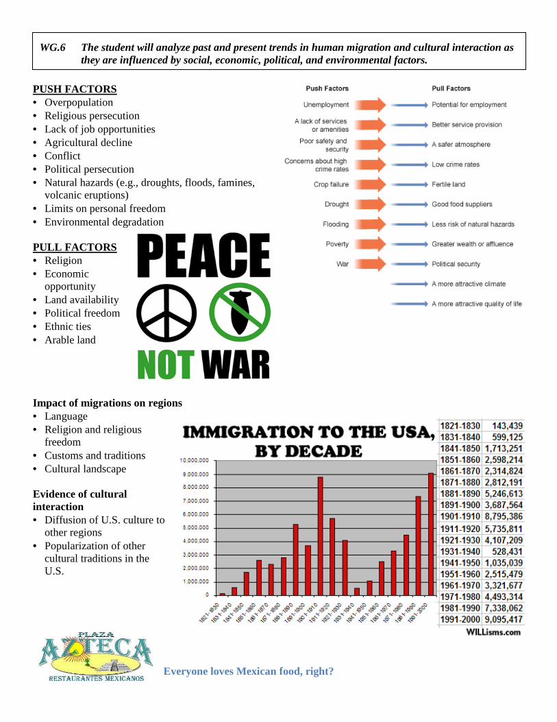
PUSH FACTORS • Overpopulation • Religious persecution • Lack of job opportunities • Agricultural decline • Conflict • Political persecution • Natural hazards (e.g., droughts, floods, famines,
volcanic eruptions) • Limits on personal freedom • Environmental degradation PULL FACTORS • Religion • Economic
opportunity • Land availability • Political freedom • Ethnic ties • Arable land Impact of migrations on regions • Language • Religion and religious
freedom • Customs and traditions • Cultural landscape Evidence of cultural interaction • Diffusion of U.S. culture to
other regions • Popularization of other
cultural traditions in the U.S.
Everyone loves Mexican food, right?
WG.6 The student will analyze past and present trends in human migration and cultural interaction as they are influenced by social, economic, political, and environmental factors.

WG.7 The student will identify types of natural, human, and capital resources and explain their significance by a) showing their influence on patterns of economic activity and land use;b) evaluating perspectives and consequences regarding the use of resources.
Changes in use of energy resources and technology over time• Wood (deforestation) • Coal (pollution, mining problems, competition with oil and gas)• Petroleum (transportation, environmental considerations)• Nuclear (contamination, waste) • Solar, wind (cost, aesthetics)
Natural resources • Renewable: Soil, water, forests • Nonrenewable: Fossil fuels (oil, coal, natural gas) and
iron, copper, bauxite) Human resources • Level of education • Skilled and unskilled laborers • Entrepreneurial and managerial abilities
Capital resources • Availability of money for investment • Level of infrastructure • Availability and use of tools, machines, and
technologies Levels of economic activity • Primary : Dealing directly with resources (e.g.,
fishing, farming, forestry, mining) • Secondary: Manufacturing and processing (e.g.,
steel mills, automobile assembly, sawmills)• Tertiary : Services (e.g., transportation, retail
trade, information technology services)
Nuclear Power plants around the world (red dots)
will identify types of natural, human, and capital resources and explain their
showing their influence on patterns of economic activity and land use; evaluating perspectives and consequences regarding the use of resources.
use of energy resources and technology over time
Coal (pollution, mining problems, competition with oil and gas) Petroleum (transportation, environmental considerations)
Nonrenewable: Fossil fuels (oil, coal, natural gas) and metals (gold,
Entrepreneurial and managerial abilities
Availability and use of tools, machines, and
: Dealing directly with resources (e.g.,
: Manufacturing and processing (e.g., assembly, sawmills)
: Services (e.g., transportation, retail trade, information technology services)
Coal is a NON-RENEWABLE resource
Solar and Wind Energy is a clean alternative
Deforestation in the Amazon
will identify types of natural, human, and capital resources and explain their
evaluating perspectives and consequences regarding the use of resources.
RENEWABLE resource
Solar and Wind Energy is a
Deforestation in the Amazon
Effects of unequal distribution of resources • Interdependence of nations, trading in goods, services, and capital resources • Uneven economic development • Energy producers and consumers • Imperialism • Conflict over control of resources Patterns of land use • Economic activities that require extensive areas of land (e.g., agriculture) vs. those that require a limited
areas (e.g., manufacturing) • Land uses that are compatible with each other (open spaces and residential) vs. land uses that are not
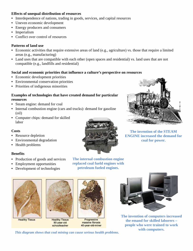
compatible (e.g., landfills and residential) Social and economic priorities that influence a culture’s perspective on resources • Economic development priorities • Environmental conservation priorities • Priorities of indigenous minorities Examples of technologies that have created demand for particular resources • Steam engine: demand for coal • Internal combustion engine (cars and trucks): demand for gasoline
(oil) • Computer chips: demand for skilled
labor Costs • Resource depletion • Environmental degradation • Health problems Benefits
• Production of goods and services • Employment opportunities • Development of technologies
The invention of the STEAM ENGINE increased the demand for
coal for power.
The internal combustion engine replaced coal fueld engines with
petroleum fueled engines.
The invention of computers increased the emand for skilled laborers – people who were trained to work
with computers. This diagram shows that coal mining can cause serious health problems.
Differences between developed and developing nations • Access to natural resources • Access to capital resources (investment in technology and
infrastructure) • Number and skills of human resources • Levels of economic development • Standards of living and quality of life • Relationships between economic development and quality of life
Indicators of economic development • Urban-rural ratio
• Labor force characteristics (primary, secondary, tertiary sectors) • GDP per capita • Educational achievement Indicators of standards of living and quality of life • Population growth rate (natural increase) • Population age distribution • Literacy rate • Life expectancy • Infant mortality rate • Percentage of urban population
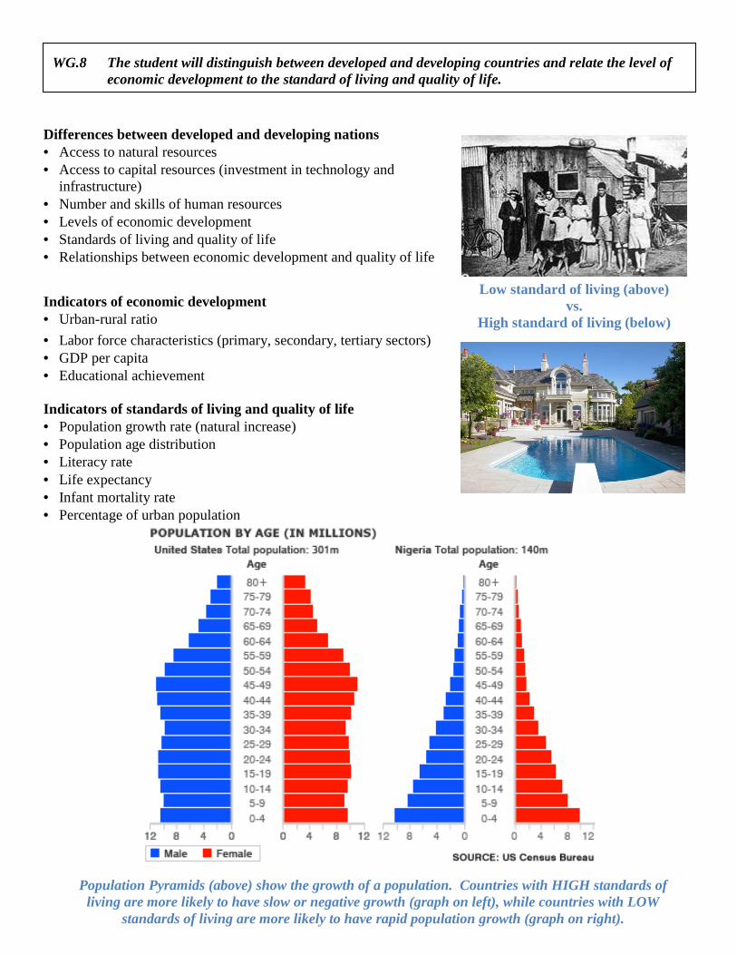
Low standard of living (above) vs.
High standard of living (below)
Population Pyramids (above) show the growth of a population. Countries with HIGH standards of living are more likely to have slow or negative growth (graph on left), while countries with LOW
standards of living are more likely to have rapid population growth (graph on right).
WG.8 The student will distinguish between developed and developing countries and relate the level of economic development to the standard of living and quality of life.
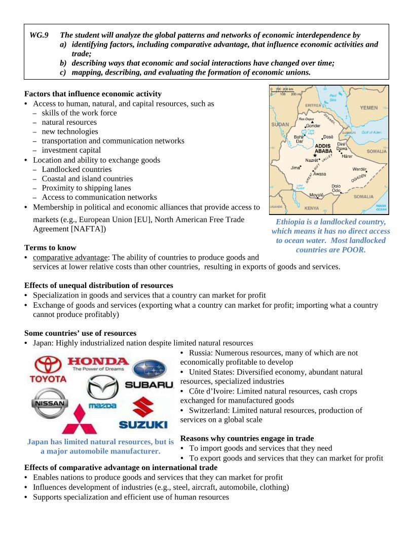
Japan has limited natural resources, but is a major automobile manufacturer.
Factors that influence economic activity • Access to human, natural, and capital resources, such as
– skills of the work force – natural resources – new technologies – transportation and communication networks – investment capital
• Location and ability to exchange goods – Landlocked countries – Coastal and island countries – Proximity to shipping lanes – Access to communication networks
• Membership in political and economic alliances that provide access to
markets (e.g., European Union [EU], North American Free Trade Agreement [NAFTA])
Terms to know • comparative advantage: The ability of countries to produce goods and
services at lower relative costs than other countries, resulting in exports of goods and services. Effects of unequal distribution of resources • Specialization in goods and services that a country can market for profit • Exchange of goods and services (exporting what a country can market for profit; importing what a country
cannot produce profitably) Some countries’ use of resources • Japan: Highly industrialized nation despite limited natural resources
• Russia: Numerous resources, many of which are not economically profitable to develop • United States: Diversified economy, abundant natural resources, specialized industries • Côte d’Ivoire: Limited natural resources, cash crops exchanged for manufactured goods • Switzerland: Limited natural resources, production of services on a global scale Reasons why countries engage in trade • To import goods and services that they need • To export goods and services that they can market for profit
Effects of comparative advantage on international trade • Enables nations to produce goods and services that they can market for profit • Influences development of industries (e.g., steel, aircraft, automobile, clothing) • Supports specialization and efficient use of human resources
Ethiopia is a landlocked country, which means it has no direct access to ocean water. Most landlocked
countries are POOR.
WG.9 The student will analyze the global patterns and networks of economic interdependence by a) identifying factors, including comparative advantage, that influence economic activities and
trade; b) describing ways that economic and social interactions have changed over time; c) mapping, describing, and evaluating the formation of economic unions.
Changes over time • Industrial labor systems (e.g., cottage industry, factory, office, telecommunications) • Migration from rural to urban areas • Industrialized countries export labor-intensive work to developing nations • Growth of trade alliances • Growth of service (tertiary) industries • Growth of financial services networks and international
banks • Internationalization of product assembly (e.g., vehicles,
electronic equipment) • Technology that allows instant communication among
people in different countries • Modern transportation networks that allow rapid and
efficient exchange of goods and materials (e.g., Federal Express, United Parcel Service, U. S. Postal Service)
• Widespread marketing of products (e.g., Fuji film, Nike, United Colors of Benetton)
Economic interdependence can be depicted through trade, resource, or transportation maps. Examples of economic unions • EU: European Union • NAFTA: North American Free Trade Agreement • ASEAN: Association of Southeast Asian Nations • OPEC: Organization of Petroleum Exporting Countries
Advantages of economic unions • More efficient industries • Access to larger markets • Access to natural, human, and capital resources without restrictions • Greater influence on world market Disadvantages of economic unions • Closing of some industries • Concentration of some industries in certain countries, leaving peripheral areas behind • Agribusiness replacing family farms • Difficulty in agreeing on common economic policies
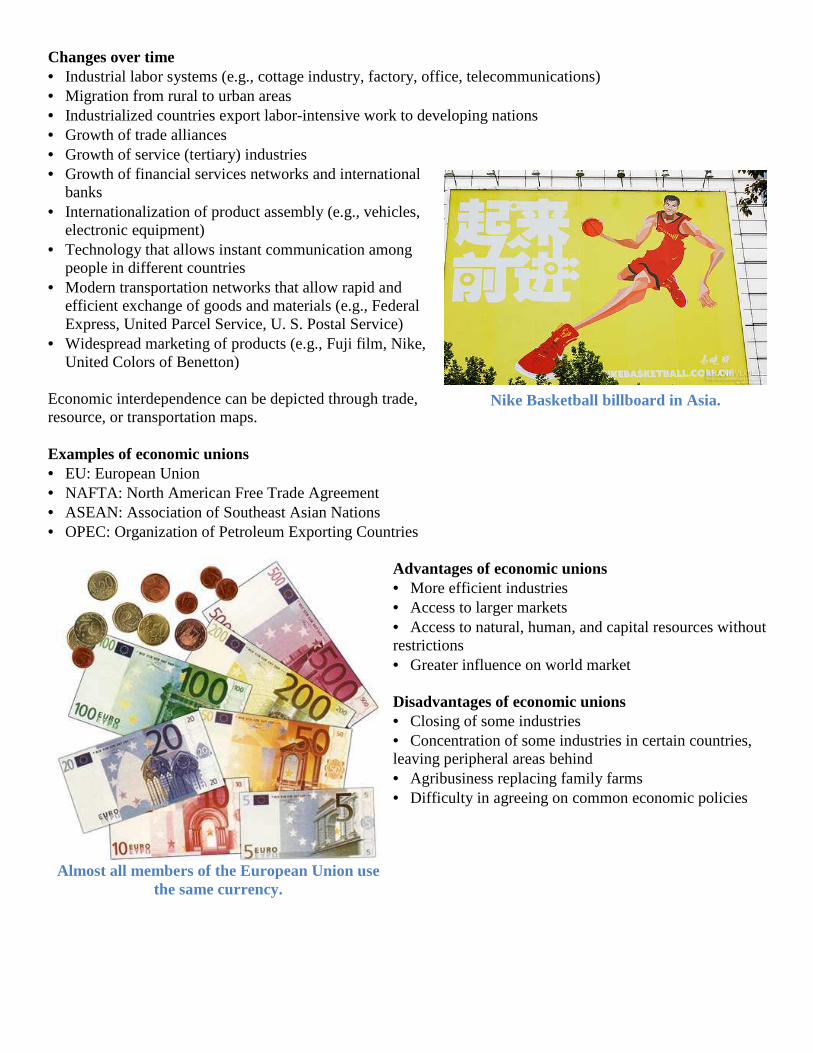
Nike Basketball billboard in Asia.
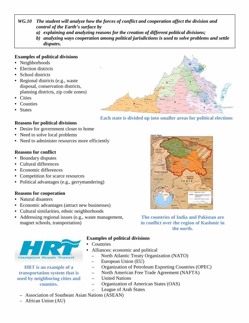
Almost all members of the European Union use the same currency.
Examples of political divisions • Neighborhoods • Election districts • School districts • Regional districts (e.g., waste
disposal, conservation districts, planning districts, zip code zones)
• Cities • Counties • States
Reasons for political divisions • Desire for government closer to home • Need to solve local problems • Need to administer resources more efficiently Reasons for conflict • Boundary disputes • Cultural differences • Economic differences • Competition for scarce resources • Political advantages (e.g., gerrymandering) Reasons for cooperation • Natural disasters • Economic advantages (attract new businesses) • Cultural similarities, ethnic neighborhoods • Addressing regional issues (e.g., waste management,
magnet schools, transportation)
Examples of political divisions • Countries • Alliances: economic and political
– North Atlantic Treaty Organization (NATO) – European Union (EU) – Organization of Petroleum Exporting Countries (OPEC) – North American Free Trade Agreement (NAFTA) – United Nations – Organization of American States (OAS) – League of Arab States
– Association of Southeast Asian Nations (ASEAN) – African Union (AU)
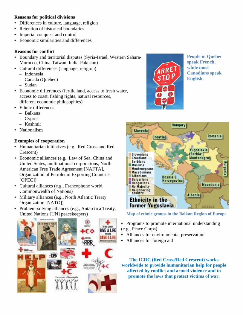
Each state is divided up into smaller areas for political elections
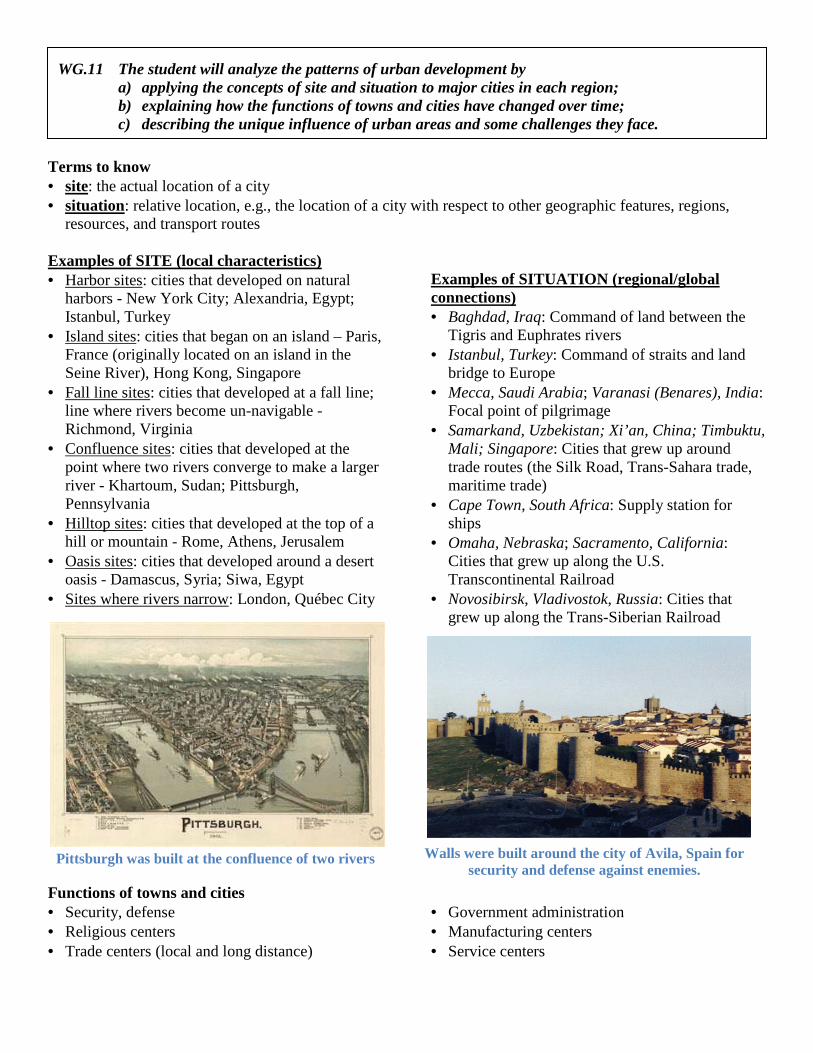
The countries of India and Pakistan are in conflict over the region of Kashmir in
the north.
HRT is an example of a transportation system that is
used by neighboring cities and counties.
WG.10 The student will analyze how the forces of conflict and cooperation affect the division and control of the Earth’s surface by a) explaining and analyzing reasons for the creation of different political divisions; b) analyzing ways cooperation among political jurisdictions is used to solve problems and settle
disputes.
Reasons for political divisions • Differences in culture, language, religion• Retention of historical boundaries • Imperial conquest and control • Economic similarities and differences Reasons for conflict • Boundary and territorial disputes (Syria
Morocco, China-Taiwan, India-Pakistan)• Cultural differences (language, religion)
– Indonesia – Canada (Québec) – Sudan
• Economic differences (fertile land, access to fresh water, access to coast, fishing rights, natural resources, different economic philosophies)
• Ethnic differences – Balkans – Cyprus – Kashmir
• Nationalism Examples of cooperation • Humanitarian initiatives (e.g., Red Cross and Red
Crescent) • Economic alliances (e.g., Law of Sea, China and
United States, multinational corporations, North American Free Trade Agreement [NAFTA], Organization of Petroleum Exporting Countries [OPEC])
• Cultural alliances (e.g., Francophone world, Commonwealth of Nations)
• Military alliances (e.g., North Atlantic Treaty Organization [NATO])
• Problem-solving alliances (e.g., Antarctica Treaty, United Nations [UN] peacekeepers)
Differences in culture, language, religion
Economic similarities and differences
Boundary and territorial disputes (Syria-Israel, Western Sahara-Pakistan)
Cultural differences (language, religion)
Economic differences (fertile land, access to fresh water, access to coast, fishing rights, natural resources,
, Red Cross and Red
Economic alliances (e.g., Law of Sea, China and United States, multinational corporations, North American Free Trade Agreement [NAFTA], Organization of Petroleum Exporting Countries
e world,
Military alliances (e.g., North Atlantic Treaty
solving alliances (e.g., Antarctica Treaty,
• Programs to promote international understanding (e.g., Peace Corps) • Alliances for environmental preservation• Alliances for foreign aid
Map of ethnic groups in the Balkan Region of Europe
The ICRC (Red Cross/Red Crescent)worldwide to provide humanitarian help for people
affected by conflict and armed violence and to promote the laws that protect victims of war
promote international understanding
Alliances for environmental preservation
People in Quebec speak French, while most Canadians speak English.
Map of ethnic groups in the Balkan Region of Europe
(Red Cross/Red Crescent) works worldwide to provide humanitarian help for people
affected by conflict and armed violence and to promote the laws that protect victims of war.
Terms to know • site: the actual location of a city • situation: relative location, e.g., the location of a city with respect to other geographic features, regions,
resources, and transport routes Examples of SITE (local characteristics) • Harbor sites: cities that developed on natural
harbors - New York City; Alexandria, Egypt; Istanbul, Turkey
• Island sites: cities that began on an island – Paris, France (originally located on an island in the Seine River), Hong Kong, Singapore
• Fall line sites: cities that developed at a fall line; line where rivers become un-navigable - Richmond, Virginia
• Confluence sites: cities that developed at the point where two rivers converge to make a larger river - Khartoum, Sudan; Pittsburgh, Pennsylvania
• Hilltop sites: cities that developed at the top of a hill or mountain - Rome, Athens, Jerusalem
• Oasis sites: cities that developed around a desert oasis - Damascus, Syria; Siwa, Egypt
• Sites where rivers narrow: London, Québec City
Examples of SITUATION (regional/global connections) • Baghdad, Iraq: Command of land between the
Tigris and Euphrates rivers • Istanbul, Turkey: Command of straits and land
bridge to Europe • Mecca, Saudi Arabia; Varanasi (Benares), India:
Focal point of pilgrimage • Samarkand, Uzbekistan; Xi’an, China; Timbuktu,
Mali; Singapore: Cities that grew up around trade routes (the Silk Road, Trans-Sahara trade, maritime trade)
• Cape Town, South Africa: Supply station for ships
• Omaha, Nebraska; Sacramento, California: Cities that grew up along the U.S. Transcontinental Railroad
• Novosibirsk, Vladivostok, Russia: Cities that grew up along the Trans-Siberian Railroad
Functions of towns and cities • Security, defense • Religious centers • Trade centers (local and long distance)
• Government administration • Manufacturing centers • Service centers
Pittsburgh was built at the confluence of two rivers Walls were built around the city of Avila, Spain for security and defense against enemies.
WG.11 The student will analyze the patterns of urban development by a) applying the concepts of site and situation to major cities in each region; b) explaining how the functions of towns and cities have changed over time; c) describing the unique influence of urban areas and some challenges they face.
Examples of cities whose functions have changed over time • Rio de Janeiro: Move of Brazil’s capital from Rio de Janeiro to Brasilia • Pittsburgh, Pennsylvania: Early function connected to defense, then became steel manufacturing center, later
shifted to diverse services (financial, light manufacturing) • New York City: Changes in trade patterns—coastal and transatlantic trade, trade from Great Lakes via Erie
Canal, worldwide trade and finances • Mining towns, “ghost” towns: Resource depletion, changes in the
environment Influences of urban areas on their regions and countries • Nation-building (monuments, symbols) • Transportation/communication hubs • Magnets for migration • Seed beds of new ideas and technologies • Diversity, leading to creativity in the arts • Universities, educational opportunities • Corporate headquarters/regional offices • Media centers (news, entertainment) Problems associated with growth of urban areas • Transportation problems emerge, especially as automobile travel
increases. • Rich and poor neighborhoods exist in different areas isolated from
one another. • Providing essential services (fresh water, sewage disposal, electricity,
schools, clinics) becomes a problem (e.g., cities in Latin America, Africa, and Asia). • Air, water, and noise pollution increase. • Sprawl results in conversion of agricultural land to urban uses, especially in North America. • In developing countries, major cities are connected more to regions outside the country than to regions within
the country.
Practical applications of geography at local and regional levels • Air- and water-quality monitoring and management • Recycling programs • Land-use and transportation planning • Selection of locations for residential and commercial development Geographic relationships • Physical characteristics that influence current events:
– Natural hazards (e.g, flooding, earthquakes, volcanoes, drought) – Climate, vegetation
• Human characteristics that influence current events: – Population distribution – Geographic patterns of ethnic diversity – A sense of place (emotional attachment to specific locations) – Geographic patterns of trade and interdependence (e.g., oil) – Geographic patterns of wealth and poverty (developed and developing nations)
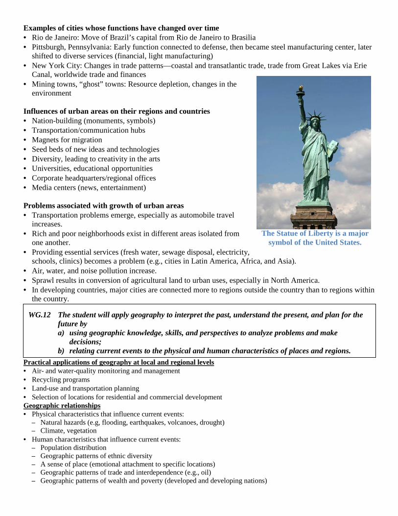
The Statue of Liberty is a major symbol of the United States.
WG.12 The student will apply geography to interpret the past, understand the present, and plan for the future by a) using geographic knowledge, skills, and perspectives to analyze problems and make
decisions; b) relating current events to the physical and human characteristics of places and regions.