Embed Size (px)
Citation preview
www.digitalglobe.com Corporate (U.S.) +1.303.684.4561 or +1.800.496.1225 | London +44.20.8899.6801 | Singapore +65.6389.4851
DATA SHEE T
Features » Very high resolution
» Industry-leading geolocation accuracy - Ultra-stable platform, high-precision
attitude sensors and GPS
» Highest capacity over a broad range of collection types (wider than any competitor)
» Bi-directional scanning
» Rapid retargeting using Control Moment Gyros (>2x faster than any competitor)
» Direct downlink to customer sites available
» World-class telescope - High contrast (MTF)
and signal-to-noise ratio
- Selectable Time Delay Integration (TDI) levels
» Frequent revisits at high resolution
Benefits » Provides highly detailed imagery
for precise map creation, change detection, and in-depth image analysis
» Geolocate features to less than 5 m to create maps in remote areas, maximizing the utility of available resources.
» Collects, stores, and downlinks a greater supply of frequently updated global imagery products than competitive systems
» Stereoscopic collection on a single pass, ensures image continuity and consistency of quality
» Extends the range of suitable imaging collection targets and enhances image interpretability
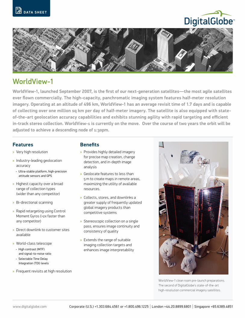
WorldView-1WorldView-1, launched September 2007, is the first of our next-generation satellites—the most agile satellites ever flown commercially. The high-capacity, panchromatic imaging system features half-meter resolution imagery. Operating at an altitude of 496 km, WorldView-1 has an average revisit time of 1.7 days and is capable of collecting over one million sq km per day of half-meter imagery. The satellite is also equipped with state- of-the-art geolocation accuracy capabilities and exhibits stunning agility with rapid targeting and efficient in-track stereo collection. WorldView-1 is currently on the move. Over the course of two years the orbit will be adjusted to achieve a descending node of 1:30pm.
WorldView-1 clean room pre-launch preparations.
The second of DigitalGlobe’s state-of-the-art
high-resolution commercial imagery satellites.
www.digitalglobe.com Corporate (U.S.) +1.303.684.4561 or +1.800.496.1225 | London +44.20.8899.6801 | Singapore +65.6389.4851
DIGITALGLOBE CONSTEL L ATION » WORL DVIE W-1
DATA SHEE T
DS-WV1 06/13
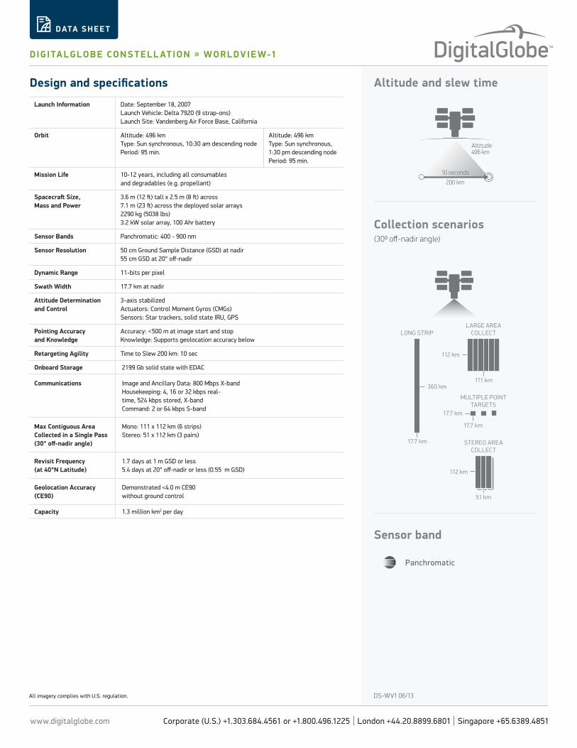
Altitude and slew timeDesign and specifications
All imagery complies with U.S. regulation.
Collection scenarios (300 off-nadir angle)
Panchromatic
Sensor band
Altitude496 km
200 km
10 seconds
LARGE AREACOLLECT
MULTIPLE POINTTARGETS
STEREO AREACOLLECT
LONG STRIP
360 km
17.7 km
17.7 km
17.7 km
112 km
51 km
112 km
111 km
Launch Information Date: September 18, 2007Launch Vehicle: Delta 7920 (9 strap-ons)Launch Site: Vandenberg Air Force Base, California
Orbit Altitude: 496 kmType: Sun synchronous, 10:30 am descending nodePeriod: 95 min.
Altitude: 496 kmType: Sun synchronous, 1:30 pm descending nodePeriod: 95 min.
Mission Life 10-12 years, including all consumables and degradables (e.g. propellant)
Spacecraft Size, Mass and Power
3.6 m (12 ft) tall x 2.5 m (8 ft) across7.1 m (23 ft) across the deployed solar arrays2290 kg (5038 lbs)3.2 kW solar array, 100 Ahr battery
Sensor Bands Panchromatic: 400 - 900 nm
Sensor Resolution 50 cm Ground Sample Distance (GSD) at nadir55 cm GSD at 20° off-nadir
Dynamic Range 11-bits per pixel
Swath Width 17.7 km at nadir
Attitude Determination and Control
3-axis stabilized Actuators: Control Moment Gyros (CMGs)Sensors: Star trackers, solid state IRU, GPS
Pointing Accuracy and Knowledge
Accuracy: <500 m at image start and stopKnowledge: Supports geolocation accuracy below
Retargeting Agility Time to Slew 200 km: 10 sec
Onboard Storage 2199 Gb solid state with EDAC
Communications Image and Ancillary Data: 800 Mbps X-bandHousekeeping: 4, 16 or 32 kbps real-time, 524 kbps stored, X-bandCommand: 2 or 64 kbps S-band
Max Contiguous Area Collected in a Single Pass (30° off-nadir angle)
Mono: 111 x 112 km (6 strips)Stereo: 51 x 112 km (3 pairs)
Revisit Frequency(at 40°N Latitude)
1.7 days at 1 m GSD or less5.4 days at 20° off-nadir or less (0.55 m GSD)
Geolocation Accuracy (CE90)
Demonstrated <4.0 m CE90 without ground control
Capacity 1.3 million km2 per day


![Worldview Spaceflight - Business Plan, Jun-09[1]](https://img.pdfslide.net/doc/110x75/58a7a9a51a28ab03128b67db/worldview-spaceflight-business-plan-jun-091.jpg)