88 | NSW ROADS AND TRAFFIC AUTHORITY
tintenBar to ewingSdale Upgrade | ENVIRONMENTAL ASSESSMENT
6 Detailed design and construction of the proposed upgrade
6.1 Preparation of detailed design
Detailed design would be undertaken only if the proposal is approved and the Chief Executive of the RTA determines that the project should proceed. In addition, post-approval modifications could occur. Any post-approval modifications that were not consistent with the approved project would require an application for modification in accordance with section 75W of the Environmental Planning and Assessment Act, 1979.
To ensure that the design development process adequately incorporates the key principles established during the study and inherent in the concept design, the development of the detailed design would be in accordance with any approval issued by the Minister for Planning. Provided it is consistent with the terms of any approval, detailed design would:
> Be consistent with the design criteria and design principles on which the concept design is based, as described in this environmental assessment and any subsequent submission report.
> Consider opportunities for refinement of the project footprint within the road corridor for safety, engineering and functional reasons, taking into account the presence of environmentally sensitive areas.
> Address any unresolved issues associated with the development of the concept design as described in this environmental assessment and any subsequent submissions report.
> Meet any conditions of approval arising from the environmental assessment approval process, unless changes to the conditions of approval are subsequently approved.
> Incorporate opportunities for innovation.
> Incorporate community and government agency requirements by the implementation of a consultation plan aimed at identifying and resolving issues of concern to agencies, the community and other groups.
> Wherever possible, avoid identified environmentally sensitive areas and significant species.
> Develop and refine impact management measures.
> Appropriately develop and incorporate the urban design strategy and landscape concept developed in the environmental assessment.
> Establish detailed proposals for the construction delivery method and construction staging addressing buildability, traffic capacity and safety during construction, geotechnical issues, all relevant RTA specifications and design requirements, current guidelines and policies and practicality / cost effectiveness.
> Incorporate the construction concepts and environmental management measures presented in this environmental assessment and any subsequent submissions report.
> Address risk management during construction and operation.
> Allow for safe and cost effective maintenance of the proposed upgrade during operation in accordance with occupational health and safety requirements and relevant RTA specifications.
> Be consistent with the principle of ecologically sustainable development.
UPGRADING THE PACIFIC HIGHWAY | 89
Chapter 6 | DETAILED DESIGN AND CONSTRUCTION OF THE PROPOSED UPGRADE
6.2 Project delivery
6.2.1 Delivery method
If the proposed upgrade proceeds, the RTA would consider the options for project delivery. The preferred method would be selected and implemented in compliance with this environmental assessment, the conditions of approval and the statement of commitments.
6.2.2 Construction hours
Regardless of the delivery method chosen, construction hours would normally be limited to between 7am and 6pm Monday to Friday and between 8am and 1pm Saturday.
Some work may be scheduled outside normal working construction hours so as to reduce impact on residents and road users. These works may include:
> Delivery of materials as requested by police and other authorities for safety reasons.
> Emergency work.
> Work that would significantly delay traffic or cause traffic problems.
> Other works for which a need is demonstrated.
Any work planned outside normal hours or on public holidays would be undertaken only after prior consultation with and/or notification of local residents and the Department of Environment and Climate Change.
6.2.3 Construction duration
It is estimated that a period of about one to one and a half years would be required for land acquisition concurrent with adjustments being made to public utilities, completion of detail design and investigations, and tendering procedures prior to commencement of construction.
Depending on the chosen delivery method, the construction period would be in the range of 2 to 3 years following the award of contract.
6.3 Proposed construction sections
6.3.1 General
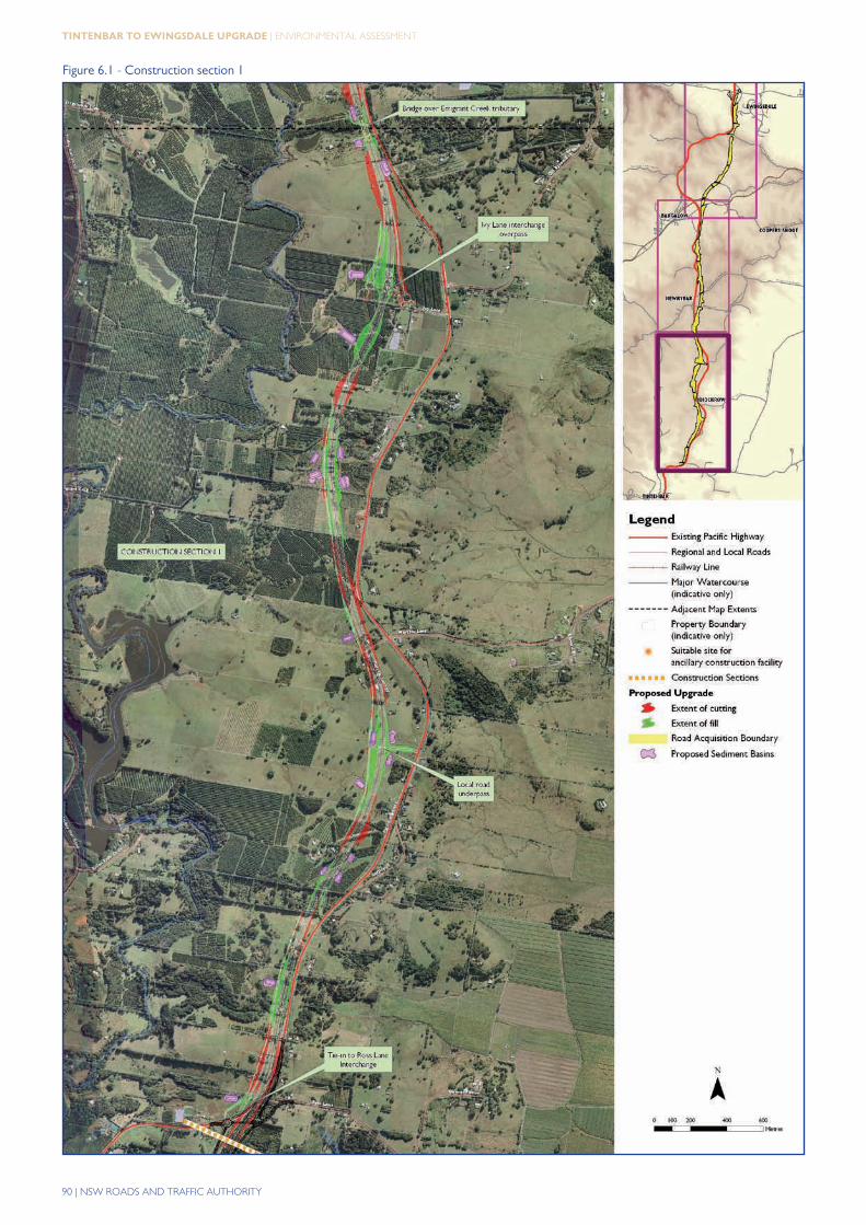
Six construction sections have been defined based on separating sections where significant construction issues or differences in construction methods are likely. This particular sectional approach has mainly been developed as a planning tool and may be altered during construction. The locations and significant features of the six proposed construction sections are given in figure 6.1, figure 6.2 and figure 6.3. Sections 1, 2 and 3 could be opened to traffic independently. Sections 4,5 and 6 could be constructed independently but only opened to traffic as a single section.
90 | NSW ROADS AND TRAFFIC AUTHORITY
tintenBar to ewingSdale Upgrade | ENVIRONMENTAL ASSESSMENT
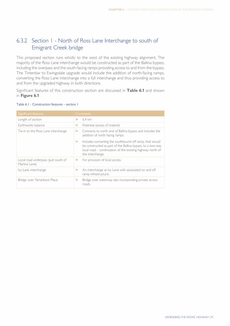
Figure 6.1 - Construction section 1
UPGRADING THE PACIFIC HIGHWAY | 91
Chapter 6 | DETAILED DESIGN AND CONSTRUCTION OF THE PROPOSED UPGRADE
6.3.2 Section 1 - North of Ross Lane Interchange to south of Emigrant Creek bridge
This proposed section runs wholly to the west of the existing highway alignment. The majority of the Ross Lane interchange would be constructed as part of the Ballina bypass, including the overpass and the south-facing ramps providing access to and from the bypass. The Tintenbar to Ewingsdale upgrade would include the addition of north-facing ramps, converting the Ross Lane interchange into a full interchange and thus providing access to and from the upgraded highway in both directions.
Significant features of this construction section are discussed in table 6.1 and shown in figure 6.1
Table 6.1 - Construction features – section 1
Significant features Comments
Length of section > 6.4 km
Earthworks balance > Potential excess of material
Tie-in to the Ross Lane interchange > Connects to north end of Ballina bypass and includes the addition of north facing ramps.
> Includes converting the southbound off ramp, that would be constructed as part of the Ballina bypass, to a two-way local road – continuation of the existing highway north of the interchange.
Local road underpass (just south of Martins Lane)
> For provision of local access.
Ivy Lane interchange > An interchange at Ivy Lane with associated on and off ramp infrastructure.
Bridge over Yarranbool Place > Bridge over waterway also incorporating private access roads.
92 | NSW ROADS AND TRAFFIC AUTHORITY
tintenBar to ewingSdale Upgrade | ENVIRONMENTAL ASSESSMENT
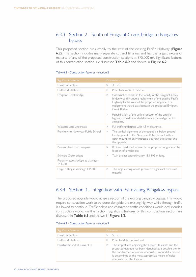
6.3.3 Section 2 - South of Emigrant Creek bridge to Bangalow bypass
This proposed section runs wholly to the east of the existing Pacific Highway (figure 6.2). The section includes many separate cut and fill areas and has the largest excess of material of any of the proposed construction sections at 375,000 m³. Significant features of this construction section are discussed table 6.2 and shown in figure 6.2.
Table 6.2 - Construction features – section 2
Significant features Comments
Length of section > 4.1 km.
Earthworks balance > Potential excess of material.
Emigrant Creek bridge > Construction works in the vicinity of the Emigrant Creek bridge would include a realignment of the existing Pacific Highway to the west of the proposed upgrade. The realignment would pass beneath the proposed Emigrant Creek Bridge.
> Rehabilitation of the defunct section of the existing highway would be undertaken once the realignment is complete.
Watsons Lane underpass > Full traffic underpass with 4.8 m clearance.
Proximity to Newrybar Public School > The vertical alignment of the upgrade is below ground level adjacent to the Newrybar Public School with an earth mound to be introduced between the school and the upgrade
Broken Head road overpass > Broken Head road intersects the proposed upgrade at the location of a major cut.
Skinners Creek bridge > Twin bridges approximately 185-195 m long.
Property access bridge at chainage 144,600
Large cutting at chainage 144,800 > This large cutting would generate a significant excess of material.
6.3.4 Section 3 - Integration with the existing Bangalow bypass
The proposed upgrade would utilise a section of the existing Bangalow bypass. This would require construction work to be done alongside the existing highway while through traffic is allowed to continue. Traffic delays and changes to traffic conditions would occur during construction works on this section. Significant features of this construction section are discussed in table 6.3 and shown in figure 6.2.
Table 6.3 - Construction features – section 3
Significant features Comments
Length of section > 5.1 km
Earthworks balance > Potential deficit of material
Possible mound at Clover Hill > The strip of land adjoining the Clover Hill estate and the proposed upgrade has been identified as a possible site for the construction of a noise attenuation mound if a mound is determined as the most appropriate means of noise attenuation at this location.
UPGRADING THE PACIFIC HIGHWAY | 93
Chapter 6 | DETAILED DESIGN AND CONSTRUCTION OF THE PROPOSED UPGRADE
Figure 6.2 - Construction sections 2 and 3
94 | NSW ROADS AND TRAFFIC AUTHORITY
tintenBar to ewingSdale Upgrade | ENVIRONMENTAL ASSESSMENT
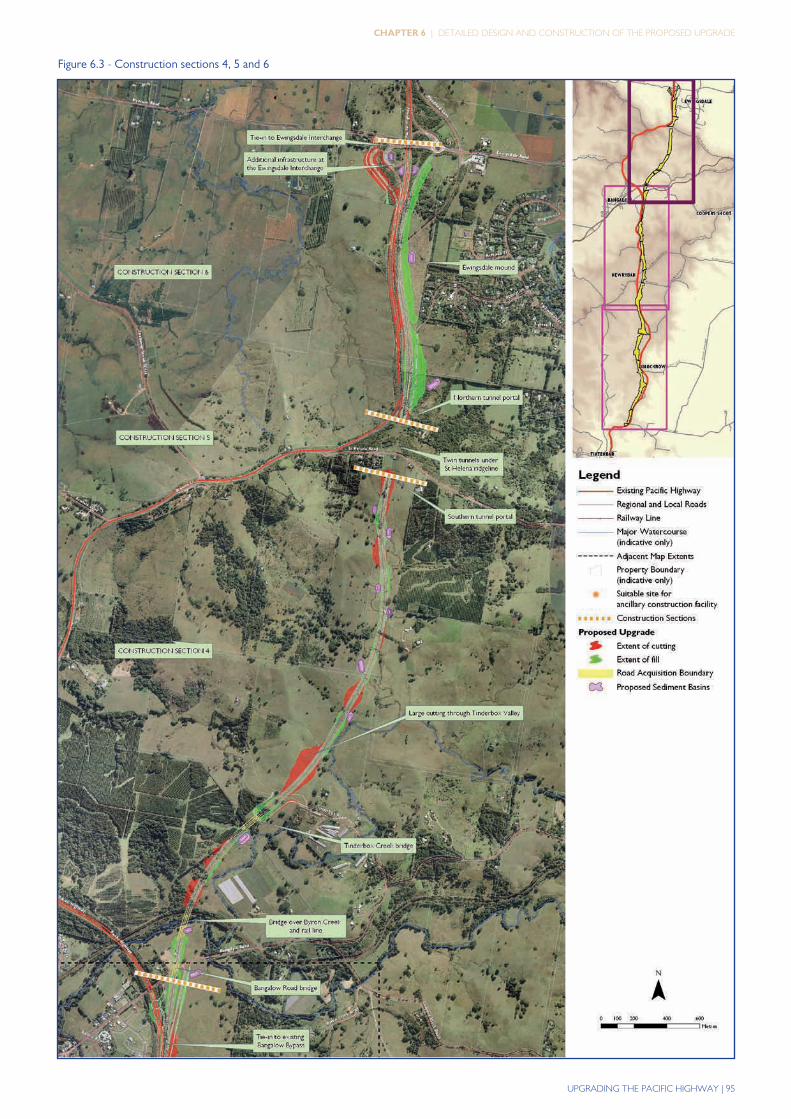
6.3.5 Section 4 - Bangalow bypass to south of tunnel
Access to the proposed upgrade from existing roads in this section is limited. It is expected that construction would proceed sequentially along the acquired land of the upgrade road reserve. Significant features of this construction section are discussed in the following table 6.4 and shown in figure 6.3
Table 6.4 - Construction features – section 4
Significant features Comments
Length of section > 3 km
Earthworks balance > Potential excess of material
Bangalow Road bridge > The bridge would be constructed over the existing Bangalow Road.
Bridge over Byron Creek and rail line > Significant bridge spanning both Byron Creek and the currently disused Casino-Murwillumbah railway line.
Bridge over tributary of Tinderbox Creek and realignment of Tinderbox Road
> Bridge over tributary of Tinderbox Creek and maintenance of continuity of Tinderbox Road. Tinderbox Road would require realignment.
Major cut in vicinity of Tinderbox Road > A significant excess of excavated spoil would be generated from the numerous cuts which are required for this section. One cut in particular in the vicinity of Tinderbox Road is estimated to generate approximately 300,000 m3 of excess material.
6.3.6 Section 5 - Tunnel and portals
Twin tunnels separated by a rock pillar are proposed. They would be approximately 340 m long and 45 m below the existing St Helena Road. Significant features of this construction section are discussed in the following table 6.5 and shown in figure 6.3.Table 6.5 - Construction features – section 5
Significant features Comments
Length of section > 0.4 km
Earthworks balance > Potential deficit of material
Drill and blast construction method > Conventional drill blast techniques.
6.3.7 Section 6 - North of tunnel to Ewingsdale interchange
This section of the proposed upgrade requires construction in close proximity to the existing Pacific Highway. Where the proposed upgrade passes the Ewingsdale residential area, it is lower and slightly closer to Ewingsdale than the existing highway.
This section is expected to have an approximate cut and fill balance and may have some local geotechnical issues associated with landslips in the vicinity of the northern tunnel portal.
Significant features of this construction section are discussed in the following table 6.6 and shown in figure 6.3.
UPGRADING THE PACIFIC HIGHWAY | 95
Chapter 6 | DETAILED DESIGN AND CONSTRUCTION OF THE PROPOSED UPGRADE
Figure 6.3 - Construction sections 4, 5 and 6
96 | NSW ROADS AND TRAFFIC AUTHORITY
tintenBar to ewingSdale Upgrade | ENVIRONMENTAL ASSESSMENT
Table 6.6 - Construction features – section 6
Significant features Comments
Length of section > 1.6 km.
Earthworks balance > Potential deficit of material.
Ewingsdale mound > An earthworks mound to the east of the proposed upgrade in the vicinity of the Ewingsdale interchange.
Additional works and infrastructure at the Ewingsdale interchange
> The new works at the Ewingsdale interchange would include a new roundabout and a new southbound on-ramp. Demolition of part of the existing noise wall would also be undertaken (in partnership with construction of the new mound).
Tie-in to the existing dual carriageway at the Ewingsdale interchange
> Works to proceed in close proximity to operating roadway.
6.3.8 Staging
Construction staging refers to the order in which one or more of the construction sections defined above are constructed, regardless of the delivery method proposed.
Construction staging may alter the number and distribution of ancillary construction facilities and affect the timeframe for completion of the project. Any construction staging arrangements would be made in consideration of the issues associated with each of the construction sections as detailed in Section 6.3.
Appropriate staging of construction would be required to ensure continuity of access along the highway and to and from adjacent properties and intersecting roadways. Staging of construction would consider:
> Continuity of highway, local road and property access.
> The land acquisition process.
> Availability of fill material (earthworks balance of each section).
> Areas where pre-consolidation of embankments would be required.
> The sequence in which completed sections could be opened to traffic.
The final construction staging would be dependant on the availability of construction funding, the concurrent workload in the construction industry and government policy. Staging may not occur and the proposed upgrade may be constructed as a single project.
6.4 Construction activities sequence
A typical sequence of construction activities is show in table 6.7. This is intended to present sufficient detail to allow an assessment of the likely nature and extent of environmental impacts during construction. It is not a full list of all tasks and obligations, and may not occur in the precise order listed.
UPGRADING THE PACIFIC HIGHWAY | 97
Chapter 6 | DETAILED DESIGN AND CONSTRUCTION OF THE PROPOSED UPGRADE
Table 6.7 - Summary of construction component activities
Component Activities
Pre construction > Tendering
> Award of contract
> Environmental management plans, licences and approvals
> Adjustment of existing public utilities
> Acquisition of land.
> Pre clearing investigations to confirm locations of flora and fauna of conservation significance
Site establishment > Site set out including survey set-out and establishment of site compounds, access points and access routes
> Safety fencing of site
> Installation of traffic management measures to control highway and construction traffic during construction
> Installation of temporary erosion, sediment and water quality controls including diversion drainage, sedimentation basins and cross-flow culverts
> Site compounds, stockpiles and necessary ancillary sites
> GPS towers for surveying
> Initial environmental safeguards.
Site preparation > Clearing and grubbing
> Mulching
> Stripping and stockpiling of topsoil, spoil and unsuitable material
> Installation of physical noise mitigation measures (where possible, noise mitigation measures should be installed before any earthworks or major works commence, e.g. in vicinity of Newrybar Public School where timing in regard to school terms is important).
> Construction access
98 | NSW ROADS AND TRAFFIC AUTHORITY
tintenBar to ewingSdale Upgrade | ENVIRONMENTAL ASSESSMENT
Table 6.7 (cont)
Component Activities
Construction works > Establishment of batching plants.
> Bridges and underpasses, culverts and drains
> Bridge construction
> Landscaping; progressive as earthworks are finished
> Pavement construction
> Safety barriers
> Lighting, line-marking and signposting
> Drainage works including: - Cross culverts - Highway drainage - Water quality basins
> Earthworks including: - Cuttings - Fill embankments
> Tunnel works including drill and blast
> Select zones
> Batter treatments
> Batching plants, crushing plants, pug mills, stockpile and storage sites
> Upgrade of local roads
> Utility adjustments
> Property access
> Existing highway works
Finishing works > Remove temporary works
> Restore and landscape temporary sites
> General site clean up
> Topsoil rehabilitation and revegetation of batters and berms
6.5 Resourcing
6.5.1 Equipment
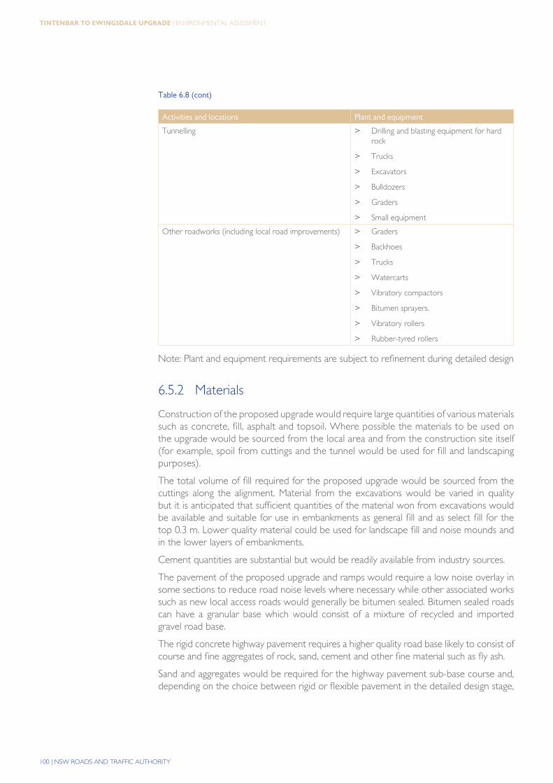
table 6.8 lists the likely construction plant and equipment that would be used on the proposed upgrade.

UPGRADING THE PACIFIC HIGHWAY | 99
Chapter 6 | DETAILED DESIGN AND CONSTRUCTION OF THE PROPOSED UPGRADE
Table 6.8 - Predicted plant and equipment requirements for construction
Activities and locations Plant and equipment
Construction work sites (locations to be determined) > Fences
> Sheds
> Fuel storage tanks
> Concrete and asphaltic concrete batch plants
> Crushing plants
Services relocation at various locations > Trucks, cranes and excavators
> Elevated platform vehicle
> Backhoes
> Trenchers
> Small equipment
Structures > Piling rigs
> Concrete pumps
> Cranes
> Excavators
> Trucks
> Barges
> Small equipment
Earthworks > Bulldozers
> Trucks
> Scrapers
> Graders
> Watercarts
> Compactors
> Vibratory rollers
> Drilling and blasting equipment for hard rock cuttings
Structural pavement > Trucks
> Concrete paver
> Concrete curing equipment
> Concrete saws
> Asphalt paver
> Vibratory rollers
> Rubber-tyred rollers
100 | NSW ROADS AND TRAFFIC AUTHORITY
tintenBar to ewingSdale Upgrade | ENVIRONMENTAL ASSESSMENT
Table 6.8 (cont)
Activities and locations Plant and equipment
Tunnelling > Drilling and blasting equipment for hard rock
> Trucks
> Excavators
> Bulldozers
> Graders
> Small equipment
Other roadworks (including local road improvements) > Graders
> Backhoes
> Trucks
> Watercarts
> Vibratory compactors
> Bitumen sprayers.
> Vibratory rollers
> Rubber-tyred rollers
Note: Plant and equipment requirements are subject to refinement during detailed design
6.5.2 Materials
Construction of the proposed upgrade would require large quantities of various materials such as concrete, fill, asphalt and topsoil. Where possible the materials to be used on the upgrade would be sourced from the local area and from the construction site itself (for example, spoil from cuttings and the tunnel would be used for fill and landscaping purposes).
The total volume of fill required for the proposed upgrade would be sourced from the cuttings along the alignment. Material from the excavations would be varied in quality but it is anticipated that sufficient quantities of the material won from excavations would be available and suitable for use in embankments as general fill and as select fill for the top 0.3 m. Lower quality material could be used for landscape fill and noise mounds and in the lower layers of embankments.
Cement quantities are substantial but would be readily available from industry sources.
The pavement of the proposed upgrade and ramps would require a low noise overlay in some sections to reduce road noise levels where necessary while other associated works such as new local access roads would generally be bitumen sealed. Bitumen sealed roads can have a granular base which would consist of a mixture of recycled and imported gravel road base.
The rigid concrete highway pavement requires a higher quality road base likely to consist of course and fine aggregates of rock, sand, cement and other fine material such as fly ash.
Sand and aggregates would be required for the highway pavement sub-base course and, depending on the choice between rigid or flexible pavement in the detailed design stage,
UPGRADING THE PACIFIC HIGHWAY | 101
Chapter 6 | DETAILED DESIGN AND CONSTRUCTION OF THE PROPOSED UPGRADE
for the overlying pavement asphalt layers or concrete base. Sand, aggregates, and gravel would also be required for other pavements including local roads and ramps, as well as for drainage layers, bedding sand, erosion protection, gabions, and select fill if sufficient material is not available from excavations.
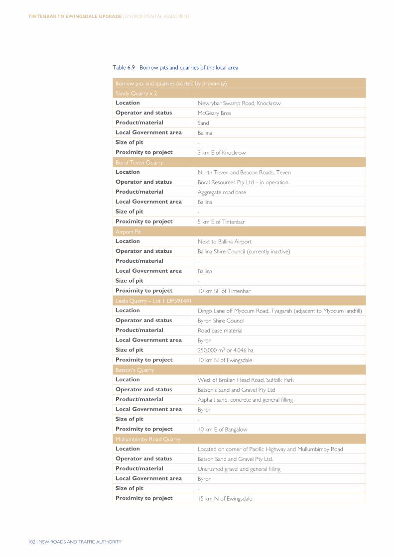
Requirements for materials would also depend on the final design and the extent of the use of pre-cast components for bridges and structures but indicative quantities for major items (excluding pre-cast concrete components) are given in table 6.9.
There are some industrial mineral borrow areas or quarries in the vicinity of the proposed upgrade. These possible local sources for construction materials are heavily favoured due to the reduction in transport, haulage and logistical costs of their use. A list of potential material sources from the local area of the proposed upgrade is given in table 6.9. The possible sites have not been directly approached regarding availability and they should not be assumed to be available at the time of construction.
102 | NSW ROADS AND TRAFFIC AUTHORITY
tintenBar to ewingSdale Upgrade | ENVIRONMENTAL ASSESSMENT
Table 6.9 - Borrow pits and quarries of the local area
Borrow pits and quarries (sorted by proximity)
Sandy Quarry x 2
Location Newrybar Swamp Road, Knockrow
Operator and status McGeary Bros
Product/material Sand
Local Government area Ballina
Size of pit -
Proximity to project 3 km E of Knockrow
Boral Teven Quarry
Location North Teven and Beacon Roads, Teven
Operator and status Boral Resources Pty Ltd – in operation.
Product/material Aggregate road base
Local Government area Ballina
Size of pit -
Proximity to project 5 km E of Tintenbar
Airport Pit
Location Next to Ballina Airport
Operator and status Ballina Shire Council (currently inactive)
Product/material -
Local Government area Ballina
Size of pit -
Proximity to project 10 km SE of Tintenbar
Leela Quarry – Lot 1 DP591441
Location Dingo Lane off Myocum Road, Tyagarah (adjacent to Myocum landfill)
Operator and status Byron Shire Council
Product/material Road base material
Local Government area Byron
Size of pit 250,000 m3 or 4.046 ha
Proximity to project 10 km N of Ewingsdale
Batson’s Quarry
Location West of Broken Head Road, Suffolk Park
Operator and status Batson’s Sand and Gravel Pty Ltd
Product/material Asphalt sand, concrete and general filling
Local Government area Byron
Size of pit -
Proximity to project 10 km E of Bangalow
Mullumbimby Road Quarry
Location Located on corner of Pacific Highway and Mullumbimby Road
Operator and status Batson Sand and Gravel Pty Ltd.
Product/material Uncrushed gravel and general filling
Local Government area Byron
Size of pit -
Proximity to project 15 km N of Ewingsdale
UPGRADING THE PACIFIC HIGHWAY | 103
Chapter 6 | DETAILED DESIGN AND CONSTRUCTION OF THE PROPOSED UPGRADE
Table 6.9 (cont)
Borrow pits and quarries (sorted by proximity)
Ocean Shores Quarry
Location Off Coolamon Scenic Drive, Ocean Shores
Operator and status Batson Sand and Gravel Pty Ltd.
Product/material Road base and general filling
Local Government area Byron
Size of pit -
Proximity to project 15 km N of Ewingsdale
Mudges Quarry
Location Off Coolamon Scenic Drive, Ocean Shores
Operator and status Not established
Product/material -
Local Government area Byron
Size of pit -
Proximity to project 15 km N of Ewingsdale
Northern Rivers Quarry
Location Off Nimbin Road, West of Lismore
Operator and status Northern Rivers Asphalt
Product/material -
Local Government area Lismore City Council
Size of pit -
Proximity to project 25 km W of Knockrow
Blakebrook Quarry
Location Blakebrook
Operator and status Lismore City Council
Product/material Basalt
Local Government area Lismore City Council
Size of pit 80.9 ha and can extract 200,000 m3 pa.
Proximity to project 35 km W of Knockrow
104 | NSW ROADS AND TRAFFIC AUTHORITY
tintenBar to ewingSdale Upgrade | ENVIRONMENTAL ASSESSMENT
The total tonnage of coarse aggregates for on-site batched concrete, asphaltic concrete and pavements required for the full length of the highway upgrade could be up to 350,000 tonnes depending on the type of pavement adopted. It is anticipated that pavement and bridge construction would be spread over approximately two to three years, as such requirements could be up to 150,000 tonnes per year.
Depending again on the pavement type and extent of usage of pre-cast concrete, sand (fine aggregates) would be required for on-site batched concrete, lean mix and asphaltic concrete. Requirements could total up to 180,000 tonnes of clean, durable sand with a low alkali/silica reaction.
6.5.3 Workforce
A peak construction workforce of about 250 to 300 people is anticipated. The average size of the construction workforce on site would be approximately 150 people including management staff and subcontractors. It is expected that employment opportunities would be available for workers in the Ballina Shire and Byron Shire local government areas.
6.5.4 Spoil disposal
The proposed upgrade would result in a surplus of material of approximately 790,000 m³, consisting predominantly of soil. This figure is based on the concept design. Refinements during detailed design may allow this to be reduced.
Due to this large volume, some impacts may be created from spoil disposal. The following spoil disposal strategy has been developed. Items are listed in priority order to reduce impacts. It is intended that all spoil would be disposed of using one or more of the following methods.
1. Spoil volume reductionDetailed geotechnical investigations would be carried out as part of the detailed design with possible alignment and profile refinements resulting in a reduced volume of spoil requiring disposal subject to achieving urban design objectives. Refinements might include engineering measures such as stabilisation of cut slopes to reduce the volume of cut material to be removed.
2. opportunities for disposal/blending of excess fill within the road reserve
Flattening of fill batters and placement of fill would be investigated subject to identified constraints and opportunities (such as landowner consultation, landscape and visual amenity, terrestrial ecology, hydrology and flora and fauna).
3. negotiation with adjacent landowners to spoil excess material or identification of other uses outside of the study area
Any significant provision of spoil to landowners or other users would be conditional on the recipient providing evidence of having any necessary approvals for receipt of such material (eg council development approval, or section 43 licence under the Protection of the Environment Operations Act) and would also be subject to meeting the requirements of spoil storage and management from the construction environmental management plan (CEMP), including mitigation against environmental impacts of spoil disposal. Key mitigation in the CEMP would include:
UPGRADING THE PACIFIC HIGHWAY | 105
Chapter 6 | DETAILED DESIGN AND CONSTRUCTION OF THE PROPOSED UPGRADE
> Spoil is not to be deposited in areas where sedimentation of waterways could result.
> Deposition of within drainage lines is to be avoided.
> Spoil is to be kept covered during transportation, and for any extended storage.
> Early development of vegetation/landscaping is required.
4. Use of spoil disposal sites
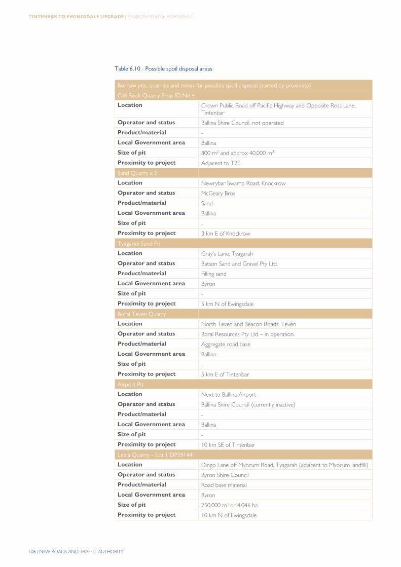
Any remaining excess material following steps 1, 2 and 3 would be transported to suitable spoil disposal sites, chosen from the potential sites identified both within and external to the proposed upgrade road reserve. Potential sites are discussed below and identified in table 6.10. Nearby sites would be preferred to reduce haulage.
The contractor’s CEMP would be required to incorporate the following measures in relation to spoil disposal:
> Air quality and dust suppression.
> Noise requirements of the NSW Environment Protection Authority’s “Environmental Criteria for Road Traffic Noise (EPA 1999) and the Road Traffic Authority’s “Environmental Noise Management Manual” (RTA 2001).
> Terrestrial ecology. Spoil would not be deposited in areas that could affect ecological values. Sites would be favoured that have potential for revegetation and landscaping following disposal.
> Hydrology and water quality. Spoil would not be deposited in areas where sedimentation of waterways could result.
> Haulage. A traffic management plan would be prepared for haulage of spoil to disposal sites, to address vehicle numbers, preferred haulage routes (in consultation with relevant authorities), hours of operation, and noise, dust and air quality impacts from transportation.
A disused Ballina Shire Council owned quarry at Tintenbar may be useful as a disposal site for spoil. The site has been used as a hard rock quarry and consists of a large open cut pit with vertical basaltic walls which is currently overgrown with weeds (such as camphor laurel). Deposition of excess fill in the pit with appropriate subsequent revegetation with local species may be a good remediation option for the site. The site is estimated at 800 m² in area with a possible fill volume of 40,000 m³.
A preliminary search for possible disposal sites has also been undertaken in the wider local area, and throughout the Northern Rivers region. The most probable locations for suitability such as disused mine sites, landfills and quarries have been investigated with input from the Department of Primary Industries and the Department of Lands.
106 | NSW ROADS AND TRAFFIC AUTHORITY
tintenBar to ewingSdale Upgrade | ENVIRONMENTAL ASSESSMENT
Table 6.10 - Possible spoil disposal areas
Borrow pits, quarries and mines for possible spoil disposal (sorted by proximity)
Old Rock Quarry Prop ID No 4
Location Crown Public Road off Pacific Highway and Opposite Ross Lane, Tintenbar
Operator and status Ballina Shire Council, not operated
Product/material -
Local Government area Ballina
Size of pit 800 m2 and approx 40,000 m3
Proximity to project Adjacent to T2E
Sand Quarry x 2
Location Newrybar Swamp Road, Knockrow
Operator and status McGeary Bros
Product/material Sand
Local Government area Ballina
Size of pit -
Proximity to project 3 km E of Knockrow
Tyagarah Sand Pit
Location Gray’s Lane, Tyagarah
Operator and status Batson Sand and Gravel Pty Ltd.
Product/material Filling sand
Local Government area Byron
Size of pit -
Proximity to project 5 km N of Ewingsdale
Boral Teven Quarry
Location North Teven and Beacon Roads, Teven
Operator and status Boral Resources Pty Ltd – in operation.
Product/material Aggregate road base
Local Government area Ballina
Size of pit -
Proximity to project 5 km E of Tintenbar
Airport Pit
Location Next to Ballina Airport
Operator and status Ballina Shire Council (currently inactive)
Product/material -
Local Government area Ballina
Size of pit -
Proximity to project 10 km SE of Tintenbar
Leela Quarry – Lot 1 DP591441
Location Dingo Lane off Myocum Road, Tyagarah (adjacent to Myocum landfill)
Operator and status Byron Shire Council
Product/material Road base material
Local Government area Byron
Size of pit 250,000 m3 or 4.046 ha
Proximity to project 10 km N of Ewingsdale
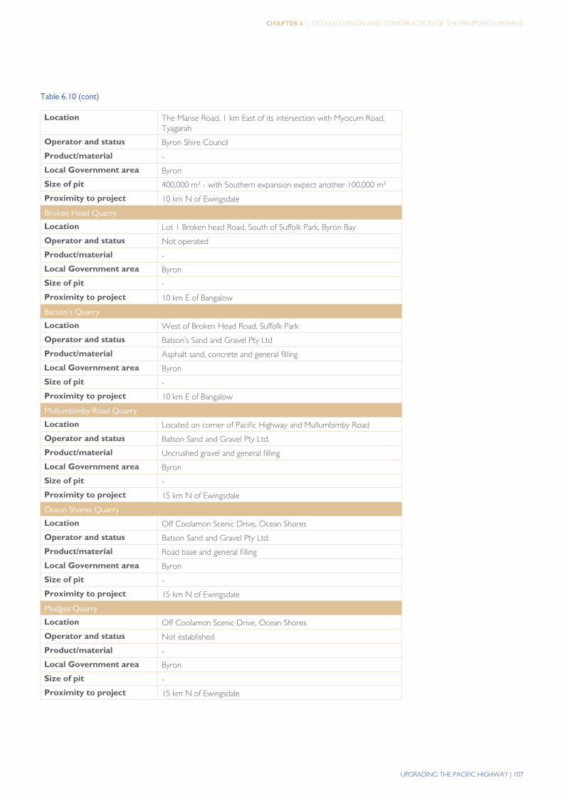
UPGRADING THE PACIFIC HIGHWAY | 107
Chapter 6 | DETAILED DESIGN AND CONSTRUCTION OF THE PROPOSED UPGRADE
Table 6.10 (cont)
Location The Manse Road, 1 km East of its intersection with Myocum Road, Tyagarah
Operator and status Byron Shire Council
Product/material -
Local Government area Byron
Size of pit 400,000 m³ - with Southern expansion expect another 100,000 m³
Proximity to project 10 km N of Ewingsdale
Broken Head Quarry
Location Lot 1 Broken head Road, South of Suffolk Park, Byron Bay
Operator and status Not operated
Product/material -
Local Government area Byron
Size of pit -
Proximity to project 10 km E of Bangalow
Batson’s Quarry
Location West of Broken Head Road, Suffolk Park
Operator and status Batson’s Sand and Gravel Pty Ltd
Product/material Asphalt sand, concrete and general filling
Local Government area Byron
Size of pit -
Proximity to project 10 km E of Bangalow
Mullumbimby Road Quarry
Location Located on corner of Pacific Highway and Mullumbimby Road
Operator and status Batson Sand and Gravel Pty Ltd.
Product/material Uncrushed gravel and general filling
Local Government area Byron
Size of pit -
Proximity to project 15 km N of Ewingsdale
Ocean Shores Quarry
Location Off Coolamon Scenic Drive, Ocean Shores
Operator and status Batson Sand and Gravel Pty Ltd.
Product/material Road base and general filling
Local Government area Byron
Size of pit -
Proximity to project 15 km N of Ewingsdale
Mudges Quarry
Location Off Coolamon Scenic Drive, Ocean Shores
Operator and status Not established
Product/material -
Local Government area Byron
Size of pit -
Proximity to project 15 km N of Ewingsdale
108 | NSW ROADS AND TRAFFIC AUTHORITY
tintenBar to ewingSdale Upgrade | ENVIRONMENTAL ASSESSMENT
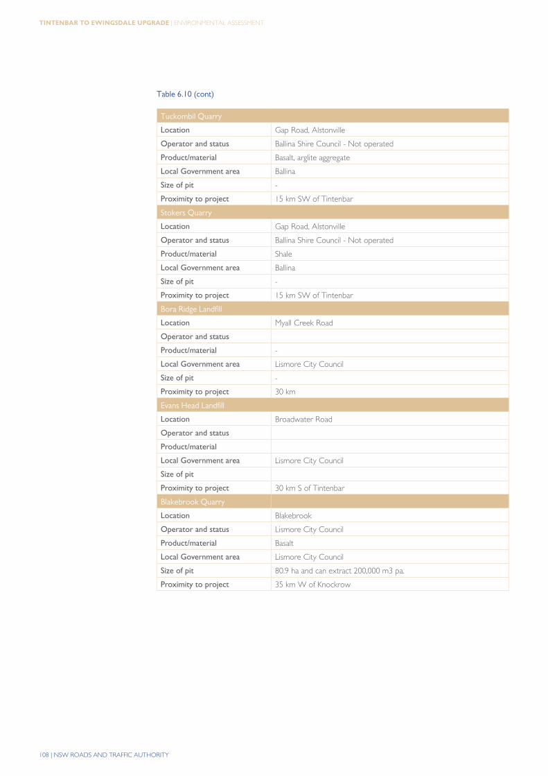
Table 6.10 (cont)
Tuckombil Quarry
Location Gap Road, Alstonville
Operator and status Ballina Shire Council - Not operated
Product/material Basalt, arglite aggregate
Local Government area Ballina
Size of pit -
Proximity to project 15 km SW of Tintenbar
Stokers Quarry
Location Gap Road, Alstonville
Operator and status Ballina Shire Council - Not operated
Product/material Shale
Local Government area Ballina
Size of pit -
Proximity to project 15 km SW of Tintenbar
Bora Ridge Landfill
Location Myall Creek Road
Operator and status
Product/material -
Local Government area Lismore City Council
Size of pit -
Proximity to project 30 km
Evans Head Landfill
Location Broadwater Road
Operator and status
Product/material
Local Government area Lismore City Council
Size of pit
Proximity to project 30 km S of Tintenbar
Blakebrook Quarry
Location Blakebrook
Operator and status Lismore City Council
Product/material Basalt
Local Government area Lismore City Council
Size of pit 80.9 ha and can extract 200,000 m3 pa.
Proximity to project 35 km W of Knockrow
UPGRADING THE PACIFIC HIGHWAY | 109
Chapter 6 | DETAILED DESIGN AND CONSTRUCTION OF THE PROPOSED UPGRADE
6.5.5 Energy consumption
energy required for road construction
Most of the construction work for the proposed upgrade would be undertaken by diesel-powered machinery. However, the range of construction equipment used would be dependent on the contractor selected and the actual conditions encountered during construction. The range of construction equipment is likely to include, but would not be limited to:
> Light transport vehicles.
> Graders and scrapers.
> Bulldozers.
> Front-end loaders and backhoes.
> Excavators.
> Drilling rigs.
> Compactors and compressors.
> Water trucks.
> Materials trucks (road and off-road).
> Backhoes, paving machines and other heavy weight vehicles.
> Pile driving rigs - land-based.
> Cranes - barge-mounted and land-based.
> Concrete pumps and air compressors.
> Concrete and/or asphalt batching plants.
> Crushing plants.
Given the extent and nature of the proposed upgrade, a large quantity of fuel is likely to be used. Fuel consumption would depend on factors including the age and condition of equipment, the speed of operation, haul lengths, and the site conditions encountered. The volume of fuel used would be generally proportional to the earthworks involved. Fuel would also be consumed in other construction activities such as bridge construction, batching plant operation, pavement laying and landscaping. Fuel usage is estimated at approximately 8 million litres of diesel. An estimate of the greenhouse gas implications of the construction and operation of the proposed upgrade is provided in Section 20.2
6.5.6 Water consumption
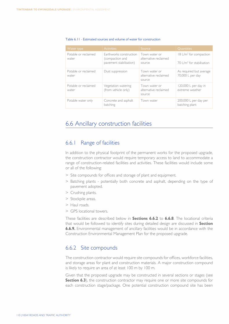
Indicative quantities of water use during construction and potential sources are outlined in table 6.11.
110 | NSW ROADS AND TRAFFIC AUTHORITY
tintenBar to ewingSdale Upgrade | ENVIRONMENTAL ASSESSMENT
Table 6.11 - Estimated sources and volume of water for construction
Water type Activities Source Quantities
Potable or reclaimed water
Earthworks construction (compaction and pavement stabilisation)
Town water or alternative reclaimed source
18 L/m3 for compaction
70 L/m3 for stabilisation
Potable or reclaimed water
Dust suppression Town water or alternative reclaimed source
As required but average 70,000 L per day
Potable or reclaimed water
Vegetation watering (from vehicle only)
Town water or alternative reclaimed source
120,000 L per day in extreme weather
Potable water only Concrete and asphalt batching
Town water 200,000 L per day per batching plant
6.6 Ancillary construction facilities
6.6.1 Range of facilities
In addition to the physical footprint of the permanent works for the proposed upgrade, the construction contractor would require temporary access to land to accommodate a range of construction-related facilities and activities. These facilities would include some or all of the following:
> Site compounds for offices and storage of plant and equipment.
> Batching plants - potentially both concrete and asphalt, depending on the type of pavement adopted.
> Crushing plants.
> Stockpile areas.
> Haul roads.
> GPS locational towers.
These facilities are described below in Sections 6.6.2 to 6.6.8. The locational criteria that would be followed to identify sites during detailed design are discussed in Section 6.6.9. Environmental management of ancillary facilities would be in accordance with the Construction Environmental Management Plan for the proposed upgrade.
6.6.2 Site compounds
The construction contractor would require site compounds for offices, workforce facilities, and storage areas for plant and construction materials. A major construction compound is likely to require an area of at least 100 m by 100 m.
Given that the proposed upgrade may be constructed in several sections or stages (see Section 6.3), the construction contractor may require one or more site compounds for each construction stage/package. One potential construction compound site has been
UPGRADING THE PACIFIC HIGHWAY | 111
Chapter 6 | DETAILED DESIGN AND CONSTRUCTION OF THE PROPOSED UPGRADE
identified at this stage, adjacent to the preliminary batching plant location (see Section 6.6.3) on the eastern side of the proposed upgrade at Bangalow Road.
The construction compounds would be fenced for security and safety purposes. Initial site works for the compounds would involve site clearing and installation of appropriate environmental controls. Hard-standing areas would be provided for parking, storage, access roads, and site sheds.
6.6.3 Concrete batching plants
Construction of bridge structures (depending on design) may require concrete to be placed in-situ over a period of up to one and a half years. Concrete for road pavements would be required over a period of around two years. This is likely to require one or more concrete batching plants to be constructed on or near the proposed upgrade. Locational criteria that would be used to identify sites suitable for concrete batching plants have been identified in table 6.12. Preliminary general locations for the location of batching plants (either asphalt or concrete) have been identified, including:.
> On the eastern side of the Ewingsdale interchange.
> On Bangalow Road on the eastern side of the proposed upgrade.
> On the north-western side of the proposed Ross Lane interchange.
The final location for batching plants would be determined during detailed design and would be influenced by the specific approach of the construction contractor(s).
It is highly desirable that crushing plants (see Section 6.6.5) be located in the vicinity of concrete batching plants, and this would be taken into consideration when choosing the relevant locations for the facilities.
Temporary buildings for staff amenities, offices and quality assurance control would also be required.
6.6.4 Asphalt batching plants
Adoption of a flexible pavement with deep asphalt, or low noise asphalt surfacing for the proposed upgrade would require asphaltic concrete to be placed over a period of about two years. This is likely to require one or more asphalt batching plants to be constructed on or near the proposed upgrade. Locational criteria that would be used to identify sites suitable for asphalt batching plants have been identified below.
The potential concrete batching plant sites listed in Section 6.6.5 may be equally suitable for asphalt batching plants.
It is highly desirable that crushing plants (see Section 6.6.5) be located in the vicinity of asphalt batching plants (particularly if flexible pavement is adopted), and this would be taken into consideration when choosing the relevant locations for the facilities.
Temporary buildings for staff amenities, offices and quality assurance control would also be required.
112 | NSW ROADS AND TRAFFIC AUTHORITY
tintenBar to ewingSdale Upgrade | ENVIRONMENTAL ASSESSMENT
6.6.5 Crushing plants
Locations which are suited for construction of a crushing plant include the vicinity of the Emigrant Creek bridge site and in the vicinity of the tunnel under the St Helena ridgeline. A crushing plant near the tunnel may be required due to the significant volumes of rock spoil that would be generated at this site.
The crushing plant area would also be expected to include areas for the stockpiling of material. The stockpiling requirements would again depend on the construction staging and contractor’s work methods but assuming conservatively that all rock would be crushed, storage would be required for 30 percent of the rock cut volume.
The crushing plant could also potentially produce aggregates for concrete and/or asphalt. Should the construction contractor adopt this option, the crushing plants would be located adjacent or as near as possible to concrete or asphalt batch plants to reduce truck traffic on public roads.
The location of the crushing plant would be determined by the construction staging (if any) and the associated mass haul balance, access, environmental and amenity issues.
6.6.6 Stockpile sites
It is likely that there would be a requirement for stockpiling of general fill material at various locations along the proposed upgrade, and for temporary storage of select material, rock or other imported materials.
Certain cuts and sections of the proposed upgrade would create excess spoil which may require some stockpiling arrangements prior to final disposal. For these areas it is estimated that there could be a requirement for stockpiles of up to 500,000 m3 of excavated material during the project. In the event of a stockpile of this size being required and assuming a typical maximum height of 3 m, stockpile areas of up to 14 ha would be required.
In addition, areas would be required for the stockpiling of topsoil materials from cut and fill areas prior to placement on medians, embankment slopes, and flatter cut and fill batters.
The potential stockpile areas would also be suitable for the temporary storage of other materials such as unsuitable material, cleared vegetation mulch, rock and excess concrete.
The construction contractor would be required to protect stockpiles of erodible material such as topsoil against erosion by mulching or other means.
6.6.7 Haul roads
Haul roads would be installed inside the road reserve to enable the efficient movement of construction vehicles, plant and equipment. In occasional cases it may be necessary to locate haul roads outside the road reserve for a short distance. This would be carried out in a way that minimises impacts on the surrounding environment. It may be carried out to avoid construction traffic needing to use the public road network.
6.6.8 GPS locational towers
Depending on surveying requirements, a small number of GPS locational towers may be constructed either inside or outside the road reserve. These would typically be small
UPGRADING THE PACIFIC HIGHWAY | 113
Chapter 6 | DETAILED DESIGN AND CONSTRUCTION OF THE PROPOSED UPGRADE
areas (approximately 20 m x 20 m) and be located to avoid impacts on the surrounding environment.
6.6.9 Site identification for ancillary facilities
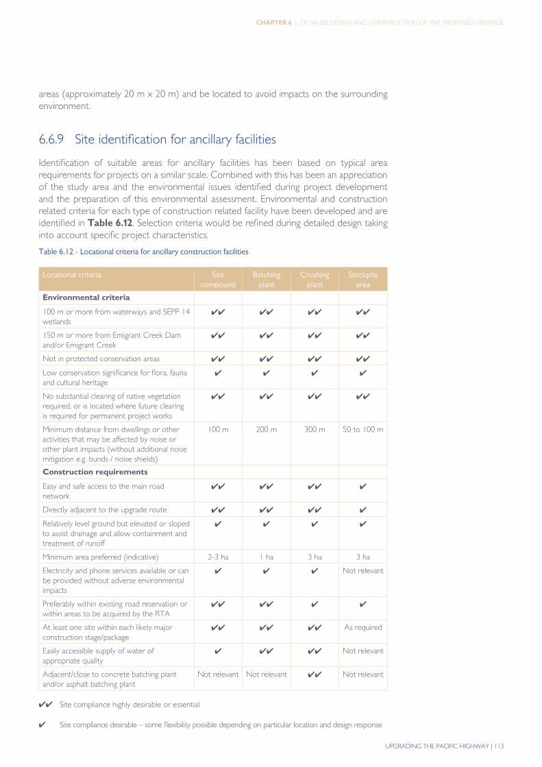
Identification of suitable areas for ancillary facilities has been based on typical area requirements for projects on a similar scale. Combined with this has been an appreciation of the study area and the environmental issues identified during project development and the preparation of this environmental assessment. Environmental and construction related criteria for each type of construction related facility have been developed and are identified in table 6.12. Selection criteria would be refined during detailed design taking into account specific project characteristics.
Table 6.12 - Locational criteria for ancillary construction facilities
Locational criteria Site compound
Batching plant
Crushing plant
Stockpile area
Environmental criteria
100 m or more from waterways and SEPP 14 wetlands
✔✔ ✔✔ ✔✔ ✔✔
150 m or more from Emigrant Creek Dam and/or Emigrant Creek
✔✔ ✔✔ ✔✔ ✔✔
Not in protected conservation areas ✔✔ ✔✔ ✔✔ ✔✔
Low conservation significance for flora, fauna and cultural heritage
✔ ✔ ✔ ✔
No substantial clearing of native vegetation required, or is located where future clearing is required for permanent project works
✔✔ ✔✔ ✔✔ ✔✔
Minimum distance from dwellings or other activities that may be affected by noise or other plant impacts (without additional noise mitigation e.g. bunds / noise shields)
100 m 200 m 300 m 50 to 100 m
Construction requirements
Easy and safe access to the main road network
✔✔ ✔✔ ✔✔ ✔
Directly adjacent to the upgrade route ✔✔ ✔✔ ✔✔ ✔
Relatively level ground but elevated or sloped to assist drainage and allow containment and treatment of runoff
✔ ✔ ✔ ✔
Minimum area preferred (indicative) 2-3 ha 1 ha 3 ha 3 ha
Electricity and phone services available or can be provided without adverse environmental impacts
✔ ✔ ✔ Not relevant
Preferably within existing road reservation or within areas to be acquired by the RTA
✔✔ ✔✔ ✔ ✔
At least one site within each likely major construction stage/package
✔✔ ✔✔ ✔✔ As required
Easily accessible supply of water of appropriate quality
✔ ✔✔ ✔✔ Not relevant
Adjacent/close to concrete batching plant and/or asphalt batching plant
Not relevant Not relevant ✔✔ Not relevant
✔✔ Site compliance highly desirable or essential
✔ Site compliance desirable – some flexibility possible depending on particular location and design response
114 | NSW ROADS AND TRAFFIC AUTHORITY
tintenBar to ewingSdale Upgrade | ENVIRONMENTAL ASSESSMENT
6.6.10 Site rehabilitation
Site rehabilitation works would be undertaken progressively throughout construction, with full rehabilitation of ancillary construction sites once the sites are no longer required. Site rehabilitation measures would include, but not be limited to ripping, reinstatement of topsoil, landscaping and revegetation, and spoil and rubbish removal.
6.7 Construction management
6.7.1 Traffic management during construction
There are no appropriate alternative temporary routes to the existing highway that could be used during construction. Provision for highway traffic would be included in the construction sequencing and construction methodology for all sections of the proposed upgrade, consistent with the RTA’s Traffic Control at Work Sites (RTA 2003).
Much of the proposed upgrade would be able to be constructed with minimal disruption to existing highway traffic (e.g. the Bangalow bypass to south of tunnel section). However, there are a number of locations where construction activities would be required in close proximity to existing highway traffic.
Locations where work would be carried out in close proximity to the existing highway are:
> At the tie-ins at the southern limit of the project to the north of the Ross Lane interchange.
> At the Emigrant Creek bridge and the overpass of the existing highway.
> At the Bangalow Road overpass.
> Along the duplicated section of the existing Bangalow bypass.
> At the tie-in at the northern limit of the project at the Ewingsdale interchange.
The Broken Head Road overpass can be constructed without affecting traffic on the existing highway, but construction would have impacts on road users of Broken Head Road.
In addition to speed restrictions and traffic controls, night work could be required for short periods at the above locations, to allow smooth transitions to occur and traffic diversions to be installed while minimising traffic impacts. Detailed arrangements for works in these areas would be developed during detail design.
Haulage may have an impact on local roads. It would include the transfer of fill material within and beyond the construction corridor as well as the delivery of construction materials. Where significant volumes of fill material need to be transferred within the construction corridor. Haulage would also take into account peak travel hours and times, particularly during school and public holiday periods, to minimise the potential for delays on the existing highway to the travelling public.
UPGRADING THE PACIFIC HIGHWAY | 115
Chapter 6 | DETAILED DESIGN AND CONSTRUCTION OF THE PROPOSED UPGRADE
6.7.2 Waste management
The selected construction contractor(s) would be required to minimise and manage waste during construction. Guidelines for managing waste, implementing re-use and recycling programs, and disposing appropriately of other non-reusable waste would be developed, consistent with the objectives of the Waste Avoidance and Resource Recovery Act 2001 and the Waste Avoidance and Resource Recovery Strategy (DEC 2006).
reuse and recycling of materials during construction
Where possible and consistent with other environmental and occupational health and safety requirements, waste materials would be recycled either on-site or through approved off-site recycling programs. Examples of potential opportunities for recycling of materials during construction include:
> Tree and plant material generated during initial site clearing - with the exception of certain weeds and invasive plant species, this material would be mulched and used on-site during construction for erosion and sediment control, and where possible larger logs would be salvaged for reuse.
> Houses to be demolished - recycling of building materials would be optimised.
> Reuse of the existing highway - e.g. depending on agreements reached with the Ballina Shire and Byron Shire councils, reuse of pavement materials from redundant sections of the old highway in the vicinity of the Emigrant Creek bridge.
> Rock and soil material found to be unsuitable for construction purposes - would be reused if possible within the project area in batter extensions, subject to meeting the landscape and urban design objectives described in Section 5.16.
> On-site facilities for sorting of paper, plastic, glass and other waste from site compounds - to be recycled through local council recycling programs.
> Topsoil and fill generally.
Recommended