CV: Dr. A K Saha
Curriculum Vitae
Dr. ASHIS KUMAR SAHA
Affiliation
Assistant Professor (Remote Sensing, Computer and GIS) Department of Geography, Delhi School of Economics, University of Delhi, India
Contact Details
Mailing Address
Department of Geography Delhi School of Economics University of Delhi Delhi – 110 007, INDIA
E-Mail [email protected], [email protected]
Phone +91-11-27666491(O) Cell Phone +91-9818503393
Fax +91-11-27667336
URL http://people.du.ac.in/~aksaha/
Academic Qualification
Ph.D. (2004) In Earth Sciences from Department of Earth Sciences, Indian Institute of Technology Roorkee, Roorkee, India Topic: “GIS-based Study for Route Planning in Landslide Susceptible Terrain”
M.Tech. (1999)
In Applied Geology from Department of Earth Sciences, University of Roorkee (Now IIT Roorkee), Roorkee, India with special courses on Remote Sensing, Environmental Geosciences, GIS, Numerical Methods & Computer Programming, Obtained: 82.7% marks (1st Division with Honors) Dissertation Topic: “Landslide Hazard Zonation Studies in the Bhagirathi Valley- using Remote Sensing - G.I.S.”
B.Sc. (1996) In Geology (Honors) from Department of Geology, Presidency College, University of Calcutta, Kolkata, India Obtained: 71% marks (1st Class)
Studies Abroad
Jun 2001 - Sep 2002
DAAD – Sandwich Model Fellowship
4–month German language course at Goethe Institute, Dresden, Germany
1–year Doctoral Research at Institute of Photogrammetry and Remote Sensing, Dresden University of Technology, Dresden, Germany
Employment
6th Apr 2005 - till date
Assistant Professor (Remote Sensing and GIS) at Department of Geography, Delhi School of Economics, University of Delhi, Delhi -110 007, India
1st Dec 2004 - 31st Mar 2005
Senior Research Associate (Landscape Ecology / Hydrology Group) at Ashoka Trust for Research in Ecology and the Environment (ATREE), an NGO at Bangalore, India
CV: Dr. A K Saha
Awards 1991-1996 Indian National Scholarships
1998-1999 University Grants Commission Scholarship
1999 B.L.Wadhawan Prize for highest marks in M.Tech. (Appl. Geology Dissertation)
1999 S. Devi Prize for highest marks in the final year in all PG Science Courses
Fellowships
2000 - 2001 Junior Research Fellowship from Council for Scientific and Industrial Research (CSIR), New Delhi, India
2001 – 2002 German Academic Exchange Service (DAAD) Sandwich Model Fellowship, Bonn, Germany
2002 – 2004 Senior Research Fellowship from Council for Scientific and Industrial Research (CSIR), New Delhi, India
2009 German Academic Exchange Service (DAAD) Re-invitation Fellowship, Bonn, Germany
2014 German Academic Exchange Service (DAAD) Re-invitation Fellowship, Bonn, Germany
2018 German Academic Exchange Service (DAAD) Re-invitation Fellowship, Bonn, Germany
Specialized Training
2nd Jun- 23rd Jun 1998
“Mine Training” at Mochia Pb-Zn mine, Zawar, Rajasthan
6th Dec- 17th Dec 1999
“SAR Interferometry Technology and Application” at CSRE-IIT Bombay, India
31st Mar- 5th Apr 2003
“GIS and Remote Sensing for Disaster Mitigation” at GIS Institute, Noida, India
13th Oct- 18th Oct 2003
“GPS Applications for Landslide and Resource Planning” at IIT Roorkee, India
8th Dec- 12th Dec 2003
“Landslide Analysis and Control” at IIT Roorkee, India
11th Jan- 13th Jan 2005
“Modelling Land-Use Land-Cover Change and Species Distribution” at ATREE, Bangalore, India
6th May- 3rd Jun 2008
“Orientation Course” for Lecturers at Centre for Professional Development in Higher Education (University Grants Commission – Academic Staff College), University of Delhi, Delhi, India
5th Sep- 25th Sep 2017
“Refresher Course in Summer School (Inter-disciplinary)” at Centre for Professional Development in Higher Education (University Grants Commission – Academic Staff College), University of Delhi, Delhi, India
29th Jan- 2nd Feb 2018
“One Week National Level Training of Trainers Program on Drought Assessment” at National Institute of Disaster Management, Ministry of Home Affairs, Government of India, New Delhi, India
Technical Skills Image Processing ERDAS Imagine, Leica Photogrammetry Suit, eCognition Developer, ENVI
GIS Software ArcGIS, ILWIS, Idrisi TerrSet, MapInfo, QGIS
GPS Software SKI
Hydrology WMS
Programming FORTRAN, C and C++
CV: Dr. A K Saha
Teaching Experience Total Experience >13 Years
Subjects Taught MA (Geography) - Remote Sensing and GIS (Fundamentals and Advanced) - Computer Applications in Geography (Old Syllabus) - Computer Aided Mapping and Thematic Atlas - Terrain Modelling and Analysis - Natural Hazards and Disaster Management - Advanced Physical Geography
MPhil (Geography) - Natural Hazards and Disaster - Environmental Monitoring and GIS - Research Methodology
MA/MSc (Environmental Studies) (at School of Environmental Studies, Delhi Univ. as a Guest Lecturer) - Methodologies in Environmental Studies (2005-2009) - Environmental Hazards (2006)
BSc (Geology) (at Department of Geology, Delhi Univ. as a Guest Lecturer) - Photogeology, Remote Sensing and GIS (2009-2010)
Research Experience Total Experience >13 years (post-PhD)
Areas of Interest Geo-environmental Studies using Remote Sensing and GIS: Landslide Hazard Zonation; Landuse / Landcover Mapping and Change Detection; OBIA; Digital Image Classification; Drought; Digital Terrain Modeling
Publication
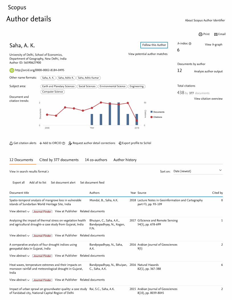
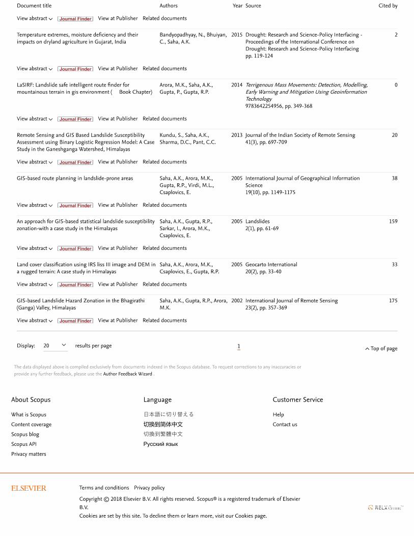
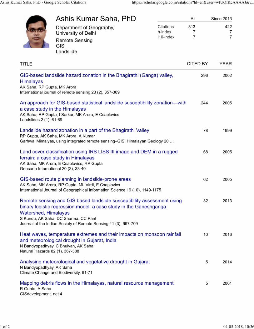
Peer-reviewed journals: 10 (Impact Factor 2016: 0.214-3.657) (Max Citation: 175; Total Citation- Scopus: 438) h-index: 6 (Scopus), 7 (Google Scholar) Other research articles: 2 Chapter in books/proceedings: 11 (International: 6, National: 5) + 1 (Accepted)
Research Projects
“Remote Sensing – GIS based Landslide Inventory Mapping and Susceptibility Zonation using Analytical Hierarchy Process (AHP) in a Himalayan Terrain” Funded by: University of Delhi; Duration: Phase-I, II & III (2008-11) Grant Amount: Rs. 285,000
“Development of Object-based Remote Sensing – GIS Methodology for Landslide Recognition and Hazard Zonation in the Garhwal Himalayas” Funded by: Department of Science & Technology, Government of India under SERC Fast Track Proposal for Young Scientists, 2010-11; Duration: 3 Years (2011-14) Grant Amount: Rs. 175,7000
“Landslide Susceptibility Zonation using Weights-of-Evidence and Logistic Regression Model: A Comparative Analysis in the Chamoli-Joshimath Road Section, Uttarakhand” Funded by: University of Delhi; Duration: Phase-I & II (2011-13) Grant Amount: Rs. 190,000
“Landuse/landcover change detection using Object-based Image Analysis (OBIA) approach in Chamoli Region (Uttarakhand)” Funded by: University of Delhi; Duration: Phase-I (2013-14) Grant Amount: Rs. 60,000
“Mapping and Monitoring of Mangroves in Indian Sundarban using Time-Series Remote Sensing Data” Funded by: University of Delhi; Duration: Phase-I (2015-16) Grant Amount: Rs. 1,50,000
CV: Dr. A K Saha
Ph.D. thesis supervised
2 (awarded), 1 (submitted) and 3 (in progress)
M.Phil. thesis supervised
12 (awarded) and 1 (in progress)
MA thesis supervised
43 (awarded) and 5 (Submitted in May 2018) (List Enclosed)
Professional Society Membership
Life Member, Indian Society of Remote Sensing, Dehradun, India Life Member, National Association of Geographers, India (NAGI), Delhi, India Life Member, The Association for Geographical Studies, Delhi, India
Fellow, The Society of Earth Scientists, Lucknow, India Life Member, The Indian Science Congress Association, Kolkata, India Member, European Drought Centre Member, International Association for Promoting Geoethics (IAPG) Joint Secretary, National Association of Geographers, India (NAGI),
Reviewer
GeoCarto International (Taylor & Francis) Journal of Zhejiang University-SCIENCE A (Springer) Journal of Development & Agricultural Economics (Academic Journals) Journal of Mountain Science (Springer) Environmental Earth Sciences (Springer) Cartography and Geographic Information Science (Taylor & Francis) Indian Journal of Geosciences (Geological Survey of India) Geomatics, Natural Hazards and Risk (Taylor & Francis) Natural Hazards (Springer) Disaster and Development (NIDM) Journal of Indian Society of Remote Sensing (Springer) GeoRisk (Taylor & Francis) Egyptian Journal of Remote Sensing (Elsevier) Asian Journal of Water, Environment and Pollution (Capital Publishing) Land Degradation & Development (Wiley) Remote Sensing Letters (Taylor & Francis)
Academic Administration
Resident Tutor (RT) of Gwyer Hall (Hostel), Delhi Univ. (2005 – 2007)
Member of various committees of the University of Delhi Personal Details
Date of Birth 16th September 1974
Sex Male
Marital Status Married
Nationality Indian
Passport Valid Indian Passport
Language Proficiency English, Bengali (Mother Tongue), Hindi, German
Hobbies Photography, Globetrotting Declaration
I hereby declare that the above particulars furnished by me are true to the best of my knowledge. Place: Delhi Date: May 4, 2018 (Ashis Kumar Saha)
Dr. A K Saha, Asstt. Prof., Dept. of Geography, DSE, University of Delhi
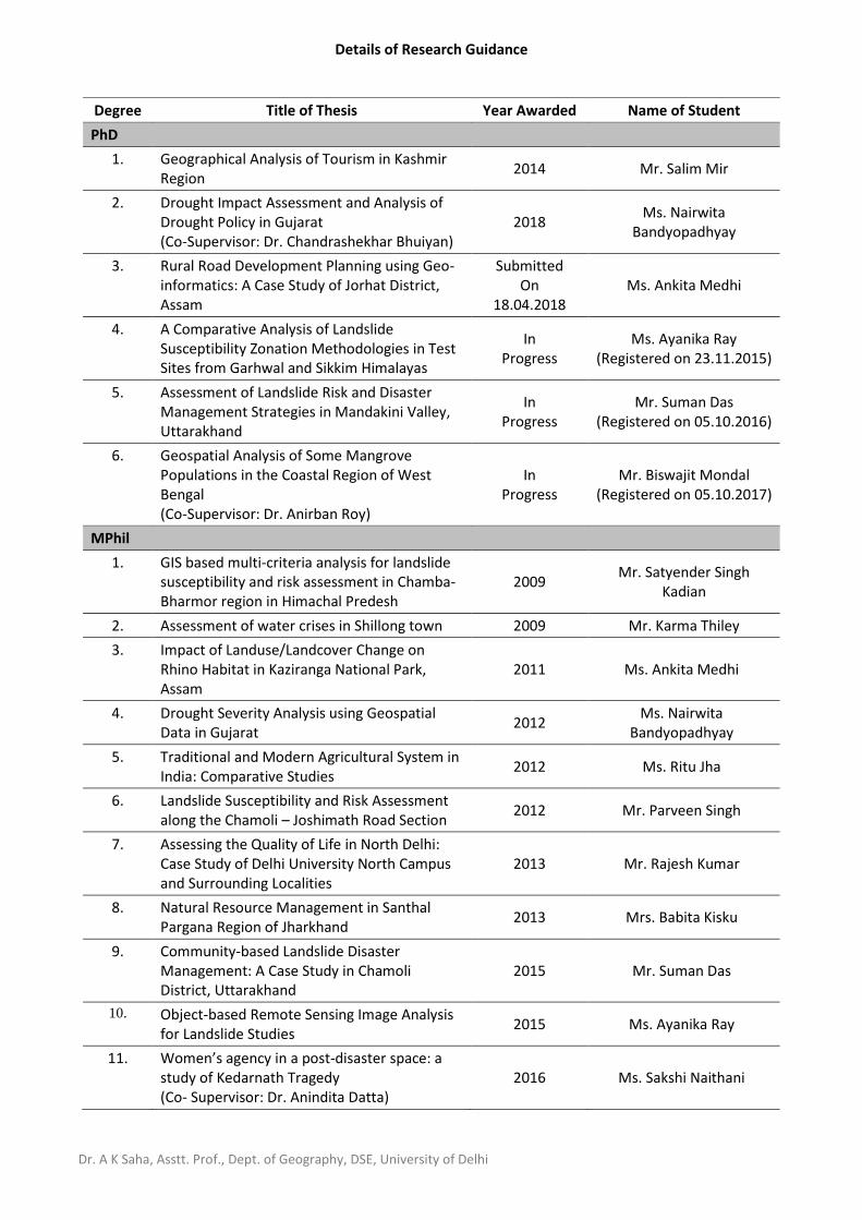
Details of Research Guidance
Degree Title of Thesis Year Awarded Name of Student
PhD
1. Geographical Analysis of Tourism in Kashmir Region
2014 Mr. Salim Mir
2. Drought Impact Assessment and Analysis of Drought Policy in Gujarat (Co-Supervisor: Dr. Chandrashekhar Bhuiyan)
2018 Ms. Nairwita
Bandyopadhyay
3. Rural Road Development Planning using Geo-informatics: A Case Study of Jorhat District, Assam
Submitted On
18.04.2018 Ms. Ankita Medhi
4. A Comparative Analysis of Landslide Susceptibility Zonation Methodologies in Test Sites from Garhwal and Sikkim Himalayas
In Progress
Ms. Ayanika Ray (Registered on 23.11.2015)
5. Assessment of Landslide Risk and Disaster Management Strategies in Mandakini Valley, Uttarakhand
In Progress
Mr. Suman Das (Registered on 05.10.2016)
6. Geospatial Analysis of Some Mangrove Populations in the Coastal Region of West Bengal (Co-Supervisor: Dr. Anirban Roy)
In Progress
Mr. Biswajit Mondal (Registered on 05.10.2017)
MPhil
1. GIS based multi-criteria analysis for landslide susceptibility and risk assessment in Chamba-Bharmor region in Himachal Predesh
2009 Mr. Satyender Singh
Kadian
2. Assessment of water crises in Shillong town 2009 Mr. Karma Thiley
3. Impact of Landuse/Landcover Change on Rhino Habitat in Kaziranga National Park, Assam
2011 Ms. Ankita Medhi
4. Drought Severity Analysis using Geospatial Data in Gujarat
2012 Ms. Nairwita
Bandyopadhyay
5. Traditional and Modern Agricultural System in India: Comparative Studies
2012 Ms. Ritu Jha
6. Landslide Susceptibility and Risk Assessment along the Chamoli – Joshimath Road Section
2012 Mr. Parveen Singh
7. Assessing the Quality of Life in North Delhi: Case Study of Delhi University North Campus and Surrounding Localities
2013 Mr. Rajesh Kumar
8. Natural Resource Management in Santhal Pargana Region of Jharkhand
2013 Mrs. Babita Kisku
9. Community-based Landslide Disaster Management: A Case Study in Chamoli District, Uttarakhand
2015 Mr. Suman Das
10. Object-based Remote Sensing Image Analysis for Landslide Studies
2015 Ms. Ayanika Ray
11. Women’s agency in a post-disaster space: a study of Kedarnath Tragedy (Co- Supervisor: Dr. Anindita Datta)
2016 Ms. Sakshi Naithani
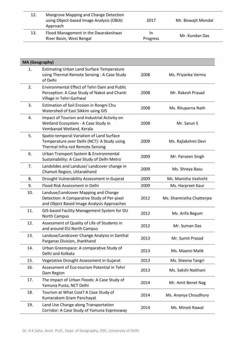
Dr. A K Saha, Asstt. Prof., Dept. of Geography, DSE, University of Delhi
12. Mangrove Mapping and Change Detection using Object-based Image Analysis (OBIA) Approach
2017 Mr. Biswajit Mondal
13. Flood Management in the Dwarakeshwar River Basin, West Bengal
In Progress
Mr. Kundan Das
MA (Geography)
1. Estimating Urban Land Surface Temperature using Thermal Remote Sensing : A Case Study of Delhi
2008 Ms. Priyanka Verma
2. Environmental Effect of Tehri Dam and Public Perception: A Case Study of Nakot and Chanti Village in Tehri Garhwal
2008 Mr. Rakesh Prasad
3. Estimation of Soil Erosion in Rongni Chu Watershed of East Sikkim using GIS
2008 Ms. Rituparna Nath
4. Impact of Tourism and Industrial Activity on Wetland Ecosystem - A Case Study in Vembanad Wetland, Kerala
2008 Mr. Sarun S
5. Spatio-temporal Variation of Land Surface Temperature over Delhi (NCT): A Study using Thermal Infra-red Remote Sensing
2009 Ms. Rajlakshmi Devi
6. Urban Transport System & Environmental Sustainability: A Case Study of Delhi Metro
2009 Mr. Parveen Singh
7. Landslides and Landuse/ Landcover change in Chamoli Region, Uttarakhand
2009 Ms. Shreya Basu
8. Drought Vulnerability Assessment in Gujarat 2009 Ms. Manisha Vashisht
9. Flood Risk Assessment in Delhi 2009 Ms. Harpreet Kaur
10. Landuse/Landcover Mapping and Change Detection: A Comparative Study of Per-pixel and Object Based Image Analysis Approaches
2012 Ms. Sharmistha Chatterjee
11. GIS-based Facility Management System for DU North Campus
2012 Ms. Arifa Begum
12. Assessment of Quality of Life of Students in and around DU North Campus
2012 Mr. Suman Das
13. Landuse/Landcover Change Analysis in Santhal Parganas Division, Jharkhand
2013 Mr. Sumit Prasad
14. Urban Greenspace: A comparative Study of Delhi and Kolkata
2013 Ms. Maansi Malik
15. Vegetative Drought Assessment in Gujarat 2013 Ms. Sheena Tangri
16. Assessment of Eco-tourism Potential in Tehri Dam Region
2013 Ms. Sakshi Naithani
17. The Impact of Urban Floods: A Case Study of Yamuna Pusta, NCT Delhi
2014 Mr. Amit Benet Nag
18. Tourism at What Cost? A Case Study of Kumarakom Gram Panchayat
2014 Ms. Ananya Choudhury
19. Land Use Change along Transportation Corridor: A Case Study of Yamuna Expressway
2014 Ms. Minoti Rawat
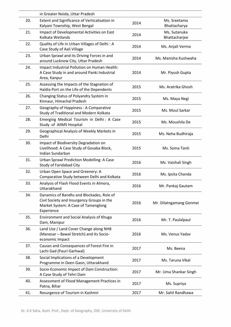
Dr. A K Saha, Asstt. Prof., Dept. of Geography, DSE, University of Delhi
in Greater Noida, Uttar Pradesh
20. Extent and Significance of Verticalisation in Kalyani Township, West Bengal
2014 Ms. Sreetama Bhattacharya
21. Impact of Developmental Activities on East Kolkata Wetlands
2014 Ms. Sutanuka Bhattacharjee
22. Quality of Life in Urban Villages of Delhi : A Case Study of Aali Village
2014 Ms. Anjali Verma
23. Urban Sprawl and its Driving Forces in and around Lucknow City, Uttar Pradesh
2014 Ms. Manisha Kushwaha
24. Impact Industrial Pollution on Human Health: A Case Study in and around Panki Industrial Area, Kanpur
2014 Mr. Piyush Gupta
25. Assessing the Impacts of the Stagnation of Haldia Port on the Life of the Dependents
2015 Ms. Aratrika Ghosh
26. Changing Status of Polyandry System in Kinnaur, Himachal Pradesh
2015 Ms. Maya Negi
27. Geography of Happiness : A Comparative Study of Traditional and Modern Kolkata
2015 Ms. Moul Sarkar
28. Emerging Medical Tourism in Delhi : A Case Study of AIIMS Hospital
2015 Ms. Moushila De
29. Geographical Analysis of Weekly Markets in Delhi
2015 Ms. Neha Budhiraja
30. Impact of Biodiversity Degradation on Livelihood: A Case Study of Gosaba Block, Indian Sundarban
2015 Ms. Soma Tanti
31. Urban Sprawl Prediction Modelling: A Case Study of Faridabad City
2016 Ms. Vaishali Singh
32. Urban Open Space and Greenery: A Comparative Study between Delhi and Kolkata
2016 Ms. Ipsita Chanda
33. Analysis of Flash Flood Events in Almora, Uttarakhand
2016 Mr. Pankaj Gautam
34. Dynamics of Bandhs and Blockades, Role of Civil Society and Insurgency Groups in the Market System: A Case of Tamenglong Experience
2016 Mr. Dilatngamang Gonmei
35. Environment and Social Analysis of Khuga Dam, Manipur
2016 Mr. T. Paulalpaul
36. Land Use / Land Cover Change along NH8 (Manesar – Bawal Stretch) and its Socio-economic Impact
2016 Ms. Venus Yadav
37. Causes and Consequences of Forest Fire in Lachi Gad (Pauri Garhwal)
2017 Ms. Beena
38. Social Implications of a Development Programme in Deen Gaon, Uttarakhand
2017 Ms. Taruna Vikal
39. Socio-Economic Impact of Dam Construction: A Case Study of Tehri Dam
2017 Mr. Uma Shankar Singh
40. Assessment of Flood Management Practices in Patna, Bihar
2017 Ms. Supriya
41. Resurgence of Tourism in Kashmir 2017 Mr. Sahil Randhawa
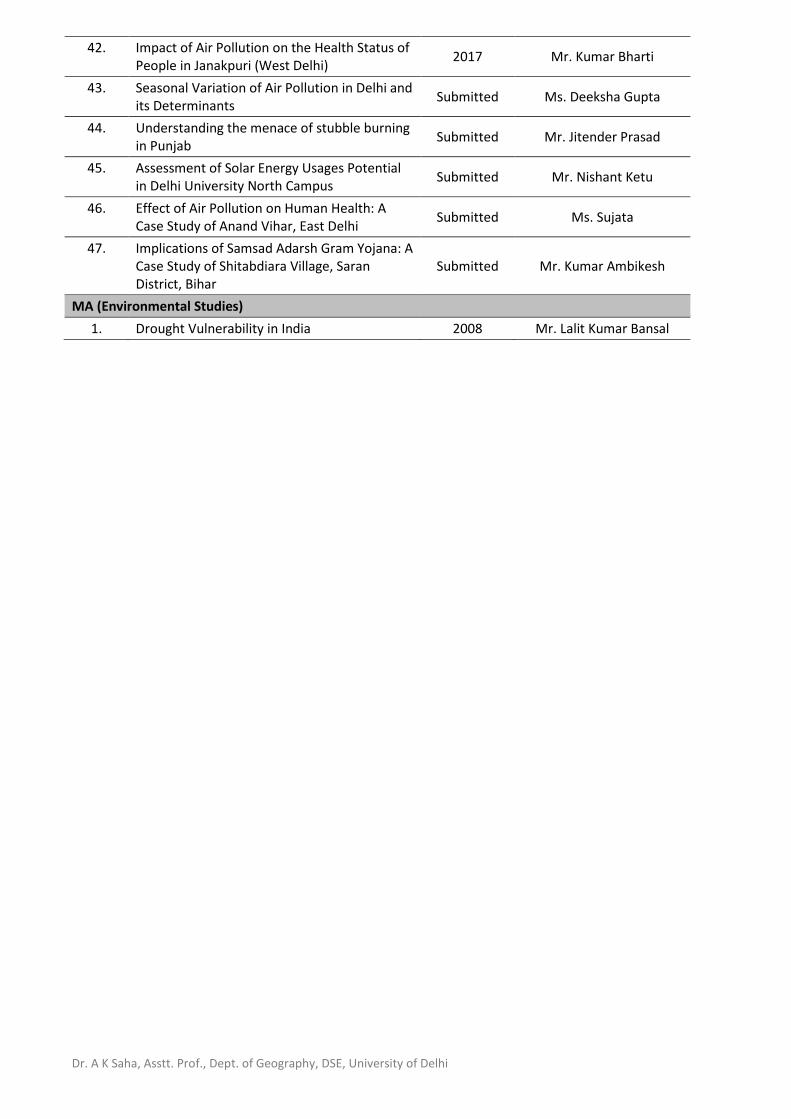
Dr. A K Saha, Asstt. Prof., Dept. of Geography, DSE, University of Delhi
42. Impact of Air Pollution on the Health Status of People in Janakpuri (West Delhi)
2017 Mr. Kumar Bharti
43. Seasonal Variation of Air Pollution in Delhi and its Determinants
Submitted Ms. Deeksha Gupta
44. Understanding the menace of stubble burning in Punjab
Submitted Mr. Jitender Prasad
45. Assessment of Solar Energy Usages Potential in Delhi University North Campus
Submitted Mr. Nishant Ketu
46. Effect of Air Pollution on Human Health: A Case Study of Anand Vihar, East Delhi
Submitted Ms. Sujata
47. Implications of Samsad Adarsh Gram Yojana: A Case Study of Shitabdiara Village, Saran District, Bihar
Submitted Mr. Kumar Ambikesh
MA (Environmental Studies)
1. Drought Vulnerability in India 2008 Mr. Lalit Kumar Bansal
Page 1 of 5
Dr. Ashis Kumar Saha: List of Publications
(Scopus and Google Scholar Citation as on Friday, 04 May 2018)
ORCID: http://orcid.org/0000-0002-8184-0495; ResearcherID: http://www.researcherid.com/rid/H-2298-2011 Scopus Author: https://www.scopus.com/authid/detail.uri?authorId=56590627900 Google Scholar: https://scholar.google.co.in/citations?user=wfUOfKcAAAAJ&hl=en
h-index: 6 (Scopus); 7 (Google Scholar)
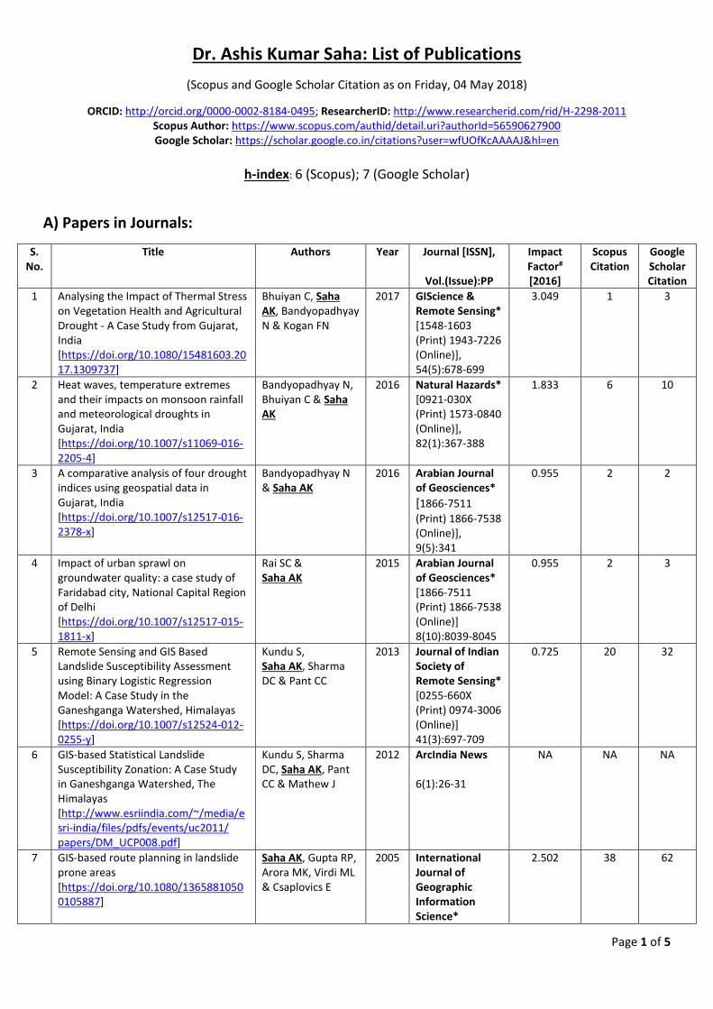
A) Papers in Journals:
S. No.
Title Authors Year Journal [ISSN],
Vol.(Issue):PP
Impact Factor# [2016]
Scopus Citation
Google Scholar Citation
1 Analysing the Impact of Thermal Stress on Vegetation Health and Agricultural Drought - A Case Study from Gujarat, India [https://doi.org/10.1080/15481603.2017.1309737]
Bhuiyan C, Saha AK, Bandyopadhyay N & Kogan FN
2017 GIScience & Remote Sensing* [1548-1603 (Print) 1943-7226 (Online)], 54(5):678-699
3.049 1 3
2 Heat waves, temperature extremes and their impacts on monsoon rainfall and meteorological droughts in Gujarat, India [https://doi.org/10.1007/s11069-016-2205-4]
Bandyopadhyay N, Bhuiyan C & Saha AK
2016 Natural Hazards* [0921-030X (Print) 1573-0840 (Online)], 82(1):367-388
1.833 6 10
3 A comparative analysis of four drought indices using geospatial data in Gujarat, India [https://doi.org/10.1007/s12517-016-2378-x]
Bandyopadhyay N & Saha AK
2016 Arabian Journal of Geosciences* [1866-7511
(Print) 1866-7538 (Online)], 9(5):341
0.955 2 2
4 Impact of urban sprawl on groundwater quality: a case study of Faridabad city, National Capital Region of Delhi [https://doi.org/10.1007/s12517-015-1811-x]
Rai SC & Saha AK
2015 Arabian Journal of Geosciences* [1866-7511 (Print) 1866-7538 (Online)] 8(10):8039-8045
0.955 2 3
5 Remote Sensing and GIS Based Landslide Susceptibility Assessment using Binary Logistic Regression Model: A Case Study in the Ganeshganga Watershed, Himalayas [https://doi.org/10.1007/s12524-012-0255-y]
Kundu S, Saha AK, Sharma DC & Pant CC
2013 Journal of Indian Society of Remote Sensing* [0255-660X (Print) 0974-3006 (Online)] 41(3):697-709
0.725 20 32
6 GIS-based Statistical Landslide Susceptibility Zonation: A Case Study in Ganeshganga Watershed, The Himalayas [http://www.esriindia.com/~/media/esri-india/files/pdfs/events/uc2011/ papers/DM_UCP008.pdf]
Kundu S, Sharma DC, Saha AK, Pant CC & Mathew J
2012 ArcIndia News 6(1):26-31
NA NA NA
7 GIS-based route planning in landslide prone areas [https://doi.org/10.1080/13658810500105887]
Saha AK, Gupta RP, Arora MK, Virdi ML & Csaplovics E
2005 International Journal of Geographic Information Science*
2.502 38 62
Page 2 of 5
[1365-8816 (Print) 1362-3087 (Online)] 19(10)1149-1175
8 An approach for GIS-based Statistical Landslide Susceptibility Zonation - with a case study in the Himalayas [https://doi.org/10.1007/s10346-004-0039-8]
Saha AK, Gupta RP, Sarkar I, Arora MK & Csaplovics E
2005 Landslides* [1612-510X (Print) 1612-5118 (Online)] 2(1):61-69
3.657 159 244
9 Land cover classification using IRS LISS III imagery and DEM in a rugged terrain: A case study in Himalaya [https://doi.org/10.1080/10106040508542343]
Saha AK, Arora MK, Csaplovics E & Gupta RP
2005 GeoCarto International* [1010-6049 (Print) 1752-0762 (Online)] 20(2):33-40
1.646 33 68
10 GIS - based Landslide Hazard Zonation in a part of the Himalayas [https://doi.org/10.1080/01431160010014260]
Saha AK, Gupta RP & Arora MK
2002 International Journal of Remote Sensing* [0143-1161 (Print) 1366-5901 (Online)] 23(2):357-369
1.724 175 296
11 Mapping Debris Flows in the Himalayas [Appeared online on 01.09.2009; URL: https://www.geospatialworld.net/article/mapping-debris-flows-in-the-himalayas/]
Gupta RP & Saha AK
2000 GIS@Development (Geospatial World)* [0971-9377 (Print) 2277-3134 (online)] 4(12):26-27
NA NA 5
12 Landslide Hazard Zonation in a part of the Bhagirathi Valley, Garhwal Himalayas, Using Integrated Remote Sensing - GIS [http://www.himgeology.com/volume_abstract.php?abstract=514]
Gupta RP, Saha AK, Arora MK & Kumar A
1999 Himalayan Geology* [0971-8966 (Print)], 20(2):71-85
0.214 (SCI
Journal.org)
48 78
Total Citation 484 803
(* UGC Listed) (# Journal Impact Factor as published by Thomson Reuters in 2017 if otherwise not mentioned)
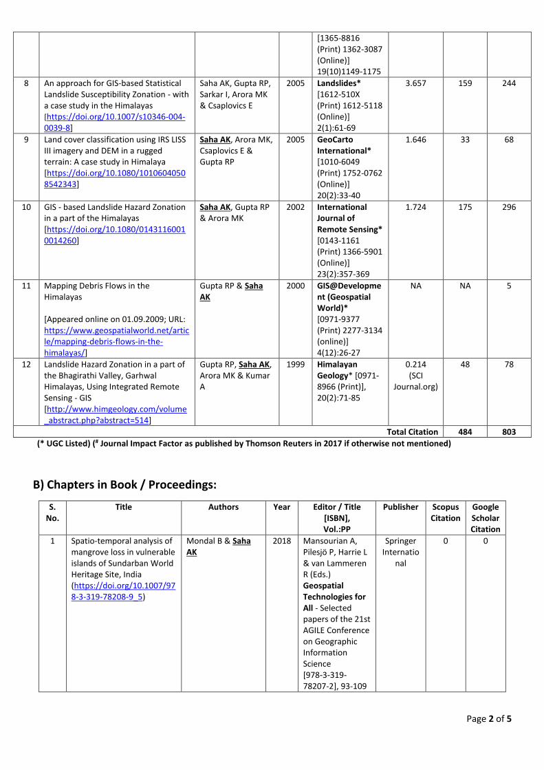
B) Chapters in Book / Proceedings:
S. No.
Title Authors Year Editor / Title [ISBN], Vol.:PP
Publisher Scopus Citation
Google Scholar Citation
1 Spatio-temporal analysis of mangrove loss in vulnerable islands of Sundarban World Heritage Site, India (https://doi.org/10.1007/978-3-319-78208-9_5)
Mondal B & Saha AK
2018
Mansourian A, Pilesjö P, Harrie L & van Lammeren R (Eds.) Geospatial Technologies for All - Selected papers of the 21st AGILE Conference on Geographic Information Science [978-3-319-78207-2], 93-109
Springer Internatio
nal
0 0
Page 3 of 5
2 Women and Water: Scripting Gender and Gendered Spaces in Drought-Prone Areas of Gujarat
Bandyopadhyay N & Saha AK
2018 (Accepted)
Datta A (Ed.) The Power of Space, Spaces of Power: Scripting Gender in India
NIAS Press,
Copenhagen
NA NA
3 Facility Management System: A Case Study of University Campus [https://doi.org/10.1007/978-3-319-47145-7_14]
Begum A & Saha AK
2017 Sharma P & Rajput S (Eds.) Sustainable Smart Cities in India: Challenges and Future Perspectives [978-3-319-47144-0], 213-225
Springer Internatio
nal
0 0
4 Community Based Disaster Management for Climate Change Adaptation: A Conceptual Model
Das S & Saha AK 2017 Negi VS (Ed.) Climate Change Perspectives and Challenges in 21st Century [978-93-5171-094-3], 155-163
Research India Press,
New Delhi
NA NA
5 GIS based Landslide Risk Assessment: A Case Study of Kandey Village, Chamoli District, Uttarakhand
Das S & Saha AK 2017 Pandey BW, Negi VS & Kumria P (Eds.) Environmental Concerns and Sustainable Development in Himalaya [997-79-3517-1096-7], 158-175
Research India Press,
New Delhi
NA NA
6 Temperature Extremes, Moisture Deficiency and Their Impacts on Dryland Agriculture in Gujarat, India [https://www.taylorfrancis.com/books/e/ 9781315687223/chapters/10.1201%2Fb18077-21]
Bandyopadhyay N, Bhuiyan C & Saha AK
2015 Andreu J, Solera A, Paredes-Arquiola J, Haro-Monteagudo D & van Lanen H (Eds.) Drought: Research and Science-Policy Interfacing [978-1-138-02779-4], 119-124
CRC Press, Balkema
2 4
7 Mapping Gender and Gendered Spaces in Drought-Prone Areas of Gujarat
Bandyopadhyay N & Saha AK
2015 Datta A (Ed.) Proceedings of International Conference on Re Orienting Gender : Geographies of Resistance, Agency, Violence and Desire in Asia [978-93-82847-41-0], 127-137
R K Books, New Delhi
NA NA
8 Land cover change and rhino habitat mapping of Kaziranga National Park, Assam
Medhi A & Saha AK
2014 Singh M, Singh RB & Hassan I (Eds.) Climate Change and Biodiversity: Proceedings of
Springer, Japan
NA 1
Page 4 of 5
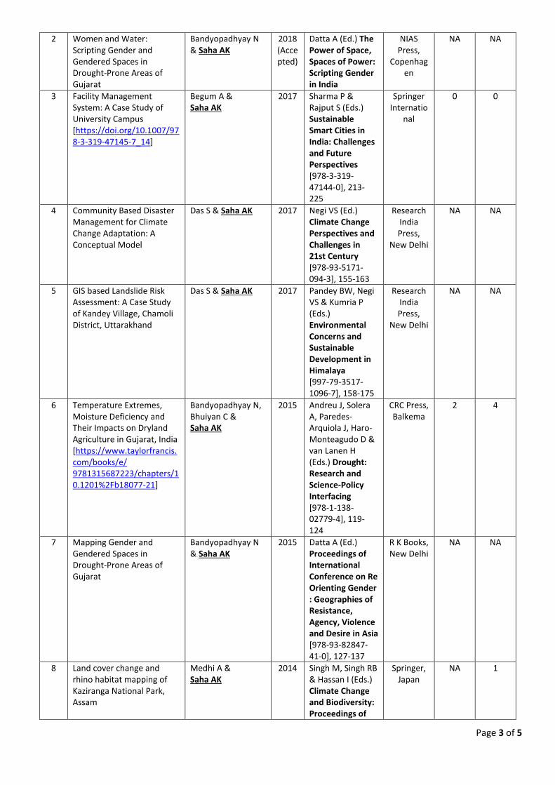
[https://doi.org/10.1007/978-4-431-54838-6_10]
IGU Rohtak Conference [978-4-431-54837-9], 1:125-138
9 Analysing Meteorological and Vegetative Drought in Gujarat [https://doi.org/10.1007/978-4-431-54838-6_5]
Bandyopadhyay N & Saha AK
2014 Singh M, Singh RB & Hassan I (Eds.) Climate Change and Biodiversity: Proceedings of IGU Rohtak Conference [978-4-431-54837-9], 1:61-71
Springer, Japan
NA 5
10 Analysis of Spatio-temporal Drought Pattern in Gujarat
Bandyopadhyay N & Saha AK
2013 Singh G (Ed.) Proceedings of National Seminar on Drought Mitigation: Special Reference to Rajasthan (DMRR-2013), [ISBN 978-93-81914-14-4], 1:3-8
Sagar Publishers
, Jaipur
NA NA
11 Truncating the Life Cycle of a Tourism Destination: An Analysis of Tourism-Terrorism Relationship with Respect to Butler’s TALC Model
Mir S & Saha AK 2012 Aima A, Manhas PS & Bhasin J (Eds.) Tourism Destination Management: Strategic Practices and Policies (ISBN [978-81-8457-370-1], 374-389
Kanishka Publishers Distributo
rs, New Delhi
NA NA
12 LaSIRF: Landslide Safe Intelligent Route Finder for mountainous terrain in GIS environment [https://doi.org/10.1007/978-3-642-25495-6_11]
Arora MK, Saha AK, Gupta P & Gupta RP
2012 Pradhan B & Buchroithner M (Eds.) Terrigenous Mass Movements [978-3-642-25495-6], 349-368
Springer-Verlag, Berlin
Heidelberg
0 0
C) Papers Presented in Seminar/Symposium/Conference/Workshop:
1. Saha AK (2017) - Using GIS to Solve Real World Problems, UGC National Seminar on Application and Emerging Trends of Geospatial Technologies for Sustainable Resource Analysis & Management, 13 January, Department of Geography, Kabi Sukanta Mahavidyalaya (under University of Burdwan), Bhadreswar, West Bengal.
2. Bandyopadhyay N, Bhuiyan C & Saha AK (2016) - Socio-economic Impacts of Drought in Gujarat: Perception, Adaptattion and Mitigation Measures, 38th Indian Geography Congress on Sustainable Development Environmental Vulnerability and Geospatial Technology, National Association of Geographers, India, 26-28 December, Department of Studies in Geography, University of Mysore, Mysuru.
3. Mondal B & Saha AK (2016) - Species-level Mangrove Mapping Using Hyperspectral Remote Sensing Data: A Case Study in Saptamukhi Reserve Forest, Indian Sundarban, 38th Indian Geography Congress on Sustainable Development Environmental Vulnerability and Geospatial Technology, National Association of Geographers, India, 26-28 December, Department of Studies in Geography, University of Mysore, Mysuru.
Page 5 of 5
4. Medhi A & Saha AK (2016) - Rural Road Development in Assam, An Overview of Pradhan Mantri Gram Sadak Yojna (PMGSY) Program Implementation, 38th Indian Geography Congress on Sustainable Development Environmental Vulnerability and Geospatial Technology, National Association of Geographers, India, 26-28 December, Department of Studies in Geography, University of Mysore, Mysuru.
5. Mondal B & Saha AK (2016) - Estimation of Land Area Change in Indian Sundarban using Object-based Image Analysis (OBIA) Approach and its Relation with Sea Level Rise, 9th International Geographical Union (IGU) Conference on Land Use Change, Climate Extremes and Disaster Risk Reduction, 18-20 March, Shaheed Bhagat Singh College, University of Delhi, Delhi.
6. Saha AK & Das S (2016) - Community-based Landslide Disaster Management: A Case Study of Kandey Village, Chamoli District, Uttarakhand, 5th NAGI (National Association of Geographers, India) International Conference on Future Earth Perspectives in South Asia, 5-7 February, Department of Geography, Bharathidasan University, Tiruchirappalli.
7. Mondal B & Saha AK (2015) - Spatio-Temporal Analysis of Mangroves in Indian Sundarban using Multispectral Landsat data (1988-2014), 37th Indian Geography Congress, National Association of Geographers, India, 2-4 December, Department of Geography, University of Jammu, Jammu.
8. Saha AK & Medhi A (2015) - An Object-based Image Analysis (OBIA) Approach for Land Resources Mapping, UGC-SAP DRS-III National Seminar on Environment-Resource & Urban-Regional Planning, 20-21 March, Department of Geography, University of Delhi, Delhi.
9. Bandyopadhyay N & Saha AK (2014) - Mapping Gender and Gendered Spaces in Drought-Prone Areas of Gujarat, International Conference on Re-orienting Gender: Geographies of Resistance, Agency, Violence and Desire in Asia, 19-21 November, Department of Geography, University of Delhi, Delhi.
10. Saha AK (2013) - Route Planning in Landslide Susceptible Terrain, Indo-German Nachkontakt Association Hyderabad Seminar on Earth Sciences for Society, 7-8 November, CSIR-NGRI, Hyderabad.
11. Saha AK (2009) - Spatial Multi Criteria Analysis for Landslide Susceptibility Zonation, 2nd India Disaster Management Congress, 4-6 November, Vigyan Bhawan, New Delhi.
12. Saha AK (2008) - Urban Heat Island and its mitigation strategy for Delhi NCT, Celebrating the Golden Jubilee of Indo-German Cooperation in Higher Education - Symposium on Education and Research in Sustainability, 7-8 September, IIT Madras. Madras.
13. Saha AK (2008) - Success Rate of Landslide Susceptibility Zonation methods in the Himalayas, International Workshop on Cryosphere & Hazards for the Hindu Kush, Himalaya & Tibetan Plateau, 31 March - 2 April, ICIMOD, Kathmandu, Nepal.
14. Saha AK (2008) - GIS-based Statistical Landslide Susceptibility Zonation in the Chamoli Region, Himalayas, CBRI Diamond Jubilee Conference on Landslide Management: Present Scenario & Future Directions, Central Building Research Institute, 10-12 February, Roorkee.
15. Saha AK, Gupta RP, Sarkar I, Arora MK & Csaplovics E (2004) - A GIS-based Statistical Approach for Landslide Hazard Zonation in Himalayas, NRDMS Session, Map India 2004, 7th Annual International Conference, 28-30 January, New Delhi.
Year
Documents C
itation
s
Documents
Citations
2008 20180
2
0
50
⽇本語に切り替える
切换到简体中文
切換到繁體中⽂
Русский язык
All Since 2013
Citations 813 422h-index 7 7i10-index 7 7
Ashis Kumar Saha, PhDDepartment of Geography,University of Delhi
Remote SensingGISLandslide
TITLE CITED BY YEAR
GIS-based landslide hazard zonation in the Bhagirathi (Ganga) valley,HimalayasAK Saha, RP Gupta, MK AroraInternational journal of remote sensing 23 (2), 357-369
296 2002
An approach for GIS-based statistical landslide susceptibility zonation—witha case study in the HimalayasAK Saha, RP Gupta, I Sarkar, MK Arora, E CsaplovicsLandslides 2 (1), 61-69
244 2005
Landslide hazard zonation in a part of the Bhagirathi ValleyRP Gupta, AK Saha, MK Arora, A KumarGarhwal Mimalyas, using integrated remote sensing–GIS, Himalayan Geology 20 …
78 1999
Land cover classification using IRS LISS III image and DEM in a ruggedterrain: a case study in HimalayasAK Saha, MK Arora, E Csaplovics, RP GuptaGeocarto International 20 (2), 33-40
68 2005
GIS‐based route planning in landslide‐prone areasAK Saha, MK Arora, RP Gupta, ML Virdi, E CsaplovicsInternational Journal of Geographical Information Science 19 (10), 1149-1175
62 2005
Remote sensing and GIS based landslide susceptibility assessment usingbinary logistic regression model: a case study in the GaneshgangaWatershed, HimalayasS Kundu, AK Saha, DC Sharma, CC PantJournal of the Indian Society of Remote Sensing 41 (3), 697-709
32 2013
Heat waves, temperature extremes and their impacts on monsoon rainfalland meteorological drought in Gujarat, IndiaN Bandyopadhyay, C Bhuiyan, AK SahaNatural Hazards 82 (1), 367-388
10 2016
Analysing meteorological and vegetative drought in GujaratN Bandyopadhyay, AK SahaClimate Change and Biodiversity, 61-71
5 2014
Mapping debris flows in the Himalayas, natural resource managementR Gupta, A SahaGISdevelopment. net 4
5 2001
Ashis Kumar Saha, PhD - Google Scholar Citations https://scholar.google.co.in/citations?hl=en&user=wfUOfKcAAAAJ&v...
1 of 2 04-05-2018, 10:36
TITLE CITED BY YEAR
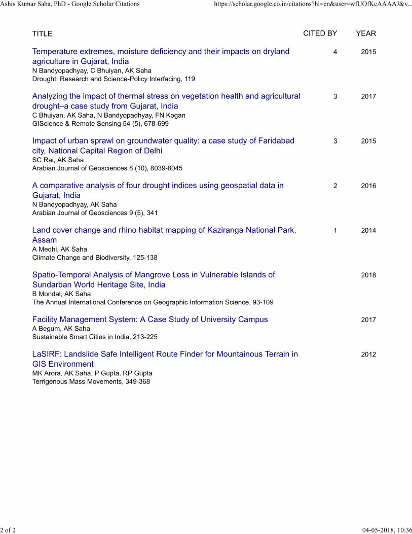
Temperature extremes, moisture deficiency and their impacts on drylandagriculture in Gujarat, IndiaN Bandyopadhyay, C Bhuiyan, AK SahaDrought: Research and Science-Policy Interfacing, 119
4 2015
Analyzing the impact of thermal stress on vegetation health and agriculturaldrought–a case study from Gujarat, IndiaC Bhuiyan, AK Saha, N Bandyopadhyay, FN KoganGIScience & Remote Sensing 54 (5), 678-699
3 2017
Impact of urban sprawl on groundwater quality: a case study of Faridabadcity, National Capital Region of DelhiSC Rai, AK SahaArabian Journal of Geosciences 8 (10), 8039-8045
3 2015
A comparative analysis of four drought indices using geospatial data inGujarat, IndiaN Bandyopadhyay, AK SahaArabian Journal of Geosciences 9 (5), 341
2 2016
Land cover change and rhino habitat mapping of Kaziranga National Park,AssamA Medhi, AK SahaClimate Change and Biodiversity, 125-138
1 2014
Spatio-Temporal Analysis of Mangrove Loss in Vulnerable Islands ofSundarban World Heritage Site, IndiaB Mondal, AK SahaThe Annual International Conference on Geographic Information Science, 93-109
2018
Facility Management System: A Case Study of University CampusA Begum, AK SahaSustainable Smart Cities in India, 213-225
2017
LaSIRF: Landslide Safe Intelligent Route Finder for Mountainous Terrain inGIS EnvironmentMK Arora, AK Saha, P Gupta, RP GuptaTerrigenous Mass Movements, 349-368
2012
Ashis Kumar Saha, PhD - Google Scholar Citations https://scholar.google.co.in/citations?hl=en&user=wfUOfKcAAAAJ&v...
2 of 2 04-05-2018, 10:36
Recommended