ENBE | Final Project | Part A – Report | The Better Town Representation
IGNATIUS JEE SHAO IANG | 0320069 | Ms. Ida | FNBE AUGUST 2014 | Taylor’s University
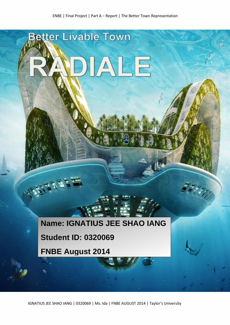
Name: IGNATIUS JEE SHAO IANG
Student ID: 0320069
FNBE August 2014
ENBE | Final Project | Part A – Report | The Better Town Representation
IGNATIUS JEE SHAO IANG | 0320069 | Ms. Ida | FNBE AUGUST 2014 | Taylor’s University
CONTENT:
1. INTRODUCTION
2. A TOWN- Investigation on Better Township or Town or City
Guidelines and Issues
3. Investigation & Data Collection: The Ancient Town
4. Investigation & Data Collection: The Present Town
5. Investigation & Data Collection: The Future City
6. The New “X” Town – RADIALE
Overview
Master Plan
Zoning
Transportation
Town Enhancement & Sustainable Approaches
7. The Conclusion
8. Reference List
ENBE | Final Project | Part A – Report | The Better Town Representation
IGNATIUS JEE SHAO IANG | 0320069 | Ms. Ida | FNBE AUGUST 2014 | Taylor’s University
Introduction
After analysing and understanding the brief, I understand
that I am assigned to do research on the elements of Natural
and built environment in their basic unit, form and function such
as natural topography, landscape, space, buildings and
infrastructure. In this final project, I am required to investigate
about a past, a present and a future city. With all the
information I get, I need to propose a future town which focus
on the needs of the people, the facilities, infrastructures and
how the city sustain by itself in the future.
To propose a successful town, I understand that I need to
focus on its geometric shape, form, pattern, system and the
structure of town. Besides, I need to emphasis on the main
focus and the zoning, transportation, utility of the town. The
people, population, social issues, food distribution, culture and
religion also play a major role in maintaining the successful
operation of the town.
ENBE | Final Project | Part A – Report | The Better Town Representation
IGNATIUS JEE SHAO IANG | 0320069 | Ms. Ida | FNBE AUGUST 2014 | Taylor’s University
Town VS City
Definition of Town
A settlement in which includes residential districts, shops and
amenities with its own local government.
A town is larger than a village, but smaller than a city, which
means to say it has more populations than a village but not as
much as a city.
Definition of City
A city is a relatively large and permanent human settlement.
City normally has a particular administrative, legal, or historical
status based on local law.
City in general has more complex systems for sanitation, utilities,
land usage, housing, and transportation.
There are 4 eccentric differences between a town and a city.
(i) The demography/geography
(ii) The form of Government
(iii) The communities
(iv) Population
(i) Demography/Geography
Towns cover a smaller area than cities. As cities advance, they
merge with surrounding areas. As for towns, they do not
generally expand into other areas in the same way as the cities.
ENBE | Final Project | Part A – Report | The Better Town Representation
IGNATIUS JEE SHAO IANG | 0320069 | Ms. Ida | FNBE AUGUST 2014 | Taylor’s University
(ii) Form of Government
A town is rule by municipal bodies, which is leaded by a
chairman. On the other hand, governance of cities is handled by
corporate bodies and chairman is the head of corporation.
(iii) Communities
In terms of community, town has a complete community hinting
at one special community. However, cities can have different
communities usually categorized by race or religion.
(iv) Populations
Towns are smaller than cities and bigger than villages.
Therefore, cities are more densely populated than towns, which
mean to say that a city has more population as compared to
town. Most of a region’s administrative offices are situated in
the cities.
ENBE | Final Project | Part A – Report | The Better Town Representation
IGNATIUS JEE SHAO IANG | 0320069 | Ms. Ida | FNBE AUGUST 2014 | Taylor’s University
Investigation & Data Collection
Ancient City
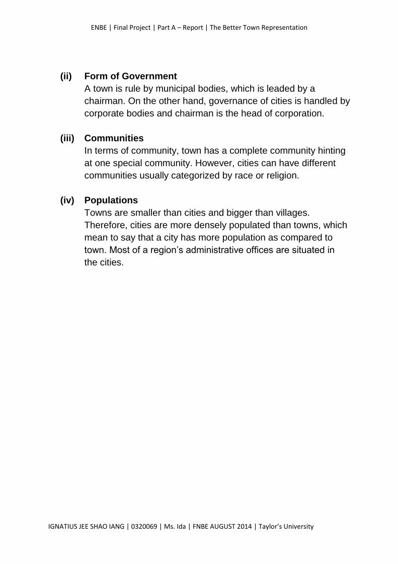
Case Study 1: Athens, Greece
A view of the Acropolis in Athens, Greece The remains of the Parthenon
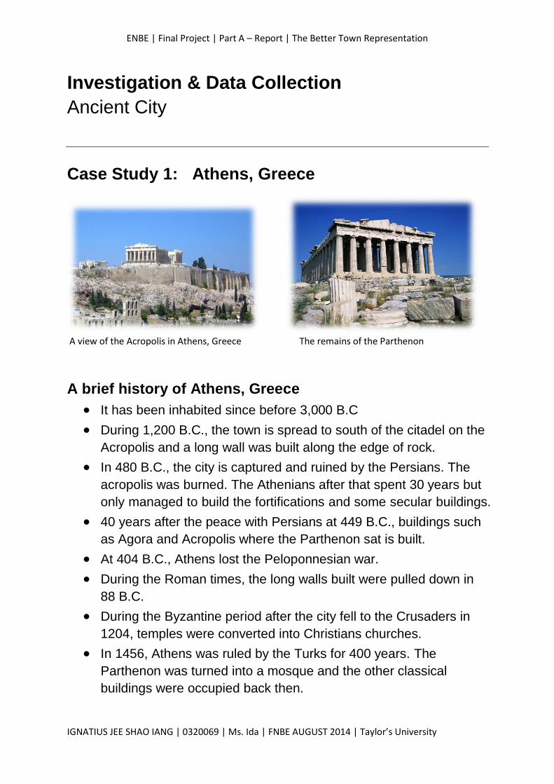
A brief history of Athens, Greece
It has been inhabited since before 3,000 B.C
During 1,200 B.C., the town is spread to south of the citadel on the
Acropolis and a long wall was built along the edge of rock.
In 480 B.C., the city is captured and ruined by the Persians. The
acropolis was burned. The Athenians after that spent 30 years but
only managed to build the fortifications and some secular buildings.
40 years after the peace with Persians at 449 B.C., buildings such
as Agora and Acropolis where the Parthenon sat is built.
At 404 B.C., Athens lost the Peloponnesian war.
During the Roman times, the long walls built were pulled down in
88 B.C.
During the Byzantine period after the city fell to the Crusaders in
1204, temples were converted into Christians churches.
In 1456, Athens was ruled by the Turks for 400 years. The
Parthenon was turned into a mosque and the other classical
buildings were occupied back then.
ENBE | Final Project | Part A – Report | The Better Town Representation
IGNATIUS JEE SHAO IANG | 0320069 | Ms. Ida | FNBE AUGUST 2014 | Taylor’s University
The Characteristics of Focus in Athens, Greece
- A city which emphasises on the management of water source.
Athens shows the importance of waterworks in a city. The
Aqueduct served as a main character in the city as it’s the
foremost way of conducting water to the whole area. Furthermore,
the city also emphasised on the zoning. The upper city is also the
focus of the city as it’s the zone where every main events being
held. It is situated at the centre of the city.
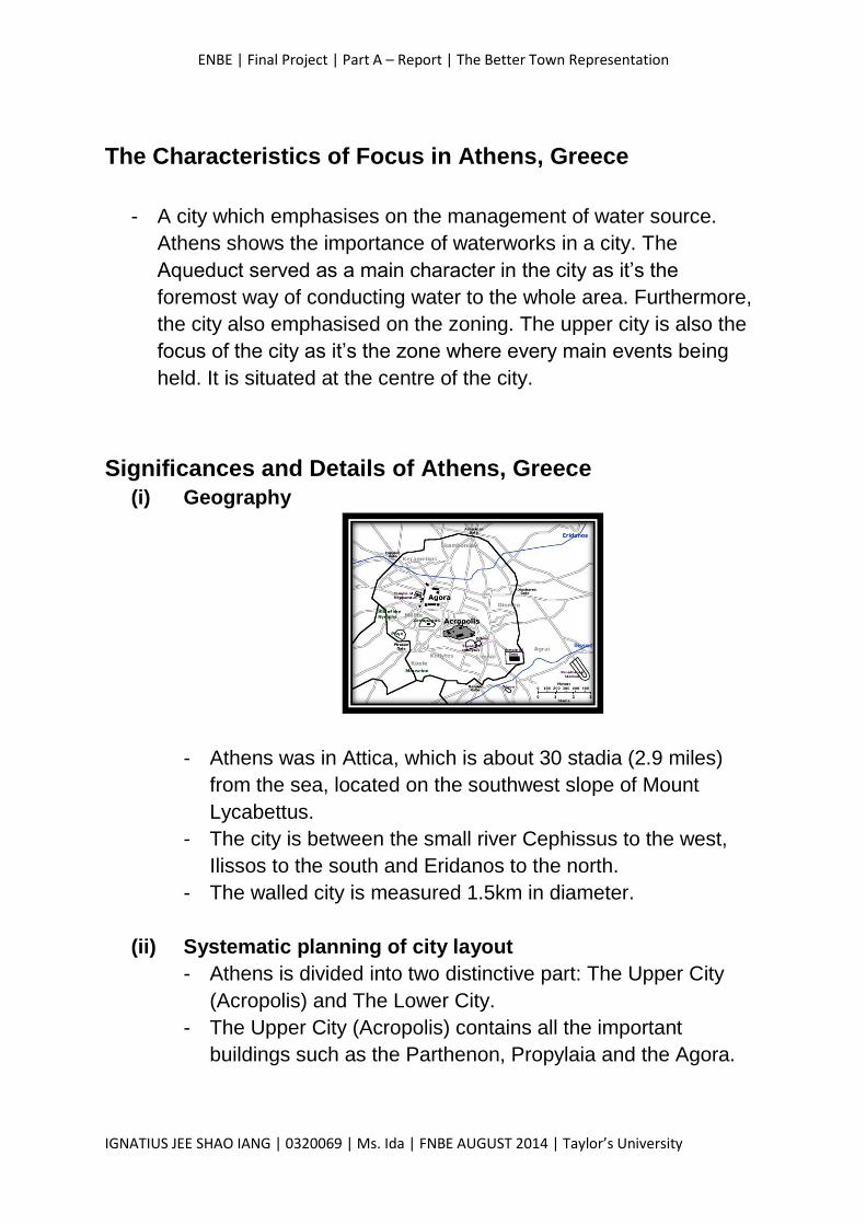
Significances and Details of Athens, Greece
(i) Geography
- Athens was in Attica, which is about 30 stadia (2.9 miles)
from the sea, located on the southwest slope of Mount
Lycabettus.
- The city is between the small river Cephissus to the west,
Ilissos to the south and Eridanos to the north.
- The walled city is measured 1.5km in diameter.
(ii) Systematic planning of city layout
- Athens is divided into two distinctive part: The Upper City
(Acropolis) and The Lower City.
- The Upper City (Acropolis) contains all the important
buildings such as the Parthenon, Propylaia and the Agora.
ENBE | Final Project | Part A – Report | The Better Town Representation
IGNATIUS JEE SHAO IANG | 0320069 | Ms. Ida | FNBE AUGUST 2014 | Taylor’s University
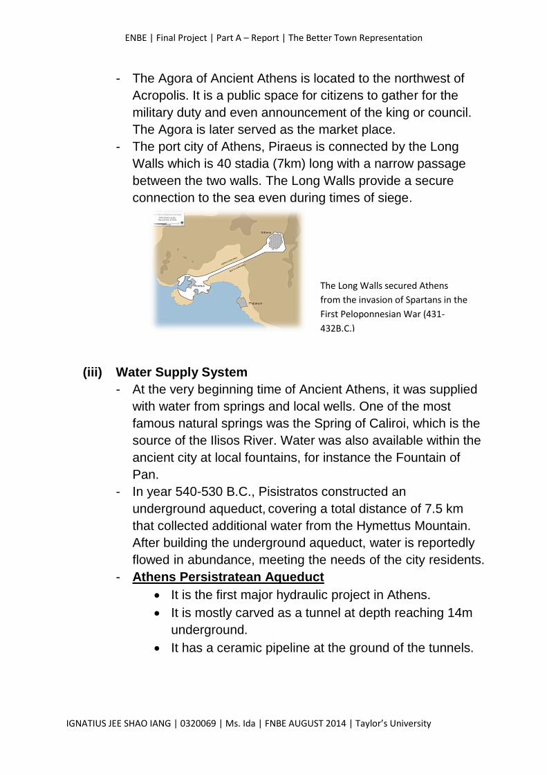
- The Agora of Ancient Athens is located to the northwest of
Acropolis. It is a public space for citizens to gather for the
military duty and even announcement of the king or council.
The Agora is later served as the market place.
- The port city of Athens, Piraeus is connected by the Long
Walls which is 40 stadia (7km) long with a narrow passage
between the two walls. The Long Walls provide a secure
connection to the sea even during times of siege.
(iii) Water Supply System
- At the very beginning time of Ancient Athens, it was supplied
with water from springs and local wells. One of the most
famous natural springs was the Spring of Caliroi, which is the
source of the Ilisos River. Water was also available within the
ancient city at local fountains, for instance the Fountain of
Pan.
- In year 540-530 B.C., Pisistratos constructed an
underground aqueduct, covering a total distance of 7.5 km
that collected additional water from the Hymettus Mountain.
After building the underground aqueduct, water is reportedly
flowed in abundance, meeting the needs of the city residents.
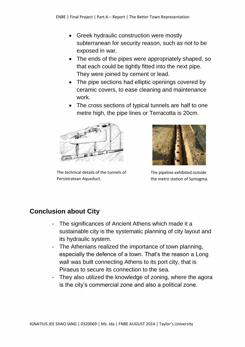
- Athens Persistratean Aqueduct
It is the first major hydraulic project in Athens.
It is mostly carved as a tunnel at depth reaching 14m
underground.
It has a ceramic pipeline at the ground of the tunnels.
The Long Walls secured Athens
from the invasion of Spartans in the
First Peloponnesian War (431-
432B.C.)
ENBE | Final Project | Part A – Report | The Better Town Representation
IGNATIUS JEE SHAO IANG | 0320069 | Ms. Ida | FNBE AUGUST 2014 | Taylor’s University
Greek hydraulic construction were mostly
subterranean for security reason, such as not to be
exposed in war.
The ends of the pipes were appropriately shaped, so
that each could be tightly fitted into the next pipe.
They were joined by cement or lead.
The pipe sections had elliptic openings covered by
ceramic covers, to ease cleaning and maintenance
work.
The cross sections of typical tunnels are half to one
metre high, the pipe lines or Terracotta is 20cm.
Conclusion about City
- The significances of Ancient Athens which made it a
sustainable city is the systematic planning of city layout and
its hydraulic system.
- The Athenians realized the importance of town planning,
especially the defence of a town. That’s the reason a Long
wall was built connecting Athens to its port city, that is
Piraeus to secure its connection to the sea.
- They also utilized the knowledge of zoning, where the agora
is the city’s commercial zone and also a political zone.
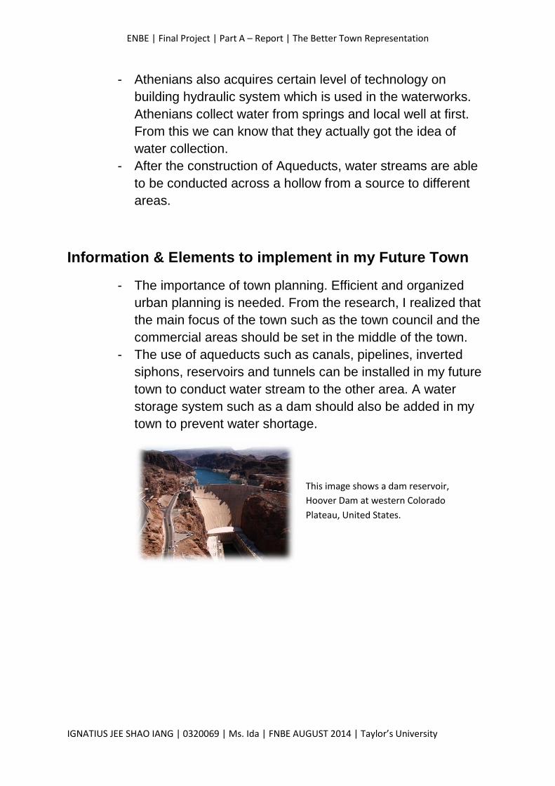
The technical details of the tunnels of
Persistratean Aqueduct.
The pipeline exhibited outside
the metro station of Syntagma.
ENBE | Final Project | Part A – Report | The Better Town Representation
IGNATIUS JEE SHAO IANG | 0320069 | Ms. Ida | FNBE AUGUST 2014 | Taylor’s University
- Athenians also acquires certain level of technology on
building hydraulic system which is used in the waterworks.
Athenians collect water from springs and local well at first.
From this we can know that they actually got the idea of
water collection.
- After the construction of Aqueducts, water streams are able
to be conducted across a hollow from a source to different
areas.
Information & Elements to implement in my Future Town
- The importance of town planning. Efficient and organized
urban planning is needed. From the research, I realized that
the main focus of the town such as the town council and the
commercial areas should be set in the middle of the town.
- The use of aqueducts such as canals, pipelines, inverted
siphons, reservoirs and tunnels can be installed in my future
town to conduct water stream to the other area. A water
storage system such as a dam should also be added in my
town to prevent water shortage.
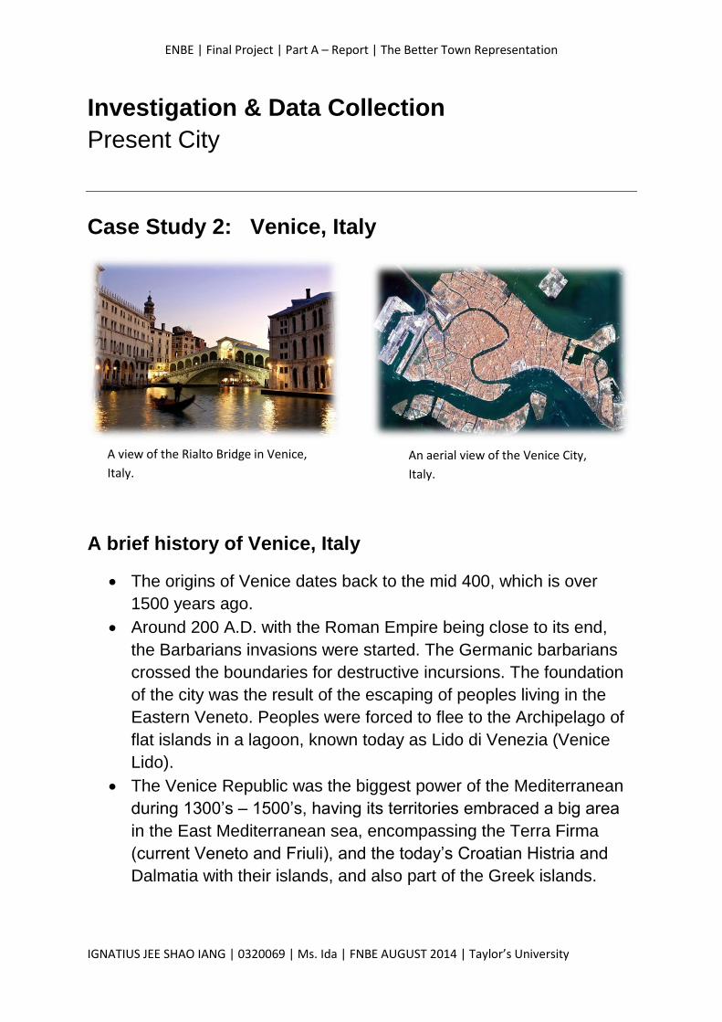
This image shows a dam reservoir,
Hoover Dam at western Colorado
Plateau, United States.
ENBE | Final Project | Part A – Report | The Better Town Representation
IGNATIUS JEE SHAO IANG | 0320069 | Ms. Ida | FNBE AUGUST 2014 | Taylor’s University
Investigation & Data Collection
Present City
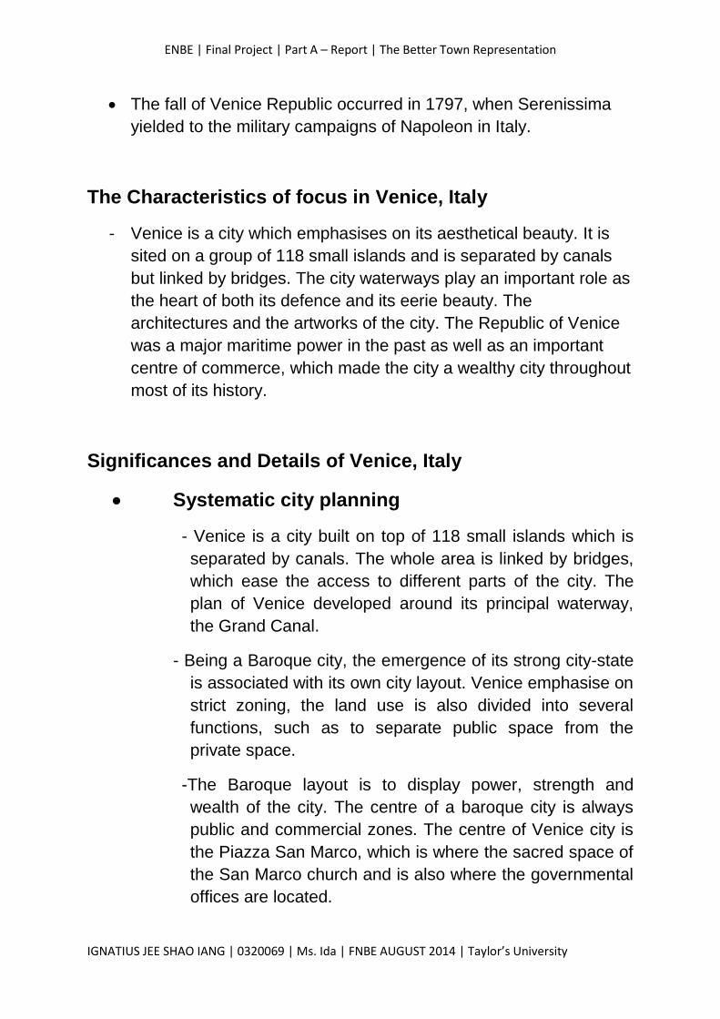
Case Study 2: Venice, Italy
A brief history of Venice, Italy
The origins of Venice dates back to the mid 400, which is over
1500 years ago.
Around 200 A.D. with the Roman Empire being close to its end,
the Barbarians invasions were started. The Germanic barbarians
crossed the boundaries for destructive incursions. The foundation
of the city was the result of the escaping of peoples living in the
Eastern Veneto. Peoples were forced to flee to the Archipelago of
flat islands in a lagoon, known today as Lido di Venezia (Venice
Lido).
The Venice Republic was the biggest power of the Mediterranean
during 1300’s – 1500’s, having its territories embraced a big area
in the East Mediterranean sea, encompassing the Terra Firma
(current Veneto and Friuli), and the today’s Croatian Histria and
Dalmatia with their islands, and also part of the Greek islands.
A view of the Rialto Bridge in Venice,
Italy.
An aerial view of the Venice City,
Italy.
ENBE | Final Project | Part A – Report | The Better Town Representation
IGNATIUS JEE SHAO IANG | 0320069 | Ms. Ida | FNBE AUGUST 2014 | Taylor’s University
The fall of Venice Republic occurred in 1797, when Serenissima
yielded to the military campaigns of Napoleon in Italy.
The Characteristics of focus in Venice, Italy
- Venice is a city which emphasises on its aesthetical beauty. It is
sited on a group of 118 small islands and is separated by canals
but linked by bridges. The city waterways play an important role as
the heart of both its defence and its eerie beauty. The
architectures and the artworks of the city. The Republic of Venice
was a major maritime power in the past as well as an important
centre of commerce, which made the city a wealthy city throughout
most of its history.
Significances and Details of Venice, Italy
Systematic city planning
- Venice is a city built on top of 118 small islands which is
separated by canals. The whole area is linked by bridges,
which ease the access to different parts of the city. The
plan of Venice developed around its principal waterway,
the Grand Canal.
- Being a Baroque city, the emergence of its strong city-state
is associated with its own city layout. Venice emphasise on
strict zoning, the land use is also divided into several
functions, such as to separate public space from the
private space.
-The Baroque layout is to display power, strength and
wealth of the city. The centre of a baroque city is always
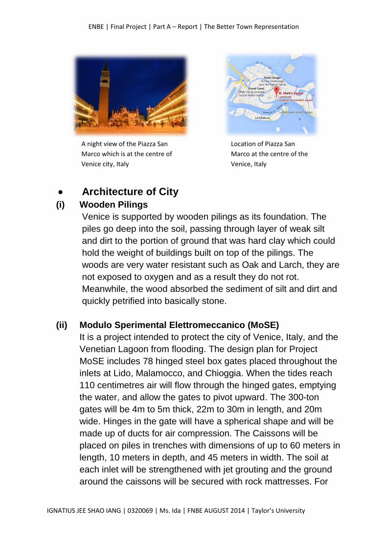
public and commercial zones. The centre of Venice city is
the Piazza San Marco, which is where the sacred space of
the San Marco church and is also where the governmental
offices are located.
ENBE | Final Project | Part A – Report | The Better Town Representation
IGNATIUS JEE SHAO IANG | 0320069 | Ms. Ida | FNBE AUGUST 2014 | Taylor’s University
Architecture of City
(i) Wooden Pilings
Venice is supported by wooden pilings as its foundation. The
piles go deep into the soil, passing through layer of weak silt
and dirt to the portion of ground that was hard clay which could
hold the weight of buildings built on top of the pilings. The
woods are very water resistant such as Oak and Larch, they are
not exposed to oxygen and as a result they do not rot.
Meanwhile, the wood absorbed the sediment of silt and dirt and
quickly petrified into basically stone.
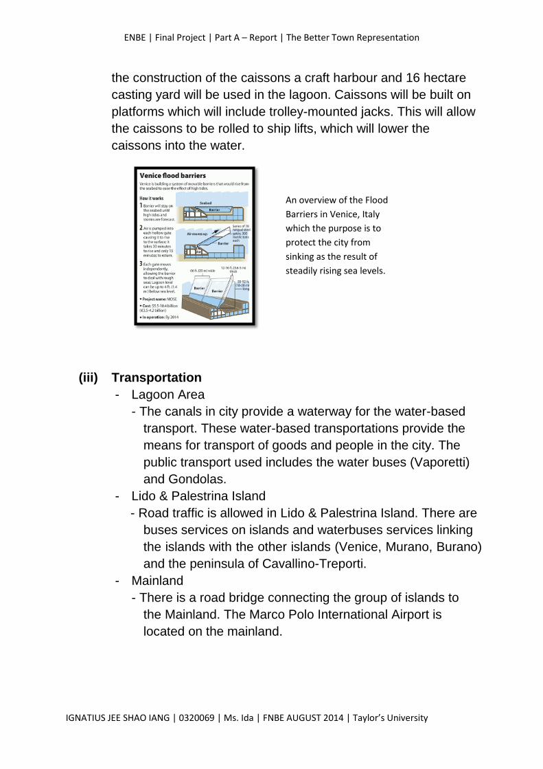
(ii) Modulo Sperimental Elettromeccanico (MoSE)
It is a project intended to protect the city of Venice, Italy, and the
Venetian Lagoon from flooding. The design plan for Project
MoSE includes 78 hinged steel box gates placed throughout the
inlets at Lido, Malamocco, and Chioggia. When the tides reach
110 centimetres air will flow through the hinged gates, emptying
the water, and allow the gates to pivot upward. The 300-ton
gates will be 4m to 5m thick, 22m to 30m in length, and 20m
wide. Hinges in the gate will have a spherical shape and will be
made up of ducts for air compression. The Caissons will be
placed on piles in trenches with dimensions of up to 60 meters in
length, 10 meters in depth, and 45 meters in width. The soil at
each inlet will be strengthened with jet grouting and the ground
around the caissons will be secured with rock mattresses. For
A night view of the Piazza San
Marco which is at the centre of
Venice city, Italy
Location of Piazza San
Marco at the centre of the
Venice, Italy
ENBE | Final Project | Part A – Report | The Better Town Representation
IGNATIUS JEE SHAO IANG | 0320069 | Ms. Ida | FNBE AUGUST 2014 | Taylor’s University
the construction of the caissons a craft harbour and 16 hectare
casting yard will be used in the lagoon. Caissons will be built on
platforms which will include trolley-mounted jacks. This will allow
the caissons to be rolled to ship lifts, which will lower the
caissons into the water.
(iii) Transportation
- Lagoon Area
- The canals in city provide a waterway for the water-based
transport. These water-based transportations provide the
means for transport of goods and people in the city. The
public transport used includes the water buses (Vaporetti)
and Gondolas.
- Lido & Palestrina Island
- Road traffic is allowed in Lido & Palestrina Island. There are
buses services on islands and waterbuses services linking
the islands with the other islands (Venice, Murano, Burano)
and the peninsula of Cavallino-Treporti.
- Mainland
- There is a road bridge connecting the group of islands to
the Mainland. The Marco Polo International Airport is
located on the mainland.
An overview of the Flood
Barriers in Venice, Italy
which the purpose is to
protect the city from
sinking as the result of
steadily rising sea levels.
ENBE | Final Project | Part A – Report | The Better Town Representation
IGNATIUS JEE SHAO IANG | 0320069 | Ms. Ida | FNBE AUGUST 2014 | Taylor’s University
Conclusion about City
- The canals in the city are fully utilized and it is the key of
transportation in it. This is because without it, the city would
goes into congestion and this strongly affects the operation and
also economy of the city.
- The City also fully utilized its aesthetical beauty by converting it
into a city of tourism. This provides high chances of commercial
activities in the city, which enhances the economy of the city.
Information & Elements to implement in my Future Town
- The zoning of areas in a city. I realized that the main focus of a
city is situated at the centre of it. For example, the political and
commercial areas of Venice, Italy.
- Utilize the purpose of canals or rivers in a city which can
contribute to the local community. Transportation should be
emphasised as it’s the key for the operation of a city.
- A colossal dam can also be constructed around the city to
protect the city from sinking as it can prevent floats in the city
especially when the sea level rises.
- The aesthetical appearance is also important as it served as the
main attraction of tourism to the city. Natural elements such as
canals, rivers and even greenery should be emphasised to
enhance eco-friendliness and also to beautify the environment of
city.
ENBE | Final Project | Part A – Report | The Better Town Representation
IGNATIUS JEE SHAO IANG | 0320069 | Ms. Ida | FNBE AUGUST 2014 | Taylor’s University
Investigation & Data Collection
The Future of Towns and Better Towns
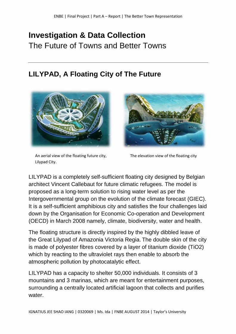
LILYPAD, A Floating City of The Future
LILYPAD is a completely self-sufficient floating city designed by Belgian
architect Vincent Callebaut for future climatic refugees. The model is
proposed as a long-term solution to rising water level as per the
Intergovernmental group on the evolution of the climate forecast (GIEC).
It is a self-sufficient amphibious city and satisfies the four challenges laid
down by the Organisation for Economic Co-operation and Development
(OECD) in March 2008 namely, climate, biodiversity, water and health.
The floating structure is directly inspired by the highly dibbled leave of
the Great Lilypad of Amazonia Victoria Regia. The double skin of the city
is made of polyester fibres covered by a layer of titanium dioxide (TiO2)
which by reacting to the ultraviolet rays then enable to absorb the
atmospheric pollution by photocatalytic effect.
LILYPAD has a capacity to shelter 50,000 individuals. It consists of 3
mountains and 3 marinas, which are meant for entertainment purposes,
surrounding a centrally located artificial lagoon that collects and purifies
water.
An aerial view of the floating future city,
Lilypad City.
The elevation view of the floating city
ENBE | Final Project | Part A – Report | The Better Town Representation
IGNATIUS JEE SHAO IANG | 0320069 | Ms. Ida | FNBE AUGUST 2014 | Taylor’s University
Information & Elements to implement in my Future Town
(i) The idea of a self-sufficient floating city.
- The Lilypad would have three marinas, and three mountains to
surround a centrally-located artificial lagoon that is totally
immersed below the water line to act as ballast for the city.
The three mountains and marinas will house venues for work,
shopping and entertainment. There are also suspended
gardens and aquaculture farms which would be located below
the tideline would be used to grow food and biomass.
Renewable energy technologies including thermal, solar, tidal,
wind and biomass would be available in the floating city and
so designed to produce more energy than what is consumed.
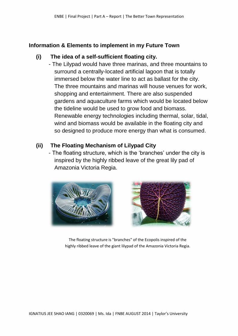
(ii) The Floating Mechanism of Lilypad City
- The floating structure, which is the ‘branches’ under the city is
inspired by the highly ribbed leave of the great lily pad of
Amazonia Victoria Regia.
The floating structure is "branches" of the Ecopolis inspired of the
highly ribbed leave of the giant lilypad of the Amazonia Victoria Regia.
ENBE | Final Project | Part A – Report | The Better Town Representation
IGNATIUS JEE SHAO IANG | 0320069 | Ms. Ida | FNBE AUGUST 2014 | Taylor’s University
The New “X” Town – The newly proposed town will be situated 5km outside the coast of
Pahang. It is a floating town which have an approximate land area of
30km2 and an existing lake at the centre of the town. There is also a
man-made linear lake in the high cost residential area. A radial grid
system will be used to design the geometric shape of the town. The
proposed town can accommodate an approximate number of 200,000
people.
(i) Land Area: Approximate 30km2
(ii) Existing Lake: Approximate 4km2
(iii) Man-made linear lake: Approximate 4km2
(iv) Population: Approximate 180,000 – 200,000
The floating town will be named Radiale, which is an Italian word for
Radial. The idea came from the geometric shape of the proposed town,
which is a circular man-made island. Besides, the word Radiale brings
the meaning of unites, hoping to propose a peaceful and unite township.
The Concept
The design concept of the proposed town is sustainable, smart and
utilization of space.
(i) Sustainability Healthy ecosystems and environments are necessary to the
survival of humans and other organisms. The ecosystems
and environments of the town are being focused to ensure
healthy lifestyle of citizens.
(ii) Smart
The proposed town comprises energy saving features which
helps in reducing the usage of non-renewable resources
such as fossil fuels. The energy saving features includes the
use of solar energy and wind energy in the town.
ENBE | Final Project | Part A – Report | The Better Town Representation
IGNATIUS JEE SHAO IANG | 0320069 | Ms. Ida | FNBE AUGUST 2014 | Taylor’s University
(iii) Space Utilizations
The Utilization of space in the town is focused as it results in
the user friendliness of the town.
The AIM
The aim is to create a living space for Malaysian as the as the result of
increasing population. The proposed town acts as a solution for the
issue of overpopulation.
The main purpose of the town is to serve as a commercial and a
residential based town. The main source of economy is based on the
business activity of the town. The commercial zone of the town is divided
into 2 zones, that is the high range commercial area and the typical
commercial areas.
The town is designed to accommodate approximately 200,000 residents.
Having a high cost residential area and also 2 typical residential areas,
the town is believed to accommodate the huge amount of citizens and
yet provide a comfortable living space.
ENBE | Final Project | Part A – Report | The Better Town Representation
IGNATIUS JEE SHAO IANG | 0320069 | Ms. Ida | FNBE AUGUST 2014 | Taylor’s University
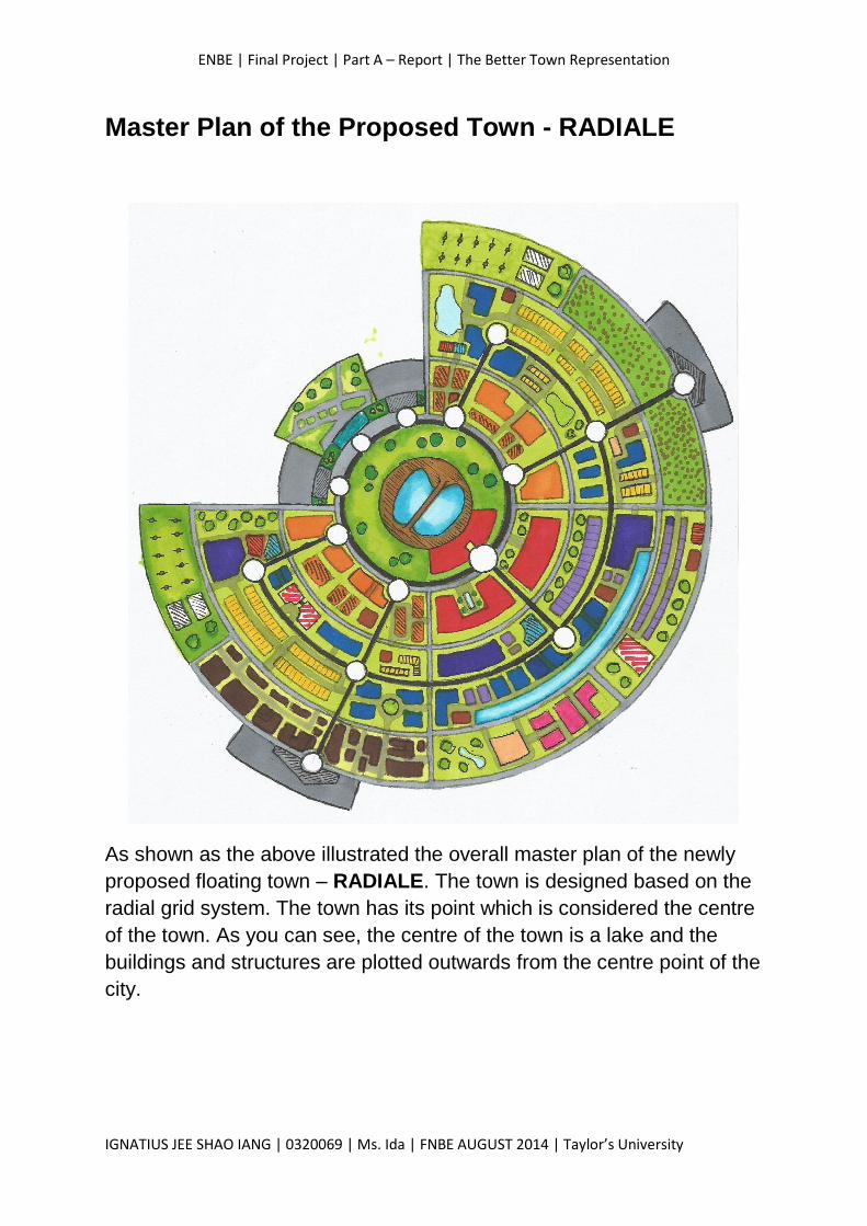
Master Plan of the Proposed Town - RADIALE
As shown as the above illustrated the overall master plan of the newly
proposed floating town – RADIALE. The town is designed based on the
radial grid system. The town has its point which is considered the centre
of the town. As you can see, the centre of the town is a lake and the
buildings and structures are plotted outwards from the centre point of the
city.
ENBE | Final Project | Part A – Report | The Better Town Representation
IGNATIUS JEE SHAO IANG | 0320069 | Ms. Ida | FNBE AUGUST 2014 | Taylor’s University
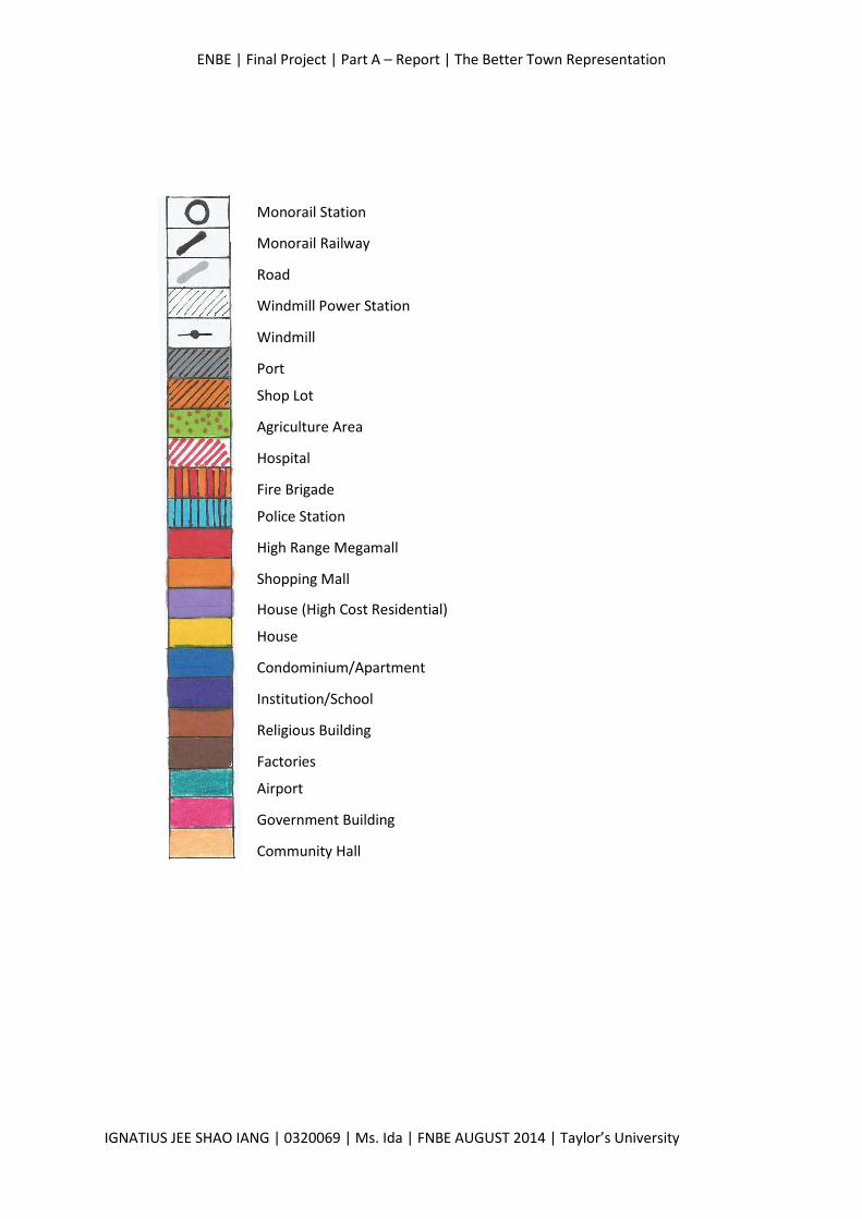
Windmill Power Station
Monorail Railway
Road
Monorail Station
Windmill
Port
Shop Lot
Agriculture Area
Hospital
Fire Brigade
Police Station
High Range Megamall
Shopping Mall
House (High Cost Residential)
House
Condominium/Apartment
Institution/School
Religious Building
Factories
Airport
Government Building
Community Hall
ENBE | Final Project | Part A – Report | The Better Town Representation
IGNATIUS JEE SHAO IANG | 0320069 | Ms. Ida | FNBE AUGUST 2014 | Taylor’s University
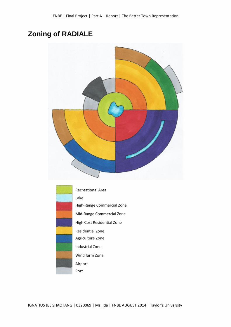
Zoning of RADIALE
Recreational Area
Lake
High-Range Commercial Zone
Mid-Range Commercial Zone
High Cost Residential Zone
Residential Zone
Agriculture Zone
Industrial Zone
Wind farm Zone
Airport
Port
ENBE | Final Project | Part A – Report | The Better Town Representation
IGNATIUS JEE SHAO IANG | 0320069 | Ms. Ida | FNBE AUGUST 2014 | Taylor’s University
The Overview of Town Zoning of Radiale
The town is generally divided into 11 zones, that is the recreational
ground, the lakes, the high-range commercial zone, the mid-range
commercial zone, high cost residential zone, residential zone, industrial
zone, Agriculture zone, the windmill power station zone, airport zone and
the port.
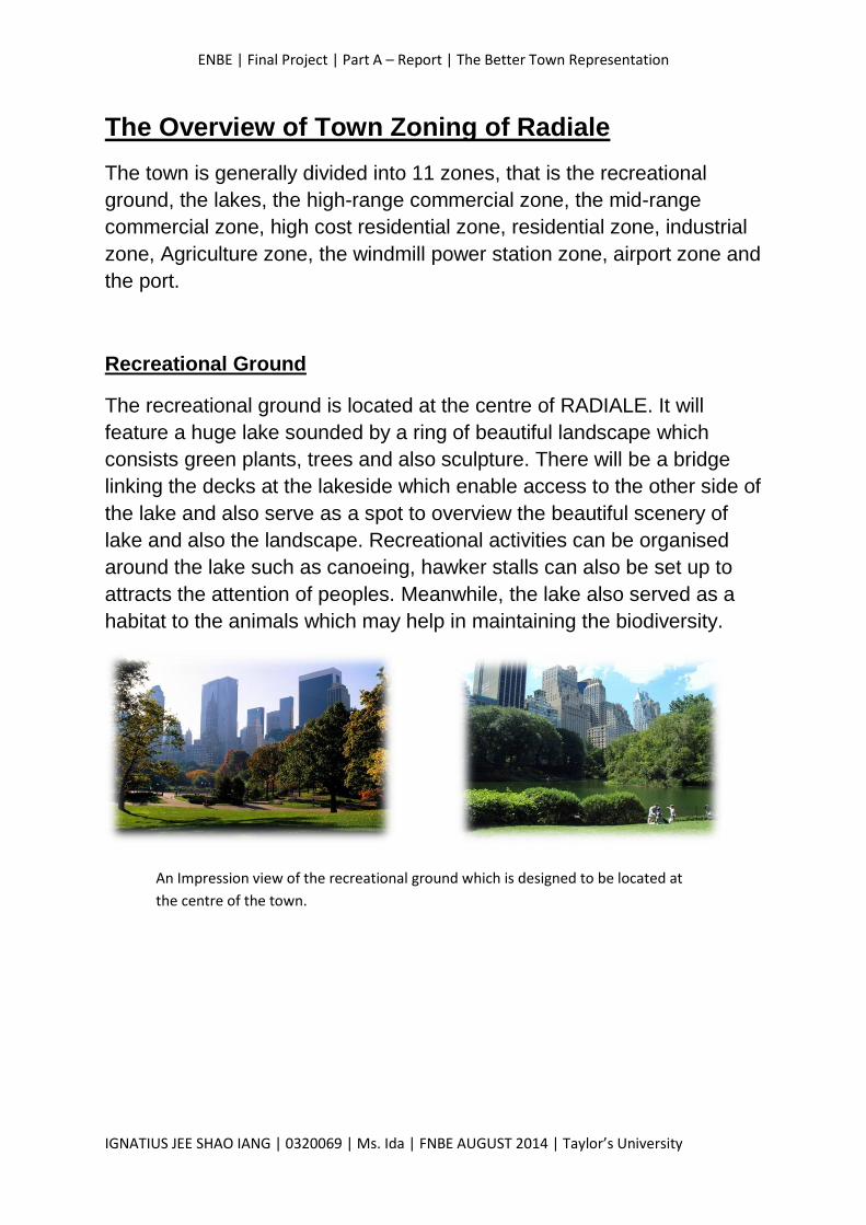
Recreational Ground
The recreational ground is located at the centre of RADIALE. It will
feature a huge lake sounded by a ring of beautiful landscape which
consists green plants, trees and also sculpture. There will be a bridge
linking the decks at the lakeside which enable access to the other side of
the lake and also serve as a spot to overview the beautiful scenery of
lake and also the landscape. Recreational activities can be organised
around the lake such as canoeing, hawker stalls can also be set up to
attracts the attention of peoples. Meanwhile, the lake also served as a
habitat to the animals which may help in maintaining the biodiversity.
An Impression view of the recreational ground which is designed to be located at
the centre of the town.
ENBE | Final Project | Part A – Report | The Better Town Representation
IGNATIUS JEE SHAO IANG | 0320069 | Ms. Ida | FNBE AUGUST 2014 | Taylor’s University
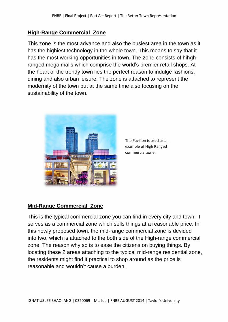
High-Range Commercial Zone
This zone is the most advance and also the busiest area in the town as it
has the highiest technology in the whole town. This means to say that it
has the most working opportunities in town. The zone consists of hihgh-
ranged mega malls which comprise the world’s premier retail shops. At
the heart of the trendy town lies the perfect reason to indulge fashions,
dining and also urban leisure. The zone is attached to represent the
modernity of the town but at the same time also focusing on the
sustainability of the town.
Mid-Range Commercial Zone
This is the typical commercial zone you can find in every city and town. It
serves as a commercial zone which sells things at a reasonable price. In
this newly proposed town, the mid-range commercial zone is devided
into two, which is attached to the both side of the High-range commercial
zone. The reason why so is to ease the citizens on buying things. By
locating these 2 areas attaching to the typical mid-range residential zone,
the residents might find it practical to shop around as the price is
reasonable and wouldn’t cause a burden.
The Pavilion is used as an
example of High Ranged
commercial zone.

ENBE | Final Project | Part A – Report | The Better Town Representation
IGNATIUS JEE SHAO IANG | 0320069 | Ms. Ida | FNBE AUGUST 2014 | Taylor’s University
High Cost Residential Zone
The high cost residential zone is located adjacent to the High Range
Commercial Zone. The zone is located this way as it is more nearer to
the High Range Commercial Zone, which may ease the access of the
residents to shop around for branded goods and also living appliances.
Besides, the location of the zone is the best in the town as it can access
to the whole commercial zone in the town. That is because it is located
at the centre adjacent to the High-range commercial zone with both the
mid range commercial zone attaching the High Range Commercial Zone.
Residential Zone
The typical residential zone is seperated into two parts which is basically
segerated by the lake and also the recreational ground. It is located at
the South West and the North East of the town. The Land area for the
residential zone is the largest among the all zones. This is to ensure
there is abundant affordable houses for the local community.
An example of house in the High
Cost Residential Zone
An impression view of the high cost
Apartment situated in the high cost
residential area.
ENBE | Final Project | Part A – Report | The Better Town Representation
IGNATIUS JEE SHAO IANG | 0320069 | Ms. Ida | FNBE AUGUST 2014 | Taylor’s University
Agriculture Zone
The agriculture in the town is served to provide enough food supply to
the residents. The agriculture zone is approximately the same size as
the industrial zone which is located at the opposite area of the town. The
reason why the zone is positioned this way is to ensure it is far away
from the industrial zone as well as the commercial zone to reduce
contimination which will leak to illness. It is situated this way so that the
public wouldn’t need to access through this zone to get to other places
of the town.
Industrial Zone
The industrial zone is located at the edge of the town which is adjacent
to the windfarm zone. It is located far away from the towncentral as to
avoid effecting the beautiness and also the comfortable view of the town.
Besides, the industrial one is situated that far to avoid polluting the
environment in the town central. The location of the industrial zone also
helps in avoiding the agriculture from being polluted.
Windfarm Zone
The Wind farm zones is located at the very edge of the floating town,
which is at the north east and the south west of the town. The town is
designed to comprise 2 windfarms as to ensure the sufficiency of
electrical energy provided. The wind farms play an essential role as the
town is totally self-sufficient and doesn’t obtain any form of energy from
the city on the mainland.
ENBE | Final Project | Part A – Report | The Better Town Representation
IGNATIUS JEE SHAO IANG | 0320069 | Ms. Ida | FNBE AUGUST 2014 | Taylor’s University
Airport and ports
The airport is situated at the north west of the town, which is located
between the 2 ports of the town. Air transportation is not really being
emphasised as the main transport for the residents to get to the city in
the mainland is the coastal boats and also the seagoing commercial
vessels. As a result, the water transport plays an important role in terms
of transportation , that is why the newly proposed floating town consists
4 ports in different areas. The town have 2 ports at the nort west of it,
which serve as a transportation to the city in the mainland. The other two
ports is set adjacently to the industrial zone and agriculture zone each.
The port at the agriculture zone serves as an import and export channel
for the algriculture and food products. Whereas for the port at the
industrial zone plays its part in exporting and importing industrial good
outwards and into the town.
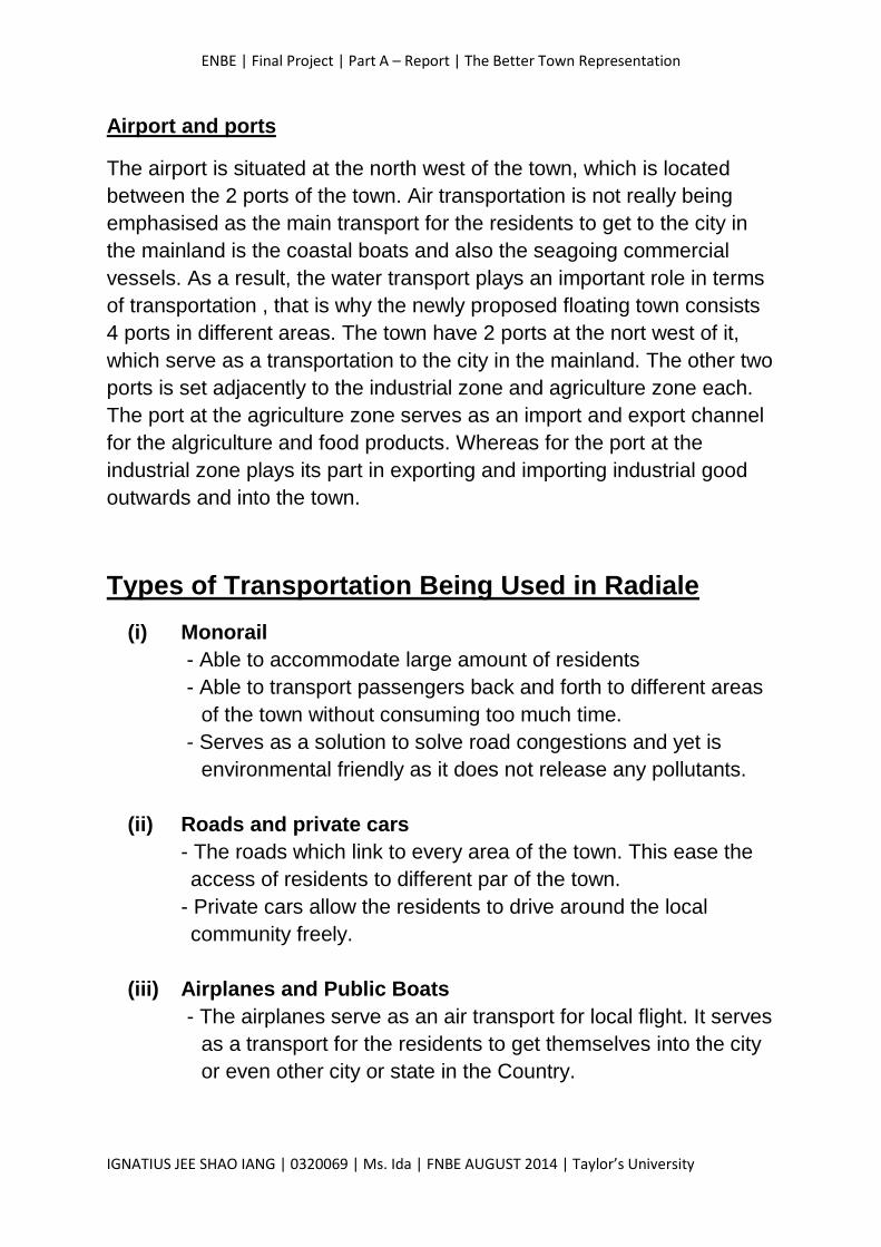
Types of Transportation Being Used in Radiale
(i) Monorail
- Able to accommodate large amount of residents
- Able to transport passengers back and forth to different areas
of the town without consuming too much time.
- Serves as a solution to solve road congestions and yet is
environmental friendly as it does not release any pollutants.
(ii) Roads and private cars
- The roads which link to every area of the town. This ease the
access of residents to different par of the town.
- Private cars allow the residents to drive around the local
community freely.
(iii) Airplanes and Public Boats
- The airplanes serve as an air transport for local flight. It serves
as a transport for the residents to get themselves into the city
or even other city or state in the Country.
ENBE | Final Project | Part A – Report | The Better Town Representation
IGNATIUS JEE SHAO IANG | 0320069 | Ms. Ida | FNBE AUGUST 2014 | Taylor’s University
- The public Boats serve as a public transport for the citizens to
get back and forth from the floating town, RADIALE to the
mainland.
Town Enhancements & Sustainable Approaches
The town enhancements & sustainable approaches to be include in the
proposal of RADIALE is the wind farm and the solar transportation and
also the. These ways enable the town to be self sufficient and
independent from the mainland.
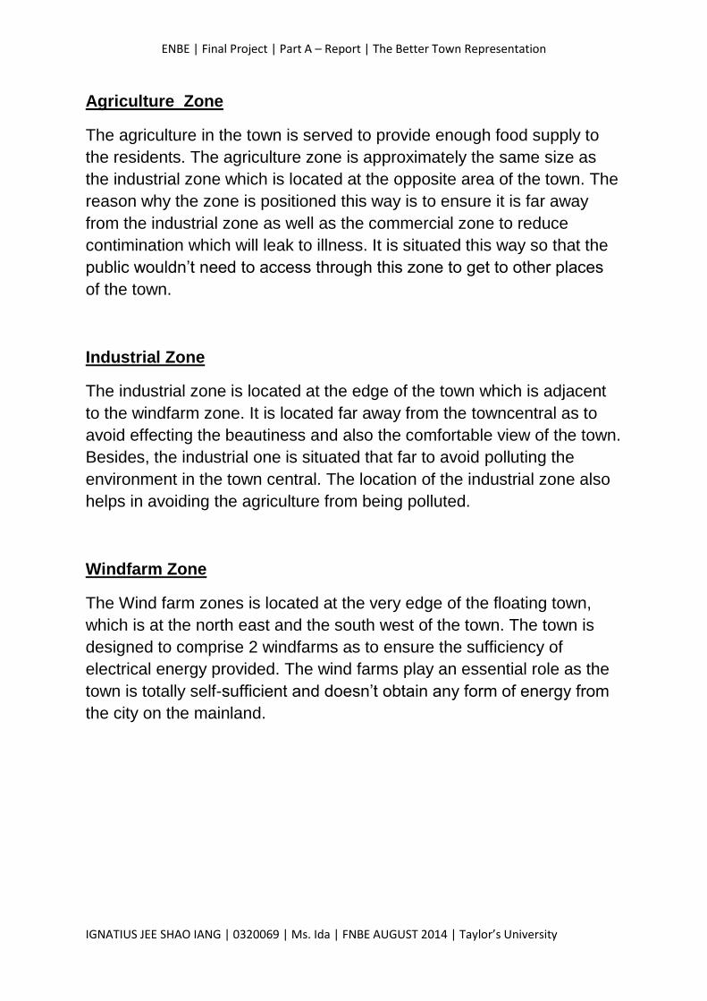
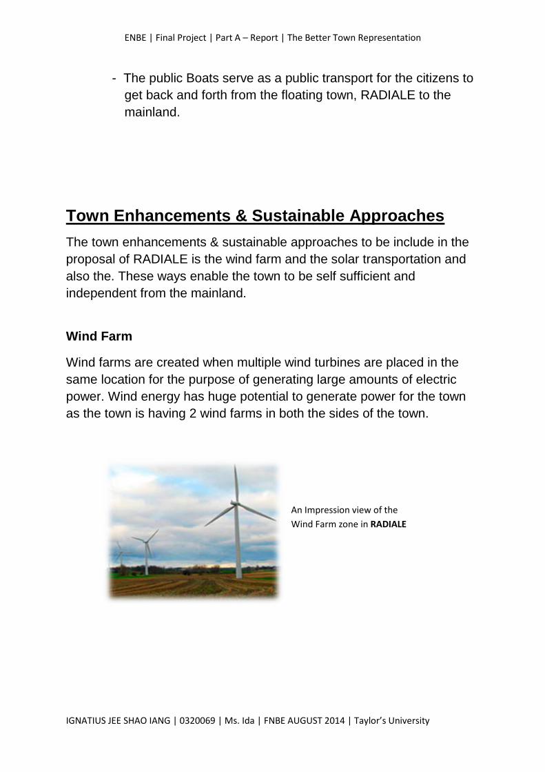
Wind Farm
Wind farms are created when multiple wind turbines are placed in the
same location for the purpose of generating large amounts of electric
power. Wind energy has huge potential to generate power for the town
as the town is having 2 wind farms in both the sides of the town.
An Impression view of the
Wind Farm zone in RADIALE
ENBE | Final Project | Part A – Report | The Better Town Representation
IGNATIUS JEE SHAO IANG | 0320069 | Ms. Ida | FNBE AUGUST 2014 | Taylor’s University
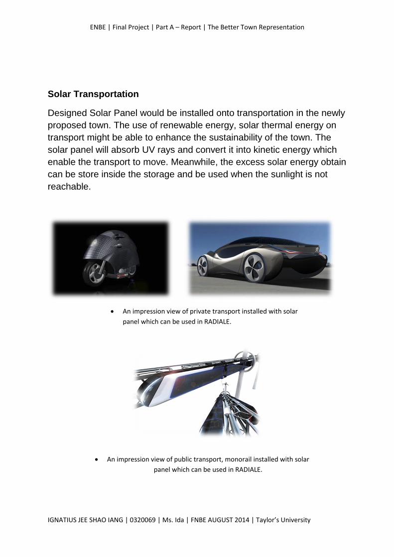
Solar Transportation
Designed Solar Panel would be installed onto transportation in the newly
proposed town. The use of renewable energy, solar thermal energy on
transport might be able to enhance the sustainability of the town. The
solar panel will absorb UV rays and convert it into kinetic energy which
enable the transport to move. Meanwhile, the excess solar energy obtain
can be store inside the storage and be used when the sunlight is not
reachable.
An impression view of private transport installed with solar
panel which can be used in RADIALE.
An impression view of public transport, monorail installed with solar
panel which can be used in RADIALE.
ENBE | Final Project | Part A – Report | The Better Town Representation
IGNATIUS JEE SHAO IANG | 0320069 | Ms. Ida | FNBE AUGUST 2014 | Taylor’s University
Conclusion
After completing this assignment, I obtained a deeper understanding on
the importance of systematic and efficient urban planning. These
elements are required in orther to build an efficient and sustainable
future town. In order for me to get a deeper undrstanding of the town, I
carried out refine researches based on the topic that is the ancient,
present and future cities. After doing so, I am required to carry out an
analysis about the pros and cons of the city planning in which lead to the
success or the failure of the city. Thus, I need to apply all the knowledge
obtained onto my proposed town to make it a better town.
ENBE | Final Project | Part A – Report | The Better Town Representation
IGNATIUS JEE SHAO IANG | 0320069 | Ms. Ida | FNBE AUGUST 2014 | Taylor’s University
Reference List:
1. http://www.livius.org/place/athens/athens-long-walls/
2. http://www.hydriaproject.net/en/cases/athens/peisistratid_aqueduct
/setting.html
3. http://www.veneto-explorer.com/facts-about-venice.html
4. https://sites.google.com/site/engineeringvenice/
5. http://archinect.com/features/article/76244/showcase-lilypad-a-
floating-ecopolis-for-ecological-refugees
6. http://vincent.callebaut.org/page1-img-lilypad2.html
Recommended