Geologic Map of the
Grants SE Quadrangle,
Cibola County, New Mexico
By
Colin T. Cikoski
June 2013
New Mexico Bureau of Geology and Mineral Resources Open-file Digital Geologic Map OF-GM 241
Scale 1:24,000
This work was supported by the U.S. Geological Survey, National Cooperative Geologic
Mapping Program (STATEMAP) under USGS Cooperative Agreement and the
New Mexico Bureau of Geology and Mineral Resources.
New Mexico Bureau of Geology and Mineral Resources
801 Leroy Place, Socorro, New Mexico, 87801-4796
The views and conclusions contained in this document are those of the author and should not be interpreted as necessarily representing the official policies,
either expressed or implied, of the U.S. Government or the State of New Mexico.
1
Grants SE unit descriptions
CT Cikoski
Note: Soil descriptions after Birkeland (1999), colors after Munsell Color (1994), and all
proportions are visual estimates.
Artificial units
af Artificial fill. Compacted gravel, sand, and mud underlying roads,
railroads, and water tanks. Up to 5 m thick.
Colluvial and slopewash units
Qsw Slopewash. Sandy silt and silty sand accumulating in depressions in
landslide areas. Likely up to 2 m thick.
Qdf Deflationary pits. Gray to brown (7.5YR 7/2 and 5YR 4/2 measured),
generally well-laminated silt and lesser clay with 5-15% fine sand,
subangular to subrounded, accumulating in depressions. Likely up to 2 m
thick.
Qc Colluvium. Gravels, sands, and silts transported by mass wasting and thin
water flow. Likely up to 2 m thick.
Qls Landslides. Slumps, slides, debris-flow deposits, and associated fine-
grained material underlying hummocky terrain along slopes below basalt-
capped mesas.
Eolian units
Qes Eolian sand. Silty fine sand and fine sandy silt forming sand sheets and
low dunes. Pale brown colors typical, with colors of 7.5YR 7/3 to 7/6 and
N 9 measured. Little evidence of soil development. Likely up to 2 m thick.
Qes/Qb_ Eolian sand over basalt. Hybrid unit that locates areas of basalt flows
largely buried by thin (0-1 m thick) eolian sand cover.
Qesd Dune sand. Clean to silty fine sand and fine sandy silt forming dune forms
of variable development and sandsheets with mounded microrelief.
Variably vegetated, with the more vegetated dunes displaying weak soil
development such as Stage I gypsum accumulation. As much as 5 m thick.
Qae Alluvial and eolian sand, undivided. Silty sand and sandy silt transported
by wind, slopewash, and confined water flow. Variably vegetated,
typically does not exhibit signs of soil development. <1/2 to 2 m thick.
Alluvial units
Rio San Jose alluvium
Qaj Alluvium associated with the Rio San Jose, undivided. Sand and silt with
lesser gravel and rare clays. Typically further subdivided into age units.
Qajh Historic alluvium associated with the Rio San Jose. Alluvium found along
the current floodplain of the Rio San Jose that does not exhibit signs of
soil development. Deposits are typically poorly to moderately sorted
angular to rounded silt/sand grains and fine pebbles. Likely up to 1 m
thick.
2
Qajhf Historic alluvium associated with thin alluvial fans from the termini of
gullies and channels along the Rio San Jose floodplain. Likely up to 1 m
thick.
Qajy Younger alluvium associated with the Rio San Jose. Alluvium underlying
terrace treads up to 2 m above the active channel, with typical soil
development including a weak reddened Bw horizon and up to Stage I Bk
development. Colors of 10YR 5/4 to 5/6, 7.5YR 5/3 to 5/4, and locally
5YR 4/4 and 7/4, measured. Likely not more than 3 m thick.
Qajo Thin deposits of sand and gravel associated with the Rio San Jose at
relatively high elevations along the active channel. Largely only
identifiable by the presence of sparse granitic and siliceous pebbles that do
not occur in underlying strata. No signs of soil development observed. 0-1
m thick.
Las Ventanas Ridge and Horace Mesa alluvium
Qaf Alluvial fan material from Mezosoic-cored highlands, undivided. Pebbly
sand and silt derived from small drainages in the flanks of Las Ventanas
Ridge and Horace Mesa. Typically subdivided based on age inferred from
geomorphology and soil development.
Qafh Historic alluvial fan material from Mesozoic-cored highlands. Likely up to
1 m thick.
Qafy Younger alluvial fan material from Mezosoic-cored highlands. Alluvium
underlying fan surfaces inset upon those of Qafo and bearing weak soils
(A/Bw at most), with colors of 10YR 6/3 measured. Likely up to 6 m
thick.
Qafo Older alluvial fan material from Mezosoic-cored highlands. Alluvium
underlying fan surfaces inset upon by those of Qafy and bearing buried
soils and evidence of a strong active soil. Buried soils have Bt and up to
Stage II Bk horizons and colors of 10YR 6/3-6/4 and 2.5Y 7/4. Evidence
for a Stage III K horizon at the top of these deposits, but this was not
observed in outcrop. Likely up to 10 m thick.
El Malpais valley alluvium
Qay Younger alluvium of the El Malpais valley. Fine sand and mud with local
fine pebbles, mainly along shallow, low gradient drainages. Active soils
and buried soils are typically weak, A/Bw to A/Bt/Bk (Stage I), with clay
as fine films on ped faces and bridging grains. Likely up to 2 m thick.
Qaec Calcareous alluvium and eolian material. Fossiliferous sand, mud, and
sparse fine pebbles with rare dark gray organic material accumulations.
Soil analyzes by White (1989) indicate deposits are up to 100% carbonate.
Fossils are mollusk shells, and carbonate casts of grasses and roots are
also locally common. Likely up to 3 m thick.
Qazo Older alluvial fan material from Zuni Canyon. Gravel, sand, and silt
bearing clasts indicative of derivation from the Zuni Mountain interior,
specifically fine pebbles of granite, red siltstone, quartz sandstone,
siliceous material, and arkosic sandstone. Distribution suggests transport
3
from Zuni Canyon into the El Malpais valley prior to the eruption of Qbz
but probably after eruption of Qbc. Thickness unknown, possibly tens of
meters in the El Malpais graben.
Zuni Mountains piedmont alluvium
Qp Alluvium of the Zuni Mountains piedmont, undivided. Typically
subdivided based on age inferred from geomorphology and soil
development. Units are extended from work to the west by Timmons and
Cikoski (2012).
Qpy Younger alluvium of the Zuni Mountains piedmont, undivided. Combined
unit of Qpy1, Qpy2, and Qpy3 of Timmons and Cikoski (2012), mapped
where finer subdivision is not readily possible at this scale. Likely up to 3
m thick.
Qpy3 Youngest alluvium of the Zuni Mountains piedmont. Brown silty fine to
coarse sand with little soil development. Contains sparse very fine
carbonate nodules (Stage I carbonate horizon morphology). Colors of 5YR
6/4 to 7.5YR 5/3 measured. 0-1 m thick.
Qpo Older alluvium of the Zuni Mountains piedmont. Pale to medium reddish
brown pebbles to boulders and silty sands with strong soil development.
Stage III carbonate horizon morphology common in outcrop. Colors of
5YR 5/4 to 8.5/2 measured, with color controlled by abundance of
carbonate. Likely up to 10 m or more thick.
Lava flows
Qbm McCartys flow. Dark gray basalt flow largely unconcealed by eolian
material or vegetation. Variably porphyritic, from <1% to 20%
phenocrysts, principally of subhedral, <1 mm across pyroxene, but also
rare (<3%) plagioclase as subhedral, clear, <1 mm across prismatic
crystals. Age estimates range from 2.4 to 3.9 ka (Table 1). Likely 0 to 6 m
thick.
Qbb Bandera flow. Lithologically similar to Qbm, though with more fine-
grained eolian cover. Consistent age estimates range from 9.17 to 12.5 ka
(Table 1). Likely 0 to 6 m thick.
Qbz Zuni Canyon flow. Dark gray to black, generally phenocryst-poor basalt.
Up to 3% phenocrysts of translucent greenish pyroxene and olivine, both
<1/2 mm across, typically anhedral, and variably degraded to translucent
reddish iddingsite(?). Likely 0 to 4 m thick.
Qbh Hoya de Cibola flow. Basalt flows burying Qbc, and buried by Qbm and
Qbb, locally concealed by eolian material and vegetation though typically
only partially concealed. Likely 0 to 5 m thick.
Qbc El Calderon flow. Dark gray to black basalt with rare fine phenocrysts. Up
to 5% phenocrysts <1/2 mm across of mainly subhedral translucent
greenish pyroxene and lesser (up to 1% of rock) anhedral translucent
greenish olivine. Basalt surface is often largely concealed by eolian
material and vegetation, with actual basalt cropping out mainly at breaks
in slope, areas of erosion, and areas with relatively high microrelief. Age
4
of eruption uncertain due to a wide spread in results, from 34 to 130 ka
(Table 1). Likely 0 to 7 m thick.
Qbg Grants flow. Dark gray to black generally phenocryst-poor basalt
underlying and largely concealed by Qbc. To date, only conclusively
distinguished as a separate flow by the paleomagnetic work of Cascadden
et al. (1997). Here, the contact is placed on a well-defined flow break
along the Rio San Jose, and an inferred flow break along the western
margin of the El Malpais valley; only the former contact is verified by
paleomagnetic work. Rock mass is up to 4% phenocrysts of pyroxene (up
to 1 mm across, subhedral, translucent greenish) and <1-2% olivine
(euhedral, <1 mm across, translucent greenish). Likely 0 to 7 m thick.
Ttbp Porphyritic trachybasalt capping Horace Mesa on this quadrangle.
Medium gray basalt with up to 5% phenocrysts of mainly plagioclase (up
to 6 mm across, translucent white to chalky white, lathe-like subhedral or
fractured anhedral shapes, 2-4% of rock mass) and pyroxene (<1-6 mm
across, black to dark translucent green, anhedral to subhedral, <1-2% of
rock mass). K-Ar age of 3.24 ± 0.09 Ma from Laughlin et al. (1993)
thought to be from this flow. 15-25 m thick.
Mesozoic strata
Kc Crevasse Canyon Formation, undivided, including associated tongue of
the Mancos Shale. Generally subdivided into constituent members.
Kcda Dalton Sandstone Member. White to pale brown quartz-rich, variably silty
fine to medium sandstone. Thin bedding, typically 10-60 cm thick, with
common 1-5 mm thick cross-laminae. Colors of 2.5Y 8.5/1 and 2.5Y 7/2
measured for fresh faces. 34-40 m thick.
Kmm Mulatto Tongue of the Mancos Shale. Yellowish brown mudstone, mostly
siltstone. Strongly planar laminated/bedded mudstone, with wavy beds 2
to 30 mm thick. Colors of 2.5Y 7/4 to 8/3 measured for fresh surfaces,
10YR 7/6 measured for weathered surface. Includes a thin quartz-rich very
fine sandstone interval. 50-60 m thick.
Kcs “Stray” Sandstone Member. Pale brown quartz-rich clean fine sandstone.
Thinly bedded, 10-40 cm thick, and massive to weakly internally cross-
stratified. Colors of 2.5Y 8/3 to 7/4 measured on fresh surfaces. Includes a
2-3 m thick shale interval, as well as local mudstone interbeds (<5% of
exposures). 20-25 m thick.
Kcdi Dilco Coal Member. Heterolithic unit of interbedded pale brown to gray
siltstone, pale brown to tan sandstone, and black coal. Thin bedding to
thick laminae; sandstone beds are typically 5-25 cm thick and massive or
internally cross-laminated with 1-4 mm thick laminae, while mudstone
beds are 3 mm to 3 cm thick, and coal beds are up to 1 cm thick and
discontinuous. Sandstone color of 2.5Y 8/4 measured on a fresh face. 35-
45 m thick.
Kg Gallup Sandstone, undivided, including associated tongues of the Mancos
Shale. Generally subdivided into constituent members.
5
Kgc Gallup Sandstone tongue “C”. Pale brown to light yellowish gray quartz-
rich silty fine sandstone. Thinly bedded (5-30 cm thick) with common
internal cross-laminae 1 mm to 1 cm thick. Color of 10YR 8/4 measured
for a fresh face. Designation as unit “C” after Molenaar (1983), previously
referred to as “Gallup, main body” by Thaden et al. (1967) and Zeigler et
al. (2012). 12-20 m thick.
Kgm2 Upper tongue of Mancos Shale intercalated with the Gallup Sandstone.
Poorly exposed, thinly laminated mudstone and siltstone located
stratigraphically between Kge and Kgc. 30-36 m thick.
Kge Gallup Sandstone tongue “E”. Pale brown to light yellowish brown,
quartz-rich silty-clayey fine sandstone. Thinly bedded (3-50 cm thick),
massive with vertical tubular burrows to well cross-laminated, with 1-3
mm thick laminae. Color of 2.5Y 8/4 measured for a fresh face. Unit is
capped by a distinctive brown, well indurated, calcite-cemented, muddy
fine sandstone, with colors of 10YR 5/4 to 6/3. Designation as unit “E”
after Molenaar (1983), previously referred to as “Gallup, upper tongue” by
Thaden et al. (1967) and Zeigler et al. (2012). 15-25 m thick.
Kgm1 Lower tongue of Mancos Shale intercalated with the Gallup Sandstone.
Poorly exposed, thinly laminated mudstone and siltstone located
stratigraphically between Kgf and Kge. 10-15 m thick.
Kgf Gallup Sandstone tongue “F”. Pale brown to pale yellow to gray quartz-
rich silty fine sandstone and fine sandy siltstone. Thinly bedded (4-30 cm
thick), commonly massive with burrows at the base, grading up into cross-
laminated (1-4 mm thick laminae). Colors of 2.5Y 7/1-8/3 measured.
Designation as unit “F” after Molenaar (1983), previously referred to as
“Gallup, lower tongue” by Thaden et al. (1967) and Zeigler et al. (2012).
12-15 m thick.
Km Mancos Shale, undivided. Claystone to siltstone, with very rare sandstone
beds. Typically divided into tongues based on stratigraphic location.
Kmrd Mancos Shale, equivalent to the Rio Salado and D-Cross Tongues. Light
gray to medium gray to pale brownish gray, well-laminated gypsiferous
siltstone to claystone and rare sparry gypsum beds. Thinly bedded, with
beds up to 6 cm thick, commonly internally laminated, with laminae <1 to
1 mm thick. 45-55 m thick.
Kd Dakota Sandstone, undivided. Sandstone, siltstone, and mudstone.
Typically divided into tongues based on stratigraphic location.
Kdt Dakota Sandstone, Twowells Tongue. Light yellow to white, quartz-rich,
variably silty fine sandstone and local siltstone. Typically more massive
and thicker bedded base, and more cross-bedded and thinner bedded top.
Beds from 1 m thick at base to 25-40 cm thick at top. Color of 2.5Y 7/4
measured on a fresh face. Gradational basal contact. 9-11 m thick.
Kmw Mancos Shale, Whitewater Arroyo Tongue. Light gray to dark gray
siltstone to claystone. Generally very poorly exposed. Color of 2.5Y 7/2
measured. 4-6 m thick.
Kdp Dakota Sandstone, Paguate Tongue. Light yellow to pale brown, variably
silty fine to medium sandstone. A massive base grades up into a bedded
6
but internally massive middle, followed by a bedded and internally cross-
stratified top. Beds are 4-20 cm thick, cross-strata 1-12 mm thick. Unit
tends to coarsen upsection, from silty very fine to clean fine-medium
sandstone. Colors of 2.5Y 7/3-8/3 measured on fresh faces. 9-12 m thick.
Kmc Mancos Shale, Clay Mesa Tongue. Black to brown claystone to siltstone.
Brown color of 10YR 5/4 measured; brown color may be an iron oxide
stain. 18-24 m thick.
Kdc Dakota Sandstone, Cubero Tongue. Pale brown to light yellow variably
silty fine sandstone. Thinly bedded, particularly where not bioturbated
(30-50 cm thick where massive, 2-12 cm thick where cross-bedded).
Vertical and subhorizontal burrows common. Unit includes a ~2 m thick
medial section of mudstone, separating two sandstone intervals. 9-12 m
thick.
Kdou Dakota Sandstone, upper Oak Canyon Member. Black to pale brown
gypsiferous claystone to siltstone. Strongly laminated mudstone,
commonly wavy, up to 4 mm thick. Local very fine sandstone beds up to 3
cm thick. Colors of 2.5Y 5/3, 7/2, and black (value <2.5, chroma ~1)
measured. Unit includes a ~2 m thick sandstone interval dividing two
mudstone intervals. 26-30 m thick.
Kdol Dakota Sandstone, lower Oak Canyon Member. Pale brown to white,
variably silty fine to medium sandstone and lesser pebbly sandstone and
siltstone. Thin beds (1-10 cm thick beds) that are typically more massive
at the base and internally planar and cross-laminated toward the top.
Vertical and subhorizontal burrows are common. Locally carbonaceous.
Pebbles at the base are up to ½ cm across, poorly sorted, generally well
rounded, and principally of light to medium brown siliceous material with
rare quartzite and sparse granite. 8-10 m thick.
Jm Morrison Formation, undivided. Interbedded pale yellow to light brown
sandstone, varicolored mudstone, and lesser conglomerate. Lower
sandstones are of silty fine sand, typically pale yellow in color (2.5Y 8/3
measured), and are indistinctly bedded with cross-laminae. Upper
sandstones and conglomerates are pale brown to white, of quartz-rich silty
fine to coarse sand, generally in thin beds (5-8 cm thick) with common,
well-expressed cross-laminae. Pebbles, only observed in the upper part of
the unit, are up to 1 cm across, moderately sorted, subrounded to rounded,
and mainly of siliceous material with rare granites (up to 2% of beds) and
sparse white to gray quartzites (<<1%). Mudstones are clay to silt, with
colors of 5YR 5/3, 5GY 8/1, and 5Y 8/2 measured. Use of Jm here differs
from the previous maps of Thaden et al. (1967) and Maxwell (1986) in
that the strongly cross-bedded sandstones and conglomerates between the
varicolored mudstones and bioturbated lower Dakota sandstones are
included in the Morrison and not considered a part of the Oak Canyon
Member of the Dakota. Pinches out to the south. 0-30 m thick.
Jb Bluff Sandstone. Light gray to strong olive colored, strongly cross-bedded,
dominantly eolian sandstone with local fluvial sandstone. Variably silty
fine to medium sands, mainly of quartz. Thin to medium beds (up to 1.5 m
7
thick observed), tabular and wedge-shaped, with steep, large-scale, eolian
cross-laminae. Local fluvial beds are thinner, up to 20 cm thick, with low-
angle, small-scale cross-laminae. Colors of 5Y 8/2 and 2.5Y 6/6 measured.
Forms bold cliffs. 85-90 m thick.
Js Summerville Formation. White to pale yellow, very poorly exposed
sandstone, mudstone, and limestone conglomerate(?). One poor exposure
suggests the presence of limestone pebble conglomerate channels, with
subrounded to rounded, poorly sorted fine to medium pebbles in a silty
fine to coarse sand matrix; given the poor exposure, however, it is possible
this conglomerate is actually a caliche-cemented Quaternary deposit inset
upon the Summerville sandstones. Colors of 2.5Y 8/1 to 7/3 measured. 13-
16 m thick.
Jt Todilto Formation. Gypsiferous light to dark gray fine-grained limestone.
Typically <5% of fresh faces is visible grains (locally up to 20%), with
<1-2% fine (<1 mm across) circular fossils. Thinly bedded, 0.5 to 10 cm
thick. Colors of 2.5Y 6/1 to 7/1 measured. 5-7 m thick.
Je Entrada Sandstone. Pink to light reddish brown silty fine sandstone and
siltstone. Grains are moderately to poorly sorted, very silty with rare
medium sand grains. Indistinctly thinly bedded (2-10 cm thick), but well
cross-bedded. Color of 2.5YR 7/4 measured. 45-50 m thick. ^u Triassic, undivided. Cross-section only. Includes both ^c and ^m. 540-
550 m thick.
^c Chinle Formation, undivided. Poorly exposed red mudstone at the top,
reddish brown sandstone and pebble conglomeratet at the base; middle of
unit is not exposed. Basal contact placed on the first pebble conglomerate.
^m Moenkopi Formation. Slope-forming red to reddish brown mudstones
along the eastern edge of the quadrangle. Poorly exposed. Less than 5 m
thick.
Paleozoic and older strata
Psa San Andres Formation. Light to dark gray limestone and dolomite.
Exposed only along the eastern margin of the quadrangle. 75-80 m thick.
Pg Glorieta Sandstone. Cross section only. 40-45 m thick.
Py Yeso Formation. Cross section only. 380-385 m thick.
Pa Abo Formation. Cross section only. 285-290 m thick.
*u Pennsylvanian strata, undivided. Cross section only. Only locally present
in the Zuni Mountains, ~150 m thick in the Gottlieb #1 lithologic log.
=u Precambrian rocks, undivided. Cross-section only.
Intrusive rocks
Tib Intrusive basalt. Dark gray to dark brownish gray and black pyroxene-
plagioclase basaltic porphyry dikes. Rock mass is up to 10% greenish-
translucent subhedral pyroxene, 1-3% clear to white subhedral plagioclase,
and sparse reddish translucent crystals, possibly iddingsite replacing
olivine. All phenocrysts <1 mm across. Dikes are 0 to 1 m wide.
8
References Birkeland, P.W. 1999. Soils and geomorphology: New York, Oxford University Press,
430 p.
Cascadden, T.E., Geissman, J.W., Kudo, A.M., and Laughlin, A.W. 1997. El Calderon
cinder cone and associated basalt flows: in Maberry, K., ed., Natural history of El
Malpais National Monument: New Mexico Bureau of Geology and Mineral
Resources, Bulletin 156, p. 41-51.
Champion, D.E., and Lanphere, M.A. 1988. Evidence for a new geomagnetic reversal
from lava flows in Idaho – discussion of short polarity reversals in the Bruhnes
and late Matuyama polarity chrons: Journal of Geophysical Research, v. 93, p.
11,667-11,680.
Dunbar, N.W., and Phillips, F.M. 2004. Cosmogenic 36
Cl ages of lava flows in the Zuni-
Bandera volcanic field, north-central New Mexico, USA: in Cather, S.M.,
McIntosh, W.C., and Kelley, S.A., eds., Tectonics, geochronology and volcanism
in the southern Rocky Mountains and Rio Grande rift: N.M. Bureau of Geology
and Mineral Resources, Bulletin 160, p. 309-317.
Kelly, T.E., and Reynolds, C.B. 1989. Structural geology of the Malpais Valley, San
Rafael, New Mexico: in Anderson, O.J., Lucas, S.G., Love, D.W., and Cather,
S.M., eds., Southeastern Colorado Plateau: N.M. Geological Society, Guidebook
40, p. 119-121.
Laughlin, A.W., and WoldeGabriel, G. 1997. Dating the Zuni-Bandera volcanic field: in
Maberry, K., ed., Natural history of El Malpais National Monument: New Mexico
Bureau of Geology and Mineral Resources, Bulletin 156, p. 25-29.
Laughlin, A.W., Perry, F.V., Damon, P.E., Shafiqullah, M., WoldeGabriel, G., McIntosh,
W.C., Harrington, C.D., Wells, S.G., and Drake [Drakos], P.D. 1993.
Geochronology of Mount Taylor, Cebollita Mesa, and Zuni-Bandera volcanic
fields, Cibola County, New Mexico: New Mexico Geology, v. 15, p. 81-92.
Laughlin, A.W., Poths, J., Healey, H.A., Reneau, S., and WoldeGabriel, G. 1994. Dating
of Quaternary basalts using the cosmogenic 3He and
14C methods with
implications for excess 40
Ar: Geology, v. 22, p. 135-138.
Maxwell, C.H. 1986. Geologic map of El Malpais lava field and surrounding areas,
Cibola County, New Mexico: US Geological Survey, Miscellaneous Map I-1595,
scale 1:62,500.
McIntosh, W.C. 1994. 40
Ar/39
Ar geochronology of late Miocene to Pleistocene basalts of
the Zuni-Bandera, Red Hill-Quemado, and Potrillo volcanic fields, New Mexico
(abs.): New Mexico Geology, v. 16, p. 60-61.
Molenaar, C.M. 1983. Principal reference section and correlation of Gallup Sandstone,
northwestern New Mexico: in Hook, S.C., ed. Contributions to mid-Cretaceous
paleontology and stratigraphy of New Mexico – Part II: New Mexico Bureau of
Geology and Mineral Resources, Circular 185, p. 29-40.
Munsell Color. 1994 edition. Munsell soil color charts: New Windsor, N.Y., Kollmorgen
Corp., Macbeth Division.
Thaden, R.E., Merrin, S., and Raup, O.B. 1967. Geologic map of the Grants SE
quadrangle, Valencia County, New Mexico: US Geological Survey, Geologic
Quadrangle Map GQ-682, scale 1:24,000.
9
Timmons, J.M., and Cikoski, C.T. 2012. Preliminary geologic map of the San Rafael
quadrangle, Cibola County, New Mexico: New Mexico Bureau of Geology and
Mineral Resources, Open-file Geologic Map OF-GM-232, scale 1:24,000.
White, W.D. 1989. Geohydrologic and environmental indicators of a dewatered wetland:
Ojo del Gallo, San Rafael, New Mexico: in Anderson, O.J., Lucas, S.G., Love,
D.W., and Cather, S.M., eds., Southeastern Colorado Plateau: N.M. Geological
Society, Guidebook 40, p. 337-345.
Zeigler, K.E., Cikoski, C.T., Drakos, P.D., and Riesterer, J. 2012. Preliminary geologic
map of the Grants quadrangle, Cibola County, New Mexico: New Mexico Bureau
of Geology and Mineral Resources, Open-file Geologic Map OF-224, scale
1:24,000.
10
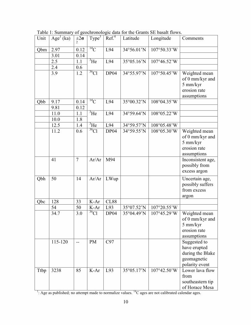
Table 1: Summary of geochronologic data for the Grants SE basalt flows.
Unit Age1 (ka) ±2σ
2 Type
3 Ref.
4 Latitude Longitude Comments
Qbm 2.97 0.12 14
C L94 34°56.01’N 107°50.33’W
3.01 0.14
2.5 1.1 3He L94 35°05.16’N 107°46.52’W
2.4 0.6
3.9 1.2 36
Cl DP04 34°55.97’N 107°50.45’W Weighted mean
of 0 mm/kyr and
5 mm/kyr
erosion rate
assumptions
Qbb 9.17 0.14 14
C L94 35°00.32’N 108°04.35’W
9.81 0.12
11.0 1.1 3He L94 34°59.64’N 108°05.22’W
10.0 1.8
12.5 1.4 3He L94 34°59.57’N 108°05.48’W
11.2 0.6 36
Cl DP04 34°59.55’N 108°05.30’W Weighted mean
of 0 mm/kyr and
5 mm/kyr
erosion rate
assumptions
41 7 Ar/Ar M94 Inconsistent age,
possibly from
excess argon
Qbh 50 14 Ar/Ar LWup Uncertain age,
possibly suffers
from excess
argon
Qbc 128 33 K-Ar CL88
54 50 K-Ar L93 35°07.52’N 107°20.55’W
34.7 3.0 36
Cl DP04 35°04.49’N 107°45.29’W Weighted mean
of 0 mm/kyr and
5 mm/kyr
erosion rate
assumptions
115-120 -- PM C97 Suggested to
have erupted
during the Blake
geomagnetic
polarity event
Ttbp 3238 85 K-Ar L93 35°05.17’N 107°42.50’W Lower lava flow
from
southeastern tip
of Horace Mesa 1: Age as published; no attempt made to normalize values.
14C ages are not calibrated calendar ages.

11
2: Uncertainty as published.
3: PM – age from comparison of radiometric ages and paleomagnetic data to established paleomagnetic
sequence; 14
C ages date material from buried soils immediately underlying the flows; 3He and
36Cl are
cosmogenic surface exposure ages; 40
Ar/39
Ar and K-Ar are crystallization ages. 4: C97 – Cascadden et al., 1997; CL88 – Champion and Lanphere, 1988; DP04 – Dunbar and Phillips,
2004; L93 – Laughlin et al., 1993; L94 – Laughlin et al., 1994; LWup – Laughlin and WoldeGabriel,
unpublished data, cited in Laughlin and WoldeGabriel., 1997; M94 – McIntosh, 1994.
Recommended