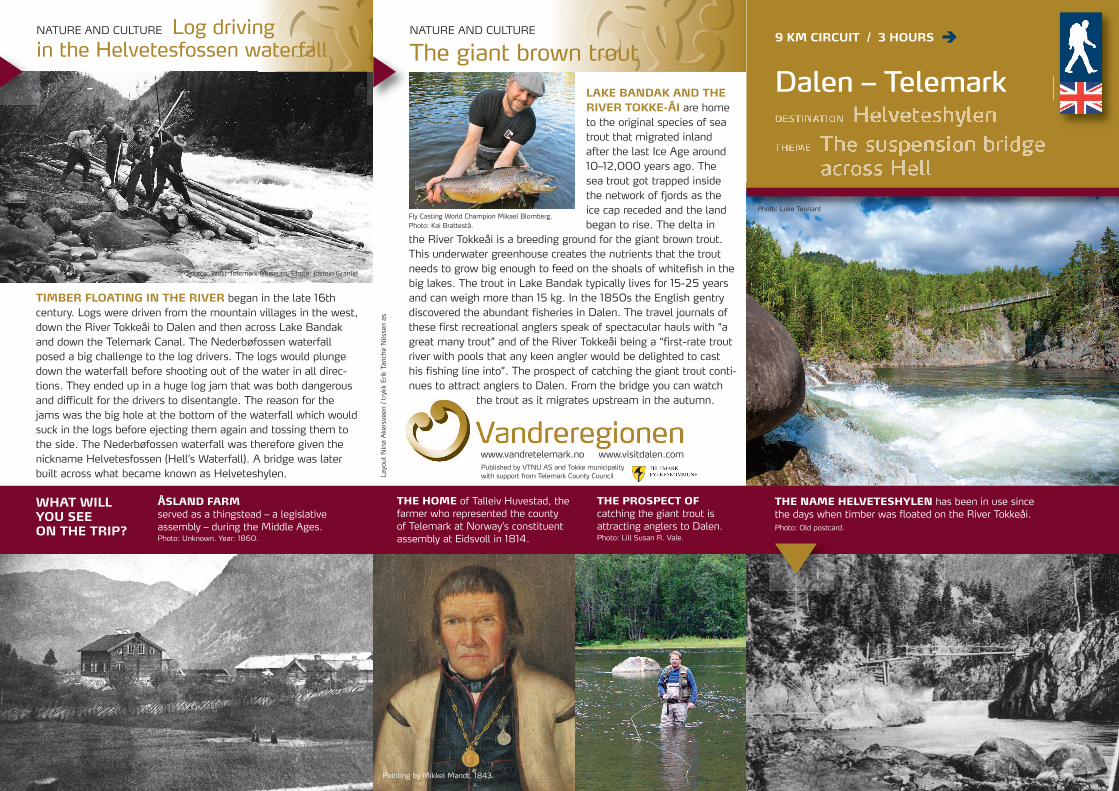
LAKE BANDAK AND THERIVER TOKKE-ÅI are hometo the original species of seatrout that migrated inlandafter the last Ice Age around10–12,000 years ago. The sea trout got trapped insidethe network of fjords as theice cap receded and the landbegan to rise. The delta in
the River Tokkeåi is a breeding ground for the giant brown trout.This underwater greenhouse creates the nutrients that the troutneeds to grow big enough to feed on the shoals of whitefish in thebig lakes. The trout in Lake Bandak typically lives for 15-25 yearsand can weigh more than 15 kg. In the 1850s the English gentrydiscovered the abundant fisheries in Dalen. The travel journals ofthese first recreational anglers speak of spectacular hauls with “agreat many trout” and of the River Tokkeåi being a “first-rate troutriver with pools that any keen angler would be delighted to casthis fishing line into”. The prospect of catching the giant trout conti-nues to attract anglers to Dalen. From the bridge you can watch
the trout as it migrates upstream in the autumn.
Source: West-Telemark Museum, Photo: Jostein Granlid
Fly Casting World Champion Mikael Blomberg. Photo: Kai Brattestå.
www.vandretelemark.no www.visitdalen.com
NATURE AND CULTURE
The giant brown trout9 KM CIRCUIT / 3 HOURS
Published by VTNU AS and Tokke municipality with support from Telemark County Council
WHAT WILL YOU SEE ON THE TRIP?
ÅSLAND FARMserved as a thingstead – a legislative assembly – during the Middle Ages. Photo: Unknown. Year: 1860.
THE HOME of Talleiv Huvestad, thefarmer who represented the countyof Telemark at Norway’s constituentassembly at Eidsvoll in 1814.
THE PROSPECT OF catching the giant trout is attracting anglers to Dalen.Photo: Lill Susan R. Vale.
THE NAME HELVETESHYLEN has been in use since the days when timber was floated on the River Tokkeåi. Photo: Old postcard.
Dalen – Telemark
Layout Nina Akersveen / trykk Erik Tanche Nilssen as
Photo: Luke Tennant
NATURE AND CULTURE Log driving in the Helvetesfossen waterfall
TIMBER FLOATING IN THE RIVER began in the late 16thcentury. Logs were driven from the mountain villages in the west,down the River Tokkeåi to Dalen and then across Lake Bandakand down the Telemark Canal. The Nederbøfossen waterfallposed a big challenge to the log drivers. The logs would plungedown the waterfall before shooting out of the water in all direc-tions. They ended up in a huge log jam that was both dangerousand difficult for the drivers to disentangle. The reason for thejams was the big hole at the bottom of the waterfall which wouldsuck in the logs before ejecting them again and tossing them tothe side. The Nederbøfossen waterfall was therefore given thenickname Helvetesfossen (Hell’s Waterfall). A bridge was laterbuilt across what became known as Helveteshylen.
Painting by Mikkel Mandt, 1843.
Map:Tokke
Access: May-October.Highest point:244 m above sea level.
Film: Log driving in West Telemark on YouTube.
Equidistance 10 m = mainroute = shortcut
Photo: Jostein Hellevik, Dalen Villmarksenter
At walktelemark.comyou will find an over-view of accommodationfor hikers.
Ú
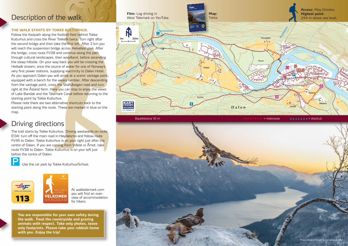
Description of the walk
THE WALK STARTS BY TOKKE KULTURHUS.Follow the footpath along the football field behind TokkeKulturhus and cross the River Tokkeåi twice. Turn right after the second bridge and then take the first left. After 2 km youwill reach the suspension bridge across Helveteshylen. Afterthe bridge, cross route FV38 and continue along the paththrough cultural landscapes, then woodland, before ascendingthe steep hillside. On your way back you will be crossing theHeibøåi stream, once the source of water for one of Norway’svery first power stations, supplying electricity to Dalen Hotel.As you approach Dalen you will arrive at a scenic vantage point,equipped with a bench for the weary rambler. After descendingfrom the vantage point, cross the Skafsåvegen road and turnright at the Åsland farm. Here you can stop to enjoy the viewsof Lake Bandak and the Telemark Canal before returning to thestarting point by Tokke Kulturhus. Please note there are two alternative shortcuts back to thestarting point along the route. These are marked in blue on themap.
Driving directionsThe trail starts by Tokke Kulturhus. Driving westwards on routeE134: turn off the main road in Høydalsmo and follow routeFV45 to Dalen. Tokke Kulturhus is on your right just after thecentre of Dalen. If you are coming from Vrådal or Åmot, takeroute FV38 to Dalen. Tokke Kulturhus is on your left just before the centre of Dalen.
Use the car park by Tokke Kulturhus/School.
You are responsible for your own safety duringthe walk. Treat the countryside and grazinganimals with respect. Take only photos, leaveonly footprints. Please take your rubbish homewith you. Enjoy the trip!
Recommended