Tectonophysics 468 (2009) 149-157
Contents lists available at ScienceDirect
Tectonophysics
j ourna l homepage: www.e lsev ie r.com/ locate / tecto
Magmatic rifting of Pangaea linked to onset of South American plate motion
Erin K. Beutel ⁎Department of Geology and Environmental Geosciences, College of Charleston, 66 George St., Charleston, SC 29424, United States
⁎ Tel.: +1 843 953 5591; fax: +1 843 953 5446.E-mail address: [email protected].
0040-1951/$ – see front matter © 2008 Elsevier B.V. Aldoi:10.1016/j.tecto.2008.06.019
A B S T R A C T
A R T I C L E I N F OArticle history:
The causes of the transition Received 30 August 2007Accepted 5 June 2008Available online 21 June 2008Keywords:PangaeaStressFinite elementDikesMagmatic riftingAmagmatic rifting
from amagmatic to magmatic rifting during continental break-up are not alwaysclear and have been often linked to the break-through of a plume. However, stress fields recorded in the crustmay offer new insights into the relationship between changes in the stress field and the onset of magmatism.In this paper stress fields recorded in the crust of North America are used to test possible causes of the break-up of Pangaea and the transition from amagmatic to magmatic rifting. Finite element models reveal that themost likely scenario for the break-up involves the initial northwest motion of North America at 230 Ma,followed by a south-southeast motion of South America at 200 Ma with the initiation of magmatism, andfinally a weakened area between North and South America sometime soon after 200 Ma which resulted inNorth America being dominated by northwest motion once again. It was also determined that plateboundary structure and orientation play a large part in the recorded stress fields and must be taken intoconsideration when modeling continental break-ups and rifting.
© 2008 Elsevier B.V. All rights reserved.
1. Background
Continental rifting and the transition from pure continental riftingto seafloor spreading may be investigated from both present dayactivity, such as rifting in East Africa—the Red Sea, and from pastrifting events, such as the break-up of Pangaea. Present day studies,such as those on the East African rift and Red Sea rift have theadvantage of real-timemeasurements and observations, while studiesof the past rifting events have the advantage of a completed timelinerather than a snapshot waiting to develop. However, because of theamount of time that has passed, investigations of past rifting eventssometimes smooth over the details such as rift orientation andpropagation because of a lack of data or because of scale issues. In thispaper I use these details to understand the stress field in NorthAmerica at the time of the break-up of Pangaea, specifically the timewhen the rifting went from amagmatic to magmatic. The possiblecauses of these stress fields, and therefore the break-up of Pangaea,are then determined using finite element models.
The break-up of Pangaea began around 230 Ma with the initialrifting of the southeastern portion of North America (Schlische, 2002).These early rifts can be found in both North and South Carolina(Schlische, 2002) and generally trend Northeast with regionalvariations, however, it is unclear if this initial rifting also occurredalong the southern margin of North America as the few Mesozoic riftbasins from Georgia, Northern Florida, and Alabama are not preciselydated. Around 200 Ma+/−2 Ma (Nomade et al., 2007) magmatic
l rights reserved.
injection in the form of a giant dike swarm began approximatelysynchronously with the progression of rifting to the North-Northeast(Hames et al., 2000; McHone, 2000; Salters et al., 2003; Schlischeet al., 2003; Beutel et al., 2005). Because most of the dikes and theexposed flows are dated to around 200 Ma, it is assumed that themajority of the voluminous mafic magmas along the North Americanmargin from Florida to New England were emplaced within a 2–3 million time period (Nomade et al., 2007). Initial maps combinedwith new field work indicate that the southeastern margin of NorthAmerica is dominated byNW trending dikes cross-cut by infrequent tofrequent N and NE trending dikes, however, as the swarm progressesto the northeast the overall dike trend slowly rotates to becomepredominantly NE (May, 1971; Ragland et al., 1983; McHone, 1988;Marzoli et al., 1999; Salters et al., 2003; Beutel et al., 2005). Cross-cutting relationships and geochemistry suggest that the NW trendingdikes were emplaced first, followed by theN and finally theNE trendingdikes (Raglandet al.,1983; Beutel et al., 2005). Because of sedimentationand logistical issues, it is not clear what the relationship between these200Madikes and the formation of thefirst oceanic crust around180Ma.However, it is clear that they represent the transition between theamagmatic phaseof riftingandmagmatic riftingphase. This informationcan be used in conjunctionwith afinite elementmodel to determine thestress field during the break-up of Pangaea and the possible causes ofthis stress field as the rifting progresses from magmatic to amagmatic.Because the regional stresses recorded in the rock represent snapshotsof what was occurring at the time, finding the sources of these stressesshould clarify possible causes for the break-up of the Pangaea byindicating what was occurring prior to and during the break-up andtransition from amagmatic to magmatic.
150 E.K. Beutel / Tectonophysics 468 (2009) 149-157
1.1. Dikes and stress
Dikes record the stress field during their emplacement and thus thestress field during the change from amagmatic to magmatic riftingduring the break-up of Pangaea. In general dikes are injectedperpendicular to the least least-compressive regional stress field,however, pre-existing fractures, local stress fields, and basementstructures can cause deviation from the regional (state-wide) stressfield (de Boer and Snider, 1979; Mchone et al., 1987; Fialko and Rubin,1999; Ziv et al., 2000; Jourdan et al., 2006). According to Ziv et al. (2000),one of three criteria must be met for dikes to follow pre-existingfractures; one, that the fractures are close to perpendicular to the leastleast-compressive stress field (whichmeans that the dikes will still giveus a general view of the stress field at the time of their emplacement);two, that themagma pressure is so high that it creates a scenario wherethe shear to the opening of the dike walls is small; and three, theeffective dike-normal stress is small compared to the rock tensilestrength. Because these conditions are difficult to maintain over longdistances and/or depths,most dikes affected by fractures rotatewithin ashort distance to becomeparallel to the ambient compressive stressfield(Ziv et al., 2000). Local stress fields that affect dikes can be caused by theinjection of thedike itself and/or themagmabody, the classic example ofmagma bodies affecting dike orientation is seen at volcanoes wheredikes are injected radially about the domal uplift (Johnson, 1961). Thebest evidence for basement control of dike orientation comes from theKaroo swarm in SouthAfricawhere Jourdan et al. (2006) recognized thatthe Karoo swarm consists of both Proterozoic and Mesozoic dikes, bothof which follow the cratonicmargin. This suggests that cratonicmarginsand basement structures may strongly affect dike orientation.
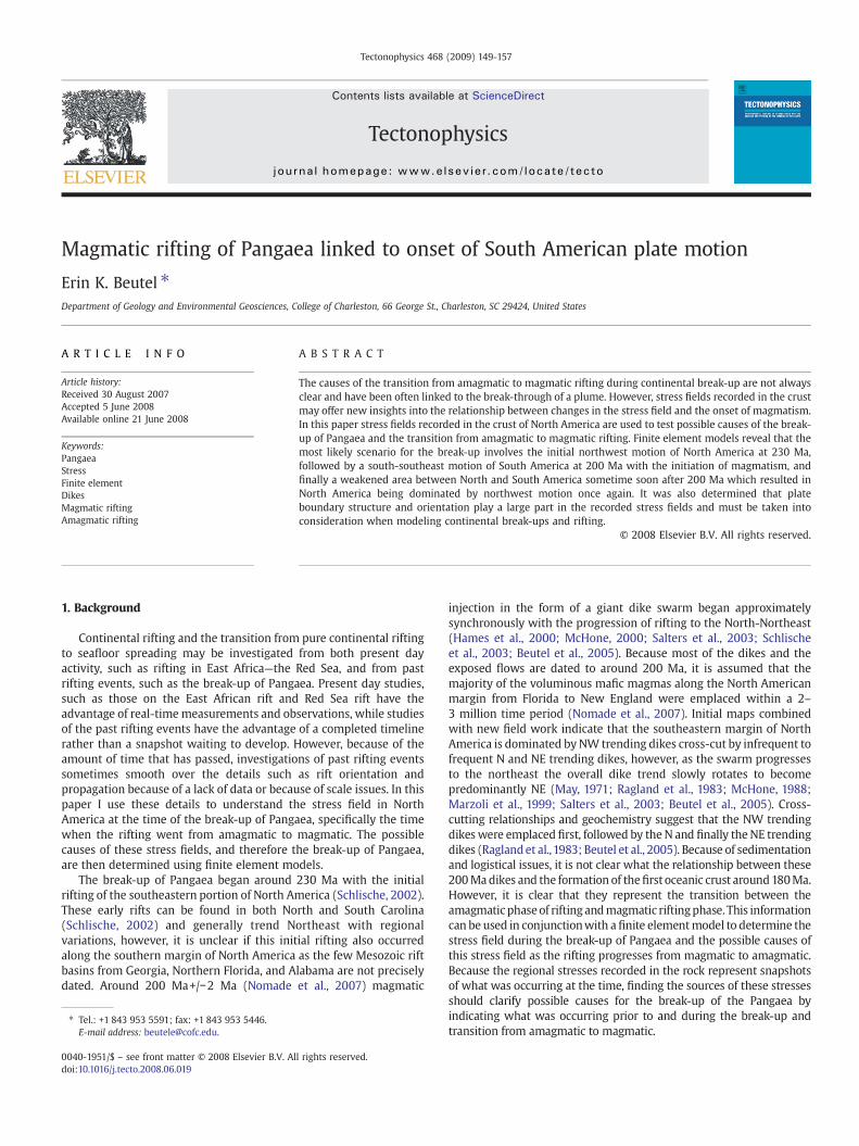
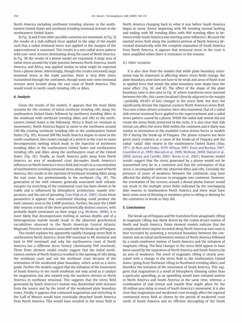
Fig. 1. Sketch map of 200 my Pangaea with pre-South Carolina regional studies dike orientmapped dikes are shown as short thick black lines (e.g. Marzoli et al., 1999), rough sketches oshows true orientation of dikes in South Carolina and parts of North Carolina based on newmapped dikes and faults would overlie each other in the region indicated by the connectinindicates from North to South, the locations of North Carolina, South Carolina, and Georgia. Tshelves, which we do not have good data for and missing continental pieces from the time
1.1.1. Can CAMP dikes be used to reveal a regional (eastern North America)stress history or are they affected by local (10's of km) structures and stressfields?
The dikes and other Mesozoic igneous features of the east coast ofNorth America have been collectively grouped into the CentralAtlantic Magmatic Province (CAMP) and have been used as evidenceboth for a plume and against a plume (May, 1971; de Boer and Snider,1979; McHone et al., 1987; Ernst and Buchan, 1997; King andAnderson, 1998; Marzoli et al., 1999; Courtillot et al., 1999; Dalzielet al., 2000; McHone, 2000; Janney and Castillo, 2001; Beutel et al.,2005). In this study I will use the dike patterns to understand theleast-compressive stress regime during the transition from amagmaticto magmatic in the break-up of Pangaea, however, this will only bepossible if none of the previously discussed outside influences havehas affected their orientation. Because the conditions under whichdikes follow pre-existing fractures cannot be maintained over longdistances unless the fractures are extensional stress perpendicular tobeginwith, it is unlikely that the giant dike swarms of CAMP are overlyinfluenced by any non-stress responsive fractures. While the influenceof a large magma chamber due to a plume has been proposed toexplain the CAMP dikes, the dikes are not radial and in fact cross-cut.Further, unless the plumewas amoving target, the regional stress fieldwould have exerted some influence on the dikes at a distance and noevidence of a change in orientation along the strike of the dikes isseen, suggesting that any magma chamber influence was extremelylocalized (10s of km) and not visible. The other possibility, that pre-existing basement structures could have influenced dike orientation,is also unlikely given the multiple orientation of dikes within theCarolinas, and because many of the dikes cross-cut or stop against the
ations (e.g. Marzoli et al., 1999), continental boundaries, and normal faults. Previouslyf major normal faults in North America are shown as thin lines. Rose diagram in cornerfieldwork and map compilations, while the adjacent grey box illustrates how the all theg lines. Light gray shading of 3 states along the southeastern portion of North Americahe stippled area between the major continental outlines indicates both the continentalof the suture—it is assumed that all three continents were acting as one at this time.
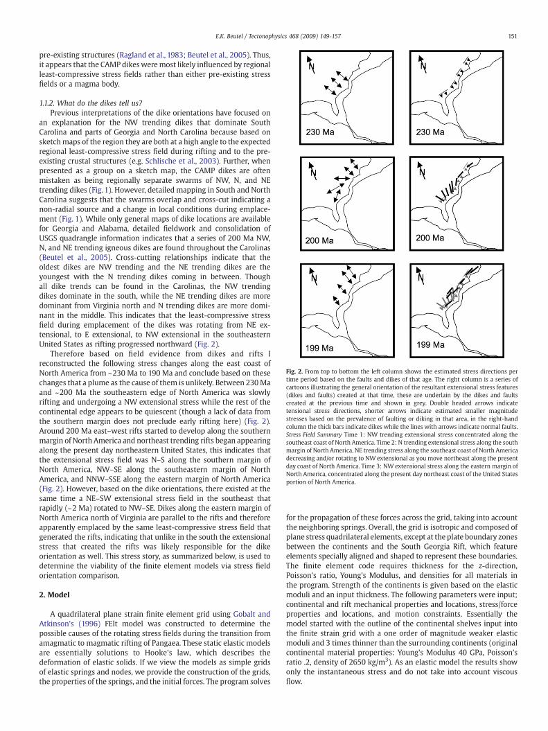
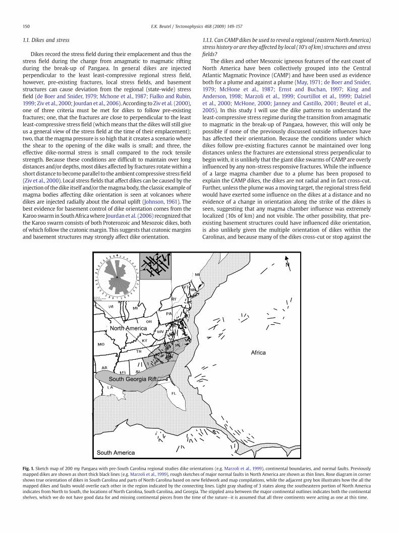
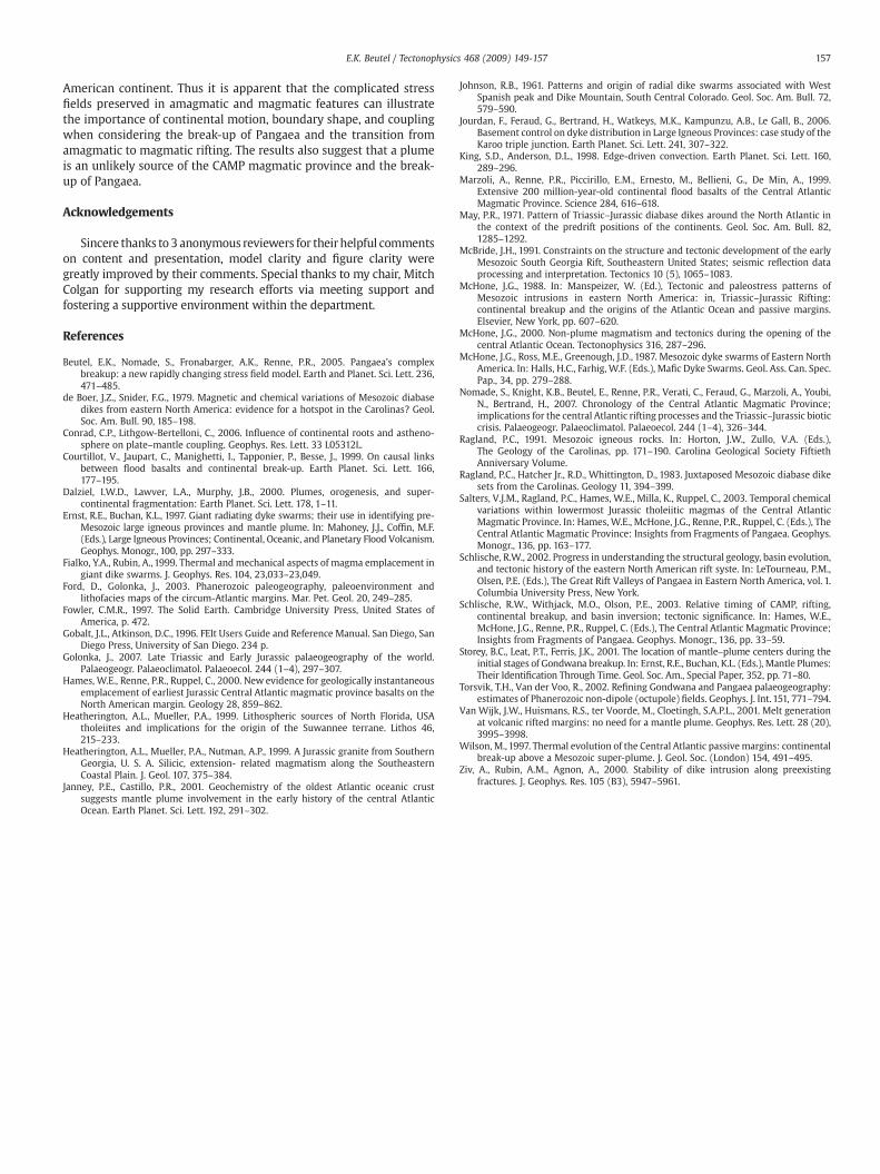
Fig. 2. From top to bottom the left column shows the estimated stress directions pertime period based on the faults and dikes of that age. The right column is a series ofcartoons illustrating the general orientation of the resultant extensional stress features(dikes and faults) created at that time, these are underlain by the dikes and faultscreated at the previous time and shown in grey. Double headed arrows indicatetensional stress directions, shorter arrows indicate estimated smaller magnitudestresses based on the prevalence of faulting or diking in that area, in the right-handcolumn the thick bars indicate dikes while the lines with arrows indicate normal faults.Stress Field Summary Time 1: NW trending extensional stress concentrated along thesoutheast coast of North America. Time 2: N trending extensional stress along the southmargin of North America, NE trending stress along the southeast coast of North Americadecreasing and/or rotating to NW extensional as you move northeast along the presentday coast of North America. Time 3: NW extensional stress along the eastern margin ofNorth America, concentrated along the present day northeast coast of the United Statesportion of North America.
151E.K. Beutel / Tectonophysics 468 (2009) 149-157
pre-existing structures (Ragland et al., 1983; Beutel et al., 2005). Thus,it appears that the CAMP dikesweremost likely influenced by regionalleast-compressive stress fields rather than either pre-existing stressfields or a magma body.
1.1.2. What do the dikes tell us?Previous interpretations of the dike orientations have focused on
an explanation for the NW trending dikes that dominate SouthCarolina and parts of Georgia and North Carolina because based onsketchmaps of the region they are both at a high angle to the expectedregional least-compressive stress field during rifting and to the pre-existing crustal structures (e.g. Schlische et al., 2003). Further, whenpresented as a group on a sketch map, the CAMP dikes are oftenmistaken as being regionally separate swarms of NW, N, and NEtrending dikes (Fig. 1). However, detailed mapping in South and NorthCarolina suggests that the swarms overlap and cross-cut indicating anon-radial source and a change in local conditions during emplace-ment (Fig. 1). While only general maps of dike locations are availablefor Georgia and Alabama, detailed fieldwork and consolidation ofUSGS quadrangle information indicates that a series of 200 Ma NW,N, and NE trending igneous dikes are found throughout the Carolinas(Beutel et al., 2005). Cross-cutting relationships indicate that theoldest dikes are NW trending and the NE trending dikes are theyoungest with the N trending dikes coming in between. Thoughall dike trends can be found in the Carolinas, the NW trendingdikes dominate in the south, while the NE trending dikes are moredominant from Virginia north and N trending dikes are more domi-nant in the middle. This indicates that the least-compressive stressfield during emplacement of the dikes was rotating from NE ex-tensional, to E extensional, to NW extensional in the southeasternUnited States as rifting progressed northward (Fig. 2).
Therefore based on field evidence from dikes and rifts Ireconstructed the following stress changes along the east coast ofNorth America from ~230 Ma to 190 Ma and conclude based on thesechanges that a plume as the cause of them is unlikely. Between 230Maand ~200 Ma the southeastern edge of North America was slowlyrifting and undergoing a NW extensional stress while the rest of thecontinental edge appears to be quiescent (though a lack of data fromthe southern margin does not preclude early rifting here) (Fig. 2).Around 200 Ma east–west rifts started to develop along the southernmargin of North America and northeast trending rifts began appearingalong the present day northeastern United States, this indicates thatthe extensional stress field was N–S along the southern margin ofNorth America, NW–SE along the southeastern margin of NorthAmerica, and NNW–SSE along the eastern margin of North America(Fig. 2). However, based on the dike orientations, there existed at thesame time a NE–SW extensional stress field in the southeast thatrapidly (~2 Ma) rotated to NW–SE. Dikes along the eastern margin ofNorth America north of Virginia are parallel to the rifts and thereforeapparently emplaced by the same least-compressive stress field thatgenerated the rifts, indicating that unlike in the south the extensionalstress that created the rifts was likely responsible for the dikeorientation as well. This stress story, as summarized below, is used todetermine the viability of the finite element models via stress fieldorientation comparison.
2. Model
A quadrilateral plane strain finite element grid using Gobalt andAtkinson's (1996) FElt model was constructed to determine thepossible causes of the rotating stress fields during the transition fromamagmatic to magmatic rifting of Pangaea. These static elastic modelsare essentially solutions to Hooke's law, which describes thedeformation of elastic solids. If we view the models as simple gridsof elastic springs and nodes, we provide the construction of the grids,the properties of the springs, and the initial forces. The program solves
for the propagation of these forces across the grid, taking into accountthe neighboring springs. Overall, the grid is isotropic and composed ofplane stress quadrilateral elements, except at the plate boundary zonesbetween the continents and the South Georgia Rift, which featureelements specially aligned and shaped to represent these boundaries.The finite element code requires thickness for the z-direction,Poisson's ratio, Young's Modulus, and densities for all materials inthe program. Strength of the continents is given based on the elasticmoduli and an input thickness. The following parameters were input;continental and rift mechanical properties and locations, stress/forceproperties and locations, and motion constraints. Essentially themodel started with the outline of the continental shelves input intothe finite strain grid with a one order of magnitude weaker elasticmoduli and 3 times thinner than the surrounding continents (originalcontinental material properties: Young's Modulus 40 GPa, Poisson'sratio .2, density of 2650 kg/m3). As an elastic model the results showonly the instantaneous stress and do not take into account viscousflow.
152 E.K. Beutel / Tectonophysics 468 (2009) 149-157
Applied forces were calculated based on a general rate of motionand mass for continents, because I am examining relative stressorientation and strength rather than absolute numbers within anorder of magnitude will give the same results. Constraints on motionwere simplified into able tomove in all directions or fixed in space andunable to move at all. Several models were constructed to testnumerous possibilities including a radial slab suction/rollback, avertical plume with radial compressional stress, and different appliedstresses to the continents. The radial slab pull model is constructedbased on the reconstructions of Pangaea that show it completelysurrounded by inward dipping slabs (Golonka, 2007). Approximateslab-suction forces were based on the average rates of continentalmotion, which was then translated into an outward force applied tothe margin. Vertical loading and topographic doming with radialcompression were combined to determine the approximate magni-tude of the radial compressive force that might have been caused bythe intrusion of a plume. The other possible force tested was themotion of the continents as driven by a mantle basal drag force. Thiswas also approximated based on the approximate rate and direction ofmotion of the continents. The assumption being that the continents
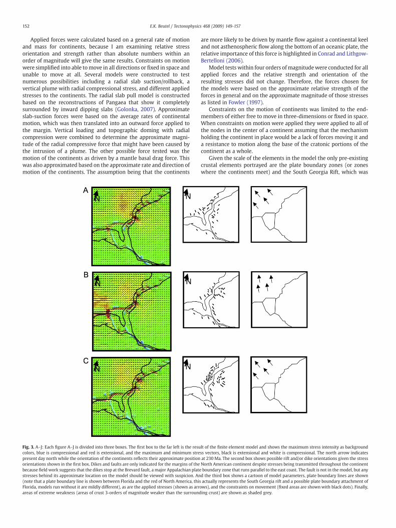
Fig. 3. A–J: Each figure A–J is divided into three boxes. The first box to the far left is the resucolors, blue is compressional and red is extensional, and the maximum and minimum strepresent day north while the orientation of the continents reflects their approximate positionorientations shown in the first box. Dikes and faults are only indicated for the margins of thebecause field work suggests that the dikes stop at the Brevard fault, a major Appalachian platstresses behind its approximate location on the model should be viewed with suspicion. An(note that a plate boundary line is shown between Florida and the red of North America, thisFlorida, models run without it are mildly different), as are the applied stresses (shown as arrareas of extreme weakness (areas of crust 3-orders of magnitude weaker than the surround
are more likely to be driven by mantle flow against a continental keeland not asthenospheric flow along the bottom of an oceanic plate, therelative importance of this force is highlighted in Conrad and Lithgow-Bertelloni (2006).
Model tests within four orders of magnitudewere conducted for allapplied forces and the relative strength and orientation of theresulting stresses did not change. Therefore, the forces chosen forthe models were based on the approximate relative strength of theforces in general and on the approximate magnitude of those stressesas listed in Fowler (1997).
Constraints on the motion of continents was limited to the end-members of either free to move in three-dimensions or fixed in space.When constraints on motion were applied they were applied to all ofthe nodes in the center of a continent assuming that the mechanismholding the continent in place would be a lack of forces moving it anda resistance to motion along the base of the cratonic portions of thecontinent as a whole.
Given the scale of the elements in the model the only pre-existingcrustal elements portrayed are the plate boundary zones (or zoneswhere the continents meet) and the South Georgia Rift, which was
lt of the finite element model and shows the maximum stress intensity as backgroundss vectors, black is extensional and white is compressional. The north arrow indicatesat 230 Ma. The second box shows possible rift and/or dike orientations given the stressNorth American continent despite stresses being transmitted throughout the continente boundary zone that runs parallel to the east coast. The fault is not in the model, but anyd the third box shows a cartoon of model parameters, plate boundary lines are shownactually represents the South Georgia rift and a possible plate boundary attachment of
ows), and the constraints on movement (fixed areas are shownwith black dots). Finally,ing crust) are shown as shaded grey.
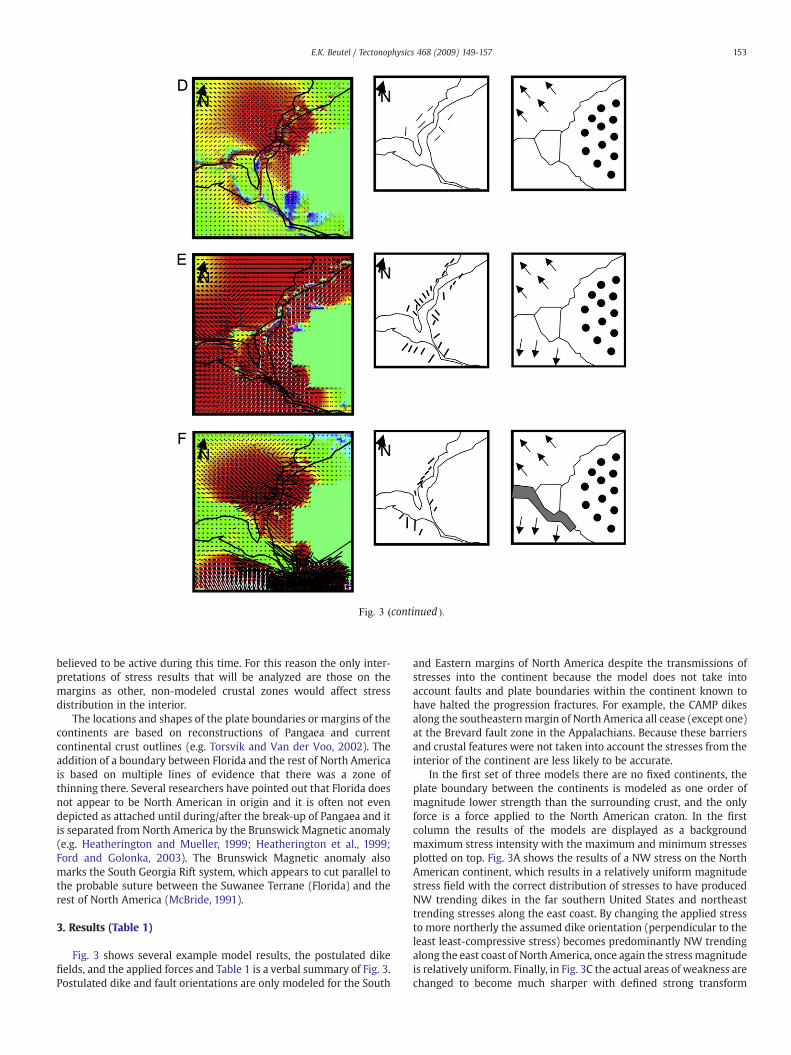
Fig. 3 (continued ).
153E.K. Beutel / Tectonophysics 468 (2009) 149-157
believed to be active during this time. For this reason the only inter-pretations of stress results that will be analyzed are those on themargins as other, non-modeled crustal zones would affect stressdistribution in the interior.
The locations and shapes of the plate boundaries or margins of thecontinents are based on reconstructions of Pangaea and currentcontinental crust outlines (e.g. Torsvik and Van der Voo, 2002). Theaddition of a boundary between Florida and the rest of North Americais based on multiple lines of evidence that there was a zone ofthinning there. Several researchers have pointed out that Florida doesnot appear to be North American in origin and it is often not evendepicted as attached until during/after the break-up of Pangaea and itis separated from North America by the Brunswick Magnetic anomaly(e.g. Heatherington and Mueller, 1999; Heatherington et al., 1999;Ford and Golonka, 2003). The Brunswick Magnetic anomaly alsomarks the South Georgia Rift system, which appears to cut parallel tothe probable suture between the Suwanee Terrane (Florida) and therest of North America (McBride, 1991).
3. Results (Table 1)
Fig. 3 shows several example model results, the postulated dikefields, and the applied forces and Table 1 is a verbal summary of Fig. 3.Postulated dike and fault orientations are only modeled for the South
and Eastern margins of North America despite the transmissions ofstresses into the continent because the model does not take intoaccount faults and plate boundaries within the continent known tohave halted the progression fractures. For example, the CAMP dikesalong the southeasternmargin of North America all cease (except one)at the Brevard fault zone in the Appalachians. Because these barriersand crustal features were not taken into account the stresses from theinterior of the continent are less likely to be accurate.
In the first set of three models there are no fixed continents, theplate boundary between the continents is modeled as one order ofmagnitude lower strength than the surrounding crust, and the onlyforce is a force applied to the North American craton. In the firstcolumn the results of the models are displayed as a backgroundmaximum stress intensity with the maximum and minimum stressesplotted on top. Fig. 3A shows the results of a NW stress on the NorthAmerican continent, which results in a relatively uniform magnitudestress field with the correct distribution of stresses to have producedNW trending dikes in the far southern United States and northeasttrending stresses along the east coast. By changing the applied stressto more northerly the assumed dike orientation (perpendicular to theleast least-compressive stress) becomes predominantly NW trendingalong the east coast of North America, once again the stressmagnitudeis relatively uniform. Finally, in Fig. 3C the actual areas of weakness arechanged to become much sharper with defined strong transform
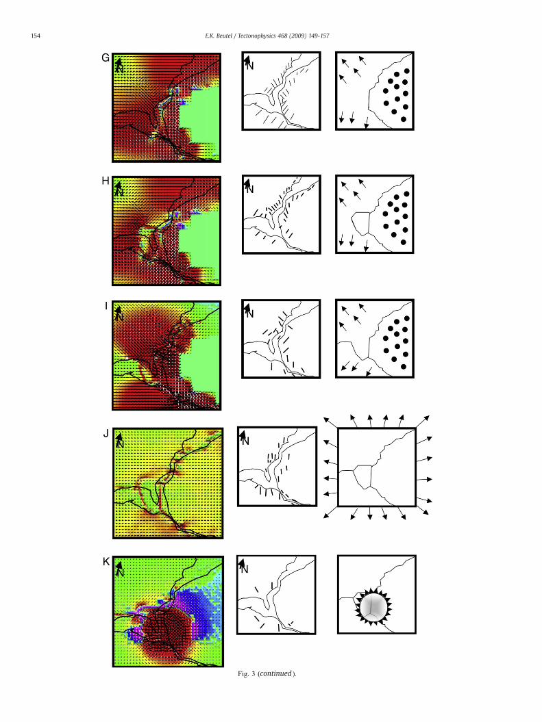
Fig. 3 (continued ).
154 E.K. Beutel / Tectonophysics 468 (2009) 149-157
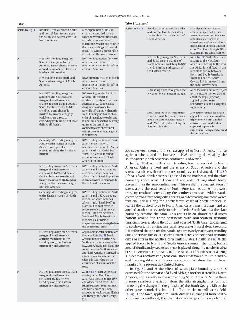
ble 1
efers to Fig. 3 Results: Listed as probable dikeand normal fault trends alongthe south and eastern coasts ofNorth America
Model parameters: Unlessotherwise specified suturezones between continents aremodeled as one order ofmagnitude weaker and thinnerthan surrounding continentalcrust. The South Georgia Rift ismodeled in the same manner.
N to NW trending along theSouthern margin of NorthAmerica, abrupt change in trendaround Georgia/South Carolinaborder to NE trending.
NW trending motion for NorthAmerica—no motion orresistance to motion for Africaor South America.
NW trending along South andSoutheastern margin of NorthAmerica.
NNW trending motion of NorthAmerica—no motion orresistance to motion for Africaor South America
N to NW trending along theSouthern and Southeasternmargin of North America,change in trend around Georgia/South Carolina border to NEtrending, trend change ismarked by an area of highlyvariable stress directioncoinciding with the area of mostdefined rift basins.
NW trending motion for NorthAmerica—no motion orresistance to motion for Africa orSouth America. Suture zonesalong east coast made toresemble rift basins with north–south trending rift basins of oneorder of magnitude weaker andthinner crust separated by strong(same as the rest of thecontinent) areas of continentwith structures at right angles tothe rift zones.
Generally NE trending along theSoutheastern margin of NorthAmerica with possibleN trending along the Southernmargin.
NW trending motion for NorthAmerica—no motion orresistance to motion for SouthAmerica. Africa is held fixed'‘fixed’ in place so it cannotmove in response to NorthAmerica's motion.
NE trending along the Southernmargin of North Americachanging to NW trending alongthe Southeastern margin andfinally changing to NE trendingalong the Northeastern marginof North America.
NW trending motion for NorthAmerica and a SSW trendingmotion for South America.Africa is held ‘fixed’ in place soit cannot move in response toNorth America's motion.
Generally NE trending along theentire Eastern margin of NorthAmerica.
NW trending motion for NorthAmerica and a SSW trendingmotion for South America.Africa is held ‘fixed’fixed’ inplace so it cannot move inresponse to North America'smotion. The area betweenSouth and North America ismodeled as 3 orders ofmagnitude lower strength thanthe continental crust.
NE trending along the Southernmargin of North Americaabruptly switching to NWtrending along the Easternmargin of North America.
Applied continental motions arethe same As in Fig. 3F, NorthAmerica is moving to the NW,South America is moving to theSSW, and Africa is held fixed. Thesuture between South Americaand North America is removed asa zone of weakness to see theeffect this suture had on thedistribution of stress along thecoast.
NE trending along the Southernmargin of North America,switching gradual to NWtrending along the Easternmargin of North America.
As in Fig. 3F, North America ismoving to the NW, SouthAmerica is moving to the SSW,and Africa is held fixed. Thesuture between South Americaand North America is onlymodeled asweak around Floridaand through the South GeorgiaRift.
Table 1 (continued)
Refers to Fig. 3 Results: Listed as probable dikeand normal fault trends alongthe south and eastern coasts ofNorth America
Model parameters: Unlessotherwise specified suturezones between continents aremodeled as one order ofmagnitude weaker and thinnerthan surrounding continentalcrust. The South Georgia Rift ismodeled in the same manner.
I NE trending along the Southernand Southeastern margins ofNorth America, switching to NWtrending in the mid-section ofthe Eastern margin.
As in Fig. 3F, North America ismoving to the NW, SouthAmerica is moving to the SSW,and Africa is held fixed. In thismodel the suture betweenNorth and South America issimplified and the SouthGeorgia Rift is removed fromthe zones of weakness.
J N trending dikes throughout theNorth American Eastern margin.
All of the continents are subjectto an outward motion (radialabout the triple junction)applied to their outerboundaries due to a likely slab-suction force.
K Small stresses in the continentsresult in small N trending dikesalong the Southeastern marginand NW trending dikes along theSouthern Margin.
A negative vertical loading isapplied to an area around thetriple junction and a radialoutward force modeled onexpected topographicexpression is emplaced aroundthe vertical load.
155E.K. Beutel / Tectonophysics 468 (2009) 149-157
Ta
R
A
B
C
D
E
F
G
H
(continued on next page)
zones between them and the stress applied to North America is onceagain northeast and an increase in NW trending dikes along thesoutheastern North American continent is observed.
In Fig. 3D–F a northeastern trending force is applied to NorthAmerica, Africa is fixed and the stress on South America and thestrength and thewidth of the plate boundary area is changed. In Fig. 3DAfrica is fixed, North America is pushed to the northeast, and the plateboundary zones remain linear and one order of magnitude lowerstrength than the surrounding crust. This results in a concentration ofstress along the east coast of North America, including northwesttrending tensional stress along the southeastern coast, which wouldcreate northeast trendingdikes or rifts, anddecreasing andmore variedtensional stress along the northeastern coast of North America. InFig. 3E the applied force to North America remains northeast and anapplied south-southeasterly force is applied to SouthAmerica, theplateboundary remains the same. This results in an almost radial stresspattern around the three continents with northeastern trendingtensional stresses along the southeast coast of North America changingto northwestern trending tensional stresses northward along the coast.It is inferred that the results would be dominantly northwest trendingdikes or rifts in the southeastern United States and northeast trendingdikes or rifts in the northeastern United States. Finally, in Fig. 3F theapplied forces to North and South America remain the same, but anarea of significantly weakened crust is placed along the northern edgeof South America. This results in the east coast of North America beingsubject to a northwesterly tensional stress that would result in north-east trending dikes or rifts mostly concentrated along the northeastmargin of the present day United States.
In Fig. 3G and H the effect of weak plate boundary zones isexamined for the scenario of a fixed Africa, a northeast trending NorthAmerica, and a south-southeast trending South America. While thereis some small-scale variation along the rifts, strengthening (but notremoving the changes in the grid shape) the South Georgia Rift or theother plate boundaries, has little effect on the overall stress field.In Fig. 3I the force applied to South America is changed from south-southeast to southeast, this dramatically changes the stress field in
156 E.K. Beutel / Tectonophysics 468 (2009) 149-157
North America including northwest trending stresses in the south-eastern United States and northeast trending tensional stresses in thenortheastern United States.
In Fig. 3J and K two other possible scenarios are examined. In Fig. 3Jthe results of a slab-rollback force applied to the edge of the modelsuch that a radial tensional stress was applied to the margins of thesupercontinent is examined. This results in a non-radial stress patternwith east–west stresses dominating along the coast of North America.In Fig. 3K the results of a plume model are examined. A large area ofradial stress around the triple junction between North America, SouthAmerica, and Africa, was applied similar to what might be expectedfrom a plume dome. Interestingly, though this creates extremely largetensional stress at the triple junction, there is very little stresstransmitted through the continents, though some east–west tensionalstresses were located along the east coast of North America. Thiswould result in north–south trending rifts or dikes.
4. Analysis
Given the results of the models, it appears that the most likelyscenario for the creation of initial northeast trending rifts along thesoutheastern United States followed by northwest trending dikes inthe southeast with northeast trending dikes and rifts in the north-eastern United States is the following: Africa is fixed (or resistant tomovement); North America begins to move to the northwest around230 Ma creating northeast trending rifts in the southeastern UnitedStates (Fig. 3D); Around 200 Ma South America begins to move to thesouth-southwest, this creates enough of a stretch in the crust to causedecompression melting which leads to the injection of northwesttrending dikes in the southeastern United States and northeasterntrending rifts and dikes along the northeastern coast of the UnitedStates (Fig. 3E); Finally, as South America pulls away from NorthAmerica an area of weakened crust decouples South America'sinfluence onNorth America's stress field and results in a concentrationof northwestern trending tensional stress along the east coast of NorthAmerica, this results in the injection of northeast trending dikes alongthe east coast, but predominantly in the northeast (Fig. 3F). Thegeneration of the melt volumes generally associated with volcanicmargins via stretching of the continental crust has been shown to beviable and is influenced by lithospheric architecture, mantle tem-perature, and the rate of spreading (VanWijk et al., 2001). Given theseparameters it appears that continental thinning could produce themelt volumes seen in the CAMP province. Further, because the CAMPdike swarms consist of the three geochemically distinct sources, withprobable depth constraints on their origin (e.g. McHone, 2000), it ismore likely that decompression melting at various depths and of aheterogeneous mantle would result in the observed geochemicalvariabilities observed in the North American Central AtlanticMagmatic Province volcanics associated with the break-up of Pangaea.
This model explains the apparently rapidly changing stress field insoutheastern North America (from NW tensional to NE tensional andback to NW tensional) and why the northeastern coast of NorthAmerica has a different stress history (dominantly NW tensional).These finite element model results suggest that the initial north-eastern motion of North America resulted in the opening of rifts alongthe southeast coast and not the northeast coast because of theorientation of the weakened plate boundary, which acted as a stressguide. Further the models suggest that the initiation of the movementof South America to the south-southeast not only acted as a catalystfor magmatism, but also rotated only the southern stresses in NorthAmerica to northeast tensional. This suggests that the stress fieldgenerated by South America's motion was diminished with distancefrom the source and by the trend of the weakened plate boundaryzones. Finally, it appears that continued magmatism and stretching inthe Gulf of Mexico would have essentially detached South Americafrom North America. This would have resulted in the stress field in
North America changing back to what it was before South Americabegan to move (hence beginning with NE trending normal faultingand ending with NE trending dikes with NW trending dikes in be-tweenwhile South Americawas exerting some influence). Because theexerted stress field along the southern portion of North America de-creased dramatically with the complete separation of South Americafrom North America, it appears that tensional stress in the crust ismost amplified when there is resistance to the tension.
4.1. Other scenarios
It is also clear from the models that while plate boundary orien-tation may be important in affecting where stress fields change, theplate boundary zone does not have to be weak and areas of fixed crustor applied force that mimic the plate boundary zone shape have thesame effect (Fig. 3G and H). The effect of the shape of the plateboundary zone is also seen in Fig. 3C where transforms were insertedbetween the rifts, this causes localized (directly adjacent to themargin—probably 10s10's of km) changes in the stress field, but does notsignificantly deviate the regional (eastern North America) stress field.Two non-craton driven scenarios were also examined, that of a radialslab-retreat tensional force applied to the supercontinent and a radialstress pattern caused by a plume. While the radial slab retreat did notcreate the stress fields preserved in the rocks, it is also clear that slabretreat can affect the stress field within the continent and it likely wassimilar in orientation to the modeled craton driven forces in models3D–F during the break-up of Pangaea. The plume scenario has beengiven much credence as a cause of the break-up of Pangaea and theradial' ‘radial’ dike swarm in the southeastern United States (May,1971; de Boer and Snider, 1979;Wilson, 1997; Ernst and Buchan,1997;Courtillot et al., 1999; Marzoli et al., 1999;McHone, 2000; Dalziel et al.,2000; Janney and Castillo, 2001; Storey et al., 2001), however, modelresults suggest that the stress generated by a plume would not betransmitted very far in a continent and that the orientation of thatstress is incompatible with the observed dikes and rifts. Certainly thepresence of zones of weakness between the continents may haveaffected the ability of stresses to propagate into continent. However,the orientation of the stresses around a domal plume feature wouldnot result in the multiple stress fields indicated by the overlappingdike swarms in Southeastern North America and there must havebeen some zone of thinning or weakness prior to rifting or doming forthe continents to break as they did.
5. Conclusions
The break-up of Pangaea and the transition from amagmatic riftingto magmatic rifting was likely driven by the craton driven motion ofNorth and South America. Finite element models indicate that thecomplicated stress regime recorded along North Americas east coast isbest recreated by assuming a structural boundary between the con-tinents and an initial northwestern motion of North America followedby a south-southwest motion of South America and the initiation ofmagmatic rifting. The final changes in the stress field appear to havebeen caused by the separation of North America and South America byan area of weakness. The onset of magmatic rifting is clearly asso-ciated with a change in the stress field in the southeastern UnitedStates (going from Northeast rifting to Northwest trending dikes) andtherefore the initiation of the movement of South America. This sug-gests that magmatism is a result of lithospheric thinning rather thana particular upwelling, as an upwelling would have initiated motionin North America and South America at the same time, whereas acombination of slab retreat and mantle flow might allow for the30 million year delay in onset of South America's movement. It is alsoclear that magmatism and weakened crust strongly affect the regionalcontinental stress field as shown by the period of weakened crustnorth of South America and its effective decoupling of the South
157E.K. Beutel / Tectonophysics 468 (2009) 149-157
American continent. Thus it is apparent that the complicated stressfields preserved in amagmatic and magmatic features can illustratethe importance of continental motion, boundary shape, and couplingwhen considering the break-up of Pangaea and the transition fromamagmatic to magmatic rifting. The results also suggest that a plumeis an unlikely source of the CAMP magmatic province and the break-up of Pangaea.
Acknowledgements
Sincere thanks to 3 anonymous reviewers for theirhelpful commentson content and presentation, model clarity and figure clarity weregreatly improved by their comments. Special thanks to my chair, MitchColgan for supporting my research efforts via meeting support andfostering a supportive environment within the department.
References
Beutel, E.K., Nomade, S., Fronabarger, A.K., Renne, P.R., 2005. Pangaea's complexbreakup: a new rapidly changing stress field model. Earth and Planet. Sci. Lett. 236,471–485.
de Boer, J.Z., Snider, F.G., 1979. Magnetic and chemical variations of Mesozoic diabasedikes from eastern North America: evidence for a hotspot in the Carolinas? Geol.Soc. Am. Bull. 90, 185–198.
Conrad, C.P., Lithgow-Bertelloni, C., 2006. Influence of continental roots and astheno-sphere on plate–mantle coupling. Geophys. Res. Lett. 33 L05312L.
Courtillot, V., Jaupart, C., Manighetti, I., Tapponier, P., Besse, J., 1999. On causal linksbetween flood basalts and continental break-up. Earth Planet. Sci. Lett. 166,177–195.
Dalziel, I.W.D., Lawver, L.A., Murphy, J.B., 2000. Plumes, orogenesis, and super-continental fragmentation: Earth Planet. Sci. Lett. 178, 1–11.
Ernst, R.E., Buchan, K.L., 1997. Giant radiating dyke swarms; their use in identifying pre-Mesozoic large igneous provinces and mantle plume. In: Mahoney, J.J., Coffin, M.F.(Eds.), Large Igneous Provinces; Continental, Oceanic, and Planetary Flood Volcanism.Geophys. Monogr., 100, pp. 297–333.
Fialko, Y.A., Rubin, A., 1999. Thermal and mechanical aspects of magma emplacement ingiant dike swarms. J. Geophys. Res. 104, 23,033–23,049.
Ford, D., Golonka, J., 2003. Phanerozoic paleogeography, paleoenvironment andlithofacies maps of the circum-Atlantic margins. Mar. Pet. Geol. 20, 249–285.
Fowler, C.M.R., 1997. The Solid Earth. Cambridge University Press, United States ofAmerica, p. 472.
Gobalt, J.L., Atkinson, D.C., 1996. FElt Users Guide and Reference Manual. San Diego, SanDiego Press, University of San Diego. 234 p.
Golonka, J., 2007. Late Triassic and Early Jurassic palaeogeography of the world.Palaeogeogr. Palaeoclimatol. Palaeoecol. 244 (1–4), 297–307.
Hames, W.E., Renne, P.R., Ruppel, C., 2000. New evidence for geologically instantaneousemplacement of earliest Jurassic Central Atlantic magmatic province basalts on theNorth American margin. Geology 28, 859–862.
Heatherington, A.L., Mueller, P.A., 1999. Lithospheric sources of North Florida, USAtholeiites and implications for the origin of the Suwannee terrane. Lithos 46,215–233.
Heatherington, A.L., Mueller, P.A., Nutman, A.P., 1999. A Jurassic granite from SouthernGeorgia, U. S. A. Silicic, extension- related magmatism along the SoutheasternCoastal Plain. J. Geol. 107, 375–384.
Janney, P.E., Castillo, P.R., 2001. Geochemistry of the oldest Atlantic oceanic crustsuggests mantle plume involvement in the early history of the central AtlanticOcean. Earth Planet. Sci. Lett. 192, 291–302.
Johnson, R.B., 1961. Patterns and origin of radial dike swarms associated with WestSpanish peak and Dike Mountain, South Central Colorado. Geol. Soc. Am. Bull. 72,579–590.
Jourdan, F., Feraud, G., Bertrand, H., Watkeys, M.K., Kampunzu, A.B., Le Gall, B., 2006.Basement control on dyke distribution in Large Igneous Provinces: case study of theKaroo triple junction. Earth Planet. Sci. Lett. 241, 307–322.
King, S.D., Anderson, D.L., 1998. Edge-driven convection. Earth Planet. Sci. Lett. 160,289–296.
Marzoli, A., Renne, P.R., Piccirillo, E.M., Ernesto, M., Bellieni, G., De Min, A., 1999.Extensive 200 million-year-old continental flood basalts of the Central AtlanticMagmatic Province. Science 284, 616–618.
May, P.R., 1971. Pattern of Triassic–Jurassic diabase dikes around the North Atlantic inthe context of the predrift positions of the continents. Geol. Soc. Am. Bull. 82,1285–1292.
McBride, J.H., 1991. Constraints on the structure and tectonic development of the earlyMesozoic South Georgia Rift, Southeastern United States; seismic reflection dataprocessing and interpretation. Tectonics 10 (5), 1065–1083.
McHone, J.G., 1988. In: Manspeizer, W. (Ed.), Tectonic and paleostress patterns ofMesozoic intrusions in eastern North America: in, Triassic–Jurassic Rifting:continental breakup and the origins of the Atlantic Ocean and passive margins.Elsevier, New York, pp. 607–620.
McHone, J.G., 2000. Non-plume magmatism and tectonics during the opening of thecentral Atlantic Ocean. Tectonophysics 316, 287–296.
McHone, J.G., Ross, M.E., Greenough, J.D., 1987. Mesozoic dyke swarms of Eastern NorthAmerica. In: Halls, H.C., Farhig, W.F. (Eds.), Mafic Dyke Swarms. Geol. Ass. Can. Spec.Pap., 34, pp. 279–288.
Nomade, S., Knight, K.B., Beutel, E., Renne, P.R., Verati, C., Feraud, G., Marzoli, A., Youbi,N., Bertrand, H., 2007. Chronology of the Central Atlantic Magmatic Province;implications for the central Atlantic rifting processes and the Triassic–Jurassic bioticcrisis. Palaeogeogr. Palaeoclimatol. Palaeoecol. 244 (1–4), 326–344.
Ragland, P.C., 1991. Mesozoic igneous rocks. In: Horton, J.W., Zullo, V.A. (Eds.),The Geology of the Carolinas, pp. 171–190. Carolina Geological Society FiftiethAnniversary Volume.
Ragland, P.C., Hatcher Jr., R.D., Whittington, D., 1983. Juxtaposed Mesozoic diabase dikesets from the Carolinas. Geology 11, 394–399.
Salters, V.J.M., Ragland, P.C., Hames, W.E., Milla, K., Ruppel, C., 2003. Temporal chemicalvariations within lowermost Jurassic tholeiitic magmas of the Central AtlanticMagmatic Province. In: Hames, W.E., McHone, J.G., Renne, P.R., Ruppel, C. (Eds.), TheCentral Atlantic Magmatic Province: Insights from Fragments of Pangaea. Geophys.Monogr., 136, pp. 163–177.
Schlische, R.W., 2002. Progress in understanding the structural geology, basin evolution,and tectonic history of the eastern North American rift syste. In: LeTourneau, P.M.,Olsen, P.E. (Eds.), The Great Rift Valleys of Pangaea in Eastern North America, vol. 1.Columbia University Press, New York.
Schlische, R.W., Withjack, M.O., Olson, P.E., 2003. Relative timing of CAMP, rifting,continental breakup, and basin inversion; tectonic significance. In: Hames, W.E.,McHone, J.G., Renne, P.R., Ruppel, C. (Eds.), The Central Atlantic Magmatic Province;Insights from Fragments of Pangaea. Geophys. Monogr., 136, pp. 33–59.
Storey, B.C., Leat, P.T., Ferris, J.K., 2001. The location of mantle–plume centers during theinitial stages of Gondwana breakup. In: Ernst, R.E., Buchan, K.L. (Eds.), Mantle Plumes:Their Identification Through Time. Geol. Soc. Am., Special Paper, 352, pp. 71–80.
Torsvik, T.H., Van der Voo, R., 2002. Refining Gondwana and Pangaea palaeogeography:estimates of Phanerozoic non-dipole (octupole) fields. Geophys. J. Int. 151, 771–794.
Van Wijk, J.W., Huismans, R.S., ter Voorde, M., Cloetingh, S.A.P.L., 2001. Melt generationat volcanic rifted margins: no need for a mantle plume. Geophys. Res. Lett. 28 (20),3995–3998.
Wilson, M.,1997. Thermal evolution of the Central Atlantic passivemargins: continentalbreak-up above a Mesozoic super-plume. J. Geol. Soc. (London) 154, 491–495.
Ziv, A., Rubin, A.M., Agnon, A., 2000. Stability of dike intrusion along preexistingfractures. J. Geophys. Res. 105 (B3), 5947–5961.
Recommended