Embed Size (px)
Citation preview
PHYSICAL PLANNINGANCIENT CITIES
UR CITY
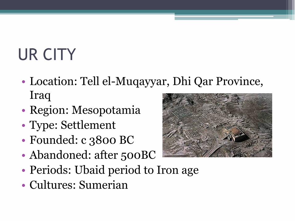
• Location: Tell el-Muqayyar, Dhi Qar Province, Iraq
• Region: Mesopotamia
• Type: Settlement
• Founded: c 3800 BC
• Abandoned: after 500BC
• Periods: Ubaid period to Iron age
• Cultures: Sumerian
• Ur was an important Sumerian city-state in ancient Mesopotamia located at the site of modern Tell el-Muqayyar in Iraq's Dhi Qar Governorate.
• Once a coastal city near the mouth of the Euphrates on the Persian Gulf, Ur is now well inland, south of the Euphrates on its right bank, 16 kilometres (9.9 mi) from Nasiriyah.
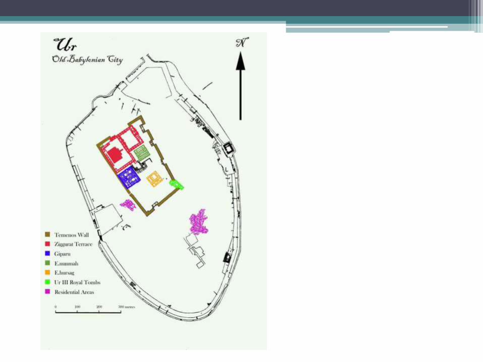
• The site is marked by the ruins of the Ziggurat of Ur, which contained the shrine of Nanna, excavated in the 1930s. The temple was built in the 21st century BC (short chronology), during the reign of Ur-Nammu and was reconstructed in the 6th century BC by Nabonidus, the Assyrian born last king of Babylon.
• The ruins cover an area of 1,200 metres (3,900 ft) northwest to southeast by 800 metres (2,600 ft) northeast to southwest and rise up to about 20 metres (66 ft) above the present plain level.
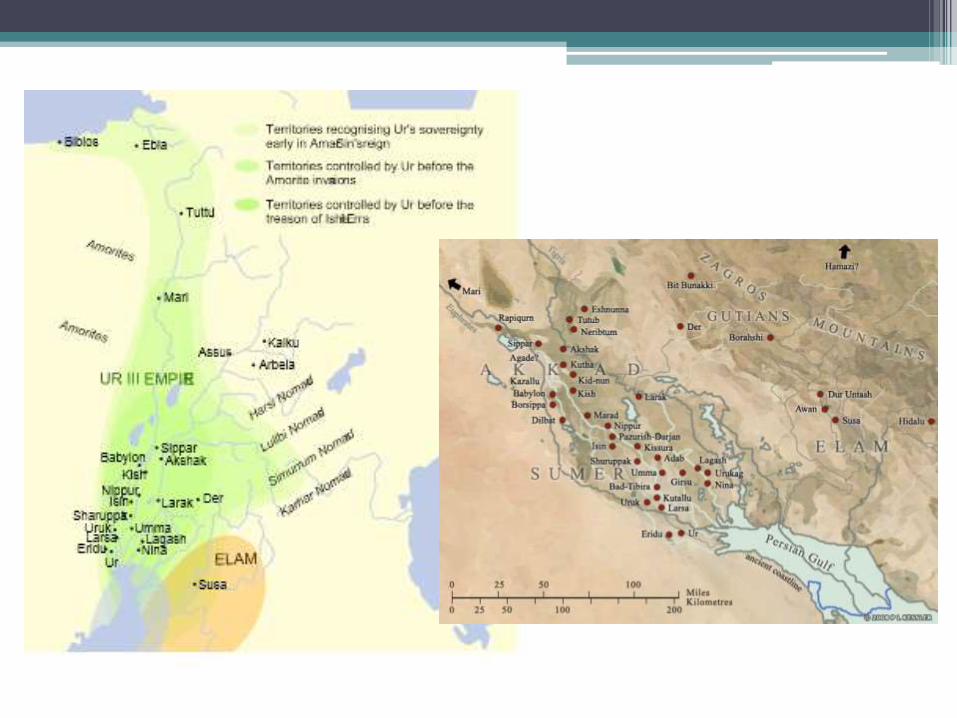
• Ur was a major city, and later the capital, of theSumerian Empire in southern Mesopotamia. Its location near the sea made it a center of commerce and traderoutes. Between 2030-1980 BCE, Ur was the world's largest city, boasting about 65,000 inhabitants within itswalls. The city featured many glorious temples andtombs. Today, the site is recognizable for its well-preserved remains of the Great Ziggurat.
The earliest settlement of Ur dates back to the Ubaid Period, or about 5300–4000 BCE. Droughts brought about the consolidation of several small farming villages into larger settlements. This led to the need for large-scale irrigation, in order to support the larger farms and populations during the drought periods.
Due to its favorable location, Ur became the capital of the Sumerian Empire, and the city was ruled by an impressive record of dynastic Kings, including Ur-Nammu (2112–2094 BCE). Countless advances inagriculture, architecture, and warfare were achieved in the Sumerian empire. The Sumerians are also well-known for cuneiform writing, a very early form of written communication that helped propel Ur’s into position for trade and commerce.
The city of Ur faced much conflict throughout its dynasties, including its invasion by the great Akkadian King Sargon in 2340 BCE. Despite this, Ur flourished again and continued as an urban center in Mesopotamia for nearly 1500 years. Ur began to decline around 550 BCE, likely due to drought and other natural occurrences in the region.
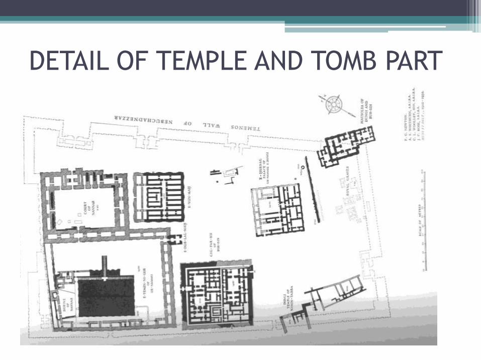
DETAIL OF TEMPLE AND TOMB PART
ZIGGURAT• The term ‘ziggurat’ derives from the Akkadian verb zaqārū (“to build a raised area”), which pretty much
describes the process involved. From a very early stage in their civilization, the Sumerians had taken to placing their important temples on platforms or, in the case of ziggurats, on a stepped series of platforms. There are a variety of reasons why they may have done this. In the first place, its elevated position would have symbolized its elevated relationship with the people of the city— literally putting it above the humdrum of everyday life.
• We know of at least 32 ziggurats in Mesopotamia and western Iran and typically they are built out of a core of mud-brick with an outer skin of fired bricks, set in bitumen mortar, to protect it againstflooddamage.
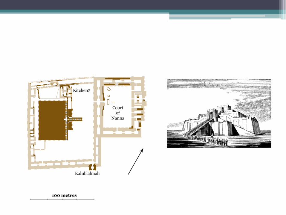
• Ur—the last native Sumerian rulers of Mesopotamia. Originally it had three stages. However, only the lowest one is reasonably well preserved. It measures about 64 x 46 metres at the base and was about 15 metres high. Of the other two, we have only the outline of the base of the second stage and the eroded core of the third.
• The summit was reached via three staircases of 100 steps—one perpendicular to, and the other two leaning against, the side of the lowest stage . These have been restored somewhat and refaced with new brickwork. The stairs intersected at a gatehouse located between the first and second stages—only the foundations survive. From it, the central staircase continues straight up to the second stage and then on to the temple at the top of the third. Access to the top of the first stage was via a pair of lateral stairways leading down from the gatehouse.
• Deep slits filled with broken pottery penetrated from the exterior face deep into the core of this platform. Woolley believed that these were designed to drain water from the interior and suggested that trees and gardens were planted along the top. At each end of the ziggurat, deep channels were cut into one of the buttresses, apparently to drain excess water. On the southeast side of the lowest terrace the foundations of a small building of unknown function were found but no trace of any other structure—including the temple at the summit—has been found.
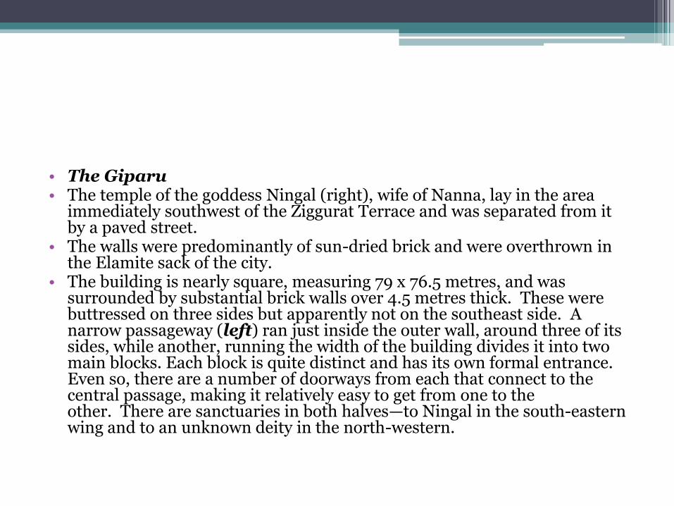
• The Giparu• The temple of the goddess Ningal (right), wife of Nanna, lay in the area
immediately southwest of the Ziggurat Terrace and was separated from it by a paved street.
• The walls were predominantly of sun-dried brick and were overthrown in the Elamite sack of the city.
• The building is nearly square, measuring 79 x 76.5 metres, and was surrounded by substantial brick walls over 4.5 metres thick. These were buttressed on three sides but apparently not on the southeast side. A narrow passageway (left) ran just inside the outer wall, around three of its sides, while another, running the width of the building divides it into two main blocks. Each block is quite distinct and has its own formal entrance. Even so, there are a number of doorways from each that connect to the central passage, making it relatively easy to get from one to the other. There are sanctuaries in both halves—to Ningal in the south-eastern wing and to an unknown deity in the north-western.
PRIVATE HOUSES
• The primary building material was mud-brick, of which the country had an inexhaustible supply. Clay tempered with straw was packed into moulds and simply allowed to dry in the sun. Nothing could be easier or cheaper. Certainly nothing else was available locally. It is very prone to damageby running water, however, and flooding has always been a problem in Mesopotamia. The builders minimized the effects of this by using kiln-fired bricks for the foundations and lower course of the walls. Thicker, support walls had a core of rubble into which the brickwork was bonded.
• Interior walls were normally covered with a thick mud plaster and might be whitewashed to help reflect the heat.
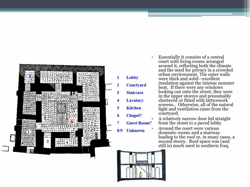
• Essentially it consists of a central court with living rooms arranged around it, reflecting both the climate and the need for privacy in a crowded urban environment. The outer walls were thick and solid—excellent insulation against the intense summer heat. If there were any windows looking out onto the street, they were in the upper storeys and presumably shuttered or fitted with latticework screens.. Otherwise, all of the natural light and ventilation came from the courtyard.
• A relatively narrow door led straight from the street to a paved lobby
• Around the court were various domestic rooms and a stairway leading to the roof or, in many cases, a second storey. Roof space was (and still is) much used in southern Iraq.
BAZAARS & CHAPELS
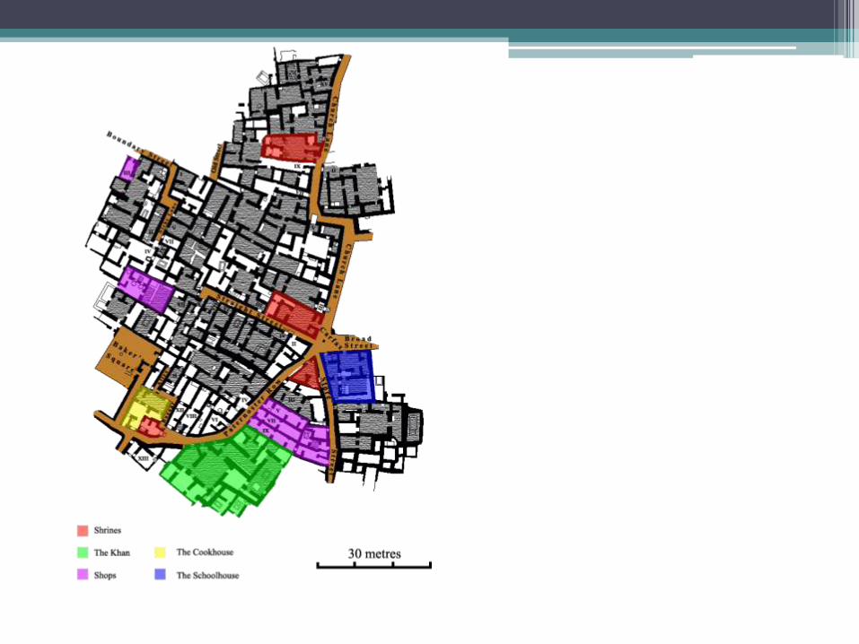
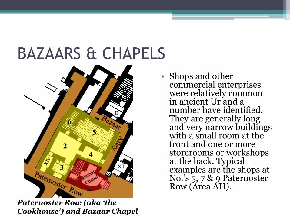
• Shops and other commercial enterprises were relatively common in ancient Ur and a number have identified. They are generally long and very narrow buildings with a small room at the front and one or more storerooms or workshops at the back. Typical examples are the shops at No.’s 5, 7 & 9 Paternoster Row (Area AH).
Paternoster Row (aka ‘the Cookhouse’) and Bazaar Chapel
Baker Square
• Royal Cemetery• In the mid-1920s, C. Leonard Woolley's invstigations
at Ur focused on the cemetery, where he eventually excavated over 2000 graves. Based on the wealth of tombs, Woolley designated 16 as "royal tombs", all of which date to the Early Dynastic IIIa period of 2600-2450 BC. Some of tombs had a stone-built chamber with multiple rooms, where the principal royal burial was placed. Retainers--people who presumably served the royal personage and were buried with him or her--were found in a pit outside of the chamber or adjacent to it. Woolley called these areas "death pits", and the largest of them held the remains of 74 people. Woolley came to the conclusion that the attendants had willingly drunk some drug and then lay down in rows to go with their master or mistress.
• Recent analysis of a sample of skulls from several pits at Ur suggest instead that the retainers were killed by blunt force trauma, as ritual sacrifices. After they were killed, an attempt was made to preserve the bodies, using a combination of heat-treatment and the application of mercury; and then the bodies were dressed in their finery and laid in rows in the pits.
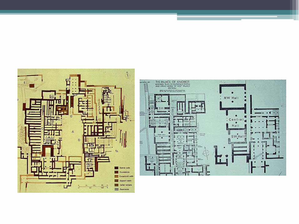
CITY OF MILETUS
• Location: Balat, Didim, Aydı Province, Turkey
• Region: Caria
• Type: Settlement
• Area: 90 ha (220 acres)
• Builder: Probably settlers from Crete
• Miletus was one of the great Ionian cities in southwestern Asia Minor. Homer refers to the people of Miletus as Carians. They fought against the Achaeans (Greeks) in the Trojan War. Later traditions have Ionian settlers taking the land from the Carians. Miletus itself sent off settlers to the Black Sea area, as well as the Hellespont. In 499 Miletus led the Ionian revolt that was a contributing factor in the Persian Wars. Miletus was destroyed 5 years later. Then in 479, Miletus joined the Delian League, and in 412 Miletus revolted from Athenian control offering a naval base to the Spartans. Alexander the Great conquered Miletus in 334 B.C.; then in 129, Miletus became part of the Roman province of Asia. In the 3rd Century A.D., Goths attacked Miletus, but the city continued, waging an ongoing fight against the silting of its harbor.
• Geology[edit source | editbeta]• During the Pleistocene epoch the Miletus region was submerged in the Aegean Sea. It
subsequently emerged slowly, the sea reaching a low level of about 130 meters (430 ft) below present level at about 18,000 BP. The site of Miletus was part of the mainland.
• A gradual rise brought a level of about 1.75 meters (5 ft 9 in) below present at about 5500 BP, creating several karst block islands of limestone, the location of the first settlements at Miletus. At about 1500 BC the karst shifted due to small crustal movements and the islands consolidated into a peninsula. Since then the sea has risen 1.75 m but the peninsula has been surrounded by sediment from the Maeander river and is now land-locked. Sedimentation of the harbor began at about 1000 BC, and by AD 300Lake Bafa had been created.[4]
• Hippodamus arranged the buildings and the streets of Miletus around 450 BC such that the winds from the mountains and the sea close to Miletus could flow optimal through the city and provide a cooling during the hot summer. In De architectura libridecem Vitruvius also mentions that in planning we have to consider the influence of the winds. Hippodamus first applied to his home city the grid plan which he had developed on inspiration from geometrically designed settlements, and that later many cities were laid out according to this plan. Miletus, which is a fine example of the grid plan, comprises houses on blocks created by streets and side streets crossing at right angles, with public buildings in the city centre, This plan retained in the Hellenistic period, however in the Roman period it began to deteriorate gradually and inevitably.
• The Greeks were the first to use solar architecture They oriented their houses to make use of the sun during winter, while obscuring its rays during summer and entire cities were built this way as early as 400 BC.
• A city in the southern coast of Asia Minor, famous for its great prosperity, mainly during the period from the 8th to the 4th century BC, when it became the metropolis of the Ionians. It was built in the Latmian Bay, near the mouth of the river Maeander.
• Its location was settled in the 2nd millennium BC by Kares or Leleges and subsequently by Cretans, who were brought there by Sarpedon. After the Heraclids descended to the Peloponnese, the Ionians under Neleus, son of the Athenian king Kodrus, colonised Miletus (11th century BC). Since then, especially from 650 BC onwards, the city flourished greatly and became the metropolis of the 80-90 Ionian colonies. It distinguished itself as a commercial and naval power, and became an important centre for science and philosophy, with particular emphasis on the exact sciences. The main exponents of the Milesian School where Thales, one of the Seven Sages of ancient times, and Anaximander.
Click on the map to visit the Bouleuterion of Miletus
• The subsequent development of the city is closely linked with the important historical events which took place in the area. It was subjugated to Croesus; later, after the Persians conquered Lydia, it retained some form of autonomy, but soon lost it, after a series of unsuccessful revolts. It was liberated after the naval battle of Mycale (479 BC) and became a member of the Athenian Confederacy from which it seceded twice. Early in the 4th century BC the city began to decline, mainly due to internal conflicts. It was conquered by Alexander the Great in 334 BC, but retained some form of autonomy. It then passed into the hands of his successors, but it was by now a city of secondary importance. During the reign of Antiochus XIII, last king of Syria, Miletus was conquered by the Romans, and under their rule it flourished for the second time.
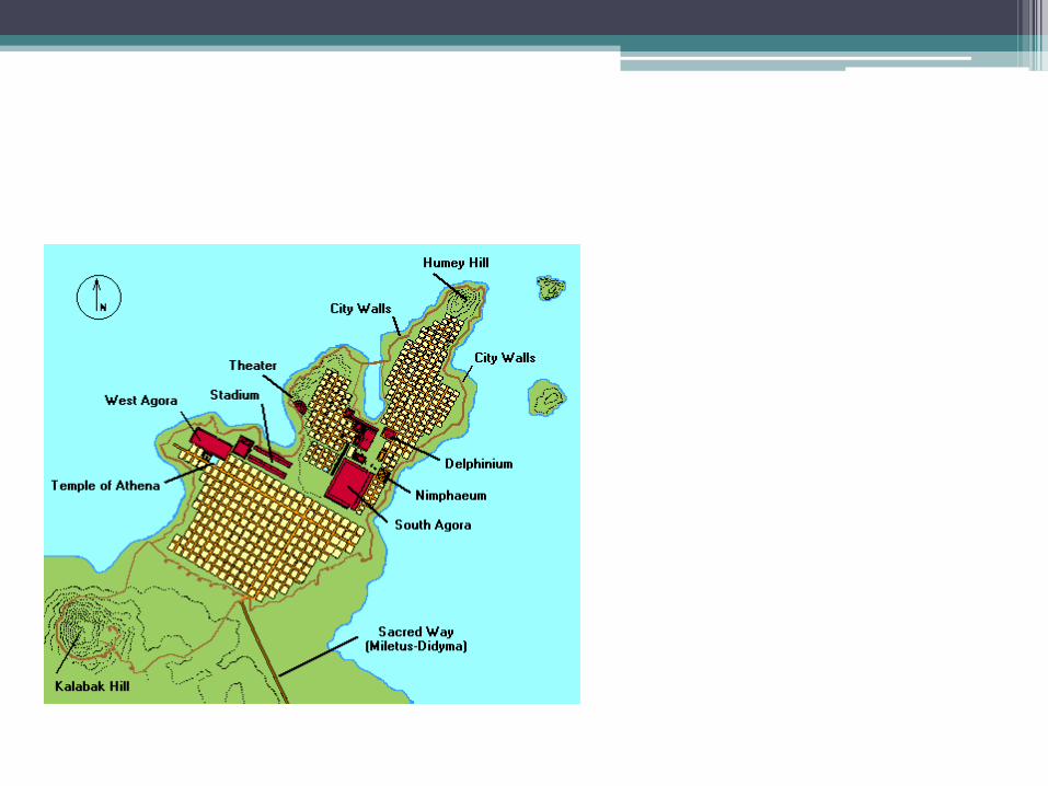
• Miletus was a typical example of a metropolis of the ancient world. It was fortified, and had four ports of which the central one, known as the Port of Lions, was situated in the eastern bay and was strategically the most important one for the city's defence. After its destruction by the Persians, the city was rebuilt by the Milesian architect Hippodamus on the basis of a new system of city-planning which took his name. It was constructed in regular blocks, and the city centre was divided into three cores corresponding to the three areas of public life: religious, administrative, and commercial. The city thus assumed a special form based on symmetry and balance.
• The buildings around the central port date from the classical period. They include the Port Colonnade, the small Agora, the Prytaneion, and the western part of the Temple of Delphinian Apollo. Hippodamus' city plan probably included the Temple of Athena, located west of the Stadium, which dates from the same period.
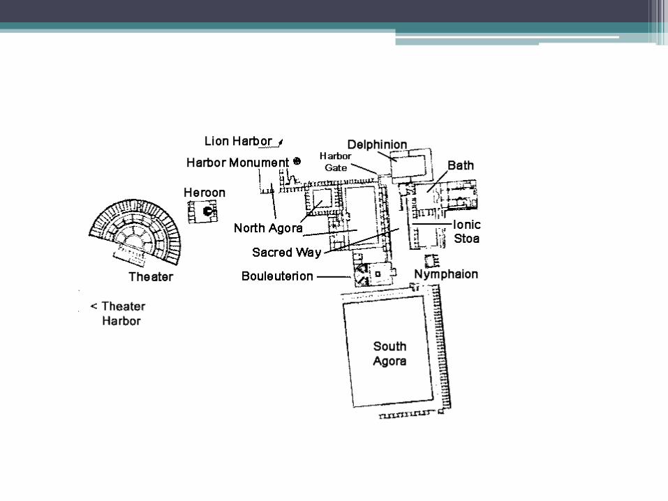
• An intense building activity was evident in Hellenistic times. The temple of Delphinian Apollo (Delphinium), which was initially built in archaic times, was given its final form. The whole of the city centre was reshaped, including the north and south Agora, the Gymnasium and the Bouleuterion. During this time the Stadium was built, which might have held 15,000. The theatre, initially built in the 4th century BC, was extended to accommodate 5,300. Also, the Nymphaeum was built, and the north Agora underwent certain changes: the propylon was demolished, and stores were built in two zones which covered the Agora's eastern side. The 16-column entrance to the port, situated between the Delphinium and the stoa, is among the earliest architectural works of the Roman period and one of the city's most characteristic ones. The arena, situated between the Delphinium and the Gymnasium, was joined to the baths built by Vergilius Capitus. The extension of the theatre (capacity 15,000), with a facade of 140 m., also dates from the Roman times.
• Towards the end of the Roman occupation Miletus once again fell into decline, especially after the barbarians' invasions starting in the middle of the 3rd century AD Subsequently it fell under successive dominations, from the Byzantine to the Seljuk (14th century AD) and the Ottoman (in AD 1400). After its port was rendered useless by the river Maeander's silt, the city was finally abandoned in the 16th century AD.
EGYPTIAN CITY
• The reasons for the foundation of a new settlement could be varied: security, often combined with economics, as in the case of the southern fortress towns (Buhen); cultic and administrative needs (Kahun); political motives seem to have led Akhenaten to found Akhetaten. The main consideration where to build was generally proximity to a waterway and height above the floodplains. Adobe buildings are very vulnerable when brought in prolonged contact with water, be it seeping groundwater or the rising Nile. But even stone edifices are in danger of collapsing, above all when their foundations are as flimsy as those the Egyptians built.
Elevations, as long as they were inhabited, kept above the slowly rising plains, where the river deposited its silt. When old houses crumbled, new ones were built on top of the debris. This has been going on until recent times, when the yearly inundations were stopped by the Aswan dam. The continuity of settlement during the millennia is one of the reasons for the scarcity of data about ancient villages and cities, as excavation is virtually impossible.
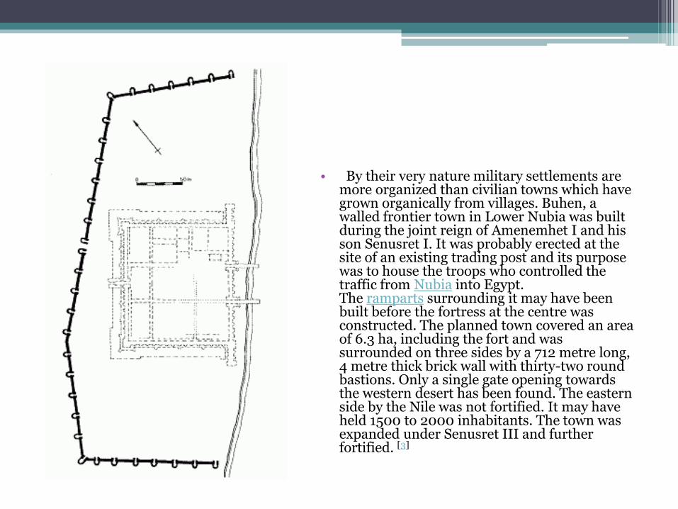
• By their very nature military settlements are more organized than civilian towns which have grown organically from villages. Buhen, a walled frontier town in Lower Nubia was built during the joint reign of Amenemhet I and his son Senusret I. It was probably erected at the site of an existing trading post and its purpose was to house the troops who controlled the traffic from Nubia into Egypt. The ramparts surrounding it may have been built before the fortress at the centre was constructed. The planned town covered an area of 6.3 ha, including the fort and was surrounded on three sides by a 712 metre long, 4 metre thick brick wall with thirty-two round bastions. Only a single gate opening towards the western desert has been found. The eastern side by the Nile was not fortified. It may have held 1500 to 2000 inhabitants. The town was expanded under Senusret III and further fortified. [3]
• City quarters• Generally there was little town planning, and what little there was looked a bit like the hieroglyph for
"city" with houses arranged rather haphazardly around the crossing of two major roads. But in a number of cases attempts at planning seem to have been made, above all in walled cities.
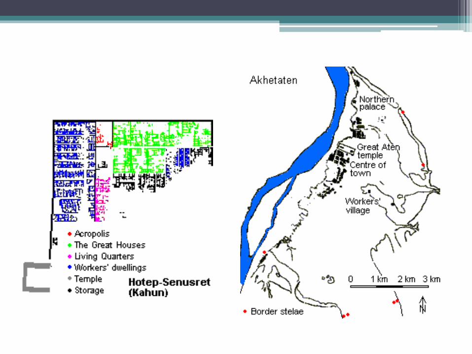
• The town serving the pyramid temple complex Hotepsenusret (Ha-Usertesen-hotep as Petrie called it near modern Kahun or more correctly Lahun) in the Fayum was founded by Senusret II and remained inhabited for about a century. The outlay of the city itself was rectangular with an orthogonal street grid, covering an area of 350 by 400 metres. It was surrounded by a brick wall and divided into two parts by another wall. Generally different social classes did not live in separate city quarters. But here there was a rich residential area, where a handful of palatial 60 room residences were fifty times as big as the dwellings in the poorer half of the city.
This part had also a wide street leading to the palace. The streets all over the city were laid out in approximately straight lines. The alleys leading to the workers' dwellings ended in culs-de-sac. The main street was nine metres wide, as opposed to the alleys and streets in the residential districts which were sometimes as narrow as 1½ metres. The streets had shallow stone channels running down the middle for drainage.
Despite the love Egyptians had for gardens, there was no space left for them inside the walls at Hotepsenusret. The whole area was covered with streets and one-storeyed mud-brick buildings. In this Hotepsenusret was very different from Akhenaten's specially created capital Akhetaten - or at least some parts of it. There the planners included public open spaces where trees were planted and inhabitants often had their own private garden plots.
Actually, within the boundaries of Akhetaten there was mostly empty space. The planners had given the new capital very generous dimensions; but it was abandoned after only a few of the main government edifices had been erected. These formed the town centre, while the residential areas were north-east and south-west of them.
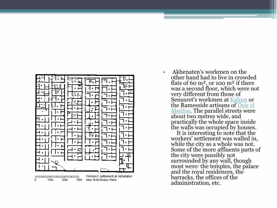
• Akhenaten's workmen on the other hand had to live in crowded flats of 60 m², or 100 m² if there was a second floor, which were not very different from those of Senusret's workmen at Kahun or the Ramesside artisans of Deir el Medine. The parallel streets were about two metres wide, and practically the whole space inside the walls was occupied by houses.
It is interesting to note that the workers' settlement was walled in, while the city as a whole was not. Some of the more affluents parts of the city were possibly not surrounded by any wall, though most were: the temples, the palace and the royal residences, the barracks, the offices of the administration, etc.
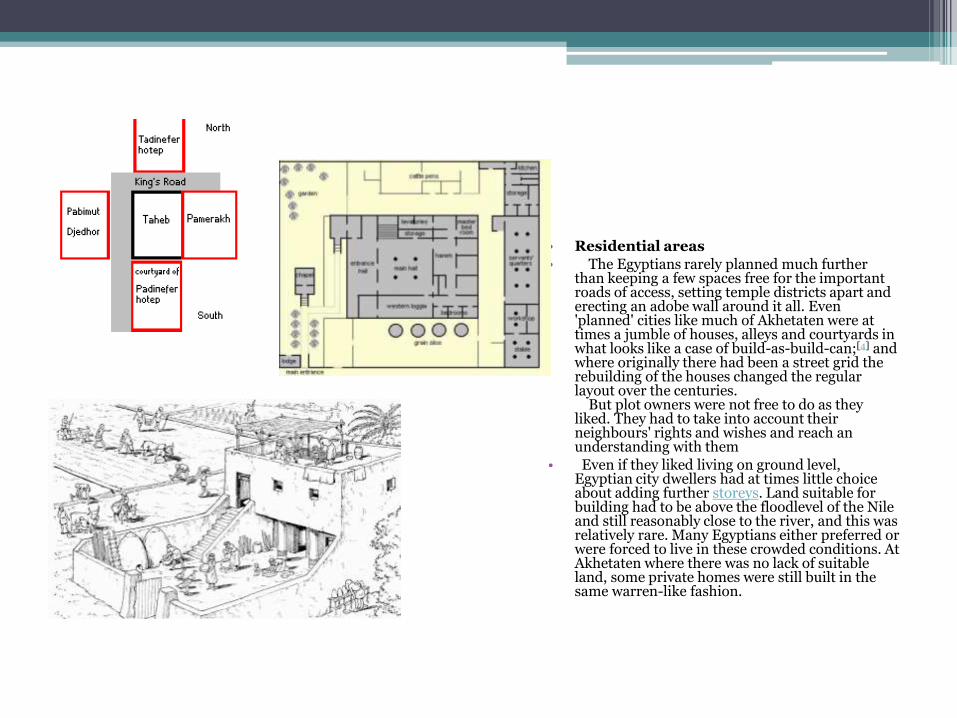
• Residential areas
• The Egyptians rarely planned much further than keeping a few spaces free for the important roads of access, setting temple districts apart and erecting an adobe wall around it all. Even 'planned' cities like much of Akhetaten were at times a jumble of houses, alleys and courtyards in what looks like a case of build-as-build-can;[4] and where originally there had been a street grid the rebuilding of the houses changed the regular layout over the centuries.
But plot owners were not free to do as they liked. They had to take into account their neighbours' rights and wishes and reach an understanding with them
• Even if they liked living on ground level, Egyptian city dwellers had at times little choice about adding further storeys. Land suitable for building had to be above the floodlevel of the Nile and still reasonably close to the river, and this was relatively rare. Many Egyptians either preferred or were forced to live in these crowded conditions. At Akhetaten where there was no lack of suitable land, some private homes were still built in the same warren-like fashion.
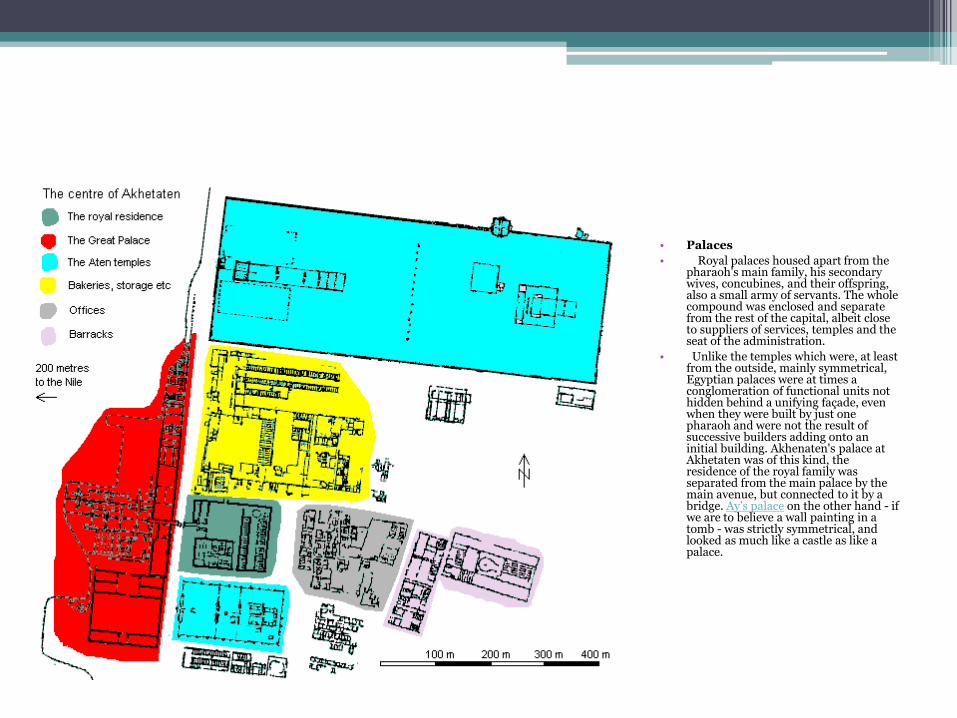
• Palaces
• Royal palaces housed apart from the pharaoh's main family, his secondary wives, concubines, and their offspring, also a small army of servants. The whole compound was enclosed and separate from the rest of the capital, albeit close to suppliers of services, temples and the seat of the administration.
• Unlike the temples which were, at least from the outside, mainly symmetrical, Egyptian palaces were at times a conglomeration of functional units not hidden behind a unifying façade, even when they were built by just one pharaoh and were not the result of successive builders adding onto an initial building. Akhenaten's palace at Akhetaten was of this kind, the residence of the royal family was separated from the main palace by the main avenue, but connected to it by a bridge. Ay's palace on the other hand - if we are to believe a wall painting in a tomb - was strictly symmetrical, and looked as much like a castle as like a palace.
MEMPHIS• Memphis (Arabic: منف ;Greek: Μέμφις) was the ancient capital of Aneb-
Hetch, the first nome of Lower Egypt. Its ruins are located near the town of Mit Rahina, south of Cairo.
• According to legend related by Manetho, the city was founded by the pharaoh Menes around 3000 BC. Capital of Egypt during the Old Kingdom, it remained an important city throughout ancient Mediterranean history.[1][2][3] It occupied a strategic position at the mouth of the Nile delta, and was home to feverish activity. Its principal port, Peru-nefer, harboured a high density of workshops, factories, and warehouses that distributed food and merchandise throughout the ancient kingdom. During its golden age, Memphis thrived as a regional centre for commerce, trade, and religion.
• Memphis was believed to be under the protection of the god Ptah, the patron of craftsmen. Its great temple, Hut-ka-Ptah(meaning "Enclosure of the ka of Ptah"), was one of the most prominent structures in the city. The name of this temple, rendered in Greek as Aί γυ πτoς (Ai-gy-ptos) by the historian Manetho, is believed to be the etymological origin of the modern English nameEgypt.
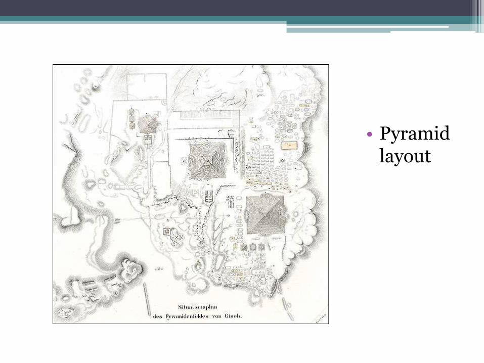
• Pyramid layout
• Memphis (18 miles southwest of Cairo) is oldest capital of ancient Egypt. Founded around 3000 B.C. by King Menes on land reclaimed from the Nile, it was selected as a site for the capital because it was located between Upper Egypt and Lower Egypt at a place where the Nile Valley narrows to less than a mile across, and travel between the northern and southern Egypt could be controlled.
• Memphis was the capital for much of ancient Egypt’s history. For a long time it was the administrative capital of the ancient Egyptian empire while Thebes was the religious center. The Pharaohs spent much of his time in Memphis and visited Thebes only during special religious ceremonies.
• When Memphis was at its largest around 300 B.C. it covered 20 square miles and had a population of around 250,000. Today most of it lies under the village of Mit Rahina and fields that surround it. Memphis was once on the Nile but the now the river is some distance away. Nearly all of the great buildings that once stood in Memphis have been lost to time.
•Pyramid layout
• The Memphis Museum contains a huge 30-foot-long reclining Colossus of Ramses the Great that weights 120 tons and is made of fine-grained limestone. Childless women still walk around the statue seven times in the belief it will make them pregnant. Some women reportedly have even climbed on statue and simulated the movements of love making. The Temple for Embalming the Sacred Apis Bull shows how to embalm a bull. Situated in a grove of palm trees is the Alabaster Sphinx of King Tuthmosis III. In the area is the necropolis of the Apis bulls (Serapeum), which contains 24 granite sarcophagi, each weighing over 60 tons.
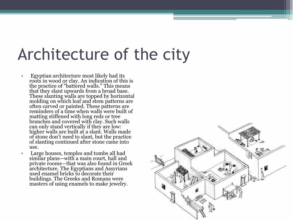
Architecture of the city• Egyptian architecture most likely had its
roots in wood or clay. An indication of this is the practice of "battered walls." This means that they slant upwards from a broad base. These slanting walls are topped by horizontal molding on which leaf and stem patterns are often carved or painted. These patterns are reminders of a time when walls were built of matting stiffened with long reds or tree branches and covered with clay. Such walls can only stand vertically if they are low: higher walls are built at a slant. Walls made of stone don’t need to slant, but the practice of slanting continued after stone came into use.
• Large houses, temples and tombs all had similar plans—with a main court, hall and private rooms—that was also found in Greek architecture. The Egyptians and Assyrians used enamel bricks to decorate their buildings. The Greeks and Romans were masters of using enamels to make jewelry.
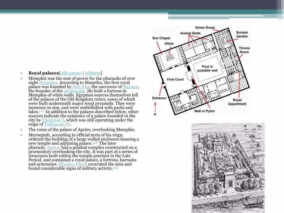
• Royal palaces[edit source | editbeta]
• Memphis was the seat of power for the pharaohs of over eight dynasties. According to Manetho, the first royal palace was founded by Hor-Aha, the successor of Narmer, the founder of the 1st dynasty. He built a fortress in Memphis of white walls. Egyptian sources themselves tell of the palaces of the Old Kingdom rulers, some of which were built underneath major royal pyramids. They were immense in size, and were embellished with parks and lakes.[47] In addition to the palaces described below, other sources indicate the existence of a palace founded in the city by Thutmose I, which was still operating under the reign of Tuthmosis IV.
• The ruins of the palace of Apries, overlooking Memphis.
• Merneptah, according to official texts of his reign, ordered the building of a large walled enclosure housing a new temple and adjoining palace.[48] The later pharaoh, Apries, had a palatial complex constructed on a promontory overlooking the city. It was part of a series of structures built within the temple precinct in the Late Period, and contained a royal palace, a fortress, barracks and armouries. Flinders Petrie excavated the area and found considerable signs of military activity.[49]
• Other buildings[edit source | editbeta]• The centrally located palaces and temples
were surrounded by different districts of the city, in which were many craftsmen's workshops, arsenals, and dockyards. Also were residential neighbourhoods, some of which were inhabited primarily by foreigners—first Hittites andPhoenicians, later Persians, and finally Greek. The city was indeed located at the crossroads of trade routes and thus attracted goods imported from diverse regions of the Mediterranean.
• Ancient texts confirm that city-wide development took place regularly. Furthermore, there is evidence that the Nile has shifted over the centuries to the east, leaving new lands to occupy the eastern part of the old capital.[50] This area of the city was dominated by the large eastern gate of the temple of Ptah.