Embed Size (px)
Citation preview
ELECTRONIC SOIL DATA STORAGE: possible approaches with an emphasis
on the Russian Soil Database
Pavel Krasilnikov Eurasian Center for Food Security
Alexander Ivanov Soil Science Faculty
Lomonosov Moscow State University
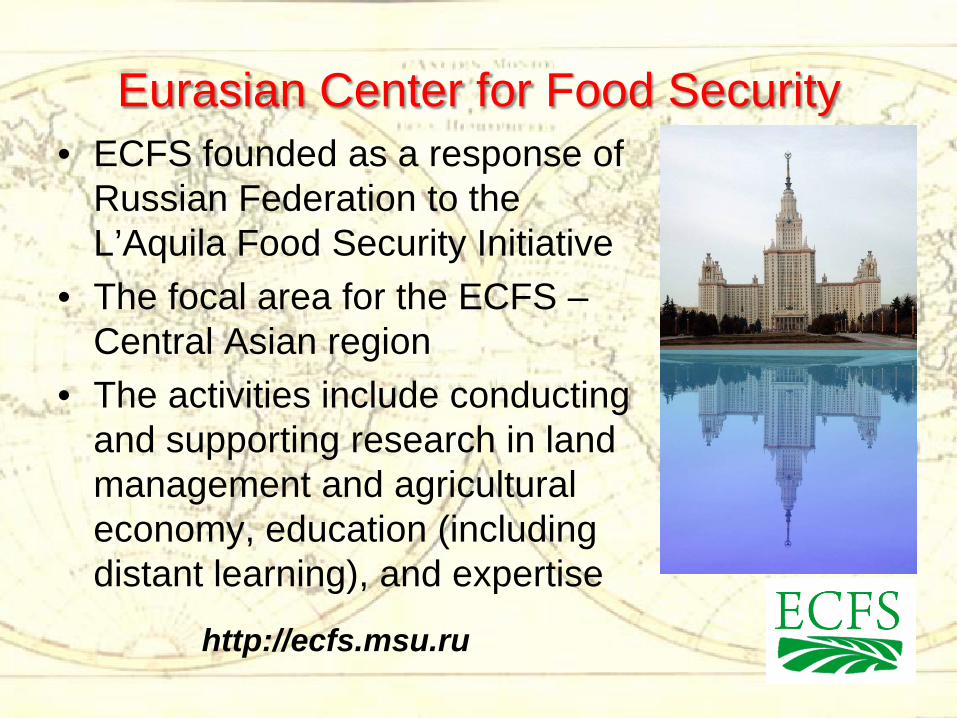
Eurasian Center for Food Security • ECFS founded as a response of
Russian Federation to the L’Aquila Food Security Initiative
• The focal area for the ECFS – Central Asian region
• The activities include conducting and supporting research in land management and agricultural economy, education (including distant learning), and expertise
http://ecfs.msu.ru
Russian soil database: Institutions
• Dokuchaev (Russian) Soil Science Society • Faculty of Soil Science of Lomonosov
Moscow State University • Eurasian Center for Food Security of
Lomonosov Moscow State University • Participating Institutions, providing soil
data all over the country
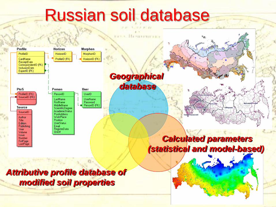
Russian soil database
Attributive profile database of modified soil properties
Geographical database
Calculated parameters (statistical and model-based)
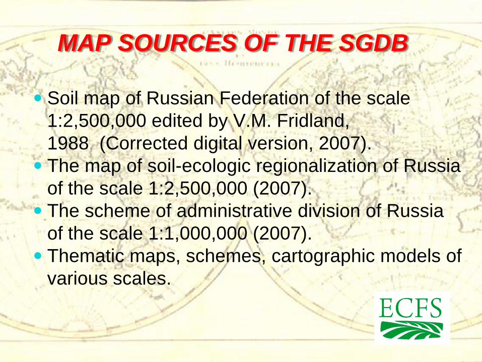
MAP SOURCES OF THE SGDB
Soil map of Russian Federation of the scale 1:2,500,000 edited by V.M. Fridland, 1988 (Corrected digital version, 2007).
The map of soil-ecologic regionalization of Russia of the scale 1:2,500,000 (2007).
The scheme of administrative division of Russia of the scale 1:1,000,000 (2007).
Thematic maps, schemes, cartographic models of various scales.
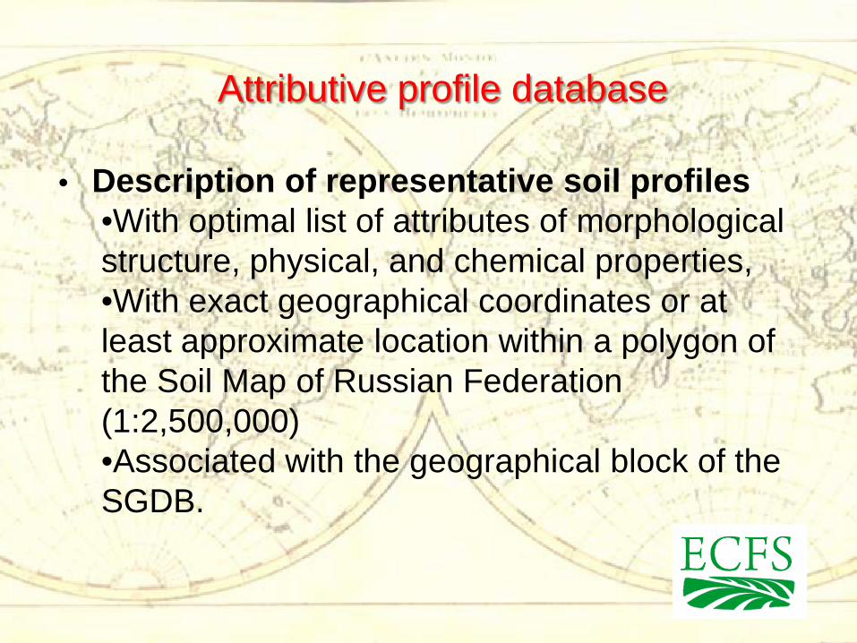
Attributive profile database
• Description of representative soil profiles •With optimal list of attributes of morphological structure, physical, and chemical properties, •With exact geographical coordinates or at least approximate location within a polygon of the Soil Map of Russian Federation (1:2,500,000) •Associated with the geographical block of the SGDB.
Russian soil database and related initiatives
• The development of a joint database of soil resources of Russia, Ukraine and Belorussia - supported by Russian Foundation for Basic Research, 2011-2012)
• The development of soil databases of Central Asian Republics (Uzbekistan, Kirgizstan and Tajikistan) – project by ECFS under development for 2012-2014
• Development of a joint database for Russian Federation and Kazakhstan – searching for funds yet
Definitions of data storage systems
• Actually the term “soil database” is used for a broad range of information resources differing in their aims, structure, content and functional abilities. The common feature of these resources is the presence of components containing soil data, and the electronic form of data storage
• The basic form of a database is a collection of point (profile) data, like NCSS Soil Characterization Data or WISE
• The other level is a soil-geographical database, which links soil attributes with a spatial unit (polygon)
The benefits of international electronic data storage system
• Compact storage • Availability for remote users • Easy data management • Possibility for export to GIS and other tools for
visualization • Relatively easy transformation to other format for
data sharing
The difficulties in data collection and electronic storage
• Political and juridical – Farm-level data are usually fee-based – Other data is often unavailable due to intellectual property issues – Certain “jealousy” for national databases exists
• Data deficiency – There are extensive areas with no or insufficient soil information – Many surveys have a limited number of soil parameters
• Data promiscuity – The list of soil attributes differ in different countries – In the same country there are differences in methods used by different institutions and in different periods
• Structural differences – The codification of data is different – The metadata part is insufficient for data understanding
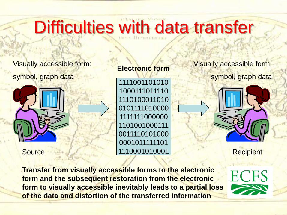
Difficulties with data transfer
Visually accessible form:
symbol, graph data
Source Recipient
Visually accessible form:
symbol, graph data Electronic form
Transfer from visually accessible forms to the electronic form and the subsequent restoration from the electronic form to visually accessible inevitably leads to a partial loss of the data and distortion of the transferred information
1111001101010 1000111011110 1110100011010 0101111010000 1111111000000 1101001000111 0011110101000 0001011111101 1110001010001
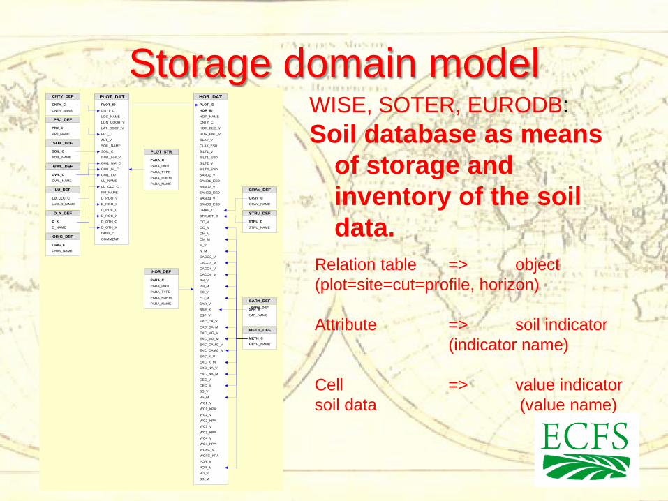
Storage domain model WISE, SOTER, EURODB: Soil database as means
of storage and inventory of the soil data.
Relation table => object (plot=site=cut=profile, horizon) Attribute => soil indicator (indicator name) Cell => value indicator soil data (value name)
CNTY_DEF
PRJ_DEF
SOIL_DEF
GWL_DEF
LU_DEF
D_X_DEF
PLOT_STR
ORIG_DEF
PLOT_ID
CNTY_C
LOC_NAME
LON_COOR_V
LAT_COOR_V
PRJ_C
ALT_V
SOIL_C
SOIL_NAME
GWL_NM_V
GWL_NM_C
GWL_HI_C
GWL_LO
LU_NAME
LU_CLC_C
PM_NAME
D_ROO_V
D_ROC_C
D_ROO_X
D_ROC_X
D_OTH_C
D_OTH_X
ORIG_C
COMMENT
CNTY_C
CNTY_NAME
PRJ_C
PRJ_NAME
SOIL_C
SOIL_NAME
GWL_C
GWL_NAME
LU_CLC_C
LUCLC_NAME
D_X
D_NAME
PARA_C
PARA_UNIT
ORIG_C
ORIG_NAME
HOR_STR
HOR DATCNTY_DEF PLOT DAT
PRJ_DEF
SOIL_DEF
GWL_DEF
LU_DEF
D_X_DEF
ORIG_DEF
PLOT_STR
GRAV_DEF
STRU_DEF
METH_DEF
SARX_DEF
PLOT_ID
HOR_ID
HOR_NAME
CNTY_C
HOR_BEG_V
CLAY_V
HOR_END_V
CLAY_ESD
SILT1_V
SILT1_ESD
SILT2_V
SILT2_ESD
SAND1_V
SAND1_ESD
SAND2_V
SAND2_ESD
SAND3_V
SAND3_ESD
GRAV_C
STRUCT_C
OC_V
OC_M
OM_V
OM_M
N_V
N_M
CACO3_V
CACO3_M
CACO4_V
CACO4_M
PH_M
PH_V
EC_V
EC_M
SAR_V
ESP_V
EXC_CA_V
EXC_CA_M
EXC_MG_V
EXC_MG_M
EXC_CAMG_V
EXC_CAMG_M
EXC_K_V
EXC_K_M
EXC_NA_V
EXC_NA_M
CEC_V
CEC_M
BS_V
BS_M
WC1_V
WC1_KPA
WC2_V
WC2_KPA
WC3_V
WC3_KPA
WC4_V
WC4_KPA
WCFC_V
WCFC_KPA
POR_V
POR_M
BD_V
BD_M
GRAV_C
GRAV_NAME
METH_C
METH_NAME
STRU_C
STRU_NAME
SAR_X SAR_X
SAR_NAME
PARA_FORM
PARA_NAME
PARA_TYPE
PARA_C
PARA_UNIT
PARA_FORM
PARA_NAME
PARA_TYPE
HOR_DEF
GRAV_DEF
STRU_DEF
SARX_DEF
METH_DEF
Disadvantages of the common domain model
• Diversity of the lists of indicators • Structural limitation of list representation of indicators and values of indicators of soil properties. • Problem of recording the “history” of indicator values (whether they are products of direct experimental measurements, or secondary, i.e. derived by pedotransfer functions)
Semantic domain model The object o is characterized by the value v of the indicator i determined with the method m Where: o – the object name, v – the name of value of the indicator, i – the indicator name, m – the name of a method of definition of value of an indicator
The database concept
• Soil object - an associative array of indexed indicators of of soil properties.
• The soil profile - a tree of associated arrays of indicators of soil properties in the space of soil objects:
S=SUmin[xID,IndicatorID,ObjectID,ValueID,MethodID]
• http://open.soil.msu.ru • http://db.soil.msu.ru
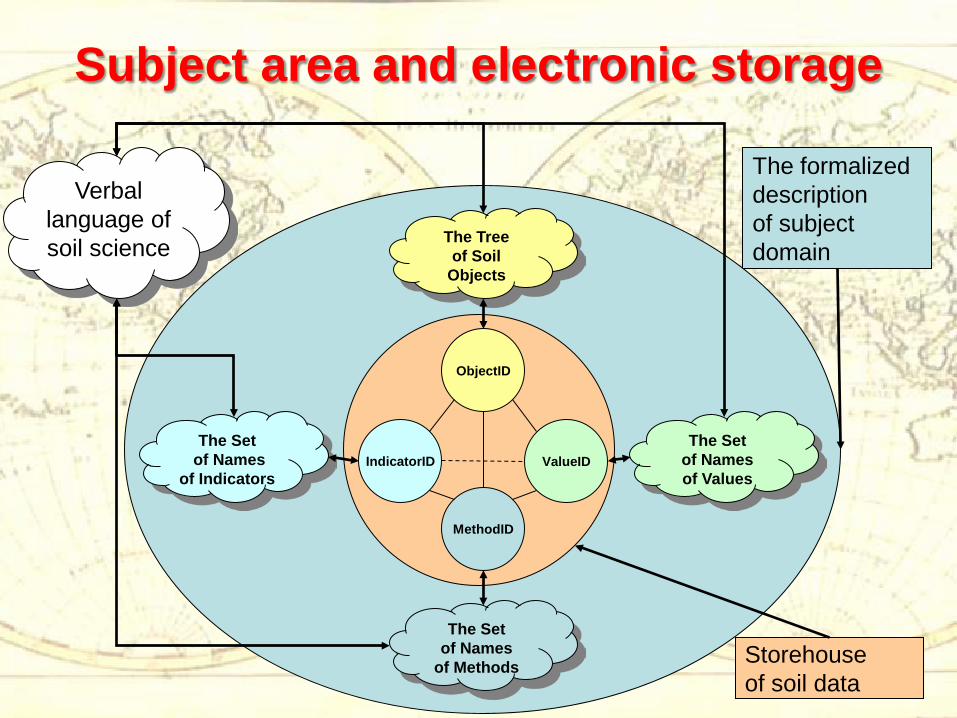
Subject area and electronic storage
The formalized description of subject domain
Storehouse of soil data
IndicatorID
ObjectID
MethodID
ValueID
The Tree of Soil
Objects
The Set of Names of Values
The Set of Names
of Methods
The Set of Names
of Indicators
Verbal language of soil science
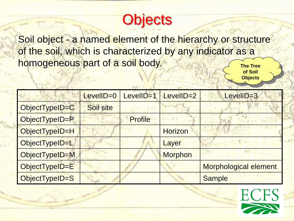
Objects
The Tree of Soil
Objects
Soil object - a named element of the hierarchy or structure of the soil, which is characterized by any indicator as a homogeneous part of a soil body.
LevelID=0 LevelID=1 LevelID=2 LevelID=3 ObjectTypeID=C Soil site ObjectTypeID=P Profile ObjectTypeID=H Horizon ObjectTypeID=L Layer ObjectTypeID=M Morphon ObjectTypeID=E Morphological element ObjectTypeID=S Sample
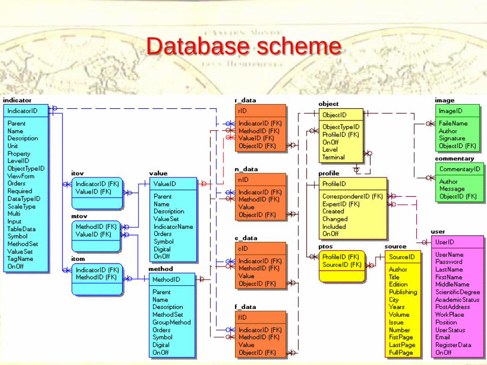
Database scheme
Perspectives • Improving the structure and design of the
database • Filling the database with real soil data • Future geographic extension of the
database • Developing data sharing format; data
sharing with EuroDB (HWSD) is a priority • Forming a joint soil information space from
Lisbon to Vladivostok
THANK YOU FOR YOUR ATTENTION