Embed Size (px)
Citation preview
Hydro-‐poli*cal Baseline of the Upper Jordan River
The Associa+on of the Friends of Ibrahim Abd el Al
Mark Zeitoun, Karim Eid-‐Sabbagh, Muna Dajani, and Michael Talhami
www.uea.ac.uk/watersecurity/
publica2ons
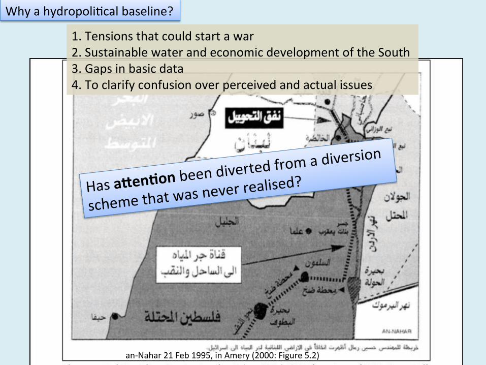
Has a9en*on been diverted
from a diversion
scheme that was never realised?
Why a hydropoli2cal baseline?
1. Tensions that could start a war 2. Sustainable water and economic development of the South 3. Gaps in basic data 4. To clarify confusion over perceived and actual issues
an-‐Nahar 21 Feb 1995, in Amery (2000: Figure 5.2)
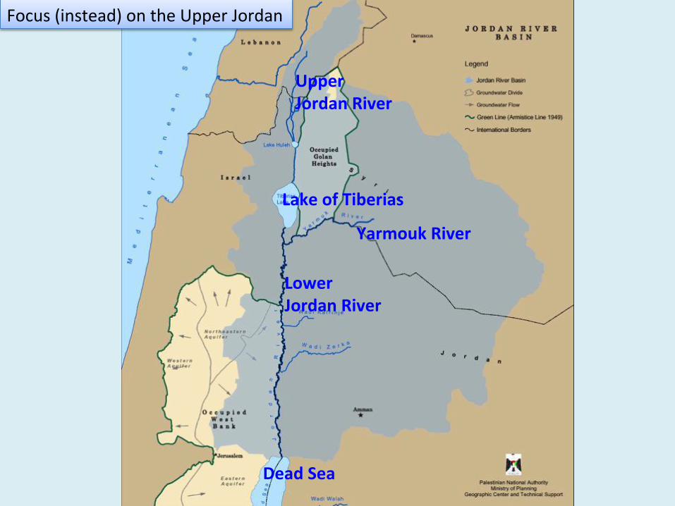
Lake of Tiberias
Upper Jordan River
Lower Jordan River
Yarmouk River
Dead Sea
Focus (instead) on the Upper Jordan
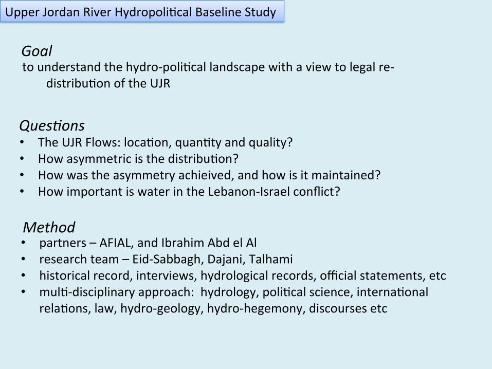
• The UJR Flows: loca2on, quan2ty and quality? • How asymmetric is the distribu2on? • How was the asymmetry achieived, and how is it maintained? • How important is water in the Lebanon-‐Israel conflict?
• partners – AFIAL, and Ibrahim Abd el Al • research team – Eid-‐Sabbagh, Dajani, Talhami • historical record, interviews, hydrological records, official statements, etc • mul2-‐disciplinary approach: hydrology, poli2cal science, interna2onal
rela2ons, law, hydro-‐geology, hydro-‐hegemony, discourses etc
to understand the hydro-‐poli2cal landscape with a view to legal re-‐
distribu2on of the UJR
Ques+ons
Goal
Method
Upper Jordan River Hydropoli2cal Baseline Study
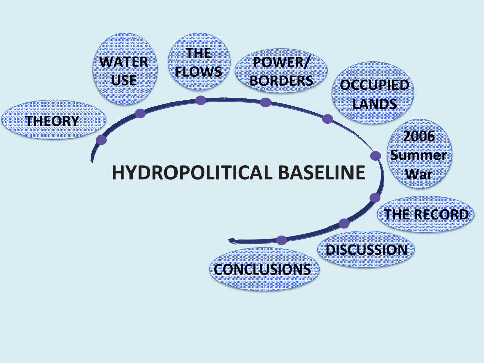
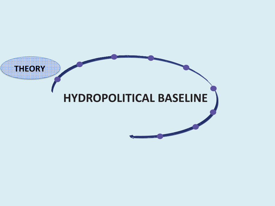
HYDROPOLITICAL BASELINE
THEORY
THE FLOWS
OCCUPIED LANDS
WATER USE
2006 Summer War
THE RECORD
POWER/ BORDERS
CONCLUSIONS DISCUSSION
HYDROPOLITICAL BASELINE
THEORY
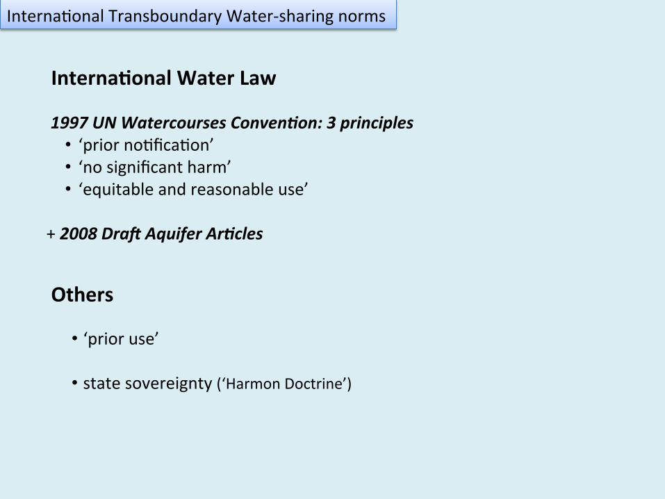
1997 UN Watercourses Conven3on: 3 principles • ‘prior no2fica2on’ • ‘no significant harm’ • ‘equitable and reasonable use’
+ 2008 Dra= Aquifer Ar3cles
Interna2onal Transboundary Water-‐sharing norms
• ‘prior use’
• state sovereignty (‘Harmon Doctrine’)
Interna*onal Water Law
Others
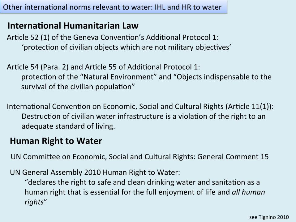
Ar2cle 52 (1) of the Geneva Conven2on’s Addi2onal Protocol 1: ‘protec2on of civilian objects which are not military objec2ves’
Ar2cle 54 (Para. 2) and Ar2cle 55 of Addi2onal Protocol 1:
protec2on of the “Natural Environment” and “Objects indispensable to the survival of the civilian popula2on”
Interna2onal Conven2on on Economic, Social and Cultural Rights (Ar2cle 11(1)):
Destruc2on of civilian water infrastructure is a viola2on of the right to an adequate standard of living.
Other interna2onal norms relevant to water: IHL and HR to water
see Tignino 2010
Human Right to Water
UN General Assembly 2010 Human Right to Water: “declares the right to safe and clean drinking water and sanita2on as a human right that is essen2al for the full enjoyment of life and all human rights”
UN Commifee on Economic, Social and Cultural Rights: General Comment 15
Interna*onal Humanitarian Law
HYDROPOLITICAL BASELINE
WATER USE
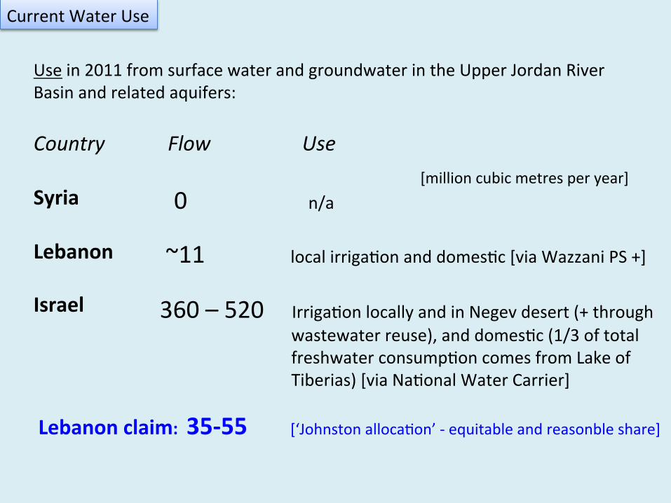
Use in 2011 from surface water and groundwater in the Upper Jordan River Basin and related aquifers: Country Flow Use Syria
Lebanon Israel
Current Water Use
[million cubic metres per year] 0 n/a
~11 local irriga2on and domes2c [via Wazzani PS +]
360 – 520 Irriga2on locally and in Negev desert (+ through wastewater reuse), and domes2c (1/3 of total freshwater consump2on comes from Lake of Tiberias) [via Na2onal Water Carrier]
Lebanon claim: 35-‐55 [‘Johnston alloca2on’ -‐ equitable and reasonble share]
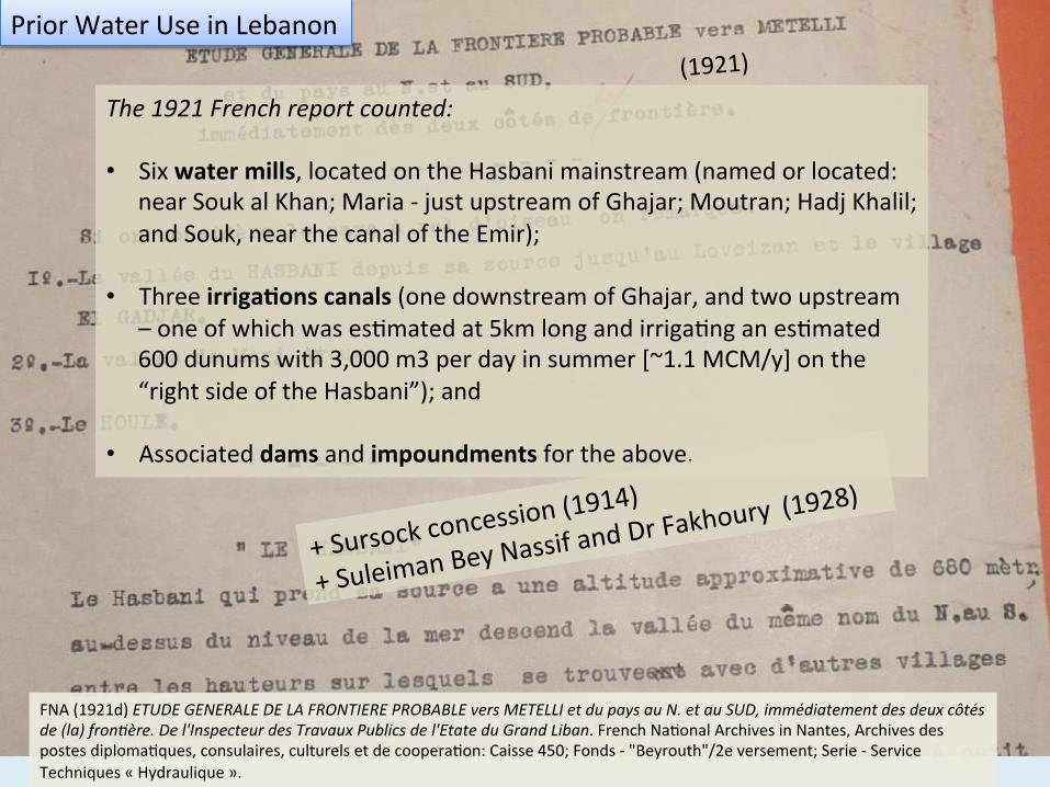
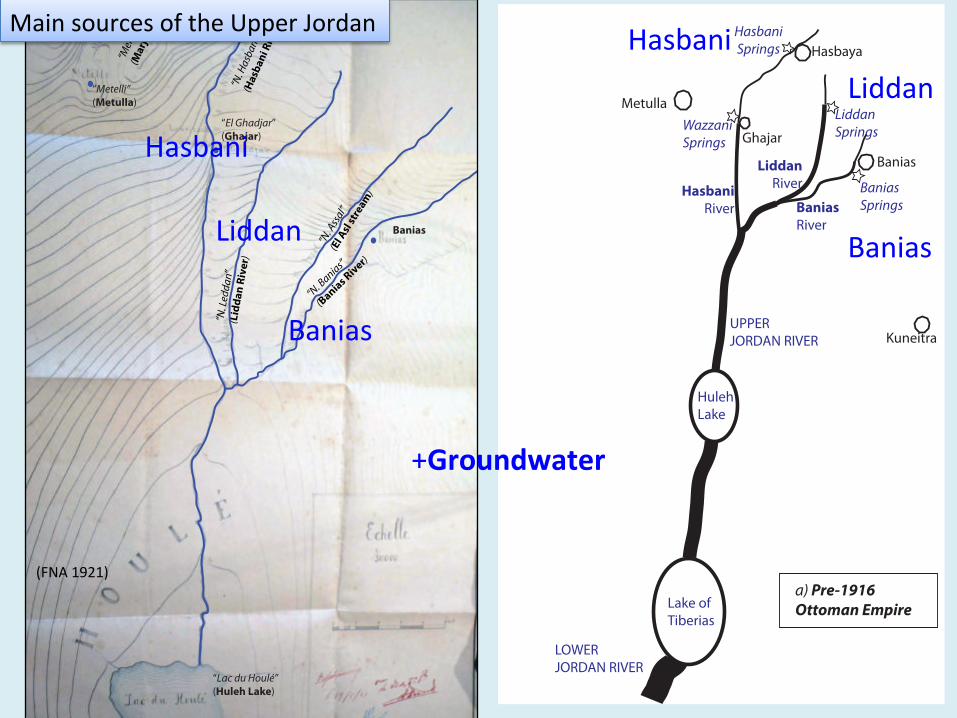
FNA (1921d) ETUDE GENERALE DE LA FRONTIERE PROBABLE vers METELLI et du pays au N. et au SUD, immédiatement des deux côtés de (la) fron+ère. De l'Inspecteur des Travaux Publics de l'Etate du Grand Liban. French Na2onal Archives in Nantes, Archives des postes diploma2ques, consulaires, culturels et de coopera2on: Caisse 450; Fonds -‐ "Beyrouth"/2e versement; Serie -‐ Service Techniques « Hydraulique ».
The 1921 French report counted: • Six water mills, located on the Hasbani mainstream (named or located:
near Souk al Khan; Maria -‐ just upstream of Ghajar; Moutran; Hadj Khalil; and Souk, near the canal of the Emir);
• Three irriga*ons canals (one downstream of Ghajar, and two upstream – one of which was es2mated at 5km long and irriga2ng an es2mated 600 dunums with 3,000 m3 per day in summer [~1.1 MCM/y] on the “right side of the Hasbani”); and
• Associated dams and impoundments for the above.
(1921) Prior Water Use in Lebanon
+ Sursock concession
(1914)
+ Suleiman Bey Nassif and Dr
Fakhoury (1928)
HYDROPOLITICAL BASELINE
THE FLOWS
HulehLake
Lake of Tiberias
Banias Springs
HasbaniSprings
WazzaniSprings
HasbaniRiver
LiddanRiver
BaniasRiver
UPPER JORDAN RIVER
LiddanSprings
LOWERJORDAN RIVER
Hasbaya
Metulla
Banias
Kuneitra
Ghajar
a) Pre-1916 Ottoman Empire
“El Ghadjar”(Ghajar)
“Metelli”(Metulla)
Banias“N
. Led
dan”
(Lid
dan
Rive
r)
“N. A
ssal”
(El A
sl st
ream
)
“N. B
anias”
(Banias River)
“N. H
asba
ni”
(Has
bani
Riv
er)
“Lac du Houlé”(Huleh Lake)
“Mer
dj A
youn
”(M
arja
youn
)
(FNA 1921)
+Groundwater
Hasbani Liddan
Banias
Hasbani
Liddan
Banias
Main sources of the Upper Jordan
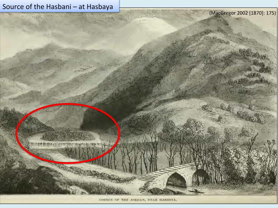
(MacGregor 2002 [1870]: 175) Source of the Hasbani – at Hasbaya
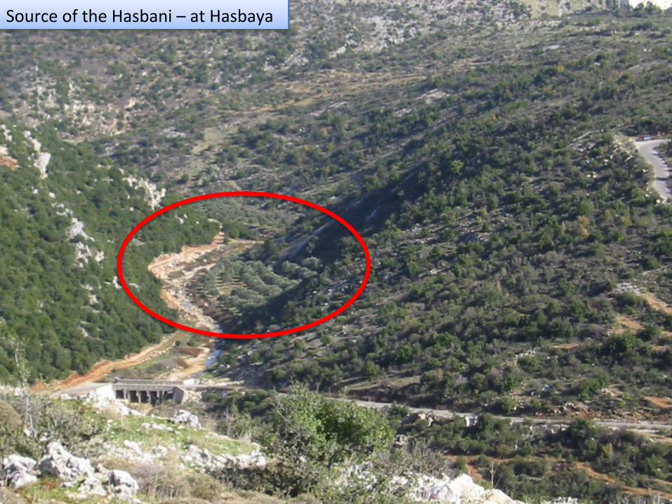
Source of the Hasbani – at Hasbaya
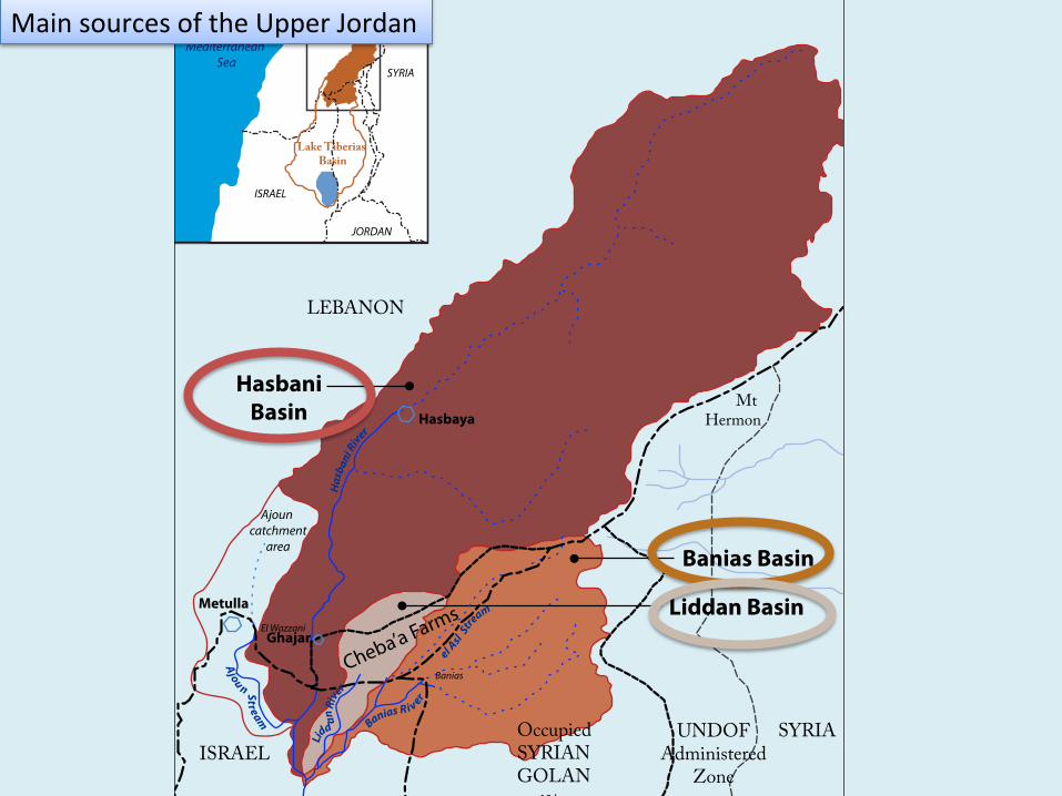
HasbaniBasin
Banias Basin
Liddan Basin
Hasbaya
ISRAEL
LEBANON
SYRIAOccupied SYRIANGOLAN
UNDOFAdministered
Zone
Mt Hermon
Cheba’a Farms
Mediterranean Sea
LEBANON
SYRIA
JORDAN
ISRAEL
Lake Tiberias Basin
El Wazzani
Banias
Banias R i ver
el Asl
Stream
Has
bani
River
Lidd
an R
iver
Ajou n Stream
Based on Rimmer and Salingar (2006). Data for basins, rivers and boundaries (except occupied Golan): Hartman 2008.
Mapping: Doris SummerBeirut, 2011
10 km
Metulla
Ghajar
Ajoun catchment
area
Main sources of the Upper Jordan
HasbaniBasin
Banias Basin
Liddan Basin
Hasbaya
ISRAEL
LEBANON
SYRIAOccupied SYRIANGOLAN
UNDOFAdministered
Zone
Mt Hermon
Cheba’a Farms
Mediterranean Sea
LEBANON
SYRIA
JORDAN
ISRAEL
Lake Tiberias Basin
El Wazzani
Banias
Banias R i ver
el Asl
Stream
Has
bani
River
Lidd
an R
iver
Ajou n Stream
Based on Rimmer and Salingar (2006). Data for basins, rivers and boundaries (except occupied Golan): Hartman 2008.
Mapping: Doris SummerBeirut, 2011
10 km
Metulla
Ghajar
Ajoun catchment
area
HSI Yearbooks 1949-‐1977, 1959-‐2004, and 1992-‐2004, and Klein (1998) for 1977-‐1992.
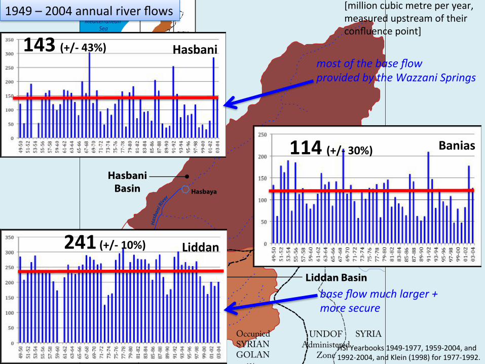
1949 – 2004 annual river flows
!
Banias 114 (+/-‐ 30%) !
Hasbani 143 (+/-‐ 43%)
!
Liddan 241 (+/-‐ 10%)
[million cubic metre per year, measured upstream of their confluence point]
most of the base flow provided by the Wazzani Springs
base flow much larger + more secure
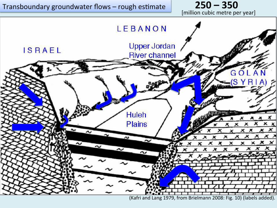
(Kafri and Lang 1979, from Brielmann 2008: Fig. 10) (labels added).
Transboundary groundwater flows – rough es2mate 250 – 350 [million cubic metre per year]
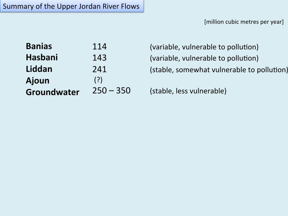
Banias Hasbani Liddan Ajoun Groundwater
114 (variable, vulnerable to pollu2on) 143 (variable, vulnerable to pollu2on) 241 (stable, somewhat vulnerable to pollu2on) (?) 250 – 350 (stable, less vulnerable)
Summary of the Upper Jordan River Flows
[million cubic metres per year]
HYDROPOLITICAL BASELINE
POWER/ BORDERS
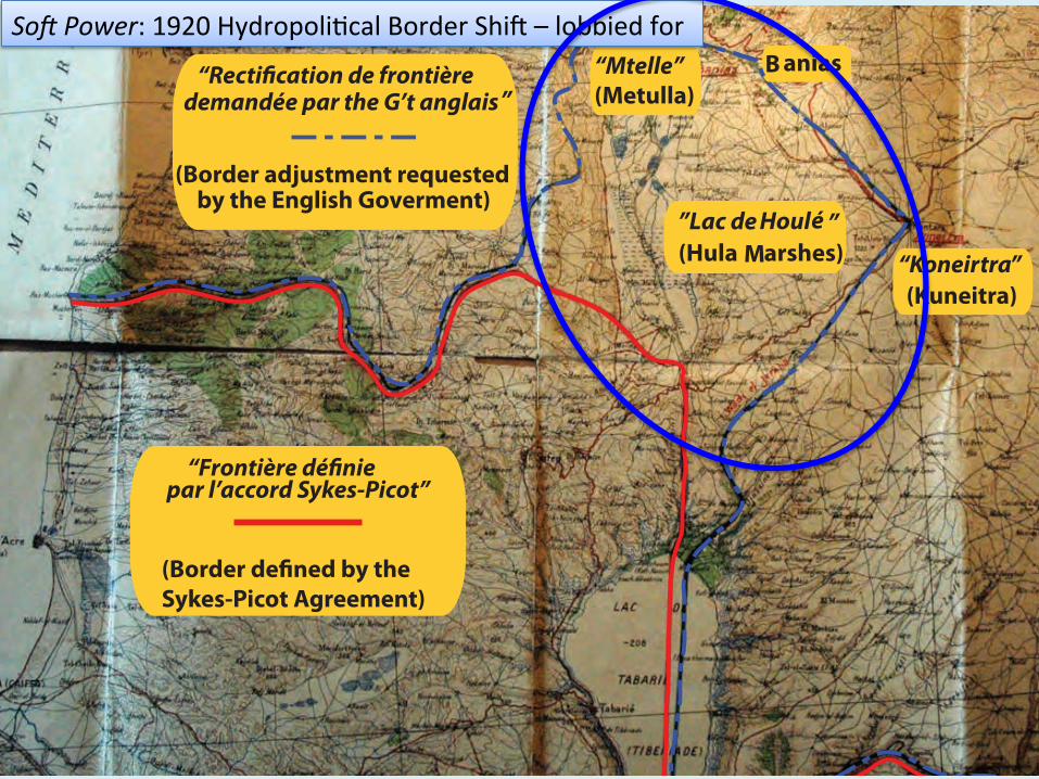
“Mtelle”(Metulla)
B anias
(Kuneitra)
par l’accord Sykes-Picot”
”Lac de Houlé ”(Hula Marshes)
Sykes-Picot Agreement)
demandée par the G’t anglais”
(Border adjustment requestedby the English Goverment)
“Koneirtra”
So[ Power: 1920 Hydropoli2cal Border Shiv – lobbied for
HulehLake
Lake of Tiberias
Banias Springs
HasbaniSprings
WazzaniSprings
HasbaniRiver
LiddanRiver
BaniasRiver
UPPER JORDAN RIVER
LiddanSprings
LOWERJORDAN RIVER
Hasbaya
Metulla
Banias
Kuneitra
Ghajar
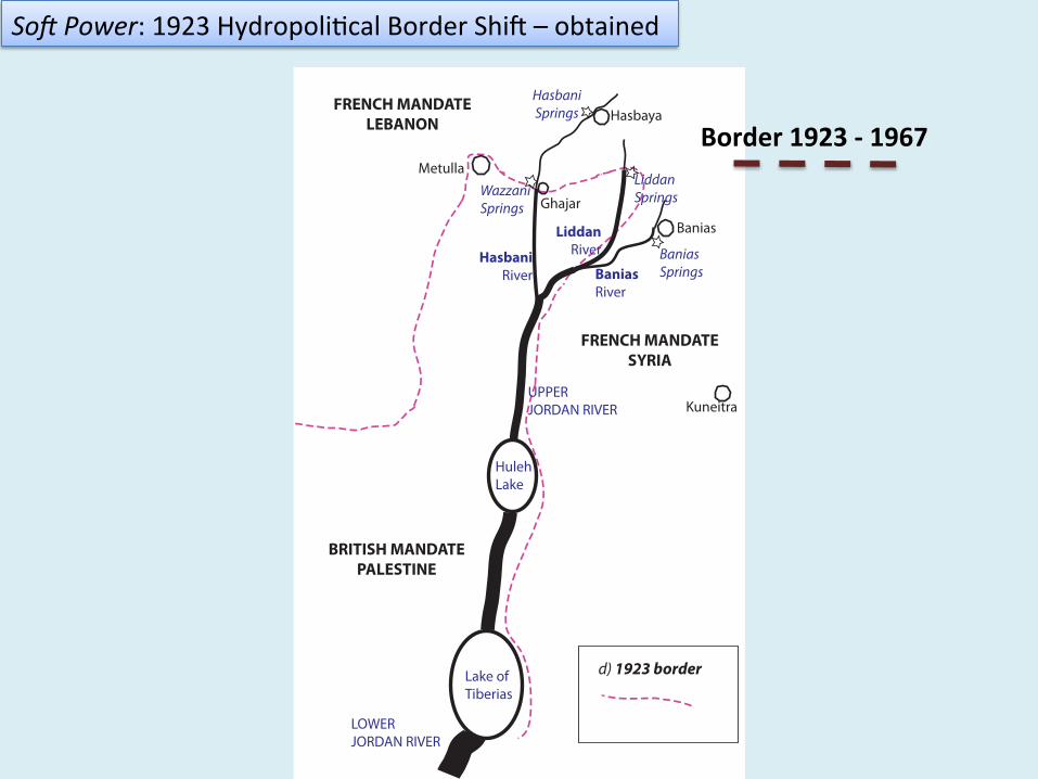
BRITISH MANDATEPALESTINE
FRENCH MANDATESYRIA
FRENCH MANDATELEBANON
d) 1923 border
Border 1923 -‐ 1967
So[ Power: 1923 Hydropoli2cal Border Shiv – obtained
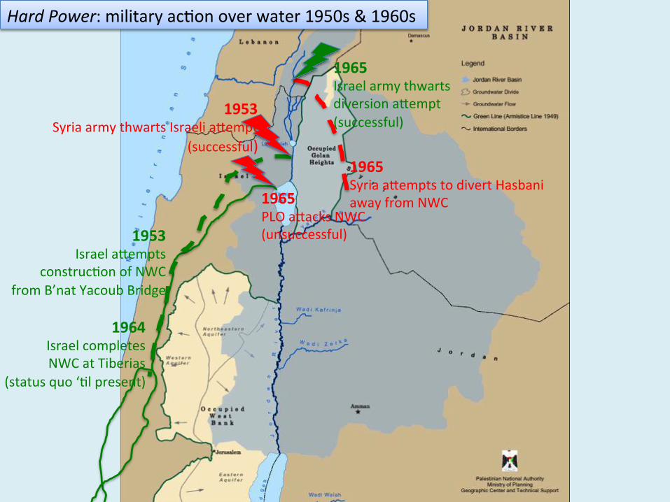
1953 Syria army thwarts Israeli afempt
(successful)
1964 Israel completes NWC at Tiberias
(status quo ‘2l present)
1965 PLO afacks NWC (unsuccessful)
1965 Israel army thwarts diversion afempt (successful)
1953 Israel afempts
construc2on of NWC from B’nat Yacoub Bridge
1965 Syria afempts to divert Hasbani away from NWC
Hard Power: military ac2on over water 1950s & 1960s
Cheba’a
Farms
HulehLake
Lake of Tiberias
Banias Springs
HasbaniSprings
WazzaniSprings
HasbaniRiver
LiddanRiver
BaniasRiver
UPPER JORDAN RIVER
LiddanSprings
LOWERJORDAN RIVER
Hasbaya
Metulla
Banias
Kuneitra
Ghajar
ISRAEL
LEBANON
SYRIA
e) post 1948 border+ 1967 Israeli occupation of Golan
Cheba’a
Farms
HulehLake
Lake of Tiberias
Banias Springs
HasbaniSprings
WazzaniSprings
HasbaniRiver
LiddanRiver
BaniasRiver
UPPER JORDAN RIVER
LiddanSprings
LOWERJORDAN RIVER
Hasbaya
Metulla
Banias
Kuneitra
Ghajar
ISRAEL
LEBANON
SYRIA
e) post 1948 border+ 1967 Israeli occupation of Golan
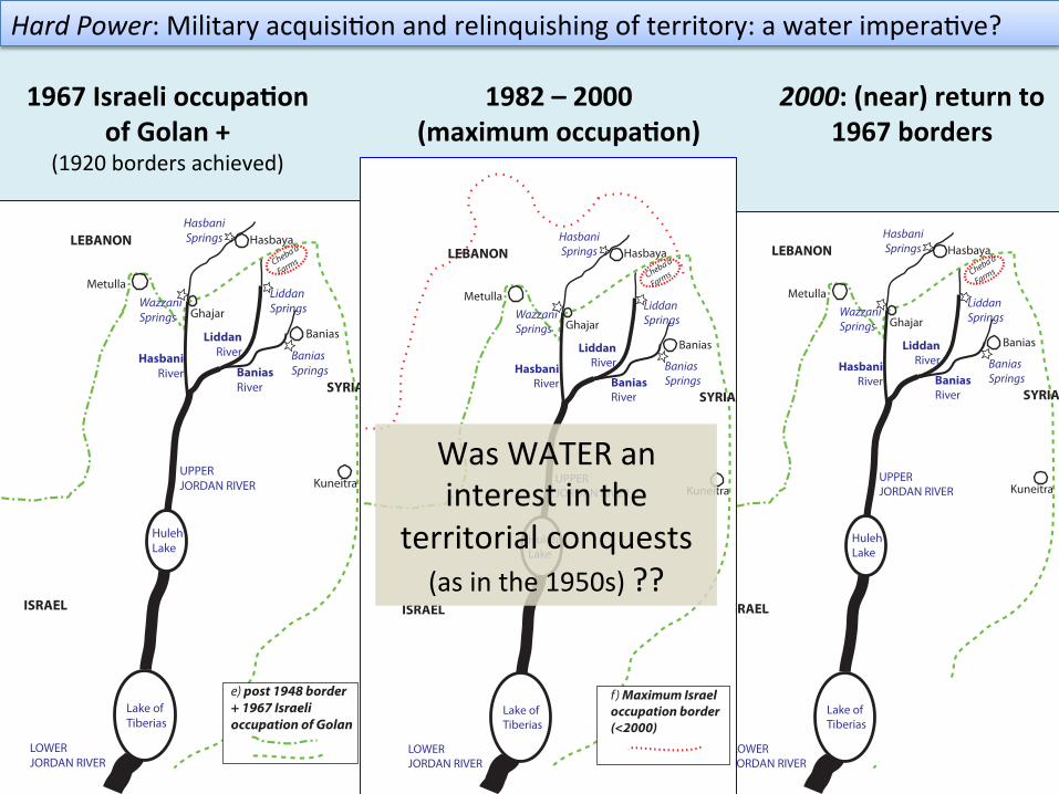
1967 Israeli occupa*on of Golan +
(1920 borders achieved)
Hard Power: Military acquisi2on and relinquishing of territory: a water impera2ve?
Cheba’a
Farms
HulehLake
Lake of Tiberias
Banias Springs
HasbaniSprings
WazzaniSprings
HasbaniRiver
LiddanRiver
BaniasRiver
UPPER JORDAN RIVER
LiddanSprings
LOWERJORDAN RIVER
Hasbaya
Metulla
Banias
Kuneitra
Ghajar
ISRAEL
LEBANON
SYRIA
f ) Maximum Israeloccupation border (<2000)
2000: (near) return to 1967 borders
1982 – 2000 (maximum occupa*on)
Was WATER an interest in the
territorial conquests (as in the 1950s) ??
HYDROPOLITICAL BASELINE
OCCUPIED LANDS

Interests in CHEBA’A
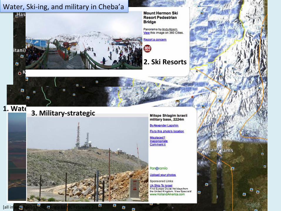
1. Water
2. Ski Resorts
3. Military-‐strategic
Water, Ski-‐ing, and military in Cheba’a
[all images taken from Google Earth, February 2012]

Lebanon
Occupied Cheba’a Farms
4. site of Abraham’s Covenant of the Pieces
Religious sites in Cheba’a
[all images taken from Google Earth, February 2012]
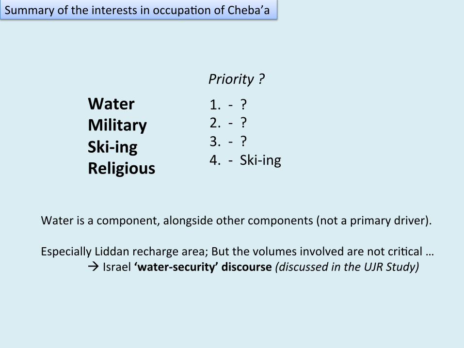
Summary of the interests in occupa2on of Cheba’a
Water Military Ski-‐ing Religious
1. -‐ ? 2. -‐ ? 3. -‐ ? 4. -‐ Ski-‐ing
Priority ?
Water is a component, alongside other components (not a primary driver). Especially Liddan recharge area; But the volumes involved are not cri2cal …
à Israel ‘water-‐security’ discourse (discussed in the UJR Study)
Interests in GHAJAR
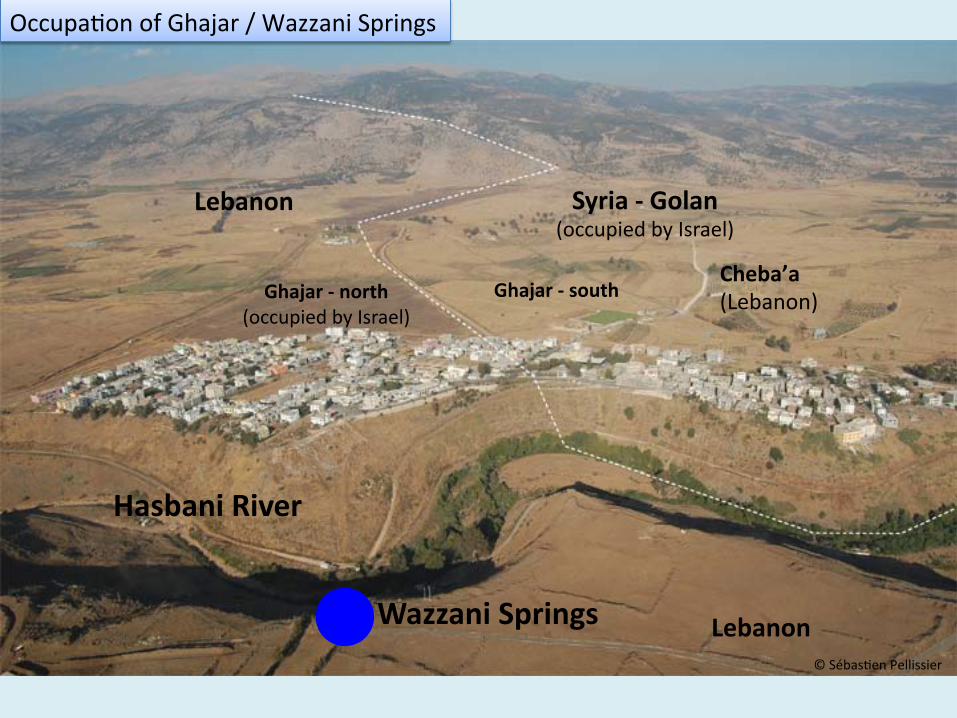
Lebanon Syria -‐ Golan
(occupied by Israel)
Ghajar -‐ north
(occupied by Israel)Ghajar -‐ south
Wazzani Springs
Hasbani River
Lebanon
© Sébas2en Pellissier
Occupa2on of Ghajar / Wazzani Springs
Cheba’a (Lebanon)
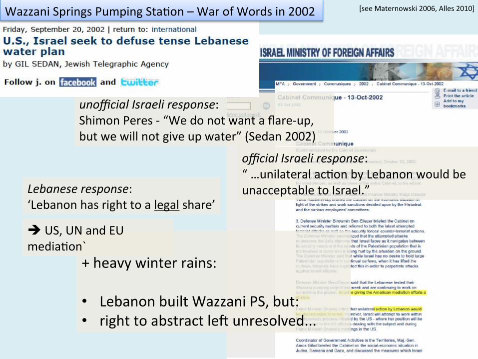
unofficial Israeli response: Shimon Peres -‐ “We do not want a flare-‐up, but we will not give up water” (Sedan 2002)
official Israeli response: “ …unilateral ac2on by Lebanon would be unacceptable to Israel.”
+ heavy winter rains: • Lebanon built Wazzani PS, but: • right to abstract lev unresolved...
Lebanese response: ‘Lebanon has right to a legal share’
[see Maternowski 2006, Alles 2010] Wazzani Springs Pumping Sta2on – War of Words in 2002
è US, UN and EU media2on`
Hasbani River +!
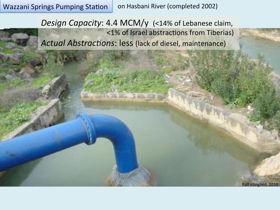
Wazzani Springs Pumping Sta2on on Hasbani River (completed 2002)
Ralf Klingbeil, 2010
Design Capacity: 4.4 MCM/y (<14% of Lebanese claim, <1% of Israel abstrac2ons from Tiberias)
Actual Abstrac+ons: less (lack of diesel, maintenance)
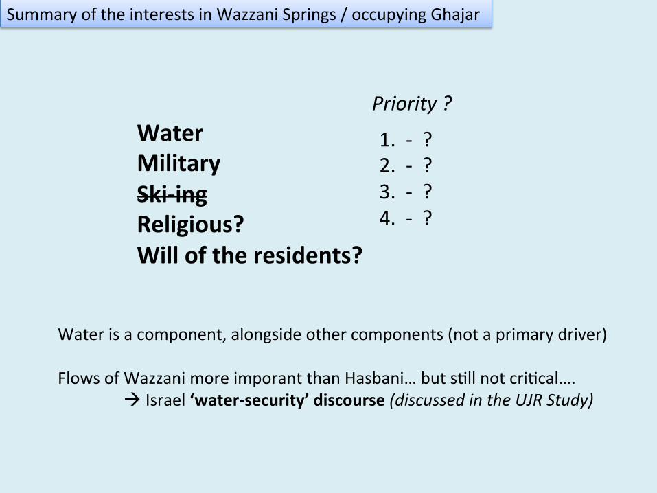
Summary of the interests in Wazzani Springs / occupying Ghajar
Water Military Ski-‐ing Religious? Will of the residents?
1. -‐ ? 2. -‐ ? 3. -‐ ? 4. -‐ ?
Priority ?
Water is a component, alongside other components (not a primary driver) Flows of Wazzani more imporant than Hasbani… but s2ll not cri2cal….
à Israel ‘water-‐security’ discourse (discussed in the UJR Study)
HYDROPOLITICAL BASELINE
2006 Summer War
Cheba’a
Yaroun
Khiam
Insar
Jbaa
Blida
Zrariye
Hasbaiya
Houla
Chaqra
Blat
Rmaich
Qlaiaa
Kfar Chouba
Zabqine
Babliye
Hebbariye
Aabbassiye
Jouaya
Taibe
Yohmor
Tyre
Aaitaroun
Doueir
Naqoura
Rihane
Kfar Sir
Kfour
Aabba
Sarba
Barich
Sarafand
Aalma ech Chaab
Kaoukaba
Aanqoun
Aadloun
Kfar Kila
Jibchit
Merouaniye
Mari
Soultanieh
Insariye
Aalmane
Harouf
Markaba
Arzay
El Majidiye
Kfar Roummane
Zefta
El Biyada
Habbouch
Chihine
Ez Zahrani
Bent Jbail
Aaramta
Barti
Qasmiye
Mansouri
Toufahta
Jarjouaa
Fardis
Braiqaa
Aazze
Marjayoun
Mlikh
Kharayeb
Qraiye
Dlafy
Aita Ech Chaab
Majdel Selm
Ebel es Saqi
Borj ech Chmali
Bedias
Kfar Melki
Aadaisse
Baissariye
Maaroub
Deir Qanoun
Bourghliye
Jebbain
Yarine Maroun er Ras
Hassaniye
Tair Harfa
Khartoum
Sidon
Kfar Hamam
Ain Jerfa
Aaddoussiye
Saksakiye
Tanbourit
Haret SaidaDarb es Sim
Louaiziye
Kfar Jarra
Siddiqine
Wazzani
Ramiya
Chama’a MheibibBeit Yahoun
QantaraGhandourieh
Aitit Majdel
QaouzahBeit Lif
Sribbine
Aita El-Jabel
Tallousa
Baraachit
S T A T E B O U N D A R I E SC a z a
Boundaries of occupied Cheba’a Farms
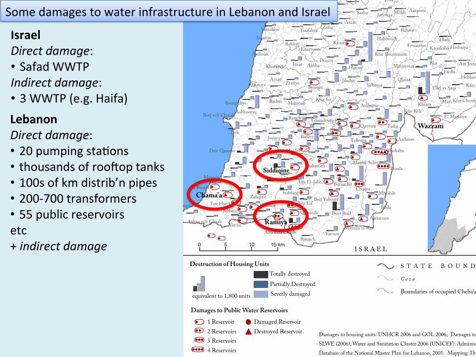
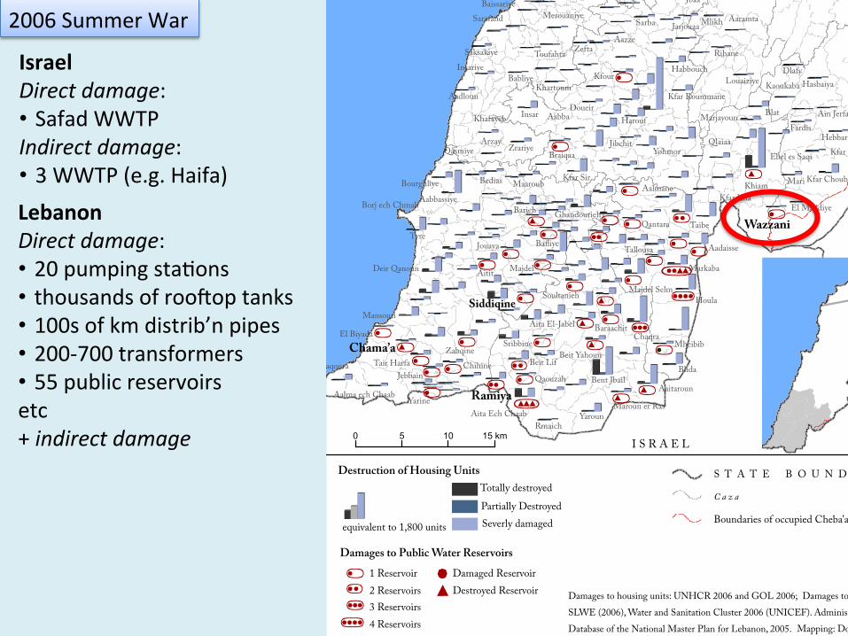
Damages to housing units: UNHCR 2006 and GOL 2006; Damages to water reservoirs: SLWE (2006), Water and Sanitation Cluster 2006 (UNICEF). Administrative boundaries: Database of the National Master Plan for Lebanon, 2005. Mapping: Doris Summer, 2011.
0 5 10 15 km
equivalent to 1,800 units
Totally destroyedPartially DestroyedSeverly damaged
Destruction of Housing Units
Damages to Public Water Reservoirs1 Reservoi Damaged Reservoir
Destroyed Reservoirr
2 Reservoirs3 Reservoirs4 Reservoirs
S Y R I A
I S R A E L
Israel Direct damage: • Safad WWTP Indirect damage: • 3 WWTP (e.g. Haifa) Lebanon Direct damage: • 20 pumping sta2ons • thousands of roovop tanks • 100s of km distrib’n pipes • 200-‐700 transformers • 55 public reservoirs etc + indirect damage
Some damages to water infrastructure in Lebanon and Israel
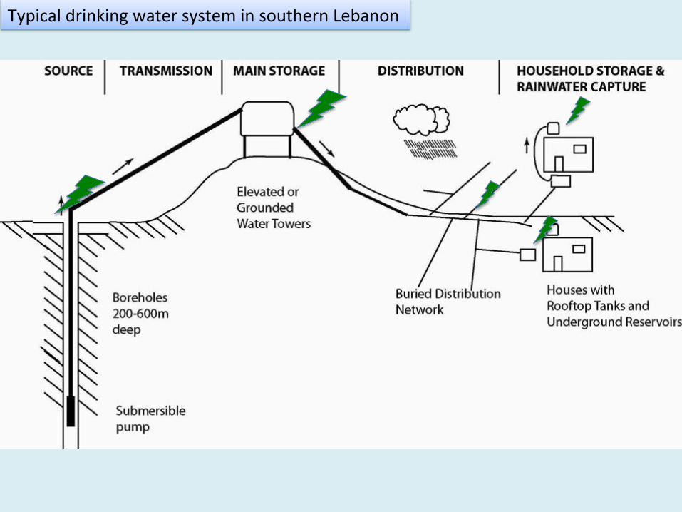
Typical drinking water system in southern Lebanon
Zeitoun
Zeitoun
2006 Summer War
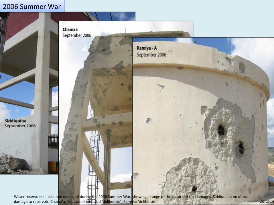
Zeitoun Water reservoirs in Lebanon damaged during the 2006 Summer War, showing a range of the nature of the damages. Siddiquine: no direct damage to reservoir; Chama'a: ‘indiscriminate’ and ‘deliberate’; Ramiya: ‘deliberate’.
Cheba’a
Yaroun
Khiam
Insar
Jbaa
Blida
Zrariye
Hasbaiya
Houla
Chaqra
Blat
Rmaich
Qlaiaa
Kfar Chouba
Zabqine
Babliye
Hebbariye
Aabbassiye
Jouaya
Taibe
Yohmor
Tyre
Aaitaroun
Doueir
Naqoura
Rihane
Kfar Sir
Kfour
Aabba
Sarba
Barich
Sarafand
Aalma ech Chaab
Kaoukaba
Aanqoun
Aadloun
Kfar Kila
Jibchit
Merouaniye
Mari
Soultanieh
Insariye
Aalmane
Harouf
Markaba
Arzay
El Majidiye
Kfar Roummane
Zefta
El Biyada
Habbouch
Chihine
Ez Zahrani
Bent Jbail
Aaramta
Barti
Qasmiye
Mansouri
Toufahta
Jarjouaa
Fardis
Braiqaa
Aazze
Marjayoun
Mlikh
Kharayeb
Qraiye
Dlafy
Aita Ech Chaab
Majdel Selm
Ebel es Saqi
Borj ech Chmali
Bedias
Kfar Melki
Aadaisse
Baissariye
Maaroub
Deir Qanoun
Bourghliye
Jebbain
Yarine Maroun er Ras
Hassaniye
Tair Harfa
Khartoum
Sidon
Kfar Hamam
Ain Jerfa
Aaddoussiye
Saksakiye
Tanbourit
Haret SaidaDarb es Sim
Louaiziye
Kfar Jarra
Siddiqine
Wazzani
Ramiya
Chama’a MheibibBeit Yahoun
QantaraGhandourieh
Aitit Majdel
QaouzahBeit Lif
Sribbine
Aita El-Jabel
Tallousa
Baraachit
S T A T E B O U N D A R I E SC a z a
Boundaries of occupied Cheba’a Farms
Damages to housing units: UNHCR 2006 and GOL 2006; Damages to water reservoirs: SLWE (2006), Water and Sanitation Cluster 2006 (UNICEF). Administrative boundaries: Database of the National Master Plan for Lebanon, 2005. Mapping: Doris Summer, 2011.
0 5 10 15 km
equivalent to 1,800 units
Totally destroyedPartially DestroyedSeverly damaged
Destruction of Housing Units
Damages to Public Water Reservoirs1 Reservoi Damaged Reservoir
Destroyed Reservoirr
2 Reservoirs3 Reservoirs4 Reservoirs
S Y R I A
I S R A E L
2006 Summer War
Israel Direct damage: • Safad WWTP Indirect damage: • 3 WWTP (e.g. Haifa) Lebanon Direct damage: • 20 pumping sta2ons • thousands of roovop tanks • 100s of km distrib’n pipes • 200-‐700 transformers • 55 public reservoirs etc + indirect damage
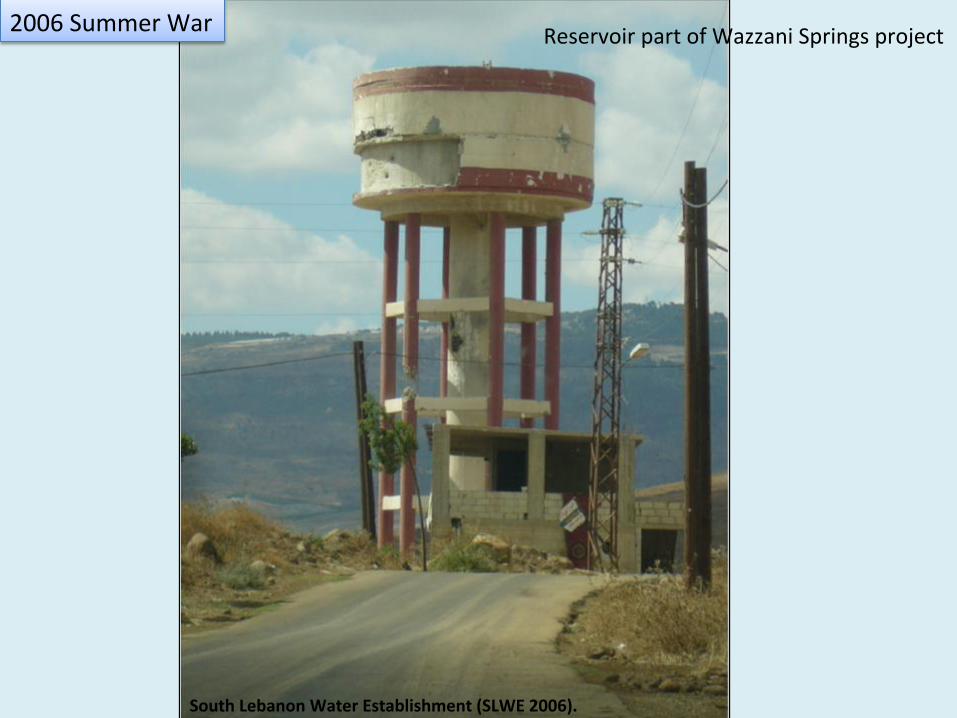
South Lebanon Water Establishment (SLWE 2006).
2006 Summer War Reservoir part of Wazzani Springs project
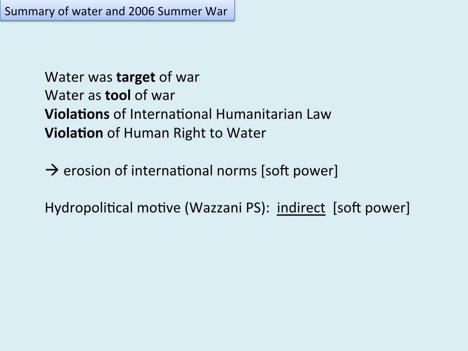
Water was target of war Water as tool of war Viola*ons of Interna2onal Humanitarian Law Viola*on of Human Right to Water à erosion of interna2onal norms [sov power] Hydropoli2cal mo2ve (Wazzani PS): indirect [sov power]
Summary of water and 2006 Summer War
HYDROPOLITICAL BASELINE
THE RECORD
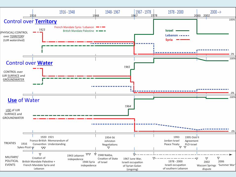
1916 -‐ 1948 1948-‐ 1967 1967 -‐ 1978 1978 -‐ 2000 2000 -‐-‐>
IsraelLebanonSyria
British Mandate PalestineFrench Mandate Syria / Lebanon
2000 20021978196719481916
0%
100%
0%
100%
0%
100%
MILITARY/
POLITICAL
EVENTS
1948 Nakba,
1978 -‐ 2000 2002 2006
1916
1920
TREATIES
1954-‐561921 1993
1964
1965
1923
Control over Territory
Control over Water
Use of Water
HYDROPOLITICAL BASELINE
CONCLUSIONS
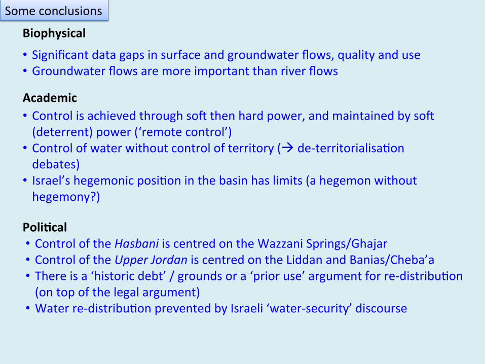
Biophysical Academic Poli*cal
Some conclusions
• Significant data gaps in surface and groundwater flows, quality and use • Groundwater flows are more important than river flows
• Control is achieved through sov then hard power, and maintained by sov (deterrent) power (‘remote control’) • Control of water without control of territory (à de-‐territorialisa2on debates) • Israel’s hegemonic posi2on in the basin has limits (a hegemon without hegemony?)
• Control of the Hasbani is centred on the Wazzani Springs/Ghajar • Control of the Upper Jordan is centred on the Liddan and Banias/Cheba’a • There is a ‘historic debt’ / grounds or a ‘prior use’ argument for re-‐distribu2on (on top of the legal argument) • Water re-‐distribu2on prevented by Israeli ‘water-‐security’ discourse
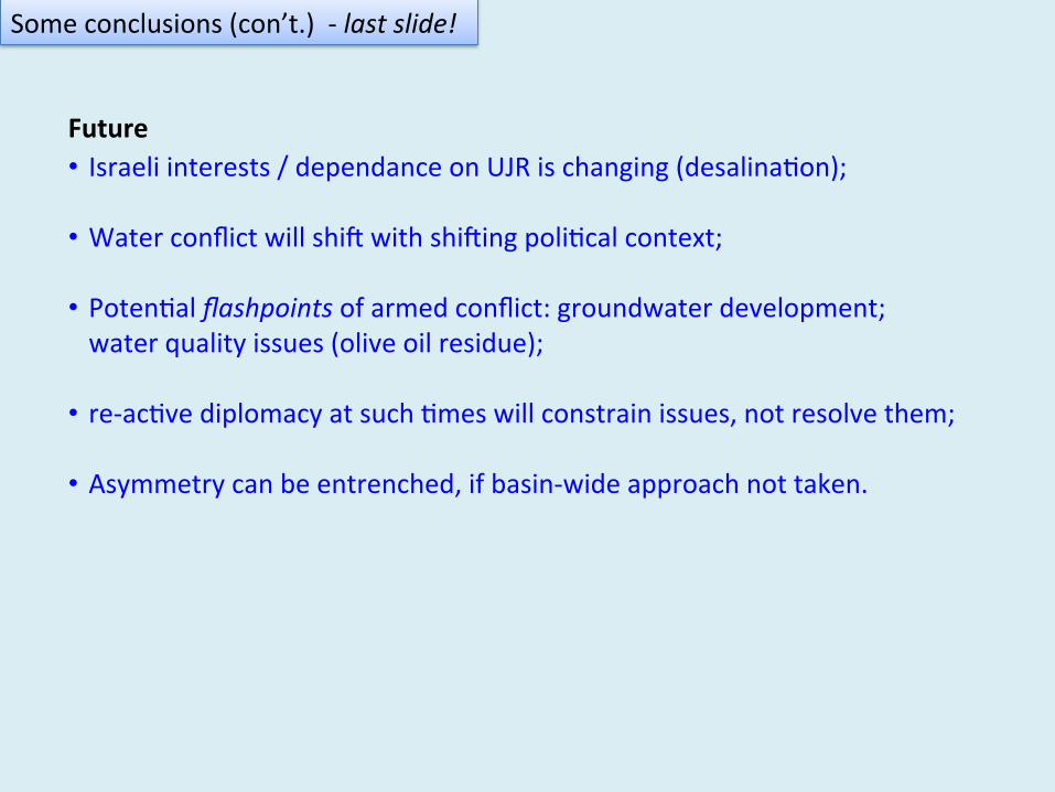
• Israeli interests / dependance on UJR is changing (desalina2on);
• Water conflict will shiv with shiving poli2cal context;
• Poten2al flashpoints of armed conflict: groundwater development; water quality issues (olive oil residue);
• re-‐ac2ve diplomacy at such 2mes will constrain issues, not resolve them;
• Asymmetry can be entrenched, if basin-‐wide approach not taken.
Some conclusions (con’t.) -‐ last slide!
Future
Mark Zeitoun, Karim Eid-‐Sabbagh, Muna Dajani, and Michael Talhami
Thank-‐you !
For more analysis and references: download the Upper Jordan River Hydropoli2cal Baseline from the Publica2ons page of the UEA Water Security Research Centre: www.uea.ac.uk/watersecurity/publica2ons
References Amery, Hussein (2000). A Popular Theory of Water Diversion from Lebanon: Toward Public Par2cipa2on for Peace.
Water in the Middle East: A Geography of Peace. Wolf, A. and H. Amery. Aus2n, USA, University of Texas Press. Brielmann, Heike (2008). Recharge and discharge mechanism and dynamics in the mountainous northern Upper
Jordan River Catcment, Israel, LMU Muenchen: Faculty of Goesciences. FNA (1921). ETUDE GENERALE DE LA FRONTIERE PROBABLE vers METELLI et du pays au N. et au SUD, immédiatement
des deux côtés de (la) fron+ère. De l'Inspecteur des Travaux Publics de l'Etate du Grand Liban. French Na2onal Archives in Nantes, Archives des postes diploma2ques, consulaires, culturels et de coopera2on: Caisse 450; Fonds -‐ "Beyrouth"/2e versement; Serie -‐ Service Techniques "Hydraulique"; Sujet -‐ U2lisa2on de la rivière Yarmouk et du bassin supérieur du Jourdain Sta2on de jaugeage de Wadi-‐Khaled, 1921 -‐ 1942.
HSI (1977). Hydrological Yearbook 1949 -‐ 1977. (Hebrew), Jerusalem, Hydrological Service of Israel. HSI (2004). Hydrological Yearbook 1959 -‐ 2004. (Hebrew), Jerusalem, Hydrological Service of Israel. Klein, Michael (1998). "Water Balance of the Upper Jordan River Basin." Water Interna+onal 23(4): 244 -‐ 248. Lukes, Steven (2005 [1974]). Power: A Radical View -‐ 2nd edi2on. Hampshire, UK, Palgrave MacMillan. MacGregor, John (2002 [1870]). The Rob Roy on the Jordan -‐ The extraordinary 19th Century tale of the first canoeist
to explore the Middle East and Africa. London, UK, republished by The Long Riders' Guild Press, 2002. Also published by Harper&Brothers, Publishers, New York in 1870, under the 2tle: The Rob Roy on the Jordan, Nile, Red Sea, and Gennesareth, &c: A Canoe Cruise in Pales2ne and Egypt, and the Waters of Damascus.
Sedan, Gil (2002). U.S., Israel seek to defuse tense Lebanese water plan. J Weekly.com, Jewish Telegraphic Agency. SLWE (2006). Damages to the Water Sector in the South of Lebanon from the 2006 War. Saida, South Lebanon Water
Establishment. Tignino, Mara (2010). "Water, interna2onal peace, and security." Interna+onal Review of the Red Cross -‐
Humanitarian debate: law, policy, ac+on 92(September 2010). Zeitoun, Mark (2007). Viola2ons, Opportuni2es and Power along the Jordan River: Security Studies Theory Applied
to Water Conflict. Water Resources in the Middle East: Israeli-‐Pales+nian Water Issues -‐ From Conflict to Coopera+on. Shuval, H. and H. Dweik. Heidelberg, Germany, Springer Verlag. 213 -‐ 224.
Zeitoun, Mark, Karim Eid-‐Sabbagh, Muna Dajani and Michael Talhami (2012). Hydro-‐poli+cal Baseline of the Upper Jordan River. Beirut, Associa2on of the Friends of Ibrahim Abd el Al.


![[MOH Jordan] Jordan Public Health Surveillance](https://img.pdfslide.net/doc/110x75/586a119d1a28ab677d8bb3dc/moh-jordan-jordan-public-health-surveillance.jpg)