Embed Size (px)
Citation preview

1 GIM - INSPIRE data harmonisation and tools - welcome, 15-06-2016, Caroline Heylen
GeoTrends Seminar INSPIRE data harmonisation: methodology and tools

2
Agenda
GIM - INSPIRE data harmonisation and tools - welcome, 15-06-2016, Caroline Heylen
09:00 Registration and coffee
09:30 Welcome
09:40 INSPIRE data harmonisation: the legal obligation and beyond
10:00 Methodology and tools for ensuring interoperability of spatial datasets and services (part 1)
10:45 Break
11:00 Demo: data harmonisation in practice
11:30 Methodology and tools for ensuring interoperability of spatial datasets and services (part 2)
12:00 Lunch
13:00 End

3 GIM - INSPIRE data harmonisation and tools - welcome, 15-06-2016, Caroline Heylen
▶ INSPIRE data harmonisatie & tools
Wed 15 June 2016
▶ Grip op GRB
Fri 24 June 2016
▶ Environmental mapping: drones, aerial or satellite
images?
Tue 28 June 2016
▶ OGC trends & standards
Fri 7 October 2016

4
GIM in numbers
▶ 2 sites (Leuven and Gembloux)
▶ 20 years of experience in offering smart geo insights
▶ 50 highly-motivated and skilled GIS experts
▶ More than 750 business and government customers
▶ ISO 9001:2008 certified
GIM - INSPIRE data harmonisation and tools - welcome, 15-06-2016, Caroline Heylen

5
4 centers of competence
Geomarketing
& Location
Intelligence
GIS &
Automated
Data
Processing
GIS Application
Development
Earth
Observation
GIM - INSPIRE data harmonisation and tools - welcome, 15-06-2016, Caroline Heylen
6
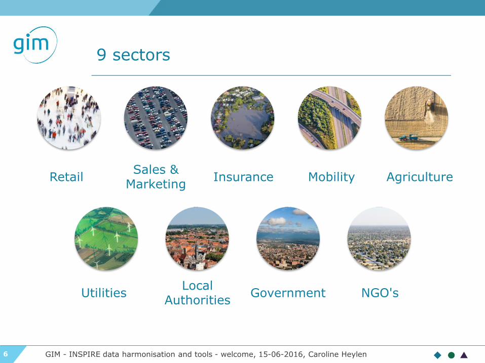
9 sectors
Retail
Government Local
Authorities
Agriculture Sales &
Marketing Mobility Insurance
Utilities NGO's
GIM - INSPIRE data harmonisation and tools - welcome, 15-06-2016, Caroline Heylen
7
INSPIRE : legislation
GeoTrends seminar INSPIRE - Legislation, 15-06-2016, An Heirman
GeoTrends Seminar INSPIRE data
harmonisation and tools

8
INSPIRE Directive - What is it?
GeoTrends seminar INSPIRE - Legislation, 15-06-2016, An Heirman
Infrastructure for Spatial Information in Europe
▶ What? INSPIRE Directive (2007) transposed at the
national and regional levels in Belgium
▶ Who? Public authorities
▶ Aim? Better facilitate public access to spatial data related
to the environment across Europe
▶ Which data? Spatial data which can be used in
environmental studies/policies

9
INSPIRE Directive - What is it?
GeoTrends seminar INSPIRE - Legislation, 15-06-2016, An Heirman
INSPIRE is based on a number of common principles:
▶ Data should be collected only once and kept where it can be
maintained most effectively.
▶ It should be possible to combine seamless spatial information
from different sources across Europe and share it with many
users and applications.
▶ It should be possible for information collected at one
level/scale to be shared with all levels/scales; detailed for
thorough investigations, general for strategic purposes.
▶ Geographic information needed for good governance at all
levels should be readily and transparently available.
▶ Easy to find what geographic information is available, how it
can be used to meet a particular need, and under which
conditions it can be acquired and used.

10
INSPIRE in 3 words
Collect
Harmonization
Share

11
INSPIRE Directive
GeoTrends seminar INSPIRE - Legislation, 15-06-2016, An Heirman
http://inspire.ec.europa.eu/

12
INSPIRE Directive - Data themes
GeoTrends seminar INSPIRE - Legislation, 15-06-2016, An Heirman

13 GeoTrends seminar INSPIRE - Legislation, 15-06-2016, An Heirman

14
INSPIRE - Technical Architecture & IR
GeoTrends seminar INSPIRE - Legislation, 15-06-2016, An Heirman
harmonised
spatial data set
spatial data set
metadata
spatial service
metadata
view service
download service
transformation service
invoke service service
discovery service
service bus
geoportals and applications
data
la
yer
servic
e
layer
ap
plicati
on
la
yer
e-commerce service
IR metadata IR Data specifications
IR Network services
IR Data and service sharing
IR Monitoring and reporting

15
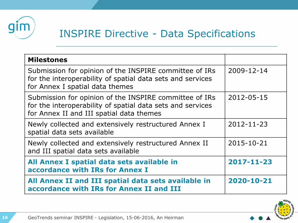
INSPIRE Directive - Data Specifications
GeoTrends seminar INSPIRE - Legislation, 15-06-2016, An Heirman
For each of the 34 INSPIRE
themes
16
INSPIRE Directive - Data Specifications
GeoTrends seminar INSPIRE - Legislation, 15-06-2016, An Heirman
Milestones
Submission for opinion of the INSPIRE committee of IRs for the interoperability of spatial data sets and services for Annex I spatial data themes
2009-12-14
Submission for opinion of the INSPIRE committee of IRs for the interoperability of spatial data sets and services for Annex II and III spatial data themes
2012-05-15
Newly collected and extensively restructured Annex I spatial data sets available
2012-11-23
Newly collected and extensively restructured Annex II and III spatial data sets available
2015-10-21
All Annex I spatial data sets available in accordance with IRs for Annex I
2017-11-23
All Annex II and III spatial data sets available in accordance with IRs for Annex II and III
2020-10-21

17
Transposition into Belgian legislation
GeoTrends seminar INSPIRE - Legislation, 15-06-2016, An Heirman
INSPIRE directive
GDI-decreet
Décret Géomatique Wallon
Ordonnance Bruxelloise
BELG
IU
M

18
INSPIRE: Methodology and tools for ensuring interoperability of spatial datasets and services Part I
GeoTrends seminar INSPIRE - Methodology, 15-06-2016, Stijn Goedertier, Steven Smolders
GeoTrends seminar, Leuven, 15 June 2016

19
What clients ask us…
GeoTrends seminar INSPIRE - Methodology, 15-06-2016, Stijn Goedertier, Steven Smolders
Which steps do I need to take today
to make sure I meet the 2017
deadline?
How can I best convert my data?
How can I make an interoperable
download service?
Can I use open-source software
tools?
How can I ensure benefits?

20
Client case: INSPIRE RoadMap for ACT
GeoTrends seminar INSPIRE - Methodology, 15-06-2016, Stijn Goedertier, Steven Smolders
•Status Data
•Status Technology
AS-IS
•Identify the solutions
•Comparisons
SWOT analysis •Plan
•Tasks
•Budget
RoadMap
•Validation SWOT
•Alignement with INSPIRE deadlines and specs
POC •Collect
•Harmonization
•Share
Implementation
ACT= Administration du Cadastre et de la topography of Luxembourg

21
Implementing INSPIRE: a methodology
GeoTrends seminar INSPIRE - Methodology, 15-06-2016, Stijn Goedertier, Steven Smolders
Identify datasets and services in scope
Study theme, local administrations, third
parties, etc.
Sort out third party intellectual property
Make datasets and services available for
use
Determine conditions for access and use
Provide dataset and services
Provide description metadata and
discovery service
Create, maintain, and validate metadata
Register in INSPIRE Geoportal
Test conformance of metadata
Provide interoperable datasets
Define mappings to INSPIRE data specifications
Implement transformations
Test conformance of datasets
Provide interoperable download service
Implement service (ATOM/OpenSearch or
WFS)
Create, maintain, and validate service
metadata
Test conformance of download service
Provide interoperable view service
Implement view service (WMS)
Create, maintain, and validate service
metadata
Test conformance of view service
Monitoring and reporting
Collect annual usage statistics
Contribute information
Simplified overview:

22
Define mappings to INSPIRE data specifications
GeoTrends seminar INSPIRE - Methodology, 15-06-2016, Stijn Goedertier, Steven Smolders
▶ Understand the source data and target data
▶ Frequencies
▶ Definitions
▶ Relationships
▶ Lifecycle
▶ Code lists and definitions
▶ Map source and target schema
▶ Define transformation rules
▶ Ensure persistence of identifiers and adherence to
life-cycle rules
Define mappings to INSPIRE data specifications

23
Understand the source data
GeoTrends seminar INSPIRE - Methodology, 15-06-2016, Stijn Goedertier, Steven Smolders
Define mappings to INSPIRE data specifications
▶ Use FME Data Inspector to explore the data
▶ Use FME Desktop to query attribute values (e.g.
filter, attribute exploder, StatisticsCalculator, etc.)
and create reports (e.g. HTMLReporter)

24
Data profiling with Talend
GeoTrends seminar INSPIRE - Methodology, 15-06-2016, Stijn Goedertier, Steven Smolders
Define mappings to INSPIRE data specifications
▶ Use Talend Open Study for Data Quality to create
data quality analysis reports (missing attribute
values, attribute value frequencies, referential
integrity, etc.)

25
Understand the INSPIRE data specifications…
GeoTrends seminar INSPIRE - Methodology, 15-06-2016, Stijn Goedertier, Steven Smolders
Define mappings to INSPIRE data specifications

26
… available via the INSPIRE website
GeoTrends seminar INSPIRE - Methodology, 15-06-2016, Stijn Goedertier, Steven Smolders
http://inspire.ec.europa.eu > Data Specifications
Define mappings to INSPIRE data specifications

27
The INSPIRE data specifications share a common template…
GeoTrends seminar INSPIRE - Methodology, 15-06-2016, Stijn Goedertier, Steven Smolders
Define mappings to INSPIRE data specifications
Foreword 7.2 Minimum DQ requirements and recommendations
General Executive Summary 7.3 Recommendation on data quality
Theme-specific Executive Summary 8. Metadata
1. Scope 8.1 Additional requirements and recommendations for MD elements defined in the MD Regulation
2. Overview (incl. 2.2 informal description) 8.2 MD Elements for interoperability
3. Specification scopes 8.3 Recommended theme-specific MD elements
4. Identification information 9. Delivery (incl. Encodings)
5. Data content and structure 10. Data Capture
5.2 Basic notions 11. Portrayal (incl. layers, styles)
5.3 – 5.x Application schemas (incl. UML diagrams and feature catalogues)
6. Reference Systems Annex A: Abstract Test Suite
7. Data Quality Annex B: Use cases
7.1 DQ Elements Annex C: Code list values
(greyed sections are common)

28
The INSPIRE data specifications have a hierarchy of requirements…
GeoTrends seminar INSPIRE - Methodology, 15-06-2016, Stijn Goedertier, Steven Smolders
Define mappings to INSPIRE data specifications
(greyed requirements are common)

29
The INSPIRE data specifications are expressed as a UML data model
GeoTrends seminar INSPIRE - Methodology, 15-06-2016, Stijn Goedertier, Steven Smolders
Define mappings to INSPIRE data specifications
class Administrativ eUnit
«featureType»
Administrativ eUnit
+ country: CountryCode
+ geometry: GM_MultiSurface
+ inspireId: Identifier
+ name: GeographicalName [1..*]
+ nationalCode: CharacterString
+ nationalLevel: AdministrativeHierarchyLevel
«voidable, l ifeCycleInfo»
+ beginLifespanVersion: DateTime
+ endLifespanVersion: DateTime [0..1]
«voidable»
+ nationalLevelName: LocalisedCharacterString [1..*]
+ residenceOfAuthority: ResidenceOfAuthority [1..*]
constraints
{CondominiumsAtCountryLevel}
{AdmininstrativeUnitHighestLevel}
{AdministrativeUnitLowestLevel}
«codeList»
Administrativ eHierarchyLev el
+ 1stOrder
+ 2ndOrder
+ 3rdOrder
+ 4thOrder
+ 5thOrder
+ 6thOrder
«dataType»
Geographical Names::GeographicalName
+ spelling: SpellingOfName [1..*]
«voidable»
+ grammaticalGender: GrammaticalGenderValue [0..1]
+ grammaticalNumber: GrammaticalNumberValue [0..1]
+ language: CharacterString
+ nameStatus: NameStatusValue
+ nativeness: NativenessValue
+ pronunciation: PronunciationOfName
+ sourceOfName: CharacterString
«dataType»
ResidenceOfAuthority
+ name: GeographicalName
«voidable»
+ geometry: GM_Point
+lowerLevelUnit
«voidable» 0..*
+upperLevelUnit
«voidable» 0..1
+/administeredBy
«voidable» 0..*
+coAdminister
«voidable» 0..*
http://inspire.ec.europa.eu/data-model/approved/r4618-ir/html

30
The INSPIRE data specifications are expressed as XML Schema (XSD)
GeoTrends seminar INSPIRE - Methodology, 15-06-2016, Stijn Goedertier, Steven Smolders
Define mappings to INSPIRE data specifications

31
An XML instance (snippet - draft)
GeoTrends seminar INSPIRE - Methodology, 15-06-2016, Stijn Goedertier, Steven Smolders
<gml:FeatureCollection
xmlns:au="http://inspire.ec.europa.eu/schemas/au/4.0" ...
xmlns:gml="http://www.opengis.net/gml/3.2"
xmlns:gn="http://inspire.ec.europa.eu/schemas/gn/4.0">
<gml:featureMember>
<au:AdministrativeUnit gml:id="_f652adbf-056c-4ba6-b34d-
57ae8917b462">
<gml:name>Herentals</gml:name>
<au:geometry>
<gml:MultiSurface gml:id="_0f05dd9c-757e-4599-bf4c-6f242280491a"
srsName="urn:ogc:def:crs:EPSG::4258" srsDimension="2">
<gml:surfaceMember>
<gml:Polygon gml:id="_231d2df3-ebc4-487f-bb23-9dc0751c49f6">
<gml:exterior>
<gml:LinearRing>
<gml:posList>...</gml:posList>
</gml:LinearRing>
</gml:exterior>
</gml:Polygon>
</gml:surfaceMember>
</gml:MultiSurface>
</au:geometry>
<au:nationalCode>1982001920</au:nationalCode>
<au:inspireId>
<base:Identifier>
<base:localId>13011</base:localId>
<base:namespace>BE.STATBEL</base:namespace>
</base:Identifier>
</au:inspireId>
<au:nationalLevel
xlink:href="http://inspire.ec.europa.eu/codelist/AdministrativeHierarchyL
evel/6thOrder"></au:nationalLevel>
<au:nationalLevelName>
<gmd:LocalisedCharacterString>gemeente</gmd:LocalisedCharacterString>
</au:nationalLevelName>
<au:country>
<gmd:Country
codeList="http://inspire.ec.europa.eu/codelist/CountryCode"
codeListValue="BE">BE</gmd:Country>
</au:country>
<au:name>
<gn:GeographicalName>
<gn:language>dut</gn:language>
...
<gn:spelling>
<gn:SpellingOfName>
<gn:text>Herentals</gn:text>
<gn:script xsi:nil="true"/>
</gn:SpellingOfName>
</gn:spelling>
</gn:GeographicalName>
</au:name>
...
</au:AdministrativeUnit>
</gml:featureMember>
Define mappings to INSPIRE data specifications

32
Tool: Interactive Data Specifications
GeoTrends seminar INSPIRE - Methodology, 15-06-2016, Stijn Goedertier, Steven Smolders
http://inspire-regadmin.jrc.ec.europa.eu/dataspecification/
Define mappings to INSPIRE data specifications
33
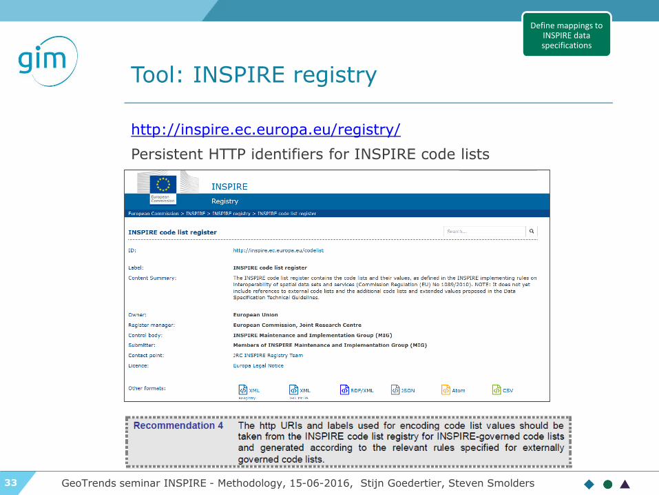
Tool: INSPIRE registry
GeoTrends seminar INSPIRE - Methodology, 15-06-2016, Stijn Goedertier, Steven Smolders
http://inspire.ec.europa.eu/registry/
Persistent HTTP identifiers for INSPIRE code lists
Define mappings to INSPIRE data specifications

34
Map source and target schema
GeoTrends seminar INSPIRE - Methodology, 15-06-2016, Stijn Goedertier, Steven Smolders
▶ Map feature types
▶ Map attributes
▶ Map attribute values
Define mappings to INSPIRE data specifications

35
Define transformations
GeoTrends seminar INSPIRE - Methodology, 15-06-2016, Stijn Goedertier, Steven Smolders
▶ Join up datasets
▶ Filter by attribute values and feature types
▶ Attribute value transformations
▶ Geometry: coordinate transformation, edge
matching, etc.
▶ Geocoding
Define mappings to INSPIRE data specifications

36
Define coordinate transformations
GeoTrends seminar INSPIRE - Methodology, 15-06-2016, Stijn Goedertier, Steven Smolders
Define mappings to INSPIRE data specifications
Reference system:
ETRS89
Map projection:
2D geodetic in ETRS89 on GRS80
ETRS89 Lambert Azimuthal Equal Area (ETRS-LAEA)
ETRS89 Lambert Conformal Conic (ETRS-LCC)
ETRS Transverse Mercator (ETRS-TMxx)
Ellipsoid:
GRS80

37
Ensure persistence of identifiers and adhere to life-cycle rules
GeoTrends seminar INSPIRE - Methodology, 15-06-2016, Stijn Goedertier, Steven Smolders
Define mappings to INSPIRE data specifications

38
Ensure persistence of identifiers and adhere to life-cycle rules
GeoTrends seminar INSPIRE - Methodology, 15-06-2016, Stijn Goedertier, Steven Smolders
▶ INSPIRE Identifier (inspireID): exactly 1
▶ localId: external identifier
▶ namespace: unique ID of data
source
▶ versionID: id of version (2007-02-
12T12:12:12+05:30)
▶ Thematic identifier: 0, 1 or more used for data
linking
▶ Which namespace to use?
▶ Namespace register?
▶ GCM Annex H on HTTP URIs
class Base Types
«dataType»
Identifier
+ localId: CharacterString
+ namespace: CharacterString
«lifeCycleInfo, voidable»
+ versionId: CharacterString [0..1]
class Base Types
«dataType»
Base Types 2::ThematicIdentifier
+ identifier: CharacterString
+ identifierScheme: CharacterString
Define mappings to INSPIRE data specifications

39
Ensure persistence of identifiers and adhere to life-cycle rules
GeoTrends seminar INSPIRE - Methodology, 15-06-2016, Stijn Goedertier, Steven Smolders
Life-cycle: From start to end of spatial object
▶ Version-cycle: Part of spatial object’s life-cycle
Validity: real-world phenomenon.
Example:
▶ t1 = building is built
▶ t3 = building is demolished
▶ t2 = building function changed (office -> residential)
class Base Types
«featureType»
CadastralParcels::CadastralParcel
+ geometry: GM_Object
+ inspireId: Identifier
+ label: CharacterString
+ nationalCadastralReference: CharacterString
«voidable»
+ areaValue: Area [0..1]
+ referencePoint: GM_Point [0..1]
+ validFrom: DateTime [0..1]
+ validTo: DateTime [0..1]
«lifeCycleInfo, voidable»
+ beginLifespanVersion: DateTime
+ endLifespanVersion: DateTime [0..1]
A
Define mappings to INSPIRE data specifications

40
Implement transformations
GeoTrends seminar INSPIRE - Methodology, 15-06-2016, Stijn Goedertier, Steven Smolders
▶ Consider type of download service
▶ Pre-defined dataset download service: offline
transformation
▶ Direct access download service: “online”
transformation
▶ Choose ETL tool
▶ Implement transformation
▶ Generate data or deploy transformation
Implement transformations

41
Tool: HUMBOLDT Alignment Editor (HALE)
GeoTrends seminar INSPIRE - Methodology, 15-06-2016, Stijn Goedertier, Steven Smolders
• Input: common file formats: Shape, PostgreSQL, etc.
• Transformations: schema transformations and coordinate transformations (or
complex transformations with Groovy scripting)
• Output: INSPIRE GML and/or GeoServer App-Schema mapping file (restricted)
Implement transformations

42
Tool: Safe Software FME
GeoTrends seminar INSPIRE - Methodology, 15-06-2016, Stijn Goedertier, Steven Smolders
• Input: hundreds of formats supported
• Data profiling: FME inspector, StatisticsCalculator, HTMLREporter, etc.
• Transformations: various transformers for data assembly, attribute filtering,
renaming, attribute value transformations, coordinate system transformations,
etc. Use of SchemaMapper transformer allows reading Excel / CSV mapping
tables.
• Output: As of FME Desktop 2014, FME includes the INSPIRE GML Writer,
which supports the creation of INSPIRE GML for all 34 data themes
• Validation with XMLValidator, AttributeValidator, etc.
Implement transformations
43
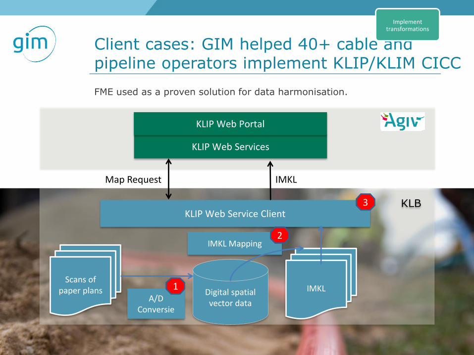
Client cases: GIM helped 40+ cable and pipeline operators implement KLIP/KLIM CICC
GeoTrends seminar INSPIRE - Methodology, 15-06-2016, Stijn Goedertier, Steven Smolders
Digital spatial vector data
A/D Conversie
KLIP Web Service Client
KLIP Web Services
KLIP Web Portal
KLB
Map Request IMKL
Scans of paper plans
IMKL Mapping
1
2
3
IMKL
Implement transformations
FME used as a proven solution for data harmonisation.

44
Tool: Con terra INSPIRE solution pack for FME
GeoTrends seminar INSPIRE - Methodology, 15-06-2016, Stijn Goedertier, Steven Smolders
• Input: hundreds of formats supported (Safe Software FME).
• Transformation: Support for various implementation methods (Esri
INSPIRE Geodatabase, INSPIRE GML). Integration of INSPIRE UML
diagrams into GML workspace templates
• Output: ESRI INSPIRE Geodatabase, INSPIRE GML
• Services: Automatic generation of Atom Feeds
Implement transformations

45
Test conformance of datasets
GeoTrends seminar INSPIRE - Methodology, 15-06-2016, Stijn Goedertier, Steven Smolders
▶ Concepts based on ISO19105 conformance testing
standard
▶ Abstract Tests Suites (ATSs)
▶ Set of test cases corresponding to requirements in the technical guidance
specifications
▶ Validated by MIG-T, MIWP-5: see GitHub inspire-eu-validation
▶ Executable Test Suites (ETSs):
▶ Set of executable test cases
▶ Available ETSs
• OGC CITE (focus on GML certification)
• JRC INSPIRE Validator (focus on metadata only for the moment)
• eENVplus Validation Services: verifies the conformance of GML datasets with
respect to INSPIRE application schemas and also with respect to ISO 19136:2007
(GML 3.2.1)
More and authoritative test tools are needed.
Test conformance of datasets

46
INSPIRE: Methodology and tools for ensuring interoperability of spatial datasets and services Part II
GeoTrends seminar INSPIRE - Methodology, 15-06-2016, Stijn Goedertier, Steven Smolders
GeoTrends seminar, Leuven, 15 June 2016

47
Implementing INSPIRE: a methodology
GeoTrends seminar INSPIRE - Methodology, 15-06-2016, Stijn Goedertier, Steven Smolders
Identify datasets and services in scope
Study theme, local administrations, third
parties, etc.
Sort out third party intellectual property
Make datasets and services available for
use
Determine conditions for access and use
Provide dataset and services
Provide description metadata and
discovery service
Create, maintain, and validate metadata
Register in INSPIRE Geoportal
Test conformance of metadata
Provide interoperable datasets
Define mappings to INSPIRE data specifications
Implement transformations
Test conformance of datasets
Provide interoperable download service
Implement service (ATOM/OpenSearch or
WFS)
Create, maintain, and validate service
metadata
Test conformance of download service
Provide interoperable view service
Implement view service (WMS)
Create, maintain, and validate service
metadata
Test conformance of view service
Monitoring and reporting
Collect annual usage statistics
Contribute information
Simplified overview:

48
Two types of download services
• Predefined dataset download services: allow the
download of datasets or predefined parts of datasets in
their entirety. (Minimum requirement)
▶ ATOM / OpenSearch
▶ WFS 2.0 with stored queries
▶ Hybrid implementation (e.g. WFS 1.1.0 with ATOM)
• Direct access download services: services that allow
the user to specify which parts of a dataset need to be
downloaded by specifying queries. (Should be
implemented where practicable)
▶ WFS 2.0
GeoTrends seminar INSPIRE - Methodology, 15-06-2016, Stijn Goedertier, Steven Smolders
Implement download service
(ATOM/OpenSearch or WFS)

49
ATOM / OpenSearch
GeoTrends seminar INSPIRE - Methodology, 15-06-2016, Stijn Goedertier, Steven Smolders
ATOM Feed:
• Open Standard for Web Feeds
• Successor of RSS
Implement download service
(ATOM/OpenSearch or WFS)

50
ATOM /OpenSearch
GeoTrends seminar INSPIRE - Methodology, 15-06-2016, Stijn Goedertier, Steven Smolders
Open Search:
• Open standard
• Allows to search multiple Web sites /search engines
Implement download service
(ATOM/OpenSearch or WFS)

51
ATOM / OpenSearch
GeoTrends seminar INSPIRE - Methodology, 15-06-2016, Stijn Goedertier, Steven Smolders
Implement download service
(ATOM/OpenSearch or WFS)

52
Case study: ATOM /OpenSearch download services for Brussels Capital Region
GeoTrends seminar INSPIRE - Methodology, 15-06-2016, Stijn Goedertier, Steven Smolders
Approach: use the ISO19115/19119/ISO19139
metadata as the starting point and generate the ATOM
feeds and the OpenSearch descriptions automatically.
Implementation: GeoNetwork was enhanced to
• Implement the transformation from ISO XXXX to
ATOM
• Implement the OpenSearch protocol (for search and
download)
Conformance testing: Implementation was tested
with the GDI-DI test suite.
Implement download service
(ATOM/OpenSearch or WFS)

53
Case study: ATOM download services for Brussels Capital Region
GeoTrends seminar INSPIRE - Methodology, 15-06-2016, Stijn Goedertier, Steven Smolders
On the basis of these ISO19139 metadatarecords, GeoNetwork
will expose the following service endpoints together
constituting a complete INSPIRE ATOM feed/OpenSearch
implementation:
▶ Top level service feed on the basis of the
service metadata record
▶ Dataset level feed on the basis of the
dataset metadata record
▶ OpenSearch description document on the
basis of the service metadata record
▶ OpenSearch describedBy operation on the
basis of the dataset level Atom feed
▶ OpenSearch download operation giving
direct access to the downloadable file
Implement download service
(ATOM/OpenSearch or WFS)

54
Web Feature Service (WFS)
GeoTrends seminar INSPIRE - Methodology, 15-06-2016, Stijn Goedertier, Steven Smolders
• Predefined dataset download service: WFS 2.0
with stored queries
• GetCapabilities: get information about the
feature types and services supported by the WFS.
• GetFeature operation with specification of a a
“storedQuery” that allows querying on datasetId,
CRS (and language)
http://www.myinspirewfs.gim.be/request=GetFeatur
e&storedquery_id=urnx:wfs:StoredQueryId:gim:Get
DataSetByIDandCRS&DataSetID=waternetwork_abc
&CRS=EPSG:4326
Implement download service
(ATOM/OpenSearch or WFS)

55
Web Feature Service (WFS)
GeoTrends seminar INSPIRE - Methodology, 15-06-2016, Stijn Goedertier, Steven Smolders
• Direct-access download service: WFS 2.0
• GetCapabilities: get information about the
feature types and services supported by the WFS.
• DescribeFeatureType: get information about
the attribute types (columns) of a feature type.
• GetFeature: return data as the result of a given
“ad-hoc” query.
Implement download service
(ATOM/OpenSearch or WFS)
http://www.myinspirewfs.gim.be/geoserver/wfs?service=wfs&
version=2.0.0& request=GetFeature&
typeNames=gim:featuretype& srsName=CRS
bbox=a1,b1,a2,b2
56
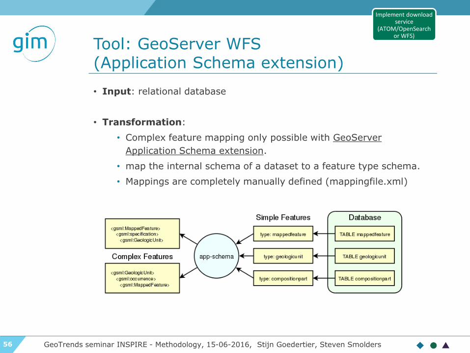
Tool: GeoServer WFS (Application Schema extension)
GeoTrends seminar INSPIRE - Methodology, 15-06-2016, Stijn Goedertier, Steven Smolders
• Input: relational database
• Transformation:
• Complex feature mapping only possible with GeoServer
Application Schema extension.
• map the internal schema of a dataset to a feature type schema.
• Mappings are completely manually defined (mappingfile.xml)
Implement download service
(ATOM/OpenSearch or WFS)

57
Create, maintain, and validate download service metadata
GeoTrends seminar INSPIRE - Methodology, 15-06-2016, Stijn Goedertier, Steven Smolders
Several (non-exclusive) options possible:
▶ ATOM: link to dataset and service metadata record
in Discovery Service (TG requirements 6 and 14)
▶ WFS scenario 1: GetCapabilities is extended with
reference to service metadata in Discovery Service
(TG Requirement 53).
▶ WFS scenario 2: GetCapabilities is extended to
include all metadata elements (TG Requirement
53).
Create, maintain, and validate download service metadata
For WFS Services, Service metadata can be generated automatically on the basis of WFS Capabilities

58
Test conformance of download service
GeoTrends seminar INSPIRE - Methodology, 15-06-2016, Stijn Goedertier, Steven Smolders
▶ Concepts based on ISO19105 conformance testing
standard
▶ Abstract Tests Suites (ATSs)
▶ Set of test cases corresponding to requirements in the technical guidance
specifications
▶ Validated by MIG-T, MIWP-5: see GitHub inspire-eu-validation: ats-
download-atom, ats-download-predefined-wfs, ats-download-
directaccess-wfs, ats-download-QoS
▶ Executable Test Suites (ETSs):
▶ Set of executable test cases
▶ Available ETSs:
• OGC WFS 2.0 Conformance Test Suite
• JRC INSPIRE Validator
• GDI-DE Test Suite (focus on metadata, download, view services)
Test conformance of download service

59
Implementing INSPIRE: a methodology
GeoTrends seminar INSPIRE - Methodology, 15-06-2016, Stijn Goedertier, Steven Smolders
Identify datasets and services in scope
Study theme, local administrations, third
parties, etc.
Sort out third party intellectual property
Make datasets and services available for
use
Determine conditions for access and use
Provide dataset and services
Provide description metadata and
discovery service
Create, maintain, and validate metadata
Register in INSPIRE Geoportal
Test conformance of metadata
Provide interoperable datasets
Define mappings to INSPIRE data specifications
Implement transformations
Test conformance of datasets
Provide interoperable download service
Implement service (ATOM/OpenSearch or
WFS)
Create, maintain, and validate service
metadata
Test conformance of download service
Provide interoperable view service
Implement view service (WMS)
Create, maintain, and validate service
metadata
Test conformance of view service
Monitoring and reporting
Collect annual usage statistics
Contribute information
Simplified overview:

60
Implement View Service
GeoTrends seminar INSPIRE - Methodology, 15-06-2016, Stijn Goedertier, Steven Smolders
▶ Choose implementation option
▶ Web Map Service (WMS 1.3.0): an arbitrary region is
rendered by the server.
▶ Web Map Tile Service (WMTS 1.0.0): pre-rendered tiles
that can be cached.
▶ INSPIRE specifics:
▶ Support European Coordinate reference systems (ETRS89)
▶ PNG and GIF are mandatory
▶ Multilingualism support
▶ Use INSPIRE harmonised layer names
▶ Use INSPIRE styles
▶ …
Implement view service (WMS or
WMTS)

61
Create, maintain, and validate view service metadata
GeoTrends seminar INSPIRE - Methodology, 15-06-2016, Stijn Goedertier, Steven Smolders
Two (non-exclusive)
options:
▶ Scenario 1:
GetCapabilities is
extended with
reference to service
metadata in Discovery
Service.
▶ Scenario 2:
GetCapabilities is
extended to include
all metadata
elements.
Create, maintain, and validate view service
metadata
For WMS Services, Service metadata can be generated automatically on the basis of WMS Capabilities

62
Test conformance of view service
GeoTrends seminar INSPIRE - Methodology, 15-06-2016, Stijn Goedertier, Steven Smolders
▶ Concepts based on ISO19105 conformance testing
standard
▶ Abstract Tests Suites (ATSs)
▶ Set of test cases corresponding to requirements in the technical guidance
specifications
▶ Validated by MIG-T, MIWP-5: see GitHub inspire-eu-validation: ats-view-
wms, ats-view-wmts
▶ Executable Test Suites (ETSs):
▶ Set of executable test cases (test assertions)
▶ Available ETSs:
• OGC WMS 1.3.0 Conformance Test Suite
• JRC INSPIRE Validator
• GDI-DE Test Suite (focus on metadata, download, view services)
Test conformance of view service

63
Conclusion
GeoTrends seminar INSPIRE - Methodology, 15-06-2016, Stijn Goedertier, Steven Smolders
• Ensuring INSPIRE interoperability can be a lot of hard
work due to 6 legal acts and 40+ technical guidelines
• Careful planning and coordination needed - 2017 is
nearby
• Proven methodologies and tools are available to help

64
Contact us
www.gim.be
GIM - INSPIRE data harmonisatie en tools - welcome, 15-06-2016, Caroline Heylen