Embed Size (px)
Citation preview
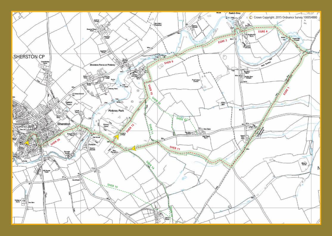
Go towards Malmesbury and turn right by the Rattlebone Inn into Noble Street, beside the triangle and large acer tree. This is known as the Jubilee Tree, as it was planted in 1897 to mark Queen Victoria’s Diamond Jubilee. A short way down the hill turn left up the steps onto SHER26. Follow this through the houses to a metal kissing gate and along a fi eld edge with houses on your left. Continue through the next kissing gate, veer diagonally right across the fi eld, over a stile, then on the same line to another kissing gate in the fi eld corner. Descend the steps to the road and follow it with care downhill to Forlorn Bridge over the River Avon.
Make your way over Forlorn Bridge and immediately left up the hill. When the woodland on the left stops, turn left onto the signed track (SHER12), going past Keeper’s Cottage. Continue on this track, passing through a large iron gate, which once retained Pinkney Park’s herd of deer, and follow the wall round to the left (SHER10). Go through a metal fi eld gate and immediately take the signed, diverted footpath on the right (SHER9).
Stay in the fi eld and follow the path around the two fi eld sides then across two adjacent stiles into a fi eld on your right.
Continue with the hedge on your left across two more stiles (EGRE2). The path then veers right and through a gate before going diagonally across the fi eld towards two large oak trees and a water trough. Bear right following the tree line, cross two stiles (the fi rst with a bridge) and continue alongside pheasant rearing pens then along the right-hand side of a post-and-rail fence. Views of Easton Grey House and parkland lie to your left. A downward slope now takes you to a gate and out onto a road. Turn left over the bridge into the picturesque village of Easton Grey. The bridge is probably 16th century while The Bridge House and collection of smaller buildings are 17th century , including
the original laundry which at one time serviced Easton Grey House.
A short diversion left, up the hill for 500 yards, will bring you to the church, which is well worth a visit. Retrace your steps to rejoin the walk.
Using Noble Street, Sherston 26, 12, 10 & 9,Easton Grey 2, 4 & 1 (the Fosse Way) and Sherston 11.
6 miles - includes a couple of small inclines and some parts. May be muddy.
Easton Grey
4 Turn right up the small lane beside The Bridge House, then left at the footpath sign to EGRE4, between buildings and through a metal gate. Continue across the fi eld to a stile and then through an arable fi eld with
fi ne, open views. Go through a large gap in the hedge and immediately turn right. Follow this rough path with the hedge on your right for 100 yards. At the corner of the fi eld veer right down a steep path. At the bottom a bridge crosses the widened river with ruins of Easton Grey Mill on the left. Proceed straight ahead through a metal gate, then a kissing gate and on along the track, through another metal gate and fi nally cross a stile. This brings you back to the river beside the Fosse Way and is the site of a former Roman settlement. There were once important military and trading posts at this river crossing as it was approximately halfway between the cities of Aquae Sulis (Bath) and Corinium (Cirencester).
Bear right up the hill along the Fosse Way (EGRE1), passing through a metal gate while being wary of possible off-road vehicles.
After 3/4 of a mile go through another metal gate, cross a minor road and continue for 400 yards to join another road (muddy in wet weather). Go left along this road to rejoin the wide, stony track of the Fosse Way where the metalled road sweeps left. Immediately turn right through the gate on a signed path (SHER11) towards the left hand corner of the fi eld. Cross a stile and turn left alongside the hedge to the corner. Go over a stile, across a track and almost immediately go over a second stile. Keep the hedge on your left for 700 yards until you reach the gate onto the road. Now turn left, and after about 500 yards, take the fi rst right, where you soon rejoin the fi rst part of this walk and you can retrace your steps back to the village.
SHER
12
SHER 10
SHER 10
SHER
11
SHER 11
SHER 14
SHER
14
SHER 15
SHER 26
SHER 9
SHER 10
EGRE 2
EGRE 4
EGRE
1
C Crown Copyright. 2015 Ordnance Survey 100054880