Embed Size (px)
Citation preview
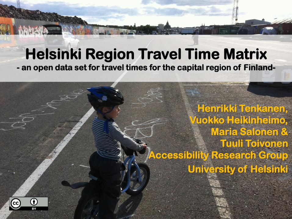
Helsinki Region Travel Time Matrix- an open data set for travel times for the capital region of Finland-
Henrikki Tenkanen,
Vuokko Heikinheimo,
Maria Salonen &
Tuuli Toivonen
Accessibility Research Group
University of Helsinki
• What is Helsinki Region Travel Time Matrix?
• Who can use the Matrix?
• How to cite the data?
• How did we estimate the travel times and
distances?
• Walking
• Public transportation
• Private car
• Why the Matrix was created?
• Related publications
Contents of this presentation:
• Helsinki Region Travel Time Matrix contains travel
time and distance information for routes between
all 250 m x 250 m grid cell centroids (n = 13 231) in
the Capital Region of Helsinki by walking, public
transportation and car.
• The data set has been published so far twice, to
represent the situation
• April 2013
• September 2015
In the Helsinki region.
What is Helsinki Region Travel
Time Matrix (#1)?
• Helsinki Region Travel Time Matrix is a spatial data
set that can be used (for example) to:
• Understand the travel distances and times between
different parts of the city region
• Compare the times and distances with different
modes of transportation
• Understand how the travel times and distances have
changed over time
• There has been an attempt to make measures
comparable across different times and modes of
transportation
What is Helsinki Region Travel
Time Matrix (#2)?
• The matrix can be used by anyone.
• The Matrix and its extracts are licensed under a
Creative Commons Attribution 4.0 International
License. So, when you use the data, you must
cite it.
• The matrix should be used with thought. We do
not take any responsibility for any mistakes, errors or
other deficiencies in the data.
Who can use the Matrix?
• Data/Tools description:
Toivonen, T., M. Salonen, H. Tenkanen, P. Saarsalmi,
T. Jaakkola & J. Järvi (2014). Joukkoliikenteellä,
autolla ja kävellen: Avoin saavutettavuusaineisto
pääkaupunkiseudulla. Terra 126: 3, 127-136.
• DOI name for the 2015 matrix:
Toivonen, T., H. Tenkanen, V. Heikinheimo, T.
Jaakkola, J. Järvi & M. Salonen (2015). Helsinki
Region-Travel Time Matrix 2015. DOI:
10.13140/RG.2.1.1901.3201
How to cite the data?
• We calculated the door-to-door distances and travel
times by walking, public transporation and private
car
• We used the center points of 250 m statistical grid
squares as origins and destinations
• Each transportation mode was calculated separately,
as explained in the the following slides
How did we estimate the travel
times and distances?
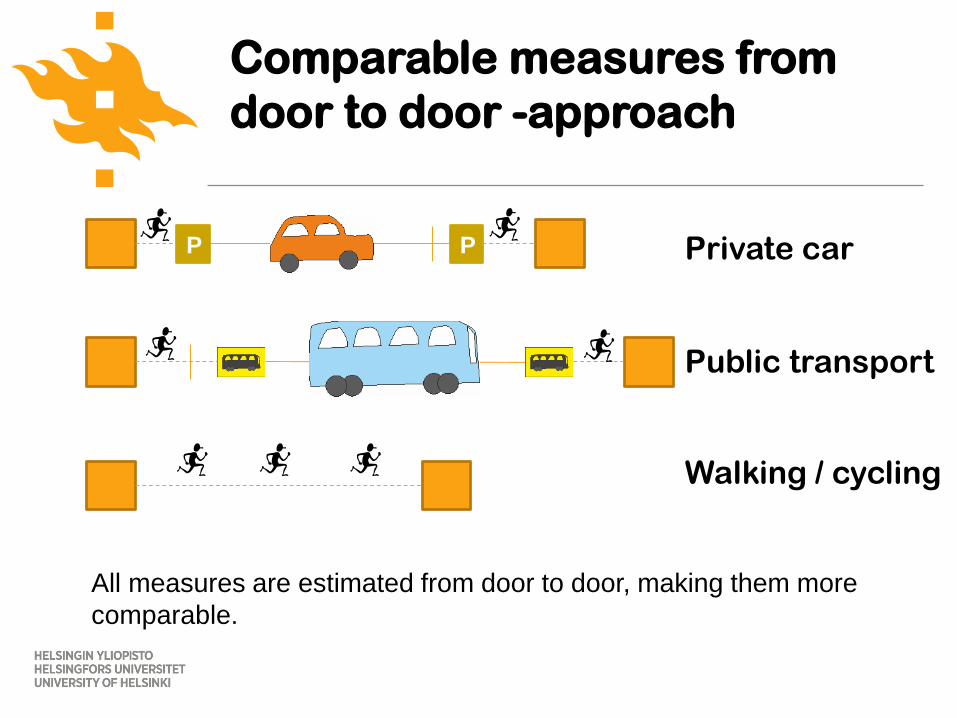
Comparable measures from
door to door -approach
P P Private car
Public transport
Walking / cycling
All measures are estimated from door to door, making them more
comparable.
• Walking
• routes were estimated using the walkable roads in
Open Street Map
• Walking speed was set to 70 m / minute, which is the
standard also in Reittiopas
How did we estimate the times
and distances (walking)?
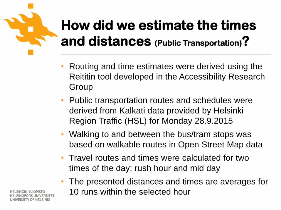
• Routing and time estimates were derived using the
Reititin tool developed in the Accessibility Research
Group
• Public transportation routes and schedules were
derived from Kalkati data provided by Helsinki
Region Traffic (HSL) for Monday 28.9.2015
• Walking to and between the bus/tram stops was
based on walkable routes in Open Street Map data
• Travel routes and times were calculated for two
times of the day: rush hour and mid day
• The presented distances and times are averages for
10 runs within the selected hour
How did we estimate the times
and distances (Public Transportation)?
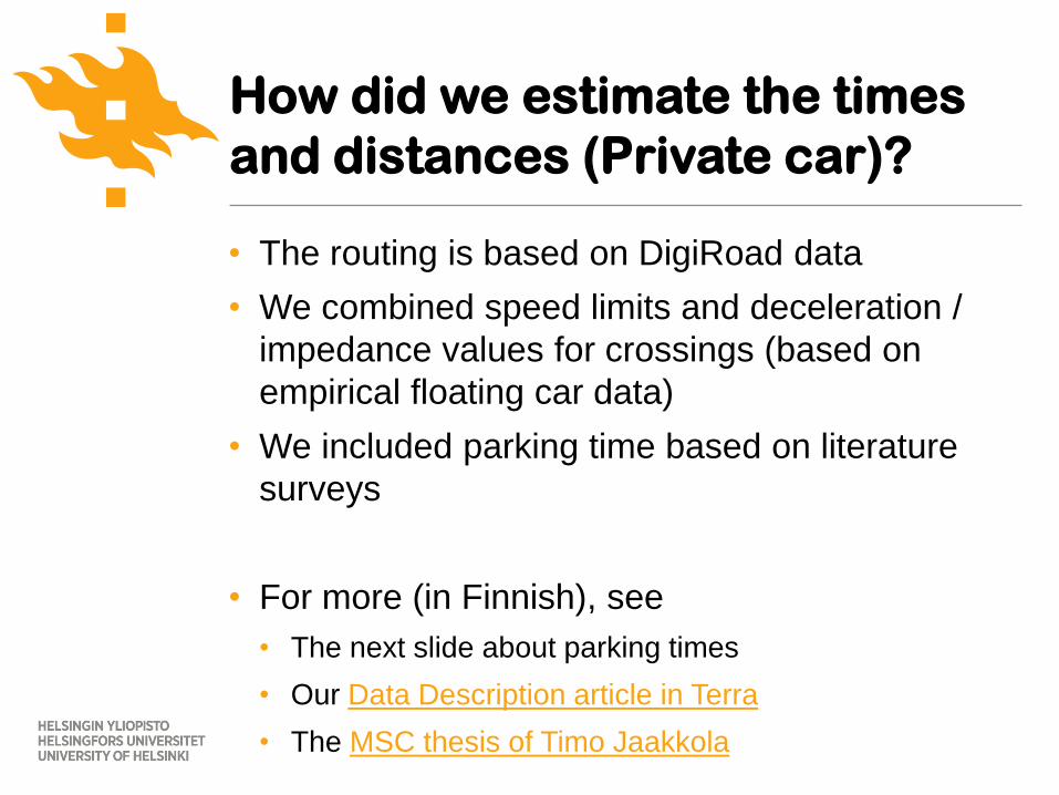
• The routing is based on DigiRoad data
• We combined speed limits and deceleration /
impedance values for crossings (based on
empirical floating car data)
• We included parking time based on literature
surveys
• For more (in Finnish), see
• The next slide about parking times
• Our Data Description article in Terra
• The MSC thesis of Timo Jaakkola
How did we estimate the times
and distances (Private car)?
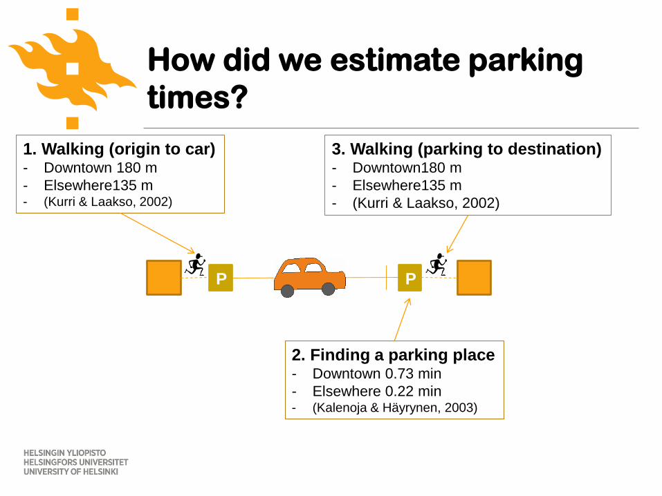
How did we estimate parking
times?
P P
1. Walking (origin to car)- Downtown 180 m
- Elsewhere135 m- (Kurri & Laakso, 2002)
3. Walking (parking to destination)- Downtown180 m
- Elsewhere135 m
- (Kurri & Laakso, 2002)
2. Finding a parking place- Downtown 0.73 min
- Elsewhere 0.22 min- (Kalenoja & Häyrynen, 2003)
• Most travel time –based accessibility measures were
either overly simplistic (travel time by private car
using speed limits) or too complex (travel time
estimates by traffic planning software)
• Accessibility Research Group has developed tools to
calculate robust, transparent and comparable travel
time measures for the Helsinki region
(see http://blogs.helsinki.fi/accessibility/tools/)
• The measures have a direct impact on the
conclusions that can be drawn
(see the next two slides)
Why the Matrix was created #1?
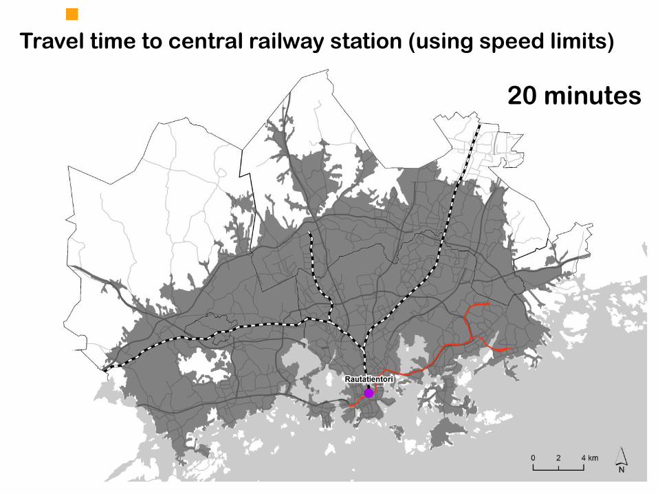
Travel time to central railway station (using speed limits)
20 minutes
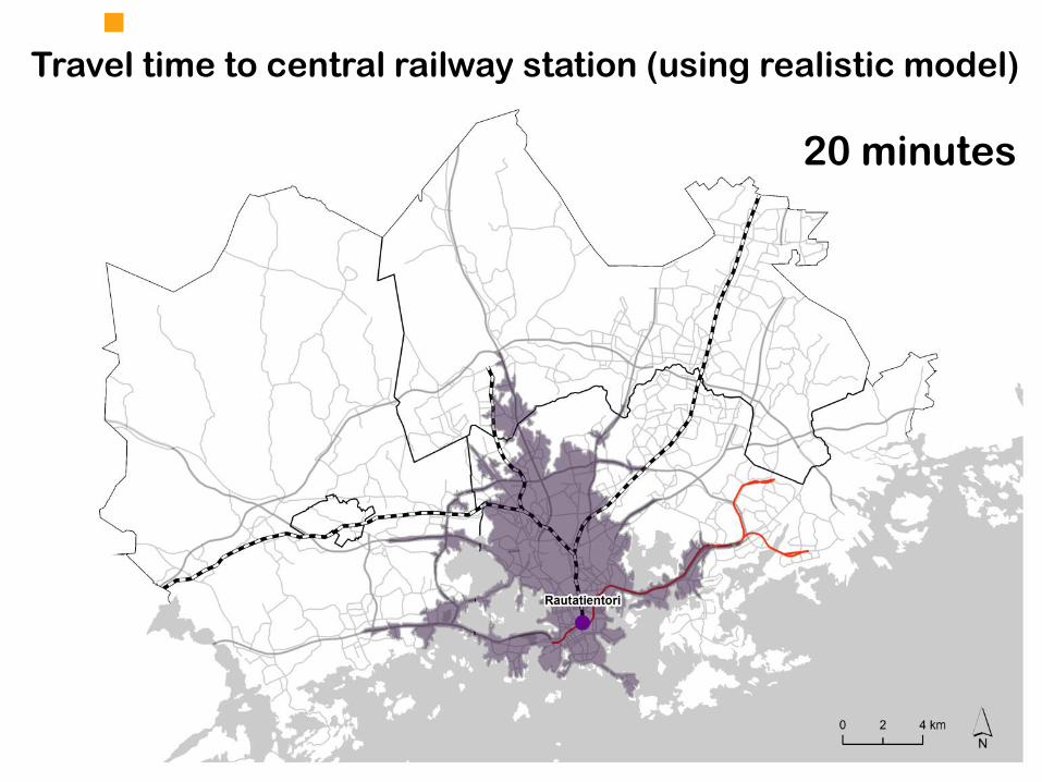
Travel time to central railway station (using realistic model)
20 minutes
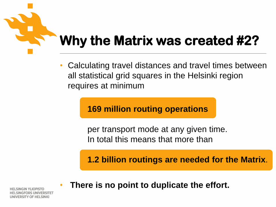
• Calculating travel distances and travel times between
all statistical grid squares in the Helsinki region
requires at minimum
169 million routing operations
per transport mode at any given time.
In total this means that more than
1.2 billion routings are needed for the Matrix.
• There is no point to duplicate the effort.
Why the Matrix was created #2?
We have published several methodological and applied
journal articles using the matrix.
See the updating list of publications at:
http://blogs.helsinki.fi/accessibility/publications/
Related publications by the
Accessibility Research Group