Embed Size (px)
Citation preview

ELSEVIER Geomorphology 1.+ I 19<))! U I -I'+K
GfOMORPHOlOGY
Diversion of the upper Bear River: Glacial diffluence andQuaternary erosion, Sierra Nevada, California
L. Allan James
Reeel \ cd 1.+ AprJ I 199'+: revised In IkcemhlT Il)9.+: aceepteu 6 January 199)
Abstract
Deep canyon erosion and dl\er"'lIl of more than 300 km' of the former upper Bear River is documented with stratigraphicand morphologic evidence. Stratigraphic relationships constrain canyon incision to no older than late Miocene in age. A hypothesisis advanced that channel diversion was caused by ice spilling over a divide between the Bear and South Yuba drainages leadingto development of glacial diffluence and deep incision. The local glacial stratigraphy is mapped based on lateral moraines,erratics, and striae which indicate that at least two and probably three glacial advances occupied both South Yuba and Bearvalleys. Stratigraphic relationships constrain most valley incision to before the last major glacial stage and probably by the endof an earlier, larger glacial advance. Morphologic evidence supports a hypothesis of dominantly sub-glacial erosion at an outletglacier through the Yuba gorge where steep valley gradients, high shear stresses, and large meltwater discharges led to rapiderosion and formation of a deep V-shaped valley
_.~_._---_.__._------------------
1. Introduction
The relative importance of Quaternary glacial erosion to the evolution of modern Sierra Nevada topography is one of the oldest geomorphic debates in theregion, This debate, which involved such eminentscholars as Whitney, Muir, and LeConte (cf. Batemanand Wahrhaftig, 1966), has not yet becn fully resolved.Most modern studies of the evolution of the northernSierra Nevada agree that the present drainage was produced primarily during the late Cenozoic prior to Quaternary glaciations. Modern valley incision wasinitiated following late Miocene deep burial of earliervalleys with mudflows, conglomerates, and in responseto uplift of the Sierra block in the east (Lindgren, 1900;Lindgren, 191 I: Bateman and Wahrhaftig, 1966: Christensen, 1966). The post-volcanic drainage was redefined into a series of consequent streams flowing
SSD/OIf>9-)))X( 9) IOOO).~
west-southwest down the Sierra fault block, In spite ofextensive and repeated Quaternary glaciations, fewsubstantial derangements attributable to this periodhave been documented other than the beheading of anupper Tuolumne River tributary due to faultingI Huber, 1990).
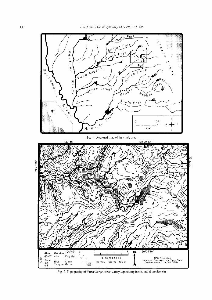
This paper documents a diversion of about 300 km2
of the former upper Bear River down the South YubaRiver 10 the northern Sierra Nevada (Fig, I), Deepvolcaniclastic burial of an early Cenozoic valley adjacent to a modem deep gorge constrains the timing ofItlcision providing an opportunity to constrain rates oferosion in a Sierra canyon, A hypothesis is presentedthat the channel diversion and much of the local SouthYuba valley incision at the site were induced by glacialerosion during the Quaternary period, Morphologic andstratigraphic evidence are reviewed that constrain theage of the deep Yuba canyon at this site and the diver-
132
Fig. I. Regional map of the study area.120'37'30"120'45'
Blue CISCO
Canyon Grove
kilometers
Contour interval 100 m
UTM ProjectionSources Drainage from Tiger Files
Contours from 1 :24,000 DEMs
Fig 2 Topography of Yuba Gorge. Bear Valley. Spauldmg basin. and diversion site.

LA. James I GeOlllorl'h%g\ /-/1/445) 131-1411
Fig. 3. View to north into Yuba Gorge across upper Bear Valley; from Emigrant Gap.
133
sion of the upper Bear River to post-Miocene and prelate Wisconsinan. Stratigraphic evidence is outlined ofat least two and probably three glacial advances thatspilled over the South Yuba-Bear River divide andflowed into both basins.
If correct, this model of Quaternary drainage diversion has important implications: ( I ) rapid rates of glacial valley incision in a Sierra canyon, (2) the Bear andSouth Yuba channels down-valley from the diversionmay not be geomorphically and hydraulically adjustedto their present loads of water and sediment, and (3)
general principles of sediment storage potential may bebased on non-representative systems. The latter implication arises from the fact that Gilbert's sediment wavemodel (Gilbert, 1917) is based largely on field workin the South Yuba River, which may be ill-adjusted tothe addition of more than 300 km 2 of upstream catchment area.
The broad basin around and east of Lake Spaulding(Fig. 2) was deeply filled with ice repeatedly duringthe Quaternary and will be referred to informally as theSpaulding basin or ice field. The Spaulding ice fieldwas fed by high cirque glaciers from the north and byvalley glaciers in the upper South Yuba and Fordycevalleys. Both Bear Valley and the deep, steep-walled,
bedrock gorge of the South Yuba ( hereafter referred toas the Gorge) emanate from the southwest end of theSpaulding basin.
The South Yuba River heads at the crest of the northern Sierra Nevada near Donner Pass; the Bear Riverheads abruptly on the side of Bear Valley near thediversion site. Like most modern Sierra rivers, the BearRiver, Fordyce Creek, and the South Yuba at LakeSpaulding flow southwest down the dip of the SierraNevada towards Sacramento Valley. Near EmigrantGap less than 1 krn from the Bear River, however, theSouth Yuba River turns abruptly about 110° from thiscourse to the northwest and flows into the Gorge( Fig. 3 ). This has long been recognized as the site ofa stream diversion although the time and cause havenever been seriously studied.
2. Early knowledge of glaciation and diversion
Early descriptions of the study area indicate anawareness of valley glaciation although no evidence ofmultiple glaciations has been previously presented.Lindgren ( 1900) provides the only glacial mapping inthe area; glacial units of Burnett and Jennings (1962)

134 L·\. jallln / Ge( (1/11"ph%gl' /.J ( / YY5) /3/-/.J1l
in this area are derived from Lindgren's map. Lindgren( 1900) did not map moraine ridges. but mapped thicktill and described three val1ey glaciers below theSpaulding ice field (Fig. 4). He recognized til1s in bothval1eys. but found no evidence of multiple glaciations.He postulated that the primary ice lobe occupied BearVal1ey and recognized two other lobes: one fol1owingthe present South Yuba River into the Gorge and onepassing across the Ful1er Lake area to the lower Gorge:
.'The heaviest moraines found in this quadrangle extend from FullerLake l north I to Bowman Mountain. Fall Creek. with its beautifulcirque, near the head, certainly contained an important glacier, whichmay have reached down as far as the South Fork of the Yuba. butthi, would have been utterly inadequate to accumulate such largemorainal masses, which must. therefore, be considered as largelyhaving been carried down from higher ridges by the main icesheet .. .The main ice stream did not follow the present course of theYuba below Emigrant Gap... The deep Rap separating the Yuba fromthe Bear River at Bear Valley represented the valley of the Neoceneriver formerly filled with lava and gravel and again worn out duringthe early part of the Pleistocene period. Through this gap the mainice stream must have flowed. continuing on below Bear Valley. a,evidenced by the heavy moraine, on both sides. which gradually thinout 4 or 5 miles below that point. It i, probable. however. that abranch of the South Fork of the Yuba glacicr followed the main merfor a certain distance... ·· (Lindgren. 19(0). Iemphasi, added I
This quote is crucial to an understanding of Lindgren's interpretation of glaciation and erosion of theseval1eys (Lindgren, 1900). His geologic maps show thepre-volcanic channel passing beneath Lowel1 HillRidge only 2 km southwest of the Gorge and turningto the northwest up Bear Val1ey through the site ofLake Spaulding (Fig. 4) (cf. smal1 scale maps in thework by Lindgren, 1893: Bateman and Wahrhaftig.1966). Thus, the "deep gap" he refers to as beingexhumed by glacial erosion is within the uppermostBear Valley: it is not the Gorge. The pre-volcanic channel. henceforth referred to informally as the Omegapaleo-valley after the Omega hydraulic mine to whichit is graded, is exposed in Bear Valley as a high reliefangular disconformity between Paleozoic quartzite ofthe Shoo Fly Complex and Cenozoic andesitic rock.
Gilbert (1905) also recognized the importance ofglaciation along the upper South Yuba and the abruptgeologic changes at the diversion site:
"Westward from l Donner) pa,s the Yuba valley is well glaciatedto the bend near Emigrant Gap. The rock is granitic and a dar":plutonic; much of it is bare ... and the canyon is broad. Glaciatiollwas active ... At Emigrant Gap several things change abruptly. PIlI-
tonic rocks give place to bedded rocks and metamorphic... Glacialsculpture is succeeded by non-glacial." (Gilbert. 1905)
Manson (190 I) argued that ice did not occupy theGorge and that Bear Valley was glacially eroded. It isnot clear if he believed the Gorge existed prior to glaciation. By erroneously concluding it contained no glacier, he seems logically forced to conclude that theGorge did not exist during the glacial period; yet, hepostulated the South Yuba channel was old:
.The upper one-third of the drainage basin of the South Yuba wasthe gathering ground for a glacier. This glacier, instead of followingthe channel of the river through the tortuous. deep, and narrowchannel which turns northwest through 110°, plowed its way in adirect course through the lava ridge and eroded Bear Valley, in whichBear River heads."
"Upon the disappearance of the ice age. Yuba River took the northerly course along a deeply eroded channel. leaving a portion of itsglacial channel below this bend for Bear River. This river thereforeoccupies a channel far larger than its feeble forces could have excavated... Yuba River below the bend probably occupies a very oldchannel..." (Manson, 1901)
Causes of the Bear River diversion are poorly understood. One interpretation assumes the diversion wasthe product of long-term headward erosion by fluvialprocesses. An example of this common view appearedin a popular account explaining the diversion as theresult of both streams eroding headward, evidentlybefore the upper South Yuba drainage had developed.Although upper basin glaciation was recognized, itplayed no role in the diversion by this scenario:
.. A deep gorge cut through this ridge. It contained the Yuba River,where the Yuba had captured the Bear. The two rivers, each erodingheadward from opposite sides of the ridge, had struggled towardeach other until the divide between them broke down, and the Beargiving up its direction of flow, joined the Yuba and went the otherway. To the northeast.... was a lake gouged in granite by an alpineglacier." (McPhee, 1992). [emphasis added 1
The view that channel diversion resulted from slow,progressive fluvial erosion is the conventional modelof stream capture, and implies a substantive uniformitarianism in which the diversion is typically regardedas pre-Quaternary. This view implies that both systemshave had considerable time to adjust hydraulically tothe changes in their respective drainage areas.
Only one hypothesis of glacially induced diversionhas been located in the literature:
"Bear Valley and the South Fork of the Yuba River are separatedby only about 100 feet [33 m; actually -70 m] of elevation, yet the

Cenozoic
LA. James / (iemnmpllOlogr I.J ( 1<)<)5) IJ 1- l.JiI
Pre-Cenozoic
135
Quaternary Alluvium
t~;~?'~;>J Glacial Till
Igneous Intrusives;mostly granodiorite
Bowman Lake Granite
• Andesitic Breccia& Conglomerate
Rhyolitic Tuff
Pre-VolcanicConglomerate
Ultramafics;mostly serpentine
[glliill Basement Rocks
••••• Pre-VolcanicChannel Course
a ~
, '1kilometersUTM Projection
Source: Lindgren (1900)
120°45' 120°37'30"
Fig. 4. Geologic map of study area. Arrow points to andesitic lahar deposit (not on original map) in Bear Valley indicating course of prevolcanic channel was very near Gorge. "Omega" is location of Omega hydraulic mine in pre-volcanic conglomerate. Most of map replicatesLingren's ( 1900) original units, although allm ial deposits have been expanded.

136 LA. }alllesI GeOlIlOtl'hologr 14 (/995) /3/-/48
gorge is 1600 feet [525 ml deep Evitlenlly the headlmtels oj TheSouTh Yuha were Ollce the headHaten of th,' Bear Ricer, hUI Here
captured hr the South Fork or The Yuha, The delails are not clear,but Ihis change ill drainage is nidelllir cO/lllecled wilh glacialioll."'
(Durrell, 1971 ) l emphasis added I
To evaluate competing hypotheses of the timing andcause of Gorge incision and channel diversion. the geomorphic evolution of the Sierra Nevada must first beconsidered.
3. Cenozoic landscape evolution
Most modern studies agree that the long-term evolution of the northern Sierra Nevada topographyinvolved two phases of orogenic activity and a seriesof late Cenozoic volcanic episodes. Sierra uplift hasbeen analyzed by numerous workers comparing paleogradient restorations of Cenozoic strata with modernstream profiles (e.g. Lindgren, 191 I; Bateman andWahrhaftig. 1966; Huber, 1981, 1990). These studiesindicate that following an early period of Cretaceousuplift, there was a long period of quiescence, erosion.and relief reduction. Early Cenozoic erosion removedseveral kilometers of overburden exposing the graniticbatholith during the Cretaceous, as is shown by graniticcontacts and inclusions in Tertiary paleochannels(Lindgren, 1911) and by provenance studies of theGreat Valley sedimentary sequence (Linn et a!., 1992).
Incision of most northern Sierra valleys occurredduring the late Cenozoic in response to decreased vulcanism and renewed uplift rather than in response toQuaternary glaciation. The early Cenozoic drainagewas largely obliterated in the northern Sierra by deeplate Miocene volcanic deposits that buried pre-existingvalleys (Durrell. 1966; Slemmons, 1966). Radiometricdating indicates ages of rhyolitic deposits ranging from16. I to 33.4 ~a overlain by andesitic deposits rangingfrom more than 10 Ma to 5 Ma (Slemmons, 1966:Noble et aI., 1974). Volcanism was intermittent andseparated by periods of intervolcanic channel development, but these channels rarely eroded below thelevel of the pre-volcanic channels (Bateman and Wahrhaftig, 1966). As volcanic deposits stacked up andextended westward they ultimately ranged from a hundred to a thousand meters in depth and extended fromNevada across the present Sierra crest to the foothills.
Rapid late Cenozoic uplift instigated substantial preglacial valley incision. Matthes' (1930) belief that theentire Pliocene was orogenically quiet and that tiltingbegan in the early Quaternary, has been rejected bymost modern scholars ( Wahrhaftig, 1965; Christensen,1966). Huber (1981, 1990) concluded that uplift inthe southern and central Sierra began early, was spreadover a long period, but accelerated in the last 10 Ma ofthe Cenozoic. Unruh (1991) suggested that northernSierra tilting began between 8.4 and 3.4 Ma and proceeded at a uniform rate (0.28° Im.y.) through the lateCenozoic. Deeply weathered surfaces of large segmented fans in the Central Valley indicate substantialpre-glacial late Cenozoic canyon erosion (Marchandand Allwardt, 1981). As a result of volcanic burial ofthe earlier drainage and late Cenozoic uplift along thenorthwestern axis of the modem range, northern SierraNevada drainages were largely reorganized into a seriesof southwest-flowing consequent streams (Batemanand Wahrhaftig, 1966).
Although not the dominant cause of valley incision,substantial Quaternary glacial erosion occurred in somevalleys. At an elevation and position comparable to theYuba Gorge, Matthes (1930) estimated that Quaternary glacial erosion was 150 m and 460 m in the lowerand upper Yosemite Valley, respectively (not including present depths of alluvium). He postulated that alarge, poorly documented, pre-Wisconsinan advanceperformed most of this Quaternary erosion. Althoughonly a fraction of the great pre-glacial erosion ofYosemite Valley, this Quaternary incision is comparable to depths of Yuba Gorge down-cutting, and ismuch greater than the depth required to initiate channeldiversion of the upper South Yuba drainage. Huber( 1990) concluded that the longitudinal profile of theTuolumne valley in a steep, narrow canyon east of theGrand Canyon of the Tuolumne was primarily due toglacial erosion. Glacial plucking and dense jointingwere important factors explaining irregularities in thelongitudinal profile.
4. Hypotheses of Gorge incision and diversion
This paper evaluates several hypotheses of Gorgedevelopment that are grouped into two categoriesdepending on whether or not the Gorge existed duringthe early Cenozoic (Table 1). The first hypothesis,

1.'\. Jallles / Ge(!lIIorph(!I(!~\' N (1<,)<,)5) 131-141\
Table ICategorical evaluation of Gorge incisIon and channel diversion hypotheses
Hypothesis
Pre-Volcanic Gorge. Occupied by a tributary to the Omega Channel.I. Continuous through Cenozoic
2. Aggraded by volcanics and exhumed during late Cenozoic.A. Northeast-flowing main channel in present South Yuba.
B. Southeast-flowing tributary to Omega Channel See hypotheses 3 through 6.
No Pre-Volcanic Gorge. Omega paleo-valley under Lowell Hill to Bear Valley.
No Diversion.
3. South Yuba channel avulsed directly from Omega channel and Gorge incised through volcanics into presentcourse by fluvial superpositioning.
Diversion. Bear Valley eroded and graded to basement rocks. then diverted into South Yuba:4. Gorge eroded by fluvial capture.
A. Pre-Quaternary
B. Rapid interglacial
5. Gorge eroded by Quaternary glaCIal and glaCiofluvial erosion.
6. Gorge eroded by pro-glacial freeze shattering followed by glaciation
137
Plausibility
Reject
RejectGood
Unlikely
Vcry good
Unlikely
UnlikelyVery good
Possibly with glaciation
that a deep ancestral Gorge was maintained through thelate Cenozoic, is rejected outright. This area was deeplyburied by late Miocene(?) andesitic lahars that covermost ridges in the area including Lowell Hill Ridge( 1770 m) south of the Gorge, and ridgetops along bothsides of Yuba Valley below the Gorge for many kilometers (Fig. 4). Andesitic mudflow. breccia, and conglomerates exposed in Bear Valley have not been dated.but they are similar to andesitic deposits elsewhere inthe Sierra (Durrell. 1966). Their depth and tabularbedding indicate a continuous cover across the Gorgeand Bear Valley area. Additional reasons for rejectionof this hypothesis apply also to the next hypothesis.
A second hypothesis, in which a pre-volcanic Gorgewas buried by volcanics and exhumed, takes two forms:a northwest-flowing main channeL and a southeastflowing tributary (Table I). Existence of a majornorthwest-flowing pre-volcanic Gorge draining theupper South Yuba would be very difficult to explaindue to close proximity of the Omega paleo-valley. lackof pre-volcanic conglomerates or volcanic channel fillin the Gorge area, and lack of a connection with thelower Omega valley through granitic rocks on the southcanyon wall above the mouth of Diamond Creek. TheOmega valley passed from Bear Valley northwestunder Lowell Hill Ridge across the Diamond Creekbasin to the Alpha and Omega hydraulic mines (Fig.4). A projection of elevations beneath Lowell Hill
Ridge places the paleo-valley bottom near the floor ofBear Valley where Lindgren (1893, 1900) mapped itthrough the upper Bear Valley to the northeast throughSpaulding basin. The presence of a well-cementedandesitic outcrop at 1460 m elevation in the mouth ofBear Valley between the Gorge and the exposure underLowell Hill Ridge (arrows in Figs. 4 and 5) indicatesthe Omega paleo-valley connected with the Spauldingarea. The paleo-valley passed so close to the Gorge,therefore, that a pre-volcanic channel flowing northwest through the Gorge would have to have been adistributary channel. Hypotheses postulating a majornortheast-dipping pre-volcanic Gorge are rejectedbecause of the need to explain how and why such asystem of three distributary valleys formed (Gorge,Omega paleo-valley. and Bear Valley). and how thelower Bear Valley was later eroded.
It is far easier to support a hypothesis of a pre-volcanic tributary flowing south-southeast from the Bowman Lake granitics through the Gorge to the Omegachannel in the upper Bear Valley (2B, Table 1).Although there is no evidence of such a tributary, itwould be consistent with the Omega channel drainagepattern and with north-trending rock structures in theGorge. Existence of a pre-volcanic tributary throughthe Gorge does not alter the fundamental time constraint that Gorge exhumation could not have begununtil the volcanic epoch had subsided enough to allow

L.A }wlleslGemllorphologr 14(1<)<)5) 131-148
Fig. S. View nonhwest into Gorge (G) showing upper north side of Omega paleovalley volcanic fill (0). Low andesitic valley fill in mouth ofBear Valley ( A) indicates paleovalley extended northeast toward Lake Spaulding near Gorge (cf. Fig. 4).
channels to incise; not before the late Miocene. It doeschange the implications about rates of erosion in lessresistant volcanic fill rather than granite from theGorge.
Hypotheses of Gorge incision that do not assume apre-volcanic valley have a similar time constraint: erosion of the Gorge must have occurred after the lateMiocene. These hypotheses can be divided into twocategories: the South Yuba channel pattern developedduring the volcanic period as a channel avulsion a fewkilometers north of the Omega channel without a di version from the Bear River, or the Bear Valley was erodedfirst and the South Yuba was diverted from it later. Theformer scenario (3, Table 1) requires Gorge erosionin pre-glacial time, so fluvial erosion processes are presumed. According to this hypothesis, the initial postvolcanic upper drainage flowed down the South Yuba.Erosion by headward retreat of a west-flowing tributaryin the Gorge area is ruled out due to the lack of headward erosion of Diamond Creek into unconsolidatedandesitic lahar material. Deep fluvial erosion throughPaleozoic granites and quartzites of the Gorge wouldrequire large stream powers produced by flows fromthe catchment of the upper South Yuba. Thus, ratherthan tributary headward retreat, this model impliessuperpositioning of the channel down through theandesitic overburden to its present course, then knickpoint retreat.
This third hypothesis is unlikely because volcanicburial was very deep and extensive in this area, thevolcaniclastic fill in the Omega paleovalley provided amore erodible path to the southwest, tilting was to thesouthwest, and morphological factors such as long profiles indicate drainage through Bear Valley. Thishypothesis requires downstream damming of theOmega channel while sustaining rapid intervolcanicerosion to counteract volcanic burial and uplift so thatstructural training of the avulsed channel could beginimmediately before a southwestern drainage coulddevelop. Sierra uplift along an axis trending northnorthwest, steepened most southwest-trending valleys(Lindgren, 1911; Bateman and Wahrhaftig, 1966),This uplift would have steepened Bear River whichtrends southwest, but not the South Yuba below thediversion site which trends northwest, parallel to therange. Most importantly, erosion of Bear Valleyremains to be explained if the primary post-volcanicdrainage initially flowed through the Gorge. The smalldrainage area and low gradient of the modem BearRiver in Bear Valley are inadequate to have erodedthrough the bench of Paleozoic quartzite at the southwest end of Bear Valley. Headward erosion of the BearRiver through this bench would not have outpacedheadward erosion of much steeper tributaries into theGorge. In short, early development of the South Yubadrainage through the Gorge is at odds with the upper

1..11, J"lIIes/C;e"III(Jlph(JI(J~\ /-/ (/'jl)5) /3/-1-/11 139
Bear River flowing southwest into Bear Valley insteadof northwest into the Gorge. Furthennore. SacramentoValley late Cenozoic alluvial fans are much moreextensive to the southwest than to the west along theSouth Yuba (Olmsted and Davis. 1961; Burnett andJennings, 1962), suggesting an early and completedevelopment of the upper Bear River drainage. Unlessa process can be identified by which the Bear Valleycould be eroded without the aid of the upper SouthYuba, early non-diversion hypotheses of Gorge incision must be rejected.
S. Evidence of a diversion
Gorge diversion hypotheses in which the BearValley was eroded as an initial response to late Cenozoic volcanic filling include fluvial capture early in thepost-volcanic era, rapid fluvial incision during interglacials, rapid glacial erosion, or frost shattering in a proglacial environment (4-6. Table I). These hypotheseshold in common the assumption that the initial response
to volcanic aggradation was an avulsion of the upperYuba drainage to the southwest through Bear Valley.Only after this Bear River drainage from Spauldingbasin through Bear Valley was well established did thediversion of upper-basin flows through the Gorgeoccur. Morphologic evidence that supports diversionafter the establishment of southwest drainage throughBear Valley includes drainage patterns and longitudinalprofiles. Drainage patterns indicate diversion by closeproximity of the two channels and a barbed South Yubachannel planform. The present Bear and South Yubachannels approach to within 0.7 km of one another atthe diversion site (Fig. 2). It is unlikely that this proximity is a coincidence, since the two valleys are nearlyaccordant and are separated by a very low divide. Themodem drainage pattern over most ofthe Sierra Nevadais strikingly parallel, which is indicative of channelsdeveloped on steep terrain with minimal structural control (Howard, 1967). At the diversion site, however,the South Yuba main channel turns sharply 110° fromits course parallel to the regional trend and flows intothe gorge to the northwest (Fig. 2). Barbed channel
2000
[»>1 Granitoid Rocks
Volcanic and Sedimentary Rocks
r00 Calaveras Complex: Cher t, phy Ilite,~ and argillaceous rocksRZZ@ Feather River Peritotite Belt:l<::«illJ largely serpentine
I'»j Bowman Lake Pluton
•Shoo Fly Complex: largely
siliciclastic sandstones.
n n n ...
............ "' ...... "' "' ......"' "' .................. "' "" ...... ... '" ... ... ... ~, '" ...~ """""
Ri\le ,«<,»»»»''/ub8 ,,',,',',',',,".'.'.'.'.'~'--
Soutn ",""',,',,',,'.','.',A" '.",,',,".}_.................. A ,
,,4v;;iii~:::::::::::::':::::::::;::~.::.;-~.~ ~. , ~-
,.".~"' '" ' , "t-'.:..:: ---
... : :"::":::=;::=~~;:;;:~;~:~:~-'
::'::":~::»:"':'''':' "'~'~"'''';
" ",,. ,'"
,..~;'
"'.1
/««t::<;;i.' ,<,.:~:::: ::<:/
.../::.->..,: "~/
~~%;:;~ , Fall Creek<~::j)'.':. Jolly Boy Terminus
Washington Terminus
.-E 1500
c:::.Q......ro>Q)
W
1000
Spaulding
Dam "'-
Yuba Gorge \
Bea' Valley ---.... ~
o 20 40
River Distance (km)
60
Fig. 6. Longitudinal profile, of South Yuha and Bear rivers with geologic units. Bear Valley is at grade with upper South Yuba, while SouthYuba gradient steepens substantially in the Gorge wHh no apparent ,truetural explanation.

140 L.A . .lames / G/'omorpllOlogv 14 ( 1'1'(5) 131-148
patterns, in which tributaries join the main channel atobtuse angles, can be indicative of stream capture(Doeringsfeld and Ivey, 1964; Howard, 1967: Strandberg, 1967). The sudden turn of the South Yuba channel represents a large barb which is interpreted as theresponse to diversion of a well-developed southwesttrending drainage system.
Longitudinal profiles of the Bear and South YubaRivers also indicate possible diversion. The SouthYuba profile steepens suddenly where the river turnsnorthwest and enters the Gorge, and is not graded tothe channel above (Fig. 6). Channel gradients withinthe Gorge range between 0.10 and 0.16 m/ m in spiteof a high sinuosity within tight entrenched meanders.A structural explanation for the break in profile is lacking. It does not correspond with known faults. Theupper inflection point at the base of Spaulding Damoccurs near the contact with resistant granodiorites, butmost of the steepened reaches are in Paleozoic quartzites of the Shoo Fly Complex, and the Devonian granitics of the Bowman Lake pluton has no apparent effect.In contrast, the Bear River profile is graded to the upperSouth Yuba profile through Spaulding basin above thediversion across the same Paleozoic quartzites (Fig.6). The combined longitudinal profile from the upperSouth Yuba through Bear Valley suggests that a southwest-trending drainage had evolved over a sufficientperiod of post-volcanic time for the valley floor to havedeveloped a graded profile in the basement rocks. Sierrauplift steepened channels flowing parallel to BearValley, not to the Gorge; yet, the opposite trend isobserved in present profiles: the Gorge is over-steepened, while the gradient of Bear Valley is gentle.
The alignment and accordance of the Bear and SouthYuba valleys, the abrupt termination of the Bear Riverheadwaters so near the Gorge, and the longitudinalprofiles support hypotheses that the post-volcanic BearRiver initially headed up beyond the Spaulding basinbut was diverted. Given the evidence available, the besthypotheses are those that include abandonment of theOmega pre-volcanic channel due to volcanic aggradation, development of an early post-volcanic drainagesouthwest down Bear Valley, and later erosion of theGorge and diversion of the channel. Additional morphological and stratigraphic evidence suggests thatQuaternary glacial erosion was an important component of Gorge incision.
6. Glacial stratigraphy
This study presents a hypothesis of deep, rapid canyon incision by glacial action. The glacial history ofthe study area is important both as an indicator of themagnitude and frequency of glacial erosion events, andas a constraint to Gorge incision. Sierra Nevada canyons were subjected to repeated Quaternary glaciations(Birkeland, 1964; Bateman and Wahrhaftig, 1966; Fullerton, 1986). This report briefly outlines a newlydeveloped, locally referenced glacial stratigraphy forthe study area (cf. James and Davis, 1994). Moraineridges, till-mantled ridge-tops, and upper limits of granitic boulder erratics on Paleozoic (Shoo Fly Complex) or on Cenozoic volcanic rocks were used to mapglacial advances. Topographic position and the degreeof erosion and weathering of boulders, tills, andmoraines were used to distinguish between advances.Lacking absolute dates, no attempt is made to regionally correlate these units which are given informal localstratigraphic names. A more detailed report on the glacial stratigraphy is pending.
Although steep gradients have resulted in poor preservation of deposits, enough consistent evidence hasbeen collected to map two advances. Solid lines inFig. 7 represent locations established by moraineridges, till on ridgetops, or upper limits of erratic boulders. Dashed lines are interpolated based on topographic considerations. While Bear Valley and theGorge have been field mapped extensively, tills to thenorth in Canyon and Fall creeks, and to the south in theAmerican basin are mapped on the basis of reconnaissance surveys and should be considered hypothetical.Although Lindgren ( 1900) mapped extensive glacialtill in the upper Fall Creek basin (Fig. 4), preliminarymapping suggests that the ice was thin there and thatthe dominant glaciers came down from Canyon Creekand Linsley Creek and from the Spaulding Basin nearGrouse Ridge across the Fuller Lake area.
At least two and probably three distinct glacialadvances were identified in the area that were highenough to spill over the divide north and south of ClydeMountain into the South Yuba drainage (Fig. 7). Anumber of boulder erratics are located beyond the margin of the most extensive, well-preserved morainesmapped. Although some of these erratics could beexplained as outliers of the mapped advance, their position and the severe erosion of till suggest they may

L·\. JOllie- / Gt'olllOlpholog, 1-1 (19<;51 131-I-IX 141
120°45'
+ Glacial Erratics~......_ ...._ ...._ ...._ ..5, N
1kilometers
120"37'30"
120°37'30" Contour interval 100 mlJTM Projection
Fig. 7. Glacial map of Spaulding ice field and valley glaciers. Solid lines represent moraine ridges, till-covered ridge-tops, and well definedupper limits of erratics. Dashed lines are interpolated based on topography.
represent one or more earlier extensive advances. Theseboulder erratics, referred to as "pre-Washington" inregard to the Washington advance described next, lackmoraine ridges and occur at higher elevations and morewesterly down-valley locations than either of the twosubsequent advances. For example, two small biotitegranodiorite erratics were found on top of the relativelycoarse-grained Bowman Lake granite above the Washington lateral moraine on the peak of Clyde Mountain( 1830 m). Similarly, granitic boulders were found onShoo Fly rocks above and beyond the Washington outwash terrace northeast of the town of Washington (Fig.7). A possible pre-Washington till-mantled ridge islocated northwest of the Washington moraine on Lowell Hill Ridge, although it could be a large isolated spurof a severely eroded Washington morainal complex.
Tills of intermediate age are associated with discontinuous moraine ridges in both the South Yuba andBear valleys. Although few striae have persisted onboulders or erosional surfaces and moraines are missingfrom valley bottoms and tributary crossings, bouldersand till from this advance are otherwise well-preserved.Moraine crests are rounded and moderately bouldery,and exposed granitic boulders produce a solid hammerring. The upper limit of erratic boulders associated withthis advance can be traced along valley walls gradingto glacial termini at elevations below 1100 m in BearValley and at 840 m in the South Yuba valley in thetown of Washington for which this advance is informally named. Washington till is preserved above thefalls of Scotchman Creek (Lindgren, 1900) and northof the South Yuba river near the contact with a broad

142 L.A. James / (JerJl"or{,h%g\ 14 (1995) 131-148
7. Glacial erosion and stratigraphic constraints
Similarly, a first approximation of the averageboundary shear of Jolly Boy ice through the Gorge isabout 230 kPa based on an ice depth of at least 425 mand an ice surface 6.2o/c slope measured by maximum
Ice depths and slopes at the capture site were sufficient to produce high shear stresses and sustain rapidglacial erosion. Washington ice was approximately 520m thick in the mouth of the Gorge. Although Washington ice surface slopes through the Gorge have not beendetermined, adoption of Jolly Boy ice surface slopes atthis location (6.2%) allows an estimation of averageboundary shear stress of Washington ice at the mouthof the Gorge. Assuming the specific weight of the ice( y,) was 0.9 that of water and ignoring losses of energyto internal friction, average boundary shear was about280 thousand pascals:
elevations of till along the north edge of Lowell HillRidge. These shear stress values of Washington andJolly Boy ice are more than 2 1/2 and 2 times valuesof typical subglacial shear stresses, respectively (Paterson, 1969). This supports a hypothesis of great erosive competence of ice and high erosion rates withinthe Gorge.
Erosion rates provide a constraint on Gorge incisionand channel diversion processes. Assuming 300 m ofGorge incision occurred since late Miocene (a conservative estimate), rates of Gorge incision leading tochannel diversion must have been rapid; that is, anaverage 60 m/m.y. over 5 m.y. Furthermore, at least70 meters of post-diversion erosion is necessary toaccount for the depth of the Gorge below the adjacentfloor of Bear Valley. Holocene subaerial weatheringand erosion rates have been far too slow to account forGorge incision or diversion. If striated metamorphicsurfaces are assumed to be 14 thousand years old andpost-glacial erosion is assumed to be 5 mm (morewould have obliterated fresh striae), then the averagepost-Jolly Boy erosion rate is only about 0.36 m/m.y.Although subsurface weathering encouraged substantial erosion elsewhere in the Sierra, those processesoperate best on granitic rock and the associated steppedtopography is not recognized in the northern Sierra(Wahrhaftig, 1965). Rocks such as the weakly metamorphosed Shoo Fly quartzite weather slowly, so ahypothesis of Gorge erosion promoted by subsurfaceweathering must explain why the Gorge developed atleast partially in these rocks.
Minimum ages of Gorge incision and channel diversion are provided by glacial evidence. For example, theWashington outwash terrace provides a constraint onthe minimum age of incision lower in the South Yubavalley. This terrace, near the Washington terminusacross from the town of Washington, is about 40 mabove the modern channel 15 km below the Gorge.This indicates that most valley incision at this locationhad occurred by the end of the Washington advance.Up-valley, an outwash terrace covered by coarse angular colluvium near the Jolly Boy terminus is about 15m higher than the Jolly Boy outwash terrace and about30 m above the present channel bed,S km down-valleyfrom the diversion site. This terrace indicates the lowerGorge at the Jolly Boy terminus had been largelyeroded prior to Jolly Boy time; perhaps by late Wash-
2 . 280 m ·0.062 = 284 kPa,-'s=8820 kg' m
Washington outwash terrace at about 840 m elevation.A lateral Washington moraine is nearthe crest of ClydeMountain (1810 m).
The youngest moraine ridges in the study area belowSpaulding basin are often sharp-crested and bouldery.These moraines extend below I 160 m in Bear Valleyand terminate at 945 m elevation in the South Yubavalley near the Jolly Boy Mine. These moraines can betraced up both valleys to an accordant source, so theyare assumed to be contemporaneous and are informallynamed the Jolly Boy moraine. Jolly Boy morainesextend above 1700 m on both flanks ofClyde Mountainand a line of bouldery till is preserved along the northside of Lowell Hill Ridge at the edge of the Gorge. Thefreshness of depositional and erosional surfaces,including the retention of clear striae on Paleozoicquartzites, boulder frequencies, and moraine morphology, suggests that this advance was late Wisconsinanin age (Tioga?), but dating is needed to establish thisrelationship. Younger sharp-crested, boulderymoraines in and above the Spaulding basin could berecessional moraines or readvances, but are not relevantto the diversion under consideration and are not considered in this article.

LA Jamel / Geomorl'ho{ogv' {.J (IYY5) {.> {. I.JX 143
ington time if the terrace represents a Washingtonrecession.
Evidence of the Jolly Boy glaciation at the diversionsite is well preserved on metamorphic surfaces whichare rounded, smoothed, striated, and grooved, withoccasional roches moutonnees. Striae orientations document branching ice-flow paths down the Bear andSouth Yuba valleys (lames and Davis, 1994), andstriae on the inner entrenched channel wall in the upperGorge indicate late Jolly Boy ice at an elevation at least50 m below the floor of Bear Valley. At least someinner-channel incision was contemporaneous withJolly Boy glaciation since the inner edge of the cut isgrooved about 4 m down from the bench surface. Themeandering pattern of the entrenched channel musthave been established prior to or during Jolly Boy time.This constrains channel diversion to no later than JollyBoy time and probably earlier.
8. Morphologic features
Geomorphic forms that can be used to evaluate thevarious diversion hypotheses include limited tributaryincision in the Gorge, valley cross-section shapes, adiffluence step, and hummocky bedrock surfaces at theupper end of the Gorge. Hanging valleys above theGorge have not incised, and tributary gradients remainvery steep near canyon confluences. For example. FallCreek is about 600 m above the floor of the Gorge(Fig. 8). In addition, incision of a north- flowing SouthYuba tributary into Shoo Fly quartzite on the north edgeof the Bear Valley floor near the diversion site has beenlimited. Although this evidence supports hypotheses ofrecent deep erosion, hanging valleys and slow tributary
r---------.---------~,
2000
E';;' 1600o:g>~
W1200
4 6River Distance (km)
Fig. 8. Fall Creek longitudinal profile illustrating almost 600 m 01
hanging tributary relief.
erosion are common in unglaciated Sierra Nevada valleys (Matthes. 1930) and most are on granitic rock, soa lithologic explanation cannot be dismissed.
Bear Valley cross-sections have wide, shallow, parabolic shapes due to weak volcaniclastic rocks in thevalley walls, a low gradient, and reoccupation of theupper Omega paleo-valley. In contrast, the V-shapedGorge apparently misled some workers into concludingthe Gorge had not been glaciated (Manson, 190 I ) . Thedeep, narrow cross-section of the Gorge should not beinterpreted as evidence of ineffective glacial erosion.Although valley cross-section shape has been relatedto degree of glaciation (Embleton and King, 1975),this relationship may be complicated by rock structure,valley gradient, and sub-glacial processes. GlaciatedV-shaped valleys have been explained by exfoliation( Bateman and Wahrhaftig, 1966), steep gradients, andintense subglacial melt-water erosion (Embleton andKing, 1975):
. 'It is sometimes possible for valleys in which glaciers have flowedto exhibit V-shaped sections in a generally U-shaped valley. The Vshaped sections are usually associated with reaches of greater gra-dient than the U-shaped portions The Gorge du Guit in the FrenchAlp,--. examined by J. Tricart was cut by subglacial meltwatertlowing under hydrostatic pressure. The glacier in this section of thevalley would have been relatively thin, probably less than 300 m,and deep crevasses and moulins would have allowed meltwater toreach the base of the decaying glacier. The meltwater. heavily loadedwith abrasive material, would rapidly scour a deep gorge, having asteep V-shaped cross-profile. beneath the ice. The stream that hasoccupIed the valley after the ice retreated has only been able to erodethe bottom of the gorge by about 5 m." (Embleton and King, 1975)
Morphological evidence of glacial valley deepeningmay be located at valley junctions. Penck (1905) inhis" rule of cross-sections" postulated formation of adiscordant valley confluence with step height proportional to the difference in cross-section areas of therespective valley glaciers; i.e., a dijj7.uence step (Batesand Jackson, 1987):
"The diffluence of the ice is controlled by the rule ofcross-sections...steps oceur where branches occurred for here there was a suddendiminution of the ice... steps of diffluence are hanging openings ofthose valleys that are entered by the ice. The height of... steps willgenerally be more considerable. the greater the difference betweenthe main glacier and its affluent or diverting branch ... " (Penck,I'J()S)
Penck applied this rule to both confluent glacierswhich produce hanging valleys and to diffluent glaciersthat produce ledges facing up-valley, and cited several

144 L.A. )a!lleslGeu!IlurpllOlugy 14 (1995) /3/-/48
Fig. 9. View south toward Bear Valley of 60 m high rock ledge, or step of diffluence from within Yuba Gorge. Bedding planes are nearly verticalwhile low angle grooves indicate Jolly Boy ice rose up from lower left to upper right.
examples. The concept that valleys conveying more icewill be lowered more rapidly leaving the subdominantvalley perched, supports the hypothesis that glacial erosion led to the Bear River diversion. An abrupt,grooved, steep rock face cut into the north end of thefloor of Bear Valley forms a diffluence step suggestingrapid glacial erosion of the upper Gorge (Fig. 9). Iceflowing into the Gorge established a positive feedbackmechanism in which progressively more flow wasdiverted as Gorge erosion accelerated.
Fluvial incision rates could be sufficient to accomplish the Gorge incision, but local valley bottom morphology is clearly not fluvial in origin. At the mouth ofthe Gorge the South Yuba valley bottom has a broadhummocky surface developed in Paleozoic quartzite.This bench surface has been eroded into a series of rockbars oriented normal to the upper Gorge axis aroundwhich a series of entrenched meanders have developed.Initiation of fluvial capture generally occurs by headward erosion of a tributary, faulting, or by aggradationor damming downstream leading to over-topping of adivide. Headward retreat was dismissed earlier since itrequires rapid erosion by a small tributary through thegranite and Paleozoic quartzite Gorge area while headward retreat of Diamond Creek through relativelyincompetent materials has been limited. There are noknown faults above the Melones Fault Zone (Fig. 6).A damming or aggradational hypothesis must assumethere was a much lower divide between the Bear and
South Yuba basins than is necessary with a glacialdiversion hypothesis. Once Bear Valley was substantially eroded, it would have required a very high damto cause spillage across to the South Yuba. Yet, thereis no evidence on the flat, outwash-covered floor ofBear Valley of post-volcanic aggradation or damming.While there was ample sediment in the system duringthe Pliocene, the fluvial regime was overwhelminglyerosional. Although glacial erosion could haveremoved such deposits, damming cannot explain whythe upper Bear River continues to flow through BearValley rather than as a tributary to the South YubaGorge. These difficulties suggest that fluvial diversionhypotheses are unlikely.
By the fore-going arguments for elimination of competing hypotheses, hypotheses of Gorge erosion andchannel diversion have been reduced to the glacial andpro-glacial erosion processes. Extensive glaciation ofthe Gorge and evidence of substantial glacial erosionhave been demonstrated, and the following sectiondescribes sub-glacial erosion processes that may havelead to rapid canyon erosion.
9. Glacial creation and deepening of valleys
In spite of controversy over the concept as it appliesin the Sierra Nevada, glacial erosion as an agent ofvalley creation has been well documented by early Eur-

L..\. Jill/WI / GeoIl10rl'!lo{ogl {oj (1995) 13/- {oJl\ 145
opean and American geomorphologists. Creation ofvalleys across drainage divides by transection, icelandic, outlet, and through glaciers has been mapped,described, and defined by several workers (Tarr, 1909;Embleton and King, 1975; Linton, 1949, 1963), as hasprogressive valley erosion across continental glacialdivides (Coates and Kirkland, 1974).
Outlet glaciers provide a mechanism by which rapiddivide lowering may occur. Cols and small valleys maybe deepened by outlet glaciers due to positive feedbacksthat can exist between steep slopes and valley bottomincision processes (Hooke, 1991). Over-deepenedslopes are associated with transverse crevasses whichencourage the percolation of meltwater to the base.Fluctuations in meltwater can greatly accelerate basalerosion in temperate glaciers and this can furthersteepen valley bottom slopes. Evidence of deep subglacial meltwater erosion in the Gorge includes a deephole in the modem channel a few hundred metersupstream of the Jolly Boy terminus. Miners at the JollyBoy gold mine have been removing boulders for yearsfrom a deep pit well below the South Yuba graded bed.This hole presumably developed during Jolly Boy glaciation in response to high pressure subglacial meltwater flows. The potential for hydraulic heads in excessof 100 meters in conjunction with high velocity subglacial meltwater flows, freeze~thaw cycles, and glacialabrasion can result in substantial erosion capacities insuch environments.
Proglacial mechanical weathering of valley bottomshas been postulated as a mechanism by which deepvalley incision can occur, particularly in conjunctionwith glacial erosion (Embleton and King, 1975).Freeze shattering in periglacial or proglacial environ-
Table 2
Hypothesis of glacial diversion
ments can cause jointing which prepares the valley floorfor glacial erosion. It is not known if such a processoperated in Sierra canyons during glacial advances, butthe hypothesis is viable.
10. Hypothesis of Quaternary glacial erosion anddiversion
Based on stratigraphic and morphological evidence,a hypothesis of the process and timing of Gorge erosionand channel diversion is advanced (Table 2). The prevolcanic valley extended under Lowell Hill Ridge andup through Spaulding basin. There may have been prevolcanic tributaries under Emigrant Gap and a southflowing tributary through the Gorge to the OmegachanneL The pre-volcanic channels were deeplyaggraded by volcanics and largely abandoned. Theearly post-volcanic drainage developed on erodiblevolcaniclastic rock that had aggraded above most structural controls of the basement rocks as a southwesttrending channel from the Spaulding basin throughBear Valley. As the main channel was superposed ontothe underlying basement rocks, it exploited the preexisting Omega paleo-valley through the upper BearValley, and maintained a course through the formersouthwest wall of that valley where there is now a largebedrock bench in lower Bear Valley (Fig. 2).
The post-volcanic, preglacial South Yuba channel\'vas a west-flowing small tributary fed by DiamondCreek that joined the former main channel at CanyonCreek ( Fig. 4). Following volcanic aggradation, as thispreglacial tributary encountered hard basement rocks,erosional processes shifted from vertical incision to
I. Prior to glaciation a steep South Yuba tributary was scparated from thl' Bear River by a divide near Clyde Mountain. The Gorge did notexist or was a tributary valley flowing southeast. Fall Creek was graded to that tflbutary or Canyon Creek at a much higher level than the
Gorge.
2. Pre-Washington and Washington Ice flowed over diVIdes on both "des "I' Clyde 'Vlountain from the Spaulding ice held through both the
Fuller Lake area and the Gorge site. Gorge incision occurred in response to glaCiation across the divide as a steep. shallow ice flowdeveloped into a substantial. highly erosive ICe fall with transverse neva"es that allowed meltwater access to the bed. As the proto-Gorge
floor was lowered toward the level of the Bear Valley floor. mcreasing discharges of Ice and meltwater were diverted down the steep SouthYuba Canyon. Ultimately. during pre-Washington or Washington time. the Gorge was eroded below the floor of Bear Valley. and most
meltwater from the Spaulding ice held was diverted through the (Jorge Upon deglaciation. stream flows continued flowing through theGorge.
3. Jolly Boy ice reoccupied both valleys. and continued cutting the Gorgc to Its present position more than 70 m below the floor of BearValley. The Gorge already existed and carried the South Yuba channel. however. and this advance merely deepened it

146 LA. }(/IIlCl/Geo/llorpholog\ 141 IYY5) 131-14<!
slow headward retreat of a knickpoint at the granitemetamorphic contact near the Jolly Boy mine. Headward erosion of this proto-South Yuba tributary wasmore rapid up Diamond Creek where the Omega paleochannel was filled with erodible volcanics. The Gorgedid not exist prior to Quaternary erosion, although therewas a low saddle between tributaries to the South Yubaand the Bear Valley.
Quaternary glacial advances spilled over the divideinto the South Yuba basin. Due to steep gradients,incipient ice flows across the low pre-glacial SouthYuba-Bear Valley divide rapidly developed into anoutlet glacier through the Gorge site. Increasing flowsof ice and sub-glacial meltwater led to incremental augmentation of valley cross-section size and establisheda progressive dominance of ice flow down the Gorge.Sub-glacial meltwater was diverted from the Spauldingice field which resulted in fluvial derangement in preJolly Boy time. Much Gorge incision may haveoccurred during one or more very extensive glaciationsin pre-Washington time and the Gorge was furtherdeepened by the Washington and Jolly Boy advances.It is not possible with the available information, tospecify when channel diversion occurred, but if thelogic of previous discussions is sound, and glacial processes are responsible, then Quaternary diversion is theinevitable conclusion. Furthermore, the event can beconstrained to pre-Jolly Boy; that is, to pre-Washingtonor Washington glacial erosion.
11. Conclusions
Most modem Sierra Nevada valleys formed in theLate Cenozoic prior to Quaternary glaciation. Glaciation modified many canyons, but its importance variesfrom canyon to canyon. The South Yuba Gorge presents an opportunity to examine valley evolution withsome clear stratigraphic constraints. Burial of a largepaleo-valley by volcanic lahars and conglomerates andits exposure in Bear Valley provide a fortuitous opportunity to study the rate and sequence of valley evolutionof Bear and South Yuba valleys.
Existence of a northwest-flowing South Yuba channel through a pre-volcanic Gorge is rejected due to
close proximity of the main pre-volcanic paleo-valleyunder Lowell Hill Ridge and up Bear Valley throughSpaulding basin. The hypothesis that the South Yuba
channel was superposed In its present course in orshortly after the intervolcanic period is unlikely. Thishypothesis ignores regional tilting, requires rapid intervolcanic channel erosion in order for structural controlsto prevail over aggradation and uplift effects at the sametime that it requires filling of the Omega channel, andit cannot explain how Bear Valley was eroded.
Morphologic and stratigraphic evidence indicatesthat the initial post-volcanic drainage developed to thesouthwest down Bear Valley and that Gorge incisionoccurred after erosion of Bear Valley. This indicatesdiversion of more than 300 km2 of the former upperBear River to the South Yuba basin in post-Miocenetime. If this interpretation is correct, incision of theGorge provides an example of rapid valley cuttingthrough Paleozoic granite and quartzite. Fluvial processes in large basins can attain sufficient erosion rates,but diversion of the upper basin is required. Thehypothesis that the upper Bear was captured by headward fluvial erosion is rejected because it requires rapiderosion of a small tributary through Paleozoic graniticswhile erosion of Diamond Creek through weak volcaniclastic materials was limited. If headward erosion didnot cause capture, then fluvial capture requires postMiocene aggradation or damming of Bear Valley.There is no evidence for such an event, nor does itexplain why the upper Bear River continues to flowdown Bear Valley. Thus, post-volcanic, fluvial capturehypotheses are unlikely.
Processes of Gorge incision and channel diversionwere apparently dominated by Quaternary glacial erosion. Deep and repeated glaciations into the Gorge,steep valley gradients, and large potential supplies ofmeltwater support the hypothesis that glacial erosionwas highly competent at this location. Field mappingdocuments at least two and probably more extensiveglacial advances that occupied both the South Yubaand Bear valleys, and provides stratigraphic constraintson the timing of Gorge incision. Morphological formsindicate that valley bottoms were substantially loweredand modified by glaciation. Rock bars, a diffluencestep, a stepped South Yuba longitudinal profile, hanging valleys, and other features indicate a dominance ofglacial erosion in the Gorge. This erosion was presumably assisted by sub-glacial meltwater. Evidence ofdeep glacial erosion in similar positions elsewhere inthe Sierra Nevada and a long literature of glacial diffluence indicate that glacial erosion can be rapid and can

L.A . .lames / Gt'omorpholog\ J.i (/()I.)5) 131-148 147
create new valleys, particularly under conditions ofsteep valley gradients where large volumes of subglacial meltwater are involved. Thus, rapid pre-late Wisconsinan Quaternary glacial erosion is identified as thepreferred hypothesis for evolution of the South YubaGorge including deep incision and channel diversion.
Acknowledgements
I am thankful to a great many individuals includingthe following. Bob Wilson and Dan Sarlitto assistedwith mapping glacial striae; Jerry Davis and Jeff Schaffer helped map moraines north of Fuller Lake. LaurenceJames provided logistical support during summer fieldseasons. N. King Huber and an anonymous reviewerprovided numerous insights and editorial commentsthat resulted in substantial improvements to an earlierversion of this paper. Charles Higgins pointed out Durrell's ( 1971 ) reference to glaciation and diversion. Personnel at the Tahoe National Forest, U.S. ForestService, supplied digital elevation models used to generate topographic maps. Shan Burkhalter. RichardDeal, and Kan He assisted with Arc Info cartographicdevelopment. Finally, I benefitted greatly from use ofthe University of South Carolina Geography and HSScomputer labs for map production and would like toexpressly thank John Jensen and David Cowen for provision of equipment and the working environment forgeographic information processing.
References
Bateman. P.e. and Wahrhaftig. C. I%6. Geology of the SierraNevada. In: E. Bailey (Editor). Geology of Northern California.Calif. Div. Mines and Geol. Bull.. 160.
Bates. R.L. and Jackson. J.A .. 1987. Glossary of Geology. 3rd ed.Am. Geol. Inst.. Alexandria. VA
Birkeland. P.w.. 1964. Pleistocene glaCiatIon of the northern SierraNevada and the Basin Ranges. Geol SOl" Am Bull .. 42 86)-925.
Burnett. J.L. and Jennings. e.W. 1962. GeologIC Map of California.Chico Sheet. Cal. Div. Mines and Geol.. 1250000.
Christensen. M.N .. 1966. Late CenozoIC crustal movements in theSierra Nevada of California. Geol. Soc Am Bull.. 77: 162-181.
Coates. D.R. and Kirkland. J.T.. 1974. ApplicatIon of glacial modebfor large-scale terrain derangements. Symp Proc. GeographicalMonograph No.5. In: W.e. Mahaney I Editor). Quaternary EnVIronments: York L'niv .. York. UK. pp. 44-1.'6
Doeringsfeld. W.W.. Jr. and Ivey. J.B., 1964. ese of photogeologyand geomorphic criteria to locate subsurface structure. Mt. Geol.,I 183-195. Reprinted in Photogeol. Photogeomorphol. TreatisePetrol. Geol. Rpt. Ser. 18, pp. 147-159.
Durrell. e.. 1966. Tertiary and Quaternary Geology of the NorthernSierra Nevada. In: E. Bailey (Editor). Geology of Northern California. Cal. Div. Min. Geol., Bull.. 190: 185-197.
Durrell. C.. 1971. Northern Sierra Nevada. Field Trip Guide. Unpubl.Road Log. May 15-16. 1971.
Embleton. e. and King. e.A.M .. 1975. Glacial Geomorphology.Wiley. New York. 573 pp.
Fullerton. D.S .. 1986. Chronology and correlation of glacial depositsin the Sierra Nevada. California. In: G.M. Richmond and D.S.Fullerton (Editor). Quaternary Glaciations in the United Statesof America. Quat. Sci. Rev .. 5: 161-169.
Gilbert. G.K .. 1905. Field notebooks of G.K. Gilbert. Library Congress. Washington. DC. unpubl.
Gilbert. G.K .. 1917. Hydraulic-mining debris in the Sierra Nevada.U.S. Geol. Surv. Prof. Pap.. 105: 154 pp.
Hooke. R.L.. 1991. Positive feedbacks associated with erosion ofglacial cirques and overdeepenings. Geol. Soc Am. Bull.. 103:I 104-1 108.
Howard. A.D.. 1967. Drainage analysis in geologic interpretation: Asummation. Bull. Am. Assoc. Petrol. Geol.. 51: 2246--2259.
Huber. NK .. 1981. Amount and timing of late Cenozoic uplift andtilt of the central Sierra Nevada. California - Evidence from theupper San Joaquin River Basin. U.S. Geol. Surv. Prof. Pap.. 1197:28 pp.
Huber. N.K .. 1990. The late Cenozoic evolution of the TuolumneRiver. central Sierra Nevada. California. Geol. Soc. Am. Bull..1021 I): 102-115
James. L.A. and Davis. J .• 1994. Glaciation and Hydraulic GoldMinmg Sediment in the Bear and South Yuba Rivers: SierraNevada. Unpubl. Field Trip Guide. Assoc. Amer. Geog. Nat.Mtg. 106 pp.
Lmdgren. W. 1893. Two Neocene Rivers of California. Geol. Soc.Am. Bull.. 4: 257-298.
Lmdgren. W.. 1900. Colfax Folio. California. U.S. Geol. Surv.. Geol.Atlas. Folio 66; l: 125000.
l.mdgren. W.. 1911. Tertiary gravels of the Sierra Nevada of California. U.S. Geol. Surv. Prof. Pap.. 73: 226.
I.mn. A.M .. DePaolo. OJ. and Ingersoll. R. V.. 1992. Nd-Sr isotopic,geochemical. and petrographic stratigraphy and paleotectonicanalysis: Mesozoic Great Valley forearc sedimentary rocks ofCalifornia. Geol. Soc. Am. Bull., 104: 1264-1279.
Linton. D.L.. 1949. Watershed breaching by ice in Scotland. Trans.Ins!. Br Geogr., 17: 1-16.
Linton. D.L.. 1963. The forms of glacial erosion. Trans. Inst. Br.Geogr, 33: 1-28.
Manson, M.. 1901. Features and water rights of Yuba River. California. U.S. Dept. Agric. Office Exp. Stat. Bull. 100, Rpt. Irrig.Invest.. Cal.
Marchand, D.E. and Allwardt. A., 1981. Late Cenozoic stratigraphicunits. northeastern San Joaquin Valley. California. U.S. Geol.Surv. Bull.. 1470: 70 pp.
Matthes. F.. 1930. Geologic history of Yosemite Valley. U.S. Geol.Surv. Prof. Pap.. 160.

148 LA. James / Geomorphology /4 (/995) /3/-/48
McPhee. J.. 1992. Annals of the Former World: Assembling California. The New Yorker. Sept. 7. pp. 36-68.
Noble. D.C.. Slemmons, D.B.. Korringa. M.K.. Dickinson. W,R.AI-Rawi, Y, and McKee. E.H.. 1974. Eureka Valley Tuff. eastcentral California and adjacent Nevada. Geology, 2: 139-142
Olmsted. F.H. and Davis. G.H., 1961. Geologic features and groundwater storage capacity of the Sacramento Valley. California. \:.SGeo!. Surv. War. Suppl. Pap.. 1497.
Paterson. W.S.B .. 1969. The Physics of Glaciers. Pergamon. !':CIA
York. 250 pp.Penck. A.. 1905. Glacial features In the surface of the Alps. J. Geol.
13( I): 1-19.
Slemmons. D.B., 1966. Cenozoic volcanism of the central SierraNevada. California. In: E. Bailey (Editor). Geology of NorthernCalifornia. Cal. Div. Min. Geol. Bull .. 190: 199-208.
Strandberg, C.H.. 1967. Aerial Discovery Manual. Wiley. New York.Tarr. R.S .. 1909. Yakutat Bay Region. Alaska: Physiography and
glacial geology. U.S. Geol. Surv. Prof. Pap.. 64: 183 pp.Unruh. J.R., 1991. Uplift of the Sierra Nevada and implications for
late Cenozoic epeirogeny in the western Cordillera. GeoL Soc.Am. Bull .. 103: 1395-1404.
Wahrhaftig. C.A., 1965. Stepped topography of the southern SierraNevada. California. Geo!. Soc. Am. Bull.. 76: 1165-1190.


