Embed Size (px)
Citation preview
Planning Department Agreement No. CE 60/2005 (TP) Land Use Planning for the Closed Area – Feasibility Study
Final Report
G:\Document\25100\25112 Closed Area\Report\041 Draft Final Report\041-02 Final Report\041-02 Final Report.doc
Page 113 Ove Arup & Partners Hong Kong Ltd July 2010
6 BROAD TECHNICAL ASSESSMENTS
6.1 Introduction
In the RDPs, a number of land proposals have been recommended and a broad technical
assessment has been undertaken to evaluate the impacts of these proposals. The land
proposals in the RDP are technical feasible and they are briefly described in the following
sections.
6.2 Transport and Traffic Assessment
6.2.1 Transport Model Development
Arup‟s in-house territory transport model was developed using EMME software which
comprises a traditional 4-stage model and is compatible with Transport Department‟s
Enhanced Comprehensive Transport Study – 3 (ECTS3) model. It has been well-validated
to year 2005 by territory-wide cordons and screenlines and major corridors including Tolo
Highway. It is hence recommended to adopt this model as a basis and update it using the
latest available planning data and land use data for this Study.
The model input assumption for this Study has been recorded in the Technical Note–
Parameters, Assumptions and Input data of the Traffic Model circulated in November 2007.
However, while the transport model for this Study was developing in 2008, the “North East
New Territories New Development Areas Planning and Engineering Study – Investigation”
(NENT NDA Study) has commenced with a more updated set of planning parameters and
input assumptions provided by various government departments which were reported in its
Technical Report 3C. Considered the area that will be excised from the FCA is in vicinity of
the NDAs, it is better to adopt the same set of planning assumptions as the reference model
scenario for consistency.
With the availability of the 2006-based Territorial Population and Employment Data Matrices
(TPEDM) land use data released and revised by Planning Department (PlanD) in May and
July 2008 respectively, the base year model was developed for year 2006 and it was
validated to 2006 traffic condition. The model input data for base year model setup, planning
input parameter for design years are described in Appendix C.
6.2.2 Planning Data and Network Assumptions
The 2006-based Territorial Population and Employment Data Matrices (TPEDM) land use
data released and revised by Planning Department (PlanD) in May and July 2008
respectively is adopted in this Study. Planning data for Years 2016, 2021, 2026 and 2031
were provided by Planning Department in the NENT NDA Study. The same set of planning
data is adopted in this Study for consistency.
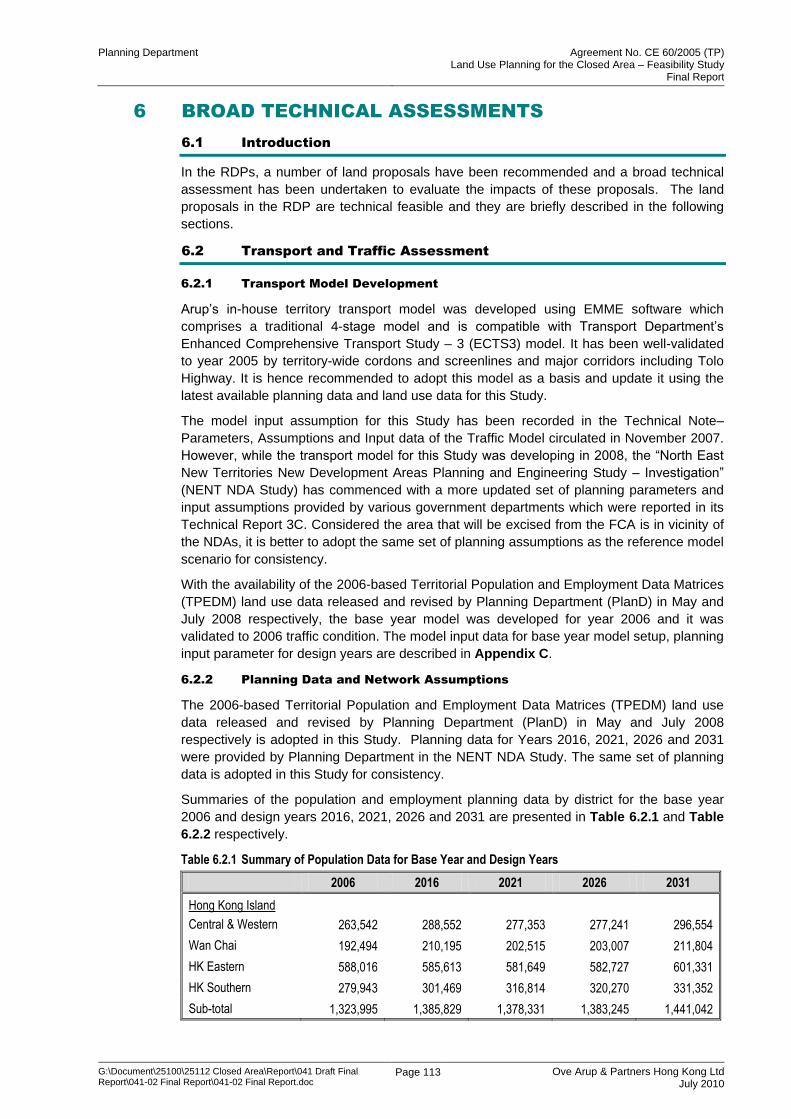
Summaries of the population and employment planning data by district for the base year
2006 and design years 2016, 2021, 2026 and 2031 are presented in Table 6.2.1 and Table
6.2.2 respectively.
Table 6.2.1 Summary of Population Data for Base Year and Design Years
2006 2016 2021 2026 2031
Hong Kong Island
Central & Western 263,542 288,552 277,353 277,241 296,554
Wan Chai 192,494 210,195 202,515 203,007 211,804
HK Eastern 588,016 585,613 581,649 582,727 601,331
HK Southern 279,943 301,469 316,814 320,270 331,352
Sub-total 1,323,995 1,385,829 1,378,331 1,383,245 1,441,042
Planning Department Agreement No. CE 60/2005 (TP) Land Use Planning for the Closed Area – Feasibility Study
Final Report
G:\Document\25100\25112 Closed Area\Report\041 Draft Final Report\041-02 Final Report\041-02 Final Report.doc
Page 114 Ove Arup & Partners Hong Kong Ltd July 2010
2006 2016 2021 2026 2031
Kowloon Urban
Yau Ma Tei 198,798 230,982 241,427 242,953 255,932
Mong Kok 137,413 147,396 141,044 141,707 151,354
Sham Shui Po 390,656 463,342 497,963 504,408 529,357
Kowloon City 371,887 439,563 490,479 494,130 511,128
Kwun Tong 594,471 670,920 708,767 716,163 739,908
Wong Tai Sin 429,846 427,518 439,650 442,592 454,435
Sub-total 2,123,072 2,379,721 2,519,331 2,541,953 2,642,115
New Territories
Tsuen Wan 279,093 285,619 283,693 286,004 296,314
Kwai Chung 315,940 315,533 336,273 343,011 354,862
Tsing Yi 206,486 197,166 197,704 198,394 203,809
Tuen Mun 489,960 520,486 572,950 579,859 599,218
Yuen Long 143,775 163,169 158,763 160,766 178,846
Tin Shui Wai 272,217 315,291 321,783 324,890 332,725
Tai Po 252,714 257,215 252,532 254,106 261,945
Fanling/ Sheung Shui 237,562 258,035 360,293 362,590 371,124
Shatin 431,749 496,441 493,268 496,254 510,158
Ma On Shan 194,997 223,556 226,657 225,987 229,107
Tseung Kwan O 348,877 426,455 449,313 449,035 456,436
North Lantau 89,245 143,045 223,705 288,974 297,027
Subtotal 3,262,616 3,602,012 3,876,936 3,969,869 4,091,571
Rural
Rural NWNT 145,282 206,684 217,582 368,518 410,960
Rural NENT 78,079 105,626 110,643 238,326 262,997
Rural SENT 64,472 78,959 80,404 85,421 101,059
Rural SWNT 67,398 76,103 76,648 80,255 88,936
Sub-total 355,231 467,372 485,277 772,520 863,953
Total 7,064,914 7,834,935 8,259,874 8,667,588 9,038,681
Notes:
Population includes Usual Residents and Persons Other than Usual Residents Present in Hong Kong as at Mid-year
Persons Other than Usual Residents Present in Hong Kong as at Mid-year including Mobile Residents and Transients
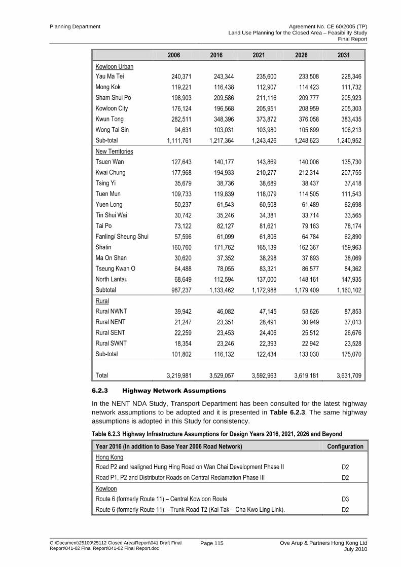
Table 6.2.2 Summary of Employment Data for Base Year and Design Years
2006 2016 2021 2026 2031
Hong Kong Island
Central & Western 377,746 385,564 380,109 388,632 395,489
Wan Chai 275,644 274,184 280,467 275,378 269,372
HK Eastern 273,372 295,064 288,692 282,913 277,692
HK Southern 92,420 107,287 104,847 111,198 113,032
Sub-total 1,019,181 1,062,099 1,054,115 1,058,120 1,055,585
Planning Department Agreement No. CE 60/2005 (TP) Land Use Planning for the Closed Area – Feasibility Study
Final Report
G:\Document\25100\25112 Closed Area\Report\041 Draft Final Report\041-02 Final Report\041-02 Final Report.doc
Page 115 Ove Arup & Partners Hong Kong Ltd July 2010
2006 2016 2021 2026 2031
Kowloon Urban
Yau Ma Tei 240,371 243,344 235,600 233,508 228,346
Mong Kok 119,221 116,438 112,907 114,423 111,732
Sham Shui Po 198,903 209,586 211,116 209,777 205,923
Kowloon City 176,124 196,568 205,951 208,959 205,303
Kwun Tong 282,511 348,396 373,872 376,058 383,435
Wong Tai Sin 94,631 103,031 103,980 105,899 106,213
Sub-total 1,111,761 1,217,364 1,243,426 1,248,623 1,240,952
New Territories
Tsuen Wan 127,643 140,177 143,869 140,006 135,730
Kwai Chung 177,968 194,933 210,277 212,314 207,755
Tsing Yi 35,679 38,736 38,689 38,437 37,418
Tuen Mun 109,733 119,839 118,079 114,505 111,543
Yuen Long 50,237 61,543 60,508 61,489 62,698
Tin Shui Wai 30,742 35,246 34,381 33,714 33,565
Tai Po 73,122 82,127 81,621 79,163 78,174
Fanling/ Sheung Shui 57,596 61,099 61,806 64,784 62,890
Shatin 160,760 171,762 165,139 162,367 159,963
Ma On Shan 30,620 37,352 38,298 37,893 38,069
Tseung Kwan O 64,488 78,055 83,321 86,577 84,362
North Lantau 68,649 112,594 137,000 148,161 147,935
Subtotal 987,237 1,133,462 1,172,988 1,179,409 1,160,102
Rural
Rural NWNT 39,942 46,082 47,145 53,626 87,853
Rural NENT 21,247 23,351 28,491 30,949 37,013
Rural SENT 22,259 23,453 24,406 25,512 26,676
Rural SWNT 18,354 23,246 22,393 22,942 23,528
Sub-total 101,802 116,132 122,434 133,030 175,070
Total 3,219,981 3,529,057 3,592,963 3,619,181 3,631,709
6.2.3 Highway Network Assumptions
In the NENT NDA Study, Transport Department has been consulted for the latest highway
network assumptions to be adopted and it is presented in Table 6.2.3. The same highway
assumptions is adopted in this Study for consistency.
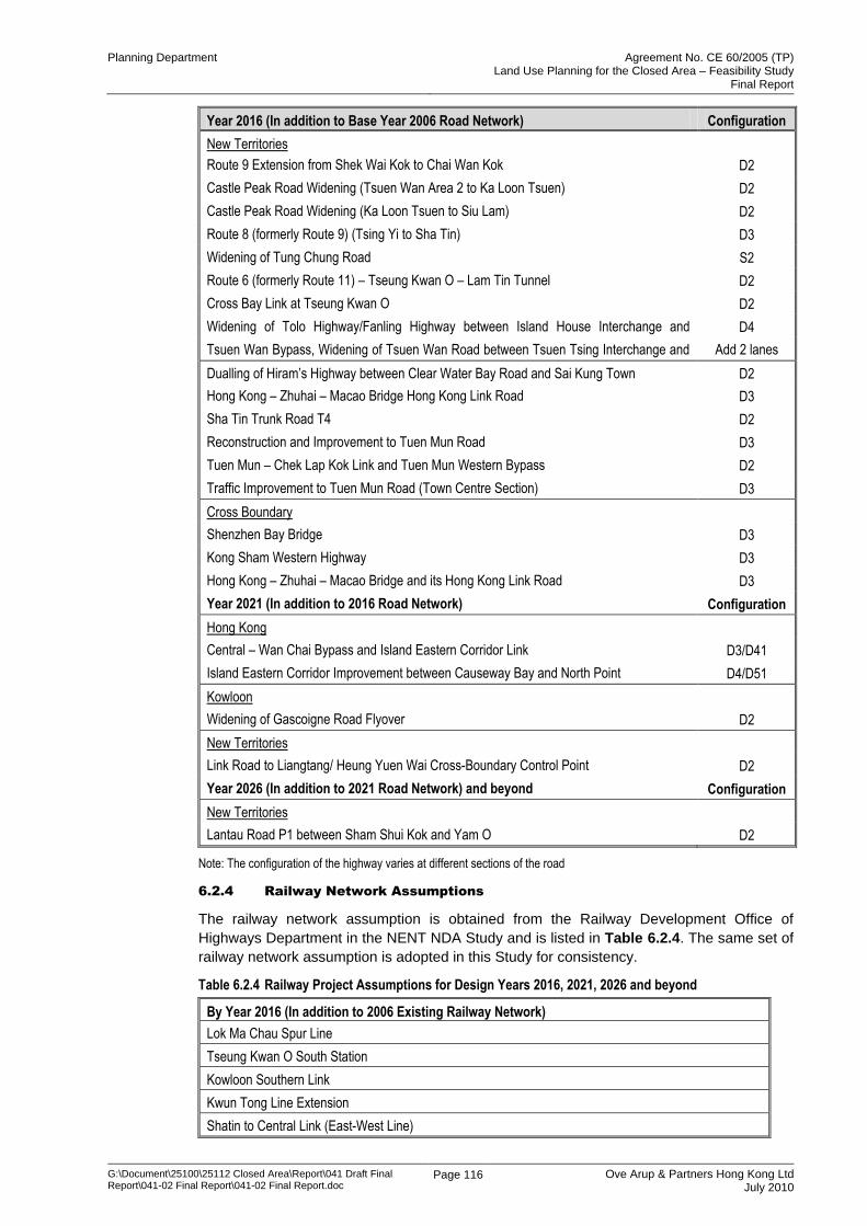
Table 6.2.3 Highway Infrastructure Assumptions for Design Years 2016, 2021, 2026 and Beyond
Year 2016 (In addition to Base Year 2006 Road Network) Configuration
Hong Kong
Road P2 and realigned Hung Hing Road on Wan Chai Development Phase II D2
Road P1, P2 and Distributor Roads on Central Reclamation Phase III D2
Kowloon
Route 6 (formerly Route 11) – Central Kowloon Route D3
Route 6 (formerly Route 11) – Trunk Road T2 (Kai Tak – Cha Kwo Ling Link). D2
Planning Department Agreement No. CE 60/2005 (TP) Land Use Planning for the Closed Area – Feasibility Study
Final Report
G:\Document\25100\25112 Closed Area\Report\041 Draft Final Report\041-02 Final Report\041-02 Final Report.doc
Page 116 Ove Arup & Partners Hong Kong Ltd July 2010
Year 2016 (In addition to Base Year 2006 Road Network) Configuration
New Territories
Route 9 Extension from Shek Wai Kok to Chai Wan Kok D2
Castle Peak Road Widening (Tsuen Wan Area 2 to Ka Loon Tsuen) D2
Castle Peak Road Widening (Ka Loon Tsuen to Siu Lam) D2
Route 8 (formerly Route 9) (Tsing Yi to Sha Tin) D3
Widening of Tung Chung Road S2
Route 6 (formerly Route 11) – Tseung Kwan O – Lam Tin Tunnel D2
Cross Bay Link at Tseung Kwan O D2
Widening of Tolo Highway/Fanling Highway between Island House Interchange and
Fanling (Stage 1 – Section between Island House Interchange and Tai Hang) and (Stage 2
– Section between Tai Hang and Wo Hop Shek Interchange)
D4
Tsuen Wan Bypass, Widening of Tsuen Wan Road between Tsuen Tsing Interchange and
Kwai Tsing Interchange, and Associated Junction Improvement Works
Add 2 lanes
per direction Dualling of Hiram‟s Highway between Clear Water Bay Road and Sai Kung Town D2
Hong Kong – Zhuhai – Macao Bridge Hong Kong Link Road D3
Sha Tin Trunk Road T4 D2
Reconstruction and Improvement to Tuen Mun Road D3
Tuen Mun – Chek Lap Kok Link and Tuen Mun Western Bypass D2
Traffic Improvement to Tuen Mun Road (Town Centre Section) D3
Cross Boundary
Shenzhen Bay Bridge D3
Kong Sham Western Highway D3
Hong Kong – Zhuhai – Macao Bridge and its Hong Kong Link Road D3
Year 2021 (In addition to 2016 Road Network) Configuration
Hong Kong
Central – Wan Chai Bypass and Island Eastern Corridor Link D3/D41
Island Eastern Corridor Improvement between Causeway Bay and North Point D4/D51
Kowloon
Widening of Gascoigne Road Flyover D2
New Territories
Link Road to Liangtang/ Heung Yuen Wai Cross-Boundary Control Point D2
Year 2026 (In addition to 2021 Road Network) and beyond Configuration
New Territories
Lantau Road P1 between Sham Shui Kok and Yam O D2
Note: The configuration of the highway varies at different sections of the road
6.2.4 Railway Network Assumptions
The railway network assumption is obtained from the Railway Development Office of
Highways Department in the NENT NDA Study and is listed in Table 6.2.4. The same set of
railway network assumption is adopted in this Study for consistency.
Table 6.2.4 Railway Project Assumptions for Design Years 2016, 2021, 2026 and beyond
By Year 2016 (In addition to 2006 Existing Railway Network)
Lok Ma Chau Spur Line
Tseung Kwan O South Station
Kowloon Southern Link
Kwun Tong Line Extension
Shatin to Central Link (East-West Line)
Planning Department Agreement No. CE 60/2005 (TP) Land Use Planning for the Closed Area – Feasibility Study
Final Report
G:\Document\25100\25112 Closed Area\Report\041 Draft Final Report\041-02 Final Report\041-02 Final Report.doc
Page 117 Ove Arup & Partners Hong Kong Ltd July 2010
West Island Line
South Island Line East
Guangzhou – Shenzhen – Hong Kong Express Rail Link
By Year 2021 (In addition to 2016 Railway Network)
Shatin to Central Link (North-South Line)
South Island Line West
Northern Link
North Hong Kong Island Line
Opening of Hung Shui Kiu MTR Station
By Year 2026 and beyond (In addition to 2021 Railway Network)
Opening of Tai Ho Wan MTR Station
Opening of Kwu Tung MTR Station
6.2.5 Cross Boundary Traffic
The latest cross boundary traffic forecast is provided by Planning Department under the
NENT NDA Study and is adopted in this Study as shown in Table 6.2.5.
Table 6.2.5 Cross Boundary Traffic Forecast (in daily vehicles)
Cross Boundary Point Vehicle Type 2020 2030
Lok Ma Chau (LMC) Bus/ Coach 2,600 2,700
GV 9,500 9,200
CT 9,800 9,500
Car 16,600 20,800
Total 38,500 42,100
Man Kam To (MKT) Bus/ Coach 300 400
GV 1,900 1,900
CT 1,800 1,800
Car 3,900 4,800
Total 7,900 9,000
Sha Tau Kok (STK) Bus/ Coach 400 500
GV 800 700
CT 600 600
Car 1,100 1,400
Total 3,000 3,200
Shenzhen Bay Port (SBP) Bus/ Coach 3,300 5,100
GV 21,600 25,500
CT 21,500 25,400
Car 34,000 54,500
Total 80,300 110,500
Hong Kong – Zhuhau Macao Bridge (HZMB)
Bus/ Coach 2,800 4,200
GV 1,200 2,100
CT 1,700 2,700
Car 7,500 14,800
Total 13,200 23,900
Cross Boundary Total Bus/ Coach 9,400 12,900
GV 35,000 39,400
CT 35,400 39,900
Car 63,000 96,400
Total 142,800 188,700
Source: From HK2030 Study by Planning Department, October 2007
Planning Department Agreement No. CE 60/2005 (TP) Land Use Planning for the Closed Area – Feasibility Study
Final Report
G:\Document\25100\25112 Closed Area\Report\041 Draft Final Report\041-02 Final Report\041-02 Final Report.doc
Page 118 Ove Arup & Partners Hong Kong Ltd July 2010
Liantang / Heung Yuen Wai BCP was not included in the traffic forecasts in HK2030 as
shown in Table 6.2.5. The estimation of traffic movements at BCPs should be as follows:
adopt the traffic forecasts at various BCPs from the HK 2030 as shown in Table 6.2.5
and those at Liantang / Heung Yuen Wai BCP from the Shenzhen – Hong Kong
Preliminary Planning Study on Developing Liantang/Heung Yuen Wai Control Point
(Liantang Study)
divert traffic from other BCPs to Liantang / Heung Yuen Wai BCP based on the
Liantang Study results to derive the traffic volumes for 2020 and 2030 at all BCPs.
interpolate or extrapolate from 2020 and 2030 figures to produce 2021, 2026 and 2031
estimates as shown in Table 6.2.6.
Table 6.2.6 Cross Boundary Traffic Forecast for Model Design Years (in daily vehicles)
BCP Vehicle Type 2016 2021 2026 2031
Lok Ma Chau (LMC) Bus/ Coach 3,100 3,200 3,300 3,400
GV 4,600 4,000 3,400 2,800
CT 4,700 4,100 3,500 2,900
Car 14,200 16,000 17,700 19,500
Total 26,600 27,300 27,900 28,600
Man Kam To (MKT) Bus/ Coach 400 400 500 500
GV 900 800 700 600
CT 900 800 700 600
Car 3,400 3,800 4,200 4,600
Total 5,600 5,800 6,100 6,300
Sha Tau Kok (STK) Bus/ Coach 400 500 600 700
GV 300 300 200 200
CT 300 300 200 200
Car 900 1,000 1,200 1,300
Total 1,900 2,100 2,200 2,400
Shenzhen Bay Port (SBP) Bus/ Coach 2,600 3,600 4,500 5,500
GV 19,700 21,600 23,500 25,400
CT 19,600 21,500 23,400 25,300
Car 25,700 36,000 46,300 56,600
Total 67,600 82,700 97,700 112,800
Hong Kong – Zhuhau Macao Bridge (HZMB)
Bus/ Coach 2,300 3,000 3,700 4,400
GV 600 1,100 1,500 2,000
CT 1,100 1,600 2,100 2,600
Car 4,400 8,100 11,800 15,500
Total 8,400 13,800 19,100 24,500
Liantang/Heung Yuen Wai (LT/HYW)
Bus/ Coach - 600 700 800
GV - 7,600 8,200 8,800
CT - 7,600 8,200 8,800
Car - 1,500 2,000 2,500
Total - 17,300 19,100 20,900
Cross Boundary Total Bus/ Coach 8,800 11,400 13,400 15,400
GV 26,100 35,300 37,500 39,700
CT 26,600 35,900 38,100 40,400
Car 48,600 66,400 83,200 100,000
Total 110,100 149,000 172,200 195,500
Planning Department Agreement No. CE 60/2005 (TP) Land Use Planning for the Closed Area – Feasibility Study
Final Report
G:\Document\25100\25112 Closed Area\Report\041 Draft Final Report\041-02 Final Report\041-02 Final Report.doc
Page 119 Ove Arup & Partners Hong Kong Ltd July 2010
It is noted that the second stage assessment of NENT NDA Study will adopt a revised set of
cross boundary assumptions, which is the same set adopted in the TMCLKL Study.
However, due to the time mismatch, the revised assumption made in NENT NDA Study will
not be adopted in the transport model of this Study. Nonetheless, the cross boundary input
adopted in the Closed Area Study assumes 28,600, 6,300, 2,400 and 20,900 daily vehicles
at LMC, MKT, STK and Liantang/ Heung Yuen Wai respectively in 2031. The cross
boundary input for TMCLKL study assumes 20,400, 2,000, 3,200 and 18,800 daily vehicles
at LMC, MKT, STK and Liantang/ Heung Yuen Wai correspondingly. The traffic forecast
assumed in this Study is therefore on a more conservative side based on a greater cross-
boundary demand in these BCPs.
6.2.6 Overall Traffic Impact Assessment
Amongst the proposed development concepts, it is identified that the new residential
developments in Kong Nga Po and Hung Lung Hang, and various recreation land are the
major traffic generators that may have implications to the existing road networks. The 2-way
traffic generated is about 650 PCUs in the peak hour. The other major traffic demand
comes from the anticipated increase of population in the existing recognised villages.
According to the 10 years small house demand, the village population within the Study Area
will be increased from 3,000 to 25,500. The estimated additional peak hour traffic is about
850 PCUs. All other land uses proposed for the Study Areas are with low traffic demand and
are mainly weekend traffic, such as Eco Lodge, Holiday Camp, organic farms, hiking trail
and cycle track etc. The planning intention for the Study Area is to maintain the natural
environment with minimal level of development. As can be seen from above, most of the
land uses are “green” in nature without generating too much traffic.
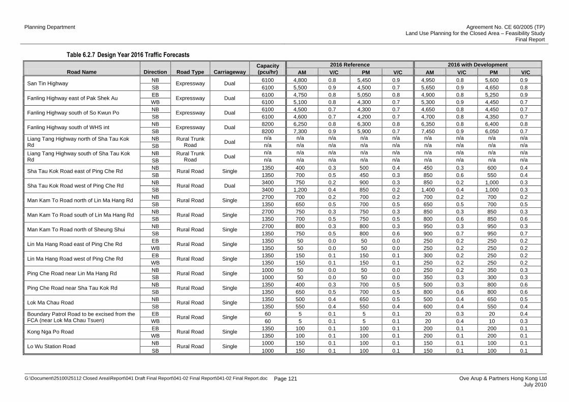
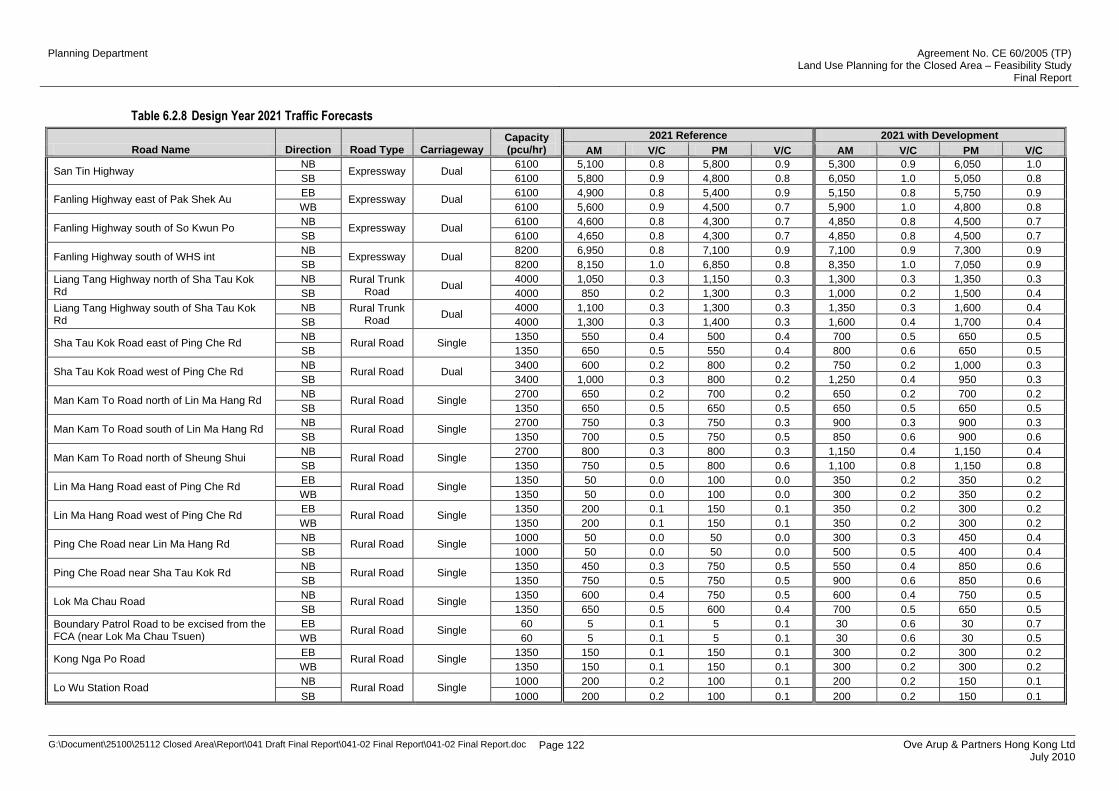
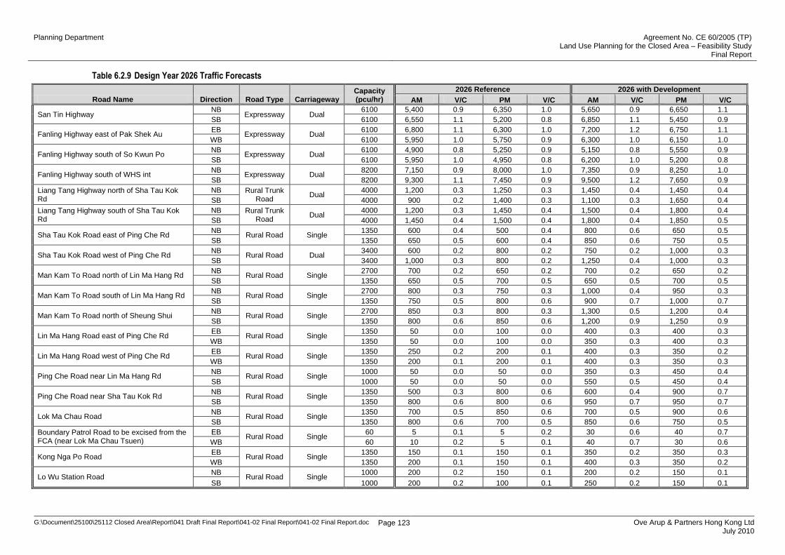
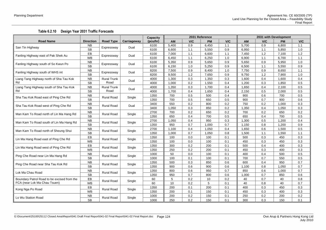
Table 6.2.7, Table 6.2.8, Table 6.2.9 and Table 6.2.10 show the traffic forecasts for the
strategic highways in NENT and the major local distributors of the Study Area. The
assessment is based on the scenario with the implementation of various road improvement
measures such as widening of Lin Ma Hang Road and Kong Nga Po Road, and traffic
restriction at the existing boundary patrol road to be excised from the FCA . The traffic
forecasts show that both San Tin Highway and Fanling Highway will be operating within
capacity until 2021. In 2031, the highest V/C ratio of these two highways shall reach 1.2 and
1.1 respectively. A V/C ratio above 1.2 indicates that the road is operating beyond the
practical capacity. The development traffic will not impose significant impact on the link
capacity of regional and local distributors. Under both of the reference case and the “with
development” case, the V/C of all local distributors is operating within the practical capacity.
As discussed in Section 6.2.5, the cross boundary assumption as adopted in TR3C of the
NENT NDA Study was used in this Study. The use of the revised cross-boundary
assumption (small cross boundary traffic forecast for the BCPs within the study area) as
adopted in the second stage assessment of NENT NDA is not adopted due to the time
mismatch. Nonetheless, the major traffic corridors including Man Kam To Road and Sha
Tau Kok Road would be operating within the practical capacity under the current cross-
boundary assumptions, no improvement measures would be necessary. With a lower cross-
boundary demand (same as TMCLKL Study) at these BCPs, it is believed that the major
corridors will be operating with more reserve capacity during peak hour. Again, no
improvement measures would be necessary.
Apart from cross-boundary assumption, it is noted that the second stage assessment of
NETN NDA will also adopt a revised set of airport passenger and cargo forecast. It is not
recommended to revise the developed transport model using the latest airport assumption
due to possible time and cost implication to this Study. Nevertheless, it is considered that
the impact of the airport traffic to the Closed Area would not be significant. In addition to
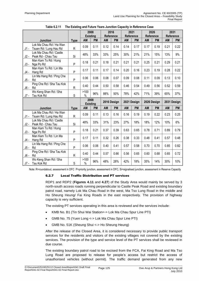
assess the link capacity, 7 main junctions within the Study Area are selected for junction
capacity analysis. Table 6.2.11 shows the results of the reference and design case. In the
junction capacity analysis, PM peak of the design case is generally slightly worse than in
Planning Department Agreement No. CE 60/2005 (TP) Land Use Planning for the Closed Area – Feasibility Study
Final Report
G:\Document\25100\25112 Closed Area\Report\041 Draft Final Report\041-02 Final Report\041-02 Final Report.doc
Page 120 Ove Arup & Partners Hong Kong Ltd July 2010
AM peak. For the signalised junctions, J2 (Lok Ma Chau Road/ Castle Peak Road – Chau
Tau) and J7 (Wo Keng Shan Road/ Sha Tau Kok Road) will perform satisfactorily with
ample reserve capacity of 6% and 10% respectively in year 2031. On the other hand, the
critical design flow / capacity ratio (DFC) of the priority junctions and roundabouts is 0.89 at
J3 (Man Kam To Road/ Kong Nga Po Road) and 0.85 at J5 (Lin Ma Hang Road/ Ping Che
Road) in year 2031. A DFC of 85% would indicate that queuing would theoretically be
avoided in nearly all (85% of) cases. Therefore, it is anticipated that the priority junctions /
roundabouts will perform satisfactorily in the design case, while junction J3 would operate at
marginal level. The junction capacity calculation shows that all of the 7 junctions in the
future are operating with reserved capacity.
Planning Department Agreement No. CE 60/2005 (TP) Land Use Planning for the Closed Area – Feasibility Study
Final Report
G:\Document\25100\25112 Closed Area\Report\041 Draft Final Report\041-02 Final Report\041-02 Final Report.doc Page 121 Ove Arup & Partners Hong Kong Ltd July 2010
Table 6.2.7 Design Year 2016 Traffic Forecasts
Road Name Direction Road Type Carriageway Capacity (pcu/hr)
2016 Reference 2016 with Development
AM Demand (pcu/hr)
V/C PM Demand (pcu/hr)
V/C AM Demand (pcu/hr)
V/C PM Demand (pcu/hr)
V/C
San Tin Highway NB
Expressway Dual 6100 4,800 0.8 5,450 0.9 4,950 0.8 5,600 0.9
SB 6100 5,500 0.9 4,500 0.7 5,650 0.9 4,650 0.8
Fanling Highway east of Pak Shek Au EB
Expressway Dual 6100 4,750 0.8 5,050 0.8 4,900 0.8 5,250 0.9
WB 6100 5,100 0.8 4,300 0.7 5,300 0.9 4,450 0.7
Fanling Highway south of So Kwun Po NB
Expressway Dual 6100 4,500 0.7 4,300 0.7 4,650 0.8 4,450 0.7
SB 6100 4,600 0.7 4,200 0.7 4,700 0.8 4,350 0.7
Fanling Highway south of WHS int NB
Expressway Dual 8200 6,250 0.8 6,300 0.8 6,350 0.8 6,400 0.8
SB 8200 7,300 0.9 5,900 0.7 7,450 0.9 6,050 0.7
Liang Tang Highway north of Sha Tau Kok Rd
NB Rural Trunk Road
Dual n/a n/a n/a n/a n/a n/a n/a n/a n/a
SB n/a n/a n/a n/a n/a n/a n/a n/a n/a
Liang Tang Highway south of Sha Tau Kok Rd
NB Rural Trunk Road
Dual n/a n/a n/a n/a n/a n/a n/a n/a n/a
SB n/a n/a n/a n/a n/a n/a n/a n/a n/a
Sha Tau Kok Road east of Ping Che Rd NB
Rural Road Single 1350 400 0.3 500 0.4 450 0.3 600 0.4
SB 1350 700 0.5 450 0.3 850 0.6 550 0.4
Sha Tau Kok Road west of Ping Che Rd NB
Rural Road Dual 3400 750 0.2 900 0.3 850 0.2 1,000 0.3
SB 3400 1,200 0.4 850 0.2 1,400 0.4 1,000 0.3
Man Kam To Road north of Lin Ma Hang Rd NB
Rural Road Single 2700 700 0.2 700 0.2 700 0.2 700 0.2
SB 1350 650 0.5 700 0.5 650 0.5 700 0.5
Man Kam To Road south of Lin Ma Hang Rd NB
Rural Road Single 2700 750 0.3 750 0.3 850 0.3 850 0.3
SB 1350 700 0.5 750 0.5 800 0.6 850 0.6
Man Kam To Road north of Sheung Shui NB
Rural Road Single 2700 800 0.3 800 0.3 950 0.3 950 0.3
SB 1350 750 0.5 800 0.6 900 0.7 950 0.7
Lin Ma Hang Road east of Ping Che Rd EB
Rural Road Single 1350 50 0.0 50 0.0 250 0.2 250 0.2
WB 1350 50 0.0 50 0.0 250 0.2 250 0.2
Lin Ma Hang Road west of Ping Che Rd EB
Rural Road Single 1350 150 0.1 150 0.1 300 0.2 250 0.2
WB 1350 150 0.1 150 0.1 250 0.2 250 0.2
Ping Che Road near Lin Ma Hang Rd NB
Rural Road Single 1000 50 0.0 50 0.0 250 0.2 350 0.3
SB 1000 50 0.0 50 0.0 350 0.3 300 0.3
Ping Che Road near Sha Tau Kok Rd NB
Rural Road Single 1350 400 0.3 700 0.5 500 0.3 800 0.6
SB 1350 650 0.5 700 0.5 800 0.6 800 0.6
Lok Ma Chau Road NB
Rural Road Single 1350 500 0.4 650 0.5 500 0.4 650 0.5
SB 1350 550 0.4 550 0.4 600 0.4 550 0.4
Boundary Patrol Road to be excised from the FCA (near Lok Ma Chau Tsuen)
EB Rural Road Single
60 5 0.1 5 0.1 20 0.3 20 0.4
WB 60 5 0.1 5 0.1 20 0.4 10 0.3
Kong Nga Po Road EB
Rural Road Single 1350 100 0.1 100 0.1 200 0.1 200 0.1
WB 1350 100 0.1 100 0.1 200 0.1 200 0.1
Lo Wu Station Road NB
Rural Road Single 1000 150 0.1 100 0.1 150 0.1 100 0.1
SB 1000 150 0.1 100 0.1 150 0.1 100 0.1
Planning Department Agreement No. CE 60/2005 (TP) Land Use Planning for the Closed Area – Feasibility Study
Final Report
G:\Document\25100\25112 Closed Area\Report\041 Draft Final Report\041-02 Final Report\041-02 Final Report.doc Page 122 Ove Arup & Partners Hong Kong Ltd July 2010
Table 6.2.8 Design Year 2021 Traffic Forecasts
Road Name Direction Road Type Carriageway Capacity (pcu/hr)
2021 Reference 2021 with Development
AM Demand (pcu/hr)
V/C PM Demand (pcu/hr)
V/C AM Demand (pcu/hr)
V/C PM Demand (pcu/hr)
V/C
San Tin Highway NB
Expressway Dual 6100 5,100 0.8 5,800 0.9 5,300 0.9 6,050 1.0
SB 6100 5,800 0.9 4,800 0.8 6,050 1.0 5,050 0.8
Fanling Highway east of Pak Shek Au EB
Expressway Dual 6100 4,900 0.8 5,400 0.9 5,150 0.8 5,750 0.9
WB 6100 5,600 0.9 4,500 0.7 5,900 1.0 4,800 0.8
Fanling Highway south of So Kwun Po NB
Expressway Dual 6100 4,600 0.8 4,300 0.7 4,850 0.8 4,500 0.7
SB 6100 4,650 0.8 4,300 0.7 4,850 0.8 4,500 0.7
Fanling Highway south of WHS int NB
Expressway Dual 8200 6,950 0.8 7,100 0.9 7,100 0.9 7,300 0.9
SB 8200 8,150 1.0 6,850 0.8 8,350 1.0 7,050 0.9
Liang Tang Highway north of Sha Tau Kok Rd
NB Rural Trunk Road
Dual 4000 1,050 0.3 1,150 0.3 1,300 0.3 1,350 0.3
SB 4000 850 0.2 1,300 0.3 1,000 0.2 1,500 0.4
Liang Tang Highway south of Sha Tau Kok Rd
NB Rural Trunk Road
Dual 4000 1,100 0.3 1,300 0.3 1,350 0.3 1,600 0.4
SB 4000 1,300 0.3 1,400 0.3 1,600 0.4 1,700 0.4
Sha Tau Kok Road east of Ping Che Rd NB
Rural Road Single 1350 550 0.4 500 0.4 700 0.5 650 0.5
SB 1350 650 0.5 550 0.4 800 0.6 650 0.5
Sha Tau Kok Road west of Ping Che Rd NB
Rural Road Dual 3400 600 0.2 800 0.2 750 0.2 1,000 0.3
SB 3400 1,000 0.3 800 0.2 1,250 0.4 950 0.3
Man Kam To Road north of Lin Ma Hang Rd NB
Rural Road Single 2700 650 0.2 700 0.2 650 0.2 700 0.2
SB 1350 650 0.5 650 0.5 650 0.5 650 0.5
Man Kam To Road south of Lin Ma Hang Rd NB
Rural Road Single 2700 750 0.3 750 0.3 900 0.3 900 0.3
SB 1350 700 0.5 750 0.5 850 0.6 900 0.6
Man Kam To Road north of Sheung Shui NB
Rural Road Single 2700 800 0.3 800 0.3 1,150 0.4 1,150 0.4
SB 1350 750 0.5 800 0.6 1,100 0.8 1,150 0.8
Lin Ma Hang Road east of Ping Che Rd EB
Rural Road Single 1350 50 0.0 100 0.0 350 0.2 350 0.2
WB 1350 50 0.0 100 0.0 300 0.2 350 0.2
Lin Ma Hang Road west of Ping Che Rd EB
Rural Road Single 1350 200 0.1 150 0.1 350 0.2 300 0.2
WB 1350 200 0.1 150 0.1 350 0.2 300 0.2
Ping Che Road near Lin Ma Hang Rd NB
Rural Road Single 1000 50 0.0 50 0.0 300 0.3 450 0.4
SB 1000 50 0.0 50 0.0 500 0.5 400 0.4
Ping Che Road near Sha Tau Kok Rd NB
Rural Road Single 1350 450 0.3 750 0.5 550 0.4 850 0.6
SB 1350 750 0.5 750 0.5 900 0.6 850 0.6
Lok Ma Chau Road NB
Rural Road Single 1350 600 0.4 750 0.5 600 0.4 750 0.5
SB 1350 650 0.5 600 0.4 700 0.5 650 0.5
Boundary Patrol Road to be excised from the FCA (near Lok Ma Chau Tsuen)
EB Rural Road Single
60 5 0.1 5 0.1 30 0.6 30 0.7
WB 60 5 0.1 5 0.1 30 0.6 30 0.5
Kong Nga Po Road EB
Rural Road Single 1350 150 0.1 150 0.1 300 0.2 300 0.2
WB 1350 150 0.1 150 0.1 300 0.2 300 0.2
Lo Wu Station Road NB
Rural Road Single 1000 200 0.2 100 0.1 200 0.2 150 0.1
SB 1000 200 0.2 100 0.1 200 0.2 150 0.1
Planning Department Agreement No. CE 60/2005 (TP) Land Use Planning for the Closed Area – Feasibility Study
Final Report
G:\Document\25100\25112 Closed Area\Report\041 Draft Final Report\041-02 Final Report\041-02 Final Report.doc Page 123 Ove Arup & Partners Hong Kong Ltd July 2010
Table 6.2.9 Design Year 2026 Traffic Forecasts
Road Name Direction Road Type Carriageway Capacity (pcu/hr)
2026 Reference 2026 with Development
AM Demand (pcu/hr)
V/C PM Demand (pcu/hr)
V/C AM Demand (pcu/hr)
V/C PM Demand (pcu/hr)
V/C
San Tin Highway NB
Expressway Dual 6100 5,400 0.9 6,350 1.0 5,650 0.9 6,650 1.1
SB 6100 6,550 1.1 5,200 0.8 6,850 1.1 5,450 0.9
Fanling Highway east of Pak Shek Au EB
Expressway Dual 6100 6,800 1.1 6,300 1.0 7,200 1.2 6,750 1.1
WB 6100 5,950 1.0 5,750 0.9 6,300 1.0 6,150 1.0
Fanling Highway south of So Kwun Po NB
Expressway Dual 6100 4,900 0.8 5,250 0.9 5,150 0.8 5,550 0.9
SB 6100 5,950 1.0 4,950 0.8 6,200 1.0 5,200 0.8
Fanling Highway south of WHS int NB
Expressway Dual 8200 7,150 0.9 8,000 1.0 7,350 0.9 8,250 1.0
SB 8200 9,300 1.1 7,450 0.9 9,500 1.2 7,650 0.9
Liang Tang Highway north of Sha Tau Kok Rd
NB Rural Trunk Road
Dual 4000 1,200 0.3 1,250 0.3 1,450 0.4 1,450 0.4
SB 4000 900 0.2 1,400 0.3 1,100 0.3 1,650 0.4
Liang Tang Highway south of Sha Tau Kok Rd
NB Rural Trunk Road
Dual 4000 1,200 0.3 1,450 0.4 1,500 0.4 1,800 0.4
SB 4000 1,450 0.4 1,500 0.4 1,800 0.4 1,850 0.5
Sha Tau Kok Road east of Ping Che Rd NB
Rural Road Single 1350 600 0.4 500 0.4 800 0.6 650 0.5
SB 1350 650 0.5 600 0.4 850 0.6 750 0.5
Sha Tau Kok Road west of Ping Che Rd NB
Rural Road Dual 3400 600 0.2 800 0.2 750 0.2 1,000 0.3
SB 3400 1,000 0.3 800 0.2 1,250 0.4 1,000 0.3
Man Kam To Road north of Lin Ma Hang Rd NB
Rural Road Single 2700 700 0.2 650 0.2 700 0.2 650 0.2
SB 1350 650 0.5 700 0.5 650 0.5 700 0.5
Man Kam To Road south of Lin Ma Hang Rd NB
Rural Road Single 2700 800 0.3 750 0.3 1,000 0.4 950 0.3
SB 1350 750 0.5 800 0.6 900 0.7 1,000 0.7
Man Kam To Road north of Sheung Shui NB
Rural Road Single 2700 850 0.3 800 0.3 1,300 0.5 1,200 0.4
SB 1350 800 0.6 850 0.6 1,200 0.9 1,250 0.9
Lin Ma Hang Road east of Ping Che Rd EB
Rural Road Single 1350 50 0.0 100 0.0 400 0.3 400 0.3
WB 1350 50 0.0 100 0.0 350 0.3 400 0.3
Lin Ma Hang Road west of Ping Che Rd EB
Rural Road Single 1350 250 0.2 200 0.1 400 0.3 350 0.2
WB 1350 200 0.1 200 0.1 400 0.3 350 0.3
Ping Che Road near Lin Ma Hang Rd NB
Rural Road Single 1000 50 0.0 50 0.0 350 0.3 450 0.4
SB 1000 50 0.0 50 0.0 550 0.5 450 0.4
Ping Che Road near Sha Tau Kok Rd NB
Rural Road Single 1350 500 0.3 800 0.6 600 0.4 900 0.7
SB 1350 800 0.6 800 0.6 950 0.7 950 0.7
Lok Ma Chau Road NB
Rural Road Single 1350 700 0.5 850 0.6 700 0.5 900 0.6
SB 1350 800 0.6 700 0.5 850 0.6 750 0.5
Boundary Patrol Road to be excised from the FCA (near Lok Ma Chau Tsuen)
EB Rural Road Single
60 5 0.1 5 0.2 30 0.6 40 0.7
WB 60 10 0.2 5 0.1 40 0.7 30 0.6
Kong Nga Po Road EB
Rural Road Single 1350 150 0.1 150 0.1 350 0.2 350 0.3
WB 1350 200 0.1 150 0.1 400 0.3 350 0.2
Lo Wu Station Road NB
Rural Road Single 1000 200 0.2 150 0.1 200 0.2 150 0.1
SB 1000 200 0.2 100 0.1 250 0.2 150 0.1
Planning Department Agreement No. CE 60/2005 (TP) Land Use Planning for the Closed Area – Feasibility Study
Final Report
G:\Document\25100\25112 Closed Area\Report\041 Draft Final Report\041-02 Final Report\041-02 Final Report.doc Page 124 Ove Arup & Partners Hong Kong Ltd July 2010
Table 6.2.10 Design Year 2031 Traffic Forecasts
Road Name Direction Road Type Carriageway Capacity (pcu/hr)
2031 Reference 2031 with Development
AM Demand (pcu/hr)
V/C PM Demand (pcu/hr)
V/C AM Demand (pcu/hr)
V/C PM Demand (pcu/hr)
V/C
San Tin Highway NB
Expressway Dual 6100 5,400 0.9 6,450 1.1 5,700 0.9 6,800 1.1
SB 6100 6,600 1.1 5,550 0.9 6,950 1.1 5,850 1.0
Fanling Highway east of Pak Shek Au EB
Expressway Dual 6100 7,000 1.1 6,600 1.1 7,450 1.2 7,100 1.2
WB 6100 6,450 1.1 6,250 1.0 6,900 1.1 6,700 1.1
Fanling Highway south of So Kwun Po NB
Expressway Dual 6100 5,350 0.9 5,650 0.9 5,650 0.9 5,950 1.0
SB 6100 6,150 1.0 5,250 0.9 6,500 1.1 5,550 0.9
Fanling Highway south of WHS int NB
Expressway Dual 8200 7,500 0.9 8,400 1.0 7,750 0.9 8,650 1.1
SB 8200 9,500 1.2 7,650 0.9 9,750 1.2 7,900 1.0
Liang Tang Highway north of Sha Tau Kok Rd
NB Rural Trunk Road
Dual 4000 1,300 0.3 1,350 0.3 1,600 0.4 1,600 0.4
SB 4000 1,000 0.2 1,550 0.4 1,200 0.3 1,850 0.5
Liang Tang Highway south of Sha Tau Kok Rd
NB Rural Trunk Road
Dual 4000 1,350 0.3 1,700 0.4 1,650 0.4 2,100 0.5
SB 4000 1,700 0.4 1,650 0.4 2,150 0.5 2,000 0.5
Sha Tau Kok Road east of Ping Che Rd NB
Rural Road Single 1350 700 0.5 500 0.4 900 0.6 700 0.5
SB 1350 700 0.5 650 0.5 900 0.7 900 0.6
Sha Tau Kok Road west of Ping Che Rd NB
Rural Road Dual 3400 550 0.2 800 0.2 750 0.2 1,000 0.3
SB 3400 1,050 0.3 850 0.2 1,350 0.4 1,050 0.3
Man Kam To Road north of Lin Ma Hang Rd NB
Rural Road Single 2700 700 0.2 650 0.2 700 0.2 650 0.2
SB 1350 650 0.4 700 0.5 650 0.4 700 0.5
Man Kam To Road south of Lin Ma Hang Rd NB
Rural Road Single 2700 1,050 0.4 950 0.3 1,300 0.5 1,200 0.4
SB 1350 950 0.7 1,000 0.7 1,150 0.8 1,200 0.9
Man Kam To Road north of Sheung Shui NB
Rural Road Single 2700 1,100 0.4 1,050 0.4 1,650 0.6 1,500 0.5
SB 1350 1,000 0.7 1,050 0.8 1,500 1.1 1,550 1.1
Lin Ma Hang Road east of Ping Che Rd EB
Rural Road Single 1350 100 0.0 100 0.1 500 0.3 450 0.3
WB 1350 100 0.0 100 0.1 450 0.3 450 0.3
Lin Ma Hang Road west of Ping Che Rd EB
Rural Road Single 1350 300 0.2 200 0.1 500 0.4 400 0.3
WB 1350 250 0.2 200 0.1 450 0.3 400 0.3
Ping Che Road near Lin Ma Hang Rd NB
Rural Road Single 1000 50 0.0 100 0.1 400 0.4 500 0.5
SB 1000 100 0.1 100 0.1 700 0.7 550 0.5
Ping Che Road near Sha Tau Kok Rd NB
Rural Road Single 1350 500 0.3 850 0.6 600 0.4 950 0.7
SB 1350 900 0.6 900 0.6 1,100 0.8 1,050 0.7
Lok Ma Chau Road NB
Rural Road Single 1350 800 0.6 950 0.7 850 0.6 1,000 0.7
SB 1350 950 0.7 800 0.6 1,000 0.7 850 0.6
Boundary Patrol Road to be excised from the FCA (near Lok Ma Chau Tsuen)
EB Rural Road Single
60 5 0.2 10 0.2 40 0.7 40 0.8
WB 60 10 0.2 5 0.1 40 0.8 40 0.7
Kong Nga Po Road EB
Rural Road Single 1350 200 0.1 200 0.1 400 0.3 450 0.3
WB 1350 200 0.1 150 0.1 450 0.3 400 0.3
Lo Wu Station Road NB
Rural Road Single 1000 200 0.2 150 0.1 250 0.2 200 0.2
SB 1000 250 0.2 150 0.1 300 0.3 150 0.1
Planning Department Agreement No. CE 60/2005 (TP) Land Use Planning for the Closed Area – Feasibility Study
Final Report
G:\Document\25100\25112 Closed Area\Report\041 Draft Final Report\041-02 Final Report\041-02 Final Report.doc
Page 125 Ove Arup & Partners Hong Kong Ltd July 2010
Table 6.2.11 The Existing and Future Years Junction Capacity in Reference Case
Junction Type
2008 Existing
2016 Reference
2021 Reference
2026 Reference
2031 Reference
AM PM AM PM AM PM AM PM AM PM
J1 - Lok Ma Chau Rd / Ha Wan Tsuen Rd / Lung Hau Rd R
0.09 0.11 0.12 0.14 0.14 0.17 0.17 0.19 0.21 0.22
J2 - Lok Ma Chau Rd / Castle Peak Rd - Chau Tau Si
48% 33% 33% 25% 30% 21% 21% 15% 13% 9%
J3 - Man Kam To Rd / Kong Nga Po Rd P
0.18 0.21 0.18 0.21 0.21 0.21 0.25 0.21 0.29 0.21
J4 - Man Kam To Rd / Lin Ma Hang Rd P
0.17 0.11 0.17 0.14 0.20 0.16 0.23 0.19 0.28 0.22
J5 - Lin Ma Hang Rd / Ping Che Rd P
0.06 0.06 0.08 0.07 0.09 0.08 0.11 0.09 0.13 0.10
J6 - Ping Che Rd / Sha Tau Kok Rd R
0.40 0.44 0.50 0.58 0.46 0.54 0.49 0.56 0.52 0.59
J7 - Wo Keng Shan Rd / Sha Tau Kok Rd S
>100%
96% 88% 50% 78% 42% 71% 39% 65% 37%
Junction Type
2008 Existing
2016 Design 2021 Design 2026 Design 2031 Design
AM PM AM PM AM PM AM PM AM PM
J1 - Lok Ma Chau Rd / Ha Wan Tsuen Rd / Lung Hau Rd R
0.09 0.11 0.13 0.16 0.16 0.19 0.19 0.22 0.23 0.25
J2 - Lok Ma Chau Rd / Castle Peak Rd - Chau Tau Si
48% 33% 31% 23% 27% 18% 18% 12% 10% 6%
J3 - Man Kam To Rd / Kong Nga Po Rd P
0.18 0.21 0.37 0.39 0.63 0.65 0.78 0.71 0.89 0.79
J4 - Man Kam To Rd / Lin Ma Hang Rd P
0.17 0.11 0.32 0.26 0.38 0.33 0.48 0.41 0.57 0.48
J5 - Lin Ma Hang Rd / Ping Che Rd P
0.06 0.06 0.40 0.41 0.57 0.58 0.70 0.70 0.85 0.82
J6 - Ping Che Rd / Sha Tau Kok Rd R
0.40 0.44 0.57 0.66 0.56 0.65 0.60 0.68 0.65 0.72
J7 - Wo Keng Shan Rd / Sha Tau Kok Rd S
>100%
96% 48% 28% 42% 18% 35% 14% 30% 10%
Note: R=roundabout, assessment in DFC P=priority junction, assessment in DFC, Si=signalised junction, assessment in Reserve Capacity
6.2.7 Local Traffic Distribution and PT services
RDP1 and RDP2 (Figures 4.11 and 4.27) of the Study Area would mainly be served by 3
north-south access roads running perpendicular to Castle Peak Road and existing boundary
patrol road, namely Lok Ma Chau Road in the west, Ma Tso Lung Road in the middle and
Ho Sheung Heung/ Fai King Roads in the east respectively. The provision of highway
capacity is very sufficient.
The existing PT services operating in this area is reviewed and the services include:
KMB No. B1 (Tin Shui Wai Station<-> Lok Ma Chau Spur Line PTI)
GMB No. 75 (Yuen Long <-> Lok Ma Chau Spur Line PTI)
GMB No. 51K (Sheung Shui <-> Ho Sheung Heung)
After the release of the Closed Area, it is considered necessary to provide public transport
services for the residents and visitors of the existing villages not covered by the existing
services. The provision of the type and service level of the PT services shall be reviewed in
due course.
The existing boundary patrol road to be excised from the FCA, Fai King Road and Ma Tso
Lung Road are proposed to release for people‟s access but restrict the access of
unauthorised vehicles (without permit). The traffic demand generated from any new
Planning Department Agreement No. CE 60/2005 (TP) Land Use Planning for the Closed Area – Feasibility Study
Final Report
G:\Document\25100\25112 Closed Area\Report\041 Draft Final Report\041-02 Final Report\041-02 Final Report.doc
Page 126 Ove Arup & Partners Hong Kong Ltd July 2010
developments along these roads will be supported by public transport services. Regarding
new developments, it is estimated that less than 300 visitor trips will be made at peak hours
to Eco Lodge and other conservation areas. Given the low daily visitor anticipated, new
public transport terminus in the area is not recommended. Shuttle services between the
western portion of Study areas and the nearest railway station could provide reasonable
good service for the visitors to Eco Lodge and other conservation areas. Provision of shuttle
service with 4 minute headway and capacity of 24 (equivalent to hourly capacity of 360) or
the provision of new GMB service with 3 minute headway (equivalent to hourly capacity of
about 320 seats) during peak hour would be sufficient for such a low demand. Nonetheless,
the type of service, capacity and frequency of the shuttle services should be subject to
future review. However, provision of long public transport vehicles to Eco Lodge and other
conservation areas along the existing boundary patrol road to be excised from the FCA, Fai
King Road and Ma Tso Lung Road is not recommended as restriction for vehicles
exceeding 7m would be executed after the release of the area for traffic safety reason.
RDP3 and RDP4 (Figures 4.43 and 4.59) of the study area are mainly served by 2
distributors running in north-south direction namely Man Kam To Road and Ping Che Road.
The existing PT services operating in this area is reviewed and the services include:
KMB No. 73K (Sheung Shui <-> Man Kam To San Uk Ling)
KMB No. 79K (Sheung Shui <-> Ta Kwu Ling)
GMB No. 52K (Fanling <-> Ping Che)
GMB No. 59K (Fanling <-> Lin Ma Hang)
After the release of the Closed Area, it is considered necessary to provide public transport
services for the residents and visitors of the existing villages not covered by the existing
services. The existing PT services running via Man Kam To Road, Ping Che Road and Lin
Ma Hang Road may be rerouted to cover more village areas, subject to passenger demand.
Regarding new developments, it is expected that majority of the above development traffic
would be distributed onto Man Kam To Road for access to other part of HK. It is estimated
that less than 330 person trips for public transport services will be generated during peak
hour from the current proposed low population intake at Kong Nga Pong and Hung Lung
Hang. It therefore does not support the provision of a new PTI. Shuttle services circulating
between the nearest railway station would be sufficient for daily commuting purposes. It is
anticipated that provision of shuttle service with 5 minute headway and capacity of 28 seats
(equivalent to hourly capacity of 336 seats), or the provision of new public bus service with
15 minute headway (equivalent to hourly capacity of about 400 seats), during peak hour
would accommodate such a low demand.
For the Man Kam To Development Corridor, it is estimated that less than 30 person working
trips for public transport services will be generated during peak hour. It is anticipated that
the low public transport trip demand could be sufficiently accommodated by the existing
public transport services operating along Man Kam To Road.
In addition, the estimated daily visitors and working staff for the C&C facilities is about 1,900,
with peak hour demand less than 190. They are not transient but estimated normal weekday
demand on a conservative side. Bus or public light bus terminus shall be required for the
C&C facilities at Sha Ling. However, the sizing of the terminus and service route could only
be determined when detailed development plan is finalised. The preliminary concept could
be a shuttle/ GMB route (16 seats) from the C&C facilities to the nearest rail station PTI at 5-
minute headway during peak hour (equivalent to capacity of 192 seats). Nonetheless, the
type of service, capacity and frequency of these shuttle services should be subject to future
review.
Planning Department Agreement No. CE 60/2005 (TP) Land Use Planning for the Closed Area – Feasibility Study
Final Report
G:\Document\25100\25112 Closed Area\Report\041 Draft Final Report\041-02 Final Report\041-02 Final Report.doc
Page 127 Ove Arup & Partners Hong Kong Ltd July 2010
RDP5 and RDP6 (Figures 4.75 and 4.91) of study area are mainly served by Sha Tau Kok
Road and Ping Che Road. Sha Tau Kok Road is divided into three sections, namely Lung
Yuek Tau (LYT), Ma Mei Ha (MMH) and Wo Hang (WH). WH section is in single-2 standard
while the other 2 sections are dual-2 carriageway. As no considerable development traffic is
anticipated for the recommended development plan, the WH section is not recommended to
upgrade.
The existing PT services operating in this area is reviewed and the services include:
KMB No. 78K (Sheung Shui <-> Sha Tau Kok)
GMB No. 55K (Fanling <-> Sha Tau Kok)
GMB No. 56K (Fanling <-> Luk Keng)
GMB No. 59K (Fanling <-> Lin Ma Hang)
After the release of the Closed Area, it is considered necessary to strengthen the public
transport services for the residents and visitors of the existing villages. The schedule and
routings of the existing PT services running via Ping Che Road and Lin Ma Hang Road may
be reviewed subject to passenger demand.
Moreover, a small-scale public transport terminus (pick up/ set down bays for public
transport vehicles and parking facilities for coaches and private cars) is proposed at Lin Ma
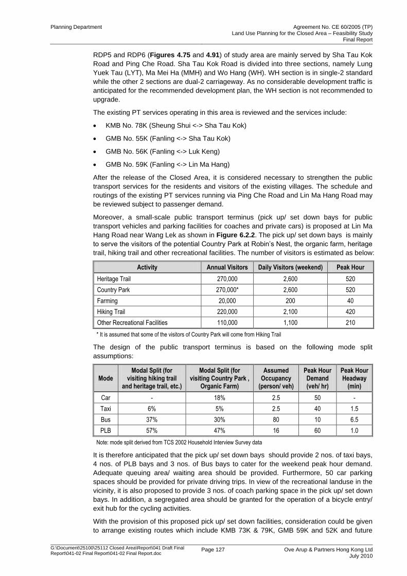
Hang Road near Wang Lek as shown in Figure 6.2.2. The pick up/ set down bays is mainly
to serve the visitors of the potential Country Park at Robin‟s Nest, the organic farm, heritage
trail, hiking trail and other recreational facilities. The number of visitors is estimated as below:
Activity Annual Visitors Daily Visitors (weekend) Peak Hour
Heritage Trail 270,000 2,600 520
Country Park 270,000* 2,600 520
Farming 20,000 200 40
Hiking Trail 220,000 2,100 420
Other Recreational Facilities 110,000 1,100 210
* It is assumed that some of the visitors of Country Park will come from Hiking Trail
The design of the public transport terminus is based on the following mode split
assumptions:
Mode Modal Split (for
visiting hiking trail and heritage trail, etc.)
Modal Split (for visiting Country Park ,
Organic Farm)
Assumed Occupancy
(person/ veh)
Peak Hour Demand (veh/ hr)
Peak Hour Headway
(min)
Car - 18% 2.5 50 -
Taxi 6% 5% 2.5 40 1.5
Bus 37% 30% 80 10 6.5
PLB 57% 47% 16 60 1.0
Note: mode split derived from TCS 2002 Household Interview Survey data
It is therefore anticipated that the pick up/ set down bays should provide 2 nos. of taxi bays,
4 nos. of PLB bays and 3 nos. of Bus bays to cater for the weekend peak hour demand.
Adequate queuing area/ waiting area should be provided. Furthermore, 50 car parking
spaces should be provided for private driving trips. In view of the recreational landuse in the
vicinity, it is also proposed to provide 3 nos. of coach parking space in the pick up/ set down
bays. In addition, a segregated area should be granted for the operation of a bicycle entry/
exit hub for the cycling activities.
With the provision of this proposed pick up/ set down facilities, consideration could be given
to arrange existing routes which include KMB 73K & 79K, GMB 59K and 52K and future
Planning Department Agreement No. CE 60/2005 (TP) Land Use Planning for the Closed Area – Feasibility Study
Final Report
G:\Document\25100\25112 Closed Area\Report\041 Draft Final Report\041-02 Final Report\041-02 Final Report.doc
Page 128 Ove Arup & Partners Hong Kong Ltd July 2010
recreational routes to use the facilities. In this case, these PT services could turn around at
the pick up/ set down bays for the return trip.
In addition, the existing PT services KMB No. 78K, GMB No. 55K and GMB No. 56K are
operating along Sha Tau Kok. Their service frequency and operating hours could be
reviewed and increased subject to the future visitor demand going to the hiking trail and the
country park from Sha Tau Kok Road.
There is an alternative proposal for the location of the pick up/ set down bays for public
transport vehicles and parking facilities for coaches and private cars as shown in Figure
6.2.2. The location of this pick up/ set down bays, which is close to the Lin Ma Hang village,
is proposed after the consultation with the Lin Ma Hang villagers.
While various shuttle services are proposed from the new development to the nearest
railway station, the terminating facility at the railway station is also reviewed. Considered
that the existing minibus, taxi and bus terminus at the nearest rail station, e.g., Sheung Shui
Station and Fanling Station are saturating, it is proposed to provide a new public transport
terminus. There are some potential sites such as the open area for car parking between
Choi Yuen Road and San Wan Road, near San Wan Road and Sha Tau Kok Road, and
along Pak Wo Road which could be considered for locating the terminating facility. The
facility should take into account the existing condition of public transport terminus and
provide a coherent pedestrian walkway system to facilitate interchange passengers.
However, the location and design of the terminating facility should be further investigated
and carried out in the detailed design stage when implemented.
6.2.8 Existing and Future Boundary Crossing Points
There are currently seven land crossings, namely, Lok Ma Chau (LMC), Man Kam To
(MKT), Sha Tau Kok (STK) and Shenzhen Bay (SZB), Lo Wu (LW), Hung Hom Station
(HHS) and Lok Ma Chau Spur Line (LMCSL). The LMC, MKT and STK were originally
designed mainly for freight traffic, while LW, HHS and LMCSL have been designed for
passenger-only crossing right from the beginning. Shenzhen Bay Control Point (SZB)
started to serve both vehicular and passenger crossing traffic. Before the opening of SZB,
the continuous increase in cross-boundary vehicular and passenger traffic at the four land
crossings (Lo Wu, LMC, MKT, STK) within the Closed Area results in their operation
approaching the design capacity.
In the land-side cross-boundary passenger highway traffic, the share for MTK, STK and
LMC was 6%, 5% and 89% respectively in 2006. In the land-side cross-boundary vehicular
traffic, same as passenger traffic, LMC takes up most of the increase vehicular traffic with
the share for MTK, STK and LMC being 18%, 6% and 76% respectively in 2006.
In July 2007, Shenzhen Bay Control Point (SZB) started to operate. It is expected the SZB
will divert the traffic from LMC. In Aug 2007, the MTRC (formerly KCRC) East Rail LMC
Spur Line was open. The Spur Line BCP is a passenger–only crossing served mainly by the
East Rail on the Hong Kong side. It is expected the opening of LMC Spur Line will release
the pressure of Lo Wu control point. Initial traffic statistics also indicate that certain
percentage of LMC bus / coach trips are diverted to LMC Spur Line.
With the commissioning of the SZB control point in July 2007, it is anticipated that the cross-
boundary traffic will be further concentrated on the western side of New Territories. On the
Shenzhen side, however, the increasing cross-boundary traffic using LMC and SZB will
deteriorate the already congested urban corridor traffic since vehicles from the east of
Guangdong have to pass through the central urban areas of Shenzhen. In accordance with
the Shenzhen Comprehensive Plan (1996-2010), a new control point is proposed at
Liantang/Heung Yuen Wai in addition to the HK-SWC, to implement the Shenzhen transport
planning principle to have east in-east out / west in-west out on cross-boundary vehicular
traffic. It was intended that through this new control point, the cross-boundary traffic is
Planning Department Agreement No. CE 60/2005 (TP) Land Use Planning for the Closed Area – Feasibility Study
Final Report
G:\Document\25100\25112 Closed Area\Report\041 Draft Final Report\041-02 Final Report\041-02 Final Report.doc
Page 129 Ove Arup & Partners Hong Kong Ltd July 2010
directed to a proposed expressway, the “Shenzhen Eastern Corridor” leading to Huizhou
and the eastern part of Guangdong Province.
The vehicular cross boundary points at LMC, MKT and STK and the proposed vehicular
cross boundary location at Liantang/ Heung Yuen Wai are within the assessment area of
this Study. The main rural roads connecting to the existing BCPs are San Sham Road, Man
Kam To Road and Sha Tau Kok Road respectively, in which Man Kam To Road and Sha
Tau Kok Road are also the main corridors serving the Closed Area traffic (heading both to
BCPs and to urban areas). As discussed in Section 6.2.6, Man Kam To Road and Sha Tau
Kok Road will be operating within practical capacity, taken into account the development
traffic generated from the Closed Area. It is therefore anticipated that the conflict between
the cross boundary traffic and the local traffic of the Closed Area will be insignificant. San
Sham Road leading to LMC BCP is not a corridor for the Closed Area traffic except those
heading to this BCP. It is considered that the operation of LMC BCP and San Sham Road
will have minimal impact to the Closed Area traffic.
Traffic restriction arrangement at MKT and STK BCPs will also be implemented to guide
non-cross boundary traffic to return instead of running into other rural roads within the
released Closed Area. It would further minimise the impact in the Closed Area.
For the new BCP proposed at Liantang/ Heung Yuen Wai, it is expected a new connecting
road will be identified and proposed to connect the BCP to Fanling Highway. When the
connecting road is built in the future, the cross-boundary traffic will be diverted from using
the local roads in Fanling and Sheung Shui areas. The traffic condition of Man Kam Road,
Sha Tau Kok Road and Jocky Club Road will be improved and it will provide more reserve
road capacity for future developments proposed in the NENT. On the other hand, the new
connecting road will carry the majority of the cross boundary traffic from the proposed
Liantang/ Heung Yuen Wai BCP and it is envisaged that its impact to the Closed Area traffic
will be negligible.
For the BCP at Lo Wu, the station area and area along Lo Wu Station Road will still be
restricted for public access after the release of the Closed Area. Traffic restriction at Lo Wu
Station Road will be implemented to avoid entrance of unauthorised vehicles. The impact of
this BCP to the Close Area is considered negligible.
For the BCP at Lok Ma Chau Spur Line, no private vehicle access is granted and only public
transport services are allowed at the BCP. Again traffic restriction plan at Lung Hau Road
and Ha Tsuen Road will be implemented to restrict unauthorised vehicles. People from this
BCP could therefore take public transport only. Its impact to the Closed Area is anticipated
minimal.
Details of the traffic restriction plans at various BCP are discussed in Section 6.2.12.
6.2.9 Proposed General Road Improvement Works
It is envisaged that the secondary boundary fencing would be completed in sections. The
release of Frontier Closed Area, therefore, is anticipated in line with the below completion
schedule:
Lin Ma Hang to Sha Tau Kok Section in late 2011;
Mai Po to Lok Ma Chau Control Point Section in late 2011;
Lok Ma Chau Control Point to Ng Tung River Section in late 2012;
Ng Tung River to Lin Ma Hang Section (Completion date, not yet confirmed)
All existing village access roads under the maintenance of HAD, as well as other rural roads
including Lin Ma Hang Road, Man Kam To Road, Sha Tau Kok Road and Kong Nga Po
Road, etc, are investigated in this Study. Road improvement proposal is then developed to
Planning Department Agreement No. CE 60/2005 (TP) Land Use Planning for the Closed Area – Feasibility Study
Final Report
G:\Document\25100\25112 Closed Area\Report\041 Draft Final Report\041-02 Final Report\041-02 Final Report.doc
Page 130 Ove Arup & Partners Hong Kong Ltd July 2010
cater for the release of closed area by sections. An inventory of the access roads for all
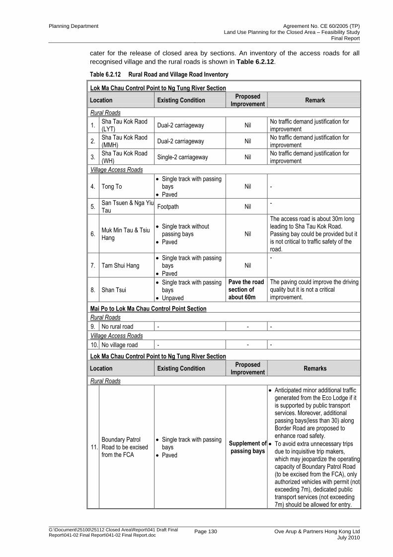
recognised village and the rural roads is shown in Table 6.2.12.
Table 6.2.12 Rural Road and Village Road Inventory
Lok Ma Chau Control Point to Ng Tung River Section
Location Existing Condition Proposed
Improvement Remark
Rural Roads
1. Sha Tau Kok Raod (LYT)
Dual-2 carriageway Nil No traffic demand justification for improvement
2. Sha Tau Kok Raod (MMH)
Dual-2 carriageway Nil No traffic demand justification for improvement
3. Sha Tau Kok Road (WH)
Single-2 carriageway Nil No traffic demand justification for improvement
Village Access Roads
4. Tong To Single track with passing
bays
Paved
Nil -
5. San Tsuen & Nga Yiu Tau
Footpath Nil -
6. Muk Min Tau & Tsiu Hang
Single track without passing bays
Paved
Nil
The access road is about 30m long leading to Sha Tau Kok Road. Passing bay could be provided but it is not critical to traffic safety of the road.
7. Tam Shui Hang Single track with passing
bays
Paved
Nil
-
8. Shan Tsui Single track with passing
bays
Unpaved
Pave the road section of about 60m
The paving could improve the driving quality but it is not a critical improvement.
Mai Po to Lok Ma Chau Control Point Section
Rural Roads
9. No rural road - - -
Village Access Roads
10. No village road - - -
Lok Ma Chau Control Point to Ng Tung River Section
Location Existing Condition Proposed
Improvement Remarks
Rural Roads
11. Boundary Patrol Road to be excised from the FCA
Single track with passing bays
Paved
Supplement of passing bays
Anticipated minor additional traffic generated from the Eco Lodge if it is supported by public transport services. Moreover, additional passing bays(less than 30) along Border Road are proposed to enhance road safety.
To avoid extra unnecessary trips due to inquisitive trip makers, which may jeopardize the operating capacity of Boundary Patrol Road (to be excised from the FCA), only authorized vehicles with permit (not exceeding 7m), dedicated public transport services (not exceeding 7m) should be allowed for entry.
Planning Department Agreement No. CE 60/2005 (TP) Land Use Planning for the Closed Area – Feasibility Study
Final Report
G:\Document\25100\25112 Closed Area\Report\041 Draft Final Report\041-02 Final Report\041-02 Final Report.doc
Page 131 Ove Arup & Partners Hong Kong Ltd July 2010
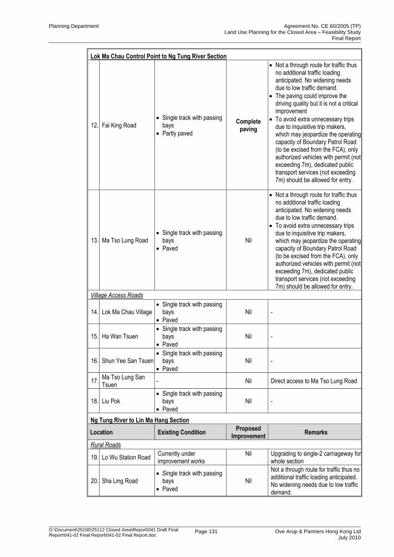
Lok Ma Chau Control Point to Ng Tung River Section
12. Fai King Road Single track with passing
bays
Partly paved
Complete paving
Not a through route for traffic thus no additional traffic loading anticipated. No widening needs due to low traffic demand.
The paving could improve the driving quality but it is not a critical improvement
To avoid extra unnecessary trips due to inquisitive trip makers, which may jeopardize the operating capacity of Boundary Patrol Road (to be excised from the FCA), only authorized vehicles with permit (not exceeding 7m), dedicated public transport services (not exceeding 7m) should be allowed for entry.
13. Ma Tso Lung Road Single track with passing
bays
Paved
Nil
Not a through route for traffic thus no additional traffic loading anticipated. No widening needs due to low traffic demand.
To avoid extra unnecessary trips due to inquisitive trip makers, which may jeopardize the operating capacity of Boundary Patrol Road (to be excised from the FCA), only authorized vehicles with permit (not exceeding 7m), dedicated public transport services (not exceeding 7m) should be allowed for entry.
Village Access Roads
14. Lok Ma Chau Village Single track with passing
bays
Paved
Nil -
15. Ha Wan Tsuen Single track with passing
bays
Paved
Nil -
16. Shun Yee San Tsuen Single track with passing
bays
Paved
Nil -
17. Ma Tso Lung San Tsuen
- Nil Direct access to Ma Tso Lung Road
18. Liu Pok Single track with passing
bays
Paved
Nil -
Ng Tung River to Lin Ma Hang Section
Location Existing Condition Proposed
Improvement Remarks
Rural Roads
19. Lo Wu Station Road Currently under improvement works
Nil Upgrading to single-2 carriageway for whole section
20. Sha Ling Road Single track with passing
bays
Paved
Nil
Not a through route for traffic thus no additional traffic loading anticipated. No widening needs due to low traffic demand.
Planning Department Agreement No. CE 60/2005 (TP) Land Use Planning for the Closed Area – Feasibility Study
Final Report
G:\Document\25100\25112 Closed Area\Report\041 Draft Final Report\041-02 Final Report\041-02 Final Report.doc
Page 132 Ove Arup & Partners Hong Kong Ltd July 2010
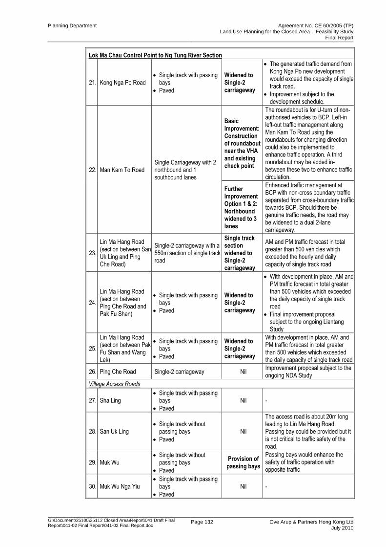
Lok Ma Chau Control Point to Ng Tung River Section
21. Kong Nga Po Road Single track with passing
bays
Paved
Widened to Single-2 carriageway
The generated traffic demand from Kong Nga Po new development would exceed the capacity of single track road.
Improvement subject to the development schedule.
22. Man Kam To Road Single Carriageway with 2 northbound and 1 southbound lanes
Basic Improvement:Construction of roundabout near the VHA and existing check point
The roundabout is for U-turn of non-authorised vehicles to BCP. Left-in left-out traffic management along Man Kam To Road using the roundabouts for changing direction could also be implemented to enhance traffic operation. A third roundabout may be added in-between these two to enhance traffic circulation.
Further Improvement Option 1 & 2: Northbound widened to 3 lanes
Enhanced traffic management at BCP with non-cross boundary traffic separated from cross-boundary traffic towards BCP. Should there be genuine traffic needs, the road may be widened to a dual 2-lane carriageway.
23.
Lin Ma Hang Road (section between San Uk Ling and Ping Che Road)
Single-2 carriageway with a 550m section of single track road
Single track section widened to Single-2 carriageway
AM and PM traffic forecast in total greater than 500 vehicles which exceeded the hourly and daily capacity of single track road
24.
Lin Ma Hang Road (section between Ping Che Road and Pak Fu Shan)
Single track with passing bays
Paved
Widened to Single-2 carriageway
With development in place, AM and PM traffic forecast in total greater than 500 vehicles which exceeded the daily capacity of single track road
Final improvement proposal subject to the ongoing Liantang Study
25.
Lin Ma Hang Road (section between Pak Fu Shan and Wang Lek)
Single track with passing bays
Paved
Widened to Single-2 carriageway
With development in place, AM and PM traffic forecast in total greater than 500 vehicles which exceeded the daily capacity of single track road
26. Ping Che Road Single-2 carriageway Nil Improvement proposal subject to the ongoing NDA Study
Village Access Roads
27. Sha Ling Single track with passing
bays
Paved
Nil -
28. San Uk Ling Single track without
passing bays
Paved
Nil
The access road is about 20m long leading to Lin Ma Hang Road. Passing bay could be provided but it is not critical to traffic safety of the road.
29. Muk Wu Single track without
passing bays
Paved
Provision of passing bays
Passing bays would enhance the safety of traffic operation with opposite traffic
30. Muk Wu Nga Yiu Single track with passing
bays
Paved
Nil -

Planning Department Agreement No. CE 60/2005 (TP) Land Use Planning for the Closed Area – Feasibility Study
Final Report
G:\Document\25100\25112 Closed Area\Report\041 Draft Final Report\041-02 Final Report\041-02 Final Report.doc
Page 133 Ove Arup & Partners Hong Kong Ltd July 2010
Lok Ma Chau Control Point to Ng Tung River Section
31. Chow Tin Single track with passing
bays
Paved
Nil -
32. Fung Wong Wu Single track with passing
bays
Paved
Nil -
33. Ta Kwu Ling Village - Nil Direct access to Lin Ma Hang Road
34. Kan Tau Wai Single track with passing
bays
Paved
Nil -
35. Tong Fong Single track with passing
bays
Paved
Nil -
36. Kaw Liu Village Single track with passing
bays
Paved
Nil -
37. Relocated Chuk Yuen
Single track without passing bays
Paved
Provision of passing bays
Final improvement proposal subject to the relocation
38. Tsung Yuen Ha Single track with passing
bays
Paved
Nil -
39. Ha Heung Yuen Single track without
passing bays
Paved
Provision of passing bays
Passing bays would enhance the safety of traffic operation with opposite traffic
40. Heung Yuen Wai Single track with passing
bays
Paved
Nil -
41. Lin Ma Hang Single track with passing
bays
Paved
Nil -
From traffic review, it is anticipated that the villages would generate less than 30 pcu/hr 2-
way traffic in peak hour. The low traffic volume therefore supports the provision of single
track access road.
With on-site investigation and preliminary review, most of the village access roads are in
good condition. Improvement works is only proposed to some village access roads as
shown in Table 6.2.12 to enhance traffic safety. However, such road improvement works is
not critical and it is subject to the future maintenance agent to determine the implementation
need/ schedule.
Rural Road in Lin Ma Hang to Sha Tau Kok Section
Sha Tau Kok Road is the main connection road to the strategic road network within this area.
As discussed in Section 6.2.6, improvement works at Sha Tau Kok Road is not necessary
due to the general low traffic demand from Closed Area.
Rural Road in Mai Po to Lok Ma Chau Control Point Section
There are no major rural roads within this area.
Rural Road in Lok Ma Chau Control Point to Ng Tung River Section
Traffic impact assessment shows that the vehicular traffic generated from the new
developments in the area would impose capacity problem to the existing boundary patrol
road to be excised from the FCA. To minimize the anticipated huge traffic volume in the
area, it is therefore proposed to support the traffic from Eco Lodge by public transport
service only. There would be no private vehicular trips generated from these new
Planning Department Agreement No. CE 60/2005 (TP) Land Use Planning for the Closed Area – Feasibility Study
Final Report
G:\Document\25100\25112 Closed Area\Report\041 Draft Final Report\041-02 Final Report\041-02 Final Report.doc
Page 134 Ove Arup & Partners Hong Kong Ltd July 2010
developments. In addition, the existing boundary patrol road to be excised from the FCA is
proposed to be permitted to people‟s access, authorised vehicles with permits (not
exceeding 7m) and dedicated public transport services (not exceeding 7m) only. Such
arrangement is to avoid additional traffic induced by inquisitive trip makers visiting the area
for no reason other than to look around. Any extra unnecessary trips may induce adverse
impact on the operating capacity of this road.
It is recommended to supplement less than 30 no. of passing bays along the full length of
Border Road to enhance road safety. Moreover, the allowed vehicles should be limited to
7m or below to further enhance traffic operation safety.
Ultimately, the road may be upgraded to TPDM standard, depending on the recommended
access arrangement for the LMC Loop and/ or future traffic demands on the road. In this
regard, some land resumption would be unavoidable to provide standard alignment radius,
sightline etc.
Similarly, it is not recommended for large-scale improvement for Fai King Road. There
would be no capacity problem at Fai King Road as additional through traffic on this road is
unlikely. It is proposed to provide proper paving along the road. Similar to the existing
boundary patrol road to be excised from the FCA, the road should only be opened to
authorised vehicles (not exceeding 7m) and dedicated public transport services (not
exceeding 7m) to avoid additional traffic induced by inquisitive trip makers visiting the area
for no reason other than to look around. Any extra unnecessary trips may induce adverse
impact on the operating capacity of Fai King Road.
Ma Tso Lung Road is a single track road and there would be no capacity problem as
additional through traffic on this road is unlikely. However, the road may be upgraded to
TPDM single track standard as an ultimate improvement to further enhance traffic safety,
depending on the implementation need/ schedule determined by the maintenance agent.
Similar to the existing boundary patrol road to be excised from the FCA, the road should
only be opened to authorised vehicles (not exceeding 7m) and dedicated public transport
services (not exceeding 7m) to avoid additional traffic induced by inquisitive trip makers
visiting the area for no reason other than to look around. Any extra unnecessary trips may
induce adverse impact on the operating capacity of Ma Tso Lung Road.
The signage arrangement for vehicle restriction to boundary patrol road to be excised from
the FCA, Fai King Road and Ma Tso Lung Road is shown in Figure 6.2.5
Rural Road in Ng Tung River to Lin Ma Hang Section
Lo Wu Station Road is currently under improvement works to provide full section of single-2
configuration. It is anticipated that sufficient road capacity would be provided with the
improved Lo Wu Station Road and further improvement measures is therefore unnecessary.
The section of Lo Wu Station Road within the land vesting area of MTRCL will remain as a
single track access road. In addition, as advised by the HKPF, it is suggested that Lo Wu
Road should be designated as "Restricted Road". Only police vehicles, emergency vehicles
and those vehicles with valid permit can have access to Lo Wu Road.
Sha Ling Road is a single track road and there would be no capacity problem as additional
through traffic on this road is unlikely. However, the road may be upgraded to TPDM single
track standard as an ultimate improvement to further enhance traffic safety, depending on
the implementation need/ schedule determined by the maintenance agent. On the other
hand, more critical review on Sha Ling Road would be necessary if the proposed C&C
facilities would finally be located at Sha Ling. In addition, as advised by the HKPF, the
scenic point at Macintosh Fort is situated at the end of Sha Ling Road which is very narrow
and steep, public transport and private cars should not be allowed to travel there for the
sake of road safety. It is suggested the steep section of Sha Ling Road be designated as
"Restricted Road". Only police vehicle, emergency vehicles and vehicles with valid permit
can have access to the "Restricted Road'.
Planning Department Agreement No. CE 60/2005 (TP) Land Use Planning for the Closed Area – Feasibility Study
Final Report
G:\Document\25100\25112 Closed Area\Report\041 Draft Final Report\041-02 Final Report\041-02 Final Report.doc
Page 135 Ove Arup & Partners Hong Kong Ltd July 2010
The existing Kong Nga Po Road is mainly a single track road with a short section of single-2
carriageway. With the development at Kong Nga Po and Hung Lung Hang, it is anticipated
that the single track road would encounter capacity problem, despite that the traffic demand
from the new development is low (2-way about 360 pcu/hr equivalent to 330 Veh/hr). It is
therefore proposed to widen the single track Kong Nga Po Road to single-2 carriageway.
The improvement works should be subject to the development schedule of Kong Nga Po
development.
For Man Kam To Road, there would be no capacity problem so widening of the road is
anticipated not necessary. However, it is proposed to improve the road for the enforcement
of the proposed traffic restriction plan. The improvement scheme is to construct two
roundabouts, one located at the existing Police check point near Kong Nga Po Road after its
demolition, another one located at the intersection of Man Kam To Road, Man Kam To BCP
and access to Lin Ma Hang Road near the northbound VHA. With these two roundabouts in
place, left-in left-out traffic management could be implemented along Man Kam To Road
(section north of existing Police check point) where northbound traffic could turn to
southbound lane at the roundabout near the VHA, and southbound traffic could turn to
northbound lanes at the roundabout at the Police check point. It would minimise the
disturbance induced by the right turning traffic along the road, or from the village access on
both sides of Man Kam To Road. A third roundabout may be added in-between these two to
enhance traffic circulation. The road will be maintained as 2 northbound and 1 southbound
lanes. Should there be genuine traffic needs, the road may be widened to a dual 2-lane
carriageway.
Other options to further improvement on Man Kam To Road is also proposed to widen Man
Kam To Road to single-4 carriageway with 3 northbound lanes and 1 southbound lane if
such widening is deemed required at a later stage. This further improvement is to
strengthen the traffic restriction operation by providing 2 northbound lanes serving the cross
boundary traffic and 1 northbound lane serving the local traffic. There are two proposed
options in traffic management along the northbound lanes. Option 1 segregates the cross
boundary traffic in the northbound slow and middle lanes, while they are the middle and fast
lanes in Option 2. Nonetheless, the implementation of this further improvement should be
subject to the traffic condition and more detail investigation particularly on difficulties in
maintaining the Closed Road from traffic management and control aspects, is required.
The details of the improvement scheme of Man Kam To Road will be discussed in Section
6.2.12.
Lin Ma Hang Road (section between San Uk Ling and Ping Che Road) is basically a single-
2 carriageway with a 550m section of single track road. Based on the traffic forecast, the 2-
way peak hour traffic would exceed 400 pcus (equivalent to 350 vehicles) in which the
single track section would encounter capacity problem. It is therefore proposed to provide
full section of single-2 carriageway to accommodate the traffic demand.
Lin Ma Hang Road (section between Ping Che Road and Pak Fu Shan) and Lin Ma Hang
Road (section between Pak Fu Shan and Wang Lek) are single track roads. When new
developments are in place, the 2-way AM and PM total traffic loading on this two section of
roads shall reach 300 pcu (equivalent to 260 vehicles) and the single track configuration
would encounter capacity problem. It is also proposed to upgrade these two sections of road
to single-2 configuration.
It is anticipated that the widening works of Lin Ma Hang Road (section between Ping Che
Road and Pak Fu Shan) would be completed by 2015 for the construction works of
Liantang/ Heung Yuen Wai BCP. However, in case the widening works of the other two
sections of Lin Ma Hang Road could not complete on time, intermit traffic management
scheme should be implemented to avoid congestion at the single track section. It is
proposed to release Lin Ma Hang Road (section between San Uk Ling and Ping Che Road
and section between Pak Fu Shan and Wang Lek) for people‟s access but not for vehicles.
Planning Department Agreement No. CE 60/2005 (TP) Land Use Planning for the Closed Area – Feasibility Study
Final Report
G:\Document\25100\25112 Closed Area\Report\041 Draft Final Report\041-02 Final Report\041-02 Final Report.doc
Page 136 Ove Arup & Partners Hong Kong Ltd July 2010
Only vehicles with permit, such as the private vehicles from the local villages and dedicated
public transport services, could be authorised to run on the road. Moreover, the allowed
vehicles should be limited to 7m or below to enhance traffic operation safety. In addition, the
proposed pick up/ set down bays for public transport vehicles and parking facilities for
coaches and private cars near Wang Lek should be operating after the widening of Lin Ma
Hang Road (section between Pak Fu Shan and Wang Lek).
The existing Ping Che Road for section near Lin Ma Hang Road is in single-2 configuration
and there should be no capacity problem arisen from the traffic generated in the Closed
Area. However, any improvement proposal on the full section of Ping Che Road should be
subject to the ongoing NDA Study.
The location of all rural roads and village roads with proposed improvement works is shown
in Figure 6.2.1.
6.2.10 Pedestrian and Cycling Facilities
Two sections of cycle track are proposed in the western and eastern district of the Study
area respectively as shown in Figure 6.2.4. The western section will join the main cycling
network in the NT at Castle Peak Road. The eastern section will be along Lin Ma Hang
Road and join with the potential cycling network in Ping Che NDA.
Instead of providing the western section of cycling track by widening Border Road, another
potential proposal is to consider the operation of non-designated cycling track along Border
Road. It would minimize the modification works required but detail investigation is required
in a later stage to evaluate this proposed option. Nonetheless, the proposed cycling tracks
should be subject to the potential connection with the existing / proposed cycling network
and the road improvement proposals under NDA and Loop Studies.
Roadside footway should form part of the pedestrian network. In addition to provide proper
traffic aids for all roads released from FCA, it is required to provide separate footpath for all
major distributor roads as well as for the village access roads from pedestrian safety point of
view. Typical sections of the proposed road hierarchy are shown in Figure 6.2.2 to Figure
6.2.3.
6.2.11 Traffic Impact Assessment on Specific Development Proposals
1) Potential Country Park at Robin’s Nest
The estimated annual visitor to the potential country park is about 270,000. The average
daily visitor is less than 1,000. The anticipated 2-way peak hour weekday traffic generated is
about 70 PCUs which will not impose any impact on the road network.
Regarding the worst scenario as discussed in Section 6.2.7 which assumed all visitors only
come on weekend, the average daily visitor during weekend is about 2,600. The anticipated
2-way peak hour weekend traffic therefore generated shall reach about 80 PCUs.
Considered lower background traffic at weekend, it is anticipated that the induced traffic will
have insignificant impact on the road network.
The proposed gateway to the country park is located at Lin Ma Hang Road near Lin Ma
Hang Tsuen. It is proposed to provide pick up/set down bays for public transport vehicles
and parking facilities for coaches and private cars and bicycle parking at the gateway in
order to attract more visitors and to support local development in long term. The access to
private car park and pick up/set down bays for public transport vehicles should be
segregated. The proposed terminus with car and cycle parking is shown in Figure 6.2.2.
Apart from access using Lin Ma Hang Road, visitor could also access to the Country Park
via Sha Tau Kok Road. The existing PT services KMB 78K, GMB 55K and GMB 56K are
operating along Sha Tau Kok. Their service frequency and operating hours could be
reviewed and increased subject to the future visitor demand going to the hiking trail and the
country park from Sha Tau Kok Road.
Planning Department Agreement No. CE 60/2005 (TP) Land Use Planning for the Closed Area – Feasibility Study
Final Report
G:\Document\25100\25112 Closed Area\Report\041 Draft Final Report\041-02 Final Report\041-02 Final Report.doc
Page 137 Ove Arup & Partners Hong Kong Ltd July 2010
2) Low Density Residential Development at Kong Nga Po, Hung Lung Hang and other
recreational land
The size of the proposed residential development at Kong Nga Po and Hung Lung Hang is
about 25 ha and the estimated population is about 4,700. The trip rate for a medium density
R(B) (low accessibility average 1000 sq. metre) is adopted in the traffic assessment for
more conservative trip generation. The trip rate is also shown in the below table. The
anticipated 2-way peak hour traffic is about 360 PCUs. The operation of existing single track
section of Kong Nga Po Road would be aggravated by such traffic demand. Given the
proposed scale of development, there is no need to explore additional access road to Kong
Nga Po. However, the existing Kong Nga Po Road should be upgraded to single-2
configuration for the whole section. The proposed improvement works is shown in Figure
6.2.3.
Trip Rate (per flat) AM PM
Generation Attraction Generation Attraction
Medium Density R(B) - Low Accessibility Ave 1000 sq.m. (Mean)
0.1961 0.1116 0.0955 0.1321
Apart from Kong Nga Po and Hung Lung Hang, there are a number of recreational land
anticipated with residential development. The maximum estimated population from each
area is about 2,400. Again, the trip rate for a medium density R(B) (low accessibility average
1000 sq. metre) is adopted in the traffic assessment for more conservative trip generation.
The development would generate the 2-way peak hour traffic of about 20 to 150 PCUs. The
induced traffic would be accommodated by various rural roads including Man Kam To Road,
Lin Ma Hang Road and Sha Tau Kok Road. It is anticipated that these rural roads would
operate without capacity problem with the proposed improvement at Lin Ma Hang Road to
single-2 carriageway.
3) Proposed Eco-lodge at Ma Tso Lung
The estimated daily visitor to the Eco-lodge is about 230. The main access road to the site
is via the existing boundary patrol road to be excised from the FCA. As discussed in
Section 6.2.9, the boundary patrol road to be excised from the FCA would be limited for
authorised vehicles only due to environmental concern. The visitor traffic would therefore be
undertaken by public transport services. In this regard, the anticipated 2-way peak hour
traffic is about 5 PCUs. Since there is a 65 meters level difference between the proposed
site and the boundary patrol road to be excised from the FCA, it is expected that the access
road will be constructed with at least 10 degree slope.
Regarding the weekend scenario, the average daily visitor is about 400. The anticipated 2-
way peak hour weekend traffic therefore generated shall reach about 10 PCUs. Considered
lower background traffic at weekend, it is anticipated that the induced traffic will have
insignificant impact on the road network.
4) Proposed Bicycle Track within the area that will be excised from the FCA
No vehicular traffic impact is anticipated due to the provision of bicycle track. Although the
traffic volume along the road of the proposed alignment is not high, it is recommended to
provide segregated cycle track and facilities for cyclists because of the interference with the
general traffic and the vulnerability of cyclists. According to the design requirement of
maximum gradient 5%, the potential alignment of the bicycle track is shown in Figure 6.2.4.
5) Potential Columbarium and Crematorium Facilities
The proposed C&C facilities at Sha Ling are assumed to provide about 100,000 niches and
3 no. of cremators. Considered an average size of 5 visitors per niche visit, the estimated
daily niche visitors shall reach 100,000 x 5 / 365 = 1,370. For attendees to cremation, the
estimated number of daily visitors is 360, assuming 6 no. of cremation/ day per cremator
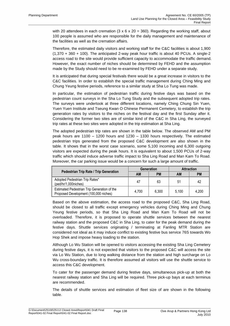
Planning Department Agreement No. CE 60/2005 (TP) Land Use Planning for the Closed Area – Feasibility Study
Final Report
G:\Document\25100\25112 Closed Area\Report\041 Draft Final Report\041-02 Final Report\041-02 Final Report.doc
Page 138 Ove Arup & Partners Hong Kong Ltd July 2010
with 20 attendees in each cremation (3 x 6 x 20 = 360). Regarding the working staff, about
100 people is assumed who are responsible for the daily management and maintenance of
the facilities as well as the cremation affairs.
Therefore, the estimated daily visitors and working staff for the C&C facilities is about 1,900
(1,370 + 360 + 100). The anticipated 2-way peak hour traffic is about 40 PCUs. A single-2
access road to the site would provide sufficient capacity to accommodate the traffic demand.
However, the exact number of niches should be determined by FEHD and the assumption
made by the Study should need to be re-examined by FEHD under a separate study.
It is anticipated that during special festivals there would be a great increase in visitors to the
C&C facilities. In order to establish the special traffic management during Ching Ming and
Chung Yeung festive periods, reference to a similar study at Sha Lo Tung was made.
In particular, the estimation of pedestrian traffic during festive days was based on the
pedestrian count surveys in the Sha Lo Tung Study and the subsequent adopted trip rates.
The surveys were undertook at three different locations, namely Ching Chung Sin Yuen,
Yuen Yuen Institute and Tseung Kwan O Chinese Permanent Cemetery, to establish the trip
generation rates by visitors to the niches on the festival day and the first Sunday after it.
Considering the former two sites are of similar kind of the C&C in Sha Ling, the surveyed
trip rates at these two sites were adopted in the trip estimation at Sha Ling.
The adopted pedestrian trip rates are shown in the table below. The observed AM and PM
peak hours are 1100 – 1200 hours and 1230 – 1330 hours respectively. The estimated
pedestrian trips generated from the proposed C&C development are also shown in the
table. It shows that in the worst case scenario, some 5,100 incoming and 6,300 outgoing
visitors are expected during the peak hours. It is equivalent to about 1,500 PCUs of 2-way
traffic which should induce adverse traffic impact to Sha Ling Road and Man Kam To Road.
Moreover, the car parking issue would be a concern for such a large amount of traffic.
Pedestrian Trip Rate / Trip Generation Generation Attraction
AM PM AM PM
Adopted Pedestrian Trip Rates* (ped/hr/1,000niches)
47 63 51 42
Estimated Pedestrian Trip Generation of the Proposed Development (100,000 niches)
4,700 6,300 5,100 4,200
Based on the above estimation, the access road to the proposed C&C, Sha Ling Road,
should be closed to all traffic except emergency vehicles during Ching Ming and Chung
Yeung festive periods, so that Sha Ling Road and Man Kam To Road will not be
overloaded. Therefore, it is proposed to operate shuttle services between the nearest
railway station and the proposed C&C in Sha Ling, to cater for the peak demand during the
festive days. Shuttle services originating / terminating at Fanling MTR Station are
considered not ideal as it may induce conflict to existing festive bus service 76S towards Wo
Hop Shek and impose heavy loading to the station.
Although Lo Wu Station will be opened to visitors accessing the existing Sha Ling Cemetery
during festive days, it is not expected that visitors to the proposed C&C will access the site
via Lo Wu Station, due to long walking distance from the station and high surcharge on Lo
Wu cross-boundary traffic. It is therefore assumed all visitors will use the shuttle service to
access this C&C development.
To cater for the passenger demand during festive days, simultaneous pick-up at both the
nearest railway station and Sha Ling will be required. Three pick-up bays at each terminus
are recommended.
The details of shuttle services and estimation of fleet size of are shown in the following
table.
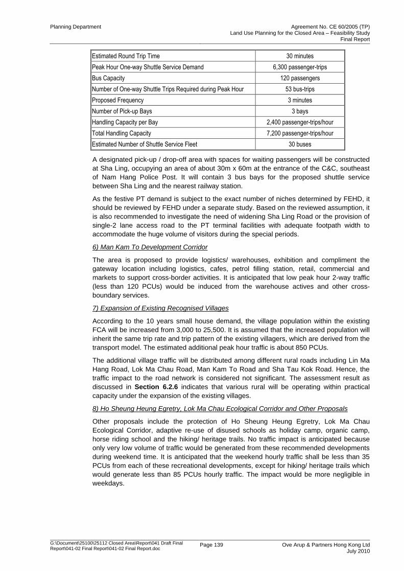
Planning Department Agreement No. CE 60/2005 (TP) Land Use Planning for the Closed Area – Feasibility Study
Final Report
G:\Document\25100\25112 Closed Area\Report\041 Draft Final Report\041-02 Final Report\041-02 Final Report.doc
Page 139 Ove Arup & Partners Hong Kong Ltd July 2010
Estimated Round Trip Time 30 minutes
Peak Hour One-way Shuttle Service Demand 6,300 passenger-trips
Bus Capacity 120 passengers
Number of One-way Shuttle Trips Required during Peak Hour 53 bus-trips
Proposed Frequency 3 minutes
Number of Pick-up Bays 3 bays
Handling Capacity per Bay 2,400 passenger-trips/hour
Total Handling Capacity 7,200 passenger-trips/hour
Estimated Number of Shuttle Service Fleet 30 buses
A designated pick-up / drop-off area with spaces for waiting passengers will be constructed
at Sha Ling, occupying an area of about 30m x 60m at the entrance of the C&C, southeast
of Nam Hang Police Post. It will contain 3 bus bays for the proposed shuttle service
between Sha Ling and the nearest railway station.
As the festive PT demand is subject to the exact number of niches determined by FEHD, it
should be reviewed by FEHD under a separate study. Based on the reviewed assumption, it
is also recommended to investigate the need of widening Sha Ling Road or the provision of
single-2 lane access road to the PT terminal facilities with adequate footpath width to
accommodate the huge volume of visitors during the special periods.
6) Man Kam To Development Corridor
The area is proposed to provide logistics/ warehouses, exhibition and compliment the
gateway location including logistics, cafes, petrol filling station, retail, commercial and
markets to support cross-border activities. It is anticipated that low peak hour 2-way traffic
(less than 120 PCUs) would be induced from the warehouse actives and other cross-
boundary services.
7) Expansion of Existing Recognised Villages
According to the 10 years small house demand, the village population within the existing
FCA will be increased from 3,000 to 25,500. It is assumed that the increased population will
inherit the same trip rate and trip pattern of the existing villagers, which are derived from the
transport model. The estimated additional peak hour traffic is about 850 PCUs.
The additional village traffic will be distributed among different rural roads including Lin Ma
Hang Road, Lok Ma Chau Road, Man Kam To Road and Sha Tau Kok Road. Hence, the
traffic impact to the road network is considered not significant. The assessment result as
discussed in Section 6.2.6 indicates that various rural will be operating within practical
capacity under the expansion of the existing villages.
8) Ho Sheung Heung Egretry, Lok Ma Chau Ecological Corridor and Other Proposals
Other proposals include the protection of Ho Sheung Heung Egretry, Lok Ma Chau
Ecological Corridor, adaptive re-use of disused schools as holiday camp, organic camp,
horse riding school and the hiking/ heritage trails. No traffic impact is anticipated because
only very low volume of traffic would be generated from these recommended developments
during weekend time. It is anticipated that the weekend hourly traffic shall be less than 35
PCUs from each of these recreational developments, except for hiking/ heritage trails which
would generate less than 85 PCUs hourly traffic. The impact would be more negligible in
weekdays.
Planning Department Agreement No. CE 60/2005 (TP) Land Use Planning for the Closed Area – Feasibility Study
Final Report
G:\Document\25100\25112 Closed Area\Report\041 Draft Final Report\041-02 Final Report\041-02 Final Report.doc
Page 140 Ove Arup & Partners Hong Kong Ltd July 2010
6.2.12 Proposed Traffic Restriction Plan
Background
The existing Frontier Closed Area (FCA) (the Closed Area) was first established in 1951. It
was designated by the Frontier Closed Area Order (Cap. 245A) to provide a buffer zone to
help the law enforcement agencies to maintain the integrity of the boundary between Hong
Kong and the Mainland and to combat illegal immigration and other cross boundary criminal
activities. Vehicular access to the Closed Area is controlled by the Police through the
issuance of Closed Area permits based on actual needs to enter the Closed Area.
The Security Bureau has conducted a review of the extent of the Closed Area and
concluded that the objective of maintaining boundary security may still be achieved even if
the coverage of the Closed Area is substantially reduced. On 7 September 2006, the
Security Bureau announced the proposed revised Closed Area boundary. The finalized plan
for reducing the FCA was submitted by the Security Bureau to Legco in Jan 2008.
One of the specific objective of the Study is to identify the infrastructural requirements and
government, community and social facilities in support of the development needs and
assess whether traffic restriction should be imposed to meet the planning intention for the
Study Area in case the current closed road restriction is no longer proposed on security
ground after the area is released from the Closed Area.
The Existing Traffic Restriction in FCA
All Road within the Closed Area boundary designate as Closed Road under the Road Traffic
(Traffic Control) Regulations (Cap. 374G). Vehicular access is controlled through the
issuance of closed road permits by Hong Kong Police Force. The issuance of closed road
permits is a regulatory mechanism to confine the use of boundary control points by cross-
boundary vehicles in accordance with the quotas allocated. The existing road system within
the FCA mainly comprises sub-standard Road intended to serve local villages. This
mechanism ensures that the boundary control points and the road network in their vicinity
will not be overloaded.
The Proposed Modification to existing Traffic Restriction in the area that will be excised from
the FCA
Based on the planning intention of the Recommended Development Plan, it is proposed to
lift the existing traffic restriction plan (TRP) phase by phase according to the program of
constructing secondary boundary fence and local access road improvement works.
However, the extent of Road (including existing, improved or new access Road and the
main distributor road leading to the control point) to which the TRP applies in different
stages should be reviewed critically for boundary traffic, transport need of villagers, local
developments‟ traffic and recreation traffic demand.
It is worthwhile to note that upon completion of the secondary boundary fence, existing
police check points at Lok Ma Chau, Sha Ling, Ping Che and Shek Chung Au will be
removed.
The proposed traffic restriction plans for the boundary control points are described below.
Restrictions on roads under DSD, WSD and DO‟s management will be maintained.
Traffic Restriction for road leading to Lok Ma Chau Control Point
Lok Ma Chau Control Point will not be affected under the new FCA boundary. The existing
traffic restriction on Shan Sham Road is therefore proposed to be maintained. San Sham
Road is the only vehicular access road leading to Lok Ma Chau Control Point, and there is
no police check point on the road before the Control Point.
Planning Department Agreement No. CE 60/2005 (TP) Land Use Planning for the Closed Area – Feasibility Study
Final Report
G:\Document\25100\25112 Closed Area\Report\041 Draft Final Report\041-02 Final Report\041-02 Final Report.doc
Page 141 Ove Arup & Partners Hong Kong Ltd July 2010
Traffic Restriction for road leading to Lok Ma Chau Spur Line Control Point
The existing police check point at Lok Ma Chau Road near the access road of Ha Wan
Fishman San Tsuen is proposed to be removed. Traffic restriction on Lung Hau Road, Ha
Wan Tsuen Road and section of existing boundary patrol road from Lok Ma Chau Tsuen to
Ng Tung River would be lifted. The access road leading to Lok Ma Chau Spur Line Control
Point west of its junction with Lung Hau Road, and the road eastward of the same junction,
which would fall within the future FCA, would continue be subject to closed road restrictions.
Existing police check point at the junction is proposed to be maintained, to guard entry into
the future FCA. A priority junction will be provided south of the junction for U-turn purposes.
Under this proposal, traffic restriction on Ha Wan Tsuen Road would be lifted, up to the
section of Ha Wan Tsuen Road north of Ha Wan Tsuen. Vehicle may use the open area to
turn around, or use the local road to access Lung Hau Road. .
Lung Hau Road will be the major vehicular access to the Lok Ma Chau Spur Line Control
Point. However, to enter the Lok Ma Chau Spur Line Control Point, only the authorized
vehicles with closed road permits or public transport are allowed. Details of the
arrangements are shown in the attached Figure 6.2.6.
The implementation of traffic restriction plan for road leading to Lok Ma Chau Spur Line
Control Point is not constrained by the need for any road improvement works. The traffic
plan could be implemented when the section 2 of SBF is completed by the end of 2012. In
case the proposed traffic restriction plan could not be implemented on time after the release
of the Closed Area, an interim arrangement should be carried out. Under the interim
arrangement, “road closed sign” will be placed at Ha Wan Tsuen Road north of Ha Wan
Tsuen such that Ha Wan Tsuen would also be released. It is anticipated that the open area
at Ha Wan Tsuen would be sufficient for U-turn of unauthorised vehicles. Initial warning
signs would be erected near the existing roundabout near the junction Ha Wan Tsuen Road/
Border Road. For Lung Hau Road itself, it would not be released under the interim
arrangement and it will remain to be a closed road. The interim arrangement is
demonstrated in Figure 6.2.7.
Traffic Restriction for road leading to Man Kam To Control Point
A basic improvement proposal for traffic restriction arrangement at Man Kam To Road is
proposed as follows:
Maintain three traffic lanes (2 northbound and 1 southbound) as the existing
configuration
Provide a roundabout after removal of the existing Police check point near Kong Nga Po
Road and a three-leg roundabout at the intersection of Man Kam To Road, Man Kam To
BCP and the access to Lin Ma Hang Road near the northbound VHA.
The existing Closed Road restrictions on Man Kam To Road will be removed and new
Closed Road restrictions will be imposed at the entry to Lo Wu Station Road and at the
entry to Man Kam To Control Point at the proposed roundabout. Unauthorised vehicles
to the control point could return at the roundabout
Expand the existing bus lay-bys at south of the VHA to facilitate pick-up/ drop off of
cross-boundary coaches for local villagers
Rearrange the VHA layout to compensate for any loss of holding spaces arising from
diverting of northbound cross-boundary cars and coaches through VHA
Right-turning on Man Kam To Road and the access road on both sides of the road
would be banned. The traffic would be operated in left-in left-out mode and change
direction at the two proposed roundabouts. If necessary, another roundabout at north of
Sha Ling Road junction may be required.
Planning Department Agreement No. CE 60/2005 (TP) Land Use Planning for the Closed Area – Feasibility Study
Final Report
G:\Document\25100\25112 Closed Area\Report\041 Draft Final Report\041-02 Final Report\041-02 Final Report.doc
Page 142 Ove Arup & Partners Hong Kong Ltd July 2010
The southbound cross boundary traffic will merge with the non-cross boundary traffic at
a priority junction with Lin Ma Hang Road
If the traffic situation warrants, Man Kam To Road may be widened to a dual 2-lane
carriageway in future to cater for the proposed Man Kam To Development Corridor
With this arrangement, the full section of Man Kam To Road from existing Police check point
and the subsequent Lin Ma Hang Road could be released from the traffic restriction. “Road
Closed” signage will be provided at the roundabout near VHA and the junction with Lo Wu
Station Road to alert the drivers of the starting point of the closed roads. Details of the
arrangements are shown in the attached Figure 6.2.8.
It is worthwhile to note that from the latest Cross Boundary Survey (TD114/2007) in
September 2007, over a survey period of five consecutive working days, the average daily
duration of goods vehicles queuing beyond VHA was only 6.7% of the operating hours
(07:00-22:00). As September is the peak season of the industry, the Cross Boundary
Survey 2007 should reflect the worst case scenario at Man Kam To Road. In addition, it is
anticipated that significant percentage of cross-boundary traffic using Man Kam To Control
Point will be diverted to the planned Liantang Control Point in 2018 according to the study of
Shenzhen /Hong Kong Joint Study on New Control Point at Liantang /Heung Yuen Wai. It is
therefore considered that the realignment of VHA will be capable to handle the cross
boundary traffic.
Based on the above basic improvement scheme, further improvement on Man Kam To
Road is also proposed to strengthen the traffic restriction operation and there are two
proposed options:
Option 1:
Man Kam To Road will be widened from existing single 3-lane to a single 4-lane
carriageway. Preliminary assessment reveals that about 15% of private lots will be affected
for widening of Man Kam To Road. The widened road will provide 3 lanes northbound and 1
lane southbound. Under this Option 1 (Figure 6.2.9), the northbound cross boundary traffic
will be segregated with the leftmost lane dedicated for queuing of cross boundary goods
vehicles, the middle lane for other northbound cross boundary traffic and the remaining lane
for northbound non-cross boundary traffic to Lin Ma Hang Road only. Traffic could make U-
turn at the roundabouts located at the existing Police check point and near the VHA as
proposed in the basic improvement scheme. The junction of Lin Ma Hang Road and Man
Kam To Road will be signalized.
Option 2:
TD has raised concern on Option 1 about handling of vehicular access on both sides of Man
Kam To Road and the operation of signalised junction for southbound cross boundary traffic
and local traffic of Lin Ma Hang Road. In this regard, another traffic restriction arrangement
Option 2 is proposed in which the northbound cross boundary traffic will be segregated with
the middle lane dedicated for queuing of cross boundary goods vehicles and the fast lane
for other northbound cross boundary traffic. The slow lane will be dedicated for northbound
non-cross boundary traffic to Lin Ma Hang Road only. The traffic restriction arrangement is
shown in Figure 6.2.10.
Under Option 2, the southbound cross boundary traffic will merge with the local traffic from
Lin Ma Hang Road and Man Kam To Road as in the existing arrangement. Traffic could
make U-turn at the roundabouts located at the existing Police check point and near the VHA
as proposed in the basic improvement scheme. In addition, signalised junctions are
proposed at junction with Sha Ling Road and junction with Lo Wu Station Road. The
junctions would allow turning of traffic from vehicular access on the western side of Man
Kam To Road to the southbound lane. For better traffic management, the junctions will be
released from traffic restriction. “Road Closed” signs will be provided along the northbound
Planning Department Agreement No. CE 60/2005 (TP) Land Use Planning for the Closed Area – Feasibility Study
Final Report
G:\Document\25100\25112 Closed Area\Report\041 Draft Final Report\041-02 Final Report\041-02 Final Report.doc
Page 143 Ove Arup & Partners Hong Kong Ltd July 2010
middle and fast lanes at downstream of the junctions to alert the drivers of the starting point
of the closed roads.
In both Option 1 and Option 2, the northbound lane for non cross-boundary traffic and the
southbound lane of section of Man Kam To Road from existing check point and the
subsequent Lin Ma Hang Road could be released from the traffic restriction. The two cross-
boundary northbound lanes leading to MKT CP from existing police check point will be
remained as closed road. “Road Closed” signage will be provided to alert the drivers of the
starting point of the closed roads. Nonetheless, the implementation of this further
improvement (either Option 1 or Option 2) should be subject to the traffic condition and
more detail investigation is required.
Under the basic improvement scheme or further improvement proposals Option 1 and
Option 2, there will be no police check points for cross boundary traffic at MKT CP, same
arrangement as that at LMC Control Point mentioned above. The northbound cross
boundary traffic other than goods vehicles will be diverted to the eastern part of existing
VHA, and completely segregated with non-cross boundary traffic accessing Lin Ma Hang
Road. The VHA will also be expanded southwards to accommodate the goods vehicles
queuing spaces affected from the realignment.
The traffic restriction arrangement at MKT Control Point before the opening of Liantang/
Heung Yuen Wai BCP was critically reviewed. Since commencement of this Study in 2007,
the daily total cross-boundary vehicles via Man Kam To Control Point have dropped from
6,900 to 5,100 in May 2009. In particular, the cross-boundary GV via MKT CP has
decreased from 6,050 to 4,400 by 1,650, which represents a 27% drop. Moreover, the traffic
assessment shows that in year 2016, the northbound traffic along Man Kam To Road will be
maintained less than 1000 PCUs (including development traffic) during peak hour, with a
V/C ratio of about 0.3. It is envisaged that northbound Man Kam To Road will be operated at
a similar V/C ratio to the existing situation. Associated with the expansion of VHA which
would increase the handling capacity, it is anticipated that the queuing problem of cross-
boundary traffic on the Hong Kong side is unlikely to get worse. It is anticipated that the
basic improvement scheme would still be applicable before the opening of Liantang/ Heung
Yuen Wai BCP.
Traffic Restriction for Lo Wu Station Road
Section of Lo Wu Station Road next to the station building is private road managed by the
MTRCL. It is considered the traffic restriction at Lo Wu Station Road hinder the access to
the Sha Ling Cemetery and other village dwellings along the road, therefore suggested that
the road should be opened up to the MTRCL boundary.
Considering Lo Wu Station Road is a major access for coaches to pick-up cross boundary
students at Lo Wu Station, and to maintain clear access for the coaches and emergency
vehicles, the existing traffic restriction for Lo Wu Station Road is, from traffic point of view,
proposed to be maintained. Community accessing Sha Ling Cemetery and other village
dwellings along the road will still have the access rights. A mini-roundabout for U-turn
purposes will be provided near the junction Lo Wu Station Road / Man Kam To Road and
“Road Closed” signs will be erected to alert the drivers before entering the closed road.
There will be no police check point for traffic accessing Lo Wu Station Road, to check for
legitimate closed road permit holders, similar to the above-mentioned case for Lok Ma Chau
Control Point. The motorists with valid closed road permits are allowed to have access to
the Sha Ling Cemetery and other village dwellings along the road. Details of the
arrangements are shown in the attached Figure 6.2.11.
Traffic Restriction for road leading to Sha Tau Kok Control Point
The existing traffic restriction on Sha Tau Kok Road near Shek Chung Au is proposed to be
lifted, with the removal of existing police check point. On the other hand, section of Lin Ma
Hang Road from Lin Ma Hang Tsuen to Sha Tau Kok, Sha Tau Kok Road leading to Sha
Planning Department Agreement No. CE 60/2005 (TP) Land Use Planning for the Closed Area – Feasibility Study
Final Report
G:\Document\25100\25112 Closed Area\Report\041 Draft Final Report\041-02 Final Report\041-02 Final Report.doc
Page 144 Ove Arup & Partners Hong Kong Ltd July 2010
Tau Kok Chuen and Sha Ho Road leading to Sha Tau Kok Control Point are proposed to be
kept as restricted road. “Road Closed” signage will be erected to alert drivers before
entering closed roads and U-turn facility should be provided to divert the unauthorised
vehicles away from the restricted area. Two U-turn facility options are proposed. Option 1
provides a mini-roundabout at Sha Tau Kok Road near Tsiu Hang. Option 2 modifies the
existing signalised junction Sha Tau Kok Road/ Shan Tsui Village Road to provide a U-turn
lane. These two options are demonstrated in Figure 6.2.12 and Figure 6.2.13 respectively.
Option 2 is being investigated by TD.
A new police check point is proposed at Gate 1, at Sha Tau Kok Road between its junction
with Sha Ho Road and Shun Hing Road, guarding the access to Sha Tau Kok Chuen. There
will be no police check for inspection of traffic accessing Sha Tau Kok Control Point similar
to the practice at Lok Ma Chau Control Point as mentioned above.
Under this proposal, traffic restriction on section of Sha Tau Kok Road from existing police
check point to Shan Tsui Village Road leading to Shan Tsui would be lifted. In case the
proposed Option 1 or Option 2 U-turn facility could not be implemented on time after the
release of the Closed Area, interim traffic management could be arranged in which
unauthorised vehicles could return at the existing U-turn facilities at the northern end of
Shan Tsui Village Road. The interim traffic restriction plan is shown in Figure 6.2.14.
6.2.13 Summary of Road Improvement and Traffic Management Proposal
As discussed in Section 6.2.9, road improvement or traffic management measures have
been proposed at some village access and rural roads. Those roads required for the
implementation of improvement or traffic management schemes are summarised in Table
6.2.13 and illustrated in Figure 6.2.15.
Table 6.2.13 Road Improvement/ Traffic Management Summary
Lin Ma Hang to Sha Tau Kok Section
Location Proposed Improvement/ Traffic Management Schemes
Village Access Roads
Shan Tsui Pave the road section of about 60m. The paving could improve the driving quality but it is not a critical improvement.
Lok Ma Chau Control Point to Ng Tung River Section
Location Proposed Improvement/ Traffic Management Schemes
Rural Roads
Boundary Patrol Road to be excised from the FCA
Supplement of passing bays.
Only authorized vehicles with permit (not exceeding 7m), dedicated public transport services (not exceeding 7m) should be allowed for entry.
Fai King Road
Complete paving to improve the driving quality but it is not a critical improvement
Only authorized vehicles with permit (not exceeding 7m), dedicated public transport services (not exceeding 7m) should be allowed for entry.
Ma Tso Lung Road Only authorized vehicles with permit (not exceeding 7m), dedicated public transport services (not exceeding 7m) should be allowed for entry.
Ng Tung River to Lin Ma Hang Section
Location Proposed Improvement/ Traffic Management Schemes
Rural Roads
Kong Nga Po Road Widened to Single-2 carriageway subject to the development schedule of Kong Nga Po new development.
Man Kam To Road
Basic Improvement: Construction of roundabout near the VHA and existing check point. The roundabout is for U-turn of non-authorised vehicles to BCP. Left-in left-out traffic management along Man Kam To Road using the roundabouts for changing direction could also be implemented to enhance traffic operation.
Planning Department Agreement No. CE 60/2005 (TP) Land Use Planning for the Closed Area – Feasibility Study
Final Report
G:\Document\25100\25112 Closed Area\Report\041 Draft Final Report\041-02 Final Report\041-02 Final Report.doc
Page 145 Ove Arup & Partners Hong Kong Ltd July 2010
Lin Ma Hang to Sha Tau Kok Section
Location Proposed Improvement/ Traffic Management Schemes
Further Improvement Option 1 & 2: Northbound widened to 3 lanes. Enhanced traffic management at BCP with non-cross boundary traffic separated from cross-boundary traffic towards BCP.
Lin Ma Hang Road (section between San Uk Ling and Ping Che Road)
Single track section widened to Single-2 carriageway
Lin Ma Hang Road (section between Ping Che Road and Pak Fu Shan)*
Widened to Single-2 carriageway
Lin Ma Hang Road (section between Pak Fu Shan and Wang Lek)
Widened to Single-2 carriageway
Village Access Roads
Muk Wu Provision of passing bays
Relocated Chuk Yuen Provision of passing bays subject to the relocation
Ha Heung Yuen Provision of passing bays
* the road widening works is carried out under the Liantang/ Heung Yuen Wai BCP project
In case some of the proposed road improvement works/ traffic management scheme could
not be completed on time, an interim arrangement should be carried out to some of the
roads before the release of the Closed Area. The possible interim arrangement are
summarised in Table 6.2.14 and illustrated in Figure 6.2.16.
Table 6.2.14 Interim Traffic Management Proposal
Location Proposed Interim Traffic Management Schemes
Lin Ma Hang Road (section between San Uk Ling and Ping Che Road)
Only authorized vehicles with permit (not exceeding 7m), dedicated public transport services (not exceeding 7m) should be allowed for entry.
Lin Ma Hang Road (section between Pak Fu Shan and Wang Lek)
Only authorized vehicles with permit (not exceeding 7m), dedicated public transport services (not exceeding 7m) should be allowed for entry.
Road leading to Lock Ma Chau Spur Line BCP
“Road closed sign” will be placed at Ha Wan Tsuen Road north of Ha Wan Tsuen such that Ha Wan Tsuen would also be released. The open space at Ha Wan Tsuen would be used for U-turn of unauthorised vehicles. Lung Hau Road will remain to be a closed road.
Road leading to Sha Tau Kok BCP
Unauthorised vehicles could return at the existing U-turn facilities at the northern end of Shan Tsui Village Road.
6.3 Drainage and Sewerage Assessment
The preliminary drainage and sewerage impact assessment is carried out as per guideline
set out in the DSD Stormwater Drainage Manual (SDM), DSD Sewerage Manual Vol 1 and
EPD Guideline for Estimating the Sewage Flows for Sewage Infrastructure Planning (GESF)
(Report No.: EPD/TP 1/05).
6.3.1 Drainage Impact Assessment
6.3.1.1 Introduction
The majority of proposed developments are relating to expansion of existing villages to meet
next 10 year small housing demand for recognized villages. Apart from these, there are
other new development such as Kong Nga Po residential, Eco-lodge development etc.
These developments spread in North East New Territories from Sha Tau Kok to Lok Ma
Chau.
Under the present condition, the runoff from the proposed developments conveyed to
Shenzhen River through the stream or engineered channel and the same arrangement will
Planning Department Agreement No. CE 60/2005 (TP) Land Use Planning for the Closed Area – Feasibility Study
Final Report
G:\Document\25100\25112 Closed Area\Report\041 Draft Final Report\041-02 Final Report\041-02 Final Report.doc
Page 146 Ove Arup & Partners Hong Kong Ltd July 2010
be maintained after the development. The flooding condition to the villages around Ping Che
Area has been improved considerably after the training of Ping Yuen River. DSD has a
further programme as part of the secondary drainage improvement works recommended
under Drainage Master Plan Study in Northern New Territories but majority of those works
are outside the study area such as within Ta Kwu Ling area.
Table 6.3.1 below provides a summary of the planned and completed river training projects
within and in the vicinity of the Study Area.
Table 6.3.1 Planned and Recently Completed River Training Projects
Item No./
Project Ref.
Name of the River /Water Course
Project Description Actual or
Programmed Completion Date
Contract No. DC/2002/12
Ping Yuen River Rehabilitation Works at Ping Yuen River Works substantially completed
118CD Phase 1 FTA05 Drainage Improvement in Northern New Territories – Package B
1/2007
119CD/B (Remainder)
TKL05 Drainage Improvement in Northern New Territories – Package C
12/2012
147CD/A FTA06
Drainage Improvement in Northern New Territories – Package B
1/2009
156CD/A FTA04, KTN01,MTL01
Drainage Improvement in Northern New Territories – Package B
10/2010
153CD/A TKL02, TKL07, LMH01
Drainage Improvement in Northern New Territories – Package C
6/2011
112CD/B San Tin Western Channel
Drainage Improvement in Northern New Territories – Package A
4/2013
90CD Shenzhen River Regulation of Shenzhen River, Stage III Completed
- Shenzhen River Improvement to upstream section of Shenzhen River
Under Planning
6.3.1.2 Methodology and Design Criteria
Methodology
Objectives and Procedure
The main objectives for the preliminary drainage impact assessment and procedure of
assessment are as follows:
To outline the existing drainage conditions;
To outline the existing flooding susceptibility of the proposed development area;
To outline the changes to the drainage characteristics and the potential drainage
impact which may rise from the proposed development and;
To recommend the preliminary details of new drainage works required and
appropriate mitigation measures.
Relevant Guidelines
The design criteria follow the guidelines set out in the DSD Stormwater Drainage Manual
(SDM) and drainage impact assessment will be carried out in accordance with ETWB TCW
No. 2/2006 for Public Sector Projects.
Analysis Method
The proposed developments are relatively small as compared to relevant sub-catchments of
the drainage channel. In view of the broad assessment required under the study, Rational
Method used to estimate the peak discharge. The likely impact on downstream drainage
system has been carried by relative increase in discharge due to proposed development.
Planning Department Agreement No. CE 60/2005 (TP) Land Use Planning for the Closed Area – Feasibility Study
Final Report
G:\Document\25100\25112 Closed Area\Report\041 Draft Final Report\041-02 Final Report\041-02 Final Report.doc
Page 147 Ove Arup & Partners Hong Kong Ltd July 2010
Design Criteria
Design Return Periods and Flood Protection Levels
As proposed developments are associated with the village type developments and therefore
1 in 50 year design event is used to assess the adequacy main rural drainage channels and
1 in 200 for Shenzhen River as referred in Table 10 of Stormwater Drainage Manuel.
Combination of Rain and Tide Events
In areas where tidal backwater influence occurs such as along Shenzhen River, the flood
water level is a result of a combined tidal and fluvial flood probability.
The flood protection standard can, therefore, be expressed in terms of the combinations of
storms and tidal events of different return periods. The following approximate pragmatic rule
for determining the T-year flood level in the fluvial-tidal zone of a drainage system will be
adopted:
Take the T -year flood level as the higher of those flood levels due to the following two
cases:
Case I: a T - year sea level in conjunction with an X - year rainfall;
Case II: an X - year sea level in conjunction with a T - year rainfall.
In the above rule,
X = 10, when T = 50 or 200; and
X = 2, when T = 10.
Table 6.3.2 summarises the design return period combinations of rain and tide events. As
events below a 1 in 10 year return period are not covered in the SDM, a mean high water
level will be adopted in conjunction with the rainfall event similar to under previous Study.
Table 6.3.2 Design Return Period Combinations of Rain and Tide Events
Flood Protection The More Critical of the Two Cases:
Return Period Case I Case II
200-year 200-year rain + 10- year rain +
10-year sea level 200-year sea level
50-year 50-year rain + 10-year rain +
10-year sea level 50-year sea level
10-year 10-year rain + 2-year rain +
2-year sea level 10-year sea level
2-year* 2-year rain + N/A
MHHW sea level
Note: * MHHW - Mean higher high water level = 2.30 mPD for Tsim Bei Tsui Gauge
The water level along the Shenzhen River and other channels for use under this study are
extracted from Drainage Master Plan Study in Northern New Territories.
Rainstorm Duration and Profile
A 4 hour rainstorm is used to design the mitigation measures. The 4 hour duration is
considered to be the critical duration, which results in the maximum combined runoff, as the
rainstorm duration exceeds the time of concentration of the drainage basin. The design
rainstorm is synthetic and is developed in accordance with the SDM. The rainfall intensity is
taken from the Intensity-Duration-Frequency (IDF) curves for rainstorms not exceeding 4
hours.
Planning Department Agreement No. CE 60/2005 (TP) Land Use Planning for the Closed Area – Feasibility Study
Final Report
G:\Document\25100\25112 Closed Area\Report\041 Draft Final Report\041-02 Final Report\041-02 Final Report.doc
Page 148 Ove Arup & Partners Hong Kong Ltd July 2010
Design Sea Level
Sea level forms the downstream hydraulic boundary condition for the Shenzhen River. Sea
Levels at Tsim Bei Tsui for the Ng Tung, Ping Yuen and San Tin basins was adopted to
assess the hydraulic performance in the Drainage Master Plan Study in NNT.
Development Scenarios
The hydraulic performance of the Planned Model developed under NENT DMP Study with
Ultimate Development Scenario is referred to assess the hydraulic performance of the
associated drainage system.
6.3.1.3 Drainage Impacts
Potential Country Park at Robin’s Nest
The potential Country Park at Robin‟s Nest falls within the upper catchment of Shenzhen
River and Sha Tau Kok River. There is no human settlement along the Shenzhen/ Sha Tau
Kok River which is running along the toe of the potential Country Park except San Kwai Tin
village. The Country Park site is characterised by hilly terrain covered with grass, vegetation
and trees. Under the Country Park proposal, there will not be any changes to the current
landuse except minor hiking trails which will be negligible as compared to the total
catchment areas. Therefore, the potential Country Park proposal will not cause any adverse
impact to the characteristics of existing stream course.
East-West Hiking Trail, Heritage Trail and Bicycle Track
As part of the proposal under this Study, an east-west hiking trail link and a bicycle track is
proposed as part of the recreational activities. The east bicycle track will be running along
the Lin Ma Hang Road and west bicycle track along the existing boundary patrol road to be
excised from the FCA. As the bicycle track will spread in San Tin, Ng Tung and Ping Yuen
River basin and therefore change in landuse and hence increase in runoff will be negligible
as compared to design flows to respective drainage system. Nevertheless, bicycle track will
cross number of channel and streams along its alignment. Box culvert or footbridge will be
adopted for these areas of conflict and they will be designed as per DSD guideline.
Adaptive Re-use of Disused Schools
As recommended in RDPs, there is a proposal to re-use the disused schools for recreational
facilities such as holiday camp or museum or field study centre. This proposal will not
change the landuse characteristics from drainage perspective and therefore will not have
any adverse impact to the drainage system.
Kong Nga Po Low Density Residential Development
The site area for proposed low density residential development at Kong Nga Po sits within
the sub-catchment NH01A and GW01A (refer to Figure 3.6 in Appendix D) of Ganges Basin
now known as Ping Yuen Basin and is drained by their watercourse and other natural water
courses. The site area is sitting at a significantly higher elevation and therefore will not
subject to any flooding. The runoff from the development area will be divided between the
tributary of Nam Hang and Ping Yuen West stream. The hydraulic performance of those
tributary has not been assessed under Drainage Master Plan (DMP) Study in NNT. The
hydraulic performance of Nam Hang and Ping Yuen West under DMP Study in NNT shows
that the stream has 1 year and 5 year flood protection respectively. The proposed change in
landuse will cause increase in runoff and hence rise in water level which will further lower
flood protection to the areas along the stream course.
The following mitigation measures in the form of multi-lateral options are recommended
subjected to detailed drainage impact assessment during the investigation and preliminary
design stage (I & PD) by considering life cycle cost of various options:
Planning Department Agreement No. CE 60/2005 (TP) Land Use Planning for the Closed Area – Feasibility Study
Final Report
G:\Document\25100\25112 Closed Area\Report\041 Draft Final Report\041-02 Final Report\041-02 Final Report.doc
Page 149 Ove Arup & Partners Hong Kong Ltd July 2010
River training of the tributary of Ping Yuen West River receiving flows from proposed
development;
River training of tributary of Nam Hang River receive flow from proposed development;
Store excess storm flows into an underground storm tank or detention pond to mitigate
the impact.
Proposed Eco-lodge at Ma Tso Lung
The proposed Eco-lodge falls within the catchment boundary of sub-catchment SZ03A-a
(refer to Figure 3.6 in Appendix D) of the San Tin Basin. Under the present condition, part
of the runoff drains towards Ma Tso Lung stream and remaining join the stream along the
Lok Ma Chau Loop. After the development, it is proposed to discharge the runoff into Ma
Tso Lung stream. As part of the drainage improvement works under 4156CD, the existing
Ma Tso Lung River will be trained to provide 1 in 10 years flood protection and hence to
raise the flood protection level at Ma Tso Lung. It is recommended to include proposed eco-
lodge for the design of Ma Tso Lung stream. Nevertheless, the proposed Eco-lodge will be
built as an elevated bungalows and therefore the increase in runoff due to the proposed
Eco-lodge will be negligible. Further, the Eco-lodge will be located at a higher elevation and
therefore will have designed flood protection.
As Ma Tso Lung stream will only provide a flood protection 1 in 10 years and therefore
access road will also have 1 in 10 year flood protection.
Village Developments
There are number of existing villages such as Lok Ma Chau, Liu Pok, San Uk Ling, Muk Wu
Ngau Yiu, Muk Wu, Chow Tin & Fung Wong Wu, Tong Fong, Kan Tau Wai, Tsung Yuen Ha,
Heung Yuen Wai & Ha Heung Yuen, Chuk Yuen, Lin Ma Hang, San Kwai Tin, Shan Tsui,
Sheung & Ha Tam Tsui Hang, San Tsuen, Nga Yiu Tau and Muk Min Tau spread within the
Study Area from east to west. With the opening of Closed Area, these villages will expand in
future to meet the future small house demand.
The following sections describe the preliminary drainage impact assessment due to
expansion of these villages.
Lok Ma Chau Village
The Lok Ma Chau village falls within sub-catchment SZ03A-a (refer to Figure 3.6 in
Appendix D) of the San Tin Basin. Under the present condition, the storm water from Lok
Ma Chau village is conveyed to Shenzhen River through the stream running along Lok Ma
Chau Loop periphery. The stream running along the loop has 1 in 2 year flood protection
which increase to 1 in 10 years towards downstream. Therefore, the flood protection of
stream running along Lok Ma Chau Loop is recommended to be increased as part of the
Lok Ma Chau Loop developments or other drainage improvement works. The expansion of
village will cause increase in paved areas and hence increase in runoff. The expansion of
village has been taken into consideration in Drainage Master Plan Study in Northern New
Territories. It is recommended to include Lok Ma Chau village zone into development of
drainage scheme for the development of Lok Ma Chau Loop and also in the Feasibility
Study for Review of Drainage Master Plans in Yuen Long and North District to assess the
hydraulic performance of associated drainage system.
Liu Pok Village
Liu Pok village falls within sub-catchment SZ03A-b (refer to Figure 3.6 in Appendix D) of the
San Tin Basin. Under the present condition, the storm water from Liu Pok village is
conveyed to Shenzhen River by the stream running through the ponds. The hydraulic
performance of the stream has not been assessed under the DMP study in NNT. The
proposed village rezoning will cause increase in surface runoff. However, the increase in
runoff will be negligible as compared to catchment area of associated streams. Any
Planning Department Agreement No. CE 60/2005 (TP) Land Use Planning for the Closed Area – Feasibility Study
Final Report
G:\Document\25100\25112 Closed Area\Report\041 Draft Final Report\041-02 Final Report\041-02 Final Report.doc
Page 150 Ove Arup & Partners Hong Kong Ltd July 2010
improvement to the existing channel shall be investigated under investigation stage. Apart
from this, it is recommended to include proposed expansion of Liu Pok village in the
Feasibility Study for Review of Drainage Master Plans in Yuen Long and North District.
San Uk Ling, Muk Wu Nga Yiu and Muk Wu Village
San Uk Ling and Muk Wu Village are located within sub-catchment SZ07A-a (refer to
Figure 3.6 in Appendix D) of Shenzhen River Basin. Whereas, Muk Wu Nga Yiu village is
located within the sub-catchment SZ07A-c of Shenzhen River Basin. As Muk Wu and Muk
Wu Nga Yiu villages are located next to Shenzhen River and therefore runoff from these
villages is directly conveyed to Shenzhen River. Whereas, the runoff from San Uk Ling
village is conveyed to Shenzhen River through the stream course located on east. The
hydraulic performance of the stream currently conveying the storm flow from San Uk Ling
has not been assessed under previous study. As Muk Wu and Muk Wu Nga Yiu villages are
located next to Shenzhen River and therefore conveying of increased surface to Shenzhen
River will be easily managed. The expansion of San Uk Ling village is marginal and
therefore should not cause any significant impact to the stream. It is recommended that
expansion of villages shall be taken into consideration for the Feasibility Study for Review of
Drainage Master Plans in Yuen Long and North District.
Chow Tin and Fung Wong Wu
Chow Tin and Fung Wong Wu village are located along the west and east side of Ping Yuen
West River. The Ping Yuen River is designed to have a flood protection of 1 in 50 years.
Based upon the hydraulic performance, the simulated maximum water level under 1 in 100
year event is 6.12mPD. The area of these villages is insignificant as compared to catchment
area of Ping Yuen River and therefore expansion of these villages should have negligible
impact on the hydraulic performance of Ping Yuen River. It is recommended to include
future zoning of these villages for the design of TKL 05 drainage channel as part of the
drainage improvement under Package C. Apart from this, it is recommended that future
zoning of these villages shall be taken into consideration in the Feasibility Study for Review
of Drainage Master Plans in Yuen Long and North District to assess the overall impact on
the Shenzhen River.
Tong Fong and Kan Tau Wai
Tong Fong and Kan Tau Wai villages are located along the Ping Che Road and are located
within sub-catchment GM06A-c (0.22km2), GE03A (0.67km
2) and GM07A (0.35km
2) (refer
to Appendix D) of Ping Yuen River as defined under DMP Study in NNT. The Ping Yuen
East river is running through these villages with Kan Tau Wai located on north and Tong
Fong located on south of river. Even after the Ping Yuen River training works by DSD, these
villages have lower flood protection. The catchment area of these villages is insignificant as
compared to catchment area of Ping Yuen River and therefore expansion of these villages
should have negligible impact on the hydraulic performance of Ping Yuen River. However, it
is recommended to train Ping Yuen East River to provide the design flood protection. Apart
from this, it is recommended that zoning of these villages shall be taken into consideration
for the design of drainage improvement works in Ping Che area also in the Feasibility Study
for Review of Drainage Master Plans in Yuen Long and North District to assess the overall
impact on the Shenzhen River and associated drainage system.
Tsung Yuen Ha, Heung Yuen Wai, Ha Heung Yuen and Chuk Yuen Village
There are number of proposals including expansion of Chuk Yuen village, Tsung Yuen Ha,
Heung Yuen Wai and Ha Heung Yuen villages. Chuk Yuen village is located within the sub-
catchment SZ08A (refer to Figure 3.6 in Appendix D) of Shenzhen Basin whereas Tsung
Yuen Ha, Ha Yeung Yuen and Heung Yuen Wai are located within catchment of Kong Yiu
River, The expansion of Tsung Yuen Ha, Heung Yuen Wai, Ha Heung Yuen and Chuk Yuen
villages will cause increase in storm runoff. Under the present condition, the runoff from
Tsung Yuen Ha, Ha Heung Yuen and Chuk Yuen is being conveyed to Kong Yiu River for
Planning Department Agreement No. CE 60/2005 (TP) Land Use Planning for the Closed Area – Feasibility Study
Final Report
G:\Document\25100\25112 Closed Area\Report\041 Draft Final Report\041-02 Final Report\041-02 Final Report.doc
Page 151 Ove Arup & Partners Hong Kong Ltd July 2010
its final disposal into Shenzhen River. Whereas, the runoff from Heung Yuen Wai is
conveyed to Kong Yiu River through the Heung Yuen River. Currently, Kong Yiu River is
conveying runoff from landfill site and surrounding including above mentioned villages to
Shenzhen River.
Further, the section of Shenzhen River between Lo Wu and its junction with Ping Yuen
River has been trained under project 90CD/A – Regulation of Shenzhen River Stage III,
which has 50 year flood protection level. It is understood that the HKSAR and Shenzhen
Municipal governments would undertake a joint study on the training of the upstream section
of Shenzhen River, which will also receive storm runoff from the proposed Heung Yuen Wai
BCP under another planning study. The Shenzhen River is designed to have a flood
protection level of 1 in 50 years.
Based upon the hydraulic performance of Kong Yiu River under DMP Study in NNT, Kong
Yiu River provides a flood protection 1 in 50 years to Chuk Yuen and Tsung Yuen Ha village
and 1 in 200 years to Ha Heung Yuen Village. Whereas, Heung Yuen River provides a flood
protection of 1 year to Heung Yuen Wai village. Apart from this, a section of Kong Yiu River
upstream of Tsung Yuen Ha village has a flood protection of 1 in 2 years only. It is
recommended to increase the flood protection of section of Kong Yiu River and Heung Yuen
River to 1 in 50 year meet the current design standard by drainage improvement works.
Under the present condition, the maximum simulated water level under DMP Study in NNT
along Kong Yiu River at Chuk Yuen, Tsung Yuen Ha, Ha Heung Yuen and Heung Yuen Wai
is 9.00mPD, 11.19mPD, 17.70mPD and 16.07mPD respectively under 1 in 50 year. The site
formation level of the village expansion is recommended to be 300mm above the 50 year
maximum water level. As the area due to expansion of village is small as compared to the
catchment area of Kong Yiu River and therefore expansion of villages will cause negligible
impact on the overall hydraulic performance of Kong Yiu River. Further, Shenzhen River
receives flow not only from the Northern New Territories but also from Shenzhen side and
therefore the water level near to concerned villages will be affected by downstream water
levels and landuse characteristics on both side of border. It is recommended that the
landuse changes due to expansion of villages should be included in the Feasibility Study on
“Review of Drainage Master Plans in Yuen Long and North District” to assess the overall
hydraulic performance of the Shenzhen River and associated drainage system.
Lin Ma Hang and San Kwai Tin Village
The expansion of Lin Ma Hang and San Kwai Tin villages will cause increase in storm
runoff. Under the present condition, the runoff from Lin Ma Hang village is conveyed to
Shenzhen River through Lin Ma Hang stream which is receiving flow from Lin Ma Hang
village and surrounding.
As part of the recommendation under Feasibility Study on Drainage Master Plan Study in
Northern New Territories, the hydraulic performance of the Lin Ma Hang stream will be
improved by river training works. It is recommended to include future expansion of Lin Ma
Hang village for the Lin Ma Hang river training works. However, Lin Ma Hang stream is an
ecologically important stream located within a designated Site of Special Scientific Interest
and therefore river training works may not be feasible. In view of this, raising of the site
formation level or detention ponds shall be investigated during investigation stage to provide
design flood protection.
Further, Lin Ma Hang and San Kwai Tin village fall within the sub-catchment SZ09A (refer to
Figure 3.6 in Appendix D) of Shenzhen River basin. The hydraulic performance of this
section of Shenzhen River near to Lin Ma Hang or San Kwai Tin village has not been
assessed under the Drainage Master Plan Study in Northern New Territories. However, the
area due to expansion of these villages will be small as compared to catchment area of
Shenzhen River and therefore any adverse impact will be negligible. Though, the possibility
is low of the river training works of the upper Shenzhen River under Shenzhen River
Planning Department Agreement No. CE 60/2005 (TP) Land Use Planning for the Closed Area – Feasibility Study
Final Report
G:\Document\25100\25112 Closed Area\Report\041 Draft Final Report\041-02 Final Report\041-02 Final Report.doc
Page 152 Ove Arup & Partners Hong Kong Ltd July 2010
Regulation Stage IV to be extended to Lin Ma Hang village, however it is recommended that
expansion of these villages shall be taken into account for designing river training works for
the upstream section of Shenzhen River and also in the Feasibility Study on “Review of
Drainage Master Plans in Yuen Long and North District” to assess the overall hydraulic
performance of the Shenzhen River and associated drainage system.
Shan Tsui, Sheung & Ha Tam Tsui Hang, San Tsuen, Nga Yiu Tau, Tsui Hang & Muk Min
Tau Village
There are a number of proposals in Sha Tau Kok including expansion of Shan Tsui, Sheung
& Ha Tam Tsui Hang, San Tsuen, Nga Yiu Tau, Tsui Hang & Muk Min Tau village. Under
the present condition the runoff from these villages is discharged to Starling Inlet through
natural and man made channels. The hydraulic performance of existing drainage system
has not been assessed under previous DMP Study in NNT. However, the hydraulic
performance of the drainage system will be assessed under the study on “Review of
Drainage Master Plans in Yuen Long and North District”. It is recommended that landuse
changes due to expansion of these villages shall be taken into consideration under the
Feasibility Study on “Review of Drainage Master Plans in Yuen Long and North District” on
planning drainage improvement works.
Recommended Development Plan 2 (Figure 4.27)
The following land use proposals have been proposed on RDP2.
Proposed Land Use
Agricultural uses (near Ma Tso Lung)
Agricultural uses (near Liu Pok)
CA/Green Belt
Apart from Eco-lodge development and expansion of Liu Pok village, there are other
proposed landuses namely agricultural near Ma Tso Lung and Liu Pok and CA/Green Belt in
Recommended Development Plan 2. The runoff from agricultural uses near Ma Tso Lung is
currently conveyed to Shenzhen River through Ma Tso Lung stream. The proposed
landuse will have negligible impact on runoff coefficient as compared to existing and
therefore no adverse drainage impact is anticipated. Similarly, no adverse drainage impact
is anticipated from proposed landuse near Liu Pok.
The proposed CA/Green Belt is located on west of Ng Tung River near to its junction with
Shenzhen River. Under the present condition, this is low lying area and the runoff from the
upper catchment is conveyed to Shenzhen River through single cell (2.0m x 2.0m) box
culvert from this area. This proposal will not cause any change to runoff characteristics as
compared to existing and therefore no adverse drainage impact is expected.
Recommended Development Plan 3 (Figure 4.43)
Apart from Kong Nga Po Comprehensive Development Area and expansion of number of
villages, there are number of other proposals such as agriculture near north of Man Kam To
Road, Green Belt/CA, Man Kam To Development Corridor and Hung Lung Hang residential
area near Kong Nga Po and listed below:
Proposed Land Use
Agricultural uses (at north of Man Kam To Road)
Green Belt / CA
Man Kam To Development Corridor
Hung Lung Hang Residential Area near Kong Nga Po
REC Zone near Fung Wong Wu
Planning Department Agreement No. CE 60/2005 (TP) Land Use Planning for the Closed Area – Feasibility Study
Final Report
G:\Document\25100\25112 Closed Area\Report\041 Draft Final Report\041-02 Final Report\041-02 Final Report.doc
Page 153 Ove Arup & Partners Hong Kong Ltd July 2010
The proposed landuse as agricultural, Green Belt/CA will have similar runoff characteristics
after the proposed development and therefore will not cause any additional storm flows after
the proposed development.
Whereas, Man Kam To Development Corridor is proposed for other uses such as logistics,
cargo handling and eating place etc. The runoff from this area can be conveyed to future
channel FTA04. As FTA04 is currently in design stage and therefore it is recommended to
include the proposed landuse change for the design of channel.
The proposed Hung Lung Hang Residential Area near Kong Nag Po sits within sub-
catchment GW01A (1.17km2) (refer to Figure 3.6 in Appendix D) of formerly known Ganges
Basin and is proposed to be maintained of rural character by improving/upgrading the area
for local communities. Under the present condition, the runoff from this area is conveyed to
Ping Yuen West River through a stream course. This further development in the area will
cause increase in surface runoff to the stream. However, the area of change in landuse will
be small as compared to total catchment area. It is recommended to consider the following
mitigation measures in investigation stage after firmed up the proposed development:
River training of Ping Yuen River West;
Store excess storm flows into a storm tank to mitigate the impact.
For the surface run-off generated form REC Zone near Fung Wong Wu, it has been
included in the calculation for the Recommended Development Plan 4 as they are referring
to the same area.
Recommended Development Plan 4 (Figure 4.59)
Apart from residential developments in the form of expansion of villages, the following
landuse proposals have been raised.
Proposed Land Use
Agricultural Uses
Green Belt / CA
REC Zone near Fung Wong Wu
REC Zone near Pak Fu Shan
The proposed recreational uses spread from Pak Fu Shan to Ping Che Road and is
proposed to be initiated by private developers. Under the existing condition, Ping Yuen East
and Kong Yiu Rivers are passing through the proposed development site. The runoff from
the development site can be conveyed to Shenzhen River through Ping Yuen East and
Kong Yiu rivers. The proposed landuse will cause minor increase in runoff as compared to
existing condition and recommended to design the mitigation measures after carrying out
detailed sewerage impact assessment during the development of site layout plan.
Whereas, REC Zone near Pak Fu Shan is proposed for residential and horse rising school
purposes. Under the existing condition, the runoff from the development site is directly
conveyed to Shenzhen River. This section of the Shenzhen River falls within the study
boundary of Drainage Master Plan Study (DMP) in Northern New Territories (NNT).
However, the hydraulic performance of this section of Shenzhen River was not assessed
under DMP Study in NNT.
In view of the proposed BCP at Heung Yuen Wai, DSD is investigating the training of
upstream section of Shenzhen River between Ping Yuen River and proposed BCP. After the
river training works, the flood protection level of this area will be increased. It is
recommended to include the proposed REC Zone and Public Transport Terminus near Lin
Ma Hang for the design of river training works of upstream section of Shenzhen River and
also for the study on “Review of Drainage Master Plans in Yuen Long and North District” to
assess the performance of Shenzhen River.
Planning Department Agreement No. CE 60/2005 (TP) Land Use Planning for the Closed Area – Feasibility Study
Final Report
G:\Document\25100\25112 Closed Area\Report\041 Draft Final Report\041-02 Final Report\041-02 Final Report.doc
Page 154 Ove Arup & Partners Hong Kong Ltd July 2010
Further, the proposed agriculture landuse proposal will not cause any increase in surface
runoff.
Recommended Development Plan 5 (Figure 4.75)
Apart from residential developments in the form of expansion of villages and the proposed
Country Park, the following landuse proposals have been raised.
Proposed Land Use
Public Transport Terminus and Agricultural Uses
Agricultural Uses
Green Belt/CA
A public transport terminus next to Shenzhen River is also proposed. The landuse change
due to public transport terminus is negligible as compared to catchment area and therefore
this will not cause any adverse drainage impact to Shenzhen River.
Whereas, the proposed agriculture and Green Belt/CA landuse proposals will not cause any
increase in surface runoff.
Recommended Development Plan 6 (Figure 4.91)
Apart from residential developments in the form of expansion of villages and the proposed
Country Park, the following landuse proposals have been raised.
Proposed Land Use
Recreational Area near Tong To Ping Tsuen
Agricultural Uses
Green Belt/CA
It is anticipated that proposed REC zone may cause minor increase in surface runoff as
compared to existing condition. Any mitigation measures required shall be investigated as
part of the detailed drainage impact assessment by the developer. Whereas, proposed
agricultural and Green Belt/CA landuses will maintain existing runoff characteristics.
6.3.1.4 Overall Drainage Impact Assessment
As mentioned before the runoff from the Study Area is conveyed to Shenzhen River through
its tributary. There are number of planning proposals which include enhancement of
environment, expansion of villages, new village type development and Government
Institution and are spread from Lok Ma Chau to Sha Tau Kok. Based on the previous
discussion, the proposals in general will not have in general any material adverse impact on
the drainage system. However, drainage improvement works are required to provide the
design flood protection level. It is proposed to include the proposed landuse changes for the
design of river training works especially of upstream section of Shenzhen River and also for
the study on “Review of Drainage Master Plans in Yuen Long and North District”. However,
detailed drainage impact assessment is recommended under the investigation stage to
identify and for the design of most cost effective mitigation measures due to proposed
development.
6.3.1.5 Improvement and Mitigation Measures
Although, the extent of proposed new developments and expansion of villages is on small
scale as compared to catchment area of the respective drainage channels but this will
cause increase in surface runoff and hence increase in water level along the existing
drainage system which likely to be marginal. As current study only require a broad brush
impact assessment and therefore detailed mathematical modelling is recommended to be
undertaken in investigation stage to determine the increase in water level along the
drainage system, if any and subsequent design of mitigation measures.
Planning Department Agreement No. CE 60/2005 (TP) Land Use Planning for the Closed Area – Feasibility Study
Final Report
G:\Document\25100\25112 Closed Area\Report\041 Draft Final Report\041-02 Final Report\041-02 Final Report.doc
Page 155 Ove Arup & Partners Hong Kong Ltd July 2010
The mitigation measures could be in the form of flood wall or on site storage of stormwater,
or in combination of both. The determination of flood wall could only be determined by
detailed hydraulic analysis.
However, sizing of detention tanks under 1 in 50 year has been determined on the basis
that peak discharge from the site will be maintained similar to the existing condition after the
development (refer to Appendix E). Rational method has been used to estimate the peak
discharge with rain storm profile corresponding to Stormwater Drainage Manual.
Figure 6.3.1 to 6.3.6 shows the existing, planned and proposed drainage improvement
works.
6.3.2 Sewerage Impact Assessment
6.3.2.1 Introduction
The Sewerage Impact Assessment (SIA) is carried out to assess the impact arising from the
proposed population intake due to expansion of villages and the proposed developments of
the RDP to meet future housing demand.
The SIA establishes the additional sewerage requirements including sewage treatments and
how these can be accommodated, as well as an assessment of the adequacy of the existing
sewerage network to convey the flows from proposed developments to the existing or new
sewerage facilities.
6.3.2.2 Methodology and Design Criteria
The main objectives for the SIA and the procedures of the assessment are as follows:
To outline the requirement for additional sewage treatment to support the
development, including standards to comply with current discharge policy;
Assessment of the available existing capacities in the existing facilities, including
committed works, for sewage treatment and of the sewerage system, to determine
whether there are spare capacities to support the new developments;
To outline the sewerage system requirements i.e. sewers, pumping stations, rising
mains etc.
Relevant Guidelines
The assessment has been carried out as per guideline set out in the DSD Sewerage Manual
Vol 1 (SM1) and EPD Guideline for Estimating the Sewage Flows for Sewage Infrastructure
Planning (GESF) (Report No.: EPD/TP 1/05).
Unit Flow Factors (UFF)
The majority of the activities which will generate additional sewage flows are residents and
visitors. Apart from this, there will also be foul flow from horse riding school.
The global unit flow factors used to estimate the sewage flow generated is listed in Table
6.3.3:
Table 6.3.3 Global unit flow factors for various activities
Activity Type Unit Flow Factors (m3/head/day)
Modern villages 0.270
Low density residential development 0.370
Public Rental 0.190
Visitors / Staff 0.080
Unit Load Factors
The global unit load factors used to estimate the sewage loading from the proposed
developments have been referred referred to in Table 4 of SM1 and are listed below:
Planning Department Agreement No. CE 60/2005 (TP) Land Use Planning for the Closed Area – Feasibility Study
Final Report
G:\Document\25100\25112 Closed Area\Report\041 Draft Final Report\041-02 Final Report\041-02 Final Report.doc
Page 156 Ove Arup & Partners Hong Kong Ltd July 2010
Table 6.3.4 Summary of adopted unit load factors
Trades Unit SS
(kg/d) BOD (kg/d)
COD (kg/d)
TKN (kg/d)
NH3 N (kg/d)
E. Coli (no./d)
Domestic (Residential)
Person 0.04 0.042 0.09 8.5x10⁻³ 5 x10⁻³ 4.3x10¹⁰
Commercial[1] Employee 0.059 0.087 0.173 9.2x10⁻³ 4.8 x10⁻³ 3.5x10¹⁰
Schools[2] Person 0.034 0.034 0.07 6.7x10⁻³ 4 x10⁻³ 3.5x10¹⁰
Note: [1] Unit Load Factors (Commercial) is the sum of Unit Load Factors for commercial activities and employed population. [2] Unit Load Factors of Schools is the Unit Load Factor of employed population.
6.3.2.3 Existing, Committed and Planned Infrastructure
The urban areas and some of the villages in the vicinity of the Study Area falls within the
sewage catchment boundary of SWHSTW, while that of Sha Tau Kok and Lok Ma Chau
area falls within the sewage catchment area of Sha Tau Kok Sewage Treatment Works
(STKSTW) and Yuen Long Sewage Treatment Works (YLSTW). However, the existing
villages proposed for developments within the Study Area are scattered village type
developments with majority of them still using the septic tanks due to lack of sewerage
facilities.
Currently, there is no sewerage system except a rising main which convey sewage flows
from NENT Landfill site and also from some of the villages located along Ping Che Road to
SWHSTW. The location of existing rising main along with pumping station is shown in
Figure 6.3.9 to 6.3.10.
Further to the recommendation in the Review of SMP Study, a number of village sewerage
schemes as shown in Figure 6.3.7 to 6.3.12 and listed below in Table 6.3.5 have been
planned. The majority of those schemes are in planning stage except for the proposed
village sewerage works under 4061 DR which has been completed. The sewage from the
villages would be progressively carried to the Yuen Long, Shek Wu Hui and Sha Tau Kok
STWs through either gravity sewer or rising mains.
Table 6.3.5 Planned Sewerage Improvement Works in the Study Area
PWP Item Project Description Tentative Program
- Proposed Village Sewer under NWNT Feasibility Study -
4345DS North District Sewerage Stage 2 Pak Hok Lam Trunk Sewer 02/10-06/15
4345DS North District Sewerage Stage 2, Part 2A 02/10-06/15
4061DR North East New Territories Village Sewerage Phase 2 01/03-08/08 (completed)
- North District Sewerage Stage 3, Package ND1 06/12-06/16
4203DS North District Sewerage Stage 2, Part 2B 06/11-12/15
Note: [1] The information is provided by DSD and EPD.
However, these planned sewerage works are not designed to cater for additional sewage
flow generated from proposed developments in the Closed Area.
6.3.2.4 Development Flow and Loads Projections
The following sections summarises the estimation of sewage flows generated from various
proposals under this Study.
East-West Hiking Trail Link, Heritage Trail and Bicycle track
A east-west hiking trail link, heritage trail and a bicycle track is proposed as part of the
recreational activities under this Study. The east bicycle track will be running along Lin Ma
Hang Road and west bicycle track along the existing boundary patrol road to be excised
from the FCA.
Public toilets should be provided along the bicycle tracks at suitable intervals after taking
into consideration existing public toilets which is subject to further investigation. As the
location of the toilet facilities for bicycle track and hiking/heritage trails have not been
identified at this stage. It is recommended to select appropriate sewage collection and
Planning Department Agreement No. CE 60/2005 (TP) Land Use Planning for the Closed Area – Feasibility Study
Final Report
G:\Document\25100\25112 Closed Area\Report\041 Draft Final Report\041-02 Final Report\041-02 Final Report.doc
Page 157 Ove Arup & Partners Hong Kong Ltd July 2010
treatment approach in investigation stage after determining the facilities to be provided by
taking into consideration the updated sewerage system in the vicinity.
For hiking trail (including heritage trail), no sewerage provision has been made on the
assumption that public toilet facilities in the vicinity can be used for the hiking trails.
It is expected that maximum daily of 3,200 people will be visiting the Study Area for cycling,
hiking and heritage trail. To derive the unit flow factor for visitors from flushing use, the
flushing water consumption of 0.1m3/person/day (on 16 hours daily basis) of typical
domestic residents, employees and students usage. On the other hand, the unit flow factor
from the wash basin use has assumed a consumption of 0.03m3/person/day (on 8 hours
daily basis). Further, it has been assumed that this activity will only last for 8 hrs. This
would result in Unit Flow Factor (UFF) of 0.05m3/person/day for flushing use and
0.03m3/person/day for wash basin use, i.e. the activity will generate UFF of
0.08m3/person/day, and approximately 256m
3/day sewage flows will be generated.
Further, the majority of the additional sewage flow generation will be from bicycle users
which will be distributed from Lok Ma Chau, the boundary patrol road to be excised from the
FCA and Lin Ma Hang Road.
Adaptive Re-use of Disused Schools
There are four disused schools namely Lung Kai Public School, Sam Wo Public School,
King Sau Public School and Kwan Ah Public School in RDP 2, 3, 5 and 6 respectively.
There is a proposal to re-use the disused schools for recreational facilities such as holiday
camp or museum or field study centre. Under the peak season, a maximum of 50 tourists
are expected to visit. Using UFF of 0.19m3/day, an additional ADWF of 9.5 m
3/day will be
generated from each school.
Further, sewage from Lung Kai Public School could be conveyed to Ma Tso Lung sewerage
system which is currently in design stage. Whereas, sewage from Sam Wo Public School
could be conveyed to SWHSTW along with the sewage flows from San Uk Ling, Muk Wu
and Muk Wu Nga Yiu villages. King Sau Public School is located in Lin Ma Hang village.
The sewage generated is proposed to be conveyed to the new STW at Ping Che/Ta Kwu
Ling. In short term, the additional sewage can be treated by the proposed local STP at Lin
Ma Hang village under DS4203. The additional sewage flows from Kwan Ah Public School
located within Shan Tsui and Ha Tam Shui Hang village boundary is recommended to be
conveyed to Sha Tau Kok STW along with sewage flows due to expansion of villages in
Recommended Development Plan 6.
Sandy Ridge Cemetery
The maximum projected employment population for Sandy Ridge Cemetery is around 100.
In addition, 1900 of visitors are expected during normal days. For sewage flow estimation, it
is assumed that they will be staying a maximum of 2 hours, which is equivalent to 475
numbers of people on 8 hour basis. The unit flow factor (UFF) of 0.08m3/day on 8 hour
basis for staff and visitors has been used to estimate sewage flow generated from the
cemetery. A peaking factor of 8 is used to estimate the peak discharge for the design of
sewer.
The estimated sewage flow generated from Sandy Ridge Cemetery is presented below in
Table 6.3.6.
Table 6.3.6 Projected Sewage Flows from Sandy Ridge Cemetery
Name of development site Recommended
UFF1 (m3/person/day)
Average Dry Weather Flow's
(m3/day)
Sandy Ridge Cemetery 0.08 46.0
Estimated ADWF from Sandy Ridge Cemetery 0.52l/s
Estimated Peak Dry Weather Flow (PDWF) (PF=8) for Sewer 4.25l/s
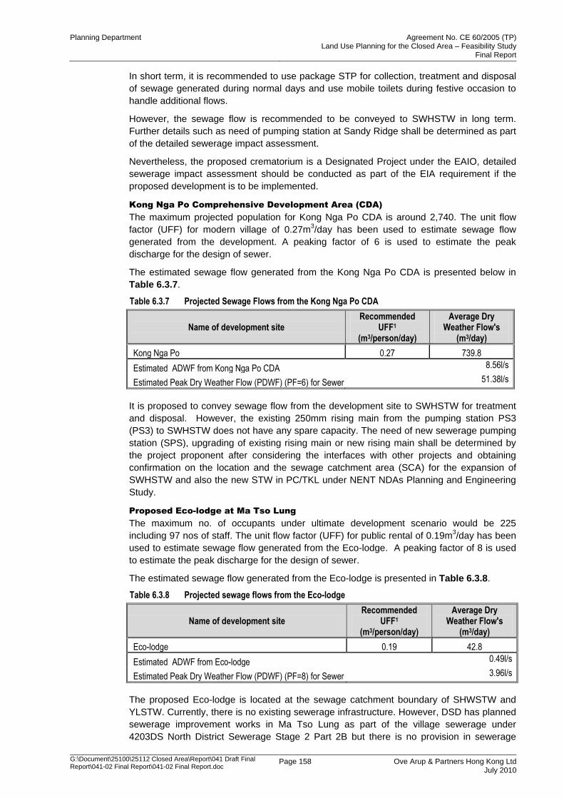
Planning Department Agreement No. CE 60/2005 (TP) Land Use Planning for the Closed Area – Feasibility Study
Final Report
G:\Document\25100\25112 Closed Area\Report\041 Draft Final Report\041-02 Final Report\041-02 Final Report.doc
Page 158 Ove Arup & Partners Hong Kong Ltd July 2010
In short term, it is recommended to use package STP for collection, treatment and disposal
of sewage generated during normal days and use mobile toilets during festive occasion to
handle additional flows.
However, the sewage flow is recommended to be conveyed to SWHSTW in long term.
Further details such as need of pumping station at Sandy Ridge shall be determined as part
of the detailed sewerage impact assessment.
Nevertheless, the proposed crematorium is a Designated Project under the EAIO, detailed
sewerage impact assessment should be conducted as part of the EIA requirement if the
proposed development is to be implemented.
Kong Nga Po Comprehensive Development Area (CDA)
The maximum projected population for Kong Nga Po CDA is around 2,740. The unit flow
factor (UFF) for modern village of 0.27m3/day has been used to estimate sewage flow
generated from the development. A peaking factor of 6 is used to estimate the peak
discharge for the design of sewer.
The estimated sewage flow generated from the Kong Nga Po CDA is presented below in
Table 6.3.7.
Table 6.3.7 Projected Sewage Flows from the Kong Nga Po CDA
Name of development site Recommended
UFF1 (m3/person/day)
Average Dry Weather Flow's
(m3/day)
Kong Nga Po 0.27 739.8
Estimated ADWF from Kong Nga Po CDA 8.56l/s
Estimated Peak Dry Weather Flow (PDWF) (PF=6) for Sewer 51.38l/s
It is proposed to convey sewage flow from the development site to SWHSTW for treatment
and disposal. However, the existing 250mm rising main from the pumping station PS3
(PS3) to SWHSTW does not have any spare capacity. The need of new sewerage pumping
station (SPS), upgrading of existing rising main or new rising main shall be determined by
the project proponent after considering the interfaces with other projects and obtaining
confirmation on the location and the sewage catchment area (SCA) for the expansion of
SWHSTW and also the new STW in PC/TKL under NENT NDAs Planning and Engineering
Study.
Proposed Eco-lodge at Ma Tso Lung
The maximum no. of occupants under ultimate development scenario would be 225
including 97 nos of staff. The unit flow factor (UFF) for public rental of 0.19m3/day has been
used to estimate sewage flow generated from the Eco-lodge. A peaking factor of 8 is used
to estimate the peak discharge for the design of sewer.
The estimated sewage flow generated from the Eco-lodge is presented in Table 6.3.8.
Table 6.3.8 Projected sewage flows from the Eco-lodge
Name of development site Recommended
UFF1 (m3/person/day)
Average Dry Weather Flow's
(m3/day)
Eco-lodge 0.19 42.8
Estimated ADWF from Eco-lodge 0.49l/s
Estimated Peak Dry Weather Flow (PDWF) (PF=8) for Sewer 3.96l/s
The proposed Eco-lodge is located at the sewage catchment boundary of SHWSTW and
YLSTW. Currently, there is no existing sewerage infrastructure. However, DSD has planned
sewerage improvement works in Ma Tso Lung as part of the village sewerage under
4203DS North District Sewerage Stage 2 Part 2B but there is no provision in sewerage
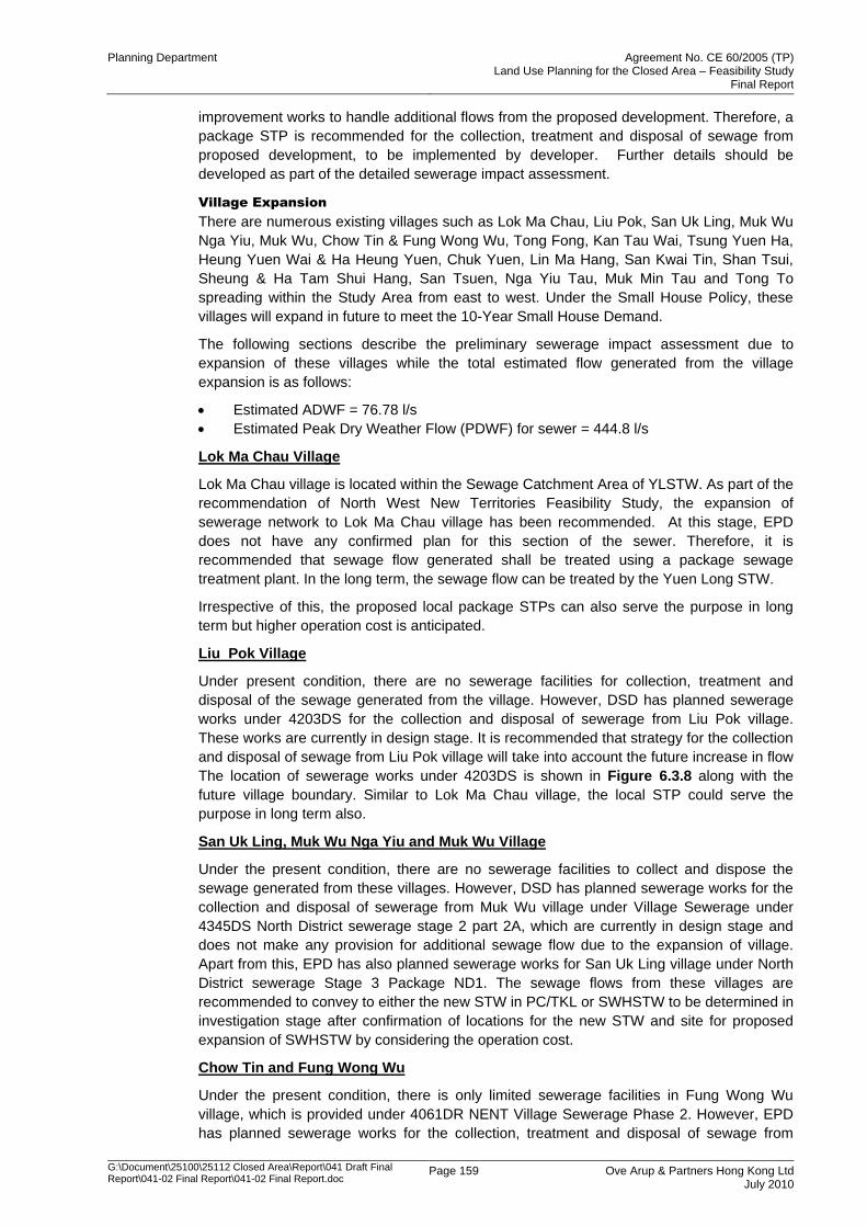
Planning Department Agreement No. CE 60/2005 (TP) Land Use Planning for the Closed Area – Feasibility Study
Final Report
G:\Document\25100\25112 Closed Area\Report\041 Draft Final Report\041-02 Final Report\041-02 Final Report.doc
Page 159 Ove Arup & Partners Hong Kong Ltd July 2010
improvement works to handle additional flows from the proposed development. Therefore, a
package STP is recommended for the collection, treatment and disposal of sewage from
proposed development, to be implemented by developer. Further details should be
developed as part of the detailed sewerage impact assessment.
Village Expansion
There are numerous existing villages such as Lok Ma Chau, Liu Pok, San Uk Ling, Muk Wu
Nga Yiu, Muk Wu, Chow Tin & Fung Wong Wu, Tong Fong, Kan Tau Wai, Tsung Yuen Ha,
Heung Yuen Wai & Ha Heung Yuen, Chuk Yuen, Lin Ma Hang, San Kwai Tin, Shan Tsui,
Sheung & Ha Tam Shui Hang, San Tsuen, Nga Yiu Tau, Muk Min Tau and Tong To
spreading within the Study Area from east to west. Under the Small House Policy, these
villages will expand in future to meet the 10-Year Small House Demand.
The following sections describe the preliminary sewerage impact assessment due to
expansion of these villages while the total estimated flow generated from the village
expansion is as follows:
Estimated ADWF = 76.78 l/s
Estimated Peak Dry Weather Flow (PDWF) for sewer = 444.8 l/s
Lok Ma Chau Village
Lok Ma Chau village is located within the Sewage Catchment Area of YLSTW. As part of the
recommendation of North West New Territories Feasibility Study, the expansion of
sewerage network to Lok Ma Chau village has been recommended. At this stage, EPD
does not have any confirmed plan for this section of the sewer. Therefore, it is
recommended that sewage flow generated shall be treated using a package sewage
treatment plant. In the long term, the sewage flow can be treated by the Yuen Long STW.
Irrespective of this, the proposed local package STPs can also serve the purpose in long
term but higher operation cost is anticipated.
Liu Pok Village
Under present condition, there are no sewerage facilities for collection, treatment and
disposal of the sewage generated from the village. However, DSD has planned sewerage
works under 4203DS for the collection and disposal of sewerage from Liu Pok village.
These works are currently in design stage. It is recommended that strategy for the collection
and disposal of sewage from Liu Pok village will take into account the future increase in flow
The location of sewerage works under 4203DS is shown in Figure 6.3.8 along with the
future village boundary. Similar to Lok Ma Chau village, the local STP could serve the
purpose in long term also.
San Uk Ling, Muk Wu Nga Yiu and Muk Wu Village
Under the present condition, there are no sewerage facilities to collect and dispose the
sewage generated from these villages. However, DSD has planned sewerage works for the
collection and disposal of sewerage from Muk Wu village under Village Sewerage under
4345DS North District sewerage stage 2 part 2A, which are currently in design stage and
does not make any provision for additional sewage flow due to the expansion of village.
Apart from this, EPD has also planned sewerage works for San Uk Ling village under North
District sewerage Stage 3 Package ND1. The sewage flows from these villages are
recommended to convey to either the new STW in PC/TKL or SWHSTW to be determined in
investigation stage after confirmation of locations for the new STW and site for proposed
expansion of SWHSTW by considering the operation cost.
Chow Tin and Fung Wong Wu
Under the present condition, there is only limited sewerage facilities in Fung Wong Wu
village, which is provided under 4061DR NENT Village Sewerage Phase 2. However, EPD
has planned sewerage works for the collection, treatment and disposal of sewage from
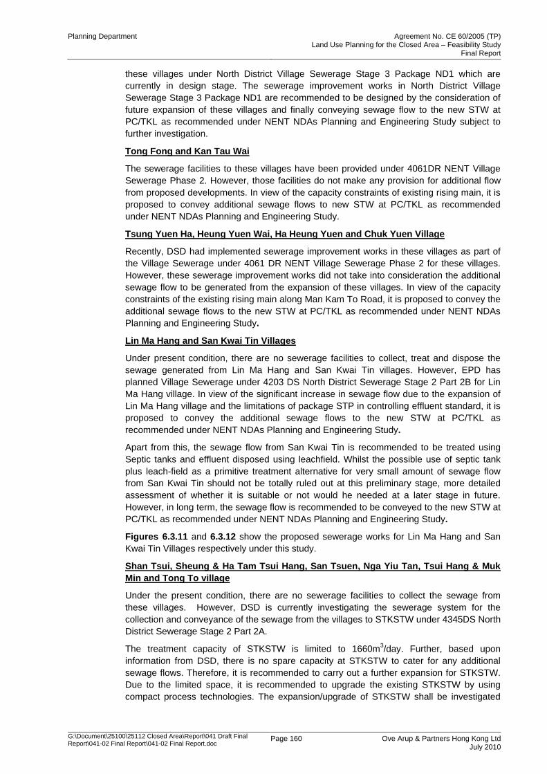
Planning Department Agreement No. CE 60/2005 (TP) Land Use Planning for the Closed Area – Feasibility Study
Final Report
G:\Document\25100\25112 Closed Area\Report\041 Draft Final Report\041-02 Final Report\041-02 Final Report.doc
Page 160 Ove Arup & Partners Hong Kong Ltd July 2010
these villages under North District Village Sewerage Stage 3 Package ND1 which are
currently in design stage. The sewerage improvement works in North District Village
Sewerage Stage 3 Package ND1 are recommended to be designed by the consideration of
future expansion of these villages and finally conveying sewage flow to the new STW at
PC/TKL as recommended under NENT NDAs Planning and Engineering Study subject to
further investigation.
Tong Fong and Kan Tau Wai
The sewerage facilities to these villages have been provided under 4061DR NENT Village
Sewerage Phase 2. However, those facilities do not make any provision for additional flow
from proposed developments. In view of the capacity constraints of existing rising main, it is
proposed to convey additional sewage flows to new STW at PC/TKL as recommended
under NENT NDAs Planning and Engineering Study.
Tsung Yuen Ha, Heung Yuen Wai, Ha Heung Yuen and Chuk Yuen Village
Recently, DSD had implemented sewerage improvement works in these villages as part of
the Village Sewerage under 4061 DR NENT Village Sewerage Phase 2 for these villages.
However, these sewerage improvement works did not take into consideration the additional
sewage flow to be generated from the expansion of these villages. In view of the capacity
constraints of the existing rising main along Man Kam To Road, it is proposed to convey the
additional sewage flows to the new STW at PC/TKL as recommended under NENT NDAs
Planning and Engineering Study.
Lin Ma Hang and San Kwai Tin Villages
Under present condition, there are no sewerage facilities to collect, treat and dispose the
sewage generated from Lin Ma Hang and San Kwai Tin villages. However, EPD has
planned Village Sewerage under 4203 DS North District Sewerage Stage 2 Part 2B for Lin
Ma Hang village. In view of the significant increase in sewage flow due to the expansion of
Lin Ma Hang village and the limitations of package STP in controlling effluent standard, it is
proposed to convey the additional sewage flows to the new STW at PC/TKL as
recommended under NENT NDAs Planning and Engineering Study.
Apart from this, the sewage flow from San Kwai Tin is recommended to be treated using
Septic tanks and effluent disposed using leachfield. Whilst the possible use of septic tank
plus leach-field as a primitive treatment alternative for very small amount of sewage flow
from San Kwai Tin should not be totally ruled out at this preliminary stage, more detailed
assessment of whether it is suitable or not would he needed at a later stage in future.
However, in long term, the sewage flow is recommended to be conveyed to the new STW at
PC/TKL as recommended under NENT NDAs Planning and Engineering Study.
Figures 6.3.11 and 6.3.12 show the proposed sewerage works for Lin Ma Hang and San
Kwai Tin Villages respectively under this study.
Shan Tsui, Sheung & Ha Tam Tsui Hang, San Tsuen, Nga Yiu Tan, Tsui Hang & Muk
Min and Tong To village
Under the present condition, there are no sewerage facilities to collect the sewage from
these villages. However, DSD is currently investigating the sewerage system for the
collection and conveyance of the sewage from the villages to STKSTW under 4345DS North
District Sewerage Stage 2 Part 2A.
The treatment capacity of STKSTW is limited to 1660m3/day. Further, based upon
information from DSD, there is no spare capacity at STKSTW to cater for any additional
sewage flows. Therefore, it is recommended to carry out a further expansion for STKSTW.
Due to the limited space, it is recommended to upgrade the existing STKSTW by using
compact process technologies. The expansion/upgrade of STKSTW shall be investigated
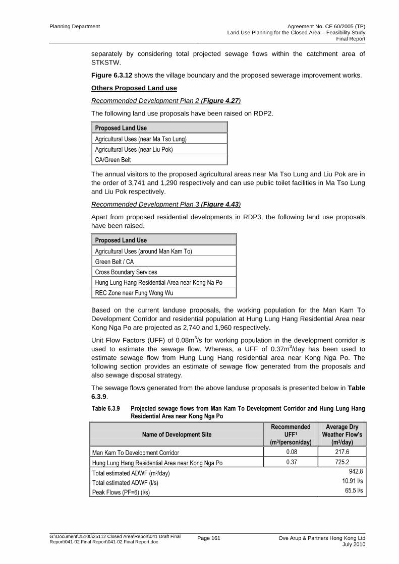
Planning Department Agreement No. CE 60/2005 (TP) Land Use Planning for the Closed Area – Feasibility Study
Final Report
G:\Document\25100\25112 Closed Area\Report\041 Draft Final Report\041-02 Final Report\041-02 Final Report.doc
Page 161 Ove Arup & Partners Hong Kong Ltd July 2010
separately by considering total projected sewage flows within the catchment area of
STKSTW.
Figure 6.3.12 shows the village boundary and the proposed sewerage improvement works.
Others Proposed Land use
Recommended Development Plan 2 (Figure 4.27)
The following land use proposals have been raised on RDP2.
Proposed Land Use
Agricultural Uses (near Ma Tso Lung)
Agricultural Uses (near Liu Pok)
CA/Green Belt
The annual visitors to the proposed agricultural areas near Ma Tso Lung and Liu Pok are in
the order of 3,741 and 1,290 respectively and can use public toilet facilities in Ma Tso Lung
and Liu Pok respectively.
Recommended Development Plan 3 (Figure 4.43)
Apart from proposed residential developments in RDP3, the following land use proposals
have been raised.
Proposed Land Use
Agricultural Uses (around Man Kam To)
Green Belt / CA
Cross Boundary Services
Hung Lung Hang Residential Area near Kong Na Po
REC Zone near Fung Wong Wu
Based on the current landuse proposals, the working population for the Man Kam To
Development Corridor and residential population at Hung Lung Hang Residential Area near
Kong Nga Po are projected as 2,740 and 1,960 respectively.
Unit Flow Factors (UFF) of 0.08m3/s for working population in the development corridor is
used to estimate the sewage flow. Whereas, a UFF of 0.37m3/day has been used to
estimate sewage flow from Hung Lung Hang residential area near Kong Nga Po. The
following section provides an estimate of sewage flow generated from the proposals and
also sewage disposal strategy.
The sewage flows generated from the above landuse proposals is presented below in Table
6.3.9.
Table 6.3.9 Projected sewage flows from Man Kam To Development Corridor and Hung Lung Hang Residential Area near Kong Nga Po
Name of Development Site Recommended
UFF1 (m3/person/day)
Average Dry Weather Flow's
(m3/day)
Man Kam To Development Corridor 0.08 217.6
Hung Lung Hang Residential Area near Kong Nga Po 0.37 725.2
Total estimated ADWF (m3/day) 942.8
Total estimated ADWF (l/s) 10.91 l/s
Peak Flows (PF=6) (l/s) 65.5 l/s
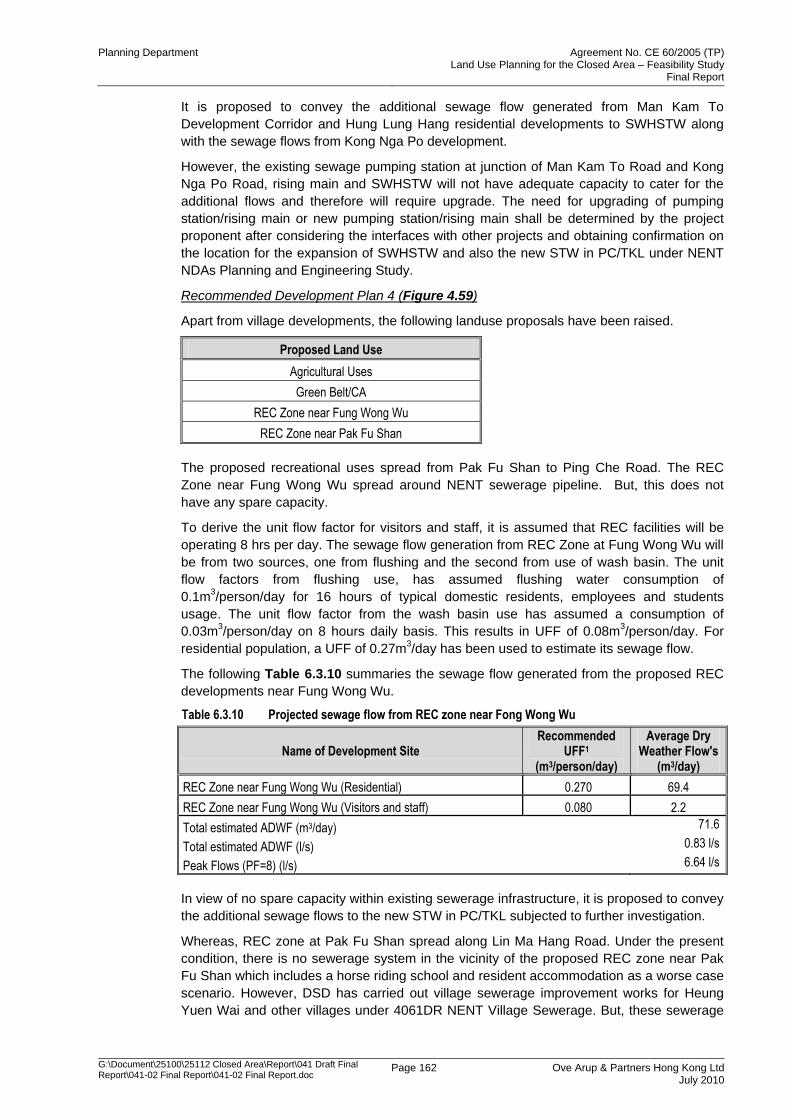
Planning Department Agreement No. CE 60/2005 (TP) Land Use Planning for the Closed Area – Feasibility Study
Final Report
G:\Document\25100\25112 Closed Area\Report\041 Draft Final Report\041-02 Final Report\041-02 Final Report.doc
Page 162 Ove Arup & Partners Hong Kong Ltd July 2010
It is proposed to convey the additional sewage flow generated from Man Kam To
Development Corridor and Hung Lung Hang residential developments to SWHSTW along
with the sewage flows from Kong Nga Po development.
However, the existing sewage pumping station at junction of Man Kam To Road and Kong
Nga Po Road, rising main and SWHSTW will not have adequate capacity to cater for the
additional flows and therefore will require upgrade. The need for upgrading of pumping
station/rising main or new pumping station/rising main shall be determined by the project
proponent after considering the interfaces with other projects and obtaining confirmation on
the location for the expansion of SWHSTW and also the new STW in PC/TKL under NENT
NDAs Planning and Engineering Study.
Recommended Development Plan 4 (Figure 4.59)
Apart from village developments, the following landuse proposals have been raised.
Proposed Land Use
Agricultural Uses
Green Belt/CA
REC Zone near Fung Wong Wu
REC Zone near Pak Fu Shan
The proposed recreational uses spread from Pak Fu Shan to Ping Che Road. The REC
Zone near Fung Wong Wu spread around NENT sewerage pipeline. But, this does not
have any spare capacity.
To derive the unit flow factor for visitors and staff, it is assumed that REC facilities will be
operating 8 hrs per day. The sewage flow generation from REC Zone at Fung Wong Wu will
be from two sources, one from flushing and the second from use of wash basin. The unit
flow factors from flushing use, has assumed flushing water consumption of
0.1m3/person/day for 16 hours of typical domestic residents, employees and students
usage. The unit flow factor from the wash basin use has assumed a consumption of
0.03m3/person/day on 8 hours daily basis. This results in UFF of 0.08m
3/person/day. For
residential population, a UFF of 0.27m3/day has been used to estimate its sewage flow.
The following Table 6.3.10 summaries the sewage flow generated from the proposed REC
developments near Fung Wong Wu.
Table 6.3.10 Projected sewage flow from REC zone near Fong Wong Wu
Name of Development Site Recommended
UFF1 (m3/person/day)
Average Dry Weather Flow's
(m3/day)
REC Zone near Fung Wong Wu (Residential) 0.270 69.4
REC Zone near Fung Wong Wu (Visitors and staff) 0.080 2.2
Total estimated ADWF (m3/day) 71.6
Total estimated ADWF (l/s) 0.83 l/s
Peak Flows (PF=8) (l/s) 6.64 l/s
In view of no spare capacity within existing sewerage infrastructure, it is proposed to convey
the additional sewage flows to the new STW in PC/TKL subjected to further investigation.
Whereas, REC zone at Pak Fu Shan spread along Lin Ma Hang Road. Under the present
condition, there is no sewerage system in the vicinity of the proposed REC zone near Pak
Fu Shan which includes a horse riding school and resident accommodation as a worse case
scenario. However, DSD has carried out village sewerage improvement works for Heung
Yuen Wai and other villages under 4061DR NENT Village Sewerage. But, these sewerage
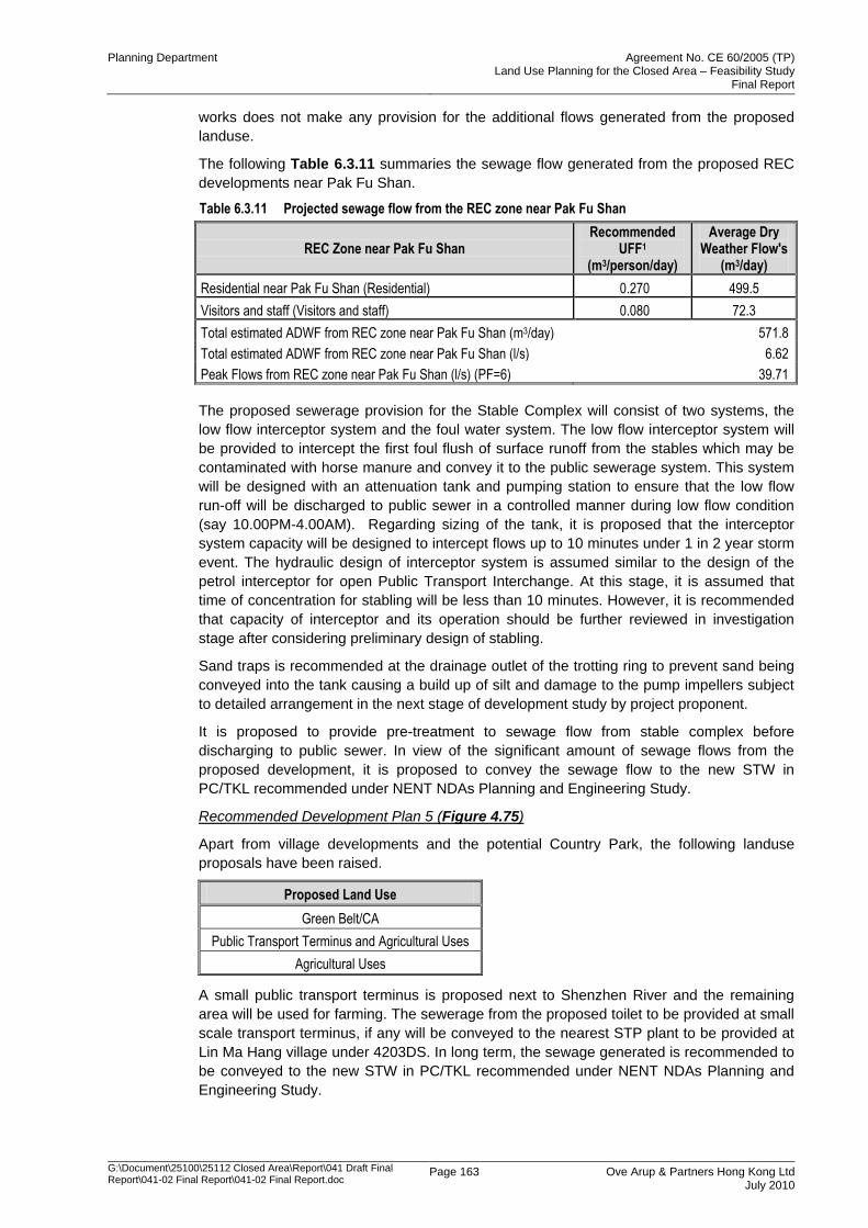
Planning Department Agreement No. CE 60/2005 (TP) Land Use Planning for the Closed Area – Feasibility Study
Final Report
G:\Document\25100\25112 Closed Area\Report\041 Draft Final Report\041-02 Final Report\041-02 Final Report.doc
Page 163 Ove Arup & Partners Hong Kong Ltd July 2010
works does not make any provision for the additional flows generated from the proposed
landuse.
The following Table 6.3.11 summaries the sewage flow generated from the proposed REC
developments near Pak Fu Shan.
Table 6.3.11 Projected sewage flow from the REC zone near Pak Fu Shan
REC Zone near Pak Fu Shan Recommended
UFF1 (m3/person/day)
Average Dry Weather Flow's
(m3/day)
Residential near Pak Fu Shan (Residential) 0.270 499.5
Visitors and staff (Visitors and staff) 0.080 72.3
Total estimated ADWF from REC zone near Pak Fu Shan (m3/day) 571.8
Total estimated ADWF from REC zone near Pak Fu Shan (l/s) 6.62
Peak Flows from REC zone near Pak Fu Shan (l/s) (PF=6) 39.71
The proposed sewerage provision for the Stable Complex will consist of two systems, the
low flow interceptor system and the foul water system. The low flow interceptor system will
be provided to intercept the first foul flush of surface runoff from the stables which may be
contaminated with horse manure and convey it to the public sewerage system. This system
will be designed with an attenuation tank and pumping station to ensure that the low flow
run-off will be discharged to public sewer in a controlled manner during low flow condition
(say 10.00PM-4.00AM). Regarding sizing of the tank, it is proposed that the interceptor
system capacity will be designed to intercept flows up to 10 minutes under 1 in 2 year storm
event. The hydraulic design of interceptor system is assumed similar to the design of the
petrol interceptor for open Public Transport Interchange. At this stage, it is assumed that
time of concentration for stabling will be less than 10 minutes. However, it is recommended
that capacity of interceptor and its operation should be further reviewed in investigation
stage after considering preliminary design of stabling.
Sand traps is recommended at the drainage outlet of the trotting ring to prevent sand being
conveyed into the tank causing a build up of silt and damage to the pump impellers subject
to detailed arrangement in the next stage of development study by project proponent.
It is proposed to provide pre-treatment to sewage flow from stable complex before
discharging to public sewer. In view of the significant amount of sewage flows from the
proposed development, it is proposed to convey the sewage flow to the new STW in
PC/TKL recommended under NENT NDAs Planning and Engineering Study.
Recommended Development Plan 5 (Figure 4.75)
Apart from village developments and the potential Country Park, the following landuse
proposals have been raised.
Proposed Land Use
Green Belt/CA
Public Transport Terminus and Agricultural Uses
Agricultural Uses
A small public transport terminus is proposed next to Shenzhen River and the remaining
area will be used for farming. The sewerage from the proposed toilet to be provided at small
scale transport terminus, if any will be conveyed to the nearest STP plant to be provided at
Lin Ma Hang village under 4203DS. In long term, the sewage generated is recommended to
be conveyed to the new STW in PC/TKL recommended under NENT NDAs Planning and
Engineering Study.
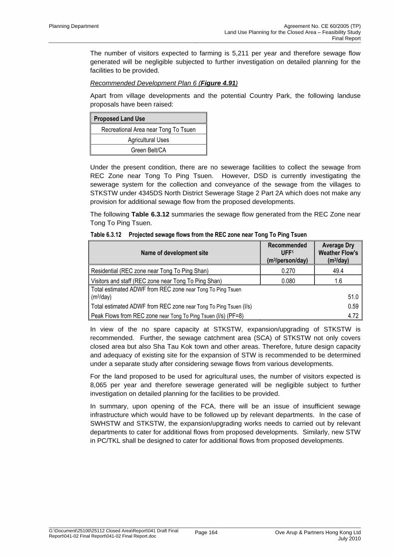
Planning Department Agreement No. CE 60/2005 (TP) Land Use Planning for the Closed Area – Feasibility Study
Final Report
G:\Document\25100\25112 Closed Area\Report\041 Draft Final Report\041-02 Final Report\041-02 Final Report.doc
Page 164 Ove Arup & Partners Hong Kong Ltd July 2010
The number of visitors expected to farming is 5,211 per year and therefore sewage flow
generated will be negligible subjected to further investigation on detailed planning for the
facilities to be provided.
Recommended Development Plan 6 (Figure 4.91)
Apart from village developments and the potential Country Park, the following landuse
proposals have been raised:
Proposed Land Use
Recreational Area near Tong To Tsuen
Agricultural Uses
Green Belt/CA
Under the present condition, there are no sewerage facilities to collect the sewage from
REC Zone near Tong To Ping Tsuen. However, DSD is currently investigating the
sewerage system for the collection and conveyance of the sewage from the villages to
STKSTW under 4345DS North District Sewerage Stage 2 Part 2A which does not make any
provision for additional sewage flow from the proposed developments.
The following Table 6.3.12 summaries the sewage flow generated from the REC Zone near
Tong To Ping Tsuen.
Table 6.3.12 Projected sewage flows from the REC zone near Tong To Ping Tsuen
Name of development site Recommended
UFF1 (m3/person/day)
Average Dry Weather Flow's
(m3/day)
Residential (REC zone near Tong To Ping Shan) 0.270 49.4
Visitors and staff (REC zone near Tong To Ping Shan) 0.080 1.6
Total estimated ADWF from REC zone near Tong To Ping Tsuen (m3/day) 51.0
Total estimated ADWF from REC zone near Tong To Ping Tsuen (l/s) 0.59
Peak Flows from REC zone near Tong To Ping Tsuen (l/s) (PF=8) 4.72
In view of the no spare capacity at STKSTW, expansion/upgrading of STKSTW is
recommended. Further, the sewage catchment area (SCA) of STKSTW not only covers
closed area but also Sha Tau Kok town and other areas. Therefore, future design capacity
and adequacy of existing site for the expansion of STW is recommended to be determined
under a separate study after considering sewage flows from various developments.
For the land proposed to be used for agricultural uses, the number of visitors expected is
8,065 per year and therefore sewerage generated will be negligible subject to further
investigation on detailed planning for the facilities to be provided.
In summary, upon opening of the FCA, there will be an issue of insufficient sewage
infrastructure which would have to be followed up by relevant departments. In the case of
SWHSTW and STKSTW, the expansion/upgrading works needs to carried out by relevant
departments to cater for additional flows from proposed developments. Similarly, new STW
in PC/TKL shall be designed to cater for additional flows from proposed developments.
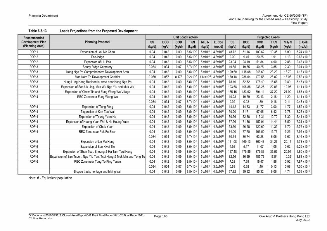
Planning Department Agreement No. CE 60/2005 (TP) Land Use Planning for the Closed Area – Feasibility Study
Final Report
G:\Document\25100\25112 Closed Area\Report\041 Draft Final Report\041-02 Final Report\041-02 Final Report.doc
Page 165 Ove Arup & Partners Hong Kong Ltd July 2010
Table 6.3.13 Loads Projections from the Proposed Development
Recommended Development Plan
(Planning Area) Planning Proposal
Unit Load Factors Projected Loads
SS
(kg/d)
BOD
(kg/d)
COD
(kg/d)
TKN
(kg/d)
NH3 N
(kg/d)
E. Coli
(no./d)
SS
(kg/d)
BOD
(kg/d)
COD
(kg/d)
TKN
(kg/d)
NH3 N
(kg/d)
E. Coli
(no./d)
RDP 1 Expansion of Lok Ma Chau 0.04 0.042 0.09 8.5x10⁻³ 5 x10⁻³ 4.3x10¹⁰ 48.72 51.16 109.62 10.35 6.09 5.24 x10¹³
RDP 2 Eco-lodge 0.04 0.042 0.09 8.5x10⁻³ 5 x10⁻³ 4.3x10¹⁰ 9.00 9.45 20.25 1.91 1.13 9.68 x10¹²
RDP 2 Expansion of Liu Pok 0.04 0.042 0.09 8.5x10⁻³ 5 x10⁻³ 4.3x10¹⁰ 23.04 24.19 51.84 4.90 2.88 2.48 x10¹³
RDP 3 Sandy Ridge Cemetery 0.034 0.034 0.07 6.7x10⁻³ 4 x10⁻³ 3.5x10¹⁰ 19.55 19.55 40.25 3.85 2.30 2.01 x10¹³
RDP 3 Kong Nga Po Comprehensive Development Area 0.04 0.042 0.09 8.5x10⁻³ 5 x10⁻³ 4.3x10¹⁰ 109.60 115.08 246.60 23.29 13.70 1.18 x10¹⁴
RDP 3 Man Kam To Development Corridor 0.059 0.087 0.173 9.2x10⁻³ 4.8 x10⁻³ 3.5x10¹⁰ 160.48 236.64 470.56 25.02 13.06 9.52 x10¹³
RDP 3 Hung Lung Hang Residential Area near Kong Nga Po 0.04 0.042 0.09 8.5x10⁻³ 5 x10⁻³ 4.3x10¹⁰ 78.40 82.32 176.40 16.66 9.80 8.43 x10¹³
RDP 3 Expansion of San Uk Ling, Muk Wu Nga Yiu and Muk Wu 0.04 0.042 0.09 8.5x10⁻³ 5 x10⁻³ 4.3x10¹⁰ 103.68 108.86 233.28 22.03 12.96 1.11 x10¹⁴
RDP 3 Expansion of Chow Tin and Fung Wong Wu Village 0.04 0.042 0.09 8.5x10⁻³ 5 x10⁻³ 4.3x10¹⁰ 175.16 183.92 394.11 37.22 21.90 1.88 x10¹⁴
RDP 4 REC Zone near Fung Wong Wu 0.04 0.042 0.09 8.5x10⁻³ 5 x10⁻³ 4.3x10¹⁰ 10.28 10.79 23.13 2.18 1.29 1.11 x10¹³
0.034 0.034 0.07 6.7x10⁻³ 4 x10⁻³ 3.5x10¹⁰ 0.92 0.92 1.89 0.18 0.11 9.45 x10¹¹
RDP 4 Expansion of Tong Fong 0.04 0.042 0.09 8.5x10⁻³ 5 x10⁻³ 4.3x10¹⁰ 14.12 14.83 31.77 3.00 1.77 1.52 x10¹³
RDP 4 Expansion of Kan Tau Wai 0.04 0.042 0.09 8.5x10⁻³ 5 x10⁻³ 4.3x10¹⁰ 30.20 31.71 67.95 6.42 3.78 3.25 x10¹³
RDP 4 Expansion of Tsung Yuen Ha 0.04 0.042 0.09 8.5x10⁻³ 5 x10⁻³ 4.3x10¹⁰ 50.36 52.88 113.31 10.70 6.30 5.41 x10¹³
RDP 4 Expansion of Heung Yuen Wai & Ha Heung Yuen 0.04 0.042 0.09 8.5x10⁻³ 5 x10⁻³ 4.3x10¹⁰ 67.96 71.36 152.91 14.44 8.50 7.31 x10¹³
RDP 4 Expansion of Chuk Yuen 0.04 0.042 0.09 8.5x10⁻³ 5 x10⁻³ 4.3x10¹⁰ 53.60 56.28 120.60 11.39 6.70 5.76 x10¹³
RDP 4 REC Zone near Pak Fu Shan 0.04 0.042 0.09 8.5x10⁻³ 5 x10⁻³ 4.3x10¹⁰ 74.00 77.70 166.50 15.73 9.25 7.96 x10¹³
0.034 0.034 0.07 6.7x10⁻³ 4 x10⁻³ 3.5x10¹⁰ 30.74 30.74 63.28 6.06 3.62 3.16 x10¹³
RDP 5 Expansion of Lin Ma Hang 0.04 0.042 0.09 8.5x10⁻³ 5 x10⁻³ 4.3x10¹⁰ 161.08 169.13 362.43 34.23 20.14 1.73 x10¹⁴
RDP 6 Expansion of San Kwai Tin 0.04 0.042 0.09 8.5x10⁻³ 5 x10⁻³ 4.3x10¹⁰ 4.92 5.17 11.07 1.05 0.62 5.29 x10¹²
RDP 6 Expansion of Shan Tsui, Sheung & Ha Tam Tsui Hang 0.04 0.042 0.09 8.5x10⁻³ 5 x10⁻³ 4.3x10¹⁰ 167.48 175.85 376.83 35.59 20.94 1.80 x10¹⁴
RDP 6 Expansion of San Tsuen, Nga Yiu Tan, Tsui Hang & Muk Min and Tong To 0.04 0.042 0.09 8.5x10⁻³ 5 x10⁻³ 4.3x10¹⁰ 82.56 86.69 185.76 17.54 10.32 8.88 x10¹³
RDP 6 REC Zone near Tong To Ping Tsuen 0.04 0.042 0.09 8.5x10⁻³ 5 x10⁻³ 4.3x10¹⁰ 7.32 7.69 16.47 1.56 0.92 7.87 x10¹²
0.034 0.034 0.07 6.7x10⁻³ 4 x10⁻³ 3.5x10¹⁰ 0.68 0.68 1.40 0.13 0.08 7.00 x10¹¹
Bicycle track, heritage and hiking trail 0.04 0.042 0.09 8.5x10⁻³ 5 x10⁻³ 4.3x10¹⁰ 37.92 39.82 85.32 8.06 4.74 4.08 x10¹³
Note: # - Equivalent population
Planning Department Agreement No. CE 60/2005 (TP) Land Use Planning for the Closed Area – Feasibility Study
Final Report
G:\Document\25100\25112 Closed Area\Report\041 Draft Final Report\041-02 Final Report\041-02 Final Report.doc
Page 166 Ove Arup & Partners Hong Kong Ltd July 2010
6.3.2.5 Sewage Collection, Treatment and Disposal Options
The proposed developments aim to be implemented after the release of the Closed Area,
whereas planning and implementation of sewerage improvements works including
expansion/upgrade of STW or new STW take considerable time.
The Environmental Protection Department/ the Drainage Service Department has planned
several sewerage improvement works for the existing village but these sewerage
improvement works are not planned and designed for the proposed major developments in
this Study. In order to meet the requirement for a „no net increase in pollution loading in
Deep Bay‟, the Study proposed to convey sewerage flow from the purposed developments
to centralized sewerage treatment works (STWs) such as Shek Wu Hui STW, new STW in
Ping Che / Ta Kwu Ling and Sha Tau Kok for the collection, treatment and disposal of
sewerage generated from the proposed developments. As those STWs do not have spare
capacity to handle such large sewage flows, this Study recommended that the proposed
major developments should be implemented after the completion of the expansion /
upgrading of these STWs and also a new STW in Ping Che/Ta Kwu Ling.
Further to the recommendation of a new STW in Ping Che/Ta Kwu Ling under NENT NDAs
Planning and Engineering Study, it is recommended to convey sewage flow from the
proposed developments in Closed Area between San Uk Ling and Lin Ma Hang to the new
STW. The proposed STW in PC/TKL is recommended to be designed by considering
additional flows from the developments under this Study and also developments in other
studies.
Whereas, the sewage flow from proposed development between San Uk Ling and Ng Tung
River are recommended to be conveyed to SWHSTW. The expansion/upgrading of
SWHSTW shall make provision for additional sewage flows from these developments.
Lastly, the sewage flows from the proposed developments at Shan Tsui, Sheung & Ha Tam
Tsui Hang, San Tsuen, Nga Yiu Tan, Tsui Hang & Muk Min and Tong To village is
recommended to be conveyed to STKSTW. In view of no spare capacity, the expansion of
STKSTW is recommended by considering the sewage flows from various developments
under a separate study.
6.3.2.6 Sewerage Impact Assessment
Long Term Improvement Works
The proposed sewerage improvement works will have impacts on existing and planned
sewerage improvement works. Especially, in RDP3, there are number of development
proposals to convey the additional sewage flows to SWHSTW. This proposal may require
upgrading of the existing rising main conveying sewage flow from NENT Landfill site and
villages. The following section provide a brief description on the spare capacity of existing
rising main and improvement works may be required.
Existing Rising Main (Leachate Pipeline)
The location of the existing rising main is shown in Figures 6.3.9 to 6.3.11. As mentioned
before, the sewage flows from San Uk Ling, Muk Wu and Muk Wu Nga Yiu villages are
recommended to be conveyed to the new STW at PC/TKL. Whereas, sewage flows from
the remaining developments in RDP3 such as Sandy Ridge Cemetery, Kong Nga Po CDA,
Hung Lung Hang Residential Area and Man Kam To Development Corridor are proposed to
be conveyed to SWHSTW.
The capacity of the existing rising main is approximately 3888m3/day, whereas ADWF from
San Uk Ling, Muk Wu and Muk Wu Nga Yiu village would be approximately 700m3/day in
the ultimate development case. Therefore, sewage flow from these villages can be
conveyed to new STW in PC/TKL without any upgrade of existing rising main. However, a
sewage pumping station will be required to pump the sewage from these villages.
Planning Department Agreement No. CE 60/2005 (TP) Land Use Planning for the Closed Area – Feasibility Study
Final Report
G:\Document\25100\25112 Closed Area\Report\041 Draft Final Report\041-02 Final Report\041-02 Final Report.doc
Page 167 Ove Arup & Partners Hong Kong Ltd July 2010
Whereas, ADWF from Sandy Ridge Cemetery, Kong Nga Po CDA, Hung Lung Hang
Residential Area and Man Kam To Development Corridor is approximately 1728m3/day
which is lower than the capacity of rising main and PS3. It is recommended to collect the
sewage from these developments at PS3 for conveying to SWHSTW through existing rising
main.
As the locations for the expansion of SWHSTW in NENT NDA Planning and Engineering
Study and the new STW in PC/TKL are not confirmed yet and therefore it is recommended
to determine the sewage scheme from long term perspective for San Uk Ling, Muk Wu and
Muk Wu Nga Yiu villages in investigation stage after considering the pumping cost to the
new STW at PC/TKL or SWHSTW.
6.3.2.7 Sewage Treatment Works (STW)
Expansion/Upgrade of Shek Wu Hui Sewage Treatment Works (SWHSTW)
SWHSTW collects and provides treatment to the wastewater generated from Fanling/
Sheung Shui areas before discharging into Deep Bay through Ng Tung River and Shenzhen
River. The capacity of the SWHSTW upgraded under the Project PWP Item 4229DS/A
entitled “Expansion of Shek Wu Hui Sewage Treatment Works and Ting Kok Road Pumping
Station No. 5”. The project is an interim expansion as recommended in Agreement No.
CE28/99 entitled “Review of North District and Tolo Harbour Sewerage Master Plans”. The
construction works of the SWHSTW expansion commenced in September 2005 and was
scheduled for completion in early 2009. The scope of the project includes increasing the
treatment capacity of SWHSTW from 80,000m3/day to 93,000m
3/day so as to cater for the
base growth of population in Sheung Shui/Fanling areas up to year 2011 and extension of
public sewerage to nearby villages. However, the above interim expansion does not take
into consideration the additional sewage generated from the planning proposals under this
study.
Therefore, further expansion and upgrading of the SWHSTW will be required to handle
additional flows and loads from the developments under this study and also other
developments such as NDAs. It is proposed to review the need of upgrade/expansion of
SWHSTW under NENT NDA Planning and Engineering Study after taking all the proposed
potential developments within the Sewage Catchment Area of SWHSTW into consideration.
As, SWHSTW is subject to discharge policy of “no net increase in pollution loading” in terms
of disposal of sewage as the effluent is proposed to be discharged within the Deep Bay
through Ng Tung River. This policy is to ensure that, no additional pollutant loading arising
from new development is discharged into the Deep Bay. In order to achieve no net increase
of pollution load to Deep Bay area, it is proposed to reuse the effluent for landscape
irrigation of non-agricultural use and also for toilet flushing.
With the advancement in process technology, there are a number of options that could be
considered suitable for achieving ambitious treatment levels. These include the following but
should be investigated under NENT NDA Planning and Engineering Study for the
expansion/upgrade of SWHSTW.
Membrane Bio-reactors (MBR)
Fine screening and degritting (3mm) followed by MBR is an appropriate option to achieve an
effluent discharge level of 3mg/l BOD: 3mg/1 SS. The MBR system has been consistently
achieving BOD<2 and SS<1 in the US. Therefore additional tertiary treatment will not be
necessary. MBRs are the most compact process available but would be relatively expensive
to construct and operate. It may be possible to purchase or lease skid-mounted MBR units,
which can be either external membranes for use with a separate aeration tank or a
biological reactor with immersed membrane.
The plant is relatively straightforward to operate but can have reasonably high maintenance
costs due to the significant level of mechanical plant, blowers, valves, pumps, etc.
Planning Department Agreement No. CE 60/2005 (TP) Land Use Planning for the Closed Area – Feasibility Study
Final Report
G:\Document\25100\25112 Closed Area\Report\041 Draft Final Report\041-02 Final Report\041-02 Final Report.doc
Page 168 Ove Arup & Partners Hong Kong Ltd July 2010
Biological Aerated Filters (BAF)
In order to limit the plant footprint, it is possible to eliminate the requirement for primary
settlement for a temporary plant. Screening (6mm) followed by BAF may be an appropriate
option for achieving the required discharge consent. BAF alone would not suffice, tertiary
treatment is required, e.g. sand filtration. However, due to an increased residual soluble
BOD in the effluent of a BAF system (as a result of the relatively short system retention
time), there is a higher element of risk that the system will not achieve an effluent discharge
level of 3mg/l BOD: 3mg/1 SS.
This process is robust and has precise design guidelines and can produce a fully nitrified
effluent without having to provide a clarification stage. As the bio-mass is attached to media
it should be relatively robust against salinity, although more frequent backwashing may be
required than normal if the bacteria produce muco-polysaccharide slimes when stressed.
The plant is relatively straightforward to operate but can have reasonably high maintenance
costs due to the significant level of mechanical plant, blowers, valves, pumps, etc.
Sequencing Batch Reactors (SBR)
SBR system is a fill and draw batch activated sludge treatment system, which is capable of
achieving a discharge level of 20mg/l BOD: 30mg/l SS alone. The footprint for an SBR plant
is less than that of conventional activated sludge plant due to the aeration and settlement
stages being carried out in a common tank.
In order to achieve a very high quality effluent standard, some tertiary treatment will be
required, for example, sand filtration. There is still an element of risk of the system not
achieving an effluent discharge level of 3mg/l BOD: 3mg/1 SS. In this option, the SBR unit
may be stacked in order to reduce the overall footprint.
Maintenance and operating costs will be slightly lower than as there is no return sludge
pumping required.
Expansion/Upgrade of Sha Tau Kok Sewage Treatment Works (STKSTW)
STKSTW was designed to treat 1,660 m3/day DWF of sewage containing 230mg/l of BOD
and SS. The works was commissioned in 1985 and is designed to provide preliminary and
secondary treatment (extended aeration activated sludge) for all flows up to 3xDWF to
achieve a 20mg/l BOD and 30mg/l SS effluent standard with full nitrification. Treated effluent
is UV disinfected before discharging into Starling Inlet.
Under the existing arrangement, the wastewater is passed through 20 mm screen first,
before going through biological treatment provided by the oxidation ditch (1.8 m depth,
1,833 m3 volume) with a design hydraulic retention time of 26.5 hours. Two final
sedimentation tanks provide the final clarification of the effluent before disinfection by the
UV. The circular sedimentation tank has a diameter of 12.5m and a sidewall depth of 2m.
The UV facilities consist of one channel with two modules and seven banks in each module.
Sludge is returned from the sedimentation tanks to the inlet of the STKSTW by RAS pumps
(one duty, one standby). Surplus sludge is stored in two holding tanks and from which,
taken off-site by road tanker to the inlet of Shek Wu Hui Sewage Treatment Works.
As capacity of STKSTW is limited to 1,660m3/day, where ADWF from village expansion
under ultimate development scenario under this study is approximately 1739m3/day under
the ultimate development scenario and therefore it is recommended to carry out further
expansion of STKSTW. Due to the limitation of space, it is recommended to upgrade the
existing STKSTW by using compact process technologies. The expansion/upgrade of
STKSTW should be investigated separately by considering total projected sewage flows
within the catchment area of STKSTW. The detailed scheme to convey the sewage flow
from the villages shall be developed in investigation stage after confirming the site for the
expansion of STKSTW.
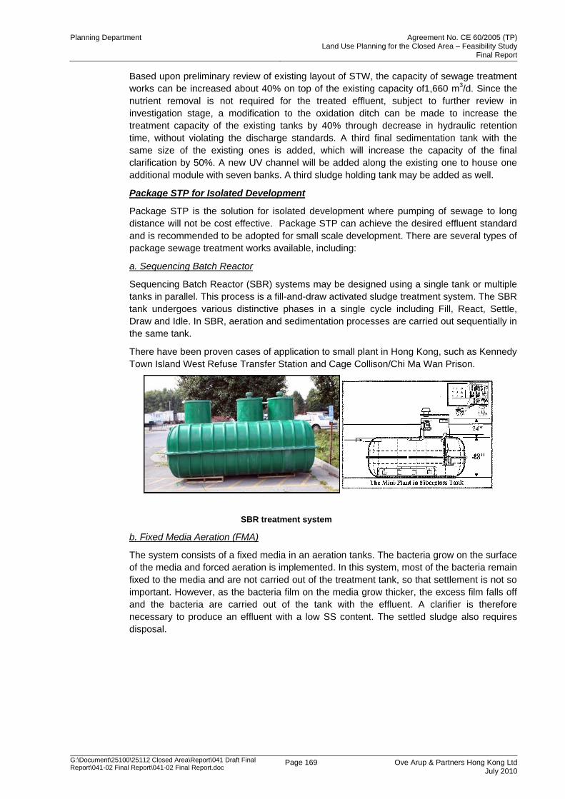
Planning Department Agreement No. CE 60/2005 (TP) Land Use Planning for the Closed Area – Feasibility Study
Final Report
G:\Document\25100\25112 Closed Area\Report\041 Draft Final Report\041-02 Final Report\041-02 Final Report.doc
Page 169 Ove Arup & Partners Hong Kong Ltd July 2010
Based upon preliminary review of existing layout of STW, the capacity of sewage treatment
works can be increased about 40% on top of the existing capacity of1,660 m3/d. Since the
nutrient removal is not required for the treated effluent, subject to further review in
investigation stage, a modification to the oxidation ditch can be made to increase the
treatment capacity of the existing tanks by 40% through decrease in hydraulic retention
time, without violating the discharge standards. A third final sedimentation tank with the
same size of the existing ones is added, which will increase the capacity of the final
clarification by 50%. A new UV channel will be added along the existing one to house one
additional module with seven banks. A third sludge holding tank may be added as well.
Package STP for Isolated Development
Package STP is the solution for isolated development where pumping of sewage to long
distance will not be cost effective. Package STP can achieve the desired effluent standard
and is recommended to be adopted for small scale development. There are several types of
package sewage treatment works available, including:
a. Sequencing Batch Reactor
Sequencing Batch Reactor (SBR) systems may be designed using a single tank or multiple
tanks in parallel. This process is a fill-and-draw activated sludge treatment system. The SBR
tank undergoes various distinctive phases in a single cycle including Fill, React, Settle,
Draw and Idle. In SBR, aeration and sedimentation processes are carried out sequentially in
the same tank.
There have been proven cases of application to small plant in Hong Kong, such as Kennedy
Town Island West Refuse Transfer Station and Cage Collison/Chi Ma Wan Prison.
SBR treatment system
b. Fixed Media Aeration (FMA)
The system consists of a fixed media in an aeration tanks. The bacteria grow on the surface
of the media and forced aeration is implemented. In this system, most of the bacteria remain
fixed to the media and are not carried out of the treatment tank, so that settlement is not so
important. However, as the bacteria film on the media grow thicker, the excess film falls off
and the bacteria are carried out of the tank with the effluent. A clarifier is therefore
necessary to produce an effluent with a low SS content. The settled sludge also requires
disposal.
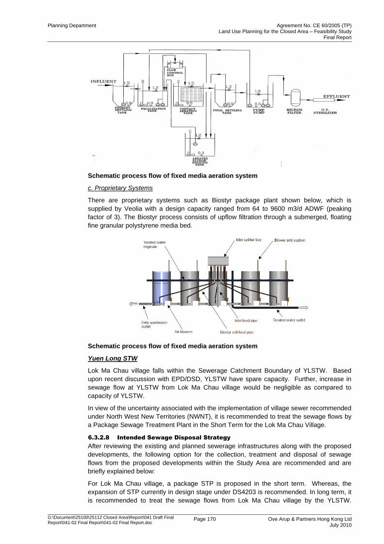
Planning Department Agreement No. CE 60/2005 (TP) Land Use Planning for the Closed Area – Feasibility Study
Final Report
G:\Document\25100\25112 Closed Area\Report\041 Draft Final Report\041-02 Final Report\041-02 Final Report.doc
Page 170 Ove Arup & Partners Hong Kong Ltd July 2010
Schematic process flow of fixed media aeration system
c. Proprietary Systems
There are proprietary systems such as Biostyr package plant shown below, which is
supplied by Veolia with a design capacity ranged from 64 to 9600 m3/d ADWF (peaking
factor of 3). The Biostyr process consists of upflow filtration through a submerged, floating
fine granular polystyrene media bed.
Schematic process flow of fixed media aeration system
Yuen Long STW
Lok Ma Chau village falls within the Sewerage Catchment Boundary of YLSTW. Based
upon recent discussion with EPD/DSD, YLSTW have spare capacity. Further, increase in
sewage flow at YLSTW from Lok Ma Chau village would be negligible as compared to
capacity of YLSTW.
In view of the uncertainty associated with the implementation of village sewer recommended
under North West New Territories (NWNT), it is recommended to treat the sewage flows by
a Package Sewage Treatment Plant in the Short Term for the Lok Ma Chau Village.
6.3.2.8 Intended Sewage Disposal Strategy
After reviewing the existing and planned sewerage infrastructures along with the proposed
developments, the following option for the collection, treatment and disposal of sewage
flows from the proposed developments within the Study Area are recommended and are
briefly explained below:
For Lok Ma Chau village, a package STP is proposed in the short term. Whereas, the
expansion of STP currently in design stage under DS4203 is recommended. In long term, it
is recommended to treat the sewage flows from Lok Ma Chau village by the YLSTW.
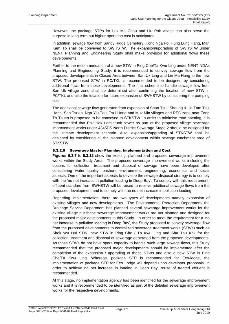
Planning Department Agreement No. CE 60/2005 (TP) Land Use Planning for the Closed Area – Feasibility Study
Final Report
G:\Document\25100\25112 Closed Area\Report\041 Draft Final Report\041-02 Final Report\041-02 Final Report.doc
Page 171 Ove Arup & Partners Hong Kong Ltd July 2010
However, the package STPs for Lok Ma Chau and Liu Pok village can also serve the
purpose in long term but higher operation cost is anticipated.
In addition, sewage flow from Sandy Ridge Cemetery, Kong Nga Po, Hung Lung Hang, Man
Kam To shall be conveyed to SWHSTW. The expansion/upgrading of SWHSTW under
NENT Planning and Engineering Study shall make provision for additional flows these
developments.
Further to the recommendation of a new STW in Ping Che/Ta Kwu Ling under NENT NDAs
Planning and Engineering Study, it is recommended to convey sewage flow from the
proposed developments in Closed Area between San Uk Ling and Lin Ma Hang to the new
STW. The proposed STW in PC/TKL is recommended to be designed by considering
additional flows from these developments. The final scheme to handle sewage flow from
San Uk village zone shall be determined after confirming the location of new STW in
PC/TKL and also the location for future expansion of SWHSTW by considering the pumping
cost.
The additional sewage flow generated from expansion of Shan Tsui, Sheung & Ha Tam Tsui
Hang, San Tsuen, Nga Yiu Tau, Tsui Hang and Muk Min villages and REC zone near Tong
To Tsuen is proposed to be conveyed to STKSTW. In order to minimise road opening, it is
recommended that Pak Hok Lam trunk sewer as part of the proposed village sewerage
improvement works under 4345DS North District Sewerage Stage 2 should be designed for
the ultimate development scenario. Also, expansion/upgrading of STKSTW shall be
designed by considering all the planned development within sewage catchment area of
STKSTW.
6.3.2.9 Sewerage Master Planning, Implementation and Cost
Figures 6.3.7 to 6.3.12 show the existing, planned and proposed sewerage improvement
works within the Study Area. The proposed sewerage improvement works including the
options for collection, treatment and disposal of sewage have been developed after
considering water quality, onshore environment, engineering, economics and social
aspects. One of the important aspects to develop the sewage disposal strategy is to comply
with the „no net increase in pollution loading in Deep Bay‟. To comply with this requirement,
effluent standard from SWHSTW will be raised to receive additional sewage flows from the
proposed development and to comply with the no net increase in pollution loading.
Regarding implementation, there are two types of developments namely expansion of
existing villages and new developments. The Environmental Protection Department/ the
Drainage Service Department has planned several sewerage improvement works for the
existing village but these sewerage improvement works are not planned and designed for
the proposed major developments in this Study. In order to meet the requirement for a „no
net increase in pollution loading in Deep Bay‟, the Study proposed to convey sewerage flow
from the purposed developments to centralized sewerage treatment works (STWs) such as
Shek Wu Hui STW, new STW in Ping Che / Ta Kwu Ling and Sha Tau Kok for the
collection, treatment and disposal of sewerage generated from the proposed developments.
As those STWs do not have spare capacity to handle such large sewage flows, this Study
recommended that the proposed major developments should be implemented after the
completion of the expansion / upgrading of these STWs and also a new STW in Ping
Che/Ta Kwu Ling. Whereas, package STP is recommended for Eco-lodge, the
implementation of package STP for Eco Lodge will depend upon developer proposals. In
order to achieve no net increase in loading in Deep Bay, reuse of treated effluent is
recommended.
At this stage, no implementation agency has been identified for the sewerage improvement
works and it is recommended to be identified as part of the detailed sewerage improvement
works for the respective developments.
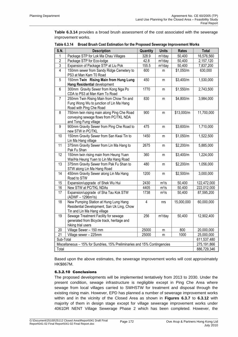
Planning Department Agreement No. CE 60/2005 (TP) Land Use Planning for the Closed Area – Feasibility Study
Final Report
G:\Document\25100\25112 Closed Area\Report\041 Draft Final Report\041-02 Final Report\041-02 Final Report.doc
Page 172 Ove Arup & Partners Hong Kong Ltd July 2010
Table 6.3.14 provides a broad brush assessment of the cost associated with the sewerage
improvement works.
Table 6.3.14 Broad Brush Cost Estimation for the Proposed Sewerage Improvement Works
S.N. Description Quantity Units Rates Total
1 Package STP for Lok Ma Chau Villages 328.9 m3/day 50,400 16,576,560
2 Package STP for Eco-lodge 42.8 m3/day 50,400 2,157,120
3 Expansion of Package STP at Liu Pok 155.5 m3/day 50,400 7,837,200
4 150mm sewer from Sandy Ridge Cemetery to PS3 at Man Kam T0 Road
600 m $1,050/m 630,000
5 150mm Twin Rising Main from Hung Lung Hang Residential development
450 m $3,400/m 1,530,000
6 300mm Gravity Sewer from Kong Nga Po CDA to PS3 at Man Kam To Road
1770 m $1,550/m 2,743,500
7 250mm Twin Rising Main from Chow Tin and Fung Wong Wu to junction of Lin Ma Hang Road with Ping Che Road
830 m $4,800/m 3,984,000
8 750mm twin rising main along Ping Che Road conveying sewage flows from PC/TKL NDA and Tong Fung village
900 m $13,000/m 11,700,000
9 900mm Gravity Sewer from Ping Che Road to new STW in PC/TKL
475 m $3,600/m 1,710,000
10 150mm Gravity Sewer from San Kwai Tin to Lin Ma Hang village
1450 m $1,050/m 1,522,500
11 375mm Gravity Sewer from Lin Ma Hang to Pak Fu Shan
2675 m $2,200/m 5,885,000
12 150mm twin rising main from Heung Yuen Wai/Ha Heung Yuen to Lin Ma Hang Road
360 m $3,400/m 1,224,000
13 375mm Gravity Sewer from Pak Fu Shan to STW along Lin Ma Hang Road
480 m $2,200/m 1,056,000
14 450mm Gravity Sewer along Lin Ma Hang Road to STW
1200 m $2,500/m 3,000,000
15 Expansion/upgrade of Shek Wu Hui 2430 m3/s 50,400 122,472,000
16 New STW at PC/TKL NDAs 4405 m3/s 50,400 222,012,000
17 Expansion/upgrade of Sha Tau Kok STW (ADWF – 1296m3/s)
1738 m3/s 50,400 87,595,200
18 New Pumping Station at Hung Lung Hang Residential Development, San Uk Ling, Chow Tin and Lin Ma Hang village
4 nrs 15,000,000 60,000,000
19 Sewage Treatment Facility for sewage generated from Bicycle track, heritage and hiking trial users
256 m3/day 50,400 12,902,400
20 Village Sewer – 150 mm 25000 m 800 20,000,000
21 Village sewer – 225mm 25000 m 1000 25,000,000
Sub-Total 611,537,480
Miscellaneous – 15% for Sundries, 15% Preliminaries and 15% Contingencies 275,191,866
Total 886,729,346
Based upon the above estimates, the sewerage improvement works will cost approximately
HK$867M.
6.3.2.10 Conclusions
The proposed developments will be implemented tentatively from 2013 to 2030. Under the
present condition, sewage infrastructure is negligible except in Ping Che Area where
sewage from local villages carried to SWHSTW for treatment and disposal through the
existing rising main. However, EPD has planned a number of sewerage improvement works
within and in the vicinity of the Closed Area as shown in Figures 6.3.7 to 6.3.12 with
majority of them in design stage except for village sewerage improvement works under
4061DR NENT Village Sewerage Phase 2 which has been completed. However, the
Planning Department Agreement No. CE 60/2005 (TP) Land Use Planning for the Closed Area – Feasibility Study
Final Report
G:\Document\25100\25112 Closed Area\Report\041 Draft Final Report\041-02 Final Report\041-02 Final Report.doc
Page 173 Ove Arup & Partners Hong Kong Ltd July 2010
planned sewerage improvement works are not designed to cater for additional flow due to
the proposed developments in this Study after opening of the Closed Area. Therefore,
additional sewerage infrastructure is required to support the proposed developments.
Figures 6.3.7 to 6.3.12 also show the proposed sewerage improvement works apart from
existing and planned sewerage improvement works. In order to comply with no net increase
in loading, the sewage generated from majority of the development will be conveyed to the
new STW in PC/TKL, SWHSTW and STKSTW. Under the present condition, there is no
spare capacity at SWHSTW and STKSTW to handle sewage flow and therefore will require
expansion and upgrading of the STWs. This will require raising the treatment level and open
the opportunity for effluent reuse. For the expansion and upgrading of SWHSTW, it is
recommended to be investigated under NENT NDA Planning and Engineering Study after
considering all the developments within the Sewage Catchment Area (SCA). Regarding
STKSTW, as majority of the SCA lies outside the Study Area of the current study and
therefore it is recommended to investigate the expansion/upgrading of STKSTW under a
separate study after considering all the future developments within SCA.
Local Package STP is proposed for Lok Ma Chau village in the short term. Whereas,
expansion/upgrading of local package STP at Liu Pok village is recommended to cater for
the additional flows. These package STPs can serve the purpose in long term but higher
operation cost is anticipated. However, in long term it is recommended to convey the
sewage flows to centralised STWs progressively.
In order to achieve the total water management objective, it is proposed to reuse the effluent
for non-potable uses such as landscape irrigation of non-agricultural use and also for
flushing water. However, in view of the limited reuse of treated effluent, the effluent still need
to be discharged into water bodies for its disposal.
In view of the diversity of proposed developments comprising Government to private
initiatives, the actual implementation programme and implementation agency for the
proposed mitigation measures shall be determined as part of the detailed sewerage impact
assessment by the project proponent after taking into consideration interfacing with other
projects.
In summary, upon opening of the FCA, there will be an issue of insufficient sewage
infrastructure which would have to be followed up by relevant departments. In the case of
SWHSTW and STKSTW, the expansion/upgrading works needs to carried out by relevant
departments to cater for additional flows from proposed developments. Similarly, new STW
in PC/TKL shall be designed to cater for additional flows from proposed developments.
6.4 Water and Utility Impact Assessment
6.4.1 Water Supply
6.4.1.1 Introduction
The proposed developments in Closed Area will generate demands for fresh and flushing
water supply. Although majority of the developments are expansion of villages or additional
recreational facilities, some of them cannot be met by the existing WSD supply systems.
The impact on the existing systems, the requirement for the new system to meet such
demands are examined and discussed in this section. However, the upgrading will also
depend upon demands from other projects which are not covered under this project.
6.4.1.2 Methodology
The approach adopted in carrying out the Water Supply Impact Assessment is as follows:
Identify the scope of the development;
Determine the water demand of the development;
Planning Department Agreement No. CE 60/2005 (TP) Land Use Planning for the Closed Area – Feasibility Study
Final Report
G:\Document\25100\25112 Closed Area\Report\041 Draft Final Report\041-02 Final Report\041-02 Final Report.doc
Page 174 Ove Arup & Partners Hong Kong Ltd July 2010
Identify the existing and planned water supply system within the development
boundary;
Examine the impact arising from new water demand on the existing source of supply,
service reservoirs and the system capacity;
Recommend improvement and upgrading works;
6.4.1.3 Estimation of Water Demand
Unit Demand
The majority of the developments are due to expansion of existing recognized villages and
therefore the unit demands applied to village and service trade is in accordance with WSD‟s
Departmental Instruction DI1309. Whereas for visitors and staff, this has been assumed as
80 l/h/d to estimate total water demand from the proposed developments under this study.
Demand Estimate
Based upon the above unit water demand, the total estimated daily water consumption is
approximately 12,229.4m3 including for fresh water supply as well as for flushing water
supply. All the developments except developments within RDP1 including Lok Ma Chau
village falls within the Sheung Shui Water Treatment Works supply zone.
The build up of total water demand estimate for the proposed developments is shown in
below in Table 6.4.1. Whereas, the details of existing, planned and proposed upgrade / new
watermains are shown in Figures 6.4.1 to 6.4.6.
It can be seen from the above figures that majority of the proposed developments are
currently served by existing watermains but will not be able to cater for additional demands
from proposed expansion of villages and therefore will require upgrade.
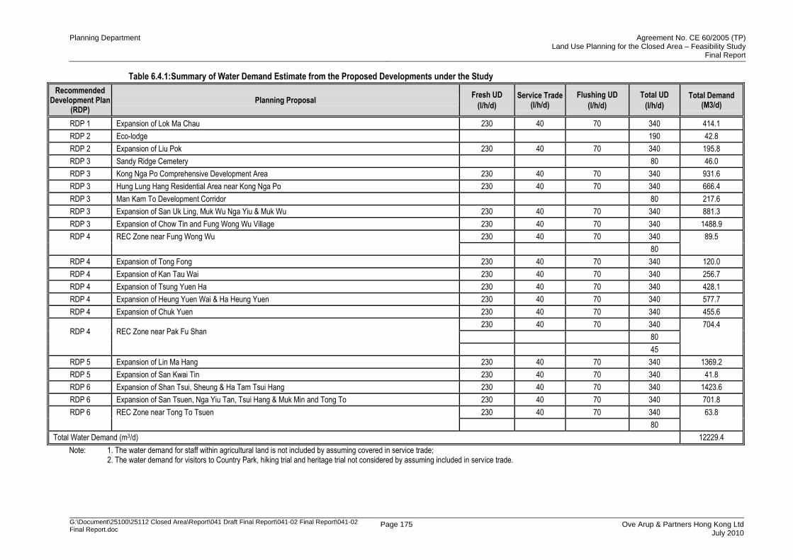
Planning Department Agreement No. CE 60/2005 (TP) Land Use Planning for the Closed Area – Feasibility Study
Final Report
G:\Document\25100\25112 Closed Area\Report\041 Draft Final Report\041-02 Final Report\041-02 Final Report.doc
Page 175 Ove Arup & Partners Hong Kong Ltd July 2010
Table 6.4.1: Summary of Water Demand Estimate from the Proposed Developments under the Study
Recommended Development Plan
(RDP) Planning Proposal
Fresh UD
(l/h/d)
Service Trade (l/h/d)
Flushing UD
(l/h/d)
Total UD
(l/h/d)
Total Demand (M3/d)
RDP 1 Expansion of Lok Ma Chau 230 40 70 340 414.1
RDP 2 Eco-lodge 190 42.8
RDP 2 Expansion of Liu Pok 230 40 70 340 195.8
RDP 3 Sandy Ridge Cemetery 80 46.0
RDP 3 Kong Nga Po Comprehensive Development Area 230 40 70 340 931.6
RDP 3 Hung Lung Hang Residential Area near Kong Nga Po 230 40 70 340 666.4
RDP 3 Man Kam To Development Corridor 80 217.6
RDP 3 Expansion of San Uk Ling, Muk Wu Nga Yiu & Muk Wu 230 40 70 340 881.3
RDP 3 Expansion of Chow Tin and Fung Wong Wu Village 230 40 70 340 1488.9
RDP 4
REC Zone near Fung Wong Wu
230 40 70 340 89.5
80
RDP 4 Expansion of Tong Fong 230 40 70 340 120.0
RDP 4 Expansion of Kan Tau Wai 230 40 70 340 256.7
RDP 4 Expansion of Tsung Yuen Ha 230 40 70 340 428.1
RDP 4 Expansion of Heung Yuen Wai & Ha Heung Yuen 230 40 70 340 577.7
RDP 4 Expansion of Chuk Yuen 230 40 70 340 455.6
RDP 4
REC Zone near Pak Fu Shan
230 40 70 340 704.4
80
45
RDP 5 Expansion of Lin Ma Hang 230 40 70 340 1369.2
RDP 5 Expansion of San Kwai Tin 230 40 70 340 41.8
RDP 6 Expansion of Shan Tsui, Sheung & Ha Tam Tsui Hang 230 40 70 340 1423.6
RDP 6 Expansion of San Tsuen, Nga Yiu Tan, Tsui Hang & Muk Min and Tong To 230 40 70 340 701.8
RDP 6
REC Zone near Tong To Tsuen
230 40 70 340 63.8
80
Total Water Demand (m3/d) 12229.4
Note: 1. The water demand for staff within agricultural land is not included by assuming covered in service trade; 2. The water demand for visitors to Country Park, hiking trial and heritage trial not considered by assuming included in service trade.
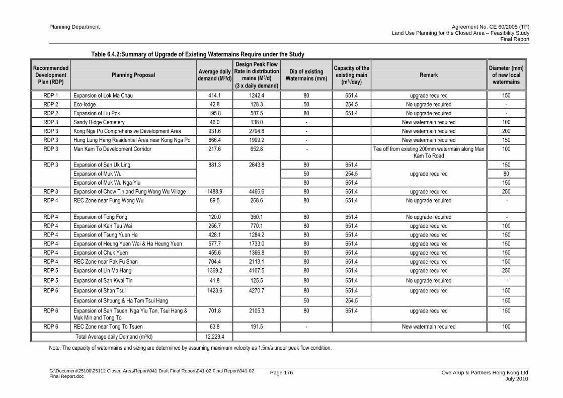
Planning Department Agreement No. CE 60/2005 (TP) Land Use Planning for the Closed Area – Feasibility Study
Final Report
G:\Document\25100\25112 Closed Area\Report\041 Draft Final Report\041-02 Final Report\041-02 Final Report.doc
Page 176 Ove Arup & Partners Hong Kong Ltd July 2010
Table 6.4.2: Summary of Upgrade of Existing Watermains Require under the Study
Recommended Development Plan (RDP)
Planning Proposal Average daily demand (M3/d)
Design Peak Flow Rate in distribution
mains (M3/d)
(3 x daily demand)
Dia of existing Watermains (mm)
Capacity of the existing main
(m3//day) Remark
Diameter (mm) of new local watermains
RDP 1 Expansion of Lok Ma Chau 414.1 1242.4 80 651.4 upgrade required 150
RDP 2 Eco-lodge 42.8 128.3 50 254.5 No upgrade required -
RDP 2 Expansion of Liu Pok 195.8 587.5 80 651.4 No upgrade required -
RDP 3 Sandy Ridge Cemetery 46.0 138.0 - New watermain required 100
RDP 3 Kong Nga Po Comprehensive Development Area 931.6 2794.8 - New watermain required 200
RDP 3 Hung Lung Hang Residential Area near Kong Nga Po 666.4 1999.2 - New watermain required 150
RDP 3 Man Kam To Development Corridor 217.6 652.8 - Tee off from existing 200mm watermain along Man Kam To Road
100
RDP 3
Expansion of San Uk Ling 881.3
2643.8
80 651.4
upgrade required
150
Expansion of Muk Wu 50 254.5 80
Expansion of Muk Wu Nga Yiu 80 651.4 150
RDP 3 Expansion of Chow Tin and Fung Wong Wu Village 1488.9 4466.6 80 651.4 upgrade required 250
RDP 4 REC Zone near Fung Wong Wu 89.5
268.6
80 651.4
No upgrade required
-
RDP 4 Expansion of Tong Fong 120.0 360.1 80 651.4 No upgrade required -
RDP 4 Expansion of Kan Tau Wai 256.7 770.1 80 651.4 upgrade required 100
RDP 4 Expansion of Tsung Yuen Ha 428.1 1284.2 80 651.4 upgrade required 150
RDP 4 Expansion of Heung Yuen Wai & Ha Heung Yuen 577.7 1733.0 80 651.4 upgrade required 150
RDP 4 Expansion of Chuk Yuen 455.6 1366.8 80 651.4 upgrade required 150
RDP 4 REC Zone near Pak Fu Shan 704.4 2113.1 80 651.4 upgrade required 150
RDP 5 Expansion of Lin Ma Hang 1369.2 4107.5 80 651.4 upgrade required 250
RDP 5 Expansion of San Kwai Tin 41.8 125.5 80 651.4 No upgrade required -
RDP 6 Expansion of Shan Tsui 1423.6 4270.7 80 651.4 upgrade required 150
Expansion of Sheung & Ha Tam Tsui Hang 50 254.5 150
RDP 6 Expansion of San Tsuen, Nga Yiu Tan, Tsui Hang & Muk Min and Tong To
701.8 2105.3 80 651.4 upgrade required 150
RDP 6 REC Zone near Tong To Tsuen 63.8 191.5 - New watermain required 100
Total Average daily Demand (m3/d) 12,229.4
Note: The capacity of watermains and sizing are determined by assuming maximum velocity as 1.5m/s under peak flow condition.
Planning Department Agreement No. CE 60/2005 (TP) Land Use Planning for the Closed Area – Feasibility Study
Final Report
G:\Document\25100\25112 Closed Area\Report\041 Draft Final Report\041-02 Final Report\041-02 Final Report.doc
Page 177 Ove Arup & Partners Hong Kong Ltd July 2010
6.4.1.4 Water Supply Impact Assessment
Existing and Planned Water Supply System
Table 6.4.2 identified the local distribution watermains to be upgraded or new local
distribution watermains to be installed to cater for additional water demands from proposed
developments (only showing the new watermains/ upgrading works for development sites
and villages). Apart from this, a preliminary assessment has also been done on the
adequacy and need for upgrading of existing distribution watermains running along the road.
However, the precise details of upgrading of these distribution watermains and any other
associated distribution watermains should be reconfirmed subjected to further detailed water
impact assessment by project proponent in investigation and preliminary design stage. The
location plan of new local distribution watermains and the need to upgrade existing local
distribution watermains along major roads have been shown from Figures 6.4.1 to 6.4.6.
RDP1 – It can be seen from Table 6.4.2 that existing 80mm watermain would not be able to
cope with future growth of the proposed development. In order to minimise interruption of
supply, it is proposed to lay a new 250mm main along the existing boundary patrol road to
be excised from the FCA from the 300mm supply mains running along Lok Ma Chau Road
to cater for additional demand from Lok Ma Chau village and other developments within its
supply zone. There is marginal increase in demand due to growth in Lok Ma Chau village
which will have marginal impact on supply mains and supply source. However, detailed
hydraulic assessment is recommended in investigation and preliminary design stage to
determine the extent of impact and any need for the upgrading of existing distribution
watermains along Ha Wan Tsuen Road after considering demands from existing and all the
proposed developments.
RDP2 – Eco-lode and all proposed developments within RDP2 fall within the supply zone of
Kwu Tung South Fresh Water Service Reservoir. Under the present condition, there is an
existing 80mm supply mains which will not be have adequate capacity to feed the proposed
developments. The peak daily demand due to these developments will be approximately
3194m3/day which can only be met by laying a new 200mm watermain from the trunk main
along both Castle Peak Road and Ma Tso Long Road. Therefore, existing watermain
running along Castle Peak Road and Ma Tso Lung may be affected. Alternatively, the
proposed watermain from Ha Wan Tsuen Road along the existing boundary patrol road to
be excised from the FCA can be extended to feed the proposed development. Based upon
preliminary analysis, a 250mm watermain need to be laid along the existing boundary patrol
road to be excised from the FCA. This may require upgrading of existing watermain along
Ha Tsuen Road subjected to further detailed water impact assessment in investigation and
preliminary design stage after taking into consideration traffic, cost and other issues into
consideration. Apart from these, the future growth within Liu Pok village can be met by
existing 80mm watermain.
RDP3 – The Sandy Ridge Cemetery, proposed Kong Nga Po Comprehensive Development
Area, Hung Lung Hang Residential Area near Kong Nga Po, Man Kam To Development
Corridor and expansion of San Uk Ling, Muk Wu Nga Yiu & Muk Wu villages fall within the
supply zone of Table Hill Service Reservoir. The additional demand cannot be met by
existing 200mm watermain running along Man Kam To Road and a new 300mm watermain
along Man Kam To Road need to be laid to meet future water demand. Moreover, the future
demand due to Comprehensive Development Area and Hung Lung Hang Residential Area
near Kong Nga Po cannot be met by existing 100mm distribution watermains and therefore
a new 250mm watermain along Kong Nga Po need to be laid to meet future water demand.
As this preliminary assessment has not considered the additional demands from other
development which will also extract water supply from the existing watermain along Man
Kam To Road. Therefore, detailed hydraulic assessment shall be carried out in investigation
and preliminary design stage to determine the need for upgrading of existing watermain
along Man Kam To Road.
Planning Department Agreement No. CE 60/2005 (TP) Land Use Planning for the Closed Area – Feasibility Study
Final Report
G:\Document\25100\25112 Closed Area\Report\041 Draft Final Report\041-02 Final Report\041-02 Final Report.doc
Page 178 Ove Arup & Partners Hong Kong Ltd July 2010
RDP4 – The future growth of villages in RDP4 may require upgrade of existing distribution
watermains. The expansion of Chow Tin and Fung Wong Wu village will require upgrade or
new 250mm distribution watermains from the 300mm running along the Ping Che Road. In
addition, an existing 150mm watermain running along Lin Ma Hang Road will not be able
support the future demand due to proposed development and village expansion and need to
be upgraded to 350mm. In order to minimise disruption, it is proposed to lay a new 350mm
watermain along Lin Ma Hang Road. The detailed hydraulic assessment is recommended to
be carried out in investigation and preliminary design stage to determine the extent and the
need of upgrading of existing distribution main running along Ping Che Road after
considering the water demands from existing, committed and planned developments
including from NDAs. Apart from these, the future growth within Tong Fong can be met by
existing 80mm watermain.
RDP5 – In order to meet additional water demand due to village expansion and other
developments, it is proposed to extend the watermain along Lin Ma Hang Road to Lin Ma
Hang village. Apart from these, the future growth within San Kwai Tin can be met by existing
80mm watermain.
RDP6 – The future expansion of villages located in RDP6 will require upgrade of existing
local distribution mains serving the respective villages and the proposed size is shown in
Table 6.4.2. It is recommended to investigate the need to upgrade existing watermain
running Sha Tau Kok Road in investigation and preliminary design stage after considering
the demands from existing, committed and planned developments.
Water Supply Source – Sheung Shui Water Treatment Works
The majority of the developments within the study area except proposed developments in
RDP1 falls within the supply zones of Kwu Tung, Table Hill and Ping Che fresh water
service reservoirs. The treated water to these service reservoirs comes from the Sheung
Shui Water Treatment Works, which has a capacity of 200 MLD.
The estimated water demand from the new development is about 12.2 MLD. Under the
present condition, there is spare capacity at Sheung Shui Water Treatment Works which
can be used for proposed developments subjected to detailed assessment in investigation
stage after taking into consideration all the planning proposals within water supply zone. It
can be seen that proposed developments will only take 6.1% of existing capacity of Sheung
Shui Water Treatment Works.
However, the treatment capacity of Sheung Shui Water Treatment Works needs to be
increased to cater for proposed Kwu Tung North, Fanling North and Ping Che/Ta Kwu Ling
New Developments Areas (NDA). Therefore, it is recommended that need of any expansion
of Sheung Shui Water Treatment Works or adjustment of supply zone with other water
treatment works shall be identified after taking into consideration additional water demands
arising from proposed developments and also other developments within the supply zones.
Fresh Water Service Reservoirs
Kwu Tung Fresh Water Service Reservoir
The proposed developments between Eco-lodge and Ng Tung River within the Closed Area
fall within the supply zone of Kwu Tung Fresh Water Service Reservoirs. The additional
water demands from Eco-lodge and Liu Pok are approximately 1065 m3/day. As this
additional water demands will be required to meet the housing demands for next 10 years
and therefore it can be considered that proposed developments can be fed without any
expansion of Kwu Tung FWSR at this stage. However, it is recommended that additional
demands due to proposed developments shall be included in the expansion of storage
capacity of existing Kwu Tung FWSR or a new FWSR for the proposed Kwu Tung North
NDAs.
Planning Department Agreement No. CE 60/2005 (TP) Land Use Planning for the Closed Area – Feasibility Study
Final Report
G:\Document\25100\25112 Closed Area\Report\041 Draft Final Report\041-02 Final Report\041-02 Final Report.doc
Page 179 Ove Arup & Partners Hong Kong Ltd July 2010
Table Hill Fresh Water Service Reservoirs
The Sandy Ridge Cemetery, proposed Kong Nga Po Comprehensive Development Area,
Hung Lung Hang Residential Area near Kong Nga Po, Man Kam To Development Corridor
and expansion of San Uk Ling, Muk Wu & Muk Wu Nga Yiu villages fall within the supply
zone of Table Hill Fresh Water Service Reservoirs. These developments will generate an
additional water demand of 2743m3/days. The design capacity of Table Hill Fresh Water SS
is 27450 m3. As this additional water demands will be required to meet the housing
demands for next 10 years and therefore it can be considered that proposed developments
can be fed without any expansion of Table Hill FWSR at this stage. However, it is
recommended to investigate the need for expansion or new service reservoir in conjunction
with other developments within supply zone such as proposed Fanling North NDAs as part
of NENT NDAs study.
Ping Che Fresh Water Service Reservoirs
Rest of the developments in the study area within the Recommended Development Plan 3,
4, 5 and 6 fall within the supply zone of Ping Che Fresh Water Service Reservoirs. These
developments will require an additional water demand of 7721m3/d whereas the design
capacity of Ping Che Fresh Water SS is 20,000 m3. After the adjustment of supply zone of
Ping Che Fresh Water Service Reservoir, there would not be any spare capacity to cater for
additional demand from the new developments. Therefore, it is recommended to investigate
the feasibility of expansion or new service reservoir by considering additional water demand
from other developments such as proposed PC/TKL NDAs and also proposed
Liantang/Heung Yuen Wai BCPs.
6.4.1.5 Conclusions and Recommendations
This section has provided a baseline review and a preliminary water supply impact
assessment on the water supply system including the facilities already in place, previously
planned or proposed to cater for the additional demand arising from the proposed
development.
The unit water demands adopted in the water demand assessment generally follow WSD‟s
DI 1309. The water demand for the staff within the agricultural farms and for visitors to
farming, hiking trail, heritage trail and Country Park has not been considered by assuming
that such demand has been included in the service trade for residential population.
The proposed upgrade or laying of new distribution watermains have been shown from
Figure 6.4.1 to 6.4.6. As there will be progressive increase in demand and therefore the
upgrading or laying of new watermain shall be interfaced with road works under this study or
other studies. The proposed distribution watermains shall be located along public road or
footpaths. Phasing of works or work entrustment shall be investigated during investigation
stage for the proposed works.
In addition, the capacity of existing distribution watermains along Ha Wan Tsuen Road, Ma
Tso Lung Road, Man Kam To Road, Ping Che Road and Sha Tau Kok Road will be affected
due to additional demands from proposed developments. It is recommended to carry
detailed hydraulic assessment in investigation and preliminary design stage to determine
the extent of upgrading works required after considering the additional demands from all the
developments with the supply zone.
The proposed developments between Eco-lodge and Ng Tung River within the Closed Area
fall within the supply zone of Kwu Tung Fresh Water Service Reservoirs and will generate
an additional water demand of approximately 1065m3/day. Whereas, the Sandy Ridge
Cemetery, proposed Kong Nga Po Comprehensive Development Area, Hung Lung Hang
Residential Area near Kong Nga Po, Man Kam To Development Corridor and expansion of
San Uk Ling, Muk Wu Nga Yiu & Muk Wu villages fall within the supply zone of Table Hill
Fresh Water Service Reservoir and will generate an additional water demand of
Planning Department Agreement No. CE 60/2005 (TP) Land Use Planning for the Closed Area – Feasibility Study
Final Report
G:\Document\25100\25112 Closed Area\Report\041 Draft Final Report\041-02 Final Report\041-02 Final Report.doc
Page 180 Ove Arup & Partners Hong Kong Ltd July 2010
2743m3/day. Rest of the developments in the study area within the Recommended
Development Plan 3, 4, 5 and 6 fall within the supply zone of Ping Che Fresh Water Service
Reservoir and will generate an additional water demand of 7721m3/d.
The need for upgrade/expansion of Sheung Shui Water Treatment Works and Fresh Water
Service Reservoirs shall be considered in investigation stage after considering the demands
from other developments within the supply zone.
The water impact assessment show that proposed development and expansion of villages is
sustainable from water infrastructure point of view. With the proposed developments,
upgrading works are required for existing water mains along Ha Wan Tsuen Road, Ma Tso
Lung Road, Man Kam To Road, Ping Che Road and Sha Tau Kok Road. However, detailed
hydraulic assessment shall be carried out to determine the need and extent of upgrading of
distribution mains along Ha Wan Tsuen Road, Ma Tso Lung Road, Man Kam To Road, Ping
Che Road and Sha Tau Kok Road.
6.4.2 Utilities Provision
6.4.2.1 Introduction
The information on existing utilities in the vicinity the Study Area has been obtained from
various utility undertakers. China and Light Power (CLP) and telecommunications are
identified to be the major utility services within the Study Area. Most of the existing power
cables and telecommunications cables were laid along the existing road networks and
supplied to the existing boundary control points and villages within the study area.
Gas main is only found in the western portion of the Study Area along Lok Ma Chau Road
and terminates at Lok Ma Chau Station.
Figure 6.4.7 shows existing and proposed CLP power cables network within the Study
Area.
6.4.2.2 Power Supply
CLP has indicated that no major electricity reinforcement (e.g. construction of sub-station) is
required based on their initial review on the proposed developments within the Study Area.
However, this will subject to the detailed assessment together with the Liantang/ Heung
Yuen Wai BCP, Lok Ma Chau Loop and NDA Studies during the detailed design stage.
Proposed Eco-lodge at Ma Tso Lung
Power supply shall be provided to the proposed Eco-lodge at Ma Tso Lung. Extension of
the existing CLP power cables along the existing boundary patrol road to be excised from
the FCA is required and the new power cables will be laid along the proposed access road
to serve for the Eco-lodge at Ma Tso Lung. The proposed new power cable is shown in
Figure 6.4.7 which is subjected to the detailed assessment of the proposed development
during the detailed design stage. An estimation of electrical load arising from the proposed
Eco-lodge at Ma Tso Lung is summarized in Table 6.4.3 below.
Low Density Residential Development at Kong Nga Po
There are existing power cables along Man Kam To Road and the new power cables can be
extended from Man Kam To Road via Kong Nga Po Road and access road to serve for the
proposed residential development at Kong Nga Po. The proposed new power cable is
shown in Figure 6.4.7 which is subjected to the detailed assessment of the proposed
development during the detailed design stage.
There is existing CLP 400kV Overhead Power Lines located on the east side of the
proposed residential development at Kong Nga Po. As advised by CLP during the co-
ordination meeting on 6 February, these overhead power lines cannot be diverted. As a
result, a buffer area is provided between the existing Overhead Power Lines and the
proposed residential development. An estimation of electrical load arising from the proposed
low density residential development at Kong Nga Po is summarized in Table 6.4.3 below.

Planning Department Agreement No. CE 60/2005 (TP) Land Use Planning for the Closed Area – Feasibility Study
Final Report
G:\Document\25100\25112 Closed Area\Report\041 Draft Final Report\041-02 Final Report\041-02 Final Report.doc
Page 181 Ove Arup & Partners Hong Kong Ltd July 2010
Crematorium and Columbarium at Sandy Ridge
There are existing power cables along Man Kam To Road and the new power cables can be
extended from Man Kam To Road via Sha Ling Road to serve for the proposed C&C
facilities at Sandy Ridge. The proposed new power cables layout is shown in Figure 6.4.7
which is subjected to Food and Environmental Hygiene Department (FEHD)‟s detailed
design and assessment on the proposed C&C facilities at Sandy Ridge.
Adaptive Re-use of Disused Schools
There are existing power cables serving for the existing vacant schools (e.g. Lung Kai
Public School in Ma Tso Lung, Sam Wo Public School near Muk Wu Nga Yiu, King Sau
Public School in Lin Ma Hang and Kwan Ah Public School in Tam Shui Hang). Therefore
new provision of power cables may not required subjected to condition of existing power
cables and detailed assessment of the proposed uses of the disused schools during the
detailed design stage. An estimation of electrical load arising from the proposed adaptive re-
use of disused schools is summarized in Table 6.4.3 below.
Village Developments
There are many indigenous villages within the Study Area that will be expanded due to
future demand. Expansion of the nearby existing power cable network may be required to
accommodate the additional electrical demand subject to the detailed assessment to be
agreed with CLP during the detailed design stage.
Road Improvement Works
It has been mentioned in Section 6.2 that it is recommended to improve some of the existing
roads within the Study Area. To facilitate the road upgrading works, new power cable for
street lighting is required subject to detailed assessment during the detailed design stage.
Other Land Uses Proposals
Other land uses proposals (e.g. potential Country Park at Robin‟s Nest, East-West Hiking
Trial, Bicycle tracks, Heritage Trails, Recreation Uses, etc.) require power supply which is
subjected to detailed assessment during the detailed design stage.
Table 6.4.3 Electrical Load Estimation
Proposed Land Use Development Type Load Demand
(kV)
Eco-lodge Bungalows 1,460
Re-Use of Disused School
Lung Kai Public School 375
Sam Wo Public School 375
King Sau Public School 375
Kwan Ah Public School 375
Residential Development at Kong Nga Po Villa houses 26480
29,440
Note:
6.4.2.3 Telecommunication Cables
Telecommunication cables shall be provided to the new development proposals, i.e. Eco-
lodge in Ma Tso Lung, low-density residential development at Kong Nga Po and
crematorium & columbarium in Sandy Ridge, etc., new telecommunication cables could be
extended from the nearby existing cable network to serve the new developments.
For other proposed land-uses such as hiking trail, heritage trail, bicycle track and the
potential Country Park, new telecommunication cable network is not necessary.
For the remaining proposed land-uses such as adaptive re-use of disused schools and
existing indigenous villages, there are existing telecommunication cables and hence new
Planning Department Agreement No. CE 60/2005 (TP) Land Use Planning for the Closed Area – Feasibility Study
Final Report
G:\Document\25100\25112 Closed Area\Report\041 Draft Final Report\041-02 Final Report\041-02 Final Report.doc
Page 182 Ove Arup & Partners Hong Kong Ltd July 2010
provision of telecommunication cables may not be required subject to the detailed
assessment during the detailed design stage.
6.4.2.4 Gas Main
Gas mains shall be provided to the new development proposals, i.e. Eco-lodge in Ma Tso
Lung and low-density residential development at Kong Nga Po. As the existing gas main
network within the Study Area is limited, extensive gas main extensions from the existing
gas main network to serve the new developments are required.
For other proposed land-uses such as hiking trail, heritage trail, bicycle track and the
potential Country Park, the provision for gas main is not necessary.
For the remaining proposed land-uses such as adaptive re-use of disused schools,
crematorium & columbarium (C&C) in Sandy Ridge and existing indigenous villages, the
requirement for gas main supply will be subjected to the decision by HKCG as there is no
gas supply to the existing villages, C&C and disused schools at this moment.
6.5 Geotechnical Assessment
6.5.1 Potential Country Park at Robin’s Nest
The potential Country Park at Robins Nest involves no physical alteration of the existing
landforms and no actual development work is proposed, no geotechnical assessment is
deemed necessary.
6.5.2 East-West Hiking Trails, Heritage Trails and Bicycle Track
Desk Study
The proposed Hiking Trails, Heritage Trails and Bicycle Track are predominantly located on
and around natural terrain hillsides that are situated away from areas where notable
development works have taken place in the past. As such, limited existing desk study data
is available for them.
Geological Conditions
The proposed alignments of the Hiking Trails and Bicycle Tracks cross a wide variety of
geological conditions:
Affected Man-Made Features
The formation of the proposed Bicycle Track will affect several man-made slopes along the
existing boundary patrol road to be excised from the FCA, in association with road widening
/ improvement works. The probable impact of these works is discussed within later sections
of this report.
The proposed Hiking and Heritage Trails pass mainly through natural terrain areas or along
existing tracks and will not significantly impact upon any man-made slopes
Natural Terrain Hazards
The proposed Hiking Trails, Heritage Trails and Bicycle Track constitute lightly used open
air recreation areas. In accordance with GEO Report 138 such land use falls within a Group
4 facility and does not require a natural terrain hazard assessment.
However, it is noted that the alignments pass close to or through large areas of natural
terrain. As such, the risks of landslides affecting them cannot be discounted and any
facilities associated with them, such as shelters / rest areas, should be located on
topographic high points away from areas of steep terrain and drainage channels.
Geotechnical Feasibility
The proposed Hiking Trails and Heritage Trails largely adhere to an existing network of
footpaths passing through the study area. As such, only a small number of new footpaths
Planning Department Agreement No. CE 60/2005 (TP) Land Use Planning for the Closed Area – Feasibility Study
Final Report
G:\Document\25100\25112 Closed Area\Report\041 Draft Final Report\041-02 Final Report\041-02 Final Report.doc
Page 183 Ove Arup & Partners Hong Kong Ltd July 2010
would need to be constructed. The construction of these trails should require only minimal
geotechnical works, such as the formation of minor slope cuttings typically less than 2m in
height. Where practicable, their alignment should be modified to suit the existing terrain
such that the need for cuttings is minimised as much as possible.
Given the relative simplicity of such works, the proposed Hiking Trails and Heritage Trails
are found to be geotechnically feasible.
Geotechnical Constraints
No major constraints have been identified regarding the proposed works.
Requirements for Future Studies
Other than refinement of the proposed alignments in order to minimise the amount of slope
cutting required, and subsequent designs for such cuttings, there are no specific
geotechnical requirements for future studies regarding these items.
6.5.3 Adaptive Re-use of Disused Schools
The current proposals for re-use of the disused schools within the Study Area, namely Lung
Kai Public School, Sam Wo Public School, King Sau Public School and Kwan Ah Public
School, only involve utilisation of the existing structures. As no new development has been
proposed as part of this Study, no geotechnical assessment is considered necessary.
However, should the development plans change at any stage to include construction
activates, further assessments may be required on a site-by-site basis.
6.5.4 Low Density Residential Development at Kong Nga Po
Desk Study
A search of the files held within the Geotechnical Information Unit (GIU) of the GEO
identified the records of 17 drillholes formed within, or in close proximity to Kong Nga Po,
namely drillhole Nos. SL3/2, SL3/3, SL3/4, SL3/5, SL3/6, SL3/7, SL3/8, SL3/9, SL3/10,
SL3/12, SL3/13, SL3/15, SL3/17, SL3/18, SL3/19, SL3/20 and SL3/21.
The drillholes were mostly formed in association with Road and Drainage works carried out
under Shek Wu Hui Package 5 Area 6 formation works and their locations are presented on
Figure 6.5.1.
Aerial Photograph Interpretation (API)
A series of ortho-rectified aerial photographs showing the terrain setting and development
history between 1973 and 2006 are presented on Figure 6.5.2. Discussion of the specific
findings of the review of the aerial photographs for the site is provided below.
Geomorphological Setting
The general study area originally comprised mainly of natural terrain covered by a thin
veneer of vegetation. The site is characterised by a broad convex upper terrain associated
with a NE-SW ridgeline. This abruptly changes into a concave mid-slope terrain laterally
delineated by well-defined and steep convex breaks-in-slope. Several SE- and NW-
traversing, moderately to steeply incised topographic depressions are evident below the
ridgeline and valley colluvial accumulations are apparent within the lower portions of these.
No boulders of significance were identified.
Development History
The study area originally comprised an area of natural terrain hillside with limited evidence
of anthropogenic activity, largely limited to the development of isolated village houses and
areas of cultivated lands at the toe of the hillside areas. However, in the late-1980‟s several
new Road were formed within the site and the slope works associated with these effectively
resulted in the excavation and removal of all natural terrain areas.
Planning Department Agreement No. CE 60/2005 (TP) Land Use Planning for the Closed Area – Feasibility Study
Final Report
G:\Document\25100\25112 Closed Area\Report\041 Draft Final Report\041-02 Final Report\041-02 Final Report.doc
Page 184 Ove Arup & Partners Hong Kong Ltd July 2010
Geological Conditions
According to Hong Kong Geological Survey Sheet 3 (Figure 6.5.3), the Kong Nga Po Study
Area is underlain dominantly by meta-siltstone and phyllite, with meta-sandstone (Cmp).
Foliations within the meta-sediments are recorded to dip towards WNW with gradients
between 30° to 75°. The southern end of the study area is recorded as being underlain by
coarse ash crystal tuff (JTM) which is noted to have schistose texture dipping at
approximately 34° NW.
The boundary between the metasedimentary deposits and the tuffaceous deposits
comprises a NE-SW striking fault, which the geological memoir records as the thrust fault.
This fault is offset by several NNW-SSE striking faults to the east and west of the study
area. In addition, a major quartzphyric rhyolite (rq) dyke is recorded running diagonally
across the site from the northeast to the southwest. Graphite schist (gr) is also recorded to
the south of the study area.
No major fill deposits are recorded within the study area. Localised areas of Quaternary
debris flow deposits (Qpd) are recorded within topographic lows at the west and southeast
portions of the site.
Based upon a review of the drillhole logs previously discussed, it is apparent that the
geological materials within the site area change sequentially with depth from completely
decomposed siltstone / sandstone to moderately decomposed siltstone/sandstone, with the
exception of SL3/14 where a gradual change from completely decomposed to moderately
decomposed tuff was logged. This finding suggests that the location of the NE-SW striking
major fault line is further north of the location recorded on the geological map within this
portion of the site, possibly due to offsets caused by NNW-SSE striking faults.
Inferred bedrock levels within the site were found to vary between 2.5m to 28.5m depth and
were typically in the order of 16m below the ground surface, with localised troughs and
peaks roughly corresponding to the overlying topography. No major deposits of fill/colluvium
were recorded within any of the drillholes formed within the site area.
Affected Man-Made Features
Numerous registered man-made features including Slope Nos. 3NW-C401, 3NW-C/C402,
3NW-C/C403, 3NW-C/C404, 3NW-C/C405, 3NW-C/C399, 3NW-C/C454, 3NW-C/C406,
3NW-C/F58, 3NW-C/F50, 3NW-C/C363, 3NW-C/C364, 3NW-C/C365, 3NW-C/C366, 3NW-
C/C367, 3NW-C/C439, 3NW-C/C358, 3NW-C/C469, 3NW-C/C378, and 3NW-C/F66 have
been formed within the study area. The locations of these slopes are presented on Figure
6.5.4.
A search of the GEO LPMIS records for these slopes indicates that none of the slopes have
been upgraded under the LPM Programme. However, given that they were formed in the
early 1990‟s, it is highly likely that they underwent detailed geotechnical checking at the time
of their formation.
Natural Terrain Hazards
A review of cases of past instability has been carried out with reference to the API, GEO‟s
landslide incident database as well as the Enhanced Natural Terrain Landslide Inventory
(ENTLI) and Large Landslide Dataset. The locations of all relevant landslide incidents are
presented on Figure 6.5.5.
Whilst, both the API and ENTLI identified the presence of several small possible natural
terrain failures, it is noted that the areas in which these occurred have all now been
excavated and engineered cut-slopes formed in their place.
The remaining areas of natural terrain within the site boundary comprise isolated small
pockets of hillside as can be seen on the 1993 aerial photograph (Figure 6.5.2). None of
Planning Department Agreement No. CE 60/2005 (TP) Land Use Planning for the Closed Area – Feasibility Study
Final Report
G:\Document\25100\25112 Closed Area\Report\041 Draft Final Report\041-02 Final Report\041-02 Final Report.doc
Page 185 Ove Arup & Partners Hong Kong Ltd July 2010
these remaining natural terrain areas are noted to affect the proposed development
platforms and, as such, natural terrain hazards within the site are found to be negligible.
Given such conditions it is found that the site does not satisfy the GEO Alert Criteria or In-
principle Objection Criteria as defined in GEO Report 138 and no detailed study of natural
terrain hazards is required for the currently proposed development platform layout indicated
on Figure 6.5.1.
Geotechnical Feasibility
Based on a review of the information currently available, it is found that the proposed
development works are geotechnically feasible and no major constraints that would
preclude development within the site at Kong Nga Po are apparent.
Geotechnical Constraints
Ground Conditions
The current review has been carried out based on a limited data set regarding the
geological conditions at the site, comprising largely of published geological data and the
drillhole logs within the Geotechnical Information Unit. Additional project specific drillholes
should be formed during the Investigation and Design Stage of the project in order to
confirm ground conditions within the site area. This is especially necessary within the
proposed development platforms and the man-made slopes abutting them.
Natural Terrain Hazards
All major areas of natural terrain were removed from the study area during the extensive site
modification works that took place in the late 1980‟s. As such it is considered that the site is
not affected by any notable natural terrain hazards. However, further natural terrain hazard
reviews should be conducted in the event that the layout of the proposed development
platforms changes.
Requirements for Future Studies
Additional Ground Investigation Works
Whilst the existing coverage of investigation works within the site is found to be reasonable
for general characterisation purposes, it is insufficient for the detailed design of any site
formation works. This is particularly so within the southern portion, where little to no
drillholes exist in the vicinity of the recorded fault location.
Sufficient additional investigation works, including field and laboratory testing, should be
scheduled during the Investigation and Design Stages of the project in order to provide
sufficient information on the geological, hydrogeological and geotechnical conditions within
the site.
Impact on Existing Man-made Slope Features
The layout of any proposed development works within the site area should make due
consideration of the impact from the existing slopes within the site, with a view to minimising
it as much as possible. The assessment should include the identification of any risks
presented by landslides from slopes situated above proposed structures as well as the
impact the structures may have by surcharging the slopes below.
Where unaffected by any proposed works, the existing stability of those features within the
study area boundary should also be checked to see whether additional stabilisation works
are required.
Natural Terrain Hazard Study
As previously indicated above, further reviews of the need for detailed studies of natural
terrain hazards should be carried out during the Investigation and Design stages of the
project based upon any revisions to the proposed site layout and usage.
Planning Department Agreement No. CE 60/2005 (TP) Land Use Planning for the Closed Area – Feasibility Study
Final Report
G:\Document\25100\25112 Closed Area\Report\041 Draft Final Report\041-02 Final Report\041-02 Final Report.doc
Page 186 Ove Arup & Partners Hong Kong Ltd July 2010
6.5.5 Proposed Eco-lodge at Ma Tso Lung
Desk Study
A search of the files held within the Geotechnical Information Unit (GIU) of the GEO
identified the records of 6 drillholes formed within, or in close proximity to the proposed Eco-
lodge area, namely drillhole Nos. 5610/MTL1 to 5 and 2859/H7. The drillholes were mostly
formed in association with the site investigation for a vehicular border link at Lok Ma Chau
Borrow Areas and their locations are indicated on Figure 6.5.6.
Aerial Photograph Interpretation
A series of ortho-rectified aerial photographs showing the terrain setting and development
history between 1973 and 2006 are presented on Figure 6.5.7. Discussion of the specific
findings of the review of the aerial photographs for the site is provided below.
Development History
The proposed Eco-lodge area comprises a natural terrain hillside that has remained largely
unaffected by anthropogenic activity.
Geomorphological Setting
The Eco-lodge study area comprises a natural terrain hill bounded by deeply incised valleys
to the southeast and southwest and a low-lying alluvial plain to north and northeast. The hill
summits at an elevation of about 110 mPD and is characterised by dominant NNE trending
spur lines in the northern and eastern parts and a notable NW trending valley in the western
part. A number of ephemeral stream channels are present within the sub-catchments
formed by the spur lines and these typically drain towards the alluvial areas to the north and
east of the site. Colluvial deposits are noted to have accumulated within the lower part of
some catchments, as indicated by gentle, fan-like areas at the toe of the hillside.
Geological Conditions
According to Hong Kong Geological Survey Sheet 2 (Figure 6.5.8), the proposed Eco-lodge
Study Area is underlain dominantly by undivided meta-sandstone with meta-conglomerate
and phyllite (Cts). Foliations within the meta-sediments are recorded to dip towards
NW/WNW with gradients between 25° to 30° while bedding is inclined towards NW and
WNW with gradients between 30° to 35°. A NE-SW striking bed of meta-conglomerate (cg)
is recorded to cut through the southern half of the site. No major faults have been recorded
within the study area.
Major topographic depressions and valley areas are typically recorded as containing
surficial Quaternary debris flow deposits (Qd) comprising unsorted sand, gravel, cobbles
and boulders; clay/silt matrix. Alluvial deposits (Qa) containing well-sorted to semi-sorted
clay/silt, sand and gravel are also recorded within the floor of major topographic valleys and
lower-lying flood plain areas.
The above conditions were largely confirmed by the existing GI records identified for the
site, which recorded ground conditions predominantly comprising sandstones with
occasional interbeds of shale. A weathered horizon of weaker fissile rock was typically
identified close to the ground surface and the depth to more competent rocks (i.e. Grade III
or better) varied between 3 m to 16 m below ground level. The deeper areas of weathering
were largely identified along ridgelines and topographic highs.
Localised colluvial deposits, generally less than 3 m in thickness, were recorded within
topographic depressions.
Planning Department Agreement No. CE 60/2005 (TP) Land Use Planning for the Closed Area – Feasibility Study
Final Report
G:\Document\25100\25112 Closed Area\Report\041 Draft Final Report\041-02 Final Report\041-02 Final Report.doc
Page 187 Ove Arup & Partners Hong Kong Ltd July 2010
Affected Man-Made Features
No man-made features are present within the proposed Eco-lodge Study Area itself, the
closest recorded features being situated along the road to the northwest of the site as
indicated on Figure 6.5.9.
Natural Terrain Hazards
The Study Area comprises a natural terrain hillside with gradients typically between 20° to
40°, although localised areas of steeper / shallow gradient are also present (Figure 6.5.10).
Marginally steeper slopes (35° to 50°) are noted within the south-east portion of the site.
These steeper portions in the south-eastern part of the site typically satisfy GEO‟s In-
principle Objection Criteria, in that they have angular elevations greater than 35° and
potentially involve elevation differences exceeding 50 m. Other areas of the site fall within
the GEO Alert Criteria. As such a detailed Natural Terrain Hazard Study will be required for
any proposed developments within the site boundary.
A review of the ENTLI records for the study area (Figure 6.5.11) revealed the presence of
11 No. relict landslide scars, namely failure Nos. 02NED0003, 02NED0004, 02NED0005,
02NED0006, 02NEDX0001, 02NEDX0002, 02NEDX0003 02NEDX0004, 02NEDX0005,
02NEDX0006 and 02NEDX0007. All of these inferred failures comprise relatively small
scale open hillslope failures in areas with gradients between 30° to 50°. A review of the
aerial photographs for the area indicates that no landslides have occurred within the site
during the period 1973 to present.
In addition to the open hillslope failure hazards indicated by the ENTLI records, it is also
noted that several prominent drainage lines are present within the natural terrain area.
These include a notable NW-SE trending valley within the western part of the site and
several smaller N to ENE trending valleys in the northern, eastern and southern parts of the
site. Each of these drainage lines has the potential to channelize landslide debris from the
upslope areas, resulting in additional channelised debris flow hazards.
The magnitude and potential impact of these hazards should be further reviewed during the
detailed design stage of the project, once the proposed layout of facilities within the Eco-
lodge has been confirmed by the project proponent. In general, any layout proposals should
seek to avoid placing structures or facilities within areas that satisfy the In-principle
Objection Criteria.
Geotechnical Feasibility
Based on the preliminary assessment carried out it is considered that construction of an
Eco-lodge and ancillary facilities within the study area is feasible, although a number of
geotechnical constraints, as listed below, are present.
Geotechnical Constraints
Further development of plans for an Eco-lodge within the study area should take due
account of the following anticipated geotechnical constraints:
Ground Conditions
The current review has been carried out based on a limited data set regarding the
geological conditions at the site, comprising largely of published geological data and the
drillhole logs within the Geotechnical Information Unit. Additional project specific drillholes
should be formed during the Investigation and Design Stage of the project in order to
confirm ground conditions within the site area.
Natural Terrain Hazards
The review has identified that potential exists for both Open Hillslope and Channelised
Debris Flow landslide hazards. Further detailed studies of natural terrain hazards, including
detailed engineering geological and geomorphological mapping, should be carried out
Planning Department Agreement No. CE 60/2005 (TP) Land Use Planning for the Closed Area – Feasibility Study
Final Report
G:\Document\25100\25112 Closed Area\Report\041 Draft Final Report\041-02 Final Report\041-02 Final Report.doc
Page 188 Ove Arup & Partners Hong Kong Ltd July 2010
during the Investigation and Design Stage of the project in order to better quantify these
hazards and determine whether any hazard mitigation measures are necessary.
Site Formation
The development of the Eco-lodge would involve site formation and construction works
within areas of steeply sloping ground. Extreme care is required during the design stage in
order to ensure that any proposed facilities do not result in adverse surcharging of the
slopes below and that any slope cuttings meet the required geotechnical standards.
Requirements for Future Studies
Additional Ground Investigation Works
Minimal coverage of existing ground investigation data has been identified for the site area.
As such an extensive investigation is required in order to sufficiently characterise geological,
hydrogeological and geotechnical conditions for the purpose of any detailed design works.
In addition to the identification of typical parameters for design consideration, such as
rockhead depth, soil type and strength, groundwater levels etc., due attention should also
be made to the identification of any adverse geological structures (discontinuities and
foliations within the bedrock) and the impact they may have upon the design.
Natural Terrain Hazard Assessment
As previously indicated, the entire of the study site falls within either the GEO Alert Criteria
or In-principle Objection Criteria. As such a detailed study of the natural terrain hazards
affecting the proposed development works, following the guidelines and requirements of
GEO Report 138, will be required.
Site Formation Design
The proposed development works include the formation of a number of elevated bungalows
and associated facilities, comprising an administration building and a series of cart tracks /
footpaths and look outs. The design of the geotechnical works for these structures /
facilities, such as the site formation and foundations, should comply with all relevant
statutory requirements.
6.5.6 Village Development
A number of existing villages are present within the Closed Area, including Lok Ma Chau,
Liu Pok, San Uk Lung, Muk Wu Ngau Yu, Muk Wu, Chow Tin & Fung Wong Wu, Tong
Fong, Kan Tau Wai, Tsung Yuen Ha, Heung Yuen Wai & Ha Heung Yuen, Chuk Yuen, Lin
Ma Hang, San Kwai Tin, San Tsui, Sheung & Ha Tam Tsui Hang, San Tsuen, Nga Yiu Tan
and Muk Min.
Currently no fixed development plans have been formulated for these areas and, as such, it
is inappropriate to conduct geotechnical assessments at this stage. Further investigation
and assessment should be conducted on a site-by-site basis as and when detailed
development proposals have been made.
6.5.7 Road Network Improvements
Three notable proposals have currently been made as a typical example to illustrate the
improvement of the road networks within the Study Area. These include improvement works
for portions of Lin Ma Hang Road, the existing boundary patrol road to be excised from the
FCA and Kong Nga Po Road.
In view of the large overall size of the study area, it is recommended that those geotechnical
aspects for Road not directly affected by any proposed improvement works be handled in a
conventional manner by the relevant maintenance department. From a geotechnical
perspective, this largely constitutes the investigation and stabilisation of substandard man-
made slopes and retaining walls under the Landslide Prevention and Mitigation (LPMit)
Programme managed by the Geotechnical Engineering Office (GEO).
Planning Department Agreement No. CE 60/2005 (TP) Land Use Planning for the Closed Area – Feasibility Study
Final Report
G:\Document\25100\25112 Closed Area\Report\041 Draft Final Report\041-02 Final Report\041-02 Final Report.doc
Page 189 Ove Arup & Partners Hong Kong Ltd July 2010
6.5.7.1 Lin Ma Hang Road Improvement Works and Traffic Terminus
The proposed works involve the widening of Lin Ma Hang Road and construction of a new
traffic terminus (parking bays and bus stops). Further details of the proposed works are
provided in Section 6.2.9 of this report.
Desk Study
A search of the files held within the Geotechnical Information Unit (GIU) of the GEO
revealed that there are no existing ground investigation records available along or in the
general vicinity of the proposed road improvement and terminus works.
Aerial Photograph Interpretation
A series of ortho-rectified aerial photographs showing the terrain setting and development
history between 1973 and 2006 are presented on Figure 6.5.12. Discussion of the specific
findings of the review of the aerial photographs for the site is provided below.
Development History
The proposed road improvement and terminus area falls along the boundary of natural
terrain hillsides (to the south) and alluvial wet lands (to the north). Based on the aerial
photographs reviewed, a small road has been present along the proposed alignment since
at least the early 1970‟s. Little evidence of any change to the land use was apparent from
the photographs inspected.
Geomorphological Setting
The proposed road improvement and terminus area are situated along the toe of natural
terrain hillsides. A total of twelve distinct north facing natural terrain drainage catchment
areas, with potential to impact upon the proposed works, are evident and these are
indicated on Figure 6.5.13.
The close proximity of wetland areas to the north also indicates potential flood risks unless
the works are notably elevated above the level of the flood plain.
Geological Conditions
According to Hong Kong Geological Survey Sheet 3 (Figure 6.5.14), the affected portion of
Lin Ma Hang Road is situated within an area of slightly metamorphosed Coarse ash crystal
Tuff with superficial deposits of Colluvium along the toes of hillside areas and within
topographic valleys and alluvial deposits within the flat, wetland areas in the North.
Foliations within the bedrock are recorded to dip towards W/SW with gradients between 35°
to 45° and are thus unlikely to be adverse with respect to slope stability along the road.
A weathered horizon of Completely Decomposed Tuff is likely to be present across the
majority of the area, although the extent and thickness of such material cannot currently be
confirmed due to the lack of site-specific ground investigation records.
Affected Man-Made Features
A total of 4 No. registered man-made features are present along the affected portion of Lin
Ma Hang Road, as indicated on Figure 6.5.15. Two of these features, namely Feature Nos.
3NW-B/C9 and 3NW-B/C12 will remain largely unaffected by the works as the road
widening works will take place to the North of their locations. However, substantial
modification of Feature Nos. 3NW-C/C11 and 3NW-B/C13 is likely to be required to
accommodate the new road alignment. The approximate extent of these works, assuming
that the slopes are cut back at 50° using 10 m high batters with 2 m wide berms, is also
presented on Figure 6.5.16. The adoption of such a geometry, which was selected in order
to minimise the amount of cutting back into the natural terrain hillside, which mean that
additional slope stabilisation measures such as soil nails will be required in order to achieve
adequate factors of safety.
Planning Department Agreement No. CE 60/2005 (TP) Land Use Planning for the Closed Area – Feasibility Study
Final Report
G:\Document\25100\25112 Closed Area\Report\041 Draft Final Report\041-02 Final Report\041-02 Final Report.doc
Page 190 Ove Arup & Partners Hong Kong Ltd July 2010
In addition to the above listed existing features, the proposed alignment will also require the
formation of several minor slope cuttings (<2 m in height) at the terminus area and the
construction of a number of fill slopes / retaining walls along the northern edge of the
alignment. Further investigation and design for such works should be undertaken within the
investigation and design stages of the project.
Natural Terrain Hazards
As previously indicated, a total of 12 No. natural terrain catchments are located immediately
above the affected portion of Lin Ma Hang Road, as indicated on Figure 6.5.13. It is noted
that two of these catchments are likely to be substantially removed in association with the
slope modification works for Feature Nos. 3NW-C/C11 and 3NW-B/C13, whilst a further two
catchments do not satisfy the Alert Criteria defined in GEO Report 138 due to the presence
of a relatively flat buffer area between the hillside and the road alignment. This means that a
total of 8 No. catchments will require further detailed study at a later stage.
A review of the ENTLI records for the catchment areas (Figure 6.5.16) revealed the
presence of 9 No. recent and relict landslide scars, namely failure Nos. 03NWB0058,
03NWBY0008, 03NWBX0123, 03NWBX0124, 03NWBX0125, 03NWBX0126,
03NWBX0127, 03NWBX0128 and 03NWBX0129. The majority of these failures comprise
relatively small scale relict open hillslope failures on the hillside to the east of the terminus.
However failure No. 03NWB0058 differs in that it comprises a recent (less than 50 years
old) debris flow whose run-out was constrained within a topographic depression. No debris
from the failure reached the toe of the hillside however.
Based upon the evidence available, it is apparent that the road could be affected by open
hillslope landslides. Although several small topographic valleys are present, these do not
appear sufficiently incised or narrow to result in the channelisation of landslide debris (i.e.
channelisation ratios are >5). The magnitude and potential impact of the natural terrain
hazards from the catchments overlooking the road should be further reviewed during the
investigation and detailed design stages.
The magnitude and potential impact of hazards within the 8 No. catchments should be
further reviewed during later stages of the study and any necessary hazard mitigation works
proposed.
Geotechnical Feasibility
Based on the preliminary assessment carried out it is considered that the road widening and
terminus construction works are feasible, although several geotechnical constraints, as
listed below, are present.
Geotechnical Constraints
Further development of the proposed road widening scheme should take due account of the
following anticipated geotechnical constraints:
Ground Conditions
The current review has been carried out based on a limited data set regarding the
geological conditions at the site, reliant entirely published geological data due to the lack of
site-specific drillhole logs. Additional project specific drillholes should be formed during the
Investigation and Design Stage of the project in order to confirm ground conditions within
the site area.
Particular items requiring specific focus during any future ground condition assessment are
the soil thicknesses and bedrock levels within any areas requiring slope cuttings or site
formation and the nature, thickness and compressibility of alluvial deposits within the
wetland areas, upon which several fill slopes and retaining walls may need to be
constructed.
Planning Department Agreement No. CE 60/2005 (TP) Land Use Planning for the Closed Area – Feasibility Study
Final Report
G:\Document\25100\25112 Closed Area\Report\041 Draft Final Report\041-02 Final Report\041-02 Final Report.doc
Page 191 Ove Arup & Partners Hong Kong Ltd July 2010
Natural Terrain Hazards
The review has identified that potential exists for debris slides and debris flows within the
natural terrain catchments overlooking the alignment. Further detailed studies of natural
terrain hazards, including detailed engineering geological and geomorphological mapping,
should be carried out during the Investigation and Design Stages of the project in order to
better quantify these hazards and determine whether any hazard mitigation measures are
necessary.
Site Formation
The road widening and terminus construction will require site formation and construction
works both within and adjacent to areas of steeply sloping ground. Extreme care is required
during the design stage in order to ensure that any proposed cuttings meet the required
geotechnical standards and do not induce hillslope instability.
Requirements for Future Studies
Additional Ground Investigation Works
No existing ground investigation data has been identified for the site area. As such an
extensive investigation is required in order to sufficiently characterise geological,
hydrogeological and geotechnical conditions for the purpose of any detailed design works.
In addition to the identification of typical parameters for design consideration, such as
rockhead depth, soil type and strength, groundwater levels etc., due attention should also
be made to the identification of any adverse geological structures (discontinuities and
foliations within the bedrock), the presence of compressible alluvial deposits, and the impact
they may have upon the design.
Natural Terrain Hazard Assessment
As previously indicated, areas of natural terrain overlooking the alignment fall within the
GEO Alert Criteria. As such a detailed study of the natural terrain hazards affecting the
proposed development works, following the guidelines and requirements of GEO Report
138, will be required.
Site Formation Design
The proposed improvement works will include the formation of a number of cut slopes, fill
slopes and retaining walls. The design of the geotechnical works for these structures, such
as the site formation and foundations, should comply with all relevant statutory
requirements.
6.5.7.2 Upgrading Works for Boundary Patrol Road to be excised from the FCA
The proposed works involve the addition of the passing bays to enhance road safety of the
existing boundary patrol road to be excised from the FCA to facilitate the construction of a
Bicycle Track. Further details of the proposed works are provided in Section 6.2.9 of this
report.
Desk Study
A search of the files held within the Geotechnical Information Unit (GIU) of the GEO
revealed that there are no relevant existing ground investigation records available along or
in the general vicinity of the proposed road improvement works.
Aerial Photograph Interpretation
A series of ortho-rectified aerial photographs showing the terrain setting and development
history between 1973 and 2008 are presented on Figure 6.5.17. Discussion of the specific
findings of the review of the aerial photographs for the site is provided below.
Planning Department Agreement No. CE 60/2005 (TP) Land Use Planning for the Closed Area – Feasibility Study
Final Report
G:\Document\25100\25112 Closed Area\Report\041 Draft Final Report\041-02 Final Report\041-02 Final Report.doc
Page 192 Ove Arup & Partners Hong Kong Ltd July 2010
Development History
The proposed road improvement area falls along the boundary of natural terrain hillsides (to
the south) and alluvial / estuarine wet lands (to the north). Based on the aerial photographs
reviewed, the road has been present along its current alignment since at least the early
1970‟s. Little evidence of any change to the land use was apparent from the photographs
inspected.
Geomorphological Setting
The proposed road improvement area is situated along the toe of natural terrain hillsides. A
total of 19 distinct north facing natural terrain drainage catchment areas, with potential to
impact upon the proposed works, are evident and these are indicated on Figure 6.5.18.
The close proximity of wetland areas to the north, and a former river meander in this area,
also indicates potential flood risks unless the works are notably elevated above the level of
the flood plain.
Geological Conditions
According to Hong Kong Geological Survey Sheet 2 (Figure 6.5.19), the affected portion of
the existing boundary patrol road to be excised from the FCA is situated within an area of
undivided metasandstone with metaconglomerate and phylitte. Superficial deposits of
colluvium and alluvium are recorded along the toes of hillside areas and within topographic
valleys respectively. Estuarine deposits are also recorded within the wetland area to the
north of the road. Foliations and bedding within the rockmass are recorded to dip towards
the NW with gradients between 25° to 44°.
A weathered horizon of fissile extremely weak and completely weathered rock is likely to be
present across the majority of the area, although the extent and thickness of such material
cannot currently be confirmed due to the lack of site-specific ground investigation records.
Several NW trending geological faults are also recorded cutting across the alignment, as
well as a number of similarly trending lineaments that may also represent faults. These
features typically coincide with topographic valleys and it is likely that the depth to bedrock
is notably deeper in their vicinity than elsewhere along the alignment.
Affected Man-Made Features
A total of 20 No. registered man-made features are present along the affected portion of the
existing boundary patrol road to be excised from the FCA, as indicated on Figure 6.5.20.
Based on the currently proposed alignment it is noted that eight of the cut slopes along the
alignment will require modification by slope cutting in order to facilitate the works. These
slopes are Feature Nos. 2SE-B/C296, 2NE-D/C70, 2NE-D/C26, 2NE-D/C33, 2NE-D/C32,
2NE-D/C30, 2NE-D/C84 and 2NE-D/C85. A preliminary assessment on the amount of slope
cutting required has been carried out assuming a slope gradient of 50°, adopted in order to
avoid excessive cutting back into natural hillsides, and the extent of the slope modification
works is shown on Figure 6.5.20. These modified portions of the slopes would likely require
additional support in the form of soil nails.
In addition to the above listed features, it is also likely that the following fill slopes will require
modification and enlargement in order to facilitate the proposed alignment, Feature Nos.
2NE-D/F6, 2NE-D/F7, 2NE-D/F4 and 2NE-D/F13. The proposed alignment is also likely
requiring the formation of a number of new fill slopes / retaining walls along various portions
of the alignment.
Further investigation and design for such works should be undertaken within the
investigation and detailed design stages of the project. Future studies should also include
detailed reviews of the stability of other un-modified slopes situated along the affected
portion of the alignment in order to ensure that they meet the current geotechnical
requirements.
Planning Department Agreement No. CE 60/2005 (TP) Land Use Planning for the Closed Area – Feasibility Study
Final Report
G:\Document\25100\25112 Closed Area\Report\041 Draft Final Report\041-02 Final Report\041-02 Final Report.doc
Page 193 Ove Arup & Partners Hong Kong Ltd July 2010
Natural Terrain Hazards
As previously indicated, a total of 19 No. natural terrain catchments are located immediately
above the affected portion of the existing boundary patrol road to be excised from the FCA,
as indicated on Figure 6.5.18. All of these catchments satisfy the Alert Criteria defined in
GEO Report 138 and thus require further detailed study at a later stage.
A review of the ENTLI records for the study area (also presented on Figure 6.5.18) revealed
the presence of few failures within the identified catchments, with the majority of the past
failures in the area occurring on the west and east facing slopes that do not directly affect
the road. A total of 4 No. relict failures are recorded and all of these comprise small scale
failures with limited mobility situated high on the hillsides. In addition to the data recorded by
the ENTLI, a single Large Landslide has also been recorded within one of the catchment
areas. However, the data recorded for this failure appears highly questionable as it appears
to fail parallel to the slope contours. Additionally, no evidence of the failure was found in the
review of aerial photographs carried out as part of this study. As such the failure is
considered to have been incorrectly recorded.
Regardless of the above information, the magnitude and potential impact of hazards within
the catchments above the road should be further reviewed during the investigation and
detailed design stages of the project and any necessary hazard mitigation works proposed.
Geotechnical Feasibility
Based on the preliminary assessment carried out it is considered that the road upgrading
works are feasible, although several geotechnical constraints, as listed below, are present.
Geotechnical Constraints
Further development of the proposed road upgrading scheme should take due account of
the following anticipated geotechnical constraints:
Ground Conditions
The current review has been carried out based on a limited data set regarding the
geological conditions at the site, largely reliant on published geological data due to a relative
lack of site-specific drillhole logs. Additional project specific drillholes should be formed
during the Investigation and Design Stage of the project in order to confirm ground
conditions within the site area.
Particular items requiring specific focus during any future ground condition assessment are
the soil thicknesses and bedrock levels within any areas requiring slope cuttings or site
formation and the nature, thickness and compressibility of alluvial and estuarine deposits
within the wetland areas, upon which several fill slopes and retaining walls may need to be
constructed. Based on the data within the geological map, both the bedding and foliations
within the solid geology are likely to be adversely orientated with respect to slope stability.
As such any future investigation works should include sufficient investigation to characterise
these features.
Natural Terrain Hazards
The review has identified a number of natural terrain catchments overlooking the alignment.
Further detailed studies of natural terrain hazards, including detailed engineering geological
and geomorphological mapping, should be carried out during the Investigation and Design
Stage of the project in order to better quantify these hazards and determine whether any
hazard mitigation measures are necessary.
Site Formation
The road upgrading works will require site formation and construction works both within and
adjacent to areas of steeply sloping ground. Extreme care is required during the design
stage in order to ensure that any proposed cuttings meet the required geotechnical
Planning Department Agreement No. CE 60/2005 (TP) Land Use Planning for the Closed Area – Feasibility Study
Final Report
G:\Document\25100\25112 Closed Area\Report\041 Draft Final Report\041-02 Final Report\041-02 Final Report.doc
Page 194 Ove Arup & Partners Hong Kong Ltd July 2010
standards and do not induce hillslope instability, especially given the potential adverse
geological structure within the bedrock.
Requirements for Future Studies
Additional Ground Investigation Works
Very little existing ground investigation data has been identified along the affected portion of
the road. As such an extensive investigation is required in order to sufficiently characterise
geological, hydrogeological and geotechnical conditions for the purpose of any detailed
design works.
In addition to the identification of typical parameters for design consideration, such as
rockhead depth, soil type and strength, groundwater levels etc., due attention should also
be made to the identification of any adverse geological structure (discontinuities, bedding
and foliations within the bedrock), the presence of compressible alluvial /estuarine deposits,
and the impact they may have upon the design.
Natural Terrain Hazard Assessment
As previously indicated, areas of natural terrain overlooking the alignment fall within the
GEO Alert Criteria. As such a detailed study of the natural terrain hazards affecting the
proposed development works, following the guidelines and requirements of GEO Report
138, will be required.
Site Formation Design
The proposed improvement works will include the formation of a number of cut slopes, fill
slopes and retaining walls. The design of the geotechnical works for these structures, such
as the site formation and foundations, should comply with all relevant statutory
requirements.
6.5.7.3 Kong Nga Po Road Improvement Works
The proposed residential development at Kong Nga Po will result in increased traffic flow to
and from the area. As such it has been recommended that road improvement works (road
widening) be carried out in this area. Further specific details of the proposed works are
provided in Section 6.2.9 of this report.
Desk Study
A search of the files held within the Geotechnical Information Unit (GIU) of the GEO
identified several existing ground investigation reports along the alignment of the road and
in the vicinity of the proposed development at Kong Nga Po, as indicated on Figure 6.5.21.
The drillholes were mostly formed in association with Road and Drainage works carried out
under Shek Wu Hui Package 5 Area 6 formation works.
Aerial Photograph Interpretation
A series of ortho-rectified aerial photographs showing the terrain setting and development
history between 1973 and 2008 are presented on Figure 6.5.22. Discussion of the specific
findings of the review of the aerial photographs for the site is provided below.
Development History
The proposed road improvement works follow the approximate existing alignment of Kong
Nga Po Road, which weaves its way through hilly terrain. Based on the aerial photographs
reviewed, this road was constructed in the late 1980‟s and a number of cut slopes formed in
association with its construction. Subsequent to its formation, the majority of the cut slopes
are noted to have become heavily vegetated. Few other notable changes are apparent.
Planning Department Agreement No. CE 60/2005 (TP) Land Use Planning for the Closed Area – Feasibility Study
Final Report
G:\Document\25100\25112 Closed Area\Report\041 Draft Final Report\041-02 Final Report\041-02 Final Report.doc
Page 195 Ove Arup & Partners Hong Kong Ltd July 2010
Geomorphological Setting
Kong Nga Po Road weaves its way through hillside terrain and is thus affected by a number
of areas of sloping ground, including both man-made slopes as well as twelve distinct
natural terrain catchment areas, as indicated on Figure 6.5.23.
Geological Conditions
According to Hong Kong Geological Survey Sheet 3 (Figure 6.5.24), the affected portion of
Kong Nga Po Road is situated within an area of metasiltstone and phylitte, with
metasandstone. Superficial debris flow deposits are recorded within several of the
topographic valleys the alignment crosses. The alignment runs largely parallel to, and in
close proximity to, a major regional thrust fault separating the metasedimentary rocks in the
north from the meta-volcanic deposits to the south. This thrust fault dips at approximately
30° to the north and, given its close proximity to the eastern portion of the alignment it is
possible that volcanic rocks will also be encountered. Foliations within the metasedimentary
rocks closely match the orientation of the thrust fault. In addition to the main thrust fault,
several NNW trending geological faults also cut across the alignment in its eastern part.
A weathered horizon of fissile extremely weak and completely weathered rock is likely to be
present across the majority of the area, although the extent and thickness of such material
cannot currently be confirmed due to the lack of site-specific ground investigation records.
Affected Man-Made Features
A total of 24 No. registered man-made features are present along the affected portion of
Kong Nga Po Road, as indicated on Figure 6.5.25. Based on the current alignment
proposal, approximately 10 of the slopes will require cutting into in order to accommodate
the new road. These slopes include Feature Nos. 3NW-C/C8, 3NW-C/C43, 3NW-C/C47,
3NW-C/C37, 3NW-C/C38, 3NW-C/C39, 3NW-C/C346, 3NW-C/C350, 3NW-C/C353 and
3NW-C/C363. A preliminary review indicates that, in most cases this could be achieved by
localised steepening to between 40 to 45° at the toe of the slope, thus largely avoiding the
need for extensive additional stabilisation works. The only slope where steeper cutting, with
additional support from soil nails, may be needed is considered to be Feature No. 3NW-
C/C8, where space limitations at the slope crest may preclude any further land takes
necessary to allow shallower slope gradients.
In addition to the above listed features, it is also likely that the following fill slopes will require
modification and enlargement in order to facilitate the proposed alignment, Feature Nos.
3NW-C/F21, 3NW-C/F79, 3NW-C/F16, 3NW-C/F17 and 3NW-C/F54.
The proposed alignment is also likely requiring the formation of a number of new fill slopes /
retaining walls along various portions of the alignment. Further investigation and design for
such works should be undertaken within the investigation and design stages of the project.
Natural Terrain Hazards
As previously indicated, a total of 12 No. natural terrain catchments are located immediately
above the affected portion of Kong Nga Po Road, as indicated on Figure 6.5.23. All of the
catchments satisfy the GEO Alert Criteria and will therefore require further detailed study at
the investigation and detailed design stages of the project.
A review of the ENTLI records for the study area (Figure 6.5.23) revealed that 10 of the
catchments have no history of natural terrain instability. However, 5 No. relict landslides
have been recorded in the easternmost catchment and 6 No. recent failures and 4 No. relict
failures within a catchment overlooking the central portion of the road. A number of these
past failures appear to comprise debris flows with moderate mobility, with travel distances in
the order of 30 to 40 m from the landslide source area. However, the presence of valleys or
terrain with gentle gradients at the toes of the hillside appears to have acted as sufficient
buffer to prevent the failures affecting any facilities in the area.
Planning Department Agreement No. CE 60/2005 (TP) Land Use Planning for the Closed Area – Feasibility Study
Final Report
G:\Document\25100\25112 Closed Area\Report\041 Draft Final Report\041-02 Final Report\041-02 Final Report.doc
Page 196 Ove Arup & Partners Hong Kong Ltd July 2010
The magnitude and potential impact of hazards within the 12 No. catchments should be
further reviewed during later stages of the study and any necessary hazard mitigation works
proposed.
Geotechnical Feasibility
Based on the preliminary assessment carried out it is considered that the road improvement
works are feasible, although several geotechnical constraints, as listed below, are present.
Geotechnical Constraints
Further development of the proposed scheme should take due account of the following
anticipated geotechnical constraints:
Ground Conditions
The current review has been carried out based on a limited data set regarding the
geological conditions at the site, based on the published geological data and those relevant
site-specific drillhole logs identified by the desk study. Additional project specific drillholes
should be formed during the Investigation and Design Stage of the project in order to
confirm ground conditions within the site area.
Particular items requiring specific focus during any future ground condition assessment are
the soil thicknesses and bedrock levels within any areas requiring slope cuttings or site
formation.
Natural Terrain Hazards
The review has identified that potential exists for natural terrain landslides within the
drainage catchments overlooking the alignment. Further detailed studies of natural terrain
hazards, including detailed engineering geological and geomorphological mapping, should
be carried out during the Investigation and Design Stage of the project in order to better
quantify these hazards and determine whether any hazard mitigation measures are
necessary.
Site Formation
The road widening works will require site formation and construction works within and
adjacent to areas of steeply sloping ground. Extreme care is required during the design
stage in order to ensure that any proposed cuttings meet the required geotechnical
standards and do not induce hillslope instability.
Requirements for Future Studies
Additional Ground Investigation Works
Whilst a reasonable amount of existing ground investigation data has been identified along
the alignment, further investigation is still likely to be required in order to sufficiently
characterise geological, hydrogeological and geotechnical conditions for the purpose of any
detailed design works. Such additional work could largely focus on the proposed areas of
slope cutting and any areas requiring the formation of fill slopes and retaining walls.
In addition to the identification of typical parameters for design consideration, such as
rockhead depth, soil type and strength, groundwater levels etc., due attention should also
be made to the identification of any adverse geological structures (discontinuities and
foliations within the bedrock) and the impact they may have upon the design.
Natural Terrain Hazard Assessment
As previously indicated, areas of natural terrain overlooking the alignment fall within the
GEO Alert Criteria. As such a detailed study of the natural terrain hazards affecting the
proposed development works, following the guidelines and requirements of GEO Report
138, will be required.
Planning Department Agreement No. CE 60/2005 (TP) Land Use Planning for the Closed Area – Feasibility Study
Final Report
G:\Document\25100\25112 Closed Area\Report\041 Draft Final Report\041-02 Final Report\041-02 Final Report.doc
Page 197 Ove Arup & Partners Hong Kong Ltd July 2010
Site Formation Design
The proposed improvement works will include the formation of a number of cut slopes, fill
slopes and retaining walls. The design of the geotechnical works for these structures /
facilities, such as the site formation and foundations, should comply with all relevant
statutory requirements.
6.6 Visual Impact Assessment
6.6.1 Overview
The aim of this section of the report is to carry out a Visual Impact Assessment (VIA) for
each of the key development proposals within the Study Area. In developing the
assessment reference was made to the:
Environmental Impact Assessment Ordinance, Cap.499 Guidance Note - Preparation of
Landscape and Visual Impact Assessment (EIAO Guidance Note No. 8/2002)
Technical Memorandum on Environmental Impact Assessment Process (TM on EIAP)
It identifies the key parameters of the development proposals and outlines the existing site
conditions, visual envelopes, and analyses the impacts that would occur. The VIA shall
assess the source and magnitude of effects caused by the proposed development on the
existing views, visual amenity, character and quality of the visually sensitive receivers within
the context of the site and its environs.
For those proposals without new buildings/structures (e.g. Country Park and Green
Belt/Agriculture zones), a general review of the impacts to the overall visual context will be
provided in brief. For those proposals proposing new building/structures under this Study
(i.e. villages, eco-lodge, Kong Nga Po etc), visual assessments will be conducted based on
the broad examinations of their visual context/envelope and, the magnitude of change in the
setting from key view points and the impacts on visual amenity.
The adopted vision and themes for the Study result in limited development of a relatively
low-scale that is compatible with the surrounding environment and respects the cultural and
ecological integrity of the Study Area. In this regard, all land use and development
proposals are low intensity to minimise any obtrusion into the natural environment.
Furthermore, it is important to recognize that the development proposals that are supported
by concept designs (i.e. Eco-lodge and Kong Nga Po) have been presented as a potential
design concept under the recommended development parameters. Future design and
development could produce a completely different scheme and these designs should be
subject to a detailed VIA to support any planning application seeking approval from the TPB.
6.6.2 Potential Country Park at Robin’s Nest
The intent of the Robins Nest Country Park is to protect environmentally important areas
with an assumption against development limiting any adverse impacts as a result of this
land use proposal. The Park will cover approximately 476.25ha of hilly terrain in the eastern
extent of the Study Area with Robin‟s Nest Peak located at an elevation of 492m. The hilly
terrain is identifiable from many parts of the Study Area and surroundings including the Ping
Che/Ta Kwu Ling and Fanling North NDAs as well as Shenzhen. The landscaped terrain
provides a green backdrop to eastern facing visual catchments and the designation of a
Country Park will maintain this high value element.
The Park will provide for low-intensity recreational uses such as hiking trails which follow
existing footpaths. The existing paths may require some improvements, however this would
not affect the broader views of the area from within the visual envelope. The proposed
designation as a Country Park will effectively retain this important asset in a natural state.
Planning Department Agreement No. CE 60/2005 (TP) Land Use Planning for the Closed Area – Feasibility Study
Final Report
G:\Document\25100\25112 Closed Area\Report\041 Draft Final Report\041-02 Final Report\041-02 Final Report.doc
Page 198 Ove Arup & Partners Hong Kong Ltd July 2010
6.6.3 Recommended East-West Hiking Trail Link and Bicycle Tracks
The hiking trail and bicycle route selection process has focused on the utilisation of existing
roads, trails and paths to limit environmental impacts and costs in providing new
infrastructure. No significant structures are proposed for the hiking trail and bicycle tracks.
There will only be some supporting facilities for hiking and cycling activities at the
entrances/exits/nodes of the trails & tracks, such as signposts, interpretive/directional signs,
notices, kiosks, cycle park, etc. However, these are very minor in nature and will be subject
to the future detailed design and implementation stage by relevant Government agencies. In
this regard, no or minor visual impact of the trails and tracks will be anticipated in the
existing natural and built environment.
In some areas, the Landscape Master plan proposes landscape improvement works to
enhance the usability and visual amenity for users. It is proposed to replace the existing
border fence between Lok Ma Chau and Liu Pok with street planting to replicate the fence
and enhance the visual amenity, plus provide shade opportunities for users. This low-
intensity landscape treatment will not have an adverse impact on the immediate locality and
is primarily located away from any key visual receivers such as recognised villages.
6.6.4 Adaptive Re-use of Disused Schools
The proposed re-use of the disused schools, namely, Lung Kai Public School, Sam Wo
Public School, King Sau Public School and Kwan Ah Public School, within the Study Area
will only utilise the existing structures and no new development has been proposed for them
as part of this Study. Currently, the schools are all relatively small low-rise structures that
have an existing presence in the natural and built environment. In this regard, no visual
impact will is anticipated from the proposal of adaptive re-use of the schools.
6.6.5 Recreation Areas
Extensive areas through the central portion of the Study Area and a portion of land near
Tong To in the eastern portion of the Study Area have been identified for potential
recreational uses that will serve the local population and provide low-intensity facilities for
visitors. The planning intention is for the areas to provide low-intensity recreational uses.
The Recreation Areas are intended to integrate with other recreation facilities such as the
hiking/heritage trails and cycling tracks and the potential country park, while integrating with
the provisions of the village and agricultural zones to provide a holistic approach to the
provision of low-intensity tourism while preserving the natural and rural character.
Residential facilities ancillary to recreational facilities (such as overnight accommodation)
could be provided and are restricted at a maximum plot ratio of 0.2 and maximum building
height of 6m. However there should be a presumption against purpose-built residential
development as well as other more intensive uses such as a theme park.
In terms of visual assessment, the planning intention is for the provision of low density
recreational uses that are primarily outdoor nature-based activities. Uses under the
Recreation Areas are intended to integrate with the rural village and agricultural setting and
other recreation facilities such as the hiking/heritage trails and cycling tracks and Country
Park. The targeted low-intensity uses such as horse riding schools, dog
boarding/training/recreation facilities, visitor centres, local historical/folk museums,
adventure parks, organic farms, pick-your-own-crops, hobby-farms, accommodation
(Camping grounds, farm-stays, B&B, guesthouses, eco-lodges) , rest-stops, BBQ areas,
eating places and other uses are primarily outdoor nature-based activities.
As actual implementation of future development under the Recreation Area is dependent on
private initiatives and market circumstances, it is not possible to predict the future size,
design and layout of the Recreation Areas. Notwithstanding, the existing visual amenity
would probably be changed by loss of some vegetation and farmlands for the future
development. However, the proposed recreation uses would not significantly change the
existing rural setting should the recommended planning intention be upheld. Therefore, the
Planning Department Agreement No. CE 60/2005 (TP) Land Use Planning for the Closed Area – Feasibility Study
Final Report
G:\Document\25100\25112 Closed Area\Report\041 Draft Final Report\041-02 Final Report\041-02 Final Report.doc
Page 199 Ove Arup & Partners Hong Kong Ltd July 2010
impact on the visual amenity and compatibility with surroundings will be perceptible but
slight. Moreover, development of shop & services, eating place, flats or houses, hotel or
other uses in larger scale such as theme park, zoo or golf course will require permission
from Town Planning Board, however there is a general presumption against major
development (i.e. theme park) in this area to avoid major disruption to the rural character of
the locality. In any event, the TPB could require the provision of a VIA to analyse the visual
impact of the proposed development on the natural and rural setting of the areas.
Subsequently, the potential impact on the visual amenity and compatibility with surroundings
is acceptable at this stage of the planning process.
6.6.6 Low Density Comprehensive Residential Development at Kong Nga Po
6.6.6.1 Proposed Development
This proposal will provide an opportunity to provide a show-case for sustainable building
development. It promotes good low-intensity urban design and will also include sustainable
land development initiatives.
The development site has a total area of 16.2ha and is characterised by a number of
platforms created by past activities as a soil borrow area. The conceptual design under this
Study is for indicative use only and its detailed design will be subject to the planning
approval and implementation stage. The proposed scheme has been based on a plot ratio
of 1.5 (applicable to the platform areas only – approx 7ha) and a maximum height of 3 - 6
storeys. A Master Layout Plan (MLP) and perspectives of the conceptual design is provided
in Figure 4.109 and 4.110 respectively.
The design has confined all of the proposed building structures within the existing platforms
and existing access roads form much of the proposed road network. This will limit the need
for any major earthworks to prepare the site for development. It also creates a visually
interesting built environment.
The platforms have a total area of approximately 7 ha (refer to Figure 6.6.1) giving a total
GFA of 10.5 ha. A larger apartment size was adopted with the intention to provide a higher-
quality luxury development for environmentally conscious buyers.
6.6.6.2 Visual Context
The Kong Nga Po site is located in an elevated position and is formed by a series of man-
made platforms created from past soil borrow activities (Figure 6.6.1 refers). The site is
currently vacant with stands of vegetation on sloping portions of the site. The site is
currently covered under the Draft Fu Tei Au & Sha Ling Outline Zoning Plan (OZP) No.
S/NE-FTA/11, and is mainly within the “Green Belt” (GB) zone, with a small portion within
the “Agriculture” (AGR) zone. The site is surrounded by patches of land zoned as
“Government, Institution & Community” (G/IC) as well as the following uses:
To the southeast of the site are some rural settlements and rural industrial uses in Hung
Lung Hang
To the south are some hilly slopes and the San Wai/ Tai Ling Firing Range.
To the immediate west is the San Uk Ling Police Firearm Training Ground, the San Uk
Ling Holding Centre and the Livestock Waste Control Centre. To the Further west is the
non-indigenous village of Sha Ling, which includes the Sandy Ridge Cemetery, some
village settlements and agricultural lands.
To the north of the site are some local villages, some agricultural lands, graves and
cross-border facilities in San Uk Ling and Man Kam To with some hilly areas. Man Kam
To Road, the main road connecting this area to the existing road system of Hong Kong
is located on the further northwest.
Planning Department Agreement No. CE 60/2005 (TP) Land Use Planning for the Closed Area – Feasibility Study
Final Report
G:\Document\25100\25112 Closed Area\Report\041 Draft Final Report\041-02 Final Report\041-02 Final Report.doc
Page 200 Ove Arup & Partners Hong Kong Ltd July 2010
6.6.6.3 Visual Envelope/Sensitive Receivers/ Viewpoints
Due to the uniform nature of the site and undulating topography surrounding, the proposed
site has a limited visual envelope as shown in Figure 6.6.2. The surrounding hilly terrain
forms natural visual barriers to the site restricting any impacts, notwithstanding the relatively
elevated nature of the site itself. This will assist in mitigating any adverse impacts on
surrounding areas. In addition, the site does not have any high value landscape value due
to past activities.
A number of viewpoints within the visual envelope have been selected to represent the key
views from the relevant Visual Sensitive Receivers (“VSRs”). In the visual context of the site,
the visual envelope includes the local residents of the rural settlements in the north and the
west and the residents of the future NDA in the south.
Five (5) VSRs and one (1) highpoint have been selected which best represent public views
of the Proposed Development from different angles (Figure 6.6.2 refers). These include:
VSR 1 (VP1): San Uk Ling – This viewpoint is located within San Uk Ling village which is a
recognized village situated to the north of the Proposed Development. This viewpoint has
been selected as it is the largest rural village settlement in proximity to the Site and the local
villagers may have a line of view towards the Site. This viewpoint represents the residential
receivers in proximity to the Proposed Site.
VSR2 (VP2): Sha Ling – This viewpoint assesses the visual impact of local residents at the
rural settlement of Sha Ling located to the west of the Proposed Site. Two viewpoints have
been taken to represent the views from the rural settlement as it is situated on the both
sides of Man Kam To Road. One of the viewpoints is taken from a location at the existing
settlement at the north of Man Kam To Road. This viewpoint represents another group of
residential receivers near the Site. Another viewpoint is located at the existing settlement at
the south of Man Kam To Road. In addition, a photo is also taken from the existing platform
at Kong Nga Po overlooking Man Kam To area to illustrate the views that are exposed from
the site.
VSR3 (VP3): Hung Lung Hang – This viewpoint is to assess the visual impact of future
residents at the proposed Residential Area to the southeast of the Proposed Development
at Hung Lung Hang, Currently, the site is largely occupied by open storage uses.
VSR4 (VP4): Lo Shui Ling – This viewpoint is taken from the high point/peak of Lo Shui Ling
falling within a section of the proposed Hiking Trail which represents the views of trail
walkers passing by this trail.
VSR5 (VP5): Fanling North NDA – This viewpoint is located to the southwest of the
Proposed Site. It is selected as it is the largest future development with possible views to
the Proposed Site. The NDA site is currently vacant but residential development will be
implemented in the future.
In order to allow for better appreciation of the overall development scale of the proposed
development, consideration of the development at a wider angle from a high point (HP) in
proximity has also been included.
High Point 1 (VP6): Southeast to Kong Nga Po – This highpoint is located at the top of a
knoll at Hung Lung Hang to the southeast of the Proposed Site which can give an overall
view of the site in close proximity.
Planning Department Agreement No. CE 60/2005 (TP) Land Use Planning for the Closed Area – Feasibility Study
Final Report
G:\Document\25100\25112 Closed Area\Report\041 Draft Final Report\041-02 Final Report\041-02 Final Report.doc
Page 201 Ove Arup & Partners Hong Kong Ltd July 2010
Photo 6.6.6.1 (VP1 refers)
Photo 6.6.6.2 (a) (VP2a refers)
Photo 6.6.6.2(b) (VP2b refers)
Photo 6.6.6.2 (c) (VP2c refers)
Planning Department Agreement No. CE 60/2005 (TP) Land Use Planning for the Closed Area – Feasibility Study
Final Report
G:\Document\25100\25112 Closed Area\Report\041 Draft Final Report\041-02 Final Report\041-02 Final Report.doc
Page 202 Ove Arup & Partners Hong Kong Ltd July 2010
Photo 6.6.6.3 (VP3 refers)
Photo 6.6.6.4 (VP4 refers)
Photo 6.6.6.5 (VP5 refers)
Photo 6.6.6.6 (VP 6 refers)
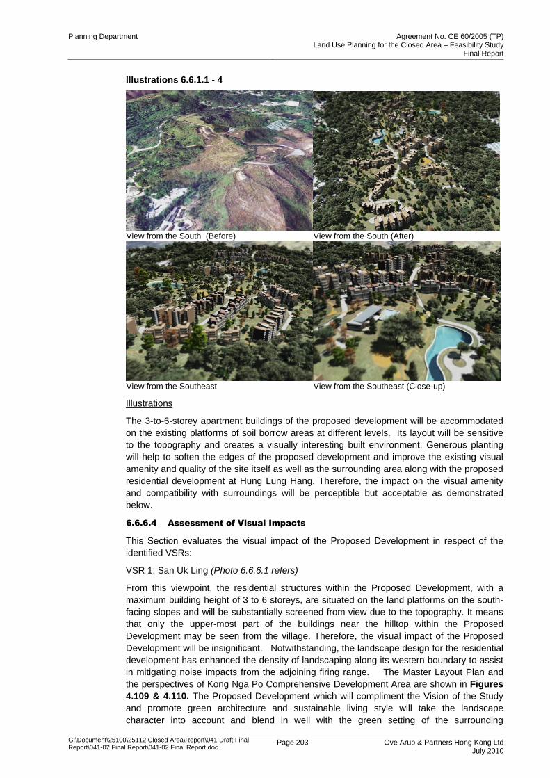
Planning Department Agreement No. CE 60/2005 (TP) Land Use Planning for the Closed Area – Feasibility Study
Final Report
G:\Document\25100\25112 Closed Area\Report\041 Draft Final Report\041-02 Final Report\041-02 Final Report.doc
Page 203 Ove Arup & Partners Hong Kong Ltd July 2010
Illustrations 6.6.1.1 - 4
View from the South (Before) View from the South (After)
View from the Southeast View from the Southeast (Close-up)
Illustrations
The 3-to-6-storey apartment buildings of the proposed development will be accommodated
on the existing platforms of soil borrow areas at different levels. Its layout will be sensitive
to the topography and creates a visually interesting built environment. Generous planting
will help to soften the edges of the proposed development and improve the existing visual
amenity and quality of the site itself as well as the surrounding area along with the proposed
residential development at Hung Lung Hang. Therefore, the impact on the visual amenity
and compatibility with surroundings will be perceptible but acceptable as demonstrated
below.
6.6.6.4 Assessment of Visual Impacts
This Section evaluates the visual impact of the Proposed Development in respect of the
identified VSRs:
VSR 1: San Uk Ling (Photo 6.6.6.1 refers)
From this viewpoint, the residential structures within the Proposed Development, with a
maximum building height of 3 to 6 storeys, are situated on the land platforms on the south-
facing slopes and will be substantially screened from view due to the topography. It means
that only the upper-most part of the buildings near the hilltop within the Proposed
Development may be seen from the village. Therefore, the visual impact of the Proposed
Development will be insignificant. Notwithstanding, the landscape design for the residential
development has enhanced the density of landscaping along its western boundary to assist
in mitigating noise impacts from the adjoining firing range. The Master Layout Plan and
the perspectives of Kong Nga Po Comprehensive Development Area are shown in Figures
4.109 & 4.110. The Proposed Development which will compliment the Vision of the Study
and promote green architecture and sustainable living style will take the landscape
character into account and blend in well with the green setting of the surrounding
Planning Department Agreement No. CE 60/2005 (TP) Land Use Planning for the Closed Area – Feasibility Study
Final Report
G:\Document\25100\25112 Closed Area\Report\041 Draft Final Report\041-02 Final Report\041-02 Final Report.doc
Page 204 Ove Arup & Partners Hong Kong Ltd July 2010
environment. In addition, the planning parameters recommended under this Study require
the future development proponent to conduct a VIA to support future planning applications
for the site.
VSR 2: Sha Ling (Photos 6.6.6.2(a), (b) and (c) refer)
The viewpoints in photos (a) & (b) are taken from Sha Ling at the north and the south of
Man Kam To Road respectively. Since mature vegetation exists along Man Kam To Road
overlooking the Proposed Site, the Proposed Site is largely screened from the view and the
visual impact of the Proposed Development will be imperceptible. This is further justified by
the Photo (c) which is looking west from the lower club-house platform of the concept design.
This shows that views towards Sha Ling are obscured from the topography and vegetation
cover further mitigating any adverse visual impacts. As with VSR 1, the only recognisable
feature of the development will be the dense landscaping and the upper-most part of the
buildings. The Proposed Development will impose a minor magnitude of change visually
within the visual catchment from these viewpoints.
VSR 3: Hung Lung Hang (Photo 6.6.6.3 refers)
This viewpoint assesses the visual impact of the Proposed Residential Development on the
possible future residents of the proposed Residential Area at Hung Lung Hang to the
southeast of the Proposed Development. According to the Recommended Development
Plan, residential development is proposed in this area in future and so the sensitive
receivers will be the future residents of the future residential development. The Proposed
Development will have a low intensity of 3 to 6 storeys and will be visually compatible with
its surrounding with the proposed extensive greenery/landscape treatment to be provided
for the Proposed Development, there will be no adverse visual impact.
VSR 4: Lo Shui Ling (Photo 6.6.6.4 refers)
This VP is taken from the Proposed Hiking Trail at Lo Shue Ling, which represents the view
from the north of the Proposed Site. The view towards the Proposed Development is
transient in nature. Thus, the sensitivity of this viewpoint is low. With the proposed extensive
greenery/landscape treatment to be provided, the Proposed Development will blend into the
surrounding visual context and will have an insignificant visual impact.
VSR 5: Fanling North NDA (Photo 6.6.6.5 refers)
The Fanling North NDA is located at the flat land at the southern bank of the Ng Tung River.
The view from there towards the Proposed Site will be shielded by the hilly ridges of Cheung
Po Tau and Cham Shan. Thus, the Proposed Development will impose no visual impact on
the VSRs at this viewpoint.
HP 1: Southeast to Kong Nga Po (Photo 6.6.6.6 refers)
This viewpoint is located at the top of a knoll, occupied by a grave but no sensitive receivers,
to the southeast of the Proposed Site. This viewpoint provides an overall view of the
Proposed Residential Development. The indicative development scheme will blend into the
existing topography by creating a series of staggered platforms and incorporating extensive
greenery/landscape treatment. The existing vegetation within the foreground and the
extensive/proposed greenery/landscape treatment will provide extensive screening for the 3
to 6-storey development in the lower portion. Only the upper portion of the Proposed
Development will be visible where extensive greenery/landscape treatment will also be
incorporated. The Proposed Development (as well as the future Residential Area at Hung
Lung Hang) will replace the existing incompatible land uses, e.g. livestock farms, in this
location and will not only be visually compatible with its surroundings but also enhance the
visual amenity in terms of high quality green development, being responsive to the
topography and integrating extensive landscape treatment.
Planning Department Agreement No. CE 60/2005 (TP) Land Use Planning for the Closed Area – Feasibility Study
Final Report
G:\Document\25100\25112 Closed Area\Report\041 Draft Final Report\041-02 Final Report\041-02 Final Report.doc
Page 205 Ove Arup & Partners Hong Kong Ltd July 2010
6.6.7 Proposed Eco-lodge at Ma Tso Lung
6.6.7.1 Proposed Development
The eco-lodge development at Ma Tso Lung is proposed as a show-case site to provide this
form of development within the Study Area first of its kind in Hong Kong. The eco-lodge
concept has been a key outcome to enhance and merge the environmental and tourism
objectives of the Study. It can also provide an example for other similar developments
elsewhere in Hong Kong.
The proposed eco-lodge at Ma Tso Lung will contribute to Hong Kong‟s Tourism Industry
and the local community. The facility should be of a proper scale that is compatible with the
site and constraints and could provide a series of small isolated bungalows/huts scattered
around the site at appropriate locations as shown in the concept design. Based on the
concept design (Figures 4.113 to 4.115 refers) the plot ratio for the eco-lodge is about 0.1
with a maximum building height of 6m above the existing ground level. The overall plot ratio
for the site could be further increased to 0.2 to increase financial feasibility and flexibility in
the future design. The Study also provides specific design objectives for this site and has
prepared a more generic list of design criteria for the application of this form of development
in other areas of Hong Kong. The site-specific and more generic design objectives
emphasis the need to integrate the development with the surrounding natural environment.
Notwithstanding, a broad assessment of the eco-lodge concept has been undertaken and
the future planning controls recommended that a detailed VIA be prepared to support future
planning applications.
6.6.7.2 Visual Context
The Proposed Development is located on hilly terrain at Ma Tso Lung overlooking the
fishponds in Hoo Hok Wai. It is in close proximity to ecologically-important Deep Bay
wetlands and associated educational/tourist facilities providing complimentary resources in
this area. The proposal is based on a series of scattered bungalows throughout a site
(approximately 12 ha in area) looking north over the Hoo Hok Wai wetlands. It utilizes a
pole-mounted design for the bungalows to mitigate impact on the ground cover and allow
each bungalow to be positioned more accurately on the site. A total of 80 bungalows is
proposed in this site which gives visitors good opportunities for bird watching in an elevated
position without affecting the fishponds/wetlands and would further encourage eco-tourism
into the area. The site is currently vacant and has maintained a natural environment of
grassy slopes with limited vegetation. The site is surrounded by the following:
To the east of the site are some the rural settlements of Shun Yee San Tsuen and Ma
Tso Lung San Tsuen and the Lo Wu Firing Range but they are not directly visible from
the Site
To the immediate south are some hilly terrains with the Kwu Tong North NDA farther
away to the south
To the west of the site is predominantly hilly terrain with the village of Lok Ma Chau.
To the north of the site is the extensive area of wetland/fishponds in Hoo Hok Wai and
Shenzhen further away.
To the immediate northwest is Ngau Kok Shan Operation Base. To the west is a narrow
strip of wetland/fishponds and Lok Ma Chau Loop.
6.6.7.3 Visual Envelope/Visual Sensitive Receivers/ Viewpoints
According to the proposed design concept, the eco-lodge will be located on the northeast
facing slopes below the predominant ridgelines at Ma Tso Lung (Figure 4.113 Refers).
The visual envelope of the Proposed Development extends north to the southern extent of
Shenzhen due to the built form which effectively creates a wall along the boundary of
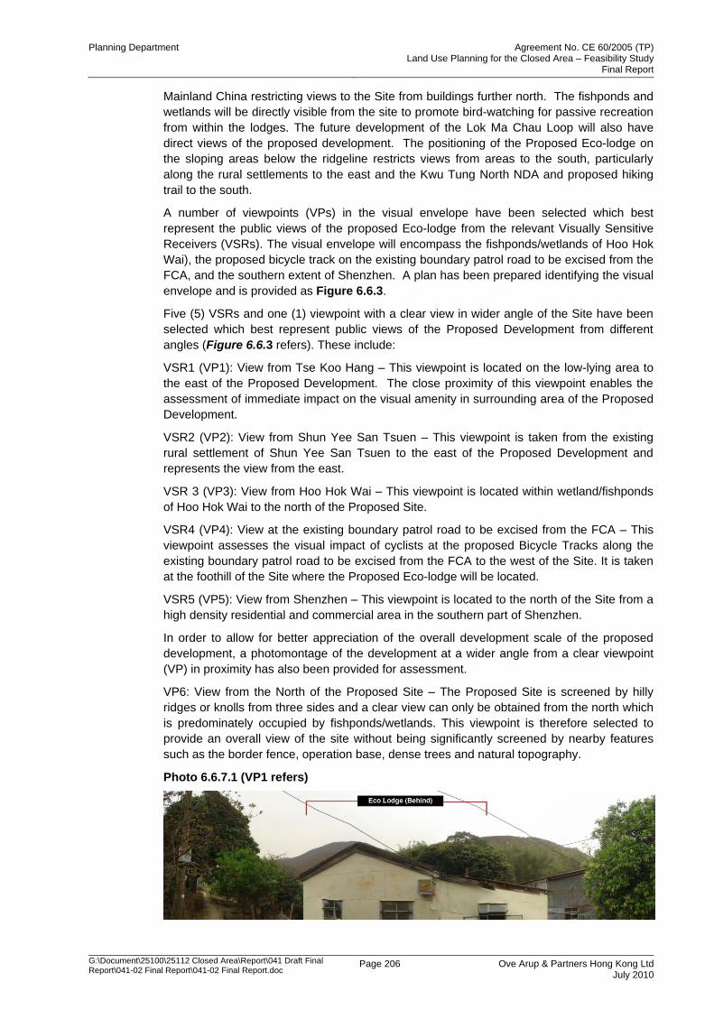
Planning Department Agreement No. CE 60/2005 (TP) Land Use Planning for the Closed Area – Feasibility Study
Final Report
G:\Document\25100\25112 Closed Area\Report\041 Draft Final Report\041-02 Final Report\041-02 Final Report.doc
Page 206 Ove Arup & Partners Hong Kong Ltd July 2010
Mainland China restricting views to the Site from buildings further north. The fishponds and
wetlands will be directly visible from the site to promote bird-watching for passive recreation
from within the lodges. The future development of the Lok Ma Chau Loop will also have
direct views of the proposed development. The positioning of the Proposed Eco-lodge on
the sloping areas below the ridgeline restricts views from areas to the south, particularly
along the rural settlements to the east and the Kwu Tung North NDA and proposed hiking
trail to the south.
A number of viewpoints (VPs) in the visual envelope have been selected which best
represent the public views of the proposed Eco-lodge from the relevant Visually Sensitive
Receivers (VSRs). The visual envelope will encompass the fishponds/wetlands of Hoo Hok
Wai), the proposed bicycle track on the existing boundary patrol road to be excised from the
FCA, and the southern extent of Shenzhen. A plan has been prepared identifying the visual
envelope and is provided as Figure 6.6.3.
Five (5) VSRs and one (1) viewpoint with a clear view in wider angle of the Site have been
selected which best represent public views of the Proposed Development from different
angles (Figure 6.6.3 refers). These include:
VSR1 (VP1): View from Tse Koo Hang – This viewpoint is located on the low-lying area to
the east of the Proposed Development. The close proximity of this viewpoint enables the
assessment of immediate impact on the visual amenity in surrounding area of the Proposed
Development.
VSR2 (VP2): View from Shun Yee San Tsuen – This viewpoint is taken from the existing
rural settlement of Shun Yee San Tsuen to the east of the Proposed Development and
represents the view from the east.
VSR 3 (VP3): View from Hoo Hok Wai – This viewpoint is located within wetland/fishponds
of Hoo Hok Wai to the north of the Proposed Site.
VSR4 (VP4): View at the existing boundary patrol road to be excised from the FCA – This
viewpoint assesses the visual impact of cyclists at the proposed Bicycle Tracks along the
existing boundary patrol road to be excised from the FCA to the west of the Site. It is taken
at the foothill of the Site where the Proposed Eco-lodge will be located.
VSR5 (VP5): View from Shenzhen – This viewpoint is located to the north of the Site from a
high density residential and commercial area in the southern part of Shenzhen.
In order to allow for better appreciation of the overall development scale of the proposed
development, a photomontage of the development at a wider angle from a clear viewpoint
(VP) in proximity has also been provided for assessment.
VP6: View from the North of the Proposed Site – The Proposed Site is screened by hilly
ridges or knolls from three sides and a clear view can only be obtained from the north which
is predominately occupied by fishponds/wetlands. This viewpoint is therefore selected to
provide an overall view of the site without being significantly screened by nearby features
such as the border fence, operation base, dense trees and natural topography.
Photo 6.6.7.1 (VP1 refers)
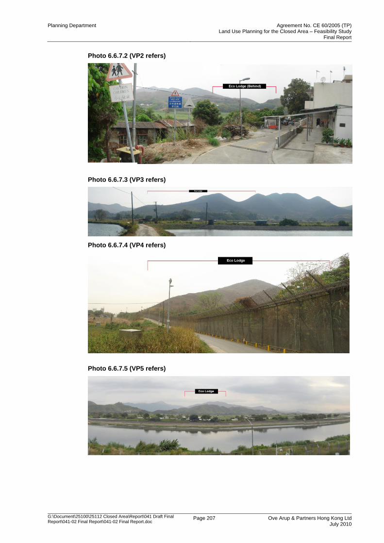
Planning Department Agreement No. CE 60/2005 (TP) Land Use Planning for the Closed Area – Feasibility Study
Final Report
G:\Document\25100\25112 Closed Area\Report\041 Draft Final Report\041-02 Final Report\041-02 Final Report.doc
Page 207 Ove Arup & Partners Hong Kong Ltd July 2010
Photo 6.6.7.2 (VP2 refers)
Photo 6.6.7.3 (VP3 refers)
Photo 6.6.7.4 (VP4 refers)
Photo 6.6.7.5 (VP5 refers)

Planning Department Agreement No. CE 60/2005 (TP) Land Use Planning for the Closed Area – Feasibility Study
Final Report
G:\Document\25100\25112 Closed Area\Report\041 Draft Final Report\041-02 Final Report\041-02 Final Report.doc
Page 208 Ove Arup & Partners Hong Kong Ltd July 2010
Photo 6.6.7.6 (VP6 refers)
Illustrations 6.6.7.1 - 4
View from the Northwest (Before) View from the Northwest (After)
View from the South View from the Northeast (Close-up)
Illustrations
As illustrated in different angles and close-up above, the development concept and future
development should be of a proper scale that is compatible with the site. The concept
provides a series of small isolated bungalows/huts scattered around the site with the
extensive natural vegetation and landscape enhancement to blend into the local setting and
minimise impact on the adjacent bird flight lines over HHW. Therefore, the impact on the
visual amenity and compatibility with surroundings will be perceptible but acceptable as
demonstrated below.
6.6.7.4 Assessment of Visual Impacts
The design philosophy of this eco-lodge which is a common approach with this form of
development is for it to blend with the natural environment. The design criteria promotes
development that will be immersed into the hillside with appropriate colour/material selection
surrounded by extensive landscaping. Initially this will assist in minimising the degree of
change in the natural landscape of the site when viewed from within the visual envelope.
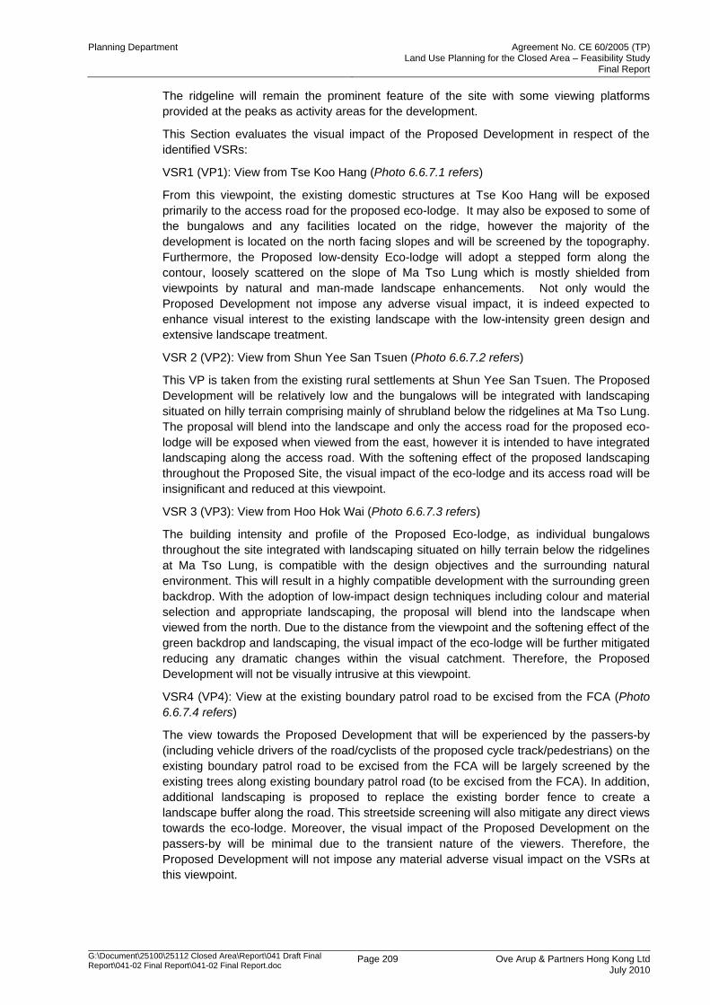
Planning Department Agreement No. CE 60/2005 (TP) Land Use Planning for the Closed Area – Feasibility Study
Final Report
G:\Document\25100\25112 Closed Area\Report\041 Draft Final Report\041-02 Final Report\041-02 Final Report.doc
Page 209 Ove Arup & Partners Hong Kong Ltd July 2010
The ridgeline will remain the prominent feature of the site with some viewing platforms
provided at the peaks as activity areas for the development.
This Section evaluates the visual impact of the Proposed Development in respect of the
identified VSRs:
VSR1 (VP1): View from Tse Koo Hang (Photo 6.6.7.1 refers)
From this viewpoint, the existing domestic structures at Tse Koo Hang will be exposed
primarily to the access road for the proposed eco-lodge. It may also be exposed to some of
the bungalows and any facilities located on the ridge, however the majority of the
development is located on the north facing slopes and will be screened by the topography.
Furthermore, the Proposed low-density Eco-lodge will adopt a stepped form along the
contour, loosely scattered on the slope of Ma Tso Lung which is mostly shielded from
viewpoints by natural and man-made landscape enhancements. Not only would the
Proposed Development not impose any adverse visual impact, it is indeed expected to
enhance visual interest to the existing landscape with the low-intensity green design and
extensive landscape treatment.
VSR 2 (VP2): View from Shun Yee San Tsuen (Photo 6.6.7.2 refers)
This VP is taken from the existing rural settlements at Shun Yee San Tsuen. The Proposed
Development will be relatively low and the bungalows will be integrated with landscaping
situated on hilly terrain comprising mainly of shrubland below the ridgelines at Ma Tso Lung.
The proposal will blend into the landscape and only the access road for the proposed eco-
lodge will be exposed when viewed from the east, however it is intended to have integrated
landscaping along the access road. With the softening effect of the proposed landscaping
throughout the Proposed Site, the visual impact of the eco-lodge and its access road will be
insignificant and reduced at this viewpoint.
VSR 3 (VP3): View from Hoo Hok Wai (Photo 6.6.7.3 refers)
The building intensity and profile of the Proposed Eco-lodge, as individual bungalows
throughout the site integrated with landscaping situated on hilly terrain below the ridgelines
at Ma Tso Lung, is compatible with the design objectives and the surrounding natural
environment. This will result in a highly compatible development with the surrounding green
backdrop. With the adoption of low-impact design techniques including colour and material
selection and appropriate landscaping, the proposal will blend into the landscape when
viewed from the north. Due to the distance from the viewpoint and the softening effect of the
green backdrop and landscaping, the visual impact of the eco-lodge will be further mitigated
reducing any dramatic changes within the visual catchment. Therefore, the Proposed
Development will not be visually intrusive at this viewpoint.
VSR4 (VP4): View at the existing boundary patrol road to be excised from the FCA (Photo
6.6.7.4 refers)
The view towards the Proposed Development that will be experienced by the passers-by
(including vehicle drivers of the road/cyclists of the proposed cycle track/pedestrians) on the
existing boundary patrol road to be excised from the FCA will be largely screened by the
existing trees along existing boundary patrol road (to be excised from the FCA). In addition,
additional landscaping is proposed to replace the existing border fence to create a
landscape buffer along the road. This streetside screening will also mitigate any direct views
towards the eco-lodge. Moreover, the visual impact of the Proposed Development on the
passers-by will be minimal due to the transient nature of the viewers. Therefore, the
Proposed Development will not impose any material adverse visual impact on the VSRs at
this viewpoint.
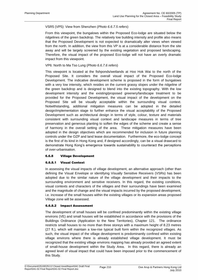
Planning Department Agreement No. CE 60/2005 (TP) Land Use Planning for the Closed Area – Feasibility Study
Final Report
G:\Document\25100\25112 Closed Area\Report\041 Draft Final Report\041-02 Final Report\041-02 Final Report.doc
Page 210 Ove Arup & Partners Hong Kong Ltd July 2010
VSR5 (VP5): View from Shenzhen (Photo 6.6.7.5 refers)
From this viewpoint, the bungalows within the Proposed Eco-lodge are situated below the
ridgelines of the green backdrop. The relatively low building intensity and profile also means
that the Proposed Development is not expected to dramatically alter views when viewed
from the north. In addition, the view from this VP is at a considerable distance from the site
away and will be largely screened by the existing vegetation and proposed landscaping.
Therefore, the visual impact of the proposed Eco-lodge will not have an overly dramatic
impact from this viewpoint.
VP6: North to Ma Tso Lung (Photo 6.6.7.6 refers)
This viewpoint is located at the fishponds/wetlands at Hoo Hok Wai to the north of the
Proposed Site. It considers the overall visual impact of the Proposed Eco-lodge
Development. The indicative development scheme is proposed in the form of bungalows
with a very low intensity, which resides on the current grassy slopes under the ridgeline of
the green backdrop and is designed to blend into the existing topography. With the low
development intensity and the existing/proposed greenery/landscape treatment to be
provided for the Proposed Development, the visual impact of the development on the
Proposed Site will be visually acceptable within the surrounding visual context.
Notwithstanding, additional mitigation measures can be adopted in the detailed
design/implementation stage to further enhance the visual acceptability of the Proposed
Development such as architectural design in terms of style, colour, texture and materials
consistent with surrounding visual context and landscape measures in terms of tree
preservation and generous planting to soften the edges of the scheme and create a sense
of harmony in the overall setting of the area. These mitigation measures have been
adopted in the design objectives which are recommended for inclusion in future planning
controls under the OZP and land lease documentation. Furthermore, the eco-lodge concept
is the first of its kind in Hong Kong and, if designed accordingly, can be a visual drawcard to
demonstrate Hong Kong‟s emergence towards sustainability to counteract the perceptions
of over-urbanisation.
6.6.8 Village Development
6.6.8.1 Visual Context
In assessing the visual impacts of village development, an alternative approach (other than
defining the Visual Envelope or identifying Visually Sensitive Receivers (VSRs) has been
adopted due to the similar nature of the village development and their impacts to the
surrounding environment and sensitive receivers. In this regard, the existing conditions,
visual contexts and characters of the villages and their surroundings have been examined
and the magnitude of change and the visual impacts incurred by the proposed development,
i.e. increase of the small houses within the existing villages or its expansion areas proposed
Village zone will be assessed.
6.6.8.2 Impact Assessment
The development of small houses will be confined predominantly within the existing village
environs (VE) and small houses will be established in accordance with the provisions of the
Buildings Ordinance (Application to the New Territories), Chapter 121. The ordinance
restricts small houses to no more than three storeys with a maximum height of 8.23 metres
(27 ft.), which will maintain a low-rise typical built form within the recognized villages. As
such, the visual impact of the village development is predominantly confined within existing
village environs where there is already established village development. It must be
recognized that the existing village environs mapping has already provided an agreed extent
of small-house development within the Study Area. In this regard, there is already an
agreed level of visual impact that could have been imposed prior to the commencement of
this Study.
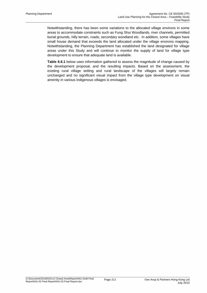
Planning Department Agreement No. CE 60/2005 (TP) Land Use Planning for the Closed Area – Feasibility Study
Final Report
G:\Document\25100\25112 Closed Area\Report\041 Draft Final Report\041-02 Final Report\041-02 Final Report.doc
Page 211 Ove Arup & Partners Hong Kong Ltd July 2010
Notwithstanding, there has been some variations to the allocated village environs in some
areas to accommodate constraints such as Fung Shui Woodlands, river channels, permitted
burial grounds, hilly terrain, roads, secondary woodland etc. In addition, some villages have
small house demand that exceeds the land allocated under the village environs mapping.
Notwithstanding, the Planning Department has established the land designated for village
areas under this Study and will continue to monitor the supply of land for village type
development to ensure that adequate land is available.
Table 6.6.1 below uses information gathered to assess the magnitude of change caused by
the development proposal, and the resulting impacts. Based on the assessment, the
existing rural village setting and rural landscape of the villages will largely remain
unchanged and no significant visual impact from the village type development on visual
amenity in various indigenous villages is envisaged.
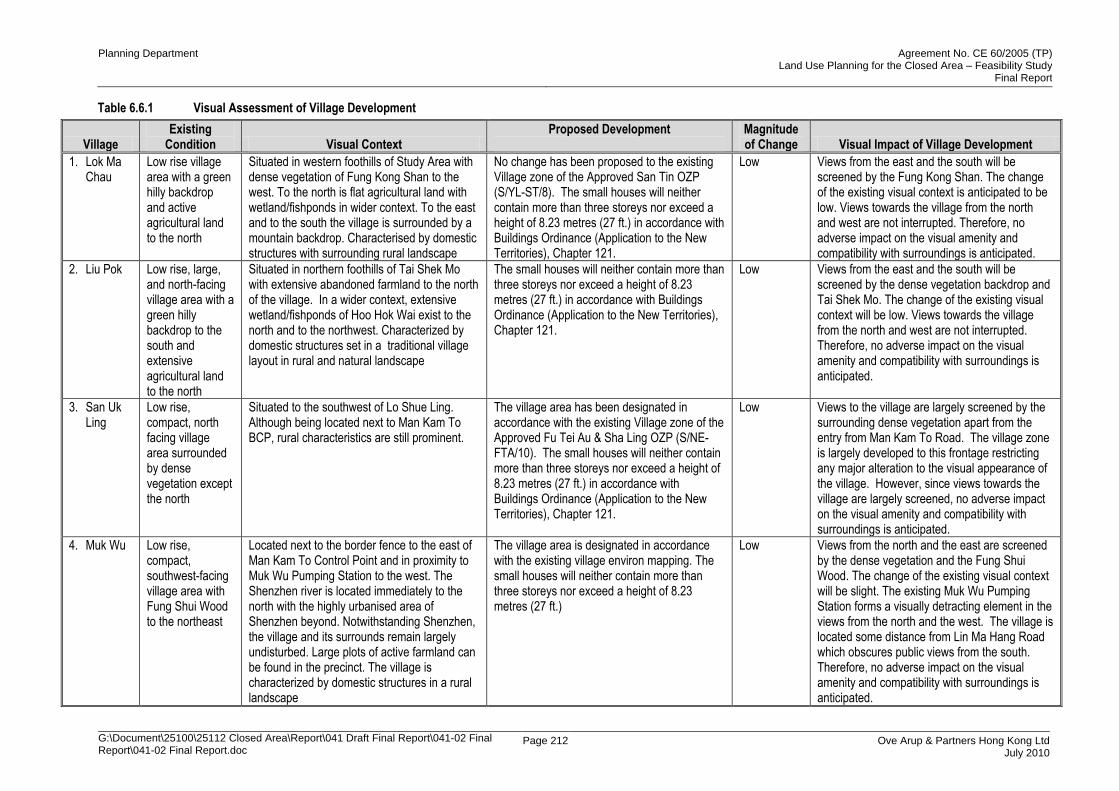
Planning Department Agreement No. CE 60/2005 (TP) Land Use Planning for the Closed Area – Feasibility Study
Final Report
G:\Document\25100\25112 Closed Area\Report\041 Draft Final Report\041-02 Final Report\041-02 Final Report.doc
Page 212 Ove Arup & Partners Hong Kong Ltd July 2010
Table 6.6.1 Visual Assessment of Village Development
Village Existing
Condition Visual Context Proposed Development
Magnitude of Change Visual Impact of Village Development
1. Lok Ma Chau
Low rise village area with a green hilly backdrop and active agricultural land to the north
Situated in western foothills of Study Area with dense vegetation of Fung Kong Shan to the west. To the north is flat agricultural land with wetland/fishponds in wider context. To the east and to the south the village is surrounded by a mountain backdrop. Characterised by domestic structures with surrounding rural landscape
No change has been proposed to the existing Village zone of the Approved San Tin OZP (S/YL-ST/8). The small houses will neither contain more than three storeys nor exceed a height of 8.23 metres (27 ft.) in accordance with Buildings Ordinance (Application to the New Territories), Chapter 121.
Low Views from the east and the south will be screened by the Fung Kong Shan. The change of the existing visual context is anticipated to be low. Views towards the village from the north and west are not interrupted. Therefore, no adverse impact on the visual amenity and compatibility with surroundings is anticipated.
2. Liu Pok Low rise, large, and north-facing village area with a green hilly backdrop to the south and extensive agricultural land to the north
Situated in northern foothills of Tai Shek Mo with extensive abandoned farmland to the north of the village. In a wider context, extensive wetland/fishponds of Hoo Hok Wai exist to the north and to the northwest. Characterized by domestic structures set in a traditional village layout in rural and natural landscape
The small houses will neither contain more than three storeys nor exceed a height of 8.23 metres (27 ft.) in accordance with Buildings Ordinance (Application to the New Territories), Chapter 121.
Low Views from the east and the south will be screened by the dense vegetation backdrop and Tai Shek Mo. The change of the existing visual context will be low. Views towards the village from the north and west are not interrupted. Therefore, no adverse impact on the visual amenity and compatibility with surroundings is anticipated.
3. San Uk Ling
Low rise, compact, north facing village area surrounded by dense vegetation except the north
Situated to the southwest of Lo Shue Ling. Although being located next to Man Kam To BCP, rural characteristics are still prominent.
The village area has been designated in accordance with the existing Village zone of the Approved Fu Tei Au & Sha Ling OZP (S/NE-FTA/10). The small houses will neither contain more than three storeys nor exceed a height of 8.23 metres (27 ft.) in accordance with Buildings Ordinance (Application to the New Territories), Chapter 121.
Low Views to the village are largely screened by the surrounding dense vegetation apart from the entry from Man Kam To Road. The village zone is largely developed to this frontage restricting any major alteration to the visual appearance of the village. However, since views towards the village are largely screened, no adverse impact on the visual amenity and compatibility with surroundings is anticipated.
4. Muk Wu Low rise, compact, southwest-facing village area with Fung Shui Wood to the northeast
Located next to the border fence to the east of Man Kam To Control Point and in proximity to Muk Wu Pumping Station to the west. The Shenzhen river is located immediately to the north with the highly urbanised area of Shenzhen beyond. Notwithstanding Shenzhen, the village and its surrounds remain largely undisturbed. Large plots of active farmland can be found in the precinct. The village is characterized by domestic structures in a rural landscape
The village area is designated in accordance with the existing village environ mapping. The small houses will neither contain more than three storeys nor exceed a height of 8.23 metres (27 ft.)
Low Views from the north and the east are screened by the dense vegetation and the Fung Shui Wood. The change of the existing visual context will be slight. The existing Muk Wu Pumping Station forms a visually detracting element in the views from the north and the west. The village is located some distance from Lin Ma Hang Road which obscures public views from the south. Therefore, no adverse impact on the visual amenity and compatibility with surroundings is anticipated.
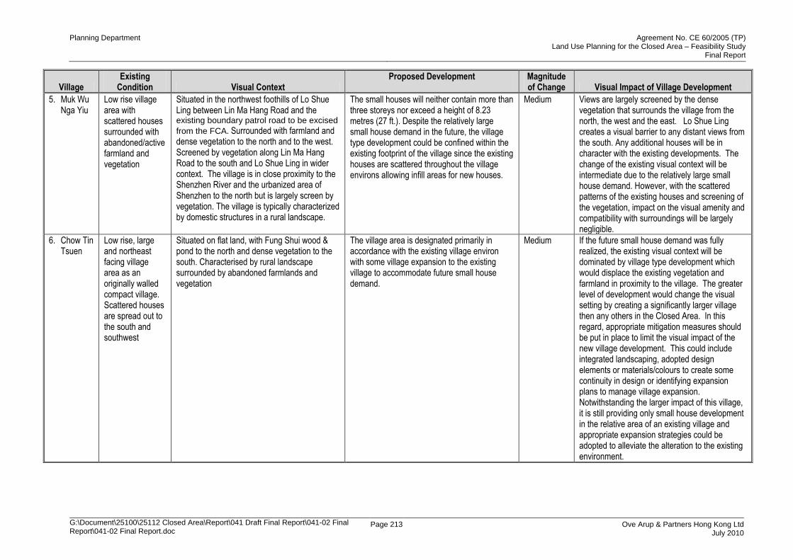
Planning Department Agreement No. CE 60/2005 (TP) Land Use Planning for the Closed Area – Feasibility Study
Final Report
G:\Document\25100\25112 Closed Area\Report\041 Draft Final Report\041-02 Final Report\041-02 Final Report.doc
Page 213 Ove Arup & Partners Hong Kong Ltd July 2010
Village Existing
Condition Visual Context Proposed Development
Magnitude of Change Visual Impact of Village Development
5. Muk Wu Nga Yiu
Low rise village area with scattered houses surrounded with abandoned/active farmland and vegetation
Situated in the northwest foothills of Lo Shue Ling between Lin Ma Hang Road and the existing boundary patrol road to be excised
from the FCA. Surrounded with farmland and dense vegetation to the north and to the west. Screened by vegetation along Lin Ma Hang Road to the south and Lo Shue Ling in wider context. The village is in close proximity to the Shenzhen River and the urbanized area of Shenzhen to the north but is largely screen by vegetation. The village is typically characterized by domestic structures in a rural landscape.
The small houses will neither contain more than three storeys nor exceed a height of 8.23 metres (27 ft.). Despite the relatively large small house demand in the future, the village type development could be confined within the existing footprint of the village since the existing houses are scattered throughout the village environs allowing infill areas for new houses.
Medium Views are largely screened by the dense vegetation that surrounds the village from the north, the west and the east. Lo Shue Ling creates a visual barrier to any distant views from the south. Any additional houses will be in character with the existing developments. The change of the existing visual context will be intermediate due to the relatively large small house demand. However, with the scattered patterns of the existing houses and screening of the vegetation, impact on the visual amenity and compatibility with surroundings will be largely negligible.
6. Chow Tin Tsuen
Low rise, large and northeast facing village area as an originally walled compact village. Scattered houses are spread out to the south and southwest
Situated on flat land, with Fung Shui wood & pond to the north and dense vegetation to the south. Characterised by rural landscape surrounded by abandoned farmlands and vegetation
The village area is designated primarily in accordance with the existing village environ with some village expansion to the existing village to accommodate future small house demand.
Medium If the future small house demand was fully realized, the existing visual context will be dominated by village type development which would displace the existing vegetation and farmland in proximity to the village. The greater level of development would change the visual setting by creating a significantly larger village then any others in the Closed Area. In this regard, appropriate mitigation measures should be put in place to limit the visual impact of the new village development. This could include integrated landscaping, adopted design elements or materials/colours to create some continuity in design or identifying expansion plans to manage village expansion. Notwithstanding the larger impact of this village, it is still providing only small house development in the relative area of an existing village and appropriate expansion strategies could be adopted to alleviate the alteration to the existing environment.
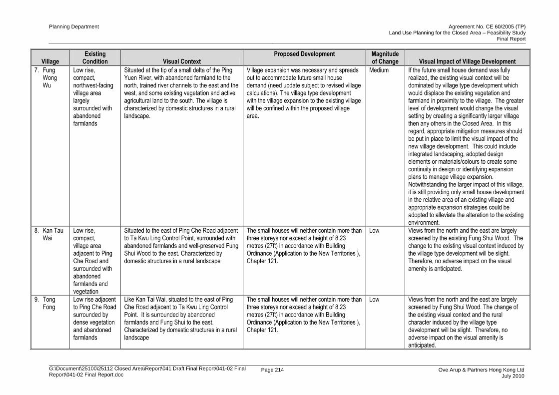
Planning Department Agreement No. CE 60/2005 (TP) Land Use Planning for the Closed Area – Feasibility Study
Final Report
G:\Document\25100\25112 Closed Area\Report\041 Draft Final Report\041-02 Final Report\041-02 Final Report.doc
Page 214 Ove Arup & Partners Hong Kong Ltd July 2010
Village Existing
Condition Visual Context Proposed Development
Magnitude of Change Visual Impact of Village Development
7. Fung Wong Wu
Low rise, compact, northwest-facing village area largely surrounded with abandoned farmlands
Situated at the tip of a small delta of the Ping Yuen River, with abandoned farmland to the north, trained river channels to the east and the west, and some existing vegetation and active agricultural land to the south. The village is characterized by domestic structures in a rural landscape.
Village expansion was necessary and spreads out to accommodate future small house demand (need update subject to revised village calculations). The village type development with the village expansion to the existing village will be confined within the proposed village area.
Medium If the future small house demand was fully realized, the existing visual context will be dominated by village type development which would displace the existing vegetation and farmland in proximity to the village. The greater level of development would change the visual setting by creating a significantly larger village then any others in the Closed Area. In this regard, appropriate mitigation measures should be put in place to limit the visual impact of the new village development. This could include integrated landscaping, adopted design elements or materials/colours to create some continuity in design or identifying expansion plans to manage village expansion. Notwithstanding the larger impact of this village, it is still providing only small house development in the relative area of an existing village and appropriate expansion strategies could be adopted to alleviate the alteration to the existing environment.
8. Kan Tau Wai
Low rise, compact, village area adjacent to Ping Che Road and surrounded with abandoned farmlands and vegetation
Situated to the east of Ping Che Road adjacent to Ta Kwu Ling Control Point, surrounded with abandoned farmlands and well-preserved Fung Shui Wood to the east. Characterized by domestic structures in a rural landscape
The small houses will neither contain more than three storeys nor exceed a height of 8.23 metres (27ft) in accordance with Building Ordinance (Application to the New Territories ), Chapter 121.
Low Views from the north and the east are largely screened by the existing Fung Shui Wood. The change to the existing visual context induced by the village type development will be slight. Therefore, no adverse impact on the visual amenity is anticipated.
9. Tong Fong
Low rise adjacent to Ping Che Road surrounded by dense vegetation and abandoned farmlands
Like Kan Tai Wai, situated to the east of Ping Che Road adjacent to Ta Kwu Ling Control Point. It is surrounded by abandoned farmlands and Fung Shui to the east. Characterized by domestic structures in a rural landscape
The small houses will neither contain more than three storeys nor exceed a height of 8.23 metres (27ft) in accordance with Building Ordinance (Application to the New Territories ), Chapter 121.
Low Views from the north and the east are largely screened by Fung Shui Wood. The change of the existing visual context and the rural character induced by the village type development will be slight. Therefore, no adverse impact on the visual amenity is anticipated.

Planning Department Agreement No. CE 60/2005 (TP) Land Use Planning for the Closed Area – Feasibility Study
Final Report
G:\Document\25100\25112 Closed Area\Report\041 Draft Final Report\041-02 Final Report\041-02 Final Report.doc
Page 215 Ove Arup & Partners Hong Kong Ltd July 2010
Village Existing
Condition Visual Context Proposed Development
Magnitude of Change Visual Impact of Village Development
10. Chuk Yuen
Low rise village area adjacent to Lin Ma Hang Road, surrounded by dense vegetation and abandoned farmlands
Located in close proximity to Liantang of Shenzhen. Rural in nature in great contrast to the highly developed Liantang area
Village area is given for its relocation to accommodate existing and future small house demand.
Medium Views from the north, the east and the south are largely screened by hills and knolls. However, the existing visual amenity would be changed by loss of some vegetation and farmlands for the relocation of the village in such new location. However, the village type development would not significantly change the existing rural setting. Therefore, the impact on the visual amenity and compatibility with surroundings will be perceptible but slight.
11. Tsung Yuen Ha
Low rise, north-facing village area surrounded with some active farmlands and a well-preserved Fung Shui Wood
Located adjacent to Ha Heung Yuen to the east, with active farmlands and greenhouses to the north and the west, abandoned farmlands to the east and a Fung Shui Wood to the south. Characterized by domestic structures in a rural landscape
The small houses will neither contain more than three storeys nor exceed a height of 8.23 metres (27 ft.). Despite the relatively large potential future small house development, future village type development would be confined within the village since the existing houses are scattered allowing the infilling of new development to take up the village zone.
Medium If the future small house demand would be fully realized, the existing visual context will be by village type development encroaching the surrounding vegetation and farmlands. As such, the visual amenity would be changed by loss of some vegetation and farmlands for village expansion. However, the village type development would not significantly change the existing rural character and its village setting. There is already an accepted presence of this form of development in this area. Therefore, the impact on the visual amenity and compatibility with surroundings will be perceptible but slight.
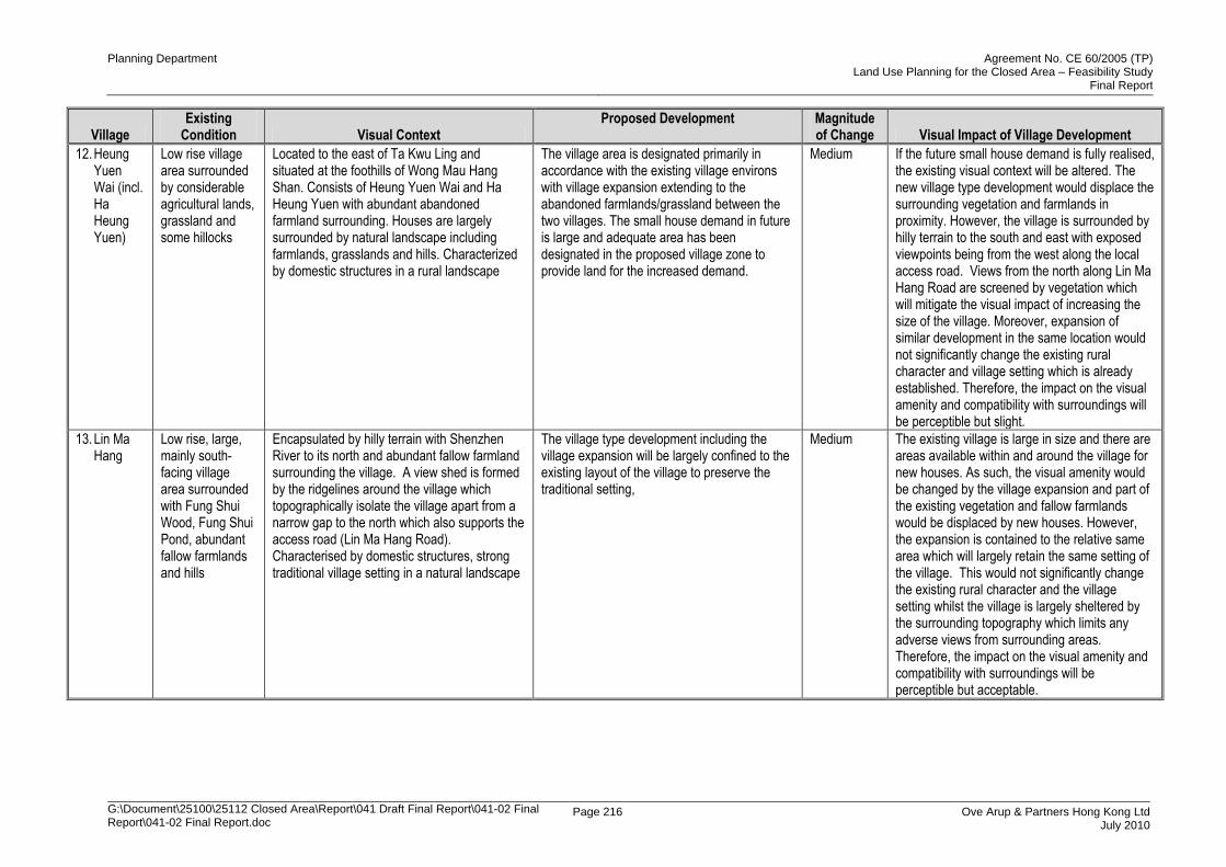
Planning Department Agreement No. CE 60/2005 (TP) Land Use Planning for the Closed Area – Feasibility Study
Final Report
G:\Document\25100\25112 Closed Area\Report\041 Draft Final Report\041-02 Final Report\041-02 Final Report.doc
Page 216 Ove Arup & Partners Hong Kong Ltd July 2010
Village Existing
Condition Visual Context Proposed Development
Magnitude of Change Visual Impact of Village Development
12. Heung Yuen Wai (incl. Ha Heung Yuen)
Low rise village area surrounded by considerable agricultural lands, grassland and some hillocks
Located to the east of Ta Kwu Ling and situated at the foothills of Wong Mau Hang Shan. Consists of Heung Yuen Wai and Ha Heung Yuen with abundant abandoned farmland surrounding. Houses are largely surrounded by natural landscape including farmlands, grasslands and hills. Characterized by domestic structures in a rural landscape
The village area is designated primarily in accordance with the existing village environs with village expansion extending to the abandoned farmlands/grassland between the two villages. The small house demand in future is large and adequate area has been designated in the proposed village zone to provide land for the increased demand.
Medium If the future small house demand is fully realised, the existing visual context will be altered. The new village type development would displace the surrounding vegetation and farmlands in proximity. However, the village is surrounded by hilly terrain to the south and east with exposed viewpoints being from the west along the local access road. Views from the north along Lin Ma Hang Road are screened by vegetation which will mitigate the visual impact of increasing the size of the village. Moreover, expansion of similar development in the same location would not significantly change the existing rural character and village setting which is already established. Therefore, the impact on the visual amenity and compatibility with surroundings will be perceptible but slight.
13. Lin Ma Hang
Low rise, large, mainly south-facing village area surrounded with Fung Shui Wood, Fung Shui Pond, abundant fallow farmlands and hills
Encapsulated by hilly terrain with Shenzhen River to its north and abundant fallow farmland surrounding the village. A view shed is formed by the ridgelines around the village which topographically isolate the village apart from a narrow gap to the north which also supports the access road (Lin Ma Hang Road). Characterised by domestic structures, strong traditional village setting in a natural landscape
The village type development including the village expansion will be largely confined to the existing layout of the village to preserve the traditional setting,
Medium The existing village is large in size and there are areas available within and around the village for new houses. As such, the visual amenity would be changed by the village expansion and part of the existing vegetation and fallow farmlands would be displaced by new houses. However, the expansion is contained to the relative same area which will largely retain the same setting of the village. This would not significantly change the existing rural character and the village setting whilst the village is largely sheltered by the surrounding topography which limits any adverse views from surrounding areas. Therefore, the impact on the visual amenity and compatibility with surroundings will be perceptible but acceptable.
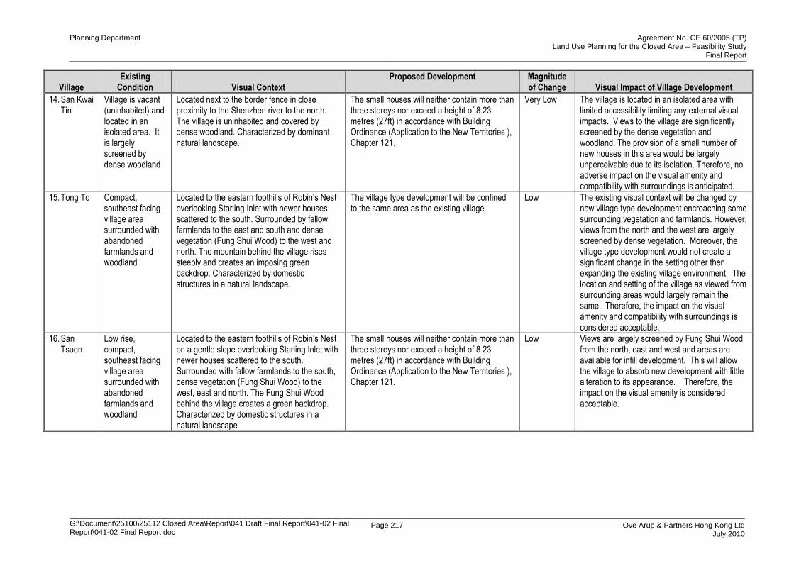
Planning Department Agreement No. CE 60/2005 (TP) Land Use Planning for the Closed Area – Feasibility Study
Final Report
G:\Document\25100\25112 Closed Area\Report\041 Draft Final Report\041-02 Final Report\041-02 Final Report.doc
Page 217 Ove Arup & Partners Hong Kong Ltd July 2010
Village Existing
Condition Visual Context Proposed Development
Magnitude of Change Visual Impact of Village Development
14. San Kwai Tin
Village is vacant (uninhabited) and located in an isolated area. It is largely screened by dense woodland
Located next to the border fence in close proximity to the Shenzhen river to the north. The village is uninhabited and covered by dense woodland. Characterized by dominant natural landscape.
The small houses will neither contain more than three storeys nor exceed a height of 8.23 metres (27ft) in accordance with Building Ordinance (Application to the New Territories ), Chapter 121.
Very Low The village is located in an isolated area with limited accessibility limiting any external visual impacts. Views to the village are significantly screened by the dense vegetation and woodland. The provision of a small number of new houses in this area would be largely unperceivable due to its isolation. Therefore, no adverse impact on the visual amenity and compatibility with surroundings is anticipated.
15. Tong To Compact, southeast facing village area surrounded with abandoned farmlands and woodland
Located to the eastern foothills of Robin‟s Nest overlooking Starling Inlet with newer houses scattered to the south. Surrounded by fallow farmlands to the east and south and dense vegetation (Fung Shui Wood) to the west and north. The mountain behind the village rises steeply and creates an imposing green backdrop. Characterized by domestic structures in a natural landscape.
The village type development will be confined to the same area as the existing village
Low The existing visual context will be changed by new village type development encroaching some surrounding vegetation and farmlands. However, views from the north and the west are largely screened by dense vegetation. Moreover, the village type development would not create a significant change in the setting other then expanding the existing village environment. The location and setting of the village as viewed from surrounding areas would largely remain the same. Therefore, the impact on the visual amenity and compatibility with surroundings is considered acceptable.
16. San Tsuen
Low rise, compact, southeast facing village area surrounded with abandoned farmlands and woodland
Located to the eastern foothills of Robin‟s Nest on a gentle slope overlooking Starling Inlet with newer houses scattered to the south. Surrounded with fallow farmlands to the south, dense vegetation (Fung Shui Wood) to the west, east and north. The Fung Shui Wood behind the village creates a green backdrop. Characterized by domestic structures in a natural landscape
The small houses will neither contain more than three storeys nor exceed a height of 8.23 metres (27ft) in accordance with Building Ordinance (Application to the New Territories ), Chapter 121.
Low Views are largely screened by Fung Shui Wood from the north, east and west and areas are available for infill development. This will allow the village to absorb new development with little alteration to its appearance. Therefore, the impact on the visual amenity is considered acceptable.
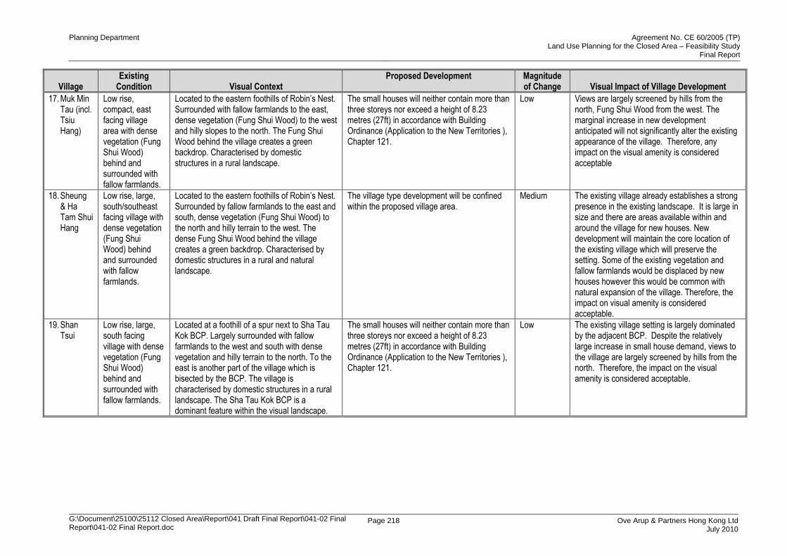
Planning Department Agreement No. CE 60/2005 (TP) Land Use Planning for the Closed Area – Feasibility Study
Final Report
G:\Document\25100\25112 Closed Area\Report\041 Draft Final Report\041-02 Final Report\041-02 Final Report.doc
Page 218 Ove Arup & Partners Hong Kong Ltd July 2010
Village Existing
Condition Visual Context Proposed Development
Magnitude of Change Visual Impact of Village Development
17. Muk Min Tau (incl. Tsiu Hang)
Low rise, compact, east facing village area with dense vegetation (Fung Shui Wood) behind and surrounded with fallow farmlands.
Located to the eastern foothills of Robin‟s Nest. Surrounded with fallow farmlands to the east, dense vegetation (Fung Shui Wood) to the west and hilly slopes to the north. The Fung Shui Wood behind the village creates a green backdrop. Characterised by domestic structures in a rural landscape.
The small houses will neither contain more than three storeys nor exceed a height of 8.23 metres (27ft) in accordance with Building Ordinance (Application to the New Territories ), Chapter 121.
Low Views are largely screened by hills from the north, Fung Shui Wood from the west. The marginal increase in new development anticipated will not significantly alter the existing appearance of the village. Therefore, any impact on the visual amenity is considered acceptable
18. Sheung & Ha Tam Shui Hang
Low rise, large, south/southeast facing village with dense vegetation (Fung Shui Wood) behind and surrounded with fallow farmlands.
Located to the eastern foothills of Robin‟s Nest. Surrounded by fallow farmlands to the east and south, dense vegetation (Fung Shui Wood) to the north and hilly terrain to the west. The dense Fung Shui Wood behind the village creates a green backdrop. Characterised by domestic structures in a rural and natural landscape.
The village type development will be confined within the proposed village area.
Medium The existing village already establishes a strong presence in the existing landscape. It is large in size and there are areas available within and around the village for new houses. New development will maintain the core location of the existing village which will preserve the setting. Some of the existing vegetation and fallow farmlands would be displaced by new houses however this would be common with natural expansion of the village. Therefore, the impact on visual amenity is considered acceptable.
19. Shan Tsui
Low rise, large, south facing village with dense vegetation (Fung Shui Wood) behind and surrounded with fallow farmlands.
Located at a foothill of a spur next to Sha Tau Kok BCP. Largely surrounded with fallow farmlands to the west and south with dense vegetation and hilly terrain to the north. To the east is another part of the village which is bisected by the BCP. The village is characterised by domestic structures in a rural landscape. The Sha Tau Kok BCP is a dominant feature within the visual landscape.
The small houses will neither contain more than three storeys nor exceed a height of 8.23 metres (27ft) in accordance with Building Ordinance (Application to the New Territories ), Chapter 121.
Low The existing village setting is largely dominated by the adjacent BCP. Despite the relatively large increase in small house demand, views to the village are largely screened by hills from the north. Therefore, the impact on the visual amenity is considered acceptable.
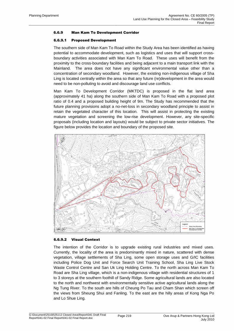
Planning Department Agreement No. CE 60/2005 (TP) Land Use Planning for the Closed Area – Feasibility Study
Final Report
G:\Document\25100\25112 Closed Area\Report\041 Draft Final Report\041-02 Final Report\041-02 Final Report.doc
Page 219 Ove Arup & Partners Hong Kong Ltd July 2010
6.6.9 Man Kam To Development Corridor
6.6.9.1 Proposed Development
The southern side of Man Kam To Road within the Study Area has been identified as having
potential to accommodate development, such as logistics and uses that will support cross-
boundary activities associated with Man Kam To Road. These uses will benefit from the
proximity to the cross-boundary facilities and being adjacent to a main transport link with the
Mainland. The area does not have any significant environmental value other than a
concentration of secondary woodland. However, the existing non-indigenous village of Sha
Ling is located centrally within the area so that any future (re)development in the area would
need to be non-polluting to avoid and discourage land use conflicts.
Man Kam To Development Corridor (MKTDC) is proposed in the flat land area
(approximately 41 ha) along the southern side of Man Kam To Road with a proposed plot
ratio of 0.4 and a proposed building height of 9m. The Study has recommended that the
future planning provisions adopt a no-net-loss in secondary woodland principle to assist in
retain the vegetated character of this location. This will assist in protecting the existing
mature vegetation and screening the low-rise development. However, any site-specific
proposals (including location and layouts) would be subject to private sector initiatives. The
figure below provides the location and boundary of the proposed site.
6.6.9.2 Visual Context
The intention of the Corridor is to upgrade existing rural industries and mixed uses.
Currently, the locality of the area is predominantly mixed in nature, scattered with dense
vegetation, village settlements of Sha Ling, some open storage uses and G/IC facilities
including Police Dog Unit and Force Search Unit Training School, Sha Ling Live Stock
Waste Control Centre and San Uk Ling Holding Centre. To the north across Man Kam To
Road are Sha Ling village, which is a non-indigenous village with residential structures of 1
to 3 storeys at the southern foothill of Sandy Ridge. Some agricultural lands are also located
to the north and northwest with environmentally sensitive active agricultural lands along the
Ng Tung River. To the south are hills of Cheung Po Tau and Cham Shan which screen off
the views from Sheung Shui and Fanling. To the east are the hilly areas of Kong Nga Po
and Lo Shue Ling.
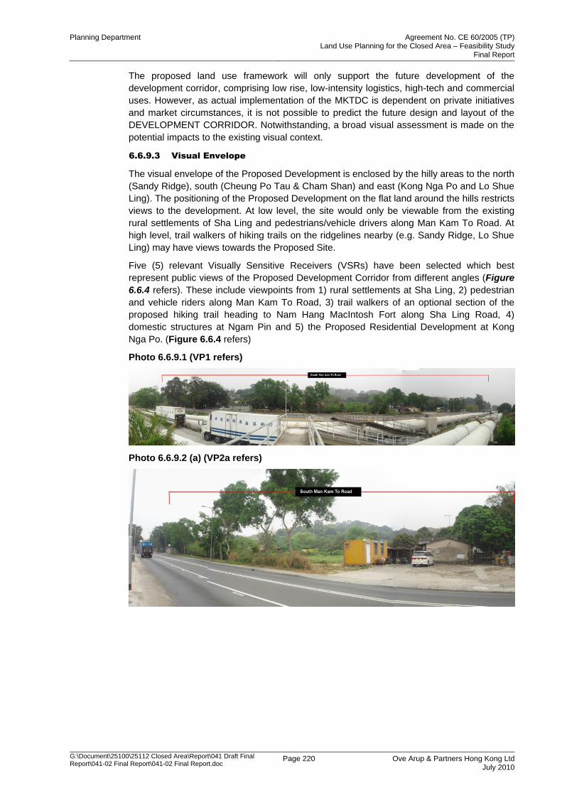
Planning Department Agreement No. CE 60/2005 (TP) Land Use Planning for the Closed Area – Feasibility Study
Final Report
G:\Document\25100\25112 Closed Area\Report\041 Draft Final Report\041-02 Final Report\041-02 Final Report.doc
Page 220 Ove Arup & Partners Hong Kong Ltd July 2010
The proposed land use framework will only support the future development of the
development corridor, comprising low rise, low-intensity logistics, high-tech and commercial
uses. However, as actual implementation of the MKTDC is dependent on private initiatives
and market circumstances, it is not possible to predict the future design and layout of the
DEVELOPMENT CORRIDOR. Notwithstanding, a broad visual assessment is made on the
potential impacts to the existing visual context.
6.6.9.3 Visual Envelope
The visual envelope of the Proposed Development is enclosed by the hilly areas to the north
(Sandy Ridge), south (Cheung Po Tau & Cham Shan) and east (Kong Nga Po and Lo Shue
Ling). The positioning of the Proposed Development on the flat land around the hills restricts
views to the development. At low level, the site would only be viewable from the existing
rural settlements of Sha Ling and pedestrians/vehicle drivers along Man Kam To Road. At
high level, trail walkers of hiking trails on the ridgelines nearby (e.g. Sandy Ridge, Lo Shue
Ling) may have views towards the Proposed Site.
Five (5) relevant Visually Sensitive Receivers (VSRs) have been selected which best
represent public views of the Proposed Development Corridor from different angles (Figure
6.6.4 refers). These include viewpoints from 1) rural settlements at Sha Ling, 2) pedestrian
and vehicle riders along Man Kam To Road, 3) trail walkers of an optional section of the
proposed hiking trail heading to Nam Hang MacIntosh Fort along Sha Ling Road, 4)
domestic structures at Ngam Pin and 5) the Proposed Residential Development at Kong
Nga Po. (Figure 6.6.4 refers)
Photo 6.6.9.1 (VP1 refers)
Photo 6.6.9.2 (a) (VP2a refers)
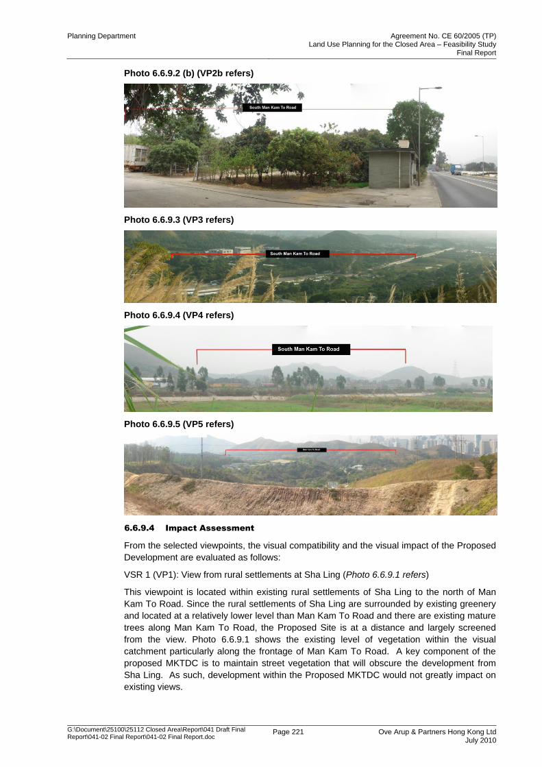
Planning Department Agreement No. CE 60/2005 (TP) Land Use Planning for the Closed Area – Feasibility Study
Final Report
G:\Document\25100\25112 Closed Area\Report\041 Draft Final Report\041-02 Final Report\041-02 Final Report.doc
Page 221 Ove Arup & Partners Hong Kong Ltd July 2010
Photo 6.6.9.2 (b) (VP2b refers)
Photo 6.6.9.3 (VP3 refers)
Photo 6.6.9.4 (VP4 refers)
Photo 6.6.9.5 (VP5 refers)
6.6.9.4 Impact Assessment
From the selected viewpoints, the visual compatibility and the visual impact of the Proposed
Development are evaluated as follows:
VSR 1 (VP1): View from rural settlements at Sha Ling (Photo 6.6.9.1 refers)
This viewpoint is located within existing rural settlements of Sha Ling to the north of Man
Kam To Road. Since the rural settlements of Sha Ling are surrounded by existing greenery
and located at a relatively lower level than Man Kam To Road and there are existing mature
trees along Man Kam To Road, the Proposed Site is at a distance and largely screened
from the view. Photo 6.6.9.1 shows the existing level of vegetation within the visual
catchment particularly along the frontage of Man Kam To Road. A key component of the
proposed MKTDC is to maintain street vegetation that will obscure the development from
Sha Ling. As such, development within the Proposed MKTDC would not greatly impact on
existing views.
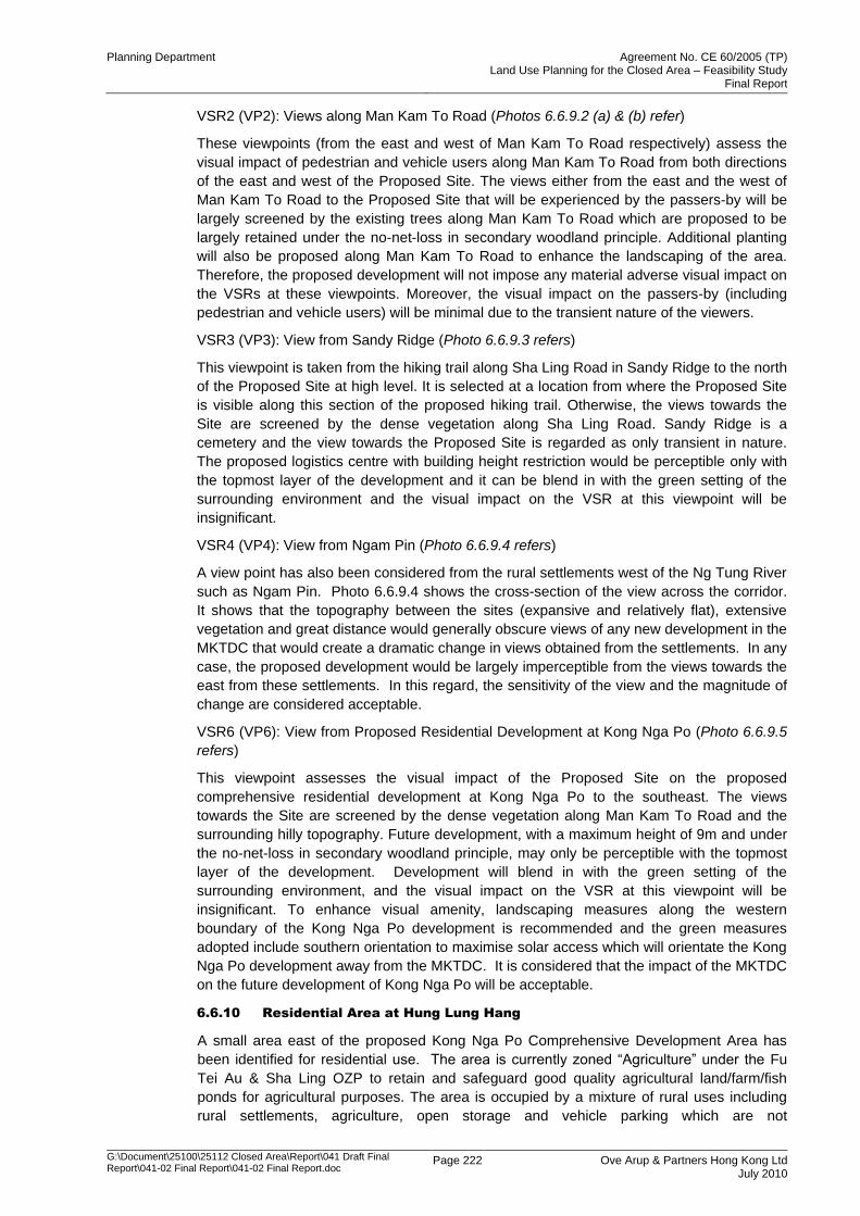
Planning Department Agreement No. CE 60/2005 (TP) Land Use Planning for the Closed Area – Feasibility Study
Final Report
G:\Document\25100\25112 Closed Area\Report\041 Draft Final Report\041-02 Final Report\041-02 Final Report.doc
Page 222 Ove Arup & Partners Hong Kong Ltd July 2010
VSR2 (VP2): Views along Man Kam To Road (Photos 6.6.9.2 (a) & (b) refer)
These viewpoints (from the east and west of Man Kam To Road respectively) assess the
visual impact of pedestrian and vehicle users along Man Kam To Road from both directions
of the east and west of the Proposed Site. The views either from the east and the west of
Man Kam To Road to the Proposed Site that will be experienced by the passers-by will be
largely screened by the existing trees along Man Kam To Road which are proposed to be
largely retained under the no-net-loss in secondary woodland principle. Additional planting
will also be proposed along Man Kam To Road to enhance the landscaping of the area.
Therefore, the proposed development will not impose any material adverse visual impact on
the VSRs at these viewpoints. Moreover, the visual impact on the passers-by (including
pedestrian and vehicle users) will be minimal due to the transient nature of the viewers.
VSR3 (VP3): View from Sandy Ridge (Photo 6.6.9.3 refers)
This viewpoint is taken from the hiking trail along Sha Ling Road in Sandy Ridge to the north
of the Proposed Site at high level. It is selected at a location from where the Proposed Site
is visible along this section of the proposed hiking trail. Otherwise, the views towards the
Site are screened by the dense vegetation along Sha Ling Road. Sandy Ridge is a
cemetery and the view towards the Proposed Site is regarded as only transient in nature.
The proposed logistics centre with building height restriction would be perceptible only with
the topmost layer of the development and it can be blend in with the green setting of the
surrounding environment and the visual impact on the VSR at this viewpoint will be
insignificant.
VSR4 (VP4): View from Ngam Pin (Photo 6.6.9.4 refers)
A view point has also been considered from the rural settlements west of the Ng Tung River
such as Ngam Pin. Photo 6.6.9.4 shows the cross-section of the view across the corridor.
It shows that the topography between the sites (expansive and relatively flat), extensive
vegetation and great distance would generally obscure views of any new development in the
MKTDC that would create a dramatic change in views obtained from the settlements. In any
case, the proposed development would be largely imperceptible from the views towards the
east from these settlements. In this regard, the sensitivity of the view and the magnitude of
change are considered acceptable.
VSR6 (VP6): View from Proposed Residential Development at Kong Nga Po (Photo 6.6.9.5
refers)
This viewpoint assesses the visual impact of the Proposed Site on the proposed
comprehensive residential development at Kong Nga Po to the southeast. The views
towards the Site are screened by the dense vegetation along Man Kam To Road and the
surrounding hilly topography. Future development, with a maximum height of 9m and under
the no-net-loss in secondary woodland principle, may only be perceptible with the topmost
layer of the development. Development will blend in with the green setting of the
surrounding environment, and the visual impact on the VSR at this viewpoint will be
insignificant. To enhance visual amenity, landscaping measures along the western
boundary of the Kong Nga Po development is recommended and the green measures
adopted include southern orientation to maximise solar access which will orientate the Kong
Nga Po development away from the MKTDC. It is considered that the impact of the MKTDC
on the future development of Kong Nga Po will be acceptable.
6.6.10 Residential Area at Hung Lung Hang
A small area east of the proposed Kong Nga Po Comprehensive Development Area has
been identified for residential use. The area is currently zoned “Agriculture” under the Fu
Tei Au & Sha Ling OZP to retain and safeguard good quality agricultural land/farm/fish
ponds for agricultural purposes. The area is occupied by a mixture of rural uses including
rural settlements, agriculture, open storage and vehicle parking which are not
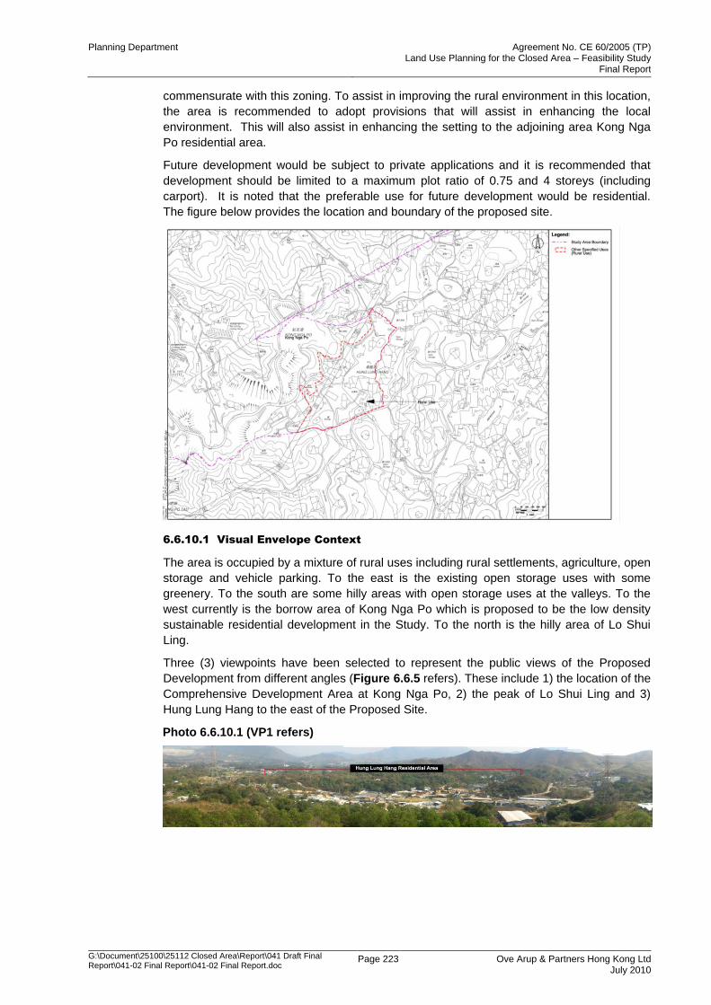
Planning Department Agreement No. CE 60/2005 (TP) Land Use Planning for the Closed Area – Feasibility Study
Final Report
G:\Document\25100\25112 Closed Area\Report\041 Draft Final Report\041-02 Final Report\041-02 Final Report.doc
Page 223 Ove Arup & Partners Hong Kong Ltd July 2010
commensurate with this zoning. To assist in improving the rural environment in this location,
the area is recommended to adopt provisions that will assist in enhancing the local
environment. This will also assist in enhancing the setting to the adjoining area Kong Nga
Po residential area.
Future development would be subject to private applications and it is recommended that
development should be limited to a maximum plot ratio of 0.75 and 4 storeys (including
carport). It is noted that the preferable use for future development would be residential.
The figure below provides the location and boundary of the proposed site.
6.6.10.1 Visual Envelope Context
The area is occupied by a mixture of rural uses including rural settlements, agriculture, open
storage and vehicle parking. To the east is the existing open storage uses with some
greenery. To the south are some hilly areas with open storage uses at the valleys. To the
west currently is the borrow area of Kong Nga Po which is proposed to be the low density
sustainable residential development in the Study. To the north is the hilly area of Lo Shui
Ling.
Three (3) viewpoints have been selected to represent the public views of the Proposed
Development from different angles (Figure 6.6.5 refers). These include 1) the location of the
Comprehensive Development Area at Kong Nga Po, 2) the peak of Lo Shui Ling and 3)
Hung Lung Hang to the east of the Proposed Site.
Photo 6.6.10.1 (VP1 refers)
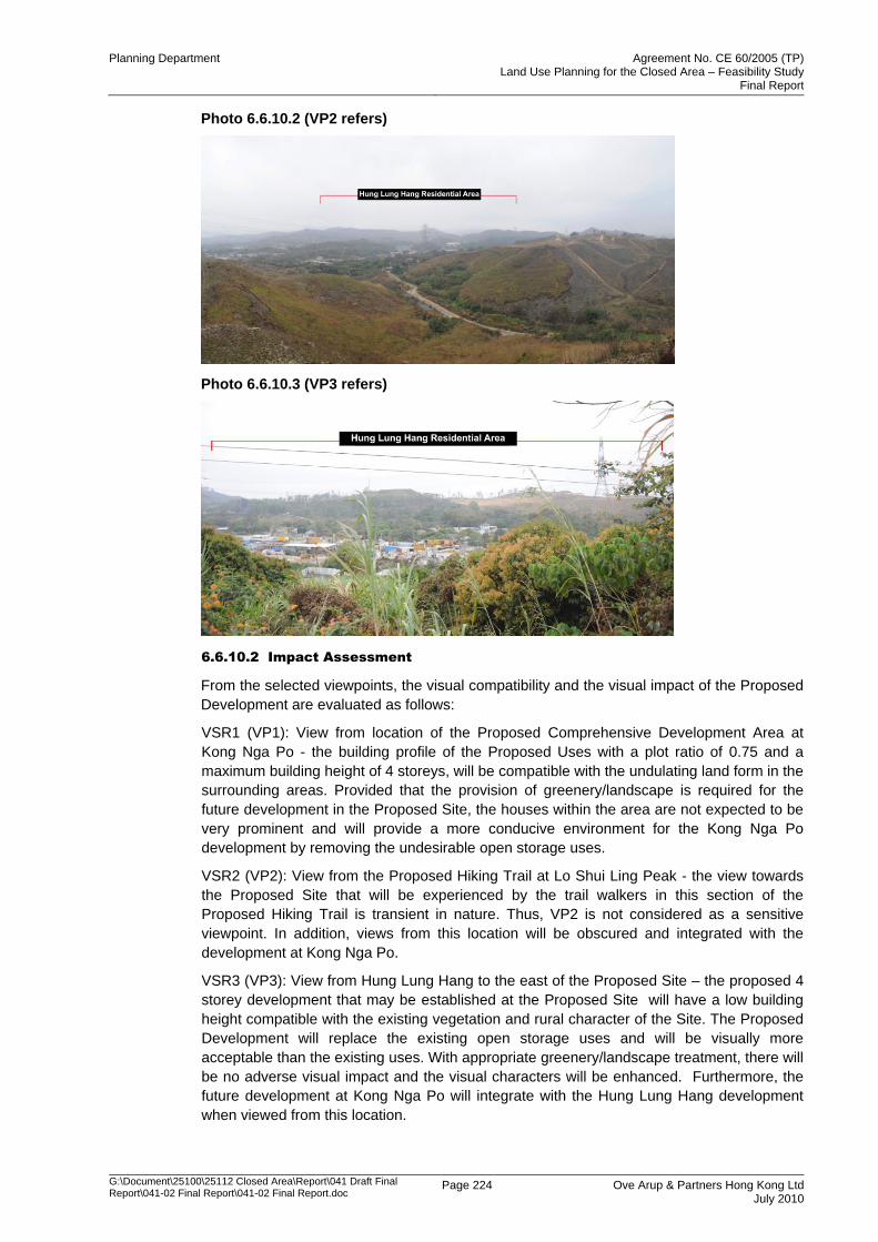
Planning Department Agreement No. CE 60/2005 (TP) Land Use Planning for the Closed Area – Feasibility Study
Final Report
G:\Document\25100\25112 Closed Area\Report\041 Draft Final Report\041-02 Final Report\041-02 Final Report.doc
Page 224 Ove Arup & Partners Hong Kong Ltd July 2010
Photo 6.6.10.2 (VP2 refers)
Photo 6.6.10.3 (VP3 refers)
6.6.10.2 Impact Assessment
From the selected viewpoints, the visual compatibility and the visual impact of the Proposed
Development are evaluated as follows:
VSR1 (VP1): View from location of the Proposed Comprehensive Development Area at
Kong Nga Po - the building profile of the Proposed Uses with a plot ratio of 0.75 and a
maximum building height of 4 storeys, will be compatible with the undulating land form in the
surrounding areas. Provided that the provision of greenery/landscape is required for the
future development in the Proposed Site, the houses within the area are not expected to be
very prominent and will provide a more conducive environment for the Kong Nga Po
development by removing the undesirable open storage uses.
VSR2 (VP2): View from the Proposed Hiking Trail at Lo Shui Ling Peak - the view towards
the Proposed Site that will be experienced by the trail walkers in this section of the
Proposed Hiking Trail is transient in nature. Thus, VP2 is not considered as a sensitive
viewpoint. In addition, views from this location will be obscured and integrated with the
development at Kong Nga Po.
VSR3 (VP3): View from Hung Lung Hang to the east of the Proposed Site – the proposed 4
storey development that may be established at the Proposed Site will have a low building
height compatible with the existing vegetation and rural character of the Site. The Proposed
Development will replace the existing open storage uses and will be visually more
acceptable than the existing uses. With appropriate greenery/landscape treatment, there will
be no adverse visual impact and the visual characters will be enhanced. Furthermore, the
future development at Kong Nga Po will integrate with the Hung Lung Hang development
when viewed from this location.
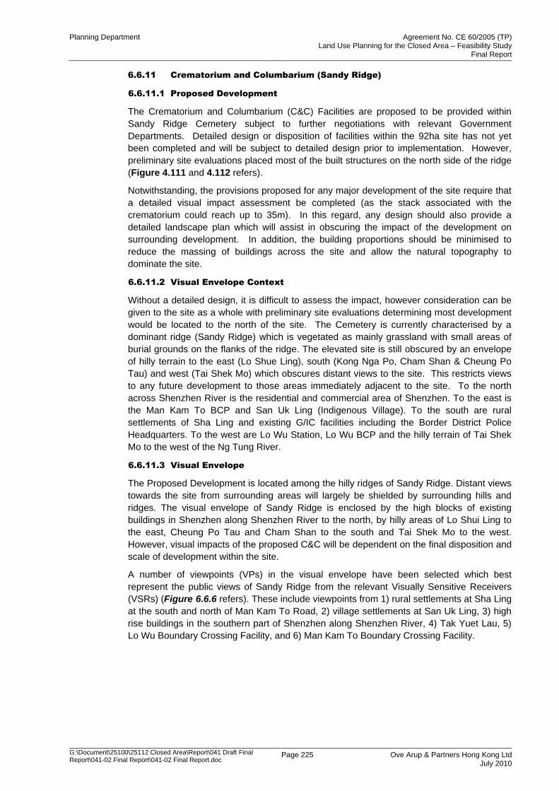
Planning Department Agreement No. CE 60/2005 (TP) Land Use Planning for the Closed Area – Feasibility Study
Final Report
G:\Document\25100\25112 Closed Area\Report\041 Draft Final Report\041-02 Final Report\041-02 Final Report.doc
Page 225 Ove Arup & Partners Hong Kong Ltd July 2010
6.6.11 Crematorium and Columbarium (Sandy Ridge)
6.6.11.1 Proposed Development
The Crematorium and Columbarium (C&C) Facilities are proposed to be provided within
Sandy Ridge Cemetery subject to further negotiations with relevant Government
Departments. Detailed design or disposition of facilities within the 92ha site has not yet
been completed and will be subject to detailed design prior to implementation. However,
preliminary site evaluations placed most of the built structures on the north side of the ridge
(Figure 4.111 and 4.112 refers).
Notwithstanding, the provisions proposed for any major development of the site require that
a detailed visual impact assessment be completed (as the stack associated with the
crematorium could reach up to 35m). In this regard, any design should also provide a
detailed landscape plan which will assist in obscuring the impact of the development on
surrounding development. In addition, the building proportions should be minimised to
reduce the massing of buildings across the site and allow the natural topography to
dominate the site.
6.6.11.2 Visual Envelope Context
Without a detailed design, it is difficult to assess the impact, however consideration can be
given to the site as a whole with preliminary site evaluations determining most development
would be located to the north of the site. The Cemetery is currently characterised by a
dominant ridge (Sandy Ridge) which is vegetated as mainly grassland with small areas of
burial grounds on the flanks of the ridge. The elevated site is still obscured by an envelope
of hilly terrain to the east (Lo Shue Ling), south (Kong Nga Po, Cham Shan & Cheung Po
Tau) and west (Tai Shek Mo) which obscures distant views to the site. This restricts views
to any future development to those areas immediately adjacent to the site. To the north
across Shenzhen River is the residential and commercial area of Shenzhen. To the east is
the Man Kam To BCP and San Uk Ling (Indigenous Village). To the south are rural
settlements of Sha Ling and existing G/IC facilities including the Border District Police
Headquarters. To the west are Lo Wu Station, Lo Wu BCP and the hilly terrain of Tai Shek
Mo to the west of the Ng Tung River.
6.6.11.3 Visual Envelope
The Proposed Development is located among the hilly ridges of Sandy Ridge. Distant views
towards the site from surrounding areas will largely be shielded by surrounding hills and
ridges. The visual envelope of Sandy Ridge is enclosed by the high blocks of existing
buildings in Shenzhen along Shenzhen River to the north, by hilly areas of Lo Shui Ling to
the east, Cheung Po Tau and Cham Shan to the south and Tai Shek Mo to the west.
However, visual impacts of the proposed C&C will be dependent on the final disposition and
scale of development within the site.
A number of viewpoints (VPs) in the visual envelope have been selected which best
represent the public views of Sandy Ridge from the relevant Visually Sensitive Receivers
(VSRs) (Figure 6.6.6 refers). These include viewpoints from 1) rural settlements at Sha Ling
at the south and north of Man Kam To Road, 2) village settlements at San Uk Ling, 3) high
rise buildings in the southern part of Shenzhen along Shenzhen River, 4) Tak Yuet Lau, 5)
Lo Wu Boundary Crossing Facility, and 6) Man Kam To Boundary Crossing Facility.

Planning Department Agreement No. CE 60/2005 (TP) Land Use Planning for the Closed Area – Feasibility Study
Final Report
G:\Document\25100\25112 Closed Area\Report\041 Draft Final Report\041-02 Final Report\041-02 Final Report.doc
Page 226 Ove Arup & Partners Hong Kong Ltd July 2010
Photo 6.6.11.1 (a) (VP1a refers)
Photo 6.6.11.1 (b) (VP1b refers)
Photo 6.6.11.2 (VP2 refers)
Photo 6.6.11.3 (VP3 refers)
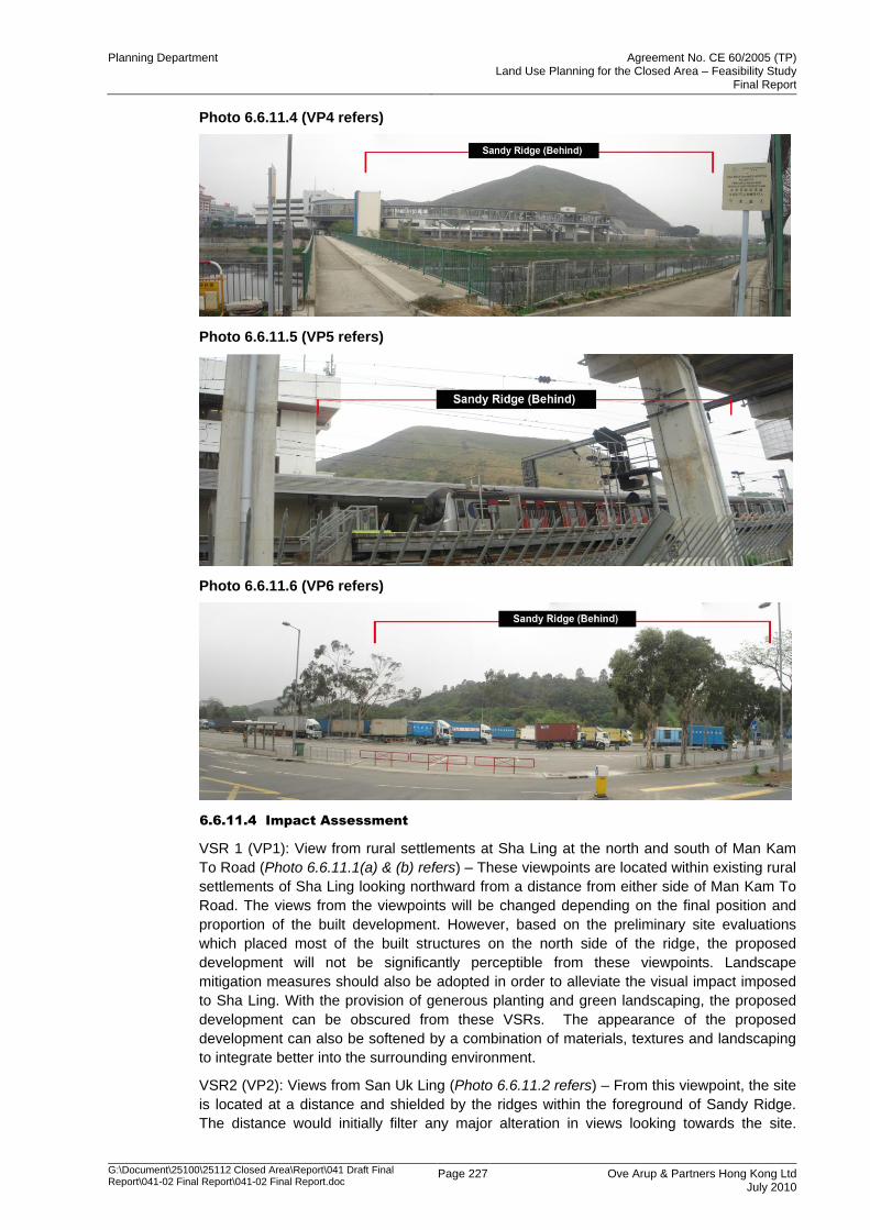
Planning Department Agreement No. CE 60/2005 (TP) Land Use Planning for the Closed Area – Feasibility Study
Final Report
G:\Document\25100\25112 Closed Area\Report\041 Draft Final Report\041-02 Final Report\041-02 Final Report.doc
Page 227 Ove Arup & Partners Hong Kong Ltd July 2010
Photo 6.6.11.4 (VP4 refers)
Photo 6.6.11.5 (VP5 refers)
Photo 6.6.11.6 (VP6 refers)
6.6.11.4 Impact Assessment
VSR 1 (VP1): View from rural settlements at Sha Ling at the north and south of Man Kam
To Road (Photo 6.6.11.1(a) & (b) refers) – These viewpoints are located within existing rural
settlements of Sha Ling looking northward from a distance from either side of Man Kam To
Road. The views from the viewpoints will be changed depending on the final position and
proportion of the built development. However, based on the preliminary site evaluations
which placed most of the built structures on the north side of the ridge, the proposed
development will not be significantly perceptible from these viewpoints. Landscape
mitigation measures should also be adopted in order to alleviate the visual impact imposed
to Sha Ling. With the provision of generous planting and green landscaping, the proposed
development can be obscured from these VSRs. The appearance of the proposed
development can also be softened by a combination of materials, textures and landscaping
to integrate better into the surrounding environment.
VSR2 (VP2): Views from San Uk Ling (Photo 6.6.11.2 refers) – From this viewpoint, the site
is located at a distance and shielded by the ridges within the foreground of Sandy Ridge.
The distance would initially filter any major alteration in views looking towards the site.
Planning Department Agreement No. CE 60/2005 (TP) Land Use Planning for the Closed Area – Feasibility Study
Final Report
G:\Document\25100\25112 Closed Area\Report\041 Draft Final Report\041-02 Final Report\041-02 Final Report.doc
Page 228 Ove Arup & Partners Hong Kong Ltd July 2010
Notwithstanding, most of the built structures will be placed on the north side of the ridge and
landscape mitigation measures can be adopted in order to alleviate the visual impact of any
future development. With the provision of generous planting, the appearance of the
proposed development can be softened by a combination of materials, textures and
landscaping to integrate better into the surrounding environment.
VSR3 (VP3): View from the southern part of Shenzhen (Photo 6.6.11.3 refers) – This
viewpoint is taken from a footbridge at a road junction among the high-rise buildings in the
southern part of Shenzhen. The proposed development with the provision of generous
planting and locating the taller buildings at the bottom of the slope would allow the taller
elements to blend with the hilly terrain of Sandy Ridge. For chimneys of the crematorium,
which may be relatively high, vertical greening can be adopted in order to alleviate their
visual impact by a combination of materials, textures, and design to integrate better into the
surrounding environment. In this regard, the provisions proposed for any major development
of the site require that a detailed visual impact assessment be completed and any design
should provide a detailed landscape plan which will assist in obscuring the impact of the
development on surrounding development, including but not limited to Shenzhen side.
It is accepted that the future development will have the greatest impact on the existing
development within Shenzhen. This will affect the relatively natural view that Mainland
residents enjoy of Hong Kong, however the existing uses, size and mostly obscured location
suggests that this is a preferable site for this form of development, subject to appropriate
design features being adopted to mitigate adverse visual impacts.
VSR4 (VP4): View from Tak Yuet Lau (Photo 6.6.11.4 refers) – This viewpoint is taken from
the existing rural settlement at Tak Yuet Lau, which is located in the low point across the Ng
Tung River and MTR East Rail to the west of Sandy Ridge. The existing hilly terrain of
Sandy Ridge acts as a visual screen to uses within and beyond the site. Due to the steep
terrain on the western flank of the ridge, it is unlikely that development would be provided in
this location and the proposed development would be imperceptible from this viewpoint.
VSR5 (VP5): View from Lo Wu Boundary Crossing Facility (LW BCP) (Photo 6.6.11.5 refers)
–This viewpoint views Sandy Ridge from a distance at Lo Wu MTR East Rail Station. It is
considered a minor viewpoint, as it is unlikely that the public would use this location as a
viewpoint. Depending on the final design, the C&C may be visible from this viewpoint,
however on relative terms, the sensitivity of the visual impact would not be interpreted as
prominent (subject to confirmation of Proposed Development‟s exact location) as compared
to existing adjacent development in Shenzhen. Appropriate landscape mitigation measures,
and vertical greening, a combination of materials, textures, and design should be adopted to
help the C&C blend into the surrounding environment and mitigate any major alteration to
the visual environment.
VSR6 (VP6): View from Man Kam To Boundary Crossing Facility (MKT BCP) (Photo
6.6.11.6 refers) – this viewpoint is taken from a distance at the MKT BCP. It is also
considered a minor viewpoint for the same reason as in the case of LW BCP and the
proposed C&C may or may not be visible depending on the ultimate design.
Further visual assessment in details should be investigated in future when the location and
the detailed schemes of the C&C facilities have been determined to ensure the compatibility
and no adverse visual impacts of the Proposed Development.
6.6.12 Overall Visual Impact Assessment
The assessment has identified that the development proposals will have a very limited
impact on the visual amenity of the Study Area. Indeed, the predominant and broader land
uses proposed under this Study have a general presumption against development (Country
Park, GB) or promote low-intensity uses (Agriculture, Recreation) that are compatible with
the predominant rural and environmental character of the area that will be excised from the
FCA. All the more comprehensive development proposals are low intensity to minimise any
Planning Department Agreement No. CE 60/2005 (TP) Land Use Planning for the Closed Area – Feasibility Study
Final Report
G:\Document\25100\25112 Closed Area\Report\041 Draft Final Report\041-02 Final Report\041-02 Final Report.doc
Page 229 Ove Arup & Partners Hong Kong Ltd July 2010
obtrusion into the natural environment and have integrated landscaping requirements, while
also requiring individual VIAs to support future planning applications. Changes to the
environment initiated by the development proposals will be mainly within the sites of
development proposals which may arise due to the loss of existing vegetation on the sites of
development proposals. However, proposed mitigations of these impacts will be through use
of careful site design and landscaping on site and the peripheries (Eco-lodge, Kong Nga Po,
MKTDC). Landscaping as mitigation will screen views from the adjacent VSRs (e.g. rural
villages and passers-by) and soften the form of the development proposals. Overall there
will be an insignificant impact on the rural character and only a slight to medium impact on
the visual amenity which can be largely mitigated by design and landscape mitigation
measures. Nevertheless, any major deviation from the proposed development intensity and
layout design may affect the visual amenity and may have visual implication on the
surroundings. Accordingly, the Study has recommended that VIA be conducted to support
future planning applications.
6.7 Landscape Impact Assessment
6.7.1 General
This section only forms part of broad technical assessment of this Project, which is not a
genuine landscape impact assessment under EIAO. The methodology for undertaking the
preliminary landscape impact assessment is referenced to Annexes 10 and 18 of the
Technical Memorandum to the Environmental Impact Assessment Ordinance (EIAO). The
assessment will be completed in accordance with the requirements stipulated in the Study
Brief.
This section aims to provide broad technical assessment of potential landscape impacts
from the proposed development of Recommended Development Plan (RDP). For the
genuine LIA, it would be included in the EIA Report for detailed design stage under another
consultancy.
Landscape impact assessment shall assess the source and magnitude of developmental
effects on the existing landscape resources, character and quality in the context of the site
and its environs.
The significance thresholds for the landscape impacts are assessed for the construction
phase and operational phase both with and without mitigation measures.
6.7.2 Environmental Legislation & Standards
Other relevant documents consulted in preparation of the Landscape Impact Assessment
include:
EIAO Guidance
EIAO Guidance Notes 8/2002 on Preparation of Landscape and Visual Impact
Assessment under the EIAO;
ETWB Technical Circulars
ETWB TC(W) No. 3/2006 on Tree Preservation;
ETWB TC(W) No. 10/2005 on Planting on Footbridges and Flyovers;
ETWB TC(W) No. 36/2004 on The Advisory Committee on the Appearance of Bridges
and Associated Structures (ACABAS);
ETWB TC(W) No. 29/2004 on Registration of Old and Valuable Trees, and Guidelines
for their Preservation;
ETWB TC(W) No. 2/2004 on Maintenance of Vegetation and Hard Landscape Features;
Planning Department Agreement No. CE 60/2005 (TP) Land Use Planning for the Closed Area – Feasibility Study
Final Report
G:\Document\25100\25112 Closed Area\Report\041 Draft Final Report\041-02 Final Report\041-02 Final Report.doc
Page 230 Ove Arup & Partners Hong Kong Ltd July 2010
WBTC
WBTC No. 7/2002 on Tree Planting in Public Works;
WBTC No. 17/2000 Improvement to the Appearance of Slope;
WBTC No. 25/1993 Control of Visual Impact of Slope;
WBTC No. 25/1992 Allocation of Space for Urban Street Trees;
Highways Department Technical Circulars
HyD TC No. 7/2006 on Independent Vetting of Tree Works under the Maintenance of
Highways Department;
GEO Guidelines
GEO Publication No. 1/2000 on Technical Guidelines on Landscape Treatment and Bio-
Engineering for Man-made Slope and Retaining Walls;
Planning Department Study and Guidelines
Study of Landscape Value Mapping of Hong Kong, Planning Department of HKSAR;
and
Hong Kong Planning Standards and Guidelines (HKPSG).
6.7.3 Baseline Study Methodology
In accordance with the Study Brief, a baseline survey of the existing landscape character
areas (LCAs) and landscape resources (LRs) will be undertaken by a combination of site
inspections and desktop surveys. Planned developments for both within the study area and
adjacent to it are also considered.
The baseline survey will form the basis of the landscape context by describing broadly
homogenous units of similar character. Environmental capital approach is adopted to
classify the landscape into distinct LCAs based on distinct patterns or combinations of
landscape resources/ elements that occur consistently in a particular landscape. “Study of
Landscape Value Mapping of Hong Kong” and “Map of Land Utilization in Hong Kong” by
Planning Department would also be considered for the identification of LCAs and LRs. The
landscape elements considered include:
Local topography and geological features;
Woodland and other vegetation types;
Built form, land use and patterns of settlement;
Details of local materials;
Natural coastline;
Prominent watercourses; and
Cultural and religious identity, including fung shui features.
6.7.3.1 Sensitivity of LCA and LR
The individual landscape character areas (LCAs) / landscape resources (LRs) are described
qualitatively and quantitatively. Their sensitivities are then evaluated and rated as low,
medium or high based on the following factors:
Quality, condition and value of landscape character / resources;
Importance and rarity of special landscape resources;
Ability of the landscape to accommodate change without compromising its essential
nature.
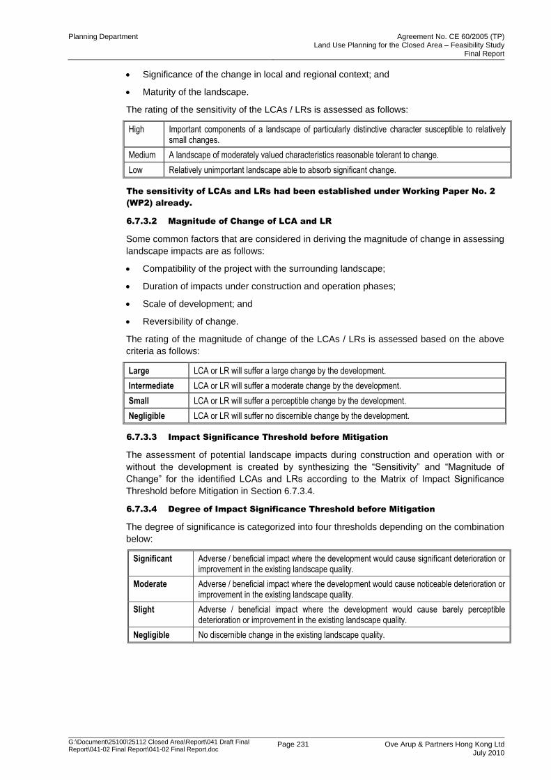
Planning Department Agreement No. CE 60/2005 (TP) Land Use Planning for the Closed Area – Feasibility Study
Final Report
G:\Document\25100\25112 Closed Area\Report\041 Draft Final Report\041-02 Final Report\041-02 Final Report.doc
Page 231 Ove Arup & Partners Hong Kong Ltd July 2010
Significance of the change in local and regional context; and
Maturity of the landscape.
The rating of the sensitivity of the LCAs / LRs is assessed as follows:
High Important components of a landscape of particularly distinctive character susceptible to relatively small changes.
Medium A landscape of moderately valued characteristics reasonable tolerant to change.
Low Relatively unimportant landscape able to absorb significant change.
The sensitivity of LCAs and LRs had been established under Working Paper No. 2
(WP2) already.
6.7.3.2 Magnitude of Change of LCA and LR
Some common factors that are considered in deriving the magnitude of change in assessing
landscape impacts are as follows:
Compatibility of the project with the surrounding landscape;
Duration of impacts under construction and operation phases;
Scale of development; and
Reversibility of change.
The rating of the magnitude of change of the LCAs / LRs is assessed based on the above
criteria as follows:
Large LCA or LR will suffer a large change by the development.
Intermediate LCA or LR will suffer a moderate change by the development.
Small LCA or LR will suffer a perceptible change by the development.
Negligible LCA or LR will suffer no discernible change by the development.
6.7.3.3 Impact Significance Threshold before Mitigation
The assessment of potential landscape impacts during construction and operation with or
without the development is created by synthesizing the “Sensitivity” and “Magnitude of
Change” for the identified LCAs and LRs according to the Matrix of Impact Significance
Threshold before Mitigation in Section 6.7.3.4.
6.7.3.4 Degree of Impact Significance Threshold before Mitigation
The degree of significance is categorized into four thresholds depending on the combination
below:
Significant Adverse / beneficial impact where the development would cause significant deterioration or improvement in the existing landscape quality.
Moderate Adverse / beneficial impact where the development would cause noticeable deterioration or improvement in the existing landscape quality.
Slight Adverse / beneficial impact where the development would cause barely perceptible deterioration or improvement in the existing landscape quality.
Negligible No discernible change in the existing landscape quality.
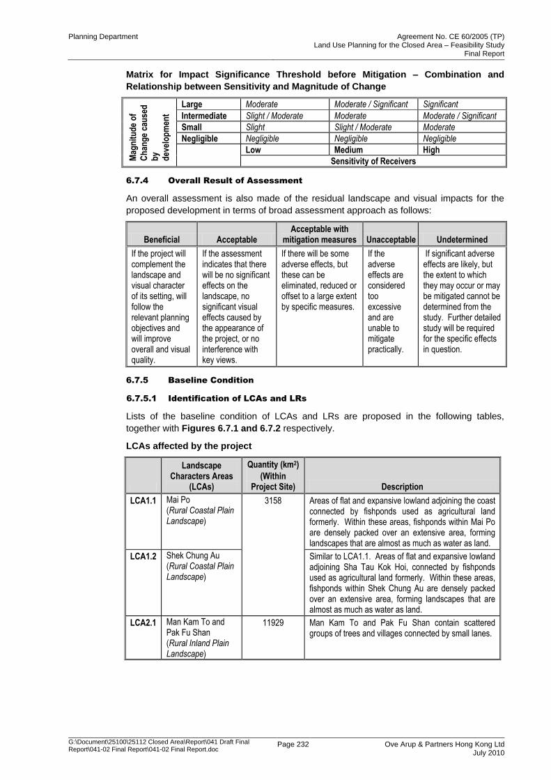
Planning Department Agreement No. CE 60/2005 (TP) Land Use Planning for the Closed Area – Feasibility Study
Final Report
G:\Document\25100\25112 Closed Area\Report\041 Draft Final Report\041-02 Final Report\041-02 Final Report.doc
Page 232 Ove Arup & Partners Hong Kong Ltd July 2010
Matrix for Impact Significance Threshold before Mitigation – Combination and
Relationship between Sensitivity and Magnitude of Change
Mag
nit
ud
e o
f
Ch
ang
e ca
use
d
by
dev
elo
pm
ent
Large Moderate Moderate / Significant Significant
Intermediate Slight / Moderate Moderate Moderate / Significant
Small Slight Slight / Moderate Moderate
Negligible Negligible Negligible Negligible
Low Medium High
Sensitivity of Receivers
6.7.4 Overall Result of Assessment
An overall assessment is also made of the residual landscape and visual impacts for the
proposed development in terms of broad assessment approach as follows:
Beneficial Acceptable Acceptable with
mitigation measures Unacceptable Undetermined
If the project will complement the landscape and visual character of its setting, will follow the relevant planning objectives and will improve overall and visual quality.
If the assessment indicates that there will be no significant effects on the landscape, no significant visual effects caused by the appearance of the project, or no interference with key views.
If there will be some adverse effects, but these can be eliminated, reduced or offset to a large extent by specific measures.
If the adverse effects are considered too excessive and are unable to mitigate practically.
If significant adverse effects are likely, but the extent to which they may occur or may be mitigated cannot be determined from the study. Further detailed study will be required for the specific effects in question.
6.7.5 Baseline Condition
6.7.5.1 Identification of LCAs and LRs
Lists of the baseline condition of LCAs and LRs are proposed in the following tables,
together with Figures 6.7.1 and 6.7.2 respectively.
LCAs affected by the project
Landscape Characters Areas
(LCAs)
Quantity (km2)
(Within Project Site) Description
LCA1.1 Mai Po (Rural Coastal Plain Landscape)
3158 Areas of flat and expansive lowland adjoining the coast connected by fishponds used as agricultural land formerly. Within these areas, fishponds within Mai Po are densely packed over an extensive area, forming landscapes that are almost as much as water as land.
LCA1.2 Shek Chung Au (Rural Coastal Plain Landscape)
Similar to LCA1.1. Areas of flat and expansive lowland adjoining Sha Tau Kok Hoi, connected by fishponds used as agricultural land formerly. Within these areas, fishponds within Shek Chung Au are densely packed over an extensive area, forming landscapes that are almost as much as water as land.
LCA2.1 Man Kam To and Pak Fu Shan (Rural Inland Plain Landscape)
11929 Man Kam To and Pak Fu Shan contain scattered groups of trees and villages connected by small lanes.
Planning Department Agreement No. CE 60/2005 (TP) Land Use Planning for the Closed Area – Feasibility Study
Final Report
G:\Document\25100\25112 Closed Area\Report\041 Draft Final Report\041-02 Final Report\041-02 Final Report.doc
Page 233 Ove Arup & Partners Hong Kong Ltd July 2010
Landscape Characters Areas
(LCAs)
Quantity (km2)
(Within Project Site) Description
LCA3.1 Ma Tso Lung (Miscellaneous Rural Fringe Landscape)
1631 Areas containing traditional pattern of agricultural fields, meandering streams, stands of woodland and scattered villages connected by small lanes. Some portions contain open storage and temporary parking.
LCA3.2 Kong Nga Po (Miscellaneous Rural Fringe Landscape)
Areas containing traditional pattern of agricultural fields, meandering streams, stands of woodland and scattered villages connected by small lanes. Some portions contain open storage and temporary parking.
LCA4.1 Ma Tso Lung and Tai Shek Mo (Upland and Hillside Landscape)
5397 Areas of large scale upland landscapes – Ma Tso Lung and Tai Shek Mo lying among hillsides, knolls, ridges and spurs. Some portions may contain woodland and vegetation.
LCA4.2 Wong Mau Hang Shan (Upland and Hillside Landscape)
Areas of large scale upland landscapes – Wong Mau Hang Shan lying among hillsides, knolls, ridges and spurs. Some portions may contain woodland and vegetation.
LCA4.3 Lin Ma Hang (Upland and Hillside Landscape)
Areas of large scale upland landscapes – Lin Ma Hang lying among hillsides, knolls, ridges and spurs. Some portions may contain woodland and vegetation.
LCA4.4 Pak Kung Au (Upland and Hillside Landscape)
Areas of large scale upland landscapes – Pak Kung Au lying among hillsides, knolls, ridges and spurs. Some portions may contain woodland and vegetation.
LCA5.1 Sha Ling (Cemetery Landscape)
732 Areas of Sha Ling cemetery lying on the edge of conurbations. These hillsides alter over a wide area to form extensive landscapes of regular terraces lined with graves and columbaria.
LCA6.1 Wang Lek and Lin
Ma Hang (Settled Valley Landscape)
2981 Areas – Wang Lek and Lin Ma Hang lying between spurs and ridges in uplands in close proximity to urban areas contain active and abandoned agricultural fields. Such landscapes possess a sense of enclosure with their coherence or visual amenity depending on the extent to which traditional land uses have been replaced.
LCA6.2 Hung Fa Leng (Settled Valley Landscape)
Areas – Hung Fa Chai lying between spurs and ridges in uplands in close proximity to urban areas contain active and abandoned agricultural fields at villages near Shek Chung Au.
LCA7.1 Hung Fa Chai (Peak Landscape)
450 Areas – Hung Fa Chai forming steep terrain and providing long-distance views across the surrounding landscape.
LCA8.1 Hung Fa Chai (Unsettled Valley Landscape)
1553 Areas – Hung Fa Chai lying between spurs and ridges in remote uplands defined by their steep valley topography. Their remoteness and steep terrain indicate that never been settled.
LRs may be affected by the project
Landscape
Resources (LRs)
Quantity (km2) (Within
Project Site) Description
LR1.1 Mai Po (Swamp)
234 Mangrove area with significant value adjacent to the coastal line of Mai Po.
LR2.1 Mai Po (Fishpond)
5585 Fishponds and gei wai within the extent of Mai Po.
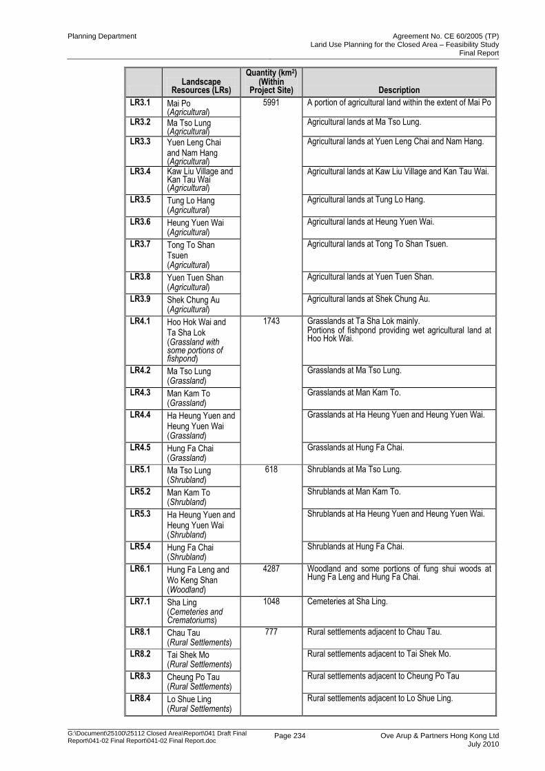
Planning Department Agreement No. CE 60/2005 (TP) Land Use Planning for the Closed Area – Feasibility Study
Final Report
G:\Document\25100\25112 Closed Area\Report\041 Draft Final Report\041-02 Final Report\041-02 Final Report.doc
Page 234 Ove Arup & Partners Hong Kong Ltd July 2010
Landscape
Resources (LRs)
Quantity (km2) (Within
Project Site) Description
LR3.1 Mai Po (Agricultural)
5991 A portion of agricultural land within the extent of Mai Po
LR3.2 Ma Tso Lung (Agricultural)
Agricultural lands at Ma Tso Lung.
LR3.3 Yuen Leng Chai and Nam Hang (Agricultural)
Agricultural lands at Yuen Leng Chai and Nam Hang.
LR3.4 Kaw Liu Village and Kan Tau Wai (Agricultural)
Agricultural lands at Kaw Liu Village and Kan Tau Wai.
LR3.5 Tung Lo Hang (Agricultural)
Agricultural lands at Tung Lo Hang.
LR3.6 Heung Yuen Wai (Agricultural)
Agricultural lands at Heung Yuen Wai.
LR3.7 Tong To Shan Tsuen (Agricultural)
Agricultural lands at Tong To Shan Tsuen.
LR3.8 Yuen Tuen Shan (Agricultural)
Agricultural lands at Yuen Tuen Shan.
LR3.9 Shek Chung Au (Agricultural)
Agricultural lands at Shek Chung Au.
LR4.1 Hoo Hok Wai and Ta Sha Lok (Grassland with some portions of fishpond)
1743 Grasslands at Ta Sha Lok mainly. Portions of fishpond providing wet agricultural land at Hoo Hok Wai.
LR4.2 Ma Tso Lung (Grassland)
Grasslands at Ma Tso Lung.
LR4.3 Man Kam To (Grassland)
Grasslands at Man Kam To.
LR4.4 Ha Heung Yuen and Heung Yuen Wai (Grassland)
Grasslands at Ha Heung Yuen and Heung Yuen Wai.
LR4.5 Hung Fa Chai (Grassland)
Grasslands at Hung Fa Chai.
LR5.1 Ma Tso Lung (Shrubland)
618 Shrublands at Ma Tso Lung.
LR5.2 Man Kam To (Shrubland)
Shrublands at Man Kam To.
LR5.3 Ha Heung Yuen and Heung Yuen Wai (Shrubland)
Shrublands at Ha Heung Yuen and Heung Yuen Wai.
LR5.4 Hung Fa Chai (Shrubland)
Shrublands at Hung Fa Chai.
LR6.1 Hung Fa Leng and Wo Keng Shan (Woodland)
4287 Woodland and some portions of fung shui woods at Hung Fa Leng and Hung Fa Chai.
LR7.1 Sha Ling (Cemeteries and Crematoriums)
1048 Cemeteries at Sha Ling.
LR8.1 Chau Tau (Rural Settlements)
777 Rural settlements adjacent to Chau Tau.
LR8.2 Tai Shek Mo (Rural Settlements)
Rural settlements adjacent to Tai Shek Mo.
LR8.3 Cheung Po Tau (Rural Settlements)
Rural settlements adjacent to Cheung Po Tau
LR8.4 Lo Shue Ling (Rural Settlements)
Rural settlements adjacent to Lo Shue Ling.
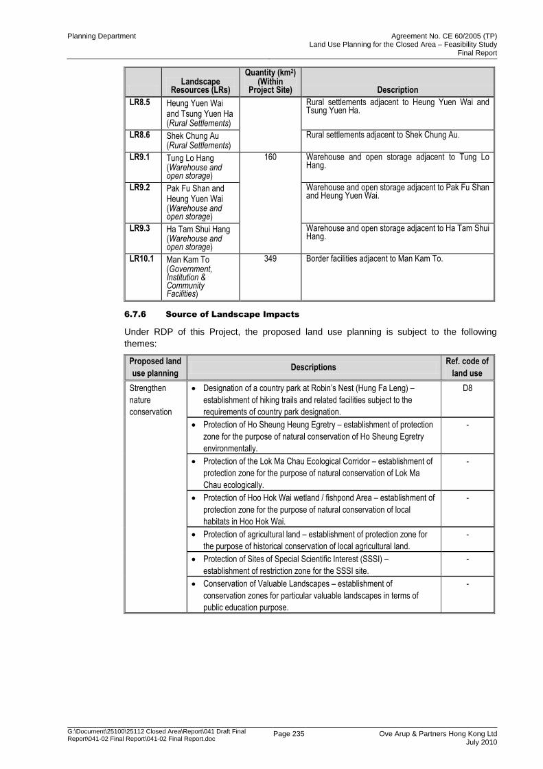
Planning Department Agreement No. CE 60/2005 (TP) Land Use Planning for the Closed Area – Feasibility Study
Final Report
G:\Document\25100\25112 Closed Area\Report\041 Draft Final Report\041-02 Final Report\041-02 Final Report.doc
Page 235 Ove Arup & Partners Hong Kong Ltd July 2010
Landscape
Resources (LRs)
Quantity (km2) (Within
Project Site) Description
LR8.5 Heung Yuen Wai and Tsung Yuen Ha (Rural Settlements)
Rural settlements adjacent to Heung Yuen Wai and Tsung Yuen Ha.
LR8.6 Shek Chung Au (Rural Settlements)
Rural settlements adjacent to Shek Chung Au.
LR9.1 Tung Lo Hang (Warehouse and open storage)
160 Warehouse and open storage adjacent to Tung Lo Hang.
LR9.2 Pak Fu Shan and Heung Yuen Wai (Warehouse and open storage)
Warehouse and open storage adjacent to Pak Fu Shan and Heung Yuen Wai.
LR9.3 Ha Tam Shui Hang (Warehouse and open storage)
Warehouse and open storage adjacent to Ha Tam Shui Hang.
LR10.1 Man Kam To (Government, Institution & Community Facilities)
349 Border facilities adjacent to Man Kam To.
6.7.6 Source of Landscape Impacts
Under RDP of this Project, the proposed land use planning is subject to the following
themes:
Proposed land
use planning Descriptions
Ref. code of
land use
Strengthen
nature
conservation
Designation of a country park at Robin‟s Nest (Hung Fa Leng) –
establishment of hiking trails and related facilities subject to the
requirements of country park designation.
D8
Protection of Ho Sheung Heung Egretry – establishment of protection
zone for the purpose of natural conservation of Ho Sheung Egretry
environmentally.
-
Protection of the Lok Ma Chau Ecological Corridor – establishment of
protection zone for the purpose of natural conservation of Lok Ma
Chau ecologically.
-
Protection of Hoo Hok Wai wetland / fishpond Area – establishment of
protection zone for the purpose of natural conservation of local
habitats in Hoo Hok Wai.
-
Protection of agricultural land – establishment of protection zone for
the purpose of historical conservation of local agricultural land.
-
Protection of Sites of Special Scientific Interest (SSSI) –
establishment of restriction zone for the SSSI site.
-
Conservation of Valuable Landscapes – establishment of
conservation zones for particular valuable landscapes in terms of
public education purpose.
-
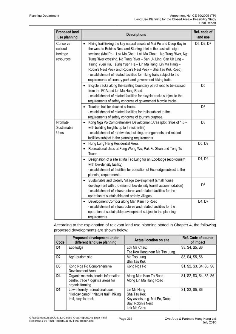
Planning Department Agreement No. CE 60/2005 (TP) Land Use Planning for the Closed Area – Feasibility Study
Final Report
G:\Document\25100\25112 Closed Area\Report\041 Draft Final Report\041-02 Final Report\041-02 Final Report.doc
Page 236 Ove Arup & Partners Hong Kong Ltd July 2010
Proposed land
use planning Descriptions
Ref. code of
land use
Conserve
cultural
heritage
resources
Hiking trail linking the key natural assets of Mai Po and Deep Bay in
the west to Robin‟s Nest and Starling Inlet in the east with eight
sections (Mai Po – Lok Ma Chau, Lok Ma Chau – Ng Tung River, Ng
Tung River crossing, Ng Tung River – San Uk Ling, San Uk Ling –
Tsung Yuen Ha, Tsung Yuen Ha – Lin Ma Hang, Lin Ma Hang –
Robin‟s Nest Peak and Robin‟s Nest Peak – Sha Tau Kok Road).
- establishment of related facilities for hiking trails subject to the
requirements of country park and government hiking trails.
D5, D2, D7
Bicycle tracks along the existing boundary patrol road to be excised
from the FCA and Lin Ma Hang Road
- establishment of related facilities for bicycle tracks subject to the
requirements of safety concerns of government bicycle tracks.
D5
Tourism trail for disused schools.
- establishment of related facilities for trails subject to the
requirements of safety concerns of tourism purpose.
D5
Promote
Sustainable
Uses
Kong Nga Po Comprehensive Development Area (plot ratios of 1.5 –
with building heights up to 6 residential)
- establishment of roadworks, building arrangements and related
facilities subject to the planning requirements
D3
Hung Lung Hang Residential Area.
Recreational Uses at Fung Wong Wu, Pak Fu Shan and Tong To
Tsuen.
D5, D9
Designation of a site at Ma Tso Lung for an Eco-lodge (eco-tourism
with low-density facility)
- establishment of facilities for operation of Eco-lodge subject to the
planning requirements.
D1, D2
Sustainable and Orderly Village Development (small house
development with provision of low-density tourist accommodation)
- establishment of infrastructures and related facilities for the
operation of sustainable and orderly villages.
D6
Development Corridor along Man Kam To Road
- establishment of infrastructures and related facilities for the
operation of sustainable development subject to the planning
requirements.
D4, D7
According to the explanation of relevant land use planning stated in Chapter 4, the following
proposed developments are shown below:
Code Proposed development under
different land use planning Actual location on site
Ref. Code of source of impact
D1 Eco-lodge Lok Ma Chau; Tse Koo Hang near Ma Tso Lung.
S3, S4, S5, S6
D2 Agri-tourism site Ma Tso Lung Sha Tau Kok
S3, S4, S5, S6
D3 Kong Nga Po Comprehensive Development Area
Kong Nga Po S1, S2, S3, S4, S5, S6
D4 Organic markets, tourist information centre, trade / logistics areas for organic farming
Along Man Kam To Road Along Lin Ma Hang Road
S1, S2, S3, S4, S5, S6
D5 Low-intensity recreational uses, “Holiday camp”, “Nature trail”, hiking trail, bicycle track.
Lin Ma Hang Sha Tau Kok Key assets, e.g. Mai Po, Deep Bay, Robin‟s Nest Lok Ma Chau
S1, S2, S5, S6
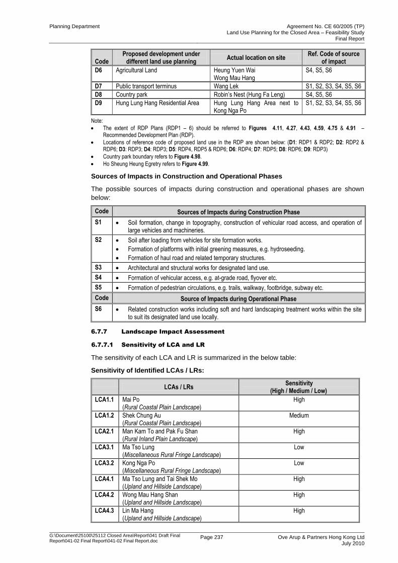
Planning Department Agreement No. CE 60/2005 (TP) Land Use Planning for the Closed Area – Feasibility Study
Final Report
G:\Document\25100\25112 Closed Area\Report\041 Draft Final Report\041-02 Final Report\041-02 Final Report.doc
Page 237 Ove Arup & Partners Hong Kong Ltd July 2010
Code Proposed development under
different land use planning Actual location on site
Ref. Code of source of impact
D6 Agricultural Land Heung Yuen Wai Wong Mau Hang
S4, S5, S6
D7 Public transport terminus Wang Lek S1, S2, S3, S4, S5, S6
D8 Country park Robin‟s Nest (Hung Fa Leng) S4, S5, S6
D9 Hung Lung Hang Residential Area Hung Lung Hang Area next to Kong Nga Po
S1, S2, S3, S4, S5, S6
Note:
The extent of RDP Plans (RDP1 – 6) should be referred to Figures 4.11, 4.27, 4.43, 4.59, 4.75 & 4.91 – Recommended Development Plan (RDP).
Locations of reference code of proposed land use in the RDP are shown below: (D1: RDP1 & RDP2; D2: RDP2 & RDP6; D3: RDP3; D4: RDP3; D5: RDP4, RDP5 & RDP6; D6: RDP4; D7: RDP5; D8: RDP6; D9: RDP3)
Country park boundary refers to Figure 4.98.
Ho Sheung Heung Egretry refers to Figure 4.99.
Sources of Impacts in Construction and Operational Phases
The possible sources of impacts during construction and operational phases are shown
below:
Code Sources of Impacts during Construction Phase
S1 Soil formation, change in topography, construction of vehicular road access, and operation of large vehicles and machineries.
S2 Soil after loading from vehicles for site formation works.
Formation of platforms with initial greening measures, e.g. hydroseeding.
Formation of haul road and related temporary structures.
S3 Architectural and structural works for designated land use.
S4 Formation of vehicular access, e.g. at-grade road, flyover etc.
S5 Formation of pedestrian circulations, e.g. trails, walkway, footbridge, subway etc.
Code Source of Impacts during Operational Phase
S6 Related construction works including soft and hard landscaping treatment works within the site to suit its designated land use locally.
6.7.7 Landscape Impact Assessment
6.7.7.1 Sensitivity of LCA and LR
The sensitivity of each LCA and LR is summarized in the below table:
Sensitivity of Identified LCAs / LRs:
LCAs / LRs
Sensitivity (High / Medium / Low)
LCA1.1 Mai Po (Rural Coastal Plain Landscape)
High
LCA1.2 Shek Chung Au (Rural Coastal Plain Landscape)
Medium
LCA2.1 Man Kam To and Pak Fu Shan (Rural Inland Plain Landscape)
High
LCA3.1 Ma Tso Lung (Miscellaneous Rural Fringe Landscape)
Low
LCA3.2 Kong Nga Po (Miscellaneous Rural Fringe Landscape)
Low
LCA4.1 Ma Tso Lung and Tai Shek Mo (Upland and Hillside Landscape)
High
LCA4.2 Wong Mau Hang Shan (Upland and Hillside Landscape)
High
LCA4.3 Lin Ma Hang (Upland and Hillside Landscape)
High
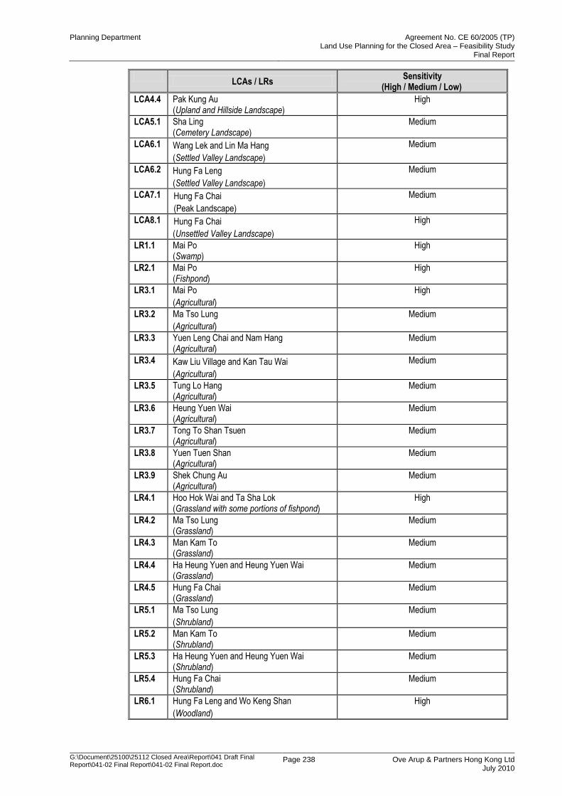
Planning Department Agreement No. CE 60/2005 (TP) Land Use Planning for the Closed Area – Feasibility Study
Final Report
G:\Document\25100\25112 Closed Area\Report\041 Draft Final Report\041-02 Final Report\041-02 Final Report.doc
Page 238 Ove Arup & Partners Hong Kong Ltd July 2010
LCAs / LRs
Sensitivity (High / Medium / Low)
LCA4.4 Pak Kung Au (Upland and Hillside Landscape)
High
LCA5.1 Sha Ling (Cemetery Landscape)
Medium
LCA6.1 Wang Lek and Lin Ma Hang
(Settled Valley Landscape)
Medium
LCA6.2 Hung Fa Leng
(Settled Valley Landscape)
Medium
LCA7.1 Hung Fa Chai
(Peak Landscape)
Medium
LCA8.1 Hung Fa Chai
(Unsettled Valley Landscape)
High
LR1.1 Mai Po (Swamp)
High
LR2.1 Mai Po (Fishpond)
High
LR3.1 Mai Po
(Agricultural)
High
LR3.2 Ma Tso Lung
(Agricultural)
Medium
LR3.3 Yuen Leng Chai and Nam Hang (Agricultural)
Medium
LR3.4 Kaw Liu Village and Kan Tau Wai
(Agricultural)
Medium
LR3.5 Tung Lo Hang (Agricultural)
Medium
LR3.6 Heung Yuen Wai (Agricultural)
Medium
LR3.7 Tong To Shan Tsuen (Agricultural)
Medium
LR3.8 Yuen Tuen Shan (Agricultural)
Medium
LR3.9 Shek Chung Au (Agricultural)
Medium
LR4.1 Hoo Hok Wai and Ta Sha Lok (Grassland with some portions of fishpond)
High
LR4.2 Ma Tso Lung (Grassland)
Medium
LR4.3 Man Kam To (Grassland)
Medium
LR4.4 Ha Heung Yuen and Heung Yuen Wai (Grassland)
Medium
LR4.5 Hung Fa Chai (Grassland)
Medium
LR5.1 Ma Tso Lung
(Shrubland)
Medium
LR5.2 Man Kam To (Shrubland)
Medium
LR5.3 Ha Heung Yuen and Heung Yuen Wai (Shrubland)
Medium
LR5.4 Hung Fa Chai (Shrubland)
Medium
LR6.1 Hung Fa Leng and Wo Keng Shan
(Woodland)
High
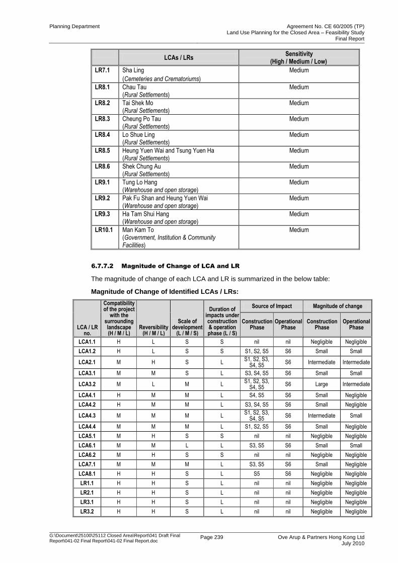
Planning Department Agreement No. CE 60/2005 (TP) Land Use Planning for the Closed Area – Feasibility Study
Final Report
G:\Document\25100\25112 Closed Area\Report\041 Draft Final Report\041-02 Final Report\041-02 Final Report.doc
Page 239 Ove Arup & Partners Hong Kong Ltd July 2010
LCAs / LRs
Sensitivity (High / Medium / Low)
LR7.1 Sha Ling
(Cemeteries and Crematoriums)
Medium
LR8.1 Chau Tau (Rural Settlements)
Medium
LR8.2 Tai Shek Mo (Rural Settlements)
Medium
LR8.3 Cheung Po Tau (Rural Settlements)
Medium
LR8.4 Lo Shue Ling (Rural Settlements)
Medium
LR8.5 Heung Yuen Wai and Tsung Yuen Ha (Rural Settlements)
Medium
LR8.6 Shek Chung Au (Rural Settlements)
Medium
LR9.1 Tung Lo Hang (Warehouse and open storage)
Medium
LR9.2 Pak Fu Shan and Heung Yuen Wai (Warehouse and open storage)
Medium
LR9.3 Ha Tam Shui Hang (Warehouse and open storage)
Medium
LR10.1 Man Kam To (Government, Institution & Community Facilities)
Medium
6.7.7.2 Magnitude of Change of LCA and LR
The magnitude of change of each LCA and LR is summarized in the below table:
Magnitude of Change of Identified LCAs / LRs:
LCA / LR no.
Compatibility of the project
with the surrounding landscape (H / M / L)
Reversibility (H / M / L)
Scale of development
(L / M / S)
Duration of impacts under construction & operation phase (L / S)
Source of Impact Magnitude of change
Construction Phase
Operational Phase
Construction Phase
Operational Phase
LCA1.1 H L S S nil nil Negligible Negligible
LCA1.2 H L S S S1, S2, S5 S6 Small Small
LCA2.1 M H S L S1, S2, S3,
S4, S5 S6 Intermediate Intermediate
LCA3.1 M M S L S3, S4, S5 S6 Small Small
LCA3.2 M L M L S1, S2, S3,
S4, S5 S6 Large Intermediate
LCA4.1 H M M L S4, S5 S6 Small Negligible
LCA4.2 H M M L S3, S4, S5 S6 Small Negligible
LCA4.3 M M M L S1, S2, S3,
S4, S5 S6 Intermediate Small
LCA4.4 M M M L S1, S2, S5 S6 Small Negligible
LCA5.1 M H S S nil nil Negligible Negligible
LCA6.1 M M L L S3, S5 S6 Small Small
LCA6.2 M H S S nil nil Negligible Negligible
LCA7.1 M M M L S3, S5 S6 Small Negligible
LCA8.1 H H S L S5 S6 Negligible Negligible
LR1.1 H H S L nil nil Negligible Negligible
LR2.1 H H S L nil nil Negligible Negligible
LR3.1 H H S L nil nil Negligible Negligible
LR3.2 H H S L nil nil Negligible Negligible
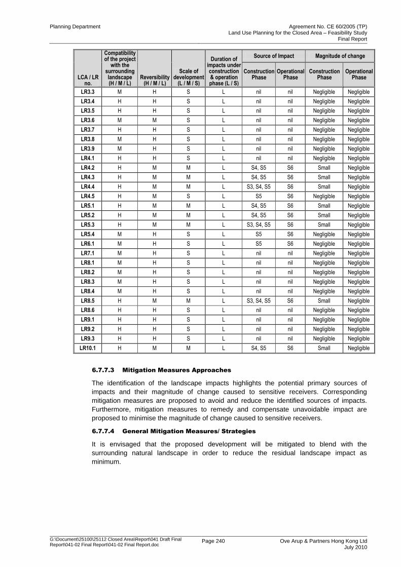
Planning Department Agreement No. CE 60/2005 (TP) Land Use Planning for the Closed Area – Feasibility Study
Final Report
G:\Document\25100\25112 Closed Area\Report\041 Draft Final Report\041-02 Final Report\041-02 Final Report.doc
Page 240 Ove Arup & Partners Hong Kong Ltd July 2010
LCA / LR no.
Compatibility of the project
with the surrounding landscape (H / M / L)
Reversibility (H / M / L)
Scale of development
(L / M / S)
Duration of impacts under construction & operation phase (L / S)
Source of Impact Magnitude of change
Construction Phase
Operational Phase
Construction Phase
Operational Phase
LR3.3 M H S L nil nil Negligible Negligible
LR3.4 H H S L nil nil Negligible Negligible
LR3.5 H H S L nil nil Negligible Negligible
LR3.6 M M S L nil nil Negligible Negligible
LR3.7 H H S L nil nil Negligible Negligible
LR3.8 M H S L nil nil Negligible Negligible
LR3.9 M H S L nil nil Negligible Negligible
LR4.1 H H S L nil nil Negligible Negligible
LR4.2 H M M L S4, S5 S6 Small Negligible
LR4.3 H M M L S4, S5 S6 Small Negligible
LR4.4 H M M L S3, S4, S5 S6 Small Negligible
LR4.5 H M S L S5 S6 Negligible Negligible
LR5.1 H M M L S4, S5 S6 Small Negligible
LR5.2 H M M L S4, S5 S6 Small Negligible
LR5.3 H M M L S3, S4, S5 S6 Small Negligible
LR5.4 M H S L S5 S6 Negligible Negligible
LR6.1 M H S L S5 S6 Negligible Negligible
LR7.1 M H S L nil nil Negligible Negligible
LR8.1 M H S L nil nil Negligible Negligible
LR8.2 M H S L nil nil Negligible Negligible
LR8.3 M H S L nil nil Negligible Negligible
LR8.4 M H S L nil nil Negligible Negligible
LR8.5 H M M L S3, S4, S5 S6 Small Negligible
LR8.6 H H S L nil nil Negligible Negligible
LR9.1 H H S L nil nil Negligible Negligible
LR9.2 H H S L nil nil Negligible Negligible
LR9.3 H H S L nil nil Negligible Negligible
LR10.1 H M M L S4, S5 S6 Small Negligible
6.7.7.3 Mitigation Measures Approaches
The identification of the landscape impacts highlights the potential primary sources of
impacts and their magnitude of change caused to sensitive receivers. Corresponding
mitigation measures are proposed to avoid and reduce the identified sources of impacts.
Furthermore, mitigation measures to remedy and compensate unavoidable impact are
proposed to minimise the magnitude of change caused to sensitive receivers.
6.7.7.4 General Mitigation Measures/ Strategies
It is envisaged that the proposed development will be mitigated to blend with the
surrounding natural landscape in order to reduce the residual landscape impact as
minimum.
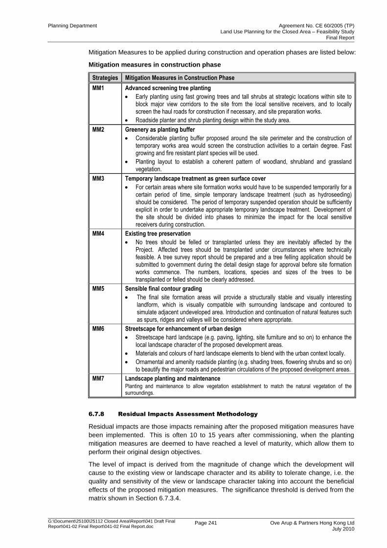
Planning Department Agreement No. CE 60/2005 (TP) Land Use Planning for the Closed Area – Feasibility Study
Final Report
G:\Document\25100\25112 Closed Area\Report\041 Draft Final Report\041-02 Final Report\041-02 Final Report.doc
Page 241 Ove Arup & Partners Hong Kong Ltd July 2010
Mitigation Measures to be applied during construction and operation phases are listed below:
Mitigation measures in construction phase
Strategies Mitigation Measures in Construction Phase
MM1 Advanced screening tree planting
Early planting using fast growing trees and tall shrubs at strategic locations within site to block major view corridors to the site from the local sensitive receivers, and to locally screen the haul roads for construction if necessary, and site preparation works.
Roadside planter and shrub planting design within the study area.
MM2 Greenery as planting buffer
Considerable planting buffer proposed around the site perimeter and the construction of temporary works area would screen the construction activities to a certain degree. Fast growing and fire resistant plant species will be used.
Planting layout to establish a coherent pattern of woodland, shrubland and grassland vegetation.
MM3 Temporary landscape treatment as green surface cover
For certain areas where site formation works would have to be suspended temporarily for a certain period of time, simple temporary landscape treatment (such as hydroseeding) should be considered. The period of temporary suspended operation should be sufficiently explicit in order to undertake appropriate temporary landscape treatment. Development of the site should be divided into phases to minimize the impact for the local sensitive receivers during construction.
MM4 Existing tree preservation
No trees should be felled or transplanted unless they are inevitably affected by the Project. Affected trees should be transplanted under circumstances where technically feasible. A tree survey report should be prepared and a tree felling application should be submitted to government during the detail design stage for approval before site formation works commence. The numbers, locations, species and sizes of the trees to be transplanted or felled should be clearly addressed.
MM5 Sensible final contour grading
The final site formation areas will provide a structurally stable and visually interesting landform, which is visually compatible with surrounding landscape and contoured to simulate adjacent undeveloped area. Introduction and continuation of natural features such as spurs, ridges and valleys will be considered where appropriate.
MM6 Streetscape for enhancement of urban design
Streetscape hard landscape (e.g. paving, lighting, site furniture and so on) to enhance the local landscape character of the proposed development areas.
Materials and colours of hard landscape elements to blend with the urban context locally.
Ornamental and amenity roadside planting (e.g. shading trees, flowering shrubs and so on) to beautify the major roads and pedestrian circulations of the proposed development areas.
MM7 Landscape planting and maintenance Planting and maintenance to allow vegetation establishment to match the natural vegetation of the surroundings.
6.7.8 Residual Impacts Assessment Methodology
Residual impacts are those impacts remaining after the proposed mitigation measures have
been implemented. This is often 10 to 15 years after commissioning, when the planting
mitigation measures are deemed to have reached a level of maturity, which allow them to
perform their original design objectives.
The level of impact is derived from the magnitude of change which the development will
cause to the existing view or landscape character and its ability to tolerate change, i.e. the
quality and sensitivity of the view or landscape character taking into account the beneficial
effects of the proposed mitigation measures. The significance threshold is derived from the
matrix shown in Section 6.7.3.4.
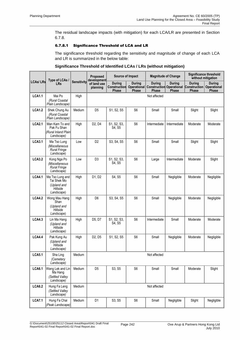
Planning Department Agreement No. CE 60/2005 (TP) Land Use Planning for the Closed Area – Feasibility Study
Final Report
G:\Document\25100\25112 Closed Area\Report\041 Draft Final Report\041-02 Final Report\041-02 Final Report.doc
Page 242 Ove Arup & Partners Hong Kong Ltd July 2010
The residual landscape impacts (with mitigation) for each LCA/LR are presented in Section
6.7.8.
6.7.8.1 Significance Threshold of LCA and LR
The significance threshold regarding the sensitivity and magnitude of change of each LCA
and LR is summarized in the below table:
Significance Threshold of Identified LCAs / LRs (without mitigation)
LCAs/ LRs Type of LCAs /
LRs Sensitivity
Proposed development of land use planning
Source of Impact Magnitude of Change Significance threshold
without mitigation
During Construction
Phase
During Operational
Phase
During Construction
Phase
During Operational
Phase
During Construction
Phase
During Operational
Phase
LCA1.1 Mai Po
(Rural Coastal Plain Landscape)
High Not affected
LCA1.2 Shek Chung Au
(Rural Coastal Plain Landscape)
Medium D5 S1, S2, S5 S6 Small Small Slight Slight
LCA2.1 Man Kam To and Pak Fu Shan
(Rural Inland Plain Landscape)
High D2, D4 S1, S2, S3, S4, S5
S6 Intermediate Intermediate Moderate Moderate
LCA3.1 Ma Tso Lung
(Miscellaneous Rural Fringe Landscape)
Low D2 S3, S4, S5 S6 Small Small Slight Slight
LCA3.2 Kong Nga Po
(Miscellaneous Rural Fringe Landscape)
Low D3 S1, S2, S3, S4, S5
S6 Large Intermediate Moderate Slight
LCA4.1 Ma Tso Lung and Tai Shek Mo
(Upland and Hillside
Landscape)
High D1, D2 S4, S5 S6 Small Negligible Moderate Negligible
LCA4.2 Wong Mau Hang Shan
(Upland and Hillside
Landscape)
High D6 S3, S4, S5 S6 Small Negligible Moderate Negligible
LCA4.3 Lin Ma Hang
(Upland and Hillside
Landscape)
High D5, D7 S1, S2, S3, S4, S5
S6 Intermediate Small Moderate Moderate
LCA4.4 Pak Kung Au
(Upland and Hillside
Landscape)
High D2, D5 S1, S2, S5 S6 Small Negligible Moderate Negligible
LCA5.1 Sha Ling
(Cemetery Landscape)
Medium Not affected
LCA6.1 Wang Lek and Lin Ma Hang
(Settled Valley Landscape)
Medium D5 S3, S5 S6 Small Small Moderate Slight
LCA6.2 Hung Fa Leng
(Settled Valley Landscape)
Medium Not affected
LCA7.1 Hung Fa Chai
(Peak Landscape)
Medium D1 S3, S5 S6 Small Negligible Slight Negligible
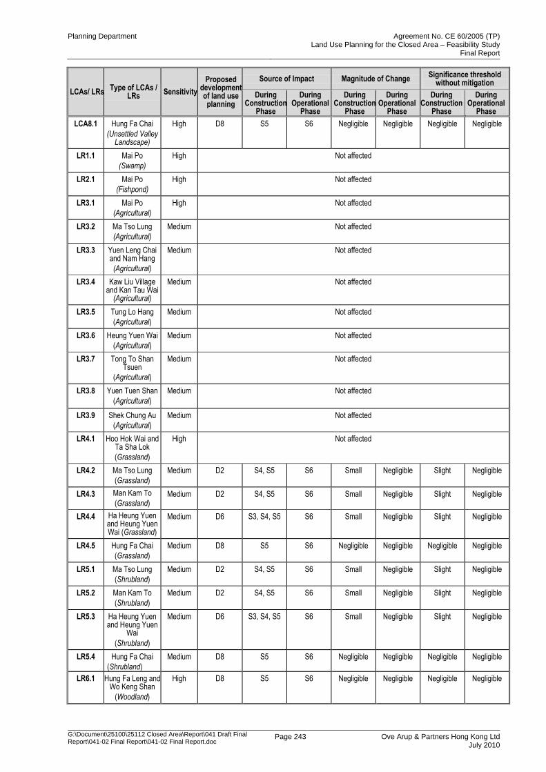
Planning Department Agreement No. CE 60/2005 (TP) Land Use Planning for the Closed Area – Feasibility Study
Final Report
G:\Document\25100\25112 Closed Area\Report\041 Draft Final Report\041-02 Final Report\041-02 Final Report.doc
Page 243 Ove Arup & Partners Hong Kong Ltd July 2010
LCAs/ LRs Type of LCAs /
LRs Sensitivity
Proposed development of land use planning
Source of Impact Magnitude of Change Significance threshold
without mitigation
During Construction
Phase
During Operational
Phase
During Construction
Phase
During Operational
Phase
During Construction
Phase
During Operational
Phase
LCA8.1 Hung Fa Chai
(Unsettled Valley Landscape)
High D8 S5 S6 Negligible Negligible Negligible Negligible
LR1.1 Mai Po
(Swamp)
High Not affected
LR2.1 Mai Po
(Fishpond)
High Not affected
LR3.1 Mai Po
(Agricultural)
High Not affected
LR3.2 Ma Tso Lung
(Agricultural)
Medium Not affected
LR3.3 Yuen Leng Chai and Nam Hang
(Agricultural)
Medium Not affected
LR3.4 Kaw Liu Village and Kan Tau Wai
(Agricultural)
Medium Not affected
LR3.5 Tung Lo Hang
(Agricultural)
Medium Not affected
LR3.6 Heung Yuen Wai
(Agricultural)
Medium Not affected
LR3.7 Tong To Shan Tsuen
(Agricultural)
Medium Not affected
LR3.8 Yuen Tuen Shan
(Agricultural)
Medium Not affected
LR3.9 Shek Chung Au
(Agricultural)
Medium Not affected
LR4.1 Hoo Hok Wai and Ta Sha Lok
(Grassland)
High Not affected
LR4.2 Ma Tso Lung
(Grassland)
Medium D2 S4, S5 S6 Small Negligible Slight Negligible
LR4.3 Man Kam To
(Grassland) Medium D2 S4, S5 S6 Small Negligible Slight Negligible
LR4.4 Ha Heung Yuen and Heung Yuen Wai (Grassland)
Medium D6 S3, S4, S5 S6 Small Negligible Slight Negligible
LR4.5 Hung Fa Chai
(Grassland)
Medium D8 S5 S6 Negligible Negligible Negligible Negligible
LR5.1 Ma Tso Lung
(Shrubland)
Medium D2 S4, S5 S6 Small Negligible Slight Negligible
LR5.2 Man Kam To
(Shrubland)
Medium D2 S4, S5 S6 Small Negligible Slight Negligible
LR5.3 Ha Heung Yuen and Heung Yuen
Wai
(Shrubland)
Medium D6 S3, S4, S5 S6 Small Negligible Slight Negligible
LR5.4 Hung Fa Chai
(Shrubland)
Medium D8 S5 S6 Negligible Negligible Negligible Negligible
LR6.1 Hung Fa Leng and Wo Keng Shan
(Woodland)
High D8 S5 S6 Negligible Negligible Negligible Negligible
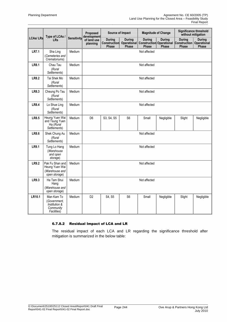
Planning Department Agreement No. CE 60/2005 (TP) Land Use Planning for the Closed Area – Feasibility Study
Final Report
G:\Document\25100\25112 Closed Area\Report\041 Draft Final Report\041-02 Final Report\041-02 Final Report.doc
Page 244 Ove Arup & Partners Hong Kong Ltd July 2010
LCAs/ LRs Type of LCAs /
LRs Sensitivity
Proposed development of land use planning
Source of Impact Magnitude of Change Significance threshold
without mitigation
During Construction
Phase
During Operational
Phase
During Construction
Phase
During Operational
Phase
During Construction
Phase
During Operational
Phase
LR7.1 Sha Ling
(Cemeteries and Crematoriums)
Medium Not affected
LR8.1 Chau Tau
(Rural Settlements)
Medium Not affected
LR8.2 Tai Shek Mo
(Rural Settlements)
Medium Not affected
LR8.3 Cheung Po Tau
(Rural Settlements)
Medium Not affected
LR8.4 Lo Shue Ling
(Rural Settlements)
Medium Not affected
LR8.5 Heung Yuen Wai and Tsung Yuen
Ha (Rural Settlements)
Medium D6 S3, S4, S5 S6 Small Negligible Slight Negligible
LR8.6 Shek Chung Au
(Rural Settlements)
Medium Not affected
LR9.1 Tung Lo Hang
(Warehouse and open storage)
Medium Not affected
LR9.2 Pak Fu Shan and Heung Yuen Wai
(Warehouse and open storage)
Medium Not affected
LR9.3 Ha Tam Shui Hang
(Warehouse and open storage)
Medium Not affected
LR10.1 Man Kam To
(Government, Institution & Community Facilities)
Medium D2 S4, S5 S6 Small Negligible Slight Negligible
6.7.8.2 Residual Impact of LCA and LR
The residual impact of each LCA and LR regarding the significance threshold after
mitigation is summarized in the below table:
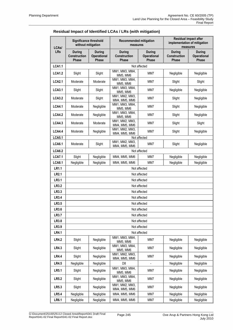
Planning Department Agreement No. CE 60/2005 (TP) Land Use Planning for the Closed Area – Feasibility Study
Final Report
G:\Document\25100\25112 Closed Area\Report\041 Draft Final Report\041-02 Final Report\041-02 Final Report.doc
Page 245 Ove Arup & Partners Hong Kong Ltd July 2010
Residual Impact of Identified LCAs / LRs (with mitigation)
LCAs/ LRs
Significance threshold without mitigation
Recommended mitigation measures
Residual impact after implementation of mitigation
measures
During Construction
Phase
During Operational
Phase
During Construction
Phase
During Operational
Phase
During Construction
Phase
During Operational
Phase
LCA1.1 Not affected
LCA1.2 Slight Slight MM1, MM3, MM4,
MM5, MM6 MM7 Negligible Negligible
LCA2.1 Moderate Moderate MM1, MM3, MM4,
MM5, MM6 MM7 Slight Slight
LCA3.1 Slight Slight MM1, MM3, MM4,
MM5, MM6 MM7 Negligible Negligible
LCA3.2 Moderate Slight MM1, MM2, MM3, MM4, MM5, MM6
MM7 Slight Negligible
LCA4.1 Moderate Negligible MM1, MM3, MM4,
MM5, MM6 MM7 Slight Negligible
LCA4.2 Moderate Negligible MM1, MM3, MM4,
MM5, MM6 MM7 Slight Negligible
LCA4.3 Moderate Moderate MM1, MM2, MM3, MM4, MM5, MM6
MM7 Slight Slight
LCA4.4 Moderate Negligible MM1, MM2, MM3, MM4, MM5, MM6
MM7 Slight Negligible
LCA5.1 Not affected
LCA6.1 Moderate Slight MM1, MM2, MM3, MM4, MM5, MM6
MM7 Slight Negligible
LCA6.2 Not affected
LCA7.1 Slight Negligible MM4, MM5, MM6 MM7 Negligible Negligible
LCA8.1 Negligible Negligible MM4, MM5, MM6 MM7 Negligible Negligible
LR1.1 Not affected
LR2.1 Not affected
LR3.1 Not affected
LR3.2 Not affected
LR3.3 Not affected
LR3.4 Not affected
LR3.5 Not affected
LR3.6 Not affected
LR3.7 Not affected
LR3.8 Not affected
LR3.9 Not affected
LR4.1 Not affected
LR4.2 Slight Negligible MM1, MM3, MM4,
MM5, MM6 MM7 Negligible Negligible
LR4.3 Slight Negligible MM1, MM3, MM4,
MM5, MM6 MM7 Negligible Negligible
LR4.4 Slight Negligible MM1, MM2, MM3, MM4, MM5, MM6
MM7 Negligible Negligible
LR4.5 Negligible Negligible D8 - Negligible Negligible
LR5.1 Slight Negligible MM1, MM3, MM4,
MM5, MM6 MM7 Negligible Negligible
LR5.2 Slight Negligible MM1, MM3, MM4,
MM5, MM6 MM7 Negligible Negligible
LR5.3 Slight Negligible MM1, MM2, MM3, MM4, MM5, MM6
MM7 Negligible Negligible
LR5.4 Negligible Negligible MM4, MM5, MM6 MM7 Negligible Negligible
LR6.1 Negligible Negligible MM4, MM5, MM6 MM7 Negligible Negligible
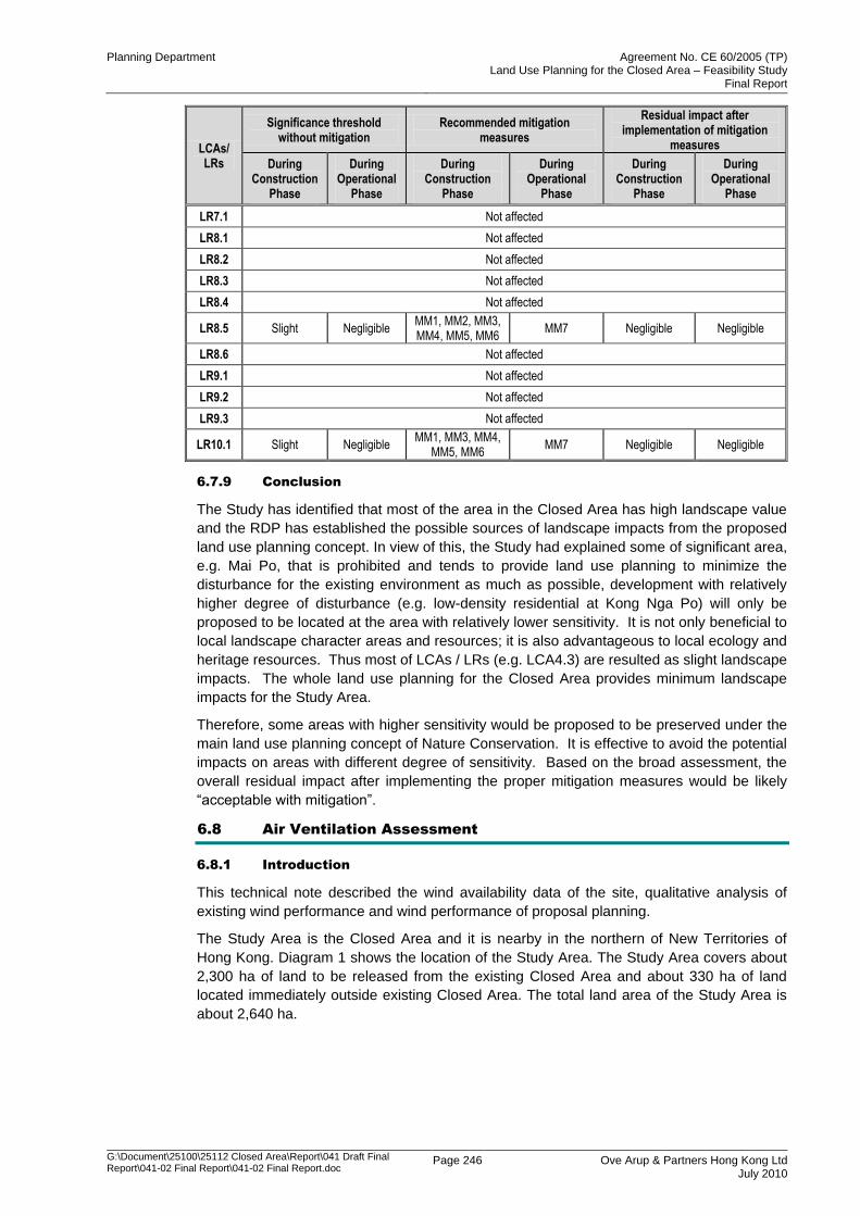
Planning Department Agreement No. CE 60/2005 (TP) Land Use Planning for the Closed Area – Feasibility Study
Final Report
G:\Document\25100\25112 Closed Area\Report\041 Draft Final Report\041-02 Final Report\041-02 Final Report.doc
Page 246 Ove Arup & Partners Hong Kong Ltd July 2010
LCAs/ LRs
Significance threshold without mitigation
Recommended mitigation measures
Residual impact after implementation of mitigation
measures
During Construction
Phase
During Operational
Phase
During Construction
Phase
During Operational
Phase
During Construction
Phase
During Operational
Phase
LR7.1 Not affected
LR8.1 Not affected
LR8.2 Not affected
LR8.3 Not affected
LR8.4 Not affected
LR8.5 Slight Negligible MM1, MM2, MM3, MM4, MM5, MM6
MM7 Negligible Negligible
LR8.6 Not affected
LR9.1 Not affected
LR9.2 Not affected
LR9.3 Not affected
LR10.1 Slight Negligible MM1, MM3, MM4,
MM5, MM6 MM7 Negligible Negligible
6.7.9 Conclusion
The Study has identified that most of the area in the Closed Area has high landscape value
and the RDP has established the possible sources of landscape impacts from the proposed
land use planning concept. In view of this, the Study had explained some of significant area,
e.g. Mai Po, that is prohibited and tends to provide land use planning to minimize the
disturbance for the existing environment as much as possible, development with relatively
higher degree of disturbance (e.g. low-density residential at Kong Nga Po) will only be
proposed to be located at the area with relatively lower sensitivity. It is not only beneficial to
local landscape character areas and resources; it is also advantageous to local ecology and
heritage resources. Thus most of LCAs / LRs (e.g. LCA4.3) are resulted as slight landscape
impacts. The whole land use planning for the Closed Area provides minimum landscape
impacts for the Study Area.
Therefore, some areas with higher sensitivity would be proposed to be preserved under the
main land use planning concept of Nature Conservation. It is effective to avoid the potential
impacts on areas with different degree of sensitivity. Based on the broad assessment, the
overall residual impact after implementing the proper mitigation measures would be likely
“acceptable with mitigation”.
6.8 Air Ventilation Assessment
6.8.1 Introduction
This technical note described the wind availability data of the site, qualitative analysis of
existing wind performance and wind performance of proposal planning.
The Study Area is the Closed Area and it is nearby in the northern of New Territories of
Hong Kong. Diagram 1 shows the location of the Study Area. The Study Area covers about
2,300 ha of land to be released from the existing Closed Area and about 330 ha of land
located immediately outside existing Closed Area. The total land area of the Study Area is
about 2,640 ha.
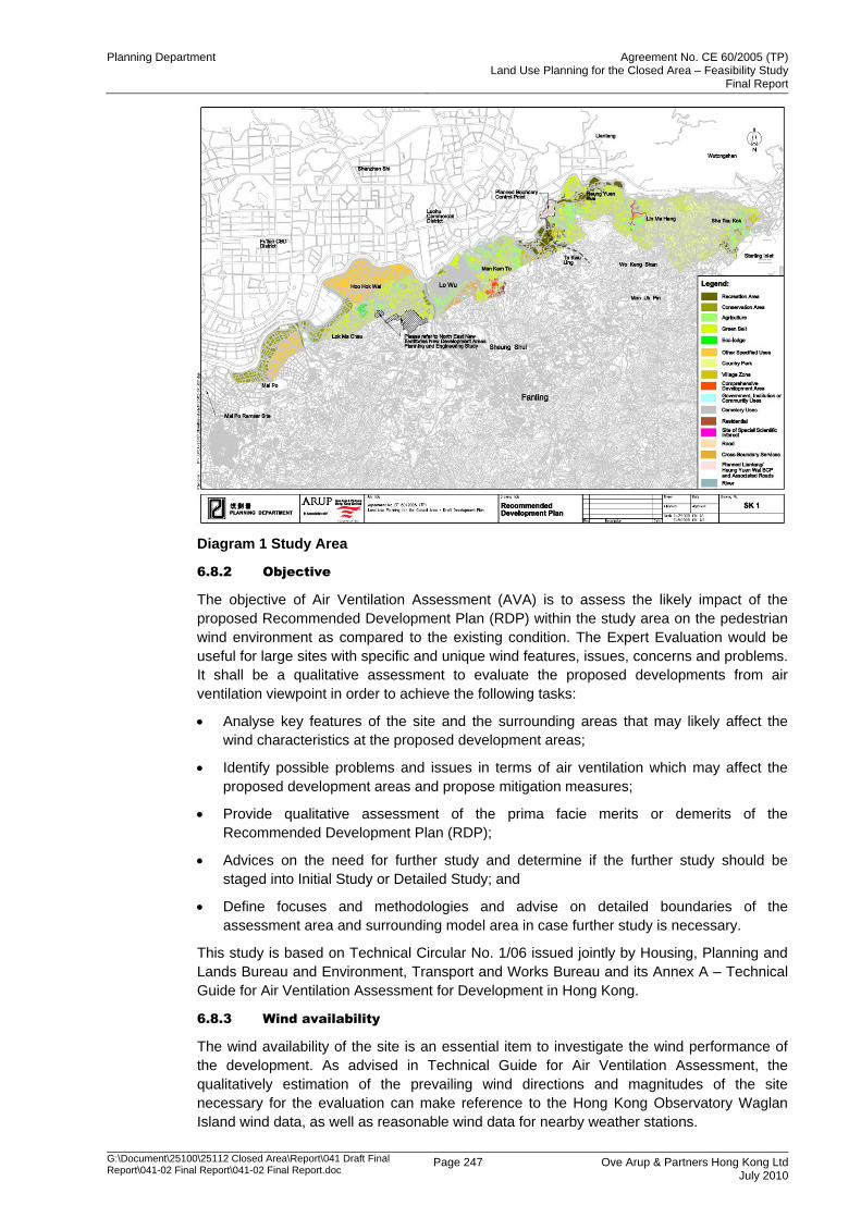
Planning Department Agreement No. CE 60/2005 (TP) Land Use Planning for the Closed Area – Feasibility Study
Final Report
G:\Document\25100\25112 Closed Area\Report\041 Draft Final Report\041-02 Final Report\041-02 Final Report.doc
Page 247 Ove Arup & Partners Hong Kong Ltd July 2010
Diagram 1 Study Area
6.8.2 Objective
The objective of Air Ventilation Assessment (AVA) is to assess the likely impact of the
proposed Recommended Development Plan (RDP) within the study area on the pedestrian
wind environment as compared to the existing condition. The Expert Evaluation would be
useful for large sites with specific and unique wind features, issues, concerns and problems.
It shall be a qualitative assessment to evaluate the proposed developments from air
ventilation viewpoint in order to achieve the following tasks:
Analyse key features of the site and the surrounding areas that may likely affect the
wind characteristics at the proposed development areas;
Identify possible problems and issues in terms of air ventilation which may affect the
proposed development areas and propose mitigation measures;
Provide qualitative assessment of the prima facie merits or demerits of the
Recommended Development Plan (RDP);
Advices on the need for further study and determine if the further study should be
staged into Initial Study or Detailed Study; and
Define focuses and methodologies and advise on detailed boundaries of the
assessment area and surrounding model area in case further study is necessary.
This study is based on Technical Circular No. 1/06 issued jointly by Housing, Planning and
Lands Bureau and Environment, Transport and Works Bureau and its Annex A – Technical
Guide for Air Ventilation Assessment for Development in Hong Kong.
6.8.3 Wind availability
The wind availability of the site is an essential item to investigate the wind performance of
the development. As advised in Technical Guide for Air Ventilation Assessment, the
qualitatively estimation of the prevailing wind directions and magnitudes of the site
necessary for the evaluation can make reference to the Hong Kong Observatory Waglan
Island wind data, as well as reasonable wind data for nearby weather stations.
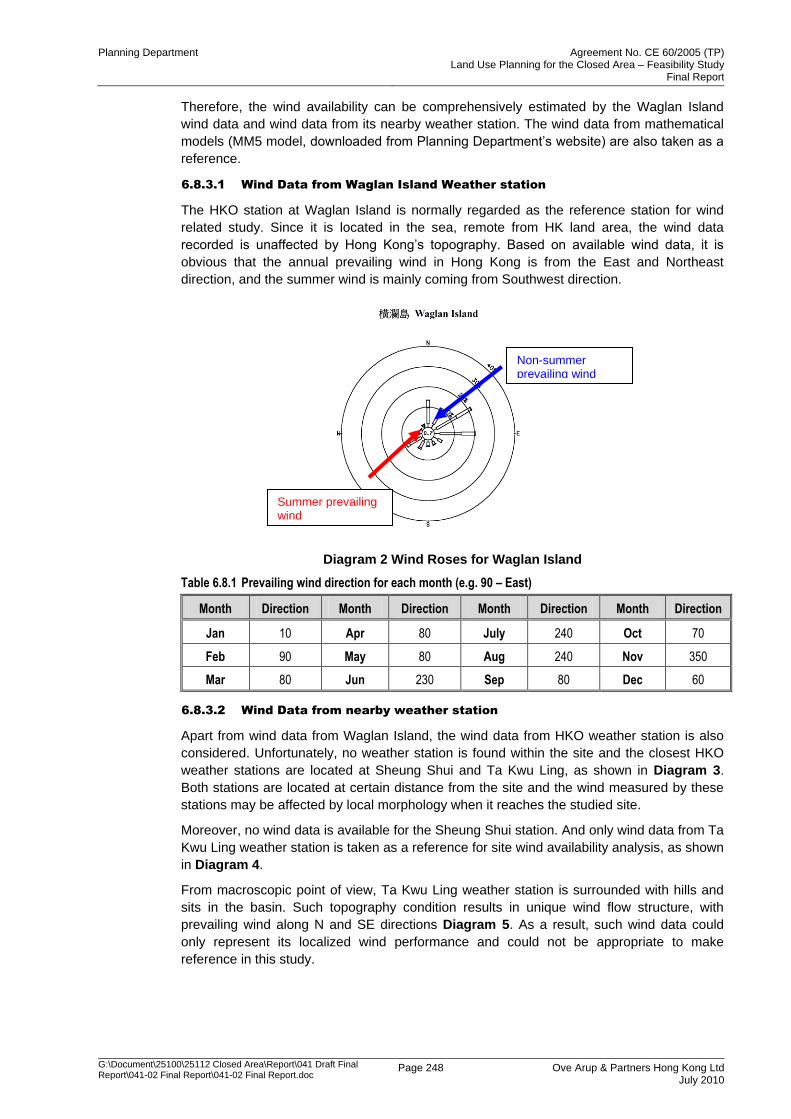
Planning Department Agreement No. CE 60/2005 (TP) Land Use Planning for the Closed Area – Feasibility Study
Final Report
G:\Document\25100\25112 Closed Area\Report\041 Draft Final Report\041-02 Final Report\041-02 Final Report.doc
Page 248 Ove Arup & Partners Hong Kong Ltd July 2010
Therefore, the wind availability can be comprehensively estimated by the Waglan Island
wind data and wind data from its nearby weather station. The wind data from mathematical
models (MM5 model, downloaded from Planning Department‟s website) are also taken as a
reference.
6.8.3.1 Wind Data from Waglan Island Weather station
The HKO station at Waglan Island is normally regarded as the reference station for wind
related study. Since it is located in the sea, remote from HK land area, the wind data
recorded is unaffected by Hong Kong‟s topography. Based on available wind data, it is
obvious that the annual prevailing wind in Hong Kong is from the East and Northeast
direction, and the summer wind is mainly coming from Southwest direction.
Diagram 2 Wind Roses for Waglan Island
Table 6.8.1 Prevailing wind direction for each month (e.g. 90 – East)
Month Direction Month Direction Month Direction Month Direction
Jan 10 Apr 80 July 240 Oct 70
Feb 90 May 80 Aug 240 Nov 350
Mar 80 Jun 230 Sep 80 Dec 60
6.8.3.2 Wind Data from nearby weather station
Apart from wind data from Waglan Island, the wind data from HKO weather station is also
considered. Unfortunately, no weather station is found within the site and the closest HKO
weather stations are located at Sheung Shui and Ta Kwu Ling, as shown in Diagram 3.
Both stations are located at certain distance from the site and the wind measured by these
stations may be affected by local morphology when it reaches the studied site.
Moreover, no wind data is available for the Sheung Shui station. And only wind data from Ta
Kwu Ling weather station is taken as a reference for site wind availability analysis, as shown
in Diagram 4.
From macroscopic point of view, Ta Kwu Ling weather station is surrounded with hills and
sits in the basin. Such topography condition results in unique wind flow structure, with
prevailing wind along N and SE directions Diagram 5. As a result, such wind data could
only represent its localized wind performance and could not be appropriate to make
reference in this study.
Non-summer prevailing wind
Summer prevailing wind

Planning Department Agreement No. CE 60/2005 (TP) Land Use Planning for the Closed Area – Feasibility Study
Final Report
G:\Document\25100\25112 Closed Area\Report\041 Draft Final Report\041-02 Final Report\041-02 Final Report.doc
Page 249 Ove Arup & Partners Hong Kong Ltd July 2010
Diagram 3 The study area and closest weather station
Diagram 4 Wind Rose for Ta Kwu Ling from HKO weather station
Ta Kwu Ling station
Sheung Shui Station
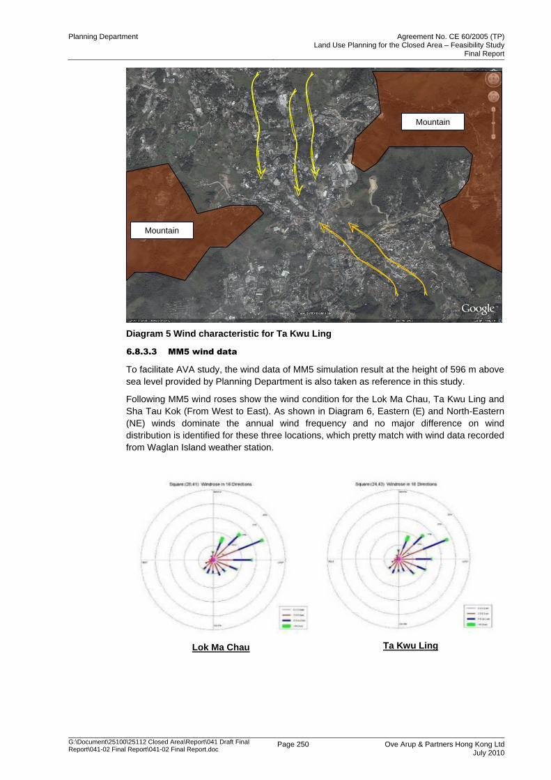
Planning Department Agreement No. CE 60/2005 (TP) Land Use Planning for the Closed Area – Feasibility Study
Final Report
G:\Document\25100\25112 Closed Area\Report\041 Draft Final Report\041-02 Final Report\041-02 Final Report.doc
Page 250 Ove Arup & Partners Hong Kong Ltd July 2010
Diagram 5 Wind characteristic for Ta Kwu Ling
6.8.3.3 MM5 wind data
To facilitate AVA study, the wind data of MM5 simulation result at the height of 596 m above
sea level provided by Planning Department is also taken as reference in this study.
Following MM5 wind roses show the wind condition for the Lok Ma Chau, Ta Kwu Ling and
Sha Tau Kok (From West to East). As shown in Diagram 6, Eastern (E) and North-Eastern
(NE) winds dominate the annual wind frequency and no major difference on wind
distribution is identified for these three locations, which pretty match with wind data recorded
from Waglan Island weather station.
Lok Ma Chau
Ta Kwu Ling
Mountain
Mountain
Planning Department Agreement No. CE 60/2005 (TP) Land Use Planning for the Closed Area – Feasibility Study
Final Report
G:\Document\25100\25112 Closed Area\Report\041 Draft Final Report\041-02 Final Report\041-02 Final Report.doc
Page 251 Ove Arup & Partners Hong Kong Ltd July 2010
Sha Tau Kok
Diagram 6 Wind Roses for Study Area from MM5 data
6.8.3.4 Site wind availability
Taking the reference of Hong Kong Observatory (HKO) Waglan Island wind availability data
and MM5 simulated data, it is expected that summer prevailing wind would be dominated by
Southern West (SW) and the non-summer wind would be dominated by East (E) and
Northern East (NE) respectively.
6.8.4 Wind performance - Existing Condition
6.8.4.1 Overall Wind condition
The study site is bounded by fully built-up area to its north in Shenzhen, mountains to its
south and east. The whole site forms a huge channel lying along NE/SW direction between
the fully developed urban area and mountains.
Since the local wind condition is influenced by the morphology of the site, the detailed
investigation of the site topography data is important.
In general, the studied closed area is relatively flat at around 10mPD from Mai Po area to
Hoo Hok Wai Area. It is believed that the prevailing wind for these areas would come from
NE direction
Several hills lie across the mid part of close area (Ma Tso Lung to Man Kam To) with
elevation varied from 183mPD (Tai Shek Mo) to 75 mPD (Lo Shue Ling). The local
prevailing wind directions should be diverted a little from NE direction due to local terrain
effect. It would be discussed in details in the next section.
Next to the Lo Shue Ling, the flat farmlands form the major part of the Closed Area from
Chow Tin Tsuen to Tsung Yuen Ha, with prevailing wind direction remaining NE directions.
Then the site climbs up to around 500 mPD at Robin‟s Nest. Wind characteristic of some
areas lying in the valleys between hills would be strongly affected by the local terrain. These
would be discussed part by part in the following section.
The Sha Tau Kok Area is located at the southeast root of Robin‟s Nest, next to Starling inlet.
Although the prevailing wind is still NE direction, the sea breeze and downhill wind along
SE/NW direction should also be considered.
Planning Department Agreement No. CE 60/2005 (TP) Land Use Planning for the Closed Area – Feasibility Study
Final Report
G:\Document\25100\25112 Closed Area\Report\041 Draft Final Report\041-02 Final Report\041-02 Final Report.doc
Page 252 Ove Arup & Partners Hong Kong Ltd July 2010
6.8.4.2 Mai Po and San Tin Areas
Diagram 7 Non-summer condition
Diagram 8 Summer condition
This area locates in between the Shenzhen built-up area and Tai Shek Mo mountain. It
forms a channel from NE/SW direction.
This area is dominated by fishponds and farmland, only low-rise clusters are indentified
at SE side of Lok Ma Chau zone.
No major wind obstruction is identified. The wind flow of the site should follow the
prevailing wind direction. i.e. NE direction under non-summer condition and SW wind in
summer condition.
Ma Tso Lung
Shenzhen built-up area
Ma Tso Lung
Shenzhen built-up area
Planning Department Agreement No. CE 60/2005 (TP) Land Use Planning for the Closed Area – Feasibility Study
Final Report
G:\Document\25100\25112 Closed Area\Report\041 Draft Final Report\041-02 Final Report\041-02 Final Report.doc
Page 253 Ove Arup & Partners Hong Kong Ltd July 2010
6.8.4.3 Hoo Hok Wai and Ma Tso Lung Areas
Diagram 9 Non-summer condition
Diagram 10 Summer condition
This area is also dominated by fishponds without any observed major wind obstruction.
Hence the wind flow for this area should mainly follow the prevailing wind - NE wind
during non-summer period.
The valley may generate another NNE wind path to its southern area with prevailing
wind direction of NNE. (as shown in red arrow)
Similarly, no major obstruction is found under SW prevailing direction. Summer wind
could run smoothly through above mentioned wind path.
The abovementioned valley also forms a wind corridor during summer period. This wind
path could serve the Hoo Hok Wai area in summer for wind coming from SW direction.
Ma Tso Lung
Tai Shek Mo
Ma Tso Lung
Tai Shek Mo
Planning Department Agreement No. CE 60/2005 (TP) Land Use Planning for the Closed Area – Feasibility Study
Final Report
G:\Document\25100\25112 Closed Area\Report\041 Draft Final Report\041-02 Final Report\041-02 Final Report.doc
Page 254 Ove Arup & Partners Hong Kong Ltd July 2010
6.8.4.4 Man Kam To Area
Diagram 11 Non-summer condition
Diagram 12 Summer condition
This site sits on relatively flat land (small relative height difference) with low-rise clusters
scattered throughout the site.
Shenzhen River forms a wind channel channeling wind to Sheung Shui Sewage
Treatment Works.
Small hills and built-up areas are located at southeast and northwest side of the site.
Therefore, the prevailing wind would still come from NE direction during non-summer
condition.
During summer time, SW wind could run through abovementioned path. The high level
land may slightly reduce the wind speed but the wind direction remains the same in
general.
Shenzhen built-up area
High level land
High level land
Shenzhen built-up area
High level land
High level land
Planning Department Agreement No. CE 60/2005 (TP) Land Use Planning for the Closed Area – Feasibility Study
Final Report
G:\Document\25100\25112 Closed Area\Report\041 Draft Final Report\041-02 Final Report\041-02 Final Report.doc
Page 255 Ove Arup & Partners Hong Kong Ltd July 2010
6.8.4.5 Ta Kwu Ling North Area
Diagram 13 Non-summer condition
Diagram 14 Summer condition
Wong Mau Hang Shan located on eastern part on this zone. The channel formed by
Shenzhen built-up area and Wong Mau Hang would slightly divert the NE prevailing
wind. (Yellow arrow)
Some NE prevailing wind may skim over the Wong Mau Hang Shan and flow down.
(Green arrow)
SW summer wind would run in opposite direction through the same path. SW wind is
likely passing through the abovementioned channel (Orange arrow).
Wong Mau Hang Shan
Shenzhen built-up area
Wong Mau Hang Shan
Shenzhen built-up area
Planning Department Agreement No. CE 60/2005 (TP) Land Use Planning for the Closed Area – Feasibility Study
Final Report
G:\Document\25100\25112 Closed Area\Report\041 Draft Final Report\041-02 Final Report\041-02 Final Report.doc
Page 256 Ove Arup & Partners Hong Kong Ltd July 2010
6.8.4.6 Lin Ma Hang Area
Diagram 15 Non-summer condition
Diagram 16 Summer condition
Ling Ma Hang area is surrounded by hill and sits at the basin of valley. Prevailing wind
direction is expected to be sheltered and altered by terrain from NE direction to N
direction for non-summer period and SW to S direction with reduced wind speed.
(yellow arrow)
Once the prevailing wind skimming over the valley, it would induce the air circulation in
the basin of the valley as shown in Diagram 17.
Planning Department Agreement No. CE 60/2005 (TP) Land Use Planning for the Closed Area – Feasibility Study
Final Report
G:\Document\25100\25112 Closed Area\Report\041 Draft Final Report\041-02 Final Report\041-02 Final Report.doc
Page 257 Ove Arup & Partners Hong Kong Ltd July 2010
Diagram 17 Skimming flow over the valley
6.8.4.7 Sha Tau Kok Area
Diagram 18 Non-summer condition
Skimming Wind
Recirculation wind
Hill
Hill
Shenzhen built-up area
Planning Department Agreement No. CE 60/2005 (TP) Land Use Planning for the Closed Area – Feasibility Study
Final Report
G:\Document\25100\25112 Closed Area\Report\041 Draft Final Report\041-02 Final Report\041-02 Final Report.doc
Page 258 Ove Arup & Partners Hong Kong Ltd July 2010
Diagram 19 Summer condition
Sha Tau Kok is located between the root of mountain at its northwest side and sea at its
southeast side,
For non-summer period, the prevailing wind is from NE direction, but may be reduced by
fully developed Shenzhen area at its northeast side. For summer period, wind would
come from SW direction without major blockage.
For the unique site characteristic, sea breeze (blue arrow) and off-shore downhill wind
should also need to be considered.
Shenzhen built-up area
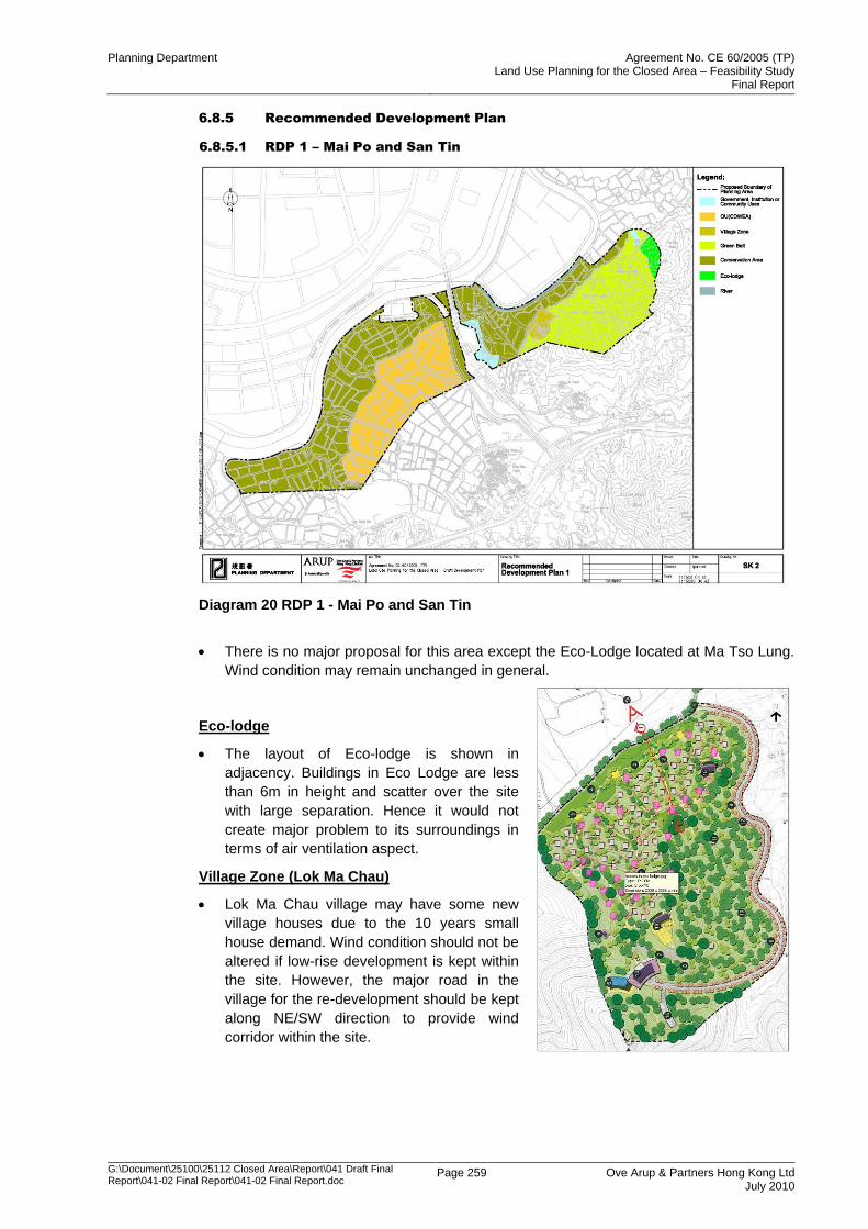
Planning Department Agreement No. CE 60/2005 (TP) Land Use Planning for the Closed Area – Feasibility Study
Final Report
G:\Document\25100\25112 Closed Area\Report\041 Draft Final Report\041-02 Final Report\041-02 Final Report.doc
Page 259 Ove Arup & Partners Hong Kong Ltd July 2010
6.8.5 Recommended Development Plan
6.8.5.1 RDP 1 – Mai Po and San Tin
Diagram 20 RDP 1 - Mai Po and San Tin
There is no major proposal for this area except the Eco-Lodge located at Ma Tso Lung.
Wind condition may remain unchanged in general.
Eco-lodge
The layout of Eco-lodge is shown in
adjacency. Buildings in Eco Lodge are less
than 6m in height and scatter over the site
with large separation. Hence it would not
create major problem to its surroundings in
terms of air ventilation aspect.
Village Zone (Lok Ma Chau)
Lok Ma Chau village may have some new
village houses due to the 10 years small
house demand. Wind condition should not be
altered if low-rise development is kept within
the site. However, the major road in the
village for the re-development should be kept
along NE/SW direction to provide wind
corridor within the site.
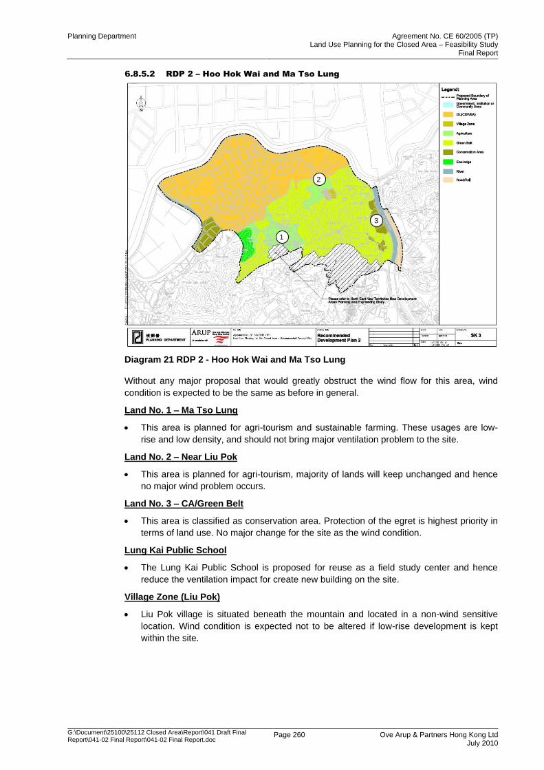
Planning Department Agreement No. CE 60/2005 (TP) Land Use Planning for the Closed Area – Feasibility Study
Final Report
G:\Document\25100\25112 Closed Area\Report\041 Draft Final Report\041-02 Final Report\041-02 Final Report.doc
Page 260 Ove Arup & Partners Hong Kong Ltd July 2010
6.8.5.2 RDP 2 – Hoo Hok Wai and Ma Tso Lung
Diagram 21 RDP 2 - Hoo Hok Wai and Ma Tso Lung
Without any major proposal that would greatly obstruct the wind flow for this area, wind
condition is expected to be the same as before in general.
Land No. 1 – Ma Tso Lung
This area is planned for agri-tourism and sustainable farming. These usages are low-
rise and low density, and should not bring major ventilation problem to the site.
Land No. 2 – Near Liu Pok
This area is planned for agri-tourism, majority of lands will keep unchanged and hence
no major wind problem occurs.
Land No. 3 – CA/Green Belt
This area is classified as conservation area. Protection of the egret is highest priority in
terms of land use. No major change for the site as the wind condition.
Lung Kai Public School
The Lung Kai Public School is proposed for reuse as a field study center and hence
reduce the ventilation impact for create new building on the site.
Village Zone (Liu Pok)
Liu Pok village is situated beneath the mountain and located in a non-wind sensitive
location. Wind condition is expected not to be altered if low-rise development is kept
within the site.
3
1
2
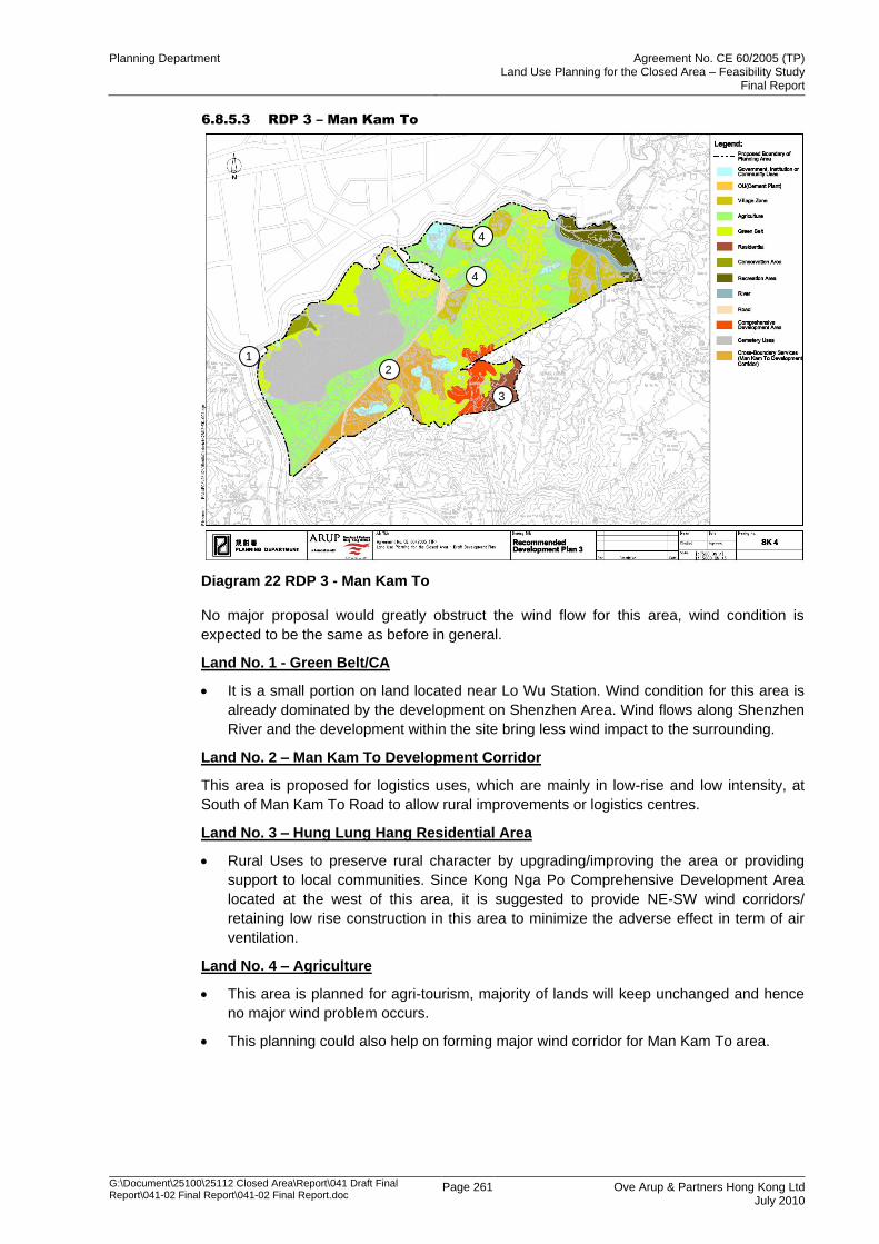
Planning Department Agreement No. CE 60/2005 (TP) Land Use Planning for the Closed Area – Feasibility Study
Final Report
G:\Document\25100\25112 Closed Area\Report\041 Draft Final Report\041-02 Final Report\041-02 Final Report.doc
Page 261 Ove Arup & Partners Hong Kong Ltd July 2010
6.8.5.3 RDP 3 – Man Kam To
Diagram 22 RDP 3 - Man Kam To
No major proposal would greatly obstruct the wind flow for this area, wind condition is
expected to be the same as before in general.
Land No. 1 - Green Belt/CA
It is a small portion on land located near Lo Wu Station. Wind condition for this area is
already dominated by the development on Shenzhen Area. Wind flows along Shenzhen
River and the development within the site bring less wind impact to the surrounding.
Land No. 2 – Man Kam To Development Corridor
This area is proposed for logistics uses, which are mainly in low-rise and low intensity, at
South of Man Kam To Road to allow rural improvements or logistics centres.
Land No. 3 – Hung Lung Hang Residential Area
Rural Uses to preserve rural character by upgrading/improving the area or providing
support to local communities. Since Kong Nga Po Comprehensive Development Area
located at the west of this area, it is suggested to provide NE-SW wind corridors/
retaining low rise construction in this area to minimize the adverse effect in term of air
ventilation.
Land No. 4 – Agriculture
This area is planned for agri-tourism, majority of lands will keep unchanged and hence
no major wind problem occurs.
This planning could also help on forming major wind corridor for Man Kam To area.
3
2 1
4
4
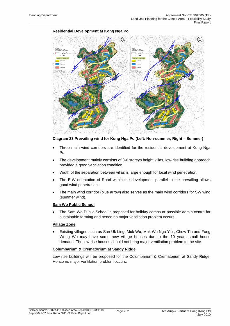
Planning Department Agreement No. CE 60/2005 (TP) Land Use Planning for the Closed Area – Feasibility Study
Final Report
G:\Document\25100\25112 Closed Area\Report\041 Draft Final Report\041-02 Final Report\041-02 Final Report.doc
Page 262 Ove Arup & Partners Hong Kong Ltd July 2010
Residential Development at Kong Nga Po
Diagram 23 Prevailing wind for Kong Nga Po (Left: Non-summer, Right – Summer)
Three main wind corridors are identified for the residential development at Kong Nga
Po.
The development mainly consists of 3-6 storeys height villas, low-rise building approach
provided a good ventilation condition.
Width of the separation between villas is large enough for local wind penetration.
The E-W orientation of Road within the development parallel to the prevailing allows
good wind penetration.
The main wind corridor (blue arrow) also serves as the main wind corridors for SW wind
(summer wind).
Sam Wo Public School
The Sam Wo Public School is proposed for holiday camps or possible admin centre for
sustainable farming and hence no major ventilation problem occurs.
Village Zone
Existing villages such as San Uk Ling, Muk Wu, Muk Wu Nga Yiu , Chow Tin and Fung
Wong Wu may have some new village houses due to the 10 years small house
demand. The low-rise houses should not bring major ventilation problem to the site.
Columbarium & Crematorium at Sandy Ridge
Low rise buildings will be proposed for the Columbarium & Crematorium at Sandy Ridge.
Hence no major ventilation problem occurs.
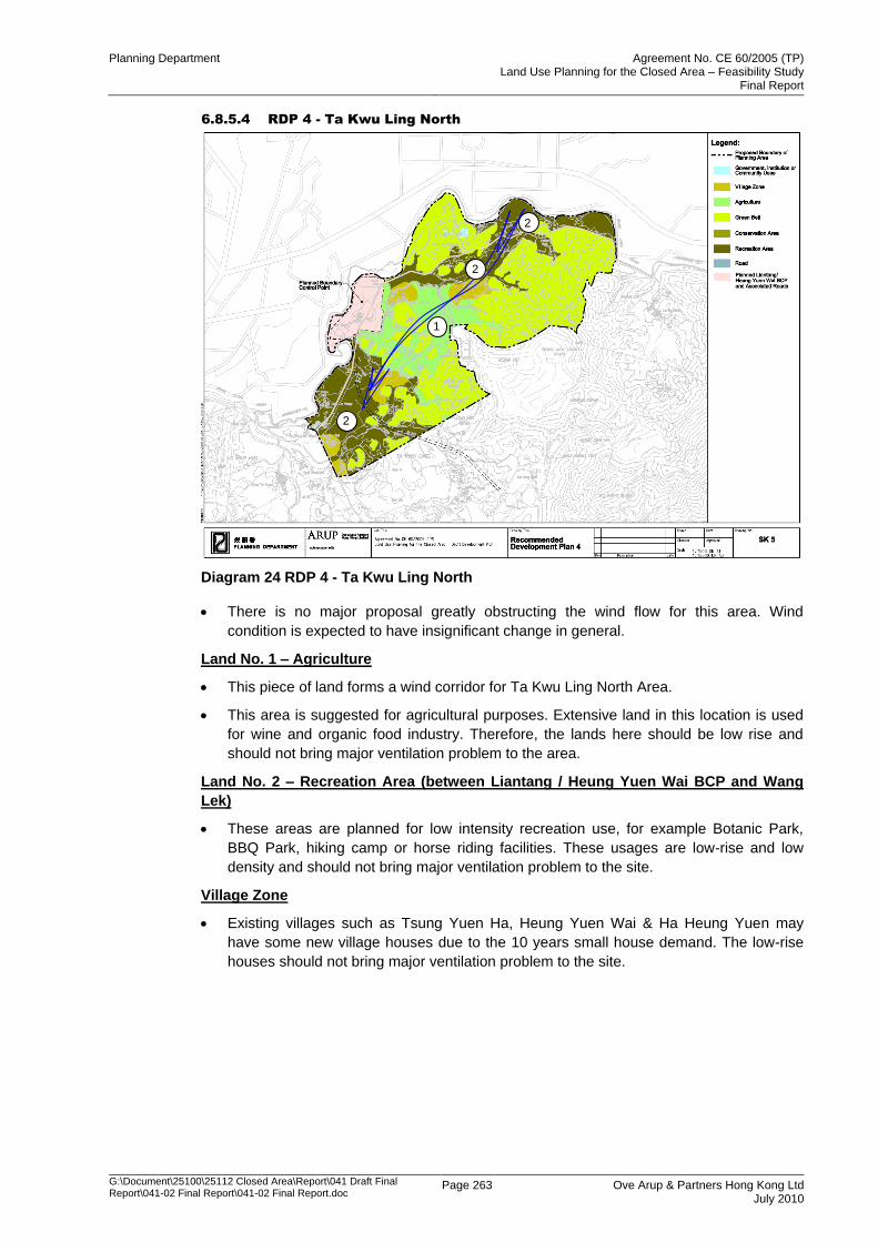
Planning Department Agreement No. CE 60/2005 (TP) Land Use Planning for the Closed Area – Feasibility Study
Final Report
G:\Document\25100\25112 Closed Area\Report\041 Draft Final Report\041-02 Final Report\041-02 Final Report.doc
Page 263 Ove Arup & Partners Hong Kong Ltd July 2010
6.8.5.4 RDP 4 - Ta Kwu Ling North
Diagram 24 RDP 4 - Ta Kwu Ling North
There is no major proposal greatly obstructing the wind flow for this area. Wind
condition is expected to have insignificant change in general.
Land No. 1 – Agriculture
This piece of land forms a wind corridor for Ta Kwu Ling North Area.
This area is suggested for agricultural purposes. Extensive land in this location is used
for wine and organic food industry. Therefore, the lands here should be low rise and
should not bring major ventilation problem to the area.
Land No. 2 – Recreation Area (between Liantang / Heung Yuen Wai BCP and Wang
Lek)
These areas are planned for low intensity recreation use, for example Botanic Park,
BBQ Park, hiking camp or horse riding facilities. These usages are low-rise and low
density and should not bring major ventilation problem to the site.
Village Zone
Existing villages such as Tsung Yuen Ha, Heung Yuen Wai & Ha Heung Yuen may
have some new village houses due to the 10 years small house demand. The low-rise
houses should not bring major ventilation problem to the site.
2
2
1
2
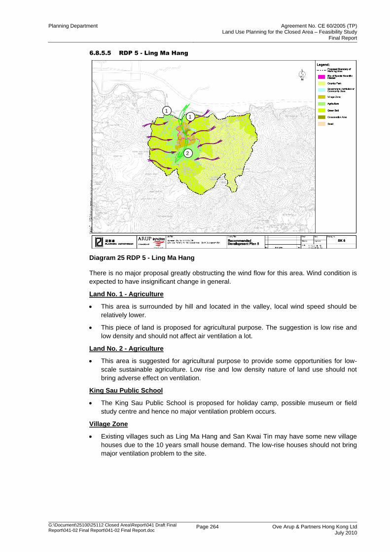
Planning Department Agreement No. CE 60/2005 (TP) Land Use Planning for the Closed Area – Feasibility Study
Final Report
G:\Document\25100\25112 Closed Area\Report\041 Draft Final Report\041-02 Final Report\041-02 Final Report.doc
Page 264 Ove Arup & Partners Hong Kong Ltd July 2010
6.8.5.5 RDP 5 - Ling Ma Hang
Diagram 25 RDP 5 - Ling Ma Hang
There is no major proposal greatly obstructing the wind flow for this area. Wind condition is
expected to have insignificant change in general.
Land No. 1 - Agriculture
This area is surrounded by hill and located in the valley, local wind speed should be
relatively lower.
This piece of land is proposed for agricultural purpose. The suggestion is low rise and
low density and should not affect air ventilation a lot.
Land No. 2 - Agriculture
This area is suggested for agricultural purpose to provide some opportunities for low-
scale sustainable agriculture. Low rise and low density nature of land use should not
bring adverse effect on ventilation.
King Sau Public School
The King Sau Public School is proposed for holiday camp, possible museum or field
study centre and hence no major ventilation problem occurs.
Village Zone
Existing villages such as Ling Ma Hang and San Kwai Tin may have some new village
houses due to the 10 years small house demand. The low-rise houses should not bring
major ventilation problem to the site.
1 1
2
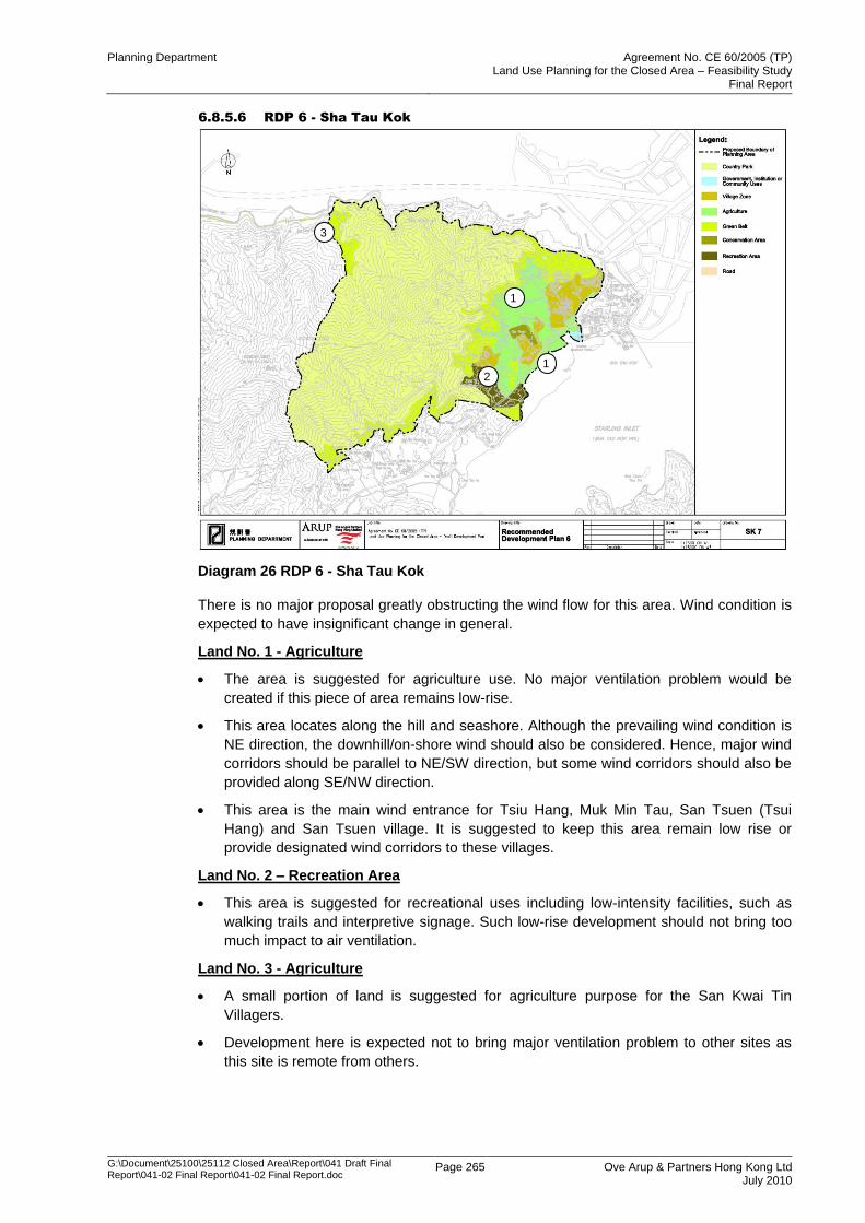
Planning Department Agreement No. CE 60/2005 (TP) Land Use Planning for the Closed Area – Feasibility Study
Final Report
G:\Document\25100\25112 Closed Area\Report\041 Draft Final Report\041-02 Final Report\041-02 Final Report.doc
Page 265 Ove Arup & Partners Hong Kong Ltd July 2010
6.8.5.6 RDP 6 - Sha Tau Kok
Diagram 26 RDP 6 - Sha Tau Kok
There is no major proposal greatly obstructing the wind flow for this area. Wind condition is
expected to have insignificant change in general.
Land No. 1 - Agriculture
The area is suggested for agriculture use. No major ventilation problem would be
created if this piece of area remains low-rise.
This area locates along the hill and seashore. Although the prevailing wind condition is
NE direction, the downhill/on-shore wind should also be considered. Hence, major wind
corridors should be parallel to NE/SW direction, but some wind corridors should also be
provided along SE/NW direction.
This area is the main wind entrance for Tsiu Hang, Muk Min Tau, San Tsuen (Tsui
Hang) and San Tsuen village. It is suggested to keep this area remain low rise or
provide designated wind corridors to these villages.
Land No. 2 – Recreation Area
This area is suggested for recreational uses including low-intensity facilities, such as
walking trails and interpretive signage. Such low-rise development should not bring too
much impact to air ventilation.
Land No. 3 - Agriculture
A small portion of land is suggested for agriculture purpose for the San Kwai Tin
Villagers.
Development here is expected not to bring major ventilation problem to other sites as
this site is remote from others.
1
1
2
3
Planning Department Agreement No. CE 60/2005 (TP) Land Use Planning for the Closed Area – Feasibility Study
Final Report
G:\Document\25100\25112 Closed Area\Report\041 Draft Final Report\041-02 Final Report\041-02 Final Report.doc
Page 266 Ove Arup & Partners Hong Kong Ltd July 2010
Country Park
No major development within the potential Country Park area. Hence, no major
ventilation problem occurs.
Kwan Ah Public School
The Kwan Ah Public School is proposed for holiday camp or Country Park visitor centre
and hence no major ventilation problem occurs.
Village Zone
Existing villages such as Tong To, San Tsuen, Tsui Hang San Tsuen, Tsui Hang, Ha
Tam Shui Hang, Sheung Tam Shui Hang and Shan Tsui may have some new village
houses due to the 10 years small house demand. The low-rise houses should not bring
major ventilation problem to the site.
6.8.6 Conclusion
This report provides the Expert Evaluation on the AVA of the Recommended Development
Plan (RDP) for the Study Area. A preliminary assessment on site characteristic and wind
availability is conducted and reported here.
The expert evaluation indicates that there is no major wind problem created as the areas
are mainly planned for low-rise and low density development. Wind corridors are available
for most of the sites for both summer and non-summer winds. No further study is needed if
there is no major change on plan. In summary, general comments for individual RDP are:
RDP 1 – Mai Po and San Tin
There is no major proposal for this area. Wind condition is expected to remain unchanged in
general.
RDP 2 – Hook Hok Wai and Ma Tso Lung
This area consists of low-rise, low density building and conservation area. No major wind
problem occurs.
RDP 3 – Man Kam To
This area located to the south of Shenzhen area. The wind condition for this area is affected
by the development on Shenzhen under NE wind condition. In general, this RDP is low-rise
and low density. Hence no major wind problem occurs
RDP 4 - Ta Kwu Ling North
This area consists of low-rise, low density building and for agricultural purposes. No major
wind problem occurs.
RDP 5 - Ling Ma Hang
This area is surrounded by hill and for agricultural, the local wind is expected to be
controlled by circulation wind. No major wind problem would occur.
RDP 6 - Sha Tau Kok
This area locates along the hill and seashore. Wind condition here is expected to be
dominated by downhill/on-shore wind. Hence, wind corridors parallel to this kind of wind is
suggested for this area
Since the whole development is planned as low rise, low density or open space, the wind
performance would not be strongly affected by this proposed planning. No further AVA study
is needed if this planning strategy/principle is not changed.
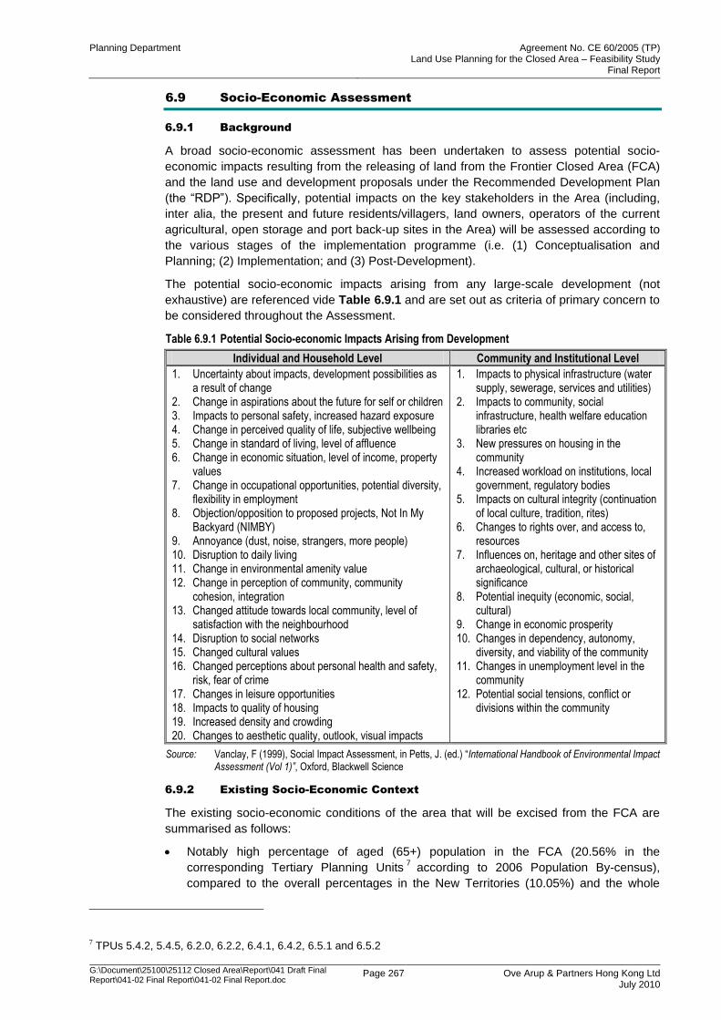
Planning Department Agreement No. CE 60/2005 (TP) Land Use Planning for the Closed Area – Feasibility Study
Final Report
G:\Document\25100\25112 Closed Area\Report\041 Draft Final Report\041-02 Final Report\041-02 Final Report.doc
Page 267 Ove Arup & Partners Hong Kong Ltd July 2010
6.9 Socio-Economic Assessment
6.9.1 Background
A broad socio-economic assessment has been undertaken to assess potential socio-
economic impacts resulting from the releasing of land from the Frontier Closed Area (FCA)
and the land use and development proposals under the Recommended Development Plan
(the “RDP”). Specifically, potential impacts on the key stakeholders in the Area (including,
inter alia, the present and future residents/villagers, land owners, operators of the current
agricultural, open storage and port back-up sites in the Area) will be assessed according to
the various stages of the implementation programme (i.e. (1) Conceptualisation and
Planning; (2) Implementation; and (3) Post-Development).
The potential socio-economic impacts arising from any large-scale development (not
exhaustive) are referenced vide Table 6.9.1 and are set out as criteria of primary concern to
be considered throughout the Assessment.
Table 6.9.1 Potential Socio-economic Impacts Arising from Development
Individual and Household Level Community and Institutional Level
1. Uncertainty about impacts, development possibilities as a result of change
2. Change in aspirations about the future for self or children 3. Impacts to personal safety, increased hazard exposure 4. Change in perceived quality of life, subjective wellbeing 5. Change in standard of living, level of affluence 6. Change in economic situation, level of income, property
values 7. Change in occupational opportunities, potential diversity,
flexibility in employment 8. Objection/opposition to proposed projects, Not In My
Backyard (NIMBY) 9. Annoyance (dust, noise, strangers, more people) 10. Disruption to daily living 11. Change in environmental amenity value 12. Change in perception of community, community
cohesion, integration 13. Changed attitude towards local community, level of
satisfaction with the neighbourhood 14. Disruption to social networks 15. Changed cultural values 16. Changed perceptions about personal health and safety,
risk, fear of crime 17. Changes in leisure opportunities 18. Impacts to quality of housing 19. Increased density and crowding 20. Changes to aesthetic quality, outlook, visual impacts
1. Impacts to physical infrastructure (water supply, sewerage, services and utilities)
2. Impacts to community, social infrastructure, health welfare education libraries etc
3. New pressures on housing in the community
4. Increased workload on institutions, local government, regulatory bodies
5. Impacts on cultural integrity (continuation of local culture, tradition, rites)
6. Changes to rights over, and access to, resources
7. Influences on, heritage and other sites of archaeological, cultural, or historical significance
8. Potential inequity (economic, social, cultural)
9. Change in economic prosperity 10. Changes in dependency, autonomy,
diversity, and viability of the community 11. Changes in unemployment level in the
community 12. Potential social tensions, conflict or
divisions within the community
Source: Vanclay, F (1999), Social Impact Assessment, in Petts, J. (ed.) “International Handbook of Environmental Impact Assessment (Vol 1)”, Oxford, Blackwell Science
6.9.2 Existing Socio-Economic Context
The existing socio-economic conditions of the area that will be excised from the FCA are
summarised as follows:
Notably high percentage of aged (65+) population in the FCA (20.56% in the
corresponding Tertiary Planning Units7
according to 2006 Population By-census),
compared to the overall percentages in the New Territories (10.05%) and the whole
7 TPUs 5.4.2, 5.4.5, 6.2.0, 6.2.2, 6.4.1, 6.4.2, 6.5.1 and 6.5.2
Planning Department Agreement No. CE 60/2005 (TP) Land Use Planning for the Closed Area – Feasibility Study
Final Report
G:\Document\25100\25112 Closed Area\Report\041 Draft Final Report\041-02 Final Report\041-02 Final Report.doc
Page 268 Ove Arup & Partners Hong Kong Ltd July 2010
Hong Kong (12.42%). As the current infrastructure in the Area is largely undeveloped
and job opportunities are limited, the majority of the young population has moved to the
urban areas for a more desirable working and living environment.
Significant proportion of population with a low education level within the Area - with
16.08% of people receiving no schooling or only kindergarten education, vis-à-vis
6.74% in the New Territories and 7.14% in the whole Territory. This is probably because
the well-educated groups have left the Area to the urban districts in search of career
opportunities.
Primary and low-skilled economic activities such as fisheries and agriculture/poultry
farming dominate the Area. Limited port back-up/cross-boundary trade related industries
(e.g. open storage and container back-up), traditional rural industrial workshops and
local retail businesses exist, usually along the arterial roads including Ping Che, Man
Kam To and Sha Tau Kok Road.
A significantly high proportion of the households in the Area with a Monthly Domestic
Household Income of HK$2,000 or less (9.74%) vis-à-vis the territorial average (3.90%).
This is probably due to the high proportion of retired population and the insufficiency of
job opportunities in the Area.
The potential changes to the above demographic and economic conditions arising from the
RDP will be delineated in the following broad assessment, whilst the range of measures and
arrangements to make the RDP and its proposals acceptable in socio-economic terms will
be identified.
6.9.3 Broad Assessment of the Potential Socio-Economic Impacts
6.9.3.1 Conceptualisation and Planning Stage
Before the planning intention for land to be released from the FCA is confirmed, there is
likely to be fear and uncertainty amongst the potentially affected public. Whilst local
residents/villagers may welcome improved access and convenience, there may also be
concerns on the potential impacts (e.g. noise or nuisance) from an influx of visitors. In
addition and as reflected from the Community Engagement, many local landowners are
concerned with the possible loss of development rights as a result of future zoning
mechanisms.
The proposed landuse framework, seeks to minimise disruption to existing villages and
settlements. Village environs and lands to meet future small house demands are fully
respected and there are no proposals to displace existing settlements. Moreover, the
recommended statutory framework generates local economic opportunities without
jeopardising the natural, cultural and environmental features.
In order to maintain the themes of sustainable development and environmental conservation,
intensification of development within non-indigenous village settlements should not be
encouraged. In this regard, scattered non-indigenous village settlements will not be
specifically reflected under the land use framework, but instead be treated as existing uses
under the surrounding planning context. Nonetheless, flexibility should be provided for the
redevelopment/alteration/addition/modification of/to existing building structures to improve
local standards of living.
The approach under the RDP does not require any major land resumption to accommodate
the land use proposals. The key development proposals at Ma Tso Lung (eco-lodge) and
Kong Nga Po (residential) are located on existing Government Land. They are both low-rise,
low-intensity uses to be based on green objectives to ensure minimal disruption to
surrounding uses and communities. There will be some minor land resumption to
accommodate road upgrading works, however this is a limited impact and will be offset by
the enhanced safety for local residents.
Planning Department Agreement No. CE 60/2005 (TP) Land Use Planning for the Closed Area – Feasibility Study
Final Report
G:\Document\25100\25112 Closed Area\Report\041 Draft Final Report\041-02 Final Report\041-02 Final Report.doc
Page 269 Ove Arup & Partners Hong Kong Ltd July 2010
The land use framework has essentially been focused on creating opportunities to enhance
economic prosperity for local residents/landowners in appropriate locations with limited
environment value. The development opportunities are primarily based around harnessing
the economic potential from the release of the FCA by allowing local residents and
landowners to actively contribute to creating a unique tourist area for Hong Kong.
The Study outcomes are consistent with the adopted vision and themes of the Study that
received general community support to protect and enhance the ecological, heritage and
landscape assets of the area with varied options for development. The approach strikes a
balance between environmental and cultural conservation while identifying options for
appropriate development. The community engagement process will help to raise social
awareness of the Study process and the ability of the Study outcomes to accommodate
community comments/concerns/aspirations. This limits social disturbance during the
planning stages for the Study and allows public input into the process.
Of course, there will always be some stakeholders that will be unsatisfied with the outcomes
of some aspects of any planning study. However, the intention of the RDP is to facilitate the
Vision as the current planning intention which is consistent with the Preferred Development
Option under the HK2030 Study that prioritises other key development proposals such as
the NENT NDA‟s, LMC Loop and L/HWY BCP in the New Territories to sustain the
demographic and economic planning objectives for Hong Kong. In this regard, the Study is
consistent with the current development priorities in Hong Kong and establishes strong
conservation objectives for the key ecological resources in the eastern and western portions
of the Study Area. The low-intensity land use framework will allow appropriate areas of the
area that will be excised from the FCA to be considered for more intensive development in
the future, when demographic and economic conditions necessitate further consideration of
the land uses in this area.
6.9.3.2 Construction Stage
It should be noted that the majority of the Area to be released is proposed to be designated
as “Conservation Area”, “Country Park”, “Sites of Special Scientific Interest”, “Green Belt”,
“Comprehensive Development and Wetland Enhancement Area”, etc. where in most cases,
there is a general presumption against development. There are, however, other provisions
recommended under the Study geared primarily towards creating opportunities for private
initiative to utilise new land use provisions.
In general, the existing indigenous and non-indigenous villagers will not be disturbed by the
releasing of land for the proposed purposes. All existing indigenous villages will be retained
in their existing form with allowances made, as necessary, to accommodate the 10-year
small house demand. In general, major disturbance to the existing villagers is not significant
and the land use framework will cater for identified village growth under the small house
demand. The exception is Chuk Yuen which will be relocated to accommodate the future
Liantang/Heung Yuen Wai BCP. However, the programme and plans for village relocation
will be addressed outside this Study and consideration has been given to it based on the
latest development of the relocation site.
The proposed landuse framework also allows for the continued existence of non-indigenous
villages, with no intensification of development. Generally, non-indigenous villages have
been designated within agriculture or green belt areas which allows the
redevelopment/alteration/addition/modification of/to existing building structures to improve
local standards of living.
Land at Kong Nga Po (and Hung Lung Hang), Ma Tso Lung and Man Kam To is proposed
for residential, eco-lodge and logistics uses respectively, which will involve general
construction activities. The Kong Nga Po and Ma Tso Lung proposals are intended to be
sustainable and green showcases. As such, sustainable design guidelines have been
developed to ensure that future developments can integrate fully into the surrounding rural
Planning Department Agreement No. CE 60/2005 (TP) Land Use Planning for the Closed Area – Feasibility Study
Final Report
G:\Document\25100\25112 Closed Area\Report\041 Draft Final Report\041-02 Final Report\041-02 Final Report.doc
Page 270 Ove Arup & Partners Hong Kong Ltd July 2010
context with minimal environmental loading. To ensure a comprehensive approach to
sustainability, provisions have been recommended that also require the future proponents to
consider impacts during construction to minimise site disturbance which will minimise
impacts to surrounding communities in terms of noise and dust pollution.
The Man Kam To proposal may involve site works, however future development schemes
would be subject to private development applications under the future statutory planning
framework. In terms of visual impact, the development guidelines will provide that a
landscaped setback should be maintained along the southern side of Man Kam To to
replicate the existing situation and screen any new uses from this important traffic corridor.
The Construction Stage implies a wide array of related activities, in particular
construction/upgrading of supporting facilities, inter alia, electricity transmission corridors,
water pipes and irrigation channels; site formation and associated works. Many of these
activities also cause dust, noise, and create hazard. Exposure of nearby villages to noise
and dust at certain times during the Construction Stage may be obvious. Notwithstanding,
appropriate construction measures (e.g. dust suppression, water quality, acoustic impact)
should be adopted at all times to ensure that impacts on existing residents is minimised.
The Kong Nga Po and Ma Tso Lung proposals are generally separated from any indigenous
or non-indigenous villages reducing the impact of construction impacts, other than
construction vehicle access. The logistics/warehousing/distribution/commercial uses at Man
Kam To may affect land occupied by the non-indigenous village of Sha Ling. The land use
provisions will allow for the settlement to be retained allowing the proposed
logistics/warehousing/distribution/commercial uses to co-exist with the settlement subject,
although direct industrial/residential interface would be minimised by segregation of uses by
Man Kam To Road. Any displacement of the occupants would be subject to the proposals
put forward by private landowners/developers. Notwithstanding, the proposed logistics/
warehousing/distribution/commercial uses could create local employment opportunities for
surrounding settlements.
The other construction project proposed under the Study is the provision of a
Hiking/Heritage Trail and Bicycle Track. The identification of preferred routes for the
facilities was based on the location of existing roads and trails to minimise environmental
impact to those areas already disturbed. A detailed design will be necessary to identify the
proposed extent of construction, however any works will be relatively minor. Construction
will involve excavation, forming and laying of trails of approximately 2.5m where necessary.
The trails will be supported by necessary infrastructure such as waste receptacles and toilet
facilities to ensure that waste generated by the use of the trails/track will be managed.
Furthermore, the trails/track is predominantly located away from existing settlements
minimising construction impact.
It is proposed to upgrade the local road network to anticipate the phased release of the
Closed Area which will include the removal of road access restrictions. The road
improvement plans are provided in Figures 6.2.1 to 6.2.6. The improvement works will
benefit local villagers by providing a safer and more efficient road network. Road
Improvement works along Man Kam To Road, Lin Ma Hang and some village access roads
are proposed. Provision of ancillary facilities such as car parks, street lighting will be
included to serve the area. The road construction may affect access for local villagers during
construction, however the construction design and programming should permit access to be
retained to all villagers during road works to minimize disruption to local residents.
Whilst it is virtually impossible to mitigate all the social impacts during the Construction
Stage, adequate measures can still be applied in order to reduce any adverse impacts
during this phase as far as possible. For instance, construction practices can be properly
managed by adoption of appropriate environmental protection measures so that the normal
life of the villagers or other stakeholders would not be significantly affected. Appropriate
Planning Department Agreement No. CE 60/2005 (TP) Land Use Planning for the Closed Area – Feasibility Study
Final Report
G:\Document\25100\25112 Closed Area\Report\041 Draft Final Report\041-02 Final Report\041-02 Final Report.doc
Page 271 Ove Arup & Partners Hong Kong Ltd July 2010
construction management plans should be provided for construction projects within the
Study Area to limit the impact on the typically tranquil environment.
Importantly, the construction phase will generate employment opportunities within the Study
Area which is highly beneficial to the socio-economic conditions. Short-term construction
jobs will be created for Kong Nga Po, Eco-lodge, Hiking/Heritage Trails, Bicycle Track, Road
improvement works, Recreation facilities etc that will provide a demand for unskilled labour.
These employment opportunities, although not available for the high proportion of aged
persons in the Study Area, do present possible options to the lower-education and low-
skilled demographic profile. This will be the first stage in actually stimulating the local
economic status of the Area in preparing for opportunities in the following stage.
6.9.3.3 Post-Development Stage
With the anticipated changes brought out by the releasing of land (mainly vis opening for
eco-tourism, designating limited land for residential, recreational and logistics uses), the
following social impacts can be envisaged:
Creating Job Opportunities
Improved access into the area that will be excised from the FCA will provide potential
for a number of direct and indirect employment opportunities. Direct employment
opportunities include those directly created by specific land use proposals, such as the
Robin‟s Nest Country Park, Eco-lodge, development at Kong Nga Po, Hiking/Heritage
Trail, Cycle Track and Columbarium & Crematorium. Job opportunities will be generated
during the design, construction and long term management and maintenance of these
facilities.
Other job opportunities include those reliant on the initiatives and proposals of the
private sector to implement specific uses within the proposed landuse framework.
These include potential developments within the MKTDC, Agriculture/Hobby
Farming/Agr-tourism within the Agriculture zones, Recreational uses (e.g. horse-riding
school/pet zoo/adventure park, etc.) within the Recreation zone, Reuse of Disused
Schools, and potential retail/overnight accommodation within the Village zones.
As a general estimate, the proposed releasing of land in the FCA will create more than
4,000 job opportunities at various levels. As the implementation of the proposals is
expected to generate local employment opportunities, this will ease the employment
situation in the Area. Increased employment levels will also stimulate local spending
and boost economic security.
Strengthening Cross-Boundary Trading
Proposed uses within the Study Area, such as tourism resources (e.g. the Eco-lodge,
hiking trails, recreational uses, etc.) and the MKTDC will support growing cross-
boundary interactions. The additional tourism and recreational facilities will attract local
and international visitors to the Study Area and is an opportunity to inform people on the
unique local history and ecological resources. It is also an opportunity for international
visitors to appreciate the rural settings of Hong Kong in addition to the more popular
built-up areas. The proposed tourism resources in the Study Area will help to increase
visitor revenue in the SAR through direct local spending as well as encouraging longer
stays in the SAR through the provision of a greater range of tourism options.
On the other hand, the MKTDC will help to support cross boundary trading and hi-tech
activities. There will be greater support to existing and future operations through, inter
alia, the provision of logistics/warehousing/distribution/exhibition/hi-tech support, petrol
filling station and low-intensity commercial facilities (e.g. cafes, open markets, etc).
Furthermore, the recommended land use framework respects the ongoing cross-
boundary initiatives for the LMC Loop and Liantang/Heung Yuen Wai BCP. To assist
Planning Department Agreement No. CE 60/2005 (TP) Land Use Planning for the Closed Area – Feasibility Study
Final Report
G:\Document\25100\25112 Closed Area\Report\041 Draft Final Report\041-02 Final Report\041-02 Final Report.doc
Page 272 Ove Arup & Partners Hong Kong Ltd July 2010
the planning under the LMC Loop Study, this Study has investigated and suggested a
range of uses for a LMC Development Corridor linking the KTN NDA and the LMC Loop
including a Research and Development Park, Science Park or the like that has strong
associations with the higher education facilities proposed for the LMC Loop.
Furthermore other uses such as shopping, entertainment and exhibition centres could
also be considered to support the development within the Loop and KTN NDA. The
exhibition component could also attract Mainland visitors and provide opportunities for
integration through, not only shopping and entertainment, but business opportunities
through exhibition and sourcing events close to the Mainland Border. The future land
use of the LMCDC will be considered under the LMC Loop Study.
This study also recognises the long-term planning potential for the middle portion of the
Study Area. While, the recreation and agricultural designation provides short to medium
term economic options for landowners consistent with the overall vision, this portion is
also strategically position between the Ping Che/Ta Kwu Ling NDA and the new
Liantang / Heung Yuen Wai BCP. Subject to future demographic and economic
conditions, a review of the land use planning off this area could be considered.
Stimulating the Local Economy and Protecting Local Rights
During both stages of Community Engagement activites, various views were raised from
local residents that future development in the Study Area should provide benefits to
local residents and existing villagers in addition to providing benefits for the greater
Hong Kong and cross-border users. There were also concerns that the future use of the
ex-FCA should help in promoting local economies and protecting local development
rights.
In general, the overall package of proposals will attract local/overseas visitor spending
in the study area to increase local consumption, leading to overall stimulation of the
local economy with visitor revenue8
estimated at $201million per annum upon
realisation of the RDP. For example, the local villagers have been afforded options to
financially benefit from increased visitors to the area by the provision of alternative uses
in village houses (tourism and services) and the promotion of alternative agricultural and
recreational land uses such as leisure farming, environmentally friendly farming and
agri-tourism. This provides a source of self-employment for local residents to pro-
actively stimulate local economies.
This is also an opportunity for the villagers and social enterprises to create local tourist
destinations by the creation of themes or other attractive measures that will promote
villages as destinations based on natural, cultural, recreational or environmental assets.
A further Tourism Study is recommended to formalise the area that will be existing from
the FCA as a Tourism area and assist local villages and landowners establish, maintain
and promote the area for tourism and recreation purposes. These opportunities will be
supported by other land use proposals to attract visitors such as the hiking trail, heritage
trails, Country Park and the protection of Hoo Hok Wai and Ho Sheung Heung. This will
be complemented by the relaxation of road restrictions and enhancement of public
transport to the Area to provide a means of access for visitors. Under the existing land
use mechanisms, village houses could provide a business function as a shop,
restaurant or short-term accommodation, whilst locals could serve as tour guides to the
area, and manage/operate recreation/tourist facilities. These opportunities could
8 The revenue figure represents gross receipts, which include the intermediate inputs of the businesses concerned in addition to the value added they produce. Moreover, as spending by both local residents and incoming tourists in the Closed Area will crowd out part of their other expenditure, the overall increase in business receipt for the whole Hong Kong economy will be smaller than the visitor revenue generated in the Closed Area.
Planning Department Agreement No. CE 60/2005 (TP) Land Use Planning for the Closed Area – Feasibility Study
Final Report
G:\Document\25100\25112 Closed Area\Report\041 Draft Final Report\041-02 Final Report\041-02 Final Report.doc
Page 273 Ove Arup & Partners Hong Kong Ltd July 2010
significantly contribute to reducing the level of low-income households in the Study
Area.
Furthermore, the Study Recommendations has allocated land to meet the 10-year small
house demand for indigenous villagers, whilst limited development rights associated
with the proposed land use framework will help to centralise the local economic
functions within the indigenous villages.
Additional local benefits are associated with the proposed refurbishment and
maintenance of heritage features (e.g. various ancestral halls) not only as part of the
heritage trail, but to enhance social resources in the community.
Encouraging a Vibrant Neighbourhood with a More Balanced and Sustainable
Development
As mentioned, currently many of the villages in the Area are quite deserted as most of
the villagers, especially young persons, have moved to urban areas in search of jobs
and desirable living conditions with adequate supporting facilities. Subsequent to the
land release, increased and improved facilities as well as new economic opportunities in
the Area (including increasing economic ties between Hong Kong and Shenzhen) will
encourage people of different ages and backgrounds to return back to the Area. The
return of local villagers plus additional influx of population from upper-income brackets
into Kong Nga Po will enable a balanced and vibrant community which will mitigate the
social segregation that is the current situation.
The RDP also proposes to introduce provisions to allow short term accommodation (e.g.
bed and breakfast or guesthouse) to be applied for within small houses in the village
zone. This will complement the existing provisions of the village zone which always
permits “eating places” and “shops and services” on the ground floor of the New
Territories Exempted Houses. This will enhance local economies through increased
access for tourists/visitors to the Study Area, notwithstanding the ability to service local
residents. Other uses such as the hiking trail, country park, leisure farming and general
interest in the scenic and environmental value of the formally restricted area will further
enhance the attractiveness of the Study Area. The land use framework identifies
options for local landowners and villagers to capitalise on the increased visitors by
promoting (but not jeopardising) the environmental, scenic, recreational and cultural
value of the Area.
The proposed provision of recreational and supporting facilities within the Area will
foster a healthy population by ensuring residents and visitors have access to a range of
leisure and recreational opportunities. A wide variety of proposed facilities are available
under the proposed recreation zone located at Ta Kwu Ling, Pak Fu Shan and Tong To
can encourage social interaction and the fostering of friendships within the community
for the social and mental well-being of residents.
Improving Environmental Conditions and Amenity
As the majority of the Area is not currently covered by any Outline Zoning Plan,
planning permission for any use(s) is not required. Unregulated and unmanaged open
storage or rural industrial operations therefore exist in the Area. With the introduction of
a regulated zoning system, the proposals put forward with the land release will offer an
opportunity to help clean up the existing degraded conditions of the Area to improve the
environmental condition and visual amenity. This in turn helps to improve the well-being
of stakeholders by creating a level playing field for future development within the Area.
This will complement the land use framework that protects environmental resources.
Protection of the environment is a key theme of the Study and will enhance the
attractiveness of the Area to visitors. The land use framework will protect areas such as
Hoo Hok Wai, Ho Sheung Heung, Robin‟s Nest and the natural terrain of the Study Area
Planning Department Agreement No. CE 60/2005 (TP) Land Use Planning for the Closed Area – Feasibility Study
Final Report
G:\Document\25100\25112 Closed Area\Report\041 Draft Final Report\041-02 Final Report\041-02 Final Report.doc
Page 274 Ove Arup & Partners Hong Kong Ltd July 2010
to promote its unique natural attributes. Notwithstanding, it gives the general public an
opportunity to appreciate some of the diversity of Hong Kong‟s plant and animal life,
including the designation of a Country Park. Protection of these areas can also be a
resource for the education and understanding of the Hong Kong‟s cultural heritage for
current and future generations.
In addition, a landscape master plan has been prepared for the Study Area to assist in
enhancing the natural environment. This will assist in enhancing general amenity and
screening key visually sensitive receivers from adverse impacts to create a more
desirable environment for residents and tourists. Given the existing green nature of the
Study Area, the need for extensive landscape improvements is not necessary, and
more effectively achieved through the protection of existing features (e.g. Country Park,
Hilly Terrain, Fishponds, Fung Shui Woodlands, Agricultural land etc)
Protecting land resources for future generations
There have been some proposals put forward under the community engagement
process to significantly enhance the development opportunities within the Area. This
has been investigated but is contrary to the current strategic development approach for
Hong Kong under the Hong Kong 2030 Study. The Study identifies a preferred
development option that includes the NENT NDAs and LMC Loop to sustain the
population and employment requirements in the North New Territories. In this regard,
there is no immediate need to consider the Study Area for any major development.
However, it has been identified that the middle portions of the Study Area would provide
the least constrained areas should the demographic and economic situations alter in the
future that would justify investigating this area for major development. It is assumed
that this would be post development of the Ping Che/Ta Kwu Ling NDA and the
proposed Liantang/Heung Yuen Wai BCP. The middle portion of the Study Area forms
a logical expansion area of the NDA along the connecting road with the BCP.
Recognition of this potential and the promotion of land uses that can benefit current
generations in the interim will allow this area to be preserved for future generations in
accordance with the key themes of sustainability. The designation of land for
recreational purposes interspersed between the existing indigenous villages will provide
opportunities for low-intensity land uses to foster the development of a local tourism
economy while not over-capitalising on the land that could undermine the use of this
area for extensive development in the future.
Social Problems Arising from General Access, Tourism or Related Activities
Notwithstanding the above social benefits, there will be an increased level of interest
shown in the Study Area as it is released. The general increase in activity as a result of
the area being publicly accessible will alter the amenity and seclusion of the area
currently experienced by local residents. The Study has promoted controlled access
through enhancement of key roads within the traffic network, maintenance of traffic
restrictions and provision of alternative transport options with the hiking trail and bicycle
tracks. This will constrain the disruption by directing access to nominated key areas.
Local villagers also have the option to pursue the potential economic benefits available
by providing services for the increased visitors. This will allow local villagers to have
some degree of control over access by opting to provide support services and facilities
to visitors or not.
With the expected influx of tourists as well as the increased traffic flow, the natural
setting and peaceful amenity in the Area may be affected. A common negative
outcome is vandalism or littering by tourists that affects the living environments of
residents. This is difficult to control, however there are existing provisions in place to
prosecute persons for these actions. In addition, the proposal envisages the provision of
adequate supporting facilities such as waste receptacles and toilets to accommodate
the increase in visitors to the area.
Planning Department Agreement No. CE 60/2005 (TP) Land Use Planning for the Closed Area – Feasibility Study
Final Report
G:\Document\25100\25112 Closed Area\Report\041 Draft Final Report\041-02 Final Report\041-02 Final Report.doc
Page 275 Ove Arup & Partners Hong Kong Ltd July 2010
Also, as vehicular access to Sandy Ridge will become unrestricted, traffic flow may be
increased to a significant degree especially at Ching Ming and Chung Yeung Festivals.
In this sense, careful planning in the Area should be made so that the life of villagers
and agricultural activities would be subject to minimal disruption. The well-rooted life of
the villagers in the recognized villages should be sufficiently protected as the priority.
6.9.4 Demographic Profile
With the release of the FCA and the promotion of new economic opportunities within the
area that will be excised from the FCA and surrounding areas, including the enhanced
linkages to Shenzhen, it is expected that there will be a substantial increase in the
residential population of the Study Area. The population growth is attributed to the release of
the FCA and the economic opportunities that will be provided under the land use framework.
For rural villages, the village population is anticipated to increase to about 25,500 from
approximately 3,000 currently. With the incremental development of the residential
proposals and other related developments, an additional new population of approximately
7,000 is estimated up to the full development of the proposals, providing a total population
of around 32,000 people.
At this stage, it is unclear if the demographic trends currently experienced in the Study Area
will continue (i.e. older persons, low income). It is intended through the recommendations of
the Study Area to stimulate local economies and promote opportunities for active
contribution by all members of the community (e.g. establishment of markets, stalls, shops,
accommodation etc), in addition to the new employment opportunities (more than 4,000).
Not only the visitors, but also the increased population, will provide increased levels of
demand for local facilities and services creating a new market for the expansion of local
economies and increasing household income. It is anticipated that this could attract
younger persons to the area that will be excised from the FCA to take advantage of new
opportunities to create an overall improvement of the demographic, social and economic
conditions of the Study Area.
6.9.5 Conclusion
In general, the social impacts generated by the release of the Closed Area and promotion of
the land uses under the Study are positive. This is achieved through the social benefits
presented above, vis bettering of the economic situation of the Area, increased general
upgrading of environmental amenity value, increased services and facilities, supporting
cross-boundary activities, and enhanced well-being of stakeholders, whilst the cultural
integrity and daily living of the existing villagers will not be significantly affected. There will
be a number of direct and indirect job opportunities created by the proposals, which will
increase local spending power, and in return help revitalise the local economies. Visitors to
the proposed tourism and recreational facilities will provide a source of revenue to local
economies, whilst opportunities for local enterprises are possible through the proposed
landuse framework which will support private initiatives for low-intensity uses such as agri-
tourism, recreation, tourism and commercial.
While it is considered that the release of the FCA and imposition of the recommended land
use framework will provide a net benefit to the socio-economic conditions of the Study Area,
consideration should be made for the following social issues of particular concern:
Influx of rent-seekers and potential residents and workers during the Conceptualisation
and Planning and Construction Stage;
Environmental disturbance in terms of dust and noise to the villagers in the Construction
Stage;
Potential conflicts between tourists and the natural environment in the Area in the Post-
Development Stage; and
Planning Department Agreement No. CE 60/2005 (TP) Land Use Planning for the Closed Area – Feasibility Study
Final Report
G:\Document\25100\25112 Closed Area\Report\041 Draft Final Report\041-02 Final Report\041-02 Final Report.doc
Page 276 Ove Arup & Partners Hong Kong Ltd July 2010
Potential conflicts between tourists and the existing residents in the Area in the Post-
Development Stage.
6.10 Sustainability Assessment
6.10.1 Introduction
6.10.1.1 Need for Broad Sustainability Assessment
Clauses 6.32 of the Study Brief of this Study require Broad Sustainability Assessments
(BSA) to be carried out for the Recommended Development Plans (RDPs) to assess their
sustainability in broad terms.
A sustainability assessment for this project is required because it constitutes new strategic
initiatives or major programme that may bring about noticeable or persistent implications on
the economic, environmental and social conditions of Hong Kong. The broad sustainability
assessment, which covers cross-sectoral issues, will discuss the sustainability of the project
in broad terms with respect to the Guiding Principles, Sustainability Indicators and Social
Checklist under the SA system promulgated by the Government in December 2001.
Inclusion of the major findings from the BSA in the relevant public consultation documents
will help facilitate better informed public discussion and building of community consensus.
6.10.1.2 Objectives of the Report
This report presents the BSA findings on the RDPs recommended for this Project. The
eight guiding principles recommended by the Council for Sustainable Development are
adopted for assessing the sustainability of the Project. The indicator-based Computer-aided
Sustainability Evaluation Tool (CASET) Model, which is a system commonly adopted in
other infrastructure projects in Hong Kong, has been chosen for conducting the BSA. This
process seeks to identify and assess at the planning stage the implications of the Project to
various economic, social and environmental aspects. It also provides an indication of the
overall implication of the Project to the local community as well as to Hong Kong at large.
Basically, the proposals recommended in the RDPs are in the a balance between
environmental conservation and development in the area that will be excised from the FCA.
The proposals are considered to be sustainable. Nevertheless, to ascertain the merits and
sustainability of the proposals of the land use planning for area that will be excised from the
FCA, the social, environmental and economic impacts shall need to be assessed in the
Study. A CASET Test will be carried out under the Study to assess the sustainability of the
development proposals recommended in area that will be excised from the FCA.
6.10.2 Scenarios Considered
A broad sustainability assessment has been carried out to assess the sustainability of the
proposed RDP. Two scenarios have been formulated to compare the environmental, social
and economic impacts with and without the project (i.e. Scenario 1 and Scenario 2
respectively). Key features of the scenarios are summarised in the following sections.
6.10.2.1 Scenario 1 (without the Project)
Obviously, the base case or the first scenario is the status quo, i.e. no new RDP will be
provided. Any change to this „do nothing‟ scenario as to the introduction of this project will
be discussed in the following scenario.
6.10.2.2 Scenario 2 (with the Project)
In this scenario, the Closed Area will be developed in accordance with the RDP.
On the following indicator assessment, quantitative figures should be provided where these
are readily available from the report or other technical studies. Should there be no quantified
data available, the relevant qualitative analysis should cover possible considerations of
Planning Department Agreement No. CE 60/2005 (TP) Land Use Planning for the Closed Area – Feasibility Study
Final Report
G:\Document\25100\25112 Closed Area\Report\041 Draft Final Report\041-02 Final Report\041-02 Final Report.doc
Page 277 Ove Arup & Partners Hong Kong Ltd July 2010
impacts, extent of the impacts, detailed assessment and mitigation measures. Further
assessments, should be conducted upon availability of quantitative details and public views
gathered during the consultation period.
6.10.3 Approach for the Broad Sustainability Assessment for the Project
6.10.3.1 Sustainable Development System
The Sustainable Development System (SDS) is a means to address and evaluate the
implications of sustainability for strategic decision-making (the decision support tool), and a
series of institutional recommendations to facilitate the use and implementation of the tool
within the government decision making process. Devising the SDS involved establishing a
definition for sustainable development for Hong Kong, providing more detail through
developing guiding principles and then focusing upon their key aspects using indicators.
According to the Study of Sustainable Development for the 21st Century in Hong Kong
(SUSDEV21) commissioned in 1997, the definition of Sustainable Development is: -
“Sustainable Development in Hong Kong balances social, economic, environmental and
resource need, both for present and future generations, simultaneously achieving a vibrant
economy, social progress and a high quality environment, locally, national and
internationally; through the efforts of the community and the Government.”
6.10.3.2 Use of Eight Guiding Principles
Guiding principles have been developed to translate the definition into more expansive, but
readily understood phrases, summarising the issues that represent sustainability in Hong
Kong. The guiding principles have been developed in a structured way to identify initial
parameters and scope out potentially relevant principles.
Eight guiding principles have been well established for sustainability assessments by the
SDU and are presented in the website:
http://www.susdev.gov.hk/html/en/su/sus.htm
The guiding principles represent the result of extensive public consultations conducted
under the Sustainable Development for the 21st Century (SUSDEV21) Study and
stakeholder group discussions convened by the SDU. They are as listed in the following
sub-sections: -
Natural Resources
Hong Kong should promote the sustainable use of natural resources to minimize its
ecological footprint through improving consumption efficiency, minimizing the use of non-
renewable resources and re-using, recycling waste and recovering energy from wastes.
Biodiversity
To maintain the biodiversity of Hong Kong and to minimize any threat which consumption in
Hong Kong may have on biodiversity elsewhere.
Leisure and Cultural Vibrancy
Protect and enhance the vibrancy of Hong Kong‟s recreational opportunities, leisure
activities, cultural diversity, archaeological, historical and architectural assets.
Environmental Quality
Hong Kong should be pro-active in avoiding environmental problems for present and future
generations, seek to find opportunities to enhance environmental quality, and minimize the
unwanted side effects, locally, nationally and internationally, of development and
inefficiencies such as air, noise and water pollution or land contamination.
Planning Department Agreement No. CE 60/2005 (TP) Land Use Planning for the Closed Area – Feasibility Study
Final Report
G:\Document\25100\25112 Closed Area\Report\041 Draft Final Report\041-02 Final Report\041-02 Final Report.doc
Page 278 Ove Arup & Partners Hong Kong Ltd July 2010
Society and Social Infrastructure
Hong Kong should foster a stable, equitable, ethical and progressive society and enable
present and future individuals to contribute to and fulfil their potential by providing universal
access to adequate and appropriate educational opportunity and social infrastructure.
Health and Hygiene
Hong Kong should provide a living and working environment and pursue policies, which
promote and protect the physical and mental health and safety of the people of Hong Kong.
Economy
Hong Kong should achieve a competitive and prosperous market-based economy, which
provides the resources to meet the needs and aspirations of the population, both now and in
the future.
Mobility
Hong Kong should provide safe, accessible, efficient and clean transport systems and
pedestrian facilities along with an efficient transport network for the movement of goods and
facilitation of services for the community.
6.10.3.3 Use of CASET Model
The Broad Sustainability Assessment (BSA) will be carried out with the aid of the CASET
(Computer Aided Sustainability Evaluation Tool) Version 2.0 with a view to providing an in-
depth analysis of the sustainability implications of the development option(s). The above
principles have been reflected in the various indicators of the CASET model. The CASET
procedure involves scenario definition, variation indication, scenario characterization,
selecting indicators, indicator evaluation and highlighting non-quantifiable issues. Among
other things, it contains information used as input to the CASET evaluation and analysis of
the sustainability implications, key sustainability issues identified and conclusion. A list of
discarded sustainability indicators will be included in the BSA report with adequate
justifications. The CASET evaluation results are attached in Appendix K.
6.10.3.4 Broad Sustainability Assessment
The discussion in this BSA report will cover the following aspects:
Environmental concerns in both construction and operational stage. Relevant findings
from the Broad Environmental Assessment on different aspects such as air quality,
noise impact, water quality, waste management, ecology, landscape and historical sites
has been reflected in the evaluation of the relevant indicators.
Other triggered indicators such as social impact, assessment on community impact,
expectation of local residents and the community at large and job opportunities has
been addressed. Discussion cover impacts on the general public at large as well as on
the local community.
6.10.3.5 Indicators
6.10.3.5.1 Affected Indicators
After responding to the prescribed questions in the CASET model, 25 indicators have been
considered relevant and 19 are considered “affected indicators”. Table 6.10.1 shows the
affected indicators.
Table 6.10.1 Affected indicators
Indicator Reference
1) Carbon dioxide emitted per year Section 6.10.4.4.1
2) Construction waste Section 6.10.4.1.1
3) Cost-Benefit Section 6.10.6.1.1
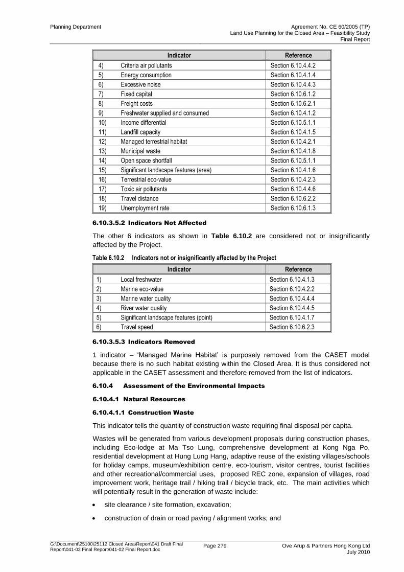
Planning Department Agreement No. CE 60/2005 (TP) Land Use Planning for the Closed Area – Feasibility Study
Final Report
G:\Document\25100\25112 Closed Area\Report\041 Draft Final Report\041-02 Final Report\041-02 Final Report.doc
Page 279 Ove Arup & Partners Hong Kong Ltd July 2010
Indicator Reference
4) Criteria air pollutants Section 6.10.4.4.2
5) Energy consumption Section 6.10.4.1.4
6) Excessive noise Section 6.10.4.4.3
7) Fixed capital Section 6.10.6.1.2
8) Freight costs Section 6.10.6.2.1
9) Freshwater supplied and consumed Section 6.10.4.1.2
10) Income differential Section 6.10.5.1.1
11) Landfill capacity Section 6.10.4.1.5
12) Managed terrestrial habitat Section 6.10.4.2.1
13) Municipal waste Section 6.10.4.1.8
14) Open space shortfall Section 6.10.5.1.1
15) Significant landscape features (area) Section 6.10.4.1.6
16) Terrestrial eco-value Section 6.10.4.2.3
17) Toxic air pollutants Section 6.10.4.4.6
18) Travel distance Section 6.10.6.2.2
19) Unemployment rate Section 6.10.6.1.3
6.10.3.5.2 Indicators Not Affected
The other 6 indicators as shown in Table 6.10.2 are considered not or insignificantly
affected by the Project.
Table 6.10.2 Indicators not or insignificantly affected by the Project
Indicator Reference
1) Local freshwater Section 6.10.4.1.3
2) Marine eco-value Section 6.10.4.2.2
3) Marine water quality Section 6.10.4.4.4
4) River water quality Section 6.10.4.4.5
5) Significant landscape features (point) Section 6.10.4.1.7
6) Travel speed Section 6.10.6.2.3
6.10.3.5.3 Indicators Removed
1 indicator – „Managed Marine Habitat‟ is purposely removed from the CASET model
because there is no such habitat existing within the Closed Area. It is thus considered not
applicable in the CASET assessment and therefore removed from the list of indicators.
6.10.4 Assessment of the Environmental Impacts
6.10.4.1 Natural Resources
6.10.4.1.1 Construction Waste
This indicator tells the quantity of construction waste requiring final disposal per capita.
Wastes will be generated from various development proposals during construction phases,
including Eco-lodge at Ma Tso Lung, comprehensive development at Kong Nga Po,
residential development at Hung Lung Hang, adaptive reuse of the existing villages/schools
for holiday camps, museum/exhibition centre, eco-tourism, visitor centres, tourist facilities
and other recreational/commercial uses, proposed REC zone, expansion of villages, road
improvement work, heritage trail / hiking trail / bicycle track, etc. The main activities which
will potentially result in the generation of waste include:
site clearance / site formation, excavation;
construction of drain or road paving / alignment works; and
Planning Department Agreement No. CE 60/2005 (TP) Land Use Planning for the Closed Area – Feasibility Study
Final Report
G:\Document\25100\25112 Closed Area\Report\041 Draft Final Report\041-02 Final Report\041-02 Final Report.doc
Page 280 Ove Arup & Partners Hong Kong Ltd July 2010
construction of the proposed development and infrastructure.
A variety of wastes will be generated, which can be divided into the following distinct
categories based on their compositions:
C&D materials: mainly arising from construction activities such as site clearance,
excavation and new building construction;
chemical wastes: generated from maintenance and servicing of construction plant and
equipment;
general refuse: generated from staff working at the construction site; and
contaminated wastes: mainly arising from historical landuse such as metal/ mechanical
workshops, oil / chemical installation.
Scenario 1 (without the Project)
The indicator will remain the same without the Project.
Scenario 2 (with the Project)
This indicator will increase slightly with the Project.
The proposed development will be implemented in stages. The C&D materials will be
generated in phases after the release of the closed area. The gross floor area (GFA) of the
existing proposed developments (excluding village zones) are tentatively 1,039,359m2.
Based on the generation rate of 0.1m3 per 1m
2 of GFA, the estimated quantity is 12Mm
3
(taking into account of safety factor of 1.2). In addition, the quantity of C&D materials
generated by the village expansion is estimated to be 0.1Mm3.
The cut materials will consist of clean rock and soil, which could be reused on-site. To
minimize the need for any off-site disposal of excavated materials, C&DM will be used for
landscaping works in the proposed developments area as far as practicable. Surplus cut
material will then be disposed off at public fill bank. A total of 0.34Mm3 of cut material will be
produced, of which 0.07Mm3 will be used for backfilling and 0.23Mm
3 will be disposed off at
public fill and 0.04Mm3 will be disposed off at landfill.
With the small scale of proposed development under the landuse planning framework and
the corresponding construction activities, quantities of chemical wastes, general refuse and
contaminated wastes generated were estimated to be small.
6.10.4.1.2 Freshwater Supplied and Consumed
This indicator reflects the volume of freshwater supplied and consumed per capita in Hong
Kong.
Scenario 1 (without the Project)
This indicator is expected to remain the same.
Scenario 2 (with the Project)
Freshwater would mainly be consumed by the villagers, workers and visitors. The amount of
water consumption by the Project would therefore result in a surge in current volume of
freshwater supplied and consumed per capita per day. Hence, there would be a qualitative
moderate increase for this indicator in Scenario 2.
6.10.4.1.3 Local Freshwater
This indicator shows the percentage of demand met by locally-derived freshwater resources
in Hong Kong.
Scenario 1 (without the Project)
There is no change in this parameter.
Planning Department Agreement No. CE 60/2005 (TP) Land Use Planning for the Closed Area – Feasibility Study
Final Report
G:\Document\25100\25112 Closed Area\Report\041 Draft Final Report\041-02 Final Report\041-02 Final Report.doc
Page 281 Ove Arup & Partners Hong Kong Ltd July 2010
Scenario 2 (with the Project)
In this project, there is no additional demand of freshwater specifically from local resources.
Hence there has been no implication on locally-derived freshwater resources and this
indicator remains the same.
6.10.4.1.4 Energy Consumption
This indicator tells the energy consumption per unit of output ($GDP).
Scenario 1 (without the Project)
This indicator is expected to remain the same without the project.
Scenario 2 (with the Project)
As developments such as Comprehensive Development at Kong Nga Po as well as Eco-
lodge are proposed within the closed area, energy consumption will be increased
accordingly. However, as the Closed Area is developed based on the principle of
sustainability development, eco-tourism and use of cycling mode will be promoted within the
Closed Area. Thus, compared the development sites with the entire Closed Area, the
electricity and fuel consumption in the Closed Area will be only little and the indicator will
therefore be qualitatively small.
6.10.4.1.5 Landfill Capacity
This indicator tells the total remaining landfill capacity by volume.
Scenario 1 (without the Project)
In this scenario, this indicator is expected to be decrease slightly without the Project, as
most of the waste generated is disposed of at landfills.
Scenario 2 (with the Project)
The landfill capacity is expected to decrease slightly with the Project.
The projected population of Closed Area is estimated to be about 32,000, which is less than
0.6% of population in Hong Kong. It has been estimated that about 170 tpd domestic waste
will be generated requiring landfill disposal. With adoption of reuse, recycling and reduction
of municipal solid waste by the entire population, the per capita waste generation continuing
to fall in recent years. Small amount of chemical waste from the new crematorium and
municipal waste from various tourist facilities/uses will also be generated.
Construction waste from Closed Area will also be limited. It is estimated that about
0.24Mm3 of C&D waste will be generated. With the waste charging scheme in place, the
construction waste will be reused as far as practicable.
6.10.4.1.6 Significant Landscape Features (Area)
This indicator presents the area of significant landscape features that would be affected
under the scenarios to be assessed.
Scenario 1 (without the Project)
No significant landscape features will be affected without the project.
Scenario 2 (with the Project)
Some of significant area, e.g. Mai Po, is planned to minimize the disturbance for the existing
environment as much as possible, development with relatively higher degree of disturbance
(e.g. comprehensive development at Kong Nga Po) will only be proposed to be located at
the area with relatively lower sensitivity. It is not only beneficial to local landscape character
areas and resources; thus it is also advantageous to local ecology and heritage resources.
Planning Department Agreement No. CE 60/2005 (TP) Land Use Planning for the Closed Area – Feasibility Study
Final Report
G:\Document\25100\25112 Closed Area\Report\041 Draft Final Report\041-02 Final Report\041-02 Final Report.doc
Page 282 Ove Arup & Partners Hong Kong Ltd July 2010
Thus most of LCAs / LRs are resulted as slight landscape impacts. The whole land use
planning for the Closed Area provides minimum landscape impacts for the Study Area.
Therefore, some areas with higher sensitivity would be proposed to be preserved under the
main land use planning concept of Nature Conservation. It is effective to avoid the potential
impacts on areas with different degree of sensitivity. Based on the broad assessment, the
overall residual impact after implementing the proper mitigation measures would be likely
“acceptable with mitigation”.
Thus, this indicator is expected to have a small decrease.
6.10.4.1.7 Significant Landscape Features (Point)
This indicator tells the total number of point-based significant landscape features and old
and valuable trees which are affected by the project.
Scenario 1 (without the Project)
No significant landscape features (point) will be affected.
Scenario 2 (with the Project)
The RDPs have been carefully designed such that no significant point-based landscape
features or old and valuable trees in the vicinity of the project will be affected.
This indicator will therefore remain the same.
6.10.4.1.8 Municipal Solid Waste
This indicator shows quantity of municipal solid waste requiring final disposal per capita in
Hong Kong.
Scenario 1 (without the Project)
The indicator is expected to remain unchanged.
Scenario 2 (with the Project)
This indicator is expected to remain unchanged or increase slightly. Most of municipal solid
wastes are domestic wastes, with small amount of commercial waste from eco-lodge and
industrial waste from crematorium/ columbarium and sustainability corridor. About 177 tpd
municipal solid waste would be generated.
Domestic waste will arise from the residential development and the storage and handling of
domestic waste. It is estimated that a total of about 177 and 56 tonnes/day of municipal
waste will be generated from the land use proposals in weekends / public holidays and
normal days respectively. Recyclable materials such as plastic bottles, aluminum cans and
paper will be collected by separate recycle bins and delivered to recyclers for recycling. The
non-recyclable portion of waste generated will be collected and delivered to the designated
refuse transfer station or landfill site for disposal by waste collector to be engaged by the
FEHD / licensed collector.
6.10.4.2 Biodiversity
Relevant indicators include managed terrestrial habitat, marine eco-value and terrestrial
eco-value.
6.10.4.2.1 Managed Terrestrial Habitat
This indicator indicates the area of managed terrestrial habitat for conservation in Hong
Kong, where exposed to impacts of this project.
Scenario 1 (without the Project)
This indicator is expected to remain the same without the Project.
Planning Department Agreement No. CE 60/2005 (TP) Land Use Planning for the Closed Area – Feasibility Study
Final Report
G:\Document\25100\25112 Closed Area\Report\041 Draft Final Report\041-02 Final Report\041-02 Final Report.doc
Page 283 Ove Arup & Partners Hong Kong Ltd July 2010
Scenario 2 (with the Project)
This indicator is expected to change because some managed areas of terrestrial habitat will
be created. These will comprise Robin‟s Nest Country Park, which will afford a greater
degree of protection to areas of woodland, shrubland and upland grassland. Elsewhere, the
status of Conservation Area will be afforded to Muk Min Tau fung shui woodland.
With regard to mitigation plantation woodland at Nam Hang, mitigation wetlands such as
those at Lok Ma Chau Spur Line Wetland Compensation Area and San Tin East Main
Drainage Channel, and reinstated fishponds along the Shenzhen River, no change is
anticipated.
All elements in this scenario are expected to either increase or remain neutral.
6.10.4.2.2 Marine Eco-value
This indicator refers the area of high marine ecological value in Hong Kong. There is no
area of high marine ecological value in the vicinity of the project area.
Scenario 1 (without the Project)
This indicator is expected to remain the same without the Project.
Scenario 2 (with the Project)
This indicator is expected to remain the same because area of high marine ecological value
will not be affected.
6.10.4.2.3 Terrestrial Eco-value
Scenario 1 (without the Project)
This indicator is expected to increase because terrestrial habitats will continue to mature in
a no-change scenario, as they have done over the past 30-40 years, eventually succeeding
to closed-canopy shrubland and climax woodland. With regard to other habitats, although
some areas may turn into freshwater marsh of higher ecological value in the short to
medium term, in the long term these would revert to non-marsh habitats.
Scenario 2 (with the Project)
This indicator is expected to change. It will increase in respect of some habitats/areas, as
terrestrial habitats will mature to closed-canopy shrubland and climax woodland, much as
they would under the do-nothing scenario, though perhaps more so in those areas zoned as
Country Park.
The designation as Conservation Area of the area of Ho Sheung Heung Egretry will provide
protection to this important egretry. Elsewhere, designation as Conservation Area of a small
number of fishponds adjacent to Lok Ma Chau Loop, and of fung shui woodlands at Heung
Yuen Wai and Lin Ma Hang will afford greater protection to these areas. While this will not
necessarily increase ecological value, it should provide the protection required to maintain
current ecological value in a more developed landscape.
However, this indicator is also expected to decrease in respect of other habitats/areas due
to impacts from development and agricultural modification on certain areas of natural
stream and lowland grasslands. The relevant areas are natural streams at Heung Yuen
Wai, Lin Ma Hang, Tong To, Muk Min Tau and Sheung/Ha Tam Shui Hang, lowland
grassland in the Tsung Yuen Ha area.
6.10.4.3 Leisure and Cultural Vibrancy
Relevant indicators include number of recorded archaeological sites, and cultural and
historical sites.
Planning Department Agreement No. CE 60/2005 (TP) Land Use Planning for the Closed Area – Feasibility Study
Final Report
G:\Document\25100\25112 Closed Area\Report\041 Draft Final Report\041-02 Final Report\041-02 Final Report.doc
Page 284 Ove Arup & Partners Hong Kong Ltd July 2010
6.10.4.3.1 Archaeological Site
This indicator reveals the number of recorded archaeological site affected by the proposed
project.
Scenario 1 (without the Project)
This indicator is expected to remain the same without the Project.
Scenario 2 (with the Project)
This indicator is expected to remain the same as there is no known archaeological site
would be affected by the new proposed developments. Detailed AIA should be carried out
identified when the development comes to place.
6.10.4.3.2 Historical Site
This indicator shows the number of cultural and historical sites affected by the proposed
development.
Scenario 1 (without the Project)
This indicator is expected to remain the same without the project.
Scenario 2 (with the Project)
This indicator is expected to improve with the Project.
The proposed development corridor at Man Kam To Road, residential development at Hung
Lung Hang and REC near Pak Fu Shan, Fung Wang Wu and Tong To Ping, as well as road
improvements schemes, cycle track and hiking trails are identified as having potential
impacts on archaeological resources. Areas containing archaeological deposits will be
preserved in situ wherever feasible.
A number of historical buildings have been identified at the village zones. The proposed
landuse reflects the existing zoning and direct impact on built heritage resources is not
anticipated. The development plan aims to revitalize the historical village through cultural
tourism. The heritage trails proposed will link individual heritage resources together to
enhance presentation of the heritage groupings of the Closed Area to visitors. The adaptive
reuse of the disused schools will also encourage rehabilitation of these historical buildings
and also promote the cultural tourism.
6.10.4.4 Environmental Quality
Relevant indicators include carbon dioxide emitted per year, criteria air pollutants, excessive
noise, marine water quality, river water quality and toxic air pollutants.
6.10.4.4.1 Carbon Dioxide Emitted Per Year
This indicator refers to the quantity (tonnes) of carbon dioxide emitted per year.
Scenario 1 (without the Project)
Carbon dioxide emitted is expected to increase slightly without the project, with the natural
growth of population and traffic in the region.
Scenario 2 (with the Project)
Carbon dioxide emitted is expected to increase, with the growth of population and traffic in
the region. However, as the developments only occupy a small portion of the site area
within the entire Closed Area, the impact of carbon dioxide emission will be minimal.
Moreover, the incinerators in the proposed Crematorium at Sandy Ridge will emit a large
amount of carbon dioxide but such impact will be localized and the future project proponent
will need to carry out the impact assessment by the carbon dioxide emission. In short, with
Planning Department Agreement No. CE 60/2005 (TP) Land Use Planning for the Closed Area – Feasibility Study
Final Report
G:\Document\25100\25112 Closed Area\Report\041 Draft Final Report\041-02 Final Report\041-02 Final Report.doc
Page 285 Ove Arup & Partners Hong Kong Ltd July 2010
the proposed limited development for the whole Closed Area, the carbon dioxide emitted will
be limited.
6.10.4.4.2 Criteria Air Pollutants
This indicator refers to the composite index for criteria air pollutants based on percentage of
the Air Quality Objectives.
Criteria air pollutants listed in the AQO consist of carbon monoxide, sulphur dioxide,
nitrogen dioxide, particulate matter, ozone and lead. They mainly come from the industrial
activities, vehicle combustion engines etc. The most critical air pollutant in this Project is
NO2, which is related to vehicle exhaust emission.
Scenario 1 (without the Project)
This indicator is expected to increase slightly without the project, with the natural growth of
population and traffic in the region.
Scenario 2 (with the Project)
Criteria air pollutants is expected to increase slightly with the project, with the growth of
population, traffic and proposed crematorium in the region.
The proposed road improvement plan will upgrade the existing road network to prevailing
safety standards, such as sightlines, turning radius, horizontal and vertical alignments. No
new road will be proposed in the Closed Area. Significant increase in traffic flow of the road
network is therefore not anticipated. By limiting development within the Closed Area,
increase in vehicle exhaust emissions will also be controlled. The air quality at both existing
and planned ASRs, with the road improvement scheme, are well below the relevant air
quality criteria. The AQO criteria for NO2 will be satisfied at all proposed developments.
A crematorium is proposed within Sandy Ridge with air sensitive receivers located at more
than 350m from the facility. Design and emission limits of crematorium will satisfy the
EPD‟s BPM for Incinerators (Crematoria) BPM 12/2 (06). Protection of human health and
the environment has been assured (see Strategic Performance Report). The proposed
crematorium is a Designated Project under the EIAO. A statutory environmental impact
assessment (EIA) is required to assess and confirm its potential environmental impact and
recommended mitigation measures. The toxic chemical pollutants will be complied at all
existing and proposed developments.
6.10.4.4.3 Excessive Noise
This indicator refers to the percentage of population in Hong Kong exposed to excessive
noise. It is of particular concern in Hong Kong because of the close proximity of noise
sources to sensitive receivers.
Scenario 1 (without the Project)
This indicator is expected to increase slightly without the project, with the natural growth of
population and traffic in the region
Scenario 2 (with the Project)
Major noise sources in the Closed Area are predominantly from road traffic, rail and fixed
noise sources.
A major environmental issue is traffic noise impacts on the existing and planned
development. A significant number of residential areas will be affected by such a long
extent. The SEA Final Report reveals that some noise sensitive receives would experience
high traffic noise impacts exceeding the noise criteria and direct noise mitigation measures
such as noise barrier would be required to protect these receivers.
Planning Department Agreement No. CE 60/2005 (TP) Land Use Planning for the Closed Area – Feasibility Study
Final Report
G:\Document\25100\25112 Closed Area\Report\041 Draft Final Report\041-02 Final Report\041-02 Final Report.doc
Page 286 Ove Arup & Partners Hong Kong Ltd July 2010
Fixed noise sources including firing ranges and BCPs would create localized noise problem
to the proposed developments. The proposed comprehensive development at Kong Nga
Po in RDP 3 would be impacted by firing range. The Shan Tsui Village Zone and Tsung
Yuen Ha Village Zone would be impacted by STK BCP and Liantang/ Heung Yuen Wai BCP
respectively. Mitigation measures in the form of buffer distance in combination with a
substantial noise barrier are proposed to protect the receivers. The ex-Lung Kai Public
School would also be impacted by firing range, and indirect mitigation measures are
required for this holiday camp.
Some proposed village zones would experience short duration impacts from helicopter
noise, but they only reflect the existing land uses. These helipads however are primarily for
emergency purpose and are not frequently used. Noise exposure is also transient in nature.
With the opening of Closed Area and increasing accessibility from improved road
infrastructure, the reliance on helicopter transport to the Closed Area is expected to reduce
from the already infrequent usage currently.
6.10.4.4.4 Marine Water Quality
This indicator shows the composite index for marine water quality pollutants based on
percentage of the Water Quality Objectives.
Scenario 1 (without the Project)
The indicator will remain the same without the Project.
Scenario 2 (with the Project)
Most areas in the Closed Area are unsewered. Domestic sewage is treated by private
treatment facilities, such as septic tanks and soakaway system, and discharged into Deep
Bay via stormwater drains or streams. The effectiveness of such treatment facilities
depends on their sizes, locations and maintenance.
With the proposed development, daily effluent flow of about 11,584m3/day has been
projected. The effluent will place stress on the existing sewerage infrastructures, as the
sewerage infrastructure has already reached or near its full capacity, and are often
overloaded due to high infiltration of stormwater and upstream village pumping stations in
rainy season. The Deep Bay Water Control Zone is a sensitive water body.
To ensure compliance of “No Net Increase in Pollution Loads Requirements” and no
discharge into SSSI, the sewerage infrastructure will be upgraded and expanded to serve
the Closed Area except for the small scale San Kwai Tin Village expansion in RDP 5 where
sewage will be treated using septic tank and leach fields. Lin Ma Hang village will also be
connected to ensure that its effluent will not be discharge into Lin Ma Hang Stream SSSI.
The RDP will include an improvement proposal on the sewerage and sewage treatment
infrastructure in Closed Area, thus the water quality of nearby watercourses would not be
worsen than the existing condition.
6.10.4.4.5 River Water Quality
This indicator reflects the percent of EPD‟s river monitoring stations ranked “Excellent” or
“Good” using the EPD River Water Quality Index.
Scenario 1 (without the Project)
The river water quality will remain as its existing condition without the Project.
Scenario 2 (with the Project)
Currently, domestic sewage from unsewered areas in the Closed Area is partially treated by
private treatment facilities before being discharged into Deep Bay via stormwater drains and
streams according to the Strategic Performance Report. Most of these treatment facilities
are septic tanks and soakaway systems in village houses. Although the opening up of the
Planning Department Agreement No. CE 60/2005 (TP) Land Use Planning for the Closed Area – Feasibility Study
Final Report
G:\Document\25100\25112 Closed Area\Report\041 Draft Final Report\041-02 Final Report\041-02 Final Report.doc
Page 287 Ove Arup & Partners Hong Kong Ltd July 2010
Closed Area would generate additional wastewater and sewage, the proposed DDP
provides trunk sewers for most of the areas and wastewater will receive tertiary treatment
prior to discharge. With the improved sewerage and sewage treatment infrastructure in the
Closed Area, it is expected that there will be no net increase in pollutant loading discharged
into Deep Bay. The RDP has included an improvement proposal on the sewerage and
sewage treatment infrastructure in Closed Area, thus the water quality of nearby
watercourses would not be worsen than the existing condition.
6.10.4.4.6 Toxic Air Pollutants
This indicator refers to the composite index for toxic air pollutants based on percentage of
acceptable risk.
Scenario 1 (without the Project)
Without the Project, it is anticipated that the existing level of toxic air pollutants would
remain the same.
Scenario 2 (with the Project)
With an increasing demand for public C&C facilities in Hong Kong, new C&C facilities are
proposed at Sandy Ridge within our study area. On account of various factors including
ecological, environmental, landscape, heritage, technical and engineering, accessibility,
land status, land use compatibility and visual impact considerations etc, the Sandy Ridge
Cemetery is considered the most suitable site to accommodate such facilities. The siting
and design of the new crematorium will also satisfy BPM requirements to ensure minimal
environmental impacts on the surroundings, without compromising the air quality objectives.
Design and emission limits of crematorium will satisfy the EPD‟s BPM for Incinerators
(Crematoria) BPM 12/2 (06). The proposed crematorium is a Designated Project under the
EIAO. A statutory environmental impact assessment (EIA) is required to assess and
confirm its potential environmental impact and recommended mitigation measures. The
toxic chemical pollutants will be complied at all existing and proposed developments. The
Strategic Performance Report which concludes that the pollutant emissions from the
crematorium at Sandy Ridge will comply with both the AQO and international standards on
dioxin without the need of mitigation measures.
This indicator will increase slightly with the toxic air pollutants emitted from the crematorium.
6.10.5 Assessment of Social Impacts
6.10.5.1 Society and Social Infrastructure
The relevant indicators associated with social impacts that were included in the assessment
include income differential and open space shortfall.
6.10.5.1.1 Income Differential
This indicator measures the difference between percentage change in the upper quartile of
after-tax household income and percentage change in the lower quartile of after-tax
household income.
Scenario 1 (without the Project)
The indicator will remain the same without the Project.
Scenario 2 (with the Project)
The indicator is expected to decrease and the change is expected to be qualitatively small
at a regional level, but of greater emphasis at a local because new economic opportunities
are created for local (typically low-income) residents. The proportion of people aged over
65 in the Study Area is substantially higher thatn that of the rest of the New Territories or
Hong Kong as a whole. This is reflective of the movement of younger generations toward
the economic opportunities of urban areas. Economic activities are also very limited due to
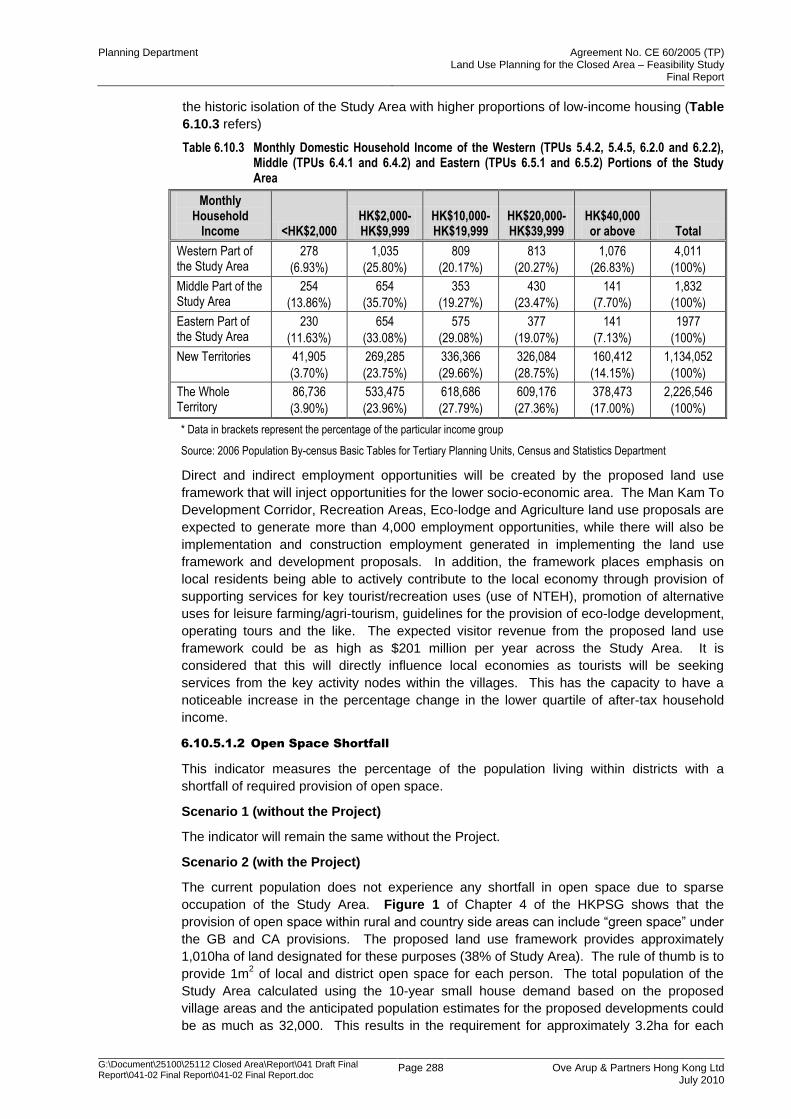
Planning Department Agreement No. CE 60/2005 (TP) Land Use Planning for the Closed Area – Feasibility Study
Final Report
G:\Document\25100\25112 Closed Area\Report\041 Draft Final Report\041-02 Final Report\041-02 Final Report.doc
Page 288 Ove Arup & Partners Hong Kong Ltd July 2010
the historic isolation of the Study Area with higher proportions of low-income housing (Table
6.10.3 refers)
Table 6.10.3 Monthly Domestic Household Income of the Western (TPUs 5.4.2, 5.4.5, 6.2.0 and 6.2.2), Middle (TPUs 6.4.1 and 6.4.2) and Eastern (TPUs 6.5.1 and 6.5.2) Portions of the Study Area
Monthly Household
Income <HK$2,000 HK$2,000-HK$9,999
HK$10,000-HK$19,999
HK$20,000-HK$39,999
HK$40,000 or above Total
Western Part of the Study Area
278
(6.93%)
1,035
(25.80%)
809
(20.17%)
813
(20.27%)
1,076
(26.83%)
4,011
(100%)
Middle Part of the Study Area
254
(13.86%)
654
(35.70%)
353
(19.27%)
430
(23.47%)
141
(7.70%)
1,832
(100%)
Eastern Part of the Study Area
230
(11.63%)
654
(33.08%)
575
(29.08%)
377
(19.07%)
141
(7.13%)
1977
(100%)
New Territories 41,905
(3.70%)
269,285
(23.75%)
336,366
(29.66%)
326,084
(28.75%)
160,412
(14.15%)
1,134,052
(100%)
The Whole Territory
86,736
(3.90%)
533,475
(23.96%)
618,686
(27.79%)
609,176
(27.36%)
378,473
(17.00%)
2,226,546
(100%)
* Data in brackets represent the percentage of the particular income group
Source: 2006 Population By-census Basic Tables for Tertiary Planning Units, Census and Statistics Department
Direct and indirect employment opportunities will be created by the proposed land use
framework that will inject opportunities for the lower socio-economic area. The Man Kam To
Development Corridor, Recreation Areas, Eco-lodge and Agriculture land use proposals are
expected to generate more than 4,000 employment opportunities, while there will also be
implementation and construction employment generated in implementing the land use
framework and development proposals. In addition, the framework places emphasis on
local residents being able to actively contribute to the local economy through provision of
supporting services for key tourist/recreation uses (use of NTEH), promotion of alternative
uses for leisure farming/agri-tourism, guidelines for the provision of eco-lodge development,
operating tours and the like. The expected visitor revenue from the proposed land use
framework could be as high as $201 million per year across the Study Area. It is
considered that this will directly influence local economies as tourists will be seeking
services from the key activity nodes within the villages. This has the capacity to have a
noticeable increase in the percentage change in the lower quartile of after-tax household
income.
6.10.5.1.2 Open Space Shortfall
This indicator measures the percentage of the population living within districts with a
shortfall of required provision of open space.
Scenario 1 (without the Project)
The indicator will remain the same without the Project.
Scenario 2 (with the Project)
The current population does not experience any shortfall in open space due to sparse
occupation of the Study Area. Figure 1 of Chapter 4 of the HKPSG shows that the
provision of open space within rural and country side areas can include “green space” under
the GB and CA provisions. The proposed land use framework provides approximately
1,010ha of land designated for these purposes (38% of Study Area). The rule of thumb is to
provide 1m2 of local and district open space for each person. The total population of the
Study Area calculated using the 10-year small house demand based on the proposed
village areas and the anticipated population estimates for the proposed developments could
be as much as 32,000. This results in the requirement for approximately 3.2ha for each
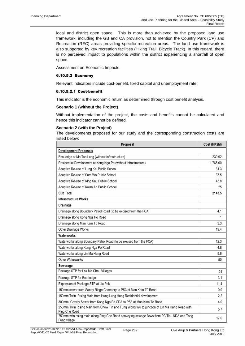
Planning Department Agreement No. CE 60/2005 (TP) Land Use Planning for the Closed Area – Feasibility Study
Final Report
G:\Document\25100\25112 Closed Area\Report\041 Draft Final Report\041-02 Final Report\041-02 Final Report.doc
Page 289 Ove Arup & Partners Hong Kong Ltd July 2010
local and district open space. This is more than achieved by the proposed land use
framework, including the GB and CA provision, not to mention the Country Park (CP) and
Recreation (REC) areas providing specific recreation areas. The land use framework is
also supported by key recreation facilities (Hiking Trail, Bicycle Track). In this regard, there
is no perceived impact to populations within the district experiencing a shortfall of open
space.
Assessment on Economic Impacts
6.10.5.2 Economy
Relevant indicators include cost-benefit, fixed capital and unemployment rate.
6.10.5.2.1 Cost-benefit
This indicator is the economic return as determined through cost benefit analysis.
Scenario 1 (without the Project)
Without implementation of the project, the costs and benefits cannot be calculated and
hence this indicator cannot be defined.
Scenario 2 (with the Project)
The developments proposed for our study and the corresponding construction costs are
listed below:
Proposal Cost (HK$M)
Development Proposals
Eco-lodge at Ma Tso Lung (without infrastructure) 239.92
Residential Development at Kong Nga Po (without infrastructure) 1,766.00
Adaptive Re-use of Lung Kai Public School 31.3
Adaptive Re-use of Sam Wo Public School 37.5
Adaptive Re-use of King Sau Public School 43.8
Adaptive Re-use of Kwan Ah Public School 25
Sub Total 2143.5
Infrastructure Works
Drainage
Drainage along Boundary Patrol Road (to be excised from the FCA) 4.1
Drainage along Kong Nga Po Road 1
Drainage along Man Kam To Road 3.3
Other Drainage Works 19.4
Waterworks
Waterworks along Boundary Patrol Road (to be excised from the FCA) 12.3
Waterworks along Kong Nga Po Road 4.8
Waterworks along Lin Ma Hang Road 9.6
Other Waterworks 50
Sewerage
Package STP for Lok Ma Chau Villages 24
Package STP for Eco-lodge 3.1
Expansion of Package STP at Liu Pok 11.4
150mm sewer from Sandy Ridge Cemetery to PS3 at Man Kam T0 Road 0.9
150mm Twin Rising Main from Hung Lung Hang Residential development 2.2
300mm Gravity Sewer from Kong Nga Po CDA to PS3 at Man Kam To Road 4.0
250mm Twin Rising Main from Chow Tin and Fung Wong Wu to junction of Lin Ma Hang Road with Ping Che Road
5.7
750mm twin rising main along Ping Che Road conveying sewage flows from PC/TKL NDA and Tong Fung village
17.0
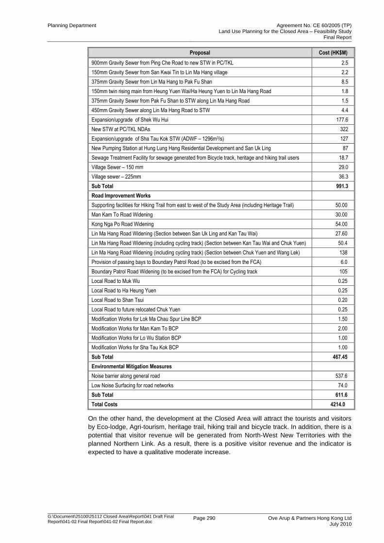
Planning Department Agreement No. CE 60/2005 (TP) Land Use Planning for the Closed Area – Feasibility Study
Final Report
G:\Document\25100\25112 Closed Area\Report\041 Draft Final Report\041-02 Final Report\041-02 Final Report.doc
Page 290 Ove Arup & Partners Hong Kong Ltd July 2010
Proposal Cost (HK$M)
900mm Gravity Sewer from Ping Che Road to new STW in PC/TKL 2.5
150mm Gravity Sewer from San Kwai Tin to Lin Ma Hang village 2.2
375mm Gravity Sewer from Lin Ma Hang to Pak Fu Shan 8.5
150mm twin rising main from Heung Yuen Wai/Ha Heung Yuen to Lin Ma Hang Road 1.8
375mm Gravity Sewer from Pak Fu Shan to STW along Lin Ma Hang Road 1.5
450mm Gravity Sewer along Lin Ma Hang Road to STW 4.4
Expansion/upgrade of Shek Wu Hui 177.6
New STW at PC/TKL NDAs 322
Expansion/upgrade of Sha Tau Kok STW (ADWF – 1296m3/s) 127
New Pumping Station at Hung Lung Hang Residential Development and San Uk Ling 87
Sewage Treatment Facility for sewage generated from Bicycle track, heritage and hiking trail users 18.7
Village Sewer – 150 mm 29.0
Village sewer – 225mm 36.3
Sub Total 991.3
Road Improvement Works
Supporting facilities for Hiking Trail from east to west of the Study Area (including Heritage Trail) 50.00
Man Kam To Road Widening 30.00
Kong Nga Po Road Widening 54.00
Lin Ma Hang Road Widening (Section between San Uk Ling and Kan Tau Wai) 27.60
Lin Ma Hang Road Widening (including cycling track) (Section between Kan Tau Wai and Chuk Yuen) 50.4
Lin Ma Hang Road Widening (including cycling track) (Section between Chuk Yuen and Wang Lek) 138
Provision of passing bays to Boundary Patrol Road (to be excised from the FCA) 6.0
Boundary Patrol Road Widening (to be excised from the FCA) for Cycling track 105
Local Road to Muk Wu 0.25
Local Road to Ha Heung Yuen 0.25
Local Road to Shan Tsui 0.20
Local Road to future relocated Chuk Yuen 0.25
Modification Works for Lok Ma Chau Spur Line BCP 1.50
Modification Works for Man Kam To BCP 2.00
Modification Works for Lo Wu Station BCP 1.00
Modification Works for Sha Tau Kok BCP 1.00
Sub Total 467.45
Environmental Mitigation Measures
Noise barrier along general road 537.6
Low Noise Surfacing for road networks 74.0
Sub Total 611.6
Total Costs 4214.0
On the other hand, the development at the Closed Area will attract the tourists and visitors
by Eco-lodge, Agri-tourism, heritage trail, hiking trail and bicycle track. In addition, there is a
potential that visitor revenue will be generated from North-West New Territories with the
planned Northern Link. As a result, there is a positive visitor revenue and the indicator is
expected to have a qualitative moderate increase.
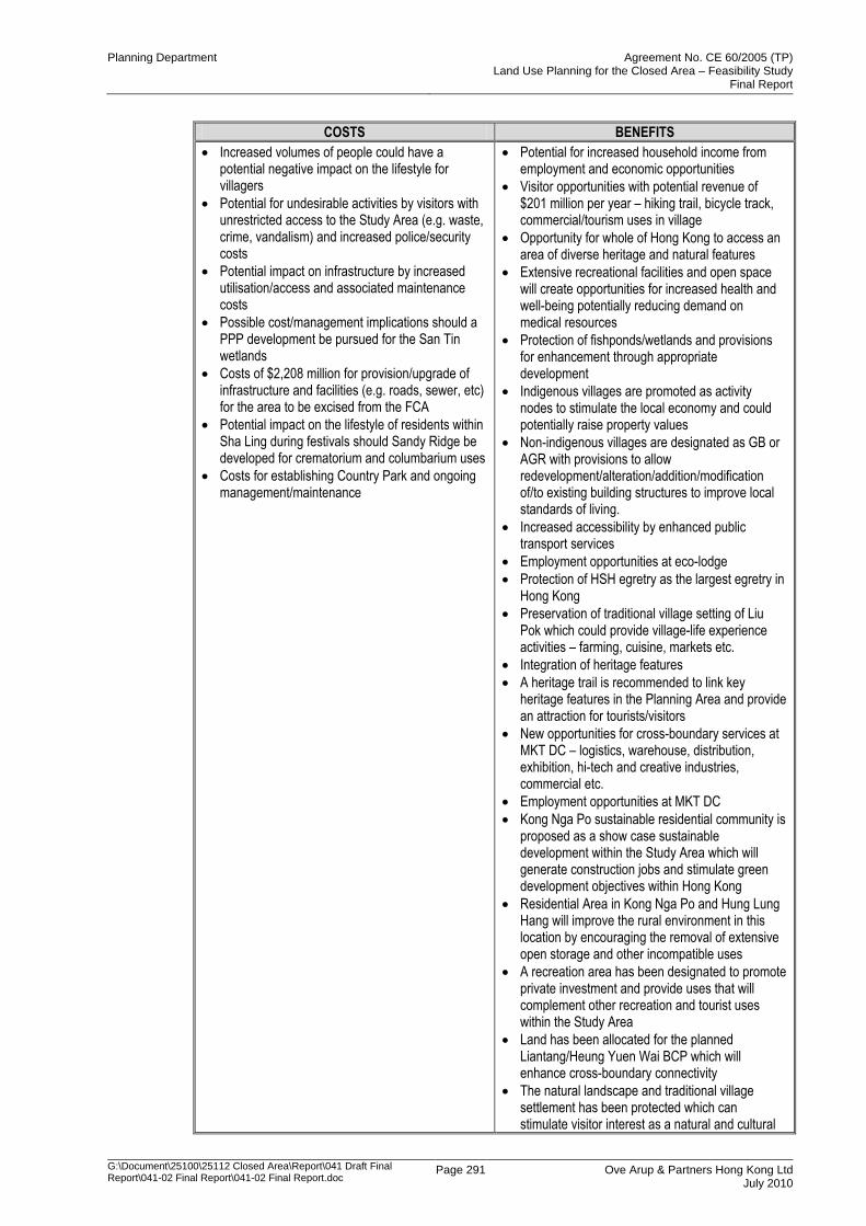
Planning Department Agreement No. CE 60/2005 (TP) Land Use Planning for the Closed Area – Feasibility Study
Final Report
G:\Document\25100\25112 Closed Area\Report\041 Draft Final Report\041-02 Final Report\041-02 Final Report.doc
Page 291 Ove Arup & Partners Hong Kong Ltd July 2010
COSTS BENEFITS
Increased volumes of people could have a potential negative impact on the lifestyle for villagers
Potential for undesirable activities by visitors with unrestricted access to the Study Area (e.g. waste, crime, vandalism) and increased police/security costs
Potential impact on infrastructure by increased utilisation/access and associated maintenance costs
Possible cost/management implications should a PPP development be pursued for the San Tin wetlands
Costs of $2,208 million for provision/upgrade of infrastructure and facilities (e.g. roads, sewer, etc) for the area to be excised from the FCA
Potential impact on the lifestyle of residents within Sha Ling during festivals should Sandy Ridge be developed for crematorium and columbarium uses
Costs for establishing Country Park and ongoing management/maintenance
Potential for increased household income from employment and economic opportunities
Visitor opportunities with potential revenue of $201 million per year – hiking trail, bicycle track, commercial/tourism uses in village
Opportunity for whole of Hong Kong to access an area of diverse heritage and natural features
Extensive recreational facilities and open space will create opportunities for increased health and well-being potentially reducing demand on medical resources
Protection of fishponds/wetlands and provisions for enhancement through appropriate development
Indigenous villages are promoted as activity nodes to stimulate the local economy and could potentially raise property values
Non-indigenous villages are designated as GB or AGR with provisions to allow redevelopment/alteration/addition/modification of/to existing building structures to improve local standards of living.
Increased accessibility by enhanced public transport services
Employment opportunities at eco-lodge
Protection of HSH egretry as the largest egretry in Hong Kong
Preservation of traditional village setting of Liu Pok which could provide village-life experience activities – farming, cuisine, markets etc.
Integration of heritage features
A heritage trail is recommended to link key heritage features in the Planning Area and provide an attraction for tourists/visitors
New opportunities for cross-boundary services at MKT DC – logistics, warehouse, distribution, exhibition, hi-tech and creative industries, commercial etc.
Employment opportunities at MKT DC
Kong Nga Po sustainable residential community is proposed as a show case sustainable development within the Study Area which will generate construction jobs and stimulate green development objectives within Hong Kong
Residential Area in Kong Nga Po and Hung Lung Hang will improve the rural environment in this location by encouraging the removal of extensive open storage and other incompatible uses
A recreation area has been designated to promote private investment and provide uses that will complement other recreation and tourist uses within the Study Area
Land has been allocated for the planned Liantang/Heung Yuen Wai BCP which will enhance cross-boundary connectivity
The natural landscape and traditional village settlement has been protected which can stimulate visitor interest as a natural and cultural
Planning Department Agreement No. CE 60/2005 (TP) Land Use Planning for the Closed Area – Feasibility Study
Final Report
G:\Document\25100\25112 Closed Area\Report\041 Draft Final Report\041-02 Final Report\041-02 Final Report.doc
Page 292 Ove Arup & Partners Hong Kong Ltd July 2010
COSTS BENEFITS
tourist destination
Adequate protection provided for LMH stream (SSSI) which can be an attraction point for tourists
Extensive areas designated for agricultural purposes can provide for environmental friendly and leisure farming opportunities. These activities can attract visitors and contribute to the village-life experience aspect of tourism
Country Park will protect key natural and ecological assets as an attraction point for visitors
Coastal/natural environment has been protected and can provide an attraction location for the establishment of tourism/recreation uses
Comparison of the estimated costs of the entire development with the estimated revenues
generated from land sales under the base scenario returns a NPV of -HK$898.9 Million and
Revenue Cost ratio of 0.3. The revenue generated from land sales would cover
approximately 30% of the total infrastructure development cost. The costs for sewerage
treatment works and associated works are significant and account for approximately 40% of
the total development and infrastructure cost (excluding Eco lodge and KNP CDA).
These results indicate that the development of the area that will be excised from the FCA
will most likely require Government assistance to proceed.
6.10.5.2.2 Fixed Capital
This indicator refers to the gross domestic fixed capital formation as a ratio to GDP.
Scenario 1 (without the Project)
Without this project there is no change on the current fixed capital investments.
Scenario 2 (with the Project)
The development is located between boundary of Hong Kong as well as Shenzhen and thus
would attract certain investment from China. In addition, the Man Kam To Development
Corridor would help to increase the economic activity and therefore increase land value in
certain locations and business opportunities. Hence, this indicator is expected to have a
small increase.
6.10.5.2.3 Unemployment Rate
This indicator refers to the unemployment rate, as published by the Census and Statistics
Department regularly.
Scenario 1 (without the Project)
The unemployment rate will remain the same without the project.
Scenario 2 (with the Project)
With the implementation of the Project, more job opportunities will be provided during the
construction stage, especially to the construction industry, which can relieve the
unemployment rate of Hong Kong.
Moreover, new employment opportunities are created by various proposals including eco-
lodge, Man Kam To Development Corridor and provision for business opportunities
generated from tourism.
As a result, this indicator will decrease and the change is expected to be small.
Planning Department Agreement No. CE 60/2005 (TP) Land Use Planning for the Closed Area – Feasibility Study
Final Report
G:\Document\25100\25112 Closed Area\Report\041 Draft Final Report\041-02 Final Report\041-02 Final Report.doc
Page 293 Ove Arup & Partners Hong Kong Ltd July 2010
6.10.5.3 Mobility
Relevant indicators include road-based freight cost, average travel distances and average
network speed.
6.10.5.3.1 Freight Costs
This indicator refers to the cost of road-based freight transport; the cost of charges and
operating costs as a ratio to GDP.
Scenario 1 (without the Project)
This indicator will remain the same without the Project.
Scenario 2 (with the Project)
With the enhanced connectivity within the Closed Area, the freight cost will be reduced with
the travelling distance and time. The planned Northern Link could help enhance the
connectivity between Tin Shui Wai, Yuen Long and the Closed Area and thus reduce the
travel cost. Village road improvement can help with reduction of travelling time whereas
Man Kam To Road widening could increase the current capacity of the road and alleviate
the traffic congestion problem caused by the boundary-crossing traffic. In general,
shortening of travelling time helps save the passengers‟ opportunity cost in travelling.
Goods vehicles can also have the same output with shorter time.
Hence the freight costs are expected to decrease and the change is expected to be small.
6.10.5.3.2 Travel Distances
This indicator refers to the distance travelled by passengers during morning peak by all
major groups of transport modes.
Scenario 1 (without the Project)
There will be no change in the traffic distances without the Project.
Scenario 2 (with the Project)
As there is no major improvement in roadworks proposed in our project, there would be no
significant change in travel distance. However, with the planned Northern Link, the travel
distance between North-West New Territories and the Closed Area would be decreased. In
short, this indicator is expected to decrease and the change is expected to be small.
6.10.5.3.3 Travel Speed
This indicator refers to the average network speed, which is calculated as total passenger
kilometres divided by total passenger hours.
Scenario 1 (without the Project)
The travelling speed will remain unchanged.
Scenario 2 (with the Project)
With the implementation of the road improvement proposal for rural roads within the Closed
Area, e.g. widening of Lin Ma Hang Road from single track to single-2 road, the traffic within
the Closed Area will in general experience a shorter journey time with less delay along the
route.
The improvement proposal at Man Kam To Road would provide an additional traffic lane for
northbound traffic such that 2 northbound lanes will be designated as cross-boundary lanes
and 1 northbound lane will serve local traffic only. In this regard, the conflicts between the
cross boundary and local traffic along the northbound direction could be minimised. The
journey time for the traffic in general will be reduced for access of Man Kam To BCP and
the local villages.
Planning Department Agreement No. CE 60/2005 (TP) Land Use Planning for the Closed Area – Feasibility Study
Final Report
G:\Document\25100\25112 Closed Area\Report\041 Draft Final Report\041-02 Final Report\041-02 Final Report.doc
Page 294 Ove Arup & Partners Hong Kong Ltd July 2010
Last but not least, the travel speed, as well as travel time, between North-West New
Territories and the Closed Area could be increased with the planned Northern Link.
In short, this indicator is therefore expected to increase and the change is expected to be
moderate.
6.10.6 Summary
According to the preliminary sustainability assessment, the proposed development at the
area that will be excised from the FCA helps improve mobility and brings positive impacts to
the economy although the site of the impact is not expected to be significant. However, it
would also cause changes to the existing rural landscape character and potential adverse
impacts on environment, natural resources and cultural vibrancy.


