Embed Size (px)
Citation preview

International Journal of Public Policy and Administration Research, 2014, 1(1): 1-11
1
A REVIEW ON CRITERIA FOR GREEN INFRASTRUCTURE TO BE ADOPTED
BY LOCAL AUTHORITIES
Kamalludin Bilal
Universiti Tun Hussein Onn Malaysia, Parit Raja, Batu Pahat, Johor Darul Ta’zim, Malaysia
Hishammudin Mohd Ali
Universiti Teknologi Malaysia, Skudai, Johor Bahru, Johor Darul Ta’zim, Malaysia
Ibrahim Sipan
Universiti Teknologi Malaysia, Skudai, Johor Bahru, Johor Darul Ta’zim, Malaysia
Nurlaila Ali
Universiti Teknologi Malaysia, Skudai, Johor Bahru, Johor Darul Ta’zim, Malaysia
ABSTRACT
Green infrastructure planning has grown in prominence since it was first discussed in the late
1990’s. Since the President’s Council on Sustainable Development discussed the concept
researchers and academics from across the globe, though predominantly the UK, Western Europe
and North America, have won the process. However, green infrastructure is an important trust in
National Landscape Policy (NLP). At the moment, Malaysia is moving towards to a developed
nation by the year 2020. One thing that must take into accounts are enviromental requirement
which is to ensure the planned development. This is to ensure that development does not destroy
the heritage and the environment. Therefore, efforts are carried out extensively with concerted
efforts by the government. In the Malaysian government efforts to intensify efforts to raise
awareness and participation in issues of global warming, green technology is the discourse is often
featured. The preservation of green spaces in urban areas can function as recreational and social
interaction areas in molding citizens who peaceful, harmonious, unified, and healthy. However, the
approach to Green Infrastructure in Malaysia is still at an early stage, but these efforts have
actually started to walk among scholars and researchers to disentangle the appropriate method
with the situation in Malaysia. The purposes of this paper is to identify the green infrastructure
criteria to be adopted by local authorities Malaysia to control and effectively development in
Malaysia.
© 2014 Pak Publishing Group. All Rights Reserved.
Keywords: Green infrastructure, Criteria, Local authorities, Evaluation.
International Journal of Public Policy and
Administration Research
journal homepage: http://pakinsight.com/?ic=journal&journal=74

International Journal of Public Policy and Administration Research, 2014, 1(1): 1-11
2
1. INTRODUCTION
Urbanisation has profound effects on the build-up of a city as well as the quality of life of
residents. It is generally recognised that in an urbanisation process, as the population increases, its
environment will generate various environmental problems. These problems range from
impairment of human health to economic and damage to urban ecosystem. As a result, urban
residents increasingly live in a city and town with less balanced ecological system (Mazlina, 2011).
The preservation of green spaces in urban areas can function as recreational and social
interaction areas in molding citizens who peaceful, harmonious, unified, and healthy. The
execution of the National Landscape Policy (NLP) requires the collaborative efforts of the
Government, private sectors, and all Malaysian to commit for effective green infrastructures, deal
with climate change, and showcase our own image and identity to make Malaysia more competitive
by attracting the interest of local and foreign investors especially to urban areas (National
Landscape Policy, 2011).
The green infrastructure (GI) has been described by MacMohan (2001) that is appearing more
and more frequently in land and development discussions across the country and around the world.
Its approach complements other approaches that are taken to planning and managing the
natural environment. It is an ecosystems based approach that is guided by landscape considerations
and when implemented can lead to biodiversity and ecological framework benefits (Liverpool City
Council Planning Department, 2008). Green Infrastructure means different things to different
people depending on the context in which it is used.
However, the approach to Green Infrastructure in Malaysia is still at an early stage, but these
efforts have actually started to walk among scholars and researchers to disentangle the appropriate
method with the situation in Malaysia. In this paper, it is more focused on the review the criteria
and evaluation of performance for GI in controlling the policy development by providing
development and enforcement of existing development. This is for local authorities which had their
Landscape Master Plan, the National Landscape Department does not have indicators and
performance assessment methods for measuring and monitoring the implementation. There is still
no indicator that used to measure the performance achievement of the implementation of master
plans in local authorities and programs that have been planned by the Department of National
Landscapes as landscape policy makers. The Department of National Landscapes which using the
Landscape Master Plan has been able to provide the standards and specifications in accordance
with the international norm to ensure the development of green infrastructure can be developed
with quality in every development especially in local authorities (Meor Saadon Sofian Mior Razali,
1997).
2. THE HISTORY OF DEVELOPMENT GREEN INFRASTRUCTURE
The GI is a new term, but it is not a new idea. It has roots in planning and conservation efforts
that started 150 years ago. The concept involved from two important precedents: (1) the linking of
parks and other green spaces for the benefit of people, and (2) the linking of natural areas to benefit
biodiversity and counter habitat fragmentation (Mark et al., 2003).
According to Mell (2010), the term green infrastructure first came to prominence in the UK
following the work of the PCSD in the work of the Urban Task Force and the Department for

International Journal of Public Policy and Administration Research, 2014, 1(1): 1-11
3
Environment, Transport and the Region’s (Department of the Environment Transport and the
Regions, 2000) proposals for the Urban Renaissance. The goals were to raise some questions and
give some new insights to help others share our appreciation of these areas, and our great concern
for the future.
2.1. Issues in Metropolitan Washington
The Metropolitan Washington DC will lose 28 acres of open space every day from 1997 to
2020. Normal metropolitan growth does not provide open space although land is abundant. All the
parks, open space and recreation areas are often the residual product of the development process.
An experience reveals that parks, open space and recreation area planning, protection,
management and use should emphasize the total green space system, rather than individual isolated
parks, natural areas, greenways, trails and recreation areas. This GI approach to parks, open space
and recreation areas is a way to recognize land for its ecological, recreational, cultural, economic,
and conservation values and functions. It seeks to prevent, rather than ameliorate, the degradation
of natural lands, air, water, the countryside, parks, recreation areas, farms and forests. It can be
used to clean land, water, and air, replenish the human spirit, and help to sustain and regenerate the
economy. According to Sir Thomas Mre’s, Utopia described towns surrounded by country belts,
which made a permanent boundary preventing the town from extending over the greenbelt. The
first attempt establishes a greenbelt is in Britain. It was to ensure cheap food and to minimize the
effects of the plague.
First laid out, a city with 17 park reservations, including the Mall, the President’s park and
urban squares, circles and triangles distributed throughout the plan’s baroque street system. The
City of Trees as Washington has been dubbed has been defined as much by its natural values as by
its national purpose. The establishing of L’Enfant Plan for the District of Columbia in 1790 came
out with the concept of setting aside public reservations for parks. Linked a number of public
projects together in a regional design scheme that created the first regional park system in the U.S.
Olmsted developed a way to simultaneously accomplish drainage, runoff, health, recreation,
beautification, and education projects. The result was a system of large and medium sized parks,
smaller landscaped areas with ponds for recreation, and linear parkland for pleasure drives, riding
and hiking. The effort eventually described as the “Emerald Necklace” created precedents for the
future park system planning.
Later Olmsted, Daniel Burnham, Augustus Saint-Gaudens, and others advised the McMillian
Commission on a new set of plans for Washington, DC in 1901-02. The commission had been
asked to study and report on a park system for the capital, but before it had finished a
comprehensive city plan, with a system of connected parks, was the result Frederick Law Olmsted
work on Boston Back Bay Fens in the late 1800’s.
In the affecting a continuation from Maine to Georgia was outlined the possibility of
combining the various efforts of trail-building. The trail conceived as a backbone on which to build
a series of public forests, parks and open ways.
International Journal of Public Policy and Administration Research, 2014, 1(1): 1-11
4
2.2. An Approach of Green Infrastructure
People depended on the land and landscape resources that are the most interested ways they
can begin to take steps toward a less destructive state of equilibrium between people and their life
support system. These corridors seen as areas relatively free of human use and impact that would
be protected and developed wisely as stated by Phil Lewis.
In taking a green space action against a rapid expansion of the Nation’s urban areas and passed
Public Law 87-80 the Housing Act of 1961. The Act included Title VII-Open Space Land, which
recognized the loss of valuable open space. The purpose of this provision was to assist state and
local governments preserve open space land that is essential to proper long-range development and
welfare of the Nation’s urban areas. In the year of 1961, the US Congress said legislation was
different from other important laws, such as the Land & Water Conservation Fund, in that it was
linked to an agency dedicated to providing housing and urban development and in response to
growth and development pressures.
From an ecological planning and project perspective, articulated a view that science and
ecology can help decision-makers understand the consequences of different actions. From an over-
arching perspective, it was believed that in order to understand a region, watershed or site, one
must understand the place, its inhabitants and all of the areas physical, biological and cultural
history. From a site-specific perspective, their teams of interdisciplinary planners applied the
principles of natural drainage to land development projects. Pioneering some of the first GI
development projects in America, McHarg demonstrated in the Woodlands of TX and on Amelia
Island in Florida ways to incorporate natural drainage into developments without adversely
affecting natural systems (McHarg, 1969).
Traditional approaches to the location of open space in metropolitan areas have preserved
many major stream valleys and areas important to natural process, more often open space has been
conceived as a residual to a desired development pattern itself. McHarg and others stated that
design for open space should start with a pattern of open space and limitations for development
based on the maximum preservation of natural processes and amenity. Through community
beautification and the Green City Strategy, the Society has leaded a community-based effort to
convert urban vacant land into a neighborhood resource that is a part of a larger system of green
space.
Report outlines of framework for a regional green infrastructure system by Beth Benson and
Michael Hough in year 1995 includes a hierarchy of green space that recognizes the various types
of GI, their functions and design requirements.
The preparation of a habitat conservation plan for San Bruno Mountain, was prepared in 1982
and resulted in a reduced size development project, and protection for living resources. The
process was hailed as a way to resolve urban development and endangered species conflicts. As a
result, in 1982 the Endangered Species Act was amended to permit the preparation of such plans.
The GI initiative emerged in 1999 from the work of the President’s Council for Sustainable
Development and the implementation of the Rural and Metropolitan Strategies Task Force in US
Forest Service.

International Journal of Public Policy and Administration Research, 2014, 1(1): 1-11
5
3. CONCEPT OF GREEN INFRASTRUCTURE
Benedict and O’Connor (2005) stated since the term GI was first used in planning efforts, the
plans have been developed in a variety of ways and have served a variety of purposes. This term
has become more widely used in land-use and conservation plans within the last few years. The
term GI has multiple meanings as it relates to conservation efforts. Just as gray infrastructure
describes the functional support system of urbanized areas, the noun of GI refers to nature’s life
support system (Benedict and Bjornland, 2002). This term describes all of the natural features of a
place – its wetlands and wild lands, parks and open spaces, wildlife habitat and ecological systems.
More conservation planners are beginning to understand the importance of planning for GI.
The adjective of GI refers to approach to conserve planning that is landscape scale, driven by a
broad-reaching public process, and results in an implementation strategy to protect an ecological
network of conservation lands.
One of the factors that distinguish GI plans from other conservation plans is that the primary
objective is to identify suitable lands for conservation in the context of current and future
developed lands. Its planning can assist the traditional land use planning process, delineating lands
for protection before the allocation of lands for new development (MacDonald et al., 2005).
This not only to ensure that the natural systems are very important to urbanization, but it also
provides a framework for locating new development. Green infrastructure’s comprehensive
network design gives conservationists and developers the certainty of knowing which lands are
available for development, and which are conservation priorities.
Moreover, conservation efforts are much more effective when they are coordinated with
growth management and smart growth efforts.
3.1. Criteria of Green Infrastructure
According to Abrahams (2010), he had summarised the criteria of GI as follow:
(a) Preserves Ecological Functions/Maintenance of Biodiversity/ Provides Ecosystem
Service;
(b) Environmental quality to improve climate/ water/ noise / aesthetics;
(c) Biological solutions to technical problems such as stormwater management;
(d) Cultural identity in awareness of the history/ culture of the city;
(e) City structure is an important element of urban structure/ urban life;
(f) Provide areas for recreation & everyday public life such as forests, wetlands, trails,
parks, rivers, grasslands, cemeteries, and other open spaces;
(g) Strategically planned and managed for integration between urban development, nature
conservation and public health;
(h) Maintains integrity of habitats to equal the quality as well as quantity; and
(i) Preserves lands for marketable goods like food production, forest products.
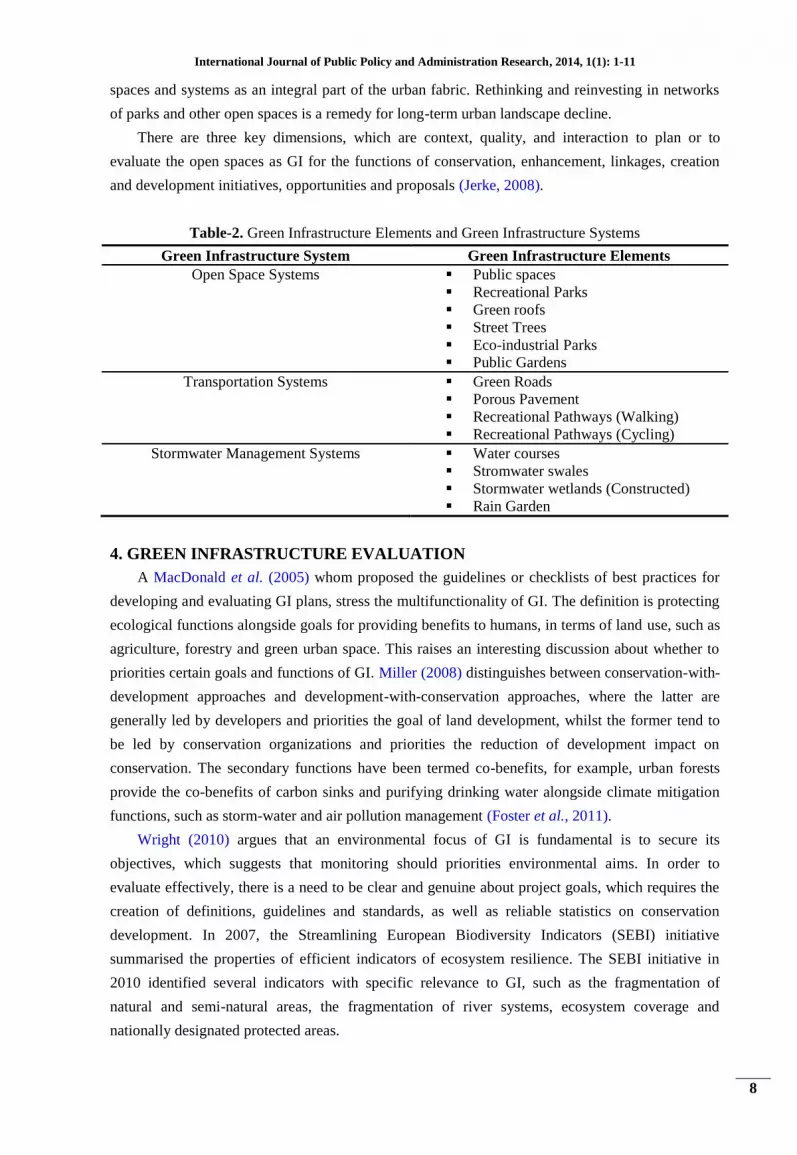
Randolph (2001) had outlined the four types of local conservation planning efforts. Beginning
with parks and recreation planning and arriving at present day green infrastructure planning,
Randolph depicts an increasing complexity in planning efforts, as well as a tendency over the years
to incorporate a broader, landscape scale focus. (See table1).

International Journal of Public Policy and Administration Research, 2014, 1(1): 1-11
6
Table-1. Evolving Nature of Local Government Land Conservation in the United States
Period Type Conservation Tools Primary Objectives
<1980 Parks &
Recreation
Planning
Land acquisition; park planning
& management
Active recreation, scenic amenity
1980s Open Space
Planning
Land acquisition & easement;
park planning & management
Active recreation, scenic amenity,
farmland protection, urban forestry
1990s Greenways &
Open Space
Planning
Land acquisition, easement,
floodplain zoning, park and
greenway planning &
management
Active and passive recreation, scenic
amenity, farmland protection, urban
forestry, urban wildlife
2000 Green
Infrastructure
Land acquisition, easement,
floodplain management, Smart
Growth Management tools,
conservation land development,
partnerships with landowners,
land trusts
Hubs and links for active and passive
recreation, scenic amenity, farmland
protection, urban forestry, urban
wildlife, regional and state ecological
systems, integration of conservation
and growth management
3.2. Comparison Criteria of Green Infrastructure
Five authors have made the comparison. In order to guide development and respond to
changes, GI has been introduced to provide more informed and systematic way of considering
priorities in the spatial planning process, and environmental friendly techniques which can be
molded to fit into design situations (Davies and Reddie, 2006). Jerke (2008) identifies green
infrastructure as one way to conserve natural systems and areas within urban communities.
According to American Society of Landscape Architects (ASLA), green infrastructure has two
scales: national or regional level; and urban level. The national or regional level refers to
interconnected networks of park systems and wildlife corridors; and the urban level refers to parks
and urban forestry, but also to green roofs, walls, and other techniques to reduce energy
consumption and storm water runoff. Five contexts and functions of GI [16]:
(a) Sustainable resource management in land and water resources;
(b) Biodiversity relating to the importance of connectivity of habitats at a variety of
landscape scales;
(c) Recreation relating to greenways and the use of non-car routes to address public health
and quality of life issues; and
(d) Landscape resources examined from aesthetic, experiential and functional points of
view; and Regional development and promotion of overall environmental quality and
quality of life.
Benedict and McMohan (2002) summarized seven principles for successful GI initiatives:
Principle 1: To plan and protect interconnected green space systems, successful initiatives can
be used as the framework by sharing similar strategies.
Principle 2: Design and plan GI before development. Restoration of natural systems is far
more expensive than protecting and preserving existing landscapes. It is essential to identify and
protect critical ecological sites and linkages in advance.

International Journal of Public Policy and Administration Research, 2014, 1(1): 1-11
7
Principle 3: Linkage is a key point. The network of different system components is critical to
maintain vital ecological processes, services and biodiversity of wildlife populations. It is also
required linkages among different agencies, nongovernmental organizations, and the private sector.
Principle 4: Green infrastructure functions across multiple jurisdictions and at different scales,
which means green infrastructure systems should connect across urban, suburban, rural and
wilderness landscapes and strategically incorporate green space elements and functions at
corresponding scales.
Principle 5: Green infrastructure is grounded in sound science and land-use planning theories
and practices, with disciplines including conservation biology and landscape ecology, urban and
regional planning, and geographic analysis and information systems.
Principle 6: Green infrastructure, as a critical public investment, should be included in the
annual budget. Resources should be tapped in state and federal agencies for planning and
management activities.
Principle 7: Green infrastructure involves diverse stakeholders, with stakeholders of the
initiatives having diverse backgrounds and needs. Successful GI efforts forge alliances and
interrelationships among various organizations.
They mentioned the links are connecting the system together and enable GI networks to work;
landscape linkages are large protected natural areas that connect existing parks, preserve or natural
areas, and provide sufficient space for native plants and animals to flourish while serving as
corridors connecting ecosystems and landscapes. Landscape linkages may also provide space for
the protection of historic sites and offer opportunities for recreational use. All GI linkages link
elements to form landscape systems and enhance the connectivity. To integrate GI elements into
the urban development site planning and design (Benedict and McMohan, 2002) summarize the
procedure as follows:
(a) Recognize and address the needs of both people and nature;
(b) Provide a framework for integrating diverse natural resource and growth management
activities in a holistic, ecosystem-based approach;
(c) Ensure that both green space and development are placed where most needed and most
appropriate;
(d) Identify vital ecological areas and connectivity prior to development;
(e) Identify opportunities for the restoration and enhancement of functioning systems in
already developed areas;
(f) Enable communities to create a system that is greater than the sum of its parts; and
(g) Enable conservation and development to be planned in harmony, not in opposition to
one another.
Gidding (2005) stated the combination of economic power and planning has built the image of
individual space and landmarks, which contribute to the character and space of cities. Open spaces
provide places for recreation, social interaction, psychological renewal, and environmental
education, and are valuable carbon sinks and wildlife habitats. Because open spaces and natural
systems are important to the future of cities, it is critical for communities to plan and develop such
International Journal of Public Policy and Administration Research, 2014, 1(1): 1-11
8
spaces and systems as an integral part of the urban fabric. Rethinking and reinvesting in networks
of parks and other open spaces is a remedy for long-term urban landscape decline.
There are three key dimensions, which are context, quality, and interaction to plan or to
evaluate the open spaces as GI for the functions of conservation, enhancement, linkages, creation
and development initiatives, opportunities and proposals (Jerke, 2008).
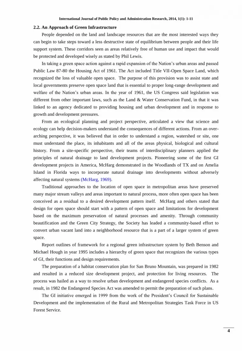
Table-2. Green Infrastructure Elements and Green Infrastructure Systems
Green Infrastructure System Green Infrastructure Elements
Open Space Systems Public spaces
Recreational Parks
Green roofs
Street Trees
Eco-industrial Parks
Public Gardens
Transportation Systems Green Roads
Porous Pavement
Recreational Pathways (Walking)
Recreational Pathways (Cycling)
Stormwater Management Systems Water courses
Stromwater swales
Stormwater wetlands (Constructed)
Rain Garden
4. GREEN INFRASTRUCTURE EVALUATION
A MacDonald et al. (2005) whom proposed the guidelines or checklists of best practices for
developing and evaluating GI plans, stress the multifunctionality of GI. The definition is protecting
ecological functions alongside goals for providing benefits to humans, in terms of land use, such as
agriculture, forestry and green urban space. This raises an interesting discussion about whether to
priorities certain goals and functions of GI. Miller (2008) distinguishes between conservation-with-
development approaches and development-with-conservation approaches, where the latter are
generally led by developers and priorities the goal of land development, whilst the former tend to
be led by conservation organizations and priorities the reduction of development impact on
conservation. The secondary functions have been termed co-benefits, for example, urban forests
provide the co-benefits of carbon sinks and purifying drinking water alongside climate mitigation
functions, such as storm-water and air pollution management (Foster et al., 2011).
Wright (2010) argues that an environmental focus of GI is fundamental is to secure its
objectives, which suggests that monitoring should priorities environmental aims. In order to
evaluate effectively, there is a need to be clear and genuine about project goals, which requires the
creation of definitions, guidelines and standards, as well as reliable statistics on conservation
development. In 2007, the Streamlining European Biodiversity Indicators (SEBI) initiative
summarised the properties of efficient indicators of ecosystem resilience. The SEBI initiative in
2010 identified several indicators with specific relevance to GI, such as the fragmentation of
natural and semi-natural areas, the fragmentation of river systems, ecosystem coverage and
nationally designated protected areas.

International Journal of Public Policy and Administration Research, 2014, 1(1): 1-11
9
Owing to the different elements involved in GI, MacDonald et al. (2005) highlight the
importance of basic GI design on both science and stakeholder feedback. Similarly, Hostetler et al.
(2011) propose a systems approach to GI, which involves the views of built environment
professionals and residents.
While Angelstam et al. (2003) recommended that both natural and social sciences are involved
in conservation planning and policy implementation. For example, the assessment is not only the
qualities of the habitat and species, but also the qualities of the conservation institutions and
management.
This is encompassed by the concept of ecological solidarity, which consists of two main
elements, in terms of the dynamics of ecological processes and biodiversity; and the social
recognition that humans are part of ecosystem functions. This proposal of evaluation at both a
natural and social scale is further supported by research conducted by Mabelis and Maksymiuk
(2009) who demonstrate the importance of public participation in the success of green urban policy
in their comparative analysis between the Hague and Warsaw.
5. DISCUSSION
Malaysia is moving towards a developed nation by 2020. The environmental requirements
should be emphasized to ensure the planned development would not destroy the heritage and the
environment itself. Therefore, efforts are carried out extensively with concerted efforts by the
government. Among the issues to be addressed is to establish the Ministry of Science and Green
Technology. The policy of green technology development has been developed to provide
incentives to industry players to invest in the development of green technology.
For local authorities who already had their Landscape Master Plan, the National Landscape
Department does not have indicators and performance assessment methods for measuring and
monitoring the implementation. There is still no indicator that used to measure the performance
achievement of the implementation of master plans in local authorities and programs that have been
planned by the National Landscape Department as landscape policy makers. The National
Landscape Department which using the Landscape Master Plan has been able to provide the
standards and specifications in accordance with the international norm to ensure the development
of GI can be developed with quality in every development especially in local authorities. The
government is aware of the importance of landscape in the development of our nation. In response
to that, the National Landscape Department entrusted with the responsibility of greening the nation
and ensuring our landscape is at its best condition. The department has been mandated to lead the
nation’s efforts in achieving the aspiration of Beautiful Garden Nation, in line with Malaysia’s goal
of being a developed nation by 2020. Hence, the quality of Malaysian living environment and
socio- economic standards can be protected and alleviated.
6. CONCLUSION
In Malaysia, GI was stated in any urban development involving various land uses such as
residential, commercial, industrial and institutional and mix-development areas require at least 10%
of open space and recreational areas (TCPD, 2006). Regarding with the National Landscape Policy
(2011), GI has existed and it is contained in the national policy landscape in the thrust 3. However,

International Journal of Public Policy and Administration Research, 2014, 1(1): 1-11
10
there are many problems in the implementation of GI. Up to now, it is still not fully implemented
on several problems such as there is no comprehensive framework of GI. Towards this, researcher
will first explore the relevant literature available and subsequently use exploratory study and
content analysis to generate the criteria and sub criteria perceived to be important to GI. Based on
the issues identified in this study, the important thing is to determine what the appropriate criteria
used to measure the performance of GI in Malaysia. The research issues that are addressed in this
study are the important evaluation aspects. Performance criteria of GI require inputs from policy
maker (National Landscape Department) and implementers (local authorities) and the importance
of performance criteria to develop the indicators of GI evaluation need to be clearly identified and
understood. Outputs from the research will contribute to the decision model of criteria and sub
criteria of GI performance to help the local authorities make decision in terms of important criteria
and sub criteria when developing a GI. Finally, a model can be developed as mechanism of
evaluation (tools) to measure performance of the implementation of the GI across local authorities
in Malaysia.
REFERENCES
Abrahams, P.M., 2010. Stakeholders' perceptions of pedestrian accessibility to green infrastructure: Fort
Worth’s urban villages. Master Thesis. Arlington, Texas, USA: University of Texas.
Angelstam, P., G. Mikusinski and B.I. Ronnback, 2003. Two-dimensional gap analysis: A tool for efficient
conservation planning and biodiversity policy implementation. Ambio, 32(8): 527-534.
Benedict, M.A. and L. Bjornland, 2002. Green infrastructure: A strategic approach to natural resource
planning and conservation. Renewable Resources Journal.
Benedict, M.A. and E.D. McMohan, 2002. Green infrastructure: Smart conservation for the 21st century.
Renewable Resources Journal. Autumn Edition: 12-17.
Davies, C. and S. Reddie, 2006. Woodlands for cities. City Trees: 35-37.
Department of the Environment Transport and the Regions, 2000. Our towns and cities: Delivering the urban
renaissance. DETR, Wetherby.
Foster, J., A. Lowe and S. Winkelman, 2011. The value of green infrastructure for urban climate adaptation.
Washington DC: Center for Clean Air Policy.
Gidding, 2005. Cambridgeshire green infrastructure strategy. Available from
http://www.cambridge.gov.uk/democracy/documents/s3763/Appendix%20B%20%201%20Backgro
und%20and%20Context.pdf.hhjjgj.
Hostetler, M., W. Allen and C. Meurk, 2011. Conserving urban biodiversity? Creating green infrastructure is
only the first step. Landscape and Urban Planning, 100: 369-371.
Jerke, 2008. APA rebuilding America task force green infrastructure sub-task force report.
Liverpool City Council Planning Department, 2008. Liverpool green infrastructure strategy: Technical
document. Liverpool: Natural Economy Northwest Progaramme. Unpublished.
Mabelis, A.A. and G. Maksymiuk, 2009. Public participation in green urban policy: Two strategies compared.
International Journal of Biodiversity Science & Management, 5(2): 63-75.
MacDonald, J., W. Allen, M. Benedict and K. O'Connor, 2005. Green infrastructure plan evaluation
frameworks. Journal of Conservation Planning: 12-43.
MacMohan, E.T., 2001. Green infrastructure. Planning Commissioners Journals, 37.

International Journal of Public Policy and Administration Research, 2014, 1(1): 1-11
11
Mark, A., Benedict, Edward and McMohan, 2003. Green infrastructure: Linking landscapes and communities.
Washington: Island Press.
Mazlina, M., 2011. Experiential contact of residents with green infrastructure network in Taiping. Doctor
Philosophy Thesis. UTM.
McHarg, I.L., 1969. Design with nature. New York: John Wiley & Sons.
Mell, I.C., 2010. Green infrastructure: Concept, perceptions and its use in spatial planning. PhD Thesis. New
Castle, UK: School of Architecture, Planning and Landscape Newcastle University.
Meor Saadon Sofian Mior Razali, 1997. Menghidupkan semula bandar: Kes Jalan Doraisamy dan Jalan Yap
Ah Shak, Kuala Lumpur. Bachelor Thesis. UITM. (References).
Miller, R., 2008. Urban forestry: Planning and managing urban green space. New Jersey: Prentice Hall.
National Landscape Policy, 2011. Department of landscape. Ministry of Housing and Local Government.
Randolph, J., 2001. Environmental land use planning and management. Washington, D.C: Island Press.
TCPD, 2006. National urbanization policy. Kuala Lumpur: Federal Department of Town and Country
Planning, Ministry of Housing and Local Government, Peninsular Malaysia.
Wright, H., 2010. Understanding green infrastructure: The development of a contested concept in England.
Local Environment, 16(10): 1003-1019.
BIBLIOGRAPHY
David, G., 2006. Green infrastructure, report to the royal commission on environmental pollution.


