Embed Size (px)
Citation preview
ABERMULE BUSINESS PARK
Geo-Environmental and Geotechnical Assessment Report MAY 2019

Arcadis (UK) Limited is a private limited company registered in England registration number: 1093549. Registered office, Arcadis House, 34 York Way, London, N1 9AB. Part of the Arcadis Group of Companies along with other entities in the UK. Regulated by RICS. Copyright © 2018 Arcadis. All rights reserved. arcadis.com
CONTACTS
GEMMA FRANCIS
Principal Consultant
dd +44 (0)117 372 1200
m +44 (0)7590 000223
Arcadis. 2 Glass Wharf Temple Quay Bristol BS2 0FR United Kingdom
Abermule Business Park
Geo-Environmental and Geotechnical Assessment Report
Author Rimjhim Singh
Checker Andrew Watts
Approver George Flower
Report No 10026414-ARC-00-XX-RP-ZZ-0003-02
Date MAY 2019
VERSION CONTROL
Version Date Author Checker Approver Changes
01 17/05/19 RS AW GF First Issue
02 28/08/20 AW GF GF Minor clarification updates following SLR review of SCR
This report dated 17 May 2019 has been prepared for Powys County Council (the “Client”) in accordance with the terms and conditions of appointment dated 09 October 2018 (the “Appointment”) between the Client and Arcadis (UK) Limited (“Arcadis”) for the purposes specified in the Appointment. For avoidance of doubt, no other person(s) may use or rely upon this report or its contents, and Arcadis accepts no responsibility for any such use or reliance thereon by any other third party.
CONTENTS
1 INTRODUCTION ....................................................................................................... 7
1.1 Appointment .......................................................................................................................................... 7
1.2 Proposed Development ........................................................................................................................ 7
1.3 Previous Reports .................................................................................................................................. 7
1.4 Limitations ............................................................................................................................................. 7
2 SITE SETTING .......................................................................................................... 9
2.1 Site Location and Description ............................................................................................................. 9
3 DESK STUDY REVIEW ........................................................................................... 12
3.1 Summary of Pertinent Information ................................................................................................... 12
3.2 Preliminary Conceptual Site Model .................................................................................................. 13
Potential Sources .............................................................................................................................. 13
Potential Receptors .......................................................................................................................... 14
Potential Pathways ........................................................................................................................... 15
3.3 Potential Contaminant Linkages ..................................................................................................... 15
4 SITE INVESTIGATION ............................................................................................ 19
4.1 General ................................................................................................................................................. 19
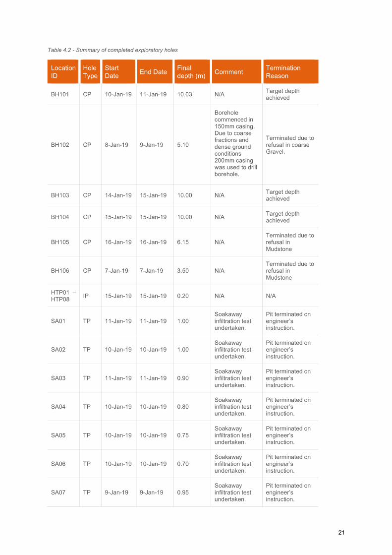
4.2 Exploratory Holes ............................................................................................................................... 20
Exploratory Hole Locations ............................................................................................................... 20
Investigation Methodology ................................................................................................................ 20
Cable Percussive Boring .................................................................................................................. 22
Hand Dug Pitting ............................................................................................................................... 23
Trial Pitting ........................................................................................................................................ 23
4.3 In Situ Testing ..................................................................................................................................... 23
General ............................................................................................................................................. 23
Penetration Testing ........................................................................................................................... 24
Hydraulic Tests ................................................................................................................................. 24
VOC Head Space Screening ............................................................................................................ 26
4.4 Installations and Post-fieldwork Monitoring .................................................................................... 26
Installations ....................................................................................................................................... 26
Post-fieldwork Monitoring ................................................................................................................. 27
4.5 Laboratory Testing ............................................................................................................................. 27
Geotechnical Laboratory Testing ...................................................................................................... 27
Geo-Environmental Laboratory Testing ............................................................................................ 28
5 GROUND CONDITIONS .......................................................................................... 30
5.1 Introduction ......................................................................................................................................... 30
5.2 Groundwater Conditions .................................................................................................................... 31
Monitoring of Ground Gas and Groundwater Levels ........................................................................ 32
5.3 Visual and Olfactory Evidence of Contamination ........................................................................... 33
5.4 Geotechnical Parameters................................................................................................................... 33
Standard Penetration Test (SPT) Results ........................................................................................ 34
Atterberg Limits ................................................................................................................................. 34
Particle Size Distribution (PSD) By Wet Sieve Method .................................................................... 35
Particle Size Distribution (PSD) By Pipette ...................................................................................... 35
Particle Density (Gas Jar) ................................................................................................................. 36
CBR Results ..................................................................................................................................... 36
Compaction Tests ............................................................................................................................. 36
BRE Full Suite .................................................................................................................................. 36
Organic Matter Content .................................................................................................................... 36
6 PRELIMINARY GEOTECHNICAL ASSESSMENT ................................................. 37
6.1 General ................................................................................................................................................. 37
6.2 Ground Floor Slabs ............................................................................................................................ 37
6.3 Foundations ........................................................................................................................................ 37
6.4 Chemical Attack on Construction Materials .................................................................................... 38
6.5 Excavations ......................................................................................................................................... 38
6.6 Groundwater ....................................................................................................................................... 38
6.7 Obstructions ....................................................................................................................................... 39
6.8 Pavement and Road Design .............................................................................................................. 39
6.9 Disposal and Re-Use of Materials ..................................................................................................... 39
6.10 Drainage............................................................................................................................................... 40
7 GENERIC QUANTITATIVE RISK ASSESSMENT .................................................. 41
7.1 Basis of Assessment .......................................................................................................................... 41
7.2 Soil Screening Values (SSVs)............................................................................................................ 41
7.3 Human Health Risk Assessment ....................................................................................................... 41
Asbestos ........................................................................................................................................... 41
Chemical Testing .............................................................................................................................. 41
Middlemarch Ecological Works - Asbestos Find/Testing ................................................................ 42
7.4 Controlled Waters Risk Assessment ................................................................................................ 44
Water Quality Standards ................................................................................................................... 44
Groundwater Testing ........................................................................................................................ 44
7.5 Ground Gas Risk Assessment .......................................................................................................... 45
General ............................................................................................................................................. 46
Gas Monitoring Results .................................................................................................................... 46
Ground Gas Assessment .................................................................................................................. 46
Radon ............................................................................................................................................... 47
8 ENVIRONMENTAL RISK ASSESSMENT ............................................................... 48
8.1 Methodology........................................................................................................................................ 48
8.2 Contaminant Sources ......................................................................................................................... 49
8.3 Summary of Potential Contaminant Sources .................................................................................. 49
8.4 Contaminant Linkages – Conceptual Model .................................................................................... 49
8.5 Summary of Contaminant Linkages ................................................................................................. 51
9 WASTE ASSESSMENT .......................................................................................... 52
9.1 HazWaste Online ................................................................................................................................. 52
Stockpile Samples ............................................................................................................................ 52
Borehole and Trial Pit Samples ........................................................................................................ 53
9.2 Estimated Waste Volumes ................................................................................................................. 54
10 CONCLUSIONS AND RECOMMENDATIONS ....................................................... 56
10.1 Geo-Environmental Conclusions ...................................................................................................... 56
10.2 Geotechnical Conclusions ................................................................................................................. 57
11 REFERENCES ........................................................................................................ 59
APPENDICES
Proposed Development Plan
Site Location Plan
Existing Site Layout
Exploratory Hole Location Plan
Standard Procedures
Exploratory Hole Logs
Soakaway Results
Certification of Field Apparatus
Monitoring Data
Geotechnical Laboratory Results
Environmental Laboratory Results
Asbestos Laboratory Reports and Material Risk Assessment Reports (as provided by Powys County Council)
HazWaste Assessment
CSM Risk Assessment Methodology
7
1 INTRODUCTION
1.1 Appointment
Arcadis Consulting (UK) Limited (Arcadis) was instructed on 10th October 2018 by Powys County Council
(PCC) ‘the Client’ to undertake an intrusive site investigation to support proposals (both feasibility and
planning) for a proposed Business Park development associated with Maesderwen Farm at Abermule Village
on A483 and B4386 road junction Powys, Wales (the ‘Site’).
The scope of the intrusive ground investigation was determined by Arcadis based upon the conclusions
detailed within the Arcadis desk study report (Ref 1) and the proposed development plans. The work was
agreed and formally instructed by PCC on 9th October 2018. The scope of the intrusive ground investigation
comprised Six cable percussive boreholes, four machine excavated trial pits for Environment and WAC, hand
excavated trial pits, sixteen trial pits with in situ soakaway tests was based on the proposed commercial end
use of the site. Soil and groundwater samples were taken during the ground investigation to better characterise
the potential risk levels, associated with both contamination and geotechnical constraints, and establish a land
quality baseline for the site to support the planning process. Ground conditions were recorded in accordance
with Eurocode 7 (Ref 2).
1.2 Proposed Development The proposed development comprises a waste bulking facility to the southwestern section of the site with
surface water compensation and business units to the north-eastern section of the site. Infrastructure (services
and road) has previously been installed onsite to accommodate a business park by the Welsh Government.
A proposed development plan has been provided by PCC and is presented in Appendix A.
1.3 Previous Reports A Phase 1 desk study was completed by Arcadis in December 2017 to the full reference for which is as follows:
Arcadis Consulting, Abermule Business Park, Phase 1 Geo-Environmental Desk Study, December
2017, 0001-UA006590-26-UP32R-01 (Ref 1).
The desk study identified potential sources of contamination on site and in close proximity of the site, hence a
targeted intrusive ground investigation was recommended to better understand potential risk levels and
establish a land quality baseline for the site including general ground conditions and geotechnical parameters
to inform development proposals.
1.4 Limitations
This report has been prepared for PCC in accordance with the terms and conditions of appointment, dated
23rd November 2018. Arcadis cannot accept any responsibility for any use of or reliance on the contents of this
report by any third party. The copyright of this document shall remain the property of Arcadis.

8
This report has been compiled from a number of sources, which Arcadis believes to be trustworthy. However,
Arcadis is unable to guarantee the accuracy of information provided by others. The report is based on
information available at the time of writing. Additional information may become available in the future which
may have a bearing on the conclusions of this report and for which Arcadis cannot be held responsible.
Ground investigations by nature only reveal a small percentage of the ground conditions present beneath the
site. The possibility of significant variation in ground conditions existing between sampling locations cannot
be discounted. Soil borne gas and groundwater conditions are based on observations made at the time of the
investigation and during subsequent monitoring visits and may be subject to significant variation due to
atmospheric, seasonal or other effects.
Arcadis do not accept liability for any use of the information presented in this report unless it is signed by the
author, checker and approver and marked as final.

9
2 SITE SETTING
2.1 Site Location and Description The site is located approximately 0.6km to the south west of Abermule village. The National Grid Reference
coordinates for the approximate centre of the Site is 315663, 294153 and the nearest postcode is SY15 6NU
which is associated with Maesderwen Farm. The site covers an area of approximately 2.09 Ha. The site lies
immediately south of the A483 and B4386 with the junction of the two roads forming the western and northern
boundary of the site.
A site location plan and existing site layout plan are presented in Appendix A (as supplied by PCC).
The majority of the site and the surrounding area comprises farmland. The topography of the Site is generally
flat, low lying land within the floodplain of the River Severn (to the north of the site). During the walkover
completed for the Desk Study, it was considered suitable to separate the site into five areas as follows:
1. Livestock grazing field in the north-eastern end of the Site.
2. A roadway (roughly ‘L’ shaped) enabling access to an electrical substation, with associated
services (identified by manhole covers and secure above ground units), potential underground
unidentified tanks beneath a compound along the south-eastern boundary.
3. One large field towards the centre south-eastern of the Site.
4. Former roadway used for storage of farm equipment, soil stockpile and hay bales along the
north-western boundary of the Site.
5. One small field in the south-west of the Site.
At the time of the visit there were sheep in the north-eastern field and the other fields were empty of livestock.
The fields are fenced off with barbed wire/ wire connected by wooden fence posts, with saplings/ young trees
growing around the circumference of the fencing. In both fields there was an odour of animal faeces and
evidence of a geotextile underlying the topsoil being held in place by wooden stakes resting on the surrounding
fencing, potentially used as a former plastic fence to stop the migration of newts during construction works of
the road.
The L-shaped roadway runs along the southern boundary of the Site approximately 140.0-160.0m orientated
north-east to south-west. Near to the junction of the road there is a rectangular double gated compound with
four lockable bollards blocking the entrance. The compound contains two electrical substation metering
units/telephone exchange box, one above ground double skinned plastic tank (containing flammable and
harmful material), concrete pipes/materials and potentially two underground storage tanks (marked by circular
scarring). The contents of the tanks onsite were not identified due to restriction of access to compound.
Crossing the compound in a north-west to south-east orientation are concrete bollards to prevent vehicle
10
access onto the underground storage tank area. Approximately 5.0-7.0m south-west of the gated compound
is an electrical substation, constructed of brick with two vents on each wall (two sets of vents at the base of
the hut and 1 set of vents at the top).
Along the roadway On-Site and within 2.0m of the road in the adjacent field, there are a large number of
manhole covers for various services. These appear to include BT communications and possibly water, gas
and electricity, as well as surface water drains. There are street lamps along either side of the road. There are
no overhead cables across the Site.
Along the north-western part of the Site in the central field is a broken tarmac road orientated north east-south
west, which is an abandoned section of a road. This is now used for storage by the farmer, including; a mound
which appears to comprise of soil with turf cover which has been disturbed at the south-western side of the
mound, a pile which appears to comprise of concrete, gravel and soil, haylage/hay bales protected by a small
electrified fence, tractor tyres and metal farm machinery/livestock feeders/chicken coops.
In the far south-west of the Site there is a small field separated by an open gate and a row of deciduous trees
across the Site orientated north-west to south-east. In the south-western section of the Site is a gated area
which leads onto a footpath that passes below a railway bridge.
The A483 and B4386 are immediately north west of the Site boundary, with fields/farmland to the west and
north west, with horses and other livestock. Approximately 5m to the north of the Site is a series of farm
buildings associated with Maesderwen Farm, with relatively new metal barns to store farm machinery and
older brick buildings converted into stables and conjoined paddocks. An additional set of farm buildings is
located approximately 5m to the north-west of the Site associated with Bryn-y-Meas Farm.
Just beyond the property boundary of the southern boundary of the Site is a railway track with associated
pylons on an embankment. Between the raised railway and the Site boundary is a row of mature deciduous
trees. Just beyond the property boundary to the north-east of the Site is a cluster of deciduous trees with a
drainage channel, orientated north-west to south-east. A gated path is adjacent to the trees which leads to a
compound containing farm machinery, and a railway bridge into fields with livestock (cows and sheep).
Abermule Business Park North-east (approximately 360-440m) of the Site, and adjacent to the B4386 is an
area of land used for commercial purposes including storage of locked shipping containers and vehicles.
Adjacent to this is an area of residential properties. A full description of the site setting and historical use is
provided in the Arcadis Phase 1 Desk Study (Ref 1).
Figure 1 shows the site boundary and the layout of the site (as extracted from the Phase 1 Desk Study).

11
Figure 1 – Current Site Layout
12
3 Desk Study Review
3.1 Summary of Pertinent Information
Table 3.1 summarises the pertinent information from the Phase 1 Desk Study Report (Ref 1).
Table 3.1 - Summary of Environmental Data
Geology Made Ground – Anticipated to be present associated with abandoned roadway and use of the Site by the farmer to store rusted farm equipment to the north.
Superficial Deposits – Alluvial Fan deposits (clay and silt).
Bedrock – Nantglyn Flags Formation (Mudstone, Siltstone and Sandstone).
Faults – One inferred fault line at rock head approximately 250m south east of the site, and down-throwing to the east.
Mining No productive Coal Measures or active mines or quarries are noted within 2km of the site boundary.
Recorded mineral sites within 1.0km of the Site boundary is an open cast mine for clay and shale 632m to the north and are now ceased.
Hydrogeology Superficial Deposits – Secondary Undifferentiated aquifer.
Bedrock – Secondary B aquifer.
One groundwater abstraction licence is recorded within 500m of the site, approximately 360m south west of the Site, used for farming and domestic, with Powys County Council being the licence holder.
Groundwater flow is anticipated to flow towards the west and south west, consistent with the catchment and flow direction of the River Severn. This assessment supersedes the flow direction detailed within the Phase 1 Desk Study for the Site.
Hydrology The nearest mapped natural surface water features are immediately to the east and to the west and approximately 14m south east of the Site boundary (assumed to be field drains). Two ponds are located approximately 70m south and approximately 20m north west of the Site. The River Severn is located approximately 200m north of the Site at its closest point and flows to the south west. The Mule river is approximately 500m east, and there are unnamed streams located approximately 200m to the north west and approximately 20 - 250m southeast of the Site. Several mapped streams/drains appear to be culverted. Surface water courses near to the Site are likely to drain north and Westwards towards the River Severn.
The nearest discharge consent is approximately 300m south east of the Site and is for discharge of sewage to the surface water course which runs past the eastern boundary of the Site.
The Site is located within an area that is susceptible to extreme flooding from rivers without defences (Zone 2). A high risk, 30-year return area is located in the southwest. A medium risk, 100-year return is located in the centre and north-east of the Site.
Unexploded Ordnance
The site is within an area denoted as “low” bomb risk area.
Site History Onsite
The site was an open agricultural field with an unnamed road in the north west of the site. (1884-1964).
The road in the north west is no longer in use and there is no other significant change on the site. (1983-1984).
The site is labelled as Abermule Business Park with access road from B4386 running in a south-eastern direction across site and along the south-eastern boundary of the site, with a couple of small structures along the access road. (2017-present).
13
Offsite
From 1884 to 1885 mapping; Approximately 3m from the site there is Cambrian Railway which runs in a north-east to south-west orientation. An Unnamed road to Abermule is present to the north of the site. A Reservoir is located approximately 80m south on the other side of railway. A drain is marked running west into the reservoir, then along bottom of the railway embankment and then northwards along eastern boundary of site. Another drain originate from railway embankment runs along western boundary of site. Three ponds are located approximately 60m and 250m north west, 230m east of the site. The River Severn is approximately 250m north of the site and in the north east there is series of farm related building called as The Court.
From 1903 to 1964, the two ponds recorded approximately 60m northwest and 230m east of the site are no longer and are likely to have been infilled. A set of 3 buildings of unknown use are approximately 60m north-west of the site.
From 1983 to 1984, two farms are recorded to the northwest (Brn-y-maes) and north east (Maesderwen) of the Site. Approximately 2-5m to the north of the site the junction of the A483 and B4386 has been reconfigured.
In 2000, the Maesderwen farm has been expanded to include a large commercial building where there were previously smaller farm buildings and approximately 220-250m east is predominantly residential property and an associated area for commercial use and former reservoir south of the site has been partially or fully infilled and appears vegetated.
By 2006, the Bryn-y-maes farm has a cylindrical structure on site and no further significant changes were noted.
Radon The site is located within a medium probability radon area (5% to 10% of homes are estimated to be at or above the action level).
Potential for Collapsible or Compressible Ground and Landslides
There is a very low potential for compressible ground stability hazards and a very low to moderate potential for compressible ground stability hazards on-site.
On-site there is a very low potential of landslides, however off-site within 250m there are six potential areas of land sliding with a low to high risk.
Ecologically Sensitive Areas
The site is not located within a designated Environmentally Sensitive Area. However, ancient woodland has been identified located approximately 413m to the northwest and 453m to the north of the Site.
3.2 Preliminary Conceptual Site Model
Potential Sources
Based on the information obtained from Desk Study report (Ref 1), potential sources of contamination
were identified both on and offsite and required investigation. These potential sources are presented in
Table 3.2.
Table 3.2 - Onsite and offsite potential sources of contamination
Potential Contaminant Sources Potential Contaminants
Onsite
Made Ground associated with abandoned roadway and use of the Site by the farmer to store farm equipment.
TPHs (Total Petroleum Hydrocarbons)
Metals – arsenic, aluminum, cadmium, chromium, copper, iron, lead, mercury, nickel, zinc
Fly ash, slag, clinker associated with railway activities
PAHs (Polycyclic Aromatic Hydrocarbons)
14
Potential Contaminant Sources Potential Contaminants
Asbestos
Spills from filling/removal of contaminating liquids associated with potential underground tanks in compound area and electrical substation.
TPHs
Metals – arsenic, aluminum, cadmium, chromium, copper, iron, lead, mercury, nickel, zinc
PCBs (Polychlorinated biphenyls)
Radon (naturally occurring) Radon gas
Offsite
Maesderwen and Bryn-y-maes Farms
Organics – TPHs and PAHs
Metals
Nitrates, Bacteria and Coliforms from livestock
Railway line
Organics – TPHs and PAHs
Metals
Fly ash, slag, clinker associated with railway activities
Potential Receptors
The potential receptors detailed below take into consideration the future land use for the Site. The Site
is proposed to occupy a waste disposal unit and commercial business units, as proposed by Powys
County Council.
Humans Future Site visitors, staff of business units.
Maintenance workers and contractors following development.
The risk to construction workers during development would be governed by Health and Safety
Legislation and mitigated by the appropriate use of Personal Protective Equipment (PPE) and
mitigation measures. The risk to construction workers has, therefore, not been considered in this
assessment.
Controlled Waters
Surface water: Reservoir and associated drainage around the Site <50m north-east, south-east,
south and north-west of the Site. River Severn approximately 230-250m north-east.
Groundwater beneath the Site: Superficial deposits is a secondary undifferentiated aquifer and the
bedrock is a secondary B aquifer.
Buildings
Building foundations.
Underground services such as water supply, drainage, gas, electricity and telecommunications.
15
Potential Pathways
Potential exposure pathways are the routes that link the receptor to the contamination. The potential
pathways for this Site are considered to be those listed within Table 3.3.
Table 3.3 - Identified Potential Contaminant Pathways
Receptor Pathways
Human Beings
Accidental ingestion of contaminants within soil, water and dust.
Indoor and outdoor inhalation of dust, vapours and ground gases.
Dermal contact with contaminants within soil, water and dust.
Controlled Waters
(groundwater and
surface water)
Leaching of contaminants from unsaturated zone into underlying groundwater.
Vertical migration of soluble contaminants through the unsaturated zone into groundwater beneath the site.
Horizontal migration of contaminants via groundwater aquifers to surface waters.
Infrastructure Direct contact with aggressive ground conditions for building/structures/ services.
Gas accumulation in confined and poorly ventilated spaces.
3.3 Potential Contaminant Linkages This study has identified potential sources of contamination from onsite (although limited) and offsite
sources of contamination which could impact site end users, controlled waters and foundations.
Potential contaminant linkages for the site are presented in Table 3.4.
.
16
Table 3.4 - Potential Contaminant Linkages
Potential Contaminant
Source Potential Pathway Receptor Likelihood of Potentially Linkage
On-Site
Made Ground from roadway abandonment and rubble mounds.
TPHs (Total Petroleum Hydrocarbons)
Metals – arsenic, aluminium, cadmium, chromium, copper, iron, lead, mercury, nickel, zinc.
Fly ash, slag, clinker associated with railway activities
PAHs (Polycyclic aromatic hydrocarbon)
Asbestos
Dermal contact with contaminants in soil, water and dust
Inhalation of dusts, vapours or hazardous ground gas
Human Health
Site users and visitors including children
Maintenance workers/contractors
Low Likelihood
The proposed development will predominantly be hardstanding; therefore, it is unlikely that a pathway will be present.
Leaching of contaminants from Made Ground and vertical migration into groundwater
Groundwater
Underlying Secondary B aquifer and Secondary Undifferentiated aquifer
Low Likelihood
The underlying superficial deposits are likely to comprise a clay component which would provide some protection to the underlying aquifers from the vertical migration of contaminants. The potential sources of contaminants are in localised locations onsite therefore this reduces the potential for widespread contamination.
Direct contact of buildings, services or foundations with contaminants in the soil and shallow groundwater.
Buildings/Underground Services
Utilities, foundations and confined spaces
Unlikely
The presence of Made Ground On-Site was localised and the Site history reflects the Site has mostly been greenfield; therefore, it is unlikely that building foundations and services will come in direct contact with the contaminants.
On-Site
Spills/leaks from underground and above Ground storage tanks in compound area and electrical substation.
TPHs
Metals – arsenic, aluminium, cadmium, chromium, copper, iron, lead, mercury, nickel, zinc.
Leaching of contaminants from Made Ground and vertical migration into groundwater
Groundwater
Underlying Secondary B aquifer and Secondary Undifferentiated aquifer
Low Likelihood
Given the structures appear to be relatively new, within the past 10 years, it is unlikely that the integrity of the tanks and substation has been compromised. Providing maintenance is continued and the structures were construct to specification there is a low likelihood of leaks.
Dermal contact with contaminants in soil, water and dust
Inhalation of dusts, vapours or hazardous ground gas
Human Health
Site users and visitors including children – Asphyxiation
Maintenance workers/contractors
Migration and accumulation of ground gas which may lead to
Explosion
17
Potential Contaminant
Source Potential Pathway Receptor Likelihood of Potentially Linkage
PCBs (Polychlorinated biphenyl)
an explosive risk within confined spaces of buildings or services.
Buildings and underground services.
On-Site and Off-Site
Underlying Geology Radon gas
Inhalation of dusts, vapours or hazardous ground gas
Human Health – Asphyxiation
Site users and visitors including children
Maintenance workers/contractors
Likely
BRE guidance indicates that there are elevated concentrations of naturally produced radon gas in this area and basic protection measures are required in all new buildings. Migration and accumulation of
ground gas which may lead to an explosive risk within confined spaces of buildings or services
Buildings/Underground Services – Explosion
Utilities, foundations and confined spaces
Off-Site
Maesderwen and Bryn-y-maes farms
TPHs and PAHs
Metals – arsenic, aluminium, cadmium, chromium, copper, iron, lead, mercury, nickel, zinc.
Nitrates, Bacteria and Coliforms from livestock
Leaching of contaminants and vertical migration into groundwater
Groundwater/ surface water
Underlying Secondary B aquifer and Secondary Undifferentiated aquifer
Migration into drainage water/streams/River Severn
Likely
Due to the topography of the Site and the surrounding valley groundwater will be present, probably at modest depth. The Site is in an area of flood risk; however, the underlying superficial deposits are likely to comprise a clay component which would provide some protection to the underlying aquifers from the vertical migration of contaminants.
Off-Site
Historic and modern-day railway line/ Made Ground
TPHs and PAHs
Migration and accumulation of ground gas which may lead to an explosive risk within confined spaces of buildings or services
Buildings/Underground Services – Explosion
Utilities, foundations and confined Spaces
Human Health
Low Likelihood
Whilst off site sources of potential contamination exist, it is considered none are likely to present a severe impact.
18
Potential Contaminant
Source Potential Pathway Receptor Likelihood of Potentially Linkage
Metals – arsenic, aluminium, cadmium, chromium, copper, iron, lead, mercury, nickel, zinc.
Fly ash, slag, clinker associated with railway activities
Inhalation of dusts, vapours or hazardous ground gas inhalation vapours
Site users and visitors including children
Maintenance workers/contractors
Horizontal and vertical migration of contaminants in groundwater
Groundwater
Underlying Secondary B aquifer and Secondary Undifferentiated aquifer
Low Likelihood
Due to the topography of the Site and the surrounding valley it is likely that groundwater will be mobile, and if contamination has occurred up-gradient, it is possible this could migrate to impact the site. However the underlying superficial deposits are likely to comprise a clay component which would tend to provide attenuation and retardation of migration of contaminants.
Direct contact of buildings, services or foundations from contaminants.
Buildings/Underground Services
Utilities, foundations and confined spaces
Low Likelihood
The underlying superficial deposits are likely to comprise a clay component which would provide some protection. Leachate and groundwater are less likely to migrate beneath the Site and come into contact with the buildings and services.
19
4 SITE INVESTIGATION
4.1 General Ground investigation works were carried between the 7th and 22nd January 2019 with monitoring being
completed on 22nd and 30th January 2019, 7th and 14th February 2019.
The scope of the ground investigation, including the location, scheduled depth and type of exploratory
hole undertaken was determined by Arcadis Consulting (UK) Ltd and is summarised in Table 4.1.
The ground investigation methods were undertaken in general accordance with the principles set out in
BS EN 1997-2:2007 (Ref 2) and with the general practice described in BS5930:2015 (Ref 3). The geo-
environmental aspects of the ground investigation complied with the general requirements of BS
10175+A1:2017 (Ref 4).
Table 4.1 - Initial ground investigation scope
Location ID Hole Type Scheduled Maximum Depth (m)
Requirements
BH101 to BH106 CP 2no. BH to 5m and 4no. BH to 10m
Determine thickness of engineering soils; collect representative samples of strata and undertake in situ tests, install groundwater/ground gas installations for subsequent monitoring.
SA1 to SA16 TP/SA 1.2m
Determine nature of shallow soils; collect representative samples and undertake soakaway tests. These will provide further site coverage to inform baseline land quality.
CBR1 to CBR44 CBR 0.8m Provide in situ CBR values of formation level.
HTP1 to HTP8 HTP 0.2m
Determine the extent of asbestos-impacted material within stockpiles on-site and inform waste disposal / re-use options.
TP101 to TP104 TP 1.0m Inform waste disposal options for surplus material.
Notes CP = Cable Percussive, SA = Soak Away, TP = Trial Pit, HTP = Hand excavated Trial Pit, CBR = Californian Bearing Ratio test
The investigation works were carried out under the supervision of a suitably experienced Arcadis ground
engineer who undertook the logging and reporting of the exploratory holes and in situ testing.
Based on the anticipated ground conditions on site (Alluvial Fan deposits- varying composition of sand,
silt and clay overlying the Nantglyn Flags Formation – mudstone, siltstone and sandstone), ground
conditions beneath the site have the potential to be highly variable hence the proposed investigation
should enable sufficient coverage of the site to inform both the land quality baseline assessment and a
20
allow for a better understanding of the ground model. Deeper boreholes would inform foundation design,
while the pits would allow for completion of soak away testing. Further site coverage has been achieved
through the CBR tests.
In addition, there are a number of stockpiles of material along the north western boundary of the site
(along the former road). Asbestos has been identified in these stockpiles by another Consultant
(Middlemarch Environmental). The results of the Middlemarch testing are discussed within Section
7.3.3. Consequently additional samples were collected of stockpiled material to test against standard
soil chemical suites (including asbestos), to be able to classify the material and to inform whether the
material in the fly tipped stockpiles has hazardous properties and may require disposal as hazardous
waste.
Borehole installations have been included to enable the collection of groundwater samples to establish
whether any on-site contamination could have leached to the underlying Secondary Undifferentiated
aquifer.
Due to the potential source of ground gas from onsite storage tanks in the compound area, and the
former reservoir located to the south of the site, ground gas monitoring has been included to confirm
the anticipated ground gas regime. Four visits were completed at weekly intervals (at least one of which
should be undertaken at a time of low or falling atmospheric pressure to capture potential worst-case
scenario conditions).
The investigation works were carried out under the supervision of a suitably experienced ground
engineer who undertook the logging and reporting of the exploratory holes and in situ testing.
4.2 Exploratory Holes
Exploratory Hole Locations
The co-ordinates and elevations of the exploratory hole locations were obtained by the Arcadis
supervising engineer using a Trimble VRS NOW GPRS system; allowing an accuracy of +/-50 mm.
Drawing 10026414-ARC-XX-XX-DR-ZZ-0001-P1-Exploratory Hole Plan presented in Appendix B
displays the as-constructed exploratory hole locations while the co-ordinates and elevation of the
ground surface at each exploratory hole location are given on the individual logs.
Investigation Methodology
The following methods and techniques were undertaken to construct the exploratory holes at the site.
The completed scope of investigation is summarised in Table 4.2.
Details of the methods of investigation and associated standards adopted and a key to the notation and
symbols used on the logs are presented in Appendix C; the exploratory hole records are presented in
Appendix D.
21
Table 4.2 - Summary of completed exploratory holes
Location ID
Hole Type
Start Date
End Date Final depth (m)
Comment Termination Reason
BH101 CP 10-Jan-19 11-Jan-19 10.03 N/A Target depth achieved
BH102 CP 8-Jan-19 9-Jan-19 5.10
Borehole commenced in 150mm casing. Due to coarse fractions and dense ground conditions 200mm casing was used to drill borehole.
Terminated due to refusal in coarse Gravel.
BH103 CP 14-Jan-19 15-Jan-19 10.00 N/A Target depth achieved
BH104 CP 15-Jan-19 15-Jan-19 10.00 N/A Target depth achieved
BH105 CP 16-Jan-19 16-Jan-19 6.15 N/A Terminated due to refusal in Mudstone
BH106 CP 7-Jan-19 7-Jan-19 3.50 N/A Terminated due to refusal in Mudstone
HTP01 – HTP08
IP 15-Jan-19 15-Jan-19 0.20 N/A N/A
SA01 TP 11-Jan-19 11-Jan-19 1.00 Soakaway infiltration test undertaken.
Pit terminated on engineer’s instruction.
SA02 TP 10-Jan-19 10-Jan-19 1.00 Soakaway infiltration test undertaken.
Pit terminated on engineer’s instruction.
SA03 TP 11-Jan-19 11-Jan-19 0.90 Soakaway infiltration test undertaken.
Pit terminated on engineer’s instruction.
SA04 TP 10-Jan-19 10-Jan-19 0.80 Soakaway infiltration test undertaken.
Pit terminated on engineer’s instruction.
SA05 TP 10-Jan-19 10-Jan-19 0.75 Soakaway infiltration test undertaken.
Pit terminated on engineer’s instruction.
SA06 TP 10-Jan-19 10-Jan-19 0.70 Soakaway infiltration test undertaken.
Pit terminated on engineer’s instruction.
SA07 TP 9-Jan-19 9-Jan-19 0.95 Soakaway infiltration test undertaken.
Pit terminated on engineer’s instruction.
22
Location ID
Hole Type
Start Date
End Date Final depth (m)
Comment Termination Reason
SA08 TP 10-Jan-19 10-Jan-19 1.00 Soakaway infiltration test undertaken.
Pit terminated on engineer’s instruction.
SA09 TP 9-Jan-19 9-Jan-19 1.10 Soakaway infiltration test undertaken.
Pit terminated on engineer’s instruction.
SA10 TP 9-Jan-19 9-Jan-19 1.20 Soakaway infiltration test undertaken.
Target depth achieved
SA11 TP 9-Jan-19 9-Jan-19 1.00 Soakaway infiltration test undertaken.
Pit terminated on engineer’s instruction.
SA12 TP 7-Jan-19 7-Jan-19 0.80 Soakaway infiltration test undertaken.
Pit terminated on engineer’s instruction.
SA13 TP 7-Jan-19 7-Jan-19 0.80 Soakaway infiltration test undertaken.
Pit terminated on engineer’s instruction.
SA14 TP 8-Jan-19 8-Jan-19 1.00 Soakaway infiltration test undertaken.
Pit terminated on engineer’s instruction.
SA15 TP 8-Jan-19 8-Jan-19 1.10 Soakaway infiltration test undertaken.
Pit terminated on engineer’s instruction.
SA16 TP 8-Jan-19 8-Jan-19 1.10 Soakaway infiltration test undertaken.
Pit terminated on engineer’s instruction.
TP101 – TP104
TP 14-Jan-19 14-Jan-19 1.00 N/A Terminated on engineer’s instruction.
Notes CP = cable percussive borehole, IP = inspection pit TP = machine excavated trial pit, HTP = hand dug trial pit, SA = soakaway test
Cable Percussive Boring
Cable percussive boring was completed using trailer mounted Dando 3000 boring rig equipped with
200mm casing and tools to undertake two boreholes up to 5m bgl and four boreholes up to 10m bgl,
however due to presence of bedrock and dense gravel some of the positions refused at a shallow depth.
Hand dug pits were undertaken in each borehole to 1.2m for service clearance purposes.
Samples of the material recovered in borehole were taken to enable representative laboratory testing.
Generally small disturbed samples were taken at each change in stratum and at 0.5 m intervals
thereafter in clay soils; and bulk samples were taken at 1 m intervals where the sand and gravel content
of the soil was significant.
23
Where specified by Arcadis Consulting (UK) Ltd, open drive tube samples were taken using thin-walled
sampling apparatus from the relatively undisturbed material throughout at 1.5m intervals the borehole.
Standard penetration tests (SPT) were generally undertaken at 1.0 m intervals until the termination
depth of the hole.
Hand Dug Pitting
Hand Dug Trial Pits (HTPs) were undertaken to quantify the amount of asbestos-impacted material
within stockpiles on-site and inform waste disposal / re-use options. Pits were entirely logged from
the surface and arisings.
Samples of the material recovered in the trial pits were taken to enable representative laboratory
testing. Generally small disturbed samples were taken at each change in stratum and at 0.5 m intervals
thereafter in clay soils; and bulk samples were taken at 1 m intervals where the sand and gravel content
of the soil was assessed as significant.
Photographic records of the hand excavated trial pits elevation and arisings were taken and are
presented with the associated trial pits log.
Trial Pitting
Trial pits were undertaken using a tracked 8-ton 360 mechanical excavator; pits were entirely logged
from the surface and arisings.
Samples of the material recovered in the trial pits were taken to enable representative laboratory testing.
Generally small disturbed samples were taken at each change in stratum and at 0.5 m intervals
thereafter in clay soils; and bulk samples were taken at 1 m intervals where the sand and gravel content
of the soil was assessed as significant.
Photographic records of the trial pit elevation and arisings were taken and are presented with the
associated trial pit log.
4.3 In Situ Testing
General
In situ testing was carried out within the relevant exploratory holes or at a specified test location. Where
tests were undertaken within or associated with a specific borehole or trial pit, the test data is presented
on the relevant exploratory hole log or as additional sheets to that log. As such, the location details will
be the same as the associated hole and its position will be the same as the exploratory hole with which
it is associated.
Where in situ tests were carried at standalone locations not directly associated with other exploratory
holes, the tests results are presented as individual records and as such the as-constructed locations
are given on the test records and their positions are shown on drawing 10026414-ARC-XX-XX-DR-ZZ-
0001-P1-Exploratory Hole Plan in Appendix B.
24
Penetration Testing
Standard Penetration Tests
Standard penetration tests (SPT) were carried out as required in the investigation scope and in
accordance with the methods given in the standard procedures presented within Appendix C. Generally,
tests were undertaken at regular intervals throughout the borehole to provide a profile of the soil’s
resistance with depth and a disturbed soil samples was recovered from the SPT split-spoon tool or a
disturbed sample was taken over the range of the test interval.
The N-values as determined in the field are presented on the borehole logs as uncorrected values that
do not consider the energy losses or efficiency of the automatic trip hammer used to drive the test tool
into the ground. The calibration certification for the test devices used in the investigation is presented
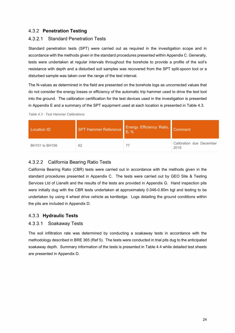
in Appendix E and a summary of the SPT equipment used at each location is presented in Table 4.3.
Table 4.3 - Test Hammer Calibrations
Location ID SPT Hammer Reference Energy Efficiency Ratio, Er %
Comment
BH101 to BH106 62 77 Calibration due December 2019
California Bearing Ratio Tests
California Bearing Ratio (CBR) tests were carried out in accordance with the methods given in the
standard procedures presented in Appendix C. The tests were carried out by GEO Site & Testing
Services Ltd of Llanelli and the results of the tests are provided in Appendix G. Hand inspection pits
were initially dug with the CBR tests undertaken at approximately 0.046-0.80m bgl and testing to be
undertaken by using 4 wheel drive vehicle as kentledge. Logs detailing the ground conditions within
the pits are included in Appendix D.
Hydraulic Tests
Soakaway Tests
The soil infiltration rate was determined by conducting a soakaway tests in accordance with the
methodology described in BRE 365 (Ref 5). The tests were conducted in trial pits dug to the anticipated
soakaway depth. Summary information of the tests is presented in Table 4.4 while detailed test sheets
are presented in Appendix D.
25
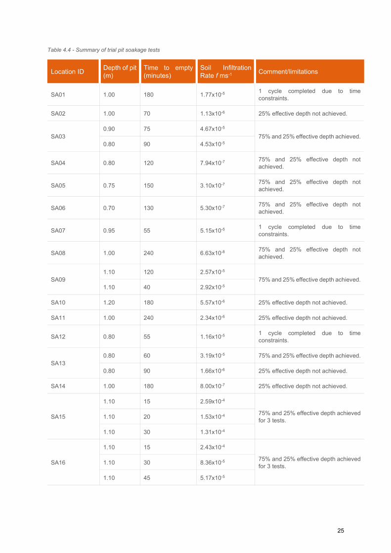
Table 4.4 - Summary of trial pit soakage tests
Location ID Depth of pit (m)
Time to empty (minutes)
Soil Infiltration Rate f ms-1
Comment/limitations
SA01 1.00 180 1.77x10⁻⁵ 1 cycle completed due to time constraints.
SA02 1.00 70 1.13x10⁻⁶ 25% effective depth not achieved.
SA03 0.90 75 4.67x10⁻⁵
75% and 25% effective depth achieved. 0.80 90 4.53x10⁻⁵
SA04 0.80 120 7.94x10⁻⁷ 75% and 25% effective depth not achieved.
SA05 0.75 150 3.10x10⁻⁷ 75% and 25% effective depth not achieved.
SA06 0.70 130 5.30x10⁻⁷ 75% and 25% effective depth not achieved.
SA07 0.95 55 5.15x10⁻⁵ 1 cycle completed due to time constraints.
SA08 1.00 240 6.63x10⁻⁸ 75% and 25% effective depth not achieved.
SA09 1.10 120 2.57x10⁻⁵
75% and 25% effective depth achieved. 1.10 40 2.92x10⁻⁵
SA10 1.20 180 5.57x10⁻⁶ 25% effective depth not achieved.
SA11 1.00 240 2.34x10⁻⁶ 25% effective depth not achieved.
SA12 0.80 55 1.16x10⁻⁵ 1 cycle completed due to time constraints.
SA13 0.80 60 3.19x10⁻⁵ 75% and 25% effective depth achieved.
0.80 90 1.66x10⁻⁶ 25% effective depth not achieved.
SA14 1.00 180 8.00x10⁻⁷ 25% effective depth not achieved.
SA15
1.10 15 2.59x10⁻⁴
75% and 25% effective depth achieved for 3 tests.
1.10 20 1.53x10⁻⁴
1.10 30 1.31x10⁻⁴
SA16
1.10 15 2.43x10⁻⁴
75% and 25% effective depth achieved for 3 tests.
1.10 30 8.36x10⁻⁵
1.10 45 5.17x10⁻⁵
26
VOC Head Space Screening
The presence of Volatile Organic Compounds (VOC) within the ground was determined using a
photoionization detector (PID) to detect the ‘headspace’ vapours emitted by the compounds. The
method is applicable to a wide range of compounds that have sufficiently high volatility to be liberated
from the soil or water matrix in normal temperature and pressure ranges.
The headspace test was undertaken on the freshly extracted soil sample at environmental sample
depths by placing a small amount of material into a screw-top glass jar so that the jar was not more
than half-full. The jar opening was covered with an aluminium foil sheet and the lid screwed on to form
an air-tight seal. The sample and jar were then shaken for about 15 seconds to break-up and disperse
the soil before resting the sample for about 5 minutes.
To assess the headspace vapour, the jar lid was removed and the PID probe was inserted through the
foil into the headspace area. The PID reading recorded was the highest response observed in the first
10 seconds. The screening results are presented on the relevant exploratory holes logs within Appendix
D.
The testing was undertaken using a PID with a 10.6eV lamp. The PID instrument was calibrated daily
using fresh air calibration techniques.
4.4 Installations and Post-fieldwork Monitoring
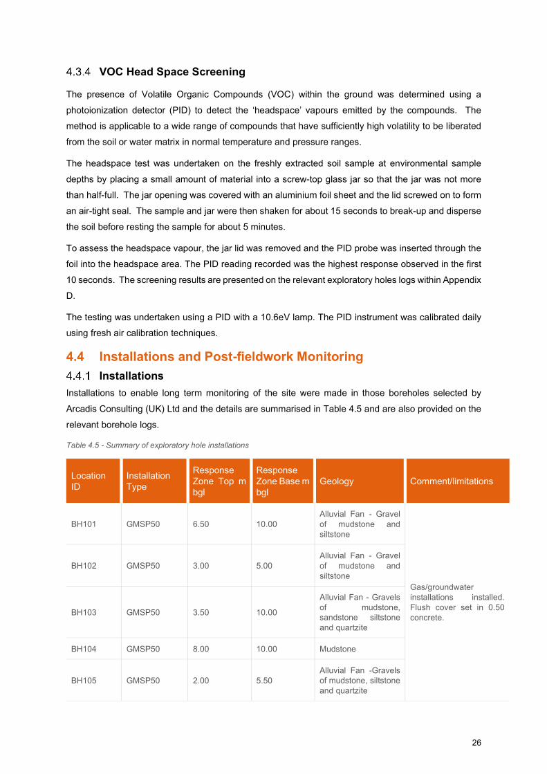
Installations
Installations to enable long term monitoring of the site were made in those boreholes selected by
Arcadis Consulting (UK) Ltd and the details are summarised in Table 4.5 and are also provided on the
relevant borehole logs.
Table 4.5 - Summary of exploratory hole installations
Location ID
Installation Type
Response Zone Top m bgl
Response Zone Base m bgl
Geology Comment/limitations
BH101 GMSP50 6.50 10.00 Alluvial Fan - Gravel of mudstone and siltstone
Gas/groundwater installations installed. Flush cover set in 0.50 concrete.
BH102 GMSP50 3.00 5.00 Alluvial Fan - Gravel of mudstone and siltstone
BH103 GMSP50 3.50 10.00
Alluvial Fan - Gravels of mudstone, sandstone siltstone and quartzite
BH104 GMSP50 8.00 10.00 Mudstone
BH105 GMSP50 2.00 5.50 Alluvial Fan -Gravels of mudstone, siltstone and quartzite

27
Location ID
Installation Type
Response Zone Top m bgl
Response Zone Base m bgl
Geology Comment/limitations
BH106 GMSP50 1.00 3.50 Alluvial Fan -Gravels of siltstone, mudstone and quartz
Notes: GMSP50 = HDPE 50mm gas monitoring standpipe
The response zones target both the superficial Alluvial Fan and underlying bedrock Nantglyn Flags
(Mudstone) Formations in order to capture monitoring of both ground water and ground gas within the
superficial deposits and bedrock.
Post-fieldwork Monitoring
Post-field work monitoring was undertaken on separate visits on the 22nd January 2019 and 30th January
2019, 7th February 2019 and 14th February 2019. Four visits to the site were made to record land gas
emissions and groundwater levels. During the second monitoring visit, after completion of the land gas
emission monitoring, the well was purged by removing three well volumes of groundwater and in situ
groundwater monitoring and sampling was undertaken. Where installations were purged dry, monitoring
and sampling was conducted on groundwater recovered following recharging of groundwater in
installations. Parameters measured during in situ monitoring were pH, dissolved oxygen, conductivity
and redox potential.
The results of the groundwater and ground gas monitoring are presented within Appendix F.
4.5 Laboratory Testing Geotechnical and geo-environmental chemical testing was undertaken on selected samples obtained
from the exploratory holes. The testing was scheduled by the geotechnical and/or geo-environmental
engineer and the testing was undertaken by an Arcadis approved testing laboratory.
Geotechnical Laboratory Testing
The geotechnical tests detailed in Table 4.6 were carried out in accordance with BS1377:1990: Parts 1
to 8 (Ref 6); or other methods as listed Table 4.6. The complete results of the geotechnical laboratory
testing are presented in Appendix G.
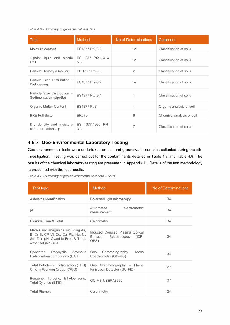
28
Table 4.6 - Summary of geotechnical test data
Test Method No of Determinations Comment
Moisture content BS1377 Pt2-3.2 12 Classification of soils
4-point liquid and plastic limit
BS 1377 Pt2-4.3 & 5.3
12 Classification of soils
Particle Density (Gas Jar) BS 1377 Pt2-8.2 2 Classification of soils
Particle Size Distribution - Wet sieving
BS1377 Pt2-9.2 14 Classification of soils
Particle Size Distribution – Sedimentation (pipette)
BS1377 Pt2-9.4 1 Classification of soils
Organic Matter Content BS1377 Pt-3 1 Organic analysis of soil
BRE Full Suite BR279 9 Chemical analysis of soil
Dry density and moisture content relationship
BS 1377:1990 Pt4-3.3
7 Classification of soils
Geo-Environmental Laboratory Testing
Geo-environmental tests were undertaken on soil and groundwater samples collected during the site
investigation. Testing was carried out for the contaminants detailed in Table 4.7 and Table 4.8. The
results of the chemical laboratory testing are presented in Appendix H. Details of the test methodology
is presented with the test results.
Table 4.7 - Summary of geo-environmental test data – Soils
Test type Method No of Determinations
Asbestos Identification Polarised light microscopy 34
pH Automated electrometric measurement
34
Cyanide Free & Total Calorimetry 34
Metals and inorganics, including As, B, Cr III, CR VI, Cd, Cu, Pb, Hg, Ni, Se, Zn), pH, Cyanide Free & Total, water soluble SO4
Induced Coupled Plasma Optical Emission Spectroscopy (ICP-OES)
34
Speciated Polycyclic Aromatic Hydrocarbon compounds (PAH)
Gas Chromatography –Mass Spectrometry (GC-MS)
34
Total Petroleum Hydrocarbon (TPH) Criteria Working Croup (CWG)
Gas Chromatography – Flame Ionisation Detector (GC-FID)
27
Benzene, Toluene, Ethylbenzene, Total Xylenes (BTEX)
GC-MS USEPA8260 27
Total Phenols Calorimetry 34
29
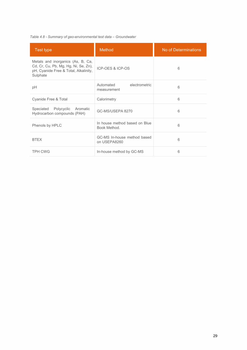
Table 4.8 - Summary of geo-environmental test data – Groundwater
Test type Method No of Determinations
Metals and inorganics (As, B, Ca, Cd, Cr, Cu, Pb, Mg, Hg, Ni, Se, Zn), pH, Cyanide Free & Total, Alkalinity, Sulphate
ICP-OES & ICP-OS 6
pH Automated electrometric measurement
6
Cyanide Free & Total Calorimetry 6
Speciated Polycyclic Aromatic Hydrocarbon compounds (PAH)
GC-MS/USEPA 8270 6
Phenols by HPLC In house method based on Blue Book Method.
6
BTEX GC-MS In-house method based on USEPA8260
6
TPH CWG In-house method by GC-MS 6
30
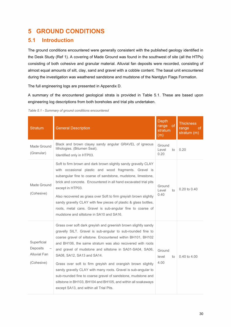
5 GROUND CONDITIONS
5.1 Introduction
The ground conditions encountered were generally consistent with the published geology identified in
the Desk Study (Ref 1). A covering of Made Ground was found in the southwest of site (all the HTPs)
consisting of both cohesive and granular material. Alluvial fan deposits were recorded, consisting of
almost equal amounts of silt, clay, sand and gravel with a cobble content. The basal unit encountered
during the investigation was weathered sandstone and mudstone of the Nantglyn Flags Formation.
The full engineering logs are presented in Appendix D.
A summary of the encountered geological strata is provided in Table 5.1. These are based upon
engineering log descriptions from both boreholes and trial pits undertaken.
Table 5.1 - Summary of ground conditions encountered
Stratum General Description
Depth range of stratum (m)
Thickness range of stratum (m)
Made Ground
(Granular)
Black and brown clayey sandy angular GRAVEL of igneous lithologies. (Bitumen Seal).
Identified only in HTP03.
Ground Level to 0.20
0.20
Made Ground
(Cohesive)
Soft to firm brown and dark brown slightly sandy gravelly CLAY
with occasional plastic and wood fragments. Gravel is
subangular fine to coarse of sandstone, mudstone, limestone,
brick and concrete. Encountered in all hand excavated trial pits
except in HTP03.
Also recovered as grass over Soft to firm greyish brown slightly
sandy gravelly CLAY with few pieces of plastic & glass bottles,
roots, metal cans. Gravel is sub-angular fine to coarse of
mudstone and siltstone in SA10 and SA16.
Ground Level to 0.40
0.20 to 0.40
Superficial
Deposits –
Alluvial Fan
(Cohesive)
Grass over soft dark greyish and greenish brown slightly sandy
gravelly SILT. Gravel is sub-angular to sub-rounded fine to
coarse gravel of siltstone. Encountered within BH101, BH102
and BH106, the same stratum was also recovered with roots
and gravel of mudstone and siltstone in SA01-SA04, SA06,
SA08, SA12, SA13 and SA14.
Grass over soft to firm greyish and orangish brown slightly
sandy gravelly CLAY with many roots. Gravel is sub-angular to
sub-rounded fine to coarse gravel of sandstone, mudstone and
siltstone in BH103, BH104 and BH105, and within all soakaways
except SA13, and within all Trial Pits.
Ground
level to
4.00
0.40 to 4.00
31
Stratum General Description
Depth range of stratum (m)
Thickness range of stratum (m)
Superficial
Deposits -
Alluvial Fan
(Granular)
Medium dense to very dense brown and grey sandy clayey sub-
angular to sub-rounded fine to coarse GRAVEL of sandstone,
siltstone, mudstone, quartzite and quartz with medium to low
cobble content of sandstone and siltstone. in all borehole
locations, SA07, SA09, SA10, SA15 and SA16, and all trial pits
except TP103.
Also recovered as brown gravelly to very gravelly fine to coarse
SAND with gravel of sub-angular to sub-rounded fine to coarse
of mudstone, siltstone, limestone and quartzite in SA01-SA03.
0.40 to
10.00 0.30 to 6.00
Bedrock
(Nantglyn
Flags
Formation)
Weak dark grey MUDSTONE - Recovered as: very dense black
slightly silty very sandy fine to coarse angular GRAVEL of
mudstone.
Identified in BH104, BH105 and BH106.
3.00 to
10.00
(base not
proven)
Extent not
proven
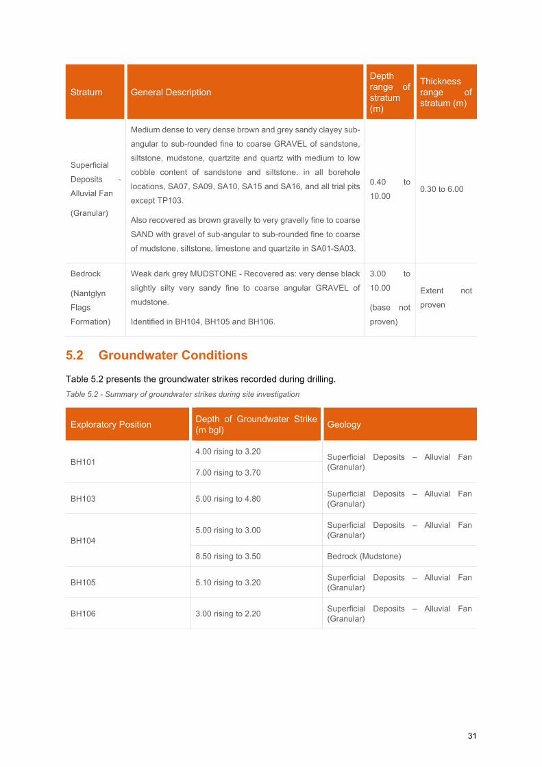
5.2 Groundwater Conditions
Table 5.2 presents the groundwater strikes recorded during drilling.
Table 5.2 - Summary of groundwater strikes during site investigation
Exploratory Position Depth of Groundwater Strike (m bgl)
Geology
BH101 4.00 rising to 3.20
Superficial Deposits – Alluvial Fan (Granular)
7.00 rising to 3.70
BH103 5.00 rising to 4.80 Superficial Deposits – Alluvial Fan (Granular)
BH104 5.00 rising to 3.00
Superficial Deposits – Alluvial Fan (Granular)
8.50 rising to 3.50 Bedrock (Mudstone)
BH105 5.10 rising to 3.20 Superficial Deposits – Alluvial Fan (Granular)
BH106 3.00 rising to 2.20 Superficial Deposits – Alluvial Fan (Granular)
32
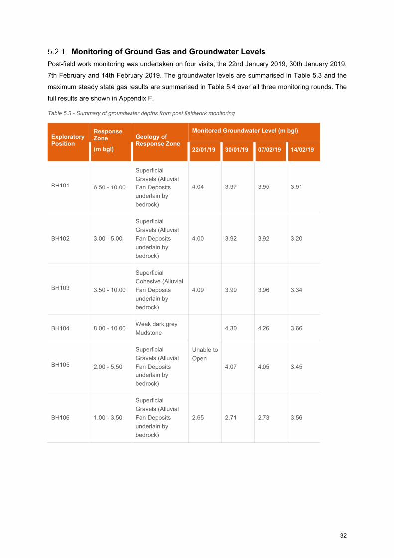
Monitoring of Ground Gas and Groundwater Levels
Post-field work monitoring was undertaken on four visits, the 22nd January 2019, 30th January 2019,
7th February and 14th February 2019. The groundwater levels are summarised in Table 5.3 and the
maximum steady state gas results are summarised in Table 5.4 over all three monitoring rounds. The
full results are shown in Appendix F.
Table 5.3 - Summary of groundwater depths from post fieldwork monitoring
Exploratory Position
Response Zone
(m bgl)
Geology of Response Zone
Monitored Groundwater Level (m bgl)
22/01/19 30/01/19 07/02/19 14/02/19
BH101 6.50 - 10.00
Superficial
Gravels (Alluvial
Fan Deposits
underlain by
bedrock)
4.04 3.97 3.95 3.91
BH102 3.00 - 5.00
Superficial
Gravels (Alluvial
Fan Deposits
underlain by
bedrock)
4.00 3.92 3.92 3.20
BH103 3.50 - 10.00
Superficial
Cohesive (Alluvial
Fan Deposits
underlain by
bedrock)
4.09 3.99 3.96 3.34
BH104 8.00 - 10.00 Weak dark grey
Mudstone
Unable to
Open
4.30 4.26 3.66
BH105 2.00 - 5.50
Superficial
Gravels (Alluvial
Fan Deposits
underlain by
bedrock)
4.07 4.05 3.45
BH106 1.00 - 3.50
Superficial
Gravels (Alluvial
Fan Deposits
underlain by
bedrock)
2.65 2.71 2.73 3.56
33
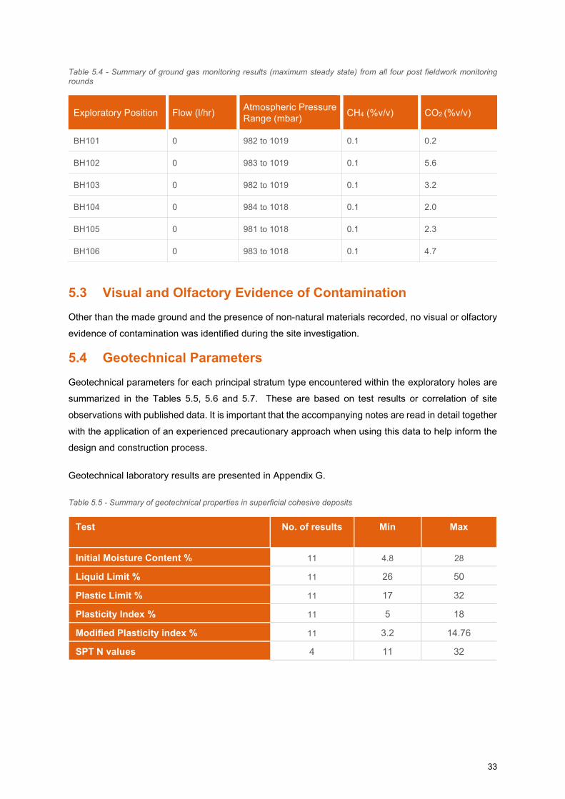
Table 5.4 - Summary of ground gas monitoring results (maximum steady state) from all four post fieldwork monitoring rounds
Exploratory Position Flow (l/hr) Atmospheric Pressure Range (mbar)
CH4 (%v/v) CO2 (%v/v)
BH101 0 982 to 1019 0.1 0.2
BH102 0 983 to 1019 0.1 5.6
BH103 0 982 to 1019 0.1 3.2
BH104 0 984 to 1018 0.1 2.0
BH105 0 981 to 1018 0.1 2.3
BH106 0 983 to 1018 0.1 4.7
5.3 Visual and Olfactory Evidence of Contamination
Other than the made ground and the presence of non-natural materials recorded, no visual or olfactory
evidence of contamination was identified during the site investigation.
5.4 Geotechnical Parameters
Geotechnical parameters for each principal stratum type encountered within the exploratory holes are
summarized in the Tables 5.5, 5.6 and 5.7. These are based on test results or correlation of site
observations with published data. It is important that the accompanying notes are read in detail together
with the application of an experienced precautionary approach when using this data to help inform the
design and construction process.
Geotechnical laboratory results are presented in Appendix G.
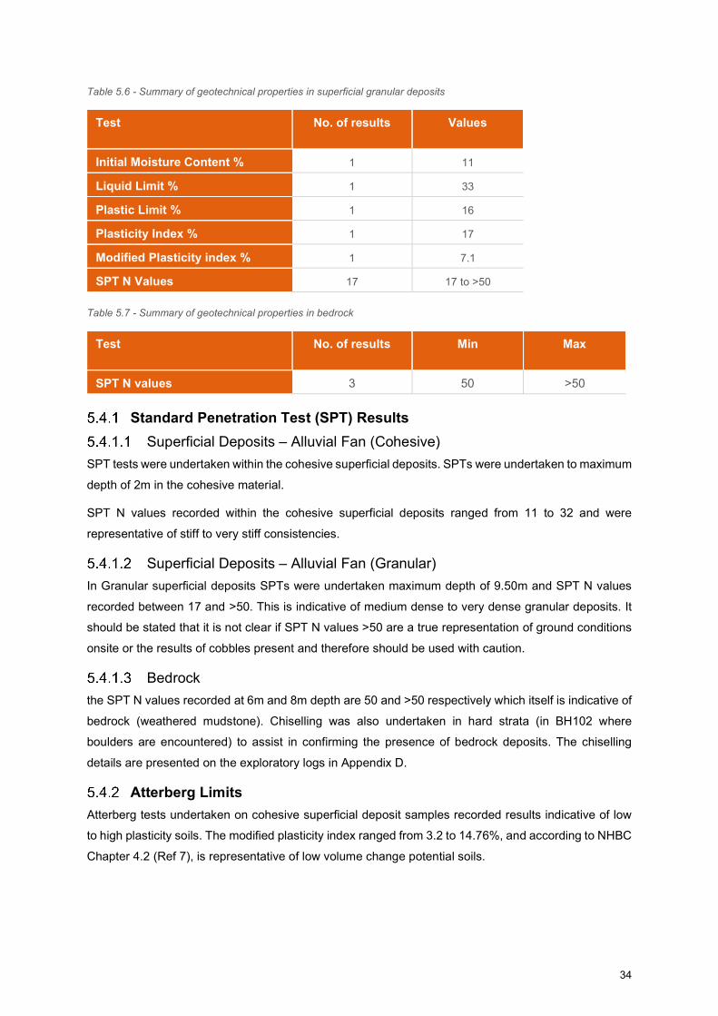
Table 5.5 - Summary of geotechnical properties in superficial cohesive deposits
Test No. of results Min Max
Initial Moisture Content % 11 4.8 28
Liquid Limit % 11 26 50
Plastic Limit % 11 17 32
Plasticity Index % 11 5 18
Modified Plasticity index % 11 3.2 14.76
SPT N values 4 11 32
34
Table 5.6 - Summary of geotechnical properties in superficial granular deposits
Test No. of results Values
Initial Moisture Content % 1 11
Liquid Limit % 1 33
Plastic Limit % 1 16
Plasticity Index % 1 17
Modified Plasticity index % 1 7.1
SPT N Values 17 17 to >50
Table 5.7 - Summary of geotechnical properties in bedrock
Test No. of results Min Max
SPT N values 3 50 >50
Standard Penetration Test (SPT) Results
Superficial Deposits – Alluvial Fan (Cohesive)
SPT tests were undertaken within the cohesive superficial deposits. SPTs were undertaken to maximum
depth of 2m in the cohesive material.
SPT N values recorded within the cohesive superficial deposits ranged from 11 to 32 and were
representative of stiff to very stiff consistencies.
Superficial Deposits – Alluvial Fan (Granular)
In Granular superficial deposits SPTs were undertaken maximum depth of 9.50m and SPT N values
recorded between 17 and >50. This is indicative of medium dense to very dense granular deposits. It
should be stated that it is not clear if SPT N values >50 are a true representation of ground conditions
onsite or the results of cobbles present and therefore should be used with caution.
Bedrock
the SPT N values recorded at 6m and 8m depth are 50 and >50 respectively which itself is indicative of
bedrock (weathered mudstone). Chiselling was also undertaken in hard strata (in BH102 where
boulders are encountered) to assist in confirming the presence of bedrock deposits. The chiselling
details are presented on the exploratory logs in Appendix D.
Atterberg Limits
Atterberg tests undertaken on cohesive superficial deposit samples recorded results indicative of low
to high plasticity soils. The modified plasticity index ranged from 3.2 to 14.76%, and according to NHBC
Chapter 4.2 (Ref 7), is representative of low volume change potential soils.
35
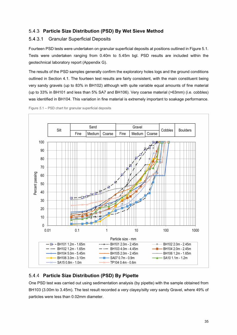
Particle Size Distribution (PSD) By Wet Sieve Method
Granular Superficial Deposits
Fourteen PSD tests were undertaken on granular superficial deposits at positions outlined in Figure 5.1.
Tests were undertaken ranging from 0.40m to 5.45m bgl. PSD results are included within the
geotechnical laboratory report (Appendix G).
The results of the PSD samples generally confirm the exploratory holes logs and the ground conditions
outlined in Section 4.1. The fourteen test results are fairly consistent, with the main constituent being
very sandy gravels (up to 83% in BH102) although with quite variable equal amounts of fine material
(up to 33% in BH101 and less than 5% SA7 and BH106). Very coarse material (>63mm) (i.e. cobbles)
was identified in BH104. This variation in fine material is extremely important to soakage performance.
Figure 5.1 – PSD chart for granular superficial deposits
Particle Size Distribution (PSD) By Pipette
One PSD test was carried out using sedimentation analysis (by pipette) with the sample obtained from
BH103 (3.00m to 3.45m). The test result recorded a very clayey/silty very sandy Gravel, where 49% of
particles were less than 0.02mm diameter.
0
10
20
30
40
50
60
70
80
90
100
0.01 0.1 1 10 100 1000
Perc
ent p
assi
ng
Particle size - mmBH101 1.2m - 1.65m BH101 2.0m - 2.45m BH102 2.0m - 2.45mBH102 1.2m - 1.65m BH103 4.0m - 4.45m BH104 2.0m - 2.45mBH104 5.0m - 5.45m BH105 2.0m - 2.45m BH106 1.2m - 1.65mBH106 3.0m - 3.10m SA07 0.7m - 0.9m SA10 1.1m - 1.2mSA15 0.8m - 1.0m TP104 0.4m - 0.6m
SiltFine Medium Coarse MediumFine Coarse
BouldersCobblesSand Gravel
36
Particle Density (Gas Jar)
Particle density tests were carried out within two samples. The results recorded density as 2.62 Mg/m3
in TP101 (0.60 – 0.80m) and 2.63 Mg/m3 in TP104 (0.40 – 0.60m).
CBR Results
Forty-Four California Bearing Ratio (CBR) tests were undertaken on site between 0.046m and 0.8m
within cohesive superficial deposits, described as brown fine to coarse gravelly silty CLAY. CBR results
ranged from 3.5% to 11.2%.
Compaction Tests
Seven Dry Density/Moisture content tests were undertaken on Alluvial Fan deposits (granular and
cohesive) comprising silty clay and sandy gravel, positions outlined in Figure 5.1. Tests were
undertaken on four boreholes (BH101, BH102, BH103 and BH104) at a depth of between 0.50m to
2.45m and in one soakaway trial pit (SA 15) at a depth of 0.30m to 1.00m. Results are included within
the geotechnical laboratory report (Appendix G).
The results of the Compaction test indicates that the maximum dry density ranges from 1.82 to 2.19
mg/m3 and the Optimum Moisture content ranges from 8 to 13%.
BRE Full Suite
Nine samples were tested for the BRE full suite (BRE BR279) and were analysed for parameters pH,
water & acid soluble sulphate, total sulphur, magnesium, chloride and nitrate. The results indicated that
pH ranged from 6.64 to 8.01, acid soluble sulphate ranged from 0.25 to 0.31%, SO4 aqueous extract
sulphate from <0.01 to 0.04g/l, Total sulphur 0.11 to 0.13% and the nitrate value was between 10 and
50mg/l. Magnesium concentration was recorded to be below 1g/l and chloride was below method limit
of detection. Results indicated moderate values for all the parameters and are attached in Appendix G
with the geotechnical results.
Organic Matter Content
One test was carried out for organic matter content from a sample obtained from BH103 (1.20m-1.65m),
which indicated a result of 1.9%.
37
6 PRELIMINARY GEOTECHNICAL ASSESSMENT
6.1 General At the time of writing it is understood that the proposed development will comprise a waste bulking
facility to the southwestern section of the site and business units to the north-eastern section of the site.
Infrastructure (services and road) has previously been installed onsite to accommodate a business park
by the Welsh Government. A proposed development layout plan has been provided but no information
regarding structural loadings have been provided at this stage.
It is assumed that the site levels will remain unchanged for the assessment. The following assessment
and recommendations will need to be reviewed when design details are available.
6.2 Ground Floor Slabs In accordance with NHBC guidance 5.1 “substructure and ground bearing floors”, shrinkable soil,
expansive materials or other unstable soils may require suspended floor construction. Shrinkable soils
are classified as those containing more than 35% fine particles (silt and clay) and have a modified
Plasticity Index of 10% or greater (see Chapters 4.2 ‘Building near trees’ (each section) and 5.2
‘Suspended ground floors’ (each section)).
The modified plasticity index for site soils varies between 3 and 15%, thus do (marginally) meet the
criteria of “shrinkable soil”. Parts of the site are underlain by variable Made Ground (fill) and this is likely
to have poor and variable load bearing characteristics. Depending on where buildings are to be located,
and their structural from and loadings, if fill exceeds 600mm and/or shrinkable clays underly the floor
area, suspended ground floor may be required. Plot specific testing should be considered to better
inform this decision.
6.3 Foundations The ground conditions beneath the site generally comprise limited made ground over variable
superficial deposits comprising various amounts of silty clay, gravelly sand and sandy gravel overlying
siltstone, mudstone and sandstone bedrock. Whilst the granular materials are relatively dense and
suitable to support up to moderate loadings (likely to be sufficient for two to three storey business units)
there are some soft clays present, and these would be unsuitable, except perhaps for very simple light
weight small structures.
The proposed development is to be two business units and a recycling bulking facility.
Made Ground soils are not considered to be a suitable founding stratum. The underlying Alluvium Fan
Deposits and Bedrock of Nantglyn Flags Formation Member recorded a number of SPT N-Value values
ranging from 11 to >50 at depths ranging from 1.20m bgl to 10.00m bgl. The superficial deposits are
noted to be laterally variable, and as such a consistent founding stratum should be targeted. The chosen
foundation solution should target the underlying Gravel within the Alluvial Fan Deposits or the Nantglyn
Flags Formation Member at depth.
38
A number of foundation solutions are deemed viable for the subject site including traditional strip, trench
fill or pad footings, or where unsuitable materials are too thick, or loads higher, vibro-stone columns or
mini-piles. This is primarily due to the variation within the shallow deposits (i.e. less than 2m bgl), and
the variation in depth that the Gravels within the Alluvial Fan deposits were encountered across the
development area. In general trench or strip foundations are not economical at depth of greater than
2mbgl. The chosen foundation solution should avoid transition between cohesive and granular, to
minimise risk of differential settlement.
Ground improvement techniques may be viable at the subject site through the use of
vibrostone/concrete columns, ideally where the underlying competent strata is the granular Alluvial Fan
deposits. The subsequent foundations should be ’rafted strips’ – to avoid any differential settlement.
If a piled foundation solution is chosen, then Detailed pile designs (in terms of pile type, depths, and
method of installation) would be dependent upon the required working loads and should be undertaken
in conjunction with a reputable, specialist, piling contractor; ideally with local experience.
Once site layouts are known, and building types and structure form are decided, it would be prudent to
undertake plot specific trial holes, to determine the most economical form of foundation and ground
floor slab combination.
6.4 Chemical Attack on Construction Materials
With reference to guidance outlined within BRE document SD1 “Concrete in aggressive ground” (2005)
(Ref 10), the test results returned for sulphate and pH values across the site correspond to a Design
Sulphate Class (DS) of DS-1 and an Aggressive Chemical Environment for Concrete Class (AC) of AC-
1.
6.5 Excavations
It is likely that the majority of the overlying Made Ground and superficial cohesive deposits could be
excavated using a conventional backhoe excavator. Due to the presence of variable superficial deposits
in places, some temporary support or battering back may be required for deeper
excavations. Groundwater entry will likely occur and hence dewatering methods will be required for
deeper excavations.
6.6 Groundwater During the site investigation groundwater was encountered in all the deeper borehole locations except
in BH102. The groundwater strikes were all encountered in the granular superficial Deposits and
mudstone between 3.20m and 7.00m bgl. The post field work monitoring identified groundwater depth
in the boreholes ranging from 2.71m to 4.30m bgl, within the granular superficial deposits and bedrock.
Therefore, it is anticipated that significant groundwater ingress into shallow excavations is unlikely.
However, following wet periods for example, shallow groundwater is more likely to be encountered, and
dewatering methods such as sump pumping of groundwater ingress and other such methods may be
required.
39
6.7 Obstructions
No evidence of buried structures or services was encountered during the site investigation. However,
storage tanks and electricity substations currently occupy the site in the central area. It is anticipated
that obstructions such as historic foundations, may require removal where they may influence future
development including foundations, pavements and services as they may act as a hard spot creating
differential settlement issues. Should any soft spots be found as a result of buried structures being
removed then it is recommended that these be replaced with a suitable well compacted type 1 granular
fill and proof rolled.
6.8 Pavement and Road Design Based upon current design plans it is understood that the proposed developments within the site include
internal roads for the site to be developed as business park.
The results of CBR undertaken on site between 0.046m and 0.8m within cohesive superficial deposits,
ranged from 3.1% to 11.2%. Based upon these results and due to the variability of the Made Ground a
design CBR of 3-5% should be achievable. However, similar conditions will need to be confirmed
throughout site. If the formation is within areas recorded with soft to firm clays a lower CBR value of 2%
may be assumed for preliminary design.
It is recommended that further testing be undertaken during earthworks at the proposed formation
level (and specifically in superficial deposits if the Made Ground material is fully removed).
Cohesive material will be frost susceptible and this will need to be considered in pavement
designs. Shallow/perched groundwater may also act as a constraint on pavement design. Areas of
loose / soft spots and hard spots should be excavated and replaced with suitable materials.
6.9 Disposal and Re-Use of Materials Pavement and services construction are likely to generate a significant volume of excess
arisings. Early consideration should be given to how this material will be managed, re-used or disposed
of. Any material proposed for re-use must be proven to be suitable for its intended use both
geotechnically and geo-environmentally.
Excavated soils which are not re-used onsite will need to be disposed of offsite to an appropriately
licenced waste disposal or treatment facility. Material identified as waste will need to be assessed to
determine its waste classification and Waste Acceptance Criteria (WAC) testing undertaken to
determine the potential waste disposal options.
Appropriate testing including compaction testing should be carried out to confirm the materials
engineering suitability of the re-used material. Materials should be re-use in accordance with an
engineering specification and compliance supported with verification testing.
Made Ground has been identified in all the hand dug trial pits in the north west of the site. Made Ground
should be handled, managed and stored separately form natural inert arisings. Material which appears
to be ‘clean’ should be segregated from material which appears to be contaminated. Arisings should
40
not be used elsewhere on site as engineering fill unless they can be proven to be suitable for its intended
use and not present a risk to controlled waters and human health. Refer to Chapter 9 for further
information regarding the stockpiles along the northern part of the site.
6.10 Drainage Sixteen Soakaways were completed across the site. The tests were undertaken in the cohesive and
granular superficial deposits up to 1.2m in depth. No results appropriate to design are available for
SA04, SA 05, SA06, SA 08 (undertaken within cohesive clays encountered at these locations) as the
water level did not achieve the 75% and 25% effective depth mark. Therefore, this is indicative of very
poor drainage conditions.
The effective depth was achieved in the other SAs (the majority of them are within granular Alluvial Fan
deposits), however due to time constraints only one test cycle could be undertaken for most of them.
The soil infiltration rate for SAs ranged from 8 x 10⁻⁷ to 2.59 x 10⁻⁴ and may be described as having low
to medium soakage potential, indicative of poor to good drainage conditions.
Based upon this information and taking due note of the variability of the superficial deposits, it may be
possible for drainage systems to be implemented within the gravels. However, as demonstrated within
the variation of results obtained, parts of the site would not be appropriate, especially in areas where a
thickness of cohesive strata is present nor where relatively dense granular deposits have a higher
proportion of fines. As a guide, greater than approximately 8 to 10% fines within an otherwise granular
material significantly reduces the material’s permeability and soakage potential.
Therefore, it is considered that Sustainable Urban Drainage Systems (SUDS) is tentatively suitable for
the proposed development, providing locations are able to target the more permeable gravels within
the Alluvial Fan deposits. Further close spaced testing is likely to be required, and discussions held with
NRW and Local Authority drainage team.
41
7 GENERIC QUANTITATIVE RISK ASSESSMENT
7.1 Basis of Assessment
As part of the intrusive investigation, thirty-four soil samples, comprising eight Made Ground and twenty-
six natural soil samples were collected for geo-environmental testing, targeting areas where sources of
contamination were identified during the desk study report (Ref 1), including BH104 targeting the
potential USTs within the gated compound, as well as to provide a general site coverage. Geo-
environmental testing was undertaken to understand the prevailing chemical regime and to determine
whether potential risks would be introduced to site users and the water environment due to the proposed
works.
The exploratory hole location plan is presented in Appendix B and the chemical testing results are
presented in Appendix H.
7.2 Soil Screening Values (SSVs)
In accordance with current UK guidance and legislation, the analytical data has been compared to
Generic Assessment Criteria (GAC) calculated using the CLEA (v1.6) model and using the exposure
assumptions and toxicological input parameters prescribed in the Environment Agency Contaminated
Land Reports (EA CLRs) for a Tier 1 screening assessment.
The soil screening values have been taken from LQM / CIEH Suitable for Use Levels (S4ULs) for
Human Health Risk Assessment (Ref 11). In the absence of a S4UL for Lead, the Category 4 Screening
Level (C4SL) has been adopted (Ref 12).
Considering the proposed development (i.e. covered in hardstanding), it is considered appropriate to
adopt the screening criteria for a “Commercial/Industrial” end use for the initial screening process.
Screening criteria for 1%, 2.5% and 6% soil organic matter (SOM) have been developed to take account
of the variation in organic content of the different soil types. Criteria relating to a SOM content of 1%
have been adopted for this assessment based on soil organic matter tests undertaken on two soil
samples which yielded results of 0.5% and 0.6% within the natural superficial deposits.
7.3 Human Health Risk Assessment
Asbestos
Eight samples of Made Ground and twenty-six samples of natural soils were screened for the presence
of asbestos fibres. Asbestos was not detected in any of these samples.
Chemical Testing
Chemical testing was undertaken on 26 samples of natural soils and 8 samples of Made Ground for
Metals, Inorganic Compounds, Polycyclic Aromatic Hydrocarbons (PAH), Monoaromatics and
Petroleum Hydrocarbons. No exceedances were identified against the relevant screening criteria.
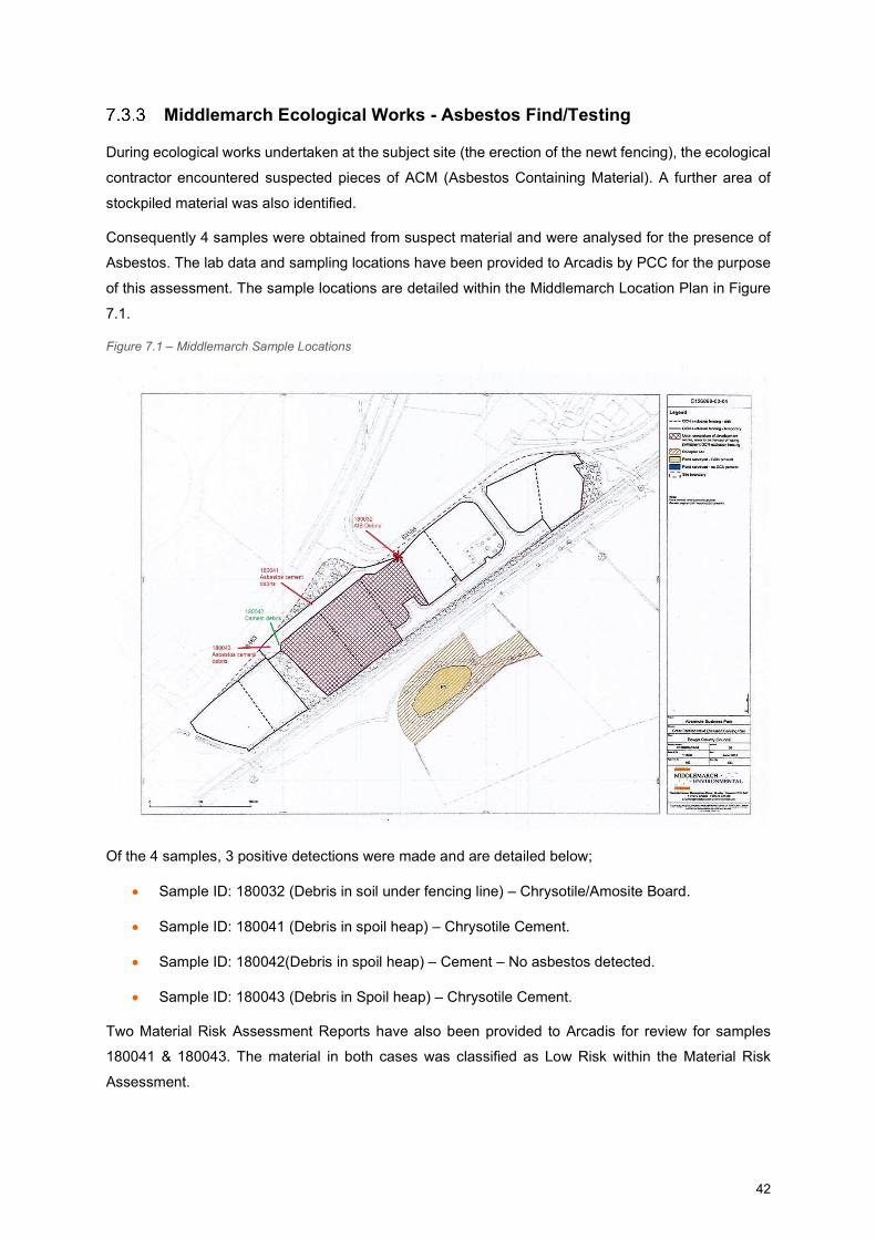
42
Middlemarch Ecological Works - Asbestos Find/Testing
During ecological works undertaken at the subject site (the erection of the newt fencing), the ecological
contractor encountered suspected pieces of ACM (Asbestos Containing Material). A further area of
stockpiled material was also identified.
Consequently 4 samples were obtained from suspect material and were analysed for the presence of
Asbestos. The lab data and sampling locations have been provided to Arcadis by PCC for the purpose
of this assessment. The sample locations are detailed within the Middlemarch Location Plan in Figure
7.1.
Figure 7.1 – Middlemarch Sample Locations
Of the 4 samples, 3 positive detections were made and are detailed below;
Sample ID: 180032 (Debris in soil under fencing line) – Chrysotile/Amosite Board.
Sample ID: 180041 (Debris in spoil heap) – Chrysotile Cement.
Sample ID: 180042(Debris in spoil heap) – Cement – No asbestos detected.
Sample ID: 180043 (Debris in Spoil heap) – Chrysotile Cement.
Two Material Risk Assessment Reports have also been provided to Arcadis for review for samples
180041 & 180043. The material in both cases was classified as Low Risk within the Material Risk
Assessment.

43
Both reports concluded; “It is likely that this material has been placed on the site from elsewhere and
therefore would not necessarily be found at depth. It would be advisable to undertake further ground
investigations in the area to quantify the levels present in the spoil heap and whether there has been
any migration into the ground below. Ground investigations for asbestos contamination should be
designed, undertaken & evaluated by competent specialists who have an appropriate level of geo-
environmental & asbestos qualifications, skills & experience”, and recommended that the material
should be ultimately “Removed under controlled conditions” & “An assessment needs to be undertaken
by a competent person in line with HSE Asbestos Essentials Task Manual Sheet A0 each time works
are required.”
It should be noted that Arcadis has not been provided with the Material Risk Assessment for sample
180032 – which is likely to report higher risk material, as Chrysotile/Amosite Board tends to be more
friable and ready to release fibres.
The Lab Reports and the Material Risk Assessment Reports as provided by PCC are also included
within Appendix H.
Arcadis consequently undertook 8no hand dug pits (HTP01-HTP08) to de-lineate the asbestos findings
of Middlemarch. No visual identifications of asbestos were made during the hand pitting investigation,
and laboratory testing of 8 samples did not indicate the presence of asbestos.
Therefore, the previously identified asbestos within samples 180032, 180041 and 180043 appears to
be localised, and asbestos does not appear to widespread throughout the stockpiled material. Although
the sampling frequency is considered moderate there is still potential for asbestos to be present within
the Stockpiles which was not identified.
As per the recommendations within the Material Risk Assessments, it would be prudent to remove and
dispose of the impacted stockpiles to an appropriate waste disposal facility in accordance with current
legislation duty of care requirements. As part of these works, it is recommended that appropriate health
and safety and necessary mitigation measures are implemented to reduce any risks associated with
materials potentially containing asbestos.
During the excavation of the stockpiles, a competent person, appointed by the Principal Contractor, will
inspect the excavated arising for visible signs of asbestos. Should asbestos be observed during any
excavations, quantification testing would be required to determine whether presence of asbestos at
visible concentrations would classify the soil as hazardous for the purposes of off-site disposal.
It should be noted that the asbestos was only encountered during excavation works, and the site in its
current undisturbed condition poses no significant risk to site operatives or the wider public from
asbestos fibres. All detections of asbestos were located below ground level, and as such no
contamination pathway between the source and receptor is present. Only once ground is broken during
enabling and construction works would a feasible inhalation pathway be present.
44
7.4 Controlled Waters Risk Assessment
Water Quality Standards
One round of groundwater sampling was undertaken on 30th January 2019 from the deep standpipes
installed from BH101 to BH106.
To assess the risk to controlled waters, the chemical testing results have been compared against
appropriate Water Quality Standards (WQS). The WQS comprise Environmental Quality Standards
(EQS) from the Water Framework Directive (Ref 13) which are considered to be protective of surface
waters, and UK Drinking Water Standards (DWS) from the Water Supply Water Quality Regulations
(Ref 14) which are considered to be protective of the underlying Secondary B Aquifer.
The EQS for copper, zinc and nickel are based on bioavailability. Site specific Predicted No Effect
Concentrations (PNEC) have been calculated for copper, zinc and nickel based on the minimum
measured concentration of calcium (88mg/l), minimum pH of 6.8 pH units and dissolved organic carbon
of 1.29mg/l as a conservative (worst case) approach. The approach used is set out in the Water
Framework Directive UK Technical Advisory Group guidance, Metal Bioavailability Assessment Tool
(Ref 15).
There are no standard guideline values for TPH in groundwater in the UK. In the absence of a specific
standard, 10 µg/l is considered to be a reasonable point of reference at which TPH could be of interest
(former UK Drinking Water Standard).
The nearest surface water features are Reservoir and associated drainage around the Site <50m north-
east, south-east, south and north-west of the Site and a significant surface water feature is the River
Severn located 250m north east from site.
Based on the topography of the Site within a valley and the location of surface water features, it is
considered that the direction of hydraulic gradient is likely to be south-east and north-west towards the
depression of the valley. Also, one groundwater abstraction licence approximately 360.0m south west
of the Site.
The groundwater chemical data is presented in Appendix H.
Groundwater Testing
Groundwater sampling was undertaken on the 30th January 2019 from all six boreholes. All samples
collected was scheduled and screened against appropriate Environmental Quality Standards (EQS)
and Drinking Water Quality (DWS).
Polycyclic Aromatic Hydrocarbons (PAHs) & Phenols
Six groundwater samples were tested for PAHs and phenols. The concentrations of PAHs and phenols
were returned below the laboratory limit of detection in all samples analysed. These are therefore not
considered to be contaminants of concern, based on one round of analysis.
45
Metals
Six groundwater samples were analysed for heavy metals. Exceedances recorded against the WQS
have been tabulated within Table 7.1.
Table 7.1 – Exceedances of WQS in groundwater samples
Determinant EQS (µg/l)
DWS (µg/l)
Number of exceedances
Locations Samples exceeding EQS/ DWS
Copper 1 2000 6
BH101 (2.8 µg/l)
BH102 (2.8 µg/l)
BH103 (3.2 µg/l)
BH104 (2.9 µg/l)
BH105 (2.7 µg/l)
BH106 (3.3 µg/l)
EQS
Nickel 4 20 2 BH102 (12.0 µg/l)
BH106 (4.1µg/l) EQS
A number of marginal groundwater exceedance for heavy metals were recorded against the stringent
EQS criteria, including Copper and Nickel. The conservative Predicted No Effect Concentration (PNEC)
calculated for copper is 3.96 μg/l, and for Nickel is 12.59 ug/l, therefore when considering the
bioavailability of the metals, no exceedances are recorded.
BTEX and Total Petroleum Hydrocarbons
Six groundwater samples were tested for BTEX and TPHCWG. The concentrations were all returned
below the laboratory limit of detection in all samples analysed. These are therefore not considered to
be contaminants of concern, based on one round of analysis.
7.5 Ground Gas Risk Assessment
Four rounds of ground gas monitoring data undertaken on the 22nd and 31st January 2019, 7th and 14th
February 2019 by Arcadis.
Concentrations of methane (CH4), carbon dioxide (CO2) and oxygen (O2) in % v/v and gas flow in litres
per hour (l/h), and hydrogen sulphide (H2S) and Carbon Monoxide (CO) in parts per million (ppm) were
taken during the visit. The groundwater levels were also measured.
Atmospheric pressure can impact ground gas flow. According to CIRIA C665 Assessing the risks posed
by hazardous ground gases to buildings (Ref 16) “at falling pressure increased emission rates occur as
the gas increases in volume. Rising pressure causes air to flow into the ground, diluting soil gas
concentrations. The rate of change in barometric pressure is also important. A swift drop over a small
range has the potential to release a greater concentration of gas than a gradual drop over a greater
pressure range”.
46
Atmospheric pressure data for the monitoring period was obtained from the Met Office Weather
Observation Data website (Ref 19). The data was obtained from a monitoring station at Woodhouse
Station, Harmon, located approximately 25 km south west of the site. Atmospheric pressure graphs
corresponding to the monitoring rounds are shown in Appendix F.
A summary of the atmospheric pressure conditions for each monitoring round is as follows.
22nd January 2019: Medium and falling atmospheric pressure (1005 – 995 mb)
30th January 2019: Low and falling atmospheric pressure (995 – 992 mb)
7th February 2019: Low and rising atmospheric pressure (995 – 1005 mb)
14th February 2019: High and falling atmospheric pressure (1029 – 1026 mb)
General
Hydrocarbon vapour was assessed via Photo Ionisation Detection (PID) analysis of the soils during the
site investigation and were recorded between <1 ppm. These levels are not at a level which is
considered to pose a significant risk.
During the monitoring visits zero or very low negative rates of flow were measured in the monitoring
wells. For the purposes of the assessment a flow rate of 0.1 l/h has been used where flow rates were
recorded as zero. The exploratory holes encountered little or no putrescible materials within the Made
Ground.
Gas Monitoring Results
Concentrations of carbon dioxide up to 5.60% v/v were recorded and a maximum concentration of
methane of 0.80% v/v was recorded.
Ground Gas Assessment
A ground gas risk assessment has been undertaken to evaluate the risk posed to potential receptors of
the proposed commercial development.
BS 8485(2019) +A1 guidance (Assessing risk posed by hazardous gases to buildings) (Ref. 17) has
been used to inform the ground gas assessment.
The Qhg is calculated using the following equation:
Qhg = borehole flow rate (l/h) x gas concentration (%v)/100
The following parameters have been used in the equation:
CH4 (max recorded concentration) = 0.8 % v/v
CO2 (max recorded concentration) = 5.6 % v/v
Flow Rate (max steady flow rate) 0.1 l/hr
Qhg CH4: 0.8/100 x 0.1 = 0.0008 – CS1 Low risk
Qhg CO2: 5.6/100 x 0.1 = 0.0056 – CS1 Low Risk
47
With reference to BS8485 Code of Practice for the design of protective measures for methane and
carbon dioxide ground gases for new buildings (Ref. 17), the calculated Qhg fall into the CS1 ‘very low
risk’ category.
Arcadis notes that 2 of the 6 monitoring wells (BH101 and BH106) were flooded (with groundwater
above the level of the slotted response zone) during the post fieldwork monitoring period. Arcadis
believes that the data obtained from the other wells during the monitoring period provides a sufficient
dataset for the purpose of the proposed development, combined with the absence of significant ground
gas sources (e.g. landfill material), and therefore the conclusions of the ground gas risk assessment
detailed below are consistent with the CSM i.e. no ground gas source.
No elevated concentrations of Methane were recorded at the site above the CS1/CS2 threshold of
1.0%v/v.
Elevated concentrations of Carbon Dioxide were recorded at the site above the CS1/CS2 threshold of
5%v/v during a single monitoring visit on 14/02/2019 during a period of falling atmospheric pressure
(although it should be noted that no elevated flow rates have been recorded at the site).
With reference to BS 8485 Code of Practice for the design of protective measures for methane and
carbon dioxide ground gases for new buildings (Ref. 17), if a carbon dioxide concentration greater than
5% v/v is encountered, consideration should be given to assigning a CS2 classification. In this instance,
there is not considered to be source of ground gas such as landfill or waste on site, the 5% limit for
carbon dioxide was only exceeded in one borehole (BH102) and the steady measured gas flow was
low. Therefore, a CS1- very low risk is considered to be more appropriate.
No protective measures are therefore considered to be required for carbon dioxide and methane.
Radon
The site is located within a medium probability radon area (5 to 10% of homes are estimated to be at
or above the action level). It is recommended that the level of protection required is confirmed with the
Local Authority Building Control Department, and that will depend on the design of any structures and
buildings including the inherent ventilation, it is likely that basic redon protection measures will be
required. The BRE211 (2015) guidance document includes guidance on how the measures should be
designed and what factors should be considered. It is recommended that a radon assessment is
undertaken within the site to provide site specific information, which could potentially reduce the risk to
the proposed development.
48
8 ENVIRONMENTAL RISK ASSESSMENT
Based on the assessment of soil, groundwater and gas monitoring data, the potential contaminant
linkages identified in the Phase 1 Desk Study have been updated in accordance with CIRIA Guidance
C552 (Ref 18), identifying the ‘contaminant linkages’ (contaminant source-pathway-receptor
relationships) that may be present at the site based upon the laboratory analysis and monitoring
completed.
8.1 Methodology
Risk assessment is the process of collating known information on a hazard or set of hazards (to
determine the potential severity of any impact) along with details on the likelihood of impact on detailed
receptors. Risks are generally managed by isolating the sensitive receptor or by intercepting or
interrupting the exposure pathway, thus no pollutant linkages are formed and there is no risk. The
following risk assessment focuses on the potential contaminants identified on the site in the context of
the proposed development of the site.
CIRIA guidance C552 (Ref 18) states that the designation of risk is based upon a consideration of both:
The likelihood of an event (probability) (considers both the presence of the hazard and the receptor
and the integrity of the pathway).
The severity of the potential consequence (considers both the potential severity of the hazard and
the sensitivity of the receptor).
Under such a classification system the following categorisation of risk has been developed and the
terminology adopted presented in Table 8.1.
Table 8.1 - Summary of risk likelihood classification categories
Term Description
Very High Risk
There is a high probability that significant harm could arise to a designated receptor from an
identified hazard at the site without appropriate remedial action or there is evidence that
significant harm to a designated receptor is already occurring.
High Risk
Harm is likely to arise to a designated receptor from an identified hazard at the site without
appropriate remedial action. Remediation works may be necessary in the short-term and are
likely over the longer term.
Moderate Risk
It is possible that harm could arise to a designated receptor from an identified hazard.
However, it is either relatively unlikely that any such harm would be severe or if any harm
were to occur it is more likely that such harm would be relatively mild. Some remediation
work may be required in the longer term.
Low Risk
It is possible that harm could arise to a designated receptor from an identified hazard, but it
is likely, at worst, that this harm if realised would normally be mild. Any subsequent
remediation works are likely to be relatively limited.
Very Low Risk It is a low possibility that harm could arise to a receptor, but it is likely at worst, that this harm
if realised would normally be mild or minor.
*Further risk assessment information is attached in Appendix J
49
8.2 Contaminant Sources The following determinants have been identified as contaminants of concern:
Radon - The site is located within a medium probability radon area (5% to 10% of homes are
estimated to be at or above the action level).
Sulphates - Design Sulphate Class (DS) of DS-1 and an Aggressive Chemical Environment for
Concrete Class (AC) of AC- 1.
Asbestos - Asbestos was detected within 3 sampling locations during the Middlemarch ecological
works, within stockpiles located adjacent to the northwest boundary.
8.3 Summary of Potential Contaminant Sources Following the preliminary CSM originally developed in the desk study report for the site (Ref 1) and
based on the results of the ground investigation the conceptual site model can now be refined as
detailed in Table 8.2.
8.4 Contaminant Linkages – Conceptual Model
The conceptual site model has been derived from the sources identified from the site investigation and
assessment and the identified receptors and pathways.
Table 8.2 provides an assessment of each identified contaminant linkage (CL) to establish the potential
risk to the sensitive receptors. The proposed development to commercial dwellings has been taken
into consideration and the risk assessment has been developed based on this specific redevelopment
and land use scenario.
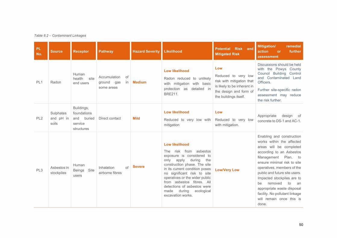
50
Table 8.2 – Contaminant Linkages
PL
No. Source Receptor Pathway Hazard Severity Likelihood
Potential Risk and
Mitigated Risk
Mitigation/ remedial
action or further
assessment
PL1 Radon
Human health site end users
Accumulation of
ground gas in
some areas
Medium
Low likelihood
Radon reduced to unlikely
with mitigation with basic
protection as detailed in
BRE211.
Low
Reduced to very low
risk with mitigation that
is likely to be inherent in
the design and form of
the buildings itself.
Discussions should be held with the Powys County Council Building Control and Contaminated Land Officers.
Further site-specific radon
assessment may reduce
the risk further.
PL2
Sulphates
and pH in
soils
Buildings,
foundations
and buried
service
structures
Direct contact Mild
Low likelihood
Reduced to very low with
mitigation
Low
Reduced to very low
with mitigation.
Appropriate design of
concrete to DS-1 and AC-1.
PL3 Asbestos in
stockpiles
Human
Beings Site
users
Inhalation of
airborne fibres
Severe
Low likelihood
The risk from asbestos exposure is considered to only apply during the construction phase. The site in its current condition poses no significant risk to site operatives or the wider public from asbestos fibres. All detections of asbestos were made during ecological excavation works.
Low/Very Low
Enabling and construction
works within the affected
areas will be completed
according to an Asbestos
Management Plan, to
ensure minimal risk to site
operatives, members of the
public and future site users.
Impacted stockpiles are to
be removed to an
appropriate waste disposal
facility. No pollutant linkage
will remain once this is
done.
51
8.5 Summary of Contaminant Linkages Contaminant linkages have been assessed for the site as detailed in Table 8.2.
Asbestos has been detected within the 3 samples obtained during the Middlemarch ecological works from
stockpiles along the north-western boundary area onsite, with the site in its current state the risk from the
inhalation of asbestos fibres is low, a credible exposure pathway becomes viable when construction and
enabling works commence. After offsite removal the contamination pathway (inhalation) between the source
and the receptor will be severed.
The chosen Principal Contractor should assess the asbestos risk to the construction workers and future
operational staff. As per the Material Risk Assessments provided to Arcadis, it would be prudent to remove
and dispose of impacted stockpiles to an appropriate waste disposal facility in accordance with current
legislation duty of care requirements. As part of these construction works to manage the risk to site users,
visitors and the wider public, appropriate health and safety and necessary mitigation measures will be
implemented to reduce any risks associated with materials potentially containing asbestos, this may include
selective removal or hand picking of significant pieces of asbestos for offsite disposal.
Sulphates and pH in the ground are considered likely to present a low risk to buildings providing appropriate
design of concrete of AC-1 and design sulphate class DS-1.
The site is located within a medium probability radon area (5 to 10% of homes are estimated to be at or above
the action level). It is recommended that the level of protection required is confirmed with the Local Authority
Building Control Department, and that will depend on the design of any structures and buildings including the
inherent ventilation, it is likely that basic redon protection measures will be required. The BRE211 (2015)
guidance document includes guidance on how the measures should be designed and what factors should be
considered. It is recommended that a radon assessment is undertaken within the site to provide site specific
information, which could potentially reduce the risk to the proposed development.
52
9 WASTE ASSESSMENT
9.1 HazWaste Online
EU Directives, UK Government policy and regulations require that construction waste to landfill is minimised.
Where possible (of benefit to the planned development) all excavation arisings as a result of the proposed
development should be re-used onsite as either engineering fill or landscaping fill. To comply with current
legislation and regulations any re-use of excavated materials within the site could be undertaken via either of
two routes – Environmental Permitting (formerly Waste Exemptions); or in accordance with the CL:AIRE
Definition of Waste: Development Industry Code of Practice. Whichever route is chosen soils must be proved
certain to be used and demonstrated to be “suitable for use” in the area to be deposited. A Materials
Management Plan (or method statement) should be produced during the design phase for the scheme.
Should the excavated material not be required or be physically or chemically unsuitable for use as backfill or
as other engineering fill within the site, the excess material would be Waste and will need to be removed off
site. If only disposal to landfill was an option, further Waste Acceptance Criteria (WAC) testing and separation
of waste for off-site disposal may be required to ensure accurate classification of material to reduce wastes
sent to non-hazardous and hazardous landfill. Natural excavated arisings would be classified as inert if
segregated from Made Ground materials. Inert waste would be the least expensive for disposal and the
material could be more easily reused.
Arisings should be stored in an appropriate manner to prevent leaching of contaminants from the material and
with suspected inert, non-hazardous and hazardous material stored separately where appropriate to avoid
cross contamination.
Under European Council Directive (91/689/EC), known as the Hazardous Waste Directive, a list of all wastes,
hazardous or otherwise has been compiled known as the European Waste Catalogue (EWC, 1994,
Commission Decision 94/3/EC). A revised EWC was released in 2002 under Commission Decision
2000/532/EC. This commission decision has been amended in turn by Commission Decisions 2001/118/EC,
2001/119/EC and 2001/573/EC. The EWC is a catalogue of all wastes, grouped according to generic industry,
process or waste type. It differentiates between non-hazardous and hazardous.
Stockpile Samples
The chemical testing results from the 8 stockpile samples represented by HTP01 to HTP08 (Made Ground)
were screened using HazWaste online software to determine whether the stockpiles represented by these
samples would be suitable for disposal at a non-hazardous or inert landfill site. It is understood that the samples
analysed are representative of the whole stockpiles.
The List of Wastes Code used in the assessment was 17.05.04; soils and stones other than those mentioned
in 17.05.03 (for non-hazardous material), whilst the code for hazardous material would be 17.05.03.
The initial screen of the results indicated that 3 of the samples could be potentially hazardous due to the
concentration of sum TPH C6-C40 (16 – 35 mg/kg) which exceeded the concentration threshold for HP3
53
Flammable. However, this classification has been revised to non-hazardous with regard to TPH as the
concentration of sum TPH required to be flammable in soil is >1000 mg/kg and no evidence of free phase
hydrocarbon product was identified on the exploratory hole logs. Where a substance has a HP3 classification,
it is assumed that enough material is present for ignition to occur, i.e. that the chemical is in its raw from, not
within the soil matrix. In the case of soils, ignition is unlikely at concentrations <1000 mg/kg. However, this
would need to be confirmed by the operator of the landfill where the waste is intended to be taken.
The 8 samples were therefore classified as non-hazardous based on the determinants analysed.
Waste Acceptance Criteria (WAC) testing should be undertaken on arisings represented by samples of non-
hazardous waste to inform the potential disposal options; either at a non-hazardous or inert landfill site.
It should be noted that the landfill operator may undertake a visual inspection of the arisings at the site entrance
and may require further testing prior to acceptance of the waste should the visual appearance of the waste
differ from the written description of the waste (included on the exploratory hole logs within Appendix D).
It should be noted that the Arcadis testing did not identify the presence of Asbestos. Asbestos has been
identified onsite during the Middlemarch ecological works, and its presence may lead to a potentially hazardous
classification.
Borehole and Trial Pit Samples
8 samples of natural soil from Trial pits TP101 – TP104 in the south western part of the site were screened
using HazWaste Online software to determine whether any excavated materials would be likely to be classified
as hazardous or non-hazardous waste, if they were to require offsite disposal as waste.
The List of Wastes Code used in the assessment was 17.05.04; soils and stones other than those mentioned
in 17.05.03 (for non-hazardous material), whilst the code for hazardous material would be 17.05.03.
The initial screen of the results indicated that 2 of the samples (TP102 0.0-0.2 m bgl and TP103 0.0-0.3 m bgl)
could be potentially hazardous due to the concentration of sum TPH C6-C40 (11 – 14mg/kg) which exceeded
the concentration threshold for HP3 Flammable. However, this classification has been revised to non-
hazardous with regard to TPH as the concentration required to be flammable in soil is >1000 mg/kg and no
evidence of free phase hydrocarbon product was identified on the exploratory hole logs.
The 8 samples were therefore classified as non-hazardous based on the determinants analysed. WAC testing
should be undertaken on arisings represented by samples of non-hazardous waste to inform the potential
disposal options; either at a non-hazardous or inert landfill site.
In order to secure disposal at a landfill site, a waste management facility may require testing of the actual
material that is to be disposed of offsite prior to acceptance. There is no obligation on a landfill operator to
accept the waste.
The results of the hazwaste assessment are attached as Appendix I.
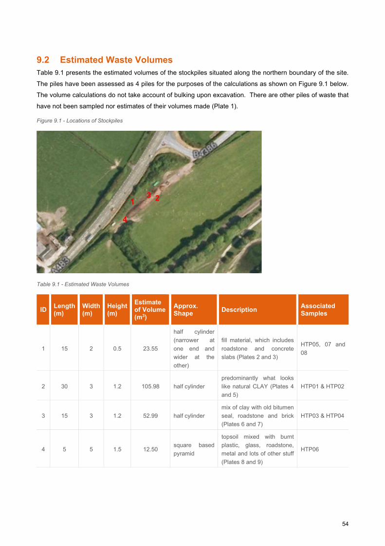
54
9.2 Estimated Waste Volumes Table 9.1 presents the estimated volumes of the stockpiles situated along the northern boundary of the site.
The piles have been assessed as 4 piles for the purposes of the calculations as shown on Figure 9.1 below.
The volume calculations do not take account of bulking upon excavation. There are other piles of waste that
have not been sampled nor estimates of their volumes made (Plate 1).
Figure 9.1 - Locations of Stockpiles
Table 9.1 - Estimated Waste Volumes
ID Length (m)
Width (m)
Height (m)
Estimate of Volume (m3)
Approx. Shape
Description Associated Samples
1 15 2 0.5 23.55
half cylinder
(narrower at
one end and
wider at the
other)
fill material, which includes
roadstone and concrete
slabs (Plates 2 and 3)
HTP05, 07 and
08
2 30 3 1.2 105.98 half cylinder
predominantly what looks
like natural CLAY (Plates 4
and 5)
HTP01 & HTP02
3 15 3 1.2 52.99 half cylinder
mix of clay with old bitumen
seal, roadstone and brick
(Plates 6 and 7)
HTP03 & HTP04
4 5 5 1.5 12.50 square based
pyramid
topsoil mixed with burnt
plastic, glass, roadstone,
metal and lots of other stuff
(Plates 8 and 9)
HTP06
1 3 2
4
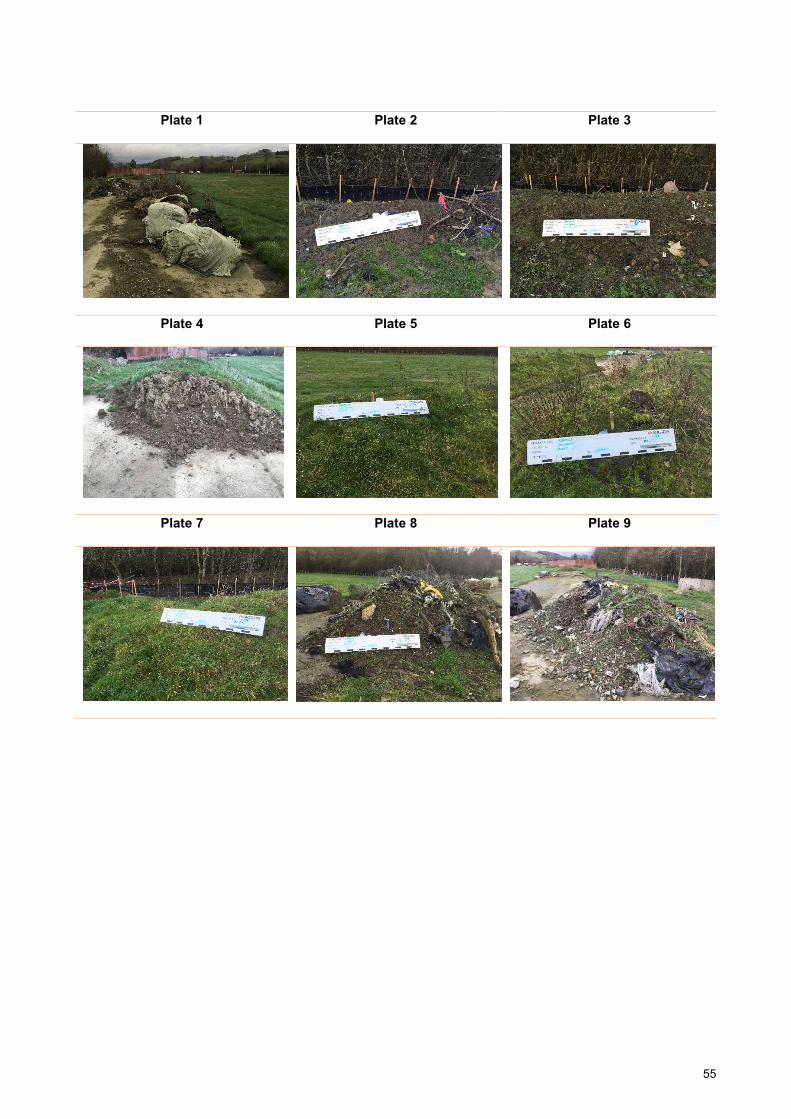
55
Plate 1 Plate 2 Plate 3
Plate 4 Plate 5 Plate 6
Plate 7 Plate 8 Plate 9
56
10 CONCLUSIONS AND RECOMMENDATIONS
A ground investigation was undertaken to target potential areas of concern highlighted within the Arcadis Desk
Study Report (Ref 1). The purpose of this report is to interpret the ground investigation data and to assess the
nature and extent of any contamination on the existing site, in order to determine the potential risk to the site /
users. This is in support of the planning condition for business units and a recycling bulking facility at Abermule
Business Park.
10.1 Geo-Environmental Conclusions
No evidence of widespread significant contamination was identified, and specific remedial actions are not
considered to be necessary to the entire site. The primary concern relates to 3 asbestos identifications made
during the Middlemarch ecological works.
Soil Samples - Samples recovered from Made Ground and Natural superficial deposits did not show
any elevations against their respective screening values for the commercial/industrial end-use.
Asbestos - Asbestos has been identified within Made Ground Deposits within the stockpiles and
poses a potential risk to construction workers and other site users during the construction phase. It is
proposed to remove the impacted stockpiles to an appropriate waste disposal facility. Once removed
offsite the contamination pathway is severed and no further remedial action will be required.
An Asbestos Management Plan will be developed by the chosen Principal Contractor and their
Specialist Sub-Contractor(s) thus enabling the construction work to be completed to with the minimum
risk to workers health. The Plan will include mitigation measures to ensure minimal risk to site
operatives, members of the public and future site users. The agreed remediation activity will be
undertaken by a specialist contractor under the overall supervision of the chosen Principal Contractor.
Documentary evidence of any asbestos removed will be provided in the form of contemporaneous
records, including proof of appropriate off-site disposal. The documentary evidence will again be
presented within A Remediation Verification report.
Ground Gas – Based on the calculated GSVs for the ground gas monitoring data, the site is classified
as CS1. No special measures are deemed necessary for the proposed development.
Radon - The site is located within a medium probability radon area (5% to 10% of homes are estimated
to be at or above the action level). It is recommended that the level of protection required is confirmed
with the Local Authority Building Control Department, it is likely that basic protection measures will be
required. It is recommended that a radon assessment is undertaken within the site to provide site
specific information, which could potentially reduce the risk to the proposed development.
Groundwater - No groundwater contaminants of concern were recorded within the samples.
Waste - 8 Stockpile samples (Made Ground) and 8 Borehole and Trial pit samples (natural soil
samples) were screened for hazwaste online. All samples tested were consistent with a classification
57
of non-hazardous – it should be noted that Arcadis testing did not identify asbestos – the presence of
asbestos may lead to a potentially hazardous classification.
10.2 Geotechnical Conclusions
Ground Conditions - Ground conditions across the site were variable comprising limited Made
Ground of both cohesive and granular deposits to the north west of the site up to 0.40m thick overlying
variable amount of sandy gravelly silt and sandy gravelly clay to a depth of 4m and sandy clayey gravel
and gravelly sand to a depth of 10m. Bedrock (Nantglyn Flags Formation) is recovered as weak dark
grey mudstone in tow boreholes.
Groundwater - Groundwater strikes in the boreholes were noted at 3m and 8.5m within the granular
superficial deposit and bedrock. The post fieldwork monitoring of the groundwater levels was
consistent with the readings taken during the site investigation. The levels ranged from 2.71m to 4.30m
over all three monitoring rounds. Higher groundwater can be anticipated, particularly after wet periods
and flood events.
Excavations - It is likely that the majority of the overlying Made Ground and superficial
cohesive deposits could be excavated using a conventional backhoe excavator. Due to the presence
of variable superficial deposits in places, some temporary support or battering back may be required
for deep excavations. Groundwater entry will likely occur and hence dewatering methods will be
required for deeper excavations.
Foundations - Made Ground soils are not considered to be a suitable founding stratum. The
underlying Alluvium Fan Deposits and Bedrock of Nantglyn Flags Formation Member recorded a
number of SPT N-Value values ranging from 11 to >50 at depths ranging from 1.20m bgl to 10.00m
bgl. The superficial deposits are noted to be laterally variable, and as such a consistent founding
stratum should be targeted. The chosen foundation solution should target the underlying Gravel within
the Alluvial Fan Deposits or the Nantglyn Flags Formation Member at depth.
A number of foundation solutions are deemed viable, including traditional foundations, vibro-stone
columns or mini piles for higher loadings, or to overcome constraints due to the variation in depth that
the Gravel within the Alluvial Fan deposits are encountered across the development area.
Plot specific investigation, based on final layout and building types is recommended to aid selection of
the appropriate foundation and ground slab configuration.
Concrete Classification - Below ground concrete should be designed to meet the specifications of
DS-1, AC-1.
Soakaway Testing - Soakage conditions are highly variable. Clay and clayey granular deposits
recoded very poor soakage and are unsuitable. Based upon the test data it may be possible for
drainage systems to be implemented within the gravels. However, as shown parts of the site would

58
not be acceptable in the more impermeable cohesive deposits present. Further testing is
recommended , and discussions held with NRW and the Local Authority drainage team. Additional
testing has been undertaken and will be reported as an addendum.
59
11 REFERENCES
1.) Arcadis Consulting, Abermule Business Park. Phase 1 Geo-Environmental Desk Study, December
2017. 0001-UA006590-26-UP32R-01.
2.) BS EN 1997-2. 2007. Incorporating corrigendum June 2010. Eurocode 7: Geotechnical
Design. Part 2 Ground Investigation and testing. British Standards Institution.
3.) BS 5930. 2015. Code of practice for ground investigations. British Standards Institution.
4.) BS 10175+A2. 2017. Investigation of potentially contaminated sites – Code of practice. British
Standards Institution.
5.) Building Research Establishment. 2016. Soakaway Design. BRE Digest DG365. BRE, Watford.
6.) BS 1377. 1990. Method of test for soils for civil engineering purposes. Published in 9 Parts.
British Standards Institution.
7.) NHBC Standards, 2011. Part 4 – Foundations.
8.) Stroud and Butler 1975. The Standard Penetration Test and the Engineering Properties of Glacial
Materials, 1975 Conf. of the Midlands Geotechnical Society.
9.) Peck, Hansen and Thornburn, Foundation Engineering, Wiley, 2nd ed., 1974.
10.) BRE Special Digest, 2005. Concrete in aggressive ground, Special Digest 1:2005, 3rd Edition, The
Concrete Centre, BRE Construction Division.
11.) Land Quality Management/ Chartered Institute of Environmental Health S4ULs for Human Health Risk
Assessment, Land Quality Press, Nottingham. “Copyright Land Quality Management Limited
reproduced with permission; Publication Number S4UL3223. All rights reserved.
12.) Contaminated Land: Applications in Real Environments (CL:AIRE), 2014. Development of Category 4
Screening Levels for Assessment of Land Affected by Contamination - SP1010.
13.) The Water Framework Directive (Standards and Classification) Directions (England and Wales) 2015.
14.) The Water Supply (Water Quality) Regulations 2016. SI 2016/614.
15.) Water Framework Directive UK Technical Advisory Group, River and Lake Assessment Method,
Specific Pollutants (Metals) Metal Bioavailability Assessment Tool (M-BAT). July 2014.
16.) CIRIA C665. Assessing the risks posed by hazardous ground gases to buildings. 2005.
17.) British Standard BS8485:2019+A1. Code of Practice for the design of protective measures for
methane and carbon dioxide ground gases for new buildings.
18.) CIRIA C552 – Contaminated Land Risk Assessment – A guide to good practice. 2001.
19.) The Met Office Weather Observation Data. Surface Pressure Data [online]. Available at: https://wow.metoffice.gov.uk Accessed March 2019.

Proposed Development Plan
Site Location Plan
Existing Site Layout
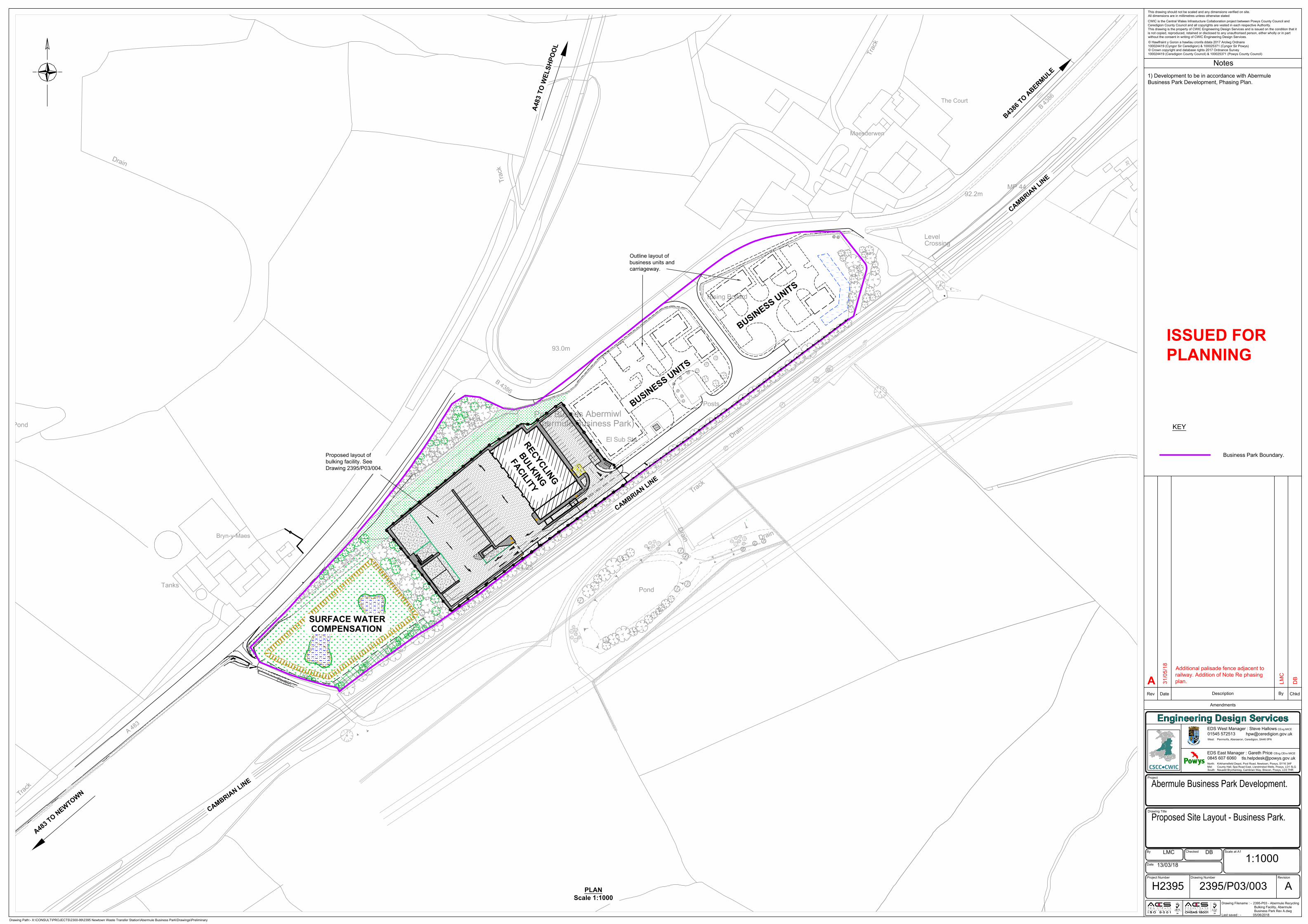
D
r
a
i
n
D
r
a
in
D
r
a
in
D
r
a
i
n
T
r
a
c
k
Pond
93.0m
B
4
3
8
6
T
r
a
c
k
Pond
Bryn-y-Maes
A
4
8
3
MP 44.25
D
r
a
i
n
Level
The Court
Maesderwen
Crossing
92.2m
MP 44
Posts
Rising Bollard
Parc Busnes Abermiwl
(Abermule Business Park)
El Sub Sta
Tanks
T
ra
c
k
T
r
a
c
k
T
r
a
c
k
3
5
B
4
3
8
6
T
P
T
P
E
P
E
P
T
P
E
P
E
P
T
P
T
P
E
P
E
P
E
P
R
A
M
P
KEY
Business Park Boundary.
14" Water Main (STW).
Notes
© Hawlfraint y Goron a hawliau cronfa ddata 2017 Arolwg Ordnans
100024419 (Cyngor Sir Ceredigion) & 100025371 (Cyngor Sir Powys)
© Crown copyright and database rights 2017 Ordnance Survey
100024419 (Ceredigion County Council) & 100025371 (Powys County Council)
CWIC is the Central Wales Infrastucture Collaboration project between Powys County Council and
Ceredigion County Council and all copyrights are vested in each respective Authority.
This drawing is the property of CWIC Engineering Design Services and is issued on the condition that it
is not copied, reproduced, retained or disclosed to any unauthorised person, either wholly or in part
without the consent in writing of CWIC Engineering Design Services.
This drawing should not be scaled and any dimensions verified on site.
All dimensions are in millimetres unless otherwise stated
Drawing Filename : - 2395-P03 - Abermule Recycling
Bulking Facility, Abermule
Business Park Rev A.dwg
Last saved : - 05/06/2018
01545 572513
Drawing Number Revision
Scale at A1
Drawing Title
Project Number
Project
Rev Date
Description By
EDS West Manager : Steve Hallows
Chkd
0845 607 6060
EDS East Manager : Gareth Price
North: Kirkhamsfield Depot, Pool Road, Newtown, Powys, SY16 3AF
Mid: County Hall, Spa Road East, Llandrindod Wells, Powys, LD1 5LG
South: Neuadd Brycheiniog, Cambrian Way, Brecon, Powys, LD3 7HR
Amendments
CEng MICE
CEng CEnv MICE
West: Penmorfa, Aberaeron, Ceredigion, SA46 0PA
By Checked
Date
Drawing Path:- X:\CONSULT\PROJECTS\2300-99\2395 Newtown Waste Transfer Station\Abermule Business Park\Drawings\Preliminary
Abermule Business Park Development.
Proposed Site Layout - Business Park.
LMC DB
13/03/18
1:1000
H2395 2395/P03/003 A
PLAN
Scale 1:1000
A
4
8
3
T
O
W
E
L
S
H
P
O
O
L
A
4
8
3
T
O
N
E
W
T
O
W
N
B
4
3
8
6
T
O
A
B
E
R
M
U
L
E
C
A
M
B
R
I
A
N
L
I
N
E
C
A
M
B
R
I
A
N
L
I
N
E
C
A
M
B
R
I
A
N
L
I
N
E
R
E
C
Y
C
L
I
N
G
B
U
L
K
I
N
G
F
A
C
I
L
I
T
Y
B
U
S
I
N
E
S
S
U
N
I
T
S
B
U
S
I
N
E
S
S
U
N
I
T
S
SURFACE WATER
COMPENSATION
Outline layout of
business units and
carriageway.
Proposed layout of
bulking facility. See
Drawing 2395/P03/004.
ISSUED FOR
PLANNING
A 31
/0
5/1
8
Additional palisade fence adjacent to
railway. Addition of Note Re phasing
plan.
LM
C
1) Development to be in accordance with Abermule
Business Park Development, Phasing Plan.
DB
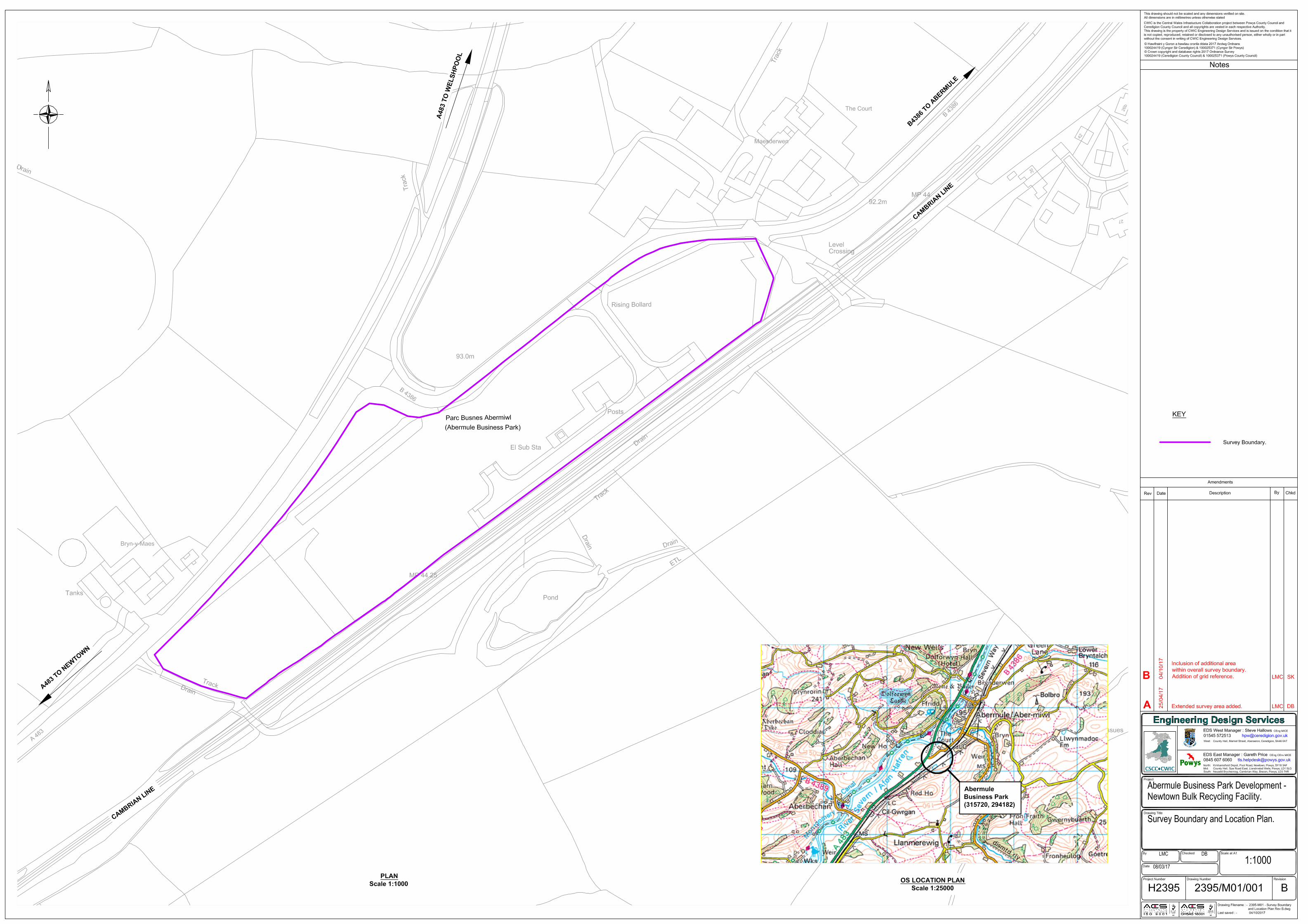
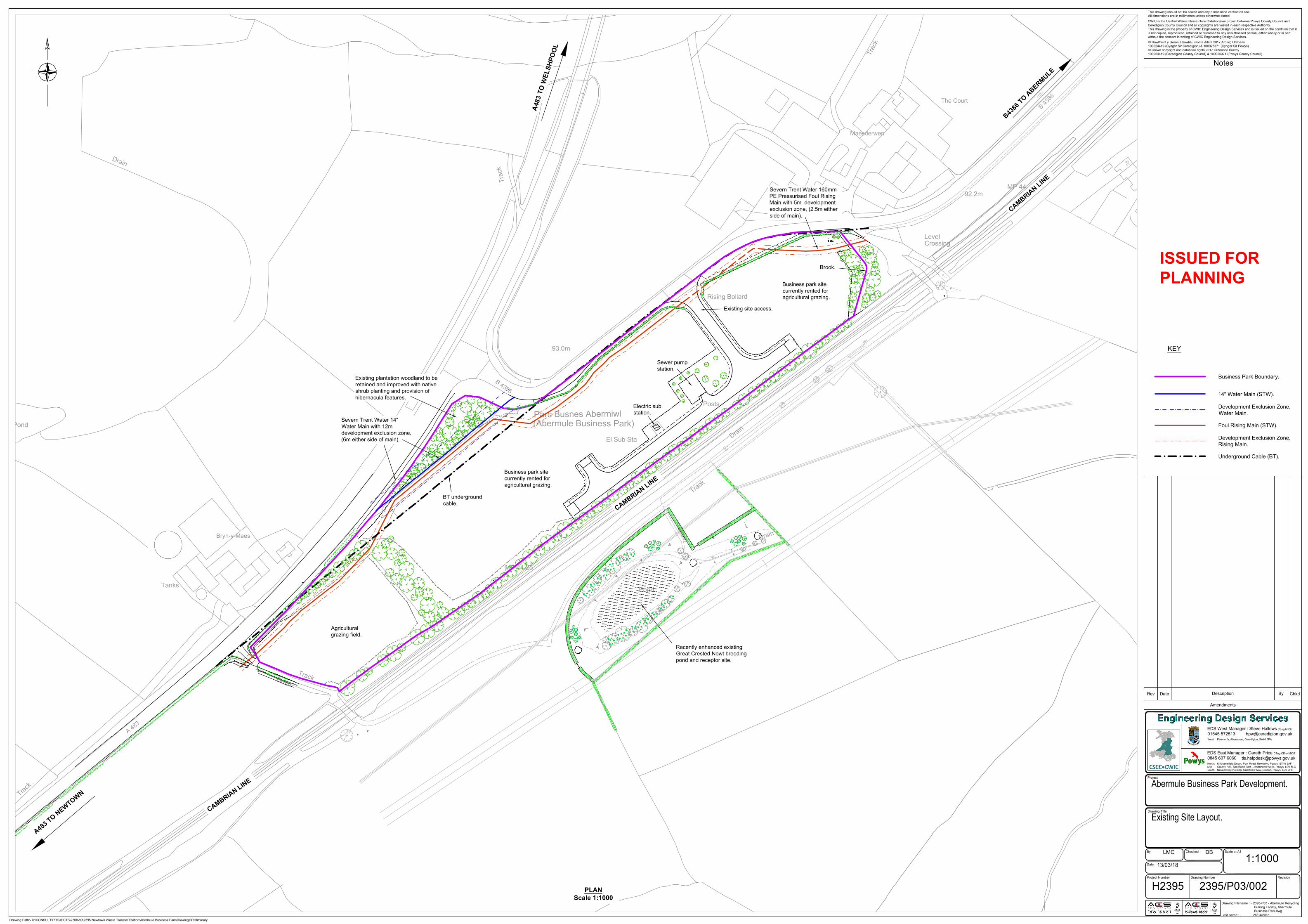
D
r
a
i
n
D
r
a
in
D
r
a
in
D
r
a
i
n
T
r
a
c
k
Pond
93.0m
B
4
3
8
6
T
r
a
c
k
Pond
Bryn-y-Maes
A
4
8
3
MP 44.25
D
r
a
i
n
Level
The Court
Maesderwen
Crossing
92.2m
MP 44
Posts
Rising Bollard
Parc Busnes Abermiwl
(Abermule Business Park)
El Sub Sta
Tanks
T
ra
c
k
T
r
a
c
k
T
r
a
c
k
3
5
B
4
3
8
6
F
O
O
T
P
A
T
H
T
P
T
P
E
P
E
P
T
P
E
P
E
P
T
P
T
P
E
P
E
P
E
P
R
A
M
P
KEY
Business Park Boundary.
Development Exclusion Zone,
Water Main.
Foul Rising Main (STW).
Development Exclusion Zone,
Rising Main.
14" Water Main (STW).
Underground Cable (BT).
Notes
© Hawlfraint y Goron a hawliau cronfa ddata 2017 Arolwg Ordnans
100024419 (Cyngor Sir Ceredigion) & 100025371 (Cyngor Sir Powys)
© Crown copyright and database rights 2017 Ordnance Survey
100024419 (Ceredigion County Council) & 100025371 (Powys County Council)
CWIC is the Central Wales Infrastucture Collaboration project between Powys County Council and
Ceredigion County Council and all copyrights are vested in each respective Authority.
This drawing is the property of CWIC Engineering Design Services and is issued on the condition that it
is not copied, reproduced, retained or disclosed to any unauthorised person, either wholly or in part
without the consent in writing of CWIC Engineering Design Services.
This drawing should not be scaled and any dimensions verified on site.
All dimensions are in millimetres unless otherwise stated
Drawing Filename : - 2395-P03 - Abermule Recycling
Bulking Facility, Abermule
Business Park.dwg
Last saved : - 26/04/2018
01545 572513
Drawing Number Revision
Scale at A1
Drawing Title
Project Number
Project
Rev Date
Description By
EDS West Manager : Steve Hallows
Chkd
0845 607 6060
EDS East Manager : Gareth Price
North: Kirkhamsfield Depot, Pool Road, Newtown, Powys, SY16 3AF
Mid: County Hall, Spa Road East, Llandrindod Wells, Powys, LD1 5LG
South: Neuadd Brycheiniog, Cambrian Way, Brecon, Powys, LD3 7HR
Amendments
CEng MICE
CEng CEnv MICE
West: Penmorfa, Aberaeron, Ceredigion, SA46 0PA
By Checked
Date
Drawing Path:- X:\CONSULT\PROJECTS\2300-99\2395 Newtown Waste Transfer Station\Abermule Business Park\Drawings\Preliminary
Abermule Business Park Development.
Existing Site Layout.
LMC DB
13/03/18
1:1000
H2395 2395/P03/002
PLAN
Scale 1:1000
Recently enhanced existing
Great Crested Newt breeding
pond and receptor site.
A
4
8
3
T
O
W
E
L
S
H
P
O
O
L
A
4
8
3
T
O
N
E
W
T
O
W
N
B
4
3
8
6
T
O
A
B
E
R
M
U
L
E
C
A
M
B
R
I
A
N
L
I
N
E
C
A
M
B
R
I
A
N
L
I
N
E
C
A
M
B
R
I
A
N
L
I
N
E
Existing site access.
Sewer pump
station.
Electric sub
station.
Business park site
currently rented for
agricultural grazing.
Agricultural
grazing field.
Business park site
currently rented for
agricultural grazing.
Brook.
Severn Trent Water 14"
Water Main with 12m
development exclusion zone,
(6m either side of main).
Severn Trent Water 160mm
PE Pressurised Foul Rising
Main with 5m development
exclusion zone, (2.5m either
side of main).
BT underground
cable.
Existing plantation woodland to be
retained and improved with native
shrub planting and provision of
hibernacula features.
ISSUED FOR
PLANNING

61
Exploratory Hole Location Plan
E
E
E
E
E
E
E
E
E
E
E
E
E
E
E
E
E
E
E
E
E
E
E
E
E
E
E
EE
E
E
E
E
E
E
E
E
E
E
E
E
E
E
E
E
E
E
E
UTL
E
E
E
E
E
E
E
E
E
E
E
E
E
E
E
EE
E
E
E
E
E
E
92.05
91 .94
91 .93
91 .93
91 .80
91 .65
91 .66
91 .72
91 .80
91 .75
91 .66
91 .59
91 .57
91.71
91 .87
91 .82
91 .93
91 .94
91 .78
91 .78
91 .64
91 .58
91 .56
91 .69
91 .88
91 .96
91 .78
91 .60
91 .57
91 .63
91 .78
91 .82
91 .84
91 .78
91 .70
91 .56
91 .65
91 .73
91.91
92.04
91 .86
91 .75
91 .59
91 .70
91 .76
91 .72
T
EoT
ED
TE DE oT T
T
T
T
T
T
T
T
T
T
T
T
T
T
ED
T
EoT
T
T
T
T
T
T
T
T
T
T
T
T
T
T
TT
T
T
T
T
T
TT
T
T
T
T
T
T
T
T
T
T
T
T
T
T
T
T
T
TEoT
T
T
T
T
T
TT
T
T
T
T
T
T
T
T
T
T
T
T
T
T
T
T
T
T
T
T TT
T
E
E
E E
E
E
EE
E
E
E
E
EE
EE
E
E
E
E
E
E
E
E
EE
E
E
E
E
E
E
E
E
E
E
E
E
E
E
E
E
E
E
E
E
EE
E
E
E
EE
E
E
E
E
E
E
EE
E
E
E
150Ø
150Ø
150Ø
150Ø
UTL
UTL
150Ø
22 5Ø
225Ø
150Ø
225Ø
1 50Ø
22 5Ø
22 5Ø
1 50Ø
150Ø
1 50Ø
225Ø
22 5Ø
1 50Ø
TT
TT
TTTTTT
TT
TTTT
TT
T
T
T
T
T
T
T
T
T
T
T
T
T
T
T
T
T
T
T
T
T
T
T
T
T
T
T
T
T
T
T
T
T
T
T
T
T
T
T
T
T
T
T
T
T
T
T
T
T
T
T
T
T
T
T
T
T
T
T
T
T
T
T
T
T
T
T
T
T
T
T
T
T
T
T
T
T
T
T
T
T
T
T
T
T
T
T
T
T
T
T
T
T
T
T
T
1 50Ø
EE
E
E
E
E
E
E
E
E
E
E
E
1 50Ø
1 50Ø
1 50Ø
T
T
T
T
T
T
T
T
T
T
T
T
T
T
T
ED
T
T
T
T
T
T
T
T
ED
T
T
T
T
T
T
T
T
T
T
T
T
T
T
T
T
T
T
T
T
T
T
TT
T
T
T
T
T
T
T
T
T
T
T
T
T
T
T
T
T
T
T
T
T
T
91.99
92.16
92.11
92.1 1
92. 09
92.66
92.97
92.98
93.22
93.46
9 2. 57
9 2.70
92.55
9 2. 66
92.76
FO
W
W
W
W
W
W
W
W
W
W
W
W
W
W
W
W
W
W
W
W
W
W
W
W
W
W
W
W
W
W
W
W
W
150Ø
150Ø
150Ø
225Ø
Wa ter Trou gh
91.29
9 1.47
91.53
92.51
91.48
40 0Ø1 50Ø
T
T
T
T
T
T
T
T
T
T
T
T
T
T
T
T
GPR
GPR
GPR
GPR
GPR
GPR
GPR
GPR
GPR
GPR
GPR
GPR
GPR
GPR
GPR
GPR
GPR
EoT
E oT
GPR
GPR
GPR
GPR
GPR
GPR
GPR
GPR
GPR
GPR
GPR
GPR
GPR
GPR
GPR
GPR
GPR
GPR
GPR
GPR
GPR
EoT
Weak Trac
e
EoT
PP
P
P
P
P
P
P
P
P
P
P
P
P
P
P
P
PP
PP
P
P
P
PP
P
EoT
HV
HV
HV
HV
HV HVHV HV
HV
HV
HV
HV
HV
HV
HV
HV
HV
HV
HV
HV
HV
HV
HV
HV
HV
HV
HV
HV
HV
HV
HV
HV
HV
HV
HV
HV
HV
HV
HV
HV
HV
HV
HV
HV
HV
HVHV
HV
E
P
P
PP
P
P
P
P
P
P
P
P
P
P
P
P
P
P
P
EoT
E
E
E
E
GPR
GPR
E oT
E oT
W
WW W
WW EoT
Mkr
GPR
GPR
EoT
EoT
GPR
GPR
GPR
Mkr
GPRGPR
GPRGPR
EoT
EoT
Mkr
GPR
GPR
GPR
GPR
EoT
EoT
GPREoT
WW
W
W
W
GPR
GPR
GPR
GPR
GPR
GPR
GPR
GPR
GPR
Mkr
PWF
0.95m
High
PRF
1 .20m
High
91.92
91.76
91.74
91.65
91.76
91.72
91.86
91.93
91 .93
92.11
Gate
PWF 1.1 0m High
92.09
92.05
92.08
92.13
92.21
92.26Gate
PWF 1
.00m High
92.1 1
92.40
92.33
92 .48
92 .80
93.1 0
93.30
93.34
Grass
Grass
93. 30
93. 31
93.32
93.33
93.36
93.34
93.34
93.49
93.53
93.38
93.45
93.41
92.93
92.4793.
08
92.85
92.91
92.64 92.48
92.3592.12
400Ø
92 .38
92 .85
93.2993.3
4
93.51
PWF 1.00m High
Gate
Gate
PWF 1 .10m High
92.14
92 .18
92.20
92.23
91 .60
91 .68
91.68
91.66
92 .30
92.19
92.13
92.16
91.72
91.68
91.68
91 .5792.4292 .49
92.40
92.32
92 .23
92 .1992.18
92.24
92.21
92.17
92.31
92.32
92.36
92.71
92.44
92.28
92.25
92.15
92.13
92.22W W W W W W W
W
W
W
EoT
92.15
92.14
92.19
92.28
92.30
92.40
92.78
93.30
DK
T
T
T
T
T
T
T
TTT
T
T
T
T
TT
EoT
E
E
E
T
T
T
T
ED
BT IC
WW
WW
WW
W
T(R)
T(R)
T(R)
T(R)
T(R)
T(R)
T(R)
T(R)
T(R)
T(R)
T(R)
T(R)
T(R)
T(R)
T(R)
T(R)
T(R)
T(R)
T(R)
T(R)
T(R)
G(R)
G(R)
G(R)
G(R)
G(R)
G(R)
G(R)
G(R)
G(R)
G(R)
G(R)
G(R)
G(R)
G(R)
G(R)
G(R)G(R)
G(R)G(R
)
G(R)
G(R)
G(R)
G(R)
G(R)
G(R)
G(R)
G(R)
G(R)
G(R)
G(R)
G(R)
G(R)
G(R)
G(R)
G(R)
G(R)
G(R)
G(R)
G(R)
G(R)
G(R)
G(R)
G(R) G(R
)
G(R)
G(R)
G(R)
G(R)
G(R)
G(R) G(R)G(R)
G(R)
G(R)
G(R)
G(R)
G(R)
G(R)
G(R)
G(R)
G(R)
G(R)
G(R)
G(R)
G(R)
G(R)
G(R)
G(R)
G(R)
G(R)
G(R)
G(R)
G(R)
G(R)
G(R)
G(R)
G(R)
G(R)
G(R)
G(R)
G(R)
G(R)
G(R)
G(R)G(R)G(R)
G(R)
G(R)
G(R)
G(R)
G(R)
G(R)
G(R)
G(R)G(R)G(R)
G(R)
G(R)
G(R)
G(R)
G(R)
G(R)
G(R)
W(R)
W(R)
W(R)
W(R)
W(R)
W(R)
W(R)
W(R)
W(R)
W(R)
W(R)
W(R)
W(R) W(R
)
W(R)
W(R)W(R) W(R)
W(R)
W(R)
W(R)
W(R)
W(R)
W(R)
W(R)
W(R)
W(R)
W(R)
W(R)
W(R)
W(R)
W(R)
W(R)
W(R)
W(R)
W(R)
W(R)
W(R)
W(R)
W(R)
W(R)
W(R)
W(R)
W(R)
W(R)
W(R)
W(R)
W(R)
W(R)
W(R)
W(R)
W(R)
W(R)
W(R)
W(R)
W(R)
W(R)
W(R)
W(R)
W(R)
W(R)
W(R)
W(R)
W(R)
W(R)
W(R)
W(R)
W(R)
RM(R)
RM(R)
RM(R)
RM(R)
RM(R)
RM(R)
RM(R)
RM(R)
RM(R)
RM(R)
RM(R)
RM(R)
RM(R)
RM(R)
RM(R)
RM(R)
RM(R)
RM(R)
RM(R)
RM(R)
RM(R)
RM(R)
RM(R)
RM(R)
RM(R)
RM(R)
RM(R)
RM(R)
RM(R)
RM(R)
RM(R)
RM(R)
RM(R)
RM(R)
RM(R)
RM(R)
RM(R)
RM(R)
RM(R)
RM(R)
RM(R)
RM(R)
RM(R)
RM(R)
RM(R)
RM(R)
RM(R)
RM(R)
RM(R)
RM(R)
RM(R)
RM(R)
RM(R)
RM(R)
RM(R)
RM(R)
RM(R)
RM(R)
RM(R) RM(R)RM(R) RM(R)
RM(R) RM(R)RM(R)
RM(R)
RM(R)
RM(R)
RM(R)
RM(R)
RM(R)
RM(R)
RM(R)
RM(R)
RM(R)
RM(R)
RM(R)
RM(R)
RM(R)
RM(R)
RM(R)
RM(R)
RM(R)
RM(R)
RM(R)
RM(R)
RM(R)
RM(R)
RM(R)
RM(R)
RM(R)
RM(R)
RM(R)
RM(R)
RM(R)
RM(R)
RM(R)
RM(R)
RM(R)
RM(R)
RM(R)
RM(R)
RM(R)
RM(R)
RM(R)
RM(R)
RM(R)
RM(R)
RM(R)
RM(R)
RM(R)
RM(R)
Block ed
Block ed
Block ed
Block ed
Block ed
Block ed
RM(R)
RM(R)
RM(R)
RM(R)
RM(R)
RM(R)
RM(R)
RM(R)
RM(R)
RM(R)
RM(R)
RM(R)
RM(R)
RM(R)
RM(R)
RM(R)
RM(R)
RM(R)
RM(R)
RM(R)
RM(R)
RM(R)
RM(R)
RM(R)
RM(R)
RM(R)
RM(R)
RM(R)
RM(R)
RM(R)
RM(R)
RM(R)
RM(R)
RM(R)
RM(R)
RM(R)
RM(R)
RM(R)
RM(R)RM(R)
RM(R)RM(R)
RM(R)RM(R)
RM(R) RM(R) RM(R) RM(R) RM(R) RM(R) RM(R) RM(R) RM(R) RM(R) RM(R) RM(R)RM(R)
RM(R)RM(R)
RM(R)RM(R)
RM(R)
E E E E
E
Headw al l Obscured
Drain
ETL
Drain
Drain
Track
93.0m
B 4386
Track
Pond
Bryn-y-Maes
MP 44.25
Drain
LevelCrossing
9
Posts
Rising Bollard
Parc Busnes Abermiwl(Abermule Business Park)
El Sub Sta
Tra
ck
CBR1
CBR3
CBR2
CBR7
CBR6
CBR5
CBR4
CBR9
CBR8 CBR10
CBR11
CBR12
CBR13
CBR15
CBR14
CBR16CBR17
CBR18
CBR20
CBR21
CBR19
CBR22
CBR23
CBR24
CBR25
CBR27
CBR26
CBR30
CBR29
CBR28
CBR31
CBR33
CBR35
CBR37
CBR38
CBR44
CBR39
CBR42
CBR43
CBR34
CBR40
CBR36
CBR41CBR32
SA5
SA4
SA6
SA7
SA8
SA11
SA10SA9
SA12
SA13
SA15
SA16
SA14
BH105BH106
BH104
BH103
BH101
BH102
TP101TP102
TP103TP104
HTP01
HTP02HTP04
HTP06
HTP05
HTP03
HTP07
Powys County HallSpa Road EastLlandrindod WellsPowysLD1 5LGhttp://www.powys.gov.uk/
ABERMULE BUSINESS PARK
EXPLORATORY HOLE PLAN
SA
CBR
BH
TP
HTP
Percolation Test Location
CBR Test Location
Borehole
Trial Pit
Hand Dug Trial Pit
Site Boundary
Existing Rising Main
Revision/Issue
DRAFT1
No. Drawn
MS
DateChecked
GF 07/03/2019
Project
Drawing Title
Date07/03/2019
Scale1:500
Sheet1
Drawing No. 10026414-ARC-XX-XX-DR-ZZ-P1-EHP
SA3
SA2
SA1
HTP08
62
Standard Procedures
C0 General Principles This ground investigation was undertaken in general accordance with the principles of BS EN 1997-1 [1] and BS EN 1997-2 [2] and the advice given in BS5930:2015 [8], which, provides complimentary guidance on the application of the primary standards. Where the requirements of the ground investigation specification differ from these primary standards, the investigation methodology was adapted as required and specific notes regarding methods and techniques employed were made in the appropriate report sections.
C1 Buried Services Service clearance was undertaken in accordance with Arcadis’ Safety, Health and Environment (SHE) Standard – Avoidance of Sub-Surface Hazards and Structures Standard. This document details the methods and safe working practices used to undertake excavations safely. Prior to breaking ground, services plans were consulted, and the area scanned using a Cable Avoidance Tool (CAT) with detected signals marked on the ground. For all investigation positions, other than for machine excavated trial pits, hand excavated inspection pits are completed to 1.20 m bgl prior to the use of drilling and boring plant.
C2 Sampling Requirements The selection of sample types and sampling techniques has been chosen to take account of the soil fabric, size and quality of sample required based on whether the soils mass properties or the intact material properties of the ground are to be determined in subsequent laboratory tests. BS EN ISO 22475-1 [4] describes three generic sample groups that are:
a. Sampling by drilling. Generally, a disturbed sample recovered from the drilling tool or digging equipment, typically meeting Class 3 to Class 5 requirements, with the recovered material being stored in bulk bags or sealed jar or tub containers.
b. Sampling by sampler. Typically referred to as open tube or drive sampling in which a tube with a sharp cutting edge is driven into the ground either by static thrust or dynamically driven to give a relatively undisturbed sample of Class 1 or Class 2 but may result in a Class 3 sample.
c. Block sampling. Cylindrical large diameter samples or cuboid hand-cut samples usually relatively undisturbed Class 1 and Class 2.
The open-tube sampling equipment used on the site was of a type and design that conformed to BS EN ISO 22475-1. For the purpose of this ground investigation block sampling was not required.
Generally, samples were assessed on site and any unexpected deterioration in sample quality was reported to the ground engineer by the lead drilling technician.
Sufficient and representative samples were taken to allow the geo-mechanical properties of the ground to be adequately characterised and to enable the sequence of soil strata to be described by an engineering geologist or geotechnical engineer.
Where samples have been taken for chemical tests the drilling method attempted to adopt dry drilling over the sampling range that generally was achieved by the use of drill casing to separate and isolate the upper soil layers and exclude groundwater. Cross-contamination was further reduced by regular cleaning of sampling tools. Sample integrity was maintained by sealing samples immediately on collection and storing the samples in a temperature controlled cool box. Samples were despatched from the site at the end of the shift on which they were collected or as required in the project specification. Details of best practice storage, preservation and decontamination measures undertaken are presented in the following table:
63
Task Soil Groundwater Ground Gas
Storage
Glass jars and vials supplied by the laboratory were used for the collection of soil samples to be analysed for volatile compounds. Plastic one-litre tubs were used to collect soil samples for metals analysis.
Glass vials supplied by the laboratory were used for the collection of samples to be analysed for volatile compounds. Samples to be analysed for lower volatility compounds were stored in laboratory prepared glass bottles.
1.4L Canisters supplied by the laboratory.
Preservation Filling of sample containers as far as practicable to minimise headspace and low storage temperature to minimise the potential for volatilisation and biodegradation of petroleum hydrocarbon compounds prior to analysis.
Not required.
Decontamination Disposable gloves were worn and changed between sample collection to prevent cross-contamination.
Groundwater samples were collected using dedicated disposable tubing / bailers, that were changed between monitoring well locations in order to prevent cross-contamination.
Disposable gloves were worn and changed between sample collection to prevent cross contamination.
Transport
Samples stored in dedicated sample boxes provided by the laboratory. Sample details and analytical requests were recorded on the laboratory chain of custody form included with samples, prior to dispatching to laboratory for analysis. Samples were dispatched to the laboratory on the day of sampling.
C3 Sample Description Sample description was undertaken by the Arcadis site geologist in accordance with BS 5930: 2015. The descriptions of the individual samples were used to identify the sequence of strata at the exploratory hole location and from which representative exploratory hole logs were drawn.
C4 In Situ Testing In situ geotechnical tests were undertaken taking account of the investigation scope and requirement to attain the appropriate parameters required in the geotechnical design. The tests were undertaken in accordance with the requirements of the relevant parts of BS EN ISO 22476 [5, 6, 7] and other methods as follows:
Dynamic probing
Dynamic probes were undertaken in general accordance with BS EN ISO 22476-2, BS EN 1997-2 and the national annex to BS EN 1997. The tests were generally made using the super-heavy DPSH-B configuration of the apparatus, however, it should be noted that the basis for selection of the type of dynamic probe should be a consideration of the driving energy in relation to the type of ground conditions anticipated at the site.
Where adequate correlation with borehole data is available an interpretation of the estimated soil type may be made, however, it should be noted that probing can give unreliable results in mixed soils.
Standard penetration testing
Standard penetration tests were carried out in accordance with BS EN ISO 22476-3, BS EN 1997-2 and the national Annex to BS EN 1997-2. The test records are presented on the borehole logs as blow counts for each increment with the N-value as the total number of blows of the four main test increments.
Where the N-value exceeds a total of 50 blows, the test reports the penetration in millimetres for the last test increment recorded, and the N value is indicated as greater than 50,
e.g. 4,5/12,14,18, 6 for 10 mm
indicates that the seating blows (4 and 5) were completed and that the test terminated in the 4th increment after penetrating 10 mm.
64
Where the seating blows exceeded 25 blows for less than 150 mm; the test was stopped, and the rods remarked after which, the main drive was continued. The test is then reported as the number of blows in each seating drive for the recorded penetration with the results of the main drive given as above,
e.g. 14/11 for 45 mm/12,14,16, 8 for 10 mm.
In certain circumstances where groundwater in-flow may affect the test, particularly in fine sand or silt, low SPT blow counts may be recorded. Where the SPT blow count was very low, N values of 5 or less, the test was, at the discretion of the site engineer, continued for a further 300 mm, recording blows for each 75 mm increment. This is not a standard penetration test value, it does however give an indication of potential disturbance to the ground.
California Bearing Ratio
In situ California Bearing Ratio (CBR) tests were carried out in general accordance with the requirements of BS 1977-9:1990, 4.3 [10]. The CBR is a strength test that is generally concerned with pavement design and the control of pavement sub grade construction, as such it is a test that is most suited to soils with a maximum particle size not exceeding 20 mm.
TRL Dynamic cone penetrometer
The TRL DCP is a device developed by the TRL to assess the California Bearing Ratio of road sub-base by correlation. As such the device was developed for use in a limited range of soil types. The test has no formal standard the test methodology and its use are discussed in TRL report PR IN 277-04 [11].
C5 Data Transfer Format The data collated during the ground investigation has been organised and managed using the “AGS data format” that allows data transfer between different disciplines and organisations in accordance with BS 8574 [9].
C6 References 1. BS EN 1997-1. 2004. Eurocode 7: Geotechnical Design. Part 1 General Rules. British Standards
Institution, 2013 (revised text). 2. BS EN 1997-2. 2007. Eurocode 7: Geotechnical Design. Part 2 Ground Investigation and testing.
British Standards Institution, 2010 (revised text). 3. BS EN ISO 22282-1:2012. Geotechnical investigation and testing – Geohydraulic testing. Part 1:
General Rules. British Standards Institution. 4. BS EN ISO 22475-1. Geotechnical investigation and testing – Sampling methods and
groundwater measurements – Part 1 Technical principles for execution. 5. BS EN ISO 22476-1:2015. Geotechnical investigation and testing – Field testing – Part 1:
Electrical cone and piezocone test. British Standards Institution 6. BS EN ISO 22476-2. Geotechnical investigation and testing – Field testing – Part 2: Dynamic
Probing. British Standards Institution 7. BS EN ISO 22476-3 2005. Geotechnical investigation and testing – Field testing – Part 3:
Standard penetration test. British Standards Institution 8. BS 5930: 2015. Code of practice for ground investigation. British Standards Institution. 9. BS 8574. Code of practice for the management of geotechnical data for ground engineering
projects. 10. BS 1377-9. 1990. Methods of test for soils for civil engineering purposes. Part 9: In-situ tests.
British Standards Institution. 11. TRL. 2004. Dynamic cone penetrometer tests and analysis. TRL Technical Report PR IN 277-
04. Transport Research Laboratory, Crowthorne, England.

65
Exploratory Hole Logs
Soakaway Results
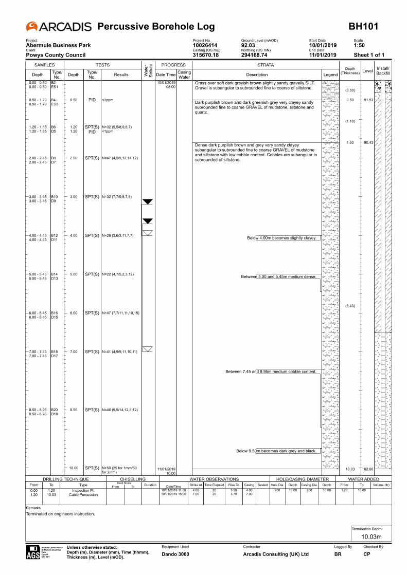
SAMPLES
Depth Type/No.
TESTS
Depth
0.50
1.201.20
2.00
3.00
4.00
5.00
6.00
7.00
8.50
10.00
Type/No.
PID
SPT(S)PID
SPT(S)
SPT(S)
SPT(S)
SPT(S)
SPT(S)
SPT(S)
SPT(S)
SPT(S)
Results
<1ppm
N=32 (5,5/8,9,8,7)<1ppm
N=47 (4,9/9,12,14,12)
N=32 (7,7/9,8,7,8)
N=28 (3,6/3,11,7,7)
N=22 (4,7/5,2,3,12)
N=47 (7,7/11,11,10,15)
N=41 (4,9/9,11,10,11)
N=46 (9,9/14,12,8,12)
N>50 (25 for 1mm/50 for 2mm)
Wat
er
Strik
es PROGRESS
Date Time
10/01/201908:00
11/01/201910:00
Casing Water
STRATA
Description
Grass over soft dark greyish brown slightly sandy gravelly SILT. Gravel is subangular to subrounded fine to coarse of siltstone.
Dark purplish brown and dark greenish grey very clayey sandy subrounded fine to coarse GRAVEL of mudstone, siltstone and quartz.
Dense dark purplish brown and grey very sandy clayey subangular to subrounded fine to coarse GRAVEL of mudstone and siltstone with low cobble content. Cobbles are subangular to subrounded of siltstone.
Below 4.00m becomes slightly clayey.
Between 5.00 and 5.45m medium dense.
Between 7.45 and 8.95m medium cobble content.
Below 9.50m becomes dark grey and black.
LegendDepth
(Thickness)
(0.50)
0.50
(1.10)
1.60
(8.43)
10.03
Level
91.53
90.43
82.00
Install/Backfill
0.00 - 0.50 B20.00 - 0.50 ES1
0.50 - 1.20 B40.50 - 1.20 ES3
1.20 - 1.65 B61.20 - 1.65 D5
2.00 - 2.45 B82.00 - 2.45 D7
3.00 - 3.45 B103.00 - 3.45 D9
4.00 - 4.45 B124.00 - 4.45 D11
5.00 - 5.45 B145.00 - 5.45 D13
6.00 - 6.45 B166.00 - 6.45 D15
7.00 - 7.45 B187.00 - 7.45 D17
8.50 - 8.95 B208.50 - 8.95 D19
Percussive Borehole Log BH101Project Project No. Ground Level (mAOD) Start Date ScaleAbermule Business Park 10026414 92.03 10/01/2019 1:50Client Easting (OS mE) Northing (OS mN) End DatePowys County Council 315670.18 294168.74 11/01/2019 Sheet 1 of 1
DRILLING TECHNIQUE CHISELLING WATER OBSERVATIONS HOLE/CASING DIAMETER WATER ADDED
RemarksTerminated on engineers instruction. .
Termination Depth:
10.03mArcadis Cymru HouseSt Mellons Business ParkCardiffCF3 0EY
Unless otherwise stated:Depth (m), Diameter (mm), Time (hhmm),Thickness (m), Level (mOD).
Equipment Used
Dando 3000Contractor
Arcadis Consulting (UK) LtdLogged By
BRChecked By
CP
From To Type0.00 1.20 Inspection Pit1.20 10.03 Cable Percussion
Hard StrataFrom To Duration Date/Time Strike At
10/01/2019 11:00 4.0010/01/2019 15:00 7.00
Time Elapsed Rise To20 3.2020 3.70
Casing Sealed4.007.00
Hole Dia. Depth200 10.00
Casing Dia. Depth200 10.00
From To Volume (ltr)1.20 10.00

SAMPLES
Depth Type/No.
TESTS
Depth
0.50
1.201.20
2.00
3.00
4.00
5.00
Type/No.
PID
SPT(S)PID
SPT(S)
SPT(S)
SPT(S)
SPT(S)
Results
<1ppm
N=33 (7,7/7,7,9,10)<1ppm
N=72 (7,12/14,17,18,23)
N>50 (14,11/36,21,0 for 0mm)
N>50 (14,19/25,21,0 for 0mm)
N>50 (25 for 10mm/50 for 25mm)
Wat
er
Strik
es PROGRESS
Date Time
08/01/201910:00
09/01/201914:00
Casing Water
STRATA
Description
Grass over dark greyish brown soft slightly sandy gravelly SILT. Gravel is subangular elongate fine to coarse of siltstone.
Dense grey and brown sandy clayey angular to subangular fine to coarse GRAVEL of mudstone and siltstone. With low cobble content of subrounded siltstone.
Driller notes boulders below 2.70m.
LegendDepth
(Thickness)
(0.50)
0.50
(4.60)
5.10
Level
91.50
86.90
Install/Backfill
0.00 - 0.50 ES1
0.50 B20.50 - 1.20 ES3
1.20 - 1.65 B51.20 - 1.65 D4
2.00 - 2.45 B72.00 - 2.45 D6
3.00 - 3.45 B93.00 - 3.45 D8
4.00 - 4.45 B114.00 - 4.45 D10
5.00 - 5.03 D12
Percussive Borehole Log BH102Project Project No. Ground Level (mAOD) Start Date ScaleAbermule Business Park 10026414 92.00 08/01/2019 1:50Client Easting (OS mE) Northing (OS mN) End DatePowys County Council 315704.47 294160.82 09/01/2019 Sheet 1 of 1
DRILLING TECHNIQUE CHISELLING WATER OBSERVATIONS HOLE/CASING DIAMETER WATER ADDED
RemarksBorehole commenced in 150mm casing. Due to coarse fractions and dense ground conditions 200mm casing was used to drill borehole. Terminated on engineers instruction. .
Termination Depth:
5.10mArcadis Cymru HouseSt Mellons Business ParkCardiffCF3 0EY
Unless otherwise stated:Depth (m), Diameter (mm), Time (hhmm),Thickness (m), Level (mOD).
Equipment Used
Dando 3000Contractor
Arcadis Consulting (UK) LtdLogged By
BRChecked By
CP
From To Type0.00 1.20 Inspection Pit1.20 5.10 Cable Percussion
Hard StrataFrom To5.00 5.10
Duration00:45
Date/Time Strike At Time Elapsed Rise To Casing Sealed Hole Dia. Depth200 5.00
Casing Dia. Depth200 5.10
From To Volume (ltr)1.20 5.10
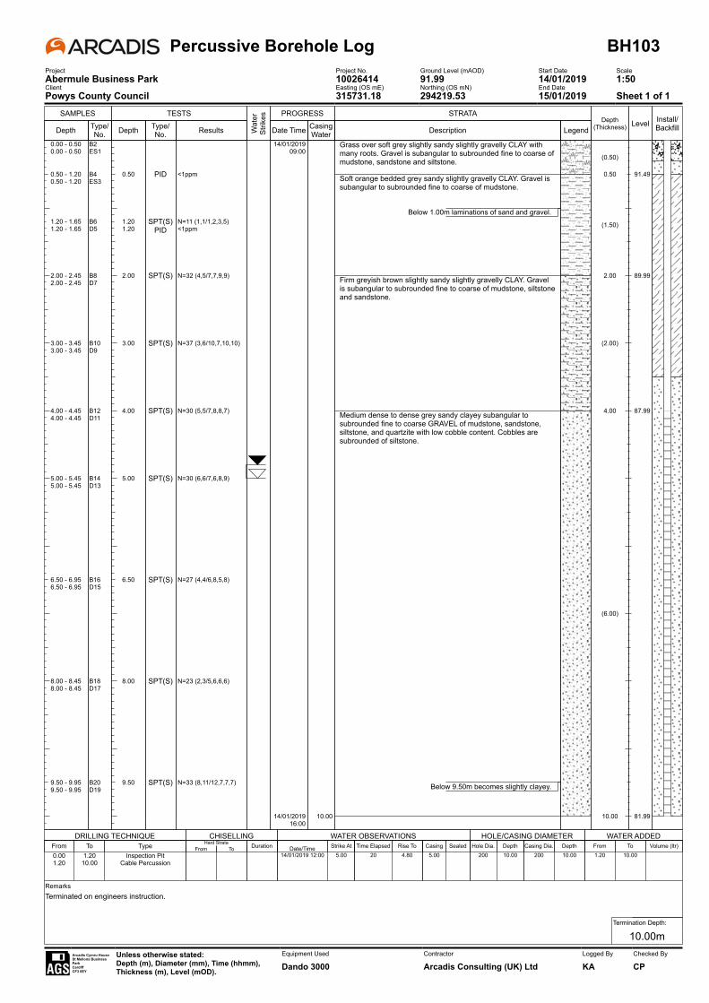
SAMPLES
Depth Type/No.
TESTS
Depth
0.50
1.201.20
2.00
3.00
4.00
5.00
6.50
8.00
9.50
Type/No.
PID
SPT(S)PID
SPT(S)
SPT(S)
SPT(S)
SPT(S)
SPT(S)
SPT(S)
SPT(S)
Results
<1ppm
N=11 (1,1/1,2,3,5)<1ppm
N=32 (4,5/7,7,9,9)
N=37 (3,6/10,7,10,10)
N=30 (5,5/7,8,8,7)
N=30 (6,6/7,6,8,9)
N=27 (4,4/6,8,5,8)
N=23 (2,3/5,6,6,6)
N=33 (8,11/12,7,7,7)
Wat
er
Strik
es PROGRESS
Date Time
14/01/201909:00
14/01/201916:00
Casing Water
10.00
STRATA
Description
Grass over soft grey slightly sandy slightly gravelly CLAY with many roots. Gravel is subangular to subrounded fine to coarse of mudstone, sandstone and siltstone.
Soft orange bedded grey sandy slightly gravelly CLAY. Gravel is subangular to subrounded fine to coarse of mudstone.
Below 1.00m laminations of sand and gravel.
Firm greyish brown slightly sandy slightly gravelly CLAY. Gravel is subangular to subrounded fine to coarse of mudstone, siltstone and sandstone.
Medium dense to dense grey sandy clayey subangular to subrounded fine to coarse GRAVEL of mudstone, sandstone, siltstone, and quartzite with low cobble content. Cobbles are subrounded of siltstone.
Below 9.50m becomes slightly clayey.
LegendDepth
(Thickness)
(0.50)
0.50
(1.50)
2.00
(2.00)
4.00
(6.00)
10.00
Level
91.49
89.99
87.99
81.99
Install/Backfill
0.00 - 0.50 B20.00 - 0.50 ES1
0.50 - 1.20 B40.50 - 1.20 ES3
1.20 - 1.65 B61.20 - 1.65 D5
2.00 - 2.45 B82.00 - 2.45 D7
3.00 - 3.45 B103.00 - 3.45 D9
4.00 - 4.45 B124.00 - 4.45 D11
5.00 - 5.45 B145.00 - 5.45 D13
6.50 - 6.95 B166.50 - 6.95 D15
8.00 - 8.45 B188.00 - 8.45 D17
9.50 - 9.95 B209.50 - 9.95 D19
Percussive Borehole Log BH103Project Project No. Ground Level (mAOD) Start Date ScaleAbermule Business Park 10026414 91.99 14/01/2019 1:50Client Easting (OS mE) Northing (OS mN) End DatePowys County Council 315731.18 294219.53 15/01/2019 Sheet 1 of 1
DRILLING TECHNIQUE CHISELLING WATER OBSERVATIONS HOLE/CASING DIAMETER WATER ADDED
RemarksTerminated on engineers instruction. .
Termination Depth:
10.00mArcadis Cymru HouseSt Mellons Business ParkCardiffCF3 0EY
Unless otherwise stated:Depth (m), Diameter (mm), Time (hhmm),Thickness (m), Level (mOD).
Equipment Used
Dando 3000Contractor
Arcadis Consulting (UK) LtdLogged By
KAChecked By
CP
From To Type0.00 1.20 Inspection Pit1.20 10.00 Cable Percussion
Hard StrataFrom To Duration Date/Time Strike At
14/01/2019 12:00 5.00Time Elapsed Rise To
20 4.80Casing Sealed
5.00Hole Dia. Depth
200 10.00Casing Dia. Depth
200 10.00From To Volume (ltr)1.20 10.00
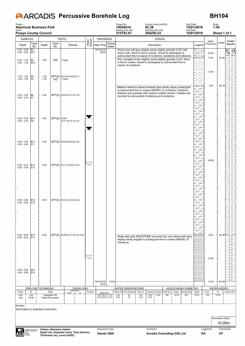
SAMPLES
Depth Type/No.
TESTS
Depth
0.50
1.201.20
2.00
3.00
4.00
5.00
6.50
8.00
Type/No.
PID
SPT(S)PID
SPT(S)
SPT(S)
SPT(S)
SPT(S)
SPT(S)
SPT(S)
Results
<1ppm
N=24 (4,4/5,6,6,7)<1ppm
N=30 (5,7/7,8,7,8)
N=54 (5,11/16,10,14,14)
N=26 (6,6/5,6,7,8)
N=17 (4,4/3,4,5,5)
N=21 (3,4/4,6,5,6)
N=50 (9,11/16,16,10,8)
Wat
er
Strik
es PROGRESS
Date Time
15/01/201908:00
15/01/201916:00
Casing Water
10.00
STRATA
Description
Grass over soft grey slightly sandy slightly gravelly CLAY with many roots. Sand is fine to coarse. Gravel is subangular to subrounded fine to coarse of mudstone, sandstone and siltstone.Firm orangish brown slightly sandy slightly gravelly CLAY. Sand is fine to coarse. Gravel is subangular to subrounded fine to coarse of mudstone.
Medium dense to dense brownish grey sandy clayey subangular to subrounded fine to coarse GRAVEL of mudstone, limestone, siltstone and quartzite with medium cobble content. Cobbles are rounded to subrounded of siltstone and mudstone.
Weak dark grey MUDSTONE recovered as: very dense dark grey slightly sandy angular to subangular fine to coarse GRAVEL of mudstone.
LegendDepth
(Thickness)
(0.40)
0.40
(1.20)
1.60
(6.40)
8.00
(2.00)
10.00
Level
91.98
90.78
84.38
82.38
Install/Backfill
0.00 - 0.50 B20.00 - 0.50 ES1
0.50 - 1.20 B40.50 - 1.20 ES3
1.20 - 1.65 B61.20 - 1.65 D5
2.00 - 2.45 B82.00 - 2.45 D7
3.00 - 3.45 B103.00 - 3.45 D9
4.00 - 4.45 B124.00 - 4.45 D11
5.00 - 5.45 B145.00 - 5.45 D13
6.50 - 6.95 B166.50 - 6.95 D15
8.00 - 8.45 B188.00 - 8.45 D17
9.50 - 9.95 B209.50 - 9.95 D19
Percussive Borehole Log BH104Project Project No. Ground Level (mAOD) Start Date ScaleAbermule Business Park 10026414 92.38 15/01/2019 1:50Client Easting (OS mE) Northing (OS mN) End DatePowys County Council 315793.61 294250.23 15/01/2019 Sheet 1 of 1
DRILLING TECHNIQUE CHISELLING WATER OBSERVATIONS HOLE/CASING DIAMETER WATER ADDED
RemarksTerminated on engineers instruction. .
Termination Depth:
10.00mArcadis Cymru HouseSt Mellons Business ParkCardiffCF3 0EY
Unless otherwise stated:Depth (m), Diameter (mm), Time (hhmm),Thickness (m), Level (mOD).
Equipment Used
Dando 3000Contractor
Arcadis Consulting (UK) LtdLogged By
KAChecked By
CP
From To Type0.00 1.20 Inspection Pit1.20 10.00 Cable Percussion
Hard StrataFrom To Duration Date/Time Strike At
15/01/2019 11:30 5.0015/01/2019 15:30 9.00
Time Elapsed Rise To20 3.0020 3.50
Casing Sealed5.00 6.008.50
Hole Dia. Depth200 10.00
Casing Dia. Depth200 10.00
From To Volume (ltr)1.60 10.00
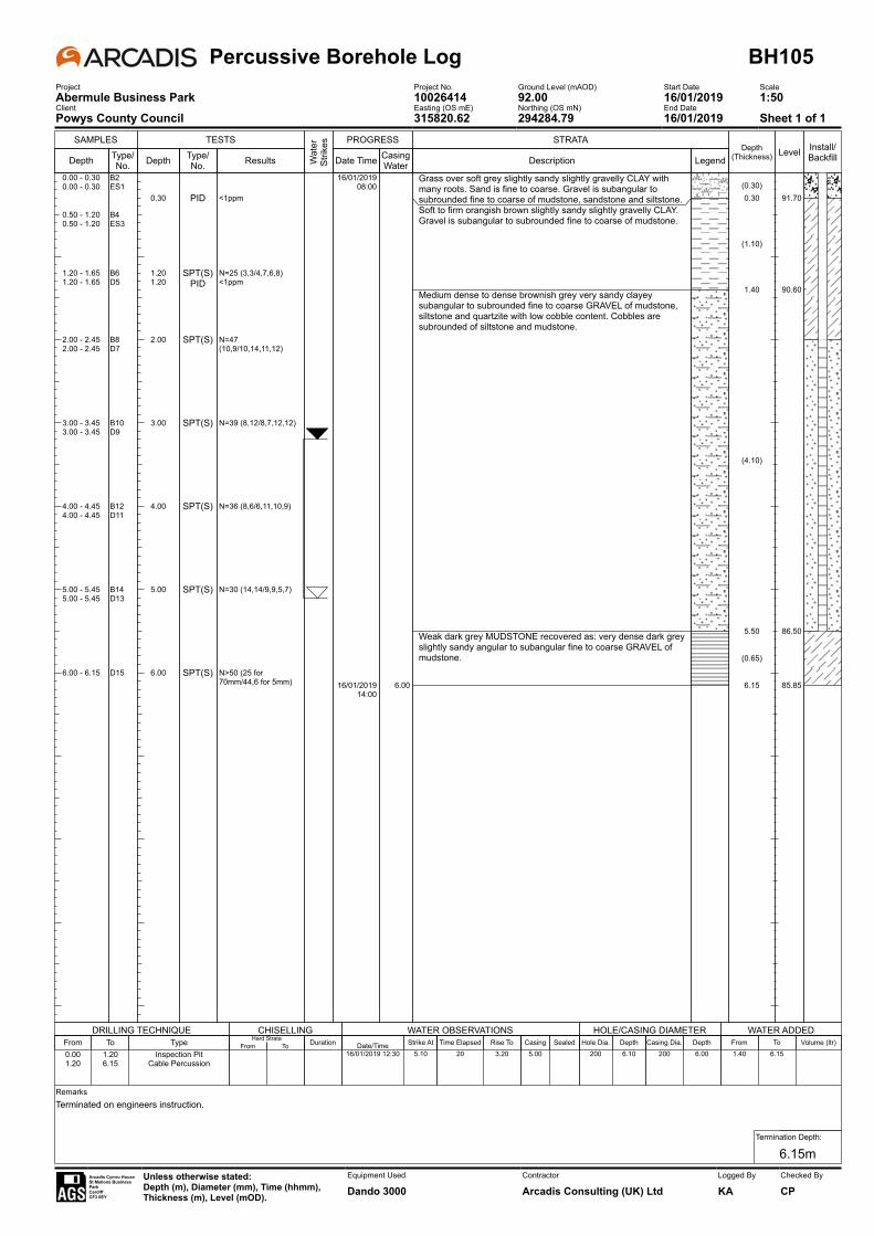
SAMPLES
Depth Type/No.
TESTS
Depth
0.30
1.201.20
2.00
3.00
4.00
5.00
6.00
Type/No.
PID
SPT(S)PID
SPT(S)
SPT(S)
SPT(S)
SPT(S)
SPT(S)
Results
<1ppm
N=25 (3,3/4,7,6,8)<1ppm
N=47 (10,9/10,14,11,12)
N=39 (8,12/8,7,12,12)
N=36 (8,6/6,11,10,9)
N=30 (14,14/9,9,5,7)
N>50 (25 for 70mm/44,6 for 5mm)
Wat
er
Strik
es PROGRESS
Date Time
16/01/201908:00
16/01/201914:00
Casing Water
6.00
STRATA
Description
Grass over soft grey slightly sandy slightly gravelly CLAY with many roots. Sand is fine to coarse. Gravel is subangular to subrounded fine to coarse of mudstone, sandstone and siltstone.Soft to firm orangish brown slightly sandy slightly gravelly CLAY. Gravel is subangular to subrounded fine to coarse of mudstone.
Medium dense to dense brownish grey very sandy clayey subangular to subrounded fine to coarse GRAVEL of mudstone, siltstone and quartzite with low cobble content. Cobbles are subrounded of siltstone and mudstone.
Weak dark grey MUDSTONE recovered as: very dense dark grey slightly sandy angular to subangular fine to coarse GRAVEL of mudstone.
LegendDepth
(Thickness)
(0.30)0.30
(1.10)
1.40
(4.10)
5.50
(0.65)
6.15
Level
91.70
90.60
86.50
85.85
Install/Backfill
0.00 - 0.30 B20.00 - 0.30 ES1
0.50 - 1.20 B40.50 - 1.20 ES3
1.20 - 1.65 B61.20 - 1.65 D5
2.00 - 2.45 B82.00 - 2.45 D7
3.00 - 3.45 B103.00 - 3.45 D9
4.00 - 4.45 B124.00 - 4.45 D11
5.00 - 5.45 B145.00 - 5.45 D13
6.00 - 6.15 D15
Percussive Borehole Log BH105Project Project No. Ground Level (mAOD) Start Date ScaleAbermule Business Park 10026414 92.00 16/01/2019 1:50Client Easting (OS mE) Northing (OS mN) End DatePowys County Council 315820.62 294284.79 16/01/2019 Sheet 1 of 1
DRILLING TECHNIQUE CHISELLING WATER OBSERVATIONS HOLE/CASING DIAMETER WATER ADDED
RemarksTerminated on engineers instruction. .
Termination Depth:
6.15mArcadis Cymru HouseSt Mellons Business ParkCardiffCF3 0EY
Unless otherwise stated:Depth (m), Diameter (mm), Time (hhmm),Thickness (m), Level (mOD).
Equipment Used
Dando 3000Contractor
Arcadis Consulting (UK) LtdLogged By
KAChecked By
CP
From To Type0.00 1.20 Inspection Pit1.20 6.15 Cable Percussion
Hard StrataFrom To Duration Date/Time Strike At
16/01/2019 12:30 5.10Time Elapsed Rise To
20 3.20Casing Sealed
5.00Hole Dia. Depth
200 6.10Casing Dia. Depth
200 6.00From To Volume (ltr)1.40 6.15
SAMPLES
Depth Type/No.
TESTS
Depth
0.20
0.80
1.20
2.00
3.00
Type/No.
PID
PID
SPT(S)
SPT(S)
SPT(S)
Results
<1ppm
<1ppm
N=37 (4,7/7,10,10,10)
N=60 (6,14/14,14,14,18)
N>50 (25 for 25mm/50 for 50mm)
Wat
er
Strik
es PROGRESS
Date Time
07/01/201910:00
07/01/201915:00
Casing Water
STRATA
Description
Grass over soft dark greenish brown very gravelly slightly sandy SILT. Gravel is subrounded fine to coarse of siltstone.
Dense becoming very dense greyish brown very silty sandy subangular to subrounded fine to coarse GRAVEL of siltstone, mudstone and quartz.
Weak dark grey MUDSTONE recovered as: very dense black slightly silty very sandy fine to coarse angular GRAVEL of mudstone.
LegendDepth
(Thickness)
(0.40)
0.40
(2.60)
3.00
(0.50)
3.50
Level
91.69
89.09
88.59
Install/Backfill
0.00 - 1.20 B30.10 - 0.20 ES1
0.60 - 0.80 ES2
1.20 - 1.65 B51.20 - 1.65 D4
2.00 - 2.45 B72.00 - 2.45 D6
3.00 - 3.10 D8
Percussive Borehole Log BH106Project Project No. Ground Level (mAOD) Start Date ScaleAbermule Business Park 10026414 92.09 07/01/2019 1:50Client Easting (OS mE) Northing (OS mN) End DatePowys County Council 315879.34 294283.66 07/01/2019 Sheet 1 of 1
DRILLING TECHNIQUE CHISELLING WATER OBSERVATIONS HOLE/CASING DIAMETER WATER ADDED
RemarksTerminated on engineers instruction. .
Termination Depth:
3.50mArcadis Cymru HouseSt Mellons Business ParkCardiffCF3 0EY
Unless otherwise stated:Depth (m), Diameter (mm), Time (hhmm),Thickness (m), Level (mOD).
Equipment Used
Dando 3000Contractor
Arcadis Consulting (UK) LtdLogged By
BRChecked By
CP
From To Type0.00 1.20 Inspection Pit1.20 3.10 Cable Percussion
Hard StrataFrom To Duration Date/Time Strike At
07/01/2019 14:00 3.00Time Elapsed Rise To
20 2.20Casing Sealed
3.00Hole Dia. Depth
150 3.50Casing Dia. Depth
150 3.00From To Volume (ltr)1.20 3.50
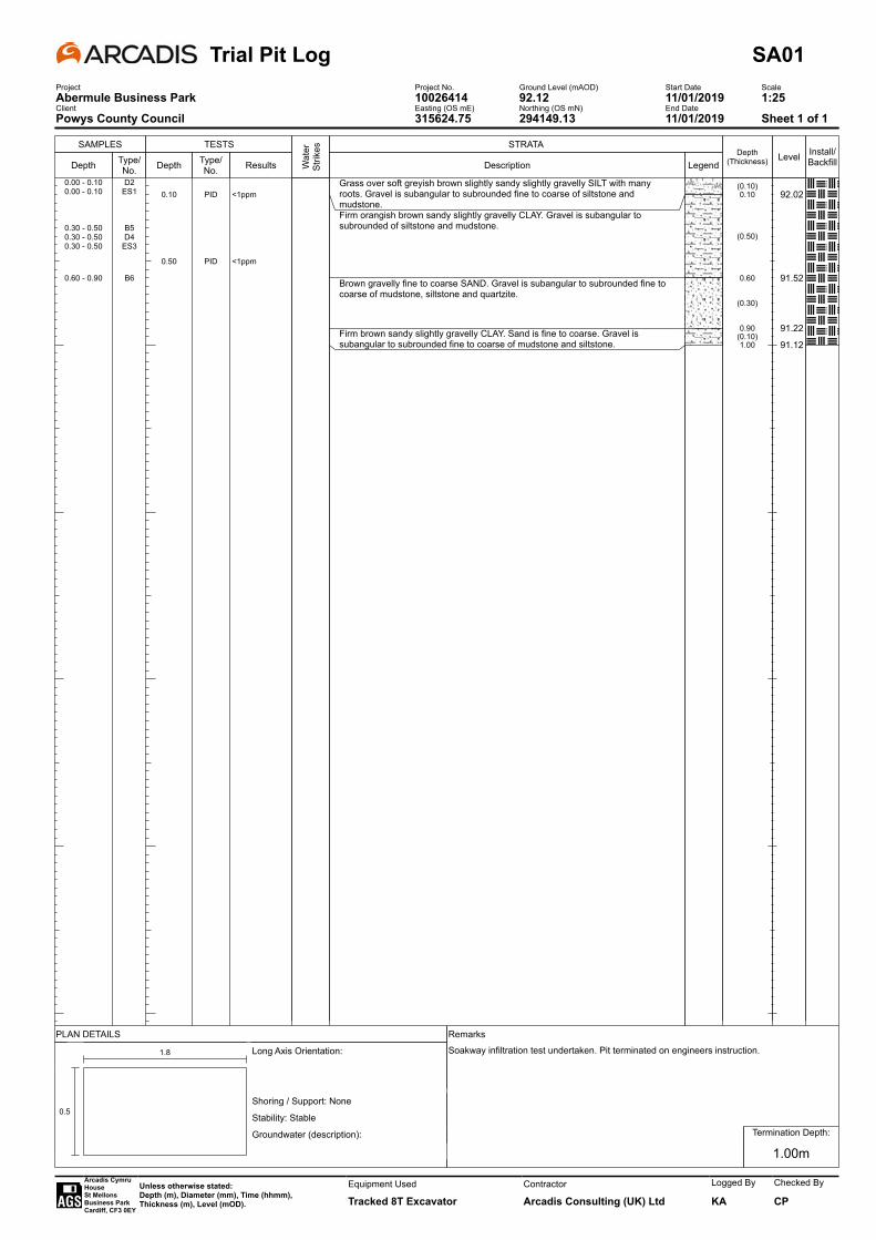
SAMPLES
Depth Type/No.
TESTS
Depth
0.10
0.50
Type/No.
PID
PID
Results
<1ppm
<1ppm
Wat
er
Strik
es STRATA
Description
Grass over soft greyish brown slightly sandy slightly gravelly SILT with many roots. Gravel is subangular to subrounded fine to coarse of siltstone and mudstone.Firm orangish brown sandy slightly gravelly CLAY. Gravel is subangular to subrounded of siltstone and mudstone.
Brown gravelly fine to coarse SAND. Gravel is subangular to subrounded fine to coarse of mudstone, siltstone and quartzite.
Firm brown sandy slightly gravelly CLAY. Sand is fine to coarse. Gravel is subangular to subrounded fine to coarse of mudstone and siltstone.
LegendDepth
(Thickness)
(0.10)0.10
(0.50)
0.60
(0.30)
0.90(0.10)1.00
Level
92.02
91.52
91.22
91.12
Install/Backfill
0.00 - 0.10 D20.00 - 0.10 ES1
0.30 - 0.50 B50.30 - 0.50 D40.30 - 0.50 ES3
0.60 - 0.90 B6
Trial Pit Log SA01Project Project No. Ground Level (mAOD) Start Date ScaleAbermule Business Park 10026414 92.12 11/01/2019 1:25Client Easting (OS mE) Northing (OS mN) End DatePowys County Council 315624.75 294149.13 11/01/2019 Sheet 1 of 1
PLAN DETAILS Remarks
-
0.5
1.8 Long Axis Orientation:
Shoring / Support: None
Stability: Stable
Groundwater (description):
. . .
Soakway infiltration test undertaken. Pit terminated on engineers instruction.
Termination Depth:
1.00m
Arcadis Cymru HouseSt Mellons Business ParkCardiff, CF3 0EY
Unless otherwise stated:Depth (m), Diameter (mm), Time (hhmm),Thickness (m), Level (mOD).
Equipment Used
Tracked 8T ExcavatorContractor
Arcadis Consulting (UK) Ltd
Logged By
KA
Checked By
CP

SAMPLES
Depth Type/No.
TESTS
Depth
0.20
0.50
0.90
Type/No.
PID
PID
PID
Results
<1ppm
<1ppm
<1ppm
Wat
er
Strik
es STRATA
Description
Grass over soft greyish brown slightly sandy slightly gravelly SILT with many roots. Gravel is subangular to subrounded fine to coarse of siltstone and mudstone.Soft to firm grey bedded orange sandy slightly gravelly CLAY. Gravel is subangular to subrounded of siltstone and mudstone.
Brown very gravelly fine to coarse SAND. Gravel is subangular to subrounded fine to coarse of mudstone, siltstone, limestone, quartzite.
Firm brown sandy slightly gravelly CLAY. Gravel is subangular to subrounded fine to coarse of mudstone, and siltstone.
LegendDepth
(Thickness)
(0.20)
0.20
(0.40)
0.60
(0.35)
0.951.00
Level
91.89
91.49
91.1491.09
Install/Backfill
0.00 - 0.20 D20.00 - 0.20 ES1
0.30 - 0.50 B50.30 - 0.50 D40.30 - 0.50 ES3
0.70 - 0.90 B60.70 - 0.90 D80.70 - 0.90 ES7
Trial Pit Log SA02Project Project No. Ground Level (mAOD) Start Date ScaleAbermule Business Park 10026414 92.09 10/01/2019 1:25Client Easting (OS mE) Northing (OS mN) End DatePowys County Council 315637.41 294133.42 10/01/2019 Sheet 1 of 1
PLAN DETAILS Remarks
-
0.5
1.7 Long Axis Orientation:
Shoring / Support: None
Stability: Stable
Groundwater (description):
. . .
Soakway infiltration test undertaken. Pit terminated on engineers instruction.
Termination Depth:
1.00m
Arcadis Cymru HouseSt Mellons Business ParkCardiff, CF3 0EY
Unless otherwise stated:Depth (m), Diameter (mm), Time (hhmm),Thickness (m), Level (mOD).
Equipment Used
Tracked 8T ExcavatorContractor
Arcadis Consulting (UK) Ltd
Logged By
KA
Checked By
CP

SAMPLES
Depth Type/No.
TESTS
Depth
0.20
0.50
Type/No.
PID
PID
Results
<1ppm
<1ppm
Wat
er
Strik
es STRATA
Description
Grass over soft greyish brown slightly sandy slightly gravelly SILT with many roots. Gravel is subangular to subrounded fine to coarse of siltstone and mudstone.Brown very clayey sandy subangular to subrounded fine to coarse GRAVEL of mudstone, siltstone and sandstone.
Brown gravelly fine to coarse SAND. Gravel is subangular to subrounded fine to coarse of mudstone, sandstone and siltstone.
Firm brown sandy slightly gravelly CLAY. Sand is fine to coarse. Gravel is subangular to subrounded fine to coarse of mudstone, and siltstone.
LegendDepth
(Thickness)
(0.20)
0.20
(0.30)
0.50
(0.30)
0.80(0.10)0.90
Level
91.88
91.58
91.28
91.18
Install/Backfill
0.00 - 0.20 D20.00 - 0.20 ES1
0.30 - 0.50 B50.30 - 0.50 D40.30 - 0.50 ES3
0.60 - 0.80 B6
Trial Pit Log SA03Project Project No. Ground Level (mAOD) Start Date ScaleAbermule Business Park 10026414 92.08 11/01/2019 1:25Client Easting (OS mE) Northing (OS mN) End DatePowys County Council 315640.74 294148.25 11/01/2019 Sheet 1 of 1
PLAN DETAILS Remarks
-
0.5
1.7 Long Axis Orientation:
Shoring / Support: None
Stability: Stable
Groundwater (description):
. . .
Soakway infiltration test undertaken. Pit terminated on engineers instruction.
Termination Depth:
0.90m
Arcadis Cymru HouseSt Mellons Business ParkCardiff, CF3 0EY
Unless otherwise stated:Depth (m), Diameter (mm), Time (hhmm),Thickness (m), Level (mOD).
Equipment Used
Tracked 8T ExcavatorContractor
Arcadis Consulting (UK) Ltd
Logged By
KA
Checked By
CP

SAMPLES
Depth Type/No.
TESTS
Depth
0.20
0.60
Type/No.
PID
PID
Results
<1ppm
<1ppm
Wat
er
Strik
es STRATA
Description
Grass over soft greyish brown slightly sandy slightly gravelly SILT with many roots. Gravel is subangular to subrounded fine to coarse of siltstone and mudstone.Soft to firm grey bedded orange sandy slightly gravelly CLAY. Gravel is subangular to subrounded of siltstone and mudstone.
LegendDepth
(Thickness)
(0.20)
0.20
(0.60)
0.80
Level
91.82
91.22
Install/Backfill
0.00 - 0.20 D20.00 - 0.20 ES1
0.40 - 0.60 B50.40 - 0.60 D40.40 - 0.60 ES3
Trial Pit Log SA04Project Project No. Ground Level (mAOD) Start Date ScaleAbermule Business Park 10026414 92.02 10/01/2019 1:25Client Easting (OS mE) Northing (OS mN) End DatePowys County Council 315662.68 294152.51 10/01/2019 Sheet 1 of 1
PLAN DETAILS Remarks
-
0.5
1.8 Long Axis Orientation:
Shoring / Support: None
Stability: Stable
Groundwater (description):
. . .
Soakway infiltration test undertaken. Pit terminated on engineers instruction.
Termination Depth:
0.80m
Arcadis Cymru HouseSt Mellons Business ParkCardiff, CF3 0EY
Unless otherwise stated:Depth (m), Diameter (mm), Time (hhmm),Thickness (m), Level (mOD).
Equipment Used
Tracked 8T ExcavatorContractor
Arcadis Consulting (UK) Ltd
Logged By
KA
Checked By
CP
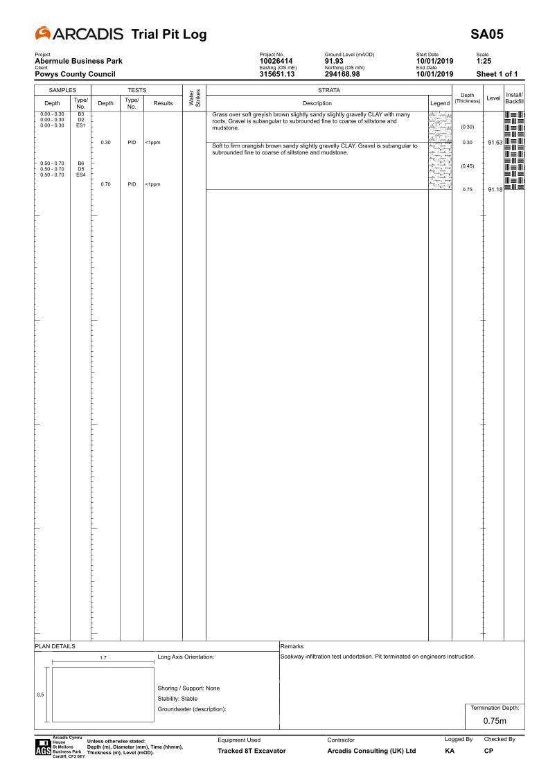
SAMPLES
Depth Type/No.
TESTS
Depth
0.30
0.70
Type/No.
PID
PID
Results
<1ppm
<1ppmW
ater
St
rikes STRATA
Description
Grass over soft greyish brown slightly sandy slightly gravelly CLAY with many roots. Gravel is subangular to subrounded fine to coarse of siltstone and mudstone.
Soft to firm orangish brown sandy slightly gravelly CLAY. Gravel is subangular to subrounded fine to coarse of siltstone and mudstone.
LegendDepth
(Thickness)
(0.30)
0.30
(0.45)
0.75
Level
91.63
91.18
Install/Backfill
0.00 - 0.30 B30.00 - 0.30 D20.00 - 0.30 ES1
0.50 - 0.70 B60.50 - 0.70 D50.50 - 0.70 ES4
Trial Pit Log SA05Project Project No. Ground Level (mAOD) Start Date ScaleAbermule Business Park 10026414 91.93 10/01/2019 1:25Client Easting (OS mE) Northing (OS mN) End DatePowys County Council 315651.13 294168.98 10/01/2019 Sheet 1 of 1
PLAN DETAILS Remarks
-
0.5
1.7 Long Axis Orientation:
Shoring / Support: None
Stability: Stable
Groundwater (description):
. . .
Soakway infiltration test undertaken. Pit terminated on engineers instruction.
Termination Depth:
0.75m
Arcadis Cymru HouseSt Mellons Business ParkCardiff, CF3 0EY
Unless otherwise stated:Depth (m), Diameter (mm), Time (hhmm),Thickness (m), Level (mOD).
Equipment Used
Tracked 8T ExcavatorContractor
Arcadis Consulting (UK) Ltd
Logged By
KA
Checked By
CP
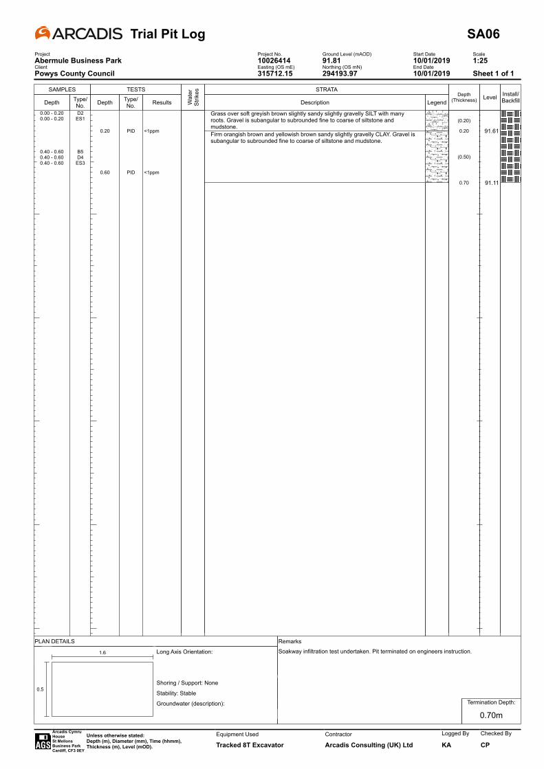
SAMPLES
Depth Type/No.
TESTS
Depth
0.20
0.60
Type/No.
PID
PID
Results
<1ppm
<1ppm
Wat
er
Strik
es STRATA
Description
Grass over soft greyish brown slightly sandy slightly gravelly SILT with many roots. Gravel is subangular to subrounded fine to coarse of siltstone and mudstone.Firm orangish brown and yellowish brown sandy slightly gravelly CLAY. Gravel is subangular to subrounded fine to coarse of siltstone and mudstone.
LegendDepth
(Thickness)
(0.20)
0.20
(0.50)
0.70
Level
91.61
91.11
Install/Backfill
0.00 - 0.20 D20.00 - 0.20 ES1
0.40 - 0.60 B50.40 - 0.60 D40.40 - 0.60 ES3
Trial Pit Log SA06Project Project No. Ground Level (mAOD) Start Date ScaleAbermule Business Park 10026414 91.81 10/01/2019 1:25Client Easting (OS mE) Northing (OS mN) End DatePowys County Council 315712.15 294193.97 10/01/2019 Sheet 1 of 1
PLAN DETAILS Remarks
-
0.5
1.6 Long Axis Orientation:
Shoring / Support: None
Stability: Stable
Groundwater (description):
. . .
Soakway infiltration test undertaken. Pit terminated on engineers instruction.
Termination Depth:
0.70m
Arcadis Cymru HouseSt Mellons Business ParkCardiff, CF3 0EY
Unless otherwise stated:Depth (m), Diameter (mm), Time (hhmm),Thickness (m), Level (mOD).
Equipment Used
Tracked 8T ExcavatorContractor
Arcadis Consulting (UK) Ltd
Logged By
KA
Checked By
CP
SAMPLES
Depth Type/No.
TESTS
Depth
0.20
0.50
Type/No.
PID
PID
Results
<1ppm
<1ppm
Wat
er
Strik
es STRATA
Description
Grass over soft greyish brown slightly sandy gravelly CLAY with many roots.
Firm orangish brown sandy slightly gravelly CLAY with low cobble content. Gravel is subangular to subrounded of siltstone and mudstone. Cobbles are subangular of siltstone.
Brown sandy slightly silty subangular to subrounded fine to coarse GRAVEL of siltstone, mudstone, sandstone, limestone and quartzite with medium cobble content. Cobbles are subangular to subrounded of siltstone and mudstone.
LegendDepth
(Thickness)
(0.20)
0.20
(0.50)
0.70
(0.25)
0.95
Level
91.95
91.45
91.20
Install/Backfill
0.00 - 0.20 D20.00 - 0.20 ES1
0.30 - 0.50 B50.30 - 0.50 D40.30 - 0.50 ES3
0.70 - 0.90 B6
Trial Pit Log SA07Project Project No. Ground Level (mAOD) Start Date ScaleAbermule Business Park 10026414 92.15 09/01/2019 1:25Client Easting (OS mE) Northing (OS mN) End DatePowys County Council 315750.15 294218.77 09/01/2019 Sheet 1 of 1
PLAN DETAILS Remarks
-
0.5
1.6 Long Axis Orientation:
Shoring / Support: None
Stability: Stable
Groundwater (description):
. . .
Soakway infiltration test undertaken. Pit terminated on engineers instruction.
Termination Depth:
0.95m
Arcadis Cymru HouseSt Mellons Business ParkCardiff, CF3 0EY
Unless otherwise stated:Depth (m), Diameter (mm), Time (hhmm),Thickness (m), Level (mOD).
Equipment Used
Tracked 8T ExcavatorContractor
Arcadis Consulting (UK) Ltd
Logged By
KA
Checked By
CP
SAMPLES
Depth Type/No.
TESTS
Depth
0.20
0.70
Type/No.
PID
PID
Results
<1ppm
<1ppmW
ater
St
rikes STRATA
Description
Grass over soft greyish brown slightly sandy slightly gravelly SILT with many roots.Gravel is subangular to subrounded fine to coarse of mudstone and siltstone.
Firm brown slightly sandy slightly gravelly CLAY. Gravel is subangular to subrounded fine to coarse of siltstone and mudstone.
LegendDepth
(Thickness)
(0.30)
0.30
(0.70)
1.00
Level
91.88
91.18
Install/Backfill
0.00 - 0.20 B30.00 - 0.20 D20.00 - 0.20 ES1
0.50 - 0.70 B60.50 - 0.70 D50.50 - 0.70 ES4
Trial Pit Log SA08Project Project No. Ground Level (mAOD) Start Date ScaleAbermule Business Park 10026414 92.18 10/01/2019 1:25Client Easting (OS mE) Northing (OS mN) End DatePowys County Council 315738.76 294235.63 10/01/2019 Sheet 1 of 1
PLAN DETAILS Remarks
-
0.5
1.6 Long Axis Orientation:
Shoring / Support: None
Stability: Stable
Groundwater (description):
. . .
Soakway infiltration test undertaken. Pit terminated on engineers instruction.
Termination Depth:
1.00m
Arcadis Cymru HouseSt Mellons Business ParkCardiff, CF3 0EY
Unless otherwise stated:Depth (m), Diameter (mm), Time (hhmm),Thickness (m), Level (mOD).
Equipment Used
Tracked 8T ExcavatorContractor
Arcadis Consulting (UK) Ltd
Logged By
KA
Checked By
CP
SAMPLES
Depth Type/No.
TESTS
Depth
0.20
0.50
Type/No.
PID
PID
Results
<1ppm
<1ppm
Wat
er
Strik
es STRATA
Description
Grass over soft greyish brown slightly sandy gravelly CLAY with many roots.
Firm orangish brown slightly sandy slightly gravelly CLAY with low cobble content. Gravel is subangular to subrounded fine to coarse of siltstone and mudstone. Cobbles are subangular of siltstone.
Brown very sandy subangular to subrounded fine to coarse GRAVEL of siltstone, mudstone, sandstone, limestone, quartzite with medium cobble content. Cobbles are subangular to subrounded of siltstone, limestone and mudstone.
LegendDepth
(Thickness)
(0.30)
0.30
(0.60)
0.90
(0.20)
1.10
Level
92.04
91.44
91.24
Install/Backfill
0.00 - 0.20 B30.00 - 0.20 D20.00 - 0.20 ES1
0.30 - 0.50 D50.30 - 0.50 ES40.30 - 0.60 B6
0.90 - 1.10 B7
Trial Pit Log SA09Project Project No. Ground Level (mAOD) Start Date ScaleAbermule Business Park 10026414 92.34 09/01/2019 1:25Client Easting (OS mE) Northing (OS mN) End DatePowys County Council 315756.98 294236.24 09/01/2019 Sheet 1 of 1
PLAN DETAILS Remarks
-
0.5
1.8 Long Axis Orientation:
Shoring / Support: None
Stability: Stable
Groundwater (description):
. . .
Soakway infiltration test undertaken. Pit terminated on engineers instruction.
Termination Depth:
1.10m
Arcadis Cymru HouseSt Mellons Business ParkCardiff, CF3 0EY
Unless otherwise stated:Depth (m), Diameter (mm), Time (hhmm),Thickness (m), Level (mOD).
Equipment Used
Tracked 8T ExcavatorContractor
Arcadis Consulting (UK) Ltd
Logged By
KA
Checked By
CP
SAMPLES
Depth Type/No.
TESTS
Depth
0.20
0.60
Type/No.
PID
PID
Results
<1ppm
<1ppm
Wat
er
Strik
es STRATA
Description
MADE GROUND: Grass over firm greyish brown slightly sandy gravelly CLAY with few pieces of plastic and glass bottles. Gravel is subangular fine to coarse of siltstone and mudstone,Firm orangish brown sandy slightly gravelly CLAY. Gravel is subangular to subrounded fine to coarse of mudstone, siltstone, sandstone and quartzite.
Brown very sandy silty subangular to subrounded fine to coarse GRAVEL of siltstone, mudstone, sandstone, limestone, quartzite with low cobble content. Cobbles are subangular to subrounded of siltstone and mudstone.
LegendDepth
(Thickness)
(0.20)
0.20
(0.90)
1.10(0.10)1.20
Level
92.21
91.31
91.21
Install/Backfill
0.00 - 0.20 B30.00 - 0.20 D20.00 - 0.20 ES1
0.40 - 0.60 B60.40 - 0.60 D50.40 - 0.60 ES4
1.10 - 1.20 B7
Trial Pit Log SA10Project Project No. Ground Level (mAOD) Start Date ScaleAbermule Business Park 10026414 92.41 09/01/2019 1:25Client Easting (OS mE) Northing (OS mN) End DatePowys County Council 315776.01 294238.61 09/01/2019 Sheet 1 of 1
PLAN DETAILS Remarks
-
0.5
1.5 Long Axis Orientation:
Shoring / Support: None
Stability: Stable
Groundwater (description):
. . .
Soakway infiltration test undertaken. Pit terminated on engineers instruction.
Termination Depth:
1.20m
Arcadis Cymru HouseSt Mellons Business ParkCardiff, CF3 0EY
Unless otherwise stated:Depth (m), Diameter (mm), Time (hhmm),Thickness (m), Level (mOD).
Equipment Used
Tracked 8T ExcavatorContractor
Arcadis Consulting (UK) Ltd
Logged By
KA
Checked By
CP
SAMPLES
Depth Type/No.
TESTS
Depth
0.30
0.70
Type/No.
PID
PID
Results
<1ppm
<1ppmW
ater
St
rikes STRATA
Description
Grass over soft greyish brown slightly sandy gravelly CLAY with many roots and rootlets. Gravel is subangular fine to coarse of siltstone and mudstone.
Firm orangish brown slightly sandy slightly gravelly CLAY with low cobble content. Gravel is subangular to subrounded fine to coarse of siltstone and mudstone. Cobbles are subangular of siltstone.
LegendDepth
(Thickness)
(0.30)
0.30
(0.70)
1.00
Level
91.88
91.18
Install/Backfill
0.00 - 0.30 B30.00 - 0.30 D20.00 - 0.30 ES1
0.50 - 0.70 B60.50 - 0.70 D50.50 - 0.70 ES4
Trial Pit Log SA11Project Project No. Ground Level (mAOD) Start Date ScaleAbermule Business Park 10026414 92.18 09/01/2019 1:25Client Easting (OS mE) Northing (OS mN) End DatePowys County Council 315763.84 294251.89 09/01/2019 Sheet 1 of 1
PLAN DETAILS Remarks
-
0.5
1.6 Long Axis Orientation:
Shoring / Support: None
Stability: Stable
Groundwater (description):
. . .
Soakway infiltration test undertaken. Pit terminated on engineers instruction.
Termination Depth:
1.00m
Arcadis Cymru HouseSt Mellons Business ParkCardiff, CF3 0EY
Unless otherwise stated:Depth (m), Diameter (mm), Time (hhmm),Thickness (m), Level (mOD).
Equipment Used
Tracked 8T ExcavatorContractor
Arcadis Consulting (UK) Ltd
Logged By
KA
Checked By
CP
SAMPLES
Depth Type/No.
TESTS
Depth
0.20
0.70
Type/No.
PID
PID
Results
<1ppm
<1ppmW
ater
St
rikes STRATA
Description
Grass over soft grey sandy slightly gravelly SILT with many roots.
Firm orangish brown sandy slightly gravelly CLAY with low cobble content. Gravel is subangular to subrounded of siltstone and mudstone. Cobbles are subangular of mudstone.
LegendDepth
(Thickness)
(0.30)
0.30
(0.50)
0.80
Level
91.76
91.26
Install/Backfill
0.00 - 0.20 ES1
0.20 - 0.30 D2
0.50 - 0.70 B50.50 - 0.70 D40.50 - 0.70 ES3
Trial Pit Log SA12Project Project No. Ground Level (mAOD) Start Date ScaleAbermule Business Park 10026414 92.06 07/01/2019 1:25Client Easting (OS mE) Northing (OS mN) End DatePowys County Council 315821.99 294270.88 07/01/2019 Sheet 1 of 1
PLAN DETAILS Remarks
-
0.5
2.0 Long Axis Orientation:
Shoring / Support: None
Stability: Stable
Groundwater (description):
. . .
Soakway infiltration test undertaken. Pit terminated on engineers instruction.
Termination Depth:
0.80m
Arcadis Cymru HouseSt Mellons Business ParkCardiff, CF3 0EY
Unless otherwise stated:Depth (m), Diameter (mm), Time (hhmm),Thickness (m), Level (mOD).
Equipment Used
Tracked 8T ExcavatorContractor
Arcadis Consulting (UK) Ltd
Logged By
KA
Checked By
CP

SAMPLES
Depth Type/No.
TESTS
Depth
0.20
0.80
Type/No.
PID
PID
Results
<1ppm
<1ppmW
ater
St
rikes STRATA
Description
Grass over soft greyish brown slightly sandy gravelly SILT with many roots.
Firm brown sandy slightly gravelly SILT. Gravel is subangular to subrounded fine to coarse of siltstone.
LegendDepth
(Thickness)
(0.20)
0.20
(0.60)
0.80
Level
91.81
91.21
Install/Backfill
0.00 - 0.20 D20.00 - 0.20 ES1
0.60 - 0.80 B40.60 - 0.80 D50.60 - 0.80 ES3
Trial Pit Log SA13Project Project No. Ground Level (mAOD) Start Date ScaleAbermule Business Park 10026414 92.01 07/01/2019 1:25Client Easting (OS mE) Northing (OS mN) End DatePowys County Council 315834.10 294292.49 07/01/2019 Sheet 1 of 1
PLAN DETAILS Remarks
-
0.5
3.7 Long Axis Orientation:
Shoring / Support: None
Stability: Stable
Groundwater (description):
. . .
Soakway infiltration test undertaken. Pit terminated on engineers instruction.
Termination Depth:
0.80m
Arcadis Cymru HouseSt Mellons Business ParkCardiff, CF3 0EY
Unless otherwise stated:Depth (m), Diameter (mm), Time (hhmm),Thickness (m), Level (mOD).
Equipment Used
Tracked 8T ExcavatorContractor
Arcadis Consulting (UK) Ltd
Logged By
KA
Checked By
CP
SAMPLES
Depth Type/No.
TESTS
Depth
0.30
0.60
Type/No.
PID
PID
Results
<1ppm
<1ppm
Wat
er
Strik
es STRATA
Description
Grass over soft greyish brown slightly sandy gravelly SILT with many roots.
Firm orangish brown sandy slightly gravelly CLAY with low cobble content. Gravel is subangular to subrounded fine to coarse of siltstone and mudstone. Cobbles are subangular of mudstone.
Medium cobble content below 0.95m.
LegendDepth
(Thickness)
(0.35)
0.35
(0.65)
1.00
Level
91.95
91.30
Install/Backfill
0.10 - 0.30 D20.10 - 0.30 ES1
0.40 - 0.60 B50.40 - 0.60 D40.40 - 0.60 ES3
Trial Pit Log SA14Project Project No. Ground Level (mAOD) Start Date ScaleAbermule Business Park 10026414 92.30 08/01/2019 1:25Client Easting (OS mE) Northing (OS mN) End DatePowys County Council 315835.74 294267.67 08/01/2019 Sheet 1 of 1
PLAN DETAILS Remarks
-
0.5
1.8 Long Axis Orientation:
Shoring / Support: None
Stability: Stable
Groundwater (description):
. . .
Soakway infiltration test undertaken. Pit terminated on engineers instruction.
Termination Depth:
1.00m
Arcadis Cymru HouseSt Mellons Business ParkCardiff, CF3 0EY
Unless otherwise stated:Depth (m), Diameter (mm), Time (hhmm),Thickness (m), Level (mOD).
Equipment Used
Tracked 8T ExcavatorContractor
Arcadis Consulting (UK) Ltd
Logged By
KA
Checked By
CP
SAMPLES
Depth Type/No.
TESTS
Depth
0.20
0.50
Type/No.
PID
PID
Results
<1ppm
<1ppm
Wat
er
Strik
es STRATA
Description
Grass over soft to firm greyish brown slightly sandy gravelly CLAY with few roots and rootlets. Gravel is subangular fine to coarse of siltstone.
Firm brown sandy slightly gravelly CLAY. Gravel is subangular to subrounded fine to coarse of siltstone.
Brown sandy silty subangular to rounded fine to coarse GRAVEL of mudstone, siltstone, quartzite and sandstone, with medium cobble content. Cobbles are subrounded of mudstone, and siltstone.
LegendDepth
(Thickness)
(0.30)
0.30
(0.35)
0.65
(0.45)
1.10
Level
92.02
91.67
91.22
Install/Backfill
0.00 - 0.20 B30.00 - 0.20 D20.00 - 0.20 ES1
0.30 - 0.50 B60.30 - 0.50 D50.30 - 0.50 ES4
0.80 - 1.00 B7
Trial Pit Log SA15Project Project No. Ground Level (mAOD) Start Date ScaleAbermule Business Park 10026414 92.32 08/01/2019 1:25Client Easting (OS mE) Northing (OS mN) End DatePowys County Council 315853.10 294260.61 08/01/2019 Sheet 1 of 1
PLAN DETAILS Remarks
-
0.5
2.0 Long Axis Orientation:
Shoring / Support: None
Stability: Stable
Groundwater (description):
. . .
Soakway infiltration test undertaken. Pit terminated on engineers instruction.
Termination Depth:
1.10m
Arcadis Cymru HouseSt Mellons Business ParkCardiff, CF3 0EY
Unless otherwise stated:Depth (m), Diameter (mm), Time (hhmm),Thickness (m), Level (mOD).
Equipment Used
Tracked 8T ExcavatorContractor
Arcadis Consulting (UK) Ltd
Logged By
KA
Checked By
CP

SAMPLES
Depth Type/No.
TESTS
Depth
0.20
0.60
Type/No.
PID
PID
Results
<1ppm
<1ppm
Wat
er
Strik
es STRATA
Description
MADE GROUND: Grass over soft to firm greyish brown slightly sandy gravelly CLAY with few roots. Includes few metal cans, plastic bottles and plastic fragments. Gravel is subangular fine to coarse of siltstone.
Firm brown sandy slightly gravelly CLAY. Gravel is subangular to subrounded fine to coarse of siltstone.
Brown very sandy subangular to rounded fine to coarse GRAVEL of mudstone, siltstone, quartzite and sandstone, with medium cobble content. Cobbles are subrounded of mudstone and siltstone.
LegendDepth
(Thickness)
(0.40)
0.40
(0.30)
0.70
(0.40)
1.10
Level
92.02
91.72
91.32
Install/Backfill
0.00 - 0.20 B50.00 - 0.20 D20.00 - 0.20 ES1
0.40 - 0.60 B60.40 - 0.60 D40.40 - 0.60 ES3
0.70 - 0.90 B7
Trial Pit Log SA16Project Project No. Ground Level (mAOD) Start Date ScaleAbermule Business Park 10026414 92.42 08/01/2019 1:25Client Easting (OS mE) Northing (OS mN) End DatePowys County Council 315835.34 294248.99 08/01/2019 Sheet 1 of 1
PLAN DETAILS Remarks
-
0.5
1.9 Long Axis Orientation:
Shoring / Support: None
Stability: Stable
Groundwater (description):
. . .
Soakway infiltration test undertaken. Pit terminated on engineers instruction.
Termination Depth:
1.10m
Arcadis Cymru HouseSt Mellons Business ParkCardiff, CF3 0EY
Unless otherwise stated:Depth (m), Diameter (mm), Time (hhmm),Thickness (m), Level (mOD).
Equipment Used
Tracked 8T ExcavatorContractor
Arcadis Consulting (UK) Ltd
Logged By
KA
Checked By
CP
SAMPLES
Depth Type/No.
TESTS
Depth
0.20
0.40
0.80
Type/No.
PID
PID
PID
Results
<1ppm
<1ppm
<1ppmW
ater
St
rikes STRATA
Description
Grass over soft to firm grey sandy slightly gravelly CLAY with many roots and rootlets. Gravel is subangular fine to coarse of mudstone and sandstone.
Firm orangish brown slightly sandy gravelly CLAY. Gravel is subangular to subrounded fine to coarse of mudstone, sandstone and siltstone.
Grey and brown very sandy subangular to subrounded fine to coarse GRAVEL of mudstone and sandstone with low cobble content. Cobbles are subangular to subrounded mudstone.
LegendDepth
(Thickness)
(0.20)
0.20
(0.40)
0.60
(0.40)
1.00
Level
91.62
91.22
90.82
Install/Backfill
0.00 - 0.20 D20.00 - 0.20 ES1
0.20 - 0.40 B50.20 - 0.40 D40.20 - 0.40 ES3
0.60 - 0.80 D70.60 - 0.80 ES6
Trial Pit Log TP101Project Project No. Ground Level (mAOD) Start Date ScaleAbermule Business Park 10026414 91.82 14/01/2019 1:25Client Easting (OS mE) Northing (OS mN) End DatePowys County Council 315543.92 294055.33 14/01/2019 Sheet 1 of 1
PLAN DETAILS Remarks
-
0.5
2.0 Long Axis Orientation:
Shoring / Support: None
Stability: Stable
Groundwater (description):
. . .
Terminated on engineers instruction.
Termination Depth:
1.00m
Arcadis Cymru HouseSt Mellons Business ParkCardiff, CF3 0EY
Unless otherwise stated:Depth (m), Diameter (mm), Time (hhmm),Thickness (m), Level (mOD).
Equipment Used
Tracked 8T ExcavatorContractor
Arcadis Consulting (UK) Ltd
Logged By
KA
Checked By
CP

SAMPLES
Depth Type/No.
TESTS
Depth
0.20
0.60
0.80
Type/No.
PID
PID
PID
Results
<1ppm
<1ppm
<1ppmW
ater
St
rikes STRATA
Description
Grass over soft to firm grey sandy slightly gravelly CLAY with many roots. Sand is fine to coarse. Gravel is subangular fine to coarse of mudstone and sandstone.
Firm orangish brown slightly sandy gravelly CLAY. Gravel is subangular to subrounded fine to coarse of mudstone, sandstone and siltstone.
Brown very sandy subangular to subrounded fine to coarse GRAVEL of mudstone and sandstone with low cobble content. Cobbles are subangular to subrounded of mudstone.
LegendDepth
(Thickness)
(0.20)
0.20
(0.40)
0.60
(0.40)
1.00
Level
91.47
91.07
90.67
Install/Backfill
0.00 - 0.20 D20.00 - 0.20 ES1
0.20 - 0.60 B50.20 - 0.60 D40.20 - 0.60 ES3
0.60 - 0.80 B70.60 - 0.80 ES6
Trial Pit Log TP102Project Project No. Ground Level (mAOD) Start Date ScaleAbermule Business Park 10026414 91.67 14/01/2019 1:25Client Easting (OS mE) Northing (OS mN) End DatePowys County Council 315564.28 294052.13 14/01/2019 Sheet 1 of 1
PLAN DETAILS Remarks
-
0.5
1.8 Long Axis Orientation:
Shoring / Support: None
Stability: Stable
Groundwater (description):
. . .
Terminated on engineers instruction.
Termination Depth:
1.00m
Arcadis Cymru HouseSt Mellons Business ParkCardiff, CF3 0EY
Unless otherwise stated:Depth (m), Diameter (mm), Time (hhmm),Thickness (m), Level (mOD).
Equipment Used
Tracked 8T ExcavatorContractor
Arcadis Consulting (UK) Ltd
Logged By
KA
Checked By
CP
SAMPLES
Depth Type/No.
TESTS
Depth
0.30
0.60
Type/No.
PID
PID
Results
<1ppm
<1ppm
Wat
er
Strik
es STRATA
Description
Grass over soft to firm greyish brown sandy slightly gravelly CLAY with many roots and rootlets. Gravel is subangular fine to coarse of mudstone and sandstone.
Firm orangish brown slightly sandy gravelly CLAY. Gravel is subangular to subrounded fine to coarse of mudstone, sandstone and siltstone.
LegendDepth
(Thickness)
(0.30)
0.30
(0.70)
1.00
Level
91.28
90.58
Install/Backfill
0.00 - 0.30 D20.00 - 0.30 ES1
0.40 - 0.60 B50.40 - 0.60 D40.40 - 0.60 ES3
Trial Pit Log TP103Project Project No. Ground Level (mAOD) Start Date ScaleAbermule Business Park 10026414 91.58 14/01/2019 1:25Client Easting (OS mE) Northing (OS mN) End DatePowys County Council 315574.59 294081.75 14/01/2019 Sheet 1 of 1
PLAN DETAILS Remarks
-
0.5
2.0 Long Axis Orientation:
Shoring / Support: None
Stability: Stable
Groundwater (description):
. . .
Terminated on engineers instruction.
Termination Depth:
1.00m
Arcadis Cymru HouseSt Mellons Business ParkCardiff, CF3 0EY
Unless otherwise stated:Depth (m), Diameter (mm), Time (hhmm),Thickness (m), Level (mOD).
Equipment Used
Tracked 8T ExcavatorContractor
Arcadis Consulting (UK) Ltd
Logged By
KA
Checked By
CP
SAMPLES
Depth Type/No.
TESTS
Depth
0.20
0.60
Type/No.
PID
PID
Results
<1ppm
<1ppm
Wat
er
Strik
es STRATA
Description
Grass over soft to firm greyish brown sandy slightly gravelly CLAY with many roots. Gravel is subangular fine to coarse of mudstone and sandstone.
Brown in places light brown very clayey sandy subangular to subrounded fine to coarse GRAVEL of sandstone, siltstone and mudstone with low cobble and boulder content. Cobbles and boulders are subangular of mudstone.
LegendDepth
(Thickness)
(0.20)
0.20
(0.80)
1.00
Level
91.40
90.60
Install/Backfill
0.00 - 0.20 D20.00 - 0.20 ES1
0.40 - 0.60 B50.40 - 0.60 D40.40 - 0.60 ES3
Trial Pit Log TP104Project Project No. Ground Level (mAOD) Start Date ScaleAbermule Business Park 10026414 91.60 14/01/2019 1:25Client Easting (OS mE) Northing (OS mN) End DatePowys County Council 315590.50 294078.23 14/01/2019 Sheet 1 of 1
PLAN DETAILS Remarks
-
0.5
1.9 Long Axis Orientation:
Shoring / Support: None
Stability: Stable
Groundwater (description):
. . .
Terminated on engineers instruction.
Termination Depth:
1.00m
Arcadis Cymru HouseSt Mellons Business ParkCardiff, CF3 0EY
Unless otherwise stated:Depth (m), Diameter (mm), Time (hhmm),Thickness (m), Level (mOD).
Equipment Used
Tracked 8T ExcavatorContractor
Arcadis Consulting (UK) Ltd
Logged By
KA
Checked By
CP
SAMPLES
Depth Type/No.
TESTS
Depth Type/No. Results W
ater
St
rikes STRATA
Description
MADE GROUND: Soft brown slightly sandy slightly gravelly CLAY. Gravel is subangular fine to coarse of sandstone and mudstone.
LegendDepth
(Thickness)
(0.20)
0.20
Level
93.55
Install/Backfill
0.00 - 0.20 ES1
Inspection Pit Log HTP01Project Project No. Ground Level (mAOD) Start Date ScaleAbermule Business Park 10026414 93.75 15/01/2019 1:25Client Easting (OS mE) Northing (OS mN) End DatePowys County Council 315660.28 294193.35 15/01/2019 Sheet 1 of 1
PLAN DETAILS Remarks
-
0.2
0.2 Long Axis Orientation:
Shoring / Support: None
Stability: Stable
Groundwater (description):
. . .
Termination Depth:
0.20m
Arcadis Cymru HouseSt Mellons Business ParkCardiff, CF3 0EY
Unless otherwise stated:Depth (m), Diameter (mm), Time (hhmm),Thickness (m), Level (mOD).
Equipment Used
Insulated Hand ToolsContractor
Arcadis Consulting (UK) Ltd
Logged By
KA
Checked By
CP

SAMPLES
Depth Type/No.
TESTS
Depth Type/No. Results W
ater
St
rikes STRATA
Description
MADE GROUND: Soft brown slightly sandy slightly gravelly CLAY. Gravel is subangular fine to coarse of sandstone and mudstone.
LegendDepth
(Thickness)
(0.20)
0.20
Level
93.54
Install/Backfill
0.00 - 0.20 ES1
Inspection Pit Log HTP02Project Project No. Ground Level (mAOD) Start Date ScaleAbermule Business Park 10026414 93.74 15/01/2019 1:25Client Easting (OS mE) Northing (OS mN) End DatePowys County Council 315649.63 294183.41 15/01/2019 Sheet 1 of 1
PLAN DETAILS Remarks
-
0.2
0.2 Long Axis Orientation:
Shoring / Support: None
Stability: Stable
Groundwater (description):
. . .
Termination Depth:
0.20m
Arcadis Cymru HouseSt Mellons Business ParkCardiff, CF3 0EY
Unless otherwise stated:Depth (m), Diameter (mm), Time (hhmm),Thickness (m), Level (mOD).
Equipment Used
Insulated Hand ToolsContractor
Arcadis Consulting (UK) Ltd
Logged By
KA
Checked By
CP
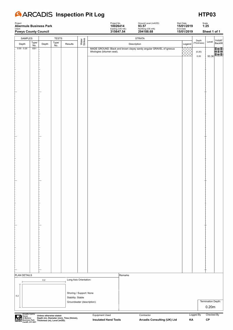
SAMPLES
Depth Type/No.
TESTS
Depth Type/No. Results W
ater
St
rikes STRATA
Description
MADE GROUND: Black and brown clayey sandy angular GRAVEL of igneous lithologies (bitumen seal).
LegendDepth
(Thickness)
(0.20)
0.20
Level
93.36
Install/Backfill
0.00 - 0.20 ES1
Inspection Pit Log HTP03Project Project No. Ground Level (mAOD) Start Date ScaleAbermule Business Park 10026414 93.57 15/01/2019 1:25Client Easting (OS mE) Northing (OS mN) End DatePowys County Council 315647.54 294188.68 15/01/2019 Sheet 1 of 1
PLAN DETAILS Remarks
-
0.2
0.2 Long Axis Orientation:
Shoring / Support: None
Stability: Stable
Groundwater (description):
. . .
Termination Depth:
0.20m
Arcadis Cymru HouseSt Mellons Business ParkCardiff, CF3 0EY
Unless otherwise stated:Depth (m), Diameter (mm), Time (hhmm),Thickness (m), Level (mOD).
Equipment Used
Insulated Hand ToolsContractor
Arcadis Consulting (UK) Ltd
Logged By
KA
Checked By
CP

SAMPLES
Depth Type/No.
TESTS
Depth Type/No. Results W
ater
St
rikes STRATA
Description
MADE GROUND: Soft brown slightly sandy slightly gravelly CLAY. Gravel is subangular fine to coarse of sandstone, limestone, concrete and brick.
LegendDepth
(Thickness)
(0.20)
0.20
Level
93.40
Install/Backfill
0.00 - 0.20 ES1
Inspection Pit Log HTP04Project Project No. Ground Level (mAOD) Start Date ScaleAbermule Business Park 10026414 93.60 15/01/2019 1:25Client Easting (OS mE) Northing (OS mN) End DatePowys County Council 315639.63 294181.74 15/01/2019 Sheet 1 of 1
PLAN DETAILS Remarks
-
0.2
0.2 Long Axis Orientation:
Shoring / Support: None
Stability: Stable
Groundwater (description):
. . .
Termination Depth:
0.20m
Arcadis Cymru HouseSt Mellons Business ParkCardiff, CF3 0EY
Unless otherwise stated:Depth (m), Diameter (mm), Time (hhmm),Thickness (m), Level (mOD).
Equipment Used
Insulated Hand ToolsContractor
Arcadis Consulting (UK) Ltd
Logged By
KA
Checked By
CP

SAMPLES
Depth Type/No.
TESTS
Depth Type/No. Results W
ater
St
rikes STRATA
Description
MADE GROUND: Soft brown slightly sandy slightly gravelly CLAY. Gravel is subangular fine to coarse of sandstone, limestone, concrete and brick.
LegendDepth
(Thickness)
(0.20)
0.20
Level
92.77
Install/Backfill
0.00 - 0.20 ES1
Inspection Pit Log HTP05Project Project No. Ground Level (mAOD) Start Date ScaleAbermule Business Park 10026414 92.97 15/01/2019 1:25Client Easting (OS mE) Northing (OS mN) End DatePowys County Council 315632.20 294178.63 15/01/2019 Sheet 1 of 1
PLAN DETAILS Remarks
-
0.2
0.2 Long Axis Orientation:
Shoring / Support: None
Stability: Stable
Groundwater (description):
. . .
Termination Depth:
0.20m
Arcadis Cymru HouseSt Mellons Business ParkCardiff, CF3 0EY
Unless otherwise stated:Depth (m), Diameter (mm), Time (hhmm),Thickness (m), Level (mOD).
Equipment Used
Insulated Hand ToolsContractor
Arcadis Consulting (UK) Ltd
Logged By
KA
Checked By
CP
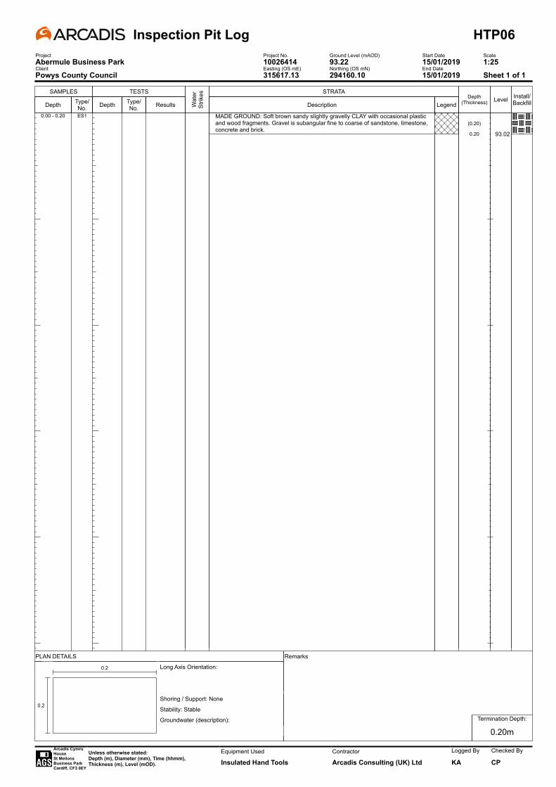
SAMPLES
Depth Type/No.
TESTS
Depth Type/No. Results W
ater
St
rikes STRATA
Description
MADE GROUND: Soft brown sandy slightly gravelly CLAY with occasional plastic and wood fragments. Gravel is subangular fine to coarse of sandstone, limestone, concrete and brick.
LegendDepth
(Thickness)
(0.20)
0.20
Level
93.02
Install/Backfill
0.00 - 0.20 ES1
Inspection Pit Log HTP06Project Project No. Ground Level (mAOD) Start Date ScaleAbermule Business Park 10026414 93.22 15/01/2019 1:25Client Easting (OS mE) Northing (OS mN) End DatePowys County Council 315617.13 294160.10 15/01/2019 Sheet 1 of 1
PLAN DETAILS Remarks
-
0.2
0.2 Long Axis Orientation:
Shoring / Support: None
Stability: Stable
Groundwater (description):
. . .
Termination Depth:
0.20m
Arcadis Cymru HouseSt Mellons Business ParkCardiff, CF3 0EY
Unless otherwise stated:Depth (m), Diameter (mm), Time (hhmm),Thickness (m), Level (mOD).
Equipment Used
Insulated Hand ToolsContractor
Arcadis Consulting (UK) Ltd
Logged By
KA
Checked By
CP

SAMPLES
Depth Type/No.
TESTS
Depth Type/No. Results W
ater
St
rikes STRATA
Description
MADE GROUND: Soft dark brown sandy slightly gravelly CLAY with occasional plastic and wood fragments. Gravel is subangular fine to coarse of sandstone, limestone, concrete and brick.
LegendDepth
(Thickness)
(0.20)
0.20
Level
92.68
Install/Backfill
0.00 - 0.20 ES1
Inspection Pit Log HTP07Project Project No. Ground Level (mAOD) Start Date ScaleAbermule Business Park 10026414 92.88 15/01/2019 1:25Client Easting (OS mE) Northing (OS mN) End DatePowys County Council 315610.44 294163.74 15/01/2019 Sheet 1 of 1
PLAN DETAILS Remarks
-
0.2
0.2 Long Axis Orientation:
Shoring / Support: None
Stability: Stable
Groundwater (description):
. . .
Termination Depth:
0.20m
Arcadis Cymru HouseSt Mellons Business ParkCardiff, CF3 0EY
Unless otherwise stated:Depth (m), Diameter (mm), Time (hhmm),Thickness (m), Level (mOD).
Equipment Used
Insulated Hand ToolsContractor
Arcadis Consulting (UK) Ltd
Logged By
KA
Checked By
CP
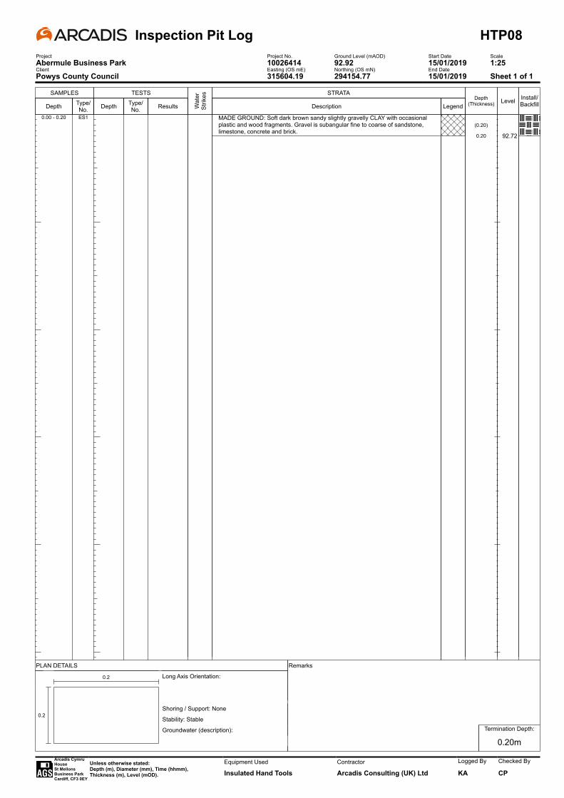
SAMPLES
Depth Type/No.
TESTS
Depth Type/No. Results W
ater
St
rikes STRATA
Description
MADE GROUND: Soft dark brown sandy slightly gravelly CLAY with occasional plastic and wood fragments. Gravel is subangular fine to coarse of sandstone, limestone, concrete and brick.
LegendDepth
(Thickness)
(0.20)
0.20
Level
92.72
Install/Backfill
0.00 - 0.20 ES1
Inspection Pit Log HTP08Project Project No. Ground Level (mAOD) Start Date ScaleAbermule Business Park 10026414 92.92 15/01/2019 1:25Client Easting (OS mE) Northing (OS mN) End DatePowys County Council 315604.19 294154.77 15/01/2019 Sheet 1 of 1
PLAN DETAILS Remarks
-
0.2
0.2 Long Axis Orientation:
Shoring / Support: None
Stability: Stable
Groundwater (description):
. . .
Termination Depth:
0.20m
Arcadis Cymru HouseSt Mellons Business ParkCardiff, CF3 0EY
Unless otherwise stated:Depth (m), Diameter (mm), Time (hhmm),Thickness (m), Level (mOD).
Equipment Used
Insulated Hand ToolsContractor
Arcadis Consulting (UK) Ltd
Logged By
KA
Checked By
CP

Trial Pit Photograph SheetProject
Abermule Business Park
SA01Job No
10026414Ground Level (mAOD) Start Date
11/01/19Client
Powys County CouncilEasting (OS mE) Northing (OS mN) End Date
Arcadis CymruHouseSt MellonsBusiness ParkCardiffCF3 0EY
Unless otherwise stated:Depth (m), Diameter (mm), Time (hhmm), Thickness (m), Level (mOD).
Equipment Used Logged By
KAChecked By
AW
11/01/19
8T Excavator
315624.75
92.12
294149.13
SA01 0.00 – 1.00mbgl
SA01 0.00 – 1.00mbgl
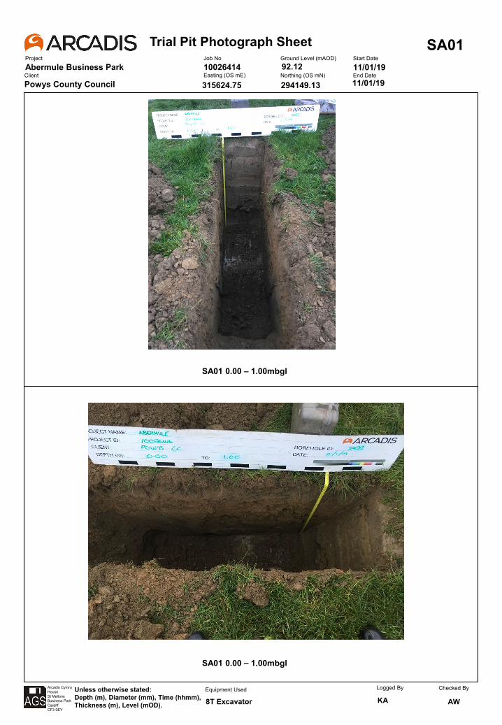

Trial Pit Photograph SheetProject
Abermule Business Park
SA01Job No
10026414Ground Level (mAOD) Start Date
11/01/19Client
Powys County CouncilEasting (OS mE) Northing (OS mN) End Date
Arcadis CymruHouseSt MellonsBusiness ParkCardiffCF3 0EY
Unless otherwise stated:Depth (m), Diameter (mm), Time (hhmm), Thickness (m), Level (mOD).
Equipment Used Logged By
KAChecked By
AW
11/01/19
8T Excavator
315624.75
92.12
294149.13
SA01 Reinstatement
Intentionally Left Blank
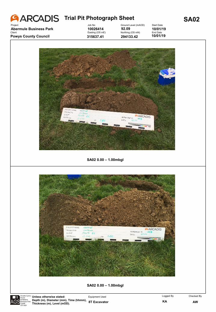
Trial Pit Photograph SheetProject
Abermule Business Park
SA02Job No
10026414Ground Level (mAOD) Start Date
10/01/19Client
Powys County CouncilEasting (OS mE) Northing (OS mN) End Date
Arcadis CymruHouseSt MellonsBusiness ParkCardiffCF3 0EY
Unless otherwise stated:Depth (m), Diameter (mm), Time (hhmm), Thickness (m), Level (mOD).
Equipment Used Logged By
KAChecked By
AW
10/01/19
8T Excavator
315637.41
92.09
294133.42
SA02 0.00 – 1.00mbgl
SA02 0.00 – 1.00mbgl
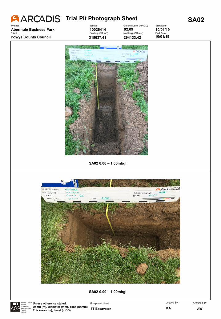
Trial Pit Photograph SheetProject
Abermule Business Park
SA02Job No
10026414Ground Level (mAOD) Start Date
10/01/19Client
Powys County CouncilEasting (OS mE) Northing (OS mN) End Date
Arcadis CymruHouseSt MellonsBusiness ParkCardiffCF3 0EY
Unless otherwise stated:Depth (m), Diameter (mm), Time (hhmm), Thickness (m), Level (mOD).
Equipment Used Logged By
KAChecked By
AW
10/01/19
8T Excavator
315637.41
92.09
294133.42
SA02 Reinstatement
Intentionally Left Blank
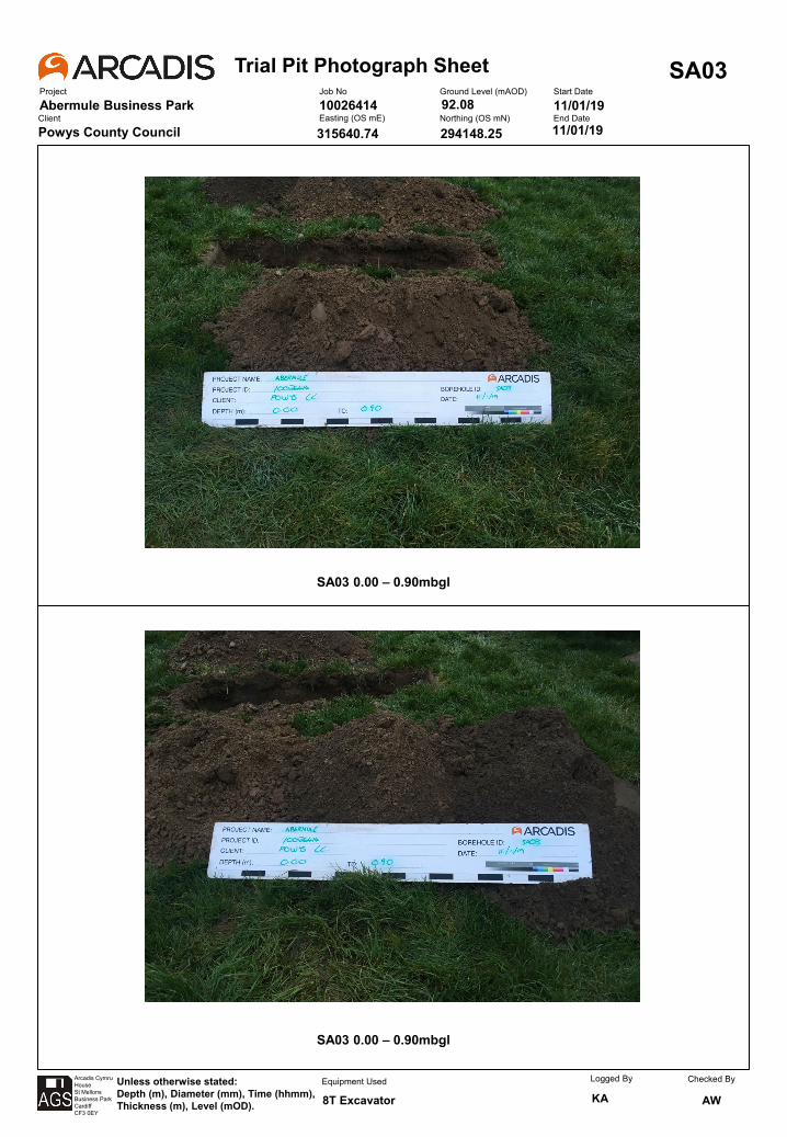
Trial Pit Photograph SheetProject
Abermule Business Park
SA03Job No
10026414Ground Level (mAOD) Start Date
11/01/19Client
Powys County CouncilEasting (OS mE) Northing (OS mN) End Date
Arcadis CymruHouseSt MellonsBusiness ParkCardiffCF3 0EY
Unless otherwise stated:Depth (m), Diameter (mm), Time (hhmm), Thickness (m), Level (mOD).
Equipment Used Logged By
KAChecked By
AW
11/01/19
8T Excavator
315640.74
92.08
294148.25
SA03 0.00 – 0.90mbgl
SA03 0.00 – 0.90mbgl
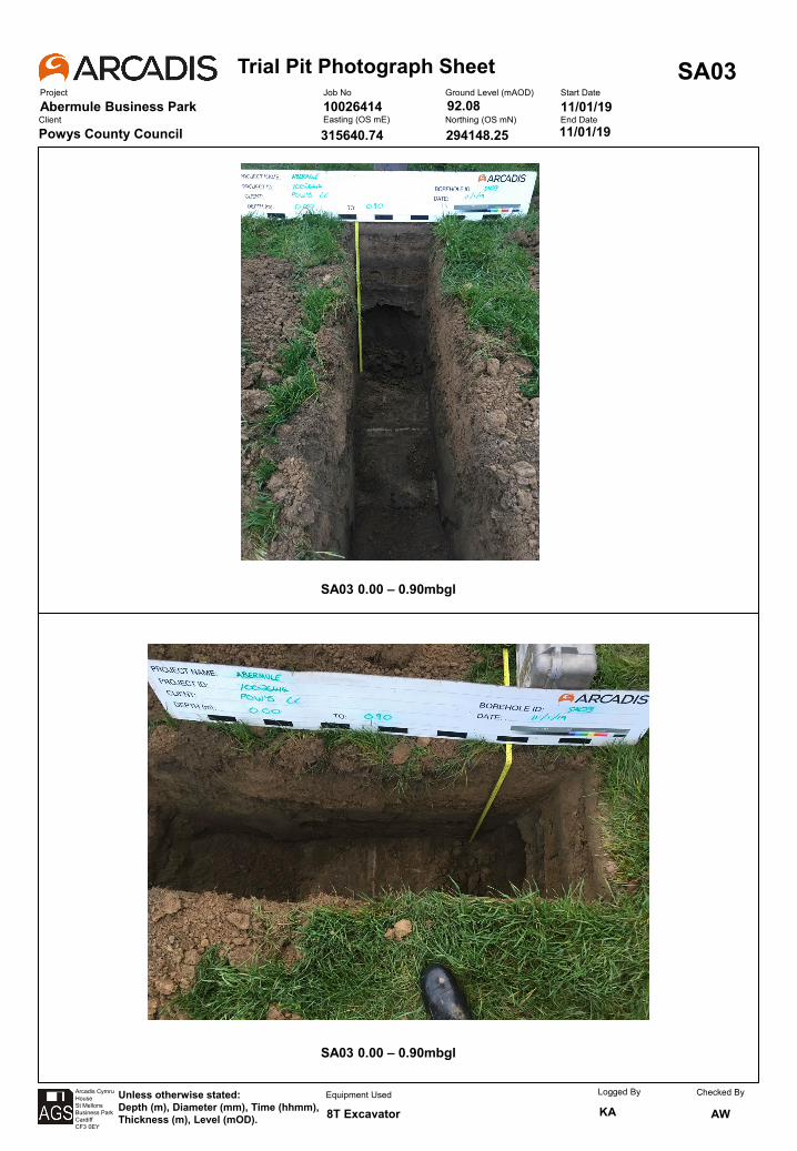
Trial Pit Photograph SheetProject
Abermule Business Park
SA03Job No
10026414Ground Level (mAOD) Start Date
11/01/19Client
Powys County CouncilEasting (OS mE) Northing (OS mN) End Date
Arcadis CymruHouseSt MellonsBusiness ParkCardiffCF3 0EY
Unless otherwise stated:Depth (m), Diameter (mm), Time (hhmm), Thickness (m), Level (mOD).
Equipment Used Logged By
KAChecked By
AW
11/01/19
8T Excavator
315640.74
92.08
294148.25
SA03 Reinstatement
Intentionally Left Blank
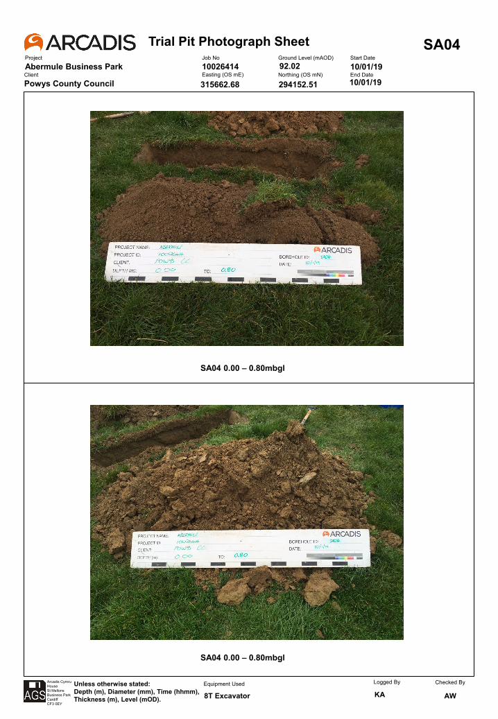
Trial Pit Photograph SheetProject
Abermule Business Park
SA04Job No
10026414Ground Level (mAOD) Start Date
10/01/19Client
Powys County CouncilEasting (OS mE) Northing (OS mN) End Date
Arcadis CymruHouseSt MellonsBusiness ParkCardiffCF3 0EY
Unless otherwise stated:Depth (m), Diameter (mm), Time (hhmm), Thickness (m), Level (mOD).
Equipment Used Logged By
KAChecked By
AW
10/01/19
8T Excavator
315662.68
92.02
294152.51
SA04 0.00 – 0.80mbgl
SA04 0.00 – 0.80mbgl
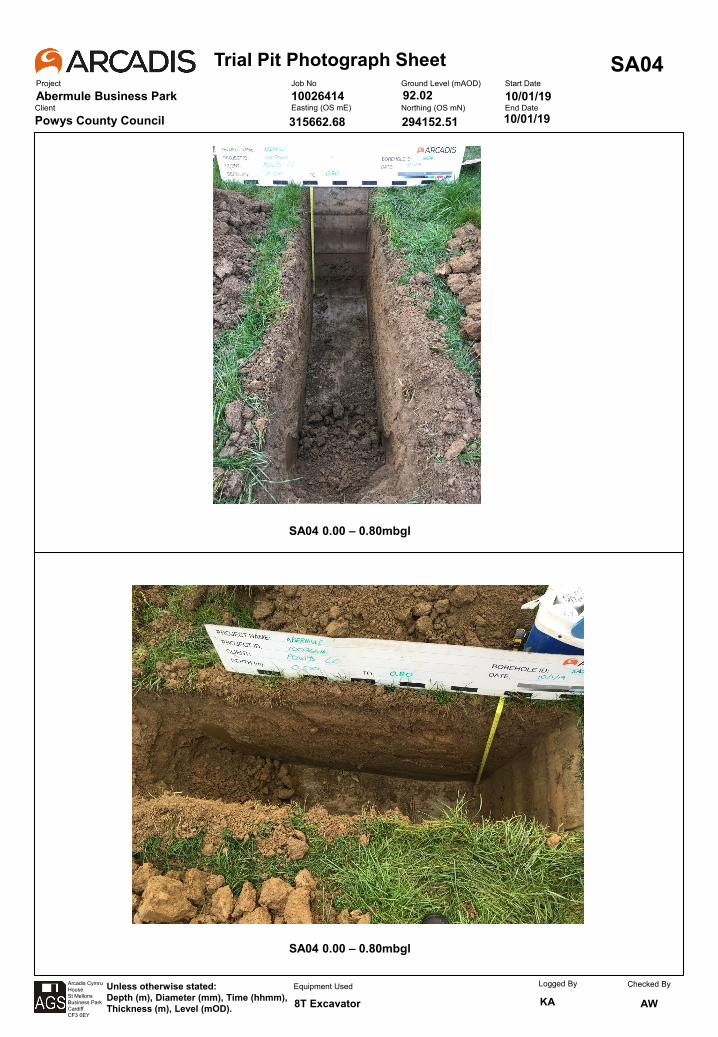

Trial Pit Photograph SheetProject
Abermule Business Park
SA04Job No
10026414Ground Level (mAOD) Start Date
10/01/19Client
Powys County CouncilEasting (OS mE) Northing (OS mN) End Date
Arcadis CymruHouseSt MellonsBusiness ParkCardiffCF3 0EY
Unless otherwise stated:Depth (m), Diameter (mm), Time (hhmm), Thickness (m), Level (mOD).
Equipment Used Logged By
KAChecked By
AW
10/01/19
8T Excavator
315662.68
92.02
294152.51
SA04 Reinstatement
Intentionally Left Blank
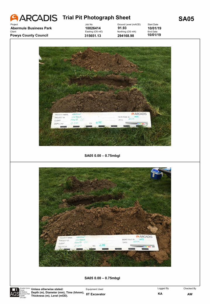
Trial Pit Photograph SheetProject
Abermule Business Park
SA05Job No
10026414Ground Level (mAOD) Start Date
10/01/19Client
Powys County CouncilEasting (OS mE) Northing (OS mN) End Date
Arcadis CymruHouseSt MellonsBusiness ParkCardiffCF3 0EY
Unless otherwise stated:Depth (m), Diameter (mm), Time (hhmm), Thickness (m), Level (mOD).
Equipment Used Logged By
KAChecked By
AW
10/01/19
8T Excavator
315651.13
91.93
294168.98
SA05 0.00 – 0.75mbgl
SA05 0.00 – 0.75mbgl
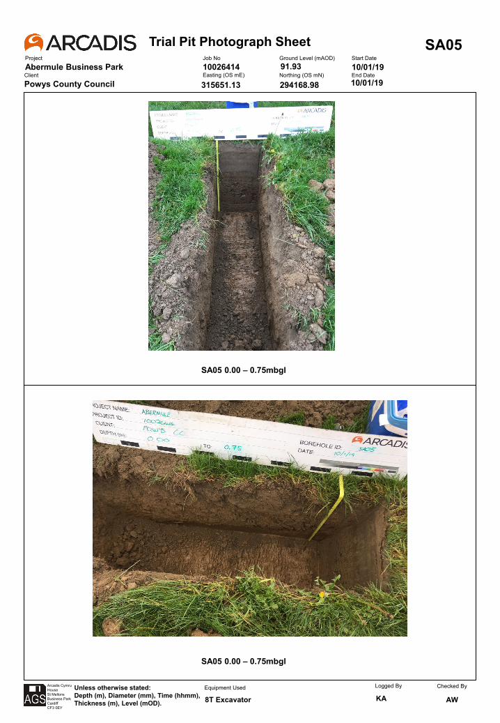
Trial Pit Photograph SheetProject
Abermule Business Park
SA05Job No
10026414Ground Level (mAOD) Start Date
10/01/19Client
Powys County CouncilEasting (OS mE) Northing (OS mN) End Date
Arcadis CymruHouseSt MellonsBusiness ParkCardiffCF3 0EY
Unless otherwise stated:Depth (m), Diameter (mm), Time (hhmm), Thickness (m), Level (mOD).
Equipment Used Logged By
KAChecked By
AW
10/01/19
8T Excavator
315651.13
91.93
294168.98
SA05 Reinstatement
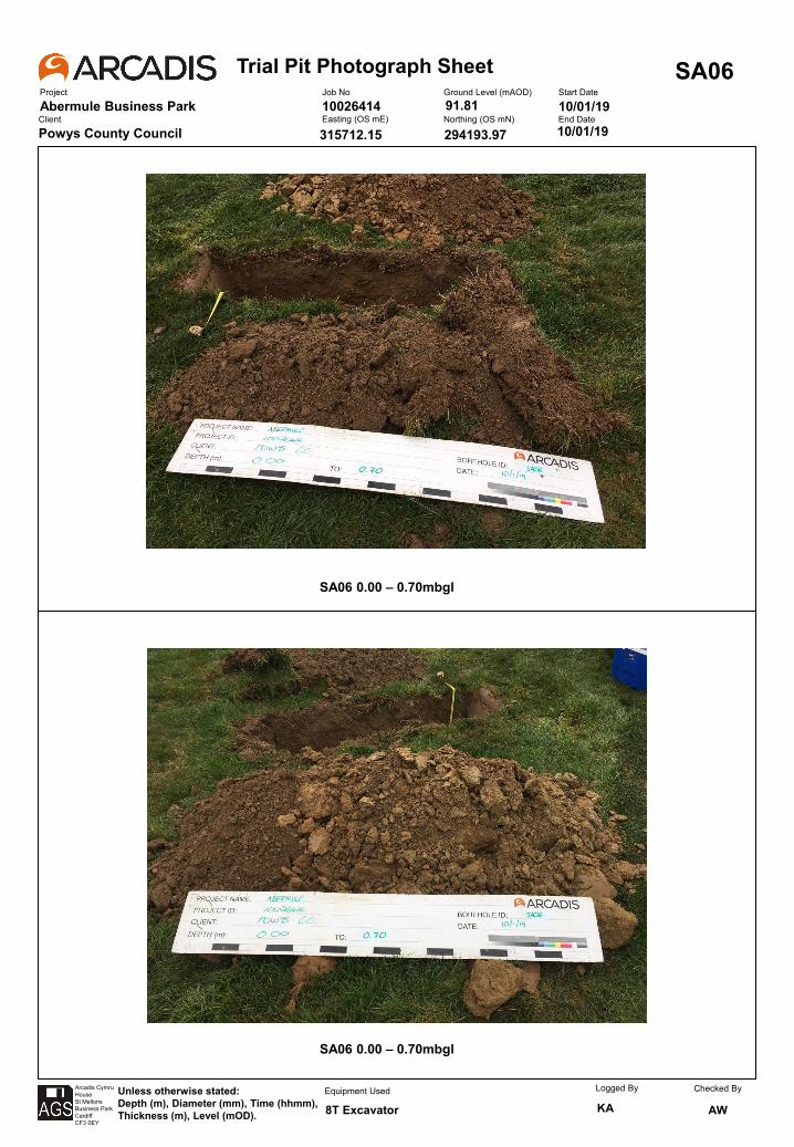
Trial Pit Photograph SheetProject
Abermule Business Park
SA06Job No
10026414Ground Level (mAOD) Start Date
10/01/19Client
Powys County CouncilEasting (OS mE) Northing (OS mN) End Date
Arcadis CymruHouseSt MellonsBusiness ParkCardiffCF3 0EY
Unless otherwise stated:Depth (m), Diameter (mm), Time (hhmm), Thickness (m), Level (mOD).
Equipment Used Logged By
KAChecked By
AW
10/01/19
8T Excavator
315712.15
91.81
294193.97
SA06 0.00 – 0.70mbgl
SA06 0.00 – 0.70mbgl
Trial Pit Photograph SheetProject
Abermule Business Park
SA06Job No
10026414Ground Level (mAOD) Start Date
10/01/19Client
Powys County CouncilEasting (OS mE) Northing (OS mN) End Date
Arcadis CymruHouseSt MellonsBusiness ParkCardiffCF3 0EY
Unless otherwise stated:Depth (m), Diameter (mm), Time (hhmm), Thickness (m), Level (mOD).
Equipment Used Logged By
KAChecked By
AW
10/01/19
8T Excavator
315712.15
91.81
294193.97
SA06 Reinstatement
Trial Pit Photograph SheetProject
Abermule Business Park
SA07Job No
10026414Ground Level (mAOD) Start Date
09/01/19Client
Powys County CouncilEasting (OS mE) Northing (OS mN) End Date
Arcadis CymruHouseSt MellonsBusiness ParkCardiffCF3 0EY
Unless otherwise stated:Depth (m), Diameter (mm), Time (hhmm), Thickness (m), Level (mOD).
Equipment Used Logged By
KAChecked By
AW
09/01/19
8T Excavator
315750.15
92.15
294218.77
SA07 0.00 – 0.95mbgl
SA07 0.00 – 0.95mbgl

Trial Pit Photograph SheetProject
Abermule Business Park
SA07Job No
10026414Ground Level (mAOD) Start Date
09/01/19Client
Powys County CouncilEasting (OS mE) Northing (OS mN) End Date
Arcadis CymruHouseSt MellonsBusiness ParkCardiffCF3 0EY
Unless otherwise stated:Depth (m), Diameter (mm), Time (hhmm), Thickness (m), Level (mOD).
Equipment Used Logged By
KAChecked By
AW
09/01/19
8T Excavator
315750.15
92.15
294218.77
SA07 Reinstatement
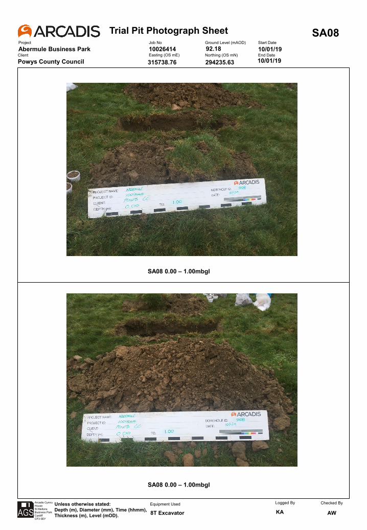
Trial Pit Photograph SheetProject
Abermule Business Park
SA08Job No
10026414Ground Level (mAOD) Start Date
10/01/19Client
Powys County CouncilEasting (OS mE) Northing (OS mN) End Date
Arcadis CymruHouseSt MellonsBusiness ParkCardiffCF3 0EY
Unless otherwise stated:Depth (m), Diameter (mm), Time (hhmm), Thickness (m), Level (mOD).
Equipment Used Logged By
KAChecked By
AW
10/01/19
8T Excavator
315738.76
92.18
294235.63
SA08 0.00 – 1.00mbgl
SA08 0.00 – 1.00mbgl
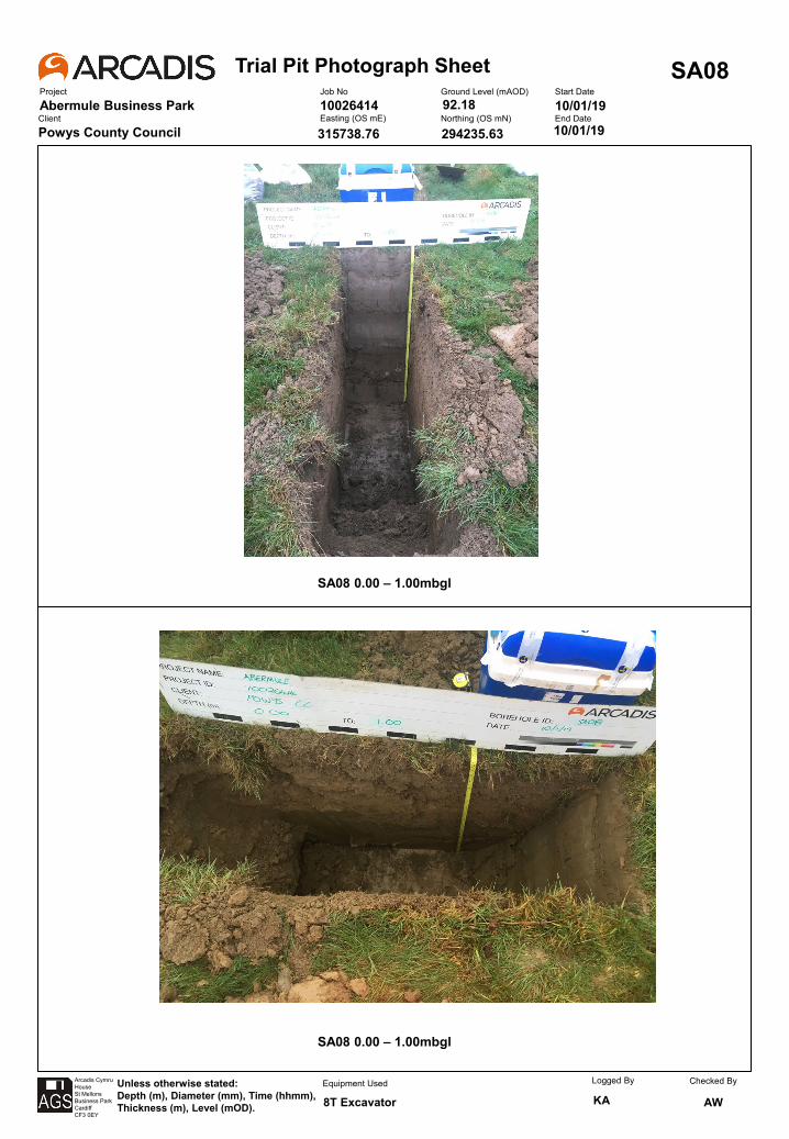
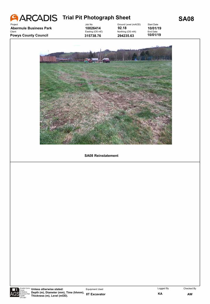
Trial Pit Photograph SheetProject
Abermule Business Park
SA08Job No
10026414Ground Level (mAOD) Start Date
10/01/19Client
Powys County CouncilEasting (OS mE) Northing (OS mN) End Date
Arcadis CymruHouseSt MellonsBusiness ParkCardiffCF3 0EY
Unless otherwise stated:Depth (m), Diameter (mm), Time (hhmm), Thickness (m), Level (mOD).
Equipment Used Logged By
KAChecked By
AW
10/01/19
8T Excavator
315738.76
92.18
294235.63
SA08 Reinstatement

Trial Pit Photograph SheetProject
Abermule Business Park
SA09Job No
10026414Ground Level (mAOD) Start Date
09/01/19Client
Powys County CouncilEasting (OS mE) Northing (OS mN) End Date
Arcadis CymruHouseSt MellonsBusiness ParkCardiffCF3 0EY
Unless otherwise stated:Depth (m), Diameter (mm), Time (hhmm), Thickness (m), Level (mOD).
Equipment Used Logged By
KAChecked By
AW
09/01/19
8T Excavator
315756.98
92.34
294236.24
SA09 0.00 – 1.10mbgl
SA09 0.00 – 1.10mbgl
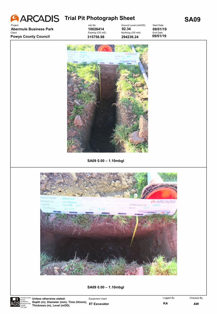
Trial Pit Photograph SheetProject
Abermule Business Park
SA09Job No
10026414Ground Level (mAOD) Start Date
09/01/19Client
Powys County CouncilEasting (OS mE) Northing (OS mN) End Date
Arcadis CymruHouseSt MellonsBusiness ParkCardiffCF3 0EY
Unless otherwise stated:Depth (m), Diameter (mm), Time (hhmm), Thickness (m), Level (mOD).
Equipment Used Logged By
KAChecked By
AW
09/01/19
8T Excavator
315756.98
92.34
294236.24
SA09 Reinstatement

Trial Pit Photograph SheetProject
Abermule Business Park
SA10Job No
10026414Ground Level (mAOD) Start Date
09/01/19Client
Powys County CouncilEasting (OS mE) Northing (OS mN) End Date
Arcadis CymruHouseSt MellonsBusiness ParkCardiffCF3 0EY
Unless otherwise stated:Depth (m), Diameter (mm), Time (hhmm), Thickness (m), Level (mOD).
Equipment Used Logged By
KAChecked By
AW
09/01/19
8T Excavator
315776.01
92.41
294238.61
SA10 0.00 – 1.20mbgl
SA10 0.00 – 1.20mbgl

Trial Pit Photograph SheetProject
Abermule Business Park
SA10Job No
10026414Ground Level (mAOD) Start Date
09/01/19Client
Powys County CouncilEasting (OS mE) Northing (OS mN) End Date
Arcadis CymruHouseSt MellonsBusiness ParkCardiffCF3 0EY
Unless otherwise stated:Depth (m), Diameter (mm), Time (hhmm), Thickness (m), Level (mOD).
Equipment Used Logged By
KAChecked By
AW
09/01/19
8T Excavator
315776.01
92.41
294238.61
SA10 Reinstatement
Trial Pit Photograph SheetProject
Abermule Business Park
SA11Job No
10026414Ground Level (mAOD) Start Date
09/01/19Client
Powys County CouncilEasting (OS mE) Northing (OS mN) End Date
Arcadis CymruHouseSt MellonsBusiness ParkCardiffCF3 0EY
Unless otherwise stated:Depth (m), Diameter (mm), Time (hhmm), Thickness (m), Level (mOD).
Equipment Used Logged By
KAChecked By
AW
09/01/19
8T Excavator
315763.84
92.18
294251.89
SA11 0.00 – 1.00mbgl
SA11 0.00 – 1.00mbgl
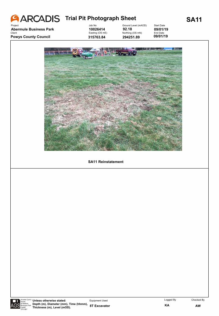
Trial Pit Photograph SheetProject
Abermule Business Park
SA11Job No
10026414Ground Level (mAOD) Start Date
09/01/19Client
Powys County CouncilEasting (OS mE) Northing (OS mN) End Date
Arcadis CymruHouseSt MellonsBusiness ParkCardiffCF3 0EY
Unless otherwise stated:Depth (m), Diameter (mm), Time (hhmm), Thickness (m), Level (mOD).
Equipment Used Logged By
KAChecked By
AW
09/01/19
8T Excavator
315763.84
92.18
294251.89
SA11 Reinstatement
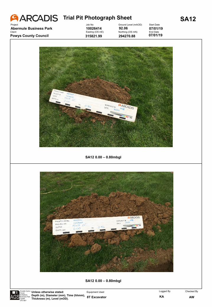
Trial Pit Photograph SheetProject
Abermule Business Park
SA12Job No
10026414Ground Level (mAOD) Start Date
07/01/19Client
Powys County CouncilEasting (OS mE) Northing (OS mN) End Date
Arcadis CymruHouseSt MellonsBusiness ParkCardiffCF3 0EY
Unless otherwise stated:Depth (m), Diameter (mm), Time (hhmm), Thickness (m), Level (mOD).
Equipment Used Logged By
KAChecked By
AW
07/01/19
8T Excavator
315821.99
92.06
294270.88
SA12 0.00 – 0.80mbgl
SA12 0.00 – 0.80mbgl
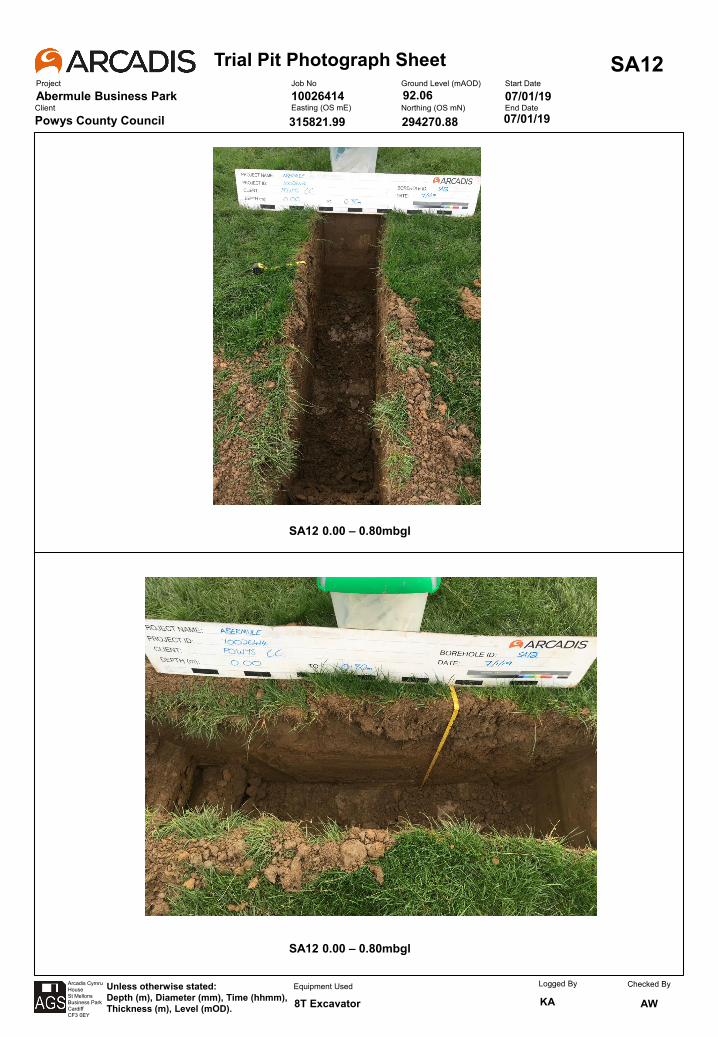
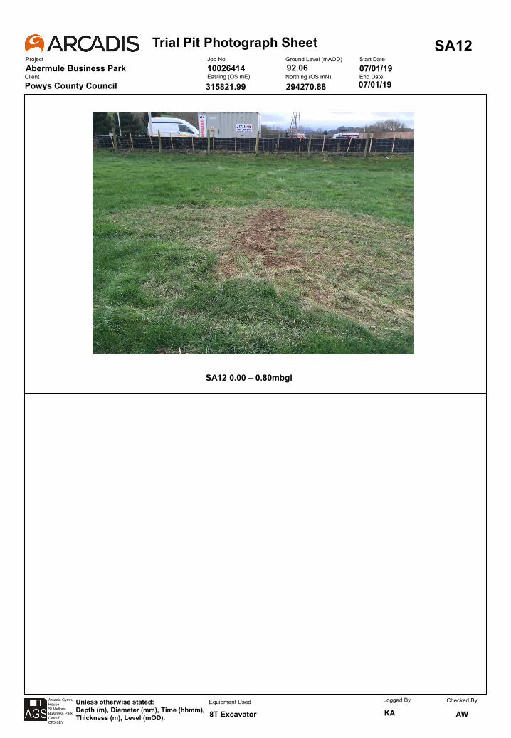
Trial Pit Photograph SheetProject
Abermule Business Park
SA12Job No
10026414Ground Level (mAOD) Start Date
07/01/19Client
Powys County CouncilEasting (OS mE) Northing (OS mN) End Date
Arcadis CymruHouseSt MellonsBusiness ParkCardiffCF3 0EY
Unless otherwise stated:Depth (m), Diameter (mm), Time (hhmm), Thickness (m), Level (mOD).
Equipment Used Logged By
KAChecked By
AW
07/01/19
8T Excavator
315821.99
92.06
294270.88
SA12 0.00 – 0.80mbgl

Trial Pit Photograph SheetProject
Abermule Business Park
SA13Job No
10026414Ground Level (mAOD) Start Date
07/01/19Client
Powys County CouncilEasting (OS mE) Northing (OS mN) End Date
Arcadis CymruHouseSt MellonsBusiness ParkCardiffCF3 0EY
Unless otherwise stated:Depth (m), Diameter (mm), Time (hhmm), Thickness (m), Level (mOD).
Equipment Used Logged By
KAChecked By
AW
07/01/19
8T Excavator
315834.10
92.01
294292.49
SA13 0.00 – 0.80mbgl
SA13 0.00 – 0.80mbgl
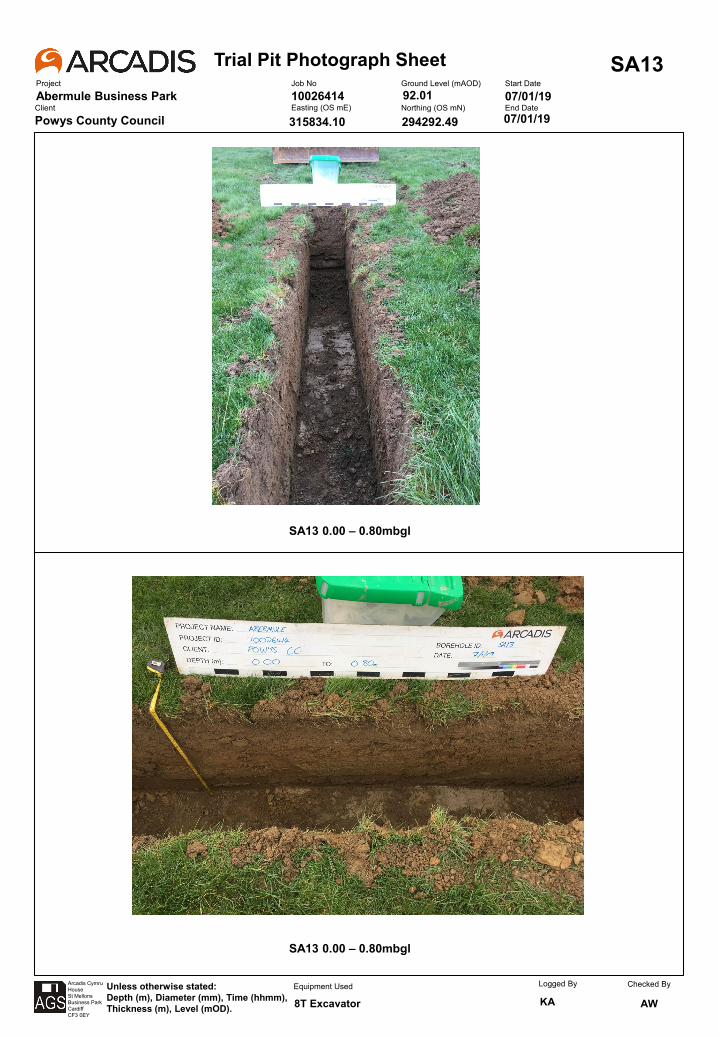
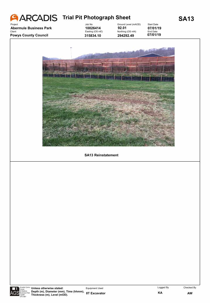
Trial Pit Photograph SheetProject
Abermule Business Park
SA13Job No
10026414Ground Level (mAOD) Start Date
07/01/19Client
Powys County CouncilEasting (OS mE) Northing (OS mN) End Date
Arcadis CymruHouseSt MellonsBusiness ParkCardiffCF3 0EY
Unless otherwise stated:Depth (m), Diameter (mm), Time (hhmm), Thickness (m), Level (mOD).
Equipment Used Logged By
KAChecked By
AW
07/01/19
8T Excavator
315834.10
92.01
294292.49
SA13 Reinstatement
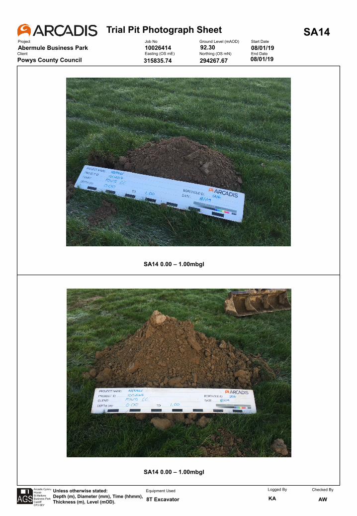
Trial Pit Photograph SheetProject
Abermule Business Park
SA14Job No
10026414Ground Level (mAOD) Start Date
08/01/19Client
Powys County CouncilEasting (OS mE) Northing (OS mN) End Date
Arcadis CymruHouseSt MellonsBusiness ParkCardiffCF3 0EY
Unless otherwise stated:Depth (m), Diameter (mm), Time (hhmm), Thickness (m), Level (mOD).
Equipment Used Logged By
KAChecked By
AW
08/01/19
8T Excavator
315835.74
92.30
294267.67
SA14 0.00 – 1.00mbgl
SA14 0.00 – 1.00mbgl
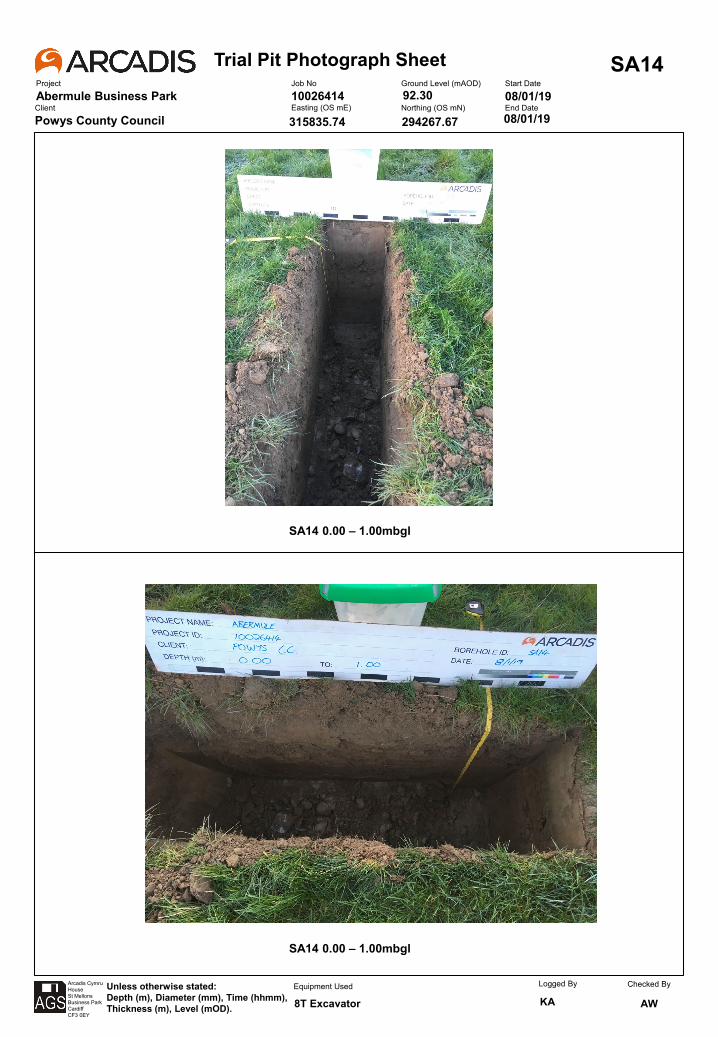
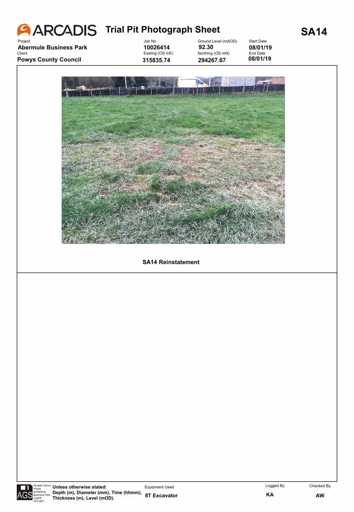
Trial Pit Photograph SheetProject
Abermule Business Park
SA14Job No
10026414Ground Level (mAOD) Start Date
08/01/19Client
Powys County CouncilEasting (OS mE) Northing (OS mN) End Date
Arcadis CymruHouseSt MellonsBusiness ParkCardiffCF3 0EY
Unless otherwise stated:Depth (m), Diameter (mm), Time (hhmm), Thickness (m), Level (mOD).
Equipment Used Logged By
KAChecked By
AW
08/01/19
8T Excavator
315835.74
92.30
294267.67
SA14 Reinstatement
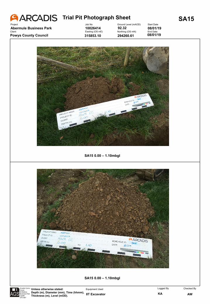
Trial Pit Photograph SheetProject
Abermule Business Park
SA15Job No
10026414Ground Level (mAOD) Start Date
08/01/19Client
Powys County CouncilEasting (OS mE) Northing (OS mN) End Date
Arcadis CymruHouseSt MellonsBusiness ParkCardiffCF3 0EY
Unless otherwise stated:Depth (m), Diameter (mm), Time (hhmm), Thickness (m), Level (mOD).
Equipment Used Logged By
KAChecked By
AW
08/01/19
8T Excavator
315853.10
92.32
294260.61
SA15 0.00 – 1.10mbgl
SA15 0.00 – 1.10mbgl
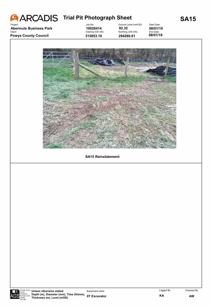
Trial Pit Photograph SheetProject
Abermule Business Park
SA15Job No
10026414Ground Level (mAOD) Start Date
08/01/19Client
Powys County CouncilEasting (OS mE) Northing (OS mN) End Date
Arcadis CymruHouseSt MellonsBusiness ParkCardiffCF3 0EY
Unless otherwise stated:Depth (m), Diameter (mm), Time (hhmm), Thickness (m), Level (mOD).
Equipment Used Logged By
KAChecked By
AW
08/01/19
8T Excavator
315853.10
92.32
294260.61
SA15 Reinstatement
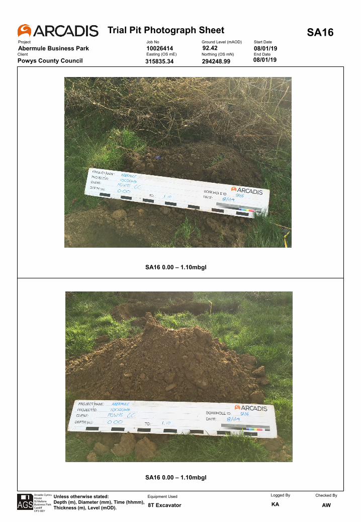
Trial Pit Photograph SheetProject
Abermule Business Park
SA16Job No
10026414Ground Level (mAOD) Start Date
08/01/19Client
Powys County CouncilEasting (OS mE) Northing (OS mN) End Date
Arcadis CymruHouseSt MellonsBusiness ParkCardiffCF3 0EY
Unless otherwise stated:Depth (m), Diameter (mm), Time (hhmm), Thickness (m), Level (mOD).
Equipment Used Logged By
KAChecked By
AW
08/01/19
8T Excavator
315835.34
92.42
294248.99
SA16 0.00 – 1.10mbgl
SA16 0.00 – 1.10mbgl
Trial Pit Photograph SheetProject
Abermule Business Park
SA16Job No
10026414Ground Level (mAOD) Start Date
08/01/19Client
Powys County CouncilEasting (OS mE) Northing (OS mN) End Date
Arcadis CymruHouseSt MellonsBusiness ParkCardiffCF3 0EY
Unless otherwise stated:Depth (m), Diameter (mm), Time (hhmm), Thickness (m), Level (mOD).
Equipment Used Logged By
KAChecked By
AW
08/01/19
8T Excavator
315835.34
92.42
294248.99
SA16 Reinstatement
Trial Pit Photograph SheetProject
Abermule Business Park
TP101Job No
10026414Ground Level (mAOD) Start Date
14/01/19Client
Powys County CouncilEasting (OS mE) Northing (OS mN) End Date
Arcadis CymruHouseSt MellonsBusiness ParkCardiffCF3 0EY
Unless otherwise stated:Depth (m), Diameter (mm), Time (hhmm), Thickness (m), Level (mOD).
Equipment Used Logged By
KAChecked By
AW
14/01/19
8T Excavator
315543.921
91.822
294055.333
TP101 0.00 – 1.00mbgl
TP101 0.00 – 1.00mbgl
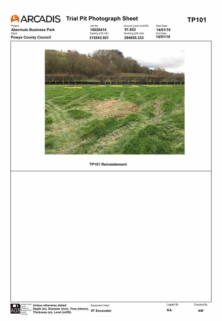
Trial Pit Photograph SheetProject
Abermule Business Park
TP101Job No
10026414Ground Level (mAOD) Start Date
14/01/19Client
Powys County CouncilEasting (OS mE) Northing (OS mN) End Date
Arcadis CymruHouseSt MellonsBusiness ParkCardiffCF3 0EY
Unless otherwise stated:Depth (m), Diameter (mm), Time (hhmm), Thickness (m), Level (mOD).
Equipment Used Logged By
KAChecked By
AW
14/01/19
8T Excavator
315543.921
91.822
294055.333
TP101 Reinstatement
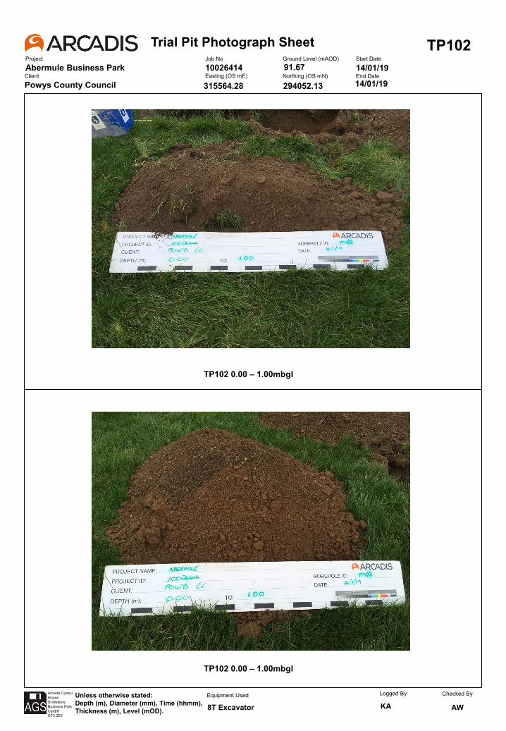
Trial Pit Photograph SheetProject
Abermule Business Park
TP102Job No
10026414Ground Level (mAOD) Start Date
14/01/19Client
Powys County CouncilEasting (OS mE) Northing (OS mN) End Date
Arcadis CymruHouseSt MellonsBusiness ParkCardiffCF3 0EY
Unless otherwise stated:Depth (m), Diameter (mm), Time (hhmm), Thickness (m), Level (mOD).
Equipment Used Logged By
KAChecked By
AW
14/01/19
8T Excavator
315564.28
91.67
294052.13
TP102 0.00 – 1.00mbgl
TP102 0.00 – 1.00mbgl
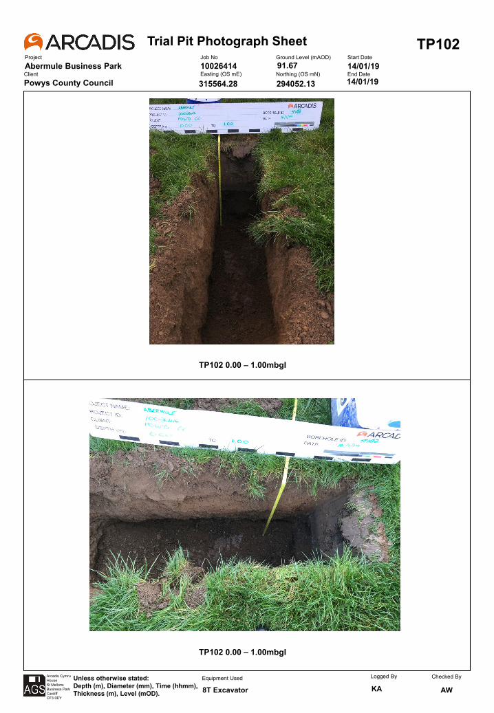
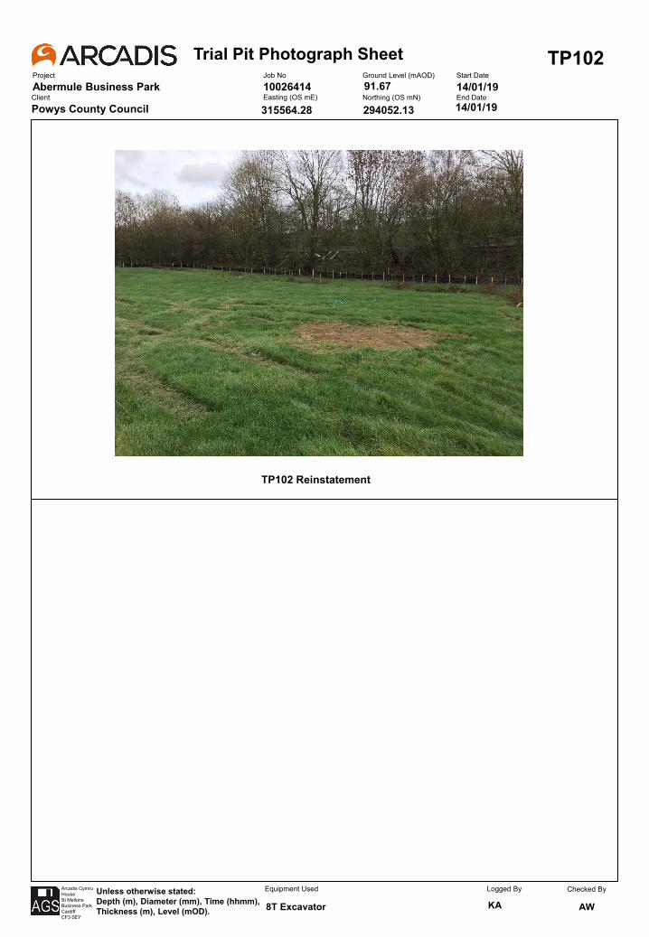
Trial Pit Photograph SheetProject
Abermule Business Park
TP102Job No
10026414Ground Level (mAOD) Start Date
14/01/19Client
Powys County CouncilEasting (OS mE) Northing (OS mN) End Date
Arcadis CymruHouseSt MellonsBusiness ParkCardiffCF3 0EY
Unless otherwise stated:Depth (m), Diameter (mm), Time (hhmm), Thickness (m), Level (mOD).
Equipment Used Logged By
KAChecked By
AW
14/01/19
8T Excavator
315564.28
91.67
294052.13
TP102 Reinstatement
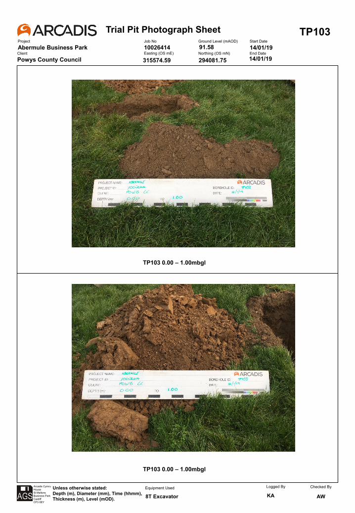
Trial Pit Photograph SheetProject
Abermule Business Park
TP103Job No
10026414Ground Level (mAOD) Start Date
14/01/19Client
Powys County CouncilEasting (OS mE) Northing (OS mN) End Date
Arcadis CymruHouseSt MellonsBusiness ParkCardiffCF3 0EY
Unless otherwise stated:Depth (m), Diameter (mm), Time (hhmm), Thickness (m), Level (mOD).
Equipment Used Logged By
KAChecked By
AW
14/01/19
8T Excavator
315574.59
91.58
294081.75
TP103 0.00 – 1.00mbgl
TP103 0.00 – 1.00mbgl
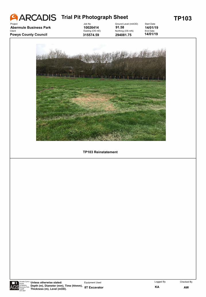
Trial Pit Photograph SheetProject
Abermule Business Park
TP103Job No
10026414Ground Level (mAOD) Start Date
14/01/19Client
Powys County CouncilEasting (OS mE) Northing (OS mN) End Date
Arcadis CymruHouseSt MellonsBusiness ParkCardiffCF3 0EY
Unless otherwise stated:Depth (m), Diameter (mm), Time (hhmm), Thickness (m), Level (mOD).
Equipment Used Logged By
KAChecked By
AW
14/01/19
8T Excavator
315574.59
91.58
294081.75
TP103 Reinstatement
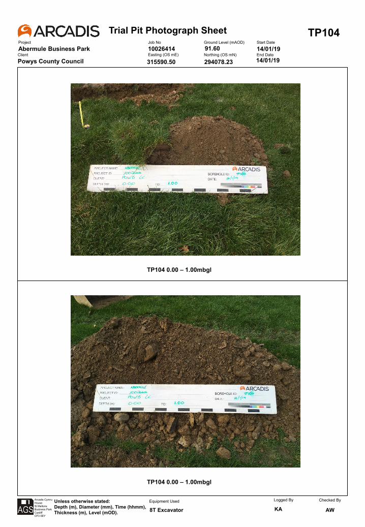
Trial Pit Photograph SheetProject
Abermule Business Park
TP104Job No
10026414Ground Level (mAOD) Start Date
14/01/19Client
Powys County CouncilEasting (OS mE) Northing (OS mN) End Date
Arcadis CymruHouseSt MellonsBusiness ParkCardiffCF3 0EY
Unless otherwise stated:Depth (m), Diameter (mm), Time (hhmm), Thickness (m), Level (mOD).
Equipment Used Logged By
KAChecked By
AW
14/01/19
8T Excavator
315590.50
91.60
294078.23
TP104 0.00 – 1.00mbgl
TP104 0.00 – 1.00mbgl
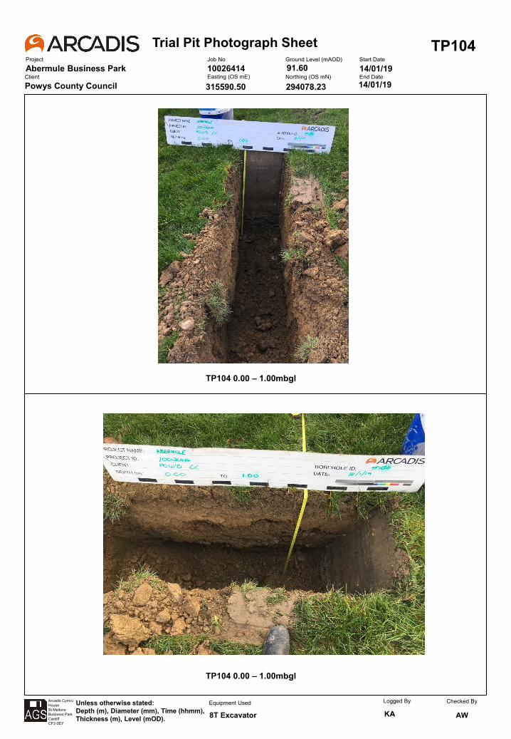
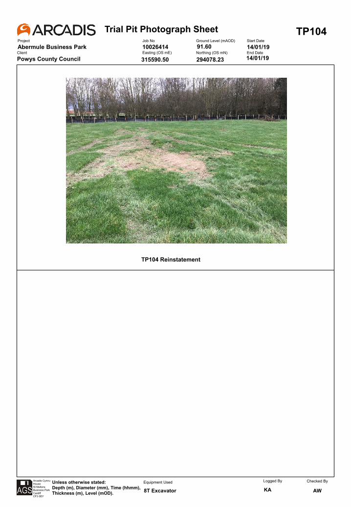
Trial Pit Photograph SheetProject
Abermule Business Park
TP104Job No
10026414Ground Level (mAOD) Start Date
14/01/19Client
Powys County CouncilEasting (OS mE) Northing (OS mN) End Date
Arcadis CymruHouseSt MellonsBusiness ParkCardiffCF3 0EY
Unless otherwise stated:Depth (m), Diameter (mm), Time (hhmm), Thickness (m), Level (mOD).
Equipment Used Logged By
KAChecked By
AW
14/01/19
8T Excavator
315590.50
91.60
294078.23
TP104 Reinstatement
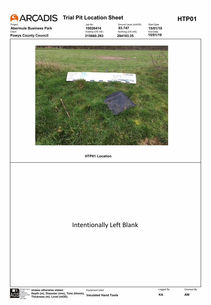
Trial Pit Location SheetProject
Abermule Business Park
HTP01Job No
10026414Ground Level (mAOD) Start Date
15/01/19Client
Powys County CouncilEasting (OS mE) Northing (OS mN) End Date
Arcadis CymruHouseSt MellonsBusiness ParkCardiffCF3 0EY
Unless otherwise stated:Depth (m), Diameter (mm), Time (hhmm), Thickness (m), Level (mOD).
Equipment Used Logged By
KAChecked By
AW
15/01/19
Insulated Hand Tools
315660.283
93.747
294193.35
HTP01 Location
Intentionally Left Blank
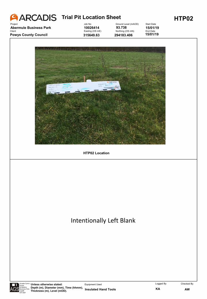
Trial Pit Location SheetProject
Abermule Business Park
HTP02Job No
10026414Ground Level (mAOD) Start Date
15/01/19Client
Powys County CouncilEasting (OS mE) Northing (OS mN) End Date
Arcadis CymruHouseSt MellonsBusiness ParkCardiffCF3 0EY
Unless otherwise stated:Depth (m), Diameter (mm), Time (hhmm), Thickness (m), Level (mOD).
Equipment Used Logged By
KAChecked By
AW
15/01/19
Insulated Hand Tools
315649.63
93.738
294183.406
HTP02 Location
Intentionally Left Blank
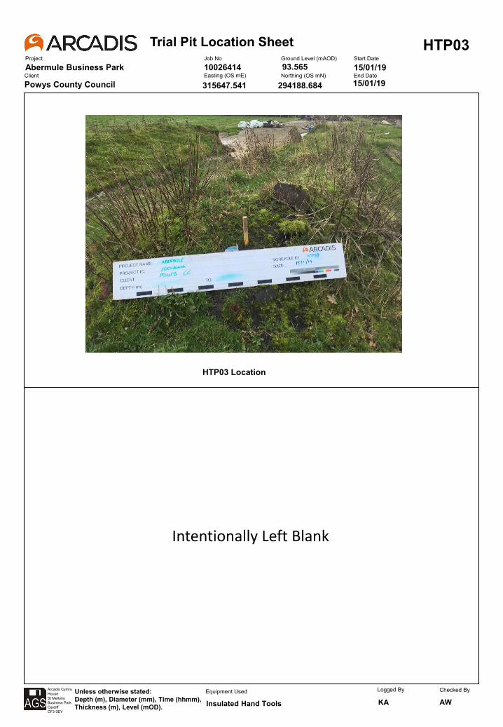
Trial Pit Location SheetProject
Abermule Business Park
HTP03Job No
10026414Ground Level (mAOD) Start Date
15/01/19Client
Powys County CouncilEasting (OS mE) Northing (OS mN) End Date
Arcadis CymruHouseSt MellonsBusiness ParkCardiffCF3 0EY
Unless otherwise stated:Depth (m), Diameter (mm), Time (hhmm), Thickness (m), Level (mOD).
Equipment Used Logged By
KAChecked By
AW
15/01/19
Insulated Hand Tools
315647.541
93.565
294188.684
HTP03 Location
Intentionally Left Blank
Trial Pit Location SheetProject
Abermule Business Park
HTP04Job No
10026414Ground Level (mAOD) Start Date
15/01/19Client
Powys County CouncilEasting (OS mE) Northing (OS mN) End Date
Arcadis CymruHouseSt MellonsBusiness ParkCardiffCF3 0EY
Unless otherwise stated:Depth (m), Diameter (mm), Time (hhmm), Thickness (m), Level (mOD).
Equipment Used Logged By
KAChecked By
AW
15/01/19
Insulated Hand Tools
315639.63
93.597
294181.737
HTP04 Location
Intentionally Left Blank

Trial Pit Location SheetProject
Abermule Business Park
HTP05Job No
10026414Ground Level (mAOD) Start Date
15/01/19Client
Powys County CouncilEasting (OS mE) Northing (OS mN) End Date
Arcadis CymruHouseSt MellonsBusiness ParkCardiffCF3 0EY
Unless otherwise stated:Depth (m), Diameter (mm), Time (hhmm), Thickness (m), Level (mOD).
Equipment Used Logged By
KAChecked By
AW
15/01/19
Insulated Hand Tools
315632.196
92.967
294178.628
HTP05 Location
Intentionally Left Blank
Trial Pit Location SheetProject
Abermule Business Park
HTP06Job No
10026414Ground Level (mAOD) Start Date
15/01/19Client
Powys County CouncilEasting (OS mE) Northing (OS mN) End Date
Arcadis CymruHouseSt MellonsBusiness ParkCardiffCF3 0EY
Unless otherwise stated:Depth (m), Diameter (mm), Time (hhmm), Thickness (m), Level (mOD).
Equipment Used Logged By
KAChecked By
AW
15/01/19
Insulated Hand Tools
315617.128
93.215
294160.098
HTP06 Location
Intentionally Left Blank
Trial Pit Location SheetProject
Abermule Business Park
HTP07Job No
10026414Ground Level (mAOD) Start Date
15/01/19Client
Powys County CouncilEasting (OS mE) Northing (OS mN) End Date
Arcadis CymruHouseSt MellonsBusiness ParkCardiffCF3 0EY
Unless otherwise stated:Depth (m), Diameter (mm), Time (hhmm), Thickness (m), Level (mOD).
Equipment Used Logged By
KAChecked By
AW
15/01/19
Insulated Hand Tools
315610.438
92.878
294163.74
HTP07 Location
Intentionally Left Blank
Trial Pit Location SheetProject
Abermule Business Park
HTP08Job No
10026414Ground Level (mAOD) Start Date
15/01/19Client
Powys County CouncilEasting (OS mE) Northing (OS mN) End Date
Arcadis CymruHouseSt MellonsBusiness ParkCardiffCF3 0EY
Unless otherwise stated:Depth (m), Diameter (mm), Time (hhmm), Thickness (m), Level (mOD).
Equipment Used Logged By
KAChecked By
AW
15/01/19
Insulated Hand Tools
315604.188
92.915
294154.771
HTP08 Location
Intentionally Left Blank
Based on BRE DG 365:2016
Project Status
Project ID
Trial Pit DetailsTest 1 Test 2 Test 3 Ground Level mAOD
1.00 mE
0.50 mN
1.80
Test 1Time
min
0 0.36
5 0.57
10 0.79
20 2.88
30 0.39
45 2.6E+01
60 1.5E+02
70 0.995
120
180
Infiltration rate f (ms‐1) Total effective storage depth (esd) (m) 0.86
Test 2Time
min
0
7
15
25
30
40
45
60
90
Infiltration rate f (ms‐1) Total effective storage depth (esd) (m)
Test 3Time
min
0
2
4
6
8
10
15
20
25
30
Infiltration rate f (ms‐1) Total effective storage depth (esd) (m) 0.00
Carried out by Notes: Logged Checked
Arcadis Consulting (UK) Ltd KA 0
NO VALID DATA
Test Parameters
75% esd (mbgl)
50% esd (mbgl)
25% esd (mbgl)
As50 (m2)
Vp75‐25 (m3)
t75 (min)
t25(min)
Test Parameters
75% esd (mbgl)
50% esd (mbgl)
25% esd (mbgl)
As50 (m2)
Vp75‐25 (m3)
t75 (min)
0.85
Test Parameters
1.77E‐05
75% esd (mbgl)
50% esd (mbgl)
25% esd (mbgl)
As50 (m2)
Vp75‐25 (m3)
t75 (min)
t25(min)
NO VALID DATA
t25(min)
Data Fit R2
Data Fit R2
Data Fit R2
Depth to Water
m bgl
Depth to Water
m bgl
Depth
Width
11/01/2019
11/01/2019
294149.13Coordinates
Date Excavated
Date Tested
Depth to Water
m bgl
0.14
0.20
0.25
Length
PRELIMINARY
Water gravity fed through 2" pipe from IBC.
Trial Pit Soakaway Test
SA01Abermule Business Park
10026414
LOCATION ID
0.70
315624.75
92.12
0.32
0.38
0.46
0.51
0.56
0.00
0.10
0.20
0.30
0.40
0.50
0.60
0.70
0.80
0.90
1.00
0 50 100 150 200 250
Water Level m
bgl
Elapsed Time (min)
Test Data
Best Fit Line
75% ESD
25% ESD
0.00
0.10
0.20
0.30
0.40
0.50
0.60
0.70
0.80
0.90
1.00
‐20 0 20 40 60 80 100
Water Level m
bgl
Elapsed Time (min)
Test Data
Best Fit Line
75% ESD
25% ESD
0.00
0.10
0.20
0.30
0.40
0.50
0.60
0.70
0.80
0.90
1.00
‐5 0 5 10 15 20 25 30 35
Water Level m
bgl
Elapsed Time (min)
Test Data
Best Fit Line
75% ESD
25% ESD

Based on BRE DG 365:2016
Project Status
Project ID
Trial Pit DetailsTest 1 Test 2 Test 3 Ground Level mAOD
1.00 mE
0.50 mN
1.70
Test 1Time
min
0 0.25
1 0.50
2 0.75
5 3.05
10 0.43
15 1.6E+02
20 2.2E+03
25 0.998
50
70
Infiltration rate f (ms‐1) Total effective storage depth (esd) (m) 1.00
Test 2Time
min
0
2
5
10
15
20
25
30
35
40
Infiltration rate f (ms‐1) Total effective storage depth (esd) (m)
Test 3Time
min
0
2
4
6
8
10
15
20
25
30
Infiltration rate f (ms‐1) Total effective storage depth (esd) (m) 0.00
Carried out by Notes: Logged Checked
Arcadis Consulting (UK) Ltd KA 0
NO VALID DATA
Test Parameters
75% esd (mbgl)
50% esd (mbgl)
25% esd (mbgl)
As50 (m2)
Vp75‐25 (m3)
t75 (min)
t25(min)
Test Parameters
75% esd (mbgl)
50% esd (mbgl)
25% esd (mbgl)
As50 (m2)
Vp75‐25 (m3)
t75 (min)
0.18
Test Parameters
1.13E‐06
75% esd (mbgl)
50% esd (mbgl)
25% esd (mbgl)
As50 (m2)
Vp75‐25 (m3)
t75 (min)
t25(min)
NO VALID DATA
t25(min)
Data Fit R2
Data Fit R2
Data Fit R2
Depth to Water
m bgl
Depth to Water
m bgl
Depth
Width
10/01/2019
10/01/2019
294133.42Coordinates
Date Excavated
Date Tested
Depth to Water
m bgl
0.00
0.03
0.04
Length
PRELIMINARY
Water gravity fed through 2" pipe from IBC.
Trial Pit Soakaway Test
SA02Abermule Business Park
10026414
LOCATION ID
0.15
315637.41
92.09
0.06
0.08
0.09
0.10
0.11
0.00
0.10
0.20
0.30
0.40
0.50
0.60
0.70
0.80
0 50 100 150 200 250 300
Water Level m
bgl
Elapsed Time (min)
Test Data
Best Fit Line
75% ESD
25% ESD
0.00
0.10
0.20
0.30
0.40
0.50
0.60
0.70
0.80
0.90
1.00
‐10 0 10 20 30 40 50
Water Level m
bgl
Elapsed Time (min)
Test Data
Best Fit Line
75% ESD
25% ESD
0.00
0.10
0.20
0.30
0.40
0.50
0.60
0.70
0.80
0.90
1.00
‐5 0 5 10 15 20 25 30 35
Water Level m
bgl
Elapsed Time (min)
Test Data
Best Fit Line
75% ESD
25% ESD
Based on BRE DG 365:2016
Project Status
Project ID
Trial Pit DetailsTest 1 Test 2 Test 3 Ground Level mAOD
0.90 0.80 mE
0.50 0.50 mN
1.70 1.70
Test 1Time
min
0 0.23
5 0.45
10 0.68
15 2.83
20 0.38
30 9.5E+00
40 5.8E+01
50 0.993
60
75
Infiltration rate f (ms‐1) Total effective storage depth (esd) (m) 0.90
Test 2Time
min
0 0.20
7 0.40
15 0.60
25 2.61
30 0.34
40 1.3E+01
45 6.1E+01
60 0.996
90
Infiltration rate f (ms‐1) Total effective storage depth (esd) (m) 0.80
Test 3Time
min
0
2
4
6
8
10
15
20
25
30
Infiltration rate f (ms‐1) Total effective storage depth (esd) (m) 0.00
Carried out by Notes: Logged Checked
Arcadis Consulting (UK) Ltd KA 0
Length
PRELIMINARY
Water gravity fed through 2" pipe from IBC. Trial pit collapsing following
Trial Pit Soakaway Test
SA03Abermule Business Park
10026414
LOCATION ID
0.69
315640.74
92.08
0.29
0.35
0.47
0.53
0.61
Depth to Water
m bgl
0.00
0.17
0.22
Depth
Width
11/01/2019
11/01/2019
294148.25Coordinates
Date Excavated
Date Tested
Depth to Water
m bgl
0.00
0.11
0.22
0.80
Depth to Water
m bgl
0.30
0.37
0.43
0.48
0.59
0.80
Test Parameters
4.67E‐05
75% esd (mbgl)
50% esd (mbgl)
25% esd (mbgl)
As50 (m2)
Vp75‐25 (m3)
t75 (min)
t25(min)
4.53E‐05
t25(min)
Data Fit R2
Data Fit R2
Data Fit R2
NO VALID DATA
Test Parameters
75% esd (mbgl)
50% esd (mbgl)
25% esd (mbgl)
As50 (m2)
Vp75‐25 (m3)
t75 (min)
t25(min)
Test Parameters
75% esd (mbgl)
50% esd (mbgl)
25% esd (mbgl)
As50 (m2)
Vp75‐25 (m3)
t75 (min)
0.00
0.10
0.20
0.30
0.40
0.50
0.60
0.70
0.80
0.90
0 20 40 60 80
Water Level m
bgl
Elapsed Time (min)
Test Data
Best Fit Line
75% ESD
25% ESD
0.00
0.10
0.20
0.30
0.40
0.50
0.60
0.70
0.80
0.90
0 20 40 60 80 100
Water Level m
bgl
Elapsed Time (min)
Test Data
Best Fit Line
75% ESD
25% ESD
0.00
0.10
0.20
0.30
0.40
0.50
0.60
0.70
0.80
0.90
1.00
‐5 0 5 10 15 20 25 30 35
Water Level m
bgl
Elapsed Time (min)
Test Data
Best Fit Line
75% ESD
25% ESD
Based on BRE DG 365:2016
Project Status
Project ID
Trial Pit DetailsTest 1 Test 2 Test 3 Ground Level mAOD
0.80 mE
0.50 mN
1.80
Test 1Time
min
0 0.24
15 0.43
30 0.61
40 2.63
60 0.34
75 2.8E+02
100 3.0E+03
120 0.990
Infiltration rate f (ms‐1) Total effective storage depth (esd) (m) 0.75
Test 2Time
min
0
2
5
10
15
20
25
30
35
40
Infiltration rate f (ms‐1) Total effective storage depth (esd) (m)
Test 3Time
min
0
2
4
6
8
10
15
20
25
30
Infiltration rate f (ms‐1) Total effective storage depth (esd) (m) 0.00
Carried out by Notes: Logged Checked
Arcadis Consulting (UK) Ltd KA 0
Length
PRELIMINARY
Water gravity fed through 2" pipe from IBC.
Trial Pit Soakaway Test
SA04Abermule Business Park
10026414
LOCATION ID
315662.68
92.02
0.12
0.13
0.14
0.16
0.17
Depth to Water
m bgl
0.05
0.08
0.10
Depth
Width
10/01/2019
10/01/2019
294152.51Coordinates
Date Excavated
Date Tested
Depth to Water
m bgl
Depth to Water
m bgl
Test Parameters
7.94E‐07
75% esd (mbgl)
50% esd (mbgl)
25% esd (mbgl)
As50 (m2)
Vp75‐25 (m3)
t75 (min)
t25(min)
NO VALID DATA
t25(min)
Data Fit R2
Data Fit R2
Data Fit R2
NO VALID DATA
Test Parameters
75% esd (mbgl)
50% esd (mbgl)
25% esd (mbgl)
As50 (m2)
Vp75‐25 (m3)
t75 (min)
t25(min)
Test Parameters
75% esd (mbgl)
50% esd (mbgl)
25% esd (mbgl)
As50 (m2)
Vp75‐25 (m3)
t75 (min)
0.00
0.10
0.20
0.30
0.40
0.50
0.60
0.70
0 50 100 150 200 250 300
Water Level m
bgl
Elapsed Time (min)
Test Data
Best Fit Line
75% ESD
25% ESD
0.00
0.10
0.20
0.30
0.40
0.50
0.60
0.70
0.80
0.90
1.00
‐10 0 10 20 30 40 50
Water Level m
bgl
Elapsed Time (min)
Test Data
Best Fit Line
75% ESD
25% ESD
0.00
0.10
0.20
0.30
0.40
0.50
0.60
0.70
0.80
0.90
1.00
‐5 0 5 10 15 20 25 30 35
Water Level m
bgl
Elapsed Time (min)
Test Data
Best Fit Line
75% ESD
25% ESD
Based on BRE DG 365:2016
Project Status
Project ID
Trial Pit DetailsTest 1 Test 2 Test 3 Ground Level mAOD
0.75 mE
0.50 mN
1.70
Test 1Time
min
0 0.26
20 0.43
30 0.59
45 2.28
60 0.28
70 2.5E+02
90 6.8E+03
105 0.969
130
150
Infiltration rate f (ms‐1) Total effective storage depth (esd) (m) 0.65
Test 2Time
min
0
2
5
10
15
20
25
30
35
40
Infiltration rate f (ms‐1) Total effective storage depth (esd) (m)
Test 3Time
min
0
2
4
6
8
10
15
20
25
30
Infiltration rate f (ms‐1) Total effective storage depth (esd) (m) 0.00
Carried out by Notes: Logged Checked
Arcadis Consulting (UK) Ltd KA 0
Length
PRELIMINARY
Water gravity fed through 2" pipe from IBC.
Trial Pit Soakaway Test
SA05Abermule Business Park
10026414
LOCATION ID
0.22
315651.13
91.93
0.18
0.19
0.19
0.20
0.22
Depth to Water
m bgl
0.10
0.15
0.17
Depth
Width
10/01/2019
10/01/2019
294168.98Coordinates
Date Excavated
Date Tested
Depth to Water
m bgl
Depth to Water
m bgl
0.23
Test Parameters
3.10E‐07
75% esd (mbgl)
50% esd (mbgl)
25% esd (mbgl)
As50 (m2)
Vp75‐25 (m3)
t75 (min)
t25(min)
NO VALID DATA
t25(min)
Data Fit R2
Data Fit R2
Data Fit R2
NO VALID DATA
Test Parameters
75% esd (mbgl)
50% esd (mbgl)
25% esd (mbgl)
As50 (m2)
Vp75‐25 (m3)
t75 (min)
t25(min)
Test Parameters
75% esd (mbgl)
50% esd (mbgl)
25% esd (mbgl)
As50 (m2)
Vp75‐25 (m3)
t75 (min)
0.00
0.10
0.20
0.30
0.40
0.50
0.60
0.70
0 50 100 150 200 250 300
Water Level m
bgl
Elapsed Time (min)
Test Data
Best Fit Line
75% ESD
25% ESD
0.00
0.10
0.20
0.30
0.40
0.50
0.60
0.70
0.80
0.90
1.00
‐10 0 10 20 30 40 50
Water Level m
bgl
Elapsed Time (min)
Test Data
Best Fit Line
75% ESD
25% ESD
0.00
0.10
0.20
0.30
0.40
0.50
0.60
0.70
0.80
0.90
1.00
‐5 0 5 10 15 20 25 30 35
Water Level m
bgl
Elapsed Time (min)
Test Data
Best Fit Line
75% ESD
25% ESD
Based on BRE DG 365:2016
Project Status
Project ID
Trial Pit DetailsTest 1 Test 2 Test 3 Ground Level mAOD
0.70 mE
0.50 mN
1.60
Test 1Time
min
0 0.18
20 0.35
30 0.53
45 2.27
60 0.28
70 2.6E+02
90 4.1E+03
110 0.920
130
Infiltration rate f (ms‐1) Total effective storage depth (esd) (m) 0.70
Test 2Time
min
0
2
5
10
15
20
25
30
35
40
Infiltration rate f (ms‐1) Total effective storage depth (esd) (m)
Test 3Time
min
0
2
4
6
8
10
15
20
25
30
Infiltration rate f (ms‐1) Total effective storage depth (esd) (m) 0.00
Carried out by Notes: Logged Checked
Arcadis Consulting (UK) Ltd KA 0
Length
PRELIMINARY
Water gravity fed through 2" pipe from IBC.
Trial Pit Soakaway Test
SA06Abermule Business Park
10026414
LOCATION ID
0.13
315712.15
91.81
0.09
0.10
0.10
0.11
0.13
Depth to Water
m bgl
0.00
0.05
0.08
Depth
Width
10/01/2019
10/01/2019
294193.97Coordinates
Date Excavated
Date Tested
Depth to Water
m bgl
Depth to Water
m bgl
Test Parameters
5.30E‐07
75% esd (mbgl)
50% esd (mbgl)
25% esd (mbgl)
As50 (m2)
Vp75‐25 (m3)
t75 (min)
t25(min)
NO VALID DATA
t25(min)
Data Fit R2
Data Fit R2
Data Fit R2
NO VALID DATA
Test Parameters
75% esd (mbgl)
50% esd (mbgl)
25% esd (mbgl)
As50 (m2)
Vp75‐25 (m3)
t75 (min)
t25(min)
Test Parameters
75% esd (mbgl)
50% esd (mbgl)
25% esd (mbgl)
As50 (m2)
Vp75‐25 (m3)
t75 (min)
0.00
0.10
0.20
0.30
0.40
0.50
0.60
0 50 100 150 200 250 300
Water Level m
bgl
Elapsed Time (min)
Test Data
Best Fit Line
75% ESD
25% ESD
0.00
0.10
0.20
0.30
0.40
0.50
0.60
0.70
0.80
0.90
1.00
‐10 0 10 20 30 40 50
Water Level m
bgl
Elapsed Time (min)
Test Data
Best Fit Line
75% ESD
25% ESD
0.00
0.10
0.20
0.30
0.40
0.50
0.60
0.70
0.80
0.90
1.00
‐5 0 5 10 15 20 25 30 35
Water Level m
bgl
Elapsed Time (min)
Test Data
Best Fit Line
75% ESD
25% ESD
Based on BRE DG 365:2016
Project Status
Project ID
Trial Pit DetailsTest 1 Test 2 Test 3 Ground Level mAOD
0.95 mE
0.50 mN
1.60
Test 1Time
min
0 0.29
5 0.51
10 0.73
15 2.65
20 0.35
25 1.2E+01
30 5.5E+01
40 0.993
45
55
Infiltration rate f (ms‐1) Total effective storage depth (esd) (m) 0.88
Test 2Time
min
0
2
5
10
15
20
25
30
35
40
Infiltration rate f (ms‐1) Total effective storage depth (esd) (m)
Test 3Time
min
0
2
4
6
8
10
15
20
25
30
Infiltration rate f (ms‐1) Total effective storage depth (esd) (m) 0.00
Carried out by Notes: Logged Checked
Arcadis Consulting (UK) Ltd KA 0
Length
PRELIMINARY
Water gravity fed through 2" pipe from IBC.
Trial Pit Soakaway Test
SA07Abermule Business Park
10026414
LOCATION ID
0.63
315750.15
92.15
0.34
0.38
0.45
0.52
0.59
Depth to Water
m bgl
0.07
0.20
0.27
Depth
Width
09/01/2019
09/01/2019
294218.77Coordinates
Date Excavated
Date Tested
Depth to Water
m bgl
Depth to Water
m bgl
0.73
Test Parameters
5.15E‐05
75% esd (mbgl)
50% esd (mbgl)
25% esd (mbgl)
As50 (m2)
Vp75‐25 (m3)
t75 (min)
t25(min)
NO VALID DATA
t25(min)
Data Fit R2
Data Fit R2
Data Fit R2
NO VALID DATA
Test Parameters
75% esd (mbgl)
50% esd (mbgl)
25% esd (mbgl)
As50 (m2)
Vp75‐25 (m3)
t75 (min)
t25(min)
Test Parameters
75% esd (mbgl)
50% esd (mbgl)
25% esd (mbgl)
As50 (m2)
Vp75‐25 (m3)
t75 (min)
0.00
0.10
0.20
0.30
0.40
0.50
0.60
0.70
0.80
0.90
0 20 40 60 80
Water Level m
bgl
Elapsed Time (min)
Test Data
Best Fit Line
75% ESD
25% ESD
0.00
0.10
0.20
0.30
0.40
0.50
0.60
0.70
0.80
0.90
1.00
‐10 0 10 20 30 40 50
Water Level m
bgl
Elapsed Time (min)
Test Data
Best Fit Line
75% ESD
25% ESD
0.00
0.10
0.20
0.30
0.40
0.50
0.60
0.70
0.80
0.90
1.00
‐5 0 5 10 15 20 25 30 35
Water Level m
bgl
Elapsed Time (min)
Test Data
Best Fit Line
75% ESD
25% ESD
Based on BRE DG 365:2016
Project Status
Project ID
Trial Pit DetailsTest 1 Test 2 Test 3 Ground Level mAOD
1.00 mE
0.50 mN
1.60
Test 1Time
min
0 0.25
5 0.50
10 0.75
20 2.90
40 0.40
60 1.7E+03
80 3.6E+04
120 0.905
180
240
Infiltration rate f (ms‐1) Total effective storage depth (esd) (m) 1.00
Test 2Time
min
0
2
5
10
15
20
25
30
35
40
Infiltration rate f (ms‐1) Total effective storage depth (esd) (m)
Test 3Time
min
0
2
4
6
8
10
15
20
25
30
Infiltration rate f (ms‐1) Total effective storage depth (esd) (m) 0.00
Carried out by Notes: Logged Checked
Arcadis Consulting (UK) Ltd KA 0
NO VALID DATA
Test Parameters
75% esd (mbgl)
50% esd (mbgl)
25% esd (mbgl)
As50 (m2)
Vp75‐25 (m3)
t75 (min)
t25(min)
Test Parameters
75% esd (mbgl)
50% esd (mbgl)
25% esd (mbgl)
As50 (m2)
Vp75‐25 (m3)
t75 (min)
0.12
Test Parameters
6.63E‐08
75% esd (mbgl)
50% esd (mbgl)
25% esd (mbgl)
As50 (m2)
Vp75‐25 (m3)
t75 (min)
t25(min)
NO VALID DATA
t25(min)
Data Fit R2
Data Fit R2
Data Fit R2
Depth to Water
m bgl
Depth to Water
m bgl
Depth
Width
10/01/2019
10/01/2019
294235.63Coordinates
Date Excavated
Date Tested
Depth to Water
m bgl
0.00
0.01
0.02
Length
PRELIMINARY
Water gravity fed through 2" pipe from IBC.
Trial Pit Soakaway Test
SA08Abermule Business Park
10026414
LOCATION ID
0.11
315738.76
92.18
0.03
0.06
0.08
0.09
0.10
0.00
0.10
0.20
0.30
0.40
0.50
0.60
0.70
0.80
0 50 100 150 200 250 300
Water Level m
bgl
Elapsed Time (min)
Test Data
Best Fit Line
75% ESD
25% ESD
0.00
0.10
0.20
0.30
0.40
0.50
0.60
0.70
0.80
0.90
1.00
‐10 0 10 20 30 40 50
Water Level m
bgl
Elapsed Time (min)
Test Data
Best Fit Line
75% ESD
25% ESD
0.00
0.10
0.20
0.30
0.40
0.50
0.60
0.70
0.80
0.90
1.00
‐5 0 5 10 15 20 25 30 35
Water Level m
bgl
Elapsed Time (min)
Test Data
Best Fit Line
75% ESD
25% ESD
Based on BRE DG 365:2016
Project Status
Project ID
Trial Pit DetailsTest 1 Test 2 Test 3 Ground Level mAOD
1.10 1.10 mE
0.50 0.50 mN
1.80 1.80
Test 1Time
min
0 0.50
5 0.70
10 0.90
15 2.74
30 0.36
50 5.0E+00
60 9.0E+01
80 0.995
100
120
Infiltration rate f (ms‐1) Total effective storage depth (esd) (m) 0.80
Test 2Time
min
0 0.43
2 0.65
5 0.88
10 2.97
15 0.41
20 1.6E+01
25 9.4E+01
30 0.977
35
40
Infiltration rate f (ms‐1) Total effective storage depth (esd) (m) 0.90
Test 3Time
min
0
2
4
6
8
10
15
20
25
30
Infiltration rate f (ms‐1) Total effective storage depth (esd) (m) 0.00
Carried out by Notes: Logged Checked
Arcadis Consulting (UK) Ltd KA 0
NO VALID DATA
Test Parameters
75% esd (mbgl)
50% esd (mbgl)
25% esd (mbgl)
As50 (m2)
Vp75‐25 (m3)
t75 (min)
t25(min)
Test Parameters
75% esd (mbgl)
50% esd (mbgl)
25% esd (mbgl)
As50 (m2)
Vp75‐25 (m3)
t75 (min)
0.95
Test Parameters
2.57E‐05
75% esd (mbgl)
50% esd (mbgl)
25% esd (mbgl)
As50 (m2)
Vp75‐25 (m3)
t75 (min)
t25(min)
2.92E‐05
t25(min)
Data Fit R2
Data Fit R2
Data Fit R2
0.64
0.60
Depth to Water
m bgl
0.33
0.39
0.45
0.50
0.55
Depth to Water
m bgl
0.20
0.23
0.28
Depth
Width
09/01/2019
09/01/2019
294236.24Coordinates
Date Excavated
Date Tested
Depth to Water
m bgl
0.30
0.45
0.55
Length
PRELIMINARY
Water gravity fed through 2" pipe from IBC.
Trial Pit Soakaway Test
SA09Abermule Business Park
10026414
LOCATION ID
0.93
315756.98
92.34
0.61
0.72
0.80
0.83
0.87
0.00
0.10
0.20
0.30
0.40
0.50
0.60
0.70
0.80
0.90
1.00
0 20 40 60 80 100 120 140
Water Level m
bgl
Elapsed Time (min)
Test Data
Best Fit Line
75% ESD
25% ESD
0.00
0.20
0.40
0.60
0.80
1.00
1.20
0 20 40 60 80 100 120 140
Water Level m
bgl
Elapsed Time (min)
Test Data
Best Fit Line
75% ESD
25% ESD
0.00
0.10
0.20
0.30
0.40
0.50
0.60
0.70
0.80
0.90
1.00
‐5 0 5 10 15 20 25 30 35
Water Level m
bgl
Elapsed Time (min)
Test Data
Best Fit Line
75% ESD
25% ESD

Based on BRE DG 365:2016
Project Status
Project ID
Trial Pit DetailsTest 1 Test 2 Test 3 Ground Level mAOD
1.20 mE
0.50 mN
1.50
Test 1Time
min
0 0.41
5 0.68
10 0.94
15 2.85
30 0.39
45 4.7E+01
60 4.5E+02
75 0.991
120
180
Infiltration rate f (ms‐1) Total effective storage depth (esd) (m) 1.05
Test 2Time
min
0
1
2
4
5
7
9
10
15
20
Infiltration rate f (ms‐1) Total effective storage depth (esd) (m)
Test 3Time
min
0
2
4
6
8
10
15
20
25
30
Infiltration rate f (ms‐1) Total effective storage depth (esd) (m) 0.00
Carried out by Notes: Logged Checked
Arcadis Consulting (UK) Ltd KA 0
NO VALID DATA
Test Parameters
75% esd (mbgl)
50% esd (mbgl)
25% esd (mbgl)
As50 (m2)
Vp75‐25 (m3)
t75 (min)
t25(min)
Test Parameters
75% esd (mbgl)
50% esd (mbgl)
25% esd (mbgl)
As50 (m2)
Vp75‐25 (m3)
t75 (min)
0.67
Test Parameters
5.75E‐06
75% esd (mbgl)
50% esd (mbgl)
25% esd (mbgl)
As50 (m2)
Vp75‐25 (m3)
t75 (min)
t25(min)
NO VALID DATA
t25(min)
Data Fit R2
Data Fit R2
Data Fit R2
Depth to Water
m bgl
Depth to Water
m bgl
Depth
Width
09/01/2019
09/01/2019
294238.61Coordinates
Date Excavated
Date Tested
Depth to Water
m bgl
0.15
0.22
0.27
Length
PRELIMINARY
Water gravity fed through 2" pipe from IBC.
Trial Pit Soakaway Test
SA10Abermule Business Park
10026414
LOCATION ID
0.59
315776.01
92.41
0.30
0.35
0.41
0.45
0.48
0.00
0.10
0.20
0.30
0.40
0.50
0.60
0.70
0.80
0.90
1.00
0 50 100 150 200 250 300
Water Level m
bgl
Elapsed Time (min)
Test Data
Best Fit Line
75% ESD
25% ESD
0.00
0.10
0.20
0.30
0.40
0.50
0.60
0.70
0.80
0.90
1.00
‐5 0 5 10 15 20 25
Water Level m
bgl
Elapsed Time (min)
Test Data
Best Fit Line
75% ESD
25% ESD
0.00
0.10
0.20
0.30
0.40
0.50
0.60
0.70
0.80
0.90
1.00
‐5 0 5 10 15 20 25 30 35
Water Level m
bgl
Elapsed Time (min)
Test Data
Best Fit Line
75% ESD
25% ESD

Based on BRE DG 365:2016
Project Status
Project ID
Trial Pit DetailsTest 1 Test 2 Test 3 Ground Level mAOD
1.00 mE
0.50 mN
1.60
Test 1Time
min
0 0.31
5 0.54
10 0.77
15 2.73
30 0.37
45 8.4E+01
60 1.0E+03
100 0.990
140
240
Infiltration rate f (ms‐1) Total effective storage depth (esd) (m) 0.92
Test 2Time
min
0
1
2
4
5
7
9
10
15
20
Infiltration rate f (ms‐1) Total effective storage depth (esd) (m)
Test 3Time
min
0
2
4
6
8
10
15
20
25
30
Infiltration rate f (ms‐1) Total effective storage depth (esd) (m) 0.00
Carried out by Notes: Logged Checked
Arcadis Consulting (UK) Ltd KA 0
Length
PRELIMINARY
Water gravity fed through 2" pipe from IBC.
Trial Pit Soakaway Test
SA11Abermule Business Park
10026414
LOCATION ID
0.39
315763.84
92.18
0.16
0.21
0.24
0.27
0.36
Depth to Water
m bgl
0.08
0.11
0.14
Depth
Width
09/01/2019
09/01/2019
294251.89Coordinates
Date Excavated
Date Tested
Depth to Water
m bgl
Depth to Water
m bgl
0.42
Test Parameters
2.34E‐06
75% esd (mbgl)
50% esd (mbgl)
25% esd (mbgl)
As50 (m2)
Vp75‐25 (m3)
t75 (min)
t25(min)
NO VALID DATA
t25(min)
Data Fit R2
Data Fit R2
Data Fit R2
NO VALID DATA
Test Parameters
75% esd (mbgl)
50% esd (mbgl)
25% esd (mbgl)
As50 (m2)
Vp75‐25 (m3)
t75 (min)
t25(min)
Test Parameters
75% esd (mbgl)
50% esd (mbgl)
25% esd (mbgl)
As50 (m2)
Vp75‐25 (m3)
t75 (min)
0.00
0.10
0.20
0.30
0.40
0.50
0.60
0.70
0.80
0.90
0 50 100 150 200 250 300
Water Level m
bgl
Elapsed Time (min)
Test Data
Best Fit Line
75% ESD
25% ESD
0.00
0.10
0.20
0.30
0.40
0.50
0.60
0.70
0.80
0.90
1.00
‐5 0 5 10 15 20 25
Water Level m
bgl
Elapsed Time (min)
Test Data
Best Fit Line
75% ESD
25% ESD
0.00
0.10
0.20
0.30
0.40
0.50
0.60
0.70
0.80
0.90
1.00
‐5 0 5 10 15 20 25 30 35
Water Level m
bgl
Elapsed Time (min)
Test Data
Best Fit Line
75% ESD
25% ESD
Based on BRE DG 365:2016
Project Status
Project ID
Trial Pit DetailsTest 1 Test 2 Test 3 Ground Level mAOD
0.80 mE
0.50 mN
2.00
Test 1Time
min
0 0.30
1 0.47
5 0.63
10 2.68
15 0.34
30 1.3E+01
45 1.9E+02
55 0.985
Infiltration rate f (ms‐1) Total effective storage depth (esd) (m) 0.67
Test 2Time
min
0
1
2
5
10
15
30
45
Infiltration rate f (ms‐1) Total effective storage depth (esd) (m)
Test 3Time
min
2
3
4
8
16
30
60
90
120
Infiltration rate f (ms‐1) Total effective storage depth (esd) (m) 0.00
Carried out by Notes: Logged Checked
Arcadis Consulting (UK) Ltd KA 0
NO VALID DATA
Test Parameters
75% esd (mbgl)
50% esd (mbgl)
25% esd (mbgl)
As50 (m2)
Vp75‐25 (m3)
t75 (min)
t25(min)
Test Parameters
75% esd (mbgl)
50% esd (mbgl)
25% esd (mbgl)
As50 (m2)
Vp75‐25 (m3)
t75 (min)
Test Parameters
1.16E‐05
75% esd (mbgl)
50% esd (mbgl)
25% esd (mbgl)
As50 (m2)
Vp75‐25 (m3)
t75 (min)
t25(min)
NO VALID DATA
t25(min)
Data Fit R2
Data Fit R2
Data Fit R2
Depth to Water
m bgl
Depth to Water
m bgl
Depth
Width
07/01/2019
07/01/2019
294270.884Coordinates
Date Excavated
Date Tested
Depth to Water
m bgl
0.13
0.14
0.20
Length
PRELIMINARY
Gravity fed through 2" pipe from IBC.
Trial Pit Soakaway Test
SA12Abermule Business Park
10026414
LOCATION ID
315821.993
92.06
0.26
0.30
0.40
0.42
0.43
0.00
0.10
0.20
0.30
0.40
0.50
0.60
0.70
0 50 100 150 200 250
Water Level m
bgl
Elapsed Time (min)
Test Data
Best Fit Line
75% ESD
25% ESD
0.00
0.10
0.20
0.30
0.40
0.50
0.60
0.70
0.80
0.90
1.00
‐10 0 10 20 30 40 50
Water Level m
bgl
Elapsed Time (min)
Test Data
Best Fit Line
75% ESD
25% ESD
0.00
0.10
0.20
0.30
0.40
0.50
0.60
0.70
0.80
0.90
1.00
‐20 0 20 40 60 80 100 120 140
Water Level m
bgl
Elapsed Time (min)
Test Data
Best Fit Line
75% ESD
25% ESD
Based on BRE DG 365:2016
Project Status
Project ID
Trial Pit DetailsTest 1 Test 2 Test 3 Ground Level mAOD
0.80 0.80 mE
0.50 0.50 mN
3.70 3.70
Test 1Time
min
0 0.61
1 0.68
2 0.74
5 2.90
10 0.23
15 7.7E+00
20 4.9E+01
45 0.918
60
Infiltration rate f (ms‐1) Total effective storage depth (esd) (m) 0.25
Test 2Time
min
0 0.46
1 0.58
2 0.69
5 3.74
10 0.42
15 3.7E+01
30 1.2E+03
45 0.881
60
90
Infiltration rate f (ms‐1) Total effective storage depth (esd) (m) 0.45
Test 3Time
min
2
3
4
8
16
30
60
90
120
Infiltration rate f (ms‐1) Total effective storage depth (esd) (m) 0.00
Carried out by Notes: Logged Checked
Arcadis Consulting (UK) Ltd KA 0
NO VALID DATA
Test Parameters
75% esd (mbgl)
50% esd (mbgl)
25% esd (mbgl)
As50 (m2)
Vp75‐25 (m3)
t75 (min)
t25(min)
Test Parameters
75% esd (mbgl)
50% esd (mbgl)
25% esd (mbgl)
As50 (m2)
Vp75‐25 (m3)
t75 (min)
Test Parameters
3.19E‐05
75% esd (mbgl)
50% esd (mbgl)
25% esd (mbgl)
As50 (m2)
Vp75‐25 (m3)
t75 (min)
t25(min)
1.66E‐06
t25(min)
Data Fit R2
Data Fit R2
Data Fit R2
0.54
0.50
Depth to Water
m bgl
0.36
0.37
0.39
0.44
0.48
Depth to Water
m bgl
0.35
0.36
0.36
Depth
Width
07/01/2019
07/01/2019
294292.49Coordinates
Date Excavated
Date Tested
Depth to Water
m bgl
0.55
0.58
0.58
Length
PRELIMINARY
Gravity fed through 2" pipe from IBC.
Trial Pit Soakaway Test
SA13Abermule Business Park
10026414
LOCATION ID
0.76
315834.1
92.01
0.60
0.63
0.65
0.68
0.72
0.00
0.10
0.20
0.30
0.40
0.50
0.60
0.70
0.80
0 10 20 30 40 50 60 70
Water Level m
bgl
Elapsed Time (min)
Test Data
Best Fit Line
75% ESD
25% ESD
0.00
0.10
0.20
0.30
0.40
0.50
0.60
0.70
0.80
0 50 100 150 200 250 300
Water Level m
bgl
Elapsed Time (min)
Test Data
Best Fit Line
75% ESD
25% ESD
0.00
0.10
0.20
0.30
0.40
0.50
0.60
0.70
0.80
0.90
1.00
‐20 0 20 40 60 80 100 120 140
Water Level m
bgl
Elapsed Time (min)
Test Data
Best Fit Line
75% ESD
25% ESD

Based on BRE DG 365:2016
Project Status
Project ID
Trial Pit DetailsTest 1 Test 2 Test 3 Ground Level mAOD
1.00 mE
0.50 mN
1.80
Test 1Time
min
0 0.33
1 0.55
5 0.78
10 2.97
15 0.41
20 1.5E+02
35 3.0E+03
60 0.957
180
Infiltration rate f (ms‐1) Total effective storage depth (esd) (m) 0.90
Test 2Time
min
0
1
2
5
10
15
30
45
Infiltration rate f (ms‐1) Total effective storage depth (esd) (m)
Test 3Time
min
2
3
4
8
16
30
60
90
120
Infiltration rate f (ms‐1) Total effective storage depth (esd) (m) 0.00
Carried out by Notes: Logged Checked
Arcadis Consulting (UK) Ltd KA 0
NO VALID DATA
Test Parameters
75% esd (mbgl)
50% esd (mbgl)
25% esd (mbgl)
As50 (m2)
Vp75‐25 (m3)
t75 (min)
t25(min)
Test Parameters
75% esd (mbgl)
50% esd (mbgl)
25% esd (mbgl)
As50 (m2)
Vp75‐25 (m3)
t75 (min)
Test Parameters
8.0E‐07
75% esd (mbgl)
50% esd (mbgl)
25% esd (mbgl)
As50 (m2)
Vp75‐25 (m3)
t75 (min)
t25(min)
NO VALID DATA
t25(min)
Data Fit R2
Data Fit R2
Data Fit R2
Depth to Water
m bgl
Depth to Water
m bgl
Depth
Width
08/01/2019
08/01/2019
294267.672Coordinates
Date Excavated
Date Tested
Depth to Water
m bgl
0.10
0.11
0.15
Length
PRELIMINARY
Gravity fed through 2" pipe from IBC.
Trial Pit Soakaway Test
SA14Abermule Business Park
10026414
LOCATION ID
0.35
315835.74
92.30
0.16
0.17
0.18
0.21
0.24
0.00
0.10
0.20
0.30
0.40
0.50
0.60
0.70
0.80
0.90
0 50 100 150 200 250 300
Water Level m
bgl
Elapsed Time (min)
Test Data
Best Fit Line
75% ESD
25% ESD
0.00
0.10
0.20
0.30
0.40
0.50
0.60
0.70
0.80
0.90
1.00
‐10 0 10 20 30 40 50
Water Level m
bgl
Elapsed Time (min)
Test Data
Best Fit Line
75% ESD
25% ESD
0.00
0.10
0.20
0.30
0.40
0.50
0.60
0.70
0.80
0.90
1.00
‐20 0 20 40 60 80 100 120 140
Water Level m
bgl
Elapsed Time (min)
Test Data
Best Fit Line
75% ESD
25% ESD
Based on BRE DG 365:2016
Project Status
Project ID
Trial Pit DetailsTest 1 Test 2 Test 3 Ground Level mAOD
1.10 1.10 1.10 mE
0.50 0.50 0.50 mN
2.00 2.00 2.00
Test 1Time
min
0 0.78
1 0.89
2 0.99
3 2.08
4 0.22
5 2.7E+00
6 9.4E+00
7 0.961
9
15
Infiltration rate f (ms‐1) Total effective storage depth (esd) (m) 0.43
Test 2Time
min
0 0.64
1 0.80
2 0.95
4 2.53
5 0.31
7 3.1E+00
9 1.6E+01
10 0.992
15
20
Infiltration rate f (ms‐1) Total effective storage depth (esd) (m) 0.61
Test 3Time
min
0 0.57
2 0.75
4 0.92
6 2.78
8 0.36
10 3.8E+00
15 2.0E+01
20 0.992
25
30
Infiltration rate f (ms‐1) Total effective storage depth (esd) (m) 0.71
Carried out by Notes: Logged Checked
Arcadis Consulting (UK) Ltd KA 0
Length
PRELIMINARY
Water gravity fed through 2" pipe from IBC.
Trial Pit Soakaway Test
SA15Abermule Business Park
10026414
LOCATION ID
0.98
315853.1
92.32
0.81
0.84
0.87
0.91
0.94
Depth to Water
m bgl
0.67
0.73
0.78
Depth
Width
08/01/2019
08/01/2019
294260.61Coordinates
Date Excavated
Date Tested
Depth to Water
m bgl
0.49
0.55
0.59
0.93
Depth to Water
m bgl
0.39
0.68
0.72
0.78
0.81
0.83
0.83
0.91
1.00
1.02
0.49
0.57
0.67
0.70
0.74
1.09
1.05
Test Parameters
2.59E‐04
75% esd (mbgl)
50% esd (mbgl)
25% esd (mbgl)
As50 (m2)
Vp75‐25 (m3)
t75 (min)
t25(min)
1.53E‐04
t25(min)
Data Fit R2
Data Fit R2
Data Fit R2
1.31E‐04
Test Parameters
75% esd (mbgl)
50% esd (mbgl)
25% esd (mbgl)
As50 (m2)
Vp75‐25 (m3)
t75 (min)
t25(min)
Test Parameters
75% esd (mbgl)
50% esd (mbgl)
25% esd (mbgl)
As50 (m2)
Vp75‐25 (m3)
t75 (min)
0.00
0.20
0.40
0.60
0.80
1.00
1.20
0 5 10 15 20
Water Level m
bgl
Elapsed Time (min)
Test Data
Best Fit Line
75% ESD
25% ESD
0.00
0.20
0.40
0.60
0.80
1.00
1.20
0 5 10 15 20 25 30
Water Level m
bgl
Elapsed Time (min)
Test Data
Best Fit Line
75% ESD
25% ESD
0.00
0.20
0.40
0.60
0.80
1.00
1.20
0 5 10 15 20 25 30 35
Water Level m
bgl
Elapsed Time (min)
Test Data
Best Fit Line
75% ESD
25% ESD

Based on BRE DG 365:2016
Project Status
Project ID
Trial Pit DetailsTest 1 Test 2 Test 3 Ground Level mAOD
1.10 1.10 1.10 mE
0.50 0.50 0.50 mN
1.90 1.90 1.90
Test 1Time
min
0 0.65
1 0.80
2 0.95
3 2.39
4 0.29
5 3.0E+00
7 1.1E+01
10 0.963
15
Infiltration rate f (ms‐1) Total effective storage depth (esd) (m) 0.60
Test 2Time
min
0 0.54
1 0.73
2 0.91
4 2.75
5 0.36
7 6.1E+00
10 3.2E+01
15 0.980
20
30
Infiltration rate f (ms‐1) Total effective storage depth (esd) (m) 0.75
Test 3Time
min
0 0.46
2 0.68
4 0.89
6 2.99
8 0.40
10 9.2E+00
15 5.3E+01
20 0.997
30
45
Infiltration rate f (ms‐1) Total effective storage depth (esd) (m) 0.85
Carried out by Notes: Logged Checked
Arcadis Consulting (UK) Ltd KA 0
Length
PRELIMINARY
Water gravity fed through 2" pipe from IBC.
Trial Pit Soakaway Test
SA16Abermule Business Park
10026414
LOCATION ID
1.05
315835.34
92.42
0.69
0.72
0.75
0.82
0.91
Depth to Water
m bgl
0.50
0.58
0.63
Depth
Width
08/01/2019
08/01/2019
294248.99Coordinates
Date Excavated
Date Tested
Depth to Water
m bgl
0.35
0.36
0.40
0.79
Depth to Water
m bgl
0.25
0.46
0.49
0.55
0.60
0.70
0.56
0.61
0.72
0.95
0.31
0.35
0.39
0.43
0.47
0.85
Test Parameters
2.43E‐04
75% esd (mbgl)
50% esd (mbgl)
25% esd (mbgl)
As50 (m2)
Vp75‐25 (m3)
t75 (min)
t25(min)
8.36E‐05
t25(min)
Data Fit R2
Data Fit R2
Data Fit R2
5.17E‐05
Test Parameters
75% esd (mbgl)
50% esd (mbgl)
25% esd (mbgl)
As50 (m2)
Vp75‐25 (m3)
t75 (min)
t25(min)
Test Parameters
75% esd (mbgl)
50% esd (mbgl)
25% esd (mbgl)
As50 (m2)
Vp75‐25 (m3)
t75 (min)
0.00
0.20
0.40
0.60
0.80
1.00
1.20
0 5 10 15 20
Water Level m
bgl
Elapsed Time (min)
Test Data
Best Fit Line
75% ESD
25% ESD
0.00
0.20
0.40
0.60
0.80
1.00
1.20
0 10 20 30 40 50
Water Level m
bgl
Elapsed Time (min)
Test Data
Best Fit Line
75% ESD
25% ESD
0.00
0.20
0.40
0.60
0.80
1.00
1.20
0 20 40 60 80
Water Level m
bgl
Elapsed Time (min)
Test Data
Best Fit Line
75% ESD
25% ESD

66
Certification of Field Apparatus
SPT Hammer Energy Test Report
James Fisher Testing Services Ltd
40A Hardwick Grange
Ruby House
Woolston
Warrington
WA1 4RF
62...
21/12/2018
18/01/2019
62.spt
JS
SPT Hammer Ref:
Test Date:
Report Date:
File Name:
Test Operator:
in accordance with BSEN ISO 22476-3:2005
Instrumented Rod Data
Diameter d (mm):
Wall Thickness t (mm):
Assumed Modulus E (GPa):
Accelerometer No.1:
Accelerometer No.2:
54
6.5
208
8965
8966
r
r
a
SPT Hammer Information
Hammer Mass m (kg):
Falling Height h (mm):
SPT String Length L (m):
63.5
760
14.5
Comments / Location
Client: PB DrillingLocation: JFTS Warrington Laboratory
Calculations
Area of Rod A (mm2):
Theoretical Energy E (J):
Measured Energy E (J):
theor
meas
970
473
365
Energy Ratio E (%):r 77Signed:
Title:
Iain Revenhorst
Senior Technician
Velocity
Time (ms)
109876543210
m/s
ec
3
2
1
0
Force
Time (ms)
109876543210
kN
200
150
100
50
0
-50
Displacement
Time (ms)
109876543210
mm
0
-1
-2
-3
-4
-5
-6
-7
Acceleration
Time (ms)
109876543210
m/s
ec2
15,000
10,000
5,000
0
-5,000
SPTMAN ver.2.00 All rights reserved, Testconsult ©2010

67
Monitoring Data
Weather:Date: Engineer:
Monitoring Point Reference
Date/ TimeTemp.
(°C)
Well Pressure
(Pa)
Time (sec)
CH4 (% v/v)
LEL (%)
CO2 (% v/v)
O2 (% v/v)
H2S (ppm) CO (ppm)Depth to
Water (m)Depth to base (m)
Initial 0.00 0.00 0.00 0.00 0.00 0.0030 0.00 0.00 0.20 20.20 0.00 1.0060 0.00 0.00 0.20 20.40 0.00 0.0090 0.00 0.00 0.20 20.70 0.00 0.00
120 0.00 0.00 0.20 20.90 0.00 0.00150 0.00 0.00 0.20 21.00 0.00 0.00180 0.00 0.00 0.20 21.10 0.00 0.00
Initial 0.00 0.00 0.00 0.00 0.00 0.0030 0.10 1.00 4.10 12.00 0.00 0.0060 0.10 1.00 4.10 10.50 0.00 0.0090 0.10 1.00 4.10 10.30 0.00 0.00
120 0.10 1.00 4.10 10.20 0.00 0.00150 0.10 1.00 4.10 10.10 0.00 0.00180 0.10 1.00 4.20 10.00 0.00 0.00
Initial 0.00 0.00 0.00 0.00 0.00 0.0030 0.00 0.00 3.20 19.10 0.00 1.0060 0.00 0.00 3.30 18.60 0.00 0.0090 0.00 0.00 3.30 18.50 0.00 0.00
120 0.00 0.00 3.30 18.50 0.00 0.00150 0.00 0.00 3.30 18.50 0.00 0.00180 0.00 0.00 3.30 18.50 0.00 0.00
BH104 22/01/2019 15:45
BH105 22/01/2019 15:45
Initial 0.00 0.00 0.00 0.00 0.00 0.0030 0.00 0.00 4.60 16.80 0.00 0.0060 0.00 0.00 4.70 16.30 0.00 0.0090 0.00 0.00 4.70 16.20 0.00 0.00
120 0.00 0.00 4.70 16.20 0.00 0.00150 0.00 0.00 4.70 16.20 0.00 0.00180 0.00 0.00 4.70 16.20 0.00 0.00
CH4 0.1%CO2 0.1%O2 21.60%H2S 0%CO 0%
x
x
x
x
Project: Abermule Mainly sunny with occasional light rainJob Number: 10026414 22/01/2019 RB
Atmos. Pressure (mbar)
Flow Rate (l/h)
Comments (all readings from GL, note datum height if different)
BH101 22/01/2019 14:03 988 3
Peak: Peak:
0.0
4.04 9.34 2.51 Pa before tap openedSteady: Steady:
0.0
BH102 22/01/2019 10:00 991 3
Peak:
BH103 22/01/2019 15:45 988 3
Peak:
4.00 4.99 Flow 1.9 then zeroedSteady: Steady:
0.0
Peak:
0.0
4.09 8.90 1.69 Pa before tap opeenedSteady: Steady:
0.0
Peak:
0.0
Borehole could not be accessed
Borehole could not be accessed
Notes: Ambient Concentration
BH10622-01-2019
15:45:00 PM987
Peak: Peak:
0.0
2.65 3.59 4.85 Pa before tap openedSteady: Steady:
0.0
Previous weather conditions, Atmosphic pressure trend and rate, flooding, soil moisture, water draw in tube, wind direction/strength, condition of monitoring point, missing/open tap, datum level, vegetation stress, odours, bubbles, etc.
QA Checklist:
Weather conditions logged for previous 24 hrs Instrument Details: Serial No. Hyder/other ref.
Gas monitor calibrated Landfill Gas Analyser Hired from Shaw City
All filters in place PID
Flow reading stable and zeroed Dip meter/ interface probe
Weather:Date: Engineer:
Monitoring Point
ReferenceDate/ Time
Temp. (°C)
Well Pressure
(Pa)
Time (sec)
CH4 (% v/v)
LEL (%)
CO2 (% v/v)
O2 (% v/v)
H2S (ppm) CO (ppm)Depth to
Water (m)Depth to base (m)
Initial 0.00 0.00 0.90 18.50 0.00 0.0015 0.00 0.00 0.00 19.20 0.00 10.0030 0.00 0.00 0.00 19.20 0.00 10.0045 0.00 0.00 0.00 19.50 0.00 10.0060 0.00 0.00 0.00 19.50 0.00 10.00
120 0.00 0.00 0.00 19.70 0.00 10.00240 0.00 0.00 0.00 19.60 0.00 10.00360 0.00 0.00 0.00 19.70 0.00 10.00
Initial 0.00 0.00 0.30 19.40 0.00 0.0015 0.00 0.00 4.40 8.80 0.00 0.0030 0.00 0.00 4.50 7.40 0.00 10.0045 0.00 0.00 4.50 7.20 0.00 10.0060 0.00 0.00 4.50 7.20 0.00 10.00
120 0.00 0.00 4.50 7.10 0.00 10.00240 0.00 0.00 4.50 7.20 0.00 10.00360 0.00 0.00 4.50 7.10 0.00 10.00
Initial 0.00 0.00 0.20 19.50 0.00 0.0015 0.00 0.00 0.90 18.80 0.00 10.0030 0.00 0.00 0.90 18.60 0.00 10.0045 0.00 0.00 0.90 18.50 0.00 10.0060 0.00 0.00 0.90 18.50 0.00 10.00
120 0.00 0.00 0.40 18.30 0.00 10.00240 0.00 0.00 0.90 18.20 0.00 10.00360 0.00 0.00 1.00 18.30 0.00 10.00
Initial 0.80 18.30 2.00 17.50 0.00 0.0015 0.00 0.00 0.50 19.20 0.00 10.0030 0.00 0.00 0.40 19.50 0.00 10.0045 0.00 0.00 0.40 19.30 0.00 10.0060 0.00 0.00 0.40 19.40 0.00 10.00
120 0.00 0.00 0.40 19.00 0.00 10.00240 0.00 0.00 0.40 18.90 0.00 10.00360 0.00 0.00 0.40 19.10 0.00 10.00
Initial 0.30 8.40 1.90 17.40 0.00 10.0015.00 0.00 0.00 1.90 16.90 0.00 10.0030.00 0.00 0.00 1.90 16.80 0.00 10.0045.00 0.00 0.00 2.00 16.70 0.00 10.0060.00 0.00 0.00 2.00 16.70 0.00 10.00
120.00 0.00 0.00 2.00 16.50 0.00 10.00240.00 0.00 0.00 2.00 16.40 0.00 10.00360.00 0.00 0.00 2.00 16.40 0.00 10.00Initial 0.00 0.00 0.00 19.90 0.00 0.0015.00 0.00 0.00 3.40 17.40 0.00 10.0030.00 0.00 0.00 2.50 16.60 0.00 10.0045.00 0.00 0.00 2.50 16.60 0.00 10.0060.00 0.00 0.00 2.50 16.60 0.00 10.00
120.00 0.00 0.00 2.50 16.50 0.00 10.00240.00 0.00 0.00 2.50 16.50 0.00 10.00360.00 0.00 0.00 2.50 16.50 0.00 10.00
CH4 0%CO2 0%O2 0.00%H2S 0%CO 0%
x
x
x
x
Peak:
0
Steady: Steady:
-1.6
Peak: -4.4
Peak:
Steady: Steady:
0
Peak: Peak: 0
Hired from Shaw City
Gas concentrations 0% unless otherwise specified.
Previous weather conditions, Atmosphic pressure trend and rate, flooding, soil moisture, water draw in tube, wind direction/strength, condition of monitoring point, missing/open tap, datum level, vegetation stress, odours, bubbles, etc.
QA Checklist:
Weather conditions logged for previous 24 hrs Instrument Details: Serial No. Hyder/other ref.
Gas monitor calibrated Landfill Gas Analyser
Project: Abermule SnowyJob Number: 10026414 30/01/2019 JB
BH101 30/10/2019 00:00 982 -2 9.31Steady: Steady:
0.0
Peak: Peak:
0
3.97
BH102 30/01/2019 00:00 983 -2 3.92Steady: Steady: 0.00
Peak: Peak:
0.00
Atmos. Pressure (mbar)
Flow Rate (l/h)
Comments (all readings from GL, note datum height if different)
4.96
BH103 30/01/2019 00:00 982 -2
BH104 30/01/2019 00:00 984 -2 9.15
3.99Steady: Steady: 0
Peak: Peak: 0
-2
4.30
4.07
8.93
5.52
Notes: Ambient Concentration
BH106 30/01/2019 00:00 983 -2 2.71 3.51Steady: Steady:
0
Peak:
BH105 30/01/2019 00:00 981
All filters in place PID
Flow reading stable and zeroed Dip meter/ interface probe
Weather:Date: Engineer:
Monitoring Point
ReferenceDate/ Time
Temp. (°C)
Well Pressure
(Pa)
Time (sec)
CH4 (% v/v)
LEL (%)
CO2 (% v/v)
O2 (% v/v)
H2S (ppm) CO (ppm)Depth to
Water (m)Depth to base (m)
Initial 0.10 1.00 0.10 21.50 0.00 0.0030 0.10 1.00 0.10 21.50 0.00 0.0060 0.10 1.00 0.10 21.60 0.00 0.0090 0.10 1.00 0.10 21.60 0.00 0.00
120 0.10 1.00 0.10 21.60 0.00 0.00150 0.10 1.00 0.10 21.60 0.00 0.00180 0.10 1.00 0.10 21.70 0.00 0.00
Initial 0.10 1.00 1.60 18.30 0.00 0.0030 0.10 1.00 1.70 17.10 0.00 0.0060 0.10 1.00 1.80 16.90 0.00 0.0090 0.10 1.00 1.90 16.70 0.00 0.00
120 0.10 1.00 2.20 16.10 0.00 0.00150 0.10 1.00 2.50 15.70 0.00 0.00180 0.10 1.00 2.60 15.50 0.00 0.00
Initial 0.10 1.00 0.60 19.20 0.00 1.0030 0.10 1.00 2.70 18.90 0.00 1.0060 0.10 1.00 2.90 18.90 0.00 0.0090 0.10 1.00 2.90 18.40 0.00 0.00
120 0.10 1.00 3.00 18.30 0.00 0.00150 0.10 1.00 3.10 18.30 0.00 0.00180 0.10 1.00 3.10 18.30 0.00 0.00
Initial 0.10 1.00 0.20 21.10 0.00 1.0030 0.10 1.00 0.10 21.30 0.00 0.0060 0.10 1.00 0.10 21.40 0.00 0.0090 0.10 1.00 0.10 21.50 0.00 0.00
120 0.10 1.00 0.10 21.50 0.00 0.00150 0.10 1.00 0.10 21.50 0.00 0.00180 0.10 1.00 0.10 21.50 0.00 0.00
BH105 07/02/2019 14:00 7 4.05 5.55
Initial 0.10 1.00 2.20 20.40 0.00 0.0030 0.10 1.00 2.20 19.90 0.00 0.0060 0.10 1.00 2.30 19.90 0.00 0.0090 0.10 1.00 2.30 19.80 0.00 0.00
120 0.10 1.00 2.30 19.80 0.00 0.00150 0.10 1.00 2.40 19.80 0.00 0.00180 0.10 1.00 2.40 19.90 0.00 0.00
CH4 0.1%CO2 0.1%O2 21.60%H2S 0%CO 0%
Previous weather conditions, Atmosphic pressure trend and rate, flooding, soil moisture, water draw in tube, wind direction/strength, condition of monitoring point, missing/open tap, datum level, vegetation stress, odours, bubbles, etc.
Notes: Ambient Concentration
BH106 07/02/2019 14:20 994 7
Peak: Peak:
0.0
2.73 3.59 No rain. Steady: Steady:
-0.0
No rain.Bund was loose so no gas recordings were taken.
4.26 9.29
Light rain at time of recording.
Top of well above bund was flooded so water had to be
removed prior to monitoring.
Steady: Steady:
0.0
Peak:
0.0
Peak:
993
BH104 07/02/2019 13:20 993 7
3.96 9.10Light rain at time of
recordingSteady: Steady:
0.0
Peak:
0.0
3.92 4.96 No rainSteady: Steady:
0.0
Peak:
0.0
BH103 07/02/2019 13:00 993 6
Peak:
BH102 07/02/2019 12:30 993 6
Peak:
Atmos. Pressure (mbar)
Flow Rate (l/h)
Comments (all readings from GL, note datum height if different)
BH101 07/02/2019 11:45 993 6
Peak: Peak:
-0.1
3.95 9.48 No rainSteady: Steady:
0.0
Project: Abermule Mainly sunny with occasional light rainJob Number: 10026414 07/02/2019 RF
Weather:Date: Engineer:
Monitoring Point
ReferenceDate/ Time
Temp. (°C)
Well Pressure
(Pa)
Time (sec)
CH4 (% v/v)
LEL (%)
CO2 (% v/v)
O2 (% v/v)
H2S (ppm) CO (ppm)Depth to
Water (m)Depth to base (m)
Initial 0.10 1.00 0.20 21.10 0.00 0.0030 0.10 1.00 0.20 21.40 0.00 0.0060 0.10 2.00 0.10 21.50 0.00 0.0090 0.10 2.00 0.10 21.60 0.00 0.00
120 0.10 2.00 0.10 21.60 0.00 0.00150 0.10 2.00 0.10 21.70 0.00 0.00180 0.10 2.00 0.10 21.70 0.00 0.00
Initial 0.10 2.00 0.70 16.70 0.00 0.0030 0.10 2.00 5.60 7.90 0.00 0.0060 0.10 2.00 5.60 7.90 0.00 0.0090 0.10 2.00 5.60 7.90 0.00 0.00
120 0.10 2.00 5.60 7.90 0.00 0.00150 0.10 2.00 5.60 7.90 0.00 0.00180 0.10 2.00 5.60 7.90 0.00 0.00
Initial 0.10 1.00 0.40 21.50 0.00 0.0030 0.10 1.00 3.20 18.00 0.00 0.0060 0.10 1.00 3.20 17.90 0.00 0.0090 0.10 1.00 3.20 17.90 0.00 0.00
120 0.10 1.00 3.20 17.90 0.00 0.00150 0.10 1.00 3.20 17.90 0.00 0.00180 0.10 1.00 3.20 17.80 0.00 0.00
Initial 0.10 1.00 0.30 21.10 0.00 4.0030 0.10 1.00 0.00 20.90 0.00 3.0060 0.10 1.00 0.00 20.90 0.00 3.0090 0.10 1.00 0.00 20.90 0.00 3.00
120 0.10 1.00 0.00 20.90 0.00 3.00150 0.10 1.00 0.10 20.90 0.00 3.00180 0.10 1.00 0.10 20.90 0.00 3.00
Initial 0.10 1.00 0.30 21.50 0.00 1.0030 0.10 1.00 2.20 18.30 0.00 0.0060 0.10 1.00 2.20 18.20 0.00 0.0090 0.10 2.00 2.20 18.20 0.00 0.00
120 0.10 2.00 2.30 18.20 0.00 0.00150 0.10 2.00 2.30 18.20 0.00 0.00180 0.10 2.00 2.30 18.20 0.00 0.00
Initial 0.10 1.00 2.40 19.00 0.00 0.0030 0.10 1.00 2.50 18.20 0.00 0.0060 0.10 1.00 2.50 18.20 0.00 0.0090 0.10 2.00 2.50 18.10 0.00 0.00
120 0.10 1.00 2.50 18.10 0.00 0.00150 0.10 1.00 2.50 18.10 0.00 0.00180 0.10 1.00 2.50 18.10 0.00 0.00
CH4 0.1%CO2 0.1%O2 21.50%H2S 0%CO 0%
x
x
x
x
Project: Abermule SunnyJob Number: 10026414 14/02/2019 RF
Atmos. Pressure (mbar)
Flow Rate (l/h)
Comments (all readings from GL, note datum height if different)
BH101 14-02-19 11.15 1019 9
Peak: Peak:
-0.0
3.91 8.30Steady: Steady:
+0.0
BH102 14-02-19 11.30 1019 9
Peak:
BH103 14-02-19 11.55 1019 9
Peak:
3.20 4.96Steady: Steady:
-0.1
Peak:
+0.1
3.34 8.92Steady: Steady:
+0.0
Peak:
+0.0
BH104 14-02-19 12.20 1018 10
Peak:
BH105 14-02-19 13.00 1018 11
Peak:
3.66 9.15Steady: Steady:
-0.0
Peak:
-0.0
Peak: +0.0
3.45 5.52Steady: Steady:
-0.0
Notes: Ambient Concentration
BH106 14-02-19 13.15 1018 11
Peak: Peak:
-0.0
2.40 3.56Steady: Steady:
-0.0
Previous weather conditions, Atmosphic pressure trend and rate, flooding, soil moisture, water draw in tube, wind direction/strength, condition of monitoring point, missing/open tap, datum level, vegetation stress, odours, bubbles, etc.
QA Checklist:
Weather conditions logged for previous 24 hrs Instrument Details: Serial No. Hyder/other ref.
Gas monitor calibrated Landfill Gas Analyser Hired from Shaw City
All filters in place PID
Flow reading stable and zeroed Dip meter/ interface probe
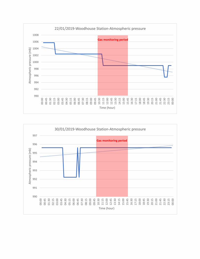
990
992
994
996
998
1000
1002
1004
1006
1008
00:0
000
:45
01:3
002
:15
03:0
003
:45
04:3
005
:15
06:0
006
:45
07:3
008
:15
09:0
009
:45
10:3
011
:15
12:0
012
:45
13:3
014
:15
15:0
015
:45
16:3
017
:15
18:0
018
:45
19:3
020
:15
21:0
021
:45
22:3
023
:15
00:0
0
Atm
osph
eric
pre
ssur
e (m
b)
Time (hour)
22/01/2019-Woodhouse Station-Atmospheric pressure
Gas monitoring period
990
991
992
993
994
995
996
997
00:0
000
:45
01:3
002
:15
03:0
003
:45
04:3
005
:15
06:0
006
:45
07:3
008
:15
09:0
009
:45
10:3
011
:15
12:0
012
:45
13:3
014
:15
15:0
015
:45
16:3
017
:15
18:0
018
:45
19:3
020
:15
21:0
021
:45
22:3
023
:15
00:0
0
Atm
osph
eric
pre
ssur
e (m
b)
Time (hour)
30/01/2019-Woodhouse Station-Atmospheric pressure
Gas monitoring period
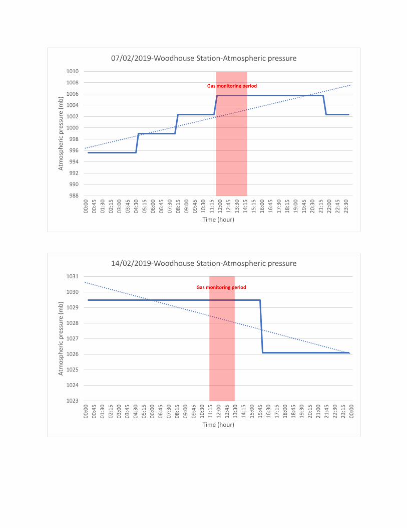
988
990
992
994
996
998
1000
1002
1004
1006
1008
1010
00:0
000
:45
01:3
002
:15
03:0
003
:45
04:3
005
:15
06:0
006
:45
07:3
008
:15
09:0
009
:45
10:3
011
:15
12:0
012
:45
13:3
014
:15
15:1
516
:00
16:4
517
:30
18:1
519
:00
19:4
520
:30
21:1
522
:00
22:4
523
:30
Atm
osph
eric
pre
ssur
e (m
b)
Time (hour)
07/02/2019-Woodhouse Station-Atmospheric pressure
1023
1024
1025
1026
1027
1028
1029
1030
1031
00:0
000
:45
01:3
002
:15
03:0
003
:45
04:3
005
:15
06:0
006
:45
07:3
008
:15
09:0
009
:45
10:3
011
:15
12:0
012
:45
13:3
014
:15
15:0
015
:45
16:3
017
:15
18:0
018
:45
19:3
020
:15
21:0
021
:45
22:3
023
:15
00:0
0
Atm
osph
eric
pre
ssur
e (m
b)
Time (hour)
14/02/2019-Woodhouse Station-Atmospheric pressure
Gas monitoring period
Gas monitoring period

68
Geotechnical Laboratory Results
LaboratoryReport
GEO Site & Testing Services Ltd
Contract Number: 41505
Notes: Observations and Interpretations are outside the UKAS Accreditation* - denotes test included in laboratory scope of accreditation# - denotes test carried out by approved contractor@ - denotes non accredited tests
This certificate is issued in accordance with the accreditation requirements of the United Kingdom Accreditation Service. The results reported herein relate only to the material supplied to the laboratory. This certificate shall not be reproduced except in full, without the prior written approval of the laboratory.
Approved Signatories:Alex Wynn (Associate Director) - Ben Sharp (Contracts Manager) - Emma Sharp (Office Manager)Paul Evans (Quality/Technical Manager) - Richard John (Advanced Testing Manager) - Sean Penn (Administrative/Accounts Assistant)Wayne Honey (Administrative/Quality Assistant)
GEO Site & Testing Services LtdUnit 3-4, Heol Aur, Dafen Ind Estate, Dafen, Llanelli, Carmarthenshire SA14 8QNTel: 01554 784040 Fax: 01554 784041 [email protected] gstl.co.uk
Client Ref: Report Date: 10-01-2019Client PO: 14018549
Client ArcadisHyder Site Investigation Services5th Floor401 Faraday StreetBirchwood ParkWarringtonWA3 6GA
Contract Title: Abermule CBR testing 4 days on siteFor the attention of: Karl Addison
Date Received: 06-11-2018Date Commenced: 06-11-2018
Date Completed: 10-01-2019
Test Description Qty
Day Rate: CBRSBS 1377:1990 - Part 9 Cl 4.3 - * UKAS
includes mob & B&B
4
Disposal of samples for job 1

Remarks:
Test Depth (m)
Test Location
Determination of the Insitu California Bearing Ratio
BS 1377-1:1990 General requirements and sample preparation
41505
14018549
07/01/2018
11/01/2019
0.150
Contract Number
Client Reference
Client
Site Location
Test Date
Paul Evans
CBR 1
Soil Description Brown fine gravelly silty CLAY.
Abermule CBR testing 4 days on site
Sampling Method
Kentledge Type Back of 4x4
Test Operator
Cearan Bryan Date
BS 1377: Part 9: 1990 Clause 4.3
Arcadis
Checked and Authorised by
This certificate is issued in accordance with the accreditation requirements of the United Kingdom
Accreditation Service. The results reported herein relate only to the material supplied to the
laboratory.
Surcharge (kg)
25
Material Above 20mm (est.)
C.B.R Value 4.3
Weather Conditions
Moisture Content (%)
%
Sunny
9
N/A
0
0.2
0.4
0.6
0.8
1
1.2
1.4
0 1 2 3 4 5 6 7 8
Load
(kP
a)
Penetration (mm)
÷÷
ø
ö
çç
è
æ
1m
m

Remarks:
Test Depth (m)
Test Location
Determination of the Insitu California Bearing Ratio
BS 1377-1:1990 General requirements and sample preparation
41505
14018549
07/01/2018
11/01/2019
0.150
Contract Number
Client Reference
Client
Site Location
Test Date
Paul Evans
CBR 2
Soil Description Brown fine gravelly silty CLAY.
Abermule CBR testing 4 days on site
Sampling Method
Kentledge Type Back of 4x4
Test Operator
Cearan Bryan Date
BS 1377: Part 9: 1990 Clause 4.3
Arcadis
Checked and Authorised by
This certificate is issued in accordance with the accreditation requirements of the United Kingdom
Accreditation Service. The results reported herein relate only to the material supplied to the
laboratory.
Surcharge (kg)
25
Material Above 20mm (est.)
C.B.R Value 4.1
Weather Conditions
Moisture Content (%)
%
Sunny
9
N/A
0
0.2
0.4
0.6
0.8
1
1.2
0 1 2 3 4 5 6 7 8
Load
(kP
a)
Penetration (mm)
÷÷
ø
ö
çç
è
æ
1m
m
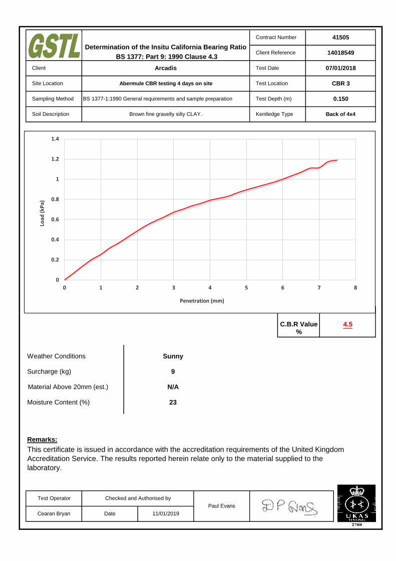
Remarks:
Test Depth (m)
Test Location
Determination of the Insitu California Bearing Ratio
BS 1377-1:1990 General requirements and sample preparation
41505
14018549
07/01/2018
11/01/2019
0.150
Contract Number
Client Reference
Client
Site Location
Test Date
Paul Evans
CBR 3
Soil Description Brown fine gravelly silty CLAY.
Abermule CBR testing 4 days on site
Sampling Method
Kentledge Type Back of 4x4
Test Operator
Cearan Bryan Date
BS 1377: Part 9: 1990 Clause 4.3
Arcadis
Checked and Authorised by
This certificate is issued in accordance with the accreditation requirements of the United Kingdom
Accreditation Service. The results reported herein relate only to the material supplied to the
laboratory.
Surcharge (kg)
23
Material Above 20mm (est.)
C.B.R Value 4.5
Weather Conditions
Moisture Content (%)
%
Sunny
9
N/A
0
0.2
0.4
0.6
0.8
1
1.2
1.4
0 1 2 3 4 5 6 7 8
Load
(kP
a)
Penetration (mm)
÷÷
ø
ö
çç
è
æ
1m
m

Remarks:
Test Depth (m)
Test Location
Determination of the Insitu California Bearing Ratio
BS 1377-1:1990 General requirements and sample preparation
41505
14018549
07/01/2018
11/01/2019
0.150
Contract Number
Client Reference
Client
Site Location
Test Date
Paul Evans
CBR 4
Soil Description Brown fine to coarse gravelly silty CLAY.
Abermule CBR testing 4 days on site
Sampling Method
Kentledge Type Back of 4x4
Test Operator
Cearan Bryan Date
BS 1377: Part 9: 1990 Clause 4.3
Arcadis
Checked and Authorised by
This certificate is issued in accordance with the accreditation requirements of the United Kingdom
Accreditation Service. The results reported herein relate only to the material supplied to the
laboratory.
Surcharge (kg)
23
Material Above 20mm (est.)
C.B.R Value 4.3
Weather Conditions
Moisture Content (%)
%
Sunny
9
N/A
0
0.2
0.4
0.6
0.8
1
1.2
1.4
0 1 2 3 4 5 6 7 8
Load
(kP
a)
Penetration (mm)
÷÷
ø
ö
çç
è
æ
1m
m

Remarks:
Test Depth (m)
Test Location
Determination of the Insitu California Bearing Ratio
BS 1377-1:1990 General requirements and sample preparation
41505
14018549
07/01/2018
11/01/2019
0.150
Contract Number
Client Reference
Client
Site Location
Test Date
Paul Evans
CBR 5
Soil Description Brown fine to coarse gravelly silty CLAY.
Abermule CBR testing 4 days on site
Sampling Method
Kentledge Type Back of 4x4
Test Operator
Cearan Bryan Date
BS 1377: Part 9: 1990 Clause 4.3
Arcadis
Checked and Authorised by
This certificate is issued in accordance with the accreditation requirements of the United Kingdom
Accreditation Service. The results reported herein relate only to the material supplied to the
laboratory.
Surcharge (kg)
25
Material Above 20mm (est.)
C.B.R Value 4.1
Weather Conditions
Moisture Content (%)
%
Sunny
9
N/A
0
0.2
0.4
0.6
0.8
1
1.2
0 1 2 3 4 5 6 7 8
Load
(kP
a)
Penetration (mm)
÷÷
ø
ö
çç
è
æ
1m
m

Remarks:
Test Depth (m)
Test Location
Determination of the Insitu California Bearing Ratio
BS 1377-1:1990 General requirements and sample preparation
41505
14018549
07/01/2018
11/01/2019
0.150
Contract Number
Client Reference
Client
Site Location
Test Date
Paul Evans
CBR 6
Soil Description Brown fine to medium gravelly silty CLAY.
Abermule CBR testing 4 days on site
Sampling Method
Kentledge Type Back of 4x4
Test Operator
Cearan Bryan Date
BS 1377: Part 9: 1990 Clause 4.3
Arcadis
Checked and Authorised by
This certificate is issued in accordance with the accreditation requirements of the United Kingdom
Accreditation Service. The results reported herein relate only to the material supplied to the
laboratory.
Surcharge (kg)
22
Material Above 20mm (est.)
C.B.R Value 4.3
Weather Conditions
Moisture Content (%)
%
Sunny
9
N/A
0
0.2
0.4
0.6
0.8
1
1.2
1.4
0 1 2 3 4 5 6 7 8
Load
(kP
a)
Penetration (mm)
÷÷
ø
ö
çç
è
æ
1m
m

Remarks:
Test Depth (m)
Test Location
Determination of the Insitu California Bearing Ratio
BS 1377-1:1990 General requirements and sample preparation
41505
14018549
07/01/2018
11/01/2019
0.150
Contract Number
Client Reference
Client
Site Location
Test Date
Paul Evans
CBR 7
Soil Description Brown fine to medium gravelly silty CLAY.
Abermule CBR testing 4 days on site
Sampling Method
Kentledge Type Back of 4x4
Test Operator
Cearan Bryan Date
BS 1377: Part 9: 1990 Clause 4.3
Arcadis
Checked and Authorised by
This certificate is issued in accordance with the accreditation requirements of the United Kingdom
Accreditation Service. The results reported herein relate only to the material supplied to the
laboratory.
Surcharge (kg)
25
Material Above 20mm (est.)
C.B.R Value 4.2
Weather Conditions
Moisture Content (%)
%
Sunny
9
N/A
0
0.2
0.4
0.6
0.8
1
1.2
0 1 2 3 4 5 6 7 8
Load
(kP
a)
Penetration (mm)
÷÷
ø
ö
çç
è
æ
1m
m

Remarks:
Test Depth (m)
Test Location
Determination of the Insitu California Bearing Ratio
BS 1377-1:1990 General requirements and sample preparation
41505
14018549
07/01/2018
11/01/2019
0.150
Contract Number
Client Reference
Client
Site Location
Test Date
Paul Evans
CBR 8
Soil Description Brown fine to medium gravelly silty CLAY.
Abermule CBR testing 4 days on site
Sampling Method
Kentledge Type Back of 4x4
Test Operator
Cearan Bryan Date
BS 1377: Part 9: 1990 Clause 4.3
Arcadis
Checked and Authorised by
This certificate is issued in accordance with the accreditation requirements of the United Kingdom
Accreditation Service. The results reported herein relate only to the material supplied to the
laboratory.
Surcharge (kg)
25
Material Above 20mm (est.)
C.B.R Value 4.1
Weather Conditions
Moisture Content (%)
%
Sunny
9
N/A
0
0.2
0.4
0.6
0.8
1
1.2
1.4
0 1 2 3 4 5 6 7 8
Load
(kP
a)
Penetration (mm)
÷÷
ø
ö
çç
è
æ
1m
m

Remarks:
Test Depth (m)
Test Location
Determination of the Insitu California Bearing Ratio
BS 1377-1:1990 General requirements and sample preparation
41505
14018549
07/01/2018
11/01/2019
0.150
Contract Number
Client Reference
Client
Site Location
Test Date
Paul Evans
CBR 9
Soil Description Brown fine to medium gravelly silty CLAY.
Abermule CBR testing 4 days on site
Sampling Method
Kentledge Type Back of 4x4
Test Operator
Cearan Bryan Date
BS 1377: Part 9: 1990 Clause 4.3
Arcadis
Checked and Authorised by
This certificate is issued in accordance with the accreditation requirements of the United Kingdom
Accreditation Service. The results reported herein relate only to the material supplied to the
laboratory.
Surcharge (kg)
25
Material Above 20mm (est.)
C.B.R Value 4.0
Weather Conditions
Moisture Content (%)
%
Sunny
9
N/A
0
0.2
0.4
0.6
0.8
1
1.2
0 1 2 3 4 5 6 7 8
Load
(kP
a)
Penetration (mm)
÷÷
ø
ö
çç
è
æ
1m
m

Remarks:
Test Depth (m)
Test Location
Determination of the Insitu California Bearing Ratio
BS 1377-1:1990 General requirements and sample preparation
41505
14018549
07/01/2018
11/01/2019
0.150
Contract Number
Client Reference
Client
Site Location
Test Date
Paul Evans
CBR 10
Soil Description Brown fine to coarse gravelly silty CLAY.
Abermule CBR testing 4 days on site
Sampling Method
Kentledge Type Back of 4x4
Test Operator
Cearan Bryan Date
BS 1377: Part 9: 1990 Clause 4.3
Arcadis
Checked and Authorised by
This certificate is issued in accordance with the accreditation requirements of the United Kingdom
Accreditation Service. The results reported herein relate only to the material supplied to the
laboratory.
Surcharge (kg)
23
Material Above 20mm (est.)
C.B.R Value 5.2
Weather Conditions
Moisture Content (%)
%
Sunny
9
N/A
0
0.2
0.4
0.6
0.8
1
1.2
1.4
1.6
0 1 2 3 4 5 6 7 8
Load
(kP
a)
Penetration (mm)
÷÷
ø
ö
çç
è
æ
1m
m

Remarks:
Test Depth (m)
Test Location
Determination of the Insitu California Bearing Ratio
BS 1377-1:1990 General requirements and sample preparation
41505
14018549
07/01/2018
11/01/2019
0.150
Contract Number
Client Reference
Client
Site Location
Test Date
Paul Evans
CBR 11
Soil Description Brown fine to medium gravelly silty CLAY.
Abermule CBR testing 4 days on site
Sampling Method
Kentledge Type Back of 4x4
Test Operator
Cearan Bryan Date
BS 1377: Part 9: 1990 Clause 4.3
Arcadis
Checked and Authorised by
This certificate is issued in accordance with the accreditation requirements of the United Kingdom
Accreditation Service. The results reported herein relate only to the material supplied to the
laboratory.
Surcharge (kg)
23
Material Above 20mm (est.)
C.B.R Value 5.2
Weather Conditions
Moisture Content (%)
%
Sunny
9
N/A
0
0.2
0.4
0.6
0.8
1
1.2
1.4
1.6
0 1 2 3 4 5 6 7 8
Load
(kP
a)
Penetration (mm)
÷÷
ø
ö
çç
è
æ
1m
m

Remarks:
Test Depth (m)
Test Location
Determination of the Insitu California Bearing Ratio
BS 1377-1:1990 General requirements and sample preparation
41505
14018549
07/01/2018
11/01/2019
0.150
Contract Number
Client Reference
Client
Site Location
Test Date
Paul Evans
CBR 12
Soil Description Brown fine to medium gravelly silty CLAY.
Abermule CBR testing 4 days on site
Sampling Method
Kentledge Type Back of 4x4
Test Operator
Cearan Bryan Date
BS 1377: Part 9: 1990 Clause 4.3
Arcadis
Checked and Authorised by
This certificate is issued in accordance with the accreditation requirements of the United Kingdom
Accreditation Service. The results reported herein relate only to the material supplied to the
laboratory.
Surcharge (kg)
25
Material Above 20mm (est.)
C.B.R Value 4.1
Weather Conditions
Moisture Content (%)
%
Sunny
9
N/A
0
0.2
0.4
0.6
0.8
1
1.2
0 1 2 3 4 5 6 7 8
Load
(kP
a)
Penetration (mm)
÷÷
ø
ö
çç
è
æ
1m
m

Remarks:
Test Depth (m)
Test Location
Determination of the Insitu California Bearing Ratio
BS 1377-1:1990 General requirements and sample preparation
41505
14018549
07/01/2018
11/01/2019
0.150
Contract Number
Client Reference
Client
Site Location
Test Date
Paul Evans
CBR 13
Soil Description Brown fine to medium gravelly silty CLAY.
Abermule CBR testing 4 days on site
Sampling Method
Kentledge Type Back of 4x4
Test Operator
Cearan Bryan Date
BS 1377: Part 9: 1990 Clause 4.3
Arcadis
Checked and Authorised by
This certificate is issued in accordance with the accreditation requirements of the United Kingdom
Accreditation Service. The results reported herein relate only to the material supplied to the
laboratory.
Surcharge (kg)
23
Material Above 20mm (est.)
C.B.R Value 4.0
Weather Conditions
Moisture Content (%)
%
Sunny
9
N/A
0
0.2
0.4
0.6
0.8
1
1.2
0 1 2 3 4 5 6 7 8
Load
(kP
a)
Penetration (mm)
÷÷
ø
ö
çç
è
æ
1m
m
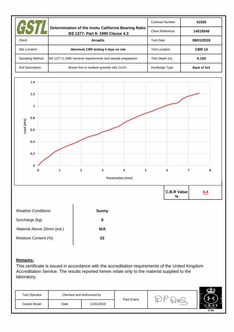
Remarks:
Test Depth (m)
Test Location
Determination of the Insitu California Bearing Ratio
BS 1377-1:1990 General requirements and sample preparation
41505
14018549
08/01/2018
11/01/2019
0.150
Contract Number
Client Reference
Client
Site Location
Test Date
Paul Evans
CBR 14
Soil Description Brown fine to medium gravelly silty CLAY.
Abermule CBR testing 4 days on site
Sampling Method
Kentledge Type Back of 4x4
Test Operator
Cearan Bryan Date
BS 1377: Part 9: 1990 Clause 4.3
Arcadis
Checked and Authorised by
This certificate is issued in accordance with the accreditation requirements of the United Kingdom
Accreditation Service. The results reported herein relate only to the material supplied to the
laboratory.
Surcharge (kg)
22
Material Above 20mm (est.)
C.B.R Value 4.4
Weather Conditions
Moisture Content (%)
%
Sunny
9
N/A
0
0.2
0.4
0.6
0.8
1
1.2
1.4
0 1 2 3 4 5 6 7 8
Load
(kP
a)
Penetration (mm)
÷÷
ø
ö
çç
è
æ
1m
m

Remarks:
Test Depth (m)
Test Location
Determination of the Insitu California Bearing Ratio
BS 1377-1:1990 General requirements and sample preparation
41505
14018549
08/01/2018
11/01/2019
0.150
Contract Number
Client Reference
Client
Site Location
Test Date
Paul Evans
CBR 15
Soil Description Brown fine to medium gravelly silty CLAY.
Abermule CBR testing 4 days on site
Sampling Method
Kentledge Type Back of 4x4
Test Operator
Cearan Bryan Date
BS 1377: Part 9: 1990 Clause 4.3
Arcadis
Checked and Authorised by
This certificate is issued in accordance with the accreditation requirements of the United Kingdom
Accreditation Service. The results reported herein relate only to the material supplied to the
laboratory.
Surcharge (kg)
23
Material Above 20mm (est.)
C.B.R Value 4.1
Weather Conditions
Moisture Content (%)
%
Sunny
9
N/A
0
0.2
0.4
0.6
0.8
1
1.2
0 1 2 3 4 5 6 7 8
Load
(kP
a)
Penetration (mm)
÷÷
ø
ö
çç
è
æ
1m
m

Remarks:
Test Depth (m)
Test Location
Determination of the Insitu California Bearing Ratio
BS 1377-1:1990 General requirements and sample preparation
41505
14018549
08/01/2018
11/01/2019
0.150
Contract Number
Client Reference
Client
Site Location
Test Date
Paul Evans
CBR 16
Soil Description Brown fine to medium gravelly silty CLAY.
Abermule CBR testing 4 days on site
Sampling Method
Kentledge Type Back of 4x4
Test Operator
Cearan Bryan Date
BS 1377: Part 9: 1990 Clause 4.3
Arcadis
Checked and Authorised by
This certificate is issued in accordance with the accreditation requirements of the United Kingdom
Accreditation Service. The results reported herein relate only to the material supplied to the
laboratory.
Surcharge (kg)
23
Material Above 20mm (est.)
C.B.R Value 4.0
Weather Conditions
Moisture Content (%)
%
Sunny
9
N/A
0
0.2
0.4
0.6
0.8
1
1.2
0 1 2 3 4 5 6 7 8
Load
(kP
a)
Penetration (mm)
÷÷
ø
ö
çç
è
æ
1m
m

Remarks:
Test Depth (m)
Test Location
Determination of the Insitu California Bearing Ratio
BS 1377-1:1990 General requirements and sample preparation
41505
14018549
09/01/2018
11/01/2019
0.150
Contract Number
Client Reference
Client
Site Location
Test Date
Paul Evans
CBR 17
Soil Description Brown fine to medium gravelly silty CLAY.
Abermule CBR testing 4 days on site
Sampling Method
Kentledge Type Back of 4x4
Test Operator
Cearan Bryan Date
BS 1377: Part 9: 1990 Clause 4.3
Arcadis
Checked and Authorised by
This certificate is issued in accordance with the accreditation requirements of the United Kingdom
Accreditation Service. The results reported herein relate only to the material supplied to the
laboratory.
Surcharge (kg)
26
Material Above 20mm (est.)
C.B.R Value 3.5
Weather Conditions
Moisture Content (%)
%
Sunny
9
N/A
0
0.2
0.4
0.6
0.8
1
1.2
0 1 2 3 4 5 6 7 8
Load
(kP
a)
Penetration (mm)
÷÷
ø
ö
çç
è
æ
1m
m

Remarks:
Test Depth (m)
Test Location
Determination of the Insitu California Bearing Ratio
BS 1377-1:1990 General requirements and sample preparation
41505
14018549
09/01/2018
11/01/2019
0.150
Contract Number
Client Reference
Client
Site Location
Test Date
Paul Evans
CBR 18
Soil Description Brown fine to medium gravelly silty CLAY.
Abermule CBR testing 4 days on site
Sampling Method
Kentledge Type Back of 4x4
Test Operator
Cearan Bryan Date
BS 1377: Part 9: 1990 Clause 4.3
Arcadis
Checked and Authorised by
This certificate is issued in accordance with the accreditation requirements of the United Kingdom
Accreditation Service. The results reported herein relate only to the material supplied to the
laboratory.
Surcharge (kg)
23
Material Above 20mm (est.)
C.B.R Value 3.5
Weather Conditions
Moisture Content (%)
%
Sunny
9
N/A
0
0.2
0.4
0.6
0.8
1
1.2
0 1 2 3 4 5 6 7 8
Load
(kP
a)
Penetration (mm)
÷÷
ø
ö
çç
è
æ
1m
m

Remarks:
Test Depth (m)
Test Location
Determination of the Insitu California Bearing Ratio
BS 1377-1:1990 General requirements and sample preparation
41505
14018549
09/01/2018
11/01/2019
0.150
Contract Number
Client Reference
Client
Site Location
Test Date
Paul Evans
CBR 19
Soil Description Brown fine to medium gravelly silty CLAY.
Abermule CBR testing 4 days on site
Sampling Method
Kentledge Type Back of 4x4
Test Operator
Cearan Bryan Date
BS 1377: Part 9: 1990 Clause 4.3
Arcadis
Checked and Authorised by
This certificate is issued in accordance with the accreditation requirements of the United Kingdom
Accreditation Service. The results reported herein relate only to the material supplied to the
laboratory.
Surcharge (kg)
23
Material Above 20mm (est.)
C.B.R Value 4.3
Weather Conditions
Moisture Content (%)
%
Sunny
9
N/A
0
0.2
0.4
0.6
0.8
1
1.2
1.4
0 1 2 3 4 5 6 7 8
Load
(kP
a)
Penetration (mm)
÷÷
ø
ö
çç
è
æ
1m
m

Remarks:
Test Depth (m)
Test Location
Determination of the Insitu California Bearing Ratio
BS 1377-1:1990 General requirements and sample preparation
41505
14018549
09/01/2018
11/01/2019
0.150
Contract Number
Client Reference
Client
Site Location
Test Date
Paul Evans
CBR 20
Soil Description Brown fine to medium gravelly silty CLAY.
Abermule CBR testing 4 days on site
Sampling Method
Kentledge Type Back of 4x4
Test Operator
Cearan Bryan Date
BS 1377: Part 9: 1990 Clause 4.3
Arcadis
Checked and Authorised by
This certificate is issued in accordance with the accreditation requirements of the United Kingdom
Accreditation Service. The results reported herein relate only to the material supplied to the
laboratory.
Surcharge (kg)
23
Material Above 20mm (est.)
C.B.R Value 4.3
Weather Conditions
Moisture Content (%)
%
Sunny
9
N/A
0
0.2
0.4
0.6
0.8
1
1.2
1.4
0 1 2 3 4 5 6 7 8
Load
(kP
a)
Penetration (mm)
÷÷
ø
ö
çç
è
æ
1m
m
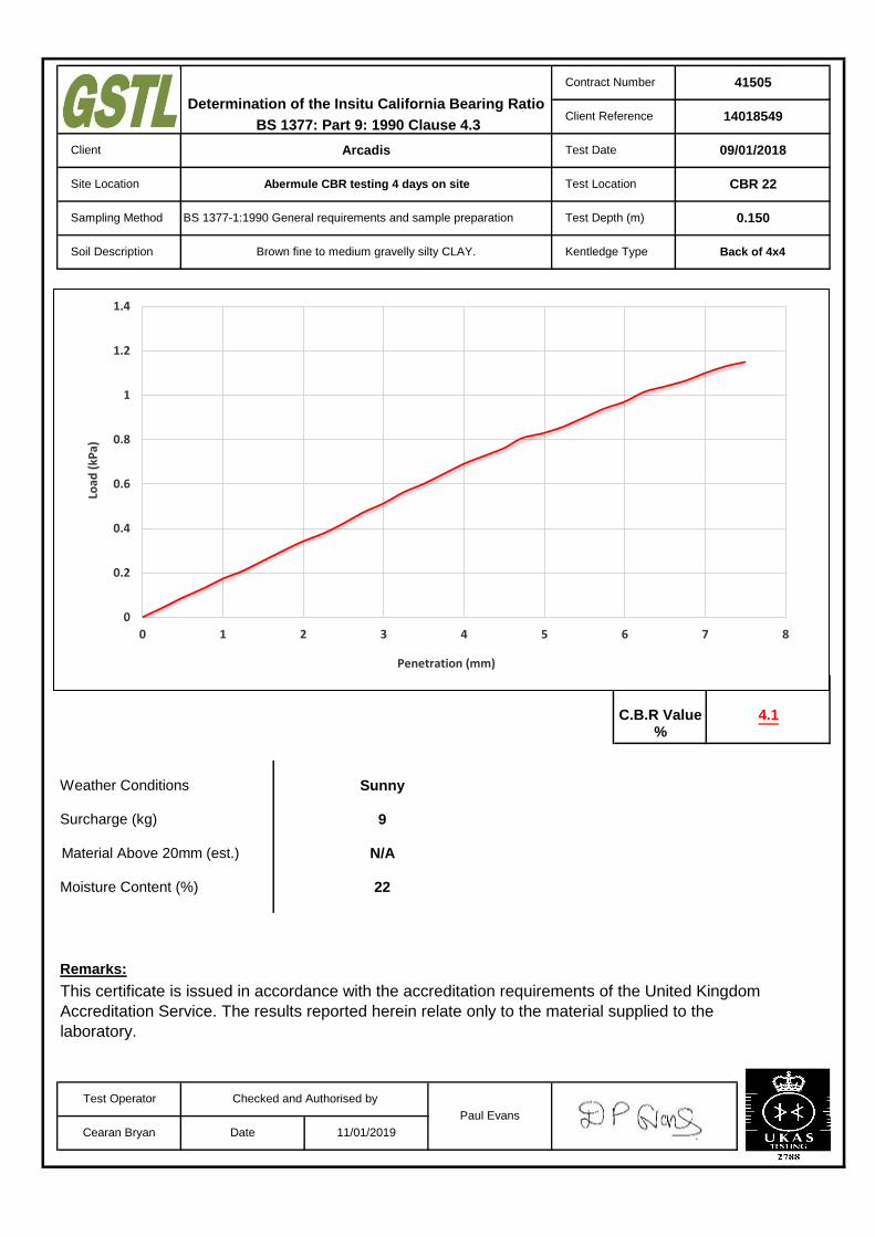
Remarks:
Test Depth (m)
Test Location
Determination of the Insitu California Bearing Ratio
BS 1377-1:1990 General requirements and sample preparation
41505
14018549
09/01/2018
11/01/2019
0.150
Contract Number
Client Reference
Client
Site Location
Test Date
Paul Evans
CBR 22
Soil Description Brown fine to medium gravelly silty CLAY.
Abermule CBR testing 4 days on site
Sampling Method
Kentledge Type Back of 4x4
Test Operator
Cearan Bryan Date
BS 1377: Part 9: 1990 Clause 4.3
Arcadis
Checked and Authorised by
This certificate is issued in accordance with the accreditation requirements of the United Kingdom
Accreditation Service. The results reported herein relate only to the material supplied to the
laboratory.
Surcharge (kg)
22
Material Above 20mm (est.)
C.B.R Value 4.1
Weather Conditions
Moisture Content (%)
%
Sunny
9
N/A
0
0.2
0.4
0.6
0.8
1
1.2
1.4
0 1 2 3 4 5 6 7 8
Load
(kP
a)
Penetration (mm)
÷÷
ø
ö
çç
è
æ
1m
m

Remarks:
Test Depth (m)
Test Location
Determination of the Insitu California Bearing Ratio
BS 1377-1:1990 General requirements and sample preparation
41505
14018549
10/01/2018
11/01/2019
0.150
Contract Number
Client Reference
Client
Site Location
Test Date
Paul Evans
CBR 23
Soil Description Brown fine to medium gravelly silty CLAY.
Abermule CBR testing 4 days on site
Sampling Method
Kentledge Type Back of 4x4
Test Operator
Cearan Bryan Date
BS 1377: Part 9: 1990 Clause 4.3
Arcadis
Checked and Authorised by
This certificate is issued in accordance with the accreditation requirements of the United Kingdom
Accreditation Service. The results reported herein relate only to the material supplied to the
laboratory.
Surcharge (kg)
24
Material Above 20mm (est.)
C.B.R Value 4.2
Weather Conditions
Moisture Content (%)
%
Sunny
9
N/A
0
0.2
0.4
0.6
0.8
1
1.2
0 1 2 3 4 5 6 7 8
Load
(kP
a)
Penetration (mm)
÷÷
ø
ö
çç
è
æ
1m
m

Remarks:
Test Depth (m)
Test Location
Determination of the Insitu California Bearing Ratio
BS 1377-1:1990 General requirements and sample preparation
41505
14018549
10/01/2018
11/01/2019
0.30
Contract Number
Client Reference
Client
Site Location
Test Date
Paul Evans
CBR 24
Soil Description Brown fine to coarse gravelly silty CLAY.
Abermule CBR testing 4 days on site
Sampling Method
Kentledge Type Back of 4x4
Test Operator
Cearan Bryan Date
BS 1377: Part 9: 1990 Clause 4.3
Arcadis
Checked and Authorised by
This certificate is issued in accordance with the accreditation requirements of the United Kingdom
Accreditation Service. The results reported herein relate only to the material supplied to the
laboratory.
Surcharge (kg)
24
Material Above 20mm (est.)
C.B.R Value 4.5
Weather Conditions
Moisture Content (%)
%
Sunny
9
N/A
0
0.2
0.4
0.6
0.8
1
1.2
1.4
0 1 2 3 4 5 6 7 8
Load
(kP
a)
Penetration (mm)
÷÷
ø
ö
çç
è
æ
1m
m

Remarks:
Test Depth (m)
Test Location
Determination of the Insitu California Bearing Ratio
BS 1377-1:1990 General requirements and sample preparation
41505
14018549
10/01/2018
11/01/2019
0.80
Contract Number
Client Reference
Client
Site Location
Test Date
Paul Evans
CBR 25
Soil Description Brown fine to medium gravelly silty CLAY.
Abermule CBR testing 4 days on site
Sampling Method
Kentledge Type Back of 4x4
Test Operator
Cearan Bryan Date
BS 1377: Part 9: 1990 Clause 4.3
Arcadis
Checked and Authorised by
This certificate is issued in accordance with the accreditation requirements of the United Kingdom
Accreditation Service. The results reported herein relate only to the material supplied to the
laboratory.
Surcharge (kg)
18
Material Above 20mm (est.)
C.B.R Value 5.4
Weather Conditions
Moisture Content (%)
%
Sunny
9
N/A
0
0.2
0.4
0.6
0.8
1
1.2
1.4
1.6
0 1 2 3 4 5 6 7 8
Load
(kP
a)
Penetration (mm)
÷÷
ø
ö
çç
è
æ
1m
m

Remarks:
Test Depth (m)
Test Location
Determination of the Insitu California Bearing Ratio
BS 1377-1:1990 General requirements and sample preparation
41505
14018549
10/01/2018
11/01/2019
0.60
Contract Number
Client Reference
Client
Site Location
Test Date
Paul Evans
CBR 26
Soil Description Brown fine to coarse gravelly silty CLAY.
Abermule CBR testing 4 days on site
Sampling Method
Kentledge Type Back of 4x4
Test Operator
Cearan Bryan Date
BS 1377: Part 9: 1990 Clause 4.3
Arcadis
Checked and Authorised by
This certificate is issued in accordance with the accreditation requirements of the United Kingdom
Accreditation Service. The results reported herein relate only to the material supplied to the
laboratory.
Surcharge (kg)
23
Material Above 20mm (est.)
C.B.R Value 5.6
Weather Conditions
Moisture Content (%)
%
Sunny
9
N/A
0
0.2
0.4
0.6
0.8
1
1.2
1.4
1.6
0 1 2 3 4 5 6 7 8
Load
(kP
a)
Penetration (mm)
÷÷
ø
ö
çç
è
æ
1m
m

Remarks:
Test Depth (m)
Test Location
Determination of the Insitu California Bearing Ratio
BS 1377-1:1990 General requirements and sample preparation
41505
14018549
10/01/2018
11/01/2019
0.150
Contract Number
Client Reference
Client
Site Location
Test Date
Paul Evans
CBR 27
Soil Description Brown fine to coarse gravelly silty CLAY.
Abermule CBR testing 4 days on site
Sampling Method
Kentledge Type Back of 4x4
Test Operator
Cearan Bryan Date
BS 1377: Part 9: 1990 Clause 4.3
Arcadis
Checked and Authorised by
This certificate is issued in accordance with the accreditation requirements of the United Kingdom
Accreditation Service. The results reported herein relate only to the material supplied to the
laboratory.
Surcharge (kg)
23
Material Above 20mm (est.)
C.B.R Value 4.1
Weather Conditions
Moisture Content (%)
%
Sunny
9
N/A
0
0.2
0.4
0.6
0.8
1
1.2
1.4
0 1 2 3 4 5 6 7 8
Load
(kP
a)
Penetration (mm)
÷÷
ø
ö
çç
è
æ
1m
m

Remarks:
Test Depth (m)
Test Location
Determination of the Insitu California Bearing Ratio
BS 1377-1:1990 General requirements and sample preparation
41505
14018549
10/01/2018
11/01/2019
0.150
Contract Number
Client Reference
Client
Site Location
Test Date
Paul Evans
CBR 28
Soil Description Brown fine to coarse gravelly silty CLAY.
Abermule CBR testing 4 days on site
Sampling Method
Kentledge Type Back of 4x4
Test Operator
Cearan Bryan Date
BS 1377: Part 9: 1990 Clause 4.3
Arcadis
Checked and Authorised by
This certificate is issued in accordance with the accreditation requirements of the United Kingdom
Accreditation Service. The results reported herein relate only to the material supplied to the
laboratory.
Surcharge (kg)
23
Material Above 20mm (est.)
C.B.R Value 3.9
Weather Conditions
Moisture Content (%)
%
Sunny
9
N/A
0
0.2
0.4
0.6
0.8
1
1.2
0 1 2 3 4 5 6 7 8
Load
(kP
a)
Penetration (mm)
÷÷
ø
ö
çç
è
æ
1m
m

Remarks:
Test Depth (m)
Test Location
Determination of the Insitu California Bearing Ratio
BS 1377-1:1990 General requirements and sample preparation
41505
14018549
10/01/2018
11/01/2019
0.30
Contract Number
Client Reference
Client
Site Location
Test Date
Paul Evans
CBR 29
Soil Description Brown fine to coarse gravelly silty CLAY.
Abermule CBR testing 4 days on site
Sampling Method
Kentledge Type Back of 4x4
Test Operator
Cearan Bryan Date
BS 1377: Part 9: 1990 Clause 4.3
Arcadis
Checked and Authorised by
This certificate is issued in accordance with the accreditation requirements of the United Kingdom
Accreditation Service. The results reported herein relate only to the material supplied to the
laboratory.
Surcharge (kg)
14
Material Above 20mm (est.)
C.B.R Value 11.2
Weather Conditions
Moisture Content (%)
%
Sunny
9
N/A
0
0.5
1
1.5
2
2.5
3
3.5
0 1 2 3 4 5 6 7 8
Load
(kP
a)
Penetration (mm)
÷÷
ø
ö
çç
è
æ
1m
m

Remarks:
Test Depth (m)
Test Location
Determination of the Insitu California Bearing Ratio
BS 1377-1:1990 General requirements and sample preparation
41505
14018549
10/01/2018
11/01/2019
0.78
Contract Number
Client Reference
Client
Site Location
Test Date
Paul Evans
CBR 30
Soil Description Brown fine to coarse gravelly silty CLAY.
Abermule CBR testing 4 days on site
Sampling Method
Kentledge Type Back of 4x4
Test Operator
Cearan Bryan Date
BS 1377: Part 9: 1990 Clause 4.3
Arcadis
Checked and Authorised by
This certificate is issued in accordance with the accreditation requirements of the United Kingdom
Accreditation Service. The results reported herein relate only to the material supplied to the
laboratory.
Surcharge (kg)
14
Material Above 20mm (est.)
C.B.R Value 10.8
Weather Conditions
Moisture Content (%)
%
Sunny
9
N/A
0
0.5
1
1.5
2
2.5
3
0 1 2 3 4 5 6 7 8
Load
(kP
a)
Penetration (mm)
÷÷
ø
ö
çç
è
æ
1m
m

Remarks:
Test Depth (m)
Test Location
Determination of the Insitu California Bearing Ratio
BS 1377-1:1990 General requirements and sample preparation
41505
14018549
07/01/2018
11/01/2019
0.15
Contract Number
Client Reference
Client
Site Location
Test Date
Paul Evans
CBR 31
Soil Description Brown fine gravelly silty CLAY.
Abermule CBR testing 4 days on site
Sampling Method
Kentledge Type Back of 4x4
Test Operator
Cearan Bryan Date
BS 1377: Part 9: 1990 Clause 4.3
Arcadis
Checked and Authorised by
This certificate is issued in accordance with the accreditation requirements of the United Kingdom
Accreditation Service. The results reported herein relate only to the material supplied to the
laboratory.
Surcharge (kg)
23
Material Above 20mm (est.)
C.B.R Value 4.5
Weather Conditions
Moisture Content (%)
%
Sunny
9
N/A
0
0.2
0.4
0.6
0.8
1
1.2
1.4
0 1 2 3 4 5 6 7 8
Load
(kP
a)
Penetration (mm)
÷÷
ø
ö
çç
è
æ
1m
m

Remarks:
Test Depth (m)
Test Location
Determination of the Insitu California Bearing Ratio
BS 1377-1:1990 General requirements and sample preparation
41505
14018549
07/01/2018
11/01/2019
0.195
Contract Number
Client Reference
Client
Site Location
Test Date
Paul Evans
CBR 32
Soil Description Brown fine gravelly silty CLAY.
Abermule CBR testing 4 days on site
Sampling Method
Kentledge Type Back of 4x4
Test Operator
Cearan Bryan Date
BS 1377: Part 9: 1990 Clause 4.3 Arcadis
Checked and Authorised by
This certificate is issued in accordance with the accreditation requirements of the United Kingdom
Accreditation Service. The results reported herein relate only to the material supplied to the
laboratory.
Surcharge (kg)
18
Material Above 20mm (est.)
C.B.R Value 4.8
Weather Conditions
Moisture Content (%)
%
Sunny
9
N/A
0
0.2
0.4
0.6
0.8
1
1.2
1.4
1.6
0 1 2 3 4 5 6 7 8
Load
(kP
a)
Penetration (mm)
÷÷
ø
ö
çç
è
æ
1m
m

Remarks:
Test Depth (m)
Test Location
Determination of the Insitu California Bearing Ratio
BS 1377-1:1990 General requirements and sample preparation
41505
14018549
07/01/2018
11/01/2019
0.40
Contract Number
Client Reference
Client
Site Location
Test Date
Paul Evans
CBR 33
Soil Description Brown fine gravelly silty CLAY.
Abermule CBR testing 4 days on site
Sampling Method
Kentledge Type Back of 4x4
Test Operator
Cearan Bryan Date
BS 1377: Part 9: 1990 Clause 4.3
Arcadis
Checked and Authorised by
This certificate is issued in accordance with the accreditation requirements of the United Kingdom
Accreditation Service. The results reported herein relate only to the material supplied to the
laboratory.
Surcharge (kg)
16
Material Above 20mm (est.)
C.B.R Value 9.7
Weather Conditions
Moisture Content (%)
%
Sunny
9
N/A
0
0.5
1
1.5
2
2.5
3
0 1 2 3 4 5 6 7 8
Load
(kP
a)
Penetration (mm)
÷÷
ø
ö
çç
è
æ
1m
m
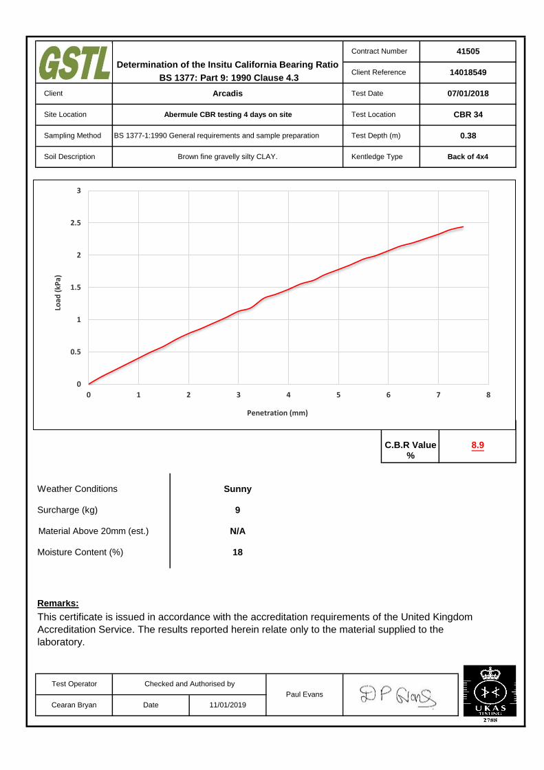
Remarks:
Test Depth (m)
Test Location
Determination of the Insitu California Bearing Ratio
BS 1377-1:1990 General requirements and sample preparation
41505
14018549
07/01/2018
11/01/2019
0.38
Contract Number
Client Reference
Client
Site Location
Test Date
Paul Evans
CBR 34
Soil Description Brown fine gravelly silty CLAY.
Abermule CBR testing 4 days on site
Sampling Method
Kentledge Type Back of 4x4
Test Operator
Cearan Bryan Date
BS 1377: Part 9: 1990 Clause 4.3
Arcadis
Checked and Authorised by
This certificate is issued in accordance with the accreditation requirements of the United Kingdom
Accreditation Service. The results reported herein relate only to the material supplied to the
laboratory.
Surcharge (kg)
18
Material Above 20mm (est.)
C.B.R Value 8.9
Weather Conditions
Moisture Content (%)
%
Sunny
9
N/A
0
0.5
1
1.5
2
2.5
3
0 1 2 3 4 5 6 7 8
Load
(kP
a)
Penetration (mm)
÷÷
ø
ö
çç
è
æ
1m
m

Remarks:
Test Depth (m)
Test Location
Determination of the Insitu California Bearing Ratio
BS 1377-1:1990 General requirements and sample preparation
41505
14018549
07/01/2018
11/01/2019
0.193
Contract Number
Client Reference
Client
Site Location
Test Date
Paul Evans
CBR 35
Soil Description Brown fine gravelly silty CLAY.
Abermule CBR testing 4 days on site
Sampling Method
Kentledge Type Back of 4x4
Test Operator
Cearan Bryan Date
BS 1377: Part 9: 1990 Clause 4.3
Arcadis
Checked and Authorised by
This certificate is issued in accordance with the accreditation requirements of the United Kingdom
Accreditation Service. The results reported herein relate only to the material supplied to the
laboratory.
Surcharge (kg)
29
Material Above 20mm (est.)
C.B.R Value 4.8
Weather Conditions
Moisture Content (%)
%
Sunny
9
N/A
0
0.2
0.4
0.6
0.8
1
1.2
1.4
1.6
0 1 2 3 4 5 6 7 8
Load
(kP
a)
Penetration (mm)
÷÷
ø
ö
çç
è
æ
1m
m

Remarks:
Test Depth (m)
Test Location
Determination of the Insitu California Bearing Ratio
BS 1377-1:1990 General requirements and sample preparation
41505
14018549
07/01/2018
11/01/2019
0.15
Contract Number
Client Reference
Client
Site Location
Test Date
Paul Evans
CBR 36
Soil Description Brown fine gravelly silty CLAY.
Abermule CBR testing 4 days on site
Sampling Method
Kentledge Type Back of 4x4
Test Operator
Cearan Bryan Date
BS 1377: Part 9: 1990 Clause 4.3
Arcadis
Checked and Authorised by
This certificate is issued in accordance with the accreditation requirements of the United Kingdom
Accreditation Service. The results reported herein relate only to the material supplied to the
laboratory.
Surcharge (kg)
25
Material Above 20mm (est.)
C.B.R Value 4.5
Weather Conditions
Moisture Content (%)
%
Sunny
9
N/A
0
0.2
0.4
0.6
0.8
1
1.2
1.4
0 1 2 3 4 5 6 7 8
Load
(kP
a)
Penetration (mm)
÷÷
ø
ö
çç
è
æ
1m
m

Remarks:
Test Depth (m)
Test Location
Determination of the Insitu California Bearing Ratio
BS 1377-1:1990 General requirements and sample preparation
41505
14018549
07/01/2018
11/01/2019
0.15
Contract Number
Client Reference
Client
Site Location
Test Date
Paul Evans
CBR 37
Soil Description Brown fine gravelly silty CLAY.
Abermule CBR testing 4 days on site
Sampling Method
Kentledge Type Back of 4x4
Test Operator
Cearan Bryan Date
BS 1377: Part 9: 1990 Clause 4.3
Arcadis
Checked and Authorised by
This certificate is issued in accordance with the accreditation requirements of the United Kingdom
Accreditation Service. The results reported herein relate only to the material supplied to the
laboratory.
Surcharge (kg)
27
Material Above 20mm (est.)
C.B.R Value 4.1
Weather Conditions
Moisture Content (%)
%
Sunny
9
N/A
0
0.2
0.4
0.6
0.8
1
1.2
1.4
0 1 2 3 4 5 6 7 8
Load
(kP
a)
Penetration (mm)
÷÷
ø
ö
çç
è
æ
1m
m

Remarks:
Test Depth (m)
Test Location
Determination of the Insitu California Bearing Ratio
BS 1377-1:1990 General requirements and sample preparation
41505
14018549
07/01/2018
11/01/2019
0.15
Contract Number
Client Reference
Client
Site Location
Test Date
Paul Evans
CBR 38
Soil Description Brown silty CLAY.
Abermule CBR testing 4 days on site
Sampling Method
Kentledge Type Back of 4x4
Test Operator
Cearan Bryan Date
BS 1377: Part 9: 1990 Clause 4.3
Arcadis
Checked and Authorised by
This certificate is issued in accordance with the accreditation requirements of the United Kingdom
Accreditation Service. The results reported herein relate only to the material supplied to the
laboratory.
Surcharge (kg)
26
Material Above 20mm (est.)
C.B.R Value 4.1
Weather Conditions
Moisture Content (%)
%
Sunny
9
N/A
0
0.2
0.4
0.6
0.8
1
1.2
0 1 2 3 4 5 6 7 8
Load
(kP
a)
Penetration (mm)
÷÷
ø
ö
çç
è
æ
1m
m
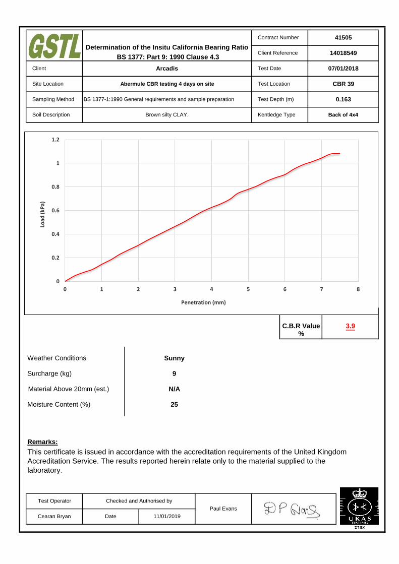
Remarks:
Test Depth (m)
Test Location
Determination of the Insitu California Bearing Ratio
BS 1377-1:1990 General requirements and sample preparation
41505
14018549
07/01/2018
11/01/2019
0.163
Contract Number
Client Reference
Client
Site Location
Test Date
Paul Evans
CBR 39
Soil Description Brown silty CLAY.
Abermule CBR testing 4 days on site
Sampling Method
Kentledge Type Back of 4x4
Test Operator
Cearan Bryan Date
BS 1377: Part 9: 1990 Clause 4.3
Arcadis
Checked and Authorised by
This certificate is issued in accordance with the accreditation requirements of the United Kingdom
Accreditation Service. The results reported herein relate only to the material supplied to the
laboratory.
Surcharge (kg)
25
Material Above 20mm (est.)
C.B.R Value 3.9
Weather Conditions
Moisture Content (%)
%
Sunny
9
N/A
0
0.2
0.4
0.6
0.8
1
1.2
0 1 2 3 4 5 6 7 8
Load
(kP
a)
Penetration (mm)
÷÷
ø
ö
çç
è
æ
1m
m

Remarks:
Test Depth (m)
Test Location
Determination of the Insitu California Bearing Ratio
BS 1377-1:1990 General requirements and sample preparation
41505
14018549
07/01/2018
11/01/2019
0.20
Contract Number
Client Reference
Client
Site Location
Test Date
Paul Evans
CBR 40
Soil Description Brown silty CLAY.
Abermule CBR testing 4 days on site
Sampling Method
Kentledge Type Back of 4x4
Test Operator
Cearan Bryan Date
BS 1377: Part 9: 1990 Clause 4.3
Arcadis
Checked and Authorised by
This certificate is issued in accordance with the accreditation requirements of the United Kingdom
Accreditation Service. The results reported herein relate only to the material supplied to the
laboratory.
Surcharge (kg)
21
Material Above 20mm (est.)
C.B.R Value 7.1
Weather Conditions
Moisture Content (%)
%
Sunny
9
N/A
0
0.2
0.4
0.6
0.8
1
1.2
1.4
1.6
1.8
2
0 1 2 3 4 5 6 7 8
Load
(kP
a)
Penetration (mm)
÷÷
ø
ö
çç
è
æ
1m
m

Remarks:
Test Depth (m)
Test Location
Determination of the Insitu California Bearing Ratio
BS 1377-1:1990 General requirements and sample preparation
41505
14018549
07/01/2018
11/01/2019
0.046
Contract Number
Client Reference
Client
Site Location
Test Date
Paul Evans
CBR 41
Soil Description Brown fine gravelly silty CLAY.
Abermule CBR testing 4 days on site
Sampling Method
Kentledge Type Back of 4x4
Test Operator
Cearan Bryan Date
BS 1377: Part 9: 1990 Clause 4.3
Arcadis
Checked and Authorised by
This certificate is issued in accordance with the accreditation requirements of the United Kingdom
Accreditation Service. The results reported herein relate only to the material supplied to the
laboratory.
Surcharge (kg)
25
Material Above 20mm (est.)
C.B.R Value 4.9
Weather Conditions
Moisture Content (%)
%
Sunny
9
N/A
0
0.2
0.4
0.6
0.8
1
1.2
1.4
1.6
0 1 2 3 4 5 6 7 8
Load
(kP
a)
Penetration (mm)
÷÷
ø
ö
çç
è
æ
1m
m

Remarks:
Test Depth (m)
Test Location
Determination of the Insitu California Bearing Ratio
BS 1377-1:1990 General requirements and sample preparation
41505
14018549
07/01/2018
11/01/2019
0.170
Contract Number
Client Reference
Client
Site Location
Test Date
Paul Evans
CBR 42
Soil Description Brown fine gravelly silty CLAY.
Abermule CBR testing 4 days on site
Sampling Method
Kentledge Type Back of 4x4
Test Operator
Cearan Bryan Date
BS 1377: Part 9: 1990 Clause 4.3
Arcadis
Checked and Authorised by
This certificate is issued in accordance with the accreditation requirements of the United Kingdom
Accreditation Service. The results reported herein relate only to the material supplied to the
laboratory.
Surcharge (kg)
25
Material Above 20mm (est.)
C.B.R Value 4.2
Weather Conditions
Moisture Content (%)
%
Sunny
9
N/A
0
0.2
0.4
0.6
0.8
1
1.2
1.4
0 1 2 3 4 5 6 7 8
Load
(kP
a)
Penetration (mm)
÷÷
ø
ö
çç
è
æ
1m
m
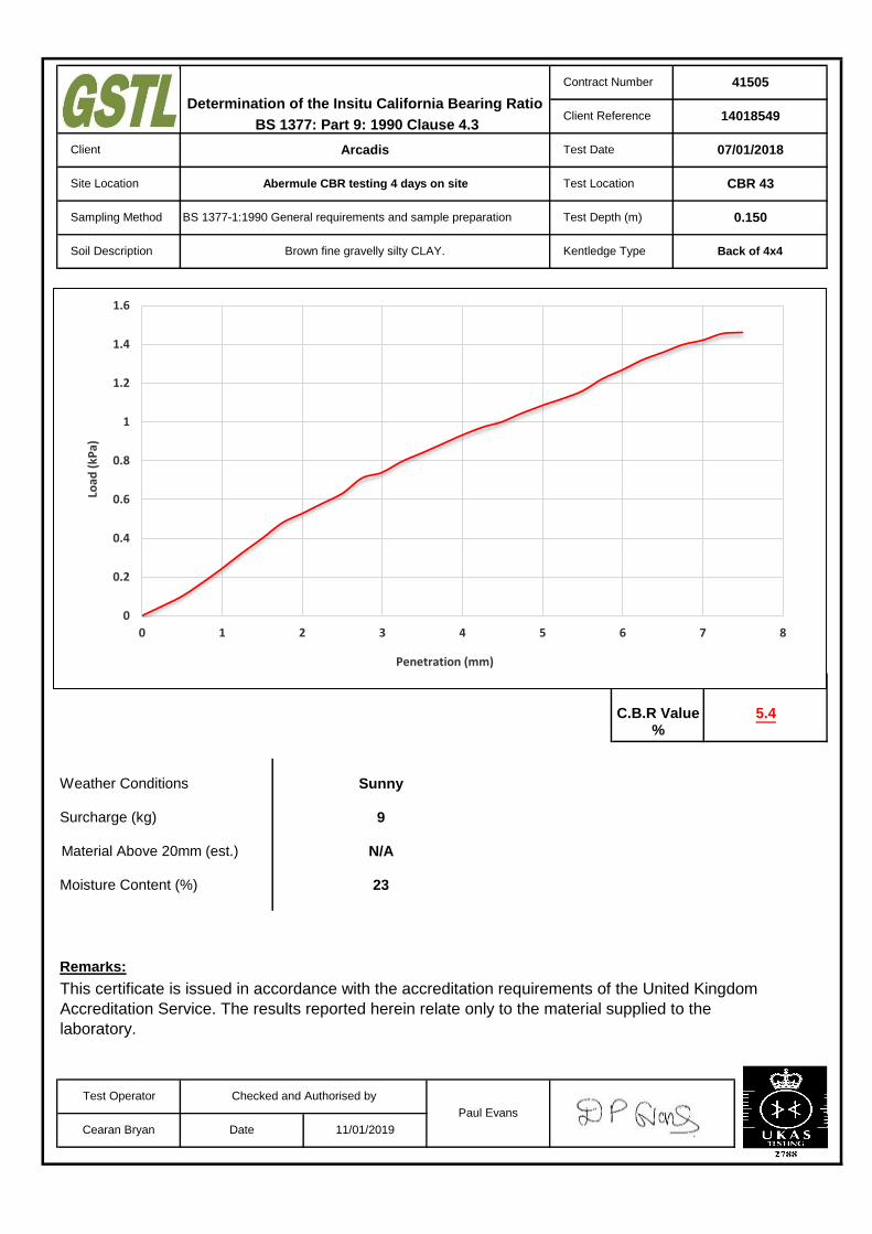
Remarks:
Test Depth (m)
Test Location
Determination of the Insitu California Bearing Ratio
BS 1377-1:1990 General requirements and sample preparation
41505
14018549
07/01/2018
11/01/2019
0.150
Contract Number
Client Reference
Client
Site Location
Test Date
Paul Evans
CBR 43
Soil Description Brown fine gravelly silty CLAY.
Abermule CBR testing 4 days on site
Sampling Method
Kentledge Type Back of 4x4
Test Operator
Cearan Bryan Date
BS 1377: Part 9: 1990 Clause 4.3
Arcadis
Checked and Authorised by
This certificate is issued in accordance with the accreditation requirements of the United Kingdom
Accreditation Service. The results reported herein relate only to the material supplied to the
laboratory.
Surcharge (kg)
23
Material Above 20mm (est.)
C.B.R Value 5.4
Weather Conditions
Moisture Content (%)
%
Sunny
9
N/A
0
0.2
0.4
0.6
0.8
1
1.2
1.4
1.6
0 1 2 3 4 5 6 7 8
Load
(kP
a)
Penetration (mm)
÷÷
ø
ö
çç
è
æ
1m
m

Remarks:
Test Depth (m)
Test Location
Determination of the Insitu California Bearing Ratio
BS 1377-1:1990 General requirements and sample preparation
41505
14018549
07/01/2018
11/01/2019
0.150
Contract Number
Client Reference
Client
Site Location
Test Date
Paul Evans
CBR 44
Soil Description Brown fine gravelly silty CLAY.
Abermule CBR testing 4 days on site
Sampling Method
Kentledge Type Back of 4x4
Test Operator
Cearan Bryan Date
BS 1377: Part 9: 1990 Clause 4.3
Arcadis
Checked and Authorised by
This certificate is issued in accordance with the accreditation requirements of the United Kingdom
Accreditation Service. The results reported herein relate only to the material supplied to the
laboratory.
Surcharge (kg)
24
Material Above 20mm (est.)
C.B.R Value 5.3
Weather Conditions
Moisture Content (%)
%
Sunny
9
N/A
0
0.2
0.4
0.6
0.8
1
1.2
1.4
1.6
0 1 2 3 4 5 6 7 8
Load
(kP
a)
Penetration (mm)
÷÷
ø
ö
çç
è
æ
1m
m
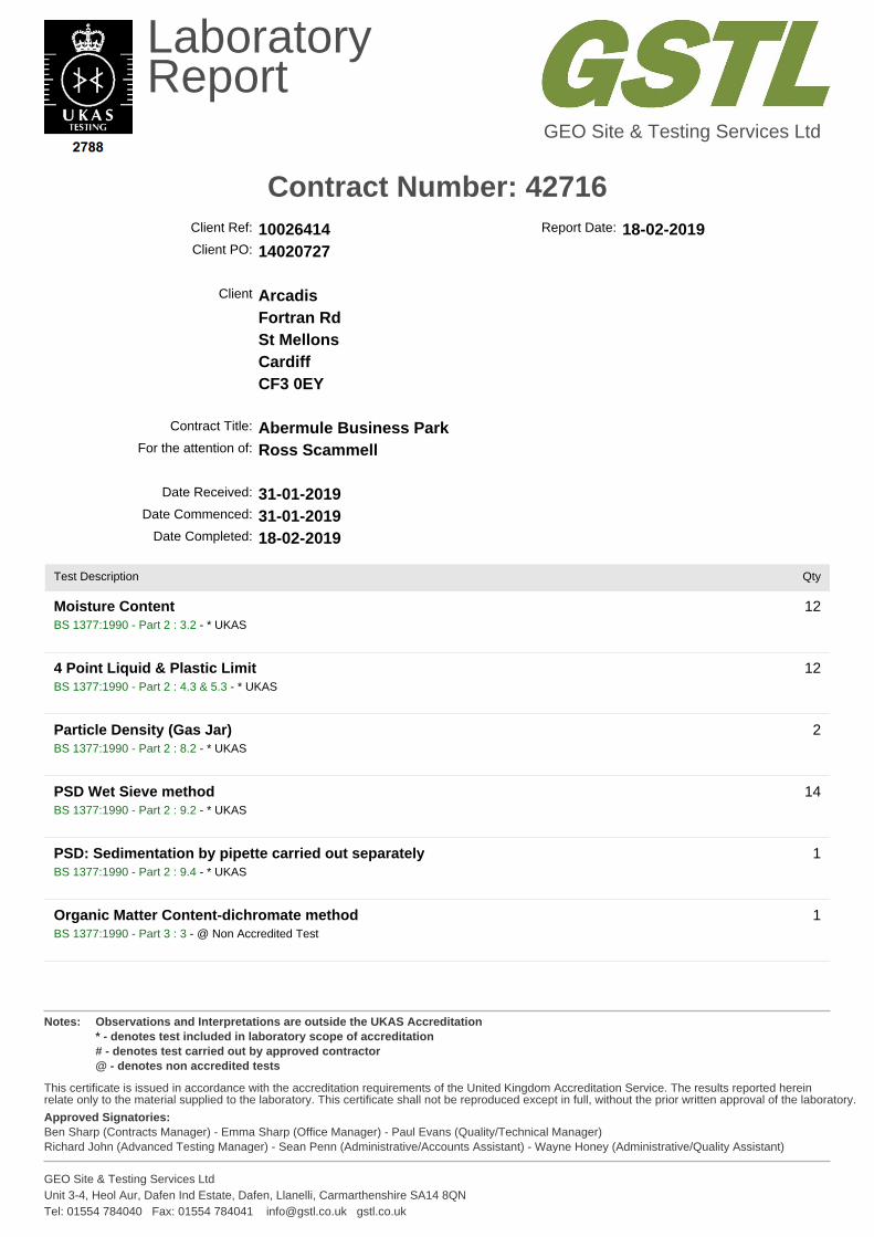
LaboratoryReport
GEO Site & Testing Services Ltd
Contract Number: 42716
Notes: Observations and Interpretations are outside the UKAS Accreditation* - denotes test included in laboratory scope of accreditation# - denotes test carried out by approved contractor@ - denotes non accredited tests
This certificate is issued in accordance with the accreditation requirements of the United Kingdom Accreditation Service. The results reported herein relate only to the material supplied to the laboratory. This certificate shall not be reproduced except in full, without the prior written approval of the laboratory.
Approved Signatories:Ben Sharp (Contracts Manager) - Emma Sharp (Office Manager) - Paul Evans (Quality/Technical Manager)Richard John (Advanced Testing Manager) - Sean Penn (Administrative/Accounts Assistant) - Wayne Honey (Administrative/Quality Assistant)
GEO Site & Testing Services LtdUnit 3-4, Heol Aur, Dafen Ind Estate, Dafen, Llanelli, Carmarthenshire SA14 8QNTel: 01554 784040 Fax: 01554 784041 [email protected] gstl.co.uk
Client Ref: 10026414 Report Date: 18-02-2019Client PO: 14020727
Client ArcadisFortran RdSt MellonsCardiffCF3 0EY
Contract Title: Abermule Business ParkFor the attention of: Ross Scammell
Date Received: 31-01-2019Date Commenced: 31-01-2019
Date Completed: 18-02-2019
Test Description Qty
Moisture ContentBS 1377:1990 - Part 2 : 3.2 - * UKAS
12
4 Point Liquid & Plastic LimitBS 1377:1990 - Part 2 : 4.3 & 5.3 - * UKAS
12
Particle Density (Gas Jar)BS 1377:1990 - Part 2 : 8.2 - * UKAS
2
PSD Wet Sieve methodBS 1377:1990 - Part 2 : 9.2 - * UKAS
14
PSD: Sedimentation by pipette carried out separatelyBS 1377:1990 - Part 2 : 9.4 - * UKAS
1
Organic Matter Content-dichromate methodBS 1377:1990 - Part 3 : 3 - @ Non Accredited Test
1
LaboratoryReport
GEO Site & Testing Services Ltd
Contract Number: 42716
Notes: Observations and Interpretations are outside the UKAS Accreditation* - denotes test included in laboratory scope of accreditation# - denotes test carried out by approved contractor@ - denotes non accredited tests
This certificate is issued in accordance with the accreditation requirements of the United Kingdom Accreditation Service. The results reported herein relate only to the material supplied to the laboratory. This certificate shall not be reproduced except in full, without the prior written approval of the laboratory.
Approved Signatories:Ben Sharp (Contracts Manager) - Emma Sharp (Office Manager) - Paul Evans (Quality/Technical Manager)Richard John (Advanced Testing Manager) - Sean Penn (Administrative/Accounts Assistant) - Wayne Honey (Administrative/Quality Assistant)
GEO Site & Testing Services LtdUnit 3-4, Heol Aur, Dafen Ind Estate, Dafen, Llanelli, Carmarthenshire SA14 8QNTel: 01554 784040 Fax: 01554 784041 [email protected] gstl.co.uk
Test Description Qty
BRE Full Suiteincludes pH, water & acid soluble sulphate, total sulphur, magnesium, chloride and nitrateBRE - BR279 - @ Non Accredited Test
9
Dry Den/MC (2.5kg Rammer Method 1 Litre Mould)BS 1377:1990 - Part 4 : 3.3 - * UKAS
7
Disposal of samples for job 1
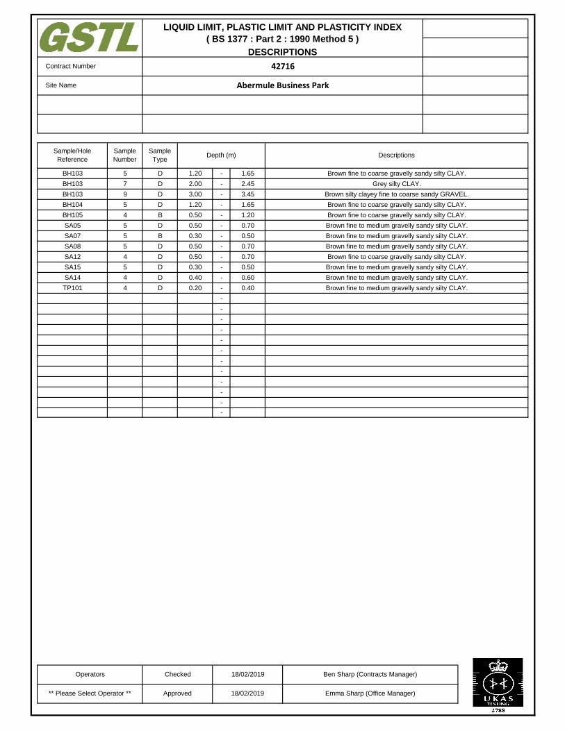
-
-
-
-
-
-
-
-
-
-
-
-
-
-
-
-
-
-
-
-
-
-
-
-
Contract Number 42716
Site Name Abermule Business Park
Brown fine to coarse gravelly sandy silty CLAY.BH103 5 D 1.20 1.65
Sample
Number
Sample
TypeDepth (m) Descriptions
Sample/Hole
Reference
Brown silty clayey fine to coarse sandy GRAVEL.BH103 9 D 3.00 3.45
BH103 7 D 2.00 2.45 Grey silty CLAY.
Brown fine to coarse gravelly sandy silty CLAY.BH105 4 B 0.50 1.20
BH104 5 D 1.20 1.65 Brown fine to coarse gravelly sandy silty CLAY.
Brown fine to medium gravelly sandy silty CLAY.SA07 5 B 0.30 0.50
SA05 5 D 0.50 0.70 Brown fine to medium gravelly sandy silty CLAY.
Brown fine to coarse gravelly sandy silty CLAY.SA12 4 D 0.50 0.70
SA08 5 D 0.50 0.70 Brown fine to medium gravelly sandy silty CLAY.
Brown fine to medium gravelly sandy silty CLAY.SA14 4 D 0.40 0.60
SA15 5 D 0.30 0.50 Brown fine to medium gravelly sandy silty CLAY.
TP101 4 D 0.20 0.40 Brown fine to medium gravelly sandy silty CLAY.
** Please Select Operator ** Approved 18/02/2019
Operators Checked 18/02/2019 Ben Sharp (Contracts Manager)
Emma Sharp (Office Manager)
LIQUID LIMIT, PLASTIC LIMIT AND PLASTICITY INDEX
( BS 1377 : Part 2 : 1990 Method 5 )
DESCRIPTIONS
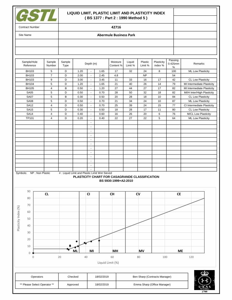
##
-
-
-
-
-
-
-
-
-
-
-
-
-
-
-
-
-
-
-
-
-
-
-
-
Symbols: NP : Non Plastic # : Liquid Limit and Plastic Limit Wet Sieved
v
0.50
0.70
0.70
Site Name
LIQUID LIMIT, PLASTIC LIMIT AND PLASTICITY INDEX
( BS 1377 : Part 2 : 1990 Method 5 )
42716
Abermule Business Park
Contract Number
Remarks
Operators Checked 18/02/2019
18/02/2019Approved** Please Select Operator **
0.70
0.50
0.60
0.40D 0.20
0.50
0.30
0.40
Sample
Type
Moisture
Content %Depth (m)
D
D
Liquid
Limit %
Plastic
Limit %
Plasticity
index %
Passing
0.425mm
%
1.65
1.20
24
NP
16
26
27
17
4.8
11
21
27
8
17
14
17
1.65
2.45
3.45
321.20
2.00
3.00
1.20
0.50
0.50
D
D
D
D
B
D 28
20
21
25
28
26
27
B
D
D
18
16
22
0.30
0.50
33
40
44
50
28
34
39
20
32
18
24
24
17 11
6
522
18
10
10
15
100
54
42
79
82
82
84
87
77
ML Low Plasticity
CL Low Plasticity
MI Intermediate Plasticity
MI Intermediate Plasticity
MI/H Inter/High Plasticity
CL Low Plasticity
ML Low Plasticity
CI Intermediate Plasticity
ML Low Plasticity
80
76
64
CL Low Plasticity
M/CL Low Plasticity
BH103
BH103
BH103
BH104
BH105
SA05
SA07
SA08
SA12
SA15
SA14
TP101
4
Sample
Number
5
7
9
5
4
5
5
5
5
4
4
Sample/Hole
Reference
Ben Sharp (Contracts Manager)
Emma Sharp (Office Manager)
PLASTICITY CHART FOR CASAGRANDE CLASSIFICATION
BS 5930:1999+A2:2010
0
10
20
30
40
50
60
70
80
90
0 20 40 60 80 100 120
Pla
stic
ity
Ind
ex (
%)
Liquid Limit (%)
ML MI MH ME
CECI CH CVCL
MV
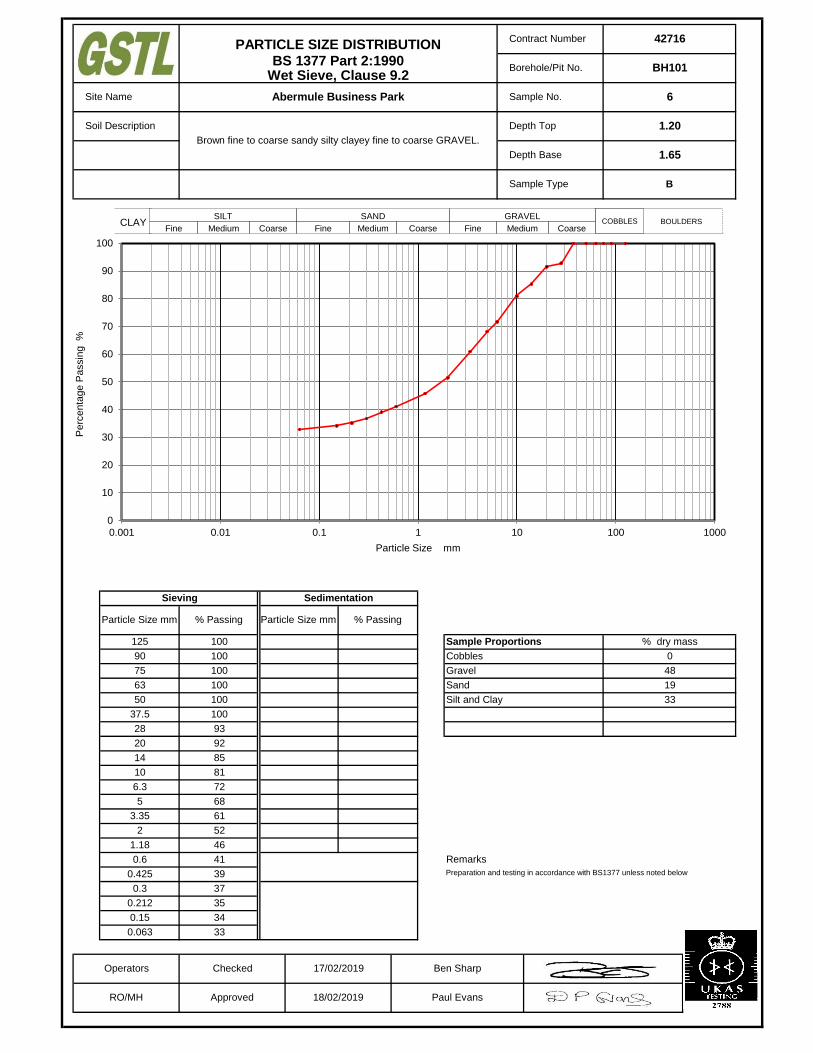
Remarks
Preparation and testing in accordance with BS1377 unless noted below
18/02/2019 Paul Evans
% Passing
0.212 35
0.15 34
0.063 33
0.6 41
0.425 39
0.3 37
2 52
1.18 46
5 68
3.35 61
10 81
6.3 72
Operators Checked 17/02/2019 Ben Sharp
RO/MH Approved
33
Sand
Silt and Clay
63 100
28 93
20 92
14 85
37.5 100
0
48
Cobbles
Gravel
50 100
19
75 100
Particle Size mm
1.65
Brown fine to coarse sandy silty clayey fine to coarse GRAVEL.
Sample Type
125 100
% Passing
Sieving Sedimentation
Particle Size mm
90 100
% dry massSample Proportions
Contract Number
Borehole/Pit No.
Site Name
Soil Description
Depth Base
Depth Top 1.20
PARTICLE SIZE DISTRIBUTIONBS 1377 Part 2:1990
Wet Sieve, Clause 9.2
42716
BH101
Abermule Business Park Sample No. 6
B
÷÷
ø
ö
çç
è
æ
1m
m
SILT
Fine Medium Coarse
SAND
Fine Medium Coarse
GRAVEL
Fine Medium CoarseCLAY COBBLES BOULDERS
0
10
20
30
40
50
60
70
80
90
100
0.001 0.01 0.1 1 10 100 1000
Pe
rce
nta
ge
Pa
ssin
g %
Particle Size mm
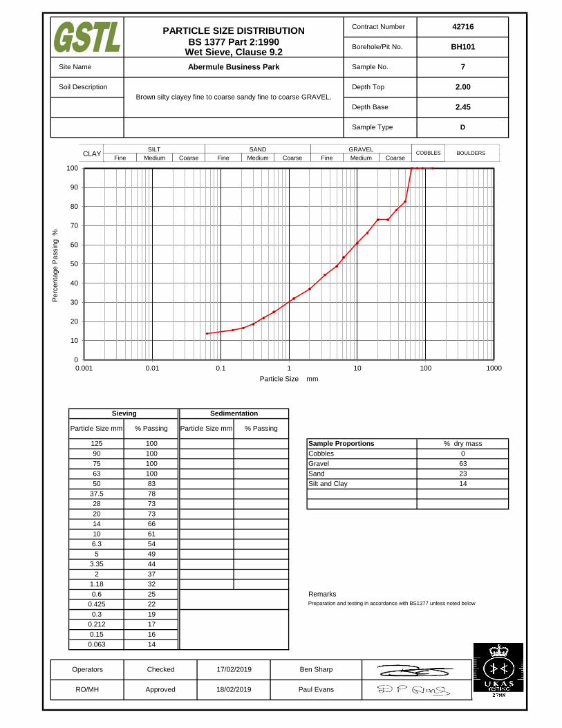
Remarks
Preparation and testing in accordance with BS1377 unless noted below
18/02/2019 Paul Evans
% Passing
0.212 17
0.15 16
0.063 14
0.6 25
0.425 22
0.3 19
2 37
1.18 32
5 49
3.35 44
10 61
6.3 54
Operators Checked 17/02/2019 Ben Sharp
RO/MH Approved
14
Sand
Silt and Clay
63 100
28 73
20 73
14 66
37.5 78
0
63
Cobbles
Gravel
50 83
23
75 100
Particle Size mm
2.45
Brown silty clayey fine to coarse sandy fine to coarse GRAVEL.
Sample Type
125 100
% Passing
Sieving Sedimentation
Particle Size mm
90 100
% dry massSample Proportions
Contract Number
Borehole/Pit No.
Site Name
Soil Description
Depth Base
Depth Top 2.00
PARTICLE SIZE DISTRIBUTIONBS 1377 Part 2:1990
Wet Sieve, Clause 9.2
42716
BH101
Abermule Business Park Sample No. 7
D
÷÷
ø
ö
çç
è
æ
1m
m
SILT
Fine Medium Coarse
SAND
Fine Medium Coarse
GRAVEL
Fine Medium CoarseCLAY COBBLES BOULDERS
0
10
20
30
40
50
60
70
80
90
100
0.001 0.01 0.1 1 10 100 1000
Pe
rce
nta
ge
Pa
ssin
g %
Particle Size mm

Remarks
Preparation and testing in accordance with BS1377 unless noted below
18/02/2019 Paul Evans
% Passing
0.212 9
0.15 8
0.063 8
0.6 11
0.425 10
0.3 9
2 17
1.18 13
5 34
3.35 26
10 50
6.3 42
Operators Checked 17/02/2019 Ben Sharp
RO/MH Approved
8
Sand
Silt and Clay
63 100
28 80
20 65
14 56
37.5 93
0
83
Cobbles
Gravel
50 100
9
75 100
Particle Size mm
2.45
Brown silty fine to medium slightly sandy fine to coarse GRAVEL.
Sample Type
125 100
% Passing
Sieving Sedimentation
Particle Size mm
90 100
% dry massSample Proportions
Contract Number
Borehole/Pit No.
Site Name
Soil Description
Depth Base
Depth Top 2.00
PARTICLE SIZE DISTRIBUTIONBS 1377 Part 2:1990
Wet Sieve, Clause 9.2
42716
BH102
Abermule Business Park Sample No. 7
B
÷÷
ø
ö
çç
è
æ
1m
m
SILT
Fine Medium Coarse
SAND
Fine Medium Coarse
GRAVEL
Fine Medium CoarseCLAY COBBLES BOULDERS
0
10
20
30
40
50
60
70
80
90
100
0.001 0.01 0.1 1 10 100 1000
Pe
rce
nta
ge
Pa
ssin
g %
Particle Size mm
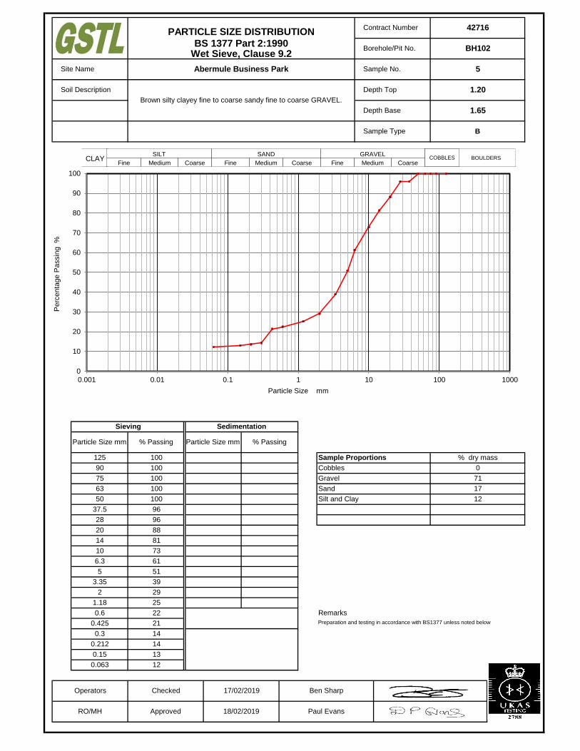
Remarks
Preparation and testing in accordance with BS1377 unless noted below
18/02/2019 Paul Evans
% Passing
0.212 14
0.15 13
0.063 12
0.6 22
0.425 21
0.3 14
2 29
1.18 25
5 51
3.35 39
10 73
6.3 61
Operators Checked 17/02/2019 Ben Sharp
RO/MH Approved
12
Sand
Silt and Clay
63 100
28 96
20 88
14 81
37.5 96
0
71
Cobbles
Gravel
50 100
17
75 100
Particle Size mm
1.65
Brown silty clayey fine to coarse sandy fine to coarse GRAVEL.
Sample Type
125 100
% Passing
Sieving Sedimentation
Particle Size mm
90 100
% dry massSample Proportions
Contract Number
Borehole/Pit No.
Site Name
Soil Description
Depth Base
Depth Top 1.20
PARTICLE SIZE DISTRIBUTIONBS 1377 Part 2:1990
Wet Sieve, Clause 9.2
42716
BH102
Abermule Business Park Sample No. 5
B
÷÷
ø
ö
çç
è
æ
1m
m
SILT
Fine Medium Coarse
SAND
Fine Medium Coarse
GRAVEL
Fine Medium CoarseCLAY COBBLES BOULDERS
0
10
20
30
40
50
60
70
80
90
100
0.001 0.01 0.1 1 10 100 1000
Pe
rce
nta
ge
Pa
ssin
g %
Particle Size mm

Remarks
Preparation and testing in accordance with BS1377 unless noted below
18/02/2019 Paul Evans
% Passing
0.212 10
0.15 9
0.063 9
0.6 11
0.425 11
0.3 10
2 14
1.18 13
5 19
3.35 17
10 27
6.3 23
Operators Checked 17/02/2019 Ben Sharp
RO/MH Approved
9
Sand
Silt and Clay
63 76
28 43
20 33
14 29
37.5 55
24
62
Cobbles
Gravel
50 66
5
75 76
Particle Size mm
4.45
Brown fine to medium slightly sandy silty fine to coarse GRAVEL with
many cobbles.
Sample Type
125 100
% Passing
Sieving Sedimentation
Particle Size mm
90 100
% dry massSample Proportions
Contract Number
Borehole/Pit No.
Site Name
Soil Description
Depth Base
Depth Top 4.00
PARTICLE SIZE DISTRIBUTIONBS 1377 Part 2:1990
Wet Sieve, Clause 9.2
42716
BH103
Abermule Business Park Sample No. 12
B
÷÷
ø
ö
çç
è
æ
1m
m
SILT
Fine Medium Coarse
SAND
Fine Medium Coarse
GRAVEL
Fine Medium CoarseCLAY COBBLES BOULDERS
0
10
20
30
40
50
60
70
80
90
100
0.001 0.01 0.1 1 10 100 1000
Pe
rce
nta
ge
Pa
ssin
g %
Particle Size mm
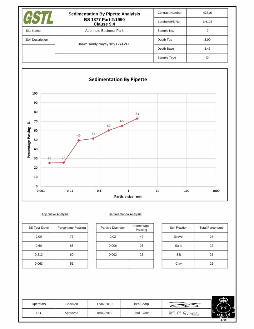
Operators Checked 17/02/2019 Ben Sharp
49
Sedimentation Analysis
65
60
BS Test Sieve
Top Sieve Analysis
Sedimentation By Pipette Analyisis
BS 1377 Part 2:1990Clause 9.4
Contract Number 42716
Borehole/Pit No. BH103
Brown sandy clayey silty GRAVEL.
RO Approved 18/02/2019 Paul Evans
0.063
0.212
0.60
2.00 73
Percentage
Passing
9
Soil Description Depth Top 3.00
3.45
Sample Type D
Site Name Abermule Business Park Sample No.
Depth Base
Total Percentage
27
22
26
Percentage Passing
Clay 25
Particle Diameter
25
25
0.02
0.006
0.002
51
Soil Fraction
Gravel
Sand
Silt
73
65
60
5149
2525
0
10
20
30
40
50
60
70
80
90
100
0.001 0.01 0.1 1 10 100 1000
Pe
rce
nta
ge P
assi
ng
%
Particle size mm
Sedimentation By Pipette
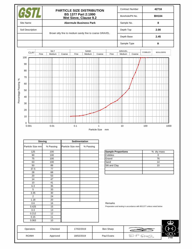
Remarks
Preparation and testing in accordance with BS1377 unless noted below
18/02/2019 Paul Evans
% Passing
0.212 12
0.15 11
0.063 10
0.6 16
0.425 15
0.3 13
2 24
1.18 20
5 33
3.35 30
10 41
6.3 35
Operators Checked 17/02/2019 Ben Sharp
RO/MH Approved
10
Sand
Silt and Clay
63 100
28 68
20 53
14 47
37.5 77
0
76
Cobbles
Gravel
50 89
14
75 100
Particle Size mm
2.45
Brown silty fine to medium sandy fine to coarse GRAVEL.
Sample Type
125 100
% Passing
Sieving Sedimentation
Particle Size mm
90 100
% dry massSample Proportions
Contract Number
Borehole/Pit No.
Site Name
Soil Description
Depth Base
Depth Top 2.00
PARTICLE SIZE DISTRIBUTIONBS 1377 Part 2:1990
Wet Sieve, Clause 9.2
42716
BH104
Abermule Business Park Sample No. 8
B
÷÷
ø
ö
çç
è
æ
1m
m
SILT
Fine Medium Coarse
SAND
Fine Medium Coarse
GRAVEL
Fine Medium CoarseCLAY COBBLES BOULDERS
0
10
20
30
40
50
60
70
80
90
100
0.001 0.01 0.1 1 10 100 1000
Pe
rce
nta
ge
Pa
ssin
g %
Particle Size mm

Remarks
Preparation and testing in accordance with BS1377 unless noted below
18/02/2019 Paul Evans
% Passing
0.212 18
0.15 17
0.063 16
0.6 24
0.425 23
0.3 20
2 29
1.18 27
5 37
3.35 34
10 45
6.3 41
Operators Checked 17/02/2019 Ben Sharp
RO/MH Approved
16
Sand
Silt and Clay
63 60
28 59
20 53
14 48
37.5 60
40
31
Cobbles
Gravel
50 60
13
75 60
Particle Size mm
5.45
Brown fine to medium sandy silty clayey fine to coarse GRAVEL with
many cobbles.
Sample Type
125 100
% Passing
Sieving Sedimentation
Particle Size mm
90 60
% dry massSample Proportions
Contract Number
Borehole/Pit No.
Site Name
Soil Description
Depth Base
Depth Top 5.00
PARTICLE SIZE DISTRIBUTIONBS 1377 Part 2:1990
Wet Sieve, Clause 9.2
42716
BH104
Abermule Business Park Sample No. 14
B
÷÷
ø
ö
çç
è
æ
1m
m
SILT
Fine Medium Coarse
SAND
Fine Medium Coarse
GRAVEL
Fine Medium CoarseCLAY COBBLES BOULDERS
0
10
20
30
40
50
60
70
80
90
100
0.001 0.01 0.1 1 10 100 1000
Pe
rce
nta
ge
Pa
ssin
g %
Particle Size mm

Remarks
Preparation and testing in accordance with BS1377 unless noted below
18/02/2019 Paul Evans
% Passing
0.212 15
0.15 14
0.063 12
0.6 22
0.425 19
0.3 17
2 38
1.18 30
5 43
3.35 41
10 51
6.3 45
Operators Checked 17/02/2019 Ben Sharp
RO/MH Approved
12
Sand
Silt and Clay
63 79
28 68
20 64
14 57
37.5 73
21
41
Cobbles
Gravel
50 79
26
75 100
Particle Size mm
2.45
Brown silty fine to medium sandy fine to coarse GRAVEL with many
cobbles.
Sample Type
125 100
% Passing
Sieving Sedimentation
Particle Size mm
90 100
% dry massSample Proportions
Contract Number
Borehole/Pit No.
Site Name
Soil Description
Depth Base
Depth Top 2.00
PARTICLE SIZE DISTRIBUTIONBS 1377 Part 2:1990
Wet Sieve, Clause 9.2
42716
BH105
Abermule Business Park Sample No. 7
D
÷÷
ø
ö
çç
è
æ
1m
m
SILT
Fine Medium Coarse
SAND
Fine Medium Coarse
GRAVEL
Fine Medium CoarseCLAY COBBLES BOULDERS
0
10
20
30
40
50
60
70
80
90
100
0.001 0.01 0.1 1 10 100 1000
Pe
rce
nta
ge
Pa
ssin
g %
Particle Size mm

Remarks
Preparation and testing in accordance with BS1377 unless noted below
18/02/2019 Paul Evans
% Passing
0.212 34
0.15 32
0.063 31
0.6 38
0.425 37
0.3 36
2 44
1.18 42
5 47
3.35 45
10 49
6.3 48
Operators Checked 17/02/2019 Ben Sharp
RO/MH Approved
31
Sand
Silt and Clay
63 76
28 59
20 53
14 51
37.5 61
24
32
Cobbles
Gravel
50 66
13
75 100
Particle Size mm
1.65
Brown fine to medium sandy silty clayey fine to coarse GRAVEL with
many cobbles.
Sample Type
125 100
% Passing
Sieving Sedimentation
Particle Size mm
90 100
% dry massSample Proportions
Contract Number
Borehole/Pit No.
Site Name
Soil Description
Depth Base
Depth Top 1.20
PARTICLE SIZE DISTRIBUTIONBS 1377 Part 2:1990
Wet Sieve, Clause 9.2
42716
BH106
Abermule Business Park Sample No. 4
D
÷÷
ø
ö
çç
è
æ
1m
m
SILT
Fine Medium Coarse
SAND
Fine Medium Coarse
GRAVEL
Fine Medium CoarseCLAY COBBLES BOULDERS
0
10
20
30
40
50
60
70
80
90
100
0.001 0.01 0.1 1 10 100 1000
Pe
rce
nta
ge
Pa
ssin
g %
Particle Size mm
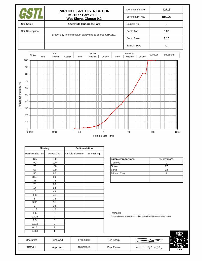
Remarks
Preparation and testing in accordance with BS1377 unless noted below
18/02/2019 Paul Evans
% Passing
0.212 2
0.15 2
0.063 1
0.6 5
0.425 4
0.3 3
2 23
1.18 12
5 36
3.35 31
10 49
6.3 41
Operators Checked 17/02/2019 Ben Sharp
RO/MH Approved
1
Sand
Silt and Clay
63 100
28 73
20 63
14 54
37.5 80
0
77
Cobbles
Gravel
50 80
22
75 100
Particle Size mm
3.10
Brown silty fine to medium sandy fine to coarse GRAVEL.
Sample Type
125 100
% Passing
Sieving Sedimentation
Particle Size mm
90 100
% dry massSample Proportions
Contract Number
Borehole/Pit No.
Site Name
Soil Description
Depth Base
Depth Top 3.00
PARTICLE SIZE DISTRIBUTIONBS 1377 Part 2:1990
Wet Sieve, Clause 9.2
42716
BH106
Abermule Business Park Sample No. 8
D
÷÷
ø
ö
çç
è
æ
1m
m
SILT
Fine Medium Coarse
SAND
Fine Medium Coarse
GRAVEL
Fine Medium CoarseCLAY COBBLES BOULDERS
0
10
20
30
40
50
60
70
80
90
100
0.001 0.01 0.1 1 10 100 1000
Pe
rce
nta
ge
Pa
ssin
g %
Particle Size mm
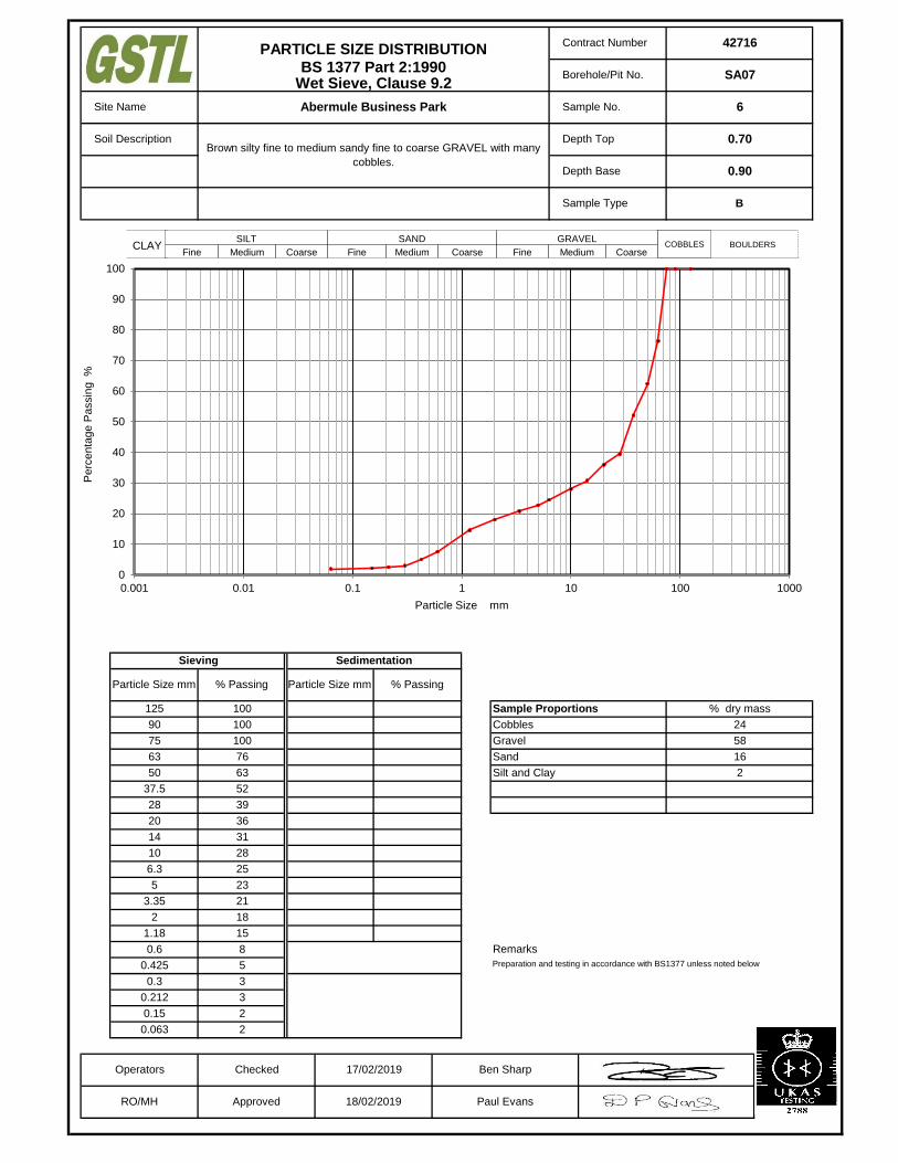
Remarks
Preparation and testing in accordance with BS1377 unless noted below
18/02/2019 Paul Evans
% Passing
0.212 3
0.15 2
0.063 2
0.6 8
0.425 5
0.3 3
2 18
1.18 15
5 23
3.35 21
10 28
6.3 25
Operators Checked 17/02/2019 Ben Sharp
RO/MH Approved
2
Sand
Silt and Clay
63 76
28 39
20 36
14 31
37.5 52
24
58
Cobbles
Gravel
50 63
16
75 100
Particle Size mm
0.90
Brown silty fine to medium sandy fine to coarse GRAVEL with many
cobbles.
Sample Type
125 100
% Passing
Sieving Sedimentation
Particle Size mm
90 100
% dry massSample Proportions
Contract Number
Borehole/Pit No.
Site Name
Soil Description
Depth Base
Depth Top 0.70
PARTICLE SIZE DISTRIBUTIONBS 1377 Part 2:1990
Wet Sieve, Clause 9.2
42716
SA07
Abermule Business Park Sample No. 6
B
÷÷
ø
ö
çç
è
æ
1m
m
SILT
Fine Medium Coarse
SAND
Fine Medium Coarse
GRAVEL
Fine Medium CoarseCLAY COBBLES BOULDERS
0
10
20
30
40
50
60
70
80
90
100
0.001 0.01 0.1 1 10 100 1000
Pe
rce
nta
ge
Pa
ssin
g %
Particle Size mm

Remarks
Preparation and testing in accordance with BS1377 unless noted below
18/02/2019 Paul Evans
% Passing
0.212 9
0.15 8
0.063 7
0.6 21
0.425 17
0.3 12
2 27
1.18 23
5 38
3.35 34
10 50
6.3 42
Operators Checked 17/02/2019 Ben Sharp
RO/MH Approved
7
Sand
Silt and Clay
63 100
28 69
20 63
14 56
37.5 69
0
73
Cobbles
Gravel
50 77
20
75 100
Particle Size mm
1.20
Brown silty fine to coarse sandy fine to coarse GRAVEL.
Sample Type
125 100
% Passing
Sieving Sedimentation
Particle Size mm
90 100
% dry massSample Proportions
Contract Number
Borehole/Pit No.
Site Name
Soil Description
Depth Base
Depth Top 1.10
PARTICLE SIZE DISTRIBUTIONBS 1377 Part 2:1990
Wet Sieve, Clause 9.2
42716
SA10
Abermule Business Park Sample No. 7
B
÷÷
ø
ö
çç
è
æ
1m
m
SILT
Fine Medium Coarse
SAND
Fine Medium Coarse
GRAVEL
Fine Medium CoarseCLAY COBBLES BOULDERS
0
10
20
30
40
50
60
70
80
90
100
0.001 0.01 0.1 1 10 100 1000
Pe
rce
nta
ge
Pa
ssin
g %
Particle Size mm

Remarks
Preparation and testing in accordance with BS1377 unless noted below
18/02/2019 Paul Evans
% Passing
0.212 10
0.15 9
0.063 8
0.6 16
0.425 15
0.3 12
2 21
1.18 19
5 26
3.35 24
10 36
6.3 29
Operators Checked 17/02/2019 Ben Sharp
RO/MH Approved
8
Sand
Silt and Clay
63 100
28 70
20 48
14 41
37.5 87
0
79
Cobbles
Gravel
50 87
13
75 100
Particle Size mm
1.00
Brown silty fine to coarse sandy fine to coarse GRAVEL.
Sample Type
125 100
% Passing
Sieving Sedimentation
Particle Size mm
90 100
% dry massSample Proportions
Contract Number
Borehole/Pit No.
Site Name
Soil Description
Depth Base
Depth Top 0.80
PARTICLE SIZE DISTRIBUTIONBS 1377 Part 2:1990
Wet Sieve, Clause 9.2
42716
SA15
Abermule Business Park Sample No. 7
B
÷÷
ø
ö
çç
è
æ
1m
m
SILT
Fine Medium Coarse
SAND
Fine Medium Coarse
GRAVEL
Fine Medium CoarseCLAY COBBLES BOULDERS
0
10
20
30
40
50
60
70
80
90
100
0.001 0.01 0.1 1 10 100 1000
Pe
rce
nta
ge
Pa
ssin
g %
Particle Size mm

Remarks
Preparation and testing in accordance with BS1377 unless noted below
18/02/2019 Paul Evans
% Passing
0.212 25
0.15 25
0.063 24
0.6 29
0.425 28
0.3 27
2 33
1.18 31
5 38
3.35 36
10 42
6.3 39
Operators Checked 17/02/2019 Ben Sharp
RO/MH Approved
24
Sand
Silt and Clay
63 76
28 55
20 50
14 45
37.5 62
24
43
Cobbles
Gravel
50 62
9
75 76
Particle Size mm
0.60
Brown fine to medium slightly sandy silty clayey fine to coarse
GRAVEL with many cobbles.
Sample Type
125 100
% Passing
Sieving Sedimentation
Particle Size mm
90 100
% dry massSample Proportions
Contract Number
Borehole/Pit No.
Site Name
Soil Description
Depth Base
Depth Top 0.40
PARTICLE SIZE DISTRIBUTIONBS 1377 Part 2:1990
Wet Sieve, Clause 9.2
42716
TP104
Abermule Business Park Sample No. 5
B
÷÷
ø
ö
çç
è
æ
1m
m
SILT
Fine Medium Coarse
SAND
Fine Medium Coarse
GRAVEL
Fine Medium CoarseCLAY COBBLES BOULDERS
0
10
20
30
40
50
60
70
80
90
100
0.001 0.01 0.1 1 10 100 1000
Pe
rce
nta
ge
Pa
ssin
g %
Particle Size mm
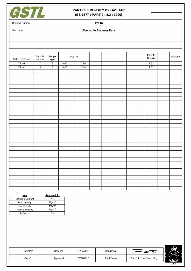
-
-
-
-
-
-
-
-
-
-
-
-
-
-
-
-
-
-
-
-
-
-
-
-
-
-
-
-
-
-
-
-
-
-
Moisture Content
Bulk Density
Dry Density
Particle Density
Key
Air Voids
PARTICLE DENSITY BY GAS JAR
(BS 1377 : PART 2 : 8.2 : 1990)
Hole ReferenceRemarks
42716
Abermule Business Park
Contract Number
Particle
Density
Site Name
Ben Sharp
Paul Evans20/02/2019ApprovedCA/JS
Reported As
%
Mg/m3
Mg/m3
Mg/m3
%
Operators Checked 19/02/2019
Depth (m)
B
B
0.60
0.40
Sample
Type
0.80
0.60
2.62
2.63
Sample
Number
7
5
TP101
TP104
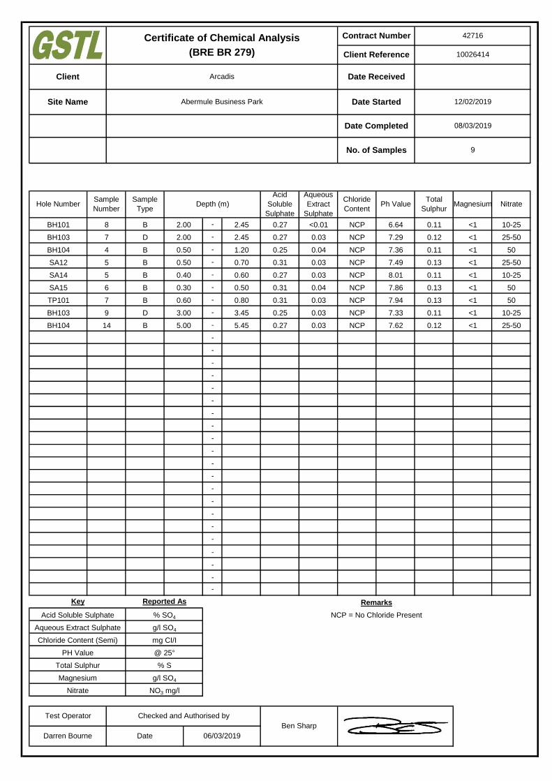
10026414
Certificate of Chemical Analysis
(BRE BR 279)
Client Arcadis Date Received
Site Name Abermule Business Park Date Started 12/02/2019
08/03/2019
No. of Samples 9
Date Completed
Contract Number 42716
Client Reference
-
-
-
-
-
-
-
-
-
-
-
-
-
-
-
-
-
-
-
-
-
-
-
-
-
-
-
-
-
-
g/l SO4
NO3 mg/l
Key
Acid Soluble Sulphate
Aqueous Extract Sulphate
Chloride Content (Semi)
PH Value
Total Sulphur
Magnesium
Nitrate
% SO4
g/l SO4
mg CI/I
@ 25°
% S
Reported As
SA15
TP101
BH103
BH104
BH101
BH103
BH104
SA12
SA14
0.12 <1 25-50
25-50
50
0.25 0.03 NCP 7.33 0.11 <1 10-25
10-25
0.31 0.04 NCP 7.86 0.13 <1 50
0.27 <0.01 NCP 6.64
0.25 0.04 NCP 7.36
0.27 0.03 NCP 8.01
0.31 0.03 NCP
2.45
2.45
1.20
0.70
0.60
0.50
0.80
3.45
5.45
2.00
2.00
0.30
0.60
3.00
5.00
5
5
6
7
9
B
B
B
B
D
B
Aqueous
Extract
Sulphate
Chloride
ContentPh Value
Total
SulphurMagnesium
14
B
D
B
0.31 0.03 NCP 7.49 0.13 <1
<1
0.27 0.03 NCP 7.29 0.12
8 0.11
Hole Number
Checked and Authorised by
Ben Sharp
Darren Bourne Date 06/03/2019
0.27 0.03
0.50
0.50
0.40
7
4
Test Operator
Remarks
NCP = No Chloride Present
Sample
Type
Sample
NumberDepth (m)
Acid
Soluble
Sulphate
0.11 <1
0.11 <1
7.94 0.13 <1
NCP 7.62
Nitrate
50
25-50
10-25
<1
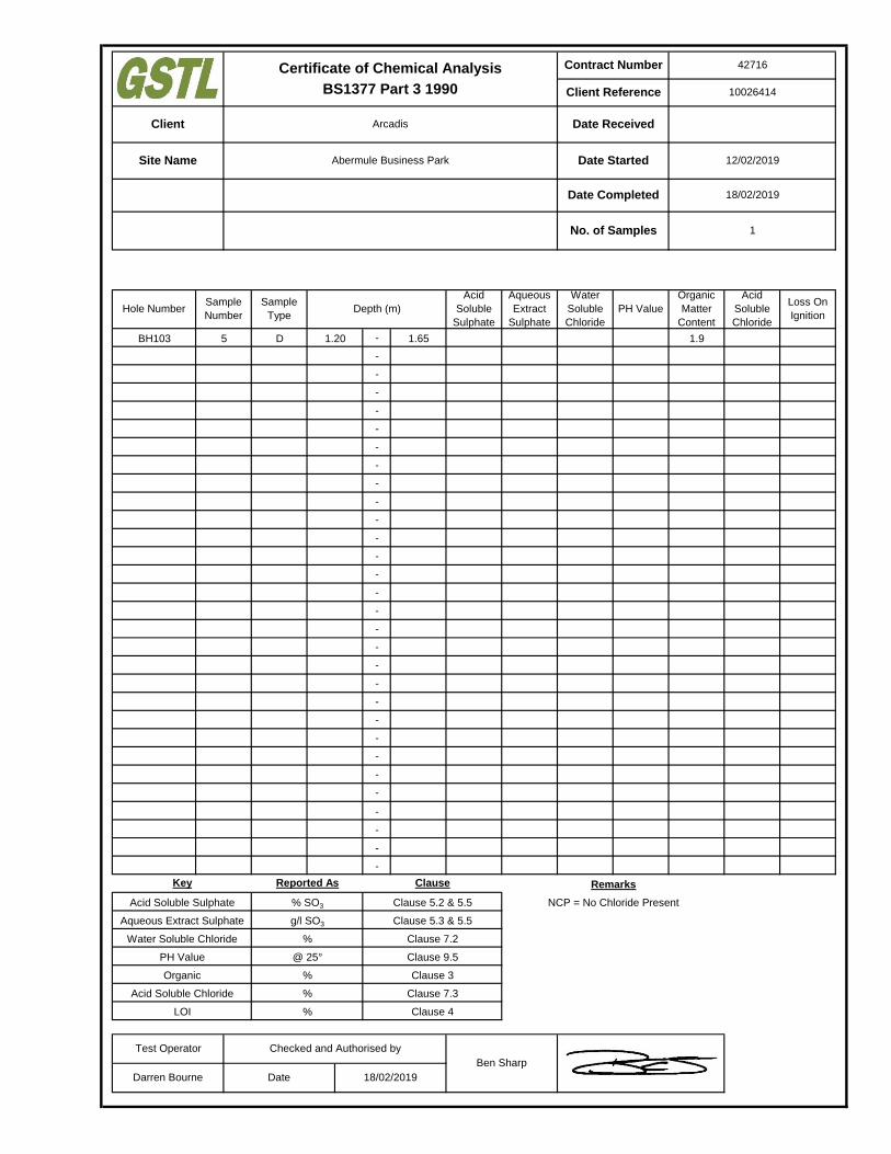
-
-
-
-
-
-
-
-
-
-
-
-
-
-
-
-
-
-
-
-
-
-
-
-
-
-
-
-
-
-
Clause
Clause 5.2 & 5.5
Clause 5.3 & 5.5
Clause 7.2
Clause 9.5
%
%
Key
Acid Soluble Sulphate
Aqueous Extract Sulphate
Water Soluble Chloride
PH Value
Organic
Acid Soluble Chloride
LOI
% SO3
g/l SO3
%
@ 25°
%
Reported As
Clause 3
Clause 7.3
Clause 4
BH103 1.205
Water
Soluble
Chloride
PH Value
Organic
Matter
Content
Acid
Soluble
Chloride
D 1.65 1.9
Hole Number
Checked and Authorised by
Ben Sharp
Darren Bourne Date 18/02/2019
Test Operator
Remarks
NCP = No Chloride Present
Sample
Type
Sample
NumberDepth (m)
Acid
Soluble
Sulphate
Aqueous
Extract
Sulphate
Loss On
Ignition
10026414
Certificate of Chemical Analysis
BS1377 Part 3 1990
Client Arcadis Date Received
Site Name Abermule Business Park Date Started 12/02/2019
18/02/2019
No. of Samples 1
Date Completed
Contract Number 42716
Client Reference
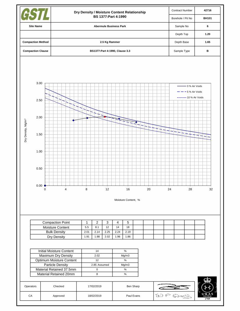
Operators
CA
Checked
Approved
17/02/2019
18/02/2019 Paul Evans
Ben Sharp
Depth Top 1.20
Compaction Method 2.5 Kg Rammer Depth Base 1.65
Compaction Clause Sample Type BBS1377:Part 4:1990, Clause 3.3
Contract Number 42716
Borehole / Pit No BH101
Site Name Abermule Business Park Sample No 6
Dry Density / Moisture Content Relationship
BS 1377:Part 4:1990
1
5.5
Compaction Point
18
2.19
1.86
Moisture Content
Bulk Density
Dry Density
Initial Moisture Content
Maximum Dry Density
Optimum Moisture Content
8.1 12
2.25
2.02 1.96
2.24
14
2.01
1.91 1.98
2.14
Particle Density
Material Retained 37.5mm
Material Retained 20mm
2.85
14
2.02
12
Assumed
0
8
%
Mg/m3
%
Mg/m3
%
%
2 3 4 5
0.00
0.50
1.00
1.50
2.00
2.50
3.00
0 4 8 12 16 20 24 28 32
Dry
Density, M
g/m
3
Moisture Content, %
0 % Air Voids
5 % Air Voids
10 % Air Voids
Operators
CA
Checked
Approved
17/02/2019
18/02/2019 Paul Evans
Ben Sharp
Soil Description Grey fine to coarse gravelly silty CLAY. Depth Top 1.20
Compaction Method 2.5 Kg Rammer Depth Base 1.65
Compaction Clause Sample Type BBS1377:Part 4:1990, Clause 3.3
Contract Number 42716
Borehole / Pit No BH102
Site Name Abermule Business Park Sample No 4
Dry Density / Moisture Content Relationship
BS 1377:Part 4:1990
1
3.2
Compaction Point
16
2.07
1.79
Moisture Content
Bulk Density
Dry Density
Initial Moisture Content
Maximum Dry Density
Optimum Moisture Content
6.0 9.4
2.13
1.95 1.88
2.12
13
1.89
1.83 1.90
2.01
Particle Density
Material Retained 37.5mm
Material Retained 20mm
2.65
13
1.95
9
Assumed
0
6.3
%
Mg/m3
%
Mg/m3
%
%
2 3 4 5
0.00
0.50
1.00
1.50
2.00
2.50
3.00
0 4 8 12 16 20 24 28 32
Dry
Density, M
g/m
3
Moisture Content, %
0 % Air Voids
5 % Air Voids
10 % Air Voids
Operators
CA
Checked
Approved
17/02/2019
18/02/2019 Paul Evans
Ben Sharp
Soil Description Grey silty CLAY. Depth Top 0.50
Compaction Method 2.5 Kg Rammer Depth Base 1.20
Compaction Clause Sample Type BBS1377:Part 4:1990, Clause 3.3
Contract Number 42716
Borehole / Pit No BH103
Site Name Abermule Business Park Sample No 4
Dry Density / Moisture Content Relationship
BS 1377:Part 4:1990
1
9.7
Compaction Point
24
2.03
1.64
Moisture Content
Bulk Density
Dry Density
Initial Moisture Content
Maximum Dry Density
Optimum Moisture Content
12 16
2.10
1.82 1.76
2.08
18
1.89
1.72 1.78
2.00
Particle Density
Material Retained 37.5mm
Material Retained 20mm
2.65
24
1.82
16
Assumed
0
6.3
%
Mg/m3
%
Mg/m3
%
%
2 3 4 5
0.00
0.50
1.00
1.50
2.00
2.50
3.00
0 4 8 12 16 20 24 28 32
Dry
Density, M
g/m
3
Moisture Content, %
0 % Air Voids
5 % Air Voids
10 % Air Voids
Operators
CA
Checked
Approved
17/02/2019
18/02/2019 Paul Evans
Ben Sharp
Soil Description Brown fine to coarse gravelly silty CLAY. Depth Top 0.50
Compaction Method 2.5 Kg Rammer Depth Base 1.20
Compaction Clause Sample Type BBS1377:Part 4:1990, Clause 3.3
Contract Number 42716
Borehole / Pit No BH104
Site Name Abermule Business Park Sample No 4
Dry Density / Moisture Content Relationship
BS 1377:Part 4:1990
1
6.4
Compaction Point
22
2.07
1.70
Moisture Content
Bulk Density
Dry Density
Initial Moisture Content
Maximum Dry Density
Optimum Moisture Content
9.1 13
2.15
1.91 1.86
2.14
15
1.91
1.80 1.87
2.04
Particle Density
Material Retained 37.5mm
Material Retained 20mm
2.65
22
1.91
13
Assumed
0
3.6
%
Mg/m3
%
Mg/m3
%
%
2 3 4 5
0.00
0.50
1.00
1.50
2.00
2.50
3.00
0 4 8 12 16 20 24 28 32
Dry
Density, M
g/m
3
Moisture Content, %
0 % Air Voids
5 % Air Voids
10 % Air Voids

Operators
CA
Checked
Approved
17/02/2019
18/02/2019 Paul Evans
Ben Sharp
Depth Top 2.00
Compaction Method 2.5 Kg Rammer Depth Base 2.45
Compaction Clause Sample Type BBS1377:Part 4:1990, Clause 3.3
Contract Number 42716
Borehole / Pit No BH104
Site Name Abermule Business Park Sample No 8
Dry Density / Moisture Content Relationship
BS 1377:Part 4:1990
1
3.1
Compaction Point
16
2.38
2.06
Moisture Content
Bulk Density
Dry Density
Initial Moisture Content
Maximum Dry Density
Optimum Moisture Content
6.7 9.8
2.41
2.19 2.11
2.37
12
2.14
2.08 2.13
2.27
Particle Density
Material Retained 37.5mm
Material Retained 20mm
2.95
9.8
2.19
10
Assumed
23
47
%
Mg/m3
%
Mg/m3
%
%
2 3 4 5
0.00
0.50
1.00
1.50
2.00
2.50
3.00
3.50
0 4 8 12 16 20 24 28 32
Dry
Density, M
g/m
3
Moisture Content, %
0 % Air Voids
5 % Air Voids
10 % Air Voids
Operators
CA
Checked
Approved
17/02/2019
18/02/2019 Paul Evans
Ben Sharp
Soil Description Grey fine to coarse gravelly silty CLAY. Depth Top 0.30
Compaction Method 2.5 Kg Rammer Depth Base 0.50
Compaction Clause Sample Type BBS1377:Part 4:1990, Clause 3.3
Contract Number 42716
Borehole / Pit No SA15
Site Name Abermule Business Park Sample No 6
Dry Density / Moisture Content Relationship
BS 1377:Part 4:1990
1
5.9
Compaction Point
17
1.97
1.68
Moisture Content
Bulk Density
Dry Density
Initial Moisture Content
Maximum Dry Density
Optimum Moisture Content
8.5 11
2.07
1.87 1.76
2.01
14
1.87
1.77 1.82
1.97
Particle Density
Material Retained 37.5mm
Material Retained 20mm
2.65
17
1.87
11
Assumed
0
4.4
%
Mg/m3
%
Mg/m3
%
%
2 3 4 5
0.00
0.50
1.00
1.50
2.00
2.50
3.00
0 4 8 12 16 20 24 28 32
Dry
Density, M
g/m
3
Moisture Content, %
0 % Air Voids
5 % Air Voids
10 % Air Voids
Operators
CA
Checked
Approved
17/02/2019
18/02/2019 Paul Evans
Ben Sharp
Depth Top 0.80
Compaction Method 2.5 Kg Rammer Depth Base 1.00
Compaction Clause Sample Type BBS1377:Part 4:1990, Clause 3.3
Contract Number 42716
Borehole / Pit No SA15
Site Name Abermule Business Park Sample No 7
Dry Density / Moisture Content Relationship
BS 1377:Part 4:1990
1
2.2
Compaction Point
15
2.21
1.93
Moisture Content
Bulk Density
Dry Density
Initial Moisture Content
Maximum Dry Density
Optimum Moisture Content
5.7 8.2
2.29
2.12 2.04
2.27
11
2.03
1.99 2.07
2.19
Particle Density
Material Retained 37.5mm
Material Retained 20mm
2.65
8.2
2.12
8
Assumed
13
52
%
Mg/m3
%
Mg/m3
%
%
2 3 4 5
0.00
0.50
1.00
1.50
2.00
2.50
3.00
0 4 8 12 16 20 24 28 32
Dry
Density, M
g/m
3
Moisture Content, %
0 % Air Voids
5 % Air Voids
10 % Air Voids

69
Environmental Laboratory Results
Asbestos Laboratory Reports and Material Risk Assessment Reports (as provided by Powys County Council)
Gemma Francis
t: 01173721360 t: 01923 225404f: 01923 237404
e: [email protected] e:
Project / Site name: Samples received on: 11/01/2019
Your job number: 10026414 Samples instructed on: 15/01/2019
Your order number: Analysis completed by: 24/01/2019
Report Issue Number: 1 Report issued on: 24/01/2019
Samples Analysed:
Signed:
Reporting ManagerFor & on behalf of i2 Analytical Ltd.
Standard Geotechnical, Asbestos and Chemical Testing Laboratory located at: ul. Pionierów 39, 41 -711 Ruda Śląska, Poland.
Accredited tests are defined within the report, opinions and interpretations expressed herein are outside the scope of accreditation.
Standard sample disposal times, unless otherwise agreed with the laboratory, are : soils - 4 weeks from reportingleachates - 2 weeks from reportingwaters - 2 weeks from reportingasbestos - 6 months from reporting
Excel copies of reports are only valid when accompanied by this PDF certificate.
Jordan Hill
8 soil samples
Abermule Business Park
Arcadis Consulting (UK) Ltd5th FloorThe PithayBristolBS1 2NL
i2 Analytical Ltd.7 Woodshots Meadow,Croxley Green Business Park,Watford, Herts, WD18 8YS
Analytical Report Number : 19-24944
This certificate should not be reproduced, except in full, without the express permission of the laboratory.
The results included within the report are representative of the samples submitted for analysis.
Iss No 19-24944-1 Abermule Business Park 10026414
Page 1 of 8
Analytical Report Number: 19-24944
Project / Site name: Abermule Business Park
Lab Sample Number 1131913 1131914 1131915 1131916 1131917Sample Reference SA01 SA01 SA05 SA06 SA08Sample Number 1 3 1 1 1Depth (m) 0.00-0.10 0.30-0.50 0.00-0.30 0.00-0.20 0.00-0.20Date Sampled Deviating Deviating Deviating Deviating DeviatingTime Taken None Supplied None Supplied None Supplied None Supplied None Supplied
Analytical Parameter
(Soil Analysis)
Un
its
Lim
it of
de
tectio
n
Accre
dita
tion
Sta
tus
Stone Content % 0.1 NONE < 0.1 < 0.1 < 0.1 < 0.1 < 0.1Moisture Content % N/A NONE 15 9.0 16 19 16Total mass of sample received kg 0.001 NONE 1.2 1.3 1.1 1.8 2.0
Asbestos in Soil Type N/A ISO 17025 Not-detected Not-detected Not-detected Not-detected Not-detected
General Inorganics
pH - Automated pH Units N/A MCERTS 7.5 7.2 7.0 6.4 7.8Total Cyanide mg/kg 1 MCERTS < 1 < 1 < 1 < 1 < 1Free Cyanide mg/kg 1 MCERTS < 1 < 1 < 1 < 1 < 1Water Soluble SO4 16hr extraction (2:1 Leachate Equivalent) g/l 0.00125 MCERTS 0.015 0.012 0.016 0.013 0.0090
Total Phenols
Total Phenols (monohydric) mg/kg 1 MCERTS < 1.0 < 1.0 < 1.0 < 1.0 < 1.0
Speciated PAHs
Naphthalene mg/kg 0.05 MCERTS < 0.05 < 0.05 < 0.05 < 0.05 < 0.05Acenaphthylene mg/kg 0.05 MCERTS < 0.05 < 0.05 < 0.05 < 0.05 < 0.05Acenaphthene mg/kg 0.05 MCERTS < 0.05 < 0.05 < 0.05 < 0.05 < 0.05Fluorene mg/kg 0.05 MCERTS < 0.05 < 0.05 < 0.05 < 0.05 < 0.05Phenanthrene mg/kg 0.05 MCERTS < 0.05 < 0.05 < 0.05 < 0.05 < 0.05Anthracene mg/kg 0.05 MCERTS < 0.05 < 0.05 < 0.05 < 0.05 < 0.05Fluoranthene mg/kg 0.05 MCERTS 0.53 < 0.05 0.51 0.25 < 0.05Pyrene mg/kg 0.05 MCERTS 0.51 < 0.05 0.47 0.25 < 0.05Benzo(a)anthracene mg/kg 0.05 MCERTS 0.43 < 0.05 0.31 < 0.05 < 0.05Chrysene mg/kg 0.05 MCERTS 0.31 < 0.05 0.30 < 0.05 < 0.05Benzo(b)fluoranthene mg/kg 0.05 MCERTS 0.57 < 0.05 0.45 < 0.05 < 0.05Benzo(k)fluoranthene mg/kg 0.05 MCERTS 0.20 < 0.05 0.24 < 0.05 < 0.05Benzo(a)pyrene mg/kg 0.05 MCERTS 0.45 < 0.05 0.39 < 0.05 < 0.05Indeno(1,2,3-cd)pyrene mg/kg 0.05 MCERTS 0.27 < 0.05 0.22 < 0.05 < 0.05Dibenz(a,h)anthracene mg/kg 0.05 MCERTS < 0.05 < 0.05 < 0.05 < 0.05 < 0.05Benzo(ghi)perylene mg/kg 0.05 MCERTS 0.29 < 0.05 0.23 < 0.05 < 0.05
Total PAH
Speciated Total EPA-16 PAHs mg/kg 0.8 MCERTS 3.56 < 0.80 3.12 < 0.80 < 0.80
This certificate should not be reproduced, except in full, without the express permission of the laboratory.
The results included within the report are representative of the samples submitted for analysis.
Iss No 19-24944-1 Abermule Business Park 10026414
Page 2 of 8

Analytical Report Number: 19-24944
Project / Site name: Abermule Business Park
Lab Sample Number 1131913 1131914 1131915 1131916 1131917Sample Reference SA01 SA01 SA05 SA06 SA08Sample Number 1 3 1 1 1Depth (m) 0.00-0.10 0.30-0.50 0.00-0.30 0.00-0.20 0.00-0.20Date Sampled Deviating Deviating Deviating Deviating DeviatingTime Taken None Supplied None Supplied None Supplied None Supplied None Supplied
Analytical Parameter
(Soil Analysis)
Un
its
Lim
it of
de
tectio
n
Accre
dita
tion
Sta
tus
Heavy Metals / Metalloids
Arsenic (aqua regia extractable) mg/kg 1 MCERTS 9.3 13 8.5 9.2 13Boron (water soluble) mg/kg 0.2 MCERTS 1.1 0.3 1.4 0.9 0.8Cadmium (aqua regia extractable) mg/kg 0.2 MCERTS < 0.2 < 0.2 < 0.2 < 0.2 < 0.2Chromium (hexavalent) mg/kg 4 MCERTS < 4.0 < 4.0 < 4.0 < 4.0 < 4.0Chromium (aqua regia extractable) mg/kg 1 MCERTS 35 36 34 38 33Copper (aqua regia extractable) mg/kg 1 MCERTS 28 41 26 26 27Lead (aqua regia extractable) mg/kg 1 MCERTS 31 27 31 31 27Mercury (aqua regia extractable) mg/kg 0.3 MCERTS < 0.3 < 0.3 < 0.3 < 0.3 < 0.3Nickel (aqua regia extractable) mg/kg 1 MCERTS 32 44 34 35 33Selenium (aqua regia extractable) mg/kg 1 MCERTS < 1.0 < 1.0 < 1.0 < 1.0 < 1.0Zinc (aqua regia extractable) mg/kg 1 MCERTS 110 110 120 120 110
Monoaromatics
Benzene ug/kg 1 MCERTS < 1.0 - < 1.0 - -Toluene µg/kg 1 MCERTS < 1.0 - < 1.0 - -Ethylbenzene µg/kg 1 MCERTS < 1.0 - < 1.0 - -p & m-xylene µg/kg 1 MCERTS < 1.0 - < 1.0 - -o-xylene µg/kg 1 MCERTS < 1.0 - < 1.0 - -MTBE (Methyl Tertiary Butyl Ether) µg/kg 1 MCERTS < 1.0 - < 1.0 - -
Petroleum Hydrocarbons
TPH-CWG - Aliphatic >EC5 - EC6 mg/kg 0.001 MCERTS < 0.001 - < 0.001 - -TPH-CWG - Aliphatic >EC6 - EC8 mg/kg 0.001 MCERTS < 0.001 - < 0.001 - -TPH-CWG - Aliphatic >EC8 - EC10 mg/kg 0.001 MCERTS < 0.001 - < 0.001 - -TPH-CWG - Aliphatic >EC10 - EC12 mg/kg 1 MCERTS < 1.0 - < 1.0 - -TPH-CWG - Aliphatic >EC12 - EC16 mg/kg 2 MCERTS < 2.0 - < 2.0 - -TPH-CWG - Aliphatic >EC16 - EC21 mg/kg 8 MCERTS < 8.0 - < 8.0 - -TPH-CWG - Aliphatic >EC21 - EC35 mg/kg 8 MCERTS < 8.0 - < 8.0 - -TPH-CWG - Aliphatic (EC5 - EC35) mg/kg 10 MCERTS < 10 - < 10 - -
TPH-CWG - Aromatic >EC5 - EC7 mg/kg 0.001 MCERTS < 0.001 - < 0.001 - -TPH-CWG - Aromatic >EC7 - EC8 mg/kg 0.001 MCERTS < 0.001 - < 0.001 - -TPH-CWG - Aromatic >EC8 - EC10 mg/kg 0.001 MCERTS < 0.001 - < 0.001 - -TPH-CWG - Aromatic >EC10 - EC12 mg/kg 1 MCERTS < 1.0 - < 1.0 - -TPH-CWG - Aromatic >EC12 - EC16 mg/kg 2 MCERTS < 2.0 - < 2.0 - -TPH-CWG - Aromatic >EC16 - EC21 mg/kg 10 MCERTS < 10 - < 10 - -TPH-CWG - Aromatic >EC21 - EC35 mg/kg 10 MCERTS 13 - 22 - -TPH-CWG - Aromatic (EC5 - EC35) mg/kg 10 MCERTS 16 - 26 - -
This certificate should not be reproduced, except in full, without the express permission of the laboratory.
The results included within the report are representative of the samples submitted for analysis.
Iss No 19-24944-1 Abermule Business Park 10026414
Page 3 of 8
Analytical Report Number: 19-24944
Project / Site name: Abermule Business Park
Lab Sample Number
Sample Reference
Sample Number
Depth (m)
Date Sampled
Time Taken
Analytical Parameter
(Soil Analysis)
Un
its
Lim
it of
de
tectio
n
Accre
dita
tion
Sta
tus
Stone Content % 0.1 NONE
Moisture Content % N/A NONE
Total mass of sample received kg 0.001 NONE
Asbestos in Soil Type N/A ISO 17025
General Inorganics
pH - Automated pH Units N/A MCERTS
Total Cyanide mg/kg 1 MCERTS
Free Cyanide mg/kg 1 MCERTSWater Soluble SO4 16hr extraction (2:1 Leachate Equivalent) g/l 0.00125 MCERTS
Total Phenols
Total Phenols (monohydric) mg/kg 1 MCERTS
Speciated PAHs
Naphthalene mg/kg 0.05 MCERTS
Acenaphthylene mg/kg 0.05 MCERTS
Acenaphthene mg/kg 0.05 MCERTS
Fluorene mg/kg 0.05 MCERTS
Phenanthrene mg/kg 0.05 MCERTS
Anthracene mg/kg 0.05 MCERTS
Fluoranthene mg/kg 0.05 MCERTS
Pyrene mg/kg 0.05 MCERTS
Benzo(a)anthracene mg/kg 0.05 MCERTS
Chrysene mg/kg 0.05 MCERTS
Benzo(b)fluoranthene mg/kg 0.05 MCERTS
Benzo(k)fluoranthene mg/kg 0.05 MCERTS
Benzo(a)pyrene mg/kg 0.05 MCERTS
Indeno(1,2,3-cd)pyrene mg/kg 0.05 MCERTS
Dibenz(a,h)anthracene mg/kg 0.05 MCERTS
Benzo(ghi)perylene mg/kg 0.05 MCERTS
Total PAH
Speciated Total EPA-16 PAHs mg/kg 0.8 MCERTS
1131918 1131919 1131920SA11 SA14 SA16
None Supplied 1 10.00-0.30 0.10-0.30 0.00-0.20Deviating Deviating Deviating
None Supplied None Supplied None Supplied
27 < 0.1 < 0.114 17 161.7 1.7 1.7
Not-detected Not-detected Not-detected
7.3 7.0 7.2< 1 < 1 < 1< 1 < 1 < 1
0.013 0.014 0.013
< 1.0 < 1.0 < 1.0
< 0.05 < 0.05 < 0.05< 0.05 < 0.05 < 0.05< 0.05 < 0.05 < 0.05< 0.05 < 0.05 < 0.05< 0.05 < 0.05 1.8< 0.05 < 0.05 0.47< 0.05 < 0.05 8.2< 0.05 < 0.05 7.7< 0.05 < 0.05 5.5< 0.05 < 0.05 4.6< 0.05 < 0.05 7.8< 0.05 < 0.05 3.7< 0.05 < 0.05 7.2< 0.05 < 0.05 4.4< 0.05 < 0.05 0.97< 0.05 < 0.05 4.8
< 0.80 < 0.80 57.1
This certificate should not be reproduced, except in full, without the express permission of the laboratory.
The results included within the report are representative of the samples submitted for analysis.
Iss No 19-24944-1 Abermule Business Park 10026414
Page 4 of 8
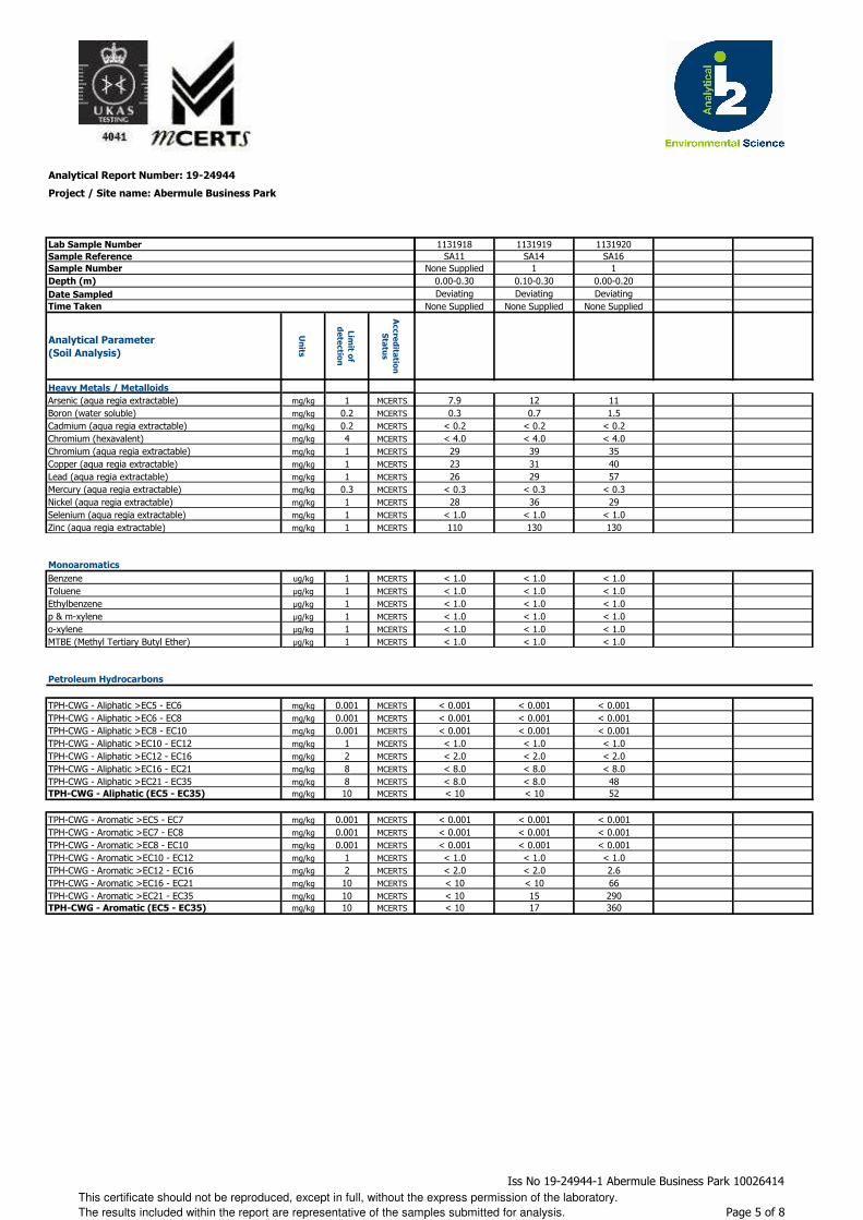
Analytical Report Number: 19-24944
Project / Site name: Abermule Business Park
Lab Sample Number
Sample Reference
Sample Number
Depth (m)
Date Sampled
Time Taken
Analytical Parameter
(Soil Analysis)
Un
its
Lim
it of
de
tectio
n
Accre
dita
tion
Sta
tus
Heavy Metals / Metalloids
Arsenic (aqua regia extractable) mg/kg 1 MCERTS
Boron (water soluble) mg/kg 0.2 MCERTS
Cadmium (aqua regia extractable) mg/kg 0.2 MCERTS
Chromium (hexavalent) mg/kg 4 MCERTS
Chromium (aqua regia extractable) mg/kg 1 MCERTS
Copper (aqua regia extractable) mg/kg 1 MCERTS
Lead (aqua regia extractable) mg/kg 1 MCERTS
Mercury (aqua regia extractable) mg/kg 0.3 MCERTS
Nickel (aqua regia extractable) mg/kg 1 MCERTS
Selenium (aqua regia extractable) mg/kg 1 MCERTS
Zinc (aqua regia extractable) mg/kg 1 MCERTS
Monoaromatics
Benzene ug/kg 1 MCERTS
Toluene µg/kg 1 MCERTS
Ethylbenzene µg/kg 1 MCERTS
p & m-xylene µg/kg 1 MCERTS
o-xylene µg/kg 1 MCERTS
MTBE (Methyl Tertiary Butyl Ether) µg/kg 1 MCERTS
Petroleum Hydrocarbons
TPH-CWG - Aliphatic >EC5 - EC6 mg/kg 0.001 MCERTS
TPH-CWG - Aliphatic >EC6 - EC8 mg/kg 0.001 MCERTS
TPH-CWG - Aliphatic >EC8 - EC10 mg/kg 0.001 MCERTS
TPH-CWG - Aliphatic >EC10 - EC12 mg/kg 1 MCERTS
TPH-CWG - Aliphatic >EC12 - EC16 mg/kg 2 MCERTS
TPH-CWG - Aliphatic >EC16 - EC21 mg/kg 8 MCERTS
TPH-CWG - Aliphatic >EC21 - EC35 mg/kg 8 MCERTSTPH-CWG - Aliphatic (EC5 - EC35) mg/kg 10 MCERTS
TPH-CWG - Aromatic >EC5 - EC7 mg/kg 0.001 MCERTS
TPH-CWG - Aromatic >EC7 - EC8 mg/kg 0.001 MCERTS
TPH-CWG - Aromatic >EC8 - EC10 mg/kg 0.001 MCERTS
TPH-CWG - Aromatic >EC10 - EC12 mg/kg 1 MCERTS
TPH-CWG - Aromatic >EC12 - EC16 mg/kg 2 MCERTS
TPH-CWG - Aromatic >EC16 - EC21 mg/kg 10 MCERTS
TPH-CWG - Aromatic >EC21 - EC35 mg/kg 10 MCERTSTPH-CWG - Aromatic (EC5 - EC35) mg/kg 10 MCERTS
1131918 1131919 1131920SA11 SA14 SA16
None Supplied 1 10.00-0.30 0.10-0.30 0.00-0.20Deviating Deviating Deviating
None Supplied None Supplied None Supplied
7.9 12 110.3 0.7 1.5
< 0.2 < 0.2 < 0.2< 4.0 < 4.0 < 4.0
29 39 3523 31 4026 29 57
< 0.3 < 0.3 < 0.328 36 29
< 1.0 < 1.0 < 1.0110 130 130
< 1.0 < 1.0 < 1.0< 1.0 < 1.0 < 1.0< 1.0 < 1.0 < 1.0< 1.0 < 1.0 < 1.0< 1.0 < 1.0 < 1.0< 1.0 < 1.0 < 1.0
< 0.001 < 0.001 < 0.001< 0.001 < 0.001 < 0.001< 0.001 < 0.001 < 0.001< 1.0 < 1.0 < 1.0< 2.0 < 2.0 < 2.0< 8.0 < 8.0 < 8.0< 8.0 < 8.0 48< 10 < 10 52
< 0.001 < 0.001 < 0.001< 0.001 < 0.001 < 0.001< 0.001 < 0.001 < 0.001< 1.0 < 1.0 < 1.0< 2.0 < 2.0 2.6< 10 < 10 66< 10 15 290< 10 17 360
This certificate should not be reproduced, except in full, without the express permission of the laboratory.
The results included within the report are representative of the samples submitted for analysis.
Iss No 19-24944-1 Abermule Business Park 10026414
Page 5 of 8
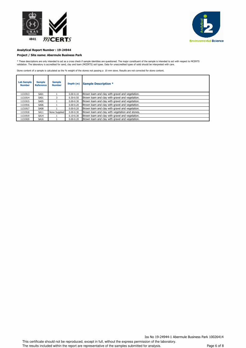
Analytical Report Number : 19-24944
Project / Site name: Abermule Business Park
Lab Sample
Number
Sample
Reference
Sample
NumberDepth (m) Sample Description *
1131913 SA01 1 0.00-0.10 Brown loam and clay with gravel and vegetation.1131914 SA01 3 0.30-0.50 Brown loam and clay with gravel and vegetation.1131915 SA05 1 0.00-0.30 Brown loam and clay with gravel and vegetation.1131916 SA06 1 0.00-0.20 Brown loam and clay with gravel and vegetation.1131917 SA08 1 0.00-0.20 Brown loam and clay with gravel and vegetation.1131918 SA11 None Supplied 0.00-0.30 Brown loam and clay with vegetation and stones.1131919 SA14 1 0.10-0.30 Brown loam and clay with gravel and vegetation.1131920 SA16 1 0.00-0.20 Brown loam and clay with gravel and vegetation.
* These descriptions are only intended to act as a cross check if sample identities are questioned. The major constituent of the sample is intended to act with respect to MCERTS validation. The laboratory is accredited for sand, clay and loam (MCERTS) soil types. Data for unaccredited types of solid should be interpreted with care.
Stone content of a sample is calculated as the % weight of the stones not passing a 10 mm sieve. Results are not corrected for stone content.
This certificate should not be reproduced, except in full, without the express permission of the laboratory.
The results included within the report are representative of the samples submitted for analysis.
Iss No 19-24944-1 Abermule Business Park 10026414
Page 6 of 8

Analytical Report Number : 19-24944
Project / Site name: Abermule Business Park
Water matrix abbreviations: Surface Water (SW) Potable Water (PW) Ground Water (GW) Process Water (PrW)
Analytical Test Name Analytical Method Description Analytical Method ReferenceMethod
number
Wet / Dry
Analysis
Accreditation
Status
Asbestos identification in soil Asbestos Identification with the use of polarised light microscopy in conjunction with disperion staining techniques.
In house method based on HSG 248 A001-PL D ISO 17025
Boron, water soluble, in soil Determination of water soluble boron in soil by hot water extract followed by ICP-OES.
In-house method based on Second Site Properties version 3
L038-PL D MCERTS
BTEX and MTBE in soil (Monoaromatics)
Determination of BTEX in soil by headspace GC-MS.
In-house method based on USEPA8260 L073B-PL W MCERTS
Free cyanide in soil Determination of free cyanide by distillation followed by colorimetry.
In-house method based on Examination of Water and Wastewater 20th Edition: Clesceri, Greenberg & Eaton (Skalar)
L080-PL W MCERTS
Hexavalent chromium in soil Determination of hexavalent chromium in soil by extraction in water then by acidification, addition of 1,5 diphenylcarbazide followed by colorimetry.
In-house method L080-PL W MCERTS
Metals in soil by ICP-OES Determination of metals in soil by aqua-regia digestion followed by ICP-OES.
In-house method based on MEWAM 2006 Methods for the Determination of Metals in Soil.
L038-PL D MCERTS
Moisture Content Moisture content, determined gravimetrically. In-house method based on BS1377 Part 2, 1990, Chemical and Electrochemical Tests
L019-UK/PL W NONE
Monohydric phenols in soil Determination of phenols in soil by extraction with sodium hydroxide followed by distillation followed by colorimetry.
In-house method based on Examination of Water and Wastewater 20th Edition: Clesceri, Greenberg & Eaton (skalar)
L080-PL W MCERTS
pH in soil (automated) Determination of pH in soil by addition of water followed by automated electrometric measurement.
In-house method based on BS1377 Part 3, 1990, Chemical and Electrochemical Tests
L099-PL D MCERTS
Speciated EPA-16 PAHs in soil Determination of PAH compounds in soil by extraction in dichloromethane and hexane followed by GC-MS with the use of surrogate and internal standards.
In-house method based on USEPA 8270 L064-PL D MCERTS
Stones content of soil Standard preparation for all samples unless otherwise detailed. Gravimetric determination of stone > 10 mm as % dry weight.
In-house method based on British Standard Methods and MCERTS requirements.
L019-UK/PL D NONE
Sulphate, water soluble, in soil (16hr extraction)
Determination of water soluble sulphate by ICP-OES. Results reported directly (leachate equivalent) and corrected for extraction ratio (soil equivalent).
In-house method based on BS1377 Part 3, 1990, Chemical and Electrochemical Tests, 2:1 water:soil extraction, analysis by ICP-OES.
L038-PL D MCERTS
Total cyanide in soil Determination of total cyanide by distillation followed by colorimetry.
In-house method based on Examination of Water and Wastewater 20th Edition: Clesceri, Greenberg & Eaton (Skalar)
L080-PL W MCERTS
TPHCWG (Soil) Determination of hexane extractable hydrocarbons in soil by GC-MS/GC-FID.
In-house method with silica gel split/clean up.
L088/76-PL W MCERTS
For method numbers ending in 'UK' analysis have been carried out in our laboratory in the United Kingdom.
For method numbers ending in 'PL' analysis have been carried out in our laboratory in Poland.
Soil analytical results are expressed on a dry weight basis. Where analysis is carried out on as-received the results obtained are multiplied by a moisture
correction factor that is determined gravimetrically using the moisture content which is carried out at a maximum of 30oC.
This certificate should not be reproduced, except in full, without the express permission of the laboratory.
The results included within the report are representative of the samples submitted for analysis.
Iss No 19-24944-1 Abermule Business Park 10026414
Page 7 of 8
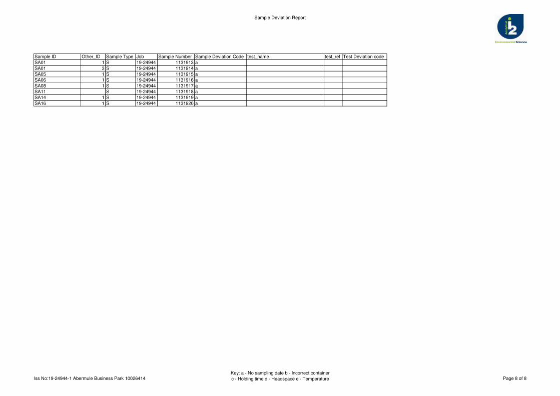
Sample Deviation Report
Sample ID Other_ID Sample Type Job Sample Number Sample Deviation Code test_name test_ref Test Deviation code
SA01 1 S 19-24944 1131913 a
SA01 3 S 19-24944 1131914 a
SA05 1 S 19-24944 1131915 a
SA06 1 S 19-24944 1131916 a
SA08 1 S 19-24944 1131917 a
SA11 S 19-24944 1131918 a
SA14 1 S 19-24944 1131919 a
SA16 1 S 19-24944 1131920 a
Iss No:19-24944-1 Abermule Business Park 10026414Key: a - No sampling date b - Incorrect container
c - Holding time d - Headspace e - Temperature Page 8 of 8
Karl Addison
t: 01923 225404f: 01923 237404
e: [email protected] e:
Project / Site name: Samples received on: 11/01/2019
Your job number: 10026414 Samples instructed on: 15/01/2019
Your order number: 14020726 Analysis completed by: 24/01/2019
Report Issue Number: 1 Report issued on: 24/01/2019
Samples Analysed:
Signed:
Reporting ManagerFor & on behalf of i2 Analytical Ltd.
Standard Geotechnical, Asbestos and Chemical Testing Laboratory located at: ul. Pionierów 39, 41 -711 Ruda Śląska, Poland.
Accredited tests are defined within the report, opinions and interpretations expressed herein are outside the scope of accreditation.
Standard sample disposal times, unless otherwise agreed with the laboratory, are : soils - 4 weeks from reportingleachates - 2 weeks from reportingwaters - 2 weeks from reportingasbestos - 6 months from reporting
Excel copies of reports are only valid when accompanied by this PDF certificate.
Jordan Hill
5 soil samples
Abermule Business Park
Arcadis Consulting (UK) Ltd5th Floor401 Faraday StreetBirchwood ParkWarringtonWA3 6GA
i2 Analytical Ltd.7 Woodshots Meadow,Croxley Green Business Park,Watford, Herts, WD18 8YS
Analytical Report Number : 19-24967
This certificate should not be reproduced, except in full, without the express permission of the laboratory.
The results included within the report are representative of the samples submitted for analysis.
Iss No 19-24967-1 Abermule Business Park 10026414
Page 1 of 6

Analytical Report Number: 19-24967
Project / Site name: Abermule Business Park
Your Order No: 14020726
Lab Sample Number 1132073 1132074 1132075 1132076 1132077Sample Reference BH101 BH102 BH102 BH106 BH106Sample Number None Supplied None Supplied None Supplied None Supplied None SuppliedDepth (m) 0.00-0.50 0.00-0.50 1.20-1.65 0.10-0.20 0.60-0.80Date Sampled Deviating Deviating Deviating Deviating DeviatingTime Taken None Supplied None Supplied None Supplied None Supplied None Supplied
Analytical Parameter
(Soil Analysis)
Un
its
Lim
it of
de
tectio
n
Accre
dita
tion
Sta
tus
Stone Content % 0.1 NONE < 0.1 < 0.1 20 < 0.1 < 0.1Moisture Content % N/A NONE 19 19 11 18 6.7Total mass of sample received kg 0.001 NONE 1.3 1.1 1.6 1.8 2.0
Asbestos in Soil Type N/A ISO 17025 Not-detected Not-detected Not-detected Not-detected Not-detected
General Inorganics
pH - Automated pH Units N/A MCERTS 6.6 6.7 7.2 6.8 6.9Total Cyanide mg/kg 1 MCERTS < 1 < 1 < 1 < 1 < 1Free Cyanide mg/kg 1 MCERTS < 1 < 1 < 1 < 1 < 1Water Soluble SO4 16hr extraction (2:1 Leachate Equivalent) g/l 0.00125 MCERTS 0.016 0.013 0.0081 0.014 0.011
Total Phenols
Total Phenols (monohydric) mg/kg 1 MCERTS < 1.0 < 1.0 < 1.0 < 1.0 < 1.0
Speciated PAHs
Naphthalene mg/kg 0.05 MCERTS < 0.05 < 0.05 < 0.05 < 0.05 < 0.05Acenaphthylene mg/kg 0.05 MCERTS < 0.05 < 0.05 < 0.05 < 0.05 < 0.05Acenaphthene mg/kg 0.05 MCERTS < 0.05 < 0.05 < 0.05 < 0.05 < 0.05Fluorene mg/kg 0.05 MCERTS < 0.05 < 0.05 < 0.05 < 0.05 < 0.05Phenanthrene mg/kg 0.05 MCERTS < 0.05 < 0.05 < 0.05 < 0.05 < 0.05Anthracene mg/kg 0.05 MCERTS < 0.05 < 0.05 < 0.05 < 0.05 < 0.05Fluoranthene mg/kg 0.05 MCERTS 0.26 < 0.05 < 0.05 < 0.05 < 0.05Pyrene mg/kg 0.05 MCERTS 0.24 < 0.05 < 0.05 < 0.05 < 0.05Benzo(a)anthracene mg/kg 0.05 MCERTS < 0.05 < 0.05 < 0.05 < 0.05 < 0.05Chrysene mg/kg 0.05 MCERTS < 0.05 < 0.05 < 0.05 < 0.05 < 0.05Benzo(b)fluoranthene mg/kg 0.05 MCERTS < 0.05 < 0.05 < 0.05 < 0.05 < 0.05Benzo(k)fluoranthene mg/kg 0.05 MCERTS < 0.05 < 0.05 < 0.05 < 0.05 < 0.05Benzo(a)pyrene mg/kg 0.05 MCERTS < 0.05 < 0.05 < 0.05 < 0.05 < 0.05Indeno(1,2,3-cd)pyrene mg/kg 0.05 MCERTS < 0.05 < 0.05 < 0.05 < 0.05 < 0.05Dibenz(a,h)anthracene mg/kg 0.05 MCERTS < 0.05 < 0.05 < 0.05 < 0.05 < 0.05Benzo(ghi)perylene mg/kg 0.05 MCERTS < 0.05 < 0.05 < 0.05 < 0.05 < 0.05
Total PAH
Speciated Total EPA-16 PAHs mg/kg 0.8 MCERTS < 0.80 < 0.80 < 0.80 < 0.80 < 0.80
Heavy Metals / Metalloids
Arsenic (aqua regia extractable) mg/kg 1 MCERTS 9.3 12 11 12 12Boron (water soluble) mg/kg 0.2 MCERTS 1.1 1.3 < 0.2 0.9 < 0.2Cadmium (aqua regia extractable) mg/kg 0.2 MCERTS < 0.2 < 0.2 < 0.2 < 0.2 < 0.2Chromium (hexavalent) mg/kg 4 MCERTS < 4.0 < 4.0 < 4.0 < 4.0 < 4.0Chromium (aqua regia extractable) mg/kg 1 MCERTS 38 40 28 36 32Copper (aqua regia extractable) mg/kg 1 MCERTS 30 29 34 30 31Lead (aqua regia extractable) mg/kg 1 MCERTS 31 29 17 33 22Mercury (aqua regia extractable) mg/kg 0.3 MCERTS < 0.3 0.3 < 0.3 0.7 < 0.3Nickel (aqua regia extractable) mg/kg 1 MCERTS 36 37 37 33 38Selenium (aqua regia extractable) mg/kg 1 MCERTS < 1.0 < 1.0 < 1.0 < 1.0 < 1.0Zinc (aqua regia extractable) mg/kg 1 MCERTS 120 130 98 130 100
This certificate should not be reproduced, except in full, without the express permission of the laboratory.
The results included within the report are representative of the samples submitted for analysis.
Iss No 19-24967-1 Abermule Business Park 10026414
Page 2 of 6
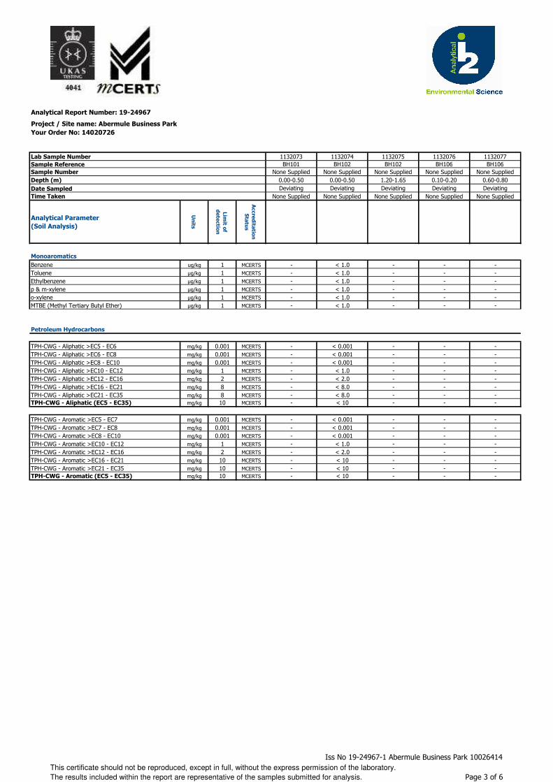
Analytical Report Number: 19-24967
Project / Site name: Abermule Business Park
Your Order No: 14020726
Lab Sample Number 1132073 1132074 1132075 1132076 1132077Sample Reference BH101 BH102 BH102 BH106 BH106Sample Number None Supplied None Supplied None Supplied None Supplied None SuppliedDepth (m) 0.00-0.50 0.00-0.50 1.20-1.65 0.10-0.20 0.60-0.80Date Sampled Deviating Deviating Deviating Deviating DeviatingTime Taken None Supplied None Supplied None Supplied None Supplied None Supplied
Analytical Parameter
(Soil Analysis)
Un
its
Lim
it of
de
tectio
n
Accre
dita
tion
Sta
tus
Monoaromatics
Benzene ug/kg 1 MCERTS - < 1.0 - - -Toluene µg/kg 1 MCERTS - < 1.0 - - -Ethylbenzene µg/kg 1 MCERTS - < 1.0 - - -p & m-xylene µg/kg 1 MCERTS - < 1.0 - - -o-xylene µg/kg 1 MCERTS - < 1.0 - - -MTBE (Methyl Tertiary Butyl Ether) µg/kg 1 MCERTS - < 1.0 - - -
Petroleum Hydrocarbons
TPH-CWG - Aliphatic >EC5 - EC6 mg/kg 0.001 MCERTS - < 0.001 - - -TPH-CWG - Aliphatic >EC6 - EC8 mg/kg 0.001 MCERTS - < 0.001 - - -TPH-CWG - Aliphatic >EC8 - EC10 mg/kg 0.001 MCERTS - < 0.001 - - -TPH-CWG - Aliphatic >EC10 - EC12 mg/kg 1 MCERTS - < 1.0 - - -TPH-CWG - Aliphatic >EC12 - EC16 mg/kg 2 MCERTS - < 2.0 - - -TPH-CWG - Aliphatic >EC16 - EC21 mg/kg 8 MCERTS - < 8.0 - - -TPH-CWG - Aliphatic >EC21 - EC35 mg/kg 8 MCERTS - < 8.0 - - -TPH-CWG - Aliphatic (EC5 - EC35) mg/kg 10 MCERTS - < 10 - - -
TPH-CWG - Aromatic >EC5 - EC7 mg/kg 0.001 MCERTS - < 0.001 - - -TPH-CWG - Aromatic >EC7 - EC8 mg/kg 0.001 MCERTS - < 0.001 - - -TPH-CWG - Aromatic >EC8 - EC10 mg/kg 0.001 MCERTS - < 0.001 - - -TPH-CWG - Aromatic >EC10 - EC12 mg/kg 1 MCERTS - < 1.0 - - -TPH-CWG - Aromatic >EC12 - EC16 mg/kg 2 MCERTS - < 2.0 - - -TPH-CWG - Aromatic >EC16 - EC21 mg/kg 10 MCERTS - < 10 - - -TPH-CWG - Aromatic >EC21 - EC35 mg/kg 10 MCERTS - < 10 - - -TPH-CWG - Aromatic (EC5 - EC35) mg/kg 10 MCERTS - < 10 - - -
This certificate should not be reproduced, except in full, without the express permission of the laboratory.
The results included within the report are representative of the samples submitted for analysis.
Iss No 19-24967-1 Abermule Business Park 10026414
Page 3 of 6
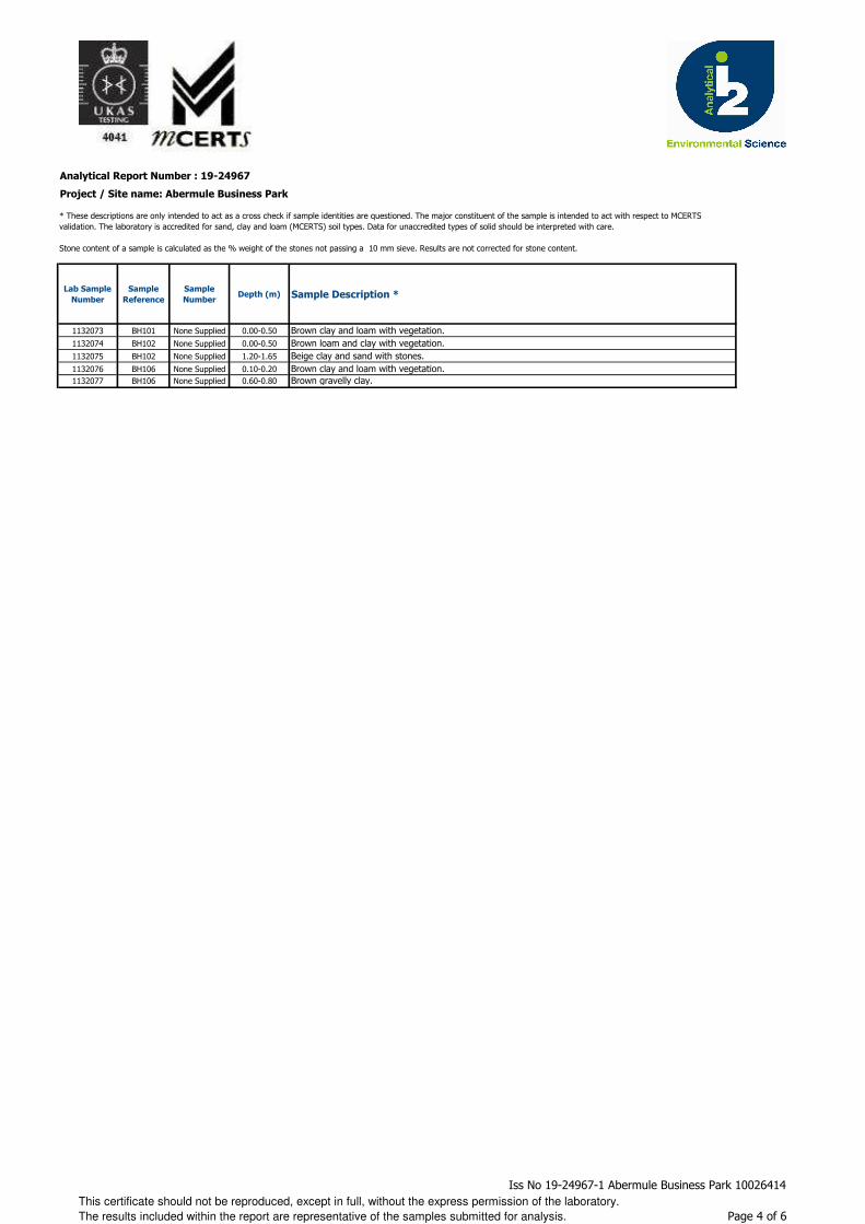
Analytical Report Number : 19-24967
Project / Site name: Abermule Business Park
Lab Sample
Number
Sample
Reference
Sample
NumberDepth (m) Sample Description *
1132073 BH101 None Supplied 0.00-0.50 Brown clay and loam with vegetation.1132074 BH102 None Supplied 0.00-0.50 Brown loam and clay with vegetation.1132075 BH102 None Supplied 1.20-1.65 Beige clay and sand with stones.1132076 BH106 None Supplied 0.10-0.20 Brown clay and loam with vegetation.1132077 BH106 None Supplied 0.60-0.80 Brown gravelly clay.
* These descriptions are only intended to act as a cross check if sample identities are questioned. The major constituent of the sample is intended to act with respect to MCERTS validation. The laboratory is accredited for sand, clay and loam (MCERTS) soil types. Data for unaccredited types of solid should be interpreted with care.
Stone content of a sample is calculated as the % weight of the stones not passing a 10 mm sieve. Results are not corrected for stone content.
This certificate should not be reproduced, except in full, without the express permission of the laboratory.
The results included within the report are representative of the samples submitted for analysis.
Iss No 19-24967-1 Abermule Business Park 10026414
Page 4 of 6

Analytical Report Number : 19-24967
Project / Site name: Abermule Business Park
Water matrix abbreviations: Surface Water (SW) Potable Water (PW) Ground Water (GW) Process Water (PrW)
Analytical Test Name Analytical Method Description Analytical Method ReferenceMethod
number
Wet / Dry
Analysis
Accreditation
Status
Asbestos identification in soil Asbestos Identification with the use of polarised light microscopy in conjunction with disperion staining techniques.
In house method based on HSG 248 A001-PL D ISO 17025
Boron, water soluble, in soil Determination of water soluble boron in soil by hot water extract followed by ICP-OES.
In-house method based on Second Site Properties version 3
L038-PL D MCERTS
BTEX and MTBE in soil (Monoaromatics)
Determination of BTEX in soil by headspace GC-MS.
In-house method based on USEPA8260 L073B-PL W MCERTS
Free cyanide in soil Determination of free cyanide by distillation followed by colorimetry.
In-house method based on Examination of Water and Wastewater 20th Edition: Clesceri, Greenberg & Eaton (Skalar)
L080-PL W MCERTS
Hexavalent chromium in soil Determination of hexavalent chromium in soil by extraction in water then by acidification, addition of 1,5 diphenylcarbazide followed by colorimetry.
In-house method L080-PL W MCERTS
Metals in soil by ICP-OES Determination of metals in soil by aqua-regia digestion followed by ICP-OES.
In-house method based on MEWAM 2006 Methods for the Determination of Metals in Soil.
L038-PL D MCERTS
Moisture Content Moisture content, determined gravimetrically. In-house method based on BS1377 Part 2, 1990, Chemical and Electrochemical Tests
L019-UK/PL W NONE
Monohydric phenols in soil Determination of phenols in soil by extraction with sodium hydroxide followed by distillation followed by colorimetry.
In-house method based on Examination of Water and Wastewater 20th Edition: Clesceri, Greenberg & Eaton (skalar)
L080-PL W MCERTS
pH in soil (automated) Determination of pH in soil by addition of water followed by automated electrometric measurement.
In-house method based on BS1377 Part 3, 1990, Chemical and Electrochemical Tests
L099-PL D MCERTS
Speciated EPA-16 PAHs in soil Determination of PAH compounds in soil by extraction in dichloromethane and hexane followed by GC-MS with the use of surrogate and internal standards.
In-house method based on USEPA 8270 L064-PL D MCERTS
Stones content of soil Standard preparation for all samples unless otherwise detailed. Gravimetric determination of stone > 10 mm as % dry weight.
In-house method based on British Standard Methods and MCERTS requirements.
L019-UK/PL D NONE
Sulphate, water soluble, in soil (16hr extraction)
Determination of water soluble sulphate by ICP-OES. Results reported directly (leachate equivalent) and corrected for extraction ratio (soil equivalent).
In-house method based on BS1377 Part 3, 1990, Chemical and Electrochemical Tests, 2:1 water:soil extraction, analysis by ICP-OES.
L038-PL D MCERTS
Total cyanide in soil Determination of total cyanide by distillation followed by colorimetry.
In-house method based on Examination of Water and Wastewater 20th Edition: Clesceri, Greenberg & Eaton (Skalar)
L080-PL W MCERTS
TPHCWG (Soil) Determination of hexane extractable hydrocarbons in soil by GC-MS/GC-FID.
In-house method with silica gel split/clean up.
L088/76-PL W MCERTS
For method numbers ending in 'UK' analysis have been carried out in our laboratory in the United Kingdom.
For method numbers ending in 'PL' analysis have been carried out in our laboratory in Poland.
Soil analytical results are expressed on a dry weight basis. Where analysis is carried out on as-received the results obtained are multiplied by a moisture
correction factor that is determined gravimetrically using the moisture content which is carried out at a maximum of 30oC.
This certificate should not be reproduced, except in full, without the express permission of the laboratory.
The results included within the report are representative of the samples submitted for analysis.
Iss No 19-24967-1 Abermule Business Park 10026414
Page 5 of 6
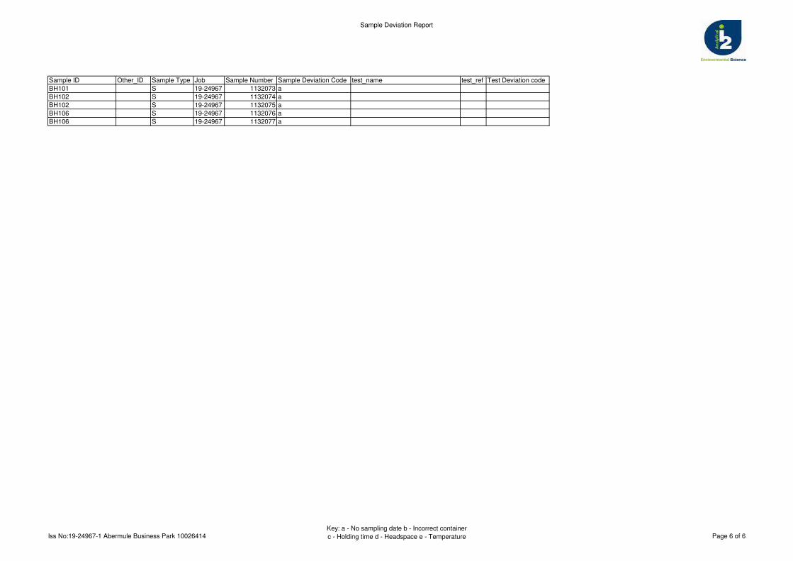
Sample Deviation Report
Sample ID Other_ID Sample Type Job Sample Number Sample Deviation Code test_name test_ref Test Deviation code
BH101 S 19-24967 1132073 a
BH102 S 19-24967 1132074 a
BH102 S 19-24967 1132075 a
BH106 S 19-24967 1132076 a
BH106 S 19-24967 1132077 a
Iss No:19-24967-1 Abermule Business Park 10026414Key: a - No sampling date b - Incorrect container
c - Holding time d - Headspace e - Temperature Page 6 of 6
Gemma Francis
t: 01173721360 t: 01923 225404f: 01923 237404
e: [email protected] e:
Project / Site name: Samples received on: 17/01/2019
Your job number: 10026414 Samples instructed on: 25/01/2019
Your order number: 14020726 Analysis completed by: 04/02/2019
Report Issue Number: 1 Report issued on: 04/02/2019
Samples Analysed:
Signed:
Reporting ManagerFor & on behalf of i2 Analytical Ltd.
Standard Geotechnical, Asbestos and Chemical Testing Laboratory located at: ul. Pionierów 39, 41 -711 Ruda Śląska, Poland.
Accredited tests are defined within the report, opinions and interpretations expressed herein are outside the scope of accreditation.
Standard sample disposal times, unless otherwise agreed with the laboratory, are : soils - 4 weeks from reportingleachates - 2 weeks from reportingwaters - 2 weeks from reportingasbestos - 6 months from reporting
Excel copies of reports are only valid when accompanied by this PDF certificate.
Jordan Hill
16 soil samples
Abermule Business Park
Arcadis Consulting (UK) Ltd5th FloorThe PithayBristolBS1 2NL
i2 Analytical Ltd.7 Woodshots Meadow,Croxley Green Business Park,Watford, Herts, WD18 8YS
Analytical Report Number : 19-26283
This certificate should not be reproduced, except in full, without the express permission of the laboratory.
The results included within the report are representative of the samples submitted for analysis.
Iss No 19-26283-1 Abermule Business Park 10026414
Page 1 of 12

Analytical Report Number: 19-26283
Project / Site name: Abermule Business Park
Your Order No: 14020726
Lab Sample Number 1140521 1140522 1140523 1140524 1140525Sample Reference TP101 TP101 TP102 TP102 TP103Sample Number None Supplied None Supplied None Supplied None Supplied None SuppliedDepth (m) 0.00-0.20 0.20-0.40 0.00-0.20 0.60-0.80 0.00-0.30Date Sampled Deviating Deviating Deviating Deviating DeviatingTime Taken None Supplied None Supplied None Supplied None Supplied None Supplied
Analytical Parameter
(Soil Analysis)
Un
its
Lim
it of
de
tectio
n
Accre
dita
tion
Sta
tus
Stone Content % 0.1 NONE < 0.1 < 0.1 < 0.1 19 < 0.1Moisture Content % N/A NONE 15 12 16 6.3 16Total mass of sample received kg 0.001 NONE 1.1 1.2 1.1 1.3 1.1
Asbestos in Soil Type N/A ISO 17025 Not-detected Not-detected Not-detected Not-detected Not-detected
General Inorganics
pH - Automated pH Units N/A MCERTS 6.2 6.8 6.9 7.3 6.5Total Cyanide mg/kg 1 MCERTS < 1 1 < 1 < 1 < 1Free Cyanide mg/kg 1 MCERTS < 1 < 1 < 1 < 1 < 1Water Soluble SO4 16hr extraction (2:1 Leachate Equivalent) g/l 0.00125 MCERTS 0.014 0.0068 0.010 0.0069 0.012
Total Phenols
Total Phenols (monohydric) mg/kg 1 MCERTS < 1.0 < 1.0 < 1.0 < 1.0 < 1.0
Speciated PAHs
Naphthalene mg/kg 0.05 MCERTS < 0.05 < 0.05 < 0.05 < 0.05 < 0.05Acenaphthylene mg/kg 0.05 MCERTS < 0.05 < 0.05 < 0.05 < 0.05 < 0.05Acenaphthene mg/kg 0.05 MCERTS < 0.05 < 0.05 < 0.05 < 0.05 < 0.05Fluorene mg/kg 0.05 MCERTS < 0.05 < 0.05 < 0.05 < 0.05 < 0.05Phenanthrene mg/kg 0.05 MCERTS < 0.05 < 0.05 < 0.05 < 0.05 < 0.05Anthracene mg/kg 0.05 MCERTS < 0.05 < 0.05 < 0.05 < 0.05 < 0.05Fluoranthene mg/kg 0.05 MCERTS < 0.05 < 0.05 < 0.05 < 0.05 < 0.05Pyrene mg/kg 0.05 MCERTS < 0.05 < 0.05 < 0.05 < 0.05 < 0.05Benzo(a)anthracene mg/kg 0.05 MCERTS < 0.05 < 0.05 < 0.05 < 0.05 < 0.05Chrysene mg/kg 0.05 MCERTS < 0.05 < 0.05 < 0.05 < 0.05 < 0.05Benzo(b)fluoranthene mg/kg 0.05 MCERTS < 0.05 < 0.05 < 0.05 < 0.05 < 0.05Benzo(k)fluoranthene mg/kg 0.05 MCERTS < 0.05 < 0.05 < 0.05 < 0.05 < 0.05Benzo(a)pyrene mg/kg 0.05 MCERTS < 0.05 < 0.05 < 0.05 < 0.05 < 0.05Indeno(1,2,3-cd)pyrene mg/kg 0.05 MCERTS < 0.05 < 0.05 < 0.05 < 0.05 < 0.05Dibenz(a,h)anthracene mg/kg 0.05 MCERTS < 0.05 < 0.05 < 0.05 < 0.05 < 0.05Benzo(ghi)perylene mg/kg 0.05 MCERTS < 0.05 < 0.05 < 0.05 < 0.05 < 0.05
Total PAH
Speciated Total EPA-16 PAHs mg/kg 0.8 MCERTS < 0.80 < 0.80 < 0.80 < 0.80 < 0.80
Heavy Metals / Metalloids
Arsenic (aqua regia extractable) mg/kg 1 MCERTS 13 12 12 16 9.7Boron (water soluble) mg/kg 0.2 MCERTS 1.4 0.7 1.9 0.6 1.5Cadmium (aqua regia extractable) mg/kg 0.2 MCERTS < 0.2 < 0.2 < 0.2 < 0.2 < 0.2Chromium (hexavalent) mg/kg 4 MCERTS < 4.0 < 4.0 < 4.0 < 4.0 < 4.0Chromium (aqua regia extractable) mg/kg 1 MCERTS 52 33 40 28 39Copper (aqua regia extractable) mg/kg 1 MCERTS 35 33 35 39 28Lead (aqua regia extractable) mg/kg 1 MCERTS 31 19 33 26 30Mercury (aqua regia extractable) mg/kg 0.3 MCERTS < 0.3 < 0.3 < 0.3 < 0.3 < 0.3Nickel (aqua regia extractable) mg/kg 1 MCERTS 39 41 35 39 34Selenium (aqua regia extractable) mg/kg 1 MCERTS < 1.0 < 1.0 < 1.0 < 1.0 < 1.0Zinc (aqua regia extractable) mg/kg 1 MCERTS 130 110 130 99 120
This certificate should not be reproduced, except in full, without the express permission of the laboratory.
The results included within the report are representative of the samples submitted for analysis.
Iss No 19-26283-1 Abermule Business Park 10026414
Page 2 of 12

Analytical Report Number: 19-26283
Project / Site name: Abermule Business Park
Your Order No: 14020726
Lab Sample Number 1140521 1140522 1140523 1140524 1140525Sample Reference TP101 TP101 TP102 TP102 TP103Sample Number None Supplied None Supplied None Supplied None Supplied None SuppliedDepth (m) 0.00-0.20 0.20-0.40 0.00-0.20 0.60-0.80 0.00-0.30Date Sampled Deviating Deviating Deviating Deviating DeviatingTime Taken None Supplied None Supplied None Supplied None Supplied None Supplied
Analytical Parameter
(Soil Analysis)
Un
its
Lim
it of
de
tectio
n
Accre
dita
tion
Sta
tus
Monoaromatics & Oxygenates
Benzene ug/kg 1 MCERTS < 1.0 < 1.0 < 1.0 < 1.0 < 1.0Toluene µg/kg 1 MCERTS < 1.0 < 1.0 < 1.0 < 1.0 < 1.0Ethylbenzene µg/kg 1 MCERTS < 1.0 < 1.0 < 1.0 < 1.0 < 1.0p & m-xylene µg/kg 1 MCERTS < 1.0 < 1.0 < 1.0 < 1.0 < 1.0o-xylene µg/kg 1 MCERTS < 1.0 < 1.0 < 1.0 < 1.0 < 1.0MTBE (Methyl Tertiary Butyl Ether) µg/kg 1 MCERTS < 1.0 < 1.0 < 1.0 < 1.0 < 1.0
Petroleum Hydrocarbons
TPH-CWG - Aliphatic >EC5 - EC6 mg/kg 0.001 MCERTS < 0.001 < 0.001 < 0.001 < 0.001 < 0.001TPH-CWG - Aliphatic >EC6 - EC8 mg/kg 0.001 MCERTS < 0.001 < 0.001 < 0.001 < 0.001 < 0.001TPH-CWG - Aliphatic >EC8 - EC10 mg/kg 0.001 MCERTS < 0.001 < 0.001 < 0.001 < 0.001 < 0.001TPH-CWG - Aliphatic >EC10 - EC12 mg/kg 1 MCERTS 1.3 1.2 1.3 1.2 < 1.0TPH-CWG - Aliphatic >EC12 - EC16 mg/kg 2 MCERTS < 2.0 < 2.0 < 2.0 < 2.0 < 2.0TPH-CWG - Aliphatic >EC16 - EC21 mg/kg 8 MCERTS < 8.0 < 8.0 < 8.0 < 8.0 < 8.0TPH-CWG - Aliphatic >EC21 - EC35 mg/kg 8 MCERTS < 8.0 < 8.0 < 8.0 < 8.0 < 8.0TPH-CWG - Aliphatic (EC5 - EC35) mg/kg 10 MCERTS < 10 < 10 11 < 10 < 10
TPH-CWG - Aromatic >EC5 - EC7 mg/kg 0.001 MCERTS < 0.001 < 0.001 < 0.001 < 0.001 < 0.001TPH-CWG - Aromatic >EC7 - EC8 mg/kg 0.001 MCERTS < 0.001 < 0.001 < 0.001 < 0.001 < 0.001TPH-CWG - Aromatic >EC8 - EC10 mg/kg 0.001 MCERTS < 0.001 < 0.001 < 0.001 < 0.001 < 0.001TPH-CWG - Aromatic >EC10 - EC12 mg/kg 1 MCERTS 1.0 < 1.0 < 1.0 < 1.0 < 1.0TPH-CWG - Aromatic >EC12 - EC16 mg/kg 2 MCERTS < 2.0 < 2.0 < 2.0 < 2.0 < 2.0TPH-CWG - Aromatic >EC16 - EC21 mg/kg 10 MCERTS < 10 < 10 < 10 < 10 < 10TPH-CWG - Aromatic >EC21 - EC35 mg/kg 10 MCERTS < 10 < 10 < 10 < 10 14TPH-CWG - Aromatic (EC5 - EC35) mg/kg 10 MCERTS < 10 < 10 < 10 < 10 14
This certificate should not be reproduced, except in full, without the express permission of the laboratory.
The results included within the report are representative of the samples submitted for analysis.
Iss No 19-26283-1 Abermule Business Park 10026414
Page 3 of 12
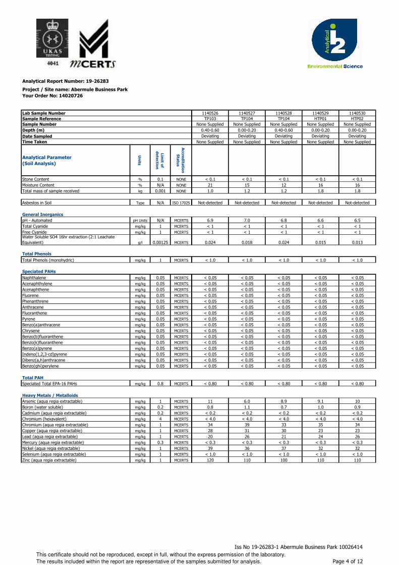
Analytical Report Number: 19-26283
Project / Site name: Abermule Business Park
Your Order No: 14020726
Lab Sample Number
Sample Reference
Sample Number
Depth (m)
Date Sampled
Time Taken
Analytical Parameter
(Soil Analysis)
Un
its
Lim
it of
de
tectio
n
Accre
dita
tion
Sta
tus
Stone Content % 0.1 NONE
Moisture Content % N/A NONE
Total mass of sample received kg 0.001 NONE
Asbestos in Soil Type N/A ISO 17025
General Inorganics
pH - Automated pH Units N/A MCERTS
Total Cyanide mg/kg 1 MCERTS
Free Cyanide mg/kg 1 MCERTSWater Soluble SO4 16hr extraction (2:1 Leachate Equivalent) g/l 0.00125 MCERTS
Total Phenols
Total Phenols (monohydric) mg/kg 1 MCERTS
Speciated PAHs
Naphthalene mg/kg 0.05 MCERTS
Acenaphthylene mg/kg 0.05 MCERTS
Acenaphthene mg/kg 0.05 MCERTS
Fluorene mg/kg 0.05 MCERTS
Phenanthrene mg/kg 0.05 MCERTS
Anthracene mg/kg 0.05 MCERTS
Fluoranthene mg/kg 0.05 MCERTS
Pyrene mg/kg 0.05 MCERTS
Benzo(a)anthracene mg/kg 0.05 MCERTS
Chrysene mg/kg 0.05 MCERTS
Benzo(b)fluoranthene mg/kg 0.05 MCERTS
Benzo(k)fluoranthene mg/kg 0.05 MCERTS
Benzo(a)pyrene mg/kg 0.05 MCERTS
Indeno(1,2,3-cd)pyrene mg/kg 0.05 MCERTS
Dibenz(a,h)anthracene mg/kg 0.05 MCERTS
Benzo(ghi)perylene mg/kg 0.05 MCERTS
Total PAH
Speciated Total EPA-16 PAHs mg/kg 0.8 MCERTS
Heavy Metals / Metalloids
Arsenic (aqua regia extractable) mg/kg 1 MCERTS
Boron (water soluble) mg/kg 0.2 MCERTS
Cadmium (aqua regia extractable) mg/kg 0.2 MCERTS
Chromium (hexavalent) mg/kg 4 MCERTS
Chromium (aqua regia extractable) mg/kg 1 MCERTS
Copper (aqua regia extractable) mg/kg 1 MCERTS
Lead (aqua regia extractable) mg/kg 1 MCERTS
Mercury (aqua regia extractable) mg/kg 0.3 MCERTS
Nickel (aqua regia extractable) mg/kg 1 MCERTS
Selenium (aqua regia extractable) mg/kg 1 MCERTS
Zinc (aqua regia extractable) mg/kg 1 MCERTS
1140526 1140527 1140528 1140529 1140530TP103 TP104 TP104 HTP01 HTP02
None Supplied None Supplied None Supplied None Supplied None Supplied0.40-0.60 0.00-0.20 0.40-0.60 0.00-0.20 0.00-0.20Deviating Deviating Deviating Deviating Deviating
None Supplied None Supplied None Supplied None Supplied None Supplied
< 0.1 < 0.1 < 0.1 < 0.1 < 0.121 15 12 16 161.0 1.2 1.2 1.8 1.8
Not-detected Not-detected Not-detected Not-detected Not-detected
6.9 7.0 6.8 6.6 6.5< 1 < 1 < 1 < 1 < 1< 1 < 1 < 1 < 1 < 1
0.024 0.018 0.024 0.015 0.013
< 1.0 < 1.0 < 1.0 < 1.0 < 1.0
< 0.05 < 0.05 < 0.05 < 0.05 < 0.05< 0.05 < 0.05 < 0.05 < 0.05 < 0.05< 0.05 < 0.05 < 0.05 < 0.05 < 0.05< 0.05 < 0.05 < 0.05 < 0.05 < 0.05< 0.05 < 0.05 < 0.05 < 0.05 < 0.05< 0.05 < 0.05 < 0.05 < 0.05 < 0.05< 0.05 < 0.05 < 0.05 < 0.05 < 0.05< 0.05 < 0.05 < 0.05 < 0.05 < 0.05< 0.05 < 0.05 < 0.05 < 0.05 < 0.05< 0.05 < 0.05 < 0.05 < 0.05 < 0.05< 0.05 < 0.05 < 0.05 < 0.05 < 0.05< 0.05 < 0.05 < 0.05 < 0.05 < 0.05< 0.05 < 0.05 < 0.05 < 0.05 < 0.05< 0.05 < 0.05 < 0.05 < 0.05 < 0.05< 0.05 < 0.05 < 0.05 < 0.05 < 0.05< 0.05 < 0.05 < 0.05 < 0.05 < 0.05
< 0.80 < 0.80 < 0.80 < 0.80 < 0.80
11 6.0 8.9 9.1 100.8 1.1 0.7 1.0 0.9
< 0.2 < 0.2 < 0.2 < 0.2 < 0.2< 4.0 < 4.0 < 4.0 < 4.0 < 4.0
34 39 33 35 3428 31 30 23 2320 26 21 24 26
< 0.3 < 0.3 < 0.3 < 0.3 < 0.339 36 37 32 32
< 1.0 < 1.0 < 1.0 < 1.0 < 1.0120 110 100 110 110
This certificate should not be reproduced, except in full, without the express permission of the laboratory.
The results included within the report are representative of the samples submitted for analysis.
Iss No 19-26283-1 Abermule Business Park 10026414
Page 4 of 12
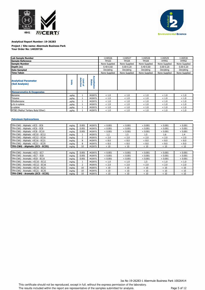
Analytical Report Number: 19-26283
Project / Site name: Abermule Business Park
Your Order No: 14020726
Lab Sample Number
Sample Reference
Sample Number
Depth (m)
Date Sampled
Time Taken
Analytical Parameter
(Soil Analysis)
Un
its
Lim
it of
de
tectio
n
Accre
dita
tion
Sta
tus
Monoaromatics & Oxygenates
Benzene ug/kg 1 MCERTS
Toluene µg/kg 1 MCERTS
Ethylbenzene µg/kg 1 MCERTS
p & m-xylene µg/kg 1 MCERTS
o-xylene µg/kg 1 MCERTS
MTBE (Methyl Tertiary Butyl Ether) µg/kg 1 MCERTS
Petroleum Hydrocarbons
TPH-CWG - Aliphatic >EC5 - EC6 mg/kg 0.001 MCERTS
TPH-CWG - Aliphatic >EC6 - EC8 mg/kg 0.001 MCERTS
TPH-CWG - Aliphatic >EC8 - EC10 mg/kg 0.001 MCERTS
TPH-CWG - Aliphatic >EC10 - EC12 mg/kg 1 MCERTS
TPH-CWG - Aliphatic >EC12 - EC16 mg/kg 2 MCERTS
TPH-CWG - Aliphatic >EC16 - EC21 mg/kg 8 MCERTS
TPH-CWG - Aliphatic >EC21 - EC35 mg/kg 8 MCERTSTPH-CWG - Aliphatic (EC5 - EC35) mg/kg 10 MCERTS
TPH-CWG - Aromatic >EC5 - EC7 mg/kg 0.001 MCERTS
TPH-CWG - Aromatic >EC7 - EC8 mg/kg 0.001 MCERTS
TPH-CWG - Aromatic >EC8 - EC10 mg/kg 0.001 MCERTS
TPH-CWG - Aromatic >EC10 - EC12 mg/kg 1 MCERTS
TPH-CWG - Aromatic >EC12 - EC16 mg/kg 2 MCERTS
TPH-CWG - Aromatic >EC16 - EC21 mg/kg 10 MCERTS
TPH-CWG - Aromatic >EC21 - EC35 mg/kg 10 MCERTSTPH-CWG - Aromatic (EC5 - EC35) mg/kg 10 MCERTS
1140526 1140527 1140528 1140529 1140530TP103 TP104 TP104 HTP01 HTP02
None Supplied None Supplied None Supplied None Supplied None Supplied0.40-0.60 0.00-0.20 0.40-0.60 0.00-0.20 0.00-0.20Deviating Deviating Deviating Deviating Deviating
None Supplied None Supplied None Supplied None Supplied None Supplied
< 1.0 < 1.0 < 1.0 < 1.0 < 1.0< 1.0 < 1.0 < 1.0 < 1.0 < 1.0< 1.0 < 1.0 < 1.0 < 1.0 < 1.0< 1.0 < 1.0 < 1.0 < 1.0 < 1.0< 1.0 < 1.0 < 1.0 < 1.0 < 1.0< 1.0 < 1.0 < 1.0 < 1.0 < 1.0
< 0.001 < 0.001 < 0.001 < 0.001 < 0.001< 0.001 < 0.001 < 0.001 < 0.001 < 0.001< 0.001 < 0.001 < 0.001 < 0.001 < 0.001
1.2 1.5 1.5 1.6 1.4< 2.0 < 2.0 < 2.0 < 2.0 < 2.0< 8.0 < 8.0 < 8.0 < 8.0 < 8.0< 8.0 < 8.0 < 8.0 < 8.0 < 8.0< 10 < 10 < 10 < 10 < 10
< 0.001 < 0.001 < 0.001 < 0.001 < 0.001< 0.001 < 0.001 < 0.001 < 0.001 < 0.001< 0.001 < 0.001 < 0.001 < 0.001 < 0.001< 1.0 < 1.0 1.5 < 1.0 < 1.0< 2.0 < 2.0 < 2.0 < 2.0 < 2.0< 10 < 10 < 10 < 10 < 10< 10 < 10 < 10 < 10 < 10< 10 < 10 < 10 < 10 < 10
This certificate should not be reproduced, except in full, without the express permission of the laboratory.
The results included within the report are representative of the samples submitted for analysis.
Iss No 19-26283-1 Abermule Business Park 10026414
Page 5 of 12
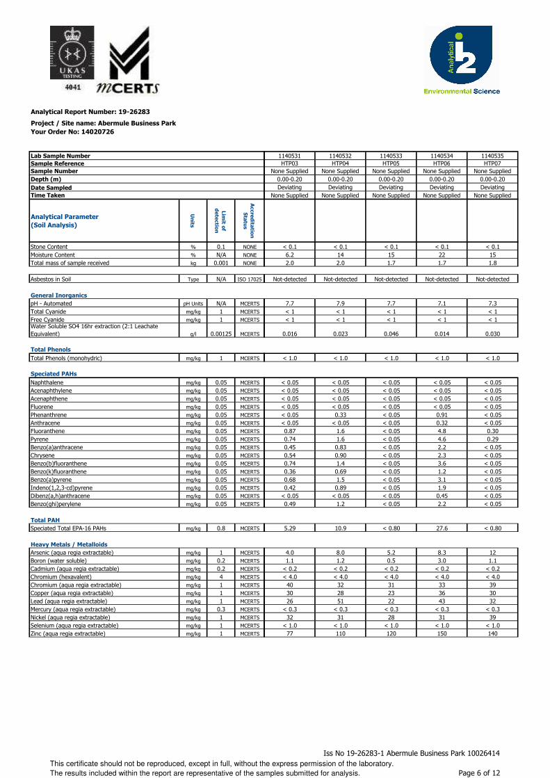
Analytical Report Number: 19-26283
Project / Site name: Abermule Business Park
Your Order No: 14020726
Lab Sample Number
Sample Reference
Sample Number
Depth (m)
Date Sampled
Time Taken
Analytical Parameter
(Soil Analysis)
Un
its
Lim
it of
de
tectio
n
Accre
dita
tion
Sta
tus
Stone Content % 0.1 NONE
Moisture Content % N/A NONE
Total mass of sample received kg 0.001 NONE
Asbestos in Soil Type N/A ISO 17025
General Inorganics
pH - Automated pH Units N/A MCERTS
Total Cyanide mg/kg 1 MCERTS
Free Cyanide mg/kg 1 MCERTSWater Soluble SO4 16hr extraction (2:1 Leachate Equivalent) g/l 0.00125 MCERTS
Total Phenols
Total Phenols (monohydric) mg/kg 1 MCERTS
Speciated PAHs
Naphthalene mg/kg 0.05 MCERTS
Acenaphthylene mg/kg 0.05 MCERTS
Acenaphthene mg/kg 0.05 MCERTS
Fluorene mg/kg 0.05 MCERTS
Phenanthrene mg/kg 0.05 MCERTS
Anthracene mg/kg 0.05 MCERTS
Fluoranthene mg/kg 0.05 MCERTS
Pyrene mg/kg 0.05 MCERTS
Benzo(a)anthracene mg/kg 0.05 MCERTS
Chrysene mg/kg 0.05 MCERTS
Benzo(b)fluoranthene mg/kg 0.05 MCERTS
Benzo(k)fluoranthene mg/kg 0.05 MCERTS
Benzo(a)pyrene mg/kg 0.05 MCERTS
Indeno(1,2,3-cd)pyrene mg/kg 0.05 MCERTS
Dibenz(a,h)anthracene mg/kg 0.05 MCERTS
Benzo(ghi)perylene mg/kg 0.05 MCERTS
Total PAH
Speciated Total EPA-16 PAHs mg/kg 0.8 MCERTS
Heavy Metals / Metalloids
Arsenic (aqua regia extractable) mg/kg 1 MCERTS
Boron (water soluble) mg/kg 0.2 MCERTS
Cadmium (aqua regia extractable) mg/kg 0.2 MCERTS
Chromium (hexavalent) mg/kg 4 MCERTS
Chromium (aqua regia extractable) mg/kg 1 MCERTS
Copper (aqua regia extractable) mg/kg 1 MCERTS
Lead (aqua regia extractable) mg/kg 1 MCERTS
Mercury (aqua regia extractable) mg/kg 0.3 MCERTS
Nickel (aqua regia extractable) mg/kg 1 MCERTS
Selenium (aqua regia extractable) mg/kg 1 MCERTS
Zinc (aqua regia extractable) mg/kg 1 MCERTS
1140531 1140532 1140533 1140534 1140535HTP03 HTP04 HTP05 HTP06 HTP07
None Supplied None Supplied None Supplied None Supplied None Supplied0.00-0.20 0.00-0.20 0.00-0.20 0.00-0.20 0.00-0.20Deviating Deviating Deviating Deviating Deviating
None Supplied None Supplied None Supplied None Supplied None Supplied
< 0.1 < 0.1 < 0.1 < 0.1 < 0.16.2 14 15 22 152.0 2.0 1.7 1.7 1.8
Not-detected Not-detected Not-detected Not-detected Not-detected
7.7 7.9 7.7 7.1 7.3< 1 < 1 < 1 < 1 < 1< 1 < 1 < 1 < 1 < 1
0.016 0.023 0.046 0.014 0.030
< 1.0 < 1.0 < 1.0 < 1.0 < 1.0
< 0.05 < 0.05 < 0.05 < 0.05 < 0.05< 0.05 < 0.05 < 0.05 < 0.05 < 0.05< 0.05 < 0.05 < 0.05 < 0.05 < 0.05< 0.05 < 0.05 < 0.05 < 0.05 < 0.05< 0.05 0.33 < 0.05 0.91 < 0.05< 0.05 < 0.05 < 0.05 0.32 < 0.050.87 1.6 < 0.05 4.8 0.300.74 1.6 < 0.05 4.6 0.290.45 0.83 < 0.05 2.2 < 0.050.54 0.90 < 0.05 2.3 < 0.050.74 1.4 < 0.05 3.6 < 0.050.36 0.69 < 0.05 1.2 < 0.050.68 1.5 < 0.05 3.1 < 0.050.42 0.89 < 0.05 1.9 < 0.05
< 0.05 < 0.05 < 0.05 0.45 < 0.050.49 1.2 < 0.05 2.2 < 0.05
5.29 10.9 < 0.80 27.6 < 0.80
4.0 8.0 5.2 8.3 121.1 1.2 0.5 3.0 1.1
< 0.2 < 0.2 < 0.2 < 0.2 < 0.2< 4.0 < 4.0 < 4.0 < 4.0 < 4.0
40 32 31 33 3930 28 23 36 3026 51 22 43 32
< 0.3 < 0.3 < 0.3 < 0.3 < 0.332 31 28 31 39
< 1.0 < 1.0 < 1.0 < 1.0 < 1.077 110 120 150 140
This certificate should not be reproduced, except in full, without the express permission of the laboratory.
The results included within the report are representative of the samples submitted for analysis.
Iss No 19-26283-1 Abermule Business Park 10026414
Page 6 of 12

Analytical Report Number: 19-26283
Project / Site name: Abermule Business Park
Your Order No: 14020726
Lab Sample Number
Sample Reference
Sample Number
Depth (m)
Date Sampled
Time Taken
Analytical Parameter
(Soil Analysis)
Un
its
Lim
it of
de
tectio
n
Accre
dita
tion
Sta
tus
Monoaromatics & Oxygenates
Benzene ug/kg 1 MCERTS
Toluene µg/kg 1 MCERTS
Ethylbenzene µg/kg 1 MCERTS
p & m-xylene µg/kg 1 MCERTS
o-xylene µg/kg 1 MCERTS
MTBE (Methyl Tertiary Butyl Ether) µg/kg 1 MCERTS
Petroleum Hydrocarbons
TPH-CWG - Aliphatic >EC5 - EC6 mg/kg 0.001 MCERTS
TPH-CWG - Aliphatic >EC6 - EC8 mg/kg 0.001 MCERTS
TPH-CWG - Aliphatic >EC8 - EC10 mg/kg 0.001 MCERTS
TPH-CWG - Aliphatic >EC10 - EC12 mg/kg 1 MCERTS
TPH-CWG - Aliphatic >EC12 - EC16 mg/kg 2 MCERTS
TPH-CWG - Aliphatic >EC16 - EC21 mg/kg 8 MCERTS
TPH-CWG - Aliphatic >EC21 - EC35 mg/kg 8 MCERTSTPH-CWG - Aliphatic (EC5 - EC35) mg/kg 10 MCERTS
TPH-CWG - Aromatic >EC5 - EC7 mg/kg 0.001 MCERTS
TPH-CWG - Aromatic >EC7 - EC8 mg/kg 0.001 MCERTS
TPH-CWG - Aromatic >EC8 - EC10 mg/kg 0.001 MCERTS
TPH-CWG - Aromatic >EC10 - EC12 mg/kg 1 MCERTS
TPH-CWG - Aromatic >EC12 - EC16 mg/kg 2 MCERTS
TPH-CWG - Aromatic >EC16 - EC21 mg/kg 10 MCERTS
TPH-CWG - Aromatic >EC21 - EC35 mg/kg 10 MCERTSTPH-CWG - Aromatic (EC5 - EC35) mg/kg 10 MCERTS
1140531 1140532 1140533 1140534 1140535HTP03 HTP04 HTP05 HTP06 HTP07
None Supplied None Supplied None Supplied None Supplied None Supplied0.00-0.20 0.00-0.20 0.00-0.20 0.00-0.20 0.00-0.20Deviating Deviating Deviating Deviating Deviating
None Supplied None Supplied None Supplied None Supplied None Supplied
< 1.0 < 1.0 < 1.0 < 1.0 < 1.0< 1.0 < 1.0 < 1.0 < 1.0 < 1.0< 1.0 < 1.0 < 1.0 < 1.0 < 1.0< 1.0 < 1.0 < 1.0 < 1.0 < 1.0< 1.0 < 1.0 < 1.0 < 1.0 < 1.0< 1.0 < 1.0 < 1.0 < 1.0 < 1.0
< 0.001 < 0.001 < 0.001 < 0.001 < 0.001< 0.001 < 0.001 < 0.001 < 0.001 < 0.001< 0.001 < 0.001 < 0.001 < 0.001 < 0.001
1.2 1.4 < 1.0 1.3 1.2< 2.0 < 2.0 < 2.0 < 2.0 < 2.0< 8.0 < 8.0 < 8.0 < 8.0 < 8.0< 8.0 12 < 8.0 17 < 8.0< 10 16 < 10 21 < 10
< 0.001 < 0.001 < 0.001 < 0.001 < 0.001< 0.001 < 0.001 < 0.001 < 0.001 < 0.001< 0.001 < 0.001 < 0.001 < 0.001 < 0.001< 1.0 < 1.0 < 1.0 < 1.0 < 1.0< 2.0 < 2.0 < 2.0 < 2.0 < 2.0< 10 < 10 < 10 < 10 < 10< 10 < 10 < 10 < 10 < 10< 10 < 10 < 10 10 < 10
This certificate should not be reproduced, except in full, without the express permission of the laboratory.
The results included within the report are representative of the samples submitted for analysis.
Iss No 19-26283-1 Abermule Business Park 10026414
Page 7 of 12
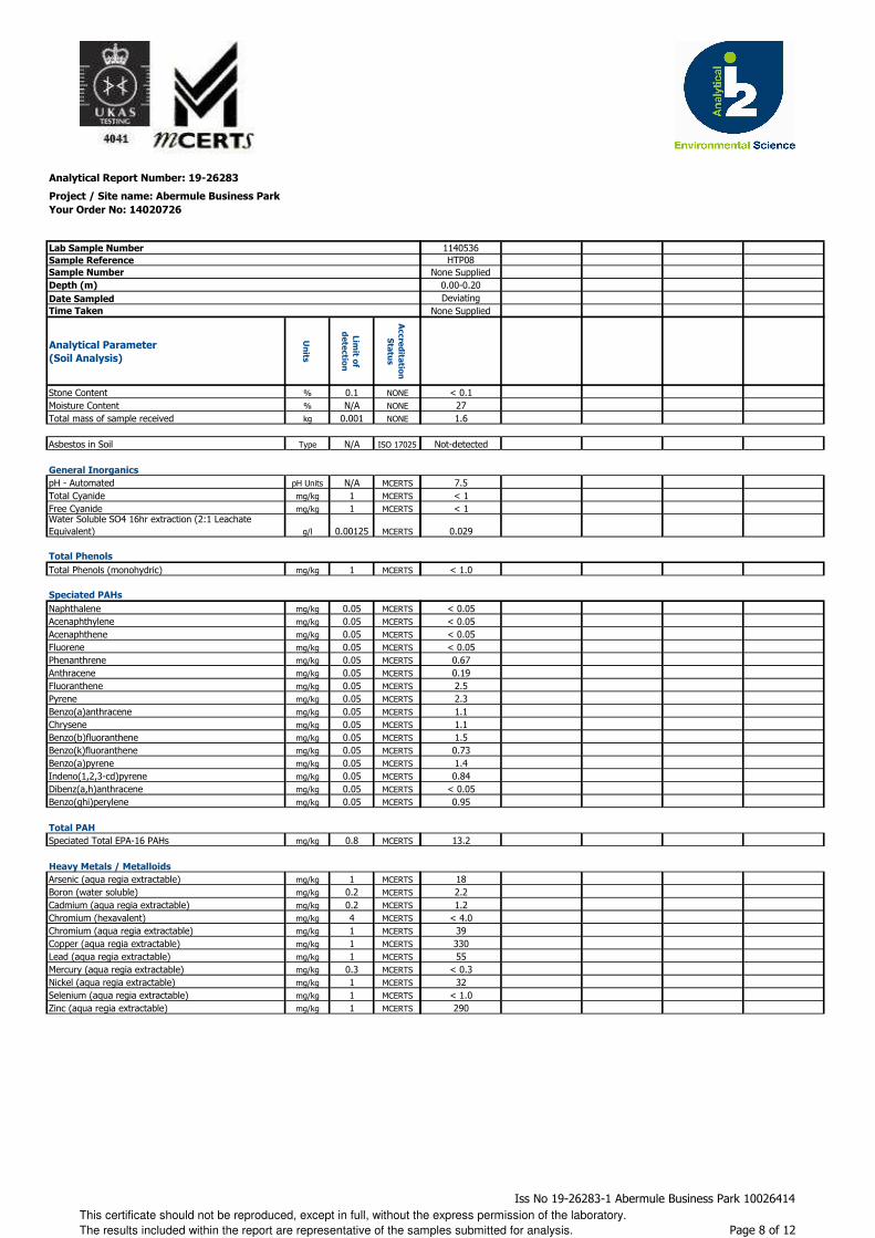
Analytical Report Number: 19-26283
Project / Site name: Abermule Business Park
Your Order No: 14020726
Lab Sample Number
Sample Reference
Sample Number
Depth (m)
Date Sampled
Time Taken
Analytical Parameter
(Soil Analysis)
Un
its
Lim
it of
de
tectio
n
Accre
dita
tion
Sta
tus
Stone Content % 0.1 NONE
Moisture Content % N/A NONE
Total mass of sample received kg 0.001 NONE
Asbestos in Soil Type N/A ISO 17025
General Inorganics
pH - Automated pH Units N/A MCERTS
Total Cyanide mg/kg 1 MCERTS
Free Cyanide mg/kg 1 MCERTSWater Soluble SO4 16hr extraction (2:1 Leachate Equivalent) g/l 0.00125 MCERTS
Total Phenols
Total Phenols (monohydric) mg/kg 1 MCERTS
Speciated PAHs
Naphthalene mg/kg 0.05 MCERTS
Acenaphthylene mg/kg 0.05 MCERTS
Acenaphthene mg/kg 0.05 MCERTS
Fluorene mg/kg 0.05 MCERTS
Phenanthrene mg/kg 0.05 MCERTS
Anthracene mg/kg 0.05 MCERTS
Fluoranthene mg/kg 0.05 MCERTS
Pyrene mg/kg 0.05 MCERTS
Benzo(a)anthracene mg/kg 0.05 MCERTS
Chrysene mg/kg 0.05 MCERTS
Benzo(b)fluoranthene mg/kg 0.05 MCERTS
Benzo(k)fluoranthene mg/kg 0.05 MCERTS
Benzo(a)pyrene mg/kg 0.05 MCERTS
Indeno(1,2,3-cd)pyrene mg/kg 0.05 MCERTS
Dibenz(a,h)anthracene mg/kg 0.05 MCERTS
Benzo(ghi)perylene mg/kg 0.05 MCERTS
Total PAH
Speciated Total EPA-16 PAHs mg/kg 0.8 MCERTS
Heavy Metals / Metalloids
Arsenic (aqua regia extractable) mg/kg 1 MCERTS
Boron (water soluble) mg/kg 0.2 MCERTS
Cadmium (aqua regia extractable) mg/kg 0.2 MCERTS
Chromium (hexavalent) mg/kg 4 MCERTS
Chromium (aqua regia extractable) mg/kg 1 MCERTS
Copper (aqua regia extractable) mg/kg 1 MCERTS
Lead (aqua regia extractable) mg/kg 1 MCERTS
Mercury (aqua regia extractable) mg/kg 0.3 MCERTS
Nickel (aqua regia extractable) mg/kg 1 MCERTS
Selenium (aqua regia extractable) mg/kg 1 MCERTS
Zinc (aqua regia extractable) mg/kg 1 MCERTS
1140536HTP08
None Supplied0.00-0.20Deviating
None Supplied
< 0.1271.6
Not-detected
7.5< 1< 1
0.029
< 1.0
< 0.05< 0.05< 0.05< 0.050.670.192.52.31.11.11.50.731.40.84
< 0.050.95
13.2
182.21.2
< 4.03933055
< 0.332
< 1.0290
This certificate should not be reproduced, except in full, without the express permission of the laboratory.
The results included within the report are representative of the samples submitted for analysis.
Iss No 19-26283-1 Abermule Business Park 10026414
Page 8 of 12
Analytical Report Number: 19-26283
Project / Site name: Abermule Business Park
Your Order No: 14020726
Lab Sample Number
Sample Reference
Sample Number
Depth (m)
Date Sampled
Time Taken
Analytical Parameter
(Soil Analysis)
Un
its
Lim
it of
de
tectio
n
Accre
dita
tion
Sta
tus
Monoaromatics & Oxygenates
Benzene ug/kg 1 MCERTS
Toluene µg/kg 1 MCERTS
Ethylbenzene µg/kg 1 MCERTS
p & m-xylene µg/kg 1 MCERTS
o-xylene µg/kg 1 MCERTS
MTBE (Methyl Tertiary Butyl Ether) µg/kg 1 MCERTS
Petroleum Hydrocarbons
TPH-CWG - Aliphatic >EC5 - EC6 mg/kg 0.001 MCERTS
TPH-CWG - Aliphatic >EC6 - EC8 mg/kg 0.001 MCERTS
TPH-CWG - Aliphatic >EC8 - EC10 mg/kg 0.001 MCERTS
TPH-CWG - Aliphatic >EC10 - EC12 mg/kg 1 MCERTS
TPH-CWG - Aliphatic >EC12 - EC16 mg/kg 2 MCERTS
TPH-CWG - Aliphatic >EC16 - EC21 mg/kg 8 MCERTS
TPH-CWG - Aliphatic >EC21 - EC35 mg/kg 8 MCERTSTPH-CWG - Aliphatic (EC5 - EC35) mg/kg 10 MCERTS
TPH-CWG - Aromatic >EC5 - EC7 mg/kg 0.001 MCERTS
TPH-CWG - Aromatic >EC7 - EC8 mg/kg 0.001 MCERTS
TPH-CWG - Aromatic >EC8 - EC10 mg/kg 0.001 MCERTS
TPH-CWG - Aromatic >EC10 - EC12 mg/kg 1 MCERTS
TPH-CWG - Aromatic >EC12 - EC16 mg/kg 2 MCERTS
TPH-CWG - Aromatic >EC16 - EC21 mg/kg 10 MCERTS
TPH-CWG - Aromatic >EC21 - EC35 mg/kg 10 MCERTSTPH-CWG - Aromatic (EC5 - EC35) mg/kg 10 MCERTS
1140536HTP08
None Supplied0.00-0.20Deviating
None Supplied
< 1.0< 1.0< 1.0< 1.0< 1.0< 1.0
< 0.001< 0.001< 0.001
1.3< 2.0< 8.0
2835
< 0.001< 0.001< 0.001< 1.0< 2.0< 10< 10< 10
This certificate should not be reproduced, except in full, without the express permission of the laboratory.
The results included within the report are representative of the samples submitted for analysis.
Iss No 19-26283-1 Abermule Business Park 10026414
Page 9 of 12
Analytical Report Number : 19-26283
Project / Site name: Abermule Business Park
Lab Sample
Number
Sample
Reference
Sample
NumberDepth (m) Sample Description *
1140521 TP101 None Supplied 0.00-0.20 Brown loam and clay with gravel and vegetation.1140522 TP101 None Supplied 0.20-0.40 Brown loam and clay with gravel and vegetation.1140523 TP102 None Supplied 0.00-0.20 Brown loam and clay with gravel and vegetation.1140524 TP102 None Supplied 0.60-0.80 Brown gravelly loam with stones.1140525 TP103 None Supplied 0.00-0.30 Brown loam and clay with gravel and vegetation.1140526 TP103 None Supplied 0.40-0.60 Brown clay and sand with vegetation.1140527 TP104 None Supplied 0.00-0.20 Brown loam and clay with gravel and vegetation.1140528 TP104 None Supplied 0.40-0.60 Brown loam and clay with gravel and vegetation.1140529 HTP01 None Supplied 0.00-0.20 Brown loam and clay with gravel and vegetation.1140530 HTP02 None Supplied 0.00-0.20 Brown loam and clay with gravel and vegetation.1140531 HTP03 None Supplied 0.00-0.20 Brown gravelly clay with tar and vegetation.1140532 HTP04 None Supplied 0.00-0.20 Brown loam and clay with gravel and brick.1140533 HTP05 None Supplied 0.00-0.20 Brown loam and clay with gravel and vegetation.1140534 HTP06 None Supplied 0.00-0.20 Brown loam and clay with gravel and vegetation.1140535 HTP07 None Supplied 0.00-0.20 Brown clay and loam with gravel and vegetation.1140536 HTP08 None Supplied 0.00-0.20 Brown clay and loam with gravel and vegetation.
* These descriptions are only intended to act as a cross check if sample identities are questioned. The major constituent of the sample is intended to act with respect to MCERTS validation. The laboratory is accredited for sand, clay and loam (MCERTS) soil types. Data for unaccredited types of solid should be interpreted with care.
Stone content of a sample is calculated as the % weight of the stones not passing a 10 mm sieve. Results are not corrected for stone content.
This certificate should not be reproduced, except in full, without the express permission of the laboratory.
The results included within the report are representative of the samples submitted for analysis.
Iss No 19-26283-1 Abermule Business Park 10026414
Page 10 of 12
Analytical Report Number : 19-26283
Project / Site name: Abermule Business Park
Water matrix abbreviations: Surface Water (SW) Potable Water (PW) Ground Water (GW) Process Water (PrW)
Analytical Test Name Analytical Method Description Analytical Method ReferenceMethod
number
Wet / Dry
Analysis
Accreditation
Status
Asbestos identification in soil Asbestos Identification with the use of polarised light microscopy in conjunction with disperion staining techniques.
In house method based on HSG 248 A001-PL D ISO 17025
Boron, water soluble, in soil Determination of water soluble boron in soil by hot water extract followed by ICP-OES.
In-house method based on Second Site Properties version 3
L038-PL D MCERTS
BTEX and MTBE in soil (Monoaromatics)
Determination of BTEX in soil by headspace GC-MS.
In-house method based on USEPA8260 L073B-PL W MCERTS
D.O. for Gravimetric Quant if Screen/ID positive
Dependent option for Gravimetric Quant if Screen/ID positive scheduled.
In house asbestos methods A001 & A006. A006-PL D NONE
Free cyanide in soil Determination of free cyanide by distillation followed by colorimetry.
In-house method based on Examination of Water and Wastewater 20th Edition: Clesceri, Greenberg & Eaton (Skalar)
L080-PL W MCERTS
Hexavalent chromium in soil Determination of hexavalent chromium in soil by extraction in water then by acidification, addition of 1,5 diphenylcarbazide followed by colorimetry.
In-house method L080-PL W MCERTS
Metals in soil by ICP-OES Determination of metals in soil by aqua-regia digestion followed by ICP-OES.
In-house method based on MEWAM 2006 Methods for the Determination of Metals in Soil.
L038-PL D MCERTS
Moisture Content Moisture content, determined gravimetrically. In-house method based on BS1377 Part 2, 1990, Chemical and Electrochemical Tests
L019-UK/PL W NONE
Monohydric phenols in soil Determination of phenols in soil by extraction with sodium hydroxide followed by distillation followed by colorimetry.
In-house method based on Examination of Water and Wastewater 20th Edition: Clesceri, Greenberg & Eaton (skalar)
L080-PL W MCERTS
pH in soil (automated) Determination of pH in soil by addition of water followed by automated electrometric measurement.
In-house method based on BS1377 Part 3, 1990, Chemical and Electrochemical Tests
L099-PL D MCERTS
Speciated EPA-16 PAHs in soil Determination of PAH compounds in soil by extraction in dichloromethane and hexane followed by GC-MS with the use of surrogate and internal standards.
In-house method based on USEPA 8270 L064-PL D MCERTS
Stones content of soil Standard preparation for all samples unless otherwise detailed. Gravimetric determination of stone > 10 mm as % dry weight.
In-house method based on British Standard Methods and MCERTS requirements.
L019-UK/PL D NONE
Sulphate, water soluble, in soil (16hr extraction)
Determination of water soluble sulphate by ICP-OES. Results reported directly (leachate equivalent) and corrected for extraction ratio (soil equivalent).
In-house method based on BS1377 Part 3, 1990, Chemical and Electrochemical Tests, 2:1 water:soil extraction, analysis by ICP-OES.
L038-PL D MCERTS
Total cyanide in soil Determination of total cyanide by distillation followed by colorimetry.
In-house method based on Examination of Water and Wastewater 20th Edition: Clesceri, Greenberg & Eaton (Skalar)
L080-PL W MCERTS
TPHCWG (Soil) Determination of hexane extractable hydrocarbons in soil by GC-MS/GC-FID.
In-house method with silica gel split/clean up.
L088/76-PL W MCERTS
For method numbers ending in 'UK' analysis have been carried out in our laboratory in the United Kingdom.
For method numbers ending in 'PL' analysis have been carried out in our laboratory in Poland.
Soil analytical results are expressed on a dry weight basis. Where analysis is carried out on as-received the results obtained are multiplied by a moisture
correction factor that is determined gravimetrically using the moisture content which is carried out at a maximum of 30oC.
This certificate should not be reproduced, except in full, without the express permission of the laboratory.
The results included within the report are representative of the samples submitted for analysis.
Iss No 19-26283-1 Abermule Business Park 10026414
Page 11 of 12
Sample Deviation Report
Sample ID Other_ID Sample Type Job Sample Number Sample Deviation Code test_name test_ref Test Deviation code
HTP01 S 19-26283 1140529 a
HTP02 S 19-26283 1140530 a
HTP03 S 19-26283 1140531 a
HTP04 S 19-26283 1140532 a
HTP05 S 19-26283 1140533 a
HTP06 S 19-26283 1140534 a
HTP07 S 19-26283 1140535 a
HTP08 S 19-26283 1140536 a
TP101 S 19-26283 1140521 a
TP101 S 19-26283 1140522 a
TP102 S 19-26283 1140523 a
TP102 S 19-26283 1140524 a
TP103 S 19-26283 1140525 a
TP103 S 19-26283 1140526 a
TP104 S 19-26283 1140527 a
TP104 S 19-26283 1140528 a
Iss No:19-26283-1 Abermule Business Park 10026414Key: a - No sampling date b - Incorrect container
c - Holding time d - Headspace e - Temperature Page 12 of 12

Gemma Francis
t: 01173721360 t: 01923 225404f: 01923 237404
e: [email protected] e:
Project / Site name: Samples received on: 17/01/2019
Your job number: 10026414 Samples instructed on: 25/01/2019
Your order number: 14020726 Analysis completed by: 07/02/2019
Report Issue Number: 2 Report issued on: 08/02/2019
Samples Analysed:
Signed:
Reporting ManagerFor & on behalf of i2 Analytical Ltd.
Standard Geotechnical, Asbestos and Chemical Testing Laboratory located at: ul. Pionierów 39, 41 -711 Ruda Śląska, Poland.
Accredited tests are defined within the report, opinions and interpretations expressed herein are outside the scope of accreditation.
Standard sample disposal times, unless otherwise agreed with the laboratory, are : soils - 4 weeks from reportingleachates - 2 weeks from reportingwaters - 2 weeks from reportingasbestos - 6 months from reporting
Excel copies of reports are only valid when accompanied by this PDF certificate.
Jordan Hill
5 soil samples
Abermule Business Park
Arcadis Consulting (UK) Ltd5th FloorThe PithayBristolBS1 2NL
i2 Analytical Ltd.7 Woodshots Meadow,Croxley Green Business Park,Watford, Herts, WD18 8YS
Replaces Analytical Report Number : 19-26285, issue no. 1
Analytical Report Number : 19-26285
This certificate should not be reproduced, except in full, without the express permission of the laboratory.
The results included within the report are representative of the samples submitted for analysis.
Iss No 19-26285-2 Abermule Business Park 10026414
Page 1 of 6

Analytical Report Number: 19-26285
Project / Site name: Abermule Business Park
Your Order No: 14020726
Lab Sample Number 1140539 1140540 1140541 1140542 1140543Sample Reference BH103 BH103 BH104 BH104 BH105Sample Number 1 3 1 3 1Depth (m) 0.00-0.50 0.50-1.20 0.00-0.50 0.50-1.20 0.00-0.30Date Sampled 14/01/2019 14/01/2019 15/01/2019 15/01/2019 16/01/2019Time Taken None Supplied None Supplied None Supplied None Supplied None Supplied
Analytical Parameter
(Soil Analysis)
Un
its
Lim
it of
de
tectio
n
Accre
dita
tion
Sta
tus
Stone Content % 0.1 NONE < 0.1 < 0.1 < 0.1 < 0.1 < 0.1Moisture Content % N/A NONE 16 16 17 20 18Total mass of sample received kg 0.001 NONE 1.0 1.2 1.1 1.0 1.0
Asbestos in Soil Type N/A ISO 17025 Not-detected Not-detected Not-detected Not-detected Not-detected
General Inorganics
pH - Automated pH Units N/A MCERTS 6.0 6.9 6.8 7.1 6.5Total Cyanide mg/kg 1 MCERTS < 1 < 1 < 1 < 1 < 1Free Cyanide mg/kg 1 MCERTS < 1 < 1 < 1 < 1 < 1Water Soluble SO4 16hr extraction (2:1 Leachate Equivalent) g/l 0.00125 MCERTS 0.010 0.011 0.015 0.020 0.013
Total Phenols
Total Phenols (monohydric) mg/kg 1 MCERTS < 1.0 < 1.0 < 1.0 < 1.0 < 1.0
Speciated PAHs
Naphthalene mg/kg 0.05 MCERTS < 0.05 < 0.05 < 0.05 < 0.05 < 0.05Acenaphthylene mg/kg 0.05 MCERTS < 0.05 < 0.05 < 0.05 < 0.05 < 0.05Acenaphthene mg/kg 0.05 MCERTS < 0.05 < 0.05 < 0.05 < 0.05 < 0.05Fluorene mg/kg 0.05 MCERTS < 0.05 < 0.05 < 0.05 < 0.05 < 0.05Phenanthrene mg/kg 0.05 MCERTS < 0.05 < 0.05 1.3 < 0.05 < 0.05Anthracene mg/kg 0.05 MCERTS < 0.05 < 0.05 0.42 < 0.05 < 0.05Fluoranthene mg/kg 0.05 MCERTS 0.30 < 0.05 6.6 0.67 0.26Pyrene mg/kg 0.05 MCERTS 0.32 < 0.05 6.3 0.68 0.24Benzo(a)anthracene mg/kg 0.05 MCERTS < 0.05 < 0.05 3.1 0.27 < 0.05Chrysene mg/kg 0.05 MCERTS < 0.05 < 0.05 3.4 0.35 < 0.05Benzo(b)fluoranthene mg/kg 0.05 MCERTS < 0.05 < 0.05 4.5 0.45 < 0.05Benzo(k)fluoranthene mg/kg 0.05 MCERTS < 0.05 < 0.05 2.6 0.22 < 0.05Benzo(a)pyrene mg/kg 0.05 MCERTS < 0.05 < 0.05 4.9 0.47 < 0.05Indeno(1,2,3-cd)pyrene mg/kg 0.05 MCERTS < 0.05 < 0.05 2.6 0.28 < 0.05Dibenz(a,h)anthracene mg/kg 0.05 MCERTS < 0.05 < 0.05 0.71 < 0.05 < 0.05Benzo(ghi)perylene mg/kg 0.05 MCERTS < 0.05 < 0.05 3.7 0.36 < 0.05
Total PAH
Speciated Total EPA-16 PAHs mg/kg 0.8 MCERTS < 0.80 < 0.80 40.0 3.75 < 0.80
Heavy Metals / Metalloids
Arsenic (aqua regia extractable) mg/kg 1 MCERTS 10 6.7 8.7 7.8 9.1Boron (water soluble) mg/kg 0.2 MCERTS 1.1 0.4 1.0 1.1 0.9Cadmium (aqua regia extractable) mg/kg 0.2 MCERTS < 0.2 < 0.2 < 0.2 < 0.2 < 0.2Chromium (hexavalent) mg/kg 4 MCERTS < 4.0 < 4.0 < 4.0 < 4.0 < 4.0Chromium (aqua regia extractable) mg/kg 1 MCERTS 33 39 36 37 35Copper (aqua regia extractable) mg/kg 1 MCERTS 24 24 38 30 24Lead (aqua regia extractable) mg/kg 1 MCERTS 34 14 45 31 30Mercury (aqua regia extractable) mg/kg 0.3 MCERTS < 0.3 < 0.3 < 0.3 < 0.3 < 0.3Nickel (aqua regia extractable) mg/kg 1 MCERTS 36 41 34 36 34Selenium (aqua regia extractable) mg/kg 1 MCERTS < 1.0 < 1.0 < 1.0 < 1.0 < 1.0Zinc (aqua regia extractable) mg/kg 1 MCERTS 120 90 120 110 110
This certificate should not be reproduced, except in full, without the express permission of the laboratory.
The results included within the report are representative of the samples submitted for analysis.
Iss No 19-26285-2 Abermule Business Park 10026414
Page 2 of 6

Analytical Report Number: 19-26285
Project / Site name: Abermule Business Park
Your Order No: 14020726
Lab Sample Number 1140539 1140540 1140541 1140542 1140543Sample Reference BH103 BH103 BH104 BH104 BH105Sample Number 1 3 1 3 1Depth (m) 0.00-0.50 0.50-1.20 0.00-0.50 0.50-1.20 0.00-0.30Date Sampled 14/01/2019 14/01/2019 15/01/2019 15/01/2019 16/01/2019Time Taken None Supplied None Supplied None Supplied None Supplied None Supplied
Analytical Parameter
(Soil Analysis)
Un
its
Lim
it of
de
tectio
n
Accre
dita
tion
Sta
tus
Monoaromatics & Oxygenates
Benzene ug/kg 1 MCERTS < 1.0 - < 1.0 - < 1.0Toluene µg/kg 1 MCERTS < 1.0 - < 1.0 - < 1.0Ethylbenzene µg/kg 1 MCERTS < 1.0 - < 1.0 - < 1.0p & m-xylene µg/kg 1 MCERTS < 1.0 - < 1.0 - < 1.0o-xylene µg/kg 1 MCERTS < 1.0 - < 1.0 - < 1.0MTBE (Methyl Tertiary Butyl Ether) µg/kg 1 MCERTS < 1.0 - < 1.0 - < 1.0
Petroleum Hydrocarbons
TPH-CWG - Aliphatic >EC5 - EC6 mg/kg 0.001 MCERTS < 0.001 - < 0.001 - < 0.001TPH-CWG - Aliphatic >EC6 - EC8 mg/kg 0.001 MCERTS < 0.001 - < 0.001 - < 0.001TPH-CWG - Aliphatic >EC8 - EC10 mg/kg 0.001 MCERTS < 0.001 - < 0.001 - < 0.001TPH-CWG - Aliphatic >EC10 - EC12 mg/kg 1 MCERTS 1.2 - < 1.0 - 1.1TPH-CWG - Aliphatic >EC12 - EC16 mg/kg 2 MCERTS < 2.0 - 3.9 - < 2.0TPH-CWG - Aliphatic >EC16 - EC21 mg/kg 8 MCERTS < 8.0 - 11 - < 8.0TPH-CWG - Aliphatic >EC21 - EC35 mg/kg 8 MCERTS < 8.0 - 59 - < 8.0TPH-CWG - Aliphatic (EC5 - EC35) mg/kg 10 MCERTS < 10 - 74 - < 10
TPH-CWG - Aromatic >EC5 - EC7 mg/kg 0.001 MCERTS < 0.001 - < 0.001 - < 0.001TPH-CWG - Aromatic >EC7 - EC8 mg/kg 0.001 MCERTS < 0.001 - < 0.001 - < 0.001TPH-CWG - Aromatic >EC8 - EC10 mg/kg 0.001 MCERTS < 0.001 - < 0.001 - < 0.001TPH-CWG - Aromatic >EC10 - EC12 mg/kg 1 MCERTS < 1.0 - < 1.0 - < 1.0TPH-CWG - Aromatic >EC12 - EC16 mg/kg 2 MCERTS < 2.0 - 2.7 - < 2.0TPH-CWG - Aromatic >EC16 - EC21 mg/kg 10 MCERTS < 10 - 50 - < 10TPH-CWG - Aromatic >EC21 - EC35 mg/kg 10 MCERTS < 10 - 180 - < 10TPH-CWG - Aromatic (EC5 - EC35) mg/kg 10 MCERTS < 10 - 230 - < 10
This certificate should not be reproduced, except in full, without the express permission of the laboratory.
The results included within the report are representative of the samples submitted for analysis.
Iss No 19-26285-2 Abermule Business Park 10026414
Page 3 of 6
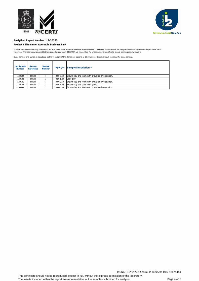
Analytical Report Number : 19-26285
Project / Site name: Abermule Business Park
Lab Sample
Number
Sample
Reference
Sample
NumberDepth (m) Sample Description *
1140539 BH103 1 0.00-0.50 Brown clay and loam with gravel and vegetation.1140540 BH103 3 0.50-1.20 Grey clay.1140541 BH104 1 0.00-0.50 Brown clay and loam with gravel and vegetation.1140542 BH104 3 0.50-1.20 Brown clay and sand with gravel.1140543 BH105 1 0.00-0.30 Brown clay and loam with gravel and vegetation.
* These descriptions are only intended to act as a cross check if sample identities are questioned. The major constituent of the sample is intended to act with respect to MCERTS validation. The laboratory is accredited for sand, clay and loam (MCERTS) soil types. Data for unaccredited types of solid should be interpreted with care.
Stone content of a sample is calculated as the % weight of the stones not passing a 10 mm sieve. Results are not corrected for stone content.
This certificate should not be reproduced, except in full, without the express permission of the laboratory.
The results included within the report are representative of the samples submitted for analysis.
Iss No 19-26285-2 Abermule Business Park 10026414
Page 4 of 6
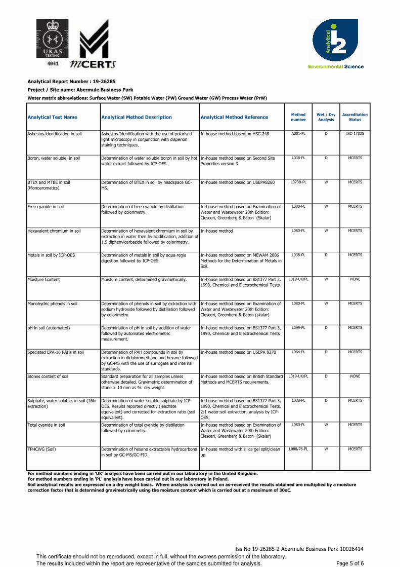
Analytical Report Number : 19-26285
Project / Site name: Abermule Business Park
Water matrix abbreviations: Surface Water (SW) Potable Water (PW) Ground Water (GW) Process Water (PrW)
Analytical Test Name Analytical Method Description Analytical Method ReferenceMethod
number
Wet / Dry
Analysis
Accreditation
Status
Asbestos identification in soil Asbestos Identification with the use of polarised light microscopy in conjunction with disperion staining techniques.
In house method based on HSG 248 A001-PL D ISO 17025
Boron, water soluble, in soil Determination of water soluble boron in soil by hot water extract followed by ICP-OES.
In-house method based on Second Site Properties version 3
L038-PL D MCERTS
BTEX and MTBE in soil (Monoaromatics)
Determination of BTEX in soil by headspace GC-MS.
In-house method based on USEPA8260 L073B-PL W MCERTS
Free cyanide in soil Determination of free cyanide by distillation followed by colorimetry.
In-house method based on Examination of Water and Wastewater 20th Edition: Clesceri, Greenberg & Eaton (Skalar)
L080-PL W MCERTS
Hexavalent chromium in soil Determination of hexavalent chromium in soil by extraction in water then by acidification, addition of 1,5 diphenylcarbazide followed by colorimetry.
In-house method L080-PL W MCERTS
Metals in soil by ICP-OES Determination of metals in soil by aqua-regia digestion followed by ICP-OES.
In-house method based on MEWAM 2006 Methods for the Determination of Metals in Soil.
L038-PL D MCERTS
Moisture Content Moisture content, determined gravimetrically. In-house method based on BS1377 Part 2, 1990, Chemical and Electrochemical Tests
L019-UK/PL W NONE
Monohydric phenols in soil Determination of phenols in soil by extraction with sodium hydroxide followed by distillation followed by colorimetry.
In-house method based on Examination of Water and Wastewater 20th Edition: Clesceri, Greenberg & Eaton (skalar)
L080-PL W MCERTS
pH in soil (automated) Determination of pH in soil by addition of water followed by automated electrometric measurement.
In-house method based on BS1377 Part 3, 1990, Chemical and Electrochemical Tests
L099-PL D MCERTS
Speciated EPA-16 PAHs in soil Determination of PAH compounds in soil by extraction in dichloromethane and hexane followed by GC-MS with the use of surrogate and internal standards.
In-house method based on USEPA 8270 L064-PL D MCERTS
Stones content of soil Standard preparation for all samples unless otherwise detailed. Gravimetric determination of stone > 10 mm as % dry weight.
In-house method based on British Standard Methods and MCERTS requirements.
L019-UK/PL D NONE
Sulphate, water soluble, in soil (16hr extraction)
Determination of water soluble sulphate by ICP-OES. Results reported directly (leachate equivalent) and corrected for extraction ratio (soil equivalent).
In-house method based on BS1377 Part 3, 1990, Chemical and Electrochemical Tests, 2:1 water:soil extraction, analysis by ICP-OES.
L038-PL D MCERTS
Total cyanide in soil Determination of total cyanide by distillation followed by colorimetry.
In-house method based on Examination of Water and Wastewater 20th Edition: Clesceri, Greenberg & Eaton (Skalar)
L080-PL W MCERTS
TPHCWG (Soil) Determination of hexane extractable hydrocarbons in soil by GC-MS/GC-FID.
In-house method with silica gel split/clean up.
L088/76-PL W MCERTS
For method numbers ending in 'UK' analysis have been carried out in our laboratory in the United Kingdom.
For method numbers ending in 'PL' analysis have been carried out in our laboratory in Poland.
Soil analytical results are expressed on a dry weight basis. Where analysis is carried out on as-received the results obtained are multiplied by a moisture
correction factor that is determined gravimetrically using the moisture content which is carried out at a maximum of 30oC.
This certificate should not be reproduced, except in full, without the express permission of the laboratory.
The results included within the report are representative of the samples submitted for analysis.
Iss No 19-26285-2 Abermule Business Park 10026414
Page 5 of 6

Sample Deviation Report
Sample ID Other_ID Sample Type Job Sample Number Sample Deviation Code test_name test_ref Test Deviation code
BH103 1 S 19-26285 1140539 c Free cyanide in soil L080-PL c
BH103 1 S 19-26285 1140539 c Total cyanide in soil L080-PL c
BH103 3 S 19-26285 1140540 c Free cyanide in soil L080-PL c
BH103 3 S 19-26285 1140540 c Total cyanide in soil L080-PL c
BH104 1 S 19-26285 1140541 c Free cyanide in soil L080-PL c
BH104 1 S 19-26285 1140541 c Total cyanide in soil L080-PL c
BH104 3 S 19-26285 1140542 c Free cyanide in soil L080-PL c
BH104 3 S 19-26285 1140542 c Total cyanide in soil L080-PL c
BH105 1 S 19-26285 1140543 c Free cyanide in soil L080-PL c
BH105 1 S 19-26285 1140543 c Total cyanide in soil L080-PL c
Iss No:19-26285-2 Abermule Business Park 10026414Key: a - No sampling date b - Incorrect container
c - Holding time d - Headspace e - Temperature Page 6 of 6
Gemma Francis
t: 01173721360 t: 01923 225404f: 01923 237404
e: [email protected] e:
Project / Site name: Samples received on: 04/02/2019
Your job number: 10026414 Samples instructed on: 04/02/2019
Your order number: 14020726 Analysis completed by: 12/02/2019
Report Issue Number: 1 Report issued on: 12/02/2019
Samples Analysed:
Signed:
Head of Customer ServicesFor & on behalf of i2 Analytical Ltd.
Standard Geotechnical, Asbestos and Chemical Testing Laboratory located at: ul. Pionierów 39, 41 -711 Ruda Śląska, Poland.
Accredited tests are defined within the report, opinions and interpretations expressed herein are outside the scope of accreditation.
Standard sample disposal times, unless otherwise agreed with the laboratory, are : soils - 4 weeks from reportingleachates - 2 weeks from reportingwaters - 2 weeks from reportingasbestos - 6 months from reporting
Excel copies of reports are only valid when accompanied by this PDF certificate.
Rexona Rahman
6 water samples
Abermule Business Park
Arcadis Consulting (UK) Ltd5th FloorThe PithayBristolBS1 2NL
i2 Analytical Ltd.7 Woodshots Meadow,Croxley Green Business Park,Watford, Herts, WD18 8YS
Analytical Report Number : 19-27265
This certificate should not be reproduced, except in full, without the express permission of the laboratory.
The results included within the report are representative of the samples submitted for analysis.
Iss No 19-27265-1 Abermule Business Park 10026414
Page 1 of 7
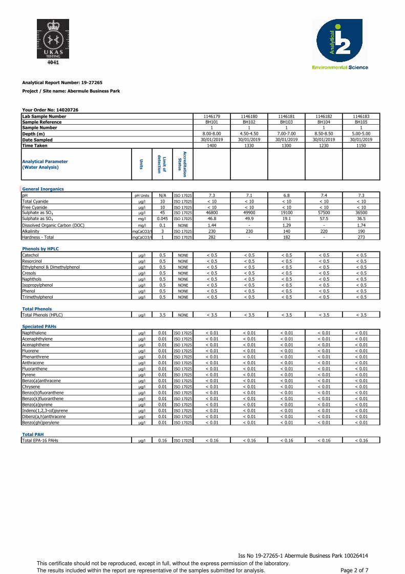
Analytical Report Number: 19-27265
Project / Site name: Abermule Business Park
Your Order No: 14020726
Lab Sample Number 1146179 1146180 1146181 1146182 1146183Sample Reference BH101 BH102 BH103 BH104 BH105Sample Number 1 1 1 1 1Depth (m) 8.00-8.00 4.50-4.50 7.00-7.00 8.50-8.50 5.00-5.00Date Sampled 30/01/2019 30/01/2019 30/01/2019 30/01/2019 30/01/2019Time Taken 1400 1330 1300 1230 1150
Analytical Parameter
(Water Analysis)
Un
its
Lim
it of
de
tectio
n
Accre
dita
tion
Sta
tus
General Inorganics
pH pH Units N/A ISO 17025 7.3 7.1 6.8 7.4 7.3Total Cyanide µg/l 10 ISO 17025 < 10 < 10 < 10 < 10 < 10Free Cyanide µg/l 10 ISO 17025 < 10 < 10 < 10 < 10 < 10Sulphate as SO4 µg/l 45 ISO 17025 46800 49900 19100 57500 36500Sulphate as SO4 mg/l 0.045 ISO 17025 46.8 49.9 19.1 57.5 36.5
Dissolved Organic Carbon (DOC) mg/l 0.1 NONE 1.44 - 1.29 - 1.74Alkalinity mgCaCO3/l 3 ISO 17025 230 230 140 220 190Hardness - Total mgCaCO3/l 1 ISO 17025 282 - 182 - 273
Phenols by HPLC
Catechol µg/l 0.5 NONE < 0.5 < 0.5 < 0.5 < 0.5 < 0.5Resorcinol µg/l 0.5 NONE < 0.5 < 0.5 < 0.5 < 0.5 < 0.5Ethylphenol & Dimethylphenol µg/l 0.5 NONE < 0.5 < 0.5 < 0.5 < 0.5 < 0.5Cresols µg/l 0.5 NONE < 0.5 < 0.5 < 0.5 < 0.5 < 0.5Naphthols µg/l 0.5 NONE < 0.5 < 0.5 < 0.5 < 0.5 < 0.5Isopropylphenol µg/l 0.5 NONE < 0.5 < 0.5 < 0.5 < 0.5 < 0.5Phenol µg/l 0.5 NONE < 0.5 < 0.5 < 0.5 < 0.5 < 0.5Trimethylphenol µg/l 0.5 NONE < 0.5 < 0.5 < 0.5 < 0.5 < 0.5
Total Phenols
Total Phenols (HPLC) µg/l 3.5 NONE < 3.5 < 3.5 < 3.5 < 3.5 < 3.5
Speciated PAHs
Naphthalene µg/l 0.01 ISO 17025 < 0.01 < 0.01 < 0.01 < 0.01 < 0.01Acenaphthylene µg/l 0.01 ISO 17025 < 0.01 < 0.01 < 0.01 < 0.01 < 0.01Acenaphthene µg/l 0.01 ISO 17025 < 0.01 < 0.01 < 0.01 < 0.01 < 0.01Fluorene µg/l 0.01 ISO 17025 < 0.01 < 0.01 < 0.01 < 0.01 < 0.01Phenanthrene µg/l 0.01 ISO 17025 < 0.01 < 0.01 < 0.01 < 0.01 < 0.01Anthracene µg/l 0.01 ISO 17025 < 0.01 < 0.01 < 0.01 < 0.01 < 0.01Fluoranthene µg/l 0.01 ISO 17025 < 0.01 < 0.01 < 0.01 < 0.01 < 0.01Pyrene µg/l 0.01 ISO 17025 < 0.01 < 0.01 < 0.01 < 0.01 < 0.01Benzo(a)anthracene µg/l 0.01 ISO 17025 < 0.01 < 0.01 < 0.01 < 0.01 < 0.01Chrysene µg/l 0.01 ISO 17025 < 0.01 < 0.01 < 0.01 < 0.01 < 0.01Benzo(b)fluoranthene µg/l 0.01 ISO 17025 < 0.01 < 0.01 < 0.01 < 0.01 < 0.01Benzo(k)fluoranthene µg/l 0.01 ISO 17025 < 0.01 < 0.01 < 0.01 < 0.01 < 0.01Benzo(a)pyrene µg/l 0.01 ISO 17025 < 0.01 < 0.01 < 0.01 < 0.01 < 0.01Indeno(1,2,3-cd)pyrene µg/l 0.01 ISO 17025 < 0.01 < 0.01 < 0.01 < 0.01 < 0.01Dibenz(a,h)anthracene µg/l 0.01 ISO 17025 < 0.01 < 0.01 < 0.01 < 0.01 < 0.01Benzo(ghi)perylene µg/l 0.01 ISO 17025 < 0.01 < 0.01 < 0.01 < 0.01 < 0.01
Total PAH
Total EPA-16 PAHs µg/l 0.16 ISO 17025 < 0.16 < 0.16 < 0.16 < 0.16 < 0.16
This certificate should not be reproduced, except in full, without the express permission of the laboratory.
The results included within the report are representative of the samples submitted for analysis.
Iss No 19-27265-1 Abermule Business Park 10026414
Page 2 of 7
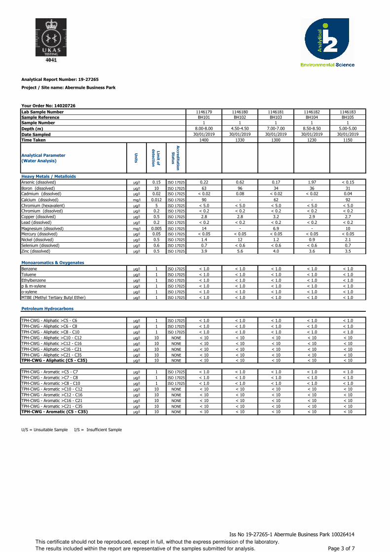
Analytical Report Number: 19-27265
Project / Site name: Abermule Business Park
Your Order No: 14020726
Lab Sample Number 1146179 1146180 1146181 1146182 1146183Sample Reference BH101 BH102 BH103 BH104 BH105Sample Number 1 1 1 1 1Depth (m) 8.00-8.00 4.50-4.50 7.00-7.00 8.50-8.50 5.00-5.00Date Sampled 30/01/2019 30/01/2019 30/01/2019 30/01/2019 30/01/2019Time Taken 1400 1330 1300 1230 1150
Analytical Parameter
(Water Analysis)
Un
its
Lim
it of
de
tectio
n
Accre
dita
tion
Sta
tus
Heavy Metals / Metalloids
Arsenic (dissolved) µg/l 0.15 ISO 17025 0.22 0.62 0.17 1.97 < 0.15Boron (dissolved) µg/l 10 ISO 17025 63 96 34 36 31Cadmium (dissolved) µg/l 0.02 ISO 17025 < 0.02 0.08 < 0.02 < 0.02 0.04Calcium (dissolved) mg/l 0.012 ISO 17025 90 - 62 - 92Chromium (hexavalent) µg/l 5 ISO 17025 < 5.0 < 5.0 < 5.0 < 5.0 < 5.0Chromium (dissolved) µg/l 0.2 ISO 17025 < 0.2 < 0.2 < 0.2 < 0.2 < 0.2Copper (dissolved) µg/l 0.5 ISO 17025 2.8 2.8 3.2 2.9 2.7Lead (dissolved) µg/l 0.2 ISO 17025 < 0.2 < 0.2 < 0.2 < 0.2 < 0.2Magnesium (dissolved) mg/l 0.005 ISO 17025 14 - 6.9 - 10Mercury (dissolved) µg/l 0.05 ISO 17025 < 0.05 < 0.05 < 0.05 < 0.05 < 0.05Nickel (dissolved) µg/l 0.5 ISO 17025 1.4 12 1.2 0.9 2.1Selenium (dissolved) µg/l 0.6 ISO 17025 0.7 < 0.6 < 0.6 < 0.6 0.7Zinc (dissolved) µg/l 0.5 ISO 17025 3.9 5.6 4.0 3.6 3.5
Monoaromatics & Oxygenates
Benzene µg/l 1 ISO 17025 < 1.0 < 1.0 < 1.0 < 1.0 < 1.0Toluene µg/l 1 ISO 17025 < 1.0 < 1.0 < 1.0 < 1.0 < 1.0Ethylbenzene µg/l 1 ISO 17025 < 1.0 < 1.0 < 1.0 < 1.0 < 1.0p & m-xylene µg/l 1 ISO 17025 < 1.0 < 1.0 < 1.0 < 1.0 < 1.0o-xylene µg/l 1 ISO 17025 < 1.0 < 1.0 < 1.0 < 1.0 < 1.0MTBE (Methyl Tertiary Butyl Ether) µg/l 1 ISO 17025 < 1.0 < 1.0 < 1.0 < 1.0 < 1.0
Petroleum Hydrocarbons
TPH-CWG - Aliphatic >C5 - C6 µg/l 1 ISO 17025 < 1.0 < 1.0 < 1.0 < 1.0 < 1.0TPH-CWG - Aliphatic >C6 - C8 µg/l 1 ISO 17025 < 1.0 < 1.0 < 1.0 < 1.0 < 1.0TPH-CWG - Aliphatic >C8 - C10 µg/l 1 ISO 17025 < 1.0 < 1.0 < 1.0 < 1.0 < 1.0TPH-CWG - Aliphatic >C10 - C12 µg/l 10 NONE < 10 < 10 < 10 < 10 < 10TPH-CWG - Aliphatic >C12 - C16 µg/l 10 NONE < 10 < 10 < 10 < 10 < 10TPH-CWG - Aliphatic >C16 - C21 µg/l 10 NONE < 10 < 10 < 10 < 10 < 10TPH-CWG - Aliphatic >C21 - C35 µg/l 10 NONE < 10 < 10 < 10 < 10 < 10TPH-CWG - Aliphatic (C5 - C35) µg/l 10 NONE < 10 < 10 < 10 < 10 < 10
TPH-CWG - Aromatic >C5 - C7 µg/l 1 ISO 17025 < 1.0 < 1.0 < 1.0 < 1.0 < 1.0TPH-CWG - Aromatic >C7 - C8 µg/l 1 ISO 17025 < 1.0 < 1.0 < 1.0 < 1.0 < 1.0TPH-CWG - Aromatic >C8 - C10 µg/l 1 ISO 17025 < 1.0 < 1.0 < 1.0 < 1.0 < 1.0TPH-CWG - Aromatic >C10 - C12 µg/l 10 NONE < 10 < 10 < 10 < 10 < 10TPH-CWG - Aromatic >C12 - C16 µg/l 10 NONE < 10 < 10 < 10 < 10 < 10TPH-CWG - Aromatic >C16 - C21 µg/l 10 NONE < 10 < 10 < 10 < 10 < 10TPH-CWG - Aromatic >C21 - C35 µg/l 10 NONE < 10 < 10 < 10 < 10 < 10TPH-CWG - Aromatic (C5 - C35) µg/l 10 NONE < 10 < 10 < 10 < 10 < 10
U/S = Unsuitable Sample I/S = Insufficient Sample
This certificate should not be reproduced, except in full, without the express permission of the laboratory.
The results included within the report are representative of the samples submitted for analysis.
Iss No 19-27265-1 Abermule Business Park 10026414
Page 3 of 7
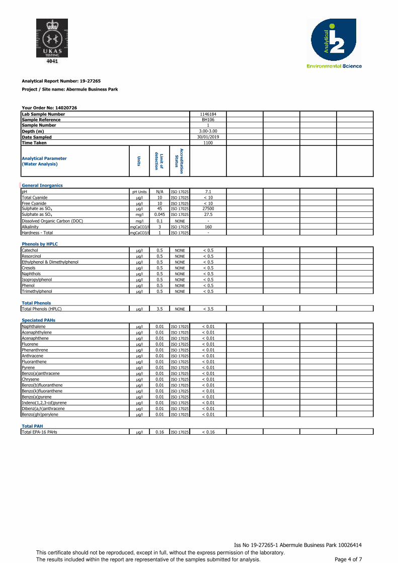
Analytical Report Number: 19-27265
Project / Site name: Abermule Business Park
Your Order No: 14020726
Lab Sample Number
Sample Reference
Sample Number
Depth (m)
Date Sampled
Time Taken
Analytical Parameter
(Water Analysis)
Un
its
Lim
it of
de
tectio
n
Accre
dita
tion
Sta
tus
General Inorganics
pH pH Units N/A ISO 17025
Total Cyanide µg/l 10 ISO 17025
Free Cyanide µg/l 10 ISO 17025Sulphate as SO4 µg/l 45 ISO 17025
Sulphate as SO4 mg/l 0.045 ISO 17025
Dissolved Organic Carbon (DOC) mg/l 0.1 NONE
Alkalinity mgCaCO3/l 3 ISO 17025
Hardness - Total mgCaCO3/l 1 ISO 17025
Phenols by HPLC
Catechol µg/l 0.5 NONE
Resorcinol µg/l 0.5 NONE
Ethylphenol & Dimethylphenol µg/l 0.5 NONE
Cresols µg/l 0.5 NONE
Naphthols µg/l 0.5 NONE
Isopropylphenol µg/l 0.5 NONE
Phenol µg/l 0.5 NONE
Trimethylphenol µg/l 0.5 NONE
Total Phenols
Total Phenols (HPLC) µg/l 3.5 NONE
Speciated PAHs
Naphthalene µg/l 0.01 ISO 17025
Acenaphthylene µg/l 0.01 ISO 17025
Acenaphthene µg/l 0.01 ISO 17025
Fluorene µg/l 0.01 ISO 17025
Phenanthrene µg/l 0.01 ISO 17025
Anthracene µg/l 0.01 ISO 17025
Fluoranthene µg/l 0.01 ISO 17025
Pyrene µg/l 0.01 ISO 17025
Benzo(a)anthracene µg/l 0.01 ISO 17025
Chrysene µg/l 0.01 ISO 17025
Benzo(b)fluoranthene µg/l 0.01 ISO 17025
Benzo(k)fluoranthene µg/l 0.01 ISO 17025
Benzo(a)pyrene µg/l 0.01 ISO 17025
Indeno(1,2,3-cd)pyrene µg/l 0.01 ISO 17025
Dibenz(a,h)anthracene µg/l 0.01 ISO 17025
Benzo(ghi)perylene µg/l 0.01 ISO 17025
Total PAH
Total EPA-16 PAHs µg/l 0.16 ISO 17025
1146184BH106
13.00-3.00
30/01/20191100
7.1< 10< 102750027.5
-160
-
< 0.5< 0.5< 0.5< 0.5< 0.5< 0.5< 0.5< 0.5
< 3.5
< 0.01< 0.01< 0.01< 0.01< 0.01< 0.01< 0.01< 0.01< 0.01< 0.01< 0.01< 0.01< 0.01< 0.01< 0.01< 0.01
< 0.16
This certificate should not be reproduced, except in full, without the express permission of the laboratory.
The results included within the report are representative of the samples submitted for analysis.
Iss No 19-27265-1 Abermule Business Park 10026414
Page 4 of 7
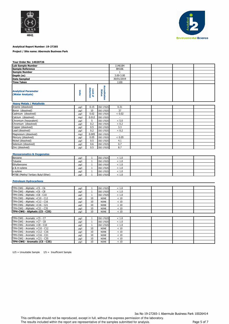
Analytical Report Number: 19-27265
Project / Site name: Abermule Business Park
Your Order No: 14020726
Lab Sample Number
Sample Reference
Sample Number
Depth (m)
Date Sampled
Time Taken
Analytical Parameter
(Water Analysis)
Un
its
Lim
it of
de
tectio
n
Accre
dita
tion
Sta
tus
Heavy Metals / Metalloids
Arsenic (dissolved) µg/l 0.15 ISO 17025
Boron (dissolved) µg/l 10 ISO 17025Cadmium (dissolved) µg/l 0.02 ISO 17025
Calcium (dissolved) mg/l 0.012 ISO 17025
Chromium (hexavalent) µg/l 5 ISO 17025Chromium (dissolved) µg/l 0.2 ISO 17025
Copper (dissolved) µg/l 0.5 ISO 17025
Lead (dissolved) µg/l 0.2 ISO 17025
Magnesium (dissolved) mg/l 0.005 ISO 17025Mercury (dissolved) µg/l 0.05 ISO 17025
Nickel (dissolved) µg/l 0.5 ISO 17025
Selenium (dissolved) µg/l 0.6 ISO 17025
Zinc (dissolved) µg/l 0.5 ISO 17025
Monoaromatics & Oxygenates
Benzene µg/l 1 ISO 17025
Toluene µg/l 1 ISO 17025
Ethylbenzene µg/l 1 ISO 17025
p & m-xylene µg/l 1 ISO 17025
o-xylene µg/l 1 ISO 17025
MTBE (Methyl Tertiary Butyl Ether) µg/l 1 ISO 17025
Petroleum Hydrocarbons
TPH-CWG - Aliphatic >C5 - C6 µg/l 1 ISO 17025
TPH-CWG - Aliphatic >C6 - C8 µg/l 1 ISO 17025
TPH-CWG - Aliphatic >C8 - C10 µg/l 1 ISO 17025
TPH-CWG - Aliphatic >C10 - C12 µg/l 10 NONE
TPH-CWG - Aliphatic >C12 - C16 µg/l 10 NONE
TPH-CWG - Aliphatic >C16 - C21 µg/l 10 NONE
TPH-CWG - Aliphatic >C21 - C35 µg/l 10 NONETPH-CWG - Aliphatic (C5 - C35) µg/l 10 NONE
TPH-CWG - Aromatic >C5 - C7 µg/l 1 ISO 17025
TPH-CWG - Aromatic >C7 - C8 µg/l 1 ISO 17025
TPH-CWG - Aromatic >C8 - C10 µg/l 1 ISO 17025
TPH-CWG - Aromatic >C10 - C12 µg/l 10 NONE
TPH-CWG - Aromatic >C12 - C16 µg/l 10 NONE
TPH-CWG - Aromatic >C16 - C21 µg/l 10 NONE
TPH-CWG - Aromatic >C21 - C35 µg/l 10 NONETPH-CWG - Aromatic (C5 - C35) µg/l 10 NONE
U/S = Unsuitable Sample I/S = Insufficient Sample
1146184BH106
13.00-3.00
30/01/20191100
0.3137
< 0.02-
< 5.0< 0.23.3
< 0.2-
< 0.054.10.78.7
< 1.0< 1.0< 1.0< 1.0< 1.0< 1.0
< 1.0< 1.0< 1.0< 10< 10< 10< 10< 10
< 1.0< 1.0< 1.0< 10< 10< 10< 10< 10
This certificate should not be reproduced, except in full, without the express permission of the laboratory.
The results included within the report are representative of the samples submitted for analysis.
Iss No 19-27265-1 Abermule Business Park 10026414
Page 5 of 7

Analytical Report Number : 19-27265
Project / Site name: Abermule Business Park
Water matrix abbreviations: Surface Water (SW) Potable Water (PW) Ground Water (GW) Process Water (PrW)
Analytical Test Name Analytical Method Description Analytical Method ReferenceMethod
number
Wet / Dry
Analysis
Accreditation
Status
Alkalinity in Water (by discreet analyser)
Determination of Alkalinity by discreet analyser (colorimetry). Accredited matrices: SW, PW, GW.
In house method based on MEWAM & USEPA Method 310.2.
L082-PL W ISO 17025
Boron in water Determination of boron in water by acidification followed by ICP-OES. Accredited matrices: SW PW GW
In-house method based on MEWAM L039-PL W ISO 17025
BTEX and MTBE in water (Monoaromatics)
Determination of BTEX and MTBE in water by headspace GC-MS. Accredited matrices: SW PW GW
In-house method based on USEPA8260 L073B-PL W ISO 17025
Dissolved Organic Carbon in water Determination of dissolved inorganic carbon in water by TOC/DOC NDIR Analyser.
In-house method based on Examination of Water and Wastewater 20th Edition: Clesceri, Greenberg & Eaton
L037-PL W NONE
Free cyanide in water Determination of free cyanide by distillation followed by colorimetry.Accredited matrices SW, GW, PW.
In-house method based on Examination of Water and Wastewater 20th Edition: Clesceri, Greenberg & Eaton (Skalar)
L080-PL W ISO 17025
Hexavalent chromium in water Determination of hexavalent chromium in water by acidification, addition of 1,5 diphenylcarbazide followed by colorimetry.
In-house method by continuous flow analyser. Accredited Matrices SW, GW, PW.
L080-PL W ISO 17025
Metals in water by ICP-MS (dissolved) Determination of metals in water by acidification followed by ICP-MS. Accredited Matrices: SW, GW, PW except B=SW,GW, Hg=SW,PW, Al=SW,PW.
In-house method based on USEPA Method 6020 & 200.8 "for the determination of trace elements in water by ICP-MS.
L012-PL W ISO 17025
Metals in water by ICP-OES (dissolved)
Determination of metals in water by acidification followed by ICP-OES. Accredited Matrices SW, GW, PW, PrW.(Al, Cu,Fe,Zn).
In-house method based on MEWAM 2006 Methods for the Determination of Metals in Soil.
L039-PL W ISO 17025
pH at 20oC in water (automated) Determination of pH in water by electrometric measurement. Accredited matrices: SW PW GW
In-house method based on BS1377 Part 3, 1990, Chemical and Electrochemical Tests
L099-PL W ISO 17025
Phenols, speciated, in water, by HPLC Determination of speciated phenols by HPLC. In house method based on Blue Book Method.
L030-PL W NONE
Speciated EPA-16 PAHs in water Determination of PAH compounds in water by extraction in dichloromethane followed by GC-MS with the use of surrogate and internal standards. Accredited matrices: SW PW GW
In-house method based on USEPA 8270 L102B-PL W ISO 17025
Sulphate in water Determination of sulphate in water by acidification followed by ICP-OES. Accredited matrices: SW PW GW, PrW.
In-house method based on MEWAM 2006 Methods for the Determination of Metals in Soil.
L039-PL W ISO 17025
Total cyanide in water Determination of total cyanide by distillation followed by colorimetry. Accredited matrices: SW PW GW
In-house method based on Examination of Water and Wastewater 20th Edition: Clesceri, Greenberg & Eaton (Skalar)
L080-PL W ISO 17025
Total Hardness of water Determination of hardness in waters by calculation from calcium and magnesium. Accredited Matrices SW, GW, PW.
In-house method based on Examination of Water and Wastewater 20th Edition: Clesceri, Greenberg & Eaton
L045-PL W ISO 17025
TPHCWG (Waters) Determination of dichloromethane extractable hydrocarbons in water by GC-MS, speciation by interpretation.
In-house method L070-PL W NONE
For method numbers ending in 'UK' analysis have been carried out in our laboratory in the United Kingdom.
For method numbers ending in 'PL' analysis have been carried out in our laboratory in Poland.
Soil analytical results are expressed on a dry weight basis. Where analysis is carried out on as-received the results obtained are multiplied by a moisture
correction factor that is determined gravimetrically using the moisture content which is carried out at a maximum of 30oC.
This certificate should not be reproduced, except in full, without the express permission of the laboratory.
The results included within the report are representative of the samples submitted for analysis.
Iss No 19-27265-1 Abermule Business Park 10026414
Page 6 of 7
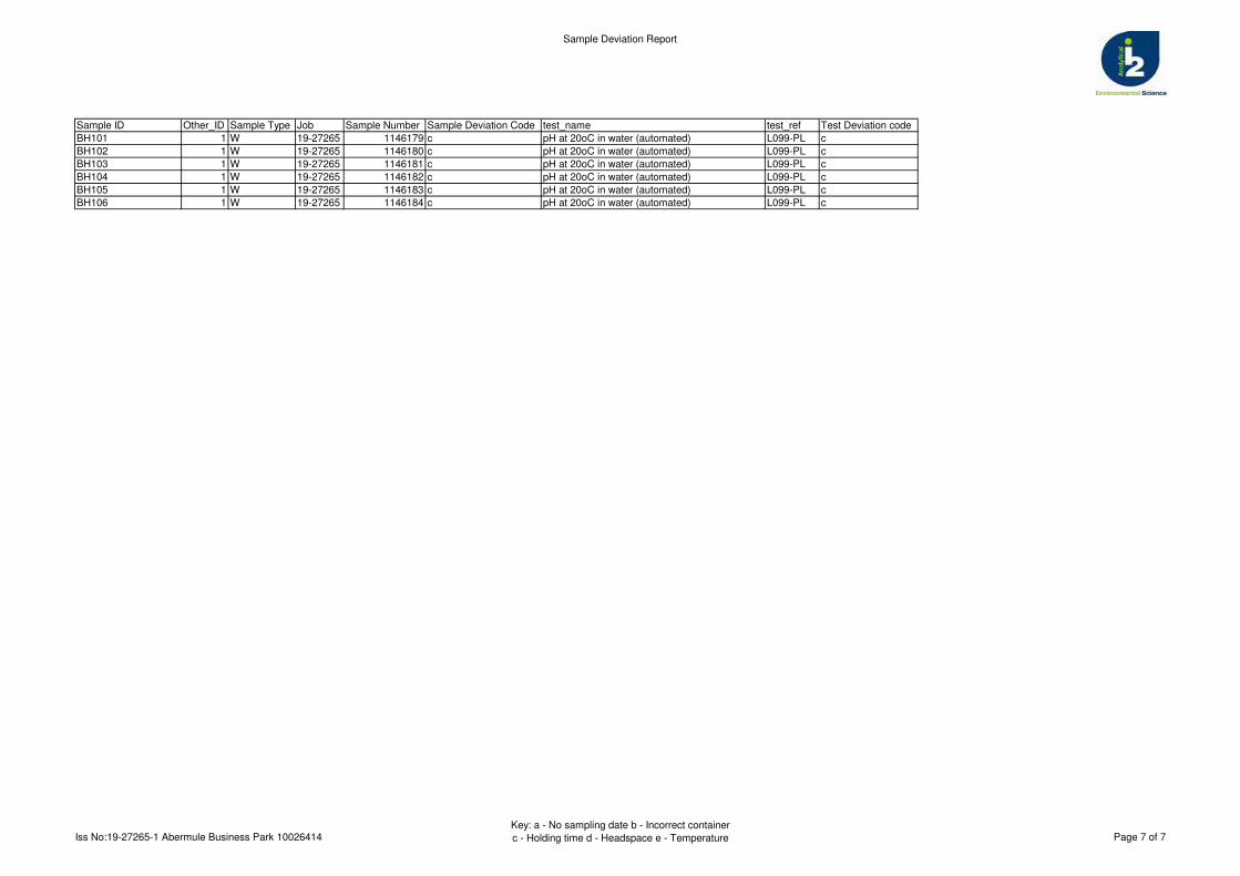
Sample Deviation Report
Sample ID Other_ID Sample Type Job Sample Number Sample Deviation Code test_name test_ref Test Deviation code
BH101 1 W 19-27265 1146179 c pH at 20oC in water (automated) L099-PL c
BH102 1 W 19-27265 1146180 c pH at 20oC in water (automated) L099-PL c
BH103 1 W 19-27265 1146181 c pH at 20oC in water (automated) L099-PL c
BH104 1 W 19-27265 1146182 c pH at 20oC in water (automated) L099-PL c
BH105 1 W 19-27265 1146183 c pH at 20oC in water (automated) L099-PL c
BH106 1 W 19-27265 1146184 c pH at 20oC in water (automated) L099-PL c
Iss No:19-27265-1 Abermule Business Park 10026414Key: a - No sampling date b - Incorrect container
c - Holding time d - Headspace e - Temperature Page 7 of 7

Laboratory Service Client:
Unit 31 Ddole Rd Industrial Estate
Llandrindod Wells
Powys
LD1 6DF
Tel: 0333 222 5913 Copy to:
Date Reported: 08/10/2018
Remarks:
Signed:
Sample Location
TEST REPORT
ASBESTOS FIBRE IDENTIFICATION
TESTED BY IN HOUSE METHOD IN ACCORDANCE WITH HSG 248 (ASBESTOS: THE ANALYSTS’ GUIDE FOR SAMPLING, ANALYSIS
AND CLEARANCE PROCEDURES) 2005
Site
PCC Highways, Transport & Recycling
County Hall
Llandrindod Wells
Powys, LD1 5LG
Lisa Contestabile
Lab Reference: 180032
Date Tested
Abermule Business Park
N/A
Debris in soil under fencing line, as plans
08/10/2018
08/10/2018
08/10/2018
Surveyor/Sampler
Event No.
Analyst
Tracy Gittens
0
Eleri Halliday
Building Ref.
Date Sampled
Date Received
Chrysotile
Product type
Board
Fibre Identification
Amosite
CHRYSOTILE = White Asbestos, AMOSITE = Brown Asbestos, CROCIDOLITE = Blue Asbestos
The laboratory takes no responsibility for sampling undertaken by non-laboratory staff, or for the
interpretation of results. UKAS accreditation is for analysis only.
Authorised Signatories:
M. Myhill, Asbestos Officer E. Halliday, Asbestos Officer T. Gittens, Asbestos OfficerThis Report relates only to the samples tested. Opinions and interpretations expressed herein are outside the scope of UKAS accreditation.
This report is invalid if altered in any way. This report may not be reproduced except in full,
FM24a Issue No:3 Issue Date: 02/07/18 Page 1 of 1
ANTHOPHYLLITE, TREMOLITE, ACTINOLITE = Minor Asbestos Types

Laboratory Service Client:
Unit 31 Ddole Rd Industrial Estate
Llandrindod Wells
Powys
LD1 6DF
Tel: 0333 222 5913 Copy to:
Date Reported: 23/10/2018
Sample Location
TEST REPORT
ASBESTOS FIBRE IDENTIFICATION
TESTED BY IN HOUSE METHOD IN ACCORDANCE WITH HSG 248 (ASBESTOS: THE ANALYSTS’ GUIDE FOR SAMPLING,
ANALYSIS AND CLEARANCE PROCEDURES) 2005
Site
County Hall
Llandrindod Wells
Powys
LD1 5LG
PCC Highways
Lab Reference: 180041
Date Tested
Abermule Busines Park
N/A
Debris in spoil heap (as plans)
18/10/2018
18/10/2018
22/10/2018
Surveyor/Sampler
Event No.
Analyst
Tracy Gittens
Tracy Gittens
Building Ref.
Date Sampled
Date Received
Product type
Cement
Fibre Identification
Chrysotile
CHRYSOTILE = White Asbestos, AMOSITE = Brown Asbestos, CROCIDOLITE = Blue Asbestos
The laboratory takes no responsibility for sampling undertaken by non-laboratory staff, or for the
interpretation of results. UKAS accreditation is for analysis only.
Authorised Signatories:
M. Myhill, Asbestos Officer E. Halliday, Asbestos Officer T. Gittens, Asbestos Officer
This Report relates only to the samples tested. Opinions and interpretations expressed herein are outside the scope of UKAS accreditation.
This report is invalid if altered in any way. This report may not be reproduced except in full,
FM24a Issue No:3 Issue Date: 02/07/18 Page 1 of 1
ANTHOPHYLLITE, TREMOLITE, ACTINOLITE = Minor Asbestos Types
Laboratory Service Client:
Unit 31 Ddole Rd Industrial Estate
Llandrindod Wells
Powys
LD1 6DF
Tel: 0333 222 5913 Copy to:
Date Reported: 23/10/2018
Sample Location
TEST REPORT
ASBESTOS FIBRE IDENTIFICATION
TESTED BY IN HOUSE METHOD IN ACCORDANCE WITH HSG 248 (ASBESTOS: THE ANALYSTS’ GUIDE FOR SAMPLING,
ANALYSIS AND CLEARANCE PROCEDURES) 2005
Site
County Hall
Llandrindod Wells
Powys
LD1 5LG
PCC Highways
Lab Reference: 180042
Date Tested
Abermule Busines Park
N/A
Debris in spoil heap (as plans)
18/10/2018
18/10/2018
22/10/2018
Surveyor/Sampler
Event No.
Analyst
Tracy Gittens
Tracy Gittens
Building Ref.
Date Sampled
Date Received
Product type
Cement
Fibre Identification
No asbestos detected
CHRYSOTILE = White Asbestos, AMOSITE = Brown Asbestos, CROCIDOLITE = Blue Asbestos
The laboratory takes no responsibility for sampling undertaken by non-laboratory staff, or for the
interpretation of results. UKAS accreditation is for analysis only.
Authorised Signatories:
M. Myhill, Asbestos Officer E. Halliday, Asbestos Officer T. Gittens, Asbestos Officer
This Report relates only to the samples tested. Opinions and interpretations expressed herein are outside the scope of UKAS accreditation.
This report is invalid if altered in any way. This report may not be reproduced except in full,
FM24a Issue No:3 Issue Date: 02/07/18 Page 1 of 1
ANTHOPHYLLITE, TREMOLITE, ACTINOLITE = Minor Asbestos Types

Laboratory Service Client:
Unit 31 Ddole Rd Industrial Estate
Llandrindod Wells
Powys
LD1 6DF
Tel: 0333 222 5913 Copy to:
Date Reported: 23/10/2018
Sample Location
TEST REPORT
ASBESTOS FIBRE IDENTIFICATION
TESTED BY IN HOUSE METHOD IN ACCORDANCE WITH HSG 248 (ASBESTOS: THE ANALYSTS’ GUIDE FOR SAMPLING,
ANALYSIS AND CLEARANCE PROCEDURES) 2005
Site
County Hall
Llandrindod Wells
Powys
LD1 5LG
PCC Highways
Lab Reference: 180043
Date Tested
Abermule Busines Park
N/A
Debris in spoil heap (as plans)
18/10/2018
18/10/2018
22/10/2018
Surveyor/Sampler
Event No.
Analyst
Tracy Gittens
Tracy Gittens
Building Ref.
Date Sampled
Date Received
Product type
Cement
Fibre Identification
Chrysotile
CHRYSOTILE = White Asbestos, AMOSITE = Brown Asbestos, CROCIDOLITE = Blue Asbestos
The laboratory takes no responsibility for sampling undertaken by non-laboratory staff, or for the
interpretation of results. UKAS accreditation is for analysis only.
Authorised Signatories:
M. Myhill, Asbestos Officer E. Halliday, Asbestos Officer T. Gittens, Asbestos Officer
This Report relates only to the samples tested. Opinions and interpretations expressed herein are outside the scope of UKAS accreditation.
This report is invalid if altered in any way. This report may not be reproduced except in full,
FM24a Issue No:3 Issue Date: 02/07/18 Page 1 of 1
ANTHOPHYLLITE, TREMOLITE, ACTINOLITE = Minor Asbestos Types
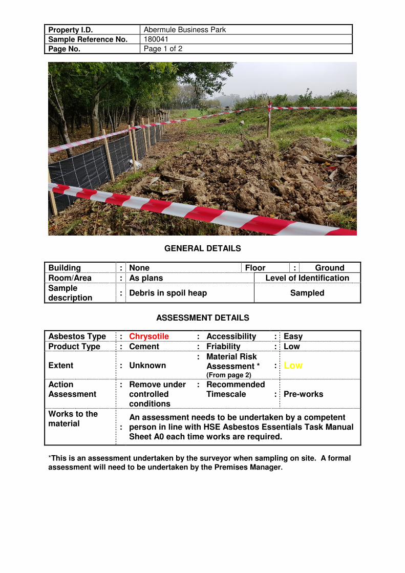
Property I.D. Abermule Business Park
Sample Reference No. 180041
Page No. Page 1 of 2
GENERAL DETAILS
Building : None Floor : Ground
Room/Area : As plans Level of Identification
Sample description
: Debris in spoil heap Sampled
ASSESSMENT DETAILS
Asbestos Type : Chrysotile : Accessibility : Easy
Product Type : Cement : Friability : Low
Extent : Unknown : Material Risk
Assessment * (From page 2)
: Low
Action Assessment
: Remove under controlled conditions
: Recommended Timescale : Pre-works
Works to the material :
An assessment needs to be undertaken by a competent person in line with HSE Asbestos Essentials Task Manual Sheet A0 each time works are required.
*This is an assessment undertaken by the surveyor when sampling on site. A formal assessment will need to be undertaken by the Premises Manager.
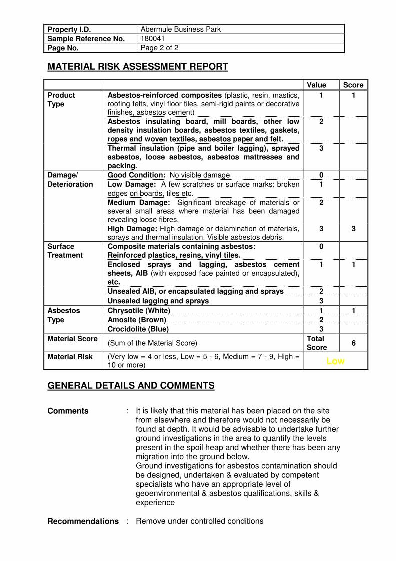
Property I.D. Abermule Business Park
Sample Reference No. 180041
Page No. Page 2 of 2
MATERIAL RISK ASSESSMENT REPORT
Value Score
Product Type
Asbestos-reinforced composites (plastic, resin, mastics, roofing felts, vinyl floor tiles, semi-rigid paints or decorative finishes, asbestos cement)
1 1
Asbestos insulating board, mill boards, other low density insulation boards, asbestos textiles, gaskets, ropes and woven textiles, asbestos paper and felt.
2
Thermal insulation (pipe and boiler lagging), sprayed asbestos, loose asbestos, asbestos mattresses and packing.
3
Damage/ Good Condition: No visible damage 0
Deterioration Low Damage: A few scratches or surface marks; broken edges on boards, tiles etc.
1
Medium Damage: Significant breakage of materials or several small areas where material has been damaged revealing loose fibres.
2
High Damage: High damage or delamination of materials, sprays and thermal insulation. Visible asbestos debris.
3 3
Surface Treatment
Composite materials containing asbestos: Reinforced plastics, resins, vinyl tiles.
0
Enclosed sprays and lagging, asbestos cement sheets, AIB (with exposed face painted or encapsulated), etc.
1 1
Unsealed AIB, or encapsulated lagging and sprays 2
Unsealed lagging and sprays 3
Asbestos Chrysotile (White) 1 1
Type Amosite (Brown) 2
Crocidolite (Blue) 3
Material Score (Sum of the Material Score)
Total Score
6
Material Risk (Very low = 4 or less, Low = 5 - 6, Medium = 7 - 9, High = 10 or more) Low
GENERAL DETAILS AND COMMENTS
Comments : It is likely that this material has been placed on the site from elsewhere and therefore would not necessarily be found at depth. It would be advisable to undertake further ground investigations in the area to quantify the levels present in the spoil heap and whether there has been any migration into the ground below. Ground investigations for asbestos contamination should be designed, undertaken & evaluated by competent specialists who have an appropriate level of geoenvironmental & asbestos qualifications, skills & experience
Recommendations : Remove under controlled conditions
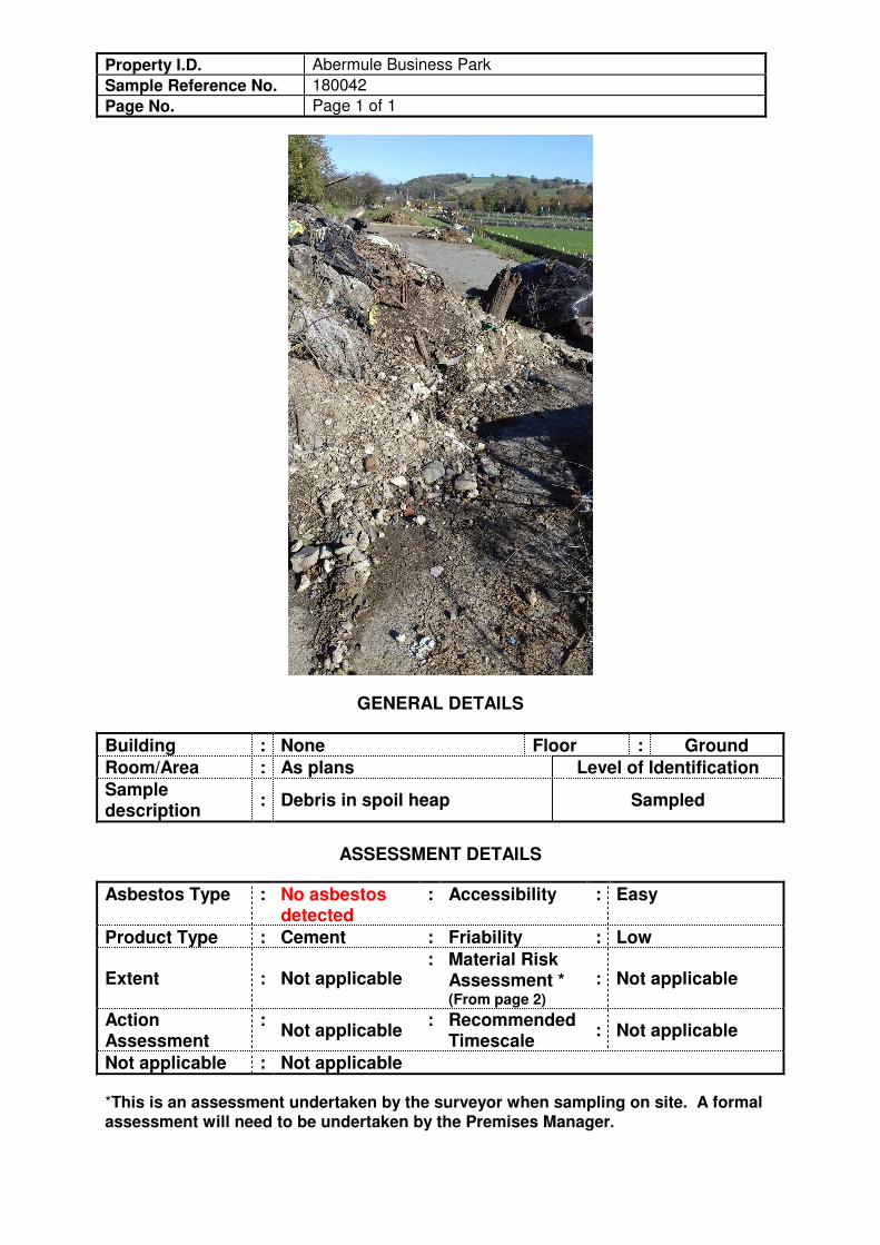
Property I.D. Abermule Business Park
Sample Reference No. 180042
Page No. Page 1 of 1
GENERAL DETAILS
Building : None Floor : Ground
Room/Area : As plans Level of Identification
Sample description
: Debris in spoil heap Sampled
ASSESSMENT DETAILS
Asbestos Type : No asbestos detected
: Accessibility : Easy
Product Type : Cement : Friability : Low
Extent : Not applicable : Material Risk
Assessment * (From page 2)
: Not applicable
Action Assessment
: Not applicable
: Recommended Timescale
: Not applicable
Not applicable : Not applicable
*This is an assessment undertaken by the surveyor when sampling on site. A formal assessment will need to be undertaken by the Premises Manager.
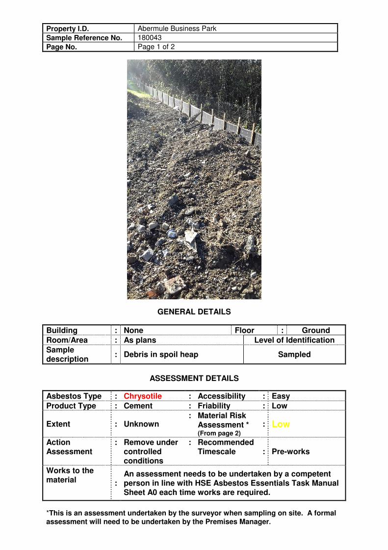
Property I.D. Abermule Business Park
Sample Reference No. 180043
Page No. Page 1 of 2
GENERAL DETAILS
Building : None Floor : Ground
Room/Area : As plans Level of Identification
Sample description
: Debris in spoil heap Sampled
ASSESSMENT DETAILS
Asbestos Type : Chrysotile : Accessibility : Easy
Product Type : Cement : Friability : Low
Extent : Unknown : Material Risk
Assessment * (From page 2)
: Low
Action Assessment
: Remove under controlled conditions
: Recommended Timescale : Pre-works
Works to the material :
An assessment needs to be undertaken by a competent person in line with HSE Asbestos Essentials Task Manual Sheet A0 each time works are required.
*This is an assessment undertaken by the surveyor when sampling on site. A formal assessment will need to be undertaken by the Premises Manager.
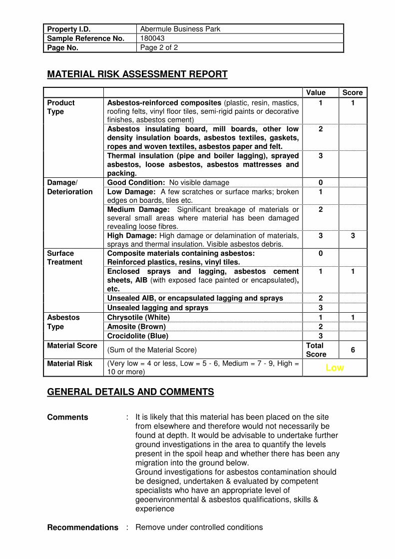
Property I.D. Abermule Business Park
Sample Reference No. 180043
Page No. Page 2 of 2
MATERIAL RISK ASSESSMENT REPORT
Value Score
Product Type
Asbestos-reinforced composites (plastic, resin, mastics, roofing felts, vinyl floor tiles, semi-rigid paints or decorative finishes, asbestos cement)
1 1
Asbestos insulating board, mill boards, other low density insulation boards, asbestos textiles, gaskets, ropes and woven textiles, asbestos paper and felt.
2
Thermal insulation (pipe and boiler lagging), sprayed asbestos, loose asbestos, asbestos mattresses and packing.
3
Damage/ Good Condition: No visible damage 0
Deterioration Low Damage: A few scratches or surface marks; broken edges on boards, tiles etc.
1
Medium Damage: Significant breakage of materials or several small areas where material has been damaged revealing loose fibres.
2
High Damage: High damage or delamination of materials, sprays and thermal insulation. Visible asbestos debris.
3 3
Surface Treatment
Composite materials containing asbestos: Reinforced plastics, resins, vinyl tiles.
0
Enclosed sprays and lagging, asbestos cement sheets, AIB (with exposed face painted or encapsulated), etc.
1 1
Unsealed AIB, or encapsulated lagging and sprays 2
Unsealed lagging and sprays 3
Asbestos Chrysotile (White) 1 1
Type Amosite (Brown) 2
Crocidolite (Blue) 3
Material Score (Sum of the Material Score)
Total Score
6
Material Risk (Very low = 4 or less, Low = 5 - 6, Medium = 7 - 9, High = 10 or more) Low
GENERAL DETAILS AND COMMENTS
Comments : It is likely that this material has been placed on the site from elsewhere and therefore would not necessarily be found at depth. It would be advisable to undertake further ground investigations in the area to quantify the levels present in the spoil heap and whether there has been any migration into the ground below. Ground investigations for asbestos contamination should be designed, undertaken & evaluated by competent specialists who have an appropriate level of geoenvironmental & asbestos qualifications, skills & experience
Recommendations : Remove under controlled conditions

70
HazWaste Assessment

Job name Abermule Business Park - Stockpile Samples V2
Comments
Classification Engine WM3 1st Edition v1.1, May 2018
Waste Stream Abermule Business Park
Created by Fiona Waldron (Arcadis Consulting (UK) Ltd)
Created on 05/03/2019
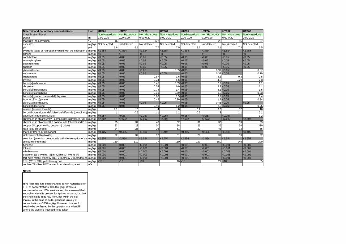
Determinand (laboratory concentrations) Unit HTP01 HTP02 HTP03 HTP04 HTP05 HTP06 HTP07 HTP08
Classification Result Non Hazardous Non Hazardous Non Hazardous Non Hazardous Non Hazardous Non Hazardous Non Hazardous Non Hazardous
Depth m 0.00-0.20 0.00-0.20 0.00-0.20 0.00-0.20 0.00-0.20 0.00-0.20 0.00-0.20 0.00-0.20
moisture {no correction} % 16 16 6.2 14 15 22 15 27
asbestos mg/kg Not detected Not detected Not detected Not detected Not detected Not detected Not detected Not detected
pH pH 6.6 6.5 7.7 7.9 7.7 7.1 7.3 7.5
cyanides {salts of hydrogen cyanide with the exception of complex cyanides such as ferrocyanides, ferricyanides and mercuric oxycyanide and those specified elsewhere in this Annex}mg/kg <1.884 <1.884 <1.884 <1.884 <1.884 <1.884 <1.884 <1.884
phenol mg/kg <1 <1 <1 <1 <1 <1 <1 <1
naphthalene mg/kg <0.05 <0.05 <0.05 <0.05 <0.05 <0.05 <0.05 <0.05
acenaphthylene mg/kg <0.05 <0.05 <0.05 <0.05 <0.05 <0.05 <0.05 <0.05
acenaphthene mg/kg <0.05 <0.05 <0.05 <0.05 <0.05 <0.05 <0.05 <0.05
fluorene mg/kg <0.05 <0.05 <0.05 <0.05 <0.05 <0.05 <0.05 <0.05
phenanthrene mg/kg <0.05 <0.05 <0.05 0.33 <0.05 0.91 <0.05 0.67
anthracene mg/kg <0.05 <0.05 <0.05 <0.05 <0.05 0.32 <0.05 0.19
fluoranthene mg/kg <0.05 <0.05 0.87 1.6 <0.05 4.8 0.3 2.5
pyrene mg/kg <0.05 <0.05 0.74 1.6 <0.05 4.6 0.29 2.3
benzo[a]anthracene mg/kg <0.05 <0.05 0.45 0.83 <0.05 2.2 <0.05 1.1
chrysene mg/kg <0.05 <0.05 0.54 0.9 <0.05 2.3 <0.05 1.1
benzo[b]fluoranthene mg/kg <0.05 <0.05 0.74 1.4 <0.05 3.6 <0.05 1.5
benzo[k]fluoranthene mg/kg <0.05 <0.05 0.36 0.69 <0.05 1.2 <0.05 0.73
benzo[a]pyrene; benzo[def]chrysene mg/kg <0.05 <0.05 0.68 1.5 <0.05 3.1 <0.05 1.4
indeno[123-cd]pyrene mg/kg <0.05 <0.05 0.42 0.89 <0.05 1.9 <0.05 0.84
dibenz[a,h]anthracene mg/kg <0.05 <0.05 <0.05 <0.05 <0.05 0.45 <0.05 <0.05
benzo[ghi]perylene mg/kg <0.05 <0.05 0.49 1.2 <0.05 2.2 <0.05 0.95
arsenic {arsenic trioxide} mg/kg 9.1 10 4 8 5.2 8.3 12 18
boron {boron tribromide/trichloride/trifluoride (combined)} mg/kg 1 0.9 1.1 1.2 0.5 3 1.1 2.2
cadmium {cadmium sulfide} mg/kg <0.257 <0.257 <0.257 <0.257 <0.257 <0.257 <0.257 1.2
chromium in chromium(VI) compounds {chromium(VI) oxide}mg/kg <7.692 <7.692 <7.692 <7.692 <7.692 <7.692 <7.692 <7.692
chromium in chromium(III) compounds {chromium(III) oxide}mg/kg 35 34 40 32 31 33 39 39
copper {dicopper oxide; copper (I) oxide} mg/kg 23 23 30 28 23 36 30 330
lead {lead chromate} mg/kg 24 26 26 51 22 43 32 55
mercury {mercury dichloride} mg/kg <0.406 <0.406 <0.406 <0.406 <0.406 <0.406 <0.406 <0.406
nickel {nickel dihydroxide} mg/kg 32 32 32 31 28 31 39 32
selenium {selenium compounds with the exception of cadmium sulphoselenide and those specified elsewhere in this Annex}mg/kg <2.554 <2.554 <2.554 <2.554 <2.554 <2.554 <2.554 <2.554
zinc {zinc chromate} mg/kg 110 110 77 110 120 150 140 290
benzene mg/kg <0.001 <0.001 <0.001 <0.001 <0.001 <0.001 <0.001 <0.001
toluene mg/kg <0.001 <0.001 <0.001 <0.001 <0.001 <0.001 <0.001 <0.001
ethylbenzene mg/kg <0.001 <0.001 <0.001 <0.001 <0.001 <0.001 <0.001 <0.001
o-xylene; [1] p-xylene; [2] m-xylene; [3] xylene [4] mg/kg <0.001 <0.001 <0.001 <0.001 <0.001 <0.001 <0.001 <0.001
tert-butyl methyl ether; MTBE; 2-methoxy-2-methylpropanemg/kg <0.001 <0.001 <0.001 <0.001 <0.001 <0.001 <0.001 <0.001
TPH (C6 to C40) petroleum group mg/kg <10 <10 <10 16 <10 21 <10 35
confirm TPH has NOT arisen from diesel or petrol n/a
Notes:
HP3 Flamable has been changed to non hazardous for
TPH at concentrations <1000 mg/kg. Where a
substance has a HP3 classification, it is assumed that
enough material is present for ignition to occur, i.e. that
the chemical is in its raw from, not within the soil
matrix. In the case of soils, ignition is unlikely at
concentrations <1000 mg/kg. However, this would
need to be confirmed by the operator of the landfill
where the waste is intended to be taken.

www.hazwasteonline.com ANCYN-F2A5C-BLZQR Page 1 of 29
Waste Classification Report
ANCYN-F2A5C-BLZQR
Job name
Abermule Business Park - Stockpile Samples V2
Description/Comments
Project
Abermule Busi
Site
Abermule
Related Documents# Name Description
None
Waste Stream Template
Abermule Business Park
Classified by
Name:Fiona WaldronDate:06 Mar 2019 08:20 GMTTelephone:0117 3721231
Company:Arcadis Consulting (UK) Ltd1st Floor, 2 Glass WharfTemple QuayBristolBS2 0FR
Report
Created by: Fiona WaldronCreated date: 06 Mar 2019 08:20 GMT
Job summary# Sample Name Depth [m] Classification Result Hazard properties Page1 HTP01 0.00-0.20 Non Hazardous 3
2 HTP02 0.00-0.20 Non Hazardous 6
3 HTP03 0.00-0.20 Non Hazardous 9
4 HTP04 0.00-0.20 Non Hazardous 12
5 HTP05 0.00-0.20 Non Hazardous 15
6 HTP06 0.00-0.20 Non Hazardous 18
7 HTP07 0.00-0.20 Non Hazardous 21
8 HTP08 0.00-0.20 Non Hazardous 24
Appendices PageAppendix A: Classifier defined and non CLP determinands 27

Report created by Fiona Waldron on 06 Mar 2019
Page 2 of 29 ANCYN-F2A5C-BLZQR www.hazwasteonline.com
Appendices PageAppendix B: Rationale for selection of metal species 28Appendix C: Version 29

Report created by Fiona Waldron on 06 Mar 2019
www.hazwasteonline.com ANCYN-F2A5C-BLZQR Page 3 of 29
Classification of sample: HTP01
Non Hazardous WasteClassified as 17 05 04
in the List of Waste
Sample details
Sample Name:HTP01Sample Depth:0.00-0.20 mMoisture content:16%(no correction)
LoW Code:Chapter: 17: Construction and Demolition Wastes (including excavated soil
from contaminated sites)Entry: 17 05 04 (Soil and stones other than those mentioned in 17 05
03)
Hazard properties
None identified
Determinands
Moisture content: 16% No Moisture Correction applied (MC)
#Determinand
CLP
Not
e
User entered dataConv.Factor
Compound conc.Classification
value
MC
App
lied
Conc. NotUsed
CLP index number EC Number CAS Number
1pH
6.6 pH 6.6 pH 6.6 pH PH
2
cyanides { salts of hydrogen cyanide with theexception of complex cyanides such as ferrocyanides,ferricyanides and mercuric oxycyanide and thosespecified elsewhere in this Annex }
<1 mg/kg 1.884 <1.884 mg/kg <0.000188 % <LOD
006-007-00-5
3phenol
<1 mg/kg <1 mg/kg <0.0001 % <LOD604-001-00-2 203-632-7 108-95-2
4naphthalene
<0.05 mg/kg <0.05 mg/kg <0.000005 % <LOD601-052-00-2 202-049-5 91-20-3
5acenaphthylene
<0.05 mg/kg <0.05 mg/kg <0.000005 % <LOD 205-917-1 208-96-8
6acenaphthene
<0.05 mg/kg <0.05 mg/kg <0.000005 % <LOD 201-469-6 83-32-9
7fluorene
<0.05 mg/kg <0.05 mg/kg <0.000005 % <LOD 201-695-5 86-73-7
8phenanthrene
<0.05 mg/kg <0.05 mg/kg <0.000005 % <LOD 201-581-5 85-01-8
9anthracene
<0.05 mg/kg <0.05 mg/kg <0.000005 % <LOD 204-371-1 120-12-7
10fluoranthene
<0.05 mg/kg <0.05 mg/kg <0.000005 % <LOD 205-912-4 206-44-0
11pyrene
<0.05 mg/kg <0.05 mg/kg <0.000005 % <LOD 204-927-3 129-00-0
12benzo[a]anthracene
<0.05 mg/kg <0.05 mg/kg <0.000005 % <LOD601-033-00-9 200-280-6 56-55-3
13chrysene
<0.05 mg/kg <0.05 mg/kg <0.000005 % <LOD601-048-00-0 205-923-4 218-01-9
14benzo[b]fluoranthene
<0.05 mg/kg <0.05 mg/kg <0.000005 % <LOD601-034-00-4 205-911-9 205-99-2

Report created by Fiona Waldron on 06 Mar 2019
Page 4 of 29 ANCYN-F2A5C-BLZQR www.hazwasteonline.com
#Determinand
CLP
Not
e
User entered dataConv.Factor
Compound conc.Classification
value
MC
App
lied
Conc. NotUsed
CLP index number EC Number CAS Number
15benzo[k]fluoranthene
<0.05 mg/kg <0.05 mg/kg <0.000005 % <LOD601-036-00-5 205-916-6 207-08-9
16benzo[a]pyrene; benzo[def]chrysene
<0.05 mg/kg <0.05 mg/kg <0.000005 % <LOD601-032-00-3 200-028-5 50-32-8
17indeno[123-cd]pyrene
<0.05 mg/kg <0.05 mg/kg <0.000005 % <LOD 205-893-2 193-39-5
18dibenz[a,h]anthracene
<0.05 mg/kg <0.05 mg/kg <0.000005 % <LOD601-041-00-2 200-181-8 53-70-3
19benzo[ghi]perylene
<0.05 mg/kg <0.05 mg/kg <0.000005 % <LOD 205-883-8 191-24-2
20arsenic { arsenic trioxide }
9.1 mg/kg 1.32 12.015 mg/kg 0.0012 %033-003-00-0 215-481-4 1327-53-3
21
boron { boron tribromide/trichloride/trifluoride(combined) }
1 mg/kg 13.43 13.43 mg/kg 0.00134 % 10294-33-4,10294-34-5,7637-07-2
22cadmium { cadmium sulfide }
1 <0.2 mg/kg 1.285 <0.257 mg/kg <0.00002 % <LOD048-010-00-4 215-147-8 1306-23-6
23chromium in chromium(VI) compounds { chromium(VI)oxide } <4 mg/kg 1.923 <7.692 mg/kg <0.000769 % <LOD
024-001-00-0 215-607-8 1333-82-0
24chromium in chromium(III) compounds { chromium(III)oxide } 35 mg/kg 1.462 51.154 mg/kg 0.00512 %
215-160-9 1308-38-9
25copper { dicopper oxide; copper (I) oxide }
23 mg/kg 1.126 25.895 mg/kg 0.00259 %029-002-00-X 215-270-7 1317-39-1
26lead { lead chromate }
1 24 mg/kg 1.56 37.436 mg/kg 0.0024 %082-004-00-2 231-846-0 7758-97-6
27mercury { mercury dichloride }
<0.3 mg/kg 1.353 <0.406 mg/kg <0.0000406 % <LOD080-010-00-X 231-299-8 7487-94-7
28nickel { nickel dihydroxide }
32 mg/kg 1.579 50.544 mg/kg 0.00505 %028-008-00-X 235-008-5 [1]234-348-1 [2]
12054-48-7 [1]11113-74-9 [2]
29
selenium { selenium compounds with the exception ofcadmium sulphoselenide and those specified elsewherein this Annex }
<1 mg/kg 2.554 <2.554 mg/kg <0.000255 % <LOD
034-002-00-8
30zinc { zinc chromate }
110 mg/kg 2.774 305.156 mg/kg 0.0305 %024-007-00-3
31benzene
<0.001 mg/kg <0.001 mg/kg <0.0000001 % <LOD601-020-00-8 200-753-7 71-43-2
32toluene
<0.001 mg/kg <0.001 mg/kg <0.0000001 % <LOD601-021-00-3 203-625-9 108-88-3
33ethylbenzene
<0.001 mg/kg <0.001 mg/kg <0.0000001 % <LOD601-023-00-4 202-849-4 100-41-4
34
o-xylene; [1] p-xylene; [2] m-xylene; [3] xylene [4]
<0.001 mg/kg <0.001 mg/kg <0.0000001 % <LOD601-022-00-9 202-422-2 [1]
203-396-5 [2]203-576-3 [3]215-535-7 [4]
95-47-6 [1]106-42-3 [2]108-38-3 [3]1330-20-7 [4]
35tert-butyl methyl ether; MTBE;2-methoxy-2-methylpropane <0.001 mg/kg <0.001 mg/kg <0.0000001 % <LOD
603-181-00-X 216-653-1 1634-04-4
36TPH (C6 to C40) petroleum group
<10 mg/kg <10 mg/kg <0.001 % <LOD TPH
Total: 0.0507 %

Report created by Fiona Waldron on 06 Mar 2019
www.hazwasteonline.com ANCYN-F2A5C-BLZQR Page 5 of 29
KeyUser supplied data
Determinand values ignored for classification, see column 'Conc. Not Used' for reason
Determinand defined or amended by HazWasteOnline (see Appendix A)
Speciated Deteminand - Unless the Determinand is Note 1, the Conversion Factor is used to calculate the compoundconcentration
<LOD Below limit of detectionCLP: Note 1 Only the metal concentration has been used for classification
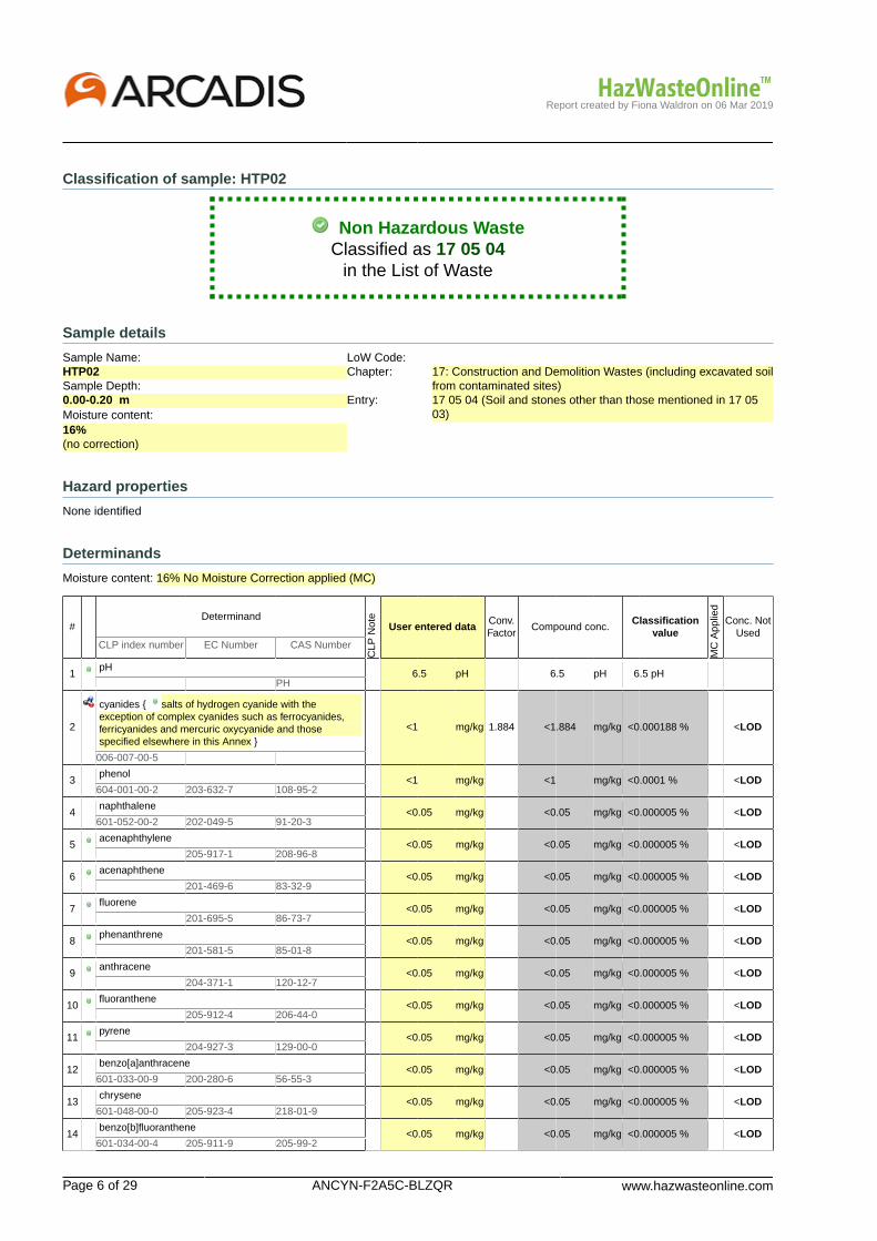
Report created by Fiona Waldron on 06 Mar 2019
Page 6 of 29 ANCYN-F2A5C-BLZQR www.hazwasteonline.com
Classification of sample: HTP02
Non Hazardous WasteClassified as 17 05 04
in the List of Waste
Sample details
Sample Name:HTP02Sample Depth:0.00-0.20 mMoisture content:16%(no correction)
LoW Code:Chapter: 17: Construction and Demolition Wastes (including excavated soil
from contaminated sites)Entry: 17 05 04 (Soil and stones other than those mentioned in 17 05
03)
Hazard properties
None identified
Determinands
Moisture content: 16% No Moisture Correction applied (MC)
#Determinand
CLP
Not
e
User entered dataConv.Factor
Compound conc.Classification
value
MC
App
lied
Conc. NotUsed
CLP index number EC Number CAS Number
1pH
6.5 pH 6.5 pH 6.5 pH PH
2
cyanides { salts of hydrogen cyanide with theexception of complex cyanides such as ferrocyanides,ferricyanides and mercuric oxycyanide and thosespecified elsewhere in this Annex }
<1 mg/kg 1.884 <1.884 mg/kg <0.000188 % <LOD
006-007-00-5
3phenol
<1 mg/kg <1 mg/kg <0.0001 % <LOD604-001-00-2 203-632-7 108-95-2
4naphthalene
<0.05 mg/kg <0.05 mg/kg <0.000005 % <LOD601-052-00-2 202-049-5 91-20-3
5acenaphthylene
<0.05 mg/kg <0.05 mg/kg <0.000005 % <LOD 205-917-1 208-96-8
6acenaphthene
<0.05 mg/kg <0.05 mg/kg <0.000005 % <LOD 201-469-6 83-32-9
7fluorene
<0.05 mg/kg <0.05 mg/kg <0.000005 % <LOD 201-695-5 86-73-7
8phenanthrene
<0.05 mg/kg <0.05 mg/kg <0.000005 % <LOD 201-581-5 85-01-8
9anthracene
<0.05 mg/kg <0.05 mg/kg <0.000005 % <LOD 204-371-1 120-12-7
10fluoranthene
<0.05 mg/kg <0.05 mg/kg <0.000005 % <LOD 205-912-4 206-44-0
11pyrene
<0.05 mg/kg <0.05 mg/kg <0.000005 % <LOD 204-927-3 129-00-0
12benzo[a]anthracene
<0.05 mg/kg <0.05 mg/kg <0.000005 % <LOD601-033-00-9 200-280-6 56-55-3
13chrysene
<0.05 mg/kg <0.05 mg/kg <0.000005 % <LOD601-048-00-0 205-923-4 218-01-9
14benzo[b]fluoranthene
<0.05 mg/kg <0.05 mg/kg <0.000005 % <LOD601-034-00-4 205-911-9 205-99-2
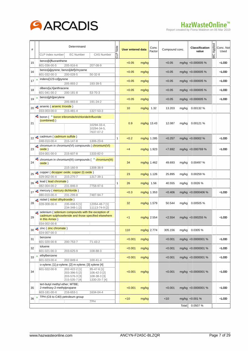
Report created by Fiona Waldron on 06 Mar 2019
www.hazwasteonline.com ANCYN-F2A5C-BLZQR Page 7 of 29
#Determinand
CLP
Not
e
User entered dataConv.Factor
Compound conc.Classification
value
MC
App
lied
Conc. NotUsed
CLP index number EC Number CAS Number
15benzo[k]fluoranthene
<0.05 mg/kg <0.05 mg/kg <0.000005 % <LOD601-036-00-5 205-916-6 207-08-9
16benzo[a]pyrene; benzo[def]chrysene
<0.05 mg/kg <0.05 mg/kg <0.000005 % <LOD601-032-00-3 200-028-5 50-32-8
17indeno[123-cd]pyrene
<0.05 mg/kg <0.05 mg/kg <0.000005 % <LOD 205-893-2 193-39-5
18dibenz[a,h]anthracene
<0.05 mg/kg <0.05 mg/kg <0.000005 % <LOD601-041-00-2 200-181-8 53-70-3
19benzo[ghi]perylene
<0.05 mg/kg <0.05 mg/kg <0.000005 % <LOD 205-883-8 191-24-2
20arsenic { arsenic trioxide }
10 mg/kg 1.32 13.203 mg/kg 0.00132 %033-003-00-0 215-481-4 1327-53-3
21
boron { boron tribromide/trichloride/trifluoride(combined) }
0.9 mg/kg 13.43 12.087 mg/kg 0.00121 % 10294-33-4,10294-34-5,7637-07-2
22cadmium { cadmium sulfide }
1 <0.2 mg/kg 1.285 <0.257 mg/kg <0.00002 % <LOD048-010-00-4 215-147-8 1306-23-6
23chromium in chromium(VI) compounds { chromium(VI)oxide } <4 mg/kg 1.923 <7.692 mg/kg <0.000769 % <LOD
024-001-00-0 215-607-8 1333-82-0
24chromium in chromium(III) compounds { chromium(III)oxide } 34 mg/kg 1.462 49.693 mg/kg 0.00497 %
215-160-9 1308-38-9
25copper { dicopper oxide; copper (I) oxide }
23 mg/kg 1.126 25.895 mg/kg 0.00259 %029-002-00-X 215-270-7 1317-39-1
26lead { lead chromate }
1 26 mg/kg 1.56 40.555 mg/kg 0.0026 %082-004-00-2 231-846-0 7758-97-6
27mercury { mercury dichloride }
<0.3 mg/kg 1.353 <0.406 mg/kg <0.0000406 % <LOD080-010-00-X 231-299-8 7487-94-7
28nickel { nickel dihydroxide }
32 mg/kg 1.579 50.544 mg/kg 0.00505 %028-008-00-X 235-008-5 [1]234-348-1 [2]
12054-48-7 [1]11113-74-9 [2]
29
selenium { selenium compounds with the exception ofcadmium sulphoselenide and those specified elsewherein this Annex }
<1 mg/kg 2.554 <2.554 mg/kg <0.000255 % <LOD
034-002-00-8
30zinc { zinc chromate }
110 mg/kg 2.774 305.156 mg/kg 0.0305 %024-007-00-3
31benzene
<0.001 mg/kg <0.001 mg/kg <0.0000001 % <LOD601-020-00-8 200-753-7 71-43-2
32toluene
<0.001 mg/kg <0.001 mg/kg <0.0000001 % <LOD601-021-00-3 203-625-9 108-88-3
33ethylbenzene
<0.001 mg/kg <0.001 mg/kg <0.0000001 % <LOD601-023-00-4 202-849-4 100-41-4
34
o-xylene; [1] p-xylene; [2] m-xylene; [3] xylene [4]
<0.001 mg/kg <0.001 mg/kg <0.0000001 % <LOD601-022-00-9 202-422-2 [1]
203-396-5 [2]203-576-3 [3]215-535-7 [4]
95-47-6 [1]106-42-3 [2]108-38-3 [3]1330-20-7 [4]
35tert-butyl methyl ether; MTBE;2-methoxy-2-methylpropane <0.001 mg/kg <0.001 mg/kg <0.0000001 % <LOD
603-181-00-X 216-653-1 1634-04-4
36TPH (C6 to C40) petroleum group
<10 mg/kg <10 mg/kg <0.001 % <LOD TPH
Total: 0.0507 %

Report created by Fiona Waldron on 06 Mar 2019
Page 8 of 29 ANCYN-F2A5C-BLZQR www.hazwasteonline.com
KeyUser supplied data
Determinand values ignored for classification, see column 'Conc. Not Used' for reason
Determinand defined or amended by HazWasteOnline (see Appendix A)
Speciated Deteminand - Unless the Determinand is Note 1, the Conversion Factor is used to calculate the compoundconcentration
<LOD Below limit of detectionCLP: Note 1 Only the metal concentration has been used for classification
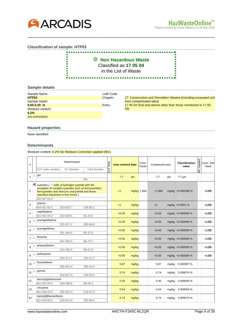
Report created by Fiona Waldron on 06 Mar 2019
www.hazwasteonline.com ANCYN-F2A5C-BLZQR Page 9 of 29
Classification of sample: HTP03
Non Hazardous WasteClassified as 17 05 04
in the List of Waste
Sample details
Sample Name:HTP03Sample Depth:0.00-0.20 mMoisture content:6.2%(no correction)
LoW Code:Chapter: 17: Construction and Demolition Wastes (including excavated soil
from contaminated sites)Entry: 17 05 04 (Soil and stones other than those mentioned in 17 05
03)
Hazard properties
None identified
Determinands
Moisture content: 6.2% No Moisture Correction applied (MC)
#Determinand
CLP
Not
e
User entered dataConv.Factor
Compound conc.Classification
value
MC
App
lied
Conc. NotUsed
CLP index number EC Number CAS Number
1pH
7.7 pH 7.7 pH 7.7 pH PH
2
cyanides { salts of hydrogen cyanide with theexception of complex cyanides such as ferrocyanides,ferricyanides and mercuric oxycyanide and thosespecified elsewhere in this Annex }
<1 mg/kg 1.884 <1.884 mg/kg <0.000188 % <LOD
006-007-00-5
3phenol
<1 mg/kg <1 mg/kg <0.0001 % <LOD604-001-00-2 203-632-7 108-95-2
4naphthalene
<0.05 mg/kg <0.05 mg/kg <0.000005 % <LOD601-052-00-2 202-049-5 91-20-3
5acenaphthylene
<0.05 mg/kg <0.05 mg/kg <0.000005 % <LOD 205-917-1 208-96-8
6acenaphthene
<0.05 mg/kg <0.05 mg/kg <0.000005 % <LOD 201-469-6 83-32-9
7fluorene
<0.05 mg/kg <0.05 mg/kg <0.000005 % <LOD 201-695-5 86-73-7
8phenanthrene
<0.05 mg/kg <0.05 mg/kg <0.000005 % <LOD 201-581-5 85-01-8
9anthracene
<0.05 mg/kg <0.05 mg/kg <0.000005 % <LOD 204-371-1 120-12-7
10fluoranthene
0.87 mg/kg 0.87 mg/kg 0.000087 % 205-912-4 206-44-0
11pyrene
0.74 mg/kg 0.74 mg/kg 0.000074 % 204-927-3 129-00-0
12benzo[a]anthracene
0.45 mg/kg 0.45 mg/kg 0.000045 %601-033-00-9 200-280-6 56-55-3
13chrysene
0.54 mg/kg 0.54 mg/kg 0.000054 %601-048-00-0 205-923-4 218-01-9
14benzo[b]fluoranthene
0.74 mg/kg 0.74 mg/kg 0.000074 %601-034-00-4 205-911-9 205-99-2
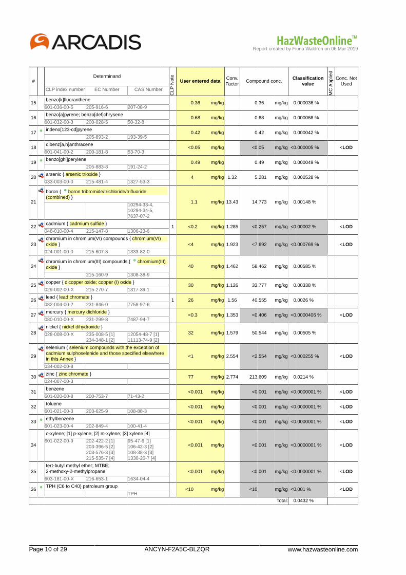
Report created by Fiona Waldron on 06 Mar 2019
Page 10 of 29 ANCYN-F2A5C-BLZQR www.hazwasteonline.com
#Determinand
CLP
Not
e
User entered dataConv.Factor
Compound conc.Classification
value
MC
App
lied
Conc. NotUsed
CLP index number EC Number CAS Number
15benzo[k]fluoranthene
0.36 mg/kg 0.36 mg/kg 0.000036 %601-036-00-5 205-916-6 207-08-9
16benzo[a]pyrene; benzo[def]chrysene
0.68 mg/kg 0.68 mg/kg 0.000068 %601-032-00-3 200-028-5 50-32-8
17indeno[123-cd]pyrene
0.42 mg/kg 0.42 mg/kg 0.000042 % 205-893-2 193-39-5
18dibenz[a,h]anthracene
<0.05 mg/kg <0.05 mg/kg <0.000005 % <LOD601-041-00-2 200-181-8 53-70-3
19benzo[ghi]perylene
0.49 mg/kg 0.49 mg/kg 0.000049 % 205-883-8 191-24-2
20arsenic { arsenic trioxide }
4 mg/kg 1.32 5.281 mg/kg 0.000528 %033-003-00-0 215-481-4 1327-53-3
21
boron { boron tribromide/trichloride/trifluoride(combined) }
1.1 mg/kg 13.43 14.773 mg/kg 0.00148 % 10294-33-4,10294-34-5,7637-07-2
22cadmium { cadmium sulfide }
1 <0.2 mg/kg 1.285 <0.257 mg/kg <0.00002 % <LOD048-010-00-4 215-147-8 1306-23-6
23chromium in chromium(VI) compounds { chromium(VI)oxide } <4 mg/kg 1.923 <7.692 mg/kg <0.000769 % <LOD
024-001-00-0 215-607-8 1333-82-0
24chromium in chromium(III) compounds { chromium(III)oxide } 40 mg/kg 1.462 58.462 mg/kg 0.00585 %
215-160-9 1308-38-9
25copper { dicopper oxide; copper (I) oxide }
30 mg/kg 1.126 33.777 mg/kg 0.00338 %029-002-00-X 215-270-7 1317-39-1
26lead { lead chromate }
1 26 mg/kg 1.56 40.555 mg/kg 0.0026 %082-004-00-2 231-846-0 7758-97-6
27mercury { mercury dichloride }
<0.3 mg/kg 1.353 <0.406 mg/kg <0.0000406 % <LOD080-010-00-X 231-299-8 7487-94-7
28nickel { nickel dihydroxide }
32 mg/kg 1.579 50.544 mg/kg 0.00505 %028-008-00-X 235-008-5 [1]234-348-1 [2]
12054-48-7 [1]11113-74-9 [2]
29
selenium { selenium compounds with the exception ofcadmium sulphoselenide and those specified elsewherein this Annex }
<1 mg/kg 2.554 <2.554 mg/kg <0.000255 % <LOD
034-002-00-8
30zinc { zinc chromate }
77 mg/kg 2.774 213.609 mg/kg 0.0214 %024-007-00-3
31benzene
<0.001 mg/kg <0.001 mg/kg <0.0000001 % <LOD601-020-00-8 200-753-7 71-43-2
32toluene
<0.001 mg/kg <0.001 mg/kg <0.0000001 % <LOD601-021-00-3 203-625-9 108-88-3
33ethylbenzene
<0.001 mg/kg <0.001 mg/kg <0.0000001 % <LOD601-023-00-4 202-849-4 100-41-4
34
o-xylene; [1] p-xylene; [2] m-xylene; [3] xylene [4]
<0.001 mg/kg <0.001 mg/kg <0.0000001 % <LOD601-022-00-9 202-422-2 [1]
203-396-5 [2]203-576-3 [3]215-535-7 [4]
95-47-6 [1]106-42-3 [2]108-38-3 [3]1330-20-7 [4]
35tert-butyl methyl ether; MTBE;2-methoxy-2-methylpropane <0.001 mg/kg <0.001 mg/kg <0.0000001 % <LOD
603-181-00-X 216-653-1 1634-04-4
36TPH (C6 to C40) petroleum group
<10 mg/kg <10 mg/kg <0.001 % <LOD TPH
Total: 0.0432 %

Report created by Fiona Waldron on 06 Mar 2019
www.hazwasteonline.com ANCYN-F2A5C-BLZQR Page 11 of 29
KeyUser supplied data
Determinand values ignored for classification, see column 'Conc. Not Used' for reason
Determinand defined or amended by HazWasteOnline (see Appendix A)
Speciated Deteminand - Unless the Determinand is Note 1, the Conversion Factor is used to calculate the compoundconcentration
<LOD Below limit of detectionCLP: Note 1 Only the metal concentration has been used for classification
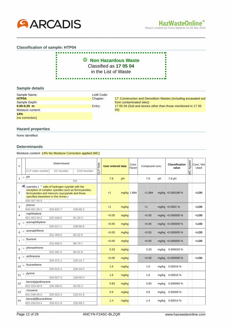
Report created by Fiona Waldron on 06 Mar 2019
Page 12 of 29 ANCYN-F2A5C-BLZQR www.hazwasteonline.com
Classification of sample: HTP04
Non Hazardous WasteClassified as 17 05 04
in the List of Waste
Sample details
Sample Name:HTP04Sample Depth:0.00-0.20 mMoisture content:14%(no correction)
LoW Code:Chapter: 17: Construction and Demolition Wastes (including excavated soil
from contaminated sites)Entry: 17 05 04 (Soil and stones other than those mentioned in 17 05
03)
Hazard properties
None identified
Determinands
Moisture content: 14% No Moisture Correction applied (MC)
#Determinand
CLP
Not
e
User entered dataConv.Factor
Compound conc.Classification
value
MC
App
lied
Conc. NotUsed
CLP index number EC Number CAS Number
1pH
7.9 pH 7.9 pH 7.9 pH PH
2
cyanides { salts of hydrogen cyanide with theexception of complex cyanides such as ferrocyanides,ferricyanides and mercuric oxycyanide and thosespecified elsewhere in this Annex }
<1 mg/kg 1.884 <1.884 mg/kg <0.000188 % <LOD
006-007-00-5
3phenol
<1 mg/kg <1 mg/kg <0.0001 % <LOD604-001-00-2 203-632-7 108-95-2
4naphthalene
<0.05 mg/kg <0.05 mg/kg <0.000005 % <LOD601-052-00-2 202-049-5 91-20-3
5acenaphthylene
<0.05 mg/kg <0.05 mg/kg <0.000005 % <LOD 205-917-1 208-96-8
6acenaphthene
<0.05 mg/kg <0.05 mg/kg <0.000005 % <LOD 201-469-6 83-32-9
7fluorene
<0.05 mg/kg <0.05 mg/kg <0.000005 % <LOD 201-695-5 86-73-7
8phenanthrene
0.33 mg/kg 0.33 mg/kg 0.000033 % 201-581-5 85-01-8
9anthracene
<0.05 mg/kg <0.05 mg/kg <0.000005 % <LOD 204-371-1 120-12-7
10fluoranthene
1.6 mg/kg 1.6 mg/kg 0.00016 % 205-912-4 206-44-0
11pyrene
1.6 mg/kg 1.6 mg/kg 0.00016 % 204-927-3 129-00-0
12benzo[a]anthracene
0.83 mg/kg 0.83 mg/kg 0.000083 %601-033-00-9 200-280-6 56-55-3
13chrysene
0.9 mg/kg 0.9 mg/kg 0.00009 %601-048-00-0 205-923-4 218-01-9
14benzo[b]fluoranthene
1.4 mg/kg 1.4 mg/kg 0.00014 %601-034-00-4 205-911-9 205-99-2

Report created by Fiona Waldron on 06 Mar 2019
www.hazwasteonline.com ANCYN-F2A5C-BLZQR Page 13 of 29
#Determinand
CLP
Not
e
User entered dataConv.Factor
Compound conc.Classification
value
MC
App
lied
Conc. NotUsed
CLP index number EC Number CAS Number
15benzo[k]fluoranthene
0.69 mg/kg 0.69 mg/kg 0.000069 %601-036-00-5 205-916-6 207-08-9
16benzo[a]pyrene; benzo[def]chrysene
1.5 mg/kg 1.5 mg/kg 0.00015 %601-032-00-3 200-028-5 50-32-8
17indeno[123-cd]pyrene
0.89 mg/kg 0.89 mg/kg 0.000089 % 205-893-2 193-39-5
18dibenz[a,h]anthracene
<0.05 mg/kg <0.05 mg/kg <0.000005 % <LOD601-041-00-2 200-181-8 53-70-3
19benzo[ghi]perylene
1.2 mg/kg 1.2 mg/kg 0.00012 % 205-883-8 191-24-2
20arsenic { arsenic trioxide }
8 mg/kg 1.32 10.563 mg/kg 0.00106 %033-003-00-0 215-481-4 1327-53-3
21
boron { boron tribromide/trichloride/trifluoride(combined) }
1.2 mg/kg 13.43 16.116 mg/kg 0.00161 % 10294-33-4,10294-34-5,7637-07-2
22cadmium { cadmium sulfide }
1 <0.2 mg/kg 1.285 <0.257 mg/kg <0.00002 % <LOD048-010-00-4 215-147-8 1306-23-6
23chromium in chromium(VI) compounds { chromium(VI)oxide } <4 mg/kg 1.923 <7.692 mg/kg <0.000769 % <LOD
024-001-00-0 215-607-8 1333-82-0
24chromium in chromium(III) compounds { chromium(III)oxide } 32 mg/kg 1.462 46.77 mg/kg 0.00468 %
215-160-9 1308-38-9
25copper { dicopper oxide; copper (I) oxide }
28 mg/kg 1.126 31.525 mg/kg 0.00315 %029-002-00-X 215-270-7 1317-39-1
26lead { lead chromate }
1 51 mg/kg 1.56 79.551 mg/kg 0.0051 %082-004-00-2 231-846-0 7758-97-6
27mercury { mercury dichloride }
<0.3 mg/kg 1.353 <0.406 mg/kg <0.0000406 % <LOD080-010-00-X 231-299-8 7487-94-7
28nickel { nickel dihydroxide }
31 mg/kg 1.579 48.964 mg/kg 0.0049 %028-008-00-X 235-008-5 [1]234-348-1 [2]
12054-48-7 [1]11113-74-9 [2]
29
selenium { selenium compounds with the exception ofcadmium sulphoselenide and those specified elsewherein this Annex }
<1 mg/kg 2.554 <2.554 mg/kg <0.000255 % <LOD
034-002-00-8
30zinc { zinc chromate }
110 mg/kg 2.774 305.156 mg/kg 0.0305 %024-007-00-3
31benzene
<0.001 mg/kg <0.001 mg/kg <0.0000001 % <LOD601-020-00-8 200-753-7 71-43-2
32toluene
<0.001 mg/kg <0.001 mg/kg <0.0000001 % <LOD601-021-00-3 203-625-9 108-88-3
33ethylbenzene
<0.001 mg/kg <0.001 mg/kg <0.0000001 % <LOD601-023-00-4 202-849-4 100-41-4
34
o-xylene; [1] p-xylene; [2] m-xylene; [3] xylene [4]
<0.001 mg/kg <0.001 mg/kg <0.0000001 % <LOD601-022-00-9 202-422-2 [1]
203-396-5 [2]203-576-3 [3]215-535-7 [4]
95-47-6 [1]106-42-3 [2]108-38-3 [3]1330-20-7 [4]
35tert-butyl methyl ether; MTBE;2-methoxy-2-methylpropane <0.001 mg/kg <0.001 mg/kg <0.0000001 % <LOD
603-181-00-X 216-653-1 1634-04-4
36TPH (C6 to C40) petroleum group
16 mg/kg 16 mg/kg 0.0016 % TPH
Total: 0.0551 %

Report created by Fiona Waldron on 06 Mar 2019
Page 14 of 29 ANCYN-F2A5C-BLZQR www.hazwasteonline.com
KeyUser supplied data
Determinand values ignored for classification, see column 'Conc. Not Used' for reason
Determinand defined or amended by HazWasteOnline (see Appendix A)
Speciated Deteminand - Unless the Determinand is Note 1, the Conversion Factor is used to calculate the compoundconcentration
<LOD Below limit of detectionCLP: Note 1 Only the metal concentration has been used for classification
Supplementary Hazardous Property Information
HP 3(i): Flammable "flammable liquid waste: liquid waste having a flash point below 60°C or waste gas oil, diesel and light heating oilshaving a flash point > 55°C and <= 75°C"Force this Hazardous property to non hazardous because TPH in soil is not likely to be flammable at concentrations<1000 mg/kg.
Hazard Statements hit:
Flam. Liq. 3; H226 "Flammable liquid and vapour."
Because of determinand:
TPH (C6 to C40) petroleum group: (conc.: 0.0016%)

Report created by Fiona Waldron on 06 Mar 2019
www.hazwasteonline.com ANCYN-F2A5C-BLZQR Page 15 of 29
Classification of sample: HTP05
Non Hazardous WasteClassified as 17 05 04
in the List of Waste
Sample details
Sample Name:HTP05Sample Depth:0.00-0.20 mMoisture content:15%(no correction)
LoW Code:Chapter: 17: Construction and Demolition Wastes (including excavated soil
from contaminated sites)Entry: 17 05 04 (Soil and stones other than those mentioned in 17 05
03)
Hazard properties
None identified
Determinands
Moisture content: 15% No Moisture Correction applied (MC)
#Determinand
CLP
Not
e
User entered dataConv.Factor
Compound conc.Classification
value
MC
App
lied
Conc. NotUsed
CLP index number EC Number CAS Number
1pH
7.7 pH 7.7 pH 7.7 pH PH
2
cyanides { salts of hydrogen cyanide with theexception of complex cyanides such as ferrocyanides,ferricyanides and mercuric oxycyanide and thosespecified elsewhere in this Annex }
<1 mg/kg 1.884 <1.884 mg/kg <0.000188 % <LOD
006-007-00-5
3phenol
<1 mg/kg <1 mg/kg <0.0001 % <LOD604-001-00-2 203-632-7 108-95-2
4naphthalene
<0.05 mg/kg <0.05 mg/kg <0.000005 % <LOD601-052-00-2 202-049-5 91-20-3
5acenaphthylene
<0.05 mg/kg <0.05 mg/kg <0.000005 % <LOD 205-917-1 208-96-8
6acenaphthene
<0.05 mg/kg <0.05 mg/kg <0.000005 % <LOD 201-469-6 83-32-9
7fluorene
<0.05 mg/kg <0.05 mg/kg <0.000005 % <LOD 201-695-5 86-73-7
8phenanthrene
<0.05 mg/kg <0.05 mg/kg <0.000005 % <LOD 201-581-5 85-01-8
9anthracene
<0.05 mg/kg <0.05 mg/kg <0.000005 % <LOD 204-371-1 120-12-7
10fluoranthene
<0.05 mg/kg <0.05 mg/kg <0.000005 % <LOD 205-912-4 206-44-0
11pyrene
<0.05 mg/kg <0.05 mg/kg <0.000005 % <LOD 204-927-3 129-00-0
12benzo[a]anthracene
<0.05 mg/kg <0.05 mg/kg <0.000005 % <LOD601-033-00-9 200-280-6 56-55-3
13chrysene
<0.05 mg/kg <0.05 mg/kg <0.000005 % <LOD601-048-00-0 205-923-4 218-01-9
14benzo[b]fluoranthene
<0.05 mg/kg <0.05 mg/kg <0.000005 % <LOD601-034-00-4 205-911-9 205-99-2
Report created by Fiona Waldron on 06 Mar 2019
Page 16 of 29 ANCYN-F2A5C-BLZQR www.hazwasteonline.com
#Determinand
CLP
Not
e
User entered dataConv.Factor
Compound conc.Classification
value
MC
App
lied
Conc. NotUsed
CLP index number EC Number CAS Number
15benzo[k]fluoranthene
<0.05 mg/kg <0.05 mg/kg <0.000005 % <LOD601-036-00-5 205-916-6 207-08-9
16benzo[a]pyrene; benzo[def]chrysene
<0.05 mg/kg <0.05 mg/kg <0.000005 % <LOD601-032-00-3 200-028-5 50-32-8
17indeno[123-cd]pyrene
<0.05 mg/kg <0.05 mg/kg <0.000005 % <LOD 205-893-2 193-39-5
18dibenz[a,h]anthracene
<0.05 mg/kg <0.05 mg/kg <0.000005 % <LOD601-041-00-2 200-181-8 53-70-3
19benzo[ghi]perylene
<0.05 mg/kg <0.05 mg/kg <0.000005 % <LOD 205-883-8 191-24-2
20arsenic { arsenic trioxide }
5.2 mg/kg 1.32 6.866 mg/kg 0.000687 %033-003-00-0 215-481-4 1327-53-3
21
boron { boron tribromide/trichloride/trifluoride(combined) }
0.5 mg/kg 13.43 6.715 mg/kg 0.000672 % 10294-33-4,10294-34-5,7637-07-2
22cadmium { cadmium sulfide }
1 <0.2 mg/kg 1.285 <0.257 mg/kg <0.00002 % <LOD048-010-00-4 215-147-8 1306-23-6
23chromium in chromium(VI) compounds { chromium(VI)oxide } <4 mg/kg 1.923 <7.692 mg/kg <0.000769 % <LOD
024-001-00-0 215-607-8 1333-82-0
24chromium in chromium(III) compounds { chromium(III)oxide } 31 mg/kg 1.462 45.308 mg/kg 0.00453 %
215-160-9 1308-38-9
25copper { dicopper oxide; copper (I) oxide }
23 mg/kg 1.126 25.895 mg/kg 0.00259 %029-002-00-X 215-270-7 1317-39-1
26lead { lead chromate }
1 22 mg/kg 1.56 34.316 mg/kg 0.0022 %082-004-00-2 231-846-0 7758-97-6
27mercury { mercury dichloride }
<0.3 mg/kg 1.353 <0.406 mg/kg <0.0000406 % <LOD080-010-00-X 231-299-8 7487-94-7
28nickel { nickel dihydroxide }
28 mg/kg 1.579 44.226 mg/kg 0.00442 %028-008-00-X 235-008-5 [1]234-348-1 [2]
12054-48-7 [1]11113-74-9 [2]
29
selenium { selenium compounds with the exception ofcadmium sulphoselenide and those specified elsewherein this Annex }
<1 mg/kg 2.554 <2.554 mg/kg <0.000255 % <LOD
034-002-00-8
30zinc { zinc chromate }
120 mg/kg 2.774 332.898 mg/kg 0.0333 %024-007-00-3
31benzene
<0.001 mg/kg <0.001 mg/kg <0.0000001 % <LOD601-020-00-8 200-753-7 71-43-2
32toluene
<0.001 mg/kg <0.001 mg/kg <0.0000001 % <LOD601-021-00-3 203-625-9 108-88-3
33ethylbenzene
<0.001 mg/kg <0.001 mg/kg <0.0000001 % <LOD601-023-00-4 202-849-4 100-41-4
34
o-xylene; [1] p-xylene; [2] m-xylene; [3] xylene [4]
<0.001 mg/kg <0.001 mg/kg <0.0000001 % <LOD601-022-00-9 202-422-2 [1]
203-396-5 [2]203-576-3 [3]215-535-7 [4]
95-47-6 [1]106-42-3 [2]108-38-3 [3]1330-20-7 [4]
35tert-butyl methyl ether; MTBE;2-methoxy-2-methylpropane <0.001 mg/kg <0.001 mg/kg <0.0000001 % <LOD
603-181-00-X 216-653-1 1634-04-4
36TPH (C6 to C40) petroleum group
<10 mg/kg <10 mg/kg <0.001 % <LOD TPH
Total: 0.0508 %

Report created by Fiona Waldron on 06 Mar 2019
www.hazwasteonline.com ANCYN-F2A5C-BLZQR Page 17 of 29
KeyUser supplied data
Determinand values ignored for classification, see column 'Conc. Not Used' for reason
Determinand defined or amended by HazWasteOnline (see Appendix A)
Speciated Deteminand - Unless the Determinand is Note 1, the Conversion Factor is used to calculate the compoundconcentration
<LOD Below limit of detectionCLP: Note 1 Only the metal concentration has been used for classification
Report created by Fiona Waldron on 06 Mar 2019
Page 18 of 29 ANCYN-F2A5C-BLZQR www.hazwasteonline.com
Classification of sample: HTP06
Non Hazardous WasteClassified as 17 05 04
in the List of Waste
Sample details
Sample Name:HTP06Sample Depth:0.00-0.20 mMoisture content:22%(no correction)
LoW Code:Chapter: 17: Construction and Demolition Wastes (including excavated soil
from contaminated sites)Entry: 17 05 04 (Soil and stones other than those mentioned in 17 05
03)
Hazard properties
None identified
Determinands
Moisture content: 22% No Moisture Correction applied (MC)
#Determinand
CLP
Not
e
User entered dataConv.Factor
Compound conc.Classification
value
MC
App
lied
Conc. NotUsed
CLP index number EC Number CAS Number
1pH
7.1 pH 7.1 pH 7.1 pH PH
2
cyanides { salts of hydrogen cyanide with theexception of complex cyanides such as ferrocyanides,ferricyanides and mercuric oxycyanide and thosespecified elsewhere in this Annex }
<1 mg/kg 1.884 <1.884 mg/kg <0.000188 % <LOD
006-007-00-5
3phenol
<1 mg/kg <1 mg/kg <0.0001 % <LOD604-001-00-2 203-632-7 108-95-2
4naphthalene
<0.05 mg/kg <0.05 mg/kg <0.000005 % <LOD601-052-00-2 202-049-5 91-20-3
5acenaphthylene
<0.05 mg/kg <0.05 mg/kg <0.000005 % <LOD 205-917-1 208-96-8
6acenaphthene
<0.05 mg/kg <0.05 mg/kg <0.000005 % <LOD 201-469-6 83-32-9
7fluorene
<0.05 mg/kg <0.05 mg/kg <0.000005 % <LOD 201-695-5 86-73-7
8phenanthrene
0.91 mg/kg 0.91 mg/kg 0.000091 % 201-581-5 85-01-8
9anthracene
0.32 mg/kg 0.32 mg/kg 0.000032 % 204-371-1 120-12-7
10fluoranthene
4.8 mg/kg 4.8 mg/kg 0.00048 % 205-912-4 206-44-0
11pyrene
4.6 mg/kg 4.6 mg/kg 0.00046 % 204-927-3 129-00-0
12benzo[a]anthracene
2.2 mg/kg 2.2 mg/kg 0.00022 %601-033-00-9 200-280-6 56-55-3
13chrysene
2.3 mg/kg 2.3 mg/kg 0.00023 %601-048-00-0 205-923-4 218-01-9
14benzo[b]fluoranthene
3.6 mg/kg 3.6 mg/kg 0.00036 %601-034-00-4 205-911-9 205-99-2
Report created by Fiona Waldron on 06 Mar 2019
www.hazwasteonline.com ANCYN-F2A5C-BLZQR Page 19 of 29
#Determinand
CLP
Not
e
User entered dataConv.Factor
Compound conc.Classification
value
MC
App
lied
Conc. NotUsed
CLP index number EC Number CAS Number
15benzo[k]fluoranthene
1.2 mg/kg 1.2 mg/kg 0.00012 %601-036-00-5 205-916-6 207-08-9
16benzo[a]pyrene; benzo[def]chrysene
3.1 mg/kg 3.1 mg/kg 0.00031 %601-032-00-3 200-028-5 50-32-8
17indeno[123-cd]pyrene
1.9 mg/kg 1.9 mg/kg 0.00019 % 205-893-2 193-39-5
18dibenz[a,h]anthracene
0.45 mg/kg 0.45 mg/kg 0.000045 %601-041-00-2 200-181-8 53-70-3
19benzo[ghi]perylene
2.2 mg/kg 2.2 mg/kg 0.00022 % 205-883-8 191-24-2
20arsenic { arsenic trioxide }
8.3 mg/kg 1.32 10.959 mg/kg 0.0011 %033-003-00-0 215-481-4 1327-53-3
21
boron { boron tribromide/trichloride/trifluoride(combined) }
3 mg/kg 13.43 40.29 mg/kg 0.00403 % 10294-33-4,10294-34-5,7637-07-2
22cadmium { cadmium sulfide }
1 <0.2 mg/kg 1.285 <0.257 mg/kg <0.00002 % <LOD048-010-00-4 215-147-8 1306-23-6
23chromium in chromium(VI) compounds { chromium(VI)oxide } <4 mg/kg 1.923 <7.692 mg/kg <0.000769 % <LOD
024-001-00-0 215-607-8 1333-82-0
24chromium in chromium(III) compounds { chromium(III)oxide } 33 mg/kg 1.462 48.231 mg/kg 0.00482 %
215-160-9 1308-38-9
25copper { dicopper oxide; copper (I) oxide }
36 mg/kg 1.126 40.532 mg/kg 0.00405 %029-002-00-X 215-270-7 1317-39-1
26lead { lead chromate }
1 43 mg/kg 1.56 67.072 mg/kg 0.0043 %082-004-00-2 231-846-0 7758-97-6
27mercury { mercury dichloride }
<0.3 mg/kg 1.353 <0.406 mg/kg <0.0000406 % <LOD080-010-00-X 231-299-8 7487-94-7
28nickel { nickel dihydroxide }
31 mg/kg 1.579 48.964 mg/kg 0.0049 %028-008-00-X 235-008-5 [1]234-348-1 [2]
12054-48-7 [1]11113-74-9 [2]
29
selenium { selenium compounds with the exception ofcadmium sulphoselenide and those specified elsewherein this Annex }
<1 mg/kg 2.554 <2.554 mg/kg <0.000255 % <LOD
034-002-00-8
30zinc { zinc chromate }
150 mg/kg 2.774 416.122 mg/kg 0.0416 %024-007-00-3
31benzene
<0.001 mg/kg <0.001 mg/kg <0.0000001 % <LOD601-020-00-8 200-753-7 71-43-2
32toluene
<0.001 mg/kg <0.001 mg/kg <0.0000001 % <LOD601-021-00-3 203-625-9 108-88-3
33ethylbenzene
<0.001 mg/kg <0.001 mg/kg <0.0000001 % <LOD601-023-00-4 202-849-4 100-41-4
34
o-xylene; [1] p-xylene; [2] m-xylene; [3] xylene [4]
<0.001 mg/kg <0.001 mg/kg <0.0000001 % <LOD601-022-00-9 202-422-2 [1]
203-396-5 [2]203-576-3 [3]215-535-7 [4]
95-47-6 [1]106-42-3 [2]108-38-3 [3]1330-20-7 [4]
35tert-butyl methyl ether; MTBE;2-methoxy-2-methylpropane <0.001 mg/kg <0.001 mg/kg <0.0000001 % <LOD
603-181-00-X 216-653-1 1634-04-4
36TPH (C6 to C40) petroleum group
21 mg/kg 21 mg/kg 0.0021 % TPH
Total: 0.0711 %

Report created by Fiona Waldron on 06 Mar 2019
Page 20 of 29 ANCYN-F2A5C-BLZQR www.hazwasteonline.com
KeyUser supplied data
Determinand values ignored for classification, see column 'Conc. Not Used' for reason
Determinand defined or amended by HazWasteOnline (see Appendix A)
Speciated Deteminand - Unless the Determinand is Note 1, the Conversion Factor is used to calculate the compoundconcentration
<LOD Below limit of detectionCLP: Note 1 Only the metal concentration has been used for classification
Supplementary Hazardous Property Information
HP 3(i): Flammable "flammable liquid waste: liquid waste having a flash point below 60°C or waste gas oil, diesel and light heating oilshaving a flash point > 55°C and <= 75°C"Force this Hazardous property to non hazardous because TPH in soil is not likely to be flammable at concentrations<1000 mg/kg.
Hazard Statements hit:
Flam. Liq. 3; H226 "Flammable liquid and vapour."
Because of determinand:
TPH (C6 to C40) petroleum group: (conc.: 0.0021%)
Report created by Fiona Waldron on 06 Mar 2019
www.hazwasteonline.com ANCYN-F2A5C-BLZQR Page 21 of 29
Classification of sample: HTP07
Non Hazardous WasteClassified as 17 05 04
in the List of Waste
Sample details
Sample Name:HTP07Sample Depth:0.00-0.20 mMoisture content:15%(no correction)
LoW Code:Chapter: 17: Construction and Demolition Wastes (including excavated soil
from contaminated sites)Entry: 17 05 04 (Soil and stones other than those mentioned in 17 05
03)
Hazard properties
None identified
Determinands
Moisture content: 15% No Moisture Correction applied (MC)
#Determinand
CLP
Not
e
User entered dataConv.Factor
Compound conc.Classification
value
MC
App
lied
Conc. NotUsed
CLP index number EC Number CAS Number
1pH
7.3 pH 7.3 pH 7.3 pH PH
2
cyanides { salts of hydrogen cyanide with theexception of complex cyanides such as ferrocyanides,ferricyanides and mercuric oxycyanide and thosespecified elsewhere in this Annex }
<1 mg/kg 1.884 <1.884 mg/kg <0.000188 % <LOD
006-007-00-5
3phenol
<1 mg/kg <1 mg/kg <0.0001 % <LOD604-001-00-2 203-632-7 108-95-2
4naphthalene
<0.05 mg/kg <0.05 mg/kg <0.000005 % <LOD601-052-00-2 202-049-5 91-20-3
5acenaphthylene
<0.05 mg/kg <0.05 mg/kg <0.000005 % <LOD 205-917-1 208-96-8
6acenaphthene
<0.05 mg/kg <0.05 mg/kg <0.000005 % <LOD 201-469-6 83-32-9
7fluorene
<0.05 mg/kg <0.05 mg/kg <0.000005 % <LOD 201-695-5 86-73-7
8phenanthrene
<0.05 mg/kg <0.05 mg/kg <0.000005 % <LOD 201-581-5 85-01-8
9anthracene
<0.05 mg/kg <0.05 mg/kg <0.000005 % <LOD 204-371-1 120-12-7
10fluoranthene
0.3 mg/kg 0.3 mg/kg 0.00003 % 205-912-4 206-44-0
11pyrene
0.29 mg/kg 0.29 mg/kg 0.000029 % 204-927-3 129-00-0
12benzo[a]anthracene
<0.05 mg/kg <0.05 mg/kg <0.000005 % <LOD601-033-00-9 200-280-6 56-55-3
13chrysene
<0.05 mg/kg <0.05 mg/kg <0.000005 % <LOD601-048-00-0 205-923-4 218-01-9
14benzo[b]fluoranthene
<0.05 mg/kg <0.05 mg/kg <0.000005 % <LOD601-034-00-4 205-911-9 205-99-2

Report created by Fiona Waldron on 06 Mar 2019
Page 22 of 29 ANCYN-F2A5C-BLZQR www.hazwasteonline.com
#Determinand
CLP
Not
e
User entered dataConv.Factor
Compound conc.Classification
value
MC
App
lied
Conc. NotUsed
CLP index number EC Number CAS Number
15benzo[k]fluoranthene
<0.05 mg/kg <0.05 mg/kg <0.000005 % <LOD601-036-00-5 205-916-6 207-08-9
16benzo[a]pyrene; benzo[def]chrysene
<0.05 mg/kg <0.05 mg/kg <0.000005 % <LOD601-032-00-3 200-028-5 50-32-8
17indeno[123-cd]pyrene
<0.05 mg/kg <0.05 mg/kg <0.000005 % <LOD 205-893-2 193-39-5
18dibenz[a,h]anthracene
<0.05 mg/kg <0.05 mg/kg <0.000005 % <LOD601-041-00-2 200-181-8 53-70-3
19benzo[ghi]perylene
<0.05 mg/kg <0.05 mg/kg <0.000005 % <LOD 205-883-8 191-24-2
20arsenic { arsenic trioxide }
12 mg/kg 1.32 15.844 mg/kg 0.00158 %033-003-00-0 215-481-4 1327-53-3
21
boron { boron tribromide/trichloride/trifluoride(combined) }
1.1 mg/kg 13.43 14.773 mg/kg 0.00148 % 10294-33-4,10294-34-5,7637-07-2
22cadmium { cadmium sulfide }
1 <0.2 mg/kg 1.285 <0.257 mg/kg <0.00002 % <LOD048-010-00-4 215-147-8 1306-23-6
23chromium in chromium(VI) compounds { chromium(VI)oxide } <4 mg/kg 1.923 <7.692 mg/kg <0.000769 % <LOD
024-001-00-0 215-607-8 1333-82-0
24chromium in chromium(III) compounds { chromium(III)oxide } 39 mg/kg 1.462 57.001 mg/kg 0.0057 %
215-160-9 1308-38-9
25copper { dicopper oxide; copper (I) oxide }
30 mg/kg 1.126 33.777 mg/kg 0.00338 %029-002-00-X 215-270-7 1317-39-1
26lead { lead chromate }
1 32 mg/kg 1.56 49.914 mg/kg 0.0032 %082-004-00-2 231-846-0 7758-97-6
27mercury { mercury dichloride }
<0.3 mg/kg 1.353 <0.406 mg/kg <0.0000406 % <LOD080-010-00-X 231-299-8 7487-94-7
28nickel { nickel dihydroxide }
39 mg/kg 1.579 61.6 mg/kg 0.00616 %028-008-00-X 235-008-5 [1]234-348-1 [2]
12054-48-7 [1]11113-74-9 [2]
29
selenium { selenium compounds with the exception ofcadmium sulphoselenide and those specified elsewherein this Annex }
<1 mg/kg 2.554 <2.554 mg/kg <0.000255 % <LOD
034-002-00-8
30zinc { zinc chromate }
140 mg/kg 2.774 388.381 mg/kg 0.0388 %024-007-00-3
31benzene
<0.001 mg/kg <0.001 mg/kg <0.0000001 % <LOD601-020-00-8 200-753-7 71-43-2
32toluene
<0.001 mg/kg <0.001 mg/kg <0.0000001 % <LOD601-021-00-3 203-625-9 108-88-3
33ethylbenzene
<0.001 mg/kg <0.001 mg/kg <0.0000001 % <LOD601-023-00-4 202-849-4 100-41-4
34
o-xylene; [1] p-xylene; [2] m-xylene; [3] xylene [4]
<0.001 mg/kg <0.001 mg/kg <0.0000001 % <LOD601-022-00-9 202-422-2 [1]
203-396-5 [2]203-576-3 [3]215-535-7 [4]
95-47-6 [1]106-42-3 [2]108-38-3 [3]1330-20-7 [4]
35tert-butyl methyl ether; MTBE;2-methoxy-2-methylpropane <0.001 mg/kg <0.001 mg/kg <0.0000001 % <LOD
603-181-00-X 216-653-1 1634-04-4
36TPH (C6 to C40) petroleum group
<10 mg/kg <10 mg/kg <0.001 % <LOD TPH
Total: 0.0628 %

Report created by Fiona Waldron on 06 Mar 2019
www.hazwasteonline.com ANCYN-F2A5C-BLZQR Page 23 of 29
KeyUser supplied data
Determinand values ignored for classification, see column 'Conc. Not Used' for reason
Determinand defined or amended by HazWasteOnline (see Appendix A)
Speciated Deteminand - Unless the Determinand is Note 1, the Conversion Factor is used to calculate the compoundconcentration
<LOD Below limit of detectionCLP: Note 1 Only the metal concentration has been used for classification

Report created by Fiona Waldron on 06 Mar 2019
Page 24 of 29 ANCYN-F2A5C-BLZQR www.hazwasteonline.com
Classification of sample: HTP08
Non Hazardous WasteClassified as 17 05 04
in the List of Waste
Sample details
Sample Name:HTP08Sample Depth:0.00-0.20 mMoisture content:27%(no correction)
LoW Code:Chapter: 17: Construction and Demolition Wastes (including excavated soil
from contaminated sites)Entry: 17 05 04 (Soil and stones other than those mentioned in 17 05
03)
Hazard properties
None identified
Determinands
Moisture content: 27% No Moisture Correction applied (MC)
#Determinand
CLP
Not
e
User entered dataConv.Factor
Compound conc.Classification
value
MC
App
lied
Conc. NotUsed
CLP index number EC Number CAS Number
1pH
7.5 pH 7.5 pH 7.5 pH PH
2
cyanides { salts of hydrogen cyanide with theexception of complex cyanides such as ferrocyanides,ferricyanides and mercuric oxycyanide and thosespecified elsewhere in this Annex }
<1 mg/kg 1.884 <1.884 mg/kg <0.000188 % <LOD
006-007-00-5
3phenol
<1 mg/kg <1 mg/kg <0.0001 % <LOD604-001-00-2 203-632-7 108-95-2
4naphthalene
<0.05 mg/kg <0.05 mg/kg <0.000005 % <LOD601-052-00-2 202-049-5 91-20-3
5acenaphthylene
<0.05 mg/kg <0.05 mg/kg <0.000005 % <LOD 205-917-1 208-96-8
6acenaphthene
<0.05 mg/kg <0.05 mg/kg <0.000005 % <LOD 201-469-6 83-32-9
7fluorene
<0.05 mg/kg <0.05 mg/kg <0.000005 % <LOD 201-695-5 86-73-7
8phenanthrene
0.67 mg/kg 0.67 mg/kg 0.000067 % 201-581-5 85-01-8
9anthracene
0.19 mg/kg 0.19 mg/kg 0.000019 % 204-371-1 120-12-7
10fluoranthene
2.5 mg/kg 2.5 mg/kg 0.00025 % 205-912-4 206-44-0
11pyrene
2.3 mg/kg 2.3 mg/kg 0.00023 % 204-927-3 129-00-0
12benzo[a]anthracene
1.1 mg/kg 1.1 mg/kg 0.00011 %601-033-00-9 200-280-6 56-55-3
13chrysene
1.1 mg/kg 1.1 mg/kg 0.00011 %601-048-00-0 205-923-4 218-01-9
14benzo[b]fluoranthene
1.5 mg/kg 1.5 mg/kg 0.00015 %601-034-00-4 205-911-9 205-99-2
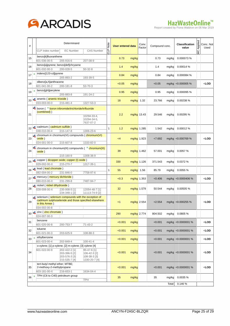
Report created by Fiona Waldron on 06 Mar 2019
www.hazwasteonline.com ANCYN-F2A5C-BLZQR Page 25 of 29
#Determinand
CLP
Not
e
User entered dataConv.Factor
Compound conc.Classification
value
MC
App
lied
Conc. NotUsed
CLP index number EC Number CAS Number
15benzo[k]fluoranthene
0.73 mg/kg 0.73 mg/kg 0.000073 %601-036-00-5 205-916-6 207-08-9
16benzo[a]pyrene; benzo[def]chrysene
1.4 mg/kg 1.4 mg/kg 0.00014 %601-032-00-3 200-028-5 50-32-8
17indeno[123-cd]pyrene
0.84 mg/kg 0.84 mg/kg 0.000084 % 205-893-2 193-39-5
18dibenz[a,h]anthracene
<0.05 mg/kg <0.05 mg/kg <0.000005 % <LOD601-041-00-2 200-181-8 53-70-3
19benzo[ghi]perylene
0.95 mg/kg 0.95 mg/kg 0.000095 % 205-883-8 191-24-2
20arsenic { arsenic trioxide }
18 mg/kg 1.32 23.766 mg/kg 0.00238 %033-003-00-0 215-481-4 1327-53-3
21
boron { boron tribromide/trichloride/trifluoride(combined) }
2.2 mg/kg 13.43 29.546 mg/kg 0.00295 % 10294-33-4,10294-34-5,7637-07-2
22cadmium { cadmium sulfide }
1 1.2 mg/kg 1.285 1.542 mg/kg 0.00012 %048-010-00-4 215-147-8 1306-23-6
23chromium in chromium(VI) compounds { chromium(VI)oxide } <4 mg/kg 1.923 <7.692 mg/kg <0.000769 % <LOD
024-001-00-0 215-607-8 1333-82-0
24chromium in chromium(III) compounds { chromium(III)oxide } 39 mg/kg 1.462 57.001 mg/kg 0.0057 %
215-160-9 1308-38-9
25copper { dicopper oxide; copper (I) oxide }
330 mg/kg 1.126 371.543 mg/kg 0.0372 %029-002-00-X 215-270-7 1317-39-1
26lead { lead chromate }
1 55 mg/kg 1.56 85.79 mg/kg 0.0055 %082-004-00-2 231-846-0 7758-97-6
27mercury { mercury dichloride }
<0.3 mg/kg 1.353 <0.406 mg/kg <0.0000406 % <LOD080-010-00-X 231-299-8 7487-94-7
28nickel { nickel dihydroxide }
32 mg/kg 1.579 50.544 mg/kg 0.00505 %028-008-00-X 235-008-5 [1]234-348-1 [2]
12054-48-7 [1]11113-74-9 [2]
29
selenium { selenium compounds with the exception ofcadmium sulphoselenide and those specified elsewherein this Annex }
<1 mg/kg 2.554 <2.554 mg/kg <0.000255 % <LOD
034-002-00-8
30zinc { zinc chromate }
290 mg/kg 2.774 804.502 mg/kg 0.0805 %024-007-00-3
31benzene
<0.001 mg/kg <0.001 mg/kg <0.0000001 % <LOD601-020-00-8 200-753-7 71-43-2
32toluene
<0.001 mg/kg <0.001 mg/kg <0.0000001 % <LOD601-021-00-3 203-625-9 108-88-3
33ethylbenzene
<0.001 mg/kg <0.001 mg/kg <0.0000001 % <LOD601-023-00-4 202-849-4 100-41-4
34
o-xylene; [1] p-xylene; [2] m-xylene; [3] xylene [4]
<0.001 mg/kg <0.001 mg/kg <0.0000001 % <LOD601-022-00-9 202-422-2 [1]
203-396-5 [2]203-576-3 [3]215-535-7 [4]
95-47-6 [1]106-42-3 [2]108-38-3 [3]1330-20-7 [4]
35tert-butyl methyl ether; MTBE;2-methoxy-2-methylpropane <0.001 mg/kg <0.001 mg/kg <0.0000001 % <LOD
603-181-00-X 216-653-1 1634-04-4
36TPH (C6 to C40) petroleum group
35 mg/kg 35 mg/kg 0.0035 % TPH
Total: 0.146 %

Report created by Fiona Waldron on 06 Mar 2019
Page 26 of 29 ANCYN-F2A5C-BLZQR www.hazwasteonline.com
KeyUser supplied data
Determinand values ignored for classification, see column 'Conc. Not Used' for reason
Determinand defined or amended by HazWasteOnline (see Appendix A)
Speciated Deteminand - Unless the Determinand is Note 1, the Conversion Factor is used to calculate the compoundconcentration
<LOD Below limit of detectionCLP: Note 1 Only the metal concentration has been used for classification
Supplementary Hazardous Property Information
HP 3(i): Flammable "flammable liquid waste: liquid waste having a flash point below 60°C or waste gas oil, diesel and light heating oilshaving a flash point > 55°C and <= 75°C"Force this Hazardous property to non hazardous because TPH in soil is not likely to be flammable at concentrations<1000 mg/kg.
Hazard Statements hit:
Flam. Liq. 3; H226 "Flammable liquid and vapour."
Because of determinand:
TPH (C6 to C40) petroleum group: (conc.: 0.0035%)
Report created by Fiona Waldron on 06 Mar 2019
www.hazwasteonline.com ANCYN-F2A5C-BLZQR Page 27 of 29
Appendix A: Classifier defined and non CLP determinands
pH (CAS Number: PH)
Description/Comments: Appendix C4Data source: WM3 1st Edition 2015Data source date: 25 May 2015Hazard Statements: None.
salts of hydrogen cyanide with the exception of complex cyanides such as ferrocyanides, ferricyanides and mercuricoxycyanide and those specified elsewhere in this Annex
CLP index number: 006-007-00-5Description/Comments: Conversion factor based on a worst case compound: sodium cyanideData source: Commission Regulation (EC) No 790/2009 - 1st Adaptation to Technical Progress for Regulation (EC) No 1272/2008.(ATP1)Additional Hazard Statement(s): EUH032 >= 0.2 %Reason for additional Hazards Statement(s)/Risk Phrase(s):14 Dec 2015 - EUH032 >= 0.2 % hazard statement sourced from: WM3, Table C12.2
acenaphthylene (EC Number: 205-917-1, CAS Number: 208-96-8)
Description/Comments: Data from C&L Inventory DatabaseData source: http://echa.europa.eu/web/guest/information-on-chemicals/cl-inventory-databaseData source date: 17 Jul 2015Hazard Statements: Skin Irrit. 2 H315 , STOT SE 3 H335 , Eye Irrit. 2 H319 , Acute Tox. 1 H310 , Acute Tox. 1 H330 , Acute Tox. 4 H302
acenaphthene (EC Number: 201-469-6, CAS Number: 83-32-9)
Description/Comments: Data from C&L Inventory DatabaseData source: http://echa.europa.eu/web/guest/information-on-chemicals/cl-inventory-databaseData source date: 17 Jul 2015Hazard Statements: Aquatic Chronic 2 H411 , Aquatic Chronic 1 H410 , Aquatic Acute 1 H400 , Skin Irrit. 2 H315 , STOT SE 3 H335 ,Eye Irrit. 2 H319
fluorene (EC Number: 201-695-5, CAS Number: 86-73-7)
Description/Comments: Data from C&L Inventory DatabaseData source: http://echa.europa.eu/web/guest/information-on-chemicals/cl-inventory-databaseData source date: 06 Aug 2015Hazard Statements: Aquatic Chronic 1 H410 , Aquatic Acute 1 H400
phenanthrene (EC Number: 201-581-5, CAS Number: 85-01-8)
Description/Comments: Data from C&L Inventory DatabaseData source: http://echa.europa.eu/web/guest/information-on-chemicals/cl-inventory-databaseData source date: 06 Aug 2015Hazard Statements: Skin Irrit. 2 H315 , Aquatic Chronic 1 H410 , Aquatic Acute 1 H400 , Skin Sens. 1 H317 , Carc. 2 H351 , STOT SE 3H335 , Eye Irrit. 2 H319 , Acute Tox. 4 H302
anthracene (EC Number: 204-371-1, CAS Number: 120-12-7)
Description/Comments: Data from C&L Inventory DatabaseData source: http://echa.europa.eu/web/guest/information-on-chemicals/cl-inventory-databaseData source date: 17 Jul 2015Hazard Statements: Aquatic Chronic 1 H410 , Aquatic Acute 1 H400 , Skin Sens. 1 H317 , Skin Irrit. 2 H315 , STOT SE 3 H335 , EyeIrrit. 2 H319
fluoranthene (EC Number: 205-912-4, CAS Number: 206-44-0)
Description/Comments: Data from C&L Inventory DatabaseData source: http://echa.europa.eu/web/guest/information-on-chemicals/cl-inventory-databaseData source date: 21 Aug 2015Hazard Statements: Aquatic Chronic 1 H410 , Aquatic Acute 1 H400 , Acute Tox. 4 H302
pyrene (EC Number: 204-927-3, CAS Number: 129-00-0)
Description/Comments: Data from C&L Inventory Database; SDS Sigma Aldrich 2014Data source: http://echa.europa.eu/web/guest/information-on-chemicals/cl-inventory-databaseData source date: 21 Aug 2015Hazard Statements: Aquatic Chronic 1 H410 , Aquatic Acute 1 H400 , STOT SE 3 H335 , Eye Irrit. 2 H319 , Skin Irrit. 2 H315
Report created by Fiona Waldron on 06 Mar 2019
Page 28 of 29 ANCYN-F2A5C-BLZQR www.hazwasteonline.com
indeno[123-cd]pyrene (EC Number: 205-893-2, CAS Number: 193-39-5)
Description/Comments: Data from C&L Inventory DatabaseData source: http://echa.europa.eu/web/guest/information-on-chemicals/cl-inventory-databaseData source date: 06 Aug 2015Hazard Statements: Carc. 2 H351
benzo[ghi]perylene (EC Number: 205-883-8, CAS Number: 191-24-2)
Description/Comments: Data from C&L Inventory Database; SDS Sigma Aldrich 28/02/2015Data source: http://echa.europa.eu/web/guest/information-on-chemicals/cl-inventory-databaseData source date: 23 Jul 2015Hazard Statements: Aquatic Chronic 1 H410 , Aquatic Acute 1 H400
boron tribromide/trichloride/trifluoride (combined) (CAS Number: 10294-33-4, 10294-34-5, 7637-07-2)
Conversion factor: 13.43Description/Comments: Combines the hazard statements and the average of the conversion factors for boron tribromide, borontrichloride and boron trifluorideData source: N/AData source date: 06 Aug 2015Hazard Statements: Skin Corr. 1B H314 , Skin Corr. 1A H314 , Acute Tox. 2 H300 , Acute Tox. 2 H330 , EUH014
chromium(III) oxide (EC Number: 215-160-9, CAS Number: 1308-38-9)
Conversion factor: 1.462Description/Comments: Data from C&L Inventory DatabaseData source: http://echa.europa.eu/web/guest/information-on-chemicals/cl-inventory-databaseData source date: 17 Jul 2015Hazard Statements: Aquatic Chronic 1 H410 , Aquatic Acute 1 H400 , Repr. 1B H360FD , Skin Sens. 1 H317 , Resp. Sens. 1 H334 ,Skin Irrit. 2 H315 , STOT SE 3 H335 , Eye Irrit. 2 H319 , Acute Tox. 4 H302 , Acute Tox. 4 H332
ethylbenzene (EC Number: 202-849-4, CAS Number: 100-41-4)
CLP index number: 601-023-00-4Description/Comments:Data source: Commission Regulation (EU) No 605/2014 – 6th Adaptation to Technical Progress for Regulation (EC) No 1272/2008.(ATP6)Additional Hazard Statement(s): Carc. 2 H351Reason for additional Hazards Statement(s)/Risk Phrase(s):03 Jun 2015 - Carc. 2 H351 hazard statement sourced from: IARC Group 2B (77) 2000
TPH (C6 to C40) petroleum group (CAS Number: TPH)
Description/Comments: Hazard statements taken from WM3 1st Edition 2015; Risk phrases: WM2 3rd Edition 2013Data source: WM3 1st Edition 2015Data source date: 25 May 2015Hazard Statements: Aquatic Chronic 2 H411 , Repr. 2 H361d , Carc. 1B H350 , Muta. 1B H340 , STOT RE 2 H373 , Asp. Tox. 1 H304 ,Flam. Liq. 3 H226
Appendix B: Rationale for selection of metal species
cyanides {salts of hydrogen cyanide with the exception of complex cyanides such as ferrocyanides, ferricyanides andmercuric oxycyanide and those specified elsewhere in this Annex}
Worst case species
arsenic {arsenic trioxide}
Worst case species based on hazard statements
boron {boron tribromide/trichloride/trifluoride (combined)}
Worst case species based on hazard statements
cadmium {cadmium sulfide}
Worst case species based on hazard statements
chromium in chromium(VI) compounds {chromium(VI) oxide}
Worst case species based on hazard statements
chromium in chromium(III) compounds {chromium(III) oxide}
Worst case species based on hazard statements
copper {dicopper oxide; copper (I) oxide}
Most likely common species
Report created by Fiona Waldron on 06 Mar 2019
www.hazwasteonline.com ANCYN-F2A5C-BLZQR Page 29 of 29
lead {lead chromate}
Worst case species based on hazard statements
mercury {mercury dichloride}
Worst case species based on hazard statements
nickel {nickel dihydroxide}
Worst case species based on hazard statements
selenium {selenium compounds with the exception of cadmium sulphoselenide and those specified elsewhere in this Annex}
Worst case species based on hazard statements
zinc {zinc chromate}
Worst case
Appendix C: Version
HazWasteOnline Classification Engine: WM3 1st Edition v1.1, May 2018HazWasteOnline Classification Engine Version: 2019.63.3818.7784 (04 Mar 2019)HazWasteOnline Database: 2019.63.3818.7784 (04 Mar 2019)
This classification utilises the following guidance and legislation:WM3 v1.1 - Waste Classification - 1st Edition v1.1 - May 2018CLP Regulation - Regulation 1272/2008/EC of 16 December 20081st ATP - Regulation 790/2009/EC of 10 August 20092nd ATP - Regulation 286/2011/EC of 10 March 20113rd ATP - Regulation 618/2012/EU of 10 July 20124th ATP - Regulation 487/2013/EU of 8 May 2013Correction to 1st ATP - Regulation 758/2013/EU of 7 August 20135th ATP - Regulation 944/2013/EU of 2 October 20136th ATP - Regulation 605/2014/EU of 5 June 2014WFD Annex III replacement - Regulation 1357/2014/EU of 18 December 2014Revised List of Wastes 2014 - Decision 2014/955/EU of 18 December 20147th ATP - Regulation 2015/1221/EU of 24 July 20158th ATP - Regulation (EU) 2016/918 of 19 May 20169th ATP - Regulation (EU) 2016/1179 of 19 July 201610th ATP - Regulation (EU) 2017/776 of 4 May 2017HP14 amendment - Regulation (EU) 2017/997 of 8 June 201713th ATP - Regulation (EU) 2018/1480 of 4 October 2018POPs Regulation 2004 - Regulation 850/2004/EC of 29 April 20041st ATP to POPs Regulation - Regulation 756/2010/EU of 24 August 20102nd ATP to POPs Regulation - Regulation 757/2010/EU of 24 August 2010

Job name Abermule Business Park - TP Samples
Comments
Classification Engine WM3 1st Edition v1.1, May 2018
Waste Stream Abermule Business Park
Created by Fiona Waldron (Arcadis Consulting (UK) Ltd)
Created on 06/03/2019
Determinand (laboratory concentrations) Unit TP101 TP101[2] TP102 TP102[2] TP103 TP103[2] TP104 TP104[2]
Classification Result Non Hazardous Non Hazardous Non Hazardous Non Hazardous Non Hazardous Non Hazardous Non Hazardous Non Hazardous
Depth m 0.00-0.20 0.20-0.40 0.00-0.20 0.60-0.80 0.00-0.30 0.40-0.60 0.00-0.20 0.40-0.60
moisture {no correction} % 15 12 16 6.3 16 21 15 12
asbestos mg/kg Not detected Not detected Not detected Not detected Not detected Not detected Not detected Not detected
pH pH 6.2 6.8 6.9 7.3 6.5 6.9 7 6.8
cyanides {salts of hydrogen cyanide with the exception of complex cyanides such as ferrocyanides, ferricyanides and mercuric oxycyanide and those specified elsewhere in this Annex}mg/kg <1.884 1 <1.884 <1.884 <1.884 <1.884 <1.884 <1.884
phenol mg/kg <1 <1 <1 <1 <1 <1 <1 <1
naphthalene mg/kg <0.05 <0.05 <0.05 <0.05 <0.05 <0.05 <0.05 <0.05
acenaphthylene mg/kg <0.05 <0.05 <0.05 <0.05 <0.05 <0.05 <0.05 <0.05
acenaphthene mg/kg <0.05 <0.05 <0.05 <0.05 <0.05 <0.05 <0.05 <0.05
fluorene mg/kg <0.05 <0.05 <0.05 <0.05 <0.05 <0.05 <0.05 <0.05
phenanthrene mg/kg <0.05 <0.05 <0.05 <0.05 <0.05 <0.05 <0.05 <0.05
anthracene mg/kg <0.05 <0.05 <0.05 <0.05 <0.05 <0.05 <0.05 <0.05
fluoranthene mg/kg <0.05 <0.05 <0.05 <0.05 <0.05 <0.05 <0.05 <0.05
pyrene mg/kg <0.05 <0.05 <0.05 <0.05 <0.05 <0.05 <0.05 <0.05
benzo[a]anthracene mg/kg <0.05 <0.05 <0.05 <0.05 <0.05 <0.05 <0.05 <0.05
chrysene mg/kg <0.05 <0.05 <0.05 <0.05 <0.05 <0.05 <0.05 <0.05
benzo[b]fluoranthene mg/kg <0.05 <0.05 <0.05 <0.05 <0.05 <0.05 <0.05 <0.05
benzo[k]fluoranthene mg/kg <0.05 <0.05 <0.05 <0.05 <0.05 <0.05 <0.05 <0.05
benzo[a]pyrene; benzo[def]chrysene mg/kg <0.05 <0.05 <0.05 <0.05 <0.05 <0.05 <0.05 <0.05
indeno[123-cd]pyrene mg/kg <0.05 <0.05 <0.05 <0.05 <0.05 <0.05 <0.05 <0.05
dibenz[a,h]anthracene mg/kg <0.05 <0.05 <0.05 <0.05 <0.05 <0.05 <0.05 <0.05
benzo[ghi]perylene mg/kg <0.05 <0.05 <0.05 <0.05 <0.05 <0.05 <0.05 <0.05
arsenic {arsenic trioxide} mg/kg 13 12 12 16 9.7 11 6 8.9
boron {boron tribromide/trichloride/trifluoride (combined)} mg/kg 1.4 0.7 1.9 0.6 1.5 0.8 1.1 0.7
cadmium {cadmium sulfide} mg/kg <0.257 <0.257 <0.257 <0.257 <0.257 <0.257 <0.257 <0.257
chromium in chromium(VI) compounds {chromium(VI) oxide}mg/kg <7.692 <7.692 <7.692 <7.692 <7.692 <7.692 <7.692 <7.692
chromium in chromium(III) compounds {chromium(III) oxide}mg/kg 52 33 40 28 39 34 39 33
copper {dicopper oxide; copper (I) oxide} mg/kg 35 33 35 39 28 28 31 30
lead {lead chromate} mg/kg 31 19 33 26 30 20 26 21
mercury {mercury dichloride} mg/kg <0.406 <0.406 <0.406 <0.406 <0.406 <0.406 <0.406 <0.406
nickel {nickel dihydroxide} mg/kg 39 41 35 39 34 39 36 37
selenium {selenium compounds with the exception of cadmium sulphoselenide and those specified elsewhere in this Annex}mg/kg <2.554 <2.554 <2.554 <2.554 <2.554 <2.554 <2.554 <2.554
zinc {zinc chromate} mg/kg 130 110 130 99 120 120 110 100
benzene mg/kg <0.001 <0.001 <0.001 <0.001 <0.001 <0.001 <0.001 <0.001
toluene mg/kg <0.001 <0.001 <0.001 <0.001 <0.001 <0.001 <0.001 <0.001
ethylbenzene mg/kg <0.001 <0.001 <0.001 <0.001 <0.001 <0.001 <0.001 <0.001
o-xylene; [1] p-xylene; [2] m-xylene; [3] xylene [4] mg/kg <0.001 <0.001 <0.001 <0.001 <0.001 <0.001 <0.001 <0.001
tert-butyl methyl ether; MTBE; 2-methoxy-2-methylpropanemg/kg <0.001 <0.001 <0.001 <0.001 <0.001 <0.001 <0.001 <0.001
TPH (C6 to C40) petroleum group mg/kg <10 <10 11 <10 14 <10 <10 <10
confirm TPH has NOT arisen from diesel or petrol n/a
Notes:
HP3 Flamable has been changed to non hazardous for
TPH at concentrations <1000 mg/kg. Where a
substance has a HP3 classification, it is assumed that
enough material is present for ignition to occur, i.e. that
the chemical is in its raw from, not within the soil
matrix. In the case of soils, ignition is unlikely at
concentrations <1000 mg/kg. However, this would
need to be confirmed by the operator of the landfill
where the waste is intended to be taken.
www.hazwasteonline.com 383FV-LURW4-BPHWY Page 1 of 29
Waste Classification Report
383FV-LURW4-BPHWY
Job name
Abermule Business Park - TP Samples
Description/Comments
Project
Aberm
Site
Aber
Related Documents# Name Description
None
Waste Stream Template
Abermule Business Park
Classified by
Name:Fiona WaldronDate:06 Mar 2019 08:31 GMTTelephone:0117 3721231
Company:Arcadis Consulting (UK) Ltd1st Floor, 2 Glass WharfTemple QuayBristolBS2 0FR
Report
Created by: Fiona WaldronCreated date: 06 Mar 2019 08:31 GMT
Job summary# Sample Name Depth [m] Classification Result Hazard properties Page1 TP101 0.00-0.20 Non Hazardous 3
2 TP101[2] 0.20-0.40 Non Hazardous 6
3 TP102 0.00-0.20 Non Hazardous 9
4 TP102[2] 0.60-0.80 Non Hazardous 12
5 TP103 0.00-0.30 Non Hazardous 15
6 TP103[2] 0.40-0.60 Non Hazardous 18
7 TP104 0.00-0.20 Non Hazardous 21
8 TP104[2] 0.40-0.60 Non Hazardous 24
Appendices PageAppendix A: Classifier defined and non CLP determinands 27

Report created by Fiona Waldron on 06 Mar 2019
Page 2 of 29 383FV-LURW4-BPHWY www.hazwasteonline.com
Appendices PageAppendix B: Rationale for selection of metal species 28Appendix C: Version 29

Report created by Fiona Waldron on 06 Mar 2019
www.hazwasteonline.com 383FV-LURW4-BPHWY Page 3 of 29
Classification of sample: TP101
Non Hazardous WasteClassified as 17 05 04
in the List of Waste
Sample details
Sample Name:TP101Sample Depth:0.00-0.20 mMoisture content:15%(no correction)
LoW Code:Chapter: 17: Construction and Demolition Wastes (including excavated soil
from contaminated sites)Entry: 17 05 04 (Soil and stones other than those mentioned in 17 05
03)
Hazard properties
None identified
Determinands
Moisture content: 15% No Moisture Correction applied (MC)
#Determinand
CLP
Not
e
User entered dataConv.Factor
Compound conc.Classification
value
MC
App
lied
Conc. NotUsed
CLP index number EC Number CAS Number
1pH
6.2 pH 6.2 pH 6.2 pH PH
2
cyanides { salts of hydrogen cyanide with theexception of complex cyanides such as ferrocyanides,ferricyanides and mercuric oxycyanide and thosespecified elsewhere in this Annex }
<1 mg/kg 1.884 <1.884 mg/kg <0.000188 % <LOD
006-007-00-5
3phenol
<1 mg/kg <1 mg/kg <0.0001 % <LOD604-001-00-2 203-632-7 108-95-2
4naphthalene
<0.05 mg/kg <0.05 mg/kg <0.000005 % <LOD601-052-00-2 202-049-5 91-20-3
5acenaphthylene
<0.05 mg/kg <0.05 mg/kg <0.000005 % <LOD 205-917-1 208-96-8
6acenaphthene
<0.05 mg/kg <0.05 mg/kg <0.000005 % <LOD 201-469-6 83-32-9
7fluorene
<0.05 mg/kg <0.05 mg/kg <0.000005 % <LOD 201-695-5 86-73-7
8phenanthrene
<0.05 mg/kg <0.05 mg/kg <0.000005 % <LOD 201-581-5 85-01-8
9anthracene
<0.05 mg/kg <0.05 mg/kg <0.000005 % <LOD 204-371-1 120-12-7
10fluoranthene
<0.05 mg/kg <0.05 mg/kg <0.000005 % <LOD 205-912-4 206-44-0
11pyrene
<0.05 mg/kg <0.05 mg/kg <0.000005 % <LOD 204-927-3 129-00-0
12benzo[a]anthracene
<0.05 mg/kg <0.05 mg/kg <0.000005 % <LOD601-033-00-9 200-280-6 56-55-3
13chrysene
<0.05 mg/kg <0.05 mg/kg <0.000005 % <LOD601-048-00-0 205-923-4 218-01-9
14benzo[b]fluoranthene
<0.05 mg/kg <0.05 mg/kg <0.000005 % <LOD601-034-00-4 205-911-9 205-99-2

Report created by Fiona Waldron on 06 Mar 2019
Page 4 of 29 383FV-LURW4-BPHWY www.hazwasteonline.com
#Determinand
CLP
Not
e
User entered dataConv.Factor
Compound conc.Classification
value
MC
App
lied
Conc. NotUsed
CLP index number EC Number CAS Number
15benzo[k]fluoranthene
<0.05 mg/kg <0.05 mg/kg <0.000005 % <LOD601-036-00-5 205-916-6 207-08-9
16benzo[a]pyrene; benzo[def]chrysene
<0.05 mg/kg <0.05 mg/kg <0.000005 % <LOD601-032-00-3 200-028-5 50-32-8
17indeno[123-cd]pyrene
<0.05 mg/kg <0.05 mg/kg <0.000005 % <LOD 205-893-2 193-39-5
18dibenz[a,h]anthracene
<0.05 mg/kg <0.05 mg/kg <0.000005 % <LOD601-041-00-2 200-181-8 53-70-3
19benzo[ghi]perylene
<0.05 mg/kg <0.05 mg/kg <0.000005 % <LOD 205-883-8 191-24-2
20arsenic { arsenic trioxide }
13 mg/kg 1.32 17.164 mg/kg 0.00172 %033-003-00-0 215-481-4 1327-53-3
21
boron { boron tribromide/trichloride/trifluoride(combined) }
1.4 mg/kg 13.43 18.802 mg/kg 0.00188 % 10294-33-4,10294-34-5,7637-07-2
22cadmium { cadmium sulfide }
1 <0.2 mg/kg 1.285 <0.257 mg/kg <0.00002 % <LOD048-010-00-4 215-147-8 1306-23-6
23chromium in chromium(VI) compounds { chromium(VI)oxide } <4 mg/kg 1.923 <7.692 mg/kg <0.000769 % <LOD
024-001-00-0 215-607-8 1333-82-0
24chromium in chromium(III) compounds { chromium(III)oxide } 52 mg/kg 1.462 76.001 mg/kg 0.0076 %
215-160-9 1308-38-9
25copper { dicopper oxide; copper (I) oxide }
35 mg/kg 1.126 39.406 mg/kg 0.00394 %029-002-00-X 215-270-7 1317-39-1
26lead { lead chromate }
1 31 mg/kg 1.56 48.354 mg/kg 0.0031 %082-004-00-2 231-846-0 7758-97-6
27mercury { mercury dichloride }
<0.3 mg/kg 1.353 <0.406 mg/kg <0.0000406 % <LOD080-010-00-X 231-299-8 7487-94-7
28nickel { nickel dihydroxide }
39 mg/kg 1.579 61.6 mg/kg 0.00616 %028-008-00-X 235-008-5 [1]234-348-1 [2]
12054-48-7 [1]11113-74-9 [2]
29
selenium { selenium compounds with the exception ofcadmium sulphoselenide and those specified elsewherein this Annex }
<1 mg/kg 2.554 <2.554 mg/kg <0.000255 % <LOD
034-002-00-8
30zinc { zinc chromate }
130 mg/kg 2.774 360.639 mg/kg 0.0361 %024-007-00-3
31benzene
<0.001 mg/kg <0.001 mg/kg <0.0000001 % <LOD601-020-00-8 200-753-7 71-43-2
32toluene
<0.001 mg/kg <0.001 mg/kg <0.0000001 % <LOD601-021-00-3 203-625-9 108-88-3
33ethylbenzene
<0.001 mg/kg <0.001 mg/kg <0.0000001 % <LOD601-023-00-4 202-849-4 100-41-4
34
o-xylene; [1] p-xylene; [2] m-xylene; [3] xylene [4]
<0.001 mg/kg <0.001 mg/kg <0.0000001 % <LOD601-022-00-9 202-422-2 [1]
203-396-5 [2]203-576-3 [3]215-535-7 [4]
95-47-6 [1]106-42-3 [2]108-38-3 [3]1330-20-7 [4]
35tert-butyl methyl ether; MTBE;2-methoxy-2-methylpropane <0.001 mg/kg <0.001 mg/kg <0.0000001 % <LOD
603-181-00-X 216-653-1 1634-04-4
36TPH (C6 to C40) petroleum group
<10 mg/kg <10 mg/kg <0.001 % <LOD TPH
Total: 0.0629 %

Report created by Fiona Waldron on 06 Mar 2019
www.hazwasteonline.com 383FV-LURW4-BPHWY Page 5 of 29
KeyUser supplied data
Determinand values ignored for classification, see column 'Conc. Not Used' for reason
Determinand defined or amended by HazWasteOnline (see Appendix A)
Speciated Deteminand - Unless the Determinand is Note 1, the Conversion Factor is used to calculate the compoundconcentration
<LOD Below limit of detectionCLP: Note 1 Only the metal concentration has been used for classification
Report created by Fiona Waldron on 06 Mar 2019
Page 6 of 29 383FV-LURW4-BPHWY www.hazwasteonline.com
Classification of sample: TP101[2]
Non Hazardous WasteClassified as 17 05 04
in the List of Waste
Sample details
Sample Name:TP101[2]Sample Depth:0.20-0.40 mMoisture content:12%(no correction)
LoW Code:Chapter: 17: Construction and Demolition Wastes (including excavated soil
from contaminated sites)Entry: 17 05 04 (Soil and stones other than those mentioned in 17 05
03)
Hazard properties
None identified
Determinands
Moisture content: 12% No Moisture Correction applied (MC)
#Determinand
CLP
Not
e
User entered dataConv.Factor
Compound conc.Classification
value
MC
App
lied
Conc. NotUsed
CLP index number EC Number CAS Number
1pH
6.8 pH 6.8 pH 6.8 pH PH
2
cyanides { salts of hydrogen cyanide with theexception of complex cyanides such as ferrocyanides,ferricyanides and mercuric oxycyanide and thosespecified elsewhere in this Annex }
1 mg/kg 1.884 1.884 mg/kg 0.000188 %
006-007-00-5
3phenol
<1 mg/kg <1 mg/kg <0.0001 % <LOD604-001-00-2 203-632-7 108-95-2
4naphthalene
<0.05 mg/kg <0.05 mg/kg <0.000005 % <LOD601-052-00-2 202-049-5 91-20-3
5acenaphthylene
<0.05 mg/kg <0.05 mg/kg <0.000005 % <LOD 205-917-1 208-96-8
6acenaphthene
<0.05 mg/kg <0.05 mg/kg <0.000005 % <LOD 201-469-6 83-32-9
7fluorene
<0.05 mg/kg <0.05 mg/kg <0.000005 % <LOD 201-695-5 86-73-7
8phenanthrene
<0.05 mg/kg <0.05 mg/kg <0.000005 % <LOD 201-581-5 85-01-8
9anthracene
<0.05 mg/kg <0.05 mg/kg <0.000005 % <LOD 204-371-1 120-12-7
10fluoranthene
<0.05 mg/kg <0.05 mg/kg <0.000005 % <LOD 205-912-4 206-44-0
11pyrene
<0.05 mg/kg <0.05 mg/kg <0.000005 % <LOD 204-927-3 129-00-0
12benzo[a]anthracene
<0.05 mg/kg <0.05 mg/kg <0.000005 % <LOD601-033-00-9 200-280-6 56-55-3
13chrysene
<0.05 mg/kg <0.05 mg/kg <0.000005 % <LOD601-048-00-0 205-923-4 218-01-9
14benzo[b]fluoranthene
<0.05 mg/kg <0.05 mg/kg <0.000005 % <LOD601-034-00-4 205-911-9 205-99-2
Report created by Fiona Waldron on 06 Mar 2019
www.hazwasteonline.com 383FV-LURW4-BPHWY Page 7 of 29
#Determinand
CLP
Not
e
User entered dataConv.Factor
Compound conc.Classification
value
MC
App
lied
Conc. NotUsed
CLP index number EC Number CAS Number
15benzo[k]fluoranthene
<0.05 mg/kg <0.05 mg/kg <0.000005 % <LOD601-036-00-5 205-916-6 207-08-9
16benzo[a]pyrene; benzo[def]chrysene
<0.05 mg/kg <0.05 mg/kg <0.000005 % <LOD601-032-00-3 200-028-5 50-32-8
17indeno[123-cd]pyrene
<0.05 mg/kg <0.05 mg/kg <0.000005 % <LOD 205-893-2 193-39-5
18dibenz[a,h]anthracene
<0.05 mg/kg <0.05 mg/kg <0.000005 % <LOD601-041-00-2 200-181-8 53-70-3
19benzo[ghi]perylene
<0.05 mg/kg <0.05 mg/kg <0.000005 % <LOD 205-883-8 191-24-2
20arsenic { arsenic trioxide }
12 mg/kg 1.32 15.844 mg/kg 0.00158 %033-003-00-0 215-481-4 1327-53-3
21
boron { boron tribromide/trichloride/trifluoride(combined) }
0.7 mg/kg 13.43 9.401 mg/kg 0.00094 % 10294-33-4,10294-34-5,7637-07-2
22cadmium { cadmium sulfide }
1 <0.2 mg/kg 1.285 <0.257 mg/kg <0.00002 % <LOD048-010-00-4 215-147-8 1306-23-6
23chromium in chromium(VI) compounds { chromium(VI)oxide } <4 mg/kg 1.923 <7.692 mg/kg <0.000769 % <LOD
024-001-00-0 215-607-8 1333-82-0
24chromium in chromium(III) compounds { chromium(III)oxide } 33 mg/kg 1.462 48.231 mg/kg 0.00482 %
215-160-9 1308-38-9
25copper { dicopper oxide; copper (I) oxide }
33 mg/kg 1.126 37.154 mg/kg 0.00372 %029-002-00-X 215-270-7 1317-39-1
26lead { lead chromate }
1 19 mg/kg 1.56 29.636 mg/kg 0.0019 %082-004-00-2 231-846-0 7758-97-6
27mercury { mercury dichloride }
<0.3 mg/kg 1.353 <0.406 mg/kg <0.0000406 % <LOD080-010-00-X 231-299-8 7487-94-7
28nickel { nickel dihydroxide }
41 mg/kg 1.579 64.759 mg/kg 0.00648 %028-008-00-X 235-008-5 [1]234-348-1 [2]
12054-48-7 [1]11113-74-9 [2]
29
selenium { selenium compounds with the exception ofcadmium sulphoselenide and those specified elsewherein this Annex }
<1 mg/kg 2.554 <2.554 mg/kg <0.000255 % <LOD
034-002-00-8
30zinc { zinc chromate }
110 mg/kg 2.774 305.156 mg/kg 0.0305 %024-007-00-3
31benzene
<0.001 mg/kg <0.001 mg/kg <0.0000001 % <LOD601-020-00-8 200-753-7 71-43-2
32toluene
<0.001 mg/kg <0.001 mg/kg <0.0000001 % <LOD601-021-00-3 203-625-9 108-88-3
33ethylbenzene
<0.001 mg/kg <0.001 mg/kg <0.0000001 % <LOD601-023-00-4 202-849-4 100-41-4
34
o-xylene; [1] p-xylene; [2] m-xylene; [3] xylene [4]
<0.001 mg/kg <0.001 mg/kg <0.0000001 % <LOD601-022-00-9 202-422-2 [1]
203-396-5 [2]203-576-3 [3]215-535-7 [4]
95-47-6 [1]106-42-3 [2]108-38-3 [3]1330-20-7 [4]
35tert-butyl methyl ether; MTBE;2-methoxy-2-methylpropane <0.001 mg/kg <0.001 mg/kg <0.0000001 % <LOD
603-181-00-X 216-653-1 1634-04-4
36TPH (C6 to C40) petroleum group
<10 mg/kg <10 mg/kg <0.001 % <LOD TPH
Total: 0.0524 %

Report created by Fiona Waldron on 06 Mar 2019
Page 8 of 29 383FV-LURW4-BPHWY www.hazwasteonline.com
KeyUser supplied data
Determinand values ignored for classification, see column 'Conc. Not Used' for reason
Determinand defined or amended by HazWasteOnline (see Appendix A)
Speciated Deteminand - Unless the Determinand is Note 1, the Conversion Factor is used to calculate the compoundconcentration
<LOD Below limit of detectionCLP: Note 1 Only the metal concentration has been used for classification

Report created by Fiona Waldron on 06 Mar 2019
www.hazwasteonline.com 383FV-LURW4-BPHWY Page 9 of 29
Classification of sample: TP102
Non Hazardous WasteClassified as 17 05 04
in the List of Waste
Sample details
Sample Name:TP102Sample Depth:0.00-0.20 mMoisture content:16%(no correction)
LoW Code:Chapter: 17: Construction and Demolition Wastes (including excavated soil
from contaminated sites)Entry: 17 05 04 (Soil and stones other than those mentioned in 17 05
03)
Hazard properties
None identified
Determinands
Moisture content: 16% No Moisture Correction applied (MC)
#Determinand
CLP
Not
e
User entered dataConv.Factor
Compound conc.Classification
value
MC
App
lied
Conc. NotUsed
CLP index number EC Number CAS Number
1pH
6.9 pH 6.9 pH 6.9 pH PH
2
cyanides { salts of hydrogen cyanide with theexception of complex cyanides such as ferrocyanides,ferricyanides and mercuric oxycyanide and thosespecified elsewhere in this Annex }
<1 mg/kg 1.884 <1.884 mg/kg <0.000188 % <LOD
006-007-00-5
3phenol
<1 mg/kg <1 mg/kg <0.0001 % <LOD604-001-00-2 203-632-7 108-95-2
4naphthalene
<0.05 mg/kg <0.05 mg/kg <0.000005 % <LOD601-052-00-2 202-049-5 91-20-3
5acenaphthylene
<0.05 mg/kg <0.05 mg/kg <0.000005 % <LOD 205-917-1 208-96-8
6acenaphthene
<0.05 mg/kg <0.05 mg/kg <0.000005 % <LOD 201-469-6 83-32-9
7fluorene
<0.05 mg/kg <0.05 mg/kg <0.000005 % <LOD 201-695-5 86-73-7
8phenanthrene
<0.05 mg/kg <0.05 mg/kg <0.000005 % <LOD 201-581-5 85-01-8
9anthracene
<0.05 mg/kg <0.05 mg/kg <0.000005 % <LOD 204-371-1 120-12-7
10fluoranthene
<0.05 mg/kg <0.05 mg/kg <0.000005 % <LOD 205-912-4 206-44-0
11pyrene
<0.05 mg/kg <0.05 mg/kg <0.000005 % <LOD 204-927-3 129-00-0
12benzo[a]anthracene
<0.05 mg/kg <0.05 mg/kg <0.000005 % <LOD601-033-00-9 200-280-6 56-55-3
13chrysene
<0.05 mg/kg <0.05 mg/kg <0.000005 % <LOD601-048-00-0 205-923-4 218-01-9
14benzo[b]fluoranthene
<0.05 mg/kg <0.05 mg/kg <0.000005 % <LOD601-034-00-4 205-911-9 205-99-2
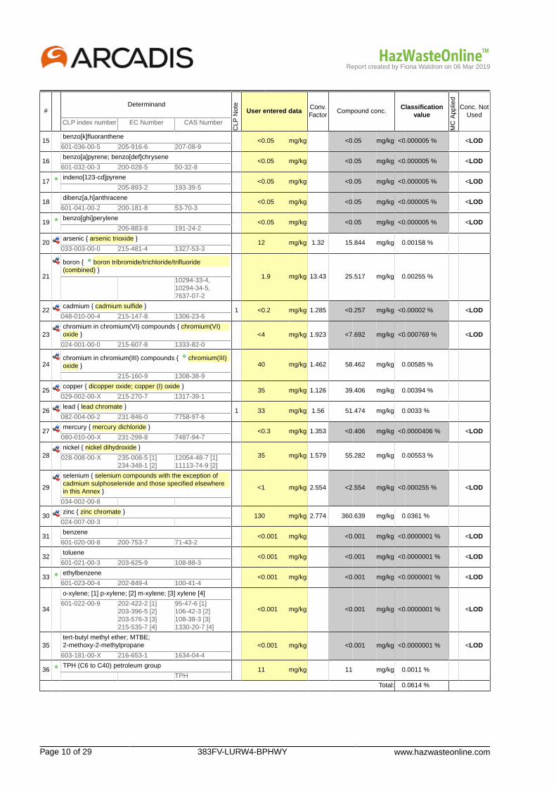
Report created by Fiona Waldron on 06 Mar 2019
Page 10 of 29 383FV-LURW4-BPHWY www.hazwasteonline.com
#Determinand
CLP
Not
e
User entered dataConv.Factor
Compound conc.Classification
value
MC
App
lied
Conc. NotUsed
CLP index number EC Number CAS Number
15benzo[k]fluoranthene
<0.05 mg/kg <0.05 mg/kg <0.000005 % <LOD601-036-00-5 205-916-6 207-08-9
16benzo[a]pyrene; benzo[def]chrysene
<0.05 mg/kg <0.05 mg/kg <0.000005 % <LOD601-032-00-3 200-028-5 50-32-8
17indeno[123-cd]pyrene
<0.05 mg/kg <0.05 mg/kg <0.000005 % <LOD 205-893-2 193-39-5
18dibenz[a,h]anthracene
<0.05 mg/kg <0.05 mg/kg <0.000005 % <LOD601-041-00-2 200-181-8 53-70-3
19benzo[ghi]perylene
<0.05 mg/kg <0.05 mg/kg <0.000005 % <LOD 205-883-8 191-24-2
20arsenic { arsenic trioxide }
12 mg/kg 1.32 15.844 mg/kg 0.00158 %033-003-00-0 215-481-4 1327-53-3
21
boron { boron tribromide/trichloride/trifluoride(combined) }
1.9 mg/kg 13.43 25.517 mg/kg 0.00255 % 10294-33-4,10294-34-5,7637-07-2
22cadmium { cadmium sulfide }
1 <0.2 mg/kg 1.285 <0.257 mg/kg <0.00002 % <LOD048-010-00-4 215-147-8 1306-23-6
23chromium in chromium(VI) compounds { chromium(VI)oxide } <4 mg/kg 1.923 <7.692 mg/kg <0.000769 % <LOD
024-001-00-0 215-607-8 1333-82-0
24chromium in chromium(III) compounds { chromium(III)oxide } 40 mg/kg 1.462 58.462 mg/kg 0.00585 %
215-160-9 1308-38-9
25copper { dicopper oxide; copper (I) oxide }
35 mg/kg 1.126 39.406 mg/kg 0.00394 %029-002-00-X 215-270-7 1317-39-1
26lead { lead chromate }
1 33 mg/kg 1.56 51.474 mg/kg 0.0033 %082-004-00-2 231-846-0 7758-97-6
27mercury { mercury dichloride }
<0.3 mg/kg 1.353 <0.406 mg/kg <0.0000406 % <LOD080-010-00-X 231-299-8 7487-94-7
28nickel { nickel dihydroxide }
35 mg/kg 1.579 55.282 mg/kg 0.00553 %028-008-00-X 235-008-5 [1]234-348-1 [2]
12054-48-7 [1]11113-74-9 [2]
29
selenium { selenium compounds with the exception ofcadmium sulphoselenide and those specified elsewherein this Annex }
<1 mg/kg 2.554 <2.554 mg/kg <0.000255 % <LOD
034-002-00-8
30zinc { zinc chromate }
130 mg/kg 2.774 360.639 mg/kg 0.0361 %024-007-00-3
31benzene
<0.001 mg/kg <0.001 mg/kg <0.0000001 % <LOD601-020-00-8 200-753-7 71-43-2
32toluene
<0.001 mg/kg <0.001 mg/kg <0.0000001 % <LOD601-021-00-3 203-625-9 108-88-3
33ethylbenzene
<0.001 mg/kg <0.001 mg/kg <0.0000001 % <LOD601-023-00-4 202-849-4 100-41-4
34
o-xylene; [1] p-xylene; [2] m-xylene; [3] xylene [4]
<0.001 mg/kg <0.001 mg/kg <0.0000001 % <LOD601-022-00-9 202-422-2 [1]
203-396-5 [2]203-576-3 [3]215-535-7 [4]
95-47-6 [1]106-42-3 [2]108-38-3 [3]1330-20-7 [4]
35tert-butyl methyl ether; MTBE;2-methoxy-2-methylpropane <0.001 mg/kg <0.001 mg/kg <0.0000001 % <LOD
603-181-00-X 216-653-1 1634-04-4
36TPH (C6 to C40) petroleum group
11 mg/kg 11 mg/kg 0.0011 % TPH
Total: 0.0614 %
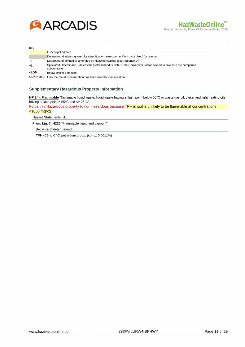
Report created by Fiona Waldron on 06 Mar 2019
www.hazwasteonline.com 383FV-LURW4-BPHWY Page 11 of 29
KeyUser supplied data
Determinand values ignored for classification, see column 'Conc. Not Used' for reason
Determinand defined or amended by HazWasteOnline (see Appendix A)
Speciated Deteminand - Unless the Determinand is Note 1, the Conversion Factor is used to calculate the compoundconcentration
<LOD Below limit of detectionCLP: Note 1 Only the metal concentration has been used for classification
Supplementary Hazardous Property Information
HP 3(i): Flammable "flammable liquid waste: liquid waste having a flash point below 60°C or waste gas oil, diesel and light heating oilshaving a flash point > 55°C and <= 75°C"Force this Hazardous property to non hazardous because TPH in soil is unlikely to be flammable at concentrations<1000 mg/kg.
Hazard Statements hit:
Flam. Liq. 3; H226 "Flammable liquid and vapour."
Because of determinand:
TPH (C6 to C40) petroleum group: (conc.: 0.0011%)

Report created by Fiona Waldron on 06 Mar 2019
Page 12 of 29 383FV-LURW4-BPHWY www.hazwasteonline.com
Classification of sample: TP102[2]
Non Hazardous WasteClassified as 17 05 04
in the List of Waste
Sample details
Sample Name:TP102[2]Sample Depth:0.60-0.80 mMoisture content:6.3%(no correction)
LoW Code:Chapter: 17: Construction and Demolition Wastes (including excavated soil
from contaminated sites)Entry: 17 05 04 (Soil and stones other than those mentioned in 17 05
03)
Hazard properties
None identified
Determinands
Moisture content: 6.3% No Moisture Correction applied (MC)
#Determinand
CLP
Not
e
User entered dataConv.Factor
Compound conc.Classification
value
MC
App
lied
Conc. NotUsed
CLP index number EC Number CAS Number
1pH
7.3 pH 7.3 pH 7.3 pH PH
2
cyanides { salts of hydrogen cyanide with theexception of complex cyanides such as ferrocyanides,ferricyanides and mercuric oxycyanide and thosespecified elsewhere in this Annex }
<1 mg/kg 1.884 <1.884 mg/kg <0.000188 % <LOD
006-007-00-5
3phenol
<1 mg/kg <1 mg/kg <0.0001 % <LOD604-001-00-2 203-632-7 108-95-2
4naphthalene
<0.05 mg/kg <0.05 mg/kg <0.000005 % <LOD601-052-00-2 202-049-5 91-20-3
5acenaphthylene
<0.05 mg/kg <0.05 mg/kg <0.000005 % <LOD 205-917-1 208-96-8
6acenaphthene
<0.05 mg/kg <0.05 mg/kg <0.000005 % <LOD 201-469-6 83-32-9
7fluorene
<0.05 mg/kg <0.05 mg/kg <0.000005 % <LOD 201-695-5 86-73-7
8phenanthrene
<0.05 mg/kg <0.05 mg/kg <0.000005 % <LOD 201-581-5 85-01-8
9anthracene
<0.05 mg/kg <0.05 mg/kg <0.000005 % <LOD 204-371-1 120-12-7
10fluoranthene
<0.05 mg/kg <0.05 mg/kg <0.000005 % <LOD 205-912-4 206-44-0
11pyrene
<0.05 mg/kg <0.05 mg/kg <0.000005 % <LOD 204-927-3 129-00-0
12benzo[a]anthracene
<0.05 mg/kg <0.05 mg/kg <0.000005 % <LOD601-033-00-9 200-280-6 56-55-3
13chrysene
<0.05 mg/kg <0.05 mg/kg <0.000005 % <LOD601-048-00-0 205-923-4 218-01-9
14benzo[b]fluoranthene
<0.05 mg/kg <0.05 mg/kg <0.000005 % <LOD601-034-00-4 205-911-9 205-99-2

Report created by Fiona Waldron on 06 Mar 2019
www.hazwasteonline.com 383FV-LURW4-BPHWY Page 13 of 29
#Determinand
CLP
Not
e
User entered dataConv.Factor
Compound conc.Classification
value
MC
App
lied
Conc. NotUsed
CLP index number EC Number CAS Number
15benzo[k]fluoranthene
<0.05 mg/kg <0.05 mg/kg <0.000005 % <LOD601-036-00-5 205-916-6 207-08-9
16benzo[a]pyrene; benzo[def]chrysene
<0.05 mg/kg <0.05 mg/kg <0.000005 % <LOD601-032-00-3 200-028-5 50-32-8
17indeno[123-cd]pyrene
<0.05 mg/kg <0.05 mg/kg <0.000005 % <LOD 205-893-2 193-39-5
18dibenz[a,h]anthracene
<0.05 mg/kg <0.05 mg/kg <0.000005 % <LOD601-041-00-2 200-181-8 53-70-3
19benzo[ghi]perylene
<0.05 mg/kg <0.05 mg/kg <0.000005 % <LOD 205-883-8 191-24-2
20arsenic { arsenic trioxide }
16 mg/kg 1.32 21.125 mg/kg 0.00211 %033-003-00-0 215-481-4 1327-53-3
21
boron { boron tribromide/trichloride/trifluoride(combined) }
0.6 mg/kg 13.43 8.058 mg/kg 0.000806 % 10294-33-4,10294-34-5,7637-07-2
22cadmium { cadmium sulfide }
1 <0.2 mg/kg 1.285 <0.257 mg/kg <0.00002 % <LOD048-010-00-4 215-147-8 1306-23-6
23chromium in chromium(VI) compounds { chromium(VI)oxide } <4 mg/kg 1.923 <7.692 mg/kg <0.000769 % <LOD
024-001-00-0 215-607-8 1333-82-0
24chromium in chromium(III) compounds { chromium(III)oxide } 28 mg/kg 1.462 40.924 mg/kg 0.00409 %
215-160-9 1308-38-9
25copper { dicopper oxide; copper (I) oxide }
39 mg/kg 1.126 43.91 mg/kg 0.00439 %029-002-00-X 215-270-7 1317-39-1
26lead { lead chromate }
1 26 mg/kg 1.56 40.555 mg/kg 0.0026 %082-004-00-2 231-846-0 7758-97-6
27mercury { mercury dichloride }
<0.3 mg/kg 1.353 <0.406 mg/kg <0.0000406 % <LOD080-010-00-X 231-299-8 7487-94-7
28nickel { nickel dihydroxide }
39 mg/kg 1.579 61.6 mg/kg 0.00616 %028-008-00-X 235-008-5 [1]234-348-1 [2]
12054-48-7 [1]11113-74-9 [2]
29
selenium { selenium compounds with the exception ofcadmium sulphoselenide and those specified elsewherein this Annex }
<1 mg/kg 2.554 <2.554 mg/kg <0.000255 % <LOD
034-002-00-8
30zinc { zinc chromate }
99 mg/kg 2.774 274.641 mg/kg 0.0275 %024-007-00-3
31benzene
<0.001 mg/kg <0.001 mg/kg <0.0000001 % <LOD601-020-00-8 200-753-7 71-43-2
32toluene
<0.001 mg/kg <0.001 mg/kg <0.0000001 % <LOD601-021-00-3 203-625-9 108-88-3
33ethylbenzene
<0.001 mg/kg <0.001 mg/kg <0.0000001 % <LOD601-023-00-4 202-849-4 100-41-4
34
o-xylene; [1] p-xylene; [2] m-xylene; [3] xylene [4]
<0.001 mg/kg <0.001 mg/kg <0.0000001 % <LOD601-022-00-9 202-422-2 [1]
203-396-5 [2]203-576-3 [3]215-535-7 [4]
95-47-6 [1]106-42-3 [2]108-38-3 [3]1330-20-7 [4]
35tert-butyl methyl ether; MTBE;2-methoxy-2-methylpropane <0.001 mg/kg <0.001 mg/kg <0.0000001 % <LOD
603-181-00-X 216-653-1 1634-04-4
36TPH (C6 to C40) petroleum group
<10 mg/kg <10 mg/kg <0.001 % <LOD TPH
Total: 0.0501 %

Report created by Fiona Waldron on 06 Mar 2019
Page 14 of 29 383FV-LURW4-BPHWY www.hazwasteonline.com
KeyUser supplied data
Determinand values ignored for classification, see column 'Conc. Not Used' for reason
Determinand defined or amended by HazWasteOnline (see Appendix A)
Speciated Deteminand - Unless the Determinand is Note 1, the Conversion Factor is used to calculate the compoundconcentration
<LOD Below limit of detectionCLP: Note 1 Only the metal concentration has been used for classification
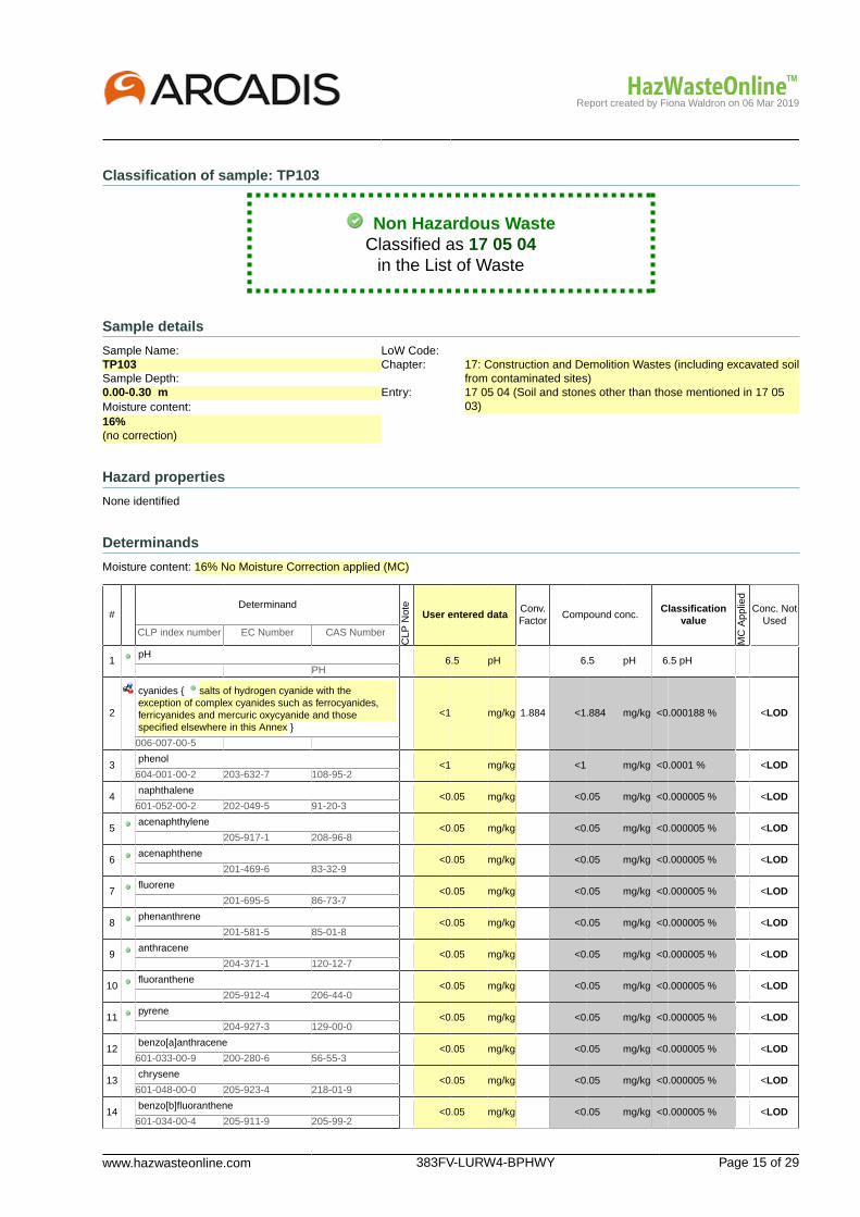
Report created by Fiona Waldron on 06 Mar 2019
www.hazwasteonline.com 383FV-LURW4-BPHWY Page 15 of 29
Classification of sample: TP103
Non Hazardous WasteClassified as 17 05 04
in the List of Waste
Sample details
Sample Name:TP103Sample Depth:0.00-0.30 mMoisture content:16%(no correction)
LoW Code:Chapter: 17: Construction and Demolition Wastes (including excavated soil
from contaminated sites)Entry: 17 05 04 (Soil and stones other than those mentioned in 17 05
03)
Hazard properties
None identified
Determinands
Moisture content: 16% No Moisture Correction applied (MC)
#Determinand
CLP
Not
e
User entered dataConv.Factor
Compound conc.Classification
value
MC
App
lied
Conc. NotUsed
CLP index number EC Number CAS Number
1pH
6.5 pH 6.5 pH 6.5 pH PH
2
cyanides { salts of hydrogen cyanide with theexception of complex cyanides such as ferrocyanides,ferricyanides and mercuric oxycyanide and thosespecified elsewhere in this Annex }
<1 mg/kg 1.884 <1.884 mg/kg <0.000188 % <LOD
006-007-00-5
3phenol
<1 mg/kg <1 mg/kg <0.0001 % <LOD604-001-00-2 203-632-7 108-95-2
4naphthalene
<0.05 mg/kg <0.05 mg/kg <0.000005 % <LOD601-052-00-2 202-049-5 91-20-3
5acenaphthylene
<0.05 mg/kg <0.05 mg/kg <0.000005 % <LOD 205-917-1 208-96-8
6acenaphthene
<0.05 mg/kg <0.05 mg/kg <0.000005 % <LOD 201-469-6 83-32-9
7fluorene
<0.05 mg/kg <0.05 mg/kg <0.000005 % <LOD 201-695-5 86-73-7
8phenanthrene
<0.05 mg/kg <0.05 mg/kg <0.000005 % <LOD 201-581-5 85-01-8
9anthracene
<0.05 mg/kg <0.05 mg/kg <0.000005 % <LOD 204-371-1 120-12-7
10fluoranthene
<0.05 mg/kg <0.05 mg/kg <0.000005 % <LOD 205-912-4 206-44-0
11pyrene
<0.05 mg/kg <0.05 mg/kg <0.000005 % <LOD 204-927-3 129-00-0
12benzo[a]anthracene
<0.05 mg/kg <0.05 mg/kg <0.000005 % <LOD601-033-00-9 200-280-6 56-55-3
13chrysene
<0.05 mg/kg <0.05 mg/kg <0.000005 % <LOD601-048-00-0 205-923-4 218-01-9
14benzo[b]fluoranthene
<0.05 mg/kg <0.05 mg/kg <0.000005 % <LOD601-034-00-4 205-911-9 205-99-2
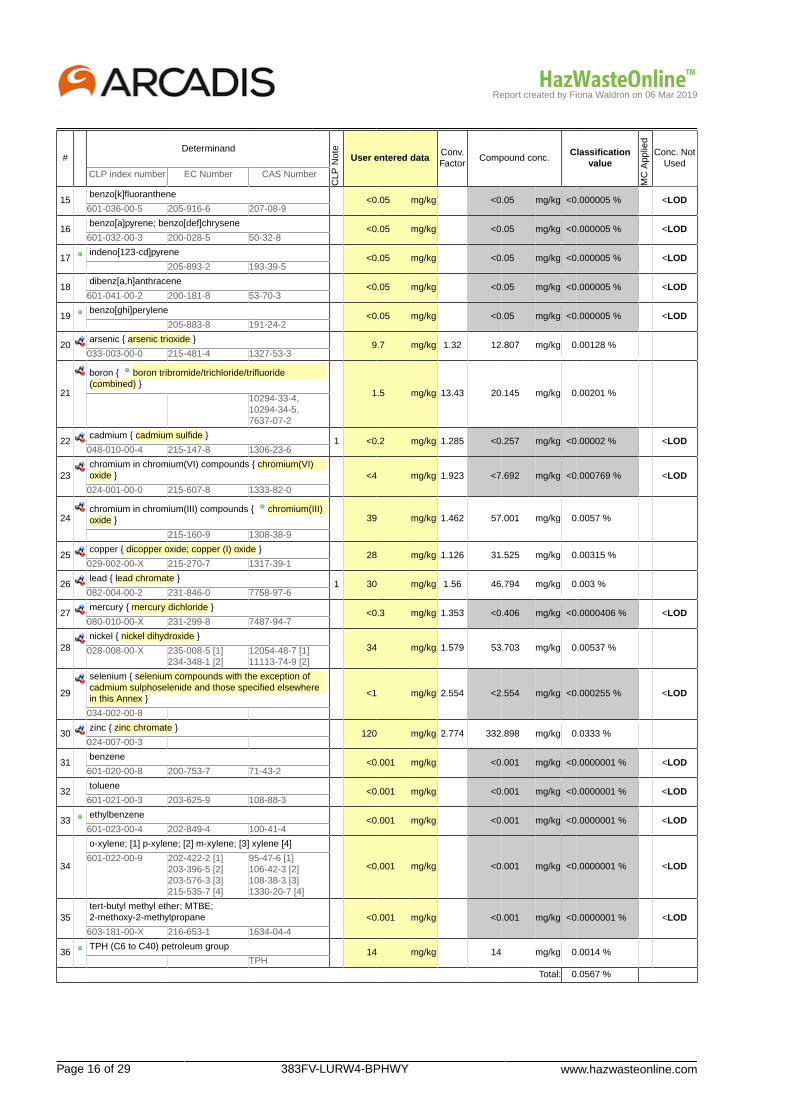
Report created by Fiona Waldron on 06 Mar 2019
Page 16 of 29 383FV-LURW4-BPHWY www.hazwasteonline.com
#Determinand
CLP
Not
e
User entered dataConv.Factor
Compound conc.Classification
value
MC
App
lied
Conc. NotUsed
CLP index number EC Number CAS Number
15benzo[k]fluoranthene
<0.05 mg/kg <0.05 mg/kg <0.000005 % <LOD601-036-00-5 205-916-6 207-08-9
16benzo[a]pyrene; benzo[def]chrysene
<0.05 mg/kg <0.05 mg/kg <0.000005 % <LOD601-032-00-3 200-028-5 50-32-8
17indeno[123-cd]pyrene
<0.05 mg/kg <0.05 mg/kg <0.000005 % <LOD 205-893-2 193-39-5
18dibenz[a,h]anthracene
<0.05 mg/kg <0.05 mg/kg <0.000005 % <LOD601-041-00-2 200-181-8 53-70-3
19benzo[ghi]perylene
<0.05 mg/kg <0.05 mg/kg <0.000005 % <LOD 205-883-8 191-24-2
20arsenic { arsenic trioxide }
9.7 mg/kg 1.32 12.807 mg/kg 0.00128 %033-003-00-0 215-481-4 1327-53-3
21
boron { boron tribromide/trichloride/trifluoride(combined) }
1.5 mg/kg 13.43 20.145 mg/kg 0.00201 % 10294-33-4,10294-34-5,7637-07-2
22cadmium { cadmium sulfide }
1 <0.2 mg/kg 1.285 <0.257 mg/kg <0.00002 % <LOD048-010-00-4 215-147-8 1306-23-6
23chromium in chromium(VI) compounds { chromium(VI)oxide } <4 mg/kg 1.923 <7.692 mg/kg <0.000769 % <LOD
024-001-00-0 215-607-8 1333-82-0
24chromium in chromium(III) compounds { chromium(III)oxide } 39 mg/kg 1.462 57.001 mg/kg 0.0057 %
215-160-9 1308-38-9
25copper { dicopper oxide; copper (I) oxide }
28 mg/kg 1.126 31.525 mg/kg 0.00315 %029-002-00-X 215-270-7 1317-39-1
26lead { lead chromate }
1 30 mg/kg 1.56 46.794 mg/kg 0.003 %082-004-00-2 231-846-0 7758-97-6
27mercury { mercury dichloride }
<0.3 mg/kg 1.353 <0.406 mg/kg <0.0000406 % <LOD080-010-00-X 231-299-8 7487-94-7
28nickel { nickel dihydroxide }
34 mg/kg 1.579 53.703 mg/kg 0.00537 %028-008-00-X 235-008-5 [1]234-348-1 [2]
12054-48-7 [1]11113-74-9 [2]
29
selenium { selenium compounds with the exception ofcadmium sulphoselenide and those specified elsewherein this Annex }
<1 mg/kg 2.554 <2.554 mg/kg <0.000255 % <LOD
034-002-00-8
30zinc { zinc chromate }
120 mg/kg 2.774 332.898 mg/kg 0.0333 %024-007-00-3
31benzene
<0.001 mg/kg <0.001 mg/kg <0.0000001 % <LOD601-020-00-8 200-753-7 71-43-2
32toluene
<0.001 mg/kg <0.001 mg/kg <0.0000001 % <LOD601-021-00-3 203-625-9 108-88-3
33ethylbenzene
<0.001 mg/kg <0.001 mg/kg <0.0000001 % <LOD601-023-00-4 202-849-4 100-41-4
34
o-xylene; [1] p-xylene; [2] m-xylene; [3] xylene [4]
<0.001 mg/kg <0.001 mg/kg <0.0000001 % <LOD601-022-00-9 202-422-2 [1]
203-396-5 [2]203-576-3 [3]215-535-7 [4]
95-47-6 [1]106-42-3 [2]108-38-3 [3]1330-20-7 [4]
35tert-butyl methyl ether; MTBE;2-methoxy-2-methylpropane <0.001 mg/kg <0.001 mg/kg <0.0000001 % <LOD
603-181-00-X 216-653-1 1634-04-4
36TPH (C6 to C40) petroleum group
14 mg/kg 14 mg/kg 0.0014 % TPH
Total: 0.0567 %

Report created by Fiona Waldron on 06 Mar 2019
www.hazwasteonline.com 383FV-LURW4-BPHWY Page 17 of 29
KeyUser supplied data
Determinand values ignored for classification, see column 'Conc. Not Used' for reason
Determinand defined or amended by HazWasteOnline (see Appendix A)
Speciated Deteminand - Unless the Determinand is Note 1, the Conversion Factor is used to calculate the compoundconcentration
<LOD Below limit of detectionCLP: Note 1 Only the metal concentration has been used for classification
Supplementary Hazardous Property Information
HP 3(i): Flammable "flammable liquid waste: liquid waste having a flash point below 60°C or waste gas oil, diesel and light heating oilshaving a flash point > 55°C and <= 75°C"Force this Hazardous property to non hazardous because TPH in soil is unlikely to be flammable at concentrations<1000 mg/kg.
Hazard Statements hit:
Flam. Liq. 3; H226 "Flammable liquid and vapour."
Because of determinand:
TPH (C6 to C40) petroleum group: (conc.: 0.0014%)
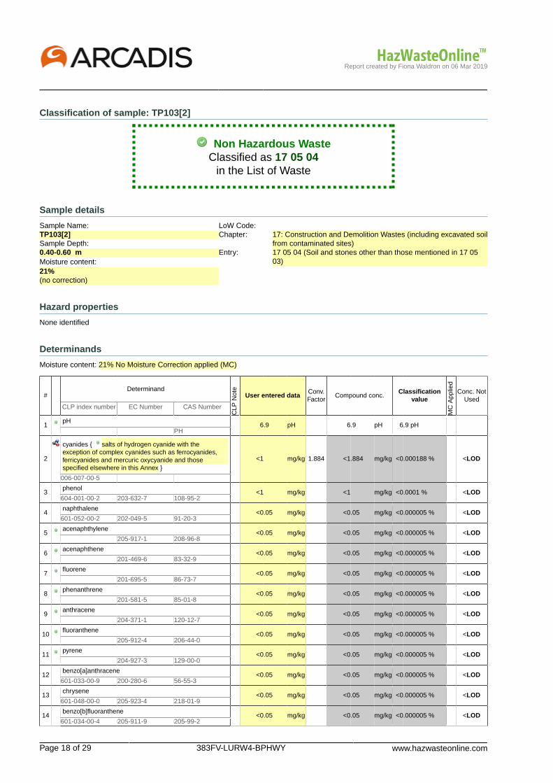
Report created by Fiona Waldron on 06 Mar 2019
Page 18 of 29 383FV-LURW4-BPHWY www.hazwasteonline.com
Classification of sample: TP103[2]
Non Hazardous WasteClassified as 17 05 04
in the List of Waste
Sample details
Sample Name:TP103[2]Sample Depth:0.40-0.60 mMoisture content:21%(no correction)
LoW Code:Chapter: 17: Construction and Demolition Wastes (including excavated soil
from contaminated sites)Entry: 17 05 04 (Soil and stones other than those mentioned in 17 05
03)
Hazard properties
None identified
Determinands
Moisture content: 21% No Moisture Correction applied (MC)
#Determinand
CLP
Not
e
User entered dataConv.Factor
Compound conc.Classification
value
MC
App
lied
Conc. NotUsed
CLP index number EC Number CAS Number
1pH
6.9 pH 6.9 pH 6.9 pH PH
2
cyanides { salts of hydrogen cyanide with theexception of complex cyanides such as ferrocyanides,ferricyanides and mercuric oxycyanide and thosespecified elsewhere in this Annex }
<1 mg/kg 1.884 <1.884 mg/kg <0.000188 % <LOD
006-007-00-5
3phenol
<1 mg/kg <1 mg/kg <0.0001 % <LOD604-001-00-2 203-632-7 108-95-2
4naphthalene
<0.05 mg/kg <0.05 mg/kg <0.000005 % <LOD601-052-00-2 202-049-5 91-20-3
5acenaphthylene
<0.05 mg/kg <0.05 mg/kg <0.000005 % <LOD 205-917-1 208-96-8
6acenaphthene
<0.05 mg/kg <0.05 mg/kg <0.000005 % <LOD 201-469-6 83-32-9
7fluorene
<0.05 mg/kg <0.05 mg/kg <0.000005 % <LOD 201-695-5 86-73-7
8phenanthrene
<0.05 mg/kg <0.05 mg/kg <0.000005 % <LOD 201-581-5 85-01-8
9anthracene
<0.05 mg/kg <0.05 mg/kg <0.000005 % <LOD 204-371-1 120-12-7
10fluoranthene
<0.05 mg/kg <0.05 mg/kg <0.000005 % <LOD 205-912-4 206-44-0
11pyrene
<0.05 mg/kg <0.05 mg/kg <0.000005 % <LOD 204-927-3 129-00-0
12benzo[a]anthracene
<0.05 mg/kg <0.05 mg/kg <0.000005 % <LOD601-033-00-9 200-280-6 56-55-3
13chrysene
<0.05 mg/kg <0.05 mg/kg <0.000005 % <LOD601-048-00-0 205-923-4 218-01-9
14benzo[b]fluoranthene
<0.05 mg/kg <0.05 mg/kg <0.000005 % <LOD601-034-00-4 205-911-9 205-99-2

Report created by Fiona Waldron on 06 Mar 2019
www.hazwasteonline.com 383FV-LURW4-BPHWY Page 19 of 29
#Determinand
CLP
Not
e
User entered dataConv.Factor
Compound conc.Classification
value
MC
App
lied
Conc. NotUsed
CLP index number EC Number CAS Number
15benzo[k]fluoranthene
<0.05 mg/kg <0.05 mg/kg <0.000005 % <LOD601-036-00-5 205-916-6 207-08-9
16benzo[a]pyrene; benzo[def]chrysene
<0.05 mg/kg <0.05 mg/kg <0.000005 % <LOD601-032-00-3 200-028-5 50-32-8
17indeno[123-cd]pyrene
<0.05 mg/kg <0.05 mg/kg <0.000005 % <LOD 205-893-2 193-39-5
18dibenz[a,h]anthracene
<0.05 mg/kg <0.05 mg/kg <0.000005 % <LOD601-041-00-2 200-181-8 53-70-3
19benzo[ghi]perylene
<0.05 mg/kg <0.05 mg/kg <0.000005 % <LOD 205-883-8 191-24-2
20arsenic { arsenic trioxide }
11 mg/kg 1.32 14.524 mg/kg 0.00145 %033-003-00-0 215-481-4 1327-53-3
21
boron { boron tribromide/trichloride/trifluoride(combined) }
0.8 mg/kg 13.43 10.744 mg/kg 0.00107 % 10294-33-4,10294-34-5,7637-07-2
22cadmium { cadmium sulfide }
1 <0.2 mg/kg 1.285 <0.257 mg/kg <0.00002 % <LOD048-010-00-4 215-147-8 1306-23-6
23chromium in chromium(VI) compounds { chromium(VI)oxide } <4 mg/kg 1.923 <7.692 mg/kg <0.000769 % <LOD
024-001-00-0 215-607-8 1333-82-0
24chromium in chromium(III) compounds { chromium(III)oxide } 34 mg/kg 1.462 49.693 mg/kg 0.00497 %
215-160-9 1308-38-9
25copper { dicopper oxide; copper (I) oxide }
28 mg/kg 1.126 31.525 mg/kg 0.00315 %029-002-00-X 215-270-7 1317-39-1
26lead { lead chromate }
1 20 mg/kg 1.56 31.196 mg/kg 0.002 %082-004-00-2 231-846-0 7758-97-6
27mercury { mercury dichloride }
<0.3 mg/kg 1.353 <0.406 mg/kg <0.0000406 % <LOD080-010-00-X 231-299-8 7487-94-7
28nickel { nickel dihydroxide }
39 mg/kg 1.579 61.6 mg/kg 0.00616 %028-008-00-X 235-008-5 [1]234-348-1 [2]
12054-48-7 [1]11113-74-9 [2]
29
selenium { selenium compounds with the exception ofcadmium sulphoselenide and those specified elsewherein this Annex }
<1 mg/kg 2.554 <2.554 mg/kg <0.000255 % <LOD
034-002-00-8
30zinc { zinc chromate }
120 mg/kg 2.774 332.898 mg/kg 0.0333 %024-007-00-3
31benzene
<0.001 mg/kg <0.001 mg/kg <0.0000001 % <LOD601-020-00-8 200-753-7 71-43-2
32toluene
<0.001 mg/kg <0.001 mg/kg <0.0000001 % <LOD601-021-00-3 203-625-9 108-88-3
33ethylbenzene
<0.001 mg/kg <0.001 mg/kg <0.0000001 % <LOD601-023-00-4 202-849-4 100-41-4
34
o-xylene; [1] p-xylene; [2] m-xylene; [3] xylene [4]
<0.001 mg/kg <0.001 mg/kg <0.0000001 % <LOD601-022-00-9 202-422-2 [1]
203-396-5 [2]203-576-3 [3]215-535-7 [4]
95-47-6 [1]106-42-3 [2]108-38-3 [3]1330-20-7 [4]
35tert-butyl methyl ether; MTBE;2-methoxy-2-methylpropane <0.001 mg/kg <0.001 mg/kg <0.0000001 % <LOD
603-181-00-X 216-653-1 1634-04-4
36TPH (C6 to C40) petroleum group
<10 mg/kg <10 mg/kg <0.001 % <LOD TPH
Total: 0.0546 %

Report created by Fiona Waldron on 06 Mar 2019
Page 20 of 29 383FV-LURW4-BPHWY www.hazwasteonline.com
KeyUser supplied data
Determinand values ignored for classification, see column 'Conc. Not Used' for reason
Determinand defined or amended by HazWasteOnline (see Appendix A)
Speciated Deteminand - Unless the Determinand is Note 1, the Conversion Factor is used to calculate the compoundconcentration
<LOD Below limit of detectionCLP: Note 1 Only the metal concentration has been used for classification

Report created by Fiona Waldron on 06 Mar 2019
www.hazwasteonline.com 383FV-LURW4-BPHWY Page 21 of 29
Classification of sample: TP104
Non Hazardous WasteClassified as 17 05 04
in the List of Waste
Sample details
Sample Name:TP104Sample Depth:0.00-0.20 mMoisture content:15%(no correction)
LoW Code:Chapter: 17: Construction and Demolition Wastes (including excavated soil
from contaminated sites)Entry: 17 05 04 (Soil and stones other than those mentioned in 17 05
03)
Hazard properties
None identified
Determinands
Moisture content: 15% No Moisture Correction applied (MC)
#Determinand
CLP
Not
e
User entered dataConv.Factor
Compound conc.Classification
value
MC
App
lied
Conc. NotUsed
CLP index number EC Number CAS Number
1pH
7 pH 7 pH 7pH PH
2
cyanides { salts of hydrogen cyanide with theexception of complex cyanides such as ferrocyanides,ferricyanides and mercuric oxycyanide and thosespecified elsewhere in this Annex }
<1 mg/kg 1.884 <1.884 mg/kg <0.000188 % <LOD
006-007-00-5
3phenol
<1 mg/kg <1 mg/kg <0.0001 % <LOD604-001-00-2 203-632-7 108-95-2
4naphthalene
<0.05 mg/kg <0.05 mg/kg <0.000005 % <LOD601-052-00-2 202-049-5 91-20-3
5acenaphthylene
<0.05 mg/kg <0.05 mg/kg <0.000005 % <LOD 205-917-1 208-96-8
6acenaphthene
<0.05 mg/kg <0.05 mg/kg <0.000005 % <LOD 201-469-6 83-32-9
7fluorene
<0.05 mg/kg <0.05 mg/kg <0.000005 % <LOD 201-695-5 86-73-7
8phenanthrene
<0.05 mg/kg <0.05 mg/kg <0.000005 % <LOD 201-581-5 85-01-8
9anthracene
<0.05 mg/kg <0.05 mg/kg <0.000005 % <LOD 204-371-1 120-12-7
10fluoranthene
<0.05 mg/kg <0.05 mg/kg <0.000005 % <LOD 205-912-4 206-44-0
11pyrene
<0.05 mg/kg <0.05 mg/kg <0.000005 % <LOD 204-927-3 129-00-0
12benzo[a]anthracene
<0.05 mg/kg <0.05 mg/kg <0.000005 % <LOD601-033-00-9 200-280-6 56-55-3
13chrysene
<0.05 mg/kg <0.05 mg/kg <0.000005 % <LOD601-048-00-0 205-923-4 218-01-9
14benzo[b]fluoranthene
<0.05 mg/kg <0.05 mg/kg <0.000005 % <LOD601-034-00-4 205-911-9 205-99-2

Report created by Fiona Waldron on 06 Mar 2019
Page 22 of 29 383FV-LURW4-BPHWY www.hazwasteonline.com
#Determinand
CLP
Not
e
User entered dataConv.Factor
Compound conc.Classification
value
MC
App
lied
Conc. NotUsed
CLP index number EC Number CAS Number
15benzo[k]fluoranthene
<0.05 mg/kg <0.05 mg/kg <0.000005 % <LOD601-036-00-5 205-916-6 207-08-9
16benzo[a]pyrene; benzo[def]chrysene
<0.05 mg/kg <0.05 mg/kg <0.000005 % <LOD601-032-00-3 200-028-5 50-32-8
17indeno[123-cd]pyrene
<0.05 mg/kg <0.05 mg/kg <0.000005 % <LOD 205-893-2 193-39-5
18dibenz[a,h]anthracene
<0.05 mg/kg <0.05 mg/kg <0.000005 % <LOD601-041-00-2 200-181-8 53-70-3
19benzo[ghi]perylene
<0.05 mg/kg <0.05 mg/kg <0.000005 % <LOD 205-883-8 191-24-2
20arsenic { arsenic trioxide }
6 mg/kg 1.32 7.922 mg/kg 0.000792 %033-003-00-0 215-481-4 1327-53-3
21
boron { boron tribromide/trichloride/trifluoride(combined) }
1.1 mg/kg 13.43 14.773 mg/kg 0.00148 % 10294-33-4,10294-34-5,7637-07-2
22cadmium { cadmium sulfide }
1 <0.2 mg/kg 1.285 <0.257 mg/kg <0.00002 % <LOD048-010-00-4 215-147-8 1306-23-6
23chromium in chromium(VI) compounds { chromium(VI)oxide } <4 mg/kg 1.923 <7.692 mg/kg <0.000769 % <LOD
024-001-00-0 215-607-8 1333-82-0
24chromium in chromium(III) compounds { chromium(III)oxide } 39 mg/kg 1.462 57.001 mg/kg 0.0057 %
215-160-9 1308-38-9
25copper { dicopper oxide; copper (I) oxide }
31 mg/kg 1.126 34.903 mg/kg 0.00349 %029-002-00-X 215-270-7 1317-39-1
26lead { lead chromate }
1 26 mg/kg 1.56 40.555 mg/kg 0.0026 %082-004-00-2 231-846-0 7758-97-6
27mercury { mercury dichloride }
<0.3 mg/kg 1.353 <0.406 mg/kg <0.0000406 % <LOD080-010-00-X 231-299-8 7487-94-7
28nickel { nickel dihydroxide }
36 mg/kg 1.579 56.862 mg/kg 0.00569 %028-008-00-X 235-008-5 [1]234-348-1 [2]
12054-48-7 [1]11113-74-9 [2]
29
selenium { selenium compounds with the exception ofcadmium sulphoselenide and those specified elsewherein this Annex }
<1 mg/kg 2.554 <2.554 mg/kg <0.000255 % <LOD
034-002-00-8
30zinc { zinc chromate }
110 mg/kg 2.774 305.156 mg/kg 0.0305 %024-007-00-3
31benzene
<0.001 mg/kg <0.001 mg/kg <0.0000001 % <LOD601-020-00-8 200-753-7 71-43-2
32toluene
<0.001 mg/kg <0.001 mg/kg <0.0000001 % <LOD601-021-00-3 203-625-9 108-88-3
33ethylbenzene
<0.001 mg/kg <0.001 mg/kg <0.0000001 % <LOD601-023-00-4 202-849-4 100-41-4
34
o-xylene; [1] p-xylene; [2] m-xylene; [3] xylene [4]
<0.001 mg/kg <0.001 mg/kg <0.0000001 % <LOD601-022-00-9 202-422-2 [1]
203-396-5 [2]203-576-3 [3]215-535-7 [4]
95-47-6 [1]106-42-3 [2]108-38-3 [3]1330-20-7 [4]
35tert-butyl methyl ether; MTBE;2-methoxy-2-methylpropane <0.001 mg/kg <0.001 mg/kg <0.0000001 % <LOD
603-181-00-X 216-653-1 1634-04-4
36TPH (C6 to C40) petroleum group
<10 mg/kg <10 mg/kg <0.001 % <LOD TPH
Total: 0.0527 %

Report created by Fiona Waldron on 06 Mar 2019
www.hazwasteonline.com 383FV-LURW4-BPHWY Page 23 of 29
KeyUser supplied data
Determinand values ignored for classification, see column 'Conc. Not Used' for reason
Determinand defined or amended by HazWasteOnline (see Appendix A)
Speciated Deteminand - Unless the Determinand is Note 1, the Conversion Factor is used to calculate the compoundconcentration
<LOD Below limit of detectionCLP: Note 1 Only the metal concentration has been used for classification

Report created by Fiona Waldron on 06 Mar 2019
Page 24 of 29 383FV-LURW4-BPHWY www.hazwasteonline.com
Classification of sample: TP104[2]
Non Hazardous WasteClassified as 17 05 04
in the List of Waste
Sample details
Sample Name:TP104[2]Sample Depth:0.40-0.60 mMoisture content:12%(no correction)
LoW Code:Chapter: 17: Construction and Demolition Wastes (including excavated soil
from contaminated sites)Entry: 17 05 04 (Soil and stones other than those mentioned in 17 05
03)
Hazard properties
None identified
Determinands
Moisture content: 12% No Moisture Correction applied (MC)
#Determinand
CLP
Not
e
User entered dataConv.Factor
Compound conc.Classification
value
MC
App
lied
Conc. NotUsed
CLP index number EC Number CAS Number
1pH
6.8 pH 6.8 pH 6.8 pH PH
2
cyanides { salts of hydrogen cyanide with theexception of complex cyanides such as ferrocyanides,ferricyanides and mercuric oxycyanide and thosespecified elsewhere in this Annex }
<1 mg/kg 1.884 <1.884 mg/kg <0.000188 % <LOD
006-007-00-5
3phenol
<1 mg/kg <1 mg/kg <0.0001 % <LOD604-001-00-2 203-632-7 108-95-2
4naphthalene
<0.05 mg/kg <0.05 mg/kg <0.000005 % <LOD601-052-00-2 202-049-5 91-20-3
5acenaphthylene
<0.05 mg/kg <0.05 mg/kg <0.000005 % <LOD 205-917-1 208-96-8
6acenaphthene
<0.05 mg/kg <0.05 mg/kg <0.000005 % <LOD 201-469-6 83-32-9
7fluorene
<0.05 mg/kg <0.05 mg/kg <0.000005 % <LOD 201-695-5 86-73-7
8phenanthrene
<0.05 mg/kg <0.05 mg/kg <0.000005 % <LOD 201-581-5 85-01-8
9anthracene
<0.05 mg/kg <0.05 mg/kg <0.000005 % <LOD 204-371-1 120-12-7
10fluoranthene
<0.05 mg/kg <0.05 mg/kg <0.000005 % <LOD 205-912-4 206-44-0
11pyrene
<0.05 mg/kg <0.05 mg/kg <0.000005 % <LOD 204-927-3 129-00-0
12benzo[a]anthracene
<0.05 mg/kg <0.05 mg/kg <0.000005 % <LOD601-033-00-9 200-280-6 56-55-3
13chrysene
<0.05 mg/kg <0.05 mg/kg <0.000005 % <LOD601-048-00-0 205-923-4 218-01-9
14benzo[b]fluoranthene
<0.05 mg/kg <0.05 mg/kg <0.000005 % <LOD601-034-00-4 205-911-9 205-99-2

Report created by Fiona Waldron on 06 Mar 2019
www.hazwasteonline.com 383FV-LURW4-BPHWY Page 25 of 29
#Determinand
CLP
Not
e
User entered dataConv.Factor
Compound conc.Classification
value
MC
App
lied
Conc. NotUsed
CLP index number EC Number CAS Number
15benzo[k]fluoranthene
<0.05 mg/kg <0.05 mg/kg <0.000005 % <LOD601-036-00-5 205-916-6 207-08-9
16benzo[a]pyrene; benzo[def]chrysene
<0.05 mg/kg <0.05 mg/kg <0.000005 % <LOD601-032-00-3 200-028-5 50-32-8
17indeno[123-cd]pyrene
<0.05 mg/kg <0.05 mg/kg <0.000005 % <LOD 205-893-2 193-39-5
18dibenz[a,h]anthracene
<0.05 mg/kg <0.05 mg/kg <0.000005 % <LOD601-041-00-2 200-181-8 53-70-3
19benzo[ghi]perylene
<0.05 mg/kg <0.05 mg/kg <0.000005 % <LOD 205-883-8 191-24-2
20arsenic { arsenic trioxide }
8.9 mg/kg 1.32 11.751 mg/kg 0.00118 %033-003-00-0 215-481-4 1327-53-3
21
boron { boron tribromide/trichloride/trifluoride(combined) }
0.7 mg/kg 13.43 9.401 mg/kg 0.00094 % 10294-33-4,10294-34-5,7637-07-2
22cadmium { cadmium sulfide }
1 <0.2 mg/kg 1.285 <0.257 mg/kg <0.00002 % <LOD048-010-00-4 215-147-8 1306-23-6
23chromium in chromium(VI) compounds { chromium(VI)oxide } <4 mg/kg 1.923 <7.692 mg/kg <0.000769 % <LOD
024-001-00-0 215-607-8 1333-82-0
24chromium in chromium(III) compounds { chromium(III)oxide } 33 mg/kg 1.462 48.231 mg/kg 0.00482 %
215-160-9 1308-38-9
25copper { dicopper oxide; copper (I) oxide }
30 mg/kg 1.126 33.777 mg/kg 0.00338 %029-002-00-X 215-270-7 1317-39-1
26lead { lead chromate }
1 21 mg/kg 1.56 32.756 mg/kg 0.0021 %082-004-00-2 231-846-0 7758-97-6
27mercury { mercury dichloride }
<0.3 mg/kg 1.353 <0.406 mg/kg <0.0000406 % <LOD080-010-00-X 231-299-8 7487-94-7
28nickel { nickel dihydroxide }
37 mg/kg 1.579 58.441 mg/kg 0.00584 %028-008-00-X 235-008-5 [1]234-348-1 [2]
12054-48-7 [1]11113-74-9 [2]
29
selenium { selenium compounds with the exception ofcadmium sulphoselenide and those specified elsewherein this Annex }
<1 mg/kg 2.554 <2.554 mg/kg <0.000255 % <LOD
034-002-00-8
30zinc { zinc chromate }
100 mg/kg 2.774 277.415 mg/kg 0.0277 %024-007-00-3
31benzene
<0.001 mg/kg <0.001 mg/kg <0.0000001 % <LOD601-020-00-8 200-753-7 71-43-2
32toluene
<0.001 mg/kg <0.001 mg/kg <0.0000001 % <LOD601-021-00-3 203-625-9 108-88-3
33ethylbenzene
<0.001 mg/kg <0.001 mg/kg <0.0000001 % <LOD601-023-00-4 202-849-4 100-41-4
34
o-xylene; [1] p-xylene; [2] m-xylene; [3] xylene [4]
<0.001 mg/kg <0.001 mg/kg <0.0000001 % <LOD601-022-00-9 202-422-2 [1]
203-396-5 [2]203-576-3 [3]215-535-7 [4]
95-47-6 [1]106-42-3 [2]108-38-3 [3]1330-20-7 [4]
35tert-butyl methyl ether; MTBE;2-methoxy-2-methylpropane <0.001 mg/kg <0.001 mg/kg <0.0000001 % <LOD
603-181-00-X 216-653-1 1634-04-4
36TPH (C6 to C40) petroleum group
<10 mg/kg <10 mg/kg <0.001 % <LOD TPH
Total: 0.0485 %

Report created by Fiona Waldron on 06 Mar 2019
Page 26 of 29 383FV-LURW4-BPHWY www.hazwasteonline.com
KeyUser supplied data
Determinand values ignored for classification, see column 'Conc. Not Used' for reason
Determinand defined or amended by HazWasteOnline (see Appendix A)
Speciated Deteminand - Unless the Determinand is Note 1, the Conversion Factor is used to calculate the compoundconcentration
<LOD Below limit of detectionCLP: Note 1 Only the metal concentration has been used for classification

Report created by Fiona Waldron on 06 Mar 2019
www.hazwasteonline.com 383FV-LURW4-BPHWY Page 27 of 29
Appendix A: Classifier defined and non CLP determinands
pH (CAS Number: PH)
Description/Comments: Appendix C4Data source: WM3 1st Edition 2015Data source date: 25 May 2015Hazard Statements: None.
salts of hydrogen cyanide with the exception of complex cyanides such as ferrocyanides, ferricyanides and mercuricoxycyanide and those specified elsewhere in this Annex
CLP index number: 006-007-00-5Description/Comments: Conversion factor based on a worst case compound: sodium cyanideData source: Commission Regulation (EC) No 790/2009 - 1st Adaptation to Technical Progress for Regulation (EC) No 1272/2008.(ATP1)Additional Hazard Statement(s): EUH032 >= 0.2 %Reason for additional Hazards Statement(s)/Risk Phrase(s):14 Dec 2015 - EUH032 >= 0.2 % hazard statement sourced from: WM3, Table C12.2
acenaphthylene (EC Number: 205-917-1, CAS Number: 208-96-8)
Description/Comments: Data from C&L Inventory DatabaseData source: http://echa.europa.eu/web/guest/information-on-chemicals/cl-inventory-databaseData source date: 17 Jul 2015Hazard Statements: Skin Irrit. 2 H315 , STOT SE 3 H335 , Eye Irrit. 2 H319 , Acute Tox. 1 H310 , Acute Tox. 1 H330 , Acute Tox. 4 H302
acenaphthene (EC Number: 201-469-6, CAS Number: 83-32-9)
Description/Comments: Data from C&L Inventory DatabaseData source: http://echa.europa.eu/web/guest/information-on-chemicals/cl-inventory-databaseData source date: 17 Jul 2015Hazard Statements: Aquatic Chronic 2 H411 , Aquatic Chronic 1 H410 , Aquatic Acute 1 H400 , Skin Irrit. 2 H315 , STOT SE 3 H335 ,Eye Irrit. 2 H319
fluorene (EC Number: 201-695-5, CAS Number: 86-73-7)
Description/Comments: Data from C&L Inventory DatabaseData source: http://echa.europa.eu/web/guest/information-on-chemicals/cl-inventory-databaseData source date: 06 Aug 2015Hazard Statements: Aquatic Chronic 1 H410 , Aquatic Acute 1 H400
phenanthrene (EC Number: 201-581-5, CAS Number: 85-01-8)
Description/Comments: Data from C&L Inventory DatabaseData source: http://echa.europa.eu/web/guest/information-on-chemicals/cl-inventory-databaseData source date: 06 Aug 2015Hazard Statements: Skin Irrit. 2 H315 , Aquatic Chronic 1 H410 , Aquatic Acute 1 H400 , Skin Sens. 1 H317 , Carc. 2 H351 , STOT SE 3H335 , Eye Irrit. 2 H319 , Acute Tox. 4 H302
anthracene (EC Number: 204-371-1, CAS Number: 120-12-7)
Description/Comments: Data from C&L Inventory DatabaseData source: http://echa.europa.eu/web/guest/information-on-chemicals/cl-inventory-databaseData source date: 17 Jul 2015Hazard Statements: Aquatic Chronic 1 H410 , Aquatic Acute 1 H400 , Skin Sens. 1 H317 , Skin Irrit. 2 H315 , STOT SE 3 H335 , EyeIrrit. 2 H319
fluoranthene (EC Number: 205-912-4, CAS Number: 206-44-0)
Description/Comments: Data from C&L Inventory DatabaseData source: http://echa.europa.eu/web/guest/information-on-chemicals/cl-inventory-databaseData source date: 21 Aug 2015Hazard Statements: Aquatic Chronic 1 H410 , Aquatic Acute 1 H400 , Acute Tox. 4 H302
pyrene (EC Number: 204-927-3, CAS Number: 129-00-0)
Description/Comments: Data from C&L Inventory Database; SDS Sigma Aldrich 2014Data source: http://echa.europa.eu/web/guest/information-on-chemicals/cl-inventory-databaseData source date: 21 Aug 2015Hazard Statements: Aquatic Chronic 1 H410 , Aquatic Acute 1 H400 , STOT SE 3 H335 , Eye Irrit. 2 H319 , Skin Irrit. 2 H315

Report created by Fiona Waldron on 06 Mar 2019
Page 28 of 29 383FV-LURW4-BPHWY www.hazwasteonline.com
indeno[123-cd]pyrene (EC Number: 205-893-2, CAS Number: 193-39-5)
Description/Comments: Data from C&L Inventory DatabaseData source: http://echa.europa.eu/web/guest/information-on-chemicals/cl-inventory-databaseData source date: 06 Aug 2015Hazard Statements: Carc. 2 H351
benzo[ghi]perylene (EC Number: 205-883-8, CAS Number: 191-24-2)
Description/Comments: Data from C&L Inventory Database; SDS Sigma Aldrich 28/02/2015Data source: http://echa.europa.eu/web/guest/information-on-chemicals/cl-inventory-databaseData source date: 23 Jul 2015Hazard Statements: Aquatic Chronic 1 H410 , Aquatic Acute 1 H400
boron tribromide/trichloride/trifluoride (combined) (CAS Number: 10294-33-4, 10294-34-5, 7637-07-2)
Conversion factor: 13.43Description/Comments: Combines the hazard statements and the average of the conversion factors for boron tribromide, borontrichloride and boron trifluorideData source: N/AData source date: 06 Aug 2015Hazard Statements: Skin Corr. 1B H314 , Skin Corr. 1A H314 , Acute Tox. 2 H300 , Acute Tox. 2 H330 , EUH014
chromium(III) oxide (EC Number: 215-160-9, CAS Number: 1308-38-9)
Conversion factor: 1.462Description/Comments: Data from C&L Inventory DatabaseData source: http://echa.europa.eu/web/guest/information-on-chemicals/cl-inventory-databaseData source date: 17 Jul 2015Hazard Statements: Aquatic Chronic 1 H410 , Aquatic Acute 1 H400 , Repr. 1B H360FD , Skin Sens. 1 H317 , Resp. Sens. 1 H334 ,Skin Irrit. 2 H315 , STOT SE 3 H335 , Eye Irrit. 2 H319 , Acute Tox. 4 H302 , Acute Tox. 4 H332
ethylbenzene (EC Number: 202-849-4, CAS Number: 100-41-4)
CLP index number: 601-023-00-4Description/Comments:Data source: Commission Regulation (EU) No 605/2014 – 6th Adaptation to Technical Progress for Regulation (EC) No 1272/2008.(ATP6)Additional Hazard Statement(s): Carc. 2 H351Reason for additional Hazards Statement(s)/Risk Phrase(s):03 Jun 2015 - Carc. 2 H351 hazard statement sourced from: IARC Group 2B (77) 2000
TPH (C6 to C40) petroleum group (CAS Number: TPH)
Description/Comments: Hazard statements taken from WM3 1st Edition 2015; Risk phrases: WM2 3rd Edition 2013Data source: WM3 1st Edition 2015Data source date: 25 May 2015Hazard Statements: Aquatic Chronic 2 H411 , Repr. 2 H361d , Carc. 1B H350 , Muta. 1B H340 , STOT RE 2 H373 , Asp. Tox. 1 H304 ,Flam. Liq. 3 H226
Appendix B: Rationale for selection of metal species
cyanides {salts of hydrogen cyanide with the exception of complex cyanides such as ferrocyanides, ferricyanides andmercuric oxycyanide and those specified elsewhere in this Annex}
Worst case species
arsenic {arsenic trioxide}
Worst case species based on hazard statements
boron {boron tribromide/trichloride/trifluoride (combined)}
Worst case species based on hazard statements
cadmium {cadmium sulfide}
Worst case species based on hazard statements
chromium in chromium(VI) compounds {chromium(VI) oxide}
Worst case species based on hazard statements
chromium in chromium(III) compounds {chromium(III) oxide}
Worst case species based on hazard statements
copper {dicopper oxide; copper (I) oxide}
Most likely common species

Report created by Fiona Waldron on 06 Mar 2019
www.hazwasteonline.com 383FV-LURW4-BPHWY Page 29 of 29
lead {lead chromate}
Worst case species based on hazard statements
mercury {mercury dichloride}
Worst case species based on hazard statements
nickel {nickel dihydroxide}
Worst case species based on hazard statements
selenium {selenium compounds with the exception of cadmium sulphoselenide and those specified elsewhere in this Annex}
Worst case species based on hazard statements
zinc {zinc chromate}
Worst case
Appendix C: Version
HazWasteOnline Classification Engine: WM3 1st Edition v1.1, May 2018HazWasteOnline Classification Engine Version: 2019.63.3818.7784 (04 Mar 2019)HazWasteOnline Database: 2019.63.3818.7784 (04 Mar 2019)
This classification utilises the following guidance and legislation:WM3 v1.1 - Waste Classification - 1st Edition v1.1 - May 2018CLP Regulation - Regulation 1272/2008/EC of 16 December 20081st ATP - Regulation 790/2009/EC of 10 August 20092nd ATP - Regulation 286/2011/EC of 10 March 20113rd ATP - Regulation 618/2012/EU of 10 July 20124th ATP - Regulation 487/2013/EU of 8 May 2013Correction to 1st ATP - Regulation 758/2013/EU of 7 August 20135th ATP - Regulation 944/2013/EU of 2 October 20136th ATP - Regulation 605/2014/EU of 5 June 2014WFD Annex III replacement - Regulation 1357/2014/EU of 18 December 2014Revised List of Wastes 2014 - Decision 2014/955/EU of 18 December 20147th ATP - Regulation 2015/1221/EU of 24 July 20158th ATP - Regulation (EU) 2016/918 of 19 May 20169th ATP - Regulation (EU) 2016/1179 of 19 July 201610th ATP - Regulation (EU) 2017/776 of 4 May 2017HP14 amendment - Regulation (EU) 2017/997 of 8 June 201713th ATP - Regulation (EU) 2018/1480 of 4 October 2018POPs Regulation 2004 - Regulation 850/2004/EC of 29 April 20041st ATP to POPs Regulation - Regulation 756/2010/EU of 24 August 20102nd ATP to POPs Regulation - Regulation 757/2010/EU of 24 August 2010

71
CSM Risk Assessment Methodology
Copyright © 2015 Arcadis. All rights reserved. arcadis.com
CONCEPTUAL SITE MODEL
General
The aim of the initial conceptual model and risk assessment is to provide a preliminary identification of
the risks to controlled waters, proposed future site users and the surrounding area posed by any
contamination present on site. The assessment is based on identification of ‘contaminant linkages’,
i.e. contaminant-pathway-receptor relationships. This approach accords with the guidance that
accompanies Part 2A of the Environmental Protection Act of 1990 where land is considered to be
contaminated when ‘significant harm’ is occurring, or where there is the ‘significant possibility of
significant harm’ or where significant pollution of controlled waters is being, or is likely to be caused.
In such cases the contaminant linkage itself is defined as being ‘significant’.
A source of contamination and a pathway to receptors must be present for there to be a risk. The
preliminary risk assessment assesses the strength of the link between the source, the pathway and
the receptor.
Source - Contaminant that has potential to cause harm to environmental receptors. In a wider
sense, sources can include particular ground conditions, for example the existence of redundant
footings, which have the potential to impact on development proposals.
Pathway - The route by which the source is brought into contact with the receptor. This can
include the transport of contamination via groundwater, wind-blown dust, vapours, excavation and
deposition etc.
Receptor - Human beings, other living organisms, physical systems and built structures that
could be affected by the source. A receptor will only be affected if a pathway from the source to the
receptor is present. Groundwater and surface water systems can be considered as receptors in their
own right as their quality is regulated by the statutory bodies, as well as being pathways for
contaminant migration to other receptors.
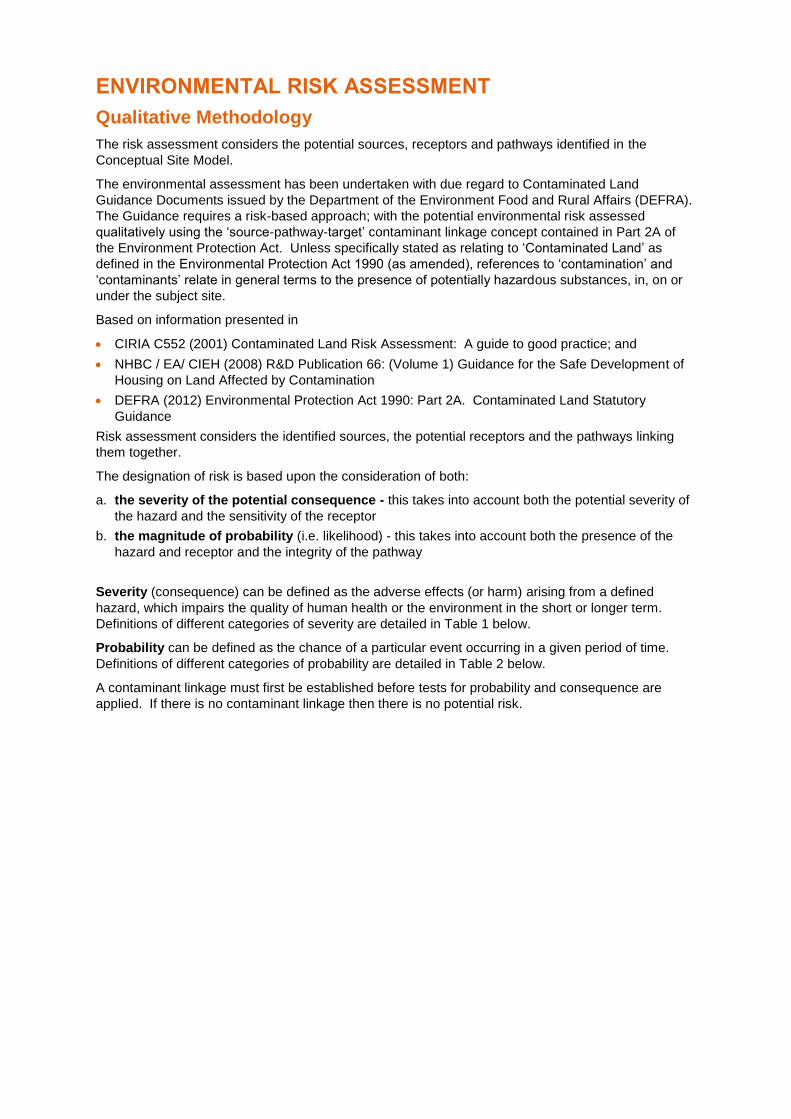
ENVIRONMENTAL RISK ASSESSMENT
Qualitative Methodology
The risk assessment considers the potential sources, receptors and pathways identified in the
Conceptual Site Model.
The environmental assessment has been undertaken with due regard to Contaminated Land
Guidance Documents issued by the Department of the Environment Food and Rural Affairs (DEFRA).
The Guidance requires a risk-based approach; with the potential environmental risk assessed
qualitatively using the ‘source-pathway-target’ contaminant linkage concept contained in Part 2A of
the Environment Protection Act. Unless specifically stated as relating to ‘Contaminated Land’ as
defined in the Environmental Protection Act 1990 (as amended), references to ‘contamination’ and
‘contaminants’ relate in general terms to the presence of potentially hazardous substances, in, on or
under the subject site.
Based on information presented in
CIRIA C552 (2001) Contaminated Land Risk Assessment: A guide to good practice; and
NHBC / EA/ CIEH (2008) R&D Publication 66: (Volume 1) Guidance for the Safe Development of
Housing on Land Affected by Contamination
DEFRA (2012) Environmental Protection Act 1990: Part 2A. Contaminated Land Statutory
Guidance
Risk assessment considers the identified sources, the potential receptors and the pathways linking
them together.
The designation of risk is based upon the consideration of both:
a. the severity of the potential consequence - this takes into account both the potential severity of
the hazard and the sensitivity of the receptor
b. the magnitude of probability (i.e. likelihood) - this takes into account both the presence of the
hazard and receptor and the integrity of the pathway
Severity (consequence) can be defined as the adverse effects (or harm) arising from a defined
hazard, which impairs the quality of human health or the environment in the short or longer term.
Definitions of different categories of severity are detailed in Table 1 below.
Probability can be defined as the chance of a particular event occurring in a given period of time.
Definitions of different categories of probability are detailed in Table 2 below.
A contaminant linkage must first be established before tests for probability and consequence are
applied. If there is no contaminant linkage then there is no potential risk.
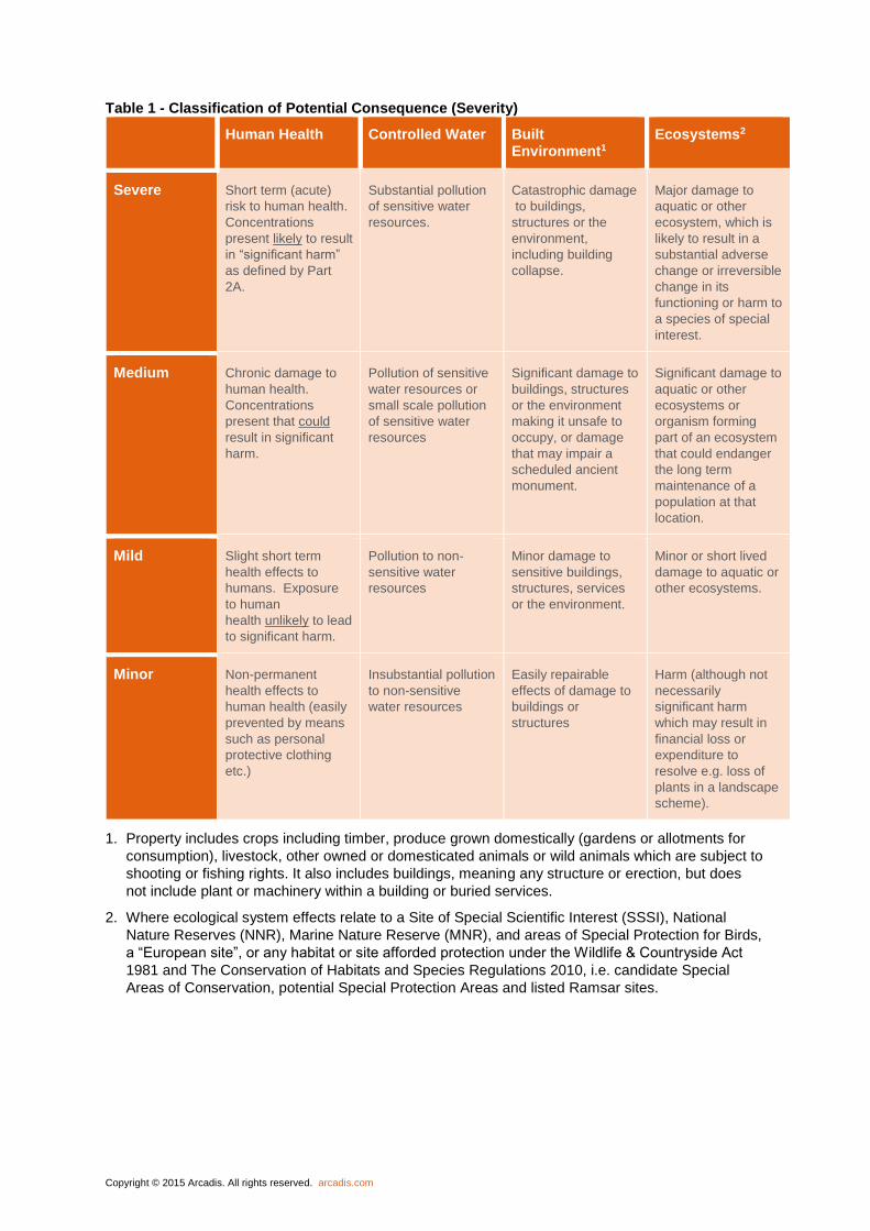
Copyright © 2015 Arcadis. All rights reserved. arcadis.com
Table 1 - Classification of Potential Consequence (Severity)
Human Health Controlled Water Built Environment1
Ecosystems2
Severe Short term (acute)
risk to human health.
Concentrations
present likely to result
in “significant harm”
as defined by Part
2A.
Substantial pollution
of sensitive water
resources.
Catastrophic damage
to buildings,
structures or the
environment,
including building
collapse.
Major damage to
aquatic or other
ecosystem, which is
likely to result in a
substantial adverse
change or irreversible
change in its
functioning or harm to
a species of special
interest.
Medium Chronic damage to
human health.
Concentrations
present that could
result in significant
harm.
Pollution of sensitive
water resources or
small scale pollution
of sensitive water
resources
Significant damage to
buildings, structures
or the environment
making it unsafe to
occupy, or damage
that may impair a
scheduled ancient
monument.
Significant damage to
aquatic or other
ecosystems or
organism forming
part of an ecosystem
that could endanger
the long term
maintenance of a
population at that
location.
Mild Slight short term
health effects to
humans. Exposure
to human
health unlikely to lead
to significant harm.
Pollution to non-
sensitive water
resources
Minor damage to
sensitive buildings,
structures, services
or the environment.
Minor or short lived
damage to aquatic or
other ecosystems.
Minor Non-permanent
health effects to
human health (easily
prevented by means
such as personal
protective clothing
etc.)
Insubstantial pollution
to non-sensitive
water resources
Easily repairable
effects of damage to
buildings or
structures
Harm (although not
necessarily
significant harm
which may result in
financial loss or
expenditure to
resolve e.g. loss of
plants in a landscape
scheme).
1. Property includes crops including timber, produce grown domestically (gardens or allotments for
consumption), livestock, other owned or domesticated animals or wild animals which are subject to
shooting or fishing rights. It also includes buildings, meaning any structure or erection, but does
not include plant or machinery within a building or buried services.
2. Where ecological system effects relate to a Site of Special Scientific Interest (SSSI), National
Nature Reserves (NNR), Marine Nature Reserve (MNR), and areas of Special Protection for Birds,
a “European site”, or any habitat or site afforded protection under the Wildlife & Countryside Act
1981 and The Conservation of Habitats and Species Regulations 2010, i.e. candidate Special
Areas of Conservation, potential Special Protection Areas and listed Ramsar sites.
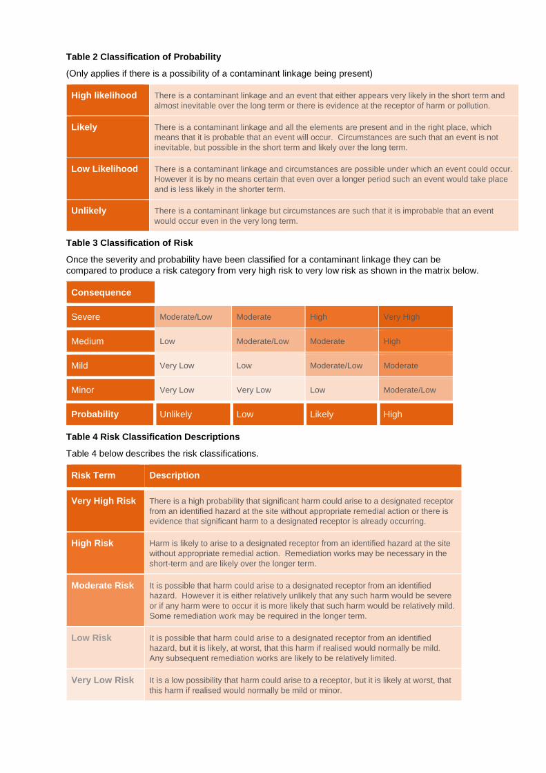
Table 2 Classification of Probability
(Only applies if there is a possibility of a contaminant linkage being present)
High likelihood There is a contaminant linkage and an event that either appears very likely in the short term and
almost inevitable over the long term or there is evidence at the receptor of harm or pollution.
Likely There is a contaminant linkage and all the elements are present and in the right place, which
means that it is probable that an event will occur. Circumstances are such that an event is not
inevitable, but possible in the short term and likely over the long term.
Low Likelihood There is a contaminant linkage and circumstances are possible under which an event could occur.
However it is by no means certain that even over a longer period such an event would take place
and is less likely in the shorter term.
Unlikely There is a contaminant linkage but circumstances are such that it is improbable that an event
would occur even in the very long term.
Table 3 Classification of Risk
Once the severity and probability have been classified for a contaminant linkage they can be
compared to produce a risk category from very high risk to very low risk as shown in the matrix below.
Consequence
Severe Moderate/Low Moderate High Very High
Medium Low Moderate/Low Moderate High
Mild Very Low Low Moderate/Low Moderate
Minor Very Low Very Low Low Moderate/Low
Probability Unlikely Low Likely High
Table 4 Risk Classification Descriptions
Table 4 below describes the risk classifications.
Risk Term Description
Very High Risk There is a high probability that significant harm could arise to a designated receptor
from an identified hazard at the site without appropriate remedial action or there is
evidence that significant harm to a designated receptor is already occurring.
High Risk Harm is likely to arise to a designated receptor from an identified hazard at the site
without appropriate remedial action. Remediation works may be necessary in the
short-term and are likely over the longer term.
Moderate Risk It is possible that harm could arise to a designated receptor from an identified
hazard. However it is either relatively unlikely that any such harm would be severe
or if any harm were to occur it is more likely that such harm would be relatively mild.
Some remediation work may be required in the longer term.
Low Risk It is possible that harm could arise to a designated receptor from an identified
hazard, but it is likely, at worst, that this harm if realised would normally be mild.
Any subsequent remediation works are likely to be relatively limited.
Very Low Risk It is a low possibility that harm could arise to a receptor, but it is likely at worst, that
this harm if realised would normally be mild or minor.

72
Arcadis (UK) Limited
St Mellons Business Park Arcadis Cymru House Fortran Road Cardiff CF3 0EY United Kingdom
T: +44 (0)2920 926 700
arcadis.com


