Embed Size (px)
Citation preview
University of Groningen
Adaptive planningRauws, Ward; de Roo, Gert
Published in:Environment and planning b-Planning & design
DOI:10.1177/0265813516658886
IMPORTANT NOTE: You are advised to consult the publisher's version (publisher's PDF) if you wish to cite fromit. Please check the document version below.
Document VersionPublisher's PDF, also known as Version of record
Publication date:2016
Link to publication in University of Groningen/UMCG research database
Citation for published version (APA):Rauws, W., & de Roo, G. (2016). Adaptive planning: Generating conditions for urban adaptability.Lessonsfrom Dutch organic development strategies. Environment and planning b-Planning & design, 43(6), 1052-1074. https://doi.org/10.1177/0265813516658886
CopyrightOther than for strictly personal use, it is not permitted to download or to forward/distribute the text or part of it without the consent of theauthor(s) and/or copyright holder(s), unless the work is under an open content license (like Creative Commons).
The publication may also be distributed here under the terms of Article 25fa of the Dutch Copyright Act, indicated by the “Taverne” license.More information can be found on the University of Groningen website: https://www.rug.nl/library/open-access/self-archiving-pure/taverne-amendment.
Take-down policyIf you believe that this document breaches copyright please contact us providing details, and we will remove access to the work immediatelyand investigate your claim.
Downloaded from the University of Groningen/UMCG research database (Pure): http://www.rug.nl/research/portal. For technical reasons thenumber of authors shown on this cover page is limited to 10 maximum.
Download date: 25-03-2022
Theme issue article
Adaptive planning:Generating conditions forurban adaptability. Lessonsfrom Dutch organicdevelopment strategies
Ward Rauws and Gert De RooUniversity of Groningen, The Netherlands
Abstract
The development of cities includes a wide variety of uncertainties which challenge spatial planners
and decision makers. In response, planning approaches which move away from the ambition to
achieve predefined outcomes are being explored in the literature. One of them is an adaptive
approach to planning. In this paper, we argue that adaptive planning comes with a shift in focus.
Instead of content and process, it is first of all about creating conditions for development which
support a city’s capacity to respond to changing circumstances. We explore what these conditions
may comprise and how they can be related to planning. First theoretically, by portraying cities as
complex adaptive systems. Then empirically, through an evaluation of the practice of organic
development strategies in which development trajectories are only minimally structured. Based
on a review of 12 Dutch urban development projects, two of which are analysed in detail in this
paper, we identify a series of conditions on spatio-functional configurations and the capacity
building of local actors which enhance urban adaptability.
Keywords
Uncertainty, urban planning, flexibility, responsiveness, self-organization
Introduction
The challenges that spatial planners face in guiding the development trajectories of cities inconditions of uncertainty are increasingly acknowledged in the planning literature (e.g.Albrechts, 2010; Bertolini, 2010; De Roo and Rauws, 2012; Salet et al., 2013; VanWoerkum et al., 2011). In response, both planning scholars and planning practitionershave started to search for planning approaches which are able to coevolve with thedynamics in cities and make cities more responsive to dealing with uncertainties
Corresponding author:
Ward Rauws, Department of Planning and Environment, Faculty of Spatial Sciences, University of Groningen, P.O. Box 800,
9700 AV Groningen, The Netherlands.
Email: [email protected]
Environment and Planning B:
Planning and Design
2016, Vol. 43(6) 1052–1074
! The Author(s) 2016
Reprints and permissions:
sagepub.co.uk/journalsPermissions.nav
DOI: 10.1177/0265813516658886
epb.sagepub.com
(e.g. Ahern, 2011; Albrechts, 2013; Bergevoet and Van Tuijl, 2016; Hillier, 2007). One ofthem is an adaptive approach to planning. Central to this approach is that it does not aim toestablish one particular future configuration – thus assuming that the precise predictions ofan urban development trajectory can be understood and defined – but instead aims tosupport a range of possible future configurations based on conditions for development(see also Hartman, 2016; Wilkinson, 2012; Yamu et al., 2015). These conditions fordevelopment generate ‘possibility spaces’ within which urban structures can take shapeand development processes can unfold.
In this paper, we explore how more traditional, control-oriented planning systems like theDutch one can open up to such an adaptive approach to planning. We do so by evaluatingorganic development strategy (ODS) practices. These are a recent and radical alternative tothe dominant Dutch planning practice (Buitelaar et al., 2014; Urhahn Urban Design, 2010)which we will argue are closely related to the idea of adaptive planning. We aim to answerthree questions:
. Which conditions for development strengthen the adaptive capacity of cities?
. How can these conditions be influenced or generated by planning?
. Which dilemmas for public planners are exposed when critically analysing an adaptiveplanning approach?
In answering these questions, we will start by exploring a complexity science perspectiveon cities (Batty, 2013; Portugali et al., 2012). This perspective invites us to understand citiesas open systems which evolve through a changeable and interrelated mix of processes(Portugali, 2006). These processes include foreseen and unforeseen triggers for change at aglobal level, such as rising sea-levels and economic crises, and formal and informal responsesat the local level, such as policy shifts and citizens’ initiatives. As such, a complexityperspective on cities moves beyond the idea that urban change processes can be reducedto direct causal relationships between system elements which can be understoodindependently of time. Instead, transformations are assumed to evolve at variable speedand impact, and originate from unstable urban configurations. This means that cities areconsidered to be constantly in a process of becoming, with uncertainties an intrinsic part oftheir development trajectories. Within complexity science this mutability of systems is notproblematized, as something to be reduced or avoided. Indeed, it is this very same mutabilitywhich provides systems with the capacity to ‘survive’ and adapt to volatile contexts. For thisreason, a complexity science perspective on cities can help in identifying conditions whichenable or constrain urban adaptability.
Our next step is to analyse how these conditions can be related to spatial planning. For this,we will evaluate ODSs by analysing two cases out of a review of 12 Dutch organic areadevelopment projects (see ODSs: facilitating and guiding local initiators in producing urbanchange section). The Netherlands, once described as a planner’s paradise (Faludi and Van deValk, 1994), has a strong tradition of blueprint planning as well as more communicativepractices, supported by a well-developed planning system and detailed planning proceduresand regulations to guide urban developments towards agreed outcomes (Gerrits et al., 2012).ODSs contrast these planning methods as they allow a variety of possible future spatio-functional configurations to emerge over time and by opening up development processesfor non-professional project initiators. ODSs are based on an open urban programmecombined with a series of conditions which new project initiatives have to meet, such asland-use type ratios, restrictions on nuisance or minimum energy standards. Within certainlimits, they therefore bring greater flexibility to the control-oriented Dutch planning practices.
Rauws and De Roo 1053
Evaluating these practices provides insights into how planning strategies can createenabling conditions for adaptive urban environments. From a complexity scienceperspective, ODSs are viewed as attempts to open up urban development trajectories formore ‘spontaneous’ and less controlled routes of development. Reviewing the planning rulesand the development process in ODS practices can reveal how planners can support cities towelcome more diverse urban fabrics and increase their possibilities for incorporatingexpected and unexpected changes during urban transformations.
Moreover, it enables us to identify the dilemmas for public planners when aiming toenhance the adaptive capacity of cities (compare Savini et al., 2015). For instance, how toserve collective, societal goals while increasing flexibility? How to open up developmentpractices for new coalitions and initiatives, while promoting coherent and inclusive cities?How to enhance responsiveness to unexpected change in the long term while seizing short-term opportunities? By discussing these questions in the context of ODS practices, we exposethe dilemmas related to an adaptive approach to planning, as well as possible ways for publicplanners to deal with these dilemmas.
This paper is structured as follows. We start by further unpacking the notion of adaptiveplanning. Then, we examine which conditions can enable and disrupt an urban area’sadaptive capacity by portraying cities as Complex Adaptive Systems. This provides ananalytical framework for reviewing ODS practices in the the second half of this paperafter which we conclude the paper.
Making sense of adaptive planning through a complexity lens
As early as the 1960s and 1970s, scholars such as McLoughlin (1969) and Rittel and Webber(1973) were already emphasizing the limitations of comprehensive bounded rationality indealing with complex public policy and planning issues. They argued that often planners andpolicymakers do not really deal with ‘tamed problems’, issues which are clearly definableand separable, but with ‘wicked problems’, situations which are inherently fuzzy, fluid anduncertain and therefore impossible to comprehend fully. Their work is again being embracedin recent studies on complexity and planning as several scholars have found inspiration incomplexity science for exploring alternative planning approaches to deal with ‘wickedproblems’ (e.g. De Roo and Rauws, 2012; Gerrits, 2008; Innes and Booher, 2010;Portugali, 2011). To further unpack the notion of adaptive planning, we draw upon thiscomplexity science perspective.
Complexity science challenges planners to rethink the nature of uncertainties and todevelop what we argue is a situational understanding of urban development trajectories,taking into account the uniqueness of an urban configuration in time and space. This isbecause, from a complexity perspective, phenomena are considered to develop non-linearly,meaning that changes can occur unexpectedly and can have a disproportionate effect overtime and space (Heylighen et al., 2006). This also implies that the effects of a traditionalplanning intervention, which tries to direct the evolution of urban developments towards apredetermined future configuration, come with uncertainties, resulting in a gap between thedesired, the intended and the actual results.
A complexity science perspective on cities invites planners to develop an alternative wayof guiding urban transformations. From this perspective, enhancing the capacity of cities tomaintain an optimal ‘fit’ with their dynamic environment should be the focus of planning,rather than trying to establish a particular urban configuration. Taking a complexity lens,cities are assumed to be embedded in a multilayered landscape in which various sub andsupra-systems coevolve in response to changes (Liljenstrom and Svedin, 2005). When these
1054 Environment and Planning B: Planning and Design 43(6)
changes, arising suddenly or gradual, expected or unexpected, lead to a mismatch betweenthe city and its context, this will mostly probably trigger a transition process through whichthe city adapts to its new context. If not, the city will get drawn into a lock-in situation,losing its connections with and relevance to its environment, and ultimately declining (seeHassink, 2005). Transitions towards a new relatively stable ‘fit’ are likely to includequalitative alterations as well as quantitative ones, including a change in both a city’sstructure and function (De Roo, 2012; Yamu et al., 2015). We are reminded of citieswhich undergo a transition from being centres of industrial production to central nodes inthe financial and wider services economy, or to being places for leisure, tourism andexperience. Due to the fundamental changes transitions inhibit, supporting the futurevitality of cities is not helped as much by planning strategies which primarily focus oncontent (what spatio-functional configuration should be planned for) or process (whom toinvolve and reach consensus with on a particular future development path) After all, whatwill turn out to be the best possible urban configuration and the most effective and legitimateactor-coalition is hard to predict.
Therefore, we argue that an adaptive approach to planning first requires a focus on theconditions under which urban developments can unfold. These conditions are end-stateindependent and are concerned with strengthening the capacity of a city undergoingtransitions and building towards new vital configurations, while remaining a liveable androbust system over time. This proposal connects to the work of Alfasi and Portugali (2007),Holcombe (2013), Andersson (2014) and Moroni (2015) in which more generic frameworksfor development based on urban codes is suggested, but differs in two respects. The codesthese authors introduce concern, among other points, ‘the relation between element of thebuilt environment’ (Alfasi and Portugali, 2007: 169), refer to general types of situations andshould merely ‘prohibit certain externalities rather than particular activities at certainlocations’ (Moroni, 2015: 10). While the conditions for development we refer to alsoinclude principles to guide emerging spatio-functional configurations, they are not limitedto such principles. They are also concerned with building the capacity of local actors, as webelieve their capacity to start initiatives can also have a substantial impact on urbanadaptability. These conditions include, for example, measures that foster informationexchange or increase connectivity between actors.
A second difference is that we do not follow authors such as Holcombe (2013) andAndersson (2014) in considering condition-based planning strategies as an opportunity toestablish a more liberal, private enterprise-led planning system. We believe governments dohave an active role in pursuing collective, societal ambitions, and encouraging sociallypreferred directions of development. This brings us to the question of how purposefullyinfluencing the direction of development trajectories relates to adaptive planning.
Various aspects are emphasized in the debate on adaptive planning. Some scholarsemphasize the need for incremental strategies and learning by doing, linking in withLindbloms’ ‘muddling through’ (e.g. Alfasi and Portugali, 2004; Kato and Ahern, 2008).Others start from a socioecological perspective and refer to adaptability as the capacity of asystem to remain stable by adjusting to internal dynamics and external changes (Folke et al.,2010). While these aspects are important elements of an adaptive approach to planning, weargue that such an approach also includes a normative dimension. In other words, adaptiveplanning is more than supporting the self-reliance of urban systems in which urbandevelopment results in some kind of social Darwinism (see also Davoudi, 2012).Generating conditions for urban adaptability cannot and should not be done in isolationfrom societal values, norms and agreements (including political agreements), for example,concerning deprived neighbourhoods or vulnerable ecological assets. The desire to create a
Rauws and De Roo 1055
better future – one which is, for instance, believed to deliver more liveable and attractivecities – cannot be ignored either. This means that generating conditions for development isnot only about fostering urban adaptability but also includes making preferred developmentdirections more likely to emerge.
To conclude, our proposal for an adaptive planning approach includes two steps: (1)creating conditions for development with regard to future spatio-functional configurationsand building the capacity of local actors who strengthen urban adaptability; and (2)tweaking these conditions to the extent that in the course of an area’s development,socially preferred trajectories become more likely to emerge and those which areconsidered to be problematic are avoided as much as possible. The dynamic ‘real’ is thuslinked with the desired ‘ideal’ (Batty, 2013). Tweaking conditions in the spirit of the lattershould of course be motivated by democratic decision-making.
Deriving conditions for urban adaptability by portraying cities ascomplex adaptive systems
In this section, we will analyse which conditions for development should be part of anadaptive planning approach. By casting cities as Complex Adaptive Systems (CAS) andrelating the properties which allow CAS to maintain a ‘fit’ with their dynamicenvironment to urban systems, we identify which conditions enable or disrupt urbanadaptability. We distinguish four properties: although each has a different emphasis, theconditions derived can partly overlap. These conditions are discussed on the basis of theliterature on dealing with uncertainties and non-linear dynamics in social and socio-spatialsystems. We present the system property first, followed by the derived conditions which wesuggest should be generated by planners and other stakeholders (i.e. local initiators). TheCAS properties are
(1) Non-linear development trajectories
A CAS perspective on cities considers urban development to progress non-linearly, resultingin development trajectories which vary in speed and scope over time. As well as a varyingdegree of uncertainty, this also means new system configurations can arise relatively quickly.Urban transformations can include sudden notable shifts, such as an inflow of migrantswhich dramatically shifts the social composition and functioning of an urban district (Albaet al., 2000), or of less visible but nevertheless fundamental shifts, for example, the way thatthe use of social media transforms our use of public space (Drucker and Gumpert, 2012).
. Disruptive conditions: when the uncertainties which come with non-linear change aresolely regarded as risks of failure, this is likely to frustrate the system’s adaptability(Holling, 1978). This means that stakeholders can become paralysed and no longer bewilling to take action or make investments (Beck, 1994). When considering publicplanning authorities in particular, this can limit their capacity to improvise, innovateand be creative, as they will lack the confidence to operate proactively (Gunn andHillier, 2014).
. Enabling conditions: non-linear development trajectories challenge planners and otherstakeholders to embrace uncertainty as a core component of urban development (DeRoo, 2012). They require planners, for example, to create institutional arrangementsand spatial designs which support various future configurations while guaranteeingbasic rights (Rauws et al., 2014; Moroni, 2015).
1056 Environment and Planning B: Planning and Design 43(6)
(2) Responsive to the dynamic environment
CAS theories portray cities as open systems which are sensitive to changing circumstancesand therefore need to adapt to maintain their functionality. The attention being paid toclimate-proof cities to cope with the increase in extreme weather conditions or rising sealevels is an example of responsiveness to changing circumstances (Brown, 2012).
. Disruptive conditions: lock-in situations in which an urban system has a high level ofspecialization and expresses an increasing functional, cognitive and political rigidity,should be avoided (Martin and Sunley, 2007; Hartman and De Roo, 2013). Meanwhile,too much diversity in an urban configuration can also have a disruptive effect, resulting forexample in a high level of fragmentation, missed opportunities for synergies betweendevelopments and inefficient use of resources (Duit, 2012, 2010; Folke et al., 2005).
. Enabling conditions: responsive urban systems require an enhanced manoeuvrabilitywhich builds on the system’s distinctive qualities compared to neighbouring systems(Hartman et al., 2011). This means planners are advised to coordinate the activeexploration of likely alternative development trajectories. Flexible project boundaries,experiments and trend-watching can help such exploration (Gerrits and Teisman, 2012;Rauws and De Roo, 2011; Rotmans et al., 2012). Also the awareness of otherstakeholders of an area’s distinctive characteristics and how they can use thesecharacteristics to connect to potential future states has to be strengthened (Boelens,2009; Hartman et al., 2011). Planners can support this process by combining inspiringvisioning with a pragmatic development approach when it comes to exploiting unexpectedor planned opportunities (Rauws et al., 2014).
(3) Self-organization
According to CAS theories, self-organization is a key property through which systems self-innovate and self-stabilize in response to changing circumstances. In the context of cities, thisincludes the rise of new structures, patterns and organizations within an urban system, as aresult of interaction between actors and without external coordination. Examples of self-organization processes can be found in urban land transformation (Webster and Lai, 2003),traffic flows (Chowdhury and Schadschneider, 1999) and informal settlements (Silva andFarrall, 2016).
. Disruptive conditions: the self-organizing capacity of systems is frustrated when its actors’efforts to deploy activities, establish relationships and take decisions which contribute tothe emergence of internal organization are suppressed (Prokopenko, 2008). This occursfor example when planning authorities have predefined the scope and the timeframewithin which citizen involvement in urban projects is accepted too tightly (Boonstraand Boelens, 2011; Sagaris, 2013), or present a ‘supposedly objective design syntax’which undermines the generative capacity of other stakeholders (Van Assche et al.,2013: 191).
. Enabling conditions: self-organization in urban systems is helped by settings in which localinitiators can easily establish collaborations according to their own motivations andinterests, and start projects of a manageable size for non-professional planners(Boonstra and Boelens, 2011; Sagaris, 2013). Planners can encourage this in at leastthree ways: (1) by creating fora for interaction and mobilizing creative minds,strategists and visionaries (Rotmans et al., 2012; Van Buuren et al., 2012),
Rauws and De Roo 1057
(2) by devising institutional frameworks and spatial designs that support small-scaleprojects (Alfasi and Portugali, 2004) and (3) by considering citizens as co-creators ofthe city who should be able to understand and contribute to the rules and regulationswhich guide urban development (Alfasi and Portugali, 2007).
(4) Coevolution
A final property of CAS, which explains their continuous reconfiguration, is coevolution. Itimplies the mutual adaptation process between urban systems (and non-urban systems),including systems related both horizontally (e.g. other cities) and hierarchically (e.g. urbanregions or neighbourhoods). Such coevolutionary processes may involve the spatialconfiguration of an urban area as well as its institutional arrangements. An example is thecoevolution between sustainable energy initiatives and urban governance through which newtrajectories for urban energy systems are established (Rydin et al., 2013).
. Disrupting conditions: urban coevolution is impeded by situations in which one systemdirects the development trajectories of other systems and subsystems while ignoring theirfeedback (Van Buuren et al., 2012). Grand designs contribute to such situations as theyfavour linear planning processes over cyclical ones, diminishing opportunities for mutualadaptation between urban systems.
. Enabling conditions: by designing spatial and institutional frameworks which allowincremental or modular development, planners increase the opportunities for mutualadaptation between systems (Gerrits and Teisman, 2012; Rotmans et al., 2012).Attention to systematic learning by both planning authorities and project initiators cansupport the successful inherence of those system characteristics which ensure that asystem fits with changes in neighbouring systems and adjusting the characteristicswhich constrain this process (Atzema et al., 2009).
In this section, we have explored enabling and disruptive conditions for urbanadaptability from a CAS perspective. To understand how planners can integrate theseconditions in planning strategies and the dilemmas this brings for public planners, thenext section includes an evaluation of ODS practices. As the above teaches us thatenabling and disruptive conditions are often each other’s antitheses, we will only focus onhow to create enabling conditions.
ODSs: facilitating and guiding local initiators in producingurban change
ODSs emerged as a response to the dominant housing and real estate practice in theNetherlands since the Second World War (Buitelaar et al., 2014; Rauws, 2016). Thispractice is primarily supply-oriented and typically includes large-scale projects based on aserial, cost-efficient production of mono-functional, individual units (e.g. single-familyhomes, apartments). It is a strongly institutionalized practice as project developers andsocial housing corporations, along with municipalities, control both what will be built andby whom. The demands of the facilities’ actual users are only considered to a limited extent(Blijie et al., 2009; Boelens and Visser, 2011; Bontje, 2003). As a result of the recent housingand real estate crisis and the re-emerging demand among contemporary Dutch citizens totake the lead in developing their everyday urban environment (Hajer, 2011), the downsidesof traditional approaches are receiving increasing attention. Overly optimistic expectations
1058 Environment and Planning B: Planning and Design 43(6)
for land revenues combined with limited flexibility in urban programmes resulted in financialfailures and/or an inability to meet this new demand (Janssen-Jansen et al., 2012; Rauwset al., 2014). ODSs are in this respect a radical and well-received alternative.
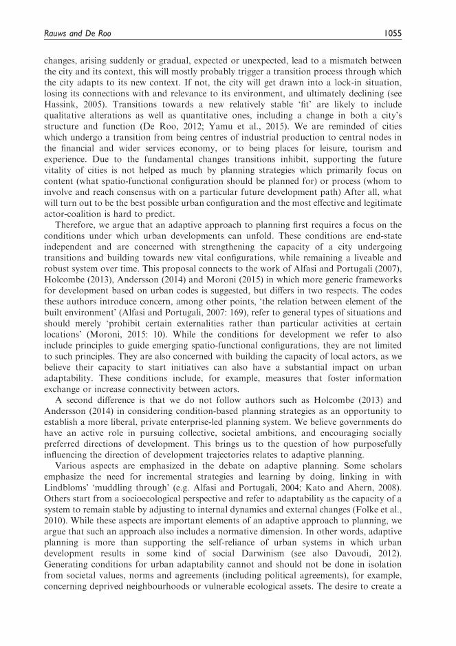
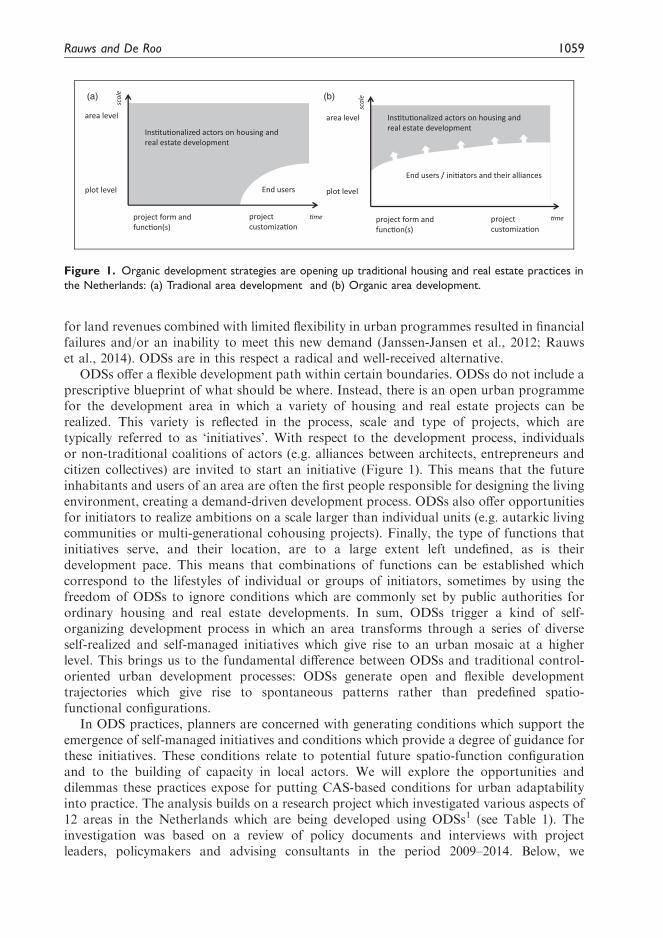
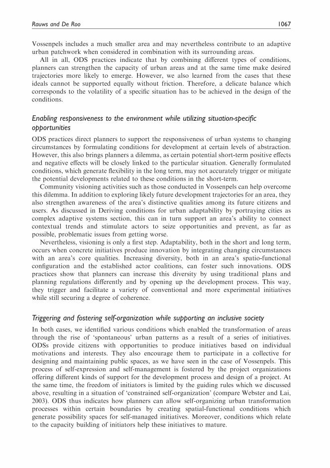
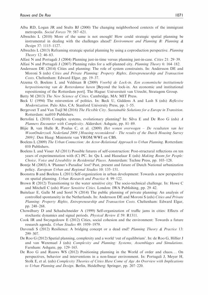
ODSs offer a flexible development path within certain boundaries. ODSs do not include aprescriptive blueprint of what should be where. Instead, there is an open urban programmefor the development area in which a variety of housing and real estate projects can berealized. This variety is reflected in the process, scale and type of projects, which aretypically referred to as ‘initiatives’. With respect to the development process, individualsor non-traditional coalitions of actors (e.g. alliances between architects, entrepreneurs andcitizen collectives) are invited to start an initiative (Figure 1). This means that the futureinhabitants and users of an area are often the first people responsible for designing the livingenvironment, creating a demand-driven development process. ODSs also offer opportunitiesfor initiators to realize ambitions on a scale larger than individual units (e.g. autarkic livingcommunities or multi-generational cohousing projects). Finally, the type of functions thatinitiatives serve, and their location, are to a large extent left undefined, as is theirdevelopment pace. This means that combinations of functions can be established whichcorrespond to the lifestyles of individual or groups of initiators, sometimes by using thefreedom of ODSs to ignore conditions which are commonly set by public authorities forordinary housing and real estate developments. In sum, ODSs trigger a kind of self-organizing development process in which an area transforms through a series of diverseself-realized and self-managed initiatives which give rise to an urban mosaic at a higherlevel. This brings us to the fundamental difference between ODSs and traditional control-oriented urban development processes: ODSs generate open and flexible developmenttrajectories which give rise to spontaneous patterns rather than predefined spatio-functional configurations.
In ODS practices, planners are concerned with generating conditions which support theemergence of self-managed initiatives and conditions which provide a degree of guidance forthese initiatives. These conditions relate to potential future spatio-function configurationand to the building of capacity in local actors. We will explore the opportunities anddilemmas these practices expose for putting CAS-based conditions for urban adaptabilityinto practice. The analysis builds on a research project which investigated various aspects of12 areas in the Netherlands which are being developed using ODSs1 (see Table 1). Theinvestigation was based on a review of policy documents and interviews with projectleaders, policymakers and advising consultants in the period 2009–2014. Below, we
Ins�tu�onalized actors on housing and real estate development
area level
plot level
scale
�meproject form andfunc�on(s)
End users
project customiza�on
Ins�tu�onalized actors on housing and real estate development
area level
(a) (b)
plot level
scale
�me
End users / ini�ators and their alliances
project form andfunc�on(s)
project customiza�on
Figure 1. Organic development strategies are opening up traditional housing and real estate practices in
the Netherlands: (a) Tradional area development and (b) Organic area development.
Rauws and De Roo 1059
present two of the 12 cases. These projects were selected because they reflect the variety ofdevelopments to which ODSs are applied. The first case, Vossenpels in the city of Nijmegen,includes a small brownfield development with a mix of dwellings and greenhouses. Thesecond case is a large greenfield development, Oosterwold, which is expected to become anew urban district of the city of Almere (see also Rauws, 2016).
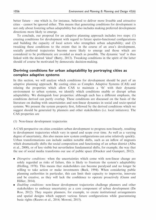
Vossenpels (City of Nijmegen)
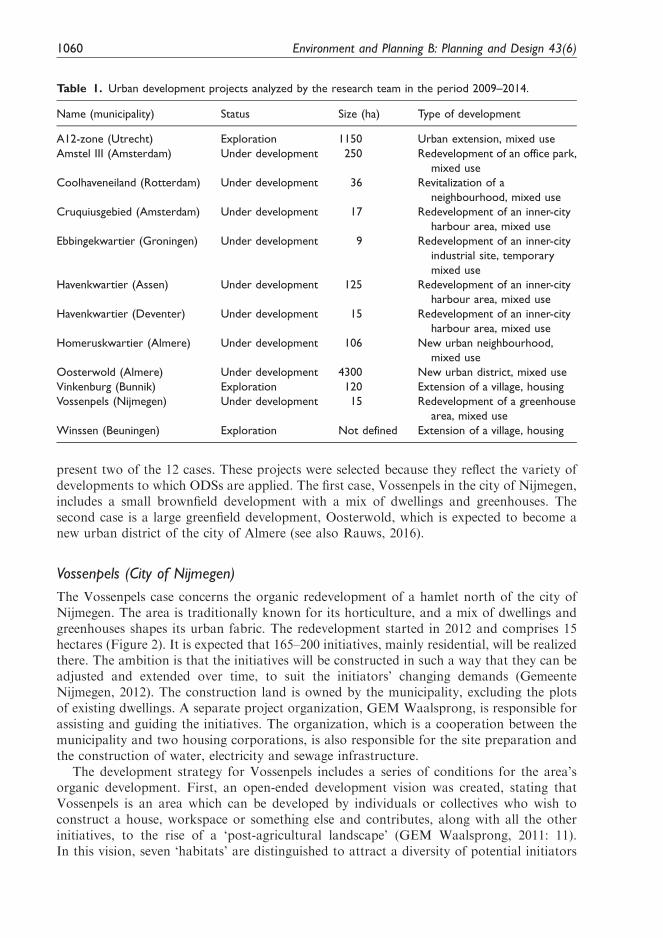
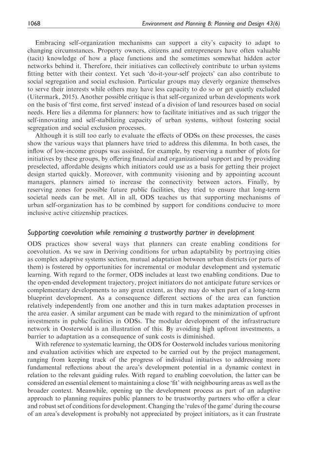
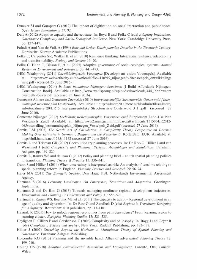
The Vossenpels case concerns the organic redevelopment of a hamlet north of the city ofNijmegen. The area is traditionally known for its horticulture, and a mix of dwellings andgreenhouses shapes its urban fabric. The redevelopment started in 2012 and comprises 15hectares (Figure 2). It is expected that 165–200 initiatives, mainly residential, will be realizedthere. The ambition is that the initiatives will be constructed in such a way that they can beadjusted and extended over time, to suit the initiators’ changing demands (GemeenteNijmegen, 2012). The construction land is owned by the municipality, excluding the plotsof existing dwellings. A separate project organization, GEM Waalsprong, is responsible forassisting and guiding the initiatives. The organization, which is a cooperation between themunicipality and two housing corporations, is also responsible for the site preparation andthe construction of water, electricity and sewage infrastructure.
The development strategy for Vossenpels includes a series of conditions for the area’sorganic development. First, an open-ended development vision was created, stating thatVossenpels is an area which can be developed by individuals or collectives who wish toconstruct a house, workspace or something else and contributes, along with all the otherinitiatives, to the rise of a ‘post-agricultural landscape’ (GEM Waalsprong, 2011: 11).In this vision, seven ‘habitats’ are distinguished to attract a diversity of potential initiators
Table 1. Urban development projects analyzed by the research team in the period 2009–2014.
Name (municipality) Status Size (ha) Type of development
A12-zone (Utrecht) Exploration 1150 Urban extension, mixed use
Amstel III (Amsterdam) Under development 250 Redevelopment of an office park,
mixed use
Coolhaveneiland (Rotterdam) Under development 36 Revitalization of a
neighbourhood, mixed use
Cruquiusgebied (Amsterdam) Under development 17 Redevelopment of an inner-city
harbour area, mixed use
Ebbingekwartier (Groningen) Under development 9 Redevelopment of an inner-city
industrial site, temporary
mixed use
Havenkwartier (Assen) Under development 125 Redevelopment of an inner-city
harbour area, mixed use
Havenkwartier (Deventer) Under development 15 Redevelopment of an inner-city
harbour area, mixed use
Homeruskwartier (Almere) Under development 106 New urban neighbourhood,
mixed use
Oosterwold (Almere) Under development 4300 New urban district, mixed use
Vinkenburg (Bunnik) Exploration 120 Extension of a village, housing
Vossenpels (Nijmegen) Under development 15 Redevelopment of a greenhouse
area, mixed use
Winssen (Beuningen) Exploration Not defined Extension of a village, housing
1060 Environment and Planning B: Planning and Design 43(6)
to join in. The vision is supported by a general land-use plan in which plot sizes are leftundefined, a construction time of 15 years is allowed and possible future extensions ofbuildings are anticipated. As such, the ODS for Vossenpels is not focused on controllingurban development towards a narrowly predefined future state. Instead, it invites localinitiators to produce urban change by offering possibility spaces.
The development vision was established by an interactive process which was mainly aimedat inspiring and connecting potential initiators and stimulating their collaboration. Itincluded a community visioning event and a digital platform for potential initiators tolaunch their ideas. A similar process, in which initiators are invited collectively to designand maintain public space, is currently ongoing. The development of Vossenpels iscompletely based on small-scale local initiatives, including privately commissionedhousing, creative industries and cohousing initiatives. GEM Waalsprong offers initiatorsexamples of best practices, step-by-step guides on how to complete the legal procedures,and help from professional urban designers. The project organization thus aims to inspireand facilitate citizens and entrepreneurs to develop an initiative in various ways.
In addition to the open and inviting development vision, planners also composed guidingrules. An important part of these rules is integrated in the land-use plan. This plan indicates thatthe existing physical patterns, such as the historically developed street layout, green areas andelongated shape of existing plots, must be respected. Next, the zoning allows for a mix of livingspace, offices, shops and food services, but prohibits other types of development in order toprevent too much competition with functions in adjacent urban areas. The plan also includes amaximum for the area available to non-housing functions in the development area and the ratioof built surface to the size of a plot. A maximum building height and a minimum distancebetween a building and the edge of the plot are meant to prevent negative outcomes.
Hence, the open development vision which invites citizens to realize an initiativeaccording to their own preferences is guided by a comprehensive set of rules whichbounds the flexibility of the Vossenpels development trajectory.
In addition to these restrictions, other guiding rules aim to encourage particular types ofdevelopment. Social diversity is encouraged by supporting initiators with low and middleincomes. This is done by reserving plots, financial and organizational support and byproviding a series of preselected, affordable designs which can be used as a basis for such
Figure 2. The global land use plan of Vossenpels (a) and an artist’s impression of a possible project by
private commissioning (b) (www.plantjevlag.nl).
Rauws and De Roo 1061
projects (GEM Waalsprong, 2014). Moreover, potential initiators themselves definedadditional guiding rules for the ‘habitats’ which were distinguished during the communityvisioning process with the aim of harmonizing the designs of individual projects. These rulesconcern the aesthetics of the urban fabric (e.g. the building materials used and the fencing-offof plots) and are included in the plots’ purchase agreements. Both are examples of howsocietal ideals are integrated in the open development framework of an ODS, somewhatdecreasing its flexibility.
To conclude, various conditions are created to guide the development of Vossenpels.These can be interpreted traditionally, as rules installed to enforce a particulardevelopment trajectory. However, in the context of the organic development aimed for inVossenpels, they serve other goals: to encourage self-managed initiatives, to avoid conflictbetween these initiatives and to stimulate synergy and coherence in the area’s developmenttrajectory, which is accepted as being as yet unknown. Taken together, these conditionscould offer planners examples of how to enable urban adaptability, as will be discussed inthe next section. First, however, we will introduce the second case.
Oosterwold (City of Almere)
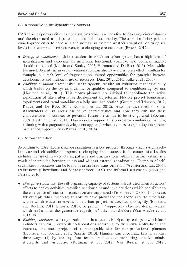
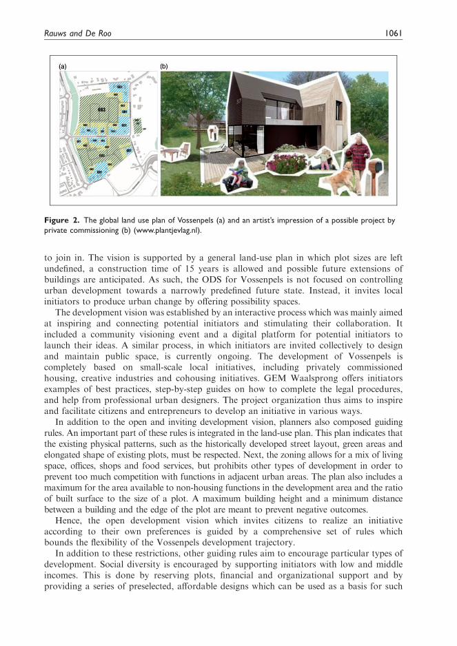
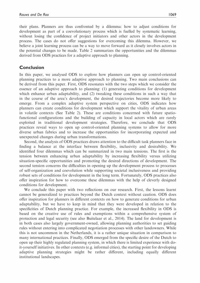
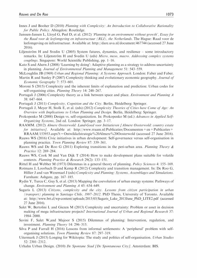
The organic development of Oosterwold will add a new urban district to the east side of thecity of Almere. The project area is much larger than that of ‘Vossenpels’: it covers 4300hectares and is designed to include mixed-use (living, offices, farming and leisure)developments (Figure 3). The first initiatives were started in spring 2014 and if the area isfully developed it is expected that it will contain at least 15,000 dwellings and support 26,000jobs (Gemeente Almere and Gemeente Zeewolde, 2012). The development of Oosterwold isthe largest and most radical application of ODSs in the Netherlands so far. By Dutchstandards, a relatively large number of responsibilities have been transferred to the localinitiators. For example, they are expected to construct the access road to their plot, make theinitiative partly self-supporting in terms of energy and wastewater treatment, and contributeto local food production. Half the land in the area is owned by Central Government RealEstate Agency (Rijksvastgoedbedrijf: RVOB). Profits earned from these plots will to a largeextent be used for providing public facilities in the area and the city as a whole.
Figure 3. Overview of the Oosterwold development (a) area and an impression of how the area might
develop organically over time (b) (RAAMM, 2012).
1062 Environment and Planning B: Planning and Design 43(6)
The development strategy generates various conditions for the organic development ofOosterwold. As with Vossenpels, a vision of an open development programme has beendrafted. This vision is being translated into a structure plan and aims to inspire potentialinitiators to shape a low-density living and working environment in a countryside-like setting(Gemeente Almere and Gemeente Zeewolde, 2012). As no timeframe has been set for thedevelopment’s completion, Oosterwold’s development trajectory is open ended.Architectural regulations have been abandoned and different functions can beaccommodated as long as they do not cause nuisance to neighbouring plots. This meansthat the ODS for Oosterwold leaves open a wider range of development trajectories than theODS for Vossenpels. However, initiators do have to take into account the existing functionsand reservations for the future development of infrastructure and nature areas.
Similar to Vossenpels, a specially founded organization, ‘Maak Oosterwold’, isfacilitating the development of initiatives in various ways. Manuals and guidance fororganizing the development process and completing legal planning procedures are alsoprovided in Oosterwold. Moreover, an account manager has been appointed to connectinitiators, including professional project developers, to the current landowners, to helpthem work out their ideas while taking into account the development vision, and toidentify options for synergy between initiatives.
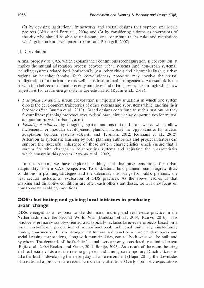
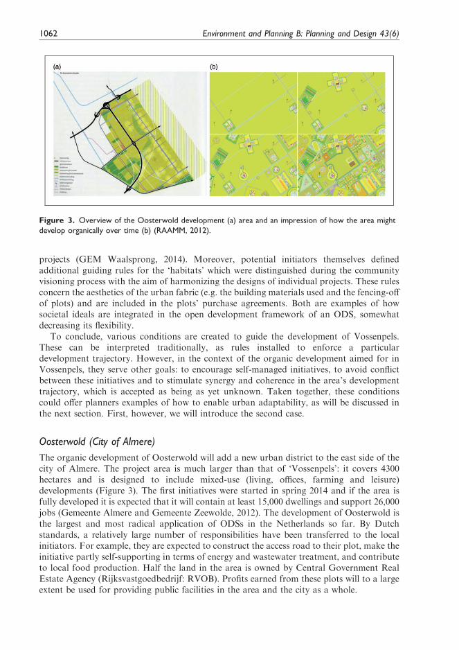
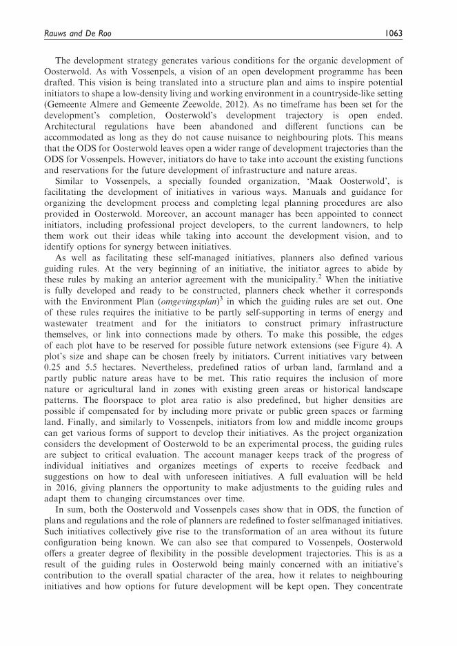
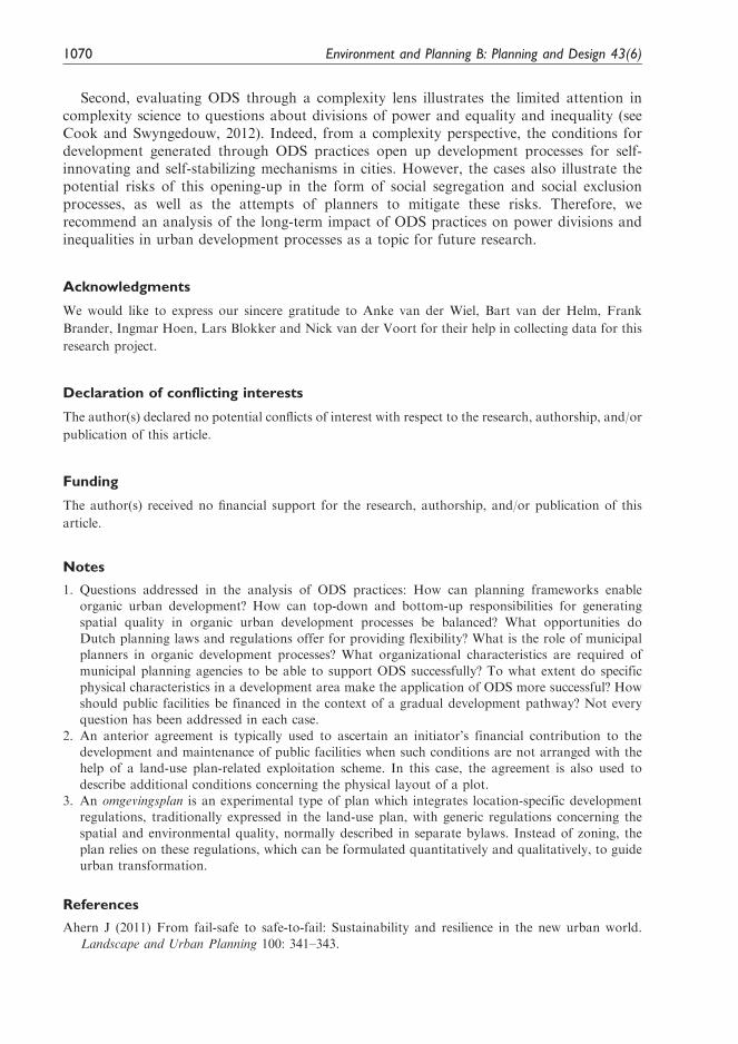
As well as facilitating these self-managed initiatives, planners also defined variousguiding rules. At the very beginning of an initiative, the initiator agrees to abide bythese rules by making an anterior agreement with the municipality.2 When the initiativeis fully developed and ready to be constructed, planners check whether it correspondswith the Environment Plan (omgevingsplan)3 in which the guiding rules are set out. Oneof these rules requires the initiative to be partly self-supporting in terms of energy andwastewater treatment and for the initiators to construct primary infrastructurethemselves, or link into connections made by others. To make this possible, the edgesof each plot have to be reserved for possible future network extensions (see Figure 4). Aplot’s size and shape can be chosen freely by initiators. Current initiatives vary between0.25 and 5.5 hectares. Nevertheless, predefined ratios of urban land, farmland and apartly public nature areas have to be met. This ratio requires the inclusion of morenature or agricultural land in zones with existing green areas or historical landscapepatterns. The floorspace to plot area ratio is also predefined, but higher densities arepossible if compensated for by including more private or public green spaces or farmingland. Finally, and similarly to Vossenpels, initiators from low and middle income groupscan get various forms of support to develop their initiatives. As the project organizationconsiders the development of Oosterwold to be an experimental process, the guiding rulesare subject to critical evaluation. The account manager keeps track of the progress ofindividual initiatives and organizes meetings of experts to receive feedback andsuggestions on how to deal with unforeseen initiatives. A full evaluation will be heldin 2016, giving planners the opportunity to make adjustments to the guiding rules andadapt them to changing circumstances over time.
In sum, both the Oosterwold and Vossenpels cases show that in ODS, the function ofplans and regulations and the role of planners are redefined to foster selfmanaged initiatives.Such initiatives collectively give rise to the transformation of an area without its futureconfiguration being known. We can also see that compared to Vossenpels, Oosterwoldoffers a greater degree of flexibility in the possible development trajectories. This is as aresult of the guiding rules in Oosterwold being mainly concerned with an initiative’scontribution to the overall spatial character of the area, how it relates to neighbouringinitiatives and how options for future development will be kept open. They concentrate
Rauws and De Roo 1063
on avoiding possible negative consequences, such as free-rider behaviour, blocking futuredevelopment options and unwanted externalities, and securing a minimum level of spatialcoherence and environmental quality. In the case of Vossenpels, the range of possible futureconfigurations is more narrowly defined as more conditions on the individual projects areincluded. Our next step will be to evaluate the opportunities and dilemmas ODS practicesexpose in generating conditions for urban adaptability.
Lessons from ODSs for generating conditions for urban adaptability
In this section, we will evaluate how ODS elements can support planners in generatingconditions for urban adaptability and which dilemmas they may face in doing so. Thisanalysis is structured along the four CAS properties which are central to this paper: non-linear development trajectories, responsiveness to the dynamic environment, self-organization and coevolution. The analysis is summarized in Table 2.
Coping with non-linear development trajectories while promoting preferred outcomes
In both case studies, the idea of developing a predefined fixed urban configuration has beenabandoned to a large extent. It is accepted that the uncertainties resulting from the relativefreedom given to initiators and from market and societal trends generate urban developmenttrajectories which progress at varying speeds and with unexpected twists. This acceptance isillustrated by the relatively open urban programmes and the loose or unrestricted timeframe
Figure 4. Step-by-step development of road, bike and water infrastructure. Land owners have to reserve
the edge of their plot for possible future infrastructure and they each have to add a network extension on at
least one side of the plot. This way the network grows in an organic way (Gemeente Almere & Gemeente
Zeewolde, 2013 p.51).
1064 Environment and Planning B: Planning and Design 43(6)
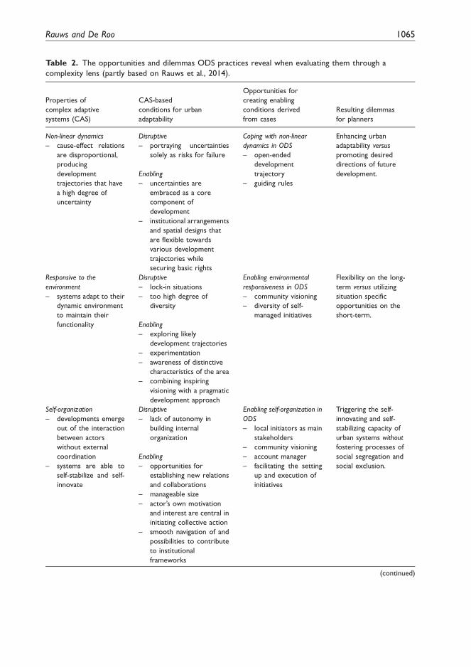
Table 2. The opportunities and dilemmas ODS practices reveal when evaluating them through a
complexity lens (partly based on Rauws et al., 2014).
Properties of
complex adaptive
systems (CAS)
CAS-based
conditions for urban
adaptability
Opportunities for
creating enabling
conditions derived
from cases
Resulting dilemmas
for planners
Non-linear dynamics
– cause-effect relations
are disproportional,
producing
development
trajectories that have
a high degree of
uncertainty
Disruptive
– portraying uncertainties
solely as risks for failure
Enabling
– uncertainties are
embraced as a core
component of
development
– institutional arrangements
and spatial designs that
are flexible towards
various development
trajectories while
securing basic rights
Coping with non-linear
dynamics in ODS
– open-ended
development
trajectory
– guiding rules
Enhancing urban
adaptability versus
promoting desired
directions of future
development.
Responsive to the
environment
– systems adapt to their
dynamic environment
to maintain their
functionality
Disruptive
– lock-in situations
– too high degree of
diversity
Enabling
– exploring likely
development trajectories
– experimentation
– awareness of distinctive
characteristics of the area
– combining inspiring
visioning with a pragmatic
development approach
Enabling environmental
responsiveness in ODS
– community visioning
– diversity of self-
managed initiatives
Flexibility on the long-
term versus utilizing
situation specific
opportunities on the
short-term.
Self-organization
– developments emerge
out of the interaction
between actors
without external
coordination
– systems are able to
self-stabilize and self-
innovate
Disruptive
– lack of autonomy in
building internal
organization
Enabling
– opportunities for
establishing new relations
and collaborations
– manageable size
– actor’s own motivation
and interest are central in
initiating collective action
– smooth navigation of and
possibilities to contribute
to institutional
frameworks
Enabling self-organization in
ODS
– local initiators as main
stakeholders
– community visioning
– account manager
– facilitating the setting
up and execution of
initiatives
Triggering the self-
innovating and self-
stabilizing capacity of
urban systems without
fostering processes of
social segregation and
social exclusion.
(continued)
Rauws and De Roo 1065
for developing initiatives. However, the open-ended development trajectory does not meanODS represents an ‘anything goes’ approach.
The open-ended development trajectory is accompanied by guiding rules. In both cases,these rules display three functions, all of which are involved in achieving a delicate balancebetween generating openness and flexibility on the one hand, and avoiding possible negativeconsequences and fostering preferred directions of development on the other. First, guidingrules are used to create and secure flexibility during the development trajectory. The globalland-use plan for Vossenpels and the compulsory reservation zone for possible futureinfrastructure network extensions in Oosterwold are examples of this. Second, guidingrules are used to integrate societal values, norms and agreements in the developmentprocess. For example, they prevent initiators from creating a nuisance for neighbouringinitiatives, and as such protect their utility, liveability and financial value. The third andfinal function of the guiding rules is about stimulating the emergence of desired trajectories,such as the rise of an urban district in a ‘countryside-like setting’ in Oosterwold. The fixedratio between urban land, nature and farmland for each plot is an example of a guiding rulewhich helps bring about such an outcome.
In contrast to the first two types of guiding rules, the third type of condition aims tosupport the emergence of particular kinds of urban configurations over others. This bringsus to the dilemma planners face between enhancing urban adaptability against promotingdesired directions of future development. The former can support cities in coping with andprofiting from different potential development directions, while the latter addresses thoseissues or threats which require collective efforts. Examples include climate change, affordablehousing or sustainable transportation. In other words, being adaptive does not mean beingindifferent about those trajectories which may emerge over time. ODS practices show howplanners try to overcome this dilemma by formulating the conditions for developmentcleverly. For example, by fostering a ‘countryside-like setting’ in Oosterwold by onlydefining the ratio between land-uses, some flexibility is retained around how the land-usetypes are organized, what kind of urban, nature or agriculture functions will be realized, andwhich arrangements can be formed between plot owners regarding user rights andmaintenance responsibilities. In Vossenpels, the guiding rules with regard to a project’sdesign and function are much more strict, partly initiated by the inhabitants themselves,limiting the spatio-functional adaptability of an area. Here, it is important to consider that
Table 2. Continued.
Properties of
complex adaptive
systems (CAS)
CAS-based
conditions for urban
adaptability
Opportunities for
creating enabling
conditions derived
from cases
Resulting dilemmas
for planners
Coevolution
– developments are
generated by a mutual
adaptation process
between (sub)systems
Disruptive
– one system or subsystem
directs the paths of
others, while ignoring
their feedback
– linear planning process
Enabling
– modular development
– systematic learning
Enabling coevolution in ODS
– open-ended
development
trajectory
– minimization of
upfront investments in
public facilities
– global land use plan
– evaluation of guiding
rules
Altering conditions for
development as part of an
coevolutionary process
without losing the
confidence of project
initiators and other
actors in the
development process.
1066 Environment and Planning B: Planning and Design 43(6)
Vossenpels includes a much smaller area and may nevertheless contribute to an adaptiveurban patchwork when considered in combination with its surrounding areas.
All in all, ODS practices indicate that by combining different types of conditions,planners can strengthen the capacity of urban areas and at the same time make desiredtrajectories more likely to emerge. However, we also learned from the cases that theseideals cannot be supported equally without friction. Therefore, a delicate balance whichcorresponds to the volatility of a specific situation has to be achieved in the design of theconditions.
Enabling responsiveness to the environment while utilizing situation-specificopportunities
ODS practices direct planners to support the responsiveness of urban systems to changingcircumstances by formulating conditions for development at certain levels of abstraction.However, this also brings planners a dilemma, as certain potential short-term positive effectsand negative effects will be closely linked to the particular situation. Generally formulatedconditions, which generate flexibility in the long term, may not accurately trigger or mitigatethe potential developments related to these conditions in the short-term.
Community visioning activities such as those conducted in Vossenpels can help overcomethis dilemma. In addition to exploring likely future development trajectories for an area, theyalso strengthen awareness of the area’s distinctive qualities among its future citizens andusers. As discussed in Deriving conditions for urban adaptability by portraying cities ascomplex adaptive systems section, this can in turn support an area’s ability to connectcontextual trends and stimulate actors to seize opportunities and prevent, as far aspossible, problematic issues from getting worse.
Nevertheless, visioning is only a first step. Adaptability, both in the short and long term,occurs when concrete initiatives produce innovation by integrating changing circumstanceswith an area’s core qualities. Increasing diversity, both in an area’s spatio-functionalconfiguration and the established actor coalitions, can foster such innovations. ODSpractices show that planners can increase this diversity by using traditional plans andplanning regulations differently and by opening up the development process. This way,they trigger and facilitate a variety of conventional and more experimental initiativeswhile still securing a degree of coherence.
Triggering and fostering self-organization while supporting an inclusive society
In both cases, we identified various conditions which enabled the transformation of areasthrough the rise of ‘spontaneous’ urban patterns as a result of a series of initiatives.ODSs provide citizens with opportunities to produce initiatives based on individualmotivations and interests. They also encourage them to participate in a collective fordesigning and maintaining public spaces, as we have seen in the case of Vossenpels. Thisprocess of self-expression and self-management is fostered by the project organizationsoffering different kinds of support for the development process and design of a project. Atthe same time, the freedom of initiators is limited by the guiding rules which we discussedabove, resulting in a situation of ‘constrained self-organization’ (compare Webster and Lai,2003). ODS thus indicates how planners can allow self-organizing urban transformationprocesses within certain boundaries by creating spatial-functional conditions whichgenerate possibility spaces for self-managed initiatives. Moreover, conditions which relateto the capacity building of initiators help these initiatives to mature.
Rauws and De Roo 1067
Embracing self-organization mechanisms can support a city’s capacity to adapt tochanging circumstances. Property owners, citizens and entrepreneurs have often valuable(tacit) knowledge of how a place functions and the sometimes somewhat hidden actornetworks behind it. Therefore, their initiatives can collectively contribute to urban systemsfitting better with their context. Yet such ‘do-it-your-self projects’ can also contribute tosocial segregation and social exclusion. Particular groups may cleverly organize themselvesto serve their interests while others may have less capacity to do so or get quietly excluded(Uitermark, 2015). Another possible critique is that self-organized urban developments workon the basis of ‘first come, first served’ instead of a division of land resources based on socialneeds. Here lies a dilemma for planners: how to facilitate initiatives and as such trigger theself-innovating and self-stabilizing capacity of urban systems, without fostering socialsegregation and social exclusion processes.
Although it is still too early to evaluate the effects of ODSs on these processes, the casesshow the various ways that planners have tried to address this dilemma. In both cases, theinflow of low-income groups was assisted, for example, by reserving a number of plots forinitiatives by these groups, by offering financial and organizational support and by providingpreselected, affordable designs which initiators could use as a basis for getting their projectdesign started quickly. Moreover, with community visioning and by appointing accountmanagers, planners aimed to increase the connectivity between actors. Finally, byreserving zones for possible future public facilities, they tried to ensure that long-termsocietal needs can be met. All in all, ODS teaches us that supporting mechanisms ofurban self-organization has to be combined by support for conditions conducive to moreinclusive active citizenship practices.
Supporting coevolution while remaining a trustworthy partner in development
ODS practices show several ways that planners can create enabling conditions forcoevolution. As we saw in Deriving conditions for urban adaptability by portraying citiesas complex adaptive systems section, mutual adaptation between urban districts (or parts ofthem) is fostered by opportunities for incremental or modular development and systematiclearning. With regard to the former, ODS includes at least two enabling conditions. Due tothe open-ended development trajectory, project initiators do not anticipate future services orcomplementary developments to any great extent, as they may do when part of a long-termblueprint development. As a consequence different sections of the area can functionrelatively independently from one another and this in turn makes adaptation processes inthe area easier. A similar argument can be made with regard to the minimization of upfrontinvestments in public facilities in ODSs. The modular development of the infrastructurenetwork in Oosterwold is an illustration of this. By avoiding high upfront investments, abarrier to adaptation as a consequence of sunk costs is diminished.
With reference to systematic learning, the ODS for Oosterwold includes various monitoringand evaluation activities which are expected to be carried out by the project management,ranging from keeping track of the progress of individual initiatives to addressing morefundamental reflections about the area’s development potential in a dynamic context inrelation to the relevant guiding rules. With regard to enabling coevolution, the latter can beconsidered an essential element tomaintaining a close ‘fit’ with neighbouring areas as well as thebroader context. Meanwhile, opening up the development process as part of an adaptiveapproach to planning requires public planners to be trustworthy partners who offer a clearand robust set of conditions for development. Changing the ‘rules of the game’ during the courseof an area’s development is probably not appreciated by project initiators, as it can frustrate
1068 Environment and Planning B: Planning and Design 43(6)
their plans. Planners are thus confronted by a dilemma: how to adjust conditions fordevelopment as part of a coevolutionary process which is fuelled by systematic learning,without losing the confidence of project initiators and other actors in the developmentprocess. The cases do not offer suggestions for overcoming this dilemma. However, webelieve a joint learning process can be a way to move forward as it closely involves actors inthe potential changes to be made. Table 2 summarizes the opportunities and the dilemmasderived from ODS practices for a adaptive approach to planning.
Conclusion
In this paper, we analysed ODS to explore how planners can open up control-orientedplanning practices to a more adaptive approach to planning. Two main conclusions canbe derived from this paper. First, ODS resonates with the two steps which we consider theessence of an adaptive approach to planning: (1) generating conditions for developmentwhich enhance urban adaptability, and (2) tweaking these conditions in such a way thatin the course of the area’s development, the desired trajectories become more likely toemerge. From a complex adaptive system perspective on cities, ODS indicates howplanners can create conditions for development which support the vitality of urban areasin volatile contexts (See Table 2). These are conditions concerned with future spatio-functional configurations and the building of capacity in local actors which are rarelyexploited in traditional development strategies. Therefore, we conclude that ODSpractices reveal ways to open up control-oriented planning systems to allow for morediverse urban fabrics and to increase the opportunities for incorporating expected andunexpected changes during urban transformations.
Second, the analysis of ODS practices draws attention to the difficult task planners face infinding a balance at the interface between flexibility, inclusivity and desirability. Weidentified four dilemmas which can be summarized in two main tensions. The first is thetension between enhancing urban adaptability by increasing flexibility versus utilizingsituation-specific opportunities and promoting the desired directions of development. Thesecond tension concerns the difficulties in opening up the development process to processesof self-organization and coevolution while supporting societal inclusiveness and providingrobust sets of conditions for development in the long term. Fortunately, ODS practices alsooffer inspiration for how to overcome these dilemmas with the help of cleverly designedconditions for development.
We conclude this paper with two reflections on our research. First, the lessons learntcannot be generalized to practices beyond the Dutch context without caution. ODS doesoffer inspiration for planners in different contexts on how to generate conditions for urbanadaptability, but we have to keep in mind that they were developed in relation to thespecificities of Dutch planning practice. For example, the increased flexibility in ODS isbased on the creative use of rules and exemptions within a comprehensive system ofprotection and legal security (see also Buitelaar et al., 2014). The land for development isin both cases also largely government-owned, allowing planning authorities to set guidingrules without entering into complicated negotiation processes with other landowners. Whilethis is not uncommon in the Netherlands, it is a rather unique situation in comparison tomany international practices. Finally, ODS emerged from the specific desire of the Dutch toopen up their highly regulated planning system, in which there is limited experience with do-it-yourself initiatives. In other contexts (e.g. informal cities), the starting point for developingadaptive planning strategies might be rather different, including equally differentinstitutional landscapes.
Rauws and De Roo 1069
Second, evaluating ODS through a complexity lens illustrates the limited attention incomplexity science to questions about divisions of power and equality and inequality (seeCook and Swyngedouw, 2012). Indeed, from a complexity perspective, the conditions fordevelopment generated through ODS practices open up development processes for self-innovating and self-stabilizing mechanisms in cities. However, the cases also illustrate thepotential risks of this opening-up in the form of social segregation and social exclusionprocesses, as well as the attempts of planners to mitigate these risks. Therefore, werecommend an analysis of the long-term impact of ODS practices on power divisions andinequalities in urban development processes as a topic for future research.
Acknowledgments
We would like to express our sincere gratitude to Anke van der Wiel, Bart van der Helm, Frank
Brander, Ingmar Hoen, Lars Blokker and Nick van der Voort for their help in collecting data for this
research project.
Declaration of conflicting interests
The author(s) declared no potential conflicts of interest with respect to the research, authorship, and/or
publication of this article.
Funding
The author(s) received no financial support for the research, authorship, and/or publication of this
article.
Notes
1. Questions addressed in the analysis of ODS practices: How can planning frameworks enableorganic urban development? How can top-down and bottom-up responsibilities for generating
spatial quality in organic urban development processes be balanced? What opportunities doDutch planning laws and regulations offer for providing flexibility? What is the role of municipalplanners in organic development processes? What organizational characteristics are required of
municipal planning agencies to be able to support ODS successfully? To what extent do specificphysical characteristics in a development area make the application of ODS more successful? Howshould public facilities be financed in the context of a gradual development pathway? Not everyquestion has been addressed in each case.
2. An anterior agreement is typically used to ascertain an initiator’s financial contribution to thedevelopment and maintenance of public facilities when such conditions are not arranged with thehelp of a land-use plan-related exploitation scheme. In this case, the agreement is also used to
describe additional conditions concerning the physical layout of a plot.3. An omgevingsplan is an experimental type of plan which integrates location-specific development
regulations, traditionally expressed in the land-use plan, with generic regulations concerning the
spatial and environmental quality, normally described in separate bylaws. Instead of zoning, theplan relies on these regulations, which can be formulated quantitatively and qualitatively, to guideurban transformation.
References
Ahern J (2011) From fail-safe to safe-to-fail: Sustainability and resilience in the new urban world.
Landscape and Urban Planning 100: 341–343.
1070 Environment and Planning B: Planning and Design 43(6)
Alba RD, Logan JR and Stults BJ (2000) The changing neighborhood contexts of the immigrant
metropolis. Social Forces 79: 587–621.Albrechts L (2010) More of the same is not enough! How could strategic spatial planning be
instrumental in dealing with the challenges ahead? Environment and Planning B: Planning &
Design 37: 1115–1127.Albrechts L (2013) Reframing strategic spatial planning by using a coproduction perspective. Planning
Theory 12: 46–63.Alfasi N and Portugali J (2004) Planning just-in-time versus planning just-in-case. Cities 21: 29–39.
Alfasi N and Portugali J (2007) Planning rules for a self-planned city. Planning Theory 6: 164–182.Andersson DE (2014) Cities and planning: The role of system constraints. In: Andersson DE and
Moroni S (eds) Cities and Private Planning: Property Rights, Entrepreneurship and Transaction
Costs. Cheltenham: Edward Elgar, pp. 19–37.Atzema O, Boelens L and Veldman B (2009) Voorbij de Lock-in. Een economische institutionele
herpositionering van de Rotterdamse haven [Beyond the lock-in. An economic and institutional
repositioning of the Rotterdam port]. The Hague: Universiteit van Utrecht, Stratagem Group.Batty M (2013) The New Science of Cities. Cambridge, MA: MIT Press.Beck U (1994) The reinvention of politics. In: Beck U, Giddens A and Lash S (eds) Reflexive
Modernization. Palo Alto, CA: Stanford University Press, pp. 1–55.
Bergevoet T and Van Tuijl M (2016) The Flexible City. Sustainable Solutions for a Europe in Transition.Rotterdam: nai010 Publishers.
Bertolini L (2010) Complex systems, evolutionary planning? In: Silva E and De Roo G (eds) A
Planners Encounter with Complexity. Aldershot: Ashgate, pp. 81–89.Blijie B, van Hulle R, Poulus C, et al. (2009) Het wonen overwogen – De resultaten van het
WoonOnderzoek Nederland 2009 [Housing reconsidered – The results of the Dutch Housing Survey
2009]. Den Haag: Ministerie van VROM/WWI en CBS.Boelens L (2009) The Urban Connection: An Actor-Relational Approach to Urban Planning. Rotterdam:
010 Publishers.
Boelens L and Visser AJ (2011) Possible futures of self-construction: Post-structural reflections on tenyears of experimentation with (C) PC. In: Qu L and Hasselaar E (eds) Making Room for People:Choice, Voice and Liveability in Residential Places. Amsterdam: Techne Press, pp. 103–128.
Bontje M (2003) A ‘Planner’s Paradise’ lost? Past, present and future of Dutch National urbanization
policy. European Urban and Regional Studies 10: 135–151.Boonstra B and Boelens L (2011) Self-organization in urban development: Towards a new perspective
on spatial planning. Urban Research and Practice 4: 99–122.
Brown R (2012) Transitioning to the water sensitive city: The socio-technical challenge. In: Howe Cand Mitchell C (eds) Water Sensitive Cities. London: IWA Publishing, pp. 29–42.
Buitelaar E, Galle M and Sorel N (2014) The public planning of private planning: An analysis of
controlled spontaneity in the Netherlands. In: Andersson DE and Moroni S (eds) Cities and PrivatePlanning: Property Rights, Entrepreneurship and Transaction Costs. Cheltenham: Edward Elgar,pp. 248–268.
Chowdhury D and Schadschneider A (1999) Self-organization of traffic jams in cities: Effects ofstochastic dynamics and signal periods. Physical Review E 59: R1311.
Cook IR and Swyngedouw E (2012) Cities, social cohesion and the environment: Towards a futureresearch agenda. Urban Studies 49: 1959–1979.
Davoudi S (2012) Resilience: A bridging concept or a dead end? Planning Theory & Practice 13:299–307.
De Roo G (2012) Spatial planning, complexity and a world ‘out of equilibrium’. In: de Roo G, Hillier J
and van Wezemael J (eds) Complexity and Planning: Systems, Assemblages and Simulations.Farnham: Ashgate, pp. 129–165.
De Roo G and Rauws WS (2012) Positioning planning in the World of order and chaos. . . On
perspectives, behavior and interventions in a non-linear environment. In: Portugali J, Meyer H,Stolk E, et al. (eds) Complexity Theories of Cities Have Come of Age An Overview with Implicationsto Urban Planning and Design. Berlin, Heidelberg: Springer, pp. 207–220.
Rauws and De Roo 1071
Drucker SJ and Gumpert G (2012) The impact of digitization on social interaction and public space.
Open House International 37: 92.Duit A (2012) Adaptive capacity and the ecostate. In: Boyd E and Folke C (eds) Adapting Institutions:
Governance Complexity and Social-Ecological Resilience. New York: Cambridge University Press,
pp. 127–147.Faludi A and Van de Valk A (1994) Rule and Order: Dutch planning Doctrine in the Twentieth Century.
Dordrecht: Kluwer Academic Publications.Folke C, Carpenter SR, Walker B, et al. (2010) Resilience thinking: Integrating resilience, adaptability
and transformability. Ecology and Society 15: 20.Folke C, Hahn T, Olsson P, et al. (2005) Adaptive governance of social-ecological systems. Annual
Review of Environment and Resources 30: 441–473.
GEM Waalsprong (2011) Ontwikkelingsvisie Vossenpels [Development vision Vossenpels]. Availableat: http://www.welovethecity.eu/download/?file¼110919_nijmegen%20vossenpels_ontwikkelingsvisie.pdf (accessed 25 June 2016).
GEM Waalsprong (2014) Ik bouw betaalbaar Nijmegen: bouwboek [I Build Affordable Nijmegen:Construction Book]. Available at: http://www.waalsprong.nl/uploads/downloads/444_ibbnbwcompleetdeflr-lowres.pdf (accessed 25 June 2016).
Gemeente Almere and Gemeente Zeewolde (2010) Intergemeentelijke Structuurvisie Oosterwold [Inter-
municipal structure plan Oosterwold]. Available at: http://almere20.almere.nl/fileadmin/files/almere/subsites/almere_20/LR_5_Intergemeentelijke_Structuurvisie_Oosterwold_3_1_.pdf (accessed 27June 2016).
Gemeente Nijmegen (2012) Toelichting Bestemmingsplan Vossenpels Zuid [Supplement Land-Use PlanVossenpels Zuid]. Available at: http://www2.nijmegen.nl/mmbase/attachments/1315034/R2012-065vaststelling_bestemmingsplan_Nijmegen_Vosselpels_Zuid.pdf (accessed 27 June 2016).
Gerrits LM (2008) The Gentle Art of Coevolution: A Complexity Theory Perspective on DecisionMaking Over Estuaries in Germany, Belgium and the Netherlands. Rotterdam: EUR. Available at:http://hdl.handle.net/1765/11152 (accessed 27 June 2016).
Gerrits L and Teisman GR (2012) Coevolutionary planning processes. In: De Roo G, Hillier J and vanWezemael J (eds) Complexity and Planning: Systems, Assemblages and Simulations. Farnham:Ashgate, pp. 199–220.
Gerrits L, Rauws WS and de Roo G (2012) Policy and planning brief – Dutch spatial planning policies
in transition. Planning Theory & Practice 13: 336–341.Gunn S and Hillier J (2014) When uncertainty is interpreted as risk: An analysis of tensions relating to
spatial planning reform in England. Planning Practice and Research 29: 56–74.
Hajer MA (2011) The Energetic Society. Den Haag: PBL Netherlands Environmental AssessmentAgency.
Hartman S (2016) Leisuring Landscapes. On Emergence, Transitions and Adaptation. Groningen:
Inplanning.Hartman S and De Roo G (2013) Towards managing nonlinear regional development trajectories.
Environment and Planning C: Government and Policy 31: 556–570.
Hartman S, Rauws WS, Beeftink MJ, et al. (2011) The capacity to adapt – Regional development in anage of quality and dynamism. In: De Roo G and Zandbelt D (eds) Regions in Transition; Designingfor Adaptivity. Rotterdam: 010 publishers, pp. 13–110.
Hassink R (2005) How to unlock regional economies from path dependency? From learning region to
learning cluster. European Planning Studies 13: 521–535.Heylighen F, Cilliers P and Gershenson C (2006) Complexity and philosophy. In: Bogg J and Geyer R
(eds) Complexity, Science and Society. New York: Radcliff Publishing, pp. 132–177.
Hillier J (2007) Stretching Beyond the Horizon: A Multiplanar Theory of Spatial Planning andGovernance. Farnham: Ashgate Publishing.
Holcombe RG (2013) Planning and the invisible hand: Allies or adversaries? Planning Theory 12:
199–210.Holling CS (1978) Adaptive Environmental Assessment and Management. Toronto, ON, Canada:
Wiley.
1072 Environment and Planning B: Planning and Design 43(6)
Innes J and Booher D (2010) Planning with Complexity: An Introduction to Collaborative Rationality
for Public Policy. Abingdon: Routledge.Janssen-Jansen L, Lloyd G, Peel D, et al. (2012) ‘Planning in an environment without growth’, Essay for
the Raad voor de leefomgeving en infrastructuur (RLI), the Netherlands. The Hague: Raad voor de
leefomgeving en infrastructuur. Available at: http://dare.uva.nl/document/467744 (accessed 27 June2016).
Liljenstrom H and Svedin U (2005) System futures, dynamics, and resilience – some introductoryremarks. In: Liljenstrom H and Svedin U (eds) Micro, meso, macro. Addressing complex systems
couplings. Singapore: World Scientific Publishing, pp. 1–16.Kato S and Ahern J (2008) ‘Learning by doing’: Adaptive planning as a strategy to address uncertainty
in planning. Journal of Environmental Planning and Management 51: 543–559.
McLoughlin JB (1969) Urban and Regional Planning: A Systems Approach. London: Faber and Faber.Martin R and Sunley P (2007) Complexity thinking and evolutionary economic geography. Journal of
Economic Geography 7: 573–601.
Moroni S (2015) Complexity and the inherent limits of explanation and prediction: Urban codes forself-organising cities. Planning Theory 14: 248–267.
Portugali J (2006) Complexity theory as a link between space and place. Environment and Planning A38: 647–664.
Portugali J (2011) Complexity, Cognition and the City. Berlin, Heidelberg: Springer.Portugali J, Meyer H, Stolk E, et al. (eds) (2012) Complexity Theories of Cities have Come of Age: An
Overview with Implications to Urban Planning and Design. Berlin, Heidelberg: Springer.
Prokopenko M (2008) Design vs. self-organization. In: Prokopenko M (ed.) Advances in Applied Self-Organizing Systems, 2nd ed. London: Springer, pp. 3–17.
RAAMM. (2012) Almere Oosterwold: Land-Goed voor Initiatieven [Almere Oosterwold: country estate
for initiatives]. Available at: http://www.rraam.nl/Publicaties/Documenten+en+Publicaties+RRAAM/153953.aspx?t=Ontwikkelstrategie%20Almere%20Oosterwold (accessed 27 June 2016).
Rauws WS (2016) Civic initiatives in urban development: Self-governance versus self-organisation in
planning practice. Town Planning Review 87: 339–361.Rauws WS and De Roo G (2011) Exploring transitions in the peri-urban area. Planning Theory &
Practice 12: 269–284.Rauws WS, Cook M and Van Dijk T (2014) How to make development plans suitable for volatile
contexts. Planning Practice & Research 29(2): 133–151.Rittel H and Webber M (1973) Dilemmas in a general theory of planning. Policy Sciences 4: 155–169.Rotmans J, Loorbach D and Kemp R (2012) Complexity and transition management. In: De Roo G,
Hillier J and van Wezemael J (eds) Complexity and Planning: Systems, Assemblages and Simulations.Farnham: Ashgate, pp. 167–185.
Rydin Y, Turcu C, Guy S, et al. (2013) Mapping the coevolution of urban energy systems: Pathways of
change. Environment and Planning A 45: 634–649.Sagaris L (2013) Citizens, complexity and the city. Lessons from citizen participation in urban
(transport) planning in Santiago Chile, 1997–2012. PhD Thesis, University of Toronto. Available
at: http://www.brt.cl/wp-content/uploads/2013/03/Sagaris_Lake_2013June_PhD_LITE2.pdf (accessed27 June 2016).
Salet W, Bertolini L and Giezen M (2013) Complexity and uncertainty: Problem or asset in decisionmaking of mega infrastructure projects? International Journal of Urban and Regional Research 37:
1984–2000.Savini F, Salet W,and Majoor S (2015) Dilemmas of planning: Intervention, regulation, and
investment. Planning Theory 14: 296–315.
Silva P and Farrall H (2016) Lessons from informal settlements: A ‘peripheral’ problem with self-organising solutions. Town Planning Review 87: 297–319.
Uitermark J (2015) Longing for Wikitopia: The study and politics of self-organisation. Urban Studies
52: 2301–2312.Urhahn Urban Design. (2010) De Spontane Stad [De Spontaneous City]. Amsterdam: BIS.
Rauws and De Roo 1073
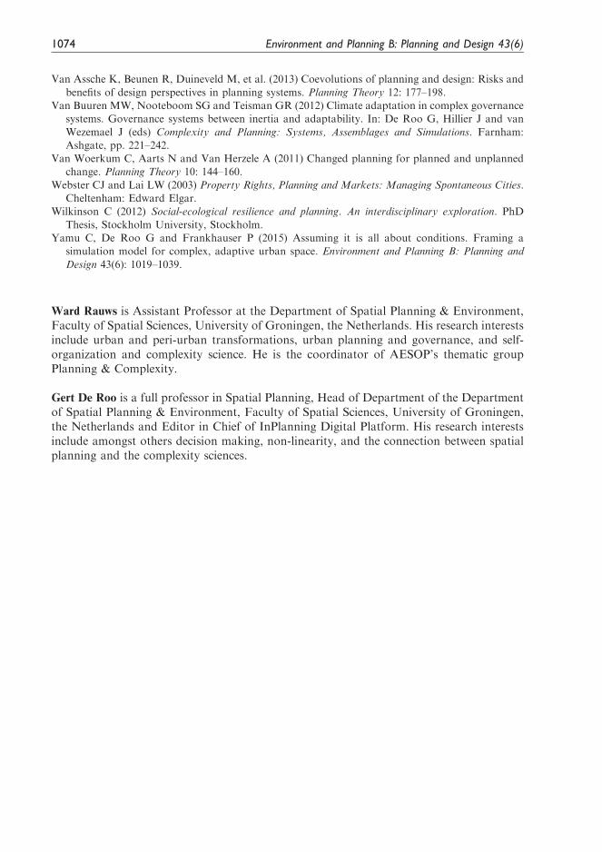
Van Assche K, Beunen R, Duineveld M, et al. (2013) Coevolutions of planning and design: Risks and
benefits of design perspectives in planning systems. Planning Theory 12: 177–198.Van Buuren MW, Nooteboom SG and Teisman GR (2012) Climate adaptation in complex governance
systems. Governance systems between inertia and adaptability. In: De Roo G, Hillier J and van
Wezemael J (eds) Complexity and Planning: Systems, Assemblages and Simulations. Farnham:Ashgate, pp. 221–242.
Van Woerkum C, Aarts N and Van Herzele A (2011) Changed planning for planned and unplannedchange. Planning Theory 10: 144–160.
Webster CJ and Lai LW (2003) Property Rights, Planning and Markets: Managing Spontaneous Cities.Cheltenham: Edward Elgar.
Wilkinson C (2012) Social-ecological resilience and planning. An interdisciplinary exploration. PhD
Thesis, Stockholm University, Stockholm.Yamu C, De Roo G and Frankhauser P (2015) Assuming it is all about conditions. Framing a
simulation model for complex, adaptive urban space. Environment and Planning B: Planning and
Design 43(6): 1019–1039.
Ward Rauws is Assistant Professor at the Department of Spatial Planning & Environment,Faculty of Spatial Sciences, University of Groningen, the Netherlands. His research interestsinclude urban and peri-urban transformations, urban planning and governance, and self-organization and complexity science. He is the coordinator of AESOP’s thematic groupPlanning & Complexity.
Gert De Roo is a full professor in Spatial Planning, Head of Department of the Departmentof Spatial Planning & Environment, Faculty of Spatial Sciences, University of Groningen,the Netherlands and Editor in Chief of InPlanning Digital Platform. His research interestsinclude amongst others decision making, non-linearity, and the connection between spatialplanning and the complexity sciences.
1074 Environment and Planning B: Planning and Design 43(6)


