Embed Size (px)
Citation preview
REGULAR JOINT MEETING OF THE OAKLEY CITY COUNCIL/OAKLEY CITY COUNCIL ACTING AS THE SUCCESSOR AGENCY TO THE OAKLEY REDEVELOPMENT AGENCY HELD TUESDAY, JUNE 28, 2016
3.11 Authorize the City Manager to execute an amendment to the Consulting Services Agreement with BKF Engineers, Inc. to provide Construction Support Services for the Main Street Downtown Improvement Project - CIP 165 (Kevin Rohani, Public Works Director/City Engineer) 3.12 Award of construction contract to Yelton Company Inc. for demolishing and
disposal of the buildings located at 3510 Main Street for the Main Street Downtown Improvement Project – CIP 165 (Kevin Rohani, Public Works Director/City Engineer)
3.13 Adoption of a Resolution to Establish Special Speed Zones for Segments of
Main Street (Kevin Rohani, Public Works Director/City Engineer) 3.14 Ordinance making amendments to Chapter 12 of Title 6 of the Oakley Municipal Code Dealing with Floodplain Management and to Chapter 9 of Title 3 dealing with development agreements (Kevin Rohani, Public Works Director/City Engineer)
3.15 Waive the Second Reading and Adopt Ordinance Accepting the Requirements Relating to Peace Officer Training and Recruitment (William Galstan, Special Counsel) 3.16 Resolution Authorizing Access to State and Federal Level Summary Criminal History Information for Employment, Licensing and/or Certification (Chris Thorsen, Police Chief) 3.17 Waive the Second Reading and Adopt an Ordinance Amending an Existing
P-1 (Planned Unit Development) District for the Emerson Ranch Subdivision to Accommodate a Final Development Plan for the Project Titled “Emerson Neighborhood 6 – Woodbury”(Ken Strelo, Senior Planner)
4.0 PUBLIC HEARINGS 4.1 Proposed Amendment to Chapter 1 of Title 9 of the Oakley Municipal Code
(“Zoning Ordinance”) as well as applying the Affordable Housing Overlay Zone (AHO) to 9 specific Properties in Order to Comply with the City Approved and State Certified 2015-2023 Housing Element (RZ 08-16) (Joshua McMurray, Planning Manager)
OAKLEY -~
STAFF REPORT
Agenda Date: 06/28/2016 Agenda Item: 3. '! '!
CALIFORNIA
Date:
To:
From:
Subject:
Tuesday, June 28, 2016
Bryan Montgomery, City Manager
Kevin Rohani, P.E. Public Works Director/City Engineer
Authorize the City Manager to execute an amendment to the Consulting Services Agreement with BKF Engineers, Inc. to provide Construction Support Services for the Main Street Downtown Improvement Project- CIP 165
Background and Analysis The City's Capital Improvement Program for Fiscal Year 2015-16 includes a project to design and construct the Main Street improvements in downtown from Norcross Lane to 2nd Street. The development of downtown Oakley is a priority for the City Council. The goal for the community is to have a downtown that is thriving and vibrant, and will serve as a solid foundation for the economic vitality of Oakley.
On July 14, 2015, the City Council awarded a design contract to BKF Engineers, Inc. for performing the design and the preparation of construction documents for the Main Street Improvement Project from Norcross Lane to 2nd Street.
City staff has been working with the development community to promote downtown Oakley and create opportunities for new development in the downtown. These efforts have resulted in a very exciting opportunity to develop the vacant property located on Main Street between 2nd and 5th Streets. This is the parcel of land between the railroad tracks and Main Street. The development project at this site is for the construction of a 40,000 SF retail/office complex, which would be a great enhancement for Oakley and the downtown, and would promote the vitality of the downtown area.
This development project is adjacent to the limits of the CIP 165 project that is currently under design. The developer of this site has agreed to accelerate the construction of the buildings, if the street frontage improvements can be constructed in advance and as part of the Main Street improvements, that cover from Norcross Lane to 2nd Street. If the street improvements on Main Street from 2nd to 5th Streets are done as part of the CIP 165 Project, there would be an economy of scale for the City and a more timely construction of the improvements.
On December 8, 2015, the City Council amended the design contract with BKF Engineers, Inc. for performing the design and the preparation of the construction documents for the Main Street improvements from 2"d Street to 5th Streets; in coordination with the above referenced 40,000 sf development project. This design is nearly complete and the project will be going out for the bidding phase by next month, with construction to start by fall 2016.
The City requested BKF Engineers, Inc. to provide some additional design related tasks that were not in their original design contract. These additional design items included: preparation of Plat and Legal maps and documents for all the Right of Way processing required by Caltrans (the right of way dedication report is presented to City Council at June 28, 2016 meeting), performing pavement coring, performing preliminary sanitary sewer design, and preparation of multiple gateway monument design. The cost of these additional services was reviewed by staff and is included in this construction support services contract addendum.
In order to ensure consistency and quality control as the project moves forward into the construction phase, staff now proposes to amend the BKF Engineers, Inc. contract to include support for the construction phase of the project.
Construction Support Services are an important element in this large scale and high profile project because of the complexity of the design and coordination work involved. The following summary has been prepared in order to better understand the distribution of the work efforts for the construction of this project.
The key components of the construction for this project are:
• Day-to-day construction inspections: The City Engineering Inspector will monitor and inspect the contractor's daily work; measure and document quantities of material used on the project and insure compliance with the plans and specifications. Since this is a Federal grant funded project, it requires an added level of documentation and monitoring of the project to insure compliance with Caltrans' requirement towards the reimbursement of grant funds to the City.
Coordination with the design team during construction: City Engineering staff will work closely with the contractor, downtown merchants, residents, and the design team to provide responses to inquiries and questions that may arise during the course of the project's construction. This is an important role especially on this project with many detailed design elements.
• Construction Support Services: This work requires the project consultant to provide field survey staking, review of all shop drawings and various product submittals for the construction, provide design clarifications and information, and attend various meetings. At the conclusion of the construction work, an as-built document for the project will also be prepared for the City by the design team.
BKF Engineers, Inc. will be assigned the task of providing Construction Support Services for this project along with their sub-consultants as outlined in the attached
··-~··----------·----------
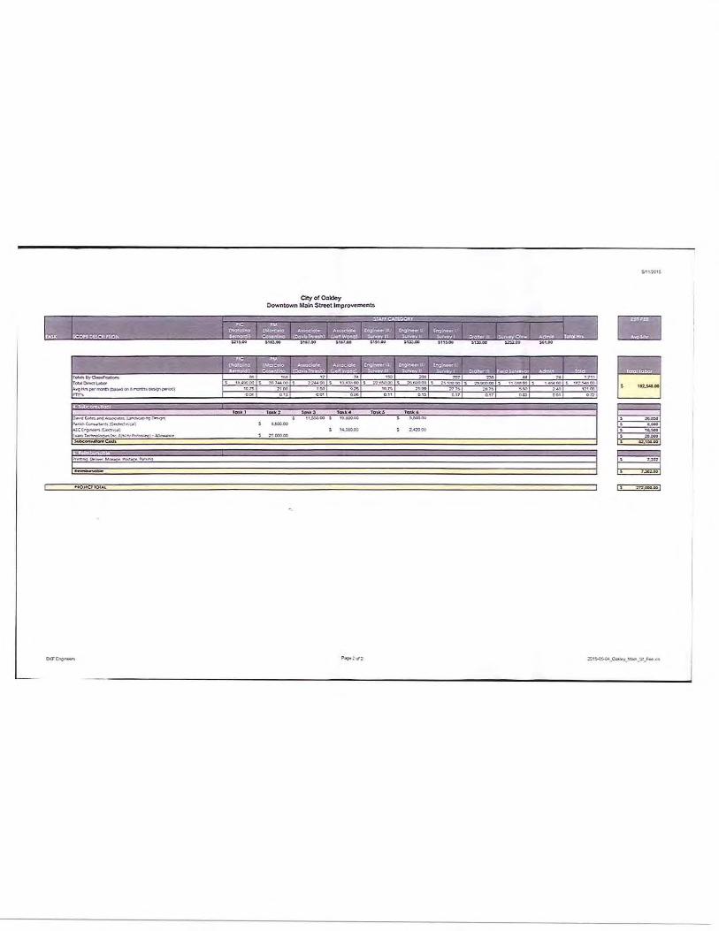
proposal and scope of work. Staff recommends approval of the amendment to the BKF Engineers, Inc. contract to provide Construction Support Services in an amount not to exceed $193,400.
Fiscal Impact Approval of this resolution will accept the proposal and authorize the City Manager to execute an amendment to the agreement with BKF Engineers, Inc. for a cost not to exceed $193,400. The funding of this contract amendment will be from the General Capital Projects Fund.
The funding for the construction of the Main Street improvements will be included in the FY 2016-17 CIP budget.
Staff Recommendation Staff recommends that the City Council adopt the resolution approving the proposal with BKF Engineers, Inc. and amending the agreement for providing Construction Support Services associated with the Main Street Improvement Project- CIP 165 and authorizes the City Manager to sign the amendment to the design agreement.
Attachments 1) Original BKF Engineers, Inc. - Consulting Services Agreement 2) Amendment 1 - BKF Engineers, Inc. - Consulting Services Agreement 3) New BKF Engineers, Inc. Proposal (Exhibit A) (Amendment 2) 4) Resolution
Attachment 1
CONSULTING SERVICES AGREEMENT BETWEEN THE CITY OF OAKLEY AND BKF ENGINEERS FOR CITY OF OAKLEY DOWNTOWN IMPROVEMENTS- MAIN STREET (NORCROSS LANE TO znd STREED- CIP 165
THIS AGREEMENT for consulting services is entered into by and between the City of Oakley, a municipal corporation in the State of California (hereinafter referred to as "City") and BKF Engineers, a California Company (hereinafter referred to as "Consultant"), collectively sometimes referred to hereinafter as the "Parties", as of July 14,2015 (the "Effective Date").
Section 1. SERVICES. Subject to the tenms and conditions set forth in this Agreement, Consultant shall provide to City the services described in the Scope of Work or proposal letter attached hereto and incorporated herein as Exhibit A at the time and place and in the manner specified therein. In the event of a conflict in or inconsistency between the tenms of this Agreement and Exhibit A, the Agreement shall prevail.
1.1 Term of Services. The term of this Agreement shall begin on the Effective Date and shall end on June 30, 2016, the date of completion specified in Exhibit A, and Consultant shall complete the work described in Exhibit A prior to that date, unless the term of the Agreement is otherwise terminated or extended, as provided for in Section 8. The time provided to Consultant to complete the services required by this Agreement shall not affect the City's right to terminate the Agreement, as provided for in Section 8. Should this Agreement be amended to include additional tasks as contemplated in Section 1, the term of services shall be extended as mutually agreed upon by City and Consultant.
1.2 Standard of Performance. Consultant shall perform all services required pursuant to this Agreement in the manner and according to the standards observed by a competent practitioner of the profession in which Consultant is engaged in the geographical area in which Consultant practices its profession. Consultant shall prepare all work products required by this Agreement in a substantial, first-class manner and shall conform to the standards of quality normally observed by a person practicing in Consultant's profession.
1.3 Assignment of Personnel. Consultant shall assign only competent personnel to perform services pursuant to this Agreement. In the event that City, in its sole discretion, at any time during the term of this Agreement, desires the reassignment of any such persons, Consultant shall, immediately upon receiving notice from City of such desire of City, reassign such person or persons.
1.4 Time. Consultant shall devote such time to the performance of services pursuant to this Agreement as may be reasonably necessary to meet the standard of performance provided in Section 1.1 above and to satisfy Consultant's obligations hereunder_
1.5 Public Works Requirement. Notice is hereby given that "work performed during the design and preconstruction phases of construction including, but not limited to, inspection
and land surveying work," the services constitute a public works within the definition of Section 1720(a)(1) of the California Labor Code, requiring the payment of prevailing wages and the provisions set out in Exhibit B.
Section 2. COMPENSATION. City hereby agrees to pay Consultant a sum not to exceed the Two Hundred Seventy Two Thousand Dollars and Zero Cents ($272,000), notwithstanding any contrary indications that may be contained in Consultant's proposal, for services to be performed and reimbursable costs incurred under this Agreement. In the event of a conflict between this Agreement and Consultant's proposal, attached as Exhibit A, regarding the amount of compensation, the Agreement shall prevail. City shall pay Consultant for services rendered pursuant to this Agreement at the time and in the manner set forth herein. The payments specified below shall be the only payments from City to Consultant for services rendered pursuant to this Agreement. Consultant shall submit all invoices to City in the manner specified herein. Except as specifically authorized by City, Consultant shall not bill City for duplicate services performed by more than one person.
Consultant and City acknowledge and agree that compensation paid by City to Consultant under this Agreement is based upon Consultant's estimated costs of providing the services required hereunder, including salaries and benefits of employees and subcontractors of Consultant. Consequently, the parties further agree that compensation hereunder is intended to include the costs of contributions to any pensions and/or annuities to which Consultant and its employees, agents, and subcontractors may be eligible. City therefore has no responsibility for such contributions beyond compensation required under this Agreement.
2.1 Invoices. Consultant shall submit invoices, not more often than once a month during the term of this Agreement, based on the cost for services performed and reimbursable costs incurred prior to the invoice date. Invoices shall contain the following information:
• Serial identifications of progress bills; i.e., Progress Bill No. 1 for the first invoice, etc.;
• The beginning and ending dates of the billing period; • A Task Summary containing the original contract amount, the amount of prior
billings, the total due this period, the balanoe available under the Agreement, and the percentage of completion;
• At City's option, for each work item in each task, a copy of the applicable time entries or time sheets shall be submitted showing the name of the person doing the work, the hours spent by each person, a brief description of the work, and each reimbursable expense;
• The Consultant's signature.
2.2 Monthly Payment. City shall make monthly payments, based on invoices received, for services satisfactorily performed, and for authorized reimbursable costs incurred. City shall have 30 days from the receipt of an invoice that complies with all of the requirements above to pay Consultant.
City of Oakley and BKF Engineers- Downtown Improvements, Main St (Norcross Ln to 2nd St)- CIP 165
2.3 Final Payment. City shall pay the last I 0% of the total sum due pursuant to this Agreement within 60 days after completion of the services and submittal to City of a final invoice, if all services required have been satisfactorily performed.
2.4 Total Payment. City shall pay for the services to be rendered by Consultant pursuant to this Agreement. City shall not pay any additional sum for any expense or cost whatsoever incurred by Consultant in rendering services pursuant to this Agreement. City shall make no payment for any extra, further, or additional service pursuant to this Agreement.
In no event shall Consultant submit any invoice for an amount in excess of the maximum amount of compensation provided above either for a task or for the entire Agreement, unless the Agreement is modified prior to the submission of such an invoice by a properly executed change order or amendment approved by the City Manager, which shall not exceed the maximum amount allowed by the Oakley Municipal Code.
2.5 Hourly Fees. Fees for work performed by Consultant shall not exceed the amounts shown on the Compensation Schedule attached hereto and incorporated herein as Exhibit 6.
2.6 Reimbursable Exoenses. Reimbursable expenses are specified in Exhibit A, and expenses not listed in Exhibit A are not chargeable to the City.
2.7 Payment of Taxes. Consultant is solely respcnsible for the payment of employment taxes incurred under this Agreement and any similar federal or state taxes.
2.8 Payment upon Tenmination. In the event that the City or Consultant terminates this Agreement pursuant to Section 8 of this Agreement, the City shall compensate the Consultant for all outstanding costs and reimbursable expenses incurred for work satisfactorily completed as of the date of written notice of termination. Consultant shall maintain adequate logs and timesheets in order to verify costs incurred to that date.
2.9 Authorization to Perform Services. The Consultant is not authorized to perform any services or incur any costs whatsoever under the terms of this Agreement until receipt of authorization from the Contract Administrator.
Section 3. FACiliTIES AND EQUIPMENT. Except as set forth herein, Consultant shall, at its sole cost and expense, provide all facilities and equipment that may be necessary to perform the services required by this Agreement. City shall make available to Consultant only the facilities and equipment listed in this section, and only under the terms and conditions set forth herein.
City shall furnish physical facilities such as desks, filing cabinets, and conference space, as may be reasonably necessary for Consultant's use while consulting with City employees and reviewing records and the information in possession of the City. The location, quantity, and time of furnishing those facilities shall be in the sole discretion of City. In no event shall City be obligated to furnish any facility that may involve
City of Oakley and BKF Engineers- Downtown Improvements, Main St (Norcross Ln to 2nd St)- CIP 165
incurring any direct expense, including but not limited to computer, long-distance telephone or other communication charges, vehicles, and reproduction facilities.
Section 4. INSURANCE REQUIREMENTS. Before beginning any work under this Agreement, Consultant, at its own cost and expense, shall procure the types and amounts of insurance listed below and in Exhibit C against claims for injuries to persons or damages to property that may arise from or in connection with the perfonrrance of the work hereunder by the Consultant and its agents, representatives, employees, and subcontractors. Consistent with the following provisions, Consultant shall provide proof satisfactory to City of such insurance that meets the requirements of this section and under fomns of insurance satisfactory in all respects to the City, and that such insurance is in effect prior to commencing work under this Agreement. Consultant shall maintain the insurance policies required by this section throughout the term of this Agreemenl The cost of such insurance shall be included in the Consultant's bid. Consultant shall not allow any subcontractor to commence work on any subcontract until Consultant has obtained all insurance required herein for the subcontractor(s) and provided evidence thereof to City. Verification of the required insurance shall be submilted and made part of this Agreement prior to execution. Verification of the required insurance is attached hereto and incorporated herein as Exhibit D.
4.1 Variation. The City may approve a variation in the insurance requirements, upon a determination that the coverage, scope, limit, and form of such insurance is either not commercially available, or that the City's interests are otherwise sufficiently protected.
4.2 Notice of Reduction in Coverage. In the event that any coverage required by this section is reduced, limited, or materially affected in any other manner, Consultant shall provide written notice to City at Consultant's earliest possible opportunity and in no case later than five days after Consultant is notified of the change in coverage.
4.3 Remedies. In addition to any other remedies City may have if Consultant fails to provide or maintain any insurance policies or policy endorsements to the extent and within the time herein required, City may, at its sole option, exercise any of the following remedies, which are alternatives to other remedies City may have and are not the exclusive remedy for Consultant's breach:
• Order Consultant to stop work under this Agreement or withhold any payment that becomes due to Consultant hereunder, or both stop work ond withhold any payment, until Consultant demonstrates compliance with the requirements hereof; and/or
• Terminate this Agreement.
Section 5. INDEMNIFICATION AND CONSULTANT'S RESPONSIBILITIES. Consultant shall to the fullest extent allowed by law, with respect to all Services performed in connection with this Agreement, defend with counsel acceptable to the City, and indemnify and hold the City and its officials, officers, employees, agents, and volunteers harmless from and against any and all losses that arise out of, pertain to, or relate to the negligence, recklessness, or willful misconduct of the Consultant ("Ciaims").Consultant will bear all loses, costs, damages, expense and liability of every kind, nature and description that arise out of, pertain to, or relate to such Claims, whether directly or indirectly ("Liability'). Such obligations to defend,
City of Oakley and BKF Engineers- Downtown Improvements, Main St (Norcross Ln to 2nd St)- CIP 165
hold hannless and indemnify the City shall not apply to the extent that such Liability is caused by the sole negligence, active negligence, or willful misconduct of the City or any third party.
With respect to third party claims against the Consultant, the Consultant waives any and all rights of any type of express or implied indemnity against the indemnitees.
However, notwithstanding the foregoing. in accordance with Califomia Civil Code Section 1668. nothing in this Agreement shall be construed to exempt the City from its own fraud, willful injury to the person or property of another, or violation of law. In addition, and notwithstanding the foregoing, to the extent this Agreement is a "construction contract" as defined by Califomia Civil Code section 2783, as may be amended from time to time, such duties of Consultant to indemnify shall not apply when to do so would be prohibited by California Civil Code Section 2782.
Section 6.
6.1
6.2
Section 7.
7.1
7.2
STATUS OF CONSULTANT.
Independent Contractor. At all times during the term of this Agreement, Consultant shall be an independent contractor and shall not be an employee of City. City shall have the right to control Consultant only insofar as the results of Consultant's services rendered pursuant to this Agreement and assignment of personnel pursuant to Subparagraph 1.3; however, othenwise City shall not have the right to control the means by which Consultant accomplishes services rendered pursuant to this Agreement. Notwithstanding any other City, state, or federal policy, rule, regulation, law, or ordinance to the contrary, Consultant and any of its employees, agents, and subcontractors providing services under this Agreement shall not qualify for or become entitled to, and hereby agree to waive any and all claims to, any compensation, benefit, or any incident of employment by City, including but not limited to eligibility to enroll in the California Public Employees Retirement System (PERS) as an employee of City and entitlement to any contribution to be paid by City for employer contributions and/or employee contributions for PERS benefits.
Consultant. Not Agent. Except as City may specify in writing, Consultant shall have no authority, express or implied, to act on behalf of City in any capacity whatsoever as an agent. Consultant shall have no authority, express or implied, pursuant to this Agreement to bind City to any obligation whatsoever.
LEGAL REQUIREMENTS.
Governing Law. The laws of the State of California shall govem this Agreement.
Compliance with Applicable Laws. Consultant and any subcontractors shall comply with all laws applicable to the perfonnance of the work hereunder, including but not limited to, the California Building Code, the Americans with Disabilities Act, and any copyright, patent or trademark law. Consultant's failure to comply with any law(s) or regulation(s) applicable to the performance of the work hereunder shall constitute a breach of contract.
City of Oakley and BKF Engineers- Downtown Improvements, Main St (Norcross Ln to 2"' St)- CIP 165
,-----------------------------·--·~- ---
7.3 Other Governmental Regulations. To the extent that this Agreement may be funded by fiscal assistance from another governmental entity, Consultant and any subcontractors shall comply with all applicable rules and regulations to which City is bound by the terms of such fiscal assistance program.
7.4 licenses and Permits. Consultant represents and warrants to City that Consultant and its employees, agents, and any subcontractors have all licenses, permits, qualifications, and approvals of whatsoever nature that are legally required to practice their respective professions. Consultant represents and warrants to City that Consultant and its employees, agents, any subcontractors shall, at their sole cost and expense, keep in effect at all times during the term of this Agreement any licenses, permits, and approvals that are legally required to practice their respective professions. In addition to the foregoing, Consultant and any subcontractors shall obtain and maintain during the term of this Agreement valid business licenses from City.
7.5 Nondiscrimination and Equal Opportunity. Consultant shall not discriminate, on the basis of a person's race, religion, color, national origin, age, physical or mental handicap or disability, medical condition, marital status, sex, or sexual orientation, against any employee, applicant for employment, subcontractor, bidder for a subcontract, or participant in, recipient of, or applicant for any services or programs provided by Consultant under this Agreement. Consultant shall comply with all applicable federal, state. and local laws, policies, rules, and requirements related to equal opportunity and nondiscrimination in employment, contracting, and the provision of any services that are the subject of this Agreement.
Section 8.
8.1
Consultant shall include the provisions of this Subsection in any subcontract approved by the Contract Administrator of this Agreement.
TERMINATION AND MODIFICATION.
Termination. City may cancel this Agreement at any time and without cause upon written notification to Consultant.
Consultant may cancel this Agreement upon 30 days written notice to City and shall incl~de in such notice the reasons for cancellation.
In the event of temnination, Consultant shall be entitled to compensation for services performed to the effective date oftemnination; City, however, may condition payment of such compensation upon Consultant delivering to City any or all documents, photographs, computer software, video and audio tapes, and other materials provided to Consultant or prepared by or for Consultant or the City in connection with this Agreement.
8.2 Extension. City may, in its sole and exclusive discretion, extend the end date of this Agreement beyond that provided for in Subsection 1.1. This Agreement may be extended at the option of the City. Should City decide to exercise its option to extend this
City of Oakley and BKF Engineers- Downtown Improvements, Main St (Norcross Ln to 200 St)- CIP 165
Agreement, City shall provide written notice to Consultant at least sixty (60) days prior to the end date of this Agreement Any such extension shall require a written amendment to this Agreement, as provided for herein, Consultant understands and agrees that, if City grants such an extension, City shall have no obligation to provide Consultant with compensation beyond the maximum amount provided for in this Agreement, unless City agrees to do so by written amendment to this Agreement Similarly, Consultant understands and agrees that, City shall have no obligation to reimburse Consultant for any otherwise reimbursable expenses incurred during the extension period, unless City agrees to do so by written amendment to this Agreement
8,3 Amendments, The parties may amend this Agreement only by a writing signed by all the parties,
8.4 Assignment and Subcontracting, City and Consultant recognize and agree that this Agreement contemplates personal performance by Consultant and is based upon a determination of Consultant's unique personal competence, experience, and specialized personal knowledge, Moreover, a substantial inducement to City for entering into this Agreement was and is the professional reputation and competence of Consultant Consultant may not assign this Agreement or any interest therein without the prior written approval of the Contract Administrator, Consultant shall not subcontract any portion of the performance contemplated and provided for herein, other than to the subcontractors noted in the proposal, without prior written approval of the Contract Administrator,
8.5 SurvivaL All obligations arising prior to the termination of this Agreement and all provisions of this Agreement allocating liability between City and Consultant shall survive the temnination of this Agreement
8,6 Options upon Breach by Consultant If Consultant materially breaches any of the terms of this Agreement, City's remedies shall include, but not be limited to the following:
8,6,1 Immediately terminate the Agreement;
8,6,2 Retain the plans, specifications, drawings, reports, design documents, and any other work product prepared by Consultant pursuant to this Agreement;
8,6.3 Retain a different consultant to complete the work described in Exhibit A not finished by Consultant; or
8.6.4 Charge Consultant the difference between the cost to complete the work described in Exhibit A that is unfinished at the time of breach and the amount that City would have paid Consultant pursuant to Section 2 of this Agreement if Consultant had completed the work,
City of Oakley and BKF Engineers- Downtown Improvements, Main St (Norcross Ln to 2nc St)- CIP 165
Section 9. KEEPING AND STATUS OF RECORDS.
9.1 Records Created as Part of Consultant's Performance. All reports, data, maps, models, charts, studies, surveys, photographs, memoranda, plans, studies, specifications, records, files, or any other documents or materials, in electronic or any other form, that Consultant prepares or obtains pursuant to this Agreement and that relate to the matters covered hereunder shall be the property of the City. Consultant hereby agrees to deliver those documents to the City upon termination of the Agreement. It is understood and agreed that the documents and other materials, including but not limited to those described above, prepared pursuant to this Agreement are prepared specifically for the City and are not necessarily suitable for any future or other use. City and Consultant agree that, until final approval by City, all data, plans, specifications, reports and other documents are confidential and will not be released to third parties without prior written consent of both parties.
9.2 Consultant's Books and Records. Consultant shall maintain any and all ledgers, books of account, invoices, vouchers, canceled checks, and other records or documents evidencing or relating to charges for services or expenditures and disbursements charged to the City under this Agreement for a minimum of three (3) years, or for any longer period required by law, from the date of final payment to the Consultant to this Agreement.
9.3 Inspection and Audit of Records. Any records or documents that Section 9.2 of this Agreement requires Consultant to maintain shall be made available for inspection, audit, and/or copying at any time during regular business hours, upon oral or written request of the City. Under California Government Code Section 8546.7, if the amount of public funds expended under this Agreement exceeds TEN THOUSAND DOLLARS ($10,000.00), the Agreement shall be subject to the examination and audit of the State Auditor, at the request of City or as part of any audit of the City, for a period of three (3) years after final payment under the Agreement.
Section 10 MISCELLANEOUS PROVISIONS.
10.1 Attorneys' Fees. If a party to this Agreement brings any action, including an action for declaratory relief, to enforce or interpret the provision of this Agreement, the prevailing party shall be entitled to reasonable attorneys' fees in addition to any other relief to which that party may be entitled. The court may set such fees in the same action or in a separate action brought for that purpose.
10.2 Venue. In the event that either party brings any action against the other under this Agreement, the parties agree that trial of such action shall be vested exclusively in the state courts of California in the County of Contra Costa or in the United States District Court for the Northern District of California.
City of Oakley and BKF Engineers- Downtown Improvements, Main St (Norcross Ln to 2°0 St)- CIP 165
10.3 Severability. If a court of competent jurisdiction finds or rules that any provision of this Agreement is invalid, void, or unenforceable, the provisions of this Agreement not so adjudged shall remain in full force and effect. The invalidity in whole or in part of any provision of this Agreement shall not void or affect the validity of any other provision of this Agreement.
10.4 No Implied Waiver of Breach. The waiver of any breach of a specific provision of this Agreement does not constitute a waiver of any other breach of that term or any other term of this Agreement.
10.5 Successors and Assigns. The provisions of this Agreement shall inure to the benefit of and shall apply to and bind the successors and assigns of the parties.
10.6 Use of Recycled Products. Consultant shall prepare and submit all reports, written studies and other printed material on recycled paper to the extent it is available at equal or less cost than virgin paper.
10.7 Conflict of Interest. Consultant may serve other clients, but none whose activities within the corporate limits of City or whose business, regardless of location, would place Consultant in a "conflict of interest," as that term is defined in the Political Reform Act, codified at California Government Code Section 81000 et seq.
Consultant shall not employ any City official in the work perfonmed pursuant to this Agreement. No officer or employee of City shall have any financial interest in this Agreement that would violate California Government Code Sections 1090 et seq.
Consultant hereby warrants that it is not now, nor has it been in the previous twelve (12) months, an employee, agent, appointee, or official of the City. If Consultant was an employee, agent, appointee, or official of the City in the previous twelve months, Consultant warrants that it did not participate in any manner in the forming of this Agreement. Consultant understands that, if this Agreement is made in violation of Government Code§ 1090 et.seq., the entire Agreement is void and Consultant will not be entitled to any compensation for services perfonmed pursuant to this Agreement, including reimbursement of expenses, and Consultant will be required to reimburse the City for any sums paid to the Consultant. Consultant understands that, in addition to the foregoing, it may be subject to criminal prosecution for a violation of Government Code§ 1090 and, if applicable, will be disqualified from holding public office in the State of California.
10.8 Solicitation. Consultant agrees not to solicit business at any meeting, focus group, or interview related to this Agreement, either orally or through any written materials.
10.9 Contract Administration. This Agreement shall be administered by Kevin Rohani, P.E. Public Works Director/City Engineer ('Contract Administrator"). All correspondence shall be directed to or through the Contract Administrator or his or her designee.
City of Oakley and BKF Engineers- Downtown Improvements, Main St (Norcross Ln to 2nd St)- CIP 165
10.10 Notices.
Any written notice tc Consultant shall be sent to:
BKF Engineeers Attn: Natalina V. Bemardi. P.E.. LEED AP Principal/Vice President 4670 Willow Road Suite 250 Pleasanton. CA 94588
Any written notice to City shall be sent to:
City of Oakley Attn: Kevin Rohani, P.E., Public Works Director/City Engineer 3231 Main Street Oakley, CA 94561
10.11 Professional Seal. Where applicable in the determination of the Contract Administrator, the first page of a technical report, first page of design specifications, and each page of construction drawings shall be stamped/sealed and signed by the licensed professional responsible for the report/design preparation. The stamp/seal shall be in block entitled "Seal and Signature of Registered Professional with report/design responsibility," as in the following example.
Seal and Signature of Registered Professional with report/design responsibility.
10.12 Integration. This Agreement, including the Scope of Work and Compensation Schedule, Provisions Required for Public Works Contracts, Insurance Requirements. and Verification of Required Insurance, attached hereto and incorporated herein as Exhibit A, B, C and D respectively, represents the entire and integrated agreement between City and Consultant and supersedes all prior negotiations, representations, or agreements, either written or oral.
City of Oakley and BKF Engineers- Downtown Improvements, Main St (Norcross Ln to 2nd St)- CIP 165
CITY
Exhibit A Exhibit B Exhibit C Exhibit D
Scope of Services and Compensation Schedule Provisions Required for Public Works Contracts Insurance Requirements Verification of Required Insurance
10.13 Counterparts. This Agreement may be executed in multiple counterparts, each of which shall be an original and all of which together shall constitute one agreemenl
10.14 Authorized Signature. Each person and party signing this Agreement warrants that he/she has the authority to execute this Agreement on behalf of the principal and that the party will be bound by such signature.
The parties have executed this Agreement as of the Effective Date.
CONSULTANT
City of Oakley, a municipal corporation in the State of California
BKF Engineers, a California Company
By:J('
Attest:
Libby \freon is, City Clerk
Approved as to Form:
kt£-{[At:<--;., 15:- U~c(;J;:c ~ ·!-'""'Derek P. Coie, City Attorney
City of Oakley and BKF Engineers- Downtown Improvements, Main St (Norcross Ln to 2'd St)- CIP 165
I I
EXHIBIT A
SCOPE OF SERVICES AND COMPENSATION SCHEDULE
City of Oakley and BKF Engineers- Downtown Improvements, Main St (Norcross Ln to 2nd St)- CIP 165
--------------------------·----·---
·~ =·, Bkf ENGINEERS
SURVEYORS
May 11, 2015
Kevin Rohani, P.E. Public Works Director/City Engineer 3231 Main Street Oakley, CA 94561
PLANNERS Subject: City of Oakley Downtown Improvements, Main Street (Norcross Lane to Second Street)
'1-670 Wilfow Road,
SuiCe 2.50
Pleasanf;an
California 9'1-588
p·925·396·7700
(·925·396·7799
www·bkf·com
Dear Mr. Rohani:
Per our conversation, the City of Oakley (City) plans to implement a segment the downtown Visioning Plan established by BKF and Gates + Associates in January of 2015, and reinforce a vision that will promote the addition of businesses and development within the core of the City of Oakley. It is with great interest and excitement that BKF Engineers (BKF) is submitting this proposal to develop plans, specifications and estimate (construction documents) to advance the design for the improvements on Main Street from Norcross Lane to Second Street.
BKF will be teaming with Gates + Associates (Gates) in this exciting effort. As noted within our proposal, we are personally committed to the City and this project. Natalina Bernardi will serve as the City's main point of contact.
Our team has an excellent reputation of developing concepts and implementing designs that are not only attractive, but consider localized constraints so that they can be realized as envisioned before construction. Over the past decades, our team has proven to be an industry-leader working within urbanized settings that are revitalized and converted to better-serve its community. BKF and Gates have collaborated on the Oakley Downtown Visioning Plan in January of 2015 and have a clear understanding of the City's vision and project constraints. In developing this vision with the City, BKF and Gates + Associates will provide a seamless transition into final design and the continuation of the City's vision for the downtown core.
BKF looks forward to providing the same professionalism and skill in preparation of the PS&E for Main Street from Norcross Lane to Second Street. We appreciate the opportunity to submit this proposal and look forward to continuing our excellent working relationship with the City of Oakley.
Very truly yours,
BKF ENGINEERS
~Bkf 100 ENGINEERS
SURVEYORS 'f'C:ARS PLANNE~S
SKF recognizes that a complete understanding of services and an organized project delivery approach is critical for project success. We understand that managing, building consensus, and obtaining project approvals and permits is often more challenging than preparing the actual design documents. Ensuring that these processes are managed will allow the City of Oakley's Project to be delivered on schedule and within budget. Our expertise and straight forward approach in managing federally funded projects under the Caltrans local assistance program will enable the City of Oakley to meet or exceed federally funded deadlines. Below is our overall project understanding followed by our management and design approach:
PROJECf UnO<RS !MJDfNG The City of Oakley plans to extend the Main Street downtown improvements from Norcross lane to Second
Street. The new streets cape extension will advance the planned segment on Main Street from Norcross lane to
Second Street to final PS&E design. Improvements at the intersections of Main Street/Norcross Lane, Main
Street/Hall Street, Main Street/O'Hara Avenue, and Main Street/Second Street will enhance pedestrian safety
and connectivity. Traffic signal improvements at the Main Street/Norcross Avenue intersection will be
consistent with pedestrian improvements at this intersection.
The project will add sidewalks and bulb-outs on Main Street from Norcross Lane to Second Street increasing
connectivity, safety, and facilitating pedestrian crossing by allowing individuals to establish their presence
within a crossing area before vehicles begin to turn. The project will also provide enhanced pedestrian
accommodations, accessible sidewalks and curb ramps, and site furnishings. Increasing parking spaces and
access along Main Street and minor cross-streets will facilitate access to downtown merchants and create a
buffer from the roadway. Developing sidewalk continuity through driveways and added control at major
intersections will allow visitors and patrons to walk from one place to the next while naviga:ing through the
downtown core.
It is understood that there will be no right of way acquisitions with this project Utility relocation and drainage
improvements will be only to support the street design.
BKF will prepare the PS&E documents for construction to include geometric design, grading, drainage design,
lighting, traffic signal, utility relocation, and streets cape, planting and irrigation enhancements for the planned
street improvements. A full description of the scope of work is summarized below.
The project will be consistent with the City's Downtown Specific Plan (adopted March 2010)
and with the Downtown Visioning Plan (January 2015).
May 11. 2015 City of Oakley Downtown -V:ain Street ImprO'Ie~em Project
~Bkf 100 EnGINEERS
StlRVEY<:lRS YEAF<'$ PLANNERS
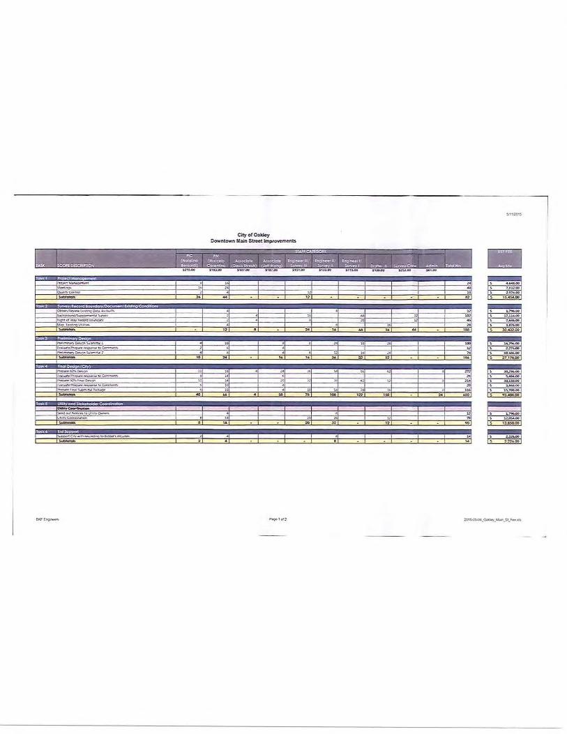
TASK 1: PROJECT MANAGEMENT
The project will begin with a kickoff meeting with the City of Oakley. Our approach to Project Management includes comment review meetings after each milestone submittaL BKF will prepare meeting agendas and keep minutes for meetings with the City. We will also prepare and update the project schedule on a monthly basis which will be presented at the project coordination meetings.
Project Administration - BKF's Project Manager will supervise, coordinate, and monitor the design for conformance with City's standards and policies. BKF will establish and implement a quality control procedure for design activities, perform in-house quality control reviews for each task, and submit project deliverables to the City for review in accordance with the approved schedule.
Kick-off Meeting - A partnering/kick-off meeting will be scheduled with the City soon after the Notice-toProceed to confirm project scope, goals, and objectives.
Meetings - Conduct monthly project meetings either in person or via teleconference. BKF will attend monthly progress meetings with the City staff to discuss the project progress, issues which may affect the project schedule and budget, and any other agenda items that the City may request for discussion. BKF will prepare the agenda, action logs, updated project schedules and meeting minutes.
CPM Schedule - BKF will prepare a detailed Critical Path Method (CPM) schedule for the entire project using Microsoft Project software. The Microsoft Project CPM schedule will be updated on a monthly basis and submitted at each monthly Project Meeting.
Invoices/Progress Reports - BKF will prepare and submit budget reports, monthly progress reports, and invoices in accordance with the City's requirements.
Quality Assurance- BKF will perform an in-house QA/QC review of the documents submitted to the City and outside agencies. BKF's quality control review prior to each submittal will include the review of the design package for coordination among the various design elements, compliance with City and Federally Funded project standards, and completeness. The different project sheets will present the design in a common manner with no contradictions or variances. The review will focus on ensuring that the plan elements are clearly delineated.
Task 1 De/iverables
1) City Meeting Agendas/Minutes (8 Meetings)
2) Project Schedule
TASK 2: SURVEY/RECORD BOUNDARY /REPORTING/DOCUMENT EXISTING CONDtnONS
Immediately after receiving the Notice-to-Proceed, BKF will perform site investigations and review all available documentation. We will conduct preliminary investigations and verify right of way and utility locations. This task will consist of compiling, reviewing existing data pertinent to the project and performing investigations necessary to verify the project's criteria and scope. Also included are planning phase activities, identifying supplemental information, performing field survey work, and conducting site visits/field review, and obtaining information and requirements related to utilities and right of way conditions.
May 11, 2015 City of Oakley Oo1,:.:ntowr: '\.1.ain Streetlmproverr:ent Project
~--~~~~~~~~~~~~~~~~~~~~~~-,.,,,_,, __ ,,
~BkF 100 ENGINEERS
SURVEY<l~S
YEARS PLANNERS
In the initial phase of work, BKF will investigate the extent and perform field studies necessary to understand the existing conditions. Our approach will minimize unnecessary labor and expense allowing the City to direct additional funds for street improvements. The data collected will help our team define site constraints, confirm budget, and establish the scope of work necessary to prepare the streetscape along Main Street. BKF team activities will include the following during this task:
Collect Record Data and Relevant Project Information: BKF will obtain and review available data and information necessary for the design of the project. This information may be obtained from the City, utility companies, or other organizations. BKF will compile available pavement information, right of way record maps, utility occupation drawings, block maps, and third party utility as-built information of record to supplement the topographic base sheets and begin the utility verification process. Data to be reviewed includes the following:
• Review work performed as part of the Main Street Downtown Street Improvements PS&E- CIP 11 and 103
• Previous report(s) or documents related to the proposed project area • As-built plans • Utility information • Right of way information
Field Review: BKF will visit Main Street with the City to document the project limits, conform areas, and verify locations of existing above-ground utilities. We will compile both a photographic log and field notes of the investigation. BKF will evaluate the following:
• Existing pavement condition • Existing limits of curb, gutter and sidewalk to remain- identify conform locations • Location of entrance ways • Location of existing utility boxes and poles and signal equipment • Back of walk conforms for sidewalk and curb ramps
Background/Supplemental Survey - BKF will use the existing raw aerial topographic base map of the project area as background for the plan sheets. Our field survey crews will recover sufficient survey monument information in the area to establish control that will be used for the project. The horizontal and vertical coordinate system used for establishing existing survey control for the project will be determined upon further discussions with the City.
BKF will provide supplemental survey services for purposes of locating elements in the field that are necessary for design of the Downtown Main Street improvements form Norcross lane to Second Street. Some of these elements will include elevation at entrance ways, existing improvements to remain (for conform purposes), street crown elevation, limits of driveways, manhole invert elevations, utility poles, vaults, and building corners and traffic signal equipment.
~.:lay 11, 201S City of Oakley Downtown Main Street :mproverr.ent Prcject
I ~BkF 'I 100 ENGINEERS . SuRvEYO~S
YEA!~$ PlANNERS
Record Boundary - Utilizing the survey control and the existing raw aerial mapping, BKF will obtain recorded right of way information to provide record boundary of the various individual parcels that are located within the project limits. The record boundary and easement information will be superimposed onto the aerial topographic map.
This proposal excludes title services, County map checking or filing fees, mailing and reproduction costs, plotting expenses, the setting of any property comers and the filing of any record of survey that may be required under California law. This proposal is also based on the fact that BKF will be provided with access to all of the properties within and adjacent to the survey limits.
This scope of services assumes that all utilities will be placed within the roadway right of way under the franchise agreement and that no separate Public Utility Easements will be required for the project.
Utility Research and Coordination: BKF will perform utility research to map the existing utilities in the project area, have USA field locate utilities that potentially conflict with the proposed improvements, and develop relocation plans for conflicting utilities. We will incorporate the City's storm drain and sewer information into the base drawing. All the gathered utility information will be compiled and used to supplement the project bases sheets to provide a complete existing base.
BKF will prepare a potholing plan for concurrence by the City and work with EXARO Technologies to positively identify location of existing utilities. This level of effort will minimize construction costs and ensure the correct placement of the proposed improvements. We will provide both written notice and hold a meeting at the City offices describing the proposed construction schedule. A5 part of the utility coordination work, BKF will:
• Review work performed as part of the Main Street Downtown Street Improvements PS&E- CIP 11 and 103
• Review and update as-built utility information for the Project area • Request utility mapping from all affected utility owners • Update base mapping with existing utility information • Identify potential utility conflicts • Submit utility maps to impacted utility owners for verification of potential conflicts • Prepare utility potholing plan for coordination with EXARO Technologies • Coordinate the above work with the utility owners
Geotechnical Data: Parikh Consultants Inc. (PC!) will evaluate ex1st1ng geotechnical data and establish "RValues" for areas of asphalt overlay or reconstruction of street section where necessary. Parikh Consultants will perform field exploration, borings, sample evaluation and testing for the project. They will prepare a geotechnical memorandum and log of test borings establishing the recommended pavement section. This scope of work assumes that the City will waive all permit fees related to geotechnical investigation.
Task 2 Deliverables
1) Aerial Topographic Background and Supplemental Survey
2) Record Boundary
3) Utility Mapping/Pothoting plan
4) Geotechnical Memorandum
L~BkF 100 EJ.IG.INE£RS
Sul!v~VORS
'!'EARS PLANNERS
TASK 3: PRELIMINARY DESIGN
BKF will refine the concept design prepared to date based on multiple factors such as utility impacts, right of way impacts, pedestrian connectivity, overall cost and schedule, and work with the City and stakeholders to develop a detailed design to be advanced into final design. BKF will advance the concept and identify the following, assessing benefits, constraints and challenges:
• Prepare Horizontal and vertical alignment, layout and lane configuration
• Prepare typical sections showing right of way and conform limits
• Provide a design that will implement facilities for pedestrians while maintaining two lanes in each direction.
• Evaluate locations and limits of bulb-outs
• Prepare a preliminary Utility Relocation Plan
• Prepare order of magnitude cost estimate for design.
• Prepare memo establishing the design criteria forfinal design
• Refined layout of hardscape and softscape
• Prepare options for gateway elements (up to 3 options)
• Preliminary details (seatwalls, site accessories or furniture)
• Selection of plant materials
• Conceptual site landscape lighting
• Review cost estimate of participation in value engineering.
• Prepare presentation exhibits, including two photo simulations.
• Participate in presentation to finalize design direction.
The advanced preliminary design will be detailed as an approved prelimir.ary plan ;,n exhibit form w\th cress sections and highlighted details to ensure that all potential issues are discussed. With concurrence en the details and criteria of the design, the project can proceed in obtaining formal approval.
Task 3 Deliverables
1) Preliminary Design Layout for Main Street from Norcross Lane to Second Street
2) Preliminary Utility Relocation Plan
3) Gateway Options
4) Presentation Material/Photo simulation
Cir;10f Oak lev Down~own lv1Bir> S.tret"t [mprovement Prc_iec!
~Bkf 100 ENGINEERS
SO<vEYo•s 'r"EARS PLANNERS
TASK 4: FINAL DESIGN
With the completion of the Preliminary Design Phase, BKF will initiate the final Design Phase preparing plans, specifications, and Construction Cost Estimate as discussed below.
Based on the developments during the design and criteria established during the preliminary phase, all the major components of the design plans, technical specifications and estimate will be advanced to final design during this phase.
TASK 4.1 Project Plans
Design submittals will be prepared for the 60%, 90% and final plans. With the establishment and review of the alignment and geometry, design will be production-oriented for preparation of project plans. The plans will be developed to a 60% level in order to obtain a thorough review.
The focus of the design team is to finalize the supplemental project information that forms the basis of design for the project. In this light, the emphasis becomes design and production-oriented. All project sheets, which will be represented in the bid documents, will be identified and developed in varying degrees of detail during this phase.
The vertical design, including flow line and pavement elevations, will be established during the 60% plans, specifications and estimate (PS&E) design effort. The back of walk, cross slope and longitudinal slope, fiow line, and pavement elevations will consider and balance the Project area constraints including conforms, and will incorporate impacts to driveways, curb ramps, and adjacent sidewalk interface conforms.
For the 90% ubmital, BKF will incorporate or resolve any remaining comments received as a result of the 60% submittal review. BKF will also conduct remaining site investigations. It is crucial that the design engineers are confident that existing field conditions have not changed since inception of the project and are depicted accurately in the bid-ready documents. Assumptions, in lieu of verifications, are not acceptable; BKF will walk the site with the final bid documents prior to submittal. All remaining aspects of the design will be finalized in order to prepare a complete, checked and bid-ready set of documents. Schedules for utility relocations will be confirmed. The construction cost estimate will be updated and formatted to its final form. BKF will conduct a final quality control review on all documents to ensure that all design elements are thoroughly addressed prior to their submission to the City.
In the Final Submittal, BKF will prepare bid-ready documents.
For each design submittal, BKF will prepare the following plan sheets in progressive levels of details:
·. will be prepared to provide an overview of the project limits and an index of project sheets. Project abbreviations, legend, and survey controls will also be included.
General notes will include applicable City standard notes, and project notes.
Plans will include cross section showing cross slopes, type and depth of new pavement section and the following: face of curb, back of walk, median, sidewalk, lane widths, grade breaks, bulb-outs, and right of way limits.
BKF will evaluate the existing facilities impacted by the proposed improvements. The evaluation shall include existing conditions, unusual/special conditions and adjustments of manholes/valve covers conflicting with the proposed work. Demolition plans will show existing sidewalk, curb and gutter to be removed, removal of existing street pavement section, conform grind area, and existing residences with addresses. Additionally, all facilities to be protected in place will be identified. Existing utilities will be shown
r ... 1ay lL 2015 City of Oakley Co>Nn:o·•vn .\1aln Str2et !:nprc·;ernen: Projen
~BkF 100 ENGINE~RS
S!JRYiiYORS YEARS Pu.~NERS
as background information.
: ····::<•:;;-:. ·•·~;· : , :.-.;·Improvement Plan sheets will be prepared showing the top of curb and back of walk lines along the north and south sides of Main Street illustrating the limits and scope of surface improvements. Plan sheets will include basic horizontal and vertical layout information and identify all major construction features including areas of reconstruction and limits of cor<form at driveways and intersections. More specifically, the plan will be at 1"=20' scale showing the station line with distance and bearing, station line/offset of each driveway, curb ramp locations, limits of new pavement section, limit of pavement conforms, and important elements to protect in place. The plan will also identify the location of new curb ramps with respect to new and existing utility boxes and inlets. Existing and proposed elevations will be shown in the plar< at every 50 feet and for relevant changes along the crown, flow line, and at the back of walk .
. _.:•,t.:•·.<'·:·•· t> .. :. ,-,:.•: Details will be provided as necessary to provide guidance to theContractor on special conditions related to sidewalk ,back of walk conforms, and intersection grading. Additionally grading plans will be prepared and added to the details sheets. BKF will show City standard details for curb, gutter and sidewalk, pavement conform, and utility adjustments on detail sheets.
•;,.,;,-,.,,_,, a·.:, :•,.·::!.-,; ·'•il·:: (;.:::•,::., Drainage plans will be prepared showing the proposed site
improvements and existing drainage system with proposed drainage modifications and additions. Drainage plans will include location of proposed manholes and inlets and location of tie-in to the existing drainage system. The drainage plan will be prepared at 1"=20' scale showing the station line with, station line/offset of each manhole and inlet, and important drainage elements to protect in place will be identified.
The profile will be prepared at 1":20' horizontal/1":4' vertical and will include existing and proposed profiles for the crown/center lir<e, and north ar<d south flowlines with slope values. BKF will also include elevations at entrance ways for confomn at the back of walk.
Drainage details will be provided as applicable for the new drainage system to include new pipe connections to existing manholes and tie-in to
, .· ' , BKF will identify all utilities that are impacted by the project (e.g. water, sewer, gas, electric, cable TV, telephone, valves, boxes, and service connections) on 20-scale plan sheets. BKF will provide utility adjustments to the City, and coordinate with the appropriate utility owners.
· • · · · It is BKF's understanding that permanent storm water treatment will not be required for this project based on our preliminary evaluation from our stomn water expert, Ed Boscacci a Qualified Storm Water Pollution Prevention Plan Developer (QSD) and Qualified Storm Water Pollution Prevention Plan Practitioner (QSP). BMP plans will show location of gravel bags and check dams along the gutters, curb inlet protection and trees to be protected in place. Notes will make reference to compliance with appropriate sections in the City's special provisions.
New signs will be placed onto the new poles, as necessary, for integration with the new streetscape improvements. Pavement delineation plans will include turn'tng movements at each intersection and will extend 50 feet into roads that intersect with Main Street to include Norcross lane, Hall Street, O'Hara Avenue and Second Street.
rvlay 11. 2015 City of Oakley Dcvvntov;n Marn Street Jmpr·c:l'~e.'T\~nt Project
~BkF 100 .ENGINEERS
Su~VEYORS
YEARS ?tANNERS
Li(j:,,::,,_, '"'··i r,,,;:,.- "~' .. ; :•·· · BKF will provide the traffic signal modification plan for the traffic signal at the intersection of Main Street/O'Hara Avenue. Based on our preliminary evaluation, it is understood that the existing traffic signal service and controller cabinets do not need to be relocated. BKF will also provide a design for a new traffic signal at the intersection of Main Street/Norcross Lane. AEC Engineers, as part of the BKFteam, will prepare Lighting plans for the proposed street lights along Main Street
:_ ... ; r·j(',_:_:c_:·,;:- :,, •J L:::>: ,_, .. : ;_ }>, = · , • • . ~ '· ,~~ ':, i ._-,; : · > ~ ., ~-- . ,: ·. :>.~: David Gates and Associates, as part of the BKF team will prepare the following: Layout plans for landscaped areas, hardscaped areas, and site furnishings; landscape lighting coordination - location and fixture selection; planting plans and details; irrigation plans and details; landscape construction items; and gateway element. Since the gateway feature is unknown at this time, there is no structural design being estimated but can be done so after it is determined as needed.
TASK 4.2 Specifications
Specifications will be prepared using standard C.S.l format modified as appropriate for City Standards for all work items necessary for the construction of the project. BKF will assemble the Technical Specifications and appropriate City "Boilerplate" Special Provisions for Federally Funded Projects. The Specifications will be prepared for the 60%, 90%, and Final Submittals.
TASK 4.3 Construction Cost Estimate
BKF will prepare a preliminary cost estimate to ensure that the magnitude of cost corresponds to the project budget. Should the scope exceed the budget, we will include value-engineering strategies in our analysis, which may include alternative rehabilitation strategies or delaying repairs to certain segments. The Construction Cost Estimate will be prepared using present-day dollars; escalation costs will not be applied. The Construction Cost Estimate will be prepared for the 60%, 90%, and Final Submittals.
Task 4 Deliverables
1) 60% PS&E Submittal with Response to Comments from Preliminary Design
2) 90% PS&E Submittal with Response to Comments from 60% Design
3) Final Documents with Response to Comments (rom 90% Design
TASK 5: UTILITY RELOCATION AND STAKEHOLDER COORDINATION
BKF's key to successful stakeholder coordination is a multifaceted and parallel delivery approach. After advancing the preferred alternative into final design, BKF will prepare a comprehensive deliverable to be submitted to each stakeholder simultaneously.
Utility Coordination and Relocation There are various water, gas, electrical and overhead utilities along Main Street from Norcross Lane to Second Street BKF will send out utility notices and obtain utility mapping information. We will also provide notification of probable utility impacts to affected utility owners and coordinate a suitable plan for relocation of impacted
City of OOlkley Dovvnto-..,,n ~~12110 Street Irr.provement Project
-------------------------------
!:~Bkf 100 EN<iiNEERS
SURVEYORS YEARS PLANNERS
utilities. One utility of note is the overhead electrical line along the north and south sides of Main Street. BKF will work with the City to protect the power poles in place where feasible.
Task 5 De/iverobles
1) Utility Notice to Owner
2) Utility Coordination
TASK 6: Bid Assistance
BKF will assist the City during the project bid period to respond to contractor's questions on the contract documents.
Task 6 Deliverables
1) None
Notes and Conditions:
Notes and conditions to the scope of work above are noted as follows:
1. Geotechnical services are only for the purpose of establishing the roadway section. 2. Drilling Permit fees from the Contra Costa Environmental Health Department will be considered a pass
through cost to the City.
lv1ory :1. 2015 Cil:;l- of Oakl€)1 Downtov~r. Ma1n Street !mprcvement PrCJo?Ct
.,......._ ~-l ,~,.~l'lf"'O"'W10~
"""~0....,"1~'!"..111] ,._
....... ., h •MIA -to~ .._. ......... l .ra:toa:.~-to~
~~-..... ~-· --
--
,.
..
City of Ool<loy Downtown Main Stroot lmprovemon~
" ..
" ' "' . ..
Pqtd:"
,.
10 ,.. •oo
:I
" = ...
.. .,
,. . .. ,.., " , . = m ...
o..oc~~.-s"'-'«W..ft~~·
'....O.""'-'"....n~ 4.((~~ lo~'f~tllo(.I\J"..t"V~I·~• -
Tmlt 1
Cityo f O.:Jk:Joy Oowntown Mttln Stroot Improvement$
JoUI:1 TGU3 To,.k. TO\ok5 1'0Sit6 ~ H ..:.:.O.OO ~ '~AQQ.GO ~ '-''.COOO ' ...,. ..
I\ ,n..ooo.ool
EXHIBITB
PROVISIONS REQUIRED FOR PUBLIC WORKS CONTRACTS PURSUANT TO CALIFORNIA LABOR CODE SECTION 1720 ET SEQ.
HOURS OF WORK:
A. In accordance with California Labor Code Section 1810, 8 hours of labor in performance of the services described in Exhibit A shall constitute a legal day's work under this contract.
B. In accordance with California Labor Code Section 1811, the time of service of any worker employed in performance of the services described in Exhibit A is limited to eight hours during any one calendar day, and forty hours during any one calendar week, except in accordance with California Labor Code Section 1815, which provides that work in excess of eight hours during any one calendar day and forty hours during any one calendar week is permitted upon compensation for all hours worked in excess of eight hours during any one calendar day and forty hours during any one calendar week at not less than one-and-Dne-half times the basic rate of pay.
C. The Consultant and its subcontractors shall forfeit as a penalty to the City $25.00 for each worker employed in the performance of the services described in Exhibit A for each calendar day during which the worker is required or permitted to work more than 8 hours in any one calendar day, or more than 40 hours in any one calendar week, in violation of the provisions of California Labor Code Section 1810 and following.
WAGES:
A. In accordance with California Labor Code Section 1773.2, the City has determined the general prevailing wages in the locality in which the services described in Exhibit A are to be performed for each craft or type of work needed to be as published by the State of California Department of Industrial Relations, Division of Labor StaUstics and Research, a copy of which is on file in the City Public Works Office and shall be made available on request. The Consultant and subcontractors engaged in the performance of the services described in Exhibit A shall pay no less than these rates to all persons engaged in performance of the services described in Exhibit 6
B. In accordance with Labor Code Section 1775, the Consultant and any subcontractors engaged in performance of the services described in Exhibit A shall comply Labor Code Section 1775, which establishes a penalty of up to S50.00 per day far each worker engaged in the performance of the services described in Exhibit A that the Consultant or any subcontractor pays less than the specified prevailing wage. The amount of such penalty shall be determined by the Labor Commissioner and shall be based on consideration of the mistake, inadvertence, or neglect of the Consultant or subcontractor in failing to pay the correct rate of prevailing wages, or the previous record of the Consultant or subcontractor in meeting applicable prevailing wage obligations, or the
City of Oakley and BKF Engineers- Downtown Improvements, Main St (Norcross Ln to 2nd St)- CIP 165
willful failure by the Consultant or subcontractor to pay the correct rates of prevailing wages. A mistake, inadvertence, or neglect in failing to pay the correct rate of prevailing wages is not excusable if the Consultant or subcontractor had knowledge of their obligations under the California Labor Code. The Consultant or subcontractor shall pay the difference between the prevailing wage rates and the amount paid to each worker for each calendar day or portion thereof for which each worker was paid less than the prevailing wage rate. If a subcontractor worker engaged in performance of the services described in Exhibit A is not paid the general prevailing per diem wages by the subcontractor, the Consultant is not liable for any penalties therefore unless the Consultant had knowledge of that failure or unless the Consultant fails to comply with all of the following requirements:
1. The contract executed between the Consultant and the subcontractor for the performance of part of the services described in Exhibit A shall include a copy of the provisions of California Labor Code Sections 1771, 1775, 1776, 1777.5, 1813, and 1815.
2. The Consultant shall monitor payment of the speci~ed general prevailing rate of per diem wages by the subcontractor by periodic review of the subcontractor's certified payroll records.
3. Upon becoming aware of a subcontractor's failure to pay the specified prevailing rate of wages, the Consultant shall diligently take corrective action to halt or rectify the failure, including, but not limited to, retaining sufficient funds due the subcontractor for performance of the services described in Exhibit A.
4. Prior to making final payment to the subcontractor, the Consultant shall obtain an affidavit signed under penalty of perjury from the subcontractor that the subcontractor has paid the specified general prevailing rate of per diem wages for employees engaged in the performance of the services described in Exhibit A and any amounts due pursuant to California Labor Code Section 1813.
C. In accordance with California Labor Code Section 1776, the Consultant and each subcontractor engaged in performance of the services described in Exhibit A shall keep accurate payroll records showing the name, address, social security number, work, straight time and overtime hours worked each day and week, and the actual per diem wages paid to each journeyman, apprentice, worker, or other employee employed in performance of the services described in Exhibit A. Each payroll record shall contain or be verified by a written declaration that it is made under penalty of perjury, stating both of the following:
City of Oakley and BKF Engineers- Downtown Improvements, Main St (Norcross Ln to 200 St)- CIP 165
1. The information contained in the payroll record is true and correct
2. The employer has complied with the requirements of Sections 1771, 1811, and 1815 for any work performed by the employer's employees on the public works project. The payroll records required pursuant to California Labor Code Section 1776 shall be certified and shall be available for inspection by the Owner and its authorized representatives, the Division of Labor Standards Enforcement, the Division of Apprenticeship Standards of the Department of Industrial Relations and shall otherwise be available for inspection in accordance with California Labor Code Section 1776.
D. In accordance with California Labor Code Section 1777.5, the Consultant, on behalf of the Consultant and any subcontractors engaged in performance of the services described in Exhibit A, shall be responsible for ensuring compliance with California Labor Code Section 1777.5 governing employment and payment of apprentices on public works contracts.
E. In case it becomes necessary for the Consultant or any subcontractor engaged in performance of the services described in Exhibit A to employ for the services described in Exhibit A any person in a trade or occupation (except executive, supervisory, administrative, clerical. or other non manual workers as such) for which no minimum wage rate has been determined by the Director of the Department of Industrial Relations, the Contractor shall pay the minimum rate of wages specified therein for the classification which most nearly corresponds to services described in Exhibit A to be performed by that person. The minimum rate thus furnished shall be applicable as a minimum for such trade or occupation from the time of the initial employment of the person affected and during the continuance of such employment
City of Oakley and BKF Engineers- Downtown Improvements, Main St (Norcross Ln to 2nd St)CIP 165
EXHIBITC
INSURANCE REQUIREMENTS
PROFESSIONAL SERVICE CONTRACTS:
Consultant shall procure and maintain for the duration of the contract insurance against claims for injuries to persons or damages to property which may arise from or in connection with the perfonmance of the work hereunder by the Consultant, its agents, representatives, or employees.
MINIMUM SCOPE AND LIMIT OF INSURANCE
Coverage shall be at least as broad as:
1. Commercial General liability (CGL): Insurance Services Offer Form CG 00 01 covering CGL on an "occurrence" basis, including products and completed operations, property damage, bodily injury and personal & advertising injury with limits no less than $1,000,000 per occurrence. If a general aggregate limit applies, either the general aggregate limit shall apply separately to this project/location or the general aggregate limit shall be twice the required occurrence limit
2. Automobile liability: Insurance Services Office Fonm Number CA 0001 covering, Code 1 (any auto), or if Consultant has no owned autos, Code 8 (hired) and 9 (non-owned), with limit no less than $1,000,000 per accident for bodily injury and property damage.
3. Workers' Compensation insurance as required by the State of California, with Statutory Limits, and Employer's Liability Insurance with limit of no less than $1,000,000 per accident for bodily injury or disease. (not required if consultant provides written verification it has no employees)
4. Professional Liability (Errors and Omissions) Insurance appropriates to the Consultant's profession, with limit no less than $1,000,000 per occurrence or claim, $2,000,000 aggregate.
If the Consultant maintains higher limits than the minimums shown above, the City requires and shall be entitled to coverage for the higher limits maintained by the Contractor. Any available insurance proceeds in excess of the specified minimum limits of insurance and coverage shall be available to the City.
Other Insurance Provisions
The insurance policies are to contain, or be endorsed to contain, the following provisions:
Additional insured Status The City, its officers, officials, employees, and volunteers are to be covered as additional insureds on the CGL policy with respect to liability arising out of work or operations performed by or on behalf of the Consultant including materials, parts or equipment furnished in connection with
City of Oakley and BKF Engineers- Downtown Improvements, Main St (Norcross Ln to 2nd St)CIP 165
such work or operations. General liability coverage should be provided in the form of an endorsement to the Consultant's insurance (at least as broad as ISO Form CG 20 10 11 85 or both CG 20 10 and CG 20 37 forms if later revisions used).
Primary Coverage For any claims related to this contract, the Consultant's insurance coverage shall be primary insurance as respects the City, its officers, officials, employees, and volunteers. Any insurance or self-insurance maintained by the City, its officers, officials, employees, or volunteers shall be excess of the Consultant's insurance and shall not contribute with it.
Notice of Cancellation Each insurance policy required above shall state that coverage shall not be canceled, except with notice to the City.
Waiver of Subrogation Consultant hereby grants to City a waiver of any right to subrogation which Consultant or any insurer of said Consultant may acquire against the City by virtue of the payment of any loss under such insurance. Consultant agrees to obtain any endorsement that may be necessary to affect this waiver of subrogation, but this provision applies regardless of whether or not the City has received a waiver of subrogation endorsement from the insurer.
Deductibfes and Self-Insured Retentions Any deductibles or self-insured retentions must be declared to and approved by the City. The City may require the Consultant to provide proof of ability to pay losses and related investigations, claim administration, and defense expenses within the retention.
Acceptability of Insurers Insurance is to be placed with insurers with a current A.M. Best's rating of no less than A: VII, unless otherwise acceptable to the City.
Claims Made Policies If any of the required policies provide coverage on a claims-made basis:
1, The Retroactive Date must be shown and must be before the date of the contract or the beginning of contract work.
2. Insurance must be maintained and evidence of insurance must be provided for at least five {5) years after completion of the contract of work.
3. If coverage is canceled or non-renewed, and not repfaced with another claims-made policy form with a Retroactive Date prior to the contract effective date, the Consultant must purchase 'extended reporting" coverage far a minimum of five (5} years after completion of contract work.
Verification of Coverage Consultant shall furnish the City with original certificates and amendatory endorsements or copies of the applicable policy language effecting coverage required by this clause. All certificates and
City of Oakley and BKF Engineers- Downtown Improvements, Main St (Norcross Ln to 2nct St)CIP 165
endorsements are to be received and approved by the City before work commences. However, failure to obtain the required documents prior to the work beginning shall not waive the Consultanfs obligation to provide them. The City reserves the right to require complete, certified copies of all required insurance policies, including endorsements required by these specifications, at any time.
Subcontractors Consultant shall require and verify that all subcontractors maintain insurance meeting all the requirements stated herein, and Contractor shall ensure that City is an additional insured on insurance required from subcontractors.
Special Risks or Circumstances City reserves the right to modify these requirements, including limits, based on the nature of the risk, prior experience, insurer, coverage, or other special circumstances.
City of Oakley and BKF Engineers- Downtown Improvements, Main St (Norcross Ln to 2'd St)CIP 165
~-----
!
EXHIBIT D
VERIFICATION OF REQUIRED INSURANCE
City of Oakley and BKF Engineers- Downtown Improvements, Main St (Norcross Ln to 2nd St)CIP 165
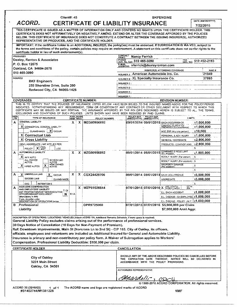
Ciient#· 45 BKFENGINE
ACORDN CERTIFICATE OF LIABILITY INSURANCE 1 OATE (MM/00/VYYY)
7/2212015 THIS CERTIFICATE lS ISSUED AS A MATTER OF INFORMATION ONLY AND CONFERS NO RIGHTS UPON THE CERTIFICATE HOLDER. THIS CERTIFICATE DOES NOT AFFIRMATIVELY OR NEGATIVELY AMEND, EXTEND OR ALTER TIHE COVERAGE AFFORDED BY THE POLICIES BELOW. TIHIS CERTIFICATE OF INSURANCE DOES NOT CONSTITUTE A CONTRACT BETWEEN TIHE ISSUING INSURER($), AUTHORIZED REPRESENTATIVE OR PRODUCER, AND THE CERTIFICATE HOLDER.
IMPORTANT: If the certificate holder is an ADDITIONAL INSURED, the poliey(ies} must be endorsed. If SUBROGAT10N IS WANED, subject to the terms and conditions of the policy, certain policies may require an endorsement. A statement on this certificate does not confer rights to the certificate holder in lieu of such endorscment(s).
PR;OOUCER 1 ~~1:AcT Nancy Ferrick Dealey, Renton & Associates I Fl1gNJo, Ext): 510 465-3090
.
'""" {.AJC Not: 510 452-2193 P. 0. Box 12675 Jp~~~-~: nferrick@dealeyre~ton.com Oakland, CA 94604·2675
JNSURER(S) AFFORDING COVEAAGE NAICt: 510 465-3090
~NSURERA : Amertcan Automobile Ins. Co. '21 049 INSURE.O fNSURERB XL Specialty Insurance Co. 37885
BKF Engineers ----
255 Shoreline Drive, Suite 200 j INSURERC: --- --· . ----- ----
Redwood City, CA 94065·1428 ! INSURER 0: . ·-·--·· -·--·- - ------
I INSURER E;
I 1NSURER F:
COVERAGES CERTIFICATIE NUMBER· REVISION NUMBER· THIS IS TO CERTIFY THAT THE POLICIES OF INSURANCE LISTED BELOW HAVE BEEN ISSUED. TO THE INSURED NAMED ABOVE FOR THE POliCY PERIOD INDICATED. NOTWITHSTANDING ANY REQUIREMENT. TERM OR CONDITION OF AI>N CONTRACT OR OTH::.R DOCUMENT WITH RESPECT TO WHICH THIS CERTIFICATE MAY BE ISSUED OR MAY PERTAIN, Tr.E INSURANCE AFFORDED BY THE POLICIES DESCRIBED HEREIN !S SUBJECT TO ALL THE TE.qMs,
.
~;:.~~~~~-AND_ CONDITIONS OF SUCH POLICIES. ~~~f:!"E .. ~':_~W~ MAY HAVE BEEN REDUCED BY PAID_CLAIMS. -------- .. -
'i:',.SRR T"Y:._E_~~-~~~~-RA~.<?.E ~~~L~~4 POUCYNU~~-E.~-- ···---· &~J5g~~~~..J6~rm; _ L!MrYS -=~~~-A GENERALLIABJuTY x x MZGS0956B92 ~9101!2014 09J01t2015_~~-C?.~.Y.~R..§~~~- ____ .. l.~t • .QQ!b_o,o,o,__-1
_ _ • DAMAGE TO RENTED 1 OOO OOO M:;;;RCIAl. GENooRAL LIABILITY 1 PREMISES 18:1 occurrence S
CLAIMS.IAAD!; [XI OCCUR i MEG EXP IAny O<'le person) j-"s-'1~0:".0,~0"'0"':-:----J f--e-1 Contractual Uab I PERSONAL &Aov 1r-uuRY I s1 ,000 000 ~Cross Liability ! GENERAL AGGREGATE i s.2,000,000
~'L AGGREGATE UMIT APPLIES ?ER: I PRODUCTS· COMP!OP AG_G_j ~£._!!9_9 ,,_,OCOOCOQ'---j
I _!__ POU~~lil.j~_[J LOC I --- . --"' i s -----AiAi:rroMOBILELLABILITY X X 1 MZG80956892 .. ·--~9/01_/2_ 014 09/01/201 cOMBlNEDSINGLE :JMIT 1 ;1,000,000
• r-'" J~ __ ~..Q~Ci~IJ --·---+"====--·-j
0. _X, ANY AUTO ~ 80011. Y INJURY (Per P'JIW"i : $.
I ALL OWNED -,SCHEDULED I 80DilYINJURY{Pc-raccOdcm): S. ·--·-·· ----1 AUTOS __ AUTOS ; ixlx ·x NON-OWNED n HIRED AUTOS ~ AUTOS i ; S
~+-+-~----~-,----~~-77.~----------------4------7------I-----------------------
PROPERTY DAMAGE PN llccidQr.~
A i xl f,JMWU~U..AL.IAB ~OCCUR X X .CGX24429706 P910112014,09101/201-r=EA"C"'H'-'OC=CooU"RREco0c.NooCo.E __ ~-_,_ ·ss,~o,o_,o,_,oo=o'-----1 4 EXCESS LIAS ! I CLAIMS-MADEI ~GGREGATE --~~s5,,_,0_,0_,0,0ec0"'0'----J
1 _ _,·=,1"D'!'E"'Do-I'=="'C!RC'E','TE'CN~T='0N"'-'S'-----~:.__..-J--'-·--··-·---. _. .. . _ ---· f--·- l . : S ----A ~~~:~;~~;~e-:::~~~ YIN 1 x 1 wzPs1o2ss44 p7!o1J2o1sio7/01J2o1~--~-Jfc?.s..r:o~hsJ _ _;_~;t:~---·---·----l
!ANY PROPRIETOR!PARTNERIEXECUTIVEr -~;-] ' ! E.L EACH ACCIDENT . $1 QQQ 000 :~=~~=~~~~EXCLUDED? Ll!_: N 'A i I E.L. DJSEASE. EA EM?LOYEE; s1 000.000 ·-----.
f-::-·~g,ri:;ec':'~"fpc.5
f,,~,"""o"'°F"d""'' Pc;E;>:RA"'-"TI"O"Ns...,."'""~"'---+-+-----======------ ·-- i:=::.· ' E.L OJ SEASE -_POLICY LIMIT I s1,000,000 B Professional ! DPR9725060 FH/01/2015 07/01/201~ $5,000,000 per Claim
! Liabllity 1 1 $7,000,000 Ann! Aggr.
i OESCRJPTION OF OPERATIONS i LOCATIONS l VEHICLES (Attl:ctl ACORO 1 D1, AddiUo-ru~l RMTUirks- Seh~<.~lo, lf moro 1>-PI>CII Is roq<.~irOO)
General Liability Policy excludes claims arising out of the performance of professional services. 30 Days Notice of Cancellation (10 Days for Non-Payment of Premtum).
Ref: Downtown Improvements, Main St (Norcross Ln to 2nd St}- ClP 165. City of Oakley, its office-rs, officials, employees and volunteers are included as Additional Insured for General and Automobile Liability.
Insurance is primary and non-contributory per policy fonn. A Waiver of Subrogation applies to Workers·
Compensation. Professional Liability Deductib,e: $100,000 per claim.
CERTIFICATE HOLDER CANCELLATION
City of Oakley SHOULD ANY OF THE ABOVE DESCRIBED POUCIES BE CANCELLED BEFORE TllE EXPIRATION DATE THEREOF. NOTICE YlrtLL BE DEUVERED IN
3231 Main Street ACCORDANCE WITH THE POUCY PROVJSIONS.
Oakley, CA 04561 AUTHORIZED REPR:ESE.NTATfVE
~.J "'"'d~" 'J;- ' flO_,--( I © 1988·2010 ACORD CORPORATION. AI! nghts reserved.
ACORD 25 (2010/05) 1 of 1 The ACORD name and logo are registered marks of ACORD #S1402744/M1381228 NMF
---------------------------------------------------------- -·-·--·-------·
Additional Insured - Owners, Lessees or Contractors - Scheduled Person or Organization- CG 20 10 04 13 Policy Amendment(s) Commercial General Liability
1 nsured: BKF Engineers Policy Number: MZGB0956892
Producer: Dealey, Renton & Associates Effective Date: DS/0112014
Tbis endorsement modifies insurance provided under the: following:
Commercial General Liability Coverage Part
Schedule
:t"ame Of Additional Insured Person(s) Or Organization(s)
C1ty of O.aldey
3231 Main Street
Oakley. CA 94561
Location(s) Of Covered Operations
Ref: DowntO\Vn Improvements, Main St (Norcross Ln to Znd St)- CIP 165. NAME OF ADDITIONAL FNSUREO PERSON($) OR ORGANIZATION(S} CONTINUED: City of Oakley, !ts officers, officials, employees and volunteers are Additional Insured.
Information required to complete this Schedule, if not sho·wn above, will be shov..n in the Declarations_
A. Section H - Who Is An Insured is amended to include as an additional insured the person(s) or organization(s) shown in the Schedule, but only with respect to liability· for bodil}' injury, property damage or personal and ad"·ertising injury caused, in whole or in part, by:
I.
2.
Your acts or omissions: or
The acts or omissions of those acting on your behalf;
in the performance of your ongoing operations for the additional insured(s) at the Jocation(s) designated above_
However:
l. The insurance afforded to such additional insured only applies to the extent permitted by law; and
B.
2. If coverage provided to the additional insured is required by a contract or agreement, 1he insurance afforded to such additional insured will not be broader than that which you are required by the contract or agreement to provide for such additional lnsured.
\\lith respect to the additional insureds, exclusions apply:
insurance afforded to these the following additional
This insurance does not apply to bodily injury or property damage occurring after:
1. All work, including materials, parts or equipment furnjshed in connection with such work,. on the project (other than service. maintenance or repairs) to be performed by or on behalf of the additional insured(s) at the Iocatlon of the covered operations has been completed; or
This Form mllSt be anached !o Change Endorsement when issued after !.he policy is written.
One of the Firt'man·s Fund Insurance Compa.nies as namc.d jn tlle policy
CG2010 4-13 ... lnsur.mc..: Services Offlce. Jnc., 20!2 Page 1 of2
·-~-···---------------------
2. That portion of your work out of which the jnjUJ)' or damage arises has been put to its intended use by any person or organization other than another contractor or subcontractor engaged in perfonnjng operations for a principal as a part of the same project.
C. \Vith respect to the insurance afforded to these additional insureds, the following is added to Section HI - LUnits Of losurance:
CG2010 +-13 + lnsur..:mcc Se~v;C{!'s Of:lce. lnc .. 2011
li coverage provided to the additional insured is required by a contract or agreement. the most we will pay on behalf of the additional insured is the amount of insurance:
1. Required by the contract or agreement: or
2. Available under the applicable Limits of lnsurance shown in the Declarations;
whichever is less.
This endorsement shall not increase the applicable Urn its of Insurance shown in the Declarations.
Page 2 of 2
Additional Insured- Owners, Lessees or Contractors- Completed Operations - CG 20 37 04 13 Policy Arnendment(s) Commercial General Llability
Insured: BKF Engineers Policy Number: MZG80956892
Producer: Dealey, Renton & Associates Effective Date: 0910112014
This eodorsemect modifies insurance provided under the following:
Commercial General Liability Coverage Part
Products/Completed Operations Liability Coverage Part
Scbednle
l'\am'7 Of Additional Insured Person(s) Or Organiz.ation(s)
City or Oakley
3231 Main Street
Oakley, CA 94551
Location And Description Of Completed Operations
Ref; Downtown Improvements, Main St (Norcross Ln to 2nd St). CIP 165. NAME OF ADDITIONAL INSURED PERSON{S) OR ORGANIZATIONISJ CONTINUED: City of Oakley, its officers. officials, employees and volunteers are Additiona~ Insured.
Information required to complete this Schedule, if not shown above, will be shown in the Declarations.
A. Section II ~ Who Is An Insured is amended to include as an additional insured the person(s) or organization(s) shown in the Schedule, but on1y with respect to !iabi!lty for bodily injury or property damage caused. jn whole or in part, by your work at the location designated and described in the Schedule of this endorsement performed for that additional lnsured and included in the products--<:ompleted operations hazard.
However:
1. The insurance afforded to such additional insured only applies to the extent pennitted by Jav.·~ and
2. If coverage provided to the additional insured is required by a contract or agreement, the insurance afforded to such additional insured will not be broader than that which you are
required by the contract or agreement to provide for such additional insured.
B. With respect to the insurance afforded to these additional insureds. the following is added to Section Ill - Limits Of Insurance:
!f coverage provided to the additional insured is required by a contract or agreement. the most we will pay on behalf of the additional insured is the amount of insurance:
i. Required by the contract or agreement: or
2. Available under the applicable Limits of Insurance shown in the Declarations:
whiche'-'er is less.
This endorsement shall not increase the applicable Limits of Insurance shown in the Declarations.
This Form musl be attached m Change Er1dorsemen1 \Vhen issued after rhc policy is vainen.
One of the fireman":s Fund ln:.urance Companies as named in the policy
CG~037 4.13 + ln..su:a:tlce Services Offic<'. Inc .. ~012
MZG80956892
Amendmentto Condition 4. Other Insurance- CG 72 90 l1 09 Policy Amcndment(s) Commercial General Liability
The following is added as a second paragraph to Section fV Condjtlons, Condition 4. Other Insurance. foilo\\ing paragraph b.(l)(b):
However. if you have added any person~ organization or vendor of yours as an additional insured to 1hjs policy and have agreed in a written insured contract
that this insurance is primary and non--eontributory with other insurance a vailab 1c to that additional lnsured. this insurance is primary and we will not seek contribution fi-om such additional insured's OVlTl insurance. This lnsura..Jce is excess over all other insurance available to the addirional insured.
This Fonn must 1:te 3tntchcd to Chan,£,-e Endorscmcm wllcr!. iss.ued after the policy is written.
One of lb.-: Frrl!'m~n's Fund lnsuraru:.: Companies as n2mcd in the policy
CG7291'} J 1...()'; ;e 2009 fi:reman'!- Fund l=n.OC>.:- Compo.fl}·- No~"3w, CA ,(~..!! n~ts rc:::.'¥el"'>'cd Jr:clud...'"S COP'iri>!h!ed mm:enal of l~ Servi-ces ()ffio:-. lnc with il~ l"tomi~;.:,.r_
Prcsidcn~
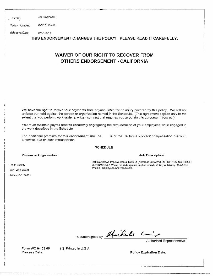
nsured: BKF Engineers
=>olicy Number: INZP81 026644
Effective Date: 07/01/2015
THIS ENDORSEMENT CHANGES THE POLICY. PLEASE READ IT CAREFULLY.
WAIVER OF OUR RIGHT TO RECOVER FROM OTHERS ENDORSEMENT- CALIFORNIA
We have the right to recover our payments from anyone liable for an injury covered by this policy. We will not enforce our right against the person or organization named in the Schedule. (This agreement applies only to the extent that you perform work under a written contract that requires you to obtain this agreement from us.)
You must maintain payroll records accurately segregating the remuneration of your employees while engaged in the work described in the Schedule.
The additional premium for this endorsement shall be otherwise due on such remuneration.
% of the California workers' compensation premium
Person or Organization
::.ity of Oakley
:231 Main Street
)akley. CA 94561
Form WC 04 03 06 Process Date:
SCHEDULE
Job Description
Ref: Downtown Improvements. Main St (Norcross Ln to 2nd St)- CIP 165. SCHEDULE CONTINUED: A Waiver of Subrogation applies in favor of City of Oakley. its officers, officials, employees and volunteers.
Countersigned by ~ c • 7
Authorized Representative
(1) Printed in U.S.A. Policy Expiration Date:
- __________________________________ _J
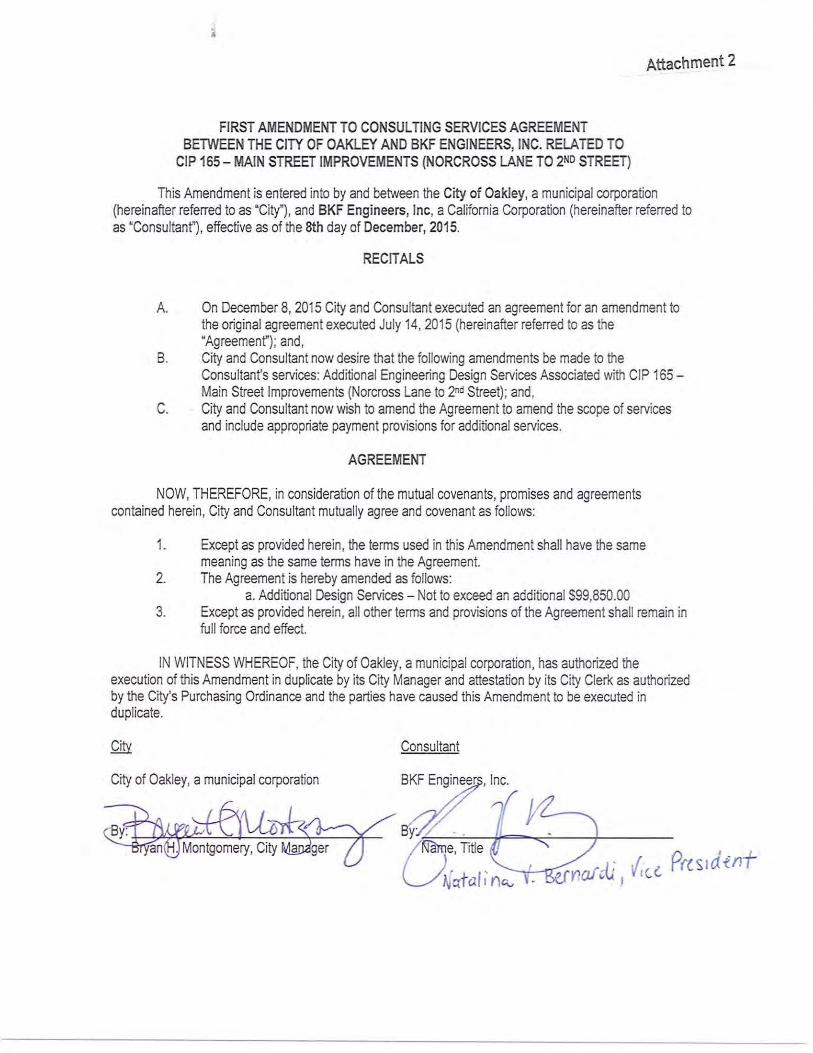
FIRST AMENDMENT TO CONSULTING SERVICES AGREEMENT BETWEEN THE CITY OF OAKLEY AND BKF ENGINEERS, INC. RELATED TO
CIP 165- MAIN STREET IMPROVEMENTS (NORCROSS LANE TO 2 ND STREET)
Attachment 2
This Amendment is entered into by and between the City of Oakley, a municipal corporation (hereinafter referred to as "City"), and BKF Engineers, Inc, a California Corporation (hereinafter referred to as "Consultant"), effective as of the 8th day of December, 2015.
RECITALS
A. On December 8, 2015 City and Consultant executed an agreement for an amendment to the original agreement executed July 14, 2015 (hereinafter referred to as the "Agreement"); and,
B. City and Consultant now desire that the following amendments be made to the Consultant's services: Additional Engineering Design Services Associated with CIP 165-Main Street Improvements (Norcross Lane to 2 nd Street); and,
C. City and Consultant now wish to amend the Agreement to amend the scope of services and include appropriate payment provisions for additional services.
AGREEMENT
NOW, THEREFORE, in consideration of the mutual covenants, promises and agreements contained herein, City and Consultant mutually agree and covenant as follows:
1. Except as provided herein, the terms used in this Amendment shall have the same meaning as the same terms have in the Agreement.
2. The Agreement is hereby amended as follows: a. Additional Design Services - Not to exceed an additional $99,850.00
3. Except as provided herein, all other terms and provisions of the Agreement shall remain in full force and effect.
IN WITNESS WHEREOF, the City of Oakley, a municipal corporation, has authorized the execution of this Amendment in duplicate by its City Manager and attestation by its City Clerk as authorized by the City's Purchasing Ordinance and the parties have caused this Amendment to be executed in duplicate.
Consultant
City of Oakley, a municipal corporation
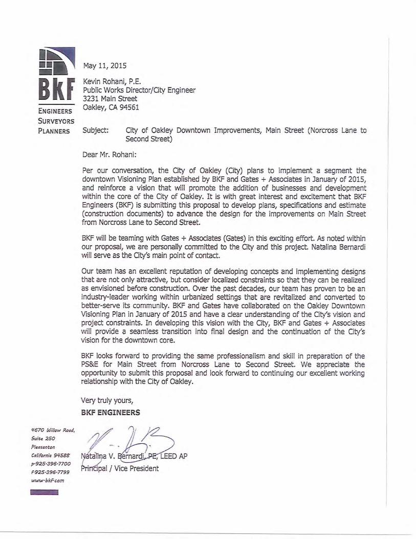
I~ n , Bkf ENGINEERS
SURVEYORS
May 11, 2015
Kevin Rohani, P.E. Public Works Director/Gty Engineer 3231 Main Street Oakley, CA 94561
PLANNERS Subject: City of Oakley Downtown Improvements, Main Street (Norcross Lane to Second Street)
'1670 Willow Read,
Suiu 250
Pleasaneon
CaliFornia 9'1588
p·925·396·7700
F·925·396·7799
wt•tvrbi<Fcom
Dear Mr. Rohani:
Per our conversation, the Gty of Oakley (City) plans to implement a segment the downtown Visioning Plan established by BKF and Gates+ Assodates in January of 2015, and reinforce a vision that will promote the addition of businesses and development within the core of the City of Oakley. It is with great interest and excitement that BKF Engineers (BKF) is submitting this proposal to develop plans, specifications and estimate (construction documents) to advance the design for the improvements on Main Street from Norcross Lane to Second Street.
BKF will be teaming with Gates+ Associates (Gates) in this exciting effort. As noted within our proposal, we are personally committed to the Gty and this project. Natalina Bernardi will serve as the Gty's main point of contact.
Our team has an excellent reputation of developing concepts and implementing designs that are not only attractive, but consider localized constraints so that they can be realized as envisioned before construction. Over the past decades, our team has proven to be an industry-leader working within urbanized settings that are revitalized and converted to better-serve its community. BKF and Gates have collaborated on the Oakley Downtown Visioning Plan in January of 2015 and have a clear understanding of the City's vision and project constraints. In developing this vision with the City, BKF and Gates + Associates will provide a seamless transition into final design and the continuation of the Oty's vision for the downtown core.
BKF looks forward to providing the same professionalism and skill in preparation of the PS&E for Main Street from Norcross Lane to Second Street. We appreciate the opportunity to submit this proposal and look forward to continuing our excellent working relationship with the City of Oakley.
Very truly yours,
BKF ENGINEERS
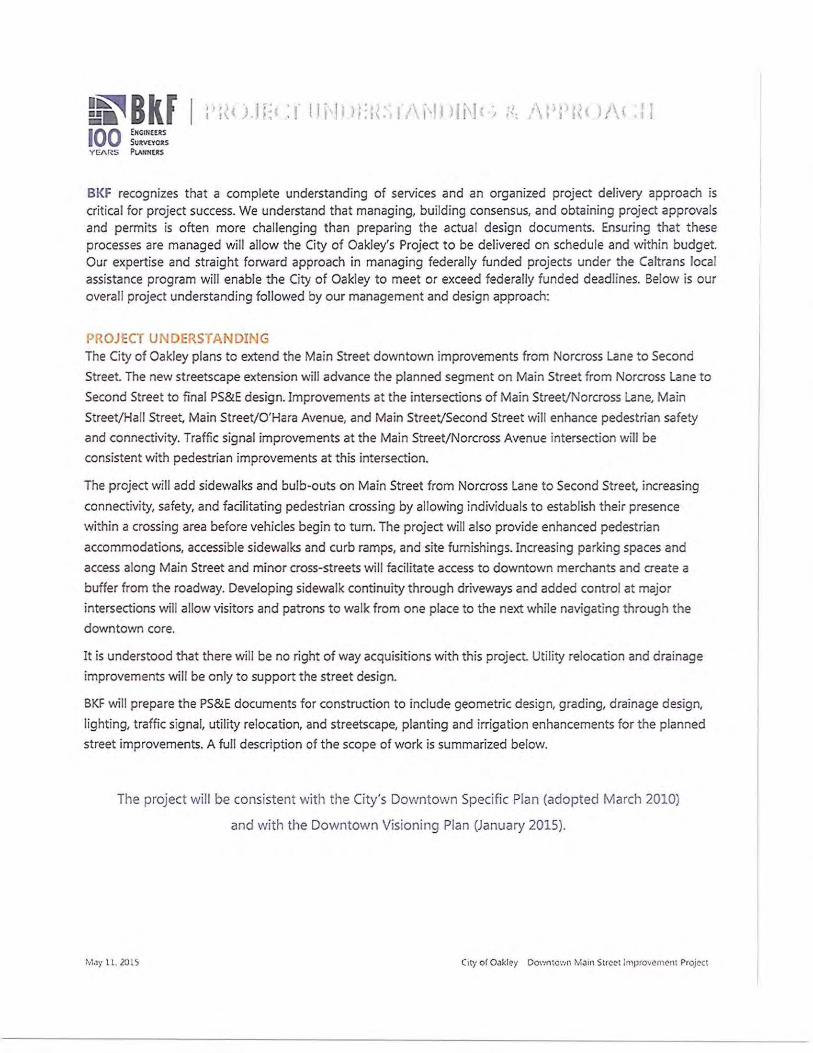
L~BkF I 100 fHGINWtS
SuRvtYORS YEA RS PI.AHNUS
BKF recognizes that a complete understanding of services and an organized project delivery approach is critical for project success. We understand that managing, building consensus, and obtaining project approvals and permits is often more challenging than preparing the actual design documents. Ensuring that these processes are managed will allow the City of Oakley's Project to be delivered on schedule and within budget. Our expertise and straight forward approach in managing federally funded projects under the Caltrans local assistance program will enable the City of Oakley to meet or exceed federally funded deadlines. Below is our overall project understanding followed by our management and design approach:
PROJECT UNDERSTANDING The City of Oakley plans to extend the Main Street downtown improvements from Norcross Lane to Second
Street. The new streetscape extension will advance the planned segment on Main Street from Norcross Lane to
Second Street to final PS&E design. Improvements at the intersections of Main Street/Norcross Lane, Main
Street/Hall Street Main Street/O'Hara Avenue, and Main Street/Second Street will enhance pedestrian safety
and connectivity. Traffic signal improvements at the Main Street/Norcross Avenue intersection will be
consistent with pedestrian improvements at this intersection.
The project will add sidewalks and bulb-outs on Main Street from Norcross Lane to Second Street, increasing
connectivity, safety, and facilitating pedestrian crossing by allowing individuals to establish their presence
within a crossing area before vehicles begin to turn. The project will also provide enhanced pedestrian
accommodations, accessible sidewalks and curb ramps, and site furnishings. Increasing parking spaces and
access along Main Street and minor cross-streets will facilitate access to downtown merchants and create a
buffer from the roadway. Developing sidewalk continuity through driveways and added control at major
intersections will allow visitors and patrons to walk from one place to the next while navigating through the
downtown core.
It is understood that there will be no right of way acquisitions with this project. Utility relocation and drainage
improvements will be only to support t he street design.
BKF will prepare the PS&E documents for construction to include geometric design, grading, drainage design,
lighting, traffic signal, util ity relocation, and streetscape, planting and irrigation enhancements for the planned
street improvements. A full description of the scope of work is summarized below.
The project will be consistent with the City's Downtown Specific Plan (adopted March 2010)
and with the Downtown Visioning Plan (January 2015).
MJy l l. 201S Cn:y of Oakley Do,·mto·:,n M;11n StrcN improvement Project
L~BkF I 100 E!IGiti!US
Su~VO'Ol!.S YEARS l'tA.~NUS
SCOPE OF SERVJCES
TASK 1: PROJECT MANAGEMENT
The project will begin with a kickoff meeting with the City of Oakley. Our approach to Project Management includes comment review meetings after each milestone submittal. BKF will prepare meeting agendas and keep minutes for meetings with the City. We will also prepare and update the proj ect schedule on a monthly basis which will be presented at the project coordination meetings.
Project Administration - BKF's Project Manager will supervise, coordinate, and monitor the design for conformance with City's standards and policies. BKF will establish and implement a quality control procedure for design activities, perform in-house quality control reviews for each task, and submit project deliverables to the City for review in accordance with the approved schedule.
Kick-off Meeting - A partnering/kick-off meeting will be scheduled with the City soon after the Notice-toProceed to confirm project scope, goals, and objectives.
Meetings - Conduct monthly project meetings either in person or via teleconference. BKF will attend monthly progress meetings with the City staff to discuss the project progress, issues which may affect the proj ect schedule and budget, and any other agenda items that the City may request for discussion. BKF will prepare the agenda, action logs, updated project schedules and meeting minutes.
CPM Schedule - BKF will prepare a detailed Critical Path Method (CPM) schedule for the entire project using Microsoft Proj ect software. The Microsoft Project CPM schedule will be updated on a monthly basis and submitted at each monthly Project Meeting.
Invoices/Progress Reports - BKF will prepare and submit budget reports, monthly progress reports, and invoices in accordance with the City's requirements.
Quality Assurance - BKF will perform an in-house QA/QC review of the documents submitted to the City and outside agencies. BKF's quality control review prior to each submittal will include the review of the design package for coordination among the various design elements, compliance with City and Federally Funded project standards, and completeness. The different project sheets will present the design in a common manner with no contradictions or variances. The review will focus on ensuring that the plan elements are dearly delineated.
Task 1 Deliverobles
1) City Meeting Agendas/Minutes (8 Meetings)
2) Project Schedule
TASK 2: SURVEY /RECORD BOUNDARY /REPORTING/DOCUMENT EXISTING CONDITIONS
Immediately after receiving the Notice-to-Proceed, BKF will perform site investigations and review all available documentation. We will conduct preliminary investigations and verify right of way and utility locations. This task will consist of compiling, reviewing existing data pertinent to the project and performing investigations necessary to verify the project's criteria and scope. Also included are planning phase activities, identifying supplemental information, performing field survey work, and conducting site visits/field review, and obtaining information and requirements related to utilities and right of way conditions.
M,Jy 11. 2015 City of Oakley 00\·mto·:,n M,11n Street !mpro•:cmcnt PrOJeCt
In the init ial phase of work. BKF will investigate the extent and perform field studies necessary to understand the existing conditions. Our approach will minimize unnecessary labor and expense allowing the City to direct additional funds for street improvements. The data collected will help our team define site constraints, confirm budget, and establish the scope of work necessary to prepare the streetscape along Main Street BKF team activities will include the following during this task:
Collect Record Data and Relevant Project Information: BKF will obtain and review available data and information necessary for the design of the project. This information may be obtained from the City, utility companies, or other organizations. BKF will compile available pavement information, right of way record maps, utility occupation drawings, block maps, and third party utility as-built information of record to supplement the topographic base sheets and begin the utility verification process. Data to be reviewed includes the following:
• Review work performed as part of the Main Street Downtown Street Improvements PS&E- CIP 11 and 103
• Previous report(s) or documents related to the proposed project area • As-built plans • Utility information • Right of way information
Field Review: BKF will visit Main Street with the City to document the project limits, conform areas, and verify locations of existing above-ground utilities. We will compile both a photographic log and field notes of the investigation. BKF will evaluate the following:
• Existing pavement condition • Existing limits of curb. gutter and sidewalk to remain - identify conform locations • location of entrance ways • location of existing utility boxes and poles and signal equipment • Back of walk conforms for sidewalk and curb ramps
Background/Supplemental Survey - BKF will use the existing raw aerial topographic base map of the project area as background for the plan sheets. Our field survey crews will recover sufficient survey monument information in the area to establish control that will be used for the project. The horizontal and vertical coordinate system used for establishing existing survey control for the project will be determined upon further discussions with the City.
BKF will provide supplemental survey services for purposes of locating elements in the field that are necessary for design of the Downtown Main Street improvements form Norcross lane to Second Street Some of these elements will include elevation at entrance ways, existing improvements to remain (for conform purposes). street crown elevation, limits of driveways, manhole invert elevations, utility poles, vaults, and building corners and traffic signal equipment.
May 11. 2015
L~BkF I 100 ENGJ"[[RS
SuRvtYORS Y EJ\RS PlAHNERS
... I • \.;
1\ I ! ) I ) \ ~ .I\ { . \1 I , I 1 1\ 1 , • .
Record Boundary - Utilizing the survey control and the existing raw aerial mapping, BKF will obtain recorded right of way information to provide record boundary of the various individual parcels that are located within the project limits. The record boundary and easement information will be superimposed onto the aerial topographic map.
This proposal excludes title services, County map checking or filing fees, mailing and reproduction costs, plotting expenses, the setting of any property comers and the filing of any record of survey that may be required under California law. This proposal is also based on the fact that BKF will be provided with access to all of the properties within and adjacent to the survey limits.
This scope of services assumes that all utilities will be placed within the roadway right of way under the franchise agreement and that no separate Public Utility Easements will be required for the proj ect.
Utility Research and Coordination: BKF will perform utility research to map the existing utilities in the project area, have USA field locate utilities that potentially conflict with the proposed improvements, and develop relocation plans for conflicting utilities. We will incorporate the City,s storm drain and sewer information into the base drawing. All the gathered utility information will be compiled and used to supplement the project bases sheets to provide a complete existing base.
BKF will prepare a potholing plan for concurrence by the City and work with EXARO Technologies to positively identify location of existing utilities. This level of effort will minimize construction costs and ensure the correct placement of the proposed improvements. We will provide both written notice and hold a meeting at the City offices describing the proposed construction schedule. As part of the utility coordination work, BKF will:
o Review work performed as part of the Main Street Downtown Street Improvements PS&E- OP 11 and 103
• Review and update as-built utility information for the Project area o Request utility mapping from all affected utility owners • Update base mapping with existing utility information • Identify potential utility conflicts • Submit utility maps to impacted utility owners for verification of potential conflicts • Prepare utility potholing plan for coordination with EXARO Technologies • Coordinate the above work with the utility owners
Geotechnical Data: Parikh Consultants Inc. (PCI) will evaluate existing geotechnical data and establish "RValuesn for areas of asphalt overlay or reconstruction of street section where necessary. Parikh Consultants will perform field exploration, borings, sample evaluation and testing for the project. They will prepare a geotechnical memorandum and log of test borings establishing the recommended pavement section. This scope of work assumes that the City will waive all permit fees related to geotechnical investigation.
Task 2 Deliverob/es
1) Aerial Topographic Background and Supplemental Survey
2) Record Boundary
3) Utility Mapping/Potholing plan
4) Geotechnical Memorandum
May 11. 2015 Cory o f 0 .1kley Do,·mto·:m M .1u1 Strl!et lmpro·;ement Proje<t
TASK 3: PRELIMINARY DESIG N
BKF will refine the concept design prepared to date based on multiple factors such as utility impacts, right of way impacts, pedestrian connectivity, overall cost and schedule, and work with the City and stakeholders to develop a detailed design to be advanced into final design. BKF will advance the concept and identify the following, assessing benefits, constraints and challenges:
o Prepare Horizontal and vertical alignment, layout and lane configuration
• Prepare typical sections showing right of way and conform limits
• Provide a design that will implement facilities for pedestrians while maintaining two Janes in each direction.
o Evaluate locations and limits of bulb-outs
o Prepare a preliminary Utility Relocation Plan
• Prepare order of magnitude cost estimate for design.
• Prepare memo establishing the design criteria for final design
• Refined layout of hardscape and softscape
o Prepare options for gateway elements (up to 3 options)
o Preliminary details (seatwalls, site accessories or furniture)
• Selection of plant materials
• Conceptual site landscape lighting
• Review cost estimate of participation in value engineering.
• Prepare presentation exhibits, including two photo simulations.
• Participate in presentation to finalize design direction.
The advanced preliminary design will be detailed as an approved preliminary plan in exhibit form with cross sections and highlighted details to ensure that all potential issues are discussed. With concurrence on the details and criteria of the design, the project can proceed in obtaining formal approval.
Task 3 Deliverobles
1) Preliminary Design Layout for Main Street from Norcross Lone to Second Street
2) Preliminary Utility Relocation Plan
3) Gateway Options
4) Presentation Material/Photo simulation
M<ly l l 2015 C•ty of O~kle-; Do:mtoc·:n M .1in StrC'ct lmp:ovC'mC'nt P10jc?CI
TASK 4: FINAL DESIGN
With the completion of the Preliminary Design Phase, BKF will initiate the Final Design Phase preparing plans, specifications, and Construction Cost Estimate as discussed below.
Based on the developments during the design and criteria established during the preliminary phase, all the major components of the design plans, technical specifications and estimate will be advanced to final design during this phase.
TASK 4.1 Project Plans
Design submittals will be prepared for the 60%, 90% and final plans. With the establishment and review of the alignment and geometry, design will be production-oriented for preparation of proj ect plans. The plans will be developed to a 60% level in order to obtain a thorough review.
The focus of the design team is to finalize the supplemental project information that forms the basis of design for the project In this light, the emphasis becomes design and production-oriented. All project sheets, which will be represented in the bid documents, will be identified and developed in varying degrees of detail during this phase.
The vertical design, including flow line and pavement elevations, will be established during the 60% plans, specifications and estimate (PS&E) design effort. The back of walk, cross slope and longitudinal slope, flow line, and pavement elevations will consider and balance the Project area constraints including conforms, and will incorporate impacts to driveways, curb ramps, and adjacent sidewalk interface conforms.
For the 90% ubmital, BKF will incorporate or resolve any remaining comments received as a result of the 60% submittal review. BKF will also conduct remaining site investigations. It is crucial that the design engineers are confident that existing field conditions have not changed since inception of the project and are depicted accurately in the bid-ready documents. Assumptions, in lieu of verifications, are not acceptable; BKF will walk the site with the final bid documents prior to submittal. Al l remaining aspects of the design will be finalized in order to prepare a complete, checked and bid-ready set of documents. Schedules for utility relocations will be confirmed. The construction cost estimate will be updated and formatted to its final form. BKF will conduct a final quality control review on all documents to ensure that all design elements are thoroughly addressed prior to their submission to the City.
In the Final Submittal, BKF will prepare bid-ready documents.
For each design submittal, BKF will prepare the following plan sheets in progressive levels of details:
• I :, .: will be prepared to provide an overview of the project limits and an index of project sheets. Project abbreviations, legend, and survey controls will also be included.
- _ _ , , u ~· General notes will include applicable City standard notes, and project notes.
- s __ - s: Plans will include cross section showing cross slopes, type and depth of new pavement section and the following: face of curb, back of walk, median, sidewalk. lane widths, g rade breaks, bulb-outs, and right of way limits.
· BKF will evaluate the existing facilities impacted by the proposed improvements. The evaluation shall include existing conditions, unusual/special conditions and adjustments of manholes/valve covers conflicting with the proposed work. Demolition plans will show existing sidewalk, curb and gutter to be removed, removal of existing street pavement section, conform grind area, and existing residences with addresses. Additionally, all facilities to be protected in place will be identified. Existing utilities will be shown
M,lj' 11. 2015 Csty of O~kle-J 00\·mtO':. n M,1111 Strect lmpso·,e merH Project
::~BkF I I I I . 1 ) j i : I ,· 1• J l \ ~ . ' I ,
100 EHG1N£US Su~Vn'OAS
Y EARS PlANNERS
as background information.
-. Improvement Plan sheets will be prepared showing the top of curb and back of walk lines along the north and south sides of Main Street illustrating the limits and scope of surface improvements. Plan sheets will include basic horizontal and vertical layout information and identify all major construction features including areas of reconstruction and limits of conform at driveways and intersections. More specifically, the plan will be at 1"=20' scale showing the station line with distance and bearing, station line/offset of each driveway, curb ramp locations, limits of new pavement section, limit of pavement conforms, and important elements to protect in place. The plan will also identify the location of new curb ramps with respect to new and existing utility boxes and inlets. Existing and proposed elevations will be shown in the plan at every SO feet and for relevant changes along the crown, flow line, and at the back of walk.
"' • ., - Details will be provided as necessary to provide guidance to theContractor on special conditions related to sidewalk ,back of walk conforms, and intersection grading. Additionally grading plans will be prepared and added to the details sheets. BKF wi ll show City standard details for curb, gutter and sidewalk, pavement conform, and utility adjustments on detail sheets .
• 1 ' ,..., .!s · . Drainage plans will be prepared showing the proposed site improvements and existing drainage system with proposed drainage modifications and additions. Drainage plans will include location of proposed manholes and inlets and location of tie-in to the existing drainage system. The drainage plan will be prepared at 1"=20' scale showing the station line with, station line/offset of each manhole and inlet, and important drainage elements to protect in place will be identified.
The profile will be prepared at 1•:20' horizontal/1 ":4' vertical and will include existing and proposed profiles for the crown/center line, and north and south flowlines with slope values. BKF will also include elevations at entrance ways for conform at the back of walk.
Drainage details will be provided as applicable for the new drainage system to include new pipe connections to existing manholes and tie-in to
- !:I · t • _ s. BKF will identify all utilities that are impacted by the project (e.g. water, sewer, gas, electric, cable TV, telephone, valves, boxes, and service connections) on 20-scale plan sheets. BKF will provide utility adjustments to the City, and coordinate with the appropriate utility owners.
,. v i C ·~ ., ' · $7 It is BKF's understanding that permanent storm water treatment will not be required for this project based on our preliminary evaluation from our storm water expert, Ed Boscacci a Qualified Storm Water Pollution Prevention Plan Developer (QSD) and Qualified Storm Water Pollution Prevention Plan Practitioner (QSP). BMP plans will show location of gravel bags and check dams along the gutters, curb inlet protection and trees to be protected in place. Notes will make reference to compliance with appropriate sections in the City's spedal provisions.
: New signs will be placed onto the new poles, as necessary, for integration with the new streetscape improvements. Pavement delineation plans will include turning movements at each intersection and will extend 50 feet into roads that intersect with Main Street to include Norcross lane, Hall Street, O'Hara Avenue and Second Street.
C•ty of O,lkl~y Downto·::n M,1111 Strct'llnlprovcm~nt ProJeCt
L~BkF I 100 EHGINWtS
SU~Vl"tOllS YEARS Pw!NUS
t,P JO( } ''\( • I j , I I 1\ , · I
_; • · BKF will provide the traffic signal modification plan for the traffic signal at the intersection of Main Street/O'Hara Avenue. Based on our preliminary evaluation, it is understood that the existing traffic signal service and controller cabinets do not need to be relocated. BKF will also provide a design for a new traffic signal at the intersection of Main Street/Norcross Lane. AEC Engineers, as part of the BKF team, will prepare Lighting plans for the proposed street lights along Main Street
, "' • , ·• .. : David Gates and Associates, as part of the BKF team will prepare the following: Layout plans for landscaped areas, hardscaped areas, and site furnishings; landscape lighting coordination - location and fixture selection; planting plans and details; irrigation plans and details; landscape construction items; and gateway element Since the gateway feature is unknown at this time, there is no structural design being estimated but can be done so after it is determined as needed.
TASK 4.2 Specifications
Specifications will be prepared using standard C.S.l format modified as appropriate for City Standards for all work items necessary for the construction of the project. BKF will assemble the Technical Specifications and appropriate City "Boilerplate" Special Provisions for Federally Funded Projects. The Specifications will be prepared for the 60%, 90%, and Final Submittals.
TASK 4.3 Construction Cost Estimate
BKF will prepare a preliminary cost estimate to ensure that the magnitude of cost corresponds to the project budget Should the scope exceed the budget, we will include value-engineering strategies in our analysis, which may include alternative rehabilitation strategies or delaying repairs to certain segments. The Construction Cost Estimate will be prepared using present-day dollars; escalation costs will not be applied. The Construction Cost Estimate will be prepared for the 60%, 90%, and Final Submittals.
Task 4 Deliverables
1) 60% PS&E Submittal with Response to Comments from Preliminary Design
2) 90% PS&E Submittal with Response to Comments from 60% Design
3) Final Documents with Response to Comments from 90% Design
TASK 5: UTILITY RELOCATION AND STAKEHO LDER COORDINATION
BKF's key to successful stakeholder coordination is a multifaceted and parallel delivery approach. After advancing the preferred alternative into final design, BKF will prepare a comprehensive deliverable to be submitted to each stakeholder simultaneously.
Utility Coordination and Relocation There are various water, gas, electrical and overhead utilities along Main Street from Norcross Lane to Second Street BKF will send out utility notices and obtain utility mapping information. We will also provide notification of probable utility impacts to affected utility owners and coordinate a suitable plan for relocation of impacted
Ma;·ll. 2015 C•r1 of 0 ,1klcy Oo·.-.nto-:.n•"IJm Strect lmprowment ProJe<l
utilities. One utility of note is the overhead electrical line along the north and south sides of Main Street BKF will work with the City to protect the power poles in place where feasible.
Task 5 Deliverables
1) Utility Notice to Owner
2) Utility Coordination
TASK 6: Bid Assistance
BKF will assist the City during the project bid period to respond to contractor's questions on the contract documents.
Task 6 Deliverables
1) None
Notes and Conditions:
Notes and conditions to the scope of work above are noted as follows:
1. Geotechnical services are only for the purpose of establishing the roadway section. 2. Drilling Permit fees from the Contra Costa Environmental Health Deportment will be considered a pass
through cost to the City.
ivlay 11. 201 S Coty of Oakley Oo ... mto·::n M,,n Street fmprovem.::nt PrOJe<t
L I ?·'W-'· "'' ·'"
~ 1--
. .
t'· '',·::S-=~--- I .j :I I I I .1 I I I I .E I· ~1
--
r--...,~
•t!Wo..ctL*"'
~,.._PI"~(:..:I .... II'O'JI'ot;o---,r~
o-.c;.v.ft_,~~~
,~ .. --~ r:"'-'"t,.._..~ t-.T~:..C. M!L...,.~1·~
[""' · . .. wo;
City o! O.ldey Oowmown lbJn su..t lmpt'O'Wment:.
~ ~ ,...,. ~ f3!!::!!:!:1. 1"'. - ~ .... ~ ~~ . ..... 1~ •.
' .. 1Q~QO ., ..
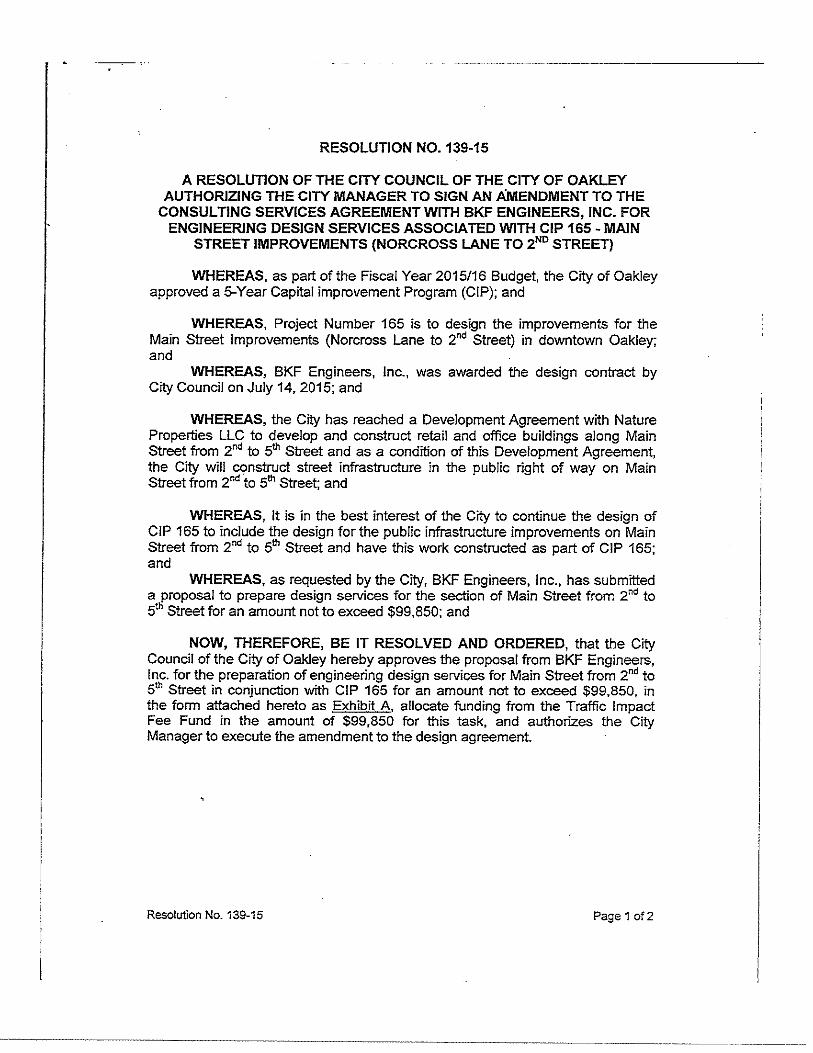
RESOLUTION NO. 139-15
A RESOLUTION OF THE CITY COUNCIL OF THE CITY OF OAKLEY AUTHORIZING THE CITY MANAGER TO SIGN AN AMENDMENT TO THE
CONSULTING SERVICES AGREEMENT WITH BKF ENGINEERS, INC. FOR ENGINEERING DESIGN SERVICES ASSOCIATED WITH CIP 165- MAIN
STREET IMPROVEMENTS (NORCROSS LANE TO zND STREET)
WHEREAS, as part of the Fiscal Year 2015/16 Budget, the City of Oakley approved a 5-Year Capital improvement Program (CIP); and
WHEREAS, Project Number 165 is to design the improvements for the Main Street Improvements (Norcross Lane to 2nd Street) in downtown Oakley; and
WHEREAS, BKF Engineers, Inc., was awarded the design contract by City Council on July 14, 2015; and
WHEREAS, the City has reached a Development Agreement with Nature Properties LLC to develop and construct retail and office buildings along Main Street from znd to 5th Street and as a condition of this Development Agreement, the City will construct street infrastructure in the public right of way on Main Street from znd to 5"' Street; and
WHEREAS, It is in the best interest of the City to continue the design of CIP 165 to include the design for the public infrastructure improvements on Main Street from znd to 5"' Street and have this work constructed as part of CIP 165; and
WHEREAS, as requested by the City, BKF Engineers, Inc., has submitted a proposal to prepare design services for the section of Main Street from znd to 5tll Street for an amount not to exceed $99,850; and
NOW, THEREFORE, BE IT RESOLVED AND ORDERED, that the City Council of the City of Oakley hereby approves the proposal from BKF Engineers, Inc. for the preparation of engineering design services for Main Street from znd to 5th Street in conjunction with CIP 165 for an amount not to exceed $99,850, in the form attached hereto as Exhibit A, allocate funding from the Traffic Impact Fee Fund in the amount of $99,850 for this task, and authorizes the City Manager to execute the amendment to the design agreement.
Resolution No. 139-15 Page 1 of2
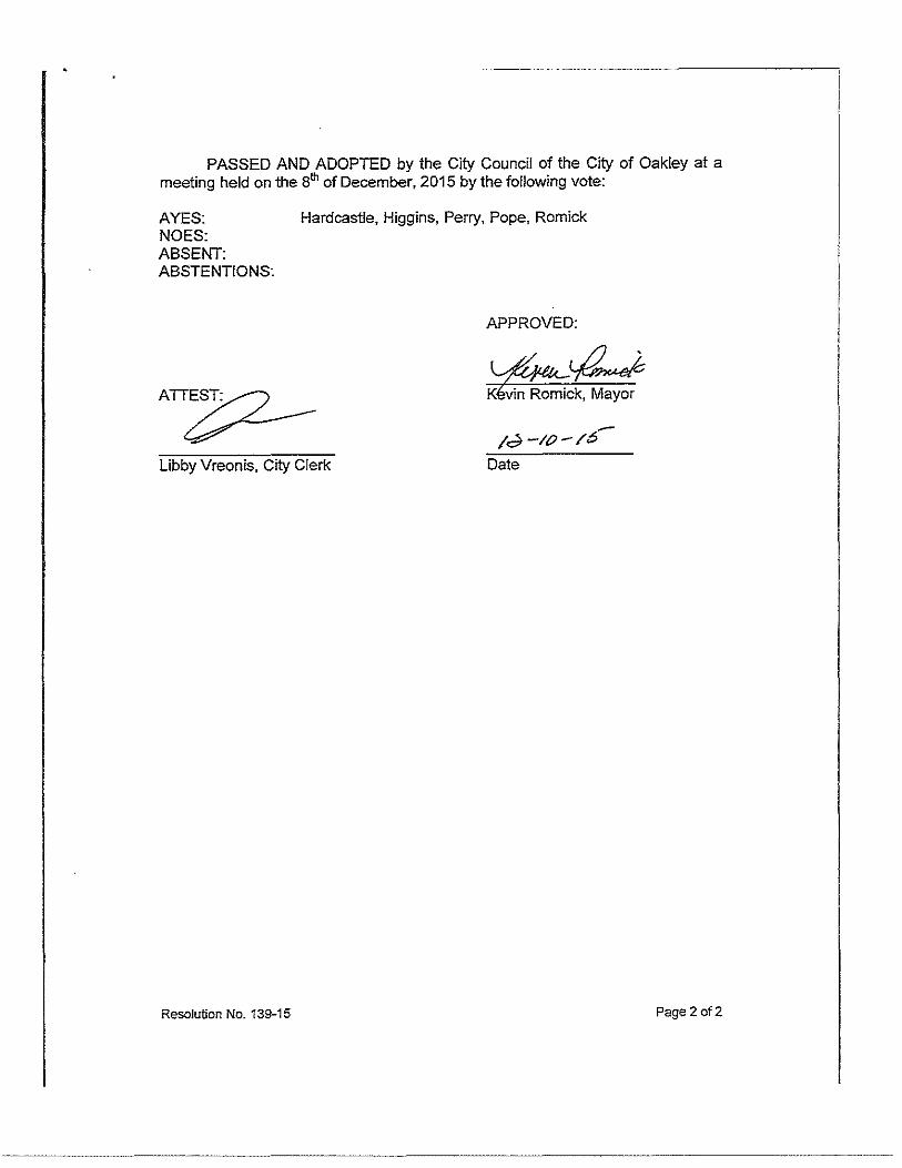
PASSED AND ADOPTED by the City Council of the City of Oakley at a meeting held on the 8th of December, 2015 by the following vote:
AYES: Hardcastle, Higgins, Perry, Pope, Romick NOES: ABSENT: ABSTENTIONS:
APPROVED:
ATT~
Libby Vreonis, City Clerk Date
Resolution No. 139-15 Page 2 of2
ENGINEERS SURVEYORS
November 19, 2015
Kevin Rohani, P.E. Public Works Director/City Engineer 3231 Main Street Oakley, CA 94561
Exhibit A
PLAtiNERS Subject: City of ·Oakley Downtown Improvemen~, Main Street (Serond Street to
r.t-670 .1/Ji/Jow ~~4..
$U;i~·2SO.
i>J¢Mlln ton.
·c.wr.,_rnli: 9ll~lf.e
p-$25·395·7700
i-925-396·7799 WwW-.bKPcom
!Zpi@ £$9
Fifth Street, North Side) . .
Dear Mr. Rohani:
Per our conversa.tion~ the City of Oakley (City), in. coordination with N(!ture Properties, has. planned improvements along the north side of Main Street from Second Street to Fifth Street. BKF Engineers (BKF) iS submitting this proPosal to develop plans, specifications and estimate (construction documents) to design the improvements in the ·public right of way along Main Street from Second Street to Fifth Street:
BKF will continue to wOrk with Gates. ± Assodates {Gates) :in. this effOrt. As .noted within our proposal; we are P!=rsonally -committed to the City <md !:hts project. Natalina Bernardi will serve as the Cit)(s main point of contact. ·
·Our team has an excellent reputation pf working with land developers and implementing streetscape designs that are not .Otily attiactjVe, but. consiqer localized coilstraint_s $()·that they can be realized as envisioned before construction. Over the' past decades, our team has proven to be an induStry-leader working within urbanized settings thatare revitalized and converted to better-serve Its community. 13KF and Gates have collaborated on the Oakley Downtovm ViSioning Plan in January of2015 and wilii'JOrk with the City and an d coordinate with t!le I.and developer to have a .clear understanding of the City's vision and project constraints. BKF and Gates + Assodates will provide fi.nai d~ign services. for the continuation of the City's vision for the downtown core.
BKF lookS forward to proViding .the same professiomilism arid skill in preparation of the PS&E for Main Street from Second Street to Fifth Street (north side). We appreciate the opportunity to submit this proposal and look forward to continuing our excellent working relationship with the City of Oakley.
Very truly yours;
BKF ENGINEERS
BKF recognizes that a complete uhderst.anding· ·of services. and an org;mizeq project delivery approacf1 is critical for project success. We ·understand ·that managing, f:?uilding cqnsensus, and obtaining project approvais and. permits is often more challenging than ·prepa"ring tile actual design documents: En~uring that ·these processes are managed will aJiow the \:ity of Oakley's Project to be delivered on· .schedule and within budget Our expertise anci straight fol'Ward approach in managing_ federally funded projects u·nder the caitrahs local assistance program Will enable the CitY .of Oakley to meet cir exceed federally funded deadlines. Below is our overall project·.undei:standihg followed bi our management and design.appmach:
PROJECT UNDERSTANDING The. CitY of Oakley ·plans to extend the north side of Maio Sti:eet ciowAtown improvements fromSeeond Street
to Fifth Street The new streetscape extension will advance the planned ·segment on Main Street from Second
Street to Fifth Street to final PS&E design.
The project will add sidewalks ;>)1d bu.lb,0uts on the north sid<'! of Main Street from Second Street to Fifth
Street, increasing conn,cti0ry, safety, and facilitating .Pedestrian crossing by allowing i'ndividua)s tq establish
th~lr presencev;ithin.;l crossing ;>rea before y~t)icles begin to turn_. The"prqjei;t \viii al.so ·provide e.nhan.ce.d
pedestrian accommodations, accesSible. sidewalks and curb ramps, and sitii furnishings. Develo·p;ng sidewalk
continuity wilT allow visitors and· patrons lo walk .from one place to the .next while navigating through the
downtown-core.
BKF will prepare the PS&E documents for construction to include~ geometric design, grading, drainage design,
lighting, traffic signal, utility relocation, and streeiscape, ·planting and irrigation ent)al].cemen.ts fqr the planned
street improve11:1ents. A full description of the scope of work i~ summarize<;! qelow.
SCOPE OF SERVlCES
TASK l:PROJECT MANAGEMENT
The proJect mana9.ement scope of work is inCluded in the ongoing effort fortne work being performed .in .t.h~ Main Street segment from Norcross lane to Second Street
TASK 2: SURVEY/RECORD BOUNDARY/PLAT AND LEGALS
Iffimediately after rec-eiving. the Notice-to-Pro,eed, BKF wm perfom1 site investigations and revrew afl.available documentation. We will conduct preliminary. investigations and verify right. of .way and utility locations. This task will consist of compiling, reviewi~g existing data pertinent to the project and performing jnve~igations necessary to verify the· proj~'s criteria ana scope. Also included ar!" plimning pha~e activities, identifying supP.Iemental informatiqn, performing field survey work, .and conducting site visits/field review; and obtaining inform·ation and requirements related to utilities and right of way conditioqs,
C!iy<~fbokl~J-_Do\·~ntown.f•tial.l) Street impr9yerneot Proje.ct· (S<!cond Street ~o Fifth ~trcet -· r•Iortb Side)
In the initial phase of work, BKF will investigate the extent and perform field studies necessary to understand the existing conditions. Our approach will minimize unnecessary labor and expense allowing the City·to direct additional funds for street improvements. The data collected will help our team define s.ite constraints, confirm budget, and establish the scope of work necessary to prepare the streetscape along Main Street. BKF team activities will indude the following during this task
Collect Record Data and Relevant Project Information: BKF will obtain and review available data and information necessary 'for the design of the ·project. This information may be obtained from the City, utility companies, or other organizations. BKF will compile available pavement information,. right of way record maps, utility occUpation drawings, block maps, and third. party utility as-built information of record to supplement the ·topographic base sheets and begin the utility verification process. Data to be·reviewed includes the following:
o Previous report(s) or documents related to. the proposed project area o As-built p!ans o Utility information • Right of way information
Field Review: BKF will visit Main street with the City to document the project limits, coilform areas, and verify iocations of existinQ abovecgrourid utilities. We will compife both a photographic Jog and field notes of the investigation. BKF will·evall!ate.the following:
• Existing pavement condition • .Existing limits of curb, gutter and sidewalk to rem? in ~identify conform locations o Location of entrance. ways o Location of existing utility boxes and poles and signal equipment o Bac~ of walk conforms for sidewalk and curb ramps
Background/Supplemental Survey - BKF will use the existing raw aerial topographfc base map of the project area as background for' the· plan sheets, Our field survey .crews will recover sufficient survey monument information in the area· to establish control that will be used for the project. The horizontal and vertical coordinate system used for establishing existing survey control for the project will be determined·upon·further discussions with the Cify. It is BKF's assumption that the survey provided to the City by Nature Properties is acceptable to use for the Oty's project
B]5:F will provide supplem.ental survey services for purposes of locating elementsjn the field tha.t-are necessary for design of the Downtown Main Street improvements from Second Street to Fifth Street (North Side). Some· of these eleme.nts will inclo.de existing lill)it of'pavement, edsting elements to rem!l.ih (for conform purposes), street crown elevation •. limits of driveways, manhole invert elevations, utility poles; vaults, and buifding corners and traffic signal equipment.
Record· Boundary - Utilizing the survey control and the existing raw aerial mapping, ·sKF will obtain recorded. right of way information to provide record boundary of the Nature Properties parcel. The record boundary information will be superimposed onto the aerial topographic map.
November lS. 2015 Ci~y of 0Jkle;,• Da:mtcwn M::in Strce:Utnpr~ctlt Project {Second Strc~rt<) Fifth Street -Nor,h Side}
This proposal excludes title services, County map coecking or fiHrig fees, mailing ~nd reproduction costs, piottihg expenses, the setting of any property comers and the filing of any record of survey that may be required under California law. This proposal is also based on the fact that BKF will be provided ·with access to the Nature Properties parcel within and adjacentto the survey limits.
This ·scope of services assumes that all utilities will be placed withirr the roadway right of way under ·the franchise agreeme.nt and that n'O separate P~blic, Utility Easeme.nts will be re.quired for the project
Plat .and Legal Description: Jt is our ·assumption tha.t this work can 'be prepared by plat& legal description o_nly. BKF will research and ob!;lin the vesting deed of the Nature Properties parcel and use this information to determine the. area to be deeded for the street righf of .way. The City will provide· the Title Report of the subject property for mapping purposes. Based on the new Right of Way requirements we will create ·an exhibit of the proposed parcel and calculate the limits of the area· to be described and mapped. SKF will also prepare the mathematical closure calculations for determining the area. Based on the above calculated location and area, BKF will prepare the legal qescription and plat for the area. One legal description and pfat will be prepared for the Oty's proposed parceL Excluded are the-following: title. Reports, Te.ntative Maps, Parcel\flnal Maps, lot line adjustment application or process.ing, and. field survey forlot;easementline·verifica.tion;
Utility .Coordination: lt is assumed that the utility coordination work is in.cluded' under the original contract. However, BKFwiii ne~ to request from ·utility owners additional information from Se~o.nd Street to Fifth Street.
Utility ·Investigation: BKF will prepare a potbciling plan for concurrence by the .City and work with .EXARO Technologies to positively identifY location .of existing utilities .. This lever of ·effort will minimize -construction costs and ensure the correct placement of the proposed improvements. As pait of the utility iiwestigation work, BKF will:
• Ji.eview'and ~pda:te as,built utility information for the Project area· • Update base mapping with existing utility information o Identify potential utifity conflicts · o Su\:>mit utility maps to impacted utility owners forverification of potential confli.cts • Prepare utili;y pothoiing plan for coordination with EXARO Technologies
Geotechnka! Data: Parikh Consultants Jnc: (PCI) will expand the geotechnical investigation to identify soil conditions fOr the monument. Parikh Consuh:aDts wiH perform field. explOration, borings, sample evaruation and :testing for tbe proposed monument location. This scope of work assumes that the Oty·will waive all permit. fees related to geotechnical investigation,
Task 2 Deliverab/es
1) Supplemental Survey
2) ,Record BoundQry·
3) Utility Mapping/Potholiiig plan
4) Geotechnical Memorandum
TASK3: PRELIMINARY DESIGN Nov&;~mber-lZ, ·2015 Gty ofb,1!:!cy- 00\'.'0'p~·m Main Str.mt !snprove."'',¢n.t Projqct
{S&O:'Id StiCi'lt to Flftl\ $\ceet- North Side)·
!;KF will refine the concept design prepared by Nature Properties, We will evaluate multiple l<lttors such as utility impacts, right of way impacts; pedestrian c,onnectivity, overall cost and schedule. BKF will advance the concept and id_entify the following, assessing benefits, constraints <)_nd challenges along the North Sjde of Main Stre.et only:
o Prepare Horizontal and vertical alignment; layout and lane configuration
o Prepare typical sections showing right of way and conform limits
• Provide a design that will implement (acilities for pedestria.ns
• Evaluate locatioQs and limits of bulb-outs
o Prepare .a preliminary Utility Relocation Rlan
• Prepare order of magnitude-cost estimate for design.
• Refined layout of hardscape and softscape
0
0
• 0
Preliminary details (seatwalls, site accessories or furniture}
Selection of plant materials.
Conceptual site lilndscape lighting
Review cost eStimate of participation in value engineering.
0
0
Prepare presentation exhibits, induding_ two section/elevations.
Participate in. presentation to finalize design direction.
Task 3 Deliverables
1) Preliminary Design Layout for Main Street from Norcross Lone to Second Street
2) Preliminary Utility Relocation Plan
TASK 4: FINAL DESIGN
"It is BKF's .understanding that this work will i)e incorporated into the contra,:t documents for Main· Street from Norcro.ss Lane to Second Stte.ei.
With. the completion of the Preliminary Design Phase, BKF will initiate the Final D.esign Phase preparing plans, specifiCations, and Construction Cost Estima.te.as discuSsed below ..
Based -on the developments during the design and criteria established during the preliminary phase, all the major components of the design plans, technical _specifications and estimate will be advanced to final design during this phase.
Cilr cf O<~;kley- Down:o·.:m ivlain Street In~p~o::m Project {Sec end Stre~:-t() Fifth Street- ·Noct~ Sicir:)
·--~----------------------------
------ ---- --·
TASK 4.1 Project Plans
Design submittals will be prepared for the 60%" 90% and ·final P.lans. With ihe establishment an<:J review of the alignment an.d geqmetry, design will be production-oriented for preparation ofproject plans. The plans will be developed to a 60% level in or<fer to obtain a thorough review.
The.focusof the design team is. to finalize the supplemental project'information that fotms the basis of design fa( the project. In this ligAt, the emphasis becomes design and production-oriented~ All projett sheets, whicn \viii be represented in the bid documents, will te identified and developed in varying degrees of detail during this phase.
The vertical de"sign, including flow iine and pavement elevations, will be established during the 60% plans, .specifications and estimate (PS&El design effoit. The·back of walk, cross slope and longitudimil slope, flow line, -and pavement ·elevations. will consider and balance the Project area constraints including conforms, and will incorporate impacts to driveways,·curb ramps, and adjacent sidewall<- interface conforms.
For the 9o% supmital, "BKF will incorporate or resolve any remaining comments received as a result-of the 60% .s.ubmittal revi.ew, BKF will also condu.ct remainin!J site investigations. It is crucial that the design engineers are confident that existing field conditions. have .not changed since inception of the project and ;>re depicted ·acclirately in the bid-ready documents. BkF will walk tbe site with the final bid documents. prior to submittal. AJI remaining aspects of the design will be finalized in 'order to prepare a complete:. checked· and bid-ready set of ~ocuments. Schedules for utility relocations will be confirmed. The con·struction cost esti.mate will be u·pdated :and fotnnatted to its final foim. SKF will conduct a .final quality control review cin aJI documents to ensure that all design elements are thoroughly-addressed prior to their submission to the City.
!n the Final Submittal, BKF will prepare bid-ready<focuments.
For each design submittal, BKFwill prepare the following plan sheets in progressive levels of details:
title Sheet: .wiJI be prepared to provide an ove.rview of the project limits and an index of project sheets, Project abbreviations, legend, and survey contro.ls will also be included.
General r•otes: General notes will include applicable City standard· notes, and project notes.
Typical Cross Secticns: Plans will include cross section showing cross slopes, type and depth .of new pavement section and the following:·face of curb, back of walk. median, sidewalk, lane widths, gr:ade breaks, bulb-outs, and right ofway limits.
D~moHtion Plan: BKF v.:ill evaluate the eXisting faqlit_ies inypacted by ·the proposed- improvem~nts. The evaluation shall include existing conditions, unusual/special conditions and. adjustments df manhole;;/valve covers conflicting ....,ith the propose.d work. Demolition. plans will show existing· sidewalk. curb an·d gutter.te> be removed, removal of existing street pavement section, .conform grind area, and existing residences with addresses. Additionally, all facilities to be protected iri place will be identified. Existing utilities will be shown· as background inform~tion~
lmprovem:ont Pbns: fmprovement Plan sheets will be prepared showing the top of curb :and back of walk lines along the noith and south sides of Main Street illustrating the. limits and scope of surface improvements. Plan sheets will jnclude basic horizontal. infor111etion and identifY aJI major copstructio.n features including are?s of reconstruction and limits of conform. More specifically, the plan will be at ·1"=20'
SC<!Ie showing the station line with- distance. :and bearing, statio.n line/offset of each drivew?y, curb ramp locations, limits of new pavement section, limit .of pavement conforms, ·an.d important elements to protect in place. The plan wilL also identify the location of new c.urb ramps with respect to new and. existing utility bo.xes and inlets.
Ncvcmb2r is. 2015 (i_ty of O.:lkle-;- Oa:mto':m Mnii1 Suee: Imrrove:l'l~nt,Projcct {S~cond Sttc.ct to Fif!h 5!rcct- North Side}
Construction D~l<ii!s: Details will be provided as necessary to guide the Contractor on special conditions related to sidewalk, .back of walk cooforms, and intersection grading. Additionally grading plans will be prepared and added to the details sheets. BKF will show City standard details for curb, gutter and sidewalk, pavement conform and utility adjthtmeilts on·. detail sheets. Existing and proposed elevations will be shown in the plan at every 50 feet·and for relevant changes· along the street, flow line, and at the back ofwalk.
Drcdnage Piar::, Profi!:;:·s and .D~tz:Hs: Dra:il)C;lg~ pl~!l~: will be prepared showing the proposed site improvements and existing drainage system vvith proposed drainage mo:difica;ions and !ldditions. Drainage plans wiH include Jocaiion of propos<;>d manholes and inlets and location of tie-in to the existing drainage system. The drainage plan will be prepared at 1""'20' ,scale shpwing the station line with, station line/offset qf each manhole and inlet an.d important drainage elements to protect in place will be identified.
Drainage profiles will be. prepared at 1":20' horizontal/r:4' vertical and will include existing profiles for the crown/center line, and north and -south floWlines with slope values. Proposed· curb profiles will be. included for the north ·side of Main Street only.
Drainage details will be provided as applicable to supplement the proposed design
Utility Rearrangement Pl?ns: BKF wHI identify al,l utilities that .are i!Tipacted by the project (e.g, water, sewer, gas, electric, cable· TV, telephone, valves, boxes, and service connections) an prepare utility rearrangement plans on 20-scal~ sheets. . ·
Erosion Controi Plans and Detzi!s: It is BKF's understanding that permanent stor:m water treatment Will not be requiced for .this project based on our preliminary evaluation from our storm water expert; Ed Boscacci a Qualified Storm Water Pollution Prevention Plan. Developer {QSD) and Qualified Storm Water Pollution Prevention Plan Practitioner (QSP). BMP plans will show location of gravel bags and clheci< dams along the gutters, curb inlet protection and trees to be protected in place. Notes· will make reference to compliance with appropriate sections in the Oty's special provisions.
Pav~m.ent DeHn2ation and Sign Plans; New signs will be placed pnto the rfe~.~y pde~ ?~- necessa!Y, for: integration with the new streetscape improvements. BKF will prepare pavement delin·eation plans based on the approved preliminary'di?sign.
Lighting: AEC Engineers, as part of the BKF team,. will prepare llghting plans for the, proposed street lights along the North side of Main Street from Second Street to Fifth Street.
Landscaping tayout, PlmLting and Irrigation Pl.:1ns ~nd Det~Hs: David Gates and Associates, as part of the BKF team will prepare the following: Layout plans for landscaped: areas, hardscaped areas; and site furnishings; landscape lighting coordination - loca.ti()n and· fixture selection; planting plans. and <;letaijs; irrigation plans and details; landscape construction items:
TASK 4.2 Specifications
Specifications will be prepared usin9. standard C.S.l format modified as appropriate for City Standards for all work items neeessaryforthe construction of the project BKF·will assemble the Te.chnical Specifications-and a'ppropriate City "Boilerplate• 'Special Provisions for Federally Funded Projects. The Specifications will be prepared for the 60%,.90%, and Final Submittals.
No.vemOer 18. 2"01 5 q~y of-Q3klev Oowntown f>.:l~:n Street Impr9\~~t.f"r0ject (Sc.:or.d Street to Fihl> St~!- North Side)
~~Bkf "0~"~~ ''""'""" H u 5UJ:V£YCR:S YEARS Pl:AJlnotS
TASK 4.3 Construction Cost Estimate
BKF wm prepare· a pr!'liminary cost estimate to· ensure that the magnitude. of cost corresponds to. the project budget. .Should the scope exceed the budget, we wiil include value-€ingineering ·strategies in our analysis, which may include alternative rehabilitation strategies or delaying repairs to certain segments. The Construction Cost Esti.niate will be prepared using .present-day dollars; escalation .costs will not be· applied. The Construction Cost Estimate will be prepared for the £0%, 90%, and Final Submittals ..
Task 4 De/iverobles
I) 60% PS&E Sqbmittal with Response to Cpm.roents from Preliminary Design
2) 90% PS&E S1.1bmittal with Response to Comments from 60% Design
3) Fmal Docuinents.with Response to. Comments from 90% Design·
November lS, 201S City of Oilklcy- D~·:ntown t.-t~rl Street:rmR'9yeirl:?nt PrCj~ct (Second Slrcet to-Nfth St~ect .. North Side]
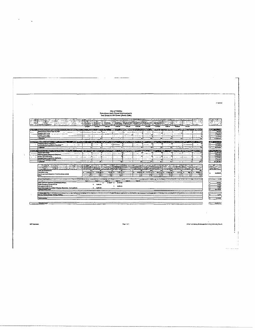
-- ..... , ... , ,..,.,.,,.,, ___ ..... ____ _
I~ =·, BkF ENGINEERS
SURVEYORS
PLANNERS
4670 Willow Road,
Suite 250
Pleosant;on
California 94588
p·925·396·7700
f-925·396·7799
www·bkfcom
Attachment 3
June 21, 2016
Kevin Rohani, P.E. Public Works Director/City Engineer City of Oakley 3231 Main Street Oakley, CA 94561
Subject: Construction Support Services, and Additional Design Services as Requested by the City
Dear Mr. Rohani:
Per your request BKF Engineers (BKF) is submitting this addendum for the following items whose scope is further summarized in the letter below:
TASK 3A -Preliminary Design Services for Sanitary Sewer TASK 4A- Final Design -Pavement Coring- Parikh Consultants TASK 48- Final Design - Plat and Legal Descriptions for various parcels TASK 4C- Final Design -Gateway Monument Additional Options TASK lA- Construction Support Services and Survey Staking for CIP 165 Main Street Realignment TASK 78 - Construction Support Services and Survey Staking for CIP Main Street Downtown Improvements from 2nd Street to 5th Street TASK lC - Construction Support Services and Survey Staking for CIP 165A Main Street Downtown Utility Improvements from Norcross Lane to 2nd Street
TASK 3A - Preliminary Design - Services for Sanitary Sewer.
BKF developed preliminary plans and estimate for the Sanitary Sewer improvements in the public right of way along Main Street f rom Norcross Lane to Second Street. BKF coordinated with Ironhouse Sanitary District (ISD) and the City in this effort. Below is a list of items included in our scope of work to complete the
design:
1. Obtain information on the locat ion of laterals (by ISD) 2. Attend an initial meeting with ISD and the City 3. Prepare preliminary sanitary sewer relocation plans
The fo llowing are BKF's assumptions regarding th is work: 1. The existing 8" sewer on the north side of Main Street will be replaced with 10" HDPE SDR26 sanitary
sewer pipe. 2. Existing 4" laterals will be replaced with 6" latera ls up to 2' behind the proposed back of walk. 3. A new sanitary sewer manhole will be added at the end of the 6" sanitary sewer line on the south side
of Main Street. 4. A small portion of the 6" sanitary sewer line will be replaced. 5. BKF assumes that sanitary sewer work will be included in advance utility package.
TASK 3A- DELIVERABLE$: »
» Preliminary design plans for sanitary sewer design including plans, profiles, and details.
Preliminary estimate for sanitary sewer design including plans, profiles, and details.
I~ =·, Bkf ENGINEERS
SURVEYORS
PLANNERS
'1670 Willow Road,
Suit:e 250
Pleasanton
California 9'1588
p· 925 ·396. 7700
F-925·396·7799
www·bkf·com
TASK 4A - Final Design - Pavement Coring Parikh Consultants performed coring at 9 locations for the purposes of evaluating existing roadway section. Traffic control was required for lane closures one lane will be closed at a time. Cores will be collected and
the logged (pictu res) and the pavement and base thickness was measured. Memo was prepared for the data that was collected. No special design is proposed as the city is interested only in the existing
conditions.
TASK 4A- DELIVER ABLES: » Coring results with report
TASK 4B- Final Design- Plat and Legal Descriptions for Various Parcels BKF assisted the City in preparing property exhibits and plat and legal descriptions for the following parcels:
APN Owner Property Address
035-111-007 Meadows Investment Properties 3361 Main Street
035-112-016 Tower Energy Group 3481 Main Street 035 -112-018 Tower Energy Group 3481 Main Street 037-160-020 Painter, Michael 3478 Main Street 037-160-022 City of Oakley 3210 Main Street 037-160-022 Mann Victoria Louise/Favalora Julie Ann 3530 Main Street 037-160-024 City of Oakley 3540 Main Street 037-160-025 City of Oakley 3570 Main Street
Additionally, based on City negotiations with property owners, exhibits and plat and legal descriptions for various properties were prepared multiple times. A total of 12 Plat and legal descriptions were prepare d by BKF with accompanying various exhibits. TASK 4B - DELIVERABLE$: » Property exhibits for the parcels listed above
» Plat and legal documents for the parcels listed above
TASK 4C- Final Design -Gateway Monument Additional Options Gates & associates provided 3 additional gateway design options and exhibits per City's request.
TASK 4C- DELIVERABLE$: » 3 Additional gateway monument design options
TASK 7A- Construction Support Services and Survey Staking for CIP 165 Main Street Realignment
The BKF team will assist the City in providing support throughout the construction phase of the Project.
BKF will assist the City in reviewing contractor submittals and respond ing to contractor RFis in a timely
manner. BKF's survey crews will prepare the survey staking based on the engineering issued for bid
drawi ngs. Additionally, BKF will attend the project pre-construction meeting, up to two field meetings,
and the project punch list meeting.
Construction Staking will include the following: a. Control and Administration
• Verify project control • Set control on south side for stage 1 construction • Reference control on north side for stage 2 construction • Setup CAD files provided • Perform misc. admin.
b. Demolition
• Stake saw cut and curb removal limits for demo
I~ =·, Bkf ENGINEERS
SURVEYORS
PLANNERS
lf670 Willow Road,
Suite 250
Pleasanton
California 9lf588
p·925·396·7700
(·925·396·7799
www·bkf·com
c. Rough Grading • Provide project control to grader for GPS operation • Stake misc. offsets to face of curb for rough grading
d. Utilities • Stake offsets to street lights • Stake center of signal poles and face of curb for review and placement of the signals
e. Curb /Concrete • Stake offsets to face of curb at angle points, radius, grade breaks, curb ramps, driveways
and end points • Stake misc. back of wa lk and conform locations • Stake offsets to face of curb in pavement area for median curbs
f. Retaining Walls • Stake offsets to face of wall at intervals of 50' and at ends and angle points
g. Landscape • Stake center of tree wells once curb is built
• Stake misc. landscape items - seat walls, granite seats
Construction Staking assumptions are as follows: a. One set of stakes will be set per item above. b. Staking to be scheduled 48 hours prior to date of staking, 5 days prior to start of job c. Area will be free for debris and obstruction prior to crew arrival d. Excluded are as-builts, verifications, certifications, landscape staking, subdrain staking, re-staking,
except as noted. e. Additional staking, re-staking not shown above can be provided on a time and expense basis. f. Staking interva l shall be SO' to 100' on tangents and 25' on small horizontal curves unless noted. g. We have assumed that the project will not be phased unless noted h. Scope and fee is subject to change based on review of completed plans.
TASK 7 A - DELIVER ABLES: » Attend Pre-construction meeting
» Review contractor submittals and shop drawings
» Review and respond to contractor RFis
» Construction staking for the Project
TASK 78 - Construction Support Services and Survey Staking for CIP Main Street Downtown Improvements from 2nd Street to 5th Street
The BKF team will assist the City in providing support throughout the construction phase of the Project.
BKF will assist the City in reviewing contractor submittals and responding to contractor RFis in a timely
manner. BKF's survey crews will prepare the survey staking based on the engineering issued for bid
drawings. Additionally, BKF will attend the project pre-construction meeting, up to two field meetings,
and the project punch list meeting.
Construction Staking will include the following: a. Control and Administration
• Verify project control • Reference control on southwest side • Setup CAD files provided • Perform misc. admin.
b. Demolition • Stake right of way limits
c. Rough Grading
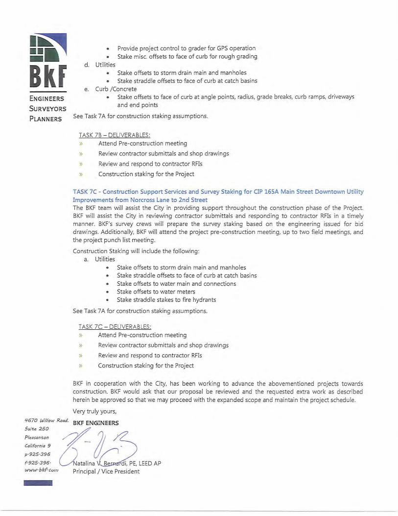
I~ =·, Bkf ENGINEERS
SURV EYORS
PLANNERS
• Provide project control to grader for GPS operation • Stake misc. offsets to face of curb for rough grading
d. Utilities • Stake offsets to storm drain main and manholes • Stake straddle offsets to face of curb at catch basins
e. Curb / Concrete • Stake offsets to face of curb at angle points, radius, grade breaks, curb ramps, driveways
and end points
See Task 7 A for construction staking assumptions.
TASK 7B - DELIVERABLE$:
» Attend Pre-construction meeting
» Review contractor submittals and shop drawings
» Review and respond to contractor RFis
» Construction staking for the Project
TASK 7C - Construction Support Services and Survey Staking for OP 165A Main Street Downtown Utility Improvements from Norcross Lane to 2nd Street The BKF team will assist the City in providing support throughout the construction phase of the Project. BKF will assist the City in reviewing contractor submittals and responding to contractor RFis in a timely manner. BKF's survey crews will prepare the survey staking based on the engineering issued for bid drawings. Additionally, BKF will attend the project pre-construction meeting, up to two field meetings, and the project punch list meeting.
Construction Staking will include the fol lowing: a. Utilities
• Stake offsets to storm drain main and manholes • Stake straddle offsets to face of curb at catch basins • Stake offsets to water main and connections • Stake offsets to water meters • Stake straddle stakes to fire hydrants
See Task 7 A for construction staking assumptions.
TASK 7C - DELIVERABLE$:
» Attend Pre-construction meeting
» Review contractor submittals and shop drawings
}> Review and respond to contractor RFis
» Construction staking for the Project
BKF in cooperat ion with the City, has been working to advance the abovementioned projects towards construction. BKF would ask that our proposal be reviewed and the requested extra work as described herein be approved so that we may proceed with the expanded scope and maintain the project schedule.
Very truly yours,
'1-670 Willow Road. BKF ENGINEERS
~~~} ({at2lEEDAP www· bkF·c"m Principal I Vice President
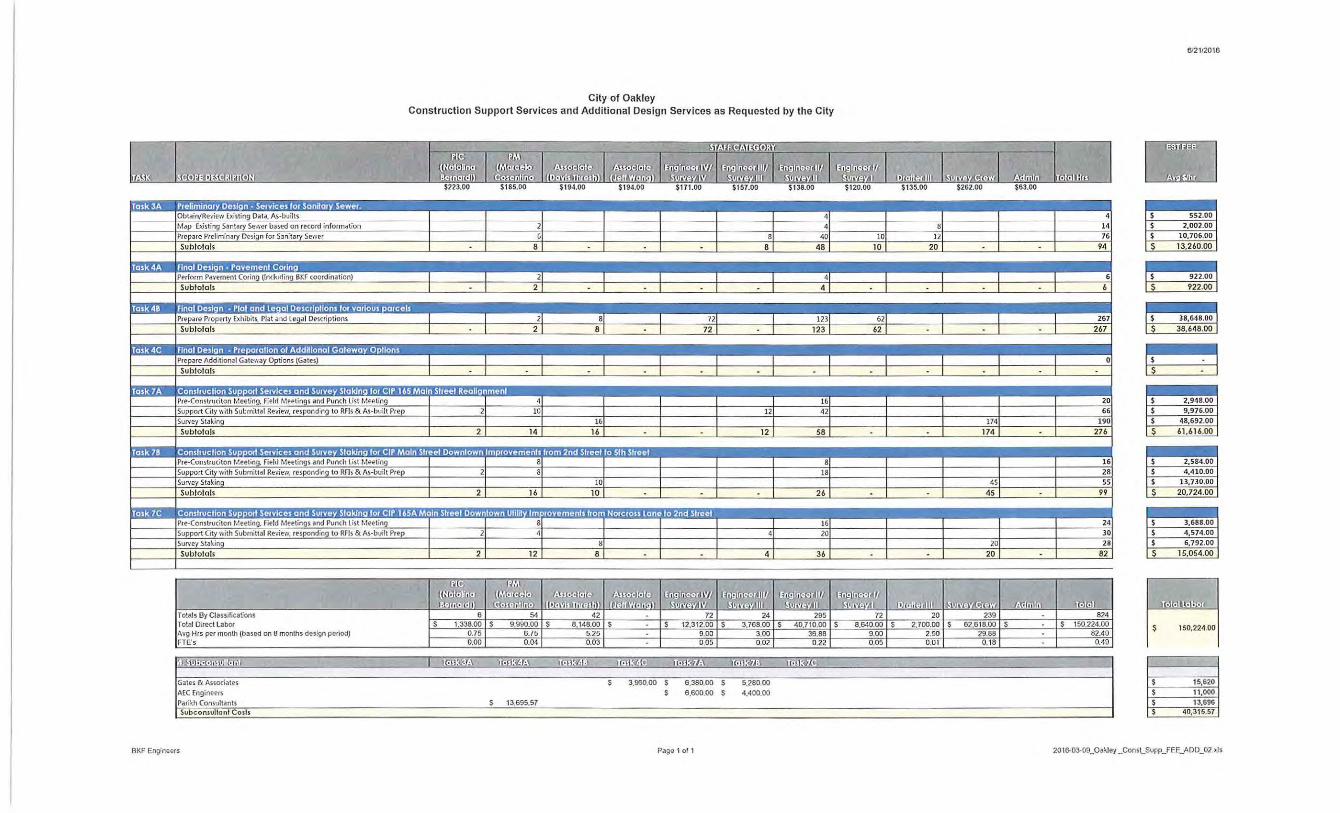
&'2112016
City of Oakley Construction Support Services and Additional Design Services as Requested by the City
b .. ·Lm, ·- 1 6TBI&Iaalmr;;;r;;Ji~l -rn l~l = lm I c:J $223.00 $185.00 $194.00 $194.00 $171.00 $157.00 $138.00 $120.00 $135.00 $262.00 $63.00
relimlnary Design · Services for Sonijory Sewer. .. • $ 552.00
14 $ 2,002.00
40 10 12 76 $ 10,706.00
8 8 48 10 20 94 s 13,260.00
BKF coordination) 6 2
,tions 267
267
,.h llh
Prepare Additional Gate-.·.ay Options (Gates) Sublolals ~ 0
omlrucllon Support Services and Survey Slaking for CIP 165M 16 20 $ 2,948.00
2 1 1:01 1 ~61 I I 1:21
42
58 174 190
276 174
$ 9 ,976.00 $ 48,692.00
s 61 ,616.00
66
•lllll~lool ·ll·lll"l::~~=ll:0l!lllllll!l I I I 8
18
26
45
45 99
16 $ 2,584.00 $ 4,410.00 $ 13,730.00
s 20,724.00
28 55
ownlown Ulihty fmprovemen!s from Norcross lane to 2nd Street :.~~· :.·. ··:-: ...- ::C: 16 24 $ 3,688.00
20 30 $ 4,574.00
21 12 1 s8
1 I I 4 1 36
20
20
$ 6,792.00
s 15,054.00 28
82
~ri:!l'l Totals By Classiflcat:ons 24 72 824 To!al Dire<t Labor s 1,338.00 s 9,990.00 s s s 12,312.00 s 3,766.00 s s 8,640.00 s s s s 150.224.00 Avg Hrs I"'' month (based on 8 months design pe riod) 0.75 6.75 9.00 3.00 9.00 82.40
~ 150,224.00
FTE's 0,00 0,04 0.05 0.02 0.05 0.49
'-J.M!f!I!N ofl!lll! o1 I mo:~~ 1w~~a H·IJ~"]: l! i!K(&j 'IJ!IJ:W.;.. Uorl:Hi mn~~
Gates & Associatts s 3,960.00 s 6,380.00 s 5,280.00 $ 15,620 AEC Engineers s 6,600.00 s 4.400.00 $ 11,000
Pari~h Consultants s 13,695.57 $ 13,696 Subconsullanl Cosh $ 40,315.57
BKF Eng:neers Page t of 1 20tS.03-09_0a'<feJ_Const_Supp_FEE_ADD_02 >.Is
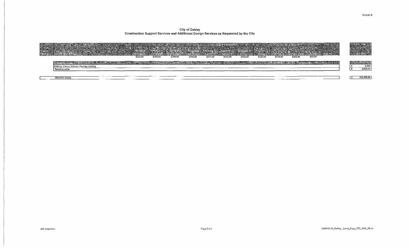
6/2112016
City of Oakley Construction Support Services and Additional Design Services as Requested by the City
'. Printing, Deii1-er, M1leage, Postage, Parking 2,8&0
Reimbvr5oble 2,860.43
PROJECT TOTAl I s 193,4oo.oo I
BKF Eng:neers P;,ge2of 1 2016-03-09_0aklej_ConsLSupp_FEE_ADD_02_~ls
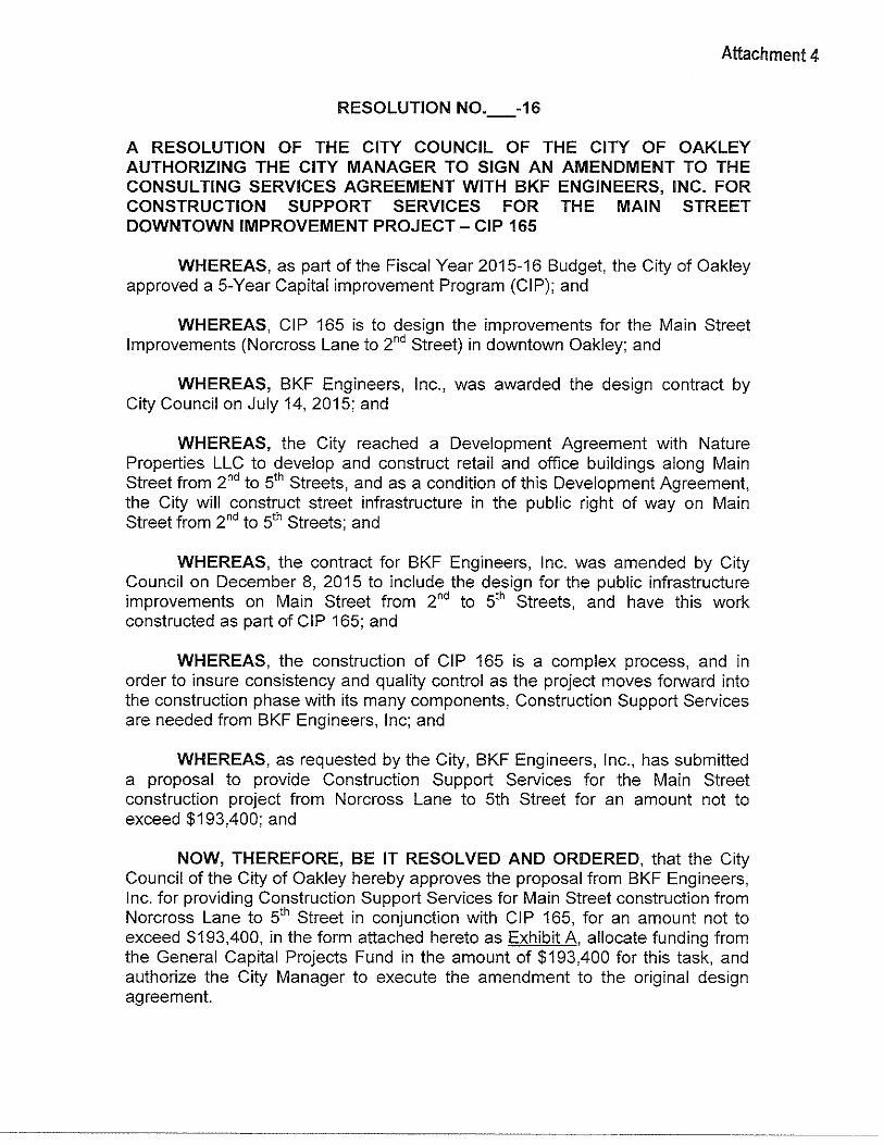
Attachment 4
RESOLUTION N0._-16
A RESOLUTION OF THE CITY COUNCIL OF THE CITY OF OAKLEY AUTHORIZING THE CITY MANAGER TO SIGN AN AMENDMENT TO THE CONSULTING SERVICES AGREEMENT WITH BKF ENGINEERS, INC. FOR CONSTRUCTION SUPPORT SERVICES FOR THE MAIN STREET DOWNTOWN IMPROVEMENT PROJECT- CIP 165
WHEREAS, as part of the Fiscal Year 2015-16 Budget, the City of Oakley approved a 5-Year Capital improvement Program (CIP); and
WHEREAS, CIP 165 is to design the improvements for the Main Street Improvements (Norcross Lane to 2nd Street) in downtown Oakley; and
WHEREAS, BKF Engineers, Inc., was awarded the design contract by City Council on July 14, 2015; and
WHEREAS, the City reached a Development Agreement with Nature Properties LLC to develop and construct retail and office buildings along Main Street from 2nd to 5th Streets, and as a condition of this Development Agreement, the City will construct street infrastructure in the public right of way on Main Street from 2nd to 5th Streets; and
WHEREAS, the contract for BKF Engineers, Inc. was amended by City Council on December 8, 2015 to include the design for the public infrastructure improvements on Main Street from 2nd to 5th Streets, and have this work constructed as part of CIP 165; and
WHEREAS, the construction of CIP 165 is a complex process, and in order to insure consistency and quality control as the project moves forward into the construction phase with its many components, Construction Support Services are needed from BKF Engineers, Inc; and
WHEREAS, as requested by the City, BKF Engineers, Inc., has submitted a proposal to provide Construction Support Services for the Main Street construction project from Norcross Lane to 5th Street for an amount not to exceed $193,400; and
NOW, THEREFORE, BE IT RESOLVED AND ORDERED, that the City Council of the City of Oakley hereby approves the proposal from BKF Engineers, Inc. for providing Construction Support Services for Main Street construction from Norcross Lane to 5th Street in conjunction with CIP 165, for an amount not to exceed $193,400, in the form attached hereto as Exhibit A, allocate funding from the General Capital Projects Fund in the amount of $193,400 for this task, and authorize the City Manager to execute the amendment to the original design agreement.
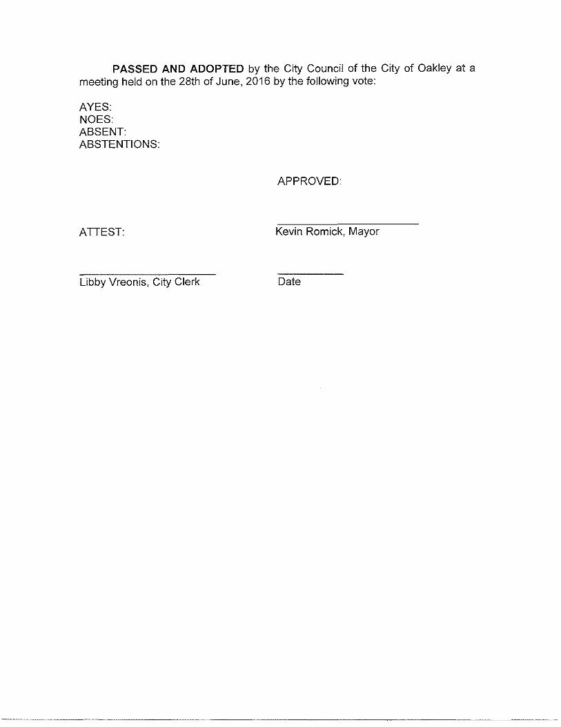
PASSED AND ADOPTED by the City Council of the City of Oakley at a meeting held on the 28th of June, 2016 by the following vote:
AYES: NOES: ABSENT: ABSTENTIONS:
APPROVED:
ATTEST: Kevin Romick, Mayor
Libby Vreonis, City Clerk Date
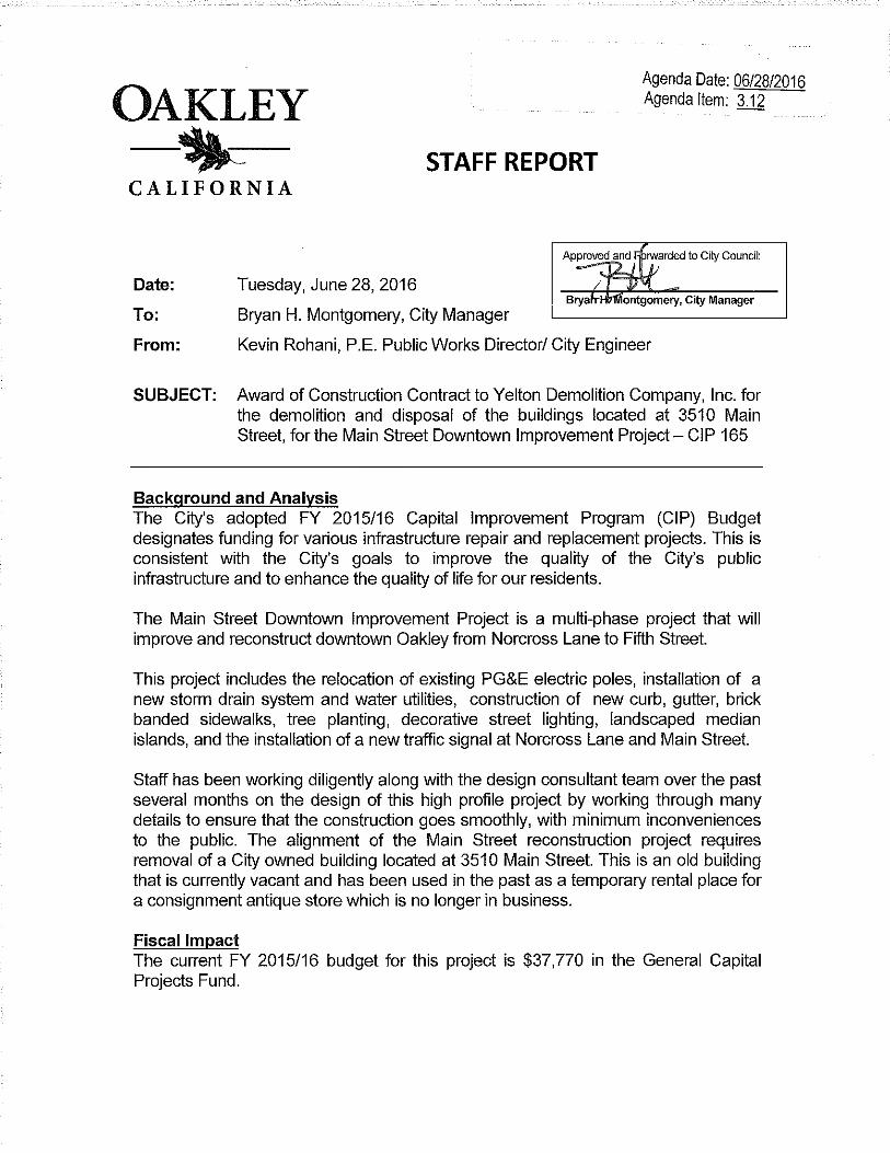
Agenda Date: 06/28/2016 Agenda Item: 3.12 OAKLEY
-~- STAFF REPORT CALIFORNIA
Approved anJ ~ rwarded to City Council: -~L"'- j)
Date: Tuesday, June 28, 2016 I Jl,l
Bryah-HtNiontgomery, City Manager To: Bryan H. Montgomery, City Manager
From: Kevin Rohani, P.E. Public Works Director/ City Engineer
SUBJECT: Award of Construction Contract to Yelton Demolition Company, Inc. for the demolition and disposal of the buildings located at 3510 Main Street, for the Main Street Downtown Improvement Project- CIP 165
Background and Analysis The City's adopted FY 2015/16 Capital Improvement Program (CIP) Budget designates funding for various infrastructure repair and replacement projects. This is consistent with the City's goals to improve the quality of the City's public infrastructure and to enhance the quality of life for our residents.
The Main Street Downtown Improvement Project is a multi-phase project that will improve and reconstruct downtown Oakley from Norcross Lane to Fifth Street.
This project includes the relocation of existing PG&E electric poles, installation of a new storm drain system and water utilities, construction of new curb, gutter, brick banded sidewalks, tree planting, decorative street lighting, landscaped median islands, and the installation of a new traffic signal at Norcross Lane and Main Street.
Staff has been working diligently along with the design consultant team over the past several months on the design of this high profile project by working through many details to ensure that the construction goes smoothly, with minimum inconveniences to the public. The alignment of the Main Street reconstruction project requires removal of a City owned building located at 3510 Main Street. This is an old building that is currently vacant and has been used in the past as a temporary rental place for a consignment antique store which is no longer in business.
Fiscal Impact The current FY 2015/16 budget for this project is $37,770 in the General Capital Projects Fund.
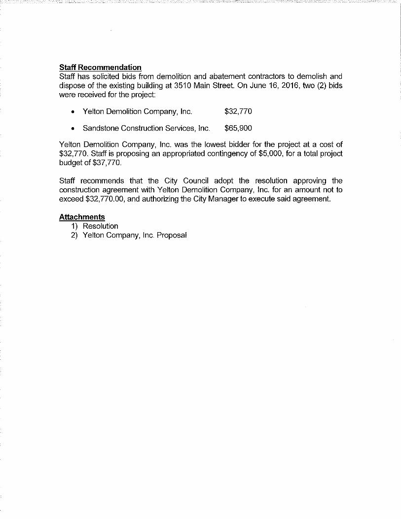
Staff Recommendation Staff has solicited bids from demolition and abatement contractors to demolish and dispose of the existing building at 3510 Main Street. On June 16,2016, two (2) bids were received for the project:
• Yelton Demolition Company, Inc.
• Sandstone Construction Services, Inc.
$32,770
$65,900
Yelton Demolition Company, Inc. was the lowest bidder for the project at a cost of $32,770. Staff is proposing an appropriated contingency of $5,000, for a total project budget of $37,770.
Staff recommends that the City Council adopt the resolution approving the construction agreement with Yelton Demolition Company, Inc. for an amount not to exceed $32,770.00, and authorizing the City Manager to execute said agreement.
Attachments 1) Resolution 2) Yelton Company, Inc. Proposal
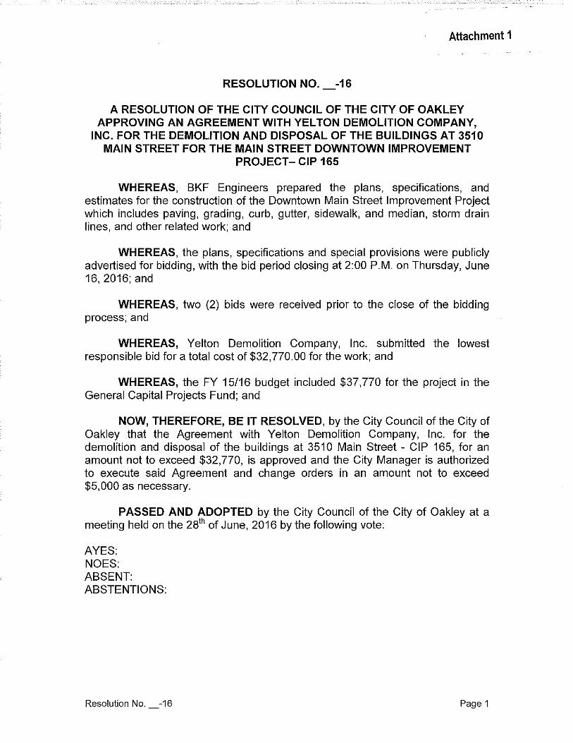
Attachment 1
RESOLUTION NO. _-16
A RESOLUTION OF THE CITY COUNCIL OF THE CITY OF OAKLEY APPROVING AN AGREEMENT WITH YELTON DEMOLITION COMPANY,
INC. FOR THE DEMOLITION AND DISPOSAL OF THE BUILDINGS AT 3510 MAIN STREET FOR THE MAIN STREET DOWNTOWN IMPROVEMENT
PROJECT- CIP 165
WHEREAS, BKF Engineers prepared the plans, specifications, and estimates for the construction of the Downtown Main Street Improvement Project which includes paving, grading, curb, gutter, sidewalk, and median, storm drain lines, and other related work; and
WHEREAS, the plans, specifications and special provisions were publicly advertised for bidding, with the bid period closing at 2:00 P.M. on Thursday, June 16,2016;and
WHEREAS, two (2) bids were received prior to the close of the bidding process; and
WHEREAS, Yelton Demolition Company, Inc. submitted the lowest responsible bid for a total cost of $32,770.00 for the work; and
WHEREAS, the FY 15/16 budget included $37,770 for the project in the General Capital Projects Fund; and
NOW, THEREFORE, BE IT RESOLVED, by the City Council of the City of Oakley that the Agreement with Yelton Demolition Company, Inc. for the demolition and disposal of the buildings at 3510 Main Street- CIP 165, for an amount not to exceed $32,770, is approved and the City Manager is authorized to execute said Agreement and change orders in an amount not to exceed $5,000 as necessary.
PASSED AND ADOPTED by the City Council of the City of Oakley at a meeting held on the 281
h of June, 2016 by the following vote:
AYES: NOES: ABSENT: ABSTENTIONS:
Resolution No. _-16 Page 1
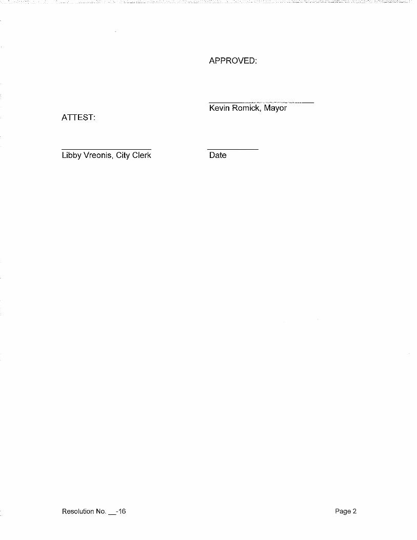
APPROVED:
Kevin Romick, Mayor ATTEST:
Libby Vreonis, City Clerk Date
Resolution No. _-16 Page 2
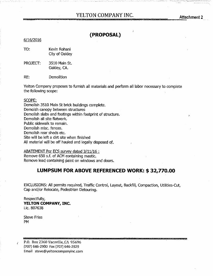
................................................ Y ... E..,L..,T ... o .... N.....,CO ...... M .... P ... A ... N ... Y ... I ... N ... C ............................ ......,_~Att!:!!!achment 2
6/16/2016
TO:
PROJECT:
RE:
Kevin Rohani City of Oakley
3510 Main St. Oakley, CA.
Demolition
(PROPOSAL)
Yelton Company proposes to furnish all materials and perform all labor necessary to complete the following scope:
SCOPE: Demolish 3510 .Main St brick buildings complete. Demoish canopy between structures Demolish slabs and footings within footprint of structure. Demolish all site flatwork. Public sidewalk to remain. Demolish misc. fences. Demolish rear sheds etc. Site will be left a dirt site when finished All material will be off ha4led and legally disposed of,
ABATEMENT Per ECS survey dated 3/11/16 : Remove 650 s.f. of ACM eontaining mastic. Remove leacl containing paint on windows and doors.
LUMPSUM FOR ABOVE REFERENCED WORK: $ 32,770.00
EXCLUSIONS: All permits required, Traffic Control, Layout, Backfill, Compaction, Utilities-Cut, Cap and/or Relocate, Pedestrian Detouring.
Respectfully, YELTON COMPANY, INC. Lie. 807638
Steve Frias PM
i P.O. Box 2360 Vacaville, (:A 95696 (707) 646-29.bO Fax (707) 646-2929 Email [email protected]
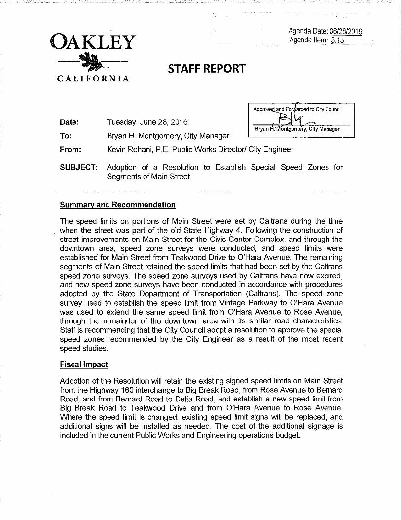
OAKLEY -~-CALIFORNIA
STAFF REPORT
Date: Tuesday, June 28, 2016
To: Bryan H. Montgomery, City Manager
Agenda Date: 06/28/2016 Agenda Item: 3.13
From: Kevin Rohani, P.E. Public Works Director/ City Engineer
SUBJECT: Adoption of a Resolution to Establish Special Speed Zones for Segments of Main Street
Summary and Recommendation
The speed limits on portions of Main Street were set by Caltrans during the time when the street was part of the old State Highway 4. Following the construction of street improvements on Main Street for the Civic Center Complex, and through the downtown area, speed zone surveys were conducted, and speed limits were established for Main Street from Teakwood Drive to O'Hara Avenue. The remaining segments of Main Street retained the speed limits that had been set by the Caltrans speed zone surveys. The speed zone surveys used by Caltrans have now expired, and new speed zone surveys have been conducted in accordance with procedures adopted by the State Department of Transportation (Caltrans). The speed zone survey used to establish the speed limit from Vintage Parkway to O'Hara Avenue was used to extend the same speed limit from O'Hara Avenue to Rose Avenue, through the remainder of the downtown area with its similar road characteristics. Staff is recommending that the City Council adopt a resolution to approve the special speed zones recommended by the City Engineer as a result of the most recent speed studies.
Fiscal Impact
Adoption of the Resolution will retain the existing signed speed limits on Main Street from the Highway 160 interchange to Big Break Road, from Rose Avenue to Bernard Road, and from Bernard Road to Delta Road, and establish a new speed limit from Big Break Road to Teakwood Drive and from O'Hara Avenue to Rose Avenue. Where the speed limit is changed, existing speed limit signs will be replaced, and additional signs will be installed as needed. The cost of the additional signage is included in the current Public Works and Engineering operations budget.
Background and Analysis
The California Vehicle Code (CVC) requires that all speed limits in excess of 25 miles per hour be established on the basis of an engineering and traffic survey conducted in accordance with procedures adopted by the State Department of Transportation (Caltrans) if they are to be enforceable by the use of radar. These special speed zone surveys are required to be updated every seven (7) years to continue the use of radar enforcement. The Engineering and Traffic Surveys used by Caltrans to establish the speed limits on Main Street from Highway 160 to Teakwood Drive, and from O'Hara Avenue to Delta Road have expired.
Speed survey data was collected in April, 2016 for preparation of the Engineering and Traffic Surveys used to establish the speed limits recommended from Highway 160 to Teakwood Drive and from Rose Avenue to Delta Road. In addition, the speed zone survey conducted in October 2013 for the downtown area was used to establish the recommended speed limit for the segment of Main Street from O'Hara Avenue to Rose Avenue.
In general the speed limit of a roadway is set at the nearest five mile per hour interval where eighty-five percent of the vehicles travel at or below the speed, known as the 851
h percentile or critical speed. In order for speeding violations to be enforceable by police and in court, the City must have current speed zone certifications on file at the courthouse.
The recommended speed limits contained in the attached resolution reflect the current traffic conditions on Main Street from the western City Limits at Highway 160, to the eastern City Limits at Delta Road.
The recommended speed limits include retaining the existing speed limits on Main Street:
1. From the Highway 160 interchange to Big Break Road, at 45 mph 2. From Rose Avenue to Bernard Road, at 45 mph, and 3. From Bernard Road to Delta Road at 40 mph.
The recommended speed limits on Main Street include: 1. Setting the speed limit between Big Break Road and Teakwood Drive from 45
mph to 40 mph, 2. Setting the speed limit between O'Hara Avenue and Rose Avenue at 30 mph.
The recommended speed limits shown in the attached resolution are based on an analysis of the traffic survey data and engineering and traffic studies. Adoption of the attached resolution will approve the recommendations and Traffic Order of the City Engineer, establishing the speed limits on the listed streets consistent with the California Vehicle Code and The City's Municipal Code. Adoption of these speed
limits will allow enforcement by the use of radar. A copy of the Engineering and Traffic Surveys, with a copy of the approved Resolution, will be maintained in the Public Works and Engineering files, with a copy in the Police Department and a copy delivered to the Contra Costa County Traffic Court.
Conclusion
Staff recommends that the City Council approve the resolution adopting a Traffic Order of the City Engineer establishing the prima facie speed limit on certain city streets.
Attachment 1) Resolution
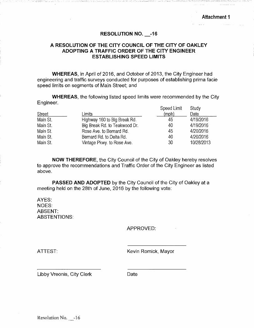
Attachment 1
RESOLUTION NO. -16
A RESOLUTION OF THE CITY COUNCIL OF THE CITY OF OAKLEY ADOPTING A TRAFFIC ORDER OF THE CITY ENGINEER
ESTABLISHING SPEED LIMITS
WHEREAS, in April of 2016, and October of 2013, the City Engineer had engineering and traffic surveys conducted for purposes of establishing prima facie speed limits on segments of Main Street; and
WHEREAS, the following listed speed limits were recommended by the City Engineer.
Street Main St Main St Main St Main St Main St
Limits Highway 160 to Big Break Rd. Big Break Rd. to Teakwood Dr. Rose Ave. to Bernard Rd. Bernard Rd. to Delta Rd. Vintage Pkwy. to Rose Ave.
Speed Limit (mph)
45 40 45 40 30
Study Date 4/19/2016 4/19/2016 4/20/2016 4/20/2016 10/28/2013
NOW THEREFORE, the City Council of the City of Oakley hereby resolves to approve the recommendations and Traffic Order of the City Engineer as listed above.
PASSED AND ADOPTED by the City Council of the City of Oakley at a meeting held on the 28th of June, 2016 by the following vote:
AYES: NOES: ABSENT: ABSTENTIONS:
APPROVED:
ATTEST: Kevin Romick, Mayor
Libby Vreonis, City Clerk Date
ResolutionNo. -16
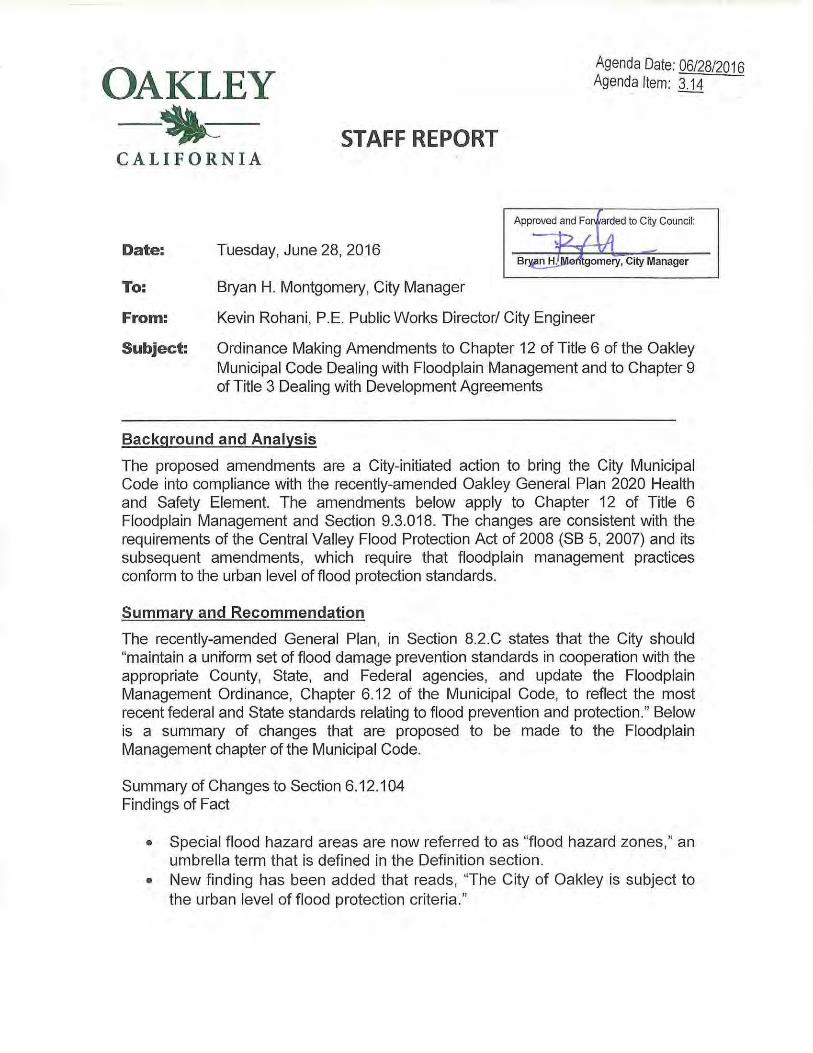
OAKLEY -~-CALIFORNIA
STAFF REPORT
Date: Tuesday, June 28, 2016
To: Bryan H. Montgomery, City Manager
Agenda Date: 06/28/2016 Agenda Item: 3.14
Approved and Fof'i arded to City Council:
!2 LA ....,. v l ,.,
B~l'ftgomery, City Manager
From: Kevin Rohani, P.E. Public Works Director/ City Engineer
Subject: Ordinance Making Amendments to Chapter 12 of Title 6 of the Oakley Municipal Code Dealing with Floodplain Management and to Chapter 9 of Title 3 Dealing with Development Agreements
Background and Analysis
The proposed amendments are a City-initiated action to bring the City Municipal Code into compliance with the recently-amended Oakley General Plan 2020 Health and Safety Element. The amendments below apply to Chapter 12 of Title 6 Floodplain Management and Section 9.3.018. The changes are consistent with the requirements of the Central Valley Flood Protection Act of 2008 (SB 5, 2007) and its subsequent amendments, which require that floodplain management practices conform to the urban level of flood protection standards.
Summary and Recommendation
The recently-amended General Plan, in Section 8.2.C states that the City should "maintain a uniform set of flood damage prevention standards in cooperation with the appropriate County, State, and Federal agencies, and update the Floodplain Management Ordinance, Chapter 6.12 of the Municipal Code, to reflect the most recent federal and State standards relating to flood prevention and protection ." Below is a summary of changes that are proposed to be made to the Floodplain Management chapter of the Municipal Code.
Summary of Changes to Section 6.12.1 04 Findings of Fact
• Special flood hazard areas are now referred to as "flood hazard zones," an umbrella term that is defined in the Definition section.
• New finding has been added that reads, "The City of Oakley is subject to the urban level of flood protection criteria. "
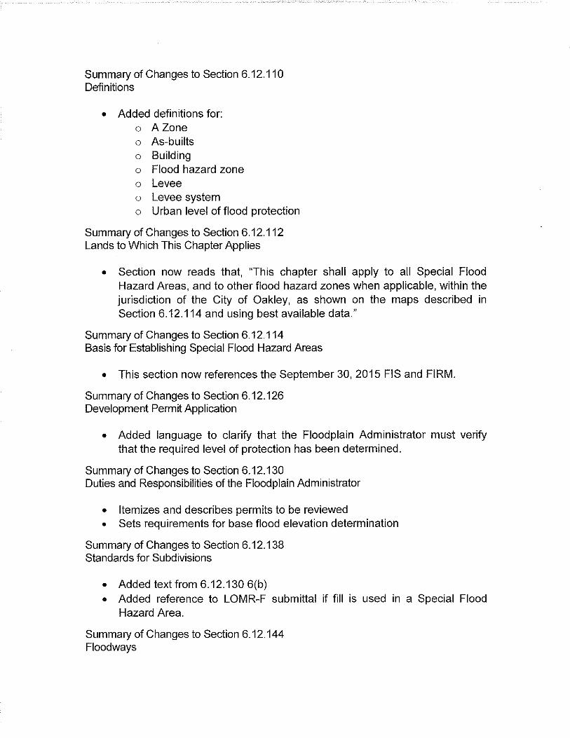
Summary of Changes to Section 6.12.110 Definitions
• Added definitions for: o AZone o As-builts o Building o Flood hazard zone o Levee o Levee system o Urban level of flood protection
Summary of Changes to Section 6.12.112 Lands to Which This Chapter Applies
• Section now reads that, 'This chapter shall apply to all Special Flood Hazard Areas, and to other flood hazard zones when applicable, within the jurisdiction of the City of Oakley, as shown on the maps described in Section 6.12.114 and using best available data."
Summary of Changes to Section 6.12.114 Basis for Establishing Special Flood Hazard Areas
• This section now references the September 30, 2015 FIS and FIRM.
Summary of Changes to Section 6.12.126 Development Permit Application
• Added language to clarify that the Floodplain Administrator must verify that the required level of protection has been determined.
Summary of Changes to Section 6.12.130 Duties and Responsibilities of the Floodplain Administrator
• Itemizes and describes permits to be reviewed • Sets requirements for base flood elevation determination
Summary of Changes to Section 6.12.138 Standards for Subdivisions
• Added text from 6.12.130 6(b) • Added reference to LOMR-F submittal if fill is used in a Special Flood
Hazard Area.
Summary of Changes to Section 6.12.144 Floodways
• Added language to clarify the procedure until a regulatory floodway is adopted.
Summary of Changes to Section 6.12.152 Conditions for Variances
• Added language to clarify the definition of "minimum necessary."
NEW Section added: Chapter6.12.154 Construction or Development in Flood Hazard Zone; Findings
• Added chapter to comply with provisions of state law that require the City to make specific findings prior to approving certain land use entitlements and other permits for property, development projects, or subdivisions located within a flood hazard zone.
Fiscal Impact There are no fiscal impacts associated with this action.
Conclusion Staff recommends that the City Council introduces the ordinance by title only.
Attachments 1) Ordinance _-16 2) Chapter 12 of Title 6 with Track Changes
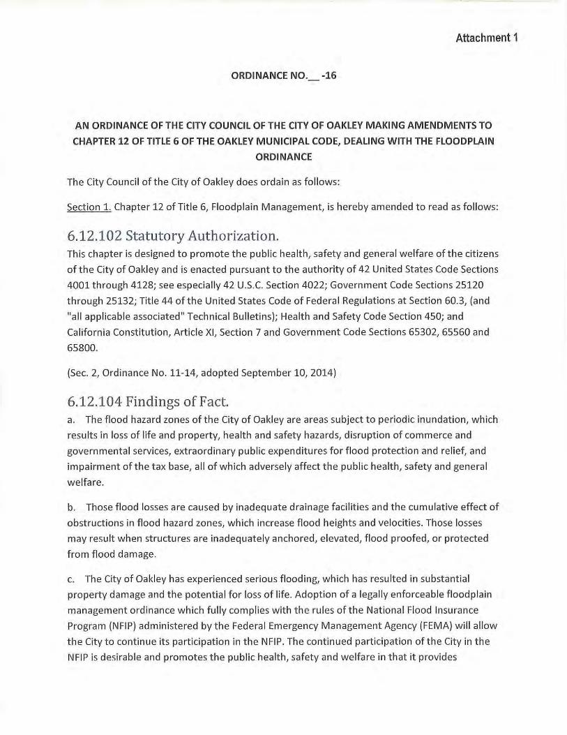
Attachment 1
ORDINANCE NO._ -16
AN ORDINANCE OF THE CITY COUNCIL OF THE CITY OF OAKLEY MAKING AMENDMENTS TO
CHAPTER 12 OF TITLE 6 OF THE OAKLEY MUNICIPAL CODE, DEALING WITH THE FLOODPLAIN
ORDINANCE
The City Council of the City of Oakley does ordain as follows:
Section 1. Chapter 12 of Title 6, Floodplain Management, is hereby amended to read as follows :
6.12.102 Statutory Authorization. This chapter is designed to promote the public health, safety and general welfare of the citizens
of the City of Oakley and is enacted pursuant to the authority of 42 United States Code Sections
4001 through 4128; see especially 42 U.S.C. Section 4022; Government Code Sections 25120
through 25132; Title 44 of the United States Code of Federal Regulations at Section 60.3, (and
"all applicable associated" Technical Bulletins); Health and Safety Code Section 450; and
California Constitution, Article XI, Section 7 and Government Code Sections 65302, 65560 and
65800.
(Sec. 2, Ordinance No. 11-14, adopted September 10, 2014)
6.12.104 Findings of Fact. a. The flood hazard zones of the City of Oakley are areas subject to periodic inundation, which
results in loss of life and property, health and safety hazards, disruption of commerce and
governmental services, extraordinary public expenditures for flood protection and relief, and
impairment of the tax base, all of which adversely affect the public health, safety and general
welfare.
b. Those flood losses are caused by inadequ ate drainage facilities and the cumulative effect of
obstructions in flood hazard zones, which increase flood heights and velocities. Those losses
may result when structures are inadequately anchored, elevated, flood proofed, or protected
from flood damage.
c. The City of Oakley has experienced serious flooding, which has resulted in substantia l
property damage and the potential for loss of life. Adoption of a legally enforceable floodplain
management ordinance which fully complies w ith the rules of the National Flood Insurance
Program (NFIP) administered by the Federal Emergency Management Agency (FEMA) will allow
the City to continue its participation in the NFIP. The continued participation ofthe City in the
NFIP is desirable and promotes the public health, safety and welfare in that it provides
insurance and Federal assistance in the event of flood(s) within theCitis jurisdiction. In the
absence of such insurance/ the City1s vulnerability to damage and loss resulting from flood
events may be substantial and potential flood damage represents an immediate threat to the
publ ic/ health/ safety and w elfare.
d. The City of Oakley is subject to the urban level of flood protection criteria.
(Sec. 21 Ordinance No. 11-141 adopted September 101 2014)
6.12.106 Statement of Purpose. It is the purpose of this chapter to promote the public health/ safety and general welfare/ and
to minimize public and private losses due to flood conditions in specific areas by provisions
designed:
a. To protect human life and health;
b. To minimize expenditure of public money for costly flood control projects;
c. To minimize the need for rescue and relief efforts associated with flooding and generally
undertaken at the expense of the general public;
d. To m inimize prolonged business interruptions during flooding;
e. To minimize damage to public facilities and utilities such as water and gas mains/ electric/
telephone/ and sewer lines/ and streets and bridges located in flood hazard zones;
f . To help maintain a stable tax base by providing for the use and development of flood hazard
zones subject to review by permit and application of flood damage reduction standards so as to
minimize future flood blight areas;
g. To provide information to the general public regarding flood hazard zones in the City of
Oakley;
h. To clearly establish that those who occupy the flood hazard zones should assume
responsibility for their actions and the losses they may suffer; and
i. To ensure that potential buyers are notified if property is in an flood hazard zone.
(Sec. 21 Ordinance No. 11-141 adopted September 101 2014)
6.12.108 Methods of Reducing Flood Losses. In order to accomplish its purpose/ this chapter includes methods and provisions for:
a. Restricting or prohibiting land uses that create a danger to health, safety, and property due
to water inundation or erosion hazards or that result in damaging increases in erosion, flood
heights, or velocities;
b. Requiring that land use areas vulnerable to floods be protected against flood damage at the
time of initial construction including facilities such as utilities, which serve them;
c. Requiring that the design of streets and public access facilities include consideration of
accessibility under the base flood conditions for emergency service vehicles and any rescue and
relief operations;
d. Controlling and limiting the alteration of natural floodplains, stream channels, and natural
protection barriers that help accommodate or channel flood waters;
e. Controlling filling, grading, dredging, and other development which may increase flood
damage;
f . Preventing or regulating the construction of flood barriers that will unnaturally divert
floodwaters or that may increase flood hazards in other areas;
g. Requiring orderly development of drainage facilities within watershed areas as
development occurs;
h. Recognizing the importance and beneficial functions of natural floodplain s; and
i. Requ iring that all new construction and substantial improvements within floodplains be
constructed in such a manner that flood damage will be minimized .
(Sec. 2, Ordinance No. 11-14, adopted September 10, 2014)
6.12.110 Definitions. Unless specifically defined below, words or phrases used in this chapter shall be interpreted so
as to give them the meaning they have in common usage and to give this chapter its most
reasonable application.
"A Zone." See "Special flood hazard area."
"Appeal" means a request for a review of the Floodplain Administrator's interpretation of any
provision of this chapter or decision on a request for a variance.
"Area of shallow flooding" means a designated AO, AH, or VO Zone on the Flood Insurance Rate
Map (FIRM). The base flood depths range from one to three feet; a clearly defined channel does
not exist; the path of flooding is unpredictable and indeterminate; and velocity flow may be
evident. Such flooding is characterized by ponding or sheet flow.
"As-builts" are a revised set of drawing submitted by a contractor upon completion of a project
or a particular job. They reflect all changes made in the specifications and working drawings
during the construction process, and show the exact dimensions, geometry, and location of all
elements of the work completed under the contract.
"Base flood" means a flood having a one percent chance of being equaled or exceeded in any
given year (also called the "one hundred (100) year flood").
"Base flood elevation (BFE)" means the elevation above "mean sea level" to which the base
flood will rise as determined by FEMA or the Floodplain Administrator. This elevation is shown on
the Flood Insurance Rate Map for Zones AE, AH, Al-30, VE, and Vl-V30.
"Basement" means any area of the building having its floor subgrade (below ground level) on all
sides.
"Building." See "Structure."
"Breakaway walls" are any type of walls, whether solid or lattice and whether constructed of
concrete, masonry, wood, metal, plastic, or any other suitable building material, that are not
part ofthe structural support of the building, and that are designed to break away under
abnormally high tides or wave action without causing any damage to the structural integrity of
the building on which they are used or any buildings to which they might be carried by flood
waters. A breakaway wall shall have a safe design loading resistance of not less than ten (10)
and no more than twenty (20) pounds per square foot. Use of breakaway walls must be
certified by a registered engineer or architect and shall meet the following conditions:
a. Breakaway wall collapse shall result from a water load less than that which would occur
during the base flood; and
b. The elevated portion of the building shall not incur any structural damage due to the
effects of wind and water loads acting simultaneously in the event of the base flood.
"Building permit" shall mean a: building permit, plumbing permit, electrical permit, or
mechanical permit issued by the City of Oakley Building Department.
"Coastal high hazard area" means an area of special flood hazard extending from offshore to
the inland limit of a primary frontal dune along an open coast and any other area subject to
high velocity wave action from storms or seismic sources. It is the area subject to high velocity
waters, including coastal and tidal inundation or tsunamis. The area is designated on a FIRM as
Zone V1-V30, VE or V.
"Development" means any manmade change to improved or unimproved real estate, including
but not limited to buildings or other structures, mining, dredging, filling, grading, paving,
excavation, drilling operations, and storage of equipment or materials.
"Encroachment" means the advance or infringement of uses, fill, excavation, buildings,
permanent structures, or development into a floodplain that may impede or alter the flow
capacity of a floodplain.
"Existing manufactured home park or subdivision" means a manufactured home park or
subdivision for which the construction of facilities for servicing the lot on which the
manufactured homes are to be affixed, including, at a minimum, the installation of utilities,
either final site grading or the pouring of concrete pads, and the construction of streets are
completed on or before the effective date of the ordinance codified in this chapter.
"Expansion to an existing manufactured home park or subdivision" means the preparation of
additional sites by the construction of facilities for servicing the lots on which the manufactured
homes are to be affixed, including the installation of utilities, either final site grading or pouring
of concrete pads, or the construction of streets.
"Flood or flooding" means a general and temporary condition of partial or complete inundation
of normally dry land areas from:
a. The overflow of flood waters; and/or
b. The unusual and rapid accumulation or runoff of surface waters from any source; and/or
c. The collapse or subsidence of land along the shore of a lake or other body of water as a
result of erosion or undermining caused by waves or currents of water exceeding anticipated
cyclical levels or suddenly caused by an unusually high water level in a natural body of water
accompanied by a severe storm or by an unanticipated force of nature such as flash flood or an
abnormal tidal surge or by some similarly unusual and unforeseeable event that results in
flooding as defined in this definition.
"Flood Boundary and Floodway Map" means the official map described in Section 6.12.114 on
which FEMA or the Federal Insurance Administration (FIA) has delineated both the areas of
flood hazard and the flood way.
"Flood hazard zone" means an area subject to flooding that is delineated as either a Special Flood Hazard Area (FEMA 100-year floodplain) or other areas with flood risk, such as the 200-
or 500-year floodplains, or areas that are at risk of flooding from levee failure. The identification of flood hazard zones does not imply that areas outside the flood hazard zones, or uses permitted within flood hazard zones, will be free from flooding or flood damage.
"Flood Insurance Rate Map (FIRM)" means the official map described in Section 6.12.114 on
which FEMA or FIA has delineated both the Special Flood Hazard Areas (SFHAs) and the risk
premium zones applicable to the community.
"Flood Insurance Study (FIS)" means the official report described in Section 6.12.114 provided
by the FIA that includes flood profiles, the FIRM, the Flood Boundary and Flood way Map, and in
some areas, the base flood elevation.
"Flood-related erosion" means the collapse or subsidence of land along the shore of a lake or
other body of water as a result of undermining caused by waves or currents of water exceeding
anticipated cyclical levels or suddenly caused by an unusually high water level in a natural body
of water, accompanied by a severe storm, or by an unanticipated force of nature, such as a
flash flood or an abnormal tidal surge, or by some similarly unusual and unforeseeable event
which results in flooding.
"Flood-related erosion area" or "flood-related erosion prone area" means a land area adjoining
the shore of a lake or other body of water, which because of the composition of the shoreline
or bank and high water levels or wind-driven currents, is likely to suffer flood-related erosion
damage.
"Flood-related erosion area management" means the operation of an overall program of
corrective and preventive measures for reducing flood-related erosion damage, including but
not limited to emergency preparedness plans, flood-related erosion control work, and
floodplain management regulations.
"Flood resistant" means any combination of structural and nonstructural additions, changes, or
adjustments to structures that reduces flood damage, generally allowing flood waters to enter
and exit the building without causing any significant damage to the structures or their contents.
"Flood resistant materials" means any building material capable of withstanding direct and
prolonged (at least seventy-two (72) hours) contact with flood waters without sustaining
significant damage (any damage requiring more than low-cost cosmetics repair-such as
painting). Acceptable materials are specified in "technical bulletins" and/or as approved by the
Floodplain Administrator.
"Floodplain or flood-prone area" means any land area susceptible to being inundated by water
from any source (see definition of "flood or flooding").
"Floodplain Administrator" is the individual appointed to administer and enforce the floodplain
management regulations, including the issuance of floodplain permits. The Floodplain
Administrator, as used in this chapter, shall mean the City Engineer or a person under his or her
supervision.
"Floodplain management" means the operation of an overall program of corrective and
preventive measures for reducing flood damage and preserving and enhancing, where possible,
natural resources in the floodplain, including but not limited to emergency preparedness plans,
flood control work, and floodplain management regulations.
"Floodplain management regulations" means zoning ordinances, subdivision regulations,
building codes, health regulations, special purpose ordinances (such as floodplain ordinance,
grading ordinance, and erosion control regulations), and other applications of the police power
that control development in flood-prone areas. This term describes Federal, State, or local
regulations in any combination thereof that provide standards for preventing and reducing
flood loss and damage.
"Floodplain permit" means a permit required of all development which occurs in any area
designated by FEMA as a SFHA and as required by the Floodplain Administrator.
"Flood proofing" means any combination of structural and nonstructural additions, changes, or
adjustments to nonresidential structures that eliminate flood damage to real estate or
improved real property, water and sanitary facilities, and nonresidential structures and their
contents.
"Fioodway" means the channel of a river or other watercourse and the adjacent land areas that
must be reserved in order to discharge the base flood without cumulatively increasing the
water surface elevation more than one foot. The flood way shall be as designated on the FIRMs
and/or as designated by the Floodplain Administrator whether or not a floodplain is shown on
the FIRM. Also referred to as "regulatory floodway."
"Fioodway fringe" means that area of the floodplain on either side of the "regulatory floodway"
where encroachment may be permitted.
"Fraud and victimization," as related to Sections 6.12.148 through 6.12.152, means that a
variance granted must not cause fraud on or victimization of the public. In examining this
requirement, the Zoning Administrator will consider the fact that every newly constructed
building adds to government responsibilities and remains a part of the community for fifty (SO)
to one hundred (100) years. Buildings that are permitted to be constructed below the base
flood elevation are subject during all those years to increased risk of damage from floods, while
future owners of the property and the community as a whole are subject to all the costs,
inconvenience, danger, and suffering that those increased flood damages bring. In addition,
future owners may purchase the property, unaware that it is subject to potential flood damage,
and can be insured only at very high flood insurance rates.
"Freeboard" means a factor of safety usually expressed in feet above a base flood elevation for
purposes of floodplain management. "Freeboard" tends to compensate for the many unknown
factors that could contribute to flood heights greater than the height calculated for a selected
size flood and flood way conditions, such as wave action, bridge openings, and the hydrological
effect of urbanization of the watershed.
"Functionally dependent use" means a use that cannot perform its intended purpose unless it is
located or carried out in close proximity to water. The term includes only docking facilities, port
facilities that are necessary for the loading and unloading of cargo or passengers, and ship
building and ship repair facilities; it does not include long-term storage or related
manufacturing facilities.
"Governing body" is the local governing unit, i.e., county or municipality, that is empowered to
adopt and implement regulations to provide for the public health, safety, and general welfare
of its citizenry.
"Hardship," as used in the definition of "variance" herein, means the exceptional hardship that
would result from a failure to grant the requested variance. The City requires that the variance
be exceptional, unusual, and peculiar to the property involved. Mere economic or financial
hardship alone is not exceptional. Inconvenience, aesthetic considerations, physical handicaps,
personal preferences, or the disapproval of ones neighbors likewise cannot, as a rule, qualify as
an exceptional hardship. All of these problems can be resolved through other means without
granting a variance, even ifthe alternative is more expensive, or requires the property owner to
build elsewhere or put the parcel to a different use than originally intended.
"Highest adjacent grade" means the highest natural (i.e., undisturbed} elevation ofthe ground
surface prior to construction next to the proposed walls of a structure.
"Historic structure" means any structure that is:
a. Listed individually in the National Register of Historic Places or preliminarily determined by
the Secretary of the Interior as meeting the requirements for individual listing in the National
Register;
b. Certified or preliminarily determined by the Secretary of the Interior as contributing to the
historical significance of a registered historic district or a district preliminarily determined by
the Secretary of the Interior to qualify as a registered historic district;
c. Individually listed on a State inventory of historic places in states with historic preservation
programs which have been approved by the Secretary of the Interior; or
d. Individually listed on a local inventory of historic places in communities with historic
preservation programs that have been certified either by an approved State program as
determined by the Secretary of the Interior or directly by the Secretary of the Interior in states
with approved programs.
"Levee" means a man-made structure, usually an earthen embankment, designed and
constructed in accordance with sound engineering practices to contain, control, or divert the
flow of water so as to provide protection from temporary flooding.
"Levee system" means a flood protection system which consists of a levee, or levees, and
associated structures, such as closure and drainage devices, which are constructed and
operated in accord with sound engineering practices.
"Lowest floor" means the lowest floor of the lowest enclosed area, including basement. An
unfinished or flood resistant enclosure, usable solely for parking of vehicles, building access, or
storage in an area other than a basement area is not considered a building's lowest floor;
provided, that such enclosure is not built so as to render the structure in violation of the
applicable nonelevation design requirements ofthis chapter. This definition allows attached
garages to be built at grade (with adequate venting). Below grade garages and storage areas
are not allowed as they are considered to be basements.
"Manufactured home" means a structure, transportable in one or more sections, that is built on
a permanent chassis and is designed for use with or without a permanent foundation when
connected to the required utilities. For floodplain management purposes the term
"manufactured home" also includes park trailers, travel trailers, and other similar vehicles
placed on a site for greater than one hundred eighty {180) consecutive days and neither
continuously licensed nor "road ready."
"Manufactured home park or subdivision" means a parcel (or contiguous parcels) of land
divided into two or more manufactured home lots for sale or rent.
"Market value" shall be determined by estimating the cost to replace the structure in new
condition and adjusting that cost figure by the amount of depreciation which has accrued since
the structure was constructed. The cost of replacement of the structure shall be based on a
square foot cost factor determined by reference to a building cost estimating guide recognized
by the building construction industry. The amount of depreciation shall be determined by
taking into account the age and physical condition but shall not include economic or other
forms of external obsolescence. Use of replacement costs or accrued depreciation factors
different from those contained in recognized building cost estimating guides may be considered
only if such factors are included in a report prepared by an independent professional appraiser
and supported by a written explanation of the differences.
"Mean sea level" means, for purposes ofthe NFIP, the National Geodetic Vertical Datum
(NGVD) of 1929 or other datum, to which base flood elevations shown on a community's FIRM
are referenced.
"New construction," for floodplain management purposes, means structures for which the
"start of construction" commenced on or after June 26, 2000, the effective date of the City of
Oakley's floodplain management ordinance, and includes any subsequent improvements to
such structures.
"Obstruction" includes but is not limited to any dam, wall, wharf, embankment, levee, dike,
pile, abutment, protection, excavation, channelization, bridge, conduit, culvert, building, wire,
fence, rock, gravel, refuse, fill, structure, vegetation, or other material that may alter, impede,
retard, or change the direction and/or velocity oft he flow of water because of (a) its location
in, along, across, or projecting into any watercourse, (b) its propensity to snare or collect debris
carried by the flow of water, or (c) its likelihood of being carried downstream.
"One hundred (100) year flood" means a flood that has a one percent annual probability of
being equaled or exceeded. See "Base flood."
"Person" means an individual or his or her agent, firm, partnership, association, or corporation,
or any agent of the aforementioned groups, or this State or its agencies or its political
subdivisions.
"Public safety and nuisance," as related to the issuance of variances under this chapter, means
that the granting of a variance must not result in anything that is injurious to safety or health of
an entire community or neighborhood, or any considerable number of persons, or unlawfully
obstructs the free passage or use, in the customary manner, of any navigable lake or river, bay,
stream, canal, or basin.
"Reconstruction" means to perform major construction or modifications to an existing structure
that makes the existing structure like or better than new. Reconstruction does not cover normal
or routine maintenance unless otherwise specified in the definition of "historical structures"
herein.
"Recreational vehicle" means a vehicle that is:
a. Built on a single chassis;
b. Four hundred (400) square feet or less when measured at the largest horizontal projection;
c. Designed to be self-propelled or permanently towable by a light duty truck; and
d. Designed primarily not for use as a permanent dwelling but as temporary living quarters for
recreational, camping, travel, or seasonal use.
"Regulatory flood way" means the channel of a river or other watercourse and the adjacent land
areas that must be reserved to discharge the base flood without cumulatively increasing the
water surface elevation more than one foot.
"Remedy a violation" means to bring a structure or other development into compliance with
State or local floodplain management regulations, or ifthat is not possible, to reduce the
impacts of its noncompliance. Ways that impacts may be reduced include protecting the
structure or other affected development from flood damages, implementing the enforcement
provisions of this chapter or otherwise deterring future similar violations, or reducing Federal
financial exposure with regard to the structure or other development.
"Riverine" means relating to, formed by, or resembling a river (including tributaries), stream,
brook, etc.
"Sand dunes" means naturally occurring accumulations of sand in ridges or mounds landward
of the beach.
"Special Flood Hazard Area (SFHA)" means an area having special flood or flood-related erosion
hazards, and shown on FIRM as Zone A, AO, Al-30, A99, AH, VO, Vl-30 or V.
"Start of construction" includes substantial improvement and means the date the building
permit was issued, if the actual start of construction, repair, reconstruction, placement, or
other improvement was within one hundred eighty (180) days of the permit date. The actual
start means either (a) the first placement of permanent construction of a structure on a site,
such as the pouring of slab or footings, the installation of piles, the construction of columns, or
any work beyond the stage of excavation or (b) the placement of a manufactured home on a
foundation. Permanent construction does not include land preparation, such as clearing,
grading, and filling; the installation of streets and/or walkways; excavation for a basement,
foundations, footings, or piers or the erection of temporary forms; and installation on the
property of accessory buildings, such as garages or sheds not occupied as dwelling units or not
part of the main structure. For a substantial improvement, the actual start of construction
means the first alteration of any wall, ceiling, floor, or other structural part of a building,
whether or not that alteration affects the external dimensions of the building.
"Structure" means a walled and roofed building or manufactured home, including a gas or
liquid storage tank, that is principally above ground.
"Substantial damage" means damage of any origin sustained by a structure sufficiently
extensive that the cost of restoring the structure to its before-damaged condition would equal
or exceed fifty percent (50%) of the market value of the structure before the damage occurred.
"Substantial improvement" means any reconstruction, rehabilitation, addition, or improvement
of a structure, the cost of which equals or exceeds fifty percent (50%) of the market value of
the structure before the "start of construction" of the improvement. The term includes
structures that have incurred "substantial damage," regardless of the actual repair work
performed.
The percentage figure shall be added to any successive building permits that may be issued or
have been issued within a contiguous ten (10) year span. "Substantial improvement" is
considered to occur when the first alteration of any wall, ceiling, floor, or other structural part
of the building commences, whether or not that alteration affects the external dimensions of
the structure. The term does not, however, include either:
a. Any project for improvement of a structure, not required because of flood damage, that is
necessary to comply with existing State or local health, sanitary, or safety code specifications
that are the minimum necessary to assure safe living conditions; or
b. Any alteration of an "historic structure," if the alteration will not preclude the structure's
continued designation as an "historic structure."
"Technical bulletin" means bulletins developed by the Federal Emergency Management Agency
(FEMA), the California Department of Water Resources (CA DWR), or the Floodplain
Administrator. Bulletins clarify specific requirements of Federal, State, or local laws pertaining
to floodplain management.
"Urban level of flood protection" means the level of protection that is necessary to withstand
flooding that has a 1-in-200 chance of occurring in any given year using criteria consistent with,
or developed by, the California Department of Water Resources. "Urban level of flood
protection" shall not mean shallow flooding or flooding from local drainage that meets the
criteria oft he national FEMA standard of flood protection.
"Variance" means a grant of relief from the requirements of this chapter that permits
construction in a manner that would otherwise be prohibited by this chapter.
"Violation" means the failure of a structure or other development to comply with this chapter.
A structure or other development without an elevation certificate, other certifications, or other
evidence of compliance required in this chapter is presumed to be in violation until such time as
that documentation is provided.
"Water surface elevation" means the height, in relation to the National Geodetic Vertical
Datum (NGVD) of 1929 or other datum, where specified, of floods of various magnitudes and
frequencies in the floodplains of coastal or riverine areas.
"Watercourse" means a lake, river, creek, stream, wash, arroyo, channel, or other topographic
feature on or over wh ich waters flow at least periodically. Watercourse includes specifically
designated areas in which substant ial flood damage may occur.
(Sec. 2, Ordinance No. 11-14, adopted September 10, 2014)
6.12.112 Lands to Which This Chapter Applies. This chapter shall apply to all Special Flood Hazard Areas, and to other flood hazard zones when
applicable, within the jurisdiction of the City of Oakley, as shown on the maps described in
Section 6.12.114 and using best available data.
(Sec. 2, Ordinance No. 11-14, adopted September 10, 2014)
6.12.114 Basis for Establishing Special Flood Hazard Areas. SFHAs have been identified by FEMA or the FIA in a scientific and engineering report entitled
"Flood Insurance Study for Contra Costa County, California and Incorporated Areas," dated
September 30, 2015 with an accompanying FIRM and Flood Boundary and Floodway Map. All
subsequent amendments to and/or revisions of the study and maps are hereby adopted by
reference and declared to be a part of this chapter. That FIS and the accompanying maps are on
file with the City of Oakley at 3633 Main Street, Oakley, CA 94561. The FIS describes the
minimum area of applicability of this chapter and may be supplemented by studies for other
areas that allow implementation of this chapter, and that are recommended by the Floodplain
Administrator. Within the SFHA identified in the FIS, accompanying maps, and supplemental
studies, one foot of freeboard is required.
(Sec. 2, Ordinance No. 11-14, adopted September 10, 2014)
6.12.116 Compliance. No structure or land shall hereafter be constructed, located, extended, converted, or altered
without full compliance with the terms ofthis chapter and other applicab le regulations.
Violations of the requirements, including vio lations of conditions and safeguards establ ished in
connection with conditions, shall constitute an infraction punishable as provided in
Government Code Section 25132. Nothing herein sha ll prevent the City Council of the City of
Oakley from taking such lawful action as is necessary to prevent or remedy any violation.
(Sec. 2, Ordinance No. 11-14, adopted September 10, 2014)
6.12.118 Abrogation and Greater Restrictions. This chapter is not intended to repeal, abrogate, or impair any existing easements, covenants,
or deed restrictions. However, where this chapter and another ordinance, easement, covenant,
or deed restriction confl ict or overlap, whichever imposes the more stringent restrictions shall
prevail.
(Sec. 2, Ordinance No. 11-14, adopted September 10, 2014)
6.12.120 Interpretation. In the interpretation and application of this chapter, all provisions shall be:
a. Considered as minimum requ irements;
b. Liberally construed in favor of the City; and
c. Deemed neither to limit nor repeal any other powers granted under State statutes.
(Sec. 2, Ordinance No. 11-14, adopted September 10, 2014)
6.12.122 Warning and Disclaimer of Liability. The degree of flood protection required by this chapter is considered reasonable for regulatory
purposes and is based on scientific and engineering considerations. Larger floods can and will
occur on rare occasions. Flood heights may be increased by manmade or natural causes. This
chapter does not imply that land outside the flood hazard zones or uses permitted within such
areas will be free from flooding or flood damages. This chapter shall not create liability on the
part of the City, any officer or employee thereof, or the FIA for any flood damages that result
from reliance on this chapter or any administrative decision made thereunder.
(Sec. 2, Ordinance No. 11-14, adopted September 10, 2014)
6.12.124 Establishment of Floodplain Permit. A floodplain permit shall be obtained from the City of Oakley before construction, issuance of a
grading permit or building permit, and commencement of development on any property within
any flood hazard zone established in Section 6.12.114. Application for a floodplain permit shall
be made on forms furnished by the City's Floodplain Administrator and may include but not be
limited to: plans in triplicate drawn to scale showing the nature, location, dimensions, and
elevation ofthe area in question; and the location of existing or proposed structures, fill,
storage of materials, drainage facilities, or other development defined in this chapter.
Specifically, the following information is required:
a. Proposed elevation, in relation to mean sea level, of the lowest floor, including basement,
of all structures. In Zone AO or VO, elevation of highest adjacent grade and proposed elevation
of lowest floor of all structures;
b. Proposed elevation, in relation to mean sea level, to wh ich any structure will be
flood proofed;
c. All appropriate certifications listed in Section 6.12.130;
d. Description of the extent to which any watercourse w ill be altered or relocated as a result
of proposed development; and
e. Description ofthe extent to which grading is proposed with in the flood hazard zone.
(Sec. 2, Ordinance No. 11-14, adopted September 10, 2014)
6.12.126 Development Permit Application. Prior to a variance permit, land use permit, development plan permit, or tentative map
application being deemed complete on any property within a flood hazard zone established in
Section 6.12.114, an applicant must provide verification from the Floodplain Administrator that
the required flood zone, BFE, minimum finished floor elevation, and the required level of
protection has been determined.
(Sec. 2, Ordinance No. 11-14, adopted September 10, 2014)
6.12.128 Designation of the Floodplain Administrator. The City Engineer of the City of Oakley shall be the Floodplain Administrator but may designate
a person under his or her supervision, including the Floodplain Manager, to administer and
implement this chapter by granting or denying floodplain permits in accordance with its
provisions.
(Sec. 2, Ordinance No. 11-14, adopted September 10, 2014)
6.12.130 Duties and Responsibilities of the Floodplain Administrator. The duties and responsibilities of the Floodplain Administrator shall include but not be limited
to the following:
a. Permit Review.
1) 1) Review all floodplain permits to determine that the permit requirements of this Chapter
have been satisfied;
2) Review written statements required to be su bmitted by each applicant that all other
required State and Federal permits have been obtained;
3) Review floodplain permits for compliance with FEMA requirements for elevation of
structures above the floodplain plus freeboard;
4) Review floodplain permit for compliance with FEMA requirements so that the proposed
development does not adversely affect the carrying capacity of the areas where base flood
elevations have been determined but a floodway has not been designated. For purposes of
this chapter, "adversely affect" means that the cumulative effect of the proposed
development, when combined with all other existing and expected development, will
increase the water surface elevation of the base flood more than one foot at any point.
5) Review all development permits to determine that all Conditional Letters of Map Revision
(CLOMR) and Conditional Letters of Map Revision Based on Fill (CLOMR-F) for projects
within a SFHA are approved prior to issuance of a grading permit. An approved CLOMR
allows for construction activities and land preparation as specified in the "start of
construction " definition.
6) Review all development permits to determine that all LOMR and LOMR-F for all flood
control projects within a SFHA are approved prior to the issuance of building permits or
"start of construction." At the discretion of the Floodplain Administrator, building permits
may be issued based upon a CLOMR. As-builts for the approved grading plan sha ll be
submitted to the Floodplain Administrator for review and approval upon completion of
grading.
b) Use, Review , and Development of Other Base Flood Elevation Data.
When base flood elevation data has not been provided in accordance with Section 6.12.114,
the Floodplain Administrator shall require, obtain, review, and reasonably utilize any base
flood elevation and floodway data available from a Federal, State, or other source to
administer Sections 6.12.134 through 6.12.146.
(Sec. 2, Ordinance No. 11-14, adopted September 10, 2014)
6.12.132 Appeals. The Zoning Administrator of the City of Oakley shall hear and decide appeals when it is alleged
there is an error in any requirement, decision, or determination made by the Floodplain
Administrator in the enforcement or administration of this chapter.
(Sec. 2, Ordinance No. 11-14, adopted September 10, 2014)
6.12.134 Standards of Construction. In all SFHAs, the following standards are required:
a. Anchoring.
1) All new construction and substantia l improvements shal l be anchored to prevent flotation ,
collapse, or latera l movement of the structure resulting from hyd rodynamic and hydrostatic
loads, including the effects of buoyancy.
2) All manufactured homes shall meet the anchoring standards of Section 6.12.140.
b. Construction Materials and Methods.
1) All new construction and substantial improvements shal l be constructed with materials and
utility equipment resistant to flood damage.
2) All new construction and substantial improvements shall be constructed using methods
and practices that minimize flood damage.
3) All new construction and substantial improvements shall be constructed with electrical,
heating, ventilation, plumbing, and air conditioning equipment and other service facilit ies that
are designed and/or located so as to prevent water f rom entering or accumulating within the
components during conditions of floodin g.
4) In Zone AH, AO or VO, all new construction and substantial improvements shal l be
constructed with drainage paths adequate to guide f loodwaters around and away f rom
proposed structures.
c. Elevat ion and Floodproofing.
1) New construction and substantial improvement of any structure shall have the lowest f loor,
including basement, elevated to or above the base flood elevation plus the required foot of
freeboard. Nonresidentia l structures may meet the standards in subsection (c)(3) ofthis
section. Upon the completion of the substructure, but prior to completion of the structure, the
elevation of the lowest floor, including basement, shall be certified by a registered professional
engineer or surveyor or verif ied by the building inspector to be properly elevated. Such
certification or verification shall be provided to the Floodplain Administrator.
2) New construction and substantial improvement of any structure in Zone AH, AO, or VO
shall have t he lowest floor, including basement, elevated above the highest adjacent grade at
least as high as the depth number speci fied in feet on the FIRM plus the required foot of
freeboard, or at least two feet, if no depth number is specified. Nonresidential structures may
meet the standards in subsection (c)(3) oft his section. Upon the completion of the substructure
but prior to completion oft he structure, the elevation ofthe lowest floor, including basement,
shall be certified by a registered professional engineer or surveyor or verified by the building
inspector to be properly elevated. Such certification or verification shall be provided to the
Floodplain Administrator.
3) If the difference in elevation between the lowest floor and the ground below the lowest
floor is 6.6 feet or greater, the applicant will provide the Floodplain Administrator with a deed
restriction. The deed restriction will be recorded and will run with the property (not the
applicant). The restriction will limit the area below the lowest floor to be used only for building
access, storage, and parking of vehicles and will not allow this area to be developed into
habitable space.
4) Nonresidential construction shall either be elevated in conformance with subsection (c)(l)
or (2) of this section, or together with attendant utility and sanitary facilities:
a) Be flood proofed so that, below the base flood level plus freeboard, the structure is
watertight with walls substantially impermeable to the passage of water;
b) Have structural components capable of resisting hydrostatic and hydrodynamic loads and
effects of buoyancy; and
c) Be certified by a registered professional engineer or architect that the standards of this
subsection are satisfied. Such certification shall be provided to the Floodplain Administrator; or
d) The Floodplain Administrator may allow the nonresidential structure to be made "flood
resistant." Flood resistant structures shall comply with subsection (c)(S) oft his section.
5) All new construction and substantial improvements with fully enclosed areas below the
lowest floor, excluding basements, that are usable solely for parking of vehicles, building
access, or storage, and that are subject to flooding shall be designed to equalize hydrostatic
flood forces on exterior walls automatically by allowing for the entry and exit of floodwaters.
Designs for meeting that requirement must either be certified by a registered professional
engineer or architect or meet or exceed the following minimum criteria:
a) Have a minimum of two openings with a total net area of not less than one square inch for
every one square foot of enclosed area subject to flooding. The bottom of all openings shall be
no higher than one foot above grade. Openings may be equipped with screens, louvers, valves,
or other coverings or devices, if they permit the automatic entry and exit of floodwaters.
d. Manufactured homes shall also meet the standards in Section 6.12.140.
(Sec. 2, Ordinance No. 11-14, adopted September 10, 2014)
6.12.136 Standards for Utilities. a. All new and replacement water supply and sanitary sewage systems shall be designed to
minimize or eliminate infiltration of flood waters into the system and discharge from the
system into flood waters.
b. On-site waste disposal systems shall be located to avoid impairment to them or
contamination from them during flooding. All septic tanks shall be adequately anchored to
resist flotation, collapse, or lateral movement.
c. On-site water supply systems shall be located to avoid impairment to them or
contamination of them during flooding.
(Sec. 2, Ordinance No. 11-14, adopted September 10, 2014)
6.12.138 Standards fo r Subdivisions. a. All applications for tentative map approval are incomplete unless the tentative maps
identify the flood hazard zone, the elevation of the base flood, and the flood elevation
necessary to assess the urban level of flood protection. Developments consisting of more than
ten (10) new insurable structures or more than 5 acres will be required to determine the above
elevations by developing a detailed hydrology and hydraulic study, including but not limited to
a back water analysis. Developments of ten (10) or fewer insurable structures or fewer than 5
acres will be required to determine the above elevations by using standards acceptable to the
Floodplain Administrator.
b. All final subdivision improvement plans shall provide the elevation of pads, streets, and the
lowest floors of all proposed structure(s). If the site is in a SFHA and is filled above the base
flood, as-built information for the lowest floor, pad, and lowest adjacent grade elevations shall
be certified by a registered professional engineer or surveyor and provided as part of an
application for a letter of map revision based on fill (LOMR-F) to the Floodplain Administrator.
c. All subdivision proposals shall be consistent with the need to minimize flood damage.
d. All subdivision proposals shall have public utilities and facilities such as road, sewer, gas,
electrical, and water systems located and constructed to minimize flood damage.
e. All subdivisions shall provide adequate drainage to reduce exposure to flood hazards.
(Sec. 2, Ordinance No. 11-14, adopted September 10, 2014)
6.12.140 Standards for Manufactured Homes. a. All manufactured homes to be placed or substantially improved within an SFHA (Zones A1-
30, and AH), as shown on the study and maps described in Section 6.12.114, shall:
1) Be elevated and anchored to a foundation such that the lowest floor of the manufactured
home is at or above the base flood elevation, plus the required foot of freeboard.
2) Be securely anchored to an adequately designed foundation system to resist flotation ,
collapse, or lateral movement in accordance with California Health and Safety Code Sections
18613.4 or 18551.
b. Subsection (a) of this section shall apply to:
1) Manufactured homes to be placed or substantially improved in an expansion to an existing
manufactured home park or subdivision;
2) Manufactured homes to be placed or substantially improved outside of a manufactured
home park or subdivision; and
3) Manufactured homes to be placed in a manufactured home park or subdivision established
on or after the effective date of the ordinance codified in this chapter.
c. Subsection (a)(1) of this section shall not apply to manufactured homes to be placed or
substantially improved in an existing manufactured home park or subdivision, except:
1) Where the repair, reconstruction, or improvement of the streets, utilities, and pads equals
or exceeds fifty percent (SO%) of the streets, utilities, and pads before the repair,
reconstruction, or improvement is commenced; or
2) The manufactured home has incurred "substantial damage" as a result of a flood.
(Sec. 2, Ordinance No. 11-14, adopted September 10, 2014)
6.12.142 Standards for Recreational Vehicles. All recreational vehicles placed on sites within an SFHA (Zones A1-30, AH, and AE) on the FIRM
shall:
a. Be on the site for fewer than one hundred eighty (180) consecutive days; or
b. Be fully licensed, insured, and ready for highway use. A recreational vehicle is ready for
highway use if it is on its wheels or integral jacking system, is attached to the site only by quick
disconnect type utilities and security devices, and has no permanently attached additions; or
c. Meet the permit requirements of Section 6.12.124 and the elevation and anchoring
requirements for manufactured homes in Section 6.12.140.
(Sec. 2, Ordinance No. 11-14, adopted September 10, 2014)
6.12.144 Floodways. Within SFHAs established in Section 6.12.114 are areas designated as floodways . A floodway is
an extremely hazardous area because of the velocity of floodwaters that carry debris and
potential projectiles and because of the potential for erosion. Floodways may or may not be
specifically designated on the FIRM Maps; their existence will be as determined by the
Floodplain Administrator. Encroachments, including fill, new construction, substantial
improvements, and other development, are not allowed in a floodway unless certification by a
registered professional engineer is provided demonstrating that the encroachment(s) shall not
result in any increase in flood levels during the occurrence ofthe base flood discharge. Allowed
new construction and improvements shall comply with all applicable flood hazard reduction
provisions of Sections 6.12.148 through 6.12.152. Until a regulatory floodway is adopted, no new
construction, substantial development, or other development (including fill} shall be permitted within
Zones Al-30 and AE, unless it is demonstrated that the cumulative effect of the proposed development,
when combined with all other development, will not increase the water surface elevation of the base
flood more than one foot at any point within the City of Oakley."
(Sec. 2, Ordinance No. 11-14, adopted September 10, 2014)
6.12.146 Coastal High Hazard Areas. Within coastal high hazard areas established in Section 6.12.114, the following standards shall
apply:
a. All new construction and substantial improvements shall be elevated on adequately
anchored pilings or columns and securely anchored to such pilings or columns so that the
lowest horizontal portion of the structural members of the lowest floor (excluding the pilings or
columns) is elevated to or above the base flood elevation plus the required foot of freeboard.
The pile or column foundation, and the structure attached and hereto, shall be anchored to
resist flotation, collapse, or lateral movement from the effects of wind and water loads acting
simultaneously on all building components. Water loading values used shall be those associated
with the base flood plus freeboard . Wind loading values used shall be those required by
applicable State or local building standards.
b. All new construction shall be located on the landward side of the reach of mean high tide.
c. All new construction and substantial improvements shall have the space below the lowest
floor free of obstructions or constructed with breakaway walls. Such temporarily enclosed
space shall not be used for human habitation.
d. Fill shall not be used for structural support of buildings.
e. Manmade alteration of sand dunes that would increase potential flood damage is
prohibited.
f. The Floodplain Administrator shall obtain and maintain the following records:
1) Certification by a registered engineer or architect that a proposed structure complies with
subsection (a) of this section.
2) The elevation (in relation to mean sea level) of the bottom of the lowest structural member
of the lowest floor (excl uding pilings or columns) of all new and substantially improved
structures and whether such structures contain a basement.
(Sec. 2, Ordinance No. 11-14, adopted September 10, 2014)
6.12.148 Nature of Variances. The variance criteria set forth in this chapter are based on the general principle of zoning law
that variances pertain to a piece of property and are not personal in nature. A variance may be
granted for a parcel of property with physical characteristics so unusual that complying with the
requirements of this chapter would create an exceptional hardship to the applicant or the
surrounding property owners. The characteristics must be unique to the property and not be
shared by adjacent parcels. The unique characteristic must pertain to the land itself, not to the
structure, its inhabitants, or the property owners.
It is the duty of the City to help protect its citizens from flooding. This need is so compelling and
the implications of the cost of insuring a structure built below flood level are so serious that
variances from the flood elevation or from other requirements in the flood ordinance are quite
rare. The long-term goal of preventing and reducing flood loss and damage can only be met if
variances are strictly limited. Therefore, the variance guidelines provided in this chapter are
more detailed and contain multiple provisions that must be met before a variance can be
properly granted. The criteria are designed to screen out those situations in which alternatives
other than a variance are more appropriate.
(Sec. 2, Ordinance No. 11-14, adopted September 10, 2014)
6.12.150 Appeal Process. a. The Zoning Administrator of the City of Oakley shall hear and decide appeals and request s
for variances from the requirements of this chapter.
b. The Zoning Administrator shall hear and decide appeals when it is alleged there is an error
in any requirement, decision, or determination made by the Floodplain Administrator in the
enforcement or administration of this chapter.
c. In passing upon such applications, the Zoning Administrator shal l consider all technical
evaluations, all relevant factors, the standards specified in this chapter, and all other relevant
factors including but not limited to the following:
1) The danger that materials may be swept onto other lands to the injury of others;
2) The danger to life and property due to flooding or erosion damage;
3) The susceptibility of the proposed facility and its contents to flood damage and the effect
of such damage on the owner and future owners of the property and on the community;
4) The importance of the services provided by the proposed facility to the community, if
applicable;
5) The necessity to the facility of a waterfront location, if applicable;
6) The availability of alternative locations fo r the proposed use that are not subject to flooding
or erosion damage;
7) The compatibil ity of the proposed use with existing and anticipated development;
8) The relationship ofthe proposed use to the comprehensive plan and floodplain
management program for that area;
9) The safety of access to the property in time of flood for ordinary and emergency vehicles;
10) The expected heights, velocity, duration, rate of ri se, and sediment transport of the flood
waters expected at the site; and
11) The costs of providing governmental services during and after flood conditions, including
maintenance and repair of public ut ilities and facilities such as sewer, gas, electrical, and water
systems, and streets and bridges.
d. Generally, variances may be issued for new construction and substantial improvements to
be erected on a lot of one-half acre or less in size contiguous to and surrounded by lots with
existing structures constructed below the base flood leve l, if the factors in subsect ion (c) of thi s
section have been fully considered. As the lot size increases beyond one-half acre, the technical
justification required for issuing the variance will increase.
e. Upon consideration of the factors of subsection (c) ofthis section and the purposes of this
chapter, the Zoning Administrator may attach such conditions to the granting of variances as
deemed necessary to further the purposes of this chapter.
f. Appeals from Zoning Administrator decisions may be made to the Planning Commission and
City Council in the time and manner provided in Chapter 1.8, as amended by Ordinance No. 06-
00, and upon payment of the fees prescribed therein.
g. The Floodplain Administrator shall maintain the records of all appeal actions and report any
variances granted to the FIA upon request.
(Sec. 2, Ordinance No. 11-14, adopted September 10, 2014)
6.12.152 Conditions for Variances. a. Variances may be issued for the reconstruction, rehabilitation, or restoration of "historic
structures" upon a determination that the proposed restoration or rehabilitation will not
preclude the structure's continued designation as an historic structure, and that the minimum
necessary variance is to preserve the historic character and design of the structure without
regard to the procedures set forth in the remainder of this section.
b. Variances shall not be issued within any designated floodway if any increase in flood levels
during the base flood discharge would result.
c. Variances shall only be issued upon a determination that the variance is the minimum
necessary, considering the flood hazard, to afford relief. "Minimum necessary" means to afford
relief with a minimum of deviation from the requirements of this chapter.
d. Variances shal l only be issued upon:
1) A showing of good and sufficient cause;
2) A determination that failure to grant the variance would result in exceptional hardship to
the applicant; and
3) A determination that the granting of a variance will neither result in increased flood
heights, additional threats to public safety, or extraordinary public expense, nor create
nuisances, cause fraud on or victimization of the public, or conflict with existing local laws or
ordinances.
e. Variances may be issued for new construction and substantial improvements and for other
development necessary for the conduct of a functionally dependent use; provided, that the
provisions of subsections (a) through (d) of this section are satisfied, and that the structure or
other development is protected by methods that minimize flood damages during the base flood
and create no additional threats to public safety.
f. Any applicant to whom a variance is granted shall be given written notice over the signature
of the Floodplain Administrator that:
1) The issuance of a variance to construct a structure below the base flood level will result in
significantly increased premium rates for flood insurance. Insurance premiums as high as $25
for $100 of insurance coverage are possible; and
2) Such construction below the base flood level increases risks to life and property. It is
required that a copy of the notice shall be recorded by the Floodplain Administrator in the
Office of the County Recorder and shall be recorded in a manner so that it appears in the chain
of title of the affected parcel of land.
(Sec. 2, Ordinance No. 11-14, adopted September 10, 2014)
6.12 .154 Construction or Development in Flood Hazard Zone;
Findings.
Prior to approval of a development agreement, a discretionary permit or other discretionary
entitlement resulting in construction of a new building or construction resulting in an increase
in allowed occupancy for an existing building, or approval of a tentative map, or a parcel map,
the Floodplain Administrator must make one ofthe below-stated findings:
a) The flood management facilities provide the urban level of flood protection for projects in
urban and urbanizing areas or the national Federal Emergency Management Agency
standard of flood protection for projects in nonurbanized areas;
b) The city has imposed conditions on the project that will protect the property to the urban
level of flood protection in urban and urbanizing areas or the National Emergency
Management Agency standard of flood protection in urbanized areas;
c) The local flood management agency has made adequate progress (as defined in California
Government Code Sec. 65007) on the construction of a flood protection system that will
result in flood protection equal to or greater than the urban level of flood protection in
urban or urbanizing areas or the national Federal Emergency Management Agency standard
of flood protection in non-urbanized areas for projects located within a flood hazard zone,
intended to be protected by the system;
d) The project in an undetermined risk area has met the urban level of flood protection;
e) The property is located in an area of potential flooding of 3 feet or less from sources other
than local drainage (i.e. localized conditions that may occur anywhere in a community, such
as localized rainfall, water from storm water and drainage problems, and water from
temporary water and wastewater distribution system failure) or potential flooding from
local drainage that meets the criteria oft he national Federal Emergency Management
Agency standard of flood protection;
f) The property is located within a watershed with a contributing area of 10 or fewer square
miles.
Section 2. Subparagraph (c) is hereby added to Section 9.3.018 of the Oakley Municipal Code, to
read as follows:
c) The City Council shall not approve the agreement unless it makes one of the findings in
Section 6.12.154 of the Oakley Municipal Code.
Section 3. This ordinance shall take effect and be in force and effect thirty (30) days from and
after the date of its passage. The City Clerk shall cause the ordinance to be published within
fifteen (15) days after its passage in a newspaper of general circulation, or by publishing a
summary of the ordinance, posting a certified copy of the proposed ordinance in the office of
the City Clerk at least five (5) days prior to the City Council meeting at which the ordinance is to
be adopted, and within fifteen (15) days after its adoption, publishing a summary of the
ordinance with the names of the Council members voting for and against the ordinance.
The foregoing ordinance was adopted with the reading waived at a regular meeting of
the Oakley City Council on June 28th by the following vote:
AYES:
NOES:
ABSTENTIONS:
ABSENT:
APPROVED:
Kevin Romick, Mayor
ATIEST:
Libby Vreonis, City Clerk Date
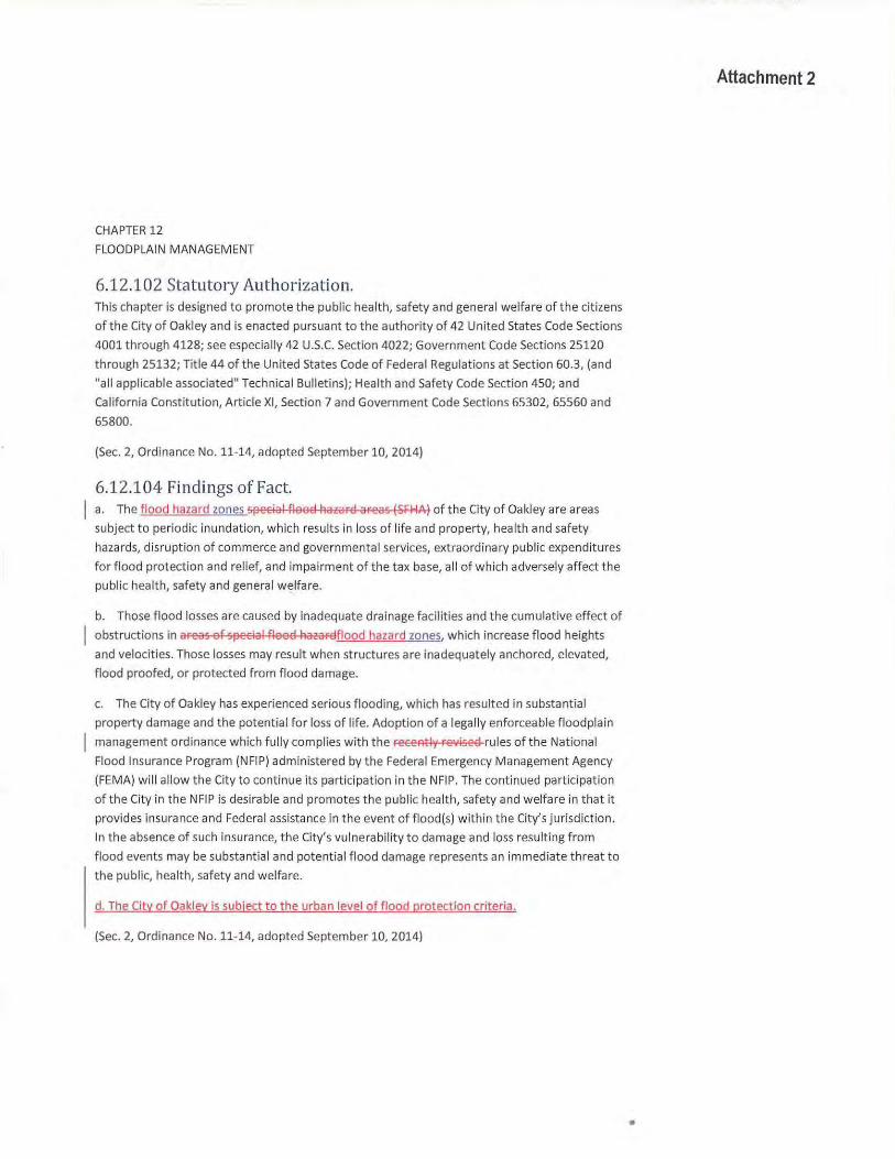
CHAPTER 12
FLOODPLAIN MANAGEMENT
6.12.102 Statutory Authorization. This chapter is designed to promote the public health, safety and general welfare of the citizens
of the City of Oakley and is enacted pursuant to the authority of 42 United States Code Sections
4001 through 4128; see especially 42 U.S.C. Section 4022; Government Code Sections 25120
through 25132; Title 44 of the United States Code of Federal Regulations at Section 60.3, (and
"all applicable associated" Technical Bulletins); Health and Safety Code Section 450; and
California Constitution, Article XI, Section 7 and Government Code Sections 65302, 65560 and
65800.
(Sec. 2, Ordinance No. 11-14, adopted September 10, 2014)
6.12.104 Findings of Fact. a. The flood hazard zones Sflecial flood hazard areas (SFI-IA) of the City of Oakley are areas
subject to periodic inundat ion, which results in loss of life and property, health and safety
hazards, disruption of commerce and governmental services, extraordinary pub lic expenditures
for flood protection and relief, and impairment of the tax base, all of which adversely affect the
public health, safety and general welfare.
b. Those flood losses are caused by inadequate drainage facilities and the cumulative effect of
obstructions in areas of Sf!ecial flood hazardflood hazard zones. which increase flood heights
and velocities. Those losses may result when structures are inadequately anchored, elevated,
flood proofed, or protected from flood damage.
c. The City of Oakley has experienced serious flooding, which has resulted in substantial
property damage and the potential for loss of life. Adoption of a legally enforceable floodplain
management ordinance which f ully complies wit h the receAtly revised rules of the National
Flood Insurance Program (NFIP) administered by the Federal Emergency Management Agency
(FEMA) will allow the City to cont inue its participation in the NFIP. The continued participation
of the City in the NFIP is desirable and promotes the public health, safety and welfare in that it
provides insurance and Federal assistance in the event of flood(s) within the City's jurisdiction.
In the absence of such insurance, the City's vulnerability to damage and loss resulting from
flood events may be substantial and potential flood damage represents an immed iate threat to
the publ ic, health, safety and welfare.
d. The City of Oakley is subject to the urban level of flood protection criteria.
(Sec. 2, Ordinance No. 11-14, adopted September 10, 2014)
Attachment 2
•
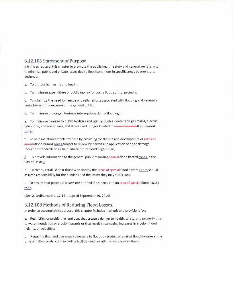
6.12.106 Statement of Purpose. It is the purpose of this chapter to promote the public health, safety and general welfare, and
to minimize public and priva te losses due to flood conditions in specific areas by provisions
designed:
a. To protect human life and health;
b. To minimize expenditure of public money for costly flood control projects;
c. To minimize the need for rescue and relief efforts associated with flooding and generally
undertaken at the expense of the general public;
d. To minimize prolonged business interruptions during flooding;
e. To minimize damage to public facilities and utilities such as water and gas mains, electric,
telephone, and sewer lines, and streets and bridges located in areas of special flood hazard
f. To help maintain a stable tax base by providing for the use and development of afea5-ef
~flood hazard zones subject to review by permit and application of flood damage
reduction standards so as to minimize future flood blight areas;
g. To provide information to the general public regarding ~flood hazard zones in the
City of Oakley;
h. To clearly establish that those who occupy the areas of special flood hazard zones should
assume responsibility for their actions and the losses they may suffer; and
i. To ensure that potential buyers are notified if property is in an area of special flood hazard
zone.
(Sec. 2, Ordinance No. 11-14, adopted September 10, 2014)
6.12.108 Methods of Reducing Flood Losses. In order to accomplish its purpose, this chapter includes methods and provisions for:
a. Restricting or prohibiting land uses that create a danger to health, safety, and property due
to water inundation or erosion hazards or that result in damaging increases in erosion, flood
heights, or velocities;
b. Requiring that land use areas vulnerable to floods be protected against flood damage at the
time of initial construction including facilities such as utilities, which serve them;
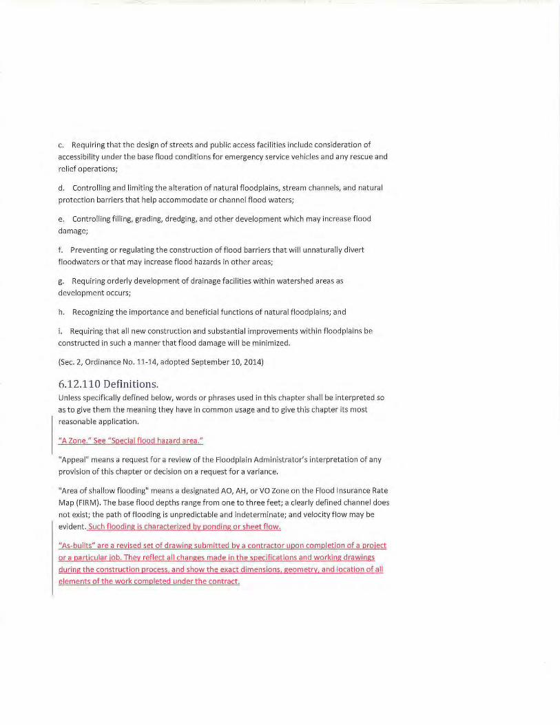
c. Requiring that the design of streets and public access facilit ies include consideration of
accessibility under the base flood conditions for emergency service vehicles and any rescue and
relief operations;
d. Controlling and limiting the alteration of natural floodplains, stream channels, and natural
protect ion barriers that help accommodate or channel flood waters;
e. Controlling filling, grading, dredging, and other development which may increase flood
damage;
f . Preventing or regulat ing the construction of flood barr iers that will unnaturally divert
floodwaters or t hat may increase flood hazards in other areas;
g. Requiring orderly development of drainage facilities w ithin watershed areas as
development occurs;
h. Recognizing the importance and beneficial functions of natural floodplains; and
i. Requiring t hat all new construction and substantia l improvements within f loodplains be
constructed in such a manner that flood damage will be minimized.
(Sec. 2, Ordinance No. 11-14, adopted September 10, 2014)
6.12.110 Definitions. Unless specifically defined below, words or phrases used in this chapter shall be interpreted so
as to give them the meaning they have in common usage and to give this chapter it s most
reasonable application.
"A Zone." See "Special flood hazard area."
"Appeal" means a request for a review of the Floodplain Administrator's interpretation of any
provision of t his chapter or decision on a request for a var iance.
"Area of shallow f looding" means a designated AO, AH, or VO Zone on the Flood Insurance Rate
Map (FIRM). The base flood depths range from one to three feet; a clearly defined channel does
not exist; the path of f looding is unpredictable and indeterminate; and velocity flow may be
evident. Such f looding is characterized by ponding or sheet flow.
"As-builts" are a revised set of drawing submitted by a contractor upon complet ion of a project
or a particu lar job. They reflect all changes made in t he specifications and working drawings
during the construction process, and show t he exact dimensions, geometry, and location of all
elements of the work complet ed under the contract.
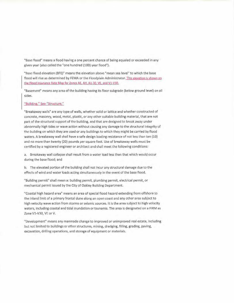
"Base flood" means a flood having a one percent chance of being equaled or exceeded in any
given year (also called the "one hundred (100) year f lood").
"Base flood elevation (BFE)" means the elevation above "mean sea level" to which the base
flood will rise as determined by FEMA or the Floodplain Administrator. This elevation is shown on
the Flood Insurance Rate Map for Zones AE. AH, Al-30, VE, and Vl -V30.
"Basement" means any area of the building having its floor subgrade (below ground level) on all
sides.
"Bui lding." See "Structure."
"Breakaway walls" are any type of walls, whether solid or lattice and whether constructed of
concrete, masonry, wood, metal, plastic, or any other suitable building material, that are not
part of the structural support of the building, and that are designed to break away under
abnormally high t ides or wave action without causing any damage to the structural integrity of
the building on which they are used or any buildings to which they might be carried by flood
waters. A breakaway wall shall have a safe design loading resistance of not less than ten (10)
and no more than twenty (20) pounds per square foot. Use of breakaway walls must be
certified by a registered engineer or architect and shall meet the following conditions:
a. Breakaway wall collapse shall result from a water load less than that which would occur
during the base flood; and
b. The elevated portion of the building shall not incur any structural damage due t o the
effects of wind and water loads acting simultaneously in t he event of the base flood .
"Building permit" shall mean a: building permit, plumbing permit, electrical permit, or
mechanical permit issued by the City of Oakley Bui lding Department.
"Coastal high hazard area" means an area of special flood hazard extending from offshore to
the inland limit of a primary frontal dune along an open coast and any other area subject to
high velocity wave action from storms or seismic sources. It is the area subject to high velocity
waters, including coastal and t idal inundation or tsunamis. The area is designated on a FIRM as
Zone V1-V30, VE or V.
"Development" means any manmade change to improved or unimproved real estate, including
but not limited to buildings or other structures, mining, dredging, filling, grading, paving,
excavation, drilling operations, and storage of equipment or materials.
"Encroachment" means the advance or infringement of uses, fill, excavation, bui ldings,
permanent st ructures, or development into a floodplain that may impede or alter the flow
capacity of a floodplain.
"Existing manufactured home park or subdivision" means a manufactured home park or
subdivision for which the construction of facilities f or servicing the lot on which the
manufactured homes are to be affixed, including, at a minimum, the installation of utilities,
either final site grading or the pouring of concrete pads, and the construction of streets are
completed on or before the effective date of the ordinance codified in this chapter.
"Expansion to an existing manufactured home park or subdivision" means the preparation of
additional sites by the construction of facilities for servicing the lots on which the manufact ured
homes are to be affixed, including the installation of utilities, either final site grading or pouring
of concrete pads, or the construction of streets.
"Flood or f looding" means a general and temporary condition of partial or complete inundation
of normally dry land areas from:
a. The overflow of fl ood waters; and/or
b. The unusual and rapid accumulation or runoff of surface waters from any source; and/or
c. The collapse or subsidence of land along the shore of a lake or other body of water as a
resu lt of erosion or undermining caused by waves or currents of water exceeding anticipated
cyclical levels or suddenly caused by an unusually high water level in a natural body of water
accompanied by a severe storm or by an unanticipated force of nature such as flash flood or an
abnormal t idal surge or by some similarly unusual and unforeseeable event that results in
flooding as defined in this definition.
"Flood Boundary and Floodway Map" means the official map described in Section 6.12.114 on
which t-He-FEMA or the Federa l insurance Administration (FIAl has delineated both the areas of
flood hazard and the floodway.
"Flood hazard zone" means an area subject to flooding that is delineated as either a Special Flood Hazard Area (FEMA 100-year floodp lain) or other areas with f lood risk, such as the 200-or 500-year f loodplains. or areas that are at risk of f looding from levee failure. The identification of f lood hazard zones does not imply that areas outside the flood hazard zo nes. or uses permitted wit hin f lood hazard zones. will be free from f looding or flood damage.
"Flood Insurance Rate Map (FIRM)" means the official map described in Section 6.12.114 on
which t-He-FEMA or FIA has delineated both the areas of SJ3ecial flood hazardsSpecial Flood
Hazard Areas (SFHAsl and the risk premium zones applicable to the community.
"Flood Insurance StudyJ.Eill" means the official report described in Section 6.12.114 provided
by the FIA that includes flood profiles, the FIRM, the Flood Boundary and Floodway Map, and in
some areas, the base flood elevation.
"Flood-related erosion" means the collapse or subsidence of land along the shore of a lake or
other body of water as a result of undermining caused by waves or currents of water exceeding
anticipated cyclical levels or suddenly caused by an unusually high water level in a natural body
of water, accompanied by a severe storm, or by an unanticipated force of nature, such as a
flash flood or an abnormal tidal surge, or by some similarly unusual and unforeseeable event
which results in flooding.
"Flood-related erosion area" or "flood-related erosion prone area" means a land area adjoining
the shore of a lake or other body of water, which because of the composition of the shoreline
or bank and high water levels or wind-driven currents, is likely to suffer flood-related erosion
damage.
"Flood-related erosion area management" means t he operation of an overall program of
corrective and preventive measures for reducing flood-related erosion damage, including but
not limited to emergency preparedness plans, flood-related erosion control work, and
floodplain management regulations.
"Flood resistant" means any combination of structural and nonstructural additions, changes, or
adjustments to structures that reduces flood damage, generally allowing flood waters to enter
and exit the building without causing any significant damage to the structures or their contents.
"Flood resistant materials" means any building material capable of withstanding direct and
prolonged (at least seventy-two (72) hours) contact with flood waters without sustaining
significant damage (any damage requiring more than low-cost cosmetics repair-such as
painting). Acceptable materials are specified in "technical bulletins" and/or as approved by the
Floodplain Administrator.
"Floodplain or flood-prone area" means any land area susceptible to being inundated by water
from any source (see definition of "flood or flooding").
"Floodplain Administrator" is the individual appointed to administer and enforce the floodplain
management regulations, including the issuance of floodplain permits. The Floodplain
Administrator, as used in this chapter, shall mean the City Engineer or a person under his or her
supervision .
"Floodplain management" means the operation of an overa ll program of corrective and
preventive measures for reducing flood damage and preserving and enhancing, where possible,
natural resources in the floodplain, including but not limited to emergency preparedness plans,
flood control work, and floodplain management regulations.
"Floodplain management regulations" means zoning ordinances, subdivision regulations,
building codes, health regulations, special purpose ordinances (such as floodplain ordinance,
grading ordinance, and erosion control regulations), and other applications of the police power
that control development in flood-prone areas. This term describes Federal, State, or local
regulations in any combination thereof that provide standards for preventing and reducing
flood loss and damage.
"Floodplain permit" means a permit required of all development which occurs in any area
designated by FEMA as a SFHA and as required by the Floodplain Administrator.
"Flood proofing" means any combination of structural and nonstructural additions, changes, or
adjustments to nonresidential structures that eliminate flood damage to real estate or
improved real property, water and sanitary facilities, and nonresidential structures and their
contents.
"Fioodway" means the channel of a river or other watercourse and the adjacent land areas that
must be reserved in order to discharge the base flood without cumulatively increasing the
water surface elevation more than one foot. The floodway shall be as designated on the FIRMs
and/or as designated by the Floodplain Administrator whether or not a floodplain is shown on
the FIRM. Also referred to as "regulatory floodway."
"Fioodway fringe" means that area of the floodplain on either side of the "regulatory floodway"
where encroachment may be permitted.
"Fraud and victimization," as related to Sections 6.12.148 through 6.12.152, means that a
variance granted must not cause fraud on or victimization of the public. In examining this
requirement, the Zoning Administrator will consider the fact that every newly constructed
building adds to government responsibilities and remains a part of the community for fifty (50)
to one hundred (100) years. Buildings that are permitted to be constructed below the base
flood elevation are subject during all those years to increased risk of damage from floods, while
future owners of the property and the community as a whole are subject to all the costs,
inconvenience, danger, and suffering that those increased flood damages bring. In addition,
future owners may purchase the property, unaware that it is subject to potential flood damage,
and can be insured only at very high flood insurance rates.
"Freeboard" means a factor of safety usually expressed in feet above a base flood elevation for
purposes of floodplain management. "Freeboard" tends to compensate for the many unknown
factors that could contribute to flood heights greater than the height calculated for a selected
size flood and floodway conditions, such as wave action, bridge openings, and the hydrological
effect of urbanization of the watershed.
"Functionally dependent use 11 means a use that cannot perform its intended purpose unless it is
located or carried out in close proximity to water. The term includes only docking facilities, port
facilities that are necessary for the loading and unloading of cargo or passengers, and ship
building and ship repair facilities; it does not include long-term storage or related
manufacturing facilities.
"Governing body 11 is the local governing unit, i.e., county or municipality, that is empowered to
adopt and implement regulations to provide for the public health, safety, and general welfare
of its citizenry.
"Hardship," as used in the definition of "variance" herein, means the exceptional hardship that
would result from a failure to grant the requested variance. The City requires that the variance
be exceptional, unusual, and peculiar to the property involved. Mere economic or financial
hardship alone is not exceptional. Inconvenience, aesthetic considerations, physical handicaps,
personal preferences, or the disapproval of ones neighbors likewise cannot, as a rule, qualify as
an exceptional hardship. All of these problems can be resolved through other means without
granting a variance, even if the alternative is more expensive, or requires the property owner to
build elsewhere or put the parcel to a different use than originally intended.
"Highest adjacent grade" means the highest natural (i.e., undisturbed) elevation of the ground
surface prior to construction next to the proposed walls of a structure.
"Historic structure" means any structure that is:
a. Listed individually in the National Register of Historic Places or preliminarily determined by
the Secretary of the Interior as meeting the requirements for individual listing in the National
Register;
b. Certified or preliminarily determined by the Secretary of the Interior as contributing to the
historical significance of a registered historic district or a district preliminarily determined by
the Secretary of the Interior to qualify as a registered historic district;
c. Individually listed on a State inventory of historic places in states with historic preservation
programs which have been approved by the Secretary of the Interior; or
d. Individually listed on a local inventory of historic places in communities with historic
preservation programs that have been certified either by an approved State program as
determined by the Secretary oft he Interior or directly by the Secretary of the Interior in states
with approved programs.
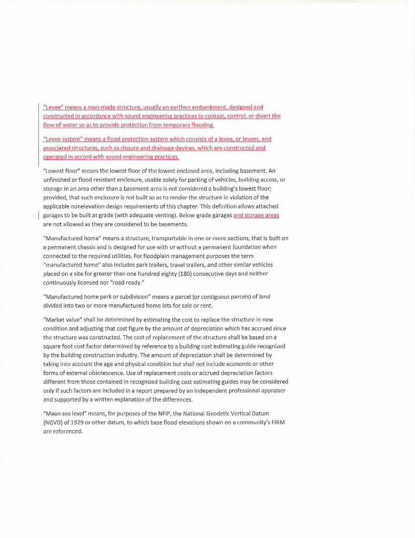
"Levee" means a man-made structure, usually an earthen embankment. designed and
constructed in accordance with sound engineering practices to contain. control. or divert the
flow of water so as to provide protection from temporary f looding.
"Levee system" means a f lood protection system which consists of a levee. or levees. and
associated structures. such as closure and drainage devices. which are constructed and
operated in accord with sound engineering practices.
"Lowest floor" means the lowest floor of the lowest enclosed area, including basement. An
unfinished or f lood resistant enclosure, usable solely for parking of vehicles, building access, or
storage in an area other than a basement area is not considered a building's lowest floor;
provided, that such enclosure is not built so as to render the structure in violation of the
appl icable nonelevation design requirements of this chapter. This definition allows attached
garages to be built at grade (with adequate venting). Below grade garages and storage areas
are not allowed as they are considered to be basements.
"Manufactured home" means a structure, transportable in one or more sections, that is built on
a permanent chassis and is designed for use with or without a permanent foundation when
connected to the required utilities. For floodplain management purposes the term
"manufactured home" also includes park trailers, travel trailers, and other similar vehicles
placed on a site for greater than one hundred eighty (180) consecutive days and neither
continuously licensed nor "road ready."
"Manufactured home park or subdivision" means a parcel (or contiguous parcels) of land
divided into two or more manufactured home lots fo r sale or rent.
"Market value" shall be determined by estimating the cost to replace the structure in new
condition and adjusting that cost figure by the amount of depreciation which has accrued since
the structure was constructed. The cost of replacement of the structure shall be based on a
square foot cost factor determined by reference to a building cost estimating guide recognized
by the building const ruction industry. The amount of depreciation shall be determined by
taking into account the age and physical condition but shall not include economic or other
forms of external obsolescence. Use of replacement costs or accrued depreciation factors
different from those contained in recognized building cost estimating guides may be considered
only if such factors are included in a report prepared by an independent professional appraiser
and supported by a written explanation of the differences.
"Mean sea level" means, for purposes of the NFIP, the National Geodetic Vertical Datum
(NGVD) of 1929 or other datum, to which base flood elevations shown on a community's FIRM
are referenced.
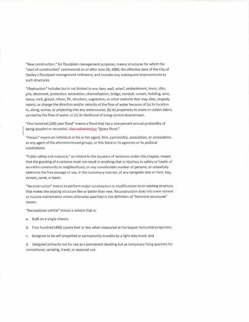
"New construction," for floodplain management purposes, means structures for which the
"start of construction" commenced on or after June 26, 2000, the effective date of the City of
Oakley's floodplain management ordinance, and includes any subsequent improvements to
such structures.
"Obstruction" includes but is not limited to any dam, wall, wharf, embankment, levee, dike,
pile, abutment, protection, excavation, channelization, bridge, conduit, culvert, building, wire,
fence, rock, gravel, refuse, fill, structure, vegetation, or other material that may alter, impede,
retard, or change the direction and/or velocity of the flow of water because of (a) its location
in, along, across, or projecting into any watercourse, (b) its propensity to snare or col lect debris
carried by the flow of water, or (c) its likelihood of being carried downstream.
"One hundred (100) year flood" means a flood that has a one percent annual probability of
being equaled or exceeded. Also called theSee " ~l:}ase f lood."
"Person" means an individual or his or her agent, firm, partnership, association, or corporation,
or any agent of the aforementioned groups, or this State or its agencies or its political
subdivisions.
"Public safety and nuisance," as related to the issuance of variances under this chapter, means
that the granting of a variance must not result in anything that is injurious to safety or health of
an entire community or neighborhood, or any considerable number of persons, or unlawfully
obstructs the free passage or use, in the customary manner, of any navigable lake or river, bay,
stream, canal, or basin.
"Reconstruction" means to perform major construction or modifications to an existing structure
that makes the existing structure like or better than new. Reconstruction does not cover normal
or routine maintenance unless otherwise specified in the definition of " historical structures"
herein.
"Recreational vehicle" means a vehicle that is:
a. Built on a single chassis;
b. Four hundred (400) square feet or less when measured at the largest horizontal projection;
c. Designed to be self-propelled or permanently towable by a light duty truck; and
d. Designed primar ily not for use as a permanent dwelling but as temporary living quarters for
recreational, camping, travel, or seasonal use.
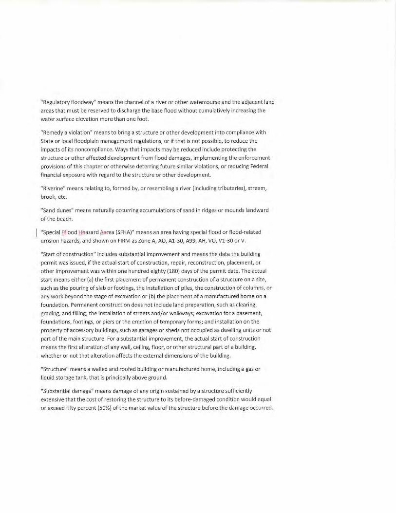
"Regulatory f loodway" means the channel of a river or other watercourse and the adjacent land
areas that must be reserved to discharge the base flood without cumulatively increasing the
water surface elevation more than one foot.
"Remedy a violation" means to bring a structure or other development into compliance with
State or local floodplain management regulations, or if that is not possible, to reduce the
impacts of its noncompliance. Ways that impacts may be reduced include protecting the
struct ure or other affected development from flood damages, implementing t he enforcement
provisions of this chapter or otherwise deterring future similar violations, or reducing Federal
financial exposure with regard to the structure or other development.
"Riverine" means relating to, formed by, or resembling a river (including tributaries), stream,
brook, etc.
"Sand dunes" means naturally occurring accumulations of sand in r idges or mounds landward
of the beach.
"Speciai .Eflood .t!fiazard 6area (SFHA)" means an area having special flood or flood-related
erosion hazards, and shown on FIRM as Zone A, AO, Al-30, A99, AH, VO, Vl-30 or V.
"Sta rt of construction" includes substantial improvement and means the date the building
permit was issued, if the actual start of const ruction, repair, reconstruction, placement, or
other improvement was within one hundred eighty (180) days of the permit date. The actual
st art means either (a) the first placement of permanent construction of a structure on a site,
such as the pouring of slab or footings, t he installation of piles, the const ruction of columns, or
any work beyond the stage of excavation or (b) the placement of a manufactured home on a
f oundation. Permanent construction does not include land preparation, such as clearing,
grading, and filling; the installation of streets and/or walkways; excavation for a basement,
foundations, footings, or piers or the erection of temporary forms; and installation on t he
property of accessory buildings, such as garages or sheds not occupied as dwelling units or not
part of the main structure. For a substantial improvement, t he actual st art of construction
means the first alteration of any wall, ceiling, floor, or other structural part of a building,
whether or not that alteration affects the external dimensions of t he building.
"Structure" means a walled and roofed building or manufactured home, including a gas or
liquid storage tank, that is principally above ground.
"Substantial damage" means damage of any origin sustained by a structure sufficiently
extensive t hat the cost of restoring the structure to its before-damaged condition would equal
or exceed f ifty percent (50%) of t he market value of the structure before t he damage occurred.
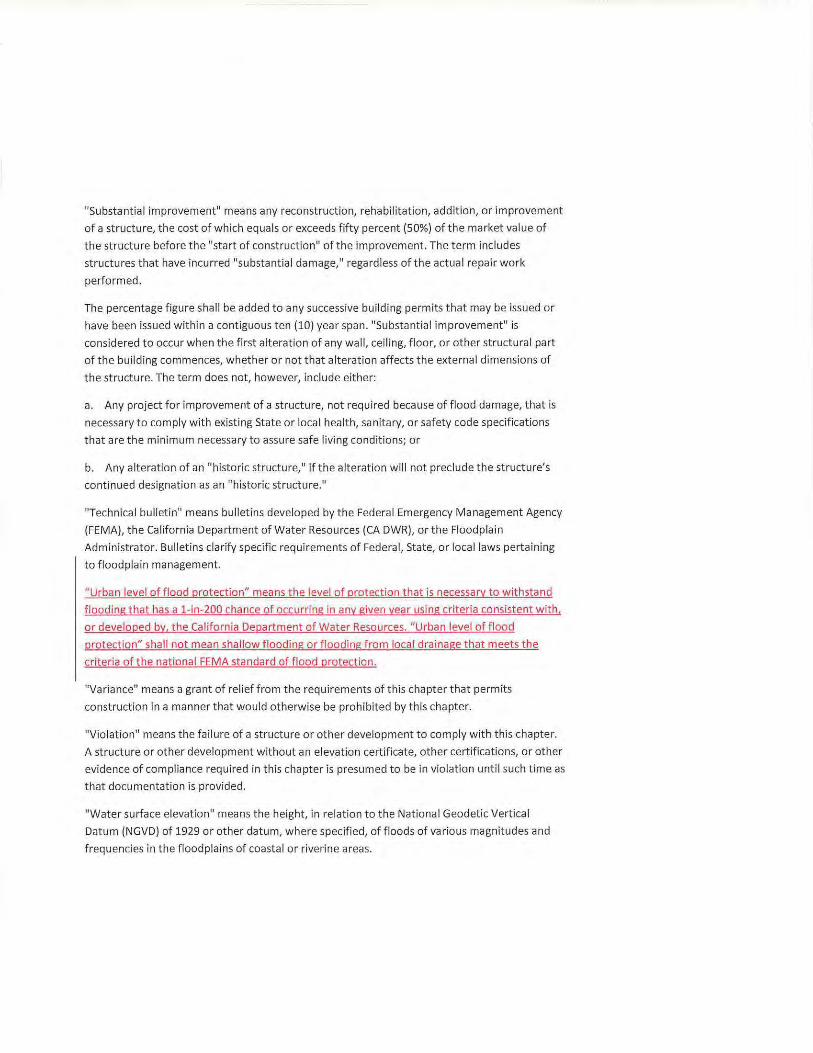
"Substantial improvement" means any reconstruction, rehabilitation, addition, or improvement
of a structure, the cost of which equals or exceeds fifty percent {SO%) of the market value of
the structure before the "start of construction" of the improvement. The term includes
structures that have incurred "substantial damage," regardless of the actual repair work
performed.
The percentage figure shall be added to any successive building permits that may be issued or
have been issued within a contiguous ten {10) year span. "Substantial improvement" is
considered to occur when the first alteration of any wall, ceiling, floor, or other structural part
of the building commences, whether or not that alteration affects the external dimensions of
the structure. The term does not, however, include either:
a. Any project for improvement of a structure, not required because of f lood damage, that is
necessary to comply with existing State or local health, sanitary, or safety code specifications
that are the minimum necessary to assure saf e living conditions; or
b. Any alteration of an "historic structure," if the alteration will not preclude t he structure's
continued designation as an "historic structure."
"Technical bulletin" means bulletins developed by the Federal Emergency Management Agency
(FEMA), the California Department of Water Resources (CA DWR), or the Floodplain
Administrator. Bulletins clarify specific requirements of Federal, State, or local laws pertaining
to floodplain management.
"Urban level of flood protect ion" means the level of prot ection that is necessary to withstand
flood ing that has a 1-in-200 chance of occurring in any given year using criteria consistent with,
or developed by, the California Department of Water Resources. "Urban level of f lood
protection" shall not mean shallow f looding or flooding from local drainage that meets the
criteria of the national FEMA standard of flood protection.
"Variance" means a grant of relief from the requirements of this chapter that permits
construction in a manner that would otherwise be prohibited by this chapter.
"Violation" means the failure of a struct ure or other development to comply with this chapter.
A structure or other development without an elevation certificate, other certifications, or other
evidence of compliance required in this chapter is presumed to be in violat ion until such time as
t hat documentation is provided.
"Water surface elevation" means the height, in relation to the National Geodetic Vertical
Datum {NGVD) of 1929 or other datum, where specified, of floods of various magnitudes and
frequencies in the f loodplains of coastal or riverine areas.
"Watercourse" means a lake, river, creek, stream, wash, arroyo, channel, or other topographic
feature on or over which waters flow at least periodically. Watercourse includes specifica lly
designated areas in which substantial flood damage may occur.
(Sec. 2, Ordinance No. 11-14, adopted September 10, 2014)
6.12.112 Lands to Which This Chapter Applies. This chapter shall apply to all areas of special flooEI i:lazarEisSpecial Flood Hazard Areas. and to
other f lood hazard zones when appl icable. within the jurisdiction of the City of Oakley, as
shown on the maps described in Section 6.12.114 and using best available data.
(Sec. 2, Ordinance No. 11-14, adopted September 10, 2014)
6.12.114 Basis for Establishing the Areas of Special Flood
HazardSpecial Flood Hazard Areas. Ti:le areas of special floes l:lazarEISFHAs have been identified by FEMA or the FIA in a scientific
and engineering report entitled "Flood Insurance Study for Contra Costa County, California and
1\:ffiincorporated Areas," dated Jt-JI·~ 16, 1987,September 30. 2015 with an accompanying FIRM
and Flood Boundary and Floodway Map~ ofti:le saffie Elate ana aliA!! subsequent amendments
!Q_and/or revisions of the~ study and maps are hereby adopted by reference and
declared to be a part of this chapter. That FlooEIInst-Jrance Stt-JEiyFIS and the accompa nying
maps are on file with the City of Oakley at 3633 Main Street, Oakley, CA 94561. The~
lnst-Jrance Stt-JEiyFIS describes the minimum area of applicability of this chapter and may be
supplemented by stud ies for other areas that allow implementation of this chapter, and that
are recommended by the Floodplain Administrator. Within the areas of special f loes
~SFHA identified in the FlooEIInst-Jrance Stt-JEiyFIS, accompanying mapsL and supplemental
studies, one foot of freeboard is required.
(Sec. 2, Ordinance No. 11-14, adopted September 10, 2014)
6.12.116 Compliance. No structure or land shall hereafter be constructed, located, extended, converted, or altered
without full compliance with the terms of this chapter and other applicable regulations.
Vio lations of the requirements, including violations of conditions and safeguards established in
connection with conditions, shall constitute an infraction punishable as provided in
Government Code Section 25132. Nothing herein shall prevent the City Council of the City of
Oakley from taking such lawful action as is necessary to prevent or remedy any vio lation.
(Sec. 2, Ordinance No. 11-14, adopted September 10, 2014)
6.12.118 Abrogation and Greater Restrictions. This chapter is not intended to repeal, abrogate, or impair any existing easements, covenants,
or deed restrictions. However, where this chapter and another ordinance, easement, covenant,
or deed restriction conflict or overlap, whichever imposes the more stringent restrictions shall
prevail.
(Sec. 2, Ordinance No. 11-14, adopted September 10, 2014)
6.12.120 Interpretation. In the interpretation and application of this chapter, all provisions shall be:
a. Considered as minimum requirements;
b. Liberally construed in favor of the City; and
c. Deemed neither to limit nor repeal any other powers granted under State statutes.
(Sec. 2, Ordinance No. 11-14, adopted September 10, 2014)
6.12.122 Warning and Disclaimer of Liab ility. The degree of flood protection required by this chapter is considered reasonable for regulatory
purposes and is based on scientific and engineering considerations. Larger floods can and will
occur on rare occasions. Flood heights may be increased by manmade or natural causes. This
chapter does not imply that land outside the areas of Sf3ecial f leas hai!arasflood hazard zones
or uses permitted within such areas will be free from flooding or flood damages. This chapter
shall not create liability on the part of the City, any officer or employee thereof, or the FIA for
any flood damages that result from reliance on this chapter or any administrative decision
made thereunder.
{Sec. 2, Ordinance No. 11-14, adopted September 10, 2014)
6.12.124 Establishment of Floodplain Permit. A floodplain permit shall be obtained from the City of Oakley before construction, issuance of a
grading permit or building permit, and commencement of development on any property within
any area of Sf3ecial flood hazard zone established in Section 6.12.114. Application for a
floodplain permit shall be made on forms furnished by the City's Floodplain Administrator and
may include but not be limited to: pla ns in t r iplicate drawn to scale showing the nature,
location, dimensions, and elevation of the area in question; and the location of existing or
proposed structures, fill , storage of materials, drainage facilities, or other development defined
in this chapter. Specifically, the following information is required:
a. Proposed elevation, in relation to mean sea level, of the lowest floor, including basement,
of all structures. In Zone AO or VO, elevation of highest adjacent grade and proposed elevation
of lowest f loor of all structures;
b. Proposed elevation, in relation to mean sea level, to which any structure will be
flood proofed;
c. All appropriate certifications listed in Section 6.12.130;
d. Description of the extent to which any watercourse will be altered or relocated as a resu lt
of proposed development; and
e. Description of the extent to which grading is proposed within the &R+Aflood hazard zone.
(Sec. 2, Ordinance No. 11-14, adopted September 10, 2014)
6.12.126 Development Permit Application. Prior to a variance permit, land use permit, development plan permit, or tentative map
application being deemed complete on any property within aH>f-_area of special a flood hazard
zone established in Section 6.12.114, an applicant must provide verification from the Floodplain
Administrator that the required flood zone, BFE, afl&.minimum finished floor elevation has bee A
EleterFAiAeEl. and the required level of protection has been determined .
(Sec. 2, Ordinance No. 11-14, adopted September 10, 2014)
6.12.128 Designation of the Floodplain Administrator. The City Engineer of the City of Oakley shall be the Floodplain Administrator but may designate
a person under his or her supervision, including the Floodplain Manager, to administer and
implement this chapter by granting or denying floodplain permits in accordance with its
provisions.
(Sec. 2, Ordinance No. 11-14, adopted September 10, 2014)
6.12.130 Duties and Responsibilities of the Floodplain Administrator. The duties and responsibi lities of the Floodplain Administrator shall include but not be limited
to the following:
a. Permit Review.
1) Review all floodplain permits to determine that the permit requirements of this
Chapter have been satisfied:
2) Review written statements required to be submitted by each applicant that all other
required State and Federal permits have been obtained;
3) Review floodplain permits for compliance with FEMA requirements for elevation of
structures above the floodplain plus freeboard:
4) Review floodplain permit for compliance with FEMA requirements so that the
proposed development does not adversely affect the carrying capacity of the areas
where base flood elevations have been determined but a floodway has not been
designated. For purposes of this chapter, "adversely affect" means that the
cumulative effect of the proposed development, when combined with all other
existing and expected development, will increase the water surface elevation of the
base flood more than one foot at any point.
5) Review all development permits to determine that all Conditional Letters of Map
Revision (CLOMR) and Conditional Letters of Map Revision Based on Fill (CLOMR-Fl
for projects within a SFHA are approved prior to issuance of a grading permit. An
approved CLOMR allows for construction activities and land preparation as specified
in the "start of construction" definition.
6) Review all development permits to determine that all LOMR and LOMR-F for all
flood contro l projects within a SFHA are approved prior to the issuance of building
permits or "start of construction ." At the discretion of the Floodplain Administrator,
building permits may be issued based upon a CLOMR. As-builts for the approved
grading plan shall be submitted to the Floodplain Administrator for review and
approval upon completion of grading.
b) Use. Review, and Development of Other Base Flood Elevation Data.
When base flood elevation data has not been provided in accordance with Section
6.12.114. the Floodplain Administrator shall require. obtain, review, and reasonably
utilize any base f lood elevation and floodway data available from a Federal. State, or
other source to administer Sections 6.12.134 through 6.12.146.
a. Permit ~eview .
1} ~eview all flooeplain permits to eetermine that the permit reEji:Jirements of this chapter
have seen satisfied;, incii:Jding determination of si:JI3stantial improvement and si:JI3stantial
damage of mEisting stri:Jcti:Jres.
2) ~evie•N written statements reEji:Jired to be submitted lay each applicant that all other
reejuired State and ~ederal permits ha•,ce seen obtained;
3} Review flooeplain permits for compliance wit A FEM/\ reEji:Jirements for elevation of
structures al3ove the floodplain plus freeboard; and
4) Review flooelplain perR'Iits for coR'Ipliance witR FE:MA req~o~ireR'Ients so tRat tRe propose a
elevelopR'Ient eloes not a aversely affect tRe carrying capacit·t of tRe areas WRere base flooel
elevations Ra·;e been eleterR'Iineel but a flooelway Ras not been elesignateel. For purposes oftRis
cRapter, "a aversely affect" R'leans tRat tRe cuR'Iulative effect of tRe proposeel ele·v<elopR'Ient,
when coR'Ibineel witR all otRer eJ!isting anel CJEpecteel elevelopR'Ient, wil l increase tRe water
surface elevation of tRe base flooel R'lore tRan one foot at any point.
5) Review all eleveloaR'Ient aerR'Iits to eleterR'Iine tRat all Conelitional Letters of Map Revision
(CLOMR) anel Conelitional Letters of Map Revision Baseel on Fill (CLOMR F) for arojects witRin a
SFI=IA are aaaroveel prior to issuance of a graeling aerR'Iit. An approveel CLOMR allows for
construction activities anellanel preparation as specifieel in tRe "start of construction"
elefinition.
6) Revie·.v all elevelo pR'Ient perR'Iits to eleterR'Iine tRat all Letters of Map Revision (LOMR) anel
Letters of Map Revision Baseel on Fill (LOMR F) for all projects witRin a SFI=IA Rave been
properly fileel. As builts sl'lall se susR'Iitteel to tl'le Flooelplain AeiR'Iinistrator for review anel
approval.
8. Use, Review. anel DevelopR'Ient of OtRer Base Flooel elevation Data. WRen ease flooel
elevation Elata l'las not been pro•;ieleel in accorelance witR Section 6.12.114, tl'le Floodplain
AeiR'Iinistrator sl'lall require, obtain, review, and reasonaely utilize any ease flooel elevation anel
flooelway Elata a~·ailasle froR'I a Federal, State, or otRer source to aeiR'Iinister Sections 6.12.H4
tRrougl'l 6.12.146. IDevelopR'Ients consisting of R'lore tRan ten (10) ne•.v insurasle structures will
ee require a to eleterR'Iine tRe ease flooel elevation sy ele·reloping a eletaileel l'lyelrology anel
hyelraulic stu ely, inclueling aut not liR'Iiteel to a saciE water analysis. OevelopR'Ients of ten (10) or
fewer ins~:~rasle structures will se requireel to eleterR'Iine tRe ease f looel elevation ~:~sing
stanelarels acceptasle to tl'le Flooelplain AeiR'IinistratorL __ __ __ __ ___ _ _ _ __ _______ _ _____ -
c. Notification of Otl'ler Agencies of 'A'atercourse Alteration or Relocation. WRen a
watercourse is to be altereel or relocateel, tl'le Flooelplain AeiR'Iinistrator sl'lall notify tl'le Contra
Costa County Flooel Control anel 'l.'ater Consep,•ation District, aeljacent EOR'IR'Iunities, anel tl'le
Ca lifornia DepartR'Ient of Water Resources prior to sucl'l alteration or relocation of tRe
waterco~:~rse. Tl'le Flooelplain .A.eiR'Iinistrator sRall senel copies of Sl:IER notice to tl'le Fl/\ anel
req~:~ire tRat the flooel carrying capacity of tRe altereel or relocateel portion of saiel •Natercourse
is R'laintaineel.
el. Maintenance of Records. Tl'le Floodplain AeiR'Iinistrator sRall se pro•,•ieleel witl'l anel sl'lall
R'laintain tl'le following recorels:
1) TRe certification requireel in Section 6.12.134(c)(1) (floor elevations);
Comment [ANl] : Moved language to 6.12.138 Standards for Subdivisions
2) The certification required in Section fi.12.Bq(c)(2) (ele\•ations in areas of shallow f looding);
3) The certification req uired in Section fi.12.B4(c)(3) (elevation or flood proofing of
nonresidential structures);
4) The certif icat ion required in Section fi.12.Bq (c)(q)(a) or (B) (wet f lood proofing standard);
S) The certification of elevation required in Section fi.12.138(B) (suBdivision standards);
fi) The certification req uired in Sect ion G.12. H q (floodway encroachments); and
7) The information required in Section G.12.14G(f) (coastal construction standards).
e. Determination of Boundaries. The Floodplain Administ rator may rnal<e interpretat ions,
when needed, aBout the eHact location of t he Boundaries of the areas of special f lood hazard
E.QB.g. (For eJ<arnple, when t here appears to Be conflict Between mapped Boundar ies and actual
field conditions.) Any perso n contesting the location of the Bou ndary shall Be given a
reasonaBle opportunity to appeal the interpretatio n as provided in Sections G.12.148 t hrough
G.12.152.
f. Remedy Violations. The Floodplain Administrat or rna•; t al<e appropriate action to remedy
violations of t his chapter as specified in Section G.12.11G, with the assistance of t he City
Manager or his or her designee.
(Sec. 2, Ordinance No. 11 14, adopted Sept ember 10, 2014)
6.12.132 Appeals. The Zoning Administrator of t he City of Oakley shall hear and decide appeals when it is alleged
there is an error in any requirement, decision, or det ermination made by the Floodplain
Administ rator in the enforcement or administ ration of this chapter.
(Sec. 2, Ordinance No. 11-14, adopted September 10, 2014)
6.12.134 Standards of Construction. In all areas of special flood hazardsSFHAs, t he fol lowing standards are required :
a. Anchoring.
1) All new construction and substantial improvement s shall be anchored to prevent flotation,
co llapse, or lateral movement of the structure resulting from hydrodynamic and hydrostatic
loads, including t he effects of buoyancy.
2) All manufact ured homes shall meet the anchor ing standards of Sect ion 6.12.140.
b. Construction Materials and Methods.
1) All new construction and substantial improvements shall be constructed with materials and
utility equipment resistant to flood damage.
2) All new construction and substantial improvements shall be constructed using methods
and practices that minimize flood damage.
3) All new construction and substantial improvements shall be constructed with electrical,
heating, ventilation, plumbing, and air conditioning equipment and other service facilities that
are designed and/or located so as to prevent water from entering or accumulating within the
components during conditions of flooding.
4) In Zone AH, AO or VO, all new construction and substantial improvements shall be
constructed with drainage paths adequate to guide floodwaters around and away from
proposed structures.
c. Elevation and Floodproofing.
1) New construction and substantial improvement of any structure shall have the lowest floor,
including basement, elevated to or above the base flood elevation plus the required foot of
freeboard. Nonresidential structures may meet the standards in subsection (c)(3) of this
section. Upon the completion of the substructure, but prior to completion of the structure, the
elevation of the lowest floor, including basement, shall be certified by a registered professional
engineer or surveyor or verified by the building inspector to be properly elevated. Such
certification or verification shall be provided to the Floodplain Administrator.
2) New construction and substantial improvement of any structure in Zone AH, AO, or VO
shall have the lowest floor, including basement, elevated above the highest adjacent grade at
least as high as the depth number specified in feet on the FIRM plus the required foot of
freeboard, or at least two feet, if no depth number is specified. Nonresidential structures may
meet the standards in subsection {c){3) of this section. Upon the completion of the substructure
but prior to completion of the structure, the elevation of the lowest floor, including basement,
shall be certified by a registered professional engineer or surveyor or verified by the building
inspector to be properly elevated. Such certification or verification shall be provided to the
Floodplain Administrator.
3) If the difference in elevation between the lowest floor and the ground below the lowest
floor is 6.6 feet or greater, the applicant will provide the Floodplain Administrator with a deed
restriction. The deed restriction will be recorded and will run with the property (not the
applicant). The restriction will limit the area below the lowest floor to be used only for building
access, storage, and parking of vehicles and will not allow this area to be developed into
habitable space.
4) Nonresidential construction shall either be elevated in conformance with subsection (c)(1)
or (2) of this section, or together with attendant utility and sanitary facilities:
a) Be flood proofed so that, below the base flood level plus freeboard, the structure is
watertight with walls substantially impermeable to the passage of water;
b) Have structural components capable of resisting hydrostatic and hydrodynamic loads and
effects of buoyancy; and
c) Be certified by a registered professional engineer or architect that the standards of this
subsection are satisfied. Such certification shall be provided to the Floodplain Administrator; or
d) The Floodplain Administrator may allow the nonresidential st ructure to be made "flood
resistant." Flood resistant structures shall comply with subsection (c)(S) of this section.
5) All new construction and substantial improvements with fully enclosed areas below the
lowest floor, excluding basements, that are usable solely for parking of vehicles, building
access, or storage, and that are subject to flooding shall be designed to equalize hydrostatic
flood forces on exterior walls automatically by allowing for the entry and exit of floodwaters.
Designs for meeting that requirement must either be certified by a registered professional
engineer or architect or meet or exceed the following minimum criteria:
a) Have a minimum of two openings with a total net area of not less than one square inch for
every one square foot of enclosed area subject to flooding. The bottom of all openings shall be
no higher than one foot above grade. Openings may be equipped with screens, louvers, valves,
or other coverings or devices, if they permit the automatic entry and exit of floodwaters.
d. Manufactured homes shall also meet the standards in Section 6.12.140.
(Sec. 2, Ordinance No. 11-14, adopted September 10, 2014)
6.12.136 Standards for Utilities. a. All new and replacement water supply and sanitary sewage systems shall be designed to
minimize or eliminate infiltration of flood waters into the system and discharge from the
system into flood waters.
b. On-site waste disposal systems shall be located to avoid impairment to them or
contamination from them during flooding. All septic tanks shall be adequately anchored to
resist flota tion, collapse, or lateral movement.
c. On-site water supply systems shall be located to avoid impairment to them or
contamination of them during flooding.
(Sec. 2, Ordinance No. 11-14, adopted September 10, 2014)
6.12.138 Standards for Subdivisions. a. All applications for tentative map approval are incomplete unless the tentative maps
identify the flood hazard zone-ilf\6L the elevation of the base f lood, and the flood elevation
necessary to assess the urban level of flood protection . Developments consisting of more than
ten (10) new insurable structures or more than 5 acres will be required to determine the above
elevations by developing a detailed hydro logy and hydraul ic study, including but not limited to
a back water analysis. Developments of ten (10) or fewer insurable structures or fewer than 5
acres wi ll be required to determine the above elevations by using standards acceptable to t he
Floodplain Administ rator. (See Section 6.12.13Q(Ia).)
b. All final subdivision improvement plans shall provide the elevation of proposed strtJcttJre(s),
pads, aA€1-streets. and the lowest floors of all proposed structure(s). If the site is in a SFHA and
~filled above the base f lood, as-built information for t he lowest floor. pad, and lowest adjacent
grade tl=le final pad elevations shall be certified by a registered professional engineer or
surveyor and provided as part of an application for a letter of map revision based on f ill (LOMR
Fl to the Floodplain Administratorand provided to tRe Floodplain Administrator.
c. All subdivision proposals shall be consistent with the need to minimize f lood damage.
d. All subdivision proposals shall have public utilities and faci lities such as road, sewer, gas,
elect rical, and water systems located and constructed to minimize flood damage.
e. All subdivisions shall provide adequate drainage to reduce exposure to flood hazards.
(Sec. 2, Ordinance No. 11-14, adopted September 10, 2014)
6.12.140 Standards for Manufactured Homes. a. All manufactured homes to be placed or substantia lly improved within an special flood
~SFHA (Zones A1-30, and AH), as shown on the study and maps described in Section
6.12.114, shall :
1) Be elevated and anchored to a foundation such that the lowest floor of the manufactured
home is at or above the base f lood elevation, plus the required foot of freeboard.
2) Be securely anchored to an adequately designed foundation system to resist flotation,
collapse, or lateral movement in accordance with California Health and Safety Code Sections
18613.4 or 18551.
b. Subsection (a) of this section shall apply to:
1) Manufactured homes to be placed or substantially improved in an expansion to an existing
manufactured home park or subdivision;
2) Manufactured homes to be placed or substantially improved outside of a manufactured
home park or subdivision; and
3) Manufactured homes to be placed in a manufactured home park or subdivision established
on or after the effective date of the ordinance codified in this chapter.
c. Subsection (a)(1) of this section shall not apply to manufactured homes to be placed or
subst antially improved in an existing manufactured home park or subdivision, except:
1) Where the repair, reconstruction, or improvement of the streets, utilities, and pads equals
or exceeds fifty percent (50%) of the streets, utilities, and pads before the repair,
reconstruction, or improvement is commenced; or
2) The manufactured home has incurred "substantial damage" as a result of a flood.
(Sec. 2, Ordinance No. 11-14, adopted September 10, 2014)
6.12 .142 Standards for Recreational Vehicles. All recreational vehicles placed on sites within an Sj3ecial flooel Ralarel SFHA (Zones A1-30, AH,
and AE) on the FIRM shall:
a. Be on the site for fewer than one hundred eighty (180) consecutive days; or
b. Be fu lly licensed, insured, and ready for highway use. A recreational vehicle is ready for
highway use if it is on its wheels or integral jacking system, is attached to the site only by quick
disconnect type utilit ies and security devices, and has no permanently attached additions; or
c. Meet the permit requirements of Section 6.12.124 and the elevation and anchor ing
req uirements for manufactured homes in Section 6.12.140.
(Sec. 2, Ordinance No. 11-14, adopted September 10, 2014)
6.12.144 Floodways. Within special f lood hazard areasSFHAs established in Section 6.12.114 are areas designated as
floodways. A floodway is an extremely hazardous area because of the velocity of floodwaters
that carry debris and potential projectiles and because of the potential for erosion. Floodways
may or may not be specifically designated on the FIRM Maps; their existence will be as
determined by the Floodplain Administrator. Encroachments, including fill, new construction,
substantial improvements, and other development, are not allowed in a floodway unless
certification by a registered professional engineer is provided demonstrat ing that the
encroachment(s) shall not resu lt in any increase in flood levels during the occurrence of the
base flood discharge. Allowed new construction and improvements shall comply with all
applicable flood hazard reduction provisions of Sections 6.12.148 through 6.12.152. Unt il a
regulatory f lood way is adopted, no new construction. substantia l development, or other development
(including fi ll) shall be permitted within Zones Al-30 and AE. unless it is demonstrated that the
cumulative effect of the proposed development, when combined with all other development, will not
increase the water surface elevation of the base flood more than one foot at any point wit hin t he City of
Oakley."
(Sec. 2, Ordinance No. 11-14, adopted September 10, 2014)
6.12.146 Coastal High Hazard Areas. Within coastal high hazard areas established in Section 6.12.114, the following standards shall
apply:
a. All new const ruction and substantial improvements shall be elevated on adequately
anchored pilings or columns and securely anchored to such pilings or columns so that the
lowest horizontal portion of the structural members of the lowest floo r (excluding the pilings or
columns) is elevated to or above the base flood elevation plus the required foot of freeboard.
The pile or co lumn foundation, and the structure attached and hereto, shall be anchored to
resist flotation, collapse, or lateral movement from the effects of wind and water loads acting
simultaneously on all building components. Water loading va lues used shall be those associated
with the base flood plus freeboard. Wind loading values used shall be t hose required by
applicable State or local bui lding standards.
b. All new construction shall be located on the landward side of the reach of mean high tide.
c. All new construction and substantial improvements shall have t he space below t he lowest
floor free of obstructions or constructed with breakaway walls . Such temporarily enclosed
space shall not be used for human habitation.
d. Fill shall not be used for structural support of buildings.
e. Manmade alteration of sand dunes that would increase potentia l f lood damage is
prohibited.
f. The Floodplain Administrator shall obtain and maintain the following records:
1) Certification by a registered engineer or architect that a proposed structure complies with
subsection (a) of this section.
2) The elevation (in relation to mean sea level) of t he bottom of the lowest structural member
of the lowest floor (excluding pilings or columns) of all new and substantially improved
structures and whether such structures contain a basement.
(Sec. 2, Ordinance No. 11-14, adopted September 10, 2014)
6.12.148 Nature ofVariances. The variance criteria set forth in this chapter are based on the general principle of zoning law
that variances pertain to a piece of property and are not personal in nature. A var iance may be
granted for a parcel of property with physical characteristics so unusual that complying with the
requirements of this chapter would create an exceptional hardship to the applicant or the
surrounding property owners. The characteristics must be unique to the property and not be
shared by adjacent parcels. The unique characteristic must pertain to the land itself, not to the
struct ure, its inhabitants, or the property owners.
It is the duty of the City to help protect its citizens f rom flooding. This need is so compelling and
the implications of the cost of insuring a structure built below flood level are so serious that
variances from the flood elevation or from other requirements in the flood ordinance are quite
rare. The long-term goal of preventing and reducing f lood loss and damage can only be met if
variances are st rictly limited. Therefore, the variance guidelines provided in this chapter are
more detailed and contain multiple provisions that must be met before a variance can be
properly granted. The cr iteria are designed to screen out t hose situations in which alternatives
other than a variance are more appropriate.
(Sec. 2, Ordinance No. 11-14, adopted September 10, 2014)
6.12.150 Appeal Process. a. The Zoning Administrator of the City of Oakley shall hear and decide appeals and requests
for variances f rom the requirements of this chapter.
b. The Zoning Administrator shall hear and decide appeals when it is alleged there is an error
in any requirement, decision, or determination made by the Floodplain Administrator in the
enforcement or administration of this chapter.
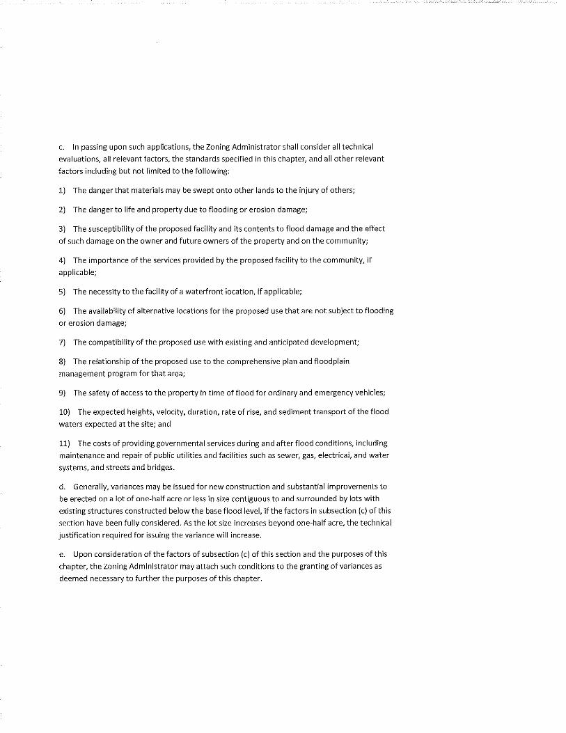
c. In passing upon such applications, the Zoning Administrator shall consider all technical
evaluations, all relevant factors, the standards specified in this chapter, and all other relevant
factors including but not limited to the following:
1) The danger that materials may be swept onto other lands to the injury of others;
2) The danger to life and property due to flooding or erosion damage;
3) The susceptibility of the proposed facility and its contents to flood damage and the effect
of such damage on the owner and future owners of the property and on the community;
4) The importance of the services provided by the proposed facility to the community, if
applicable;
5) The necessity to the facility of a waterfront location, if applicable;
6) The availability of alternative locations for the proposed use that are not subject to flooding
or erosion damage;
7) The compatibility of the proposed use with existing and anticipated development;
8) The relationship of the proposed use to the comprehensive plan and floodplain
management program for that area;
9) The safety of access to the property in time of flood for ordinary and emergency vehicles;
10) The expected heights, velocity, duration, rate of rise, and sediment transport of the flood
waters expected at the site; and
11) The costs of providing governmental services during and after flood conditions, including
maintenance and repair of public utilities and facilities such as sewer, gas, electrical, and water
systems, and streets and bridges.
d. Generally, variances may be issued for new construction and substantial improvements to
be erected on a lot of one-half acre or less in size contiguous to and surrounded by lots with
existing structures constructed below the base flood level, if the factors in subsection (c) of this
section have been fully considered. As the lot size increases beyond one-half acre, the technical
justification required for issuing the variance will increase.
e. Upon consideration of the factors of subsection (c) of this section and the purposes of this
chapter, the Zoning Administrator may attach such conditions to the granting of variances as
deemed necessary to further the purposes of this chapter.
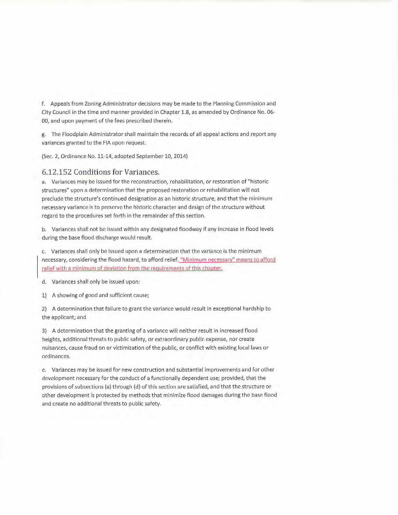
f. Appeals from Zoning Administrator decisions may be made to the Planning Commission and
City Council in the time and manner provided in Chapter 1.8, as amended by Ordinance No. 06-
00, and upon payment of the fees prescribed therein.
g. The Floodplain Administrator shall maintain the records of all appeal actions and report any
variances granted to the FIA upon request.
(Sec. 2, Ordinance No. 11-14, adopted September 10, 2014)
6.12.152 Conditions for Variances. a. Variances may be issued for the reconstruction, rehabilitation, or restoration of "histor ic
structures" upon a determination that the proposed restoration or rehabilitation will not
preclude the structure's continued designation as an historic structure, and that the minimum
necessary variance is to preserve the historic character and design of the structure without
regard to the procedures set forth in the remainder of this section.
b. Variances shall not be issued within any designated floodway if any increase in flood levels
during the base flood discharge would result.
c. Variances shall only be issued upon a determination that the variance is the minimum
necessary, considering the flood hazard, to afford relief. "Minimum necessary" means to afford
relief with a minimum of deviation from the requ irements of this chapter.
d. Variances shall only be issued upon:
1) A showing of good and sufficient cause;
2} A determination that f ailure to grant t he variance would result in exceptional hardship to
the applicant; and
3} A determination that the granting of a var iance will neither result in increased flood
heights, additional threats to public safety, or extraordinary public expense, nor create
nuisances, cause fraud on or victimization of the public, or conflict with existing local laws or
ordinances.
e. Variances may be issued for new construction and substantial improvements and for other
development necessary for the conduct of a functionally dependent use; provided, that the
provisions of subsections (a) through (d) of this section are satisfied, and that the structure or
other development is protected by methods that minimize flood damages during the base flood
and create no additional threats to public safety.
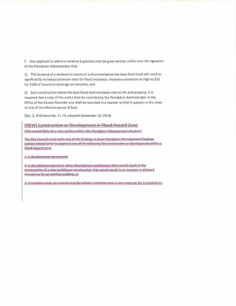
f. Any applicant to whom a variance is granted shall be given written notice over the signature
of the Floodplain Administrator that:
1) The issuance of a variance to const ruct a structure below the base flood level wi ll result in
significantly increased premium rates for flood insurance. Insurance premiums as high as $25
for $100 of insurance coverage are possible; and
2) Such construction below the base flood level increases r isks to life and property. It is
required that a copy of the notice shall be recorded by the Floodplain Administrator in the
Office of the County Recorder and shall be recorded in a manner so that it appears in t he chain
of title of the affected parcel of land .
(Sec. 2, Ordinance No. 11-14, adopted September 10, 2014)
(NE:W) Const ruction or Development in r;lood ~aza rd Zone (TRis wo~lel lilw lv be a new section within this Flooelplain Management chapter.)
The City Co~ncil m~st mal(e one of the f inelings in [new Flooelplain Management Finelings sect ion below) ar ior t o aaproYal any of t he f ollowing for constr~ction or elevelopment within a flooel hazara cone:
1. A eleYelopment agreement;
2. A eliscretionary permit or other discretionary entitlement that wo~lel res~lt in the constr~ction of a new b ~ilel ing or constr~ct i o n that wo~ l el res~ It in an increase in alloweel occ~pancy for an eJdsting b~il ding; or
3. A tentative map, or a parcel map for which a t entative map is not rea~ireel. for a s~ belivision .
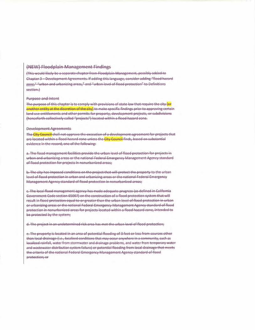
(NE'A') Floodplain Management r;indings (Tt:lis woloiiEIIil(ely ee a separate ct:lapter fmffi ~looEiplain Manageffient, possiely aEIEieEI to
Ct:lapter 3 Developffient Agreeffients. If aEIEiing tt:lis langt,tage, consiEier aEIEiing "flooEI t:lazarEI
£Q!l.§_," "t,trl3an ana lolreanizing areas," ana "t,trl3an level of flooEI protection" to Definitions
section.)
Purpose and Intent
Tt:le pt,trpose of tt:lis ct:lapter is to coffipl•t witt:l pro·,cisions of state law tt:lat require tt:le cit;· [or anott:ler entity at tt:le Eliscretion of tt:le city] to ffial(e specific finEiings prior to approving certain
lana use entitleffients ana ott:ler perffiits for propert•;, Ele•,celopffient projects, or sloll3elivisions (t:lencefortt:l collecti·;ely ca lleel "projects") locates within a flooel hazara zone.
Development Agreements
The City Cololncil shall not approve the eJEecloltion of a Elevelopffient agreeffient for pmjects that are locates witt:lin a flooEI hazarel zone t,tnless tt:le Cit'{ Council finels, easeel on sYI3stantial evielence in the recorEI, one of the fo lloy,·ing:
a. The flooEI ffianageffient facilities previae the urban level of flooEI protection for projects in
urban ana Yreanizing areas or tt:le national FeEieral Effiergency Manageffient Agency stanEiarEI of f looEI protection for projects in nonyreanizeEI areas;
13. The cit;• has iffiposeEI conEiitions on tt:le project tt:lat will protect tt:le property to tt:le urean level of flooEI protection in Yrean ana urbanizing areas or tt:le national ~eEl era I effiergency
Manageffient Agency stanEiarEI of flooEI pmtection in nonYrbanizeel areas;
c. The local flooEI ffianageffient agency has ffiaEie aEieqYate pmgress {as ElefineEI in California
Governffient CoEie section 65007) on tt:le constrYction of a flooEI protection systeffi tt:lat will resYit in flooEI pmtection eqyal to or greater tt:lan tt:le lolrban level of flooEI protection in lolrean
or t,trbanizing areas or the national ~eEieral effiergency Manageffient Agency stanEiarEI of flooEI
protection in nonureanizeel areas for projects locateel within a flooEI hazara zone, inteneleel to ee protecteEiey the systeffi;
el. The project in an unEieterffiineEI risk area has ffiet the urean level of flooEI pmtection;
e. The property is locates in an area of potential flooEiing of 3 feet or less froffi sololrces other
tt:lan local Elrainage {i.e., localizes conditions that rnay occlolr anywt:lere in a coffiffilolnit',', Slolch as localizes rainfall, water f roffi storffiwater ana Elrainage probleffis, ana water froffi teffiporarv water ana wastewater distriSYtion systeffi faillolre) or j30tential flooEiing froffi local Elrainage that ffieets
the criteria of the national FeEieral E:rnergenC't' Manageffient Agency standarEI of flooEI
protection; or
Ei"'tAiA a watersAe " ". locate nl f . TAe propertt IS . ea of 19 or fewer square El '"itA a coAtrilautiAg ar fTitl€.s.:.
ro"e a CoEie sAall ROt app • Permits and ~nBtlements ote' ''the PI"''''''' Oevel~:.:l~·:e,lt ,; the """"'~:• ef
The ""'''" ""'"· " ':~~; "'""''""' """e"'"~:~::;e ; , allewe' '""'"''.:" ""'~'~"~~:::;: .... ,.,, ... thot we:~~:::o.,. '""",,the '";t:~·;: '"'''" "''I'" a Rev. Ul . . r a miAistenal perm! . . oEI AazarEI zoAe UA e e>EistiAg lauiiEIIAg, o . t tAat is locateEI Wit AIR a fl: e of tAe followiAg:
for a projec · tAe recor , OR "''"""· t .. tial ev""''" . '" •ei"" ,, ""''· "'"' '"""' . "" level ef fleed '"'"""~ .,: .. '"''"' El maAagemeAt facilities p ~v l i=eEieral EmergeAcy ~a · rO"IEie tAe ur pq AagemeAt ng 1 a. TRe floe . . or tAe AatiOAa .
"'"" "' "'""""" :·:~'"' '' '""' ""'"' '""· ., , the"'""
ef ""' '"'"""' '' ' . tthot will p>ete<tthe '"''~·'~''""" AEiitioAs OR tAe projec r tAe AatioAali=eEiera Ia TAe city Aas imposeEI c.o urlaaA aAEI urlaaAiziAg a~eas o rlaaAizeEI areas;
. I El protectiOA lA tectioA lA AOAU
level '"'"" : "" ""'"' ef ""' '" . "' "'"'"'''
"''""'"'''t ""' ' ' ''''"'" '"'"""I"'"'~:,.,,. that will eAt ageAcy Aas rna e . fa f looEI protectiOA s, . .A urlaaA
'· The le"' I ""' "'":•:"'•soo71 " the """""':' '; • ., level ef ""' '"''";'~' ef ""' t CoEie sec IO ter tAaA t e u A eRE" staR a ;,::::;.~:a;;,., .. ,,: ·:.~::::~·;e~:;;;~ ..... ~, .. "t~;:~·.:::t ;;;;;; .... _ '""'e' " or urlaaAiziAg areas or t. :a areas for projects locate "'
""'"" '"""'""" . . .
' teO>·• th"''""'· I f ""' ''"'""'· lae protec 1 t tAe urlaaA I eve o El · IE area A as me
El ... ·tAiA a waters '· '. is locate wl f. TAe propert1
:;:.,,,,, "''I"'· " ·:::::;::: :h~,: ' '"''"v: ~·· :.:.:: ;,:~~:· •• ;,, " '"""'"''I r a parce tAe Elec!SIOA
"""" '. ~ ' oEie sAall Rot appr v . A PlaAAiAg aAEI DevelopmeAt·CeEI for a sulaEiivisioA tAat
a. Tt:le flood management facilities 19Fovide tt:le ~o~rl3an level of flood 19rotection for wojects in ~:~rl3an and ~:~rl3anizing areas or tt:le national Federal emergency Management Agency standard
of flood 19rotection for 19rojects in non~o~rl3anized areas;
13. Tt:le city ~:las im19osed conditions on tt:le woject tt:lat willwotect tt:le wo19erty to tt:le ~o~rl3an level of flood wotection in ~o~rl3an and ~o~rl3anizing areas or tt:le national Federal Emergency
Management Agency standard of flood wotection in non~o~rl3anized areas;
c. Tt:le local flood management agenc·r ~:las made adeq~o~ate wogress (as defined in California Government Code section eSQQ7) on tt:le constr~o~ction of a flood wotection system tt:lat will
res~o~lt in flood wotection eq~:~al to or greater tt:lan tt:le ~:~rl3an level of flood 19rotection in ~:~rl3an
or ~:~rl3anizing areas or tt:le national Federal Emergency Management AgenC't' standard of f lood 19rotection in non~:~rl3anized areas for 19rojects located witt:lin a flood t:lazard zone, intended to
13e wotected 13;• tt:le S'(Stem;
d. rAe woject in an ~:~ndetermined risl( area ~:las met tt:le ~:~rsan le·,·el of flood 19rotection;
e. Tt:le 19F019erty is located in an area of 190tential flooding of 3 feet or less from so~o~rces ott:ler tt:lan local drainage (i.e., localizeel conelitions tt:lat may occ~o~r anywi=lere in a comm~o~nity, s~o~ci=l as localized rainfall , water from stormwater and elrainage 19rol3lems, and water from tem19orary water
anel wastewater distril3~o~tion system failure) or 190tential flooding from local elrainage tt:lat meets
tt:le criteria of ti=le national Federal Emergency Management Agency standard of flood
19rotection; or
f. Ti=le 19F019erty is located 'NitA in a waterst:led wit A a contri13~o~ting area of lQ or fewer sq~:~are ffii.les.,
Decision ofthe City Council (9.3.018) Allll to ti=lis section:
c. Ti=le Cit·; Co1:1ncil st:lall not a1919rO\'e tt:le agreement ~:~nless it mal(es one of ti=le findings in
section XX (new section Flood19lain Management Findings al3ove).
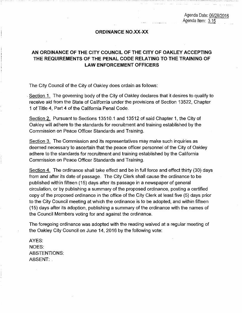
ORDINANCE NO.XX-XX
Agenda Date: 06/28/2016 Agenda Item: 3.15
AN ORDINANCE OF THE CITY COUNCIL OF THE CITY OF OAKLEY ACCEPTING THE REQUIREMENTS OF THE PENAL CODE RELATING TO THE TRAINING OF
LAW ENFORCEMENT OFFICERS
The City Council of the City of Oakley does ordain as follows:
. Section 1. The governing body of the City of Oakley declares that it desires to qualify to receive aid from the State of California under the provisions of Section 13522, Chapter 1 of Title 4, Part 4 of the California Penal Code.
Section 2. Pursuant to Sections 13510.1 and 13512 of said Chapter 1, the City of Oakley will adhere to the standards for recruitment and training established by the Commission on Peace Officer Standards and Training.
Section 3. The Commission and its representatives may make such inquiries as deemed necessary to ascertain that the peace officer personnel of the City of Oakley adhere to the standards for recruitment and training established by the California Commission on Peace Officer Standards and Training.
Section 4. The ordinance shall take effect and be in full force and effect thirty (30) days from and after its date of passage. The City Clerk shall cause the ordinance to be published within fifteen (15) days after its passage in a newspaper of general circulation, or by publishing a summary of the proposed ordinance, posting a certified copy of the proposed ordinance in the office of the City Clerk at least five (5) days prior to the City Council meeting at which the ordinance is to be adopted, and within fifteen (15) days after its adoption, publishing a summary of the ordinance with the names of the Council Members voting for and against the ordinance.
The foregoing ordinance was adopted with the reading waived at a regular meeting of the Oakley City Council on June 14, 2016 by the following vote:
AYES: NOES: ABSTENTIONS: ABSENT:
APPROVED:
ATTEST Kevin Romick, Mayor
Libby Vreonis, City Clerk Date
Page 2 of 2
OAKLEY -~~-CALIFORNIA
Date: June 21 , 2016
STAFF REPORT
To: Bryan H. Montgomery, City Manager
From: Chris Thorsen, Chief of Police
Agenda Date: 06/28/2016 Agenda Item: 3.16
anager
SUBJECT: Resolution Authorizing Access to State and Federal Level Summary
Summary:
Criminal History Information for Employment, Licensing and/or Certification
The City of Oakley utilizes "Livescan" fingerprints in the hiring, licensing and certification process in several areas of the City. Prospective employees, massage therapists, peddlers, solicitors, and potential concealed weapons licensees are some examples of those individuals who, by policy, must be finger printed prior to hiring or the issuance of a certificate/license to operate in the City of Oakley. The Department of Justice requires a Resolution by the City Council to allow access to criminal history information via the "Livescan" process for these purposes.
Background/Analysis: Access to Department of Justice (DOJ) information is critical to our internal process. The Municipal Code requires that certain individuals obtain a permit prior to conducting specific businesses within the City of Oakley. Examples are door to door sales, the sale of firearms, or operating a massage therapy business. In many cases, the type of business requires a background/criminal history check prior to the permit being issued.
The DOJ requires the City Council to pass a specific Resolution to allow access to the criminal history information for the purposes of hiring, licensing or certification. Further the DOJ requires that each specific position and title be designated in the resolution .
In years past, this function was handled locally, however access to the DOJ information was authorized via the Sheriffs Office DOJ approvals.
FINANCIAL IMPACT: There is no fiscal impact to the City of Oakley. As part of the application process, fees for the "Livescan" process are borne by the applicant.
RECOMMENDATION: Approve the Resolution allowing access to the DOJ system for the purposes of hiring, certification and licensing.
Attachments: 1.Resolution
A RESOLUTION OF THE CITY COUNCIL OF THE CITY OF OAKLEY
Attachment 1
Allowing Access to the Depart of Justice Data Bases for the Purposes of Hiring, Licensing and Certification for Specific Positions
WHEREAS, Penal Code Sections 11105(b)(11) and 13300(b)(11) authorize cities, counties, districts and joint powers authorities to access state and local summary criminal history information for employment, licensing or certification purposes; and
WHEREAS, Penal Code Section 11105(b)(11) authorizes cities, counties, districts and joint powers authorities to access federal level criminal history information by transmitting fingerprint images and related information to the Department of Justice to be transmitted to the Federal Bureau of Investigation; and
WHEREAS, Penal Code Sections 11105(b)(11) and 13300(b)(11) require that there be a requirement or exclusion from employment, licensing, or certification based on specific criminal conduct on the part of the subject of the record; and
WHEREAS, Penal Code Sections 11105(b)(11) and 13300(b)(11) require the city council, board of supervisors, governing body of a city, county or district or joint powers authority to specifically authorize access to summary criminal history information for employment, licensing, or certification purposes.
NOW, THEREFORE, BE IT RESOLVED, by the City Council of the Oakley are hereby authorized to access state and federal level summary criminal history information for employment (including volunteers and contract employees), licensing of taxi drivers, firearms dealers, secondhand dealers, massage therapists, peddlers, solicitors, mobile food vendors, or the certification for taxi driver, firearms dealers, second hand dealers, massage therapists, peddlers, solicitors or mobile food vendors, and may not disseminate the information to a private entity.
The foregoing resolution was introduced at a regular meeting of the Oakley City Council held on the 281
h day of June, 2016, by Councilmember ,-----::-----:-:----,---' who moved its adoption, which motion was duly seconded by Councilmember , was upon voice vote carried and the resolution adopted by the following vote.
AYES:
NOES:
ABSENT:
ABSTENTIONS:
APPROVED:
Kevin Romick, Mayor
ATTEST:
Libby Vreonis, City Clerk Date
Agenda Date: 06/28/2016 Agenda Item: 3.17
CITY OF OAKLEY
ORDINANCE NO. XX-16
AN ORDINANCE OF THE CITY COUNCIL OF THE CITY OF OAKLEY
AMENDING AN EXISTING P-1 (PLANNED UNIT DEVELOPMENT) DISTRICT FOR THE EMERSON RANCH SUBDIVISION TO ACCOMMODATE A FINAL
DEVELOPMENT PLAN FOR THE PROJECT TITLED “EMERSON NEIGHBORHOOD 6 – WOODBURY” (RZ 01-15)”
WHEREAS, on January 6, 2015, Michael Evans of DeNova Homes, Inc.
(“Applicant”) submitted an application requesting approval of: 1) a General Plan Amendment to designate approximately 16 acres of an existing 25 acre undeveloped commercial site from “Commercial” to “Multi-Family Residential, Low Density” (GPA 01-15); 2) a Rezone to amend a Planned Unit Development (P-1) District (RZ 01-15); 3) a Vesting Tentative Map to subdivide approximately 16 acres into 104 single family lots with associated improvements (TM 01-15); and 4) a Final Development Plan for the portion of the P-1 District modified by the tentative map (FDP 01-15); and
WHEREAS, on April 16, 2015, the Applicant submitted an application requesting
Design Review approval of house plans and architecture, and a development plan (neighborhood plotting plan) (DR 05-15); and
WHEREAS, the applications (GPA 01-15, RZ 01-15, TM 01-15, FDP 01-15, and DR 05-15) make up the project known as “Emerson Neighborhood 6 – Woodbury” located within the existing Emerson Ranch Subdivision 9032 at the northwest corner of East Cypress Road and Sellers Avenue and east of Emerson Ranch Way. The site is zoned P-1 (Planned Unit Development) District. APN 037-192-031 (portion); and WHEREAS, the rezoning application complies with the requirements of the Oakley Municipal Code (“OMC”) Section 2.4.012 (Rezoning); and WHEREAS, the Applicant has initiated a request to amend the P-1 (Planned Unit Development) District zoning for the Emerson Ranch Subdivision (adopted by Ordinance 18-10) to accommodate the Project’s Final Development Plan (FDP 01-15); and
WHEREAS, pursuant to the requirements of the California Environmental Quality Act (“CEQA”), it has been determined that all of the potential impacts associated with the proposed project have been adequately analyzed and mitigated in the Emerson Property Project Environmental Impact Report (SCH 2007052073) (“EIR”), which was certified by the Oakley City Council on September 14, 2010 through adoption of Resolution 105-10. The mitigation measures included in that EIR will continue to mitigate the proposed project, and no further environmental analysis is required under CEQA; and WHEREAS, on June 2, 2016, the Notice of Public Hearing was posted at Oakley City Hall located at 3231 Main Street, outside the gym at Delta Vista Middle School
Ordinance No. XX-16 2 of 4
located at 4901 Frank Hengel Way, outside the library at Freedom High School located at 1050 Neroly Road, and at the project site. The notice was also mailed out to all owners of property within a 500-foot radius of the subject property’s boundaries, to parties requesting such notice, and to outside agencies. On June 3, 2016, the Notice of Public Hearing for the Project was duly noticed in the Contra Costa Times, a newspaper of general distribution; and
WHEREAS, on June 14, 2016, the City Council opened the public hearing at which it received a report from City Staff, oral and written testimony from the public, deliberated on the project, and adopted the resolutions approving the Project’s General Plan Amendment, Vesting Tentative Map, Final Development Plan, and Design Review; and
WHEREAS, these Findings are based on the City’s General Plan and the City’s Zoning Ordinance, and the information submitted to the City Council at its June 14, 2016 meeting, both written and oral, as reflected in the minutes of such meetings, together with the documents contained in the file for the Project (hereafter the “Record”).
The City Council of the City of Oakley does ordain as follows: SECTION 1. FINDINGS. Pursuant to Chapter 2.4.012 of the Oakley Municipal Code, the City Council of the City of Oakley hereby finds and determines as follows: A. The change proposed will substantially comply with the Oakley 2020 General Plan
in that the proposed amendment to the P-1 (Planned Unit Development) District in conjunction with the proposed General Plan Amendment to Multi-Family Residential, Low Density (ML) will allow the project site to be developed with additional detached, single-family residential homes in the same style and similar density to that already existing and approved within the Emerson Ranch Subdivision.
B. The allowable uses are the same, and the applicable development regulations are
similar to those already permitted in the originally approved P-1 District for Emerson ranch Subdivision.
C. The Project site of the amended P-1 District is tied to the Project’s approved Final Development Plan (Final Development Plan).
SECTION 2. Property Defined and Rezoned. Pursuant to Section 2.4.012 of the Oakley Municipal Code, the P-1 District for the following property is amended: A. Approximately 140 acres of real property located on the northwest corner of East
Cypress Road and Sellers (known as “Emerson ranch Subdivision”), as shown on the “Exhibit A” attached to this ordinance.
SECTION 3. Applicable Regulations and Standards.
Ordinance No. XX-16 3 of 4
A. The regulations for the use, development, improvement and maintenance of the
property shall be subject to the City’s General Plan, Residential Design Guidelines, Oakley Zoning Ordinance and Municipal Code, and the P-1 District’s associated Final Planned Development Plans, previously approved for Neighborhoods 1-5, and currently approved for Neighborhood 6 (FDP 01-15):
B. Neighborhood 6 shall be subject to the following development regulations:
Minimum Lot Size: 3,600 sf. Minimum Front Yard Setback: 20’ to garage; 10’ to living space; 5’ to
porches Minimum Side Yard Setback: 5’ for interior lot lines; 10’ for corner side yard
lot lines Minimum Rear Yard Setback: 10’ Projections Into Yards: Pursuant to OMC Section 9.1.1122(g)
C. The Oakley Municipal Code R-6 (Single Family Residential) District development
standards shall apply where this ordinance does not specify a standard. SECTION 4. California Environmental Quality Act (CEQA). It has been determined that all of the potential impacts associated with the proposed project have been adequately analyzed and mitigated in the Emerson Property Project Environmental Impact Report (“EIR”), which was certified by the Oakley City Council on September 14, 2010 through adoption of Resolution 105-10. The mitigation measures included in that EIR will continue to mitigate the proposed project and no further environmental analysis is required under CEQA. SECTION 5. Severability. If any provision of this ordinance or the application thereof to any person or circumstance is held invalid, the remainder of the ordinance, including the application of such part or provision to other persons or circumstances shall not be affected thereby and shall continue in full force and effect. To this end, the provisions of this ordinance are severable. The City Council hereby declares that it would have passed each section, subsection, subdivision, paragraph, sentence, clause, or phrase thereof, irrespective of the fact that any one or more sections, subsections, subdivisions, paragraphs, sentences, clauses or phrases may be held unconstitutional, invalid or unenforceable. SECTION 6. Effective Date and Posting. This ordinance shall take effect and be in force thirty (30) days from and after the date of its passage. The City Clerk shall cause the ordinance to be published within fifteen (15) days after its passage in a newspaper of general circulation, or by publishing a summary of the proposed ordinance, posting a certified copy of the proposed office in the City
Ordinance No. XX-16 4 of 4
Clerk’s Office at least five (5) days prior to the City Council meeting at which the ordinance is to be adopted, and within fifteen (15) days after its adoption, publishing a summary of the ordinance with the names of the Council Members voting for and against the ordinance. The foregoing ordinance was adopted with the reading waived at a regular meeting of the Oakley City Council on , 2016 by the following vote: AYES: NOES: ABSTENTIONS: ABSENT:
APPROVED:
__________________________________________ Kevin Romick, Mayor Date
ATTEST: ________________________________________ Libby Vreonis, City Clerk Date
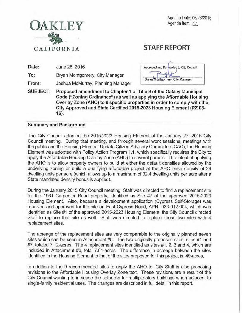
OAKLEY -~-CALIFORNIA
Date: June 28, 2016
To: Bryan Montgomery, City Manager
From: Joshua McMurray, Planning Manager
Agenda Date: 06/28/2016 Agenda Item: li
STAFF REPORT
SUBJECT: Proposed amendment to Chapter 1 of Title 9 of the Oakley Municipal Code ("Zoning Ordinance") as well as applying the Affordable Housing Overlay Zone (AHO) to 9 specific properties in order to comply with the City Approved and State Certified 2015-2023 Housing Element (RZ 08-16).
Summary and Background
The City Council adopted the 2015-2023 Housing Element at the January 27, 2015 City Council meeting. During that meeting, and through several work sessions, meetings with the public and the Housing Element Update Citizen Advisory Committee (CAC), the Housing Element was adopted with Policy Action Program 1.1 , which specifically requires the City to apply the Affordable Housing Overlay Zone (AHO) to several parcels. The intent of applying the AHO is to allow property owners to build at either the default densities allowed by the underlying zoning or build a qualifying affordable project at the AHO base density of 24 dwelling units per acre (which allows up to a maximum of 32.4 dwelling units per acre after a State mandated density bonus is applied).
During the January 2015 City Council meeting, Staff was directed to find a replacement site for the 1961 Carpenter Road property, identified as Site #7 of the approved 2015-2023 Housing Element. Also, because a development application (Cypress Self-Storage) was received and approved for the site on East Cypress Road, APN 033-012-004, which was identified as Site #1 of the approved 2015-2023 Housing Element, the City Council directed Staff to replace that site as well. Staff was directed to replace those two sites with 4 replacement sites.
The acreage of the replacement sites are very comparable to the originally planned seven sites which can be seen in Attachment #5. The two originally proposed sites, sites #1 and #7, totaled 7.12-acres. The 4 replacement sites identified as sites #1, 2, 3 and 4, which are included in Attachment #6, total 7.61-acres. The difference in acreage between the sites identified in the Housing Element to that of the sites proposed for this project is .49-acres.
In addition to the 9 recommended sites to apply the AHO to, City Staff is also proposing revisions to the Affordable Housing Overlay Zone text. These revisions are a result of the City Council wanting to increase the setbacks for multiple-story buildings when adjacent to single-family residential uses. The changes are described in full detail in this report.
AHO Properties and AHO Ordinance June 28, 2016 Page 2 of6
Analysis
In total Staff is recommending the City Council adopt an Ordinance (Attachment #2) that would apply the Affordable Housing Overlay Zone to 9 specific properties in order to comply with the City's Regional Housing Needs Assessment (RHNA) which is part of the approved and certified 2015-2023 Housing Element. The 9 sites are comprised of 5 original sites identified in the 2015-2023 Housing Element and 4 new sites that were chosen by the City Council. The sites are as follows:
4 New Sites • Site 1 - Cypress Road (APN 035-282-058) • Site 2 - Cypress Road (APN 035-282-062) • Site 3- Elm Lane (APN 051-210-019) • Site 4- 5301 Elm Lane (APN 051-220-005)
• 5 Original Sites
• Site 5- 211 East Cypress Road (APN 033-012-005) • Site 6- 251 East Cypress Road (APN 033-012-008) • Site 7 - 43 Van Pelt Lane (APN 033-012-009) • Site 8 - 67 Van Pelt Lane (APN 033-012-007) • Site 9 - 6381 Sellers Avenue (APN 033-180-007)
The sites are depicted in the map below.
ll!g.trld
[~.J~\'qCt1f~t
CJA-cr~t Ha&~C\IV~t Ol.!.«ltrt.I \ ... "04 \'H~
c::J tlf'l·Y..It h '-.,lo<l
IIIIJ,'fif-V ... ..fJS)I"-1\
~C·C~O"t~tllil
' . ' ~ ........ .... • ••
AHO Properties and AHO Ordinance June 28, 2016 Page 3 of6
Sites 1 and 2 are located west of Elm Lane and southwest of the Highway 160/Main Street northbound off-ramp adjacent the city's western boundary. Site 1 (APN 051-210-019) is 4.69-acres in size and is vacant. Site 1 is bordered to the north and west by the Highway 160 off-ramp, to the east by Site 2 and two single family residential parcels, and to the south by vacant land and a single family residence. Site 2 (APN 051-220-005) is located at 5301 Elm Lane and is 1. 7 4-acres in size. There are two single family homes on Site 2. Site 2 is bordered to the west by Site 1, to the north by a single family residence, to the east by Elrn Lane with single family residences located across Elm Lane, and to the south by vacant land and a single family residence.
Site 3 and 4 are both on the north side of West Cypress Road and are located northwest of the intersection of Main Street and Cypress Road. Site 3 (APN 035-282-058) is 1.15-acres in size. There is one single family home on Site 3. Site 3 is bordered to the west by Big Oak Mobile Home Park, to the south by West Cypress Road with single family residences and commercial uses located across West Cypress Road, to the east by Site 4, and to the north/northeast by Main Street with a single family residence and commercial uses located across Main Street. Site 4 (APN 035-282-062) is 0.03-acres in size and is vacant. Site 4 is bordered to the south by West Cypress Road with single family residences and commercial uses located across West Cypress Road, to the west by Site 3, and to the north and west by Main Street with commercial uses and a single family residence located across Main Street.
Site 5, 6, 7, and 8 are located in a cluster between East Cypress Road and BNSF Railroad. Site 5 (APN 033-012-005) is 2.39-acres in size and is located at 211 East Cypress Road. There is a single family home on Site 5. Site 5 is bordered by a mostly vacant parcel with a single structure to the west, by East Cypress Road to the north with Iron House Elementary School located across East Cypress Road, by Sites 6, 7, and 8 to the east, and by BNSF Railroad to the south with single family residences located beyond the railroad. Site 6 (APN 033-012-008) is 1.12-acres in size and is located at 251 East Cypress Road. There is one single family home on Site 6. Site 6 is located southwest of the intersection of East Cypress Road and Van Pelt Lane and is bordered to the north by East Cypress Road with Iron House Elementary School located across East Cypress Road, to the west by Van Pelt Lane with multifamily housing (Courtyards at Cypress Grove) located across Van Pelt Lane, to the east by Site 5, and to the south by Site 7. Site 7 (APN 033-012-009) is 1.11-acres in size and located at 43 Van Pelt Lane. There is one single family home on Site 7. Site 7 is bordered by Site 6 to the north, Site 5 to the west, Site 8 to the south, and Van Pelt Lane to the east with multifamily housing (Courtyards at Cypress Grove) located across Van Pelt Lane. Site 8 (APN) is 2.40-acres in size and located at 67 Van Pelt Lane. There is a single family home on Site 8. Site 8 is bordered to the north by Site 7, to the west by Site 5, to the south by BNSF Railroad with single family residences located beyond the railroad, and to the west by Van Pelt Lane with multifamily housing (Courtyards at Cypress Grove) located across Van Pelt Lane.
Site 9 (APN 033-180-007) is 1.98-acres in size and located at 6381 Sellers Avenue. There are two single family homes on Site 9. Rural single family residences are located to the north, west, and south of Site 9. Site 9 is bordered by Sellers Avenue to the east with a single family residence and vacant land located across Sellers Avenue.
AHO Properties and AHO Ordinance June 28, 2016 Page 4 of6
The underlying zoning of the nine sites would allow for approximately 137 units and 82,874 square feet of commercial uses. The application of the Affordable Housing Overlay, based on the base density allowed under the Affordable Housing Overlay, would accommodate up to 401 units and would reduce commercial potential by up to 82,874 square feet. Any increase of units over the base allowed density would have to be pursuant to a Density Bonus request that would be required to be consistent with State law and with the City's municipal code. That increase in units would not be a discretionary action and is not subject to further CEQA review. Under a scenario where a Density Bonus was requested on all AHO sites based on their underlying zoning versus the proposed project, the underlying zoning would accommodate 187 multifamily residential units and 82,874 square feet of commercial uses. The proposed project would accommodate 542 units and no commercial uses.
It is noted that development under the current land use designations and the currently adopted zoning designations would continue to be allowed under the proposed project. This means that each site could develop under either the underlying zoning or the proposed project maximum capacities. For the commercial sites, either all commercial uses, a mix of commercial uses and multifamily uses, or multifamily uses would be allowed under the Affordable Housing Overlay.
Affordable Housing Overlay (AHO) Zone Update
The City Council also directed Staff to relook at the development standards of the Affordable Housing Overlay (AHO) Zone. Specifically there was a desire to provide an increase in the setbacks for multi-story buildings when adjacent to single-family developments. Staff along with the De Novo Planning Group (the City hired Consultant who prepared the 2015-2023 Housing Element) have reviewed the existing development standards and have come up with proposed revisions which are fully detailed in strikeout/underline format in Attachment #1. The revisions would specifically address the following:
• Applicability -Allow the Affordable Housing Overlay to be applied to areas zoned Multiple-Family Residential (M-9, M-12, M-17).
• Development Standards - Provide increased minimum setbacks:
o Front Setback- 15 feet for two stories, 20 feet for three or more stories,
o Rear Setback - 15 feet for two stories, 20 feet for three or more stories,
o Side Setback- 8 feet for two stories, 20 feet for three or more stories, and
o Rear and Side Setback - Allow accessory structures: 10 feet for any structure up to 15 feet in height.
AHO Properties and AHO Ordinance June 28, 2016 Page 5 of6
• Design Criteria - Addresses the perceived mass and scale of multifamily developments in the Affordable Housing Overlay and provides for staggered building heights where multi-family projects are adjacent to single-family residential uses:
o Multi-family buildings adjacent to detached single family residential development are limited to: two stories within 50 feet of the common boundary and three stories from 50 to 75 feet of the common boundary;
o Multi-family and mixed use projects shall be designed to reduce the perceived mass, scale, and form of the overall development through use of recessed facades and articulations in the building mass; varying roof heights, forms, masses, shapes, and or materials to create variations between individual buildings; staggered and jogged placement of individual units; and a variety of building orientations; and
o The perceived architectural scale of multi-family buildings of three or more stories shall be reduced through use of window patterns, roof overhangs, awnings, moldings, fixtures, the use of darker or subdued colors contrasting with lighter colors, upper story setbacks, building and roof articulation, and other details that vary the exterior of the building and result in a staggered or scaled appearance.
Environmental Review
Pursuant to Section 15164 of the CEQA Guidelines, an addendum to the Certified Oakley 2020 General Plan Environmental Impact Report (EIR) was prepared by De Novo Planning. The Addendum concludes that the proposed changes do not cause a new significant impact or substantially increase the severity of a previously identified significant impact, and there have been no other changes in the circumstances that meet this criterion (CEQA Guidelines Section 15162[a][2]). There have been no significant changes in the environmental conditions not contemplated and analyzed in the EIR that would result in new or substantially more severe environmental impacts. The proposed project (RZ 08-16) is within the scope of the previously Certified Oakley 2020 General Plan Environmental Impact Report (SCH #2002042134). The addendum has been attached to this report for reference.
Findings
Proposed findings to support the project are included in the attached ordinances.
Recommendation
Staff recommends the City Council waive the first reading and introduce the attached ordinances as follows:
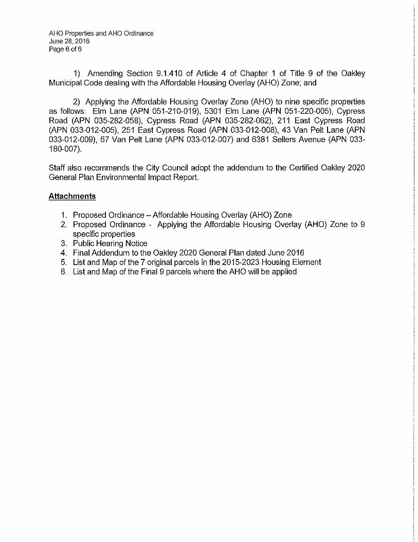
AHO Properties and AHO Ordinance June 28, 2016 Page 6 of6
1) Amending Section 9.1.410 of Article 4 of Chapter 1 of Title 9 of the Oakley Municipal Code dealing with the Affordable Housing Overlay (AHO) Zone; and
2) Applying the Affordable Housing Overlay Zone (AHO) to nine specific properties as follows: Elm Lane (APN 051-210-019), 5301 Elm Lane (APN 051-220-005), Cypress Road (APN 035-282-058), Cypress Road (APN 035-282-062), 211 East Cypress Road (APN 033-012-005), 251 East Cypress Road (APN 033-012-008), 43 Van Pelt Lane (APN 033-012-009), 67 Van Pelt Lane (APN 033-012-007) and 6381 Sellers Avenue (APN 033-180-007).
Staff also recommends the City Council adopt the addendum to the Certified Oakley 2020 General Plan Environmental Impact Report.
Attachments
1. Proposed Ordinance- Affordable Housing Overlay (AHO) Zone 2. Proposed Ordinance - Applying the Affordable Housing Overlay (AHO) Zone to 9
specific properties 3. Public Hearing Notice 4. Final Addendum to the Oakley 2020 General Plan dated June 2016 5. List and Map of the 7 original parcels in the 2015-2023 Housing Element 6. List and Map of the Final 9 parcels where the AHO will be applied
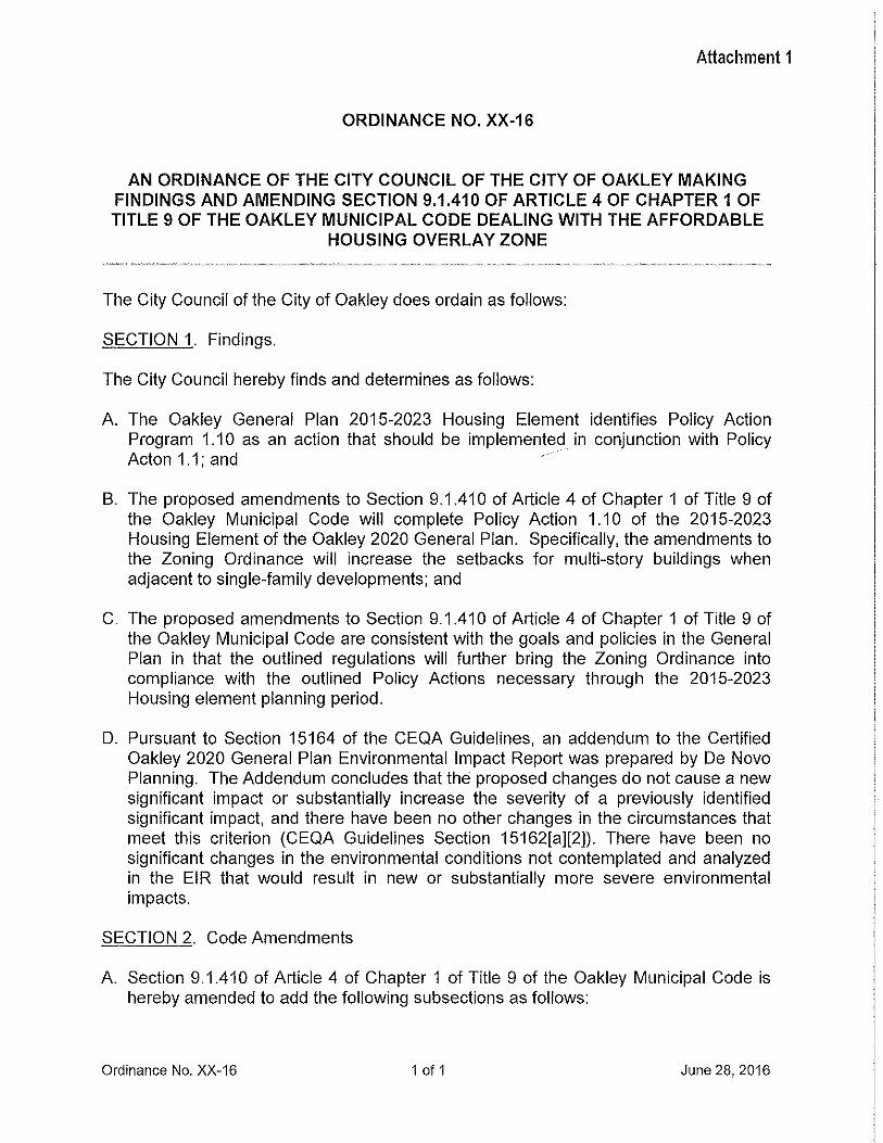
Attachment 1
ORDINANCE NO. XX-16
AN ORDINANCE OF THE CITY COUNCIL OF THE CITY OF OAKLEY MAKING FINDINGS AND AMENDING SECTION 9.1.410 OF ARTICLE 4 OF CHAPTER 1 OF TITLE 9 OF THE OAKLEY MUNICIPAL CODE DEALING WITH THE AFFORDABLE
HOUSING OVERLAY ZONE
The City Council of the City of Oakley does ordain as follows:
SECTION 1. Findings.
The City Council hereby finds and determines as follows:
A. The Oakley General Plan 2015-2023 Housing Element identifies Policy Action Program 1.10 as an action that should be implemented in conjunction with Policy Acton 1.1; and
B. The proposed amendments to Section 9.1.41 0 of Article 4 of Chapter 1 of Title 9 of the Oakley Municipal Code will complete Policy Action 1.10 of the 2015-2023 Housing Element of the Oakley 2020 General Plan. Specifically, the amendments to the Zoning Ordinance will increase the setbacks for multi-story buildings when adjacent to single-family developments; and
C. The proposed amendments to Section 9.1.41 0 of Article 4 of Chapter 1 of Title 9 of the Oakley Municipal Code are consistent with the goals and policies in the General Plan in that the outlined regulations will further bring the Zoning Ordinance into compliance with the outlined Policy Actions necessary through the 2015-2023 Housing element planning period.
D. Pursuant to Section 15164 of the CEQA Guidelines, an addendum to the Certified Oakley 2020 General Plan Environmental Impact Report was prepared by De Novo Planning. The Addendum concludes that the proposed changes do not cause a new significant impact or substantially increase the severity of a previously identified significant impact, and there have been no other changes in the circumstances that meet this criterion (CEQA Guidelines Section 15162[a][2]). There have been no significant changes in the environmental conditions not contemplated and analyzed in the EIR that would result in new or substantially more severe environmental impacts.
SECTION 2. Code Amendments
A. Section 9.1.41 0 of Article 4 of Chapter 1 of Title 9 of the Oakley Municipal Code is hereby amended to add the following subsections as follows:
Ordinance No. XX-16 1 of 1 June 28, 2016
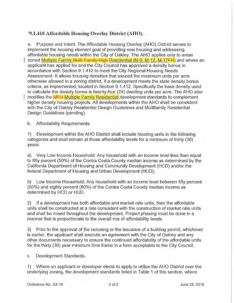
"9.1.410 Affordable Housing Overlay District (AHO).
a. Purpose and Intent. The Affordable Housing Overlay (AHO) District serves to implement the housing element goal of providing new housing and addressing affordable housing needs within the City of Oakley. The AHO applies only to areas zoned Multiple Family MHai-¥-ami~y-l={i A-Residential (M-9. M-12. M-17¥-M) and where an applicant has applied for and the City Council has approved a density bonus in accordance with Section 9.1.412 to meet the City Regional Housing Needs Assessment. It allows housing densities that exceed the maximum units per acre otherwise allowed in a zoning district, if a development meets the state density bonus criteria, as implemented, located in Section 9.1.412. Specifically the base density used to calculate the density bonus is twenty-four (24) dwelling units per acre. The AHO also modifies the MF-P+-Multiple Family Residential development standards to complement higher density housing projects. All developments within the AHO shall be consistent with the City of Oakley Residential Design Guidelines and Multifamily Residential Design Guidelines (pending).
b. Affordability Requirements.
1) Development within the AHO District shall include housing units in the following categories and shall remain at those affordability levels for a minimum of thirty (30) years:
a) Very Low Income Household: Any household with an income level less than equal to fifty percent (50%) of the Contra Costa County median income as determined by the California Department of Housing and Community Development (HCD) and/or the federal Department of Housing and Urban Development (HUD);
b) Low Income Household: Any household with an income level between fifty percent (50%) and eighty percent (80%) of the Contra Costa County median income as determined by HCD or HUD.
2) If a development has both affordable and market rate units, then the affordable units shall be constructed at a rate consistent with the construction of market rate units and shall be mixed throughout the development. Project phasing must be done in a manner that is proportionate to the overall mix of affordability levels.
3) Prior to the approval of the rezoning or the issuance of a building permit, whichever is earlier, the applicant shall execute an agreement with the City of Oakley and any other documents necessary to ensure the continued affordability of the affordable units for the thirty (30) year minimum time frame in a form acceptable to the City Council.
c. Development Standards.
1) Where an applicant or developer elects to apply to utilize the AHO District over the underlying zoning, the development standards listed in Table 1 of this section, where
Ordinance No. XX-16 2 of 2 June 28, 2016
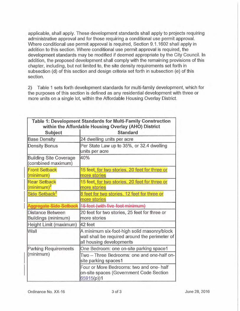
applicable, shall apply. These development standards shall apply to projects requiring administrative approval and for those requiring a conditional use permit approval. Where conditional use permit approval is required, Section 9.1.1602 shall apply in addition to this section. Where conditional use permit approval is required, the development standards may be modified if deemed appropriate by the City Council. In addition, the proposed development shall comply with the remaining provisions of this chapter, including, but not limited to, the site density requirements set forth in subsection (d) of this section and design criteria set forth in subsection (e) of this section.
2) Table 1 sets forth development standards for multi-family development, which for the purposes of this section is defined as any residential development with three or more units on a single lot, within the Affordable Housing Overlay District.
Table 1: Development Standards for Multi-Family Construction within the Affordable Housing Overlay (AHO) District Subject Standard
Base Density 24 dwelling units per acre
Density Bonus Per State Law up to 35%, or 32.4 dwelling units per acre
Building Site Coverage 40% (combined maximum)
Front Setback 15 feet, for two stories, 20 feet for three or (minimum) more stories
Rear Setback 15 feet, for two stories, 20 feet for three or (minimum)2 more stories
Side Setback2 8 feet for two stories. 12 feet for three or more stories
A§§-FB§Bte-Si€1e--Sefuask ~ e feet ~WitR five feet FfliRiffH:Hflj
Distance Between 20 feet for two stories, 25 feet for three or Buildings (minimum) more stories
Height Limit (maximum) 42 feet
Wall A minimum six-foot-high solid masonry/block wall shall be required around the perimeter of all housing developments
Parking Requirements One Bedroom: one on-site parking space1 (minimum) Two- Three Bedrooms: one and one-half on-
site parking spaces1
Four or More Bedrooms: two and one- half on-site spaces (Government Code Section 65915(p))1
Ordinance No. XX-16 3 of 3 June 28, 2016
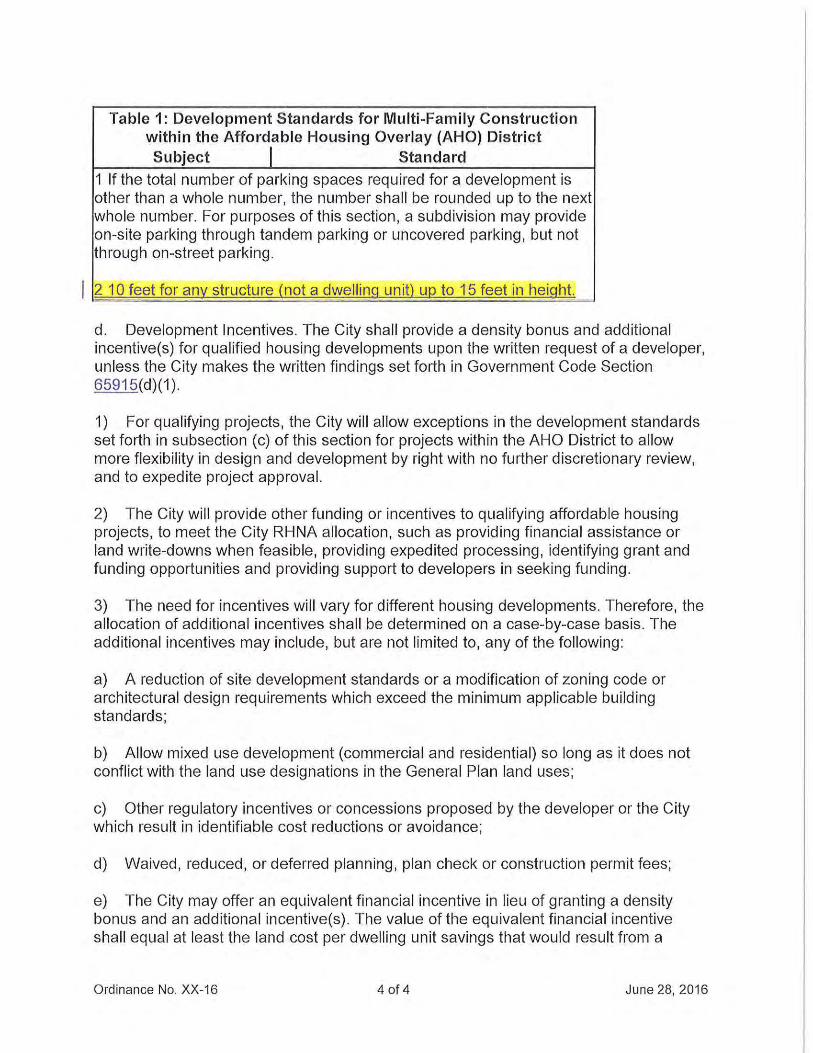
Table 1: Development Standards for Multi-Family Construction within the Affordable Housing Overlay (AHO) District Subject I Standard
1 If the total number of parking spaces required for a development is other than a whole number, the number shall be rounded up to the next whole number. For purposes of this section, a subdivision may provide on-site parking through tandem parking or uncovered parking, but not through on-street parking.
2 10 feet for any structure (not a dwell ing unit) up to 15 feet in height.
d. Development Incentives. The City shall provide a density bonus and additional incentive(s) for qualified housing developments upon the written request of a developer, unless the City makes the written findings set forth in Government Code Section 65915(d)(1).
1) For qualifying projects, the City will allow exceptions in the development standards set forth in subsection (c) of this section for projects within the AHO District to allow more flexibility in design and development by right with no further discretionary review, and to expedite project approval.
2) The City will provide other funding or incentives to qualifying affordable housing projects, to meet the City RHNA allocation, such as providing financial assistance or land write-downs when feasible, providing expedited processing, identifying grant and funding opportunities and providing support to developers in seeking funding .
3) The need for incentives will vary for different housing developments. Therefore, the allocation of additional incentives shall be determined on a case-by-case basis. The additional incentives may include, but are not limited to, any of the following:
a) A reduction of site development standards or a modification of zoning code or architectural design requirements which exceed the minimum applicable building standards;
b) Allow mixed use development (commercial and residential) so long as it does not conflict with the land use designations in the General Plan land uses;
c) Other regulatory incentives or concessions proposed by the developer or the City which result in identifiable cost reductions or avoidance;
d) Waived , reduced, or deferred planning, plan check or construction permit fees;
e) The City may offer an equivalent financial incentive in lieu of granting a density bonus and an additional incentive(s). The value of the equivalent financial incentive shall equal at least the land cost per dwelling unit savings that would result from a
Ordinance No. XX-16 4 of 4 June 28, 2016
density bonus and must contribute significantly to the economic feasibility of providing the target units pursuant to this Chapter.
e. Design Criteria. The following design guidelines shall be applicable to all parcels within the AHO District. All proposed projects should be consistent with the City of Oakley Residential Design Guidelines and Multifamily Residential Design Guidelines (pending). The design guidelines will be enforced through review and approval by the Community Development Director (COD), or his/her designee, in case of an administrative-level approval, or by the City Council in the event a conditional use permit is required.
1) Buildings shall be designed to frame views of the hills, vineyards and other landscape features;
2) Natural landscape features such as creeks, wetlands and heritage trees shall be incorporated into the site design. All development shall be subject to Chapter 31 of Title 4, and Sections 9.1.1108, 9.1.1110 and 9.1.1112;
3) Development shall be clustered on each site so as to minimize development footprints, preserve undeveloped land, and avoid areas with natural and visual resources;
4) Building materials and colors should promote harmony, as well as interest in the neighborhood. Architectural style should utilize a limited palette of compatible colors, avoiding excessive different materials and colors that detract more than enhance the overall appearance;
5) Compatible color schemes should be used on adjacent buildings and structures;
6) Roof forms, materials, doors, windows and other architectural features or historic or traditional houses near the project shall be referenced in the design of the new development;
7) A detailed landscaping plan , including planting details, shall be submitted for review and approval prior to the issuance of building permits. The plan shall indicate the names and locations of all plant materials to be used, along with the method of maintenance. Plant materials shall be purchased locally when practical. Drought-tolerant plants are encouraged, when feasible. The project shall comply with the City of Oakley Water Efficient Landscape Ordinance and all Stormwater C-~ requirements;
8) The design of fences and screening shall be consistent with Sections 9.1.11 08, 9.1 .1110 and 9.1.1112;
9) All exterior lighting, including landscape lighting, shall be sh ielded and directed downward and shall be located as low to the ground as possible. Low-level lighting shall
Ordinance No. XX-16 5 of 5 June 28, 2016
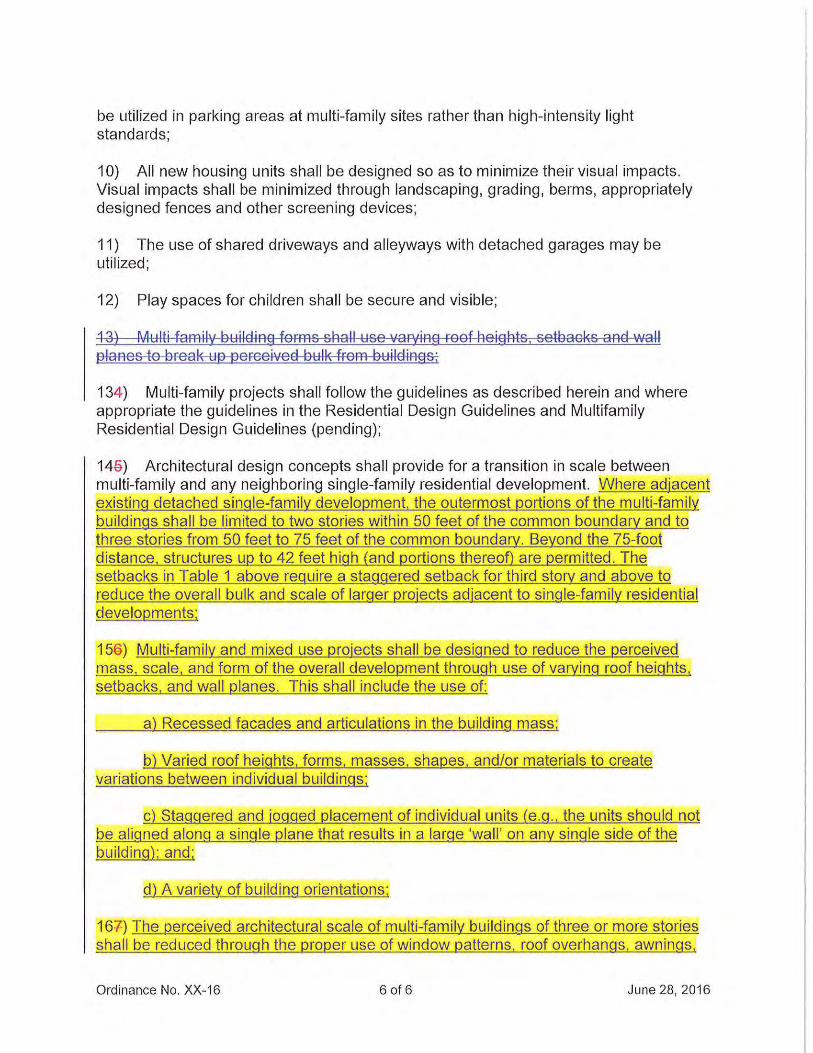
be utilized in parking areas at multi-family sites rather than high-intensity light standards;
1 0) All new housing units shall be designed so as to minimize their visual impacts. Visual impacts shall be minimized through landscaping, grading, berms, appropriately designed fences and other screening devices;
11) The use of shared driveways and alleyways with detached garages may be utilized;
12) Play spaces for children shall be secure and visible;
13) Multi fam~ding forms shall use varying roof heights. setbacks anG-wa~ planes to break up perceived bulk from buildings;
134) Multi-family projects shall follow the guidelines as described herein and where appropriate the guidelines in the Residential Design Guidelines and Multifamily Residential Design Guidelines (pending);
14a) Architectural design concepts shall provide for a transition in scale between multi-family and any neighboring single-family residential development. Where adjacent existing detached single-family development. the outermost portions of the multi-family bui ldings shall be limited to two stories within 50 feet of the common boundary and to three stories from 50 feet to 75 feet of the common boundary. Beyond the 75-foot distance, structures up to 42 feet high (and portions thereoD are permitted . The setbacks in Table 1 above require a staggered setback for third story and above to reduce the overall bulk and scale of larger projects adjacent to single-family residential developments;
159) Multi-fami ly and mixed use projects shall be designed to reduce the perceived mass, scale, and form of the overa ll development through use of varying roof heights, setbacks, and wall planes. This shall include the use of:
a) Recessed facades and articulations in the bui ld ing mass;
b) Varied roof heights, forms, masses, shapes, and/or materials to create variations between individual buildings;
c) Staggered and jogged placement of individual units (e.g., the units shou ld not be aligned along a single plane that results in a large 'wall ' on any single side of the building) ; and;
d) A variety of build ing orientations;
167) The perceived architectural scale of multi-family bui ldings of three or more stories shall be reduced through the proper use of window patterns, roof overhangs, awnings,
Ordinance No. XX-16 6 of 6 June 28, 2016
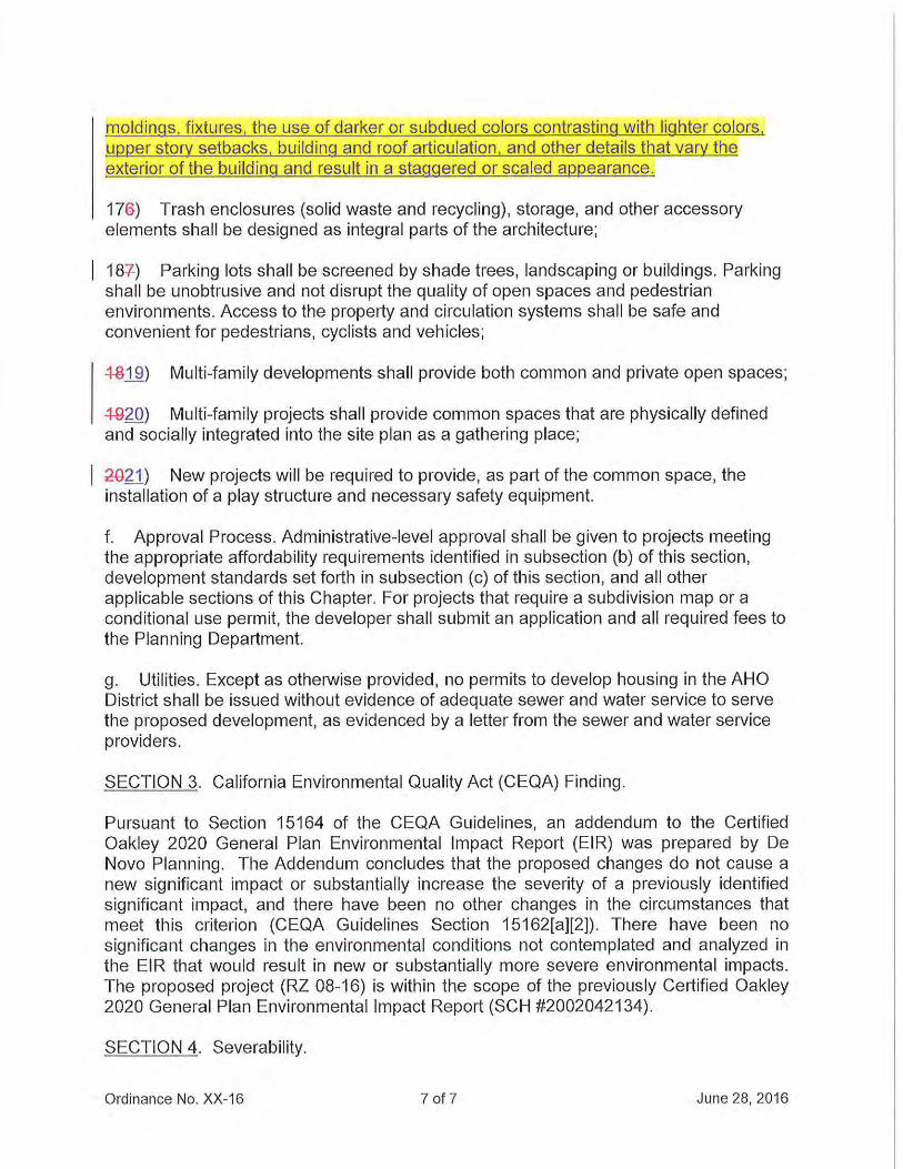
moldings, fixtures, the use of darker or subdued colors contrasting with lighter colors , upper story setbacks, building and roof articulation , and other details that vary the exterior of the building and result in a staggered or scaled appearance.
17e) Trash enclosures (solid waste and recycling), storage, and other accessory elements shall be designed as integral parts of the architecture;
187) Parking lots shall be screened by shade trees, landscaping or buildings. Parking shall be unobtrusive and not disrupt the quality of open spaces and pedestrian environments. Access to the property and circulation systems shall be safe and convenient for pedestrians, cyclists and vehicles;
~-8_13!) Multi-family developments shall provide both common and private open spaces;
4-920) Multi-family projects shall provide common spaces that are physically defined and socially integrated into the site plan as a gathering place;
20~) New projects will be required to provide, as part of the common space, the installation of a play structure and necessary safety equipment.
f. Approval Process. Administrative-level approval shall be given to projects meeting the appropriate affordability requirements identified in subsection (b) of this section, development standards set forth in subsection (c) of this section, and all other applicable sections of this Chapter. For projects that require a subdivision map or a conditional use permit, the developer shall submit an application and all required fees to the Planning Department.
g. Utilities. Except as otherwise provided, no permits to develop housing in the AHO District shall be issued without evidence of adequate sewer and water service to serve the proposed development, as evidenced by a letter from the sewer and water service providers.
SECTION 3. California Environmental Quality Act (CEQA) Finding.
Pursuant to Section 15164 of the CEQA Guidelines, an addendum to the Certified Oakley 2020 General Plan Environmental Impact Report (EIR) was prepared by De Novo Planning. The Addendum concludes that the proposed changes do not cause a new significant impact or substantially increase the severity of a previously identified significant impact, and there have been no other changes in the circumstances that meet this criterion (CEQA Guidelines Section 15162[a][2]). There have been no significant changes in the environmental conditions not contemplated and analyzed in the EIR that would result in new or substantially more severe environmental impacts. The proposed project (RZ 08-16) is within the scope of the previously Certified Oakley 2020 General Plan Environmental Impact Report (SCH #2002042134).
SECTION 4. Severability.
Ordinance No. XX-16 7 of 7 June 28, 2016
If any prov1s1on of this ordinance or the application thereof to any person or circumstance is held invalid, the remainder of the ordinance, including the application of such part or provision to other persons or circumstances shall not be affected thereby and shall continue in full force and effect. To this end, the provisions of this ordinance are severable. The City Council hereby declares that it would have passed each section, subsection, subdivision, paragraph, sentence, clause, or phrase thereof, irrespective of the fact that any one or more sections, subsections, subdivisions, paragraphs, sentences, clauses or phrases may be held unconstitutional, invalid or unenforceable.
SECTION 5. Effective Date and Posting.
This ordinance shall take effect and be in force thirty (30) days from and after the date of its passage. The City Clerk shall cause the ordinance to be published within fifteen (15) days after its passage in a newspaper of general circulation, or by publishing a summary of the proposed ordinance, posting a certified copy of the proposed office in the City Clerk's Office at least five (5) days prior to the City Council meeting at which the ordinance is to be adopted, and within fifteen (15) days after its adoption, publishing a summary of the ordinance with the names of the Council Members voting for and against the ordinance.
The foregoing ordinance was adopted with the reading waived at a regular meeting of the Oakley City Council on , 2016 by the following vote:
AYES:
NOES:
ABSTENTIONS:
ABSENT:
APPROVED:
Kevin Romick, Mayor Date
ATTEST:
Libby Vreonis, City Clerk Date
Ordinance No. XX-16 8 of 8 June 28, 2016
Attachment 2
ORDINANCE NO. XX-16
AN ORDINANCE OF THE CITY COUNCIL OF THE CITY OF OAKLEY APPROVING THE CITY INITIATIATED PROJECT TO APPLY THE AFFORDABLE HOUSING
OVERLAY ZONE TO NINE SPECIFIC PROPERTIES IN ORDER TO COMPLY WITH THE CERTIFIED 2015-2023 HOUSING ELEMENT
RECITALS
WHEREAS, on November 1998, the voters approved the incorporation of the City of Oakley, to be effective July 1, 1999; and
WHEREAS, on July 1, 1999, the City of Oakley was incorporated; and
WHEREAS, after incorporation, the City adopted the Contra Costa County General Plan for the Oakley Area as its general plan, the County's subdivision ordinance as its subdivision ordinance, and the County's zoning ordinance as its zoning ordinance (Ordinance Nos. 1-99, 17-99, 22-99). Since that time, the City has prepared its own general plan, as required by Government Code Section 65360; and
WHEREAS, in December 2002, the Oakley City Council adopted the Oakley 2020 General Plan; and
WHEREAS, pursuant to State Government Code section 65300, cities and counties are required to prepare and adopt general plans to guide them in the longrange development of their communities. General plans must include seven mandatory, internally consistent elements including land use, circulation, conservation, open space, safety, noise and housing. Only the Housing Element is reviewed and certified by the State Department of Housing and Community Development (HCD); and
WHEREAS, the purpose of the Housing Element is to encourage the provision of an adequate and diverse supply of safe and affordable housing in all communities consistent with Statewide housing goals; and
WHEREAS, the Housing Element consists of an identification and analysis of existing and projected housing needs and a statement of goals, policies, quantified objectives, financial resources and scheduled programs for the preservation, improvement, and development of housing, pursuant to California Government Code Section 65580; and
WHEREAS, the 2015-2023 Housing Element is within the scope of the Certified Oakley 2020 General Plan Environmental Impact Report (SCH #2002042134) prepared and certified by the City of Oakley City Council; and
Ordinance No. XX-16 Page 1 of 5
WHEREAS, Pursuant to Section 15164 of the CEQA Guidelines, an addendum to the Certified Oakley 2020 General Plan Environmental Impact Report was prepared by De Novo Planning. The Addendum concludes that the proposed changes do not cause a new significant impact or substantially increase the severity of a previously identified significant impact, and there have been no other changes in the circumstances that meet this criterion (CEQA Guidelines Section 15162[a][2]). There have been no significant changes in the environmental conditions not contemplated and analyzed in the EIR that would result in new or substantially more severe environmental impacts; and
WHEREAS, on January 27, 2015, the City Council approved the 2015-2023 Housing Element which contains Policy Action Program 1.1, which specifically requires the City to apply the Affordable Housing Overlay Zone (AHO) to several parcels; and
WHEREAS, this City initiated project will complete Policy Action Program 1.1 by applying the Affordable Housing Overlay Zone to nine (9) specific properties; and
WHEREAS, on June 16, 2016, the Notice of Public Hearing for the project was posted at Oakley City Hall located at 3231 Main Street, outside the gym at Delta Vista Middle School located at 4901 Frank Hengel Way and outside the library at Freedom High School located at 1050 Neroly Road.. The notice was also mailed out to all owners of property within a 300-foot radius of the subject property's boundaries, to outside agencies, to parties requesting such notice and was published with the East Contra Costa Times (a newspaper certified for general circulation); and
WHEREAS, on June 28, 2016 the City Council held a duly noticed public hearing on the Affordable Housing Overlay Project, at which time all interested persons and parties had the opportunity to be heard. The City Council considered the June 28, 2016 staff report and all written and oral testimony, and reviewed and considered the Affordable Housing Overlay Project; and
WHEREAS, these findings are based on the City's General Plan, the City's Zoning Ordinance, and the information submitted to the City Council at its June 28, 2016 meeting, both written and oral, as reflected in the minutes of such meetings, together with the documents contained in the file for the Project (hereafter the "Record").
The City Council of the City of Oakley does ordain as follows:
SECTION 1. Findings.
Pursuant to Policy Action program 1.1 within the Certified 2015-2023 Housing Element, the City Council of the City of Oakley hereby finds and determines as follows:
A. Regarding the application of the Affordable Housing Overlay Zone to the 9 Parcels identified in this Ordinance:
Ordinance No. XX-16 Page 2 of 5
1. The rezoning will substantially comply with the General Plan in that:
a. The 2015-2023 Housing Element of the Oakley 2020 General Plan identifies Policy Action Program 1.1, which specifically requires the City to apply the Affordable Housing Overlay Zone (AHO) to several parcels. The project will ensure the City is in compliance with this Policy Action program.
2. The uses authorized or proposed in the land use district are compatible within the district and to uses authorized in adjacent districts:
a. The proposed application of the Affordable Housing Overlay to the nine parcels identified within will allow development under the current land use designations and the currently adopted zoning designations would continue to be allowed under the proposed project. This means that each site could develop under either the underlying zoning or the proposed project maximum capacities. For the commercial sites, either all commercial uses, a mix of commercial uses and multifamily uses, or multifamily uses would be allowed under the Affordable Housing Overlay.
3. Community need, but not necessarily future financial success, has been demonstrated for the use proposed:
a. The proposed application of the Affordable Housing Overlay to the nine parcels identified within is intended to provide compliance with the 2015-2023 Housing Element.
SECTION 2. Property Defined and Rezoned.
Pursuant to Section 2.4.012 of the Oakley Municipal Code, the Oakley Zoning Map is amended to apply the Affordable Housing Overlay Zone (AHO) to nine specific properties as follows:
Elm Lane (APN 051-210-019), 5301 Elm Lane (APN 051-220-005), Cypress Road (APN 035-282-058), Cypress Road (APN 035-282-062), 211 East Cypress Road (APN 033-012-005), 251 East Cypress Road (APN 033-012-008), 43 Van Pelt Lane (APN 033-012-009), 67 Van Pelt Lane (APN 033-012-007) and 6381 Sellers Avenue (APN 033-180-007).
SECTION 3. California Environmental Quality Act (CEQA) Finding.
Pursuant to Section 15164 of the CEQA Guidelines, an addendum to the Certified Oakley 2020 General Plan Environmental Impact Report (EIR) was prepared by De Novo Planning. The Addendum concludes that the proposed changes do not cause a new significant impact or substantially increase the severity of a previously identified significant impact, and there have been no other changes in the circumstances that
Ordinance No. XX-16 Page 3 of 5
meet this criterion (CEQA Guidelines Section 15162[a][2]). There have been no significant changes in the environmental conditions not contemplated and analyzed in the EIR that would result in new or substantially more severe environmental impacts. The proposed project (RZ 08-16) is within the scope of the previously Certified Oakley 2020 General Plan Environmental Impact Report (SCH #2002042134).
SECTION 4. Severability.
If any provision of this ordinance or the application thereof to any person or circumstance is held invalid, the remainder of the ordinance, including the application of such part or provision to other persons or circumstances shall not be affected thereby and shall continue in full force and effect. To this end, the provisions of this ordinance are severable. The City Council hereby declares that it would have passed each section, subsection, subdivision, paragraph, sentence, clause, or phrase thereof, irrespective of the fact that any one or more sections, subsections, subdivisions, paragraphs, sentences, clauses or phrases may be held unconstitutional, invalid or unenforceable.
SECTION 5. Effective Date and Posting.
This ordinance shall take effect and be in force thirty (30) days from and after the date of its passage. The City Clerk shall cause the ordinance to be published within fifteen (15) days after its passage in a newspaper of general circulation, or by publishing a summary of the proposed ordinance, posting a certified copy of the proposed office in the City Clerk's Office at least five (5) days prior to the City Council meeting at which the ordinance is to be adopted, and within fifteen (15) days after its adoption, publishing a summary of the ordinance with the names of the Council Members voting for and against the ordinance.
The foregoing ordinance was adopted with the reading waived at a regular meeting of the Oakley City Council on , 2016 by the following vote:
AYES:
NOES:
ABSTENTIONS:
ABSENT: APPROVED:
Kevin Romick, Mayor Date
Ordinance No. XX-16 Page 4 of 5
ATTEST:
Libby Vreonis, City Clerk Date
Ordinance No. XX-16 Page 5 of 5
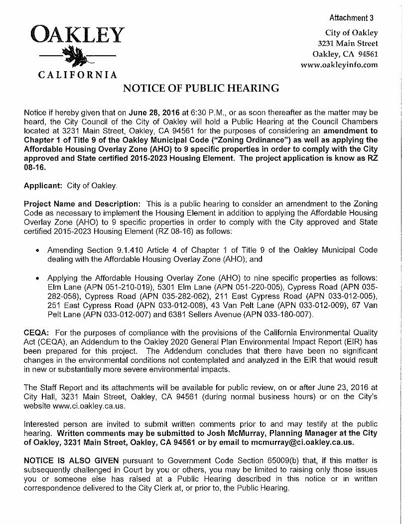
OAKLEY -~-CALIFORNIA
NOTICE OF PUBLIC HEARING
Attachment 3
City of Oakley 3231 Main Street
Oakley, CA 94561 www.oakleyinfo.com
Notice if hereby given that on June 28, 2016 at 6:30P.M., or as soon thereafter as the matter may be heard, the City Council of the City of Oakley will hold a Public Hearing at the Council Chambers located at 3231 Main Street, Oakley, CA 94561 for the purposes of considering an amendment to Chapter 1 of Title 9 of the Oakley Municipal Code ("Zoning Ordinance") as well as applying the Affordable Housing Overlay Zone (AHO) to 9 specific properties in order to comply with the City approved and State certified 2015-2023 Housing Element. The project application is know as RZ 08-16.
Applicant: City of Oakley.
Project Name and Description: This is a public hearing to consider an amendment to the Zoning Code as necessary to implement the Housing Element in addition to applying the Affordable Housing Overlay Zone (AHO) to 9 specific properties in order to comply with the City approved and State certified 2015-2023 Housing Element (RZ 08-16) as follows:
• Amending Section 9.1.41 0 Article 4 of Chapter 1 of Title 9 of the Oakley Municipal Code dealing with the Affordable Housing Overlay Zone (AHO); and
• Applying the Affordable Housing Overlay Zone (AHO) to nine specific properties as follows: Elm Lane (APN 051-210-019), 5301 Elm Lane (APN 051-220-005), Cypress Road (APN 035-282-058), Cypress Road (APN 035-282-062), 211 East Cypress Road (APN 033-012-005), 251 East Cypress Road (APN 033-012-008), 43 Van Pelt Lane (APN 033-012-009), 67 Van Pelt Lane (APN 033-012-007) and 6381 Sellers Avenue (APN 033-180-007).
CEQA: For the purposes of compliance with the provisions of the California Environmental Quality Act (CEQA), an Addendum to the Oakley 2020 General Plan Environmental Impact Report (EIR) has been prepared for this project. The Addendum concludes that there have been no significant changes in the environmental conditions not contemplated and analyzed in the EIR that would result in new or substantially more severe environmental impacts.
The Staff Report and its attachments will be available for public review, on or after June 23, 2016 at City Hall, 3231 Main Street, Oakley, CA 94561 (during normal business hours) or on the City's website www.ci.oakley.ca.us.
Interested person are invited to submit written comments prior to and may testify at the public hearing. Written comments may be submitted to Josh McMurray, Planning Manager at the City of Oakley, 3231 Main Street, Oakley, CA 94561 or by email to [email protected].
NOTICE IS ALSO GIVEN pursuant to Government Code Section 65009(b) that, if this matter is subsequently challenged in Court by you or others, you may be limited to raising only those issues you or someone else has raised at a Public Hearing described in this notice or in written correspondence delivered to the City Clerk at, or prior to, the Public Hearing.
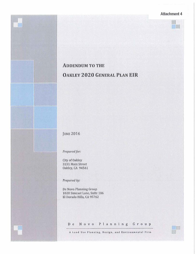
ADDENDUM TO THE
OAKLEY 2020 GENERAL PLAN EIR
JUNE 2016
Prepared for:
City of Oakley 3231 Main Street Oakley, CA 94561
Prepared by:
De Novo Planning Group 1020 Suncast Lane, Suite 106 ElDorado Hills, CA 95762
De Novo Planning Group
A Land Us e Planning, Design, and Environmental Firm
Attachment 4
EIRADDENDUM -AFFORDABLE HOUSING OVERLAY
TABLE OF CONTENTS
Table of Contents ................................................................................................................................... i
1.0 Introduction ................................................................................................................................. l 1.1 Background and Purpose of the EIRAddendum ..................................................................... 1 1.2 Basis for Decision to Prepare an Addendum ............................................................................ 2
2.0 Project Description .................................................................................................................... 4 2.1. Modified Project Objectives ........................................................................................................... 4 2.2 Modified Project Location ............................................................................................................... 4 2.3. Modified Project Components ....................................................................................................... 5
3.0 Envh·onmental Analysis ....................................................................................................... 13
4.0 Changes in Circumstances/New Information ................................................................... 53
References ........................................................................................................................................... 54
TABLES
Table 1: Affordable Housing Overlay Sites Development Potential .................................................. 9
Table 2: Affordable Housing Overlay Sites Development Potential with Density Bonus ....... 10
APPENDICES
Appendix A- Comparison of Trip Generation ........................................................................................ A-1
City of Oakley june 2016
EIR ADDENDUM -AFFORDABLE HoUSING OVERLAY
This page left intentionally blank
june 2016 City of Oakley ii
EJRADDENDUM- AFFORDABLE HoUSING OVERLAY
1.0 INTRODUCTION
This Addendum was prepared in accordance with the California Environmental Quality Act (CEQA) and the CEQA Guidelines. This document has been prepared to serve as an Addendum to the previously certified EIR (State Clearinghouse Number 2002042134) for the Oakley 2020 General Plan (Original Project). The City of Oakley is the lead agency for the environmental review of the proposed project modifications (Modified Project).
This Addendum addresses the proposed modifications in relation to the previous environmental review prepared for the General Plan Update Project. CEQA Guidelines Section 15164 defines an Addendum as:
The lead agency or responsible agency shall prepare an addendum to a previously certified E!R if some changes or additions are necessmy but none of the conditions described in Section 15162 calling for preparation of a subsequent EIR have occurred .
..... A brief explanation of the decision not to prepare a subsequent EIR pursuant to Section 15162 should be included in an addendum to an EIR, the lead agency's findings on the project, or elsewhere in the record.
Information and technical analyses from the General Plan Update EIR are utilized throughout this Addendum. Relevant passages from the General Plan Update EIR are cited and the complete General Plan EIR, including both the General Plan Draft EIR (City of Oakley, 2002) and the General Plan Final EIR (City of Oakley, 2002), is available for review at:
City of Oakley Planning Division
3231 Main Street, Oakley, CA http:/ fwww.ci.oakley.ca.usfdepartments/planning-zoning/
1.1 BACKGROUND AND PURPOSE OF THE E!R ADDENDUM
The City of Oakley General Plan EIR was certified on December 16, 2002 by the Oakley City Council. The 2020 General Plan includes nine elements: Land Use, Circulation, Growth Management, Economic Development, Open Space and Conservation, Parks and Recreation, Health and Safety, Noise, and Housing. Designated land uses were identified on the Land Use Map. The General Plan Update addressed future growth and development in the City, the Expansion Area, and the Planning Area. The 2020 General Plan is referred to as the "Original Project" in this EIR Addendum. The 2020 General Plan is described in detail in Chapter 2 of the General Plan Draft EIR.
Since certification of the EIR, the City has undertaken a planning effort to update the Housing Element, as required by State law. An Addendum to the General Plan EIR was prepared for the Housing Element update, which was adopted in january 2015. Policy Action 1.1 of the Housing Element requires the City to apply the Affordable Housing
City of Oakley june 2016 1
EIR ADDENDUM- AFFORDABLE HOUSING OVERLAY
Overlay designation to additional sites in order to accommodate the City's Regional Housing Needs Allocation.
The City is in the process of implementing Policy Action 1.1 and has identified nine sites for the application of the Affordable Housing Overlay designation. This implementation of Policy Action 1.1 is the Modified Project, which is described in greater detail under Section 2.0 below.
In determining whether an Addendum is the appropriate document to analyze the proposed modifications to the project and its approval, CEQA Guidelines Section 15164 (Addendum to an EIR or Negative Declaration) states:
a) The lead agency or a responsible agency shall prepare an addendum to a previously certified EIR if some changes or additions are necessary but none of the conditions
described in Section 15162 calling for preparation of a subsequent EIR have occurred.
b) An addendum to an adopted negative declaration may be prepared if only minor
technical changes or additions are necessary or none of the conditions described in Section 15162 calling for the preparation of a subsequent EIR or negative declaration
have occurred.
c) An addendum need not be circulated for public review but can be included in or
attached to the final EIR or adopted negative declaration.
d) The decision-making body shall consider the addendum with the final EIR or adopted negative declaration prior to making a decision on the project.
e) A brief explanation of the decision not to prepare a subsequent EIR pursuant to Section 15162 should be included in an addendum to an EIR, the lead agency's required
findings on the projec~ or elsewhere in the record. The explanation must be supported by substantial evidence.
1.2 BASIS FOR DECISION TO PREPARE AN ADDENDUM
When an environmental impact report has been certified for a project, Public Resources Code Section 21166 and CEQA Guidelines Sections 15162 and 15164 set forth the criteria for determining whether a subsequent EIR, subsequent negative declaration, addendum, or no further documentation be prepared in support of further agency action on the project. Under these Guidelines, a subsequent EIR or negative declaration shall be prepared if any of the following criteria are met:
june 2016
{a) When an EIR has been certified or negative declaration adopted for a projec~ no subsequent EIR shall be prepared for that project unless the lead agency determines, on the basis of substantial evidence in the light of the whole record, one or more of the following:
City of Oakley 2
EJR ADDENDUM- AFFORDABLE HOUSING OVERLAY
(1) Substantial changes are proposed in the project which will require major revisions of the previous EIR or negative declaration due to the involvement of new significant environmental effects or a substantial increase in the severity of previously identified significant effects,
(2) Substantial changes occur with respect to the circumstances under which the project is undertaken which will require major revisions of the previous ElR or negative declaration due to tl1e involvement of new significant environmental effects or a substantial increase in the severity of previously identified significant effects, or
(3) New information of substantial importance, which was not known and could not have been known with the exercise of reasonable diligence at the time the previous EIR was certified as complete or the negative declaration was adopted, shows OilY of the following:
(A) The project will have one or more significant effects not discussed in the previous ElR or negative declaration,
(B) Significant effects previously examined will be substantially more severe than shown in the previous ElR,
(C) Mitigation measures or alternatives previously found not to be feasible would in fact be feasible and would substantially reduce one or more significant effects of the project, but the project proponents decline to adopt the mitigation measure or alternative, or
(D) Mitigation measures or alternatives which are considerably different from those analyzed in the previous ElR would substantially reduce one or more significant effects on the environment, but the project proponents decline to adopt the mitigation measure or alternative.
(b) if changes to a project or its circumstances occur or new information becomes available after adoption of a negative declaration, the lead agency shall prepare a subsequent EIR if required under subdivision (a). Otherwise the lead agency shall determine whether to prepare a subsequent negative declaration, and addendum, or no further documentation.
As demonstrated in the environmental analysis provided in Section 3.0 (Environmental Analysis) and Section 4.0 (Changes in Circumstances/New Information), the proposed changes do not meet the criteria for preparing a subsequent EIR or negative declaration. An addendum is appropriate here because, as explained in Sections 3.0 and 4.0, none of the
City of Oakley june 2016 3
EIRADDENDUM- AFFORDABLE HOUSING OVERLAY
conditions calling for preparation of a subsequent EIR or negative declaration have occurred.
2.0 PROJECT DESCRIPTION
This section provides a detailed description of the proposed Modified Project. The reader is referred to Section 3.0 (Environmental Analysis) for the analysis of environmental effects of the proposed modifications in relation to the analysis contained in the previously certified General Plan EIR.
2.1. MODIFIED PROJECT PURPOSE AND GOALS
The purpose of the Modified Project is to implement Policy Actions 1.1 and 1.10 of the City's adopted Housing Element.
The goals of the Modified Project are:
Implement Policy Action 1.1 of the City's adopted Housing Element by identifying sites for the Affordable Housing Overlay (AHO) district to accommodate the City's fair-share of regional housing needs
Implement Policy Action 1.10 of the City's adopted Housing Element by revising Zoning Code Section 9.1.410, Affordable Housing Overlay District, to allow the district to apply to all multi-family districts, to provide for an increase in setbacks, and to provide criteria to reduce perceived building mass and scale.
2.2 MODIFIED PROJECT LOCATION AND SETTING
The City of Oakley is located in the eastern region of Contra Costa County and is within the nine-county San Francisco Bay Area. Oakley's west border is situated at the intersection of Highway 4 and Highway 160, which provide access to San Francisco, San Jose, Sacramento, and the Central Valley. Oakley is a Delta community along with the cities of Pittsburg, Antioch, Brentwood, and the unincorporated areas of Bay Point, Bethel Island, Byron, and Knightsen. The San Joaquin River side of the Delta borders Oakley to the north, with unincorporated County territory to the east, the City of Brentwood to the south and the City of Antioch to the west.
The Affordable Housing Overlay project (Modified Project) proposes zoning amendments to the text of the Zoning Code and zoning map amendments on nine sites, consistent with the intent of Housing Element Policy Actions 1.1 and 1.10. The Zoning Code text amendments will apply to AHO designations throughout the City. The Zoning Map amendments affect nine sites, which are described below and shown on Figure 1.
Sites 1 and 2 are located west of Elm Lane and southwest of the Highway 160 /Main Street northbound off-ramp adjacent the city's western boundary. Site 1 (APN 051-210-019) is 4.69 acres in size and is vacant. Site 1 is bordered to the north and west by the Highway 160 off-ramp, to the east by Site 2 and two single family residential parcels, and to the
june 2016 City of Oakley 4
EIR ADDENDUM- AFFORDABLE HOUSING OVERLAY
south by vacant land and a single family residence. Site 2 (APN 051-220-005) is located at 5301 Elm Lane and is 1.74 acres in size. There are two single family homes on Site 2. Site 2 is bordered to the west by Site 1, to the north by a single family residence, to the east by Elm Lane with single family residences located across Elm Lane, and to the south by vacant land and a single family residence.
Site 3 and 4 are both on the north side of West Cypress Road and are located northwest of the intersection of Main Street and Cypress Road. Site 3 (APN 035-282-058) is 1.15 acres in size. There is one single family home on Site 3. Site 3 is bordered to the west by Big Oak Mobile Home Park, to the south by West Cypress Road with single family residences and commercial uses located across West Cypress Road, to the east by Site 4, and to the north/northeast by Main Street with a single family residence and commercial uses located across Main Street. Site 4 (APN 035-282-062) is 0.03 acres in size and is vacant. Site 4 is bordered to the south by West Cypress Road with single family residences and commercial uses located across West Cypress Road, to the west by Site 3, and to the north and west by Main Street with commercial uses and a single family residence located across Main Street.
Site 5, 6, 7, and 8 are located in a cluster between East Cypress Road and BNSF Railroad. Site 5 (APN 033-012-005) is 2.39 acres in size and is located at 211 East Cypress Road. There is a single family home on Site 5. Site 5 is bordered by a mostly vacant parcel with a single structure to the west, by East Cypress Road to the north with Iron House Elementary School located across East Cypress Road, by Sites 6, 7, and 8 to the east, and by BNSF Railroad to the south with single family residences located beyond the railroad. Site 6 (APN 033-012-008) is 1.12 acres in size and is located at 251 East Cypress Road. There is one single family home on Site 6. Site 6 is located southwest of the intersection of East Cypress Road and Van Pelt Lane and is bordered to the north by East Cypress Road with Iron House Elementary School located across East Cypress Road, to the west by Van Pelt Lane with multifamily housing (Courtyards at Cypress Grove) located across Van Pelt Lane, to the east by Site 5, and to the south by Site 7. Site 7 (APN 033-012-009) is 1.11 acres in size and located at 43 Van Pelt Lane. There is one single family home on Site 7. Site 7 is bordered by Site 6 to the north, Site 5 to the west, Site 8 to the south, and Van Pelt Lane to the east with multifamily housing (Courtyards at Cypress Grove) located across Van Pelt Lane. Site 8 (APN) is 2.40 acres in size and located at 67 Van Pelt Lane. There is a single family home on Site 8. Site 8 is bordered to the north by Site 7, to the west by Site 5, to the south by BNSF Railroad with single family residences located beyond the railroad, and to the west by Van Pelt Lane with multifamily housing (Courtyards at Cypress Grove) located across Van Pelt Lane.
Site 9 (APN 033-180-007) is 1.98 acres in size and located at 6381 Sellers Avenue. There are two single family homes on Site 9. Rural single family residences are located to the north, west, and south of Site 9. Site 9 is bordered by Sellers Avenue to the east with a single family residence and vacant land located across Sellers Avenue.
2.3. MODIFIED PROJECT COMPONENTS
The Modified Project would update the City's Zoning Code to implement Policy Actions 1.1 and 1.10 of the City's Housing Element.
City of Oakley june 2016 5
EIRADDENDUM- AFFORDABLE HoUSING OVERLAY
Zoning Map Amendments- Policy Action1.1
The Modified Project revises Policy Action 1.1 by removing APN 033-012-004 and 034-030-007 from Policy Action 1.1 the adopted Housing Element and replacing those with Modified Project Sites 1 through 4. The Modified Project would apply the Affordable Housing Overlay designation to each of the nine sites as shown in Table 1.
The Modified Project does not result in any changes to the RHNA or the quantified objectives identified in the adopted Housing Element.
The nine sites included in the Modified Project are designated Multifamily High, Multifamily Low, and Commercial under the Original Project.
The Original Project allows for development in each of the General Plan land use designations as follows:
june 2016
Multi-Family Residential, Low Density: The purpose of the Multi-Family Residential, Low Density Land Use Designation is to provide a more affordable, small lot development and to increase the availability of rental or entry-level housing. This designation allows for a minimum of 5.5 dwelling units and a maximum of 9.6 swelling units per gross acre.
Multi-Family Residential, High Density: The purpose of the Multi-Family Residential, High Density (MH) Land Use Designation is to provide affordable and rental residential units, and to maximize urban residential space. This designation allows for a typical apartment-style building or a condominium complex. This designation allows a minimum of 9.6 dwelling units and a maximum of 16.7 dwelling units per gross acre.
General Commercial: This designation allows for a broad range of commercial uses typically found adjacent to residential neighborhoods, downtowns, and freeways. The particular form of commercial zoning for different areas of the City will depend, among other factors, on the characteristics of surrounding land uses. General types of commercial uses include retail and service facilities, and limited office uses. Through sensitive design, commercial uses can be located near single-family residences with minimal disruption or impact. Typical uses will vary widely in size and purpose and include large-scale retail, regionalserving retail, grocery and convenience stores, salons, professional offices, restaurants, drug stores, dry cleaners, post office facilities, banks, and other uses of similar character and impacts. This designation allows maximum site coverage of 40 percent and maximum floor area ratio (FAR) of 1.0. A FAR of 1.0 means that the finished floor area divided by the total lot size must not exceed 1.0. A 1-act·e site with a 1.0 FAR would be allowed up to 43,560 s.f. of commercial uses.
City of Oakley 6
EIRADDENDUM- AFFORDABLE HoUSING OVERLAY
The Modified Project allows for development under the existing General Plan land use designations or under the Affordable Housing Overlay. The Affordable Housing Overlay allows development as follows:
Affordable Housing Overlay: The Affordable Housing Overlay district provides for new, affordable housing where an applicant has received a density bonus. The base density allowed is 24 units per acre and up to 32.4 dwelling units per acre is allowed with a density bonus.
As shown in Table 2, the Original Project would accommodate approximately 137 units and 82,87 4 square feet of commercial uses on the seven sites under the base land use designations. The Modified Project, based on the base density allowed under the Affordable Housing Overlay, would accommodate up to 401 units and would reduce commercial potential by up to 82,87 4 square feet.
Government Code Section 65915(!)(5) states: "All density calculations resulting in fractional units shall be rounded up to the next whole number. The granting of a density bonus shall not be interpreted, in and of itself, to require a general plan amendment, local coastal plan amendment, zoning change, or other discretionwy approval. The granting of a concession or incentive shall not be interpreted, in and of itself, to require a general plan amendment, local coastal plan amendment, zoning change, or other discretionwy approval. This provision is declaratmy of existing law." The granting of the density bonus that would allow for the production of units in excess of the base zoning must not be interpreted to require any discretionary approval, as established by State law. Any project that requests a density bonus to receive more than the base units allowed under the Affordable Housing Overlay must request a density bonus and the associated increase in units is not subject to any discretionary approval. Therefore, this Addendum evaluates potential impacts associated with the base allowed density under the Affordable Housing Overlay that could occur with implementation of Policy Action 1.1. Any increase of units over the base allowed density would be pursuant to a density bonus request that would be required to be consistent with State law and with the City's municipal code. As previously stated, that increase in units would not be a discretionary action and is not subject to further CEQA review. Table 2 identifies the development if density bonuses were requested on all AHO sites for the Original Project versus the Modified Project. Under this scenario, the Original Project would accommodate 187 multifamily residential units and 82,87 4 square feet of commercial uses. The Modified Project would accommodate 542 units and no commercial uses.
It is noted that development under the Original Project land use designations and the currently adopted zoning designations would continue to be allowed under the Modified Project. This means that each site could develop under either the Original Project or Modified Project maximum capacities. For the commercial sites, either all commercial uses, a mix of commercial uses and multifamily uses, or multifamily uses would be allowed under the Affordable Housing Overlay.
City of Oakley june 2016 7
EIRADDENDUM- AFFORDABLE HOUSING OVERLAY
Zoning Text Amendments- Policy Action 1.10
The Modified Project would implement Policy Action 1.10, through revising the Affordable Housing Overlay standards established under Zoning Code Section 9.1.410. The Affordable Housing Overlay standards are revised as follows:
Applicabilitv. Allow the Affordable Housing Overlay to be applied to areas zoned Multiple Family Residential (M-9, M-12, M-17).
Development Standards. Provide increased minimum setbacks: o Front Setback- 1S feet for two stories, 20 feet for three or more stories, o Rear Setback- 1S feet for two stories, 20 feet for three or more stories, o Side Setback- 8 feet for two stories, 20 feet for three or more stories, and o Rear and Side Setback- Allow accessory structures: 10 feet for any structure
up to 1S feet in height.
Design Criteria. Address the perceived mass and scale of multifamily developments in the Affordable Housing Overlay and provide for staggered building heights where multifamily projects are adjacent single family residential uses:
june 2016
o Multi-family buildings adjacent to detached single family residential development are limited to: two stories within SO feet of the common boundary and three stories from SO to 7S feet of the common boundary;
o Multi-family and mixed use projects shall be designed to reduce the perceived mass, scale, and form of the overall development through use of recessed facades and articulations in the building mass; varying roof heights, forms, masses, shapes, and or materials to create variations between individual buildings; staggered and jogged placement of individual units; and a variety of building orientations; and
o The perceived architectural scale of multi-family buildings of three or more stories shall be reduced through use of window patterns, roof overhangs, awnings, moldings, fixtures, the use of darker or subdued colors contrasting with lighter colors, upper story setbacks, building and roof articulation, and other details that vary the exterior of the building and result in a staggered or scaled appearance.
City of Oakley 8
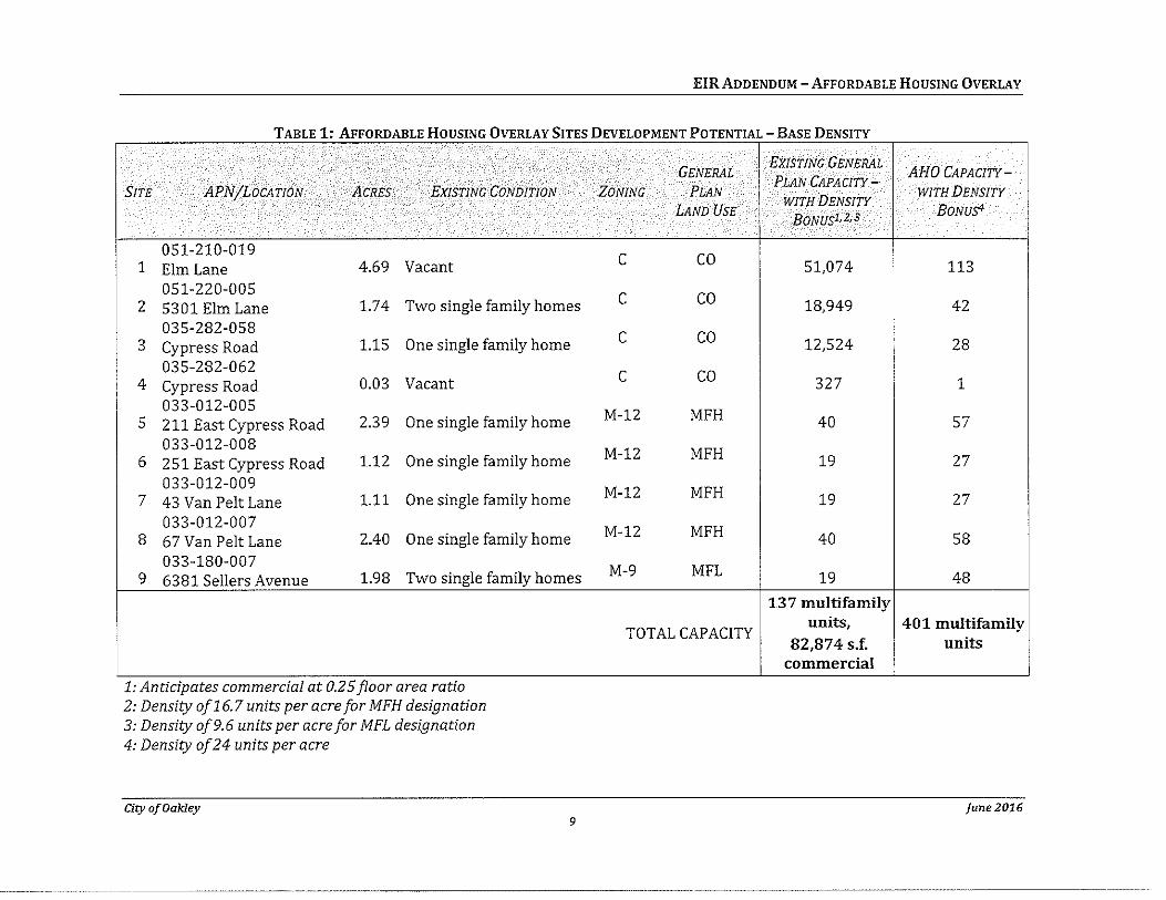
EIR ADDENDUM -AFFORDABLE HOUSING OVERLAY
TABLE 1· AFFORDABLE HOUSING OVERLAY SITES DEVELOPMENT POTENTIAL- BASE DENSITY
SITE APNjLOCATION ACRES EXISTING CONDITION
051-210-019 1 Elm Lane 4.69 Vacant
051-220-005 2 5301 Elm Lane 1.74 Two single family homes
035-282-058 3 Cypress Road 1.15 One single family home
035-282-062 4 Cypress Road 0.03 Vacant
033-012-005 5 211 East Cypress Road 2.39 One single family home
033-012-008 6 2 51 East Cypress Road 1.12 One single family home
033-012-009 7 43 Van Pelt Lane 1.11 One single family home
033-012-007 8 67 Van Pelt Lane 2.40 One single family home
033-180-007 9 6381 Sellers Avenue 1.98 Two single family homes
.. 1: AntiCipates commercwl at 0.25 floor area ratw 2: Density of16.7 units per acre for MFH designation 3: Density of9.6 units per acre for MFL designation 4: Density of24 units per acre
City of Oakley 9
GENERAL
ZONING PLAN
LAND USE
c co
c co
c co
c co
M-12 MFH
M-12 MFH
M-12 MFH
M-12 MFH
M-9 MFL
TOTAL CAPACITY
EXISTING GENERAL AHO CAPACITY-
PLAN CAPACITY-
WITH DENSITY WITH DENSITY
BONUS1,2,3 BONUs4
51,074 113
18,949 42
12,524 28
327 1
40 57
19 27
19 27
40 58
19 48
137 multifamily units, 401 multifamily
82,874 s.f. units commercial
June2016
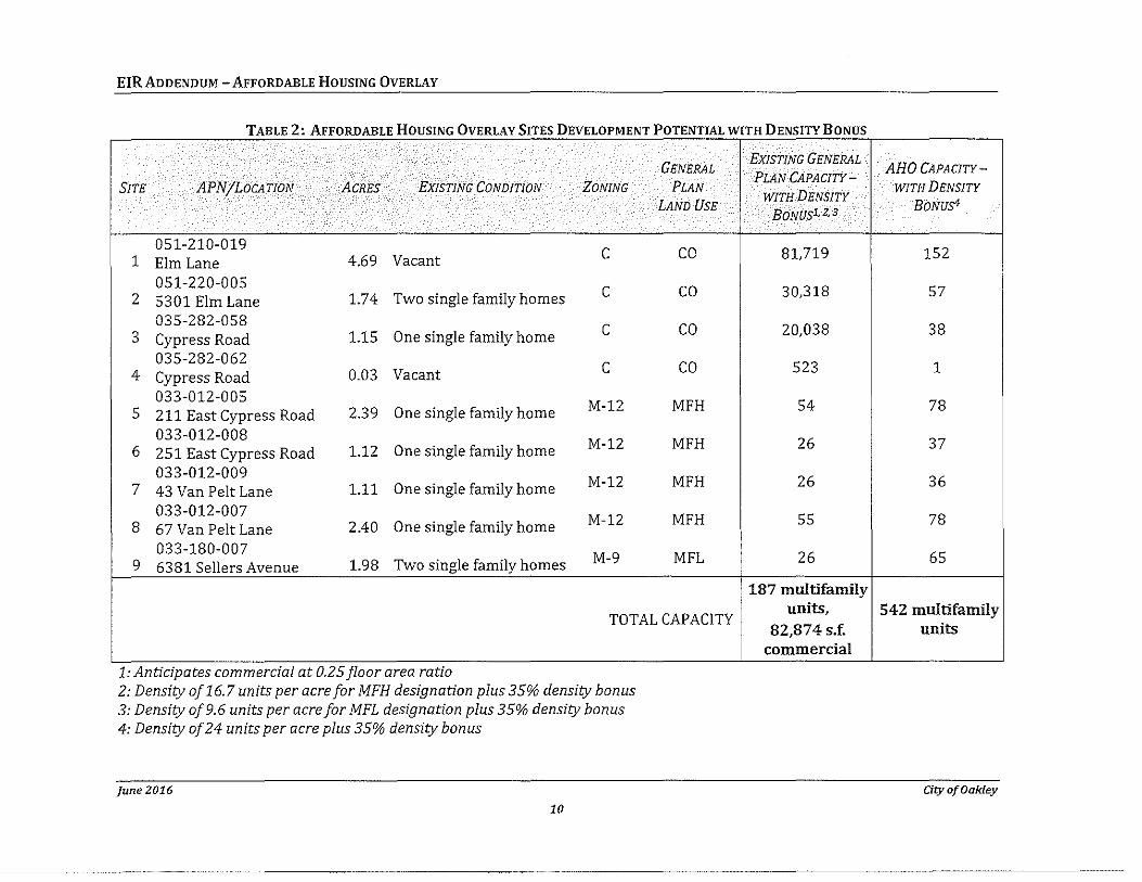
EIRADDENDUM -AFFORDABLE HOUSING OVERLAY
TABLE 2· AFFORDABLE HOUSING OVERLAY SITES DEVELOPMENT POTENTIAL WITH DENSITY BONUS
GENERAL
SiTE APNjLOCATION ACRES EXISTING CONDITION ZONING PLAN
LAND USE
051-210-019 c co 1 Elm Lane 4.69 Vacant 051-220-005 c co 2 5301 Elm Lane 1.74 Two single family homes 035-282-058 c co 3 Cypress Road 1.15 One single family home 035-282-062 c co 4 Cypress Road 0.03 Vacant 033-012-005
M-12 MFH 5 211 East Cypress Road 2.39 One single family home 033-012-008 M-12 MFH 6 251 East Cypress Road 1.12 One single family home 033-012-009 M-12 MFH 7 43 Van Pelt Lane 1.11 One single family home 033-012-007 M-12 MFH 8 67 Van Pelt Lane 2.40 One single family home 033-180-007
M-9 MFL 9 6381 Sellers Avenue 1.98 Two single family homes
TOTAL CAP A CITY
.. 1: Anticipates commerczal at 0.25 floor area ratiO 2: Density of16.7 units per acre for MFH designation plus 35% density bonus 3: Density of9.6 units per acre for MFL designation plus 35% density bonus 4: Density of24 units per acre plus 35% density bonus
]une2016
10
EXISTING GENERAL PLAN CAPACITY-
WITH DENSITY BONUS1,2,3
81,719
30,318
20,038
523
54
26
26
55
26
187 multifamily units,
82,874 s.f. commercial
AHO CAPACITY-
WITH DENSITY
BONUS!
152
57
38
1
78
37
36
78
65
542 multifamily units
City of Oakley
Legend
r~~~J Ookloy City Boundary
r··~·----... L ....... .J Affordoblo Hou:!ilng Ovorl:ly
G~ncml Plan lond U~c DcsignDtlons
r.=J MFL • Multl..f"omily Low
- MFH - Multi--Family High
C - Commorcial
CITY OF OAKLEY GENERAL PLAN EIR ADDENDUM
N Figure 1: Affordable Housing Overlay Sites
t
\ 1 .... !••·· ,~,.,.,, .. , •. u .. .-.......... u ......... _~ ... .J/ .. - •••
This page left intentionally blank.
EJRADDENDUM- AFFORDABLE HOUSING OVERLAY
3.0 ENVIRONMENTALANALYSIS
This section of the Addendum provides analysis and cites substantial evidence that supports the City's determination that the proposed modifications to the General Plan and Zoning Code proposed by the Affordable Housing Overlay project (Modified Project) do not meet the criteria for preparing a subsequent or supplemental ElR under CEQA Guidelines Section 15162.
As addressed in the analysis below, the proposed modifications associated with the Modified Project are not substantial changes to the adopted project. The proposed modifications would not cause a new significant impact or substantially increase the severity of a previously identified significant impact from the Final EIR (CEQA Guidelines Section 15162[a][1]) that would require major revisions to the EIR. All impacts would be nearly equivalent to or reduced from the impacts previously analyzed in the Final EIR. Accordingly, the proposed modifications associated with the Affordable Housing Overlay project are not inconsistent with the General Plan or Zoning Ordinance. Further, the Modified Project does not conflict with the Mitigation Measures for the Original Project.
The proposed changes do not cause a new significant impact or substantially increase the severity of a previously identified significant impact, and there have been no other changes in the circumstances that meet this criterion (CEQA Guidelines Section 15162[a)[2]). There have been no significant changes in the environmental conditions not contemplated and analyzed in the EIR that would result in new or substantially more severe environmental impacts.
There is no new information of substantial importance (which was not known or could not have been known at the time of the application (see Section 4.0), that identifies: a new significant impact (condition "A" under CEQA Guidelines Section 15162[a][3]), a substantial increase in the severity of a previously identified significant impact (condition "B" CEQA Guidelines Section 15162[a)[3]), mitigation measures or alternatives previously found infeasible that would now be feasible and would substantially reduce one or more significant effects, or mitigation measures or alternatives which are considerably different from those analyzed in the EIR which would substantially reduce one or more significant effects on the environment (conditions "C" and "D" CEQA Guidelines Section 15162[a][3]). None of the "new information" conditions listed in the CEQA Guidelines Section 15162[a][3) are present here to trigger the need for a Subsequent or Supplemental EIR.
CEQA Guidelines Section 15164 states that "The lead agency or a responsible agency shall prepare an addendum to a previously certified EIR if some changes or additions are necessary but none of the conditions described in Section 15162 calling for preparation of a subsequent EIR have occurred." An addendum is appropriate here because, as explained above, none of the conditions calling for preparation of a subsequent EIR have occurred.
The following includes a detailed discussion of applicable impacts identified under the EIR in relation to the Modified Project . All impacts identified under the EIR for the Original Project have been determined to be less than significant, less than significant with
City of Oakley june 2016 13
EIR ADDENDUM- AFFORDABLE HOUSING OVERLAY
mitigation, or significant and unavoidable. As described in the following discussion, the Modified Project would not result in the increase in significance of environmental impacts or in new significant environmental impacts.
The following discussion identifies the environmental topics addressed in the EIR, provides a summa1y of impacts associated with the Original Project, as described in the EIR, and includes an analysis of the potential impacts associated with the Modified Project when compared to the Original Project.
june 2016 City of Oakley 14
EJR ADDENDUM- AFFORDABLE HOUSING OVERLAY
AESTHETICS
Aestl1etic Impacts Associated with the Original Project Impact 3.2-A Development associated with the proposed General Plan may impact scenic
vistas and visual natural resources within the Planning Area. (Less than Significant with Implementation of General Plan Policies and Programs)
Impact 3.2-B
Impact 3.2-C
Discussion
Mitigation Adopted by the City: None. Impact is reduced by implementation of General Plan Land Use Element Policies 2.1.5, 2.1.6, 2.1.9, 2.6.6, and 2.6. 7, and Programs 2.4.8 and 2.6.A, Open Space and Conservation Element Policies 6.3.4, 6.3.5, 6.3.7, 6.6.1, 6.6.2, 6.6.3, 6.6.4, 6.7.1, and 6.7.2 and Programs 6.3.G, 6.3.H, 6.6.8, 6.7.A, and 6.7.8, and Parks and Recreation Element Policies 7.3.5, 7.4.3, 7.4.10, and 7.4.11, and Programs 7.4.8 and 7.4.C.
Development associated with the proposed General Plan may alter the existing visual character or quality and urban design of the Planning Area. (Less than Significant with Implementation of General Plan Policies and Programs)
Mitigation Adopted by the City: None. Impact is reduced by implementation of General Plan Land Use Element Policies 2.1.3, 2.2.1, 2.2.2, 2.3.2, 2.5.1, 2.5.3, and 2.5.5 and Programs 2.4.8 and 2.5.A, Economic Development Element Policy 5.3.2 and Programs 5.3.8, 5.3.C, and 5.3.E, and Open Space and Conservation Element Policies 6.5.1, 6.5.2, 6.5.4, and 6.5.6, and Program 6.5.8.
Development of the proposed General Plan may change the City character. (Less than Significant with Implementation of General Plan Policies and Programs)
Mitigation Adopted by the City: None. Impact is reduced by implementation of General Plan policies and programs identified under Impact 3.2-B.
Aesthetic impacts associated with the Original Project were identified and discussed in Section 3.2, Aesthetic Resources, and Section 5.5, Impacts Not Found To Be Significant, of the General Plan Draft EIR (General Plan Draft EIR, pages 3-21 through 3-26 and 5-13).
The General Plan EIR identified that future development associated with the Original Project may impact scenic vistas and visual natural resources within the Planning Area. The General Plan EIR identified that the goals, policies, and implementation measures included in the General Plan would provide for the protection of scenic qualities of visual resources and that the General Plan's goals, policies, and programs would mitigate any potential impacts on aesthetic qualities inherent in the Planning Area (Impact 3.2-A, General Plan Draft EIR, pp. 3-22- 3-24). No mitigation was required.
The General Plan EIR identified that the Original Project would have a potentially significant impact associated with alteration of the visual character or quality and urban design of the Planning Area. The General Plan EIR concluded that the policies and programs presented in the General Plan would preserve the community character and scenic qualities of Oakley, mitigating any potential impacts on visual character and quality (Impacts 3.2-B and 3.2-C, General Plan Draft EIR, pp. 3-24-3-26). No mitigation was required.
City of Oakley june 2016 15
EIRADDENDUM- AFFORDABLE HoUSING OVERLAY
The General Plan EIR found that the Original Project would result in less than significant impacts to visual scenic resources and visual character with implementation of General Plan policies and programs.
The General Plan EIR also identified that aesthetic impacts not found to be significant in the Initial Study included the substantial damage to scenic resources, including but not limited to, trees, rock outcrop pings, and historic buildings within a state scenic highway (General Plan Draft EIR, p. 5-13 and General Plan Draft EIR Appendix A).
The Modified Project would not designate additional sites for urban development in comparison to the Original Project. However, the Modified Project would allow for an increase in residential density on the AHO sites, which could result in a larger development footprint, including increased building sizes and heights. The increase in density and development was considered in the City's approved Housing Element, which the Modified Project implements. Future development under the Modified Project would be subject to the policies and actions of the General Plan identified to reduce potential impacts associated with visual character, scenic resources and vistas, and light and glare. As discussed under Impacts 3.2-A, 3.2-B, and 3.2-C in the General Plan EIR (see General Plan Draft EIR, pp. 3-22 through 3-26), these policies and programs include measures to protect natural and scenic views, require new development to be generally consistent with Oakley's character, and ensure infill development is consistent with the architectural characteristics of the neighborhood. General Plan policies and programs in the Open Space and Conservation Element require preservation and enhancement of the City's natural resources. Policy 2.2.2 of the Land Use Element requires new development to be generally consistent with the scale, appearance, and small town character of Oakley. Future development will also be required to comply with Zoning Code provisions, including design criteria that address visual impacts and exterior lighting. In addition, the Modified Project will amend the Zoning Code to provide for increased setbacks and design criteria to reduce the perceived mass and scale of multifamily and mixed use developments accommodated by the Modified Project. The design criteria required by the Modified Project will provide for a transition in building heights between adjacent single family residential development and future multifamily uses in order to reduce the mass of structures neighboring single family uses. The design criteria will also require all mixed use and multifamily developments accommodated by the Affordable Housing Overlay to usc variations in building mass, such as recessed facades and articulations as well as staggered and jobbed placement of individual units, to reduce the perceived mass of the project. Perceived mass and scale will also be reduced through requiring varied roof heights, forms, masses, shapes, and/or materials to create variations between individual buildings in a multifamily development as well as a variety of building orientations.
As with the Original Project, compliance with the policies and programs in the General Plan and applicable regulations, including the additional development standards and design criteria included in the Modified Project, would ensure the Modified Project's potential to degrade existing visual character, impact scenic resources and vistas, and cause light and glare impacts would be reduced to less than significant. There would be no new significant impacts or increase in the significance of impacts associated with aesthetic resources. The Modified Project does not change increase the severity of the impacts beyond what was addressed in the General Plan EIR. There are no changed circumstances or new information that meets the standard for requiring further environmental review under CEQA Guidelines Section 15162.
june 2016 City of Oakley 16
EIR ADDENDUM- AFFORDABLE HOUSING OVERLAY
AGRICULTURAL AND FORESTRY RESOURCES
Agricultural and Forestty Resources Impacts Associated wit/1 tile Original Project Impact 3.5-C The proposed General Plan may convert prime farmland, unique farmland, or
farmland of statewide importance or conflict with existing zoning for agricultural use or a Williamson Act contract with the Planning Area. (Less than Significant with Implementation of General Plan Policies and Programs)
hnnact 3.1-C
Discussion
Mitigation Adopted by the City: None. Impact is reduced by implementation of General Plan Land Use Element Policies 2.2.5, 2.2.13, and 2.6.5, Growth Management Element Policy 4.9.3 and Program 4.9.E, Open Space and Conservation Element Policies 6.1.1, 6.1.2, 6.1.3, and 6.1.4 and Programs 6.1.B, 6.1.D, 6.1.E, and 6.1.F, Parks and Recreation Element Policy 7.3.6, and Housing Element Policy 10.2.8 and Programs 10.3.A and 10.3.B.
The proposed General Plan may result in land use conflicts and incompatibility between existing and proposed land uses. (Less than Significant with Implementation of General Plan Policies and Programs)
Mitigation Adopted by the City: None. Impact is reduced by implementation of General Plan Land Use Element Policies 2.2.3, 2.2.7, 2.2.13, 2.3.1, and 2.4.3, Open Space and Conservation Element Policies 6.1.2 and 6.1.4 and Program 6.6.A, Parks and Recreation Element Policy 7.5. 7, and Noise Element Policies 9.1.1 and 9.2.1.
Agricultural impacts associated with the Original Project were identified and discussed in Sections 3.1 Land Use, and 3.5, Parks, Open Space, and Agriculture, of the General Plan Draft EIR (General Plan Draft EIR, pp. 3·1 through 3-21 and pp. 3-63 through 3-77).
The General Plan ElR identified that the Original Project may convert agricultural resources, including Farmland, or conflict with existing zoning for agricultural use or a Williamson Act within the Planning Area and discussed that the transition from agriculture to urban uses limits the potential for large-scale commercial agriculture within the city. The General Plan includes policies and programs aimed to reduce impacts associated with conflicts with agricultural lands and conversion of agricultural lands through providing buffers between high density residential and agricultural uses, providing increased setbacks between residential and agricultural uses, transitioning to lower densities at City boundaries, and implementing the City's Right to Farm Ordinance. The General Plan EIR also includes policies to preserve area's the agricultural heritage. Implementation of the General Plan policies and programs would reduce potential impacts to agricultural resources to less than significant and no mitigation was required (Impact 3.5-C, General Plan Draft ElR, pp. 3-75 through 3-77). The General Plan ElR provided additional discussion of potential land use conflicts between residential and agricultural uses under Impact 3.1-C and identified General Plan policies to reduce potential land use conflicts with agricultural uses. The impact was determined to be less than significant with implementation of the General Plan and no mitigation was required (Impact 3.1-C, General Plan Draft EJR, pp. 3.1·16 through 3.1·18).
The Modified Project would not identify any new sites for urbanization or development that were not anticipated for development in the General Plan EIR and thus would not change the potential for agricultural uses to be converted to urban uses. The Modified Project would increase the
City of Oakley june 2016 17
EJR ADDENDUM- AFFORDABLE HOUSING OVERLAY
potential density of sites identified for development by the Original Project. The General Plan EIR identified General Plan policies and programs that address potential conflicts with agricultural uses and address the potential for conversion to agricultural uses. As with the Original Project, implementation of the General Plan policies and programs described under Impacts 3.5-C and 3.1-C in the General Plan Draft EIR would reduce potential impacts to agricultural resources associated with the Modified Project to less than significant [see Impact 3.5-C, General Plan Draft EIR, pp. 3-75 through 3-77}. Therefore, the Modified Project would have no change to the significance of impacts associated with agricultural zoning, uses, or resources in comparison to the Original Project.
There are no designated forest and timber resources in the City. Therefore, the Modified Project would not have a significant impact on forest and timber resources.
june 2016 City of Oakley 18
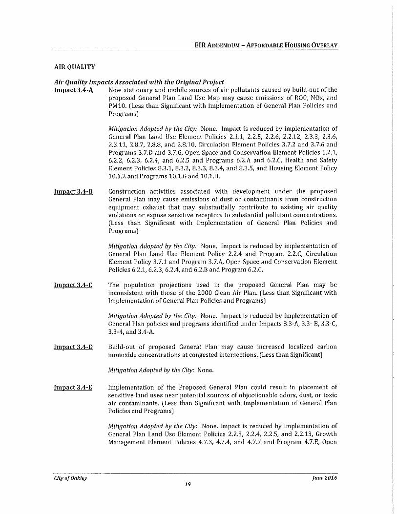
EIRADDENDUM- AFFORDABLE HOUSING OVERLAY
AIR QUALITY
Air Quality Impacts Associated witll tile Original Project Impact 3.4-A New stationary and mobile sources of air pollutants caused by build-out of the
proposed General Plan Land Use Map may cause emissions of ROG, NOx, and PM10. (Less than Significant with Implementation of General Plan Policies and Programs)
Impact 3.4-B
Impact 3.4-C
Impact 3.4-D
Impact 3.4-E
City of Oakley
Mitigation Adopted by the City: None. Impact is reduced by implementation of General Plan Land Use Element Policies 2.1.1, 2.2.5, 2.2.6, 2.2.12, 2.3.3, 2.3.6, 2.3.11, 2.8. 7, 2.8.8, and 2.8.10, Circulation Element Policies 3. 7.2 and 3. 7.6 and Programs 3.7.D and 3.7.G, Open Space and Conservation Element Policies 6.2.1, 6.2.2, 6.2.3, 6.2.4, and 6.2.5 and Programs 6.2.A and 6.2.C, Health and Safety Element Policies 8.3.1, 8.3.2, 8.3.3, 8.3.4, and 8.3.5, and Housing Element Policy 10.1.2 and Programs 10.1.G and 10.1.H.
Construction activities associated with development under the proposed General Plan may cause emissions of dust or contaminants from construction equipment exhaust that may substantially contribute to existing air quality violations or expose sensitive receptors to substantial pollutant concentrations. (Less than Significant with Implementation of General Plan Policies and Programs)
Mitigation Adopted by the City: None. Impact is reduced by implementation of General Plan Land Use Element Policy 2.2.4 and Program 2.2.C, Circulation Element Policy 3.7.1 and Program 3.7.A, Open Space and Conservation Element Policies 6.2.1, 6.2.3, 6.2.4, and 6.2.8 and Program 6.2.C.
The population projections used in the proposed General Plan may be inconsistent with those of the 2000 Clean Air Plan. (Less than Significant with Implementation of General Plan Policies and Programs)
Mitigation Adopted by the City: None. Impact is reduced by implementation of General Plan policies and programs identified under Impacts 3.3-A, 3.3- B, 3.3-C, 3.3-4, and 3.4-A.
Build-out of proposed General Plan may cause increased localized carbon monoxide concentrations at congested intersections. (Less than Significant)
Mitigation Adopted by the City: None.
Implementation of the Proposed General Plan could result in placement of sensitive land uses near potential sources of objectionable odors, dust, or toxic air contaminants. (Less than Significant with Implementation of General Plan Policies and Programs)
Mitigation Adopted by the City: None. Impact is reduced by implementation of General Plan Land Use Element Policies 2.2.3, 2.2.4, 2.2.5, and 2.2.13, Growth Management Element Policies 4.7.3, 4.7.4, and 4.7.7 and Program 4.7.E, Open
june 2016 19
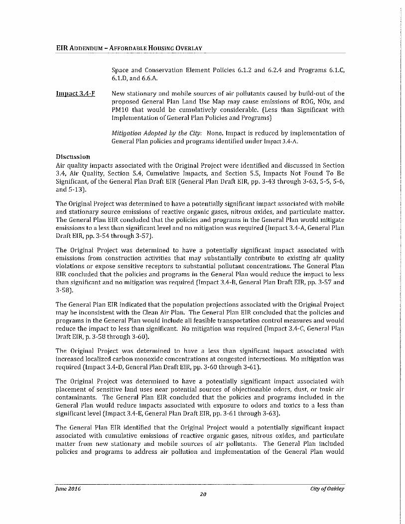
EIRADDENDUM -AFFORDABLE HOUSING OVERLAY
Impact 3.4-F
Discussion
Space and Conservation Element Policies 6.1.2 and 6.2.4 and Programs 6.1.C, 6.l.D, and 6.6.A.
New stationary and mobile sources of air pollutants caused by build-out of the proposed General Plan Land Use Map may cause emissions of ROG, NOx, and PM10 that would be cumulatively considerable. (Less than Significant with Implementation of General Plan Policies and Programs)
Mitigation Adopted by the City: None. Impact is reduced by implementation of General Plan policies and programs identified under Impact 3.4-A.
Air quality impacts associated with the Original Project were identified and discussed in Section 3.4, Air Quality, Section 5.4, Cumulative Impacts, and Section 5.5, Impacts Not Found To Be Significant, of the General Plan Draft EIR (General Plan Draft EIR, pp. 3-43 through 3-63, 5-5, 5-6, and 5-13).
The Original Project was determined to have a potentially significant impact associated with mobile and stationary source emissions of reactive organic gases, nitrous oxides, and particulate matter. The General Plan EIR concluded that the policies and programs in the General Plan would mitigate emissions to a less than significant level and no mitigation was required (Impact 3.4-A, General Plan Draft EIR, pp. 3-54 through 3-57).
The Original Project was determined to have a potentially significant impact associated with emissions from construction activities that may substantially contribute to existing air quality violations or expose sensitive receptors to substantial pollutant concentrations. The General Plan EIR concluded that the policies and programs in the General Plan would reduce the impact to less than significant and no mitigation was required (Impact 3.4-B, General Plan Draft EIR, pp. 3-57 and 3-58).
The General Plan EIR indicated that the population projections associated with the Original Project may be inconsistent with the Clean Air Plan. The General Plan EIR concluded that the policies and programs in the General Plan would include all feasible transportation control measures and would reduce the impact to less than significant. No mitigation was required (Impact 3.4-C, General Plan Draft EIR, p. 3-58 through 3-60).
The Original Project was determined to have a less than significant impact associated with increased localized carbon monoxide concentrations at congested intersections. Mo mitigation was required (Impact 3.4-D, General Plan Draft EIR, pp. 3-60 through 3-61).
The Original Project was determined to have a potentially significant impact associated with placement of sensitive land uses near potential sources of objectionable odors, dust, or toxic air contaminants. The General Plan EIR concluded that the policies and programs included in the General Plan would reduce impacts associated with exposure to odors and taxies to a less than significant level (Impact 3.4-E, General Plan Draft EIR, pp. 3-61 through 3-63).
The General Plan EIR identified that the Original Project would a potentially significant impact associated with cumulative emissions of reactive organic gases1 nitrous oxides 1 and particulate matter from new stationary and mobile sources of air pollutants. The General Plan included policies and programs to address air pollution and implementation of the General Plan would
june 2016 City of Oakley 20
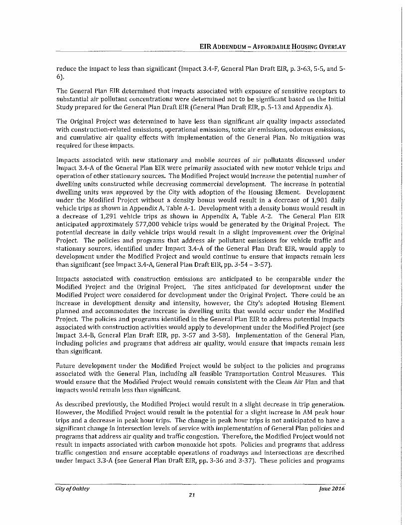
EIRADDENDUM- AFFORDABLE HOUSING OVERLAY
reduce the impact to less than significant (Impact 3.4-F, General Plan Draft EIR, p. 3-63, S-5, and 5-6).
The General Plan EIR determined that impacts associated with exposure of sensitive receptors to substantial air pollutant concentrations were determined not to be significant based on the Initial Study prepared for the General Plan Draft EIR (General Plan Draft EIR, p. 5-13 and Appendix A).
The Original Project was determined to have less than significant air quality impacts associated with construction-related emissions, operational emissions} toxic air emissions1 odorous emissions) and cumulative air quality effects with implementation of the General Plan. No mitigation was required for these impacts.
Impacts associated with new stationary and mobile sources of air pollutants discussed under Impact 3.4-A of the General Plan EIR were primarily associated with new motor vehicle trips and operation of other stationary sources. The Modified Project would increase the potential number of dwelling units constructed while decreasing commercial development. The increase in potential dwelling units was approved by the City with adoption of the Housing Element. Development under the Modified Project without a density bonus would result in a decrease of 1,901 daily vehicle trips as shown in Appendix A, Table A-1. Development with a density bonus would result in a decrease of 1,291 vehicle trips as shown in Appendix A, Table A-2. The General Plan EIR anticipated approximately 577,000 vehicle trips would be generated by the Original Project. The potential decrease in daily vehicle trips would result in a slight improvement over the Original Project. The policies and programs that address air pollutant emissions for vehicle traffic and stationary sources, identified under Impact 3.4-A of the General Plan Draft EIR, would apply to development under the Modified Project and would continue to ensure that impacts remain less than significant (see Impact 3.4-A, General Plan Draft EIR, pp. 3-54- 3·57).
Impacts associated with construction emissions are anticipated to be comparable under the Modified Project and the Original Project. The sites anticipated for development under the Modified Project were considered for development under the Original Project. There could be an increase in development density and intensity, however, the City's adopted Housing Element planned and accommodates the increase in dwelling units that would occur under the Modified Project. The policies and programs identified in the General Plan EIR to address potential impacts associated with construction activities would apply to development under the Modified Project (see Impact 3.4-B, General Plan Draft EIR, pp. 3-57 and 3-58). Implementation of the General Plan, including policies and programs that address air quality, would ensure that impacts remain less than significant.
Future development under the Modified Project would be subject to the policies and programs associated with the General Plan, including all feasible Transportation Control Measures. This would ensure that the Modified Project would remain consistent with the Clean Air Plan and that impacts would remain less than significant.
As described previously, the Modified Project would result in a slight decrease in trip generation. However, the Modified Project would result in the potential for a slight increase in AM peak hour trips and a decrease in peak hour trips. The change in peak hour trips is not anticipated to have a significant change in intersection levels of service with implementation of General Plan policies and programs that address air quality and traffic congestion. Therefore, the Modified Project would not result in impacts associated with carbon monoxide hot spots. Policies and programs that address traffic congestion and ensure acceptable operations of roadways and intersections are described under Impact 3.3-A (see General Plan Draft EIR, pp. 3-36 and 3-37). These policies and programs
City of Oakley june 2016 21
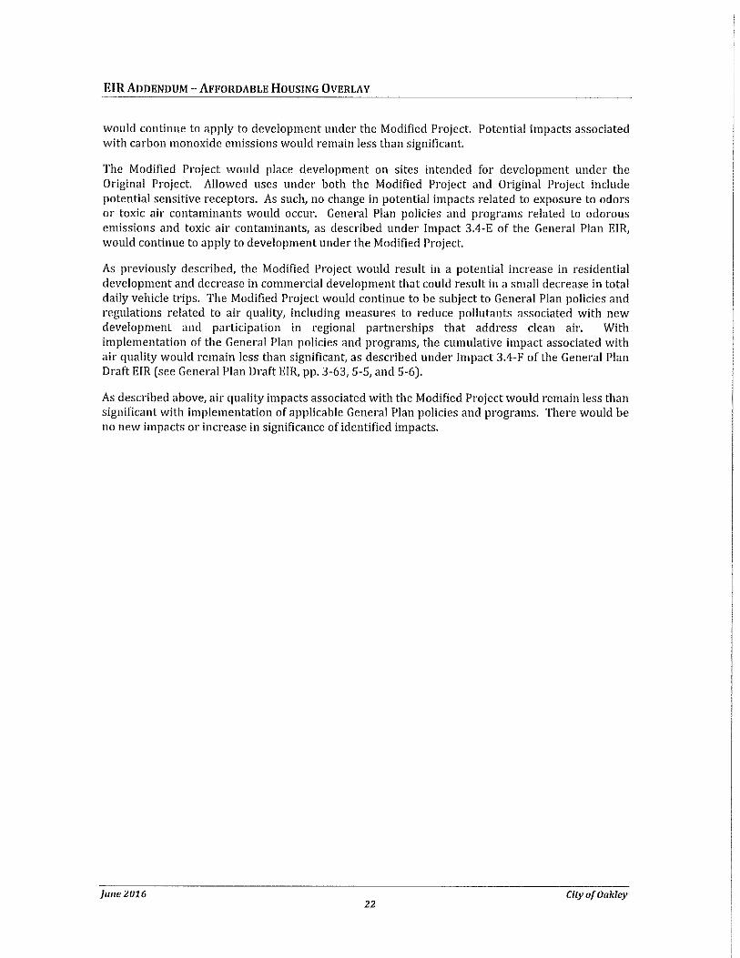
EIR ADDENDUM- AFFORDABLE HOUSING OVERLAY
would continue to apply to development under the Modified Project. Potential impacts associated with carbon monoxide emissions would remain less than significant.
The Modified Project would place development on sites intended for development under the Original Project. Allowed uses under both the Modified Project and Original Project include potential sensitive receptors. As such, no change in potential impacts related to exposure to odors or toxic air contaminants would occur. General Plan policies and programs related to odorous emissions and toxic air contaminants, as described under impact 3.4-E of the General Plan ElR, would continue to apply to development under the Modified Project.
As previously described, the Modified Project would result in a potential increase in residential development and decrease in commercial development that could result in a small decrease in total daily vehicle trips. The Modified Project would continue to be subject to General Plan policies and regulations related to air quality, including measures to reduce pollutants associated with new development and participation in regional partnerships that address clean air. With implementation of the General Plan policies and programs, the cumulative impact associated with air quality would remain less than significant, as described under Impact 3.4-F of the General Plan Draft EIR (see General Plan Draft EIR, pp. 3-63, S-5, and S-6).
As described above, air quality impacts associated with the Modified Project would remain less than significant with implementation of applicable General Plan policies and programs. There would be no new impacts or increase in significance of identified impacts.
june 2016 City of Oakley 22
EIRADDENDUM- AFFORDABLE HOUSING OVERLAY
BIOLOGICAL RESOURCES
Biological Resources Impacts Associated with the Original Project Impact 3.9·A Approval of projects under the General Plan may reduce or destroy the habitat
of species identified as sensitive, including species identified as endangered, candidate, and/or special status by the California Department of Fish and Game and U.S. Fish and Wildlife Service. (Less than Significant with Implementation of General Plan Policies and Programs}
Impact 3.9-B
Impact 3.9-C
Impact 3.9-D
Impact 3.9-E
Impact 3.9-F
City of Oakley
Mitigation Adopted by the City: None. Impact is reduced by implementation of General Plan Land Use Element Policies 2.1.5, 2.6.6, and 2.6.7 and Program 2.6.A, Growth Management Element Policy 4.10.6 and Program 4.10.H, Open Space and Conservation Element Policies 6.3.1, 6.3.2, 6.3.3, 6.3.4, 6.3.5, 6.3.6, 6.3.7, 6.6.1, 6.6.2, 6.6.3, and 6.6.4 and Programs 6.3.A, 6.3.B, 6.3.E, 6.3.F, 6.3.G, 6.3.H, and 6.6.C, and Parks and Recreation Element Policies 7.2.7, 7.3.7, 7.3.10, 7.4.6, and 7.4.7.
Implementation of the proposed General Plan may result in loss of plant and wildlife habitat within the Planning Area. (Less than Significant with Implementation of General Plan Policies and Programs}
Mitigation Adopted by the City: None. Impact is reduced by implementation of General Plan policies and programs identified under Impact 3. 9-A.
Approval of projects under the updated General Plan may adversely affect movement and dispersal of wildlife and wildlife migration corridors. (Less than Significant with Implementation of General Plan Policies and Programs)
Mitigation Adopted by the City: None. Impact is reduced by implementation of General Plan policies and programs identified under Impact 3.9-A.
New development under the General Plan may result in the introduction and spread of non-native invasive plant species. (Less than Significant with Implementation of General Plan Policies and Programs}
Mitigation Adopted by the City: None. Impact is reduced by implementation of General Plan policies and programs identified under Impact 3.9-A.
Development associated with the proposed General Plan may result in a significant loss of trees. (Less than Significant with Implementation of General Plan Policies and Programs}
Mitigation Adopted by the City: None. Impact is reduced by implementation of General Plan Open Space and Conservation Element Policy 6.3.5 and Programs 6.3.C and 6.3.D.
Development associated with the proposed General Plan may lead to the cumulative conversion and loss of plant and animal habitat. (Less than Significant with Implementation of General Plan Policies and Programs}
june 2016 23
EJR ADDENDUM- AFFORDABLE HoUSING OVERLAY
Discussion
Mitigation Adopted by the City: None. Impact is reduced by implementation of General Plan policies and programs identified under Impact 3.9-A.
Biological resources impacts associated with the Original Project were identified and discussed in Section 3.9, Biological Resources, Section 5.4, Cumulative Impacts, and Section 5.5, Impacts Not Found To Be Significant, of the General Plan Draft EIR (General Plan Draft EIR, pp. 3-129 through 3-141, 5·11, 5-12,5-13, and 5-14).
The General Plan EIR identified that the Original Project would have a potentially significant impact related to the reduction or destruction of habitat of sensitive species and loss of plant and wildlife habitat within the Planning Area. The Original Project also has the potential to adversely affect wildlife movement and wildlife migration corridors. The General Plan included policies and programs to address impacts to biological resources and implementation of the General Plan would reduce the potential impact to less than significant. No mitigation was required (Impacts 3.9-A, 3.9· B, and 3.9-C, General Plan Draft EIR, pp. 3-134- 3·140).
The Original Project has the potential to result in the introduction and spread of non-native invasive plant species and a significant loss of trees. These impacts would be reduced to less than significant with implementation of the proposed General plan and no mitigation measures are required (Impact 3.9-D and 3.9-E, General Plan Draft EIR, p. 3-141).
The General Plan EIR identified that development associated with the General Plan may lead to the cumulative conversion and loss of plant and animal habitat. This impact was determined to be less than significant with implementation of the proposed General Plan. No mitigation was required (Impact 3.9-F, General Plan Draft EIR, p. 3·142).
Impacts associated with conflict with local policies or ordinances protecting biological resources and conflict with provisions of an adopted Habitat Conservation Plan, Natural Community Conservation Plan, or other approved locat regionat or state habitat conservation plan were determined to not be significant based on the Initial Study prepared for the General Plan Draft EIR (General Plan Draft EIR, pp. 5-13 and 5-14 and Appendix A).
The Modified Project does not identify any new sites for urbanization or development that were not anticipated for development in the General Plan EIR. The Modified Project would increase the potential density of sites identified for development by the Original Project as previously described. However, as urbanization and disturbance on the sites associated with the Modified Project was anticipated under the Original Project, potential impacts to biological resources in the vicinity of these sites would remain similar to those identified for the Original Project. The policies and programs identified in the General Plan EIR would continue to apply to the Modified Project and would reduce potential impacts to biological resources as described under Impacts 3.9-A through 3.9-F in the General Plan EIR and would reduce potential impacts to less than significant as described in the General Plan EIR (General Plan Draft EIR, pp. 3-134 through 3-142, 5-11, and 5-12). Therefore, the Modified Project would not result in any new impacts to biological resources and would not increase the significance of impacts to biological resources in comparison to the Original Project.
Since the certification of the General Plan EIR, the East Contra Costa County Habitat Conservation Plan/Natural Community Conservation Plan (HCP /NCCP) has been adopted. The Modified Project does not propose development on any of the Preserve Systems lands prioritized for acquisition in the HCP /NCCP. As subsequent projects are considered by the City, each project will comply with
june 2016 City of Oakley 24
EIR ADDENDUM- AFFORDABLE HOUSING OVERLAY
the requirements of the HCP /NCCP. There will be no new impacts associated with potential conflicts with the HCP /NCCP.
City of Oakley june 2016 25
EIRADDENDUM- AFFORDABLE HOUSING OVERLAY
CULTURAL RESOURCES
Cultural Resources Impacts Associated witll tile Original Project Impact 3.10-A Development associated with the proposed General Plan may lead to potential
damage or loss of known historic, cultural, archaeological, or paleontological resources. (Less than Significant)
Impact 3.10-B
Impact 3.10-C
Discussion
Mitigation Adopted by the City: None.
Development associated with the proposed General Plan could damage unknown historic, cultural, prehistoric, or archaeological resources in the Planning Area. (Less than Significant with Implementation of General Plan Policies and Programs)
Mitigation Adopted by the City: None. Impact is reduced by implementation of General Plan Land Use Element Policies 2.5.1, 2.5.2, 2.5.3, 2.5.4, 2.5.5, 2.8.4, and 2.8.11 and Programs 2.5.A and 2.5.8 and Open Space and Conservation Element Policies 6.4.1, 6.5.1, 6.5.2, 6.5.3, 6.5.4, 6.5.5, and 6.5.6 and Programs 6.4.A, 6.5.A, 6.5.8, and 6.5.C.
Development associated with the proposed General Plan in combination with growth elsewhere in eastern Contra Costa County and the western San Joaquin Valley could result in cumulative loss to cultural resources. (Less than Significant with Implementation of General Plan Policies and Programs)
Mitigation Adopted by the City: None. Impact is reduced by implementation of General Plan policies and programs identified under Impact 3.10-8.
These impacts associated with the Original Project were identified and discussed in 3.10, Cultural Resources, and Section 5.4, Cumulative Impacts, Impact 3.10-C, of the General Plan Draft EIR (General Plan Draft EIR, pp. 3-142 through 3-151,5-12, and 5-13).
The General Plan EIR identified that future development associated with the Original Project could disturb or destroy cultural resources. The General Plan includes policies and programs to preserve and protect cultural, historic, prehistoric, and archaeological resources. With implementation of the General Plan, impacts would be less than significant and no mitigation was required (Impacts 3.10-A and 3.10-8, General Plan Draft EIR, pp. 3-148 through 3-151).
The General Plan EIR identified that development associated with the Original Project could result in a potentially significant cumulative loss to cultural resources. The General Plan EIR concluded that implementation of the General Plan along with other existing General Plans and design guidelines in the area would reduce the impact to less than significant. No mitigation was required (Impact 3.10-C, General Plan Draft EIR, p. 3-151,5-12, and 5-13).
The Modified Project would not identify any new sites for urbanization or development that were not anticipated for development in the General Plan EIR. The Modified Project would allow an increase in potential residential densities of sites identified for development by the Original Project. Potential impacts to cultural resources associated with these sites would remain similar to those identified for the Original Project. The policies and programs identified in the General Plan EIR would apply to the Modified Project and would reduce potential impacts to cultural resources to
june 2016 City of Oakley 26
EIRADDENDUM- AFFORDABLE HOUSING OVERLAY
less than significant as described under Impacts 3.10-A through 3.10-C in the General Plan EIR (see General Plan Draft EIR, pp. 3-134 through 3-142, 5-12, and 5-13). Therefore, the Modified Project would not result in any new impacts to cultural resources and would not increase the significance of impacts to cultural resources in comparison to the Original Project.
City of Oakley june 2016 27
EIR ADDENDUM- AFFORDABLE HOUSING OVERLAY
GEOLOGY AND SOILS
Geology and Soils Impacts Associated witll tile Original Project Impact 3.12-A Development associated with the proposed General Plan may place buildings on
expansive soils, thus potentially causing structural damage or exposing people or structures to potential seismic events and related ground shaking. (Less than Significant with Implementation of General Plan Policies and Programs)
Impact 3.12-B
lmnact 3.12-C
Discussion
Mitigation Adopted by the City: None. Impact is reduced by implementation of General Plan Health and Safety Element Policies 8.1.1, 8.1.2, 8.1.3, 8.1.4, 8.1.5, 8.1.6, 8.1.7, 8.1.8, 8.1.9, 8.2.13, and 8.4.4 and Programs 8.1.A, 8.1.8, 8.1.C, and 8.1.D.
Development associated with the proposed General Plan may locate people and structures in areas with potential for liquefaction. (Less than Significant with Implementation of General Plan Policies and Programs)
Mitigation Adopted by the City: None. Impact is reduced by implementation of General Plan policies and programs identified under Impact 3.12-A.
Redevelopment of sites along the Delta waterfront may subject greater population to liquefaction, tsunami, and other seismic hazards. (Less than Significant with Implementation of General Plan Policies and Programs)
Mitigation Adopted by the City: None. Impact is reduced by implementation of General Plan policies and programs identified under Impact 3.12-A.
Geology and soils impacts associated with the Original Project were identified and discussed in Section 3.12, Geology and Soils, of the General Plan Draft EIR (General Plan Draft EIR, pp. 3-159 through 3-169). Chapter 5, Section 5.5, of the General Plan Draft EIR described impacts found not to be significant, including exposure of people or structures to potential substantial adverse effects involving landslides and soils incapable of adequately supporting the use of septic tanks or alternative wastewater systems (General Plan Draft EIR, pp. 5-13 and 5-14).
The Original Project would have a less than significant impact associated with seismic events, related ground shaking, and expansive soils with implementation of General Plan policies and programs that address seismic and geologic hazards. No mitigation was required (Impact 3.12-A. General Plan Draft EIR, pp. 3-166 through 3-168).
The Original Project would have a less than significant impact associated with liquefaction, tsunami, and other seismic hazards with implementation of General Plan policies and programs. No mitigation was required (Impacts 3.12-B and 3.12-C, General Plan Draft EIR, p. 3-168 through 3-169).
The Modified Project would not identify any new sites for urbanization or development that were not anticipated for development in the General Plan EIR. The Modified Project would increase the potential density of sites identified for development by the Original Project. Potential impacts associated with geology and soils on these sites would remain consistent with those identified for the Original Project. The policies and programs identified in the General Plan EIR would apply to development under the Modified Project and would reduce potential impacts associated with
june 2016 City of Oakley 28
EIRADDENDUM- AFFORDABLE HOUSING OVERLAY
geology and soils to less than significant as described under Impacts 3.12-A through 3.12-C in the General Plan EIR (General Plan Draft EIR, pp. 3-166 through 3-169). Therefore, the Modified Project would not result in any new impacts associated with geology and soils and would not increase the significance of impacts related to geology and soils in comparison to the Original Project.
City of Oakley june 2016 29
EIRADDENDUM- AFFORDABLE HoUSING OVERLAY
GREENHOUSE GASES
Greenhouse Gases Impacts Associated with the Original Project The General Plan EIR did not address greenhouse gas emissions. Greenhouse gas em1sswns associated with residential uses primarily occur as a result of transportation (vehicle trips) and energy usage (electricity and natural gas). The Modified Project is implementing the City's Housing Element, which was prepared to accommodate Oakley's fair share of residential units as allocated by the Association of Bay Area Governments and is consistent with the regional planning documents prepared by ABAG to address greenhouse gas emissions. The Modified Project would not have a significant impact related to conflicts with plans, policies, or regulations adopted to reduce greenhouse gas emissions. At the local level, the Modified Project would not result in a significant increase in greenhouse gas emissions. As demonstrated in Appendix A, development under the Modified Project would result in a decrease of 1,291 to 1,901 daily vehicle trips. Development associated with the Modified Project would be subject to energy efficiency measures, including Ca!Green standards as well as the policies and programs established by the General Plan to reduce energy usage (see Impact 3.11-B, General Plan Draft EIR, pp. 3-158 and 3-159). Compared to the Original Project, the Modified Project would not result in an increase in greenhouse gas emissions that would have a significant impact on the environment, as development under the Modified Project would not result in a significant increase in vehicle trips and potential energy usage would be reduced as described under Impact 3.11-B of the General Plan Draft EIR.
june 2016 City of Oakley 30
EIRADDENDUM- AFFORDABLE HOUSING OVERLAY
HAZARDS AND HAZARDOUS MATERIALS
Hazards and Hazardous Materials Impacts Associated with tile Original Project Impact 3.7-B New development associated with the proposed General Plan may increase fire
hazard in areas with flammable brush, grass, or trees. (Less than Significant with Implementation of General Plan Policies and Programs)
Impact 3. 7 -c
Impact 3. 7-D
Impact 3.7-E
Discussion
Mitigation Adopted by the City: None. Impact is reduced by implementation of General Plan Land Use Element Policy 2.6.5, Circulation Element Program 3.5.F, Growth Management Element Policies 4.4.1, 4.4.2, 4.4.3, 4.4.4, 4.4.5, and 4.4.6 and Programs 4.4.A, 4.4.B, 4.4.C, 4.4.D, 4.4.E, and 4.4.F, Parks and Recreation Element Policy 7.5.10, Health and Safety Element Policies 8.4.1, 8.4.2, 8.4.3, 8.4.4, and 8.4.5 and Programs 8.4.A, 8.4.B, and 8.4.C.
New development associated with the proposed General Plan may result in degradations to emergency preparedness that may exceed the capabilities of existing programs. (Less than Significant)
Mitigation Adopted by the City: None. Impact is reduced by implementation of General Plan Circulation Element Program 3.5.F, Growth Management Element Policy 4.4.4, Health and Safety Element Policies 8.4.1, 8.4.2, 8.4.3, and 8.4.4 and Programs 8.4.A and 8.4.C.
Development associated with the proposed General Plan may locate new industrial uses that involve hazardous material and wastes close to existing or proposed sensitive receptors. (Less than Significant with Implementation of General Plan Policies and Programs)
Mitigation Adopted by the City: None. Impact is reduced by implementation of General Plan Land Use Element Policies 2.2.3, 2.2.4, 2.2.13, 2.4.1, and 2.4.3, Growth Management Element Policies 4.4.5, 4.7.7, and 4.7.10 and Program 4.7.E, Health and Safety Element Policies 8.3.1, 8.3.2, 8.3.3, 8.3.4, and 8.3.5 and Programs 8.3.A and 8.3.B.
Development associated with the proposed General Plan in combination with other growth in east Contra Costa County may lead to potential cumulative impacts to health and safety. (Less than Significant with Implementation of General Plan Policies and Programs)
Mitigation Adopted by the City: None. Impact is reduced by implementation of General Plan policies and programs identified under Impacts 3.7-A, 3.7-B, 3.7-C, and 3.7-D.
Hazards and hazardous materials impacts associated with the Original Project were identified and discussed in Section 3.7, Public Safety/Hazards, Section 5.4, Cumulative Impacts, and Section 5.5, Impacts Not Found To Be Significant, of the General Plan Draft EIR (General Plan Draft EIR, pp. 3-98 through 3-116,5-8 through 5-11,5-13 and 5-14).
The General Plan EIR identified that new development associated with the Original Project would have a potentially significant impact related to increased fire hazards. New development would he
City of Oakley june 2016 31
EIR ADDENDUM- AFFORDABLE HOUSING OVERLAY
guided by the policies and programs contained in the General Plan, including requirements related to fire risk, that would reduce potential impacts to less than significant. No mitigation was required (Impact 3.7-B, General Plan Draft EIR, pp. 3-109 through 3-112).
The General Plan EIR identified that Original Project would have a less than significant impact associated with emergency preparedness with implementation of the General Plan policies and programs. No mitigation was required (Impact 3.7-C, General Plan Draft EIR, pp. 3-112 through 3-114).
The General Plan EIR identified that new development associated with the Original Project would have a potentially significant impact related to use of hazardous materials and wastes close to existing or proposed sensitive receptors. New development would be guided by the policies and programs contained in the General Plan1 including requirements related to hazardous materials and waste, that would reduce potential impacts to less than significant. No mitigation was required (Impact 3.7-D, General Plan Draft EIR, pp. 3-114 through 3-116].
The Original Project would have the potential to lead to potential cumulative impacts to health and safety. Implementation of the General Plan, including policies and programs discussed under Impacts 3.7-A through 3.7-D would reduce the impact to less than significant (Impact 3.7-E, General Plan Draft EIR, pp. 3-116 and 5-8 through 5-11).
The General Plan EIR determined that safety hazards associated with a public airport, public use airport, or private airstrip would not be significant based on the analysis provided in the Initial Study (General Plan Draft EIR, pp. 5-13 and 5-14 and Appendix A).
As previously discussed, the Modified Project would allow for an increase in density on sites that are currently designated in the General Plan to allow for multi-family residential development or commercial uses. The increase in dwelling units was planned by the City's adopted Housing Element. The Modified Project would not identify any new areas for development in comparison to the Original Project. The General Plan policies and programs identified in the Draft EIR under Impacts 3.7-B, 3.7-C, 3.7-D, and 3.7-E would apply to any development under the Affordable Housing Overlay. These policies and programs address potential exposure to hazardous materials and conditions and would continue to ensure that potential impacts associated with hazards and hazardous materials remain at a less than significant level under the Modified Project. Therefore, the Modified Project would not increase the significance of impacts associated with hazards and hazardous materials in comparison to the Original Project and would not result in any new impacts associated with hazards and hazardous materials.
june2016 City of Oakley 32
EJR ADDENDUM- AFFORDABLE HOUSING OVERLAY
HYDROLOGY AND WATER QUALITY
Hydrology and Water Quality Impacts Associated witll tile Original Project Impact 3.7-A Development in accordance associated with the proposed General Plan may
result in changes in absorption rates, drainage patterns, and the rate and amount of surface runoff within the Planning Area. This could expose people or property to water related hazards such as flooding. (Less than Significant with Implementation of General Plan Policies and Programs)
Impact 3.8-A
Impact 3.8-8
Impact 3.8-C
City of Oakley
Mitigation Adopted by the City: None. Impact is reduced by implementation of General Plan Land Use Element Policies 2.6.2, 2.6.3, and 2.6.4, Growth Management Element Policies 4.10.1, 4.10.2, 4.10.3, 4.10.4, 4.10.5, 4.10.6, 4.10.7, 4.10.8, and 4.10.9 and Programs 4.10.A, 4.10.8, 4.10.C, 4.10.D, 4.10.E, 4.10.F, 4.10.G, and 4.10.H, Open Space and Conservation Element Policy 6.3.3 and Program 6.3.G, Parks and Recreation Element Policy 7.1.10 and Program 7.1.L, Health and Safety Policies 8.2.1, 8.2.2, 8.2.3, 8.2.4, 8.2.5, 8.2.6, 8.2.7, 8.2.8, 8.2.9, 8.2.10, 8.2.11, 8.2.12, and 8.2.13 and Programs 8.2.A, 8.2.8, 8.2.C, 8.2.D, 8.2.E, 8.2.F, and 8.2.G8.
Future development associated with the proposed General Plan may result in additional discharge into surface waters or other alteration of surface water quality in violation of Regional Water Quality Control Board standards or waste discharge requirements. (Less than Significant with Implementation of General Plan Policies and Programs)
Mitigation Adopted by the City: None. Impact is reduced by implementation of General Plan Growth Management Element Policies 4.8.1, 4.8.2, 4.8.3, 4.8.4, 4.8.5, 4.8.6, 4.8.7, 4.8.8, 4.8.9, 4.8.10, 4.8.11, 4.8.12, 4.8.13, and 4.10.2 and Programs 4.8.A, 4.8.8, 4.8.C, 4.8.D, and 4.9.E.
New development associated with the proposed General Plan may result in a substantial increase of construction-related erosion and sedimentation into surface waters. [Less than Significant with Implementation of General Plan Policies and Programs)
Mitigation Adopted by the City: None. Impact is reduced by implementation of General Plan Growth Management Element Policies 4.10.2, 4.10.4, 4.10.5, and 4.10.9 and Programs 4.10.A, 4.10.8, 4.10.D, 4.10.E, 4.10.F, 4.10.G, and 4.10.H, Open Space and Conservation Element Programs 6.3.G and 6.3.H, and Health and Safety Element Policies 8.2.1 and 8.2.9 and Programs 8.2.A and 8.2.8.
New development under the proposed General Plan may generate wastewater flows that exceed the collection and treatment capacity of the existing wastewater treatment plant. [Less than Significant with Implementation of General Plan Policies and Programs)
Mitigation Adopted by the City: None. Impact is reduced by implementation of General Plan Growth Management Policies 4.8.10, 4.8.13, 4.9.1, 4.9.2, 4.9.3, and 4.9.4 Programs 4.9.A, 4.9.8, 4.9.C, 4.9.D, and 4.9.E Parks & Recreation Program 7.1.P.
june 2016 33
EIRADDENDUM- AFFORDABLE HOUSING OVERLAY
Impact 3.7-E
Discussion
Development associated with the proposed General Plan in combination with other growth in east Contra Costa County may lead to potential cumulative impacts to health and safety. (Less than Significant with Implementation of General Plan Policies and Programs]
Mitigation Adopted by the City: None. Impact is reduced by implementation of General Plan policies and programs identified under Impacts 3.7-A, 3.7-B, 3.7-C, and 3.7-D.
Hydrology and water quality impacts associated with the Original Project were identified and discussed in Section 3.7, Public Safety/Hazards, Section 3.8, Hydrology and Water Quality, Section 5.4, Cumulative Impacts, and Section 5.5of the General Plan Draft EIR (General Plan Draft EIR, p. 3-98 through 3-129 and 5-8 through 5-11).
The Original Project could result in changes in absorption rates, drainage patterns, and surface runoff rates and amounts that could result in water related hazards, including flooding. This impact would be reduced to less than significant as future development would be required to comply with General Plan policies which address flooding and stormwater management. No mitigation was required (Impact 3.7-A, General Plan Draft EIR, pp. 3-105 through 3-109).
The General Plan EIR identified that impacts associated with violation of water quality standards or waste discharge requirements associated with future development would be reduced to less than significant with implementation of relevant General Plan policies and programs. No mitigation was required (Impact 3.8-A, General Plan Draft EIR, pp. 3-122 through 3-125).
The Original Project may result in a potentially significant impact associated with the potential to increase construction-related erosion and sedimentation into surface waters. The General Plan policies and programs that address drainage and construction-related water contamination would reduce the impact to less than significant. No mitigation was required (Impact 3.8- B, General Plan Draft EIR, pp. 3-125 through 3-127).
The General Plan EIR identified that wastewater generated by new development associated with the Original Project could have a potentially significant impact associated with the collection and treatment capacity of the wastewater treatment plant. The General Plan includes policies and programs to address wastewater and implementation of the General Plan would reduce the impact to less than significant. No mitigation was required (Impact 3.8-C, General Plan Draft EIR, pp. 3-127 through 3-129).
The Original Project would have the potential to lead to potential cumulative impacts to health and safety, including impacts associated with drainage, flooding, and stormwater runoff. Implementation of the General Plan, including policies and programs discussed under Impacts 3.7-A through 3.7-D would reduce the impact to less than significant. (Impact 3.7-E, General Plan Draft EIR, pp. 3-116 and 5-8 through 5-11).
The Modified Project would not identify any new areas for development in comparison to the Original Project. While densities and development footprints could increase on the Affordable Housing Overlay sites, the Original Project anticipated disturbance of the sites related to multifamily and commercial development and provided measures to address potential development in the City, including high density multi-family uses. The Modified Project would result in comparable effects associated with water quality, waste discharge, drainage patterns, runoff, flood hazards, and
june 2016 City of Oakley 34
EIR ADDENDUM- AFFORDABLE HOUSING OVERLAY
other hydrological hazards. The Modified Project would not result in an increase in groundwater usage, as the City's water supply comes from surface sources (see Utilities discussion below). The Modified Project would be subject to the General Plan policies and programs described under Impacts 3. 7-A, 3.8-A, 3.8-8, and 3.8-C of the General Plan Draft E!R. These policies ensure that new development is designed to control drainage and runoff, address potential flooding hazards, include measures to ensure water quality through addressing potential pollutants in stormwater runoff, and address potential impacts to surface waters and groundwater that may be affected by new projects. Implementation of the General Plan's policies and programs as well as adopted federal, state, and local regulations to address drainage, flooding, and water quality would ensure that potential hydrology and water quality impacts remain less than significant and no new or increased impacts would occur with implementation of the Modified Project.
City of Oakley june 2016 35
EIRADDENDUM- AFFORDABLE HoUSING OVERLAY
LAND USE AND PLANNING
Land Use and Planning Impacts Associated with the Original Project Impact 3.1-A The proposed General Plan would physically divide an established community.
(Less than Significant)
Impact 3.1-C
Impact 3.1-D
Impact 3.1-E
Discussion
Mitigation Adopted by the City: None. Impact is reduced by implementation of General Plan Land Use Element Policies 2.1.8, 2.2.5, 2.3.1, 2.4.1, and 2.8.8 and Circulation Element Policies 3.2.3 and 3.7.5.
The proposed General Plan may result in land use conflicts and incompatibility between existing and proposed land uses. (Less than Significant with Implementation of General Plan Policies and Programs)
Mitigation Adopted by the City: None. Impact is reduced by implementation of General Plan Land Use Element Policies 2.2.3, 2.2.7, 2.2.13, 2.3.1, and 2.4.3, Open Space and Conservation Element Policies 6.1.2 and 6.1.4 and Program 6.6.A, Parks and Recreation Element Policy 7.5.7, and Noise Element Policies 9.1.1 and 9.2.1.
The proposed General Plan may detract from the strength of Downtown Oakley as a focal point and destination within the City. (Less than Significant with Implementation of General Plan Policies and Programs)
Mitigation Adopted by the City: None. Impact is reduced by implementation of General Plan Land Use Element Policies 2.2.6, 2.3.7, 2.3.8, 2.3.12, 2.8.1, 2.8.3, 2.8.4, 2.8.5, and 2.8.9 and Programs 2.3.A, 2.3.8, 2.5.A, 2.8.8, and 2.8.C, Economic Development Element Programs 5.1.C, 5.1.L, and 5.4.A, Open Space and Conservation Element Policies 6.5.1, 6.5.4, and 6.5.5, and Parks and Recreation Program 7.4.E.
The proposed General Plan may result in a cumulative impact on land use and development, regional population growth, and jobs/housing balance. (Less than Significant with Implementation of General Plan Policies and Programs)
Mitigation Adopted by the City: None. Impact is reduced by implementation of all General Plan policies and programs.
These impacts associated with the Original Project were identified and discussed in Section 3.1, Land Use, Section 5.4, Cumulative Impacts, and Section 5.5, Impacts Not Found To Be Significant, of the General Plan Draft EIR (General Plan Draft EIR, pp. 3-1 through 3-20,5-3, 5-13, and 5-14).
The General Plan EIR identified the Original Project would have a less than significant impact associated with physical division of an established community with implementation of policies included in the General Plan (Impact 3.1-A, General Plan Draft EIR, pp. 3-12 through 3-14). No mitigation was required.
The General Plan EIR identified that future development associated with the Original Project has the potential to induce growth and increase the number of housing units and jobs in the Planning Area. New development would be required to be consistent with the City's performance standards
june 2016 City of Oakley 36
EIRADDENDUM- AFFORDABLE HOUSING OVERLAY
and the General Plan provides for treatment of growth management issues. The General Plan ElR concluded that implementation of General Plan policies would reduce the impact to a less than significant level (Impact 3.1-8, General Plan Draft EIR, pp. 3-14 through 3-16).
The Original Project has the potential to result in land use conflicts and incompatibility between existing and proposed land uses. The General Plan EIR identified that the policies and programs presented in the General Plan provided methods to prevent conflicts from occurring and that implementation of the General Plan policies would reduce the impact to a less than significant level (Impact 3.1-C, General Plan EIR, pp. 3-16 through 3-18). No mitigation was required.
The General Plan EIR concluded that impacts to Downtown Oakley, as a focal point and destination, would be reduced to less than significant through implementation of policies and programs to support the preservation of Downtown Oakley as the center of the City (Impact 3.1-D, General Plan EIR, pp. 3-18 through 3-20). No mitigation was required.
The General Plan EIR identified that the Original Project may result in a cumulative impact on land use and development, regional population growth, and jobs/housing balance. The General Plan EIR concluded that the short-term (20-year) and long-term (buildout conditions) were mitigated by the General Plan's goals, policies, and programs (Impact 3.1E, General Plan EIR, pp. 3-20 through 3-21 and 5-3). No mitigation was required.
The General Plan EIR identified that conflicts with any applicable land use plan, policy, or regulation of an agency with jurisdiction over the project adopted for the purpose of avoiding or mitigating an environmental effect would not be significant, as described in the Initial Study (General Plan Draft ElR, pp. 5-13 and 5-14 and Appendix A).
The EIR found that the Original Project would result in less than significant impacts associated with land use and planning and no mitigation measures were required.
The Modified Project would increase the potential density on the proposed Affordable Housing Overlay sites. The potential increase in development is consistent with the City's adopted Housing Element. As previously described, sites affected by the Modified Project are designated for multifamily or commercial use by the Original Project. The Modified Project would not physically divide an established community, as it would not create any new roads or barriers within existing communities, and potential impacts to established communities would be reduced as the Modified Project would be required to comply with the General Plan policies discussed under Impact 3.1-A in the General Plan Draft EIR.
The Modified Project includes modifications to the Zoning Code that would ensure the Modified Project is consistent with adopted regulations. As previously described, the Modified Project includes design criteria to reduce the perceived mass and scale of new development accommodated by the Modified Project. development standards to increase setbacks between adjacent development and multi-family and mixed use development that would be accommodated by the Modified Project. Development associated with the Modified Project would be required to comply with applicable local, state, and federal regulations that have been adopted to avoid or mitigate an environmental effect. Compliance with the General Plan policies and programs identified under Impacts 3.1-A, 3.1-8, 3.1-C-, 3.1-D, and 3.1-E of the General Plan Draft ElR would ensure that potential impacts remain less than significant. The Modified Project would not result in a significant increase in any environmental impacts associated with land use and planning and would not result in any new impacts.
City of Oakley june 2016 37
EIRADDENDUM- AFFORDABLE HOUSING OVERLAY
MINERAL RESOURCES
The General Plan ElR identified that the following impacts associated with mineral resources would not be significant based on the Initial Study prepared for this General Plan EIR (General Plan Draft EIR, pp. 5-13- 5-14):
Conflict with any applicable land use plan, policy, or regulation of an agency with jurisdiction over the project (including, but not limited to the general plan, specific plan, local coastal program, or zoning ordinance) adopted for the purpose of avoiding or mitigating an environmental effect.
Loss of availability of a known mineral resource classified MRZ-2 by the State Geologist that would be of value to the region and residents of the state.
The Modified Project does not identify any new locations for development in comparison to the Original Project. There would be no change to potential impacts associated with mineral resources. The Modified Project would not result in a significant increase in any environmental impacts associated with mineral resources and would not result in any new impacts.
june 2016 City of Oakley 38
EJRADDENDUM- AFFORDABLE HOUSING OVERLAY
NOISE
Noise Impacts Associated witl> tile Original Project Impact 3.13-A New development may increase traffic volumes along existing roadways and
introduce traffic along new roadways, thereby exposing residents to excessive roadside noise levels. (Less than Significant with Implementation of General Plan Policies and Programs]
Impact 3.13-B
Impact 3.13-C
Discussion
Mitigation Adopted by the City: None. Impact is reduced by implementation of General Plan Circulation Element Policy 3.7.1 and Program 3.7.A, Growth Management Element Program 4.3.C, Noise Element Policies 9.1.1, 9.1.5, 9.1.6, 9.1.7, and 9.2.1 and Program 9.1.A.
The General Plan may potentially expose existing noise-sensitive uses to construction-related noise, and excessive levels of ground borne vibration and noise. Ambient noise levels near areas of new development may temporarily increase. (Less than Significant with Implementation of General Plan Policies and Programs)
Mitigation Adopted by the City: None. Impact is reduced by implementation of General Plan Circulation Element Policy 3.7.1 and Program 3.7.A and Noise Element Policies 9.1.2 and 9.1.4 and Program 9.1.A.
Implementation of the proposed Land Use Map would have the potential of locating noise generating, nonMtraffic sources close to sensitive land uses. (Less than Significant with Implementation of General Plan Policies and Programs]
Mitigation Adopted by the City: None. Impact is reduced by implementation of General Plan Land Use Element Policies 2.1.8, 2.2.4, 2.4.1, and 2.4.3 and Program 2.4.8, Growth Management Element Program 4.3.C, and Noise Element Policies 9.1.1, 9.1.2, 9.1.3, 9.1.4, 9.1.7, 9.1.8, 9.1.9, 9.2.1, and 9.2.2 and Program 9.1.A.
Noise impacts associated with the Original Project were identified and discussed in Section 3.13, Noise, and Section 5.5, Impacts Not Found To Be Significant, of the General Plan E!R (General Plan Draft E!R, pp. 3-169 through 3-181,5-13, and 5-14).
The Original Project would result in increased traffic levels, resulting in exposure to increased roadside noise levels. Future development projects would be required to comply with the General Plan policies and programs designed to maintain or reduce exposure to excessive noise levels, implementation of the General Plan would reduce potential impacts to a less than significant level. No mitigation was required (Impact 3.13-A, General Plan Draft E!R, pp. 3-175 and 3.177).
The Original Project would have a less than significant impact associated with exposure of noisesensitive land uses to a substantial temporaty, periodk1 or perrnanent increase in ambient noise levels, including construction-related noise. Future development projects would be subject to the General Plan policies and programs that address potential increases in noise levels. No mitigation was required (Impact 3.13-8, General Plan Draft EIR, pp. 3-177 - 3-179).
The Original Project would have the potential to locate noise-generating, non-traffic noise sources close to sensitive land uses. The policies and programs included in the General Plan would avoid
City of Oakley june 2016 39
EIR ADDENDUM- AFFORDABLE HoUSING OVERLAY
development that results in land use incompatibility and ensure that adequate measures are implemented to reduce potential noise impacts (Impact 3.13-C, General Plan Draft EIR, p. 3-179- 3-181).
The General Plan EIR found that the Original Project would not result in noise impacts associated with an airport or airstrip (General Plan Draft EIR, pp. 5-13 and 5-14 and Appendix A).
In summation, the General Plan EIR found that the Original Project would result in less than significant noise impacts and no mitigation measures were required.
As previously described, the Modified Project would allow multi-family and mixed use development on sites designated for multi-family and commercial development in the General Plan. The Modified Project would result in a reduction in total daily vehicle trips (see Appendix A). If all development under the Modified Project occurred with a density bonus, there would be a slight increase in AM peak hour trips (103 trips), a slight decrease (48 trips) in PM peak hour trips, and an overall reduction of 1,291 daily trips. Future development accommodated by the Modified Project would be required to comply with the General Plan policies and programs that address exposure to excessive noise levels, as described under Impact 3.13-A in the General Plan Draft EIR. Compliance with these policies and programs would continue to ensure that potential exposure to excessive noise levels remains less than significant.
Potential impacts associated with construction activities and substantial temporary, periodic, or permanent increase in ambient noise levels are anticipated to be comparable under the Modified Project to the Original Project as the AHO sites were designated for urban development with residential and/or commercial uses by the Original Project. Future development under the Modified Project would be required to comply with the General Plan policies and programs that address potential increases in noise levels, as described under Impact 3.13-B of the General Plan EIR. The impact would remain Jess than significant.
The Modified Project would accommodate residential development on sites designated for multifamily residential and/or commercial development by the Original Project. No change in potential exposure to noise-generating, non-traffic noise sources is expected with adherence to the General Plan policies and programs identified under Impact 3.13-C of the General Plan Draft EIR.
The Modified Project would not result in any changes in noise exposure relative to airstrips or airports, so there would be no change in significance of impacts relative to this topic.
The Modified Project would not result in any new impacts or increase in significance of impacts in relation to noise.
june 2016 City of Oakley 40
EIRADDENDUM- AFFORDABLE HOUSING OVERLAY
POPULATION AND HOUSING
Population and Housing Impacts Associated witl! tile Original Project Impact 3.1·8 The proposed General Plan may induce growth and an increase in the number of
housing units and jobs in the Planning Area. (Less than Significant with Implementation of General Plan Policies and Programs]
Impact 3.1-E
Discussion
Mitigation Adopted by the City: None. Impact is reduced by implementation of General Plan Land Use Element Policies 2.1.1, 2.1.3, 2.1.5, 2.1.9, 2.3.6, and 2.3.11 and Programs 2.1.C, 2.2.A, and 2.4.A, Circulation Element Policy 3.7.7, and Housing Element Policies 10.1.1 and 10.3.3 and Programs 10.1.A, 10.1.8, and 10.1.E.
The proposed General Plan may result in a cumulative impact on land use and development, regional population growth, and jobs/housing balance. (Less than Significant with Implementation of General Plan Policies and Programs]
Mitigation Adopted by the City: None. Impact is reduced by implementation of all General Plan policies and programs.
Population and housing impacts associated with the Original Project were identified and discussed in Section 3.1, Land Use, and Chapter 5, Section 5.3, Growth-Inducing Impacts, of the General Plan Draft EIR (General Plan Draft EIR, pp. 3-1 through 3-21, S-2, and S-3].
The Original Project would result in less than significant impacts associated with population growth and related growth inducement, with adherence to General Plan policies and programs as described under Impact 3.1-8 and in Section 5.5 of the General Plan Draft EIR. Section 5.5 of the General Plan described the Smart Growth approach to the General Plan and identified a range of components identified in the Growth Management Element to preserve the quality of life. The General Plan EIR concluded that the standards included in the General Plan would mitigate impacts as a result of traffic and population impacts, concluding that growth-inducing impacts would be less than significant (Impact 3.18, General Plan Draft EIR, pp. 3-14 through 3-16 and Section 5.3, General Plan EIR, pp. 5-2 and 5-3)
The General Plan EJR identified that the Original Project may result in a cumulative impact on land use and development, regional population growth, and jobs/housing balance. The General Plan EIR concluded that the short-term (20-year] and long-term (buildout conditions] were mitigated by the General Plan's goals, policies, and programs (Impact 3.1E, General Plan EIR, pp. 3-20 - 3·21). No mitigation was required
Impacts associated with displacement of existing housing and people were determined to be less than significant and no mitigation was required (General Plan Draft EIR, pp. 5-13 - 5-14).
The Modified Project would accommodate an increase in residential dwelling units as described in Section 2, Project Description. This increase in growth is consistent with the state housing allocations made by the State Department of Housing and Community Development and A8AG. The Modified Project would accommodate planned growth for the region and is consistent with population forecasts. Long-term growth and the effects of growth would continue to be mitigated by the General Plan policies and programs described under Impacts 3.18 and 3.1E of the General Plan Draft EIR (see General Plan Draft EIR, pp. 3-14 through 3-16,3-20, S-2, and S-3). The Modified
City of Oakley june 2016 41
EIRADDENDUM- AFFORDABLE HOUSING OVERLAY
Project would not result in any increase in significance or new impacts related to population/housing and growth inducement. Impacts associated with potential displacement of existing housing and people would remain less than significant, the Modified Project would have no effect on the significance of this impact.
june 2016 City of Oakley 42
EJRADDENDUM- AFFORDABLE HOUSING OVERLAY
PUBLIC SERVICES
Public Services Impacts Associated witl! tile Original Project Impact 3.6-A Growth and development associated with the proposed General Plan may strain
government services and create demand for expanded services and facilities. (Less than Significant with Implementation of General Plan Policies and Programs]
Impact 3.6-B
Impact 3.6-C
Impact 3.6-D
City of Oakley
Mitigation Adopted by the City: None. Impact is reduced by implementation of General Plan Land Use Element Policies 2.2.9, 2.2.10, 2.2.14, and 2.3.13 and Programs 2.1.C, 2.1.0, 2.1.E, 2.4.C, and 2.8.B, Circulation Element Policy 3.6.4 ad Programs 3.5.0 and 3.7.E, Growth Management Element Policies 4.1.1, 4.1.2, 4.1.4, 4.2.1, 4.2.2, 4.2.3, 4.2.4, 4.2.5, 4.2.6, 4.2.7, 4.2.8, 4.2.9, 4.2.10, 4.2.11, 4.2.12, 4.3.1, 4.3.2, 4.3.3, 4.3.4, 4.3.5, 4.4.2, 4.5.4, 4.6.2, 4.6.3, 4.6.4, 4.6.5, 4.6.6, 4.6.7, 4.6.8, 4.6.10, and 4.10.4 and Programs 4.2.A, 4.2.B, 4.2.0, 4.3.B, 4.3.0, 4.4.F, 4.4.G, 4.5.0, 4.6.B, 4.6.F, 4.6.G, 4.9.A, 4.10.E, and 4.10.F, Open Space and Conservation Element Policy 6.5.B, Parks and Recreation Element Policies 7.1.12, 7.1.19, and 7.2.1 and Programs 7.1.A, 7.1.B, 7.1.0, 7.1.G, 7.1.H, 7.1.!, 7.1.0, 7.3.A, 7.4.A, 7.7.1, and 7.7.), and Housing Element Programs 10.2.F, 10.2.G, 10.2.H, 10.2.1, 10.2.T, and 10.5.E.
Growth and development associated with the proposed General Plan may strain fire protection and emergency services and create demand for expanded services and facilities. (Less than Significant with Implementation of General Plan Policies and Programs]
Mitigation Adopted by the City: None. Impact is reduced by implementation of General Plan Circulation Element Program 3.5.F, Growth Management Element Policies 4.4.1, 4.4.2, 4.4.3, 4.4.4, 4.4.5, and 4.4.6 and Programs 4.4.C, 4.4.0, 4.4.E, 4.4.F, and 4.4.G, and Health and Safety Element Policies 8.4.4 and 8.4.5 and Program 8.4.B.
Growth and development associated with the proposed General Plan may strain law enforcement and create demand for expanded services and facilities. (Less than Significant with Implementation of General Plan Policies and Programs]
Mitigation Adopted by the City: None. Impact is reduced by implementation of General Plan Land Use Element Policy 2.6.5, Circulation Element Policy 3.5.1 and Programs 3.5.A and 3.5.F, Growth Management Element Policies 4.5.1, 4.5.2, 4.5.3, 4.5.4, and 4.5.5 and Programs 4.5.A, 4.5.B, 4.5.C, and 4.5.0.
Growth and development associated with the proposed General Plan may strain schools and create demand for expanded services and facilities. (Less than Significant with Implementation of General Plan Policies and Programs]
Mitigation Adopted by the City: None. Impact is reduced by implementation of General Plan Land Use Element Policy 2.2.9, Circulation Element Program 3.2.C, Growth Management Element Policies 4.3.5, 4.6.1, 4.6.2, 4.6.3, 4.6.4, 4.6.5, 4.6.6, 4.6. 7, 4.6.8, 4.6.9, 4.6.10, and 4.6.11 and Programs 4.5.B, 4.6.A, 4.6.B, 4.6.C, 4.6.0,
june 2016 43
EIR ADDENDUM- AFFORDABLE HOUSING OVERLAY
Impact 3.6-E
Impact 3.6-F
Discussion
4.6.E, 4.6.F, 4.6.G, and 4.7.A, and Parks and Recreation Element Policies 7.1.10, 7.1.17, and 7.6.3 and Programs 7.1.L, 7.1.N, 7.2.B, 7.6.A, and 7.7.1.
New urban development associated with the proposed General Plan may result in a cumulative effect on public services. (Less than Significant with Implementation of General Plan Policies and Programs)
Mitigation Adopted by the City: None. Impact is reduced by implementation of General Plan Growth Management Element Policies 4.7.1, 4.7.2, 4.7.3, 4.7.4, 4.7.5, 4.7.6, 4.7.7, 4.7.8, 4.7.9, and 4.7.10 and Programs 4.7.A, 4.7.B, 4.7.C, 4.7.D, 4.7.E, and 4.7.F.
Growth and development associated with the proposed General Plan may strain solid waste and recycling services and create demand for expanded services and facilities. (Less than Significant with Implementation of General Plan Policies and Programs)
Mitigation Adopted by the City: None. Impact is reduced by implementation of General Plan Policies and Programs identified under Impacts 3.6-A, 3.6- B, 3.6-C, 3.6-D, and 3.6- E.
Public services impacts associated with the Original Project were identified and discussed in Section 3.6, Public Services, and Section 5.4, Cumulative Impacts, of the General Plan Draft EIR (General Plan Draft EIR, pp. 3-78 through 3-98 and 5-6 through 5-8).
The General Plan EIR determined that potential impacts associated with government services would be reduced to less than significant with implementation of General Plan policies and programs. No mitigation was required (Impact 3.6-A, General Plan Draft EIR, pp. 3-81 through 3-89).
The General Plan EIR determined that potential impacts associated with fire protection and emergency services, including demand for expanded services and facilities, would be reduced to less than significant with implementation of General Plan policies and programs. No mitigation was required (Impact 3.6-B, General Plan Draft EIR, pp. 3-89 through 3-91).
The General Plan EIR determined that potential impacts associated with law enforcement, including demand for expanded services and facilities, would be reduced to less than significant with implementation of General Plan policies and programs. No mitigation was required (Impact 3.6-C, General Plan Draft EIR, pp. 3-91 through 3-93).
The General Plan EIR determined that potential impacts associated with schools, including demand for expanded services and facilities1 would be reduced to less than significant with implementation of General Plan policies and programs. No mitigation was required (Impact 3.6-D, General Plan Draft EIR, pp. 3-93through 3-96).
The General Plan EIR identified that new urban development associated with the Original Project may result in a cumulative effect on public services. This impact was determined to be less than significant with implementation of the General Plan, including policies and programs discussed under Impacts 3.6-A through 3.6-E (Impact 3.6-F, General Plan Draft EIR, pp. 3-97 and 5-6 through S-8).
june 2016 City of Oakley 44
EIRADDENDUM- AFFORDABLE HOUSING OVERLAY
The General Plan EIR determined that the Original Project would have a less than significant impact on fire protection and emergency services, law enforcement schools, and government services and facilities and that no mitigation was necessary.
As previously described, the Modified Project would allow for an increase in residential densities on sites designated with the Affordable Housing Overlay. The Modified Project would result in an increase in demand for pub1ic services associated with the potential increase in residential units and associated population. As described under Impacts 3.6-A, 3.6-8, 3.6-C, 3.6-D, and 3.6-E of the General Plan Draft EIR, the General Plan includes policies and programs to ensure that environmental impacts associated with the demand for increased governmental services, fire protection and emergency services, law enforcement, and schools, including the demand for expanded facilities, would be reduced to less than significant. The General Plan policies and programs also ensure that cumulative environmental impacts associated with provision of public services would be reduced to less than significant, as described under Impact 3.6-F of the General Plan Draft EIR. Development accommodated by the Modified Project would be required to comply with General Plan policies and programs related to the provisions of public services and facilities as well as payment of all applicable impact fees for public services and facilities, as described in the General Plan Draft EIR (General Plan Draft EIR, pp. 3-81 through 3-97). Implementation of the identified General Plan policies and programs would continue to ensure that impacts associated with development, including development accommodated by the Affordable Housing Overlay, would remain less than significant. The Modified Project would not result in an increase in the significance or any new environmental impacts associated with the provision of public services.
City of Oakley june 2016 45
EIRADDENDUM- AFFORDABLE HOUSING OVERLAY
RECREATION
Recreation Impacts Associated with the Original Project Impact 3.5-A New growth associated with the proposed General Plan may put increasing
pressure on parks and recreational facilities, which may create demand for new and expanded recreational facilities and/or shortage of park facilities accessible to all residents. (Less than Significant with Implementation of General Plan Policies and Programs)
Inmact 3.5·8
Discussion
Mitigation Adopted by the City: None. Impact is reduced by implementation of General Plan Parks & Recreation Policies - ALL Programs - ALL Growth Management Policies 4.3.5, 4.6.9, and 4.10.8 Open Space & Recreation Policy 6.1.4 Programs 6.1.8, 6.2.A, and 6.6.8.
Growth and development associated with the proposed General Plan may result in the loss of open space that may increase pressures to develop open space lands. (Less than Significant with Implementation of General Plan Policies and Programs)
Mitigation Adopted by the City: None. Impact is reduced by implementation of General Plan Land Use Policies 2.1.5 and 2.7.1 Program 2.6.A Growth Management Policies 4.4.6 and 4.7.8 Open Space & Conservation Policies 6.1.4, 6.3.1, 6.3.2, 6.6.1, and 6.6.4 Programs 6.1.8, 6.3.8, 6.6.A, 6.6.8, and 6.6.C Parks & Recreation Policies 7.1.10, 7.1.11, 7.3.5, 7.3.6, and 7.4.6 Programs 7.1.A and 7.7.8.
Recreation impacts associated with the Original Project were identified and discussed in Section 3.5, Parks, Open Space, and Agriculture, of the General Plan Draft EIR (General Plan Draft EIR, pp. 3·63 through 3-77). Impacts associated with loss of open space were also addressed in Section 3.5.
The General Plan EIR determined that with the implementation of the General Plan, including the Parks and Recreation Element, the Original Project would have a less than significant impact on parks and recreation facilities resulting from increased population and use of facilities and no mitigation was necessary (Impact 3.5-A, General Plan Draft EIR, pp. 3-70 · 71).
The Original Project was determined to have a less than significant impact associated with use of and provision of parks and recreation facilities and with loss of open space. No mitigation measures were required.
The Modified Project would accommodate an increase in residential development and a commensurate increase in population. The potential increase in population could result in increased demand for recreational facilities and increased use of existing recreational facilities. Future development would be required to comply with policies and programs related to the provision of parks and recreation facilities identified in the General Plan Draft EIR under Impact 3.5-A (General Plan Draft EIR, pp. 3· 70 and 3· 71 ). The policies and programs identified under Impact 3.5-A would ensure that impacts associated with recreation facilities under the Modified Project would remain less than significant. There would be no new impact or increase in the significance of an impact associated with the provision or use of parks and recreational facilities. The Modified Project accommodates multi-family development on sites designated for multi-family
june 2016 City of Oakley 46
EIRADDENDUM- AFFORDABLE HOUSING OVERLAY
or commercial use and does not change the land use designation of any lands designated as open space. Implementation of General Plan policies and programs identified under Impact 3.5-B (General Plan Draft EIR, pp. 3-72 through 3-75) would ensure that there would be no change in potential impacts to open space under the Modified Project.
City of Oakley ]une2016 47
EIR ADDENDUM- AFFORDABLE HOUSING OVERLAY
TRANSPORTATION AND TRAFFIC
Transportation and Traffic Impacts Associated wit/1 the Original Project Impact 3.3-A New urban development associated with the proposed General Plan may result
in increased traffic exceeding Level of Service (LOS) standards for roadway segments and signalized intersections. (Less than Significant with Implementation of General Plan Policies and Programs)
Impact 3.3-B
Impact 3.3-C
Impact 3.3-D
Discussion
Mitigation Adopted by the City: None. Impact is reduced by implementation of General Plan Circulation Element Policies 3.1.1, 3.1.2, 3.1.7, and 3.1.8 and Programs 3.1.A, 3.1.8, and 3.1.C and Growth Management Policies 4.1.1 and 4.1.2.
New urban development and intensification of use of developed areas in the Plan Area may result in increased needs for transit services not available through existing transit services and facilities. (Less than Significant with Implementation of General Plan Policies and Programs)
Mitigation Adopted by the City: None. Impact is reduced by implementation of General Plan Circulation Element Policies 3.3.1, 3.3.2, 3.3.3, and 3.7.2 and Programs 3.1.G, 3.3.A, 3.3.C, 3.3.D, 3.3.E, 3.3.F, 3.3.G, and 3.7.8, Open Space and Conservation Element Policy 6.2.2 and Program 6.2.A, and Housing Element Policy 10.1.2 Programs 10.1.G and 10.1.H.
New urban development associated with the proposed General Plan may create additional demand for pedestrian and bicycle connections and facilities. (Less than Significant with Implementation of General Plan Policies and Programs)
Mitigation Adopted by the City: None. Impact is reduced by implementation of General Plan Land Use Element Policies 2.3.6, 2.3.9, 2.8.2, 2.8.3, 2.8.5, and 2.8.9 and Program 2.8.0, Circulation Element Policies 3.2.1, 3.2.2, 3.2.3, 3.2.4, 3.7.2, and 3.7.3 and Programs 3.1.E, 3.1.G, 3.2.A, 3.2.8, 3.2.0, 3.5.8, 3.7.8, 3.7.0, and 3.7.G, Open Space and Conservation Policy 6.2.2 and Program 6.2.A, and Parks and Recreation Element Policies 7.3.8, 7.4.10, 7.5.6, 7.5.7, 7.5.10, 7.5.11, 7.5.12, and 7.6.2.
New urban development associated with the proposed General Plan nay result in a cumulative effect on traffic, transit, or pedestrian and bicycle facilities. (Less than Significant with Implementation of General Plan Policies and Programs)
Mitigation Adopted by the City: None. Impact is reduced by implementation of General Plan policies and programs identified under Impacts 3.3-A, 3.3- B, and 3.3-C.
Transportation and traffic impacts associated with the Original Project were identified and discussed in Section 3.3, Circulation/Transportation, and Section 5.4, Cumulative Impacts, of the General Plan Draft EIR (General Plan Draft EIR, pp. 3-26 through 3-43, 5-3, and 5-4).
The Original Project may increase traffic volumes and level of service (LOS) standards for roadway segments and signalized intersections. General Plan policies will ensure that necessary
june 2016 City of Oakley 48
EJRADDENDUM- AFFORDABLE HOUSING OVERLAY
improvements are planned and that the City coordinates with appropriate agencies. This impact is less than significant and no mitigation was required (Impact 3.3-A, General Plan Draft EIR, pp. 3-36 through 3-3 7).
New urban development and intensification of uses in developed areas associated with the Original Project may result in a potentially significant impact associated with increased needs for transit services. General Plan policies and programs would address the need for increased transit services. The impact was determined to be less than significant and no mitigation was required (Impact 3.3-B, General Plan Draft EIR, pp. 3-38 through 3-39).
New urban development associated with the Original Project may result in a potentially significant impact associated with demand for pedestrian and bicycle facilities. General Plan policies and programs would address the pedestrian and bicycle improvement standards and address needed facilities. The impact was determined to be less than significant and no mitigation was required (Impact 3.3-C, General Plan Draft EIR, pp. 3-39 and 3-42).
Under cumulative conditions, the Original Project could result in a cumulative effect on traffic, transit, or pedestrian and bicycle facilities. General Plan policies and programs to address these issues would reduce the impact to less than significant. Therefore, no mitigation was required (Impact 3.3-D, General Plan Draft EIR, pp. 3-42 through 3-43, S-4, and 5-S).
The Original Project would result in less than significant impacts associated transportation and traffic. No mitigation was required.
As described in the Project Description, the Modified Project would result in an increase in the potential for multi-family and mixed use development on sites designated for multi-family and commercial uses by the General Plan. The additional housing units accommodated by the Modified Project were planned in the adopted Housing Element. Development under the Modified Project under base density conditions would result in a decrease of 1,901 daily vehicle trips, an increase of 57 AM peak hour trips, and a decrease of 59 PM peak hour vehicle trips (Table A-1). Under density bonus conditions (Table A-2), the Modified Project would also result in decrease in daily vehicle trips (-1,297 trips), an increase of 103 AM peak hour trips, and a decrease of 3 PM peak hour trips. While this would not have a significant impact on regional traffic generation or vehicle miles travelled, the Modified Project could result in a localized increase in AM peak hour traffic in the vicinity of Sites 5 through 9, which could affect roadway and intersection LOS. The General Plan includes policies and programs to ensure that the acceptable roadway LOS is maintained throughout the City under General Plan buildout conditions. No significant reduction in future LOS is anticipated with continued implementation of General Plan policies and programs. Future development under the Modified Project would be required to comply with General Plan policies and programs that require development projects to identify potential traffic impacts and to pay their fair-share of improvements necessary to address traffic. General Plan policies would continue to ensure that necessary improvements are addressed by new development providing necessary improvements or addressing traffic impacts through an appropriate funding mechanism and by regular review of intersection LOS and implementation of circulation improvements necessa1y to mitigate effects of growth and would reduce the impact to less than significant. Continued implementation of General Plan policies and programs would ensure that the Modified Project continues to be consistent with adopted plans, regulations, and policies associated with the performance of the circulation system, as described under Impact 3.3-A of the Draft EIR, and does not result in any new impacts or the increase in significance of impacts relative to this topic.
City of Oakley june 2016 49
EIR ADDENDUM- AFFORDABLE HOUSING OVERLAY
The Modified Project would result in an increase in demand for transit, bicycle, and pedestrian facilities associated with population growth. However, future development associated with the Modified Project would be required to comply with applicable adopted policies and programs supporting alternative transportation as described under Impacts 3.3-B and 3.3-C of the General Plan Draft EIR, which would ensure that impacts remain less than significant. The Modified Project would not result in any new or increased impacts associated with alternative transportation.
The Modified Project does not include any plans that would introduce roadway or other transportation hazards. All development would be required to provide roadway improvements consistent with the City's roadway standards. There would be no impact associated with roadway or transportation hazards.
The Modified Project would not result in increased building heights or other changes that would affect air traffic pattems and would have no impact regarding air traffic patterns.
june 2016 City of Oakley 50
EIRADDENDUM- AFFORDABLE HOUSING OVERLAY
UTILITIES AND SERVICE SYSTEMS
Utilities and Service Systems Impacts Associated with t/w Original Project Impact 3.11-A New development under the proposed General Plan will increase the demand
for public water and may exceed available supply (during drought years) or distribution capacity. (Less than Significant with Implementation of General Plan Policies and Programs)
Impact 3.11-B
Discussion
Mitigation Adopted by the City: None. Impact is reduced by implementation of General Plan Growth Management Element Policies 4.7.5, 4.8.1, 4.8.2, 4.8.4, 4.8.5, 4.8.6, 4.8.7, 4.8.8, 4.8.9, 4.8.10, 4.8.11, 4.8.12, 4.8.13, and 4.10.2 and Programs 4.8.A, 4.8.8, 4.8.C, 4.8.D and 4.9.E and Parks and Recreation Element Program 7.1.P.
New development associated with the proposed General Plan may result in exceeding utility service capabilities during peak periods. (Less than Significant with Implementation of General Plan Policies and Programs)
Mitigation Adopted by the City: None. Impact is reduced by implementation of General Plan Growth Management Element Policies 4.7.1 and 4.7.6, Open Space and Conservation Policy 6.2.1, and Housing Policy 10.2. 7 and Programs 10.2.C, 10.2.0, and 10.4.B.
Utilities and service systems impacts associated with the Original Project were identified and discussed in Section 3.11, Utilities and Service Systems, of the General Plan Draft EIR (General Plan Draft EIR, pp. 3-152 through 3-159.
The Original Project would result in increased demand for water supplies, distribution, and treatment facilities. The General Plan includes policies and programs to address water demand through build out. Implementation of the General Plan would reduce the impact to less than significant and no mitigation was required (Impact 3.11-A, General Plan Draft EIR, pp. 3-154 through 3-157).
The General Plan EIR identified that wastewater generated by new development associated with the Original Project could have a potentially significant impact associated with the collection and treatment capacity of the wastewater treatment plant. The General Plan includes policies and programs to address wastewater and implementation of the General Plan would reduce the impact to less than significant. No mitigation was required (Impact 3.8-C, General Plan Draft EIR, pp. 3-127 through 3·129).
The General Plan EIR determined that potential impacts associated with solid waste and recycling services, including demand for expanded services and facilities, would be reduced to less than significant with implementation of General Plan policies and programs. No mitigation was required (Impact 3.6-E, General Plan Draft EIR, pp. 3-96 through 3-98).
The Original Project would result in a potentially significant impact associated with exceeding utility service capabilities, including electric and natural gas, during peak periods. The General Plan includes policies and programs to address utility systems and energy use. Implementation of the General Plan would reduce the impact to less than significant and no mitigation was required (Impact 3.11-8, General Plan Draft EIR, pp. 3-157 through 3-159).
City of Oakley June 2016 51
EJR ADDENDUM- AFFORDABLE HOUSING OVERLAY
The Original Project would result in less than significant impacts associated with wastewater treatment and conveyance facilities, storm drainage facilities, solid waste disposal, and water supply and treatment facilities. No mitigation was necessmy to address these impacts.
While the Modified Project could result in an increase in residential development, there would be a decrease in commercial development as shown in Tables 1 and 2. The increase in development was planned by the adopted Housing Element The Modified Project could result in a slight increase in demand, compared with build out conditions of the General Plan, for wastewater, stormwater, solid waste, water supply, and energy utilities. The General Plan Draft EIR identified that under huildout conditions, the demand for services would exceed existing facilities and supply and that improvements and expansion to se1vice infrastructure, facilities, and supply would be needed to address buildout conditions for water, wastewater, solid waste, and other utilities; this would also be true of the Modified Project As discussed under Impacts 3.11-A, 3.8-C, 3.6-E, and 3.11-8 of the General Plan Draft EIR, implementation of General Plan policies and programs would address potential impacts to utility services and would reduce potential impacts to less than significant Future development accommodated by the Modified Project would continue to be subject to General Plan policies, development impact fees, ordinances, and requirements identified in the General Plan EIR to reduce potential impacts associated with an increased demand for wastewater, stormwater, solid waste, and water supply services and facilities to a less than significant level, consistent with the discussion provided for Impacts 3.11-A, 3.8-C, 3.6-E, and 3.11-8 in the General Plan Draft EIR. With the implementation of the General Plan policies and programs identified in the General Plan Draft EIR, these impacts would remain less than significant with the Modified Project There would be no increase in the severity of impacts and there would be no new impacts associated with utilities and service systems.
june 2016 City of Oakley 52
EJRADDENDUM- AFFORDABLE HOUSING OVERLAY
4.0 CHANGES IN CIRCUMSTANCES/NEW INFORMATION
In addition to the effects of the Project changes discussed in Section 3.0 and Table 4 of this Addendum, Section 15162 of the CEQA Guidelines states that a subsequent EIR would be required if substantial changes occur with respect to the circumstances under which the project is undertaken which would require major revisions of the previous EIR due to the involvement of new significant environmental effects or a substantial increase in the severity of previously identified significant effects.
To address the potential for other changed circumstances that may result in new or substantially more severe cumulative impacts, a review was completed of plans, policies, and regulations that would apply to the Modified Project. No new plans, policies, or regulations that would result in new significant environmental impacts or an increase in the severity of environmental impacts were identified. There have been no significant changes in circumstances that would involve new significant environmental effects or a substantial increase in the severity of previously identified significant effects.
Since the certification of the General Plan EIR and adoption of the Original Project, the City has not reached the residential build-out potential identified in the General Plan. The General Plan anticipated new residential development of 7,132 units in the City, 4,053 in the expansion area, and 10,885 in the Planning Area. In 2006, the City annexed the East Cypress Corridor Annexation Areas 1 and 2, expanding the City limits to include the majority of the expansion area. A review of Department of Finance E-5 reports indicates that housing units in the City have increased from 8,275 in 2002 to 12,206 in 2015, an increase of 3,931 units. This increase in units is well under the residential development of 11,185 units anticipated in the City and expansion area by the General Plan. The growth trend in the City and region suggests that the build-out scenario envisioned for the Original Project will likely occur at a much slower pace and impacts associated with future growth in 2020 and beyond will occur at a slower and reduced rate.
Overall, the changes in circumstances that have occurred since preparation of the General Plan EIR would not result in new significant impacts or substantial increases in the severity of previously identified significant impacts in association with the Modified Project. No other additional information of substantial importance, which would require major revisions to earlier analyses that would warrant preparation of a subsequent EIR pursuant to Section 15162 of the CEQA Guidelines, has been identified or received. Therefore, pursuant to Section 15164 of the CEQA Guidelines, an Addendum to the General Plan EIR provides the appropriate level of environmental review for the Modified Project.
City of Oakley ]une2016 53
EIRADDENDUM- AFFORDABLE HOUSING OVERLAY
REFERENCES
California Department of Finance, 2015. Report E-5, Population and Housing Estimates for Cities, Counties, and the State, january 11,2011-2015 with 2010 Benchmark. May 1, 2015.
City of Oakley, 2002. Oakley 2020 General Plan Update Draft Environmentallmpact Report. Prepared by Quad Knopf for the City of Oakley. September 2002.
City of Oakley, 2002. Oakley 2020 General Plan Update Final Environmental Impact Report SCH 2002042134. Prepared by Quad Knopf for the City of Oakley. November 2002.
City of Oakley, 2010. City of Oakley General Plan 2020. Adopted December 16, 2002, amended january 26, 2010.
City of Oakley, 2015. Housing Element. Prepared by De Novo Planning Group for the City of Oakley. january 2015.
City of Oakley, 2014. Oakley Municipal Code, Title 4- Chapter 2, Title 7- Chapters 1 and 2, and Title 9, Chapters 1-4. Current through Ordinance 6-16 passed january 26, 2016.
june 2016 City of Oakley 54
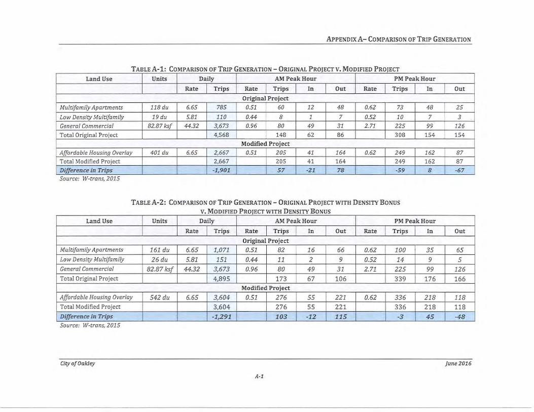
APPENDIX A- COMPARISON OF TRIP GENERATION
TABLE A -1: COMPARISON OF TRIP GENERATION- ORIGINAL PROJECT V. MODIFIED PROJECT
Land Use Units Daily AM Peak Hour PM Peak Hour
Rate Trips Rate Trips In Out Rate Trips In Out
Or iginal Project
Multifamily Apartments 118 du 6.65 785 0.51 60 12 48 0.62 73 48 2 5
Low Density Multifamily 19 du 5.81 110 0.44 8 1 7 0.52 10 7 3
General Commercial 82.87 ksf 44.32 3,673 0.96 80 49 31 2.71 225 99 126
Total Original Project 4,568 148 62 86 308 154 154 Modified Project
Affordable Housing Overlay 401 du 6.65 2,667 0.51 205 41 164 0.62 249 162 87
Total Modifi ed Project 2,667 205 41 164 249 162 87 Difference in Trips -1,901 57 -21 78 -59 8 -67 Source: W-trans, 2015
TABLE A -2: COMPARISON OF TRIP GENERATION - ORIGINAL PROJECT WITH DENSITY BONUS
V MODIFIED PROJECT WITH DENSITY BONUS . Land Use Units Daily AM Peak Hour PM Peak Hour
Rate Trips Rate Trips In Out Rate Trips In Out
Original Project Multifamily Apartments 161 du 6.65 1,071 0.51 82 16 66 0.62 100 35 65 Low Density Multifamily 26 du 5.81 151 0.44 11 2 9 0.52 14 9 5 General Commercial 82.87 ksf 44.32 3,673 0.96 80 49 31 2.71 225 99 12 6
Total Original Project 4,895 173 67 106 339 176 166 Modified Project
Affordable Housing Overlay 542du 6.65 3,604 0.51 276 55 221 0.62 336 21 8 118 Total Modified Project 3,604 276 55 221 336 218 118 Difference in Trips -1,291 103 -12 115 -3 45 -48 Source: W-trans, 2015
City of Oakley june 2016
A-1
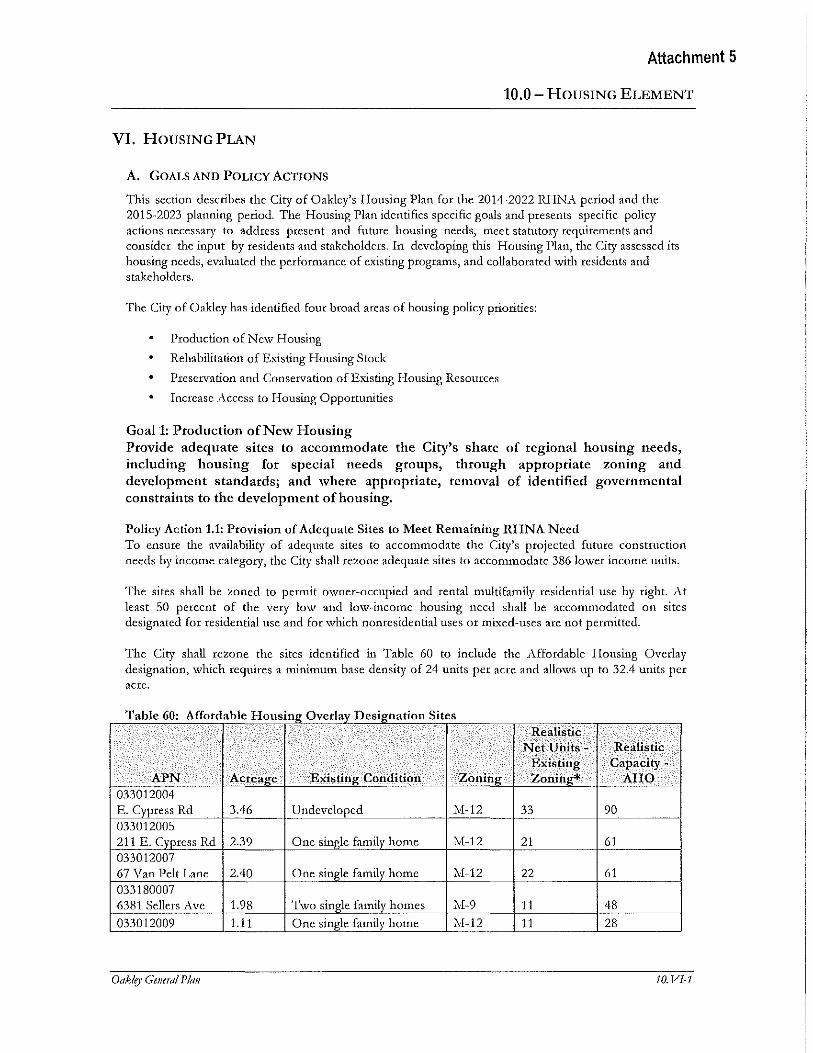
Attachment 5
10.0- HOUSING ELEMENT
VI. HousiNG PLAN
A. GOALS AND POLICY ACTIONS
This section describes the City of Oakley's Housing Plan for the 2014-2022 RHNA period and the 2015-2023 planning period. The Housing Plan identifies specific goals and presents specific policy actions necessary to address present and future housing needs, meet statutory requirements and consider the input by residents and stakeholders. In developing this Housing Plan, the City assessed its housing needs, evaluated the performance of existing programs, and collaborated with residents and stakeholders.
The City of Oakley has idenlified four broad areas of housing policy priorities:
• Production of New Housing
Rehabilitation of Existing Housing Stock
Preservation and Conservation of Existing Housing Resources
Increase Access to Housing Opportunities
Goal 1: Production of New Housing Provide adequate sites to accommodate the City's share of regional housing needs, including housing for special needs groups, through appropriate zoning and development standards; and where appropriate, removal of identified governmental constraints to the development ofhonsing.
Policy Action1.1: Provision of Adequate Sites to Meet Remaining RHNA Need To ensure the availability of adequate sites to accommodate the City's projected future construction needs by income category, the City shall rezone adequate sites to accommodate 386 lower income units.
The sites shall be :toned to permit owner-occupied and rental multifamily residential use by right. At least 50 percent of the vety low and low-income housing need shall be accommodated on sites designated for residential use and for which nonresidential uses or mi.-xed-uses are not permitted.
The City shall rezone the sites identified in Table 60 to include the Affordable Housing Overlay designation, which requires a minimum base density of 24 units per acre and allows up to 32.4 units per acre.
Tbi60Affdbl a e : or a e Houstng 0 ver ay D estgnatton s· ttes Realistic
Net Units- Realistic Existing Capacity-
APN Acreage Existing -Condition Zoning Zoning* AHO 033012004 E. Cypress Rd 3.46 Undeveloped 11-12 33 90 033012005 211 E. Cypress Rd 2.39 One single family home M-12 21 61 033012007 67 Van Pelt Lane 2.40 One single family home M-12 22 61 033180007 6381 Sellers Ave 1.98 Two single family homes M-9 11 48 033012009 1.11 One single family home M-12 11 28
Oaklo• Gmeml Plan 10. VI-1
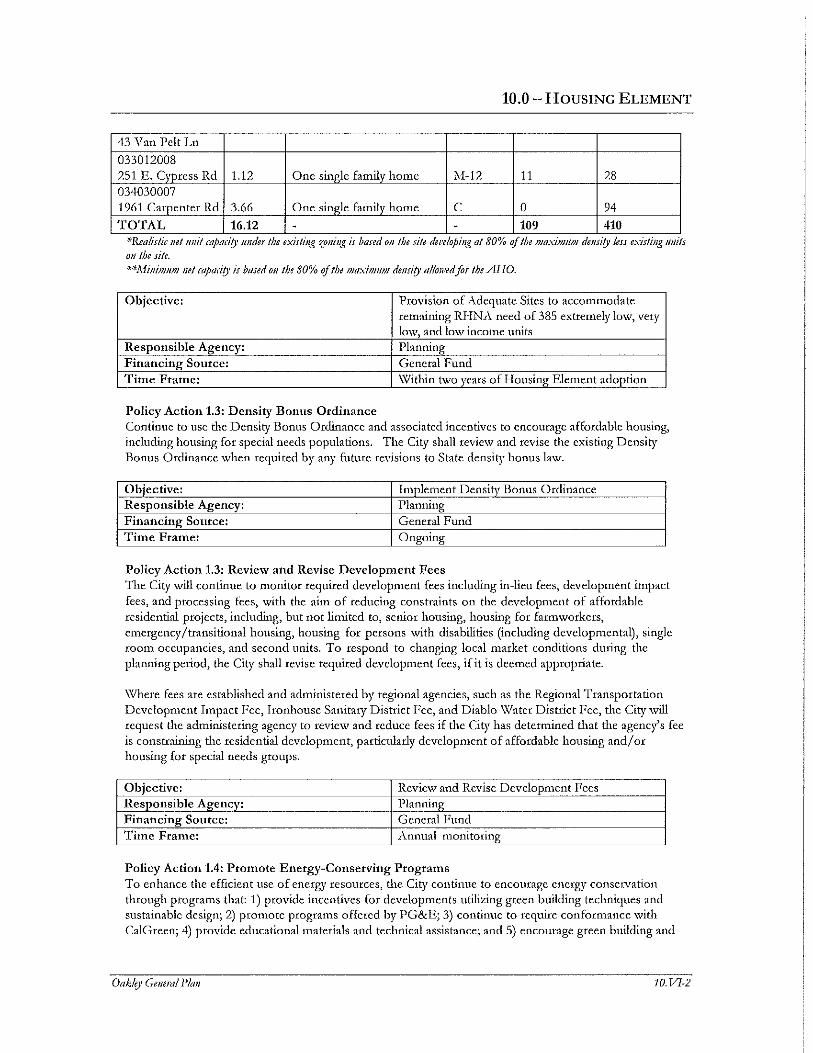
10.0- HOUSING ELEMENT
43 Van Pelt Ln
033012008 251 E. Cypress Rd 1.12 One single family home >\I-12 11 28 034030007 1961 Carpenter Rd 3.66 One single family home c 0 94
TOTAL 16.12 - - 109 410 *Real!Sitc net mut mpaa(y 11nder the ex1stmg zomng 1s baJed 011 the stfe del'elopmg at 80% of the llJaXtlllllllJ dei!St(y less exulmg umts 011 !he site. **1\finimJI!JJ net mpad(y is based on !he 80% of !he mtlxitmi!JJ dwsi(y allowed for the AHO.
Objective: Provision of Adequate Sites to accommodate remaining RHNA need of 385 extremely low, vety lmv, and low income units
Responsible Agency: Planning Financing Source: General Fund Time Frame: \'V'ithin two years of Housing Element adoption
Policy Action 1.3: Density Bonus Ordinance Continue to use the Density Bonus Ordinance and associated incentives to encourage affordable housing, including housing for special needs populations. The City shall review and revise the existing Density Bonus Ordinance when required by any future revisions to State density bonus law.
Objective: Implement Density Bonus Ordinance Responsible Agency: Planning Financing Source: General Fund Titne Frame: Ongoing
Policy Action 1.3: Review and Revise Development Fees TI1e City will continue to monitor required development fees including in-lieu fees, development impact fees, and processing fees, with the aim of reducing constraints on the development of affordable residential projects, including, but not limited to, senior housing, housing for farm workers, emergenc~r/transitional housing, housing for persons with disabilities (including developmental), single room occupancies, and second units. To respond to changing local market conditions during the planning period, the City shall revise required development fees, if it is deemed appropriate.
\\There fees are established and administered by regional agencies, such as the Regional Transportation Development Impact Fee, Ironhouse Sanitary District Fee, and Diablo \Vater District Fee, the City will request the administering agency to review and reduce fees if the City has determined that the agency's fee is constraining the residential development, particularly development of affordable housing and/ or housing for special needs groups.
Objective: Review and Revise Development Fees Responsible Agency: Planning Financing Source: General Fund Time Frame: Annual monitoring
Policy Action 1.4: Prmnote Energy-Conserving Progran1s To enhance the efficient use of energy resources, the City continue to encourage energy conservation through programs that: 1) provide incentives for developments utilizing green building techniques and sustainable design; 2) promote programs offered by PG&E; 3) continue to require conformance with Cal Green; 4) provide educational materials and technical assistance; and 5) encourage green building and
Oak/e)' General Plan IO.VI-2
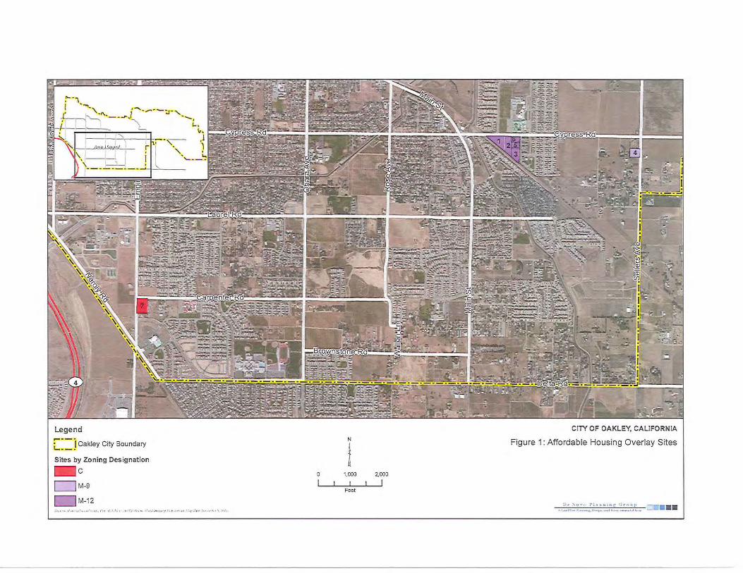
Legend
C: = j Oakley City Boundary
Sites by Zoning Designation -c D M-9
D M-12
N
i 1,000
Feet
2,000
I
CITY OF OAKLEY, CALIFORNIA
Figure 1: Affordable Housing Overlay Sites
EIRADDENDUM -AFFORDABLE HOUSING OVERLAY
TABLE 1· AFFORDABLE HOUSING OVERLAY SITES DEVELOPMENT POTENTIAL- BASE DENSITY . . ···. · ..
SITE APNjLOCATION ACRES EXISTING CONDITION
051-210-019 1 Elm Lane 4.69 Vacant
051-220-005 2 5301 Elm Lane 1.74 Two single family homes
035-282-058 3 Cypress Road 1.15 One single family home
035-282-062 4 Cypress Road 0.03 Vacant
033-012-005 5 211 East Cypress Road 2.39 One single family home
033-012-008 6 2 51 East Cypress Road 1.12 One single family home
033-012-009 7 43 Van Pelt Lane 1.11 One single family home
033-012-007 8 67 Van Pelt Lane 2.40 One single family home
033-180-007 9 6381 Sellers Avenue 1.98 Two single family homes
1: Anticipates commercial at 0.25 floor area ratio 2: Density of16.7 units per acre for MFH designation 3: Density of9.6 units per acre for MFL designation 4: Density of24 units per acre
City of Oakley 9
.
GENERAL EXISTING GENERAL
AHO CAPACITY-
ZONING PLAN PLAN CAPACITY-
WITH DENSITY WITH DENSITY
LAND USE BONUS1,2,3 BONUs4 -:
c co 51,074 113
c co 18,949 42
c co 12,524 28
c co 327 1
M-12 MFH 40 57
M-12 MFH 19 27
M-12 MFH 19 27
M-12 MFH 40 58
M-9 MFL 19 48
137 multifamily
TOTAL CAPACITY units, 401 multifamily
82,874 s.f. units commercial
March2016
Attachment 6
EIRADDENDUM -AFFORDABLE HOUSING OVERLAY
TABLE 2· AFFORDABLE HOUSING OVERLAY SITES DEVELOPMENT POTENTIAL WITH DENSITY BONUS
GENERAL SITE APNjLOCATION AcR.ES EXISTING CONDITION ZONING PLAN
LAND USE
051-210-019 c co 1 Elm Lane 4.69 Vacant 051-220-005 c co 2 5301 Elm Lane 1.74 Two single family homes 035-282-058 c co 3 Cypress Road 1.15 One single family home 035-282-062 c co 4 Cypress Road 0.03 Vacant 033-012-005
M-12 MFH 5 211 East Cypress Road 2.39 One single family home 033-012-008
M-12 MFH 6 251 East Cypress Road 1.12 One single family home 033-012-009
M-12 MFH 7 43 Van Pelt Lane 1.11 One single family home 033-012-007
M-12 MFH 8 6 7 Van Pelt Lane 2.40 One single family home 033-180-007
M-9 MFL 9 6381 Sellers Avenue 1.98 Two single family homes
TOTAL CAPACITY
.. 1: Antzczpates commerczal at 0.25 floor area ratzo 2: Density of16.7 units per acre for MFH designation plus 35% density bonus 3: Density of9.6 units per acre for MFL designation plus 35% density bonus 4: Density of24 units per acre plus 35% density bonus
March2016
10
EXISTING GENERAL PLAN CAPACITY-
WITH DENSITY BONU:§U3
81,719
30,318
20,038
523
54
26
26
55
26
187 multifamily units,
82,874 s.f. commercial
AHO CAPACITY-
WITH DENSITY BONUs4
152
57
38
1
78
37
36
78
65
542 multifamily units
City of Oakley
Legend
r~~~J Ooxloy City Boundary
,.---------.. L _______ j Anordoblo Hou~lng Overlay
Gcncml Plan Land U$C Dcs.lgnatlon$
D MFL • Multi-Fumlly Low
'"~ ::~ · ·~ !mr u;.,;,~, ..,. ,_ ... ,.., ''· '' ·"'"''·<' , ,, -·.t,.,,,, .• .••:r
CITY OF OAKLEY GENERAL PLAN EIR ADDENDUM
N Figure 1: Affordable Housing Overlay Sites
A
l Ml1eG


