Embed Size (px)
Citation preview
PN1630
birminghamarchaeology
Alma Street, Coventry.
An Archaeological Desk-based Assessment
REGISTERED
OR
GANISATION
IFA
2007
Project No. 1630June 2007
Alma Street, Coventry.
An Archaeological Desk-based Assessment 2007
By
Shane Kelleher
For
Victoria Hall Ltd.
For further information please contact:
Alex Jones (Director)
Birmingham Archaeology
The University of Birmingham
Edgbaston
Birmingham B15 2TT
Tel: 0121 414 5513
Fax: 0121 414 5516
E-Mail: [email protected]
Web Address: http://www barch.bham.ac.uk/bufau
Alma Street, Coventry: An Archaeological Desk-based Assessment 2007
ALMA STREET, COVENTRY: AN ARCHAEOLOGICAL DESK-BASED ASSESSMENT 2007
CONTENTS
SUMMARY
1 INTRODUCTION................................................................................................... 1
2 LOCATION AND GEOLOGY.................................................................................... 1
3 AIMS AND OBJECTIVES........................................................................................ 1
4 METHODOLOGY.................................................................................................... 2
5 PREVIOUS ARCHAEOLOGICAL WORK................................................................... 2
6 ARCHAEOLOGICAL AND HISTORICAL CONTEXT ................................................... 2
6.1 PREHISTORIC .................................................................................................... 26.2 ROMAN ........................................................................................................... 2
6.3 ANGLO-SAXON .................................................................................................. 26.4 MEDIEVAL........................................................................................................ 3
6.5 POST-MEDIEVAL................................................................................................. 4
7 HISTORICAL DEVELOPMENT OF THE STUDY AREA ............................................... 4
8 CONCLUSIONS AND RECOMMENDATIONS............................................................ 7
9 ACKNOWLEDGEMENTS......................................................................................... 8
10 SOURCES.......................................................................................................... 8
10.1 PRIMARY SOURCES ............................................................................................. 810.2 SECONDARY SOURCES.......................................................................................... 8
10.3 CARTOGRAPHIC SOURCES...................................................................................... 910.4 INTERNET SOURCES ............................................................................................ 9
Birmingham Archaeology i
Alma Street, Coventry: An Archaeological Desk-based Assessment 2007
Tables
Table 1. Occupants at the study area during 1871 census.
Figures
Figure 1. Location Map.
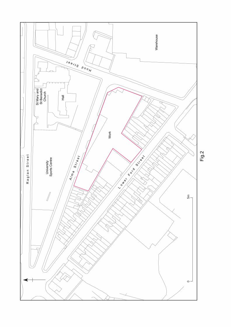
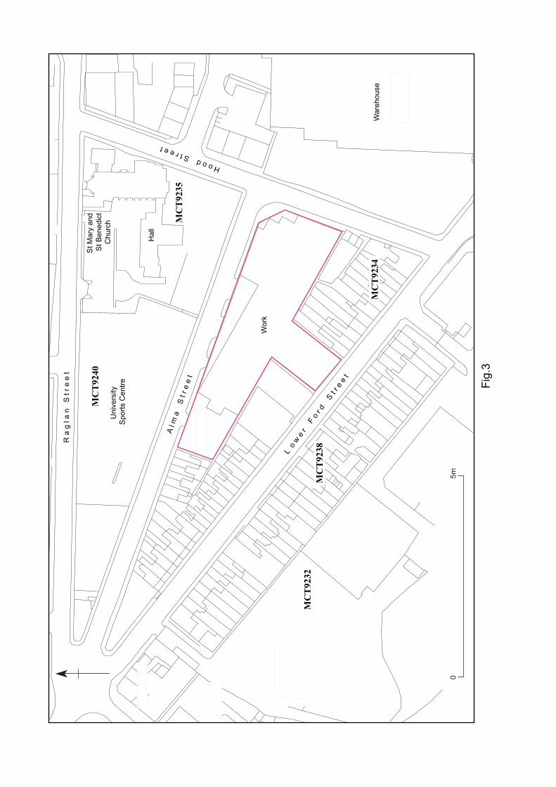
Figure 2. Location of the study area.
Figure 3. HER map of the study area and its vicinity.Figure 4. John Speed’s Map of Coventry 1610.
Figure 5. Samuel Bradford’s Plan of Coventry 1748.Figure 6. Thomas Sharp’s Plan of Coventry 1807.
Figure 7. Ordnance Survey map 1831.Figure 8. Board of Health Map of Coventry 1851.
Figure 9. Ordnance Survey maps 1889 to 1937.Figure 10. Ordnance Survey maps 1951 to 1992.
Plates
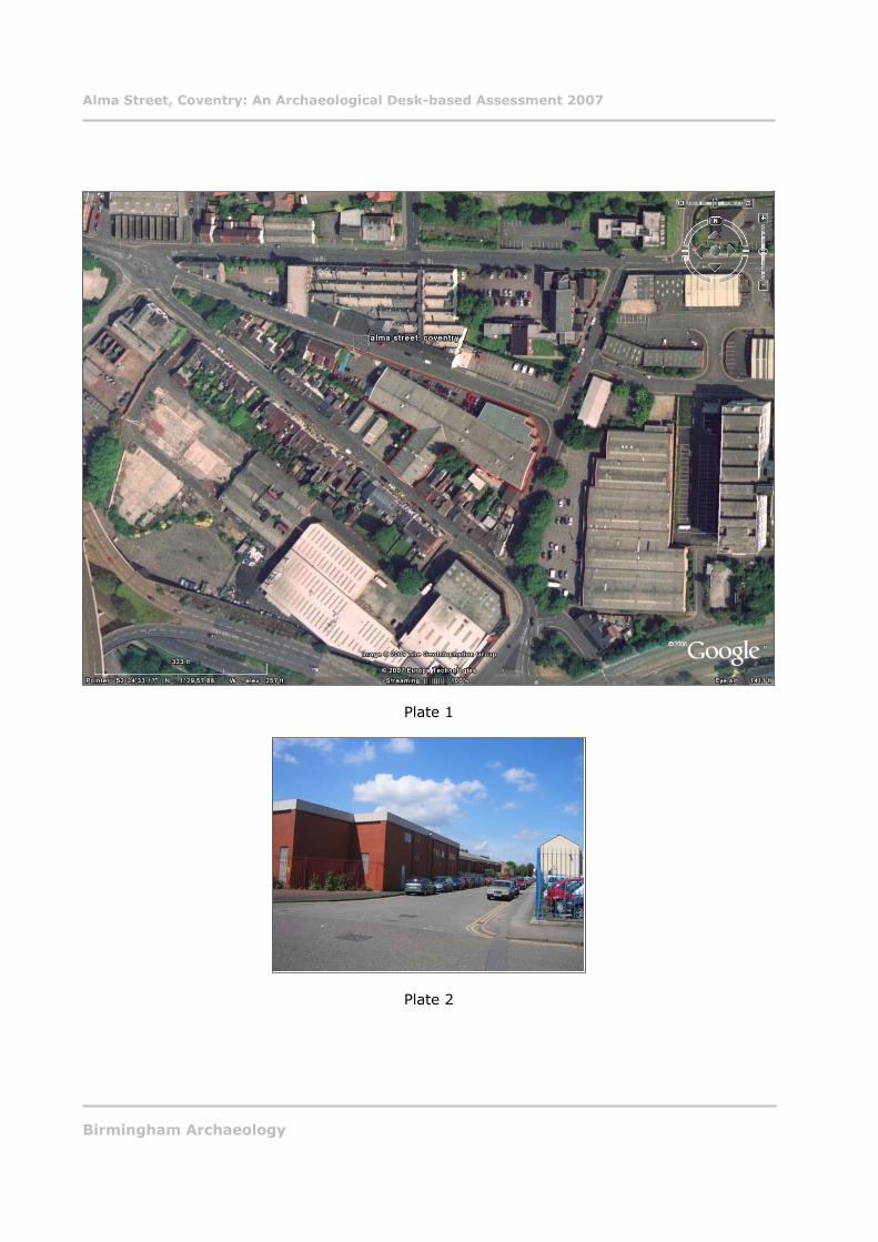
Plate 1. Aerial view of Alma Street, courtesy of Google Earth. Plate 2. Study area from northeast.
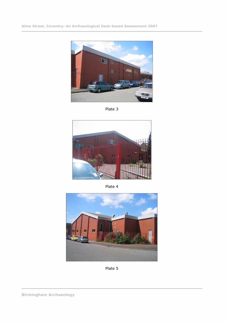
Plate 3. Study area from north.Plate 4. Study area from northwest.
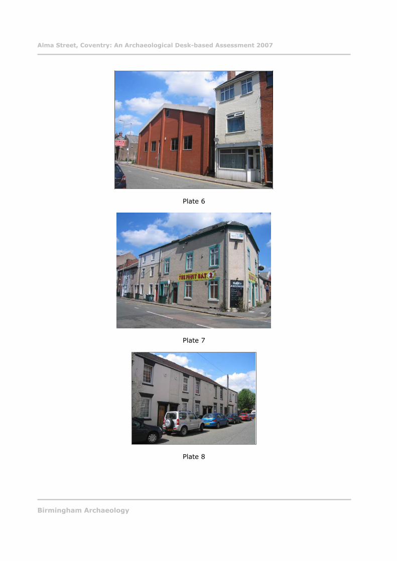
Plate 5. Study area from southeast.Plate 6. Study area from southwest.
Plate 7. ‘The Fruit Bat’ public house from southeast.
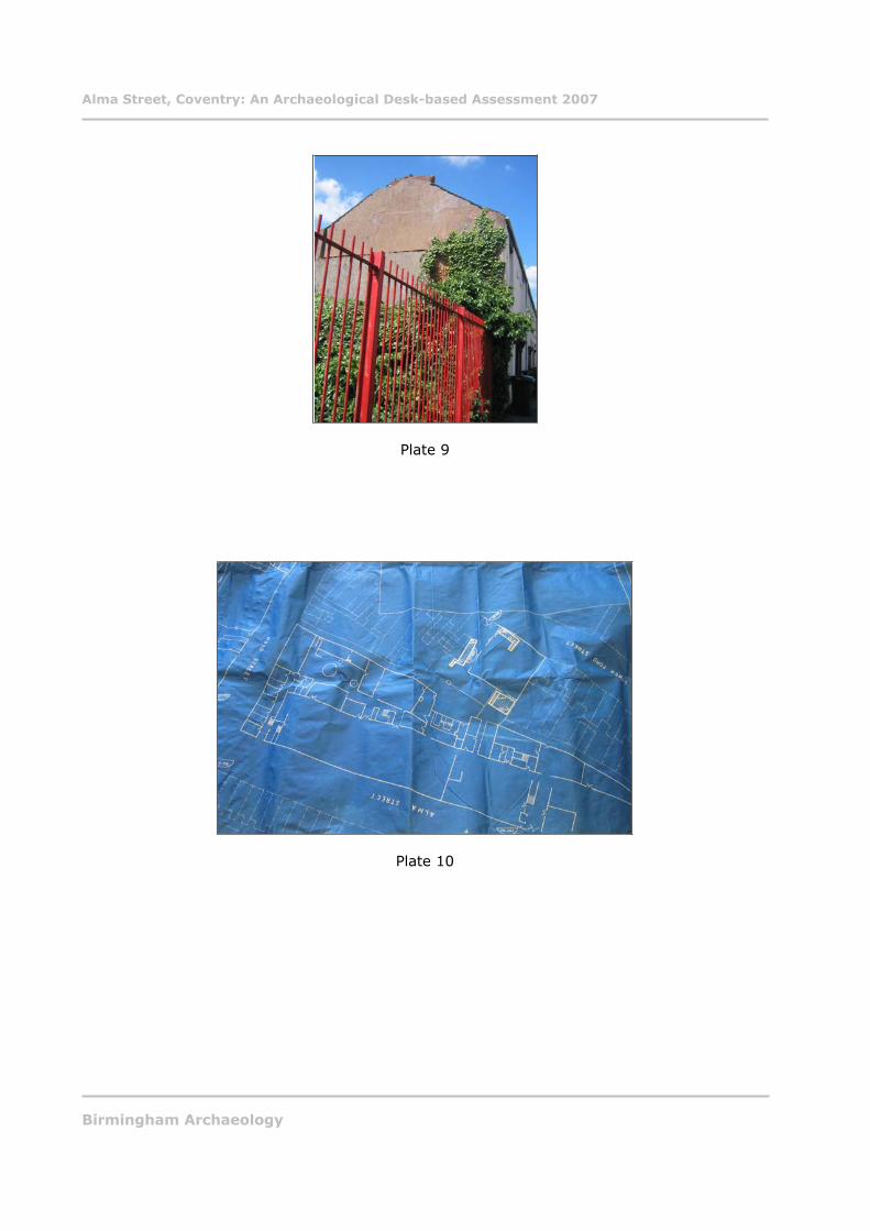
Plate 8. Victorian houses on Alma Street from north.Plate 9. Gable end of Victorian houses adjacent to the study area.
Plate 10. Blueprints for underground air raid shelters at study area (Coventry Archives ref. CCA/CD/1/114/14).
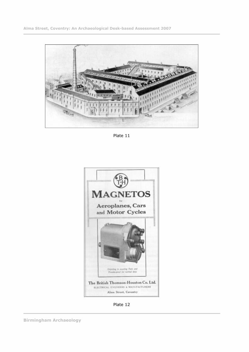
Plate 11. BTH magnetos factory at Alma Street (from www.hillfields.org.uk).Plate 12. BTH magnetos advert (from www.hillfields.org.uk).
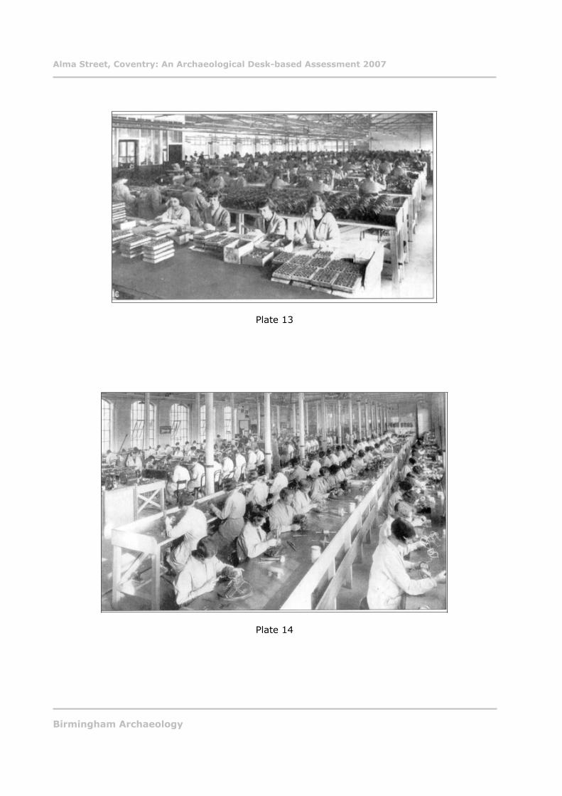
Plate 13. Headphone making at BTH Alma Street (from www.hillfields.org.uk).Plate 14. Winding at BTH Alma Street (from www.hillfields.org.uk).
Birmingham Archaeology ii
Alma Street, Coventry: An Archaeological Desk-based Assessment 2007
SUMMARY
In June 2007, Birmingham Archaeology carried out a desk based assessment of a site at Alma
Street, Coventry (NGR SP 3416 7914). The work was commissioned in advance of a proposedredevelopment of the site as student accommodation. A search of all relevant and readily
available published and non-published documentary sources, including historic maps andphotographs, was carried out at the Coventry City Archives, Birmingham Central Library, and
the Library of the University of Birmingham. The Coventry Historic Environment Record, the
main source of archaeological information for the city was also consulted. In addition, a walkover of the study area was undertaken in order to assess the topography and any above-
ground archaeology, including standing buildings.
This assessment has revealed information about a site with an interesting history. It appearsto have been as undeveloped pasture land probably from at least the 17th century until the mid
19th century when the surrounding area was developed for residential and industrial purposes. In the mid 19th century the study area was occupied by terraced housing on each side; this
was eroded away by industrial development towards the end of that century. Firstly, it was
occupied by Apollo Cycle works, and then by various tyre manufacturers including Dunlops,until the factory was taken over and extended by British Thomson Houston Company Ltd who
were eventually taken over by GEC, who constructed the current factory buildings on site. It was also found that recent excavations at nearby Lower Ford Street yielded some interesting
medieval archaeological deposits. Given the potential for medieval and post-medieval deposits,recommendations were made for future archaeological work.
Birmingham Archaeology iii
Alma Street, Coventry: An Archaeological Desk-based Assessment 2007
ALMA STREET, COVENTRY:
AN ARCHAEOLOGICAL DESK-BASED ASSESSMENT, 2007.
1 INTRODUCTION
In June 2007 Birmingham Archaeology carried out an archaeological desk-based assessment of
a site at Alma Street, Coventry, Warwickshire (Fig. 1, Plate 1). The work was commissioned
by Victoria Hall Ltd. in advance of a proposed redevelopment of the site as student accommodation.
This report outlines the results of the assessment, which was carried out between the 1st and
22nd of June 2007, and which was prepared in accordance with the Institute of FieldArchaeologists Standard and Guidance for Archaeological Desk-Based Assessment (IFA 1999).
The assessment was required by the Planning Archaeologist, Coventry City Council (Patrick
2006) to assess the impact of the development on archaeological remains in advance of
consideration of development proposals. The assessment is in accordance with guidelines laiddown in Planning Policy Guidance Note 16 (DoE 1990).
2 LOCATION AND GEOLOGY
The study area is located at the corner of Alma Street and Hood Street, Coventry, and occupies
a site of c. 0.4 hectares. It is located to the east of Coventry City centre, which is approximately 18 kilometres north of Warwick, 30 kilometres southeast of Birmingham and is
centred on NGR SP 3416 7914 (Fig. 2).
According to the Solid and Drift map (British Geological Survey 1967) the underlying geology consists of Keresley Member (KRS) which is a red-brown mudstone and red brown sandstone,
with mudstone dominating the lower part, and becoming increasingly sandy in the upper part.It is likely that in this part of Coventry that the upper sections of the geological strata are of
Corley sandstone; pebbly sandstone found at the top of Keresley member.
The present character of the study area is hardstanding, and it is occupied by a late 20th-
century factory building (Plates 2 to 6). The site is bounded by Alma Street to the northeast,Hood Street to the southeast, and Lower Ford Street to the southwest. Adjacent to the study
area along Lower Ford Street and Alma Street are sections of mid to late 19th-century housing
and a much altered 19th-century public house ‘The Fruit Bat’, formerly known as the ‘Spittlemoor’, on the corner of Hood Street and Lower Ford Street (Plate 7). Adjacent to the
study area to the southwest along Hood Street are three late 20th-century industrial units. On the other side of Alma Street is what appears to be a converted late 19th-century factory;
whilst the other side of Hood Street is occupied by a late 20th-century warehouse building.
3 AIMS AND OBJECTIVES
The overall objective was to define the likely extent, survival, and significance of archaeological
remains and historic buildings in the area of the proposed development by collating existingarchaeological and historical information for the site, so that the archaeological implications of
the proposed development can be assessed. This information can then be used to inform thedesign and decision making process.
Birmingham Archaeology 1
Alma Street, Coventry: An Archaeological Desk-based Assessment 2007
4 METHODOLOGY
A search of all relevant and readily available published and non-published documentary
sources, including historic maps and photographs, was carried out at the Coventry CityArchives, Birmingham Central Library, and the Library of the University of Birmingham. The
Coventry Historic Environment Record, the main source of archaeological information for theCity was also consulted.
In addition, a walkover of the study area was undertaken in order to assess the topography and any above-ground archaeology, including standing buildings.
5 PREVIOUS ARCHAEOLOGICAL WORK
A search of the Coventry Historic Environment Record shows that there has been no previousarchaeological work carried out at the study area. Three archaeological events have taken
place in the vicinity of the study area; these include a series of archaeological investigations at Lower Ford Street, HER ECT 328 (Birmingham Archaeology 2005a) (Fig. 3), archaeological
building recording at the Former Lea Francis Works in Lower Ford Street, HER ECT 328
(Birmingham Archaeology 2005b), and an Archaeological Desk-based Assessment at GodivaPlace, HER ECT 374 (not illustrated on Fig. 3) (ULAS 2006). The excavations at Lower Ford
Street revealed activity dating back to the 12th-13th-century, and more intensive activity,characterised by a series of dug pits, in the 15th-16th-century. There are no scheduled
monuments, or listed buildings in the vicinity of or at the study area.
6 ARCHAEOLOGICAL AND HISTORICAL CONTEXT
6.1 Prehistoric
Prehistoric activity of a transitory nature has been recorded in what is now the city; however
no settlements have been identified.
6.2 Roman
Until recently there was no evidence for Roman settlement at Coventry. However, a probable
Roman ditch and Roman finds have been recorded adjacent to the Herbert Art Gallery andMuseum (Pers. Comm. Laurence Jones). There is also possible evidence for a Roman road at
Cox Street, which is located c.200 metres to the west of the study area. Excavations here in
the early 20th-century uncovered a possible Roman river crossing for a putative road runningfrom Mancetter to the north and Baginton to the south, HER MCT 15141 (not illustrated on Fig.
3).
6.3 Anglo-Saxon
Continuous settlement began in Coventry in the Anglo-Saxon period. Onomastic evidence
supports this with the name Coventry almost certainly being Anglo-Saxon or Old English inorigin, meaning “tree of a man called Cofa” (Mills 2003, 135), Cofa itself being an Old English
personal name. Further indications of its Anglo-Saxon origins are the prevalence of the endings
‘ley’, or ‘leah’: a wood or clearing, in the names of its hamlets and nearby parishes such asPinley, Shortley, or Canley (VCH VIII, 1-23). Despite the high incidence of ‘ley’ suffixes, it is no
longer believed that the Coventry area was once impenetrable forest, which was later graduallycleared by the Anglo-Saxon settlers. It is thought that the relatively low population density
recorded in the Domesday Book may be due to the difficulty of ploughing the underlying
Birmingham Archaeology 2
Alma Street, Coventry: An Archaeological Desk-based Assessment 2007
geology of heavy clays, which ensured that Coventry may only have been a large scatter of
hamlets or farmsteads across an extensive manor (Demidowicz 2003, 10). There is very little evidence regarding the development of Coventry prior to the Domesday Book, which recorded
an agricultural settlement of up to 60 households. George Demidowicz recently argued that Coventry was the centre of a large estate, and since large estates often contained a minster
church, Coventry must have had one (Demidowicz 2003, 9). The original location of the earlymedieval agricultural centre of Coventry is unknown. However, there was a 12th-century
suburb at Spon to the west, and beyond Gosford to the east. Settlement in the wooded rivervalley at Spon or in the well-watered Gosford area, would have been more in character with
the known practice of the Anglo-Saxons (VCH VIII, 1-23). Human remains dating to the 9th
century have been recorded beneath the cathedral arcade of St. Mary’s.
In about 1043 a Benedictine house, consisting of an Abbot and 24 monks, was founded at Coventry by Leofric, Earl of Mercia, and his wife, the Countess Godifu (Godiva) It is likely that
the whole of Coventry belonged to Godiva in her own right, and that the abbey was foundedwithin her territories and was endowed by Leofric with lands in Warwickshire and elsewhere
(VCH VIII 1-23).
6.4 Medieval
After the compilation of the Domesday Book in 1086, the whole city was granted to the Earls of
Chester, who founded a castle in the town, and took control of the Coventry estates by 1147. By the 12th-century the town that grew up around the Benedictine priory (which had by then
become Coventry’s first Cathedral) had gained considerable commercial importance. Thetown’s wealth, which had been accrued from trading high-quality wool from Warwickshire
flocks, brought other religious orders to the town. These included the Franciscans in the 13th-century, and the Carmelites and Carthusians in the 4th-century. By this time the church
dominated life in the city, and remains of all the monastic houses can be seen above ground
today (Soden 2005, 51-98).
Despite the fact that the whole city had been granted to the Earls of Chester in 1088, by 1113 the priory was claiming roughly half of Coventry as its own. Thus the medieval division of the
Prior’s half and the Earl’s half. After the mid 13th-century the Priory’s influence waned and the town was once again unified under Queen Isabel who came into the possession of the manor of
Coventry in 1330.
In 1329 a licence was granted to the priory and men of Coventry to levy murage for building a
wall round the city, however work does not seem to have started for some time. It was notuntil 1363 that licence to crenellate was granted, and this was followed 22 years later by a
licence to complete the work. Parts of this wall, though badly preserved and largely rebuiltsurvive to the south of the study area (VCH VIII, 1-23). The wall was finally completed in the
1530s (Demidowicz 2003, 13). Twelve gates were erected at strategic points, furtherdemonstrating that Coventry at this time was a hub of communication.
Coventry’s wealth was founded on the cloth trade, which was flourishing by the 14th-century
(Soden 2005, 143-147). At this time the city was the fourth largest in the country (Demidowicz
2003, 11-13). In 1334 and 1344 charters exempted Coventry merchants from toll, pavage andother duties throughout the kingdom.
Following the Dissolution of the monasteries in 1539, Coventry experienced a period of general
decline. A series of complex economic disasters hit the city, resulting in contraction ofpopulation, shrinkage of the suburbs back to within the historic core and the general
dereliction of structures within the town. Although recent archaeological work in the city has
Birmingham Archaeology 3
Alma Street, Coventry: An Archaeological Desk-based Assessment 2007
revealed that this was not the case in Far Gosford Street where there was a renewed building
programme (Soden 2005, 36). This suggests that not all fortunes were in decline in the latemedieval period.
6.5 Post-medieval
Following the Civil War Coventry’s trade and industry suffered further decline. However, a
revival of fortunes came about in the late 17th and early 18th centuries due to the introductionof new types of cloth and the beginnings of the ribbon industry. The new industries were small
scale, labour intensive, and unmechanised, and were squeezed into the existing urban fabric(Demidowicz 2003, 15).
From the later 18th century, the main lines of industrial development in Coventry were in
ribbon weaving and watchmaking, followed after less than a century by the emergence of thecity first as the cradle of cycle manufacture and later as an important centre of the motor
industry and its ancillary trades. It was the cycle industry that ensured that once again that
Coventry became prosperous (Demidowicz 2003, 15).
The introduction of the canal system, in the late 18th century, and then the railways ensuredthat Coventry maintained its position as a hub of communication and a strong industrial base
throughout the 19th century. Although the pace of the town’s economy quickened in the late18th-century, the first industrial revolution based on iron and coal largely passed Coventry by
(Demidowicz 2003, 17).
For the first half of the 19th century, watchmaking and silk ribbon weaving were the staple
industries of the town and its northern hinterland. As both manufacturing activities needed plenty of light, but remained domestic in scale, houses with large windows on the front or rear
became a characteristic building type in Coventry.
The onset of the cycle industry and later the motor car industry demonstrated Coventry’s “time-honoured ability to pull a new industry out of the hat when it desperately mattered”
(www.coventry.gov.uk). At the end of the 19th century there were no fewer than 100 workshops devoted to making bicycles in Coventry, with over 3000 citizens employed in the
trade (Stewart 1983, 22). By 1911 most of the leading cycle companies had diversified into the
making of cars and motor-cycles. In some cases, firms were making all three.
The success of Coventry’s motor industry made it a target for the German Luftwaffe in WorldWar Two, causing innumerable damage to Coventry’s historic fabric and infrastructure.
7 HISTORICAL DEVELOPMENT OF THE STUDY AREA
Alma Street is located in the historic district of Harnall, which was later renamed Hillfields in
the 19th century. The district, which was first mentioned in the Coombe Abbey Charter as being
in the bounds of the Prior’s half of Coventry in the 12th century (VCH VIII 71-77), is bounded by Leicester Row and Foleshill Road to the northwest, Great Heath to the north, Swan Lane to
the east, and Far Gosford Street to the southeast. It is situated in an area immediately to theeast of the former town wall, and to the north of the River Sherbourne, which ran through
Harnall from west to east. The river had an important role in Coventry’s economic life until the19th century, when “there were as many as fourteen mills exploiting a four mile stretch of the
Birmingham Archaeology 4
Alma Street, Coventry: An Archaeological Desk-based Assessment 2007
Sherbourne, between Spon End and Stivichall, though not all of them were in existence at the
same time” (Birmingham Archaeology 2005a, 3).
There is little or no documentary or archaeological evidence regarding the use form or function of the study area prior to the medieval period. Most of Harnall was claimed by the Coventry
Priory in the early 12th century as part of its original endowment. Harnall became one of theestates of Roger de Montalt in 1279, when the property “consisted of six cottages, and a
number of crofts and other pieces of land” (Birmingham Archaeology 2005a, 4). It is alsoknown that the Benedictine Hospital of St. John the Baptist, which was founded in 1165 as a
descendant of St. Mary’s Priory, had land at Harnall, which in the 13th and 14th centuries
encompassed the area between Swanswell Pool to the north and the town wall to the south; anarea which may have included the current study area. Later documentary sources refer to the
area as Harnall Fields, which was being used to feed stock destined for Coventry market. It isknown that a butcher had beasts on pasture in Harnall in 1365, and there were 60 sheep and
cattle in a field there in the early 16th century (VCH Vol VIII, 71-77).
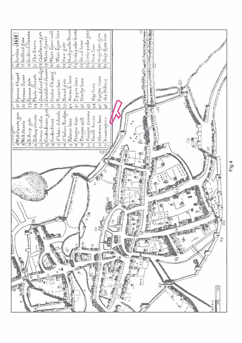
John Speed’s map of 1610 (Fig. 4) provides little insight into the function and use of the studyarea in the early 17th-century. Speed obviously believed the area to be unimportant or
undeveloped, as he decided to place his Key over much of the district of Harnall. It is likely
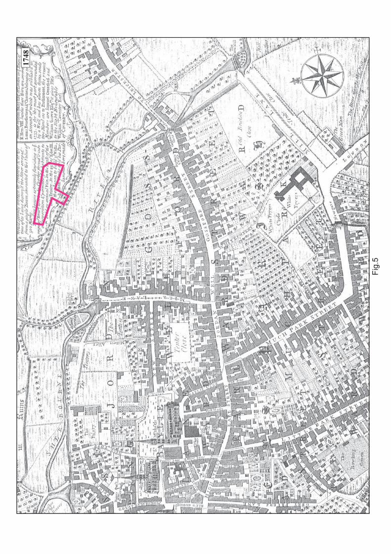
that there was no development here at this that time, and that it was still being used forpasture. Similarly Samuel Bradford’s plan of 1748 (Fig. 5) shows the area as being
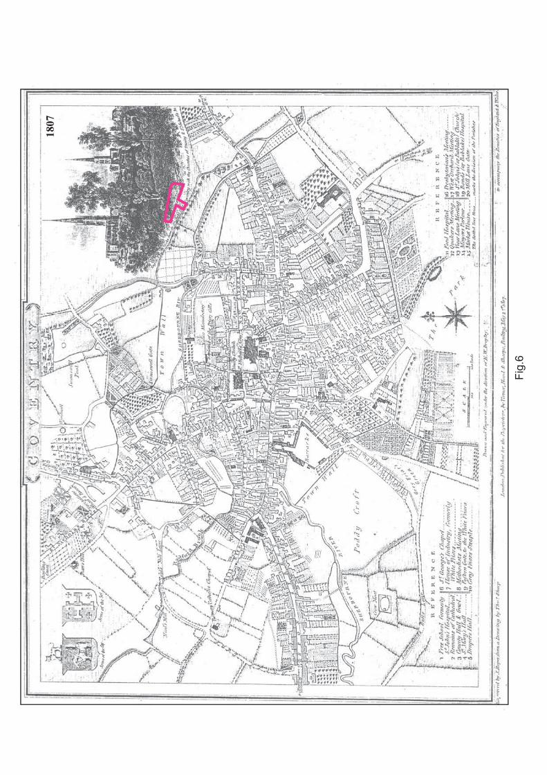
undeveloped grassland to the east of the ever encroaching town, following the destruction ofthe town wall in the previous century. There does not appear to be any further development in
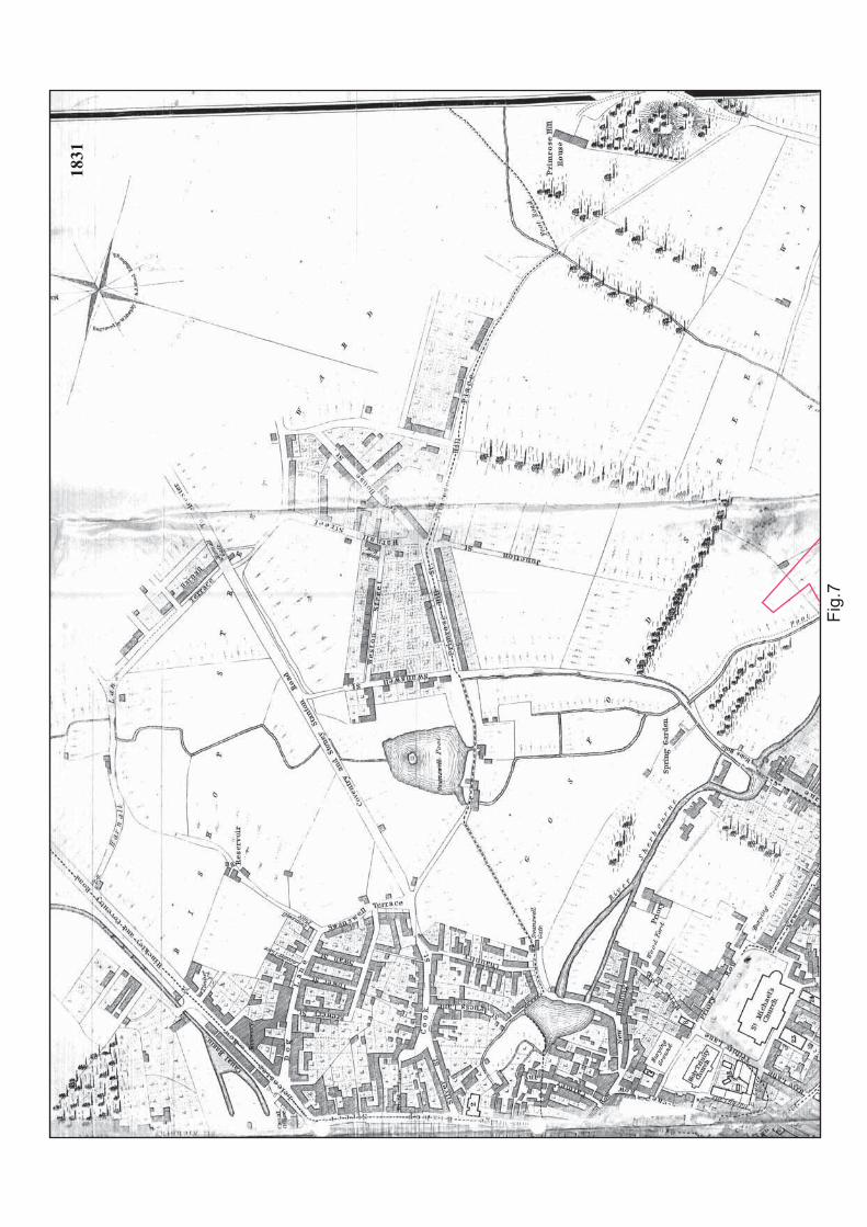
the study area or in the vicinity by the time of Sharp’s map of 1807 (Fig. 6) nor in the 1831Ordnance Survey map (Fig. 7).
In 1844 an Act of Parliament was obtained that enabled the dams belonging to various water
mills on the River Sherbourne to be demolished. This alleviated the serious problem of flooding
in the Harnall area, and “paved the way for the ground between river and the Hillfields ‘newtown’ (that had begun to be developed in the 1820s and 1830s and was largely occupied by
ribbon weavers) from the 1850s onwards” (Birmingham Archaeology 2005b, 1). In fact thisproved to be a continuation of function and tradition in the Hillfields area as many French
ribbon and silk weaving refugees settled in the area in 1685 (www.hillfields.org.uk). Hillfieldsitself was developed as a mainly ribbon weaving suburb of Coventry in 1828, and by 1850
there were 13 ribbon manufacturers, 120 ribbon weavers, and 5 machinery manufacturers in Hillfields alone (www.hillfields.org.uk).
In the 1849 tithe apportionment, the area surrounding the study area was divided up into FarSpittlemore (south) HER MCT 9234 and HER MCT 9325 (Fig. 3), which was described as a
pasture or a meadow; Middle Spittlemore HER MCT 9238 and HER MCT 9240, which wasdescribed as a meadow; and Ling Meadow HER MCT 9233 (not illustrated on Fig. 3), which was
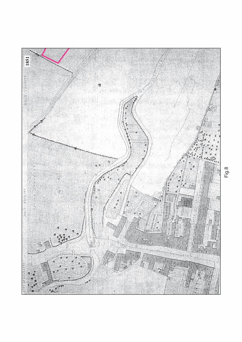
a meadow or pastureland; and Garden Meadow HER MCT 9232, again being a meadow orpastureland. This agricultural function is attested by the area still appearing undeveloped in
the 1851 Board of Health Map (Fig. 8). These fieldnames obviously contributed to the areacontinuing to be referred to as the Spittlemoor for years to come. Alma Street (after the Battle
of Alma) and Raglan Street (after a British Commander at the Battle of Alma) were laid out in
commemoration of the Crimean War (1854-6); the distinctive fan shape of these streets as well as that Lower Ford Street, which was laid out as part of an earlier development, is a
“modest Victorian interpretation” of Napoleon III’s Parisian town planning (BirminghamArchaeology 2005b, 1).
The 1861 census provides an excellent insight into the occupiers of Alma Street at the time;
these included a brass and iron works, ribbon weavers, a silk trimmer, dressmakers, and a
Birmingham Archaeology 5
Alma Street, Coventry: An Archaeological Desk-based Assessment 2007
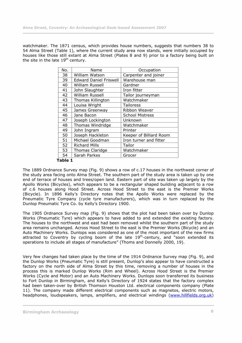
watchmaker. The 1871 census, which provides house numbers, suggests that numbers 38 to
54 Alma Street (Table 1), where the current study area now stands, were initially occupied byhouses like those still extant at Alma Street (Plates 8 and 9) prior to a factory being built on
the site in the late 19th century.
No. Name Occupation
38 William Watson Carpenter and joiner
39 Edward Daniel Friswell Warehouse man
40 William Russell Gardner
41 John Slaughter Iron fitter
42 William Russell Tailor journeyman
43 Thomas Killington Watchmaker
44 Louisa Wright Tailoress
45 James Greenway Ribbon Weaver
46 Jane Bacon School Mistress
47 Joseph Lockington Unknown
48 Thomas Windridge Watchmaker
49 John Ingram Printer
50 Joseph Hackleton Keeper of Billiard Room
51 Michael Goodman Iron turner and fitter
52 Richard Mills Tailor
53 Thomas Claridge Watchmaker
54 Sarah Parkes Grocer
Table 1
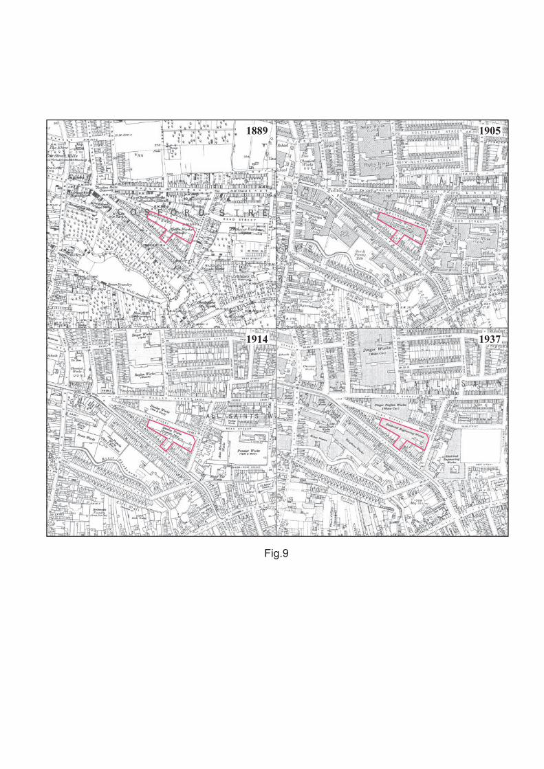
The 1889 Ordnance Survey map (Fig. 9) shows a row of c.17 houses in the northwest corner of
the study area facing onto Alma Street. The southern part of the study area is taken up by oneend of terrace of houses and trees/open land. Eastern part of site was taken up largely by the
Apollo Works (Bicycles), which appears to be a rectangular shaped building adjacent to a rowof c.6 houses along Hood Street. Across Hood Street to the east is the Premier Works
(Bicycle). In 1896 Kelly’s Directory notes that the Apollo Works were replaced by the
Pneumatic Tyre Company (cycle tyre manufacturers), which was in turn replaced by theDunlop Pneumatic Tyre Co. by Kelly’s Directory 1900.
The 1905 Ordnance Survey map (Fig. 9) shows that the plot had been taken over by Dunlop
Works (Pneumatic Tyre) which appears to have added to and extended the existing factory.The houses to the northwest and east had been removed whilst the southern part of the study
area remains unchanged. Across Hood Street to the east is the Premier Works (Bicycle) and anAuto Machinery Works. Dunlops was considered as one of the most important of the new firms
attracted to Coventry by cycling boom of the late 19th-century, and “soon extended its
operations to include all stages of manufacture” (Thoms and Donnelly 2000, 19).
Very few changes had taken place by the time of the 1914 Ordnance Survey map (Fig. 9), and
the Dunlop Works (Pneumatic Tyre) is still present, Dunlop’s also appear to have constructed a factory on the north side of Alma Street by this time, removing a number of houses in the
process this is marked Dunlop Works (Rim and Wheel). Across Hood Street is the PremierWorks (Cycle and Motor) and an Auto Machinery Works. Dunlops soon transferred its business
to Fort Dunlop in Birmingham, and Kelly’s Directory of 1924 states that the factory complex
had been taken-over by British Thomson Houston Ltd. electrical components company (Plate11). The company made different electrical components such as magnetos, electric motors,
headphones, loudspeakers, lamps, amplifiers, and electrical windings (www.hillfields.org.uk)
Birmingham Archaeology 6
Alma Street, Coventry: An Archaeological Desk-based Assessment 2007
(Plates 12-14). BTH began the manufacture of ‘talkie’ equipment for cinema projectors in 1929
ad demonstrated an early form of 3D film-projector at the 1951 Festival of Britain(www.hillfields.org.uk). In 1937 (Fig. 9) the factory building appears to be the same as the
previous map with an extension constructed towards Lower Ford Street, it is now an ElectricalEngineering Works. The factory on the other side of Hood Street is also an Electrical
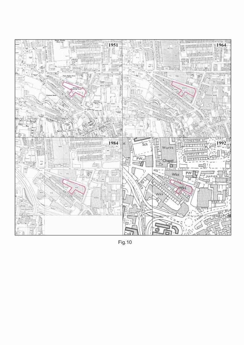
Engineering Works, whilst the works on the north side of Alma Street has changed to theSinger Raglan Works (Motor Car). It is clear from the records at Coventry Archives that the
Alma Street area received some bomb damaged in the blitz during World War Two, the industrialised nature of the Hillfields area ensured that it was a viable target. The BTH
Company planned accordingly, creating a number of air raid shelters at their plants, including
that in the current study area. Plans show that they constructed three air raid shelters on theLower Ford Street side of the Alma Street plant (Plate 10). These had enough space for 161
people in total and may still be extant. BTH was later taken over by AEI, and later by GEC,who built a new premises on the site, which was until recently occupied by Lucas Aerospace
(www.hillfields.org.uk).
There were very few changes to the study area until the 1984 Ordnance Survey map (Fig 10)where it would appear that the factory building seen on the previous Ordnance Survey map
had been demolished by this time and replaced by a new works building which conforms to the
current ground plan.
8 CONCLUSIONS AND RECOMMENDATIONS
This assessment has revealed information about a site with an interesting history. It appears
to have been as undeveloped pasture land probably from at least the 17th century until the mid19th century when the surrounding area was developed for residential and industrial purposes.
In the mid 19th century the study area was occupied by terraced housing on each side; this
was eroded away by industrial development towards the end of that century. Firstly, it was occupied by Apollo Cycle works, and then by various tyre manufacturers including Dunlops,
until the factory was taken over and extended by British Thomson Houston Company Ltd whowere eventually taken over by GEC, who constructed the current factory buildings on site.
Whilst the Alma Street site may not lie in the historic core of the city of Coventry, the study
area’s proximity to the medieval town wall, the River Sherbourne, and the fact that recentexcavations at the nearby Lower Ford Street have yielded significant medieval deposits,
indicates that some form of archaeological mitigation may be necessary. Therefore it is
suggested that the following recommendations are taken into account:
Standing Buildings
There does not appear to be any trace of the former factory buildings remaining above ground
level. Therefore, there is no requirement for any programme of historic building recording above ground. However, it may be useful to examine if there is any access route to the air raid
shelters from inside the current factory buildings prior to demolition.
Subsurface Archaeology
It is recommended that an archaeological evaluation is carried out following the removal of the
current factory buildings, this is important in order to investigate for the presence of, andsubsequent possible truncation of archaeological deposits. If such a scheme of works proves
ineffective it is recommended that a watching brief be undertaken during any future subsurfaceintrusions. In addition to this, if the presence of Second World War air raid shelters under part
Birmingham Archaeology 7
Alma Street, Coventry: An Archaeological Desk-based Assessment 2007
of the site is verified, they should be recorded by a suitably qualified archaeologist to a level
decided by the Planning Archaeologist, in accordance with PPG 15 (DOE 1994). Any finaldecision on further archaeological work should be made by the Planning Archaeologist,
Coventry City Council.
9 ACKNOWLEDGEMENTS
The project was commissioned by Victoria Hall Ltd. Thanks go to Alexandra Thompson of Coventry City Council who provided the Historic Environment Record search. The assessment
was undertaken by Shane Kelleher, who also produced the written report, which was illustratedby Nigel Dodds. The report was edited by Laurence Jones who also managed the project for
Birmingham Archaeology.
10 SOURCES
10.1 Primary Sources
1861 Coventry City Census
1871 Coventry City Census
1896 Kelly’s Directory of Coventry.
1900 Kelly’s Directory of Coventry.
10.2 Secondary Sources
Birmingham Archaeology 2005a Lower Ford Street Coventry, Archaeological Excavations,Birmingham Archaeology Report no. 1338a.
Birmingham Archaeology 2005b The Building History of the Former Lea Francis Works in LowerFord Street, Coventry, Birmingham Archaeology Report no. 1338b.
Demidowicz, G. 2003 A Guide to the Buildings of Coventry: An Illustrated Architectural History.
Stroud, Tempus.
Department of the Environment (DoE) 1990 Planning Policy Guidance Note 16: Archaeology and Planning.
Department of the Environment (DoE) 1994 Planning Policy Guidance Note 15: Planning andthe Historic Environment.
Institute of Field Archaeologists (IFA) 1999 Standard and Guidance for Archaeological Desk-
Based Assessment, rev. edn.
Mills, A. D. 2003. Oxford Dictionary of English Place Names. Oxford, Oxford University Press.
Patrick, C. 2006 A brief for an archaeological desk-based assessment. Coventry City Council.
Soden, I. 2005 Coventry, The Hidden History. Stroud, Tempus.
Birmingham Archaeology 8
Alma Street, Coventry: An Archaeological Desk-based Assessment 2007
Stewart, J. 1983 The City that put the World on Wheels, Cycling, November 12.
Thoms, D. and Donnelly, T. 2000 The Coventry Motor Industry- Birth to Renaissance.Aldershot, Ashgate.
Victoria County History1969 Volume VIII The City of Coventry and Borough of Warwick.
University of Leicester Archaeological Services 2006 An Archaeological Desk-Based Assessment
of Godiva Place Coventry.
10.3 Cartographic Sources
1610 John Speed’s Map of Coventry.
1748 Samuel Bradford’s Plan of Coventry.
1807 Thomas Sharp’s Plan of Coventry.
1831 Ordnance Survey map of Coventry.
1851 Board of Health Map of Coventry.
1889 Ordnance Survey 1st edition.
1905 Ordnance Survey 2nd edition.
1914 Ordnance Survey edition.
1937 Ordnance Survey edition.
1951 Ordnance Survey edition.
1964 Ordnance Survey edition.
1967 British Geological Survey, Solid and Drift map sheet 169, Warwickshire.
1984 Ordnance Survey edition.
1992 Ordnance Survey edition.
10.4 Internet Sources
www.coventry.gov.uk
www.hillfields.org.uk
Birmingham Archaeology 9
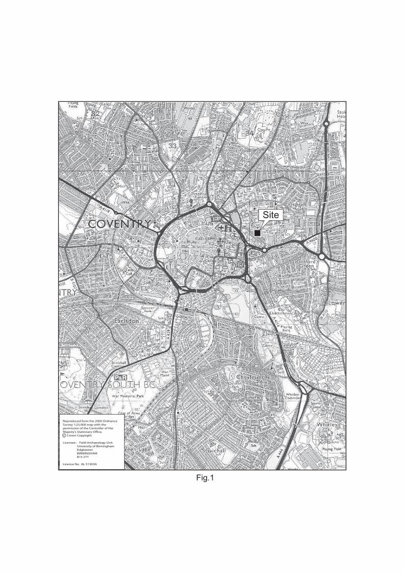
Fig.1
Site
Reproduced from the 2000 OrdnanceSurvey 1:25,000 map with thepermission of the Controller of HerMajesty's Stationary Office,c Crown Copyright
Licensee : Field Archaeology Unit University of Birmingham Edgbaston BIRMINGHAM B15 2TT
Licence No. AL 51303A
c
Uni
vers
ityS
port
s C
entr
e
War
ehou
se
05m
Fig
.2
R a
g l
a n
S t
r e
e t
A l m
a
S t
r e e
t
L o
w e
r
F o
r d
S t
r e e
t
H o o d S t r e
e t
St M
ary
and
St B
ened
ict
Chu
rch
Hal
l
Wor
k
Uni
vers
ityS
port
s C
entr
e
War
ehou
se
05m
Fig
.3
R a
g l
a n
S t
r e
e t
A l m
a
S t
r e e
t
Lo
w er
Fo
r d S
t r e
e t
H o o d St r e e t
St M
ary
and
St B
ened
ict
Chu
rch
Hal
l
Wor
k
MC
T20
29
MC
T15
142
MC
T92
40
MC
T92
35
MC
T92
39
MC
T92
34
MC
T92
19
MC
T92
32M
CT
9238
MC
T92
37
1610
Fig
.4
1748
Fig
.5
1807
Fig
.6
1831
Fig
.7
1851
Fig
.8
1889 1905
1914 1937
Fig.9
1951 1964
1984 1992
Fig.10
Alma Street, Coventry: An Archaeological Desk-based Assessment 2007
Plate 1
Plate 2
Birmingham Archaeology
Alma Street, Coventry: An Archaeological Desk-based Assessment 2007
Plate 3
Plate 4
Plate 5
Birmingham Archaeology
Alma Street, Coventry: An Archaeological Desk-based Assessment 2007
Plate 6
Plate 7
Plate 8
Birmingham Archaeology
Alma Street, Coventry: An Archaeological Desk-based Assessment 2007
Plate 9
Plate 10
Birmingham Archaeology
Alma Street, Coventry: An Archaeological Desk-based Assessment 2007
Plate 11
Plate 12
Birmingham Archaeology
Alma Street, Coventry: An Archaeological Desk-based Assessment 2007
Plate 13
Plate 14
Birmingham Archaeology


