Embed Size (px)
Citation preview
AMENDED
State of New Hampshire - Wetlands Permit Application
Lyme, NH – Thetford, VT, A000(394), 14460 East Thetford Road Bridge over the Connecticut River
Bridge Rehabilitation Project
April 2019 – Amended June 2021
Lyme, NH – Thetford, VT 14460 Amended Wetlands Permit Application
Table of Contents
Page
Wetlands Permit Amendment Form (W-06-081) 1
Amended Wetlands Permit Application Form (W-06-012) 3
Figure 1 - USGS Location Map 7
Amended Wetlands Permit Application – Attachment A (W-06- 013) 8
Exhibit C - Amended Alterative Design Technical Report 16
Exhibit D – NHB21-1856 19
Exhibit K - Wetlands Permit Application Photographs and Photo plan 21
Exhibit P – Amended Assessment of Floodplain Impact Memo 28
Exhibit S - Wetland Delineation Report 29
Exhibit T - Lyme Tax Map - Sheet 403 57
Exhibit U - Wetland Permit Abutter List 58
Exhibit V – Temporary Construction Easement at Lot 22 59
Exhibit W - 1937 Bridge Construction Photographs 61
Appendix A - Wetlands Permit Application Plan set 6/28/2021

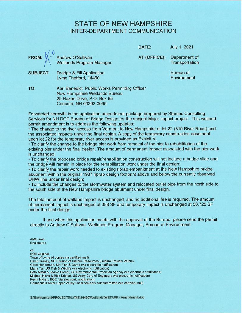
NHDES-W-06-081
[email protected] or (603) 271-2147 NHDES Wetlands Bureau, PO Box 95, Concord, NH 03303-0095
www.des.nh.gov 2020-05 Page 1 of 2
AMENDMENT REQUEST FORM FOR A WETLANDS APPLICATION OR PERMIT
Water Division/Land Resources Management Wetlands Bureau
RSA/Rule: RSA 482-A:3, XIV(e)/ Env-Wt 311.13; Env-Wt 314.07
Administrative Use Only
Administrative Use Only
Administrative Use Only
File No.:
Check No.:
Amount:
Initials:
Any request for an amendment to a wetlands application or permit must be submitted to the Department on this form. An applicant may request an amendment to a pending permit application or an existing permit, provided the proposed change does not constitute a “significant amendment.” A “significant amendment" means an amendment which changes the proposed or previously approved acreage of the permitted fill or dredge area by 20 percent or more, includes a prime wetland, or elevates the project’s impact classification. This meaning of "significant amendment" shall not apply to an application amendment that is in response to a request from the Department (RSA 482-A:3, XIV(e)).
SECTION 1 - REQUESTED AMENDMENT TYPE AND AMENDMENT CRITERIA
Does the proposed change constitute a “significant amendment” as provided in RSA 482-A:3, XIV(e) and described above? Yes No
If you answered “yes” to the previous question, then you cannot request an amendment using this form and must file a new permit application.
AMENDMENT TO PENDING PERMIT APPLICATION, NHDES FILE NUMBER: (proceed to Section 2) AMENDMENT TO EXISTING PERMIT NUMBER: 2019-01230 (proceed to Section 3)
SECTION 2 - AMENDMENT TO A PENDING PERMIT APPLICATION Not applicable
To request an amendment to a pending permit application, the applicant must:
• Submit the information required by Env-Wt 311.03, showing the changes prior to the Department’s issuance of a final decision on the application, including but not limited to, a revised set of plans and revised application fees for any additional square footage of impacts calculated pursuant to RSA 482-A:3, I(b) or (c) as applicable, and
• Provide notice to each person to whom notice of the original application was sent prior to filing the amended application with the Department (Env-Wt 311.13).
By checking this box, you confirm that you have provided all information required pursuant to Env-Wt 311.03 to the Department and provided the required notice(s) as described above.
NHDES-W-06-081
[email protected] or (603) 271-2147 NHDES Wetlands Bureau, PO Box 95, Concord, NH 03303-0095
www.des.nh.gov 2020-05 Page 2 of 2
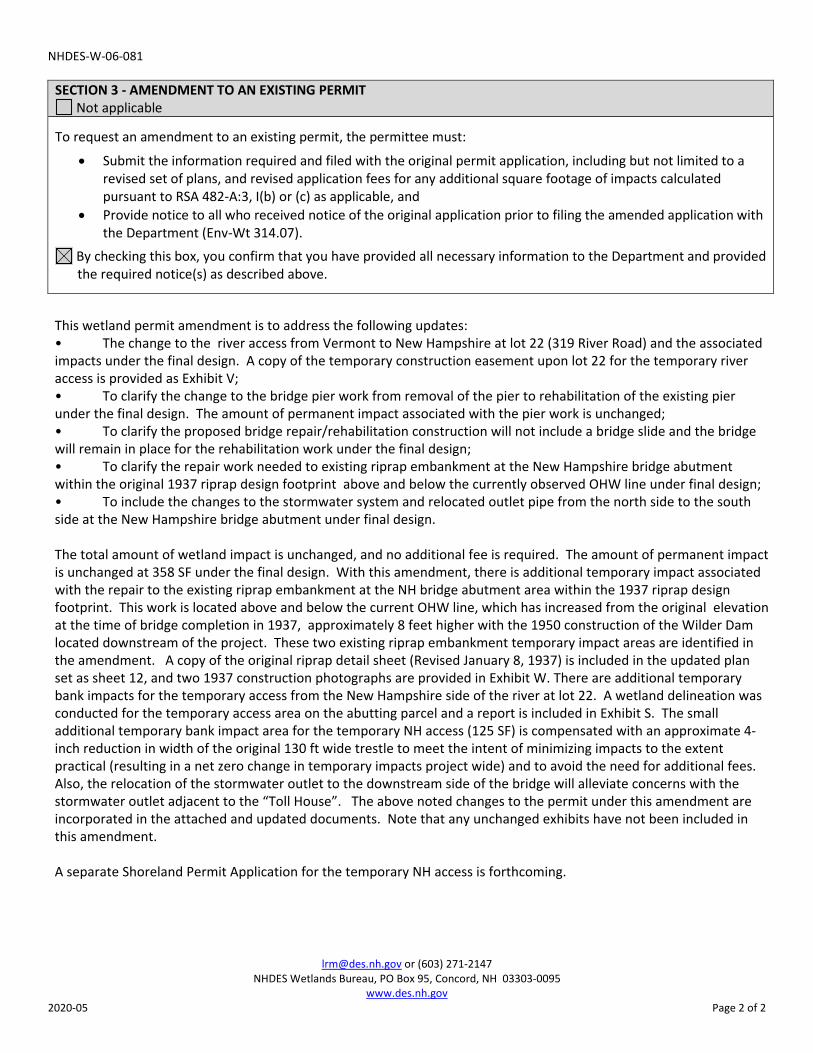
SECTION 3 - AMENDMENT TO AN EXISTING PERMIT Not applicable
To request an amendment to an existing permit, the permittee must:
• Submit the information required and filed with the original permit application, including but not limited to arevised set of plans, and revised application fees for any additional square footage of impacts calculatedpursuant to RSA 482-A:3, I(b) or (c) as applicable, and
• Provide notice to all who received notice of the original application prior to filing the amended application withthe Department (Env-Wt 314.07).
By checking this box, you confirm that you have provided all necessary information to the Department and provided the required notice(s) as described above.
This wetland permit amendment is to address the following updates:• The change to the river access from Vermont to New Hampshire at lot 22 (319 River Road) and the associated impacts under the final design. A copy of the temporary construction easement upon lot 22 for the temporary river access is provided as Exhibit V;• To clarify the change to the bridge pier work from removal of the pier to rehabilitation of the existing pier under the final design. The amount of permanent impact associated with the pier work is unchanged;• To clarify the proposed bridge repair/rehabilitation construction will not include a bridge slide and the bridge will remain in place for the rehabilitation work under the final design;• To clarify the repair work needed to existing riprap embankment at the New Hampshire bridge abutment within the original 1937 riprap design footprint above and below the currently observed OHW line under final design;• To include the changes to the stormwater system and relocated outlet pipe from the north side to the south side at the New Hampshire bridge abutment under final design.
The total amount of wetland impact is unchanged, and no additional fee is required. The amount of permanent impact is unchanged at 358 SF under the final design. With this amendment, there is additional temporary impact associated with the repair to the existing riprap embankment at the NH bridge abutment area within the 1937 riprap design footprint. This work is located above and below the current OHW line, which has increased from the original elevation at the time of bridge completion in 1937, approximately 8 feet higher with the 1950 construction of the Wilder Dam located downstream of the project. These two existing riprap embankment temporary impact areas are identified in the amendment. A copy of the original riprap detail sheet (Revised January 8, 1937) is included in the updated plan set as sheet 12, and two 1937 construction photographs are provided in Exhibit W. There are additional temporary bank impacts for the temporary access from the New Hampshire side of the river at lot 22. A wetland delineation was conducted for the temporary access area on the abutting parcel and a report is included in Exhibit S. The small additional temporary bank impact area for the temporary NH access (125 SF) is compensated with an approximate 4-inch reduction in width of the original 130 ft wide trestle to meet the intent of minimizing impacts to the extent practical (resulting in a net zero change in temporary impacts project wide) and to avoid the need for additional fees. Also, the relocation of the stormwater outlet to the downstream side of the bridge will alleviate concerns with the stormwater outlet adjacent to the “Toll House”. The above noted changes to the permit under this amendment are incorporated in the attached and updated documents. Note that any unchanged exhibits have not been included in this amendment.
A separate Shoreland Permit Application for the temporary NH access is forthcoming.
[email protected] or (603) 271-2147 NHDES Wetlands Bureau, 29 Hazen Drive, PO Box 95, Concord, NH 03302-0095
www.des.nh.gov Permit Application –Valid until 01/2019 Page 1 of 4
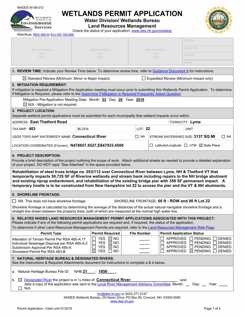
NHDES-W-06-012
WETLANDS PERMIT APPLICATION Water Division/ Wetlands Bureau
Land Resources Management Check the status of your application: www.des.nh.gov/onestop
RSA/Rule: RSA 482-A/ Env-Wt 100-900
1. REVIEW TIME: Indicate your Review Time below. To determine review time, refer to Guidance Document A for instructions.
Standard Review (Minimum, Minor or Major Impact) Expedited Review (Minimum Impact only) 2. MITIGATION REQUIREMENT: If mitigation is required a Mitigation-Pre Application meeting must occur prior to submitting this Wetlands Permit Application. To determine if Mitigation is Required, please refer to the Determine if Mitigation is Required Frequently Asked Question. Mitigation Pre-Application Meeting Date: Month: 03 Day: 20 Year: 2019 N/A - Mitigation is not required
3. PROJECT LOCATION: Separate wetland permit applications must be submitted for each municipality that wetland impacts occur within.
ADDRESS: East Thetford Road TOWN/CITY: Lyme
TAX MAP: 403 BLOCK: LOT: 22 UNIT:
USGS TOPO MAP WATERBODY NAME: Connecticut River NA STREAM WATERSHED SIZE: 3137 SQ MI NA
LOCATION COORDINATES (If known): N478657.6527,E847933.4509 Latitude/Longitude UTM State Plane
4. PROJECT DESCRIPTION: Provide a brief description of the project outlining the scope of work. Attach additional sheets as needed to provide a detailed explanation of your project. DO NOT reply “See Attached" in the space provided below.
Rehabilitation of steel truss bridge no. 053/112 over Connecticut River between Lyme, NH & Thetford VT that temporarily impacts 50,725 SF of Riverine wetlands and stream bank including repairs to the NH bridge abutment and existing riprap embankment, and rehabilitation of the existing bridge pier with 358 SF permanent impact. A temporary trestle is to be constructed from New Hampshire lot 22 to access the pier and the VT & NH abutments.
5. SHORELINE FRONTAGE:
NA This does not have shoreline frontage. SHORELINE FRONTAGE: 66 ft - ROW and 90 ft Lot 22
Shoreline frontage is calculated by determining the average of the distances of the actual natural navigable shoreline frontage and a straight line drawn between the property lines, both of which are measured at the normal high water line.
6. RELATED NHDES LAND RESOURCES MANAGEMENT PERMIT APPLICATIONS ASSOCIATED WITH THIS PROJECT: Please indicate if any of the following permit applications are required and, if required, the status of the application. To determine if other Land Resources Management Permits are required, refer to the Land Resources Management Web Page.
Permit Type Permit Required File Number Permit Application Status Alteration of Terrain Permit Per RSA 485-A:17 Individual Sewerage Disposal per RSA 485-A:2 Subdivision Approval Per RSA 485-A Shoreland Permit Per RSA 483-B
YES NO YES NO YES NO YES NO
_____ _____ _____ _____
APPROVED PENDING DENIED APPROVED PENDING DENIED APPROVED PENDING DENIED APPROVED PENDING DENIED
7. NATURAL HERITAGE BUREAU & DESIGNATED RIVERS: See the Instructions & Required Attachments document for instructions to complete a & b below.
a. Natural Heritage Bureau File ID: NHB 21 ___ - 1856 __ .
b. Designated River the project is in ¼ miles of: Connecticut River ; and date a copy of the application was sent to the Local River Management Advisory Committee: Month: Day: Year:
N/A
Administrative
Use Only
Administrative
Use Only
Administrative
Use Only
File No.:
Check No.:
Amount:
Initials:
[email protected] or (603) 271-2147 NHDES Wetlands Bureau, 29 Hazen Drive, PO Box 95, Concord, NH 03302-0095
www.des.nh.gov Permit Application –Valid until 01/2019 Page 2 of 4
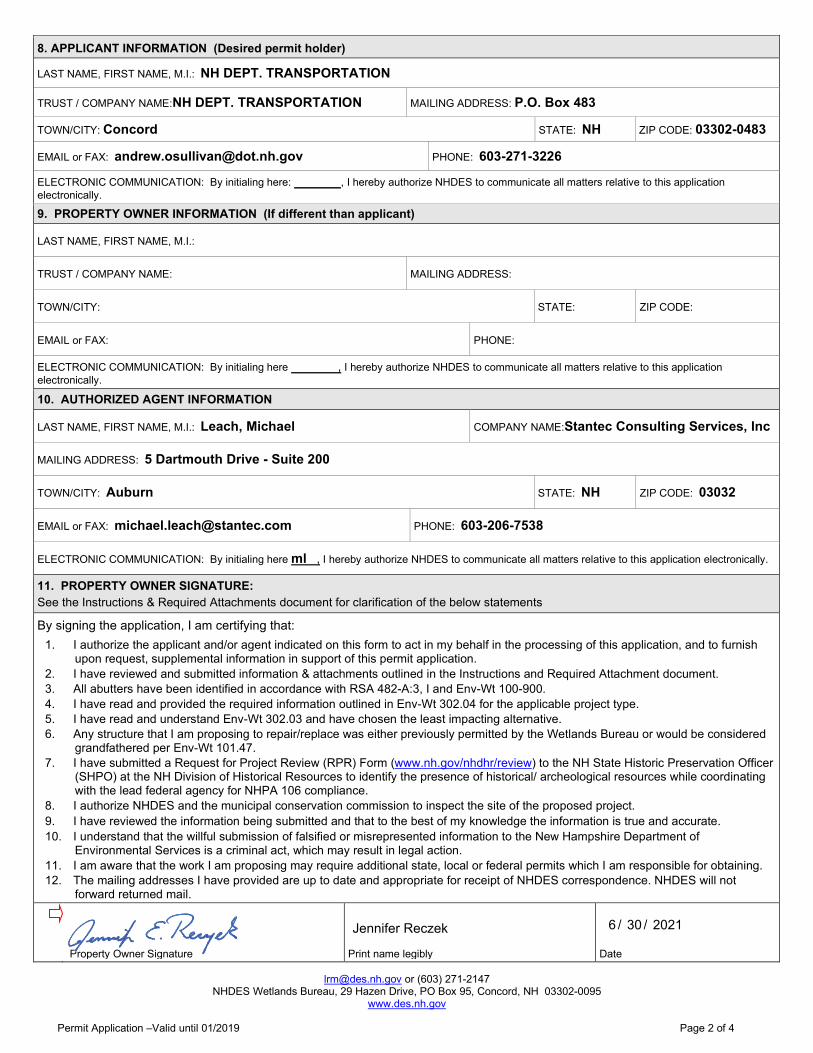
8. APPLICANT INFORMATION (Desired permit holder)
LAST NAME, FIRST NAME, M.I.: NH DEPT. TRANSPORTATION
TRUST / COMPANY NAME:NH DEPT. TRANSPORTATION MAILING ADDRESS: P.O. Box 483
TOWN/CITY: Concord STATE: NH ZIP CODE: 03302-0483
EMAIL or FAX: [email protected] PHONE: 603-271-3226
ELECTRONIC COMMUNICATION: By initialing here: , I hereby authorize NHDES to communicate all matters relative to this application electronically.
9. PROPERTY OWNER INFORMATION (If different than applicant)
LAST NAME, FIRST NAME, M.I.:
TRUST / COMPANY NAME: MAILING ADDRESS:
TOWN/CITY: STATE: ZIP CODE:
EMAIL or FAX: PHONE:
ELECTRONIC COMMUNICATION: By initialing here , I hereby authorize NHDES to communicate all matters relative to this application electronically.
10. AUTHORIZED AGENT INFORMATION
LAST NAME, FIRST NAME, M.I.: Leach, Michael COMPANY NAME:Stantec Consulting Services, Inc
MAILING ADDRESS: 5 Dartmouth Drive - Suite 200
TOWN/CITY: Auburn STATE: NH ZIP CODE: 03032
EMAIL or FAX: [email protected] PHONE: 603-206-7538
ELECTRONIC COMMUNICATION: By initialing here ml , I hereby authorize NHDES to communicate all matters relative to this application electronically.
11. PROPERTY OWNER SIGNATURE: See the Instructions & Required Attachments document for clarification of the below statements
By signing the application, I am certifying that: 1. I authorize the applicant and/or agent indicated on this form to act in my behalf in the processing of this application, and to furnish
upon request, supplemental information in support of this permit application. 2. I have reviewed and submitted information & attachments outlined in the Instructions and Required Attachment document. 3. All abutters have been identified in accordance with RSA 482-A:3, I and Env-Wt 100-900. 4. I have read and provided the required information outlined in Env-Wt 302.04 for the applicable project type. 5. I have read and understand Env-Wt 302.03 and have chosen the least impacting alternative. 6. Any structure that I am proposing to repair/replace was either previously permitted by the Wetlands Bureau or would be considered
grandfathered per Env-Wt 101.47. 7. I have submitted a Request for Project Review (RPR) Form (www.nh.gov/nhdhr/review) to the NH State Historic Preservation Officer
(SHPO) at the NH Division of Historical Resources to identify the presence of historical/ archeological resources while coordinating with the lead federal agency for NHPA 106 compliance.
8. I authorize NHDES and the municipal conservation commission to inspect the site of the proposed project. 9. I have reviewed the information being submitted and that to the best of my knowledge the information is true and accurate. 10. I understand that the willful submission of falsified or misrepresented information to the New Hampshire Department of
Environmental Services is a criminal act, which may result in legal action. 11. I am aware that the work I am proposing may require additional state, local or federal permits which I am responsible for obtaining. 12. The mailing addresses I have provided are up to date and appropriate for receipt of NHDES correspondence. NHDES will not
forward returned mail.
Property Owner Signature
Print name legibly
/ / Date
Jennifer Reczek 6 30 2021
[email protected] or (603) 271-2147 NHDES Wetlands Bureau, 29 Hazen Drive, PO Box 95, Concord, NH 03302-0095
www.des.nh.gov Permit Application –Valid until 01/2019 Page 3 of 4
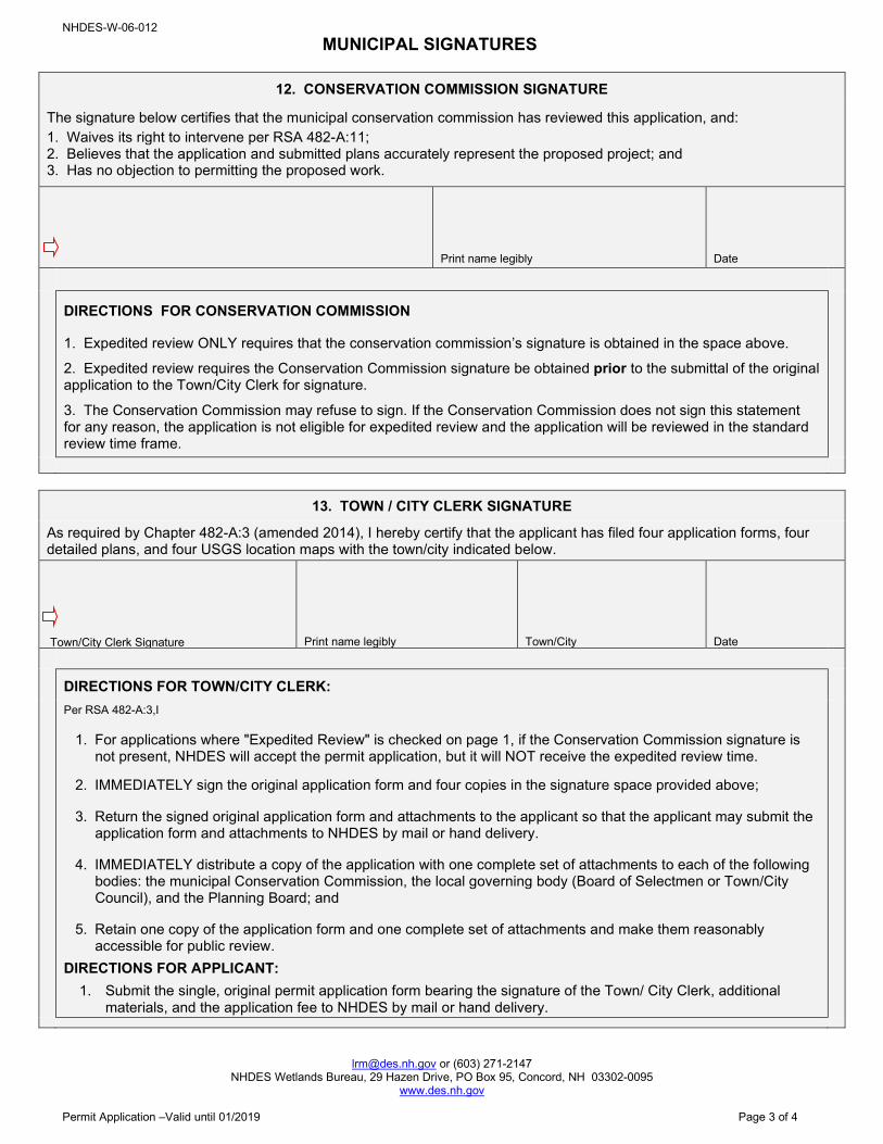
NHDES-W-06-012 MUNICIPAL SIGNATURES
12. CONSERVATION COMMISSION SIGNATURE
The signature below certifies that the municipal conservation commission has reviewed this application, and: 1. Waives its right to intervene per RSA 482-A:11; 2. Believes that the application and submitted plans accurately represent the proposed project; and 3. Has no objection to permitting the proposed work.
Print name legibly Date
DIRECTIONS FOR CONSERVATION COMMISSION
1. Expedited review ONLY requires that the conservation commission’s signature is obtained in the space above.
2. Expedited review requires the Conservation Commission signature be obtained prior to the submittal of the original application to the Town/City Clerk for signature.
3. The Conservation Commission may refuse to sign. If the Conservation Commission does not sign this statement for any reason, the application is not eligible for expedited review and the application will be reviewed in the standard review time frame.
13. TOWN / CITY CLERK SIGNATURE
As required by Chapter 482-A:3 (amended 2014), I hereby certify that the applicant has filed four application forms, four detailed plans, and four USGS location maps with the town/city indicated below.
Town/City Clerk Signature
Print name legibly Town/City Date
DIRECTIONS FOR TOWN/CITY CLERK:
Per RSA 482-A:3,I
1. For applications where "Expedited Review" is checked on page 1, if the Conservation Commission signature is not present, NHDES will accept the permit application, but it will NOT receive the expedited review time.
2. IMMEDIATELY sign the original application form and four copies in the signature space provided above;
3. Return the signed original application form and attachments to the applicant so that the applicant may submit the application form and attachments to NHDES by mail or hand delivery.
4. IMMEDIATELY distribute a copy of the application with one complete set of attachments to each of the following bodies: the municipal Conservation Commission, the local governing body (Board of Selectmen or Town/City Council), and the Planning Board; and
5. Retain one copy of the application form and one complete set of attachments and make them reasonably accessible for public review.
DIRECTIONS FOR APPLICANT: 1. Submit the single, original permit application form bearing the signature of the Town/ City Clerk, additional
materials, and the application fee to NHDES by mail or hand delivery.
[email protected] or (603) 271-2147 NHDES Wetlands Bureau, 29 Hazen Drive, PO Box 95, Concord, NH 03302-0095
www.des.nh.gov
Permit Application –Valid until 01/2019 Page 4 of 4
NHDES-W-06-012
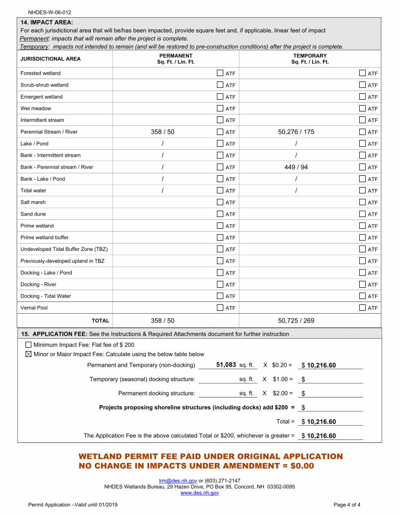
15. APPLICATION FEE: See the Instructions & Required Attachments document for further instruction
Minimum Impact Fee: Flat fee of $ 200 Minor or Major Impact Fee: Calculate using the below table below
Permanent and Temporary (non-docking) 51,083 sq. ft. X $0.20 = $ 10,216.60
Temporary (seasonal) docking structure: sq. ft. X $1.00 = $
Permanent docking structure: sq. ft. X $2.00 = $
Projects proposing shoreline structures (including docks) add $200 = $
Total = $ 10,216.60
The Application Fee is the above calculated Total or $200, whichever is greater = $ 10,216.60
14. IMPACT AREA:For each jurisdictional area that will be/has been impacted, provide square feet and, if applicable, linear feet of impactPermanent: impacts that will remain after the project is complete.Temporary: impacts not intended to remain (and will be restored to pre-construction conditions) after the project is complete.
JURISDICTIONAL AREA PERMANENT
Sq. Ft. / Lin. Ft. TEMPORARY
Sq. Ft. / Lin. Ft.
Forested wetland ATF ATF
Scrub-shrub wetland ATF ATF
Emergent wetland ATF ATF
Wet meadow ATF ATF
Intermittent stream ATF ATF
Perennial Stream / River 358 / 50 ATF 50,276 / 175 ATF
Lake / Pond / ATF / ATF
Bank - Intermittent stream / ATF / ATF
Bank - Perennial stream / River / ATF 449 / 94 ATF
Bank - Lake / Pond / ATF / ATF
Tidal water / ATF / ATF
Salt marsh ATF ATF
Sand dune ATF ATF
Prime wetland ATF ATF
Prime wetland buffer ATF ATF
Undeveloped Tidal Buffer Zone (TBZ) ATF ATF
Previously-developed upland in TBZ ATF ATF
Docking - Lake / Pond ATF ATF
Docking - River ATF ATF
Docking - Tidal Water ATF ATF
Vernal Pool ATF ATF
TOTAL 358 / 50 50,725 / 269
WETLAND PERMIT FEE PAID UNDER ORIGINAL APPLICATIONNO CHANGE IN IMPACTS UNDER AMENDMENT = $0.00
[email protected] or (603) 271-2147 NHDES Wetlands Bureau, 29 Hazen Drive, PO Box 95, Concord, NH 03302-0095
www.des.nh.gov
Wetlands Permit Application Attachment A – Revised 06/2021 Page 1 of 8
NHDES‐W‐06‐013 WETLANDS PERMIT APPLICATION – ATTACHMENT A
MINOR AND MAJOR ‐ 20 QUESTIONS Land Resources Management
Wetlands Bureau Check the Status of your application: www.des.nh.gov/onestop
RSA/ Rule: RSA 482‐A, Env‐Wt. 100‐900
Env‐Wt. 302.04 Requirements for Application Evaluation ‐ For any major or minor project, the applicant shall demonstrate by plan and example that the following factors have been considered in the project’s design in assessing the impact of the proposed project to areas and environments under the department’s jurisdiction. Respond with statements demonstrating:
1. The need for the proposed impact.
The need of this project and proposed impacts are to maintain the safety, integrity, reliability, and continuity of a vital local river crossing serving Thetford, VT and Lyme, NH by addressing the current structural deficiencies of the 84 years old existing bridge crossing the Connecticut River and removing this bridge from the New Hampshire Department of Transportation (NHDOT) red list.
A NHDOT inspection of the bridge and pier completed in the fall of 2013 indicated the bridge’s deteriorated condition is no longer capable of safely supporting legal loads and the bridge was subsequently posted at a 15‐ton load limit in 2014 and placed on the NHDOT’s bridge red list. Some repairs were made in the fall 2014; however, deterioration of the bridge floor system is still ongoing, and thus the 15‐ton posting was retained with the bridge remaining on the NHDOT’s red list. The inspection also found the existing concrete pier is in poor condition and must be rehabilitated at a minimum. The concrete pier has extensive cracking and spalling concrete and has exposed reinforcing steel above and below the waterline.
The proposed rehabilitation of the existing bridge project includes mostly temporary wetland impacts (50,725 SF) to conduct the bridge rehabilitation work including repairs to the existing 1937 riprap within the channel and along the bank at the existing NH bridge abutment (within the original riprap embankment footprint). The proposed project includes a small permanent impact (358 SF) necessary for the pier rehabilitation work in the river. See Figure 1 for the project location. See the attached Wetland Plans in Appendix A for details of the proposed impacts under this project.
2. That the alternative proposed by the applicant is the one with the least impact to wetlands or surface waters on site.
The proposed alternative is the most practical, least impacting to wetlands and surface waters with the utilization of temporary trestles to access the existing deteriorated bridge and pier. The temporary trestle access is proposed from the New Hampshire side of the river through vacant lot 22 to the south of the bridge. Since the bridge was originally constructed in 1937, a hydroelectric dam (Wilder Dam) located downstream of the bridge was constructed in 1950, which has increased the river depth and OHW. Due to the additional river depth and existing subsurface conditions, a temporary cofferdam is necessary to access and rehabilitate the existing pier. The temporary impact associated with the temporary trestle deck and bulkhead placed above the river in NH is 50,014 SF. The temporary impact for the trestle deck access in Vermont is 8,777 SF to the river and 172 LF along the Vermont river bank for the bridge abutment reconstruction. A temporary impact to the NH river bank of 125 SF is proposed and is associated with temporary construction access placed across lot 22 to access the river and trestle from lot 22 during the pier reconstruction and bridge abutment reconstruction.
In addition, the existing river bank and channel riprap adjacent to the bridge abutment is to be repaired within the original footprint embankment riprap shown on the original design plans. The temporary bank (324 SF) and channel (262 SF) repair totals to 586 SF along the bank/channel. In addition, the roadway drainage system on the NH side exists in close proximity to the “Toll House” on lot 23; and the stormwater outlet of this system is proposed to be relocated to the south side of the bridge at the downstream location and along and above the riprap repair location.
The permanent impact under this application is for the additional pier base size (width and length) for the concrete encasement and associated riprap repair to rehabilitate the existing pier of 358 SF. The total linear length of the rehabilitated pier is 50 LF along the river channel. The net total permanent impact area is 358 SF.
[email protected] or (603) 271-2147 NHDES Wetlands Bureau, 29 Hazen Drive, PO Box 95, Concord, NH 03302-0095
www.des.nh.gov
Wetlands Permit Application Attachment A – Revised 06/2021 Page 2 of 8
3. The type and classification of the wetlands involved.
The project wetland involved is the Connecticut River with a classification of Riverine, lower perennial, unconsolidated bottom, permanently flooded ‐ R2UBH and NHDES jurisdictional river bank.
4. The relationship of the proposed wetlands to be impacted relative to nearby wetlands and surface waters.
The Connecticut River is the low point of the watershed area relative to the nearby wetlands and surface waters and is the only wetland impacted by this project.
5. The rarity of the wetland, surface water, sand dunes, or tidal buffer zone area.
The Connecticut River is the largest river in the state and is identified as a Designated
River. The NH Natural Heritage Bureau (NHB) review – Exhibit D ‐ did not identify any
rarity of the wetlands or surface waters.
The project area is not located in a tidal area.
6. The surface area of the wetlands that will be impacted.
The surface area for the construction trestle and cofferdams in New Hampshire is 50,014 SF and the Vermont trestle portion is 8,777 SF, which are temporary impacts.
A temporary construction access from NH upon lot 22 is proposed to access the river and temporary trestle in the river to conduct the rehabilitation of the existing pier will impact 125 SF of bank during construction.
The project includes temporary bank impacts of 324 SF and channel (below OHW) impacts of 262 SF in New Hampshire (586 SF total) to repair the existing riprap slope at the bridge abutment within the original riprap footprint of the 1937 bridge design. A copy of the original 1937 riprap design detail sheet is included in the attached amended application plan set.
The proposed bridge pier rehabilitation will be permanent impact of 358 SF resulting from the proposed rehabilitation concrete encasement of the existing pier and associated riprap repair.
[email protected] or (603) 271-2147 NHDES Wetlands Bureau, 29 Hazen Drive, PO Box 95, Concord, NH 03302-0095
www.des.nh.gov
Wetlands Permit Application Attachment A – Revised 06/2021 Page 3 of 8
7. The impact on plants, fish and wildlife including, but not limited to: a. Rare, special concern species; b. State and federally listed threatened and endangered species; c. Species at the extremities of their ranges; d. Migratory fish and wildlife; e. Exemplary natural communities identified by the DRED‐NHB; and f. Vernal pools.
(a, b, c) A recent NH Natural Heritage Bureau (NHB) review – Exhibit D – and a US Fish and Wildlife Service (USFWS) IPAC review ‐ Exhibit E ‐ relative to the presence of Federal or State listed threatened and endangered or rare species, or natural communities of special or exemplary status was conducted for the project area. The USF&WS IPAC consultation review indicated Dwarf Wedgemussel (Alasmidonta heterodon) and Northern Long‐eared Bat (Myotis seprentrionalis), may occur in the project area.
A freshwater mussel survey in the Connecticut River within the project area was conducted on August 15 and 16, 2018 with none of the mussel species observed being federally or state listed. In addition, the recent NHB Data Check for the project area indicated that there are only historical records in the project area, and that several field surveys over the past 15 years by the Vermont Heritage Bureau failed to locate Dwarf Wedgemussel and the species is ‘presumed extirpated’. The NHDOT, on behalf of the FHWA, has determined that a finding of no effect on the Dwarf Wedgemussel is appropriate for this project. The letter noting the “no effect” determination (October 2, 2018) provided to the USFWS New England Field Office is located in Exhibit F.
The NHDOT has coordinated with the USFWS New England Field Office and has received a letter of concurrence (dated September 5, 2018) with the finding that the project may rely on the Northern Long‐eared Bat and NLEB Programmatic Biological Opinion (PBO) and that the project will have no effect to the NLEB. A bridge inspection conducted in August 2018 found no evidence of bat use at the project site. A copy of the consistency letter from USFWS is located in Exhibit G.
(d) The project will not impact migratory fish or wildlife. See correspondence from NOAA in Exhibit L.
(e.) No exemplary natural communities have been identified in the vicinity of the project. Highest Ranked Habitats and Conservation Focus Areas, per the NH Wildlife Action Plan, do not exist in or near the project area. See attached NHF&G map in Exhibit M .
(f) No vernal pools are present in the project area.
8. The impact of the proposed project on public commerce, navigation, and recreation.
The proposed project will have temporary impacts on public commerce during construction with the closure of the bridge and detours north and south. currently trucks over 15 tons are detoured north or south. Upon completion, the project will fully restore public commerce with the restoration of the bridge to full legal load limits and removal of the truck detour.
The proposed project will have temporary impacts to navigation and recreation along the westerly portion of the Connecticut River within the project areas due to the installation of the trestles and a cofferdam during construction. Navigation and recreation along the easterly side of the river will not be impacted and is to be maintained. Federal Highway (FHWA) on behalf of NHDOT corresponded to the US Coast Guard relative to the proposed rehabilitation and a permit is not required. See Exhibit N.
9. The extent to which a project interferes with the aesthetic interests of the general public. For example, where an applicant proposes the construction of a retaining wall on the bank of a lake, the applicant shall be required to indicate the type of material to be used and the effect of the construction of the wall on the view of other users of the lake.
Temporary interference of the aesthetic interests of the general public is anticipated during the 2‐year construction period with the proposed rehabilitation work to the bridge and pier and the encapsulation of the bridge during painting. As part of the Memorandum of Agreement (MOA) relative to the historic integrity of the bridge and bridge pier, the proposed replacement pier is to be similar to the existing pier and would preserve the existing aesthetic interest of the general public upon completion. The proposed painting of the existing bridge would likely provide an aesthetic improvement to the general public in the project area upon completion. A copy of the Adverse Effects Memo (Exhibit H) and Memorandum of Agreement (Exhibit I) are provided in application information.
[email protected] or (603) 271-2147 NHDES Wetlands Bureau, 29 Hazen Drive, PO Box 95, Concord, NH 03302-0095
www.des.nh.gov
Wetlands Permit Application Attachment A – Revised 06/2021 Page 4 of 8
10. The extent to which a project interferes with or obstructs public rights of passage or access. For example, where the applicant proposes to construct a dock in a narrow channel, the applicant shall be required to document the extent to which the dock would block or interfere with the passage through this area.
The proposed project will temporarily interfere and obstruct public rights of passage with the closure of the existing bridge during construction and detouring traffic north and south of the project area during the 2‐year construction period. Currently trucks over 15 tons are detoured north and south, due to the existing bridge load limits, and some public rights of passage and access in the project area are currently obstructed and interfered. Upon completion of the project and restoration of the bridge to full legal load limits, interference, and obstructions of the public rights of passage and access will be restored in the project area.
11. The impact upon abutting owners pursuant to RSA 482‐A:11, II. For example, if an applicant is proposing to rip‐rap a stream, the applicant shall be required to document the effect of such work on upstream and downstream abutting properties.
The proposed project is not intended to impact abutting owners upon completion of the bridge rehabilitation project. All disturbed areas adjacent to the abutting owners will be restored to the current conditions upon completion. However, during construction abutting property owners are likely to be impacted due the adjacent construction activities and closure of the bridge and use of detours to access the adjacent Town across the river.
12. The benefit of a project to the health, safety, and well‐being of the general public.
Upon completion of the bridge rehabilitation project, the general public's health, safety, and well‐being will be benefitted. The bridge will be restored to full legal loads to address public safety. Access between the adjacent communities for large/heavy vehicles including emergency vehicles will be restored to address health and well‐being.
[email protected] or (603) 271-2147 NHDES Wetlands Bureau, 29 Hazen Drive, PO Box 95, Concord, NH 03302-0095
www.des.nh.gov
Wetlands Permit Application Attachment A – Revised 06/2021 Page 5 of 8
13. The impact of a proposed project on quantity or quality of surface and ground water. For example, where an applicant proposes to fill wetlands the applicant shall be required to document the impact of the proposed fill on the amount of drainage entering the site versus the amount of drainage exiting the site and the difference in the quality of water entering and exiting the site.
The bridge rehabilitation project is not intended to impact/change the quantity or quality of the surface or ground water or change the amount of drainage entering the project site or the amount exiting the site. The existing drainage patterns (flow to the river) are to be maintained unchanged upon completion of the project.
14. The potential of a proposed project to cause or increase flooding, erosion, or sedimentation.
The project will implement standard erosion control measures on land to reduce the potential for erosion and sedimentation. A cofferdam with a silt boom curtain is to be used for the proposed pier construction to reduce the potential for sedimentation in the river. The proposed change to the pier, minor increase in size, is estimated to be less than 1% of the total cross‐sectional area of the 100‐year floodplain under the bridge. The proposed change to the existing pier is not anticipated to increase the potential for flooding upon completion of the project. As part of the project, the NH Office of Energy and Planning was consulted – See Exhibit 0. A memorandum relative to the proposed change to the pier is provided in Exhibit P.
15. The extent to which a project that is located in surface waters reflects or redirects current or wave energy which might cause damage or hazards.
The project proposes to rehabilitate the existing bridge pier in the river with one that is slightly larger and longer. The area of the rehabilitated pier will increase by 358 SF that includes an increased length of 4 feet (46 feet existing to 50 feet proposed) and increased width of 3 feet (existing 8 feet to proposed 11 feet). The bridge abutment embankment repair totaling 586 SF will be within the original riprap footprint. It is anticipated the project will not change the river current or wave energy from the original construction conditions.
[email protected] or (603) 271-2147 NHDES Wetlands Bureau, 29 Hazen Drive, PO Box 95, Concord, NH 03302-0095
www.des.nh.gov
Wetlands Permit Application Attachment A – Revised 06/2021 Page 6 of 8
16. The cumulative impact that would result if all parties owning or abutting a portion of the affected wetland or wetland complex were also permitted alterations to the wetland proportional to the extent of their property rights. For example, an applicant who owns only a portion of a wetland shall document the applicant’s percentage of ownership of that wetland and the percentage of that ownership that would be impacted.
The project proposes mostly temporary impacts, including repair of the existing riprap embankment slope within the original footprint at the NH bridge abutment, and only minor permanent impacts (358 SF) to the river for the rehabilitation of the existing bridge pier. Due to the uniqueness of this project, it is unlikely that abutters would seek to impact the Connecticut River to the same extent. However, should abutters seek to impact the river in a similar fashion, we would anticipate incremental permanent impacts to the river that would affect the functions and values provided by the river.
17. The impact of the proposed project on the values and functions of the total wetland or wetland complex.
The project proposes temporary impacts to the river and the river surface with the installation of temporary trestles and a cofferdam at the pier during construction that are not anticipated to impact the values and functions of the total river (wetland) upon completion. Some minor shading of the river in the vicinity of the temporary trestle is anticipated along with temporary river impacts for the piles supporting the trestle during construction, but upon completion of the project, the temporary shading and piles will be removed, and the river restored to the current condition.
Temporary river bank impacts are also anticipated during construction and the impact areas are to be restored to the current conditions upon completion of the rehabilitation work to the bridge abutments.
The construction of the rehabilitation encasement to the existing bridge pier will likely involve a temporary cofferdam to allow construction of the pier encasement. The small increase in size to the existing pier is not anticipated to impact the existing values and functions of the river.
[email protected] or (603) 271-2147 NHDES Wetlands Bureau, 29 Hazen Drive, PO Box 95, Concord, NH 03302-0095
www.des.nh.gov
Wetlands Permit Application Attachment A – Revised 06/2021 Page 7 of 8
18. The impact upon the value of the sites included in the latest published edition of the National Register of Natural Landmarks, or sites eligible for such publication.
There are no National Landmarks in proximity to this site.
The existing bridge is eligible for National Register and a Memorandum of Agreement (MOA) with the State of NH, State of Vermont and FWHA for the proposed bridge rehabilitation work has been executed. A copy of the Adverse Effect Memo (Exhibit H) and executed MOA (Exhibit I) are included in application submission.
19. The impact upon the value of areas named in acts of congress or presidential proclamations as national rivers, national wilderness areas, national lakeshores, and such areas as may be established under federal, state, or municipal laws for similar and related purposes such as estuarine and marine sanctuaries.
The portion of the Connecticut River that flows through the project area is Designated River under RSA 483 of the New Hampshire River Management and Protection Program as identified as a “Rural” river. The proposed rehabilitation of the existing bridge is intended to retain the value of the area by preserving and rehabilitating the existing bridge. In accordance with RSA 483, a copy of this wetland application is being sent to the Connecticut River Joint Commissions ‐ Upper Valley Subcommittee for their review.
20. The degree to which a project redirects water from one watershed to another.
The project does not redirect water from one watershed to another.
[email protected] or (603) 271-2147 NHDES Wetlands Bureau, 29 Hazen Drive, PO Box 95, Concord, NH 03302-0095
www.des.nh.gov
Wetlands Permit Application Attachment A – Revised 06/2021 Page 8 of 8
Additional comments
This wetland permit amendment is to address the following updates: • The change to the river access from Vermont to New Hampshire at lot 22 (319 River Road) and the associated
impacts under the final design. A copy of the temporary construction easement upon lot 22 for the temporary river access is provided as Exhibit V;
• To clarify the change to the bridge pier work from removal of the pier to rehabilitation of the existing pier under the final design. The amount of permanent impact associated with the pier work is unchanged;
• To clarify the proposed bridge repair/rehabilitation construction will not include a bridge slide and the bridge will remain in place for the rehabilitation work under the final design;
• To clarify the repair work needed to existing riprap embankment at the New Hampshire bridge abutment within the original 1937 riprap design footprint above and below the currently observed OHW line under final design;
• To include the changes to the stormwater system and relocated outlet pipe from the north side to the south side at the New Hampshire bridge abutment under final design.
The total amount of wetland impact is unchanged, and no additional fee is required. The amount of permanent impact is unchanged at 358 SF under the final design. With this amendment, there is additional temporary impact associated with the repair to the existing riprap embankment at the NH bridge abutment area within the 1937 riprap design footprint. This work is located above and below the current OHW line, which has increased from the original elevation at the time of bridge completion in 1937, approximately 8 feet higher with the 1950 construction of the Wilder Dam located downstream of the project. These two existing riprap embankment temporary impact areas are identified in the amendment. A copy of the original riprap detail sheet (Revised January 8, 1937) is included in the updated plan set as sheet 12, and two 1937 construction photographs are provided in Exhibit W. There are additional temporary bank impacts for the temporary access from the New Hampshire side of the river at lot 22. A wetland delineation was conducted for the temporary access area on the abutting parcel and a report is included in Exhibit S. The small additional temporary bank impact area for the temporary NH access (125 SF) is compensated with an approximate 4‐inch reduction in width of the original 130 ft wide trestle to meet the intent of minimizing impacts to the extent practical (resulting in a net zero change in temporary impacts project wide) and to avoid the need for additional fees. Also, the relocation of the stormwater outlet to the downstream side of the bridge will alleviate concerns with the stormwater outlet adjacent to the “Toll House”. The above noted changes to the permit under this amendment are incorporated in the attached and updated documents. Note that any unchanged exhibits have not been included in this amendment. A separate Shoreland Permit Application for the temporary NH access is forthcoming.
LYME, NH-THETFORD, VT 14460 Exhibit C Bridge Rehabilitation
Page 1 of 3
Env-Wt. 904.09 Alternative Design Amended TECHNICAL REPORT
Env-Wt 904.09(a) - If the applicant believes that installing the structure specified in the applicable rule is not practicable, the applicant may propose an alternative design in accordance with this section.
Please explain why the structure specified in the applicable rule is not practicable (Env-Wt 101.74 defines practicable as available and capable of being done after taking into consideration costs, existing technology, and logistics in light of overall project purposes.)
This document addresses compliance with Env-Wt 900 “Stream Crossings”. The Connecticut River has a watershed area of 276 square miles which makes this bridge a Tier 3 stream crossing. The project involves rehabilitating the existing steel truss bridge. As discussed at the March 20, 2019 NHDOT Natural Resources meeting at the NHDOT office in Concord, the project involves rehabilitating the existing historic bridge structure, which now includes the rehabilitation of the existing pier located in the river under this amendment. The work includes reconstruction of the rockfill slopes in front of the abutment walls. The final grades after reconstruction are intended to meet the existing grades. The work will also involve temporary bank impacts and temporary trestles placed in the river to allow access from New Hampshire to the bridge pier in the river and access the Vermont abutment. A temporary cofferdam will be used for the rehabilitation work to the existing pier. A Summary of the NHDOT Natural Resources meeting minutes has been provided with the wetland application.
The existing bridge passes the 100-year storm event. With the proposed improvements, including a rehabilitated and enlarged pier that is 358 SF larger than the existing, the bridge will pass the 100-year storm event with no measurable change in water surface elevation.
The rehabilitation of the existing bridge results in the least amount of construction and environmental impacts; and it is the least costly alternative relative to construction costs. The project did consider full replacement alternatives for replacement with without impact to historic integrity or replacement in another location downstream. While theses alternative would be in compliance with the NH Stream Crossing Guidelines, they were dismissed due to the substantial increase in environmental and property impacts, utility impacts, significant construction constraints, as well as higher construction costs as compared to the proposed rehabilitation. Therefore, adhering to the requirements of a fully compliant crossing is not practicable.
The no build alternative will not address the existing bridge which is in ‘fair’ condition, and without any improvements its condition will continue to decline to poor, eventually forcing the bridge to be closed. Therefore, this alternative was rejected.
The proposed alternative meets the specific design criteria for Tier 2 and Tier 3 crossings to the maximum extent practicable, as specified below.
Env-Wt 904.05 Design Criteria for Tier 2 and Tier 3 Stream Crossings – New Tier 2 stream crossings, replacement Tier 2 crossings that do not meet the requirements of Env-Wt 904.07, and new and replacement Tier 3 crossings shall be designed and constructed:
LYME, NH-THETFORD, VT 14460 Exhibit C Bridge Rehabilitation
Env-Wt. 904.09 Alternative Design Amended TECHNICAL REPORT
Page 2 of 3
(a) In accordance with the NH Stream Crossing Guidelines.The NH Stream Crossing Guidelines recommend that the crossing should be a span structure with a
width of 1.2 x Bankfull Width + 2 feet. The proposed rehabilitation will retain the existing abutments and single pier design. There is no change to the total span of the bridge. This criteria will not be met under the guidelines.
(b) With bed forms and streambed characteristics necessary to cause water depths and velocities withinthe crossing structure at a variety of flows to be comparable to those found in the natural channelupstream and downstream of the stream crossing. The bed forms and streambed characteristics will remain the same as they are today upon completion of the project.
(c) To provide a vegetated bank on both sides of the watercourse to allow for wildlife passage.The project will restore the existing riprap on the river banks under the bridge. This criteria will not
be met under the guidelines.
(d) To preserve the natural alignment and gradient of the stream channel, so as to accommodate naturalflow regimes and the functioning of the natural floodplain. The project does not change the current river channel alignment or gradient.
(e) To accommodate the 100-year frequency flood, to ensure that (1) there is no increase in flood stageson abutting properties; and (2) flow and sediment transport characteristics will not be affected in amanner which could adversely affect channel stability. The existing bridge passes the 100-year frequency flood and the bridge with the proposed improvements will continue to pass the 100-year storm event. No increase in flood stage is anticipated.
(f) To simulate a natural stream channel.The project does not propose to alter the natural stream channel upon completion. Temporary
impacts to the stream channel will occur during construction.
(g) So as not to alter sediment transport competence.Sediment transport competence will not be altered under the project.
Env-Wt 904.09(c)(3) – The alternative design must meet the general design criteria specified in Env-Wt 904.01:
Env-Wt 904.01 (a) Not be a barrier to sediment transport;
Sediment transport is accommodated by the existing bridge and will continue to be accommodated atthis crossing.
(b) Prevent the restriction of high flows and maintain existing low flows;High and low flows are accommodated at this crossing and will continue to be accommodated with
the bridge improvements.
LYME, NH-THETFORD, VT 14460 Exhibit C Bridge Rehabilitation
Env-Wt. 904.09 Alternative Design Amended TECHNICAL REPORT
Page 3 of 3
(c) Not obstruct or otherwise substantially disrupt the movement of aquatic life indigenous to the waterbody beyond the actual duration of construction; There will be no obstructions or disruptions to the movement of aquatic life indigenous to the waterbody beyond the duration of construction. (d) Not cause an increase in the frequency of flooding or overtopping of banks; The bridge improvements will not cause an increase in the frequency of flooding or overtopping of banks. (e) Preserve watercourse connectivity where it currently exists; Watercourse connectivity exists today and will continue to exist with the bridge improvements. (f) Restore watercourse connectivity where: (1) Connectivity previously was disrupted as a result of human activity(ies); and (2) Restoration of connectivity will benefit aquatic life upstream or downstream of the crossing, or both; Not applicable to this project. (g) Not cause erosion, aggradation, or scouring upstream or downstream of the crossing; and The existing bridge does not cause erosion, aggradation, or scouring upstream or downstream of the crossing, nor will it upon completion of construction. The existing riprap on the river banks under the bridge will be restored upon completion of the project. (h) Not cause water quality degradation. The proposed bridge improvements will not cause water quality degradation. Erosion and sediment controls will be utilized during construction to protect water quality in the Connecticut River.
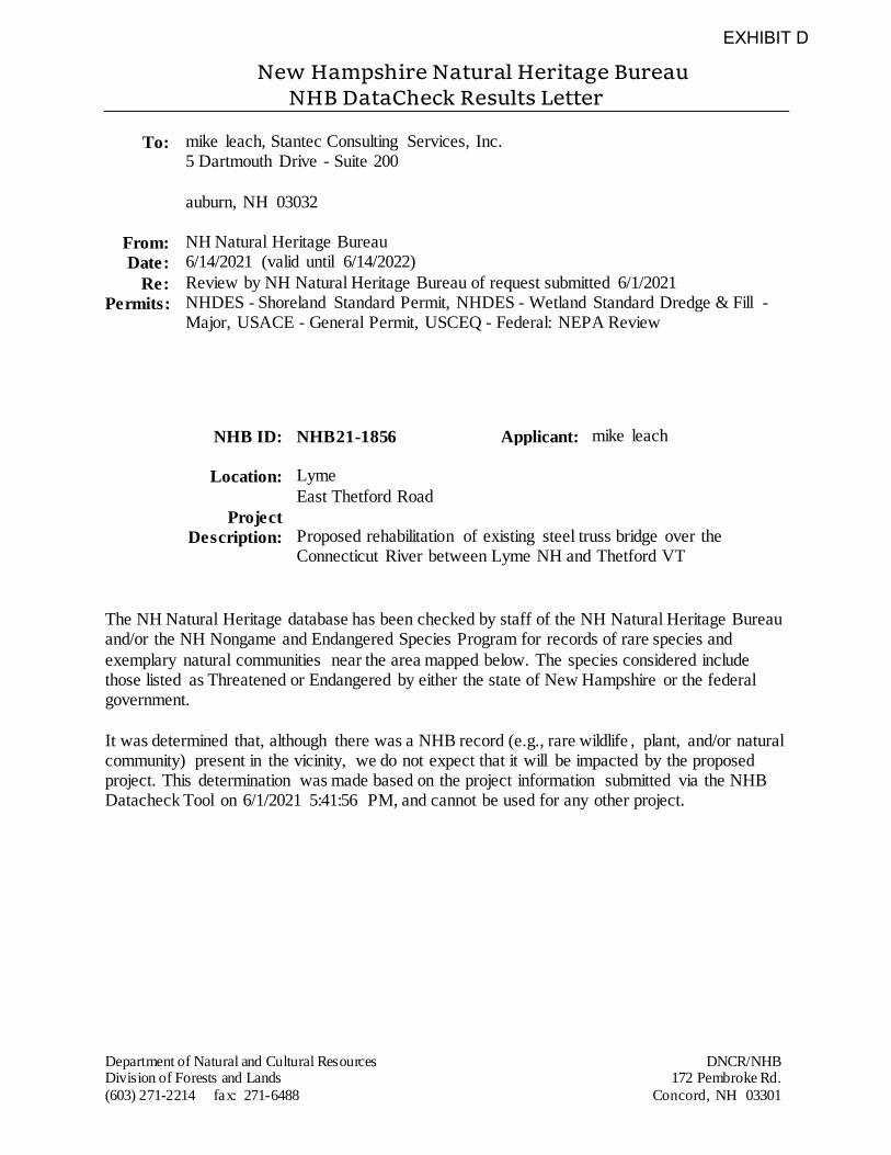
New Hampshire Natural Heritage Bureau NHB DataCheck Results Letter
Department of Natural and Cultural Resources DNCR/NHB Division of Forests and Lands 172 Pembroke Rd.
(603) 271-2214 fax: 271-6488 Concord, NH 03301
To: mike leach, Stantec Consulting Services, Inc. 5 Dartmouth Drive - Suite 200
auburn, NH 03032
From: NH Natural Heritage Bureau
Date: 6/14/2021 (valid until 6/14/2022)
Re: Review by NH Natural Heritage Bureau of request submitted 6/1/2021
Permits: NHDES - Shoreland Standard Permit, NHDES - Wetland Standard Dredge & Fill - Major, USACE - General Permit, USCEQ - Federal: NEPA Review
NHB ID: NHB21-1856 Applicant: mike leach
Location: Lyme
East Thetford Road
Project
Description:
Proposed rehabilitation of existing steel truss bridge over the Connecticut River between Lyme NH and Thetford VT
The NH Natural Heritage database has been checked by staff of the NH Natural Heritage Bureau and/or the NH Nongame and Endangered Species Program for records of rare species and
exemplary natural communities near the area mapped below. The species considered include those listed as Threatened or Endangered by either the state of New Hampshire or the federal government.
It was determined that, although there was a NHB record (e.g., rare wildlife , plant, and/or natural community) present in the vicinity, we do not expect that it will be impacted by the proposed project. This determination was made based on the project information submitted via the NHB Datacheck Tool on 6/1/2021 5:41:56 PM, and cannot be used for any other project.
EXHIBIT D
New Hampshire Natural Heritage Bureau NHB DataCheck Results Letter
Department of Natural and Cultural Resources DNCR/NHB Division of Forests and Lands 172 Pembroke Rd.
(603) 271-2214 fax: 271-6488 Concord, NH 03301
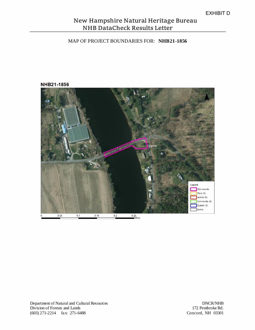
MAP OF PROJECT BOUNDARIES FOR: NHB21-1856
EXHIBIT D
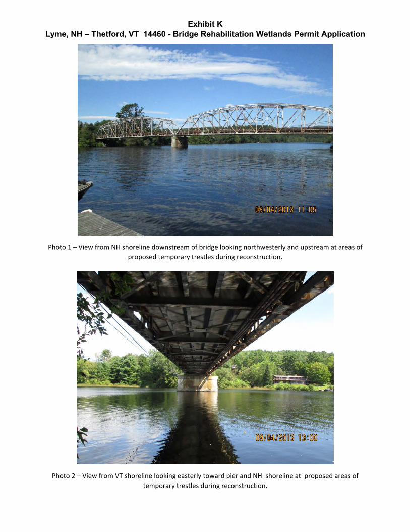
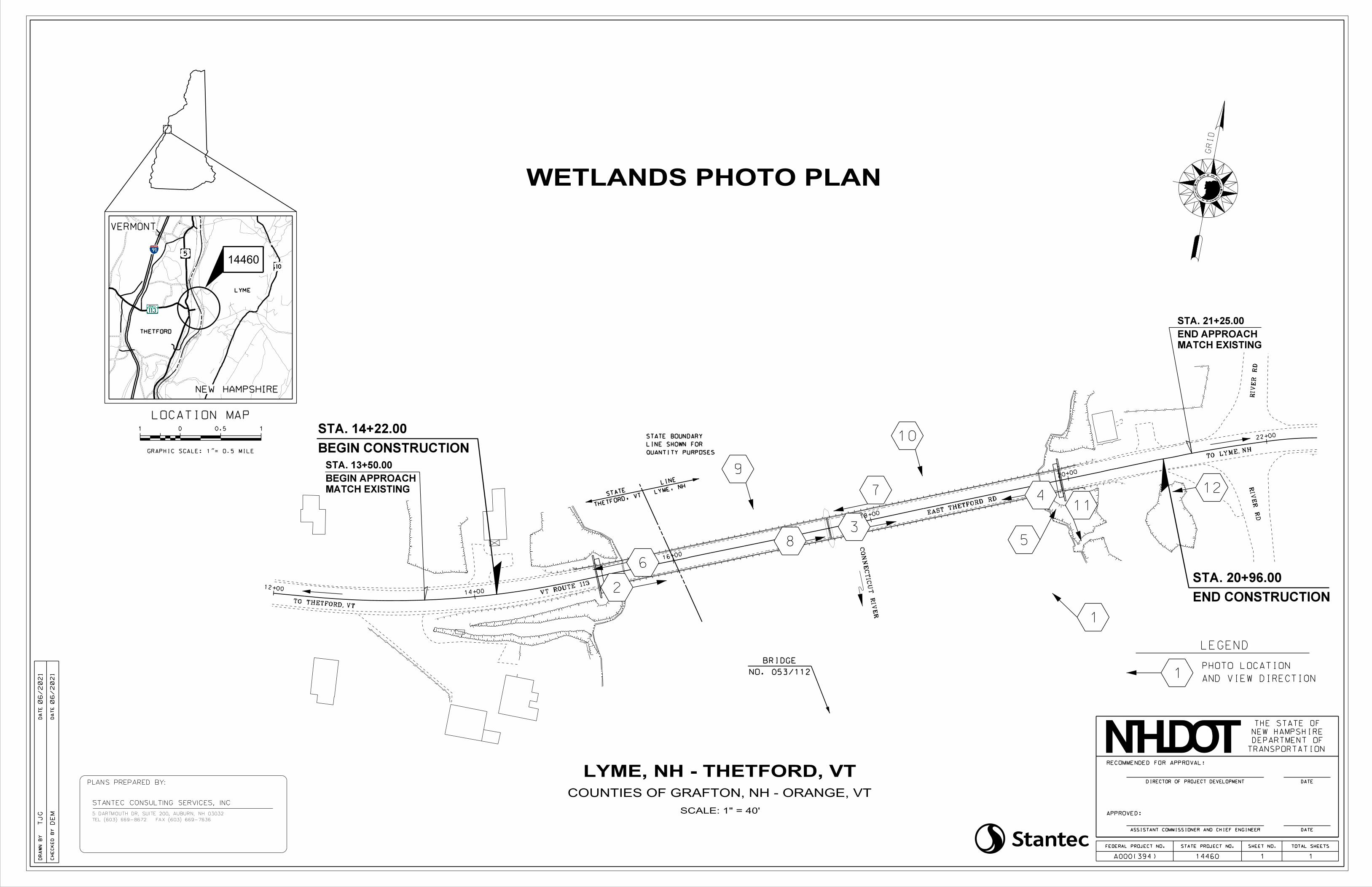
Exhibit K Lyme, NH – Thetford, VT 14460 - Bridge Rehabilitation Wetlands Permit Application
Photo 1 – View from NH shoreline downstream of bridge looking northwesterly and upstream at areas of
proposed temporary trestles during reconstruction.
Photo 2 – View from VT shoreline looking easterly toward pier and NH shoreline at proposed areas of
temporary trestles during reconstruction.
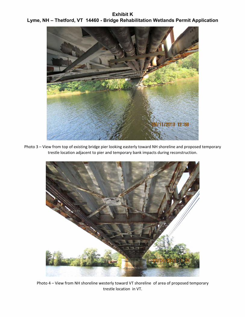
Exhibit K Lyme, NH – Thetford, VT 14460 - Bridge Rehabilitation Wetlands Permit Application
Photo 3 – View from top of existing bridge pier looking easterly toward NH shoreline and proposed temporary
trestle location adjacent to pier and temporary bank impacts during reconstruction.
Photo 4 – View from NH shoreline westerly toward VT shoreline of area of proposed temporary
trestle location in VT.
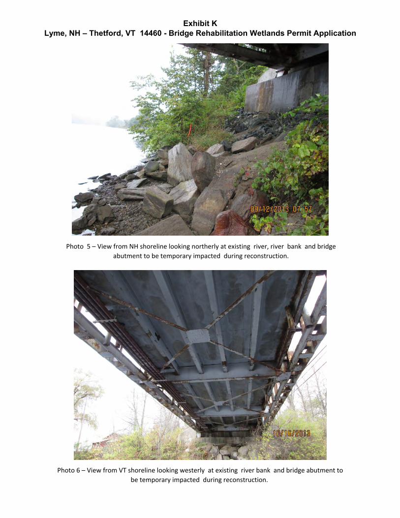
Exhibit K Lyme, NH – Thetford, VT 14460 - Bridge Rehabilitation Wetlands Permit Application
Photo 5 – View from NH shoreline looking northerly at existing river, river bank and bridge abutment to be temporary impacted during reconstruction.
Photo 6 – View from VT shoreline looking westerly at existing river bank and bridge abutment to
be temporary impacted during reconstruction.
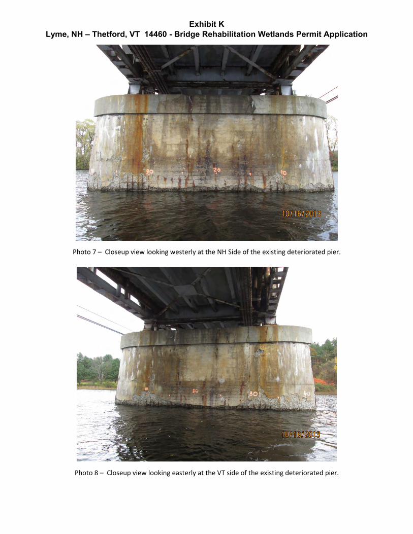
Exhibit K Lyme, NH – Thetford, VT 14460 - Bridge Rehabilitation Wetlands Permit Application
Photo 7 – Closeup view looking westerly at the NH Side of the existing deteriorated pier.
Photo 8 – Closeup view looking easterly at the VT side of the existing deteriorated pier.
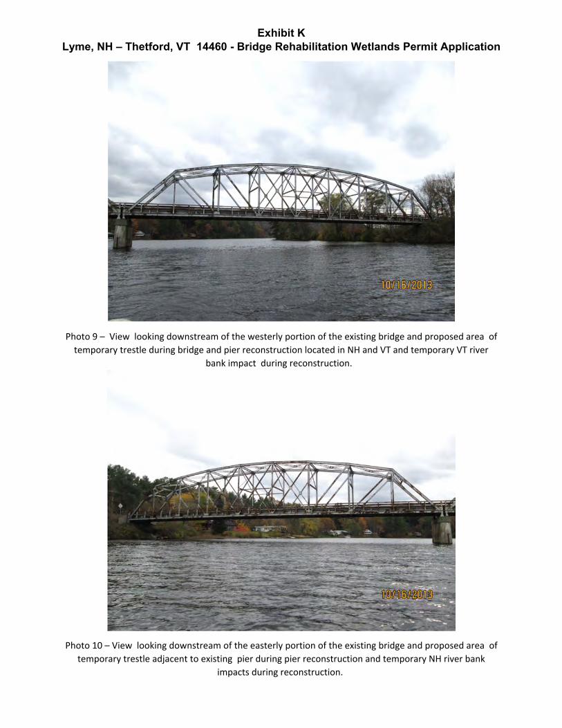
Exhibit K Lyme, NH – Thetford, VT 14460 - Bridge Rehabilitation Wetlands Permit Application
Photo 9 – View looking downstream of the westerly portion of the existing bridge and proposed area of
temporary trestle during bridge and pier reconstruction located in NH and VT and temporary VT river
bank impact during reconstruction.
Photo 10 – View looking downstream of the easterly portion of the existing bridge and proposed area of
temporary trestle adjacent to existing pier during pier reconstruction and temporary NH river bank
impacts during reconstruction.
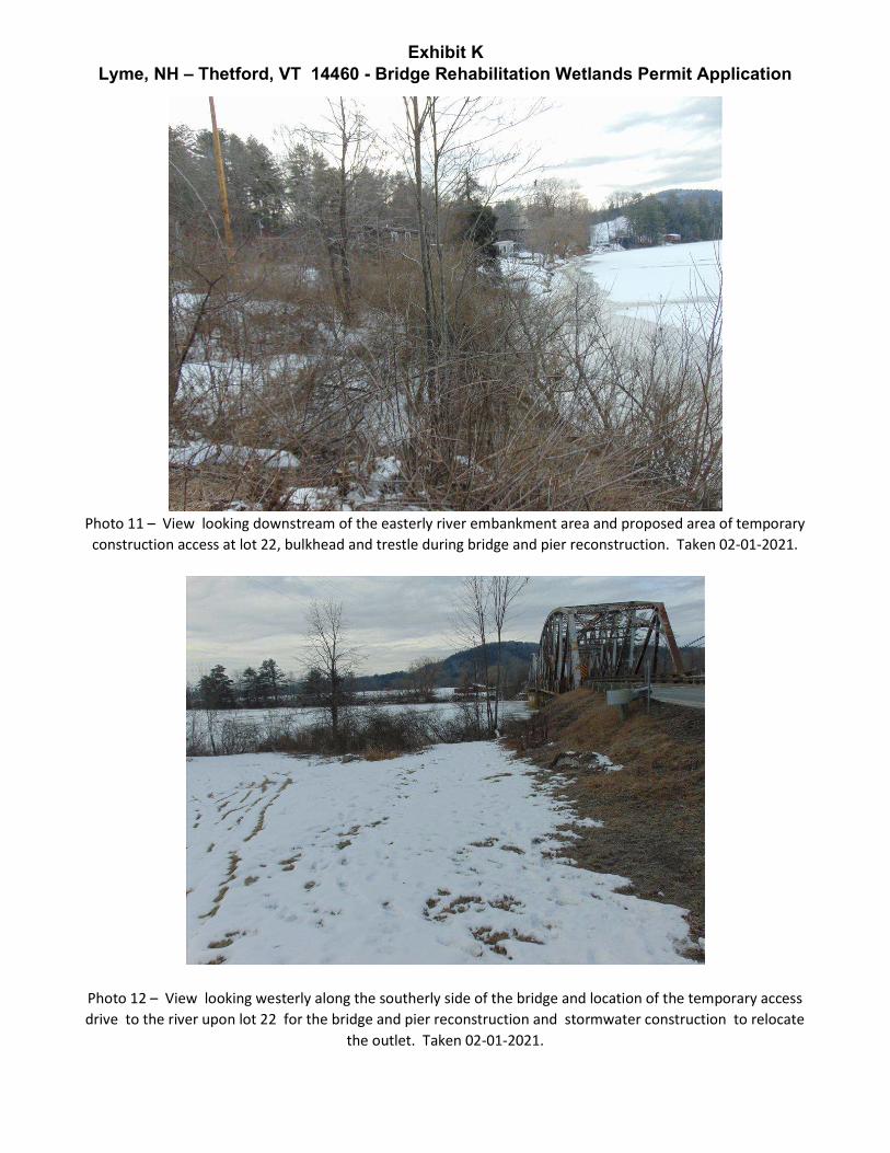
Exhibit K Lyme, NH – Thetford, VT 14460 - Bridge Rehabilitation Wetlands Permit Application
Photo 11 – View looking downstream of the easterly river embankment area and proposed area of temporary construction access at lot 22, bulkhead and trestle during bridge and pier reconstruction. Taken 02-01-2021.
Photo 12 – View looking westerly along the southerly side of the bridge and location of the temporary access drive to the river upon lot 22 for the bridge and pier reconstruction and stormwater construction to relocate
the outlet. Taken 02-01-2021.
LOCATION MAP
0
CH
EC
KE
D
BY
DR
AW
N
BY
DA
TE
DA
TE
DE
M
TJ
G
TEL (603) 669-8672 FAX (603) 669-7636
STANTEC CONSULTING SERVICES, INC
PLANS PREPARED BY:
5 DARTMOUTH DR, SUITE 200, AUBURN, NH 03032
ASSISTANT COMMISSIONER AND CHIEF ENGINEER DATE
APPROVED:
RECOMMENDED FOR APPROVAL:
DIRECTOR OF PROJECT DEVELOPMENT DATE
NEW HAMPSHIRE
DEPARTMENT OF
TRANSPORTATION
THE STATE OF
TOTAL SHEETSSHEET NO.STATE PROJECT NO.FEDERAL PROJECT NO.
1A000(394)
TE
H
STATE OF NEW H
AM
PS
HI
REDE
PA
RT
ME
NT
OF TRANSPOR
T
ATI
ON
GRI
D
SCALE: 1" = 40'
06/2021
06/2021
LYME, NH - THETFORD, VT
COUNTIES OF GRAFTON, NH - ORANGE, VT
14460
12+0014+00
16+00
18+00
20+00
22+00
0.5 11
GRAPHIC SCALE: 1"= 0.5 MILE
VERMONT
NEW HAMPSHIRE
THETFORD
LYME
1
14460
MATCH EXISTING
BEGIN APPROACH
STA. 13+50.00
MATCH EXISTING
STA. 21+25.00
END APPROACH
WETLANDS PHOTO PLAN
1
2
6
3
4
5
7
8
10
9
LEGEND
AND VIEW DIRECTION
PHOTO LOCATION
1
12
11EAST T
HETFORD RD
RIV
ER
RD
RIV
ER
RD
NO. 053/112
BRIDGE
TO LYME, NH
THETFORD, VTSTATE LYME,
NHLINE
CO
NN
EC
TIC
UT
RIV
ER
TO THETFORD, VT
QUANTITY PURPOSES
LINE SHOWN FOR
STATE BOUNDARY
BEGIN CONSTRUCTION
STA. 14+22.00
END CONSTRUCTION
STA. 20+96.00VT ROUTE 1
13
U
� Stantec
To:
File:
Project File
Auburn, NH
195311395 Lyme, NH - Thetford, VTEast Thetford Road over the Connecticut River
From:
Date:
Gerard Fortin, PE Senior Principal
Auburn, NH
April 12, 2018
Revised June 3, 2021
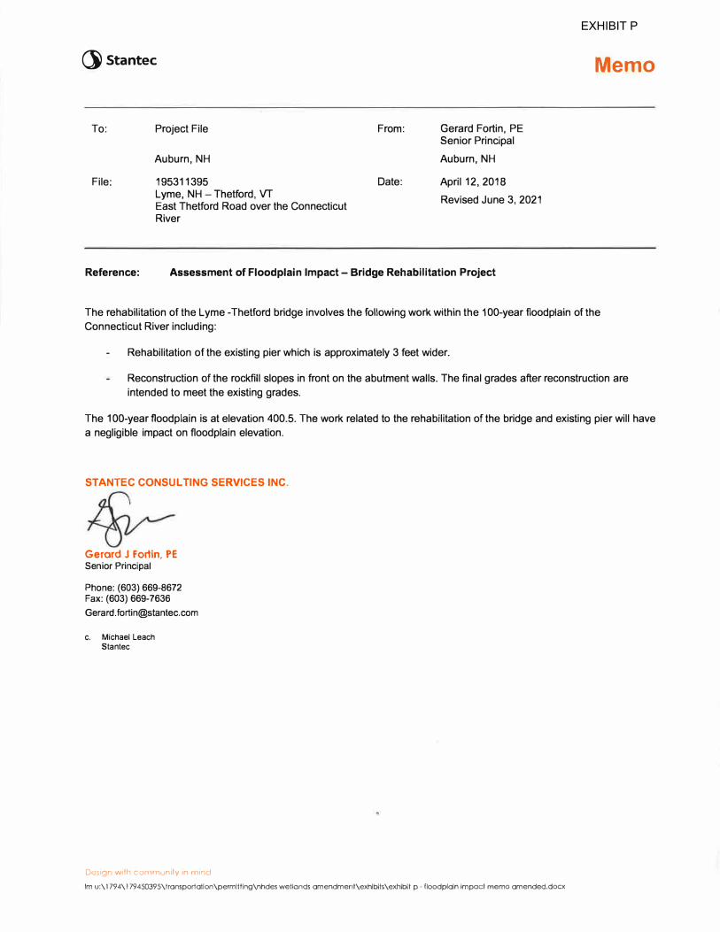
Reference: Assessment of Floodplain Impact - Bridge Rehabilitation Project
Memo
The rehabilitation of the Lyme -Thetford bridge involves the following work within the 100-year floodplain of the
Connecticut River including:
Rehabilitation of the existing pier which is approximately 3 feet wider.
Reconstruction of the rockfill slopes in front on the abutment walls. The final grades after reconstruction are
intended to meet the existing grades.
The 100-year floodplain is at elevation 400.5. The work related to the rehabilitation of the bridge and existing pier will have
a negligible impact on floodplain elevation.
STANTEC CONSUL TING SERVICES INC.
Gerard J Fortin, PE Senior Principal
Phone: (603) 669-8672 Fax: (603) 669-7636
c. Michael Leach
Staniec
Design with community in mind
Im u:\ 1794\ l 79450395\transportation\permitting\nhdes wetlands amendment\exhibits\exhibit p - floodplain impact memo amended.docx
EXHIBIT P
Stantec Consulting Services Inc. 30 Park Drive, Topsham, ME 04086-1737
June 9, 2021 File: 179450395
Attention: Michael Leach Stantec Consulting Services Inc. 5 Dartmouth Drive, Suite 200 Auburn, NH 03032-3984
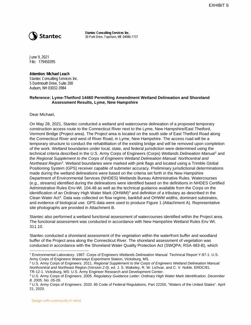
Reference: Lyme-Thetford 14460 Permitting Amendment Wetland Delineation and Shoreland Assessment Results, Lyme, New Hampshire
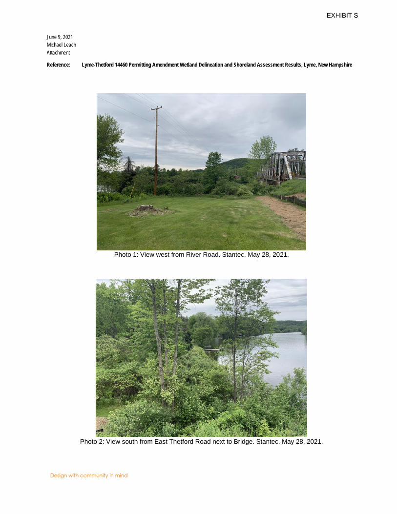
Dear Michael, On May 28, 2021, Stantec conducted a wetland and watercourse delineation of a proposed temporary construction access route to the Connecticut River next to the Lyme, New Hampshire/East Thetford, Vermont Bridge (Project area). The Project area is located on the south side of East Thetford Road along the Connecticut River and west of River Road, in Lyme, New Hampshire. The access road will be a temporary structure to conduct the rehabilitation of the existing bridge and will be removed upon completion of the work. Wetland boundaries under local, state, and federal jurisdiction were determined using the technical criteria described in the U.S. Army Corps of Engineers (Corps) Wetlands Delineation Manual1 and the Regional Supplement to the Corps of Engineers Wetland Delineation Manual: Northcentral and Northeast Region2. Wetland boundaries were marked with pink flags and located using a Trimble Global Positioning System (GPS) receiver capable of submeter accuracy. Preliminary jurisdictional determinations made during the wetland delineations were based on the criteria set forth in the New Hampshire Department of Environmental Services (NHDES) Wetlands Bureau Administrative Rules. Watercourses (e.g., streams) identified during the delineations were identified based on the definitions in NHDES Certified Administrative Rules Env-Wt. 104.48 as well as the technical guidance available from the Corps on the identification of an Ordinary High Water Mark (OHWM)3 and definition of a tributary as described in the Clean Water Act4. Data was collected on flow regime, bankfull and OHWM widths, dominant substrates, and evidence of biological use. GPS data were used to produce Figure 1 (Attachment A). Representative site photographs are provided in Attachment B. Stantec also performed a wetland functional assessment of watercourses identified within the Project area. The functional assessment was conducted in accordance with New Hampshire Wetland Rules Env Wt. 311.10. Stantec conducted a shoreland assessment of the vegetation within the waterfront buffer and woodland buffer of the Project area along the Connecticut River. The shoreland assessment of vegetation was conducted in accordance with the Shoreland Water Quality Protection Act (SWQPA; RSA 483-B), which 1 Environmental Laboratory. 1987. Corps of Engineers Wetlands Delineation Manual. Technical Report Y-87-1. U.S. Army Corps of Engineers Waterways Experiment Station, Vicksburg, MS. 2 U.S. Army Corps of Engineers. 2011. Regional Supplement to the Corps of Engineers Wetland Delineation Manual: Northcentral and Northeast Region (Version 2.0), ed. J. S. Wakeley, R. W. Lichvar, and C. V. Noble. ERDC/EL TR-12-1. Vicksburg, MS: U.S. Army Engineer Research and Development Center. 3 U.S. Army Corps of Engineers. 2005. Regulatory Guidance Letter: Ordinary High Water Mark Identification. December 8, 2005. No. 05-05. 4 U.S. Army Corps of Engineers. 2020. 85 Code of Federal Regulations, Part 22250, “Waters of the United States”. April 21, 2020.
EXHIBIT S
June 9, 2021 Michael Leach Page 2 of 5
Reference: Lyme-Thetford 14460 Permitting Amendment Wetland Delineation and Shoreland Assessment Results, Lyme, New Hampshire
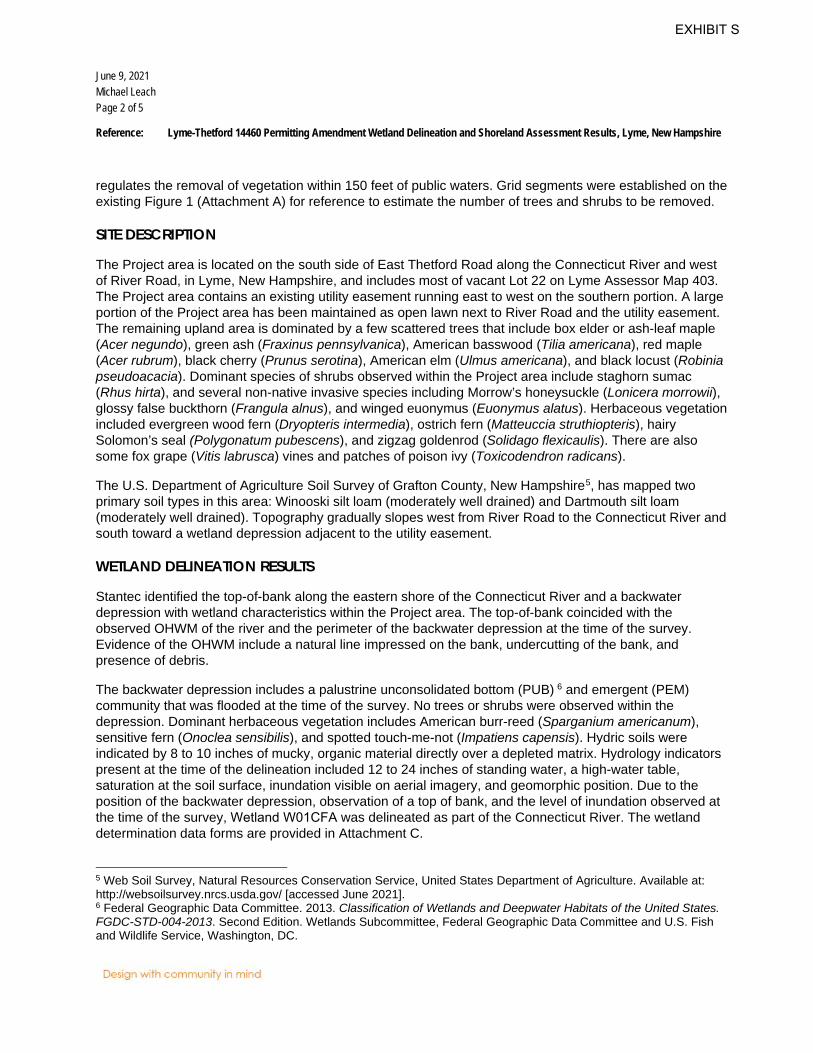
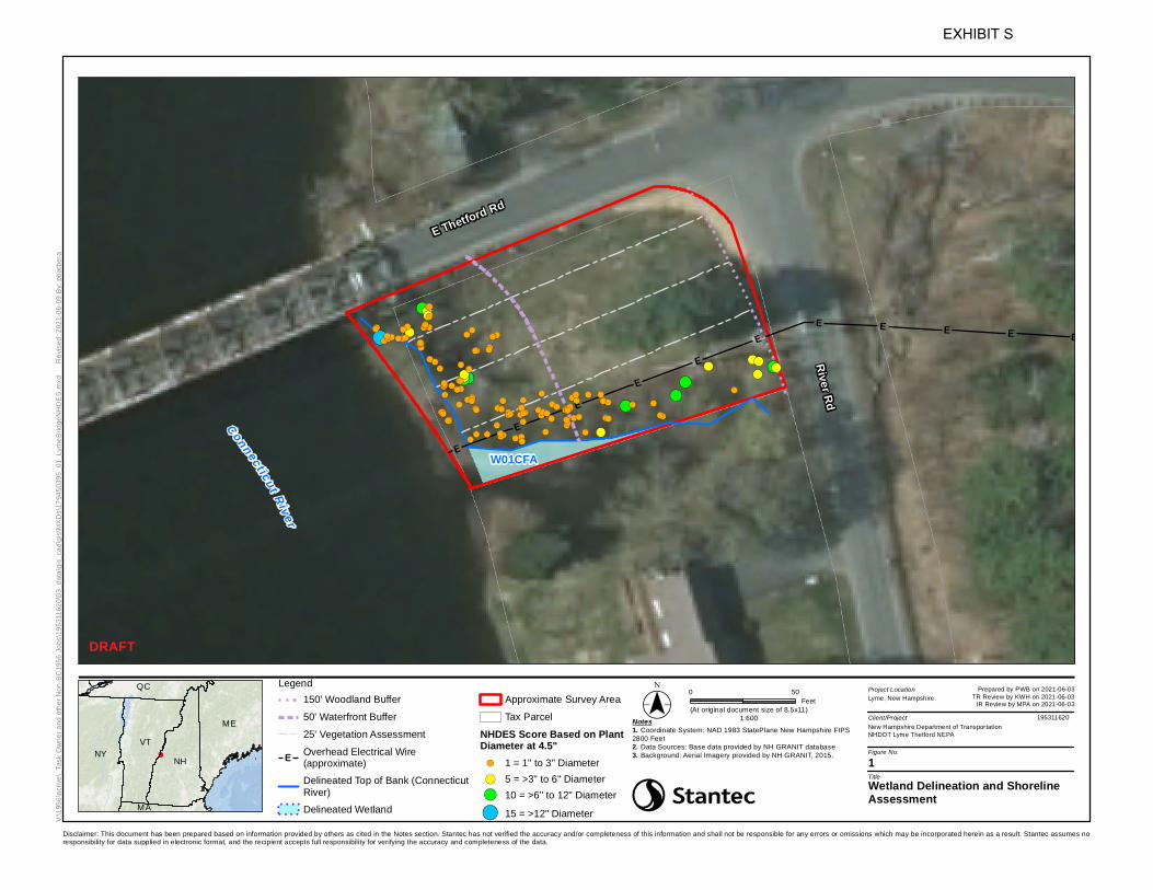
regulates the removal of vegetation within 150 feet of public waters. Grid segments were established on the existing Figure 1 (Attachment A) for reference to estimate the number of trees and shrubs to be removed.
SITE DESCRIPTION
The Project area is located on the south side of East Thetford Road along the Connecticut River and west of River Road, in Lyme, New Hampshire, and includes most of vacant Lot 22 on Lyme Assessor Map 403. The Project area contains an existing utility easement running east to west on the southern portion. A large portion of the Project area has been maintained as open lawn next to River Road and the utility easement. The remaining upland area is dominated by a few scattered trees that include box elder or ash-leaf maple (Acer negundo), green ash (Fraxinus pennsylvanica), American basswood (Tilia americana), red maple (Acer rubrum), black cherry (Prunus serotina), American elm (Ulmus americana), and black locust (Robinia pseudoacacia). Dominant species of shrubs observed within the Project area include staghorn sumac (Rhus hirta), and several non-native invasive species including Morrow’s honeysuckle (Lonicera morrowii), glossy false buckthorn (Frangula alnus), and winged euonymus (Euonymus alatus). Herbaceous vegetation included evergreen wood fern (Dryopteris intermedia), ostrich fern (Matteuccia struthiopteris), hairy Solomon’s seal (Polygonatum pubescens), and zigzag goldenrod (Solidago flexicaulis). There are also some fox grape (Vitis labrusca) vines and patches of poison ivy (Toxicodendron radicans). The U.S. Department of Agriculture Soil Survey of Grafton County, New Hampshire5, has mapped two primary soil types in this area: Winooski silt loam (moderately well drained) and Dartmouth silt loam (moderately well drained). Topography gradually slopes west from River Road to the Connecticut River and south toward a wetland depression adjacent to the utility easement.
WETLAND DELINEATION RESULTS
Stantec identified the top-of-bank along the eastern shore of the Connecticut River and a backwater depression with wetland characteristics within the Project area. The top-of-bank coincided with the observed OHWM of the river and the perimeter of the backwater depression at the time of the survey. Evidence of the OHWM include a natural line impressed on the bank, undercutting of the bank, and presence of debris. The backwater depression includes a palustrine unconsolidated bottom (PUB) 6 and emergent (PEM) community that was flooded at the time of the survey. No trees or shrubs were observed within the depression. Dominant herbaceous vegetation includes American burr-reed (Sparganium americanum), sensitive fern (Onoclea sensibilis), and spotted touch-me-not (Impatiens capensis). Hydric soils were indicated by 8 to 10 inches of mucky, organic material directly over a depleted matrix. Hydrology indicators present at the time of the delineation included 12 to 24 inches of standing water, a high-water table, saturation at the soil surface, inundation visible on aerial imagery, and geomorphic position. Due to the position of the backwater depression, observation of a top of bank, and the level of inundation observed at the time of the survey, Wetland W01CFA was delineated as part of the Connecticut River. The wetland determination data forms are provided in Attachment C.
5 Web Soil Survey, Natural Resources Conservation Service, United States Department of Agriculture. Available at: http://websoilsurvey.nrcs.usda.gov/ [accessed June 2021]. 6 Federal Geographic Data Committee. 2013. Classification of Wetlands and Deepwater Habitats of the United States. FGDC-STD-004-2013. Second Edition. Wetlands Subcommittee, Federal Geographic Data Committee and U.S. Fish and Wildlife Service, Washington, DC.
EXHIBIT S
June 9, 2021 Michael Leach Page 3 of 5
Reference: Lyme-Thetford 14460 Permitting Amendment Wetland Delineation and Shoreland Assessment Results, Lyme, New Hampshire
WETLAND FUNCTIONAL ASSESSMENT
Stantec performed a wetland functional assessment of the watercourses within the Project area. Potential impacts include the construction of a temporary access ramp for the rehabilitation of the existing bridge over the Connecticut River. Stantec conducted the functional assessment to provide additional information on the Connecticut River. Wetland and watercourse functions and values were evaluated through direct field observation and a review of existing public data resources following the Corps The Highway Methodology Workbook Supplement, Wetland Functions and Values: A Descriptive Approach7 and the New Hampshire Method for evaluating the Ecological Integrity of the wetland and stream (RSA 482-A:2, XI). The Wetland Functional Assessment Worksheet and required wildlife and vegetation list is included in Attachment D. The required wetland delineation plans and photographs are included in attachments A and B, respectively. Ecological Integrity, Fish & Aquatic Life Habitat, Flood Storage, Sediment Trapping, Uniqueness/Heritage, Wetland-based Recreation, and Wetland-dependent Wildlife Habitat were determined to be the principal functions of the Connecticut River.
SHORELAND ASSESSMENT RESULTS
Stantec identified and measured the diameter of a total of 138 trees and shrubs within the Project area along the shore of the Connecticut River. Several of the trees and shrubs are single stems originating from a tree or shrub with multiple stems. A total of 52 of the trees and shrubs are non-native invasive species. Table 1 (Attachment E) contains the plant identification number, species, diameter at breast height (DBH; at 4.5 feet), and relative point score for each tree and shrub observed. Figure 1 (Attachments A) shows the location of each tree and shrub observed as circular points of different sizes and colors for each score (1 – orange, 5 – yellow, 10 – green, and 15 – blue). Based on the Construction Access and Right-Of-Way Plan for the State of New Hampshire Department of Transportation, the proposed temporary access ramp to the Connecticut River would be approximately 20 to 30 feet wide and located south of East Thetford Road and north of the existing utility easement and backwater depression (wetland W01CFA) identified within the Project area. Approximately 32 trees and shrubs with a DBH of 1 inch or greater were identified within the proposed area for the access ramp (center segment Figure 1); 19 of these trees and shrubs were non-native invasive species.
REGULATORY DISCUSSION
The Corps and NHDES regulate the wetlands and waterbodies identified within the survey area. Under the provisions of Section 404 of the Clean Water Act, the Corps regulates activities within Waters of the United States, which include navigable waters, such as the Connecticut River, and all their tributaries, adjacent wetlands, and other waters or wetlands where degradation or destruction could affect interstate or foreign commerce. For most projects, the Corps and NHDES review process is merged, unless proposed impacts exceed thresholds reviewable under the NH Programmatic General Permit (e.g., >3 acres of proposed
7 U.S. Army Corps of Engineers. 1999. The Highway Methodology Workbook Supplement, Wetland Functions and Values: A Descriptive Approach. U.S. Army Corps of Engineers. New England Division. 32pp. NAEEP- 360-1-30a.
EXHIBIT S

June 9, 2021 Michael Leach Page 4 of 5
Reference: Lyme-Thetford 14460 Permitting Amendment Wetland Delineation and Shoreland Assessment Results, Lyme, New Hampshire
impacts to inland wetlands or waterways), which would require an Individual Permit application review by the Corps. Wetlands and waterbodies, as well as other protected natural resources, are regulated by NHDES under RSA 482-A and RSA 483-B. A permit from NHDES is required to dredge, fill, or build a structure in a wetland, surface water, or land within 100 feet of a municipally designated prime wetland or tidal waters. Projects proposing jurisdictional impacts of 10,000 square feet or greater will require a compensatory mitigation plan to be submitted to NHDES with the permit application. NHDES permitting categories are classified as Minimum, Minor, and Major projects. The following provides a general summary of relevant impacts corresponding to the Major Project permitting category, which is likely to apply to a project of this size given the number of wetlands identified on the Project Site: • Projects that involve alteration of nontidal wetlands, nontidal surface waters, and banks adjacent to
nontidal surface waters in excess of 20,000 square feet in the aggregate.• Projects which, when taken in the aggregate with previous work on the property within the last 5 years,
would be considered major. For example, if previous work on the property was fill of 15,000 square feetof nontidal wetlands and an individual applies to fill an additional 15,000 square feet of nontidalwetlands on the property, the application shall be deemed to be for a major project.
• Projects located in or adjacent to prime wetlands.• Removal of more than 20 cubic yards of rock, gravel, sand, mud, or other material from public waters.• Projects that alter the course of or disturb 200 or more linear feet of an intermittent or perennial nontidal
stream or river channel or its banks.• Projects in a wetland that have been identified by Natural Heritage Inventory – Department of
Resources and Economic Development as an exemplary natural community and/or that hasdocumented occurrences of state or federally listed Endangered or Threatened species.
Activities within 0.25 miles of designated rivers8 are regulated under the Shoreland Water Quality Protection Act RSA 483-B. A state Shoreland Permit is required for most new construction, excavation, and filling activities within the Protected Shoreland (250 feet from reference line) of NHDES designated rivers, lakes, and ponds. The Connecticut River is a Designated River identified within the survey area that falls under the jurisdiction of the Shoreland Water Quality Protection Act. Under RSA 482-A:15 and administrative rules Env-Wt. 700, individual municipalities may elect to designate wetlands as “prime-wetlands” if, after thorough analysis, it is determined that high-quality wetlands are present. Typically, a wetland receives this designation because of its large size, unspoiled character, and ability to sustain populations of rare or threatened plant and animal species. There are no prime wetlands identified in the Town of Lyme. The NHDES Wetland Rules group selected high-value wetland resource areas into a new category known as “Priority Resource Area” (PRA)9. A PRA is an area protected under the Wetlands law, RSA 482-A. A
8 NHDES Designated Rivers: https://www.des.nh.gov/organization/divisions/water/wmb/rivers/desigriv.htm 9 NHDES PRA Environmental Fact Sheet: https://www.des.nh.gov/organization/commissioner/pip/factsheets/wet/ documents/wb-25.pdf
EXHIBIT S
June 9, 2021 Michael Leach Page 5 of 5
Reference: Lyme-Thetford 14460 Permitting Amendment Wetland Delineation and Shoreland Assessment Results, Lyme, New Hampshire
PRA has one or more of the following characteristics: 1) Protected species or habitat; 2) A bog; 3) Is a wetland in a floodplain of a river where the location has a drainage area of at least 1 square mile or is a tidal area; 4) A designated prime wetland or a duly-established 100-foot buffer to a prime wetland; and/or 5) Is a sand dune, tidal wetland, tidal water, or undeveloped tidal buffer zone (Env-Wt. 103.65). Based on review of the NHDES Wetlands Permit Planning Tool10 and the results of the wetland and watercourse delineation, no PRA wetlands were identified in the Project area. Stantec contacted the New Hampshire Natural Heritage Bureau (NHB) to determine the presence/absence of rare wildlife, plant, and/or natural community within the Project area. NHB determined that, although there was a NHB record (e.g., rare wildlife, plant, and/or natural community) present in the vicinity, they do not expect that it will be impacted by the proposed project. Stantec recommends further consultation with the local municipality to determine what restrictions would be placed on any proposed development within the Project area. Please contact me if you have any questions about the information contained in this report.
Regards, Stantec Consulting Services Inc.
Charles W. Ferris NHCWS #279 Wetland Scientist Phone: 207 504 7281 Fax: 207 729 2715 [email protected] Attachment: Attachment A – Figure 1. Wetland Delineation and Shoreline Assessment
Attachment B – Representative Photographs Attachment C – Wetland Determination Data Forms Attachment D – Wetland Functional Assessment Worksheet Attachment E – Table 1: Shoreland Assessment Vegetation Data
10 NHDES Wetlands Permit Planning Tool: http://des3.sr.unh.edu/Html5Viewer/Index.html?configBase=http://jointagencyvm.sr.unh.edu/Geocortex/ Essentials/des3.sr.unh.edu/REST/sites/Tom__Scratch_Site/viewers/Scratch/virtualdirectory/Resources/Config/Default
EXHIBIT S
June 9, 2021 Michael Leach Attachment
Reference: Lyme-Thetford 14460 Permitting Amendment Wetland Delineation and Shoreland Assessment Results, Lyme, New Hampshire
Attachment A – Figure 1. Wetland Delineation and Shoreline Assessment
EXHIBIT S
ME
MA
NHNYVT
QC
EE
EE
EE
E E E E E!(
!(
!(!(
!(!(!(
!(
!(
!(!(
!(!(
!(
!(!(!(
!(!(
!(!(
!(!(!(!( !(!(!(
!(!(
!(!(!(
!(!(!(!(
!(!(!(!(
!(!(
!(!(
!(!(!(
!(!(!(!(
!(!(
!(
!(
!(
!(!(!(
!(
!(!(!(!(
!(!(
!(!(!(!(
!(!( !(
!(
!(!(
!(!(!(!(!( !(!(!(
!(!(!(!(!(
!(!(!(!(
!(
!(!(!(!(!(!(!(!(
!(!(!(!(!(!(
!(
!(
!(!(!(!(
!(!(!(!(!(
!(
!(!(
!(!(
!(!( !(
!(!(
!(!(
!( !(
!(!(
!(
Connecticut R iver
River Rd
E Thetford Rd
W01CFA
1
New Hampshire Department of TransportationNHDOT Lyme Thetford NEPA
Legend150' Woodland Buffer50' Waterfront Buffer25' Vegetation Assessment
E Overhead Electrical Wire(approximate)Delineated Top of Bank (ConnecticutRiver)Delineated Wetland
Approximate Survey AreaTax Parcel
NHDES Score Based on PlantDiameter at 4.5"!( 1 = 1" to 3" Diameter!( 5 = >3" to 6" Diameter!( 10 = >6" to 12" Diameter!( 15 = >12" DiameterV:\
1956
\activ
e\_Ta
sk O
wner
and o
ther N
on-B
C195
6 Job
s\195
3116
20\03
_data
\gis_
cad\g
is\MX
Ds\17
9450
395_
01_L
ymeB
ridge
NHDE
S.mx
d
Revis
ed: 2
021-0
6-09 B
y: pb
arbera
DRAFT
(At original document size of 8.5x11)1:600
Lyme, New Hampshire
195311620
Prepared by PWB on 2021-06-03TR Review by KWH on 2021-06-03
IR Review by MPA on 2021-06-03
Wetland Delineation and ShorelineAssessment
Disclaimer: This document has been prepared based on information provided by others as cited in the Notes section. Stantec has not verified the accuracy and/or completeness of this information and shall not be responsible for any errors or omissions which may be incorporated herein as a result. Stantec assumes noresponsibility for data supplied in electronic format, and the recipient accepts full responsibility for verifying the accuracy and completeness of the data.
Notes1. Coordinate System: NAD 1983 StatePlane New Hampshire FIPS2800 Feet2. Data Sources: Base data provided by NH GRANIT database3. Background: Aerial Imagery provided by NH GRANIT, 2015.
Project Location
Client/Project
Figure No.
Title
($$¯ 0 50Feet
EXHIBIT S

June 9, 2021 Michael Leach Attachment
Reference: Lyme-Thetford 14460 Permitting Amendment Wetland Delineation and Shoreland Assessment Results, Lyme, New Hampshire
ATTACHMENT B – Representative Photographs
EXHIBIT S
June 9, 2021 Michael Leach Attachment
Reference: Lyme-Thetford 14460 Permitting Amendment Wetland Delineation and Shoreland Assessment Results, Lyme, New Hampshire
Photo 1: View west from River Road. Stantec. May 28, 2021.
Photo 2: View south from East Thetford Road next to Bridge. Stantec. May 28, 2021.
EXHIBIT S
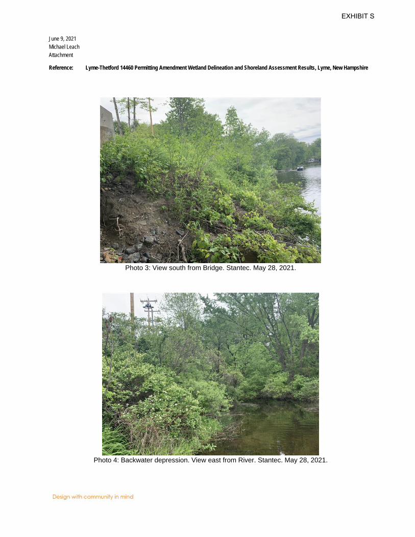
June 9, 2021 Michael Leach Attachment
Reference: Lyme-Thetford 14460 Permitting Amendment Wetland Delineation and Shoreland Assessment Results, Lyme, New Hampshire
Photo 3: View south from Bridge. Stantec. May 28, 2021.
Photo 4: Backwater depression. View east from River. Stantec. May 28, 2021.
EXHIBIT S
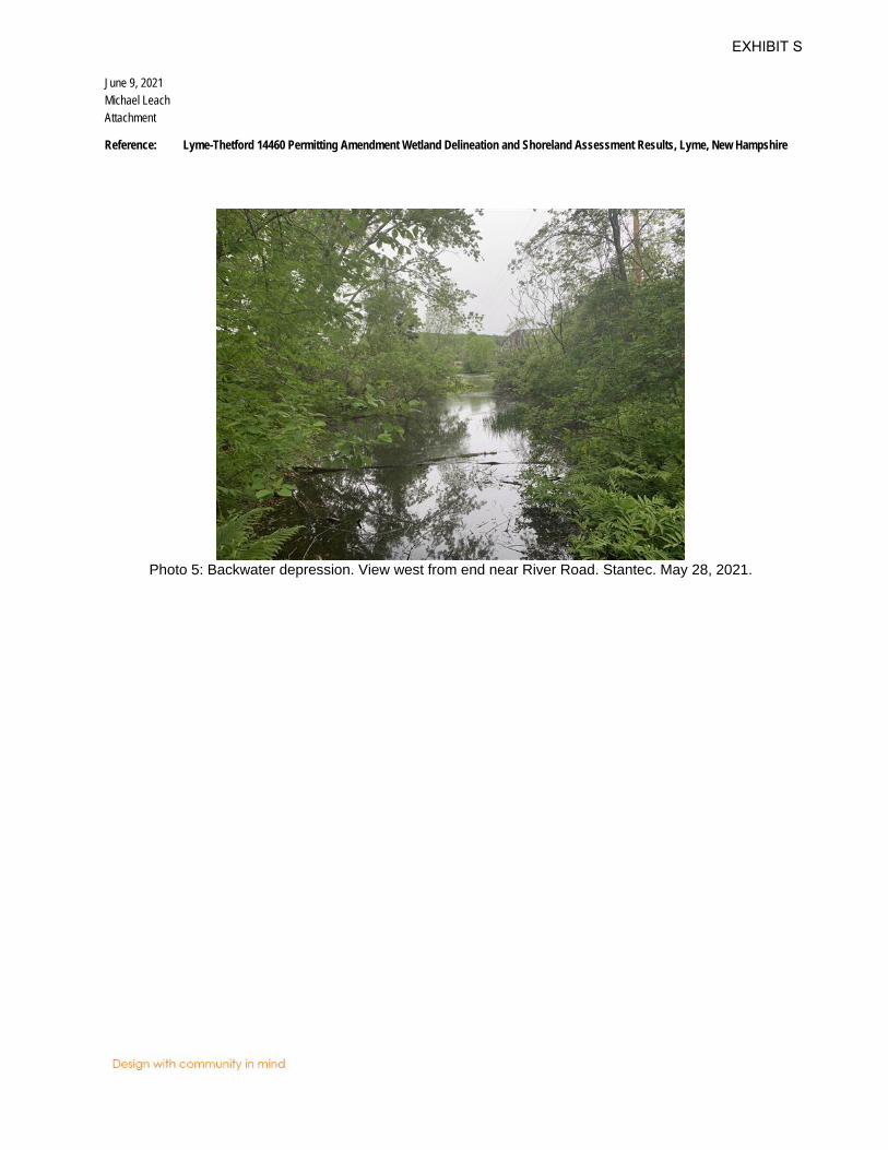
June 9, 2021 Michael Leach Attachment
Reference: Lyme-Thetford 14460 Permitting Amendment Wetland Delineation and Shoreland Assessment Results, Lyme, New Hampshire
Photo 5: Backwater depression. View west from end near River Road. Stantec. May 28, 2021.
EXHIBIT S

June 9, 2021 Michael Leach Attachment
Reference: Lyme-Thetford 14460 Permitting Amendment Wetland Delineation and Shoreland Assessment Results, Lyme, New Hampshire
Attachment C – Wetland Determination Data Forms
EXHIBIT S
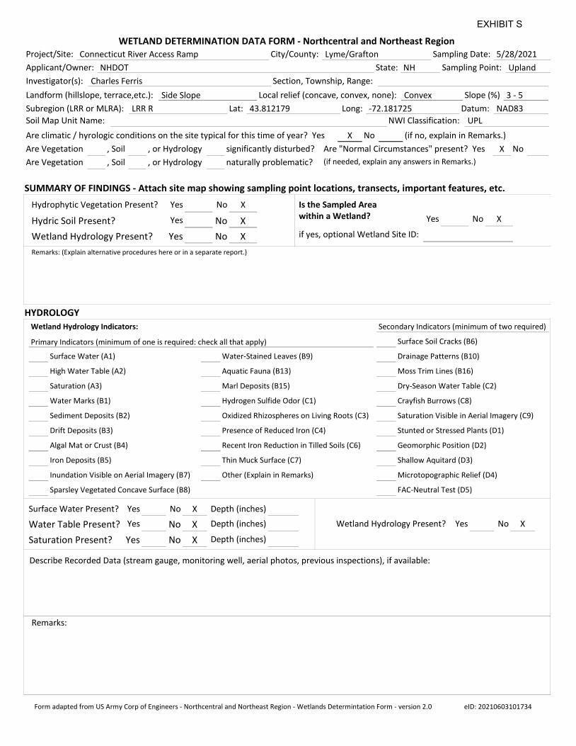
WETLAND DETERMINATION DATA FORM - Northcentral and Northeast Region
SUMMARY OF FINDINGS - Attach site map showing sampling point locations, transects, important features, etc.
HYDROLOGY
Sampling Point:
Project/Site: Connecticut River Access Ramp Sampling Date: 5/28/2021City/County: Lyme/Grafton
Applicant/Owner: NHDOT State: NH Sampling Point: Upland
Investigator(s): Charles Ferris Section, Township, Range:
Landform (hillslope, terrace,etc.): Side Slope Local relief (concave, convex, none): Convex Slope (%) 3 - 5
Subregion (LRR or MLRA): LRR R Lat: 43.812179 Long: -72.181725 Datum: NAD83
Soil Map Unit Name: NWI Classification: UPL
Are climatic / hyrologic conditions on the site typical for this time of year? Yes X
Are Vegetation , Soil , or Hydrology
Are Vegetation , Soil , or Hydrology
Are "Normal Circumstances" present? Yes X
(if no, explain in Remarks.)No
significantly disturbed?
naturally problematic? (if needed, explain any answers in Remarks.)
No
Surface Water (A1)
High Water Table (A2)
Saturation (A3)
Water Marks (B1)
Sediment Deposits (B2)
Drift Deposits (B3)
Algal Mat or Crust (B4)
Iron Deposits (B5)
Inundation Visible on Aerial Imagery (B7)
Sparsley Vegetated Concave Surface (B8)
Water-Stained Leaves (B9)
Aquatic Fauna (B13)
Marl Deposits (B15)
Hydrogen Sulfide Odor (C1)
Oxidized Rhizospheres on Living Roots (C3)
Presence of Reduced Iron (C4)
Recent Iron Reduction in Tilled Soils (C6)
Thin Muck Surface (C7)
Other (Explain in Remarks)
Surface Soil Cracks (B6)
Drainage Patterns (B10)
Moss Trim Lines (B16)
Dry-Season Water Table (C2)
Crayfish Burrows (C8)
Saturation Visible in Aerial Imagery (C9)
Stunted or Stressed Plants (D1)
Geomorphic Position (D2)
Shallow Aquitard (D3)
Microtopographic Relief (D4)
FAC-Neutral Test (D5)
Primary Indicators (minimum of one is required: check all that apply)
Wetland Hydrology Indicators: Secondary Indicators (minimum of two required)
No XYesSurface Water Present? Depth (inches)
Water Table Present? No X Depth (inches)Yes
YesSaturation Present? No X Depth (inches)
Describe Recorded Data (stream gauge, monitoring well, aerial photos, previous inspections), if available:
Remarks:
XYesWetland Hydrology Present? No
No XYesHydrophytic Vegetation Present?
Hydric Soil Present? No XYes
YesWetland Hydrology Present? No X
Remarks: (Explain alternative procedures here or in a separate report.)
No XYes
Is the Sampled Areawithin a Wetland?
if yes, optional Wetland Site ID:
Form adapted from US Army Corp of Engineers - Northcentral and Northeast Region - Wetlands Determintation Form - version 2.0 eID: 20210603101734
EXHIBIT S
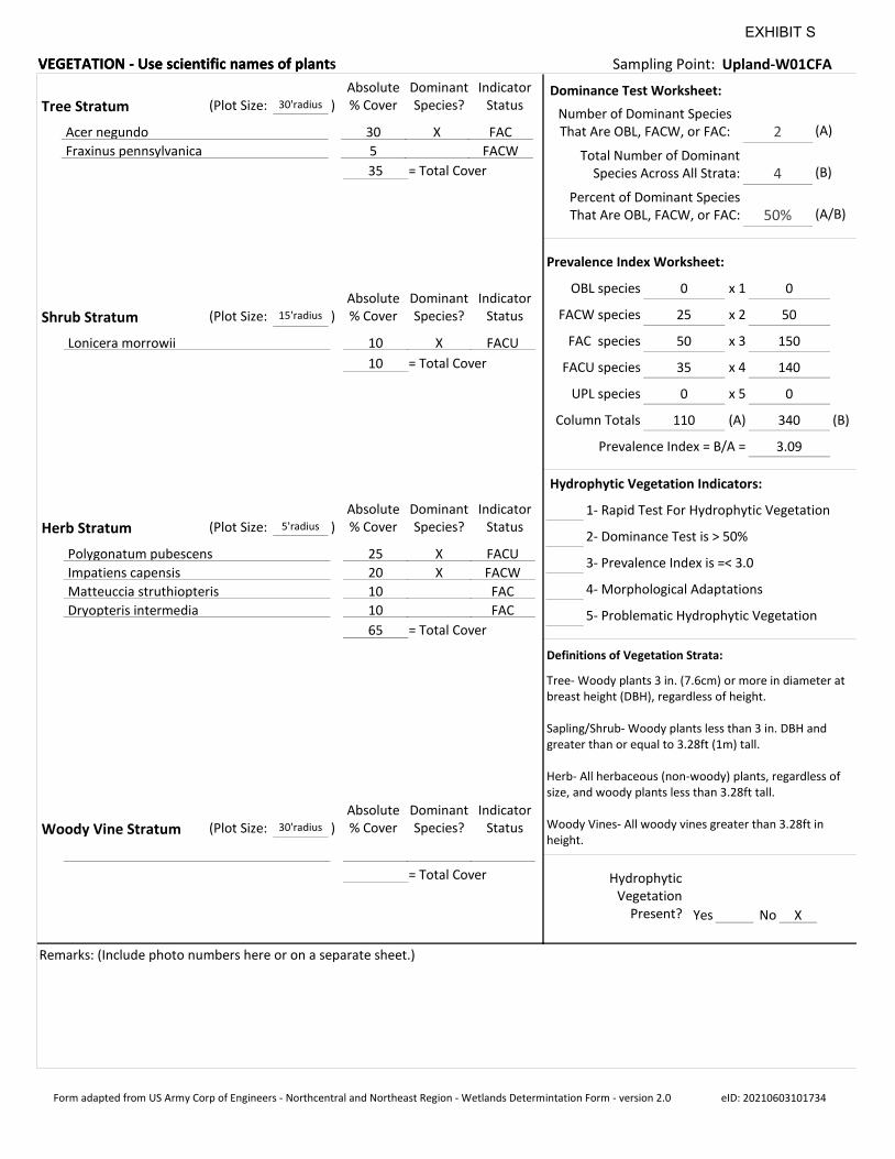
VEGETATION - Use scientific names of plantVEGETATION - Use scientific names of plants Sampling Point: Upland-W01CFA
Sampling Point: Upland-W01CFA
Remarks: (Include photo numbers here or on a separate sheet.)
Absolute% Cover
DominantSpecies?
IndicatorStatusShrub Stratum (Plot Size: )15'radius
Lonicera morrowii 10 X FACU
10 = Total Cover
Absolute% Cover
DominantSpecies?
IndicatorStatusTree Stratum (Plot Size: )30'radius
Acer negundo 30 X FAC
Fraxinus pennsylvanica 5 FACW
35 = Total Cover
Absolute% Cover
DominantSpecies?
IndicatorStatusHerb Stratum (Plot Size: )5'radius
Polygonatum pubescens 25 X FACU
Impatiens capensis 20 X FACW
Matteuccia struthiopteris 10 FAC
Dryopteris intermedia 10 FAC
65 = Total Cover
Absolute% Cover
DominantSpecies?
IndicatorStatusWoody Vine Stratum (Plot Size: )30'radius
= Total Cover
Number of Dominant SpeciesThat Are OBL, FACW, or FAC: 2
Total Number of DominantSpecies Across All Strata: 4
Percent of Dominant SpeciesThat Are OBL, FACW, or FAC: 50%
OBL species 0
FACW species 25
FAC species 50
FACU species 35
UPL species 0
x 1 0
x 2 50
x 3 150
x 4 140
x 5 0
Column Totals 110 (A) 340
Prevalence Index = B/A = 3.09
3- Prevalence Index is =< 3.0
2- Dominance Test is > 50%
1- Rapid Test For Hydrophytic Vegetation
Dominance Test Worksheet:
Prevalence Index Worksheet:
Hydrophytic Vegetation Indicators:
4- Morphological Adaptations
5- Problematic Hydrophytic Vegetation
(A)
(B)
(A/B)
(B)
Tree- Woody plants 3 in. (7.6cm) or more in diameter at breast height (DBH), regardless of height.
Sapling/Shrub- Woody plants less than 3 in. DBH and greater than or equal to 3.28ft (1m) tall.
Herb- All herbaceous (non-woody) plants, regardless of size, and woody plants less than 3.28ft tall.
Woody Vines- All woody vines greater than 3.28ft in height.
No XYes
HydrophyticVegetation
Present?
Definitions of Vegetation Strata:
Form adapted from US Army Corp of Engineers - Northcentral and Northeast Region - Wetlands Determintation Form - version 2.0 eID: 20210603101734
EXHIBIT S
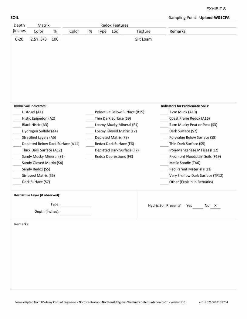
SOIL Sampling Point: Upland-W01CFA
Depth(inches Color % Color % Type Loc Texture Remarks
Matrix Redox Features
0-20 2.5Y 3/3 100 Silt Loam
Histosol (A1)
Histic Epipedon (A2)
Black Histic (A3)
Hydrogen Sulfide (A4)
Stratified Layers (A5)
Depleted Below Dark Surface (A11)
Thick Dark Surface (A12)
Sandy Mucky Mineral (S1)
Sandy Gleyed Matrix (S4)
Sandy Redox (S5)
Stripped Matrix (S6)
Dark Surface (S7)
Polyvalue Below Surface (B15)
Thin Dark Surface (S9)
Loamy Mucky Mineral (F1)
Loamy Gleyed Matric (F2)
Depleted Matrix (F3)
Redox Dark Surface (F6)
Depleted Dark Surface (F7)
2 cm Muck (A10)
Coast Prarie Redox (A16)
5 cm Mucky Peat or Peat (S3)
Dark Surface (S7)
Polyvalue Below Surface (S8)
Thin Dark Surface (S9)
Iron-Manganese Masses (F12)
Piedmont Floodplain Soils (F19)
Mesic Spodic (TA6)
Red Parent Material (F21)
Very Shallow Dark Surface (TF12)
Hydric Soil Indicators: Indicators for Problematic Soils:
Restrictive Layer (if observed):
Remarks:
XYesHydric Soil Present? No
Redox Depressions (F8)
Other (Explain in Remarks)
Type:
Depth (inches):
Form adapted from US Army Corp of Engineers - Northcentral and Northeast Region - Wetlands Determintation Form - version 2.0 eID: 20210603101734
EXHIBIT S
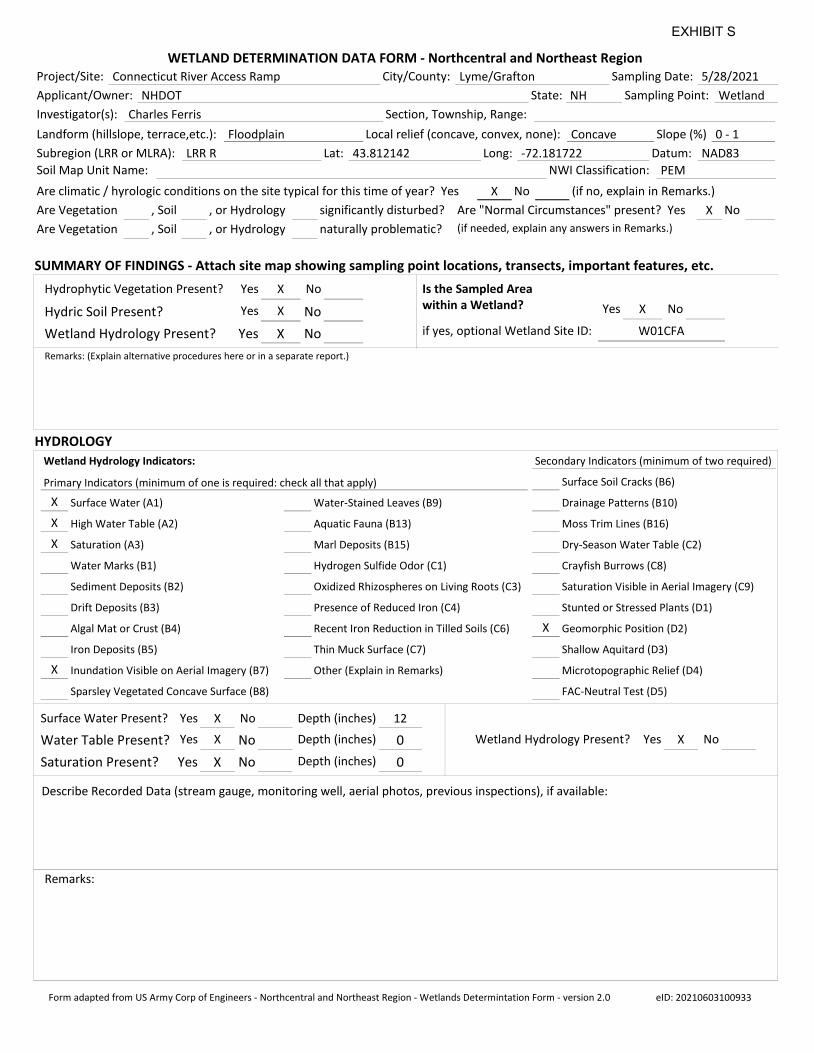
WETLAND DETERMINATION DATA FORM - Northcentral and Northeast Region
SUMMARY OF FINDINGS - Attach site map showing sampling point locations, transects, important features, etc.
HYDROLOGY
Sampling Point:
Project/Site: Connecticut River Access Ramp Sampling Date: 5/28/2021City/County: Lyme/Grafton
Applicant/Owner: NHDOT State: NH Sampling Point: Wetland
Investigator(s): Charles Ferris Section, Township, Range:
Landform (hillslope, terrace,etc.): Floodplain Local relief (concave, convex, none): Concave Slope (%) 0 - 1
Subregion (LRR or MLRA): LRR R Lat: 43.812142 Long: -72.181722 Datum: NAD83
Soil Map Unit Name: NWI Classification: PEM
Are climatic / hyrologic conditions on the site typical for this time of year? Yes X
Are Vegetation , Soil , or Hydrology
Are Vegetation , Soil , or Hydrology
Are "Normal Circumstances" present? Yes X
(if no, explain in Remarks.)No
significantly disturbed?
naturally problematic? (if needed, explain any answers in Remarks.)
No
X
X
X
X
X
Surface Water (A1)
High Water Table (A2)
Saturation (A3)
Water Marks (B1)
Sediment Deposits (B2)
Drift Deposits (B3)
Algal Mat or Crust (B4)
Iron Deposits (B5)
Inundation Visible on Aerial Imagery (B7)
Sparsley Vegetated Concave Surface (B8)
Water-Stained Leaves (B9)
Aquatic Fauna (B13)
Marl Deposits (B15)
Hydrogen Sulfide Odor (C1)
Oxidized Rhizospheres on Living Roots (C3)
Presence of Reduced Iron (C4)
Recent Iron Reduction in Tilled Soils (C6)
Thin Muck Surface (C7)
Other (Explain in Remarks)
Surface Soil Cracks (B6)
Drainage Patterns (B10)
Moss Trim Lines (B16)
Dry-Season Water Table (C2)
Crayfish Burrows (C8)
Saturation Visible in Aerial Imagery (C9)
Stunted or Stressed Plants (D1)
Geomorphic Position (D2)
Shallow Aquitard (D3)
Microtopographic Relief (D4)
FAC-Neutral Test (D5)
Primary Indicators (minimum of one is required: check all that apply)
Wetland Hydrology Indicators: Secondary Indicators (minimum of two required)
X No 12YesSurface Water Present? Depth (inches)
XWater Table Present? No 0Depth (inches)Yes
Yes XSaturation Present? No Depth (inches) 0
Describe Recorded Data (stream gauge, monitoring well, aerial photos, previous inspections), if available:
Remarks:
XYesWetland Hydrology Present? No
X NoYesHydrophytic Vegetation Present?
XHydric Soil Present? NoYes
Yes XWetland Hydrology Present? No
Remarks: (Explain alternative procedures here or in a separate report.)
X NoYes
Is the Sampled Areawithin a Wetland?
if yes, optional Wetland Site ID: W01CFA
Form adapted from US Army Corp of Engineers - Northcentral and Northeast Region - Wetlands Determintation Form - version 2.0 eID: 20210603100933
EXHIBIT S
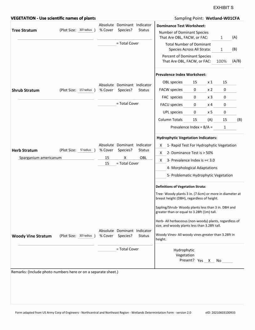
VEGETATION - Use scientific names of plantVEGETATION - Use scientific names of plants Sampling Point: Wetland-W01CFA
Sampling Point: Wetland-W01CFA
Remarks: (Include photo numbers here or on a separate sheet.)
Absolute% Cover
DominantSpecies?
IndicatorStatusShrub Stratum (Plot Size: )15'radius
= Total Cover
Absolute% Cover
DominantSpecies?
IndicatorStatusTree Stratum (Plot Size: )30'radius
= Total Cover
Absolute% Cover
DominantSpecies?
IndicatorStatusHerb Stratum (Plot Size: )5'radius
Sparganium americanum 15 X OBL
15 = Total Cover
Absolute% Cover
DominantSpecies?
IndicatorStatusWoody Vine Stratum (Plot Size: )30'radius
= Total Cover
Number of Dominant SpeciesThat Are OBL, FACW, or FAC: 1
Total Number of DominantSpecies Across All Strata: 1
Percent of Dominant SpeciesThat Are OBL, FACW, or FAC: 100%
OBL species 15
FACW species 0
FAC species 0
FACU species 0
UPL species 0
x 1 15
x 2 0
x 3 0
x 4 0
x 5 0
Column Totals 15 (A) 15
Prevalence Index = B/A = 1
X
X
X
3- Prevalence Index is =< 3.0
2- Dominance Test is > 50%
1- Rapid Test For Hydrophytic Vegetation
Dominance Test Worksheet:
Prevalence Index Worksheet:
Hydrophytic Vegetation Indicators:
4- Morphological Adaptations
5- Problematic Hydrophytic Vegetation
(A)
(B)
(A/B)
(B)
Tree- Woody plants 3 in. (7.6cm) or more in diameter at breast height (DBH), regardless of height.
Sapling/Shrub- Woody plants less than 3 in. DBH and greater than or equal to 3.28ft (1m) tall.
Herb- All herbaceous (non-woody) plants, regardless of size, and woody plants less than 3.28ft tall.
Woody Vines- All woody vines greater than 3.28ft in height.
X NoYes
HydrophyticVegetation
Present?
Definitions of Vegetation Strata:
Form adapted from US Army Corp of Engineers - Northcentral and Northeast Region - Wetlands Determintation Form - version 2.0 eID: 20210603100933
EXHIBIT S
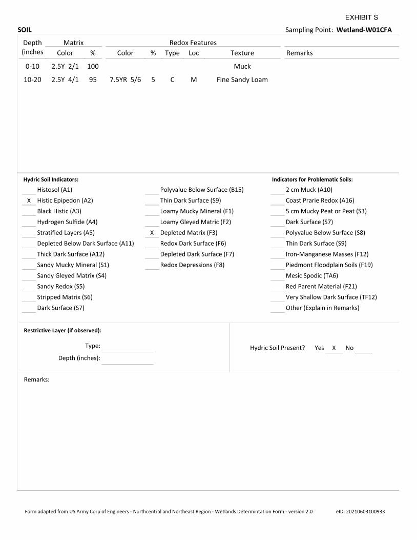
SOIL Sampling Point: Wetland-W01CFA
Depth(inches Color % Color % Type Loc Texture Remarks
Matrix Redox Features
0-10 2.5Y 2/1 100 Muck
10-20 2.5Y 4/1 95 7.5YR 5/6 5 C M Fine Sandy Loam
X
X
Histosol (A1)
Histic Epipedon (A2)
Black Histic (A3)
Hydrogen Sulfide (A4)
Stratified Layers (A5)
Depleted Below Dark Surface (A11)
Thick Dark Surface (A12)
Sandy Mucky Mineral (S1)
Sandy Gleyed Matrix (S4)
Sandy Redox (S5)
Stripped Matrix (S6)
Dark Surface (S7)
Polyvalue Below Surface (B15)
Thin Dark Surface (S9)
Loamy Mucky Mineral (F1)
Loamy Gleyed Matric (F2)
Depleted Matrix (F3)
Redox Dark Surface (F6)
Depleted Dark Surface (F7)
2 cm Muck (A10)
Coast Prarie Redox (A16)
5 cm Mucky Peat or Peat (S3)
Dark Surface (S7)
Polyvalue Below Surface (S8)
Thin Dark Surface (S9)
Iron-Manganese Masses (F12)
Piedmont Floodplain Soils (F19)
Mesic Spodic (TA6)
Red Parent Material (F21)
Very Shallow Dark Surface (TF12)
Hydric Soil Indicators: Indicators for Problematic Soils:
Restrictive Layer (if observed):
Remarks:
XYesHydric Soil Present? No
Redox Depressions (F8)
Other (Explain in Remarks)
Type:
Depth (inches):
Form adapted from US Army Corp of Engineers - Northcentral and Northeast Region - Wetlands Determintation Form - version 2.0 eID: 20210603100933
EXHIBIT S

June 9, 2021 Michael Leach Attachment
Reference: Lyme-Thetford 14460 Permitting Amendment Wetland Delineation and Shoreland Assessment Results, Lyme, New Hampshire
Attachment D – Wetland Functional Assessment Worksheet
EXHIBIT S
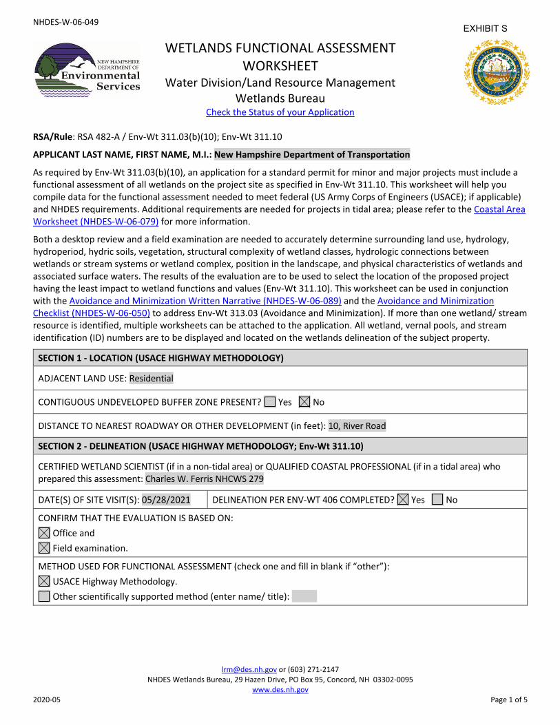
NHDES-W-06-049
[email protected] or (603) 271-2147 NHDES Wetlands Bureau, 29 Hazen Drive, PO Box 95, Concord, NH 03302-0095
www.des.nh.gov 2020-05 Page 1 of 5
WETLANDS FUNCTIONAL ASSESSMENT WORKSHEET
Water Division/Land Resource Management Wetlands Bureau
Check the Status of your Application
RSA/Rule: RSA 482-A / Env-Wt 311.03(b)(10); Env-Wt 311.10
APPLICANT LAST NAME, FIRST NAME, M.I.: New Hampshire Department of Transportation
As required by Env-Wt 311.03(b)(10), an application for a standard permit for minor and major projects must include a functional assessment of all wetlands on the project site as specified in Env-Wt 311.10. This worksheet will help you compile data for the functional assessment needed to meet federal (US Army Corps of Engineers (USACE); if applicable) and NHDES requirements. Additional requirements are needed for projects in tidal area; please refer to the Coastal Area Worksheet (NHDES-W-06-079) for more information.
Both a desktop review and a field examination are needed to accurately determine surrounding land use, hydrology, hydroperiod, hydric soils, vegetation, structural complexity of wetland classes, hydrologic connections between wetlands or stream systems or wetland complex, position in the landscape, and physical characteristics of wetlands and associated surface waters. The results of the evaluation are to be used to select the location of the proposed project having the least impact to wetland functions and values (Env-Wt 311.10). This worksheet can be used in conjunction with the Avoidance and Minimization Written Narrative (NHDES-W-06-089) and the Avoidance and Minimization Checklist (NHDES-W-06-050) to address Env-Wt 313.03 (Avoidance and Minimization). If more than one wetland/ stream resource is identified, multiple worksheets can be attached to the application. All wetland, vernal pools, and stream identification (ID) numbers are to be displayed and located on the wetlands delineation of the subject property.
SECTION 1 - LOCATION (USACE HIGHWAY METHODOLOGY)
ADJACENT LAND USE: Residential
CONTIGUOUS UNDEVELOPED BUFFER ZONE PRESENT? Yes No
DISTANCE TO NEAREST ROADWAY OR OTHER DEVELOPMENT (in feet): 10, River Road
SECTION 2 - DELINEATION (USACE HIGHWAY METHODOLOGY; Env-Wt 311.10)
CERTIFIED WETLAND SCIENTIST (if in a non-tidal area) or QUALIFIED COASTAL PROFESSIONAL (if in a tidal area) who prepared this assessment: Charles W. Ferris NHCWS 279
DATE(S) OF SITE VISIT(S): 05/28/2021 DELINEATION PER ENV-WT 406 COMPLETED? Yes No
CONFIRM THAT THE EVALUATION IS BASED ON: Office and Field examination.
METHOD USED FOR FUNCTIONAL ASSESSMENT (check one and fill in blank if “other”): USACE Highway Methodology. Other scientifically supported method (enter name/ title):
EXHIBIT S
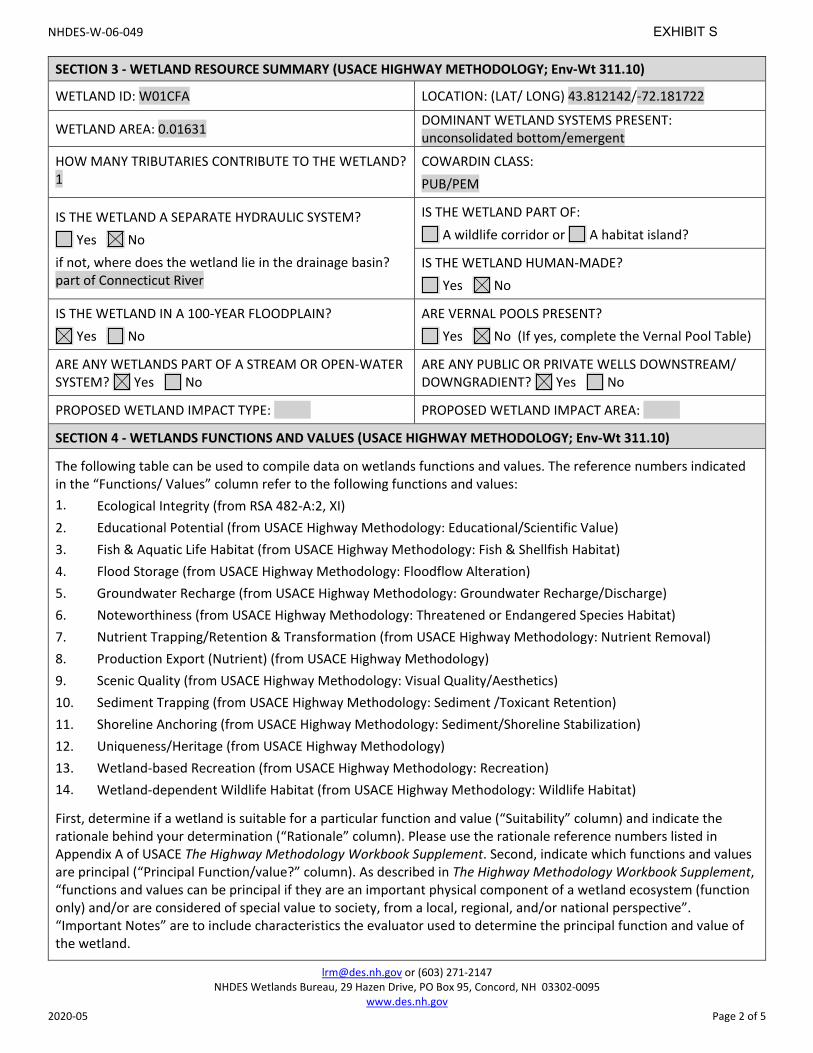
NHDES-W-06-049
[email protected] or (603) 271-2147 NHDES Wetlands Bureau, 29 Hazen Drive, PO Box 95, Concord, NH 03302-0095
www.des.nh.gov 2020-05 Page 2 of 5
SECTION 3 - WETLAND RESOURCE SUMMARY (USACE HIGHWAY METHODOLOGY; Env-Wt 311.10)
WETLAND ID: W01CFA LOCATION: (LAT/ LONG) 43.812142/-72.181722
WETLAND AREA: 0.01631 DOMINANT WETLAND SYSTEMS PRESENT: unconsolidated bottom/emergent
HOW MANY TRIBUTARIES CONTRIBUTE TO THE WETLAND? 1
COWARDIN CLASS: PUB/PEM
IS THE WETLAND A SEPARATE HYDRAULIC SYSTEM? Yes No
if not, where does the wetland lie in the drainage basin? part of Connecticut River
IS THE WETLAND PART OF: A wildlife corridor or A habitat island?
IS THE WETLAND HUMAN-MADE? Yes No
IS THE WETLAND IN A 100-YEAR FLOODPLAIN? Yes No
ARE VERNAL POOLS PRESENT? Yes No (If yes, complete the Vernal Pool Table)
ARE ANY WETLANDS PART OF A STREAM OR OPEN-WATER SYSTEM? Yes No
ARE ANY PUBLIC OR PRIVATE WELLS DOWNSTREAM/ DOWNGRADIENT? Yes No
PROPOSED WETLAND IMPACT TYPE: PROPOSED WETLAND IMPACT AREA:
SECTION 4 - WETLANDS FUNCTIONS AND VALUES (USACE HIGHWAY METHODOLOGY; Env-Wt 311.10)
The following table can be used to compile data on wetlands functions and values. The reference numbers indicated in the “Functions/ Values” column refer to the following functions and values: 1. Ecological Integrity (from RSA 482-A:2, XI)2. Educational Potential (from USACE Highway Methodology: Educational/Scientific Value)3. Fish & Aquatic Life Habitat (from USACE Highway Methodology: Fish & Shellfish Habitat)4. Flood Storage (from USACE Highway Methodology: Floodflow Alteration)5. Groundwater Recharge (from USACE Highway Methodology: Groundwater Recharge/Discharge)6. Noteworthiness (from USACE Highway Methodology: Threatened or Endangered Species Habitat)7. Nutrient Trapping/Retention & Transformation (from USACE Highway Methodology: Nutrient Removal)8. Production Export (Nutrient) (from USACE Highway Methodology)9. Scenic Quality (from USACE Highway Methodology: Visual Quality/Aesthetics)10. Sediment Trapping (from USACE Highway Methodology: Sediment /Toxicant Retention)11. Shoreline Anchoring (from USACE Highway Methodology: Sediment/Shoreline Stabilization)12. Uniqueness/Heritage (from USACE Highway Methodology)13. Wetland-based Recreation (from USACE Highway Methodology: Recreation)14. Wetland-dependent Wildlife Habitat (from USACE Highway Methodology: Wildlife Habitat)
First, determine if a wetland is suitable for a particular function and value (“Suitability” column) and indicate the rationale behind your determination (“Rationale” column). Please use the rationale reference numbers listed in Appendix A of USACE The Highway Methodology Workbook Supplement. Second, indicate which functions and values are principal (“Principal Function/value?” column). As described in The Highway Methodology Workbook Supplement, “functions and values can be principal if they are an important physical component of a wetland ecosystem (function only) and/or are considered of special value to society, from a local, regional, and/or national perspective”. “Important Notes” are to include characteristics the evaluator used to determine the principal function and value of the wetland.
EXHIBIT S
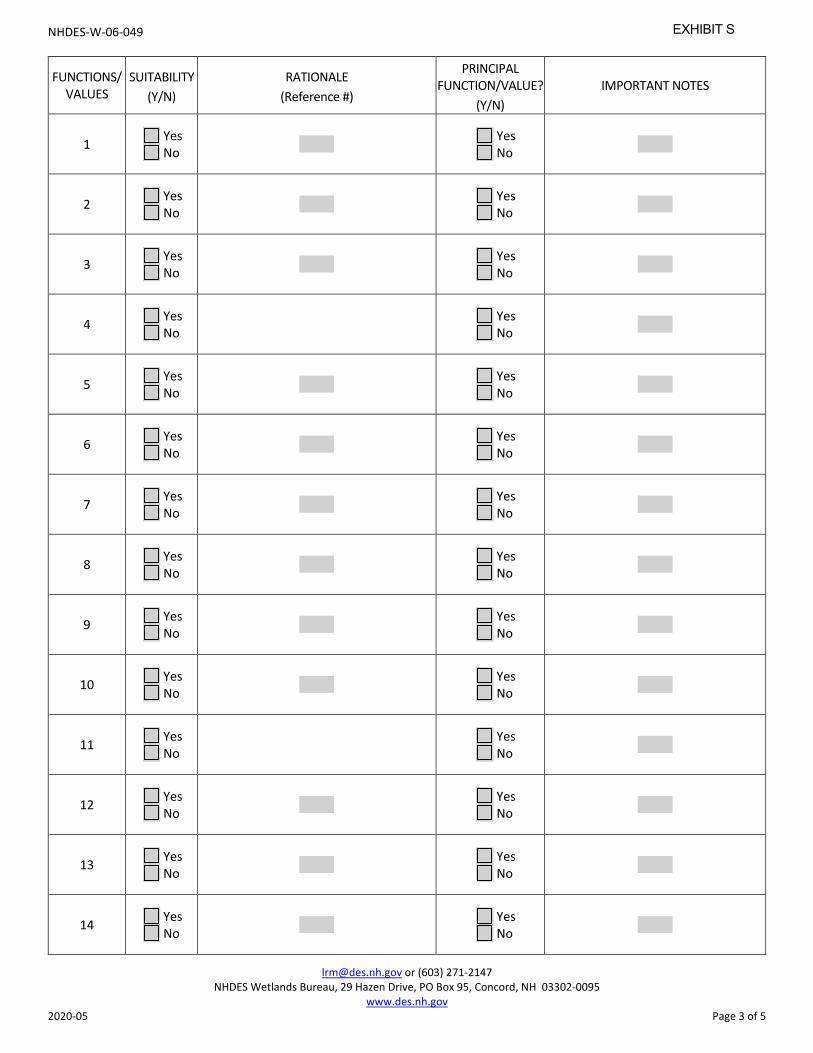
NHDES-W-06-049
[email protected] or (603) 271-2147 NHDES Wetlands Bureau, 29 Hazen Drive, PO Box 95, Concord, NH 03302-0095
www.des.nh.gov 2020-05 Page 3 of 5
FUNCTIONS/ VALUES
SUITABILITY (Y/N)
RATIONALE (Reference #)
PRINCIPAL FUNCTION/VALUE?
(Y/N) IMPORTANT NOTES
1 Yes No
Yes No
2 Yes No
Yes No
3 Yes No
Yes No
4 Yes No
Yes No
5 Yes No
Yes No
6 Yes No
Yes No
7 Yes No
Yes No
8 Yes No
Yes No
9 Yes No
Yes No
10 Yes No
Yes No
11 Yes No
Yes No
12 Yes No
Yes No
13 Yes No
Yes No
14 Yes No
Yes No
EXHIBIT S
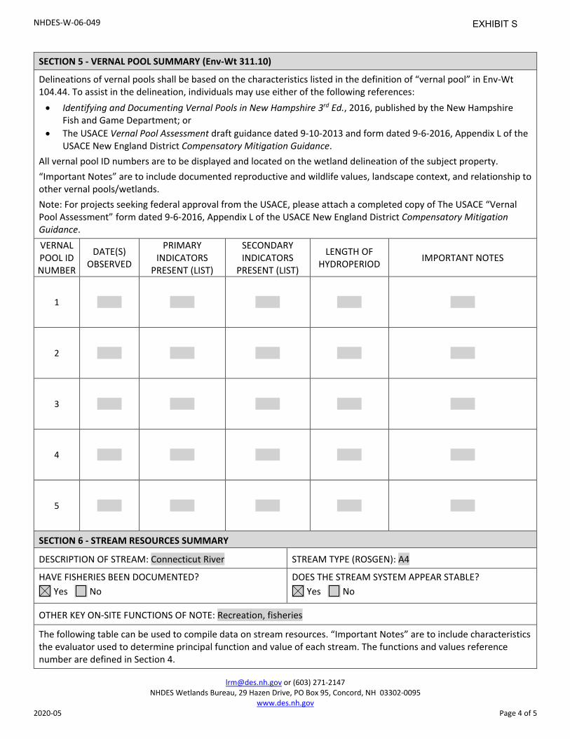
NHDES-W-06-049
[email protected] or (603) 271-2147 NHDES Wetlands Bureau, 29 Hazen Drive, PO Box 95, Concord, NH 03302-0095
www.des.nh.gov 2020-05 Page 4 of 5
SECTION 5 - VERNAL POOL SUMMARY (Env-Wt 311.10)
Delineations of vernal pools shall be based on the characteristics listed in the definition of “vernal pool” in Env-Wt 104.44. To assist in the delineation, individuals may use either of the following references: • Identifying and Documenting Vernal Pools in New Hampshire 3rd Ed., 2016, published by the New Hampshire
Fish and Game Department; or• The USACE Vernal Pool Assessment draft guidance dated 9-10-2013 and form dated 9-6-2016, Appendix L of the
USACE New England District Compensatory Mitigation Guidance.All vernal pool ID numbers are to be displayed and located on the wetland delineation of the subject property. “Important Notes” are to include documented reproductive and wildlife values, landscape context, and relationship to other vernal pools/wetlands. Note: For projects seeking federal approval from the USACE, please attach a completed copy of The USACE “Vernal Pool Assessment” form dated 9-6-2016, Appendix L of the USACE New England District Compensatory Mitigation Guidance. VERNAL POOL ID NUMBER
DATE(S) OBSERVED
PRIMARY INDICATORS
PRESENT (LIST)
SECONDARY INDICATORS
PRESENT (LIST)
LENGTH OF HYDROPERIOD IMPORTANT NOTES
1
2
3
4
5
SECTION 6 - STREAM RESOURCES SUMMARY
DESCRIPTION OF STREAM: Connecticut River STREAM TYPE (ROSGEN): A4
HAVE FISHERIES BEEN DOCUMENTED? Yes No
DOES THE STREAM SYSTEM APPEAR STABLE? Yes No
OTHER KEY ON-SITE FUNCTIONS OF NOTE: Recreation, fisheries
The following table can be used to compile data on stream resources. “Important Notes” are to include characteristics the evaluator used to determine principal function and value of each stream. The functions and values reference number are defined in Section 4.
EXHIBIT S
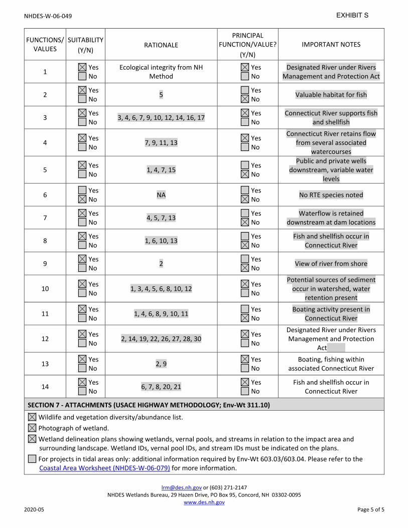
NHDES-W-06-049
[email protected] or (603) 271-2147 NHDES Wetlands Bureau, 29 Hazen Drive, PO Box 95, Concord, NH 03302-0095
www.des.nh.gov 2020-05 Page 5 of 5
FUNCTIONS/ VALUES
SUITABILITY (Y/N)
RATIONALE PRINCIPAL
FUNCTION/VALUE? (Y/N)
IMPORTANT NOTES
1 Yes No
Ecological integrity from NH Method
Yes No
Designated River under Rivers Management and Protection Act
2 Yes No 5 Yes
No Valuable habitat for fish
3 Yes No 3, 4, 6, 7, 9, 10, 12, 14, 16, 17 Yes
No Connecticut River supports fish
and shellfish
4 Yes No 7, 9, 11, 13 Yes
No
Connecticut River retains flow from several associated
watercourses
5 Yes No 1, 4, 7, 15 Yes
No
Public and private wells downstream, variable water
levels
6 Yes No NA Yes
No No RTE species noted
7 Yes No 4, 5, 7, 13 Yes
No Waterflow is retained
downstream at dam locations
8 Yes No 1, 6, 10, 13 Yes
No Fish and shellfish occur in
Connecticut River
9 Yes No 2 Yes
No View of river from shore
10 Yes No 1, 3, 4, 5, 6, 8, 10, 12 Yes
No
Potential sources of sediment occur in watershed, water
retention present
11 Yes No 1, 4, 6, 8, 9, 10, 11 Yes
No Boating activity present in
Connecticut River
12 Yes No 2, 14, 19, 22, 26, 27, 28, 30 Yes
No
Designated River under Rivers Management and Protection
Act
13 Yes No 2, 9 Yes
No Boating, fishing within
associated Connecticut River
14 Yes No 6, 7, 8, 20, 21 Yes
No Fish and shellfish occur in
Connecticut River
SECTION 7 - ATTACHMENTS (USACE HIGHWAY METHODOLOGY; Env-Wt 311.10)
Wildlife and vegetation diversity/abundance list. Photograph of wetland. Wetland delineation plans showing wetlands, vernal pools, and streams in relation to the impact area and surrounding landscape. Wetland IDs, vernal pool IDs, and stream IDs must be indicated on the plans.
For projects in tidal areas only: additional information required by Env-Wt 603.03/603.04. Please refer to the Coastal Area Worksheet (NHDES-W-06-079) for more information.
EXHIBIT S
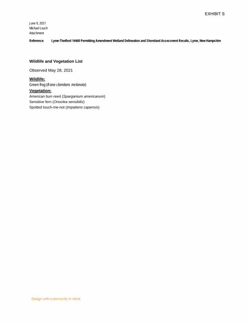
June 9, 2021 Michael Leach Attachment
Reference: Lyme-Thetford 14460 Permitting Amendment Wetland Delineation and Shoreland Assessment Results, Lyme, New Hampshire
Wildlife and Vegetation List
Observed May 28, 2021 Wildlife: Green frog (Rana clamitans melanota) Vegetation: American burr-reed (Sparganium americanum) Sensitive fern (Onoclea sensibilis) Spotted touch-me-not (Impatiens capensis)
EXHIBIT S

June 9, 2021 Michael Leach Attachment
Reference: Lyme-Thetford 14460 Permitting Amendment Wetland Delineation and Shoreland Assessment Results, Lyme, New Hampshire
Attachment E – Table 1. Shoreland Assessment Vegetation Data
EXHIBIT S
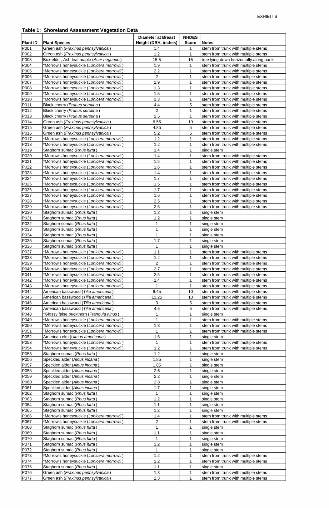
Plant ID Plant SpeciesDiameter at Breast
Height (DBH, inches)NHDES Score Notes
P001 Green ash (Fraxinus pennsylvanica ) 1.4 1 stem from trunk with multiple stemsP002 Green ash (Fraxinus pennsylvanica ) 1.2 1 stem from trunk with multiple stemsP003 Box-elder, Ash-leaf maple (Acer negundo ) 15.5 15 tree lying down horizontally along bankP004 *Morrow's honeysuckle (Lonicera morrowii ) 1.9 1 stem from trunk with multiple stemsP005 *Morrow's honeysuckle (Lonicera morrowii ) 2.2 1 stem from trunk with multiple stemsP006 *Morrow's honeysuckle (Lonicera morrowii ) 2 1 stem from trunk with multiple stemsP007 *Morrow's honeysuckle (Lonicera morrowii ) 2.9 1 stem from trunk with multiple stemsP008 *Morrow's honeysuckle (Lonicera morrowii ) 1.3 1 stem from trunk with multiple stemsP009 *Morrow's honeysuckle (Lonicera morrowii ) 1.5 1 stem from trunk with multiple stemsP010 *Morrow's honeysuckle (Lonicera morrowii ) 1.3 1 stem from trunk with multiple stemsP011 Black cherry (Prunus serotina ) 4.4 5 stem from trunk with multiple stemsP012 Black cherry (Prunus serotina ) 2 1 stem from trunk with multiple stemsP013 Black cherry (Prunus serotina ) 2.5 1 stem from trunk with multiple stemsP014 Green ash (Fraxinus pennsylvanica ) 6.55 10 stem from trunk with multiple stemsP015 Green ash (Fraxinus pennsylvanica ) 4.85 5 stem from trunk with multiple stemsP016 Green ash (Fraxinus pennsylvanica ) 5.2 5 stem from trunk with multiple stemsP017 *Morrow's honeysuckle (Lonicera morrowii ) 1.2 1 stem from trunk with multiple stemsP018 *Morrow's honeysuckle (Lonicera morrowii ) 1.2 1 stem from trunk with multiple stemsP019 Staghorn sumac (Rhus hirta ) 1.4 1 single stemP020 *Morrow's honeysuckle (Lonicera morrowii ) 1.4 1 stem from trunk with multiple stemsP021 *Morrow's honeysuckle (Lonicera morrowii ) 1.5 1 stem from trunk with multiple stemsP022 *Morrow's honeysuckle (Lonicera morrowii ) 1.6 1 stem from trunk with multiple stemsP023 *Morrow's honeysuckle (Lonicera morrowii ) 1.4 1 stem from trunk with multiple stemsP024 *Morrow's honeysuckle (Lonicera morrowii ) 1.7 1 stem from trunk with multiple stemsP025 *Morrow's honeysuckle (Lonicera morrowii ) 1.5 1 stem from trunk with multiple stemsP026 *Morrow's honeysuckle (Lonicera morrowii ) 1.7 1 stem from trunk with multiple stemsP027 *Morrow's honeysuckle (Lonicera morrowii ) 1.6 1 stem from trunk with multiple stemsP028 *Morrow's honeysuckle (Lonicera morrowii ) 2.5 1 stem from trunk with multiple stemsP029 *Morrow's honeysuckle (Lonicera morrowii ) 2.5 1 stem from trunk with multiple stemsP030 Staghorn sumac (Rhus hirta ) 1.2 1 single stemP031 Staghorn sumac (Rhus hirta ) 1.2 1 single stemP032 Staghorn sumac (Rhus hirta ) 1 1 single stemP033 Staghorn sumac (Rhus hirta ) 1 1 single stemP034 Staghorn sumac (Rhus hirta ) 1 1 single stemP035 Staghorn sumac (Rhus hirta ) 1.7 1 single stemP036 Staghorn sumac (Rhus hirta ) 1 1 single stemP037 *Morrow's honeysuckle (Lonicera morrowii ) 1.1 1 stem from trunk with multiple stemsP038 *Morrow's honeysuckle (Lonicera morrowii ) 1.2 1 stem from trunk with multiple stemsP039 *Morrow's honeysuckle (Lonicera morrowii ) 2 1 stem from trunk with multiple stemsP040 *Morrow's honeysuckle (Lonicera morrowii ) 2.7 1 stem from trunk with multiple stemsP041 *Morrow's honeysuckle (Lonicera morrowii ) 2.5 1 stem from trunk with multiple stemsP042 *Morrow's honeysuckle (Lonicera morrowii ) 2.4 1 stem from trunk with multiple stemsP043 *Morrow's honeysuckle (Lonicera morrowii ) 1 1 stem from trunk with multiple stemsP044 American basswood (Tilia americana ) 6.45 10 stem from trunk with multiple stemsP045 American basswood (Tilia americana ) 11.25 10 stem from trunk with multiple stemsP046 American basswood (Tilia americana ) 3 5 stem from trunk with multiple stemsP047 American basswood (Tilia americana ) 4.5 5 stem from trunk with multiple stemsP048 *Glossy false buckthorn (Frangula alnus ) 1 1 single stemP049 *Morrow's honeysuckle (Lonicera morrowii ) 1 1 stem from trunk with multiple stemsP050 *Morrow's honeysuckle (Lonicera morrowii ) 1.3 1 stem from trunk with multiple stemsP051 *Morrow's honeysuckle (Lonicera morrowii ) 1 1 stem from trunk with multiple stemsP052 American elm (Ulmus americana ) 1.6 1 single stemP053 *Morrow's honeysuckle (Lonicera morrowii ) 1 1 stem from trunk with multiple stemsP054 *Morrow's honeysuckle (Lonicera morrowii ) 1.2 1 stem from trunk with multiple stemsP055 Staghorn sumac (Rhus hirta ) 1.2 1 single stemP056 Speckled alder (Alnus incana ) 1.85 1 single stemP057 Speckled alder (Alnus incana ) 1.85 1 single stemP058 Speckled alder (Alnus incana ) 2.5 1 single stemP059 Speckled alder (Alnus incana ) 2.2 1 single stemP060 Speckled alder (Alnus incana ) 2.8 1 single stemP061 Speckled alder (Alnus incana ) 1.7 1 single stemP062 Staghorn sumac (Rhus hirta ) 1 1 single stemP063 Staghorn sumac (Rhus hirta ) 1.2 1 single stemP064 Staghorn sumac (Rhus hirta ) 1.1 1 single stemP065 Staghorn sumac (Rhus hirta ) 1.2 1 single stemP066 *Morrow's honeysuckle (Lonicera morrowii ) 1.4 1 stem from trunk with multiple stemsP067 *Morrow's honeysuckle (Lonicera morrowii ) 2 1 stem from trunk with multiple stemsP068 Staghorn sumac (Rhus hirta ) 1 1 single stemP069 Staghorn sumac (Rhus hirta ) 1.1 1 single stemP070 Staghorn sumac (Rhus hirta ) 1 1 single stemP071 Staghorn sumac (Rhus hirta ) 1.2 1 single stemP072 Staghorn sumac (Rhus hirta ) 1 1 single stemP073 *Morrow's honeysuckle (Lonicera morrowii ) 1.2 1 stem from trunk with multiple stemsP074 *Morrow's honeysuckle (Lonicera morrowii ) 1.2 1 stem from trunk with multiple stemsP075 Staghorn sumac (Rhus hirta ) 1.1 1 single stemP076 Green ash (Fraxinus pennsylvanica ) 1.3 1 stem from trunk with multiple stemsP077 Green ash (Fraxinus pennsylvanica ) 2.3 1 stem from trunk with multiple stems
Table 1: Shoreland Assessment Vegetation Data
EXHIBIT S
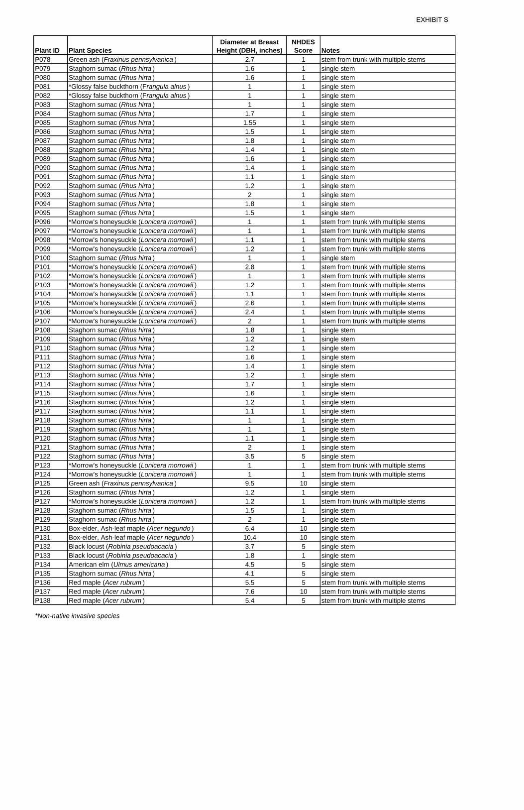
Plant ID Plant SpeciesDiameter at Breast
Height (DBH, inches)NHDES Score Notes
P078 Green ash (Fraxinus pennsylvanica ) 2.7 1 stem from trunk with multiple stemsP079 Staghorn sumac (Rhus hirta ) 1.6 1 single stemP080 Staghorn sumac (Rhus hirta ) 1.6 1 single stemP081 *Glossy false buckthorn (Frangula alnus ) 1 1 single stemP082 *Glossy false buckthorn (Frangula alnus ) 1 1 single stemP083 Staghorn sumac (Rhus hirta ) 1 1 single stemP084 Staghorn sumac (Rhus hirta ) 1.7 1 single stemP085 Staghorn sumac (Rhus hirta ) 1.55 1 single stemP086 Staghorn sumac (Rhus hirta ) 1.5 1 single stemP087 Staghorn sumac (Rhus hirta ) 1.8 1 single stemP088 Staghorn sumac (Rhus hirta ) 1.4 1 single stemP089 Staghorn sumac (Rhus hirta ) 1.6 1 single stemP090 Staghorn sumac (Rhus hirta ) 1.4 1 single stemP091 Staghorn sumac (Rhus hirta ) 1.1 1 single stemP092 Staghorn sumac (Rhus hirta ) 1.2 1 single stemP093 Staghorn sumac (Rhus hirta ) 2 1 single stemP094 Staghorn sumac (Rhus hirta ) 1.8 1 single stemP095 Staghorn sumac (Rhus hirta ) 1.5 1 single stemP096 *Morrow's honeysuckle (Lonicera morrowii ) 1 1 stem from trunk with multiple stemsP097 *Morrow's honeysuckle (Lonicera morrowii ) 1 1 stem from trunk with multiple stemsP098 *Morrow's honeysuckle (Lonicera morrowii ) 1.1 1 stem from trunk with multiple stemsP099 *Morrow's honeysuckle (Lonicera morrowii ) 1.2 1 stem from trunk with multiple stemsP100 Staghorn sumac (Rhus hirta ) 1 1 single stemP101 *Morrow's honeysuckle (Lonicera morrowii ) 2.8 1 stem from trunk with multiple stemsP102 *Morrow's honeysuckle (Lonicera morrowii ) 1 1 stem from trunk with multiple stemsP103 *Morrow's honeysuckle (Lonicera morrowii ) 1.2 1 stem from trunk with multiple stemsP104 *Morrow's honeysuckle (Lonicera morrowii ) 1.1 1 stem from trunk with multiple stemsP105 *Morrow's honeysuckle (Lonicera morrowii ) 2.6 1 stem from trunk with multiple stemsP106 *Morrow's honeysuckle (Lonicera morrowii ) 2.4 1 stem from trunk with multiple stemsP107 *Morrow's honeysuckle (Lonicera morrowii ) 2 1 stem from trunk with multiple stemsP108 Staghorn sumac (Rhus hirta ) 1.8 1 single stemP109 Staghorn sumac (Rhus hirta ) 1.2 1 single stemP110 Staghorn sumac (Rhus hirta ) 1.2 1 single stemP111 Staghorn sumac (Rhus hirta ) 1.6 1 single stemP112 Staghorn sumac (Rhus hirta ) 1.4 1 single stemP113 Staghorn sumac (Rhus hirta ) 1.2 1 single stemP114 Staghorn sumac (Rhus hirta ) 1.7 1 single stemP115 Staghorn sumac (Rhus hirta ) 1.6 1 single stemP116 Staghorn sumac (Rhus hirta ) 1.2 1 single stemP117 Staghorn sumac (Rhus hirta ) 1.1 1 single stemP118 Staghorn sumac (Rhus hirta ) 1 1 single stemP119 Staghorn sumac (Rhus hirta ) 1 1 single stemP120 Staghorn sumac (Rhus hirta ) 1.1 1 single stemP121 Staghorn sumac (Rhus hirta ) 2 1 single stemP122 Staghorn sumac (Rhus hirta ) 3.5 5 single stemP123 *Morrow's honeysuckle (Lonicera morrowii ) 1 1 stem from trunk with multiple stemsP124 *Morrow's honeysuckle (Lonicera morrowii ) 1 1 stem from trunk with multiple stemsP125 Green ash (Fraxinus pennsylvanica ) 9.5 10 single stemP126 Staghorn sumac (Rhus hirta ) 1.2 1 single stemP127 *Morrow's honeysuckle (Lonicera morrowii ) 1.2 1 stem from trunk with multiple stemsP128 Staghorn sumac (Rhus hirta ) 1.5 1 single stemP129 Staghorn sumac (Rhus hirta ) 2 1 single stemP130 Box-elder, Ash-leaf maple (Acer negundo ) 6.4 10 single stemP131 Box-elder, Ash-leaf maple (Acer negundo ) 10.4 10 single stemP132 Black locust (Robinia pseudoacacia ) 3.7 5 single stemP133 Black locust (Robinia pseudoacacia ) 1.8 1 single stemP134 American elm (Ulmus americana ) 4.5 5 single stemP135 Staghorn sumac (Rhus hirta ) 4.1 5 single stemP136 Red maple (Acer rubrum ) 5.5 5 stem from trunk with multiple stemsP137 Red maple (Acer rubrum ) 7.6 10 stem from trunk with multiple stemsP138 Red maple (Acer rubrum ) 5.4 5 stem from trunk with multiple stems*Non-native invasive species
EXHIBIT S
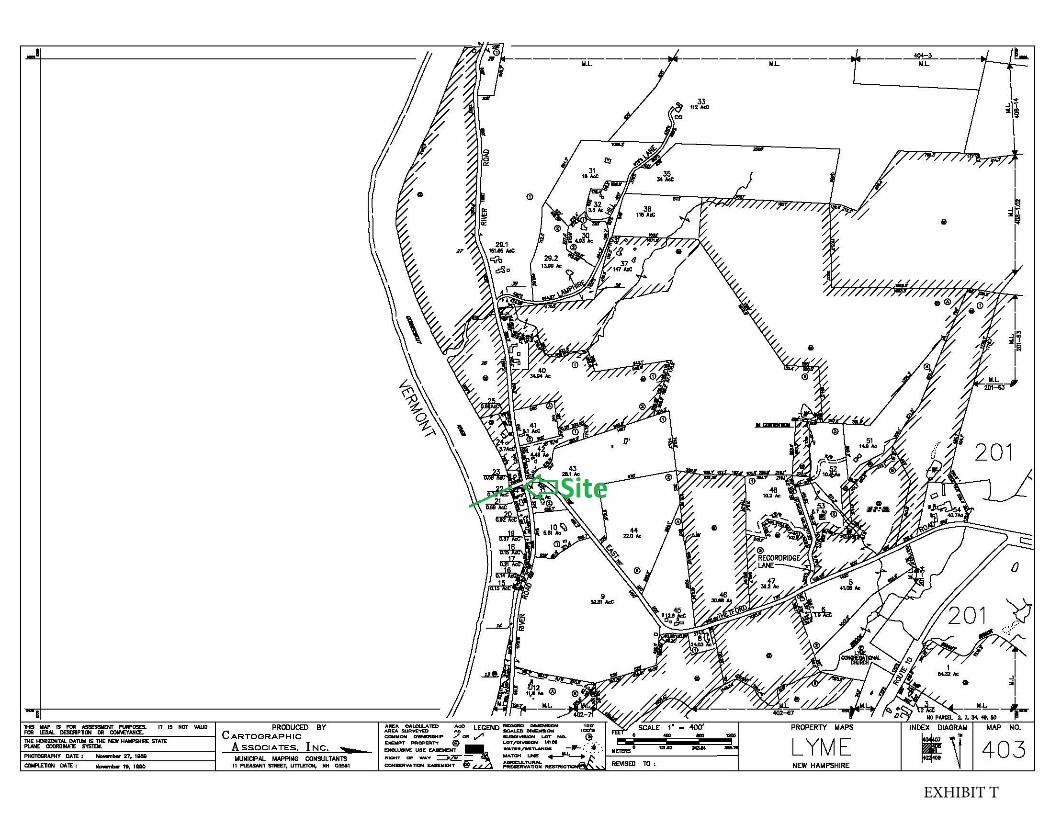
EXHIBIT T
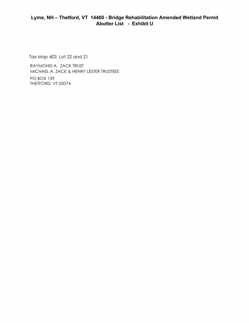
Lyme, NH – Thetford, VT 14460 - Bridge Rehabilitation Amended Wetland Permit Abutter List - Exhibit U
Tax Map 403 Lot 22 and 21
RAYMOND A. ZACK TRUST MICHAEL A. ZACK & HENRY LESTER TRUSTEES
PO BOX 159 THETFORD, VT 05074
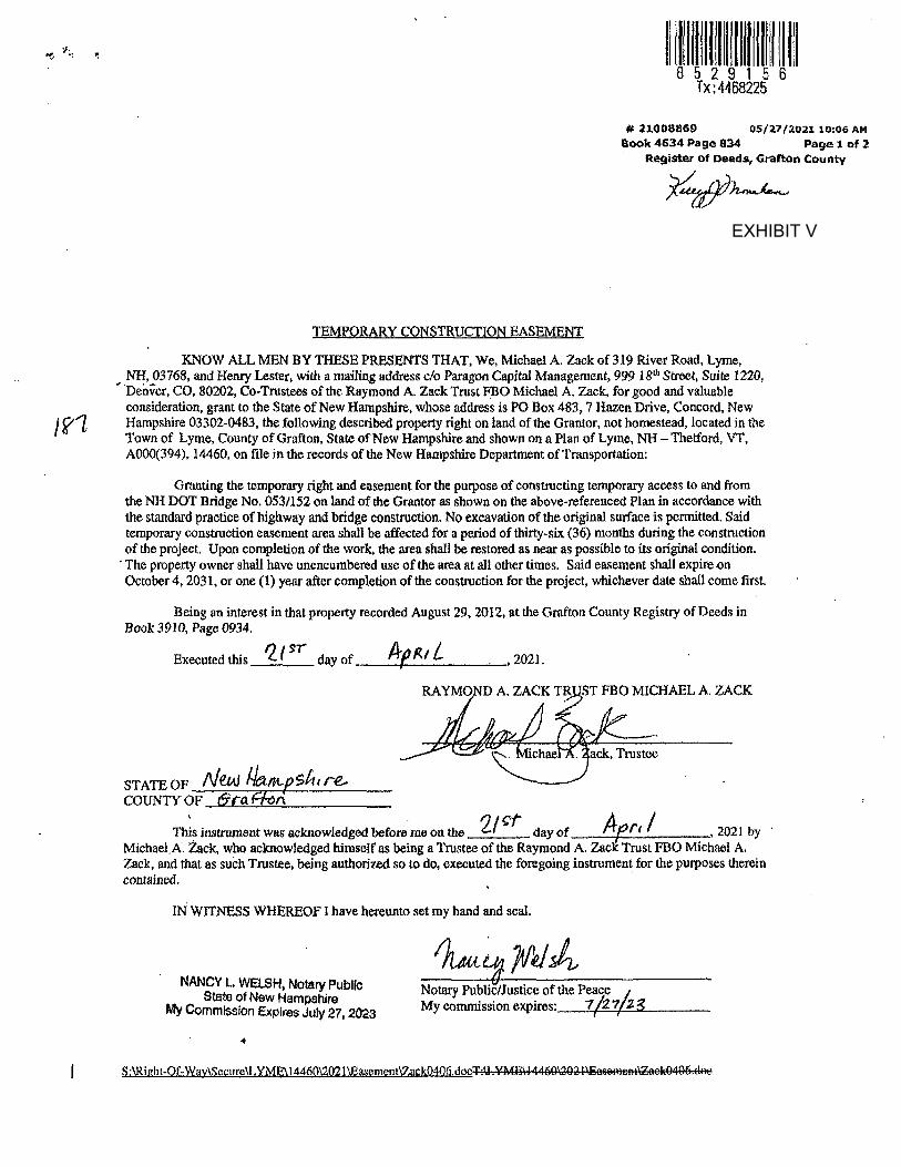
EXHIBIT V
EXHIBIT V
Exhibit W Lyme, NH – Thetford, VT 14460 - Bridge Rehabilitation
Amended Wetlands Permit Application
View easterly from Vermont of pier and NH bridge abutment circa 1937
View westerly towards Vermont of completed bridge. Historic Toll House at right of photo - circa 1937
DEPARTMENT OF TRANSPORTATION
THE STATE OF NEW HAMPSHIRE
LOCATION MAP
0
CH
EC
KE
D
BY
DR
AW
N
BY
DA
TE
DA
TE
DE
M
TJ
G
STAMP:
TEL (603) 669-8672 FAX (603) 669-7636
STANTEC CONSULTING SERVICES, INC
PLANS PREPARED BY:
5 DARTMOUTH DR, SUITE 200, AUBURN, NH 03032
ASSISTANT COMMISSIONER AND CHIEF ENGINEER DATE
APPROVED:
RECOMMENDED FOR APPROVAL:
DIRECTOR OF PROJECT DEVELOPMENT DATE
NEW HAMPSHIRE
DEPARTMENT OF
TRANSPORTATION
THE STATE OF
TOTAL SHEETSSHEET NO.STATE PROJECT NO.FEDERAL PROJECT NO.
1A000(394)
PERCENT OF TRUCKS
DESIGN SPEED
DESIGN DATA
TE
H
STATE OF NEW H
AM
PS
HI
REDE
PA
RT
ME
NT
OF TRANSPOR
T
ATI
ON
GRI
D
LENGTH OF ROADWAY
SCALE: 1" = 40'
06/2021
06/2021
LYME, NH - THETFORD, VT
COUNTIES OF GRAFTON, NH - ORANGE, VT
14460
FEDERAL AID PROJECT
AVERAGE DAILY TRAFFIC 2016
AVERAGE DAILY TRAFFIC 2036
775 FT
25 MPH
9.5%
2,700
2,200
12+0014+00
16+00
18+00
20+00
22+00
0.5 11
GRAPHIC SCALE: 1"= 0.5 MILE
VERMONT
NEW HAMPSHIRE
THETFORD
LYME
12
14460
MATCH EXISTING
BEGIN APPROACH
STA. 13+50.00
MATCH EXISTING
STA. 21+25.00
END APPROACH
THE CONNECTICUT RIVER
VT ROUTE 113 & EAST THETFORD ROAD OVER
NH PROJECT NO. 14460
A000(394)
SHEET NO. DESCRIPTION
INDEX OF SHEETS
AMENDED WETLAND PLANS
ENV-WT 301.01 AND ENV-WT 101.48.
DELINEATION IN ACCORDANCE WITH THE NH DES ADMINISTRATIVE RULES
(VERSION 2.0, JANUARY, 2012) AND MEET THE CRITERIA FOR WETLAND
DELINEATION MANUAL FOR THE NORTHCENTRAL NORTHEAST REGION
AND THE REGIONAL SUPPLEMENT TO THE CORPS OF ENGINEERS WETLAND
WETLAND DELINEATION MANUAL TECHNICAL REPORT Y-87-1 (JANUARY, 1987)
WITH THE CRITERIA DESCRIBED IN THE U.S. ARMY CORPS OF ENGINEERS
AND 2021. THE WETLAND DELINEATIONS WERE COMPLETED IN ACCORDANCE
WETLANDS WERE DELINEATED BY STANTEC, INC. IN 2013 REFRESHED IN 2018
1937 RIPRAP DETAIL SHEET
ABUTMENT RECONSTRUCTION PLAN
ACCESS DRIVE PLAN & PROFILE
EROSION CONTROL PLANS
WETLAND IMPACT PLAN
EROSION CONTROL STRATEGIES
SURVEY LAYOUT & APPROACH SECTION
SITE PLAN & PROFILE
STANDARD SYMBOLS
TITLE PAGE
12
11
10
8-9
7
6
5
4
2-3
1
EAST THETFORD RD
RIV
ER
RD
RIV
ER
RD
NO. 053/112
BRIDGETO LYME, NH
THETFORD, VTSTATE LYME,
NHLINE
CO
NN
EC
TIC
UT
RIV
ER
TO THETFORD, VT
QUANTITY PURPOSES
LINE SHOWN FOR
STATE BOUNDARY
BEGIN CONSTRUCTION
STA. 14+22.00
END CONSTRUCTION
STA. 20+96.00VT ROUTE 1
13
U
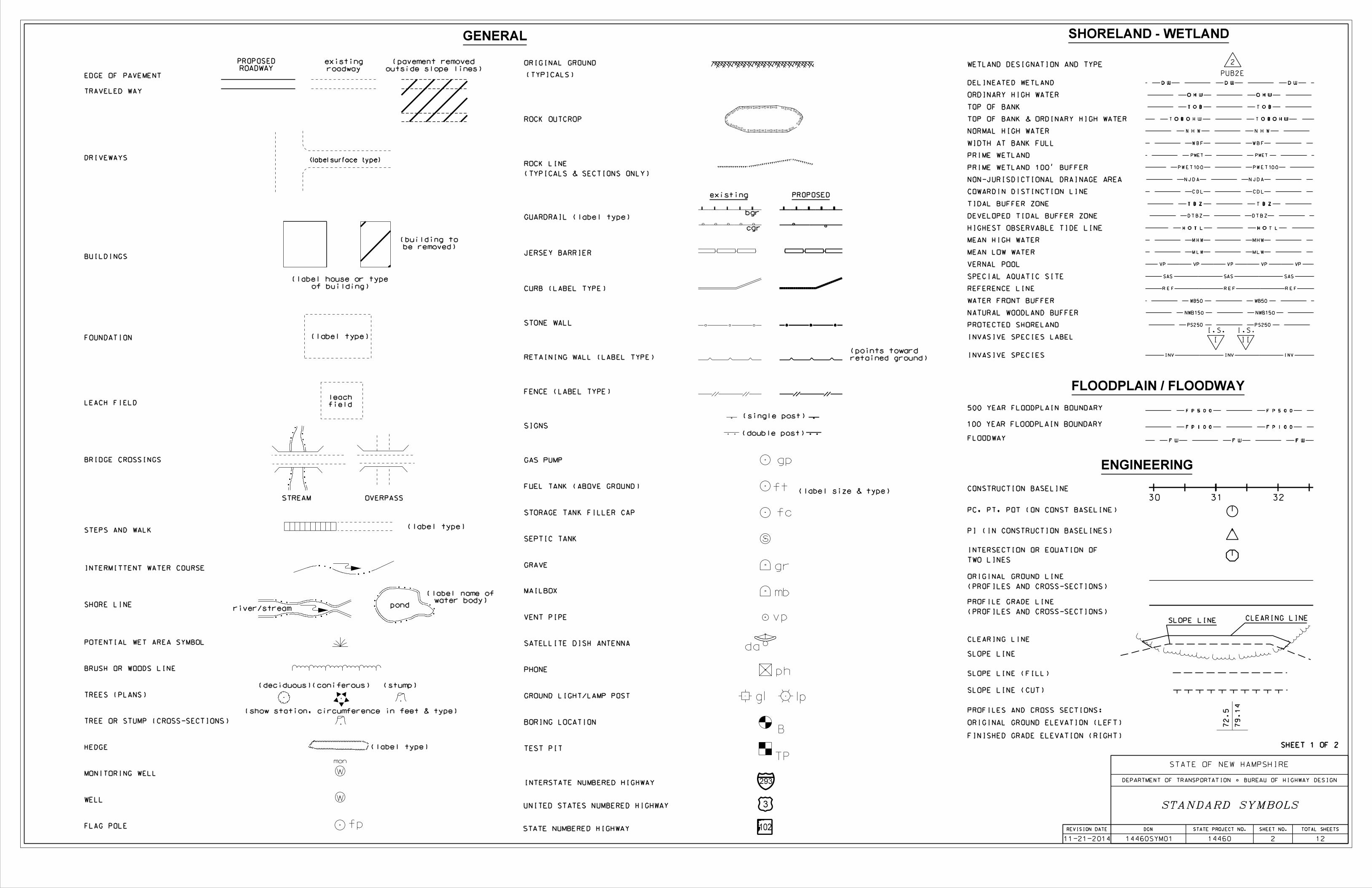
SHEET 1 OF 2
STATE PROJECT NO. SHEET NO. TOTAL SHEETS
14460
DGN
14460SYM01
STATE OF NEW HAMPSHIRE
DEPARTMENT OF TRANSPORTATION BUREAU OF HIGHWAY DESIGN
STANDARD SYMBOLSw
DRIVEWAYS
BUILDINGS
FOUNDATION
STEPS AND WALK
INTERMITTENT WATER COURSE
SHORE LINE
BRUSH OR WOODS LINE
TREES (PLANS)
HEDGE
WELL
SEPTIC TANK
LEACH FIELD
GAS PUMP
FUEL TANK (ABOVE GROUND)
GRAVE
ROCK OUTCROP
ORIGINAL GROUND
(TYPICALS & SECTIONS ONLY)
(TYPICALS)
ROCK LINE
STONE WALL
RETAINING WALL (LABEL TYPE)
SIGNS
MAILBOX
(label type)
(label type)
river/stream
(deciduous)(coniferous) (stump)
(double post)
(single post)
(label type)
SATELLITE DISH ANTENNA
DELINEATED WETLAND
BORING LOCATION
TEST PIT
CONSTRUCTION BASELINE
PC, PT, POT (ON CONST BASELINE)
PI (IN CONSTRUCTION BASELINES)
INTERSECTION OR EQUATION OF
TWO LINES
ORIGINAL GROUND LINE
(PROFILES AND CROSS-SECTIONS)
PROFILE GRADE LINE
(PROFILES AND CROSS-SECTIONS)
SLOPE LINE (FILL)
SLOPE LINE (CUT)
ORIGINAL GROUND ELEVATION (LEFT)
FINISHED GRADE ELEVATION (RIGHT)
INTERSTATE NUMBERED HIGHWAY
UNITED STATES NUMBERED HIGHWAY
STATE NUMBERED HIGHWAY
PROFILES AND CROSS SECTIONS:
(label surface type)
pond
(label size & type)
FLAG POLE
ENGINEERING
SLOPE LINE
79.
14
72.
5
CLEARING LINE
EDGE OF PAVEMENT
TRAVELED WAY
ROADWAY
PROPOSED
roadway
existing
outside slope lines)
(pavement removed
be removed)
(building to
of building)
(label house or type
water body)
(label name of
fp
field
leach
retained ground)
(points toward
s
gp
ft
gr
mb
da
vpVENT PIPE
PHONE
TIDAL BUFFER ZONE
ORDINARY HIGH WATER
SPECIAL AQUATIC SITE
TOP OF BANK
TOP OF BANK & ORDINARY HIGH WATER
VERNAL POOL
INVASIVE SPECIES
SLOPE LINE
CLEARING LINE
30 31 32
GENERAL
ph
STORAGE TANK FILLER CAP
2
PUB2E
cgr
JERSEY BARRIER
fc
B
WATER FRONT BUFFER
NATURAL WOODLAND BUFFER
POTENTIAL WET AREA SYMBOL
MONITORING WELL
II
I.S.
I
I.S.INVASIVE SPECIES LABEL
TP
PRIME WETLAND
WETLAND DESIGNATION AND TYPE
293
3
102
BRIDGE CROSSINGS
STREAM OVERPASS
TREE OR STUMP (CROSS-SECTIONS)
(show station, circumference in feet & type)
existing PROPOSED
500 YEAR FLOODPLAIN BOUNDARY
100 YEAR FLOODPLAIN BOUNDARY
FLOODPLAIN / FLOODWAY
FLOODWAY
GROUND LIGHT/LAMP POST gl lp
FENCE (LABEL TYPE)
CURB (LABEL TYPE)
w
mon
SHEET 1 OF 2
NON-JURISDICTIONAL DRAINAGE AREA
COWARDIN DISTINCTION LINE
PRIME WETLAND 100' BUFFER
WIDTH AT BANK FULL
MEAN HIGH WATER
MEAN LOW WATER
DEVELOPED TIDAL BUFFER ZONE
REFERENCE LINE
SHORELAND - WETLAND
GUARDRAIL (label type)bgr
NORMAL HIGH WATER
HIGHEST OBSERVABLE TIDE LINE
PROTECTED SHORELAND
REVISION DATE
11-21-2014 2 12
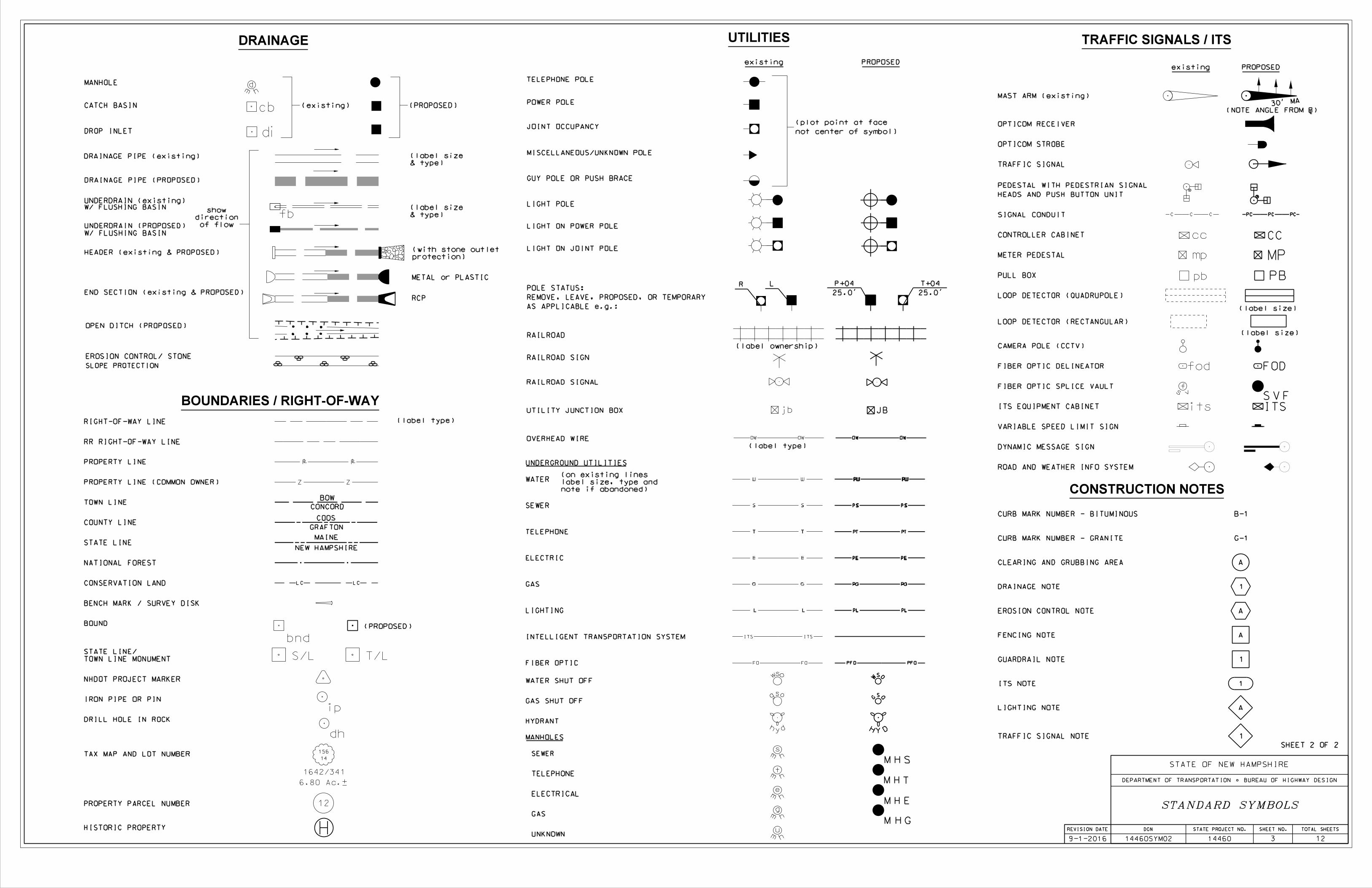
TELEPHONE POLE
POWER POLE
JOINT OCCUPANCY
MISCELLANEOUS/UNKNOWN POLE
POLE STATUS:
AS APPLICABLE e.g.:
LIGHT POLE
LIGHT ON POWER POLE
LIGHT ON JOINT POLE
(plot point at face
not center of symbol)
RIGHT-OF-WAY LINE
PROPERTY LINE
TOWN LINE
COUNTY LINE
STATE LINE
BOUND
DRILL HOLE IN ROCK
NATIONAL FOREST
(label type)
BOW
CONCORD
COOS
GRAFTON
MAINE
IRON PIPE OR PIN
NHDOT PROJECT MARKER
PEDESTAL WITH PEDESTRIAN SIGNAL
HEADS AND PUSH BUTTON UNIT
CONTROLLER CABINET
METER PEDESTAL
PULL BOX
LOOP DETECTOR (QUADRUPOLE)
LOOP DETECTOR (RECTANGULAR)
(label size)
(label size)
PROPERTY PARCEL NUMBER
HISTORIC PROPERTY
WATER SHUT OFF
GAS SHUT OFF
RAILROAD
RAILROAD SIGN
RAILROAD SIGNAL
(label ownership)
HYDRANT
UTILITY JUNCTION BOX
MAST ARM (existing)
OPTICOM RECEIVER
OPTICOM STROBE
MANHOLE
CATCH BASIN
DROP INLET
DRAINAGE PIPE (existing)
EROSION CONTROL/ STONE
SLOPE PROTECTION
(existing)
DRAINAGE
BOUNDARIES / RIGHT-OF-WAY
UTILITIES
di
cb (PROPOSED)
RCP
g os
H Y D
12
DRAINAGE PIPE (PROPOSED)
HEADER (existing & PROPOSED)
REMOVE, LEAVE, PROPOSED, OR TEMPORARYEND SECTION (existing & PROPOSED)
OPEN DITCH (PROPOSED)
SEWER
TELEPHONE
ELECTRICAL
GAS
30' MA
NEW HAMPSHIRE
S/L T/L
bnd
TOWN LINE MONUMENT
STATE LINE/
of flow
direction
show& type)
(label size
& type)
(label size
W/ FLUSHING BASIN
UNDERDRAIN (PROPOSED)
STAN'S
SIGN
MANHOLES
TRAFFIC SIGNAL
RR RIGHT-OF-WAY LINE
PROPERTY LINE (COMMON OWNER)
TAX MAP AND LOT NUMBER
protection)
(with stone outlet
6.80 Ac.±
1642/341
14
156
note if abandoned)
label size, type and
(on existing lines
UNDERGROUND UTILITIES
W/ FLUSHING BASINUNDERDRAIN (existing)
L P+04
25.0'
R T+04
25.0'
jb
M H T
M H E
M H S
M H G
SOG
W
SO
m h
e
m h
g
hy d
m ht
m h
s
wso
cc
pb
mp
PB
MP
(NOTE ANGLE FROM Å)
FENCING NOTE
CLEARING AND GRUBBING AREA
DRAINAGE NOTE
GUARDRAIL NOTE
G-1
B-1
LIGHTING NOTE
EROSION CONTROL NOTE
A
1
A
A
1
A
CONSTRUCTION NOTES
(PROPOSED)
GUY POLE OR PUSH BRACE
BENCH MARK / SURVEY DISK
METAL or PLASTIC
CURB MARK NUMBER - GRANITE
CURB MARK NUMBER - BITUMINOUS
fb
TELEPHONE
ELECTRIC
GAS
LIGHTING
FIBER OPTIC
INTELLIGENT TRANSPORTATION SYSTEM
WATER
SEWER
JB
CC
SIGNAL CONDUIT
PROPOSEDexistingPROPOSEDexisting
dh
ip
1TRAFFIC SIGNAL NOTE
SHEET 2 OF 2
m h
uUNKNOWN
m hd
TRAFFIC SIGNALS / ITS
ITS NOTE 1
FIBER OPTIC DELINEATOR
s vf
ITSitsVS F
FODfod
VARIABLE SPEED LIMIT SIGN
DYNAMIC MESSAGE SIGN
FIBER OPTIC SPLICE VAULT
ROAD AND WEATHER INFO SYSTEM
CAMERA POLE (CCTV)
ITS EQUIPMENT CABINET
CONSERVATION LAND
OVERHEAD WIRE
(label type)
REVISION DATE
9-1-2016
STATE PROJECT NO. SHEET NO. TOTAL SHEETS
14460
DGN
14460SYM02
STATE OF NEW HAMPSHIRE
DEPARTMENT OF TRANSPORTATION BUREAU OF HIGHWAY DESIGN
3 12
STANDARD SYMBOLS
360
360
400
360
360
360
360
360
360
360
365
365
365
365
365
365
365
365
365
365
365
365
365
365
365
365
365
365
365
365
365 3
65
365
365
365
365
365
365
365
365
370
370
370
370
370
370
370
370
370
37
0370
375
375
375
375
375
375
375
375
380
380
380
380
380
380
380
380
380
380
385
385
385
385
385
385
385
385
390
390
390 390390
390
390
390
390
390
390390
390
395
395
395
395
395
395
395
395
395
395
395
395
395
395
395
395
395
395
395
395
395
395
395395
395
395 395395
395
395
395
395
395
395
395
395
400
400
400
400
400400
400
400
400 400 400
400 400
400
400
400
400
400
400
400400400
405
405
405
405
405
405
405
405
410
410
410
410
410
410
415
415
mh
t
fc
scpscpscpscpscpscpscpscpscp
scp scp scp scp scp scp scp scp scpscpscpscpscpscpscpscpscpscp
scp scp scp scp scp scp scp scp
mb
di
di
an
an
anan
anan
an
NULL
NULL
NULL
NULL
NULL
scp
S/
L
mon
gran
1'x1'
steel post
steel post
1.5'c
str gr cb
bgr
str gr cb
bgr
36
329
net
1
1314
psnh
6
90
901/1
bell
wood
story
1•
sp
conc
sp
drm
sk
stn
cr
4"ci
p
4"pvc
drive
grav
bulkhead
tank
propane
und.sps
& 2
deck
woodlawn
woven wire
orn
cmp
15"
tie
wood
field
gravel pull-off
wood rw
woods
mixed
brush
&
woods
mixed
2
901
cmp
15"
brush
&
woods
mixed
slu
•cmp
und
6"alum
slope
washed out
slabs
gran
rip rap
gran slabs
concrete
exposed
bridge truss
of northwest
centerline
bridge truss
of southwest
centerline
bridge truss
of northwest
centerline
bridge truss
of northeast
centerline
bridge truss
of southeast
centerlinebridge truss
of southwest
centerline
bridge truss
of northeast
centerline
bridge truss
of southeast
centerline
pier
conc
slabs
gran
plate
truss
steel
str gr cb
bgr
rap
rip
wood
1 story
orn
sp
wood
drive
gravel #'s
read
can't
pole
tel
bgr
mixed woods
area
sluff
& brush
mixed woods
riprap
riprap
rap
riphdr
drm
lawn
woven
wire
3'h
rcp
24"
hdr
conc
gate
metal
ade
stock-
stockade
garage
wood
1 story
field
woods
mixed
3-1
903R
net
5A
(7) steel fence posts
line
drip
stn
crsh
wood stockade
slab
conc
pipe
6"
steel bridge rail
steel coping
wing walls/deck
conc abut/
steel truss
Bridge:
steel bridge rail
steel coping
wing walls/deck
conc abut/
steel truss
Bridge:
sewer?
woods
mixed
& parking
gravel drive
#6
6x
#131
psnh
#'s
no
6Y
#131
psnh
65T
7
#131
psnh
STATE OF NEW HAMPSHIREDEPARTMENT OF TRANSPORTATION * BUREAU OF BRIDGE DESIGN
BRIDGE NO. STATE PROJECTTOWN
LOCATION
REVISIONS AFTER PROPOSAL
SHEET SCALE
DESIGNED
DRAWN
QUANTITIES
REV. DATE
ISSUE DATE FEDERAL PROJECT NO. SHEET NO. TOTAL SHEETS
FILE NUMBER
OF
BRIDGE SHEET
DATEBY
CHECKED
CHECKED
CHECKED
DATEBY
SUBDIRECTORY
XX 14460SITE
.DGN LOCATOR
VT ROUTE 113 & EAST THETFORD ROAD OVER THE CONNECTICUT RIVER
LYME AND THETFORD
SITE PLAN & PROFILE
053\112 14460
- 38
03/2019JGS
JGS 03/2019
03/20191-14-2-6
A000(394)
LRB 02/2019
01/2019JDG
AS NOTED 4 12
JDG 03/2019 TEK
L = 120.43'
T = 60.24'
R = 1800.00'
E = 848287.51
N = 478804.29
PI Sta. 21+41.23
EAST THETFORD RD - CURVE 3
L = 82.68'
T = 41.53'
R = 350.00'
E = 848383.94
N = 478836.86
PI Sta. 22+42.96
EAST THETFORD RD - CURVE 4
L = 261.76'
T = 131.93'
R = 850.00'
E = 847566.54
N = 478505.69
PI Sta. 13+62.95
EAST THETFORD RD - CURVE 2
L = 160.83'
T = 80.43'
R = 3500.00'
E = 847354.94
N = 478487.73
PI Sta. 11+50.62
EAST THETFORD RD - CURVE 1
STATE LINE
THETFORD, VT LYME, NH
QUANTITY PURPOSES
LINE SHOWN FOR
STATE BOUNDARY
(APPROX. LIMITS)
ITEM 645.0001
TURBIDITY BARRIER
(APPROX. LIMITS)
ITEM 645.0001
TURBIDITY BARRIER
PIER JACKET
ITEM 520.02016
(NOT SHOWN ON PROFILE)
(APPROX. LIMITS)
ITEM 503.201- COFFERDAM
(APPROX. LIMITS)
TEMPORARY TRESTLE
(APPROX. LIMITS)
TEMPORARY TRESTLE
TEMPORARY CONSTRUCTION EASEMENT
APPROXIMATE LIMITS OF EXISTING RIPRAP
OF EXISTING RIPRAP
APPROXIMATE LIMITS
(SEE SHEET 11)
RIPRAP, CLASS V
ITEM 583.5
(SEE BORING LOGS)
BEDROCK SURFACE
APPROXIMATE
RIVER BED
APPROX. EXISTING
(SEE SHEET 12)
RIPRAP, CLASS III
ITEM 583.3PIER JACKET REPAIR
EL 384.0 (OCT. 2013)Q EL. 400.50
DECK ELEVATION (TYP.)
EXISTING BRIDGE
(FIXED)
À BRG ABUT A À PIER
(EXP.)
À BRG ABUT B
À BRG (FIXED)À BRG (EXP)
(SEE BORING LOGS)
BEDROCK SURFACE
APPROXIMATE
100
N
EAST THETFORD ROAD
River
Road
River
Road
VT 113
398.2
403.38
405.16
406.02
405.35
403.83
403.0
403.7
361.8
364.9
364.2
403.0
366.5
395.7
407.9
LY
ME,
NH
TH
ET
FO
RD,
VT
DATUM = 320.00'
18+00 19+00 20+00 21+00 22+0017+0016+0015+0014+0013+00
466'-0"
1'-3" (TYP)
231'-9"
231'-9"
FINISH GRADE
PROPOSED
GRADE
EXISTING
398.18
406.09
403.01
3.60%
PVI
ST
A 13
+50.00
PVI
EL
= 396.08
PVI
ST
A 13
+87.50
PVI
EL
= 397.43
PV
C
ST
A 14
+45.00
5.98%
LVC = 80.00'
K = 19
PVI
ST
A 14
+85.00
PVI
EL
= 403.26
EL
= 400.87
-1.85%
PVI 20
+95.00
PVI
EL
= 402.88
-0.81%
PVI 21
+25.00
2.74%
PVI
EL
= 403.70
PVI 20
+18.00
PVI
EL
= 403.50
PVI EL = 408.31
PVI 17+58.00
VC = 466.00'
K = 126
PV
CC
ST
A 15
+25.00
EL
= 404.00
PV
T 19
+91.00
EL
= 404.00
(404.8)
(405.7)
(405.1)
(405.8)
13+00
14+00
15+00 16+00 17+00 18+00 19+00 20+00 21+00
22+00
PT 1
4+9
2.7
9
PI 22
+21.02
PC
C 22
+01.42
PC 20
+80.99
PI 13
+36.35
I.S.
I
II
I.S.
I.S.
I
I.S.
I
R.
O.
W.
EXI
ST.
R.
O.
W.
EXI
ST.
WPFR 2
EXIST. R.O.W.
WPFR 2
EXIST. R.O.W.
R.O.W.
EXIST.
R.
O.
W.
EXI
ST.
DAVID E. CHAPMAN
CLAUDIA HENRION
####
LOUIS R. PETERS
####
EXIST. R.O.W.
EXIST. R.O.W.
EXIST. R.O.W.
EXI
ST.
R.
O.
W.
EXI
ST.
R.
O.
W.
EXI
ST.
R.
O.
W.
EXIST. R.O.W.
GILLIAN
TYLER,
23403
TRUST
RAYMOND A. ZACK
22403
an
an
STATE OF NEW HAMPSHIREDEPARTMENT OF TRANSPORTATION * BUREAU OF BRIDGE DESIGN
BRIDGE NO. STATE PROJECTTOWN
LOCATION
REVISIONS AFTER PROPOSAL
SHEET SCALE
DESIGNED
DRAWN
QUANTITIES
REV. DATE
ISSUE DATE FEDERAL PROJECT NO. SHEET NO. TOTAL SHEETS
FILE NUMBER
OF
BRIDGE SHEET
DATEBY
CHECKED
CHECKED
CHECKED
DATEBY
STA. 15+25.00
BRG ABUT. AÀ
STA. 19+91.00
BRG ABUT. BÀÀ
STA. 17+58.00
PIER
EAST THETFORD ROAD CONSTRUCTION Å
WP2
À BRG SPAN 1 À BRG SPAN 2
478634.5553 847943.0169
847933.4509478657.6527
478676.9977 847925.4389
WORKING POINT COORDINATES
WORKING POINT
WP1
WP2
WP3
NORTHING EASTING
SCALE: 1" = 20'
SURVEY LAYOUT
WP1
WP3
PROFILE GRADE LINE
TYPICAL APPROACH SECTION NOT TO SCALE
1'-6" TO 3'-2"
VARIES
SHOULDER
10'-6"
SHOULDER
2'-6"
VARIES
1'-6" TO 2'-0"
VARIES
VARIES
TRAVEL LANE
10'-6"
B CONST. L
VARIES VARIES
TRAVEL LANE
2'-6"
SUBDIRECTORY
XX 14460SVL
.DGN LOCATOR
VT ROUTE 113 & EAST THETFORD ROAD OVER THE CONNECTICUT RIVER
LYME AND THETFORD
SURVEY LAYOUT AND APPROACH SECTION
053\112 14460
- 38
--
- -
-1-14-2-6
A000(394)
TJG 06/2021
01/2019JDG
AS NOTED 5 12
25'-0"
25'-0"
15+00 16+00 17+00 18+00 19+00 20+00
PT
14
+9
2.
79
N
NOTES:
2. PRODUCTS CONTAINING POLYACRYLAMIDE (PAM) SHALL NOT BE APPLIED DIRECTLY TO OR WITHIN 100 FEET OF ANY SURFACE
3. ALL EROSION CONTROL BLANKETS SHALL BE MADE WITH WILDLIFE FRIENDLY BIODEGRADABLE NETTING.
1
SLOPES
CHANNELS
APPLICATION AREAS DRY MULCH METHODS HYDRAULICALLY APPLIED MULCHES2
ROLLED EROSION CONTROL BLANKETS3
HMT WC SG CB HM SMM BFM FRM SNSB DNSB DNSCB DNCB
STEEPER THAN 2:1 NO NO YES NO NO NO NO YES NO NO NO YES
2:1 SLOPE YES YES YES YES NO NO YES YES NO YES YES YES
3:1 SLOPE YES YES YES YES NO YES YES YES YES YES YES NO
4:1 SLOPE YES YES YES YES YES YES YES YES YES YES NO NO
WINTER STABILIZATION 4T/AC YES YES YES NO NO YES YES YES YES YES YES
LOW FLOW CHANNELS NO NO NO NO NO NO NO NO NO NO YES YES
HIGH FLOW CHANNELS NO NO NO NO NO NO NO NO NO NO NO YES
ABBREV. STABILIZATION MEASURE ABBREV. STABILIZATION MEASURE ABBREV. STABILIZATION MEASURE
HMT HAY MULCH & TACK HM HYDRAULIC MULCH SNSB SINGLE NET STRAW BLANKET
WC WOOD CHIPS SMM STABILIZED MULCH MATRIX DNSB DOUBLE NET STRAW BLANKET
SG STUMP GRINDINGS BFM BONDED FIBER MATRIX DNSCB 2 NET STRAW-COCONUT BLANKET
CB COMPOST BLANKET FRM DNCB 2 NET COCONUT BLANKET
LEVEL OF PROTECTION TO STRUCTURES AND DOWN-GRADIENT SENSITIVE RECEPTORS.
DROP INLET SEDIMENT BARRIERS SHOULD NEVER BE USED AS THE PRIMARY MEANS OF SEDIMENT CONTROL AND SHOULD ONLY BE USED TO PROVIDE AN ADDITIONAL 8.4.
CLEAN CATCH BASINS, DRAINAGE PIPES, AND CULVERTS IF SIGNIFICANT SEDIMENT IS DEPOSITED.8.3.
INSTALL SEDIMENT BARRIERS AND SEDIMENT TRAPS AT INLETS TO PREVENT SEDIMENT FROM ENTERING THE DRAINAGE SYSTEM.8.2.
DIVERT SEDIMENT LADEN WATER AWAY FROM INLET STRUCTURES TO THE EXTENT POSSIBLE.8.1.
PROTECT STORM DRAIN INLETS: 8.
DETENTION BASINS SHALL BE DESIGNED AND CONSTRUCTED TO ACCOMMODATE A 2 YEAR STORM EVENT.12.7.
ALL AREAS THAT CAN BE STABILIZED SHALL BE STABILIZED PRIOR TO OPENING UP NEW TERRITORY.12.6.
GRAVEL, OR CRUSHED STONE BASE TO HELP MINIMIZE EROSION ISSUES.
FOR HAUL ROADS ADJACENT TO SENSITIVE ENVIRONMENTAL AREAS OR STEEPER THAN 5%, THE DEPARTMENT WILL CONSIDER USING EROSION STONE, CRUSHED 12.5.
AREAS WHERE HAUL ROADS ARE CONSTRUCTED AND STORMWATER CANNOT BE TREATED THE DEPARTMENT WILL CONSIDER INFILTRATION.12.4.
SLOPES 3:1 OR FLATTER WILL RECEIVE TURF ESTABLISHMENT ALONE.12.3.
SLOPES STEEPER THAN 3:1 WILL RECEIVE TURF ESTABLISHMENT WITH MATTING.12.2.
STRATEGIES.
THE CONTRACTOR SHALL COMPLY WITH RSA 485:A:17 AND ENV-WQ 1500; ALTERATION OF TERRAIN FOR CONSTRUCTION AND USE ALL CONVENTIONAL BMP 12.1.
STRATEGIES SPECIFIC TO OPEN AREAS LESS THAN 5 ACRES:12.
TABLE 1
GUIDANCE ON SELECTING TEMPORARY SOIL STABILIZATION MEASURES
EROSION CONTROL STRATEGIES
REVISION DATE
12-21-2015
WATER WITHOUT PRIOR WRITTEN APPROVAL FROM THE NH DEPARTMENT OF ENVIRONMENTAL SERVICES.
1. ALL SLOPE STABILIZATION OPTIONS ASSUME A SLOPE LENGTH \10 TIMES THE HORIZONTAL DISTANCE COMPONENT OF THE SLOPE, IN FEET.
FIBER REINFORCED MEDIUM
GENERAL CONSTRUCTION PLANNING AND SELECTION OF STRATEGIES TO CONTROL EROSION AND SEDIMENT ON HIGHWAY CONSTRUCTION PROJECTS
SWEEP ALL CONSTRUCTION RELATED DEBRIS AND SOIL FROM THE ADJACENT PAVED ROADWAYS AS NECESSARY.7.2.
INSTALL AND MAINTAIN CONSTRUCTION EXITS, ANYWHERE TRAFFIC LEAVES A CONSTRUCTION SITE ONTO A PUBLIC RIGHT-OF-WAY.7.1.
ESTABLISH STABILIZED CONSTRUCTION EXITS:7.
BEST MANAGEMENT PRACTICES (BMP) BASED ON AMOUNT OF OPEN CONSTRUCTION AREA
1 1
HYDROLOGY BEYOND THE PERMITTED AREA.
DIVERT OFF-SITE WATER THROUGH THE PROJECT IN AN APPROPRIATE MANNER SO NOT TO DISTURB THE UPSTREAM OR DOWNSTREAM SOILS, VEGETATION OR 5.5.
AND DISCHARGE LOCATIONS PRIOR TO USE.
STABILIZE, TO APPROPRIATE ANTICIPATED VELOCITIES, CONVEYANCE CHANNELS OR PUMPING SYSTEMS NEEDED TO CONVEY CONSTRUCTION STORMWATER TO BASINS 5.4.
CONSTRUCT IMPERMEABLE BARRIERS AS NECESSARY TO COLLECT OR DIVERT CONCENTRATED FLOWS FROM WORK OR DISTURBED AREAS.5.3.
LOCATION.
DIVERT STORM RUNOFF FROM UPSLOPE DRAINAGE AREAS AWAY FROM DISTURBED AREAS, SLOPES, AND AROUND ACTIVE WORK AREAS AND TO A STABILIZED OUTLET 5.2.
DIVERT OFF SITE RUNOFF OR CLEAN WATER AWAY FROM THE CONSTRUCTION ACTIVITY TO REDUCE THE VOLUME THAT NEEDS TO BE TREATED ON SITE.5.1.
CONTROL STORMWATER FLOWING ONTO AND THROUGH THE PROJECT:5.
WITH SECTION 2.1.2.1. OF THE 2012 NPDES CONSTRUCTION GENERAL PERMIT.
WHEN WORK IS PERFORMED WITHIN 50 FEET OF SURFACE WATERS (WETLAND, OPEN WATER OR FLOWING WATER), PERIMETER CONTROL SHALL BE ENHANCED CONSISTENT 3.5.
WHEN WORK IS PERFORMED IN AND NEAR WATER COURSES, STREAM FLOW DIVERSION METHODS SHALL BE IMPLEMENTED PRIOR TO ANY EXCAVATION OR FILLING.3.4.
PROTECT AND MAXIMIZE EXISTING NATIVE VEGETATION AND NATURAL FOREST BUFFERS BETWEEN CONSTRUCTION ACTIVITY AND SENSITIVE AREAS.3.3.
CONSTRUCTION SHALL BE SEQUENCED TO LIMIT THE DURATION AND AREA OF EXPOSED SOILS.3.2.
CLEARLY FLAG AREAS TO BE PROTECTED IN THE FIELD AND PROVIDE CONSTRUCTION BARRIERS TO PREVENT TRAFFICKING OUTSIDE OF WORK AREAS.3.1.
PLAN ACTIVITIES TO ACCOUNT FOR SENSITIVE SITE CONDITIONS: 3.
MET.
CRITICAL PATH METHOD SCHEDULE (CPM), AND THE CONTRACTOR HAS ADEQUATE RESOURCES AVAILABLE TO ENSURE THAT ENVIRONMENTAL COMMITMENTS WILL BE
MONTHS, UNLESS THE CONTRACTOR DEMONSTRATES TO THE DEPARTMENT THAT THE ADDITIONAL AREA OF DISTURBANCE IS NECESSARY TO MEET THE CONTRACTORS
, OR EXCEED ONE ACRE DURING WINTER TH
THROUGH NOVEMBER 30ST
THE MAXIMUM AMOUNT OF DISTURBED EARTH SHALL NOT EXCEED A TOTAL OF 5 ACRES FROM MAY 14.3.
UTILIZE TEMPORARY MULCHING OR PROVIDE ALTERNATE TEMPORARY STABILIZATION ON EXPOSED SOILS IN ACCORDANCE WITH TABLE 1.4.2.
SHALL BE USED TO REDUCE THE AMOUNT AND DURATION OF SOIL EXPOSED TO THE ELEMENTS AND VEHICLE TRACKING.
CONSTRUCTION SHALL BE SEQUENCED TO LIMIT THE DURATION AND AREA OF EXPOSED SOILS. MINIMIZE THE AREA OF EXPOSED SOIL AT ANY ONE TIME. PHASING 4.1.
MINIMIZE THE AMOUNT OF EXPOSED SOIL:4.
UP AND DOWN THE SLOPE, DISKED, HARROWED, DRAGGED WITH A CHAIN OR MAT, MACHINE-RAKED, OR HAND-WORKED TO PRODUCE A RUFFLED SURFACE.
THE OUTER FACE OF THE FILL SLOPE SHOULD BE IN A LOOSE RUFFLED CONDITION PRIOR TO TURF ESTABLISHMENT. TOPSOIL OR HUMUS LAYERS SHALL BE TRACKED 6.4.
CONVEY STORMWATER DOWN THE SLOPE IN A STABILIZED CHANNEL OR SLOPE DRAIN.6.3.
CONSIDER HOW GROUNDWATER SEEPAGE ON CUT SLOPES MAY IMPACT SLOPE STABILITY AND INCORPORATE APPROPRIATE MEASURES TO MINIMIZE EROSION.6.2.
OUTLET OR CONVEYANCE.
INTERCEPT AND DIVERT STORM RUNOFF FROM UPSLOPE DRAINAGE AREAS AWAY FROM UNPROTECTED AND NEWLY ESTABLISHED AREAS AND SLOPES TO A STABILIZED 6.1.
PROTECT SLOPES:6.
MONITORING OF THE SYSTEM.
DEMONSTRATED EXPERIENCE IN THE DESIGN OF FLOCCULANT TREATMENT SYSTEMS. THE CONSULTANT WILL ALSO BE RESPONSIBLE FOR THE IMPLEMENTATION AND
TREAT AND RELEASE WATER CAPTURED IN STORM WATER BASINS. THE CONTRACTOR SHALL ALSO RETAIN THE SERVICES OF AN ENVIRONMENTAL CONSULTANT WHO HAS
THE CONTRACTOR WILL BE REQUIRED TO HAVE AN APPROVED DESIGN IN ACCORDANCE WITH ENV-WQ 1506.12 FOR AN ACTIVE FLOCCULANT TREATMENT SYSTEM TO 14.3.
AMOUNT OF SEDIMENT IN THE STORMWATER TREATMENT BASINS.
THE DEPARTMENT ANTICIPATES THAT SOIL BINDERS WILL BE NEEDED ON ALL SLOPES STEEPER THAN 3:1, IN ORDER TO MINIMIZE EROSION AND REDUCE THE 14.2.
TREATMENT OPTIONS USED FOR UNDER 5 ACRES AND BETWEEN 5 AND 10 ACRES WILL BE UTILIZED.
THE CONTRACTOR SHALL COMPLY WITH RSA 485:A:17 AND ENV-WQ 1500 ALTERATION OF TERRAIN AND SHALL USE CONVENTIONAL BMP STRATEGIES AND ALL 14.1.
STRATEGIES SPECIFIC TO OPEN AREAS OVER 10 ACRES:14.
ALSO CONSIDER A SOIL BINDER IN ACCORDANCE WITH THE NHDES APPROVALS OR REGULATIONS.
SLOPES 3:1 OR FLATTER WILL RECEIVE TURF ESTABLISHMENT OR OTHER TEMPORARY SOIL STABILIZATION MEASURES DETAILED IN TABLE 1. THE CONTRACTOR MAY 13.4.
BONDED FIBER MATRIXES (BFMS) OR FLEXIBLE GROWTH MEDIUMS (FGMS) MAY BE UTILIZED, IF MEETING THE NHDES APPROVALS AND REGULATIONS.
THE CONTRACTOR MAY ALSO CONSIDER A SOIL BINDER IN ACCORDANCE WITH THE NHDES APPROVALS OR REGULATIONS. OTHER ALTERNATIVE MEASURES, SUCH AS
SLOPES STEEPER THAN A 3:1 WILL RECEIVE TURF ESTABLISHMENT WITH MATTING OR OTHER TEMPORARY SOIL STABILIZATION MEASURES DETAILED IN TABLE 1. 13.3.
DETENTION BASINS WILL BE CONSTRUCTED TO ACCOMMODATE THE 2-YEAR 24-HOUR STORM EVENT AND CONTROL A 10-YEAR 24-HOUR STORM EVENT.13.2.
TREATMENT OPTIONS USED FOR UNDER 5 ACRES WILL BE UTILIZED.
THE CONTRACTOR SHALL COMPLY WITH RSA 485:A:17 AND ENV-WQ 1500 ALTERATION OF TERRAIN AND SHALL USE CONVENTIONAL BMP STRATEGIES AND ALL 13.1.
STRATEGIES SPECIFIC TO OPEN AREAS BETWEEN 5 AND 10 ACRES:13.
LOSS UNTIL PERMANENT VEGETATION IS ESTABLISHED.
SOIL TACKIFIERS MAY BE APPLIED IN ACCORDANCE WITH THE MANUFACTURER'S SPECIFICATIONS AND REAPPLIED AS NECESSARY TO MINIMIZE SOIL AND MULCH 9.4.
AND PRIOR TO SEPTEMBER 15, OF ANY GIVEN YEAR, IN ORDER TO ACHIEVE VEGETATIVE STABILIZATION PRIOR TO THE END OF THE GROWING SEASON.
EROSION CONTROL SEED MIX SHALL BE SOWN IN ALL INACTIVE CONSTRUCTION AREAS THAT WILL NOT BE PERMANENTLY SEEDED WITHIN TWO WEEKS OF DISTURBANCE 9.3.
2012 CGP. (SEE TABLE 1 FOR GUIDANCE ON THE SELECTION OF TEMPORARY SOIL STABILIZATION MEASURES.)
IN ALL AREAS, TEMPORARY SOIL STABILIZATION MEASURES SHALL BE APPLIED IN ACCORDANCE WITH THE STABILIZATION REQUIREMENTS (SECTION 2.2) OF THE 9.2.
WITHIN THREE DAYS OF THE LAST ACTIVITY IN AN AREA, ALL EXPOSED SOIL AREAS, WHERE CONSTRUCTION ACTIVITIES ARE COMPLETE, SHALL BE STABILIZED. 9.1.
SOIL STABILIZATION: 9.
LINE.
SLOPES. THE PERIMETER CONTROLS SHALL BE INSTALLED ON THE FILL SLOPE TO MINIMIZE THE POTENTIAL FOR FILL SLOPE SEDIMENT DEPOSITS IN THE DITCH
CHANNEL PROTECTION MEASURES SHALL BE SUPPLEMENTED WITH PERIMETER CONTROL MEASURES WHEN THE DITCH LINES OCCUR AT THE BOTTOM OF LONG FILL 11.9.
PLAN, DEVELOPED BY A QUALIFIED ENGINEER OR A CPESC SPECIALIST, IS REVIEWED AND APPROVED BY THE DEPARTMENT.
THE AREA OF EXPOSED SOIL SHALL BE LIMITED TO ONE ACRE, OR THAT WHICH CAN BE STABILIZED AT THE END OF EACH DAY UNLESS A WINTER CONSTRUCTION
WINTER EXCAVATION AND EARTHWORK ACTIVITIES NEED TO BE LIMITED IN EXTENT AND DURATION, TO MINIMIZE POTENTIAL EROSION AND SEDIMENTATION IMPACTS. 11.8.
PERMANENT DITCHES SHALL BE DIRECTED TO DRAIN TO SEDIMENT BASINS OR STORM WATER COLLECTION AREAS.
TEMPORARY AND PERMANENT DITCHES SHALL BE CONSTRUCTED, STABILIZED AND MAINTAINED IN A MANNER THAT WILL MINIMIZE SCOUR. TEMPORARY AND 11.7.
PLACE TEMPORARY STONE INLET PROTECTION OVER INLETS IN AREAS OF SOIL DISTURBANCE THAT ARE SUBJECT TO SEDIMENT CONTAMINATION.
CATCH BASINS: CARE SHALL BE TAKEN TO ENSURE THAT SEDIMENTS DO NOT ENTER ANY EXISTING CATCH BASINS DURING CONSTRUCTION. THE CONTRACTOR SHALL 11.6.
THE CONTRACTOR SHALL BE RESPONSIBLE FOR EROSION AND SEDIMENT CONTROL FOR ONE YEAR AFTER PROJECT COMPLETION.
VEGETATIVE STABILIZATION SHALL NOT BE CONSIDERED PERMANENTLY STABILIZED UNTIL VEGETATIVE GROWTH COVERS AT LEAST 85% OF THE DISTURBED AREA.
PERMANENT STABILIZATION MEASURES WILL BE CONSTRUCTED AND MAINTAINED IN LOCATIONS AS SHOWN ON THE CONSTRUCTION PLANS TO STABILIZE AREAS. 11.5.
STABILIZATION OF THE CONTRIBUTING DISTURBED AREA.
THE CONTRACTOR SHOULD UTILIZE STORM DRAIN INLET PROTECTION TO PREVENT SEDIMENT FROM ENTERING A STORM DRAINAGE SYSTEM PRIOR TO THE PERMANENT 11.4.
ACCORDANCE WITH THE GUIDANCE MEMO FROM THE NHDES CONTAINED WITHIN THE CONTRACT PROPOSAL AND THE EPA CONSTRUCTION GENERAL PERMIT.
AFTER ANY STORM EVENT GREATER THAN 0.25 IN. OF RAIN PER 24-HOUR PERIOD. EROSION AND SEDIMENT CONTROL MEASURES WILL ALSO BE INSPECTED IN
EROSION AND SEDIMENT CONTROL MEASURES WILL BE INSPECTED IN ACCORDANCE WITH SECTION 645 OF NHDOT SPECIFICATIONS, WEEKLY AND WITHIN 24 HOURS 11.3.
MEASURES (TEMPORARY EROSION CONTROL SEED MIX AND MULCH, SOIL BINDER) OR COVERED WITH ANCHORED TARPS.
ALL STOCKPILES SHALL BE CONTAINED WITH TEMPORARY PERIMETER CONTROLS. INACTIVE SOIL STOCKPILES SHOULD BE PROTECTED WITH SOIL STABILIZATION 11.2.
TACKIFIERS, AS APPROVED BY THE NHDES.
USE MECHANICAL SWEEPERS ON PAVED SURFACES WHERE NECESSARY TO PREVENT DUST BUILDUP. APPLY WATER, OR OTHER DUST INHIBITING AGENTS OR
USE TEMPORARY MULCHING, PERMANENT MULCHING, TEMPORARY VEGETATIVE COVER, AND PERMANENT VEGETATIVE COVER TO REDUCE THE NEED FOR DUST CONTROL. 11.1.
ADDITIONAL EROSION AND SEDIMENT CONTROL GENERAL PRACTICES:11.
EROSION, POLLUTION, AND TURBIDITY PRECAUTIONS.
THE CONTRACTOR IS DIRECTED TO REVIEW AND COMPLY WITH SECTION 107.1 OF THE CONTRACT AS IT REFERS TO SPILLAGE, AND ALSO WITH REGARDS TO 1.6.
)HTTP://DES.NH.GOV/ORGANIZATION/COMMISSIONER/LEGAL/RULES/INDEX.HTM(
THE CONTRACTOR SHALL COMPLY WITH RSA 485-A:17, AND ALL, PUBLISHED NHDES ALTERATION OF TERRAIN ENV-WQ 1500 REQUIREMENTS 1.5.
OF ENVIRONMENTAL SERVICES (NHDES).
MANUAL, VOLUME 3, EROSION AND SEDIMENT CONTROLS DURING CONSTRUCTION (DECEMBER 2008) (BMP MANUAL) AVAILABLE FROM THE NEW HAMPSHIRE DEPARTMENT
ALL STORM WATER, EROSION AND SEDIMENT CONTROL MEASURES SHALL BE INSTALLED AND MAINTAINED IN ACCORDANCE WITH THE NEW HAMPSHIRE STORMWATER 1.4.
THE SPECIAL ATTENTION ITEMS INCLUDED IN THE CONTRACT DOCUMENTS.
THE CONTRACTOR'S ATTENTION IS DIRECTED TO THE NHDES WETLAND PERMIT, THE US ARMY CORPS OF ENGINEERS PERMIT, WATER QUALITY CERTIFICATION AND 1.3.
GENERAL PERMIT (CGP).
AS ADMINISTERED BY THE ENVIRONMENTAL PROTECTION AGENCY (EPA). THIS PROJECT IS SUBJECT TO REQUIREMENTS IN THE MOST RECENT CONSTRUCTION
THIS PROJECT WILL BE SUBJECT TO THE US EPA'S NATIONAL POLLUTANT DISCHARGE ELIMINATION SYSTEM (NPDES) STORM WATER CONSTRUCTION GENERAL PERMIT 1.2.
REGULATIONS.
THESE GUIDELINES DO NOT RELIEVE THE CONTRACTOR FROM COMPLIANCE WITH ANY CONTRACT PROVISIONS, OR APPLICABLE FEDERAL, STATE, AND LOCAL 1.1.
ENVIRONMENTAL COMMITMENTS:1.
SURROUNDING ENVIRONMENT FROM AREAS OF UNSTABILIZED EARTH DISTURBING ACTIVITIES.
TEMPORARY SEDIMENT BASINS OR TRAPS SHALL BE PLACED AND STABILIZED AT LOCATIONS WHERE CONCENTRATED FLOW (CHANNELS AND PIPES) DISCHARGE TO THE 10.3.
CONSTRUCT AND STABILIZE DEWATERING INFILTRATION BASINS PRIOR TO ANY EXCAVATION THAT MAY REQUIRE DEWATERING.10.2.
STORMWATER RUNOFF FROM A 10-YEAR 24 HOUR STORM EVENT. ON-SITE RETENTION OF THE 10-YEAR 24-HOUR EVENT IS NOT REQUIRED.
TEMPORARY SEDIMENT BASINS USED TO TREAT STORMWATER RUNOFF FROM AREAS GREATER THAN 5-ACRES OF DISTURBANCE SHALL BE SIZED TO ALSO CONTROL
24-HOUR STORM EVENT FOR ANY AREA OF DISTURBANCE OR 3,600 CUBIC FEET OF STORMWATER RUNOFF PER ACRE OF DISTURBANCE, WHICHEVER IS GREATER.
TEMPORARY SEDIMENT BASINS (CGP-SECTION 2.1.3.2) OR SEDIMENT TRAPS (ENV-WQ 1506.10) SHALL BE SIZED TO RETAIN, ON SITE, THE VOLUME OF A 2-YEAR 10.1.
RETAIN SEDIMENT ON-SITE AND CONTROL DEWATERING PRACTICES:10.
.TH
THE REQUIREMENTS OF NO LESS THAN 30 DAYS PRIOR TO THE COMMENCEMENT OF WORK SCHEDULED AFTER NOVEMBER 30
(E) A SWPPP AMENDMENT SHALL BE SUBMITTED TO THE DEPARTMENT, FOR APPROVAL, ADDRESSING COLD WEATHER STABILIZATION (ENV-WQ 1505.05) AND INCLUDING
WINTER CONSTRUCTION PLAN HAS BEEN APPROVED BY NHDOT THAT MEETS THE REQUIREMENTS OF ENV-WQ 1505.02 AND ENV-WQ 1505.05.
(D) WINTER EXCAVATION AND EARTHWORK SHALL BE DONE SUCH THAT NO MORE THAN 1 ACRE OF THE PROJECT IS WITHOUT STABILIZATION AT ONE TIME, UNLESS A
INCOMPLETE ROAD SURFACES, WHERE WORK HAS STOPPED FOR THE SEASON, SHALL BE PROTECTED IN ACCORDANCE WITH TABLE 1.TH
AFTER NOVEMBER 30(C)
SHALL BE STABILIZED TEMPORARILY WITH STONE OR IN ACCORDANCE WITH TABLE 1.
, TH
, OR WHICH ARE DISTURBED AFTER OCTOBER 15TH
ALL DITCHES OR SWALES WHICH DO NOT EXHIBIT A MINIMUM OF 85% VEGETATIVE GROWTH BY OCTOBER 15(B)
, SHALL BE STABILIZED IN ACCORDANCE WITH TABLE 1. TH
15
, OR WHICH ARE DISTURBED AFTER OCTOBER TH
ALL PROPOSED VEGETATED AREAS WHICH DO NOT EXHIBIT A MINIMUM OF 85% VEGETATIVE GROWTH BY OCTOBER 15(A)
FOLLOWING REQUIREMENTS.
OF ANY YEAR SHALL BE CONSIDERED WINTER CONSTRUCTION AND SHALL CONFORM TO THE ST
AND MAY 1TH
CONSTRUCTION PERFORMED ANY TIME BETWEEN NOVEMBER 302.8.
TEMPORARY EROSION AND SEDIMENTATION CONTROL MEASURES SHALL REMAIN UNTIL THE AREA HAS BEEN PERMANENTLY STABILIZED.2.7.
A WATER TRUCK SHALL BE AVAILABLE TO CONTROL EXCESSIVE DUST AT THE DIRECTION OF THE CONTRACT ADMINISTRATOR.2.6.
BE REQUIRED.
ALL STOCKPILES SHALL BE CONTAINED WITH A PERIMETER CONTROL. IF THE STOCKPILE IS TO REMAIN UNDISTURBED FOR MORE THAN 14 DAYS, MULCHING WILL 2.5.
TEMPORARY SLOPE STABILIZATION CONFORMING TO TABLE 1 HAS BEEN PROPERLY INSTALLED (D)
A MINIMUM OF 3" OF NON-EROSIVE MATERIAL SUCH AS STONE OR RIP-RAP HAS BEEN INSTALLED;(C)
A MINIMUM OF 85% VEGETATED GROWTH HAS BEEN ESTABLISHED;(B)
BASE COURSE GRAVELS HAVE BEEN INSTALLED IN AREAS TO BE PAVED;(A)
AN AREA SHALL BE CONSIDERED STABLE IF ONE OF THE FOLLOWING HAS OCCURRED:2.4.
SPECIFICATIONS FOR ROAD AND BRIDGES CONSTRUCTION.
EROSION AND SEDIMENT CONTROL MEASURES SHALL BE INSPECTED IN ACCORDANCE WITH THE CONSTRUCTION GENERAL PERMIT AND SECTION 645 OF THE NHDOT 2.3.
SEDIMENTATION BEYOND PROJECT LIMITS THROUGHOUT THE PROJECT DURATION.
EROSION, SEDIMENTATION CONTROL MEASURES AND INFILTRATION BASINS SHALL BE CLEANED, REPLACED AND AUGMENTED AS NECESSARY TO PREVENT 2.2.
INSTALLED AS SHOWN IN THE BMP MANUAL AND AS DIRECTED BY THE STORMWATER POLLUTION PREVENTION PLAN (SWPPP) PREPARER.
PERIMETER CONTROLS SHALL BE INSTALLED PRIOR TO EARTH DISTURBING ACTIVITIES. PERIMETER CONTROLS AND STABILIZED CONSTRUCTION EXITS SHALL BE 2.1.
STANDARD EROSION CONTROL SEQUENCING APPLICABLE TO ALL CONSTRUCTION PROJECTS:2.
STATE PROJECT NO. SHEET NO. TOTAL SHEETS
14460
DGN
14460ECS
STATE OF NEW HAMPSHIRE
DEPARTMENT OF TRANSPORTATION BUREAU OF HIGHWAY DESIGN
EROSION CONTROL STRATEGIES
6 12
LYME AND THETFORD
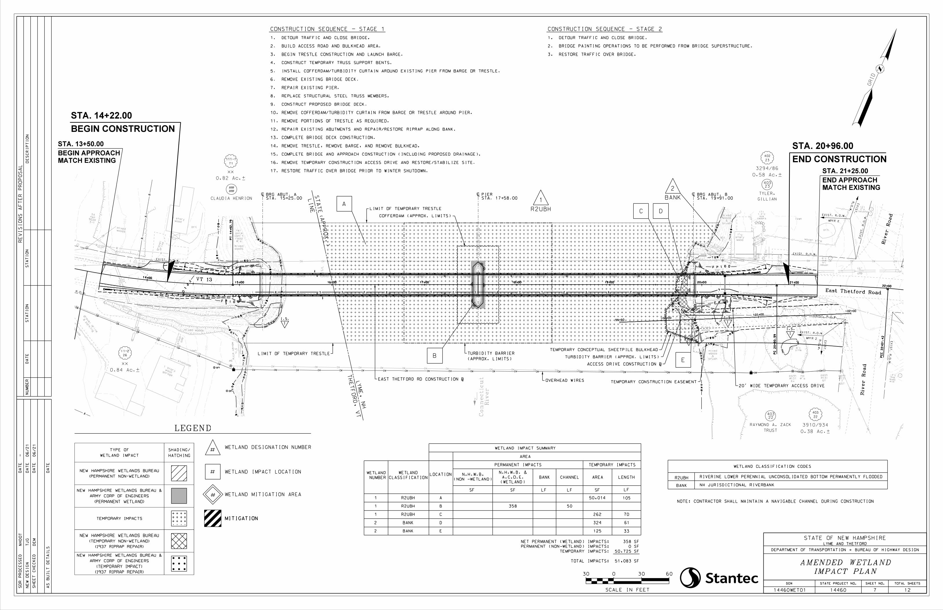
400
385
385
390
390
395
395
395
395
395
395
395
400
400
400 400
400
400
400
400
400
400
400400400
405
405
405
405
405
405
405
410
410
410
385
385
385
385
390
390
390 390390
390
390
390
390
390390
395
395
395
395
395
395
395
395
395
395
395
395
395395
395
395 395395
395
395
395
395
400
400400
400
400
400 400 400
mh
t
fc
scpscpscpscpscpscpscpscpscp
scp scp scp scp scp scp scp scp scpscpscpscpscpscpscpscpscpscp
scp scp scp scp scp scp scp scp
di
di
anan
anan
an
NULL
NULL
NULL
NULL
NULL
scp
S/
L
mon
gran
1'x1'
steel post
steel post
bgr
bgr
elm
quad
ave
.4'c
wood
story
1•
4"ci
p
4"pvc
drive
grav
cedars
ave
1.2'c
(7)
lawn
locust
tri
ave
6'c
woven wire
orn
locusts
2'c
(2)
cmp
15"
field
pine
8'c
gravel pull-off
woods
mixed
brush
&
woods
mixed
2
901
cmp
15"
brush
&
woods
mixed
slu
•cmp
und
6"alum
bgr
wood
1 story
orn
drive
gravel #'s
read
can't
pole
tel
bgr
mixed woods
& brush
mixed woods
lawn
woven
wire
3'h
rcp
24"
ade
stock-
stockade
garage
wood
1 story
woods
mixed
3-1
903R
net
5A
wood stockade
pipe
6"
sewer?
woods
mixed
& parking
gravel drive
#6
6x
#131
psnh
#'s
no
6Y
#131
psnh
65T
7
#131
psnh
EAST THETFORD RD CONSTRUCTION Å
River
Road
River
Road
East Thetford Road
À
STA. 17+58.00PIER À
STA. 19+91.00BRG ABUT. B
MATCH EXISTING
STA. 21+25.00
END APPROACH
À
STA. 15+25.00BRG ABUT. A
OVERHEAD WIRES
SCALE IN FEET
30 0 6030
LI
NE
ST
AT
EA
PP
RO
X.)
(
TH
ET
FO
RD,
VT
YM
E,
NH
L
(APPROX. LIMITS)
TURBIDITY BARRIER
COFFERDAM (APPROX. LIMITS)
VT 13
LIMIT OF TEMPORARY TRESTLE
LIMIT OF TEMPORARY TRESTLE
MATCH EXISTING
BEGIN APPROACH
STA. 13+50.00
ACCESS DRIVE CONSTRUCTION Å
TURBIDITY BARRIER (APPROX. LIMITS)
NOTE: CONTRACTOR SHALL MAINTAIN A NAVIGABLE CHANNEL DURING CONSTRUCTION
A
B
1
R2UBH
2
BANK
D
NUMBER
WETLANDLOCATION
CLASSIFICATION
WETLAND
(NON -WETLAND)
N.H.W.B.
SFSF LF LF
1 R2UBH A
1 R2UBH B
2 DBANK
SF
358 50
50,014
125
TOTAL IMPACTS:
TEMPORARY IMPACTS:
PERMANENT (NON-WETLAND) IMPACTS:
NET PERMANENT (WETLAND) IMPACTS:
R2UBH RIVERINE LOWER PERENNIAL UNCONSOLIDATED BOTTOM PERMANENTLY FLOODED
BANK NH JURISDICTIONAL RIVERBANK
WETLAND IMPACT SUMMARY
AREA
PERMANENT IMPACTS
CHANNELBANK
(WETLAND)
A.C.O.E.
N.H.W.B. &
AREA
TEMPORARY IMPACTS
LENGTH
LF
105
33
WETLAND CLASSIFICATION CODES
61
STATE PROJECT NO. SHEET NO. TOTAL SHEETS
SH
EE
T
CH
EC
KE
D
AS
BUI
LT
DE
TAI
LS
DA
TE
DA
TE
DA
TE
DA
TE
NU
MB
ER
DA
TE
ST
ATI
ON
ST
ATI
ON
DE
SC
RI
PTI
ON
RE
VI
SI
ON
S
AF
TE
R
PR
OP
OS
AL
14460
DGN
14460WET01
STATE OF NEW HAMPSHIRE
SD
R
PR
OC
ES
SE
D
NE
W
DE
SI
GN
DEPARTMENT OF TRANSPORTATION BUREAU OF HIGHWAY DESIGN
NH
DO
T
TJ
G
DE
M
- 06/21
06/21
7 12
IMPACT PLAN
AMENDED WETLAND
LYME AND THETFORD
TEMPORARY CONCEPTUAL SHEETPILE BULKHEAD
20' WIDE TEMPORARY ACCESS DRIVE
0.58 Ac.±
3294/86
23
402
GILLIAN
TYLER,
23403
CLAUDIA HENRION
####
0.82 Ac.±
xx
71
111-1
0.84 Ac.±
xx
26
11-2
0.38 Ac.±
3910/934
22
403
TRUST
RAYMOND A. ZACK
22403
TEMPORARY CONSTRUCTION EASEMENT
River
Con
necticut
RESTORE TRAFFIC OVER BRIDGE.3.
BRIDGE PAINTING OPERATIONS TO BE PERFORMED FROM BRIDGE SUPERSTRUCTURE.2.
DETOUR TRAFFIC AND CLOSE BRIDGE.1.
CONSTRUCTION SEQUENCE - STAGE 1 CONSTRUCTION SEQUENCE - STAGE 2
1 R2UBH C 262 70
C
RESTORE TRAFFIC OVER BRIDGE PRIOR TO WINTER SHUTDOWN.17.
REMOVE TEMPORARY CONSTRUCTION ACCESS DRIVE AND RESTORE/STABILIZE SITE.16.
COMPLETE BRIDGE AND APPROACH CONSTRUCTION (INCLUDING PROPOSED DRAINAGE).15.
REMOVE TRESTLE, REMOVE BARGE, AND REMOVE BULKHEAD.14.
COMPLETE BRIDGE DECK CONSTRUCTION.13.
REPAIR EXISTING ABUTMENTS AND REPAIR/RESTORE RIPRAP ALONG BANK.12.
REMOVE PORTIONS OF TRESTLE AS REQUIRED.11.
REMOVE COFFERDAM/TURBIDITY CURTAIN FROM BARGE OR TRESTLE AROUND PIER.10.
CONSTRUCT PROPOSED BRIDGE DECK.9.
REPLACE STRUCTURAL STEEL TRUSS MEMBERS.8.
REPAIR EXISTING PIER.7.
REMOVE EXISTING BRIDGE DECK.6.
INSTALL COFFERDAM/TURBIDITY CURTAIN AROUND EXISTING PIER FROM BARGE OR TRESTLE.5.
CONSTRUCT TEMPORARY TRUSS SUPPORT BENTS.4.
BEGIN TRESTLE CONSTRUCTION AND LAUNCH BARGE.3.
BUILD ACCESS ROAD AND BULKHEAD AREA.2.
DETOUR TRAFFIC AND CLOSE BRIDGE.1.
SF
SF
SF
SF
#WETLAND DESIGNATION NUMBER
MITIGATION
# WETLAND IMPACT LOCATION
WETLAND MITIGATION AREA#
LEGEND
WETLAND IMPACT
TYPE OF
TEMPORARY IMPACTS
(PERMANENT NON-WETLAND)
NEW HAMPSHIRE WETLANDS BUREAU
(PERMANENT WETLAND)
ARMY CORP OF ENGINEERS
NEW HAMPSHIRE WETLANDS BUREAU &
HATCHING
SHADING/
(1937 RIPRAP REPAIR)
(TEMPORARY NON-WETLAND)
NEW HAMPSHIRE WETLANDS BUREAU
(1937 RIPRAP REPAIR)
(TEMPORARY IMPACT)
ARMY CORP OF ENGINEERS
NEW HAMPSHIRE WETLANDS BUREAU &
2 EBANK
324
51,083
50,725
0
358
E
14+00
15+00 16+00 17+00 18+00 19+00 20+00 21+00
22+00
PT 14
+92.79
PC
C 22
+01.42
PC 20
+80.99
PI 13
+36.35
I.S.
I
II
I.S.
I.S.
I
I.S.
I
R.
O.
W.
EXI
ST.
R.
O.
W.
EXI
ST.
WPFR 2
EXIST. R.O.W.
WPFR 2
EXIST. R.O.W.
EXIST. R.O.W.
EXIST. R.O.W.
EXIST. R.O.W.
EXI
ST.
R.
O.
W.
EXI
ST.
R.
O.
W.
EXIST. R.O.W.
an
an
100+00
101+00
102+00
99+50
END CONSTRUCTION
STA. 20+96.00
BEGIN CONSTRUCTION
STA. 14+22.00
GRI
D
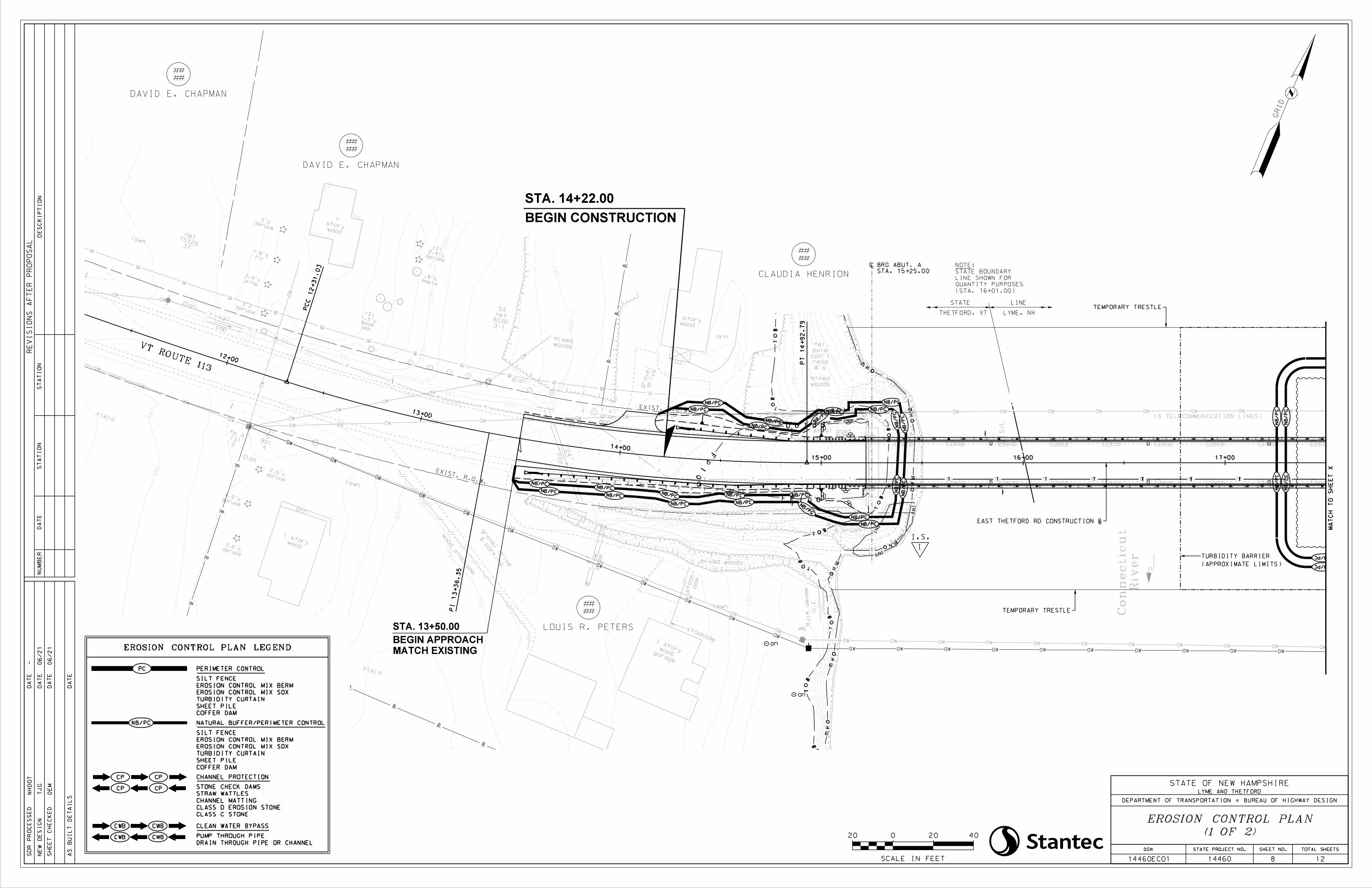
mh
t
scpscpscpscpscpscpscpscpscp
scp scp scp scp scp scp scp scp
anana
n
an
an
an
NULL
scp
S/
L
mon
gran
1'x1'
spruce
2.5'c
spruce
4.5'c
spruce
3.5'c
steel post
steel post
1.5'c
bgr
wood
1 story
orn
drive
gravel #'s
read
can't
pole
tel
bgr
mixed woods
& brush
mixed woods
lawn
woven
wire
3'h
rcp
24"
ade
stock-
stockade
garage
wood
1 story
lawn
field
4
901
5
131
wood
1 story
orn
woods
mixed
3-1
903R
net
5A
ash
quad
(2)
maple
.8'c
spruce
2.4'c
(2)
pine
2.4'c
fir
1.8'c
spruce
3'c
spruce
3'c
wood
story
1
cmp
12"
37
7S329
netlawn
field
wood stockade
pipe
6"
River
Con
necticut
woods
mixed
& parking
gravel drive
#6
5
131
fp 4
SCALE IN FEET
20 0 4020
EAST THETFORD RD CONSTRUCTION Å
THETFORD, VT LYME, NH
STATE LINE
(3 TELECOMMUNICATION LINES)
MATCH EXISTING
BEGIN APPROACH
STA. 13+50.00
(STA. 16+01.00)
QUANTITY PURPOSES
LINE SHOWN FOR
STATE BOUNDARY
NOTE:
VT ROUTE 113
STATE PROJECT NO. SHEET NO. TOTAL SHEETS
SH
EE
T
CH
EC
KE
D
AS
BUI
LT
DE
TAI
LS
DA
TE
DA
TE
DA
TE
DA
TE
NU
MB
ER
DA
TE
ST
ATI
ON
ST
ATI
ON
DE
SC
RI
PTI
ON
RE
VI
SI
ON
S
AF
TE
R
PR
OP
OS
AL
14460
DGN
14460EC01
STATE OF NEW HAMPSHIRE
SD
R
PR
OC
ES
SE
D
NE
W
DE
SI
GN
DEPARTMENT OF TRANSPORTATION BUREAU OF HIGHWAY DESIGN
NH
DO
T
TJ
G
DE
M
- 06/
21
06/
21
8 12
(1 OF 2)
EROSION CONTROL PLAN
LYME AND THETFORD
PERIMETER CONTROL
TURBIDITY CURTAIN
CHANNEL PROTECTION
CLEAN WATER BYPASS
PUMP THROUGH PIPE
SILT FENCE
EROSION CONTROL MIX BERM
EROSION CONTROL MIX SOX
SHEET PILE
COFFER DAM
STONE CHECK DAMS
STRAW WATTLES
CHANNEL MATTING
CLASS D EROSION STONE
CLASS C STONE
DRAIN THROUGH PIPE OR CHANNEL
EROSION CONTROL PLAN LEGEND
NATURAL BUFFER/PERIMETER CONTROL
COFFER DAM
SHEET PILE
TURBIDITY CURTAIN
EROSION CONTROL MIX SOX
EROSION CONTROL MIX BERM
SILT FENCE
MA
TC
H
TO
SH
EE
T
X
TEMPORARY TRESTLE
TEMPORARY TRESTLE
STA. 15+25.00
BRG ABUT. AÀ
(APPROXIMATE LIMITS)
TURBIDITY BARRIER
395
385
38
5
385
385
390
390
390 390390
390
390
390
390
390390
395
395
395
395
395
395
395
395
395
395
395
395
395
395
395
395
395
395
395
395
395
395
395
395
395
395395
395
395 395395
395
395
395
395
395
395
395
40
0
400
400400
400
400
400 400 400
400
400
400
12+00
13+00
14+00
15+00 16+00 17+00
PC
C 12
+31.03
PT
14
+9
2.
79
PI 13
+36.35
I.S.
I
DAVID E. CHAPMAN
####
CLAUDIA HENRION
####
LOUIS R. PETERS
####
DAVID E. CHAPMAN
####
EXIST. R.O.W.
EXIST. R.O.W.
an
an
BEGIN CONSTRUCTION
STA. 14+22.00
GRI
D
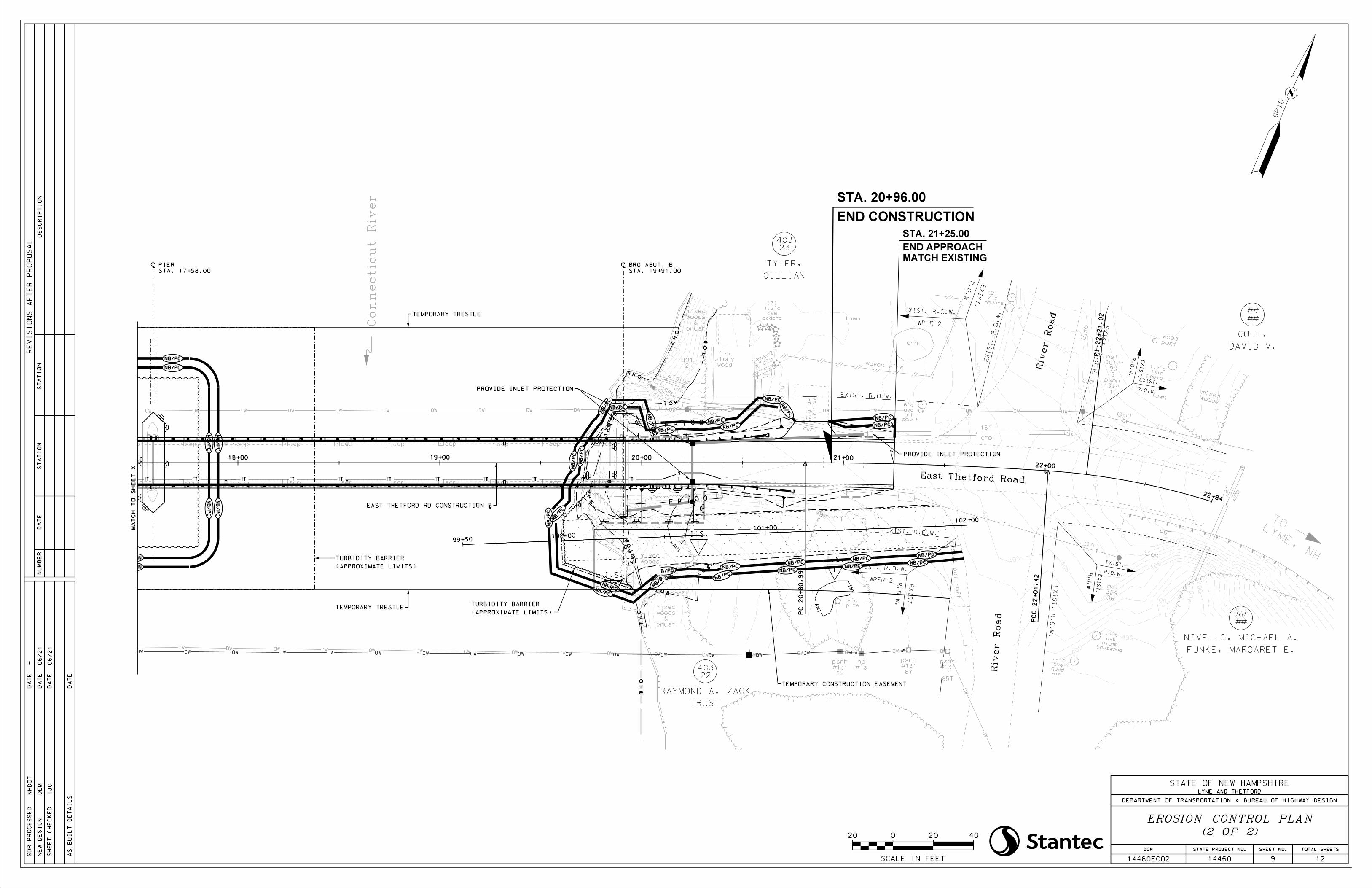
fc
scpscpscpscpscpscpscpscpscp
scp scp scp scp scp scp scp scp scpscp
scp
mb
di
di
an
an
an
anan
NULL
NULL
NULL
NULL
NULL
post
wood
LYME, NH
TO
bgr
bgr
basswood
clump
ave
.9'c
elm
quad
ave
.4'c
36
329
net
bgr
cmp
18"
1
1314
psnh
6
90
901/1
bell
lawn
poplar
twin
1.2'c
woods
mixed
wood
story
1•
4"ci
p
4"p
vc
dri
ve
gra
v
cedars
ave
1.2'c
(7)
lawn
locust
tri
ave
6'c
woven wire
orn
locusts
2'c
(2)
cmp
15"
field
pine
8'c
gravel pull-off
woods
mixed
brush
&
woods
mixed
Con
necticut
River2
901
cmp
15"
brush
&
woods
mixed
slu
•cmp
und
6"alum
sewer?
6x
#131
psnh
#'s
no
6Y
#131
psnh
65T
7
#131
psnh
SCALE IN FEET
20 0 4020
EAST THETFORD RD CONSTRUCTION Å
River
Road
River
Road
East Thetford Road
MATCH EXISTING
STA. 21+25.00
END APPROACH
STATE PROJECT NO. SHEET NO. TOTAL SHEETS
SH
EE
T
CH
EC
KE
D
AS
BUI
LT
DE
TAI
LS
DA
TE
DA
TE
DA
TE
DA
TE
NU
MB
ER
DA
TE
ST
ATI
ON
ST
ATI
ON
DE
SC
RI
PTI
ON
RE
VI
SI
ON
S
AF
TE
R
PR
OP
OS
AL
14460
DGN
14460EC02
STATE OF NEW HAMPSHIRE
SD
R
PR
OC
ES
SE
D
NE
W
DE
SI
GN
DEPARTMENT OF TRANSPORTATION BUREAU OF HIGHWAY DESIGN
NH
DO
T
DE
M
TJ
G
- 06/
21
06/
21
9 12
(2 OF 2)
EROSION CONTROL PLAN
LYME AND THETFORD
TEMPORARY TRESTLE
TEMPORARY TRESTLE
MA
TC
H
TO
SH
EE
T
X
PROVIDE INLET PROTECTION
PROVIDE INLET PROTECTIONPROVIDE INLET PROTECTION
STA. 19+91.00
BRG ABUT. BÀÀ
STA. 17+58.00
PIER
(APPROXIMATE LIMITS)
TURBIDITY BARRIER
(APPROXIMATE LIMITS)
TURBIDITY BARRIER
TEMPORARY CONSTRUCTION EASEMENT
18+00 19+00 20+00 21+00
22+00
22+84
PI 22
+21.02
PC
C 22
+01.42
PC
20
+8
0.
99
II
I.S.
I.S.
I
I.S.
I
DAVID M.
COLE,
####
FUNKE, MARGARET E.
NOVELLO, MICHAEL A.
####
R.
O.
W.
EXI
ST.
R.
O.
W.
EXI
ST.
WPFR 2
EXIST. R.O.W.
WPFR 2
EXIST. R.O.W.
R.
O.
W.
EXI
ST.
R.O.W.
EXIST.
R.O.W.
EXIST.
R.
O.
W.
EXI
ST.
EXIST. R.O.W.
EXI
ST.
R.
O.
W.
EXI
ST.
R.
O.
W.
EXI
ST.
R.
O.
W.
EXIST. R.O.W.
GILLIAN
TYLER,
23403
TRUST
RAYMOND A. ZACK
22403
400
385
385
390
390
39
5
395
395
395
395
395
395
40
0
400
400
400
400 400
400 400
400
400
400
400
400
400
400400400
405
405
405
405
405
405
405
405
405 405
405
410
410
410
410
410
410
410
410410
415
415
415
415
415
415
415
100+00
101+00
102+00
99+50
END CONSTRUCTION
STA. 20+96.00
GRI
D
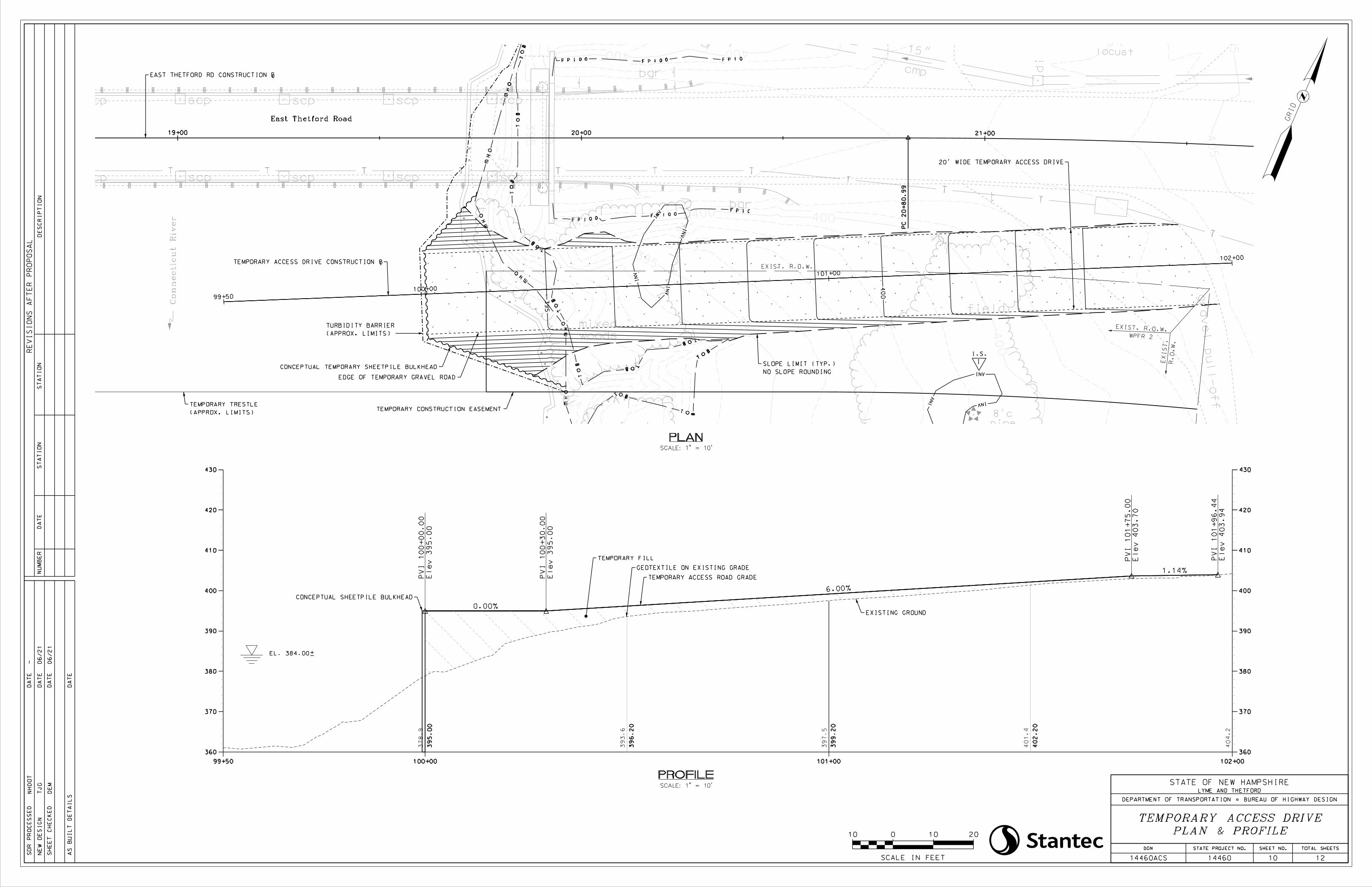
scpscpscpscpscp
scp scp scp scp scp
di
an
bgr
bgr
drive
grav
locust
tri
ave
6'c
cmp
15"
field
pine
8'c
gravel pull-off
woods
mixed
brush
&
woods
mixed
cmp
15"
EAST THETFORD RD CONSTRUCTION Å
East Thetford Road
Con
necticut
River
NO SLOPE ROUNDING
SLOPE LIMIT (TYP.)
SCALE IN FEET
10 0 2010
SCALE: 1" = 10'
PLAN
SCALE: 1" = 10'
PROFILE
GEOTEXTILE ON EXISTING GRADE
TEMPORARY ACCESS ROAD GRADE
TEMPORARY FILL
EL. 384.00±
CONCEPTUAL SHEETPILE BULKHEAD
EXISTING GROUND
R.
O.
W.
EXI
ST.
WPFR 2
EXIST. R.O.W.
EXIST. R.O.W.
I.S.
I
TEMPORARY ACCESS DRIVE CONSTRUCTION Å
20' WIDE TEMPORARY ACCESS DRIVE
CONCEPTUAL TEMPORARY SHEETPILE BULKHEAD
EDGE OF TEMPORARY GRAVEL ROAD
STATE PROJECT NO. SHEET NO. TOTAL SHEETS
SH
EE
T
CH
EC
KE
D
AS
BUI
LT
DE
TAI
LS
DA
TE
DA
TE
DA
TE
DA
TE
NU
MB
ER
DA
TE
ST
ATI
ON
ST
ATI
ON
DE
SC
RI
PTI
ON
RE
VI
SI
ON
S
AF
TE
R
PR
OP
OS
AL
14460
DGN
14460ACS
STATE OF NEW HAMPSHIRE
SD
R
PR
OC
ES
SE
D
NE
W
DE
SI
GN
DEPARTMENT OF TRANSPORTATION BUREAU OF HIGHWAY DESIGN
NH
DO
T
TJ
G
DE
M
- 06/
21
06/
21
10 12
PLAN & PROFILE
TEMPORARY ACCESS DRIVE
LYME AND THETFORD
TEMPORARY CONSTRUCTION EASEMENT
(APPROX. LIMITS)
TURBIDITY BARRIER
(APPROX. LIMITS)
TEMPORARY TRESTLE
19+00 20+00 21+00
PC
20
+8
0.
99
99+50
100+00
101+00
102+00
385
390
395
395
395
395
40
0400 400
400
400
400400400
405
405
395
400
420
430
420
430
410
400
370
360
390
380
410
400
370
360
390
380
101+00 102+0099+50 100+00
0.00%
6.00%
1.14%
40
1.
4
39
9.
20
40
4.
2
40
2.
20
39
7.
5
37
8.
9
39
5.
00
39
6.
20
39
3.
6
PVI
10
0+
00.
00
Ele
v
39
5.
00
PVI
10
0+
30.
00
Ele
v
39
5.
00
PVI
10
1+
75.
00
Ele
v
40
3.
70
PVI
10
1+
96.
44
Ele
v
40
3.
94
GRI
D
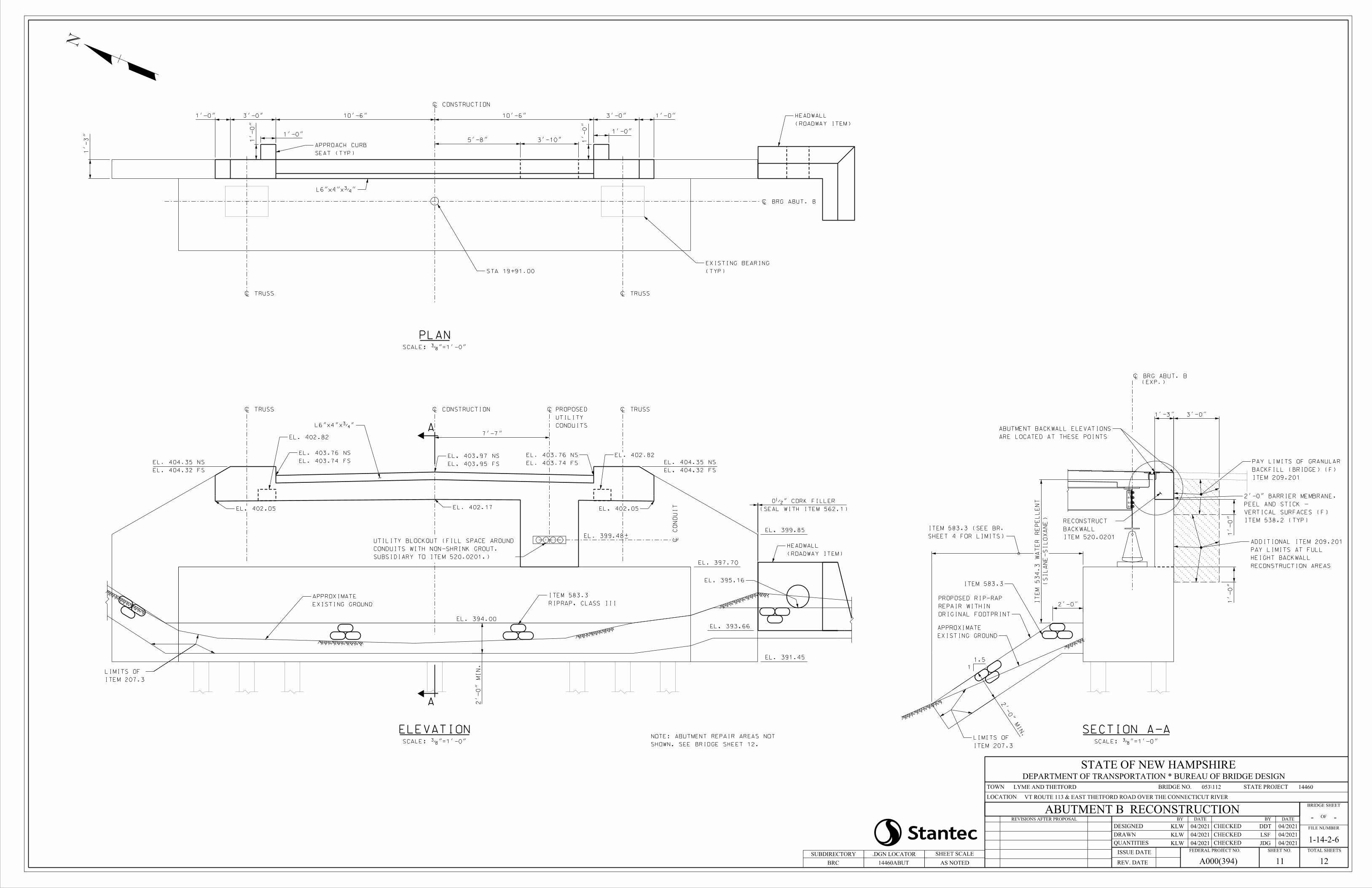
À TRUSS À TRUSS
À BRG ABUT. B
PLAN
STA 19+91.00
ABUTMENT B
(TYP)
EXISTING BEARING
À CONSTRUCTION
1'-
3"
L6"x4"xƒ"
1'-0"3'-0"10'-6"10'-6"3'-0"1'-0"
SCALE: …"=1'-0"
SEAT (TYP)
APPROACH CURB
1'-0"
1'-0"
1'-0"1'-0"
3'-10"5'-8"
(ROADWAY ITEM)
HEADWALL
À TRUSS À TRUSS
ELEVATION
EL. 399.85
A
A
EL. 403.74 FS
EL. 403.76 NS
EL. 403.95 FS
EL. 403.97 NS
EL. 404.32 FS
EL. 404.35 NS
EL. 404.32 FS
EL. 404.35 NS
EL. 402.17
À CONSTRUCTION
EL. 402.05
SCALE: …"=1'-0"
EL. 391.45
L6"x4"xƒ"
À
CO
ND
UI
T
7'-7"
CONDUITS
UTILITY
PROPOSED À
EL. 402.05
EL. 399.48±
EL. 402.82
EL. 402.82
EL. 403.74 FS
EL. 403.76 NS
NOTE: ABUTMENT REPAIR AREAS NOT
SHOWN. SEE BRIDGE SHEET 12.
EXISTING GROUND
APPROXIMATE
RIPRAP, CLASS III
ITEM 583.3
EL. 394.00
(SEAL WITH ITEM 562.1)
0•" CORK FILLER
SUBSIDIARY TO ITEM 520.0201.)
CONDUITS WITH NON-SHRINK GROUT.
UTILITY BLOCKOUT (FILL SPACE AROUND
ITEM 207.3
LIMITS OF
2'-
0"
MI
N.
EL. 393.66
EL. 395.16
SHEET 4 FOR LIMITS)
ITEM 583.3 (SEE BR.
EL. 397.70
(ROADWAY ITEM)
HEADWALL
N
ABUTMENT B RECONSTRUCTION
KLW
KLW 04/2021
04/2021
KLW 04/2021 JDG 04/2021
LSF 04/2021
DDT 04/2021
SUBDIRECTORY
14460ABUT
.DGN LOCATOR
VT ROUTE 113 & EAST THETFORD ROAD OVER THE CONNECTICUT RIVER
LYME AND THETFORD 053\112 14460
-
1-14-2-6
A000(394)
AS NOTED 11 12BRC
STATE OF NEW HAMPSHIREDEPARTMENT OF TRANSPORTATION * BUREAU OF BRIDGE DESIGN
BRIDGE NO. STATE PROJECTTOWN
LOCATION
REVISIONS AFTER PROPOSAL
DESIGNED
DRAWN
QUANTITIES
REV. DATE
ISSUE DATE FEDERAL PROJECT NO. SHEET NO. TOTAL SHEETS
FILE NUMBER
OF
BRIDGE SHEET
DATEBY
CHECKED
CHECKED
CHECKED
DATEBY
SHEET SCALE
-
(EXP.)
À BRG ABUT. B
3'-0"1'-3"
SECTION A-ASCALE: …"=1'-0"
ITEM 209.201
BACKFILL (BRIDGE) (F)
PAY LIMITS OF GRANULAR
NOTE: ABUTMENT REPAIR AREAS NOT
1'-0"
ARE LOCATED AT THESE POINTS
ABUTMENT BACKWALL ELEVATIONS
ITEM 520.0201
BACKWALL
RECONSTRUCT
1'-0"
RECONSTRUCTION AREAS
HEIGHT BACKWALL
PAY LIMITS AT FULL
ADDITIONAL ITEM 209.201
1.5
1
ITEM 583.3
ITEM 538.2 (TYP)
VERTICAL SURFACES (F)
PEEL AND STICK -
2'-0" BARRIER MEMBRANE,
ITEM 207.3
LIMITS OF
2'-0"
MI
N.
SHEET 4 FOR LIMITS)
ITEM 583.3 (SEE BR.
(SI
LA
NE-
SI
LO
XA
NE)
IT
EM 534.3
WA
TE
R
RE
PE
LL
EN
T
ORIGINAL FOOTPRINT
REPAIR WITHIN
PROPOSED RIP-RAP
EXISTING GROUND
APPROXIMATE
2'-0"
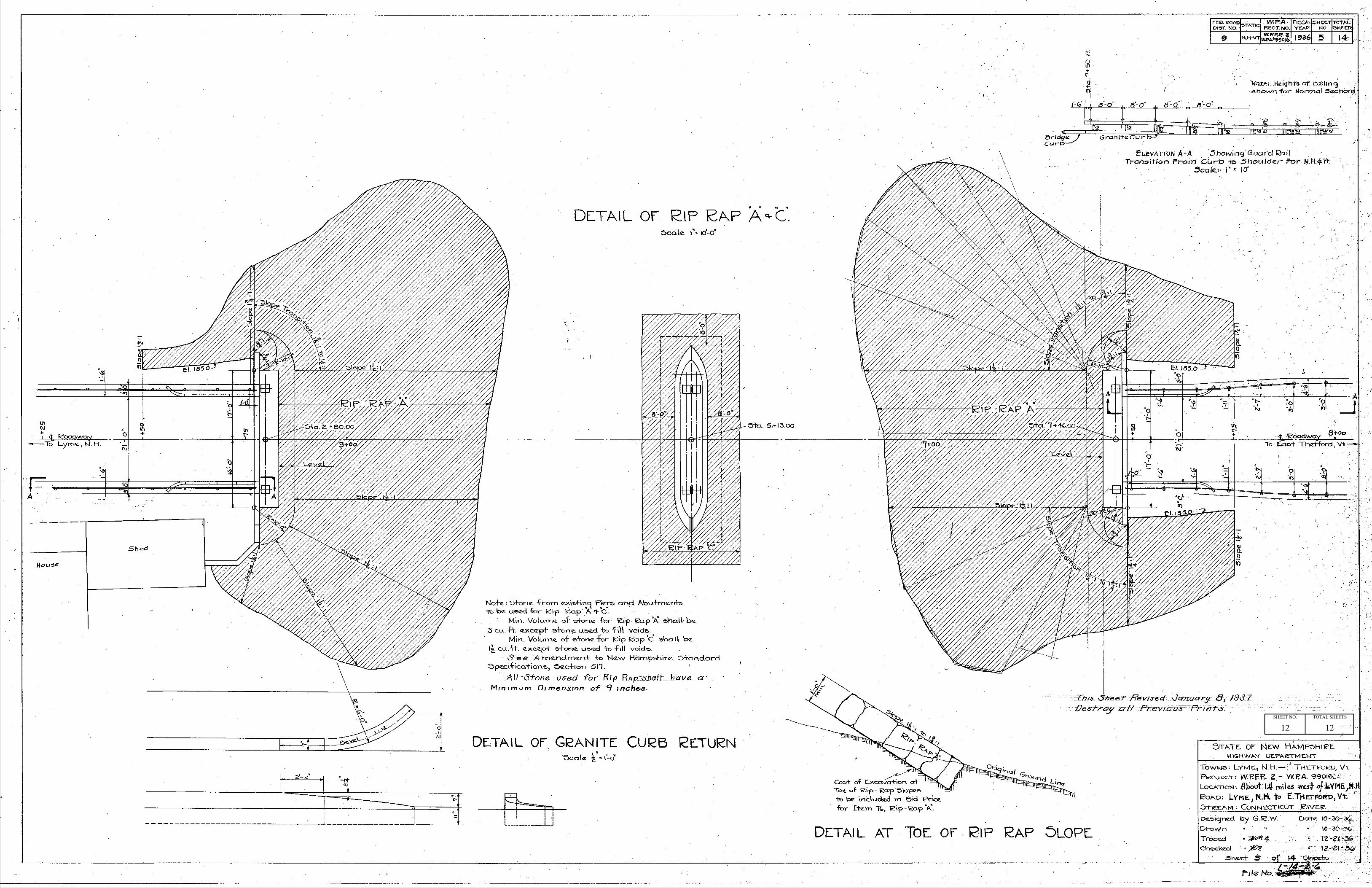
SHEET NO. TOTAL SHEETS
1212


