Embed Size (px)
Citation preview

Milling and Grain Operations
Lombardstown Mill
Appropriate Assessment
and
Natura Impact Statement
Matthew Lynch February 2012 A Lynch
Environmental
I
For
insp
ectio
n pur
pose
s only
.
Conse
nt of
copy
right
owne
r req
uired
for a
ny ot
her u
se.
EPA Export 23-07-2018:04:15:21

2. Guid2nce Documents aad Prot~sda fd8owed
The following are the pfinclpal Guidance Documenls and Protocols f d o w e d in the
preparation of this Appropriate Assessment and Natura Impact Statement:
B Department QE the Environment, Heritage a d Local Government: Circcular
L8108, ‘Water Services Investment and Rural Water Programmes - Protection
of Natural Heritage and National Monmeiits’ (September 2008).
Department of the Environment, Heritage and Local Goveimnent: Circuhr
WPW I / I 0 & PSSP 2/10> ‘AApprupr.i& Assessment under A*rticle 4 sf the
a
Habitats Directive: Guidw1ce for Plallniag Authorities’ (March 20 10).
o Department o€ the Enviromim~t, Heritage arid L Q C ~ Govemneni:
‘Appropriate Assessment of Plans and Projects in Ireland - Guidelines for
Planning Authorities’ (Revised I 1 February 20 10).
WateionaI Pzrks and WiIdlXe Service (NPWS): ‘Natura 200 Screening Protocol
- Water Service Plans and Prujects’ (2009).
EPA: Waste Water Discharge Licensing - Appropriate Assessment: Note on
Appropriate Assessment for the purpose of the Waste Water Discharge
Q
Q
(i$UthOFiis&Qn) Rt?gdal-ionS, 2007 (S.T. NO. 684 ~f 2007) (tr~~dated),
2
For
insp
ectio
n pur
pose
s only
.
Conse
nt of
copy
right
owne
r req
uired
for a
ny ot
her u
se.
EPA Export 23-07-2018:04:15:21

0%' cmSei~w,t iGn ( S A C S ) 8116 ca.adidEte Special Ai.eas 0:f cm.seff.i/atlm (CS1",CS), 7 - k _ -
st2nClMd guideline fir .i&at cnnslilutes "lose toy Is within a YZdiLIS 0% 500 melres
@ O k S Oil fl?% F'EQW Dk@%i3? issued by the Dcj3w'hDlHlt). The 'ke8ted %VZSkW&X fU3111
LOIT~~ZLTC~SWWII ?dill is dischrged i ~ i . o the D ~ g l d ~ FGVW ~sdlich in ~.U,UI ~IOWS ii2to
the Blackwater River. The Blackwzter River is a designated Special k e a of
Conservation, Site Code 002170, li Site Synopsis on which the designa~ioii was based
is aaached. The reasons for the selection oE the site as an SAC JiiclucZed the presence
of the following water-based animd species:
Sea Lam.prey, River Lamprey, Brook Lamprey,
Freshwater P e d Mussel, Crayfish, Twaite Sliad,
Atlantic Sal1non and O'der.
The Site Synopsis makes no explicit reference to the Duvglasha River, but the
lower reaches ofthe Duvglasha, from about 1.5 Itm upstream down to its confluence
with the Blackwater, are included in the Blackwater River SAC, as shown in the
NPIVS map ofthe SAC. This is ~ - d ~ ~ b t - e d l y due to the presence of one or more of the
above-Iisted anima1 species in the Duvglashsa River. The Bla&wakr River: cztchment
is protected under the Freshwater Pearl Mussel Regulations, because of the presence
of endsliigered populations of that species in thle River md its tributaries, though there
is no record of Freshwater Pearl Mussel being found in the Duvglasha.
The result ofthe screening protocol set out in the Flow Chart in Appendix I a
is that the development is iiz or close to a Special Area of Conservation and therefore
that its impact is to be assessed, There are four possible designated stages to an
kppropriate Assessment as set cut in the extracts frum the EPA Guidance Dcmmient
on the following 'WO pages:
For
insp
ectio
n pur
pose
s only
.
Conse
nt of
copy
right
owne
r req
uired
for a
ny ot
her u
se.
EPA Export 23-07-2018:04:15:21

Stage 3 - Assessment of Akteraative Sslestioaas
This stage examines alternsltive ways of achieving the objectives of the $an or project
that avoid adverse impacts on the integrity ofthe European Site.
Stage 4 " &aessmeRt whe.n*e no alternative aoliutions exist
Are there imperative reasons oToverrjdiiig public interest (LROPI)?
Are there human health or safety considerations or important environmentnl benefits?
Stage 1 - Screaming The first stage of the appropriate assessment process is screening. This stage
idenMies the likely impacts on European Sites o f a plan or project either done 01' in
combination and considers whether these effects are likely to be significant.
Step 1: ~~~~~~~~~~~~~ of the site
Is the plan or prqject directly connected with or necessary to the management of
the site for nature conservation? (The answer is always Ab for waste water
discharges).
4
For
insp
ectio
n pur
pose
s only
.
Conse
nt of
copy
right
owne
r req
uired
for a
ny ot
her u
se.
EPA Export 23-07-2018:04:15:21

step 3: QlhWraCleg.is$i@s of the site
This step mpires identification of the impacts oftl-ie project 01' plan on a
European Site(s) by chsracterising ',l?c site as a whole or those areas where
impacts are most likely to occur. In addition to consideration of the cuinulative
effecis on a European Site(s), consideration must also be given to direct, indirect,
short and long-term, isolated and interactive effects.
Step 4: Aasessaa3esa% of sigoifi'ncance
The assessment ofthe Iilcelihood of significant effects of a proposed or existing
plan or project on a European Site(s) can be eornpktecl by referring to Circular
LW08 ' ~YQW Sewice,s Jm~e,siii;lenf and Rural Wafw Pro,gi.nrimes - Proodeerion of 3Wwd ZIeritoge nisldNcrtionaI Monui?zei7f,r' issued by the D-epai-tmcnt of
Environment, Heritage and Local Government. 111 particular, the flow diagram in
Appendix I should be completed and the results of each section recorded.
If no significant effects are likely then no further assessment is required prior to
the authorisation ofthe plan or project. There ~iaust be no reasoliable scientific
doubt that the plan or project does not have an effect on a European Site. This
decision should be reasoned and recorded. If significmt effects are likely then au2
appr~priate assessment must be carried out. I n addition, if the liltefihooci of
significant effects is In doubt then the pz~~cwtt~ionasy prirwipk appf ies and an
appropikte assessment must be carried out.
r
3
For
insp
ectio
n pur
pose
s only
.
Conse
nt of
copy
right
owne
r req
uired
for a
ny ot
her u
se.
EPA Export 23-07-2018:04:15:21

..._.__I._. __ .. II 1,11 I I..̂ .I I._.." l_.ll_ .__I._ II
Identify all the elenleiits ofthe project 01' plan alone or iii combination with other
plans or projects that have the potential for having sigiiificant effects on the site. 'The
geogaphicai scope oftlie plan or project as well as the European Sites that inay be cffected
rnnust be identified. The European Site or Sites that could be affected should be described.
In line with the EPA Guidance Note, this Screening procedure reelates on1y to
activities that have or can Ixwe an impact on the aquatic environment. The primary
activity in question is the discharge OF trea.ted wa.stewater from Lornbardstown MilI. The
characteristics af the treated wastewater and the Con.ditions under \vhEch it i s dischaxgeti
are farlly specified in the existing Discharge Licence. The discharge fium the wastewater
treatment plant is combined with uncontaminated cooling water and surface water before
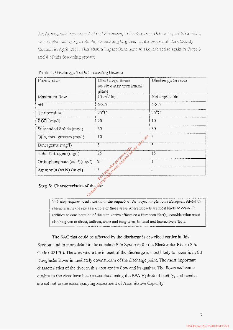
discharge to the river. The current Iicence conditions for both are as shown in Tabfe 1.
(next page). The geographical location of the discharge is specified in the localioiz maps
and site maps submitted to the County Council as part of the licensing process.
This Assessment requires that reference be made to other discharges which 'in
combination' with the discharge from Lornbardstown Milf, could have an impact on the
receiving water, either the Dravglashsa or Blackwater Rivers, There are many disdmrges "to
the Elackwater along its eiztire length, but the prjmary attention liere rnust necessarily be
on any other discharges in the vicinity oftfie discharge 60rn Lombardsiow Mill. No
such discharges of any sigmiificaizce are hiown to occur to the D~uvgIasha River. 'Yhei+e is a
disclzarge: from the agg1omcmtior-r (mr~nicipa). area) of I.,ornbardstown, through a septic
tank, to the Blacrkwafer River just upstream ofthe cn:ifluence with the Ihvglzshz.
G
For
insp
ectio
n pur
pose
s only
.
Conse
nt of
copy
right
owne
r req
uired
for a
ny ot
her u
se.
EPA Export 23-07-2018:04:15:21
p H
BOD (rngll) "llllllll_-
Suspended Solids (ing/ij
Oils, fats, greases (mg/I)
Orthophosphate (as P)(rng/l)
Ammonia (as N) (mgil)
20
30 __
10
-:-- Step 3: oZhaii.ac$eristics of the site
This step requires identification ofehe impacts ofehe project or pian on a European Sitc(s) by
characterising the site as a whole or those areas where impacts are niost Iilrciy to occur. In
addition to consideration of the cumulative effects on a European Site(s), considemtion must
also be given to direct, indirect, short and long-term, isolated and inleractive effects.
The SAC that could be affected by the discharge is described earlies in this
Section, and in more detail in the attached Site Syiiopsis for the Blackwater River (Site
Code 0021 70). The area where the iizlpact oftlie discharge is most iikely to occur i s in the
Duvgfasha River immediately downstremi of the dischai:ge point. The most importgn'c
cl~araacteristics ofthe river in this area are its flow a.n$ ifs quality. The flows and water
quality in the river have beer1 ascertained using the E f A Mydratool fadity, and results
are set o~zt in the accompanyiiig assessment of AssimiIative Cz,pncity,
7
For
insp
ectio
n pur
pose
s only
.
Conse
nt of
copy
right
owne
r req
uired
for a
ny ot
her u
se.
EPA Export 23-07-2018:04:15:21

3: are iRe qaanttfyinzg habitats m d species G f the site water dcpendzlsit?
Yes. A number offhe species are water-dependcm f.
For in
spec
tion p
urpo
ses o
nly.
Conse
nt of
copy
right
owne
r req
uired
for a
ny ot
her u
se.
EPA Export 23-07-2018:04:15:21

Parameter
Orthophosphate (mg//l> __I__ __.._..I_."
For
insp
ectio
n pur
pose
s only
.
Conse
nt of
copy
right
owne
r req
uired
for a
ny ot
her u
se.
EPA Export 23-07-2018:04:15:21

For
insp
ectio
n pur
pose
s only
.
Conse
nt of
copy
right
owne
r req
uired
for a
ny ot
her u
se.
EPA Export 23-07-2018:04:15:22

f
\
Ir . Are mlifyiiag
habitots and species of the site water
depencknt? I
1
5. Is there WFD aub-
basin plan for the site or its protected
habittiWspec 7 - '\
I A-*- ' [ 6. '' l lo. Does this plan COYN 311 potential receptors
(habitatsispwias)? 9 i
\%
'.,
impact assessnien C
i
\ ' ! '! I
i
I
t i i
PAC1
11
. .- .
For
insp
ectio
n pur
pose
s only
.
Conse
nt of
copy
right
owne
r req
uired
for a
ny ot
her u
se.
EPA Export 23-07-2018:04:15:22

Disclaimer The source hydrometric data used to estimate the flow duration cuwe ordinates for ungauged catchments was obtained from (1 ] water level data and (2) the rating curve@) generated for each hydrometric station. The Environmental Protection Agency and the Ofice of Public Works used these data, respectively, to calculate daily mean flows. The daily mean flows were then used by the Environmental Protection Agency to prepare flow duration curves for each station. Nelther body accepts any tiablllty for the subsequent handling ofthe data.
For
insp
ectio
n pur
pose
s only
.
Conse
nt of
copy
right
owne
r req
uired
for a
ny ot
her u
se.
EPA Export 23-07-2018:04:15:22

i_ +-
Disclaimer The source hydrometric data used to estimate the flow duration curve ordinates for ungauged catchments was obtafned from (I) water level data and (2) the rating cum@) generated for each hydrometric statlon. The Environmental Protecton Agency and the Ofice of Public Works used these data, respectivefy, to calculate daily mean flows. Pne daily mean flows were then used by the Environmental Protection Agency to prepare flow duratlon cuwes far each station. Neither body awpts any liability for the subsequent handling of the data.
For
insp
ectio
n pur
pose
s only
.
Conse
nt of
copy
right
owne
r req
uired
for a
ny ot
her u
se.
EPA Export 23-07-2018:04:15:22

lArSa
Average Annual Rainfall (61 -90)
Stream Length
Drainage Density
Poorly Drained 6.4 Well Drained 91.5 c
Alluvmin 1.3
Peat 0.4
Water 0 Made 0.4
sq km 19
lm CRannel length (km)lcatchmsnt area (sskm)
Index (range 0:1) -I
mwr 1370
20.6
1 .t
Percent Slope 10.7
Disciaimer The source bydFometric data used to estimate the flow duration curve ordinates for ungauged catchments was UbYatned h m (1) water h e 1 data and (2) the rating curve($) geneded for each hydrometric station. The Environmental Protection Agency and the ORce of Public Works used these data, respectively, to calmlate daify mean flows. me daily mean flows were then used by the Envtronmental Protection Agsncy to prepare flaw duraflm curves for each station. Neither body accepts any Ilabiiity for the subsequent handling ofthe data.
For
insp
ectio
n pur
pose
s only
.
Conse
nt of
copy
right
owne
r req
uired
for a
ny ot
her u
se.
EPA Export 23-07-2018:04:15:22

Disclaimer T4e source hydromettic data used to estimate the flow duration curve ordinates for ungaugd catchments was obhined from ( 1 ) water level data and (2) the rating cutve(s) genewed for each hydrometric station. The Environmental Protection Agency and the office of PuMIc Works used these data, respectfvely, to calculate daily mean hw. The daily mean flows were then used by the Environmental Protection Agency to prepare %ow duration curves for each station. Neither body accepts any liability for the subsequent handling of the data.
For
insp
ectio
n pur
pose
s only
.
Conse
nt of
copy
right
owne
r req
uired
for a
ny ot
her u
se.
EPA Export 23-07-2018:04:15:22

. .
5 I O 20 30 40 50 $0 70 80 $0 95 Flow Percentile
~~
ICI Flow (m3/s) 9 -. Fbw (m3/s) upper confidence
I I
'to I .495 1,884 1,186
20 0.926 -I .I44 0.749
30 0.623 0.776 0.5 40 0.438 0.551 . 0.349
50 0.352 0.441 0.284
60 0.28 0.331 0.204 I I I
701 0.4861 0.243 1 0.142 I
80 0.135 0.1% 0.401 r
90 0.088 0.124 0.062
95 0.069 0.103 0.046
Dlsclalmer The source hydrornefn'c data used to estimate the flow duration curve ordinates for ungauged catchments was obtafned from (1) water lave[ data and (2) the mung curve(s) generated for each hydrometrk station. The Environmental Protection Agency and the Ofice of Public Works used these dab, respectively, to calwlate daily mean flows. The daily mean flows were then used by the Environmental Protectlbn Agency to prepare flow duration curves for each station. Neither body accepts any liabitity for the subsequent handsng of the data.
For
insp
ectio
n pur
pose
s only
.
Conse
nt of
copy
right
owne
r req
uired
for a
ny ot
her u
se.
EPA Export 23-07-2018:04:15:22

I r
f
For
insp
ectio
n pur
pose
s only
.
Conse
nt of
copy
right
owne
r req
uired
for a
ny ot
her u
se.
EPA Export 23-07-2018:04:15:22

For
insp
ectio
n pur
pose
s only
.
Conse
nt of
copy
right
owne
r req
uired
for a
ny ot
her u
se.
EPA Export 23-07-2018:04:15:22

. _. . . . . . :,.. .
m E! RI
E m
W
d - a ca 2i a (0
. ..
For
insp
ectio
n pur
pose
s only
.
Conse
nt of
copy
right
owne
r req
uired
for a
ny ot
her u
se.
EPA Export 23-07-2018:04:15:22

*3 U
+
_. . .
r
For
insp
ectio
n pur
pose
s only
.
Conse
nt of
copy
right
owne
r req
uired
for a
ny ot
her u
se.
EPA Export 23-07-2018:04:15:22

c@ E
For
insp
ectio
n pur
pose
s only
.
Conse
nt of
copy
right
owne
r req
uired
for a
ny ot
her u
se.
EPA Export 23-07-2018:04:15:22

For
insp
ectio
n pur
pose
s only
.
Conse
nt of
copy
right
owne
r req
uired
for a
ny ot
her u
se.
EPA Export 23-07-2018:04:15:22

I
For
insp
ectio
n pur
pose
s only
.
Conse
nt of
copy
right
owne
r req
uired
for a
ny ot
her u
se.
EPA Export 23-07-2018:04:15:22

For
insp
ectio
n pur
pose
s only
.
Conse
nt of
copy
right
owne
r req
uired
for a
ny ot
her u
se.
EPA Export 23-07-2018:04:15:22
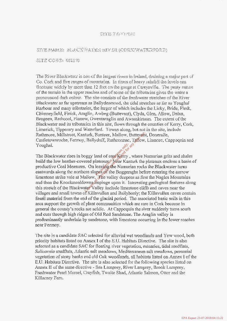
The Blackwater rises in boggy land of east Merry , where Narnwian grits arid shales build the law heather-covered plateaux. Near IC.smlurk the plateaux eizclose a basil? of productive Coal Measures. On Ieaving the Namurian rocks the Blackwater tunsls eastwads along the northern slopes of the Boggeraghs before entering the narrow limestone strike vale at Maliow. The valley deepens as first the Nagles Mountains
th is stretch of the Blackwater Valley include lirnestone cliffs and caves near the villages and sn~.aiZ towns of KiIla.tzrllen. and Ballyhooly; the KiIIavulfen caves caiztah fossil material from the end ofthe gIacia.1 period. The associated basic soils in this area support the grow'L1i of plant. camxmitics which are rare in Cork becawe in general the county's rocks are acidic. At Cappoquia the river suddenly turns south and cuts tlxough high ridges of OM Red Sandstone. The Araglin valIey is prcdominaiitly urid.erIain by sandstone, with limestone occurring in the lower reaches near Femzoy.
cmd tl7e12 th.c Kn.os;kmcaldo~>Jns impinge upon it* Illteresling geologic3.l features a h g
For in
spec
tion p
urpo
ses o
nly.
Conse
nt of
copy
right
owne
r req
uired
for a
ny ot
her u
se.
EPA Export 23-07-2018:04:15:22

A small stand of Yew (Tams liaccafw) woodland, a rare habitat in Ireland and the EU, occurs within the site. This is on a Zirnestone ridge at Dromana, near Viilierstown. While there are some patches of the wosd with a campy of Yew and some vwy old trees, the q u d i t y is geneidly poor due io the dominance of non-native aiid invasive species such as Sycamore, Beech an.d Douglas Fir QPsezidoi,sug~7 menzs;c;isii>. However, the fiimre prospect for this Yew wood i s good as the site is pr~posed fix restoxtion under a Coiliti: EU Life P~*ograrnme. Owing to i t s rarity, Yew woodland is listed with priority stat~ts on Aiinex f of the IXJ Hzbitats Direclive.
At Banteer there are a number o f Iiollows in the sediments of the floodplain diere subsidence and subterranean drainage have created isolated wetlands, sunk below the Ievel ofthe surrounding fields. The water rises and falls in these holes depeiiding on thc watertable and several different communities have developed on the acidic OT neutral sediments. Many afthe ponds are ringed about with Grey WilIows, rooted in the mineral soils but sometimes collapsed into the water. Beneath the densest stands are woodland herbs like YelJow Piriipemd (Lysinziruh/7'a: i78/7?OTU??t) with localIy abui:dant Sias~70rt (Cditriche stagpalis) and Marsh Ragwort (,%wecio pdusfris), One of the d.epressions has Silver Birch (Betzilu pendzrlr!), Ash ( F ~ m i m ~ s e.xce.lsior), Crab Apple (MuEus syhest~-is) and a !&le Oak (Quercus r+obz!r) ii? addi'iion to the will.0ws.
For
insp
ectio
n pur
pose
s only
.
Conse
nt of
copy
right
owne
r req
uired
for a
ny ot
her u
se.
EPA Export 23-07-2018:04:15:22

Tn tlic vicinity of Lismore, two deep valieys cut in Old Red Sanclsione join 'to form the Owenashad River befu'are Slowing into the Blackwater at Lismore. These vaikys retain sometl~ing close to their originaI cover of Oak with Dowizy Birch (Befzrla pubescsns), Holly and Hazel ( C O ~ J ~ U S ~ s e l h z c r ) also occ~wing. Thcre has been much planting of Beech (as well as Some of coniferous species) a,rnoiig the Oak on the shallower slopcs and 11el-e both Rhododendron and Chcry Laurel (PIWZUS lauroceiwszrs) have invaded the woodland.
For
insp
ectio
n pur
pose
s only
.
Conse
nt of
copy
right
owne
r req
uired
for a
ny ot
her u
se.
EPA Export 23-07-2018:04:15:22

In places along the upper Bride, scrub'iry , seriii-ilziural deciduous woodlaicI of Willow, Oak and Rowan OCCUFS with abundant Great 'floodrush in the ground flora.
For
insp
ectio
n pur
pose
s only
.
Conse
nt of
copy
right
owne
r req
uired
for a
ny ot
her u
se.
EPA Export 23-07-2018:04:15:22

For
insp
ectio
n pur
pose
s only
.
Conse
nt of
copy
right
owne
r req
uired
for a
ny ot
her u
se.
EPA Export 23-07-2018:04:15:22

'I"he Blackwater is noted for its ei.ror'i~,o~is I ' L ~ of salmon over the years. 'I'he river is cimrscterisecl by mighty pools, Iuvely streams, glides and gener.a.Zly, a good p t ~ h of water coming through except in very low water. Spr.jng salmon fishing can he carried out: as far upstream as Ferrnoy and is very highly regarded especial.ly at Careysville. 'The Bride, main Bl~,ckwaIer upstream o f Fermoy and some o f the tributaries are 1s101'e associakd witin grilse fishing.
The site supports many of the n is lmal species occurring in Irelcmd. Those whjch are listed in the Irish Red Data Book include Pine Marten, Badger and Trish Hare. The bat species Natterer's Bat, Dattbeiaton's Bat> Wfiiskered Bat, Brow-n Long-eared Bat and Pipismile, arc io be seen feeding along the river, roosting under the old bridges and iil QId bUildhgS.
Common Frog, a Red Data Bc;okr species that is also legally prcdected (WiJdlife Act, I476), Q C C U ~ S throughout the site. The rare bush cricket; Mefriopdera roselii (Orthoptera: Tettjgoniidae), has bccn recorded in the reed/willuw vegetation o f the Yivci" cmbanlmcnt on thc Lowcr RIackwakr River. The Swan Mussel (A~ztidum'a cygma), a scarce species nationally, QGCUFS at a few sites along ihc ffeshwater stretches of the Blackwater.
For
insp
ectio
n pur
pose
s only
.
Conse
nt of
copy
right
owne
r req
uired
for a
ny ot
her u
se.
EPA Export 23-07-2018:04:15:22

The river and river niargins also support many Heron, non-breeding Cormorant and
occurs all along the Bride and Blackwater Rivers - 2 or 3 pairs at Dromana Rock; e. 25 pairs in the w~odland opposite; 8 pairs at ArdsaiIagh Wood and c. 20 pairs at %ncrew Waad have been recorded. Some of these are quite large and significant heronries. Significant numbers of Cormorant are found north of the bridge at Yougbal and there are some important z*oosts present a t A.rdsaHagh W O Q ~ , downstream of'Strancally Castle and at the iiiouth of the Newport River* Of note are the high ntrmbers o f wintering Pochard (e.g. 275 indivicliiais in 1997) found at Ballyhq quarry on the Awbcg, the lnest site for Pociiard in County Cork
MuLe Swan (average peak 53, I994/95*-5;5/96 In :he BlaekwateF Callows). Keron
Other important spccies found within the site inclride T,ong-earerZ Owl, wbic,h O C C ~ ~ ~ S
all dong the Blackwater River, and Bar11 OwJ, a Red Dzta Bo& species, which is found in some old buildings and in Castlehyde west of Ferrnoy. Reed Warbler, a scarce breeding species in Ircland, was fcwnd for the first time in the site in 1998 at two loczrtions. It is not known whether or not this species brceds on thc site, although it is known to nearby to the south of Youghal. Dipper occurs on the rivers.
For
insp
ectio
n pur
pose
s only
.
Conse
nt of
copy
right
owne
r req
uired
for a
ny ot
her u
se.
EPA Export 23-07-2018:04:15:22
Overall, the RiiJer Bladcfcwater is of ccnsiderabk conservation significance for the occurrence of good examples of habitats and of populations of plant and animal species that are listed on Annexes 1 and I1 of the E.U. Mabitzts Bircctive respeclively ; finrt1iwmor.e i t is of high conservatioii a d u e for the populations of bird species that use it. Two Special Protection Areas, designated uaider the E.U. Birds Directive, are also located witlzin the site - Blackwater Cal!ows and Blackwater Estuary. Addiriorratiy, the jmpoi-tance ofthe si.te i,s enhanced by the presence o f a suite sf Llnl:Onlnt011 plant species.
7.2.2007
For
insp
ectio
n pur
pose
s only
.
Conse
nt of
copy
right
owne
r req
uired
for a
ny ot
her u
se.
EPA Export 23-07-2018:04:15:22


