Embed Size (px)
Citation preview

AQUA mundi (2013) - Am07058: 041 - 054 DOI 10.4409/Am-058-13-0051
Abstract: Groundwater resources in the Friuli Venezia Giulia (FVG) Region (northeast Italy) are an important natural wealth in terms of quantity, quality and ease of supply. This optimal condition, however, has long believed that it allowed an irrational and uncon-trolled exploitation that inevitably produced tangible consequences on the water resources availability.
Received: 04/04/2013 / Accepted: 07/05/2013Published online:30/08/2013
© Associazione Acque Sotterranee 2013
Groundwater sustainability in the Friuli Plain
Zini Luca, Calligaris Chiara, Treu Francesco, Zavagno Enrico, Iervolino Daniela and Lippi Francesca
Luca ZINI Dipartimento di Matematica e Geoscienze Università degli Studi di TriesteVia Weiss, 2 - 34128 Trieste - ItalyTelephone: +39 040 5582038 [email protected]
Chiara CALLIGARIS Dipartimento di Matematica e Geoscienze Università degli Studi di TriesteVia Weiss, 2 - 34128 Trieste - [email protected]
Francesco TREUDipartimento di Matematica e Geoscienze Università degli Studi di TriesteVia Weiss, 2 - 34128 Trieste - [email protected]
Enrico ZAVAGNODipartimento di Matematica e Geoscienze Università degli Studi di TriesteVia Weiss, 2 - 34128 Trieste - [email protected]
Daniela IERVOLINOServizio gestione risorse idricheRegione Autonoma Friuli Venezia GiuliaVia Giulia 75/1 – 34128 Trieste – [email protected]
Federica LIPPIServizio gestione risorse idricheRegione Autonoma Friuli Venezia GiuliaVia Giulia 75/1 – 34128 Trieste – [email protected]
Keywords: groundwater, sustainability, water-budget, Friuli Venezia Giulia Plain
The goal of the present research is the evaluation of groundwater sustainability in the Friuli Venezia Giulia Region aimed at providing guide-lines for its rational use.The studied area belongs to the hydrogeological basin of the Friuli Plain and includes part of Veneto Region and Slovenia. The plain area is divided in two parts: the High Plain (HP) characterized by a phreatic aquifer and the Low Plain (LP) where eleven confined aquifer systems were identified. The two physiographic zones are separated by the resurgence belt.In order to evaluate the groundwater avaliability, a 3D model of the Low Friuli Plain aquifer systems was realized using Rockworks R14 software, starting from 603 lithostratigraphic wells data. Isobath and isopach maps were elaborated using kriging geostatistical method.Precipitation, evapotranspiration, runoff and infiltration were calcu-lated to evaluate the inflow and outflow groundwater budget terms (109 rainfall and 46 thermometric stations, time series 1979-2008). To better define the river influences and the outflows at sea, a series of recent surveys on river discharges and surface withdrawals were considered.To obtain the water-budget in non-natural conditions, as the cur-rents, were taken into account the groundwater withdrawals that were evaluated for each type of use and for each aquifer systems, starting from 2 geodatabases: one for the domestic uses (50101 es-timated wells) and one for the industrial, agricultural, fish breed-ing, hygienic, geothermal and other minor uses (7594 wells). Well withdrawals amount were evaluated on annual base for recent peri-ods and expressed as m3/s. The total current estimated groundwater withdrawals reach 62.4 m3/s, of which 41.1 m3/s from the confined aquifer systems in the LP area. More than 52% of the withdrawals are due to the domestic wells.For the water-budget, the studied territory was considered a “semi-closed box” in which groundwater sharings with the neighboring areas are not relevant and where the recharge is mainly due to the influent character of the river, infiltration, rainfall and irrigation practices. As result, the water-budget for the confined LP is equal to +2.6 m3/s representing the accuracy, fairly acceptable for the scale of the research.Withdrawal entity, resurgence belt discharge, phreatic levels and confined aquifer’s pressure are closely interdependent and in dy-namic equilibrium. The sustainability comes from the consistency and ratio between recharge and withdrawals. The confined aquifer withdrawals in the LP represent the 23.1% of the groundwater re-charge coming from the HP and the 30.6% of the resurgence belt discharge. Seen that this last one can not further decrease, unless loss of important ecosystems, is likely to think that the present situ-ation can be defined of limit equilibrium.
42
DOI 10.4409/Am-058-13-51 AQUA mundi (2013) - Am07058: 041 - 054
IntroductionGroundwater resources in the Friuli Venezia Giulia Region
(northeast Italy) are an important natural wealth in terms of quan-tity, quality and ease of supply. This optimal condition, however, has long believed that it allowed an irrational and uncontrolled exploita-tion. This inevitably produced tangible consequences on the water resources availability. Since ten years ago, has been noted a lower-ing in the phreatic groundwater levels of the High Plain and a low-ering of pressure in the confined aquifers of the Low Plain. These phenomena are accompanied by the gradual amplitude range reduc-tion of the resurgence belt, resulting in a decrease of the amount of available water to the naturalness of the lowlands, its impact on eco-systems and related loss of traditional habitats such as wet meadows. In light of this, it is easy to predict that, unless appropriate measures will be taken at a regional level, the intense human pressure will cause the persistence, if not the increase, of the just described phe-nomena.
The goal of the presented research is the evaluation of ground-water sustainability in the Friuli Venezia Giulia Region aimed at providing guide-lines for rational exploitation.
One of the objectives of the European Directive 2000/60 and the Legislative Decree 152/06 is the sustainability of groundwater re-sources that needs to guarantee its maintenance avoiding the overuse and the depletion preserving the natural environment. In this frame-work, the water-balance become a tool to obtain the consumption sustainable water value and, together with other protective planned measures, the achievement of environmental quality (Alley et al., 1999). And so, the proper management of the groundwater goes through an accurate knowledge of the parameters involved in the balance: the inputs (recharge) and outputs (pumpage and natural discharges) (Alley et al., 1999; Elsheikh Abdalla E. M. et al., 2009; Sophocleous, 2005).
For this reason, a deep investigation into the groundwaters of the Friuli Venezia Giulia Region has been realized (Zini et al., 2011).
Human activities and the gradually increasing necessity of wa-ters, for industrial, hydroelectricity, agricultural, farming and household purposes have produced inevitably tangible impacts on the quantity and quality of groundwater availability.
Although, on a global scale, the situation can be considered not yet alarming, even if are increasingly frequent reports of water pollution and increasingly manifest indicators of the progressive groundwater depletion. In light of this, it is easy to predict that unless appropriate measures will be taken at the regional level, the intense human pressure will cause the persistence, if not the in-crease, of the phenomena so far claimed. It is indisputable fact that any well withdrawals have now created a disruption of the normal cycle, the natural way of flow and the groundwater residence time.
To worsen the situation contribute also the considerable river discharges captured for hydroelectric and irrigation purposes, sub-tracted from the mountain basins and returned back to the river courses only downstream the resurgence belt causing a depletion in the active recharge of the High Plain and indirectly of the Low Plain. In this context the knowledge of the water volume amounts subtracted to the normal water cycle assumes a higher importance.
Closely regarding groundwaters, the knowledge of the well withdrawal’s amount and the type of uses is necessary not only to support and verify the water-budget but also for the evaluation of anthropic pressures on aquifer systems, the identification of the lo-cal critical situations and, in the different areas, the assessment of the withdrawals sustainability and the identification of current us-
age patterns to derive useful guidelines for the optimal water uses. This is even truer in the Friuli Venezia Giulia Region, where well withdrawals dissolve a significant amount of groundwater and now constitute the regulating force of groundwater flow.
They, moreover, are currently the only reliable and predictable outflow from the confined aquifer systems in the Low Plain. In fact there is a data lack concerning significant losses into the sea while, at the state of knowledge, it is not possible to quantify meaningful shearing among neighboring aquifer systems.
With this very simple schematization the withdrawals amount from the confined systems can indirectly be an evaluation of the mean recharge from the aquifers of the High Plain.
Other parameters of strategic interest, closely related to with-drawals, are represented by the ratio of withdrawal volumes and availability of groundwater and by the prevailing water uses. The first is an excellent indicator of sustainability able to provide infor-mation on the degree of water renewals. The type of use, however, is very useful for the identification of the critical sectors and future rationalization of the different water uses.
In order to characterize the aquifer systems of the Friuli Plain, the researchers of the Trieste University in jointly with the func-tionaries of the Hydraulic and Geological Surveys of the Regione Friuli Venezia Giulia collaborated towards a GIS implementation as collector of information concerning the wells drilled in the Re-gion. This GIS can be considered a strategic tool to preserve the sustainability of the actual activities (Alley et al, 1999; Zini et al., 2011). During the three years project, were input in the geodatabases data concerning technical characteristics (as litho-stratigraphies, screens…) and uses (well discharges, type of uses, pumping rates). The homogenization, validation and data entry, guaranteed a geo-database with 57914 water wells and geognostic investigations. All these data were later used to evaluate the water-budget in order to define the groundwater sustainability in the Friuli Venezia Giulia Plain.
Hydrogeological SettingsThe studied area, located in the north eastern side of Italy, be-
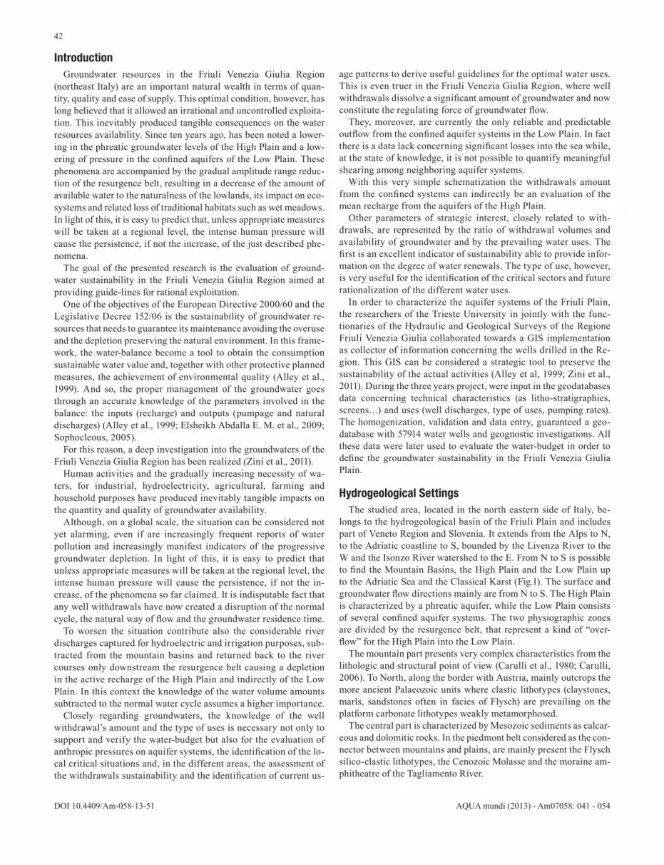
longs to the hydrogeological basin of the Friuli Plain and includes part of Veneto Region and Slovenia. It extends from the Alps to N, to the Adriatic coastline to S, bounded by the Livenza River to the W and the Isonzo River watershed to the E. From N to S is possible to find the Mountain Basins, the High Plain and the Low Plain up to the Adriatic Sea and the Classical Karst (Fig.1). The surface and groundwater flow directions mainly are from N to S. The High Plain is characterized by a phreatic aquifer, while the Low Plain consists of several confined aquifer systems. The two physiographic zones are divided by the resurgence belt, that represent a kind of “over-flow” for the High Plain into the Low Plain.
The mountain part presents very complex characteristics from the lithologic and structural point of view (Carulli et al., 1980; Carulli, 2006). To North, along the border with Austria, mainly outcrops the more ancient Palaeozoic units where clastic lithotypes (claystones, marls, sandstones often in facies of Flysch) are prevailing on the platform carbonate lithotypes weakly metamorphosed.
The central part is characterized by Mesozoic sediments as calcar-eous and dolomitic rocks. In the piedmont belt considered as the con-nector between mountains and plains, are mainly present the Flysch silico-clastic lithotypes, the Cenozoic Molasse and the moraine am-phitheatre of the Tagliamento River.
43
AQUA mundi (2013) - Am07058: 041 - 054 DOI 10.4409/Am-058-13-0051
Fig. 1: Location of the study area and the main physiographic units. In light brown and in sandy colour the mountain watersheds and the Isonzo River one, in light blue the High Plain, in light green the Low Plain; these last two are divided by the resurgence belt (blue). In yellow the Karst area.
The Friuli Plain extends south Carnic and Giulian Prealps between Livenza and Isonzo Rivers and the Classical Karst. Administratively it mainly belongs to Friuli Venezia Giulia Region and only the west-ern south is part of Veneto Region. It represents the eastern edge of the Po Valley Plain, although its characteristics must be considered marginal compared to the evolution of the latter being characterized by greater steepness and coarser sediments. Its highest elevation is about 250 m a.s.l., on a north-south length of about 90 km (Antonelli et al., 1981).
Quaternary sediments are widely present in the Plain reaching thickness, near Latisana, of more than 600 m gradually decreasing towards east till 250 m near Grado (Cimolino et al., 2010; Della Ve-dova et al., 2008; Nicolich et al., 2004). From a hydrogeological point of view, it is possible to divide the entire Plain into two parts: the High Plain and the Low Plain divided by the resurgence belt, a nar-row band WNW-ESE oriented from the base of Cellina-Meduna wa-tershed, until Classical Karst. In this area the waters emerge through a myriad of springs that give rise to a series of rivers. Its amplitude is in the order of several hundred meters, variable in space and time as a function of the water power supply conditions.
In the High Plain, characterized by a high permeability of the loose coarse deposits, a phreatic continuous aquifer is recognized that gradually reaches the surface while approaching the resurgence belt.
During the year the water table excursions are very different from place to place: from the lowest values reached along the southern side of the resurgence belt with few meters of oscillation, it switches to more than 50 meters close to the pre-Alpine mountains arc (Cuc-chi et al., 1999).
Moving towards the Low Plain, the phreatic aquifer joins in a complex layered aquifer systems characterized by gravel-sand de-posits variously interspersed with clay and silt increasingly frequent and powerful. In almost all the Low Plain wherever outcrop discon-tinuously gravelly-sandy horizons, at shallow depth, is present a dis-
continuous phreatic aquifer that has some relevance for the issues related to land (use, pollution, etc.). Here, enclosed in aquitard or aquiclude layers have been recognized eleven confined aquifer sys-tems of which the deeper have a geothermal character (Stefanini et al., 1976; Stefanini et al., 1977a, 1977b; Stefanini, 1978). To describe the subsoil of the Low Friuli Plain, has been adopted a scheme which provides the presence of seven “cold” confined aquifer systems (des-ignated as A, B, C, D, E, F, G in the direction of increasing depth) between 10 and 400 m of depth, and, as known at the time, four aquifer systems characterized by geothermal waters (called H, I, L and M) (Cucchi et al., 2008a, 2008b; Della Vedova et al., 1994; Mar-telli et al., 2007a, 2007b; Martelli et al., 2010; Nicolich et al., 2008; Stefanini et al., 1976; Stefanini et al., 1977a, 1977b; Stefanini, 1978; Stefanini et al., 1978).
Materials and MethodsIn order to evaluate the groundwater amount, a 3D model of the
Low Friuli Plain aquifer systems was realized using Rockworks R14 software, starting from 603 lithostratigraphic well data, cho-sen among 3258 available and seismic sections. Isobath and isopach maps were elaborated too, using kriging as geostatistical interpola-tion method.
Precipitation, evapotranspiration, runoff and infiltration were calculated to evaluate the inflow and outflow groundwater budget terms, using data recorded by 109 rainfall and 46 thermometric sta-tions during 1979-2008. For the precipitations the interpolating al-gorithms Natural Neighbor was used, instead for the temperatures experimental elevation gradients were used. The evapotranspira-tion was quantified as “crop evapotranspiration” calculated with the two-step approach. The surface runoff was defined using the Curve Number methodology modified by Williams. To better de-fine the river influences and the river effluences at sea, a series of

44
DOI 10.4409/Am-058-13-51 AQUA mundi (2013) - Am07058: 041 - 054
Fig. 2: Schematic North-South hydrostratigraphic cross section; each different color is representing a single different aquifer system. The question marks are identifying the unknown correlations due to the lack of data (depth not reached by the drilled well).
recent surveys on river discharges and surface withdrawals data were considered too.
To obtain the budget in non-natural conditions, as the currents, were taken into account also the groundwater withdrawals. These were evaluated for each type of use and for each aquifer system, starting from 2 geodatabases: one regarding the domestic use (50101 estimated wells) and one concerning industrial, agricultural, fish breeding, hygienic, geothermal and other minor uses (7594 wells, 7930 extraction points considering the screens). The well withdraw-als amount were evaluated, on annual base for recent periods and expressed as m3/s, for specific areas taking into account the number of wells, the discharges, the screen depths, the water meter data and other useful parameters.
For the water-budget, the studied territory was considered as a “semi-closed box” in which the groundwater sharings with the neighboring areas are not relevant and recharging groundwater is mainly due to the river influences, infiltration, rainfall and irrigation practices.
The datasetFor the realized research, a Geographic Information System on
an ESRI platform was implemented. It is a specific Oracle Geoda-tabase in which the alphanumeric information are integrated with the geographical ones and where data interoperability towards the other used platforms is guaranteed. Data query and management are possible thanks to the ESRI ArcGIS interface. In the geographic platform converged six different databases having information re-garding wells, springs and litho-stratigraphies (“DERIVAZIONI” and “DENUNCE” by the FVG Hydraulic Survey, “GEOTERMIA”,
“CGT” and “CARG” by the FVG Geological Survey and AdB real-ized by the Autorità di Bacino dell’Alto Adriatico). During the data assembly has been necessary a polishing operation on the duplicates. The homogenization, validation and implementation of the collected data reaching the number of 59260 points of which 1346 are springs and 57914 (28902 domestic) are wells (Zini et al., 2011) permitted to obtain the final geodatabase.
The confined aquifersIn order to characterize the confined aquifer systems a 3D model,
having a cell of 400x400x1 m, was realized using Rockworks R14 release software starting from 603 lithostratigraphic and wells data chosen among 3258 available (Zini et al., 2011). The set of available data allowed the elaboration of the separation surfaces, expressed as grid files, between the different hydrostratigraphic units being these last ones the structure of the realized model. First of all were real-ized hundred lithostratigraphic cross sections passing through the lithostratigraphic data, in order to verify the conceptual model pro-posed; later the three-dimensional analysis on the lithostratigraphies was done according to the chosen permeability classes. This allowed a semi-automatic construction of the model taking into account the hydraulically connected domains and the eteropic interdigitations. A “picking” operation made on the top and bottom of each tapped aquifer system allowed a hydrostratigrapic reconstruction. From the geostatistical elaboration (kriging interpolator) was derived the model defining the domains of existence and/or the limits of the in-vestigated areas, the depth of the top and the bottom (a.s.l.) and the thicknesses of the recognized aquifer systems as isobath and isopach maps (Fig. 2 and at the next page Fig. 3).

45
AQUA mundi (2013) - Am07058: 041 - 054 DOI 10.4409/Am-058-13-0051
Fig. 3: Isobath (left) and isopach (right) maps for the aquifer systems “A”, “B” and “C”. The maps are in m a.s.l., in blue the well points used for the construc-tion of each map. Isobaths are the result of the top depth values interpolation trough the kriging algorithm. Different variograms, iterations and filters were ap-plied on each dataset. Isopach maps are the interpolated result of the thickness values computed for each single aquifer system; different variograms, iterations and filters were applied on each dataset also for these maps (Zini et al., 2011).

46
DOI 10.4409/Am-058-13-51 AQUA mundi (2013) - Am07058: 041 - 054
The aquifer A, generally positioned between 10/20 and -80 m a.s.l., is widely present in the Low Plain. Permeable layers from sandy to sandy-gravelly deposits are characterizing it. The thickness of the layers sometimes reach value even higher than 10 m, but more often the aquifer is variously divided into weak permeable layers interspersed by clay-silty impermeable ones with an average thick-ness of 31 m.
The aquifer B, is a permeable gravelly (northern areas) and sandy (southern areas) layer, fairly constant with the top at about -30/ -40 m depth a.s.l. and the bottom at -100 m a.s.l. The average thickness of this system is about 13 m.
The C aquifer is on average depth between -60/70 and -130 m a.s.l. and is well developed in the lagoon and hinterland areas. It mainly consists of two almost always clearly distinguishable permeable lay-ers identified as “C high” and “C low” which average thickness is 14.5 m (“C high” + “C low”).
The aquifer D comprises a set of thin permeable layers of pre-dominantly sandy-gravelly deposits, which are generally divided in two main groups interpreted as aquifers “D high” and “D low”. The top of this system stands at indicative quotes of -110/-120 and – 155 m a.s.l. and the two levels succeed one from another at few meters of distance joining in a single indistinct layer at high permeability, thus forming a hydraulic complex circuit with local vertical sharings. The average thickness is around 15 m (“D high”+ “D low”).
The E aquifer is a permeable interval consisting of clean and coarse gravel in the northern part shifting into gravel with sand and silt to the south. The average thickness is about 14 m. The top of the permeable E aquifer is approximately -150/-200 m and the bottom at -170/-215 m a.s.l. The waters are of geothermal interest reaching temperatures of 29 °C.
A set of different permeable complex levels of gravelly-sand de-posits, sometimes cemented, interbedded discontinuously by thin layers of silt and clay constitute the aquifer F. The top of this system is present between -190 and -250 m a.s.l. depending from the loca-tion. Overall it can be considered quite well distributed mainly in the southern part of the plain where sometimes it is splitted into two different layers. The average thickness is about 17 m.
The G system consists of sandy intervals, sometimes with gravel or with weakly cemented sands. The top is about -260/-300 m a.s.l. Its average thickness is about 11 m.
The H aquifer is a composite system located below a clay-silt thick and continuous aquitard and it is one of the thinnest gravel level,
sometimes weakly cemented containing a percentage of sand. It is possible to distinguish two permeable horizons named “H high” and “H low” having an average thickness of 13-15 m and the top at a depth of -320/-370 and -380/-420 m a.s.l. respectively.
Regarding the deeper aquifers, the available information are scarce and discontinuous, and this does not allow a full characteriza-tion (Cimolino et al., 2010; Nicolich et al., 2008; Regione Autonoma Friuli Venezia Giulia, 2007). They are contained in porous horizons with variable thickness and extension where freshwaters have a high content in solutes and a strong thermal component with tempera-tures higher than 35°C.
The aquifer I is tapped at a depth ranging from -450 to -470 m a.s.l. and is mainly characterized by sandy and discontinuous len-ticular bodies. Sometimes the deposits are sandy-gravelly present in weakly cemented sand and Pliocene deposits. This aquifer has a discontinuous thickness that varies widely from 5 to 20 m.
The aquifer L is located in a low range of sandstone or cemented sand from Tortonian age, whose top is tapped at depths exceeding -500 m to about -540 m a.s.l. The thickness varies between 10 and 30 m and it is recognized only along the Tagliamento River.
The aquifer M consists of sand deposits of the Upper Miocene, has the top that can be roughly placed at depths exceeding -590 m a.s.l.
In the Low Plain all the confined aquifers are artesian, having pressure values that can reach more than 1 bar. The seasonal varia-tions mainly affect the shallower aquifers but are generally less than 0.5 bar (Martelli et al., 2007a, 2007b).
From the data present in the international literature, to each aqui-fer systems has been assigned a value of effective porosity and hy-draulic conductivity (Castany 1985; Civita, 2005; Fetter, 2001) tak-ing into account lithological data, the hardness degree, cementation or fracturing. The volumes and the average thicknesses of the aqui-fer systems were calculated starting from the 3D model (Tab.1).
Starting from volumes and effective average porosity has been calculated the amount of the water storage contained in each aquifer systems (Tab.2). The water storage, expressed as volume [km3] and as equivalent water column average height Hw [m], is here interpret-ed as the drainable storage, that is the amount of mobilizable water contained in the sediment’s pores. In the computation was not taken into account, being an order of magnitude lower, the compressible storage due to the compression of the aquifer and the water itself. All these studies are useful to reconstruct the groundwater availability and to evaluate the sustainable exploitation.
Aquifer systemsArea Volume Top - Depth Domains of existence Average thickness
A V (a.s.l.) (a.s.l.) bmean=1000∙V/A[km2] [km3] [m] [m] [m]
A 2294 71.2 +10 / -50 +10 / -80 31.0B 2294 30.6 -30 / -90 -30 / -100 13.3C 2294 33.3 -60 / -120 -60 / -130 14.5D 2294 35.1 -110 / -155 -110 / -170 15.3E 2294 32.5 -150 / -200 -150 / -215 14.2F 2294 39.5 -190 / -250 -190 / -265 17.2G 2124 23.1 -260 / -300 -260 / -320 10.9Hhigh 1135 15.2 -320 / -370 -320 / -380 13.4Hlow 852 12.5 -380 / -420 -380 / -440 14.7
Tab 1:Geometrical characteristics of the confined aquifer systems recognized and tapped in the Friuli Low Plain.

47
AQUA mundi (2013) - Am07058: 041 - 054 DOI 10.4409/Am-058-13-0051
Tab 2: Hydrogeological parameters and water storage, expressed both as volume and as equivalent water column height (Hw), calculated for each confined aquifer systems of the Friuli Low Plain.
Aquifer systems
Hydraulic Conductivity Effective porosity Storage HwKmin Kmax nemean V·nemean bmean·nemean[m/s] [m/s] [%] [Km3] [m]
A 1.0E-05 5.0E-02 20.0 14.2 6.2B 1.0E-05 5.0E-02 20.0 6.1 2.7C 1.0E-05 5.0E-03 22.5 7.5 3.3D 1.0E-05 5.0E-02 24.0 8.4 3.7E 1.0E-04 1.0E-02 20.0 6.5 2.8F 1.0E-04 5.0E-03 20.0 7.9 3.4G 1.0E-05 5.0E-02 20.0 4.6 2.2Halto 1.0E-05 5.0E-02 20.0 3.0 2.7Hbasso 1.0E-05 5.0E-02 20.0 2.5 2.9
Wells withdrawals evaluationFor the present paper, were developed procedures that permitted
to reach an adequate estimation of the wells withdrawals and their quotes divided among the different aquifer systems and for each different type of use and then compared to the available literature (Granati et al., 2000). In particular on the available datasets two dif-ferent protocols were adopted: one for the 7594 wells subjected to licence (drinking, agricultural, fish breeding, industrial, hygienic, geothermal and other minor uses) and one for the 50101 estimated domestic wells (Treu, 2011).
For these purposes has been necessary to identify and evaluate the following characteristics: number of captures and their distribution on the territory, tapped aquifers, main uses and the effective con-sumptions. In order to define for each well the tapped aquifer sys-tems were used the intersection between the depth of the screens, or the total depth, and the 3D model of the aquifers. The well withdraw-als amount were evaluated on annual base for recent periods and expressed as m3/s, as million m3/year and as water column height (m/year) with reference to specific areas.
As regard the 7594 wells subjected to license (7930 extraction points considering the screens), useful information has been derived from a informatic census done in Friuli Venezia Giulia Region start-ing from 2004. It permitted to have good quality data on location, total depth, screen depth and licensed discharges. Using the screen depth when available or the total depth, it has been possible to assign the tapped aquifer. Additional information from water-meter con-sumption has been collected for 553 wells (648 extraction points). All the data collected, even if of good quality, were anyway sub-jected to a validation protocol in order to verify their effective value. The known wells are almost all the existing ones and therefore the analyzed number can be considered representative of the real situ-ation.
Only for the wells without water-meter attributes, a reducing coef-ficient was assigned to the licensed discharge in order to estimate the real consumption. For each use the coefficient value was evaluated according to the available water-meter data.
For the agricultural use a value of 10% of the licensed discharge was assigned. This corresponds to 37 day of use per year and repre-sents the irrigation period concentrated in summertime.
For the drinking use, a value of 56% was assigned corresponding to an effective use of 13.5 hours per day.
The fish breeding are active during all the year to maintain the
correct water recharge and freshness, for this reason a value of 100% was assigned.
For the industrial use, a value of 26% was assigned corresponding to 6.5 hours/day at full discharge.
Concerning the hygienic use several uses are converging into this item (e.g. antifire). The estimation assigned a value of 7%.
Geothermal wells are active all over the year and so was consid-ered a value of 100 % of the licensed discharge.
Concerning the other minor uses, the estimation assigned a value of 100 %.
For the Low Plain area in Veneto Region, there were no available data and so an evaluation of the withdrawals has been done by anal-ogy with the near municipalities located in the Friuli Venezia Giulia.
Knowing the licensed discharges, the percentage of effective use of each well and the corresponding tapped aquifer, it has been pos-sible to estimate the withdrawals amount divided by type of use and aquifer systems.
As regard domestic wells, in the Friuli Plain are widely pres-ent private wells being part of the local culture. Their density and withdrawals vary from area to area in function of the geographi-cal distributions of the settlements, of the type of aquifer (phreatic or artesian), the depth of the water table, the groundwater quality, the distance to the coast or the development of the pipe aqueduct network. Several are, in fact, the municipalities unprovided by an aqueduct net.
In particular, a huge amount of domestic wells characterize the Low Plain. Withdrawals are mainly interesting the shallower arte-sian aquifer systems (A, B and C) and have continuous flow seen that are naturally gushing wells and generally not equipped with dis-charge reducers. Accordingly, the withdrawals are far higher than the real demands of the population. The flow freely waters, as a rule, discharges to the sea, through the irrigation canals drainage network or are influent for the shallow phreatic waters.
North of the resurgence belt instead, the water well withdrawals for strictly domestic use has always been not widespread seen that the depth to water is higher and the water might be extracted only using submersible pumps. In recent years, this practice has further mainly reduced due to the depletion over time of the water quality and due to the realization of a widespread aqueduct network. The use is therefore discontinuous and withdrawals are closely linked to the

48
DOI 10.4409/Am-058-13-51 AQUA mundi (2013) - Am07058: 041 - 054
real water demand.For the evaluation of the withdrawals, has been necessary to esti-
mate and determine the following variables:• the total number of wells and their widespread on the territory;• the coefficients (concerning consumptions for the phreatic
wells and discharge for the artesian ones) to be adopted for the withdrawals calculation;
• the sharing volume rates of the water withdrawals among the different aquifer systems.
The domestic wells data present in the geodatabase (28902 wells) are a close underestimation of the real situation representing the best knowledge framework. To fill the gap were used also data of the XIV general census of population and houses (ISTAT, 2001) from which were abstracted information on houses served by domestic wells in order to compensate the lack of information. Through appropriate data processing and integrated analysis of the gathered information, to each municipality was assigned its number of domestic wells.
In total were estimated 50101 wells for domestic or similar uses: 9376 in the High Plain and 40725 in the Low Plain. With regard to the administrative boundaries, 47709 wells are in the Friuli Venezia Gi-ulia Region and 2392 are in the part of the Low Plain located in Veneto.
For the withdrawals evaluation, first it was necessary to distin-guish between wells located at north of the resurgence belt, con-sidered all phreatic, and the ones located at south of it, considered all confined. Of course, these assumptions are partially forced, but necessary to simplify the calculation.
With regard to phreatic wells were considered the number of per-sons using a domestic well with an average per capita consumption, set equal to 290 liters per day.
With regard to the artesian wells, to compute the withdrawn amount were used the mean discharge seen that withdrawals are completely independent from the actual water demand. Based on the data surveyed in the last decades by the Servizio gestione risorse idriche of the FVG Region and from bibliography (GEOS, 1994; Granati et al., 2000) has been estimated a mean discharge per arte-sian well of 0.8 l/s. From the data present in the geodatabase (28902 domestic wells), using the screen depth when available or the total depth, it has been possible to assign the withdrawal rate for each artesian aquifer. From the realized analysis it came out that 80% of the wells present in the database are tapping the aquifer A, 10% the aquifer B, 2% the C, 4% the D, 2% the E, 1% the F and 1% the G.
The total amount of groundwater withdrawals in the Friuli Plain basin was obtained by adding the one coming from the wells sub-jected to license with the domestic ones. More than 50% of the with-drawals are due to the domestic wells.
The total withdrawals are 62.4 m3/s. Withdrawals from the moun-tains areas are 2.6 m3/s while 4.54 m3/s are from the phreatic aquifer of the High Plain, for a total value of 7.19 m3/s. The total withdraw-als amount from the confined aquifer systems are 44.4 m3/s, of wich 3.3 in the High Plain and 41.1 in the Low Plain areas (38.6 in Friuli Venezia Giulia Region and 2.5 in Veneto Region). Almost 50% of the withdrawals are in the aquifer systems A (Fig.4).
Fig. 4: Withdrawals in the Friuli Venezia Giulia Region subdivided by aquifer systems and by type of use.

49
AQUA mundi (2013) - Am07058: 041 - 054 DOI 10.4409/Am-058-13-0051
Fig. 5: Thematic maps concerning P - Precipitation (A) in mm/y, ET - Evapotranspiration (B) in mm/y and R+I map realized for the surface Runoff and Infiltra-tion (C) in mm/y.
Water hydrogeological budgetThe considerable water withdrawals and the rapid deterioration
of groundwater highlighted the necessity of an integrated approach for the assessment of sustainable consumption and for planning of future uses. The water-balance looks like the tool used to evaluate the available water resources and the future demand (Calligaris et al., 2010a, 2010b; Henriksen et al. 2008; Kalf et al., 2005; Jukic´ et al., 2009; Sophocleous et al., 2004; Sorek et al., 2010; Zhou, 2009).
The orography of the studied area is extremely favorable for the computation of the water-budget as it is a bounded basin with lim-ited water sharing with neighboring aquifers.
The analysis extended to the whole region was focused on the Plain where the withdrawals are mainly concentrated. Evaluating the budget input components it was used what already carried out by the Friuli Venezia Giulia Region (2010) in the formulation of the Water Protection Plan (Regione Autonoma Friuli Venezia Giulia, 2010).
With regard to precipitation were used data from 109 rainfall sta-tions and 46 regional thermometric stations (Hydrographic Region Unit and ARPA Osmer) recorded in the period between 1979-2008. Any missing data were reconstructed using linear regression tech-niques (stepwise or multiregression) (Cicogna, 2008) (Fig. 5).

50
DOI 10.4409/Am-058-13-51 AQUA mundi (2013) - Am07058: 041 - 054
The daily rainfall and temperature data spatialized on a 50 m grid were overlapped to the DEM. For the Precipitations (P) were used interpolating algorithms as Natural Neighbor, while for the temperatures were used experimental elevation gradients obtained correlating the thermometric daily data with the elevation of the stations (Cicogna, 2008; Castrignanò et al., 2005).
The Evapotranspiration (ET) was quantified as “crop evapo-transpiration” calculated with the two-step approach as the product between the reference evapotranspiration and the crop coefficient Kc that incorporates and synthesizes all the effects on evapotrans-piration due to the morfophysiologic characteristics of the different cultural species from phenological stage to the soil cover degree (Zini et al., 2011). Kc, depending from the type of vegetation and from the stage of plant development, was evaluated for each land use Moland class and for each decade of the year and associated to each cell of the grid. The reference evapotranspiration is a typi-cal climate parameter expressing the tendency to perspire of a given plant. To calculate it, it was used the Hargreaves formula (Allen et al., 1998), described in the notebook 56 of the FAO (Food and Agri-culture Organization). The average crop evapotranspiration for the Friuli Venezia Giulia Region is equal to 489 mm/y.
Surface Runoff (R) and effective Infiltration (I) components were used for the Plain, while for the whole mountain basins was consid-ered the sum R+I. The surface runoff has been defined using the Curve Number (CN) methodology modified by Williams (1995) to fit the long-term analysis. CN was defined for the whole regional territory combining on a 50x50 m grid the map of the hydrological groups, the land use map and the slope map extracted by DEM. From CN the retention parameter was calculated varying from a minimum, corresponding to a saturated soil, to a maximum, coin-cident with a dry soil depending from potential evapotranspiration of the computed day, from the precipitation and run off of the previ-ous day (Zini et al., 2011). The mean annual runoff over the Plain is equal to 216 mm/y. The effective infiltration component was cal-culated as the difference between precipitation, evapotranspiration and runoff. The annual mean effective infiltration over the Plain is equal to 718 mm/y.
The mountain basins discharge (R+I) analysis allows quantify-ing the mean annual active recharge of the High Plain (Tab. 3). If we consider the average R+I values, purged from the quantity of water outflowing to sea, they represent the average quantity that normally feed the aquifers of the High Plain.
The analysis was conducted dividing the area into four main hydrological basins and in the area of moraine amphitheater. The
effluent character of the main watercourses in the High Plain repre-sents the main component of the recharge in these areas.
Based on a series of measurement surveys carried out in recent years (Consorzio di Bonifica Ledra Tagliamento, 1982; Cimolino et al., 2011) and on river discharge data surveyed by the “Servizio gestione risorse idriche della Direzione centrale ambiente, energia e politiche per la montagna of the FVG Region” were evaluated the percentages of river losing of each single water course. These values in conjunction with the shallow capture of waters for irriga-tion and industrial purposes and with the groundwater withdrawals permitted to compute the mean outflows at sea and, as difference, the effluences in the High Plain (Tab.4).
The discharge of the Cellina Meduna basin has an average value of 28.5 m3/s of which 25.1 m3/s is captured mainly for irrigation and hydroelectric purposes. It follows that the useful influent discharge into the phreatic aquifer of the High Plain is 3.4 m3/s being the 12% of the total amount of the Cellina Meduna mountain basin rate.
In the mountain basin of the Tagliamento River, the discharge has an average value of 100.7 m3/s. Of these, 2.4 m3/s are well withdraw-als, 23.0 m3/s are captured for irrigation purposes, 21.2 m3/s directly outflow to sea and 54.1 m3/s supply the High Plain.
In the mountain basin of Torre – Natisone rivers the discharge has an average value of 32.8 m3/s, of which 2.5 m3/s are captured for drinking, irrigation and hydropower purposes. Seen that the compo-nent flowing directly to the sea has been estimated to be around 3.0 m3/s, the influence on the High Plain is equal to 27.3 m3/s.
For the Isonzo River basin, seen that are not available the run-off and infiltration data for the slovenian side of the mountain basin, it has been decided to use the river discharge measured at the border (Gorizia - Ponte Piuma site). In this point, the discharge has an aver-age value of 170.8 m3/s of which 26.3 m3/s are captured for irrigation and hydropower purposes, 107.1 m3/s directly flow out to sea and 37.4 m3/s are influent into the aquifers of the High Plain.
In the moraine amphitheater the estimated outflow is of 8.5 m3/s with well withdrawals of 0.2 m3/s, which implies that the amphithe-ater has an influent character with respect to the High Plain with a volume of 8.3 m3/s.
The High Plain is average fed by 130.5 m3/s of waters from moun-tain basins and by 65.3 m3/s due to effective infiltration and irriga-tion return flow (Zini et al., 2011).
The withdrawals are 7.9 m3/s (4.54 m3/s tapped from the phreatic aquifers and 3.36 m3/s from the confined aquifer northern of the re-surgence belt) and 10 m3/s are the waters drained by Classical Karst aquifer (Cucchi et al., 2007; Urbanč et al., 2012).
MOUNTAIN WATERSHED
OUTFLOW R+I
WITHDRAWALS IN THE
MOUNTAIN WATERSHED
DIFFERENCE OUTFLOW
-WITHDRAWALS
% RIVER INFLUENCES
IN THE HIGH PLAIN ACQUIFERS
CONTRIBUTION TO THE HIGH PLAIN AQUIFERS
RECHARGERM
Cellina-Meduna 28.5 25.1 3.4 100% 3.4Tagliamento 100.7 25.4 75.3 72% 54.1
Torre-Natisone 32.8 2.5 30.3 90% 27.3Moraine
Amphitheater 8.5 0.2 8.3 100% 8.3
Isonzo 170.8 26.3 144.5 26% 37.4TOTAL 341.3 79.5 261.8 130.5
Tab 3: Mountain watersheds contribution to the High Plain aquifer recharge [m3/s].

51
AQUA mundi (2013) - Am07058: 041 - 054 DOI 10.4409/Am-058-13-0051
Tab. 4: High Plain aquifers groundwater recharge and discharge [m3/s].
Tab. 5: Low Plain confined aquifers groundwater recharge [m3/s].
INPUT OUTPUT IN-OUT
RMrecharge coming from
the mountain watersheds
I+Iiinfiltration in the High Plain due to
effective precipitation and irrigation return flow (Ii)
well withdrawals in the High Plain Karst drainage RHP
+130.5 +65.3 -7.9 -10.0 +177.9+195.8 -17.9 +177.9
An estimation was made on the resurgence rivers discharges that overall drain 134.2 m3/s (Zini et al. 2011). From the difference be-tween the inputs of the High Plain and the resurgence rivers dis-charges, was estimated the input of the Low Plain as 43.7 m3/s. The
obtained result is validated by the estimated value of the calculated withdrawals 41.1 m3/s in the aquifer systems in the Low Plain area (Tab.5).
INPUT OUTPUT IN-OUTRHP
recharge coming from the High Plain
QSresurgence belt discharge
RLPArecharge of the Low Plain confined aquifers
+177.9 -134.2 +43.7
Considering that the mean annual active recharge coming from the High Plain is equal to 43.7 m3/s, and that the well withdrawals in the Low Plain for the confined aquifers are 41.1 m3/s, the water
budget is equal to +2.6 m3/s. This value is in the range of acceptance seen also the regional scale of the research (Fig.6).
INPUT OUTPUT IN-OUTRLPA
recharge of the Low Plain confined aquifers
well withdrawals in the Low Plain confined aquifers groundwater balance
+43.7 -41.1 +2.6
Tab. 6: Low Plain confined aquifers hydrogeological groundwater budget [m3/s]..
Fig. 6: Water-budget scheme. Mountain Watersheds (light brown) and Isonzo River mountain watershed (in sandy colour) to the North, the High Plain (HP) area (light blue) separated from the Low Plain (LP) (light green) by the resurgence belt (blue dashed line). In yellow the Karst area. Blue arrows are related to the influ-ences and water flows, while red and green arrows represents the well withdrawals and the resurgence belt discharges.

52
DOI 10.4409/Am-058-13-51 AQUA mundi (2013) - Am07058: 041 - 054
Discussion and ConclusionsThe research presented in this paper has as aim the quantifica-
tion of the water resources available and the identification of the groundwater withdrawals in Friuli Venezia Giulia Region in order to define, through the water-budget, the sustainability of the ac-tual use of the resource. To compare the available water resources with the estimated consumption is necessary to aggregate the re-sults by creating a conceptual model of physical reality. The ad-opted scheme divides the studied area into homogeneous zones: the mountains, the Isonzo mountain watershed, the High Plain (HP) and the Low Plain (LP) as shown in Fig 1. Each single area can be compared to communicating tanks: the mountain groundwater sup-plies, through direct contributions or through the rivers influences, the High Plain which, that in turns, supports both resurgences belt and Low Plain aquifer systems.
From the realized analysis, emerges how the current use of the confined aquifers in the Low Plain is not sustainable in the long run, that means that the amount of water withdrawals in the High Plain affects the resurgence belt discharge, reducing its amplitude with a consequent loss of traditional habitats such as wet mead-ows. The effect just mentioned, in the Low Plain, is highlighted on the artesian aquifers where the lowering of their pressures is fully monitored (Cucchi et. al, 1999; Martelli et al., 2007a, 2007b). Seen that in the water-budget the balance definition itself is resuming the concept of equilibrium, the final result obtained for the present research (+2.6 m3/s) is in the range of acceptance of a computation realized in a wide area like the Friuli Region. But even if the re-sult is positive, the criticity of the actual withdrawal rate is mainly highlighted if the attention is focused on specific areas seen the heterogeneous distribution of the wells. For example, in the right side of Tagliamento River, in the Low Plain, the withdrawals are 21.7 m3/sec with a withdrawal intensity of 35.5 l/s on Km2. In the left side of Tagliamento River instead, always for the Low Plain, the withdrawals are 14.8 m3/sec with a withdrawal intensity of 22.9 l/s on Km2. If we consider the Isonzo Low Plain, the withdrawals are 2.1 m3/sec with a withdrawal intensity of 14.9 l/s on Km2. For this reason is necessary to focus the attention on the artesian aquifer withdrawals that can also cause water recalls from the High Plain, more vulnerable to pollutants. In this framework of wild withdraw-als, it is not possible to forget the massive hydroelectric withdrawals from mountain basins and from irrigation that gradually increase in time and determine nowadays a strong decrease of the High Plain recharge, with direct impact on feeding of the confined aquifers in the Low Plain.
The enormous vulnerability of the water quality emerges also if we look at the analysis conducted on the age of waters that indicate that most of the waters deeper than 110 meters, belonging to the sys-tems “C” and above, are older than 15000 years. Deep waters have an extreme high quality but have a very low turnover (Cucchi et al., 2008a, 2008b).
An hypothetic computation of the “exhaustion time” for different aquifer systems - defined as the time required to extract, with the current withdrawal rate, all the water contained in them (without recharging) - will give very variable values, sometimes short. For shallower aquifers as “A” and “B” systems, the depletion time ranges from a minimum of 6 years in the Low Plain in the right Tagliamento to a maximum of 66 years in the Low Plain in the left Tagliamento.
For the system “C”, the depletion time ranges from a minimum of 51 years in the Low Central East Plain to a maximum of 349 years in the Low Isonzo Plain. For the system “E”, the depletion time ranges
from a minimum of 23 years in the Low Plain around Pordenone in the right side of Tagliamento river to a maximum of 153 years in the Low Isonzo Plain.
Deeper aquifer systems are still not much used and so the deple-tion time greatly increase: for the system “F” the mean depletion time is equal to 274 years.
Shorter are the depletion time higher is the replacement rate of water of the aquifer systems. Seen that the water supply mainly derives from the phreatic groundwaters of the High Plain, having worse quality, this clearly implies a depletion of artesian aquifers not only in quantitative but also qualitative (Zini et al., 2008), fact that is more relevant seen that the withdrawn water is used also for drink-able purposes. To increase the risk of mixing water from the deeper artesian aquifers with the shallow ones contributes also the gradual increase in depth of the new drilled wells and therefore the number of potentially interconnected aquifers.
The prevalent uses of artesian aquifers in the Low Plain are in order: domestic, fish breeding and agricultural. With regard to wa-ter saving in agriculture, much has been achieved or is planned to be a structural point in areas managed by Consortium of drainage (conversion of irrigation systems from scroll to rain), while still so few has been done to raise awareness of the farmer to the choice of crops that does not need too much water for a more conscious use of water resources. It is also desirable that the saved water due to the increased efficiency of the equipment is properly “reinvested” to im-prove the ecological status of rivers and to balance the water-budget by reducing groundwater extraction for irrigation and streamlining the irrigation system if not present. Emblematic is the case of fish breeding along the resurgence rivers: such systems were born to take advantage of the abundant and excellent water quality. Over the years the discharge of these rivers has been reduced and it was noted a quality deterioration, forcing the operators to drill new wells to offset the decrease in both scale and quality. Today, the ground-water withdrawals for fish breeding use are equal to 11.7 m3/s on a total of 478 wells. Even if the main part comes from the shallow phreatic aquifers of the Low Plain, it is therefore necessary a water rationalization through the use of oxygenators limiting the discharge withdrawn to the real requirements.
Finally, with regard to the domestic use, in Friuli Venezia Giulia Region was estimated that each person is consuming 17000 l/day that, compared to the European consumptions (about 250 l/day pro capita) are about 70 times higher. Even if fountains and sinks in the Low Plain have always been part of the landscape and cultural heritage, it is necessary to reflect on the sustainability of this prac-tice applying for example a discharge reducer, infact withdrawal entity, resurgence belt discharge, phreatic levels and confined aqui-fers pressure are closely interdependent and in dynamic equilibrium. The sustainability comes from the consistency and ratio between re-charge and withdrawals. The confined aquifers withdrawals in the Low Plain represents the 23.1% of the groundwater recharge coming from the High Plain and the 30.6% of the resurgence belt discharge. Seen that the resurgence belt discharge cannot further decrease, un-less loss of important ecosystems, it seems that the present situation can be defined of limit equilibrium.

53
AQUA mundi (2013) - Am07058: 041 - 054 DOI 10.4409/Am-058-13-0051
Acknowledgment: Project founded by Direzione Centrale Ambiente, Energia e Politiche per la Montagna, Servizio idraulica of the Friuli Venezia Giulia Region in the frame-work of the Agreement prot. n. 36037 dd 27.11.07 among Servizio idraulica and Trieste University (Departments of Mathematics and Geosciences – D.M.G. and Department of Civil and Environmental Engineering – D.I.C.A.).The authors would like to thank all the researchers who contribute to the project: Alzetta S., Barison E., Burelli G., Catanese G., Cicogna A., Cimolino A., Cleva S., Deana A., Della Vedova B., Franceschini G., Massari G., Mereu A., Nicolich R., Oberti di Valnera S., Olivo P., Piano C., Pocecco G., Ramani M., Riccamboni R., Schak R. and Turpaud P.Moreover Prof. Franco Cucchi, head of the project, for his precious advices, corrections and management.
REFERENCESAlley W. M., Reilly T.E., Lehn Franke O. (1999) Sustainability of Ground-
Water Resources: U.S. Geological Survey Circular 1186. U.S. Geological Survey, Denver, Colorado, p.p. 86.
Allen R.G., Pereira L.S., Raes D., Smith M. (1998) Evapotranspiration: Guide-lines for computing crop water requirements. FAO Irrigation and drainage paper 56, FAO – Food and Agriculture Organization of the United Nations (www.fao.org/docreo ).
Antonelli R., Bortolami G. C., Braga G., Dal Prà A., Francani V., Francavilla F., Giuliano G., Manfredini M., Pellegrini M., Petrucci F., Pozzi R., Ste-fanini S. (1981) Indagine sulle falde acquifere profonde della Pianura Pa-dana. Contributi tematici per la conoscenza della idrogeologia Padana. In: Indagine sulle falde acquifere profonde della Pianura Padana, Quaderno I.R.S.A., Roma, III, 51 (II), parte II, 5-70 / fig. 8.
Calligaris C., Zini L., Treu F., Iervolino D., Lippi F., Cucchi F. (2010a) Wa-ter sustainability in the Friuli Venezia Giulia Plain. In proceedings of: 85° Congresso Nazionale della società Geologica Italiana, 6-8 Settembre 2010, Pisa, Italia, pp. 157-158.
Calligaris C., Cucchi F., Deana A., Treu F., Zavagno E., Zini L., Iervolino D. and Lippi F. (2010b) Water hydrogeological balance in the FVG Plain. In proceedings of HydroPredict2010: 20-23 September 2010, Prague, Czech Republic, p.68.
Carulli G.B., Carobene L., Cavallin A., Martinis B., Onofri R., Cucchi F., Vaia F. (1980) Evoluzione strutturale Plio-Quaternaria del Friuli e della Venezia Giulia. Contributi alla Carta Neotettonica d’Italia. Pubbl. n°356, P.F. Geodinamica, C.N.R., p.p.488-545.
Carulli G.B. (2006) Carta geologica del Friuli Venezia Giulia. Scala 1:150.000. Regione Autonoma Friuli Venezia Giulia, Direzione Re-gionale Ambiente e Lavori Pubblici, Servizio Geologico Regionale. S.E.L.C.A., Firenze.
Castany G. (1985) Idrogeologia: principi e metodi. Ed. Dario Flaccovio.Castrignanò A., Lopez N., Caradonna M.S. (2005) L’impiego di parametri
topografici per migliorare la precisione della stima della precipitazione. Quaderno degli extended abstracts del Convegno AIAM 2005: Agro-meteorologia, risorse naturali e sistemi di gestione del territorio. Italian Journal of Agrometeorology, Anno 9 - n. 1, p.p. –76-77.
Cicogna A. (2008) Atlante climatico del Friuli Venezia Giulia: 1. Precipi-tazioni. ARPA-Osmer, p.p. 42.
Cimolino A., Cisotto A., Saccardo I., Deana A., Marin A. (2011) Le cam-pagne di misura per la valutazione delle dispersioni in alveo. Il progetto Trust 2009-2011, p.p.83-105.
Cimolino A., Della Vedova B., Nicolich R., Barison E., Brancatelli G. (2010) New evidence of the outer Dinaric deformation front in the Grado area (NE-Italy). Rend. Fis. Acc. Lincei 21 (Suppl 1):S, p.p.167–S179, DOI 10.1007/s12210-010-0096-y.
Civita M. (2005) Idrogeologia applicata e ambientale. Edizioni CEA, p.p.736.Consorzio di Bonifica Ledra Tagliamento (1982) Studio per la determina
zione del bilancio idrologico dell’alta pianura friulana compresa tra i fi-umi Isonzo e Tagliamento, Rapporto interno, p.p.140.
Cucchi F., Franceschini G., Zini L. (2008a) Hydrogeochemical investiga-tions and groundwater provinces of the Friuli Venezia Giulia Plain aqui-fers, northeastern Italy. Environmental Geology, 55, p.p.985-999.
Cucchi F., Franceschini G., Zini L. (2008b) Hydrogeology and geochemistry of the Friuli Venezia Giulia Plain alluvial aquifers, northeastern Italy. In: Groundwater: Modelling, Management. Ed. L.F. Konig & J.L. Weiss, p.p. 231-257. ISBN: 978-1-60456-832-5.
Cucchi F., Massari G., Oberti S. (1999) Water table fluctuations in the northern Friuli Plain. Gortania, 21, p.p.41-51.
Cucchi F., Zini L. (2007) Le acque del Carso Classico. Memorie dell’Istituto Italiano di Speleologia, serie II, Vol. XIX, p.p. 33-40.
Della Vedova B, Castelli E, Cimolino A, Vecellio C, Nicolich R, Barison E. (2008) La valutazione e lo sfruttamento delle acque geotermiche per il riscaldamento degli edifici pubblici. Rassegna Tecnica FVG, 6/2008, p.p.16-19.
Della Vedova B., Marson I., Nicolich R., Bellani S., Calore C., Grassi S., Squarci P., Perusini P. (1994) Valutazione di dettaglio delle strutture pro-fonde nella Bassa Pianura Friulana. Inventario delle risorse geotermiche nazionali, Rapporto Ministero dell’Industria e dell’Artigianato, STAR, C.N.R., p.p.40.
Elsheikh Abdalla E. M., Elsayed Zeielabdein Khalid A., Babikir Ibrahim A. A. (2009) Groundwater balance in the Khor Arbaat basin, Red Sea State, eastern Sudan. Hydrogeology Journal, 17: 2075–2082. DOI 10.1007/s10040-009-0541-0.
Fetter, C.W. (2001) Applied Hydrogeology. Fourth Edition, Prentice Hall. ISBN 0-13-088239-9.
GEOS s.n.c. di Trieste (1994) Censimento dei pozzi per l’approvvigionamento idrico ad uso privato nei comuni di Fiume Veneto, Pordenone e Zoppola. Relazione. Reg. Aut. F.-V.G., Dir. Reg. Ambiente, Rapporto interno.
Granati C., Martelli G., Roda C. (2000) Valutazione preliminare del volume d’acqua estratta annualmente in Provincia di Udine dal sottosuolo della Bassa Pianura Friulana. IGEA (Ingegneria e Geologia degli Acquiferi); 15, p.p.13-26. doi: 10.1474/GGA.2007-05.0-07.0169.
Henriksen H. J., Troldborg L., Højberg A. L., Refsgaard J. C. (2008) As-sessment of exploitable groundwater resources of Denmark by use of ensemble resource indicators and a numerical groundwater–surface wa-ter model. Journal of Hydrology, 348, p.p.224– 240. doi:10.1016/j.jhy-drol.2007.09.056.
ISTAT (2001) XIV censimento generale della popolazione e delle abitazioni. http://www.istat.it/it/censimento-popolazione-e-abitazi/popolazione-2001
Kalf F. R. P., Woolley D. R. (2005) Applicability and methodology of deter-mining sustainable yield in groundwater systems. Hydrogeol Journal, 13, p.p.295–312. DOI 10.1007/s10040-004-0401-x.
Jukic´D., Denic´-Jukic V. (2009) Groundwater balance estimation in karst by using a conceptual rainfall–runoff model. Journal of Hydrology 373, p.p. 302–315; doi:10.1016/j.jhydrol.2009.04.035.
Martelli G., Granati C. (2007a) Valutazione della ricarica del sistema ac-quifero della bassa pianura friulana. Giornale di Geologia Applicata, 5, p.p. 89-114.
Martelli G., Granati C. (2007b) Lithostratigraphical and hydrogeological characteristics of the aquifers of the Low Friuli Plain and sustainability of groundwater extractions. Caratteristiche litostratigrafiche e idrogeo-logiche degli acquiferi della Bassa Pianura Friulana e uso sostenibile della risorsa. Memorie Descrittive Carta Geologica d’Italia LXXVI, p.p.241-266, figg.21 – tabb.13.
Martelli G., Granati C. (2010) A comprehensive hydrogeological view of the Friuli alluvial plain by means of a multi-annual quantitative and qualitative research survey. Quadro idrogeologico generale della Pianura alluvionale friulana sulla base di indagini quantitative e qualitative plu-riannuali. Memorie Descrittive della Carta Geologica d’Italia XC, p.p. 181-208, figg. 26, tabb. 3.
Nicolich R., Della Vedova B., Giustiniani M., Fantoni R. (2004) Carta del sottosuolo della Pianura Friulana (Map of Subsurface Structures of the Friuli Plain). Regione Autonoma Friuli Venezia Giulia, Direzione cen-trale Ambiente e Lavori Pubblici, Servizio Geologico, p. 28.
Nicolich R., Della Vedova B., Barison E., Cimolino A. (2008) Le acque calde della pianura friulana. Notiziario U.G.I., VII, 20, p.p.5-13.

54
DOI 10.4409/Am-058-13-51 AQUA mundi (2013) - Am07058: 041 - 054
Regione Autonoma Friuli Venezia Giulia (2010) Bilancio idrologico. Allegato 1 alla Relazione istruttoria del Piano regionale di tutela delle acque. p.p.32.
Regione Autonoma Friuli Venezia Giulia (2007) Le acque calde della Pianura Friulana. p.p.27.
Sophocleous M., Devlin J.F. (2004) The persistence of the water budget myth and its relationship to sustainability. Hydrogeology Journal, 13, p.p.549–554, DOI 10.1007/s10040-004-0354-0.
Sophocleous M. (2005) Groundwater recharge and sustainability in the high plains aquifer in Kansas, USA. Hydrogeology Journal, 13, p.p.351–365.
Sorek S., Von Igel W., Kronaveter Goldstein L., Levner E. (2010) Risk-De-pendent Integrated Water Resources Management: A conceptual model. AQUAmundi 1, p.p.37-44.
Stefanini S., Cucchi F. (1976) Gli acquiferi nel sottosuolo della provincia di Gorizia (The aquifers in the Gorizia province). Quaderni Isontini Ricerca Acque, 28, p.p.347–366.
Stefanini S., Cucchi. F. (1977a) Le ghiaie nel sottosuolo della pianura veneta ad oriente del F. Piave. In: Indagine sulle falde acquifere profonde della Pianura Padana, Quaderno I.R.S.A., 34 (3), pp. 67- 79.
Stefanini S., Cucchi F. (1977b) Gli acquiferi nel sottosuolo della provincia di Udine (The aquifers in the Udine province). Quaderni Isontini Ricerca Acque, 34, 131–147.
Stefanini S. (1978) La falda freatica dell’Alta Pianura friulana. In: Indagine sulle falde acquifere profonde della Pianura Padana, Quaderno I.R.S.A., 34 (14), p.p. 343-361.
Stefanini S., Cucchi F. (1978) Gli acquiferi del sottosuolo della pianura vene-ta fra i fiumi Piave e Tagliamento. In: Indagine sulle falde acquifere pro-fonde della Pianura Padana, Quaderno I.R.S.A., 34 (12), p.p. 287-299.
Treu F. (2011) I prelievi da pozzo in Friuli Venezia Giulia. Tesi di Master inedita, Università degli Studi di Trieste. p.p. 54.
Williams J.R. (1995) The EPIC Model. In V.P. Singh, Computer Models of Watershed Hydrology. Highlands Ranch, CO: Water Resources Publica-tions, p.p. 909-1000.
Urbanč J., Mezga K., Zini L. (2012) An assessment of capacity of Brestovica – Klariči karst water supply (Slovenia). Acta Carsologica 41/1, p.p.89–100, Postojna.
Zhou Y. (2009) A critical review of groundwater budget myth, safe yield and sustainability. Journal of Hydrology 370 (2009) 207–213. doi:10.1016/j.jhydrol.2009.03.009.
Zini L., Calligaris C., Treu F., Iervolino D. and Lippi F. (2011) Risorse id-riche sotterranee del Friuli Venezia Giulia: sostenibilità dell’attuale uti-lizzo. EUT edizioni, p.p.90, ISBN: 9-788883-033148.
Zini L., Cucchi F., Franceschini G., Treu F. (2008) Caratteristiche idro-geologiche e geochimiche delle riserve acquifere sotterranee della pi-anura del Friuli Venezia Giulia. Geochemical and hydrogeological characteristics of the groundwater aquifers in the alluvial plain of Friuli Venezia Giulia. Gortania, 30, p.p.5-30.


