Embed Size (px)
Citation preview

1
Argentine Pampas Climate, Forecasting, and Social Implications
By Ivan Ramirez
2
I. Introduction
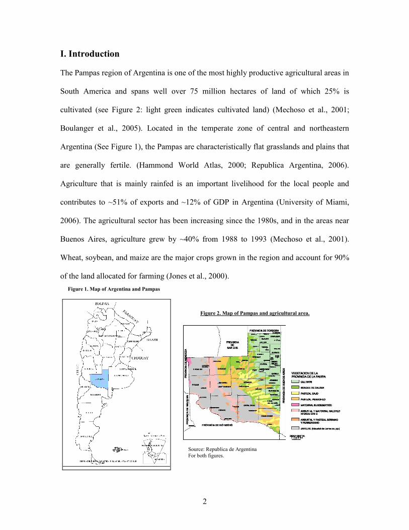
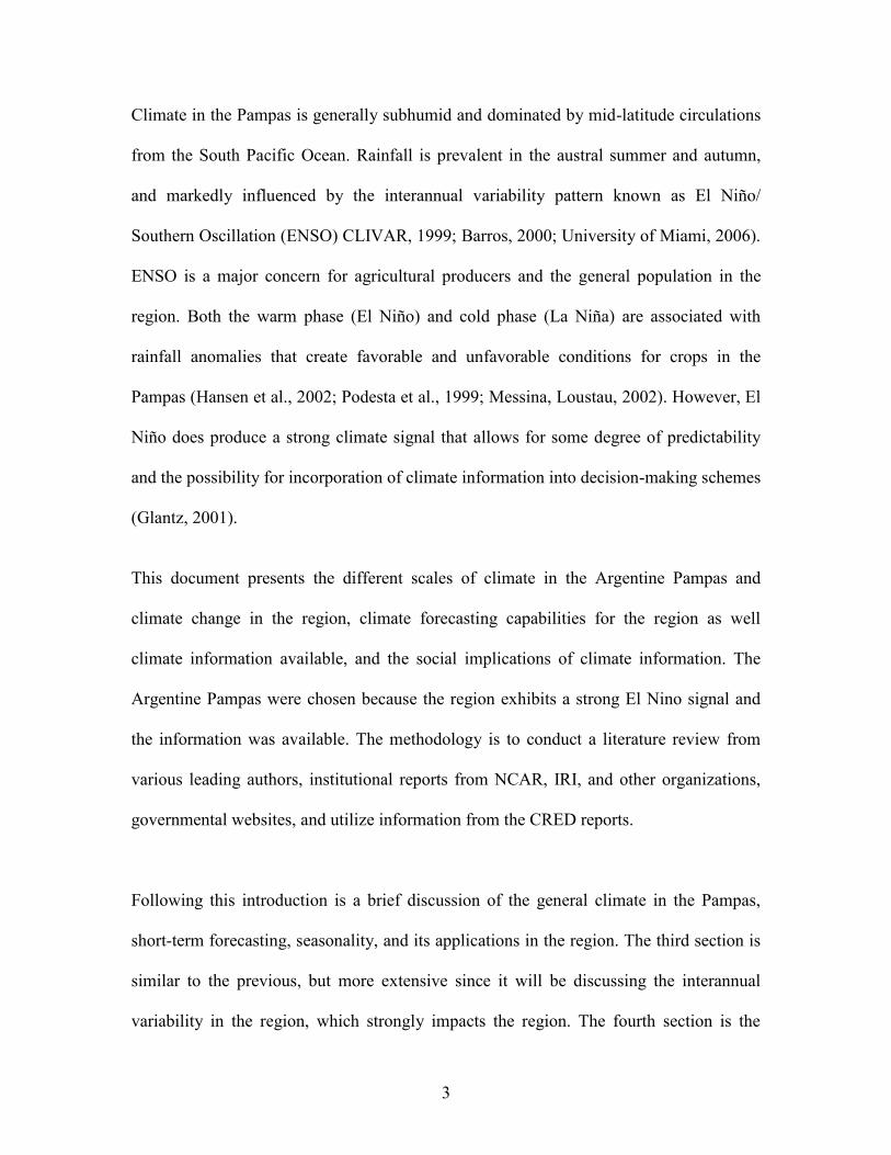
The Pampas region of Argentina is one of the most highly productive agricultural areas in
South America and spans well over 75 million hectares of land of which 25% is
cultivated (see Figure 2: light green indicates cultivated land) (Mechoso et al., 2001;
Boulanger et al., 2005). Located in the temperate zone of central and northeastern
Argentina (See Figure 1), the Pampas are characteristically flat grasslands and plains that
are generally fertile. (Hammond World Atlas, 2000; Republica Argentina, 2006).
Agriculture that is mainly rainfed is an important livelihood for the local people and
contributes to ~51% of exports and ~12% of GDP in Argentina (University of Miami,
2006). The agricultural sector has been increasing since the 1980s, and in the areas near
Buenos Aires, agriculture grew by ~40% from 1988 to 1993 (Mechoso et al., 2001).
Wheat, soybean, and maize are the major crops grown in the region and account for 90%
of the land allocated for farming (Jones et al., 2000).
Figure 2. Map of Pampas and agricultural area.
Source: Republica de Argentina
For both figures.
Figure 1. Map of Argentina and Pampas
3
Climate in the Pampas is generally subhumid and dominated by mid-latitude circulations
from the South Pacific Ocean. Rainfall is prevalent in the austral summer and autumn,
and markedly influenced by the interannual variability pattern known as El Niño/
Southern Oscillation (ENSO) CLIVAR, 1999; Barros, 2000; University of Miami, 2006).
ENSO is a major concern for agricultural producers and the general population in the
region. Both the warm phase (El Niño) and cold phase (La Niña) are associated with
rainfall anomalies that create favorable and unfavorable conditions for crops in the
Pampas (Hansen et al., 2002; Podesta et al., 1999; Messina, Loustau, 2002). However, El
Niño does produce a strong climate signal that allows for some degree of predictability
and the possibility for incorporation of climate information into decision-making schemes
(Glantz, 2001).
This document presents the different scales of climate in the Argentine Pampas and
climate change in the region, climate forecasting capabilities for the region as well
climate information available, and the social implications of climate information. The
Argentine Pampas were chosen because the region exhibits a strong El Nino signal and
the information was available. The methodology is to conduct a literature review from
various leading authors, institutional reports from NCAR, IRI, and other organizations,
governmental websites, and utilize information from the CRED reports.
Following this introduction is a brief discussion of the general climate in the Pampas,
short-term forecasting, seasonality, and its applications in the region. The third section is
similar to the previous, but more extensive since it will be discussing the interannual
variability in the region, which strongly impacts the region. The fourth section is the
4
interdecadal and multi-decadal variability in the region and discusses 20th
century
observations. The fifth section is climate change in the region, trends observed, future
projections and impacts, and mitigation/adaptation activities in the region. The final
section is the conclusions.
II. General Climate in the Pampas
The Pampas region is strongly influenced by mid-latitude circulations exerted from the
Tropical Pacific Ocean and affected by sea surface temperatures (SST) in the Southwest
Atlantic Ocean. Intra-seasonally, the South Atlantic Convergence Zone (SACZ)
dominates the austral summer from December to March (CLIVAR, 1999; Barros, 2000;
University of Miami, 2006). Via large-scale atmospheric circulations, the SACZ
teleconnects with the Atlantic Inter Tropical Convergence Zone when the South
American Monsoon (SAMS) extends southeastward along the northeastern boundary of
the Plata Basin (Mechoso et al., 2001; Boulanger et al., 2005). Local heat fluxes and
orographic lifting are important for the large-scale circulations associated with the SACZ
(Nogués-Paegle & Mo, 1997). The Andes Mountains in northern South America act as a
barrier and deflect low-level airflow, bringing moisture to southeastern South America
(Mechoso et al., 2001; Boulanger et al., 2005). However some studies suggest that the
South Pacific Convergence Zone may affect the SACZ, and that the Andes may not be as
important to upper-level flow associated with the SACZ (CLIVAR, 1999).
5
Rainfall is generally found year-round in central and eastern Argentina, but it is markedly
seasonal (IRI, 2001). The maximum rainfall amounts normally occur in March and April
and again in October and November, while rainfall minimums occur in July through
September, the austral winter. Increases in rainfall during the summer are likely
attributable to a weaker SACZ and rainfall in the region and in South America are
generally correlated with SSTs in the Tropical Pacific Ocean (CLIVAR, 1999; Barros &
Silvestri, 2002).
Although farmers in the Pampas have benefited from rich soils, diffusion of technology,
and favorable precipitation trends--at least in the last 30 years, they remain vulnerable to
extreme weather events and climate variability due to their dependency on rainfall. In
addition, they face agriculture and economic uncertainties. The government does not
provide subsidies and commodity prices have fallen. However the potential to minimize
risks and optimize gains does exist in the region. There are sufficient climate records as
well as agricultural databases available. Several institutional collaborations are currently
in development for risk management through the use of climate information (Podesta et
al., 2002). Also available are many types of climate information sources such as
Argentina’s National Meteorological Service (METEOFA), which seems to be very
popular. Another popular source is the Instituto Nacional de Technologia Agropecuaria
(INTA), a private company that serves the agricultural industry and its members with
information on technology, development, and economics and makes available climate
forecasts (INTA, 2006). Several farmers that support INTA refer to periodic meetings in
which climate information is disbursed (CRED, 2006). One particular meeting that seems
6
to be popular is regularly organized by Stella Carballo, who is an accountant by training,
and Dr. Sierra, a Professor of Meteorology at the University of Buenos Aires’ School of
Agronomy (Podesta, in person). One optimal use of the forecast is to use daily weather to
adjust planting dates and avoid water stress. Another beneficial use is related to
predicting extreme events, a wet period or dry period (usually related to ENSO) could
help to adjust suitable to either take advantage of the expected weather and climate.
However, while Argentine farmers do seek out climate information, the use of the
information is not generally maximized or even used. There exist many challenges in
using climate information. Firstly, climate itself is inherently uncertain and thus, there are
many uncertainties in the climate information provided. Farmers wish to have more
deterministic forecasts and forecasts with greater confidence. One event of bad forecast
can have a detrimental effect on the farmer’s trust of forecasts. Thirdly, the climate
information may not be communicated correctly or not suited for the end user’s needs.
Therefore, it is important to understand how the end user’s needs, how he/she perceives
the climate forecast, and the beliefs and/or constraints he/she has. For example, in a
recent CRED study (2006) that examined farmers’ perceptions in the Argentine Pampas,
the preliminary results show that farmers do seek climate information, but are not willing
to modify their planting schemes until a concrete event, which confirmed the forecast was
observed. Farmers tend to be risk averse, and unwilling to gamble, as many farmers say.
(Jones et al., 2002; Hansen et al., 2004).
7
III. Interannual Variability
The central and eastern parts of Argentina exhibit one of the strongest teleconnections to
El Nino, the warm phase of ENSO (Podesta et al.2002; Bert et al., 2005; Berri et al.,
2005). ENSO has a cycle of 3 to 7 years, and during its warm phase, warm water from
the western Tropical Pacific Ocean shifts to the central and eastern Tropical Pacific
Ocean. The equatorial sea surface temperature gradient decreases, easterly winds weaken,
and atmospheric surface pressure decreases in the eastern Pacific Ocean. As a result, a
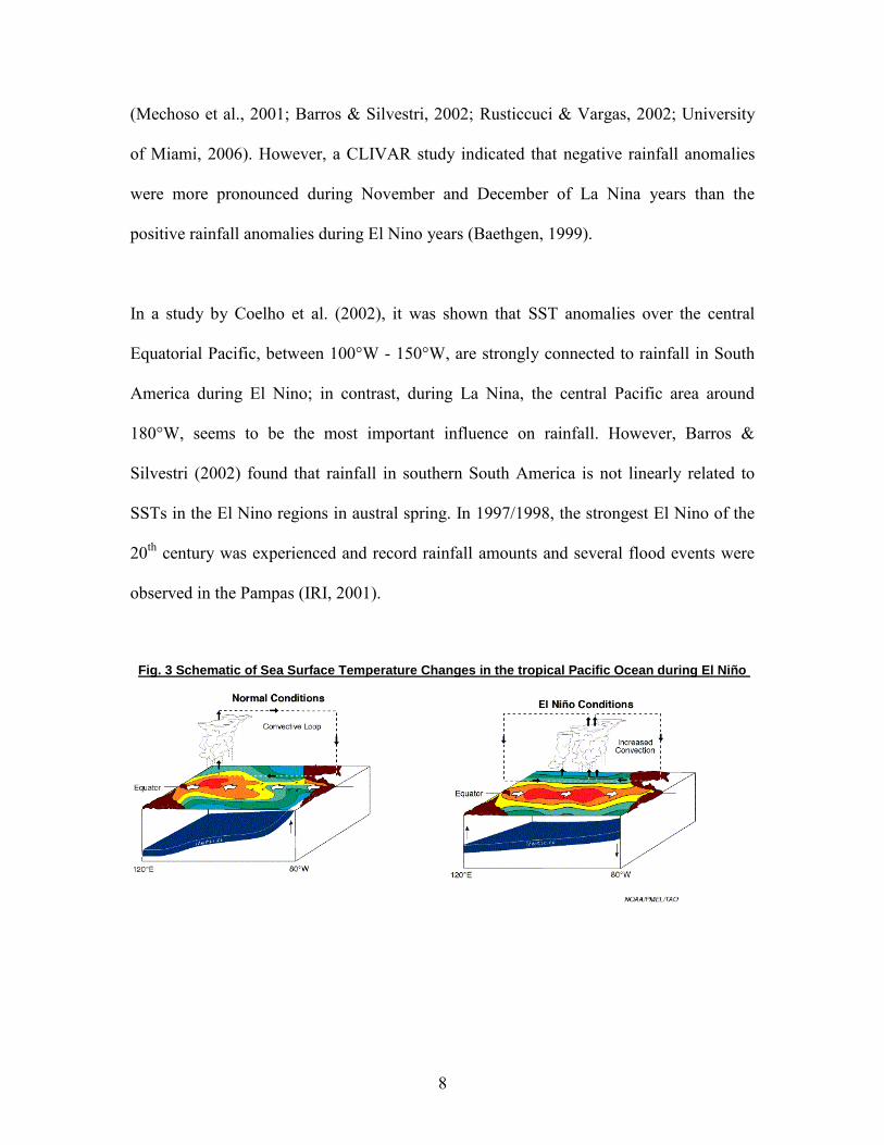
positive feedback occurs and convective activity and rainfall move eastward. See Figure
3 for a schematic of SST changes in the tropical Pacific during El Nino. In the cold phase
La Niña, the opposite occurs and there is a strengthening of easterly winds and opposite
anomalies (Goddard et al., 2001). Barros & Silvestri (2002) suggest that the ENSO
pattern is also influenced by SST variability in the South Central Pacific Ocean.
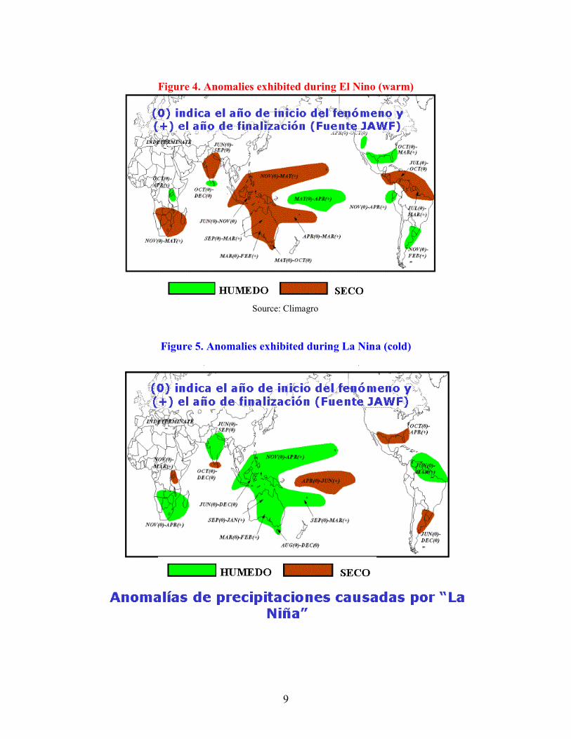
During El Nino years in the Pampas, the austral spring and summer are likely to
experience higher median rainfall amounts and are more pronounced in November and
December, a crucial time for planting in the Pampas. See Figure 4 for climate anomalies
during El Nino and La Nina. In the wintertime, warming is persistent and more intense in
El Nino years (Rusticcuci & Vargas, 2002). This is extremely important for farmers as
they already face a drier period in this time of the year. However, El Nino events in the
Pampas are generally variable. La Nina, the cold phase of ENSO, produces the likelihood
of reduced median rainfall in the region, is less pronounced, and has a narrower range of
anomalies. Positive rainfall anomalies occur from November to February in El Nino
years and negative rainfall anomalies occur from July to December in La Nina years
8
(Mechoso et al., 2001; Barros & Silvestri, 2002; Rusticcuci & Vargas, 2002; University
of Miami, 2006). However, a CLIVAR study indicated that negative rainfall anomalies
were more pronounced during November and December of La Nina years than the
positive rainfall anomalies during El Nino years (Baethgen, 1999).
In a study by Coelho et al. (2002), it was shown that SST anomalies over the central
Equatorial Pacific, between 100°W - 150°W, are strongly connected to rainfall in South
America during El Nino; in contrast, during La Nina, the central Pacific area around
180°W, seems to be the most important influence on rainfall. However, Barros &
Silvestri (2002) found that rainfall in southern South America is not linearly related to
SSTs in the El Nino regions in austral spring. In 1997/1998, the strongest El Nino of the
20th
century was experienced and record rainfall amounts and several flood events were
observed in the Pampas (IRI, 2001).
Fig. 3 Schematic of Sea Surface Temperature Changes in the tropical Pacific Ocean during El Niño
9
Figure 4. Anomalies exhibited during El Nino (warm)
Source: Climagro
Figure 5. Anomalies exhibited during La Nina (cold)
10
ENSO patterns are correlated with crops in the Pampas, and therefore predicting or
understanding this climatic phenomenon is important for the region. The clearest
association is found in maize yields, which have a tendency to be higher during El Nino
events and lower during La Ninas (Podesta et al., 1999). ENSO partly explains these
outcomes, but ENSO also happens to coincide with the growing season for maize (Jones
et al., 2000). Soybean, the most important summer crop, is also associated with ENSO,
significantly with the cold phase, but varies between regions (Berri et al., 1999). Lower
rainfall results in lower yields, but higher rainfall amounts do not increase yields. This is
possibly due to water minimums that are satisfied and yield the maximum outputs. In
recent years there has been an increasing trend towards monoculture of soybeans because
of its lower input costs and stable yields; however, monoculture is not sustainable and
there is much concern (Bert et al., 2005). Wheat is another crop with some ties to El
Nino, particularly in the southern Pampas and during the month of November, a good
month for rains (Podesta et al., 1999).
Climate information that is used effectively can enhance agricultural management and
reduce vulnerability in the Pampas (Bert et al., 2005). ENSO is an important signal in the
region and can be exploited for predictability. In addition to crop correlations, ENSO is
also strongly associated with streamflow in El Nino years (IRI, 2001). In a study by Berri
et al. (2005), they found that the forecasts issued by the Climate Outlook Forum (COF),
were potentially better than the climatology for the region; a strong El Nino in 1997/1998
followed by La Nina until 2001, allowed for good skill. When compared with IRI
forecasts, IRI forecasts showed a slightly better result than the COFs, and did not add
11
skill to IRI. The Climate Outlook Forum forecasts for Southeast Southern America,
which began in 1997 in Uruguay, was an integration of atmospheric models, physically
based statistical model, diagnostic analysis, and published literature on climate
variability. Until that time, IRI was the only source for seasonal forecast in the region
(Berri et al., 2005).
IV. Multi-decadal Variability
There is some evidence of inter-decadal variability in the region and some studies posit
that a multi-decadal pattern may also be evident. A precipitation increase has been
observed in the last 30 years that coincides with streamflow increases in the region
(Rusticucci & Penalba, 2001; University of Miami, 2006). The Argentine Delegation to
CLIVAR in 1999 issued a report, which included some observations in the last 20th
century. They reported positive changes in rainfall after 1916, which became greater after
the 1950s, and reached ~30% increase from 1956 to 1991 in the region from 20 to 35 S
(CLIVAR, 1999). According to Climagro, a nongovernmental organization in Argentina
that provides seasonal forecasts and technical support to farmers, cycles have been
observed as 4 cycles of rain in the last century. The first cycle was described as a dry
period, which began approximately in the mid 1920s, and included 3 drought campaigns.
The next phase was a transitional period from dry to humid found in the 1950s. In the
1970s it is believed and reported extensively that a more humid period was taking place.
This coincides with extensive land use changes and increase in the agricultural sector in
Argentina and the Pampas as a whole (University of Miami, 2006; Viglizzo et al., 1997)
12
Viglizzo et al. (1997) hypothesized that that land-use changes were driven by climate
during this time. Their study confirms the Climagro estimates and found steeper slopes in
semi-arid zones of the Pampas and a shift of increased humidity towards the west, which
is a semi-arid region. The most recent cycle began in the early 1990s and is considered a
transition period from humid to drier conditions. Less harsh summers, warmer winters,
and a delayed onset of frost have been reported in the region (Climagro, 2006). The
1990s were reported to be the warmest years on record in the 20th
century for Argentina
and agrees with global mean temperature trends (Loustau, 2002). It is also suggested that
the Pacific Decadal Oscilliation (PDO) may also affect the region. The PDO is a larger-
scale pattern that is ENSO-like that can persist 20 to 30 years as observed through the last
century. However it is most visible in the Northwest U.S. with some influence observed
in the tropics (NOAA, 2006; University of Washington, 2006). Climagro (2006) suggests
that the PDO is currently in a negative phase, which should mean drier conditions for the
Pampas region. However there is still a debate about the causes of the PDO and its
predictability, and thus, there is much skepticism that it is cause of current trends in
southern South America (CLIVAR, 1999).
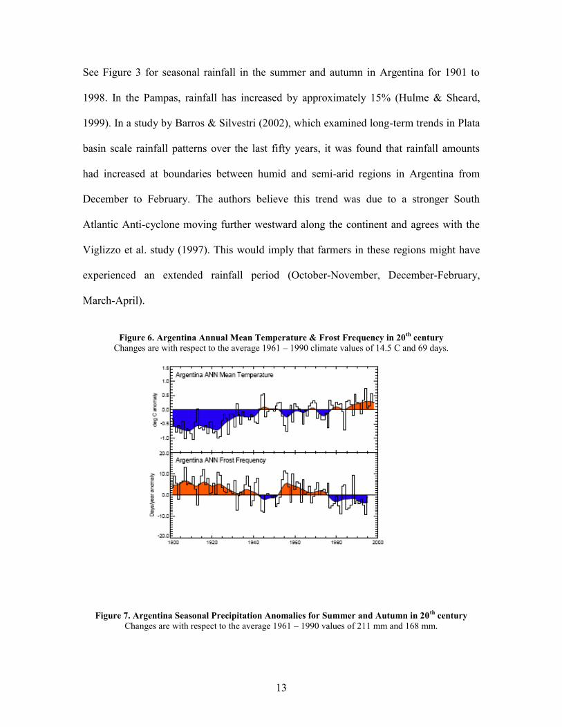
V. Climate Change
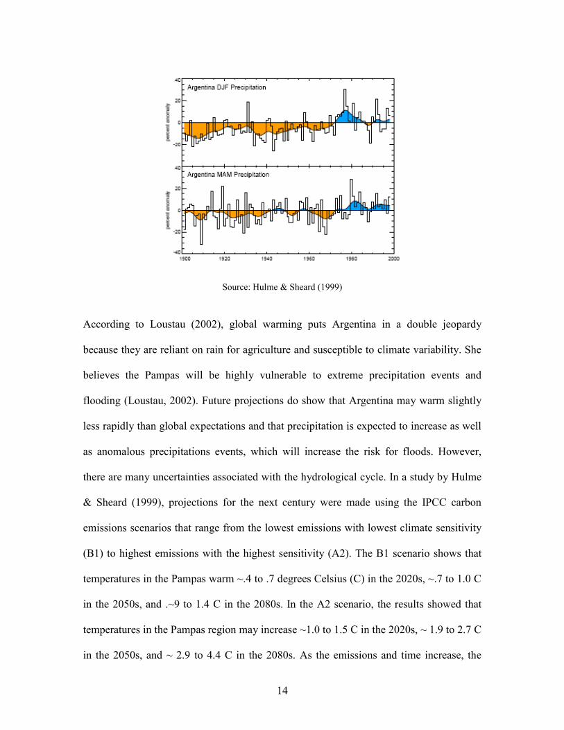
Several climate changes have been documented in Argentina within the last century. The
annual mean temperature has increased by 1°C and the 1990s was the warmest decade on
record in the 20th
century agreeing with global trends. Also, the frequency of frosts has
decreased and the number of frost days per year has decreased by 10%. See Figure 2 for
changes in annual mean temperatures and annual frost frequency in Argentina for 1901 -
1998. Annual rainfall has increased by 10% and summer rainfall has increased by 10%.
13
See Figure 3 for seasonal rainfall in the summer and autumn in Argentina for 1901 to
1998. In the Pampas, rainfall has increased by approximately 15% (Hulme & Sheard,
1999). In a study by Barros & Silvestri (2002), which examined long-term trends in Plata
basin scale rainfall patterns over the last fifty years, it was found that rainfall amounts
had increased at boundaries between humid and semi-arid regions in Argentina from
December to February. The authors believe this trend was due to a stronger South
Atlantic Anti-cyclone moving further westward along the continent and agrees with the
Viglizzo et al. study (1997). This would imply that farmers in these regions might have
experienced an extended rainfall period (October-November, December-February,
March-April).
Figure 6. Argentina Annual Mean Temperature & Frost Frequency in 20
th century
Changes are with respect to the average 1961 – 1990 climate values of 14.5 C and 69 days.
Figure 7. Argentina Seasonal Precipitation Anomalies for Summer and Autumn in 20
th century
Changes are with respect to the average 1961 – 1990 values of 211 mm and 168 mm.
14
Source: Hulme & Sheard (1999)
According to Loustau (2002), global warming puts Argentina in a double jeopardy
because they are reliant on rain for agriculture and susceptible to climate variability. She
believes the Pampas will be highly vulnerable to extreme precipitation events and
flooding (Loustau, 2002). Future projections do show that Argentina may warm slightly
less rapidly than global expectations and that precipitation is expected to increase as well
as anomalous precipitations events, which will increase the risk for floods. However,
there are many uncertainties associated with the hydrological cycle. In a study by Hulme
& Sheard (1999), projections for the next century were made using the IPCC carbon
emissions scenarios that range from the lowest emissions with lowest climate sensitivity
(B1) to highest emissions with the highest sensitivity (A2). The B1 scenario shows that
temperatures in the Pampas warm ~.4 to .7 degrees Celsius (C) in the 2020s, ~.7 to 1.0 C
in the 2050s, and .~9 to 1.4 C in the 2080s. In the A2 scenario, the results showed that
temperatures in the Pampas region may increase ~1.0 to 1.5 C in the 2020s, ~ 1.9 to 2.7 C
in the 2050s, and ~ 2.9 to 4.4 C in the 2080s. As the emissions and time increase, the
15
range of temperature increases in this scenario (Hulme & Sheard, 1999). The Pampas
region may benefit due to these climatic changes. Warmer winters and more benign
summers are expected. Agricultural production is expected to increase by 2 to 5% due to
CO2 fertilization and some crops such as soybean yields are expected to increase
(Loustau, 2002). However climate is not the only factor and crop response to global
warming requires further investigation. Also, there are some negative implications.
Increased agricultural production will lead to increases in land-use changes. Maize yields
are expected to decrease and yields in general may decrease due to loss of nutrients
incurred from increased flooding events. The farming communities are aware of these
changes and have begun discussing mitigation strategies, including the use of climate
information. There is even a campaign to minimize carbon emissions from agricultural
practices (Loustau, 2002).
VI. Conclusions
In conclusion, climate variability is the most serious concern for Argentine farmers and
communities in the Pampas. Changes in the tropical Pacific Ocean are among several
climatic influences in the region and it seems that other influences such as decadal
intervals may also play a role. Further research is needed in order to fully understand the
variability patterns in southern South America, and afford the scientists and communities
in the region a chance to mitigate future climate risks and enhance current livelihoods. If
climate change scenarios are correct for this region as projected by Hulme & Sheard, then
the Pampas may initially benefit in the short run; but as projections (worst case scenario)
also show, variability in the range of climate will increase as time increases, and thus,
16
increasing the risks. However the Pampas seem to have some capacity already existing
within their community and therefore, the future risk management may be enhanced.
References
Argentina Update. International Research Institute of Climate and Society.
http://iri.columbia.edu/climate/cid/sup/argentina.html May 2 2006
Barros, V.R., Silvestri, G.E. (2002). The relation between sea surface temperature at the
subtropical south-central Pacific and precipitation in southeastern South America. Journal
of Climate. 251 - 257
Berri, G. J., Antico, P.L., Goddard, L. (2005). Evaluation of the climate outlook forums’
seasonal precipitation forecasts of southeast South America. International Journal of
Climatology. 25: 365-377
Bert, F.E., Satorre, E.H., Toranzo, F.R., Podesta, G.P. (2005). Climatic information and
decision-making in maize crop production systems of Argentinean Pampas. Agricultural
Systems.
Boulanger, J.P., Leloup, J., Penalba, O., Rusticucci, M., Lafon, F., Vargas, W. (2005).
Observed precipitation in the Parana-Plata hydrological basin: long-terms trends, extreme
conditions and ENSO teleconnections. Climate Dynamics. 24: 393-413
Climagro. http://www.climagro.com.ar/agro/ May 2 2006
Climate, Agriculture, and Complexities in the Argentine Pampas. University of Miami.
http://www.rsmas.miami.edu/groups/agriculture/science/Science-home.html May 2 2006
Climate Diagnostics Science Review. Climate Diagnostics Center, NOAA.
http://www.cdc.noaa.gov/review/Chap04/sec5.html
Coelho, C.A.S., Uvo, C.B., Ambrizzi, T. (2002). Exploring the impacts of the tropical
Pacific SST on the precipitation patterns over South America during ENSO periods.
Theoretical and Applied Climatology. 71: 185-197
Glantz, M.H. (2001). Climate Affairs. Washington DC: Island Press
Hansen , J., Marx, S., Weber, E. (2004). The role of climate perceptions, expectations,
and forecasts on farmer decision making: The Argentine Pampas and South Florida. IRI.
Hulme, M., Sheard, N. (1999). Climate change scenarios for Argentina. Climatic
Research Unit, Norwich, UK.
17
InfoClima. http://www.infoclima.com/ May 2 2006
Instituto Nacional de Technologia Agropecuaria.
http://www.inta.gov.ar/ins/en/geography.htm May 2 2006
La Nina Summit. University Corporation of Atmospheric Research.UCAR.
http://www.ccb.ucar.edu/lanina/report/baethgen.html May 6 2006
Loustau, M. R. (2002). Influencia del Cambio Climatico Global sobre La Produccion
Agropecuaria Argentina. Revista de Ciencias Agrarias y Technologia de los Alimentos.
20: 15 – 28
Mechoso, C.B., Silva Dias, P., Baethgen, W., Barros, V., Berbery, E.H., Clarke, R.,
Cullen, H., Ereno, C., Grassi, B., Lettenmaier, D. (2001). Climatology and hydrology of
the Plata Basin. VAMOS Scientific Study Group on the Plata Basin annual meeting.
Montevideo, Uruguay, March 2001.
METEOFA. http://www.meteofa.mil.ar/ May 2 2006
NASA. Pacific Decadal Oscillation Influences Drought.
http://sealevel.jpl.nasa.gov/elnino/20040615.html
Nogués-Paegle, Julia, Mo, Kingtse C. (1997). Alternating Wet and Dry Conditions over
South America during Summer. Monthly Weather Review. 125: 279-291
Report of Argentine Delegation to the Internacional CLIVAR Conference. University
Corporation of Atmospheric Research.
http://www.clivar.ucar.edu/publications/other_pubs/clivar_conf/national_reports/cli
var_argent.htm May 6 2006
The Pacific Decadal Oscillation. University of Washington.
http://www.jisao.washington.edu/pdo/
http://www.atmos.washington.edu/gcg/RTN/rtnt.html#part5
Podesta, G. et al. (2005). Farmer interviews from Argentina
Podesta, G.P., Messina, C.D., Grondona, M.O., Magrin, G.O. (1999). Associations
between crop yields in central-eastern Argentina and El Nino-Southern Oscilliation.
Journal of Applied Meteorology. 38: 1488-1498
Podesta, G.P., Letson, D., Messina, C., Royce, F., Ferreyra, R.A., Jones, J., Hansen, J.,
Llovet, Ignacio, Grondona, M., O’Brien, J.J. (2002). Use of ENSO-related climate
information in agricultural decision making in Argentina: a pilot experience. Agricultural
Systems. 74: 371-392
18
South Atlantic Climate Change Draft. http://glaucus.fcien.edu.uy/pcmya/sacc May 2 2006
Viglizzo, E.F., Roberto, Z.E., Lertora, F., Lopez Gay, Bernardos, J. (1997). Climate and
land-use change in field-crop ecosystems of Argentina. Agriculture Ecosystems and
Environment. (66): 61-70


![[Argentine consensus of non-invasive ventilation]](https://img.pdfslide.net/doc/110x75/63530e4764e09478c603ca61/argentine-consensus-of-non-invasive-ventilation.jpg)


