Embed Size (px)
Citation preview
Photonirvachak Journal of the Indian Society of Remote Sensing, Vol. 34, No. 4, 2006
SHORT NOTE
A S S E S S I N G A R E A S D E F O R E S T E D BY C O A L M I N I N G A C T I V I T I E S T H R O U G H SATELLITE R E M O T E SENSING I M A G E S AND GIS IN PARTS OF KORBA, C H A T T I S G A R H
P.K. JosHI @, M. KUMAR, N. MIDHA, VIJAYANAND AND A. PALIWAL Indian Institute of Remote Sensing (NRSA), Dehradun-248 001, India
@Corresponding author : [email protected]
Mining is one of the most important economic activities in the state of Chhattisgarh. This activity causes two major environmental problems. First, the pollution of rivers and streams and second, alluvial erosion and deforestation. Deforestation encompasses permanent destruction of indigenous forests and woodlands to provide land for agricultural purposes, residential or industrial sites, roads, etc., or harvesting the trees for building materials or fuelwood. The changes in the land cover, particularly the tropical deforestation, have attracted worldwide attention because of their potential effects on soil erosion, run-offand carbon dioxide level. Large-scale deforestation has been reported in India in the past (NRSA, 1983). Forest cover in India has more or less stabilized after 1980 due to ban on clear felling. However, forest degradation and small-scale deforestation still continue for the extraction of fuel wood, fodder, timber products and minerals. The loss of forest cover in India between 1990 and 2000 was 380.89 kin 2, per annum (FAO, 2000) and 1889 km 2 per annum between 1991 and 1999 (FSI, 2000).
Generating an environmental database in regional context to understand deforestation in spatial and temporal domain is a difficult task by conventional methods. Today, remote sensing data, which is synoptic, repetitive and multi temporal in nature has efficiently filled this gap. Kindred with Geographical Information System (GIS), the technique has a distinct advantage over conventional methods/ approaches to map and monitor the evolution of degraded areas. It has become a versatile tool for assessing and monitoring environmental impacts as a result of natural and man made activities. The technique has proved its usefulness in assessing the environmental degradation with reference to land, water, air and vegetation. It provides an excellent overview regarding the status of mining areas and impact of mining activities. Earlier woks have demonstrated its potential in various facets of mining activity, viz., land use change detection in mining area (Ghosh and Ghosh, 1991; Prakash and Gupta, 1998), environmental impact of mining (Ghosh, 1989; SAC, 1990; Rathore and Wright, 1993; Chatterjee et al., 1994), coal fires assessment (Mansor et al., 1994) etc.
Received 10 July, 2005; in final form 25 July, 2006
4 ! 6 P.K. Joshi et aL
The Korba Coalfield has been identified as one of the potential coalfields in India with proven coal reserve of 2000 m tonnes. The coal extraction has immensely affected the landscape in terms of deforestation, degradation o f arable land and pollution in different ecosystems. The present sustainable development concept looks forward to the long-term use of the resources. Many of the eco- restoration and land reclamation practices have been recommended in the mining landscapes. Therefore, it would be very interesting to study, research and document the impact of coal mining activities in the Korba region which is well known in the international mining scenario. The fields have ample reserve of coal for both opencast and underground mining and hence provide a good opportunity for study of the problem of impact of mining on land cover status with special emphasis on the vegetation/forest distribution which are surrogates ofbiodiversity and socio-economic relevance in the environs.
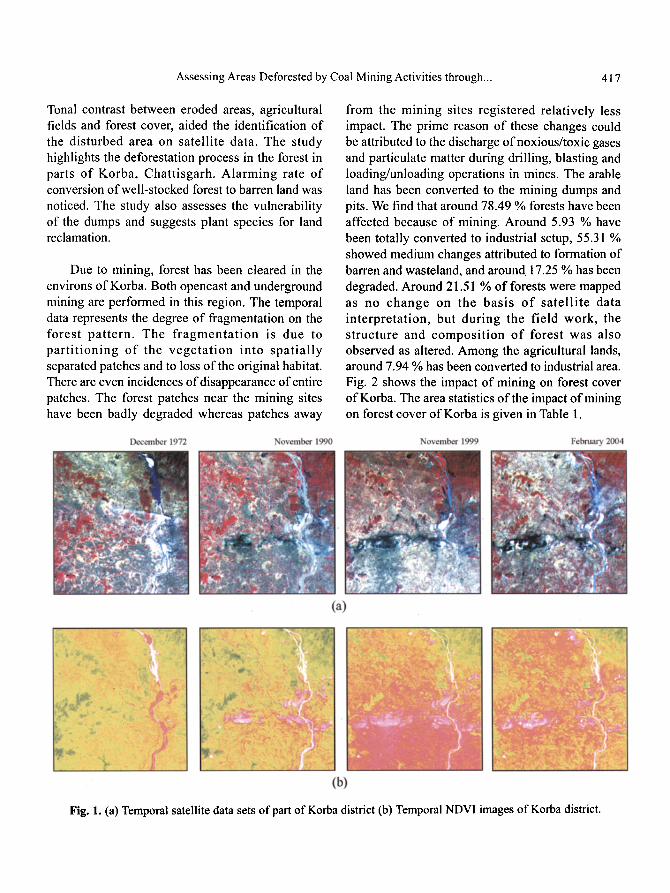
The remote sensing and GIS based techniques for deforestation estimation in the Korba include data preprocessing, interpretation and change analysis. A socio economic survey was carried out to understand the different aspects of impact and reclamation activities taken in the area. Landsat MSS, TM, ETM and IRS P6 LISS III digital data pertaining to December 1972, November 1990, November 1999 and February 2004, respectively were used to evaluate the changes. The temporal satellite data sets of part of Korba are shown in Fig. (la). Survey of India (SOl) toposheet at 1:50,000 scale and Forest Survey of India (FSI) reports were also used as collateral data. The Landsat satellite data provided by Global Land Cover Network (GLCN) was radiometr ica l ly and geometr ica l ly (orthorectification with UTM/WGS 84 projection) corrected. The datasets were with sub pixel level accuracy. For the IRS P6 LISS III dataset the same principle was applied for radiometric and geometric correction. A structured field survey form was used for personal interview with various stakeholders. The fieldwork was carried out in July-August 2004. Detailed ground truth was collected with the help
of 1:50,000 scale toposheet, base maps, Global Positioning System (GPS) and on-site investigation. A uniform classification scheme was used for mapping. For assessing the impact on natural resources, the classification scheme was restricted to (I) Forest (not impacted, highly degraded, medium degraded, less degraded), (2) Non Forest (not impacted, highly degraded, medium degraded), (3) Active Mines, and (4) Water Body. The degradation on the forest was assessed by using number of trees per hectare, ground flora and cover estimates. For the non-forest areas, visual observations and socio- economic data were used. Local enhancement (data scaling and histogram equalization) was carried out on the temporal scenes for the better interpretation. Normalized Difference Vegetation Index (NDVI) is one of the band ratios (Rouse et al., 1973) that show high values for vegetation parameters such as green leaf biomass, green leaf area, percentage green cover and leaf area index (LAI) and hence is of considerable value for vegetation discrimination [NDVl=(Infrared - Red)/(Infrared + Red)]. The temporal NDVI images are shown in Fig. (lb). In the present work, it has helped to depict dense vegetation and fragmented patched vegetation. However, NDVI was not successful in separating areas with sparse vegetation cover. The low NDVI values helped to detect the mining areas. The NDVI values were lower in the open mining areas than in the already reclaimed areas, even when both areas had the same type of vegetation cover. The NDVI images allowed identification of cover changes related to mining. NDVI images indicated an increase in disturbed areas from 1972 to 1990 and from 1990 to 1999. The 1999-2004 NDVI image did not show significant changes, indicating that most areas were disturbed prior to 1999, some of the areas show seasonal variations and also traces of reclamation activity. On screen visual interpretation was carried out at 1:50,000 scale. The interpreted layer was used for the change detection by rectifying the changed polygon by overlaying it on the image of the following period. For all the images the scale was kept constant. This technique was found more efficient and convenient while mapping the changes.
Assessing Areas Deforested by Coal Mining Activities through... 417
Tonal contrast between eroded areas, agricultural fields and forest cover, aided the identification of the disturbed area on satellite data. The study highlights the deforestation process in the forest in parts of Korba, Chattisgarh. Alarming rate of conversion of well-stocked forest to barren land was noticed. The study also assesses the vulnerability of the dumps and suggests plant species for land reclamation.
Due to mining, forest has been cleared in the environs of Korba. Both opencast and underground mining are performed in this region. The temporal data represents the degree of fragmentation on the forest pat tern. The f ragmenta t ion is due to part i t ioning o f the vegeta t ion into spatial ly separated patches and to loss of the original habitat. There are even incidences of disappearance of entire patches. The forest patches near the mining sites have been badly degraded whereas patches away
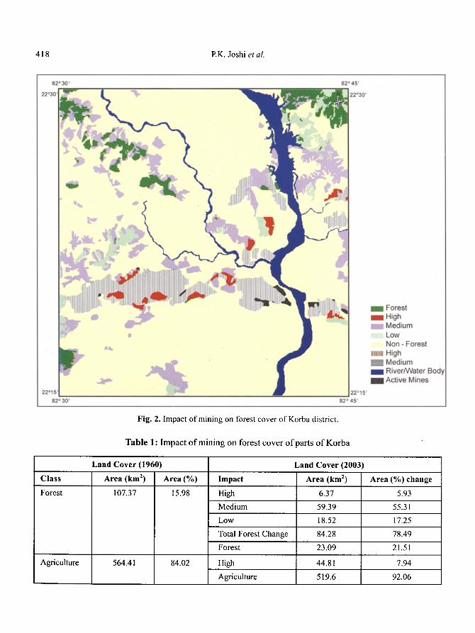
from the mining sites registered relatively less impact. The prime reason of these changes could be attributed to the discharge of noxious/toxic gases and particulate matter during drilling, blasting and loading/unloading operations in mines. The arable land has been converted to the mining dumps and pits. We find that around 78.49 % forests have been affected because of mining. Around 5.93 % have been totally converted to industrial setup, 55.31% showed medium changes attributed to formation of barren and wasteland, and around 17.25 % has been degraded. Around 21.51% of forests were mapped as no change on the basis o f satel l i te data interpretation, but during the field work, the structure and composi t ion o f forest was also observed as altered. Among the agricultural lands, around 7.94 % has been converted to industrial area. Fig. 2 shows the impact of mining on forest cover of Korba. The area statistics of the impact of mining on forest cover of Korba is given in Table 1.
Fig. 1. (a) Temporal satellite data sets of part of Korba district (b) Temporal NDVI images of Korba district.
418 P.K. Joshi et al.
Fig. 2. Impact of mining on forest cover of Korba district.
Table 1: Impact of mining on forest cover of parts of Korba
Land Cover (1960)
Class Area (km 2) Area (%)
Forest 107.37 15.98
Agriculture
Land Cover (2003)
Impact Area (km 2) Area (%) change
High 6.37 5.93
Medium 59.39 55.31
Low 18.52 17.25
Total Forest Change 84.28 78.49
Forest 23.09 21.51
564.41 84.02 High 44.81 7.94
Agriculture 519.6 92.06
Assessing Areas Deforested by Coal Mining Activities through... 419
The Korba area holds 10074.77 m tonnes of coal reserve in the 530 km 2 and the expected depth of the reserve extends up to 600 m. During the field visit, various units of Korba Industry were visited to sum up the activities being carried out. The personal interviews were carried out with employees of mines, environmental cell and local people. More than 5 m of soil and sub soil and 10 m depth of weathered mantle have covered most of the sites. The characteristics of the dump material constitute medium coarse-grained sand stone 50 %, coarse- grained sandstone 25 %, morrum 15 % and shale 4 %. Most of the mining dumps have attained the height of 45 m on average, with the average slope of 30 ~ . The dumping sites have alluvial soil. It requires a top filling of fertile soil for the reclamation actives. The dumps being very fragile in nature have been ranked for the hazard values based on available literature, personal communication pfenvironmental cell and visual comparison of the dumps. Four dumps have been assigned as high hazard value whereas eleven have been found to be having medium hazard risk. The values of the hazard risk factor are proportional to the affected adjoining area of the dumps. On the aspect of the vegetation, the impact weightages have been formulated on the basis of the vegetation at the top and the slope of the dumps. Among all the sites, the top of the dumps has high impact on the vegetation whereas in the slopes the impact is partial. However, it is necessary to take ameliorative measures in both the aspects. Almost all the dumps have high erosion impacts. In light of above discussion, it is necessary to assess the dumping sites and take necessary measures for the reclamation with the minimum impact on the adjoining areas. The mitigation measures taken by the stakeholders of the mining need to be enhanced as very little improvement in the reforestation has been noticed.
The open cast mining results into physically, nutritionally and biologically poor overburden. The establishment of vegetative cover on coal mine spoil is a challenging task due to problems such as compaction, poor water-holding capacity, infertility,
high acidity or salinity o f soil and extreme temperatures (Moffat and McNeill, 1994). The natural succession on these lands also takes long duration (Jha and Singh, 1992). Generating the green cover on these spoils may provide solution which is highly dependent on the selected species and site conditions (Alexander, 1989; Soni et al., 1989; Jha, 1992; Kumar et al., 1995). Singh et al. (2002) have discussed various approaches of ecosystem restoration on mine spoil, criteria for the selection of plantation species and future research needs in this regard. A successful afforestation on similar mining landscape of Amarkantak showed Gravellia pteridifolia, Eucalyptus camaldulensis, Pinus roxburghii and Pongamia pinnata to be the most suitable species on the basis of growth performance (Chaturvedi, 1983). On the coalmine spoils of Kansas, Rogers (1983) recommended Platanus occidentalis, Juniperus virginiana, Quercus macrocarpa, Pinus taeda and P echinata for the reclamation. Singh et al. (2004) have recommended Albizia lebbeck and ,,llbizia procera for the soil redevelopment process during early phase of mine spoil restoration in a dry tropical environment.
The application of satellite remote sensing data in this study provided useful information about the trend of deforestation in the mining landscape. Satellite images proved to be a good data source with useful temporal resolution. The spatial complexity and spectral heterogeneity of the surface mine area made the application of the satellite data some what difficult. The high-resolution data and spectral unmixing could be attempted to map the details as per requirements. Few of the earlier workers have also used satellite data processing for assessing the mining area (Mamula, 1978; Parks and Peterson, 1987; Ghosh and Ghosh, 1991; Rathore and Wright, 1993; Chatterjee et al., 1994; Prakash and Gupta, 1998; Schmidt and Glaeser, 1998). To conduct intensive fieldwork in the mining area is a limitation because of security reasons and other administrative norms. Although, the satellite data processing and interpretat ion provides an acceptable best tool for understanding the impact
420 P.K. Joshi et al.
of on the land cover, it is not able to completely replace the conventional methods. The combination of conventional methods and remote sensing data will provide a useful and cost effective tool for monitoring devastated land over a period and formulate related environmental impact assessment.
Acknowledgments
The authors thank GLCN for providing Landsat Data. IRS P6 data and fieldwork was supported by DOS-DBT project 'Biodiversity Characterisation at Landscape Level'. We also thank the Dean Indian Institute of Remote Sensing (NRSA), Dehradun and the Head Forestry and Eco logy Division for providing facilities to carry out this work.
References
Alexander, M.J. (1989). The long-term effect of Eucalyptus plantations on tin mine spoil and its implication for reclamation. Landscape and Urban Planning, 17: 47-60.
Chatterjee, R.S., Bannerjee, D., Roy, J. and Bhattacharya, A.K. (1994). Landsat TM data processing techniques for identifying and delineating environmental impacts of coal mining. ITCJournal, 2: i 55-162.
Chaturvedi, J.K. (1983). Afforestation of bauxite mined area in central India. Indian Forester, 105: 465-484.
FAO (2000). State of the World Forests. Food and Agricultural Organization. Rome.
FSI (2000). State of Forest Report 1999. Forest Survey of India, Dehradun, India pp. 130.
Ghosh, R. (1989). Mining in Jharia coalfield, Eastern India: An estimation of its impact index. J. Geological Society of lndia, 33: 353-360.
Ghosh, R. and Ghosh, D.N. (1991). Land use map of Jharia coalfield, Eastern India, aided by remote sensing. J'. of lndian Society of Remote Sensing, 18: 23-28.
Jha, A.K. (1992). Evaluation of coal mine spoil as a medium for plant growth in a dry tropical environment. Indian Forester, I 18:909-9 ! 6.
Jha, A.K. and Singh, J.S. (1992). Influence of micro sites on redevelopment of vegetation on coal mine spoils in a dry tropical environment. ,I. of Environmental Management, 36:95-116.
Kumar, S., Bisht, N.S. and Rao, R.N. (1995). Afforestation of lateratic pans of Goa - a case study. Indian Forester, 121: 176-178.
Mamula, N. (1978). Remote sensing methods for monitoring surface coal mining in the Northern Great Plains. US Geological Survey J. of Research, 6: 149- 160.
Mansor, S.B., Cracknell, A.P., Shilin, B.V. and Gornyi, V.I. (1994). Monitoring of underground coal fires using thermal infrared data. International d. of Remote Sensing, 15: 1675-1685.
Moffat, A.J. and McNeill, J.D. (1994). Restoring disturbed land for forestry. Forestry Commission Bulletin 110. HMSO, London, UK.
NRSA (1983). Nationwide mapping of forest and non- forest areas using Landsat false color composite for the period 1972-75 and 1980-82.
Parks, N.F. and Peterson, t2W. (1987). High resolution remote sensing of spatially and spectrally complex coal surface mines of Central Pennsylvania. Photograpmmetric Engineering and Remote Sensing, 4: 415-420.
Prakash, A. and Gupta, R.P. (1998). Land use mapping and change detection in a coal mining area - a case study in the Jharia coalfield, India. International Journal of Remote Sensing, 19(3): 39 I-410.
Rathore, C.S. and Wright, R. (1993). Monitoring environmental impacts of surface coal mining. lnternational dournal of Remote Sensing, 14: 1021- 1042.
Rogers, R.S. (1983). Annual variability in community organization of forest herbs: effects of an extremely warm and dry early spring. Ecology, 64: 1086-1091.
Rouse, J.W., Haas, R.H., Schell, J.A. and Deering, D.W. (1973). Monitoring vegetation systems in the Great Plains with ERTS. In Proceedings of the 3rd ERT S Symposium, NASA SP-351, vol. !, pp. 48-62.
SAC (I 990). Impact of ming activities and supetthermal power stations on environment. Project Report No. RSAM/SAC/ENVN/PR/08/90, November 1990.
Assessing Areas Deforested by Coal Mining Activities through... 421
Schmidt, H. and Glaeser, C. (1998). Multitemporal analysis of satellite data and their use in the monitoring of the environmental impacts of open cast lignite mining areas in Eastern Germany. lnternational J. of Remote Sensing, 19: 2245-2260.
Singh, A.N., Ragubanshi, A.S. and Singh, J.S. (2004). Comparative performance and restoration potential of two Albizia species planted on mine spoil in a dry tropical region, India. Ecological Engineermg, 22: 123-140.
Singh, A.N., Ragubanshi, A.S. and Singh, J.S. (2002). Plantations as a tool for mine spoil restoration. Current Science, 82: 1436-1441.
Soni, E, Vasistha, H.B. and Kumar, O. (1989). Biological diversity in surface mined areas after reclamation. Indian Forester, !!5: 475-482.


