Embed Size (px)
Citation preview
March 2020 19121900-328397-9
APPENDIX H
Biodiversity Impact Assessment
REPORT
Specialist Assessment for the Proposed Surface
Pipeline and Associated Infrastructure - Biodiversity
Impact Assessment AngloGold Ashanti (Pty) Limited South African Operations
Submitted to:
Anglo Gold Ashanti (Pty) Limited South African Operations Mr J van Wyk Carletonville - Fochville Road R500 Carletonville Gauteng 2501
Submitted by:
Golder Associates Africa (Pty) Ltd.
Building 1, Maxwell Office Park, Magwa Crescent West, Waterfall City, Midrand, 1685, South Africa
P.O. Box 6001, Halfway House, 1685
+27 11 254 4800
19121900-327695-6
February 2020

February 2020 19121900-327695-6
i
Distribution List 1 eCopy to Anglo Gold Ashanti (Pty) Limited South African Operations
1 eCopy to [email protected]
February 2020 19121900-327695-6
ii
Executive Summary
Project overview
The AGA operations in the West Wits mining lease areas are at risk of flooding due to ingress of fissure water
from surrounding mining operations. Approximately 25 Mℓ/day of fissure water flows into the underground
workings of the defunct Blyvooruitzicht Mine, which spans a strike of 6 km along the boundary with AGA.
If dewatering at the Old Blyvooruitzicht Shafts (#4, #5 & 6#) shafts were to cease, uncontrolled fissure water
would report to the AGA operations, which would pose both a flood and safety risk of AGA personnel and the
mining operations.
This report provides a professional opinion regarding the anticipated terrestrial, wetland and aquatic impacts
from this proposed project.
Location
The proposed water pipeline and associated infrastructure is located approximately 80 km west of
Johannesburg. It originates at CWC 4#, approximately 3.3 km south east of Carletonville and ends at the
North Boundary Dam (NBD) approximately 6 km south-south-west of Carletonville in Blyvooruitzicht, Merafong
City Local Municipality, West Rand District Municipality in the Gauteng Province of South Africa.
Baseline summary
Note: The proposed pipeline corridor is located in an area dominated by mining and associated activities. Due
to significant security risks concerning the presence and activities of armed illegal miners, the ability to collect
data in-field was highly constrained. The baseline biodiversity description presented in the report is thus based
on available ecological literature, supported by high-level field observations and photographs taken during a
drive-over of the pipeline corridor in an armoured vehicle.
The landscape is highly modified and fragmented. Habitats recorded along the proposed pipeline corridor
include grassland and woodland. Grassland habitats include dry, terrestrial grassland, and moist grassland
(wetlands). These display variable signs of disturbance. Woodland habitats consist mostly of stands of alien
invasive tree species. Common species include listed alien trees such as Eucalyptus and the highly invasive
Acacia mearnsii and Acacia dealbata. Indigenous trees are far less abundant and generally occur as small
stands or scattered individual trees, with Vachellia karroo and Rhus pyroides occurring fairly commonly. A
review of faunal data indicates that although the area would historically have had a rich faunal assemblage,
various past and current anthropogenic activities have caused significant habitat disturbance and
fragmentation across the landscape, which coupled with hunting, have likely resulted in reduced faunal
abundance and diversity in the current context.
A desktop delineation of suspected wetland areas was undertaken by identifying and mapping wetness
signatures (areas of flooding, wet soils, hydrophytic vegetation) on aerial imagery using Google Earth Pro.
Field verification of the preliminarily identified wetland boundaries was limited due to the afore-mentioned
security constraints. Six wetlands were identified within 500 m of the proposed pipeline; of these, only one will
be impacted by the pipeline as currently proposed. The pipeline crossing is situated predominantly within a
disturbed wetland unit, characterised by the presence of erosional features, vehicle tracks and artificial
drainage channels.
From an aquatic perspective, the diatom assemblages identified were generally comprised of species
characteristic of fresh-brackish, circumneutral to alkaline waters and eutrophic to hyper-eutrophic conditions.
The pollution levels indicated that both sites showed some form of pollution.
February 2020 19121900-327695-6
iii
According to the spatial distribution, the upstream site appeared to be impacted to a greater extent compared
to the downstream site reflecting Poor conditions. Whereas, the ecological water quality at the downstream
site appeared to show a slight recovery and improvement in comparison to the upstream site reflecting lower
levels of organic pollution and Moderate conditions. Conversely as per the toxicity results, the WET results
indicated higher toxicity levels at the downstream site (Class IV) compared to the upstream site (Class II).
Although the downstream site had a lower conductivity, it had a much higher expressed toxicity across all the
trophic level tests.
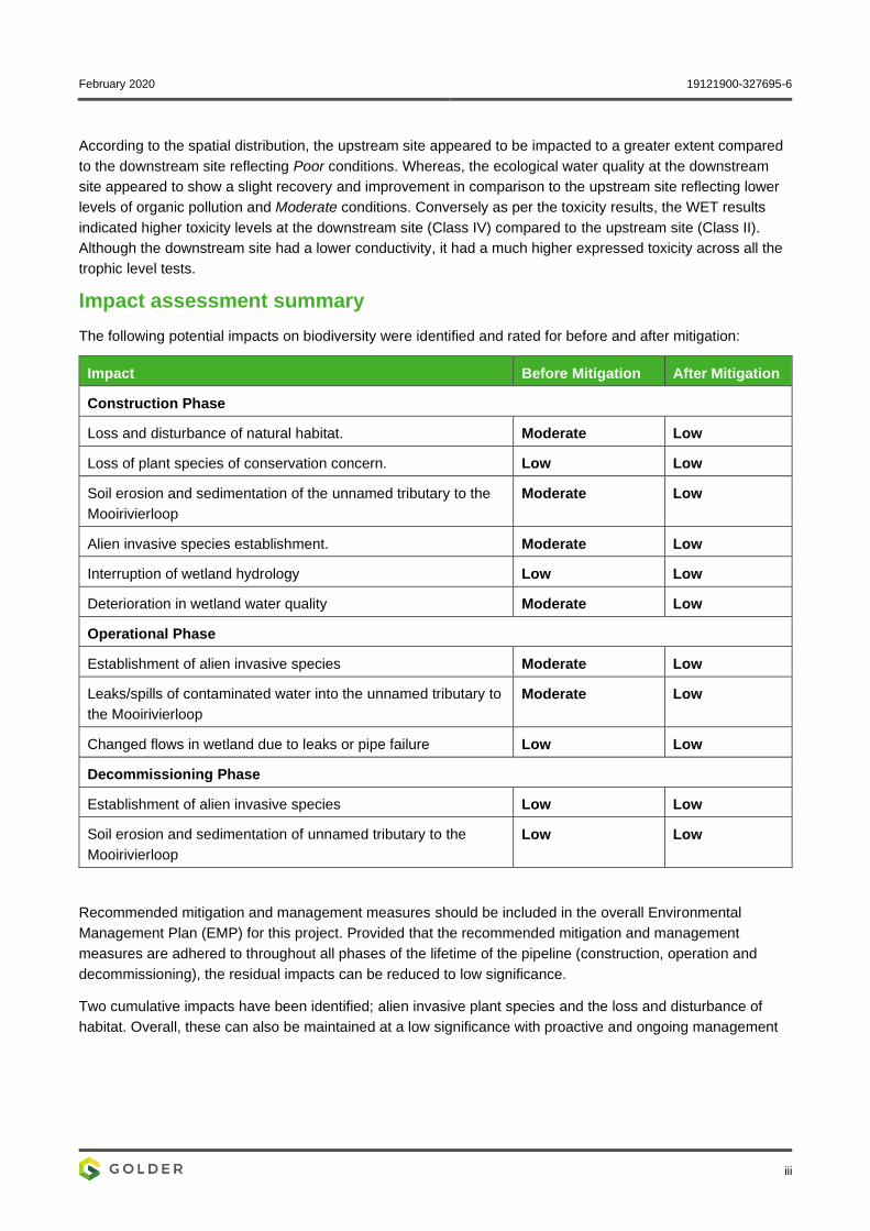
Impact assessment summary
The following potential impacts on biodiversity were identified and rated for before and after mitigation:
Impact Before Mitigation After Mitigation
Construction Phase
Loss and disturbance of natural habitat. Moderate Low
Loss of plant species of conservation concern. Low Low
Soil erosion and sedimentation of the unnamed tributary to the
Mooirivierloop
Moderate Low
Alien invasive species establishment. Moderate Low
Interruption of wetland hydrology Low Low
Deterioration in wetland water quality Moderate Low
Operational Phase
Establishment of alien invasive species Moderate Low
Leaks/spills of contaminated water into the unnamed tributary to
the Mooirivierloop
Moderate Low
Changed flows in wetland due to leaks or pipe failure Low Low
Decommissioning Phase
Establishment of alien invasive species Low Low
Soil erosion and sedimentation of unnamed tributary to the
Mooirivierloop
Low Low
Recommended mitigation and management measures should be included in the overall Environmental
Management Plan (EMP) for this project. Provided that the recommended mitigation and management
measures are adhered to throughout all phases of the lifetime of the pipeline (construction, operation and
decommissioning), the residual impacts can be reduced to low significance.
Two cumulative impacts have been identified; alien invasive plant species and the loss and disturbance of
habitat. Overall, these can also be maintained at a low significance with proactive and ongoing management
February 2020 19121900-327695-6
iv
Assumptions, limitations & exclusions
As mentioned above, the proposed pipeline corridor is located in an area dominated by mining and associated
activities. Due to significant security risks concerning the presence and activities of armed illegal miners the
ability to collect data in-field was highly constrained. The baseline biodiversity presented in the report is thus
based on available ecological literature, supported by high-level field observations and photographs recorded
during a drive-over of the pipeline corridor in an armoured vehicle. No in-field surveys were conducted for the
aquatic and wetland components. However, samples were obtained during the terrestrial survey which
supplemented the aquatic component.
February 2020 19121900-327695-6
v
Acronym List
Acronyms
AGA AngloGold Ashanti
BDI Biological Diatom Index
BLV Blyvooruitzicht
CARA Conservation of Agricultural Resources Act
DWS Department of Water and Sanitation
EIS Ecological Importance and Sensitivity
HGM Hydro-geomorphic
LoM Life of Mine
IUCN International Union for Conservation of Nature
NBD North Boundary Dam
NEMBA National Environmental Management: Biodiversity Act
PES Present Ecological Status
%PTV Percentage of Pollution Tolerant Values
SPI Specific Pollution Sensitivity Index
TUa Toxicity units
WET Whole Effluent Toxicity
February 2020 19121900-327695-6
vi
Table of Contents
1.0 INTRODUCTION ......................................................................................................................................... 1
2.0 PROJECT BACKGROUND ........................................................................................................................ 1
2.1 Location of the proposed project ....................................................................................................... 1
3.0 STUDY APPROACH AND METHODOLOGY ............................................................................................ 3
3.1 Limitations and Constraints ............................................................................................................... 3
3.2 Terrestrial Ecology ............................................................................................................................ 3
3.2.1 Literature Review .......................................................................................................................... 3
3.2.2 Field Programme ........................................................................................................................... 4
3.2.3 Screening of Species of Concern ................................................................................................. 4
3.2.3.1 Species of Concern ....................................................................................................................... 4
3.2.3.2 Habitat Suitability Assessment ...................................................................................................... 5
3.3 Wetland Ecology ............................................................................................................................... 5
3.3.1 Wetland Delineation and Classification......................................................................................... 5
3.3.1.1 Present Ecological State ............................................................................................................... 7
3.3.1.2 Ecological Importance and Sensitivity .......................................................................................... 8
3.3.1.3 Wetland Ecosystem Services ....................................................................................................... 8
3.4 Aquatic Ecology ................................................................................................................................ 9
3.4.1 Literature Review .......................................................................................................................... 9
3.4.2 Preliminary Visual Assessment ................................................................................................... 10
3.4.3 Sample Collection and Sampling Sites ....................................................................................... 10
3.4.3.1 Biological Integrity: Diatoms ........................................................................................................ 10
3.4.3.2 Exposure Integrity: Whole Effluent Toxicity Testing ................................................................... 12
3.5 Impact Assessment ......................................................................................................................... 13
3.6 Mitigation and monitoring ................................................................................................................ 15
4.0 APPLICABLE LEGISLATION, STANDARDS, AND GUIDELINES ........................................................ 15
5.0 BASELINE ASSESSMENT ...................................................................................................................... 15
5.1 Terrestrial Ecology .......................................................................................................................... 15
5.1.1 Regional Ecological Setting ........................................................................................................ 15
5.1.1.1 Gauteng Shale Mountain Bushveld ............................................................................................ 15
5.1.1.2 Carletonville Dolomite Grassland ................................................................................................ 16
February 2020 19121900-327695-6
vii
5.1.2 National and Provincial Conservation Context ........................................................................... 18
5.1.3 Landscape Context and Land Cover .......................................................................................... 18
5.2 Flora Assessment ........................................................................................................................... 22
5.2.1 Habitat Units ................................................................................................................................ 22
5.2.1.1 Grassland Habitats...................................................................................................................... 22
5.2.1.2 Woodland Habitats ...................................................................................................................... 25
5.2.2 Threatened and Protected Plant Species ................................................................................... 26
5.2.3 Plants of Medicinal Value ............................................................................................................ 27
5.2.4 CARA and NEMBA Listed Alien Invasive Species ..................................................................... 27
5.3 Fauna Assessment ......................................................................................................................... 28
5.3.1 Mammals ..................................................................................................................................... 28
5.3.2 Birds ............................................................................................................................................ 29
5.3.3 Herpetofauna (Reptiles and Amphibians) ................................................................................... 29
5.3.4 Arthropods ................................................................................................................................... 29
5.4 Wetland Ecology ............................................................................................................................. 30
5.4.1 Wetland Delineation and Classification....................................................................................... 30
5.4.2 Present Ecological State ............................................................................................................. 32
5.4.3 Ecological Importance and Sensitivity ........................................................................................ 33
5.4.4 Wetland Ecosystem Services ..................................................................................................... 33
5.5 Aquatic Ecology .............................................................................................................................. 36
5.5.1 Regional aquatic setting .............................................................................................................. 36
5.5.2 Aquatic Macroinvertebrate Communities .................................................................................... 38
5.5.3 Fish Communities ....................................................................................................................... 38
5.5.4 Diatoms ....................................................................................................................................... 38
5.5.5 Whole Effluent Toxicity ............................................................................................................... 39
6.0 APPRAISAL OF HABITAT SENSITIVITY ................................................................................................ 40
7.0 IMPACT ASSESSMENT ........................................................................................................................... 42
7.1 Construction Phase ......................................................................................................................... 42
7.1.1 Loss and disturbance of natural habitat ...................................................................................... 42
7.1.2 Loss of plant species of conservation concern ........................................................................... 42
7.1.3 Soil erosion and sedimentation of the unnamed tributary to the Mooirivierloop ......................... 42
February 2020 19121900-327695-6
viii
7.1.4 Alien invasive species establishment.......................................................................................... 43
7.1.5 Interruption of wetland hydrology ................................................................................................ 43
7.1.6 Deterioration in wetland water quality ......................................................................................... 43
7.2 Operational Phase .......................................................................................................................... 44
7.2.1 Establishment of alien invasive species...................................................................................... 44
7.2.2 Leaks/spills of contaminated water into the unnamed tributary to the Mooirivierloop ................ 44
7.2.3 Changed flows in wetlands due to leaks or pipe failure .............................................................. 44
7.3 Decommissioning Phase ................................................................................................................. 45
7.3.1 Establishment of alien invasive species...................................................................................... 45
7.3.2 Soil erosion and sedimentation of the unnamed tributary to the Mooirivierloop ......................... 45
7.4 Cumulative impacts ......................................................................................................................... 46
7.4.1 Establishment of alien invasive species...................................................................................... 46
7.4.2 Loss and disturbance of natural habitat ...................................................................................... 46
8.0 RECOMMENDED MITIGATION AND BEST PRACTICE MEASURES ................................................... 46
8.1 Construction Phase Recommendations .......................................................................................... 46
8.2 Operational Phase Recommendations ........................................................................................... 48
8.3 Decommissioning Phase Recommendations ................................................................................. 48
9.0 CONCLUSIONS ........................................................................................................................................ 49
10.0 REFERENCES .......................................................................................................................................... 50
TABLES
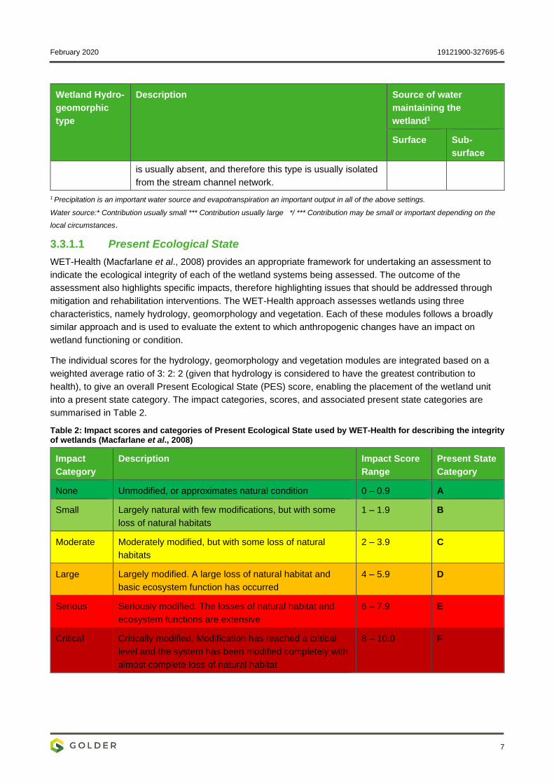
Table 1: Wetland hydro-geomorphic units (after Kotze et al., 2008) .................................................................... 6
Table 2: Impact scores and categories of Present Ecological State used by WET-Health for describing the integrity of wetlands (Macfarlane et al., 2008) ...................................................................................................... 7
Table 3: Ecological Importance and Sensitivity categories .................................................................................. 8
Table 4: Level of service scores ........................................................................................................................... 9
Table 5: Location of sampling sites .................................................................................................................... 10
Table 6: Class values used for the SPI and BDI indices in the evaluation of water quality ............................... 11
Table 7: Interpretation of the %PTV scores........................................................................................................ 11
Table 8: Grouping of toxicity units (TUa) ............................................................................................................ 12
Table 9: Weight score allocation for each test type (Persoone et al., 2003) ...................................................... 13
Table 10: Acute Hazard Classification system for natural waters (Persoone et al., 2003) ................................ 13
Table 11: Impact classification for impact assessment ...................................................................................... 14
February 2020 19121900-327695-6
ix
Table 12: Ranking scales ................................................................................................................................... 14
Table 13: Categories describing environmental consequence........................................................................... 14
Table 14: Plant species of conservation concern potentially occurring in the study area .................................. 26
Table 15: Plants with medicinal value recorded during the site visit .................................................................. 27
Table 16: CARA and NEMBA listed alien invasive flora species recorded during the field visit ........................ 27
Table 17: Mammals of conservation concern potentially occurring in the study area ........................................ 28
Table 18: Birds of conservation concern potentially occurring in the study area ............................................... 29
Table 19: Classification of wetlands within the study area ................................................................................. 30
Table 20: Level 1 PES assessment results ........................................................................................................ 32
Table 21: EIS score and category for the Channelled Valley Bottom (HGM 1) wetland and HGM2 which is being crossed ..................................................................................................................................................... 33
Table 22: Expected ichthyofaunal composition and frequency of occurrence within the AGA study area and current IUCN status ............................................................................................................................................ 38
Table 23: Diatom analysis results and ecological water quality for June 2019 .................................................. 39
Table 24: Summary of WET testing results ........................................................................................................ 40
Table 25: Hazard Classification of undiluted samples for June 2018 ................................................................ 40
Table 26: Environmental Impact Assessment matrix for the construction phase of the proposed project ........ 43
Table 27: Environmental Impact Assessment matrix for the operational phase of the proposed project .......... 45
Table 28: Environmental Impact Assessment matrix for the decommissioning phase of the proposed project 45
Table 29: Environmental Impact Assessment matrix for the cumulative impacts of the proposed project ........ 46
Table 30: Construction phase mitigation measures ........................................................................................... 46
Table 31: Operational phase mitigation measures ............................................................................................. 48
Table 32: Decommissioning phase mitigation measures ................................................................................... 49
Table A: Acknowledgements .............................................................................................................................. 76
FIGURES
Figure 1: Location of the proposed pipeline ......................................................................................................... 2
Figure 2: Armoured vehicle used for field work .................................................................................................... 3
Figure 3: Portions of the proposed pipeline could only be viewed from the roof or through the gun-ports of the armoured vehicle .................................................................................................................................................. 3
Figure 4: Proposed pipeline corridor in relation to Mucina and Rutherford’s (2006) regional vegetation types 17
Figure 5: Delineation of Nationally Threatened Ecosystems (2011) .................................................................. 19
Figure 6: Proposed pipeline route in relation to the Gauteng Conservation Plan (Version 3.3, 2011) .............. 20
Figure 7: Land cover along the proposed pipeline route .................................................................................... 21
Figure 8: Habitats along the proposed pipeline corridor ..................................................................................... 23
Figure 9: Relatively undisturbed grassland, adjacent to a small rocky outcrop. The preferred pipeline route passes through the rocky outcrop at this point ................................................................................................... 24
February 2020 19121900-327695-6
x
Figure 10: Existing pipeline corridor across a large tract of grassland, dominated by inter alia, Hyparrhenia hirta ..................................................................................................................................................................... 24
Figure 11: Old cultivated field, characterised by secondary grassland and a prevalence of weeds (e.g. Bidens pilosa, Tagetes minuta and Verbena bonariensis) ............................................................................................. 24
Figure 12: Grassland encroached by Asparagus laricinus (Populus x canescens stands in background, growing along the unnamed tributary to the Mooirivierloop) ............................................................................. 24
Figure 13: Floodplain of the unnamed tributary to the Mooirrivierloop. The alien trees Salix babylonica (left) and Populus x canescens (right) are common ................................................................................................... 24
Figure 14: Weir along the unnamed tributary to the Mooirivierloop ................................................................... 24
Figure 15: Wooded patch, dominated by the indigenous Vachellia karroo ........................................................ 25
Figure 16: Wooded rocky outcrop, located below the weir along the unnamed tributary to the Mooirivierloop . 25
Figure 17: Eucalyptus stands, amongst other invasive wood species, are common along the pipeline corridor ............................................................................................................................................................................ 25
Figure 18: Preliminary desktop delineation of suspected wetlands within 500 m of the proposed pipeline. Note: For security reasons, field verification of the wetland delineations was not permitted ....................................... 31
Figure 19: HGM1 Channelled valley bottom – level of ecosystem service provision ......................................... 34
Figure 20: HGM2 hillslope seep - level of ecosystem service provision ............................................................ 34
Figure 21: Desktop wetland delineation. Note: For security reasons, field verification of the wetland delineations was not permitted and as such, the delineation is considered tentative ........................................ 35
Figure 22: Wetland conditions along the unnamed tributary to the Mooirivierloop ............................................ 36
Figure 23: Artificial channel ................................................................................................................................ 36
Figure 24: Virtual visual assessment along the unnamed tributary to the Mooirivierloop in aid of the aquatic assessment ......................................................................................................................................................... 37
Figure 25: Habitat sensitivity along the proposed pipeline corridor .................................................................... 41
APPENDICES
APPENDIX A Document Limitations
APPENDIX B Plant species recorded along the proposed pipeline corridor during the field visit
APPENDIX C Mammals previously recorded in the 2627AD QDS
APPENDIX D Bird Species Previously Recorded in the Relevant Pentads
APPENDIX E Reptiles and Amphibians previously recorded in the 2627AD QDS
APPENDIX F Diatom Report
APPENDIX G Whole Effluent Toxicity Report
APPENDIX H Acknowledgements, Details of EAP, Declaration of Interest and Specialist EAP experience
February 2020 19121900-327695-6
1
1.0 INTRODUCTION
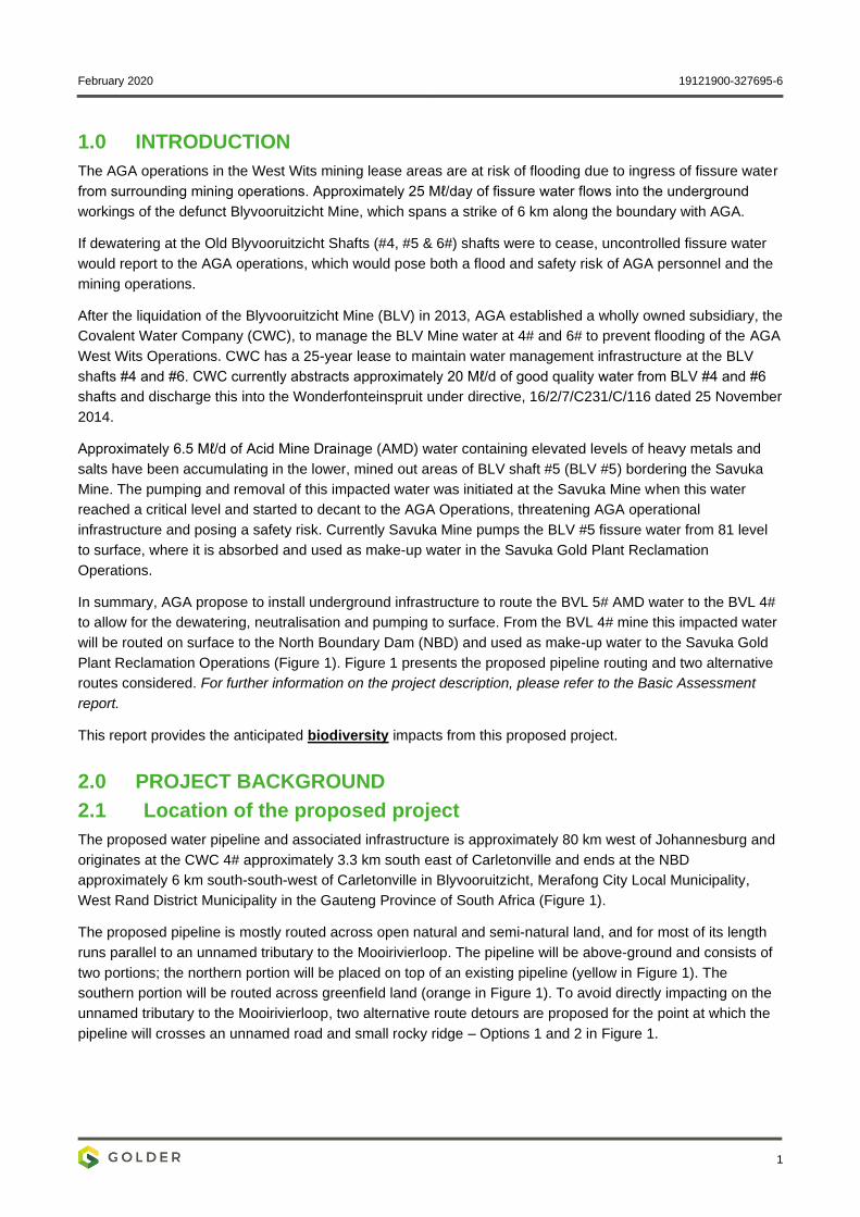
The AGA operations in the West Wits mining lease areas are at risk of flooding due to ingress of fissure water
from surrounding mining operations. Approximately 25 Mℓ/day of fissure water flows into the underground
workings of the defunct Blyvooruitzicht Mine, which spans a strike of 6 km along the boundary with AGA.
If dewatering at the Old Blyvooruitzicht Shafts (#4, #5 & 6#) shafts were to cease, uncontrolled fissure water
would report to the AGA operations, which would pose both a flood and safety risk of AGA personnel and the
mining operations.
After the liquidation of the Blyvooruitzicht Mine (BLV) in 2013, AGA established a wholly owned subsidiary, the
Covalent Water Company (CWC), to manage the BLV Mine water at 4# and 6# to prevent flooding of the AGA
West Wits Operations. CWC has a 25-year lease to maintain water management infrastructure at the BLV
shafts #4 and #6. CWC currently abstracts approximately 20 Mℓ/d of good quality water from BLV #4 and #6
shafts and discharge this into the Wonderfonteinspruit under directive, 16/2/7/C231/C/116 dated 25 November
2014.
Approximately 6.5 Mℓ/d of Acid Mine Drainage (AMD) water containing elevated levels of heavy metals and
salts have been accumulating in the lower, mined out areas of BLV shaft #5 (BLV #5) bordering the Savuka
Mine. The pumping and removal of this impacted water was initiated at the Savuka Mine when this water
reached a critical level and started to decant to the AGA Operations, threatening AGA operational
infrastructure and posing a safety risk. Currently Savuka Mine pumps the BLV #5 fissure water from 81 level
to surface, where it is absorbed and used as make-up water in the Savuka Gold Plant Reclamation
Operations.
In summary, AGA propose to install underground infrastructure to route the BVL 5# AMD water to the BVL 4#
to allow for the dewatering, neutralisation and pumping to surface. From the BVL 4# mine this impacted water
will be routed on surface to the North Boundary Dam (NBD) and used as make-up water to the Savuka Gold
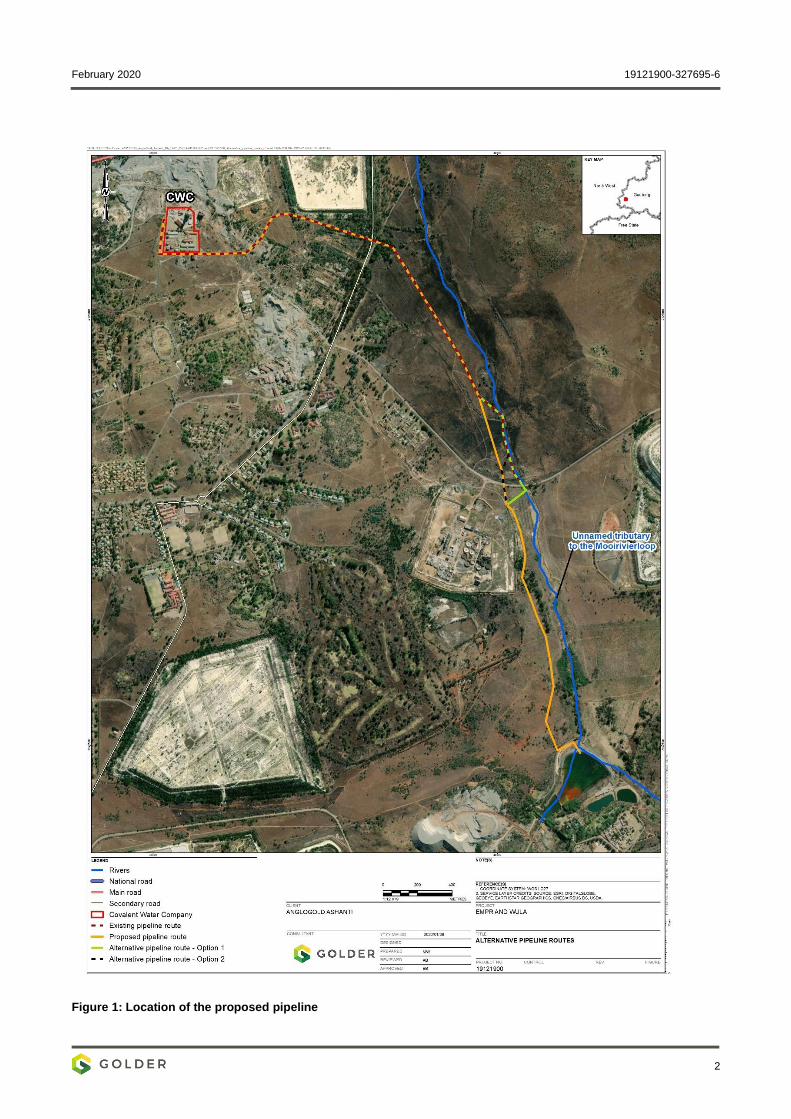
Plant Reclamation Operations (Figure 1). Figure 1 presents the proposed pipeline routing and two alternative
routes considered. For further information on the project description, please refer to the Basic Assessment
report.
This report provides the anticipated biodiversity impacts from this proposed project.
2.0 PROJECT BACKGROUND
2.1 Location of the proposed project
The proposed water pipeline and associated infrastructure is approximately 80 km west of Johannesburg and
originates at the CWC 4# approximately 3.3 km south east of Carletonville and ends at the NBD
approximately 6 km south-south-west of Carletonville in Blyvooruitzicht, Merafong City Local Municipality,
West Rand District Municipality in the Gauteng Province of South Africa (Figure 1).
The proposed pipeline is mostly routed across open natural and semi-natural land, and for most of its length
runs parallel to an unnamed tributary to the Mooirivierloop. The pipeline will be above-ground and consists of
two portions; the northern portion will be placed on top of an existing pipeline (yellow in Figure 1). The
southern portion will be routed across greenfield land (orange in Figure 1). To avoid directly impacting on the
unnamed tributary to the Mooirivierloop, two alternative route detours are proposed for the point at which the
pipeline will crosses an unnamed road and small rocky ridge – Options 1 and 2 in Figure 1.
February 2020 19121900-327695-6
2
Figure 1: Location of the proposed pipeline

February 2020 19121900-327695-6
3
3.0 STUDY APPROACH AND METHODOLOGY
3.1 Limitations and Constraints
Illegal mining and other criminal activity are widespread and highly problematic in the area, and this placed
significant constraints on field work activity and resulting data collection. The field team was transported in an
armoured personnel carrier at all times, and team members were only permitted to leave the vehicle at a few
select points along the proposed pipeline route that were deemed safe (Figure 2 and Figure 3).
Figure 2: Armoured vehicle used for field work
Figure 3: Portions of the proposed pipeline could only be viewed from the roof or through the gun-ports of
the armoured vehicle
3.2 Terrestrial Ecology
The terrestrial ecology component included a desktop literature review and a field programme. Tasks
associated with these are discussed in the sections below.
3.2.1 Literature Review
Flora Assessment
A general habitat description relevant to the broader study area was obtained from Scholes and Walker
(1993) Mucina and Rutherford (2006);
The formal conservation context of the region at a provincial and national level was established based on
the Gauteng C-Plan1 V3.3, (2011) and the National List of Threatened Ecosystems (NEMBA Threatened
Ecosystems, 2011), respectively;
A preliminary habitat/vegetation mapping exercise was undertaken at a desktop level using available
satellite imagery, supported by land cover imagery (GEOTERRA Image 2014); and
A list of flora species likely to occur in the area were obtained from SANBI2’s online Botanical Database
of Southern Africa (ref. BODATSA, 2016). Species were cross-referenced against provincial and national
threatened and protected species databases (refer to section 3.2.3.1) to determine conservation
concern.
1 Conservation Plan
2 South African National Biodiversity Institute
February 2020 19121900-327695-6
4
Fauna Assessment
Lists of mammals, herpetofauna (reptiles and amphibians) and arthropods likely to occur in the area
were sourced from the FitzPatrick Institute of African Ornithology's (2019) Virtual Museum database (i.e.
MammalMAP, ReptileMAP, FrogMAP, LepiMAP, ScorpionMAP and SpiderMAP);
A list of birds previously recorded in the relevant pentad was obtained from the South African Bird Atlas
Project 2 (ADU - SABAP2, 2011); and
Fauna species lists were cross-referenced against provincial and national threatened and protected
species databases (refer to section 3.2.3.1) to determine conservation concern.
3.2.2 Field Programme
The field programme aimed to ground-truth the general ecological character of the pipeline corridor, and
comprised a one-day site visit, conducted on the 12th June 2019. Pursuant to the constraints described in
section 3.1, the field programme comprised a visual inspection of the pipeline corridor conducted from the
confines of the armoured vehicle. Information gathered included:
General habitat character, i.e. type and structure, landscape context, and disturbances;
General flora composition; and
A catalogue of photographs was also collected from the vehicle, which were used to supplement field
notes.
3.2.3 Screening of Species of Concern
3.2.3.1 Species of Concern
Threatened and Protected Species
The Red List and protected status of floral and faunal species occurring or potential occurring in the study
area was based on:
Regional/National Red List Status, as per:
▪ Red List of South African Plants Version (SANBI, 2017);
▪ Red List of Mammals of South Africa, Lesotho and Swaziland (EWT, 2016);
▪ Regional Red List for Birds of South Africa, Lesotho and Swaziland (BirdLife South Africa, 2015);
▪ Atlas and Red List of the Reptiles of South Africa, Lesotho and Swaziland (Bates et al., 2014); and
▪ IUCN.
National Environmental Management: Biodiversity Act (NEMBA) (Act No. 10 of 2004) - Threatened or
Protected Species List (Notice 389 of 2013) (Draft NEMBA ToPS List, 2013);
Lists of Protected and Specially Protected Game and Plants, under the (Gauteng Nature Conservation
Ordinance, 1983); and
Pfab (2001a, 2001b) were also consulted in reference to the Gauteng’s Red Data plant policy and the
development guideline for ridges.
Alien Invasive Species
Alien invasive plant species recorded on-site were categorised according to the following listings:
Conservation of Agricultural Resources Act (CARA) (Act No. 43 of 1983); and/or
February 2020 19121900-327695-6
5
National Environmental Management: Biodiversity Act (NEMBA) (Act No. 10 of 2004) - 2016 listing.
Medicinal Flora Species
Assessment of the medicinal value and utility of floral species recorded in the study area was based on Van
Wyk et al. (2009).
3.2.3.2 Habitat Suitability Assessment
Based on the lists of faunal species of conservation importance potentially occurring in the study area,
‘probability of occurrence’ was determined by assessing habitat suitability. The following parameters were
used in the assessments:
Habitat requirements: Most threatened and endemic species have very specific habitat requirements.
The presence of these habitats in the study area was evaluated;
Habitat status: The status or ecological condition of available habitat in the area was assessed. Often a
high level of habitat degradation will negate the potential presence of sensitive species; and
Habitat linkage: Dispersal and movement between natural areas for breeding and feeding are important
population-level processes. Habitat connectivity within the study area and to surrounding natural habitat
and corridors was evaluated to determine the likely persistence of species of concern in the study area.
Probability of occurrence is presented in three categories, namely:
Possible: The species may occur on the site, or move through the site (in the case of mobile species),
due to potential habitat and/or resources;
Probable: The species is likely to occur on the site due to suitable habitat and resources being present
on the site; or
Unlikely: The species will not likely occur on the site due to lack of suitable habitat and resources.
3.3 Wetland Ecology
3.3.1 Wetland Delineation and Classification
Wetland Delineation
For the purposes of this assessment, wetlands are considered as those ecosystems defined by the National
Water Act, 1998 (Act 36 of 1998) as:
“land which is transitional between terrestrial and aquatic systems where the water table is usually at or near
the surface, or land that is periodically covered with shallow water, and which land in normal circumstances
supports or would support vegetation typical of life in saturated soil”.
Furthermore, wetlands have one or more of the following attributes:
Wetland (hydromorphic) soils that display characteristics resulting from prolonged saturation;
The presence, at least occasionally, of water loving plants (hydrophytes); and
A high-water table that results in saturation at or near the surface, leading to anaerobic conditions
developing in the top 50 cm of the soil (DWAF, 2005).
A desktop delineation of suspected wetland areas was undertaken by identifying and mapping wetness
signatures (areas of flooding, wet soils, hydrophytic vegetation) on aerial imagery using Google Earth Pro.
Field verification of the preliminarily-identified wetland boundaries was limited due to security constraints;
therefore it is noted the delineation presented in this report is derived from a desktop-level assessment only.
February 2020 19121900-327695-6
6
Wetland Classification
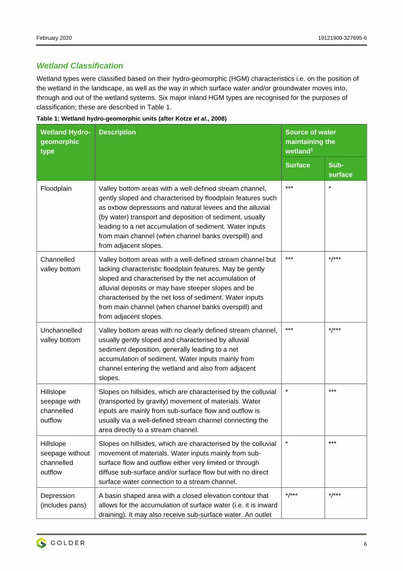
Wetland types were classified based on their hydro-geomorphic (HGM) characteristics i.e. on the position of
the wetland in the landscape, as well as the way in which surface water and/or groundwater moves into,
through and out of the wetland systems. Six major inland HGM types are recognised for the purposes of
classification; these are described in Table 1.
Table 1: Wetland hydro-geomorphic units (after Kotze et al., 2008)
Wetland Hydro-
geomorphic
type
Description Source of water
maintaining the
wetland1
Surface Sub-
surface
Floodplain Valley bottom areas with a well-defined stream channel,
gently sloped and characterised by floodplain features such
as oxbow depressions and natural levees and the alluvial
(by water) transport and deposition of sediment, usually
leading to a net accumulation of sediment. Water inputs
from main channel (when channel banks overspill) and
from adjacent slopes.
*** *
Channelled
valley bottom
Valley bottom areas with a well-defined stream channel but
lacking characteristic floodplain features. May be gently
sloped and characterised by the net accumulation of
alluvial deposits or may have steeper slopes and be
characterised by the net loss of sediment. Water inputs
from main channel (when channel banks overspill) and
from adjacent slopes.
*** */***
Unchannelled
valley bottom
Valley bottom areas with no clearly defined stream channel,
usually gently sloped and characterised by alluvial
sediment deposition, generally leading to a net
accumulation of sediment. Water inputs mainly from
channel entering the wetland and also from adjacent
slopes.
*** */***
Hillslope
seepage with
channelled
outflow
Slopes on hillsides, which are characterised by the colluvial
(transported by gravity) movement of materials. Water
inputs are mainly from sub-surface flow and outflow is
usually via a well-defined stream channel connecting the
area directly to a stream channel.
* ***
Hillslope
seepage without
channelled
outflow
Slopes on hillsides, which are characterised by the colluvial
movement of materials. Water inputs mainly from sub-
surface flow and outflow either very limited or through
diffuse sub-surface and/or surface flow but with no direct
surface water connection to a stream channel.
* ***
Depression
(includes pans)
A basin shaped area with a closed elevation contour that
allows for the accumulation of surface water (i.e. it is inward
draining). It may also receive sub-surface water. An outlet
*/*** */***
February 2020 19121900-327695-6
7
Wetland Hydro-
geomorphic
type
Description Source of water
maintaining the
wetland1
Surface Sub-
surface
is usually absent, and therefore this type is usually isolated
from the stream channel network.
1 Precipitation is an important water source and evapotranspiration an important output in all of the above settings.
Water source:* Contribution usually small *** Contribution usually large */ *** Contribution may be small or important depending on the
local circumstances.
3.3.1.1 Present Ecological State
WET-Health (Macfarlane et al., 2008) provides an appropriate framework for undertaking an assessment to
indicate the ecological integrity of each of the wetland systems being assessed. The outcome of the
assessment also highlights specific impacts, therefore highlighting issues that should be addressed through
mitigation and rehabilitation interventions. The WET-Health approach assesses wetlands using three
characteristics, namely hydrology, geomorphology and vegetation. Each of these modules follows a broadly
similar approach and is used to evaluate the extent to which anthropogenic changes have an impact on
wetland functioning or condition.
The individual scores for the hydrology, geomorphology and vegetation modules are integrated based on a
weighted average ratio of 3: 2: 2 (given that hydrology is considered to have the greatest contribution to
health), to give an overall Present Ecological State (PES) score, enabling the placement of the wetland unit
into a present state category. The impact categories, scores, and associated present state categories are
summarised in Table 2.
Table 2: Impact scores and categories of Present Ecological State used by WET-Health for describing the integrity of wetlands (Macfarlane et al., 2008)
Impact
Category
Description Impact Score
Range
Present State
Category
None Unmodified, or approximates natural condition 0 – 0.9 A
Small Largely natural with few modifications, but with some
loss of natural habitats
1 – 1.9 B
Moderate Moderately modified, but with some loss of natural
habitats
2 – 3.9 C
Large Largely modified. A large loss of natural habitat and
basic ecosystem function has occurred
4 – 5.9 D
Serious Seriously modified. The losses of natural habitat and
ecosystem functions are extensive
6 – 7.9 E
Critical Critically modified. Modification has reached a critical
level and the system has been modified completely with
almost complete loss of natural habitat
8 – 10.0 F
February 2020 19121900-327695-6
8
3.3.1.2 Ecological Importance and Sensitivity
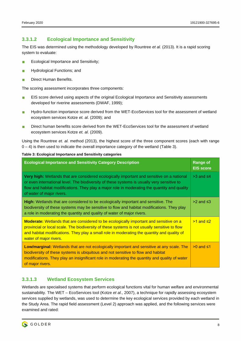
The EIS was determined using the methodology developed by Rountree et al. (2013). It is a rapid scoring
system to evaluate:
Ecological Importance and Sensitivity;
Hydrological Functions; and
Direct Human Benefits.
The scoring assessment incorporates three components:
EIS score derived using aspects of the original Ecological Importance and Sensitivity assessments
developed for riverine assessments (DWAF, 1999);
Hydro-function importance score derived from the WET-EcoServices tool for the assessment of wetland
ecosystem services Kotze et. al. (2009); and
Direct human benefits score derived from the WET-EcoServices tool for the assessment of wetland
ecosystem services Kotze et. al. (2009).
Using the Rountree et. al. method (2013), the highest score of the three component scores (each with range
0 – 4) is then used to indicate the overall importance category of the wetland (Table 3).
Table 3: Ecological Importance and Sensitivity categories
Ecological Importance and Sensitivity Category Description Range of
EIS score
Very high: Wetlands that are considered ecologically important and sensitive on a national
or even international level. The biodiversity of these systems is usually very sensitive to
flow and habitat modifications. They play a major role in moderating the quantity and quality
of water of major rivers.
>3 and ≤4
High: Wetlands that are considered to be ecologically important and sensitive. The
biodiversity of these systems may be sensitive to flow and habitat modifications. They play
a role in moderating the quantity and quality of water of major rivers.
>2 and ≤3
Moderate: Wetlands that are considered to be ecologically important and sensitive on a
provincial or local scale. The biodiversity of these systems is not usually sensitive to flow
and habitat modifications. They play a small role in moderating the quantity and quality of
water of major rivers.
>1 and ≤2
Low/marginal: Wetlands that are not ecologically important and sensitive at any scale. The
biodiversity of these systems is ubiquitous and not sensitive to flow and habitat
modifications. They play an insignificant role in moderating the quantity and quality of water
of major rivers.
>0 and ≤1
3.3.1.3 Wetland Ecosystem Services
Wetlands are specialised systems that perform ecological functions vital for human welfare and environmental
sustainability. The WET – EcoServices tool (Kotze et al., 2007), a technique for rapidly assessing ecosystem
services supplied by wetlands, was used to determine the key ecological services provided by each wetland in
the Study Area. The rapid field assessment (Level 2) approach was applied, and the following services were
examined and rated:
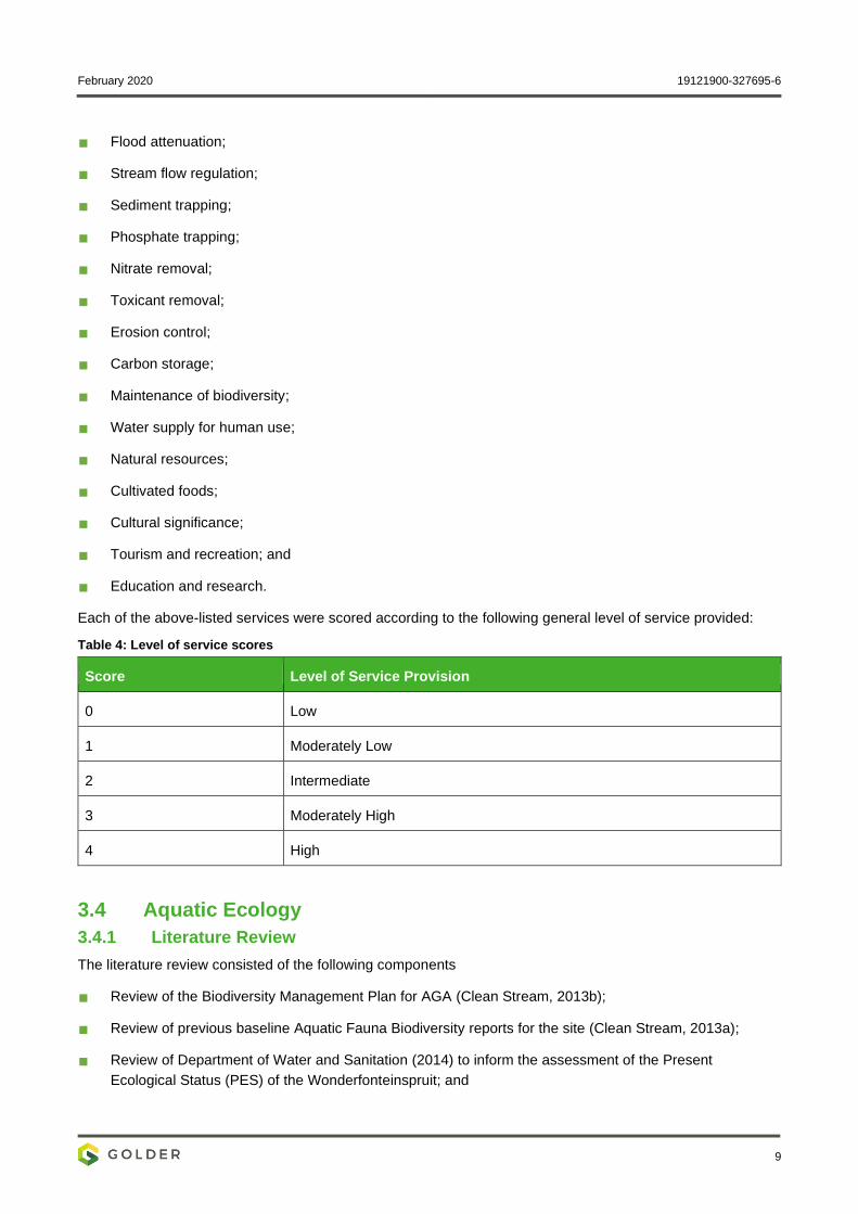
February 2020 19121900-327695-6
9
Flood attenuation;
Stream flow regulation;
Sediment trapping;
Phosphate trapping;
Nitrate removal;
Toxicant removal;
Erosion control;
Carbon storage;
Maintenance of biodiversity;
Water supply for human use;
Natural resources;
Cultivated foods;
Cultural significance;
Tourism and recreation; and
Education and research.
Each of the above-listed services were scored according to the following general level of service provided:
Table 4: Level of service scores
Score Level of Service Provision
0 Low
1 Moderately Low
2 Intermediate
3 Moderately High
4 High
3.4 Aquatic Ecology
3.4.1 Literature Review
The literature review consisted of the following components
Review of the Biodiversity Management Plan for AGA (Clean Stream, 2013b);
Review of previous baseline Aquatic Fauna Biodiversity reports for the site (Clean Stream, 2013a);
Review of Department of Water and Sanitation (2014) to inform the assessment of the Present
Ecological Status (PES) of the Wonderfonteinspruit; and
February 2020 19121900-327695-6
10
Review of available fish literature including (Skelton, 2001; Kleynhans, 2007; Froese, R. and Pauly, 2011
and IUCN, 2019.1), as well as previous assessments of the project area (Clean Stream, 2013) to compile
an expected fish species list.
3.4.2 Preliminary Visual Assessment
Considering the security constraints of the study area, the ecological status of the unnamed tributary to the
Mooirivierloop was limited to a desktop assessment. This was done through examination of Google Earth
street view (2019) imagery, in addition to assessing site photographs taken during the in-field survey
conducted on 12th June 2019.
The focus included:
Channel characteristics;
Habitat and flow modifications; and
Historical temporal changes within the channel and riparian zone.
The results of the desktop assessment indicated that an assessment of fish or macroinvertebrates would not
provide any additional useful information on the current aquatic condition, regardless of the security situation.
However, it was considered that the collection of diatom and Whole Effluent Toxicity (WET) test samples
would provide some additional information regarding the health and integrity of the system. These were
collected during the terrestrial in-field survey. Refer to section 3.4.3 for the approach and methodology.
3.4.3 Sample Collection and Sampling Sites
The two aquatic indices that would provide some biological and exposure integrity data on the current
condition of the unnamed tributary to the Mooirivierloop was diatoms and WET testing respectively. During the
terrestrial in-field survey, these samples were collected at an upstream and downstream point along the
unnamed tributary to the Mooirivierloop. These methodologies are applied and accepted by the Department of
Water and Sanitation (DWS).
The two sites selected for diatom and WET test sampling based on safety and ease of access owing to the
security constraints of the study area are displayed in Table 5. The sites selected represented an upstream
and downstream site of the proposed pipeline route. Co-ordinates of the sampling sites were recorded using a
Garmin GPS 60CSx (Table 5) with the map of the study area showing the location of the sampling sites
coupled with site photos in Figure 24.
Table 5: Location of sampling sites
Unnamed tributary sampling sites Co-ordinates
WON_US -26.398026 27.402544
WON_DS -26.377109 27.394400
3.4.3.1 Biological Integrity: Diatoms
Diatoms are the unicellular algal group most widely used as indicators of river and wetland health as they
provide a rapid response to specific physico-chemical conditions in the water and are often the first indication
of change. The presence or absence of indicator taxa can be used to detect specific changes in environmental
conditions such as eutrophication, organic enrichment, salinisation and changes in pH.
February 2020 19121900-327695-6
11
Diatoms were collected by removing the biofilm from the upper surface of the cobble/stones by scrubbing
vigorously with a brush. The contents were placed into a bottle, preserved with ethanol and sent to Ecotone
Freshwater Consults for analysis.
Diatom laboratory procedures were carried out according to the methodology described by Taylor et al.
(2005). Diatom samples were prepared for microscopy by using the hot hydrochloric acid and potassium
permanganate method. Approximately 300 to 400 diatom valves were identified and counted to produce semi-
quantitative data for analysis.
The taxonomic guide by Taylor et al. (2007) was consulted for identification purposes. Environmental
preferences were inferred from Taylor et al. (2007) and various other literature sources, as indicated in the
discussion section, and used to describe the environmental water quality at each site.
Two indices, namely the Specific Pollution Sensitivity Index (SPI) (CEMAGREF, 1982) and the Biological
Diatom Index (BDI; (Lenoir and Coste, 1996) were used in the diatom assessment. The SPI has been
extensively tested in a broad geographical region and integrates impacts from organic material, electrolytes,
pH, and nutrients. In addition, the Percentage of Pollution Tolerant Values (% PTV) (Kelly and Whitton, 1995)
was used to indicate organic pollution. All calculations were computed using OMNIDIA ver. 4.2 program
(Lecointe et al., 1993).
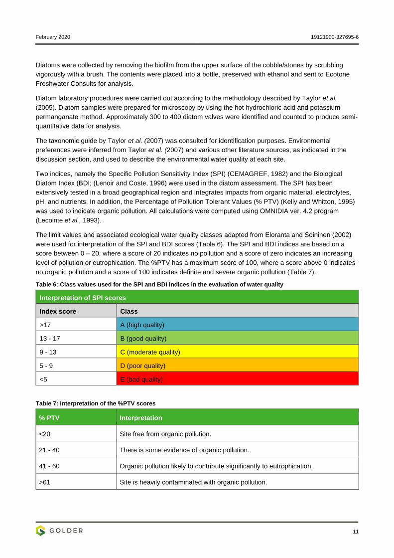
The limit values and associated ecological water quality classes adapted from Eloranta and Soininen (2002)
were used for interpretation of the SPI and BDI scores (Table 6). The SPI and BDI indices are based on a
score between 0 – 20, where a score of 20 indicates no pollution and a score of zero indicates an increasing
level of pollution or eutrophication. The %PTV has a maximum score of 100, where a score above 0 indicates
no organic pollution and a score of 100 indicates definite and severe organic pollution (Table 7).
Table 6: Class values used for the SPI and BDI indices in the evaluation of water quality
Interpretation of SPI scores
Index score Class
>17 A (high quality)
13 - 17 B (good quality)
9 - 13 C (moderate quality)
5 - 9 D (poor quality)
<5 E (bad quality)
Table 7: Interpretation of the %PTV scores
% PTV Interpretation
<20 Site free from organic pollution.
21 - 40 There is some evidence of organic pollution.
41 - 60 Organic pollution likely to contribute significantly to eutrophication.
>61 Site is heavily contaminated with organic pollution.
February 2020 19121900-327695-6
12
3.4.3.2 Exposure Integrity: Whole Effluent Toxicity Testing
Governmental, industrial and international agencies have increasingly adopted single-species toxicity tests to
predict potential effects on the environment. These tests are scientifically sound and in conjunction with
chemical and ecological measurements can identify, monitor and serve as basis to implement control
measures on the discharge of complex effluents.
For the protection of aquatic life against the toxic effects of effluents and receiving waters a battery approach
using fish, water flea, algae and bacteria is recommended by Slabbert et al. (1998). WET tests are important
additions to chemical-specific measurements because:
Test organisms respond to compounds, which are not readily identifiable or measured by analytical
techniques;
Test organisms respond to unknown compounds;
Effects due to chemical interaction, e.g. synergism, antagonism and addition are detected;
Information on the type of hazardous chemical activity in an effluent, i.e. toxicity is provided; and
Information on the impact on particular groups of target organisms is provided.
The following biological tests were used in acute toxicity evaluation:
Bacterial (Vibrio fischeri) bioluminesescence inhibition test – 30 min;
72 h algal growth inhibition test (Selenastrum capricornutum);
Water flea (Daphnia pulex) 48 h lethality test; and
Guppy (Poecilia reticulata) 96 h lethality test.
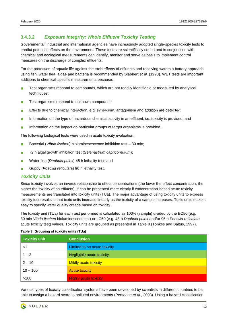
Toxicity Units
Since toxicity involves an inverse relationship to effect concentrations (the lower the effect concentration, the
higher the toxicity of an effluent), it can be presented more clearly if concentration-based acute toxicity
measurements are translated into toxicity units (TUa). The major advantage of using toxicity units to express
toxicity test results is that toxic units increase linearly as the toxicity of a sample increases. Toxic units make it
easy to specify water quality criteria based on toxicity.
The toxicity unit (TUa) for each test performed is calculated as 100% (sample) divided by the EC50 (e.g.
30 min Vibrio fischeri bioluminescent test) or LC50 (e.g. 48 h Daphnia pulex and/or 96 h Poecilia reticulata
acute toxicity test) values. Toxicity units are grouped as presented in Table 8 (Tonkes and Baltus, 1997).
Table 8: Grouping of toxicity units (TUa)
Toxicity unit Conclusion
<1 Limited to no acute toxicity
1 – 2 Negligible acute toxicity
2 – 10 Mildly acute toxicity
10 – 100 Acute toxicity
>100 Highly acute toxicity
Various types of toxicity classification systems have been developed by scientists in different countries to be
able to assign a hazard score to polluted environments (Persoone et al., 2003). Using a hazard classification
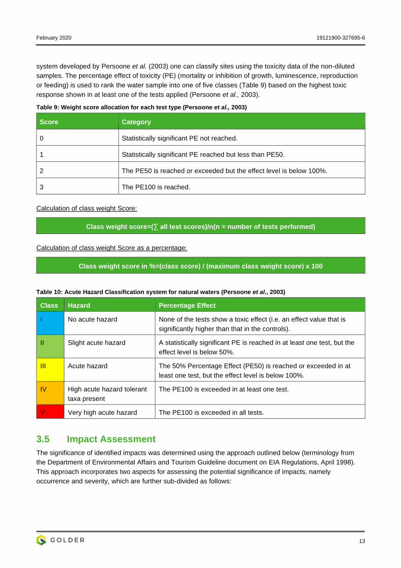
February 2020 19121900-327695-6
13
system developed by Persoone et al. (2003) one can classify sites using the toxicity data of the non-diluted
samples. The percentage effect of toxicity (PE) (mortality or inhibition of growth, luminescence, reproduction
or feeding) is used to rank the water sample into one of five classes (Table 9) based on the highest toxic
response shown in at least one of the tests applied (Persoone et al., 2003).
Table 9: Weight score allocation for each test type (Persoone et al., 2003)
Score Category
0 Statistically significant PE not reached.
1 Statistically significant PE reached but less than PE50.
2 The PE50 is reached or exceeded but the effect level is below 100%.
3 The PE100 is reached.
Calculation of class weight Score:
Class weight score=(∑ all test scores)/n(n = number of tests performed)
Calculation of class weight Score as a percentage:
Class weight score in %=(class score) / (maximum class weight score) x 100
Table 10: Acute Hazard Classification system for natural waters (Persoone et al., 2003)
Class Hazard Percentage Effect
I No acute hazard None of the tests show a toxic effect (i.e. an effect value that is
significantly higher than that in the controls).
II Slight acute hazard A statistically significant PE is reached in at least one test, but the
effect level is below 50%.
III Acute hazard The 50% Percentage Effect (PE50) is reached or exceeded in at
least one test, but the effect level is below 100%.
IV High acute hazard tolerant
taxa present
The PE100 is exceeded in at least one test.
V Very high acute hazard The PE100 is exceeded in all tests.
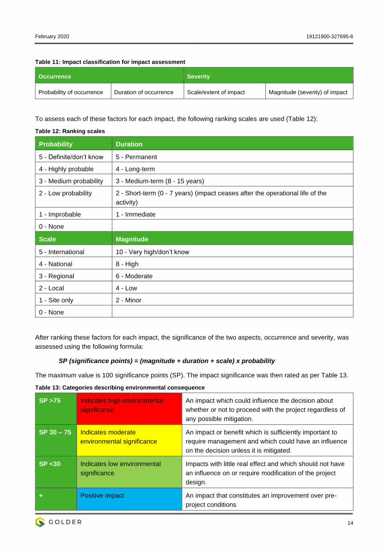
3.5 Impact Assessment
The significance of identified impacts was determined using the approach outlined below (terminology from
the Department of Environmental Affairs and Tourism Guideline document on EIA Regulations, April 1998).
This approach incorporates two aspects for assessing the potential significance of impacts, namely
occurrence and severity, which are further sub-divided as follows:
February 2020 19121900-327695-6
14
Table 11: Impact classification for impact assessment
Occurrence Severity
Probability of occurrence Duration of occurrence Scale/extent of impact Magnitude (severity) of impact
To assess each of these factors for each impact, the following ranking scales are used (Table 12):
Table 12: Ranking scales
Probability Duration
5 - Definite/don’t know 5 - Permanent
4 - Highly probable 4 - Long-term
3 - Medium probability 3 - Medium-term (8 - 15 years)
2 - Low probability 2 - Short-term (0 - 7 years) (impact ceases after the operational life of the
activity)
1 - Improbable 1 - Immediate
0 - None
Scale Magnitude
5 - International 10 - Very high/don’t know
4 - National 8 - High
3 - Regional 6 - Moderate
2 - Local 4 - Low
1 - Site only 2 - Minor
0 - None
After ranking these factors for each impact, the significance of the two aspects, occurrence and severity, was
assessed using the following formula:
SP (significance points) = (magnitude + duration + scale) x probability
The maximum value is 100 significance points (SP). The impact significance was then rated as per Table 13.
Table 13: Categories describing environmental consequence
SP >75 Indicates high environmental
significance
An impact which could influence the decision about
whether or not to proceed with the project regardless of
any possible mitigation.
SP 30 – 75 Indicates moderate
environmental significance
An impact or benefit which is sufficiently important to
require management and which could have an influence
on the decision unless it is mitigated.
SP <30 Indicates low environmental
significance
Impacts with little real effect and which should not have
an influence on or require modification of the project
design.
+ Positive impact An impact that constitutes an improvement over pre-
project conditions
February 2020 19121900-327695-6
15
Although not explicitly included in the criteria tables, there is uncertainty associated with the information and
methods used in an Environmental Impact Assessment (EIA) because of its predictive nature. The certainty
with which an impact analysis can be completed depends on a number of factors including:
Understanding of natural/ecological and socio-economic processes at work now and in the future; and
Understanding of present and future properties of the affected resource.
The level of prediction confidence for an impact analysis will be discussed when there are questions about the
factors reviewed above. Where the level of prediction confidence makes a prediction of the impact
problematic, a subjective assessment is made based on the available information, the applicability of
information on surrogates and on professional opinion.
The level of prediction confidence is sufficiently low in some cases that an estimate of environmental
consequence cannot be made with a sufficient degree of confidence. Undetermined ratings are accompanied
by recommendations for research or monitoring to provide more data in the future.
3.6 Mitigation and monitoring
Recommendations for control and/or mitigation measures were made in response to the impacts identified.
4.0 APPLICABLE LEGISLATION, STANDARDS, AND GUIDELINES
The following national and provincial legislation were consulted during the study:
▪ National Environmental Management Act (NEMA) (Act No. 107 of 1998);
▪ National Environmental Management: Biodiversity Act (NEMBA) (Act No. 10 of 2004);
▪ Environment Conservation Act (ECA) (Act No. 73 of 1989);
▪ Conservation of Agricultural Resources Act (CARA) (Act No. 43 of 1983);
▪ National Forests Act (NFA) (Act No. 84 of 1998); and
▪ Gauteng Nature Conservation Ordinance (Ordinance 12 of 1983).
5.0 BASELINE ASSESSMENT
5.1 Terrestrial Ecology
5.1.1 Regional Ecological Setting
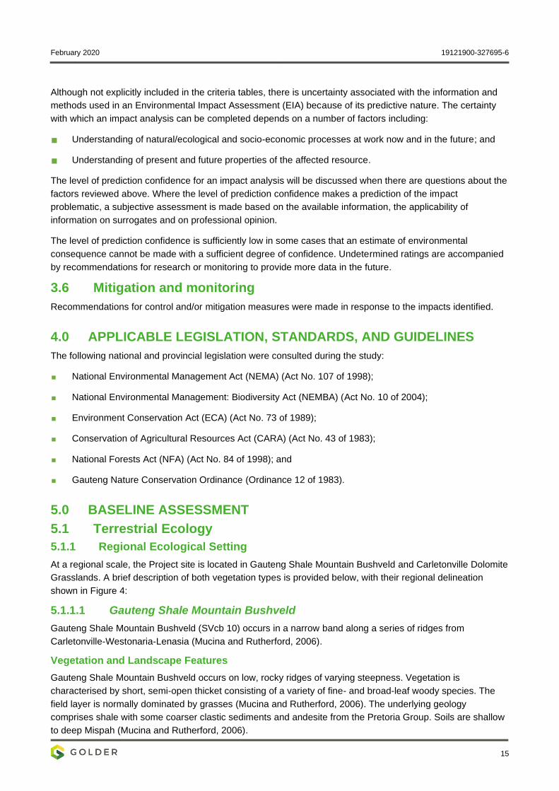
At a regional scale, the Project site is located in Gauteng Shale Mountain Bushveld and Carletonville Dolomite
Grasslands. A brief description of both vegetation types is provided below, with their regional delineation
shown in Figure 4:
5.1.1.1 Gauteng Shale Mountain Bushveld
Gauteng Shale Mountain Bushveld (SVcb 10) occurs in a narrow band along a series of ridges from
Carletonville-Westonaria-Lenasia (Mucina and Rutherford, 2006).
Vegetation and Landscape Features
Gauteng Shale Mountain Bushveld occurs on low, rocky ridges of varying steepness. Vegetation is
characterised by short, semi-open thicket consisting of a variety of fine- and broad-leaf woody species. The
field layer is normally dominated by grasses (Mucina and Rutherford, 2006). The underlying geology
comprises shale with some coarser clastic sediments and andesite from the Pretoria Group. Soils are shallow
to deep Mispah (Mucina and Rutherford, 2006).
February 2020 19121900-327695-6
16
Important Plant Taxa
Based on Mucina and Rutherford (2006) vegetation classification, important plant taxa are those species that
have a high abundance, a frequent occurrence (not being particularly abundant) or are prominent in the
landscape within a particular vegetation type. They recognise the following species as important taxa in
Gauteng Shale Mountain Bushveld:
Trees: Dombeya rotundifolia, Celtis africana, Combretum molle, Cussonia spicata, Englerophytum
magalismontanum, Protea caffra, Rhus leptodictya, Vangueria infausta, Vachellia caffra, V. karroo,
Zanthoxylum capense and Ziziphus mucronata.
Shrubs: Asparagus laricinus, Canthium gilfillanii, Chrysanthemoides monilifera, Dichrostachys cinerea,
Diospyros austro-africana, Diospyros lycioides subsp. lycioides, Ehretia rigida subsp. rigida, Grewia
occidentalis, Gymnosporia polyacantha and Olea europaea.
Grasses: Hyparrhenia dregeana, Cymbopogon caesius, Digitaria eriantha and Eragrostis curvula.
Herbs: Dicoma zeyheri, Helichrysum nudifolium, H. rugulosum, Hermannia lancifolia, Selaginella dregei,
Senecio venosus, Vernonia natalensis, Vernonia oligocephala, Cheilanthes hirta, Pellaea calomelanos and
Scadoxus puniceus.
5.1.1.2 Carletonville Dolomite Grassland
Carletonville Dolomite Grasslands (Gh15) are predominantly found in the North West Province, in the regions
around Potchefstroom, Ventersdorp and Carletonville.
Vegetation and Landscape Features
Carletonville Dolomite Grasslands occur on slightly undulating plains which are typically intersected by rocky
chert ridges. They are species rich and according to Mucina and Rutherford (2006), dominated by many plant
species.
Important Plant Taxa
Grasses: Aristida congesta, Brachiaria serrata, Cynodon dactylon, Digitaria tricholaenoides, Diheteropogon
amplectens, Eragrostis chloromelas, E. racemosa, Heteropogon contortus, Loudetia simplex, Schizachyrium
sanguineum, Setaria sphacelata, Themeda triandra and Alloteropsis semialata.
Herbs: Acalypha angusta, Barleria macrostegia, Chamaecrista mimosoides, Chamaesyce inaequilatera,
Crabbea angustifolia, Dianthus mooiensis, Dicoma anomala, Helichrysum caespititium, H. miconiifolium, H.
nudifolium, Ipomoea ommaneyi, Kyphocarpa angustifolia and Senecio coronatus.
Shrubs: Anthospermum rigidum, Indigofera comosa, Pygmaeothamnus zeyheri, Englerophytum
magalismontana, Tylosema esculentum and Ziziphus zeyheriana.
February 2020 19121900-327695-6
17
Figure 4: Proposed pipeline corridor in relation to Mucina and Rutherford’s (2006) regional vegetation types
February 2020 19121900-327695-6
18
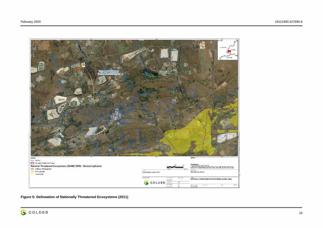
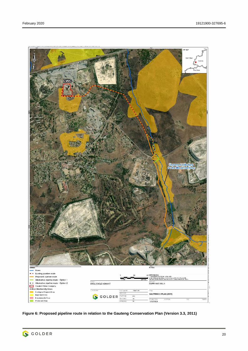
5.1.2 National and Provincial Conservation Context
At a national level, no threatened ecosystems are present in the immediate landscape (Figure 5). At a
provincial level, the Gauteng Conservation Plan classifies most of the habitat along the unnamed tributary to
the Mooirivierloop adjacent to the proposed pipeline corridor as ‘Ecological Support Areas’. Several other
Ecological Support Areas are present in the surrounding landscape, while lands to the north-west of the
pipeline’s northern end-point is a designated ‘important area’ (shown in Figure 5) (Gauteng C-Plan V3.3,
2011).
The proposed pipeline corridor intersects four patches of land designated as ‘Ecological Support Area’
(Figure 6).
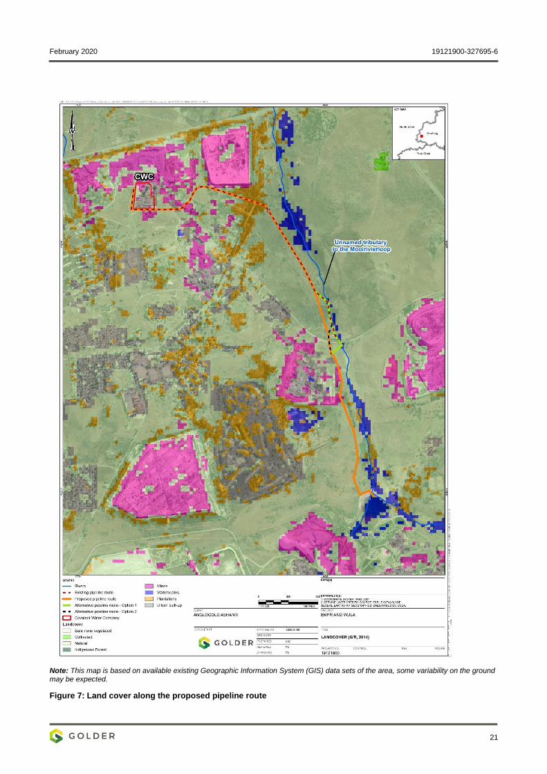
5.1.3 Landscape Context and Land Cover
The proposed pipeline will be approximately 5.1 km long and will orientate in southerly direction from
Blyvooruitzicht Mine to North Boundary dam. About 3.3 km of the proposed pipeline will be routed through an
existing pipeline servitude, with the remaining 1.8 km routed across greenfield properties. The unnamed
tributary to the Mooirivierloop runs parallel to the pipeline along much of its proposed length.
Land cover imagery classifies most land along the proposed pipeline route as ‘natural’, with the remaining
small parcels of land classified as ‘mines’, ‘plantations’ and ‘waterbodies’ – shown in Figure 7. Across the
border landscape, most of the land to the east of the pipeline corridor is open and classified as ‘natural’. Land
to the west of the pipeline corridor is largely developed and comprises residential areas, a golf course, and
various mines and related facilities that are interspersed by pockets of natural habitat and alien wood
plantations.
February 2020 19121900-327695-6
19
Figure 5: Delineation of Nationally Threatened Ecosystems (2011)
February 2020 19121900-327695-6
20
Figure 6: Proposed pipeline route in relation to the Gauteng Conservation Plan (Version 3.3, 2011)
February 2020 19121900-327695-6
21
Note: This map is based on available existing Geographic Information System (GIS) data sets of the area, some variability on the ground may be expected.
Figure 7: Land cover along the proposed pipeline route
February 2020 19121900-327695-6
22
5.2 Flora Assessment
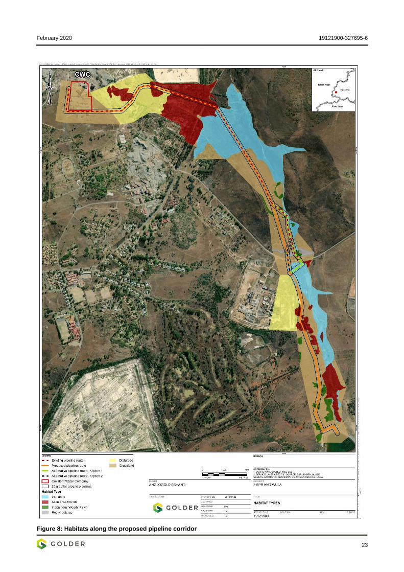
5.2.1 Habitat Units
Habitat types along the proposed pipeline corridor include both grassland and woodland. These display
varying degree of anthropogenic disturbance, from relatively undisturbed to highly modified. A notable feature
is a small rocky outcrop. This runs perpendicular to the pipeline corridor and the unnamed tributary to the
Mooirivierloop and bisects these immediately north of the unnamed tar road, at the midpoint of the proposed
pipeline route. The rocky outcrop is grass dominated, with small pockets of woody vegetation. A brief
discussion of these main habitat types, with accompanying photographs, is provided below, along with a
habitat map in Figure 8.
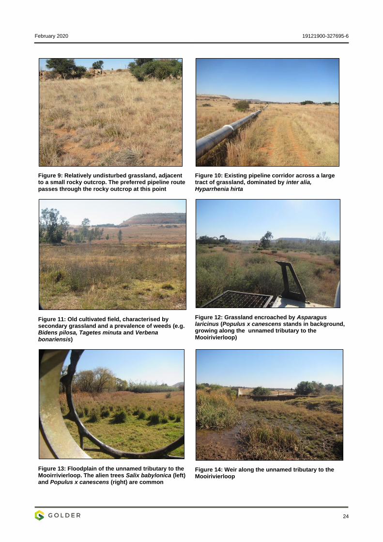
5.2.1.1 Grassland Habitats
Grassland habitats include dry terrestrial grassland and moist grassland (wetland) – refer to section 5.4 for
more detail on wetland habitats.
Terrestrial grasslands range from relatively undisturbed grassland (typically associated with rocky habitats -
Figure 9), to areas of secondary grassland. The latter have been subject to historic overgrazing alien species
encroachment, and other forms of physical disturbances (e.g. historic earthworks and agriculture). Several
species are common in disturbed grassland, including the thatching grass Hyparrhenia hirta (Figure 10) and
various Eragrostis species. In less disturbed grassland, Themeda triandra amongst others, is abundant.
Weedy forbs, such as Bidens pilosa, Verbena bonariensis and Tagetes minuta are common in areas that have
been physically disturbed (shown in Figure 11), while the multi-stemmed shrub Asparagus laricinus
(Figure 12) and the smaller Seriphium plumosa are prevalent in areas that have ostensibly been heavily
grazed in the past. In terms of larger woody taxa, scattered Vachellia karroo, and alien Acacia and Eucalyptus
trees are present throughout the drier grassland habitats.
Moist grassland habitats are mainly found along the unnamed tributary to the Mooirivierloop. The unnamed
tributary to the Mooirivierloop is characterised by a fairly broad river corridor/floodplain. Portions of the river
corridor are infested by the alien invasive Populus x canescens and scattered Salix babylonica trees (Figure
13, also refer to section 5.2.1.2). Remaining areas are characterised by fairly open, wetland habitat dominated
by various Cyperaceae species (sedges), grasses/reeds like Paspalum urvillei, Eragrostis gummiflua and
Phragmites australis, and the rush Typha capensis (Figure 13 and Figure 14). For a list of plant species
recorded during the field visit refer to APPENDIX B.
February 2020 19121900-327695-6
23
Figure 8: Habitats along the proposed pipeline corridor
February 2020 19121900-327695-6
24
Figure 9: Relatively undisturbed grassland, adjacent to a small rocky outcrop. The preferred pipeline route
passes through the rocky outcrop at this point
Figure 10: Existing pipeline corridor across a large tract of grassland, dominated by inter alia,
Hyparrhenia hirta
Figure 11: Old cultivated field, characterised by secondary grassland and a prevalence of weeds (e.g. Bidens pilosa, Tagetes minuta and Verbena
bonariensis)
Figure 12: Grassland encroached by Asparagus laricinus (Populus x canescens stands in background, growing along the unnamed tributary to the
Mooirivierloop)
Figure 13: Floodplain of the unnamed tributary to the Mooirrivierloop. The alien trees Salix babylonica (left) and Populus x canescens (right) are common
Figure 14: Weir along the unnamed tributary to the Mooirivierloop
February 2020 19121900-327695-6
25
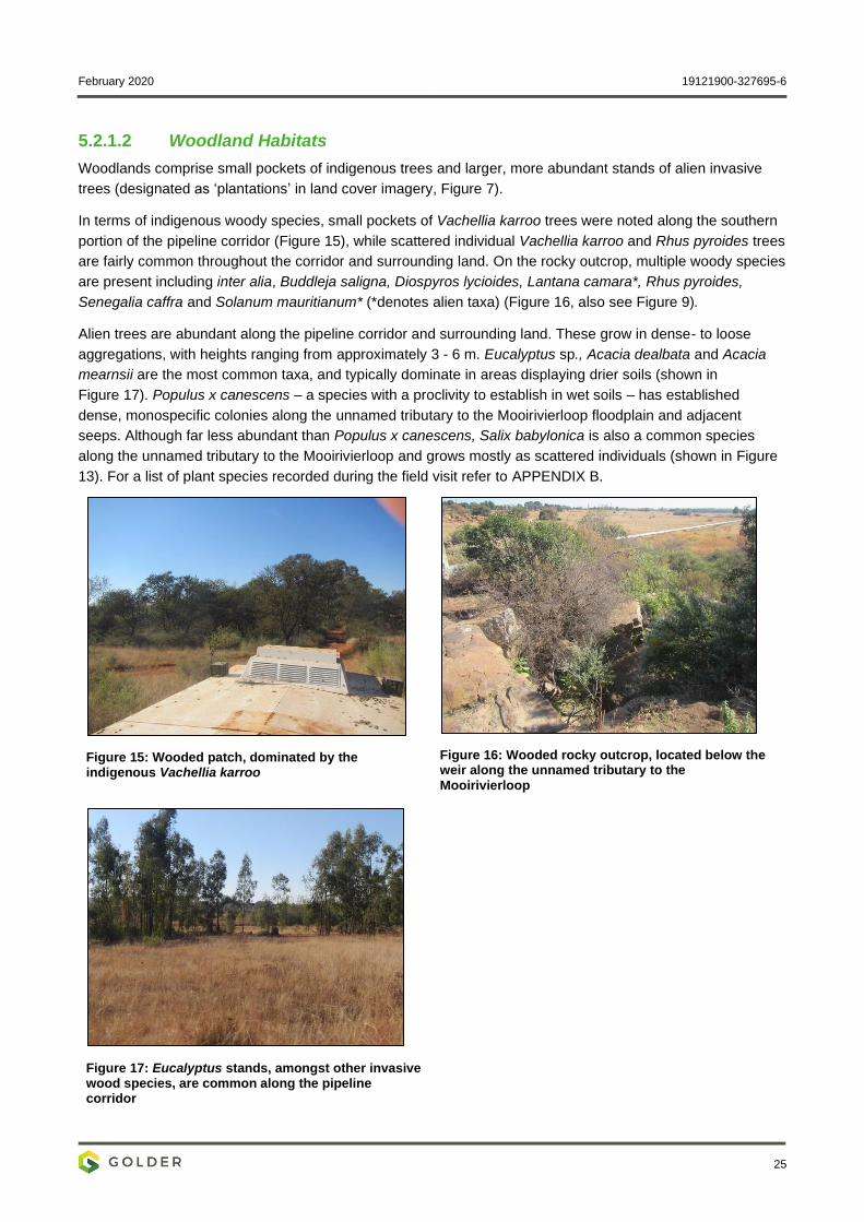
5.2.1.2 Woodland Habitats
Woodlands comprise small pockets of indigenous trees and larger, more abundant stands of alien invasive
trees (designated as ‘plantations’ in land cover imagery, Figure 7).
In terms of indigenous woody species, small pockets of Vachellia karroo trees were noted along the southern
portion of the pipeline corridor (Figure 15), while scattered individual Vachellia karroo and Rhus pyroides trees
are fairly common throughout the corridor and surrounding land. On the rocky outcrop, multiple woody species
are present including inter alia, Buddleja saligna, Diospyros lycioides, Lantana camara*, Rhus pyroides,
Senegalia caffra and Solanum mauritianum* (*denotes alien taxa) (Figure 16, also see Figure 9).
Alien trees are abundant along the pipeline corridor and surrounding land. These grow in dense- to loose
aggregations, with heights ranging from approximately 3 - 6 m. Eucalyptus sp., Acacia dealbata and Acacia
mearnsii are the most common taxa, and typically dominate in areas displaying drier soils (shown in
Figure 17). Populus x canescens – a species with a proclivity to establish in wet soils – has established
dense, monospecific colonies along the unnamed tributary to the Mooirivierloop floodplain and adjacent
seeps. Although far less abundant than Populus x canescens, Salix babylonica is also a common species
along the unnamed tributary to the Mooirivierloop and grows mostly as scattered individuals (shown in Figure
13). For a list of plant species recorded during the field visit refer to APPENDIX B.
Figure 15: Wooded patch, dominated by the indigenous Vachellia karroo
Figure 16: Wooded rocky outcrop, located below the weir along the unnamed tributary to the
Mooirivierloop
Figure 17: Eucalyptus stands, amongst other invasive wood species, are common along the pipeline corridor
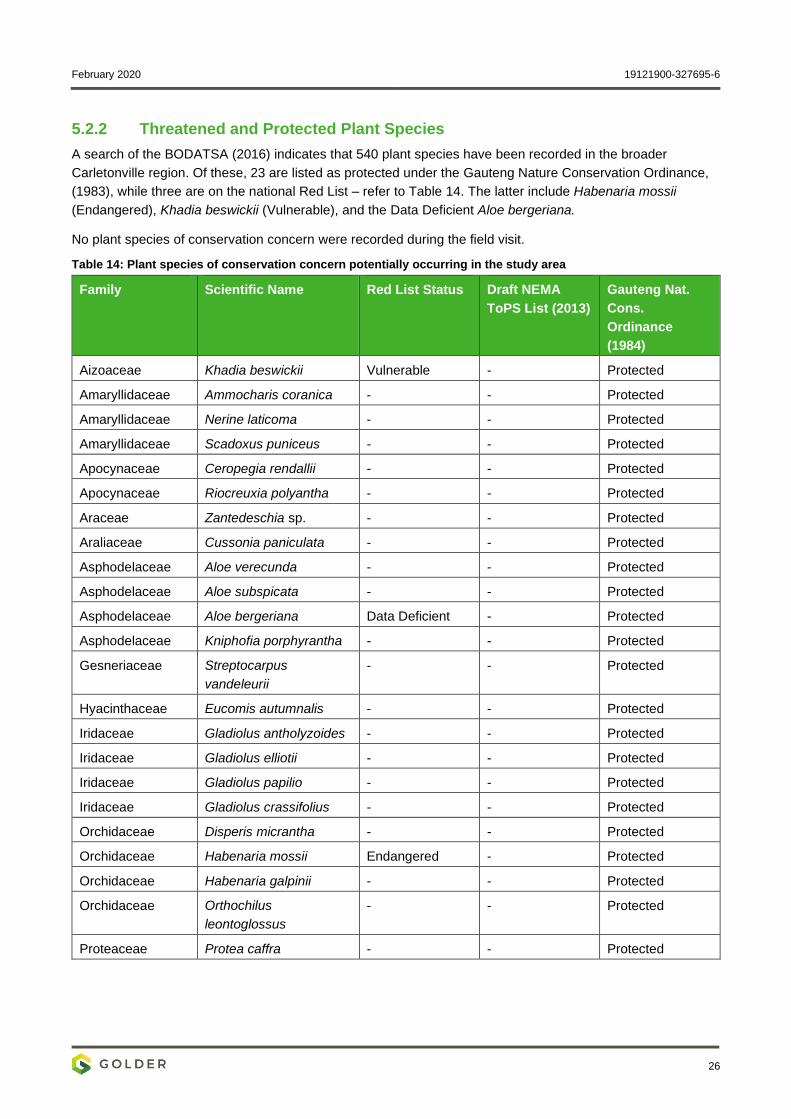
February 2020 19121900-327695-6
26
5.2.2 Threatened and Protected Plant Species
A search of the BODATSA (2016) indicates that 540 plant species have been recorded in the broader
Carletonville region. Of these, 23 are listed as protected under the Gauteng Nature Conservation Ordinance,
(1983), while three are on the national Red List – refer to Table 14. The latter include Habenaria mossii
(Endangered), Khadia beswickii (Vulnerable), and the Data Deficient Aloe bergeriana.
No plant species of conservation concern were recorded during the field visit.
Table 14: Plant species of conservation concern potentially occurring in the study area
Family Scientific Name Red List Status Draft NEMA
ToPS List (2013)
Gauteng Nat.
Cons.
Ordinance
(1984)
Aizoaceae Khadia beswickii Vulnerable - Protected
Amaryllidaceae Ammocharis coranica - - Protected
Amaryllidaceae Nerine laticoma - - Protected
Amaryllidaceae Scadoxus puniceus - - Protected
Apocynaceae Ceropegia rendallii - - Protected
Apocynaceae Riocreuxia polyantha - - Protected
Araceae Zantedeschia sp. - - Protected
Araliaceae Cussonia paniculata - - Protected
Asphodelaceae Aloe verecunda - - Protected
Asphodelaceae Aloe subspicata - - Protected
Asphodelaceae Aloe bergeriana Data Deficient - Protected
Asphodelaceae Kniphofia porphyrantha - - Protected
Gesneriaceae Streptocarpus
vandeleurii
- - Protected
Hyacinthaceae Eucomis autumnalis - - Protected
Iridaceae Gladiolus antholyzoides - - Protected
Iridaceae Gladiolus elliotii - - Protected
Iridaceae Gladiolus papilio - - Protected
Iridaceae Gladiolus crassifolius - - Protected
Orchidaceae Disperis micrantha - - Protected
Orchidaceae Habenaria mossii Endangered - Protected
Orchidaceae Habenaria galpinii - - Protected
Orchidaceae Orthochilus
leontoglossus
- - Protected
Proteaceae Protea caffra - - Protected
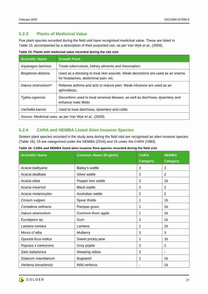
February 2020 19121900-327695-6
27
5.2.3 Plants of Medicinal Value
Five plant species recorded during the field visit have recognised medicinal value. These are listed in
Table 15, accompanied by a description of their purported use, as per Van Wyk et al., (2009).
Table 15: Plants with medicinal value recorded during the site visit
Scientific Name Growth Form
Asparagus laricinus Treats tuberculosis, kidney aliments and rheumatism.
Boophone disticha Used as a dressing to treat skin wounds. Weak decoctions are used as an enema
for headaches, abdominal pain, etc.
Datura stramonium* Relieves asthma and acts to reduce pain. Weak infusions are used as an
aphrodisiac.
Typha capensis Decoctions used to treat venereal disease, as well as diarrhoea, dysentery and
enhance male libido.
Vachellia karroo Used to treat diarrhoea, dysentery and colds.
Source: Medicinal uses, as per Van Wyk et al., (2009).
5.2.4 CARA and NEMBA Listed Alien Invasive Species
Sixteen plant species recorded in the study area during the field visit are recognised as alien invasive species
(Table 16); 15 are categorised under the NEMBA (2016) and 15 under the CARA (1983).
Table 16: CARA and NEMBA listed alien invasive flora species recorded during the field visit
Scientific Name Common Name (English) CARA
Category
NEMBA
Category
Acacia baileyana Bailey’s wattle 3 3
Acacia dealbata Silver wattle 2 2
Acacia elata Pepper tree wattle 3 1b
Acacia mearnsii Black wattle 2 2
Acacia melanoxylon Australian wattle 2 2
Cirsium vulgare Spear thistle 1 1b
Cortaderia selloana Pampas grass 1 1b
Datura stramonium Common thorn apple 1 1b
Eucalyptus sp. Gum 2 1b
Lantana camara Lantana 1 1b
Morus cf alba Mulberry 3 3
Opuntia ficus-indica Sweet prickly pear 1 1b
Populus x canescens Grey poplar 2 2
Salix babylonica Weeping willow 2 -
Solanum mauritianum Bugweed 1 1b
Verbena bonariensis Wild verbena - 1b
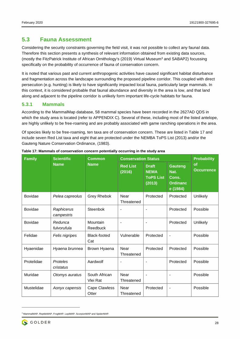
February 2020 19121900-327695-6
28
5.3 Fauna Assessment
Considering the security constraints governing the field visit, it was not possible to collect any faunal data.
Therefore this section presents a synthesis of relevant information obtained from existing data sources,
(mostly the FitzPatrick Institute of African Ornithology's (2019) Virtual Museum3 and SABAP2) focussing
specifically on the probability of occurrence of fauna of conservation concern.
It is noted that various past and current anthropogenic activities have caused significant habitat disturbance
and fragmentation across the landscape surrounding the proposed pipeline corridor. This coupled with direct
persecution (e.g. hunting) is likely to have significantly impacted local fauna, particularly large mammals. In
this context, it is considered probable that faunal abundance and diversity in the area is low, and that land
along and adjacent to the pipeline corridor is unlikely form important life-cycle habitats for fauna.
5.3.1 Mammals
According to the MammalMap database, 58 mammal species have been recorded in the 2627AD QDS in
which the study area is located (refer to APPENDIX C). Several of these, including most of the listed antelope,
are highly unlikely to be free-roaming and are probably associated with game ranching operations in the area.
Of species likely to be free-roaming, ten taxa are of conservation concern. These are listed in Table 17 and
include seven Red List taxa and eight that are protected under the NEMBA ToPS List (2013) and/or the
Gauteng Nature Conservation Ordinance, (1983).
Table 17: Mammals of conservation concern potentially occurring in the study area
Family Scientific
Name
Common
Name
Conservation Status Probability
of
Occurrence Red List
(2016)
Draft
NEMA
ToPS List
(2013)
Gauteng
Nat.
Cons.
Ordinanc
e (1984)
Bovidae Pelea capreolus Grey Rhebok Near
Threatened
Protected Protected Unlikely
Bovidae Raphicerus
campestris
Steenbok - - Protected Possible
Bovidae Redunca
fulvorufula
Mountain
Reedbuck
- - Protected Unlikely
Felidae Felis nigripes Black-footed
Cat
Vulnerable Protected - Possible
Hyaenidae Hyaena brunnea Brown Hyaena Near
Threatened
Protected Protected Possible
Protelidae Proteles
cristatus
Aardwolf - - Protected Possible
Muridae Otomys auratus South African
Vlei Rat
Near
Threatened
- - Possible
Mustelidae Aonyx capensis Cape Clawless
Otter
Near
Threatened
Protected - Possible
3 MammalMAP, ReptileMAP, FrogMAP, LepiMAP, ScorpionMAP and SpiderMAP.
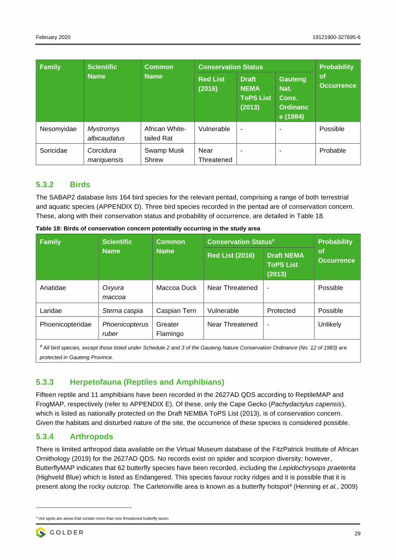
February 2020 19121900-327695-6
29
Family Scientific
Name
Common
Name
Conservation Status Probability
of
Occurrence Red List
(2016)
Draft
NEMA
ToPS List
(2013)
Gauteng
Nat.
Cons.
Ordinanc
e (1984)
Nesomyidae Mystromys
albicaudatus
African White-
tailed Rat
Vulnerable - - Possible
Soricidae Corcidura
mariquensis
Swamp Musk
Shrew
Near
Threatened
- - Probable
5.3.2 Birds
The SABAP2 database lists 164 bird species for the relevant pentad, comprising a range of both terrestrial
and aquatic species (APPENDIX D). Three bird species recorded in the pentad are of conservation concern.
These, along with their conservation status and probability of occurrence, are detailed in Table 18.
Table 18: Birds of conservation concern potentially occurring in the study area
Family Scientific
Name
Common
Name
Conservation Status# Probability
of
Occurrence Red List (2016) Draft NEMA
ToPS List
(2013)
Anatidae Oxyura
maccoa
Maccoa Duck Near Threatened - Possible
Laridae Sterna caspia Caspian Tern Vulnerable Protected Possible
Phoenicopteridae Phoenicopterus
ruber
Greater
Flamingo
Near Threatened - Unlikely
# All bird species, except those listed under Schedule 2 and 3 of the Gauteng Nature Conservation Ordinance (No. 12 of 1983) are
protected in Gauteng Province.
5.3.3 Herpetofauna (Reptiles and Amphibians)
Fifteen reptile and 11 amphibians have been recorded in the 2627AD QDS according to ReptileMAP and
FrogMAP, respectively (refer to APPENDIX E). Of these, only the Cape Gecko (Pachydactylus capensis),
which is listed as nationally protected on the Draft NEMBA ToPS List (2013), is of conservation concern.
Given the habitats and disturbed nature of the site, the occurrence of these species is considered possible.
5.3.4 Arthropods
There is limited arthropod data available on the Virtual Museum database of the FitzPatrick Institute of African
Ornithology (2019) for the 2627AD QDS. No records exist on spider and scorpion diversity; however,
ButterflyMAP indicates that 62 butterfly species have been recorded, including the Lepidochrysops praeterita
(Highveld Blue) which is listed as Endangered. This species favour rocky ridges and it is possible that it is
present along the rocky outcrop. The Carletonville area is known as a butterfly hotspot4 (Henning et al., 2009)
4 Hot spots are areas that contain more than one threatened butterfly taxon.
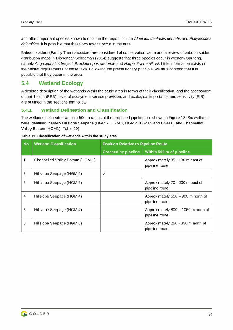
February 2020 19121900-327695-6
30
and other important species known to occur in the region include Aloeides dentastis dentatis and Platylesches
dolomitica. It is possible that these two taxons occur in the area.
Baboon spiders (Family Theraphosidae) are considered of conservation value and a review of baboon spider
distribution maps in Dippenaar-Schoeman (2014) suggests that three species occur in western Gauteng,
namely Augacephalus breyeri, Brachionopus pretoriae and Harpactira hamiltoni. Little information exists on
the habitat requirements of these taxa. Following the precautionary principle, we thus contend that it is
possible that they occur in the area.
5.4 Wetland Ecology
A desktop description of the wetlands within the study area in terms of their classification, and the assessment
of their health (PES), level of ecosystem service provision, and ecological importance and sensitivity (EIS),
are outlined in the sections that follow.
5.4.1 Wetland Delineation and Classification
The wetlands delineated within a 500 m radius of the proposed pipeline are shown in Figure 18. Six wetlands
were identified, namely Hillslope Seepage (HGM 2, HGM 3, HGM 4, HGM 5 and HGM 6) and Channelled
Valley Bottom (HGM1) (Table 19).
Table 19: Classification of wetlands within the study area
No. Wetland Classification Position Relative to Pipeline Route
Crossed by pipeline Within 500 m of pipeline
1 Channelled Valley Bottom (HGM 1) Approximately 35 - 130 m east of
pipeline route
2 Hillslope Seepage (HGM 2) ✓
3 Hillslope Seepage (HGM 3) Approximately 70 - 200 m east of
pipeline route
4 Hillslope Seepage (HGM 4) Approximately 550 – 900 m north of
pipeline route
5 Hillslope Seepage (HGM 4) Approximately 800 – 1060 m north of
pipeline route
6 Hillslope Seepage (HGM 6) Approximately 250 - 350 m north of
pipeline route
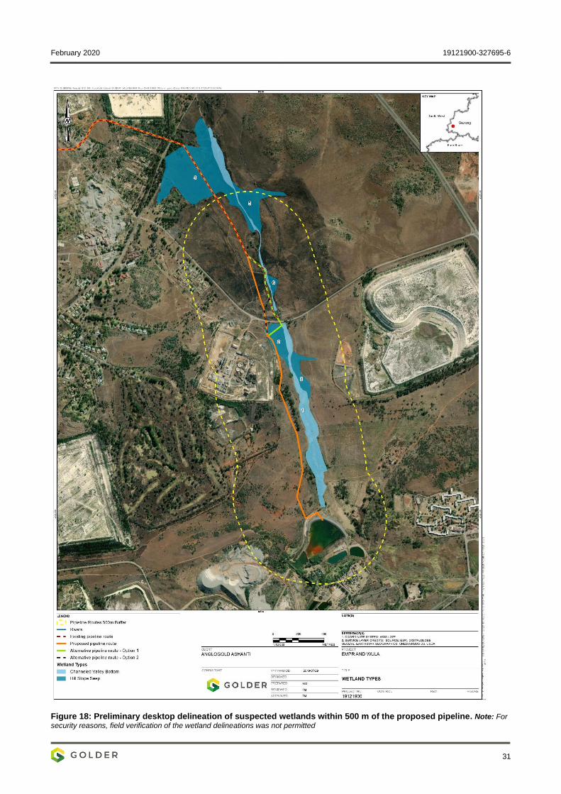
February 2020 19121900-327695-6
31
Figure 18: Preliminary desktop delineation of suspected wetlands within 500 m of the proposed pipeline. Note: For
security reasons, field verification of the wetland delineations was not permitted
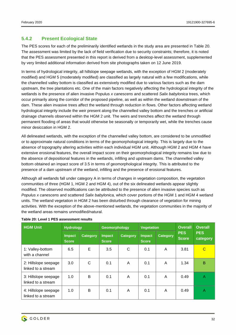
February 2020 19121900-327695-6
32
5.4.2 Present Ecological State
The PES scores for each of the preliminarily identified wetlands in the study area are presented in Table 20.
The assessment was limited by the lack of field verification due to security constraints; therefore, it is noted
that the PES assessment presented in this report is derived from a desktop-level assessment, supplemented
by very limited additional information derived from site photographs taken on 12 June 2019.
In terms of hydrological integrity, all hillslope seepage wetlands, with the exception of HGM 2 (moderately
modified) and HGM 5 (moderately modified) are classified as largely natural with a few modifications, while
the channelled valley bottom is classified as extensively modified due to various factors such as the dam
upstream, the tree plantations etc. One of the main factors negatively affecting the hydrological integrity of the
wetlands is the presence of alien invasive Populus x canescens and scattered Salix babylonica trees, which
occur primarily along the corridor of the proposed pipeline, as well as within the wetland downstream of the
dam. These alien invasive trees affect the wetland through reduction in flows. Other factors affecting wetland
hydrological integrity include the weir present along the channelled valley bottom and the trenches or artificial
drainage channels observed within the HGM 2 unit. The weirs and trenches affect the wetland through
permanent flooding of areas that would otherwise be seasonally or temporarily wet, while the trenches cause
minor desiccation in HGM 2.
All delineated wetlands, with the exception of the channelled valley bottom, are considered to be unmodified
or to approximate natural conditions in terms of the geomorphological integrity. This is largely due to the
absence of topography altering activities within each individual HGM unit. Although HGM 2 and HGM 4 have
extensive erosional features, the overall impact score on their geomorphological integrity remains low due to
the absence of depositional features in the wetlands, infilling and upstream dams. The channelled valley
bottom obtained an impact score of 3.5 in terms of geomorphological integrity. This is attributed to the
presence of a dam upstream of the wetland, infilling and the presence of erosional features.
Although all wetlands fall under category A in terms of changes in vegetation composition, the vegetation
communities of three (HGM 1, HGM 2 and HGM 4), out of the six delineated wetlands appear slightly
modified. The observed modifications can be attributed to the presence of alien invasive species such as
Populus x canescens and scattered Salix babylonica, which cover portions of the HGM 1 and HGM 4 wetland
units. The wetland vegetation in HGM 2 has been disturbed through clearance of vegetation for mining
activities. With the exception of the above-mentioned wetlands, the vegetation communities in the majority of
the wetland areas remains unmodified/natural.
Table 20: Level 1 PES assessment results
HGM Unit Hydrology Geomorphology Vegetation Overall
PES
Score
Overall
PES
category Impact
Score
Category Impact
Score
Category Impact
Score
Category
1: Valley-bottom
with a channel
6.5 E 3.5 C 0.1 A 3.81 C
2: Hillslope seepage
linked to a stream
3.0 C 0.1 A 0.1 A 1.34 B
3: Hillslope seepage
linked to a stream
1.0 B 0.1 A 0.1 A 0.49 A
4: Hillslope seepage
linked to a stream
1.0 B 0.1 A 0.1 A 0.49 A
February 2020 19121900-327695-6
33
HGM Unit Hydrology Geomorphology Vegetation Overall
PES
Score
Overall
PES
category Impact
Score
Category Impact
Score
Category Impact
Score
Category
5: Hillslope seepage
linked to a stream
3.0 C 0.0 A 0.1 A 1.31 B
6: Hillslope seepage
linked to a stream
1.0 B 0.0 A 0.0 A 0.53 A
5.4.3 Ecological Importance and Sensitivity
The EIS scores and categories for the Channelled Valley Bottom wetland (HGM1) and the hillslope seep
(HGM 2) that will be affected by the pipeline are presented in Table 21. The above-mentioned wetlands were
found to be of Low/Marginal EIS.
The low/marginal ecological importance and sensitivity component score is due to the absence of Red Data
species or unique species. The low score for hydro-functional importance reflects the limited role of the
wetland in moderating flooding, stream flow and controlling erosion. The importance in terms of direct human
benefits is limited as there is little evidence to suggest any reliance on this wetland for water supply, crop
production or spiritual services; furthermore, the fraught security situation also makes it less likely that local
people would depend on the wetlands for resources.
Table 21: EIS score and category for the Channelled Valley Bottom (HGM 1) wetland and HGM2 which is being crossed
Component Channelled valley bottom (HGM1) Hillslope seep (HGM 2)
Ecological Importance and Sensitivity 1.0 1.0
Hydro-Functional Importance 1.0 0.9
Direct Human Benefits 0.6 0.4
Overall EIS Score 1.0 1.0
Overall EIS Category Low/Marginal Low/Marginal
5.4.4 Wetland Ecosystem Services
Numerous functions are typically attributed to wetlands, which include nutrient removal, sediment trapping,
flood attenuation and erosion control. Many of these functions attributed to wetlands are wetland type specific
and can be linked to the position of wetlands in the landscape as well as to the way in which water enters and
flows through the wetland. Thus, not all wetlands can be expected to perform all functions, or to perform these
functions with the same efficiency.
Figure 19 and Figure 20 below show the results of the WET-EcoServices assessment conducted for the
Channelled Valley Bottom wetland and the hillslope seepage that will be crossed by the pipeline. The level of
ecosystem services provision was generally assessed as low.
Erosion control scored the highest (intermediate to moderately high), mostly due to the moderate abundance
of vegetation cover buffering the wetland and the expected moderate surface roughness of the wetlands.
Carbon storage and streamflow regulation also obtained intermediate scores.
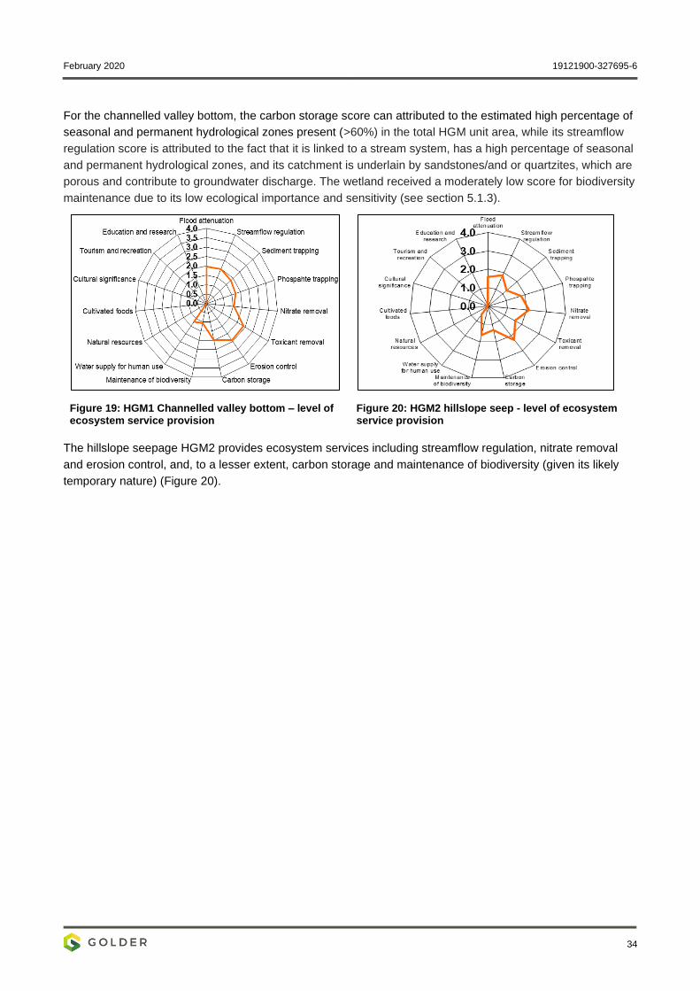
February 2020 19121900-327695-6
34
For the channelled valley bottom, the carbon storage score can attributed to the estimated high percentage of
seasonal and permanent hydrological zones present (>60%) in the total HGM unit area, while its streamflow
regulation score is attributed to the fact that it is linked to a stream system, has a high percentage of seasonal
and permanent hydrological zones, and its catchment is underlain by sandstones/and or quartzites, which are
porous and contribute to groundwater discharge. The wetland received a moderately low score for biodiversity
maintenance due to its low ecological importance and sensitivity (see section 5.1.3).
Figure 19: HGM1 Channelled valley bottom – level of ecosystem service provision
Figure 20: HGM2 hillslope seep - level of ecosystem service provision
The hillslope seepage HGM2 provides ecosystem services including streamflow regulation, nitrate removal
and erosion control, and, to a lesser extent, carbon storage and maintenance of biodiversity (given its likely
temporary nature) (Figure 20).
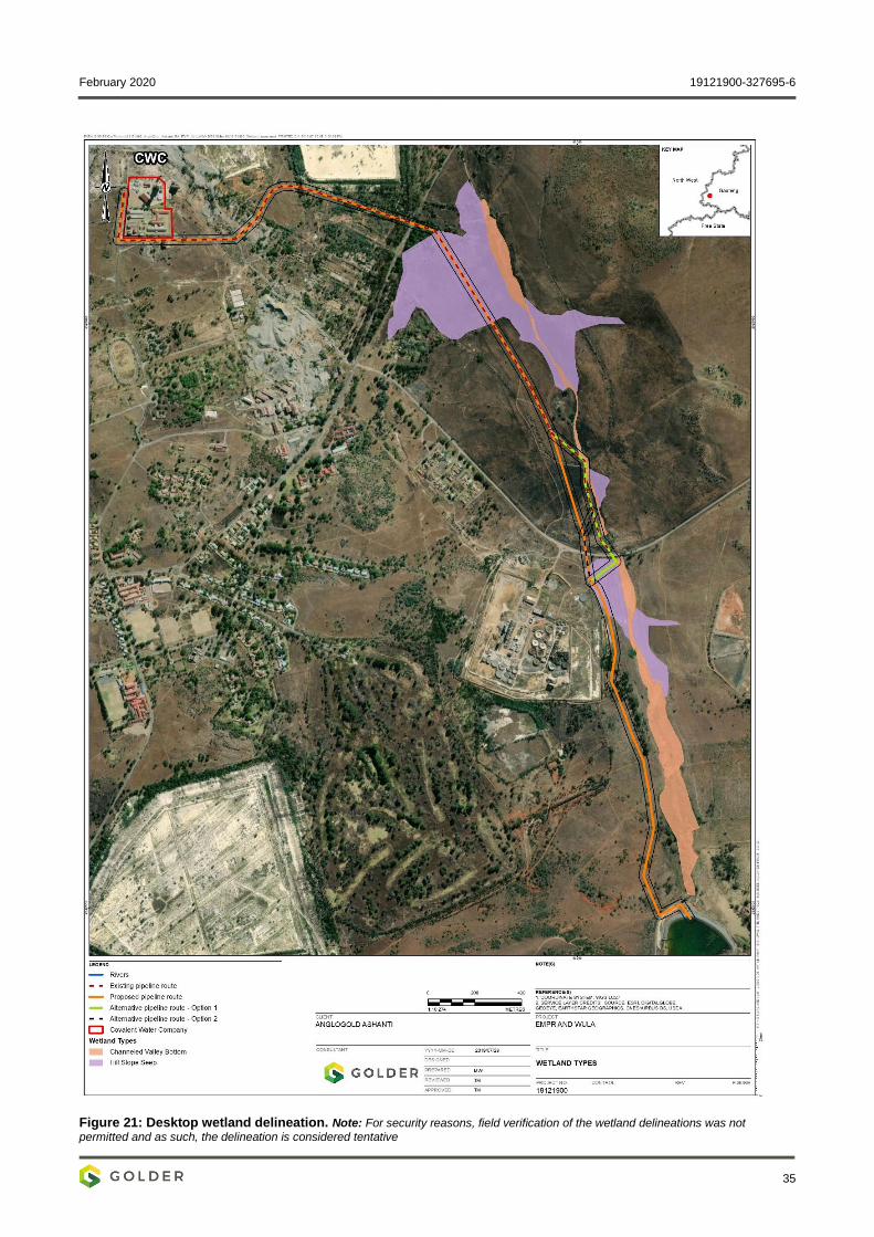
February 2020 19121900-327695-6
35
Figure 21: Desktop wetland delineation. Note: For security reasons, field verification of the wetland delineations was not
permitted and as such, the delineation is considered tentative
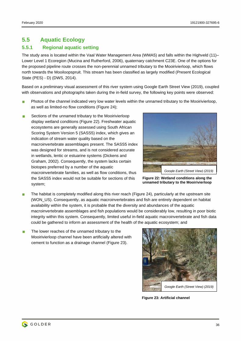
February 2020 19121900-327695-6
36
5.5 Aquatic Ecology
5.5.1 Regional aquatic setting
The study area is located within the Vaal Water Management Area (WMA5) and falls within the Highveld (11)–
Lower Level 1 Ecoregion (Mucina and Rutherford, 2006), quaternary catchment C23E. One of the options for
the proposed pipeline route crosses the non-perennial unnamed tributary to the Mooirivierloop, which flows
north towards the Mooiloopspruit. This stream has been classified as largely modified (Present Ecological
State (PES) - D) (DWS, 2014).
Based on a preliminary visual assessment of this river system using Google Earth Street View (2019), coupled
with observations and photographs taken during the in-field survey, the following key points were observed:
Photos of the channel indicated very low water levels within the unnamed tributary to the Mooirivierloop,
as well as limited-no flow conditions (Figure 24);
Sections of the unnamed tributary to the Mooirivierloop
display wetland conditions (Figure 22). Freshwater aquatic
ecosystems are generally assessed using South African
Scoring System Version 5 (SASS5) index, which gives an
indication of stream water quality based on the
macroinvertebrate assemblages present. The SASS5 index
was designed for streams, and is not considered accurate
in wetlands, lentic or estuarine systems (Dickens and
Graham, 2002). Consequently, the system lacks certain
biotopes preferred by a number of the aquatic
macroinvertebrate families, as well as flow conditions, thus
the SASS5 index would not be suitable for sections of this
system;
Figure 22: Wetland conditions along the unnamed tributary to the Mooirivierloop
The habitat is completely modified along this river reach (Figure 24), particularly at the upstream site
(WON_US). Consequently, as aquatic macroinvertebrates and fish are entirely dependent on habitat
availability within the system, it is probable that the diversity and abundances of the aquatic
macroinvertebrate assemblages and fish populations would be considerably low, resulting in poor biotic
integrity within this system. Consequently, limited useful in-field aquatic macroinvertebrate and fish data
could be gathered to inform an assessment of the health of the aquatic ecosystem; and
The lower reaches of the unnamed tributary to the
Mooirivierloop channel have been artificially altered with
cement to function as a drainage channel (Figure 23).
Figure 23: Artificial channel
Google Earth (Street View) (2019)
Google Earth (Street View) (2019)
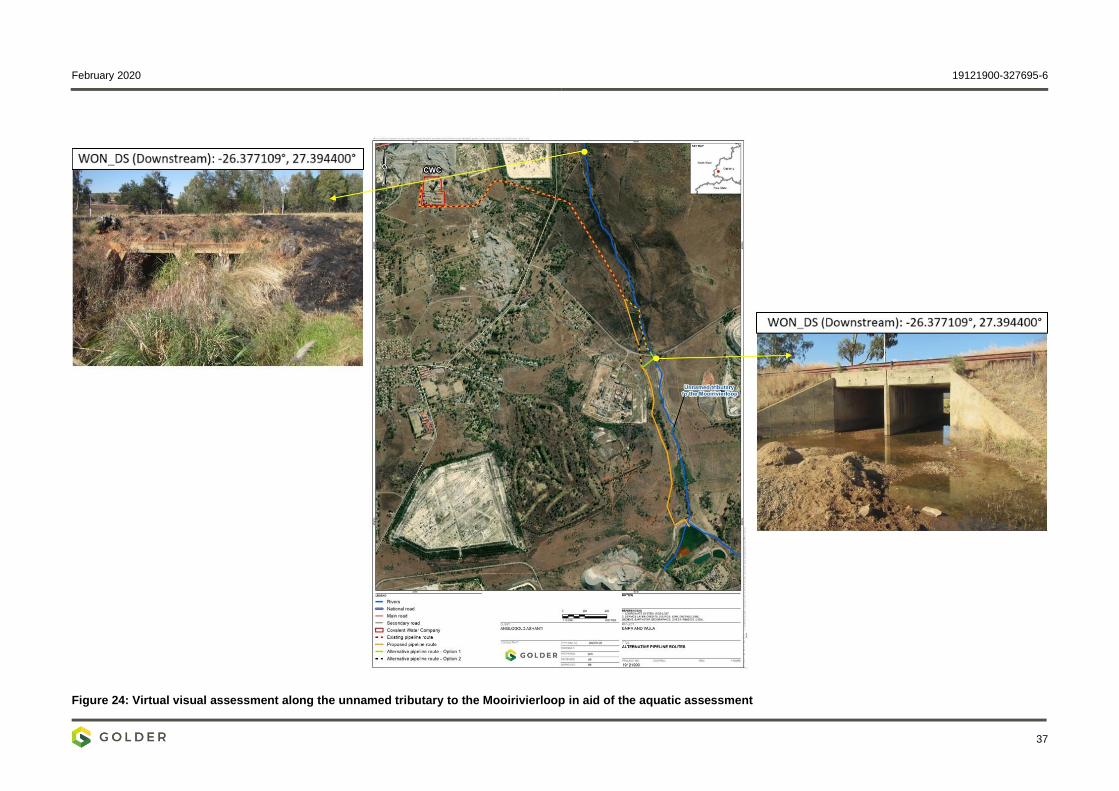
February 2020 19121900-327695-6
37
Figure 24: Virtual visual assessment along the unnamed tributary to the Mooirivierloop in aid of the aquatic assessment
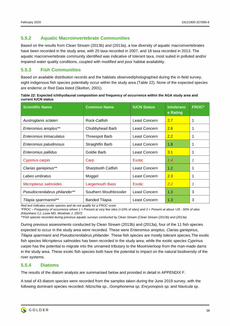
February 2020 19121900-327695-6
38
5.5.2 Aquatic Macroinvertebrate Communities
Based on the results from Clean Stream (2013b) and (2013a), a low diversity of aquatic macroinvertebrates
have been recorded in the study area, with 20 taxa recorded in 2007, and 18 taxa recorded in 2013. The
aquatic macroinvertebrate community identified was indicative of tolerant taxa, most suited in polluted and/or
impaired water quality conditions, coupled with modified and poor habitat availability.
5.5.3 Fish Communities
Based on available distribution records and the habitats observed/photographed during the in-field survey,
eight indigenous fish species potentially occur within the study area (Table 22). None of the expected species
are endemic or Red Data listed (Skelton, 2001).
Table 22: Expected ichthyofaunal composition and frequency of occurrence within the AGA study area and current IUCN status
Scientific Name Common Name IUCN Status Intoleranc
e Rating
FROC*
Austroglanis sclateri Rock-Catfish Least Concern 2.7 1
Enteromius anoplus** Chubbyhead Barb Least Concern 2.6 1
Enteromius trimaculatus Threespot Barb Least Concern 2.2 1
Enteromius paludinosus Straightfin Barb Least Concern 1.8 1
Enteromius pallidus Goldie Barb Least Concern 3.1 1
Cyprinus carpio Carp Exotic 1.4 1
Clarias gariepinus** Sharptooth Catfish Least Concern 1.2 1
Labeo umbratus Moggel Least Concern 2.3 1
Micropterus salmoides Largemouth Bass Exotic 2.2 1
Pseudocrenilabrus philander** Southern Mouthbrooder Least Concern 1.3 3
Tilapia sparrmannii** Banded Tilapia Least Concern 1.3 3
Red text indicates exotic species and do not qualify for a FROC score
*FROC – Frequency of occurrence where 1 = Present at very few sites (<10% of sites) and 3 = Present at about >25 - 50% of sites
(Kleynhans CJ, Louw MD, Moolman J. 2007)
**Fish species recorded during previous aquatic surveys conducted by Clean Stream (Clean Stream (2013b) and (2013a)
During previous assessments conducted by Clean Stream (2013b) and (2013a), four of the 11 fish species
expected to occur in the study area were recorded. These were Enteromius anoplus, Clarias gariepinus,
Tilapia sparrmanii and Pseudocrenilabrus philander. These fish species are mostly tolerant species.The exotic
fish species Micropterus salmoides has been recorded in the study area, while the exotic species Cyprinus
carpio has the potential to migrate into the unnamed tributary to the Mooirivierloop from the man-made dams
in the study area. These exotic fish species both have the potenital to impact on the natural biodiversity of the
river systems.
5.5.4 Diatoms
The results of the diatom analysis are summarised below and provided in detail in APPENDIX F.
A total of 43 diatom species were recorded from the samples taken during the June 2019 survey, with the
following dominant species recorded: Nitzschia sp., Gomphonema sp. Encyonopsis sp. and Navicula sp.
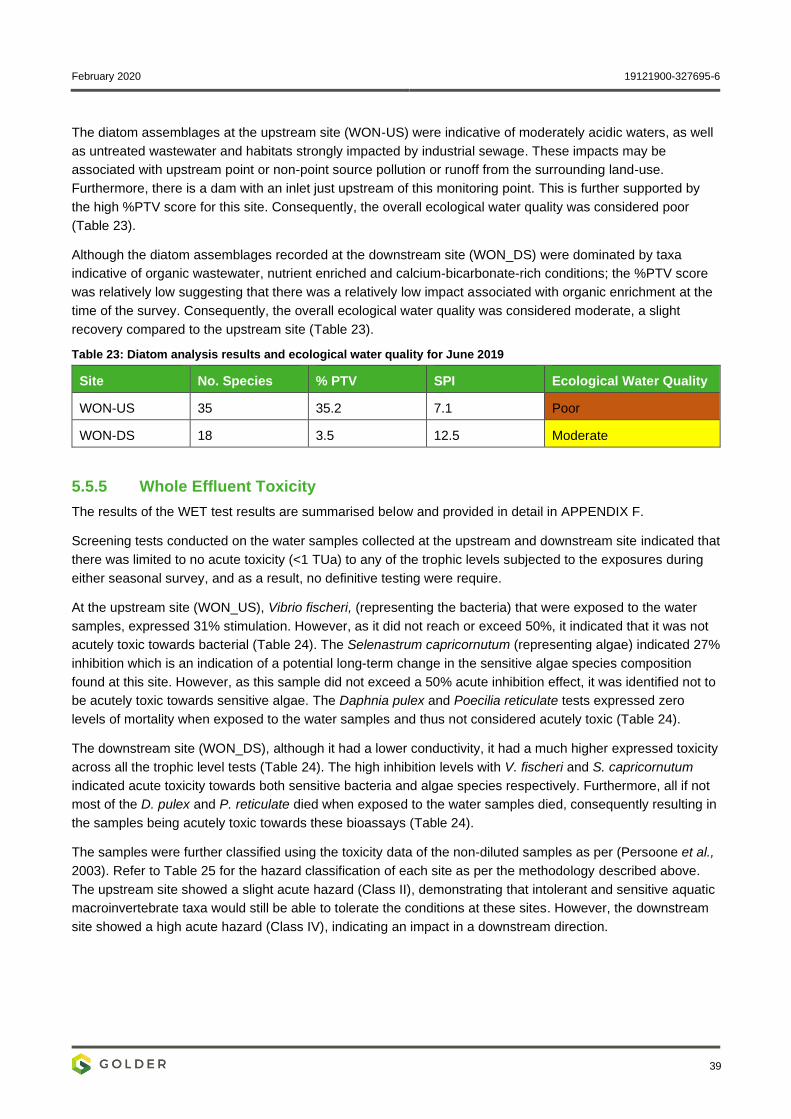
February 2020 19121900-327695-6
39
The diatom assemblages at the upstream site (WON-US) were indicative of moderately acidic waters, as well
as untreated wastewater and habitats strongly impacted by industrial sewage. These impacts may be
associated with upstream point or non-point source pollution or runoff from the surrounding land-use.
Furthermore, there is a dam with an inlet just upstream of this monitoring point. This is further supported by
the high %PTV score for this site. Consequently, the overall ecological water quality was considered poor
(Table 23).
Although the diatom assemblages recorded at the downstream site (WON_DS) were dominated by taxa
indicative of organic wastewater, nutrient enriched and calcium-bicarbonate-rich conditions; the %PTV score
was relatively low suggesting that there was a relatively low impact associated with organic enrichment at the
time of the survey. Consequently, the overall ecological water quality was considered moderate, a slight
recovery compared to the upstream site (Table 23).
Table 23: Diatom analysis results and ecological water quality for June 2019
Site No. Species % PTV SPI Ecological Water Quality
WON-US 35 35.2 7.1 Poor
WON-DS 18 3.5 12.5 Moderate
5.5.5 Whole Effluent Toxicity
The results of the WET test results are summarised below and provided in detail in APPENDIX F.
Screening tests conducted on the water samples collected at the upstream and downstream site indicated that
there was limited to no acute toxicity (<1 TUa) to any of the trophic levels subjected to the exposures during
either seasonal survey, and as a result, no definitive testing were require.
At the upstream site (WON_US), Vibrio fischeri, (representing the bacteria) that were exposed to the water
samples, expressed 31% stimulation. However, as it did not reach or exceed 50%, it indicated that it was not
acutely toxic towards bacterial (Table 24). The Selenastrum capricornutum (representing algae) indicated 27%
inhibition which is an indication of a potential long-term change in the sensitive algae species composition
found at this site. However, as this sample did not exceed a 50% acute inhibition effect, it was identified not to
be acutely toxic towards sensitive algae. The Daphnia pulex and Poecilia reticulate tests expressed zero
levels of mortality when exposed to the water samples and thus not considered acutely toxic (Table 24).
The downstream site (WON_DS), although it had a lower conductivity, it had a much higher expressed toxicity
across all the trophic level tests (Table 24). The high inhibition levels with V. fischeri and S. capricornutum
indicated acute toxicity towards both sensitive bacteria and algae species respectively. Furthermore, all if not
most of the D. pulex and P. reticulate died when exposed to the water samples died, consequently resulting in
the samples being acutely toxic towards these bioassays (Table 24).
The samples were further classified using the toxicity data of the non-diluted samples as per (Persoone et al.,
2003). Refer to Table 25 for the hazard classification of each site as per the methodology described above.
The upstream site showed a slight acute hazard (Class II), demonstrating that intolerant and sensitive aquatic
macroinvertebrate taxa would still be able to tolerate the conditions at these sites. However, the downstream
site showed a high acute hazard (Class IV), indicating an impact in a downstream direction.
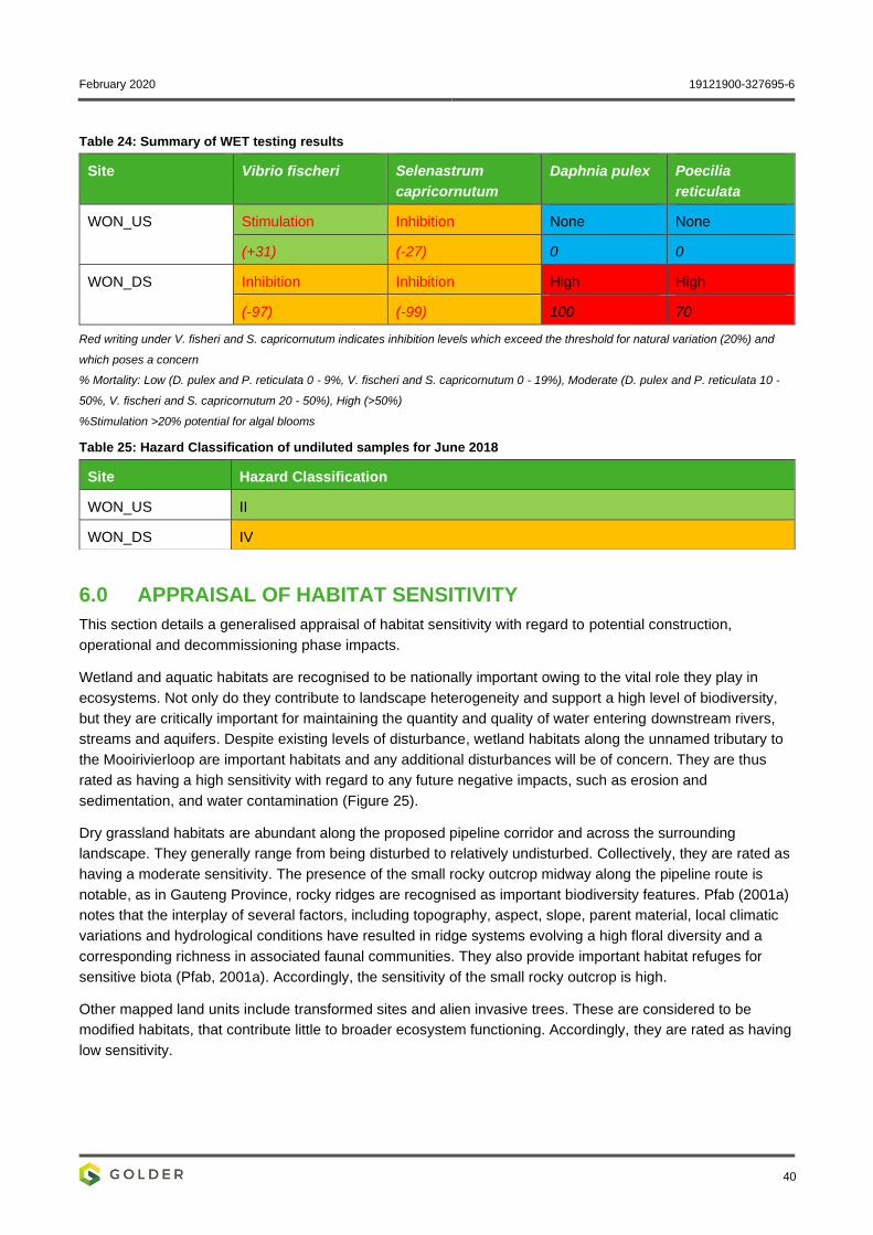
February 2020 19121900-327695-6
40
Table 24: Summary of WET testing results
Site Vibrio fischeri Selenastrum
capricornutum
Daphnia pulex Poecilia
reticulata
WON_US Stimulation Inhibition None None
(+31) (-27) 0 0
WON_DS Inhibition Inhibition High High
(-97) (-99) 100 70
Red writing under V. fisheri and S. capricornutum indicates inhibition levels which exceed the threshold for natural variation (20%) and
which poses a concern
% Mortality: Low (D. pulex and P. reticulata 0 - 9%, V. fischeri and S. capricornutum 0 - 19%), Moderate (D. pulex and P. reticulata 10 -
50%, V. fischeri and S. capricornutum 20 - 50%), High (>50%)
%Stimulation >20% potential for algal blooms
Table 25: Hazard Classification of undiluted samples for June 2018
6.0 APPRAISAL OF HABITAT SENSITIVITY
This section details a generalised appraisal of habitat sensitivity with regard to potential construction,
operational and decommissioning phase impacts.
Wetland and aquatic habitats are recognised to be nationally important owing to the vital role they play in
ecosystems. Not only do they contribute to landscape heterogeneity and support a high level of biodiversity,
but they are critically important for maintaining the quantity and quality of water entering downstream rivers,
streams and aquifers. Despite existing levels of disturbance, wetland habitats along the unnamed tributary to
the Mooirivierloop are important habitats and any additional disturbances will be of concern. They are thus
rated as having a high sensitivity with regard to any future negative impacts, such as erosion and
sedimentation, and water contamination (Figure 25).
Dry grassland habitats are abundant along the proposed pipeline corridor and across the surrounding
landscape. They generally range from being disturbed to relatively undisturbed. Collectively, they are rated as
having a moderate sensitivity. The presence of the small rocky outcrop midway along the pipeline route is
notable, as in Gauteng Province, rocky ridges are recognised as important biodiversity features. Pfab (2001a)
notes that the interplay of several factors, including topography, aspect, slope, parent material, local climatic
variations and hydrological conditions have resulted in ridge systems evolving a high floral diversity and a
corresponding richness in associated faunal communities. They also provide important habitat refuges for
sensitive biota (Pfab, 2001a). Accordingly, the sensitivity of the small rocky outcrop is high.
Other mapped land units include transformed sites and alien invasive trees. These are considered to be
modified habitats, that contribute little to broader ecosystem functioning. Accordingly, they are rated as having
low sensitivity.
Site Hazard Classification
WON_US II
WON_DS IV
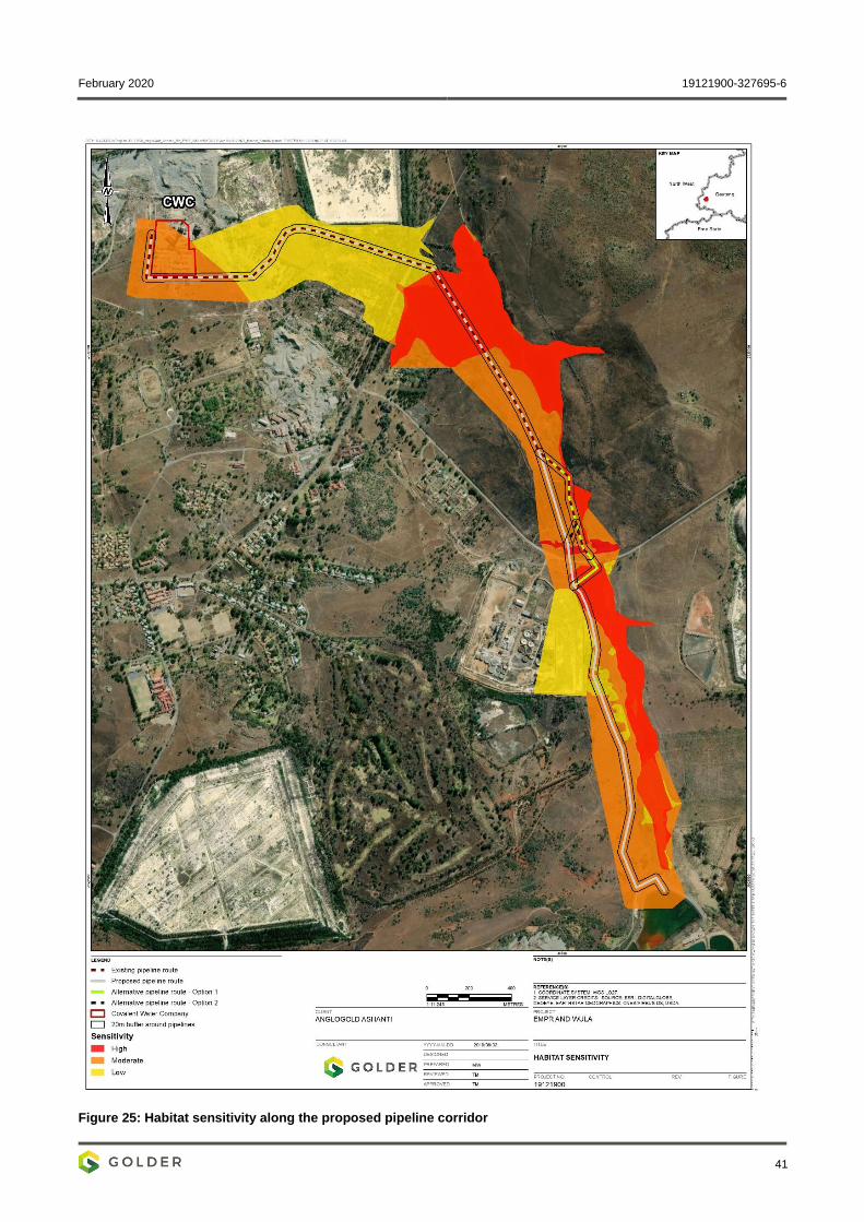
February 2020 19121900-327695-6
41
Figure 25: Habitat sensitivity along the proposed pipeline corridor
February 2020 19121900-327695-6
42
7.0 IMPACT ASSESSMENT
The proposed project activities consist of the construction and operation of a pipeline, which will pump water
from BLV #4 Shaft to the North Boundary Dam. It is understood that the pipeline will be surface mounted and
supported on pre-cast concrete plinths spaced 9 m apart, with the footprint of each plinth being roughly
600 mm x 300 mm. The proposed pipeline will be 400 mm in diameter and the total pipeline route
approximately 5.1 km. The following sections describe the impacts that are expected to occur during various
phases of the project.
7.1 Construction Phase
The impacts directly related to the Construction Phase of the proposed project are outlined below. Table 26
provides a significance rating for each impact before and after mitigation.
7.1.1 Loss and disturbance of natural habitat
Activities that are likely to cause habitat loss/disturbance during the construction phase include:
▪ The establishment of temporary vehicle access tracks and laydown areas for construction material
(e.g. pipes), along the entire proposed length of the pipeline. Associated habitat disturbance is
expected to be limited and short-term - there is an existing vehicle track network along the current
and proposed pipeline corridor which will provide access for construction vehicles; and
▪ Placement of concrete plinths. This is specific to the southern portion of the pipeline. Although
permanent, associated habitat disturbance is expected to be limited as each concrete plinth has a
small footprint and will be placed on ground surface (i.e. no significant earth works or concrete
foundations will be required).
Disturbances to vegetation may also result in other/secondary impacts, such as loss of plant species of
conservation concern, soil erosion and the establishment of alien invasive plants (see section 7.1.4).
This impact is expected to be Negative, of low magnitude, medium-term in duration, and restricted to the sites
where the concrete plinths will be established, resulting in an impact significance of Moderate prior to
mitigation. Provided that the proposed mitigation measures are implemented as part of the construction
phase, the potential impact may be reduced to Low significance.
7.1.2 Loss of plant species of conservation concern
Plant species of conservation concern may be destroyed/damaged during the placement of concrete plinths
and/or the establishment of construction tracks and laydown areas.
This impact is Negative, of high magnitude and immediate in duration. It will however be restricted to the sites
where the concrete plinths will be placed, resulting in an impact significance of Low both prior and after
mitigation. It is important however that the proposed mitigation measures are implemented to avoid any
possible loss of plants of conservation concern.
7.1.3 Soil erosion and sedimentation of the unnamed tributary to the Mooirivierloop
Disturbance to existing vegetation during construction coupled with soil mobilisation, may cause erosion,
which could lead to increases in sediment load in the unnamed tributary to the Mooirivierloop and a reduction
in aquatic ecosystem integrity.
This impact is Negative, of moderate magnitude and medium-term in duration. It may however, extend
beyond the immediate area of development. This results in an impact significance of Moderate prior to
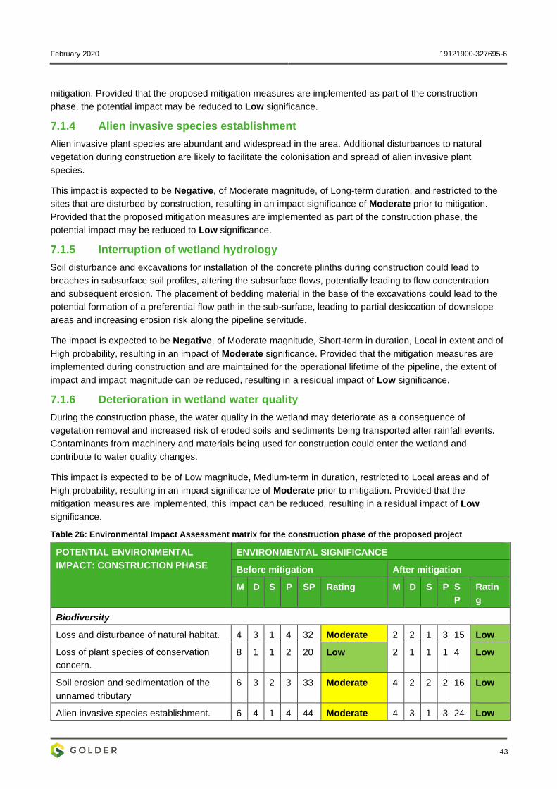
February 2020 19121900-327695-6
43
mitigation. Provided that the proposed mitigation measures are implemented as part of the construction
phase, the potential impact may be reduced to Low significance.
7.1.4 Alien invasive species establishment
Alien invasive plant species are abundant and widespread in the area. Additional disturbances to natural
vegetation during construction are likely to facilitate the colonisation and spread of alien invasive plant
species.
This impact is expected to be Negative, of Moderate magnitude, of Long-term duration, and restricted to the
sites that are disturbed by construction, resulting in an impact significance of Moderate prior to mitigation.
Provided that the proposed mitigation measures are implemented as part of the construction phase, the
potential impact may be reduced to Low significance.
7.1.5 Interruption of wetland hydrology
Soil disturbance and excavations for installation of the concrete plinths during construction could lead to
breaches in subsurface soil profiles, altering the subsurface flows, potentially leading to flow concentration
and subsequent erosion. The placement of bedding material in the base of the excavations could lead to the
potential formation of a preferential flow path in the sub-surface, leading to partial desiccation of downslope
areas and increasing erosion risk along the pipeline servitude.
The impact is expected to be Negative, of Moderate magnitude, Short-term in duration, Local in extent and of
High probability, resulting in an impact of Moderate significance. Provided that the mitigation measures are
implemented during construction and are maintained for the operational lifetime of the pipeline, the extent of
impact and impact magnitude can be reduced, resulting in a residual impact of Low significance.
7.1.6 Deterioration in wetland water quality
During the construction phase, the water quality in the wetland may deteriorate as a consequence of
vegetation removal and increased risk of eroded soils and sediments being transported after rainfall events.
Contaminants from machinery and materials being used for construction could enter the wetland and
contribute to water quality changes.
This impact is expected to be of Low magnitude, Medium-term in duration, restricted to Local areas and of
High probability, resulting in an impact significance of Moderate prior to mitigation. Provided that the
mitigation measures are implemented, this impact can be reduced, resulting in a residual impact of Low
significance.
Table 26: Environmental Impact Assessment matrix for the construction phase of the proposed project
POTENTIAL ENVIRONMENTAL
IMPACT: CONSTRUCTION PHASE
ENVIRONMENTAL SIGNIFICANCE
Before mitigation After mitigation
M D S P SP Rating M D S P S
P
Ratin
g
Biodiversity
Loss and disturbance of natural habitat. 4 3 1 4 32 Moderate 2 2 1 3 15 Low
Loss of plant species of conservation
concern.
8 1 1 2 20 Low 2 1 1 1 4 Low
Soil erosion and sedimentation of the
unnamed tributary
6 3 2 3 33 Moderate 4 2 2 2 16 Low
Alien invasive species establishment. 6 4 1 4 44 Moderate 4 3 1 3 24 Low
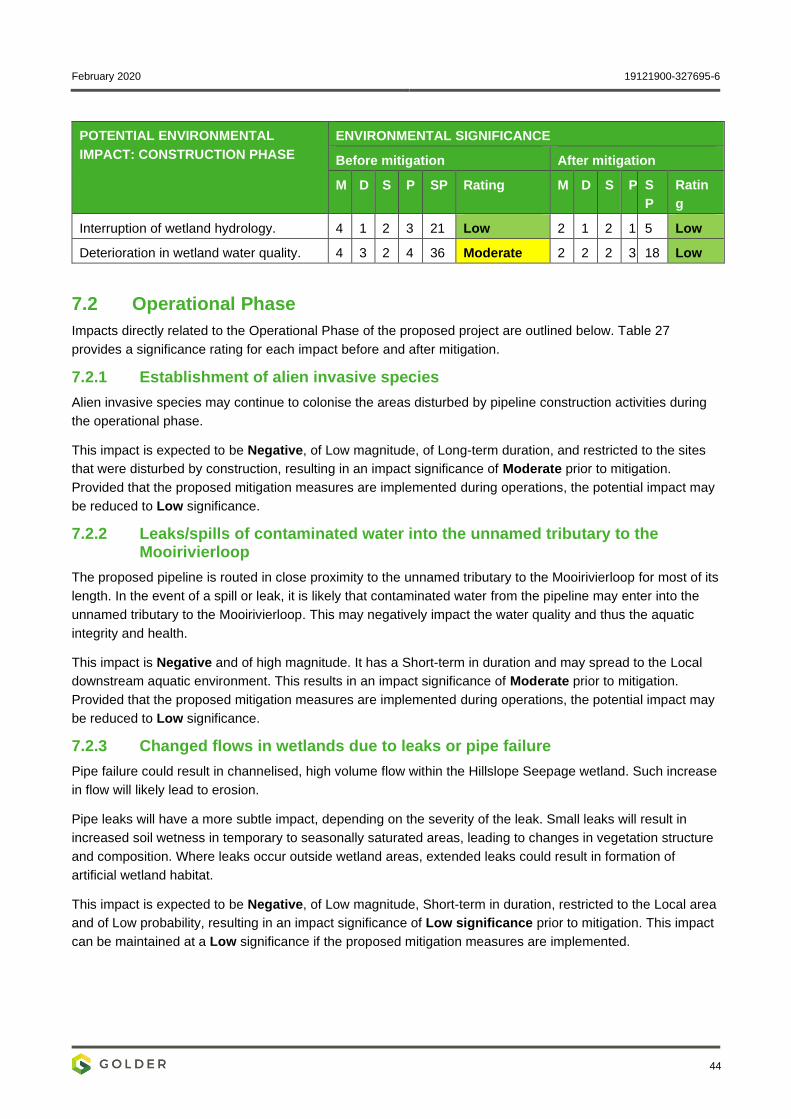
February 2020 19121900-327695-6
44
POTENTIAL ENVIRONMENTAL
IMPACT: CONSTRUCTION PHASE
ENVIRONMENTAL SIGNIFICANCE
Before mitigation After mitigation
M D S P SP Rating M D S P S
P
Ratin
g
Interruption of wetland hydrology. 4 1 2 3 21 Low 2 1 2 1 5 Low
Deterioration in wetland water quality. 4 3 2 4 36 Moderate 2 2 2 3 18 Low
7.2 Operational Phase
Impacts directly related to the Operational Phase of the proposed project are outlined below. Table 27
provides a significance rating for each impact before and after mitigation.
7.2.1 Establishment of alien invasive species
Alien invasive species may continue to colonise the areas disturbed by pipeline construction activities during
the operational phase.
This impact is expected to be Negative, of Low magnitude, of Long-term duration, and restricted to the sites
that were disturbed by construction, resulting in an impact significance of Moderate prior to mitigation.
Provided that the proposed mitigation measures are implemented during operations, the potential impact may
be reduced to Low significance.
7.2.2 Leaks/spills of contaminated water into the unnamed tributary to the Mooirivierloop
The proposed pipeline is routed in close proximity to the unnamed tributary to the Mooirivierloop for most of its
length. In the event of a spill or leak, it is likely that contaminated water from the pipeline may enter into the
unnamed tributary to the Mooirivierloop. This may negatively impact the water quality and thus the aquatic
integrity and health.
This impact is Negative and of high magnitude. It has a Short-term in duration and may spread to the Local
downstream aquatic environment. This results in an impact significance of Moderate prior to mitigation.
Provided that the proposed mitigation measures are implemented during operations, the potential impact may
be reduced to Low significance.
7.2.3 Changed flows in wetlands due to leaks or pipe failure
Pipe failure could result in channelised, high volume flow within the Hillslope Seepage wetland. Such increase
in flow will likely lead to erosion.
Pipe leaks will have a more subtle impact, depending on the severity of the leak. Small leaks will result in
increased soil wetness in temporary to seasonally saturated areas, leading to changes in vegetation structure
and composition. Where leaks occur outside wetland areas, extended leaks could result in formation of
artificial wetland habitat.
This impact is expected to be Negative, of Low magnitude, Short-term in duration, restricted to the Local area
and of Low probability, resulting in an impact significance of Low significance prior to mitigation. This impact
can be maintained at a Low significance if the proposed mitigation measures are implemented.
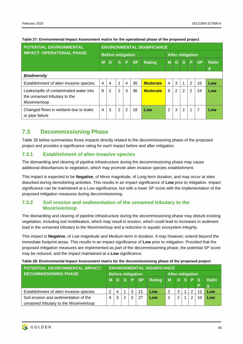
February 2020 19121900-327695-6
45
Table 27: Environmental Impact Assessment matrix for the operational phase of the proposed project
POTENTIAL ENVIRONMENTAL
IMPACT: OPERATIONAL PHASE
ENVIRONMENTAL SIGNIFICANCE
Before mitigation After mitigation
M D S P SP Rating M D S P SP Ratin
g
Biodiversity
Establishment of alien invasive species 4 4 1 4 36 Moderate 4 3 1 2 16 Low
Leaks/spills of contaminated water into
the unnamed tributary to the
Mooirivierloop
8 2 2 3 36 Moderate 8 2 2 2 24 Low
Changed flows in wetland due to leaks
or pipe failure
4 3 2 2 18 Low 2 3 2 1 7 Low
7.3 Decommissioning Phase
Table 28 below summarises those impacts directly related to the decommissioning phase of the proposed
project and provides a significance rating for each impact before and after mitigation.
7.3.1 Establishment of alien invasive species
The dismantling and clearing of pipeline infrastructure during the decommissioning phase may cause
additional disturbances to vegetation, which may promote alien invasive species establishment.
This impact is expected to be Negative, of Minor magnitude, of Long-term duration, and may occur at sites
disturbed during demolishing activities. This results in an impact significance of Low prior to mitigation. Impact
significance can be maintained at a Low significance, but with a lower SP score with the implementation of the
proposed mitigation measures during decommissioning.
7.3.2 Soil erosion and sedimentation of the unnamed tributary to the Mooirivierloop
The dismantling and clearing of pipeline infrastructure during the decommissioning phase may disturb existing
vegetation, including soil mobilisation, which may result in erosion, which could lead to increases in sediment
load in the unnamed tributary to the Mooirivierloop and a reduction in aquatic ecosystem integrity.
This impact is Negative, of Low magnitude and Medium-term in duration. It may however, extend beyond the
immediate footprint areas. This results in an impact significance of Low prior to mitigation. Provided that the
proposed mitigation measures are implemented as part of the decommissioning phase, the potential SP score
may be reduced, and the impact maintained at a Low significance.
Table 28: Environmental Impact Assessment matrix for the decommissioning phase of the proposed project
POTENTIAL ENVIRONMENTAL IMPACT:
DECOMMISSIONING PHASE
ENVIRONMENTAL SIGNIFICANCE
Before mitigation After mitigation
M D S P SP Rating M D S P S
P
Ratin
g
Establishment of alien invasive species 2 4 1 3 21 Low 2 3 1 2 12 Low
Soil erosion and sedimentation of the
unnamed tributary to the Mooirivierloop
4 3 2 3 27 Low 2 2 1 2 10 Low
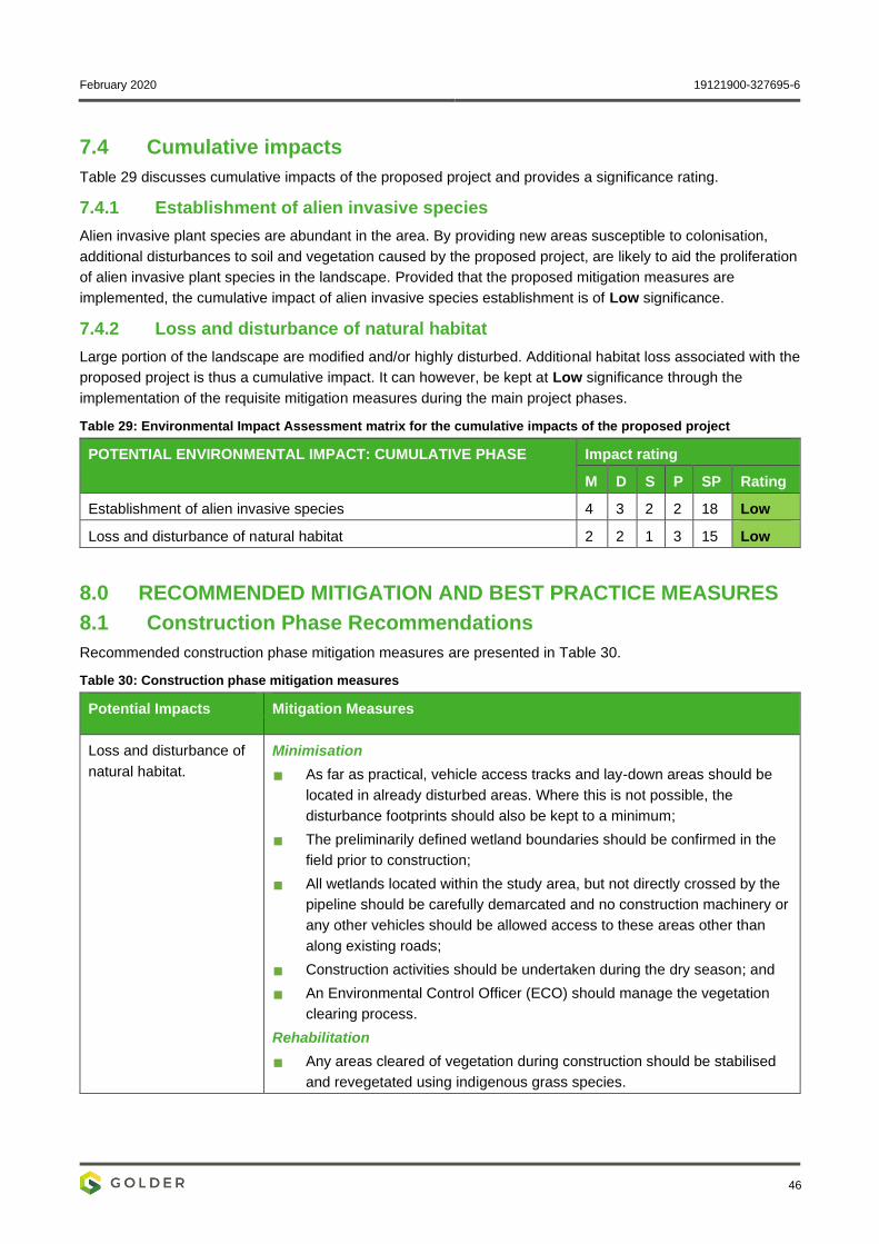
February 2020 19121900-327695-6
46
7.4 Cumulative impacts
Table 29 discusses cumulative impacts of the proposed project and provides a significance rating.
7.4.1 Establishment of alien invasive species
Alien invasive plant species are abundant in the area. By providing new areas susceptible to colonisation,
additional disturbances to soil and vegetation caused by the proposed project, are likely to aid the proliferation
of alien invasive plant species in the landscape. Provided that the proposed mitigation measures are
implemented, the cumulative impact of alien invasive species establishment is of Low significance.
7.4.2 Loss and disturbance of natural habitat
Large portion of the landscape are modified and/or highly disturbed. Additional habitat loss associated with the
proposed project is thus a cumulative impact. It can however, be kept at Low significance through the
implementation of the requisite mitigation measures during the main project phases.
Table 29: Environmental Impact Assessment matrix for the cumulative impacts of the proposed project
POTENTIAL ENVIRONMENTAL IMPACT: CUMULATIVE PHASE Impact rating
M D S P SP Rating
Establishment of alien invasive species 4 3 2 2 18 Low
Loss and disturbance of natural habitat 2 2 1 3 15 Low
8.0 RECOMMENDED MITIGATION AND BEST PRACTICE MEASURES
8.1 Construction Phase Recommendations
Recommended construction phase mitigation measures are presented in Table 30.
Table 30: Construction phase mitigation measures
Potential Impacts Mitigation Measures
Loss and disturbance of
natural habitat.
Minimisation
As far as practical, vehicle access tracks and lay-down areas should be
located in already disturbed areas. Where this is not possible, the
disturbance footprints should also be kept to a minimum;
The preliminarily defined wetland boundaries should be confirmed in the
field prior to construction;
All wetlands located within the study area, but not directly crossed by the
pipeline should be carefully demarcated and no construction machinery or
any other vehicles should be allowed access to these areas other than
along existing roads;
Construction activities should be undertaken during the dry season; and
An Environmental Control Officer (ECO) should manage the vegetation
clearing process.
Rehabilitation
Any areas cleared of vegetation during construction should be stabilised
and revegetated using indigenous grass species.
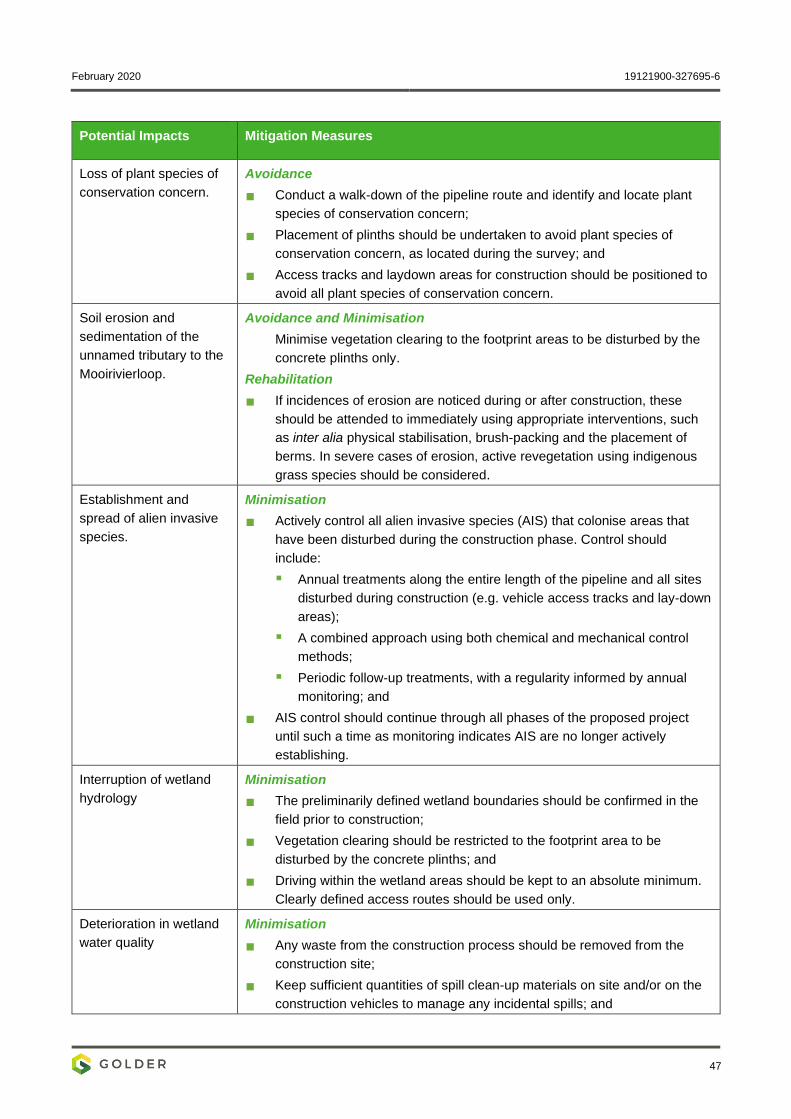
February 2020 19121900-327695-6
47
Potential Impacts Mitigation Measures
Loss of plant species of
conservation concern.
Avoidance
Conduct a walk-down of the pipeline route and identify and locate plant
species of conservation concern;
Placement of plinths should be undertaken to avoid plant species of
conservation concern, as located during the survey; and
Access tracks and laydown areas for construction should be positioned to
avoid all plant species of conservation concern.
Soil erosion and
sedimentation of the
unnamed tributary to the
Mooirivierloop.
Avoidance and Minimisation
Minimise vegetation clearing to the footprint areas to be disturbed by the
concrete plinths only.
Rehabilitation
If incidences of erosion are noticed during or after construction, these
should be attended to immediately using appropriate interventions, such
as inter alia physical stabilisation, brush-packing and the placement of
berms. In severe cases of erosion, active revegetation using indigenous
grass species should be considered.
Establishment and
spread of alien invasive
species.
Minimisation
Actively control all alien invasive species (AIS) that colonise areas that
have been disturbed during the construction phase. Control should
include:
▪ Annual treatments along the entire length of the pipeline and all sites
disturbed during construction (e.g. vehicle access tracks and lay-down
areas);
▪ A combined approach using both chemical and mechanical control
methods;
▪ Periodic follow-up treatments, with a regularity informed by annual
monitoring; and
AIS control should continue through all phases of the proposed project
until such a time as monitoring indicates AIS are no longer actively
establishing.
Interruption of wetland
hydrology
Minimisation
The preliminarily defined wetland boundaries should be confirmed in the
field prior to construction;
Vegetation clearing should be restricted to the footprint area to be
disturbed by the concrete plinths; and
Driving within the wetland areas should be kept to an absolute minimum.
Clearly defined access routes should be used only.
Deterioration in wetland
water quality
Minimisation
Any waste from the construction process should be removed from the
construction site;
Keep sufficient quantities of spill clean-up materials on site and/or on the
construction vehicles to manage any incidental spills; and
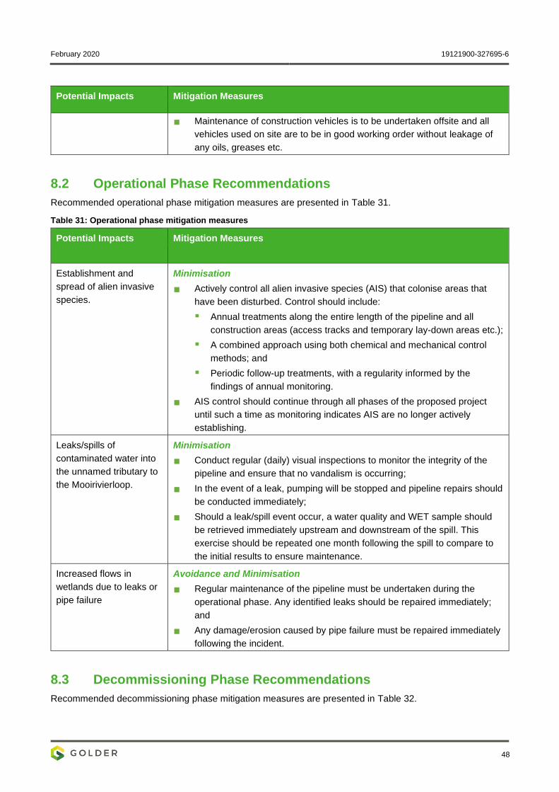
February 2020 19121900-327695-6
48
Potential Impacts Mitigation Measures
Maintenance of construction vehicles is to be undertaken offsite and all
vehicles used on site are to be in good working order without leakage of
any oils, greases etc.
8.2 Operational Phase Recommendations
Recommended operational phase mitigation measures are presented in Table 31.
Table 31: Operational phase mitigation measures
Potential Impacts Mitigation Measures
Establishment and
spread of alien invasive
species.
Minimisation
Actively control all alien invasive species (AIS) that colonise areas that
have been disturbed. Control should include:
▪ Annual treatments along the entire length of the pipeline and all
construction areas (access tracks and temporary lay-down areas etc.);
▪ A combined approach using both chemical and mechanical control
methods; and
▪ Periodic follow-up treatments, with a regularity informed by the
findings of annual monitoring.
AIS control should continue through all phases of the proposed project
until such a time as monitoring indicates AIS are no longer actively
establishing.
Leaks/spills of
contaminated water into
the unnamed tributary to
the Mooirivierloop.
Minimisation
Conduct regular (daily) visual inspections to monitor the integrity of the
pipeline and ensure that no vandalism is occurring;
In the event of a leak, pumping will be stopped and pipeline repairs should
be conducted immediately;
Should a leak/spill event occur, a water quality and WET sample should
be retrieved immediately upstream and downstream of the spill. This
exercise should be repeated one month following the spill to compare to
the initial results to ensure maintenance.
Increased flows in
wetlands due to leaks or
pipe failure
Avoidance and Minimisation
Regular maintenance of the pipeline must be undertaken during the
operational phase. Any identified leaks should be repaired immediately;
and
Any damage/erosion caused by pipe failure must be repaired immediately
following the incident.
8.3 Decommissioning Phase Recommendations
Recommended decommissioning phase mitigation measures are presented in Table 32.
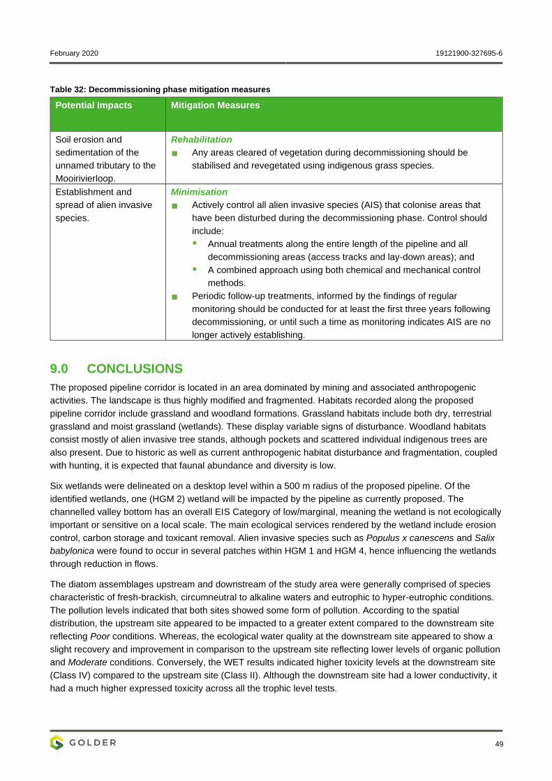
February 2020 19121900-327695-6
49
Table 32: Decommissioning phase mitigation measures
Potential Impacts Mitigation Measures
Soil erosion and
sedimentation of the
unnamed tributary to the
Mooirivierloop.
Rehabilitation
Any areas cleared of vegetation during decommissioning should be
stabilised and revegetated using indigenous grass species.
Establishment and
spread of alien invasive
species.
Minimisation
Actively control all alien invasive species (AIS) that colonise areas that
have been disturbed during the decommissioning phase. Control should
include:
▪ Annual treatments along the entire length of the pipeline and all
decommissioning areas (access tracks and lay-down areas); and
▪ A combined approach using both chemical and mechanical control
methods.
Periodic follow-up treatments, informed by the findings of regular
monitoring should be conducted for at least the first three years following
decommissioning, or until such a time as monitoring indicates AIS are no
longer actively establishing.
9.0 CONCLUSIONS
The proposed pipeline corridor is located in an area dominated by mining and associated anthropogenic
activities. The landscape is thus highly modified and fragmented. Habitats recorded along the proposed
pipeline corridor include grassland and woodland formations. Grassland habitats include both dry, terrestrial
grassland and moist grassland (wetlands). These display variable signs of disturbance. Woodland habitats
consist mostly of alien invasive tree stands, although pockets and scattered individual indigenous trees are
also present. Due to historic as well as current anthropogenic habitat disturbance and fragmentation, coupled
with hunting, it is expected that faunal abundance and diversity is low.
Six wetlands were delineated on a desktop level within a 500 m radius of the proposed pipeline. Of the
identified wetlands, one (HGM 2) wetland will be impacted by the pipeline as currently proposed. The
channelled valley bottom has an overall EIS Category of low/marginal, meaning the wetland is not ecologically
important or sensitive on a local scale. The main ecological services rendered by the wetland include erosion
control, carbon storage and toxicant removal. Alien invasive species such as Populus x canescens and Salix
babylonica were found to occur in several patches within HGM 1 and HGM 4, hence influencing the wetlands
through reduction in flows.
The diatom assemblages upstream and downstream of the study area were generally comprised of species
characteristic of fresh-brackish, circumneutral to alkaline waters and eutrophic to hyper-eutrophic conditions.
The pollution levels indicated that both sites showed some form of pollution. According to the spatial
distribution, the upstream site appeared to be impacted to a greater extent compared to the downstream site
reflecting Poor conditions. Whereas, the ecological water quality at the downstream site appeared to show a
slight recovery and improvement in comparison to the upstream site reflecting lower levels of organic pollution
and Moderate conditions. Conversely, the WET results indicated higher toxicity levels at the downstream site
(Class IV) compared to the upstream site (Class II). Although the downstream site had a lower conductivity, it
had a much higher expressed toxicity across all the trophic level tests.
February 2020 19121900-327695-6
50
Overall, the potential impacts as a result of the construction, operation and decommissioning phase of the
proposed pipeline were identified as follows:
Loss and disturbance of natural habitat;
Loss of plant species of conservation concern;
Soil erosion and sedimentation of the unnamed tributary to the Mooirivierloop;
Establishment and spread of alien invasive species;
Interruption of wetland hydrology;
Deterioration in wetland water quality, due to leaks and spills; and
Increased flows due to leaks or pipe failure.
Before mitigation, the significance of these impacts is rated either Moderate or Low. With the implementation
of the recommended mitigation measures, all impacts for all phases can be reduced to Low significance.
10.0 REFERENCES
ADU - SABAP2 (2011) The Southern Africa Bird Atlas Project 2, Animal Demographic Unit.
Bates, M., Branch, W., Bauer, A., Burger, M., Marais, J., Alexander, G. and De Villiers, M. (eds.) (2014) Atlas
and Red List of the Reptiles of South Africa, Lesotho and Swaziland. Pretoria: Suricata 1, South African
Biodiversity Institute.
BirdLife South Africa (2015) The 2015 Eskom Red Data Book of Birds of South Africa, Lesotho and
Swaziland.
BODATSA (2016) Plants of Southern Africa, South African National Biodiversity Institute (SANBI) - Botanical
Database of Southern Africa.
CEMAGREF. (1982) Etude des méthodes biologiques quantitatives d’appréciation de la qualité des eaux.
Rapport Division Qualité des Eaux Lyon - Agence Financiére de Bassin Rhône- Méditerranée- Corse. Pierre-
Benite.
Clean Stream (2013a) AngloGold Ashanti - West Wits Operations Aquatic Fauna Biodiversity. Report Number
AGA/C/2013.
Clean Stream (2013b) Biodiversity Management Plan: AngloGold Ahanti West Wits Operations.
Department of Water and Sanitation (2014) A Desktop Assessment of the Present Ecological State,
Ecological Importance and Ecological Sensitivity per Sub Quaternary Reaches for Secondary Catchments in
South Africa. Compiled by RQIS-RDM:https://www.dwa.gov.za/iwqs/rhp/eco/peseismodel.aspx accessed on.
Dickens, C. W. and Graham, P. M. (2002) The South African Scoring System (SASS) Version 5 Rapid
Bioassessment Method for Rivers, African Journal of Aquatic Science, 27 (1), pp. 1–10.
DOI:10.2989/16085914.2002.9626569.
Dippenaar-Schoeman, A. (2014) Field Guide to the Spiders of South Africa. Cape Town: LAPA Publishers.
Draft NEMBA ToPS List National Environmental Management: Biodiversity Act (Act No. 10 of 2004) - Lists of
critically endangered, endangered, vulnerable and protected species. (2013). South Africa.
February 2020 19121900-327695-6
51
Eloranta, P. & Soininen, J. (2002) Ecological status of Finnish rivers evaluated using benthic diatom
communities., Journal of Applied Phycology, 14, pp. 1–7.
EWT (2016) Red List of Mammals of South Africa, Lesotho and Swaziland, Endangered Wildlife Trust.
FitzPatrick Institute of African Ornithology (2019) Virtual Museum - MammalMAP, ReptileMAP, FrogMAP,
SpiderMAP, ScorpionMAP and LepiMAP, Animal Demographic Unit.
Froese, R. and Pauly, D. 2011 [no date] FishBase. World Wide Web electronic publication. www.fishbase.org,
version (10/2011)., 2011.
Gauteng C-Plan V3.3 (2011) Gauteng Conservation Plan (Version 3.3).
Gauteng Nature Conservation Ordinance (1983) Schedule 2, 2A ,11 & 12: Protected and Specially Protected
Fauna and Flora - Gauteng Nature Conservation Ordinance (Ordinance 12 of 1983), as amended by Gauteng
General Law Amendment Act (Act No.4 of 2005).
Henning, G., Terblanche, R. and Ball, J. (eds.) (2009) South African Red Data Book: Butterflies. Pretoria:
Biodiversity Series 13, South African National Biodiversity Institute.
IUCN [no date-a] Red List of Threatened Species, International Union for the Conservation of Nature.
Available from: http://www.iucnredlist.org [Accessed 7 February 2019].
IUCN [no date-b] The IUCN Red List of Threatened Species, Version 2018.1.
DOI:http://dx.doi.org/10.2305/IUCN.UK.2016- 3.RLTS.T22719744A94642482.en.
Kelly, M.G. and Whitton, B. A. (1995) The trophic diatom index: a new index for monitoring eutrophication in
rivers, Journal of Applied Phycology, 7, pp. 433--444.
Kleynhans, C. J. (2007) Module D: Fish Response Assessment Index in River EcoClassification: Manual for
EcoStatus Determination (version 2) Joint Water Research Commission and Department of Water Affairs and
Forestry report, WRC Report No. TT 330, 8.
Lecointe, C., Coste, M. & Prygiel, J. (1993) “Omnidia”: Software for taxonomy, calculation of diatom indices
and inventories management., Hydrobiologia, (269/270), pp. 509–513.
Lenoir, A. & Coste, M. (1996) Development of a practical diatom index of overall water quality applicable to
the French National Water Board network. In Use of Algae for Monitoring Rivers II: Edited by Whitton, B.A. &
Rott, E. Institut für Botanik, Universität Innsbruck. pp. 29-43.
Mucina, L. and Rutherford, M. (2006) The Vegetation of South Africa, Lesotho and Swaziland. Pretoria:
Reprint 2011, Strelitzia 19, South African National Biodiversity Institute (SANBI).
NEMBA Threatened Ecosystems National Environmental Management: Biodiversity Act (Act No. 10 of 2004) -
National list of threatened terrestrial ecosystems for South Africa (2011). South Africa.
Persoone, G., Marsalek, B., Blinova, I., Törökne, A., Zarina, D., Manusadzianas, L., Nalecz-Jawecki, G.,
Tofan, L., Stepanova, N., Tothova, L. and Kolar, B. (2003) A practical and user-friendly toxicity classification
system with micro-biotests for natural waters and wastewatersle., Environmental Toxicology and Chemistry,
18, pp. 395–402.
Pfab, M. (2001a) Development guidelines for ridges, Gauteng Department of Agriculture, Conservation,
Environment and Land Affairs - Directorate of Nature Conservation.
Pfab, M. F. (2001b) Red Data Plant Policy for Environmental Impact Evaluations, (August 2000).
February 2020 19121900-327695-6
52
SANBI (2017) Red List of South African Plants, South African National Biodiversity Institute.
Scholes, R. and Walker, B. (1993) An African Savanna. First. Cambridge: Cambridge University Press.
Skelton, P. H. (2001) A Complete Guide to the Freshwater Fishes of Southern Africa, Ecology. Vol. 1. Struik
Publishers. DOI:10.2989/16085914.2002.9626577.
Slabbert, JL., Oosthuizen, J, Venter, E.A., Hill, E, Du Preez, M. Pretorius, .J. (1998) Development of
Procedures to assess Whole Effluent Toxicity. Contract Report for the Water Research Commission; Report
No 453/1/98, Division of Water Environment and Forestry Technology, CSIR, Pretoria.
TAYLOR, J. C.; HARDING, W. R.; ARCHIBALD, C. G. M. (2007) An Illustrated guide to some common diatom
species from South Africa.
Tonkes, M. and C. B. (1997) No TitlePraktijkonderzoek aan complexe efflenetenment de Totaal Effluent
Milieubezwaarlikheid (TEM) - metodiek. RIZA.
Van Wyk, B., Van Oudtshoorn, B. and Gericke, N. (2009) Medicinal Plants of South Africa. Second Edi.
Pretoria: Briza Publications.
Golder Associates Africa (Pty) Ltd.
Andrew Zinn Aisling Dower
Terrestrial Ecologist Senior Ecologist
AZ/AD/nbh
Reg. No. 2002/007104/07
Directors: RGM Heath, MQ Mokulubete, SC Naidoo, GYW Ngoma
Golder and the G logo are trademarks of Golder Associates Corporation
https://golderassociates.sharepoint.com/sites/108123/project files/6 deliverables/final client deliverables/final specialist reports/19121900-327695-6_rep_biodiversity_final_19feb2020.docx

February 2020 19121900-327695-6
APPENDIX A
Document Limitations

February 2020 19121900-327695-6
DOCUMENT LIMITATIONS
This Document has been provided by Golder Associates Africa Pty Ltd (“Golder”) subject to the following
limitations:
i) This Document has been prepared for the particular purpose outlined in Golder’s proposal and no
responsibility is accepted for the use of this Document, in whole or in part, in other contexts or for any
other purpose.
ii) The scope and the period of Golder’s Services are as described in Golder’s proposal, and are subject to
restrictions and limitations. Golder did not perform a complete assessment of all possible conditions or
circumstances that may exist at the site referenced in the Document. If a service is not expressly
indicated, do not assume it has been provided. If a matter is not addressed, do not assume that any
determination has been made by Golder in regards to it.
iii) Conditions may exist which were undetectable given the limited nature of the enquiry Golder was
retained to undertake with respect to the site. Variations in conditions may occur between investigatory
locations, and there may be special conditions pertaining to the site which have not been revealed by the
investigation and which have not therefore been taken into account in the Document. Accordingly,
additional studies and actions may be required.
iv) In addition, it is recognised that the passage of time affects the information and assessment provided in
this Document. Golder’s opinions are based upon information that existed at the time of the production of
the Document. It is understood that the Services provided allowed Golder to form no more than an
opinion of the actual conditions of the site at the time the site was visited and cannot be used to assess
the effect of any subsequent changes in the quality of the site, or its surroundings, or any laws or
regulations.
v) Any assessments made in this Document are based on the conditions indicated from published sources
and the investigation described. No warranty is included, either express or implied, that the actual
conditions will conform exactly to the assessments contained in this Document.
vi) Where data supplied by the client or other external sources, including previous site investigation data,
have been used, it has been assumed that the information is correct unless otherwise stated. No
responsibility is accepted by Golder for incomplete or inaccurate data supplied by others.
vii) The Client acknowledges that Golder may have retained sub-consultants affiliated with Golder to provide
Services for the benefit of Golder. Golder will be fully responsible to the Client for the Services and work
done by all of its sub-consultants and subcontractors. The Client agrees that it will only assert claims
against and seek to recover losses, damages or other liabilities from Golder and not Golder’s affiliated
companies. To the maximum extent allowed by law, the Client acknowledges and agrees it will not have
any legal recourse, and waives any expense, loss, claim, demand, or cause of action, against Golder’s
affiliated companies, and their employees, officers and directors.
viii) This Document is provided for sole use by the Client and is confidential to it and its professional advisers.
No responsibility whatsoever for the contents of this Document will be accepted to any person other than
the Client. Any use which a third party makes of this Document, or any reliance on or decisions to be
made based on it, is the responsibility of such third parties. Golder accepts no responsibility for
damages, if any, suffered by any third party as a result of decisions made or actions based on this
Document.
GOLDER ASSOCIATES AFRICA (PTY) LTD

February 2020 19121900-327695-6
APPENDIX B
Plant Species Recorded Along
the Proposed Pipeline Corridor
During the Field Visit
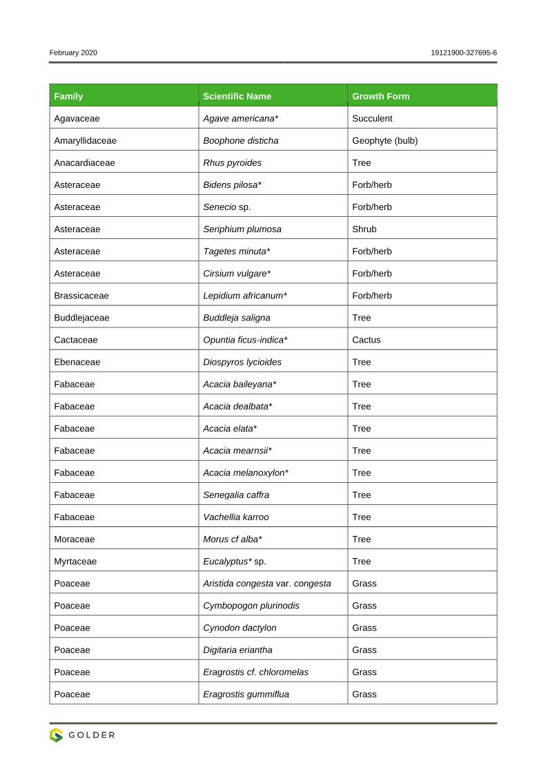
February 2020 19121900-327695-6
Family Scientific Name Growth Form
Agavaceae Agave americana* Succulent
Amaryllidaceae Boophone disticha Geophyte (bulb)
Anacardiaceae Rhus pyroides Tree
Asteraceae Bidens pilosa* Forb/herb
Asteraceae Senecio sp. Forb/herb
Asteraceae Seriphium plumosa Shrub
Asteraceae Tagetes minuta* Forb/herb
Asteraceae Cirsium vulgare* Forb/herb
Brassicaceae Lepidium africanum* Forb/herb
Buddlejaceae Buddleja saligna Tree
Cactaceae Opuntia ficus-indica* Cactus
Ebenaceae Diospyros lycioides Tree
Fabaceae Acacia baileyana* Tree
Fabaceae Acacia dealbata* Tree
Fabaceae Acacia elata* Tree
Fabaceae Acacia mearnsii* Tree
Fabaceae Acacia melanoxylon* Tree
Fabaceae Senegalia caffra Tree
Fabaceae Vachellia karroo Tree
Moraceae Morus cf alba* Tree
Myrtaceae Eucalyptus* sp. Tree
Poaceae Aristida congesta var. congesta Grass
Poaceae Cymbopogon plurinodis Grass
Poaceae Cynodon dactylon Grass
Poaceae Digitaria eriantha Grass
Poaceae Eragrostis cf. chloromelas Grass
Poaceae Eragrostis gummiflua Grass
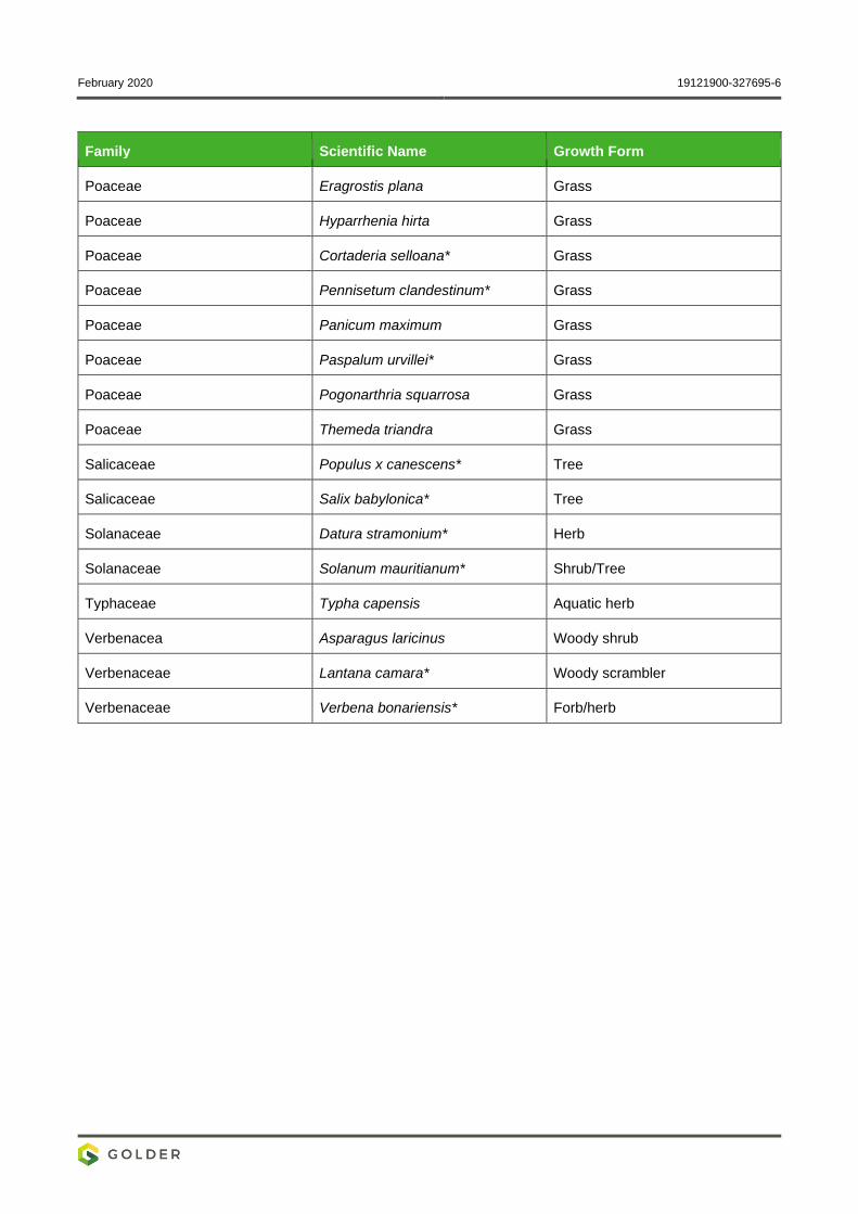
February 2020 19121900-327695-6
Family Scientific Name Growth Form
Poaceae Eragrostis plana Grass
Poaceae Hyparrhenia hirta Grass
Poaceae Cortaderia selloana* Grass
Poaceae Pennisetum clandestinum* Grass
Poaceae Panicum maximum Grass
Poaceae Paspalum urvillei* Grass
Poaceae Pogonarthria squarrosa Grass
Poaceae Themeda triandra Grass
Salicaceae Populus x canescens* Tree
Salicaceae Salix babylonica* Tree
Solanaceae Datura stramonium* Herb
Solanaceae Solanum mauritianum* Shrub/Tree
Typhaceae Typha capensis Aquatic herb
Verbenacea Asparagus laricinus Woody shrub
Verbenaceae Lantana camara* Woody scrambler
Verbenaceae Verbena bonariensis* Forb/herb
February 2020 19121900-327695-6
APPENDIX C
Mammals Previously Recorded in
the 2627AD QDS
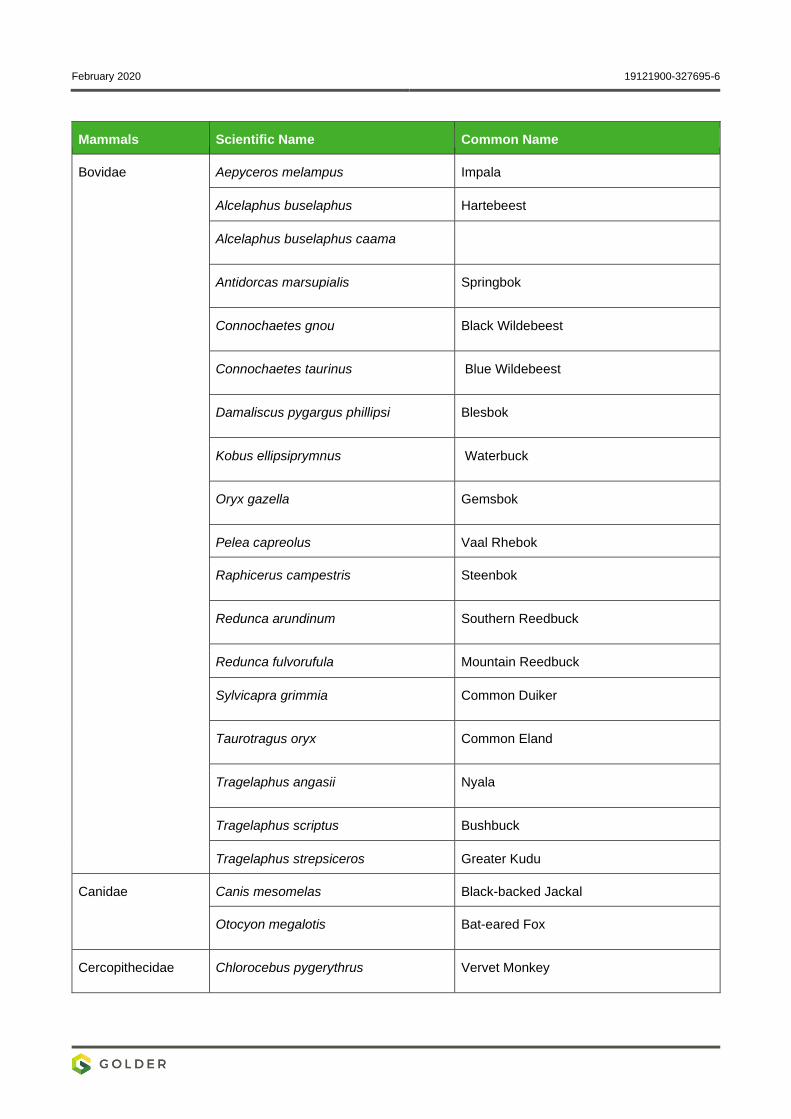
February 2020 19121900-327695-6
Mammals Scientific Name Common Name
Bovidae Aepyceros melampus Impala
Alcelaphus buselaphus Hartebeest
Alcelaphus buselaphus caama Family
Antidorcas marsupialis Springbok
Connochaetes gnou Black Wildebeest
Connochaetes taurinus Blue Wildebeest
Damaliscus pygargus phillipsi Blesbok
Kobus ellipsiprymnus Waterbuck
Oryx gazella Gemsbok
Pelea capreolus Vaal Rhebok
Raphicerus campestris Steenbok
Redunca arundinum Southern Reedbuck
Redunca fulvorufula Mountain Reedbuck
Sylvicapra grimmia Common Duiker
Taurotragus oryx Common Eland
Tragelaphus angasii Nyala
Tragelaphus scriptus Bushbuck
Tragelaphus strepsiceros Greater Kudu
Canidae Canis mesomelas Black-backed Jackal
Otocyon megalotis Bat-eared Fox
Cercopithecidae Chlorocebus pygerythrus Vervet Monkey
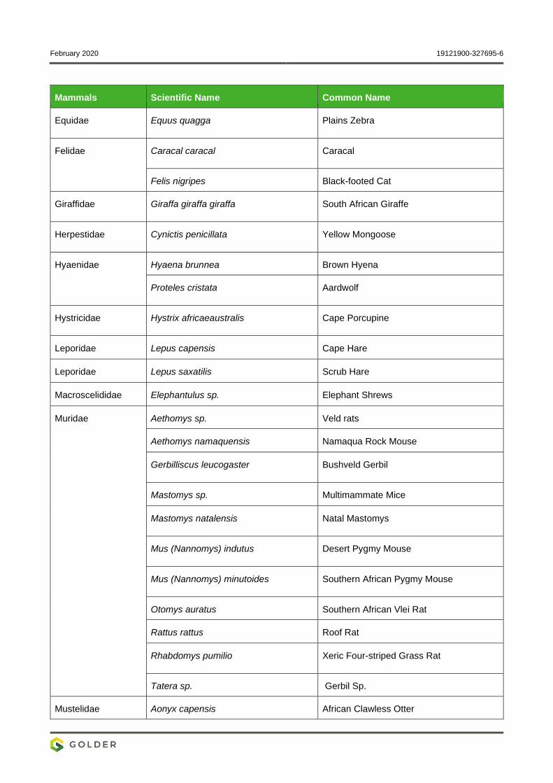
February 2020 19121900-327695-6
Mammals Scientific Name Common Name
Equidae Equus quagga Plains Zebra
Felidae Caracal caracal Caracal
Felis nigripes Black-footed Cat
Giraffidae Giraffa giraffa giraffa South African Giraffe
Herpestidae Cynictis penicillata Yellow Mongoose
Hyaenidae Hyaena brunnea Brown Hyena
Proteles cristata Aardwolf
Hystricidae Hystrix africaeaustralis Cape Porcupine
Leporidae Lepus capensis Cape Hare
Leporidae Lepus saxatilis Scrub Hare
Macroscelididae Elephantulus sp. Elephant Shrews
Muridae Aethomys sp. Veld rats
Aethomys namaquensis Namaqua Rock Mouse
Gerbilliscus leucogaster Bushveld Gerbil
Mastomys sp. Multimammate Mice
Mastomys natalensis Natal Mastomys
Mus (Nannomys) indutus Desert Pygmy Mouse
Mus (Nannomys) minutoides Southern African Pygmy Mouse
Otomys auratus Southern African Vlei Rat
Rattus rattus Roof Rat
Rhabdomys pumilio Xeric Four-striped Grass Rat
Tatera sp. Gerbil Sp.
Mustelidae Aonyx capensis African Clawless Otter
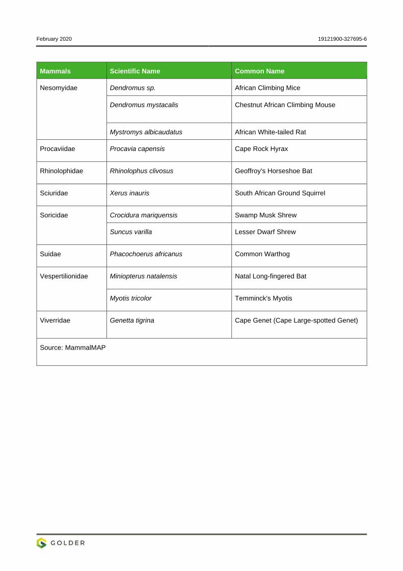
February 2020 19121900-327695-6
Mammals Scientific Name Common Name
Nesomyidae Dendromus sp. African Climbing Mice
Dendromus mystacalis Chestnut African Climbing Mouse
Mystromys albicaudatus African White-tailed Rat
Procaviidae Procavia capensis Cape Rock Hyrax
Rhinolophidae Rhinolophus clivosus Geoffroy's Horseshoe Bat
Sciuridae Xerus inauris South African Ground Squirrel
Soricidae Crocidura mariquensis Swamp Musk Shrew
Suncus varilla Lesser Dwarf Shrew
Suidae Phacochoerus africanus Common Warthog
Vespertilionidae Miniopterus natalensis Natal Long-fingered Bat
Myotis tricolor Temminck's Myotis
Viverridae Genetta tigrina Cape Genet (Cape Large-spotted Genet)
Source: MammalMAP
February 2020 19121900-327695-6
APPENDIX D
Bird Species Previously Recorded
in the Relevant Pentads
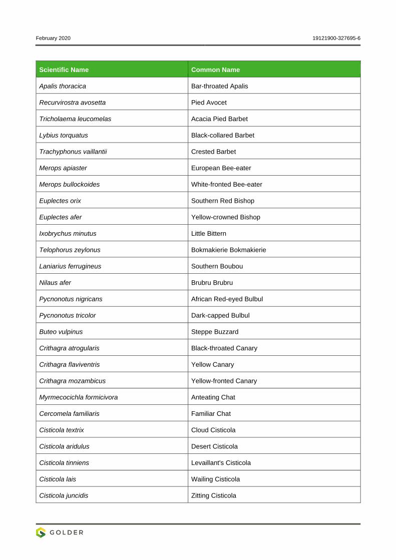
February 2020 19121900-327695-6
Scientific Name Common Name
Apalis thoracica Bar-throated Apalis
Recurvirostra avosetta Pied Avocet
Tricholaema leucomelas Acacia Pied Barbet
Lybius torquatus Black-collared Barbet
Trachyphonus vaillantii Crested Barbet
Merops apiaster European Bee-eater
Merops bullockoides White-fronted Bee-eater
Euplectes orix Southern Red Bishop
Euplectes afer Yellow-crowned Bishop
Ixobrychus minutus Little Bittern
Telophorus zeylonus Bokmakierie Bokmakierie
Laniarius ferrugineus Southern Boubou
Nilaus afer Brubru Brubru
Pycnonotus nigricans African Red-eyed Bulbul
Pycnonotus tricolor Dark-capped Bulbul
Buteo vulpinus Steppe Buzzard
Crithagra atrogularis Black-throated Canary
Crithagra flaviventris Yellow Canary
Crithagra mozambicus Yellow-fronted Canary
Myrmecocichla formicivora Anteating Chat
Cercomela familiaris Familiar Chat
Cisticola textrix Cloud Cisticola
Cisticola aridulus Desert Cisticola
Cisticola tinniens Levaillant's Cisticola
Cisticola lais Wailing Cisticola
Cisticola juncidis Zitting Cisticola
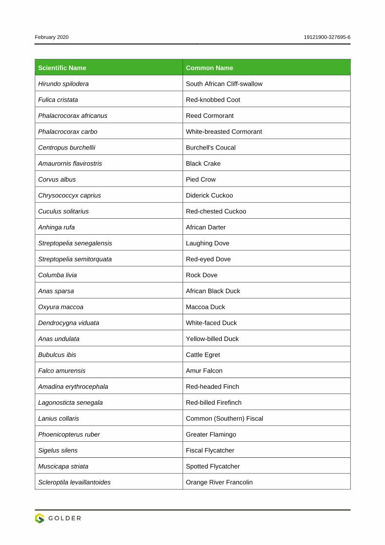
February 2020 19121900-327695-6
Scientific Name Common Name
Hirundo spilodera South African Cliff-swallow
Fulica cristata Red-knobbed Coot
Phalacrocorax africanus Reed Cormorant
Phalacrocorax carbo White-breasted Cormorant
Centropus burchellii Burchell's Coucal
Amaurornis flavirostris Black Crake
Corvus albus Pied Crow
Chrysococcyx caprius Diderick Cuckoo
Cuculus solitarius Red-chested Cuckoo
Anhinga rufa African Darter
Streptopelia senegalensis Laughing Dove
Streptopelia semitorquata Red-eyed Dove
Columba livia Rock Dove
Anas sparsa African Black Duck
Oxyura maccoa Maccoa Duck
Dendrocygna viduata White-faced Duck
Anas undulata Yellow-billed Duck
Bubulcus ibis Cattle Egret
Falco amurensis Amur Falcon
Amadina erythrocephala Red-headed Finch
Lagonosticta senegala Red-billed Firefinch
Lanius collaris Common (Southern) Fiscal
Phoenicopterus ruber Greater Flamingo
Sigelus silens Fiscal Flycatcher
Muscicapa striata Spotted Flycatcher
Scleroptila levaillantoides Orange River Francolin
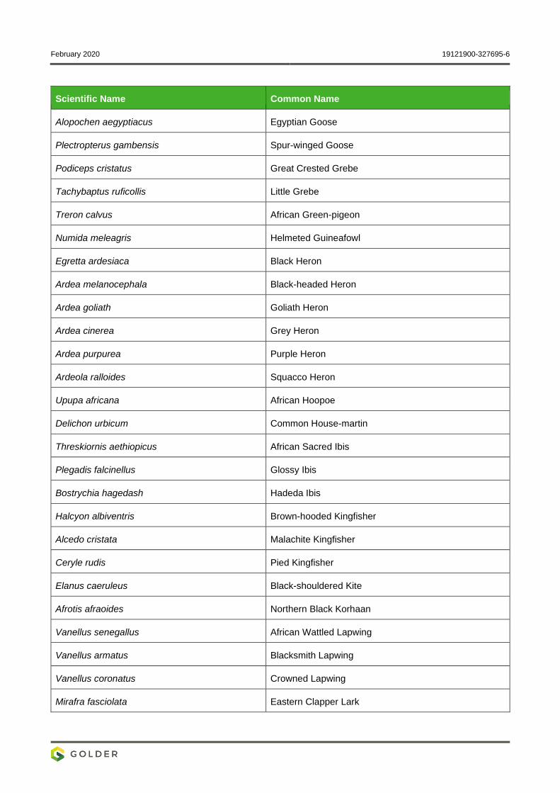
February 2020 19121900-327695-6
Scientific Name Common Name
Alopochen aegyptiacus Egyptian Goose
Plectropterus gambensis Spur-winged Goose
Podiceps cristatus Great Crested Grebe
Tachybaptus ruficollis Little Grebe
Treron calvus African Green-pigeon
Numida meleagris Helmeted Guineafowl
Egretta ardesiaca Black Heron
Ardea melanocephala Black-headed Heron
Ardea goliath Goliath Heron
Ardea cinerea Grey Heron
Ardea purpurea Purple Heron
Ardeola ralloides Squacco Heron
Upupa africana African Hoopoe
Delichon urbicum Common House-martin
Threskiornis aethiopicus African Sacred Ibis
Plegadis falcinellus Glossy Ibis
Bostrychia hagedash Hadeda Ibis
Halcyon albiventris Brown-hooded Kingfisher
Alcedo cristata Malachite Kingfisher
Ceryle rudis Pied Kingfisher
Elanus caeruleus Black-shouldered Kite
Afrotis afraoides Northern Black Korhaan
Vanellus senegallus African Wattled Lapwing
Vanellus armatus Blacksmith Lapwing
Vanellus coronatus Crowned Lapwing
Mirafra fasciolata Eastern Clapper Lark

February 2020 19121900-327695-6
Scientific Name Common Name
Calandrella cinerea Red-capped Lark
Mirafra africana Rufous-naped Lark
Chersomanes albofasciata Spike-heeled Lark
Macronyx capensis Cape Longclaw
Spermestes cucullatus Bronze Mannikin
Riparia paludicola Brown-throated Martin
Hirundo fuligula Rock Martin
Ploceus velatus Southern Masked-weaver
Gallinula chloropus Common Moorhen
Urocolius indicus Red-faced Mousebird
Colius striatus Speckled Mousebird
Acridotheres tristis Common Myna
Cisticola fulvicapilla Neddicky Neddicky
Caprimulgus pectoralis Fiery-necked Nightjar
Oriolus larvatus Black-headed Oriole
Pandion haliaetus Osprey Osprey
Cypsiurus parvus African Palm-swift
Terpsiphone viridis African Paradise-flycatcher
Columba guinea Speckled Pigeon
Anthus cinnamomeus African Pipit
Charadrius tricollaris Three-banded Plover
Netta erythrophthalma Southern Pochard
Prinia flavicans Black-chested Prinia
Prinia subflava Tawny-flanked Prinia
Ortygospiza atricollis African Quailfinch
Quelea quelea Red-billed Quelea
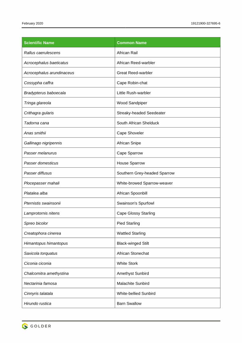
February 2020 19121900-327695-6
Scientific Name Common Name
Rallus caerulescens African Rail
Acrocephalus baeticatus African Reed-warbler
Acrocephalus arundinaceus Great Reed-warbler
Cossypha caffra Cape Robin-chat
Bradypterus baboecala Little Rush-warbler
Tringa glareola Wood Sandpiper
Crithagra gularis Streaky-headed Seedeater
Tadorna cana South African Shelduck
Anas smithii Cape Shoveler
Gallinago nigripennis African Snipe
Passer melanurus Cape Sparrow
Passer domesticus House Sparrow
Passer diffusus Southern Grey-headed Sparrow
Plocepasser mahali White-browed Sparrow-weaver
Platalea alba African Spoonbill
Pternistis swainsonii Swainson's Spurfowl
Lamprotornis nitens Cape Glossy Starling
Spreo bicolor Pied Starling
Creatophora cinerea Wattled Starling
Himantopus himantopus Black-winged Stilt
Saxicola torquatus African Stonechat
Ciconia ciconia White Stork
Chalcomitra amethystina Amethyst Sunbird
Nectarinia famosa Malachite Sunbird
Cinnyris talatala White-bellied Sunbird
Hirundo rustica Barn Swallow
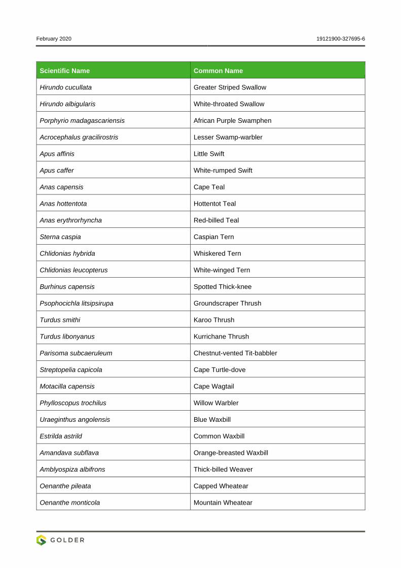
February 2020 19121900-327695-6
Scientific Name Common Name
Hirundo cucullata Greater Striped Swallow
Hirundo albigularis White-throated Swallow
Porphyrio madagascariensis African Purple Swamphen
Acrocephalus gracilirostris Lesser Swamp-warbler
Apus affinis Little Swift
Apus caffer White-rumped Swift
Anas capensis Cape Teal
Anas hottentota Hottentot Teal
Anas erythrorhyncha Red-billed Teal
Sterna caspia Caspian Tern
Chlidonias hybrida Whiskered Tern
Chlidonias leucopterus White-winged Tern
Burhinus capensis Spotted Thick-knee
Psophocichla litsipsirupa Groundscraper Thrush
Turdus smithi Karoo Thrush
Turdus libonyanus Kurrichane Thrush
Parisoma subcaeruleum Chestnut-vented Tit-babbler
Streptopelia capicola Cape Turtle-dove
Motacilla capensis Cape Wagtail
Phylloscopus trochilus Willow Warbler
Uraeginthus angolensis Blue Waxbill
Estrilda astrild Common Waxbill
Amandava subflava Orange-breasted Waxbill
Amblyospiza albifrons Thick-billed Weaver
Oenanthe pileata Capped Wheatear
Oenanthe monticola Mountain Wheatear
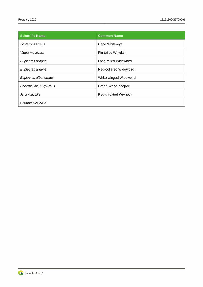
February 2020 19121900-327695-6
Scientific Name Common Name
Zosterops virens Cape White-eye
Vidua macroura Pin-tailed Whydah
Euplectes progne Long-tailed Widowbird
Euplectes ardens Red-collared Widowbird
Euplectes albonotatus White-winged Widowbird
Phoeniculus purpureus Green Wood-hoopoe
Jynx ruficollis Red-throated Wryneck
Source: SABAP2
February 2020 19121900-327695-6
APPENDIX E
Reptiles and Amphibians
Previously Recorded in the
2627AD QDS
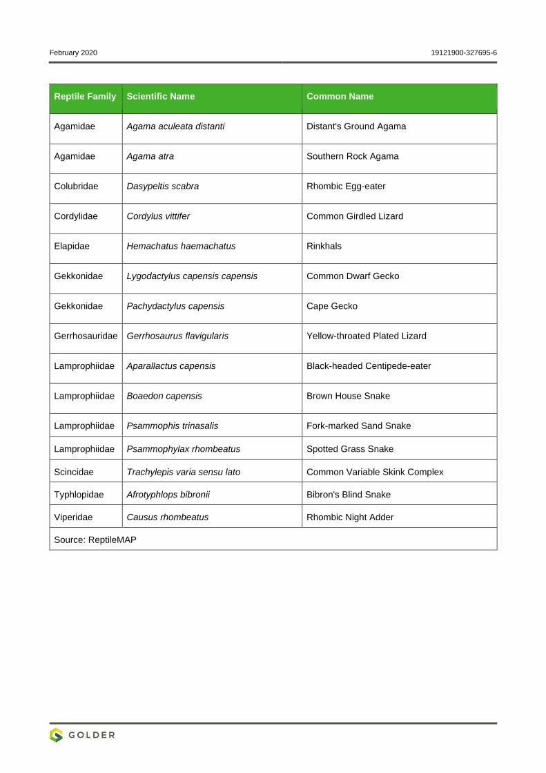
February 2020 19121900-327695-6
Reptile Family Scientific Name Common Name
Agamidae Agama aculeata distanti Distant's Ground Agama
Agamidae Agama atra Southern Rock Agama
Colubridae Dasypeltis scabra Rhombic Egg-eater
Cordylidae Cordylus vittifer Common Girdled Lizard
Elapidae Hemachatus haemachatus Rinkhals
Gekkonidae Lygodactylus capensis capensis Common Dwarf Gecko
Gekkonidae Pachydactylus capensis Cape Gecko
Gerrhosauridae Gerrhosaurus flavigularis Yellow-throated Plated Lizard
Lamprophiidae Aparallactus capensis Black-headed Centipede-eater
Lamprophiidae Boaedon capensis Brown House Snake
Lamprophiidae Psammophis trinasalis Fork-marked Sand Snake
Lamprophiidae Psammophylax rhombeatus Spotted Grass Snake
Scincidae Trachylepis varia sensu lato Common Variable Skink Complex
Typhlopidae Afrotyphlops bibronii Bibron's Blind Snake
Viperidae Causus rhombeatus Rhombic Night Adder
Source: ReptileMAP
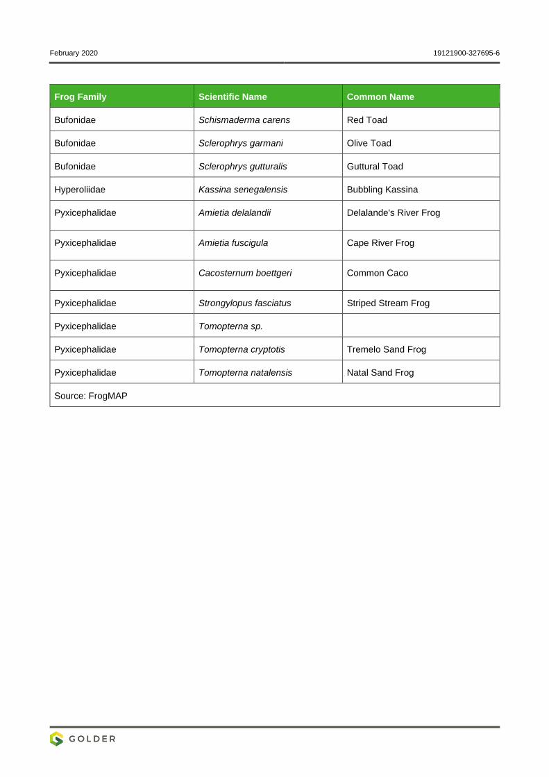
February 2020 19121900-327695-6
Frog Family Scientific Name Common Name
Bufonidae Schismaderma carens Red Toad
Bufonidae Sclerophrys garmani Olive Toad
Bufonidae Sclerophrys gutturalis Guttural Toad
Hyperoliidae Kassina senegalensis Bubbling Kassina
Pyxicephalidae Amietia delalandii Delalande's River Frog
Pyxicephalidae Amietia fuscigula Cape River Frog
Pyxicephalidae Cacosternum boettgeri Common Caco
Pyxicephalidae Strongylopus fasciatus Striped Stream Frog
Pyxicephalidae Tomopterna sp.
Pyxicephalidae Tomopterna cryptotis Tremelo Sand Frog
Pyxicephalidae Tomopterna natalensis Natal Sand Frog
Source: FrogMAP
February 2020 19121900-327695-6
APPENDIX F
Diatom Report
Diatom Analysis Report June 2019
Golder AGA- Project
- 1 -
Golder AGA- Project
19121900
Diatom Analysis Report
Reference: Golder_AGA_Diatoms_June_2019
Date: June 2019
No. of samples: Two
Version: Draft

Diatom Analysis Report June 2019
Golder AGA- Project
- 2 -
Prepared For:
Golder (Pty) Ltd
PO Box 6001, Halfway House, 1685
Golder House, Magwa Crescent West
Maxwell Office Park
Cnr Allandale Road and Maxwell Drive
Waterfall City, Midrand
T: +27 11 254 4800
Prepared By:
Ecotone Freshwater Consultants
P.O Box 84, Florida, 1710
(T): 011 672 1375
(C): +27 84 585 7479
(F): 088 011 673 1192
www.ecotone-sa.co.za
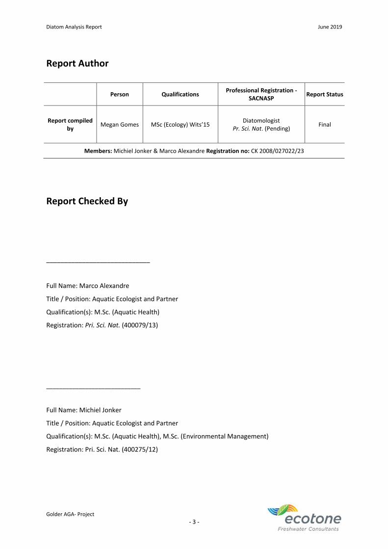
Diatom Analysis Report June 2019
Golder AGA- Project
- 3 -
Report Author
Person Qualifications Professional Registration -
SACNASP Report Status
Report compiled by
Megan Gomes MSc (Ecology) Wits’15 Diatomologist
Pr. Sci. Nat. (Pending) Final
Members: Michiel Jonker & Marco Alexandre Registration no: CK 2008/027022/23
Report Checked By
_____________________________
Full Name: Marco Alexandre
Title / Position: Aquatic Ecologist and Partner
Qualification(s): M.Sc. (Aquatic Health)
Registration: Pri. Sci. Nat. (400079/13)
_____________________________
Full Name: Michiel Jonker
Title / Position: Aquatic Ecologist and Partner
Qualification(s): M.Sc. (Aquatic Health), M.Sc. (Environmental Management)
Registration: Pri. Sci. Nat. (400275/12)
Diatom Analysis Report June 2019
Golder AGA- Project
- 4 -
Limitations and Disclaimer
The spatial and temporal extents of Ecotone Freshwater Consultants CC (Ecotone) services are
described in the proposal and are subject to restrictions and limitations. A total assessment of all
probable scenarios or circumstances that may exist on the study site was not undertaken. No
assumptions should be made unless opinions are specifically indicated and provided. Data presented
in this document may not elucidate all possible conditions that may exist given the limited nature of
the enquiry.
Ecotone exercises reasonable skill, care and diligence in the provision of services; however, Ecotone
accepts no liability or consequential liability for the use of the supplied project deliverables (in part or
whole) and any information or material contained therein. The client, including their agents, by
receiving these deliverables, indemnifies Ecotone (including its members, employees, and sub-
consultants) against any actions, claims, demands, losses, liabilities, costs, damages and expenses
arising directly or indirectly from or in connection with services rendered, directly or indirectly by
Ecotone.
The project deliverables, including the reported results, comments, recommendations, and
conclusions, are based on the author/s professional knowledge as well as available information.
Ecotone, therefore, reserves the right to modify aspects of the project deliverables if and when
new/additional information becomes available from research or further work in the applicable field of
practice or about this study. Ecotone also reserves the right to authorise peer review of this deliverable
by an independent third party.
Diatom Analysis Report June 2019
Golder AGA- Project
- 5 -
Declaration of Independence
I, Marco Alexandre, as duly authorised representative of Ecotone Freshwater Consultants CC
(Ecotone), hereby confirm my independence (as well as that of Ecotone) as a specialist and declare
that neither I nor Ecotone have any interest, be it business, financial, personal or other, in any
proposed activity, application or appeal, other than fair remuneration for work performed, specifically
in connection with the diatom assessment for Golder AGA sites.
______________________________
Full Name: Marco Alexandre
Title / Position: Aquatic Ecologist and Partner
Qualification(s): M.Sc. (Aquatic Health)
Registration: Pri. Sci. Nat. (400079/13))

Diatom Analysis Report June 2019
Golder AGA- Project
- 6 -
Table of Contents
Limitations and Disclaimer .................................................................................................................. - 4 -
Declaration of Independence .............................................................................................................. - 5 -
Table of Contents ................................................................................................................................ - 6 -
List of Tables ........................................................................................................................................ - 6 -
List of Abbreviations ............................................................................................................................ - 7 -
Key Terminology Outlined in (Taylor et al., 2007a) ............................................................................. - 7 -
Executive summary ............................................................................................................................. - 8 -
1. Introduction and Scope of Work ................................................................................................. - 9 -
2. Methodology ............................................................................................................................... - 9 -
2.1. Laboratory Procedures ........................................................................................................ - 9 -
2.2. Diatom-based Water Quality Indices .................................................................................. - 9 -
2.2.1. The Specific Pollution Sensitivity Index (SPI) ........................................................... - 10 -
2.2.2. The Percentage Pollution Tolerant Valves (%PTV) .................................................. - 11 -
3. Results and Discussion .............................................................................................................. - 11 -
3.1. Diatom Assessment ........................................................................................................... - 11 -
3.2. Ecological Classification for Water Quality ........................................................................ - 11 -
3.3. Diatom Spatial Analysis ..................................................................................................... - 12 -
4. Summary and Conclusions ........................................................................................................ - 15 -
5. References ................................................................................................................................. - 17 -
List of Tables
Table 2-1: Adjusted class limit boundaries for the Specific Pollution Index in the evaluation of water
quality applied in this study (adapted from Eloranta & Soininen, 2002; Taylor & Koekemoer, in press) -
10 -
Table 2-2: Interpretation of the percentage Pollution Tolerant Valves scores (adapted from Kelly,
1998).................................................................................................................................................. - 11 -
Table 3-1: Ecological descriptors for the sites based on the diatom community (Van Dam et al., 1994
and Taylor et al., 2007) ...................................................................................................................... - 12 -
Table 3-2: Species and their abundances for the AGA sites .............................................................. - 14 -
Table 3-3: Diatom index scores for the study sites indicating the ecological water quality ............. - 15 -
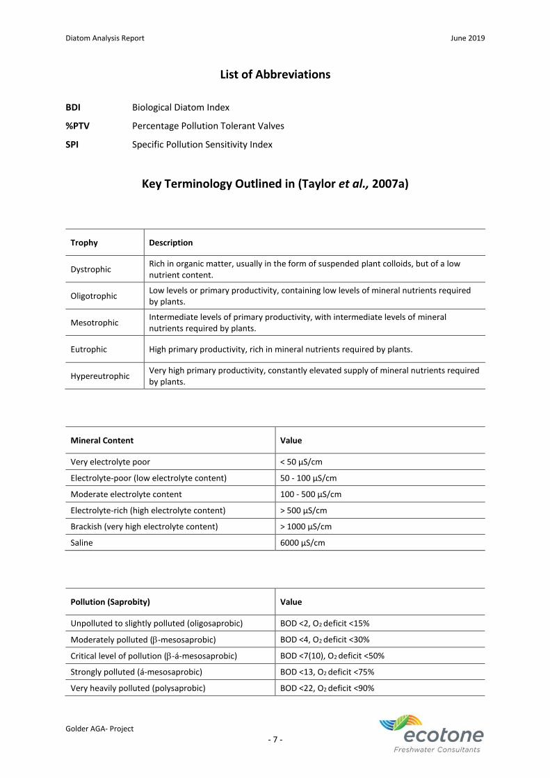
Diatom Analysis Report June 2019
Golder AGA- Project
- 7 -
List of Abbreviations
BDI Biological Diatom Index
%PTV Percentage Pollution Tolerant Valves
SPI Specific Pollution Sensitivity Index
Key Terminology Outlined in (Taylor et al., 2007a)
Trophy Description
Dystrophic Rich in organic matter, usually in the form of suspended plant colloids, but of a low nutrient content.
Oligotrophic Low levels or primary productivity, containing low levels of mineral nutrients required by plants.
Mesotrophic Intermediate levels of primary productivity, with intermediate levels of mineral nutrients required by plants.
Eutrophic High primary productivity, rich in mineral nutrients required by plants.
Hypereutrophic Very high primary productivity, constantly elevated supply of mineral nutrients required by plants.
Mineral Content Value
Very electrolyte poor < 50 μS/cm
Electrolyte-poor (low electrolyte content) 50 - 100 μS/cm
Moderate electrolyte content 100 - 500 μS/cm
Electrolyte-rich (high electrolyte content) > 500 μS/cm
Brackish (very high electrolyte content) > 1000 μS/cm
Saline 6000 μS/cm
Pollution (Saprobity) Value
Unpolluted to slightly polluted (oligosaprobic) BOD <2, O2 deficit <15%
Moderately polluted (-mesosaprobic) BOD <4, O2 deficit <30%
Critical level of pollution (-á-mesosaprobic) BOD <7(10), O2 deficit <50%
Strongly polluted (á-mesosaprobic) BOD <13, O2 deficit <75%
Very heavily polluted (polysaprobic) BOD <22, O2 deficit <90%
Diatom Analysis Report June 2019
Golder AGA- Project
- 8 -
Executive summary
Diatom laboratory procedures were carried out according to the methodology described by Taylor
et al. (2005). The Percentage of Pollution Tolerant Valves (%PTV; Kelly & Whitton, 1995) was
included in the analysis to indicate organic pollution. A total of 43 diatom species were recorded at
the upstream (US) and downstream (DS) sites. The diatom assemblages were generally comprised
of species characteristic of fresh-brackish, circumneutral to alkaline waters and eutrophic to hyper-
eutrophic conditions. The pollution levels indicated that both sites showed some form of pollution.
According to the spatial distribution the upstream site appeared to be impacted to a greater extent
compared to the downstream site reflecting Poor conditions. Whereas, the ecological water quality
at the downstream site appeared to show a slight recovery and improvement in comparison to the
upstream site reflecting lower levels of organic pollution and Moderate conditions. The impacts
reflected at both sites may be associated with upstream point or non-point source pollution or
runoff from the surrounding land-use.
Diatom Analysis Report June 2019
Golder AGA- Project
- 9 -
1. Introduction and Scope of Work
Diatoms are the unicellular algal group most widely used as indicators of river and wetland health as
they provide a rapid response to specific physico-chemical conditions in water and are often the first
indication of change. The presence or absence of indicator taxa can be used to detect specific changes
in environmental conditions such as eutrophication, organic enrichment, salinization and changes in
pH. They are therefore useful for providing an overall picture of trends within an aquatic system as
they show an ecological memory of water quality over a period of time.
2. Methodology
2.1. Laboratory Procedures
Diatom laboratory procedures were carried out according to the methodology described by Taylor et
al. (2005). Diatom samples were prepared for microscopy by using the hot hydrochloric acid and
potassium permanganate method. Approximately 300 to 400 diatom valves were identified and
counted to produce semi-quantitative data for analysis. Prygiel et al. (2002) found that diatom counts
of 300 valves and above were necessary to make correct environmental inferences. The taxonomic
guide by Taylor et al. (2007b) and Cantonati et al. (2017) was consulted for identification purposes.
Where necessary, Krammer & Lange-Bertalot (1986, 1988, 1991 a, b) were used for identification and
confirmation of species identification. Environmental preferences were inferred from Taylor et al.
(2007b) and Cantonati et al. (2017) and various other literature sources as indicated in the discussion
section to describe the environmental water quality at each site.
2.2. Diatom-based Water Quality Indices
There are different diatom-based water quality indices that are used globally and are based on the
specific water quality tolerances of diatoms. Most of the indices are based on a weighted average
equation by Zelinka and Marvan (1961). Two values are assigned to each diatom species used in the
calculations of the indices that reflects the tolerance or affinity of the diatom species to a certain water
quality (good or bad); and indicates how strong (or weak) the relationship is (Taylor 2004). These
values are then weighted by the abundance of the diatom species in the sample (Lavoie et al. 2006;
Taylor 2004; Besse 2007). The main difference between indices is in the indicator sets (number of
indicators and list of taxa) used in calculations (Eloranta & Soininen 2002). These indices underpin the
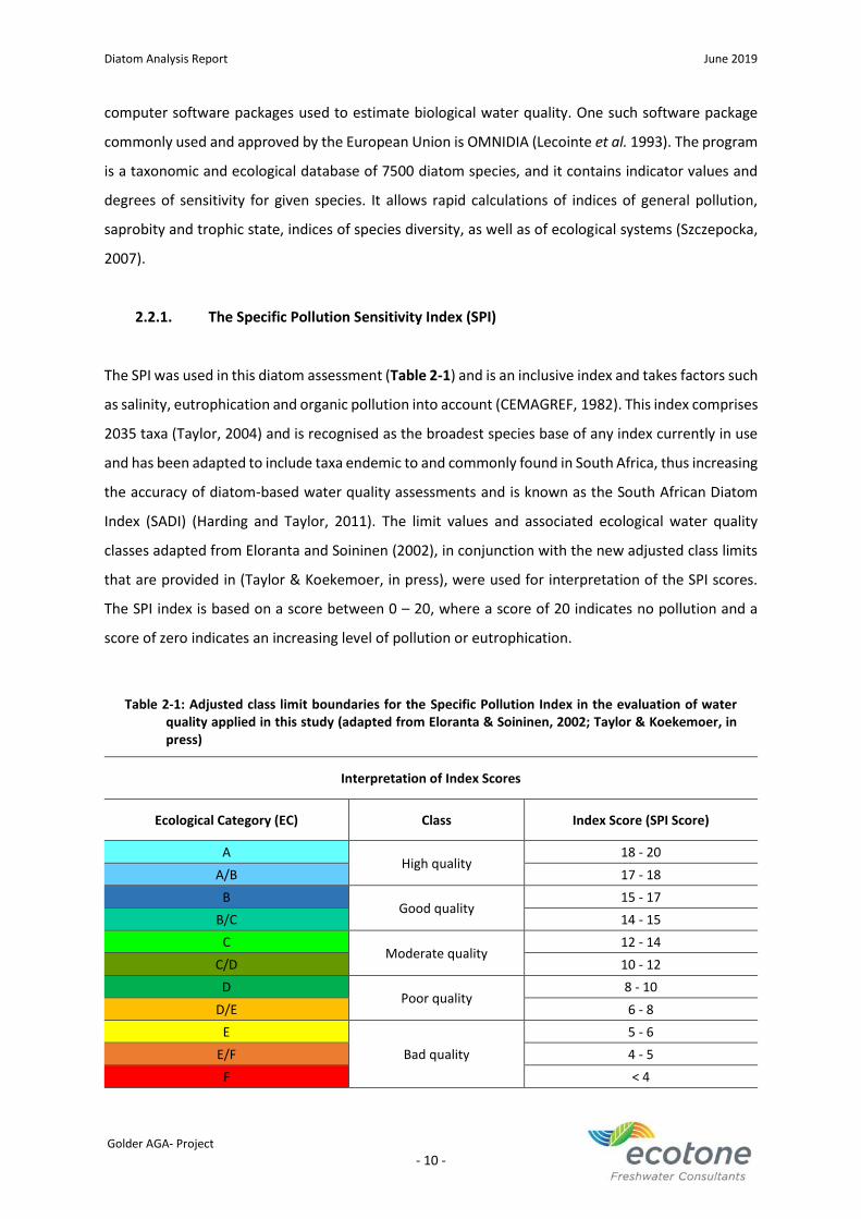
Diatom Analysis Report June 2019
Golder AGA- Project
- 10 -
computer software packages used to estimate biological water quality. One such software package
commonly used and approved by the European Union is OMNIDIA (Lecointe et al. 1993). The program
is a taxonomic and ecological database of 7500 diatom species, and it contains indicator values and
degrees of sensitivity for given species. It allows rapid calculations of indices of general pollution,
saprobity and trophic state, indices of species diversity, as well as of ecological systems (Szczepocka,
2007).
2.2.1. The Specific Pollution Sensitivity Index (SPI)
The SPI was used in this diatom assessment (Table 2-1) and is an inclusive index and takes factors such
as salinity, eutrophication and organic pollution into account (CEMAGREF, 1982). This index comprises
2035 taxa (Taylor, 2004) and is recognised as the broadest species base of any index currently in use
and has been adapted to include taxa endemic to and commonly found in South Africa, thus increasing
the accuracy of diatom-based water quality assessments and is known as the South African Diatom
Index (SADI) (Harding and Taylor, 2011). The limit values and associated ecological water quality
classes adapted from Eloranta and Soininen (2002), in conjunction with the new adjusted class limits
that are provided in (Taylor & Koekemoer, in press), were used for interpretation of the SPI scores.
The SPI index is based on a score between 0 – 20, where a score of 20 indicates no pollution and a
score of zero indicates an increasing level of pollution or eutrophication.
Table 2-1: Adjusted class limit boundaries for the Specific Pollution Index in the evaluation of water quality applied in this study (adapted from Eloranta & Soininen, 2002; Taylor & Koekemoer, in press)
Interpretation of Index Scores
Ecological Category (EC) Class Index Score (SPI Score)
A High quality
18 - 20
A/B 17 - 18
B Good quality
15 - 17
B/C 14 - 15
C Moderate quality
12 - 14
C/D 10 - 12
D Poor quality
8 - 10
D/E 6 - 8
E
Bad quality
5 - 6
E/F 4 - 5
F < 4
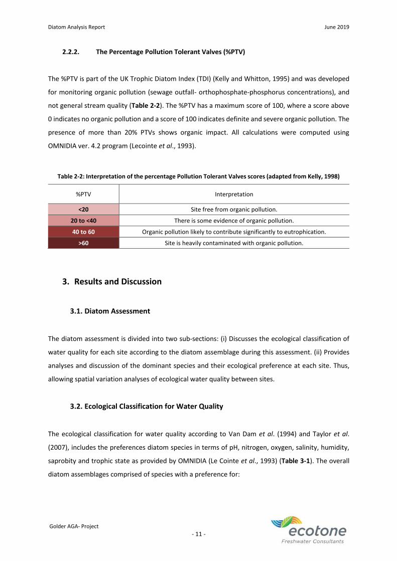
Diatom Analysis Report June 2019
Golder AGA- Project
- 11 -
2.2.2. The Percentage Pollution Tolerant Valves (%PTV)
The %PTV is part of the UK Trophic Diatom Index (TDI) (Kelly and Whitton, 1995) and was developed
for monitoring organic pollution (sewage outfall- orthophosphate-phosphorus concentrations), and
not general stream quality (Table 2-2). The %PTV has a maximum score of 100, where a score above
0 indicates no organic pollution and a score of 100 indicates definite and severe organic pollution. The
presence of more than 20% PTVs shows organic impact. All calculations were computed using
OMNIDIA ver. 4.2 program (Lecointe et al., 1993).
Table 2-2: Interpretation of the percentage Pollution Tolerant Valves scores (adapted from Kelly, 1998)
%PTV Interpretation
<20 Site free from organic pollution.
20 to <40 There is some evidence of organic pollution.
40 to 60 Organic pollution likely to contribute significantly to eutrophication.
>60 Site is heavily contaminated with organic pollution.
3. Results and Discussion
3.1. Diatom Assessment
The diatom assessment is divided into two sub-sections: (i) Discusses the ecological classification of
water quality for each site according to the diatom assemblage during this assessment. (ii) Provides
analyses and discussion of the dominant species and their ecological preference at each site. Thus,
allowing spatial variation analyses of ecological water quality between sites.
3.2. Ecological Classification for Water Quality
The ecological classification for water quality according to Van Dam et al. (1994) and Taylor et al.
(2007), includes the preferences diatom species in terms of pH, nitrogen, oxygen, salinity, humidity,
saprobity and trophic state as provided by OMNIDIA (Le Cointe et al., 1993) (Table 3-1). The overall
diatom assemblages comprised of species with a preference for:
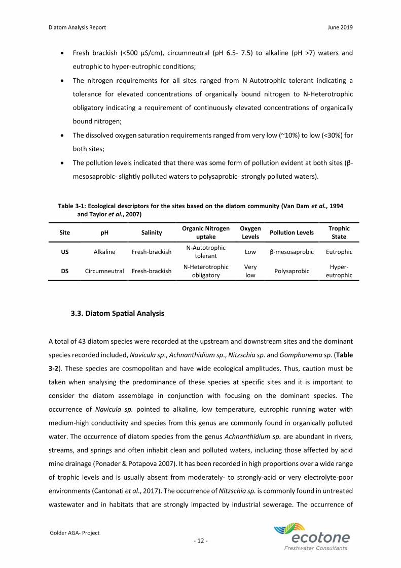
Diatom Analysis Report June 2019
Golder AGA- Project
- 12 -
• Fresh brackish (<500 μS/cm), circumneutral (pH 6.5- 7.5) to alkaline (pH >7) waters and
eutrophic to hyper-eutrophic conditions;
• The nitrogen requirements for all sites ranged from N-Autotrophic tolerant indicating a
tolerance for elevated concentrations of organically bound nitrogen to N-Heterotrophic
obligatory indicating a requirement of continuously elevated concentrations of organically
bound nitrogen;
• The dissolved oxygen saturation requirements ranged from very low (~10%) to low (<30%) for
both sites;
• The pollution levels indicated that there was some form of pollution evident at both sites (β-
mesosaprobic- slightly polluted waters to polysaprobic- strongly polluted waters).
Table 3-1: Ecological descriptors for the sites based on the diatom community (Van Dam et al., 1994 and Taylor et al., 2007)
Site pH Salinity Organic Nitrogen
uptake Oxygen Levels
Pollution Levels Trophic
State
US Alkaline Fresh-brackish N-Autotrophic
tolerant Low β-mesosaprobic Eutrophic
DS Circumneutral Fresh-brackish N-Heterotrophic
obligatory Very low
Polysaprobic Hyper-
eutrophic
3.3. Diatom Spatial Analysis
A total of 43 diatom species were recorded at the upstream and downstream sites and the dominant
species recorded included, Navicula sp., Achnanthidium sp., Nitzschia sp. and Gomphonema sp. (Table
3-2). These species are cosmopolitan and have wide ecological amplitudes. Thus, caution must be
taken when analysing the predominance of these species at specific sites and it is important to
consider the diatom assemblage in conjunction with focusing on the dominant species. The
occurrence of Navicula sp. pointed to alkaline, low temperature, eutrophic running water with
medium-high conductivity and species from this genus are commonly found in organically polluted
water. The occurrence of diatom species from the genus Achnanthidium sp. are abundant in rivers,
streams, and springs and often inhabit clean and polluted waters, including those affected by acid
mine drainage (Ponader & Potapova 2007). It has been recorded in high proportions over a wide range
of trophic levels and is usually absent from moderately- to strongly-acid or very electrolyte-poor
environments (Cantonati et al., 2017). The occurrence of Nitzschia sp. is commonly found in untreated
wastewater and in habitats that are strongly impacted by industrial sewerage. The occurrence of
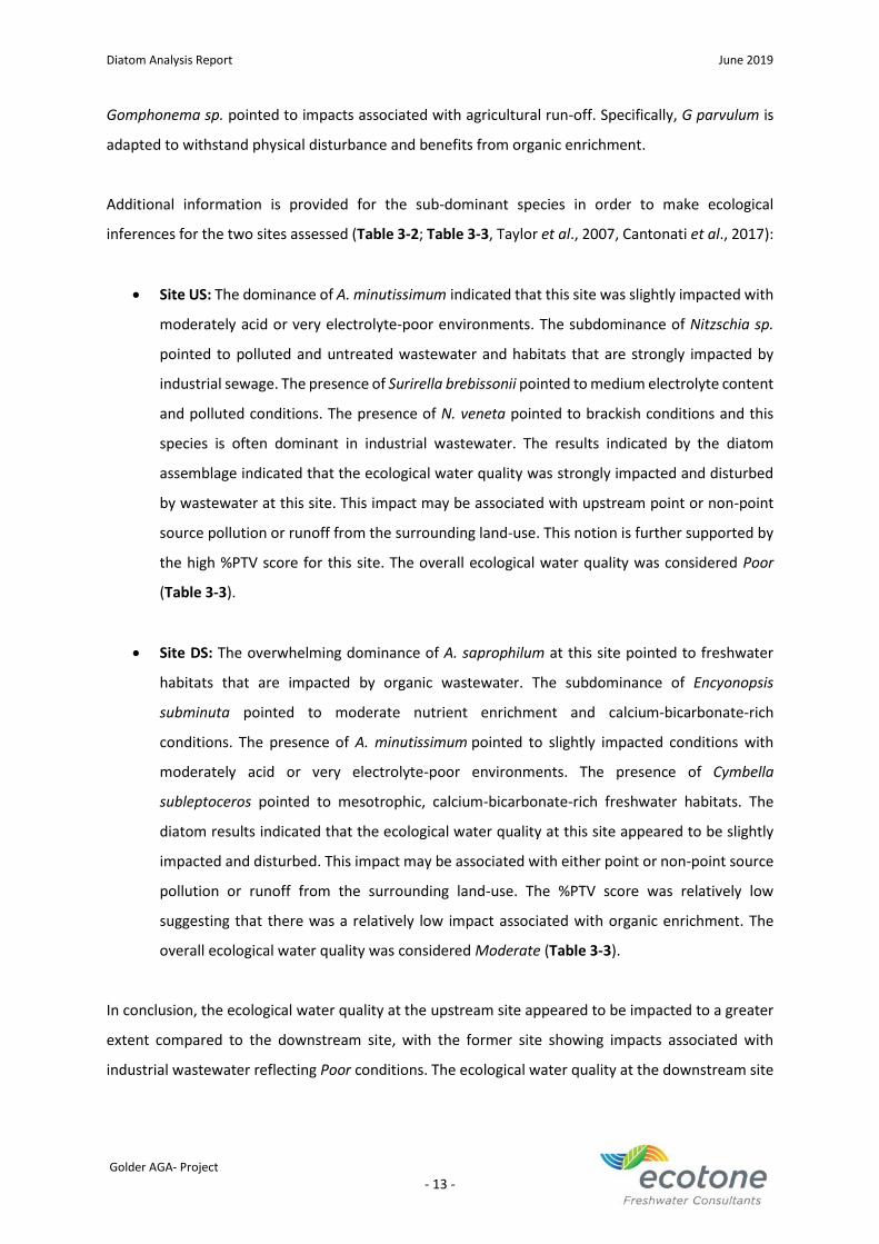
Diatom Analysis Report June 2019
Golder AGA- Project
- 13 -
Gomphonema sp. pointed to impacts associated with agricultural run-off. Specifically, G parvulum is
adapted to withstand physical disturbance and benefits from organic enrichment.
Additional information is provided for the sub-dominant species in order to make ecological
inferences for the two sites assessed (Table 3-2; Table 3-3, Taylor et al., 2007, Cantonati et al., 2017):
• Site US: The dominance of A. minutissimum indicated that this site was slightly impacted with
moderately acid or very electrolyte-poor environments. The subdominance of Nitzschia sp.
pointed to polluted and untreated wastewater and habitats that are strongly impacted by
industrial sewage. The presence of Surirella brebissonii pointed to medium electrolyte content
and polluted conditions. The presence of N. veneta pointed to brackish conditions and this
species is often dominant in industrial wastewater. The results indicated by the diatom
assemblage indicated that the ecological water quality was strongly impacted and disturbed
by wastewater at this site. This impact may be associated with upstream point or non-point
source pollution or runoff from the surrounding land-use. This notion is further supported by
the high %PTV score for this site. The overall ecological water quality was considered Poor
(Table 3-3).
• Site DS: The overwhelming dominance of A. saprophilum at this site pointed to freshwater
habitats that are impacted by organic wastewater. The subdominance of Encyonopsis
subminuta pointed to moderate nutrient enrichment and calcium-bicarbonate-rich
conditions. The presence of A. minutissimum pointed to slightly impacted conditions with
moderately acid or very electrolyte-poor environments. The presence of Cymbella
subleptoceros pointed to mesotrophic, calcium-bicarbonate-rich freshwater habitats. The
diatom results indicated that the ecological water quality at this site appeared to be slightly
impacted and disturbed. This impact may be associated with either point or non-point source
pollution or runoff from the surrounding land-use. The %PTV score was relatively low
suggesting that there was a relatively low impact associated with organic enrichment. The
overall ecological water quality was considered Moderate (Table 3-3).
In conclusion, the ecological water quality at the upstream site appeared to be impacted to a greater
extent compared to the downstream site, with the former site showing impacts associated with
industrial wastewater reflecting Poor conditions. The ecological water quality at the downstream site
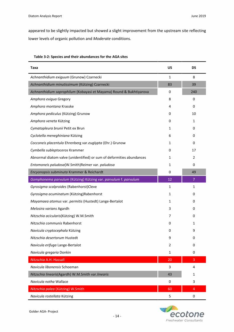
Diatom Analysis Report June 2019
Golder AGA- Project
- 14 -
appeared to be slightly impacted but showed a slight improvement from the upstream site reflecting
lower levels of organic pollution and Moderate conditions.
Table 3-2: Species and their abundances for the AGA sites
Taxa US DS
Achnanthidium exiguum (Grunow) Czarnecki 1 8
Achnanthidium minutissimum (Kützing) Czarnecki 83 39
Achnanthidium saprophilum (Kobayasi et Mayama) Round & Bukhtiyarova 0 240
Amphora exigua Gregory 8 0
Amphora montana Krasske 4 0
Amphora pediculus (Kützing) Grunow 0 10
Amphora veneta Kützing 0 1
Cymatopleura brunii Petit ex Brun 1 0
Cyclotella meneghiniana Kützing 6 0
Cocconeis placentula Ehrenberg var.euglypta (Ehr.) Grunow 1 0
Cymbella subleptoceros Krammer 0 17
Abnormal diatom valve (unidentified) or sum of deformities abundances 1 2
Entomoneis paludosa(W.Smith)Reimer var. paludosa 1 0
Encyonopsis subminuta Krammer & Reichardt 0 49
Gomphonema parvulum (Kützing) Kützing var. parvulum f. parvulum 12 7
Gyrosigma scalproides (Rabenhorst)Cleve 1 1
Gyrosigma acuminatum (Kützing)Rabenhorst 1 0
Mayamaea atomus var. permitis (Hustedt) Lange-Bertalot 1 0
Melosira varians Agardh 3 0
Nitzschia acicularis(Kützing) W.M.Smith 7 0
Nitzschia communis Rabenhorst 0 1
Navicula cryptocephala Kützing 0 9
Nitzschia desertorum Hustedt 9 0
Navicula erifuga Lange-Bertalot 2 0
Navicula gregaria Donkin 1 0
Nitzschia A.H. Hassall 20 3
Navicula libonensis Schoeman 3 4
Nitzschia linearis(Agardh) W.M.Smith var.linearis 43 1
Navicula notha Wallace 0 3
Nitzschia palea (Kützing) W.Smith 60 4
Navicula rostellata Kützing 5 0
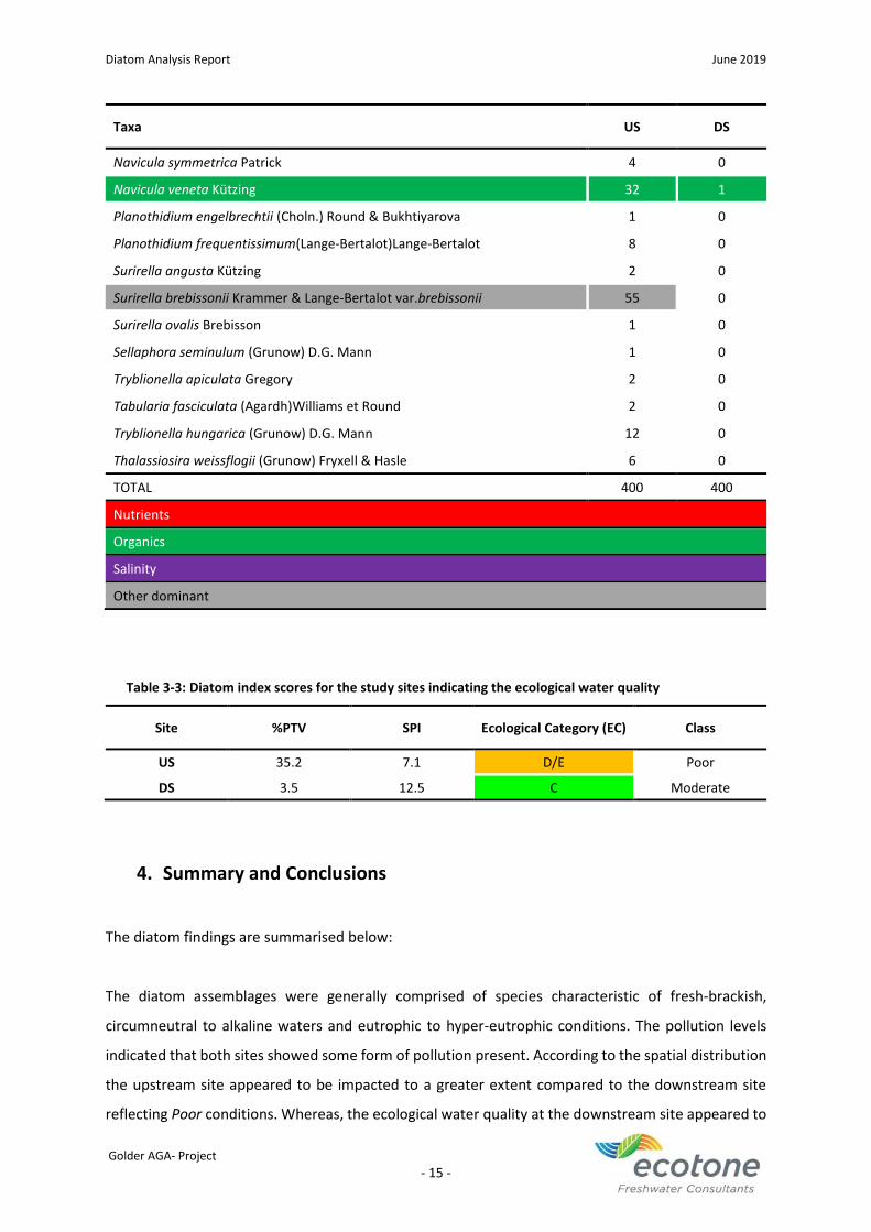
Diatom Analysis Report June 2019
Golder AGA- Project
- 15 -
Taxa US DS
Navicula symmetrica Patrick 4 0
Navicula veneta Kützing 32 1
Planothidium engelbrechtii (Choln.) Round & Bukhtiyarova 1 0
Planothidium frequentissimum(Lange-Bertalot)Lange-Bertalot 8 0
Surirella angusta Kützing 2 0
Surirella brebissonii Krammer & Lange-Bertalot var.brebissonii 55 0
Surirella ovalis Brebisson 1 0
Sellaphora seminulum (Grunow) D.G. Mann 1 0
Tryblionella apiculata Gregory 2 0
Tabularia fasciculata (Agardh)Williams et Round 2 0
Tryblionella hungarica (Grunow) D.G. Mann 12 0
Thalassiosira weissflogii (Grunow) Fryxell & Hasle 6 0
TOTAL 400 400
Nutrients
Organics
Salinity
Other dominant
Table 3-3: Diatom index scores for the study sites indicating the ecological water quality
Site %PTV SPI Ecological Category (EC) Class
US 35.2 7.1 D/E Poor
DS 3.5 12.5 C Moderate
4. Summary and Conclusions
The diatom findings are summarised below:
The diatom assemblages were generally comprised of species characteristic of fresh-brackish,
circumneutral to alkaline waters and eutrophic to hyper-eutrophic conditions. The pollution levels
indicated that both sites showed some form of pollution present. According to the spatial distribution
the upstream site appeared to be impacted to a greater extent compared to the downstream site
reflecting Poor conditions. Whereas, the ecological water quality at the downstream site appeared to

Diatom Analysis Report June 2019
Golder AGA- Project
- 16 -
show a slight recovery and improvement in comparison to the upstream site reflecting lower levels of
organic pollution and Moderate conditions. The impacts reflected at both sites may be associated with
upstream point or non-point source pollution or runoff from the surrounding land-use.
Diatom Analysis Report June 2019
Golder AGA- Project
- 17 -
5. References
Besse-Lototskaya, A., Verdonschot, P. F. M., Coste, M., Van de Vijver, B. (2011). Evaluation of European
diatom trophic indices. Ecological Indicators, 11, 456-467.
Cantonati, M., Kelly, M.G. and Lange-Bertalot, H. (2017). Freshwater benthic diatoms of central
Europe: Over 800 common species used in ecological assessment. Koeltz Botanical Books.
CEMAGREF. (1982). Etude des méthodes biologiques quantitatives d'appréciation de la qualité des
eaux. Rapport Division Qualité des Eaux Lyon - Agence Financiére de Bassin Rhône- Méditerranée-
Corse. Pierre-Benite.
Eloranta, P. & Soininen, J. (2002). Ecological status of Finnish rivers evaluated using benthic diatom
communities. Journal of Applied Phycology, 14: 1-7.
Kelly, M.G. & Whitton, B.A. (1995). The trophic diatom index: a new index for monitoring
eutrophication in rivers. Journal of Applied Phycology, 7: 433-444.
Kelly, M.G. (1998) Use of the Trophic Diatom Index to monitor eutrophication in rivers. Water
Research, 32: 236-242.
Kelly, M.G., Bennion, H., Cox, E.J., Goldsmith, B.m, Jamieson, J., Juggins, S., Mann, D.G & Telford, R.J.
(2005). Common freshwater diatoms of Britain and Ireland: an interactive key. Environment
Agency, Bristol. Retrieved from (http://craticula.ncl.ac.uk/EADiatomKey/html/
taxon13410310.html).
Krammer, K. & Lange-Bertalot, H. (1986). Bacillariophyceae.1. Teil: Naviculaceae. In: Suβwasserflora
von Mittleuropa, Band 2/1. Edited by Ettl, H., Gerloff, J., Heynig, H. & Mollenhauer, D. Spektrum
Akademischer Verlag, Heidelberg, Berlin.
Krammer, K. & Lange-Bertalot, H. (1988). Bacillariophyceae. 2. Teil: Bacillariaceae, Epithemiaceae,
Surirellaceae. In: Suβwasserflora von Mittleuropa, Band 2/2. Edited by Ettl, H., Gerloff, J., Heynig,
H. & Mollenhauer, D. Spektrum Akademischer Verlag, Heidelberg, Berlin.
Krammer, K. & Lange-Bertalot, H. (1991a). Bacillariophyceae. 3. Teil: Centrales, Fragilariaceae,
Eunotiaceae. In: Suβwasserflora von Mittleuropa, Band 2/3. Edited by Ettl, H., Gerloff, J., Heynig,
H. & Mollenhauer, D. Spektrum Akademischer Verlag, Heidelberg, Berlin.
Krammer, K. & Lange-Bertalot, H. (1991b). Bacillariophyceae. 4. Teil: Achnanthaceae, Kritische
Erg¨anzungen zu Navicula (Lineolatae und Gomphonema). In: Suβwasserflora von Mittleuropa,
Band 2/2. Edited by Ettl, H., Gerloff, J., Heynig, H. & Mollenhauer, D. Spektrum Akademischer
Verlag, Heidelberg, Berlin.
Lecointe, C., Coste, M. & Prygiel, J. (1993). “Omnidia”: Software for taxonomy, calculation of diatom
indices and inventories management. Hydrobiologia 269/270: 509-513.
Diatom Analysis Report June 2019
Golder AGA- Project
- 18 -
Lenoir, A. & Coste, M. (1996). Development of a practical diatom index of overall water quality
applicable to the French National Water Board network. In Use of Algae for Monitoring Rivers II:
Edited by Whitton, B.A. & Rott, E. Institut für Botanik, Universität Innsbruck. pp. 29-43.
Ponader, K. C., & Potapova, M. G. (2007). Diatoms from the genus Achnanthidium in flowing waters
of the Appalachian Mountains (North America): ecology, distribution and taxonomic notes.
Limnologica, 37: 227–241.
Prygiel, J., Carpentier, P., Almeida, S., Coste, M., Druart, J.C., Ector, L., Guillard, D., Honeré, M.A.,
Iserentant, R., Ledeganck, P., Lalanne-Cassou, C., Lesniak, C., Mercier, I., Moncaut, P., Nazart, M.,
Nouchet, N., Peres, F., Peeters, V., Rimet, F., Rumeau, A., Sabater, S., Straub, F., Torrisi, M.,
Tudesque, L., van der Vijver, B., Vidal, H., Vizinet, J. & Zydek, N. (2002). Determination of the
biological diatom index (IBD NF T 90-354): Results of an intercomparison exercise. Journal of
Applied Phycology, 14: 27-39.
Szczepocka E. (2007). Benthic diatoms from the outlet section of the Bzura River 30 years ago and
presently. Oceanological and Hydrobiological Studies, 36: 255-260.
Taylor, J.C., De la Rey, A. and Van Rensburg, L. (2005) Recommendations for the collection, preparation
and enumeration of diatoms from riverine habitats for water quality monitoring in South Africa.
African Journal of Aquatic Science, 30(1): 65–75.
Taylor, JC, Harding, WR and Archibald, CGM (2007a). A methods manual for the collection, preparation
and analysis of diatom samples. Water Research Commission Report TT281/07. Water Research
Commission. Pretoria.
Taylor, J.C., Harding, W.R. & Archibald, C.G.M. (2007b). An illustrated guide to some common diatom
species from South Africa. WRC Report No. TT 282/07. Water Research Commission, Pretoria,
South Africa.
Van Dam, H., Mertens, A. & Sinkeldam, J. (1994). A coded checklist and ecological indicator values of
freshwater diatoms from the Netherlands. Netherlands Journal of Aquatic Ecology, 28: 133-17.
Zelinka, M. & Marvan, P. (1961). Zur Präzisierung der biologischen klassifikation der Reinheit
flieβender Gewässer. -Arch. Hydrobiol., 57: 389-407.
February 2020 19121900-327695-6
APPENDIX G
Whole Effluent Toxicity Report
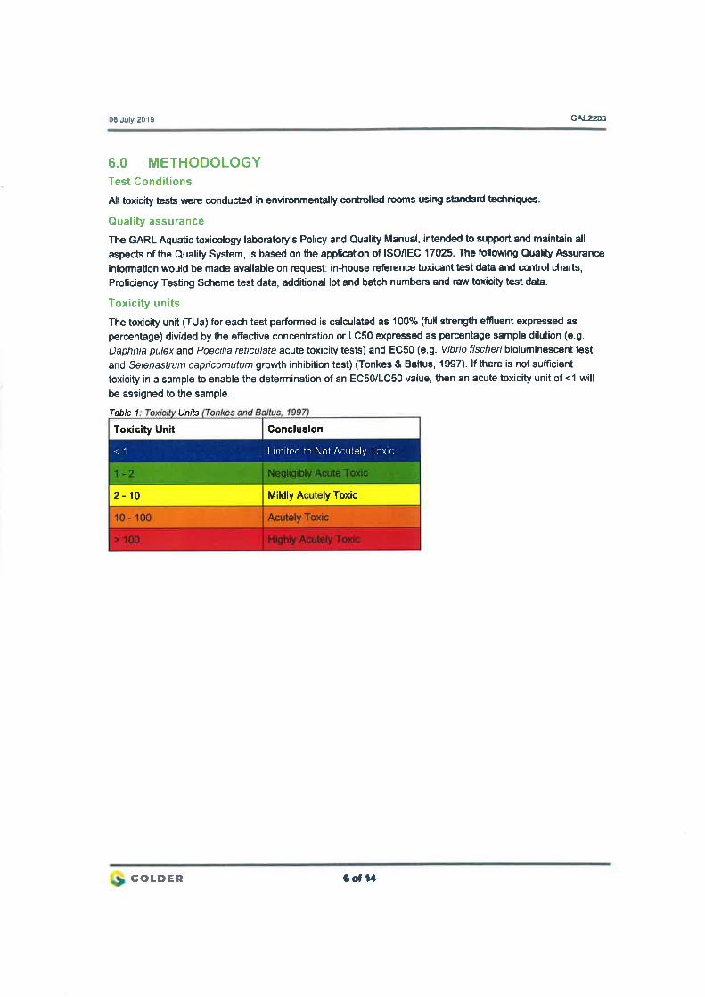
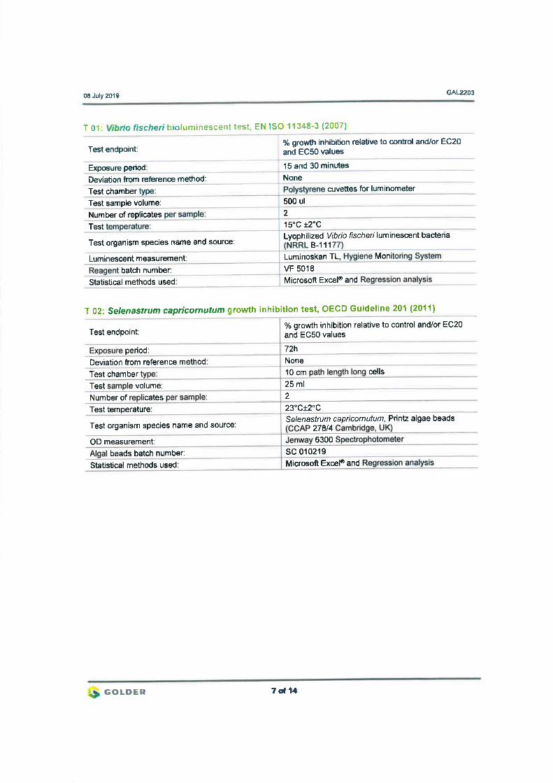
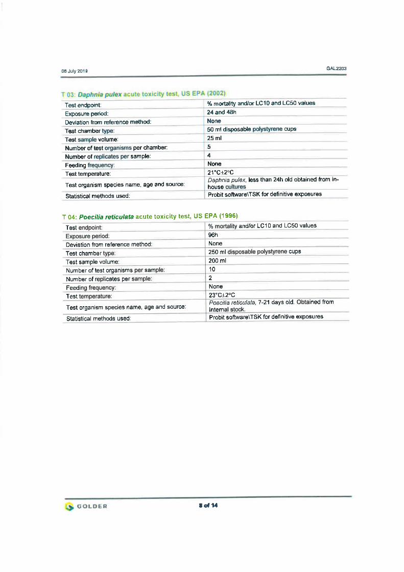
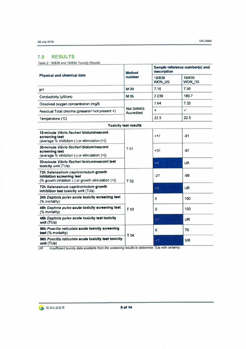
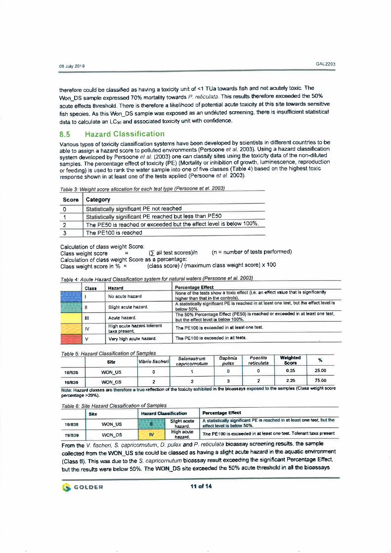

February 2020 19121900-327695-6
APPENDIX H
Acknowledgements, Details of
EAP, Declaration of Interest and
Specialist Experience
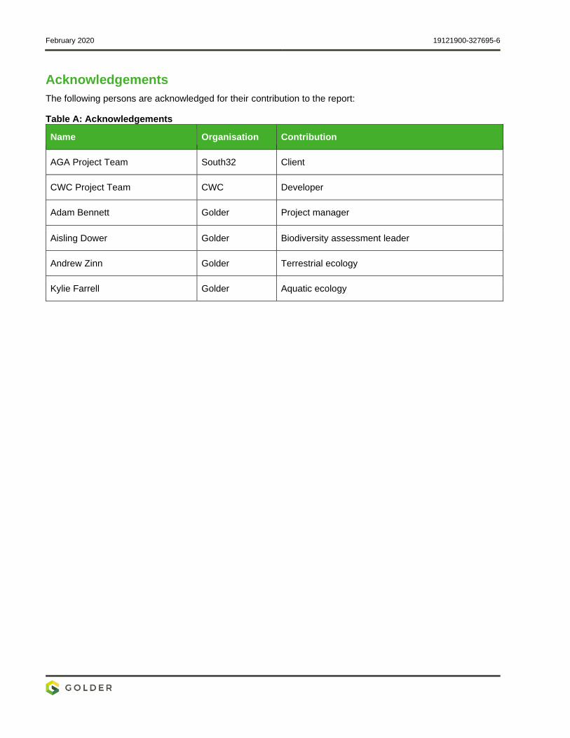
February 2020 19121900-327695-6
Acknowledgements
The following persons are acknowledged for their contribution to the report:
Table A: Acknowledgements
Name Organisation Contribution
AGA Project Team South32 Client
CWC Project Team CWC Developer
Adam Bennett Golder Project manager
Aisling Dower Golder Biodiversity assessment leader
Andrew Zinn Golder Terrestrial ecology
Kylie Farrell Golder Aquatic ecology
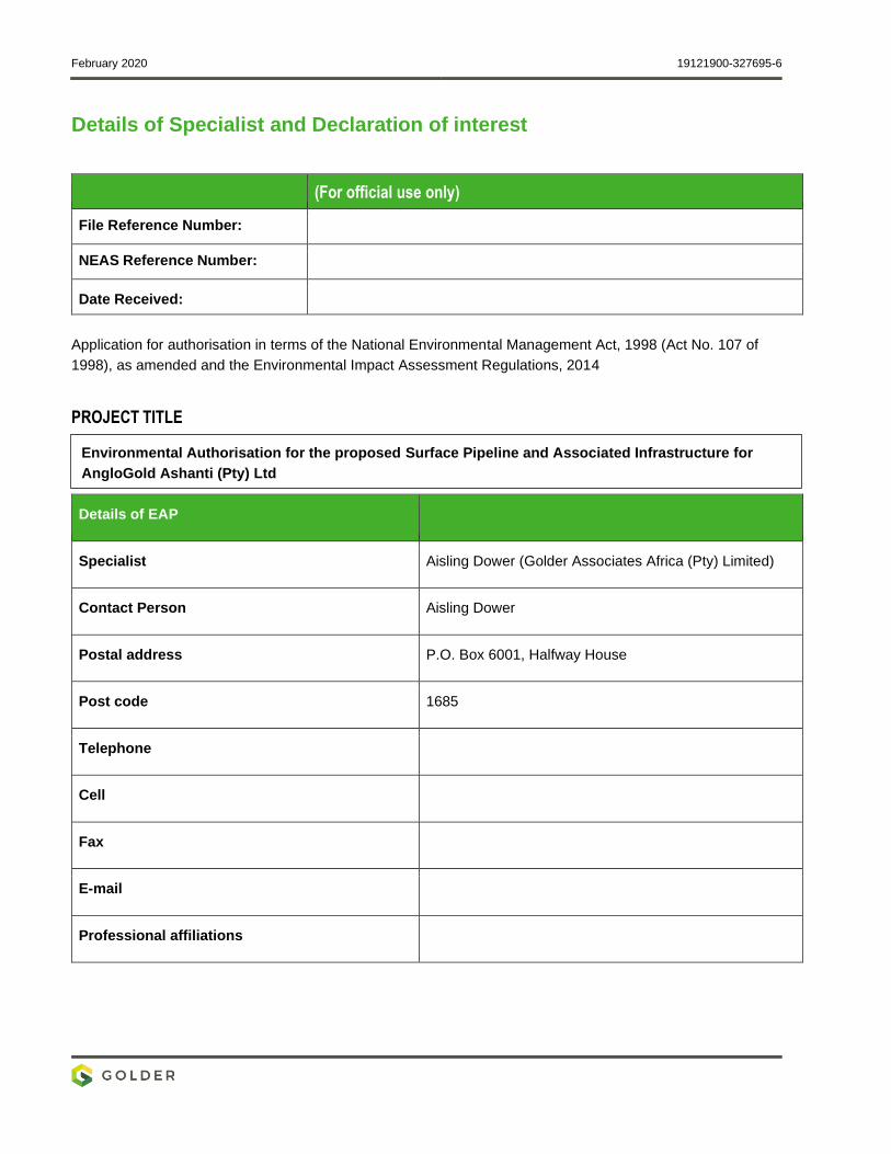
February 2020 19121900-327695-6
Details of Specialist and Declaration of interest
(For official use only)
File Reference Number:
NEAS Reference Number:
Date Received:
Application for authorisation in terms of the National Environmental Management Act, 1998 (Act No. 107 of
1998), as amended and the Environmental Impact Assessment Regulations, 2014
PROJECT TITLE
Details of EAP
Specialist Aisling Dower (Golder Associates Africa (Pty) Limited)
Contact Person Aisling Dower
Postal address P.O. Box 6001, Halfway House
Post code 1685
Telephone
Cell
Fax
Professional affiliations
Environmental Authorisation for the proposed Surface Pipeline and Associated Infrastructure for
AngloGold Ashanti (Pty) Ltd
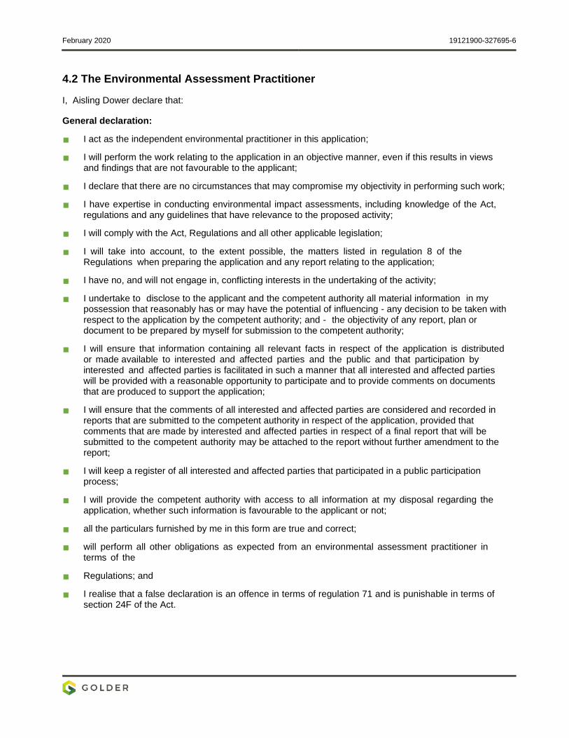
February 2020 19121900-327695-6
4.2 The Environmental Assessment Practitioner
I, Aisling Dower declare that:
General declaration:
I act as the independent environmental practitioner in this application;
I will perform the work relating to the application in an objective manner, even if this results in views and findings that are not favourable to the applicant;
I declare that there are no circumstances that may compromise my objectivity in performing such work;
I have expertise in conducting environmental impact assessments, including knowledge of the Act, regulations and any guidelines that have relevance to the proposed activity;
I will comply with the Act, Regulations and all other applicable legislation;
I will take into account, to the extent possible, the matters listed in regulation 8 of the Regulations when preparing the application and any report relating to the application;
I have no, and will not engage in, conflicting interests in the undertaking of the activity;
I undertake to disclose to the applicant and the competent authority all material information in my possession that reasonably has or may have the potential of influencing - any decision to be taken with respect to the application by the competent authority; and - the objectivity of any report, plan or document to be prepared by myself for submission to the competent authority;
I will ensure that information containing all relevant facts in respect of the application is distributed or made available to interested and affected parties and the public and that participation by interested and affected parties is facilitated in such a manner that all interested and affected parties will be provided with a reasonable opportunity to participate and to provide comments on documents that are produced to support the application;
I will ensure that the comments of all interested and affected parties are considered and recorded in reports that are submitted to the competent authority in respect of the application, provided that comments that are made by interested and affected parties in respect of a final report that will be submitted to the competent authority may be attached to the report without further amendment to the report;
I will keep a register of all interested and affected parties that participated in a public participation process;
I will provide the competent authority with access to all information at my disposal regarding the application, whether such information is favourable to the applicant or not;
all the particulars furnished by me in this form are true and correct;
will perform all other obligations as expected from an environmental assessment practitioner in terms of the
Regulations; and
I realise that a false declaration is an offence in terms of regulation 71 and is punishable in terms of section 24F of the Act.
February 2020 19121900-327695-6
Disclosure of Vested Interest (delete whichever is not applicable)
I do not have and will not have any vested interest (either business, financial, personal or other) in the
proposed activity proceeding other than remuneration for work performed in terms of the
Environmental Impact Assessment Regulations, 2014;
I do not have a vested interest in the proposed activity proceeding:
Signature of the environmental assessment practitioner:
Golder Associates Africa (Pty) limited
Name of company:
19 February 2020
Date:
February 2020 19121900-327695-6
Specialist experience
Aisling is a biodiversity specialist with over 11 years consulting experience in Europe and sub-Saharan Africa.
Experienced in designing, costing and conducting baseline flora and fauna surveys, ecosystem services
assessments, ecological impact assessment and development of mitigation, compensation and offsetting
measures for projects in the mining, O&G, waste, transport, land development and power generation sectors.
She has completed baseline biodiversity studies and ecosystem service reviews for numerous projects in
Southern Africa, East Africa, and Central and West Africa, and is experienced in conducting such
assessments to satisfy both national environmental regulations and international financing requirements
particularly those demanded by the International Finance Corporation’s 2012 Performance Standards. To date
she has worked on biodiversity-related projects in Ireland, UK, Kosovo, Gabon, Guinea, Guinea-Bissau,
Kenya, DRC, Mozambique and Uganda, in addition to numerous projects in South Africa, covering northern
temperate, Mediterranean, tropical rainforest, desert, savanna and coastal environments.

golder.com
March 2020 19121900-328397-9
APPENDIX I
Social Impact Assessment
REPORT
Specialist Assessment for the Proposed Surface
Pipeline and Associated Infrastructure - Social Impact
Assessment AngloGold Ashanti (Pty) Limited South Africa Operations
Submitted to:
Anglo Gold Ashanti (Pty) Limited South Africa Operations Mr J van Wyk
Carletonville - Fochville Road R500
Carletonville
Gauteng
2501
Submitted by:
Golder Associates Africa (Pty) Ltd.
Building 1, Maxwell Office Park, Magwa Crescent West, Waterfall City, Midrand, 1685, South Africa
P.O. Box 6001, Halfway House, 1685
+27 11 254 4800
19121900-327395-3
February 2020

February 2020 19121900-327395-3
i
Distribution List 1 eCopy to AngloGold Ashanti (Pty) Limited South Africa Operations
1 eCopy to [email protected]
February 2020 19121900-327395-3
ii
Executive Summary
Project overview
The AngloGold Ashanti (AG)A operations in the West Wits mining lease areas are at risk of flooding due to
ingress of fissure water from surrounding mining operations. Approximately 25 Mℓ/day of fissure water flows
into the underground workings of the defunct Blyvooruitzicht Mine, which spans a strike of 6 km along the
boundary with AGA.
If dewatering at the Old Blyvooruitzicht Shafts (#4, #5 & 6#) shafts were to cease, uncontrolled fissure water
would report to the AGA operations, which would pose both a flood and safety risk of AGA personnel and the
mining operations.
After the liquidation of the Blyvooruitzicht Mine (BLV) in 2013, AGA established a wholly owned subsidiary, the
Covalent Water Company (CWC), to manage the BLV Mine water at 4# and 6# to prevent flooding of the AGA
West Wits Operations. CWC has a 25-year lease to maintain water management infrastructure at the BLV
shafts #4 and #6. CWC currently abstracts approximately 20 Mℓ/d of good quality water from BLV #4 and #6
shafts and discharge this into the Wonderfonteinspruit under directive, 16/2/7/C231/C/116 dated 25 November
2014.
Approximately 6.5 Mℓ/d of Acid Mine Drainage (AMD) water containing elevated levels of heavy metals and
salts have been accumulating in the lower, mined out areas of BLV shaft #5 (BLV #5) bordering the Savuka
Mine. The pumping and removal of this impacted water was initiated at the Savuka Mine when this water
reached a critical level and started to decant to the AGA Operations, threatening AGA operational
infrastructure and posing a safety risk. Currently Savuka Mine pumps the BLV #5 fissure water from 81 level
to surface, where it is absorbed and used as make-up water in the Savuka Gold Plant remining operations.
In summary, AGA propose to install underground infrastructure to route the BVL 5# AMD water to the BVL 4#
to allow for the dewatering, neutralisation and pumping to surface. From the BVL 4# mine this impacted water
will be routed on surface to the North Boundary Dam (NBD) and used as make-up water to the Savuka Gold
Plant Reclamation Operations. This report provides scoping of the anticipated socio-economic impacts of this
proposed project.
Location
The proposed water pipeline and associated infrastructure is approximately 80 km west of Johannesburg and
originates in the greater West Wits mining lease areas approximately 3.3 km south-east of Carletonville and
ends at the North Boundary Dam (NBD) approximately 6 km south-south-west of Carletonville in
Blyvooruitzicht, Merafong City Local Municipality (MCLM), West Rand District Municipality in the Gauteng
Province of South Africa.
Baseline summary
A desktop study was conducted to understand and document the prevailing socio-economic conditions within
the proposed study area. The key demographic aspects within the municipality are provided below:
The Merafong population has dropped from 197 520 to 188 843 between 2011 and 2016, with a negative
population growth rate of 1.02;
The dominant population within the municipality group is black African, and the dominant language is
IsiXhosa;
February 2020 19121900-327395-3
iii
Approximately 84% of the working persons in Merafong have jobs in the formal sector; nearly 60% of the
formally employed persons are semi-skilled. The unemployment rate varies between 17% and 20%; and
The economy of Merafong City is still dominated by the mining sector, which contributed 54.9% to Gross
Domestic Product (GDP) in 2011 and 29.1% in 2016.
The provision of social infrastructure and services is relatively good within the municipality, with a majority of
the people using electricity for cooking and lighting, 74,7% households living in formal dwellings and the
availability of adequate sanitation and waste disposal in formal dwellings. Unfortunately, there is a backlog of
water and sanitation in informal settlements, road infrastructure is in poor to fair conditions within the MCLM
and the crime rate is high. Additionally, Merafong is not a traditional tourism destination with many of its
neighbours outperforming the municipality by a wide margin. There are, however, numerous tourism
development opportunities in Merafong.
Impact Assessment summary
Construction phase impacts
The anticipated impacts during the construction phase include:
Two positive impacts, namely employment opportunities and small, medium, and micro-enterprises
(SMMEs) development; and
Three negative impacts, namely population influx, disruption of movement patterns and health, safety,
and security risk.
Operational phase impacts
The anticipated impacts during the operational phase include:
Two positive impacts, namely health and safety of AGA personnel and operations and Employment
opportunities; and
One negative impact, namely, loss of employment.
Decommissioning phase impacts
The anticipated decommissioning phase impact includes one negative impact, which is the loss of
employment.
Concluding remarks
Golder recommends the implementation of mitigation measures, as described in this report. If mitigation
measures are implemented accordingly, it is anticipated that the consequence and probability of
moderate and high negative impacts will be reduced, while moderate positive impacts will on average be
enhanced to maximise benefits to the directly affected. Given the above, it is strongly recommended that
the mitigation measures described in this report be incorporated into the Environmental and Social
Management Plan for the proposed project. Additionally, measures must be put in place to monitor and
assess the implementation of these mitigation measures and take corrective action where necessary.
The opinions presented in this report apply to the information about the project as it existed at the time of
Golder’s investigations, and those reasonably foreseeable. These opinions do not necessarily apply to
conditions and features that may arise after the date of this report, about which Golder had no prior
knowledge nor had the opportunity to evaluate.
February 2020 19121900-327395-3
iv
Acronym List Acronyms
AGA Anglo Ashanti Gold
CWC Covalent Water Company
GDP Gross Domestic Product
IDP Integrated Development Plan
MCLM Merafong City Local Municipality
SIA Social Impact Assessment
SMME Small, medium, and micro-enterprises
WRDM West Rand District Municipality
February 2020 19121900-327395-3
v
Table of Contents
1.0 INTRODUCTION ......................................................................................................................................... 1
2.0 PROJECT BACKGROUND ........................................................................................................................ 1
2.1 Project description ............................................................................................................................. 1
2.2 Project location .................................................................................................................................. 1
3.0 STUDY APPROACH AND METHODOLOGY ............................................................................................ 3
3.1 Data collection ................................................................................................................................... 3
3.1.1 Desktop review .............................................................................................................................. 3
3.1.2 Public participation ........................................................................................................................ 3
3.2 Impact assessment ........................................................................................................................... 3
3.2.1 Identification of impacts ................................................................................................................ 3
3.2.2 Rating of impacts .......................................................................................................................... 3
3.2.3 Mitigation measures ...................................................................................................................... 5
4.0 APPLICABLE LEGISLATION, STANDARDS, AND GUIDELINES .......................................................... 5
4.1 National Environmental Management Act, 1998 (Act No. 107 of 1998 as amended) ...................... 5
4.2 Mine Health and Safety Act (Act No. 29 of 1996) ............................................................................. 5
4.3 Constitution of South Africa ............................................................................................................... 6
5.0 SOCIAL BASELINE .................................................................................................................................... 6
5.1 Socio-economic demographics ......................................................................................................... 6
5.1.1 Population ..................................................................................................................................... 6
5.1.2 Age and gender profile .................................................................................................................. 7
5.1.3 Ethnicity and language .................................................................................................................. 7
5.1.4 Education ...................................................................................................................................... 7
5.1.5 Employment .................................................................................................................................. 8
5.1.6 Economic activities........................................................................................................................ 8
5.2 Social and physical infrastructure ..................................................................................................... 9
5.2.1 Housing ......................................................................................................................................... 9
5.2.2 Water and sanitation ..................................................................................................................... 9
5.2.3 Waste management ...................................................................................................................... 9
5.2.4 Energy sources ............................................................................................................................. 9
February 2020 19121900-327395-3
vi
5.2.5 Roads .......................................................................................................................................... 10
5.2.6 Land use ..................................................................................................................................... 10
5.2.7 Tourism ....................................................................................................................................... 10
5.2.8 Crime ........................................................................................................................................... 10
6.0 IMPACT ASSESSMENT ........................................................................................................................... 10
6.1 Construction phase ......................................................................................................................... 11
6.1.1 Employment opportunities .......................................................................................................... 11
6.1.2 SMME development .................................................................................................................... 11
6.1.3 Population influx .......................................................................................................................... 11
6.1.4 Disruption of movement patterns ................................................................................................ 11
6.1.5 Health, safety, and security risk .................................................................................................. 11
6.2 Operational phase ........................................................................................................................... 12
6.2.1 Health and safety of AGA personnel and operations .................................................................. 12
6.2.2 Employment opportunities .......................................................................................................... 12
6.2.3 Loss of employment .................................................................................................................... 13
6.3 Decommissioning phase ................................................................................................................. 13
6.3.1 Loss of employment .................................................................................................................... 13
7.0 RECOMMENDED MITIGATION AND BEST PRACTICE MEASURES ................................................... 13
7.1 Construction phase recommendations ........................................................................................... 13
7.2 Operational phase recommendations ............................................................................................. 14
7.3 Decommissioning phase recommendations ................................................................................... 15
8.0 CONCLUSION .......................................................................................................................................... 15
9.0 REFERENCES .......................................................................................................................................... 16
TABLES
Table 1: Public places ........................................................................................................................................... 3
Table 2: Aspects for assessing the potential significance of impacts .................................................................. 4
Table 3: Scoring system for evaluation impacts ................................................................................................... 4
Table 4: Aspects of the South African constitution applicable to the SIA ............................................................. 6
Table 5: Population Statics of the Gauteng, West Rand District and Merafong Local Municipality (Statistics South Africa 2016 a and b) ................................................................................................................................... 7
Table 6: Population group and Language distribution (Stats SA CS 2016) ......................................................... 7
February 2020 19121900-327395-3
vii
Table 7: Education Level of MCLM (IDP 2018-2019) ........................................................................................... 8
Table 8: Employment and Unemployment profile (IDP 2018-2019) ..................................................................... 8
Table 9: The Sectoral Economic Structure and Performance (IDP 2018-2019) .................................................. 9
Table 10: Distribution of households by main source of energy for cooking and lighting (CS 2016) ................. 10
Table 11: Social Impact Assessment matrix for the construction phase of the proposed project ...................... 12
Table 12: Social Impact Assessment matrix for the operational phase of the proposed project ....................... 13
Table 13: Social Impact Assessment Matrix for the decommissioning phase of the proposed project ............. 13
Table 14: Proposed mitigation measures for construction phase impacts ......................................................... 13
Table 15: Proposed mitigation measures for operational phase impacts .......................................................... 14
Table 16: Proposed mitigation measures for decommissioning phase impacts ................................................ 15
FIGURES
Figure 1: Location of the proposed pipeline ......................................................................................................... 2
APPENDICES
APPENDIX A Document Limitations
APPENDIX B Acknowledgements, Details of Social Assessment Practitioner, Declaration of Interest and Specialist Experience
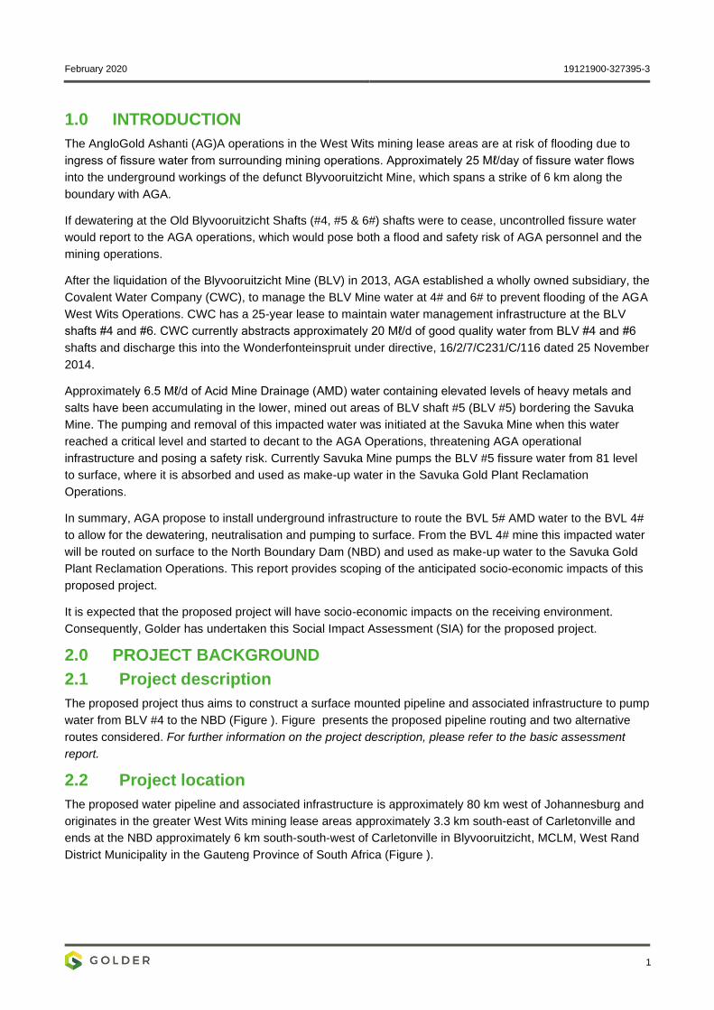
February 2020 19121900-327395-3
1
1.0 INTRODUCTION
The AngloGold Ashanti (AG)A operations in the West Wits mining lease areas are at risk of flooding due to
ingress of fissure water from surrounding mining operations. Approximately 25 Mℓ/day of fissure water flows
into the underground workings of the defunct Blyvooruitzicht Mine, which spans a strike of 6 km along the
boundary with AGA.
If dewatering at the Old Blyvooruitzicht Shafts (#4, #5 & 6#) shafts were to cease, uncontrolled fissure water
would report to the AGA operations, which would pose both a flood and safety risk of AGA personnel and the
mining operations.
After the liquidation of the Blyvooruitzicht Mine (BLV) in 2013, AGA established a wholly owned subsidiary, the
Covalent Water Company (CWC), to manage the BLV Mine water at 4# and 6# to prevent flooding of the AGA
West Wits Operations. CWC has a 25-year lease to maintain water management infrastructure at the BLV
shafts #4 and #6. CWC currently abstracts approximately 20 Mℓ/d of good quality water from BLV #4 and #6
shafts and discharge this into the Wonderfonteinspruit under directive, 16/2/7/C231/C/116 dated 25 November
2014.
Approximately 6.5 Mℓ/d of Acid Mine Drainage (AMD) water containing elevated levels of heavy metals and
salts have been accumulating in the lower, mined out areas of BLV shaft #5 (BLV #5) bordering the Savuka
Mine. The pumping and removal of this impacted water was initiated at the Savuka Mine when this water
reached a critical level and started to decant to the AGA Operations, threatening AGA operational
infrastructure and posing a safety risk. Currently Savuka Mine pumps the BLV #5 fissure water from 81 level
to surface, where it is absorbed and used as make-up water in the Savuka Gold Plant Reclamation
Operations.
In summary, AGA propose to install underground infrastructure to route the BVL 5# AMD water to the BVL 4#
to allow for the dewatering, neutralisation and pumping to surface. From the BVL 4# mine this impacted water
will be routed on surface to the North Boundary Dam (NBD) and used as make-up water to the Savuka Gold
Plant Reclamation Operations. This report provides scoping of the anticipated socio-economic impacts of this
proposed project.
It is expected that the proposed project will have socio-economic impacts on the receiving environment.
Consequently, Golder has undertaken this Social Impact Assessment (SIA) for the proposed project.
2.0 PROJECT BACKGROUND
2.1 Project description
The proposed project thus aims to construct a surface mounted pipeline and associated infrastructure to pump
water from BLV #4 to the NBD (Figure ). Figure presents the proposed pipeline routing and two alternative
routes considered. For further information on the project description, please refer to the basic assessment
report.
2.2 Project location
The proposed water pipeline and associated infrastructure is approximately 80 km west of Johannesburg and
originates in the greater West Wits mining lease areas approximately 3.3 km south-east of Carletonville and
ends at the NBD approximately 6 km south-south-west of Carletonville in Blyvooruitzicht, MCLM, West Rand
District Municipality in the Gauteng Province of South Africa (Figure ).
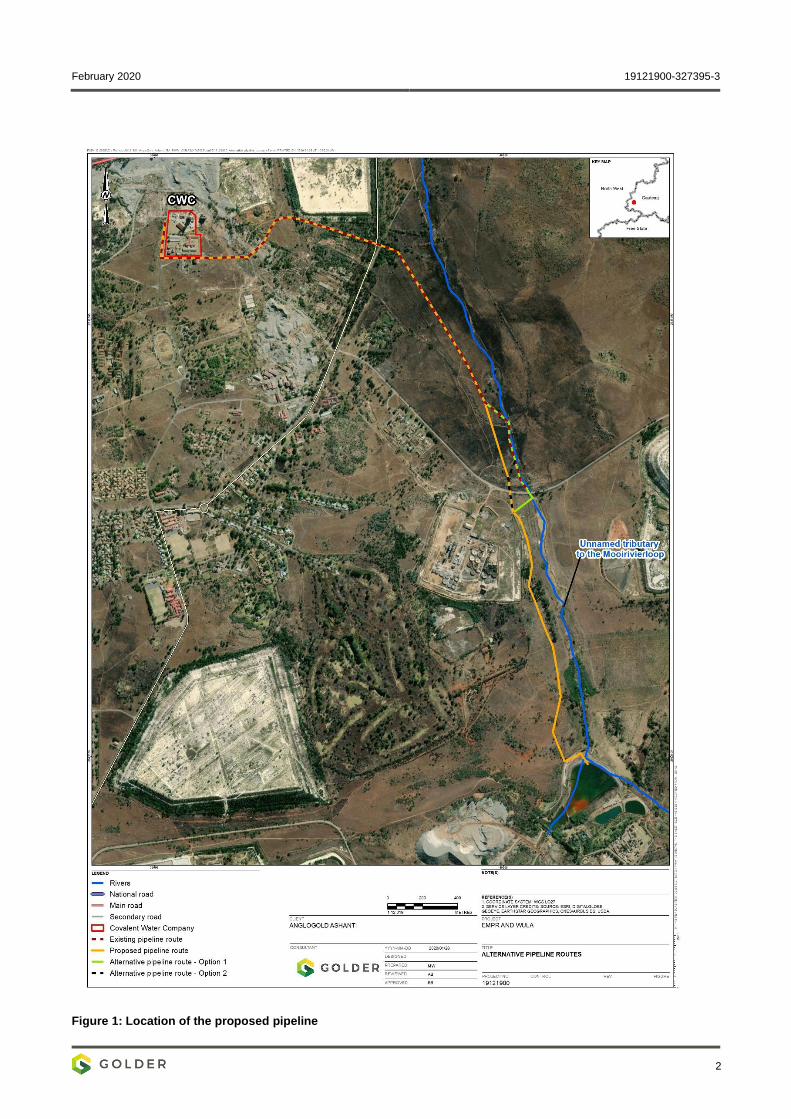
February 2020 19121900-327395-3
2
Figure 1: Location of the proposed pipeline
February 2020 19121900-327395-3
3
3.0 STUDY APPROACH AND METHODOLOGY
3.1 Data collection
3.1.1 Desktop review
Golder reviewed available documents to obtain information regarding the socio-economic conditions in the
study area. The documents reviewed include the following:
Integrated Development Plans (IDPs) of the affected local and district municipalities;
Community census survey outcomes by StatsSA;
Documents concerning the proposed project, which include the project description document; and
Available maps and satellite imagery.
3.1.2 Public participation
Golder placed site notices around the area regarding the proposed project. Additionally, Golder sent letters to
all interested and affected parties in a manner of e-mail, post and SMS; the purpose of the letters was to
inform stakeholders about the following;
Proposed AGA project; and
Availability of the draft basic assessment report and environmental management programme report
which was posted on the Golder website (https://www.golder.com/global-locations/africa/south-africa-
public-documents) and placed at the public places as shown below.
Table 1: Public places
Public places Address
Carletonville Library corner of Celestine and Emerald Streets,
Carletonville
Wedela Library 5378 Hawk Street, Wedela, Carletonville
Comment period viz., from Thursday, 10 October 2019 to Monday, 11 November 2019.
All stakeholders were granted an opportunity to send their comments regarding the proposed project via e-
mail, phone or post. Golder Prepared a comment and response register (CRR) after the 11th of November
2019, the outcomes of the CRR were considered during the impact assessment.
3.2 Impact assessment
3.2.1 Identification of impacts
Based on the collected data, outcomes of the public participation and expert knowledge, impacts were
identified and categorised according to the project phase in which the impacts are likely to occur viz.,
construction, operation, and closure and decommissioning phases.
3.2.2 Rating of impacts
The significance of the identified impacts will be determined using the approach outlined below (terminology
from the Department of Environmental Affairs Guideline document on ESIA Regulations, April 1998). This
approach incorporates two aspects for assessing the potential significance of impacts, namely occurrence and
severity, which are further sub-divided, as shown in Table 2.
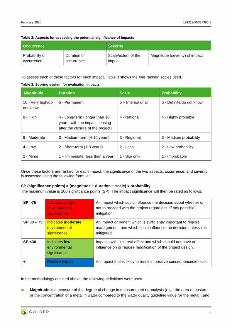
February 2020 19121900-327395-3
4
Table 2: Aspects for assessing the potential significance of impacts
Occurrence Severity
Probability of
occurrence
Duration of
occurrence
Scale/extent of the
impact
Magnitude (severity) of impact
To assess each of these factors for each impact, Table 3 shows the four ranking scales used.
Table 3: Scoring system for evaluation impacts
Magnitude Duration Scale Probability
10 - Very high/do
not know
5 - Permanent 5 – International 5 - Definite/do not know
8 - High 4 - Long-term (longer than 10
years, with the impact ceasing
after the closure of the project)
4 - National 4 - Highly probable
6 - Moderate 3 - Medium-term (4-10 years) 3 - Regional 3 - Medium probability
4 - Low 2 - Short-term (1-3 years) 2 - Local 2 - Low probability
2 - Minor 1 – Immediate (less than a year) 1 - Site only 1 - Improbable
Once these factors are ranked for each impact, the significance of the two aspects, occurrence, and severity, is assessed using the following formula:
SP (significance points) = (magnitude + duration + scale) x probability
The maximum value is 100 significance points (SP). The impact significance will then be rated as follows:
SP >75 Indicates a high
environmental
significance
An impact which could influence the decision about whether or
not to proceed with the project regardless of any possible
mitigation.
SP 30 – 75 Indicates moderate
environmental
significance
An impact or benefit which is sufficiently important to require
management, and which could influence the decision unless it is
mitigated.
SP <30 Indicates low
environmental
significance
Impacts with little real effect and which should not have an
influence on or require modification of the project design.
+ Positive impact An impact that is likely to result in positive consequences/effects.
In the methodology outlined above, the following definitions were used:
Magnitude is a measure of the degree of change in measurement or analysis (e.g., the area of pasture,
or the concentration of a metal in water compared to the water quality guideline value for the metal), and
February 2020 19121900-327395-3
5
is classified as none/negligible, low, moderate, or high. The categorisation of the impact magnitude may
be based on a set of criteria (e.g. health risk levels, ecological concepts, and professional judgement)
pertinent to each of the discipline areas and key questions analysed. The specialist study must attempt
to quantify the magnitude and outline the rationale used. Appropriate, widely recognised standards are to
be used as a measure of the level of impact.
Scale/Geographic extent refers to the area that could be affected by the impact and is classified as site,
local, regional, national, or international.
Duration refers to the length of time over which an environmental impact may occur: i.e.
immediate/transient, short-term (one to three years), medium-term (four to 10 years), long-term (greater
than 10 years with impact ceasing after the closure of the project), or permanent.
Probability of occurrence is a description of the probability of the impact actually occurring as
improbable (less than 5% chance), low probability (5% to 40% chance), medium probability (40% to 60%
chance), highly probable (most likely, 60% to 90% chance) or definite (impact will definitely occur).
3.2.3 Mitigation measures
Mitigation measures were formulated to avoid or reduce negative impacts and to enhance positive ones.
Golder used the following criteria when recommending mitigation measures:
Ability to avoid the impact without having significant negative secondary consequences; and
Feasibility and cost-effectiveness.
After suitable mitigation measures were identified for each impact, the rating procedure described in the
section above was repeated to assess the expected significance. The difference between pre- and post-
mitigation rating represents the degree to which the recommended mitigation measures are expected to be
effective in reducing the impacts.
4.0 APPLICABLE LEGISLATION, STANDARDS, AND GUIDELINES
4.1 National Environmental Management Act, 1998 (Act No. 107 of 1998 as amended)
According to NEMA, sustainable development requires the integration of social, economic, and environmental
factors in the planning, implementation, and evaluation of decisions to ensure that development serves
present and future generations. NEMA also sets out the process for public participation.
4.2 Mine Health and Safety Act (Act No. 29 of 1996)
AGA holds a Mining Right and operates with an environmental management programme report (EMPr) and is
regulated by the Department of Mineral Resources. The objects of the act are to:
Protect the health and safety of persons at mines;
Require employers and employees to identify hazards and eliminate, control, and minimise the risks
relating to health and safety at mines;
Give effect to the public international law obligations of the Republic that concern health and safety at
mines;
Provide for employee participation in matters of health and safety through health and safety;
Provide for effective monitoring of health and safety conditions at mines;
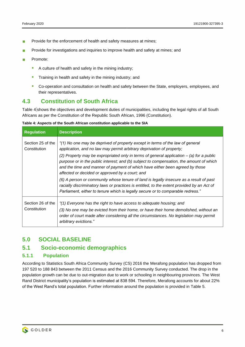
February 2020 19121900-327395-3
6
Provide for the enforcement of health and safety measures at mines;
Provide for investigations and inquiries to improve health and safety at mines; and
Promote:
▪ A culture of health and safety in the mining industry;
▪ Training in health and safety in the mining industry; and
▪ Co-operation and consultation on health and safety between the State, employers, employees, and
their representatives.
4.3 Constitution of South Africa
Table 4 shows the objectives and development duties of municipalities, including the legal rights of all South
Africans as per the Constitution of the Republic South African, 1996 (Constitution).
Table 4: Aspects of the South African constitution applicable to the SIA
Regulation Description
Section 25 of the
Constitution
“(1) No one may be deprived of property except in terms of the law of general
application, and no law may permit arbitrary deprivation of property;
(2) Property may be expropriated only in terms of general application – (a) for a public
purpose or in the public interest; and (b) subject to compensation, the amount of which
and the time and manner of payment of which have either been agreed by those
affected or decided or approved by a court; and
(6) A person or community whose tenure of land is legally insecure as a result of past
racially discriminatory laws or practices is entitled, to the extent provided by an Act of
Parliament, either to tenure which is legally secure or to comparable redress.”
Section 26 of the
Constitution
“(1) Everyone has the right to have access to adequate housing; and
(3) No one may be evicted from their home, or have their home demolished, without an
order of court made after considering all the circumstances. No legislation may permit
arbitrary evictions.”
5.0 SOCIAL BASELINE
5.1 Socio-economic demographics
5.1.1 Population
According to Statistics South Africa Community Survey (CS) 2016 the Merafong population has dropped from
197 520 to 188 843 between the 2011 Census and the 2016 Community Survey conducted. The drop in the
population growth can be due to out-migration due to work or schooling in neighbouring provinces. The West
Rand District municipality’s population is estimated at 838 594. Therefore, Merafong accounts for about 22%
of the West Rand’s total population. Further information around the population is provided in Table 5.
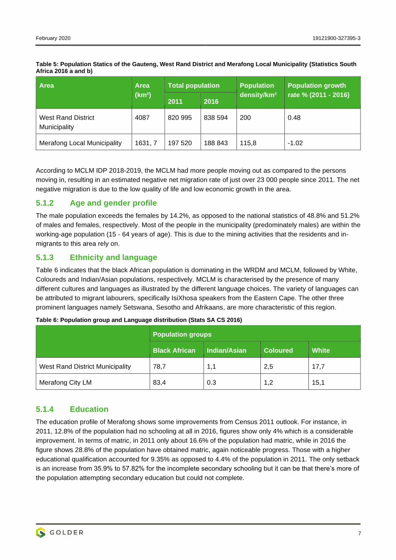
February 2020 19121900-327395-3
7
Table 5: Population Statics of the Gauteng, West Rand District and Merafong Local Municipality (Statistics South Africa 2016 a and b)
Area Area
(km²)
Total population Population
density/km²
Population growth
rate % (2011 - 2016) 2011 2016
West Rand District
Municipality
4087 820 995 838 594 200 0.48
Merafong Local Municipality 1631, 7 197 520 188 843 115,8 -1.02
According to MCLM IDP 2018-2019, the MCLM had more people moving out as compared to the persons
moving in, resulting in an estimated negative net migration rate of just over 23 000 people since 2011. The net
negative migration is due to the low quality of life and low economic growth in the area.
5.1.2 Age and gender profile
The male population exceeds the females by 14.2%, as opposed to the national statistics of 48.8% and 51.2%
of males and females, respectively. Most of the people in the municipality (predominately males) are within the
working-age population (15 - 64 years of age). This is due to the mining activities that the residents and in-
migrants to this area rely on.
5.1.3 Ethnicity and language
Table 6 indicates that the black African population is dominating in the WRDM and MCLM, followed by White,
Coloureds and Indian/Asian populations, respectively. MCLM is characterised by the presence of many
different cultures and languages as illustrated by the different language choices. The variety of languages can
be attributed to migrant labourers, specifically IsiXhosa speakers from the Eastern Cape. The other three
prominent languages namely Setswana, Sesotho and Afrikaans, are more characteristic of this region.
Table 6: Population group and Language distribution (Stats SA CS 2016)
Population groups
Black African Indian/Asian Coloured White
West Rand District Municipality 78,7 1,1 2,5 17,7
Merafong City LM 83,4 0.3 1,2 15,1
5.1.4 Education
The education profile of Merafong shows some improvements from Census 2011 outlook. For instance, in
2011, 12.8% of the population had no schooling at all in 2016, figures show only 4% which is a considerable
improvement. In terms of matric, in 2011 only about 16.6% of the population had matric, while in 2016 the
figure shows 28.8% of the population have obtained matric, again noticeable progress. Those with a higher
educational qualification accounted for 9.35% as opposed to 4.4% of the population in 2011. The only setback
is an increase from 35.9% to 57.82% for the incomplete secondary schooling but it can be that there’s more of
the population attempting secondary education but could not complete.
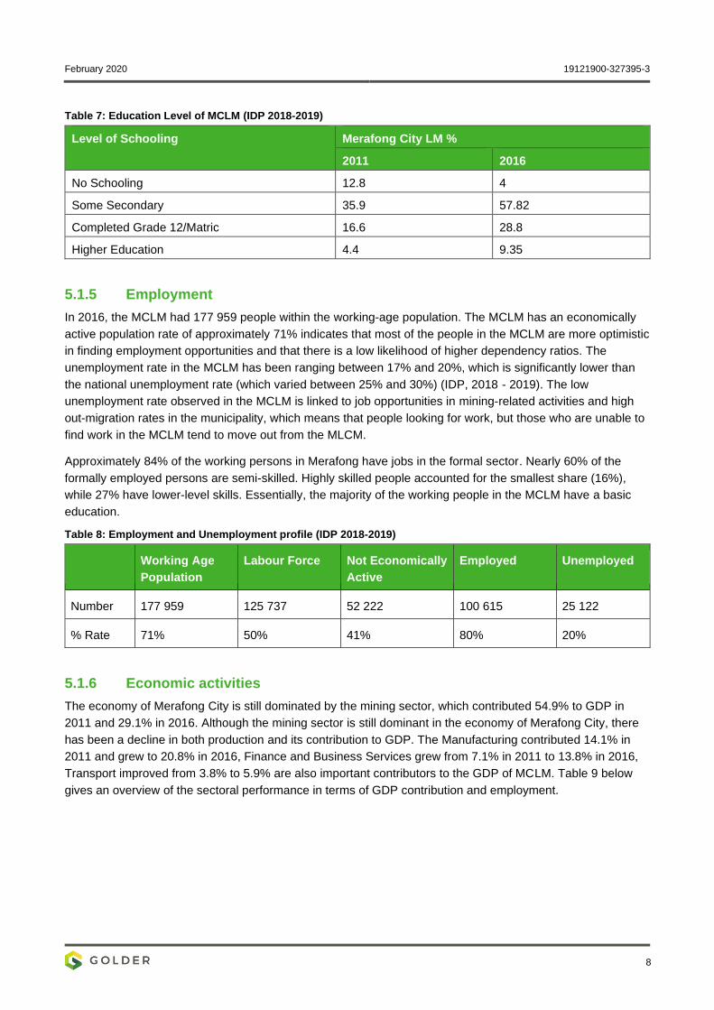
February 2020 19121900-327395-3
8
Table 7: Education Level of MCLM (IDP 2018-2019)
Level of Schooling Merafong City LM %
2011 2016
No Schooling 12.8 4
Some Secondary 35.9 57.82
Completed Grade 12/Matric 16.6 28.8
Higher Education 4.4 9.35
5.1.5 Employment
In 2016, the MCLM had 177 959 people within the working-age population. The MCLM has an economically
active population rate of approximately 71% indicates that most of the people in the MCLM are more optimistic
in finding employment opportunities and that there is a low likelihood of higher dependency ratios. The
unemployment rate in the MCLM has been ranging between 17% and 20%, which is significantly lower than
the national unemployment rate (which varied between 25% and 30%) (IDP, 2018 - 2019). The low
unemployment rate observed in the MCLM is linked to job opportunities in mining-related activities and high
out-migration rates in the municipality, which means that people looking for work, but those who are unable to
find work in the MCLM tend to move out from the MLCM.
Approximately 84% of the working persons in Merafong have jobs in the formal sector. Nearly 60% of the
formally employed persons are semi-skilled. Highly skilled people accounted for the smallest share (16%),
while 27% have lower-level skills. Essentially, the majority of the working people in the MCLM have a basic
education.
Table 8: Employment and Unemployment profile (IDP 2018-2019)
Working Age
Population
Labour Force Not Economically
Active
Employed Unemployed
Number 177 959 125 737 52 222 100 615 25 122
% Rate 71% 50% 41% 80% 20%
5.1.6 Economic activities
The economy of Merafong City is still dominated by the mining sector, which contributed 54.9% to GDP in
2011 and 29.1% in 2016. Although the mining sector is still dominant in the economy of Merafong City, there
has been a decline in both production and its contribution to GDP. The Manufacturing contributed 14.1% in
2011 and grew to 20.8% in 2016, Finance and Business Services grew from 7.1% in 2011 to 13.8% in 2016,
Transport improved from 3.8% to 5.9% are also important contributors to the GDP of MCLM. Table 9 below
gives an overview of the sectoral performance in terms of GDP contribution and employment.
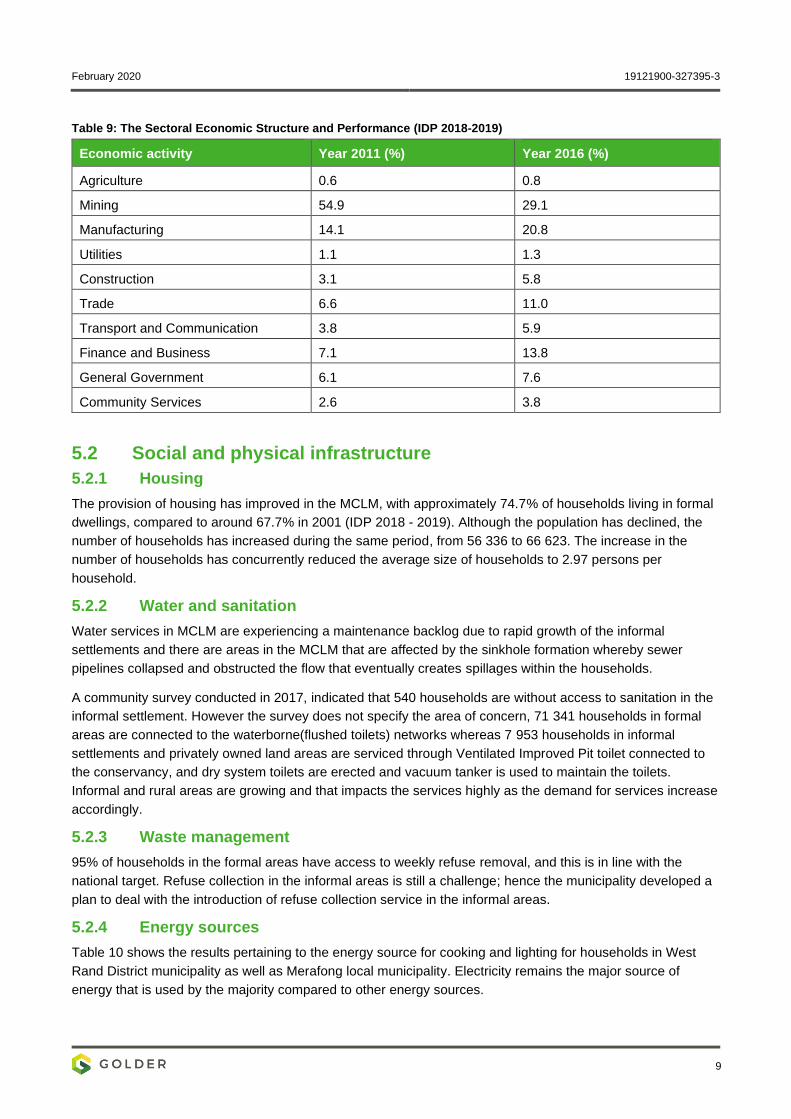
February 2020 19121900-327395-3
9
Table 9: The Sectoral Economic Structure and Performance (IDP 2018-2019)
Economic activity Year 2011 (%) Year 2016 (%)
Agriculture 0.6 0.8
Mining 54.9 29.1
Manufacturing 14.1 20.8
Utilities 1.1 1.3
Construction 3.1 5.8
Trade 6.6 11.0
Transport and Communication 3.8 5.9
Finance and Business 7.1 13.8
General Government 6.1 7.6
Community Services 2.6 3.8
5.2 Social and physical infrastructure
5.2.1 Housing
The provision of housing has improved in the MCLM, with approximately 74.7% of households living in formal
dwellings, compared to around 67.7% in 2001 (IDP 2018 - 2019). Although the population has declined, the
number of households has increased during the same period, from 56 336 to 66 623. The increase in the
number of households has concurrently reduced the average size of households to 2.97 persons per
household.
5.2.2 Water and sanitation
Water services in MCLM are experiencing a maintenance backlog due to rapid growth of the informal
settlements and there are areas in the MCLM that are affected by the sinkhole formation whereby sewer
pipelines collapsed and obstructed the flow that eventually creates spillages within the households.
A community survey conducted in 2017, indicated that 540 households are without access to sanitation in the
informal settlement. However the survey does not specify the area of concern, 71 341 households in formal
areas are connected to the waterborne(flushed toilets) networks whereas 7 953 households in informal
settlements and privately owned land areas are serviced through Ventilated Improved Pit toilet connected to
the conservancy, and dry system toilets are erected and vacuum tanker is used to maintain the toilets.
Informal and rural areas are growing and that impacts the services highly as the demand for services increase
accordingly.
5.2.3 Waste management
95% of households in the formal areas have access to weekly refuse removal, and this is in line with the
national target. Refuse collection in the informal areas is still a challenge; hence the municipality developed a
plan to deal with the introduction of refuse collection service in the informal areas.
5.2.4 Energy sources
Table 10 shows the results pertaining to the energy source for cooking and lighting for households in West
Rand District municipality as well as Merafong local municipality. Electricity remains the major source of
energy that is used by the majority compared to other energy sources.
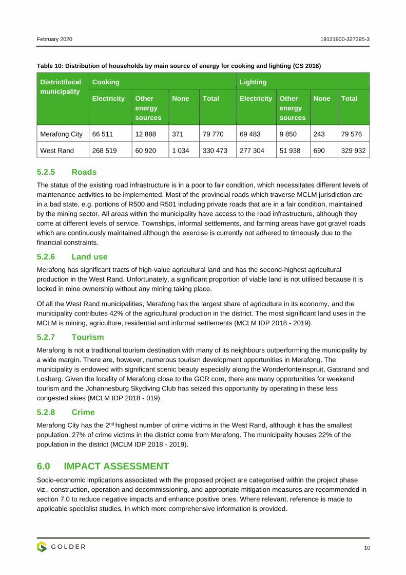
February 2020 19121900-327395-3
10
Table 10: Distribution of households by main source of energy for cooking and lighting (CS 2016)
5.2.5 Roads
The status of the existing road infrastructure is in a poor to fair condition, which necessitates different levels of
maintenance activities to be implemented. Most of the provincial roads which traverse MCLM jurisdiction are
in a bad state, e.g. portions of R500 and R501 including private roads that are in a fair condition, maintained
by the mining sector. All areas within the municipality have access to the road infrastructure, although they
come at different levels of service. Townships, informal settlements, and farming areas have got gravel roads
which are continuously maintained although the exercise is currently not adhered to timeously due to the
financial constraints.
5.2.6 Land use
Merafong has significant tracts of high-value agricultural land and has the second-highest agricultural
production in the West Rand. Unfortunately, a significant proportion of viable land is not utilised because it is
locked in mine ownership without any mining taking place.
Of all the West Rand municipalities, Merafong has the largest share of agriculture in its economy, and the
municipality contributes 42% of the agricultural production in the district. The most significant land uses in the
MCLM is mining, agriculture, residential and informal settlements (MCLM IDP 2018 - 2019).
5.2.7 Tourism
Merafong is not a traditional tourism destination with many of its neighbours outperforming the municipality by
a wide margin. There are, however, numerous tourism development opportunities in Merafong. The
municipality is endowed with significant scenic beauty especially along the Wonderfonteinspruit, Gatsrand and
Losberg. Given the locality of Merafong close to the GCR core, there are many opportunities for weekend
tourism and the Johannesburg Skydiving Club has seized this opportunity by operating in these less
congested skies (MCLM IDP 2018 - 019).
5.2.8 Crime
Merafong City has the 2nd highest number of crime victims in the West Rand, although it has the smallest
population. 27% of crime victims in the district come from Merafong. The municipality houses 22% of the
population in the district (MCLM IDP 2018 - 2019).
6.0 IMPACT ASSESSMENT
Socio-economic implications associated with the proposed project are categorised within the project phase
viz., construction, operation and decommissioning, and appropriate mitigation measures are recommended in
section 7.0 to reduce negative impacts and enhance positive ones. Where relevant, reference is made to
applicable specialist studies, in which more comprehensive information is provided.
District/local
municipality
Cooking Lighting
Electricity Other
energy
sources
None Total Electricity Other
energy
sources
None Total
Merafong City 66 511 12 888 371 79 770 69 483 9 850 243 79 576
West Rand 268 519 60 920 1 034 330 473 277 304 51 938 690 329 932
February 2020 19121900-327395-3
11
6.1 Construction phase
The anticipated impacts during the construction phase include:
Two positive impacts, namely employment opportunities and SMME development; and
Three negative impacts, namely population influx, disruption of movement patterns and health, safety,
and security risk.
These are discussed further in the subsequent sections.
6.1.1 Employment opportunities
It is anticipated that AGA will appoint a contractor for the construction of the pipeline and associated
infrastructure during the construction phase. The number of locally employed people during the construction
phase will largely depend on AGA’s recruitment policy and the applicant’s level of education, skills, and work
experience.
6.1.2 SMME development
The construction of the pipeline and associated infrastructure has the potential to create job opportunities for
existing and new local SMMEs. These opportunities may include and not to be limited to:
Minor land clearing for the preparation and laying of the pipeline support plinths;
General manual labour relates to construction activities; and
The supply of materials.
Should these opportunities be realised there will be a positive impact on the local economic activity in the
area.
6.1.3 Population influx
During the construction phase, it is not anticipated that a population influx will be induced by work and
business seekers coming into the area seeking employment and business opportunities.
6.1.4 Disruption of movement patterns
It is anticipated that there may be a disruption of movement patterns within the project areas, this will primarily
occur as a result of:
Minor land clearing for the preparation and laying of the pipeline support plinths;
Traffic disturbances and rerouting while gantries are being constructed over local roads; and
Project-related traffic on local roads.
6.1.5 Health, safety, and security risk
Apart from the actual construction of the pipeline and associated infrastructure, the construction phase will
also require the transportation of construction machinery and material on the nearby national road, which is
used by private motorists. Consequently, this may result in:
Increased dust levels which may result in respiratory problems for the locals and construction workers;
and
Increased traffic volumes.
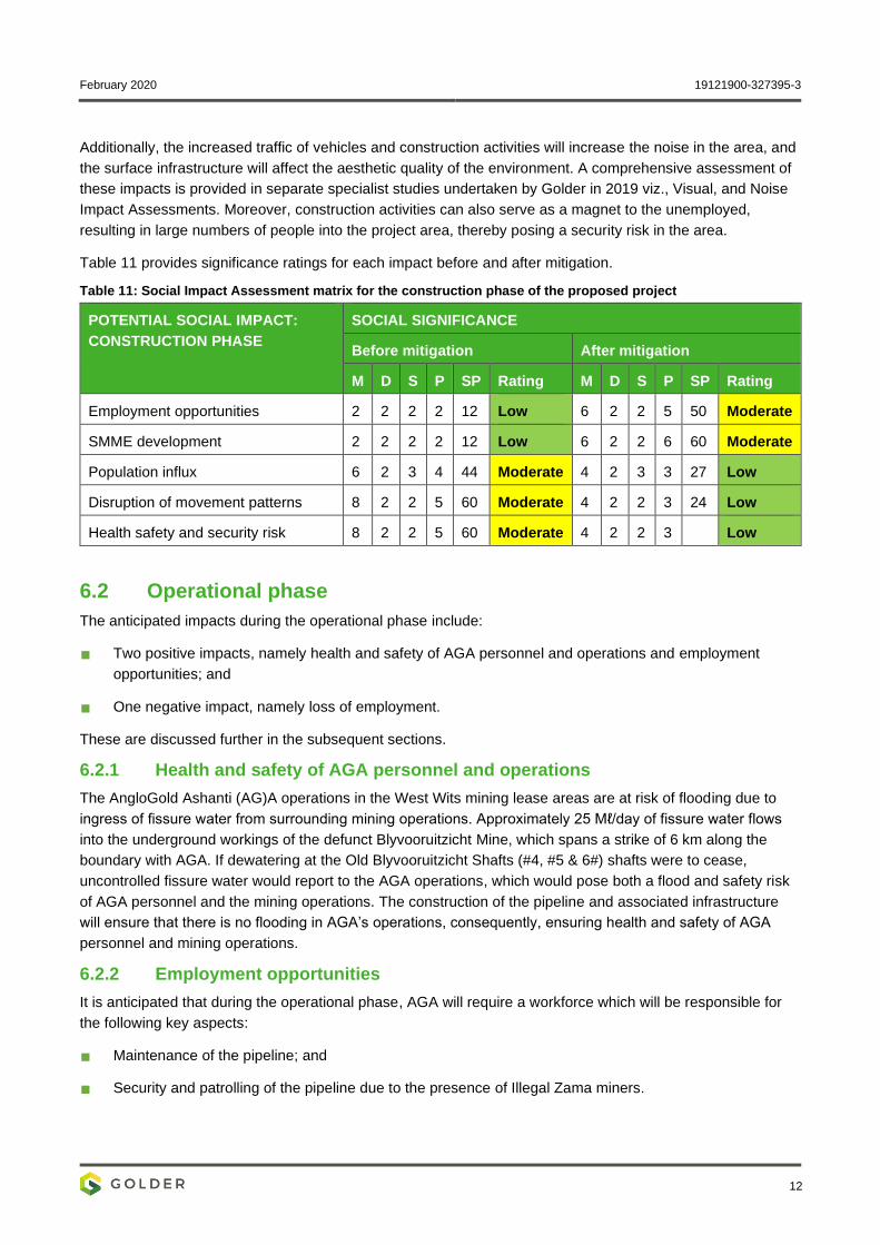
February 2020 19121900-327395-3
12
Additionally, the increased traffic of vehicles and construction activities will increase the noise in the area, and
the surface infrastructure will affect the aesthetic quality of the environment. A comprehensive assessment of
these impacts is provided in separate specialist studies undertaken by Golder in 2019 viz., Visual, and Noise
Impact Assessments. Moreover, construction activities can also serve as a magnet to the unemployed,
resulting in large numbers of people into the project area, thereby posing a security risk in the area.
Table 11 provides significance ratings for each impact before and after mitigation.
Table 11: Social Impact Assessment matrix for the construction phase of the proposed project
POTENTIAL SOCIAL IMPACT:
CONSTRUCTION PHASE
SOCIAL SIGNIFICANCE
Before mitigation After mitigation
M D S P SP Rating M D S P SP Rating
Employment opportunities 2 2 2 2 12 Low 6 2 2 5 50 Moderate
SMME development 2 2 2 2 12 Low 6 2 2 6 60 Moderate
Population influx 6 2 3 4 44 Moderate 4 2 3 3 27 Low
Disruption of movement patterns 8 2 2 5 60 Moderate 4 2 2 3 24 Low
Health safety and security risk 8 2 2 5 60 Moderate 4 2 2 3 Low
6.2 Operational phase
The anticipated impacts during the operational phase include:
Two positive impacts, namely health and safety of AGA personnel and operations and employment
opportunities; and
One negative impact, namely loss of employment.
These are discussed further in the subsequent sections.
6.2.1 Health and safety of AGA personnel and operations
The AngloGold Ashanti (AG)A operations in the West Wits mining lease areas are at risk of flooding due to
ingress of fissure water from surrounding mining operations. Approximately 25 Mℓ/day of fissure water flows
into the underground workings of the defunct Blyvooruitzicht Mine, which spans a strike of 6 km along the
boundary with AGA. If dewatering at the Old Blyvooruitzicht Shafts (#4, #5 & 6#) shafts were to cease,
uncontrolled fissure water would report to the AGA operations, which would pose both a flood and safety risk
of AGA personnel and the mining operations. The construction of the pipeline and associated infrastructure
will ensure that there is no flooding in AGA’s operations, consequently, ensuring health and safety of AGA
personnel and mining operations.
6.2.2 Employment opportunities
It is anticipated that during the operational phase, AGA will require a workforce which will be responsible for
the following key aspects:
Maintenance of the pipeline; and
Security and patrolling of the pipeline due to the presence of Illegal Zama miners.
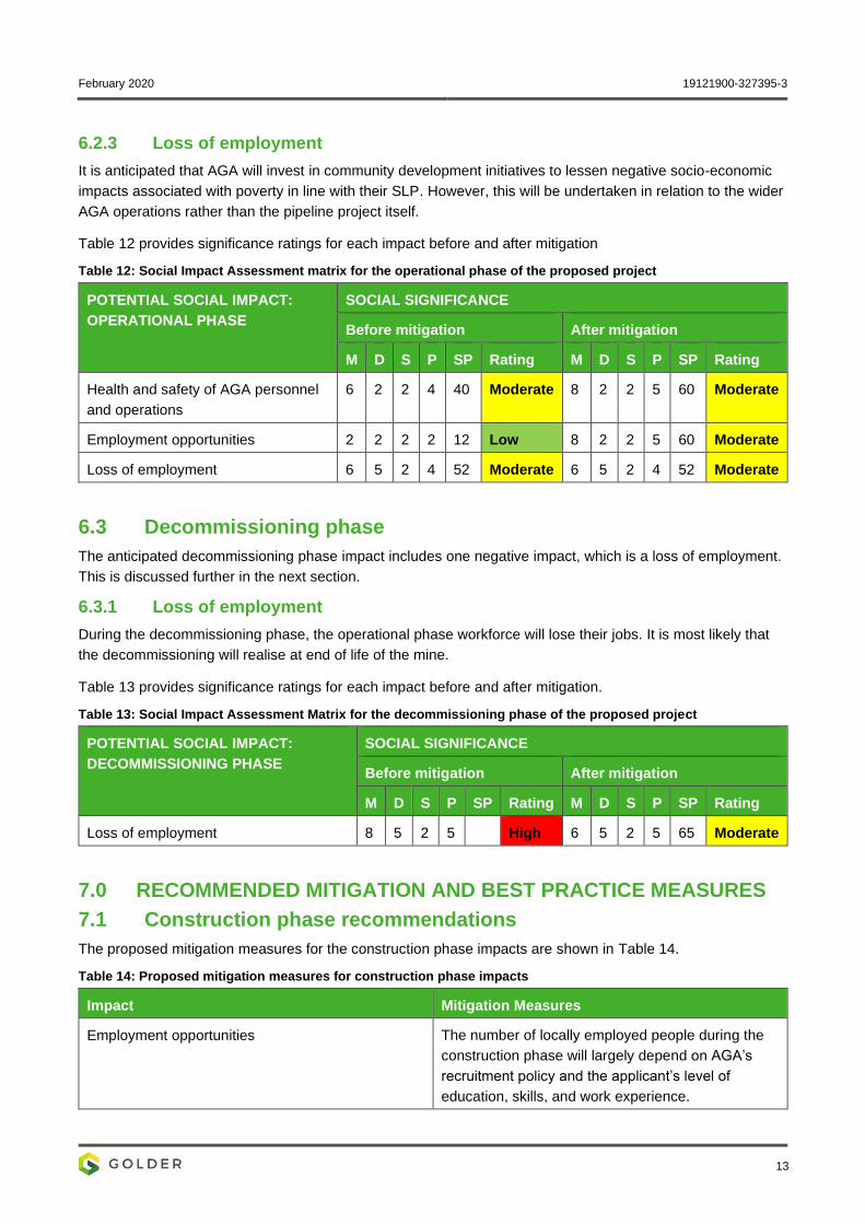
February 2020 19121900-327395-3
13
6.2.3 Loss of employment
It is anticipated that AGA will invest in community development initiatives to lessen negative socio-economic
impacts associated with poverty in line with their SLP. However, this will be undertaken in relation to the wider
AGA operations rather than the pipeline project itself.
Table 12 provides significance ratings for each impact before and after mitigation
Table 12: Social Impact Assessment matrix for the operational phase of the proposed project
POTENTIAL SOCIAL IMPACT:
OPERATIONAL PHASE
SOCIAL SIGNIFICANCE
Before mitigation After mitigation
M D S P SP Rating M D S P SP Rating
Health and safety of AGA personnel
and operations
6 2 2 4 40 Moderate 8 2 2 5 60 Moderate
Employment opportunities 2 2 2 2 12 Low 8 2 2 5 60 Moderate
Loss of employment 6 5 2 4 52 Moderate 6 5 2 4 52 Moderate
6.3 Decommissioning phase
The anticipated decommissioning phase impact includes one negative impact, which is a loss of employment.
This is discussed further in the next section.
6.3.1 Loss of employment
During the decommissioning phase, the operational phase workforce will lose their jobs. It is most likely that
the decommissioning will realise at end of life of the mine.
Table 13 provides significance ratings for each impact before and after mitigation.
Table 13: Social Impact Assessment Matrix for the decommissioning phase of the proposed project
POTENTIAL SOCIAL IMPACT:
DECOMMISSIONING PHASE
SOCIAL SIGNIFICANCE
Before mitigation After mitigation
M D S P SP Rating M D S P SP Rating
Loss of employment 8 5 2 5 High 6 5 2 5 65 Moderate
7.0 RECOMMENDED MITIGATION AND BEST PRACTICE MEASURES
7.1 Construction phase recommendations
The proposed mitigation measures for the construction phase impacts are shown in Table 14.
Table 14: Proposed mitigation measures for construction phase impacts
Impact Mitigation Measures
Employment opportunities The number of locally employed people during the
construction phase will largely depend on AGA’s
recruitment policy and the applicant’s level of
education, skills, and work experience.
February 2020 19121900-327395-3
14
Impact Mitigation Measures
SMME development Where possible, goods and services should be
sourced from local SMMEs, this will contribute
positively to the development and growth of local
SMMEs.
Population influx Regarding recruitment, priority will be given to
locals, thus reducing the required need for
outsiders.
Disruption of movement patterns Traffic during construction must always be
regulated.
Health safety and security risk Dust suppression measures will be
implemented on unpaved roads, if required.
Traffic must always be controlled.
During the stakeholder engagement process,
community members should be sensitised to
traffic safety risks and to the need to prevent
children from wandering along the pipeline
route.
7.2 Operational phase recommendations
The proposed mitigation measures for the operational phase impacts are shown in Table 15.
Table 15: Proposed mitigation measures for operational phase impacts
Impact Mitigation Measures
Health and safety of AGA personnel and operations AGA will monitor and maintain the integrity of the
pipeline during operation.
Employment opportunities Measures to enhance the benefits derived from
employment creation during the operational phase
of the proposed project are the same as those
recommended for the construction phase (see
Section 7.1
Loss of employment Skills development programmes should be
implemented to capacitate employees, construction
workers and community members with the skills
necessary to secure other employment
opportunities.
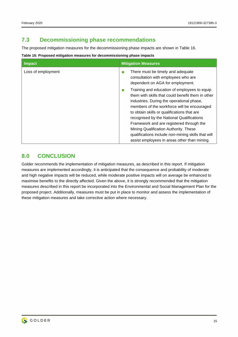
February 2020 19121900-327395-3
15
7.3 Decommissioning phase recommendations
The proposed mitigation measures for the decommissioning phase impacts are shown in Table 16.
Table 16: Proposed mitigation measures for decommissioning phase impacts
Impact Mitigation Measures
Loss of employment There must be timely and adequate
consultation with employees who are
dependent on AGA for employment.
Training and education of employees to equip
them with skills that could benefit them in other
industries. During the operational phase,
members of the workforce will be encouraged
to obtain skills or qualifications that are
recognised by the National Qualifications
Framework and are registered through the
Mining Qualification Authority. These
qualifications include non-mining skills that will
assist employees in areas other than mining.
8.0 CONCLUSION
Golder recommends the implementation of mitigation measures, as described in this report. If mitigation
measures are implemented accordingly, it is anticipated that the consequence and probability of moderate
and high negative impacts will be reduced, while moderate positive impacts will on average be enhanced to
maximise benefits to the directly affected. Given the above, it is strongly recommended that the mitigation
measures described in this report be incorporated into the Environmental and Social Management Plan for the
proposed project. Additionally, measures must be put in place to monitor and assess the implementation of
these mitigation measures and take corrective action where necessary.
February 2020 19121900-327395-3
16
9.0 REFERENCES
Statistics SA (2016 a). Community Survey, 2016: Provinces at a Glance, Statistics South Africa, Pretoria
Statistics SA (2016 b). Community Survey, 2016: Statistical Release, Statistics South Africa, Pretoria;
West Rand District Municipality (2016). Integrated Development Plan, 2016/17-2021/22, West Rand District
Municipality, Randfontein; and
Merafong City Local Municipality (2016). Integrated Development Plan, 2018-2019.
Golder Associates Africa (Pty) Ltd.
Dr Sithandiwe Ntila Dr David De Waal
Social Scientist Technical Director: Social Management and Sciences
SN/DdW/nbh
Reg. No. 2002/007104/07
Directors: RGM Heath, MQ Mokulubete, SC Naidoo, GYW Ngoma
Golder and the G logo are trademarks of Golder Associates Corporation
https://golderassociates.sharepoint.com/sites/108123/project files/6 deliverables/final client deliverables/final specialist reports/19121900-327395-3_rep_sia_final_19feb2020.docx

February 2020 19121900-327395-3
APPENDIX A
Document Limitations
February 2020 19121900-327395-3
DOCUMENT LIMITATIONS
This Document has been provided by Golder Associates Africa Pty Ltd (“Golder”) subject to the following
limitations:
i) This Document has been prepared for the particular purpose outlined in Golder’s proposal and no
responsibility is accepted for the use of this Document, in whole or in part, in other contexts or for any
other purpose.
ii) The scope and the period of Golder’s Services are as described in Golder’s proposal, and are subject to
restrictions and limitations. Golder did not perform a complete assessment of all possible conditions or
circumstances that may exist at the site referenced in the Document. If a service is not expressly
indicated, do not assume it has been provided. If a matter is not addressed, do not assume that any
determination has been made by Golder in regards to it.
iii) Conditions may exist which were undetectable given the limited nature of the enquiry Golder was
retained to undertake with respect to the site. Variations in conditions may occur between investigatory
locations, and there may be special conditions pertaining to the site which have not been revealed by the
investigation and which have not therefore been taken into account in the Document. Accordingly,
additional studies and actions may be required.
iv) In addition, it is recognised that the passage of time affects the information and assessment provided in
this Document. Golder’s opinions are based upon information that existed at the time of the production of
the Document. It is understood that the Services provided allowed Golder to form no more than an
opinion of the actual conditions of the site at the time the site was visited and cannot be used to assess
the effect of any subsequent changes in the quality of the site, or its surroundings, or any laws or
regulations.
v) Any assessments made in this Document are based on the conditions indicated from published sources
and the investigation described. No warranty is included, either express or implied, that the actual
conditions will conform exactly to the assessments contained in this Document.
vi) Where data supplied by the client or other external sources, including previous site investigation data,
have been used, it has been assumed that the information is correct unless otherwise stated. No
responsibility is accepted by Golder for incomplete or inaccurate data supplied by others.
vii) The Client acknowledges that Golder may have retained sub-consultants affiliated with Golder to provide
Services for the benefit of Golder. Golder will be fully responsible to the Client for the Services and work
done by all of its sub-consultants and subcontractors. The Client agrees that it will only assert claims
against and seek to recover losses, damages or other liabilities from Golder and not Golder’s affiliated
companies. To the maximum extent allowed by law, the Client acknowledges and agrees it will not have
any legal recourse, and waives any expense, loss, claim, demand, or cause of action, against Golder’s
affiliated companies, and their employees, officers and directors.
viii) This Document is provided for sole use by the Client and is confidential to it and its professional advisers.
No responsibility whatsoever for the contents of this Document will be accepted to any person other than
the Client. Any use which a third party makes of this Document, or any reliance on or decisions to be
made based on it, is the responsibility of such third parties. Golder accepts no responsibility for
damages, if any, suffered by any third party as a result of decisions made or actions based on this
Document.
GOLDER ASSOCIATES AFRICA (PTY) LTD
February 2020 19121900-327395-3
APPENDIX B
Acknowledgements, Details of EAP, Declaration of Interest and Specialist Experience
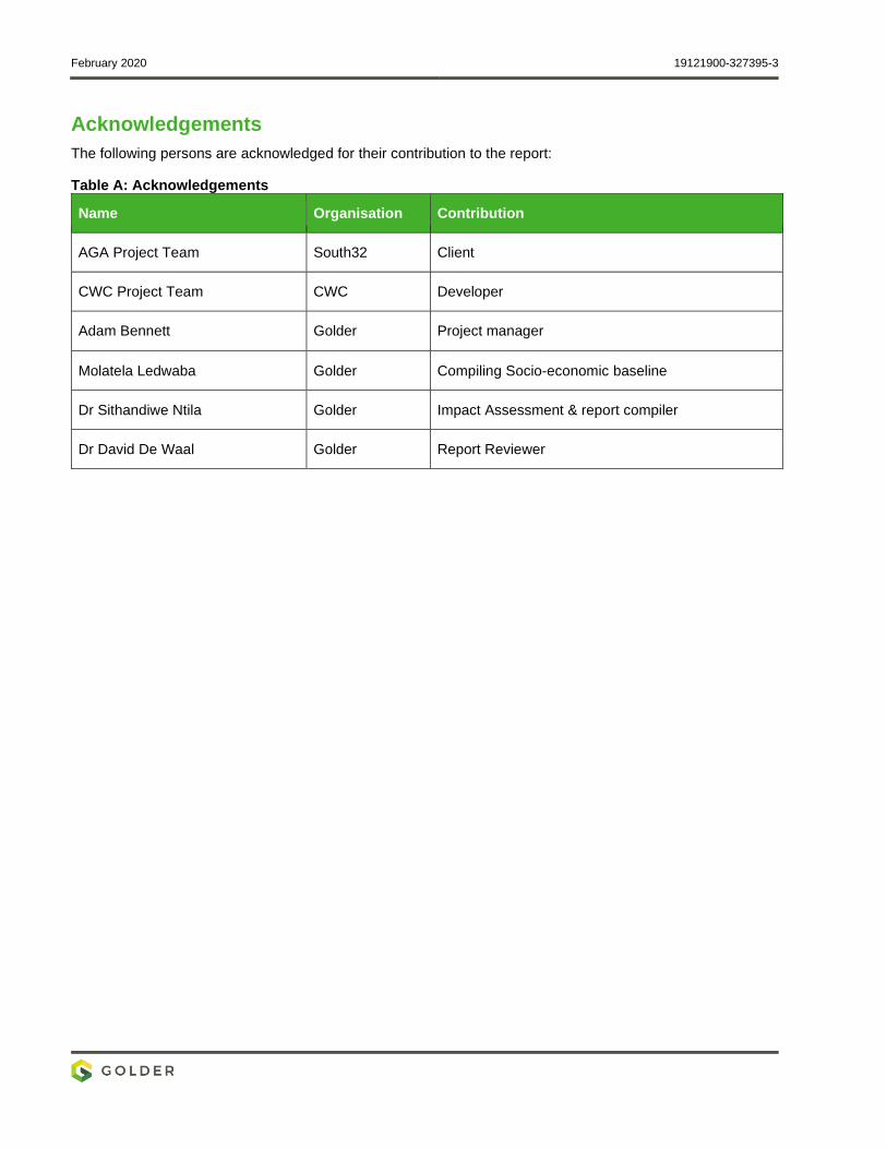
February 2020 19121900-327395-3
Acknowledgements
The following persons are acknowledged for their contribution to the report:
Table A: Acknowledgements
Name Organisation Contribution
AGA Project Team South32 Client
CWC Project Team CWC Developer
Adam Bennett Golder Project manager
Molatela Ledwaba Golder Compiling Socio-economic baseline
Dr Sithandiwe Ntila Golder Impact Assessment & report compiler
Dr David De Waal Golder Report Reviewer
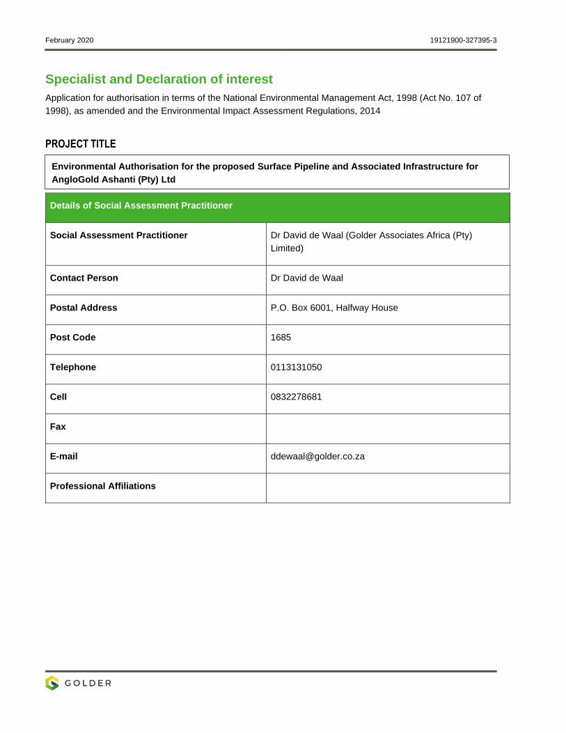
February 2020 19121900-327395-3
Specialist and Declaration of interest
Application for authorisation in terms of the National Environmental Management Act, 1998 (Act No. 107 of
1998), as amended and the Environmental Impact Assessment Regulations, 2014
PROJECT TITLE
Details of Social Assessment Practitioner
Social Assessment Practitioner Dr David de Waal (Golder Associates Africa (Pty)
Limited)
Contact Person Dr David de Waal
Postal Address P.O. Box 6001, Halfway House
Post Code 1685
Telephone 0113131050
Cell 0832278681
Fax
E-mail [email protected]
Professional Affiliations
Environmental Authorisation for the proposed Surface Pipeline and Associated Infrastructure for
AngloGold Ashanti (Pty) Ltd
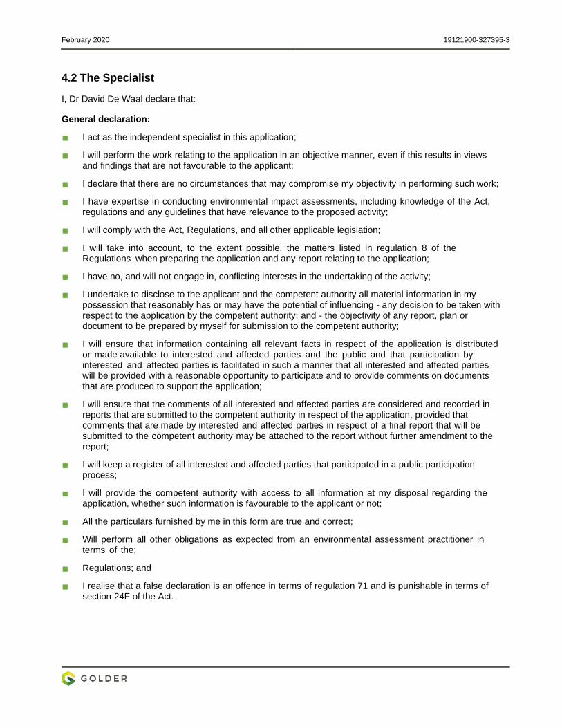
February 2020 19121900-327395-3
4.2 The Specialist
I, Dr David De Waal declare that:
General declaration:
I act as the independent specialist in this application;
I will perform the work relating to the application in an objective manner, even if this results in views and findings that are not favourable to the applicant;
I declare that there are no circumstances that may compromise my objectivity in performing such work;
I have expertise in conducting environmental impact assessments, including knowledge of the Act, regulations and any guidelines that have relevance to the proposed activity;
I will comply with the Act, Regulations, and all other applicable legislation;
I will take into account, to the extent possible, the matters listed in regulation 8 of the Regulations when preparing the application and any report relating to the application;
I have no, and will not engage in, conflicting interests in the undertaking of the activity;
I undertake to disclose to the applicant and the competent authority all material information in my possession that reasonably has or may have the potential of influencing - any decision to be taken with respect to the application by the competent authority; and - the objectivity of any report, plan or document to be prepared by myself for submission to the competent authority;
I will ensure that information containing all relevant facts in respect of the application is distributed or made available to interested and affected parties and the public and that participation by interested and affected parties is facilitated in such a manner that all interested and affected parties will be provided with a reasonable opportunity to participate and to provide comments on documents that are produced to support the application;
I will ensure that the comments of all interested and affected parties are considered and recorded in reports that are submitted to the competent authority in respect of the application, provided that comments that are made by interested and affected parties in respect of a final report that will be submitted to the competent authority may be attached to the report without further amendment to the report;
I will keep a register of all interested and affected parties that participated in a public participation process;
I will provide the competent authority with access to all information at my disposal regarding the application, whether such information is favourable to the applicant or not;
All the particulars furnished by me in this form are true and correct;
Will perform all other obligations as expected from an environmental assessment practitioner in terms of the;
Regulations; and
I realise that a false declaration is an offence in terms of regulation 71 and is punishable in terms of section 24F of the Act.
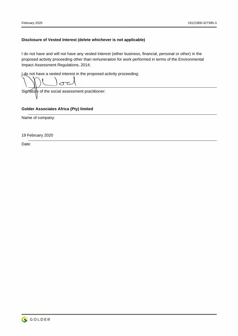
February 2020 19121900-327395-3
Disclosure of Vested Interest (delete whichever is not applicable)
I do not have and will not have any vested interest (either business, financial, personal or other) in the
proposed activity proceeding other than remuneration for work performed in terms of the Environmental
Impact Assessment Regulations, 2014;
I do not have a vested interest in the proposed activity proceeding:
Signature of the social assessment practitioner:
Golder Associates Africa (Pty) limited
Name of company:
19 February 2020
Date:
February 2020 19121900-327395-3
Specialist Social Assessment Practitioner experience
Dr David de Waal has more than 30 years of experience in his field of practice. He advises and practices in
the areas of social impact assessments, due diligence, social management processes, social baseline
studies, human rights assessments, integrated environmental governance and institutional conflict
management. David has extensive African experience in his fields of practice, mostly within the ambit of the
IFC and World Bank standards. He has led social management and assessment processes in Botswana,
Ethiopia, Ghana, Kenya, Mozambique, Rwanda, Seychelles, South Africa, Swaziland, Uganda and Zambia.

golder.com

March 2020 19121900-328397-9
APPENDIX J
Visual Impact Assessment
Golder Associates Africa (Pty) Ltd.
Building 1, Maxwell Office Park, Magwa Crescent West, Waterfall City, Midrand, 1685, South Africa P.O. Box 6001, Halfway House, 1685
T: +27 11 254 4800 F: +27 0 86 582 1561
Reg. No. 2002/007104/07
Directors: RGM Heath, MQ Mokulubete, MC Mazibuko (Mondli Colbert), GYW Ngoma
Golder and the G logo are trademarks of Golder Associates Corporation golder.com
This memorandum aims to inform and compliment the environmental assessment process for the proposed
pipeline project. It provides a brief description of the visual resource of the pipeline route and its immediate
environs, and discusses the potential impacts of the pipeline on the visual resource. It is based on a single
field visit and the expertise of the Golder team.
1.1 Visual Resource
The following notes summarise key features of the local visual resource:
The natural topography of the landscape is flat to gently undulating, with a few elevated rises and hills.
Mine tailings facilities are common in the landscape. These are tall, geometric in shape and significantly
alter the natural landscape profile (Figure 1);
Vegetation comprises large tracts of grassland/wetland, with smaller pockets of woodland/plantations
and numerous scattered trees (Figure 1);
Localised areas of built infrastructure, disturbances and transformation are common in the landscape,
and these are typically associated with mining (Figure 2). Several residential areas are also present; and
Prominent hydrological features include a small unnamed drainage line, which is a tributary to the
Mooirivierloop. This drainage line runs parallel to the proposed pipeline route.
TECHNICAL MEMORANDUM
DATE 19 February 2020 Reference No. 19121900-327357-4
TO Werner Grobbelaar, AngloGold Ashanti (Pty) Ltd South African Operations
CC Adam Bennett
FROM Andrew Zinn, Golder Associates EMAIL [email protected]
APPRAISAL OF VISUAL IMPACTS ASSOCIATED WITH THE PROPOSED SURFACE PIPELINE AND ASSOCIATED INFRASTRUCTURE
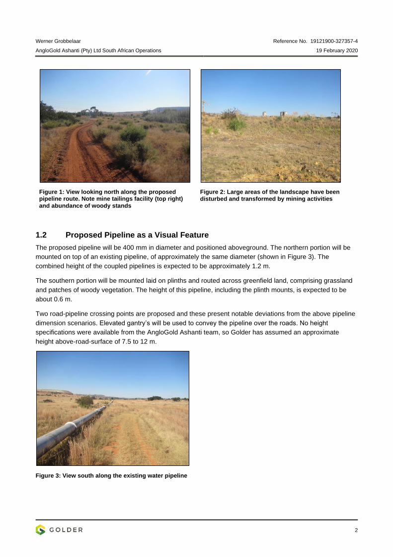
Werner Grobbelaar Reference No. 19121900-327357-4
AngloGold Ashanti (Pty) Ltd South African Operations 19 February 2020
2
Figure 1: View looking north along the proposed pipeline route. Note mine tailings facility (top right)
and abundance of woody stands
Figure 2: Large areas of the landscape have been disturbed and transformed by mining activities
1.2 Proposed Pipeline as a Visual Feature
The proposed pipeline will be 400 mm in diameter and positioned aboveground. The northern portion will be
mounted on top of an existing pipeline, of approximately the same diameter (shown in Figure 3). The
combined height of the coupled pipelines is expected to be approximately 1.2 m.
The southern portion will be mounted laid on plinths and routed across greenfield land, comprising grassland
and patches of woody vegetation. The height of this pipeline, including the plinth mounts, is expected to be
about 0.6 m.
Two road-pipeline crossing points are proposed and these present notable deviations from the above pipeline
dimension scenarios. Elevated gantry’s will be used to convey the pipeline over the roads. No height
specifications were available from the AngloGold Ashanti team, so Golder has assumed an approximate
height above-road-surface of 7.5 to 12 m.
Figure 3: View south along the existing water pipeline
Werner Grobbelaar Reference No. 19121900-327357-4
AngloGold Ashanti (Pty) Ltd South African Operations 19 February 2020
3
1.3 Appraisal of Impacts on Visual Resource
Overall the proposed pipeline will have a low profile/height (0.6 to 1.2 m) compared to other anthropogenic
infrastructure. The only points of notable elevation (7.5 to 12 m) are the two road crossings. However, relative
to the entire pipeline length, the road crossings will be short and thus spatially discreet.
The proposed pipeline will thus have a low level of theoretical visibility. As a portion of the pipeline will be
aligned to an existing pipeline, the visual intrusion along this portion is expected to be particularly limited.
Moreover, we note that mine facilities, associated infrastructure and sites of disturbance are locally ubiquitous,
and increase the visual complexity of the immediate landscape, and its capacity to ‘absorb’ additional artificial
features. Concomitant to this, is our expectation that both local residents and visitors to the area (visual
receptors) are ‘conditioned’ to the presence of artificial features. They will thus have a low receptor sensitivity
to additional impacts on the visual resources, particularly one as low profiled as the proposed pipeline.
Overall, we thus expect that visual impacts of the proposed pipeline will not be significant. In light of this, no
mitigation measures as they concern visual impacts, are recommended for inclusion in the project’s
environmental management plan.
Yours sincerely,
Golder Associates Africa (Pty) Ltd
Andrew Zinn Adam Bennett Terrestrial Ecologist Senior Environmental Scientist
AZ/AB/nbh
https://golderassociates.sharepoint.com/sites/108123/project files/6 deliverables/final client deliverables/final specialist reports/19121900-327357-4_rep_via_final_19feb2020.docx
ATTACHMENTS: Appendix A: Document Limitations
Appendix B: Acknowledgements, Details of EAP, Declaration of Interest and
Specialist Experience
Werner Grobbelaar Reference No. 19121900-327357-4
AngloGold Ashanti (Pty) Ltd South African Operations 19 February 2020
APPENDIX A
Document Limitations
Werner Grobbelaar Reference No. 19121900-327357-4
AngloGold Ashanti (Pty) Ltd South African Operations 19 February 2020
DOCUMENT LIMITATIONS
This Document has been provided by Golder Associates Africa Pty Ltd (“Golder”) subject to the following
limitations:
i) This Document has been prepared for the particular purpose outlined in Golder’s proposal and no
responsibility is accepted for the use of this Document, in whole or in part, in other contexts or for any
other purpose.
ii) The scope and the period of Golder’s Services are as described in Golder’s proposal, and are subject to
restrictions and limitations. Golder did not perform a complete assessment of all possible conditions or
circumstances that may exist at the site referenced in the Document. If a service is not expressly
indicated, do not assume it has been provided. If a matter is not addressed, do not assume that any
determination has been made by Golder in regards to it.
iii) Conditions may exist which were undetectable given the limited nature of the enquiry Golder was
retained to undertake with respect to the site. Variations in conditions may occur between investigatory
locations, and there may be special conditions pertaining to the site which have not been revealed by the
investigation and which have not therefore been taken into account in the Document. Accordingly,
additional studies and actions may be required.
iv) In addition, it is recognised that the passage of time affects the information and assessment provided in
this Document. Golder’s opinions are based upon information that existed at the time of the production of
the Document. It is understood that the Services provided allowed Golder to form no more than an
opinion of the actual conditions of the site at the time the site was visited and cannot be used to assess
the effect of any subsequent changes in the quality of the site, or its surroundings, or any laws or
regulations.
v) Any assessments made in this Document are based on the conditions indicated from published sources
and the investigation described. No warranty is included, either express or implied, that the actual
conditions will conform exactly to the assessments contained in this Document.
vi) Where data supplied by the client or other external sources, including previous site investigation data,
have been used, it has been assumed that the information is correct unless otherwise stated. No
responsibility is accepted by Golder for incomplete or inaccurate data supplied by others.
vii) The Client acknowledges that Golder may have retained sub-consultants affiliated with Golder to provide
Services for the benefit of Golder. Golder will be fully responsible to the Client for the Services and work
done by all of its sub-consultants and subcontractors. The Client agrees that it will only assert claims
against and seek to recover losses, damages or other liabilities from Golder and not Golder’s affiliated
companies. To the maximum extent allowed by law, the Client acknowledges and agrees it will not have
any legal recourse, and waives any expense, loss, claim, demand, or cause of action, against Golder’s
affiliated companies, and their employees, officers and directors.
viii) This Document is provided for sole use by the Client and is confidential to it and its professional advisers.
No responsibility whatsoever for the contents of this Document will be accepted to any person other than
the Client. Any use which a third party makes of this Document, or any reliance on or decisions to be
made based on it, is the responsibility of such third parties. Golder accepts no responsibility for
damages, if any, suffered by any third party as a result of decisions made or actions based on this
Document.
GOLDER ASSOCIATES AFRICA (PTY) LTD
Werner Grobbelaar Reference No. 19121900-327357-4
AngloGold Ashanti (Pty) Ltd South African Operations 19 February 2020
APPENDIX B
Acknowledgements, Details of
EAP, Declaration of Interest and
Specialist Experience
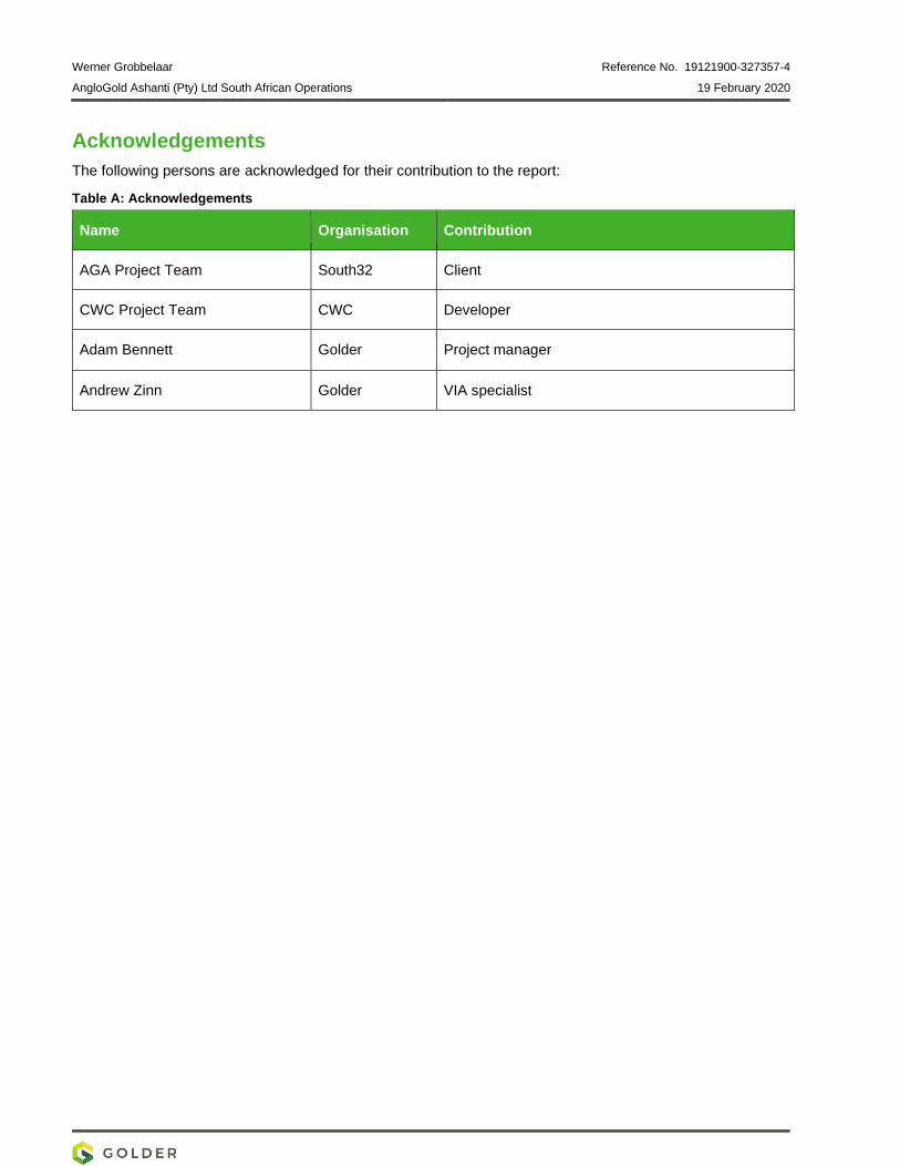
Werner Grobbelaar Reference No. 19121900-327357-4
AngloGold Ashanti (Pty) Ltd South African Operations 19 February 2020
Acknowledgements
The following persons are acknowledged for their contribution to the report:
Table A: Acknowledgements
Name Organisation Contribution
AGA Project Team South32 Client
CWC Project Team CWC Developer
Adam Bennett Golder Project manager
Andrew Zinn Golder VIA specialist
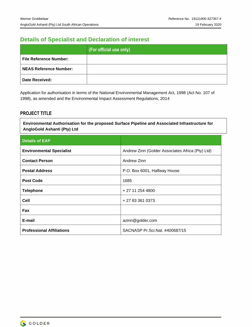
Werner Grobbelaar Reference No. 19121900-327357-4
AngloGold Ashanti (Pty) Ltd South African Operations 19 February 2020
Details of Specialist and Declaration of interest
(For official use only)
File Reference Number:
NEAS Reference Number:
Date Received:
Application for authorisation in terms of the National Environmental Management Act, 1998 (Act No. 107 of
1998), as amended and the Environmental Impact Assessment Regulations, 2014
PROJECT TITLE
Details of EAP
Environmental Specialist Andrew Zinn (Golder Associates Africa (Pty) Ltd)
Contact Person Andrew Zinn
Postal Address P.O. Box 6001, Halfway House
Post Code 1685
Telephone + 27 11 254 4800
Cell + 27 83 361 0373
Fax
E-mail [email protected]
Professional Affiliations SACNASP Pr.Sci.Nat. #400687/15
Environmental Authorisation for the proposed Surface Pipeline and Associated Infrastructure for
AngloGold Ashanti (Pty) Ltd
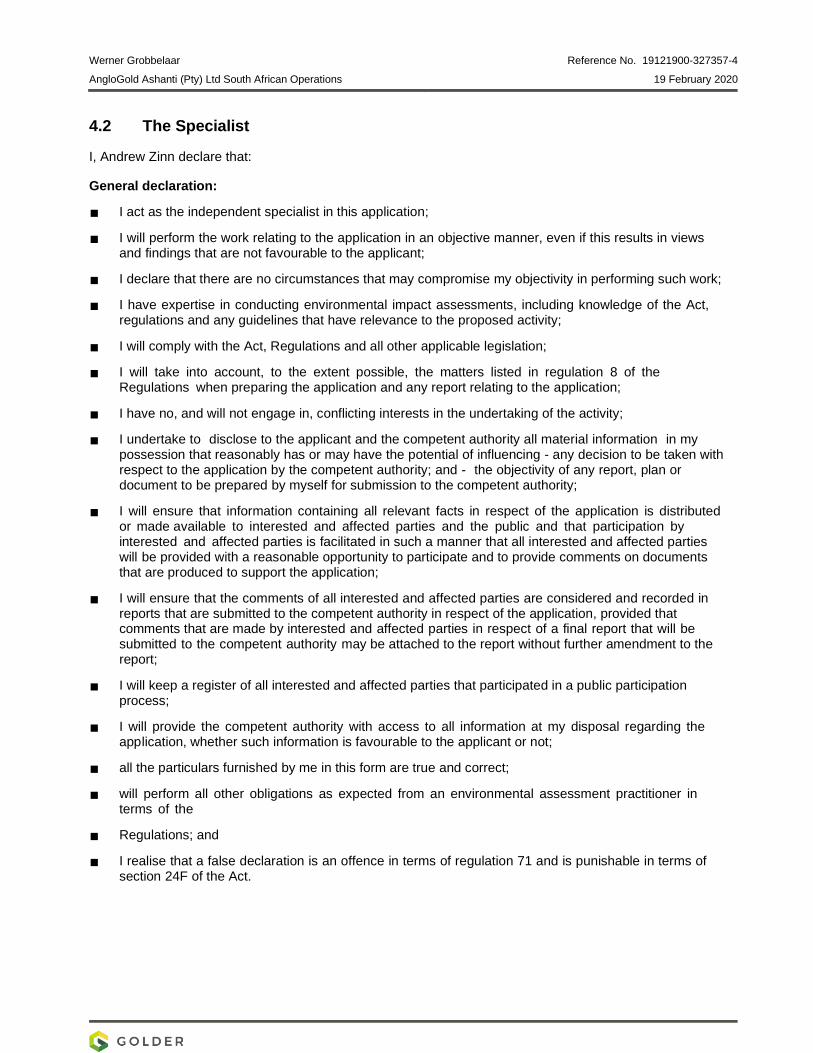
Werner Grobbelaar Reference No. 19121900-327357-4
AngloGold Ashanti (Pty) Ltd South African Operations 19 February 2020
4.2 The Specialist
I, Andrew Zinn declare that:
General declaration:
I act as the independent specialist in this application;
I will perform the work relating to the application in an objective manner, even if this results in views and findings that are not favourable to the applicant;
I declare that there are no circumstances that may compromise my objectivity in performing such work;
I have expertise in conducting environmental impact assessments, including knowledge of the Act, regulations and any guidelines that have relevance to the proposed activity;
I will comply with the Act, Regulations and all other applicable legislation;
I will take into account, to the extent possible, the matters listed in regulation 8 of the Regulations when preparing the application and any report relating to the application;
I have no, and will not engage in, conflicting interests in the undertaking of the activity;
I undertake to disclose to the applicant and the competent authority all material information in my possession that reasonably has or may have the potential of influencing - any decision to be taken with respect to the application by the competent authority; and - the objectivity of any report, plan or document to be prepared by myself for submission to the competent authority;
I will ensure that information containing all relevant facts in respect of the application is distributed or made available to interested and affected parties and the public and that participation by interested and affected parties is facilitated in such a manner that all interested and affected parties will be provided with a reasonable opportunity to participate and to provide comments on documents that are produced to support the application;
I will ensure that the comments of all interested and affected parties are considered and recorded in reports that are submitted to the competent authority in respect of the application, provided that comments that are made by interested and affected parties in respect of a final report that will be submitted to the competent authority may be attached to the report without further amendment to the report;
I will keep a register of all interested and affected parties that participated in a public participation process;
I will provide the competent authority with access to all information at my disposal regarding the application, whether such information is favourable to the applicant or not;
all the particulars furnished by me in this form are true and correct;
will perform all other obligations as expected from an environmental assessment practitioner in terms of the
Regulations; and
I realise that a false declaration is an offence in terms of regulation 71 and is punishable in terms of section 24F of the Act.
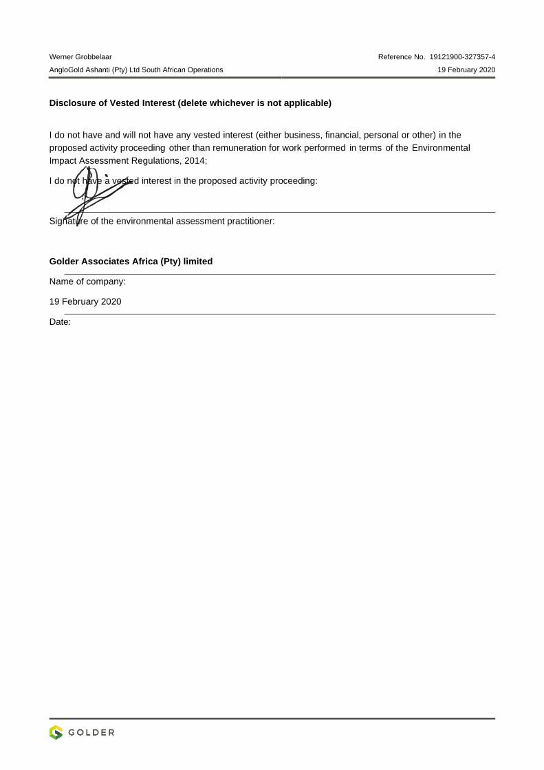
Werner Grobbelaar Reference No. 19121900-327357-4
AngloGold Ashanti (Pty) Ltd South African Operations 19 February 2020
Disclosure of Vested Interest (delete whichever is not applicable)
I do not have and will not have any vested interest (either business, financial, personal or other) in the
proposed activity proceeding other than remuneration for work performed in terms of the Environmental
Impact Assessment Regulations, 2014;
I do not have a vested interest in the proposed activity proceeding:
Signature of the environmental assessment practitioner:
Golder Associates Africa (Pty) limited
Name of company:
19 February 2020
Date:
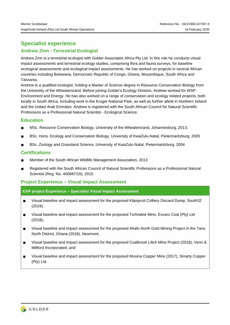
Werner Grobbelaar Reference No. 19121900-327357-4
AngloGold Ashanti (Pty) Ltd South African Operations 19 February 2020
Specialist experience
Andrew Zinn - Terrestrial Ecologist
Andrew Zinn is a terrestrial ecologist with Golder Associates Africa Pty Ltd. In this role he conducts visual
impact assessments and terrestrial ecology studies, comprising flora and fauna surveys, for baseline
ecological assessments and ecological impact assessments. He has worked on projects in several African
countries including Botswana, Democratic Republic of Congo, Ghana, Mozambique, South Africa and
Tanzania.
Andrew is a qualified ecologist, holding a Master of Science degree in Resource Conservation Biology from
the University of the Witwatersrand. Before joining Golder's Ecology Division, Andrew worked for WSP
Environment and Energy. He has also worked on a range of conservation and ecology related projects, both
locally in South Africa, including work in the Kruger National Park, as well as further afield in Northern Ireland
and the United Arab Emirates. Andrew is registered with the South African Council for Natural Scientific
Professions as a Professional Natural Scientist - Ecological Science.
Education
MSc. Resource Conservation Biology, University of the Witwatersrand, Johannesburg, 2013;
BSc. Hons. Ecology and Conservation Biology, University of KwaZulu-Natal, Pietermaritzburg, 2005
BSc. Zoology and Grassland Science, University of KwaZulu-Natal, Pietermaritzburg, 2004
Certifications
Member of the South African Wildlife Management Association, 2013
Registered with the South African Council of Natural Scientific Professions as a Professional Natural
Scientist (Reg. No. 400687/15), 2015
Project Experience – Visual Impact Assessment
EAP project Experience – Specialist Visual Impact Assessment
Visual baseline and impact assessment for the proposed Klipspruit Colliery Discard Dump, South32
(2019);
Visual baseline and impact assessment for the proposed Turfvlakte Mine, Exxaro Coal (Pty) Ltd
(2018);
Visual baseline and impact assessment for the proposed Ahafo North Gold Mining Project in the Tano
North District, Ghana (2018), Newmont;
Visual baseline and impact assessment for the proposed Coalbrook LifeX Mine Project (2018), Venn &
Millford Incorporated; and
Visual baseline and impact assessment for the proposed Musina Copper Mine (2017), Smarty Copper
(Pty) Ltd.
March 2020 19121900-328397-9
APPENDIX K
Heritage Impact Assessment

REPORT
Specialist Assessment for the Proposed Surface
Pipeline and Associated Infrastructure: Heritage
Impact Assessment Report AngloGold Ashanti (Pty) Limited South African Operations
Submitted to:
AngloGold Ashanti (Pty) Limited South African Operations Mr J van Wyk Carletonville - Fochville Road R500 Carletonville Gauteng 2501
Submitted by:
Golder Associates Africa (Pty) Ltd.
Podium at Menlyn, Second Floor, 43 Ingersol Road, Menlyn, Pretoria, 0181, South Africa
P O Box 6001, Halfway House, 1685
+27 11 254 4800
19121900-330264-11
February 2020

February 2020 19121900-330264-11
i
Distribution List 1 eCopy to AngloGold Ashanti (Pty) Limited South African Operations
1 eCopy to [email protected]
February 2020 19121900-330264-11
ii
Table of Contents
1.0 INTRODUCTION ......................................................................................................................................... 1
APPENDICES
APPENDIX A Document Limitations
APPENDIX B Phase 1 Heritage Impact Assessment Study
APPENDIX C Acknowledgements, Details of EAP, Declaration of Interest and Specialist EAP Experience
February 2020 19121900-330264-11
1
1.0 INTRODUCTION
The AGA operations in the West Wits mining lease areas are at risk of flooding due to ingress of fissure water
from surrounding mining operations. Approximately 25 Mℓ/day of fissure water flows into the underground
workings of the defunct Blyvooruitzicht Mine, which spans a strike of 6 km along the boundary with AGA. If
dewatering at the Old Blyvooruitzicht Shafts (#4, #5 & 6#) shafts were to cease, uncontrolled fissure water
would report to the AGA operations, which would pose both a flood and safety risk of AGA personnel and the
mining operations.
In summary, AGA propose to install underground infrastructure to route the BVL 5# AMD water to the BVL 4#
to allow for the dewatering, neutralisation and pumping to surface. From the BVL 4# mine this impacted water
will be routed on surface to the North Boundary Dam (NBD) and used as make-up water to the Savuka Gold
Plant Reclamation Operations.
This report provides a professional opinion regarding the anticipated heritage impact assessment from this
proposed project (See APPENDIX B).
.
Golder Associates Africa (Pty) Ltd.
Adam Bennett Warren Aken
Environmental Assessment Practitioner Associate
AB/WA/nbh
Reg. No. 2002/007104/07
Directors: RGM Heath, MQ Mokulubete, MC Mazibuko (Mondli Colbert), GYW Ngoma
Golder and the G logo are trademarks of Golder Associates Corporation
https://golderassociates.sharepoint.com/sites/108123/project files/6 deliverables/final client deliverables/final specialist reports/19121900-330264-
11_rep_heritage_final_19feb2020.docx

February 2020 19121900-330264-11
APPENDIX A
Document Limitations

February 2020 19121900-330264-11
DOCUMENT LIMITATIONS
This Document has been provided by Golder Associates Africa Pty Ltd (“Golder”) subject to the following
limitations:
i) This Document has been prepared for the particular purpose outlined in Golder’s proposal and no
responsibility is accepted for the use of this Document, in whole or in part, in other contexts or for any
other purpose.
ii) The scope and the period of Golder’s Services are as described in Golder’s proposal, and are subject to
restrictions and limitations. Golder did not perform a complete assessment of all possible conditions or
circumstances that may exist at the site referenced in the Document. If a service is not expressly
indicated, do not assume it has been provided. If a matter is not addressed, do not assume that any
determination has been made by Golder in regards to it.
iii) Conditions may exist which were undetectable given the limited nature of the enquiry Golder was
retained to undertake with respect to the site. Variations in conditions may occur between investigatory
locations, and there may be special conditions pertaining to the site which have not been revealed by the
investigation and which have not therefore been taken into account in the Document. Accordingly,
additional studies and actions may be required.
iv) In addition, it is recognised that the passage of time affects the information and assessment provided in
this Document. Golder’s opinions are based upon information that existed at the time of the production of
the Document. It is understood that the Services provided allowed Golder to form no more than an
opinion of the actual conditions of the site at the time the site was visited and cannot be used to assess
the effect of any subsequent changes in the quality of the site, or its surroundings, or any laws or
regulations.
v) Any assessments made in this Document are based on the conditions indicated from published sources
and the investigation described. No warranty is included, either express or implied, that the actual
conditions will conform exactly to the assessments contained in this Document.
vi) Where data supplied by the client or other external sources, including previous site investigation data,
have been used, it has been assumed that the information is correct unless otherwise stated. No
responsibility is accepted by Golder for incomplete or inaccurate data supplied by others.
vii) The Client acknowledges that Golder may have retained sub-consultants affiliated with Golder to provide
Services for the benefit of Golder. Golder will be fully responsible to the Client for the Services and work
done by all of its sub-consultants and subcontractors. The Client agrees that it will only assert claims
against and seek to recover losses, damages or other liabilities from Golder and not Golder’s affiliated
companies. To the maximum extent allowed by law, the Client acknowledges and agrees it will not have
any legal recourse, and waives any expense, loss, claim, demand, or cause of action, against Golder’s
affiliated companies, and their employees, officers and directors.
viii) This Document is provided for sole use by the Client and is confidential to it and its professional advisers.
No responsibility whatsoever for the contents of this Document will be accepted to any person other than
the Client. Any use which a third party makes of this Document, or any reliance on or decisions to be
made based on it, is the responsibility of such third parties. Golder accepts no responsibility for
damages, if any, suffered by any third party as a result of decisions made or actions based on this
Document.
GOLDER ASSOCIATES AFRICA (PTY) LTD
February 2020 19121900-330264-11
APPENDIX B
Phase 1 Heritage Impact
Assessment Study
Prepared for: Adam Bennett
Golder Associates Africa (Pty) Ltd PO Box 6001 Halfway House 1685 Tel 0112544970 Fax 0113150317
A PHASE I HERITAGE IMPACT ASSESSMENT STUDY FOR ANGLOGOLD ASHANTI (PTY) LIMITED’S PROPOSED SURFACE PIPELINE AND ASSOCIATED INFRASTRUCTURE NEAR CARLTONVILLE IN THE GAUTENG PROVINCE
Prepared by: Dr Julius CC Pistorius Archaeologist and Heritage Consultant 8 5th Avenue Cashan x1 Rustenburg 0299 Cell 0825545449 June 2019
Member ASAPA
2
ACRONYMS AND ABBREVIATIONS AIA Archaeological Impact Assessment
ASAPA Association of South African Professional Archaeologists
CRM Cultural Resource Management
EAP Environmental Assessment Practitioner
ECO Environmental Control Officer
EIA Environmental Impact Assessment
EMP Environmental Management Plan
EPS Environmental Performance Standards
EIA Early Iron Age
ESA Early Stone Age
GPS Global Positioning System
HIA Heritage Impact Assessment
IEM Integrated Environmental Management
I & Aps Interested and Affected Parties
LIA Late Iron Age
LSA Late Stone Age
MIA Middle Iron Age
MPRDA Mineral and Petroleum Resources Development Act No. 28 of 2002
MSA Middle Stone Age
NEMA National Environmental Management Act No. 107 of 1998
NEMBA National Environmental Management: Biodiversity Act No. 10 of 2004
NEMAQA National Environmental Management: Air Quality Act No. 39 of 2004
NEMWA National Environmental Management: Waste Act No 59 of 2008
NHRA National Heritage Resources Act No. 25 of 1999
NWA National Water Act No. 36 of 1998
OSHA Occupational Health and Safety Act No. 85 of 1993
PHRA Provincial Heritage Resource Agency
RSA Republic of South Africa
SAHRA South African Heritage Resources Agency
SAHRIS
ToR Terms of Reference
3
TERMINOLOGY Terms that may be used in this report are briefly outlined below:
• Conservation: The act of maintaining all or part of a resource (whether
renewable or non-renewable) in its present condition in order to provide for its
continued or future use. Conservation includes sustainable use, protection,
maintenance, rehabilitation, restoration and enhancement of the natural and
cultural environment.
• Cultural resource management: A process that consists of a range of
interventions and provides a framework for informed and value-based decision-
making. It integrates professional, technical and administrative functions and
interventions that impact on cultural resources. Activities include planning,
policy development, monitoring and assessment, auditing, implementation,
maintenance, communication, and many others. All these activities are (or will
be) based on sound research.
• Cultural resources: A broad, generic term covering any physical, natural and
spiritual properties and features adapted, used and created by humans in the
past and present. Cultural resources are the result of continuing human cultural
activity and embody a range of community values and meanings. These
resources are non-renewable and finite. Cultural resources include traditional
systems of cultural practice, belief or social interaction. They can be but are not
necessarily identified with defined locations.
• Heritage resources: The various natural and cultural assets that collectively
form the heritage. These assets are also known as cultural and natural
resources. Heritage resources (cultural resources) include all human-made
phenomena and intangible products that are the result of the human mind.
Natural, technological or industrial features may also be part of heritage
resources, as places that have made an outstanding contribution to the cultures,
traditions and lifestyles of the people or groups of people of South Africa.
• In-Situ Conservation: The conservation and maintenance of ecosystems,
natural habitats and cultural resources in their natural and original
surroundings.
4
• Iron Age: Refers to the last two millennia and ‘Early Iron Age’ to the first thousand
years AD. ‘Late Iron Age' refers to the period between the 16th century and the
19th century and can therefore include the Historical Period.
• Phase I studies refer to surveys using various sources of data in order to establish
the presence of all possible types and ranges of heritage resources in any given
Project Area (excluding paleontological remains as these studies are done by
registered and accredited palaeontologists).
• Phase II studies include in-depth cultural heritage studies such as archaeological
mapping, excavating and sometimes laboratory work. Phase II work may include
the documenting of rock art, engraving or historical sites and dwellings; the
sampling of archaeological sites or shipwrecks; extended excavations of
archaeological sites; the exhumation of human remains and the relocation of
graveyards, etc. Phase II work involves permitting processes, requires the input
of different specialists and the co-operation and approval of the SAHRA.
• Pre-historical: Refers to the time before any historical documents were written or
any written language developed in a particular area or region of the world. The
historical period and historical remains refer, for the Project Area, to the first
appearance or use of ‘modern’ Western writing brought to the Eastern Highveld
by the first Colonists who settled here from the 1840’s onwards.
• Preservation: Conservation activities that consolidate and maintain the existing
form, material and integrity of a cultural resource.
• Project Area: refers to the area (footprint) where the developer wants to focus its
development activities.
• Protected area: A geographically defined area designated and managed to
achieve specific conservation objectives. Protected areas are dedicated
primarily to the protection and enjoyment of natural or cultural heritage, to the
maintenance of biodiversity, and to the maintenance of life-support systems.
Various types of protected areas occur in South Africa.
5
• Recent past: Refers to the 20th century. Remains from this period are not
necessarily older than sixty years and therefore may not qualify as archaeological
or historical remains. Some of these remains, however, may be close to sixty
years of age and may, in the near future, qualify as heritage resources.
• Reconstruction: Re-erecting a structure on its original site using original
components.
• Replication: The act or process of reproducing by new construction the exact
form and detail of a vanished building, structure, object, or a part thereof, as it
appeared at a specific period.
• Restoration: Returning the existing fabric of a place to a known earlier state by
removing additions or by reassembling existing components.
• Stone Age: Refers to the prehistoric past, although Late Stone Age people lived
in South Africa well into the Historical Period. The Stone Age is divided into an
Earlier Stone Age (3 million years to 150 000 thousand years ago) the Middle
Stone Age (150 000 years to 40 000 years ago) and the Late Stone Age (40 000
years to 200 years ago).
• Sustainability: The ability of an activity to continue indefinitely, at current and
projected levels, without depleting social, financial, physical and other
resources required to produce the expected benefits.
• Translocation: Dismantling a structure and re-erecting it on a new site using
original components.
6
EXECUTIVE SUMMARY
A Phase I Heritage Impact Assessment (HIA) study as required in terms of Section 38 of the
National Heritage Resources Act (No. 25 of 1999) was done for AngloGold Ashanti (Pty)
Limited’s proposed surface pipeline and associated infrastructure near Carletonville in the
Gauteng Province. The proposed surface pipeline and associated infrastructure project is
hereafter referred to as the Project and the area to be affected as the project area.
The aims with the Phase I HIA study were the following:
• To establish whether any of the types and ranges of heritage resources as outlined in
Section 38 of the National Heritage Resources Act (No. 25 of 1999) do occur in the project
area, and if so.
• To establish the significance of the heritage resources in the project area and the level of
significance of any possible impact on any of these heritage resources.
• To propose mitigation measures for those types and ranges of heritage resources that
may be affected by the proposed Project.
The Phase I HIA study for the proposed Project did not reveal the presence of any of the types
and ranges of heritage resources as outlined in Section 3 of the National Heritage Resources
Act (No. 25 of 1999) in the Project Area. Construction, operational, decommissioning and
cumulative impacts of the proposed project were assessed as low before and after
mitigation. There is consequently no reason from a heritage point of view why the proposed
Project cannot proceed if the chance find procures outlined in the report are followed.
General: disclaimer
It is possible that this Phase I HIA study may have missed heritage resources in a strip along
the pipeline corridor which is covered with blue gum and wattle trees and with thick clumps of
vegetation along the southern part of the proposed new pipeline corridor. These areas could
not be physically examined as a result of unsafe conditions caused by illegal miners (zama
zama’s). It is also possible that heritage resources may also occur below the surface of the
earth and may only be exposed once development commences. Heritage resources may also
have been missed as a result of human failure to recognise them.
If any heritage resources of significance are exposed during the Project the South African
Heritage Resources Authority (SAHRA) should be notified immediately, all activities must be
stopped and an archaeologist accredited with the Association for Southern African
Professional Archaeologist (ASAPA) should be notified in order to determine appropriate

7
mitigation measures for the discovered finds. The Chance Find Procedure as outlined in the
report should be followed. This may include obtaining the necessary authorisation (permits)
from SAHRA to conduct the mitigation measures.
8
CONTENTS Acronyms and abbreviations 2 Terminology 3 Executive summary 6 1 INTRODUCTION 10 1.1 Background and context 10
1.2 Aims with the report 10
1.3 Assumptions and limitations 11
2 DETAILS OF THE SPECIALIST 13 3 DECLARATION OF INDEPENDENCE 14 4 LEGAL FRAMEWORK 15 4.1 Legislation relevant to heritage resources 15
4.1.1 NEMA 17
4.1.2 MPRDA 17
4.1.3 NHRA 17
4.1.3.1 Heritage Impact Assessment studies 17
4.1.3.2 Section 34 (Buildings and structures) 18
4.1.3.3 Section 35 (Archaeological and palaeontological
resources and meteorites) 18
4.1.3.4 Section 36 (Burial grounds and graves) 19
4.1.3.5 Section 37 (Public monuments and memorials) 20
4.1.3.6 Section 38 (HRM) 21
4.4.4 NEMA Appendix 6 requirements 21
5 THE PROPOSED ASHANTI GOLD PIPELINE PROJECT 24 5.1 Location 24
5.2 The nature of the Project 24
5.3 The heritage character of the Project Area 26
6 CONTEXTUALISING THE STUDY AREA 27 6.1 Prehistory and early history 27
6.2 Brief historical background to towns close to the project area 28
6.2.1 Krugersdorp and Randfontein 29
6.2.2 Soweto 30
6.2.3 Westonaria and Carletonville 31
9
6.3 Gold mining history 32
7 APPROACH AND METHODOLOGY 34 7.1 Field survey 35
7.2 Databases, literature survey and maps 35
7.3 Spokespersons consulted 35
7.4 Consultation process undertaken and comments
received from stakeholders 36
7.5 Significance rating 36
8 THE PHASE I HERITAGE SURVEY AND ASSESSMENT 38 8.1 The field survey 38
8.2 Impact assessment 41
8.2 Summary 41
9 MITIGATING POSSIBLE HERITAGE RESOURCES 43 9.1 Chance-find procedures 43
9.1.1 Chance-find procedures for heritage resources 43
9.1.2 Chance-Find Procedures for burials and graves 44
10 CONCLUSION AND RECOMMENDATIONS 45
11 SELECT BIBLIOGRAPHY 46 12 BIBLIOGRAPHY RELATING TO EARLIER HERITAGE STUDIES 48 13 SPOKESPERSONS CONSULTED 49
10
1 INTRODUCTION 1.1 Background and context
The AGA operations in the West Wits mining lease areas are at risk of flooding due to
ingress of fissure water from surrounding mining operations. Approximately 25 Mℓ/day of
fissure water flows into the underground workings of the defunct Blyvooruitzicht Mine,
which spans a strike of 6 km along the boundary with AGA.
If dewatering at the Old Blyvooruitzicht Shafts (#4, #5 & 6#) shafts were to cease,
uncontrolled fissure water would report to the AGA operations , which would pose both
a flood and safety risk of AGA personnel and the mining operations.
After the liquidation of the Blyvooruitzicht Mine (BLV) in 2013, AGA established a wholly
owned subsidiary, the Covalent Water Company (CWC), to manage the BLV Mine water
at 4# and 6# to prevent flooding of the AGA West Wits Operations. CWC has a 25-year
lease to maintain water management infrastructure at the BLV shafts #4 and #6. CWC
currently abstracts approximately 20 Mℓ/d of good quality water from BLV #4 and #6
shafts and discharge this into the Wonderfonteinspruit under directive,
16/2/7/C231/C/116 dated 25 November 2014.
Approximately 6.5 Mℓ/d of Acid Mine Drainage (AMD) water containing elevated levels
of heavy metals and salts have been accumulating in the lower, mined out areas of BLV
shaft #5 (BLV #5) bordering the Savuka Mine. The pumping and removal of this impacted
water was initiated at the Savuka Mine when this water reached a critical level and
started to decant to the AGA Operations, threatening AGA operational infrastructure and
posing a safety risk. Currently Savuka Mine pumps the BLV #5 fissure water from 81
level to surface, where it is absorbed and used as make-up water in the Savuka Gold
Plant Reclamation Operations.
In summary, AGA propose to install underground infrastructure to route the BVL 5# AMD
water to the BVL 4# to allow for the dewatering, neutralisation and pumping to surface.
From the BVL 4# mine this impacted water will be routed on surface to the North
Boundary Dam (NBD) and used as make-up water to the Savuka Gold Plant
Reclamation Operations (Figure 1).
11
1.2 Aims with the report
This study comprises a heritage survey and a heritage impact assessment study
according to Section 38 of the National Heritage Resources Act (No 25 of 1999) for
AngloGold Ashanti (Pty) Limited’s proposed surface pipeline and associated
infrastructure near Carletonville in the Gauteng Province. The aims with the heritage
survey and impact assessment were the following:
• To establish whether any of the types and ranges of heritage resources as
outlined in Section 38 of the National Heritage Resources Act (No 25 of 1999) do
occur in the project area, and if so.
• To establish the significance of the heritage resources in the project area and the
level of significance of any possible impact on any of these heritage resources.
• To propose mitigation measures for those types and ranges of heritage resources
that may be affected by the proposed Project.
1.3 Assumptions and limitations
The findings, observations, conclusions and recommendations reached in this report
are based on the author’s best scientific and professional knowledge, available
information and the limitations which illegal mining activities and associated safety
circumstances imposed on the heritage survey. The report’s findings therefore are not
fully based on accepted archaeological survey and assessment techniques and
methodologies.
The author has a good understanding of the types and ranges of heritage resources
that occur in and near the project area as was involved with several heritage impact
assessment studies in the area during the last fifteen years (see Part 12, ‘Bibliography
relating to earlier heritage studies’).
The GPS track log merely outlines the route which was travelled with an armoured
Caspir vehicle along the proposed pipeline corridor.
The author reserves the right to modify aspects of the report including the
recommendations if and when new information becomes available particularly if this
information may have an influence on the reports final results and recommendations.
12
It is possible that this Phase I HIA study may have missed heritage resources in a strip
along the pipeline corridor which is covered with Blue Gum and wattle trees and with
thick clumps of vegetation along the southern part of the proposed new pipeline
corridor. These areas could not be physically examined as a result of unsafe
conditions caused by illegal miners (zama zama’s). It is also possible that heritage
resources may also occur below the surface of the earth and may only be exposed
once development commences. Heritage resources may also have been missed as a
result of human failure to recognise them.
If any heritage resources of significance are exposed during the Ashanti Project the
South African Heritage Resources Authority (SAHRA) should be notified immediately,
all activities must be stopped and an archaeologist accredited with the Association for
Southern African Professional Archaeologist (ASAPA) should be notified in order to
determine appropriate mitigation measures for the discovered finds. The Chance Find
Procedure as outlined in the report should be followed. This may include obtaining
the necessary authorisation (permits) from SAHRA to conduct the mitigation
measures.
2 DETAILS OF THE SPECIALIST Profession: Archaeologist, Museologist (Museum Scientists), Lecturer, Heritage Guide
Trainer and Heritage Consultant
Qualifications: BA (Archaeology, Anthropology and Psychology) (UP, 1976)
BA (Hons) Archaeology (distinction) (UP, 1979)
MA Archaeology (distinction) (UP, 1985)
D Phil Archaeology (UP, 1989)
Post Graduate Diploma in Museology (Museum Sciences) (UP, 1981)
Work experience: Museum curator and archaeologist for the Rustenburg and Phalaborwa Town Councils (1980-
1984)
Head of the Department of Archaeology, National Cultural History Museum in Pretoria (1988-
1989)
Lecturer and Senior lecturer Department of Anthropology and Archaeology, University of
Pretoria (1990-2003)

13
Independent Archaeologist and Heritage Consultant (2003-)
Accreditation: Member of the Association for Southern African Professional Archaeologists.
(ASAPA)
Summary: Julius Pistorius is a qualified archaeologist and heritage specialist with extensive
experience as a university lecturer, museum scientist, researcher and heritage consultant. His
research focussed on the Late Iron Age Tswana and Lowveld-Sotho (particularly the Bamalatji
of Phalaborwa). He has published a book on early Tswana settlement in the North-West
Province and has completed an unpublished manuscript on the rise of Bamalatji metal
workings spheres in Phalaborwa during the last 1 200 years. He has excavated more than
twenty LIA settlements in North-West and twelve IA settlements in the Lowveld and has
mapped hundreds of stone walled sites in the North-West. He has written a guide for Eskom’s
field personnel on heritage management. He has published twenty scientific papers in
academic journals and several popular articles on archaeology and heritage matters. He
collaborated with environmental companies in compiling State of the Environmental Reports
for Ekurhuleni, Hartebeespoort and heritage management plans for the Magaliesberg and
Waterberg. Since acting as an independent consultant, he has done approximately 800 large
to small heritage impact assessment reports. He has a longstanding working relationship with
Eskom, Rio Tinto (PMC), Rio Tinto (EXP), Impala Platinum, Angloplats (Rustenburg), Lonmin,
Sasol, PMC, Foskor, Kudu and Kelgran Granite, Bafokeng Royal Resources, Pilanesberg
Platinum Mine (PPM) etc. as well as with several environmental companies.
14
3 DECLARATION OF INDEPENDENCE I, Dr Julius CC Pistorius declare the following:
• I act as an independent specialist in this application;
• I will perform the work relating to the application in an objective manner, even,
if this result in views and findings that are not favourable for the applicant;
• I declare that there are no circumstances that may compromise my
objectivity in performing such work;
• I have expertise in conducting the specialists report relevant to this application,
including knowledge of the Act, Regulations and any guidelines that have
relevance to the applications;
• I will comply with the Act, Regulations and other applicable legislation;
• I will consider, to the extent possible, the matters listed in Regulation 13;
• I understand to disclose to the applicant and the competent authority all material
information in my possession
• All the particulars furnished by me in this form are true and correct that
reasonably has or may have the potential of influencing - any decision to be
taken with respect to the application by the competent authority; and - the
objectivity of any report, plan or document to be prepared by myself for
submission to the competent authority; and
• I realise that a false declaration is offence in terms of regulation 48 and is
punishable in terms of section 24F of the Act.
28 January 2020
15
4 LEGAL FRAMEWORK
South Africa’s heritage resources (’national estate’) are protected by international,
national, provincial and local legislation which provides regulations, policies and
guidelines for the protection, management, promotion and utilization of heritage
resources. South Africa’s ‘national estate’ includes a wide range of various types of
heritage resources as outlined in Section 3 of the National Heritage Resources Act
(NHRA, Act No. 25 of 1999) (see Box 1).
At a national level heritage resources are dealt with by the National Heritage Council
Act (Act No. 11 of 1999) and the National Heritage Resources Act (NHRA, Act No. 25
of 1999). According to the NHRA (Act No. 25 of 1999) heritage resources are
categorized using a three-tier system, namely Grade I (national), Grade II (provincial)
and Grade III (local) heritage resources.
At the provincial level, heritage legislation is implemented by Provincial Heritage
Resources Agencies (PHRA’s) which apply the National Heritage Resources Act (Act
No. 25 of 1999) together with provincial government guidelines and strategic
frameworks. Metropolitan or Municipal (local) policy regarding the protection of cultural
heritage resources is also linked to national and provincial acts and is implemented by
the South African Heritage Resources Agency (SAHRA) and the Provincial Heritage
Resources Agencies (PHRA’s).
4.1 Legislation relevant to heritage resources
Legislation relevant to South Africa’s national estate includes the following:
• National Environmental Management Act (NEMA) Act No. 107 of 1998
• Minerals and Petroleum Resources Development Act (MPRDA) Act No. 28 of
2002
• National Heritage Resources Act (NHRA) Act No. 25 of 1999
• Development Facilitation Act (DFA) Act No. 67 of 1995
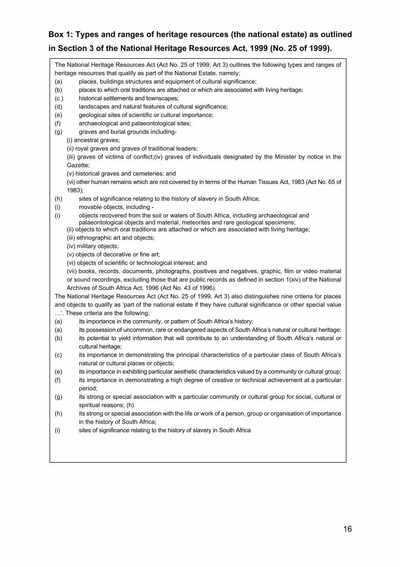
16
Box 1: Types and ranges of heritage resources (the national estate) as outlined in Section 3 of the National Heritage Resources Act, 1999 (No. 25 of 1999).
The National Heritage Resources Act (Act No. 25 of 1999, Art 3) outlines the following types and ranges of heritage resources that qualify as part of the National Estate, namely: (a) places, buildings structures and equipment of cultural significance; (b) places to which oral traditions are attached or which are associated with living heritage; (c ) historical settlements and townscapes; (d) landscapes and natural features of cultural significance; (e) geological sites of scientific or cultural importance; (f) archaeological and palaeontological sites; (g) graves and burial grounds including-
(i) ancestral graves; (ii) royal graves and graves of traditional leaders; (iii) graves of victims of conflict;(iv) graves of individuals designated by the Minister by notice in the Gazette; (v) historical graves and cemeteries; and (vi) other human remains which are not covered by in terms of the Human Tissues Act, 1983 (Act No. 65 of 1983);
(h) sites of significance relating to the history of slavery in South Africa; (i) movable objects, including - (i) objects recovered from the soil or waters of South Africa, including archaeological and
palaeontological objects and material, meteorites and rare geological specimens; (ii) objects to which oral traditions are attached or which are associated with living heritage; (iii) ethnographic art and objects; (iv) military objects; (v) objects of decorative or fine art; (vi) objects of scientific or technological interest; and (vii) books, records, documents, photographs, positives and negatives, graphic, film or video material or sound recordings, excluding those that are public records as defined in section 1(xiv) of the National Archives of South Africa Act, 1996 (Act No. 43 of 1996).
The National Heritage Resources Act (Act No. 25 of 1999, Art 3) also distinguishes nine criteria for places and objects to qualify as ‘part of the national estate if they have cultural significance or other special value …‘. These criteria are the following: (a) its importance in the community, or pattern of South Africa’s history; (a) its possession of uncommon, rare or endangered aspects of South Africa’s natural or cultural heritage; (b) its potential to yield information that will contribute to an understanding of South Africa’s natural or
cultural heritage; (c) its importance in demonstrating the principal characteristics of a particular class of South Africa’s
natural or cultural places or objects; (e) its importance in exhibiting particular aesthetic characteristics valued by a community or cultural group; (f) its importance in demonstrating a high degree of creative or technical achievement at a particular
period; (g) its strong or special association with a particular community or cultural group for social, cultural or
spiritual reasons; (h) (h) its strong or special association with the life or work of a person, group or organisation of importance
in the history of South Africa; (i) sites of significance relating to the history of slavery in South Africa
17
4.1.1 NEMA
The NEMA stipulates under Section 2(4)(a) that sustainable development requires the
consideration of all relevant factors including (iii) the disturbance of landscapes and
sites that constitute the nation’s cultural heritage must be avoided, or where it cannot
be altogether avoided, is minimised and remedied. Heritage assessments are
implemented in terms of the NEMA Section 24 in order to give effect to the general
objectives. Procedures considering heritage resource management in terms of the
NEMA are summarised under Section 24(4) as amended in 2008. In addition to the
NEMA, the National Environmental Management: Protected Areas Act, 2003 (Act No.
57 of 2003) (NEMPA) may also be applicable. This act applies to protected areas and
world heritage sites, declared as such in terms of the World Heritage Convention Act,
1999 (Act No. 49 of 1999) (WHCA).
4.1.2 MPRDA The MPRDA stipulates under Section 5(4) no person may prospect for or remove,
mine, conduct technical co-operation operations, reconnaissance operations, explore
for and produce any mineral or petroleum or commence with any work incidental
thereto on any area without (a) an approved environmental management programme
or approved environmental management plan, as the case may be.
4.1.3 NHRA
According to Section 3 of the NHRA (Act No. 25 of 1999) the ‘national estate’
comprises a wide range and various types of heritage resources (see Box 1).
4.1.3.1 Heritage Impact Assessment studies
According to Section 38 of the National Heritage Resources Act (Act No. 25 of 1999)
a Heritage Impact Assessment (HIA) process must be followed under the following
circumstances:
• The construction of a linear development (road, wall, power line, canal etc.)
exceeding 300m in length
• The construction of a bridge or similar structure exceeding 50m in length
18
• Any development or activity that will change the character of a site and which
exceeds 5 000m2 or which involve three or more existing erven or subdivisions
thereof
• Re-zoning of a site exceeding 10 000 m2
• Any other category provided for in the regulations of SAHRA, a provincial or
local heritage authority or any other legislation such as NEMA, MPRDA, etc.
4.1.3.2 Section 34 (Buildings and structures) Section 34 of the NHRA provides for general protection of structures older than 60
years. According to Section 34(1) no person may alter (demolish) any structure or part
thereof which is older than 60 years without a permit issued by the relevant provincial
heritage resources authority.
A structure means any building, works, device or any other facility made by people
and which is fixed to land and which includes fixtures, fittings and equipment
associated with such structures.
Alter means any action which affects the structure, appearance or physical properties
of a place or object, whether by way of structural or any other works such as painting,
plastering, decorating, etc.
Most importantly, Section 34(1) clearly states that no structure or part thereof may be
altered or demolished without a permit issued by the relevant Provincial Heritage
Resources Authority (PHRA). These permits will not be granted without a HIA being
completed. A destruction permit will thus be required before any removal and/or
demolition may take place, unless exempted by the PHRA according to Section
34(2) of the NHRA.
4.1.3.3 Section 35 (Archaeological and palaeontological resources and meteorites) Section 35 of the NHRA provides for the general protection of archaeological and
palaeontological resources, and meteorites. In the event that archaeological resources
are discovered during the course of development, Section 38(3) specifically requires
19
that the discovery must immediately be reported to the PHRA, or local authority or
museum who must notify the PHRA. Furthermore, no person may without permits
issued by the responsible heritage resources authority may:
• destroy, damage, excavate, alter, deface or otherwise disturb any
archaeological or paleontological site or any meteorite
• destroy, damage, excavate, remove from its original position, collect or own any
archaeological or paleontological material or object or any meteorite
• trade in, sell for private gain, export or attempt to export from the Republic any
category of archaeological or paleontological material or object, or any
meteorite; or bring onto or use at an archaeological or paleontological site any
excavation equipment or any equipment that assists in the detection or recovery
of metals or archaeological and paleontological material or objects, or use such
equipment for the recovery of meteorites
• alter or demolish any structure or part of a structure which is older than 60
years.
Heritage resources may only be disturbed or moved by an archaeologist after being
issued with a permit received from the South African Heritage Resources Agency
(SAHRA). In order to demolish heritage resources, the developer has to acquire a
destruction permit by from SAHRA.
4.1.3.4 Section 36 (Burial grounds and graves)
Section 36 of the NHRA allows for the general protection of burial grounds and graves.
Should burial grounds or graves be found during the course of development, Section
36(6) stipulates that such activities must immediately cease, and the discovery
reported to the responsible heritage resources authority and the South African Police
Service (SAPS). Section 36 also stipulates that no person without a permit issued by
the relevant heritage resources authority may:
a) destroy, damage, alter, exhume or remove from its original position or otherwise
disturb the grave of a victim of conflict, or any burial ground or part thereof which
contains such graves
b) destroy, damage, alter, exhume or remove from its original position or otherwise
disturb any grave or burial ground older than 60 years which is situated outside
a formal cemetery administered by a local authority; or
20
c) bring onto or use at a burial ground or grave referred to in paragraph (a) or (b)
any excavation, or any equipment which assists in the detection or recovery of
metals.
Section 36 of the NHRA divides graves and burial grounds into the following
categories:
a. ancestral graves
b. royal graves and graves of traditional leaders
c. graves of victims of conflict
d. graves designated by the Minister
e. historical graves and cemeteries
f. human remains
Human remains less than 60 years old are subject to provisions of the National Health
Act, 2003 (Act No. 61 of 2003), Ordinance 12 of 1980 (Exhumation Ordinance) and
Ordinance No. 7 of 1925 (Graves and dead bodies Ordinance, repealed by
Mpumalanga). Municipal bylaws with regard to graves and graveyards may differ.
Professionals involved with the exhumation and relocation of graves and graveyards
must establish whether such bylaws exist and must adhere to these laws.
Unidentified graves are handled as if they are older than 60 years until proven
otherwise.
Permission for the exhumation and relocation of graves older than sixty years must
also be gained from descendants of the deceased (where known), the National
Department of Health, Provincial Department of Health, Premier of the Province and
local police. Furthermore, permission must also be gained from the various
landowners (i.e. where the graves are located and where they are to be relocated)
before exhumation can take place.
Human remains can only be handled by a registered undertaker or an institution
declared under the Human Tissues Act (Act No. 65 of 1983 as amended).
21
4.1.3.5 Section 37 (Public monuments and memorials)
Section 37 makes provision for the protection of all public monuments and memorials
in the same manner as places which are entered in a heritage register referred to in
Section 30 of the NHRA.
4.1.3.6 Section 38 (HRM)
Section 38 (8): The provisions of this section do not apply to a development as
described in Section 38 (1) if an evaluation of the impact of such development on
heritage resources is required in terms of the Environment Conservation Act, 1989
(Act No. 73 of 1989), or the integrated environmental management guidelines issued
by the Department of Environment Affairs and Tourism, or the Minerals Act, 1991 (Act
No. 50 of 1991), or any other legislation. Section 38(8) ensures cooperative
governance between all responsible authorities through ensuring that the evaluation
fulfils the requirements of the relevant heritage resources authority in terms of
Subsection (3), and any comments and recommendations of the relevant heritage
resources authority with regard to such development have been taken into account
prior to the granting of the consent.
The Listed Activities in terms of the Government Notice Regulations (GNRs) stipulated
under NEMA for which Environmental Authorisation (EA) will be applied for will trigger
a HIA as contemplated in Section 38(1) above as follows:
4.4.4 NEMA Appendix 6 requirements
NEMA Regulations (2014) - Appendix 6 Relevant section in report
Details of the specialist who prepared the
report
Dr Julius CC Pistorius
The expertise of that person to compile a
specialist report including a curriculum vitae
Part 2. Details of the specialist
A declaration that the person is independent
in a form as may be specified by the
competent authority
Part 3. Declaration of independence
22
NEMA Regulations (2014) - Appendix 6 Relevant section in report
An indication of the scope of, and the
purpose for which, the report was prepared
Part 1. Introduction
The date and season of the site investigation
and the relevance of the season to the
outcome of the assessment
Part 7. Approach and Methodology
Part 8.1. Field survey
A description of the methodology adopted in
preparing the report or carrying out the
specialised process
Part 7. Approach and Methodology
The specific identified sensitivity of the site
related to the activity and its associated
structures and infrastructure
Part 8.1 The field survey
An identification of any areas to be avoided,
including buffers
Part 8.2 Summary
A map superimposing the activity including
the associated structures and infrastructure
on the environmental sensitivities of the site
including areas to be avoided, including
buffers;
Figures 1, 2 & 5
A description of any assumptions made and
any uncertainties or gaps in knowledge;
Part 1.3. Assumptions and limitations
A description of the findings and potential
implications of such findings on the impact of
the proposed activity, including identified
alternatives, on the environment
Part 8.2 Summary
Part 9. Conclusion and
recommendations
Any mitigation measures for inclusion in the
EMPr
Part 8.2. Summary
Part 9. Conclusion and
recommendations
Any conditions for inclusion in the
environmental authorisation
Part 9. Conclusion and
recommendations
Any monitoring requirements for inclusion in
the EMPr or environmental authorisation
Part 9. Conclusion and
recommendations
23
NEMA Regulations (2014) - Appendix 6 Relevant section in report
A reasoned opinion as to whether the
proposed activity or portions thereof should
be authorised and
Part 9. Conclusion and
recommendations
If the opinion is that the proposed activity or
portions thereof should be authorised, any
avoidance, management and mitigation
measures that should be included in the
EMPr, and where applicable, the closure plan
Part 9. Conclusion and
recommendations
A description of any consultation process that
was undertaken during the course of carrying
out the study
Part 7.4 Consultation process
undertaken, and comments received
from stakeholders
A summary and copies if any comments that
were received during any consultation
process
Part 7.4 Consultation process
undertaken and comments received
from stakeholders
Any other information requested by the
competent authority.
None
5 THE PROPOSED PIPELINE PROJECT 5.1 Location
AngloGold Ashanti (Pty) Limited’s proposed water pipeline and associated
infrastructure is located approximately 80 km west of Johannesburg. The pipeline
originates in the greater West Wits mining lease areas approximately 3.3 km south
east of Carletonville and ends at the NBD approximately 6km south-south-west of
Carletonville in Blyvooruitzicht, Merafong City Local Municipality, West Rand District
Municipality in the Gauteng Province of South Africa (Figures 1).
5.2 The nature of the Project
The proposed Project therefore aims to construct a surface mounted pipeline and
associated infrastructure to pump water from BLV #4 to the North Boundary Dam (NBD)
(Figure 1). Two alternative pipeline routes are also considered. The proposed and
alternative pipeline alternative routes are illustrated in Figure1.
24
The northern sections of the proposed Project pipeline (i.e. north of the road bisecting
the site) will be installed within the existing pipeline servitude by means of supporting
the pipeline on top of the existing pipeline thus avoiding disturbance to soil or
vegetation. The southern section of the pipeline will be situated within a newly
registered servitude and the pipeline will be supported on 600mm X 300mm pre-cast
concrete plinths spaced 9m apart (Figure 1).
No construction camp will be required. Pipes and construction equipment will either
be stored on site at Covalent No.4 shaft or the AGA Mine Service yard.
For further information on the project description, please refer to the Golder Associates
Basic Assessment report.
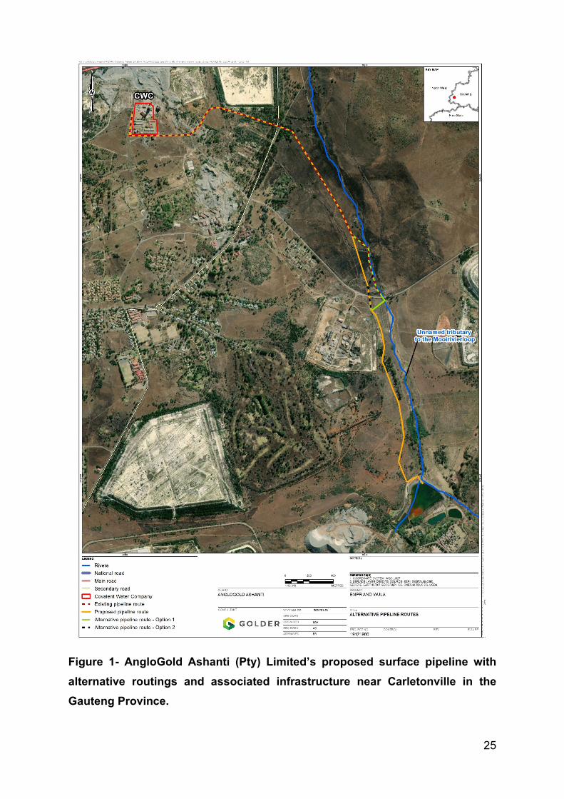
25
Figure 1- AngloGold Ashanti (Pty) Limited’s proposed surface pipeline with alternative routings and associated infrastructure near Carletonville in the Gauteng Province.
26
5.3 The heritage character of the Project Area
The project area is part of a mining landscape which is the result of gold mining
activities over a long period of time. Consequently, the area cannot be described as
pristine any longer. However, heritage resources still do occur, and these primarily
include:
• Mine landscapes where mine infrastructure older than sixty years still occurs.
• Townscapes which comprise whole suburbs of Randfontein and other towns on
the West Rand which are older than sixty years.
• Graveyards and graves dating from the nineteenth century to the recent past.
Several heritage impact assessment studies have been done in the larger project area
some of whom are located in close proximity of the project area (see Part 12,
‘Bibliography relating to earlier heritage studies’).
6 CONTEXTUALISING THE PROJECT AREA
The following is a brief outline of the pre-historical and historical background of the project
area with the aim to contextualise any possible heritage resources that may be found in
or near the proposed pipeline corridor.
6.1 Prehistory and early history
According to archaeological research, the earliest ancestors of modern humans
emerged some two to three million years ago. The remains of Australopithecine and
Homo habilis have been found in dolomite caves and underground dwellings in places
such as Sterkfontein and Swartkrans near Krugersdorp. Homo habilis, one of the Early
Stone Age hominids, is associated with Oldowan artefacts, which include crude
implements manufactured from large pebbles.
The Acheulian industrial complex replaced the Oldowan industrial complex during the
Early Stone Age. This phase of human existence was widely distributed across South
Africa and is associated with Homo Erectus, who manufactured hand axes and cleavers
from as early as one and a half million years ago. Oldowan and Acheulian artefacts were
also found four to five decades ago in some of the older gravels (ancient river beds and
27
terraces) of the Vaal River and the Klip River in Vereeniging. The earliest ancestors of
modern man may therefore have roamed the Vaal valley at the same time that their
contemporaries occupied some of the dolomite caves near Krugersdorp.
Middle Stone Age sites dating from as early as two hundred thousand years ago have
been found all over South Africa. Middle Stone Age hunter-gatherer bands also lived
and hunted in the Orange and Vaal River valleys. These people, who probably looked
like modern humans, occupied campsites near water but also used caves as
dwellings. They manufactured a wide range of stone tools, including blades and points
that may have had long wooden sticks as hafts and were used as spears.
The Late Stone Age commenced twenty thousand years ago or somewhat earlier. The
various types of Stone Age industries scattered across the country are associated with
the historical San and Khoi-Khoi people. The San were renowned as formidable hunter-
gatherers, while the Khoi-Khoi herded cattle and small stock during the last two thousand
years. Late Stone Age people manufactured tools that were small but highly effective,
such as arrow heads and knives.
The Late Iron Age people were also known for their rock art skills. Two rock arts sites
closest to the project area are Redan near Vereeniging and Bosworth near Klerksdorp.
Early Iron Age farming communities practised a mixed economy, consisting of plant
cultivation and stock herding, in the interior of South Africa during the first half of the first
millennium A.D. These Bantu-Negroid people, who interbred with the local San and Khoi-
Khoi, were ironworkers of some repute and they established the first permanent villages
south of the Limpopo River. These communities occupied the savannah of the Limpopo
Province as well as the Eastern Lowveld and coastal regions of South Africa. No traces
of their existence have as yet been found on the Highveld.
During the Late Iron Age, farming was practised in the northern, central and eastern parts
of the country. These farming communities built numerous stone walled settlements
throughout the southern Highveld of the Orange Free State, on the Witwatersrand and
numerous other places in South Africa from the 17th century onwards. These sites are
associated with the predecessors of the black ethnic groups living in South Africa. Some
of these sites are also situated near the Vaal valley, but eastwards of Vereeniging and
28
outside the Vaal Triangle. Stone walled sites are also spread out along the range of hills
running from Randfontein in the west through Johannesburg to Heidelberg in the east.
These sites are associated with the ancestors of the Sotho-Tswana peoples.
6.2 Brief historical background to towns close to the project area
The well-watered shallow valleys and numerous strong dolomitic fountains in the larger
project area attracted Voortrekker farmers to this area as early as 1842. The largest of
these fountains are Wonderfontein, situated approximately 10km north-east of
Carletonville. It is the sources of the Mooirivierloop, a tributary of Potchefstroom’s Mooi
River.
For nearly a half a decade, after the discovery of gold on the Witwatersrand, the
production of gold was confined to the main Witwatersrand gold reef. Geologists knew
that these deposits extended to the west and east but at much greater depths than on
the Rand. However, the technology to exploit these reefs was not yet available at the
time. In the 1930’s new methods revealed reefs in the north-west, near Potchefstroom
and Klerksdorp where some of the deepest mines in the world now operate.
The project area is closest to the following towns, namely Krugersdorp and Randfontein
to the north-east, Soweto to the east and Westonaria and Carletonville to the south and
to the west. A brief summary of the historical unfolding of these towns and significant
heritage sites associated with these towns are outline below.
6.2.1 Krugersdorp and Randfontein
Krugersdorp, like many other towns in the former Transvaal province, traces its origins
to the discovery of gold. The Transvaal government bought 428 hectares of the farm
Paardekraal on 26 April 1887 for £3 000 to serve as administrative centre for all the
public gold diggings proclaimed on the remainder of this and other farms.
Some heritage sites of significance in Krugersdorp are the following:
• The foundation stone of the magistrate’s court building was laid by Pres Paul
Kruger on 18 September 1890.
• The Earl of Selborne, British governor to the Transvaal Crown Colony after the
Anglo Boer War, laid the foundation stone of the hall on 10 May 1907.
29
• Coronation Park was laid out on 37ha presented to Krugersdorp by the British
government in 1902 to celebrate Mark Edward’s VII coronation.
• President Paul Kruger’s statue in Pretorius Park is the only one in the country
showing Kruger as a relatively young man.
• Krugersdorp Game Reserve (Gauteng of the town) preserves the fauna and
flora indigenous to the Witwatersrand before the discovery of gold.
The town of Randfontein was established on 3 March 1890 to serve the gold mining
operations of the Randfontein Gold Mining Company, at the time the largest gold
mining company on the Witwatersrand. (The company still boasts the world’s largest
stamp mill).
The village was founded on the farm by the same name. It was bought by Sir J.B.
Robinson together with other farms during the general scramble for property following
the discovery of the Witwatersrand gold reef in 1886.
The railway line running from Johannesburg to Krugersdorp was extended to
Randfontein in 1896.
Apart from gold and uranium the main products of the district are dairy, maize and
vegetables.
6.2.2 Soweto
Soweto, the largest township in the country was developed for exclusive black
occupation under the apartheid system from the early 1950’s. The name is an acronym
for South-Western Townships established on the farms Doornkop, Klipriviersberg,
Diepkloof, Klipspruit and Vogelstruisfontein.
The umbrella name Soweto includes 26 townships such as Meadowlands,
Dobsonville, Diepkloof and Dube, each which was designed to be a self-sufficient
entity.
30
The total area at the time was 6 734 hectares and was consolidated after the Second
World War. By 1970 Soweto had 65 968 houses, 143 churches and 127 schools with
about 100 000 pupils.
The population of Soweto entails a polygot community, open to all and includes
members of all the country’s indigenous groups. Dominant languages are Zulu, North
and South Sotho, Tswana and Xhosa.
Much of the struggle against apartheid was fought in and from Soweto. Riots that
rocked the country started on 16 June 1976.
Heritage sites in Soweto include the following:
• Hector Peterson Square in Orlando East was named for the first student that
was killed in the 1976 uprising.
• Vilikazi Street runs past the former homes of two Nobel Peace Prize winners,
namely Nelson Mandela and Desmond Tutu.
• Nelson Mandela’s former house shared with Winnie Mandela during the 1950’s
and 1960’s is now a museum.
• The imposing Regina Mundi Church (Raman Catholic) where many important
gatherings were staged during the apartheid year’s today house an art
museum.
Freedom Square hosted the thousands of people who gathered for the mass rally that
drafted the Freedom Charter, the manifesto of the African National Congress, which
was subsequently ratified at Kliptown on 26 and 27 June 1955.
6.2.3 Westonaria and Carletonville
Westonaria’s name is a compound of its location (West Rand) and Western Areas the
gold mining company that owned much of the land. It is in fact a conglomeration of
several mining towns. Significant gold mines in the wider district are Libanon,
Venterspos, Westernareas, Elsburg and Kloof.
Carletonville serves several of the country’s richest gold mines such as West
Driefontein, East Driefontein, Western Deep Levels and Blyvooruitzicht.
31
It is a comparatively young urban development as most of the mines were developed
after the Second World War. Carletonville was laid out by West Witwatersrand Areas
gold mining company on the farm Twyfelvlakte and proclaimed on 28 January 1948.
The township was named for Guy Carlton Jones, a director of Consolidated Gold
Fields for 35 years and developer of the ‘West Wits Line of mines’.
6.3 Gold mining history The Carletonville gold fields also known as the West Wits Line is the richest of all the
Witwatersrand gold fields. Its discovery turned out to be a spectacular geological and
engineering success story. Exploration drilling west of Johannesburg between 1899 and
1904 intersected several auriferous conglomerates at some depth below surface.
However, development was hampered by several ground water problems. From the
1930’s the subsurface geology became better understood as a result of the magnetic
exploration techniques developed by Rudolph Krahman. The combination of improved
geological understanding with new cementation technology enabled sub-surface ground
water flow to be controlled. This facilitated drilling and subsequent shaft development
which confirmed the existence of an enormous gold field.
The West Wits Line
The West Wits Line, also known as the Carletonville gold fields, lies on the north-western
edge of the Witwatersrand basin, 35 km west of Johannesburg. During the 1930’s
detailed prospecting took place in the region. This eventually led to the development of
ten mines, some of them the biggest and certainly the richest in the entire basin.
Mines in the area included Deelkraal, Elandsrand, Doornfontein, Blyvooruitsicht,
Western Deep Levels and Driefontein Consolidated (previously West and East
Driefontein). These mines all occurred to the west of the Bank fault. The Kloof, Libanon
and Venterspos mines all occurred to the east of the break.
Total gold production from the area amounted to a little over 7 000 tons by 1998. In
addition to gold, uranium and pyrite are imported by-products from the region.
32
The gold fields can be divided into two sections along geological lines. The section west
of the Bank fault is sedimentologically distinct and lies between Carletonville and
Fochville. This section is correctly referred to as the Carletonville gold fields.
Whilst the entire region is referred to as the West Wits Line the section east of the Bank
fault represents a natural sedimentological extension of the West Rand gold field and
comprises the three mines centred on the town of Westonaria.
West Rand Gold Fields
The West Rand Gold Fields lies 25 km west of Johannesburg and extents from
Krugersdorp in the north eastwards to Roodepoort and then southwards towards
Westonaria. Gold was discovered in the Krugersdorp area in 1887.
Amalgamation of early mining operations led to the establishment of four principal gold
mines to the north of the Witpoortjie Gap, namely East Champ D ’Or, Luipaardsvlei
Estates, West Rand Consolidated and Randfontein Estates.
In the 1930’s the South Roodepoort Mine was established to the south of the gap. In
1998 it was referred to as the Doornkop Section of Randfontein Estates. Exploration
along the eastern side of the Panvlakte fault (as a result of an interest in uranium) during
the post war years led to the establishment of the Western Areas Gold Mine in the late
1950’s and the Cooke Section of Randfontein Estates in the 1970’s. The Panvlakte horst
is now considered as the western limit to the West Rand gold fields.
7 APPROACH AND METHODOLOGY
This heritage survey and assessment study was conducted by means of the following:
7.1 Field survey
The field survey was conducted together with security personnel from AngloGold due
to the threat that illegal mine workers (zama zamas) posed to the survey team
consisting of a plant botanist and archaeologist. Both specialists were transported to
site in an armoured vehicle (Caspir) with three-armed security guards and Mr. Luther
33
Schoeman from AngloGold. The specialists were not allowed to leave the safety of the
armoured vehicle and therefore were oblique to observe the pipeline corridor from the
Caspir whilst travelling alongside its proposed corridor. The field survey was limited to
the southern part of the pipeline as the northern part of the pipeline will be mounted
on top of the existing pipeline and no further disturbances be caused along this part of
the pipeline (Figure 2).
Archaeological visibility was not good along the southern part of the pipeline where tall
grass and thick clumps with popular trees are growing along the banks of the unnamed
tributary to the Mooirivierloop.
All coordinates for heritage resources recorded were done with a Garmin Etrex hand
set Global Positioning System (instrument) with an accuracy of < 15m.
Google imagery was used as a supplementary source (prior to and after fieldwork) to
establish the possible presence of heritage resources such as abandoned buildings
or possible graveyards in the project area.
The nature and character of the project area is further illuminated with descriptions
and photographs in Part 8.1 ‘The field survey’.
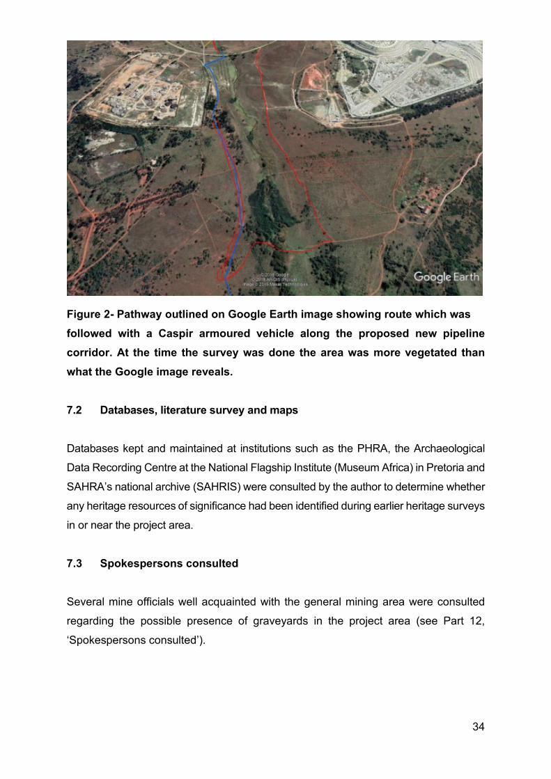
34
Figure 2- Pathway outlined on Google Earth image showing route which was followed with a Caspir armoured vehicle along the proposed new pipeline corridor. At the time the survey was done the area was more vegetated than what the Google image reveals. 7.2 Databases, literature survey and maps
Databases kept and maintained at institutions such as the PHRA, the Archaeological
Data Recording Centre at the National Flagship Institute (Museum Africa) in Pretoria and
SAHRA’s national archive (SAHRIS) were consulted by the author to determine whether
any heritage resources of significance had been identified during earlier heritage surveys
in or near the project area.
7.3 Spokespersons consulted
Several mine officials well acquainted with the general mining area were consulted
regarding the possible presence of graveyards in the project area (see Part 12,
‘Spokespersons consulted’).
35
7.4 Consultation process undertaken and comments received from stakeholders
No specific consultation process was undertaken for the purposes of the heritage study
as the stakeholder consultation for the project is being done by Golder Associates Africa
(Pty) Ltd.
7.5 Significance ratings
The significance of possible impacts on the heritage resources was determined using
a ranking scale based on the following:
• Occurrence
- Probability of occurrence (how likely is it that the impact may/will occur?), and
- Duration of occurrence (how long may/will it last?)
• Severity
- Magnitude (severity) of impact (will the impact be of high, moderate or low
severity?), and
- Scale/extent of impact (will the impact affect the national, regional or local
environment, or only that of the site?).
Each of these factors has been assessed for each potential impact using the following
ranking scales:
Probability: 5 – Definite/don’t know 4 – Highly probable 3 – Medium probability 2 – Low probability 1 – Improbable 0 – None
Duration: 5 – Permanent 4 – Long-term 3 - Medium-term (8-15 years) 2 - Short-term (0-7 years) 1 – Immediate
Scale: 5 – International 4 – National 3 – Regional 2 – Local 1 – Site only 0 – None
Magnitude: 10 - Very high/don’t know 8 – High 6 – Moderate 4 – Low 2 – Minor
36
The heritage significance of each potential impact was assessed using the following
formula:
Significance Points (SP) = (Magnitude + Duration + Scale) x Probability
The maximum value is 100 Significance Points (SP). Potential environmental impacts
are rated as very high, high, moderate, low or very low significance on the following basis:
• More than 75 significance points indicates HIGH heritage significance.
• Between 30 and 75 significance points indicates MODERATE heritage
significance.
• Less than 30 significance points indicates a LOW heritage significance.
8 THE PHASE I HERITAGE IMPACT AND ASSESSMENT 8.1 The field survey The field survey which was undertaken with a Caspir armoured vehicle was limited to
the southern part of the pipe line as the northern part of the pipeline will be mounted
on top of the existing pipeline and no further disturbances be caused along this part of
the pipeline.
The project area north and south of the tar road is flat with limited tree cover and a
small outcrop north of the tar road. The Caspir armoured car therefore followed the
proposed pipeline conveniently only to deviate here and there in order to avoid
trenches which were dug by zama zamas to remove cables.
The proposed pipeline corridor is now illuminated with photographs.
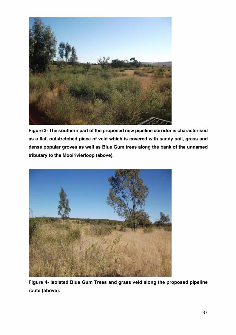
37
Figure 3- The southern part of the proposed new pipeline corridor is characterised as a flat, outstretched piece of veld which is covered with sandy soil, grass and dense popular groves as well as Blue Gum trees along the bank of the unnamed tributary to the Mooirivierloop (above).
Figure 4- Isolated Blue Gum Trees and grass veld along the proposed pipeline route (above).
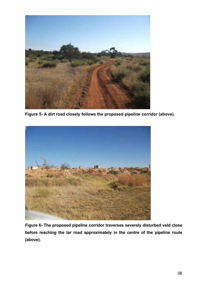
38
Figure 5- A dirt road closely follows the proposed pipeline corridor (above).
Figure 6- The proposed pipeline corridor traverses severely disturbed veld close before reaching the tar road approximately in the centre of the pipeline route (above).
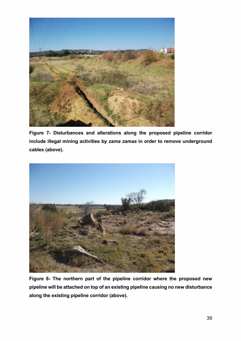
39
Figure 7- Disturbances and alterations along the proposed pipeline corridor include illegal mining activities by zama zamas in order to remove underground cables (above).
Figure 8- The northern part of the pipeline corridor where the proposed new pipeline will be attached on top of an existing pipeline causing no new disturbance along the existing pipeline corridor (above).
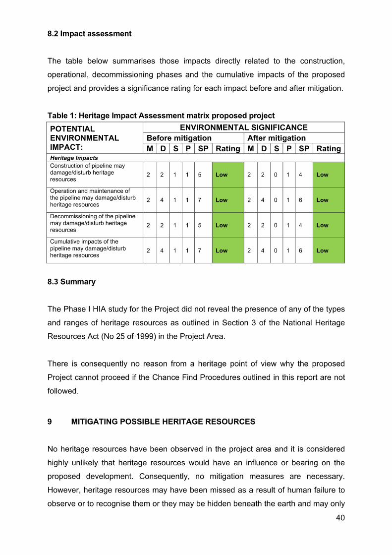
40
8.2 Impact assessment The table below summarises those impacts directly related to the construction,
operational, decommissioning phases and the cumulative impacts of the proposed
project and provides a significance rating for each impact before and after mitigation.
Table 1: Heritage Impact Assessment matrix proposed project POTENTIAL ENVIRONMENTAL IMPACT:
ENVIRONMENTAL SIGNIFICANCE Before mitigation After mitigation M D S P SP Rating M D S P SP Rating
Heritage Impacts Construction of pipeline may damage/disturb heritage resources
2 2 1 1 5 Low 2 2 0 1 4 Low
Operation and maintenance of the pipeline may damage/disturb heritage resources
2 4 1 1 7 Low 2 4 0 1 6 Low
Decommissioning of the pipeline may damage/disturb heritage resources
2 2 1 1 5 Low 2 2 0 1 4 Low
Cumulative impacts of the pipeline may damage/disturb heritage resources
2 4 1 1 7 Low 2 4 0 1 6 Low
8.3 Summary The Phase I HIA study for the Project did not reveal the presence of any of the types
and ranges of heritage resources as outlined in Section 3 of the National Heritage
Resources Act (No 25 of 1999) in the Project Area.
There is consequently no reason from a heritage point of view why the proposed
Project cannot proceed if the Chance Find Procedures outlined in this report are not
followed.
9 MITIGATING POSSIBLE HERITAGE RESOURCES No heritage resources have been observed in the project area and it is considered
highly unlikely that heritage resources would have an influence or bearing on the
proposed development. Consequently, no mitigation measures are necessary.
However, heritage resources may have been missed as a result of human failure to
observe or to recognise them or they may be hidden beneath the earth and may only
41
be exposed when earth works are done. Informal, undecorated and abandoned graves
may also be missed during foot surveys.
If chance finds of heritage resources, including graves that have been missed during
the Phase I survey, are made during the construction, operation or eventual
decommissioning of the Project, the following chance find procedures must be
implemented.
9.1 Chance find procedures Chance Find Procedures are applicable during the construction, operation or closure
phases of the Project and apply to all contractors, subcontractors, subsidiaries or
service providers. If any of the institutions’ employees find any heritage resources
during any developmental activity the person and institution must cease work at the
site of the find. They must report this find to their immediate supervisor and through
their supervisor to the senior on-site manager.
9.1.1 Chance find procedures for heritage resources
The initial procedure to follow when heritage resources are uncovered during
development is aimed at avoiding any further possible damage to the heritage
resources. The following procedures must be followed:
• The person or group who identified or exposed the heritage resource or burial
ground must cease all activity in the immediate vicinity of the site.
• The chance find must be reported to the on-site manager.
• The on-site manager must make an initial assessment of the extent of the find
and confirm that further work has stopped. He must ensure that the site is
secured and that controlled access is implemented.
• The on-site manager must inform the Environmental Officer (EO) and Health
and Safety Officer (HSO) of the chance find and its immediate impact on the
Project. The EO must contact an archaeologist registered with the Association
for Southern African Professional Archaeologist (ASAPA) or the South African
Heritage Resources Agency (SAHRA) who would provide the details of an
archaeologist.
42
• The archaeologist will conduct a site inspection and confirm the significance of
the discovery, recommend appropriate mitigation measures for the Project and
will also notify the relevant authorities.
• Based on the comments received from the authorities the archaeologist will
provide the Project with a Terms of References Report (TOR) and associated
costs if mitigation measures have to be implemented. The archaeologist will
also obtain the necessary permits from SAHRA to conduct the necessary
mitigation measures.
9.1.2 Chance Find Procedures for burials and graves
In the event that unidentified burial grounds or graves are identified and/or exposed
during any of the developmental phases of the Project the following steps must be
implemented subsequent to those outlined above:
• The archaeologist must confirm the presence of graveyards and graves and
implement the following procedures.
• Inform the local South African Police (SAP) and traditional authority.
• The archaeologist in conjunction with the SAP and traditional authority will
inspect the possible graves and make an informed decision whether the
remains are of forensic, recent, cultural-historical or archaeological
significance.
• Should it be concluded that the find is of heritage significance and therefore
protected in terms of heritage legislation the archaeologist will notify the
relevant authorities.
• The archaeologist will provide advice with regard to mitigation measures for the
graves.
10 CONCLUSION AND RECOMMENDATIONS
The Phase I HIA study for the Project did not reveal the presence of any of the types
and ranges of heritage resources as outlined in Section 3 of the National Heritage
Resources Act (No 25 of 1999) in the Project Area.
43
There is consequently no reason from a heritage point of view why the proposed
Project cannot proceed if the chance find procedures outlined in this report are not
followed.
It is possible that this Phase I HIA study may have missed heritage resources in a strip
along the pipeline corridor which is covered with blue gum and wattle trees and with
thick clumps of vegetation along the southern part of the proposed new pipeline
corridor. These areas could not be physically examined as a result of unsafe
conditions caused by illegal miners (zama zama’s). It is also possible that heritage
resources may also occur below the surface of the earth and may only be exposed
once development commences. Heritage resources may also have been missed as a
result of human failure to recognise them.
If any heritage resources of significance is exposed during the Project the South
African Heritage Resources Authority (SAHRA) should be notified immediately, all
activities must be stopped and an archaeologist accredited with the Association for
Southern African Professional Archaeologist (ASAPA) should be notify in order to
determine appropriate mitigation measures for the discovered finds. The chance find
procedures as outlined in the report should be followed. This may include obtaining
the necessary authorisation (permits) from SAHRA to conduct the mitigation
measures.
DR JULIUS CC PISTORIUS Member ASAPA
44
11 SELECT BIBLIOGRAPHY Bergh, J.S. 1992. Die vestiging van die Voortrekkers noord van die Vaalrivier tot 1840.
Historia, 37(2), 38-42.
Deacon, H.J. & Deacon, J. 1999. Human beginnings in South Africa. Uncovering the secrets of the Stone Age. David Philips: Cape Town.
Erasmus, B.P.J. 1995. Oppad in Suid Afrika. ‘n Gids tot Suid Afrika, Streek vir Streek.
Jonathan Ball Uitgewers Bpk.
Leroux, V. 1992. Reader’s Digest Book of the Great South African Outdoors. Cape Town:
Reader’s Digest Association South Africa.
Maggs, T.M. ‘O C. 1976. Iron Age communities of the Southern Highveld.
Pietermaritzburg: Natal Museum
Mason, R.J. 1962. The prehistory of the Transvaal. Johannesburg: Witwatersrand
University Press.
Mason, R.J. 1986. Origins of black people of Johannesburg and the Southern Western
Central Transvaal AD 350-1880. Archaeological Research Unit. Occasional Paper No
16. University of the Witwatersrand.
Mayhew, V. (ed.). 1982. Reader’s Digest illustrated guide to Southern Africa. Cape
Town: Reader’s Digest Association South Africa.
Naude, M. 1990. Die Transvaalse Boerewoning. Africana Society of Pretoria (8): 46-49.
O Hagan, T. (ed.) 1995. Places to visit in Southern Africa. Cape Town: AA The Motorist
Publications.
Rasmussen, R.K. 1978. Migrant kingdom: Mzilikazi's Ndebele in South Africa. Cape
Town: David Philip.
45
TNAD 1905. Short history of the native tribes of the Transvaal. Pretoria: Government
Printer.
Van Vollenhoven, A. 1997. ‘n Kultuurhulpbronstudie van die Britse Blokhuisstelsel van
die Tweede Anglo-Boere-oorlog in die voormalige Transvaal (Zuid-Afrikaansche
Republiek). Pretoria: Nasionale Kultuurhistoriese Museum.
Wadley, L. 1987. Later Stone Age Hunters and Gatherers of the Southern Transvaal:
Social and Ecological Interpretations. Oxford: British Archaeological Reports
International Series 380.
Van Warmelo, N. J. 1930. Transvaal Ndebele texts. Government Printer: Pretoria.
Viljoen, M.J. & Reinhold, W.U. 1999. An introduction to South Africa’s geological and
mining heritage. Randburg: Mintek.
12 BIBLIOGRAPHY RELATING TO EARLIER HERITAGE STUDIES
Birkholtz, P. 2008. Heritage Inventory. AngloGold Ashanti. Wes Wits situated south of
Carletonville, North West Province. Unpublished report for AngloGold Ashanti.
Pistorius, J.C.C. 2008. A Phase I Heritage Impact Assessment study for Mogale Alloys
near Krugersdorp in the Gauteng Province of South Africa Unpublished report for Mogale
Alloys.
Pistorius, J.C.C. 2008. A Phase I Heritage Impact Assessment study for Harmony’s Gold
Mining Limited Operations (Harmony) near Randfontein in the Gauteng Province of
South Africa. Unpublished report for Harmony’s Gold Mining Limited Operations
Pistorius, J.C.C. 2008. A Phase I Heritage Impact Assessment study for Rand Uranium’s
proposed Pyerite Project near the Cook Gold Plant in Randfontein in the Gauteng
Province of South Africa. Unpublished report for Golder Associates.
46
Pistorius, J.C.C. 2009. A Phase I Heritage Impact Assessment study for Rand Uranium’s
Harmony’s Pit Deposition Project near Randfontein in the Gauteng Province of South
Africa. Unpublished report for Ezendala Environmental Solutions.
Pistorius, J.C.C. 2009. A Phase I Heritage Impact Assessment study for the Mogale
Project near Krugersdorp and Randfontein in the Gauteng Province of South Africa. Unpublished report for Mintails.
Pistorius, J.C.C. 2009. A Phase I Heritage Impact Assessment study for the Cooke
Uranium Project’s new Uranium Plant/Acid Plant and Cooke Dump Reprocessing near
Randfontein in the Gauteng Province of South Africa. Unpublished report for Golder
Associates.
Pistorius, J.C.C. 2009. A Phase I Heritage Impact Assessment study for the proposed
new Randfontein Mega Tailings Project near Randfontein in the Gauteng Province of
South Africa. Unpublished report for Golder Associates.
13 SPOKESPERSON CONSULTED
Mr. Werner Grobler. Engineering Manager. Ashanti Gold.
Mr Luther Schoeman. Employee. Ashanti Gold.

February 2020 19121900-330264-11
APPENDIX C
Acknowledgements, Details of
EAP, Declaration of Interest and
Specialist EAP Experience
February 2020 19121900-330264-11
The following persons are acknowledged for their contribution to the report:
Table A: Acknowledgements
Name Organisation Contribution
AngloGold Ashanti Project Team AngloGold Ashanti Client
Olivia Allen Golder Co-ordination and liaison with client as project
manager
Adam Bennett Golder Compilation of the Heritage impact assessment
February 2020 19121900-330264-11
Details of EAP and Declaration of interest
(For official use only)
File Reference Number:
NEAS Reference Number:
Date Received:
Application for authorisation in terms of the National Environmental Management Act, 1998 (Act No. 107 of
1998), as amended and the Environmental Impact Assessment Regulations, 2014
PROJECT TITLE
Details of EAP
Environmental Assessment Practitioner (EAP) Adam Bennett (Golder Associates Africa (Pty) Limited)
Contact Person Adam Bennett
Postal address P.O. Box 6001, Halfway House
Post code 1685
Telephone +27 11 254 4989
Cell +27 0 83 538 9424
Fax
E-mail [email protected]
Professional affiliations SACNASP (Member # 400142/08)
NACA member
Environmental Authorisation for the proposed Surface Pipeline and Associated Infrastructure for
AngloGold Ashanti (Pty) Ltd
February 2020 19121900-330264-11
4.2 The Environmental Assessment Practitioner
I, Adam Bennett declare that:
General declaration:
I act as the independent environmental practitioner in this application;
I will perform the work relating to the application in an objective manner, even if this results in views and findings that are not favourable to the applicant;
I declare that there are no circumstances that may compromise my objectivity in performing such work;
I have expertise in conducting environmental impact assessments, including knowledge of the Act, regulations and any guidelines that have relevance to the proposed activity;
I will comply with the Act, Regulations and all other applicable legislation;
I will take into account, to the extent possible, the matters listed in regulation 8 of the Regulations when preparing the application and any report relating to the application;
I have no, and will not engage in, conflicting interests in the undertaking of the activity;
I undertake to disclose to the applicant and the competent authority all material information in my possession that reasonably has or may have the potential of influencing - any decision to be taken with respect to the application by the competent authority; and - the objectivity of any report, plan or document to be prepared by myself for submission to the competent authority;
I will ensure that information containing all relevant facts in respect of the application is distributed or made available to interested and affected parties and the public and that participation by interested and affected parties is facilitated in such a manner that all interested and affected parties will be provided with a reasonable opportunity to participate and to provide comments on documents that are produced to support the application;
I will ensure that the comments of all interested and affected parties are considered and recorded in reports that are submitted to the competent authority in respect of the application, provided that comments that are made by interested and affected parties in respect of a final report that will be submitted to the competent authority may be attached to the report without further amendment to the report;
I will keep a register of all interested and affected parties that participated in a public participation process;
I will provide the competent authority with access to all information at my disposal regarding the application, whether such information is favourable to the applicant or not;
all the particulars furnished by me in this form are true and correct;
will perform all other obligations as expected from an environmental assessment practitioner in terms of the
Regulations; and
I realise that a false declaration is an offence in terms of regulation 71 and is punishable in terms of section 24F of the Act.
February 2020 19121900-330264-11
Disclosure of Vested Interest (delete whichever is not applicable)
I do not have and will not have any vested interest (either business, financial, personal or other) in the
proposed activity proceeding other than remuneration for work performed in terms of the
Environmental Impact Assessment Regulations, 2014;
I do not have a vested interest in the proposed activity proceeding:
Signature of the environmental assessment practitioner:
Golder Associates Africa (Pty) limited
Name of company:
19 February 2019
Date:

February 2020 19121900-330264-11
Specialist EAP experience

February 2020 19121900-330264-11
EAP Project Experience – Specialist Noise and Vibration assessments
NIA for the Klipspruit Discard Dump Expansion Project, South32 SA Coal Holdings (Pty) Ltd, RSA,
(2019 – current)
Baseline noise monitoring and reporting for the Seriti New Vaal Colliery, Seriti, RSA, (2019 – current)
Provision of qualitative Noise Impact Assessment (NIA) for the proposed Metsimaholo underground
coal mine, Seriti Coal, RSA, 2019
Noise baseline monitoring for the gas well field development and central processing facility, CNOOC,
Uganda, 2016
Assessment of noise and air quality impacts on the Mahlangu residence resulting from the MafubeLifeX
Project, Anglo American, 2016
Maamba monthly noise and vibration monitoring and reporting, Maamba Coal, Zambia, 2016
NIA for Eikerboom, confidential client, 2016
NIA and baseline monitoring for the proposed Khongoni coal mine, Khongoni Haaskraal Coal, 2015
Noise and vibration assessment, Jindal Iron Ore Mine, 2015
NIA, Samancor Chrome Limited, Middelburg, RSA, 2015
Baseline noise monitoring and reporting, Two Rivers Platinum Mine, RSA, 2015
Noise impact opinion, Heidelberg South Rand, RSA, 2015
NIA, Kamoa Copper, DRC, 2014
NIA, Moatize Power Station, Mozambique, 2014
NIA, Nimba Iron Ore, Guinea, 2013

golder.com

March 2020 19121900-328397-9
APPENDIX L
Palaeontological Impact Assessment: Phase 1 Field Study
REPORT
Specialist Assessment for the Proposed Surface
Pipeline and Associated Infrastructure: Palaeontology
Impact Assessment Report AngloGold Ashanti (Pty) Limited South African Operations
Submitted to:
AngloGold Ashanti (Pty) Limited South African Operations Mr J van Wyk Carletonville - Fochville Road R500 Carletonville Gauteng 2501
Submitted by:
Golder Associates Africa (Pty) Ltd.
Podium at Menlyn, Second Floor, 43 Ingersol Road, Menlyn, Pretoria, 0181, South Africa
P O Box 6001, Halfway House, 1685
+27 11 254 4800
19121900-330265-12
February 2020

February 2020 19121900-330265-12
i
Distribution List 1 eCopy to AngloGold Ashanti (Pty) Limited South African Operations
1 eCopy to [email protected]
February 2020 19121900-330265-12
ii
Table of Contents
1.0 INTRODUCTION ......................................................................................................................................... 1
APPENDICES
APPENDIX A Document Limitations
APPENDIX B Phase 1 Palaeontology Impact Assessment Study
APPENDIX C Acknowledgements, Details of EAP, Declaration of Interest and Specialist EAP Experience
February 2020 19121900-330265-12
1
1.0 INTRODUCTION
The AGA operations in the West Wits mining lease areas are at risk of flooding due to ingress of fissure water
from surrounding mining operations. Approximately 25 Mℓ/day of fissure water flows into the underground
workings of the defunct Blyvooruitzicht Mine, which spans a strike of 6 km along the boundary with AGA. If
dewatering at the Old Blyvooruitzicht Shafts (#4, #5 & 6#) shafts were to cease, uncontrolled fissure water
would report to the AGA operations, which would pose both a flood and safety risk of AGA personnel and the
mining operations.
In summary, AGA propose to install underground infrastructure to route the BVL 5# AMD water to the BVL 4#
to allow for the dewatering, neutralisation and pumping to surface. From the BVL 4# mine this impacted water
will be routed on surface to the North Boundary Dam (NBD) and used as make-up water to the Savuka Gold
Plant Reclamation Operations.
This report provides a professional opinion regarding the anticipated palaeontology impact assessment from
this proposed project (See APPENDIX B).
.
Golder Associates Africa (Pty) Ltd.
Adam Bennett Warren Aken
Environmental Assessment Practitioner Associate
AB/WA/nbh
Reg. No. 2002/007104/07
Directors: RGM Heath, MQ Mokulubete, MC Mazibuko (Mondli Colbert), GYW Ngoma
Golder and the G logo are trademarks of Golder Associates Corporation
https://golderassociates.sharepoint.com/sites/108123/project files/6 deliverables/final client deliverables/final specialist reports/19121900-330265-12_rep_palaeontology_final_19feb2020.docx
February 2020 19121900-330265-12
APPENDIX A
Document Limitations

February 2020 19121900-330265-12
DOCUMENT LIMITATIONS
This Document has been provided by Golder Associates Africa Pty Ltd (“Golder”) subject to the following
limitations:
i) This Document has been prepared for the particular purpose outlined in Golder’s proposal and no
responsibility is accepted for the use of this Document, in whole or in part, in other contexts or for any
other purpose.
ii) The scope and the period of Golder’s Services are as described in Golder’s proposal, and are subject to
restrictions and limitations. Golder did not perform a complete assessment of all possible conditions or
circumstances that may exist at the site referenced in the Document. If a service is not expressly
indicated, do not assume it has been provided. If a matter is not addressed, do not assume that any
determination has been made by Golder in regards to it.
iii) Conditions may exist which were undetectable given the limited nature of the enquiry Golder was
retained to undertake with respect to the site. Variations in conditions may occur between investigatory
locations, and there may be special conditions pertaining to the site which have not been revealed by the
investigation and which have not therefore been taken into account in the Document. Accordingly,
additional studies and actions may be required.
iv) In addition, it is recognised that the passage of time affects the information and assessment provided in
this Document. Golder’s opinions are based upon information that existed at the time of the production of
the Document. It is understood that the Services provided allowed Golder to form no more than an
opinion of the actual conditions of the site at the time the site was visited and cannot be used to assess
the effect of any subsequent changes in the quality of the site, or its surroundings, or any laws or
regulations.
v) Any assessments made in this Document are based on the conditions indicated from published sources
and the investigation described. No warranty is included, either express or implied, that the actual
conditions will conform exactly to the assessments contained in this Document.
vi) Where data supplied by the client or other external sources, including previous site investigation data,
have been used, it has been assumed that the information is correct unless otherwise stated. No
responsibility is accepted by Golder for incomplete or inaccurate data supplied by others.
vii) The Client acknowledges that Golder may have retained sub-consultants affiliated with Golder to provide
Services for the benefit of Golder. Golder will be fully responsible to the Client for the Services and work
done by all of its sub-consultants and subcontractors. The Client agrees that it will only assert claims
against and seek to recover losses, damages or other liabilities from Golder and not Golder’s affiliated
companies. To the maximum extent allowed by law, the Client acknowledges and agrees it will not have
any legal recourse, and waives any expense, loss, claim, demand, or cause of action, against Golder’s
affiliated companies, and their employees, officers and directors.
viii) This Document is provided for sole use by the Client and is confidential to it and its professional advisers.
No responsibility whatsoever for the contents of this Document will be accepted to any person other than
the Client. Any use which a third party makes of this Document, or any reliance on or decisions to be
made based on it, is the responsibility of such third parties. Golder accepts no responsibility for
damages, if any, suffered by any third party as a result of decisions made or actions based on this
Document.
GOLDER ASSOCIATES AFRICA (PTY) LTD
February 2020 19121900-330265-12
APPENDIX B
Phase 1 Palaeontology Impact
Assessment Study
Proposed Surface Pipeline and Associated Infrastructure.
Merafong City Local Municipality, West Rand District Municipality, Gauteng Province
Farm: Portions 10,13,15,26,51, and 89 Blyvooruitzicht 116-IQ
Fourie, H. Dr [email protected]
012 322 7632/012 942 0110 x 1057
Palaeontological Impact Assessment: Phase 1 Field Study
Facilitated by: Golder Associates Africa (Pty) Limited
P.O. Box 6001, Halfway House, 1685
Tel: 011 254 4970
2019/06/24
Ref: Pending
B. Executive summary
Outline of the development project: Golder Associates Africa (Pty) Limited has facilitated the appointment of Dr H. Fourie,
a palaeontologist, to undertake a Paleontological Impact Assessment (PIA), Phase 1 Field Study of the suitability of the
Proposed Surface Pipeline and Associated Infrastructure on Farm Portions 10, 13, 15, 26, 51, and 89 of Blyvooruitzicht
116-IQ, Merafong City Local Municipality, West Rand District Municipality in the Gauteng Province.
The applicant, proposes the surface pipeline and associated infrastructure at Blyvooruitzicht Mine.
The Project includes three Options (see google.earth image):
The proposed water pipeline and associated infrastructure is approximately 80 km west of Johannesburg and originates in
the greater West Wits mining lease areas approximately 3.3 km south east of Carletonville and ends at the North
Boundary Dam approximately 6 km south-south-west of Carletonville in Blyvooruitzicht, Merafong City Local Municipality,
West Rand District Municipality in the Gauteng Province of South Africa.
Option 1: (green) the ‘dog leg’.
Option 2: (dashed blue) the black dashed route connecting with the orange route north of the road bisecting the pipeline.
Preferred: (orange) the orange route starting at the BLV#4 connecting to the dashed route and ending at the NBD.
Legal requirements:-
The National Heritage Resources Act (Act No. 25 of 1999) (NHRA) requires that all heritage resources, that is, all
places or objects of aesthetic, architectural, historical, scientific, social, spiritual, linguistic or technological value or
significance are protected. The Republic of South Africa (RSA) has a remarkably rich fossil record that stretches back in
time for some 3.5 billion years and must be protected for its scientific value. Fossil heritage of national and international
significance is found within all provinces of the RSA. South Africa’s unique and non-renewable palaeontological heritage
is protected in terms of the National Heritage Resources Act. According to this act, palaeontological resources may not be
excavated, damaged, destroyed or otherwise impacted by any development without prior assessment and without a
permit from the relevant heritage resources authority.
The main aim of the assessment process is to document resources in the development area and identify both the negative
and positive impacts that the development brings to the receiving environment. The PIA therefore identifies
palaeontological resources in the area to be developed and makes recommendations for protection or mitigation of these
resources.
“palaeontological” means any fossilised remains or fossil trace of animals or plants which lived in the geological past,
other than fossil fuels or fossiliferous rock intended for industrial use, and any site which contains such fossilised remains
or traces.
For this study, resources such as geological maps, scientific literature, institutional fossil collections, satellite images,
aerial maps and topographical maps were used. It provides an assessment of the observed or inferred palaeontological
heritage within the study area, with recommendations (if any) for further specialist palaeontological input where this is
considered necessary.
A Palaeontological Impact Assessment is generally warranted where rock units of LOW to VERY HIGH palaeontological
sensitivity are concerned, levels of bedrock exposure within the study area are adequate; large scale projects with high
potential heritage impact are planned; and where the distribution and nature of fossil remains in the proposed area is
unknown. The specialist will inform whether further monitoring and mitigation are necessary.
Types and ranges of heritage resources as outlined in Section 3 of the National Heritage Resources Act (Act No.25 of
1999):
(i) (i) objects recovered from the soil or waters of South Africa, including archaeological and palaeontological objects and
material, meteorites and rare geological specimens.
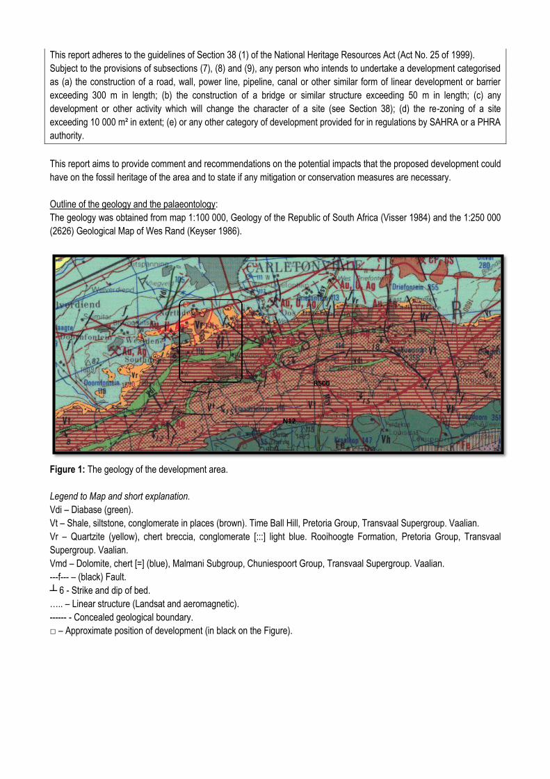
This report adheres to the guidelines of Section 38 (1) of the National Heritage Resources Act (Act No. 25 of 1999).
Subject to the provisions of subsections (7), (8) and (9), any person who intends to undertake a development categorised
as (a) the construction of a road, wall, power line, pipeline, canal or other similar form of linear development or barrier
exceeding 300 m in length; (b) the construction of a bridge or similar structure exceeding 50 m in length; (c) any
development or other activity which will change the character of a site (see Section 38); (d) the re-zoning of a site
exceeding 10 000 m² in extent; (e) or any other category of development provided for in regulations by SAHRA or a PHRA
authority.
This report aims to provide comment and recommendations on the potential impacts that the proposed development could
have on the fossil heritage of the area and to state if any mitigation or conservation measures are necessary.
Outline of the geology and the palaeontology:
The geology was obtained from map 1:100 000, Geology of the Republic of South Africa (Visser 1984) and the 1:250 000
(2626) Geological Map of Wes Rand (Keyser 1986).
Figure 1: The geology of the development area.
Legend to Map and short explanation.
Vdi – Diabase (green).
Vt – Shale, siltstone, conglomerate in places (brown). Time Ball Hill, Pretoria Group, Transvaal Supergroup. Vaalian.
Vr – Quartzite (yellow), chert breccia, conglomerate [:::] light blue. Rooihoogte Formation, Pretoria Group, Transvaal
Supergroup. Vaalian.
Vmd – Dolomite, chert [=] (blue), Malmani Subgroup, Chuniespoort Group, Transvaal Supergroup. Vaalian.
---f--- – (black) Fault.
┴ 6 - Strike and dip of bed.
….. – Linear structure (Landsat and aeromagnetic).
------ - Concealed geological boundary.
□ – Approximate position of development (in black on the Figure).
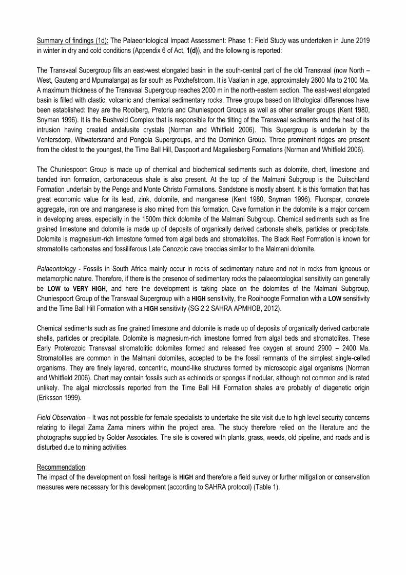
Summary of findings (1d): The Palaeontological Impact Assessment: Phase 1: Field Study was undertaken in June 2019
in winter in dry and cold conditions (Appendix 6 of Act, 1(d)), and the following is reported:
The Transvaal Supergroup fills an east-west elongated basin in the south-central part of the old Transvaal (now North –
West, Gauteng and Mpumalanga) as far south as Potchefstroom. It is Vaalian in age, approximately 2600 Ma to 2100 Ma.
A maximum thickness of the Transvaal Supergroup reaches 2000 m in the north-eastern section. The east-west elongated
basin is filled with clastic, volcanic and chemical sedimentary rocks. Three groups based on lithological differences have
been established: they are the Rooiberg, Pretoria and Chuniespoort Groups as well as other smaller groups (Kent 1980,
Snyman 1996). It is the Bushveld Complex that is responsible for the tilting of the Transvaal sediments and the heat of its
intrusion having created andalusite crystals (Norman and Whitfield 2006). This Supergroup is underlain by the
Ventersdorp, Witwatersrand and Pongola Supergroups, and the Dominion Group. Three prominent ridges are present
from the oldest to the youngest, the Time Ball Hill, Daspoort and Magaliesberg Formations (Norman and Whitfield 2006).
The Chuniespoort Group is made up of chemical and biochemical sediments such as dolomite, chert, limestone and
banded iron formation, carbonaceous shale is also present. At the top of the Malmani Subgroup is the Duitschland
Formation underlain by the Penge and Monte Christo Formations. Sandstone is mostly absent. It is this formation that has
great economic value for its lead, zink, dolomite, and manganese (Kent 1980, Snyman 1996). Fluorspar, concrete
aggregate, iron ore and manganese is also mined from this formation. Cave formation in the dolomite is a major concern
in developing areas, especially in the 1500m thick dolomite of the Malmani Subgroup. Chemical sediments such as fine
grained limestone and dolomite is made up of deposits of organically derived carbonate shells, particles or precipitate.
Dolomite is magnesium-rich limestone formed from algal beds and stromatolites. The Black Reef Formation is known for
stromatolite carbonates and fossiliferous Late Cenozoic cave breccias similar to the Malmani dolomite.
Palaeontology - Fossils in South Africa mainly occur in rocks of sedimentary nature and not in rocks from igneous or
metamorphic nature. Therefore, if there is the presence of sedimentary rocks the palaeontological sensitivity can generally
be LOW to VERY HIGH, and here the development is taking place on the dolomites of the Malmani Subgroup,
Chuniespoort Group of the Transvaal Supergroup with a HIGH sensitivity, the Rooihoogte Formation with a LOW sensitivity
and the Time Ball Hill Formation with a HIGH sensitivity (SG 2.2 SAHRA APMHOB, 2012).
Chemical sediments such as fine grained limestone and dolomite is made up of deposits of organically derived carbonate
shells, particles or precipitate. Dolomite is magnesium-rich limestone formed from algal beds and stromatolites. These
Early Proterozoic Transvaal stromatolitic dolomites formed and released free oxygen at around 2900 – 2400 Ma.
Stromatolites are common in the Malmani dolomites, accepted to be the fossil remnants of the simplest single-celled
organisms. They are finely layered, concentric, mound-like structures formed by microscopic algal organisms (Norman
and Whitfield 2006). Chert may contain fossils such as echinoids or sponges if nodular, although not common and is rated
unlikely. The algal microfossils reported from the Time Ball Hill Formation shales are probably of diagenetic origin
(Eriksson 1999).
Field Observation – It was not possible for female specialists to undertake the site visit due to high level security concerns
relating to illegal Zama Zama miners within the project area. The study therefore relied on the literature and the
photographs supplied by Golder Associates. The site is covered with plants, grass, weeds, old pipeline, and roads and is
disturbed due to mining activities.
Recommendation:
The impact of the development on fossil heritage is HIGH and therefore a field survey or further mitigation or conservation
measures were necessary for this development (according to SAHRA protocol) (Table 1).
Table 1: Criteria used (Fossil Heritage Layer Browser/SAHRA).
Rock Unit Significance/vulnerability Recommended Action
The Project includes three Options (see google.earth image):
Option 1: (green) the ‘dog leg’.
Option 2: (dashed blue) the black dashed route connecting with the orange route north of the road bisecting the pipeline.
Preferred: (orange) the orange route starting at the BLV#4 connecting to the dashed route and ending at the NBD.
The preferred Option is the orange route.
Concerns/threats (1g,1ni,1nii,1o,1p) to be added to the EMP’r:
1. Threats are earth moving equipment/machinery (front end loaders, excavators, graders, dozers) during
construction, digging of foundations, the sealing-in, disturbance, damage or destruction of the fossils by
development, vehicle traffic, and human disturbance.
2. The overburden and inter-burden must always be surveyed for fossils during construction or prospecting. Special
care must be taken during the digging, drilling, blasting and excavating of foundations, trenches, channels and
footings and removal of overburden during construction not to intrude fossiliferous layers. This can be done by
the Environmental Control Officer.
3. Care must be taken during the dolomite risk assessment according to SANS 1936-1 (2012) as stromatolites may
be present.
Recommendations:
1. Mitigation may be needed if a fossil is found, in this case, the area must be fenced off with a no-go barrier of 30
m (Appendix 3).
2. No consultation with parties was necessary.
3. Alternatives will not be feasible.
4. The development may go ahead with caution, if a fossil is found, all construction must stop, and SAHRA must be
notified. The Environmental Control Officer must familiarise him- or herself with the Malmani Subgroup fossils.
5. As part of the Environmental Authorisation conditions, an Environmental Control Officer (ECO) will be appointed
to monitor the construction activities in line with the legally binding Environmental Management Programme
(EMPr) so that when a fossil is unearthed they can notify the relevant department and specialist to further
investigate. When a fossil is found the area must be fenced-off and the construction workers must be informed
that this is a no-go area. Therefore the EMPr must be updated to include the involvement of a palaeontologist
(for training of ECO and advisory) during the digging and excavation (ground breaking) phase of the
development.
Stakeholders:
Developer – Anglo Gold Ashanti (Pty) Limited.
Environmental – Golder Associates Africa (Pty) Limited, P.O. Box 6001, Halfway House, 1685, Tel. 011 254
4970.
Landowner – Not know yet.
C. Table of Contents
A. Title page 1
B. Executive Summary 2
C. Table of Contents 5
D. Background Information on the project 6
E. Description of the Property or Affected Environment 8
F. Description of the Geological Setting 9
G. Background to Palaeontology of the area 14
H. Description of the Methodology 16
I. Description of significant fossil occurrences 18
J. Recommendation 18
K. Conclusions 19
L. Bibliography 19
Declaration 20
Appendix 1: Geology of the Transvaal Supergroup 21
Appendix 2: Table 21
Appendix 3: Protocol for Chance Finds and Management Plan 21
D. Background information on the project
Report
This report is part of the environmental impact assessment process under the National Environmental Management Act,
as amended (Act No. 107 of 1998) (NEMA) and includes Appendix 6 (GN R326 of 7 April 2017) of the Environmental
Impact Assessment Regulations (see Appendix 2). It is also in accordance with the SG 2.2 SAHRA APMHOB Guidelines,
2012. Minimum standards for palaeontological components of Heritage Impact Assessment Reports, Pp 1-15.
This report discusses and aims to provide the developer with information regarding the location of palaeontological
material that will be impacted by the development. In the pre-construction or construction phase it may be necessary for
the developer to apply for the relevant permit from the South African Heritage Resources Agency (SAHRA / PHRA).
Outline of development
The AGA operations in the West Wits mining lease areas are at risk of flooding due to ingress of fissure water from
surrounding mining operations. Approximately 25 Mℓ/day of fissure water flows into the underground workings of the
defunct Blyvooruitzicht Mine, which spans a strike of 6 km along the boundary with AGA. If dewatering at the Old
Blyvooruitzicht Shafts (#4, #5 & 6#) shafts were to cease, uncontrolled fissure water would report to the AGA operations,
which would pose both a flood and safety risk of AGA personnel and the mining operations.
In summary, AGA propose to install underground infrastructure to route the BVL 5# AMD water to the BVL 4# to allow for
the dewatering, neutralisation and pumping to surface. From the BVL 4# mine this impacted water will be routed on
surface to the North Boundary Dam (NBD) and used as make-up water to the Savuka Gold Plant Reclamation Operations.
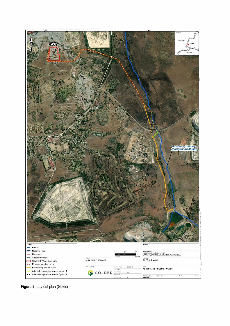
Figure 2: Lay-out plan (Golder).
The following infrastructure is anticipated;
1. Pipeline plinths,
2. Gantry,
3. Cattle ramps (if required),
4. Water transfer tank.
The Project includes three Options (google.earth image):
Option 1: (green) the ‘dog leg’.
Option 2: (dashed blue) the black dashed route connecting with the orange route north of the road bisecting the pipeline.
Preferred: (orange) the orange route starting at the BLV#4 connecting to the dashed route and ending at the NBD.
Rezoning/ and or subdivision of land: None.
Name of Developer and Environmental Consultant: Anglo Gold Ashanti (Pty) Limited and Golder Associates Africa (Pty)
Limited
Terms of reference: Dr H. Fourie is a palaeontologist commissioned to do a palaeontological impact assessment to
ascertain if any palaeontological sensitive material is present in the development area. This study will advise on the
impact on fossil heritage mitigation or conservation necessary, if any.
Dr Fourie obtained a Ph.D from the Bernard Price Institute for Palaeontological Research (now ESI), University of the
Witwatersrand. Her undergraduate degree is in Geology and Zoology. She specialises in vertebrate morphology and
function concentrating on the Therapsid Therocephalia. At present she is employed by Ditsong: National Museum of
Natural History as Curator of the plant, invertebrate, fish, reptile, dinosaur and Therapsid collections. For the past 13 years
she carried out field work in the Western Cape, Eastern Cape, North West, Northern Cape, Limpopo, Mpumalanga,
Gauteng, Kwazulu Natal, and Free State Provinces. Dr Fourie has been employed at the Ditsong: National Museum of
Natural History in Pretoria (formerly Transvaal Museum) for 24 years.
Legislative requirements: South African Heritage Resources Agency (SAHRA) for issue of permits if necessary. National
Heritage Resources Act (Act No. 25 of 1999). An electronic copy of this report must be supplied to SAHRA.
E. Description of property or affected environment
Location and depth:
The Proposed Surface Pipeline and Associated Infrastructure will be situated on Farm Portions 10, 13, 15, 26, 51, and 89
of Blyvooruitzicht 116-IQ, in Merafong City Local Municipality, West Rand District Municipality in the Gauteng Province.
The project area is approximately 80 km west of Johannesburg and approximately 3.3 km southeast of Carletonville. It
ends at the NBD approximately 6 km south-south-west of Carletonville in Blyvooruitzicht.
Depth is determined by the related infrastructure to be developed and the thickness of the formation in the development
area as well as depth of the foundations, footings, trenches, and channels to be developed. Details of the location and
distribution of all significant fossil sites or key fossiliferous rock units are often difficult to determine due to thick topsoil,
subsoil, overburden and alluvium. Depth of the overburden may vary a lot. Geological maps do not provide depth or
superficial cover, it only provides mappable surface outcrops. The depth can be verified with test pit results or drill cores.
Concrete plinths spaced 9 m apart will be used to support the pipeline. The footprint of each plinth will be roughly 600 x
300 mm.
The Project includes three Options (see google.earth image):
Option 1: (green) the ‘dog leg’.
Option 2: (dashed blue) the black dashed route connecting with the orange route north of the road bisecting the pipeline.
Preferred: (orange) the orange route starting at the BLV#4 connecting to the dashed route and ending at the NBD.
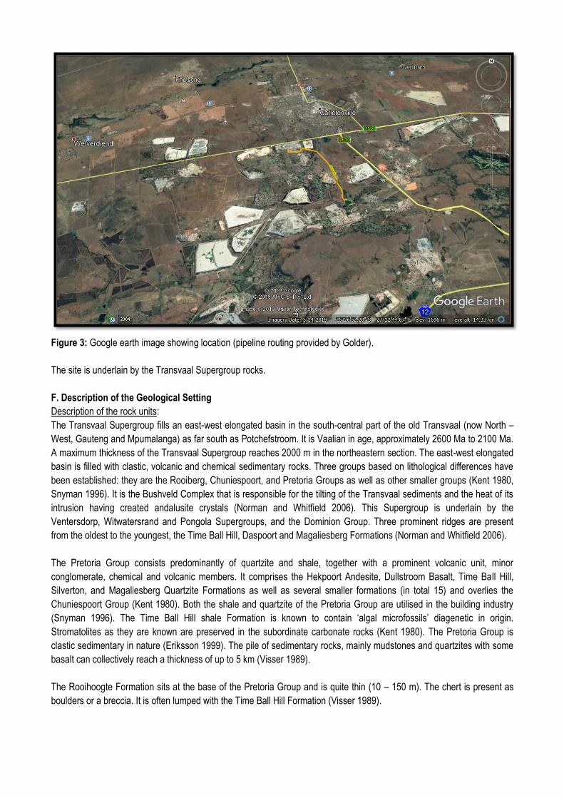
Figure 3: Google earth image showing location (pipeline routing provided by Golder).
The site is underlain by the Transvaal Supergroup rocks.
F. Description of the Geological Setting
Description of the rock units:
The Transvaal Supergroup fills an east-west elongated basin in the south-central part of the old Transvaal (now North –
West, Gauteng and Mpumalanga) as far south as Potchefstroom. It is Vaalian in age, approximately 2600 Ma to 2100 Ma.
A maximum thickness of the Transvaal Supergroup reaches 2000 m in the northeastern section. The east-west elongated
basin is filled with clastic, volcanic and chemical sedimentary rocks. Three groups based on lithological differences have
been established: they are the Rooiberg, Chuniespoort, and Pretoria Groups as well as other smaller groups (Kent 1980,
Snyman 1996). It is the Bushveld Complex that is responsible for the tilting of the Transvaal sediments and the heat of its
intrusion having created andalusite crystals (Norman and Whitfield 2006). This Supergroup is underlain by the
Ventersdorp, Witwatersrand and Pongola Supergroups, and the Dominion Group. Three prominent ridges are present
from the oldest to the youngest, the Time Ball Hill, Daspoort and Magaliesberg Formations (Norman and Whitfield 2006).
The Pretoria Group consists predominantly of quartzite and shale, together with a prominent volcanic unit, minor
conglomerate, chemical and volcanic members. It comprises the Hekpoort Andesite, Dullstroom Basalt, Time Ball Hill,
Silverton, and Magaliesberg Quartzite Formations as well as several smaller formations (in total 15) and overlies the
Chuniespoort Group (Kent 1980). Both the shale and quartzite of the Pretoria Group are utilised in the building industry
(Snyman 1996). The Time Ball Hill shale Formation is known to contain ‘algal microfossils’ diagenetic in origin.
Stromatolites as they are known are preserved in the subordinate carbonate rocks (Kent 1980). The Pretoria Group is
clastic sedimentary in nature (Eriksson 1999). The pile of sedimentary rocks, mainly mudstones and quartzites with some
basalt can collectively reach a thickness of up to 5 km (Visser 1989).
The Rooihoogte Formation sits at the base of the Pretoria Group and is quite thin (10 – 150 m). The chert is present as
boulders or a breccia. It is often lumped with the Time Ball Hill Formation (Visser 1989).

The Chuniespoort Group is made up of chemical and biochemical sediments such as dolomite, chert, limestone and
banded iron formation, carbonaceous shale is also present. At the top of the Malmani Subgroup is the Duitschland
Formation underlain by the Penge and Monte Christo Formations. Sandstone is mostly absent. It is this formation that has
great economic value for its lead, zink, dolomite, and manganese (Kent 1980, Snyman 1996). Fluorspar, concrete
aggregate, iron ore and manganese is also mined from this formation. Cave formation in the dolomite is a major concern
in developing areas, especially in the 1500m thick dolomite of the Malmani Subgroup. Chemical sediments such as fine-
grained limestone and dolomite is made up of deposits of organically derived carbonate shells, particles or precipitate.
Dolomite is magnesium-rich limestone formed from algal beds and stromatolites. The Malmani dolomites are home to
most of the cave systems that has yielded hominin fossils such as those at Mokopane’s cave. It is also home to Middle
and Late Stone Age cultures. This cave and the caves in the Cradle of Humankind, near Johannesburg, provided a refuge
for man’s distant ancestors. The breccia yielded internationally renowned hominins.
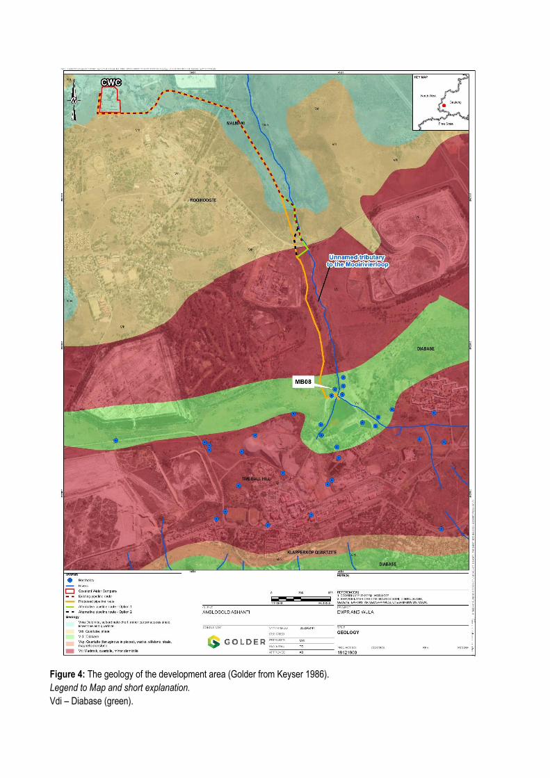
Figure 4: The geology of the development area (Golder from Keyser 1986).
Legend to Map and short explanation.
Vdi – Diabase (green).
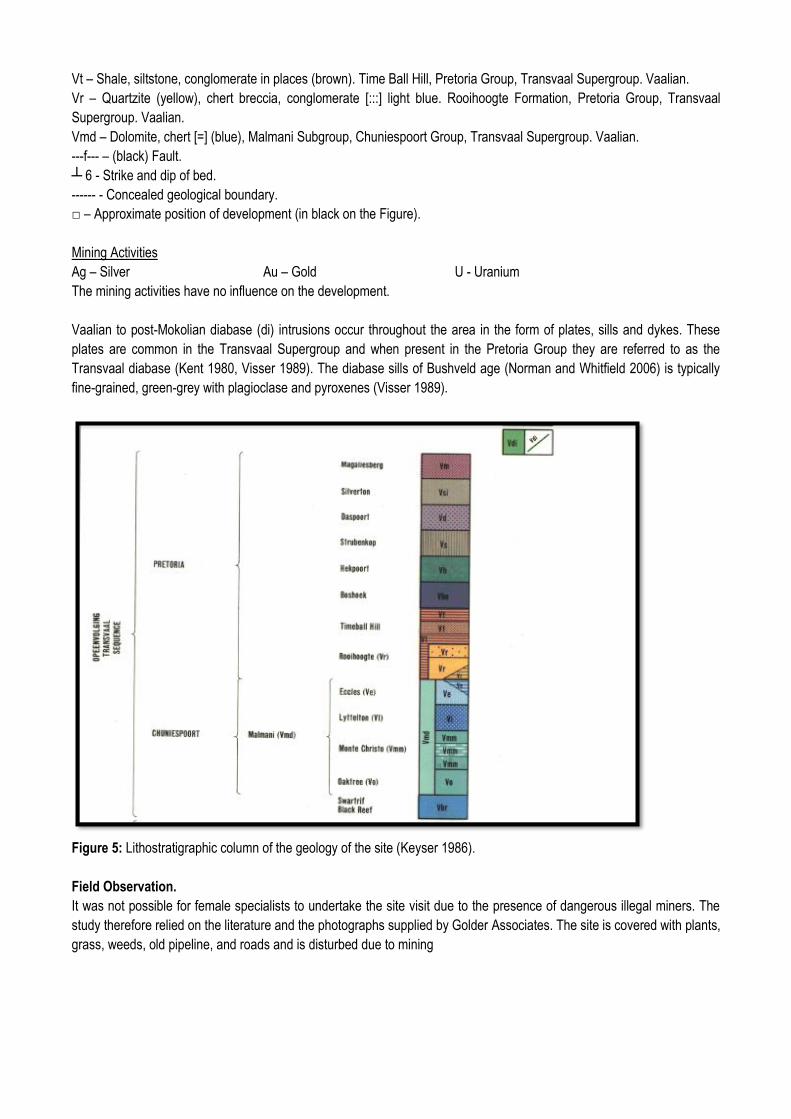
Vt – Shale, siltstone, conglomerate in places (brown). Time Ball Hill, Pretoria Group, Transvaal Supergroup. Vaalian.
Vr – Quartzite (yellow), chert breccia, conglomerate [:::] light blue. Rooihoogte Formation, Pretoria Group, Transvaal
Supergroup. Vaalian.
Vmd – Dolomite, chert [=] (blue), Malmani Subgroup, Chuniespoort Group, Transvaal Supergroup. Vaalian.
---f--- – (black) Fault.
┴ 6 - Strike and dip of bed.
------ - Concealed geological boundary.
□ – Approximate position of development (in black on the Figure).
Mining Activities
Ag – Silver Au – Gold U - Uranium
The mining activities have no influence on the development.
Vaalian to post-Mokolian diabase (di) intrusions occur throughout the area in the form of plates, sills and dykes. These
plates are common in the Transvaal Supergroup and when present in the Pretoria Group they are referred to as the
Transvaal diabase (Kent 1980, Visser 1989). The diabase sills of Bushveld age (Norman and Whitfield 2006) is typically
fine-grained, green-grey with plagioclase and pyroxenes (Visser 1989).
Figure 5: Lithostratigraphic column of the geology of the site (Keyser 1986).
Field Observation.
It was not possible for female specialists to undertake the site visit due to the presence of dangerous illegal miners. The
study therefore relied on the literature and the photographs supplied by Golder Associates. The site is covered with plants,
grass, weeds, old pipeline, and roads and is disturbed due to mining
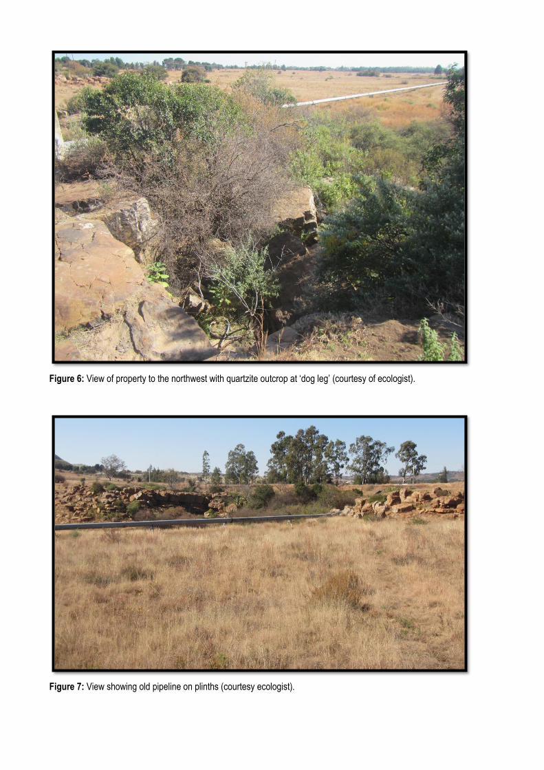
Figure 6: View of property to the northwest with quartzite outcrop at ‘dog leg’ (courtesy of ecologist).
Figure 7: View showing old pipeline on plinths (courtesy ecologist).
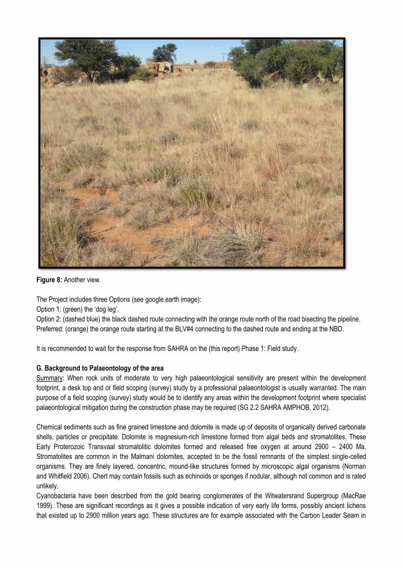
Figure 8: Another view.
The Project includes three Options (see google.earth image):
Option 1: (green) the ‘dog leg’.
Option 2: (dashed blue) the black dashed route connecting with the orange route north of the road bisecting the pipeline.
Preferred: (orange) the orange route starting at the BLV#4 connecting to the dashed route and ending at the NBD.
It is recommended to wait for the response from SAHRA on the (this report) Phase 1: Field study.
G. Background to Palaeontology of the area
Summary: When rock units of moderate to very high palaeontological sensitivity are present within the development
footprint, a desk top and or field scoping (survey) study by a professional palaeontologist is usually warranted. The main
purpose of a field scoping (survey) study would be to identify any areas within the development footprint where specialist
palaeontological mitigation during the construction phase may be required (SG 2.2 SAHRA AMPHOB, 2012).
Chemical sediments such as fine grained limestone and dolomite is made up of deposits of organically derived carbonate
shells, particles or precipitate. Dolomite is magnesium-rich limestone formed from algal beds and stromatolites. These
Early Proterozoic Transvaal stromatolitic dolomites formed and released free oxygen at around 2900 – 2400 Ma.
Stromatolites are common in the Malmani dolomites, accepted to be the fossil remnants of the simplest single-celled
organisms. They are finely layered, concentric, mound-like structures formed by microscopic algal organisms (Norman
and Whitfield 2006). Chert may contain fossils such as echinoids or sponges if nodular, although not common and is rated
unlikely.
Cyanobacteria have been described from the gold bearing conglomerates of the Witwatersrand Supergroup (MacRae
1999). These are significant recordings as it gives a possible indication of very early life forms, possibly ancient lichens
that existed up to 2900 million years ago. These structures are for example associated with the Carbon Leader Seam in
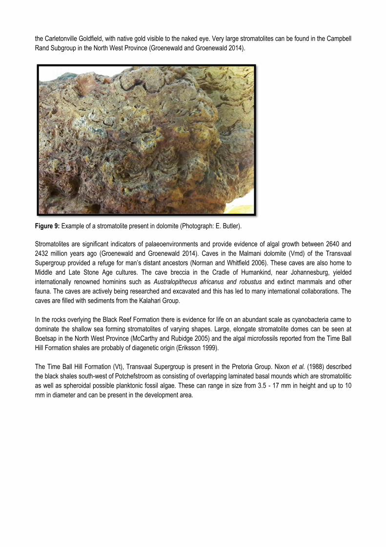
the Carletonville Goldfield, with native gold visible to the naked eye. Very large stromatolites can be found in the Campbell
Rand Subgroup in the North West Province (Groenewald and Groenewald 2014).
Figure 9: Example of a stromatolite present in dolomite (Photograph: E. Butler).
Stromatolites are significant indicators of palaeoenvironments and provide evidence of algal growth between 2640 and
2432 million years ago (Groenewald and Groenewald 2014). Caves in the Malmani dolomite (Vmd) of the Transvaal
Supergroup provided a refuge for man’s distant ancestors (Norman and Whitfield 2006). These caves are also home to
Middle and Late Stone Age cultures. The cave breccia in the Cradle of Humankind, near Johannesburg, yielded
internationally renowned hominins such as Australopithecus africanus and robustus and extinct mammals and other
fauna. The caves are actively being researched and excavated and this has led to many international collaborations. The
caves are filled with sediments from the Kalahari Group.
In the rocks overlying the Black Reef Formation there is evidence for life on an abundant scale as cyanobacteria came to
dominate the shallow sea forming stromatolites of varying shapes. Large, elongate stromatolite domes can be seen at
Boetsap in the North West Province (McCarthy and Rubidge 2005) and the algal microfossils reported from the Time Ball
Hill Formation shales are probably of diagenetic origin (Eriksson 1999).
The Time Ball Hill Formation (Vt), Transvaal Supergroup is present in the Pretoria Group. Nixon et al. (1988) described
the black shales south-west of Potchefstroom as consisting of overlapping laminated basal mounds which are stromatolitic
as well as spheroidal possible planktonic fossil algae. These can range in size from 3.5 - 17 mm in height and up to 10
mm in diameter and can be present in the development area.
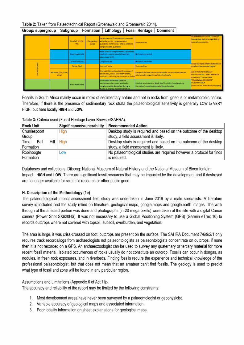
Table 2: Taken from Palaeotechnical Report (Groenewald and Groenewald 2014).
Group/ supergroup Subgroup Formation Lithology Fossil Heritage Comment
Fossils in South Africa mainly occur in rocks of sedimentary nature and not in rocks from igneous or metamorphic nature.
Therefore, if there is the presence of sedimentary rock strata the palaeontological sensitivity is generally LOW to VERY
HIGH, but here locally HIGH and LOW.
Table 3: Criteria used (Fossil Heritage Layer Browser/SAHRA).
Rock Unit Significance/vulnerability Recommended Action
Chuniespoort Group
High Desktop study is required and based on the outcome of the desktop study, a field assessment is likely.
Time Ball Hill Formation
High Desktop study is required and based on the outcome of the desktop study, a field assessment is likely.
Rooihoogte Formation
Low No palaeontological studies are required however a protocol for finds is required.
Databases and collections: Ditsong: National Museum of Natural History and the National Museum of Bloemfontein.
Impact: HIGH and LOW. There are significant fossil resources that may be impacted by the development and if destroyed
are no longer available for scientific research or other public good.
H. Description of the Methodology (1e)
The palaeontological impact assessment field study was undertaken in June 2019 by a male specialists. A literature
survey is included and the study relied on literature, geological maps, google.maps and google.earth images. The walk
through of the affected portion was done and photographs (in 20 mega pixels) were taken of the site with a digital Canon
camera (Power Shot SX620HS). It was not necessary to use a Global Positioning System (GPS) (Garmin eTrex 10) to
records outcrops where not covered with topsoil, subsoil, overburden, and vegetation.
The area is large, it was criss-crossed on foot, outcrops are present on the surface. The SAHRA Document 7/6/9/2/1 only
requires track records/logs from archaeologists not palaeontologists as palaeontologists concentrate on outcrops, if none
then it is not recorded on a GPS. An archaeozoologist can be used to survey any quaternary or tertiary material for more
recent fossil material. Isolated occurrences of rocks usually do not constitute an outcrop. Fossils can occur in dongas, as
nodules, in fresh rock exposures, and in riverbeds. Finding fossils require the experience and technical knowledge of the
professional palaeontologist, but that does not mean that an amateur can’t find fossils. The geology is used to predict
what type of fossil and zone will be found in any particular region.
Assumptions and Limitations (Appendix 6 of Act 1i):-
The accuracy and reliability of the report may be limited by the following constraints:
1. Most development areas have never been surveyed by a palaeontologist or geophysicist.
2. Variable accuracy of geological maps and associated information.
3. Poor locality information on sheet explanations for geological maps.
4. Lack of published data.
5. Lack of rocky outcrops.
6. Inaccessibility of site.
7. Insufficient data from developer and exact lay-out plan for all structures.
A Phase 1 Palaeontological Impact Assessment: Field Study will include:
1. Recommendations for the future of the site.
2. Background information on the project.
3. Description of the property of affected environment with details of the study area.
4. Description of the geological setting and field observations.
5. Background to palaeontology of the area.
6. Field Rating.
7. Stating of Significance (Heritage Value).
A Phase 2 Palaeontological Impact Assessment: Mitigation will include:
1. Recommendations for the future of the site.
2. Description of work done (including number of people and their responsibilities).
3. A written assessment of the work done, fossils excavated, not removed or collected and observed.
4. Conclusion reached regarding the fossil material.
5. A detailed site plan.
6. Possible declaration as a heritage site or Site Management Plan.
The National Heritage Resources Act No. 25 of 1999 further prescribes:-
Act No. 25 of 1999. National Heritage Resources Act, 1999.
National Estate: 3 (2) (f) archaeological and palaeontological sites,
(i)(1) objects recovered from the soil or waters of South Africa, including archaeological and palaeontological objects and
material, meteorites and rare geological specimens,
Heritage assessment criteria and grading: (a) Grade 1: Heritage resources with qualities so exceptional that they are of
special national significance;
(b) Grade 2: Heritage resources which, although forming part of the national estate, can be considered to have special
qualities which make them significant within the context of a province or a region; and (c) Grade 3: Other heritage
resources worthy of conservation.
SAHRA is responsible for the identification and management of Grade 1 heritage resources.
Provincial Heritage Resources Authority (PHRA) identifies and manages Grade 2 heritage resources.
Local authorities identify and manage Grade 3 heritage resources.
No person may damage, deface, excavate, alter, remove from its original position, subdivide or change the planning
status of a provincially protected place or object without a permit issued by a heritage resources authority or local authority
responsible for the provincial protection.
Archaeology, palaeontology and meteorites: Section 35.
(2) Subject to the provisions of subsection (8) (a), all archaeological objects, palaeontological material and meteorites are
the property of the State.
(3) Any person who discovers archaeological or palaeontological objects or material or a meteorite in the course of
development or agricultural activity must immediately report the find to the responsible heritage resources authority, or to
the nearest local authority offices or museum, which must immediately notify such heritage resources authority.
Three types of permits are available; Mitigation, Destruction and Interpretation. The specialist will apply for the permit at
the beginning of the process (SAHRA 2012).
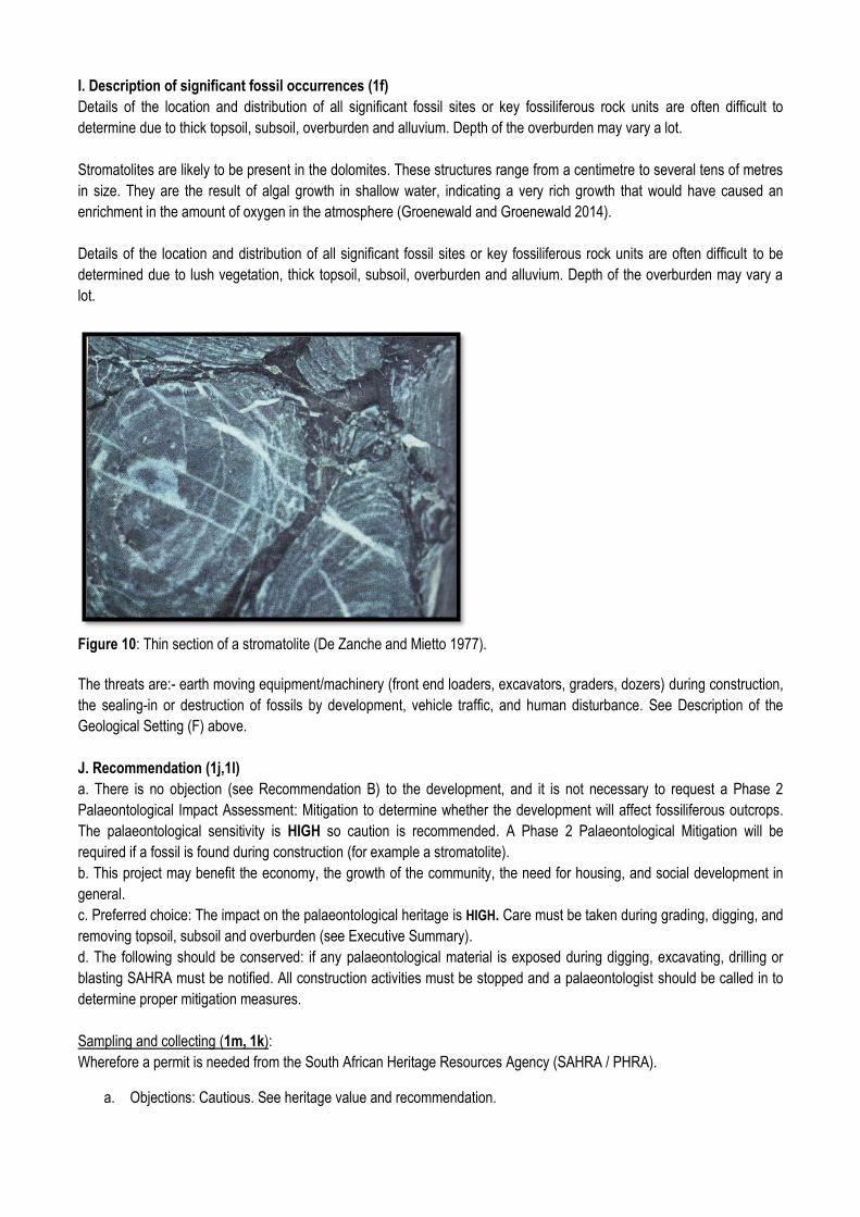
I. Description of significant fossil occurrences (1f)
Details of the location and distribution of all significant fossil sites or key fossiliferous rock units are often difficult to
determine due to thick topsoil, subsoil, overburden and alluvium. Depth of the overburden may vary a lot.
Stromatolites are likely to be present in the dolomites. These structures range from a centimetre to several tens of metres
in size. They are the result of algal growth in shallow water, indicating a very rich growth that would have caused an
enrichment in the amount of oxygen in the atmosphere (Groenewald and Groenewald 2014).
Details of the location and distribution of all significant fossil sites or key fossiliferous rock units are often difficult to be
determined due to lush vegetation, thick topsoil, subsoil, overburden and alluvium. Depth of the overburden may vary a
lot.
Figure 10: Thin section of a stromatolite (De Zanche and Mietto 1977).
The threats are:- earth moving equipment/machinery (front end loaders, excavators, graders, dozers) during construction,
the sealing-in or destruction of fossils by development, vehicle traffic, and human disturbance. See Description of the
Geological Setting (F) above.
J. Recommendation (1j,1l)
a. There is no objection (see Recommendation B) to the development, and it is not necessary to request a Phase 2
Palaeontological Impact Assessment: Mitigation to determine whether the development will affect fossiliferous outcrops.
The palaeontological sensitivity is HIGH so caution is recommended. A Phase 2 Palaeontological Mitigation will be
required if a fossil is found during construction (for example a stromatolite).
b. This project may benefit the economy, the growth of the community, the need for housing, and social development in
general.
c. Preferred choice: The impact on the palaeontological heritage is HIGH. Care must be taken during grading, digging, and
removing topsoil, subsoil and overburden (see Executive Summary).
d. The following should be conserved: if any palaeontological material is exposed during digging, excavating, drilling or
blasting SAHRA must be notified. All construction activities must be stopped and a palaeontologist should be called in to
determine proper mitigation measures.
Sampling and collecting (1m, 1k):
Wherefore a permit is needed from the South African Heritage Resources Agency (SAHRA / PHRA).
a. Objections: Cautious. See heritage value and recommendation.
b. Conditions of development: See Appendix 3.
c. Areas that may need a permit: Yes, if a fossil is found (Section G).
d. Permits for mitigation: Needed from SAHRA/PHRA.
K. Conclusions
a. All the land involved in the development was assessed and none of the property is unsuitable for
development (see Recommendation B).
b. All information needed for the Field Study was provided by the Environmental Consultant. All technical
information was provided by Golder Associates (Pty) Ltd.
c. Areas that would involve mitigation and may need a permit from the South African Heritage Resources
Agency are discussed (see Recommendation B).
d. The following should be conserved: if any palaeontological material is exposed during digging, excavating,
drilling or blasting, SAHRA must be notified. All development activities must be stopped and a
palaeontologist should be called in to determine proper mitigation measures. Especially shallow caves.
e. Condition in which development may proceed: It is further suggested that a Section 37(2) agreement of the
Occupational, Health and Safety Act 85 of 1993 is signed with the relevant contractors to protect the
environment and adjacent areas as well as for safety and security reasons.
L. Bibliography
ALMOND, J., PETHER, J, and GROENEWALD, G. 2013. South African National Fossil Sensitivity Map. SAHRA and
Council for Geosciences.
DE ZANCHE, V. and MIETTO, P. 1977. The World of Fossils. Sampson Low Guides, Berkshire, Printed in Italy, Pp 256.
ERIKSSON, P.G. 1999. Pretoria Group, [Transvaal Supergroup]. Catalogue of South African Lithostratigraphic units
(Edited Johnson, M.R.), South African Committee for Stratigraphy, Council for Geoscience, 6: 29-32.
GROENEWALD, G. and GROENEWALD, D. 2014. SAHRA Palaeotechnical Report: Palaeontological Heritage of
Gauteng. South African Heritage Resources Agency, Pp 1-20.
KENT, L. E., 1980. Part 1: Lithostratigraphy of the Republic of South Africa, South West Africa/Namibia and the Republics
of Bophuthatswana, Transkei and Venda. SACS, Council for Geosciences, Stratigraphy of South Africa. 1980. South
African Committee for Stratigraphy. Handbook 8, Part 1, Pp 690.
KEYSER, N. 1986. 1:250 000 Geological Map of the Wes Rand 2626. South African Committee for Stratigraphy, Council
for Geoscience, Pretoria.
MACRAE, C. 1999. Life Etched in Stone: Fossils of South Africa. Geological Society of South Africa. Pp305.
MCCARTHY, T and RUBIDGE, B. 2005. The Story of Earth Life: A southern African perspective on a 4.6-billion-year
journey. Struik. Pp 333.
MUNTINGH, D.J. (ed) 1992. Geological Map 2728 Frankfort, 1:250 000, South African Committee for Stratigraphy,
Council for Geoscience, Pretoria.
NIXON, N., ERIKSSON, P.G., JACOBS, R. and SNYMAN, C.P. 1988. Early Proterozoic micro-algal structures in
carbonaceous shales of the Pretoria Group, south-west of Potchefstroom. South African Journal of Science, 84: 592-595.
NORMAN, N. 2013. Geology off the beaten track: exploring South Africa’s hidden treasures. De Beers, Struik, Pp 1-256.
NORMAN, N. and WHITFIELD, G., 2006. Geological Journeys. De Beers, Struik, Pp 1-320.
SG 2.2 SAHRA APMHOB Guidelines, 2012. Minimum standards for palaeontological components of Heritage Impact
Assessment Reports, Pp 1-15.
SNYMAN, C. P., 1996. Geologie vir Suid-Afrika. Departement Geologie, Universiteit van Pretoria, Pretoria, Volume 1, Pp.
513.
VAN DER WALT, M., DAY, M., RUBIDGE, B. S., COOPER, A. K. & NETTERBERG, I., 2010. Utilising GIS technology to
create a biozone map for the Beaufort Group (Karoo Supergroup) of South Africa. Palaeontologia Africana, 45: 1-5.
VISSER, D.J.L. (ed) 1984. Geological Map of South Africa 1:100 000. South African Committee for Stratigraphy. Council
for Geoscience, Pretoria.
VISSER, D.J.L. (ed) 1989. Toeligting: Geologiese kaart (1:100 000). Die Geologie van die Republieke van Suid Afrika,
Transkei, Bophuthatswana, Venda, Ciskei en die Koningkryke van Lesotho en Swaziland. South African Committee for
Stratigraphy. Council for Geoscience, Pretoria, Pp 494.
WALRAVEN, F. 1978. Geological Map 2528 Pretoria, 1:250 000. South African Committee for Stratigraphy, Council for
Geoscience, Pretoria.
Declaration / Disclaimer (1b)
I, Heidi Fourie, declare that I am an independent consultant and have no business, financial, personal or other interest in
the proposed development project for which I was appointed to do a palaeontological assessment. There are no
circumstances that compromise the objectivity of me performing such work.
I accept no liability, and the client, by receiving this document, indemnifies me against all actions, claims, demands,
losses, liabilities, costs, damages and expenses arising from or in connection with services rendered, directly or indirectly
by the use of the information contained in this document.
It may be possible that the field study may have missed palaeontological resources in the Project Area as the presence of
outcrops are not known and may only be found once development commences.
This report may not be altered in any way and any parts drawn from this report must make reference to this report.
___________
Heidi Fourie
2019/06/24
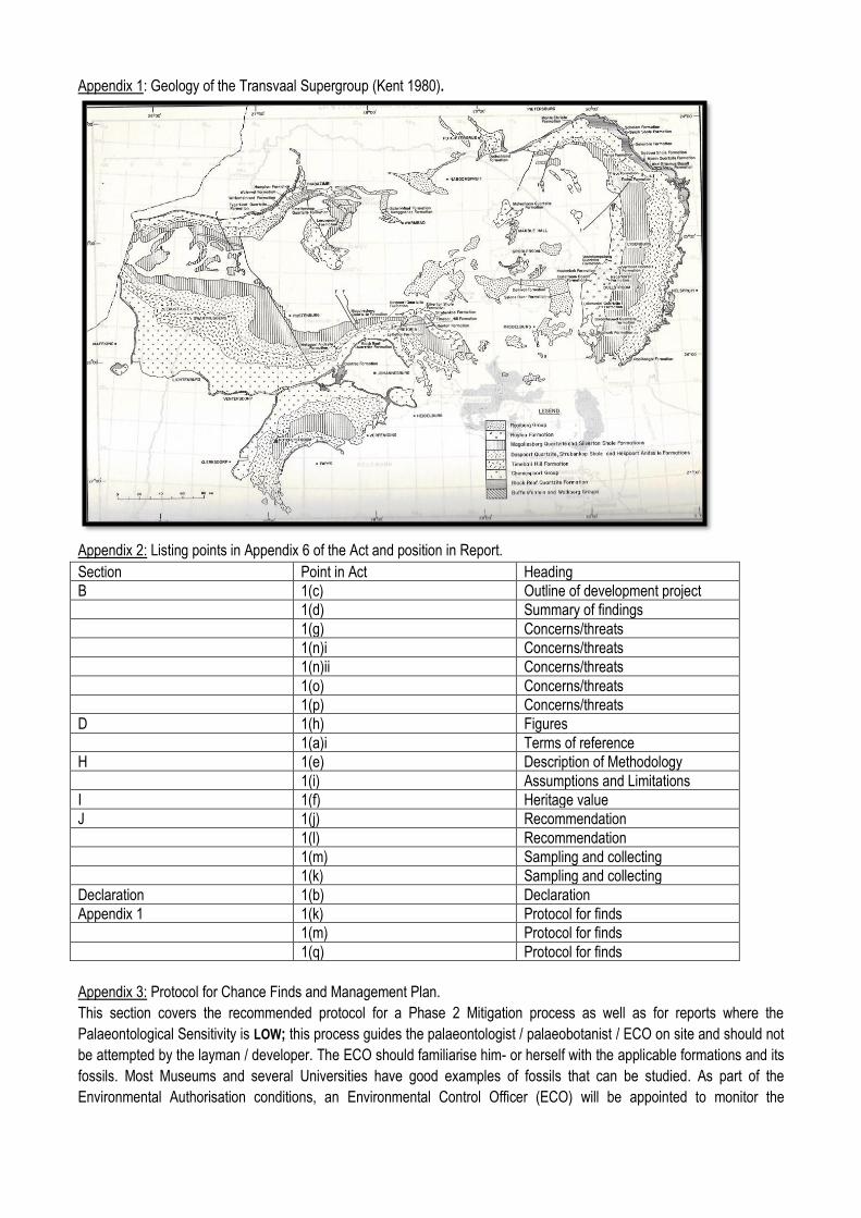
Appendix 1: Geology of the Transvaal Supergroup (Kent 1980).
Appendix 2: Listing points in Appendix 6 of the Act and position in Report.
Section Point in Act Heading
B 1(c) Outline of development project
1(d) Summary of findings
1(g) Concerns/threats
1(n)i Concerns/threats
1(n)ii Concerns/threats
1(o) Concerns/threats
1(p) Concerns/threats
D 1(h) Figures
1(a)i Terms of reference
H 1(e) Description of Methodology
1(i) Assumptions and Limitations
I 1(f) Heritage value
J 1(j) Recommendation
1(l) Recommendation
1(m) Sampling and collecting
1(k) Sampling and collecting
Declaration 1(b) Declaration
Appendix 1 1(k) Protocol for finds
1(m) Protocol for finds
1(q) Protocol for finds
Appendix 3: Protocol for Chance Finds and Management Plan.
This section covers the recommended protocol for a Phase 2 Mitigation process as well as for reports where the
Palaeontological Sensitivity is LOW; this process guides the palaeontologist / palaeobotanist / ECO on site and should not
be attempted by the layman / developer. The ECO should familiarise him- or herself with the applicable formations and its
fossils. Most Museums and several Universities have good examples of fossils that can be studied. As part of the
Environmental Authorisation conditions, an Environmental Control Officer (ECO) will be appointed to monitor the
construction activities in line with the legally binding Environmental Management Programme (EMPr) so that when a fossil
is unearthed they can notify the relevant department and specialist to further investigate. When a fossil is found the area
must be fenced-off with a 30 m barrier and the construction workers must be informed that this is a no-go area. Therefore
the EMPr must be updated to include the involvement (training of ECO) of a palaeontologist during the digging and
excavation (ground breaking) phase of the development. The EMPr already covers the conservation of heritage and
palaeontological material that may be exposed during construction activities. A regular monitoring presence over the
period during which excavations are made, by either the palaeontologist / palaeobotanist, is generally not practical so the
ECO will have to monitor before and after excavating and blasting.
The developer must survey the areas affected by the development and indicate on plan where the construction /
development / mining will take place. Trenches have to be dug to ascertain how deep the sediments are above the
bedrock (can be a few hundred metres). This will give an indication of the depth of the topsoil, subsoil, and overburden, if
need be trenches should be dug deeper to expose the interburden.
Mitigation will involve recording, rescue and judicious sampling of the fossil material present in the layers sandwiched
between the geological / coal layers. It must include information on number of taxa, fossil abundance, preservational style,
and taphonomy. This can only be done during mining or excavations. In order for this to happen, in case of coal mining
operations, the process will have to be closely scrutinised by a professional palaeontologist / palaeobotanist to ensure that
only the coal layers are mined and the interlayers (siltstone and mudstone) are surveyed for fossils or representative
sampling of fossils are taking place.
The palaeontological impact assessment process presents an opportunity for identification, access and possibly salvage
of fossils and add to the few good plant localities. Mitigation can provide valuable onsite research that can benefit both the
community and the palaeontological fraternity.
A Phase 2 study is very often the last opportunity we will ever have to record the fossil heritage within the development
area. Fossils excavated will be stored at a National Repository.
A Phase 2 Palaeontological Impact Assessment: Mitigation will include (SAHRA) -
1. Recommendations for the future of the site.
2. Description and purpose of work done (including number of people and their responsibilities).
3. A written assessment of the work done, fossils excavated, not removed or collected and observed.
4. Conclusion reached regarding the fossil material.
5. A detailed site plan and map.
6. Possible declaration as a heritage site or Site Management Plan.
7. Stakeholders.
8. Detailed report including the Desktop and Phase 1 study information.
9. Annual interim or progress Phase 2 permit reports as well as the final report.
10. Methodology used.
Mitigation involves planning the protection of significant fossil sites, rock units or other palaeontological resources and/or
excavation, recording and sampling of fossil heritage that might be lost during development, together with pertinent
geological data. The mitigation may take place before and / or during the construction phase of development. The
specialist will require a Phase 2 mitigation permit from the relevant Heritage Resources Authority before a Phase 2 may
be implemented.
The Mitigation is done in order to rescue representative fossil material from the study area to allow and record the nature
of each locality and establish its age before it is destroyed and to make samples accessible for future research. It also
interprets the evidence recovered to allow for education of the public and promotion of palaeontological heritage.
Should further fossil material be discovered during the course of the development (e. g. during bedrock excavations), this
must be safeguarded, where feasible in situ, and reported to a palaeontologist or to the Heritage Resources authority. In
situations where the area is considered palaeontologically sensitive (e. g. Karoo Supergroup Formations, ancient marine
deposits in the interior or along the coast) the palaeontologist might need to monitor all newly excavated bedrock. The
developer needs to give the palaeontologist sufficient time to assess and document the finds and, if necessary, to rescue
a representative sample.
When a Phase 2 palaeontological impact study is recommended, permission for the development to proceed can be given
only once the heritage resources authority has received and approved a Phase 2 report and is satisfied that (a) the
palaeontological resources under threat have been adequately recorded and sampled, and (b) adequate development on
fossil heritage, including, where necessary, in situ conservation of heritage of high significance. Careful planning, including
early consultation with a palaeontologist and heritage management authorities, can minimise the impact of
palaeontological surveys on development projects by selecting options that cause the least amount of inconvenience and
delay.
Three types of permits are available; Mitigation, Destruction and Interpretation. The specialist will apply for the permit at
the beginning of the process (SAHRA 2012).
The Palaeontological Society of South Africa (PSSA) does not have guidelines on excavating or collecting, but the
following is suggested:
1. The developer needs to clearly stake or peg-out (survey) the areas affected by the mining/ construction/
development operations and dig representative trenches and if possible supply geological borehole data.
2. Fossils likely to occur are; see Report, or any other fossiliferous layer ranked as VERY HIGH or HIGH.
3. When clearing topsoil, subsoil or overburden and hard rock (outcrop) is found, the contractor needs to stop all
work. The area needs to be fenced off.
4. A Palaeobotanist / palaeontologist (contact SAHRIS for list) / ECO must then inspect the affected areas and
trenches for fossiliferous outcrops / layers. The contractor / developer may be asked to move structures, and put
the development on hold.
5. If the palaeontologist / palaeobotanist / ECO is satisfied that no fossils will be destroyed or have removed the
fossils, development and removing of the topsoil can continue.
6. After this process the same palaeontologist / palaeobotanist will have to inspect and offer advice through the
Phase 2 Mitigation Process. Bedrock excavations for footings may expose, damage or destroy previously buried
fossil material and must be inspected.
7. When permission for the development is granted, the next layer can be removed, if this is part of a fossiliferous
layer, then with the removal of each layer of sediment, the palaeontologist / palaeobotanist / ECO must do an
investigation (a minimum of once a week).
8. At this stage the palaeontologist / palaeobotanist / ECO in consultation with the developer / mining company
must ensure that a further working protocol and schedule is in place. Onsite training should take place, followed
by an annual visit by the palaeontologist / palaeobotanist.
Fossil excavation if necessary during Phase 2:
1. Photography of fossil / fossil layer and surrounding strata.
2. Once a fossil has been identified as such, the task of extraction begins.
3. It usually entails the taking of a GPS reading and recording lithostratigraphic, biostratigraphic, date, collector and
locality information.
4. Using Paraloid (B-72) as an adhesive and protective glue, parts of the fossil can be kept together (not
necessarily applicable to plant fossils).
5. Slowly chipping away of matrix surrounding the fossil using a geological pick, brushes and chisels.

6. Once the full extent of the fossil / fossils are visible, it can be covered with a plaster jacket (not necessarily
applicable to plant fossils).
7. Chipping away sides to loosen underside.
8. Splitting of the rock containing palaeobotanical material should reveal any fossils sandwiched between the
layers.
SAHRA Documents:
Guidelines to Palaeontological Permitting policy.
Minimum Standards: Palaeontological Component of Heritage Impact Assessment reports.
Guidelines for Field Reports.
Palaeotechnical Reports for all the Provinces.
APPENDIX A
Acknowledgements, Details of
EAP, Declaration of Interest and
Specialist EAP experience
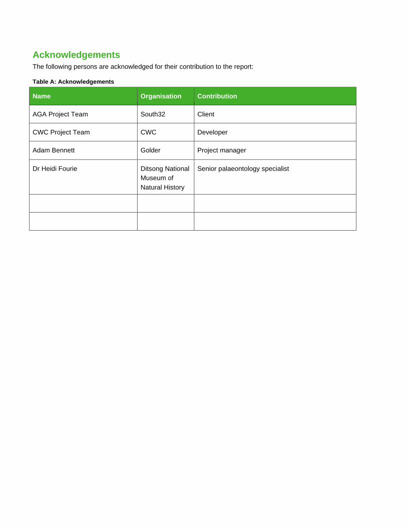
Acknowledgements The following persons are acknowledged for their contribution to the report:
Table A: Acknowledgements
Name Organisation Contribution
AGA Project Team South32 Client
CWC Project Team CWC Developer
Adam Bennett Golder Project manager
Dr Heidi Fourie Ditsong National
Museum of
Natural History
Senior palaeontology specialist
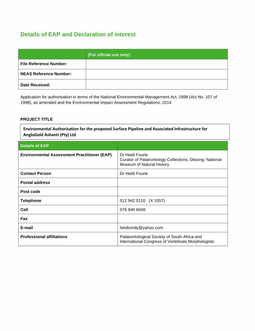
Details of EAP and Declaration of interest
(For official use only)
File Reference Number:
NEAS Reference Number:
Date Received:
Application for authorisation in terms of the National Environmental Management Act, 1998 (Act No. 107 of
1998), as amended and the Environmental Impact Assessment Regulations, 2014
PROJECT TITLE
Details of EAP
Environmental Assessment Practitioner (EAP) Dr Heidi Fourie Curator of Palaeontology Collections, Ditsong: National Museum of Natural History
Contact Person Dr Heidi Fourie
Postal address
Post code
Telephone 012 942 0110 (X 1057)
Cell 079 940 6048
Fax
E-mail [email protected]
Professional affiliations Palaeontological Society of South Africa and International Congress of Vertebrate Morphologists
Environmental Authorisation for the proposed Surface Pipeline and Associated Infrastructure for
AngloGold Ashanti (Pty) Ltd
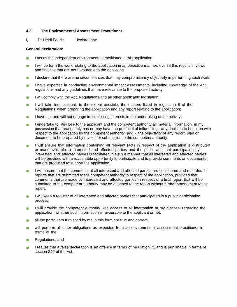
4.2 The Environmental Assessment Practitioner
I, ___ Dr Heidi Fourie _____declare that:
General declaration:
I act as the independent environmental practitioner in this application;
I will perform the work relating to the application in an objective manner, even if this results in views and findings that are not favourable to the applicant;
I declare that there are no circumstances that may compromise my objectivity in performing such work;
I have expertise in conducting environmental impact assessments, including knowledge of the Act, regulations and any guidelines that have relevance to the proposed activity;
I will comply with the Act, Regulations and all other applicable legislation;
I will take into account, to the extent possible, the matters listed in regulation 8 of the Regulations when preparing the application and any report relating to the application;
I have no, and will not engage in, conflicting interests in the undertaking of the activity;
I undertake to disclose to the applicant and the competent authority all material information in my possession that reasonably has or may have the potential of influencing - any decision to be taken with respect to the application by the competent authority; and - the objectivity of any report, plan or document to be prepared by myself for submission to the competent authority;
I will ensure that information containing all relevant facts in respect of the application is distributed or made available to interested and affected parties and the public and that participation by interested and affected parties is facilitated in such a manner that all interested and affected parties will be provided with a reasonable opportunity to participate and to provide comments on documents that are produced to support the application;
I will ensure that the comments of all interested and affected parties are considered and recorded in reports that are submitted to the competent authority in respect of the application, provided that comments that are made by interested and affected parties in respect of a final report that will be submitted to the competent authority may be attached to the report without further amendment to the report;
I will keep a register of all interested and affected parties that participated in a public participation process;
I will provide the competent authority with access to all information at my disposal regarding the application, whether such information is favourable to the applicant or not;
all the particulars furnished by me in this form are true and correct;
will perform all other obligations as expected from an environmental assessment practitioner in terms of the
Regulations; and
I realise that a false declaration is an offence in terms of regulation 71 and is punishable in terms of section 24F of the Act.
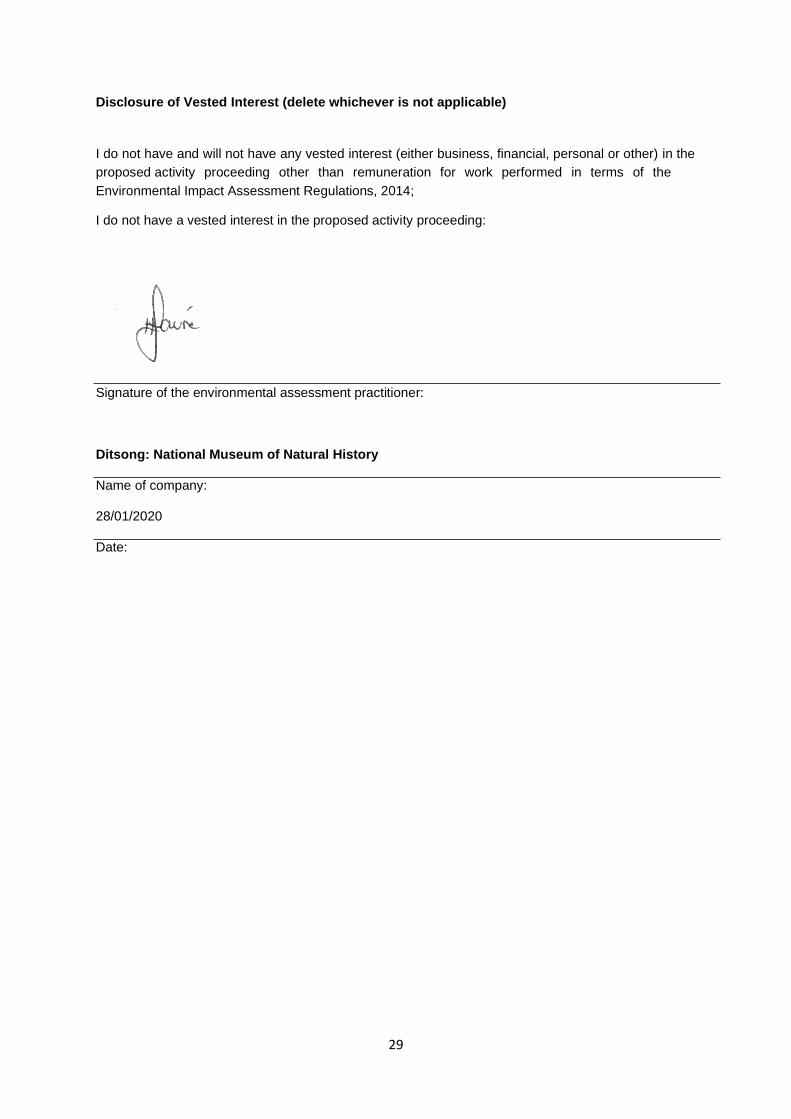
29
Disclosure of Vested Interest (delete whichever is not applicable)
I do not have and will not have any vested interest (either business, financial, personal or other) in the
proposed activity proceeding other than remuneration for work performed in terms of the
Environmental Impact Assessment Regulations, 2014;
I do not have a vested interest in the proposed activity proceeding:
Signature of the environmental assessment practitioner:
Ditsong: National Museum of Natural History
Name of company:
28/01/2020
Date:
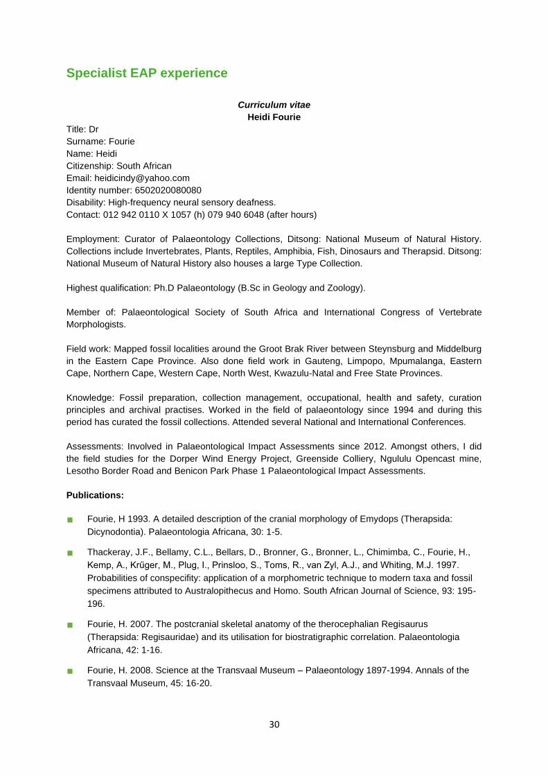
30
Specialist EAP experience
Curriculum vitae
Heidi Fourie
Title: Dr
Surname: Fourie
Name: Heidi
Citizenship: South African
Email: [email protected]
Identity number: 6502020080080
Disability: High-frequency neural sensory deafness.
Contact: 012 942 0110 X 1057 (h) 079 940 6048 (after hours)
Employment: Curator of Palaeontology Collections, Ditsong: National Museum of Natural History.
Collections include Invertebrates, Plants, Reptiles, Amphibia, Fish, Dinosaurs and Therapsid. Ditsong:
National Museum of Natural History also houses a large Type Collection.
Highest qualification: Ph.D Palaeontology (B.Sc in Geology and Zoology).
Member of: Palaeontological Society of South Africa and International Congress of Vertebrate
Morphologists.
Field work: Mapped fossil localities around the Groot Brak River between Steynsburg and Middelburg
in the Eastern Cape Province. Also done field work in Gauteng, Limpopo, Mpumalanga, Eastern
Cape, Northern Cape, Western Cape, North West, Kwazulu-Natal and Free State Provinces.
Knowledge: Fossil preparation, collection management, occupational, health and safety, curation
principles and archival practises. Worked in the field of palaeontology since 1994 and during this
period has curated the fossil collections. Attended several National and International Conferences.
Assessments: Involved in Palaeontological Impact Assessments since 2012. Amongst others, I did
the field studies for the Dorper Wind Energy Project, Greenside Colliery, Ngululu Opencast mine,
Lesotho Border Road and Benicon Park Phase 1 Palaeontological Impact Assessments.
Publications:
Fourie, H 1993. A detailed description of the cranial morphology of Emydops (Therapsida:
Dicynodontia). Palaeontologia Africana, 30: 1-5.
Thackeray, J.F., Bellamy, C.L., Bellars, D., Bronner, G., Bronner, L., Chimimba, C., Fourie, H.,
Kemp, A., Krűger, M., Plug, I., Prinsloo, S., Toms, R., van Zyl, A.J., and Whiting, M.J. 1997.
Probabilities of conspecifity: application of a morphometric technique to modern taxa and fossil
specimens attributed to Australopithecus and Homo. South African Journal of Science, 93: 195-
196.
Fourie, H. 2007. The postcranial skeletal anatomy of the therocephalian Regisaurus
(Therapsida: Regisauridae) and its utilisation for biostratigraphic correlation. Palaeontologia
Africana, 42: 1-16.
Fourie, H. 2008. Science at the Transvaal Museum – Palaeontology 1897-1994. Annals of the
Transvaal Museum, 45: 16-20.
31
Fourie, H. 2009. The postcranial skeleton of the basal therocephalian Glanosuchus macrops
(Scylacosauridae) and comparison of morphological and phylogenetic trends amongst the
Theriodontia. Palaeontologia Africana, 44: 27-39.
Fourie, H. 2013. The postcranial description of Ictidosuchoides (Therapsida: Therocephalia:
Baurioidea). Annals of the Ditsong National Museum of Natural History, 3: 1-10.
Fourie, H. 2013. Radon detection in Karoo fossil material at the Ditsong: National Museum of
Natural History, Pretoria. Ditsong: National Museum of Cultural History, Research Journal, 8: 24-
32.
Methodology:
The type of scope is determined by the geological formation and its palaeontological sensitivity
ranking determined through the Fossil Heritage Layer Browser (SAHRA).
Palaeontological Exemption Letter: Sensitivity of Insignificant to Zero/ Very Low.
Protocol for a Chance Find: Low Sensitivity.
Desktop Study: Moderate and High Sensitivity.
Field Assessment: High and Very High Sensitivity.
The report aims to provide comment and recommendations on the potential impacts that the
proposed development could have on the fossil heritage of the area and to state if any mitigation or
conservation measures are necessary.
Most fossil containing geological formations will be ranked as Moderate, High to Very High.
The Environmental Assessment Practitioner must map the location of the proposed development on
SAHRIS, once mapped, they will be able to switch on the palaeontological sensitivity layer to
determine whether or not a Palaeontological Impact Assessment is necessary.
EAP Specialist Assessment Project Experience
Fourie, H 2019. Portion 738, Doornkloof 391-JR, Centurion. Phase 1 Field Study, Palaeontological
Assessment prepared for Townscape Planning Africa.
Fourie, H. 2019. Rondebult Outfall Sewer Project. Phase 1 Field Study, Palaeontological Assessment
prepared for Shangoni Management Services.
Fourie, H. 2019. The Proposed Expansion of the Kaalfontein Hatchery. Desktop Study,
Palaeontological Assessment prepared for Anton Pelser Archaeological Consulting cc.
Fourie, H. 2018. Township Establishment: Witfontein Extension 99, Ekurhuleni Metro. Phase 1: Field
Study, Palaeontological Assessment prepared for Eugene Gouws.
Fourie, H. 2019. The Proposed Development of Mashimong Park on Erf 892, City of Ekurhuleni MM.
Phase 1: Field Study, Palaeontological Assessment prepared for Information Decision Systems.
February 2020 19121900-330265-12
APPENDIX C
Acknowledgements, Details of
EAP, Declaration of Interest and
Specialist EAP Experience
February 2020 19121900-330265-12
The following persons are acknowledged for their contribution to the report:
Table A: Acknowledgements
Name Organisation Contribution
AngloGold Ashanti Project Team AngloGold Ashanti Client
Olivia Allen Golder Co-ordination and liaison with client as project
manager
Adam Bennett Golder Compilation of the Palaeontology impact
assessment

February 2020 19121900-330265-12
Details of EAP and Declaration of interest
(For official use only)
File Reference Number:
NEAS Reference Number:
Date Received:
Application for authorisation in terms of the National Environmental Management Act, 1998 (Act No. 107 of
1998), as amended and the Environmental Impact Assessment Regulations, 2014
PROJECT TITLE
Details of EAP
Environmental Assessment Practitioner (EAP) Adam Bennett (Golder Associates Africa (Pty) Limited)
Contact Person Adam Bennett
Postal address P.O. Box 6001, Halfway House
Post code 1685
Telephone +27 11 254 4989
Cell +27 0 83 538 9424
Fax
E-mail [email protected]
Professional affiliations SACNASP (Member # 400142/08)
NACA member
Environmental Authorisation for the proposed Surface Pipeline and Associated Infrastructure for
AngloGold Ashanti (Pty) Ltd
February 2020 19121900-330265-12
4.2 The Environmental Assessment Practitioner
I, Adam Bennett declare that:
General declaration:
I act as the independent environmental practitioner in this application;
I will perform the work relating to the application in an objective manner, even if this results in views and findings that are not favourable to the applicant;
I declare that there are no circumstances that may compromise my objectivity in performing such work;
I have expertise in conducting environmental impact assessments, including knowledge of the Act, regulations and any guidelines that have relevance to the proposed activity;
I will comply with the Act, Regulations and all other applicable legislation;
I will take into account, to the extent possible, the matters listed in regulation 8 of the Regulations when preparing the application and any report relating to the application;
I have no, and will not engage in, conflicting interests in the undertaking of the activity;
I undertake to disclose to the applicant and the competent authority all material information in my possession that reasonably has or may have the potential of influencing - any decision to be taken with respect to the application by the competent authority; and - the objectivity of any report, plan or document to be prepared by myself for submission to the competent authority;
I will ensure that information containing all relevant facts in respect of the application is distributed or made available to interested and affected parties and the public and that participation by interested and affected parties is facilitated in such a manner that all interested and affected parties will be provided with a reasonable opportunity to participate and to provide comments on documents that are produced to support the application;
I will ensure that the comments of all interested and affected parties are considered and recorded in reports that are submitted to the competent authority in respect of the application, provided that comments that are made by interested and affected parties in respect of a final report that will be submitted to the competent authority may be attached to the report without further amendment to the report;
I will keep a register of all interested and affected parties that participated in a public participation process;
I will provide the competent authority with access to all information at my disposal regarding the application, whether such information is favourable to the applicant or not;
all the particulars furnished by me in this form are true and correct;
will perform all other obligations as expected from an environmental assessment practitioner in terms of the
Regulations; and
I realise that a false declaration is an offence in terms of regulation 71 and is punishable in terms of section 24F of the Act.
February 2020 19121900-330265-12
Disclosure of Vested Interest (delete whichever is not applicable)
I do not have and will not have any vested interest (either business, financial, personal or other) in the
proposed activity proceeding other than remuneration for work performed in terms of the
Environmental Impact Assessment Regulations, 2014;
I do not have a vested interest in the proposed activity proceeding:
Signature of the environmental assessment practitioner:
Golder Associates Africa (Pty) limited
Name of company:
19 February 2019
Date:
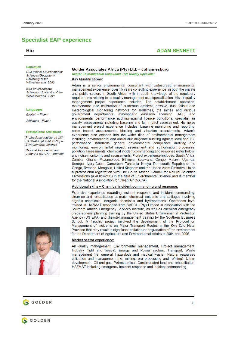
February 2020 19121900-330265-12
Specialist EAP experience
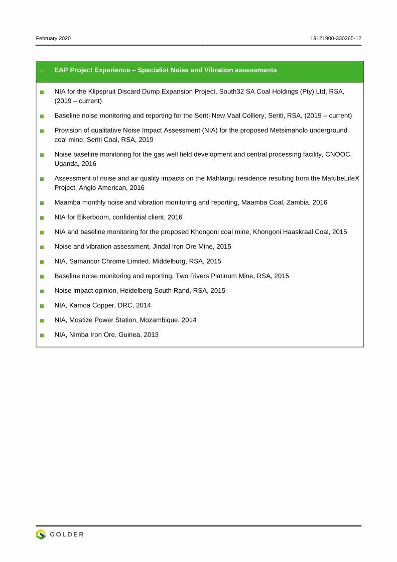
February 2020 19121900-330265-12
EAP Project Experience – Specialist Noise and Vibration assessments
NIA for the Klipspruit Discard Dump Expansion Project, South32 SA Coal Holdings (Pty) Ltd, RSA,
(2019 – current)
Baseline noise monitoring and reporting for the Seriti New Vaal Colliery, Seriti, RSA, (2019 – current)
Provision of qualitative Noise Impact Assessment (NIA) for the proposed Metsimaholo underground
coal mine, Seriti Coal, RSA, 2019
Noise baseline monitoring for the gas well field development and central processing facility, CNOOC,
Uganda, 2016
Assessment of noise and air quality impacts on the Mahlangu residence resulting from the MafubeLifeX
Project, Anglo American, 2016
Maamba monthly noise and vibration monitoring and reporting, Maamba Coal, Zambia, 2016
NIA for Eikerboom, confidential client, 2016
NIA and baseline monitoring for the proposed Khongoni coal mine, Khongoni Haaskraal Coal, 2015
Noise and vibration assessment, Jindal Iron Ore Mine, 2015
NIA, Samancor Chrome Limited, Middelburg, RSA, 2015
Baseline noise monitoring and reporting, Two Rivers Platinum Mine, RSA, 2015
Noise impact opinion, Heidelberg South Rand, RSA, 2015
NIA, Kamoa Copper, DRC, 2014
NIA, Moatize Power Station, Mozambique, 2014
NIA, Nimba Iron Ore, Guinea, 2013

golder.com


