Embed Size (px)
Citation preview
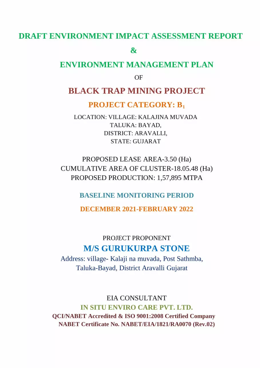
DRAFT ENVIRONMENT IMPACT ASSESSMENT REPORT
&
ENVIRONMENT MANAGEMENT PLAN
OF
BLACK TRAP MINING PROJECT
PROJECT CATEGORY: B1 LOCATION: VILLAGE: KALAJINA MUVADA
TALUKA: BAYAD, DISTRICT: ARAVALLI,
STATE: GUJARAT
PROPOSED LEASE AREA-3.50 (Ha)
CUMULATIVE AREA OF CLUSTER-18.05.48 (Ha) PROPOSED PRODUCTION: 1,57,895 MTPA
BASELINE MONITORING PERIOD
DECEMBER 2021-FEBRUARY 2022
PROJECT PROPONENT
M/S GURUKURPA STONE Address: village- Kalaji na muvada, Post Sathmba,
Taluka-Bayad, District Aravalli Gujarat
EIA CONSULTANT
IN SITU ENVIRO CARE PVT. LTD. QCI/NABET Accredited & ISO 9001:2008 Certified Company
NABET Certificate No. NABET/EIA/1821/RA0070 (Rev.02)

To, Date:
The Member Secretary,
Gujarat Pollution Control Board
Paryavaran Bhavan, Sector 10 A,
Gandhinagar, Gujarat- 382010
Sub: Regarding Environmental Clearance and conducting public hearing for M/s Gurukurpa
Stone (Black Trap Mine) over an area of 3.50 Ha. near village- village- Kalaji na muvada, Post
Sathmba, Taluka-Bayad, District Aravalli, State- Gujarat.
Dear Sir,
As per Terms of Reference (ToR) awarded by the State Environmental Impact Assessment
Authority (SEIAA), Gujarat vide letter no- No. SEIAA/GUJ/TOR/1(a)/539/2021dated
07.05.2021, we have prepared a Draft EIA/EMP report for conducting public hearing as per
the EIA Notification, 2006.
We are hereby submitting the Draft EIA/EMP Report and Executive Summary (English and
Gujarati) in both hard and soft copy for your kind perusal and scrutiny for further processing
of the case.
We kindly request you to process expeditiously our application for conducting public
consultation/hearing.
Thanking you,
Mr. Shah Pareshbhai Punamchand

UNDERTAKING
This EIA/EMP Report is prepared for obtaining Environment Clearance (EC) of M/s Gurukurpa Stone (Black Trap Mine) located near Village Kalajina Muvada, Taluka Bayad, and District Arvalli, State Gujarat with a mine lease area of area of 3.50 Ha for mining of Granite mineral has been prepared as per the conditions laid down in Terms of Reference (ToR) prescribed by SEIAA, Gujarat vide letter no. No. SEIAA/GUJ/TOR/1(a)/539/2021dated 07.05.2021.
I, Shah Pareshbhai Punamchand, am the authorised signatory for Black Trap Mine and affirm that all the data submitted and the information presented in this report is factually correct to the best of my knowledge.
Thanking You, Mr. Shah Pareshbhai Punamchand

Black Trap Mine Draft EIA/EMP
INDEX Cover Letter
Table of Contents
List of Tables
List of Figures
List of Annexure
List of Abbreviations
Executive Summary in English
Executive Summary in Gujarati
Questionnaire
S NO TABLE OF CONTENTS PAGE NO
CHAPTER-1: INTRODUCTION 1.1 Preamble 1 1.2 General Information on Mining of Minerals 1
1.3 Purpose of the Report 1 1.4 Identification of the Project and the Project Proponent 1 1.5 Environmental Clearance 2 1.6 Brief Description of Nature, Size, Location of The Project and Its
Importance To Country, Region 2
1.6.1 Nature of Project 2 1.6.2 Size of the Project 2 1.6.3 Location of the Project 2 1.6.4 Importance of the Project 3 1.7 Scope of Study – Details of Regulatory Scoping Carried Out (as per ToR) 4
CHAPTER-2: DESCRIPTION OF THE PROJECT 2.1 General 18 2.2 Type of the project 18 2.3 Need of the Project 20 2.4 Size/Magnitude of Operation for Cluster Mining 25 2.5 Technology and Process Description 25 2.5.1 Mining Equipments 28 2.5.3 Geology 29 2.5.3.1 Regional Geology 29 2.5.3.2 Local Geology 30 2.5.3.3 Land Use Pattern of the Cluster 30 2.5.4 Physiography & Drainage Pattern 31 2.5.4.1 Physiography 31 2.5.5.1 Climate 34
M/s Guru Krupa Stone

Black Trap Mine Draft EIA/EMP
2.7.6 Overburden/Waste Management 34 2.7.7 Beneficiation/ Processing 35 2.7.8 Employment Generation/Manpower Requirement 35 2.7.9 Water Requirement 35 2.7.10 Site Facility 36 2.7.10.1 Power Supply 36 2.8 Post Mining Land Use Conceptualized 36
CHAPTER-3: DESCRIPTION OF THE ENVIRONMENT 3.1 General 37 3.1.1 Laboratory Details 37 3.1.2 Methodology 37 3.2 Land Environment 38 3.2.1 Land Use in Core Zone 38 3.2.2 Land Use in Buffer Zone 39 3.2.3 Seismicity of the area 39 3.2.4 Major environmental features in Study Area 43 3.3 Soil Characteristics 43 3.3.1 Soil Types in Gujarat 43 3.3.2 Methodology of Soil Data Generation 45 3.3.2.1 Soil Monitoring Results 46 3.3.2.2 Soil Analysis 46 3.4 Water Environment 50 3.4.1 Water Monitoring Sampling Locations 50 3.4.2 Surface and Ground Water Quality 50 3.4.2.1 Surface Water Monitoring 50 3.4.2.2 Ground Water Monitoring 54 3.5 Air Environment 58 3.5.1 Meteorology 58 3.5.2 Secondary Data 59 3.5.3 Site Specific Meteorological Data 59 3.5.4 Climatology 60 3.5.4.1 Ambient Air Quality 60 3.5.4.2 Methodology Adopted For the Study 60 3.5.5 Air Quality Measurement 61 3.5.5.1 Ambient Air Quality Monitoring Results 62 3.5.5.2 Ambient Air Quality Monitoring Inference 68 3.5.6 Mineralogical Composition of PM10 69 3.6 Noise Environment 70 3.6.1 Types of Sound Fields 70 3.6.2 Noise Level in the Study Area 71 3.6.3 Ambient Noise Standards 73 3.7 Biological Environment 74 3.8 Biogeography and Physiography of the Study Area 74
M/s Guru Krupa Stone

Black Trap Mine Draft EIA/EMP
3.8.1 Objectives of Ecological Studies 74 3.8.2 Sampling Methodology of Study 74 3.8.2.1 Flora 74 3.8.2.2 Fauna 75 3.8.3 Terrestrial Environment 75 3.8.3.1 Core Zone 75 3.8.3.2 Buffer Zone 76 3.8.3.3 Aquatic Environment 80 3.9 Socio-Economic Environment 81 3.9.1 Objectives 81 3.9.2 Methodology Adopted for The Study 82 3.9.3 Concepts & Definition 82 3.9.4 Description of the study area 83 3.9.5 Population of the Cluster Study Area 86 3.9.5.1 Social Structure 87 3.9.5.2 Literacy 88 3.9.5.3 Illiteracy 88 3.9.6 Occupational Structure 95 3.9.6.1 Total workers 95 3.9.6.2 Non Workers 95 3.9.7 Infrastructural Facilities and Amenities in the cluster Study Area 100 3.10 Conclusion 107
CHAPTER-4: ANTICIPATED ENVIRONMENTAL IMPACTS AND MITIGATION MEASURES
4.1 General 108 4.2 Impact Assessment Methodology 108 4.3 Land Environment 109 4.3.1 Anticipated impacts 109 4.3.2 Mitigation Measures 109 4.4 Water Environment 110 4.4.1 Anticipated Impacts 110 4.4.2 Mitigation Measures 110 4.5 Air Environment 110 4.5.1 Anticipated Impact 111 4.5.2 Air Pollution Modeling 111 4.5.3 Pollutants considered for Computation 111 4.5.3.1 Impact on Ambient Air Quality 111 4.5.3.2 Estimation of Emission Factors 112 4.6 Meteorological Data 113 4.6.1 Mitigation Measures 119 4.7 Mitigation Measures 119 4.7.1 Drilling 119 4.7.1.1 Advantages of Wet Drilling 119
M/s Guru Krupa Stone

Black Trap Mine Draft EIA/EMP
4.7.2 Haul Road 120 4.8 Noise Environment 120 4.8.1 Anticipated Impacts 121 4.8.2 Mitigation Measures 122 4.9 Biological Environment 122 4.9.1 Anticipated Impacts 122 4.9.2 Mitigation Measures 122 4.10 Traffic Due to Transportation 131 4.10.1 Vehicular Traffic Density: 131 4.11 Impact on law & Order 136 4.12 Socio - Economic Environment 136 4.12.1 Anticipated Impacts 136 4.12.2 Mitigation Measures 136 4.12.2.1 Impact on Population Composition 136 4.13 Impact on Employment Generation 136 4.14 Mine Waste Management 137 4.15 Mine Closure 137
CHAPTER-5: ANALYSIS OF ALTERNATIVE (TECHNOLOGY & SITE) 5.1 General 138 5.2 Factors Behind the Selection of Project Site 138 5.3 Analysis of Alternative Site 138 5.3.1 Site Alternatives under Consideration 138 5.4 Analysis of Alternative Technology 138 5.4.1 Selection of Mining Methodology 138 5.4.2 Reasons for Open Cast Mining Method 139
CHAPTER-6: ENVIRONMENTAL MONITORING PROGRAM 6.1 General 140 6.2 Implementation Schedule of Mitigation Measures 140 6.2.1 Administrative Aspects & Environmental Monitoring Programme 140 6.2.2 Environment Management Cell 141 6.2.3 Environment Management Cell Responsibility 141 6.3 Environment Monitoring Programme 142 6.3.1 Air Quality Monitoring 142 6.3.2 Water Quality Monitoring 142 6.3.3 Noise Levels and Vibration 142 6.3.4 Soil Quality 143 6.3.5 Green Belt Development 143 6.4 Occupational Health & Safety 146 6.4.1 Public Health Implication 146 6.5 Corporate Environmental Policy 147
CHAPTER-7: ADDITIONAL STUDIES 7.1 Additional Studies 148 7.2 Public Hearing 148
M/s Guru Krupa Stone

Black Trap Mine Draft EIA/EMP
7.3 Risk Assessment 148 7.3.1 Key Definitions 149 7.3.2 Scope of Work for RA & DMP Study 149 7.3.2.1 Level 1: Hazard Identification 150 7.3.2.2 Level 2: Risk Assessment 150 7.3.2.3 Level 3: Treatment Controls 150 7.4 Mine Disaster Management Plan 151 7.4.1 Disaster Management Plan: Structure 151 7.4.1.1 Policy 151 7.4.1.2 Identification and Prevention of Possible Emergency Situations 151 7.4.1.3 Emergency Prevention 151 7.4.1.4 Emergency Plan Objectives 151 7.5 Fire fighting 152 7.6 First aid 152 7.7 Post Emergency Activities 153 7.7.1 Mock drill 153 7.7.2 Training 153 7.7.3 DMP Audit, Non Conformance and Corrective Action and Preventive
Action 153
7.7.4 Review of Emergency Performance 153 7.8 Blasting 153 7.9 Overburden 153 7.10 Heavy Machinery 154 7.11 Fuel Storage 154 7.12 Water Logging 154 7.12.1 Natural Resource Conservation 154 7.13 Safety Measures 154 7.14 Disaster Management Plan 155 7.14.1 Objectives of Disaster Management Plan 155 7.15 Fire Fighting Facilities 155 7.16 Emergency Medical Facilities 155 7.17 Rehabilitation & Resettlement 155
CHAPTER-8: PROJECT BENEFITS 8.1 General 156 8.2 Improvement in Physical Infrastructure 156 8.3 Improvement in Social Infrastructure 156 8.4 Employment Potential 156 8.5 Socioeconomic benefits 156 8.6 Conclusion 157
CHAPTER-9: ENVIRONMENTAL MANAGEMENT PLAN 9.1 General 158 9.2 Environment Management System 158 9.2.1 Policy 158
M/s Guru Krupa Stone

Black Trap Mine Draft EIA/EMP
9.2.2 Environment Cell 158 9.2.3 Proposed Environmental Management Plan 159 9.3 Surface Subsidence 159 9.4 Waste Management 159 9.4.1 Overburden/Waste Management 160 9.5 Acid Mine Drainage 160 9.6 Pollution Management and Control 160 9.6.1 Control of Fugitive Emissions and Gaseous Pollution 160 9.7 Water Management and Control 161 9.7.1 Surface Water Management 161 9.7.2 Ground Water Management 161 9.7.3 Details of water conservation measures proposed/Rain water Harvesting
proposal 161
9.8 Noise Pollution 161 9.8.1 Noise Abattement and Control 161 9.8.1.1 Mitigation Measures 162 9.9 Control of Vibration and Fly rock generation during blasting 162 9.10 Land Reclamation and waste management 162 9.10.1 Land use planning and mine closure 162 9.11 Biological Management Measures 163 9.12 Greenbelt Development Plan 163 9.13 Plantation Programme 164 9.13.1 Post Plantation Care 164 9.14 Solid Waste Management 165 9.15 Occupational Hazards and Safety 165 9.16 Socio-economic Conditions of the Region 166 9.17 Cost of Environment Control Measures 166 9.18 Conclusion 166
CHAPTER-10: SUMMARY & CONCLUSIONS 10.1 Introduction 168 10.2 Details About The Project 168 10.3 Air Environment 169 10.4 Water Environment 169 10.5 Noise Environment 170 10.6 Waste Management 170 10.7 Greenbelt Development 170 10.8 Conclusion 170
CHAPTER-11: DISCLOSURE OF THE CONSULTANT ENGAGED 171-172
M/s Guru Krupa Stone
Black Trap Mine Draft EIA/EMP
TABLE NO
LIST OF TABLES PAGE NO
1.1 Pillar coordinates of the project site 3 1.2 Point-Wise Compliance of Prescribed ToR 4 2.1 Lease Details in The Cluster 19
2.2 Nearest Amenities, Demographical And Physiographical Features of The Cluster
21
2.3 Coordinates of all leases in the cluster 21 2.4 Year Wise Development Plan (For mines in Cluster) 25
2.4(a) Year Wise Development and Production of Proposed Project 25 2.5 Design Parameters of the Proposed Project 26
2.6(a) First Year Mine Development for proposed project 26 2.6(b) Second Year Mine Development for proposed project 26 2.6(c) Third Year Mine Development for proposed project 27 2.6(d) Fourth Year Mine Development for proposed project 27 2.6(e) Fifth Year Mine Development for proposed project 27
2.7 Insitu tentative excavation in MT for the Proposed Project 28 2.8 List of Machinery to be Used in The Proposed Project 28 2.9 Regional tectono stratigraphic – succession 29
2.10 Land Use Pattern 31 2.11 Manpower Requirement for Cluster 35 2.12 Water Requirement for Proposed Project 35 3.1 Laboratory Details 37 3.2 Cluster Land Use Pattern as per Approved Mining Plans 38 3.3 Land Use Breakup 39 3.4 Soil Sample Collection Points in cluster 46 3.5 Soil Monitoring Analysis Results 48 3.6 Water Sampling Locations 50 3.7 Surface Water Physiological & Microbiological results 53 3.8 Ground Water Monitoring Analysis 55 3.9 IMD Data from Ahmedabad (1961-1990) 59
3.10 Site Specific Meteorological Data 59 3.11 Ambient Air Monitoring Stations 61 3.12 Ambient Air Quality Monitoring Results 64 3.13 Mineralogical Composition of PM10 69
3.14 Noise Quality Monitoring Locations 73
3.15 Hourly Leq Noise Level in the Study Area 73 3.16 Ambient Noise Quality Standards 73 3.17 Floral Species in Study Area 76 3.18 List of Cash Crops in The Study Area 78 3.19 Faunal Species in the study area 79 3.20 List of Fishes Found in the Mahi River 81 3.21 Cluster Details 81
M/s Guru Krupa Stone

Black Trap Mine Draft EIA/EMP
3.22 Details of the State Gujarat and Study area 83 3.23 Total Geographical Area of the Cluster Study Area 84
3.24(a) Demographic Structure of the cluster Study Area 90 3.24 (b) Demographic Structure of the cluster Study Area 92
3.25 Occupational Pattern of the Cluster Study Area 96 3.26 Occupation Structure of Each Village in The Cluster Study Area 97 3.27 Amenities in the Study Area 101 3.28 Infrastructure Facilities of The Study Area 104 4.1 Cluster Land Use Pattern 109 4.2 Mine Leases in Cluster 112 4.3 Input Parameters 113 4.4 Meteorological input 113 4.5 Predicted Incremental Concentrations of PM10 in Study Area 114 4.6 Predicted Incremental Concentrations of PM2.5 in Study Area 114 4.7 Predicted Incremental Concentrations of SO2 in Study Area 114 4.8 Predicted Incremental Concentrations of NOx in Study Area 114 4.9 Equipments for noise generation (Cumulative) 120
4.10 Permissible Exposure Noise Levels 121 4.11 Noise Exposure Levels & Its Effects 121 4.12 List of Plants Proposed for Green Belt Development 124 4.13 Additional Traffic load added due to Cluster 132 6.1 Implementation Schedule 140 6.2 Environmental Monitoring Programme 144 6.3 Proposed Budget Allocation For Labour Welfare 146 7.1 First Aid Kit 152 9.1 Details of Mineral Rejects of all the mine leases in the cluster 160 9.2 Cluster Land Use Pattern as per Approved Mining Plans 162 9.3 Proposed Cost of Environment Management 166
10.1 Project Details 168 11.1 Functional Area Experts 171
M/s Guru Krupa Stone

Black Trap Mine Draft EIA/EMP
FIGURE NO
LIST OF FIGURES PAGE NO
2.1 Approved Cluster Map 20 2.2 Cluster Location Map 22 2.3 10 km Buffer Map 23 2.4 15 Km Buffer Map 24 2.5 Land Use Map 32 2.6 Drainage Map 33 2.7 Climatological Data of Panchmahal District 34 3.1 Land Use Map 40 3.2 False Colour Composite Map 41 3.3 Sesimic Zone Map 42 3.4 Soil Map of Gujarat 44 3.5 Soil Monitoring Locations 47 3.6 Ground Water Monitoring Locations 51 3.7 Surface Water Monitoring Locations 52 3.8 Wind Rose showing pre dominant wind direction is from North East 60 3.9 Ambient Air Quality Monitoring Locations 63
3.10 Noise Monitoring Locations 72 3.11 Graph Showing Demographic Structure of the Study Area 86 3.12 Pie Chart Showing Gender Structure of the Study Area 87 3.13 Graph Showing Schedule Caste Structure of the Study Area 87 3.14 Graph Showing Schedule Tribe Structure of the Study Area 88 3.15 Graph showing Literacy Structure of The Study Area 88 3.16 Graph showing Illiteracy structure of the Study area 89 3.17 Occupational Pattern in the Study Area 95
4.1 Isopleth Showing Incremental Concentration Within Study Area for PM2.5
116
4.2 Isopleth Showing Incremental Concentration Within Study Area for PM10
117
4.3 Isopleth Showing Incremental Concentration Within Study Area for NO2
118
4.4 Isopleth Showing Incremental Concentration Within Study Area for PM SO2
119
4.5 Proposed Plants for Green Belt Development 131 4.6 Transportation Map 135 6.1 Organization Structure for Environment Management 142 9.1 Organization Structure for Environment Management 159
M/s Guru Krupa Stone

Black Trap Mine Draft EIA/EMP
LIST OF ANNEXURES Page No.
Annexure-I Terms of References 1-3
Annexure-II Lease Application 4-9
Annexure-III Approved Mining Plan 10-61
Annexure-IV Mine Plates 62-71
Annexure-V Lab Reports 72-110
Annexure-VI Traffic Survey Forms duly filled during traffic study 111-116
Annexure-VII Monitoring Photographs 117-120
Annexure-VIII Cluster Map 121
Annexure-IX List of Critically Polluted Areas issued by CPCB 122-124
Annexure-X Project Details Certified by District Geologist 125-128
Annexure-XI Questionnaire 129-176
Annexure-XII CER Notification dated 30th September, 2020 177-178
Annexure-XIII Form-1 and PFR 179-196
M/s Guru Krupa Stone

Black Trap Mine Draft EIA/EMP
LIST OF ABBREVIATIONS
AAQM Ambient Air Quality Monitoring
CER Corporate Environmental Responsibility
Cm Centimeter
CPCB Central Pollution Control Board
dB Decibel
DG Diesel Generator
EIA Environmental Impact Assessment
EMC Environmental Management Cell
EMP Environment Management Plan
EPA Environmental Protection Agencies
FCC False Colour Composite
GLC Ground Level Concentration
IMD Indian Meteorological Department
ISCST Industrial Source Complex, Short Terms
ISO International Organisational Of Standardization
KLD Kilo Litre Per Day
Km Kilometer
M bgl Meter Below Ground Level
mg Milligram
MoEF&CC Ministry of Environment, Forest and Climate Change
mRL Mean Reference Level
MT Million Tonne
MTPA Million Tonns Per Annum
N North
NAAQS National Ambient Air Quality Standard
NE North- East
NH National Highway
NO2 Nitrogen Dioxide
NTU Naphelo Turbidity Unit
NW North-West
OB Overburden
OM Office Memorandum
PPE Personal Protective Equipment
PPM Part per Million
M/s Guru Krupa Stone
Black Trap Mine Draft EIA/EMP
Pvt. Private
QCI Quality Council Of India
R&R Rehabilitation & Resettlement
RSPM Respirable Suspended Particulate Matter
RO Reverse Osmosis
SE South-East
SEAC State Expert Appraisal Committee
SEIAA State Level Environmental Assessment Authority
SO2 Sulphur Di-Oxide
SOI Survey Of India
SPCB State Pollution Control Board
SPM Suspended Particulate Matter
TDS Total Dissolved Solid
ToR Terms Of Reference
TS Total Solid
TSS Total Suspended Solids
US EPA United State Environment Protection Agencies
ug/m3 Micro Gram Per Cubic Meter
M/s Guru Krupa Stone

EXECUTIVE SUMMARY IN ENGLISH

Black Trap Mine Executive Summary
EXECUTIVE SUMMARY 1. Introduction 1.1 Purpose of the Report The proposed Black Trap mining project which is falling in cluster having lease area 3.50.00 Ha (Cumulative area of the cluster is 18.05.48 Ha). EIA is carried out as per cluster study of 7 leases in the cluster of homogenous mineral black trap Black Trap Mine is having lease area 3.50.00 Ha having Survey No: 90, was granted ToR, vide letter No. SEIAA/GUJ/TOR/1(a)/539/2021dated 07th May 2021. This report is prepared in compliance to the ToR points and submitted for the purpose of grant of EC. The maximum annual production of the cluster is targeted at 1,57,895 MT as ROM. The maximum cumulative capacity of the cluster is 904, 164 MTPA as ROM. The cost of the project is 1.7393 Crores. Pertaining to the MoEF&CC Notification S.O. 141(E) dated 15th January 2016 and S.O. 2269 (E) of 1st July 2016, MoEF&CC OM (F. No. L-11-11/175/2018-IA-II (M) dated 12th December 2018 and Gujarat SEAC Office Letter (Ref. No. EIA-10-2019/SEAC/GEN/59/19/507) dated 1st February 2019 the project of Black Trap Mine of Gurukurpa Stone falls under the preview of EC by means of Cluster. The proposed project falls under Category B1 & Schedule 1(a) of Mining of Minerals. 1.2 Brief Description of Nature, Size, Location of the Project and Its Importance to Country, Region 1.2.1 Nature of Project Black Trap Mining Project is a green field project characterized by open-cast semi mechanized mining in nature with occasional use of drilling and blasting. The land under the use is non-forest private land. The extracted mineral shall be sold in the open market. 1.2.1 Size of the Project The proposed mine lease area is 3.50.00 Ha and cumulative lease is 18.05.48 Ha, which is a non-forest private land. 1.2.2 Location of the Project The proposed project falls on Survey of India Toposheet no. F43B08 near village Kalaji na muvada. The settlement of villages like Daulpura is situated in the east, Ajabpura in north, Savela in west and Sathamba in south. Nearest railway station is Bayad Railway Station at a distance of North-West Km and nearest highway is SH-69 in the South-East direction at a distance of 0.683 km (apx.) from the project site.
Table 1.1 – Coordinates of the Proposed Project
Pillar Latitude Longitude
PB 1 23°11'07.03"N 73°19'17.01"E
PB 2 23°11'07.02"N 73°19'18.80"E
PB 3 23°11'05.14"N 73°19'19.02"E
PB 4 23°11'05.38"N 73°19'21.14"E
PB 5 23°11'07.14"N 73°19'21.18"E
M/s Guru Kurpa Stone Page 1

Black Trap Mine Executive Summary
PB 6 23°11'08.16"N 73°19'21.46"E
PB 7 23°11'08.24"N 73°19'24.03"E
PB 8 23°10'59.03"N 73°19'24.08"E
PB 9 23°10'59.71"N 73°19'23.26"E
PB 10 23°10'59.01"N 73°19'21.15"E
PB 11 23°11'03.82"N 73°19'21.63"E
PB 12 23°11'03.76"N 73°19'17.96"E
1.3 Identification of Project Proponent 1.3.1 Project Proponent M/s Gurukurpa Stone is identified as the project proponent having registered address at village- Kalaji na muvada, Post Sathmba, Taluka-Bayad, District Arvalli Gujarat. The authorized signatory is Mr. Shah Pareshbhai Punamchand. 1.3.2 Environmental Consultant Name: In Situ Enviro Care, Bhopal Certificate No. NABET/EIA/1821/RA0070
1.3.3 Laboratory Details Name: Gaheli Environmental Laboratory (A unit of Gaheli Centre of Research and Development Pvt. Ltd.) (En ISO 9001:2015, 14001:2015 Certified Company) (En OHSAS 18001:2007 Certified Lab)
Address –Circuit House Road, Near Parwani Orthopaedic Hospital, Near Paradise Fountain Circle, Porbandar-360575, Gujarat 2. Project Description 2.1 Need of the Cluster Black Trap is having a great value in domestic as well as international market due to its various shades, compressive strength, tensile strength, density etc. The project will bring various benefits to the project proponent and to the people in its vicinity. Following are some benefits listed below – 1. It will increase the value of Indian Export market and adds economy to the country. 2. It will provide direct employment to the people of nearby villages, which will help in
improving their livelihood. 3. It will provide indirect employment to the people associated with the project activities like
transportation, trading etc. 4. The project will felicitate green belt & landscape development and will enrich the flora of the
area. 5. It will provide various socio-economic benefits to the people like education facility, medical
camp facility, water supply facility etc. 6. The project will benefit the state as well as central government in the form of Royalty, sales
tax, income tax. 7. The project will ensure efficient use of the resources.
Therefore, project will have a great importance both in the regional as well national prospective.
M/s Guru Kurpa Stone Page 2

Black Trap Mine Executive Summary
2.2 Location of the Cluster The project is situated near Villages- Kalaji Muvada and Dolapura Taluka- Bayad, District- Aravalli. 10Km study area covers Varanasi Nadi, Damini Nadi, Canal, Bayad Railway Station etc. 2.3 Salient Features of the Project
Table 2.1 – Brief Description of the Cluster S. No. Details of Project Description
1 Cluster area 18.05.48 Ha 2 Proposed production The maximum annual production of the cluster is targeted at
1,57,895 MT as ROM. The maximum cumulative capacity of the cluster is 904, 164 MTPA as ROM.
3 Excavation proposed of cluster
5 years
4 Lessee Gurukrupa Stone (Lease Area: 01.53.78Ha) Gurukrupa Stone (Lease Area: 01.33.41Ha) Parishram Stone (Lease Area: 04.13.38Ha) Parishram Stone (Lease Area: 02.74.28 Ha) Vrundavan Stone (Lease Area: 01.99.00Ha) Vrundavan Stone (Lease Area: 02.81.63Ha) Gurukrupa Stone (Lease Area: 3.50.00 Ha)
5 Type of land Private Non-forest 6 Minerals of mine Black Trap 7 Geological reserve 1,460,835 Tonnes (Highest has been taken)
Mine Lease Reserve (MT) Gurukrupa Stone 603,013 Gurukrupa Stone 1,460,835 Parishram Stone Parishram Stone Vrundavan Stone 826,353
Vrundavan Stone 1,017,745 Gurukrupa Stone 1412317
8 Topo-sheet number F43B08 9 Project cost Mine Leasee Project Cost (Rs.)
Gurukrupa Stone Gurukrupa Stone Parishram Stone Parishram Stone Vrundavan Stone
Vrundavan Stone Gurukrupa Stone 1.7393
10 No of working days 300 11 Method of Mining Open cast semi mechanized will be adopted with occasional use of
drilling and blasting 2.4 Development & Production Plan
M/s Guru Kurpa Stone Page 3
Black Trap Mine Executive Summary
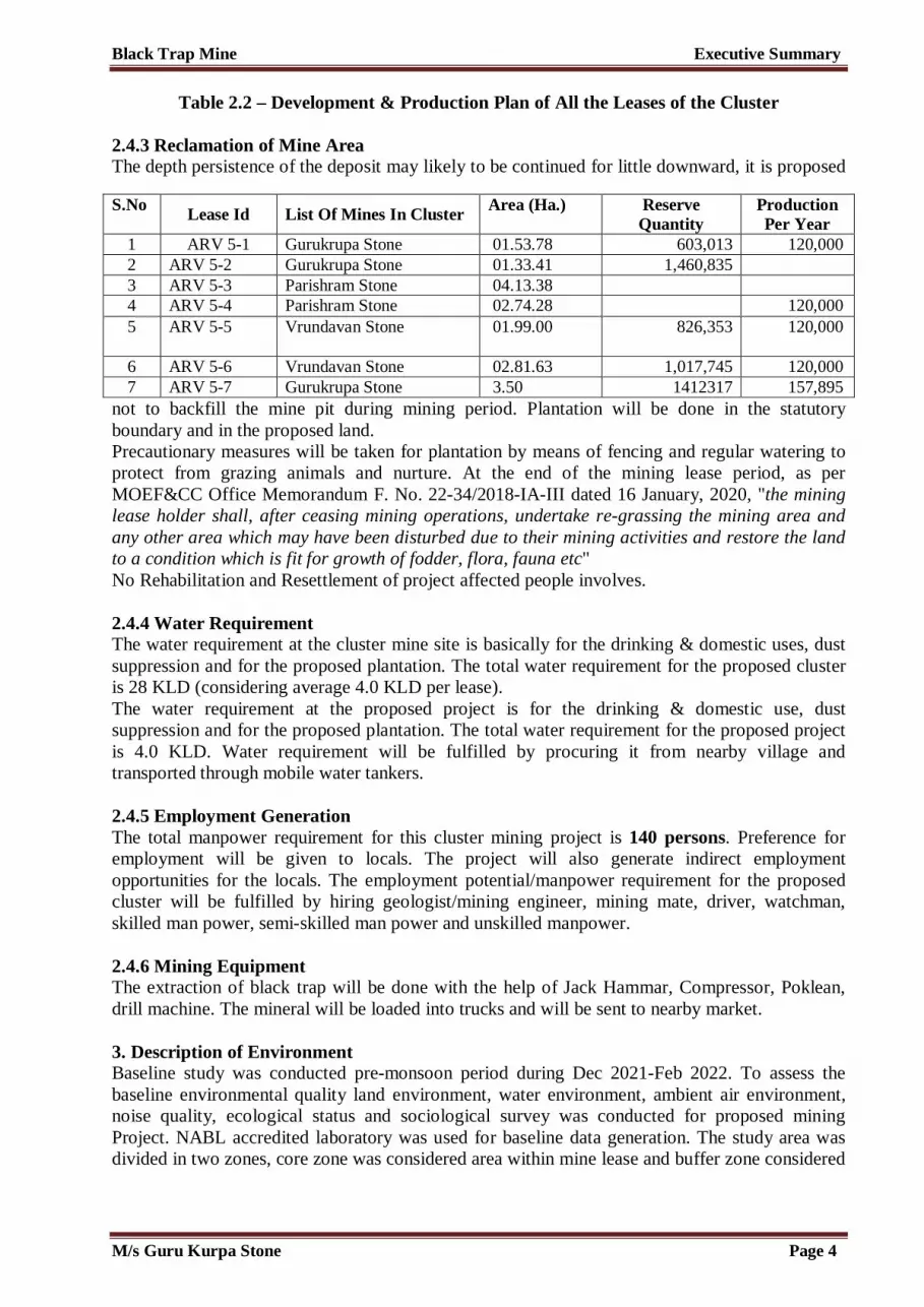
Table 2.2 – Development & Production Plan of All the Leases of the Cluster
2.4.3 Reclamation of Mine Area The depth persistence of the deposit may likely to be continued for little downward, it is proposed
not to backfill the mine pit during mining period. Plantation will be done in the statutory boundary and in the proposed land. Precautionary measures will be taken for plantation by means of fencing and regular watering to protect from grazing animals and nurture. At the end of the mining lease period, as per MOEF&CC Office Memorandum F. No. 22-34/2018-IA-III dated 16 January, 2020, "the mining lease holder shall, after ceasing mining operations, undertake re-grassing the mining area and any other area which may have been disturbed due to their mining activities and restore the land to a condition which is fit for growth of fodder, flora, fauna etc" No Rehabilitation and Resettlement of project affected people involves. 2.4.4 Water Requirement The water requirement at the cluster mine site is basically for the drinking & domestic uses, dust suppression and for the proposed plantation. The total water requirement for the proposed cluster is 28 KLD (considering average 4.0 KLD per lease). The water requirement at the proposed project is for the drinking & domestic use, dust suppression and for the proposed plantation. The total water requirement for the proposed project is 4.0 KLD. Water requirement will be fulfilled by procuring it from nearby village and transported through mobile water tankers. 2.4.5 Employment Generation The total manpower requirement for this cluster mining project is 140 persons. Preference for employment will be given to locals. The project will also generate indirect employment opportunities for the locals. The employment potential/manpower requirement for the proposed cluster will be fulfilled by hiring geologist/mining engineer, mining mate, driver, watchman, skilled man power, semi-skilled man power and unskilled manpower. 2.4.6 Mining Equipment The extraction of black trap will be done with the help of Jack Hammar, Compressor, Poklean, drill machine. The mineral will be loaded into trucks and will be sent to nearby market. 3. Description of Environment Baseline study was conducted pre-monsoon period during Dec 2021-Feb 2022. To assess the baseline environmental quality land environment, water environment, ambient air environment, noise quality, ecological status and sociological survey was conducted for proposed mining Project. NABL accredited laboratory was used for baseline data generation. The study area was divided in two zones, core zone was considered area within mine lease and buffer zone considered
S.No Lease Id List Of Mines In Cluster Area (Ha.) Reserve Quantity
Production Per Year
1 ARV 5-1 Gurukrupa Stone 01.53.78 603,013 120,000 2 ARV 5-2 Gurukrupa Stone 01.33.41 1,460,835 3 ARV 5-3 Parishram Stone 04.13.38 4 ARV 5-4 Parishram Stone 02.74.28 120,000 5 ARV 5-5 Vrundavan Stone 01.99.00 826,353 120,000
6 ARV 5-6 Vrundavan Stone 02.81.63 1,017,745 120,000 7 ARV 5-7 Gurukrupa Stone 3.50 1412317 157,895
M/s Guru Kurpa Stone Page 4

Black Trap Mine Executive Summary
area outside 10 km radius from project site. Different environmental attributes were considered for baseline environmental data. 3.1 Land Environment Since open-cast method has been adopted for cluster mining, studies of land use and terrain information is required for environment study. The main objective of land baseline data is to take remedial measures for any change in land use due to proposed cluster project. Core and buffer zone areas have been considered for land use. The vegetation is very sparse within the cluster. No building or infrastructure is located within the 500 m radius of the proposed cluster. 3.2 Seismicity of Project Area The bureau of Indian standards publishes seismicity map and codes in India. The Black Trap Mining Project is present in private non forest land falls under Seismic Zone III. 3.3 Water Environment To analyze the surface and ground water quality of study area, sampling has been carried out by NABL accredited laboratory for primary data. Secondary data has been collected from CGWB district brochure of Aravalli. Sampling of surface and ground water was collected as per IS 3025 Part I. Total 06 ground water locations were selected to study baseline ground water quality. Village name for sampling of ground water are Near Mine Site, Jitpur, Lakshmipura, Talod, Vijaygan, Kharod. Three surface water samples were also collected at Varansi Nadi and Dhamni Nadi. All the parameters have been analyzed by IS 3025: Part 4 to Part 62. After analysis it was found that pH was 7.62 and 7.74 in the sample SW-1 and SW-2 respectively. Electrical conductivity was measured as 253 and 276 µmohs/cm in the sample SW-1 and SW-2 respectively. Total dissolved solid was found to be 619 and 638 mg/l in the sample SW-1 and SW-2 respectively. Dissolved oxygen was present at 7.6 and 6.8 mg/l in the sample SW-1 and SW-2 respectively. Magnesium was found to be 20.3 and 24.7 mg/l and Calcium was found 72 and 75 mg/l in the sample SW-1 and SW-2 respectively. Turbidity of the ground water samples were found between <1 NTU. pH values vary from 6.96 to 7.72. Total dissolved solids were found within permissible limits of 2000 mg/liter, ranged from 682 to 875 mg/l. There is no heavy metal detected in any sample like cadmium, arsenic, lead, zinc, Cr6+, and aluminum. 3.4 Air Environment Site specific meteorological data was collected by installing weather station near to cluster site. Primary metrological data was collected for three months from Dec 2021 to Feb 2022. Predominant wind direction during study period was found north east. Secondary data was collected from IMD Climatological normal 1961-1990 for Ahmedabad location. As per IMD data minimum temperature was found in February 2.2 °C, maximum temperature was found 47.8 °C during May. Yearly relative humidity was found between 20-87%, Maximum rainfall was found in the month of August averaged 262.3 mm. Name of villages where AAQM locations were selected are near mine site are Near Mine Site, Jitpur, Lakshmipura, Talod, Vijaygan, Kharod The nearest receptor from the proposed cluster is Kalaji Muvada Village. Ambient air quality monitoring was conducted as per Indian standard and CPCB guidelines. Gravimetric method was used for particulate matter quantification and spectrophotometer method was used gaseous analysis. Samples were collected using Respirable Dust Sampler make
M/s Guru Kurpa Stone Page 5

Black Trap Mine Executive Summary
Envirotech. Ambient air quality monitoring stations were selected on the basis of predominant downwind direction and anticipated receptor due to truck transportation of black trap. Parameter wise 98th percentile maximum and minimum values were observed at all the 06 monitoring locations. The minimum and maximum level of PM2.5 recorded within the study area was in the range of 31.2 µg/m3 to 39.8 µg/m3 with the 98th percentile ranging between 35.54 µg/m3 to 39.6 µg/m3. The minimum and maximum level of PM10 recorded within the study area was in the range of 65.8 to 87.3µg/m3 with the 98th percentile ranging between 74.15 µg/m3 to 86.42 µg/m3. The minimum and maximum concentration of SO 2 recorded within the study area was 3.7 to 7.5 µg/m3 with the 98th percentile ranging between 5.9 µg/ m3to 7.2 µg/ m3 . The minimum and maximum level of NO2 recorded within the study area was in the range of was 11.7 µg/ m3to 19.9 µg/m3 with the 98th percentile ranging between 18.4 µg/m3 to 19.8 µg/m3. The minimum and maximum level of CO recorded within the study area was in the range of was 590 µg/ m3 to 790 µg/ m3 with the 98th percentile ranging between 694.54 µg/ m3 to 785.4 µg/ m3. . Mineralogical composition for free silica and other minerals was analyzed and this was found that free silica present at concentration 0.13 µg/m3 in PM10. 3.5 Noise Environment Noise levels of all the 06 receptor locations were monitored as per guidelines specified by Central Pollution Control Board. The names of the locations are Near Mine Site, Jitpur, Lakshmipura, Talod, Vijaygan, Kharod. 24 hourly monitoring of noise environment was conducted and divided into day and night levels whereas 6 am to 10 pm was considered day time values and 10 pm to 6 am was considered as night values. In residential and industrial areas, noise level is ranging between 50.3 dB(A) recorded at at NQ-05 to 52.262.8 dB(A) recorded at NQ-01 during day time and 39.6 dB(A) recorded at NQ-5 to 41.5 dB(A) recorded at NQ-03 during night time. 3.6 Soil Environment Soil quality samples were collected from 06 locations as per Indian standards. Physical characteristics of soil were characterized through specific parameters viz bulk density, porosity, water holding capacity, pH, electrical conductivity and texture. Soil pH plays an important role in the availability of nutrients. Soil microbial activity as well as solubility of metal ions is also dependent on pH. In the study area, variations in the pH of the soil were found to be slightly basic (7.21 to 7.6). Electrical conductivity is a measure of the soluble salts and ionic activity in the soil. In the collected soil samples, the conductivity ranged from 591– 822 µmhos/cm. 3.7 Biological Environment Flora and fauna survey was done at core and buffer zone of the cluster area and primary and secondary data was collected. The major area in study area is agricultural land. Based on primary and secondary surveys, the major agricultural crops grown during monsoon season in the study area are Rice (Oryza sativa) and Castor (Ricinus communis), while during winter Wheat (Triticum aestivum) is cultivated as the major crop. Bajra (Pennisetum typhoides) is also grown by the villagers while vegetables grown in this region include Bhindi (Abelmoschus esculentus) and Brinjal (Solanum melongena). Fruits such as Bors (Zizyphus glabrata), Amlas (Emblica officinalis), Mangoes (Mangifera indica), were Chikoos (Manilkara zapota) and Papayas (Carica papaya) are also grown in the study area. 3.8 Social Environment Primary social survey was conducted in the study area and observed there is no project affected family within the cluster area. The proposed cluster covers 81 villages in Aravalli district in Gujarat state having a total population of 320161 people. The percentages of male & female
M/s Guru Kurpa Stone Page 6

Black Trap Mine Executive Summary
population are 51.75 % & 48.25 % respectively. Total household in the study area are 62432. Total number of literates in the study area is 186782 (58.34%). Sex ratio (number of Females per thousand Male) of the study area is 1073 which shows that female population is higher in the study area as compared with the male Population. Out of the total population Scheduled Caste population in the study area is 22928 (7.16%) and Scheduled Tribe population is 4145 (1.29%). Child population (0-6 years) in the study area is 47084 which is 14.70% of the total Population out of which 25038 (7.82%) is boys population and 22046 (6.88%) is girls population. The number of total workers in the study area is approximately 155313 (18.51%) in which 91566 (58.95%) are male worker and 63747 (41.05%) are female worker. Total number of main workers in the Study Area is approximately 116334 persons, which is 74.90% of total workers and 36.33% of total population. Total number of marginal workers in the Study Area is approximately 51710 persons which is 33.29 % of the total workers and 16.15 % of total population. 4. Anticipated Environmental Impacts and Mitigation Measures 4.1 Impact on Land Use The proposed cluster project is having a fresh mine lease areas. These are private non forest lands and proposed for the black trap mining. The maximum depth of working for cluster is 145mRL. Mitigation measures have been proposed for land use change. Plantation will be done in the statutory boundaries. Dust suppression will be done regularly during the mining period. 4.2 Impact on Water Environment No surface water body is present within the mine lease area; therefore, no surface water body will be affected due to proposed cluster. Water table will not be intersected due to project activities. The required quantity of water for the mining operations is approximately 28 KLD for the cluster considering 4 KLD per lease, which will be procured through private tankers and by collecting rainwater.
4.3 Impact on Air Quality Source of air pollution will be excavation of material, loading of material and transportation of black trap. Incremental concentrations have been predicted by using ISCST3. 301 trucks per day of 10 MT capacities will run on haul road per day. Metrological data was used for air quality modeling from Dec 2021 to Feb 2022. The predominant downwind direction was North East. The 24-hourly average values of PM2.5 were compared with the NAAQS and found that all sampling stations recorded in the cluster study area are within the applicable limits i.e., 60 µg/m3 for PM2.5 in rural areas. The 24-hourly average values of PM10 were compared with the NAAQS and found that all sampling stations recorded in the study area are within the applicable limits i.e., 100 µg/m3 for PM10 in rural areas. The 24-hourly average values of SO2 were compared with the NAAQS and it was found that all sampling stations recorded values are below the applicable limits 80 µg/m3 for rural areas. The 24-hourly average values of NO2 were compared with the NAAQS and it was found that all sampling stations recorded values are below the applicable limits 80 µg/ m3 for rural areas. The 1 hourly average values of CO were compared with the NAAQS and it was found that all sampling stations recorded values are below the applicable limits 4000 µg/ m3 for rural areas. Baseline air environmental conditions after incremental pollution load are below than national ambient air quality standards. 4.4 Impact on Noise Quality Noise generated at the mine site is due to semi-mechanized mining operations and transportation. Noise generated due to mining activities dissipates within the mine. There is no major impact of mining activity on the nearby villages. However, the pronounced effect of the above noise level is
M/s Guru Kurpa Stone Page 7

Black Trap Mine Executive Summary
felt only near the active working area. The impact of noise on the villages is negligible as the villages are far located from the mine workings.
Noise Abatement and Control • Proper maintenance, oiling, and greasing of machines at regular intervals to reduce the noise
level up to an extent. • Adequate silencers and enclosures will be provided in all the diesel engines.
• Plantation along both the sides of the approach road, around the mine office building, and mine area to minimize the propagation of noise.
• Personal Protective Equipment (PPE) like earmuffs/earplugs will be provided to all operators and employees working near mining machineries or at higher noise zone.
Impact Due To Ground Vibrations and Abatement Blasting is proposed in Black Trap Mine but occasionally. Drilling and blasting will be used only for giving shattering effect to the hard strata of limestone horizons. Blasting will be done mainly with ANFO as the column charge and slurry explosive as the base charge. Measures that will be followed for abatement of ground vibration, air blast, and fly rocks are detailed below – a) Controlled Blasting with shock tube technology will be performed strictly as per the guidelines
specified under MMR, 1961; b) Proper design of blast with correct spacing, burden, and optimum charge/delay will be
performed; c) Supervision of drilling and blasting operations to ensure blast design geometry as per planning
will be ensured; d) Sub-drilling will be kept adequate to eliminate toe formation. e) Blasting operations will be carried out only during day time as per DGMS guidelines; f) Proper warning signals will be used; g) An adequate safe distance from habitation as per standards from the center of blasting will be
maintained; h) Drilling parameters like a burden, depth, diameter, and spacing will be properly designed to
ensure proper blast; i) Effective stemming of the explosives will be done in the drill holes. 4.5 Impact on Biological Environment There is no flora fauna within project site or mine lease area being a private non forest land and mined out area. Dust generated due to transportation at haul road may cause harmful impact due to stomata block of plants to prevent photosynthesis. Water sprinkling will be done regularly to reduce the impact of dust emission. No surface water body likely to get affected due to proposed cluster. Green belt will be developed in 10 % of total mine lease areas present in the cluster. 4.6 Traffic Density Due to Project The Carrying capacity of the cluster is 0.21 (LOS – B – Very Good) After Additional Traffic load added due to Cluster the modified V/C will be 0.48 (LOS –A –Good). Even if the entire load of cluster of 2709 PCU (worst case scenario) is added upon, the level of service will have minimal impact and correspond to LOS - A - Good.
M/s Guru Kurpa Stone Page 8

Black Trap Mine Executive Summary
4.7 Impact on Socio-Economic Environment There is no project affected family within proposed cluster area and no negative impact will be on social community. The project will have positive impact to nearby communities by providing CSR activities and employment to local people working at the mining sites. 5. Alternative Technology and Site Analysis Since the mining activity is site specific and it depends upon the occurrence of minerals and ores. Therefore, alternative site analysis is not done. 6. Environmental Monitoring Programme 1. To ensure proper implementation of environmental management plan. Environmental
monitoring program has been planned. 2. Air pollution, water pollution, noise pollution, soil analysis will be conducted six monthly to
ensure compliance conditions in environmental clearance. 3. Environmental management cell be established for fully functional monitoring of
environmental parameters. General Manager and environmental engineer will be kept for reclamation planning and management, air and water pollution control and all statutory compliance.
4. PM10, PM2.5, NOx and SO2 with CO will be monitored. 5. Health checkup is proposed for all villagers nearby resident to project site. 6. Environmental monitoring cost per annum for proposed project is Rs. 0.5 lakh per annum.
7. Additional Studies This is Draft EIA report; public hearing is yet to be conducted. Details of public hearing will be incorporated after conducting public hearing. 7.1 Precautions to Prevent Disaster Occurrence during Mining Period 1. All safety precautions and provisions of Mine Act 1952, Metalliferrous Mines Regulations
1961 and Mines Rules 1955 will be strictly followed during all mining operations; 2. Entry of unauthorized persons in the mining areas will be prohibited; 3. Firefighting and first-aid provisions in the mine office complexes and mining areas; 4. Provisions of all the safety appliances such as safety boots, helmets, goggles etc. will be
made available to the employees free of cost for their use; 5. Training programmes for all the employees working in hazardous premises; under Mines
Vocational Training Rules all employees of mines shall have to undergo the training at a regular interval;
6. Working of mines, as per approved plans and regularly updating the mine plans; 7. Regular maintenance and testing of all mining equipment as per manufacturer’s guidelines; 8. Suppression of dust on the haulage roads and loading & unloading points.
7.2 Measures to Prevent Accident Due to Trucks and Tippers 1. All transportation within the main working area will be carried out under the direct
supervision and control of the management; 2. The vehicles must be maintained in good repairs and checked thoroughly at least once a
week by a competent person authorized for this purpose by the management; 3. Broad signs will be provided at each and every turning point especially for the guidance of
the drivers of vehicles. 4. To avoid dangers while reversing the vehicles, especially at the embankment and turning
points as far as possible, be made man free. There should be a light and sound device to indicate reversing of trucks;
5. A statutory provision of the fence, constant education, training etc. will go a long way in reducing the incidence of such accidents.
M/s Guru Kurpa Stone Page 9

Black Trap Mine Executive Summary
7.3 Disaster Management Plan 1. Rescue and medical treatment of casualties; 2. Safeguard other people; 3. Minimize damage to property and the environment; 4. Initially contain and ultimately bring the incident under control; 5. Secure the safe rehabilitation of affected area; 6. Preserve relevant records and equipment for the subsequent inquiry into the cause and
circumstances of the emergency. 8. Project Benefits 1. Employment will be given to 140 persons nearby the proposed cluster. All the labors will be
from nearby villages; 2. Rs. 0.5 lakhs per year has been earmarked for the proposed green belt development. 3. The project will fulfill the requirement of black trap for the country, and will provide royalty
to the government; 4. The proposed cluster will lead to the overall development of the nearby areas through
employment generation, improved standard of living, revenue to the state in the form of royalty, improved transport facilities etc.;
5. The project proponents will also contribute through Corporate Environmental Responsibility and Labor Welfare Programs.
9. Environmental Management Plan 1. Approximate annual recurring cost for the dust suppression will be Rs. 0.6 lakhs. 2. Recurring cost for Environmental monitoring will be approximately Rs. 0.5 lakhs per year. 3. Green belt development will be done at Rs. 0.5 lakhs per annum as recurring cost.
10. Conclusions The mining operations will meet the compliance requirements of MoEF&CC. Community will have beneficial impacts, as the proposed cluster will generate significant economic benefits for the region. Adoption of best available technology and best management practices along with environment friendly process and with the effective implementation of the Environment Management Plan during the mining activities. The proposed cluster can proceed without any significant negative impact on environment.
*******
M/s Guru Kurpa Stone Page 10

EXECUTIVE SUMMARY IN GUJARATI

લેક પ ખાણ કાયકાર સારાશં
મેસસ ુ ુ ુપા ટોન 1
કાયકાર સારાશં
૧. પ રચય
૧.૧ અહવાલનો હ ુ
ૂચત લકે પ માઇિનગ ો ટ લીઝ િવ તાર ૩.૫૦.૦૦ હ ટર ( લ ટરનો સ ંચત િવ તાર
૧૮.૦૫.૪૮ હ ટર છે) ધરાવતા લ ટરમા ંઆવી ર ો છે. સ તીય ખિનજ લેક પના લ ટરમા ં
૭ લીઝના લ ટર અ યાસ જુબ EIA હાથ ધરવામા ંઆવે છે.
લેક પ ખાણ ૩.૫૦.૦૦ હ ટરમા ંલીઝ િવ તાર ધરાવે છે મા ંસવ નબંર: ૯૦ છે, ન ે૦૭ મી મે
૨૦૨૧ ના રોજ પ નબંર SEIAA/GUJ/TOR/1(a)/539/2021 ારા ToR મં ૂર કરવામા ં આ યો
હતો. આ રપોટના ટ ઓઆર પોઈ સ પાલનમા ં તૈયાર કરવામા ં આ યો છે. અન ે EC ના
અ દુાનના હ ુમાટ સબિમટ કરવામા ંઆ યા છે.
લ ટર ુ ંમહ મ વાિષક ઉ પાદન ROM તર ક ૧,૫૭,૮૯૫ MT લ યાં કત છે. લ ટરની મહ મ
સંચત મતા ROM તર ક ૯,૦૪, ૧૬૪ MTPA છે. ો ટની કમત ૧.૭૩૯૩ કરોડ છે.
૧૫ મી આુર ૨૦૧૬ ની MoEF&CC ચૂના SO 141(E) અન ે ૧લી ુલાઈ ૨૦૧૬ ની SO
૨૨૬૯ (E) થી સબંિંધત, MoEF&CC OM (F. No. L-11-11/175/2018-IA-II (M) તાર ખ ૧૨મી
ડસે બર ૨૦૧૮ અન ે જુરાત SEAC ઓ ફસ લેટર (સદંભ ન.ં EIA-૧૦-
૨૦૧૯/SEAC/GEN/59/19/507) તાર ખ ૧ ફ આુર ૨૦૧૯, ુ ુ ુપા ટોનનો લકે પ માઇનનો
ો ટ આના મા યમથી EC ના વૂાવલોકન હઠળ આવે છે. લ ટર ૂચત ો ટ કટગર બી ૧
અન ેખિનજોના ખાણકામની ૂચ 1(a) હઠળ આવે છે.
૧.૨ િૃત, કદ, ો ટ ુ ં થાન અને દશ, દશ માટ તેના મહ વ ુ ંસં ત વણન
૧.૨.૧ ો ટની ૃિત
લકે પ માઇિનગ ો ટ એ ીન ફ ડ ો ટ છે લગ અને લા ટગના સગંોપાત
ઉપયોગ સાથે ૃિતમા ં ઓપન-કા ટ અધ યાિં ક ખાણકામ ારા વગ ૃત થયેલ છે. ઉપયોગ
હઠળની જમીન બન-જગંલ ખાનગી જમીન છે. કાઢવામા ંઆવેલ ખિનજ ુ લા બ રમા ંવેચવામા ં
આવશે.
૧.૨.૧ ો ટ ુ ંકદ
ૂચત ખાણ લીઝ િવ તાર ૩.૫૦.૦૦ હ ટર છે અને સ ંચત લીઝ ૧૮.૦૫.૪૮ હ ટર છે, બન-
જગંલ ખાનગી જમીન છે.

લેક પ ખાણ કાયકાર સારાશં
મેસસ ુ ુ ુપા ટોન 2
૧.૨.૨ ો ટ ુ ં થાન
ૂચત ો ટ સવ ઓફ ઈ ડયા ટોપોશીટ નબંર પર આવ ેછે. F4૩B08 કાળા ના વુાડા ગામ
પાસે. વૂમા ંદૌલ રુા, ઉ રમા ંઅજબ રુા, પિ મમા ંસાવલા અને દ ણમા ંસાતબંા વા ગામોની
વસાહત આવેલી છે. ન ક ુ ંર વે ટશન ઉ ર-પિ મ કમીના તર બાયડ ર વ ે ટશન છે અને
ન કનો હાઇવે SH-૬૯ છે ો ટ સાઇટથી ૦.૬૮૩ કમી (એપી સ.)ના તર દ ણ- વૂ
દશામા ંછે.
કો ટક ૧.૧ - ૂચત ો ટના કોઓ ડને સ
તભં અ ાશં રખાશં
PB 1 23°11'07.03"N 73°19'17.01"E
PB 2 23°11'07.02"N 73°19'18.80"E
PB 3 23°11'05.14"N 73°19'19.02"E
PB 4 23°11'05.38"N 73°19'21.14"E
PB 5 23°11'07.14"N 73°19'21.18"E
PB 6 23°11'08.16"N 73°19'21.46"E
PB 7 23°11'08.24"N 73°19'24.03"E
PB 8 23°10'59.03"N 73°19'24.08"E
PB 9 23°10'59.71"N 73°19'23.26"E
PB 10 23°10'59.01"N 73°19'21.15"E
PB 11 23°11'03.82"N 73°19'21.63"E
PB 12 23°11'03.76"N 73°19'17.96"E
૧.૩ ો ટના સમથકની ઓળખ
૧.૩.૧ ો ટ ોપોન ટ
મેસસ ુ ુકપા ટોન ગામ-કાલા ના વુાડા, પો ટ સથબંા, તા કુો-બાયડ, જ લો અરવ લી
જુરાત ખાતે ન ધાયેલ સરના ુ ંધરાવનાર ો ટના તાવક તર ક ઓળખાય છે.
અિધ ૃત હ તા ર કરનાર ી શાહ પરશભાઈ નુમચદં છે.
૧.૩.૨ પયાવરણ સલાહકાર
નામ: ઇન િસ ુ એ વાયરોકર, ભોપાલ

લેક પ ખાણ કાયકાર સારાશં
મેસસ ુ ુ ુપા ટોન 3
માણપ નબંર NABET/EIA/1821/RA0070
૧.૩.૩ લબેોરટર િવગતો
નામ: ગહલી એ વાયનમે ટલ લેબોરટર
(ગહલી સે ટર ઓફ રસચ એ ડ ડવલપમે ટ ાઈવેટ લિમટડ ુ ંએક િુનટ)
(ISO 9001:2015, 14001:2015 મા ણત કંપની)
(OHSAS 18001:2007 મા ણત લેબ)
સરના ુ ં -સ કટ હાઉસ રોડ, પારવાણી ઓથ પે ડક હો પટલ પાસે, પેરડાઇઝ ફાઉ ટન સકલ પાસે,
પોરબદંર - ૩૬૦૫૭૫, જુરાત
૨. ો ટ વણન
૨.૧ લ ટર ની જ રયાત
લકે પ તનેા િવિવધ શે સ, કો િેસવ થ, ટ સલ થ, ડ સટ વગેરને કારણ ે થાિનક તમેજ
તરરા ય બ રમા ંઘ ુ ં ૂ ય ધરાવે છે. આ ો ટ ો કટના સમથક અને તેની આસપાસના
લોકોન ેિવિવધ લાભો લાવશ.ે
નીચ ે ૂચબ કટલાક ફાયદાઓ છે -
1. તે ભારતીય િનકાસ બ ર ુ ં ૂ ય વધારશ ેઅન ેદશની અથ યવ થામા ંવધારો કરશે.
2. તે ન કના ગામોના લોકોને સીધી રોજગાર રૂ પાડશે, તેમની આ િવકા ધુારવામા ં
મદદ કરશે.
3. તે પ રવહન, વેપાર વગરે વી ો ટ િૃ ઓ સાથ ે સકંળાયેલા લોકોન ે પરો રોજગાર
દાન કરશે.
4. આ ો ટ ીન બે ટ અન ે લે ડ કપ ડવલપમે ટને ો સાહન આપશ ે અને િવ તારના
વન પિતને સ ૃ બનાવશ.ે
5. તે લોકોને િવિવધ સામા જક-આિથક લાભો દાન કરશે મ ક િશ ણ િુવધા, મે ડકલ ક પની
િુવધા, પાણી રુવઠાની િુવધા વગરે.
6. આ ો ટથી રા ય તેમજ ક સરકારને રોય ટ , સે સ ટ સ, ઇ કમ ટ સના પમા ંફાયદો
થશે.
7. ો ટ સસંાધનોના કાય મ ઉપયોગની ખાતર કરશે.
તેથી, ાદિશક તમેજ રા ય ભાિવ બનેં ર ત ે ો ટ ુ ં બૂ મહ વ હશે.
૨.૨ લ ટર ુ ં થાન
આ ો ટ ગામો- કલા વુાડા અને દોલા રુા તા કુા- બાયડ, જ લો- અરવ લી ન ક આવેલો છે.
૧૦Km અ યાસ િવ તાર વારાણસી નદ , દાિમની નદ , નહર, બાયડ ર વે ટશન વગેર આવેલ છે.

લેક પ ખાણ કાયકાર સારાશં
મેસસ ુ ુ ુપા ટોન 4
૨.૩ ો ટની ુ ય િવશેષતાઓ
કો ટક ૨.૧ - લ ટર ુ ંસં ત વણન
S. ન.ં ો ટની િવગતો વણન
૧ લ ટર િવ તાર ૧૮.૦૫.૪૮ હ
૨ ૂચત ઉ પાદન લ ટર ુ ં મહ મ વાિષક ઉ પાદન ROM તર ક ૧,૫૭,૮૯૫ MT
લ યાં કત છે. લ ટરની મહ મ સંચત મતા ROM તર ક ૯,૦૪,
૧૬૪ MTPA છે.
૩ લ ટર ુ ંખોદકામ
તાિવત
૫ વષ
૪ પટદાર ુ ુ ૃપા ટોન (લીઝ એ રયા: ૦૧.૫૩.૭૮Ha)
ુ ુ ૃપા ટોન (લીઝ એ રયા: ૦૧.૩૩.૪૧Ha)
પ ર મ ટોન (લીઝ એ રયા: ૦૪.૧૩.૩૮Ha)
પ ર મ ટોન (લીઝ એ રયા: ૦૨.૭૪.૨૮ હ ટર)
ૃદંાવન ટોન (લીઝ એ રયા: ૦૧.૯૯.૦૦Ha)
ૃદંાવન ટોન (લીઝ એ રયા: ૦૨.૮૧.૬૩Ha)
ુ ુ ૃપા ટોન (લીઝ એ રયાઃ૩.૫૦.૦૦ હ ટર)
૫ જમીનનો કાર ખાનગી બન-વન
૬ ખાણ ખિનજો લેક પ
૭ ૂ તરશા ીય અનામત ૧,૪૬૦,૮૩૫ ટન (સૌથી વ ુલવેામા ંઆવી છે)
ખાણ લીઝ અનામત (MT)
ુ ુ ૃપા ટોન ૬૦૩,૦૧૩
ુ ુ ૃપા ટોન ૧,૪૬૦,૮૩૫
પ ર મ ટોન
પ ર મ ટોન
ૃદંાવન પ થર ૮૨૬,૩૫૩
ૃદંાવન પ થર ૧,૦૧૭,૭૪૫
ુ ુ ૃપા ટોન ૧૪૧૨૩૧૭
૮ ટોપો-શીટ નબંર F43B08
૯ ો ટ ખચ ખાણ પટાવાળા ો ટ ખચ ( .)
ુ ુ ૃપા ટોન
ુ ુ ૃપા ટોન
પ ર મ ટોન

લેક પ ખાણ કાયકાર સારાશં
મેસસ ુ ુ ુપા ટોન 5
પ ર મ ટોન
ૃદંાવન પ થર
ૃદંાવન પ થર
ુ ુ ૃપા ટોન ૧.૭૩૯૩
૧૦ કામકાજના દવસોની
સં યા
૩૦૦
૧૧ ખાણકામની પ િત ઓપન કા ટ અધ યાિં ક લગ અને લા ટગના સગંોપાત
ઉપયોગ સાથ ેઅપનાવવામા ંઆવશે
૨.૪ િવકાસ અને ઉ પાદન યોજના
કો ટક૨.૨ - લ ટરના તમામ લીઝનો િવકાસ અને ઉ પાદન યોજના
૨.૪.૩ ખાણ િવ તારની નુઃ ા ત
ડપો ઝટની ડાઈ થાયીતા થોડ નીચેની તરફ ચા ુ રાખવામા ં આવી શક છે, ખાણકામના
સમયગાળા દરિમયાન ખાણના ખાડાને બેક ફલ ન કરવાની દરખા ત છે. વૈધાિનક હદમા ં અને
ૂચત જમીનમા ં ૃ ારોપણ કરવામા ંઆવશે.
ચરતા ાણીઓથી ર ણ અન ે ઉછેર માટ વાડ અન ે િનયિમત પાણી ારા ૃ ારોપણ માટ
સાવચેતીના ં પગલા ં લવેામા ં આવશે. ખાણકામ લીઝ સમયગાળાના તે, MOEF&CC ઑ ફસ
મેમોર ડમ F. નબંર 22-34/2018-IA-III તાર ખ ૧૬ આુર ,૨૦૨૦ જુબ, "ખાણ લીઝ ધારક,
ખાણકામની કામગીર બધં કયા પછ , ફર થી ાિસગ હાથ ધરશે. ખાણકામ િવ તાર અને અ ય
કોઈપણ િવ તાર ક તેમની ખાણકામ િૃ ઓને કારણ ે િવ ેિપત થઈ શક છે અને જમીનન ે
એવી થિતમા ં નુઃ થાિપત કર છે ઘાસચારો, વન પિત, ાણી ૃ ટ વગરેના િવકાસ માટ યો ય
હોય.
એસ.ન ંલીઝ આઈડ લ ટરમા ંખાણોની યાદ
િવ તાર (હ.) અનામત જ થો િત વષ
ઉ પાદન
૧ ARV ૫-૧ ુ ુ ૃપા ટોન ૦૧.૫૩.૭૮ ૬૦૩,૦૧૩ ૧૨૦,૦૦૦
૨ ARV ૫-૨ ુ ુ ૃપા ટોન ૦૧.૩૩.૪૧ ૧,૪૬૦,૮૩૫
૩ ARV ૫-૩ પ ર મ ટોન ૦૪.૧૩.૩૮
૪ ARV ૫-૪ પ ર મ ટોન ૦૨.૭૪.૨૮ ૧૨૦,૦૦૦
૫ ARV ૫-૫ ૃદંાવન પ થર ૦૧.૯૯.૦૦ ૮૨૬,૩૫૩ ૧૨૦,૦૦૦
૬ ARV ૫-૬ ૃદંાવન પ થર ૦૨.૮૧.૬૩ ૧,૦૧૭,૭૪૫ ૧૨૦,૦૦૦
૭ ARV ૫-૭ ુ ુ ૃપા ટોન ૩.૫૦ ૧૪૧૨૩૧૭ ૧૫૭,૮૯૫

લેક પ ખાણ કાયકાર સારાશં
મેસસ ુ ુ ુપા ટોન 6
ો ટ અસર ત લોકોના નુવસન અન ે નુવસનમા ંકોઈ સમાવશે થતો નથી.
૨.૪.૪ પાણીની જ રયાત
લ ટર ખાણ સાઇટ પર પાણીની જ રયાત ળૂ તૂ ર તે પીવાના અને ઘર ુ ં ઉપયોગો, ળૂના
દમન અને ૂચત વાવેતર માટ છે. ૂચત લ ટર માટ પાણીની ુલ જ રયાત ૨૮ KLD છે (લીઝ
દ ઠ સરરાશ ૪.૦ KLD યાનમા ંલતેા)ં.
ૂચત ો ટમા ં પાણીની જ રયાત પીવાના અન ે ઘર ુ ં વપરાશ, ળૂ િનવારણ અન ે ૂચત
ૃ ારોપણ માટ છે. ૂચત ો ટ માટ ુલ પાણીની જ રયાત ૪.૦ KLD છે. પાણીની જ રયાત
ન કના ગામમાથંી મગંાવીને અને મોબાઈલ પાણીના ટ કર ારા પ રવહન કર ને રૂ કરવામા ં
આવશે.
૨.૪.૫ રોજગાર સ ન
આ લ ટર માઇિનગ ો ટ માટ ુલ માનવબળની જ રયાત ૧૪૦ ય તઓની છે. રોજગાર માટ
થાિનકોન ે ાધા ય આપવામા ંઆવશે. આ ો ટ થાિનકો માટ પરો રોજગાર ની તકો પણ પદેા
કરશ.ે ૂચત લ ટર માટ રોજગાર સભંિવત/માનવશ તની જ રયાત ૂ તરશા ી/ખાણકામ
ઈજનેર, ખાણકામ સાથી, ાઈવર, ચોક દાર, ુશળ માનવ શ ત, અધ- ુશળ માનવ શ ત અન ે
અ ુશળ માનવશ તની ભરતી ારા ણૂ કરવામા ંઆવશે.
૨.૪.૬ ખાણકામ સાધનો
ક હમર, કો સેર, પોકલીન, લ મશીનની મદદથી લેક પ કાઢવામા ંઆવશે. ખનીજ કોમા ં
ભર ને ન કના બ રમા ંમોકલવામા ંઆવશે.
૩. પયાવરણ ુ ંવણન
આધારરખા અ યાસ ડસે બર ૨૦૨૧-ફ આુર ૨૦૨૨ દરિમયાન ચોમાસા પહલાના સમયગાળા
દરિમયાન હાથ ધરવામા ંઆ યો હતો. આધારરખા પયાવરણીય ણુવ ાની આકારણી કરવા માટ
જમીન પયાવરણ, પાણી ુ ં વાતાવરણ, આસપાસના હવા ુ ં વાતાવરણ, અવાજની ણુવ ા,
પયાવરણીય થિત અન ે સમાજશા ીય સવ ણ હાથ ધરવામા ં આ ુ ં હ ુ.ં ૂચત ખાણકામ
ો ટ NABL મા યતા ા ત યોગશાળાનો ઉપયોગ આધારરખા ડટા જનરશન માટ કરવામા ં
આ યો હતો. અ યાસ િવ તારન ે બ ે ઝોનમા ં િવભા જત કરવામા ં આ યો હતો, કોર ઝોનન ે ખાણ
લીઝની દરનો િવ તાર અન ેબફર ઝોનને ો ટ સાઇટથી ૧૦ કમી િ યાની બહારનો િવ તાર
ગણવામા ં આ યો હતો. આધારરખા પયાવરણીય ડટા માટ િવિવધ પયાવરણીય િવશેષતાઓ
યાનમા ંલવેામા ંઆવી હતી.
૩.૧ જમીન પયાવરણ

લેક પ ખાણ કાયકાર સારાશં
મેસસ ુ ુ ુપા ટોન 7
લ ટર માઇિનગ માટ ઓપન-કા ટ પ િત અપનાવવામા ંઆવી હોવાથી, પયાવરણ અ યાસ માટ
જમીનના ઉપયોગ અને ૂ દશની મા હતીનો અ યાસ જ ર છે. જમીન આધારરખા ડટાનો ુ ય
ઉ ે ય ૂચત લ ટર ો ટન ે કારણે જમીનના ઉપયોગમા ં કોઈપણ ફરફાર માટ ઉપચારા મક
પગલા ંલવેાનો છે. જમીનના ઉપયોગ માટ કોર અન ેબફર ઝોન િવ તારો યાનમા ંલવેામા ંઆ યા
છે. લ ટરની દર વન પિત બૂ જ િવરલ છે. ૂચત લ ટરની ૫૦૦ મીટરની િ યામા ંકોઈ
બ ડગ ક ઈ ા ચર થત નથી.
૩.૨ ો ટ િવ તારની િસ મ કટ
રુો ઓફ ઈ ડયન ટા ડડ ભારતમા ં િસ મસીટ મેપ અને કો સ કાિશત કર છે. લકે પ
માઇિનગ ો ટ ખાનગી બન-જગંલ જમીન િસ મક ઝોન III હઠળ આવ ેછે.
૩.૩ જળ પયાવરણ
અ યાસ િવ તારની સપાટ અન ે ગૂભ જળની ણુવ ા ુ ં ૃ થકરણ કરવા માટ, ાથિમક ડટા
માટ NABL મા યતા ા ત યોગશાળા ારા ન નૂા લેવામા ં આ યા છે. અરવ લીના CGWB
જ લા ુ તકામાથંી ગૌણ ડટા એકિ ત કરવામા ંઆ યો છે. IS 3025 ભાગ I જુબ સપાટ અને
ગૂભ જળના ન નૂા લેવામા ંઆ યા હતા.
બેઝલાઇન ાઉ ડ વોટરની ણુવ ાનો અ યાસ કરવા માટ ુલ ૦૬ ગૂભજળ થાનો પસદં
કરવામા ંઆ યા હતા. ગૂભજળના ન નૂા લેવા માટ ગામ ુ ંનામ છે ખાણ સાઈટ પાસે, ત રુ,
લ મી રુા, તલોદ, િવજયગણ, ખારોદ. વારાણસી નદ અન ે ધામની નદ ખાતે ણ સપાટ ના
પાણીના ન નૂા પણ લવેામા ંઆ યા હતા. તમામ પ રમાણો ુ ંIS 3025: ભાગ ૪ થી ભાગ ૬૨ ારા
િવ લેષણ કરવામા ંઆ ુ ંછે.
િવ લેષણ પછ ણવા મ ુ ંક ન નૂા SW-૧ અન ેSW-૨ મા ંઅ ુ મ ેpH ૭.૬૨ અન ે૭.૭૪ હતા.
SW-૧ અન ેSW-૨ ન નૂામા ંિવ તુ વાહકતા અ ુ મ ે૨૫૩ અન ે૨૭૬ µmohs/cm તર ક માપવામા ં
આવી હતી. SW-૧ અન ેSW-૨ ન નૂામા ં ુલ ઓગળે ુ ંઘન અ ુ મ ે૬૧૯ અન ે૬૩૮ mg/l હોવા ુ ં
જણા ુ ંહ ુ.ં ઓગળેલા ઓ સજન SW-૧ અન ેSW-૨ ના ન નૂામા ંઅ ુ મ ે૭.૬ અન ે૬.૮ mg/l પર
હાજર હતા. SW-૧ અન ેSW-૨ ન નૂામા ંમે નિેશયમ અ ુ મ ે૨૦.૩ અન ે૨૪.૭ mg/l અન ેક શયમ
૭૨ અન ે૭૫ mg/l મળ આ ુ ંહ ુ.ં
<૧ NTU ની વ ચે ગૂભજળના ન નૂાઓની ટ બ ડટ મળ આવી હતી. pH ૂ યો ૬.૯૬ થી ૭.૭૨
ધુી બદલાય છે. ુલ ઓગળેલા ઘન પદાથ ૨૦૦૦ િમ લ ામ/ લટરની અ મુિતપા મયાદામા ં
મળ આ યા હતા, ૬૮૨ થી ૮૭૫ િમ લ ામ/ લ. કડિમયમ, આસિનક, લીડ, જસત, Cr૬+ અન ે
એ િુમિનયમ વા કોઈપણ ન નૂામા ંકોઈ ભાર ધા ુમળ નથી.

લેક પ ખાણ કાયકાર સારાશં
મેસસ ુ ુ ુપા ટોન 8
૩.૪ હવા પયાવરણ
લ ટર સાઇટની ન ક વેધર ટશન ઇ ટોલ કર ન ે સાઇટ ચો સ હવામાન સબંધંી મા હતી
એકિ ત કરવામા ંઆવી હતી. ાથિમક મે ોલો જકલ ડટા ડસે બર ૨૦૨૧ થી ફ આુર ૨૦૨૨ ધુી
ણ મ હના માટ એકિ ત કરવામા ંઆ યો હતો. અ યાસ સમયગાળા દરિમયાન પવનની ુ ય
દશા ઉ ર વૂમા ંજોવા મળ હતી. અમદાવાદ થાન માટ IMD લાઈમેટોલો કલ નોમલ ૧૯૬૧-
૧૯૯૦ માથંી ગૌણ ડટા એકિ ત કરવામા ંઆ યો હતો. IMDના ડટા જુબ ફ આુર મા ં લ ુ મ
તાપમાન૨.૨ °C જોવા મ ુ ંહ ુ,ં યાર મે દરિમયાન મહ મ તાપમાન ૪૭.૮ °C જોવા મ ુ ંહ ુ.ં
વાિષક સાપે ભજે ૨૦-૮૭% ની વ ચ ે જોવા મ યો હતો, ઓગ ટ મ હનામા ં મહ મ વરસાદ
સરરાશ ૨૬૨.૩ મીમી જોવા મ યો હતો.
ગામોના નામ યા ંAAQM થાનો પસદં કરવામા ંઆ યા હતા તે ખાણ સાઇટની ન ક છે ખાણ
સાઇટની ન ક, ત રુ, લ મી રુા, તલોદ, િવજયગણ, ખારોદ ૂચત લ ટરમાથંી સૌથી ન ક ુ ં
ર સે ટર કલા વુાડા ગામ છે.
એ બય ટ એર વો લટ મોિનટ રગ ભારતીય ધોરણો અન ે CPCB માગદિશકા અ સુાર હાથ
ધરવામા ં આ ુ ં હ ુ.ં પા ટ લેુટ મટેર ુ ં માણીકરણ કરવા માટ ેિવમે ક પ િતનો ઉપયોગ
કરવામા ંઆ યો હતો અન ેવા ુિવ લષેણ માટ પે ોફોટોમીટર પ િતનો ઉપયોગ કરવામા ંઆ યો
હતો. ર પરબલ ડ ટ સે પલર મકે એ વાયરોટકનો ઉપયોગ કર ન ે ન નૂાઓ એકિ ત કરવામા ં
આ યા હતા. એ બય ટ એર વો લટ મોિનટ રગ ટશનો લેક પના ક ા સપોટશનન ે કારણે
બળ ડાઉનવાઇ ડ દશા અન ેઅપે ત ર સે ટરના આધાર પસદં કરવામા ંઆ યા હતા.
તમામ ૦૬ મોિનટ રગ થાનો પર પ રમાણ જુબ ૯૮મી પસ ટાઇલ મહ મ અને લ ુ મ ૂ યો
જોવામા ં આ યા હતા. અ યાસ ે ની દર ન ધાયેલ PM ૨.૫ ુ ં લ ુ મ અન ે મહ મ તર
૩૧.૨ µg/m૩ થી ૩૯.૮ µg/m૩ ની ર જમા ંહ ુ ંઅન ે૯૮મી પસ ટાઈલ ૩૫.૫૪ µg/m૩ થી ૩૯.૬
µg/m૩ ની વ ચ ે હતી. અ યાસ ે ની દર ન ધાયેલ PM ૧૦ ુ ં લ ુ મ અને મહ મ તર
૬૫.૮ થી ૮૭.૩µg/m૩ ની ર જમા ંહ ુ ંઅને ૯૮મી પસ ટાઈલ ૭૪.૧૫ µg/m૩ થી ૮૬.૪૨ µg/m૩
ની વ ચ ેહતી. અ યાસ ે ની દર ન ધાયેલ SO૨ ની લ ુ મ અન ેમહ મ સાં તા ૩.૭ થી ૭.૫
µg/m૩ હતી મા ં ૫.૯ µg/m૩ થી ૭.૨ µg/m૩ વ ચેની ૯૮મી પસ ટાઈલ હતી. અ યાસ ે ની
દર ન ધાયેલ NO૨ ુ ંલ ુ મ અને મહ મ તર ૧૧.૭ µg/m૩ થી ૧૯.૯ µg/m૩ ની ર જમા ંહ ુ ં
અન ે૯૮મી પસ ટાઈલ ૧૮.૪ µg/m૩ થી ૧૯.૮ µg/m૩ વ ચેની હતી.
૩.૫ ઘ ઘાટ ુ ંવાતાવરણ

લેક પ ખાણ કાયકાર સારાશં
મેસસ ુ ુ ુપા ટોન 9
સે લ પો શુન કં ોલ બોડ ારા િન દ ટ માગદિશકા અ સુાર તમામ ૦૬ ર સે ટર થાનોના
અવાજના તર ુ ં િનર ણ કરવામા ં આ ુ ં હ ુ.ં થળોના નામ ખાણ સાઈટ પાસે, ત રુ,
લ મી રુા, તલોદ, િવજયગણ, ખારોદ છે. ઘ ઘાટના વાતાવરણ ુ ં ૨૪ કલાક મોિનટ રગ હાથ
ધરવામા ંઆ ુ ંહ ુ ંઅને તેન ે દવસ અન ેરાિ ના તરોમા ં િવભા જત કરવામા ંઆ ુ ં હ ુ ં યાર
સવાર ૬ વા યાથી ૧૦ વા યા ધુી દવસના સમયના ૂ યો અને રા ે ૧૦ વા યાથી સવાર ૬
વા યા ધુીના ૂ યો ગણવામા ંઆ યા હતા.
રહણાકં અન ેઔ ો ગક િવ તારોમા,ં દવસના સમયે NQ-૦૫ પર ન ધાયેલ ૫૦.૩ dB(A) થી NQ-૦૧
પર ન ધાયેલ ૫૨.૨૬૨.૮ dB(A) અને NQ-૫ થી ૩૯.૬ dB (A) ની વ ચે અવાજ ુ ં તર છે. રાિ ના
સમયે NQ-૦૩ ખાત ે૪૧.૫ dB(A) ન ધાયેલ.
૩.૬ માટ પયાવરણ
ભારતીય ધોરણો જુબ ૦૬ થળોએથી માટ ની ણુવ ાના ન નૂા લવેામા ંઆ યા હતા. ચો સ
પ રમાણો મ ક બ ક ડ સટ , પોરોિસટ , વોટર હો ડગ કપેિસટ , pH, િવ તુ વાહકતા અન ેટ સચર
ારા માટ ની ભૌિતક લા ણકતાઓ દશાવવામા ં આવી હતી. પોષક ત વોની ઉપલ ધતામા ં
જમીનનો pH મહ વનો ભાગ ભજવ ે છે. માટ ની માઇ ોબાયલ િૃ તેમજ ધા નુા આયનોની
ા યતા પણ pH પર આધા રત છે. અ યાસ ે ે, જમીનના pH મા ં ભ તા થોડ ળૂ તૂ (૭.૨૧ થી
૭.૬) હોવા ુ ંજણા ુ ંહ ુ.ં િવ તુ વાહકતા એ જમીનમા ં ા ય ાર અને આયનીય િૃ ુ ંમાપ છે.
એકિ ત માટ ના ન નૂાઓમા,ં વાહકતા ૫૯૧–૮૨૨ µmhos/cm ધુીની હતી.
૩.૭ િવક પયાવરણ
લ ટર િવ તારના ુ ય અન ેબફર ઝોનમા ંવન પિત અને ાણી ૃ ટ ુ ંસવ ણ કરવામા ંઆ ુ ં
હ ુ ંઅન ે ાથિમક અને ગૌણ મા હતી એક કરવામા ંઆવી હતી. અ યાસ ે નો ુ ય િવ તાર
ખતેીની જમીન છે. ાથિમક અન ેગૌણ સવ ણોના આધાર, અ યાસ િવ તારમા ંચોમાસાની ઋ ુ
દરિમયાન ઉગાડવામા ં આવતા ુ ય ૃિષ પાકો ચોખા (ઓર ઝા સટ વા) અન ે એરંડા ( ર કનસ
કો િુનસ) છે, યાર િશયાળા દરિમયાન ઘ ( ટકમ એ ટવમ) ુ ય પાક તર ક ઉગાડવામા ંઆવે
છે. બાજર (પેિનસટેમ ટાયફોઇ સ) પણ ામીણો ારા ઉગાડવામા ં આવે છે યાર આ દશમા ં
ઉગાડવામા ં આવતી શાકભા મા ં ભ ડ (એબલેમોસચસ એ લેુ ટસ) અન ે ર ગણ (સોલનેમ
મેલો ના) નો સમાવશે થાય છે.
બોસ (ઝીઝીફસ લા ાટા), આમલાસ (એ બલીકા ઑ ફિસના લસ), કર (મે ગીફરા ઇ ડકા), ચ ૂસ
(મ ણલકારા ઝાપોટા) અન ેપપૈયા (કર કા પપયૈા) વા ફળો પણ અ યાસ િવ તારમા ંઉગાડવામા ં
આવે છે.
૩.૮ સામા જક પયાવરણ

લેક પ ખાણ કાયકાર સારાશં
મેસસ ુ ુ ુપા ટોન 10
અ યાસ િવ તારમા ં ાથિમક સામા જક સવ ણ હાથ ધરવામા ંઆ ુ ંહ ુ ંઅને લ ટર િવ તારની
દર કોઈ ો ટ અસર ત ુ ુ ંબ ન હોવા ુ ં અવલોકન કરવામા ં આ ુ ં હ ુ.ં ૂચત લ ટર
જુરાત રા યના અરવ લી જ લાના ૮૧ ગામોને આવર લ ેછે ની ુલ વ તી ૩૨૦૧૬૧ લોકોની
છે. ુ ષ અન ે ીઓની વ તીની ટકાવાર અ ુ મ ે૫૧.૭૫% અન ે૪૮.૨૫% છે. અ યાસ િવ તારમા ં
ુલ પ રવારો ૬૨૪૩૨ છે. અ યાસ ે મા ંસા રોની ુલ સ ં યા ૧૮૬૭૮૨ (૫૮.૩૪%) છે. અ યાસ
િવ તારનો લગ ણુો ર (હ ર ુ ષ દ ઠ ીઓની સં યા) ૧૦૭૩ છે દશાવે છે ક અ યાસ
િવ તારમા ં ુ ષ વ તીની સરખામણીમા ં ીઓની વ તી વ ુ છે. અ યાસ િવ તારની ુલ
વ તીમાથંી અ ુ ૂચત િતની વ તી ૨૨૯૨૮ (૭.૧૬%) અન ેઅ ુ ૂચત જન િતની વ તી ૪૧૪૫
(૧.૨૯%) છે.
અ યાસ િવ તારમા ંબાળકોની વ તી (૦-૬ વષ) ૪૭૦૮૪ છે ુલ વ તીના ૧૪.૭૦% છે માથંી
૨૫૦૩૮ (૭.૮૨%) છોકરાઓની વ તી છે અને ૨૨૦૪૬ (૬.૮૮%) છોકર ઓની વ તી છે. અ યાસ
ે મા ં ુલ કામદારોની સં યા દા ૧૫૫૩૧૩ (૧૮.૫૧%) છે મા ં ૯૧૫૬૬ (૫૮.૯૫%) ુ ુષ
કામદાર અન ે૬૩૭૪૭ (૪૧.૦૫%) મ હલા કાયકર છે. અ યાસ ે મા ં ુ ય કામદારોની ુલ સં યા
આશર ૧૧૬૩૩૪ ય તઓ છે, ુલ કામદારોના ૭૪.૯૦% અન ે ુલ વ તીના ૩૬.૩૩% છે.
અ યાસ િવ તારમા ં સીમાતં કામદારોની ુલ સં યા આશર ૫૧૭૧૦ ય તઓ છે ુલ
કામદારોના ૩૩.૨૯% અન ે ુલ વ તીના ૧૬.૧૫% છે.
૪. અપે ત પયાવરણીય અસરો અને ઘટાડાના ંપગલાં
૪.૧ જમીનના ઉપયોગ પર અસર
ૂચત લ ટર ો ટમા ંનવા ખાણ લીઝ િવ તારો છે. આ ખાનગી બન-જગંલ જમીન છે અન ે
લકે પ ખાણકામ માટ તાિવત છે. લ ટર માટ કામ કરવાની મહ મ ડાઈ ૧૪૫ mRL છે.
જમીન વપરાશમા ં ફરફાર માટ શમનના પગલાનંી દરખા ત કરવામા ંઆવી છે. વૈધાિનક હદમા ં
ૃ ારોપણ કરવામા ંઆવશ.ે ખાણકામના સમયગાળા દરિમયાન ળૂ ુ ંદમન િનયિમતપણ ેકરવામા ં
આવશે.
૪.૨ જળ પયાવરણ પર અસર
ખાણ લીઝ િવ તારની દર કોઈ સપાટ પર ુ ં પાણી હાજર નથી; તેથી, ૂચત લ ટરન ેકારણ ે
કોઈ સપાટ ના જળાશયને અસર થશે નહ . ો ટ િૃતઓન ેકારણે પાણીના ટબલને છેદવામા ં
આવશનેહ .
ખાણકામની કામગીર માટ પાણીનો જ ર જ થો લ ટર માટ દા ૨૮ KLD છે, લીઝ દ ઠ ૪
KLD યાનમા ં લવેામા ં આવશે, ખાનગી ટ કરો ારા અને વરસાદ પાણી એક કર ને
મેળવવામા ંઆવશે.

લેક પ ખાણ કાયકાર સારાશં
મેસસ ુ ુ ુપા ટોન 11
૪.૩ હવાની ણુવ ા પર અસર
વા ુ ૂષણનો ોત સામ ી ુ ં ખોદકામ, સામ ી ુ ં લો ડગ અન ે લેક પ ુ ં પ રવહન હશ.ે
ISCST3 નો ઉપયોગ કર ન ેવધતી સાં તાની આગાહ કરવામા ંઆવી છે. ૩૦૧ ક િત દવસ ૧૦
MT મતાની િત દવસ હૉલ રોડ પર દોડશે.
ડસે બર ૨૦૨૧ થી ફ આુર ૨૦૨૨ ધુી હવાની ણુવ ાના મોડ લગ માટ મે ોલો કલ ડટાનો
ઉપયોગ કરવામા ંઆ યો હતો. ડાઉનવાઇ ડની ુ ય દશા ઉ ર વૂ હતી. PM૨.૫ ના૨૪-કલાકના
સરરાશ ૂ યોની NAAQS સાથે સરખામણી કરવામા ંઆવી હતી અને ણવા મ ુ ંહ ુ ંક લ ટર
અ યાસ િવ તારમા ં ન ધાયેલા તમામ સે પ લગ ટશનો લા ુ મયાદામા ં છે એટલ ે ક, ામીણ
િવ તારોમા ં PM ૨.૫ માટ ૬૦ µg/m૩. PM૧૦ ના ૨૪-કલાકના સરરાશ ૂ યોની NAAQS સાથ ે
સરખામણી કરવામા ંઆવી હતી અને ણવા મ ુ ં હ ુ ં ક અ યાસ િવ તારમા ંન ધાયેલા તમામ
સે પ લગ ટશનો લા ુમયાદામા ંછે એટલે ક, ામીણ િવ તારોમા ંPM૧૦ માટ ૧૦૦ µg/m૩. SO૨
ના૨૪-કલાકના સરરાશ ૂ યોની NAAQS સાથ ેસરખામણી કરવામા ંઆવી હતી અને એ ુ ં ણવા
મ ુ ંહ ુ ંક તમામ સે પ લગ ટશનો પર ન ધાયેલ ૂ યો ામીણ િવ તારો માટ લા ુમયાદા ૮૦
µg/m૩ થી નીચ ે છે. NO૨ ના૨૪-કલાકના સરરાશ ૂ યોની NAAQS સાથ ે સરખામણી કરવામા ં
આવી હતી અન ે એ ુ ં ણવા મ ુ ં હ ુ ં ક તમામ ન નૂાના ટશનો પર રકોડ કરાયેલ ૂ યો
ામીણ િવ તારો માટ લા ુમયાદા ૮૦ µg/m૩ થી નીચે છે. CO ના ૧ કલાકના સરરાશ ૂ યોની
NAAQS સાથ ેસરખામણી કરવામા ંઆવી હતી અને એ ુ ં ણવા મ ુ ં હ ુ ં ક તમામ સે પ લગ
ટશનો પર ન ધાયેલ ૂ યો ામીણ િવ તારો માટ લા ુમયાદા ૪૦૦૦ µg/m૩ કરતા ંઓછ છે.
વધતા ૂષણ લોડ પછ બેઝલાઇન હવા પયાવરણીય પ ર થિતઓ રા ય આસપાસના હવા
ણુવ ા ધોરણો કરતા ંઓછ છે.
૪.૪ અવાજની ણુવ ા પર અસર
ખાણ સાઇટ પર ઉ પ થતો અવાજ અધ-િમકનાઇ ડ ખાણકામ કામગીર અને પ રવહનન ેકારણ ે
છે. ખાણકામની િૃ ઓને કારણ ેઉ પ થતો અવાજ ખાણની દર િવખેરાઈ ય છે. ન કના
ગામો પર ખાણકામની િૃ ની કોઈ મોટ અસર નથી. જો ક, ઉપરો ત અવાજ તરની ઉ ચારણ
અસર ફ ત સ ય કાય ે ની ન ક જ અ ભુવાય છે. ગામડાઓ પર અવાજની અસર ન હવત છે
કારણ ક ગામો ખાણના કામકાજથી ૂર આવેલા છે.
અવાજ ઘટાડવા અન ેિનયં ણ
ઘ ઘાટના તરન ેએક હદ ધુી ઘટાડવા માટ િનયિમત તરાલ ેમશીનોની યો ય ળવણી,
ઓઇ લગ અન ે ીિસગ.

લેક પ ખાણ કાયકાર સારાશં
મેસસ ુ ુ ુપા ટોન 12
તમામ ડ ઝલ એ જનોમા ં રૂતા માણમા ંસાયલે સર અન ેએ લોઝર આપવામા ંઆવશે.
એ ોચ રોડની બનં ે બા ુએ ૃ ારોપણ, ખાણ ઓ ફસ બ ડગની આસપાસ અન ે ખાણ
િવ તારમા ંઅવાજનો ફલાવો ઓછો થાય છે.
માઇિનગ મશીનર ની ન ક અથવા વ ુઅવાજવાળા ઝોનમા ં કામ કરતા તમામ ઓપરટરો
અન ેકમચાર ઓને ઇયરમફ/ઇયર લગ વા પસનલ ોટ ટવ ઇ વપમે ટ (PPE) આપવામા ં
આવશે.
ાઉ ડ કંપન અને ઘટાડાને કારણે અસર
લકે પ ખાણમા ં લા ટગની દરખા ત છે પરં ુ ારક ારક. લગ અન ે લા ટગનો ઉપયોગ
ફ ત નૂાના પ થરોની િતજના સખત તરને િવખરે નાખતી અસર આપવા માટ કરવામા ં
આવશે.
લા ટગ ુ ય વે ANFO સાથ ેકોલમ ચા તર ક અને લર એ સ લો ઝવને બેઝ ચા તર ક
કરવામા ં આવશે. જમીનના કંપન, એર લા ટ અન ે લાય ખડકોને ઘટાડવા માટ અ સુરવામા ં
આવતા પગલા ંનીચે િવગતવાર છે -
a) MMR, ૧૯૬૧ હઠળ િન દ ટ માગદિશકા અ સુાર શોક ટ બુ ટકનોલો સાથે િનયિં ત લા ટગ
સખત ર તે કરવામા ંઆવશ;ે
b) યો ય તર, બોજ અને મહ મ ચા /િવલબં સાથે લા ટની યો ય ડઝાઇન કરવામા ંઆવશે;
c) આયોજન જુબ લા ટ ડઝાઇન િૂમિત િુનિ ત કરવા માટ લગ અન ે લા ટગ કામગીર ુ ં
િનર ણ િુનિ ત કરવામા ંઆવશે;
d) ઠૂાની રચનાન ે ૂર કરવા સબ- લગ પયા ત રાખવામા ંઆવશે.
e) ડ એમએસની માગદિશકા અ સુાર લા ટગ ઓપરશન મા દવસના સમય ેહાથ ધરવામા ં
આવશે;
f) યો ય ચતેવણી સકંતોનો ઉપયોગ કરવામા ંઆવશે;
g) લા ટગના ક થી ધોરણો જુબ રહઠાણથી પયા ત રુ ત તર ળવવામા ંઆવશે;
h) બોજ, ડાઈ, યાસ અને તર વા લગ પ રમાણો યો ય લા ટની ખાતર કરવા માટ યો ય
ર ત ે ડઝાઇન કરવામા ંઆવશે;
i) લ હો સમા ંિવ ફોટકો ુ ંઅસરકારક ટિમગ કરવામા ંઆવશે.
૪.૫ િવક પયાવરણ પર અસર

લેક પ ખાણ કાયકાર સારાશં
મેસસ ુ ુ ુપા ટોન 13
ો ટ સાઇટની દર કોઈ વન પિત ાણી ૃ ટ નથી અથવા ખાણ લીઝ િવ તાર ખાનગી બન-
જગંલ જમીન અન ેખાણકામનો િવ તાર છે.
હૉલ રોડ પર વાહન યવહારન ેકારણ ેપદેા થતી ળૂ કાશસં લષેણન ેરોકવા માટ છોડના ટોમાટા
લોકને કારણ ે કુસાનકારક અસર કર શક છે. ળૂના ઉ સ નની અસર ઘટાડવા માટ
િનયિમતપણ ેપાણીનો છંટકાવ કરવામા ંઆવશે. ૂચત લ ટરન ેકારણ ેકોઈ સપાટ ના જળાશયને
અસર થવાની શ તા નથી. લ ટરમા ંહાજર ુલ ખાણ લીઝ િવ તારોના ૧૦% િવ તારમા ં ીન
બે ટ િવકસાવવામા ંઆવશ.ે
૪.૬ ો ટને કારણે ા ફકની ઘનતા
લ ટરની વહન મતા ૦.૨૧ છે (LOS – B – વેર ડુ)
લ ટરને કારણ ેવધારાનો ા ફક લોડ ઉમેરાયા પછ સશંોિધત V/C ૦.૪૮ (LOS -A -Good) થશ.ે જો
૨૭૦૯ PCU (સૌથી ખરાબ પ ર થિત) ના લ ટરનો સં ણૂ ભાર ઉમેરવામા ંઆવ ેતો પણ, સેવાના
તર પર નૂતમ અસર પડશ ેઅન ેત ેLOS - A - ડુન ેઅ ુ પ હશે.
૪.૭ સામા જક-આિથક પયાવરણ પર અસર
ૂચત લ ટર િવ તારમા ંકોઈ ો ટ અસર ત પ રવાર નથી અને સામા જક સ દુાય પર કોઈ
નકારા મક અસર થશે નહ . માઇિનગ સાઇ સ પર કામ કરતા થાિનક લોકોને CSR િૃ ઓ અને
રોજગાર દાન કર ન ેઆ ો ટ ન કના સ દુાયો પર હકારા મક અસર કરશ.ે
૫. વૈક પક ટકનોલો અને સાઇટ િવ લેષણ
ખાણકામની િૃ થળ િવિશ ટ હોવાથી અને તે ખિનજો અને અય કની ઘટના પર આધાર રાખે
છે. તેથી, વૈક પક સાઇટ િવ લષેણ કરવામા ંઆવ ુ ંનથી.
૬. પયાવરણીય દખરખ કાય મ
1. પયાવરણીય યવ થાપન યોજનાના યો ય અમલીકરણની ખાતર કરવી. પયાવરણીય દખરખ
કાય મ ુ ંઆયોજન કરવામા ંઆ ુ ંછે.
2. પયાવરણીય મં ૂર મા ંશરતો ુ ંપાલન િુનિ ત કરવા માટ હવા ૂષણ, જળ ૂષણ, વિન
ૂષણ, માટ િવ લેષણ છ માિસક હાથ ધરવામા ંઆવશે.
3. પયાવરણીય પ રમાણોના સ ં ણૂ કાયા મક દખરખ માટ પયાવરણીય મનેજેમે ટ સેલની
થાપના કરવામા ં આવશે. ર લેમશેન લાિનગ અન ે મનેેજમે ટ, હવા અન ે જળ ૂષણ
િનયં ણ અન ેતમામ વૈધાિનક પાલન માટ જનરલ મનેેજર અને પયાવરણ ઇજનરે રાખવામા ં
આવશે.
4. CO સાથ ેPM૧૦, PM ૨.૫, NOx અન ેSO૨ પર નજર રાખવામા ંઆવશે.

લેક પ ખાણ કાયકાર સારાશં
મેસસ ુ ુ ુપા ટોન 14
5. ો ટ સાઇટની ન કના રહવાસીઓ માટ તમામ ામજનો માટ આરો ય તપાસનો તાવ
છે.
6. ૂચત ો ટ માટ પયાવરણીય દખરખનો વાિષક ખચ . વાિષક ૦.૫ લાખ.
૭. વધારાના અ યાસ
આ ા ટ EIA રપોટ છે; હર નુાવણી હાથ ધરવામા ંહ ુ બાક છે. હર નુાવણી હાથ ધયા
પછ હર નુાવણીની િવગતો સામેલ કરવામા ંઆવશે.
૭.૧ ખાણકામ સમયગાળા દરિમયાન આપિ ની ઘટનાને રોકવા માટની સાવચેતીઓ
1. ખાણ અિધિનયમ ૧૯૫૨, મેટ લફરસ માઇ સ ર લેુશ સ ૧૯૬૧ અન ેખાણ િનયમો ૧૯૫૫ ની
તમામ સલામતી સાવચતેીઓ અને જોગવાઈઓ ુ ં તમામ ખાણકામ કામગીર દરિમયાન
સખતપણ ેપાલન કરવામા ંઆવશે;
2. ખાણકામના િવ તારોમા ંઅનિધ ૃત ય તઓના વશે પર િતબધં રહશ;ે
3. ખાણ કાયાલય સં ુલ અને ખાણકામ િવ તારોમા ં અ નશામક અને ાથિમક સારવારની
જોગવાઈઓ;
4. સલામતીના ં ટૂ, હ મટે, ગોગ સ વગરે વા તમામ સલામતી ઉપકરણોની જોગવાઈઓ
કમચાર ઓન ેતમેના ઉપયોગ માટ િવના ૂ ય ેઉપલ ધ કરાવવામા ંઆવશે;
5. જોખમી જ યામા ં કામ કરતા તમામ કમચાર ઓ માટ તાલીમ કાય મો; ખાણ યવસાિયક
તાલીમ િનયમો હઠળ ખાણોના તમામ કમચાર ઓએ િનયિમત તરાલ પર તાલીમ લવેી
પડશ;ે
6. મં ૂર યોજનાઓ અ સુાર ખાણો ુ ં કામ કર ુ ં અન ે ખાણ યોજનાઓને િનયિમતપણ ે અપડટ
કરવી;
7. ઉ પાદકની માગદિશકા અ સુાર તમામ ખાણકામ સાધનોની િનયિમત ળવણી અન ેપર ણ;
8. પ રવહનના ર તાઓ અને લો ડગ અન ેઅનલો ડગ પોઈ સ પર ળૂ ુ ંદમન.
૭.૨ ક અને ટપરને કારણે અક માત અટકાવવાના પગલા ં
1. ુ ય કાયકાર ે ની દર તમામ પ રવહન યવ થાપનની સીધી દખરખ અને િનય ં ણ
હઠળ કરવામા ંઆવશે;
2. વાહનોની સાર મરામતમા ં ળવણી કરવી જોઈએ અને મેનજેમે ટ ારા આ હ ુમાટ અિધ ૃત
કરવામા ં આવેલ સ મ ય ત ારા અઠવા ડયામા ં ઓછામા ં ઓછા એક વખત તેની સં ણૂ
તપાસ કરવી જોઈએ;
3. ખાસ કર ન ે વાહનોના ચાલકોના માગદશન માટ દરક ટિનગ પોઈ ટ પર યાપક ચ ો
આપવામા ંઆવશ.ે
લેક પ ખાણ કાયકાર સારાશં
મેસસ ુ ુ ુપા ટોન 15
4. વાહનોને રવસ કરતી વખતે જોખમો ટાળવા માટ, ખાસ કર ને પાળા અને ટિનગ પોઈ ટ પર
બને યા ં ધુી, માણસ ુ ત કરો. કના રવિસગન ે ચૂવવા માટ કાશ અને વિન ઉપકરણ
હો ુ ંજોઈએ;
5. વાડની વધૈાિનક જોગવાઈ, સતત િશ ણ, તાલીમ વગરે આવા અક માતોની ઘટનાઓને
ઘટાડવામા ં બૂ મદદ કરશે.
૭.૩ ડઝા ટર મેનેજમે ટ લાન
1. બચાવ અન ે નહાિનની તબીબી સારવાર;
2. અ ય લોકોની રુ ા કરો;
3. િમલકત અન ેપયાવરણને થતા કુસાનને ઓ ંકરો;
4. શ આતમા ંસમાવે છે અને આખર ઘટનાન ેિનયં ણમા ંલાવે છે;
5. અસર ત િવ તારના રુ ત નુવસનને રુ ત કરો;
6. કટોકટ ના કારણ અન ેસજંોગોમા ંઅ ગુામી તપાસ માટ સબંિંધત રકો ્સ અને સાધનો સાચવો.
૮. ો ટ લાભો
1. ૂચત લ ટરની ન કના ૧૪૦ લોકોન ે રોજગાર આપવામા ં આવશે. બધા મ ૂરો ન કના
ગામોમાથંી હશે;
2. ૂચત ીન બે ટના િવકાસ માટ દર વષ . ૦.૫ લાખની ફાળવણી કરવામા ંઆવી છે.
3. આ ો ટ દશ માટ લેક પની જ રયાતને ણૂ કરશે, અને સરકારને રોય ટ દાન કરશે;
4. ૂચત લ ટર રોજગાર સ ન, વનધોરણમા ં ધુારો, રોય ટ ના વ પમા ં રા યને આવક,
ધુારલ પ રવહન િુવધાઓ વગેર ારા ન કના િવ તારોના સવાગી િવકાસ તરફ દોર જશ.ે
5. ો ટના સમથકો કોપ રટ પયાવરણીય જવાબદાર અને મ ક યાણ કાય મો ારા પણ
યોગદાન આપશે.
૯. પયાવરણીય યવ થાપન યોજના
1. ળૂના દમન માટ દા જત વાિષક રક રગ ખચ . ૦.૬ લાખ.
2. પયાવરણીય દખરખ માટ રક રગ ખચ દા . િત વષ ૦.૫ લાખ.
3. ીન બે ટનો િવકાસ . રક રગ ખચ તર ક વાિષક ૦.૫ લાખ.
૧૦. િન કષ
ખાણકામની કામગીર MoEF&CC ની અ પુાલન જ રયાતોને રૂ કરશે. સ દુાય પર ફાયદાકારક
અસર પડશે, કારણ ક ૂચત લ ટર દશ માટ ન ધપા આિથક લાભો પેદા કરશે. ખાણકામ
િૃ ઓ દરિમયાન પયાવરણન ે અ ુ ૂળ યા અન ે પયાવરણ યવ થાપન યોજનાના

લેક પ ખાણ કાયકાર સારાશં
મેસસ ુ ુ ુપા ટોન 16
અસરકારક અમલીકરણ સાથ ે ે ઠ ઉપલ ધ ટકનોલો અન ે ે ઠ યવ થાપન પ િતઓ
અપનાવવી. ૂચત લ ટર પયાવરણ પર કોઈ ન ધપા નકારા મક અસર િવના આગળ વધી શક
છે.
*******

CHAPTER-1 INTRODUCTION

Black Trap Mine Draft EIA/EMP
CHAPTER-1 INTRODUCTION
1.1 Preamble EIA is a process, used to identify the environmental, social and economic impacts of a project prior to decision-making. It is a decision-making tool, which guides the decision makers in taking appropriate decisions for proposed projects. EIA aims predicting environmental impacts at an early stage of project planning and design, find ways and means to reduce adverse impacts, shape projects to suit the local environment and present the predictions and options to decision makers. By using EIA, both environmental & economic benefits can be achieved. By considering environmental effects prediction & mitigation, early benefits in project planning, protection of environment, optimum utilization of resources, thus saving overall time & cost of the project.
In order to assess the likely impacts arising out of the cluster mining project, the EIA study is undertaken, which will be followed by preparation of a detailed EMP to minimize those adverse impacts.
1.2 General Information on Mining of Minerals Geologically, Gujarat is a treasure trove of various mineral-bearing rocks ranging in age from Pre-Cambrian, Jurassic, Cretaceous, Tertiary and Quaternary Formations. Gujarat is endowed with rich minerals like petroleum & natural gas, granite, lignite, bauxite, limestone, bentonite, fire-clay, china-clay, fluorspar, marble, agate, chalk, gypsum and decorative &dimension stones with which, the State possesses a prominent place in mineral production in India. Mineral production has been a major factor in providing employment especially in backward areas, earning valuable royalty and foreign exchange. The existence of high-class infrastructure facilities and business environment, further add to the prospect of mineral development and mineral based industries in the state.
1.3 Purpose of the Report The proposed cluster project of Black trap mining (total mining area in the cluster is 18.05.48 Ha of mineral Black trap). EIA is carried out as per cluster study of 7 leases in the cluster of homogenous mineral Black trap. Details of all the mines are discussed in the further chapters. One of the mine in the cluster named Gurukurpa Stone is having lease area 3.50.00 Ha having Survey No.: 90, was granted ToR, vide letter No. SEIAA/GUJ/TOR/1(a)/539/2021dated 07th May 2021. This report is prepared in compliance to the ToR points and submitted for the purpose of grant of EC. (ToR letter is attached as Annexure I).
1.4 Identification of the Project and the Project Proponent The proposed project of Black Trap Mine is a mining project near Village KalajinaMuvada, Taluka Bayad, and District Aravalli in Gujarat proposed by M/s Gurukurpa Stone The mining lease was granted in favorof M/s Guru Krupa Stone was granted vide order no. LOINo.GKA/QL/18/2200, dated 13/07/2018. The block area comprises of 3.50.00 Ha area of Survey No. 90. The Lease deed is annexed as Annexure II.
Mining Plan was approved by district geologist vide letter no. CGM/MC/ARV-148/925 dated 12.03.2018.The approved mine plan with progressive mine closure plan has been annexed as Annexure III.
M/s Gurukurpa Stone is identified as the project proponent having registered address at village- Kalaji na muvada, Post Sathmba, Taluka-Bayad, District Arvalli Gujarat. The authorized signatory is Mr. Shah Pareshbhai Punamchand.
M/s Guru Kurpa Stone Page 1

Black Trap Mine Draft EIA/EMP
1.5 Environmental Clearance The EC for the said lease is addressed by means of cluster as per MoEF&CC Notification S.O. 141(E) dated 15th January 2016 and S.O. 2269(E) dated 1st July 2016, MoEF&CC OM (F. No. L-11-11/175/2018-IA-II (M) dated 12th December 2018 and Gujarat SEAC Office Letter (Ref. No. EIA-10-2019/SEAC/GEN/59/19/507) dated 1st February 2019. The proposed project falls under Category B1 & Schedule 1 (a) of Mining of Minerals. 1.6 Brief Description of Nature, Size, Location of The Project and Its Importance To
Country, Region 1.6.1 Nature of Project Guru Kurpa Stone Mine is a green field project characterized by open-cast semi mechanized mining in nature. The land under the use is non-forest private land. Semi mechanized mining methodology will be adopted with occasional use of drilling and blasting.The extracted mineral shall be sold in the open market. The EC for the said lease is addressed by means of cluster as per MoEF&CC Notification S.O. 141(E) dated 15th January 2016 and S.O. 2269(E) dated 1st July 2016, MoEF&CC OM (F. No. L-11-11/175/2018-IA-II (M) dated 12th December 2018 and Gujarat SEAC Office Letter (Ref. No. EIA-10-2019/SEAC/GEN/59/19/507) dated 1st February 2019. The proposed project falls under Category B1 & Schedule 1 (a) of Mining of Minerals. 1.6.2 Size of the Project The proposed mine lease area is 3.50.00 Ha and cumulative lease is 18.05.48 Ha, which is a non forest private land. 1.6.3 Location of the Project The proposed project falls on Survey of India toposheet no. F43B08 near village Kalaji na muvada. The settlement of villages like Daulpura is situated in the east, Ajabpura in north, Savela in west and Sathamba in south. Nearest railway station is Bayad Railway Station at a distance of North-West Km and nearest highway is SH-69 in the South-East direction at a distance of 0.683 km (apx.) from the project site.
Table 1.1 – Coordinates of the Proposed Project Pillar Latitude Longitude
PB 1 23°11'07.03"N 73°19'17.01"E
PB 2 23°11'07.02"N 73°19'18.80"E
PB 3 23°11'05.14"N 73°19'19.02"E
PB 4 23°11'05.38"N 73°19'21.14"E
PB 5 23°11'07.14"N 73°19'21.18"E
PB 6 23°11'08.16"N 73°19'21.46"E
PB 7 23°11'08.24"N 73°19'24.03"E
PB 8 23°10'59.03"N 73°19'24.08"E
PB 9 23°10'59.71"N 73°19'23.26"E
PB 10 23°10'59.01"N 73°19'21.15"E
M/s Guru Kurpa Stone Page 2

Black Trap Mine Draft EIA/EMP
PB 11 23°11'03.82"N 73°19'21.63"E
PB 12 23°11'03.76"N 73°19'17.96"E
(Source: Approved Mine Plan dated 27.01.2021)
Lease area is a part of part of Private land with high topography sloping towards north direction. There is no village or human settlement in the area. The lessee is area is granted by State Govt. in the name of M/s. Gurukrupa Stone. Excavation of Black Trap mineral in the area is 3.50.00 Ha. And having elevated topography having contour maximum of 127 mRL and minimum to 144 mRL (min.) and devoid of vegetation situated near village – KalajinaMuvada, Taluka – Bayad, District – Arvalli, Gujarat.
The core zone of the project is the mine area and buffer zone of 10 Km radius from the lease periphery is the study area. The study area is spread over 81 villages falling in three districts namely, Kheda, Panch Mahals and Sabar Kantha as per census 2011.
M/s Guru Kurpa Stone Page 3

Black Trap Mine Draft EIA/EMP
Figure 1.1: 10 km Buffer Map of the Area/Study Area
M/s Guru Kurpa Stone Pag 4

Black Trap Mine Draft EIA/EMP
1.6.4 Importance of the Project Black trap Mining is a very important economic activity in panchmahal region of Gujarat. The proposed project is Black Stone Quarrying; it contains black stone concrete which is used in building construction and construction of infrastructures and road, railways etc.Black Trap mineral deposit is good quality and huge quantity in this region. It is widely used in highway, construction,
buildings, bridges and other infrastructure. It is free from clay and non-sticky in nature. The black trap mining industry contributes significantly to the State Gross Domestic Product and provides direct employment to laborers. Additional jobs are created by way of transportation and related jobs, ancillary to mining. Subject mine lease aims to augment the limestone supply of the region. 1.7 Scope of Study – Details of Regulatory Scoping Carried Out (as per ToR) The scope of the study is as per Terms of Reference (TOR) prescribed by SEIAA, Gujaratvide letter no. SEIAA/GUJ/TOR/1(a)/539/2021 dated 07th May 2021 (attached as Annexure-I) as per the generic structure of EIA given in Appendix III in the EIA notification 2006. The EIA study broadly covered: • Literature review and collection of primary and secondary data relevant to the study area;
• Establish the baseline environmental aspects of buffer zone of the study area;
• Estimation of incremental pollution load due to mining and activity and mineral transportation
• Provide mitigation measures to control environmental pollution.
• Prepare an Environment Management Plan (EMP) outlining the measures for improving the environmental quality; and
• Identify critical environmental attributes that are required to be monitored in the post-project scenario.
This Draft EIA report of Black trap Mine covers the below mentioned chapters; 1. Introduction 2. Project description 3. Description of the environment 4. Anticipated Environmental Impacts and mitigation measures 5. Analysis of alternatives (technology and site) 6. Environmental Monitoring Programme 7. Additional Studies 8. Project Benefits 9. Environmental Management Plan 10. Summary and conclusion 11. Disclosure of consultants engaged 1.8 Compliance of ToR Terms of Reference for conducting Environment Impact Assessment is compiled in tabular format (point wise compliance)
Table 1.2: Point-wise Compliance of the Prescribed ToR S. No. Condition Compliance
Project Specific ToR Specific Conditions
1 To prepare SOP for blasting including The details of blasting have been described
M/s Guru Kurpa Stone Pag 5

Black Trap Mine Draft EIA/EMP
details measures to be taken to warn trespassers/public in vicinity for blasting and address in EIA.
in Chapter 2 under section 2.5 at page 28.
2 Authentication of ground water level data through concerned agency in order to prevent ground water intersection due to working of mine shall be addressed in detail in EIA.
No ground water intersection due to working of mine envisaged
3 A progressive fencing to be put up surrounding to the mine pit under progress is to be facilitated to prevent casualty during work
A progressive fencing will be put up surrounding to the mine pit under progress so as to prevent casualty during work.
4 Community Health Centre for the entire cluster shall be facilitated on permanent basis through a corpus of cluster members.
Community Health Centre for the entire cluster will be facilitated on permanent basis through a corpus of cluster members.
5 To carry out activities under CER as mentioned in OM of MOEF&CC dtd 01.05.2018, betterment of Great Bustard sanctuary in consultation with DFO shall be explored and implemented along with its upkeep
The Great Indian Bustard Sanctuary is not present within 10 km radius from proposed project. However cost of CER has been incorporated in Chapter 9 under Table 9.3 at page 167.
6 To conduct survey for the approach road for the entire cluster and making a pacca road/s to be used by the concerned lease holders to be used by vehicles carrying mineral up to main road.
Survey has been conducted and details are providing in the chapter 4 under section 4.10 from page 133 to 137.
7 A cumulative environmental impact assessment study shall be carried out considering existing and proposed crushing units in study area.
A cumulative environmental impact assessment study has been carried out for entire cluster.
8 To address all Safety measures as per the guideline of DGMS including following.
The details of blasting have been described in Chapter 2 under section 2.5 at page 28.
a Where in any mine or part it is proposed to work by a system of deep hole blasting and/or with the help of heavy machinery for its digging, excavation and removal in such manner as would not permit of compliance with the requirement of sub regulation (1) the owner, agent or manager shall, not less than 60 days before starting such work, give notice in writing of the method of working to the Chief inspector and the Regional inspector; and no such work shall be commenced to carried out except in accordance with such conditions as the Chief inspector may specify by an order in writing. Every such notice shall be in duplicate, and shall give the details of the method of working including the precautions that are proposed to be taken against the anger from falls of sides and
The details of blasting have been described in Chapter 2 under section 2.5 at page 28.
M/s Guru Kurpa Stone Pag 6

Black Trap Mine Draft EIA/EMP
material.
b Provided further that if the shortest distance from the place of firing to any part of such building or structure is less than 50 meters irrespective of the amount of the charge, no blasting shall be done except with the permission in writing of the Chief inspector or the Regional inspector and subject lo such conditions as he may specify therein
The details of blasting have been described in Chapter 2 under section 2.5 at page 28.
c Every magazine, or store or premises, where explosives are stored shall be in charge of a competent person who shall be responsible for the proper receipt, storage an issue of explosives.
The details of blasting have been described in Chapter 2 under section 2.5 at page 28.
d Explosives shall be issued only to competent persons upon written requisition signed by the blaster or by a official authorized for the purpose, and only against their signature or thumb impression. Such requisition shall be preserved by the person in charge of the magazine or store or premises.
The details of blasting have been described in Chapter 2 under section 2.5 at page 28.
e The person in charge of the magazine or store or premises shall maintain, in a bound paged book kept for the purpose, a clear and accurate record of explosives issued to each competent person and a similar record of explosives returned to the magazine or store or premises.
The details of blasting have been described in Chapter 2 under section 2.5 at page 28.
f The preparation of charges an the charging and stemming of holes shall be carried out by or under the personal supervision of a competent person, in these regulations referred to as a ‘blaster’. The blaster shall fire the shots himself.
The details of blasting have been described in Chapter 2 under section 2.5 at page 28.
g No person shall be appointed to be a blaster unless he is the holder of Manager's, Foreman's Mate's or Blasters certificate.
The details of blasting have been described in Chapter 2 under section 2.5 at page 28.
9 To implement all safety measures including protection of lighting in mine as per the guidance manual of DGMS vide circular No: DGMS (Tech) Circular No: 10 of 2020 dtd. 23 June 2020.
The details of blasting have been described in Chapter 2 under section 2.5 at page 28.
10 Carry out need based survey for CER and give details of budgetary provision for five years for effective utilization of the same.
Need based survey has been carried out and details of budgetary provision is presented in Chapter 9 under section 9.17 as Table 9.3 at page 167.
11 Vide letter of MoEF&CC dtd 07.07.2020, EIA, EMP submitted shalt have plagiarism report complying All the conditions mentioned therein.
Complied
M/s Guru Kurpa Stone Pag 7

Black Trap Mine Draft EIA/EMP
12 Environmental Management Plan with
details of capital and recurring cost including following details shall be included in EIA:
Environmental Management Plan with details of capital and recurring cost is presented in Chapter 9 under section 9.17 as Table 9.3 at page 167.
13 Measures after post closure/working of mine, measures to be adopted as per OM of MoEF&CC dated addressing and any other area which that. After ceasing mining operations, PP shall undertake regrassing of the mining area and any which have been disturbed due to mining activities and restore the land to a condition which is for the growth the of fodder, flora and fauna.
It will be complied.
14 Details of Dust mitigation measures due to mining, handling of mineral, loading, unloading, transportation and other allied activities similar to the applicable measures guided in Notification issued by MOEF&CC dated 25/01/2018 vide GSR 94(E).
It will be complied.
Standard ToR 1 A copy of the document in support of the
fact that the Proponent is the rightful lessee of the mine should be given with compliance of lease condition validated by the concerned district geologist. In case of ordinary clay mining. NA permission/permit/applicable permissions from competent authority shall also be submitted with compliance of conditions therein.
The lease is in the name of M/s Gurukurpa Stone. The LOI Letter issue for the lease vide : Letter No. No.GKA/QL/18/2200, dated 13/07/2018 Copy of document in support of the fact that the proponent is the rightful lesse presented as Annexure II at Page 4 to 9.
2 All documents including approved mine plan, EIA and Public hearing should be compatible with one another in terms of the mine lease area, production levels, waste generation and its management, mining technology etc. and should be in the name of lessee.
Mining Plan was approved by district geologist vide letter no. CGM/MC/ARV-148/925 dated 12.03.2018 in the name of M/s Gurukurpa Stone for 03.50.00 Ha area. EIA report is prepared on the basis of information given in the approved mine plan and supportive documents like lease document, khasra etc. Approved mine plan attached as Annexure III at Page 10 to 61. Waste generation & its management are given in Chapter 2 under Section 2.7.6 at Page 35. This report is the Draft EIA. Public hearing is yet to be conducted. All the documents including approved mine plan, EIA report, lease deed etc. are in the name of M/s Guru Krupa Stone.
3 All corner coordinates of the mine lease area, superimposed on High Resolution imagery/ toposheet, topographic sheet,
The corner co-ordinates of the mine lease area superimposed on High Resolution Imagery provided in Chapter 2 under
M/s Guru Kurpa Stone Pag 8

Black Trap Mine Draft EIA/EMP
geomorphology and geology of the area should be provided Longitude, latitude. Such an Imagery of the proposed area should clearly show the land use and other ecological features of the study area (core and buffer zone).
Section 2.3 in Table 2.3 at Page 23. The land use, ecological features of the study area are shown in the 10 Km buffer map given in Chapter 2 as Figure 2.3 at Page 25 respectively.
4 Information should be provided in Survey of India Toposheet in 1:50,000 scale indicating geological map of the area, geomorphology of land forms of the area, existing minerals and mining history of the area, important water bodies, streams and rivers and soil characteristics.
Information has been provided in Survey of India Topo-Sheet in 1:50,000 scale including geological map of the area, geomorphology of land forms of the area, important water bodies and rivers and soil characteristics has been given in Chapter 2 as Figure 2.4 at Page 26.
5 It should be clearly stated whether the proponent Company has a well laid down Environment Policy approved by its Board of Directors? If so, it may be spelt out in the EIA Report with description of the prescribed operating process/procedures to bring into focus any infringement/deviation/ violation of the environmental or forest norms/ conditions? The hierarchical system or administrative order of the Company to deal with the environmental issues and for ensuring compliance with the EC conditions may also be given. The system of reporting of non-compliances / violations of environmental norms to the Board of Directors of the Company and/or shareholders or stakeholders at large, may also is detailed in the EIA Report.
The project proponent has a well laid down Environment Policy approved by lease owners. The Environment policy prescribed for standard operating process to bring into focus any infringement/deviation/violation of the environment and forest norms/conditions that the company operations will implement operational and risk management practices that provide for maximum protection of people and the environment. Details are given in Chapter 6 under Section 6.2.2 and 6.2.3 at Page 142.
6 Issues relating to Mine Safety, including subsidence study in case of underground mining and slope study in case of open cast mining, blasting study etc. should be detailed. The proposed safeguard measures in each case should also be provided.
Opencast semi-mechanized mining method with blasting is proposed for the excavation of black trap mineral. Issues related to mine safety has been given in mine plan and provided in EIA report in Chapter 7 under Section 7.13 at Page 155.
7 The study area will comprise of 10 km zone around the mine lease from lease periphery and the data contained in the EIA such as waste generation etc. should be for the life of the mine / lease period.
The EIA study has been carried out in the study area of 10 km radius zone from the periphery of the mine lease. Details of waste generation for the entire life of mine have been given in Chapter 2 under Section 2.7.6 at Page 35.
8 Land use of the study area with distance delineating forest area, agricultural land, grazing land, wildlife sanctuary, national park, migratory routes of fauna, water bodies, human settlements and other ecological features should be indicated. Land use plan of the mine lease area should be prepared to encompass preoperational,
Land use of the cluster study area with distance delineating forest area, agricultural land, grazing land, water bodies, human settlements, and other ecological features etc are shown in Chapter 3 as Figure 3.1 at Page 41 and is supported by area breakup of the land use within 10 km radius from the mine sites in Chapter 3 in Table 3.3 at
M/s Guru Kurpa Stone Pag 9

Black Trap Mine Draft EIA/EMP
operational and post operational phases and submitted. Impact, if any, of change of land use should be given.
Page 40. There is no wildlife sanctuary, national park or migratory routes of fauna present within 10 km buffer from the mine site.
9 Details of the land for any Over Burden Dumps outside the mine lease, such as extent of land area, distance from mine lease, its land use, R&R issues, if any, should be given.
There are no overburden dumps outside the mine lease area. There is no project affected family therefore R&R issues are not applicable to this project.
10 A Certificate from the Competent Authority in the State Forest Department should be provided, confirming the involvement of forest land, if any, in the project area. In the event of any contrary claim by the Project Proponent regarding the status of forests, the site may be inspected by the State Forest Department along with the Regional Office of the Ministry to ascertain the status of forests, based on which, the Certificate in this regard as mentioned above be issued. In all such cases, it would be desirable for representative of the State Forest Department to assist the Expert Appraisal Committees.
Forest land is not involved in the ML area as per approved mine plan and land use map of the project site. Land Use pattern of the project has been discussed in Chapter 3 under Section 3.2.2 at Page 40 and in Figure 3.1 at Page 41.
11 Status of forestry clearance for the broken up area and virgin forestland involved in the Project including deposition of net present value (NPV) and compensatory afforestation (CA) should be indicated. A copy of the forestry clearance should also be furnished.
There is no forest land involved within the mine lease area hence no forestry clearance is applicable to this project.
12 Implementation status of recognition of forest rights under the Scheduled Tribes and other Traditional Forest Dwellers (Recognition of Forest Rights) Act, 2006 should be indicated.
As forest land is not involve to this project, recognition of forest rights under scheduled tribes and other traditional forest dwellers under the Act of 2006, (Recognition of Forest Rights) is not applicable.
13 The vegetation in the RF / PF areas in the study area, with necessary details, should be given.
First hand information regarding the vegetation in the study area was collected and is enlisted in Chapter 3 under Section 3.8 at Page 76.
14 A study shall be got done to ascertain the impact of the Mining Project on wildlife of the study area and details furnished. Impact of the project on the wildlife in the surrounding and any other protected area and accordingly, detailed mitigative measures required, should be worked out with cost implications along with approved wildlife conservation plan from the competent authority and same shall be submitted.
A detailed study of biological environment including flora/fauna of 10 Km buffer area which is discussed in Chapter 3 under Section 3.8 from Page 76 to 83. The impact of mining operations on the biological environment including flora and fauna of the study area along with mitigation measuresis discussed in Chapter 4 under Section 4.9.1 at Page 124 and appropriate measures have been proposed in Chapter 4 under Section 4.9.2 at Page 124. As per
M/s Guru Kurpa Stone Pag 10

Black Trap Mine Draft EIA/EMP
primary survey during field visit, no Schedule I species were found therefore wildlife conservation plan may not be needed, although the authenticated flora fauna list is awaited from the DFO office, Aravalli.
15 Location of National Parks, Sanctuaries, Biosphere Reserves, Wildlife Corridors, Ramsar site, Tiger/ Elephant Reserves/(existing as well as proposed), if any, within 10 km of the mine lease should be clearly indicated, supported by a location map duly authenticated by Chief Wildlife Warden. Necessary clearance, as may be applicable to such projects due to proximity of the ecologically sensitive areas as mentioned above, should be obtained from the Standing Committee of National Board of Wildlife and copy furnished.
There is no National Parks, Sanctuaries, Biosphere Reserves, Wildlife Corridors, Ramsar site Tiger/ Elephant Reserves/ (existing as well as proposed), within 10 km of the mine lease area. 10 km Buffer Map is attached in Chapter 2 as Figure 2.3 at Page 25.
16 A detailed biological study of the study area [core zone and buffer zone (10 km radius of the periphery of the mine lease)] shall be carried out. Details of flora and fauna, endangered, endemic and RET Species duly authenticated, separately for core and buffer zone should be furnished based on such primary field survey, clearly indicating the Schedule of the fauna present. In case of any scheduled- I fauna found in the study area, the necessary plan along with budgetary provisions for their conservation should be prepared in consultation with State Forest and Wildlife Department and details furnished. Necessary allocation of funds for implementing the same should be made as part of the project cost.
A detailed biological study of the study area [core zone and buffer zone (10 km radius of the periphery of the mine lease)] has been carried out. The flora fauna species found in the study area of core zone and buffer zone (10 km radius of the periphery of the mine lease) is given in Chapter 3 under Section 3.8 from Page 76 to 83. No Schedule I species was found during primary survey. Although the DFO data is awaited for the same. Therefore necessary plan along with budgetary provisions for their conservation may not be needed.
17 Proximity to Areas declared as ‘Critically Polluted’ or the Project areas likely to come under the ‘Aravali Range', (attracting court restrictions for mining operations), should also be indicated and where so required, clearance certifications from the prescribed Authorities, such as the SPCB or State Mining Department should be secured and furnished to the effect that the proposed mining activities could be considered.
The mine lease area is not in the proximity to areas declared as "Critically Polluted" and list is attached as Annexure VII at Page 117 to 120 and also does not fall in the Aravali Range.
18 Similarly, for coastal Projects, A CRZ map duly authenticated by one of the authorized agencies demarcating LTL. HTL, CRZ area, location of the mine lease w.r.t CRZ, coastal features such as mangroves, if any,
The proposed project does not fall in the Coastal Regulation Zone.
M/s Guru Kurpa Stone Pag 11
Black Trap Mine Draft EIA/EMP
should be furnished. (Note: The Mining Projects falling under CRZ would also need to obtain approval of the concerned Coastal Zone Management Authority).
19 R&R Plan/compensation details for the Project Affected People (PAP) should be furnished. While preparing the R&R Plan, the relevant State/National Rehabilitation & Resettlement Policy should be kept in view. In respect of SCs /STs and other weaker sections of the society in the study area, a need based sample survey, family-wise, should be undertaken to assess their requirements, and action programmes prepared and submitted accordingly, integrating the sectoral programmes of line departments of the State Government. It may be clearly brought out whether the village(s) located in the mine lease area will be shifted or not. The issues relating to shifting of village(s) including their R&R and socio-economic aspects should be discussed in the Report.
There are no project affected persons due to this project. Hence R&R plan is not applicable to this project.
20 One season (non-monsoon) [i.e. March-May (Summer Season); October-December (post monsoon season) ; December-February (winter season)]primary baseline data on ambient air quality as per CPCB Notification of 2009, water quality, noise level, soil and flora and fauna shall be collected and the AAQ and other data so compiled presented date-wise in the EIA and EMP Report. Site- specific meteorological data should also be collected. The location of the monitoring stations should be such as to represent whole of the study area and justified keeping in view the pre-dominant downwind direction and location of sensitive receptors. There should be at least one monitoring station within 500 m of the mine lease in the pre-dominant downwind direction. The mineralogical composition of PM10, particularly for free silica, should be given.
One season non-monsoon data for December 2021-February 2022 (winter) has been collected by QCI/NABL accredited laboratory for ambient air, surface and ground water quality, noise level and soil quality near Kalajina Muvada and in the 10 Km study area. Baseline data along with the lab reports have been given in Chapter 3 from Sections 3.3 to 3.8 Section at from Page 46 to 76 in the EIA report including air, water, soil, and noise quality along with the flora fauna of the study area. Site- specific meteorological data was also collected by installing an automated weather station at site. The data received from site specific meteorological station is given in Table 3.10 of chapter 3 at page 62. Monitoring stations were selected on the basis of pre-dominant wind direction. selection of sensitive receptors and their locations representing the whole of the study area including upwind, downwind and crosswind directions. The wind rose is given in Chapter 3 as Figure 3.8 at Page 61. The nearest air station was fixed at village
M/s Guru Kurpa Stone Pag 12

Black Trap Mine Draft EIA/EMP
Daulpura which is about 0.397 mt from the cluster in west direction. as shown in Figure 3.9 of chapter 3 at page 64. The mineralogical composition of PM10 has been given in Chapter 3 under Section 3.5.6 in Table 3.13 at Page 71.
21 Air quality modeling should be carried out for prediction of impact of the project on the air quality of the area. It should also take into account the impact of movement of vehicles for transportation of mineral and other operating mine in study area with their cumulative impact considering their full operation status in totality. The details of the model used and input parameters used for modeling should be provided. The air quality contours may be shown on a location map clearly indicating the location of the site, location of sensitive receptors, if any, and the habitation. The wind roses showing pre-dominant wind direction may also be indicated on the map.
Ambient air quality modeling has been carried out to predict the impact of project on air quality of the study area by using USEPA model ISCST3. The impact of movement of vehicles for transportation of mineral and other operating mines in study area with their cumulative impact has been considered. The details of the model used and input parameters used for modeling has been provided in Chapter 4 under Section 4.5.2 at Page 113. The air quality contours has been shown on a location map clearly indicating the location of the site, location of sensitive receptors is given in Chapter 4 under Section 4.6 at Page 115 as Figure 4.1, Figure 4.2, Figure 4.3 and Figure 4.4 from Page 118 to 121. The wind rose showing pre-dominant wind direction has been given in Chapter 3 under Section 3.5.3 as Figure 3.8 at Page 61.
22 The water requirement for the Project, its availability and source should be furnished. A detailed water balance should also be provided. Fresh water requirement for the project should be indicated.
Total water requirement is proposed to be 4.0 KLD, which includes 1.0 KLD for drinking & domestic uses, 1.0 KLD for plantation and 2.0 KLD for dust suppression. Total water requirement for the cluster is 28 KLD. The water will be sourced through private water tanker. Details of water requirement are given in Chapter 2 under Section 2.7.9 at Page 36. Fresh water requirement for drinking and domestic uses is also furnished in the same chapter. The detailed water requirement is given in Chapter 2 under Table 2.12 of chapter 2 at page 36.
23 Necessary clearance from the Competent Authority for drawl of requisite quantity of water for the Project should be provided.
Necessary clearance from the Competent Authority for drawl of requisite quantity of water will be obtained from the Gram Panchayat if necessary.
24 Description of water conservation measures proposed to be adopted in the Project should be given. Details of rainwater harvesting proposed in the Project, if any, should be provided.
The water conservation measures are discussed under section 9.7 of chapter 9 at page 161.
25 Impact of the Project on the water quality, The proposed mining will not intersect the
M/s Guru Kurpa Stone Pag 13

Black Trap Mine Draft EIA/EMP
both surface and groundwater, should be assessed and necessary safeguard measures, if any required, should be provided.
existing ground water table. The test results of both surface and ground water are not showing adverse impact on the water quality of the study area. The detailed impacts and mitigation measures w.r.t the quality of water (surface and ground) in the surrounding area is discussed in Chapter 4 under Section 4.4.1 and 4.4.2 respectively at Page 112.
26 Based on actual monitored data, it may clearly be shown whether working will intersect groundwater. Necessary data and documentation in this regard may be provided. In case the working will intersect groundwater table, a detailed Hydro Geological Study should be undertaken and Report furnished. The Report inter-alia, shall include details of the aquifers present and impact of mining activities on these aquifers. Necessary permission from Central Ground Water Authority for working below ground water and for pumping of ground water should also be obtained and copy furnished.
Based on actual monitored data it is clear that mining will not intersect ground water table. Therefore, hydrogeological study need not be carried out. The detailed impact and mitigation measures w.r.t the quality of water in the surrounding area is discussed under Section 4.4 of Chapter 4 at page 112. No mining or working is proposed below ground water level. Central Ground Water Authority Permission for working below ground water and for pumping of ground water is not required as pumping is not proposed in this project.
27 Details of any stream, seasonal or otherwise, passing through the lease area and modification / diversion proposed, if any, and the impact of the same on the hydrology should be brought out.
There is no stream or seasonal water is passing through ML area hence no diversion or modification is proposed.
28 Information on site elevation, working depth, groundwater table etc. Should be provided both in AMSL and bgl. A schematic diagram may also be provided for the same.
Information on site elevation has been provided in the mine plan and attached as Annexure III from Page 10 to 61. The ultimate working depth for the mining opeartion in Black trap mining project is envisaged at 127 mRL. The minimum depth of water table is 30 m from the surface and maximum depth of water table is 35 m from the surface. Therefore, the ground water will not be intersected. The maximum depth of working for cluster is 127 mRL. As the mining will be restricted to 127 mRL no ground water will be encounter during the mining operations.
29 A time bound Progressive Greenbelt Development Plan shall be prepared in a tabular form (indicating the linear and quantitative coverage, plant species and time frame) and submitted, keeping in mind, the same will have to be executed up front on commencement of the Project.
Total 10 % of mine lease area will be developed as green belt designed as 1 plant per 5 m2 of land. Phase-wise plan of plantation includes 120 saplings will be proposed to be planted per year. Anticipated survival rate is at 70%.
M/s Guru Kurpa Stone Pag 14

Black Trap Mine Draft EIA/EMP
Phase-wise plan of plantation and compensatory afforestation should be charted clearly indicating the area to be covered under plantation and the species to be planted. The details of plantation already done should be given. The plant species selected for green belt should have greater ecological value and should be of good utility value to the local population with emphasis on local and native species and the species which are tolerant to pollution.
Plant species for green belt development is given at Chapter 4 under Section 4.9 in Table 4.12 from Page 124 to 133. which is based on CPCB guidelines for Green Belt Development, March 2000. Plant species selected for green belt will be of greater ecological value and of good utility value to the local population. Native and pollution tolerant species will be planted.
30 Impact on local transport infrastructure due to the Project should be indicated. Projected increase in truck traffic as a result of the Project in the present road network (including those outside the Project area) should be worked out, indicating whether it is capable of handling the incremental load. Arrangement for improving the infrastructure, if contemFigured (including action to be taken by other agencies such as State Government) should be covered. Project Proponent shall conduct Impact of Transportation study as per Indian Road Congress Guidelines.
Impact on local transport infrastructure due to proposed project has been given in Chapter 4 under Section 4.10 at Page 124 to 133. From the traffic survey analysis it can be seen that the V/C ratio will change from 0.21 to 0.48 with LOS being “A” which is “Good” as per classification. Hence the additional load on the carrying capacity of the concerned roads is not much significant and it is capable of handling the incremental load. The present road infrastructure is good enough however regular maintenance is required. Traffic survey forms are given as Annexure VI at Page 111 to 116.
31 Details of the onsite shelter and facilities to be provided to the mine workers should be included in the EIA Report.
Infrastructure facilities to be provided for mine workers are rest shelter/ rest room, separate facility for female and male workers, first aid room, training center, canteen facilities etc. The details are given in Chapter 2 under Section 2.7.10 at Page 36.
32 Conceptual post mining land use and Reclamation and Restoration of mined out areas (with plans and with adequate number of sections) should be given in the EIA report.
As per MOEF&CC Office Memorandum F.No. 22-34/2018-IA-III dated 16 January, 2020, "the mining lease holder shall, after ceasing mining operations, undertake re-grassing the mining area and any other area which may have been disturbed due to their mining activities and restore the land to a condition which is fit for growth of fodder, flora, fauna etc" Therefore at the conceptual stage of the proposed mine the excavated area will be re-grassed for growth of fodder, flora, fauna etc. Post mining land use and Reclamation and
M/s Guru Kurpa Stone Pag 15
Black Trap Mine Draft EIA/EMP
Restoration of mined out areas are explained in the EIA report in Chapter 2 under Section 2.8 at Page 36. Mine plates are also attached as Annexure IV from Page 62 to 71 in support of the above.
33 Occupational Health impacts of the Project should be anticipated and the proposed preventive measures spelt out in detail. Details of pre-placement medical examination and periodical medical examination schedules should be incorporated in the EMP. The project specific occupational health mitigation measures with required facilities proposed in the mining area may be detailed.
Occupational Health impacts of the Project are anticipated and the proposed preventive measures are given in Chapter 9 under Section 9.15 at Page 166. A provision of regular health checkups for mine workers for 3 years has been proposed in Chapter 6 under Section 6.4 in Table 6.3 at Page 147.
34 Public health implications of the Project and related activities for the population in the impact zone should be systematically evaluated and the proposed remedial measures should be detailed along with budgetary allocations.
Public health implications of the project and related activities for the population in the impact zone systematically evaluated and proposed remedial measures are provided in Chapter 6 under Sections 6.4.1 at Page 147 and budgetary provision has been given in Chapter 6 under Section 6.4 in Table 6.3 at page 147 and in Chapter 9 under Sections 9.17 and 9.18 at Page 167.
35 Measures of socio economic significance and influence to the local community proposed to be provided by the Project Proponent should be indicated. As far as possible, quantitative dimensions may be given with time frames for implementation.
Measures of socio economic significance and influence to the local community evaluated and found that project will give positive impact on the social sector. Budgetary provisions are provided in Chapter 6 under Section 6.4 in Table 6.3 at page 147 and in Chapter 9 under Sections 9.17 and 9.18 on Page 167.
36 Detailed environmental management plan (EMP) to mitigate the environmental impacts which should inter-alia include the impacts of change of land use, loss of agricultural and grazing land, if any, occupational health impacts besides other impacts specific to the proposed Project.
Detailed environmental management plan is prepared as Chapter 9 from Page 159 to 167 in the EIA report with necessary mitigation measures. Occupational health impacts are discussed with the preventive measures are given in the same chapter under section 9.15 of chapter 9 at page 166.
37 Public Hearing points raised and commitment of the Project Proponent on the same along with time bound Action Plan with budgetary provisions to implement the same should be provided and also incorporated in the final EIA/EMP Report of the Project.
This is Draft EIA report; public hearing is yet to be conducted. Details of public hearing will be incorporated after conducting public hearing.
38 Details of litigation pending against the project, if any, with direction /order passed
There is no litigation pending against the project.
M/s Guru Kurpa Stone Pag 16

Black Trap Mine Draft EIA/EMP
by any Court of Law against the Project should be given.
39 The cost of the Project (capital cost and recurring cost) as well as the cost towards implementation of EMP should be clearly addressed
The cost of the project is 1.7393 Crores. Cost towards implementing the EMP are provided in Section 9.17 at Page 167.
40 A Disaster management Plan shall be prepared and included in the EIA/EMP Report.
A Disaster Management Plan has been prepared and given in Chapter 7 under Sections 7.14, 7.15 and 7.16 at Page 156.
41 Benefits of the Project if the Project is implemented should be spelt out. The benefits of the Project shall clearly indicate environmental, social, economic, employment potential, etc.
Details of project benefits including environmental, social, economic, employment potential etc. have been discussed in Chapter 8 from Page 157 to 158.
42 Besides the above, the below mentioned general points are also to be followed 1 Executive summary of EIA/EMP report Executive summary in English and regional
language Gujarati is attached along with the EIA/EMP report.
2 All documents to be properly referenced with index and continuous page numbering.
All documents are properly referenced with index and continuous page numbering.
3 Where data are presented in the Report especially in Tables, the period in which the data were collected and the sources should be indicated.
The data in the EIA Report which is presented in tabular forms are annexed as ‘list of tables’ in the Index and the period in which the data was collected and their sources are indicated in the tables.
4 Project Proponent shall enclose all the analysis/testing reports of water, air, soil, noise etc. using the MoEF&CC/NABL accredited laboratories. All the original analysis/testing reports should be available during appraisal of the Project.
Lab reports prepared by MoEF&CC/NABL accredited laboratory are attached as Annexure V at Page 72 to 110. All the original analysis/testing reports will be available during appraisal of the Project.
5 Where the documents provided are in a language other than English, an English translation should be provided.
English version of all the documents has been provided.
6 The Questionnaire for environmental appraisal of mining projects as devised earlier by the Ministry shall also be filled and submitted.
Questionnaire for environmental appraisal is attached as Annexure XI at Page 129 to 176.
7 While preparing the EIA report, the instructions for the Proponents and instructions for the Consultants issued by MoEF&CC vide O.M. No. J-11013/41/2006- IA.II (I) dated 4th August, 2009, which are available on the website of this Ministry, should be followed.
The MoEF&CC vide O.M. No. J-11013/41/2006- IA.II (I) dated 4th August, 2009 is being followed in the preparation of the EIA Report.
8 Changes, if any made in the basic scope and project parameters (as submitted in Form-I and the PFR for securing the TOR) should be brought to the attention of MoEF&CC with reasons for such changes and permission should be sought, as the TOR
No changes have been made in the basic scope and project parameters (as submitted in Form-I and the PFR for securing the TOR).
M/s Guru Kurpa Stone Pag 17

Black Trap Mine Draft EIA/EMP
may also have to be altered. Post Public Hearing changes in structure and content of the draft EIA/EMP (other than modifications arising out of the P.H. process) will entail conducting the PH again with the revised documentation
9 As per the circular no. J-11011/618/2010-IA. II (I) dated 30.5.2012, certified report of the status of compliance of the conditions stipulated in the environment clearance for the existing operations of the project, should be obtained from the Regional Office of Ministry of Environment, Forest and Climate Change/R.O, GPCB as may be applicable.
This is a greenfield project. Certified report of the status of compliance of the conditions shall be submitted regularly after the grant of EC.
10 The EIA report should include (i) Surface plan of the area indicating contours of main topographic features, drainage and mining area. ii) Geological maps and sections iii) sections of the mine pit and external dumps, if any, clearly showing the land features of the adjoining area.
The surface plan of the mining area is given as Annexure IV at Page 71. The contours and drainage pattern is provided in Chapter 2 as Figure 2.6 at Page 34. Surface Geological plan and sections are annexed as Annexure IV at Page 62 to 71. All plates in mining has been attached as Annexure IV at Page 62 to 71.
Beside above Standard TOR, following additional TORs are recommended: 1 Approved mining plan including
progressive mine closure plan shall be provided with EIA report. Letter of approval of IBM shall also be incorporated with compliance of all the recommendations mentioned in approved mining plan.
Approved Mine plan including mine closure plan has been provided in the EIA report and attached as Annexure III from Page 10 to 61. The Mine plan is approved from CGM. The letter of approval of CGM is also attached with the mine plan.
2 Project site specific details such as distance of the project site from nearest 1) Village (Habitation) 2) Water body 3) National Highway/Bridge Pier 4) State Highway/Bridge Prier 5) Railway line/Bridge 6) Heritage site 7) National park/Wildlife sanctuary/RF/PF shall be included in the rapid EIA report to be prepared covering one season (other than monsoon) data. A map indicating the aerial distance of the lease area from these entities.
Project site specific details have been given in Table 2.2 of Chapter 2 at page 23. The map indicating the aerial distances of the lease area from these entities is given as Environment Sensitivity Map or 15 Km Buffer Map in Figure 2.4 of Chapter 2 at page 26.
3 Distance of nearby homogeneous mining lease areas from the periphery of the proposed project including a map covering distance of 500m from the periphery of the proposed project. In case of no mining lease areas are existing within 500m periphery of the proposed project, a certificate of the concerned geologist in this regard clearly
Distance of nearby homogeneous mining leases areas from the periphery of the proposed cluster project including a map covering distance of 500 m from the periphery of the proposed project has been provided in Chapter 2 under Section 2.2 at Page 21. Cluster Map is also given as Figure 2.1 of Chapter 2 at Page 22.
M/s Guru Kurpa Stone Pag 18

Black Trap Mine Draft EIA/EMP
mentioning that cluster situation does not exist.
4 Copies of all requisite permissions including permissions from District Collector, Commissioner of Geology & Mining. Indian Bureau of Mines, GPCB, Current lease renewal status from industries and mine department, Government of Gujarat with opinion of the district geologist regarding compliance of all the conditions in lease deed and copy of renewed lease (if any) etc. to be incorporated.
Mine approval letter is attached as Annexure III at Page 10 to 11.
5 Detailed outlay of Environmental Management plan (EMP) with year-wise budgetary provision including bifurcation of each activity with provision of capital cost and recurring cost.
Detailed outlay of EMP with year wise budgetary provision including bifurcation of each activity provision of capital cost and recurring cost has been provided in Chapter 9 under Section 9.17 at Page 167.
6 Detailed outlay of CSR with year-wise budgetary provision of capital of capital cost and recurring cost.
Detailed outlay of CSR with year-wise budgetary provision of capital cost and recurring cost has been provided in Chapter 9 under Section 9.17 at Page 167.
7 Compliance of MoEFCC’s O.M. No. 22-65/2017-IA.III, dated 01/05/2018 regarding corporate Environment Responsibility (CER). Fund allocation based on need based analysis for CER shall be made as per the said OM dated 01/05/2018 for various activity therein.
Compliance of MoEFCC’s O.M. No. 22-65/2017-IA.III, dated 01/05/2018 regarding corporate Environment Responsibility (CER) has been complied with details for the same are provided in Chapter 9 under Section 9.17 at Page 167.
Validity of ToR 1 The TOR prescribed for the project will be
valid for a period of three years for submission of EIA & EMP report. TOR will lapse after three years from date of issue.
Noted.
2 The period of validity could be extended for a maximum period of one year provided an application is made by the applicant to the Regulatory Authority, at least three months before the expiry of valid period together with an updated form – I, based on proper justification and also recommendation of the SEAC.
Noted.
****************
M/s Guru Kurpa Stone Pag 19

CHAPTER-2 PROJECT DESCRIPTION

Black Trap Mine Draft EIA/EMP
CHAPTER 2 – PROJECT DESCRIPTION
2.1 General The proposed project of Black Trap Mine located at near village Kalaji na muvada, Bayad Taluka, Aravalli District, which is about 0.39 km (approx.) to the east of village Kalaji na muvada village. The proposed lease measuring 3.50 ha. with the proposed production of 1,57,895 MTPA.
The proposed lease is a Non-Forest private land measuring 3.50 Ha, with the highest production target of 157895 TPA as per approved mine plan. The method of mining will be Open Cast and the Category of Mine is ‘B1’. Semi mechanized mining methodology is being adopted with occasional use of drilling and blasting. The proposed project is categorized as category B-Mining {1(a)- Mining of Minerals} as per EIA Notification 2006 and its subsequent amendments.
The Project aims to augment supply of black trap to the domestic market for the consumers.
2.2 Type of Project Pertaining to the MoEF&CC Notification S.O. 141(E) dated 15th January 2016 and S.O. 2269 (E) of 1st July 2016, MoEF&CC OM (F. No. L-11-11/175/2018-IA-II (M) dated 12th December 2018 and SEAC, Gujarat Office Letter (Ref. No. EIA-10-2019/SEAC/GEN/59/19/507) dated 1st February 2019 the project of Guru Kurpa Stone mining project falls under the perview of Environmental Clearence by means of Cluster. The proposed project falls under Category B1 & Schedule 1(a) of Mining of Minerals.
District Geologist has validated that block is falling in cluster and comprises of 07 leases is formed having total cluster area of 18.05.48 Ha with minimum individual lease area of 01.33.41 Ha and Maximum individual lease area of 4.13.38 Ha.
All together there are 07 leases in the cluster. Out of seven leases six lease owners have got environment clearance and one lease owner has been granted with TOR. The status are very much clear from the attached Table 2.1. In compliance to cluster notification, it is mandatory to incorporate the environment load of all the leases in the cluster as a whole. For the lease which has obtained EC, we have used mine plan as the source data for their details. The purpose of these calculation to assess environmental load for the cluster and fostering modelling exercise.
The detail of leases in the cluster are as follows. Cluster map is provided in the figure 2.1 below.
M/s Guru Kurpa Stone Page 20

Black Trap Mine Draft EIA/EMP
Table 2.1: Lease Details in The Cluster
The proposed Cluster mining project is spread over an area of 18.05.48 Ha (cumulative area). The maximum annual production of the cluster is targeted at 1,57,895 MT as ROM. The maximum cumulative capacity of the cluster is 904, 164 MTPA as ROM. The cost of the project is Rs 1.7393 Crores
S.No Name of Lessee Survey No. Village Area (Ha.)
Production Capacity
As Per EC in MTPA
Production Capacity As Per MP in
MTPA
LOI/ Grant Order Date
Lease Validity
upto
MP Approval
Date
TOR / EC Status
Latitude Longitude
1 Gurukrupa Stone 151 P Paiki Kalaji Muvada
01.53.78 120,000 120,000 7/22/2010 3/31/2035 3/24/2017 EC Granted 23°11'8.56"N to 23°11'5.59"N
73°19'30.79"E to 73°19'24.28"E
2 Gurukrupa Stone 150 Paiki, Kalaji
Muvada 01.33.41 120,000 7/22/2010 3/31/2035 3/24/2017 EC Granted 23°11'14.28"N to
23°11'9.54"N 73°19'30.62"E to
73°19'23.40"E
3 Parishram Stone 146, 182,
&159 Kalaji
Muvada 04.13.38 150,000 10/3/2012 3/31/2035 8/4/2021 EC Granted 23°11'22.42"N to 23°11'12.09"N
73°19'29.79"E to 73°19'22.08"E
4 Parishram Stone 111 to 114
Paiki Kalaji
Muvada 02.74.28 120,000 120,000 11/19/2008 3/31/2035 3/14/2017 EC Granted
23°11'22.84"N to 23°11'17.18"N
73°19'32.40"E to 73°19'24.72"E
5 Vrundavan Stone 103 Paiki, Dolapura 01.99.00 120,000 120,000 10/3/2012 3/31/2035 8/4/2021 EC Granted 23°11'26.88"N to
23°11'21.52"N 73°19'32.43"E to
73°19'23.70"E
6 Vrundavan Stone 101/1Paiki Dolapura 02.81.63 120,000 150,000 10/23/2013 3/31/2035 8/4/2021 EC Granted 23°11'31.4933"N
to 23°11'25.3661"N
73°19'32.4003"E to 73°19'23.70"E
7 Gurukrupa Stone 90 Kalaji Muvada
3.50 157,895 124164 7/13/2018 3/31/2035 3/12/2018 TOR Granted
23°11'8.24"N to 23°10'59.01"N
73°19'24.08"E to 73°19'17.01"E
Total Area 18.05.48
M/s Guru Kurpa Stone Page 21

Black Trap Mine Draft EIA/EMP
Figure 2.1: Approved Cluster Map
M/s Guru Kurpa Stone Page 22

Black Trap Mine Draft EIA/EMP
2.3 Need of the Project The proposed mining project falls in Aravalli District of Gujarat State. Gujarat is the one of the largest contributors of Industrial Growth in the nation. The mining project will be done on private land. For such type of mining project, the survey is being carried out by Geology Department of Private to evaluate the probable reserve.
Location of the Cluster The cluster is situated near Villages- Kalaji Muvada and Dolapura Taluka-Bayad, District- Aravalli, and State-Gujarat. 10Km study area covers Varanasi Nadi, Dhamni Nadi, Vatrak Nadi Bhairia Talav, Bayad Railway station etc. Prominent features covers within 15 Km of the cluster area, nearest amenities, demographical and physiographical features of the cluster are listed below as Table 2.2.
Table 2.2: Nearest Amenities, Demographical And Physiographical Features of The Cluster
Cluster Name Cluster Address Features/Distance/Directions within 10 & 15 Km
area
Black trap Cluster Near village- Kalaji Muvada and Dolapura
Villages- Kalaji Muvada and Dolapura Taluka- Bayad, District- Aravalli, and State-Gujarat.
SH-69 – 0.683 SH-59- 10.385 SH-238- 7.909 Varanasi Nadi – 8.632 Km Dhamni Nadi – 1.606 Km Vatrak Nadi –10.941 Km Bayad Railway Station – 11.263 km- NW Ahmedabad Airport (AMD)- abour 72.209 Km
SW
The coordinates of all the leases of the cluster are tabulated –
Table 2.3: Coordinates of all leases in the cluster S.No List of mine in cluster Latitude Longitude
1 Gurukrupa Stone 23°11'8.56"N to 23°11'5.59"N 73°19'30.79"E to 73°19'24.28"E
2 Gurukrupa Stone 23°11'14.28"N to 23°11'9.54"N 73°19'30.62"E to 73°19'23.40"E
3 Parishram Stone 23°11'22.42"N to 23°11'12.09"N 73°19'29.79"E to 73°19'22.08"E
4 Parishram Stone 23°11'22.84"N to 23°11'17.18"N 73°19'32.40"E to 73°19'24.72"E
5 Vrundavan Stone 23°11'26.88"N to 23°11'21.52"N 73°19'32.43"E to 73°19'23.70"E
6 Vrundavan Stone 23°11'31.4933"N to 23°11'25.3661"N 73°19'32.4003"E to 73°19'23.70"E
7 Gurukrupa Stone 23°11'8.24"N to 23°10'59.01"N 73°19'24.08"E to 73°19'17.01"E
M/s Guru Kurpa Stone Page 23

Black Trap Mine Draft EIA/EMP
General location map of the cluster with project site layout, 10 & 15 km maps are given below as Figure 2.2, Figure 2.3 and Figure 2.4 respectively.
India Project Site
Gujarat Aravalli Bayad
Figure 2.2: Cluster Location Map
M/s Guru Kurpa Stone Page 24

Black Trap Mine Draft EIA/EMP
Figure 2.3: 10 km Buffer Map
M/s Guru Kurpa Stone Page 25

Black Trap Mine Draft EIA/EMP
Figure 2.4: 15 km Buffer Map
M/s Guru Kurpa Stone Page 26

Black Trap Mine Draft EIA/EMP
2.4 Size/Magnitude of Operation for Cluster Mining The proposed Cluster mining project is spread over an area of 18.05.48 Ha (cumulative area). The maximum annual production of the cluster is targeted at 1,57,895 MT as ROM. The maximum cumulative capacity of the cluster is 9,04,164 MTPA as ROM. Tentative excavation presenting production per annum, reserve quantity, employment post mine landuse, Mine plan status etc are given below in Table 2.4 and Table 2.4a.
Table 2.4: Year Wise Development Plan (For mines in Cluster)
Table 2.4a – Year Wise Development and Production of Proposed Project
Year Total
mineral excavation
(Cum)
ROM (MT) Mineral/Sub grade Ratio Mineral (MT)
95% Sub grade (MT)
5%
1st year 106058 100755 5303 1:0.05 2nd year 116037 110236 5801 1:0.05 3rd year 126336 120019 6317 1:0.05 4th year 147168 139810 7358 1:0.05 5th year 157895 150000 7895 1:0.05 Total 653494 620820 32674
(Source: Approved Mine Plan) 2.5 Technology and Process Description Mining is proposed by semi mechanized opencast method. The mineral is laying on the sub surface therefore semi-mechanised opencast mining will be adopted. The main operation will be digging, shorting and transporation by trucks. The mineral trucks will be loaded by excavator.
Table 2.5 – Design Parameters of the Proposed Project S. No. Parameter Details
1 Bench Height 3.0-6.0 m 2 Bench Width >6.0 m or three times of the width 3 Slope 450 5 Haulage/Ramp Gradient 1:16
S.No Lease Id List Of Mines In
Cluster
Area (Ha.)
Reserve Quantity
Production Per
Year
Employment
M.P Approval
Date
TOR / EC Status
1 ARV 5-1
Gurukrupa Stone 01.53.78 603,013 120,000
18 3/24/2017 EC Granted
2 ARV 5-2
Gurukrupa Stone 01.33.41 1,460,835 18 3/24/2017 EC Granted
3 ARV 5-3
Parishram Stone 04.13.38 8/4/2021 EC Granted
4 ARV 5-4
Parishram Stone 02.74.28 120,000
3/14/2017 EC Granted
5 ARV 5-5
Vrundavan Stone 01.99.00 826,353 120,000
16 8/4/2021 EC Granted
6 ARV 5-6
Vrundavan Stone 02.81.63 1,017,745 120,000
16 8/4/2021 EC Granted
7 ARV 5-7
Gurukrupa Stone 3.50 1412317 157,895
38 3/12/2018 TOR Granted
M/s Guru Kurpa Stone Page 27

Black Trap Mine Draft EIA/EMP
6 Ultimate size pit depth 20m from benchmark (145 mL)
(Source – Approved Mine Plan)
Similar design parameter will be followed for the mines in cluster. Drilling and Blasting The blasting will be done by authorised contractors on contractual basis. These contartors have their explosives contaoiners as will as explosives lease. Lessee may use jack hammar drilling of 32mm dia hole or 110mm hole dia of wagon drill m/c. The QL will mine by slice method of each 1.5m with jack hammar drilling. Lessee may use deep hole blasting after getting DGMS permission. Storage of explosives The explosives will be supplied by the authorised contractor at the blasting site at the time of blasting. The explosives will be directly used so no storage of explosives is proposed. Mine Development for proposed project First Year: During this year of mining the lessee will excavate further from the surface. Two benches of mineral shall be prepared (RL 139 above & 139-133) shall be advance in the North direction.
Table 2.6(a) – First Year Mine Development for proposed project
At section
Bench at R.L.
Length X Width (m2)
Depth (m)
Total Excavation (Cu.M)
Mineral ROM (MT)
Mineral recovered 95 % (MT)
Sub grade 5% (MT)
XX’ 139 Above 3841 6 23046 64529 61302 3227 XX’ 139-133 2472 6 14832 41529 39453 2076
Total 106058 100755 5303 Second year- During this year of mining the lessee will excavate further from the first year pit.. Three benches of mineral shall be prepared (RL 139 above & 139-133 & 133-127) shall be advance in the North direction.
Table 2.6(b) – Second Year Mine Development for proposed project
At section
Bench at R.L.
Length X Width (m2)
Depth (m)
Total Excavation (Cu.M)
Mineral ROM (MT)
Mineral recovered 95 % (MT)
Sub grade 5% (MT)
AA’-XX’ 139 Above 2244 6 13464 37699 35814 1885 AA’-XX’ 139-133 1892 6 11352 31785 30196 1589 AA’-XX’ 133-127 2771 6 16626 46553 44226 2327
Total 116037 110236 5801 Third year- During this year of mining the lessee will excavate further from the first pit and second pit. Three benches of mineral shall be prepared (RL 139 above & 139-133, 133-127) shall be advance in the North direction.
M/s Guru Kurpa Stone Page 28
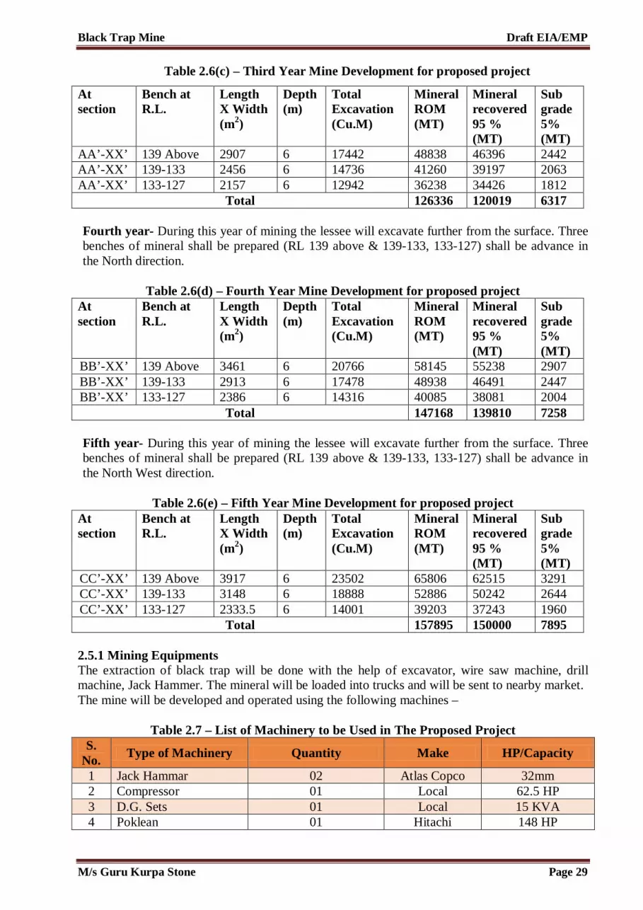
Black Trap Mine Draft EIA/EMP
Table 2.6(c) – Third Year Mine Development for proposed project
At section
Bench at R.L.
Length X Width (m2)
Depth (m)
Total Excavation (Cu.M)
Mineral ROM (MT)
Mineral recovered 95 % (MT)
Sub grade 5% (MT)
AA’-XX’ 139 Above 2907 6 17442 48838 46396 2442 AA’-XX’ 139-133 2456 6 14736 41260 39197 2063 AA’-XX’ 133-127 2157 6 12942 36238 34426 1812
Total 126336 120019 6317 Fourth year- During this year of mining the lessee will excavate further from the surface. Three benches of mineral shall be prepared (RL 139 above & 139-133, 133-127) shall be advance in the North direction.
Table 2.6(d) – Fourth Year Mine Development for proposed project At section
Bench at R.L.
Length X Width (m2)
Depth (m)
Total Excavation (Cu.M)
Mineral ROM (MT)
Mineral recovered 95 % (MT)
Sub grade 5% (MT)
BB’-XX’ 139 Above 3461 6 20766 58145 55238 2907 BB’-XX’ 139-133 2913 6 17478 48938 46491 2447 BB’-XX’ 133-127 2386 6 14316 40085 38081 2004
Total 147168 139810 7258 Fifth year- During this year of mining the lessee will excavate further from the surface. Three benches of mineral shall be prepared (RL 139 above & 139-133, 133-127) shall be advance in the North West direction.
Table 2.6(e) – Fifth Year Mine Development for proposed project At section
Bench at R.L.
Length X Width (m2)
Depth (m)
Total Excavation (Cu.M)
Mineral ROM (MT)
Mineral recovered 95 % (MT)
Sub grade 5% (MT)
CC’-XX’ 139 Above 3917 6 23502 65806 62515 3291 CC’-XX’ 139-133 3148 6 18888 52886 50242 2644 CC’-XX’ 133-127 2333.5 6 14001 39203 37243 1960
Total 157895 150000 7895 2.5.1 Mining Equipments The extraction of black trap will be done with the help of excavator, wire saw machine, drill machine, Jack Hammer. The mineral will be loaded into trucks and will be sent to nearby market. The mine will be developed and operated using the following machines –
Table 2.7 – List of Machinery to be Used in The Proposed Project S.
No. Type of Machinery Quantity Make HP/Capacity
1 Jack Hammar 02 Atlas Copco 32mm 2 Compressor 01 Local 62.5 HP 3 D.G. Sets 01 Local 15 KVA 4 Poklean 01 Hitachi 148 HP
M/s Guru Kurpa Stone Page 29

Black Trap Mine Draft EIA/EMP
5 Dumper 02 Ashok Leyland 75 HP 6 Water Tanker 01 Ford 5000 Litre 7 Water Pump 01 Local 25 HP
(Source – Approved Mine Plan)
Similar machinery will be used for the mines in cluster. 2.5.2 Reclamation and Rehabilitation of mined out area The depth persistence of the deposit may likely to be continued for little downward, it is proposed not to backfill the mine pit during mining period. Plantation will be done in the statutory boundary and in the proposed land. Precautionary measures will be taken for plantation by means of fencing and regular watering to protect from grazing animals and nurture. At the end of the mining lease period, as per MOEF&CC Office Memorandum F. No. 22-34/2018-IA-III dated 16 January, 2020, "the mining lease holder shall, after ceasing mining operations, undertake re-grassing the mining area and any other area which may have been disturbed due to their mining activities and restore the land to a condition which is fit for growth of fodder, flora, fauna etc"
No Rehabilitation and Resettlement of project affected people involves. 2.5.3 Geology 2.5.3.1 Regional Geology The basement rocks of Aravalli are Archaean- Prechampaner Gneissic Complex and Prelunayada Gnesissic Complex (equivalent to BGC of Rajasthan); Palaeo to Meso-Proterozoic Aravalli and Delhi Subgroups. The Proterozoic ggroup is overlain by the Himmatnagar sandstone of of cretaceous. The basalt dominated ‘Deccan Trap’ with restricted acid and intermediate volcanics of Cretaceousto- Eocene System:-
Table 2.8-Regional tectono stratigraphic – succession Group System Rock Type
Quaternary Recent Alluvium, Fluvial Sand Mesozoic Cretaceous-Eocene Deccan traps with inter trappeans
Cretaceous Himmatnagar sand-stones Proterozoic Meso- Proterozoic Delhi System-Alwar
Quartzites, schist and Calc-gneisses, calc-schist of Ajabgarh
Palaeo- Proterozoic Aravali System-Mica-schist, Phyllites, quartzites etc.
Archaean or Azoic
Prechampamer Gneissic Complex and Prelunvada Gneissic Complex
(Source – Approved Mine Plan) 2.5.3.2 Local Geology
Table 2.9-Local tectono stratigraphic – succession Group System Rock Type Mesozoic Cretaceous Eocene Deccan traps with inter trappeans
(Source – Approved Mine Plan)
M/s Guru Kurpa Stone Page 30

Black Trap Mine Draft EIA/EMP
2.5.3.3 Land Use Pattern of the Cluster Since open-cast method has been adopted for cluster mining, studies of land use and terrain information is required for environment study. The main objective of land baseline data is to take remedial measures for any change in land use due to proposed cluster project. In this section both core and buffer zone areas have been considered for land use present baseline.
Table 2.10: Land Use Pattern
S. No. Head Present Land Use (Ha)
1 Area to be excavated --
2 Storage for top soil --
3 Waste dump --
4 Mineral stack --
5 Infrastructure (workshop, administrative building etc.)
--
6 Road --
7 Railways --
8 Tailing Pond --
9 Effluent Treatment Plant --
10 Mineral separation plant --
11 Township area --
12 Green Belt --
13. Undistrubed land 18.05.48
Grand Total 18.05.48
2.5.4 Physiography & Drainage Pattern 2.5.4.1 Physiography Topographically, the quarry lease area comprises flat land. The cluster area falls on the survey of India toposheet No. F43B08. The lease area is situated between Latitudes 23°10’58.71”N to 23°11’08.24”N and Longitudes 73°19’17.01”E to 73°19’24.08”E. The lease area is a part of Private land with high topography sloping towards north direction. There is no village or human settlement in the area.. There is no forest land in the lease area. Drainage Pattern The minimum depth of water table is 30 m from the surface and maximum depth of water tavle is 35 m from the surface. The general drainage of the area is South West. The water table is mainly recharged by rain water. The average rainfall in the area is very low and is hardly 500-550mm. The main seasons
M/s Guru Kurpa Stone Page 31

Black Trap Mine Draft EIA/EMP
prevailing in the district are (a) monsoon – mid of June to October, (b) winter – November to February and (c) Summer – March to June. The area experencies wide temperature variation of as high as 400C TO 420C in summer and 100C to 150C.
M/s Guru Kurpa Stone Page 32

Black Trap Mine Draft EIA/EMP
Fig. 2.5– Land Use Map
M/s Guru Kurpa Stone Page 33

Black Trap Mine Draft EIA/EMP
Fig. 2.6– Drainage Map
M/s Guru Kurpa Stone Page 34

Black Trap Mine Draft EIA/EMP
2.5.5 Climate & Vegetation 2.5.5.1 Climate The district is located in east of Gujarat,comes under heavy rainfall areas in Gujarat, having sub-tropical climate with moderately low humidity. The main seasons prevailing in the district are (a) monsoon - mid of June to October, (b) winter - November to February, and (c) summer – March to June. The maximum daily temperature during the year ranges from 31.0 °C in January to 48.5 °C in May while minimum temperature ranges from 11.5 °C in January to 27.5°C in May. Maximum humidity ranges from 81.0% to 25.5%. The wind speed ranges from 88.0 to 184.9 km/day, where as evapo - transpiration ranges from 3.5 to 7.8 mm/day Vegetation Scattered vegetation, mostly bushes and trees are present in the surrounding lease area. The area is mostly comprising of Neem, Khair, Sag etc. The area does not have any forestland. 2.7.6 Overburden/Waste Management Scree is lying over the mineral. During mineral excavate intermix sub grade mineral shall also gengerate. This will be used as sub grade mineral. Waste shall not generate during plan period. No dumping site is proposed. It is also proposed to stack the sub garde. The sub grade generated shall be collected in the sub garde stack yard and shall be then mixed with high grade mineral or may be used for filling & other works in various industries.
Table 2.11: Sub grade Mineral Year I II III IV V
Sub garde in MT 5303 5801 6317 7358 7895 Sub grade in M3 1894 2072 2256 2628 2820
Swell Volume (m3) 22773 2486 2707 3153 3384 Total Area (m2) 455 497 541 631 677
Average height in m 5 5 5 5 5 (Source: Approved Mine Plan) 2.7.7 Beneficiation/ Processing No processing /beneficiation is proposed for the cluster mining. The mined out mineral will be sold in the nearby market. 2.7.8 Employment Generation/Manpower Requirement The total manpower requirement for this cluster mining project is about 200 persons. Preference for employment will be given to locals. The project will also generate indirect employment opportunities for the locals. The employment potential manpower requirement for the proposed cluster mining project is shown below.
Table 2.12: Manpower Requirement for Cluster
S. No. Requirement Numbers
1 Geologist/Mining Engineer 1
M/s Guru Kurpa Stone Page 35

Black Trap Mine Draft EIA/EMP
2 Mine mates/ Mines Foreman 1
3 Watchman 1
4 Skilled Labours/operators 30
5 Unskilled Labours 5
Total 38
2.7.9 Water Requirement The water requirement at the cluster mine site is basically for the drinking & domestic uses, dust suppression and for the proposed plantation. The total water requirement for the proposed cluster is 28 KLD (considering average 4.0 KLD per lease).
The water requirement at the proposed project is for the drinking & domestic use, dust suppression and for the proposed plantation. The total water requirement for the proposed project is 4.0 KLD. Water requirement will be fulfilled by procuring it from nearby village and transported through mobile water tankers.
Table 2.13 – Water Requirement for Proposed Project
S. No. Purpose Quantity (KLD)
1 Drinking & Domestic Purposes 1.0 2 Dust Suppression 2.0 3 Plantation 1.0
Total 4.0 KLD 2.7.10 Site Facility It is proposed to construct and provide site services as mine office cum rest shelter, first aid station, toilets. The drinking water is made available from the nearby water source. The regular use of these site services should be continued during next five years. The site services will be common between the adjoining leases in the area.
2.7.10.1 Power Supply The mines will work in one shift (i.e., general shift) day time only. Since, no mining activity will be carried out during night time, electricity supply is not required. 2.8 Post Mining Land Use Conceptualized As a part of eco restoration; it is proposed that plantation like Khair, Neem, Kashid, Shisham, Imli etc. will be carried out in the statutory boundary of the cluster area, and in the suitable areas after consultation with Gram Panchayat at the rate of 120 saplings/annum.during the proposed period of mining plan with interval 5 m in between. The rate of survival expected to be 70% in this mined out area will remain as a waste land as there will be hard rock exposures at the bottom of the pit, proposed waste dump area will be recovered by selling the waste material as rubble and subsequent plantation will be done in the area.
M/s Guru Kurpa Stone Page 36

Black Trap Mine Draft EIA/EMP
Precautionary measures will be taken for plantation by means of fencing and regular watering to protect from grazing animals and nurture. At the end of the mining lease period, as per MOEF&CC Office Memorandum F. No. 22-34/2018-IA-III dated 16 January, 2020, "the mining lease holder shall, after ceasing mining operations, undertake re-grassing the mining area and any other area which may have been disturbed due to their mining activities and restore the land to a condition which is fit for growth of fodder, flora, fauna etc"
********************
M/s Guru Kurpa Stone Page 37

CHAPTER-3 DESCRIPTION OF THE
ENVIRONMENT

Black Trap Mine Draft EIA/EMP
CHAPTER 3-DESCRIPTION OF ENVIRONMENT
3.1 General The baseline environment conditions are important factor to study in EIA study. Baseline environment provides us carrying capacity of environment, weather a proposed cluster project can be feasible or not. We can compare the predicted anticipated environmental impacts due to proposed cluster to the baseline study and can prepare mitigation plan to manage the harmful effects due to project. Thus baseline environment plays a decision tool to any project in EIA study. If the predicted environmental damage is more than the carrying capacity of present environment the project may not get approval from the Government of Gujarat. To study the baseline environment for the Black Trap mining project falling in cluster having area 03.50.00 Ha and cumulative area is 18.05.48 Ha, the study area has been separated in two zones, core zone and buffer zone. Core zone has been considered the area within cluster and buffer zone has been considered 10 km boundary from cluster. All the environmental aspects as per the ToR prescribed by SEIAA, Gujarat have been studied including ambient air quality, ambient noise quality, surface and ground water quality, soil quality, land use and ecological flora and fauna. Metrological primary and secondary data have also been collected to know the baseline temperature, humidity, wind speed, wind direction and predominant down wind direction. Primary data has been collected by National Accreditation Board for Testing and Calibration Laboratories accredited laboratory. All the laboratory reports are attached as Annexure V. 3.1.1 Laboratory Details Details of NABL accredited laboratory are presented in the table below –
Table 3.1 – Laboratory Details
S. No. Particulars Details
1 Name of the Laboratory
Gaheli Environmental Laboratory (A Unit of Gaheli Centre of Research And Development Pvt. Ltd.)
2 Address Circuit House Road, Near Parwani Orthopedic Hospital, Near Paradise Fountain Circle, Porbandar-360575, Gujarat
3 Accreditation Details
Certificate No. TC-7794
3.1.2 Methodology Base line attributes like ambient air, water, meteorology, noise, soil, ecology and biodiversity and socio economy condition were collected as per approved ToR. Secondary data was also collected from various government department as well as local people. Methodology adopted in this study is as follows – 1. Setting up meteorological station near project site; 2. Collection of ecological data at the mine site; 3. Installation of air monitoring dust samplers (for PM10, PM2.5 ) at 6 locations in the study area
for the collection of primary air pollutants; 4. Carrying out of a detailed biological study for the Core and Buffer Zone; 5. Collection of soil samples from 6 locations in the study area to analyze physical and chemical
characteristics of soil quality;
M/s Guru kurpa Stone Page 38

Black Trap Mine Draft EIA/EMP
6. Collection of surface samples from the Varansi Nadi and Dhamni Nadi. Ground water samples from 6 locations within the study area to analyse the existing water quality in the study area;
7. Noise measurement in core zone as well as buffer zone to analyze the existing situation in the study area.
8. Literature review that includes identification of relevant data and articles from various publications, various government agencies and other sources for socio-economy, demography has been done with primary data collection in 10 km of the study area;
9. Carrying out of field studies during the study period (Dec 2021 to Feb 2022) to establish the existing baseline conditions.
3.2 Land Environment Since open-cast method has been adopted for cluster mining, studies of land use and terrain information is required for environment study. The main objective of land baseline data is to take remedial measures for any change in land use due to proposed cluster project. In this section both core and buffer zone areas have been considered for land use present baseline. 3.2.1 Land Use in Core Zone Present land uses within mine leases have been provided in approved mining plans. As per government record, the present land use of cluster is waste land. Total area of the cluster is 18.05.48 Ha. The present land use pattern as per approved mine plans have been provided in the table below. The land-use map of the same has been given in Figure 3.1.
Table 3.2: Cluster Land Use Pattern as per Approved Mining Plans
S. No. Head Present Land Use (Ha)
1 Area to be excavated --
2 Storage for top soil --
3 Waste dump --
4 Mineral stack --
5 Infrastructure (workshop, administrative building etc.)
--
6 Road --
7 Railways --
8 Tailing Pond --
9 Effluent Treatment Plant --
10 Mineral separation plant --
11 Township area --
12 Area which will remains untouched --
13 Green Belt --
14. Non utilised land 18.05.48
Grand Total 18.05.48
M/s Guru kurpa Stone Page 39
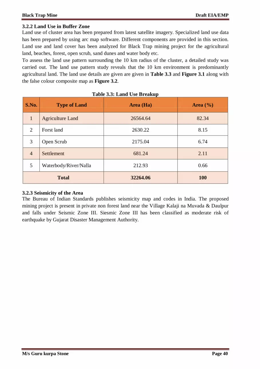
Black Trap Mine Draft EIA/EMP
3.2.2 Land Use in Buffer Zone Land use of cluster area has been prepared from latest satellite imagery. Specialized land use data has been prepared by using arc map software. Different components are provided in this section. Land use and land cover has been analyzed for Black Trap mining project for the agricultural land, beaches, forest, open scrub, sand dunes and water body etc. To assess the land use pattern surrounding the 10 km radius of the cluster, a detailed study was carried out. The land use pattern study reveals that the 10 km environment is predominantly agricultural land. The land use details are given are given in Table 3.3 and Figure 3.1 along with the false colour composite map as Figure 3.2.
Table 3.3: Land Use Breakup
S.No. Type of Land Area (Ha) Area (%)
1 Agriculture Land 26564.64 82.34
2 Forst land 2630.22 8.15
3 Open Scrub 2175.04 6.74
4 Settlement 681.24 2.11
5 Waterbody/River/Nalla 212.93 0.66
Total 32264.06 100
3.2.3 Seismicity of the Area The Bureau of Indian Standards publishes seismicity map and codes in India. The proposed mining project is present in private non forest land near the Village Kalaji na Muvada & Daulpur and falls under Seismic Zone III. Siesmic Zone III has been classified as moderate risk of earthquake by Gujarat Disaster Management Authority.
M/s Guru kurpa Stone Page 40

Black Trap Mine Draft EIA/EMP
Figure 3.1: Land Use Map
M/s Guru kurpa Stone Page 41

Black Trap Mine Draft EIA/EMP
Figure 3.2: False Colour Composite Map
M/s Guru kurpa Stone Page 42

Black Trap Mine Draft EIA/EMP
Figure 3.3: Sesimic Zone Map
M/s Guru kurpa Stone Page 43

Black Trap Mine Draft EIA/EMP
3.2.4 Major Environmental Features in Study Area There is no wild life sanctuary and national park within cluster study area. The main environmental features are surface water bodies of Varansi Nadi and Dhamni Nadi which is also a home shelter for many flora and fauna. There is no tiger and elephant corridor in study area. No archaeological site is notified by ASI present in study area. The nearest village is Daulpura which is 0.488 km away from project site. 3.3 Soil Characteristics The soil can be defined upper horizon of soil layers. Soil serves a natural medium to plant growth. Soil physical and chemical parameter has been analyzed at 06 locations including near project. Site. Secondary data of soil has also been collected to know the different soil types present in Gujarat. Map showing the different soil types in Gujarat is presented in the figure 3.4. 3.3.1 Soil Types in Gujarat The state is having with a wide range of macro and microclimates, Physiography, landforms, geology and vegetation that have an influence on the genesis of soil. Soil systems have developed over many millions of years. The soil characteristics in a given area at a given point of time are a function of both natural influences and human activities. This section deals with the different types of soils found in Gujarat. 1. Black Soil It is the most dominant soil type of Gujarat. Three major variations recorded are as follows – i. Shallow Black Soils – Shallow black soils have been developed from the basaltic trap in
Saurashtra and the Deccan trap in extreme eastern part while the remaining strips in Chhotaudepur and Saurashtra districts have been developed from granite and gneiss parent material. The depth of soil ranges from a few cm to 30 cm. (Gujarat State Agricultural Marketing Board (GSAMB) 2007). Shallow black soils are light grey in colour and mainly sandy clay loam in texture. The soil is poor in fertility.
ii. Medium Black Soils – Medium black soils have a basaltic trap parent material. Such soils in some parts of Sabarkantha and Panchmahals have been also developed from the granite and gneiss parent material. These soils vary in depth from 30 to 60 cm. They are calcareous in nature except in the Panchmahals and Sabarkantha districts. A layer of murum (unconsolidated material of decomposed trap and limestone) is found below a depth of about 40 cm, especially in the Saurashtra region (GSAMB 2007). The soils are silt loam to clay in texture and neutral to alkaline in reaction. These soils are adequately supplied with potassium and poorly supplied with phosphorous and nitrogen.
iii. Deep Black Soils – The districts of Bharuch, Surat, Valsad and southern part of Vadodara,
and the Bhal region have deep black soils. Similarly, in the Ghed tract of Junagadh districts mostly covering the talukas of Porbandar, Kutiyana, and Manavadar and part of the Mangrol taluka, the deep black soils have been formed due to the deposition of basaltic trap materials transported by the rivers Bhadar, Minsar, Osat Madhuvanti etc. They have faced the problem of salinity and alkalinity. They are also impregnated with a fairly high amount of free lime. The soils are dark brown to very dark greyish brown in colour. They contain 40 to 70 percent clay minerals. The deep black soils, in general, are clay-like in texture, poor in drainage, and neutral to alkaline in reaction. These soils are most fertile soil in Black soils.
M/s Guru kurpa Stone Page 44

Black Trap Mine Draft EIA/EMP
Figure 3.4: Soil Map of Gujarat
M/s Guru kurpa Stone Page 45
Black Trap Mine Draft EIA/EMP
2. Mixed Red and Black Soils The mixed red and black soils are shallow in depth with reddish brown colour at higher and greyish brown colour at lower elevations. Texturally, they are clay loam to clay and skeletal in nature, with stony material as high as 50 percent in subsurface layer. This provides an ideal drainage conditions for these soils. The soils are highly calcareous in nature and alkaline in reaction. The soils are low in available nitrogen, medium in phosphorus, and high in potassium (GSAMB 2007). 3. Laterite Soil True Laterites in the real sense of the term don't occur in Gujarat. However, in the Dangs district, which has an abundant forest vegetation and high annual precipitation of about 250 cm, lateritic soils have developed. They support good forests. Clayey in texture they become hard within hours of receiving irrigation and rainfall. 4. Alluvial Soils These soils are very deep. These soils are further divided into alluvial sandy to sandy loam soils, alluvial sandy loam to sandy clay loam, and coastal alluvial soil. 5. Alluvial Sandy to Sandy Loam Soils These soils cover all the northern districts, namely, Banaskantha and Mehsana except the southern part and the area of Sabarkantha bordering the Kheralu and Vijapur talukas of Mehsana district. The original alluvial material in Banaskantha and some parts of the Mehsana district has been overlaid by sandy material brought in by the winds blowing through the desert of Kutch. From a fertility point of view, these soils are low in available nutrients. 6. Alluvial Sandy Loam to Sandy Clay Loam Alluvial sandy loam to sandy clay soils are found in the Kheda, Gandhinagar, Ahmadabad and Mehsana district and the western part of the Vadodara district. These soils are the most productive soils in the state and contains fairly good amount of potassium. 7. Coastal Alluvial Soils The coastal alluvial soils are sandy clay loam to clay in texture. The fertility of this type of soil is of medium class. 8. Hill Soils This type of soil occurs in the hilly areas and eastern strip of the mainland Gujarat. The soil profile is not well developed due to steep slope and erosion. Soil is shallow in depth formed by undecomposed rock and poor in fertility. Hill soils have been developed from parent materials existing in the respective areas. Shallow and composed of undecomposed rock fragments, they are poor in fertility. 9. Desert Soils Desert soil is generally found in the little and greater desert of Kutch. The soil is deep and light grey in colour with no definite structure. It is sandy to sandy loam with silt clay loam in structure. This type of salt has high salt content and sufficient amount of gypsum in the soil profile. 3.3.2 Methodology of Soil Data Generation The composite soil samples were collected from all receptor sites and the study area analyzed for characterization. The locations of the monitoring sites are depicted in the table 3.4 and figure 3.5 below showing soil sample collection points marked within the study area of the cluster.The sample was collected by driving an auger into the soil up to the depth of 90 cm. The present study
M/s Guru kurpa Stone Page 46

Black Trap Mine Draft EIA/EMP
on the soil quality establishes the baseline characteristics and identifies the incremental concentrations if any, due to the proposed project. The objective of the sampling are: 1. To determine the baseline soil characteristics of the study area; 2. To determine the impact of proposed activity on soil characteristics and; 3. To determine the impact on soil more importantly agriculture production point of view. The soil sample is collected from three different depths viz. 30cm, 60cm and 90cm. The sample was then packed in polythene plastic bags and sealed. The sample from three different depths is homogenized and is then analyzed. The soil samples were collected in the month of March 2019. Soil samples were collected from 06 locations. The samples were filled in polythene bags, labeled in the field with number and site name and sent to laboratory for analysis. The test results and maps for soil sampling locations are provided below.
Table 3.4 – Soil Sample Collection Points in cluster 3.3.2.1 Soil Monitoring Results
Soil quality has been analyzed as per Indian standards prescribed by government. Soil samples have been taken from 06 locations. Soil quality analysis result is presented in the table 3.5. 3.3.2.2 Soil Analysis Physical characteristics of soil were characterized through specific parameters viz bulk density, porosity, water holding capacity, pH, electrical conductivity and texture. Soil pH plays an important role in the availability of nutrients. Soil microbial activity as well as solubility of metal ions is also dependent on pH. In the study area, variations in the pH of the soil were found to be slightly acidic to slightly basic (7.21 to 7.6). Electrical conductivity is a measure of the soluble salts and ionic activity in the soil. In the collected soil samples, the conductivity ranged from 591– 822 µmhos/cm. The soils with low bulk density have favorable physical condition where as those with high bulk density exhibit poor physical conditions for agriculture crops.
Station Code
Monitoring Locations
Distance from mine lease (Km)
Direction from mine
lease Longitude Latitude
SQ 1 Near Mine Site
0.515 NW 73° 19' 1.321" E 23° 11' 15.398" N
SQ 2 Jitpur 3.423 NE 73° 20' 43.052" E 23° 12' 32.218" N SQ 3 Lakshmipur
a 1.346 North 73° 19' 13.194" E 23° 11' 50.648" N
SQ 4 Talod 5.222 SW 73° 16' 45.595" E 23° 9' 28.820" N SQ 5 Vijaygan 3.940 SW 73° 18' 11.356" E 23° 9' 8.346" N SQ 6 Kharod 4.014 East 73° 21' 45.227" E 23° 10' 58.363" N
M/s Guru kurpa Stone Page 47

Black Trap Mine Draft EIA/EMP
Figure 3.5: Soil Monitoring Locations
M/s Guru kurpa Stone Page 48
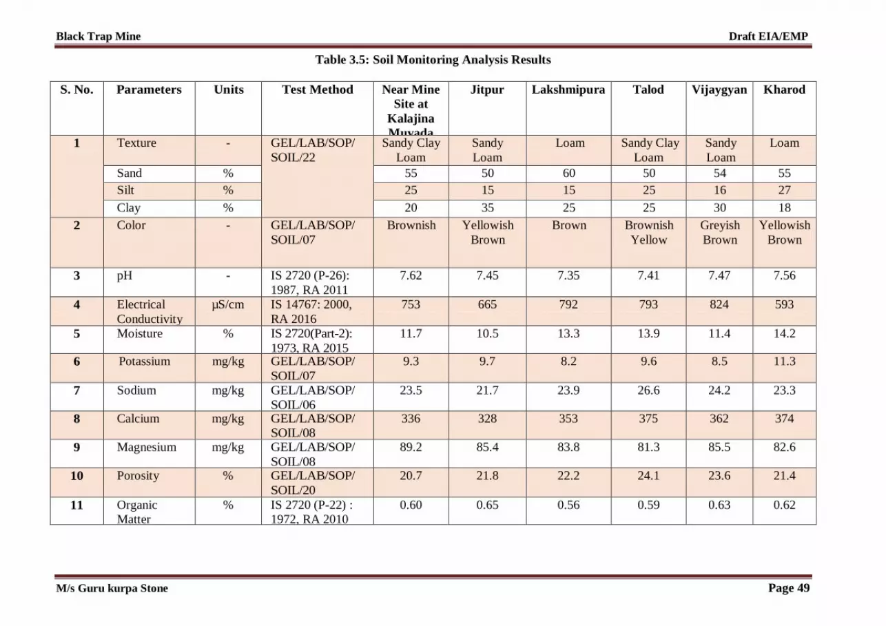
Black Trap Mine Draft EIA/EMP
Table 3.5: Soil Monitoring Analysis Results S. No. Parameters Units Test Method Near Mine
Site at Kalajina Muvada
Jitpur Lakshmipura Talod Vijaygyan Kharod
1 Texture - GEL/LAB/SOP/ SOIL/22
Sandy Clay Loam
Sandy Loam
Loam Sandy Clay Loam
Sandy Loam
Loam
Sand % 55 50 60 50 54 55 Silt % 25 15 15 25 16 27
Clay % 20 35 25 25 30 18
2 Color - GEL/LAB/SOP/ SOIL/07
Brownish Yellowish Brown
Brown Brownish Yellow
Greyish Brown
Yellowish Brown
3 pH - IS 2720 (P-26): 1987, RA 2011
7.62 7.45 7.35 7.41 7.47 7.56
4 Electrical Conductivity
µS/cm IS 14767: 2000, RA 2016
753 665 792 793 824 593
5 Moisture % IS 2720(Part-2): 1973, RA 2015
11.7 10.5 13.3 13.9 11.4 14.2
6 Potassium mg/kg GEL/LAB/SOP/ SOIL/07
9.3 9.7 8.2 9.6 8.5 11.3
7 Sodium mg/kg GEL/LAB/SOP/ SOIL/06
23.5 21.7 23.9 26.6 24.2 23.3
8 Calcium mg/kg GEL/LAB/SOP/ SOIL/08
336 328 353 375 362 374
9 Magnesium mg/kg GEL/LAB/SOP/ SOIL/08
89.2 85.4 83.8 81.3 85.5 82.6
10 Porosity % GEL/LAB/SOP/ SOIL/20
20.7 21.8 22.2 24.1 23.6 21.4
11 Organic Matter
% IS 2720 (P-22) : 1972, RA 2010
0.60 0.65 0.56 0.59 0.63 0.62
M/s Guru kurpa Stone Page 49

Black Trap Mine Draft EIA/EMP
12 Phosphorous mg/kg GEL/LAB/SOP/ SOIL/10
8.7 7.8 7.4 8.2 7.3 8.5
13 Nitrogen mg/kg GEL/LAB/SOP/ SOIL/09
121 114 137 140 129 142
14 Chloride mg/kg GEL/LAB/SOP/ SOIL/14
78 71 74 73 81 75
15 Bulk Density
gm/cc IS 2720 (P-28) : 1974, RA 2010
1.40 1.38 1.41 1.40 1.41 1.42
M/s Guru kurpa Stone Page 50

Black Trap Mine Draft EIA/EMP
3.4 Water Environment To analyse the surface and ground water quality of study area, sampling was carried out by NABL accredited laboratory (Gaheli Environmental Laboratory) for primary data. Secondary was collected from CGWB district brochure of Panchmahals. The depth of dug wells range from 6-20 m. Sampling of surface and ground water was collected as per IS 3025 Part I. Water quality assessment is one of the essential components of EIA study. Such assessment helps in evaluating the existing health of water body and suggesting appropriate mitigation measures to minimize the potential impact from development projects. Black Trap Mining Project is expected not have any anticipated impact on surface and ground water quality as per approved mining plans. 3.4.1 Water Monitoring Sampling Locations Ground water and Surface have been collected from the cluster study area. The water sampling locations are provided in the following table 3.6 and figures 3.6 and 3.7.
Table 3.6 – Water Sampling Locations
3.4.2 Surface and Ground Water Quality 3.4.2.1 Surface Water Monitoring Sampling of surface water was conducted as per Indian Standards. Surface water quality was analyzed from the Varansi Nadi and Dhamni Nadi near the cluster. Surface water analyzed results are given in table 3.7. All the parameters have been analyzed by IS 3025: Part 4 to Part 62. Details of the methods are also provided in attached laboratory reports as Annexure V.
Ground Water
Station Code
Monitoring Locations
Distance from
mine lease (Km)
Direction from mine
lease Longitude Latitude
GW 1 Near Mine Site
0.721 NW 73° 18' 55.564" E 23° 11' 19.578" N
GW 2 Jitpur 3.522 NE 73° 20' 48.397" E 23° 12' 32.064" N GW 3 Lakshmipura 1.195 North 73° 19' 13.451" E 23° 11' 45.765" N GW 4 Talod 5.104 SW 73° 16' 46.194" E 23° 9' 35.330" N GW 5 Vijaygan 3.799 SW 73° 18' 21.549" E 23° 9' 8.474" N GW 6 Kharod 4.059 East 73° 21' 46.804" E 23° 11' 3.913" N
Surface Water SW 1 Varansi
Nadi 9.341 NW 73° 14' 6.079" E 23° 12' 45.020" N
SW 2 Dhamni Nadi
2.103 SE 73° 19' 54.996" E 23° 9' 56.958" N
M/s Guru kurpa Stone Page 51

Black Trap Mine Draft EIA/EMP
Figure 3.6: Ground Water Monitoring Locations
M/s Guru kurpa Stone Page 52

Black Trap Mine Draft EIA/EMP
Figure 3.7: Surface Water Monitoring Locations
M/s Guru kurpa Stone Page 53

Black Trap Mine Draft EIA/EMP
Table 3.7: Surface Water Physiological & Microbiological results
S. No. Parameter Units Limits as per
IS:2296/Class C Test Method Varansi Nadi
Dhamni Nadi
1 Turbidity NTU 5 IS: 3025(Pt-10) 1984, RA 2017
5 4
2 pH Value - 6.9 – 9.0 IS : 3025 (Pt-11) 1983, RA 2017
7.62 7.74
3 Conductivity µmohs/
cm -
IS : 3025 (Pt-14) 1984, RA 2013
253 276
4 Alkalinity (as CaCO3)
mg/l 200 IS : 3025 (Pt-23) 1986, RA 2014
176 183
5 Total Hardness (as CaCO3)
mg/l 300 IS : 3025 (Pt-21)1983, RA 2014
275 291
6 Calcium (as Ca2+)
mg/l 75 IS : 3025 (Pt-40)1991, RA 2014
72 75
7 Magnesium (as Mg2+)
mg/l 30 IS : 3025 (Pt-21) 20.3 24.7
8 Chlorides (as Cl)
mg/l 600 IS : 3025 (Pt-32)1988, RA 2014
92 96
9 Fluoride (as F )
mg/l 1.5 4500F(D), APHA 23nd Ed. 2017
˂0.1 ˂0.1
10 Dissolved Oxygen
mg/l - IS : 3025 (Pt-38)1989, RA 2014
7.6 6.8
11 Nitrate mg/l 50 IS : 3025 (Pt-34)1988, RA 2003
4.3 5.9
12
Biological Oxygen Demand (BOD)
mg/l 30 IS : 3025 (Pt-44)1993, RA 2009
5 7
13
Chemical Oxygen Demand (COD)
mg/l - IS : 3025 (Pt-58)2006 21 23
14 Lead (Pb) mg/l 0.1 3110, APHA 23rd Ed. 2017
˂0.01 ˂0.01
15 Cadmium (Cd)
mg/l 0.01 3110, APHA 23rd Ed. 2017
˂0.01 ˂0.01
16 Copper (Cu) mg/l 1.5 3110, APHA 23rd Ed. 2017
˂0.05 ˂0.05
17 Zinc (Zn) mg/l 1.5 3110, APHA 23rd Ed. 2017
˂0.5 ˂0.5
18 Iron (Fe) mg/l 1 3110, APHA 23rd Ed. 2017
0.18 0.17
19 Total Suspended Solids (TSS)
mg/l - IS: 3025(Pt-17)1984, RA 2012
15 17
M/s Guru kurpa Stone Page 54

Black Trap Mine Draft EIA/EMP
20 Total Dissolved Solids (TDS)
mg/l 2000 IS: 3025(Pt-16)1984, RA 2017
619 638
21 Sodium (as Na)
mg/l -- IS: 3025(Pt-45)1993, RA 2014
˂5.0 ˂5.0
22 Potassium (as K)
mg/l -- IS: 3025(Pt-45)1993, RA 2014
˂5.0 ˂5.0
23 Sulphate (as SO4)
mg/l 400 IS: 3025(Pt-24)1986, RA 2014
37
42
24 Total Coliform*
MPN/100 ml
5000 IS : 1622, 1981, RA 2019
2567 2473
25 Fecal Coliform*
MPN/100 ml
- IS : 1622, 1981, RA 2019
141 166
For the sake of accuracy, two samples from the same location were collected. Two surface water samples were collected from Varansi Nadi and Dhamni Nadi for water quality. Inference: After analysis it was found that pH was 7.62 and 7.74 in the sample SW-1 and SW-2 respectively. Electrical conductivity was measured as 253 and 276 µmohs/cm in the sample SW-1 and SW-2 respectively. Total dissolved solid was found to be 619 and 638 mg/l in the sample SW-1 and SW-2 respectively. Dissolved oxygen was present at 7.6 and 6.8 mg/l in the sample SW-1 and SW-2 respectively. Magnesium was found to be 20.3 and 24.7 mg/l and Calcium was found 72 and 75 mg/l in the sample SW-1 and SW-2 respectively. 3.4.2.2 Ground Water Monitoring Ground water was analyzed as per specification IS 10500:2012. Ground water was collected from 6 locations and analysis results are attached as Annexure V. Ground water was collected as per IS 3025: Part 1 and standards prescribed by CPCB, New Delhi.
M/s Guru kurpa Stone Page 55

Black Trap Mine Draft EIA/EMP
Table 3.8: Ground Water Monitoring Analysis
S. No.
Parameters Units Limits (as per IS:10500-2012)
Test Method Near Mine Site at
Kalajina Muvada
Jitpur Lakshmipura Talod
Vijaygyan Kharod Desirable
Limit Permissible
Limit 1 Color Hazen 5 15 IS : 3025 (Pt-
4) 1983, RA 2017
<5 <5 <5 <5 <5 <5
2 Odour - Agreeable Agreeable IS : 3025 (Pt-5) 1983, RA 2017
Agreeable Agreeable Agreeable Agreeable Agreeable Agreeable
3 Turbidity NTU 1 5 IS: 3025 (Pt-10)-1984,RA 2017
<1 <1 <1 <1 <1 <1
4 pH Value - 6.5-8.5 No Relaxation
IS : 3025 (Pt-11)1983, RA 2017
7.71 7.65 6.96 7.72 7.67 7.54
5 Total Hardness (as CaCO3)
mg/l 200 600 IS : 3025 (Pt-21)1983, RA 2014
214 233 206 211 225 217
6 Calcium (as Ca2+)
mg/l 75 200 IS : 3025 (Pt-40)1991, RA 2014
43.5 46.1 40.7 43.8 46.3 41.7
7 Magnesium (as Mg2+)
mg/l 30 100 IS : 3025 (Pt-21)
24.7 27.6 25.9 25.42 27.67 26.71
8 Iron (as Fe) mg/l 0.3 No Relaxation
3110 APHA 23nd Ed. 2017
<0.01 <0.01 <0.01 <0.01 <0.01 <0.01
9 Chlorides (as Cl)
mg/l 250 1000 IS : 3025 (Pt-32)1988, RA 2014
68.2 85.3 56.8 67.5 85.8 58.3
10 Fluoride (as F ) mg/l 1 1.5 4500F(D), APHA 23nd Ed. 2017
0.18
0.21 0.24 0.16
0.22
0.25
11 Total Dissolved mg/l 500 2000 IS: 3025(Pt- 875 713 687 874 716 682
M/s Guru kurpa Stone Page 56

Black Trap Mine Draft EIA/EMP
Solids (TDS) 16)1984, RA 2017
12 Copper (as Cu) mg/l 0.05 1.5 3110 APHA 23nd Ed. 2017
<0.01 <0.01 <0.01 <0.01 <0.01 <0.01
13 Manganese(as Mn)
mg/l 0.1 0.3 3110 APHA 23nd Ed. 2017
<0.01 <0.02 <0.02 <0.01 <0.02 <0.02
14 Sulphate (as SO4)
mg/l 200 400 IS : 3025(Pt-24)1986, RA 2014
19.52 19.26 11.53 19.43 20.36 15.28
15 Nitrate(as NO3) mg/l 45 No Relaxation
IS : 3025(Pt-34)1988, RA 2014
1.84 1.56 2.33 1.82 1.58 1.72
16 Cadmium (as Cd)
mg/l 0.003 No Relaxation
3110 APHA 23nd Ed. 2017
<0.001 <0.001 <0.001 <0.001 <0.001 <0.001
17 Lead (as Pb) mg/l 0.01 No Relaxation
31110 APHA 23nd Ed. 2017
<0.01 <0.01 <0.01 <0.01 <0.01 <0.01
18 Zinc (as Zn) mg/l 5 15 3110 APHA 23nd Ed. 2017
<0.05 <0.05 <0.05 <0.05 <0.05 <0.05
19 Chromium (as Cr6+)
mg/l 0.05 No Relaxation
3110 APHA 23nd Ed. 2017
<0.02 <0.02 <0.02 <0.02 <0.02 <0.02
20 Alkalinity (as CaCO3)
mg/l 200 600 IS: 3025(Pt-23)1986, RA 2014
423 322 256 425 327 258
21 Aluminum (as Al)
mg/l 0.03 0.2 3110 APHA 23nd Ed. 2017
<0.02 <0.02 <0.02 <0.02 <0.02 <0.02
22 Boron (as B) mg/l 0.5 1 IS: 3025(Pt-57)
<0.1 <0.1 <0.1 <0.1 <0.1 <0.1
23 Phenolic Compounds
mg/l 0.001 0.002 IS : 3025(Pt-43)1992, RA
<0.001 <0.001 <0.001 <0.001 <0.001 <0.001
M/s Guru kurpa Stone Page 57

Black Trap Mine Draft EIA/EMP
2014 24 Mercury mg/l 0.001 No
Relaxation 3114 APHA 23nd Ed. 2017
<0.001 <0.001 <0.001 <0.001 <0.001 <0.001
25 Arsenic (as As) mg/l 0.01 0.05 3114 APHA 23nd Ed. 2017
<0.01 <0.01 <0.01 <0.01 <0.01 <0.01
26 Cyanide mg/l 0.05 No Relaxation
IS : 3025(Pt-27)1986, RA 2014
<0.01 <0.01 <0.01 <0.01 <0.01 <0.01
27 Anionic Detergents
mg/l 0.2 1 IS : 13428, 2005, RA 2014
<0.1 <0.1 <0.1 <0.1 <0.1 <0.1
28 Mineral Oil mg/l 0.5 No Relaxation
IS : 7299, 2017
<0.1 <0.1 <0.1 <0.1 <0.1 <0.1
M/s Guru kurpa Stone Page 58

Black Trap Mine Draft EIA/EMP
Inference: Fluoride is a common geo-genic (resulting from geological process) contamination of drinking water. The concentration of fluoride in ground water is principally governed by the climate, composition of hard rock and hydrogeology. Fluoride is released to ground water by the process of weathering of primary rocks. Maximum fluoride was found 0.25 mg/l at GW -6 and minimum concentration were found 0.16 at GW- 4. The excess amount of fluoride leads to fluorosis (Dental fluorosis and Skeleton fluorosis) for human being especially for children and pregnant women. This is a result of destruction of metabolic calcium and phosphorus. In general, general, North Gujarat is severely affected by fluoride and it affects teeth and bones of body. Sodium chloride is the main substance in chloride water. The natural water near the mine and sea coast has dissolved sodium chloride. Similarly, the presence of chloride may be due to the mixing of saline water and sewage/effluent in water. Chloride concentration more than 250 mg/l leads to corrosion in pipes and palatability. Chloride concentrations were found in the range of 56.8-85.8 mg/l in which maximum chloride concentration were observed at GW-5. The excess amount of chloride as per WHO guidelines may cause heart failure and hypertension. Nitrate is not so harmful but it is dangerous for children causing Mathemoglobinemia. This should not be allowed in water especially for children. Nitrate is basically non toxic but when ingested with food or water, it will convert by bacterial action to nitrate and then to ammonia, which is toxic. Nitrate concentrations were found very less than permission limit in the range of 1.56 to 2.33 mg/l. Sulphate is not much dangerous but it leads to Diarrhea. The Mehsana district is not affected or less affected by sulphate. The sulphate concentration was found in the range of 11.53 to 20.36 mg/l. Calcium and Magnesium is the greatest portion of hardness occurring in natural water. Hardness of water is objectionable from view point of water use. Taste and appearance is affected by presence of Magnesium and damage the water supply structure due to the calcium precipitate. Calcium values were found in the range of 40.7 to 46.3 mg/l and magnesium values were found between 24.7 to 27.6 mg/l. The Total Dissolved Solid indicates the nature of water quality for salinity. The total dissolved solids is obtained by evaporating the water sample and weighing the residue. It leads to gastro intestinal irritation in human body if TDS is excess. Hardness is also important parameter which prevents the lathering of soap. Total hardness was found in the range of 206-233 mg/l. Alkalinity is the important parameter of water in which excess amount leads to unpleasant taste. The range was found between 256-425 mg/l. Turbidity is caused due to presence of suspended and colloidal matters in the water. Turbidity is the measure of resistance of water to the passages of light through it. Turbidity of the samples were found less than one as desired. 3.5 Air Environment 3.5.1 Meteorology The meteorological data was recorded from near project site. Secondary data was also collected from nearest IMD station, Ahmedabad, Gujarat. The meteorological data provides the climate information which help to find the predominant present downwind direction to predict the incremental pollution load due to project activity. Indian climate has been divided in to four major categories. The four major seasons and their duration are presented below – 1. Winter – December to February 2. Summer – March to June 3. Monsoon – July to September 4. Post Monsoon – October to December
M/s Guru kurpa Stone Page 59

Black Trap Mine Draft EIA/EMP
Primary site specific meteorological data was collected for post monsoon period; December 2021 to February 2022. 3.5.2 Secondary Data Secondary data was collected from nearest IMD station and Climatological table 1961-1990 was used for secondary data. Significant parameters are summarized in the table below –
Table 3.9: IMD Data from Ahmedabad (1961-1990)
Month
Temperature (°C)
Relative Humidity (%)
Rainfall (mm)
Cloud Oktas
Min Max 5:30 PM 8:30AM Monthly
Total 5:30 PM 8:30AM
January 3.3 36.1 59 32 1.8 0.1 0.2 February 2.2 40.6 53 25 1.1 0.2 0.2 March 9.4 43.9 49 20 1.0 0.1 0.3 April 12.8 46.2 54 20 2.7 0.2 0.4 May 19.1 47.8 65 23 15.1 1.4 0.7 June 19.4 47.2 74 45 98.7 3.2 2.7 July 20.4 42.2 85 67 262.3 3.8 3.9
August 21.2 40.4 87 71 239.6 3.9 3.8 September 17.2 41.7 82 58 108.9 2.1 2.5
October 12.6 42.8 64 37 16.2 0.4 0.6 November 8.3 38.9 55 35 11.5 0.2 0.4 December 3.6 35.6 60 35 3.8 0.1 0.2
3.5.3 Site Specific Meteorological Data Site specific meteorological data was collected by installing weather station near to cluster site. The study period for meteorological data was Dec 2021, January 2022 and February 2022. Brief summary of site specific data has been presented in the table below –
Table 3.10: Site Specific Meteorological Data
S. No.
Month and Year
Wind Speed (m/s) Temperature (°C) Relative Humidity
Min Avg Max Min Avg Max Min Avg Max
1 Dec 2021 0 1.97 8.99 14.0 21.50 29.0 34 47.0 60
2 January
2022 0 1.74 6.17 11.0 19.20 27.4 32 45.5 59
3 February
2022 0 1.84 6.53 16.0 23.20 30.4 24 39.0 54
Wind rose of project site has been presented in the following figure. From the wind rose it can be clearly observed North East is the predominant wind direction.
M/s Guru kurpa Stone Page 60
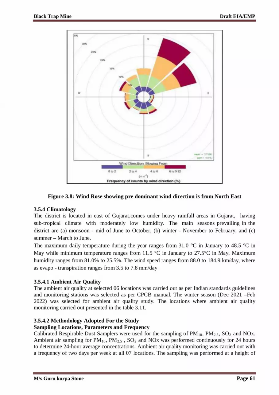
Black Trap Mine Draft EIA/EMP
Figure 3.8: Wind Rose showing pre dominant wind direction is from North East
3.5.4 Climatology The district is located in east of Gujarat,comes under heavy rainfall areas in Gujarat, having sub-tropical climate with moderately low humidity. The main seasons prevailing in the district are (a) monsoon - mid of June to October, (b) winter - November to February, and (c) summer – March to June. The maximum daily temperature during the year ranges from 31.0 °C in January to 48.5 °C in May while minimum temperature ranges from 11.5 °C in January to 27.5°C in May. Maximum humidity ranges from 81.0% to 25.5%. The wind speed ranges from 88.0 to 184.9 km/day, where as evapo - transpiration ranges from 3.5 to 7.8 mm/day 3.5.4.1 Ambient Air Quality The ambient air quality at selected 06 locations was carried out as per Indian standards guidelines and monitoring stations was selected as per CPCB manual. The winter season (Dec 2021 –Feb 2022) was selected for ambient air quality study. The locations where ambient air quality monitoring carried out presented in the table 3.11. 3.5.4.2 Methodology Adopted For the Study Sampling Locations, Parameters and Frequency Calibrated Respirable Dust Samplers were used for the sampling of PM10, PM2.5, SO2 and NOx. Ambient air sampling for PM10, PM2.5 , SO2 and NOx was performed continuously for 24 hours to determine 24-hour average concentrations. Ambient air quality monitoring was carried out with a frequency of two days per week at all 07 locations. The sampling was performed at a height of
M/s Guru kurpa Stone Page 61

Black Trap Mine Draft EIA/EMP
1.5 m (approximately) from the ground level. Standard methods specified under "National Ambient Air Quality Standards" notification G.S.R. 176(E) were adopted for sampling and analysis. 07 locations within the study area were scientifically selected and are based on the following considerations: 1. Meteorological conditions; 2. Topography of the study area; 3. The direction of the wind; 4. Representation of the region for establishing baseline status; and 5. Representation with respect to likely impact areas. The location of the monitoring stations with reference to the proposed cluster is given in the table and figure below.
Table 3.11 –Ambient Air Monitoring Stations
3.5.5 Air Quality Measurement Ambient air quality monitoring stations for proposed Mining Project was selected on the basis of nearest anticipated receptors with reference to the predominant wind direction. Samples were selected from the nearby villages and from the villages encountering in transportation route. Selected locations are with minimum two from upwind direction and one station on downwind direction. Four crosswind directions also selected to measure the incremental pollution load. Monitoring has been carried out by using calibrated instruments for five ambient air quality parameters. PM10, PM2.5, NO2, CO and SO2 were considered for study. Instrument was operated 1.5-3 m above ground surface to ignore any fugitive temporary emissions. Monitoring has been carried out as per standard operating procedure for 24 hourly particulate matter and gaseous samples were drown 8 hourly at 0.5 LPM. Samples were preserved below 4 °C to ensure no loss from the actual conditions. Respirable dust sampler was used for particulate matter sampling by using glass fibre filter of Whatman. Sulphur dioxide was sampled by scrubbing in Tetrachloromerchurate solution (Weast and Gaek method). NOx were measures by bubbling oxides of nitrogen in sodium hydroxide and sodium arsenate mixture (Jacob and Hochiser method). 3.5.5.1 Ambient Air Quality Monitoring Results Ambient air quality monitoring was conducted for three months winter season Dec 2021-Feb 2022. The samples collected are analyzed at NABL accredited laboratory and analysis results are given in Annexure V. Data has been complied for three months. Various parameters monitored during the study have been described by their maximum, minimum and average values from their study site locations. Interpretation has been done for entire data for five statistical parameters,
Station Code
Monitoring Locations
Distance from mine lease (Km)
Direction from mine
lease Longitude Latitude
AAQ 1 Near Mine Site
0.495 NW 73° 19' 1.718" E 23° 11' 15.693" N
AAQ 2 Jitpur 3.514 NE 73° 20' 48.214" E 23° 12' 31.896" N AAQ 3 Lakshmipura 1.336 North 73° 19' 14.880" E 23° 11' 50.439" N AAQ 4 Talod 5.205 SW 73° 16' 46.371" E 23° 9' 28.744" N AAQ 5 Vijaygan 3.915 SW 73° 18' 11.621" E 23° 9' 9.179" N AAQ 6 Kharod 3.985 East 73° 21' 44.200" E 23° 10' 57.811" N
M/s Guru kurpa Stone Page 62

Black Trap Mine Draft EIA/EMP
minimum, maximum, average and 98th percentile was computed location wise. Results of the same has been tabulated below:
M/s Guru kurpa Stone Page 63

Black Trap Mine Draft EIA/EMP
Figure 3.9: Ambient Air Quality Monitoring Locations
M/s Guru kurpa Stone Page 64

Black Trap Mine Draft EIA/EMP
Table 3.12: Ambient Air Quality Monitoring Results AAQ-1: Near Mine Site at Kalajina Muvada
Date PM2.5,µg/m3 PM10,µg/m3 SO2 µg/m3 , NO2 ,µg/m3 *CO, µg/m3
GEL/LAB/SOP/AIR /01
IS:5182:Pt-23 IS:5182:Pt-2 IS:5182:Pt-6 IS:5182:Pt-10
01.12.2021 34.5 80.4 5.9 14.5 734 04.12.2021 38.6 81.6 4.7 12.6 657 08.12.2021 38.2 79.5 4.3 15.8 776 11.12.2021 32.9 79.8 5.2 13.6 624 15.12.2021 34.7 85.4 5.2 18.5 755 18.12.2021 39.8 82.3 4.8 17.2 735 22.12.2021 37.8 74.5 4.8 14.6 780 25.12.2021 34.5 87.3 4.6 15.2 690 02.01.2022 36.5 75.4 3.9 12.4 770 07.01.2022 35.7 77.6 5.8 16.5 650 10.01.2022 38.6 80.6 4.3 17.5 730 14.01.2022 35.1 76.5 4.9 13.6 760 17.01.2022 33.9 84.4 5.7 19.7 755 21.01.2022 38.8 83.3 5.4 17.2 780 24.01.2022 35.6 82.4 6.1 19.8 770 28.01.2022 39.4 84.5 5.7 17.0 750 03.02.2022 37.9 79.8 5.6 16.1 680 06.02.2022 37.3 80.2 4.2 18.7 710 10.02.2022 38.1 81.8 6.4 16.4 780 13.02.2022 37.5 79.1 7.1 15.9 660 17.02.2022 36.7 82.5 4.2 19.7 670 20.02.2022 39.2 81.3 5.3 14.7 760 24.02.2022 37.8 82.2 6.2 19.4 690 27.02.2022 38.6 79.8 5.4 16.3 710
Min 32.9 74.5 3.9 12.4 624 Max 39.8 87.3 7.1 19.8 780 Average 36.35 80.9 5.5 16.1 702 98th %le 39.616 86.426 6.778 19.754 780 NAAQ Standards, EPA,1986
60 100 80 80 4000
Protocol GEL/LAB/SOP/AIR /01
IS 5182 (Part 23): 2006, RA
2017
IS 5182 (Part 2): 2001, RA
2017
IS 5182 (Part 6): 2006, RA
2017
IS 5182 (Part 10): 1999, RA 2014
AAQ-2: Jitpur Date PM2.5,µg/m3 PM10,µg/m3 SO2 µg/m3 , NO2 ,µg/m3 *CO, µg/m3 GEL/LAB/SOP/AIR
/01 IS:5182:Pt-23 IS:5182:Pt-2 IS:5182:Pt-6 IS:5182:Pt-10
02.12.2021 38.6 79.8 5.4 16.3 710
M/s Guru kurpa Stone Page 65

Black Trap Mine Draft EIA/EMP
05.12.2021 39.1 81.3 5.7 16.9 730 09.12.2021 39.1 80.4 6.8 15.8 690 12.12.2021 38.2 77.8 5.9 17.5 720 16.12.2021 37.7 83.6 7.5 16.8 730 19.12.2021 38.8 78.1 6.9 17.9 790 23.12.2021 38.8 83.3 5.4 17.2 780 26.12.2021 35.6 82.4 6.1 19.8 770 05.01.2022 39.4 84.5 5.7 17.0 750 08.01.2022 37.9 79.8 5.6 16.1 680 12.01.2022 37.0 78.2 4.2 18.7 710 15.01.2022 38.1 76.8 6.4 16.4 680 19.01.2022 34.6 75.1 5.4 14.5 695 22.01.2022 35.2 75.2 5.9 15.8 625 26.01.2022 36.1 72.2 5.2 17.6 640 29.01.2022 39.1 71.2 4.9 12.5 605 04.02.2022 32.6 76.4 5.4 17.4 694 07.02.2022 34.5 74.5 5.6 19.6 635 11.02.2022 35.4 77.6 4.5 17.5 654 14.02.2022 33.8 74.3 4.2 18.9 650 18.02.2022 37.6 74.8 5.7 15.4 625 21.02.2022 35.8 72.5 5.4 19.7 678 25.02.2022 38.4 75.6 4.1 13.4 629 28.02.2022 35.2 71.5 4.7 16.6 601 Min 32.6 71.2 4.1 12.5 601 Max 39.4 84.5 7.5 19.8 790 Average 36 77.85 5.8 16.15 695.5 98th %le 39.262 84.086 7.224 19.754 785.4 NAAQ Standards, EPA,1986
60 100 80 80 4000
Protocol GEL/LAB/SOP/AIR /01
IS 5182 (Part 23): 2006, RA
2017
IS 5182 (Part 2): 2001, RA
2017
IS 5182 (Part 6): 2006, RA
2017
IS 5182 (Part 10): 1999, RA 2014
AAQ-3: Lakshmipura Date PM2.5,µg/m3 PM10,µg/m3 SO2 µg/m3 , NO2 ,µg/m3 *CO, µg/m3 GEL/LAB/SOP/AIR
/01 IS:5182:Pt-23 IS:5182:Pt-2 IS:5182:Pt-6 IS:5182:Pt-10
03.12.2021 38.1 75.8 4.9 18.4 681 06.12.2021 31.9 74.9 4.7 15.4 659 10.12.2021 34.2 76.8 5.4 13.6 641 13.12.2021 35.2 69.8 4.6 17.5 710 17.12.2021 39.6 67.8 5.1 18.2 724 20.12.2021 31.2 69.8 4.2 16.4 634 24.12.2021 37.5 71.3 4.7 14.7 680
M/s Guru kurpa Stone Page 66

Black Trap Mine Draft EIA/EMP
27.12.2021 37.1 74.2 4.7 17.2 647 06.01.2022 38.2 68.1 5.7 18.8 626 09.01.2022 33.6 76.1 4.9 14.6 591 13.01.2022 38.7 76.6 4.4 13.7 683 16.01.2022 35.6 67.4 4.6 15.8 598 20.01.2022 39.7 67.9 4.2 16.4 623 23.01.2022 34.8 71.2 3.8 15.4 612 27.01.2022 34.9 76.5 5.4 16.7 610 30.01.2022 31.9 73.1 4.9 18.4 675 05.02.2022 37.4 75.2 5.8 14.2 615 08.02.2022 32.9 76.9 3.9 16.3 630 12.02.2022 37.5 76.7 4.5 14.8 635 15.02.2022 34.9 74.9 4.3 18.8 640 19.02.2022 34.2 79.6 4.6 14.9 630 22.02.2022 35.4 75.8 5.1 15.2 625 26.02.2022 39.6 76.3 4.6 19.9 645 29.02.2022 32.5 73.6 5.4 16.3 633 Min 31.2 67.4 3.8 13.6 591 Max 39.7 79.6 5.8 19.9 724 Average 35.45 73.5 4.8 16.75 657.5 98th %le 39.654 78.358 5.754 19.394 717.56 NAAQ Standards, EPA,1986
60 100 80 80 4000
Protocol GEL/LAB/SOP/AIR /01
IS 5182 (Part 23): 2006, RA
2017
IS 5182 (Part 2): 2001, RA
2017
IS 5182 (Part 6): 2006, RA
2017
IS 5182 (Part 10): 1999, RA 2014
AAQ-4: Talod Date PM2.5,µg/m3 PM10,µg/m3 SO2 µg/m3 , NO2 ,µg/m3 *CO, µg/m3 GEL/LAB/SOP/AIR
/01 IS:5182:Pt-23 IS:5182:Pt-2 IS:5182:Pt-6 IS:5182:Pt-10
01.12.2021 38.2 76.8 5.9 15.4 640 04.12.2021 36.5 68.1 4.8 13.5 639 08.12.2021 37.4 69.4 4.5 16.8 590 11.12.2021 35.2 69.8 4.6 17.5 710 15.12.2021 39.6 67.3 5.1 18.2 724 18.12.2021 31.2 69.6 4.2 16.4 634 22.12.2021 37.5 71.3 4.7 14.7 680 25.12.2021 37.4 74.6 3.7 16.9 634 05.01.2022 38.1 75.8 4.9 18.4 681 08.01.2022 31.9 74.9 4.7 15.4 659 12.01.2022 34.2 76.8 5.4 13.6 641 15.01.2022 35.6 67.4 4.6 15.8 598 19.01.2022 39.7 67.9 4.2 16.4 623
M/s Guru kurpa Stone Page 67

Black Trap Mine Draft EIA/EMP
22.01.2022 34.8 71.2 3.8 15.4 612 26.01.2022 36.4 65.8 5.2 14.2 682 29.01.2022 38.2 76.8 5.9 15.4 640 03.02.2022 36.5 68.1 4.8 13.5 639 06.02.2022 37.4 69.8 4.5 16.8 590 10.02.2022 34.2 79.6 4.6 14.9 630 13.02.2022 35.4 75.8 5.1 15.2 625 17.02.2022 39.6 76.3 4.6 19.9 645 20.02.2022 32.5 73.6 5.4 16.3 633 24.02.2022 37.5 79.1 7.1 15.9 660 27.02.2022 36.7 82.5 4.2 19.7 670 Min 31.2 65.8 3.7 13.5 590 Max 39.7 82.5 7.1 19.9 724 Average 35.45 74.15 5.4 16.7 657 98th %le 39.654 81.166 6.548 19.808 717.56 NAAQ Standards, EPA,1986
60 100 80 80 4000
Protocol GEL/LAB/SOP/AIR /01
IS 5182 (Part 23): 2006, RA
2017
IS 5182 (Part 2): 2001, RA
2017
IS 5182 (Part 6): 2006, RA
2017
IS 5182 (Part 10): 1999, RA 2014
AAQ-5: Vijyagyan Date PM2.5,µg/m3 PM10,µg/m3 SO2 µg/m3 , NO2 ,µg/m3 *CO, µg/m3 GEL/LAB/SOP/AIR
/01 IS:5182:Pt-23 IS:5182:Pt-2 IS:5182:Pt-6 IS:5182:Pt-10
02.12.2021 38.4 72.5 5.2 18.9 649 05.12.2021 36.5 75.8 5.3 15.2 630 09.12.2021 35.4 74.6 4.7 14.3 620 12.12.2021 38.7 74.5 4.9 12.3 655 16.12.2021 32.4 71.9 4.7 15.6 624 19.12.2021 31.6 74.8 4.8 14.8 670 23.12.2021 32.6 75.2 4.5 18.2 695 26.12.2021 34.5 69.8 5.7 15.7 674 06.01.2022 37.4 72.3 4.7 15.7 622 09.01.2022 34.2 71.4 4.8 16.4 642 13.01.2022 33.6 79.9 5.7 14.3 680 16.01.2022 35.2 76.5 5.9 15.2 630 20.01.2022 31.6 75.3 4.3 13.9 690 23.01.2022 35.4 73.8 4.6 14.8 672 27.01.2022 36.1 74.3 4.8 15.6 620 30.01.2022 37.9 75.6 5.4 13.5 634 04.02.2022 39.5 73.8 5 16.7 625 07.02.2022 35.4 72.8 4.9 17.2 645 11.02.2022 34.3 79 5.4 13.8 620
M/s Guru kurpa Stone Page 68

Black Trap Mine Draft EIA/EMP
14.02.2022 32.8 76.5 5.9 12.9 621 18.02.2022 35.3 72.4 5.4 11.7 694 21.02.2022 38 75.1 5 16.6 624 25.02.2022 32.5 72.4 5.2 13.6 620 28.02.2022 35.9 73.8 5.1 14.2 650 Min 31.6 69.8 4.3 11.7 620 Max 39.5 79.9 5.9 18.9 695 Average 35.55 74.85 5.1 15.3 657.5 98th %le 39.132 79.486 5.9 18.578 694.54 NAAQ Standards, EPA,1986
60 100 80 80 4000
Protocol GEL/LAB/SOP/AIR /01
IS 5182 (Part 23): 2006, RA
2017
IS 5182 (Part 2): 2001, RA
2017
IS 5182 (Part 6): 2006, RA
2017
IS 5182 (Part 10): 1999, RA 2014
AAQ-6: Kharod Date PM2.5,µg/m3 PM10,µg/m3 SO2 µg/m3 , NO2 ,µg/m3 *CO, µg/m3 GEL/LAB/SOP/AIR
/01 IS:5182:Pt-23 IS:5182:Pt-2 IS:5182:Pt-6 IS:5182:Pt-10
03.12.2021 34.5 72.8 5.7 15.8 672 06.12.2021 34.5 71.3 5.2 15.7 681 10.12.2021 35.2 75.9 4.1 17.6 650 13.12.2021 34.5 75.6 4.5 15.7 648 17.12.2021 35.6 72.4 6.9 15.7 635 20.12.2021 32.5 74.3 5.7 16.8 692 24.12.2021 34.9 76.5 5.4 16.7 610 27.12.2021 37.1 74.2 4.7 17.2 647 06.01.2022 38.2 68.1 5.7 18.8 626 09.01.2022 33.6 76.1 4.9 14.6 591 13.01.2022 38.7 76.6 4.4 13.7 683 16.01.2022 37.2 67.8 4.2 14.6 610 20.01.2022 36.5 72.6 4.4 16.4 620 23.01.2022 34.5 74.6 5.6 17.5 620 27.01.2022 38.9 68.2 5.2 16.3 640 30.01.2022 32.5 70.3 4.5 17.2 620 05.02.2022 36.1 73.4 4.7 14.5 610 08.02.2022 34.5 76.5 4.3 13.9 630 12.02.2022 38.7 72.4 4.1 15.8 720 15.02.2022 34.6 72.6 4.6 15.3 603 19.02.2022 36.8 73.5 5.3 14.6 612 22.02.2022 37.8 73.6 4.1 15.4 673 26.02.2022 32.5 75.8 4.9 14.6 658 29.02.2022 33.9 75.2 4.6 16.8 649 Min 32.5 67.8 4.1 13.7 591
M/s Guru kurpa Stone Page 69

Black Trap Mine Draft EIA/EMP
Max 38.9 76.6 6.9 18.8 720 Average 35.7 72.2 5.5 16.25 655.5 98th %le 38.808 76.554 6.348 18.248 707.12 NAAQ Standards, EPA,1986
60 100 80 80 4000
Protocol GEL/LAB/SOP/AIR /01
IS 5182 (Part 23): 2006, RA
2017
IS 5182 (Part 2): 2001, RA
2017
IS 5182 (Part 6): 2006, RA
2017
IS 5182 (Part 10): 1999, RA 2014
3.5.5.2 Ambient Air Quality Monitoring Inference All the measured parameters were found below the standards prescribed by CPCB, New Delhi. Suspended particulate matter in general terms is the particulate matter is suspension in ambient air. PM2.5 refers to particles with a diameter of less than 2.5 µm. These are usually called fine particles and contain secondary aerosols, combustion particles and re-condensed organic metallic vapour, and acid components. Fine particles can reach all the way down to the alveoli in the lungs. The minimum and maximum level of PM2.5 recorded within the study area was in the range of 31.2 µg/m3 to 39.8 µg/m3 with the 98th percentile ranging between 35.54 µg/m3 to 39.6 µg/m3. The 24 hourly average values of PM2.5 were compared with the NAAQS and found that all sampling stations recorded in the study area are within the applicable limits i.e., 60 µg/m3 for PM2.5 in rural areas. PM10 refers to particles with a diameter less than 10 microns. These are commonly called coarse particles - they contain dust from roads and industries as well as particles formed under combustion. Depending on their size, coarse particles can lodge in the trachea (upper throat) or in the bronchi. The minimum and maximum level of PM10 recorded within the study area was in the range of 65.8 to 87.3µg/m3 with the 98th percentile ranging between 74.15 µg/m3 to 86.42 µg/m3.The 24 hourly average values of PM10 were compared with the NAAQS and found that all sampling stations recorded in the study area are within the applicable limits i.e., 100 µg/m3 for PM10 in rural areas. Sulphur Dioxide (SO2) Sulphur Dioxide gas is an inorganic gaseous pollutant. Sulphur dioxide emissions are expected to be emitted wherever combustion of any fuel containing Sulphur takes place. The Sulphur in the fuel will combine with oxygen to form Sulphur Dioxide. Sulphur Dioxide in atmosphere is significant because of its toxicity; Sulphur Dioxide is capable of causing illness and lung injury. Further it can combine with water in the air to form toxic acid aerosols that can corrode metal surfaces, fabrics and the leaves of plants. Sulphur Dioxide is an irritant to the eyes and respiratory system. Excessive exposure to Sulphur Dioxide causes breathing related diseases as it affects the lungs. The minimum and maximum concentration of SO2 recorded within the study area was 3.7 to 7.5 µg/m3 with the 98th percentile ranging between 5.9 µg/ m3to 7.2 µg/ m3. The 24 hourly average
M/s Guru kurpa Stone Page 70

Black Trap Mine Draft EIA/EMP
values of SO2 were compared with the NAAQS and it was found that all sampling stations recorded values are below the applicable limits 80 µg/m3for rural areas. Oxides of Nitrogen (NO2) The important sources of oxides of Nitrogen are from utilities and auto exhaust due to vehicular movement in mine lease area. Oxides of Nitrogen in the presence of sunlight will undergo reactions with a number of organic compounds to produce all the effects associated with photochemical smog. NO2 has inherent ability to produce deleterious effects by themselves like toxicity. It causes asphyxiation when its concentration is great enough to reduce the normal oxygen supply from the air. The minimum and maximum level of NO2 recorded within the study area was in the range of was 11.7 µg/ m3to 19.9 µg/m3 with the 98th percentile ranging between 18.4 µg/m3 to 19.8 µg/m3. The 24 hourly average values of NO2 were compared with the NAAQS and it was found that all sampling stations recorded values are below the applicable limits 80 µg/ m3for rural areas. Carbon Monoxide (CO) Carbon monoxide is a colorless, odorless, and tasteless gas that is slightly dense than air. It is toxic to haemoglobic animals when encountered in concentrations above about 35 ppm. In the atmosphere, it is spatially variable and short lived, having a role in the formation of ground-level ozone. The minimum and maximum level of CO recorded within the study area was in the range of was 590 µg/ m3 to 790 µg/ m3 with the 98th percentile ranging between 694.54 µg/ m3 to 785.4 µg/ m3. The 1 hourly average values of CO were compared with the NAAQS and it was found that all sampling stations recorded values are below the applicable limits 4000 µg/ m3 for rural areas. 3.5.6 Mineralogical Composition of PM10 Filter paper of PM10 sampler was used to mineralogical study from project site of proposed Mining Project. Whatman filter paper was used for mineralogical composition as per EPA method. Composition of PM10 along with free silica is given in the table below.
Table 3.13: Mineralogical Composition of PM10
S. No. Element Quantity at Project Site (μg/m3)
1 Ca 1.09
2 Mg 0.21
3 Na 0.29
4 K 0.33
5 Cl 1.2
6 Pb 0.02
7 Fe 0.37
8 Silica 0.13
M/s Guru kurpa Stone Page 71

Black Trap Mine Draft EIA/EMP
3.6 Noise Environment Project site baseline noise quality is very low because there is no source except vehicles plying adjacent to cluster. Baseline noise quality monitoring was carried out with calibrated Vayubodhan instrument as per CPCB procedure. Sound was measured in dB (A) at all the receptors. 24 hourly noise monitoring was conducted at all locations and divided in two parts. One is day time from 6 am to 10 pm and night time from 10 pm to 6 am as per CPCB guidelines to compare the baseline from the prescribed standards. Sound, a normal feature of our life, is the means of communication and entertainment in most animals, including human beings. It is also a very effective alarm system. A low sound is pleasant whereas a loud sound is unpleasant and is commonly referred to as ‘noise’. Noise can be defined as an unpleasant and unwanted sound. Noise is a physical form of pollution and is not directly harmful to the life sup-porting systems namely air, soil and water. Its effects are more directly on the receiver i.e. man. Noise pollution is the result of modern industrialized urban life and congestion due to over population. 3.6.1 Types of Sound Fields Based on the distance from the source of sound generation, the types of sound field are identified. They are of three types viz. (i) Free Field (ii) Near Field and (iii) Far Field. (i) Free Field The sound waves that propagate without obstruction from source to the receiver are free field. The sound waves obey the inverse square law so that sound pressure level decreases by 6 dB (A) as the distance is doubled. Such a field is known as free field. (ii) Near Field This field is located within a few wavelengths of the source and it is also influenced by the dimensions of the source. The inverse square law does not apply in this field. (iii) Far Field The far field has two parts one is known as free part and the other as reverberation part. In the free part of the far field, the sound pressures level obeys the inverse square law and propagate without obstruction from source to the receiver. The reverberant part of the field exists for enclosed situation where the reflected sound waves are superimposed on the incident sound waves. If there are many reflected waves from all possible direction, a diffuse sound field exists. The intensity of sound energy in the environment is measured in a logarithmic scale and is expressed in a decibel (dB) scale. Ordinary sound level meter measures the sound energy that reaches the microphone by converting it into electrical energy and then measures the magnitude in dB. In a sophisticated type of sound level meter, an additional circuit (filters) is provided, which modifies the received signal in such a way that it replicates the sound signal as received by the human ear and the magnitude of sound level in this scale is denoted as dB (A). The sound levels are expressed in dB (A) scale for the purpose of comparison of noise levels, which is universally accepted by the international community. 3.6.2 Noise Level in the Study Area A preliminary reconnaissance survey was undertaken to identify the major noise generating sources in the area. The noise survey was conducted in the month of Dec, 2021 to assess the background noise levels in different zones viz. industrial, commercial, and residential and silence zones. The sampling locations for noise are confined to residential, commercial and sensitive areas; however, no industrial area is present within the 10 km radius of the project site.
M/s Guru kurpa Stone Page 72

Black Trap Mine Draft EIA/EMP
The baseline noise levels have been monitored at 06 locations within the cluster study zone. Locations were identified for assessment of existing noise level status, keeping in view the land use pattern, industrial area, Silence Zone, residential areas in villages etc., if available within 10 km radius of the study area. The day levels have been monitored during 6.00 AM to 10.00 PM and night noise levels, during 10.00 PM to 6.00 AM. The noise monitoring stations are shown in the table and figure below.
M/s Guru kurpa Stone Page 73

Black Trap Mine Draft EIA/EMP
Figure 3.10: Noise Monitoring Locations
M/s Guru kurpa Stone Page 74

Black Trap Mine Draft EIA/EMP
Table 3.14: Noise Quality Monitoring Locations
Table 3.15: Hourly Leq Noise Level in the Study Area S.
No. Date LOCATION ZONE Limit for As Per
EPA, 1986 ; Leq, dB (A)
Observed Value Leq,
dB (A) Day
Time* Night
Time** Day
Time* Night
Time** 1 01.12.2021 Near Mine Site
at Kalajina Muvada
Residential Area
55 45 52.2 41.4
2 02.12.2021 Jitpur Residential Area
55 45 51.8 40.3
3 03.12.2021 Lakshmipura Residential Area
55 45 50.6 41.5
4 04.12.2021 Talod Residential Area
55 45 51.2 40.8
5 06.12.2021 Vijaygyan Residential Area
55 45 50.3 39.6
6 07.12.2021 Kharod Residential Area
55 45 50.9 40.4
* Day Time 6.00 a.m. to 10.00 p.m.
**Night Time 10.00 p.m. to 6.00 a.m.
In residential and industrial areas, noise level is ranging between 50.3 dB(A) recorded at at NQ-05 to 52.262.8 dB(A) recorded at NQ-01 during day time and 39.6 dB(A) recorded at NQ-5 to 41.5 dB(A) recorded at NQ-03 during night time. 3.6.3 Ambient Noise Standards MoEF&CC New Delhi has notified the noise standards vide gazette notification dated February 14, 2000 for different zones under the Environment Protection Act (1986). These standards are given in the following table –
Table 3.16 –Ambient Noise Quality Standards Area Category of Area Noise, Leq (dB)
Station Code
Monitoring Locations
Distance from mine lease (Km)
Direction from mine
lease Longitude Latitude
NQ 1 Near Mine Site
0.488 NW 73° 19' 2.798" E 23° 11' 15.950" N
NQ 2 Jitpur 3.464 NE 73° 20' 47.152" E 23° 12' 30.569" N NQ 3 Lakshmipura 1.290 North 73° 19' 16.888" E 23° 11' 48.983" N NQ 4 Talod 5.172 SW 73° 16' 45.677" E 23° 9' 31.819" N NQ 5 Vijaygan 3.919 SW 73° 18' 11.569" E 23° 9' 9.042" N NQ 6 Kharod 3.948 East 73° 21' 42.900" E 23° 10' 58.458" N
M/s Guru kurpa Stone Page 75

Black Trap Mine Draft EIA/EMP
Code Day Time* Night Time**
A Industrial Area 75 70
B Commercial Area 65 55
C Residential Area 55 45
D Silence Zone 50 40
Note – 1. Daytime is from 6.00 am to 10.00 pm and Night time is from 10.00 pm to 6.00 am. 2. Silence zone is defined as area up to 100 meters around premises of hospitals, educational
institutions and courts. Use of vehicle horns, loud speakers and bursting of crackers is banned in these zones.
3.7 Biological Environment Baseline biological environment has been considered for environment impact assessment study because mining of mineral in core zone may affect the important medicinal species which are vulnerable and in buffer zone may affect the flora and fauna due to mining activities and its mineral transportation. There are two types of types of biological environment found in study area of proposed mining project. One is terrestrial flora and fauna and other is aquatic flora and fauna. Fresh water environment has been assessed ( Varanasi Nadi & Dhamni Nadi) near cluster project site). Secondary data will also be collected from state forest department to know the status of any scheduled species within study area. As per approved ToR by SEIAA, Gujarat separate study of flora and fauna has been conducted for all RET species. 3.8 Biogeography and Physiography of the Study Area The proposed project is situated near village Kalaji Muvada and Dolapura Taluka-Bayad, District- Aravalli in the State of Gujarat. The geography of Aravalli district has a wide variety of flora and fauna which is spread across its length and breadth. Some of the mammals found in the study area are nilgai, chitals, wild boar, four horned antelopes etc. A large number of other animals like snakes, lizards, scorpions, bees, etc., are also found in the study area. Various birds such as peacocks, parrots, geese ducks and cranes, etc. are also found in the district. A wide range of climatic condition facilitates the prevalence of many types of flora. During survey, various species of flora are found Sag, sadad, shisham, khair, mahuda, bamboos, timru, bor, dhav, bili, dudhalo etc. During survey of the cluster study area, no endangered and endemic fauna or flora were found near the study area. 3.8.1 Objectives of Ecological Studies The objectives of ecological study during the study period are the following – 1. To characterize the environmental components like land, water, flora and fauna; 2. To understand their present status; 3. To assess present biodiversity; 4. To understand carrying capacity of the ecosystem; 5. To identify susceptible and sensitive areas.
M/s Guru kurpa Stone Page 76

Black Trap Mine Draft EIA/EMP
3.8.2 Sampling Methodology of Study 3.8.2.1 Flora Floral status was assessed in different habitat types and project site of the study area. Quantitative data was collected using standard methods of quadrate method. Floral enumeration was done following standard sampling techniques. Random quadrates were laid in order to quantify the vegetation of the study area. Quadrate size for trees was 100 x 100 m, for shrubs it was 5 x 5 m and for herbs it was 1 x 1m. Plots of 1 x 1 m were laid within the tree quadrate at each corner to record grasses. In each of the quadrates, species and their number were recorded. 3.8.2.2 Fauna Avifauna Standard methods were followed to survey the avifauna. The point count method was followed for counting the birds. Opportunistic surveys were also carried out with respect to avifaunal checklist. Identification by calls was also made for species which were not directly encountered or were hidden in the vegetation or canopy (Sridharan 1989, Bhupathy 1991, Bibby et al., 1992 and Hutto et al., 1986). Herpetofauna Area searches were done in the circular plots of 10 m radius to inventory all terrestrial habitats for reptiles and amphibians. Area searches consisted of turning cover objects like logs, boulders etc. (Welsh, 1987).Sampling for these species involved capturing individuals by hand or observation through binoculars and aural surveys. Mammals Presence of mammals was documented by using both direct and indirect evidences. Opportunistic sightings were also included. Circular Plots were used to search indirect evidence i.e. animal burrows / holes, scat, pellets, feeding signs, and tracks. Photographic (colored pictorial guide) field guide were used for interviews with local residents (Burnham et al. 1980, Rodgers 1991, Sale and Berkmuller, 1988, Daniel, 1992) The data collected in the field was analyzed for secondary parameters such as density, frequency and abundance following standard phyto-sociological methods. Core zone has been considered within the cluster area and buffer zone has been considered outside the cluster area up to 10 km from cluster boundary. Study period for ecological study has been considered from Dec 2021 to Feb 2022. To know the baseline flora and fauna species composition primary and secondary survey was conducted by functional area expert. The proposed cluster is private non forest land, hence very less species were found in core zone and buffer zone study area. Mostly area outside of mine lease is agricultural land. Within study area two types of environment found where species diversity is present – 1. Terrestrial environment 2. Aquatic environment
3.8.3 Terrestrial Environment The proposed project is a private non forest land. The core zone comprised two types of terrestrial environment. One is waste land and the other is agricultural land. 3.8.3.1 Core Zone Being a Greenfield project, no mining has taken place in the project. There is no vegetation within mine lease except some seasonal grasses. General fauna was present like squirrel and field rat
M/s Guru kurpa Stone Page 77

Black Trap Mine Draft EIA/EMP
observed within the proposed cluster area. Common local bird species were also found in the proposed cluster as blue rock pigeon, house crow, koel and dove. 3.8.3.2 Buffer Zone There are two types of terrestrial environments found in the flora and fauna study within the buffer zone – waste land and agricultural land. The flora and fauna species found in waste land terrestrial environment are presented in the table:
Table 3.17 – Floral Species in Study Area S.
No. Scientific Name Local Name Family
OccurRence Core Zone Buffer Zone
Tree 1 Acacia nilotica Babool Mimosaceae Present Present
2 Acacia auriculiformis Khairbelt
Fabaceae - Present
3 Ziziphus mauritiana Ber Rhamnaceae Present Present
4 Acacia jacomorbi Kher Fabaceae - Present
5 Azadirachta indica Neem Meliaceae Present Present
6 Ailanthus excelsa Araduso Simaroubaceae - Present
7 Salvadora oleoides Pilu Salvadoraceae - Present
8 Emblica officinalis Ambala Phyllanthaceae - Present
9 Mangifera indica Aam Anacardiaceae - Present
10 Polyalthia longifolia Debadaru Annonaceae - Present
11 Plumeria rubra Golenchi Apocynaceae - Present
12 Cocos nucifera Naariyal Arecaceae - Present
13 Bombax ceiba Sawar Bombacaceae - Present
14 Delonix regia gulmoha Ceasalpiniaceae - Present
15 Cassia fistula Amaltas Caesalpiniaceae - Present
16 Tamarindus indica Mange Fabaceae - Present
17 Peltophorum pterocarpum
Peela gulmohar Fabaceae - Present
18 Carica papaya Papaiya Caricaceae - Present
19 Terminalia catappa Badamalili Combretaceae - Present
20 Casuarina equisetifolia
Junglisaru Casuarinaceae - Present
21 Anogeissus latifolia Dhaura Combretaceae - Present
22 Thespesia populnea Paras pipal Malvaceae - Present
23 Albizia procera Siris Fabaceae - Present
24 Acacia catechu Mulga Fabaceae - Present
26 Pithecellobium dulce Vilayati ambli Fabaceae - Present
28 Moringa oleifera Suragavo Moringaceae - Present
29 Ficus religiosa Peepal Moraceae Present Present
30 Butea monosperma Palash Fabaceae - Present
31 Dalbergia latifolia kala-shisham Fabaceae - Present
M/s Guru kurpa Stone Page 78

Black Trap Mine Draft EIA/EMP
32 Bauhinia purpurea Jasud Fabaceae - Present
33 Manilkara zapota Chikoo Sapotaceae - Present
34 Tectona grandis Saagaun Lamiaceae - Present
35 Phoenix sylvestris Khajuri Arecaceae - Present
36 Eucalyptus sp Safeda Myrtaceae - Present
Shrub 1 Nerium indicum Lalkaren Apocynaceae - Present
2 Calotropis procera Akado Apocynaceae Present Present
3 Tecoma stans Peilafol Bignoniaceae - Present
4 Xanthium strumarium Gokhru Asteraceae - Present
5 Cassia auriculata Awala Fabaceae - Present
6 Ipomea fistulosa Nasarmo Convolvulaceae - Present
7 Euphorbia neriifolia Thor Euphorbiaceae - Present
8 Jatropha curcas Ratanjot Euphorbiaceae - Present
9 Lawsonia inermis Mendhi Lythraceae - Present
10 Abelmoschus manihot Jagali bhindi Malvaceae - Present
11 Abutilon indicum Khapat Malvaceae - Present
12 Gossypium herbaceum Kapas Malvaceae - Present
13 Musa Paradisiaca Kela Musaceae - Present
14 Prosopis juliflora Gando baval Fabaceae - Present
15 Mimosa hamata Kai baval Fabaceae - Present
16 Bougainvillea spectabilis
Bougainvel Nyctaginaceae - Present
17 Datura metel Daturo Solanaceae - Present
18 Solanum incanum Ubhi ringan Solanaceae - Present
19 Lantana camara Putush Verbenaceae - Present
20 Clerodendrum inerme Madhi Verbenaceae - Present
Herb & Grasses 1 Achyranthes aspera Anghedi Amaranthaceae - Present
2 Hygrophila auriculata Akaro Acanthaceae - Present
3 Aerva javanica Gorakhganjo Amaranthaceae - Present
4 Celosia argentea Survali Amaranthaceae - Present
5 Pistia stratiotes Jalasankhala Araceae - Present
6 Blumea eriantha Kalhar Asteraceae - Present
7 Eclipta prostrata Bhangro Asteraceae - Present
8 Cassia tora Kuvandio Caesalpiniaceae - Present
9 Tridax procumbens Pardesi Bhangro Asteraceae - Present
10 Trichodesma indicum Undhanphuli Boraginaceae - Present
11 Ocimum sanctum Tulsi Labiatae - Present
12 Commelina benghalensis
Kanshira Commelinaceae - Present
13 Mimosa pudica Lajwanti Fabaceae - Present
M/s Guru kurpa Stone Page 79

Black Trap Mine Draft EIA/EMP
14 Euphorbia hirta Ghaopata Euphorbiaceae - Present
15 Urginea indica Jungli Dungli Asparagaceae - Present
16 Boerhavia diffusa Satodi Nyctagineaceae - Present
17 Crotalaria burhia Kharshan Nyctagineaceae - Present
18 Cajanus cajan Tuvar Fabaceae - Present
19 Cynodon dactylon Durba Poaceae Present Present
20 Typha angustata Ramban Poaceae - Present
The major area in study area is agricultural land. Based on primary and secondary surveys, the major agricultural crops grown during monsoon season in the study area are Rice (Oryza sativa) and Castor (Ricinus communis), while during winter Wheat (Triticum aestivum) is cultivated as the major crop. Bajra (Pennisetum typhoides) is also grown by the villagers while vegetables grown in this region include Bhindi (Abelmoschus esculentus) and Brinjal (Solanum melongena). Fruits such as Bors (Zizyphus glabrata), Amlas (Emblica officinalis), Mangoes (Mangifera indica), were Chikoos (Manilkara zapota) and Papayas (Carica papaya) are also grown in the study area.
Table 3.18: List of Cash Crops in The Study Area S.
No. Botanical Name Family Local Name Habit
Grain Crops
1 Pennisetum typhoides A. Rich. Poaceae Bajri, Bajaro Herb
2 Sorghum bicolor (L.) Moench. Poaceae Jawar, Baru Grass
3 Cajanus cajan (L.) Millsp. Fabaceae Tuver Herb
4 Triticumaes tibvum L. Poaceae Wheat - Gahun Grass
5 Vigna radiate (L.) wilczek.Var. radiata
Fabaceae Udad Herb
6 Ricinus communis L. Euphorbiaceae Arando, Divel Shrub
7 Vigna trilobata (L.) Verdcourt Fabaceae Mung, Math Herb
8 Zea mays L. Poaceae Makai Grass
Fruit Crops
1 Annona squamosa L. Annonaceae Sitafal Small tree
2 Annona reticulate L. Annonaceae Ramphal Small tree
3 Psidium guajava L. Myrtaceae Jamphal tree
4 Citrus aurantifolia (Chr.) Swingle
Rutaceae Kag Ji Limbu Small tree
5 Limonia elephantum (Correa) Panigrahi
Rutaceae Kotha Tree
6 Citrus limon (L.) Burm. f. Rutaceae Limbu Shrub
7 Musa paradisiacal L. Musaceae Kela, Kelu Small tree
M/s Guru kurpa Stone Page 80

Black Trap Mine Draft EIA/EMP
8 Punica granatum L. Punicaceae Dadam Small tree
9 Phyllantus embelica Euphorbiaceae Amala Small tree
10 Morus alba L. Moraceae Shetur Tree
Vegetable Crops
1 Abelmoschus esculentus (L.) Moench
Malvaceae Bhinda, Bhindo Under Shrub
2 Capsicum annuum L. var acuminatum Fingerh.
Solanaceae Marchi Herb
3 Cucumis sativus L. Cucurbitaceae Kakadi Climber
4 Lageneria leucantha (Duch.) Rusby.
Cucurbitaceae Dudhi Herb
5 Cicer arietinum L. Fabaceae Chana Herb
6 Momordica charantia L. Cucurbitaceae Karela Climber
7 Allium sativum vineale Liliaceae Lasun
8 Moringa oleifera Lam. Moringaceae Mitho Saragvo Tree
9 Lycopersicon lycopersicum (L.) Karst.
Solanaceae Tamata, Herb
10 Solanum melongena L. Solanaceae Ringana, Under Shrub
11 Daucus carota L. var.sativa Apiaceae Gajar Under Shrub
Cash/Commercial crops
1 Saccharum officinarum L. Poaceae Sherdi, Ganna Grass
2 Gossypium herbaceum auct. Non L. var. acerifolium (Guill. & Perr.)
Malvaceae Kapas, Desi
Kapas Shrub
Table 3.19: Faunal Species in the study area
S. No. Scientific Name English Name
Schdeule as per the Indian Wildlife (Protection) Act,
1972 Mammals
1 Funambulus pennantii Five striped squirrel Schdeule IV 2 Lepus nigricollis Indian Hare Schdeule IV 3 Herpestes edwardsii Indian Grey Mongoose Schdeule II (Part I) 5 Presbytis entellus Common Langur Schdeule II 6 Canis aureus Jackal Schdeule II (Part I) 7 Hystrix indica Indian Crested porcupine Schdeule IV 8 Macaca mulatta Rhesus Macaque Schdeule II (Part I) 9 Boselaphus tragocamelus Nilgai Schdeule III 10 Rattus rattus Common house Rat Schdeule IV
Birds 1 Anas crecca Common Teal - 2 Milvus migrans Common Pariah Kite -
M/s Guru kurpa Stone Page 81

Black Trap Mine Draft EIA/EMP
3 Phalacrocorax fuscicollis Indian Cormorant - 4 Streptopelia orientalis Oriental Turtle-Dove - 5 Coracias benghalensis Indian Roller - 6 Francolinus pondicerianus Grey Francolin - 7 Ardeola grayii Indian Pond-Heron - 8 Mesophoyx intermedia Intermediate Egret - 9 Acridotheres tristis Common Myna - 10 Turdoides caudatus Common Babbler - 11 Orthotomus sutorius Common Tailorbird - 12 Merops orientalis Green bee eater - 13 Pterocles exustus Chestnut-bellied sandgrouse 14 Columba livia Rock Pigeon Schdeule IV 15 Corvus splendens House crow - 16 Egretta garzetta Little Egret - 17 Ardea alba Great White Egret - 18 Himantopus himantopus Black-winged Stilt - 19 Grus grus Common crane - 20 Alcedo atthis Common kingfisher - 21 Acridotheres tristis Common Maina - 22 Psittacula krameri Rose ringed Parakeet - 23 Hirundo rustica Common Swallow - 24 Fulica atra Common Coot - 25 Copsychus saularis Magpie - Robin - 26 Prinia buchanani Rufous fronted prinia - 27 Saxicoloides fulicata Indian Robin -
Reptiles & Amphibians 1 Ptyas mucosa Yellow Rat Snake Schdeule II (Part II) 2 Calotes versicolor Common garden lizard - 3 Hemidactylus flaviviridis House lizard - 4 Bufo melanostictus Common Indian Toad - 5 Rana limnocharis Paddy-field Frog - 6 Rana tigrina Indian bull frog Schdeule IV
Butterflies 1 Neptis hylas Common sailor - 2 Pachliopta hector Crimson rose - 3 Papilio demoleus Lime Butterfly - 4 Junonia almana Peacock pansey -
3.8.3.3 Aquatic Environment There is no aquatic environment present in core zone of proposed cluster. Within study area of 10 km radius from cluster boundary, there are two types of water environments present –
1. Varanasi Nadi 2. Dhamni Nadi
Water quality of both Varanasi Nadi and 1. Dhamni Nadi have been already covered in water environment section.
M/s Guru kurpa Stone Page 82

Black Trap Mine Draft EIA/EMP
Table 3.20: List of Fishes Found in the Mahi River S.
No. Common Name Zoological Name
1 Two-Spot barb Pethia ticto
2 Large razor belly minnow Salmostoma bacaila
3 Blackline rasbora Rasbora daniconius
4 Sucker head Garra gotyla
5 Devario danio Devario devario
3.9 Socio-Economic Environment Socio Economic is a study to identify, evaluate and determine the potential of socio economics and cultural impacts of a proposed development project on the lives of current or future residents of a community or geographic area. Socio economics study includes the demographic structure of the study area, social group present, livelihood profile of the community, literacy & Illiteracy structure, Occupational structure including total worker, main worker, marginal worker and non-worker, basic amenities like Education facilities, medical facilities etc. The proposed Black Trap Cluster mining project at villages Kalaji Muvada and Dolapura, Taluka Bayad, District Aravalli and State Gujarat is of cluster comprising of 7 mine leases which are shown in the table –
Table 3.21: Cluster Details Sr. No.
Name of Lessee Survey No. Village Taluka District Area (Ha.)
1 Gurukrupa Stone 151 P Paiki Kalaji Muvada
Bayad Arvalli 01.53.78
2 Gurukrupa Stone 150 Paiki, Kalaji Muvada
Bayad Arvalli 01.33.41
3 Parishram Stone 146, 182, &159
Kalaji Muvada
Bayad Arvalli 04.13.38
4 Parishram Stone 111 to 114 Paiki
Kalaji Muvada
Bayad Arvalli 02.74.28
5 Vrundavan Stone 103 Paiki, Dolapura Bayad Arvalli 01.99.00
6 Vrundavan Stone 101/1Paiki Dolapura Bayad Arvalli 02.81.63
7 Gurukrupa Stone 90 Kalaji Muvada
Bayad aravali 3.50
The various attributes that have been taken into account are population composition, employment generation, occupational shift, household income, consumption pattern, ethnic issue and law & order problem. 3.9.1 Objectives The objectives of the socio-economic study are as follows –
M/s Guru kurpa Stone Page 83

Black Trap Mine Draft EIA/EMP
1. To study the socio-economic status of the people living in the study area of the proposed cluster mining project.
2. To assess the impact of the project on socio-economic environment in the study area. 3. To assess the impact of the project on Quality of life of the people in the study area. 4. To evaluate the community development measures proposed to be taken up by the project
proponent, if any. 5. To recommend Community Development measures needs to be taken up in the study area. 3.9.2 Methodology Adopted for The Study The study has been conducted based on secondary data. The secondary data has been collected from the administrative records of the Government of Gujarat, Census 2011. The primary data is collected through a sample survey of selected villages present in the study area. The details regarding population composition, number of literates, workers etc. have been collected from secondary sources and analyzed. Also, village /city/town wise details regarding amenities available in the cluster study area have been collected from secondary sources. Based on the above data, impacts due to mining operation on the community have been assessed and recommendations for improvement have been made. 3.9.3 Concepts & Definition (a) Cluster Study Area: “Study Area”, also known as “Impact Area” has been defined as the sum total of “Core Area and Buffer Area” within a radius of 10 km from the periphery of the Core Area. The cluster study area includes all the land marks both natural and manmade, falling therein. (b) Household: A group of persons who normally live together and take their meals from a common kitchen are called a household. Persons living in a household may be related or unrelated or a mix of both. (c) Sex Ratio: “Sex Ratio” is the ratio of Females to Males in a given population. It is expressed as 'number of Females per 1000 Males’. (d) Literates: All persons aged 7 years and above who can both read and write with understanding in any language are taken as literate. It is not necessary for a person to have received any formal education or passed any minimum educational standard for being treated as literate. People who are blind but can read in Braille are also treated as literates. (e) Literacy Rate: “Literacy Rate” of population is defined as the percentage of literates to the total population aged 7 years and above. (f) Labor Force: “Labor Force” is the number of people employed and unemployed in a geographical entity. The size of the “Labor Force” is the sum total of persons employed and unemployed. An unemployed person is defined as a person not employed but actively seeking work. (g) Work: “Work” is defined as participation in any economically productive activity with or without compensation, wages or profit, it can part time, full time, or unpaid work in a farm, family enterprise or in any other economic activity. Such participation may be physical and/or mental in nature. Work involves not only actual work but also includes effective supervision and direction of work. (h) Worker: All persons engaged in 'work' are defined as “workers”. Persons who are engaged in cultivation or milk production even solely for domestic consumption are also treated as workers. (i) Work participation rate: the percentage of total workers (main and marginal) to total population. • Main Workers: Those workers, who had worked for the major part of the reference period
(i.e. 6 months or more in the case of a year), are termed as “Main Workers”.
M/s Guru kurpa Stone Page 84

Black Trap Mine Draft EIA/EMP
• Marginal Workers: Those workers, who did not work for the major part of the reference period (i.e. less than 6 months), are termed as “Marginal Workers”.
3.9.4 Description of the study area Core Zone: There is no human settlement in the core zone of the cluster. Buffer Zone: Area within 10 km radius from the “Project Site” is considered as the “Study Area”. In case of black trapcluster mine in an area of 18.05.48 Ha at villages Kalaji Muvada and Dolapura, the study area is spread over 81villages in three districts namely Sabar Kantha, Panchmahal and Kheda in the state of Gujarat. The list of villages along with the sub-district and total geographical area of the Cluster Study Area is presented in the following –
Table 3.22: Details of the State Gujarat and Study area
(Source: As per Census Data, 2011)
S. No.
Particular Details of state Gujarat
Study area details
1 Area (in km2) 1,96,024 42194.88
2 No. of households 12,248,428 62432
3 Total Population 60,439,692 320161
4 Male Population 31,491,260 165700
5 Female Population 28,948,432 154461
6 Total Child Population (0-6 Age)
77,77,262 47084
7 Male child population (0-6 Age)
4,115,384 25038
8 Female child population (0-6 Age)
3,661,878 22046
9 Sex Ratio (Females per 1000 Males)
919 1073
10 Schedule Caste Population 89,17,174 22928
11 Schedule Tribe Population 4,074,447 4145
12 Literate Population 41,093,358 186782
13 Male Literates 23,474,873 117225
14 Female Literates 1,76,18,485 69557
M/s Guru kurpa Stone Page 85

Black Trap Mine Draft EIA/EMP
Table 3.23: Total Geographical Area of the Cluster Study Area S. No. Village Name Sub
District Name
Total Geographical Area (in Hectares)
S. No. Village Name Sub District Name
Total Geographical Area (in Hectares)
1 Badarpura Bayad 219.75 41 Vijayganj Bayad 230.26 2 Bayad Bayad 283.89 42 Talod Bayad 816.34
3 Simlaj Bayad 328.81 43 Nagano Math Bayad 253.03 4 Lalpur (Mota) Bayad 135.48 44 Lank Bayad 1001.21 5 Jumatral Bayad 58.93 45 Demai Bayad 1908.56 6 Nabhela Bayad 60.59 46 Fata Dhirpura Bayad 313.28 7 Gotapur Bayad 489.87 47 Motipura (Savela) Bayad 335.48
8 Gabat Bayad 1770.55 48 Bordi Bayad 609.83 9 Sarsoli Bayad 840.44 49 Mudiya Bayad 104.52
10 Radodara Bayad 1125.4 50 Kashiyavat Bayad 40.49 11 Kotda Bayad 292.2 51 Vajavat Bayad 122.18 12 Ambagam Bayad 483.28 52 Hathipura Bayad 930.45
13 Kadavia Bayad 196.08 53 Narsela Bayad 46.61 14 Vasadara Bayad 563.68 54 Khari Bayad 36.37 15 Netrodiya Bayad 63.4 55 Indran Bayad 1878.71 16 Rupnagar Bayad 128.65 56 Indran Bayad 1878.71 17 Dharamadi Vanta Bayad 597.2 57 Amodara Bayad 2279.72
18 Semaliya Bayad 456.11 58 Desaipura Kampo Bayad 657.36 19 Jitpur (Ramsi) Bayad 391.15 59 Deroli Bayad 1249.07 20 Dalpatpura Bayad 150.51 60 Zankhariya Bayad 524.82 21 Ahmadpura Bayad 352.31 61 Bhatpur Virpur 1023.53 22 Totu Bayad 446.06 62 Chorasa Virpur 556.6
23 Odha Bayad 586.93 63 Kharod Kadana 308.09
M/s Guru kurpa Stone Page 86

Black Trap Mine Draft EIA/EMP
24 Pipodara Bayad 454.78 64 Rojhav Virpur 703.2 25 Dakhaneshvar Bayad 772.23 65 Sariya Virpur 270.52 26 Madhav Kampo Bayad 685.92 66 Balvakhant Na Muvada Virpur 135.17 27 Mahadevpura Bayad 259.01 67 Pansroda Virpur 394.59 28 Savela Bayad 396.17 68 Jambudi Virpur 198.48
29 Kojan Bayad 451.02 69 Aspur Virpur 629.29 30 Ganeshpura (Sathamba) Bayad 223.65 70 Tajpur Virpur 280.56 31 Ajabpura Bayad 371.28 71 Jodhpur Virpur 734.61 32 Sathamba Bayad 7.8 72 Javrakhant Na Muvada Virpur 104.28 33 Kalajina Muvada Bayad 156.52 73 Bar Virpur 1057.53
34 Dolpur (Sathamba) Bayad 187.01 74 Alela Balasinor 804.84 35 Takhatpura (Sathamba) Bayad 145.95 75 Gundela Balasinor 542.95 36 Pagiyana Muvada Bayad 125.07 76 Jetholi Balasinor 1595.43 37 Dhom Bayad 26.49 77 Chori Lunawada 242.63 38 Jalampura (Sathamba) Bayad 381.36 78 Dhamod Lunawada 846.06
39 Champlavat Bayad 30.57 79 Khempur Lunawada 456.97 40 Patel-Na-Muvada Bayad 724.53 80 Zufarali Lunawada 138.17 81 Ubhran Malpur 541.55
M/s Guru kurpa Stone Page 87
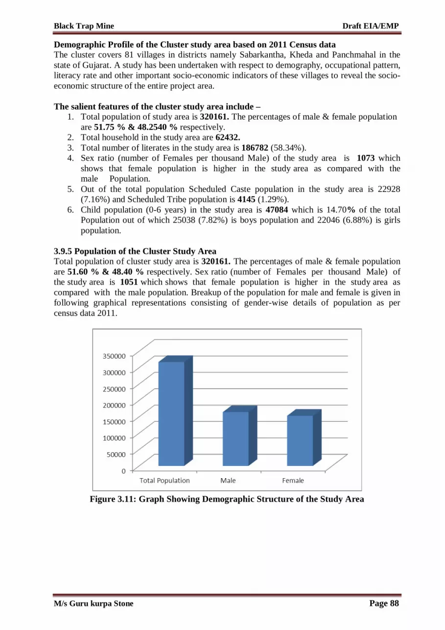
Black Trap Mine Draft EIA/EMP
Demographic Profile of the Cluster study area based on 2011 Census data The cluster covers 81 villages in districts namely Sabarkantha, Kheda and Panchmahal in the state of Gujarat. A study has been undertaken with respect to demography, occupational pattern, literacy rate and other important socio-economic indicators of these villages to reveal the socio-economic structure of the entire project area. The salient features of the cluster study area include –
1. Total population of study area is 320161. The percentages of male & female population are 51.75 % & 48.2540 % respectively.
2. Total household in the study area are 62432. 3. Total number of literates in the study area is 186782 (58.34%). 4. Sex ratio (number of Females per thousand Male) of the study area is 1073 which
shows that female population is higher in the study area as compared with the male Population.
5. Out of the total population Scheduled Caste population in the study area is 22928 (7.16%) and Scheduled Tribe population is 4145 (1.29%).
6. Child population (0-6 years) in the study area is 47084 which is 14.70% of the total Population out of which 25038 (7.82%) is boys population and 22046 (6.88%) is girls population.
3.9.5 Population of the Cluster Study Area Total population of cluster study area is 320161. The percentages of male & female population are 51.60 % & 48.40 % respectively. Sex ratio (number of Females per thousand Male) of the study area is 1051 which shows that female population is higher in the study area as compared with the male population. Breakup of the population for male and female is given in following graphical representations consisting of gender-wise details of population as per census data 2011.
Figure 3.11: Graph Showing Demographic Structure of the Study Area
M/s Guru kurpa Stone Page 88

Black Trap Mine Draft EIA/EMP
Figure 3.12: Pie Chart Showing Gender Structure of the Study Area 3.9.5.1 Social Structure (a) The Schedule Caste (SC) population within the cluster study area is 22928 (7.16%) of the total population with 11874 (3.70%) Male and 11054 (3.45%) are female. The graphical representation is given below.
Figure 3.13: Graph Showing Schedule Caste Structure of the Study Area (b) The Schedule Tribe (ST) population within the cluster study Area is 4145 (1.29%) of the total population with 2165 (0.67%) Male and 1980 (0.61%) Female. Detailed status of social structure and their graphical representation for the same is given below –
M/s Guru kurpa Stone Page 89

Black Trap Mine Draft EIA/EMP
Figure 3.14: Graph Showing Schedule Tribe Structure of the Study Area 3.9.5.2 Literacy The total number of literates within the study area is approximately 186782 which are 58.34% of total population. Male literacy rate of the study area is 117225 (62.76%) and female literacy rate is 69557 (37.24%). Detailed status of literacy is given below. Graphical structure of the literacy& illiteracy structure of the area is as follows:
Figure 3.15: Graph showing Literacy Structure of The Study Area
3.9.5.3 Illiteracy The total number of illiterates within the study area is approximately 133379 which are 41.65% of total population. Male Illiteracy in the study area is 48475 (36.34%) and female Illiteracy is 84904 (63.66%). Graphical representation for the same is given below:
M/s Guru kurpa Stone Page 90

Black Trap Mine Draft EIA/EMP
Figure 3.16: Graph showing Illiteracy structure of the Study area
M/s Guru kurpa Stone Page 91

Black Trap Mine Draft EIA/EMP
Table 3.24 (a): Demographic Structure of the cluster Study Area S. No. Name No. of
households Household Size Total Population Sex Ratio Child Population (0-6 years)
Total Male Female Total Male Female 1 Badarpura 115 4.68 538 268 270 993 79 44 35 2 Bayad 36256 5.14 186328 96451 89877 1073 27927 15015 12912 3 Simlaj 185 5.26 973 519 454 1143 190 106 84 4 Lalpur (Mota) 194 5.12 994 533 461 1156 156 87 69 5 Jumatral 86 5.19 446 234 212 1104 86 48 38 6 Nabhela 80 4.88 390 208 182 1143 71 37 34 7 Gotapur 160 5.37 859 431 428 1007 148 83 65 8 Gabat 1570 5.06 7941 4112 3829 1074 1145 629 516 9 Sarsoli 323 4.99 1612 839 773 1085 217 116 101 10 Radodara 521 4.63 2410 1264 1146 1103 311 184 127 11 Kotda 154 4.79 738 390 348 1121 114 52 62 12 Ambagam 313 4.87 1523 822 701 1173 246 144 102 13 Kadavia 68 4.88 332 171 161 1062 37 22 15 14 Vasadara 226 5.03 1136 597 539 1108 114 60 54 15 Netrodiya 98 5.19 509 265 244 1086 76 44 32 16 Rupnagar 132 5.51 727 378 349 1083 133 75 58 17 Dharamadi Vanta 238 5.55 1320 666 654 1018 211 98 113 18 Semaliya 57 4.65 265 144 121 1190 32 18 14 19 Jitpur (Ramsi) 81 6.89 558 293 265 1106 44 25 19 20 Dalpatpura 62 5.21 323 162 161 1006 45 21 24 21 Ahmadpura 153 6.05 925 476 449 1060 150 78 72 22 Totu 361 5.59 2019 1035 984 1052 342 167 175 23 Odha 399 5.02 2002 1051 951 1105 247 142 105 24 Pipodara 350 5.35 1872 949 923 1028 306 163 143 25 Dakhaneshvar 345 5.44 1877 988 889 1111 274 166 108 26 Madhav Kampo 211 5.26 1109 578 531 1089 120 69 51 27 Mahadevpura 130 4.53 589 305 284 1074 99 49 50
M/s Guru kurpa Stone Page 92

Black Trap Mine Draft EIA/EMP
28 Savela 160 5.23 837 445 392 1135 87 45 42 29 Kojan 164 5.10 837 428 409 1046 136 68 68 30 Ganeshpura (Sathamba) 53 5.94 315 151 164 921 52 20 32 31 Ajabpura 96 4.75 456 250 206 1214 37 25 12 32 Sathamba 1406 4.89 6876 3601 3275 1100 911 504 407 33 Kalajina Muvada 114 5.46 623 320 303 1056 102 55 47 34 Dolpur (Sathamba) 70 5.10 357 188 169 1112 31 18 13 35 Takhatpura (Sathamba) 74 5.05 374 197 177 1113 49 27 22 36 Pagiyana Muvada 95 5.15 489 254 235 1081 85 43 42 37 Dhom 40 6.50 260 129 131 985 41 27 14 38 Jalampura (Sathamba) 107 4.92 526 271 255 1063 69 34 35 39 Champlavat 98 5.66 555 272 283 961 78 36 42 40 Patel-ni-Muvadi 245 4.96 1215 627 588 1066 136 82 54 41 Vijayganj 61 4.69 286 158 128 1234 41 25 16 42 Talod 448 5.21 2336 1201 1135 1058 315 154 161 43 Nagano Math 142 4.67 663 338 325 1040 84 42 42 44 Lank 626 4.68 2931 1492 1439 1037 483 251 232 45 Demai 1633 5.24 8557 4413 4144 1065 1245 672 573 46 Fata Dhirpura 334 4.37 1459 753 706 1067 217 116 101 47 Motipura (Savela) 64 5.02 321 169 152 1112 32 17 15 48 Bordi 502 4.97 2495 1285 1210 1062 381 201 180 49 Mudiya 90 4.58 412 227 185 1227 61 34 27 50 Kashiyavat 28 5.07 142 66 76 868 29 15 14 51 Vajavat 141 5.11 720 344 376 915 112 50 62 52 Hathipura 379 4.97 1884 969 915 1059 223 113 110 53 Narsela 56 5.16 289 148 141 1050 44 19 25 54 Khari 27 4.96 134 67 67 1000 26 13 13 55 Indran 1225 5.33 6534 3362 3172 1060 917 432 485 56 Amodara 1153 5.77 6656 3356 3300 1017 1024 525 499 57 Desaipura Kampo 188 4.52 849 457 392 1166 76 44 32
M/s Guru kurpa Stone Page 93

Black Trap Mine Draft EIA/EMP
58 Deroli 890 5.46 4856 2489 2367 1052 811 432 379 59 Zankhariya 398 5.58 2220 1119 1101 1016 300 161 139 60 Pateliyana Muvada 109 5.23 570 298 272 1096 77 35 42 61 Bhatpur 624 5.45 3403 1746 1657 1054 548 270 278 62 Chorasa 272 4.97 1351 728 623 1169 202 99 103 63 Kharod 674 5.21 3510 1828 1682 1087 415 218 197 64 Rojhav 306 5.16 1579 822 757 1086 233 114 119 65 Sariya 476 4.78 2276 1212 1064 1139 357 183 174 66 Balvakhant Na Muvada 105 4.53 476 252 224 1125 82 41 41 67 Pansroda 433 4.86 2104 1097 1007 1089 296 159 137 68 Jambudi 199 4.89 974 489 485 1008 129 50 79 69 Aspur 311 4.90 1524 770 754 1021 225 102 123 70 Tajpur 19 5.21 99 50 49 1020 19 7 12 71 Jodhpur 476 5.04 2397 1244 1153 1079 336 171 165 72 Javrakhant Na Muvada 140 4.91 688 363 325 1117 121 68 53 73 Bar 1199 5.00 6000 3134 2866 1094 897 453 444 74 Alela 250 4.83 1208 624 584 1068 191 105 86 75 Gundela 76 4.95 376 192 184 1043 67 37 30 76 Jetholi 996 5.19 5165 2709 2456 1103 655 321 334
77 Chori 214 5.22 1118 567 551 1029 165 85 80 78 Dhamod 342 4.23 1447 750 697 1076 154 67 87 79 Khempur 413 4.97 2051 1052 999 1053 263 142 121 80 Zufarali 189 4.89 924 488 436 1119 111 56 55 81 Ubhran 634 4.96 3142 1610 1532 1051 386 213 173
Total 62432 320161 165700 154461 1073 47084 25038 22046
Table 3.24 (b): Demographic Structure of the cluster Study Area S. No. Name Schedule Caste Schedule Tribe Population Literate Population Illiterate Population
Total Male Female Total Male Female Total Male Female Total Male Femle 1 Badarpura 50 26 24 0 0 0 287 178 109 251 90 161
M/s Guru kurpa Stone Page 94

Black Trap Mine Draft EIA/EMP
2 Bayad 13508 6996 6512 2343 1230 1113 106997 67254 39743 79331 29197 50134 3 Simlaj 0 0 0 0 0 0 377 261 116 596 258 338 4 Lalpur (Mota) 0 0 0 0 0 0 404 295 109 590 238 352 5 Jumatral 0 0 0 0 0 0 197 140 57 249 94 155 6 Nabhela 0 0 0 0 0 0 170 128 42 220 80 140 7 Gotapur 0 0 0 0 0 0 384 249 135 475 182 293 8 Gabat 1014 530 484 28 13 15 4793 2954 1839 3148 1158 1990 9 Sarsoli 262 141 121 89 45 44 1031 611 420 581 228 353
10 Radodara 188 98 90 100 54 46 1548 906 642 862 358 504 11 Kotda 160 87 73 0 0 0 432 291 141 306 99 207 12 Ambagam 139 68 71 0 0 0 637 424 213 886 398 488 13 Kadavia 0 0 0 0 0 0 236 133 103 96 38 58 14 Vasadara 129 71 58 13 7 6 787 475 312 349 122 227 15 Netrodiya 0 0 0 0 0 0 259 178 81 250 87 163 16 Rupnagar 139 79 60 16 8 8 369 235 134 358 143 215 17 Dharamadi Vanta 68 35 33 0 0 0 696 454 242 624 212 412 18 Semaliya 0 0 0 0 0 0 175 108 67 90 36 54 19 Jitpur (Ramsi) 4 2 2 46 24 22 452 248 204 106 45 61 20 Dalpatpura 0 0 0 0 0 0 179 128 51 144 34 110 21 Ahmadpura 0 0 0 0 0 0 470 305 165 455 171 284 22 Totu 117 62 55 0 0 0 943 674 269 1076 361 715 23 Odha 285 150 135 0 0 0 1187 774 413 815 277 538 24 Pipodara 10 5 5 0 0 0 959 629 330 913 320 593 25 Dakhaneshvar 134 77 57 8 3 5 1101 669 432 776 319 457 26 Madhav Kampo 16 7 9 150 81 69 761 439 322 348 139 209 27 Mahadevpura 0 0 0 0 0 0 287 221 66 302 84 218 28 Savela 0 0 0 44 22 22 622 379 243 215 66 149 29 Kojan 48 27 21 0 0 0 483 310 173 354 118 236 30 Ganeshpura (Sathamba) 0 0 0 0 0 0 181 124 57 134 27 107 31 Ajabpura 0 0 0 0 0 0 361 219 142 95 31 64
M/s Guru kurpa Stone Page 95

Black Trap Mine Draft EIA/EMP
32 Sathamba 1007 536 471 320 165 155 4527 2702 1825 2349 899 1450 33 Kalajina Muvada 0 0 0 0 0 0 322 217 105 301 103 198 34 Dolpur (Sathamba) 0 0 0 0 0 0 286 164 122 71 24 47 35 Takhatpura (Sathamba) 0 0 0 0 0 0 194 126 68 180 71 109 36 Pagiyana Muvada 0 0 0 0 0 0 234 152 82 255 102 153 37 Dhom 0 0 0 0 0 0 160 96 64 100 33 67 38 Jalampura (Sathamba) 0 0 0 0 0 0 322 205 117 204 66 138 39 Champlavat 0 0 0 0 0 0 296 194 102 259 78 181 40 Patel-ni-Muvadi 246 129 117 15 7 8 845 508 337 370 119 251 41 Vijayganj 0 0 0 19 11 8 175 111 64 111 47 64 42 Talod 383 196 187 64 32 32 1135 767 368 1201 434 767 43 Nagano Math 0 0 0 17 9 8 375 240 135 288 98 190 44 Lank 103 50 53 33 18 15 1493 967 526 1438 525 913 45 Demai 694 361 333 119 60 59 5471 3271 2200 3086 1142 1944 46 Fata Dhirpura 0 0 0 0 0 0 733 500 233 726 253 473 47 Motipura (Savela) 0 0 0 0 0 0 242 145 97 79 24 55 48 Bordi 71 40 31 0 0 0 1325 907 418 1170 378 792 49 Mudiya 0 0 0 0 0 0 244 171 73 168 56 112 50 Kashiyavat 0 0 0 0 0 0 82 45 37 60 21 39 51 Vajavat 0 0 0 0 0 0 335 231 104 385 113 272 52 Hathipura 237 115 122 0 0 0 1310 795 515 574 174 400 53 Narsela 0 0 0 0 0 0 149 111 38 140 37 103 54 Khari 0 0 0 8 6 2 68 48 20 66 19 47 55 Indran 505 243 262 6 4 2 3626 2457 1169 2908 905 2003 56 Amodara 408 203 205 161 86 75 3672 2343 1329 2984 1013 1971 57 Desaipura Kampo 36 20 16 81 44 37 661 384 277 188 73 115 58 Deroli 263 137 126 36 17 19 2635 1687 948 2221 802 1419 59 Zankhariya 147 74 73 0 0 0 1264 854 410 956 265 691 60 Pateliyana Muvada 0 0 0 0 0 0 266 180 86 304 118 186 61 Bhatpur 258 129 129 0 0 0 2049 1252 797 1354 494 860
M/s Guru kurpa Stone Page 96
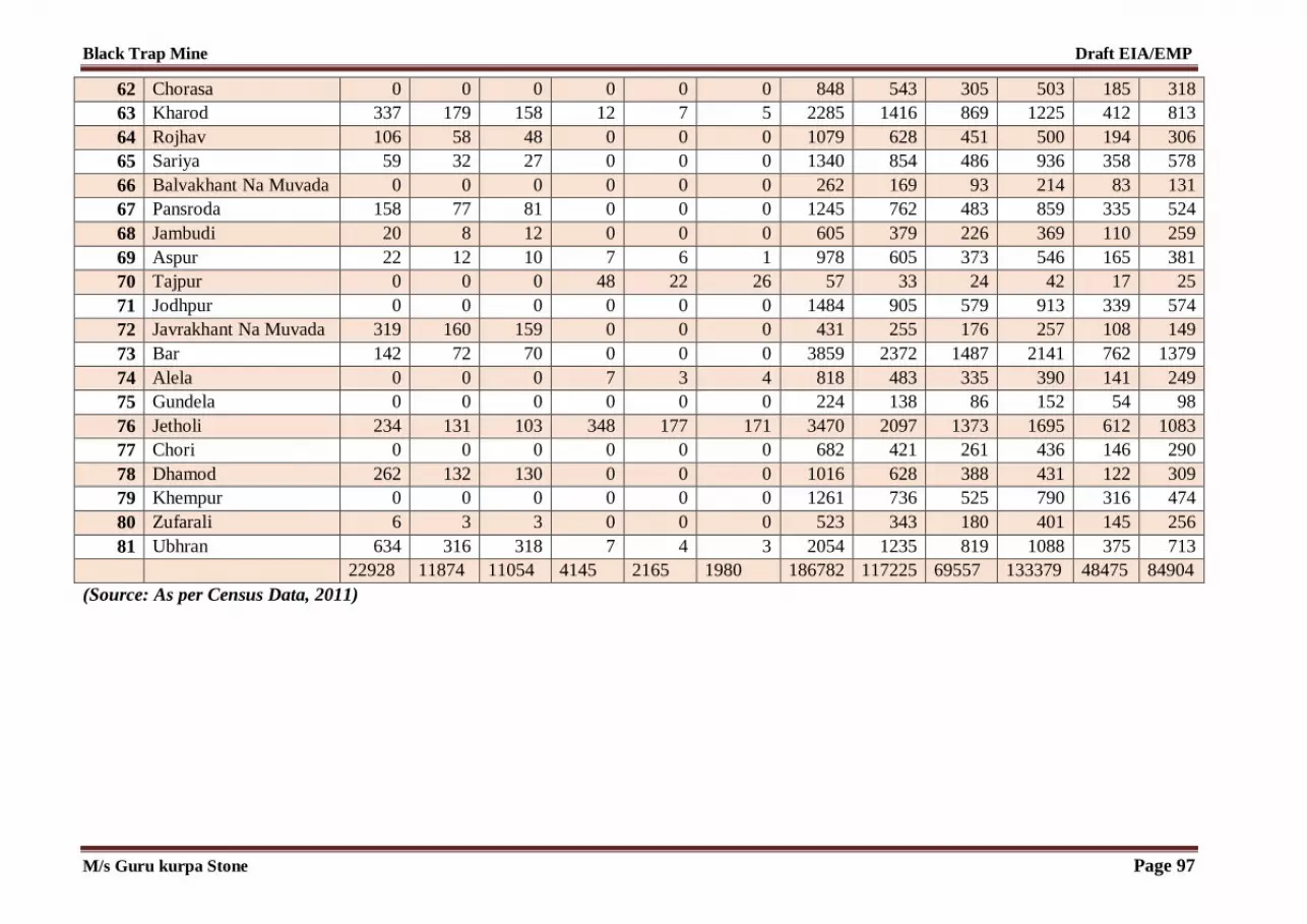
Black Trap Mine Draft EIA/EMP
62 Chorasa 0 0 0 0 0 0 848 543 305 503 185 318 63 Kharod 337 179 158 12 7 5 2285 1416 869 1225 412 813 64 Rojhav 106 58 48 0 0 0 1079 628 451 500 194 306 65 Sariya 59 32 27 0 0 0 1340 854 486 936 358 578 66 Balvakhant Na Muvada 0 0 0 0 0 0 262 169 93 214 83 131 67 Pansroda 158 77 81 0 0 0 1245 762 483 859 335 524 68 Jambudi 20 8 12 0 0 0 605 379 226 369 110 259 69 Aspur 22 12 10 7 6 1 978 605 373 546 165 381 70 Tajpur 0 0 0 48 22 26 57 33 24 42 17 25 71 Jodhpur 0 0 0 0 0 0 1484 905 579 913 339 574 72 Javrakhant Na Muvada 319 160 159 0 0 0 431 255 176 257 108 149 73 Bar 142 72 70 0 0 0 3859 2372 1487 2141 762 1379 74 Alela 0 0 0 7 3 4 818 483 335 390 141 249 75 Gundela 0 0 0 0 0 0 224 138 86 152 54 98 76 Jetholi 234 131 103 348 177 171 3470 2097 1373 1695 612 1083 77 Chori 0 0 0 0 0 0 682 421 261 436 146 290 78 Dhamod 262 132 130 0 0 0 1016 628 388 431 122 309 79 Khempur 0 0 0 0 0 0 1261 736 525 790 316 474 80 Zufarali 6 3 3 0 0 0 523 343 180 401 145 256 81 Ubhran 634 316 318 7 4 3 2054 1235 819 1088 375 713
22928 11874 11054 4145 2165 1980 186782 117225 69557 133379 48475 84904 (Source: As per Census Data, 2011)
M/s Guru kurpa Stone Page 97

Black Trap Mine Draft EIA/EMP
3.9.6 Occupational Structure “Occupational Structure” of the population in the ‘Study Area’ has been studied with reference to the total workers and non-workers. Further total workers grouped into two categories “main workers” and “marginal workers”. 3.9.6.1 Total workers Work” is defined as participation in any economically productive activity with or without compensation, wages or profit; such participation may be physical and/or mental in nature. The number of total workers in the study area is approximately 155313 (18.51%) in which 91566 (58.95%) are male worker and 63747 (41.05%) are female worker. Total workers further divided into main workers and marginal workers – (i) Main Workers The workers who had worked for the major part of the reference period (i.e. 6 months or more) are termed as “Main Workers”. Total number of main workers in the Study Area is approximately 116334 persons, which is 74.90% of total workers and 36.33% of total population. (ii) Marginal Workers Marginal Workers are those workers, who are engaged in some work for a period of less than six months, during the reference year prior to the census survey. Total number of marginal workers in the Study Area is approximately 51710 persons which is 33.29 % of the total workers and 16.15 % of total population. 3.1.6.2 Non Workers The non-workers include those engaged in unpaid household duties, students, retired persons, dependents, beggars etc. The total number of non-workers population is approximately 164848 which are 51.48 % of the total population. Out of which 74134 (44.96 % )is male and 90714 (55.04%) is female. The percent distribution of Occupational pattern within the study area is given in the table below. Occupation structure of each village in the cluster study area is tabulated below and the graphical representation has also been provided.
Figure 3.17: Occupational Pattern in the Study Area
M/s Guru kurpa Stone Page 98
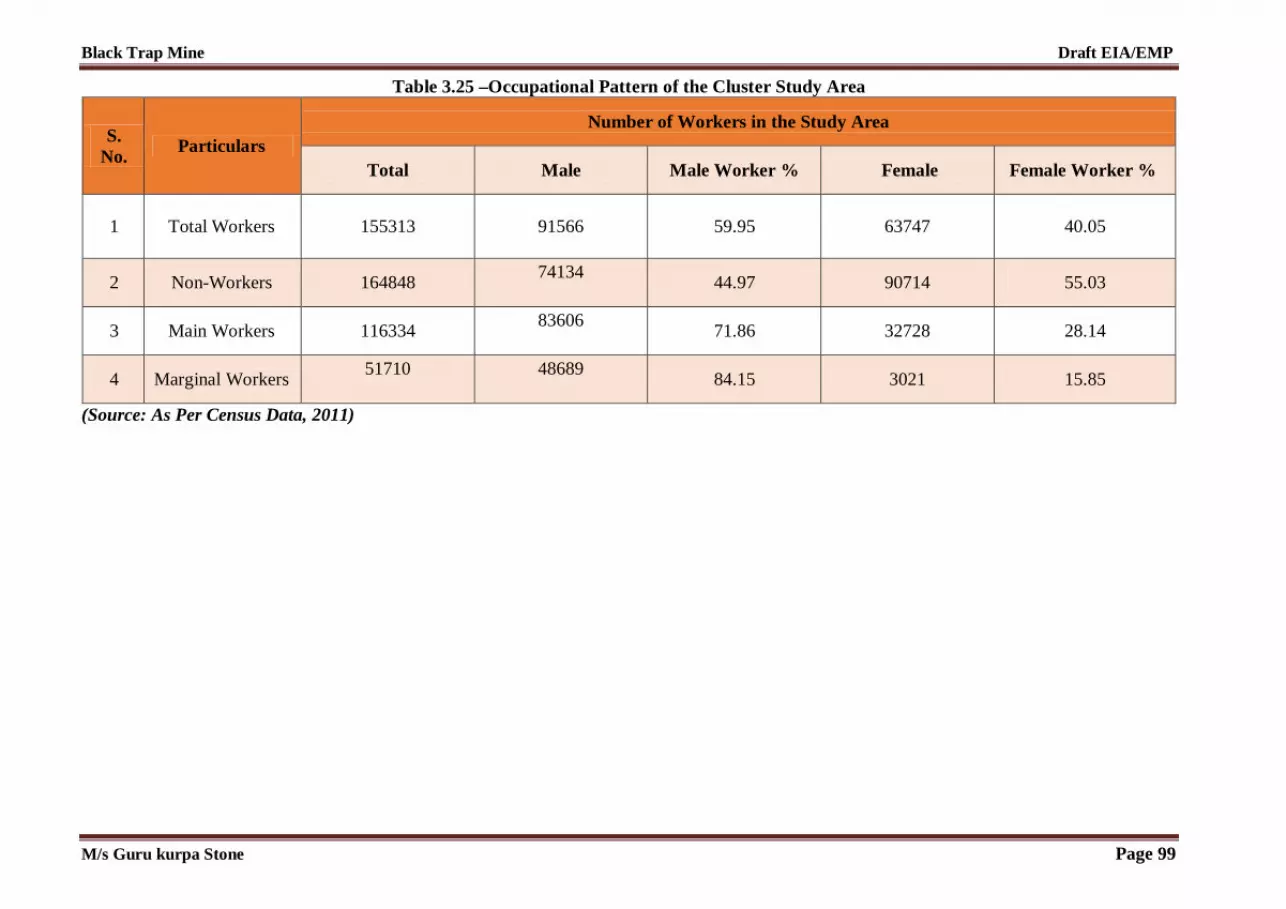
Black Trap Mine Draft EIA/EMP
Table 3.25 –Occupational Pattern of the Cluster Study Area
S. No.
Particulars Number of Workers in the Study Area
Total Male Male Worker % Female Female Worker %
1 Total Workers 155313 91566 59.95
63747
40.05
2 Non-Workers 164848 74134
44.97 90714 55.03
3 Main Workers 116334 83606
71.86 32728 28.14
4 Marginal Workers 51710
48689
84.15 3021 15.85
(Source: As Per Census Data, 2011)
M/s Guru kurpa Stone Page 99
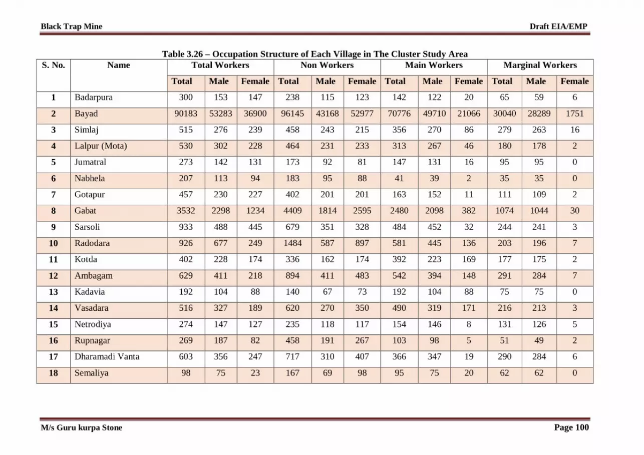
Black Trap Mine Draft EIA/EMP
Table 3.26 – Occupation Structure of Each Village in The Cluster Study Area
S. No. Name Total Workers Non Workers Main Workers Marginal Workers
Total Male Female Total Male Female Total Male Female Total Male Female
1 Badarpura 300 153 147 238 115 123 142 122 20 65 59 6
2 Bayad 90183 53283 36900 96145 43168 52977 70776 49710 21066 30040 28289 1751
3 Simlaj 515 276 239 458 243 215 356 270 86 279 263 16
4 Lalpur (Mota) 530 302 228 464 231 233 313 267 46 180 178 2
5 Jumatral 273 142 131 173 92 81 147 131 16 95 95 0
6 Nabhela 207 113 94 183 95 88 41 39 2 35 35 0
7 Gotapur 457 230 227 402 201 201 163 152 11 111 109 2
8 Gabat 3532 2298 1234 4409 1814 2595 2480 2098 382 1074 1044 30
9 Sarsoli 933 488 445 679 351 328 484 452 32 244 241 3
10 Radodara 926 677 249 1484 587 897 581 445 136 203 196 7
11 Kotda 402 228 174 336 162 174 392 223 169 177 175 2
12 Ambagam 629 411 218 894 411 483 542 394 148 291 284 7
13 Kadavia 192 104 88 140 67 73 192 104 88 75 75 0
14 Vasadara 516 327 189 620 270 350 490 319 171 216 213 3
15 Netrodiya 274 147 127 235 118 117 154 146 8 131 126 5
16 Rupnagar 269 187 82 458 191 267 103 98 5 51 49 2
17 Dharamadi Vanta 603 356 247 717 310 407 366 347 19 290 284 6
18 Semaliya 98 75 23 167 69 98 95 75 20 62 62 0
M/s Guru kurpa Stone Page 100

Black Trap Mine Draft EIA/EMP
19 Jitpur (Ramsi) 210 138 72 348 155 193 208 138 70 65 65 0
20 Dalpatpura 185 93 92 138 69 69 65 62 3 58 55 3
21 Ahmadpura 279 248 31 646 228 418 258 247 11 218 214 4
22 Totu 964 553 411 1055 482 573 767 545 222 442 433 9
23 Odha 702 566 136 1300 485 815 618 557 61 341 315 26
24 Pipodara 1013 514 499 859 435 424 617 498 119 385 358 27
25 Dakhaneshvar 832 529 303 1045 459 586 647 488 159 308 304 4
26 Madhav Kampo 585 341 244 524 237 287 382 245 137 144 141 3
27 Mahadevpura 250 140 110 339 165 174 142 139 3 123 120 3
28 Savela 408 206 202 429 239 190 194 186 8 137 134 3
29 Kojan 425 221 204 412 207 205 253 198 55 169 168 1
30 Ganeshpura (Sathamba) 167 85 82 148 66 82 156 83 73 92 74 18
31 Ajabpura 201 134 67 255 116 139 195 133 62 129 129 0
32 Sathamba 2301 1883 418 4575 1718 2857 2146 1794 352 200 188 12
33 Kalajina Muvada 339 184 155 284 136 148 239 184 55 75 73 2
34 Dolpur (Sathamba) 218 116 102 139 72 67 118 116 2 107 106 1
35 Takhatpura (Sathamba) 197 93 104 177 104 73 94 91 3 88 86 2
36 Pagiyana Muvada 298 153 145 191 101 90 137 134 3 126 125 1
37 Dhom 149 70 79 111 59 52 72 69 3 57 56 1
38 Jalampura (Sathamba) 263 150 113 263 121 142 156 149 7 133 132 1
39 Champlavat 282 145 137 273 127 146 141 111 30 74 72 2
40 Patel-ni-Muvadi 664 384 280 551 243 308 658 383 275 254 249 5
M/s Guru kurpa Stone Page 101

Black Trap Mine Draft EIA/EMP
41 Vijayganj 173 96 77 113 62 51 94 91 3 62 60 2
42 Talod 1367 715 652 969 486 483 1248 668 580 630 549 81
43 Nagano Math 374 211 163 289 127 162 238 186 52 162 162 0
44 Lank 1654 831 823 1277 661 616 993 755 238 579 565 14
45 Demai 4119 2340 1779 4438 2073 2365 3563 2268 1295 859 785 74
46 Fata Dhirpura 827 409 418 632 344 288 436 384 52 265 260 5
47 Motipura (Savela) 200 101 99 121 68 53 62 62 0 59 59 0
48 Bordi 1444 747 697 1051 538 513 1081 740 341 610 595 15
49 Mudiya 260 146 114 152 81 71 181 129 52 75 73 2
50 Kashiyavat 72 35 37 70 31 39 34 34 0 32 32 0
51 Vajavat 402 220 182 318 124 194 252 216 36 123 123 0
52 Hathipura 889 553 336 995 416 579 860 532 328 285 271 14
53 Narsela 154 92 62 135 56 79 154 92 62 84 83 1
54 Khari 64 36 28 70 31 39 64 36 28 31 29 2
55 Indran 3946 2062 1884 2588 1300 1288 2805 1884 921 1319 1182 137
56 Amodara 3438 1819 1619 3218 1537 1681 2912 1608 1304 1228 1163 65
57 Desaipura Kampo 367 273 94 482 184 298 340 273 67 119 119 0
58 Deroli 2242 1360 882 2614 1129 1485 1675 1264 411 1030 982 48
59 Zankhariya 849 601 248 1371 518 853 693 591 102 560 495 65
60 Pateliyana Muvada 279 172 107 291 126 165 279 172 107 130 130 0
61 Bhatpur 1582 927 655 1821 819 1002 1024 737 287 427 415 12
62 Chorasa 669 406 263 682 322 360 363 348 15 242 240 2
M/s Guru kurpa Stone Page 102

Black Trap Mine Draft EIA/EMP
63 Kharod 1860 1052 808 1650 776 874 1191 909 282 423 416 7
64 Rojhav 696 446 250 883 376 507 481 297 184 274 171 103
65 Sariya 1265 672 593 1011 540 471 567 471 96 298 285 13
66 Balvakhant Na Muvada 246 125 121 230 127 103 79 79 0 66 66 0
67 Pansroda 1153 616 537 951 481 470 580 458 122 302 298 4
68 Jambudi 538 271 267 436 218 218 226 216 10 194 189 5
69 Aspur 527 451 76 997 319 678 430 414 16 359 356 3
70 Tajpur 46 29 17 53 21 32 30 29 1 12 12 0
71 Jodhpur 1286 665 621 1111 579 532 589 419 170 285 274 11
72 Javrakhant Na Muvada 236 206 30 452 157 295 189 185 4 108 107 1
73 Bar 3186 1810 1376 2814 1324 1490 1862 1348 514 900 790 110
74 Alela 648 334 314 560 290 270 450 266 184 283 211 72
75 Gundela 179 105 74 197 87 110 171 103 68 93 69 24
76 Jetholi 2107 1468 639 3058 1241 1817 1248 1160 88 684 669 15
77 Chori 550 292 258 568 275 293 248 233 15 210 209 1
78 Dhamod 754 432 322 693 318 375 481 397 84 142 138 4
79 Khempur 1105 586 519 946 466 480 636 548 88 424 416 8
80 Zufarali 489 281 208 435 207 228 320 280 40 223 219 4
81 Ubhran 1300 830 470 1842 780 1062 1125 782 343 175 48 127
155313 91566 63747 164848 74134 90714 116334 83606 32728 51710 48689 3021
(Source: Census Data, 2011)
M/s Guru kurpa Stone Page 103

Black Trap Mine Draft EIA/EMP
3.9.7 Infrastructural Facilities and Amenities in the cluster Study Area: Information on amenities has been provided based on information available in 2011 Census. The Infrastructural facilities and amenities like Education, Health, Drinking Water, Electricity, Transport and Communication Network. The information is provided in subsequent paragraphs of this section. (a) Medical Facilities According to the Census-2011, there are 3 primary Health Centre, 22 Primary Health Sub Centre, ,1 Veterinary Hospital, 1 Hospital Allopathic, 1 Hospital Alternative Medicine present in the study area. The data for the medical facilities of the study area demonstrate the poor condition and lack of basic health facilities in the Study Area. (b) Educational Facilities In the study area, the number of Primary schools include 199 Govt. and 6 Private, Secondary School includes 18 Govt. and 2 private and Senior secondary School includes 2 Govt. and 4 private, 1 Government degree College of Art & Science. The data shows that Primary schools, Secondary schools / Senior Secondary Schools and College are not good enough in the ‘cluster Study Area’.
(c) Drinking Water The main source of drinking water in the study area is through hand pump, tap water, local water reservoirs constructed by district administration /land owners for storage of water. (d) Power Supply All villages in the cluster study area have power supply for domestic agriculture and for all other purposes. (e) Transport Modes of transport in the ‘cluster Study Area’ are Tractor, Jeeps along with Private Bus Services. From the cluster project site the nearest National Highway is NH 47 at a distance of 6.56 Km in the North- West direction, nearest railway station is Vanakbori Railway station at 5.47 km, nearest Airport is Ahmedabad Airport at 81 km in the North West direction.
M/s Guru kurpa Stone Page 104

Black Trap Mine Draft EIA/EMP
Table 3.27 – Amenities in the Study Area S. No.
Name Educational Facilities Health Facilities Primary Secondar
y Senior
Secodary Govt.
Degree College (Art &
Science)
Primary Health Centre
Primary health Sub
Centre
Hospital Allopat
hic
Hospital Alternate medicine
Dispensary/ Health Centre
Veterinary
Hospital Govt.
Private
Govt.
Private
Govt.
Private
1 Badarpura 1 0 0 0 0 0 0 0 0 0 0 0 0 2 Bayad 1 0 0 0 0 0 0 0 0 0 0 0 0 3 Simlaj 1 0 0 0 0 0 0 0 0 0 0 0 0 4 Lalpur
(Mota) 2 0 0 0 0 0 0 0 0 0 0 0 0
5 Jumatral 1 0 0 0 0 0 0 0 0 0 0 0 0 6 Nabhela 1 0 0 0 0 0 0 0 0 0 0 0 0 7 Gotapur 1 0 0 0 0 0 0 0 0 0 0 0 0 8 Gabat 8 2 1 0 1 0 0 1 2 0 0 0 1 9 Sarsoli 1 0 0 0 0 0 0 0 1 0 0 0 0
10 Radodara 4 0 1 0 0 0 0 0 1 0 0 0 0 11 Kotda 1 0 0 0 0 0 0 0 0 0 0 0 0 12 Ambagam 1 0 0 0 0 0 0 0 0 0 0 0 0 13 Kadavia 1 0 0 0 0 0 0 0 0 0 0 0 0 14 Vasadara 3 0 0 0 0 0 0 0 0 0 0 0 0 15 Netrodiya 1 0 0 0 0 0 0 0 0 0 0 0 0 16 Rupnagar 1 0 0 0 0 0 0 0 0 0 0 0 0 17 Dharamad
i Vanta 2 0 0 0 0 0 0 0 0 0 0 0 0
18 Semaliya 1 0 0 0 0 0 0 0 0 0 0 0 0 19 Jitpur
(Ramsi) 1 0 0 0 0 0 0 0 0 0 0 0 0
20 Dalpatpur 1 0 0 0 0 0 0 0 0 0 0 0 0
M/s Guru kurpa Stone Page 105

Black Trap Mine Draft EIA/EMP
a 21 Ahmadpur
a 1 0 0 0 0 0 0 0 0 0 0 0 0
22 Totu 1 0 0 0 0 0 0 0 0 0 0 0 0 23 Odha 7 0 1 0 0 0 0 0 1 0 0 0 0 24 Pipodara 4 0 0 0 0 0 0 0 0 0 0 0 0 25 Dakhanes
hvar 1 0 0 0 0 0 0 0 1 0 0 0 0
26 Madhav Kampo
1 0 0 0 0 0 0 0 1 0 0 0 0
27 Mahadevpura
1 0 0 0 0 0 0 0 0 0 0 0 0
28 Savela 2 0 1 0 0 0 0 0 1 0 0 0 0 29 Kojan 3 0 0 0 0 0 0 0 0 0 0 0 0 30 Ganeshpu
ra (Sathamba)
1 0 0 0 0 0 0 0 0 0 0 0 0
31 Ajabpura 1 0 0 0 0 0 0 0 0 0 0 0 0 32 Sathamba 1 0 1 0 0 0 0 1 0 0 1 0 0 33 Kalajina
Muvada 1 0 0 0 0 0 0 0 0 0 0 0 0
34 Dolpur (Sathamba)
1 0 0 0 0 0 0 0 0 0 0 0 0
35 Takhatpura (Sathamba)
1 0 0 0 0 0 0 0 0 0 0 0 0
36 Pagiyana Muvada
1 0 0 0 0 0 0 0 0 0 0 0 0
37 Dhom 1 0 0 0 0 0 0 0 0 0 0 0 0
M/s Guru kurpa Stone Page 106

Black Trap Mine Draft EIA/EMP
38 Jalampura (Sathamba)
1 0 0 0 0 0 0 0 0 0 0 0 0
39 Champlavat
1 0 0 0 0 0 0 0 0 0 0 0 0
40 Patel-ni-Muvadi
1 0 0 0 0 0 0 0 1 0 0 0 0
41 Vijayganj 0 0 0 0 0 0 0 0 0 0 0 0 0 42 Talod 5 0 0 0 0 0 0 0 1 0 0 0 0 43 Nagano
Math 1 0 0 0 0 0 0 0 0 0 0 0 0
44 Lank 7 0 1 0 0 0 0 0 1 0 0 0 0 45 Demai 20 2 0 0 0 0 0 1 1 0 0 0 0 46 Fata
Dhirpura 1 0 0 0 0 0 0 0 0 0 0 0 0
47 Motipura (Savela)
1 0 0 0 0 0 0 0 0 0 0 0 0
48 Bordi 5 0 0 0 0 0 0 0 0 0 0 0 0 49 Mudiya 1 0 0 0 0 0 0 0 0 0 0 0 0 50 Kashiyava
t 1 0 0 0 0 0 0 0 0 0 0 0 0
51 Vajavat 1 0 0 0 0 0 0 0 0 0 0 0 0 52 Hathipura 2 0 1 0 0 0 0 0 0 0 0 0 0 53 Narsela 1 0 0 0 0 0 0 0 0 0 0 0 0 54 Khari 0 0 0 0 0 0 0 0 0 0 0 0 0 55 Indran 8 0 2 0 1 0 0 0 1 0 0 0 0 56 Amodara 8 0 2 0 1 0 0 0 1 0 0 0 0 57 Desaipura
Kampo 11 0 1 0 0 0 0 0 1 0 0 0 0
58 Deroli 2 0 0 0 0 0 0 0 0 0 0 0 0 59 Zankhariy
a 7 0 0 1 0 0 0 0 1 0 0 0 0
M/s Guru kurpa Stone Page 107

Black Trap Mine Draft EIA/EMP
60 Pateliyana Muvada
3 0 0 0 0 0 0 0 1 0 0 0 0
61 Bhatpur 2 0 0 0 0 0 0 0 1 0 0 0 0 62 Chorasa 3 0 0 0 0 0 0 0 0 0 0 0 0 63 Kharod 1 0 0 0 0 0 0 0 0 0 0 0 0 64 Rojhav 3 0 0 0 0 0 0 0 0 0 0 0 0 65 Sariya 3 0 0 0 0 0 0 0 0 0 0 0 0 66 Balvakhan
t Na Muvada
1 0 0 0 0 0 0 0 0 0 0 0 0
67 Pansroda 2 0 1 0 0 0 0 0 0 0 0 0 0 68 Jambudi 2 0 0 0 0 0 0 0 0 0 0 0 0 69 Aspur 1 0 0 0 0 0 0 0 0 0 0 0 0 70 Tajpur 1 0 0 0 0 0 0 0 0 0 0 0 0 71 Jodhpur 1 0 1 0 0 0 0 0 1 0 0 0 0 72 Javrakhan
t Na Muvada
1 0 0 0 0 0 0 0 0 0 0 0 0
73 Bar 9 0 1 0 0 0 0 0 1 0 0 0 0 74 Alela 3 0 0 0 0 0 0 0 0 0 0 0 0 75 Gundela 1 0 0 0 0 0 0 0 0 0 0 0 0 76 Jetholi 6 1 1 0 1 0 0 0 1 0 0 0 0 77 Chori 1 0 0 0 0 0 0 0 0 0 0 0 0 78 Dhamod 3 0 1 0 0 0 0 0 0 0 0 0 0 79 Khempur 2 0 1 0 0 0 0 0 0 0 0 0 0 80 Zufarali 1 0 0 0 0 0 0 0 0 0 0 0 0 81 Ubhran 1 1 0 1 0 1 0 0 1 1 0 0 0 19
9 6 18 2 4 1 0 3 22 1 1 0 1
(Source: As Per Census Data, 2011)
M/s Guru kurpa Stone Page 108

Black Trap Mine Draft EIA/EMP
3.10 Conclusion “Socio-Economic Study” of the ‘cluster Study Area’ gives clear picture of its population, average household size, literacy rate, and sex ratio etc. In comparison with the facilities available in other parts of the district of Gujarat this area lacks higher level of amenities like higher education like Degree College, Govt. senior secondary school, health facilities like Hospitals, maternity home, nursing home etc. This area surely needs more medical and educational facilities to achieve good quality of life. The literacy rate and work participation rate in this area is quite average which can be improved by introduction of more employment opportunities and education facilities. It can be estimated with the data given that lack of employment, education and infrastructure is affecting the condition of the local community. More attention and care must be taken so that the needs and demand of the population of the study area can get more exposure to modern facilities of education, health facilities and development, for a brighter future.
************************
M/s Guru kurpa Stone Page 109

CHAPTER-4 ANTICIPATED IMPACTS AND
MITIGATION MEASURES

Black Trap Mine Draft EIA/EMP
CHAPTER 4 – ANTICIPATED ENVIRONMENTAL IMPACTS AND MITIGATION MEASURES
4.1 General Environmental impacts both direct and indirect on various environmental attributes due to proposed cluster mining activity will be created in the surrounding environment, during the preoperational, operational and post–operational phases. The occurrence of mineral deposits, being site specific, their exploitation, often, does not allow for any choice except adoption of eco-friendly operation. The methods are required to be selected in such a manner, so as to maintain environmental equilibrium ensuring sustainable development. The impacts due to mining operations in the cluster commence from the exploration activities, extend through extraction and processing of minerals, may continue up to post closure of the operation, with the nature and extent of impacts varying throughout the stages of project development. In order to maintain the environmental commensuration with the mining operation, it is essential to undertake studies on the existing environmental scenario and assess the impact on different environmental components. This would help in formulating suitable management plans sustainable resource extraction. Several scientific techniques and methodologies are available to predict impacts of physical environment. Mathematical models are the best tools to quantitatively describe the cause and effect relationships between sources of pollution and different components of environment. In case where it is not possible to identify and validate a model for a particular situation, predictions have been arrived at based on logical reasoning / consultation / extrapolation. The following parameters are of significance in the Environment Impact Assessment and are being discussed in detail. 1. Land Environment 2. Water Environment 3. Air Environment 4. Noise Environment 5. Solid waste 6. Biological Environment 7. Socio-Economic 4.2 Impact Assessment Methodology Environmental impacts are defined as any change in the environment either adverse or beneficial. Environment Impact assessment is the most important tool for identifying the possible impact on environment due to possible upcoming project. Baseline data has been collected through well designed scientific network. Its shows the existing environmental condition in the study area. Following methodology has been adopted for impact assessment for proposed Mining Project: 1. Listing of possible activities during the Constructions and operational phase due to proposed
cluster project. 2. Identifying possible parameters on which the significant impact can cause possible impacts. Environmental impacts due to proposed cluster mining activity have been discussed in below mentioned sections in details.
M/s Guru Kurpa Stone Page 110

Black Trap Mine Draft EIA/EMP
4.3 Land Use pattern 4.3.1 Anticipated impacts The proposed cluster project is having a fresh mine lease areas. These are private non forest lands and proposed for the black trap mining. The land use pattern for the proposed cluster black trap mining project for 5 years has been shown below.
Table 4.1: Cluster Land Use Pattern S.
No. Head Present Land Use (Ha)
1 Area to be excavated --
2 Storage for top soil --
3 Waste dump --
4 Mineral stack --
5 Infrastructure (workshop, administrative building etc.)
--
6 Road --
7 Railways --
8 Tailing Pond --
9 Effluent Treatment Plant --
10 Mineral separation plant --
11 Township area --
12 Area which will remain untouched
--
13 Green Belt --
14 Non utilized Area 18.05.48
Grand Total 18.05.48
(Source: Approved Mine Plans) The anticipated impact on land due to the cluster project will be significant due to mined out area. Areas outside the mine leases will not get affected due to proposed cluster project because overburden generated will be stacked separately and if possible it will be sold as rubble by taking necessary permission. Plantation will be done in the statutory boundary and in the waste land. 4.3.2 Mitigation Measures 1. As a part of eco-restoration, it is proposed that plantation like Khair, Neem, Kashid, Shisham,
Imli etc. will be carried out in the statutory boundary of the cluster area, and in the suitable areas after consultation with Gram Panchayat at the rate of 500 saplings/annum. The rate of survival expected to be 70% in the area mined out areas.
2. Plantation will be done in the statutory boundary and in the government waste lands. 3. The waste/overburden generated will be stacked separately and if possible it will be sold as a
rubble, by taking necessary permission.
M/s Guru Kurpa Stone Page 111

Black Trap Mine Draft EIA/EMP
4. Surface and ground water will not be affected due to mining activity. There is no perennial source of water within the leasehold area.
5. Frequent dust suppression will be done to minimize the risk of long term buildup of pollutants in the environment.
6. Advanced technology of blasting will be used for control of noise and ground vibration. 7. Adopting suitable, site-specific mitigation measures can reduce the degree of impact of
mining on land. Present land use pattern of the lease area is waste land and at the conceptual stage the land use pattern will remain the same, hence will not be changed as there is no overburden generated from the mining activity.
4.4 Water Environment Mining and its associated activities not only use a lot of water but also likely to affect the hydrological regime of the area. The major impact of deep and large mines (both underground and open cast) is of natural groundwater table. Lowering of water table may result in reduced groundwater availability. Extraction of different minerals is known to lead to water pollution due to heavy metal, acid discharges and increased suspended solids. Deep underground mines directly affect the water table of the area. However, the impact of mining projects on groundwater hydrology and surface water regime are site specific and depends upon the characteristics of the mineral, hydrogeology and requirement of groundwater for other uses. 4.4.1 Anticipated Impacts 1. As there is no river or nallas passing through any mine leases in the cluster. Damini Nadi is
about 1.606 Km in South direction. Hence no impact is anticipated on the hydrological regime of the mine lease area due to mining activity.
2. No natural course of water stream is interrupted or diverted due to mining activity; hence no impact on natural drain is anticipated.
3. Practically there is no overburden or reject generating from the mining activity, moreover the excavated mineral itself is non-toxic and hence no effect due to water flow during rains following the contours of the area is expected.
4. No water is being drawn from the surface water body in the cluster. 5. As the mineral is non-toxic so contamination of ground water due to leaching is not
anticipated. 4.4.2 Mitigation Measures 1. Overall drainage planning has been done in such a manner that the existing pre- mining
drainage conditions will be maintained to the extent possible so that run off distribution is not affected.
2. Rainwater will be collected into the mined out pits. 3. No washing of equipments will be done inside the mining lease areas. 4. Domestic effluent will be discharged in septic tank/soak pits. 5. As the mining is restricted to 145 mRL, no ground water will be encounter during the mining
operations. 6. Regular monitoring of surface water and ground water will be done to ensure there is no
adverse impact due to cluster mining project. 4.5 Air Environment Mining Operation in the cluster is carried out by opencast semi mechanized method generates dust particles due to various activities like drilling, blasting, loading & unloading of Black Trap and transportation. The air quality of the cluster depends upon the nature and concentration of emissions and meteorological conditions. Though it is an open cast semi mechanized mining
M/s Guru Kurpa Stone Page 112

Black Trap Mine Draft EIA/EMP
cluster with all possible air quality controlling measures but the major air pollutants from mining operations include:- 1. Particulate Matter (Dust) of various sizes. 2. Gases, such as, Sulphur Dioxide, Oxides of Nitrogen, Carbon Monoxide etc. from mining
Machineries & vehicular exhaust. 3. Dust is the single air pollutant observed in the open cast mines. Diesel operating drilling
machines and movement of machineries / vehicles produce NOX, SO2 and CO emissions, usually at low levels. Dust can be of significant nuisance to surrounding land users and potential health risk in some circumstances.
4.5.1 Anticipated Impact The major sources of air pollution in the proposed cluster is dust generation due to drilling, excavation, loading, unloading and transportation of mineral & wind erosion of exposed material. In this present study, United States Environmental Protection Agency (USEPA–42 series) approved mathematical equations have been used to predict concentrations for different operations in mining including the mineral transportation. 4.5.2 Air Pollution Modeling Air quality models are the primary tools for relating emissions to air quality impacts. Models, in turn, require acceptable input data for emissions, surface topography, meteorological parameters, receptor configurations, baseline air quality, and initial and boundary conditions for each modeling scenario. Since the quality and reliability of model outputs can never be any better than the inputs, quality control of the input data is important. Prediction of impacts on air environment has been carried out employing mathematical model based on a steady state Gaussian plume dispersion model designed for area sources for short term. In the present case, Industrial Source Complex [ISC3] 1993 dispersion model based on steady state Gaussian plume dispersion, designed for area sources for short term and developed by United States Environmental Protection Agency [USEPA] has been used for simulations from point sources 4.5.3 Pollutants considered for Computation The model simulations deal with the major pollutants viz., PM10, SO2, NO2 emitted from the mining activity in the cluster. 4.5.3.1 Impact on Ambient Air Quality Ambient air quality impact assessment has been done for entire cluster, in which five mine leases are present to comply with the Terms of References issued from SEIAA Gujarat. The name and area details of all mine leases are presented below.
M/s Guru Kurpa Stone Page 113

Black Trap Mine Draft EIA/EMP
Table 4.2: Mine Leases in Cluster
Sr. No.
Name of Lessee Survey No. Village Area (in Ha.)
Production Capacity As Per EC in
MTPA
1. Gurukrupa Stone 151 P Paiki Kalaji Muvada 01.53.78 120,000
2. Gurukrupa Stone 150 Paiki, Kalaji Muvada 01.33.41
3. Parishram Stone 146, 182, &159
Kalaji Muvada 04.13.38
4. Parishram Stone 111 to 114 Paiki
Kalaji Muvada 02.74.28 120,000
5. Vrundavan Stone 103 Paiki, Dolapura 01.99.00 120,000
6. Vrundavan Stone 101/1Paiki Dolapura 02.81.63 120,000
7. Gurukrupa Stone 90 Kalaji Muvada 3.50 157,895
(Source: Approved Mine Plan)
Impact on ambient air quality of nearest habitations to mine leases within study area due to above proposed cluster was considered as fully operational mines in cluster situation as per Terms of references. The mine leases present in study area as per Mines and Geology Department is 07 in total. 4.5.3.2 Estimation of Emission Factors Emission factors was calculated as per USEPA guidelines AP-42, and some equations from Indian authors including Chakraboraty, et al. (2002), Chaulya, et al. (2006) was also considered for emission factors calculations. An emission factor is a representative value that attempts to relate the quantity of a pollutant released to the atmosphere with an activity associated with the release of that pollutant. The general equation for emissions estimation is – E = A x EF x (1-ER/100) where E = emissions; A = activity rate; EF = emission factor, and ER =overall emission reduction efficiency, % The proposed mining activity includes various activities like ground preparation, excavation, handling and transport of ore. These activities have been analyzed systematically basing on USEPA-Emission Estimation Technique Manual, for Mining AP-42, to arrive at possible emissions to the atmosphere.
M/s Guru Kurpa Stone Page 114

Black Trap Mine Draft EIA/EMP
There are four sources considered for ambient air quality modelling. Wire saw operation was not considered in study due to its operation by electricity. Drilling operation, waste dump, open pit and haul road was considered as per approved mine plan.
Table 4.3: Input Parameters
S. No. Description Unit Symbol Quantity
1 Moisture content % m 8
2 Silt content % s 4
3 Wind speed m/s u 2.2
4 Hole dia mm d 110
5 Frequency Holes /day f 2
6 loading frequency no/Hr Ff 2
7 Production TPD
variable
8 Average vehicle speed km/hr v 10
9 No of working days days n 300
10 Waste dumping area sq km a variable
11 Open pit area sq km Aa Variable
12 Control efficiency during drilling
cutting operation (%) % n 90%
4.6 Meteorological Data Data recorded at the continuous weather monitoring station on wind speed, direction, and temperature at one hour interval for the monitoring period was used as meteorological input and is tabulated below as Table 4.4.
Table 4.4: Meteorological input
S. No. Data Used met file
1 Year
2 Month
3 Day
4 Hour
5 Random flow vector
6 Wind speed m/s
7 Ambient temperature K
8 Stability category
9 Rural mixing height (m)
10 Urban mixing height (m)
M/s Guru Kurpa Stone Page 115
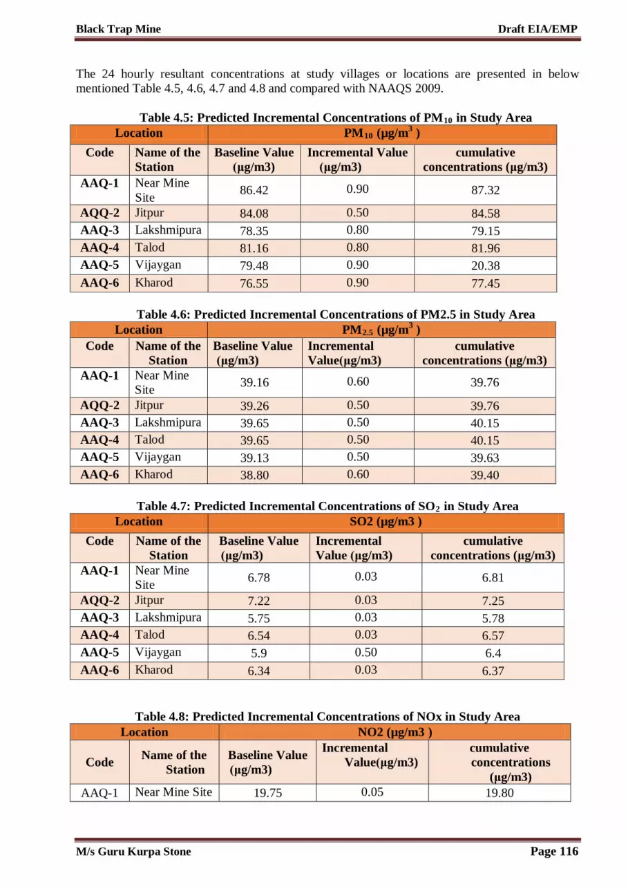
Black Trap Mine Draft EIA/EMP
The 24 hourly resultant concentrations at study villages or locations are presented in below mentioned Table 4.5, 4.6, 4.7 and 4.8 and compared with NAAQS 2009.
Table 4.5: Predicted Incremental Concentrations of PM10 in Study Area Location PM10 (µg/m3 )
Code Name of the Station
Baseline Value (μg/m3)
Incremental Value (μg/m3)
cumulative concentrations (μg/m3)
AAQ-1 Near Mine Site
86.42 0.90 87.32
AQQ-2 Jitpur 84.08 0.50 84.58 AAQ-3 Lakshmipura 78.35 0.80 79.15 AAQ-4 Talod 81.16 0.80 81.96 AAQ-5 Vijaygan 79.48 0.90 20.38 AAQ-6 Kharod 76.55 0.90 77.45
Table 4.6: Predicted Incremental Concentrations of PM2.5 in Study Area
Location PM2.5 (µg/m3 ) Code Name of the
Station Baseline Value (μg/m3)
Incremental Value(μg/m3)
cumulative concentrations (μg/m3)
AAQ-1 Near Mine Site
39.16 0.60 39.76
AQQ-2 Jitpur 39.26 0.50 39.76 AAQ-3 Lakshmipura 39.65 0.50 40.15 AAQ-4 Talod 39.65 0.50 40.15 AAQ-5 Vijaygan 39.13 0.50 39.63 AAQ-6 Kharod 38.80 0.60 39.40
Table 4.7: Predicted Incremental Concentrations of SO2 in Study Area
Location SO2 (µg/m3 )
Code Name of the Station
Baseline Value (μg/m3)
Incremental Value (μg/m3)
cumulative concentrations (μg/m3)
AAQ-1 Near Mine Site
6.78 0.03 6.81
AQQ-2 Jitpur 7.22 0.03 7.25 AAQ-3 Lakshmipura 5.75 0.03 5.78 AAQ-4 Talod 6.54 0.03 6.57 AAQ-5 Vijaygan 5.9 0.50 6.4 AAQ-6 Kharod 6.34 0.03 6.37
Table 4.8: Predicted Incremental Concentrations of NOx in Study Area Location NO2 (µg/m3 )
Code Name of the Station
Baseline Value (μg/m3)
Incremental Value(μg/m3)
cumulative concentrations
(μg/m3) AAQ-1 Near Mine Site 19.75 0.05 19.80
M/s Guru Kurpa Stone Page 116

Black Trap Mine Draft EIA/EMP
AQQ-2 Jitpur 19.75 0.10 19.85 AAQ-3 Lakshmipura 19.39 0.10 19.49 AAQ-4 Talod 19.80 0.20 20.0 AAQ-5 Vijaygan 18.57 0.20 18.77 AAQ-6 Kharod 18.24 0.20 18.44
The resultant concentrations of all the 4 parameters viz. PM2.5, PM10, NO2 and SO2 at all locations are well within the NAAQS standard limits.
M/s Guru Kurpa Stone Page 117

Black Trap Mine Draft EIA/EMP
Figure 4.1: Isopleth Showing Incremental Concentration Within Study Area for PM2.5
M/s Guru Kurpa Stone Page 118

Black Trap Mine Draft EIA/EMP
Figure 4.2: Isopleth Showing Incremental Concentration Within Study Area for PM10
M/s Guru Kurpa Stone Page 119

Black Trap Mine Draft EIA/EMP
Figure 4.3: Isopleth Showing Incremental Concentration Within Study Area for NO2
M/s Guru Kurpa Stone Page 120

Black Trap Mine Draft EIA/EMP
Figure 4.4: Isopleth Showing Incremental Concentration Within Study Area for PM SO2 4.6.1 Conclusion This was observed during the ambient air quality modelling studies due to cumulative impact assessment on nearest villages and habitation, the maximum impact of particulate matter would be up to 500 m from mine lease boundary. The nearest habitation is Village Daulpura which is present at 0.488 km towards west direction. The resultant concentration after adding incremental concentration to maximum PM10 concentration were found within NAAQS proposed by CPCB.
4.7 Mitigation Measures 4.7.1 Drilling & Blasting As per Approved Mine Plan drilling and basting is proposed for black trap mining project but occasionally for giving the shattering effect to hard strata. Controlled Blasting with shock tube technology will be performed strictly as per the guidelines specified under MMR, 1961. Adequate safe distance from habitation as per standards from centre of blasting will be maintained 4.7.2 Haul Road The long life WBM (Water Bound Macadam) haul roads will be constructed and maintained for traffic movement.
M/s Guru Kurpa Stone Page 121

Black Trap Mine Draft EIA/EMP
Transport The speed of dumpers/ trucks on haul road will be controlled as increased speed increases dust emissions. Overloading of transport vehicles will be avoided. The trucks/ tippers will have sufficient free board. Spillage of ore on public roads will be cleared immediately and vehicles will play in safe speed. Green Belt Planting of trees all along main mine haul road and regular grading of haul roads will be practiced to prevent the generation of dust due to movement of dumpers/trucks. Green belt of adequate width will be developed around the lease area. Plantation will also be done in dumping area, mineral stockyard. 4.8 Noise Environment Noise pollution is mainly due to occasional plying of trucks. These activities will not cause any problem to the inhabitants of this area because there is no human settlement in the close proximity to the mining area in the cluster.Noise will be generated within mine lease area due to excavator; drilling and blasting and dumper operation. Noise generation due to transportation truck will be temporary for any receptor location. Details of noise causing equipment as per approved mining plan for all the mine leases have been shown in belowTable 4.9 The impact of noise producing equipment on receptor locations has been estimated.
Table 4.9: Equipments for noise generation (Cumulative)
Type of Vehicle Number used
Jack Hammar 14
Compressor 7
D.G. Sets 7
Poklean 7
Dumper 14
Water Tanker 7
Water Pump 7
Total 63
Baseline noise quality has been monitored in the study area of the cluster. Incremental noise values have been compared with the standards prescribed by central pollution control board (CPCB) New Delhi. Day and night noise Leq has been calculated as per standard norms. 4.8.1 Anticipated Impacts Blasting is proposed in Black Trap Mine but occasionally. Drilling and blasting will be used only for giving shattering effect to the hard strata of black trap horizons. Blasting will be done mainly with ANFO as the column charge and slurry explosive as the base charge. Measures that will be followed for abatement of ground vibration, air blast and fly rocks are discussed further in the chapter.
M/s Guru Kurpa Stone Page 122

Black Trap Mine Draft EIA/EMP
Table 4.10: Permissible Exposure Noise Levels Total Time of Exposure (per day in hours) Sound Pressure level
8 90 6 92 4 95 6 97 2 100 1 105
Frequency levels and associated mental and physical response of humans are given in the table below.
Table 4.11: Noise Exposure Levels & Its Effects Noise Levels dB(A) Exposure Time Effects 85 Continuous Safe 85-90 Continuous Annoyance and irritation 90-100 Short term Temporary shift in hearing threshold, generally
with complete recovery Above 100 Continuous Permanent loss of hearing Short term Permanent hearing loss can be avoided 100-110 Several years Permanent deafness 110-120 Few months Permanent deafness 120 Short term Extreme discomfort 140 Short term Discomfort with actual pain 150 and above Single exposure Mechanical damage to the ear
(Source: Hand Book of EIA, Rao & Wooten) Equivalent continuous Α-weighted sound pressure level LAT Sound pressure level, in decibels, defined by below equation:
where, pA (t) is the instantaneous Α-weighted sound pressure, in Pascal’s; p0 is the reference sound pressure (= 20 × 10-6 Pa); Τ is a specified time interval, in seconds. The Α-frequency weighting is that specified for sound level meters in IEC 651. 4.8.2 Mitigation Measures 1. Maintenance of machinery: Good and regular maintenance of machinery will be ensured to
keep the noise generated at minimum. The vehicles operating will be maintained and provided with good silencers. All machines will be used at optimum capacity.
2. Trained operators: Only trained operators will be allowed to operate machines. 3. Vegetation: Plantation of trees around haul roads will be done to reduce the noise. 4. Hearing protection: Equipment like ear-muffs, ear-plugs, etc. are commonly used devices for
hearing protection. Workers and operators working at drilling sites will be provided with earmuffs.
5. Drilling: Drilling will be carried out with the help of sharp drill bits.
M/s Guru Kurpa Stone Page 123

Black Trap Mine Draft EIA/EMP
6. Blasting: Measures that will be followed for abatement of ground vibration, air blast and fly rocks are detailed below
a. Controlled Blasting with shock tube technology will be performed strictly as per the guidelines specified under MMR, 1961;
b. Proper design of blast with correct spacing, burden and optimum charge/delay will be performed; c. Supervision of drilling and blasting operations to ensure blast design geometry as per planning will
be ensured; d. Sub-drilling will be kept adequate to eliminate toe formation. e. Blasting operations will be carried out only during day time as per DGMS guidelines. f. Proper warning signals will be used; g. Adequate safe distance from habitation as per standards from centre of blasting will be maintained; h. Drilling parameters like burden, depth, diameter and spacing will be properly designed to ensure
proper blast; i. Effective stemming of the explosives will be done in the drill holes.
4.9 Biological Environment The impact on biodiversity is not very much anticipated because no wild life sanctuary is located near the mine sites in the cluster. 4.9.1 Anticipated Impacts Mining activities in the cluster generally result in the deforestation, land degradation, water, air and noise pollution which directly or indirectly affect the faunal and floral status of the project area. However, occurrence and magnitude of these impacts are entirely dependent upon the project location, mode of operation and technology involved. Impact prediction is the main footstep in impact evaluation and identifies project actions that are likely to bring significant changes in the project environment. The present study was carried out to predict the likely impacts of the proposed black trap mining cluster at villages Kalaji Muvada and Daulpura in the surrounding environment with special reference to biological attributes covering habitats/ecosystems and associated biodiversity. Although impacts on key habitat elements will occur on a local scale, but on a regional scale they would not be critical for the life cycle needs of the species observed or expected. Moreover the successive reclamation of mined out areas, following completion of mining activities, will replace habitat resources for fauna species in this locality over a longer time.. Wild life is not commonly found in the plains because of lack of vegetal cover and surface water except domestic animals. 4.9.2 Mitigation Measures 1. Regular water sprinkling will be done on haul roads to reduce suspended particulate matter
emission which blocks the stomata thus interrupting photosynthesis. 2. Proposed Green belt development will be done in 33% of cluster area. The plants proposed in
green belt development are presented in Table 4.12. 3. Green belt development reduces noise level, reduces gaseous pollution and particulate matter
pollution. 4. Pollution tolerant plants with consultation to state forest department have been proposed for
plantation. In order to compensate the loss of vegetation cover, it is suggested to carry out afforestation program mainly in mine lease area earmarked for plantation program by IBM in different phases. This habitat improvement program would ensure the faunal species to re-colonize and improve the abundance status in the core zone of the cluster. In order to improve the fodder availability, some
M/s Guru Kurpa Stone Page 124

Black Trap Mine Draft EIA/EMP
of the grass species suggested to grow within the plantation area. Wherever, mining is completed, within that area (preferably flat terrain) these grass species can also grow simply sowing grass seeds in pellet form after plowing at sub-surface level before the onset of monsoon season in phase manner.This can provide fodder for the local livestock.
M/s Guru Kurpa Stone Page 125

Black Trap Mine Draft EIA/EMP
Table 4.12: List of Plants Proposed for Green Belt Development
S. No. Scientific Name
Common Name (Gujarati, Hindi,
English) Family
Sensitive/ Tolerant Habitat Growth Rate
Regeneration
Evergreen/ Deciduous
1 Abutilon indicum Khapat Malvaceae T Shrub Quick Growing Seeds Deciduous 2 Acacia catechu Cutch tree Mimoseae T Shrub Quick Growing Seeds Evergreen 3 Acacia dealbata Silver wattle Mimoseae T Shrub Quick Growing Seeds Evergreen 4 Acacia nilotica Baubra Mimoseae T Shrub Quick Growing Seeds Evergreen 5 Acacia Pennata Biswal Mimoseae T Shrub Quick growing Seeds Evergreen 6 Acacia Senegal Kumta Mimoseae T Tree Quick Growing Seeds Deciduous 7 Acacia sinuata Kochi Mimoseae T Tree Quick Growing Seeds Deciduous 8 Acacia tortolis The umbrella thorn
tree Mimoseae T Tree Quick Growing Seeds Evergreen
9 Adenanthera pavonina
Girit Fabaceae T Tree Quick Growing Seeds Deciduous
10 Aegle marmelos Belo Rutaceae T Tree Slow Growing Seeds, Root Cuttings
Evergreen
11 Ailanthus excels Mahala Simarubaceae T Tree Quick Growing Seeds, Shoot, Roots Cuttings
Deciduous
12 Albizia amara Sirisha Mimoseae T Tree Quick Growing Seeds, Root suckers
Deciduous
13 Albizia lebbeck Sirish Mimoseae T Tree Quick Growing Seeds Deciduous 14 Albizia moluccano Rajokosundori Mimoseae T Tree Quick Growing Seeds Evergreen 15 Albizia
odoratissimo Kala sirish Mimoseae T Tree Quick Growing Seeds Evergreen
16 Albizia procera White sirish Mimoseae T Tree Quick Growing Seeds Deciduous 17 Alstonia scholaris Devil tree Aposynaceae T Tree Quick Growing Seeds Evergreen 18 Anona squamosa Seethaapholo Anomaceae T Smaal tree Fast Growing Seeds,
Grafting, Evergreen
M/s Guru Kurpa Stone Page 126

Black Trap Mine Draft EIA/EMP
Budding 19 Anona reticulate Raamaphala Anomaceae T Tree Fast Growing Seeds Evergreen 20 Anogeissus latifolia Dohu Combretaceae T Tree Slow Growing Seeds,
Root Suckers
Evergreen
21 Anthocephalus chinensis
Kadam Rubiaceae T Tree Quick growing Seeds Deciduous
22 Aphanamixis polystachya
Rohituka Meliaceae T Tree Slow growing Seeds Evergreen
23 Artocarpus heterophyllus
Jackfruit Urticaceae T Tree Slow growing Seeds Evergreen
24 Artocarpus lacucha Monkey jack Urticaceae T Tree Quick growing Seeds Deciduous 25 Azadirachta indica Nimb Meliaceae T Tree Quick growth after
1st season Seeds Evergreen
26 Balanites roxburghii
Ingoriyo Balanitaceae T Tree Quick growing Seeds Evergreen
27 Butea Monosperma Khakharo Fabaceae T Tree Slow growing Seeds Deciduous 28 Bauhinia acuminate Kanchan Caesalpinacea
e T Shrub Quick growing Seeds Deciduous
29 Bauhinia purpurea Butterfly tree Caesalpinaceae
T Tree Quick growing Seeds Deciduous
30 Bischofia javanica Paniala Bischofiaceae T Tree Quick growing Seeds, cutting
Semi-Deciduous
31 Bougainvillea spectabilis
Bougainvillea Nyctaginaceae T Shrub Quick growing Cutting Evergreen
32 Bridelia squamosa Khaja Euphorbiaceae T Tree Quick growing Seeds, Root Suckers
Deciduous
33 Callistemon citrinus
Bottle brush Myrtaceae T Small tree Slow growing Seeds, cutting
Evergreen
34 Cealophyllun inophyllum
Paanang Clusiaceae T Tree Slow growing Seeds Evergreen
35 Calotropis Akada Asclepiadacea T Shrub Quick growing Seeds, Evergreen
M/s Guru Kurpa Stone Page 127

Black Trap Mine Draft EIA/EMP
gigantean e cuttings 36 Carissa spinarun Anka Apocynaceae T Shrub Quick growing Seeds,
Root suckers
Evergreen
37 Cassia fistula Sunari Caesalpinaceae
T Tree Quick growing Seeds, Root suckers
Deciduous
38 Cassia siamea Kaishid Caesalpinaceae
T Tree Fast growing Seeds Evergreen
39 Citrus aurantium Nimbu Rutaceae T Tree Quick growing Cutting, Grafting
Evergreen
40 Clerodendrum infortunatum
Bhantaka Verbenaceae T Shrub Quick growing Seeds, cutting
Evergreen
41 Cordia dichotoma Sebespan fruit tree Cardiaceae T Tree Quick growing after 1st year
Seeds, stem cutting
Evergreen
42 Dalbergia sisoo Sissu Fabaceae T Tree Moderate during 1st year and rapid afterwards
Seeds, Root & stem cutting
Evergreen
43 Delonix regia Gulmohur Caesalpinaceae
S Tree Quick growing Seeds, cutting
Deciduous
44 Dendrocalamus strictus
Saliabanso Poaceae T Shrub/Tall perennial grass
Quick growing Seeds, stem, rhizome cutting, layering
Deciduous
45 Derris indica Karanjo Fabaceae T Tree Quick growing Seeds Evergreen 46 Diospyros
melanoxylon Kendu Ebenaceae T Tree Slow growing Seeds, root
suckers Deciduous
47 Dryptes roxburghii Putronjiva Euphorbiaceae T Tree Slow growing Seeds Evergreen 48 Duranta repens - Verbenaceae T Shrub Quick growing Seeds Evergreen 49 Emblica officinalis Amala Euphorbiaceae T Tree Quick growing Seeds,
Cutting, Deciduous
M/s Guru Kurpa Stone Page 128

Black Trap Mine Draft EIA/EMP
Budding, Inarching
50 Embryopteris peregrina
- Ebenaceae T Tree Quick growing Seeds Deciduous
51 Erythrina variegata Bangoro Fabacea T Tree Quick growing Seeds, Stem cutting
Deciduous
52 Eucalyptus citriodora
Lemon scented gum
Myrtaceae T Tree Quick growing Seeds Evergreen
53 Ficus benghalensis Banyan Tree Moraceae T Tree Quick growing Seeds, Cuttings
Evergreen
54 Ficus benjamina Pakur Moraceae T Tree Quick growing Seeds, Cuttings
Evergreen
55 Ficus gibbosa Karatosani Moraceae T Tree Quick growing Seeds, Cuttings
Evergreen
56 Ficus religiosa Pipal Moraceae T Tree Grows slow in early stages, later grows fast
Seeds, Cuttings
Evergreen
57 Ficus virens Pilkhan Moraceae T Tree Grows slow in early stages, later grows fast
Seeds, Cuttings
Evergreen
58 Gardenia jasminoides
Anant Rubiaceae T Tree Quick growing Seeds, Cuttings
Evergreen
59 Gardenia resinifera Dikamali Rubiaceae T Tree Quick growing Seeds, Cuttings
Deciduous
60 Grevillea robusta Silky aak Proteaseae T Tree Quick growing Seeds Evergreen 61 Grewia
subinequalis Pharasakoli Tiliaceae T Shrub Quick growing Seeds Evergreen
62 Guazma ulmifolia Rudraksha Sterculiaceae T Tree Quick growing Seeds Evergreen 63 Hamelia patens Scarletdush Rubiaceae T Shrub Quick growing Seeds,Cutti
ng Evergreen
64 Heterophragma roxburghii
- Bignaniaceae T Tree Quick growing Seeds Evergreen
M/s Guru Kurpa Stone Page 129

Black Trap Mine Draft EIA/EMP
65 Hibiscus rosa sinensis
Gurhal Malvaceae T Shrub Quick growing Cutting Evergreen
66 Holoptelia integrifiolia
Dauranja Ulmaceae T Tree Quick growing Seeds, Stem cutting
Deciduous
67 Ixora arborea - Rubiaceae T Tree Quick growing Cutting Evergreen 68 Juniperus
communis Betar Pinaceae S Shrub Quick growing Seeds Evergreen
69 Kigelia africana Sausage tree Vignoniaceae T Small Tree Quick growing Seeds Evergreen 70 Lagerstroemia
parviflora Patali Lythraceae T Tall tree Quick growing Seeds Deciduous
71 Lantana camara Lantana Verbenaceae T Shrub Quick growing Seeds Evergreen 72 Lawsonia inermis Heena Lythraceae T Shrub Quick growing Seeds,
cutting Evergreen
73 Mollotus philippensis
Kamala Euphorbiaceae T Tree Slow growing Seeds Evergreen
74 Madhuca longifolia Mahula Sopotaceae T Tree Quick growing Seeds Deciduous 75 Mangifera indica Aam Anacardiaceae S Tree Quick growing after
1st year Seeds, transplanting,
Evergreen
76 Millingtonia hortensis
Indian cork Bignoniaceae S Tree Quick growing Seeds, cutting
Evergreen
77 Murraya paniculata Kamini Rutaceae T Shrub Quick growing Seeds, cutting
Evergreen
78 Nerium indicum Kaner Apocynaceae T Shrub Quick growing cutting Evergreen 79 Nyctanthus arbor-
tristis Harsingar Oleaceae T Shrub Quick growing Seeds,
cutting Deciduous
80 Ouginia oojeinensis Banjan Fabaceae T Tree Quick growing Seeds, Root cutting
Deciduous
81 Peltophorum pterocarpum
Copper pod tree Caesalpinaceae
T Tall Tree Quick growing Seeds Evergreen
82 Phoenix sylvestris Khajuri Arecaceae T Tree Slow growing Seeds Evergreen
M/s Guru Kurpa Stone Page 130

Black Trap Mine Draft EIA/EMP
83 Phyllanthus acidus Country gooseberry
Euphorbiaceae T Tree Quick growing Seeds,cutting, budding
Deciduous
84 Pinus roxburghii Chilgoza Pinaceae S Tree Slow growing Seeds Evergreen 85 Pithecellobium
ducle Jungle jalebi Mimosaceae T Tree Quick growing Seeds,
Branch cutting
Evergreen
86 Polyalthia longifolin
Ashok Anonaceae S Tree Quick growing Seeds Evergreen
87 Populus deltoides Poplar Salicaceae S Tree Quick growing Seeds, stem, root cutting, root sucker
Deciduous
88 Prosopis chilensis Vilayati Babul Mimosaceae T Tree Quick growing Seeds, root sucker
Evergreen
89 Psidium guayava Amrud Myrtaceae T Tree Quick growing Seeds, cutting, budding, grafting
Evergreen
90 Pterygota alata - Sterculioceae T Tree Quick growing Seeds, cutting
Semi- Deciduous
91 Ricinus communis Castar Euphorbiaceae T Shrub Quick growing Seeds Evergreen 92 Salix tetrasperma Baisi Solicaceae T Tree Quick growing cutting Deciduous 93 Samaneo samom Rain tree Mimosaceae T Tree Quick growing Seeds,
cutting Evergreen
94 Sapindus emarginatus
Ritha Sapindaceae T Tree Quick growing Seeds Evergreen
95 Sapium sebiferum Makhan tree Euphorbiaceae T Tree Quick growing Seeds Deciduous 96 Saraca asoka Ashok Caesalpinacea
e T Tree Quick growing Seeds Evergreen
97 Sesbania grandiflora
Ogasti Fabaceae T Tree Quick growing Seeds Evergreen
98 Soymida febrifuga Sahan Meliaceae T Tree Quick growing Seeds Deciduous
M/s Guru Kurpa Stone Page 131

Black Trap Mine Draft EIA/EMP
99 Spondias pinnata - Anacardiaceae T Tree Quick growing after 1st year
Seeds Deciduous
100 Sterculia foetida Jangli Badam Sterculiaceae T Tree Quick growing Seeds Deciduous 101 Syzygium cumini Jamun Myrtaceae T Tree Quick growing Seeds,
cutting, grafting, budding
Evergreen
102 Tabernaemantane divaricata
Tagar Apocynaceae T Shrub Quick growing cutting Evergreen
103 Tamarindus indica Imli Caesalpinaceae
T Tree Quick growing Seeds Evergreen
104 Tecoma stans - Bignaniaceae T Shrub Quick growing Seeds, cutting
Evergreen
105 Tectona grandis Teak Verbenaceae T Tree Quick growing Seeds Deciduous 106 Terminalia arjuna Arjuno Combretacea T Tree Quick growing Seeds,
cutting, layering
Deciduous
107 Trema orientalis Kharkas Ulmaceae T Tree Quick growing Seeds, stumps
Evergreen
108 Zizyphus mauritiana
Bodori Rhamnaceae T Tree Quick growing Seeds Evergreen
109 Zizyphus rugosa Suran Rhamnaceae T Shrub Quick growing Seeds Evergreen 110 Zizyphus xylopyra Ber Rhamnaceae T Shrub Quick growing Seeds Evergreen
(Source: Guidelines for Developing Greenbelts, CPCB, March 2000)
M/s Guru Kurpa Stone Page 132

Black Trap Mine Draft EIA/EMP
Butea monosperma Callistemon citrinus
Grewia subinequalis Lawsonia inermis
Figure 4.5: Proposed Plants for Green Belt Development
4.10 Traffic Due to Transportation 4.10.1 Vehicular Traffic Density: Traffic data was collected from the following points. 1. Bayad to Sathamba – SH- 69- (1162-Vehicle Count) 2. Sathamba to Bayad – SH -69- (1046- Vehicle Count) The road is undivided 2 lane with RoW = 8.0 Meters. Survey hours : 8.00 Am to 8.00 Pm Vehicle Count in PCU = (1670.5 +1506.5): 1: Bayad to Sathamba – SH- 69- (1670.5-Vehicle Count) 2. Sathamba to Bayad – SH -69- (1506.5 - Vehicle Count) Total accommodative capacity of the road (8 Meters) IRC : 64 – 1990 is 15,000 PCU. Carrying capacity = Volume /Capacity = 3177/ 15,000 = 0.21(LOS – B – Very good)
M/s Guru Kurpa Stone Page 133

Black Trap Mine Draft EIA/EMP
Additional Traffic load added due to Cluster:
Table 4.13 Additional Traffic load added due to Cluster Modified V/C Ratio = Existing PCU + Additional PCU load of cluster /15,000 Modified V/C = (3177+2709) = 5886/15,000 = 0.27 Inference : New V/C ratio is 0.48 ( LOS –A –Good) Even if the entire load of cluster of 2709 PCU (worst case scenario) is added upon, the level of service will have minimal impact and correspond to LOS - A – Very Good. Traffic Volume Count and its conversion in to PCU S. No.
Type of Vehicle PCU Conversion factor
Bayad to Sathamba
Bayad to Sathamba PCU Conversion
Sathamba to Bayad
Sathamba to Bayad conversion factor
1. Car/Jeep/ Van(other than taxi)
1 305 305 264 264
2. Taxi 1 67 67 54 54
3. Auto Rickshaw (3W)
1 57 57 42 42
4. Two Wheeler 0.5 309 154.5 291 145.5
5. Tata Magic/ Shared Auto
1.5 45 67.5 44 66
6. Mini Bus 3 12 36 11 33
7. GSRTC Bus 3 18 54 17 51
8. Govt. Inter City Bus
3 10 30 8 24
9. Private Bus 3 22 66 20 60
10. School Bus 3 8 24 8 24
11. Mini LCV 1.5 15 22.5 14 21
12. LCV 1.5 33 49.5 33 49.5
13. 2-Axle(Truck) 3 66 198 57 171
Additional Traffic load added due to Cluster
Parameter Value Unit
Total Production Capacity of Cluster 904164 MTPA
No. of Working Days 300 Days
Production per day (904164/300) 3013 MTPD
Truck Capacity in each trip 10 Tones per trip
No. of Truck per day (3013/10) 301 Trucks/day
Total No of trips (Up and Down - 301 * 2)
602 Truck Trips
In PCU (602 * 4.5) 2709 PCU
M/s Guru Kurpa Stone Page 134

Black Trap Mine Draft EIA/EMP
14. 3-Axle(Truck) 4.5 48 216 45 202.5
15 MAV (Truck/Trolly)
4.5 48 216 43 193.5
16. Tractor 3 12 36 12 36
17. Tractor &Trolly 4.5 7 31.5 7 31.5
18. Cycle 0.5 80 40 76 38
19. 1162 1670.5 1046 1506.5
M/s Guru Kurpa Stone Page 135

Black Trap Mine Draft EIA/EMP
Figure 4.6: Transportation Map
M/s Guru Kurpa Stone Page 136
Black Trap Mine Draft EIA/EMP
Inference : New V/C ratio is 0.48( LOS –A–Good) Even if the entire load of cluster of 2709 PCU (worst case scenario) is added upon, the level of service will have minimal impact and correspond to LOS - B - Very good. From the above analysis it can be seen that the V/C ratio will change to 0.21 from 0.48 with LOS being “A” which is “Good”. There is minimal impact on the road network due to proposed cluster mining project. 4.11 Impact on law & Order As local people will be employed, no law & order problem is envisaged. It is expected that the workers will attend their duties and will return to their homes on the same day. There would have been law & order problem if the workers were migrants and living close to the mining area. 4.12 Socio - Economic Environment The socio-economic impacts of mining are many. Impacts of a mine project may be positive or Negative. The adverse impacts attribute to physical displacement due to land acquisition, which is followed by loss of livelihood, mental agony, changes in social structure, and risk to food security etc. People are also directly affected due to pollution. Social Impact Assessment (SIA) is a process of analysis, monitoring and managing the social consequences of a project. Study on Socio-economic status of the cluster has already been carried out using primary socio-economic survey for generating the baseline data of Socio- economic status. 4.12.1 Anticipated Impacts From the primary Socio-economic survey & through secondary data available from established literature and census data 2011, it is found that there would be positive impact on Socio-economic condition of the nearby area. There is no habitation nearby of any mining lease in the cluster. Therefore, no major impact is anticipated on the nearby habitation during the entire life of the mine. 4.12.2 Mitigation Measures From the primary Socio-economic survey & through secondary data available from established literature and census data 2011, it is found that there would be positive impact on Socio-economic condition of the nearby area. There is no habitation within 1 Km of any mining lease in the cluster. Therefore, no major impact is anticipated on the nearby habitation during the entire life of the mine. 4.12.2.1 Impact on Population Composition The impact of the proposed cluster mining project on population composition will be marginal as there will be no major immigration of people from distant areas. Only few skilled and managerial staff will be recruited from outside and the rest will be recruited locally. Similarly, there is no scope for emigration of people and there will be no displacement of people due to land acquisition. The Project proponent will ensure that all the unskilled workers deployed for cluster mining activities are local recruits. 4.13 Impact on Employment Generation The proposed cluster mining project is expected to provide direct and indirect employment opportunities to local people of different skills and trades. It is a positive impact that needs to be encouraged. It has been estimated that 200 workers of various categories will be employed directly. The employment potentiality of the project is expected to ameliorate the economic condition of the families of those persons who will get employed in the proposed cluster mining
M/s Guru Kurpa Stone Page 137

Black Trap Mine Draft EIA/EMP
project. Further, the project will provide indirect employment to people who will be involved in segregation of extracted mining materials, petty business and service oriented industries. 4.14 Mine Waste Management Scree is lying over the mineral. During mineral excavate intermix sub grade mineral shall also gengerate. This will be used as sub grade mineral. Waste shall not generate during plan period. No dumping site is proposed. It is also proposed to stack the sub garde. The sub grade generated shall be collected in the sub garde stack yard and shall be then mixed with high grade mineral or may be used for filling & other works in various industries. 4.15 Mine Closure Mine closure plan is the most important environmental requirement in mineral mining projects. The mine closure plan should cover technical, environmental, social, legal and financial aspects dealing with progressive and post closure activities. The closure operation is a continuous series of activities starting from the decommissioning of the project. Therefore, progressive mine closure plan should be specifically dealt with in the mining plan and is to be reviewed every five years in the scheme of mining. As progressive mine closure is a continuous series of activities, it is obvious that the proposals of scientific mining have included most of the activities to be included in the closure plan. While formulating the closure objectives for the site, it is important to consider the existing or the pre-mining land use of the site; and how the operation will affect this activity. Some operations such as mining in agricultural areas have clearly defined this objective of returning the land to viable agricultural purposes or for bringing the land for economically viable productive purposes. The primary aim is to ensure that the following broad objectives along with the abandonment of the mine can be successfully achieved: 1. To create a productive and sustainable after-use for the site, acceptable to mine owners,
regulatory agencies and the public. 2. To protect public health and safety of the surrounding habitation. 3. To minimize environmental damage. 4. To conserve valuable attributes and aesthetics. 5. To overcome adverse socio-economic impacts.
***********************
M/s Guru Kurpa Stone Page 138

CHAPTER-5 ANALYSIS OF ALTERNATIVE
(TECHNOLOGY & SITE)
Black Trap Mine Draft EIA/EMP
CHAPTER 5 – ANALYSIS OF ALTERNATIVE TECHNOLOGY AND SITE
5.1 General Consideration of alternatives to a project proposal is a requirement of EIA process. During the scoping process, alternatives to a proposal can be considered or refined, either directly or by reference to the key issues identified. A comparison of alternatives help to determine the best method of achieving the project objectives with minimum environmental impacts or indicates the most environmentally friendly and cost effective options. 5.2 Factors Behind The Selection of Project Site Black Trap Cluster Mining at village Kalaji Muvada and Dolapura is a cluster mining project for excavation of black trap deposits, which is mineral specific. The mining leases in the cluster has been granted by Indian Bureau of Mines. The proposed cluster mining has following advantages – 1. The mineral deposit occurs in a non-forest area. 2. There is no habitation within any of the lease area; hence no R & R issues exist. 3. There are no river, stream, nallas and water bodies in any mine lease area. 4. Availability of skilled, semi-skilled and unskilled workers in this region. 5. All the basic amenities such as medical, firefighting, education, transportation,
communication and infrastructural facilities are accessible. 6. Cluster connectivity through road and rail is good. Nearest railway station is Bayad
Railway Station at a distance of 11.263 Km and nearest highway is SH-69 in the SE direction at a distance of 0.683km from the project site.
7. The proposed cluster mining operations do not intersect the ground water level. Hence, no impact on ground water environment.
8. Study area of the cluster falls in seismic zone – III, however there is no major history of landslides, earthquake, subsidence etc.
5.3 Analysis of Alternative Site 5.3.1 Site Alternatives under Consideration Presence of Gblack trap for commercial exploitation has been identified based on the result of geological investigations and exploration carried out by the GSI. Since the mining activity is site specific and it depends upon the occurrence of minerals and ores. Therefore alternative site analysis is not done. 5.4 Analysis of Alternative Technology 5.4.1 Selection of Mining Methodology Factors which are considered for the selection of an actual mining method for a given deposit are deposit characteristics, percentage recovery, requirement of health and safety and environmental concerns, production, scheduling scope of mechanization and automation, workforce requirements wage rates and land reclamation, operating and capital cost estimates. The selection of the mining method (development and extraction) is a key decision to be made for the opening up of a mine. The open-pit or open cast mining method is the suitable choice for a property with wide area of mineralization exposed or exists in a close proximity to the surface and continues to greater to depth. Surface mining requires the removal and disposal of layers of top soil and underlying rock commonly called the overburden. Mining must be planned so that the combination of mining processing and reclaiming the land is taken up concurrently.
M/s Guru Kurpa Stone Page 139

Black Trap Mine Draft EIA/EMP
5.4.2 Reasons for Open Cast Mining Method 1. Open cast mining methodology ensures higher mineral conservation due to full visualization of
exposed ore-body. 2. No need of artificial light in the day shift with natural ventilation round the clock.
Therefore, opencast semi-mechanized method for black trap mining for the proposed cluster mining site is efficient, so no alternative mining method is proposed.
***********************
M/s Guru Kurpa Stone Page 140

CHAPTER-6 ENVIRONMENTAL
MONITORING PROGRAMME

Black Trap Mine Draft EIA/EMP
CHAPTER 6 – ENVIRONMENTAL MONITORING PROGRAM 6.1 General Regular monitoring of environmental parameters is of immense importance to assess the status of environment during cluster operation. With the knowledge of baseline conditions, the monitoring programme will serve as an indicator for any deterioration in environmental conditions due to operation of the cluster project, to enable taking up suitable mitigatory steps in time to safeguard the environment. Monitoring is important to measure the efficiency of control measures. An environmental impact assessment study is carried over for a specified period of time and the data cannot bring out all variations induced by the natural or human activities. Therefore, regular monitoring programme of the environmental parameters is essential to take into account the changes in the environmental quality. The objectives of monitoring are to: 1. Verify effectiveness of planning decisions; 2. Measure effectiveness of operational procedures; 3. Conform statutory and corporate compliance; and 4. Identify unexpected changes. 6.2 Implementation Schedule of Mitigation Measures The mitigation measures suggested in Chapter 4 – Anticipated Environmental Impacts and Mitigation Measures will be implemented so as to reduce the impact on the environment due to the operations of the proposed cluster project. The implementation of the monitoring programme is not confined to the mines sites only, but also to the nearby vicinity. As the mining impacts on environment is not limited to core zone only. Therefore study will comprise of 10 Km zone around the mines lease from the periphery. Implementation schedule of mitigation measures is given in Table 6.1.
Table 6.1: Implementation Schedule S.
No. Recommendations Time Requirement Schedule
1 Air pollution control measures Before commissioning of respective units
Immediate
2 Water pollution control measures
Before commissioning of the mines Immediate
3 Noise pollution control measures
Along with the commissioning of the mines
Immediate
4 Ecological preservation and up gradation
Stage-wise implementation Immediate & Progressive
6.2.1 Administrative Aspects & Environmental Monitoring Programme As per the guidelines laid down by the MoEF&CC regular monitoring of environmental parameters needs to be submitted to SEIAA and pollution control board to ensure control of environmental pollution due to proposed project. With the baseline data, the monitoring programme will serve as an indicator for any deterioration in environmental conditions due to operation of the cluster project. It will enable taking up suitable mitigatory steps in time and to safeguard the environment. Monitoring is as important as that of control of pollution since the efficiency of control measures can only be determined by monitoring. Usually, as in the case of the study, an Impact Assessment study is carried over short period of time and the data cannot bring out all variations induced by the natural or human activities. Therefore, regular monitoring programme of the environmental parameters is essential to take
M/s Guru Kurpa Stone Page 141

Black Trap Mine Draft EIA/EMP
into account the changes in the environmental quality. The post project monitoring work forms part of Environmental Monitoring Program. Environmental Monitoring Program will be implemented once the project activity commences. Environmental monitoring program includes – 1. Proper Environmental surveillance 2. Data Analysis & its interpretation 3. Reports preparations to support environmental management system and 4. Organizational set up for ensuring the proper and time bound manner implementation of the
environmental programme. 6.2.2 Environment Management Cell In order to maintain the environmental quality within the standards, regular monitoring of various environmental components is necessary. The proponents of the mine leases will have a full-fledged environmental management cell (EMC) which will report directly to Functional Head for environmental monitoring and control. The EMC team will take care of pollution monitoring aspects and implementation of control measures. A group of qualified and efficient engineers with technicians will be deputed for maintenance, up keep and monitoring the pollution control equipments to keep them in working at the best of their efficiencies. The organizational structure for Environment Cell for mining operations is shown in the figure below. This Environment Cell is responsible for the management and implementation of the environmental control measures. Basically, this department will supervise the reclamation planning, air & water pollution control management, Liasoning with State & Central Statutory agency & Committee. 6.2.3 Environment Management Cell Responsibility Their responsibilities are as follows – 1. To monitor the environment of core zone as well as Buffer Zone 2. To monitor the performance of pollution control equipments. 3. To develop the green belt 4. To control the excess water usages 5. Ensuring that standards are maintained 6. Carrying out the Environment management plan. The flow chart showing the Organizational structure of the Environment management cell is shown below.
M/s Guru Kurpa Stone Page 142

Black Trap Mine Draft EIA/EMP
Figure 6.1: Organization Structure for Environment Management
6.3 Environment Monitoring Programme The environmental monitoring will be conducted for the below mentioned parameters – 1. Air quality 2. Water quality 3. Noise levels 4. Soil Quality 5. Greenbelt Development 6.3.1 Air Quality Monitoring Ambient quality will be monitor each month. PM10, PM2.5, SO2, NO2 and CO monitoring will be carried out on regular basis. Proper care will be taken during drilling by adopting wet drilling or by putting cloth around the hole. Micro metrological data will also be monitor on the regular basis. 6.3.2 Water quality Monitoring Water quality monitoring will involve periodical analysis and observation of surface water and the ground water near the mining project.The water quality monitoring will be monitor for all the selected locations in every season. 6.3.3 Noise Levels and Vibration Noise level in the work zone will be monitored on regular basis to determine the exposure level of noise due to the mining activity and from its related equipments. Noise level monitoring will be done for achieving the following objectives: 1. To compare sound levels with the validated regulations. 2. To determine the various noise generating sources. 3. To determine the need and extent of noise control measures Blasting is proposed but occasionally, for loosening the hard strata. Regular testing and inspection of blasting operations in work zone will be carried out with respect to noise, fly rock throw, vibration, dust and fume generation. These tests will be conducted regularly and whenever new patterns of blasting are adopted for rock fragmentation.
M/s Guru Kurpa Stone Page 143

Black Trap Mine Draft EIA/EMP
6.3.4 Soil Quality The objective of Soil quality monitoring is to determine the status and trends of soil quality in the region so as to evaluate their levels and determine trends after the implementation of the proposed mining activity. Soil monitoring will be conducted on the regular basis to ensure its sustainability by determining various soil parameters like pH, colour, moisture etc. 6.3.5 Green Belt Development The green belt plantation/ development will be done along the statutory boundary and haul road. Locally available types of trees, which are resistant to pollutants is being planned. Plant species act as bio-monitoring agent to monitor the air environment as well as to keep and maintain the project environ healthy. Trees have substantial inter-specific as well as intra-specific variation in air pollution tolerance. Green Belt development / tree plantation in organized manner will be carried out around the existing mine site by the end of the mining activity. The species suggested are Local tree species in the mine area and nearby villages, to reduce the impact of expansion activities in the surroundings of the existing mine site. The suggested plants are suitable for green belt development have characteristics like, fast growing, thick canopy cover, perennial and evergreen large leaf area, naturally growing, efficient in absorbing pollutants without major effects on natural growth. The environmental monitoring plan will be implemented as given below.
M/s Guru Kurpa Stone Page 144

Black Trap Mine Draft EIA/EMP
Table 6.2: Environmental Monitoring Programme
Attributes Sampling Measurement
Method Test Procedure
Network Frequency A. Air Environment Pollutants PM2.5, PM10
6 locations in the cluster impact area (Minimum 2 locations in upwind side, 2 sites in downwind side / impact zone and 1 in core zone)
Once in a season.
Gravimetric method - Gravimetric method -
SO2 EPA Modified West & Geake method
Absorption in Potassium Tetra Chloromercurate followed by Colorimetric estimation using P-Rosaniline hydrochloride and Formaldehyde (IS: 5182 Part - II).
NO2 Arsenite modified Jacob & Hochheiser
Absorption in dil. NaOH and then estimated colorimetrically with sulphanilamide and N (I-Nepthyle) Ethylene diamine Dihydrochloride and Hydrogen Peroxide (CPCB Method).
B. Water Environment pH, Turbidity, Colour, Odour, Taste, TDS, Total Hardness, Calcium Hardness, Magnesium Hardness, Chloride, Fluoride, Sulphate, Nitrates, Alkalinity, Iron, Copper, Manganese, Mercury, Cadmium, Selenium, Arsenic, Cyanide, Lead, Zinc,
Set of grab samples during pre and post-monsoon for ground and surface water in the vicinity
Diurnal and Season wise
As per IS 10500 Samples for water quality should be collected and analysed as per IS: 2488 (Part 1-5) methods for sampling and testing of Industrial effluents Standard methods for examination of water and wastewater analysis published by APHA.
M/s Guru Kurpa Stone Page 145

Black Trap Mine Draft EIA/EMP
Chromium, Aluminium, Boron, Phenolic Compounds C. Noise Noise levels at Day & night time – Leq
Mine Boundaries, High noise Generating areas within the cluster
Quarterly / Half yearly As per CPCB norms As per CPCB norms
D. Soil pH, Bulk Density, Soil texture, Nitrogen, Available Phosphorus, Potassium, Calcium, Magnesium, Sodium, Electrical Conductivity, Organic Matter, Chloride
6 locations in the cluster impact area
Yearly/half yearly As per USDA Method As per USDA Method
M/s Guru Kurpa Stone Page 146

Black Trap Mine Draft EIA/EMP
6.4 Occupational Health and Safety Occupational safety and health is very closely related to productivity and good employer-employee relationship. The factors of occupational health in Black Trap Cluster mining project are mainly dust and land degradation. Safety of employees during operation and maintenance etc. shall be as per Mines rules and regulations. To avoid any adverse effect on the health of workers due to various pollutants, sufficient measures relating to safety and health will also be practiced: 1. Provision of rest shelters for mines workers with amenities like drinking water etc. 2. All safety measures like use of safety appliances, such as dust masks, helmets, shoes will be
provided to the mine workers. 3. Safety awareness programs, awards, posters, slogans related to safety etc. will be displayed. 4. Training of employees for use of safety appliances and first aid in vocational training centre. 5. Regular maintenance and testing of all equipment as per manufacturers’ guidelines will be
carried out. 6. Periodical Medical Examination (PME) of all workers by a medical Officer will be conducted. 7. First Aid facilitieswill be provided at the mines site. 8. Close surveillance of the factors in working environment and work practices which may affect
environment and worker’s health. 9. Working of mines as per approved mining plan and environmental plans
Table 6.3: Proposed Budget Allocation For Labour Welfare
S. No. Activities Fund Allocated (Rs. Lakhs/Year)
1 Labour Health Checkup 1.50
2 Sanitation 1.00
3 Crèche 0.70
4 Drinking Water 1.50
5 Occupational Safety 1.20
6 Travel Arrangements 1.10
Total 7.0 The proposed allocated Budget for labour welfare of Shree Rushan Patel is Rs. 1.0 Lakh per year. The approximate budget allocation for labour welfare for other leases of the cluster is also Rs. 1 Lakh each, totalling to Rs 7,00,000. This amount may vary. The final amount will be provided in the final EIA. 6.4.1 Public Health Implication Proper mitigation measures in relation to air pollution, water pollution, soil contamination and noise pollution is proposed to be adopted at the mines. Green belt plantation along the periphery of mining lease boundary will be done. It is expected that there will be no impact of mining on the population in the impact zone. However, the following measures shall be adopted: 1. Health checkups of all villagers in the immediate vicinity of the mines shall be carried out
periodically. 2. In case any person or a group of persons is found to be suffering from any ailment, directly
related to mining, their medical treatment will be carried out free of cost. 3. Surface water management shall be adopted to ensure that run-off from the mining does not
adversely affect natural water streams or other water bodies. 4. All water bodies e.g. wells and surface water sources in the vicinity of the mines, shall be
periodically tested for any pollution related to mining operations and remedial action taken, if
M/s Guru Kurpa Stone Page 147

Black Trap Mine Draft EIA/EMP
needed. Operators of all transport vehicles shall be instructed not to horn unnecessarily while passing through villages or nearby schools.
6.5 Corporate Environmental Policy The project proponent commits to contributing towards a clean and sustainable environment and continually enhancing the environmental performance as an integral part of the business philosophy and values. The proposed CER budget is prepared as per MoEF&CC Office Memorandum F. No. 22-65/2017-IA.III dated 30th September 2020.(Attached as Annexure XII),. The activities under CER are part of the Environment management Plan, which is dicussed in Chapter 9.
**********
M/s Guru Kurpa Stone Page 148

CHAPTER-7 ADDITIONAL STUDIES

Black Trap Mine Draft EIA/EMP
CHAPTER 7 – ADDITIONAL STUDIES 7.1 Additional Studies As per EIA Notification dated 14th September, 2006, as amended from time to time, the SEIAA, Gujarat has suggested various ToR for the preparation of the EIA and EMP. The following Additional Studies were carried out as per ToR: 1. Public Hearing 2. Risk Assessment 3. Disaster Management Plan 7.2 Public Hearing This is Draft EIA report; public hearing is yet to be conducted. Details of public hearing will be incorporated after conducting public hearing. 7.3 Risk Assessment The complete mining operation will be carried out under the management control and direction of a qualified mines manager. The DGMS risk assessment process is intended to identify existing and probable hazards in the work environment and all operations and assess the risk levels of those hazards in order to prioritize those that need immediate attention. Further, mechanisms responsible for these hazards are identified and their control measures, set to timetable are recorded along with pinpointed responsibilities. In the unlikely event that a consequence has occurred, disaster management kicks in. This includes instituting procedures pertaining to a number of issues such as communication, rescue, and rehabilitation. These are addressed in the disaster management plan. Both, the RA and DMP, are living documents and need to be updated whenever there are changes in operations, equipment, or procedures. Assessment is all about preventing accidents and taking necessary steps to prevent it from happening. However, following natural/industrial hazards may occur during normal operation: 1. Accident due to operation of heavy mining equipments 2. Accident during transportation activity because of mishandling by the drivers.
In order to take care of above hazard/disasters, the following control measures will be adopted: 1. All safety precautions and provisions of Mine Act 1952, Metalliferrous Mines Regulations
1961 and Mines Rules1955 will be strictly followed during all the mining operations 2. Entry of unauthorized persons in the cluster mining area will be prohibited 3. Fire fighting and first-aid provisions in the mines office complex and mining area 4. Provisions of all the safety appliances such as safety boots, helmets, goggles etc. will be made
available to the employees free of cost for their use 5. Under mines vocational training rules all employees of mines shall have to undergo the
training at regular interval 6. Working of cluster mines, as per approved mine plans. Regular updation of the mines plans. 7. Cleaning of mines faces will be regularly done 8. Regular maintenance and testing of all mining equipments as per manufacturer’s guidelines; 9. Suppression of dust on the haulage roads and loading & unloading points
M/s Guru Kurpa Stone Page 149
Black Trap Mine Draft EIA/EMP
10. Increasing the awareness of safety and disaster through competitions, posters and other similar drives.
7.3.1 Key Definitions Hazard Source of potential harm, injury, or loss. Consequence Size of the loss or damage. In terms of health and safety, it is the degree of harm that could be caused to people exposed to the hazard, the potential severity of injuries or ill health and / or the number of people who could be potentially affected. Consequence of a hazard need not only be in terms of safety criteria but could also be in terms of a money loss, incurred costs, loss of production, environmental impacts as well as public outrage. Risk Combination of the likelihood of a specific unwanted event and the potential consequences if it should occur. Risk Assessment Is a process that involves measurement of risk to determine priorities and to enable identification of appropriate level of risk treatment (used also to describe the overall process of risk management). Risk Control Implementation of strategies to prevent or control hazards Risk Rating The category or level or risk assigned following risk assessment (e.g. High, Medium or Low). Risk Management Overall description of the steps taken to manage risk, by identifying hazards and implementing controls in the workplace. Emergency A situation of process deviation that, if uncontrolled, may lead to a major accident /disaster with potential short term and/or long term risk damage consequence to life and property in and/or around the workplace. Disaster A catastrophic consequence of a major emergency / accident that leads to not only extensive damage to life and property, but also disrupts all normal human activity for a significant period of time and requires a major national and / or international effort for rescue and rehabilitation of those affected. 7.3.2 Scope of Work for RA & DMP Study The scope of work has been framed as per DGMS requirements for risk and safety studies in mines and includes the hazard identification, risk assessment, and ranking, resulting in treatment controls and action plans. 7.3.2.1 Level 1: Hazard Identification Hazard identification includes:
M/s Guru Kurpa Stone Page 150

Black Trap Mine Draft EIA/EMP
Study Of Safety Issues Pertaining To The Project 1. Study of operational information, including safety concepts used in design of equipment 2. and Storages. 3. Listing of hazardous inventory and identification of key hazardous substances to be used. 4. Available procedures and the extent to which they are followed in operational mines by the
same organization. 5. Consultations with employees who carry out or are likely to carry out the jobs. 6. Safety statistics for this and other mines, as applicable and available. 7. Statutory mine inspection reports, where available. 8. Past history of accidents and near misses. Identification Of Hazard Scenarios Identification of scenarios that can cause damage to life & property. 7.3.2.2 Level 2: Risk Assessment As defined earlier, risk is a function of likelihood and consequence. Likelihood is the chance that the hazard might occur. Since the risk of any hazard is dependent upon the chance that it will occur (likelihood) and the impact of an occurrence (consequence) Risk Score = Likelihood x Consequence In some cases personnel are only exposed to the hazard for part of the time. Hence, a more detailed analysis of the risk ranking can be carried out by taking exposure (% time personnel are present) and probability (chance that they will be injured) into consideration. Risk Score = (Probability x Exposure) x Consequence The values used for likelihood, consequence, exposure or probability need to be agreed by the risk assessment team, and there is an element of professional judgment in exercising these choices. 7.3.2.3 Level 3: Treatment Controls After examining the high priority risks, consideration is given to consider the potential to reduce or eliminate the risk by using the hierarchy of controls. This assists establishing methods to reduce the risk. From experience, the effectiveness of each method is given as a percentage after each of the control descriptions. The desirability of control plans (with reducing effectiveness) is as follows: 1. Elimination: Remove steps to eliminate the hazard completely. 2. Substitution: Replace with less hazardous material, substance, or process. 3. Separation: Isolate hazard from person by guarding, space, or time separation. 4. Administration: Adjusting the time or conditions of risk exposures. 5. Training: Improving skills making tasks less hazardous to persons involved. 6. Personal protective equipment: Used as the last resort, appropriately designed and properly
fitted equipment where other controls are not practicable. Control measures can reduce either the likelihood or consequence of the event or both. Depending on the level of reduction of the hazard, there could still be a residual risk that needs to be monitored so that a secondary prevention process can be initiated when trigger points are reached. 7.4 Mine Disaster Management Plan DMP is a guide, giving general considerations, directions, and procedures for handling emergencies likely to arise from planned operations. The DMP has been prepared for the cluster on the basis of the Risk Assessment and related findings covered in the report.
M/s Guru Kurpa Stone Page 151

Black Trap Mine Draft EIA/EMP
7.4.1 Disaster Management Plan: Structure The DMP is supposed to be a dynamic, changing, document focusing on continual improvement of emergency response planning and arrangements. A structure working on a Plan, Do, Check & Review cycle has been therefore suggested. Another advantage of doing this is to have a system that is in synchronicity with commonly used Safety Health and Environmental systems such as ISO 14001 and OHSAS 18001. 7.4.1.1 Policy The Safety Health and Environmental policy is existing & accessible to all at site and to other stakeholders. The policy has been framed considering legislative compliance, stakeholder involvement, continual improvement, and management by objectives. 7.4.1.2 Identification and Prevention of Possible Emergency Situations Possible emergency situations can broadly be classified into unintended explosions, vehicle collision, and inundation. Additional emergency situations can be developed on the basis of audit or other procedures prior to commencement of operations. 7.4.1.3 Emergency Prevention Some of the ways of preventing emergencies are as follows – 1. Preparation of a Preventive Maintenance Schedule Programme and also covering
maintenance schedules for all critical equipments and instruments as per recommendations of the manufacturers user manuals.
2. Importantly, it is of great importance to collect and analyze information pertaining to minor incidents and accidents at the site, as well as for recording near-mines or emergencies that were averted. This information gives an indication of how likely or unlikely it is for the site to face actual emergency and what shall be further action to prevent them from occurring.
3. Establishment of an ongoing training and evaluation programme, incorporating the development of capabilities amongst employees about potential emergencies and ways and means of identifying and averting the same. Most emergencies do not occur without some incident or an abnormal situation. So there is always sometime of few seconds to few minutes to arrest an incident of abnormal situation from turning in to an emergency. This is the role of the shift in-charge who is the incident controller along with his shift team.
7.4.1.4 Emergency Plan Objectives Specific objectives of the Emergency Response Plan are to be clearly listed with regards to the responses desired for successful management of the possible emergency situations. Suggested objectives could include – 1. To define and assess emergencies, including risk and environmental impact assessment 2. To control and contain incidents 3. To safeguard employees 4. To minimize damage to property or / and the environment 5. To inform employees, the general public and the authority on the hazards/risks assessed 6. Safeguard provided residual risk if any and the role to be played by them in the event of
emergency. 7. To inform authorities like Safety and Fire Department and Mutual Aid Centers to come up
for help. 8. For effective rescue and treatment of casualties and to count the injured. 9. To identify and list fatal accidents if any. 10. To secure the safe rehabilitation of affected areas and to restore normally. 11. To provide authoritative information to the news media.
M/s Guru Kurpa Stone Page 152

Black Trap Mine Draft EIA/EMP
12. To preserve records, equipments etc. and to organize investigation into the cause of the emergency and preventive measures to stop its recurrence.
To ensure safety of staff and patients and resume work. 7.5 Fire fighting Person noticing the fire shall immediately raise alarm and ask the nearest person to inform Manager-Quarry. Portable Fire Extinguisher shall be used in an attempt to extinguish the fire, by the person at site. Manager shall assess the severity of fire and if likely to be severe shall take following steps – 1. Call fire tenders and mobile trailer pump from nearby fire department. 2. Call for assembly of all persons at assembly points 3. Arrange for turning "OFF" main switch of electricity supply. 7.6 First aid Basic items in a first aid kit consist of items listed below.
Table 7.1: First Aid Kit S. No. Particulars
1 First aid leaflet 2 Sterilized finger dressing 3 Sterilized hand or foot dressing 4 Sterilized body or large dressing 5 Sterilized burns dressing - small 6 Sterilized burns dressing - large 7 Sterilized burns dressing – extra large 8 Sterilized cotton wool (25 gm) 9 Cetavolon (28 gm)
10 Eye pads 11 Adhesive plaster 12 Assorted roller bandage 13 Triangular bandages 14 Safety pins 15 Scissors, ordinary, 12.7cms, both sides sharp 16 Savlon liquid, 150 ml, or equivalent 17 Cotton wool for padding, 100 gm 18 Eye Ointment of sulphacetamide preparation 19 Loose woven gauze compressed pack 20 Aspirin, 300 mg (10 tablets) 21 Scribbling Pad with a pencil in a plastic 22 Adhesive dressing strips 23 Field dressing of modified army pattern 24 Record cards in a plastic cover 25 Torch, medium size without cells 26 Eye wash 27 Wooden splints, small 28 Wooden splints, big
7.7 Post Emergency Activities Medical Checkup: Medical checkup of affected persons if any and suitable medical aid shall be provided.
M/s Guru Kurpa Stone Page 153
Black Trap Mine Draft EIA/EMP
Collection of Records: Exact information shall be collected regarding cause of Emergency and remedial measures suggested preventing recurrence. Inquiry: Detailed inquiry shall be carried out to find out the cause which will be in the form of fact finding and recommendations made to suitable authority. Insurance Claims (if any): Insurance claims for damage due to consequences of emergency shall be filed. 7.7.1 Mock drill Full scale mock drill shall be conducted at least once a year in coordination with Safety Department. 7.7.2 Training Regular training of all concerned personnel will be conducted to enable the Staff to face any type of Emergency be it Natural Disasters, Fire in Equipment, Building or any explosion in quarry. 7.7.3 DMP Audit, Non Conformance and Corrective Action and Preventive Action Since this DMP has been designed as a dynamic document, it is required that its performance be audited at regular intervals. Ideally, persons auditing the DMP should be external auditors (i.e. not employed at the site being audited). The audit should result in a set of findings that are put before the site management for review. Audits will be periodic, at intervals that are decided by the Head Office. Audit reports shall state the exact non-compliance with the particular clause of this DMP, and should include steps to be taken to attain compliance, through corrective and preventive actions. 7.7.4 Review of Emergency Performance The site / head office management will review the findings of the audit and the non- compliances. It will consider whether the DMP is providing adequate safety assurance to the management, delivering performance as desired, and whether it continues to be in the spirit of Environment, Health and Safety Policies, and changing requirements. On the basis of these, the management will record its decisions and consider modifying the DMP, as deemed appropriate. 7.8 Blasting Blasting is proposed for this project. 7.9 Overburden No waste generated during plan period. Only sub grade will be generated, which will be collected in sub
grade stock yard and shall be mixed with high grade mineral or may be used for filling & other works in
various industries.
7.10 Heavy Machinery Most of the accidents occur during transportation by tippers/trucks. Operation of heavy machineries and other heavy vehicles are often attributable to mechanical failures and human errors. This can be prevented by regular training of all vehicle/machinery drivers/operators, regular maintenance of equipment and ensuring safe operations. 7.11 Fuel Storage Most of the machines will operate on diesel. However, no major storage is envisaged at the ML areas. A diesel bourse will be provided for the crawler mounted machines operating in the mines.
M/s Guru Kurpa Stone Page 154
Black Trap Mine Draft EIA/EMP
7.12 Water Logging Water logging in the mines site can be avoided by adopting following measures – 1. Due care will be taken by providing retaining walls around the pits. 2. Proper drainage will be maintained to eliminate inundation of working pits during rains from
run-off water. 3. There is no danger of flood or inundation.
7.12.1 Natural Resource Conservation 1. A green belt will be developed so that minimum soil erosion takes place. 2. The excavated soil will be spread over the backfilled mined out area in order to minimize the
impact on environment. 3. In any case the natural habitats of the existing flora and fauna will not be disturbed. 4. Use of traditional knowledge in all aspects of conservation shall be utilized. 5. Water conservation techniques will be employed. 6. Time to time analysis of the soil, water resources etc will be done in order to analyze the
negative impacts of mining activities on the environment. 7. To prepare management plans for village landscapes. Villages to be seen as landscapes of
diverse elements such as forests, scrub, grassland, streams/river, ponds etc. The dynamics of the village as an ecosystem to be assessed, corridors to be devised between major natural landscape elements, so as to facilitate movement of species.
7.13 Safety Measures Safety Measures at the proposed project are as follows –
• By virtue of origin Black Trap mineral is hard in nature. For excavation of Black Trap mineral drilling and blasting is required. Percussion Drill Machine having 85-100 mm diameter is recommended. The blasting is carried out by using Gelatin explosive material with the help of Short Delay Detonators. Blasting frequency is recommended as per the production requirement of Black Trap mineral. Blasting will be carried out under the supervision of DGMS, certified blaster/ mining met.
• The gradient of the haul road inside the pit, access trench and on the dumps will not be steeper than 1 in 16.
• A minimum safe distance of 100-m will be kept between the surface edge of the quarry and the nearest public building, roads etc.
• All mining operations both within the quarry and outside will be conducted as per the conditions laid down by DGMS and under the strict supervision of competent persons appointed under Metalliferrous Mines Regulations, 1961.
Measures Suggested to Avoid Accidents due to Blasting • Blasting will be done during the lunch interval, i.e. from 1.00 to 2.00 pm.
• Blasting will be done by qualified blaster/mining mates under the supervision of mines manager.
• The holes which have been charged with explosive will not be left unattended till blasting is completed.
• Only control blasting will be carried out for excavation of Black Trap mineral.
• Earplugs will be provided to labours for safety measures.
• Before start charging, clear audible warning signals will be given by siren • Blasting time is generally fixed after consultation with neighboring mines after the working
shift-taking all required precautions, like marking the danger zone of 500 m with red flags, use of warning signals & providing blasting shelters etc.
M/s Guru Kurpa Stone Page 155

Black Trap Mine Draft EIA/EMP
Measures to Prevent Accidents due to Trucks and Tippers are as follows – 1. All transportation within the main working area should be carried out under the direct
supervision and control of the management. 2. The vehicles must be maintained in good repairs and checked thoroughly at least once a week
by a competent person authorized for this purpose by the management. 3. Broad signs should be provided at each and every turning point especially for the guidance of
the drivers of vehicles. 4. To avoid dangers while reversing the trackless vehicles, especially at the embankment and
tripping points, all areas for reversing of lorries should, as far as possible, be made man free, and there should be a light and sound device to indicate reversing of trucks.
5. A statutory provision of the fence, constant education, training etc. will go a long way in reducing the incidence of such accidents.
7.14 Disaster Management Plan 7.14.1 Objectives of Disaster Management Plan The DMP is aimed to ensure safety of life, protection of environment, protection of installation and restoration of production. For effective implementation of the DMP, it should be widely circulated and personnel training should be given. The objective of the DMP is to make use of the combined resources of the mines and the outside services to achieve the following – 1. Rescue and medical treatment to the affected persons 2. Safeguard other people 3. Minimize damage to property and the environment 4. Secure the safe rehabilitation of affected area 5. Preserve relevant records and equipments for the subsequent inquiry into the cause and
circumstances of the emergency. In effect, it is to optimize operational efficiency to rescue rehabilitation and render medical help and to restore normalcy. 7.15 Fire Fighting Facilities Sufficient fire extinguishers will be installed at selected locations such as mines office, garage, stores etc. Besides, sufficient water hydrants with sufficient length of hose pipes will be made available on the surface for fire protection. 7.16 Emergency Medical Facilities An ambulance with driver will be made available in all the shifts. Number of persons would be trained in first aid so that, in every shift first aid personnel would be available. Emergency Communication system will be available at all times to report any emergency instances. Contact details of nearest hospital, police department, fire brigade and other important bodies will be kept handy. 7.17 Rehabilitation & Resettlement As there is no habitation with in mine lease areas no Rehabilitation & Resettlement required. However the project proponents of Cluster mining project is committed towards development of the surrounding area.
***********************
M/s Guru Kurpa Stone Page 156

CHAPTER-8 PROJECT BENEFITS
Black Trap Mine Draft EIA/EMP
CHAPTER 8 – PROJECT BENEFITS 8.1 General The proposed project is mining of Black Trap; it shall have no major impact on surrounding environment. The proposed activity shall provide raw material to various industries, thereby boosting overall improvement in economic growth of the state. 8.2 Improvement in the Physical Infrastructure The impact on the civic amenities after the commencement of mining activities is likely to be substantial. The basic requirements of the community needs will be strengthened by extending health care, educational facilities developed in the township for the community, providing drinking water to the villages, building/strengthening of existing roads in the area. The proponent will initiate the above amenities either by providing or by improving the facilities in the area, which will help in uplifting the living standards of local communities. Medical facilities will be provided in the form of first-aid facility at the mine. These medical facilities will also be available to local people in the surrounding in case of emergencies. 8.3 Improvement in the Social Infrastructure 1. Employment generation and improved standard of living 2. Increased revenue to the State in the form of royalty, taxes and duties 3. Communicationand transport facilities etc. 4. In addition to above, due to increase in purchasing power of local habitants –
a) There will be significant change in the socio-economic scenario of the area. b) The proposed project will enhance the prospects of employment. Recruitment for the
unskilled and semiskilled workers for the proposed project will be from the nearby villages.
c) The development of the basic amenities viz. roads, transportation, electricity, drinking water, proper sanitation, educational institutions, medical facilities, entertainment, etc.
d) Overall, the proposed cluster project will change living standards of the people and improve the socio-economic conditions of the areas.
8.4 Employment Potential Employment generation will be the major benefit to the society. The number of unskilled labor may increase depending on the quantum of overburden removal. The cluster mine lessees will directly employ about 200 personnel for mining of ore, quarry cleaning & road repairing. Apart from this proposed cluster project it is expected to generate substantial indirect employment in other sectors such as transportation, service units, small shops and other service providers etc. The details of employment are given in Chapter 2 – Project Details. The employment of local people in primary and secondary sectors of cluster project will upgrade the prosperity of the region. These will in-turn improves the socio-economic conditions of the areas. In addition to the above, contractual labor and indirect employment opportunities will also be getting benefited after installation of mining project. 8.5 Socio-Economic Benefits The benefits of cluster mining activity will be similar to any industrial set-up. There will be opportunities of direct and indirect employments. However, the operations being semi mechanized will not generate large scale direct employment. As mentioned earlier there will be around 200 personnel (Due to cluster mining), most of them will be skilled or semi-skilled & unskilled
M/s Guru Kurpa Stone Page 157

Black Trap Mine Draft EIA/EMP
workers. Total 90 % staff will be employed from the local villages. Regular health check up of the labor will be done. 8.6 Conclusion As discussed, it is safe to say that the cluster project is not likely to cause any significant adverse impact on the ecology of the area, as adequate preventive measures will be adopted to contain the various pollutants within permissible limits. Green belt development around the areas will also be taken up as an effective pollution mitigation technique, as well as to control the pollutants released from the premises of the cluster.
***********************
M/s Guru Kurpa Stone Page 158

CHAPTER-9 ENVIRONMENT
MANAGEMENT PLAN

Black Trap Mine Draft EIA/EMP
CHAPTER 9 – ENVIRONMENTAL MANAGEMENT PLAN 9.1 General The EMP is required to ensure sustainable development in the study areas. This chapter covers cause of pollution, main source of pollution, nature of pollution proposed mitigative measures for that pollution. The environmental management plan consists of a set of mitigation, management, monitoring and institutional measures to be taken during implementation and operation of the project, to eliminate adverse environmental impacts or reduce them to acceptable levels. The present environmental management plan addresses, the components of environment, which are likely to be affected by the different operations in a cluster mining project. The objectives of EMP are as follows – 1. Overall conservation of environment. 2. Minimization of waste generation and pollution. 3. Judicious use of natural resources and water. 4. Safety, welfare and good health of the work force and populace. 5. Ensure effective operation of all control measures. 6. Vigilance against probable disasters and accidents. 7. Monitoring of cumulative and long term impacts. 8. Ensure effective operation of all control measures. 9.2 Environment Management System 9.2.1 Policy Proponents have a well laid down Safety Health and Environment Policy duly approved. The Policy prescribes for comply with all applicable safety, health and environment laws and regulations. 1. Comply with all applicable safety, health and environment laws and regulations. 2. Enhance Safety, Health and Environment awareness among employees through effective
communication and training 3. Investigate all workplace incidents and illness in order to promptly correct any unsafe
conditions or practices. 9.2.2 Environment Cell Proponents have well established Environmental Management System which is headed by General Manager- Safety, Health & Environment. The flow chart of EMC is given below –
M/s Guru Kurpa Stone Page 159

Black Trap Mine Draft EIA/EMP
Figure 9.1: Organization Structure for Environment Management
9.2.3 Proposed Environmental Management Plan The environment management plan is prepared with a view to facilitate effective environmental management of the project, in general and implementation of the mitigation measures in particular. The EMP provides a delivery mechanism to address potential adverse impacts and to introduce standards of good practice to be adopted for all project works. For each stage of the programme, the EMP lists all the requirements to ensure effective mitigation of every potential biophysical and socio-economic impact identified in the EIA. For each impact or operation, which could otherwise give rise to impact, the following information is presented: 1. A comprehensive listing of the mitigation measures (actions); 2. The parameters that will be monitored to ensure effective implementation of the action; 3. The timing for implementation of action to ensure the objectives of mitigation is fully met. In order to minimize impacts of mining on different environmental parameters and to keep air and water quality within prescribed limits of CPCB, an Environmental Management Plan (EMP) has been prepared. This will help in resolving all environmental and ecological issues due to mining in the area. The environmental management plan includes all preventive as well as mitigation measures to minimize impact on environment along-with reclamation and rehabilitation measures form in and out land. 9.3 Surface Subsidence Entire mining operations in the cluster will be carried out under the supervision of technically qualified person. The height of dump shall be kept upto 5 m for the safety purpose. 9.4 Waste Management No waste generated during plan period. Only sub grade will be generated, which will be collected in sub grade stock yard and shall be mixed with high grade mineral or may be used for filling & other works in various industries. It values has been tabulated below.
M/s Guru Kurpa Stone Page 160

Black Trap Mine Draft EIA/EMP
Table 9.1: Details of Sub Grade of the mine lease Similar for other mine leases in cluster. 9.5 Acid Mine Drainage Since there is no mineral of such nature, acid mine drainage will be nil; hence no action is required under this head. 9.6 Air Pollution Management and Control Over all air quality of the lease areas as well in the buffer zone of the cluster are well within permissible limit. Dust emissions due to mineral handling, during mining operations are not much and it is restricted to the lease areas only. Air pollution is caused mainly due to dust generation added with gaseous emission from transportation activities along with mining operation like loading, haulage etc. 9.6.1 Control of Fugitive Emissions and Gaseous Pollution To control the fugitive emissions and to minimize the adverse impact on air quality the following measures shall be continued: 1. Dust suppression will regularly be done through water spraying on haul road. 2. Regular maintenance of machineries will be done at suitable interval to prevent gaseous
pollution. 3. Good maintenance and monitoring of fuel and oil will not allow significant addition in the
gaseous emission. 4. Periodic maintenance, levelling and smoothening of haulage roads shall be carried out. 5. PPE like dust mask etc. will be provided to the workers likely to be exposed in dusty
environment. 6. Regular health check-ups of the workers will be done and record maintained. 7. Ambient Air Quality Monitoring will be conducted on regularly basis to assess the quality of
ambient air. 8. Development of green belt/plantation around the lease boundary, roads, dumps etc. 9.7 Water Management and Control 9.7.1 Surface Water Management There is no river stream, nallas or any other water body passing through the lease area in the cluster. During rains some natural drains may flow from nearby of the mine lease area. Moreover the possibility of surface water contamination due to erosion and runoff from the mines is already stroked out as there is practically no soil and no waste will be produced from the mines. The surface run off during the rainy season will be prevented from entering into the active pits. 9.7.2 Ground Water Management The working level in next five year is likely to reach up to 127 mRL, so it is not likely to touch the ground water table in dry season. The ground water table is 30 m minimum (rainy season) to 35 m maximum (in dry season).
Year I II III IV V Sub Grade in MT 5303 5801 6317 7358 7895 Sub Grade in m3 1894 2072 2256 2628 2820 Swell Vollume m3 2273 2486 2707 3153 3384 Total area m2 455 497 541 631 677 Avg. Height in m 5 5 5 5 5
M/s Guru Kurpa Stone Page 161

Black Trap Mine Draft EIA/EMP
9.7.3 Details of water conservation measures proposed/Rain water Harvesting proposal The rain water collected in the pits after spell of rain will be used for plantation and dust suppression. Quality wise rain water collected shall be free from many pollutants as mineral is non toxic in nature. At the end of life of mine, some portion of excavated area will be used as a rain water pit. As per recent MoEF&CC Office Memorandum F.No. 22-34/2018-IA-III issued on 16 January, 2020, it is stated that the excavated area should be re-grassed by the lessee at the conceptual stage of the mine. The quality of ground water near leases is less likely to be degraded as there are no toxic elements present in mineral which can contaminate the groundwater. However following measures are proposed to be taken continuously to reduce the adverse impact on water quality: 1. Mining will be done on surface area only and should not go beyond water table 2. Regular testing of water samples will be carried out. 3. Rainwater will be collected into the mined out pit to act as water reservoir. 4. No washing of equipment will be done inside the mining lease areas. No wet beneficiation of mineral shall be carried out within the cluster area. 9.8 Noise Pollution 9.8.1 Noise Abattement and Control 1. Proper maintenance, oiling and greasing of machines at regular intervals will be done to
reduce the generation of noise. 2. Adequate silencers will be provided in all the diesel engines. 3. Plantation along the sides of approach roads and mine areas will be done to minimize the
propagation of noise. 4. PPE like earmuffs/earplugs will be provided to all operators and employees working near
mining machineries or at higher noise zone. 5. Periodical noise level monitoring will be done. Attenuation calculation shows that the sound level of about 95 db (A) will dampen down to about 50 db (A) after a distance of about 75 m, hence, adverse impact are not anticipated. In all the operations related to mining of Black Trap, noise generation is there, which increase the ambient noise level of the area but due to continuous monitoring as well as proper maintenance, lubrication, optimum operation of various earth moving machineries, drilling machines the noise levels kept within permissible safe limits as notified by Director General of Mines Safety vide. DGMS circular No. 18 (Tech) of 1975 and (Tech) (5) of 1990 Drilling, cutting and transportation will increase the noise level. 9.8.1.1 Mitigation Measures The following measures are proposed to be allowed to keep the noise levels within the permissible limits: 1. Peripheral plantation will be done to screen noise. Greenbelt development will also be carried
out. 2. Periodic maintenance of machinery and vehicles. 3. Operators of high noise generating equipment like drills are provided with ear muffs. 4. Air silencers for noise reduction on machines. 5. Imposition of speed limit on heavy Earth moving machinery near residential areas. 6. Reducing the exposure time of workers to the higher noise levels.
M/s Guru Kurpa Stone Page 162
Black Trap Mine Draft EIA/EMP
7. Regular monitoring of noise levels will be carried out at different location and necessary action will be taken for improvements as per requirements.
8. Acoustic enclosure will be provided to D.G Set. 9. Mining operation will be carried out during day light hour only to avoid high noise intensity
in night time. 9.9 Control of Vibration and Fly rock generation during blasting Following control measures shall be taken to reduce noise pollution due to mining activity.
Drilling will be done with sharp drill bits, which reduces generation of noise during drilling.
Controlled Blasting will be carried out to minimize noise generation. Blasting with optimum charge per hole and use of milli-second delay detonators reduces
generation of noise. In order to reduce the effect of noise pollution, earmuffs will be provided to all operators and
employees working at mining site as a safety measure. Proper maintenance, oiling and greasing of machines at regular intervals will be done to reduce
generation of noise. Periodical monitoring of noise level near vicinity of operating mining machines and at some
locations in the surrounding area of mine working will be done with the help of sound level meter & records will be maintained.
Silencers and mufflers on mining equipment, wherever required, will be properly fitted and maintained.
Drilling & blasting parameters shall be optimized so as to cause the minimal vibration and fly rock.
Secondary blasting shall be avoided.
9.10 Land Reclamation and waste management 9.10.1 Land use planning and mine closure The reclamation plan, post mine land use and progressive greenbelt development plan as per Approved Mine plan Land use pattern for Pre-operational, Operational and Post- operational phases are given in the table below.
Table 9.2: Cluster Land Use Pattern as per Approved Mining Plans
S. No.
Particulars Present Land Use (Ha)
1 Area to be excavated -- 2 Storage for top soil -- 3 Waste dump -- 4 Mineral stack --
5 Infrastructure (workshop, administrative building etc.)
--
6 Road -- 7 Railways -- 8 Tailing Pond -- 9 Effluent Treatment Plant --
10 Mineral separation plant --
M/s Guru Kurpa Stone Page 163

Black Trap Mine Draft EIA/EMP
11 Township area -- 12 Remaining Virgin Land -- 13 Green Belt --
14 Non utilized land 18.05.48 Grand Total 18.05.48
(Source: Approved Mine Plans) A schematic diagram showing conceptual mine land use along with relevant cross- sections is attached as Annexure IV. 9.11 Biological Management Measures There is a requirement to establish a stable ecosystem with both ecological and economic returns. Minimization of soil erosion and dust pollution enhances the beauty of the core and the buffer zone. To achieve this, it is planned to increase plantation activities. The basic objectives of plantation are as follows: 1. Improvement of Soil quality 2. Quick vegetative cover to check soil erosion 3. Improvement in mining site stability 4. Conservation of biological diversity 5. As dust receptor which likely to produce during mining 9.12 Greenbelt Development Plan Greenbelt development programme will be designed within the natural constraints of the site and in particular species selection reflects flora known to be resistant to the local conditions. Green plants forms a surface which is capable of absorbing air pollutants and forming sinks for pollutants. It improves the aesthetic value of local environment. Under cluster project, green belt has been planned with emphasis on creating biodiversity; enhance natural surroundings and mitigating pollution. The greenbelt development plan aims to overall improvement in the environmental conditions of the region. The plan with a five-fold objective addresses issues such as providing sink for air pollutants likely to emitted from the project; enhancing the forest cover for increasing the biodiversity of the region; providing aesthetic value to the project area enhancing the ecological equilibrium of the area; and to a large proportion in combating soil erosion. Greenbelt development is necessary for – 1. Landscaping and providing shelter 2. Improvement in site conditions 3. Surface air purification by providing oxygen and letting SPM to settle on the leaves. 4. To attenuate noise generation by movement of vehicles and other machinery. 5. To check soil erosion. The following characteristics will be taken into consideration while selecting plant species for green belt development and tree plantation – 1. They should be local indigenous and drought resistant species. 2. They should be fast growing and tall trees. 3. They should be perennial and evergreen. 4. They should have thick canopy cover. 5. The planting should be in appropriate alternate rows around the site to prevent lateral
pollution dispersion. 6. The trees should maintain regional ecological balance and conform to soil and hydrological
conditions. Indigenous species should be preferred.
M/s Guru Kurpa Stone Page 164

Black Trap Mine Draft EIA/EMP
7. Species will be planted as per CPCB guidelines and native species. Precautionary measures will be taken for plantation by means of fencing and regular watering to protect from grazing animals and nurture. At the end of the mining lease period, as per MOEF&CC Office Memorandum F. No. 22-34/2018-IA-III dated 16 January, 2020, "the mining lease holder shall, after ceasing mining operations, undertake re-grassing the mining area and any other area which may have been disturbed due to their mining activities and restore the land to a condition which is fit for growth of fodder, flora, fauna etc"
9.13 Plantation Programme The proposed cluster (core zone) falls under the land use of waste land and thereby no designated protected forest land existing within it. Therefore the proposed mining activities will not have any impacts like loss of true forest habitat and associated floral and faunal diversity. However, in order to compensate the loss of vegetation cover, it is proposed to carry out afforestation program mainly in mine lease areas in the cluster earmarked for plantation program as per Mining Plan approved by the Indian Bureau of Mines in different phases. This habitat improvement program would ensure the faunal species to re-colonies and improve the abundance status in the core zone. On the basis of the general principles mentioned and as per the CPCB guidelines for the development of Greenbelts following species are recommended. Outer Periphery Trees • Azadirachta indica • Ficus religiosa • Syzygium cumini • Tamarindus indica • Zizyphus xylopyra Inner Periphery Trees • Balanites roxburghii • Bougainvillea spectabilis • Derris indica Small Size Shrubs • Acacia catech • Hibiscus rosa sinensi • Lawsonia inermis • Callistemon citrinus 9.13.1 Post Plantation Care The post plantation care will be an important aspect to be taken care of for better survival rate of plantation. The following care will be taken: 1. Fencing: will be provided around the area where mass plantation has been proposed. This
will help in preventing cattle from entering in to such area and will protect unauthorized entry of out-side person. Due care will be taken to protect plantation as well as the fencing by the guards.
2. Water In During Dry Spell: During dry spell, water will be sprinkled using water tanker provided with hose pipes.
3. Manuring: Initially fertilizer/ manure will be given to the plants before and after plantation.
M/s Guru Kurpa Stone Page 165

Black Trap Mine Draft EIA/EMP
Thereafter, manuring will be continued on reduced scale till the plant attains growth of 2 to 3 m height. Provision of utilizing bio-manure will also be made within the lease areas.
4. Weeding and soil working: Man power will be engaged in mulching the soil frequently along with removal of weeds.
9.14 Solid Waste Management No waste generated during plan period. Only sub grade will be generated, which will be collected in sub grade stock yard and shall be mixed with high grade mineral or may be used for filling & other works in various industries. 9.15 Occupational Hazards and Safety Occupational safety and health is very closely related to productivity and good employer-employee relationship. The factors of occupational health in Black Trap mining project are mainly dust and land degradation. Safety of employees during operation and maintenance etc. shall be as per Mines rules and regulations. Occupational hazards involved in mines are related to dust pollution, noise pollution and injuries from equipments and fall from high places. DGMS has given necessary guidelines for safety against these occupational hazards. The management will strictly follow these guidelines. All necessary first aid and medical facilities will be provided to the workers. Mines will be well equipped with proper fire protection and firefighting equipment. All operators and mechanics will be trained to handle fire-fighting equipments. Further all the necessary protective equipments such as helmets, safety goggles, earplugs, earmuffs, etc. will be provided to persons working in mines as per Mines Rules, 1955. Initial medical examination will be carried out prior to employment of every person and periodical medical examination will be carried out of persons employed in the mine once in a five years. Provided that in case any dust related disease need to be confirmed, the pertaining tests may be conducted more frequently as the examining authority deems necessary. To avoid any adverse effect on the health of workers due to various pollutants, sufficient measures relating to safety and health will also be practiced – 1. Provision of rest shelters for mine workers with amenities like drinking water, portable toilets
etc.; 2. All safety measures like use of safety appliances, such as dust masks, helmets, shoes, non
breakable goggles, knee pads, as the case may be, shall be ensured. Safety awareness programs, awards, posters, slogans related to safety etc. will be encouraged;
3. Training of employees for use of safety appliances and first aid in vocational training center; 4. Regular maintenance and testing of all equipment as per manufacturers’ guidelines; 5. Periodical Medical Examination of all workers by a Medical Officer ; 6. First Aid facility will be provided at the mine site; 7. Close surveillance of the factors in working environment and work practices which may
affect environment and worker’s health; 8. Working of mine as per approved mining plans and environmental plans. 9.16 Socio-economic Conditions of the Region The mining cluster will create employment opportunities to number of people directly or indirectly. Mining operations will give direct employment and associated activities like transportation, trading etc. will generate indirect employment, thereby improving the status of the
M/s Guru Kurpa Stone Page 166

Black Trap Mine Draft EIA/EMP
peripheral local communities whose living standards will go up considerably due to good income levels. The social status and standards of life of local population will change with greater inflow of financial and material resources. This is bound to improve the economic conditions of the people in and around the project area. According to corporate social responsibility local needs of facilities like school, crèche, hospital, veterinary hospital, sanitation, drinking water etc. shall be considered positively and will provide financial assistance as per necessity. Vocational training programme will be conducted for the skills improvement and in manner of sustainable development. 9.17 Cost of Environment Control Measures As a part of its responsibility towards protection of environment, project proponent has allocated budget for Environment protection measures. The same is detailed below.
Table 9.3: Proposed Cost of Environment Management
S. No. Activities
Fund Allocated (Rs. Lakhs)
Capital Cost Recurring Cost
1 Dust Suppression 0.80 0.60
2 Environmental Monitoring - 0.50
3 Green Belt 0.30 0.20
4 Reclamation of Mined Out Land - 0.30
Social Aspects
5 Sanitation 0.60 0.40
6 Skill Development 0.40 0.40
7 Avenue Plantation both Sides of Mettle Road Near Mine Site
0.40 0.25
8 Maintenance of plants 0.25 0.15
9 Road upkeep 0.30 0.15
Total 3.05 2.95
Grand Total 6.0 Lakhs
9.18 Conclusion As discussed, it is safe to say that the proposed cluster project is not likely to cause any significant impact on the ecology of the area, as adequate preventive measures will be adopted to contain the various pollutants within permissible limits. Green belt development around the areas will also be taken up as an effective pollution mitigative technique, as well as to control the pollutants released from the premises of the cluster.
***********************
M/s Guru Kurpa Stone Page 167

CHAPTER-10 SUMMARY & CONCLUSION

Black Trap Mine Draft EIA/EMP
CHAPTER 10 – SUMMARY AND CONCLUSIONS 10.1 Introduction The proposed project Black Trap mining project is spread over an area of 3.50 Ha. Pertaining to the MoEF&CC Notification S.O. 141(E) dated 15th January 2016 and S.O. 2269 (E) of 1st July 2016, MoEF&CC OM (F. No. L-11-11/175/2018-IA-II (M) dated 12th December 2018 and SEAC, Gujarat Office Letter (Ref. No. EIA-10-2019/SEAC/GEN/59/19/507) dated 1st February 2019 the project of Black Trap mining project falls under the perview of Environmental Clearence by means of Cluster. The proposed project falls under Category B1 & Schedule 1(a) of Mining of Minerals.
According to cluster map block is falling in cluster and comprises of 07 leases is formed having total cluster area of 18.05.48 Ha with minimum individual lease area of 01.33.41Ha and Maximum individual lease area of 04.13.38 Ha.
The proposed Cluster mining project is spread over an area of 18.05.48 Ha (cumulative area). The maximum annual production of the cluster is targeted at 1,57,895 MT as ROM. The maximum cumulative capacity of the cluster is 904, 164 MTPA as ROM. 10.2 Details About The Project
Table 10.1: Project Details S.
No. Details of Project Description
1 Cluster area 18.05.48 Ha 2 Proposed production The maximum annual production of the cluster is targeted at
1,57,895 MT as ROM. The maximum cumulative capacity of the cluster is 904, 164 MTPA as ROM.
3 Excavation proposed of cluster
5 years
4 Lessee Gurukrupa Stone (Lease Area: 01.53.78Ha) Gurukrupa Stone (Lease Area: 01.33.41Ha) Parishram Stone (Lease Area: 04.13.38Ha) Parishram Stone (Lease Area: 02.74.28 Ha) Vrundavan Stone (Lease Area: 01.99.00Ha) Vrundavan Stone (Lease Area: 02.81.63Ha) Gurukrupa Stone (Lease Area: 3.50.00 Ha)
5 Type of land Private Non-forest 6 Minerals of mine Black Trap 7 Geological reserve 1,460,835 Tonnes (Highest has been taken)
Mine Lease Reserve (MT) Gurukrupa Stone 603,013
Gurukrupa Stone 1,460,835
Parishram Stone
Parishram Stone
Vrundavan Stone 826,353
Vrundavan Stone 1,017,745
Gurukrupa Stone 1412317
M/s Guru Kurpa Stone Page 168

Black Trap Mine Draft EIA/EMP
8 Topo-sheet number F43B08 9 Project cost Mine Leasee Project Cost (Rs.)
Gurukrupa Stone Gurukrupa Stone Parishram Stone Parishram Stone Vrundavan Stone
Vrundavan Stone Gurukrupa Stone 1.7393
10 No of working days 300 11 Method of Mining Open cast semi mechanized will be adopted with occasional
use of drilling and blasting 10.3 Air Environment Mining Operation in the cluster is carried out by opencast semi mechanized method generates dust particles due to various activities like drilling, blasting, loading & unloading of black trap and transportation. The air quality of the cluster depends upon the nature and concentration of emissions and meteorological conditions. Though it is an open cast semi mechanized mining cluster with all possible air quality controlling measures but the major air pollutants from mining operations include: 1. Particulate Matter (Dust) of various sizes. 2. Gases, such as, Sulphur Dioxide, Oxides of Nitrogen, Carbon Monoxide etc. from mining
Machineries & vehicular exhaust. 3. Dust is the single air pollutant observed in the open cast mines. 4. Diesel operating drilling machines and movement of machineries / vehicles produce NOX,
SO2 and CO emissions, usually at low levels. Dust can be of significant nuisance to surrounding land users and potential health risk in some circumstances.
10.4 Water Environment The major impact of deep and large mines (both underground and open cast) is of natural groundwater table. Lowering of water table may result in reduced groundwater availability. Extraction of different minerals is known to lead to water pollution due to heavy metal, acid discharges and increased suspended solids. However, the impact of mining projects on groundwater hydrology and surface water regime are site specific and depends upon the characteristics of the mineral, hydrogeology and requirement of groundwater for other uses. The quality of ground water near the mine leases is less likely to be degraded as there are no toxic elements present in black trap mineral which can contaminate the groundwater. There is no surface water body which can be affected due to proposed cluster project. Water table has not been intersecting due to project activities. 10.5 Noise Environment Noise pollution is mainly due to occasional plying of trucks. These activities will not cause any problem to the inhabitants of this area because there is no human settlement in the close proximity to the mining area in the cluster.Noise will be generated within mine lease area due to excavator; diamond wire saw cutting and dumpers and dumper operation. Noise generation due to transportation truck will be temporary for any receptor location. The only possible source for noise generating equipments will be old haulage vehicles and unmaintained mining equipments which will be avoid during operations.
M/s Guru Kurpa Stone Page 169

Black Trap Mine Draft EIA/EMP
Noise Abattement and Control • Proper maintenance, oiling and greasing of machines at regular intervals to reduce the noise
level up to an extent.
• Adequate silencers and enclosures will be provided in all the diesel engines. • Plantation along both the sides of approach road, around mine office building and mine area to
minimize the propagation of noise. • Personal Protective Equipment (PPE) like earmuffs/earplugs will be provided to all operators
and employees working near mining machineries or at higher noise zone. • Periodical noise level monitoring will be done. Impact Due To Ground Vibrations and Abatement Blasting is proposed in Black Trap Mine but occasionally. Drilling and blasting will be used only for giving shattering effect to the hard strata of limestone horizons. Blasting will be done mainly with ANFO as the column charge and slurry explosive as the base charge. Measures that will be followed for abatement of ground vibration, air blast and fly rocks are detailed below –
• Controlled Blasting with shock tube technology will be performed strictly as per the guidelines specified under MMR, 1961;
• Proper design of blast with correct spacing, burden and optimum charge/delay will be performed;
• Supervision of drilling and blasting operations to ensure blast design geometry as per planning will be ensured;
• Sub-drilling will be kept adequate to eliminate toe formation. • Blasting operations will be carried out only during day time as per DGMS guidelines.
• Proper warning signals will be used;
• Adequate safe distance from habitation as per standards from centre of blasting will be maintained;
• Drilling parameters like burden, depth, diameter and spacing will be properly designed to ensure proper blast;
• Effective stemming of the explosives will be done in the drill holes. 10.6 Waste Management Scree is lying over the mineral. During mineral excavate intermix sub grade mineral shall also gengerate. This will be used as sub grade mineral. Waste shall not generate during plan period. No dumping site is proposed. It is also proposed to stack the sub garde. The sub grade generated shall be collected in the sub garde stack yard and shall be then mixed with high grade mineral or may be used for filling & other works in various industries. 10.7 Greenbelt Development Green belt development will be done in 10% of total cluster mine lease area at 1 plant per 5 sq mt of land. 120 plants will be planted per year in consultation with gram Panchayat and forest department. Green belt development reduces noise level, reduces gaseous pollution and particulate matter pollution.
M/s Guru Kurpa Stone Page 170

Black Trap Mine Draft EIA/EMP
10.8 Conclusion As per above discussion there is no major impact on the environment due to mining except fugitive emission in the form of dust generation during handling and loading of mineral. The adequate preventive measures will be adopted to contain the various pollutants within permissible limits. Plantation development will be carried out in the cluster along the approach roads, around Govt. Buildings, Schools, etc. It will prove an effective pollution mitigate technique and help avoid soil erosion during monsoon season. Employment opportunities will be provided to the locals as extraction of minerals from the cluster is an important prevailing occupation for them for their livelihood. Overall, the proposed cluster will have positive impact for socio-economic development of nearby communities.
***********************
M/s Guru Kurpa Stone Page 171

CHAPTER-11 DISCLOSURE OF
CONSULTANTS ENGAGED

Black Tarp Mine Draft EIA/EMP
CHAPTER 11 – DISCLOSURE OF CONSULTANTS ENGAGED 11.1 General Declaration by Experts contributing to the EIA of Black Trap Mining Project (Cat- B1) I, hereby, certify that I was a part of the EIA team in the following capacity that developed the above EIA.
EIA Consultant In Situ Enviro Care
Name Ajay Mohan
Signature and date
08.05.2022
Table 11.1: Functional Area Experts
S. No. Functional areas
Name of the expert/s Involvement (period and task)
Signature
1 LU Dr. R. M. Singh Nov.2021 to May 2022 Land Use Assessment
2 AP Mr. P. S. Sharma Nov.2021 to May 2022 Air Pollution Assessment
3 AQ Mr. Ravindra Kamath
(Modelling done by Outsourced Lab)
Nov.2021 to May 2022 Air Quality Assessment
4 WP Dr. Nishi Naryani Nov.2021 to May 2022
Water Pollution Assessment
5 EB Mr. Madan Prakash Nov.2021 to May 2022
Ecology & Biodiversity Study
6 NV Mr. P S Sharma Nov.2021 to May 2022
Noise Analysis
7 SE Mrs. Asha Mathur Nov.2021 to May 2022
Socio Economic Assessment
M/s Gurukurpa Stone Page 172

Black Tarp Mine Draft EIA/EMP
8 HG Mr. Ajay Mohan Nov.2021 to May 2022 Hydro-Geological Study
9 GEO Dr. Manoj Kumar Nov.2021 to May 2022
Geological Study
10 SC Dr. A. K. Mishra Nov.2021 to May 2022 Soil Analysis Study
11 RH Mr. P S Sharma Nov.2021 to May 2022
Risk & Hazard Assessment
12 SHW Mr. G.K. Mishra Nov.2021 to May 2022
Solid & Hazardous Waste Assessment
11.2 Declaration by the Head of the accredited consultant organization/ authorized person I, Ajay Mohan, hereby, confirm that the above mentioned experts prepared the EIA of Black Tarp Mining Project. I also confirm that EIA Coordinator (EC) has gone through the report, and the consultant organization shall be fully accountable for any misleading information. It is certified that no unethical practices, plagiarism involved in carrying out the work and external data / text has not been used without proper acknowledgement while preparing this EIA report.
***********************
Signature
Name Ajay Mohan
Designation Mining Coordinator
Name of the EIA Consultant
Organisation
In Situ Enviro Care
NABET Certificate No. & Issue
Date
NABET/EIA/1821/RA0070(Rev.02)
M/s Gurukurpa Stone Page 173
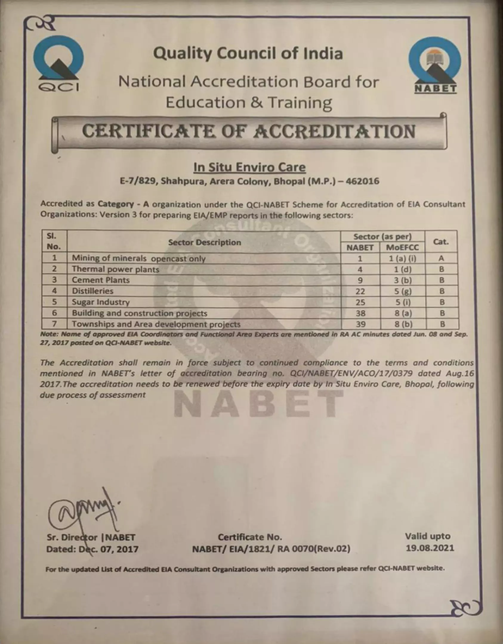


Scheme for Accreditation of EIA Consultant Organizations
List of ACOs with their Certificate / Extension Letter no. Rev. 19, February 14, 2022 Page 4
56. Karnataka ORG000756 Mineral Engineering Services NABET/EIA/1922/RA0158 22-10-2022
57. Karnataka ORG000837 Samrakshan NABET/EIA/1922/IA0051 24-07-2022
58. Karnataka ORG000912 Sai Universal Mining Services NABET/EIA/2023/IA0082 11-06-2024
59. Kerala ORG000966 CSIR- NIIST (National Institute for Interdisciplinary Sci. and Tech.)
NABET/EIA/1922/IA0057 19-12-2022
60. Kerala ORG000907 KITCO Ltd. NABET/EIA/2023/RA 0164 26-01-2023
61. Madhya Pradesh ORG000687 Forest Environment & Climate Change Management Consultancy(FECCM) Pvt Ltd.
NABET/EIA/1922/IA0054 15-05-2022
62. Madhya Pradesh ORG000516 In Situ Enviro Care QCI/NABET/ENV/ACO/22/2255 15-05-2022
63. Madhya Pradesh ORG000311 Creative Enviro Services NABET/EIA/2023/RA 0176 22-10-2023
64. Madhya Pradesh ORG001065 Envisolve LLP NABET/EIA/2124/IA0088 19-08-2024
65. Maharashtra ORG000378 Aditya Environmental Services Pvt. Ltd. NABET/EIA/1922/SA 0129 01-05-2022
66. Maharashtra ORG000820 Anacon Laboratories Pvt. Ltd. NABET/EIA/1922/RA0150 30-09-2022
67. Maharashtra ORG000027 Aqura Enviro Projects Private Limited (AEPPL) QCI/NABET/ENV/ACO/22/2151 13-05-2022
68. Maharashtra ORG000702 Building Environment (India) Pvt. Ltd. NABET/EIA/1922/SA 0136 27-05-2022
69. Maharashtra ORG000762 Dr. Subbarao s Environment Centre NABET/EIA/1922/RA0162 12-06-2022
70. Maharashtra ORG000706 Enviro Resources NABET/EIA/1922/SA 0133 30-03-2022
71. Maharashtra ORG000458 Enviro Techno Consult Pvt. Ltd. NABET/EIA/1922/RA 0163 25-02-2022
72. Maharashtra ORG000367 Equinox Environments (India) Private Limited QCI/NABET/ENV/ACO/22/2208 10-04-2022
73. Maharashtra ORG000511 Goldfinch Engineering Systems Private Limited NABET/EIA/1922/RA0145 08-12-2022

LIST OF ANNEXURES

Black Trap Mine Draft EIA/EMP
LIST OF ANNEXURES Page No.
Annexure-I Terms of References 1-3
Annexure-II Lease Application 4-9
Annexure-III Approved Mining Plan 10-61
Annexure-IV Mine Plates 62-71
Annexure-V Lab Reports 72-110
Annexure-VI Traffic Survey Forms duly filled during traffic study 111-116
Annexure-VII Monitoring Photographs 117-120
Annexure-VIII Cluster Map 121
Annexure-IX List of Critically Polluted Areas issued by CPCB 122-124
Annexure-X Project Details Certified by District Geologist 125-128
Annexure-XI Questionnaire 129-176
Annexure-XII CER Notification dated 30th September, 2020 177-178
Annexure-XIII Form-1 and PFR 179-196
M/s Guru krupa Stone

ANNEXURE-I TERMS OF REFERENCE

1

2

3

ANNEXURE-II LEASE APPLICATION

4

5

6

7

8

9

ANNEXURE-III APPROVED MINING PLAN

10

11

12

13

14

15

16

17

18
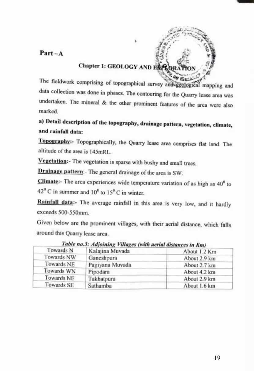
19

20
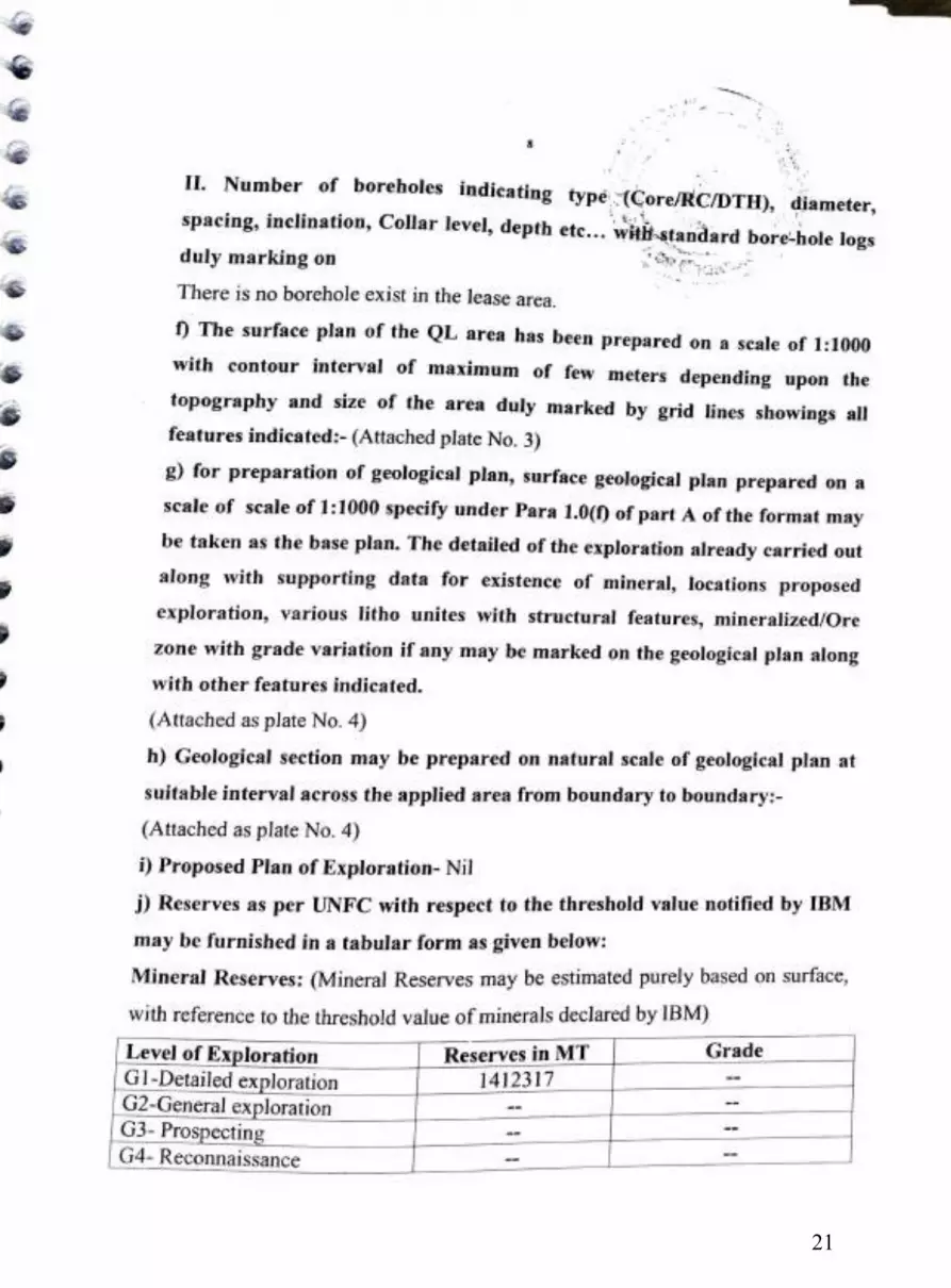
21

22
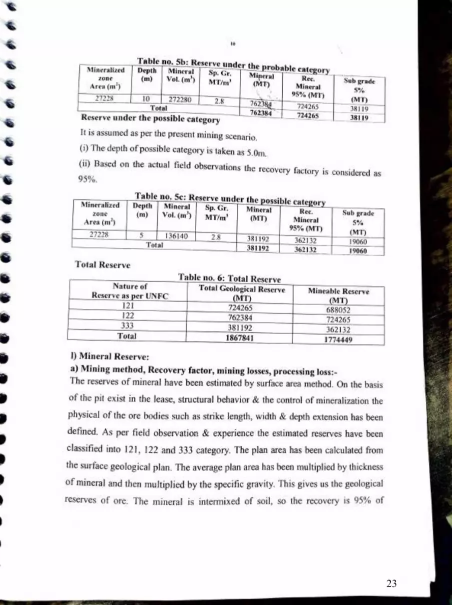
23

24

25

26

27
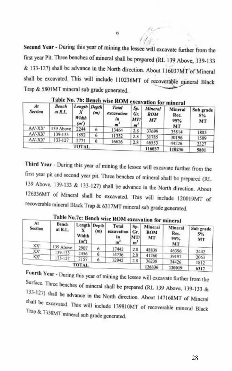
28

29

30

31
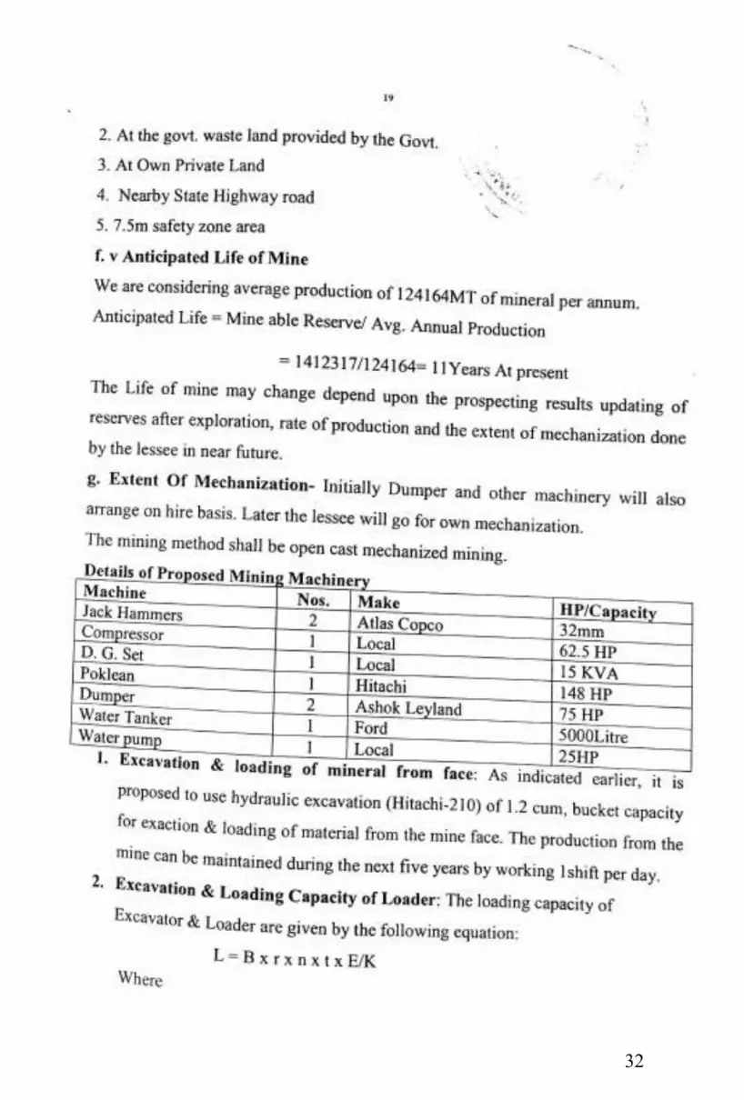
32

33

34

35

36

37

38

39

40

41

42

43

44

45

46
47

48

49

50

51

52

53

54

55

56

57

58

59
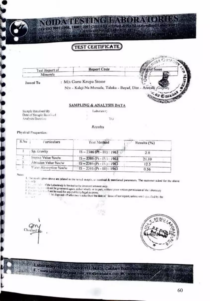
60

61

ANNEXURE-IV MINE PLATES

62

63

64

65

66

67

68

69

70

71

ANNEXURE-V LAB REPORTS

72

73

74
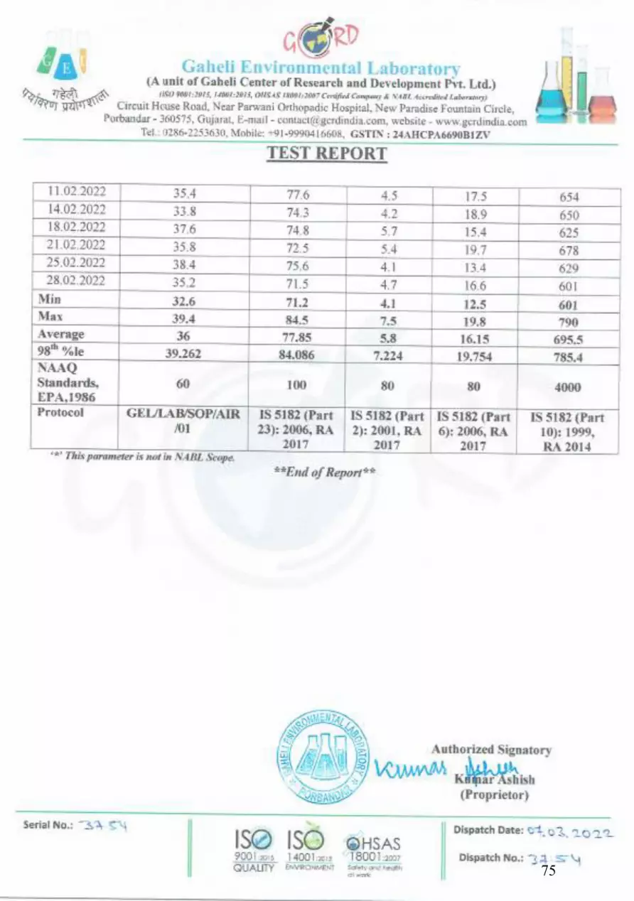
75

76

77

78

79

80
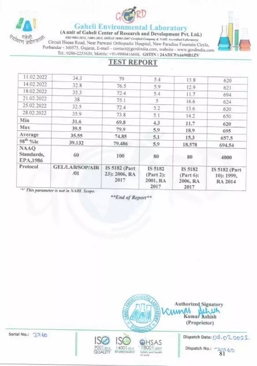
81

82

83

84

85

86

87

88

89

90

91

92

93

94

95

96
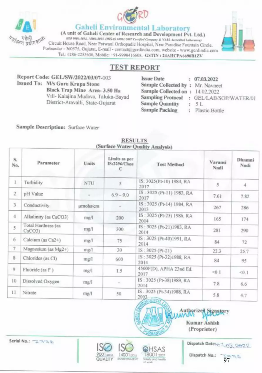
97

98

99

100

101
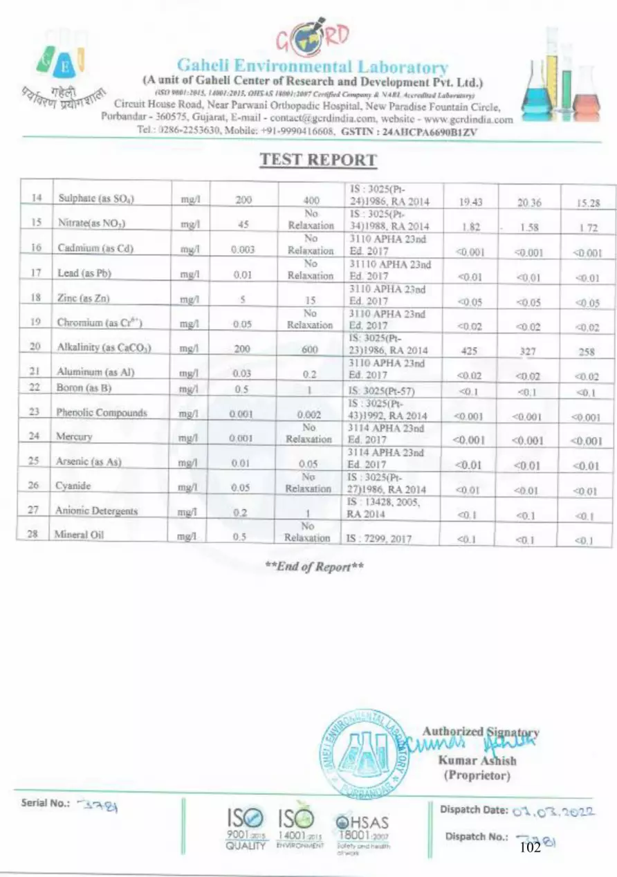
102

103

104

105

106

107

108

109

110

ANNEXURE-VI TRAFFIC SURVEY FORMS
DULY FILLED DURING TRAFFIC STUDY

111

112
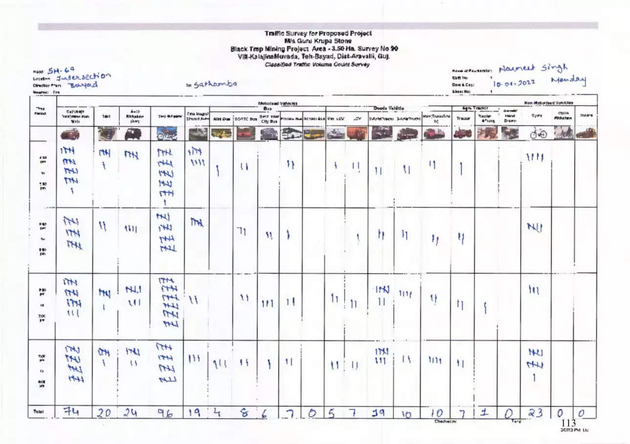
113

114

115

116

ANNEXURE-VII MONITORING
PHOTOGRAPHS

AMBIENT AIR MONITORING PHOTOGRAPHS
117

AMBIENT NOISE MONITORING PHOTOGRAPHS
118

SOIL SAMPLING PHOTOGRAPHS
119

WATER SAMPLING PHOTOGRAPHS
120

ANNEXURE-VIII CLUSTER MAP

Scanned by CamScanner121

ANNEXURE-IX LIST OF CRITICALLY
POLLUTED AREAS ISSUED BY CPCB

Co m p re h e n s i ve E nv i ro n m e n t a l A s s e s s m e n t o f I n d u s t r i a l C l u s te r s
24
Table 8 The CEPI scores for industrial areas/ clusters descending orderNo. Industrial Cluster/Area AIR WATER LAND CEPI1. Ankleshwar (Gujarat) 72.00 72.75 75.75 88.50 Ac_Wc_Lc2. Vapi (Gujarat) 74.00 74.50 72.00 88.09 Ac_Wc_Lc3. Ghaziabad (Uttar Pradesh) 68.50 75.25 71.50 87.37 Ac_Wc_Lc4. Chandrapur (Maharashtra) 70.75 67.50 66.50 83.88 Ac_Wc_Lc5. Korba (Chhatisgarh) 67.00 57.00 72.50 83.00 Ac_Ws_Lc6. Bhiwadi (Rajasthan) 71.00 69.00 59.50 82.91 Ac_Wc_Ls7. Angul Talcher (Orissa) 64.00 69.00 65.75 82.09 Ac_Wc_Lc8. Vellore (North Arcot) (Tamilnadu) 69.25 65.25 62.50 81.79 Ac_Wc_Lc9. Singrauli (Uttar Pradesh) 70.50 64.00 59.50 81.73 Ac_Wc_Ls10. Ludhiana (Punjab) 68.00 66.00 64.75 81.66 Ac_Wc_Lc11. Nazafgarh drain basin (including Anand
Parvat, Naraina, Okhla and Wazirpur), Delhi52.13 69.00 65.25 79.54 As_Wc_Lc
12. Noida (Uttar Pradesh) 65.75 64.00 60.00 78.90 Ac_Wc_Lc13. Dhanbad (Jharkhand) 64.50 59.00 65.50 78.63 Ac_Ws_Lc14. Dombivalli (Maharashtra) 66.00 63.50 57.50 78.41 Ac_Wc_Ls15. Kanpur (Uttar Pradesh) 66.00 63.50 56.00 78.09 Ac_Wc_Ls16. Cuddalore (Tamilnadu) 54.00 65.25 64.00 77.45 As_Wc_Lc17. Aurangabad (Maharashtra) 64.75 60.50 59.50 77.44 Ac_Wc_Ls18. Faridabad (Haryana) 63.50 59.00 62.75 77.07 Ac_Ws_Lc19. Agra (Uttar Pradesh) 59.00 63.75 59.50 76.48 As_Wc_Ls20. Manali (Tamilnadu) 64.00 59.00 58.00 76.32 Ac_Ws_Ls21. Haldia (West Bengal) 53.75 64.50 57.00 75.43 As_Wc_Ls22. Ahmedabad (Gujarat) 62.75 58.00 58.00 75.28 Ac_Ws_Ls23. Jodhpur (Rajasthan) 52.00 65.50 54.00 75.19 As_Wc_Ls24. Cochin, Greater (Kerala) 57.00 64.00 54.00 75.08 As_Wc_Ls25. Mandi Gobind Garh (Punjab) 62.00 55.50 62.00 75.08 Ac_Ws_Lc26. Howrah (West Bengal) 57.00 54.50 63.50 74.84 As_Ws_Lc27. Vatva (Gujarat) 60.00 62.00 56.00 74.77 Ac_Wc_Ls28. Ib Valley (Orissa) 61.00 56.50 59.00 74.00 Ac_Ws_Ls
Contd...
Table 8 below shows the CEPI scores for industrial areas/ clusters descending order. The overall CEPI is presented in the alpha-numeric form stating the score along with the status of Air, Water and Land environment in terms of subscript as critical/ severe/ normal. A sub-index score of more than 60 shows a critical level of pollution in the respective environmental component, whereas a score between 50–60 shows a severe level of pollution with reference to the respective environmental component.
122

Co m p re h e n s i ve E nv i ro n m e n t a l A s s e s s m e n t o f I n d u s t r i a l C l u s te r s
25
Table 8 contd...No. Industrial Cluster/Area AIR WATER LAND CEPI29. Varansi-Mirzapur (Uttar Pradesh) 58.00 62.00 53.50 73.79 As_Wc_Ls30. Navi Mumbai (Maharashtra) 61.00 59.00 55.50 73.77 Ac_Ws_Ls31. Pali (Rajasthan) 52.00 64.00 52.00 73.73 As_Wc_Ls32. Mangalore (Karnataka) 61.75 57.75 54.00 73.68 Ac_Ws_Ls33. Jharsuguda (Orissa) 61.00 56.50 56.00 73.34 Ac_Ws_Ls34. Coimbatore (Tamil Nadu) 62.25 58.75 45.50 72.38 Ac_Ws_Ln35. Bhadravati (Karnataka) 62.75 56.50 45.50 72.33 Ac_Ws_Ln36. Tarapur (Maharashtra) 60.75 56.00 51.25 72.01 Ac_Ws_Ls37. Panipat (Haryana) 55.75 56.50 59.00 71.91 As_Ws_Ls38. Indore (Madhya Pradesh) 59.00 57.50 52.00 71.26 As_Ws_Ls39. Bhavnagar (Gujarat) 54.50 57.50 57.75 70.99 As_Ws_Ls40. Vishakhapatnam (AndhraPradesh) 57.00 57.50 55.00 70.82 As_Ws_Ls41. Junagarh (Gujarat) 53.25 52.50 59.50 70.82 As_Ws_Ls42. Asansole (West Bengal) 58.38 56.25 50.50 70.20 As_Ws_Ls43. Patancheru- -Bollaram (Andhra Pradesh) 50.00 59.00 54.00 70.07 As_Ws_Ls44. Paradeep (Orissa) 54.00 58.50 48.00 69.26 As_Ws_Ln45. Nashik (Maharashtra) 55.00 57.50 50.25 69.25 As_Ws_Ls46. Chembur (Maharashtra) 59.75 50.75 46.00 69.19 As_Ws_Ln47. Baddi (Himachal Pradesh) 56.00 54.50 54.50 69.07 As_Ws_Ls48. Kala Amb (Himachal Pradesh) 56.75 54.50 51.00 68.77 As_Ws_Ls49. Dewas (Madhya Pradesh) 51.50 57.50 51.50 68.77 As_Ws_Ls50. Batala (Punjab) 51.00 56.50 54.50 68.59 As_Ws_Ls51. Tirupur (Tamil Nadu) 56.75 50.75 53.00 68.38 As_Ws_Ls52. Durgapur (West Bengal) 49.50 58.50 47.50 68.26 An_Ws_Ln53. Raichur (Karnataka) 59.75 46.50 44.50 68.07 As_Wn_Ln54. Bidar (Karnataka) 58.75 49.00 44.00 67.64 As_Wn_Ln55. Singhbhum, West (Bihar) 55.50 51.50 51.50 67.30 As_Ws_Ls56. Mettur (Tamilnadu) 46.00 58.00 46.50 66.98 An_Ws_Ln57. Vadodara (Gujarat) 57.00 48.00 48.00 66.91 As_Wn_Ln58. Jaipur (Rajasthan) 55.00 52.00 50.50 66.82 As_Ws_Ls59. Rajkot (Gujarat) 45.50 54.50 55.50 66.76 An_Ws_Ls60. Nagda -Ratlam (Madhya Pradesh) 44.50 54.50 56.00 66.67 An_Ws_Ls61. Jamshedpur (Jharkhand) 55.75 55.50 42.00 66.06 As_Ws_Ln62. Pimpari-Chinchwad (Maharashtra) 55.25 52.50 46.00 66.06 As_Ws_Ln
Contd...
123

Co m p re h e n s i ve E nv i ro n m e n t a l A s s e s s m e n t o f I n d u s t r i a l C l u s te r s
26
Table 8 contd...No. Industrial Cluster/Area AIR WATER LAND CEPI63. Raipur (Chhatisgarh) 56.50 42.00 49.00 65.45 As_Wn_Ln64. Saraikela (Jharkhand) 50.50 49.00 54.00 65.38 As_Wn_Ls65. Ramgarh (Jharkhand) 44.00 53.00 54.50 65.11 An_Ws_Ls66. Pinia (Karnataka) 56.75 46.00 42.00 65.11 As_Wn_Ln67. Pitampur (Madhya Pradesh) 47.75 54.00 50.50 65.09 An_Ws_Ls68. Jalandhar (Punjab) 52.00 52.00 52.00 64.98 As_Ws_Ls69. Moradabad (Uttar Pradesh) 54.00 49.00 47.50 64.71 As_Wn_Ln70. Bada Jamtara (Jharkhand) 48.00 52.50 52.50 64.47 An_Ws_Ls71. Aligarh (Uttar Pradesh) 53.00 48.00 48.00 63.83 As_Wn_Ln72. Parwanoo (Himachal Pradesh) 53.00 47.50 48.50 63.83 As_Wn_Ln73. Haridwar (Uttarakhand) 51.75 48.00 40.00 61.01 As_Wn_Ln74. Vijaywada (Andhra Pradesh) 52.00 41.50 43.00 60.57 As_Wn_Ln75. Ferozabad (Uttar Pradesh) 49.00 47.00 47.75 60.51 An_Wn_Ln76. Mathura (Uttar Pradesh) 48.00 48.00 48.00 59.98 An_Wn_Ln77. Meerut (Uttar Pradesh) 50.00 47.50 39.50 59.38 As_Wn_Ln78. Erode (Tamil Nadu) 47.38 47.25 43.50 58.19 An_Wn_Ln79. Surat (Gujarat) 46.00 46.75 45.50 57.90 An_Wn_Ln80. Kathedan (Andhra Pradesh) 44.50 47.00 45.50 57.73 An_Wn_Ln81. Kukatpalli (Andhra Pradesh) 41.50 47.00 43.50 56.56 An_Wn_Ln82. Hajipur (Bihar) 43.50 44.00 44.50 55.12 An_Wn_Ln83. Gwalior (Madhya Pradesh) 45.88 38.50 42.00 54.63 An_Wn_Ln84. Udhamsingh Nagar (Uttarakhand) 44.00 41.25 44.25 54.37 An_Wn_Ln85. Bhillai- Durg (Chhatisgarh) 44.00 35.00 33.50 50.57 An_Wn_Ln86. Bulandsahar-Khurza (Uttar Pradesh) 42.00 33.50 36.50 49.09 An_Wn_Ln87. Burnihat (Assam) 39.00 34.50 34.50 46.26 An_Wn_Ln88. Digboi (Assam) 32.00 32.75 38.00 44.55 An_Wn_Ln
124

ANNEXURE-X PROJECT DETAILS
CERTIFIED BY DISTRICT GEOLOGIST

Assistani Geologes
Geology & Minung Dept Miodasa Dis' Araval!
Projeet Details of Black Trap Minc (Other than Sand) Particulars
Details N
T TUE PROPOSAL
Nane of vase llolder M/s. Ciurukrupu Stone
Survey No, - 90,
Village: Kalajina Muvada,
Taluka: Bayad,
wation Aldress
Distriet: Arvalli. Coordinates of Lease Area
Latitude 23°11'07.03"N
Longitude 73°19'17.01 "E 73°19'18.80"E
illar PBI
23°11'07.02 "N 23°T|'05. 14"N 23°11 05.38"N
PB 2
PB 3 73°19'19.02"E
PB 4 73°19'21.14"E
PB 5 23°1 '07. 14"N 73°1921.18"E
23°1| 08.16"N 2.3°1 '08.24"N
PB 6 73°1921.46"E
73°19'24.03"E 73°1924.08"E 73°19'23.26"E
PB 7
PB8 23°10'59.03"N PB 9 23° 10'59.71 "N
PB 10 23°10'59.01 "N PB 1123°11'03.82"N PB 12 23°11 '03.76"N73°19'17.96"E
73°19'21.15"E
73°19'21.63"E
Lease Area (llectares) 3.50.00 Hectares
Ownership of land (Giove. /
Giovement Wastelund)
Private Land
Status of Operation New Project
Lease Aplication Date: 13/02/2017
LOI No.GKA/QL/18/2200, dated 13/07/2018
Mining Plan approved vide letter no. CGM/MC/ARV-
148/925 on 12/03/2018.
Status of i.case (Lease no. Date of Issue, Lease Period, Date of Applieation for lease renewal, ete.)
Name of Mineral to Mine Black Trap
Mineral Reserve (MT) 14,12,317 MT
Rate of mining of Mineral
(Annual) Proposed rate of mineral 1,57,895 MTPA
Life of Mines Appx. 11 ycars Lease area is Private Land and no forest land involves in the Whether Project involves forest
land? If Yes, Status of application for Diversion of
forest land.
mining area.
For, GURUKRUPA S7 NE
aelh P.shuh P rtner Page 1 of5
M/s. Gurukrupa Stone, Lease Area 3.50.00 Hect.
125

*So
DETAILS ON MINING/EXCAVATION ACTIVITIES 19.Requirement of power supply & AIl the activities will be carried out semi mechan
its source loading of the trucks/trolley/Dumpers will be done manually or with excavator, thus, there will be no fut
requirement in the Mining Arca.
Power Requirement is at the oflice and labor rest hou:
Mine oflice will be proposed near the mine area.
20. Requirement of water supply and For purpose of the domestic use, dust suppression anc e its source bell development, the requirement of water will be ah
4.00 KLD. This water will be taken from the nearby i! villages through tanker or Mine sump.
21. Type of mining (Manual/Semi-mechanized/mechanized).
Mining operations will be proposed by Semi-mect wet open cast method with drilling and blasting.
22 Equipment's to be used (bulldozers, hydraulic excavators, JCB, scrapers ,loaders, etc.
Hydraulie excavator with dumper and few manual todit crow-bar, pick-axe, spade elc. will be used with occisH1SI
adoption of drilling and blasting.
Black Trap is transported by truck and dumpers. i. Drilling Machines The proposed mining engh
exploitation of minerals by excavator with deci drilling and blasting. However, Jack hammer drilliig k blasting may be performed whenever require. t9iE jack hammer shall be deployed.
ii. Loading Equipment - hydraulic excavator
ii. Transport from mine head to the destina ib Mineral will be transported by hired trucks.
The machineries will be deployed on hired basis.
23. Details of method of working with phasing of activates
(Sequence of mining operations)
The proposed mining method is semi mechanized ofëi with drilling and blasting The excavated overburden and mineral will be load JCB into tractors and tuppers.
24. Explosive , Detonators to be used Explosive- Special Geletin is used for blasting. Detonator- Delay detonator & R-cord is used for en:iloi
blasting. Hole shall be drilled using integral drill of 32-110 mi with 1.5 mtr depth and spacing between holes is I mt, controlled blasting method is adopted under the supeiii of Certified Blaster.
25 Details of drilling, blasting
Control blasting shall be practiced only between 1 ivt Safety measures at the time of
blasting 26.
to 2 PM.
Adequate siren system will be in operation
All safety measures as prescribed under MMR 196 id circulars issued by DGMS.
Blasting work was carried out under the supervis in
For, GURUKRUPA STONE
P e P.sh Partner Page 3 oi
M/s. Gurukrupa Stone, Lease Area 3.50.00 Hect.
126

Certified Blaster or Mining Mate under MMR 1961. 27. Details of over burden (OB) removal & stacking
As per Mining Plan, approximately 93,392 MT will gier as Sub grade or Overburden. It will be stack withii ic area.
28 Height& Width of benches and side slope
As per Mining Plan.
Height of Bench 6 m Width of Bench 3 m
29. Depth of ground water table (Mcters)
The mining operation yet to be started. Depth of ii water is approx. 30 to 35 m.
30. Maximum depth of working (Meters). Whether it will intersect ground water table?
There is no disturbance to the ground water.
In this arca ground water is approx. 30 to 35 m belo 9 the surface.
31 Land use pattern of the lease area As per mining plan 32 Man Power Requirement The proposed mining method is semi mechanized op "i t
mining method with drilling and blasting. Therefore. tyës not require exccssive manpower.
38 manpower is sufficient for the mine operation ani iot handling
33. No. of working days in a ycar The mining activity will be carried out between Sep to Junc. Therefore total working days in a year will be ?
34. Time of Working hours in a day 12 hours a day
35. Measures Proposed for protection of environmentalattributes like water, air, human health, ete.
The mining operation should not be intersected the rnitij
waler table.
Vehicles should not be overloaded and coverei viit
tarpaulin. Control blasting should be practiced with all nertasiry
precaution.
Noise control is achieved by the following: -Shooting of large numbers of small well designe lst
holes hastily planned daily. Blasts are planned to eliminate. No. plaster shooting is taken up as this is the main eäii
of noise pollution.
36. Measures for control of noise, vibration & fly rock problems due to blasting
Fly rock hazard control: Stemming length is not kept less than the burden. It is ensured that the burden is not excessive.
Garland drains to be constructed to arrest silt and se iei flows from watering the mine area, roads, greci eli development etc. The drains shal be regularly ratise particularly after monsoon and maintained properly.
37. Plan for managing storm water. Details of garland drains to be
provided
38. Plan for managing dust, noOise, - In order to reduce effect of noise earmuffs v
For, GURUKRUPA STONE
Partner Page 4 o
M/s. Gurukrupa Stone, Lease Area - 3.50.00 Hect.
127
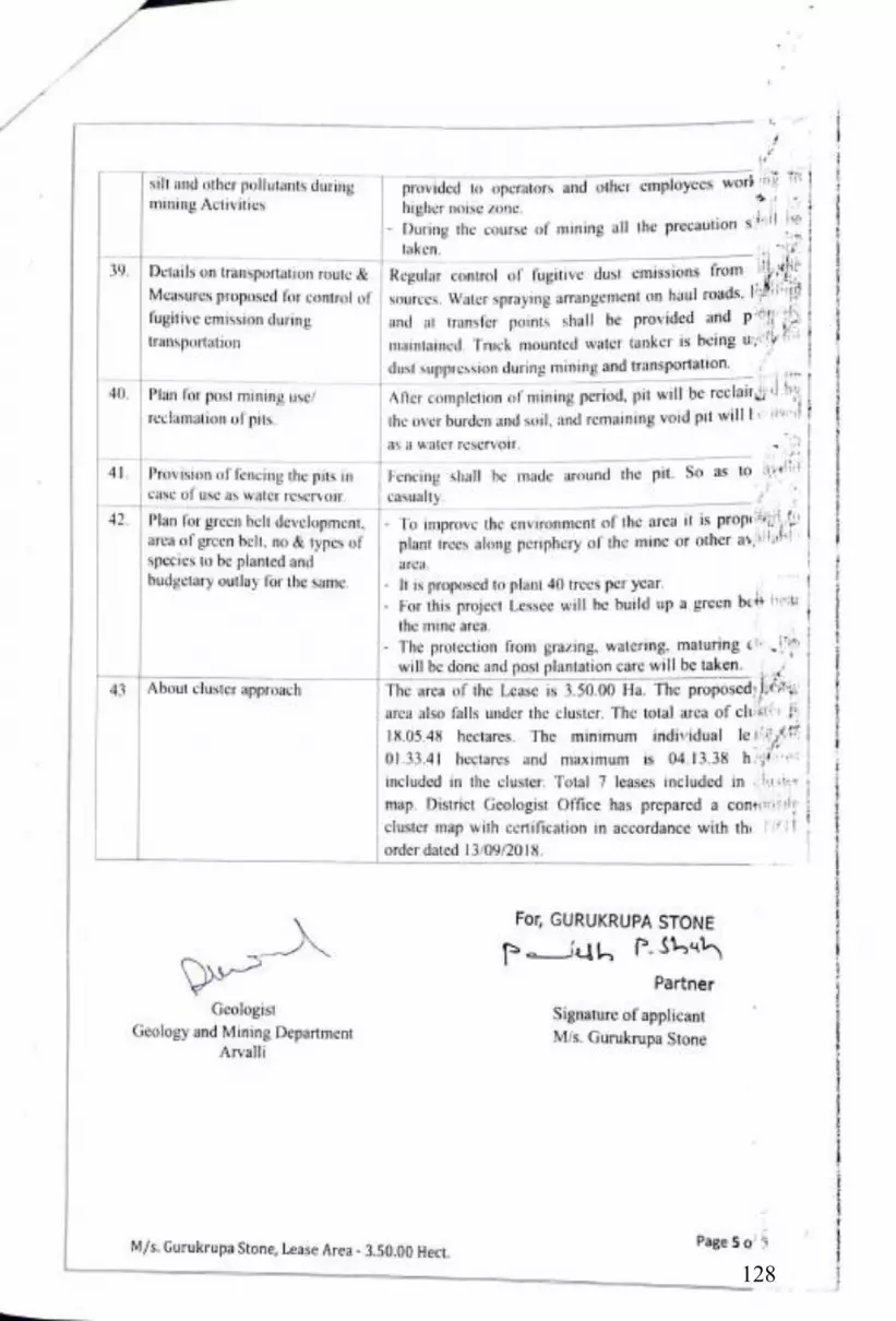
silt and other pollutants during mining Activities
provided to operators and other employces work igi* higher noise zone.
During the course of mining all the precaution siifl ie
aken.
39. Details on transportation route & Regular control of fugitive dust emissions from
Measures proposed for control of sources. Water spraying arrangement on haul roads,
fugitive emission during and at iransfer points shall be provided and p'
maintained. Truck mounted water tanker is being uy fi
dust supprcssion during mining and transportation.transportation
After completion of mining period. pit will be reclairri by
the over burden and soil, and remaining void pit willle #*ed t 40 Plan for post mining use/
reclamation of pits.
as a water reservoir.
Fencing shall be made around the pit. So as to iyei
casualty.
41 Provision of fencing the pits in case of use as watcr reservoir
42. Plan for grcen bclt devclopment, - To improve the environment of the arca it is prop
arca of grcen belt, no & types of
species to be planted and
budgetary outlay for the same.
plant trccs along periphery of the minc or other avillie arca.
-It is proposed to plant 40 trces per year.
-For this project Lessee will be build up a green bet+ 1:cr
the mine area.
- The protection from grazing, watering, maturing ce, will be done and post plantation care will be take
The arca of the Lease is 3.50.00 Ha. The proposed: arca also falls under the cluster. The total arca of clistér i 18.05.48 hectares. The minimum individual le 01.33.41 hectares and maximum is 04.13.38 h:e included in the cluster. Total 7 leases included inst map. District Geologist Office has prepared a coniisi
cluster map with certification in accordance with the fii1
43 About cluster approach
order dated 13/09/2018.
For, GURUKRUPA STONE
PJuL P.SL4h
Partner
Geologist Geology and Mining Department
Signature of applicant M/s. Gurukrupa Stone
Arvalli
M/s. Gurukrupa Stone, Lease Area 3.50.00 Hect. Page 5 o 3
128

ANNEXURE-XI QUESTIONNAIRE

M/S GURU KRUPA STONE (BLACK TRAP MINE, AREA-3.50 HA)
PROFORMA FOR ENVIRONMENTAL APPRAISAL OF MINING PROJECTS (MINING SECTOR PROJECTS)
Note 1 All information to be given in the form of Annex/s should be properly numbered and form part of reply to this proforma.
Note 2 Please enter √ in appropriate box where answer is Yes / No
Note 3 No abbreviation to be used - Not available or Not applicable should be clearly mentioned.
Note 4 Core zone is the mining lease area. Buffer zone is an area 10 km all around the periphery of the core zone.
Note 5 Adopt Scoping process in carrying out EIA study.
Note 6 Please indicate source of data.
1. General Information(a) Name of the Project M/s Gurukrupa Stone Mining Project (i) Name of the Proponents Mr. Shah Pareshbhai Punamchand.
Mailing Address E-Mail Telephone 9990416608 Fax No. -
(ii) Objective of the Project Mining of Black Trap mineral
(b) Location of Mines Village Tehsil District State Kalaji
Muvada Bayad Aravalli Gujarat
(c) Does the Proposal Relate To (i) New Mine Yes √ No (ii) Expansion Yes No √
• Increase in ML area Yes No √
• Increase in annualproduction
Yes No √
(iii) Renewal of ML Yes No √ (iv) Modernization Yes No √
(d) Site Information (i) Geographical Location
• Latitude 23°11'8.24"N • Longitude 73°19'24.08"E • Survey of India Topo
sheet numberOpen series sheet no. F43B08
• Elevation above Mean
129

M/S GURU KRUPA STONE (BLACK TRAP MINE, AREA-3.50 HA)
Sea Level • Total mining lease
area (in ha.) 3.50 Ha
(ii) Dominant nature of terrain • Flat Yes No √ • Undulated Yes √ No √ • Hilly Yes No
2. Land usage of the mining lease area (in ha.) (a) Agricultural - (b) Forest - (c) Waste land - (d) Grazing - (e) Surface Water Bodies - (f) Other (Specify) 3.50 (Private Land) Total 3.50
3. Indicate the seismic zone in which ML area falls. In case of zone IV & V, details of earth quakes in last 10years.
Mining lease is within Zone III
(a) Severity (Richter Scale) – Not applicable for Zone III
NA
(b) Impact i.e. Damage to NA • Life Yes No • Property Yes No • Existing Mine Yes No √
130

M/S GURU KRUPA STONE (BLACK TRAP MINE, AREA-3.50 HA)
4. Break-up of mining lease area (in ha.) as per approved conceptual plan
Purpose Mining Lease Area Total Area acquired Area to be acquired
Government Private Government Private Government Private Forest Others Agri. Others Forest Others Agri. Others Forest Others Agri. Others
1. Area to be excavated -- --
2. Storage for top soil -- --
3. Overburden / Dumps -- --
4. Mineral storage -- --
5. Infrastructure (Workshop, Administrative Building)
--
--
6. Roads -- --
7.Railways -- --
8. Green Belt -- --
9.Tailings pond -- --
10.Effluent treatment plant -- --
11.Coal handling plant / mineral separation plant
-- --
12. Township area -- --
13.Other (Specify) Untouched Area
3.50 3.50
TOTAL 3.50 3.50
Q-12
131

M/S GURU KRUPA STONE (BLACK TRAP MINE, AREA-3.50 HA) 5. Township (outside
mining lease)
(a) Total area (in ha) Nil (b) No. of dwelling units Nil (c) Distance from mine site Not applicable
6. Distance of water bodies (in km)
Distance from
River Bank * Other Water bodies * Sea / creek / lake / nalla etc.
(specify) Cluster boundaries Varanasi Nadi – 8.632 Km
Dhamni Nadi – 1.606 Km Vatrak Nadi –10.941 Km
NA
Ancillary facilities - -
[* From highest flood line / high tide line]
7. For projects falling
within the Coastal Regulation Zone(CRZ)
NA
Whether the mineral to be mined is of rare nature and not available outside CRZ?
Yes No
if yes, annex a scaled location map showing low tide line (LTL), high tide line (HTL) duly demarcated by one of the authorized agencies* [ *Director, Space Application Centre, Ahmedabad: Centre for Earth Sciences Studies, Thiruvananthapuram: Institute of Remote Sensing, Anna University, Chennai: Institute of Wetland Management & Ecological Designs, Kolkata: Naval Hydrographers's Office, Dehradun: National Institute of Oceanography, Panjim, Goa: and National Institute of Ocean Technology, Chennai], boundary of mining lease area, distance of ML area from LTL and HTL CRZ boundary and CRZ classification of the project area as per the approved Coastal Zone Management Plan, and settlements, sand dunes, mangroves, forest land/patches, turtles breeding and nesting sites etc., if any, in the project area.
132

M/S GURU KRUPA STONE (BLACK TRAP MINE, AREA-3.50 HA) 8. Indicate aerial distance from the periphery of core zone / area from the periphery of the buffer zone to the boundary of following (up to 10km)
S.
No. Areas Name Aerial distance from (in
km.) Core Zone/Buffer Zone
1. National Park / Sanctuary Ratanmahal Wildlife
Sanctuary 91.720
2. Biosphere Reserve / Tiger Reserve / Elephant Reserve / any other Reserve
No such reserve and corridor within 10 km of cluster area
Not applicable
3. Forest (RF / PF / unclassified)
No forest land within 10 km of cluster area
Not applicable
4. Habitat for migratory birds No such habitat within 10 km of cluster area
Not applicable
5. Corridor for animals of schedule I & II of the Wildlife (Protection) Act, 1972
None None
6. Archaeological sites * Notified * Others
No archaeological site notified within 10 km of cluster area
None
7. Defense Installation No defense installation within 10 km of cluster area
Not applicable
8. Industries / Thermal Power Plants
None Not applicable
9. Other Mines
10. Airport Ahmedabad Airport 72.29 Kms
11. Railway Lines Bayad Railway Station
11.263
12. National / State Highways SH-69 SH-59 SH-238
0.683 10.385 7.909
133

M/S GURU KRUPA STONE (BLACK TRAP MINE, AREA-3.50 HA) [* Buffer zone in case of ML area up to 25 ha. is to be considered as 5 km all around the periphery of the core zone and for ML area above 25 ha. an area 10 km all around the periphery of the core zone].
9. Description of flora & fauna separately in the core and buffer zones.*
[* Consult the Wildlife (Protection) Act, 1972 as amended subsequently and list species with (1) Common name (2) Scientific name and (3) under which schedule of the Wildlife (Protection) Act the identified species fall. Get the list authenticated by an Expert in the field / credible scientific institute / University / Chief Wildlife Warden Office. Information to be based on field survey.]
Floral Species in Study Area
S. No.
Scientific Name Local Name Family OccurRence
Core Zone Buffer Zone
Tree
1 Acacia nilotica Babool Mimosaceae Present Present
2 Acacia auriculiformis Khairbelt
Fabaceae - Present
3 Ziziphus mauritiana Ber Rhamnaceae Present Present
4 Acacia jacomorbi Kher Fabaceae - Present
5 Azadirachta indica Neem Meliaceae Present Present
6 Ailanthus excelsa Araduso Simaroubaceae - Present
7 Salvadora oleoides Pilu Salvadoraceae - Present
8 Emblica officinalis Ambala Phyllanthaceae - Present
9 Mangifera indica Aam Anacardiaceae - Present
10 Polyalthia longifolia Debadaru Annonaceae - Present
11 Plumeria rubra Golenchi Apocynaceae - Present
12 Cocos nucifera Naariyal Arecaceae - Present
13 Bombax ceiba Sawar Bombacaceae - Present
14 Delonix regia gulmoha Ceasalpiniaceae - Present
15 Cassia fistula Amaltas Caesalpiniaceae - Present
16 Tamarindus indica Mange Fabaceae - Present
17 Peltophorum Peela gulmohar Fabaceae - Present
134

M/S GURU KRUPA STONE (BLACK TRAP MINE, AREA-3.50 HA) pterocarpum
18 Carica papaya Papaiya Caricaceae - Present
19 Terminalia catappa Badamalili Combretaceae - Present
20 Casuarina equisetifolia Junglisaru Casuarinaceae - Present
21 Anogeissus latifolia Dhaura Combretaceae - Present
22 Thespesia populnea Paras pipal Malvaceae - Present
23 Albizia procera Siris Fabaceae - Present
24 Acacia catechu Mulga Fabaceae - Present
26 Pithecellobium dulce Vilayati ambli Fabaceae - Present
28 Moringa oleifera Suragavo Moringaceae - Present
29 Ficus religiosa Peepal Moraceae Present Present
30 Butea monosperma Palash Fabaceae - Present
31 Dalbergia latifolia kala-shisham Fabaceae - Present
32 Bauhinia purpurea Jasud Fabaceae - Present
33 Manilkara zapota Chikoo Sapotaceae - Present
34 Tectona grandis Saagaun Lamiaceae - Present
35 Phoenix sylvestris Khajuri Arecaceae - Present
36 Eucalyptus sp Safeda Myrtaceae - Present
Shrub
1 Nerium indicum Lalkaren Apocynaceae - Present
2 Calotropis procera Akado Apocynaceae Present Present
3 Tecoma stans Peilafol Bignoniaceae - Present
4 Xanthium strumarium Gokhru Asteraceae - Present
5 Cassia auriculata Awala Fabaceae - Present
6 Ipomea fistulosa Nasarmo Convolvulaceae - Present
7 Euphorbia neriifolia Thor Euphorbiaceae - Present
8 Jatropha curcas Ratanjot Euphorbiaceae - Present
9 Lawsonia inermis Mendhi Lythraceae - Present
10 Abelmoschus manihot Jagali bhindi Malvaceae - Present
135

M/S GURU KRUPA STONE (BLACK TRAP MINE, AREA-3.50 HA) 11 Abutilon indicum Khapat Malvaceae - Present
12 Gossypium herbaceum Kapas Malvaceae - Present
13 Musa Paradisiaca Kela Musaceae - Present
14 Prosopis juliflora Gando baval Fabaceae - Present
15 Mimosa hamata Kai baval Fabaceae - Present
16 Bougainvillea spectabilis Bougainvel Nyctaginaceae - Present
17 Datura metel Daturo Solanaceae - Present
18 Solanum incanum Ubhi ringan Solanaceae - Present
19 Lantana camara Putush Verbenaceae - Present
20 Clerodendrum inerme Madhi Verbenaceae - Present
Herb & Grasses
1 Achyranthes aspera Anghedi Amaranthaceae - Present
2 Hygrophila auriculata Akaro Acanthaceae - Present
3 Aerva javanica Gorakhganjo Amaranthaceae - Present
4 Celosia argentea Survali Amaranthaceae - Present
5 Pistia stratiotes Jalasankhala Araceae - Present
6 Blumea eriantha Kalhar Asteraceae - Present
7 Eclipta prostrata Bhangro Asteraceae - Present
8 Cassia tora Kuvandio Caesalpiniaceae - Present
9 Tridax procumbens Pardesi Bhangro Asteraceae - Present
10 Trichodesma indicum Undhanphuli Boraginaceae - Present
11 Ocimum sanctum Tulsi Labiatae - Present
12 Commelina benghalensis Kanshira Commelinaceae - Present
13 Mimosa pudica Lajwanti Fabaceae - Present
14 Euphorbia hirta Ghaopata Euphorbiaceae - Present
15 Urginea indica Jungli Dungli Asparagaceae - Present
16 Boerhavia diffusa Satodi Nyctagineaceae - Present
17 Crotalaria burhia Kharshan Nyctagineaceae - Present
18 Cajanus cajan Tuvar Fabaceae - Present
136

M/S GURU KRUPA STONE (BLACK TRAP MINE, AREA-3.50 HA) 19 Cynodon dactylon Durba Poaceae Present Present
20 Typha angustata Ramban Poaceae - Present
Faunal Species in the study area
S. No.
Scientific Name English Name Schdeule as per the Indian
Wildlife (Protection) Act, 1972
Mammals
1 Funambulus pennantii Five striped squirrel Schdeule IV
2 Lepus nigricollis Indian Hare Schdeule IV
3 Herpestes edwardsii Indian Grey Mongoose Schdeule II (Part I)
5 Presbytis entellus Common Langur Schdeule II
6 Canis aureus Jackal Schdeule II (Part I)
7 Hystrix indica Indian Crested porcupine Schdeule IV
8 Macaca mulatta Rhesus Macaque Schdeule II (Part I)
9 Boselaphus tragocamelus Nilgai Schdeule III
10 Rattus rattus Common house Rat Schdeule IV
Birds
1 Anas crecca Common Teal -
2 Milvus migrans Common Pariah Kite -
3 Phalacrocorax fuscicollis Indian Cormorant -
4 Streptopelia orientalis Oriental Turtle-Dove -
5 Coracias benghalensis Indian Roller -
6 Francolinus pondicerianus Grey Francolin -
7 Ardeola grayii Indian Pond-Heron -
8 Mesophoyx intermedia Intermediate Egret -
9 Acridotheres tristis Common Myna -
10 Turdoides caudatus Common Babbler -
11 Orthotomus sutorius Common Tailorbird -
12 Merops orientalis Green bee eater -
137

M/S GURU KRUPA STONE (BLACK TRAP MINE, AREA-3.50 HA) 13 Pterocles exustus Chestnut-bellied sandgrouse
14 Columba livia Rock Pigeon Schdeule IV
15 Corvus splendens House crow -
16 Egretta garzetta Little Egret -
17 Ardea alba Great White Egret -
18 Himantopus himantopus Black-winged Stilt -
19 Grus grus Common crane -
20 Alcedo atthis Common kingfisher -
21 Acridotheres tristis Common Maina -
22 Psittacula krameri Rose ringed Parakeet -
23 Hirundo rustica Common Swallow -
24 Fulica atra Common Coot -
25 Copsychus saularis Magpie - Robin -
26 Prinia buchanani Rufous fronted prinia -
27 Saxicoloides fulicata Indian Robin -
Reptiles & Amphibians
1 Ptyas mucosa Yellow Rat Snake Schdeule II (Part II)
2 Calotes versicolor Common garden lizard -
3 Hemidactylus flaviviridis House lizard -
4 Bufo melanostictus Common Indian Toad -
5 Rana limnocharis Paddy-field Frog -
6 Rana tigrina Indian bull frog Schdeule IV
Butterflies
1 Neptis hylas Common sailor -
2 Pachliopta hector Crimson rose -
3 Papilio demoleus Lime Butterfly -
4 Junonia almana Peacock pansey -
138

M/S GURU KRUPA STONE (BLACK TRAP MINE, AREA-3.50 HA) List of Cash Crops in the Study Area
S.
No. Botanical Name Family Local Name Habit
Grain Crops
1 Pennisetum typhoides A. Rich. Poaceae Bajri, Bajaro Herb
2 Sorghum bicolor (L.) Moench. Poaceae Jawar, Baru Grass
3 Cajanus cajan (L.) Millsp. Fabaceae Tuver Herb
4 Triticumaes tibvum L. Poaceae Wheat - Gahun Grass
5 Vigna radiate (L.) wilczek.Var.
radiata Fabaceae Udad Herb
6 Ricinus communis L. Euphorbiaceae Arando, Divel Shrub
7 Vigna trilobata (L.) Verdcourt Fabaceae Mung, Math Herb
8 Zea mays L. Poaceae Makai Grass
Fruit Crops
1 Annona squamosa L. Annonaceae Sitafal Small tree
2 Annona reticulate L. Annonaceae Ramphal Small tree
3 Psidium guajava L. Myrtaceae Jamphal tree
4 Citrus aurantifolia (Chr.) Swingle Rutaceae Kag Ji Limbu Small tree
5 Limonia elephantum (Correa) Panigrahi
Rutaceae Kotha Tree
6 Citrus limon (L.) Burm. f. Rutaceae Limbu Shrub
7 Musa paradisiacal L. Musaceae Kela, Kelu Small tree
8 Punica granatum L. Punicaceae Dadam Small tree
9 Phyllantus embelica Euphorbiaceae Amala Small tree
10 Morus alba L. Moraceae Shetur Tree
Vegetable Crops
1 Abelmoschus esculentus (L.) Moench
Malvaceae Bhinda, Bhindo Under Shrub
2 Capsicum annuum L. var Solanaceae Marchi Herb
139

M/S GURU KRUPA STONE (BLACK TRAP MINE, AREA-3.50 HA) acuminatum Fingerh.
3 Cucumis sativus L. Cucurbitaceae Kakadi Climber
4 Lageneria leucantha (Duch.) Rusby.
Cucurbitaceae Dudhi Herb
5 Cicer arietinum L. Fabaceae Chana Herb
6 Momordica charantia L. Cucurbitaceae Karela Climber
7 Allium sativum vineale Liliaceae Lasun
8 Moringa oleifera Lam. Moringaceae Mitho Saragvo Tree
9 Lycopersicon lycopersicum (L.) Karst.
Solanaceae Tamata, Herb
10 Solanum melongena L. Solanaceae Ringana, Under Shrub
11 Daucus carota L. var.sativa Apiaceae Gajar Under Shrub
Cash/Commercial crops
1 Saccharum officinarum L. Poaceae Sherdi, Ganna Grass
2 Gossypium herbaceum auct. Non L.var. acerifolium (Guill. & Perr.)
Malvaceae Kapas, Desi
Kapas Shrub
10. Details of mineral reserves (as per approved Mining Plan) (a) Proved - (b) Indicated - (c) Inferred 1482300 (d) Mineable Reserves Not provided in approved mine plans
11. Major geological formation / disturbances in the mining lease area (a) Geological maps
submitted Yes √ No
(b) Geological sections submitted
Yes √ No
(c) Contour map submitted Yes √ No (d) Whether the presence,
if any, noted of
(i) Faults Yes No √ (ii) Dykes Yes No √ (iii) Shear Zone Yes No √ (iv) Folds Yes No √
140

M/S GURU KRUPA STONE (BLACK TRAP MINE, AREA-3.50 HA) (v) Other Weak Zones Yes No √ (e) Source of data
(Indicate) Approved mine plans
12. Production of mineral(s) and life of mine (a) Rated capacity of mine
mineral wise (Tonnes /annum)
(ROM in CuM)) Granite – 157,895 Max in 5th Year
(b) Life of mine at proposed capacity(Years)
11
(c) Lease period (Years) 13 (d) Date of expiry of lease
(D/M/Y) 3/31/2035 (35 years)
(i) Date of opening of mine
NA
(ii) Production in the last 5 years from year……… to year ……… in million tonnes.
NA
(iii) (iii) Projected production for the next 5 years from year 1 t to 5th to year in million tonnes.
Year 1 – 5 653494 MTPA
(iv) Whether mining was suspended after opening of the mine?
NA
If yes, details thereof include last production figure and reason for the same.
(f) Whether plans & sections provided
Yes √ No
13. Type and method of mining operations
TYPE METHOD
Opencast Yes Semi-mechanised Yes
Underground No
141
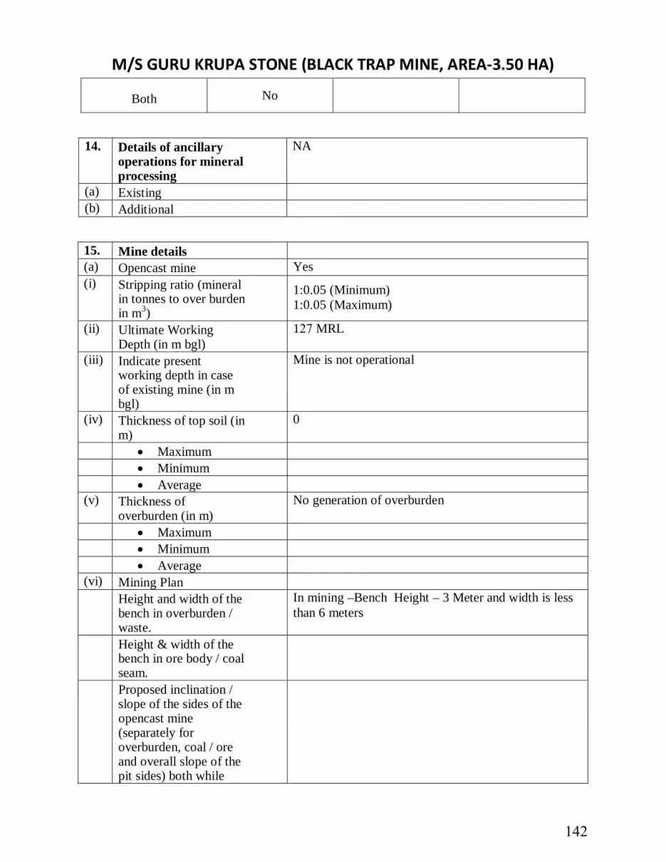
M/S GURU KRUPA STONE (BLACK TRAP MINE, AREA-3.50 HA)
Both No
14. Details of ancillaryoperations for mineralprocessing
NA
(a) Existing (b) Additional
15. Mine details(a) Opencast mine Yes (i) Stripping ratio (mineral
in tonnes to over burden in m3)
1:0.05 (Minimum) 1:0.05 (Maximum)
(ii) Ultimate Working Depth (in m bgl)
127 MRL
(iii) Indicate present working depth in case of existing mine (in m bgl)
Mine is not operational
(iv) Thickness of top soil (in m)
0
• Maximum• Minimum• Average
(v) Thickness of overburden (in m)
No generation of overburden
• Maximum• Minimum• Average
(vi) Mining Plan Height and width of the bench in overburden / waste.
In mining –Bench Height – 3 Meter and width is less than 6 meters
Height & width of the bench in ore body / coal seam. Proposed inclination / slope of the sides of the opencast mine (separately for overburden, coal / ore and overall slope of the pit sides) both while
142

M/S GURU KRUPA STONE (BLACK TRAP MINE, AREA-3.50 HA) operating the mine as well as at the time of closure of the mine.
Whether transverse sections across the Opencast mine at the end of fifth year and at the end of the life of the Mine have been submitted?
(vii) Type of blasting, if any, to be adopted
The blasting will be done by authorised contractors on contractual basis. These contartors have their explosives contaoiners as will as explosives lease. Lessee may use jack hammar drilling of 32mm dia hole or 110mm hole dia of wagon drill m/c. The QL will mine by slice method of each 1.5m with jack hammar drilling. Lessee may use deep hole blasting after getting DGMS permission.
(b) Underground mine NA (i) Seam / Ore body (ii) Mode of entry into the
mine
• Shaft • Adit • Incline (iii) Details of Machinery • On Surface Jack Hammar, Compressor, D.G. Sets and Poklean • At Face • For
Transportation Trucks, Dumper
• Others (iv) Method of Stoping
(metalliferous mines)
• Open • Filled • Shrinkage • Caving • Combination of
above
• Others (Specify) (v) Extraction method • Caving • Stowing
143

M/S GURU KRUPA STONE (BLACK TRAP MINE, AREA-3.50 HA) • Partial
Extraction
(vi) Subsidence • Predicted max.
subsidence (in m)
• Max. value of tensile strain (in mm/m)
• Max. slope change (in mm/m)
• Whether identified possible subsidence area(s) superimposed on Surface Plan has been submitted?
• Major impacts on surface features like natural drainage pattern, houses, buildings, water bodies, roads, forest, etc.
• Salient features of subsidence management (monitoring and control)
16. Surface drainage pattern at mine site (a) Whether the pre-mining
surface drainage plan submitted?
Yes √ No
(b) Do you propose any modification / diversion in the existing natural drainage pattern at any stage? If yes, when. Provide location map indicating contours, dimensions of water body to
Yes No √
144

M/S GURU KRUPA STONE (BLACK TRAP MINE, AREA-3.50 HA) be diverted, direction of flow of water and proposed route / changes, if any i.e. realignment of river / nallah / any other water body falling within core zone and its impact.
17. Embankment and/or weir construction (a) Do you propose, at any stage,
construction oft No
(i) Embankment for protection against flood?
Yes No √
(ii) Weir for water storage for the mine
Yes No
(b) If so, provide details thereof No (c) Impact of embankment of
HFL and HFL and settlement around
No
(d) Impact of weir on downstream users of water
No
18. Vehicular traffic density (outside the ML area)
(a) Existing 1. Vehicle Count in PCU = (1670.5 +1506.5): 2. 1: Bayad to Sathamba – SH- 69- (1670.5-
Vehicle Count) 3. 2. Sathamba to Bayad – SH -69- (1506.5 -
Vehicle Count) 4. 5. Total accommodative capacity of the road (8
Meters) IRC : 64 – 1990 is 15,000 PCU. Carrying capacity = Volume /Capacity = 3177/ 15,000 = 0.21(LOS – B – Very good)
(b) After the proposed activity Modified V/C Ratio = Existing PCU + Additional PCU load of cluster /15,000 Modified V/C = (3177+2709) = 5886/15,000 = 0.27 Inference : New V/C ratio is 0.48 ( LOS –A –Good) Even if the entire load of cluster of 2709 PCU (worst case scenario) is added upon, the level of service will have minimal impact and correspond to LOS - A – Very Good.
(c) Whether the existing road network is adequate?
Yes √ No
145

M/S GURU KRUPA STONE (BLACK TRAP MINE, AREA-3.50 HA) If no, provide details of alternative proposal?
19. Loading, transportation and unloading of mineral and waste rockson (a) Manual Yes √ No (b) Tubs, mine cars, etc. Yes No √ (c) Scraper, shovels,
dumpers/trucks Yes √
No
(d) Conveyors (belt, chain, etc.) Yes No √ (e) Others (specify) Yes No
20. Mineral(s) transportation outside the ML area Quantity (TPD) Percentage (%) Length (km) (a) Road (b) Rail (c) Conveyors (d) Rope Way (e) Water ways (f) Pipeline (g) Others (Specify) Total
146

M/S GURU KRUPA STONE (BLACK TRAP MINE, AREA-3.50 HA) 21. Baseline Meteorological and Air Quality Data (a) Micro-meteorological data
[Continuous monitoring through autographic instrument for one full season other than monsoon]
(i) Wind rose pattern for one full season (16 points of compass i.e. N, NNE, NE, ---) based on 24-hourly data
Q-28
147

M/S GURU KRUPA STONE (BLACK TRAP MINE, AREA-3.50 HA) (ii) Site Specific monitored data
S. No.
Month and Year
Wind Speed (m/s) Temperature (°C) Relative Humidity
Min Avg Max Min Avg Max Min Avg Max
1 Dec 2021 0 1.97 8.99 14.0 21.50 29.0 34 47.0 60
2 January
2022 0 1.74 6.17 11.0 19.20 27.4 32 45.5 59
3 February
2022 0 1.84 6.53 16.0 23.20 30.4 24 39.0 54
* 24-hours rainfall should be reported from 08:30 hrs. IST of previous day to 08:30 hrs. IST of the day. * Rainy day is considered when 24 hrs. Rainfall is 2.5mm. ** Visual observations of cloud cover should be recorded four times a day at regular intervals.
(iii) Indicate name and distance of the nearest IMD meteorological station from which climatological data have been obtained for reporting in the EIA report, if any. Climatological Data station is Ahmedabad, 72 km away from project site
(b) Ambient air quality data* (RPM, SPM, SO2, and NOx)
[*Monitoring should be carried out covering one full season except monsoon – same season as in 21 (a) (i)]
[*Frequency of sampling: Sampling to be done twice a week for the entire season 24 hourly for SPM & RPM. For gaseous pollutants 24- hourly data is given irrespective of the sampling period. ]
(i) Season and period for which monitoring has been carried out: December 2021, January 2022, February 2022
(ii) No. of samples collected at each monitoring station:
Q-29
148
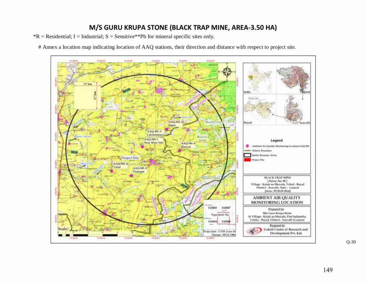
M/S GURU KRUPA STONE (BLACK TRAP MINE, AREA-3.50 HA) *R = Residential; I = Industrial; S = Sensitive**Pb for mineral specific sites only.
# Annex a location map indicating location of AAQ stations, their direction and distance with respect to project site.
Q-30
149

M/S GURU KRUPA STONE (BLACK TRAP MINE, AREA-3.50 HA) 22. Stack and emission details, if any*: Not applicable
Sl. No.
Process / unit of operation (e.g. DG Set, Boiler)
Height of stack (m)
Internal top dia. (m)
Flue gas exit velocity (m/sec)
Emission rate (kg/hr) Heat emission rate from top of stack (K.cal/hr)
Exhaust / Flue gas
SPM SO2 NOx CO Temp
OC Density Specific
Heat Volumetric flow
rate (m3/hr.)
23. Details of fugitive emissions
during mining operations* NA
24. Air Quality Impact
Prediction (AQIP)*
(a) (Details of model(s) used for AQIP including grid size, terrain features, and input meteorological data
The Air Quality Impact Prediction has been done by using AERMOD. Impact was predicted in the worst-case scenario due to combined impact of loading and unloading and emission due to transportation of vehicles on Granite mine, haul road and other mining activities. The secondary meteorological data for the period December 2021 to February 2022 was fed in the AERMOD software to obtain isopleths.
(b) Maximum incremental GLC values of pollutants based on prediction exercise
Predicted Incremental Concentrations of PM10in Study Area
Location PM10 (µg/m3 )
Code Name of the Station
Baseline Value
(μg/m3)
Incremental Value
(μg/m3)
cumulative concentrations (μg/m3)
Q-31
150

M/S GURU KRUPA STONE (BLACK TRAP MINE, AREA-3.50 HA) AAQ-1 Near Mine
Site 86.42 0.90 87.32
AQQ-2 Jitpur 84.08 0.50 84.58
AAQ-3 Lakshmipura 78.35 0.80 79.15
AAQ-4 Talod 81.16 0.80 81.96
AAQ-5 Vijaygan 79.48 0.90 20.38
AAQ-6 Kharod 76.55 0.90 77.45
Predicted Incremental Concentrations of PM2.5 in Study Area
Location PM2.5 (µg/m3 )
Code Name of the Station
Baseline Value
(μg/m3)
Incremental Value(μg/m3)
cumulative concentrations (μg/m3)
AAQ-1 Near Mine Site 39.16 0.60 39.76
AQQ-2 Jitpur 39.26 0.50 39.76
AAQ-3 Lakshmipura 39.65 0.50 40.15
AAQ-4 Talod 39.65 0.50 40.15
AAQ-5 Vijaygan 39.13 0.50 39.63
AAQ-6 Kharod 38.80 0.60 39.40
Q-32
151

M/S GURU KRUPA STONE (BLACK TRAP MINE, AREA-3.50 HA) Predicted Incremental Concentrations of SO2 in Study Area
Location SO2 (µg/m3 )
Code Name of the Station
Baseline Value
(μg/m3)
Incremental Value (μg/m3)
cumulative concentrations (μg/m3)
AAQ-1 Near Mine Site 6.78 0.03 6.81
AQQ-2 Jitpur 7.22 0.03 7.25
AAQ-3 Lakshmipura 5.75 0.03 5.78
AAQ-4 Talod 6.54 0.03 6.57
AAQ-5 Vijaygan 5.9 0.50 6.4
AAQ-6 Kharod 6.34 0.03 6.37
Predicted Incremental Concentrations of NOx in Study Area
Location NO2 (µg/m3 )
Code Name of the
Station
Baseline Value
(μg/m3)
Incremental Value(μg/m3)
cumulative concentrations (μg/m3)
AAQ-1 Near Mine Site 19.75 0.05 19.80
AQQ-2 Jitpur 19.75 0.10 19.85
AAQ-3 Lakshmipura 19.39 0.10 19.49
AAQ-4 Talod 19.80 0.20 20.0
AAQ-5 Vijaygan 18.57 0.20 18.77
AAQ-6 Kharod 18.24 0.20 18.44
Q-33
152
M/S GURU KRUPA STONE (BLACK TRAP MINE, AREA-3.50 HA) [* Question Number 22, 23 & 24 need not be filled-in for mines having ML area of 25 ha. or less.] [**Information on item no. 2 & 3 to be provided in cases with captive power generation of 500 KVA and above]
Q-34
153

M/S GURU KRUPA STONE (BLACK TRAP MINE, AREA-3.50 HA) 25. Water requirement (m3/day)
Purpose Avg. Demand Peak Demand
A. Mine site
1. Mine operation
2. Land reclamation
-
3. Dust suppression - 2.0
4. Drinking - 1.0
5. Green Belt - 1.0
6. Beneficiation
7. Washeries
8. Fire Service
9. Others(specify) B. Township
1. Green Belt
2. Domestic
3. Other(specify)
-
Total - 4.0
26. Source of Water Supply
S. No. Source m3/day
1 River (name)
2 Ground water
154

M/S GURU KRUPA STONE (BLACK TRAP MINE, AREA-3.50 HA) 3 Mine water (sump / pit)
4 Other surface water bodies (specify) Available through tanker
[*Annex a copy of sanction letter / permission from the concerned authority (Central Ground Water Authority in case of ground water abstraction is from notified area / State Ground Water Board in case of non-notified area / State Irrigation Department for surface water pumping) for drawing water.]
27. Lean season flow in case of pumping from river / nalla (cumecs)
NA
28. Ground water potential of the study area
28.1 Ground water availability (a) Range of water table (mbgl) (i) Pre-monsoon (April/May) • Core Zone • Buffer Zone (ii) Post-monsoon(November) • Core Zone • Buffer Zone (b) Total annual replenishable
recharge (million m3/year) -
• By ground water table fluctuation method
• By rainfall infiltration factor method
(c) Annual draft excluding estimated draft through mine discharge (million m3/year)
-
(d) Estimated draft through mine discharge (million m3/year)
-
(e) Net annual ground water availability (million m3/year)
-
(f) Stage of ground water development in %
-
28.2 Water demand - Competing users of the water source
NA
155

M/S GURU KRUPA STONE (BLACK TRAP MINE, AREA-3.50 HA)
S. No.
Usage
Present Consumption (m3/day)
Additional proposed as per local plan (m3/day)
Total (m3/day)
Surface Ground Surface Ground Surface Ground
1 Domestic
2 Irrigation
3 Industry 4 Mining
5 Others (specify)
Total
30. Impact on ground water
regime / stream / lake / springs due to mine dewatering *
Since mining will not intersect ground water, there will be no impact on ground water. There is no discharge of effluents from the mine site. Thus, there will be no impact on stream/lake/springs.
(a) Radius of influence (in m) [To be estimated based on analysis of pumping test data and application of empirical formula]
(b) Whether saline water ingress will take place? (applicable to coastal areas)
Yes No √
(c) Impact on stream / lake / springs
[* Provide a comprehensive hydro-geological assessment report if the average mine dewatering is more than 100 m3/day and or going below water table in non-monsoon period. The report should be based on preferably latest one year pre-monsoon and post-monsoon baseline data covering information on ground water situation, aquifer characteristics, water level conditions (April – May and November), estimate of ground water resources, predicted impact of the project
156

M/S GURU KRUPA STONE (BLACK TRAP MINE, AREA-3.50 HA) on ground water regime and detailed remedial / conservation measures such as artificial recharge of ground water etc. The report should be based on actual field inventory out of existing wells, at least 30 observation wells in the buffer zone with supplementary information from secondary sources (mention name). For estimation** of ground water resource (refer question no. 28 above) be designated study area of the buffer zone may be sub-divided into command and non-command areas, watershed-wise (in case of hard rock / consolidated formations) / block-wise / mandal-wise in case of alluvial / unconsolidated formations)] [**For estimating ground water resources in the area follow the Ground Water Estimation Committee recommendations of 1997]
31. Waste Water Management There is no waste water that will be discharged from the mine site.
(a) Daily average discharge (m3/day) from different sources
(i) Mine water discharge during • Lean Period • Monsoon Period (ii) Workshop (iii) Domestic (mine site) Domestic water discharge in septic tank followed by
soaking pit (iv) Beneficiation / Washeries (v) Coal Handling Plant (vi) Tailings pond (vii) Others (Specify) Total
157

M/S GURU KRUPA STONE (BLACK TRAP MINE, AREA-3.50 HA) (b) Waste water treatment plant;
flow sheet for treatment process attached.
Yes No
(c) Quantity of water recycled /
reused / to be recycled in
Percentage m3/day (d) Point of final discharge
Final Point Quantity discharged (in m3/day)
1. Surface
(i) Agricultural land (ii) Wasteland
(iii) Forestland
(iv) Greenbelt
2. River/nallah
3. Lake
4. Sea
5. Others (specify)
Total
(e) Users of discharge water (i) Human Yes No (ii) Livestock Yes No (iii) Irrigation Yes No (iv) Industry Yes No (v) Others (specify) (f) Details of the river / nalla, if
final effluent is / will be discharged (cumecs)
(i) Average flow rate (ii) Lean season flow rate (iii) Aquatic life (iv) Analysis of river Yes No
158

M/S GURU KRUPA STONE (BLACK TRAP MINE, AREA-3.50 HA) water100meters upstream and 100 meters downstream of discharge point submitted
Township
(a) Waste water generation from township(m3/day)
(b) Are you planning to provide sewage treatment plant? Yes No
(c) Usage of treated water 32. Attach water balance statement in the form of a flow diagram indicating source
(s), consumption (Section-wise) and output.
33. Ambient noise Level Leq db(A) S.
No. Date LOCATION ZONE Limit for As Per EPA,
1986 ; Leq, dB (A) Observed Value Leq,
dB (A) Day
Time* Night
Time** Day
Time* Night
Time** 1 01.12.2021 Near Mine Site
at Kalajina Muvada
Residential Area
55 45 52.2 41.4
2 02.12.2021 Jitpur Residential Area
55 45 51.8 40.3
3 03.12.2021 Lakshmipura Residential Area
55 45 50.6 41.5
4 04.12.2021 Talod Residential Area
55 45 51.2 40.8
5 06.12.2021 Vijaygyan Residential Area
55 45 50.3 39.6
6 07.12.2021 Kharod Residential Area
55 45 50.9 40.4
* Day Time 6.00 a.m. to 10.00 p.m.
**Night Time 10.00 p.m. to 6.00 a.m.
Total water requirement (4.0 KLD)
Domestic and drinking water
requirement (1 KLD)
Dust suppression (2.0 KLD)
Plantation (1.0 KLD)
159

M/S GURU KRUPA STONE (BLACK TRAP MINE, AREA-3.50 HA) 34. Solid Waste (a) Top soil and solid waste
quantity and quality
Name (Lump/fines/slurry/
Sludge/others)
Composition Quantity (m3/year)
Method of disposal
Mining activity*
a. Top Soil
b. Overburden
c. Others(specify)
Mineral Reject NA
Reclamation process at the end of the mine
Effluent Treatment Plant (sludge)
Not available
Total
[* Annex layout plan indicating the dump sites.]
(b) (i) Does waste (s) contain any
Hazardous/toxic substance/ Radioactive materials or heavy metals?
Yes No √
(ii) If yes, precautionary measures provided?
(c) Recovery and recycling
possibilities
(d) Possible user(s) of the solid
waste No
(e) (i) Is the solid waste suitable for
backfilling? Yes √ No
(ii) If yes, when do you propose to start backfilling
Solid waste (s) Already accumulated
(A)
To be generated (B)
% of A & B to be backfilled
A B Over burden 0 NA - - Others (specify) 0 0 - -
160

M/S GURU KRUPA STONE (BLACK TRAP MINE, AREA-3.50 HA)
Land Reclamation Plan At the conceptual stage of the proposed mine the excavated area will be re-grassed for growth of fodder, flora, fauna etc.
(f) (i) In case waste is to be dumped
on the ground, indicate associated environmental problems
NA
(ii) Number & type of waste dumps NA
• No. of external dumps • Max. projected height of
dumps (inm)
• No. of terraces and height of each stage
• Overall slope of the dump(degree)
• Proposed reclamation measures
(iii) Section of the waste dump in relation to the adjacent ground profile attached
Yes No
35. Fuel / Energy requirements* [*To be furnished for mines having ML area more than 25 ha. or captive power generation of 500KVA and above]
(a) Total power requirement (in MW): Not applicable as mine will run during day time.
S. No. Mine Site Township Others (specify) Total
1 Present
2 Proposed / additional
Total
(b) Source of power(in MW): Not applicable
S. No. SEB/Grid* Captive power plant DG Sets
1 Present
2 Proposed
161

M/S GURU KRUPA STONE (BLACK TRAP MINE, AREA-3.50 HA)
Total
[* Annex a copy of the sanction letter from the concerned authority]
(c) Details of fuels: Not applicable
S.No. Fuel Daily Consumption (TPD)
Calorific value (Kcals/kg)
% Ash % Sulphur
Existing Proposed
1 HSD
2 LSHS
3 Other (specify)
(a) 36. Storage of inflammable / explosive materials: Not applicable
S. No. Name Number of Storages
Consumption (in TPD)
Maximum Quantity at any point of time
1 Fuels
2 Explosives
162

M/S GURU KRUPA STONE (BLACK TRAP MINE, AREA-3.50 HA) 37. Human Settlement
S. No.
Name No. of households
Household Size
Total Population Sex Ratio
Child Population (0-6 years)
Total Male Female Total Male Female
1 Badarpura 115 4.68 538 268 270 993 79 44 35
2 Bayad 36256 5.14 186328
96451 89877 1073 27927 15015 12912
3 Simlaj 185 5.26 973 519 454 1143 190 106 84
4 Lalpur (Mota) 194 5.12 994 533 461 1156 156 87 69
5 Jumatral 86 5.19 446 234 212 1104 86 48 38
6 Nabhela 80 4.88 390 208 182 1143 71 37 34
7 Gotapur 160 5.37 859 431 428 1007 148 83 65
8 Gabat 1570 5.06 7941 4112 3829 1074 1145 629 516
9 Sarsoli 323 4.99 1612 839 773 1085 217 116 101
10 Radodara 521 4.63 2410 1264 1146 1103 311 184 127
11 Kotda 154 4.79 738 390 348 1121 114 52 62
12 Ambagam 313 4.87 1523 822 701 1173 246 144 102
13 Kadavia 68 4.88 332 171 161 1062 37 22 15
14 Vasadara 226 5.03 1136 597 539 1108 114 60 54
15 Netrodiya 98 5.19 509 265 244 1086 76 44 32
16 Rupnagar 132 5.51 727 378 349 1083 133 75 58
Q-44
163

M/S GURU KRUPA STONE (BLACK TRAP MINE, AREA-3.50 HA) 17 Dharamadi Vanta 238 5.55 1320 666 654 1018 211 98 113
18 Semaliya 57 4.65 265 144 121 1190 32 18 14
19 Jitpur (Ramsi) 81 6.89 558 293 265 1106 44 25 19
20 Dalpatpura 62 5.21 323 162 161 1006 45 21 24
21 Ahmadpura 153 6.05 925 476 449 1060 150 78 72
22 Totu 361 5.59 2019 1035 984 1052 342 167 175
23 Odha 399 5.02 2002 1051 951 1105 247 142 105
24 Pipodara 350 5.35 1872 949 923 1028 306 163 143
25 Dakhaneshvar 345 5.44 1877 988 889 1111 274 166 108
26 Madhav Kampo 211 5.26 1109 578 531 1089 120 69 51
27 Mahadevpura 130 4.53 589 305 284 1074 99 49 50
28 Savela 160 5.23 837 445 392 1135 87 45 42
29 Kojan 164 5.10 837 428 409 1046 136 68 68
30 Ganeshpura (Sathamba)
53 5.94 315 151 164 921 52 20 32
31 Ajabpura 96 4.75 456 250 206 1214 37 25 12
32 Sathamba 1406 4.89 6876 3601 3275 1100 911 504 407
33 Kalajina Muvada 114 5.46 623 320 303 1056 102 55 47
34 Dolpur (Sathamba) 70 5.10 357 188 169 1112 31 18 13
35 Takhatpura (Sathamba) 74 5.05 374 197 177 1113 49 27 22
36 Pagiyana Muvada 95 5.15 489 254 235 1081 85 43 42 Q-45
164

M/S GURU KRUPA STONE (BLACK TRAP MINE, AREA-3.50 HA) 37 Dhom 40 6.50 260 129 131 985 41 27 14
38 Jalampura (Sathamba) 107 4.92 526 271 255 1063 69 34 35
39 Champlavat 98 5.66 555 272 283 961 78 36 42
40 Patel-ni-Muvadi 245 4.96 1215 627 588 1066 136 82 54
41 Vijayganj 61 4.69 286 158 128 1234 41 25 16
42 Talod 448 5.21 2336 1201 1135 1058 315 154 161
43 Nagano Math 142 4.67 663 338 325 1040 84 42 42
44 Lank 626 4.68 2931 1492 1439 1037 483 251 232
45 Demai 1633 5.24 8557 4413 4144 1065 1245 672 573
46 Fata Dhirpura 334 4.37 1459 753 706 1067 217 116 101
47 Motipura (Savela) 64 5.02 321 169 152 1112 32 17 15
48 Bordi 502 4.97 2495 1285 1210 1062 381 201 180
49 Mudiya 90 4.58 412 227 185 1227 61 34 27
50 Kashiyavat 28 5.07 142 66 76 868 29 15 14
51 Vajavat 141 5.11 720 344 376 915 112 50 62
52 Hathipura 379 4.97 1884 969 915 1059 223 113 110
53 Narsela 56 5.16 289 148 141 1050 44 19 25
54 Khari 27 4.96 134 67 67 1000 26 13 13
55 Indran 1225 5.33 6534 3362 3172 1060 917 432 485
56 Amodara 1153 5.77 6656 3356 3300 1017 1024 525 499
57 Desaipura Kampo 188 4.52 849 457 392 1166 76 44 32 Q-46
165

M/S GURU KRUPA STONE (BLACK TRAP MINE, AREA-3.50 HA) 58 Deroli 890 5.46 4856 2489 2367 1052 811 432 379
59 Zankhariya 398 5.58 2220 1119 1101 1016 300 161 139
60 Pateliyana Muvada 109 5.23 570 298 272 1096 77 35 42
61 Bhatpur 624 5.45 3403 1746 1657 1054 548 270 278
62 Chorasa 272 4.97 1351 728 623 1169 202 99 103
63 Kharod 674 5.21 3510 1828 1682 1087 415 218 197
64 Rojhav 306 5.16 1579 822 757 1086 233 114 119
65 Sariya 476 4.78 2276 1212 1064 1139 357 183 174
66 Balvakhant Na Muvada 105 4.53 476 252 224 1125 82 41 41
67 Pansroda 433 4.86 2104 1097 1007 1089 296 159 137
68 Jambudi 199 4.89 974 489 485 1008 129 50 79
69 Aspur 311 4.90 1524 770 754 1021 225 102 123
70 Tajpur 19 5.21 99 50 49 1020 19 7 12
71 Jodhpur 476 5.04 2397 1244 1153 1079 336 171 165
72 Javrakhant Na Muvada 140 4.91 688 363 325 1117 121 68 53
73 Bar 1199 5.00 6000 3134 2866 1094 897 453 444
74 Alela 250 4.83 1208 624 584 1068 191 105 86
75 Gundela 76 4.95 376 192 184 1043 67 37 30
76 Jetholi 996 5.19 5165 2709 2456 1103 655 321 334
77 Chori 214 5.22 1118 567 551 1029 165 85 80
78 Dhamod 342 4.23 1447 750 697 1076 154 67 87 Q-47
166

M/S GURU KRUPA STONE (BLACK TRAP MINE, AREA-3.50 HA) 79 Khempur 413 4.97 2051 1052 999 1053 263 142 121
80 Zufarali 189 4.89 924 488 436 1119 111 56 55
81 Ubhran 634 4.96 3142 1610 1532 1051 386 213 173
Total 62432 320161
165700
154461
1073 47084 25038 22046
[* As per 2011 census record or actual survey]
Q-48
167

M/S GURU KRUPA STONE (BLACK TRAP MINE, AREA-3.50 HA)
38. Rehabilitation & Resettlement (R&R) Plan*Not proposed / Applicable in the project
[*Provide a comprehensive rehabilitation plan, if more than 1000 people are likely to be displaced, other-wise a summary plan] – Not applicable as there is no population within core zone.
(a) Villages falling within the study area Villages
Number Name Core zone 0 500 m from the blasting site (s)
NA
Buffer zone 64 Provided in the previous section
Township site NA NA
(b) Details of village(s) in the core zone – No villages are present in core zone S. No.
Village name Population* Average Annual Income Tribal Others
[*As per 2001 census / actual survey]
(c) Population to be displaced and / or Land oustees – Not applicable
Name of village(s) falling within Number of oustees
Land (only) Homestead (only)
Land and Homestead (both)
Mining Lease 1. 2.
Township Site 1. 2.
(d) Whether R&R package has been finalized? If yes, salient features of R&R plan for oustees.
NA
(i) Site details where the people are proposed to be resettled & facilities existing / to be created
(ii) Funds earmarked for compensation package. Agency /Authority
168

M/S GURU KRUPA STONE (BLACK TRAP MINE, AREA-3.50 HA)
responsible for their resettlement.
(iii) Time of commencement of resettlement of Project Affected People(PAP)
(iv) Period by which resettlement of PAP will be over.
39. Lease -wise plantation
details
(a) Lease Area (in Ha) Existing Mine New Mine (i) Area broken up - (ii) To be broken up 1.6370 (iii) Area not to be broken up 1.5680 (b) Township area (in ha.) NA (c) Area afforested and
proposed (in ha.)
Peripheral Dumps Roads Township Others (i) Existing (ii) Proposed (d) No. and type of trees planted
and proposed
(i) Existing When plantation was
started? (Month/Year)
Survival Rate % Avg. Height (ii) Proposed 40. Environmental health and
safety
(a) What major health and safety hazards are anticipated?
(b) What provisions have been
made/proposed to be made to conform to health and safety requirements?
Occupational safety and health is very closely related to productivity and good employer-employee relationship. The factors of occupational health in Black Tarp Mining Project are mainly dust and land degradation. Safety of employees during operation and maintenance etc.
169

M/S GURU KRUPA STONE (BLACK TRAP MINE, AREA-3.50 HA)
shall be as per Mines rules and regulations. To avoid any adverse effect on the health of workers due to various pollutants, sufficient measures relating to safety and health will also be practiced:
Provision of rest shelters for mines workers with amenities like drinking water etc. All safety measures like use of safety appliances, such as dust masks, helmets, shoes, safety
awareness programs, awards, posters, slogans related to safety etc. Training of employees for use of safety appliances and first aid in vocational training center. Regular maintenance and testing of all equipment as per manufacturers’ guidelines. Periodical Medical Examination (PME) of all workers by a medical Officer. First Aid facility is provided at the mines site. Close surveillance of the factors in working environment and work practices which may
affect environment and worker’s health. Working of mines as per approved mining plan and environmental plans
(c) In case of an existing mine The proposed project is a greenfield project. (i) Comprehensive report on
health status of the workers as under the Mines Act annexed
Yes
No
(ii) Mineralogical composition of RPM (dust)
• Free silica • Chromium* (Total as
well as Hexavalent)
• Lead** [* Only for Chromite mines]
[**Only for Base Metal mines]
(d) Information on radiation
protection measures, if applicable
NA
41. Environmental Management Plan
Salient features of environmental protection measures
S. No. Environmental issues*
Already practiced, if applicable
Proposed
1 Air pollution a) Dust generated due to haulage vehicles can have adverse impact to crop and other plant species of nearby areas. Water sprinkling will be done to reduce fugitive emission.
b) Granite Cluster mining project doesn’t include any diversion of forest land to non-forestry purpose,
170

M/S GURU KRUPA STONE (BLACK TRAP MINE, AREA-3.50 HA)
the total mine lease area is government waste land.
c) Within core zone of mine lease area there is no RET species, the common season grasses are present on monsoon season only. Thus due to cluster mining project no endemic species diversity loss is anticipated.
2 Water pollution Water requirement for drinking and
other operations will be 4.0 KLD. It is proposed to obtain water for drinking through tankers.
No impact on ground water is expected, as the mining do not intersect with ground water.
3 Water conservation Necessary measures will be taken.
4 Noise pollution • Peripheral plantation will be done to screen noise. Greenbelt development also be carried out.
• Periodic maintenance of machinery and vehicles.
• Operators of high noise generating equipment like drills are provided with ear muffs.
• Air silencers for noise reduction on machines.
• Imposition of speed limit on heavy Earth moving machinery near residential areas.
• Reducing the exposure time of workers to the higher noise levels.
• Regular monitoring of noise levels will be carried out at different location and necessary action will be taken for improvements as per requirements.
• Acoustic enclosure will be provided to D.G Set.
• Mining operation will be carried out during day light hour only to
171

M/S GURU KRUPA STONE (BLACK TRAP MINE, AREA-3.50 HA)
avoid high noise intensity in night time.
5 Solid waste / Tailings Overburden will be stacked separately at location as specified in the approved mine plans
6 Land degradation At Mine closure Plan stage the excavated area will be re-grassed for growth of fodder, flora, fauna etc.
7 Erosion & Sediment Not likely to impact.
8 Top soil Top Soil will be used in reclamation ad backfilling.
9 Ground vibration Blasting will be used only for giving shattering effect to the hard strata of black trap horizons. Blasting will be done mainly with ANFO as the column charge and slurry explosive as the base charge. Measures that will be followed for abatement of ground vibration, air blast and fly rocks are discussed further in the chapter. Measures that will be followed for abatement of ground vibration, air blast and fly rocks are detailed below
a. Controlled Blasting with shock tube technology will be performed strictly as per the guidelines specified under MMR, 1961; b. Proper design of blast with correct spacing, burden and optimum charge/delay will be performed; c. Supervision of drilling and blasting operations to ensure blast design geometry as per planning will be ensured; d. Sub-drilling will be kept adequate to eliminate toe formation. e. Blasting operations will be carried out only during day time as per DGMS guidelines. f. Proper warning signals will be used; g. Adequate safe distance from habitation as per standards from
172

M/S GURU KRUPA STONE (BLACK TRAP MINE, AREA-3.50 HA)
centre of blasting will be maintained; h. Drilling parameters like burden, depth, diameter and spacing will be properly designed to ensure proper blast; i. Effective stemming of the explosives will be done in the drill holes.
10 Wildlife conservation There is no Schedule I species present
11 Forest protection There is no forest land involved within the mine lease area.
12 Others (specify)
[* As applicable]
42. Compliance with environmental safeguards (For existing units)
Not Applicable
(a) Status of the compliance of conditions of Environmental clearance issued by MoEF, if any, enclosed
Yes No
(b) Status of the compliance of
`Consent to Operate' issued by SPCB, if any, enclosed
Yes No
(c) Latest 'environmental
statement enclosed Yes No
43. Scoping of EIA
Whether environmental impact assessment of the project has been carried out by following scoping process?
Yes √ No
If yes, a copy of scoping of EIA annexed Yes √ No
44. Mine Closure (a) Have you planned mine
closure? Yes √ No
173

M/S GURU KRUPA STONE (BLACK TRAP MINE, AREA-3.50 HA)
(b) Submitted a conceptual mine closure plan Yes √ No
(c) If yes, indicate estimated
amount for implementing the same (in Rs. Lakhs)
8-10 Lakhs
45. Capital cost of the project (in
Rs. Lakh) (Based on latest estimate)
Rs. 1.7393 Crores
46. Cost of environmental protection measures (in Rs. Lakh)
S. No. Activities
Fund Allocated (Rs. Lakhs)
Capital Cost Recurring Cost
1 Dust Suppression 0.80 0.60
2 Environmental Monitoring - 0.50
3 Green Belt 0.30 0.20
4 Reclamation of Mined Out Land - 0.30
Social Aspects
5 Sanitation 0.60 0.40
6 Skill Development 0.40 0.40
7 Avenue Plantation both Sides of Mettle Road Near Mine Site
0.40 0.25
8 Maintenance of plants 0.25 0.15
9 Road upkeep 0.30 0.15
Total 3.05 2.95
Grand Total 6.0 Lakhs
47. Amount earmarked for socio-economic welfare measures for the nearby villages other than R&R plans.
174

M/S GURU KRUPA STONE (BLACK TRAP MINE, AREA-3.50 HA)
48. Public Hearing Public Hearing yet to be conducted. (a) Date of Advertisement
(b) Newspapers in which the
advertisement appeared
(c) Date of public hearing
(DD/MM/YYYY)
(d) Public Hearing Panel chaired
by & members present
(e) No. of people attended the
public hearing meeting and number of people from the lease area
(f) Summary/details of public hearing in tabular form
49. Whether the following approvals* (wherever applicable) have been obtained? (i) Site clearance from
MoEF&CC Yes No
(ii) `Consent for Establishment' from the State Pollution Control Board
Yes No
(iii) NOC from Atomic Mineral Division
Yes No
(iv) Mining plan approval from IBM /Ministry of Coal
Yes No
(v) In case of existing mines, mining Scheme approval from IBM
Yes No
(vi) Forestry clearance underFCA,1980 Yes No
(vii) NOC from Chief Controller of Explosives
Yes No
(viii) Commitment regarding availability /pumping of water from the concerned Authorities
Yes No
(ix) In case of ML area falling in notified areas of the Central Ground Water Authority, NOC from them
Yes No
[* Annex copies of approvals and number them]
175

M/S GURU KRUPA STONE (BLACK TRAP MINE, AREA-3.50 HA)
50. Was / is there any court case relating to the project or related activities? If so, provide details present status.
There is no court case relating to the project or related activities against the project.
Verification: The data and information given in this Performa are true to the best of my knowledge and belief.
Mr. Shah Pareshbhai Punamchand M/s. Gurukrupa Stone Black Trap Mining Project
176

ANNEXURE-XII CER NOTIFICATION DATED
30THSEPTEMBER, 2020

177

178

ANNEXURE-XIII FORM-1 AND PFR

09/04/2022, 14:43 Report Part 1(FORM - B)
environmentclearance.nic.in/state/FORM_B_PDF.aspx?cat_id=SIA/GJ/MIN/57527/2020&pid=New 1/9
APPENDIX I(See Paragraph-6)
CATEGORY - B
Note : If space provided against any parameter is inadequate,Kindly upload supporting documentunder 'Additional Attachments if any' at the last part of the Form1. Please note that all suchAnnexures must be part of single pdf document.
(I)Basic Informations
S.No. Item Details
Whether proposal involved violation of EIAnotification NA
Weather Consent to EstablishmentObtained NA
Upload copy of CTE NA
1. Name of the Project M/s. Gurukrupa Stone
Proposal No SIA/GJ/MIN/57527/2020
2. Project Sector Non-Coal Mining
3. Location of the project Kalaji na Muvada
4. Shape of the project land Block (Polygon)
Uploaded GPS file Annexure-GPS file Uploaded copy of survey of India Toposheet Annexure-Survey of india toposheet
5. Brief summary of project Annexure-Brief summary of project
6. State of the project Gujarat
Details of State of the project
S.no State Name District Name Tehsil Name
(1.) Gujarat Arvalli Bayad
7. Town / Village Kalaji na Muvada
8. Plot/Survey/Khasra No. 90
9. S. No. in the schedule 1(a) Mining of minerals
10.Proposed capacity/area/length/tonnage tobe handled/command area/leasearea/number or wells to be drilled
157895 ha.
11. New/Expansion/Modernization New
12. Category of project B
13. Does it attract the general condition? Ifyes, please specify No
15. Does it attract the specific condition? No
16. Is there any litigation pending against theproject? No
17. Nearest railway station along with distancein kms. Bayad, 12.33 km
18. Nearest airport along with distance in kms Ahmedabad, 72 km
179

09/04/2022, 14:43 Report Part 1(FORM - B)
environmentclearance.nic.in/state/FORM_B_PDF.aspx?cat_id=SIA/GJ/MIN/57527/2020&pid=New 2/9
19. Nearest Town/City/District Headquartersalong with distance in kms
Dolpura , 0.506 km
20. Distance of the project from nearestHabitation 0.506 , 0.506 km
21. Details of alternative sites examined shownon a toposheet No
22. Whether part of interlinked projects? No
23. Whether the proposal involvesapproval/clearance under the Forest(Conservation)Act,1980?
No
24. Whether the proposal involvesapproval/clearance under the wildlife(Protection)Act,1972?
No
25.Whether the proposal involvesapproval/clearance under the C.R.Znotification,2011?
No
26. Whether there is any GovernmentOrder/Policy relevent/relating to the site? No
27. Whether there is any litigation pendingagainst the project and/or land in which theproject is proposed to be set up?
No
28. Project Cost(in Lac.) 173.93
29. Mining lease area (in ha.) 3.5000
30. Whether the proposed project/activitylocated in notified Industrial area(Yes/No) No
Activity
1 Construction, operation or decommissioning of the Project involving actions, which will causephysical changes in the locality (topography, land use, changes in water bodies, etc.)
S.No
Information/Checklist confirmation Yes/No
Details there of (withapproximate quantities/rates,
wherever possible) with sourceof information data
1.1Permanent or temporary change in land use, land cover ortopography including increase in intensity of land use (withrespect to local land use plan)
Yes
The area exhibits undulatingtopography. The shape of the leaseis irregular. The highest & lowestelevation of the area is between 145mRL to 144 mRL.
1.2 Clearance of existing land, vegetation and buildings? No Existing mining land does notrequire any clearance because thelease area is Private Land and givenby State Mining Dept. for Mining ofBlack Trap mineral, No forest land isevolved. The proposed mining landis devoid of vegetation exceptclearance of some bushes will betaken place. Huts of village Kalaji naMuvada exist outside the lease area& are very far from proposed miningsite. 180

09/04/2022, 14:43 Report Part 1(FORM - B)
environmentclearance.nic.in/state/FORM_B_PDF.aspx?cat_id=SIA/GJ/MIN/57527/2020&pid=New 3/9
1.3 Creation of new land uses? Yes Generation of new pit during Miningactivity.
1.4 Pre-construction investigations e.g. bore houses, soil testing? No Not Applicable
1.5 Construction works? No Not Applicable
1.6 Demolition works? No Not Applicable
1.7 Temporary sites used for construction works or housing ofconstruction workers? No Not Applicable
1.8Above ground buildings, structures or earthworks includinglinear structures,cut and fill or excavations and fill orexcavations
YesThe mining method will be semi-mechanized opencast with drilling &blasting.
1.9 Underground works including mining or tunneling? No Not Applicable
1.10 Reclamation works? No
The mined out area will bedeveloped as water collection pondto store rain water. The un minedland of non mineable area shall beused for plantation.
1.11 Dredging? No Not Applicable
1.12 Offshore structures? No Not Applicable
1.13 Production and manufacturing processes? Yes
This is new mine; mining will bedone by opencast method withdrilling & blasting. For loading andtransportation of ROM the shovel-dumper combination will be use.
1.14 Facilities for storage of goods or materials? Yes Direct loading & transported to endusers by dumpers/trucks.
1.15 Facilities for treatment or disposal of solid waste or liquideffluents? No No waste as well as liquid effluent
will be generating.
1.16 Facilities for long term housing of operational workers? NoThe mine workers will be fromnearby villages so no long termhousing facility is required.
1.17 New road, rail or sea traffic during construction or operation? NoDumpers/trucks will be required formaterial transportation from minesite to various project sites.
1.18New road, rail, air water borne or other transportinfrastructure including new or altered routes and stations,ports, airports etc?
NoThe existing mode of transportationwill be used. No new facility isrequired.
1.19 Closure or diversion of existing transport routes orinfrastructure leading to changes in traffic movements? No Not Applicable
1.20 New or diverted transmission lines or pipelines? No Not Applicable
1.21 Impoundment, damming, culverting, realignment or otherchanges to the hydrology of watercourses or aquifers? No Not Applicable
1.22 Stream crossings? No Not Applicable
1.23 Abstraction or transfers of water from ground or surfacewaters? Yes
4.00 KLD water will be requiredwhich will be obtained from Dugwell/ Tube well situated outside thelease area.
1.24 Changes in water bodies or the land surface affectingdrainage or run-off? No No change in water bodies, drainage
or runoff is anticipated.
1.25 Transport of personnel or materials for construction, operationor decommissioning?
Yes Road transportation for personnelwill be arranged by lessee’s vehicles
181

09/04/2022, 14:43 Report Part 1(FORM - B)
environmentclearance.nic.in/state/FORM_B_PDF.aspx?cat_id=SIA/GJ/MIN/57527/2020&pid=New 4/9
and material will be transported bydumpers/trucks.
1.26 Long-term dismantling or decommissioning or restorationworks? No Not Applicable
1.27 Ongoing activity during decommissioning which could have animpact on the environment? No Not Applicable
1.28 Influx of people to an area in either temporarily orpermanently? Yes
About 38 people will getemployment. Most of the people willbe employed from nearby villages.
1.29 Introduction of alien species? No Not Applicable
1.30 Loss of native species or genetic diversity? Yes Due to mining activity somegrasses, shrubs will be destroyed.
1.31 Any other actions? No Not Applicable
2 Use of Natural resources for construction or operation of the Project (such as land, water,materials or energy, especially any resources which are non-renewable or in short supply):
S.No
Information/Checklist confirmation Yes/No
Details thereof (withapproximate quantities/rates,
wherever possible) with sourceof information data
2.1 Land especially undeveloped or agricultural land (ha) No Lease area is Private Land.
2.2 Water (expected source & competing users) unit: KLD Yes
Dug Well/Tube well situated outsidethe lease area and no competingusers. Detail of water requirementsin KLD as given below: DustSuppression 2.00, Drinking 1.00,Green belt 1.00 – Total 4.00 KLD
2.3 Minerals (MT) Yes Black Trap mineral
2.4 Construction material – stone, aggregates, sand / soil(expected source – MT) No Not Applicable
2.5 Forests and timber (source – MT) No Not Applicable
2.6 Energy including electricity and fuels (source, competingusers) Unit: fuel (MT),energy (MW) No Not Applicable
2.7 Any other natural resources (use appropriate standard units) No Not Applicable
3Use, storage, transport, handling or production of substances or materials, which could be harmfulto human health or the environment or raise concerns about actual or perceived risks to humanhealth
S.No
Information/Checklist confirmation Yes/No
Details thereof (withapproximate quantities/rates,
wherever possible) with sourceof information data
3.1Use of substances or materials, which are hazardous (as perMSIHC rules) to human health or the environment (flora,fauna, and water supplies
No Not Applicable
3.2 Changes in occurrence of disease or affect disease vectors(e.g. insect or water borne diseases) No Not Applicable
3.3 Affect the welfare of people e.g. by changing living conditions? Yes No bad effect on welfare of people.182

09/04/2022, 14:43 Report Part 1(FORM - B)
environmentclearance.nic.in/state/FORM_B_PDF.aspx?cat_id=SIA/GJ/MIN/57527/2020&pid=New 5/9
Mine management will look after theundeveloped area to improve thesocio-economic level and enhancethe skill of the local people. About38 people will get employment.Nearby village will be adopted forsocial development and regularhealth camp will be organized.
3.4 Vulnerable groups of people who could be affected by theproject e.g. hospital patients, children, the elderly etc. No Not Applicable
3.5 Any other causes No Not Applicable
4 Production of solid wastes during construction or operation or decommissioning (MT/month)
S.No
Information/Checklist confirmation Yes/No
Details thereof (withapproximate quantities/rates,
wherever possible) with sourceof information data
4.1 Spoil, overburden or mine wastes No
No Soil Cover Over Black TrapMineral, However O/B & MineralReject will be generated during thecourse of Mining.
4.2 Municipal waste (domestic and or commercial wastes) NoNot Estimated. But Domestic andOffice Effluent will be treated inindividual Septic Tanks.
4.3 Hazardous wastes (as per Hazardous Waste ManagementRules) No Not Applicable
4.4 Other industrial process wastes No Not Applicable
4.5 Surplus product No Not Applicable
4.6 Sewage sludge or other sludge from effluent treatment No Washroom Waste will be attached toSoak Pit
4.7 Construction or demolition wastes No Not Applicable
4.8 Redundant machinery or equipment NoNot, Till Closer of Mining Operation.Machinery will be used on ContractBasis
4.9 Contaminated soils or other materials No Not Applicable
4.10 Agricultural wastes No Not Applicable
4.11 Other solid wastes No Not Applicable
5 Release of pollutants or any hazardous, toxic or noxious substances to air(Kg/hr)
S.No
Information/Checklist confirmation Yes/No
Details thereof (withapproximate quantities/rates,
wherever possible) with sourceof information data
5.1 Emissions from combustion of fossil fuels from stationary ormobile sources No Not Applicable
5.2 Emissions from production processes Yes The production process will involve183

09/04/2022, 14:43 Report Part 1(FORM - B)
environmentclearance.nic.in/state/FORM_B_PDF.aspx?cat_id=SIA/GJ/MIN/57527/2020&pid=New 6/9
excavation and loading which willgenerate emissions less inmagnitude and will have negligibleimpact
5.3 Emissions from materials handling including storage ortransport Yes
Dust emission from handling ofmaterial and transport, which will beless and little impact
5.4 Emissions from construction activities including plant andequipment No Not Applicable
5.5 Dust or odours from handling of materials includingconstruction materials, sewage and waste No
Only dust emission from handling ofmaterial, which will less and notcause any negative impact. No odorwill develop.
5.6 Emissions from incineration of waste No Not Applicable
5.7 Emissions from burning of waste in open air (e.g. slashmaterials, construction debris) No Not Applicable
5.8 Emissions from any other sources No Not Applicable
6 Generation of Noise and Vibration, and Emissions of Light and Heat:
S.No
Information/Checklist confirmation Yes/No
Details thereof (withapproximate quantities/rates,
wherever possible) with sourceof information data
6.1 From operation of equipment e.g. engines, ventilation plant,crushers Yes Noise from mining, operation &
dumpers/trucks.
6.2 From industrial or similar processes No Not Applicable
6.3 From construction or demolition No Not Applicable
6.4 From blasting or piling No Not Applicable
6.5 From construction or operational traffic Yes
During operational stage running ofdumpers/trucks will produce veryless noise, which will not cause anyimpact.
6.6 From lighting or cooling systems No Not Applicable
6.7 From any other sources No Not Applicable
7 Risks of contamination of land or water from releases of pollutants into the ground or into sewers,surface waters, groundwater, coastal waters or the sea:
S.No
Information/Checklist confirmation Yes/No
Details thereof (withapproximate quantities/rates,
wherever possible) with sourceof information data
7.1 From handling, storage, use or spillage of hazardous materials No Not Applicable
7.2 From discharge of sewage or other effluents to water or theland (expected mode and place of discharge) No Only waste water discharged to land
will be from septic tanks
7.3 By deposition of pollutants emitted to air into the land or intowater No Dust settling on land is expected to
be very low and will be non-toxic.184

09/04/2022, 14:43 Report Part 1(FORM - B)
environmentclearance.nic.in/state/FORM_B_PDF.aspx?cat_id=SIA/GJ/MIN/57527/2020&pid=New 7/9
7.4 From any other sources No Not Applicable
7.5 Is there a risk of long term build up of pollutants in theenvironment from these sources? No Not Applicable
8 Risk of accidents during construction or operation of the Project, which could affect human healthor the environment
S.No
Information/Checklist confirmation Yes/No
Details thereof (withapproximate quantities/rates,
wherever possible) with sourceof information data
8.1 From explosions, spillages, fires etc from storage, handling,use or production of hazardous substances No Not Applicable
8.2 From any other causes Yes
Envisaged due to the operation ofequipment’s. However, good safetypractices will be adopted at the site.All precautionary measures will beadopted and use of protectiveequipment’s will be mandatory.However, to meet the minorincidences and accidents first aidmeasures at site will be provided.
8.3Could the project be affected by natural disasters causingenvironmental damage (e.g. floods, earthquakes, landslides,cloudburst etc)?
No
Low probability of earthquake as thearea falls in Seismic zone – III. Nolandslides or cloudburst have beenobserved in recent years.
9Factors which should be considered (such as consequential development) which could lead toenvironmental effects or the potential for cumulative impacts with other existing or plannedactivities in the locality
S.No Information/Checklist confirmation Yes/No
Details thereof (withapproximate quantities/rates,
wherever possible) with sourceof information data
9.1
Lead to development of supporting utilities, ancillarydevelopment or development stimulated by the project whichcould have impact on the environment e.g.:
Supporting infrastructure (roads, power supply,waste orwaste water treatment, etc.)housing developmentextractive industriessupply industriesOther
Yes
Proposed project will result infurther growth of the surroundingarea by increasing direct andindirect employment opportunities inthe region. All supporting temporaryinfrastructure will be developed.Temporary Office, rest shelter, firstaid station will be constructed.
9.2 Lead to after-use of the site, which could have an impact onthe environment Yes
The deep part of mined out area willbe used for rain water storage,which will be used for local irrigation/ watering purpose for local peoplesand top mined out benches will beconverted into green belt which willhave positive impact onenvironment.
9.3 Set a precedent for later developments No Not Applicable
9.4 Have cumulative effects due to proximity to other existing orplanned projects with similar effects
Yes A number of small mines insurrounding area have either
185

09/04/2022, 14:43 Report Part 1(FORM - B)
environmentclearance.nic.in/state/FORM_B_PDF.aspx?cat_id=SIA/GJ/MIN/57527/2020&pid=New 8/9
restarted or increased productionwhich will lead to increasedcombined environmental impacts,particularly due to increased roadtraffic for materials transport/dispatch
(III) Environmental Sensitivity
S.No Areas Name/IdentityAerial distance (within
15km.) Proposed projectlocation boundary
1Areas protected under international conventions, national orlocal legislation for their ecological, landscape, cultural orother related value
No Not Applicable
2Areas which are important or sensitive for ecological reasons- Wetlands, watercourses or other water bodies, coastalzone, biospheres, mountains, forests
Yes Main Canal 4.80 Km
3Areas used by protected, important or sensitive species offlora or fauna for breeding, nesting, foraging, resting, overwintering, migration
No Not Applicable
4 Inland, coastal, marine or underground waters No Not Applicable
5 State, National boundaries No Not Applicable
6 Routes or facilities used by the public for access to recreationor other tourist, pilgrim areas No Not Applicable
7 Defence installations No Not Applicable
8 Densely populated or built-up area Yes Sathamba 1.01 Km.
9 Areas occupied by sensitive man-made land uses (hospitals,schools, places of worship, community facilities) Yes Kalaji na Muvada 1.21 Km.
10Areas containing important, high quality or scarce resources.(ground water resources,surfaceresources,forestry,agriculture,fisheries,tourism,minerals)
No Not Applicable
11Areas already subjected to pollution or environmentaldamage.(those where existing legal environmental standardsare exceeded)
No Not Applicable
12
Areas susceptible to natural hazard which could cause theproject to present environmental problems (earthquakes,subsidence, landslides, erosion, flooding or extreme oradverse climatic conditions) similar effects
No Not Applicable
(IV) PROPOSED TERMS OF REFERENCE FOR EIA STUDIES
1 Uploaded Proposed TOR File Annexure-TOR file
2 Uploaded scanned copy of covering letter Annexure-scanned copy of coveringletter
3 Uploaded Pre-Feasibility report(PFR) Annexure-PFR
4 Uploaded additional attachments(only single pdf file) Annexure-Additional attachments
ADDITIONAL MULTIPLE ENTERIES 186

09/04/2022, 14:43 Report Part 1(FORM - B)
environmentclearance.nic.in/state/FORM_B_PDF.aspx?cat_id=SIA/GJ/MIN/57527/2020&pid=New 9/9
Sr.no. Remarks Uploaded Additional Attachments
1 Undertaking Annexure-Additional Attachments
2 PDR Annexure-Additional Attachments
(V) Undertaking
The aforesaid application and documents furnished here with are true to my knowledge
V.(i)
Name GURUKRUPA STONEDesignation OwnerCompany GURUKRUPA STONEAddress Kalaji na muvada
Essential Details Sought
S.No. EDS Sought Date EDS Sought Letter
NO Record
Additional Details Sought
S.No. ADS Sought Date ADS Sought Letter
NO Record
Transferred Details(Category A To B)
S.No.
CategoryA(Proposal
No)
CategoryB(Proposal
No)
TransferredDate Reason Letter
NO Record
187

PRE-FEASIBILITY REPORT 1. EXECUTIVE SUMMARY
|Particulars Details
Location Kalaji na Muvada Black Trap Quarry L.ease Area
Near Village - Kalaji na Muvada. 1laluka Bayad Dist. -Arvalli
(CGuj) Latitude 23 10'58.71"N to 23°11 08.24 N
Longitude 73°19 17.0IE 1o 73°19'24.08°E
Toposheet No. 46 E/8
Total applied area .50.00 Ha.
Mineable Reserves As per Mining Plan
Capacity Production in ROM: 1.57.895 MIPA
Life of mine T Years
Ultimate depth of mining 20 m From Benchmark (145mRI.)
Estimated project cost |173.93 Lakh DG Set Not Required Elevation The highest & lowest elevation of the arca is 144 mRL to 145
| mRIL. -
|Land use Private Land
Nearest Habitation/ Town Dolpura Village is 0.506 km.
Nearest Airport Ahmedabad Airport 72 km.
Nearest Highway SH 69at 1. 18 Km& NH 47 at 23.27 Km.
Nearest Railway Station Bayad Railway Station-12.33 Kn Power Supply UGVCL
Nearest Hospital
Dispensary and GovI. PHC at Sathamba at 1.50 km.
Educational Facility |Government School at Sathamba at i.35 km
Nearest Telephone Facility Cell phone networks available at lease area
Water Demand and Supply |4.00 KLD, Source. Well/Water tanker
Nearest Tourist Places None within the study area
|Defense Installations None within the study area
Archeological Features None within the study area
Ecological Sensitive Zones None within the stludy area
Nearest Streams/ Rivers/ Water Bodies Main Canal at 4.80 km.
Seismic Zone Seismic zone - I,.
For, GURUKRUPA STONE
Pe esL P, $hu Partner
188

2 INTRODUCTION OF PROJECT /BACKGROUND INFORMATION
C proposed project is for Black Trap mining from lease area of 3.50.00 la. Survey No, 90. 1he urea is
located at near village - Kalaji na Muvada, Taluka - Bayad and District -Arvalli(iug.)
2.1 Identification of the project and projeet proponent Name of the proposal & Kalaji na Muvada Black Irap Quarry Mine and mining ol Black
Trap mineral. proposed activity
Name of the Applicant M/S. Gurukrupa Stone
Location of the projet Village Kalaji na Muvada, Taluka Bayad and
District Arvalli (Guj.)
Proposed Production 1.57,895 MTPA
Lease Area 3.50.00 Ha.
Mob. No. 97268 70049
Status of Lease Lease Application Date: 13/02/2017
LOI No.GKA/QL/18/2200. dated 13/07/2018
Status of Mining Plan Mining Plan approved vide letter no. GM/MCIARV-
148/925 on 12/03/2018.
2.2 Brief deseription of the nature of the project:EXCavation of Black Trap mineral in the area 3.50.00 Ha. having elevated topography having contour of 145 mRL (max.) to 144 mRL (min.) and devoid of vegetation situated near village Kalaji na Muvada, Taluka -
Bayad. District Arvalli, Gujarat. The lease area working in form of pits and method of mining is opencast mechanized. Proposed production is 1.57.895 MTPA
2.3 Need for the project and its importance to the country and or region:
The Mining project falls in the area of the district Arvalli. Gujarat where agriculure activities lesser then
southern part of Gujarat and also industrial growth. The earning sources of the region are not much. The
region has scarcity of water. Mineral wealth of the state Gujarat provides the employment opportunity to the
people of the state. Mining is one of the major core sector industries which pla: a crucial role in the process of
country economic development
2.4 Demands-supply gap Black Trap mineral deposit is good quality and huge quantity in this region. Ii I widely used in highway. construction, buildings, bridges and other infrastructure. It is free from elay and non-sticky in nature
2.5 Imports vs. Indigenous Production
There will be no import for the project. There will be indigenous inputs in the entire mining activity.
2.6 Export Possibility The mining activity is not prospecting exports.
For, GURUKRUPA STONE
os, P ,SL Partner
189

Dumwstie/t vport Nlarhets
h ln' Wil Itk l sule vt in lomostu market as er requenen.
.N npluy uvent Generationu (hivect or ladivec) he nane pojt ill govuwate duvt & inulineet optoy ment. About 8 people a ill get direct enployie
a ho allovLl imlirvet nt vmplonel wih allivd and related indhrtrics. sueh as ransporat
The h sluall onnpy ieoloist n Mine -elange (Accordanee with the rovision ol GMMCR 201 7). Tne
Whes t be vnployed shall be shilled and unskilled. Most of then will eome lrom the nearby villages. win
t nevoa ile punluw'tiom auldilimal man power shuall be equred.
Type of projevt inehuding interlinked and interdependent projects: Nu erliubed or bmeuepenlent prujeet
ruion
Sta
Distt A alli
Talbuka Hay ad
Village Kalai na Aluvala
he entire project anaisO 00la.
gle lage ot the leane rea with distance from Nearest Ilunan llabitalion
a
Toposheet No. n ih I.atitude und Iongitude
The lease rea Is u part ol Surney l lndiu Topohcet no, -1ol 8.
The lease iarea aled between I aitudes 3°10 8.7°N to O8.21 N an 73°19'17.01°°E
to 73"19'24.08
articularly the Details ltei nate Site osiedered and he iis of Siceting th
Environmentai t ousideratiwns gone iuto should he haglaligialet:
Minng is sile s le roject hene l illeinate sile is consilered.
For, GURUKRUPA STONE
Pell P.SLu Partner 190

3.4
Size/Magnitude of Operation s proposed to produce in ROM. 1.57.895 MIPA 3.5
Project deseription with process details: Cproposal is for mining of Black Irap will be supply & used as Cons Method of Mining: Existing method for excavation Existing Design parameters Semi-Mechanized Opencast Mining
6m or 3 times of The bench of 3-6 m. height and widtn ing 85-105 mm the widest machine. The proposed w (ur,:12 D
dia. holes and blasted by explosie. The nC by Excavator in dumper truck for tr2n d
material loaded
orocessing plant Or consumer.
Proposed method for excavation Semi Mechanized Opencast Mining
The bench of 3-6 m. height and idth ore thn hm or 3 times o
the widest machine. The proposed wort b utting 85-105 mm
dia. holes and blasted by explosives iheC by Excavator in dumper truck for trarsp2d
Proposed Design parameters
material loaded
processing plant or consumer.
Reserve Estimation as per UNFC Code:
MT UNFC Code A. Total Mineral Reserse
12 Proved Mineral Reserve
122 Probable Mineral Reserve
B. Total Remaining Resources
211 Feasibility Mineral Resource
221222 Prefeasibility Mineral resouree 331 Measured inineral resource
332 Indicated mineral resource
333 Inferred mineral resource
334 Reconnaissance mineral resource
Tota! Reserves Resources
Mineable Reserve is I.57.895 MTPA as per Mining Plan.
3.6 Raw material required along with estimated quantity, likely souree. ma g area of final products, mode of transport of raw material and finished product:
Raw material i.e. Black Trap w ill be produced. directly supply to project site b. dute hould be briefly
3.7 Resource optimization/ reeyeling and reuse envisaged in the prujeet. ai. outlined.
Not applicable
For, GURUKRUPA STONE
Selt P.Shuh Partner 191

3.8
Availability of water its source, energylpower Cota water requirement for the project is estimalea
Suppression) and for drinking purpose will be brougnt
* urCe, energy/power requirement and soturce operation (dust e project is estimated 4.00 KLD. Waer ler g purpose will be brought from the wells through waict nkei
Sr. No.Purpose Total Requiremeni tn.iD Dust suppression 2.00
Drinking .00 3 Gireen belt 1.00
TOTAL 4.00 KLD 3.9 au of wastes to be geerated (liquid and solid) and sehen: 10 ir management Idisposal:
No applicable
. SITE ANALYSIS 4.1 Connectivity
Connectivity Details from Project Site:
Sr. No. Particulars Details
).4 Road Conneetivity Village Road
i.18 Nearest ighway SIH 69
2.3 m 3. Nearest Railway Station Bayad Railway Station
Ahmedabad Airport 72.00 Km 4. Nearest Airport
4.2 Land form, land use and land ownership ne lease area is a part of Private land with high topography sloping towarls rih ion. There is no
Village or human settlenent in the area. The lessee is area is granted by State on Gurukrupa Stone.
:he name of M/s.
4.3 Topography The lease area forms a part of Survey of India Toposheet no. 46 E/8.
The lease area is situated between Latitudes 23°10'58.71"N to 23°I '08.24N ant 'ongi
to 73°19 24.08"E s 73°1917.01"E
4.4 Existing Land use Pattern
se patterrn The lease area is Private Land. There is no village or hutments within the area. xIsi gi
Present position of the Area
Year (in Ha.)
Area inely ta he covered at ACTIVITY
the ed of ears (in Ha.)
.70 00.00.00 Pits
00 00.00.00Dumps 70 00.00.00Infrastructure roads, buildings
S0 00.00.00Plantation
S0 03.50.00Remaining virgin land
03.50.00 03000 Total.
For, GURUKRUPA STONE
P pAL, P.Shan Partner
192

4.5 Existing 1nfrastructure:
Ices shall be Csng ntrastructure is available in the area. All necess u as per GMMCR, 2017. tirst-Aid box witlh all neeess.aury meui POVISiOns of Mines Rules. Regular medical checkiup of the muine woue Mines Rules.
4.6 Regional geology & local geolog Regional geology Period
Litholog -1arine
Quaternary Coastal deposites. Rnn sediments,aluv nin t
rocks n ith assoeiatd Aacolian ah:t
Marme nd tluv io-are a
Upper Tertiary (Neogene)
-- ncontormity- Paleocene Upper Cretaceous to
Lower Ocene atert
Decean lrp-basat tlows and enuui s
-Uncontormity rnnation)
Uppermost Jurassic to Lower Cretaceous Mirne to tluvio-marine (Surendranagr ni t
-- neontomt Protero/0ie Sub-surir hiTNCnt
4.7 Climatic details
Cst contour I8
he applied Quarry area comprises tlat land. The highest contour is 145 mRi v fis v. 4mRL of the area. Water is mainl recharged by rain w.ater. The masimn minimum temperature of 10-15 Cand mavimum relatiNe humidity ot average annual rainfall in the last tivesears was 500-5 s0 mn with the hughes: the rantall was received in the in the area durung the monsoon every \ear.
1humidity The
8ISt when ot
4.8 Social Infrastructure
The intrastructure like washrooms, first aid stations etc shall be proviledMedical facilities, Primary tiealth Centre are there in the area, imparti s
facilities. In each village one health worker has been appointed by thii tacilities.
i e medical
prmary health
rTankers The w.atet required will be an itilable from the well t so) m distanee i
Communication ser\ ICes like post oflice is .ulable m Kalaji n available at lease are. enetwoTks ane An occupational health unit will be Orgai/ed and the proposed 1ests b .Pre & Periodieal Medical Checkup progr.un ior all the workers.
Compulsory medie.l hechup progran in trs-ad bon witl pro iued.
Tramng for workcrs
Satety equipment 1C dusts Isk, satet sloes loves cic
5. PLANNING BRIEF 5.1 Planning conceptIt is propose to prrduce in RM IS7 8OS NMIPA
For, GURUKRUPA STONE
P. Sh 193

P'opulation projection aN Amer requirenment for mining is estinmated to e gNrang \illage depending unan the anailabiliy o icati ani shilled person will take place but it wllDe gratim of pople. henee thee nill e no population proicen
! Is estimated to be i8 pople. Most of tlhec:n e recruited from
ab1lity of shilled & unskille ration of highly il no permanent
and use Planning: and use paucm qlteets.)
ACTINITY e covered at Present position of the Area re: c
car (in lla.) Pits ars qin Ha.)
70 00,00.00 Dumps 00.00.00 Inttastructure toads. iuildng
0 00.00.00 Plantation 00.00.00 t. S0
Remaining \ingin land S0 03.50.00
Total. 03.50.00
5.4 Assessment of infrastrueture demand (phy sieal and soctal).
eSsary facilities emoray oflie mu stores wili be provided in the arca. Speitied first-and rex l antaned at tie stc oflice ani the rest shelter as per Mines Rule. Medical tacttin .
t ealth Centre are C Ae.. mpartng sernices. for advance medical facilities. Communict iom i post office and
18 aalable in the nearby village. Mobile net-works available at applied area ane iRe
5.5 Facilities prosided: 5.5.1 Infrastructure
calthy working Additional facilities will be made as per the requirenem. Arrangements 'r
conditions. Prov ision of Drinking nater from nearb wells or through tankers iu t
5.5.2 Landseaping and green belt development onvert in to pits. The lease arca is high topography nd at the end of mine lile mas part will be ewi
A Green bei nil be developing in 0.0580 hect. w ithin lease area and trees ie
during lease p"iod The mined out area shall be milired lor plantatio.
and maintained
fe atter proper
reclamation
5.5.3 Health and safety system
During the opencast working. and allicd activities. all the precautionary meastur
per MMR 1961 and RMCDR 2017 tor salety and security.
n into account as
Follow ing Salety & Security measures is being will be enloreed:
Mine eatrance will haxe a permanent chech post und record shai ' vehicles entering the mine area.
of all persons
Mitigation measures w ill be taken in respect to non - complianec.
Inspection of regular operation of Pollution Control 1quipment.
Arrangement of training to develop safety awareness among all stafis of
For, GURUKRUPA STONE
P P.Shh Partner 194

-AssistanisnaluMst-
S.54 Disaster Management and risk assessment he mining activities may involve accident during workng * plan in consultation with DGMS.
iled emergency
nvolve accident dluring work ing. The applicant s
irst aid facilities will be made available at the mine site. Compe ning mate, Manager will provide first aid to injured person. 1u a with them.
:d) appointed as
ep first-aid kits perso
Il be available at cdsportation lacilities for the injured persons will be made by the appllc r nis purpose. Govt. hospital is situated in the town SathamDa.
Preventive Measures:
Training of security personnel. Procedures as laid down in Disaster Management Plan to be lolowe
Training; pment, Training
rersons will be trained in use of Chemicals and protective cquipment. ire
in first aid as per Mines Rules 1955
Emergency Equipment & Facilities: Firefighting equipment's belts, barricade
Other protective equipment's i.e. goggles. helmet. face shicld. han gn
tape. irst Aid station as per the provisions of Mines Rules 1955,
6. REHABILITATION & RESETTLEMENT PLAN nere is no human settlement within the lease area. No human settlement will b u iue to tne mining
activity. So, no Rehabilitation and Resettlement is proposed.
7. PROJECT SCHEDULE
7.1 Proposed schedule and approval for implementation
The Proposed project shall be established after getting the Envionmental Clearanirem'AA, Gujarat.
7.2 Project cost estimation
Estimated Project Cost for the proposed project is Rs. 173.93 Lakh.
A site oflice, store & First Aid Station Rs. 0.340 Machineries & Tools Rs. 2i. Labour Cost Rs. 76,i0 n Financial assurance Rs. 3.50 i
Rs. 1.87 PMCP +Plantation
Royalty Rs. 71.6 Estimated Project Cost for the proposed projeet Rs. 173.9
7.3 Economic Viability
The anticipated cost of mining of Rs. 100/- per ton respectively. Average sae :tt ton. Hence the project will be viable. med at Rs. 315/-
For, GURUKRUPA STONE
Sl P .hu Partner
195

ASSiStam-seGisGR.
ANALYSIs OF PROPOSAL region. Unit will
n the availability
cet will create direct & indirect enploy menm opportuit ies Clorts to employ local people from ihe nearby village O Skilled & unskilled manpower surrounding the projcet sil A Poposed project would require significani worktorce ot no gralion of highly education and skilled esperience W rest surroundirng villages.
chnical persons. literacy in the
n addition, the proposed enpansion of project shall enhance tne pa ASsessment of the poicntial socioeconomi benefits dunt OT TOrce requirement. acquisition of supplics, and 1he tem "u O me mining projcct like food. housing. communicalions. 1a
ansportalion etc. Due to these, additional revenue to local slupp
ed primarily on
nd tor services
:dical care. local
d products and
SCrVices related io the construction and operation phases of the projeet Thus. mining activities will provide numerous new, although tempor. SKIed and unskilled labor. as well as contribute significantly to the local:
tunities for both
Additional government revenue expected from royalty. taes. duties ane An addet benefit to the proposed project will resuli in consider dustrial and commercial activities in the state Small and mediun developcd as a consequeince.
stimulating the
may be turther
For, GURUKRUPA STONE
Partner
Page | 19
For, GURUKRUPA STONE
Pa Sest P.Sha Partner 196


