Embed Size (px)
Citation preview
Buryat, Mongol and Buddhist: Multiple Identities and Disentanglement Projects in the Baikal Region, 1917–1919
Ivan Sablin
RESÜMEE
Die Baikalregion in Sibirien war lange Zeit ein Gebiet der Interaktionen zwischen europäischen, asiatischen und globalen Akteuren. Geographische Informationssysteme (GIS) dienen hier zur Rekonstruktion und Analyse von Beziehungsräumen, die durch diese Interaktionen entstanden. Zwischen 1917 und 1919, nach dem Fall des Chinesischen und des Russischen Reichs, kam es vermehrt zu Versuchen, die administrativen und internationalen Grenzen in dieser Region neu zu definieren. Unter anderem beteiligten sich lokale Intellektuelle und buddhistische Mönche an diesen Projekten der Entflechtung von Beziehungen. Zu diesen Projekten gehörten die 1917 ausgerufene Autonomie der Burjaten, die buddhistische Theokratie des abtrünnigen Mönchs Lubsan Samdan Tsydenov und die von japanischen Offizieren und dem Kosakenführer Seme-nov unterstützte pan-mongolische Föderation. Jedes Projekt konstruierte eine eigene Gruppe-nidentität und entwickelte eigene Beziehungsräume. Dieser Artikel untersucht, wie Konflikte zwischen konkurrierenden Identitäten gelöst wurden und warum letztlich alle drei Projekte scheiterten.
Introduction
The creation of the Buryat-Mongolian Autonomous Socialist Soviet Republic (BMASSR) within the Soviet Union in 1923 and the independent Mongolian People’s Republic (MPR) in 1924 was preceded by several disentanglement projects, which suggested the establishment of new boundaries along the remains of the Russian and Qing empires. These projects were developed and partly implemented in the Baikal region in Siberia
Comparativ | Zeitschrift für Globalgeschichte und vergleichende Gesellschaftsforschung 23 (2013) Heft 3, S. 17–36.
18 | Ivan Sablin
between 1917 and 1919, and included the autonomy of the Buryat people, a Mongolic-speaking indigenous people, declared in April 1917; the Pan-Mongolian federation of Inner, Outer, Hulunbuir and Buryat Mongolia proclaimed in February 1919; and the Buddhist theocracy created by Lubsan Samdan Tsydenov the same year. The advocates of the BMASSR and MPR had to consider both the failure of the previous attempts and the identities they sought to articulate. Moreover, many proponents and opponents of the three failed projects actively participated in the interactions behind the creation of the two national republics. The boundaries of the three projects discussed in this article were not constructed in the geographical space, but in the many relational spaces – spaces formed by various relations between objects (people, places, institutions, etc.).1 In some of these spaces, social boundaries were imagined and articulated in terms of group identities (e.g., eth-nic, religious, occupational) and then projected onto the geographical space suggesting demarcation of territories. The projects developed through power relations2 and involved particular mobilization framings3 from global and local discourses. Entering power relations, actors have to deal with the complex entanglements between and within natural and social environments. Disentanglement is a way of coping with the complexity through categorization and construction of boundaries (be it a list of so-cial groups and categories in a text; an isocline or a contour line on a map; or articulation of a uniform group identity); it is a way of substituting transculturality – the entangle-ment of meanings – with univocal interpretations of particular space or spaces; it is a way of meaning construction and setting up bases for action.4 If entanglement is generally understood as connection, disentanglement can therefore be rendered as disconnection. The motivation for disentanglement lies in the common principle of politics formulated by Caesar as divide et impera.5 Disentanglement – the process of boundary construction – is a struggle against power-challenging connections for establishing a uniform system of interpretation which would make reconfiguration of and domination over relational spaces possible. Although it may be designed against transculturality, in practice disentanglement aims at limiting its dynamics. It is impor-tant to realize that transculturality as intersection of meanings is always present when two or more individuals enter an interaction.6
1 Roland Wenzlhuemer, “Globalization, Communication and the Concept of Space in Global History,” Historical Social Research 35, no. 1 (2010): 19–47; Martina Löw, Raumsoziologie (Frankfurt am Main: Suhrkamp, 2001).
2 Michel Foucault, “The Subject and Power,” Critical Inquiry 8, no. 4 (1982): 777–795.3 Patrick M. Regan and Daniel Norton, “Greed, Grievance, and Mobilization in Civil Wars,” Journal of Conflict Reso-
lution 49, no. 3 (2005): 319–336.4 Denis Wood and John Fels, “The Natures of Maps: Cartographic Constructions of the Natural World,” Cartographi-
ca: The International Journal for Geographic Information and Geovisualization 43, no. 3 (2008): 14.5 Juliet Fall, “Divide and Rule: Constructing Human Boundaries in ‘boundless Nature’,” GeoJournal 58, no. 4 (2002):
243–251.6 See Madeleine Herren, Martin Rüesch, and Christiane Sibille, Transcultural History: Theories, Methods, Sources
(Heidelberg: Springer, 2012) for more information on the concept of transculturality.
Buryat, Mongol and Buddhist: Multiple Identities and Disentanglement Projects in the Baikal Region, 1917–1919 | 19
In order to rally support for their disentanglement projects, actors need to present their arguments7 in a way understandable for their recipients. In this article, the process and transitory result of formulating and defining abstract ideas about social and natural phe-nomena is rendered as discursive framing. Although framings as notions8 are deeply embedded into particular contexts, the actors which produce these contexts do not nec-essarily share their understandings: different phenomena may be included into a single discursive framing, whereas a single phenomenon may be framed in a variety of different ways. In this sense discursive framing is an illusion of sharing an interpretation. Discur-sive framings are thereby different from discursive frames or frameworks – larger struc-tures which may be constructed by elites and dominate particular contexts.9 Even though in a historical and geographical context there may indeed be such dominant structure10, the framings used by actors do not have to either originate from it or support it. When constructing his, her or its own discursive framework an actor may easily use framings which belong to competing or contradicting structures – existing global or regional discourses or discursive trends – and adjust them for local public and particular purposes. In the early twentieth centuries such major global discursive trends included, for instance, self-determination and anticolonial nationalism11; social justice and class struggle; search for new spiritual foundations and religious syncretism; geopolitics and world domination; social evolution and progress. Appadurai describes the spread of dis-courses in terms of global discursive flows and circulation of forms (with examples of “novel form” and “nation form”).12 We chose the terms “trends” and “crossings” instead of “circulation” in order to make agency more present here, as discourses are produced, crossed and circulated by actors through interactions (including power relations), but are rarely controlled by a single definable actor. The Baikal region between 1917 and 1919 is a fruitful case for studying both power relations and discursive crossings. The region’s entangled social environment had been forged through the interactions of many European, Asian and Eurasian actors. Local people exchanged with Asian, European and American settlers, soldiers, missionaries, exiles, monks, scholars, merchants and diplomats who came to the region, and travelled themselves. Migrations, travels and the exchange of goods, values, practices, knowledge and beliefs created a multitude of group identities which coexisted, interacted and con-
7 David A. Snow, “Framing Processes, Ideology, and Discursive Fields,” in The Blackwell Companion to Social Move-ments, ed. David A. Snow, Sarah A. Soule, and Hanspeter Kriesi (Oxford: Blackwell, 2004), 380–412.
8 Lenita Freidenvall, “A Discursive Struggle – the Swedish National Federation of Social Democratic Women and Gender Quotas,” Nordic Journal of Women’s Studies 13, no. 3 (2005): 175–186.
9 Alan Deacon and Kirk Mann, “Agency, Modernity and Social Policy,” Journal of Social Policy 28, no. 3 (1999): 413–435; Julianne Cheek and Terri Gibson, “The Discursive Construction of the Role of the Nurse in Medication Administration: An Exploration of the Literature,” Nursing Inquiry 3, no. 2 (1996): 83–90.
10 Bo Hellgren et al., “How Issues Become (re) Constructed in the Media: Discursive Practices in the AstraZeneca Merger,” British Journal of Management 13, no. 2 (2002): 123–140.
11 Erez Manela, The Wilsonian Moment: Self-determination and the International Origins of Anticolonial Nationa-lism (Oxford: Oxford University Press, 2007).
12 Arjun Appadurai, “How Histories Make Geographies,” Transcultural Studies no. 1 (2010): 6, 9–11.
20 | Ivan Sablin
flicted within the regional social environment. With the fall of the Qing (1911–1912) and Russian (1917) empires, global and local interactions in the region became prac-tically unmediated. The Russian Civil War and the Allied Intervention (1917–1922) intensified the existing power entanglements and brought many new actors into play. Besides the various political and military groups formed in Russia and China, they in-cluded Japanese, American, Czechoslovak, British, French, Italian, Romanian and Ser-bian troops. Each disentanglement project designed and partly implemented in the Baikal region was a product of both, power relations and discursive crossings (the interactions and inter-mixtures between global and local discourses). Each project emphasized certain group identities, which could legitimize a new international or administrative boundary. Un-like the constructive notion of “state-building”, the destructive understanding of bound-ary construction as disentanglement underlines the limitations of transculturality it is supposed to introduce and defend. It was this focus on limitation and exclusion which largely contributed to the failure of all three projects.Cartography is one of the ways people use to mentally disentangle their environments and turn the imagined social borders into geographical ones. Colonialism and evolution-ary theories tremendously increased the efforts on mapping human racial, linguistic, religious and other characteristics.13 The dominant forms of population mappings in the late nineteenth and early twentieth century suggested clear-cut boundaries between categories of opposition – ethnic, religious, economic, etc. – and fostered the discourse of partisanship.14 Such “scientific” categories were used in framing power claims in the region and period under study.Maps and other spatially referenced representations of disentanglements (statistics, legislature, etc.) can be integrated into a geographic information system and analyzed jointly.15 With GIS it is possible to reconstruct and reentangle multidimensional social environments, which was done for the Baikal Region through combining data from maps depicting ethnic and religious divisions, land use, religious institutions, economic activities, communication lines, and textual sources into a four-dimensional system (lati-tude, longitude, altitude and time). Sharing a critical post-representational perspective on cartography16, we would like to foreground the post-representational character of the GIS: we do not reconstruct the world; instead we combine different interpretations of it and propositions how it should be. The ability to combine several perspectives makes
13 Heather Winlow, “Mapping Race and Ethnicity,” ed. Rob Kitchin and Nigel Thrift, The International Encyclopedia of Human Geography, vol. 6 (Oxford: Elsevier, 2009), 398-408.
14 Jeremy W. Crampton, “Rethinking Maps and Identity: Choropleths, Clines, and Biopolitics,” in Rethinking Maps, ed. Martin Dodge, Rob Kitchin, and Chris Perkins (London: Routledge, 2009), 39.
15 Anne Kelly Knowles, “Introducing Historical GIS,” in Past Time, Past Place: GIS for History, ed. Anne Kelly Knowles (Redlands, CA: ESRI Press, 2002), xiii–xv.
16 Jeremy W. Crampton, The Political Mapping of Cyberspace (Chicago: University of Chicago Press, 2003).
Buryat, Mongol and Buddhist: Multiple Identities and Disentanglement Projects in the Baikal Region, 1917–1919 | 21
GIS into a valuable tool for global history and transcultural studies in their quest for relationality and multipolar argumentation.17
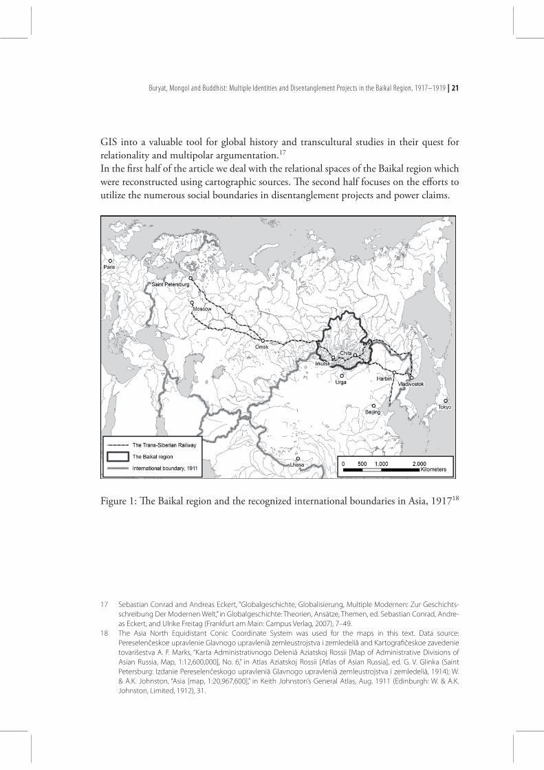
In the first half of the article we deal with the relational spaces of the Baikal region which were reconstructed using cartographic sources. The second half focuses on the efforts to utilize the numerous social boundaries in disentanglement projects and power claims.
Figure 1: The Baikal region and the recognized international boundaries in Asia, 191718
17 Sebastian Conrad and Andreas Eckert, “Globalgeschichte, Globalisierung, Multiple Modernen: Zur Geschichts-schreibung Der Modernen Welt,” in Globalgeschichte: Theorien, Ansätze, Themen, ed. Sebastian Conrad, Andre-as Eckert, and Ulrike Freitag (Frankfurt am Main: Campus Verlag, 2007), 7–49.
18 The Asia North Equidistant Conic Coordinate System was used for the maps in this text. Data source: Pereselenčeskoe upravlenie Glavnogo upravleniâ zemleustrojstva i zemledeliâ and Kartografičeskoe zavedenie tovariŝestva A. F. Marks, “Karta Administrativnogo Deleniâ Aziatskoj Rossii [Map of Administrative Divisions of Asian Russia, Map, 1:12,600,000], No. 6,” in Atlas Aziatskoj Rossii [Atlas of Asian Russia], ed. G. V. Glinka (Saint Petersburg: Izdanie Pereselenčeskogo upravleniâ Glavnogo upravleniâ zemleustrojstva i zemledeliâ, 1914); W. & A.K. Johnston, “Asia [map, 1:20,967,600],” in Keith Johnston’s General Atlas, Aug. 1911 (Edinburgh: W. & A.K. Johnston, Limited, 1912), 31.
22 | Ivan Sablin
The Relational Spaces
From a global historical perspective, the Baikal region in Siberia, just like any other mentally outlined territory, may be treated as a zone of interactions19 and, therefore, could not have clear-cut boundaries. The analytical outline of the region (Figure 1) in-cludes the territory of two provinces of the Russian Empire (the Irkutsk province and the Transbaikal region). Besides locating the region in the geographical space, Figure 1 also provides some information on its position in political, administrative and communica-tion spaces: prior to 1917 the Baikal region was situated in the Russian Empire, governed by the Irkutsk province and Transbaikal region administrations and connected to several major European and Asian cities via the Trans-Siberian Railway and the telegraph (see Figure 1). The parts of the region, which were not covered by the railway or telegraph, were more remote from Irkutsk and Chita than Saint Petersburg, Harbin or even Paris in the communication space. The speed of communication was especially slow in the mountainous areas and areas without access to navigable rivers, i.e. it depended on the natural environment. The entanglements between the social and natural environments are even more relevant for spaces formed by resources-oriented economic activities and agriculture. Particular substances become mineral resources when they are interpreted as such by humans and then discovered, extracted and used in the economy. Interpretative interactions, social relations connected to mining and modes of utilization make the spaces of natural re-sources no less constructed than other relational spaces. In terms of mineral resources, the Baikal region of the early twentieth century was con-sidered wealthy.20 Precious metal deposits were the most important objects in this space. Siberia at large was the “treasure chest” of the Russian Empire in terms of gold pro-duction, much of which was mined around Baikal. The known and newly discovered reserves lasted well into the Soviet and even post-Soviet periods.21 Furthermore, the mineral wealth made the region into a major center of penal servitude and exile. Many politically active exiles, including socialists and non-Russian nationalists, lived here in the 1910s and participated in shaping the regional social environments through teaching and otherwise transmitting their ideas to the local population.22
Siberia was called the treasure chest not only because of its gold: the so-called “soft gold” – the furs of squirrels, foxes, sables and other animals – had been one of the most
19 William Gervase Clarence-Smith, Kenneth Pomeranz, and Peer Vries, “Editorial,” Journal of Global History 1, no. 1 (2006): 1–2.
20 Pereselenčeskoe upravlenie Glavnogo upravleniâ zemleustrojstva i zemledeliâ and Kartografičeskoe zavede-nie tovariŝestva A. F. Marks, “Karta Poleznyh Iskopaemyh Aziatskoj Rossii [Map of Minerals Asian Russia, Map, 1:12,600,000], No. 56,” in Atlas Aziatskoj Rossii [Atlas of Asian Russia], ed. G. V. Glinka (Saint Petersburg: Izdanie Pereselenčeskogo upravleniâ Glavnogo upravleniâ zemleustrojstva i zemledeliâ, 1914).
21 Ivan Sablin and Maria Savelyeva, “Mapping Indigenous Siberia: Spatial Changes and Ethnic Realities, 1900–2010,” Settler Colonial Studies 1, no. 1 (2011): 77–110.
22 Š. B. Čimitdoržiev and T. M. Mihajlov, eds., Vydaûŝiesâ Burâtskie Deâteli [Prominent Buryat Figures], vol. 1 (Ulan-Ude: Burâtskoe knižnoe izdatel’stvo, 2009).
Buryat, Mongol and Buddhist: Multiple Identities and Disentanglement Projects in the Baikal Region, 1917–1919 | 23
significant Russian exports and retained its importance until the 1920s.23 Hunting fur-bearing animals was a major occupation in the northern Baikal region. However, for the majority of the people, agriculture was their main economic occupation. The two types of agriculture – crop farming and cattle breeding – formed the most important occupa-tional identities of the Baikal region.24 These two identities were often defined not only through the predominant occupation, but also through further characteristics of the life-style: all crop farmers were sedentary, whereas many cattle breeders pursued a nomadic or semi-nomadic way of life.25 The latter were continuously marginalized with the arrival of many thousands of sedentary farmers in the early twentieth century.Both the Irkutsk province and the Transbaikal region barely had any industry in 1917. Only the major cities – Irkutsk (population of 126,700 in 1910), Chita (74,300), Verkh-neudinsk (15,200) and several others26 – had some light industry. The cities of the Baikal region developed and rapidly expanded in the 1900s and 1910s, mainly as trade centers. The demand for imported manufactured products, the booming agriculture and the in-ternational trade routes (the Great Tea Route substituted by the Trans-Siberian Railway and the routes to Mongolia) fostered economic exchange. The usage of the data originating from the settler administration of the Russian Empire is relatively unproblematic when discussing the economic spaces of the Baikal region, as it reflects the knowledge of mineral deposits and provides contemporary economic data. However, when analyzing spaces formed by ethnic and religious interactions and identi-ties, one has to be very cautious: the primary objective of the aforementioned agency was to foster Russian settlement in Siberia. The settler administration’s version of the ethnic spaces fully reflected its agenda, showing vast unoccupied areas ready for Russian settle-ment.27 The puzzling inconsistency of the polygons on the ethnic maps and the maps
23 James Forsyth, A History of the Peoples of Siberia: Russia’s North Asian Colony, 1581–1990 (Cambridge: Cam-bridge University Press, 1992), 38, 247.
24 Pereselenčeskoe upravlenie Glavnogo upravleniâ zemleustrojstva i zemledeliâ and Kartografičeskoe zavedenie tovariŝestva A. F. Marks, “Karta Promyslov Aziatskoj Rossii [Map of Trades of Asian Russia, Map, 1:12,600,000], No. 47,” in Atlas Aziatskoj Rossii [Atlas of Asian Russia], ed. G. V. Glinka (Saint Petersburg: Izdanie Pereselenčeskogo upravleniâ Glavnogo upravleniâ zemleustrojstva i zemledeliâ, 1914).
25 I. I. Serebrennikov, Burâty, Ih Hozâjstvennyj Byt i Zemlepol’zovanie [Buryats, Their Economic Life and Land Use], ed. N. N. Koz’min (Verhneudinsk: Burât-mongol’skoe izdatel’stvo, 1925), 16.
26 Pereselenčeskoe upravlenie Glavnogo upravleniâ zemleustrojstva i zemledeliâ and Kartografičeskoe zavedenie tovariŝestva A. F. Marks, “Naselennost’ Gorodov Aziatskoj Rossii (diagramma) [Population of the Cities of Asian Russia (chart), Map], No. 61,” in Atlas Aziatskoj Rossii [Atlas of Asian Russia], ed. G. V. Glinka (Saint Petersburg: Izdanie Pereselenčeskogo upravleniâ Glavnogo upravleniâ zemleustrojstva i zemledeliâ, 1914).
27 Pereselenčeskoe upravlenie Glavnogo upravleniâ zemleustrojstva i zemledeliâ and Kartografičeskoe zavede-nie tovariŝestva A. F. Marks, “Ètnografičeskaâ Karta Aziatskoj Rossii [Ethnographic Map of Asian Russia, Map, 1:12,600,000], No. 25,” in Atlas Aziatskoj Rossii [Atlas of Asian Russia], ed. G. V. Glinka (Saint Petersburg: Izdanie Pereselenčeskogo upravleniâ Glavnogo upravleniâ zemleustrojstva i zemledeliâ, 1914).
24 | Ivan Sablin
showing economic activities28 and especially religions29 from the same volume suggested that agriculture and rituals were conducted in the areas where nobody lived. A further challenge every map maker working on Siberian ethnic spaces faced was how to depict nomadic and semi-nomadic ways of life. It was taken up in two different ways. In the northern Irkutsk province the area occupied by the indigenous population showed no major discontinuity, whereas in the Transbaikal region and in the southern Irkutsk province it was represented by small disconnected polygons. It is no surprise that it was these areas which were potentially suitable for Russian settlement and, therefore, adver-tised by the settler administration, which was set up for promoting Russian settlement, via the medium of the map. The contemporary maps even have some value beyond that of being an example of biased cartography: they identify some groups of non-Russian population as “Other Mongols”, suggesting the ethnic kinship between Mongolic-speaking Buryats and the population of Mongolia and demonstrating transboundary settlement patterns. 30 The depiction of ethnic spaces in the same place and practically at the same time published by Soviet ethnographers in 1961 was very different in several aspects.31 Firstly, it did not show any unoccupied land: the nomadic indigenous groups were mapped through the scope of their economic presence and not permanent dwellings. Secondly, it suggested ethnic homogeneity in particular areas, which may unequivocally be interpreted as a justifica-tion of the ethno-territorial boundaries introduced by the Soviet government. Thirdly, it demonstrated a larger ethnic diversity in the area. Finally, it did not hint at the ethnic kinship and transboundary settlement patterns of Mongolic groups: after major shifts in Soviet politics the Buryats could no longer even be called Buryat-Mongols.32
28 Pereselenčeskoe upravlenie Glavnogo upravleniâ zemleustrojstva i zemledeliâ and Kartografičeskoe zavedenie tovariŝestva A. F. Marks, “Karta Promyslov Aziatskoj Rossii [Map of Trades of Asian Russia, Map, 1:12,600,000], No. 47,” in Atlas Aziatskoj Rossii [Atlas of Asian Russia], ed. G. V. Glinka (Saint Petersburg: Izdanie Pereselenčeskogo upravleniâ Glavnogo upravleniâ zemleustrojstva i zemledeliâ, 1914).
29 Pereselenčeskoe upravlenie Glavnogo upravleniâ zemleustrojstva i zemledeliâ and Kartografičeskoe zavedenie tovariŝestva A. F. Marks, “Karta Raspredeleniâ Naseleniâ Aziatskoj Rossii Po Veroispovedaniâm [Map of Distribu-tion of the Population of Asiatic Russia by Religion, Map, 1:12,600,000], No. 27,” in Atlas Aziatskoj Rossii [Atlas of Asian Russia], ed. G. V. Glinka (Saint Petersburg: Izdanie Pereselenčeskogo upravleniâ Glavnogo upravleniâ zemleustrojstva i zemledeliâ, 1914).
30 Pereselenčeskoe upravlenie Glavnogo upravleniâ zemleustrojstva i zemledeliâ and Kartografičeskoe zavede-nie tovariŝestva A. F. Marks, “Ètnografičeskaâ Karta Aziatskoj Rossii [Ethnographic Map of Asian Russia, Map, 1:12,600,000], No. 25,” in Atlas Aziatskoj Rossii [Atlas of Asian Russia], ed. G. V. Glinka (Saint Petersburg: Izdanie Pereselenčeskogo upravleniâ Glavnogo upravleniâ zemleustrojstva i zemledeliâ, 1914).
31 S. I. Bruk, “Rasselenie Narodov Sibiri v Konce XIX i Načale XX V. [Settlement of the Peoples of Siberia in the Late 19th and Early 20th Century, Map],” in Istoriko-ètnografičeskij Atlas Sibiri [Historical and Ethnographical Atlas of Siberia], ed. M. G. Levin and L. P. Potapov (Moscow: Izdatel’stvo Akademii nauk SSSR, 1961).
32 Šandor Ânoš Sili, “Sovetskoe Sibirevedenie v 1930–1960 Gg. i Konceptual’naâ Problema «dobrovol’nogo Vhož-deniâ» Pri- i Zabajkal’â v Sostav Russkogo Gosudarstva v XVII V.: Dejstvie Partijnogo Upravleniâ Istoričeskoj Na-ukoj v Otnošenii k Regionam SSSR Po Primeru Burâtii v Istoriografičeskom Rakurse [Soviet Siberian Studies in the 1930–1960 and the Conceptual Problem of ‘Voluntary Accession’ of Baikalia and Transbaikalia to the Russian State in the 17th Century: Party Control over Soviet Regional Historical Science after the Example of Buryatia in the Historiographical Perspective],” in Regional’nye Školy Russkoj Istoriografii [Regional Schools of Russian Histo-riography], ed. Svak Dûla (Budapest: Russica Pannonicana, 2007), 183–199.
Buryat, Mongol and Buddhist: Multiple Identities and Disentanglement Projects in the Baikal Region, 1917–1919 | 25
Neither map says anything about the size, density or dynamics of the given ethnic groups or regional population in general. Textual sources published independently from the maps provide the following data: the population of the Baikal region was 1,187,142 in 1897 and 1,618,790 in 1911. Russians and Buryats were an absolute majority. In 1911 there were 588,148 Russians in the Irkutsk province (78.4 percent of the population), whereas the indigenous population (Buryats, Evenks and others) made up 134,363 (17.9 percent). Another 27,489 people (3.7 percent) did not fall into either category. In the Transbaikal region the Russian population was 590,645 (68 percent), the indigenous population was 244,003 (28 percent) and the non-Russian non-indigenous population was 34,142 (4 percent) in 1911. In 1916 the Buryat population of the Baikal region was reported to be 250,097.33 The questions of how the members of particular ethnic groups were distinguished from each other, how the remote areas were incorporated into the collection of statistical data, to what group children of mixed ethnic origin were ascribed, together with the indications that people could consciously provide false data about their ethnic identity34, make these figures problematic. Nevertheless, they still indicate that the indigenous population was a minority in both provinces.Textual sources provide further divisions of the regional population: the Russians were categorized into “old settlers” and “new settlers”, whereas many Russians, Buryats and Evenks belonged to the Cossacks – a privileged semi-military estate (soslovie). There were 250,978 Cossacks (including up to 17,570 absent) in the Transbaikal region in 1917, of which 21,092 were Buryat.35 Here, contemporary maps were very precise, as the borders between the arable and non-arable lands in many cases correspond to modern satellite data.36 The categorization of the land into identity categories, however, appears to be problematic. When compared to a map showing land use in 1914 published by the same agency37, but made by a different cartographer, one may notice different interpretations of the same lots: there appears to have been confusion as to how to distinguish between the Russian old settlers and the non-Russian indigenous population (“aliens” in con-temporary legal terms). A major problem here was the legal inequality of the different
33 P. T. Haptaev, Oktâbr’skaâ Socialističeskaâ Revolûciâ i Graždanskaâ Vojna v Burâtii [The October Socialist Revolu-tion and the Civil War in Buryatia] (Ulan-Ude: Burât. kn. izd-vo, 1964), 44–45.
34 State Archive of the Russian Federation, Collection 1701, Inventory 1, File 16, 46.35 Serebrennikov, Burâty, Ih Hozâjstvennyj Byt i Zemlepol’zovanie [Buryats, Their Economic Life and Land Use], 39.36 Pereselenčeskoe upravlenie Glavnogo upravleniâ zemleustrojstva i zemledeliâ and Kartografičeskoe zavede-
nie tovariŝestva A. F. Marks, “Karta Zabajkal’skoj Oblasti [Map of the Transbaikal Region, Map, 1:3,360,000], No. 32,” in Atlas Aziatskoj Rossii [Atlas of Asian Russia], ed. G. V. Glinka (Saint Petersburg: Izdanie Pereselenčeskogo upravleniâ Glavnogo upravleniâ zemleustrojstva i zemledeliâ, 1914); Pereselenčeskoe upravlenie Glavnogo up-ravleniâ zemleustrojstva i zemledeliâ and Kartografičeskoe zavedenie tovariŝestva A. F. Marks, “Karta Irkutskoj Gubernii [Map of the Irkutsk Province, Map, 1:3,360,000], No. 31,” in Atlas Aziatskoj Rossii [Atlas of Asian Russia], ed. G. V. Glinka (Saint Petersburg: Izdanie Pereselenčeskogo upravleniâ Glavnogo upravleniâ zemleustrojstva i zemledeliâ, 1914); Google, Google Earth 7.1, 2013.
37 [Pereselenčeskoe upravlenie] and Kartografičeskoe zavedenie G. De-Kel’š, Karta Irkutskoj Gubernii [Map of the Irkutsk Province, Map, 1:1,680,000] (Saint Petersburg: Kartografičeskoe zavedenie G. De-Kel’š, 1914).
26 | Ivan Sablin
groups.38 The Russians had more rights than the indigenous population, whereas the Cossacks had even further privileges.39 The ambivalence of identity categories, together with the settlement policies of the Tsar-ist government – the lands for new settlers were often taken from the indigenous popu-lation40 – caused the land use patterns in the Baikal region to appear striped. This strip holding was by far the most important source of intergroup conflicts in the Baikal re-gion, as most sources indicate. Compulsory takeover of Buryat lands, creation of settlers’ lots between Buryat rural districts and the artificial increase of the strip holding between different ethnic groups were part of the intentional Russification policy prior to 1917, and it was this “offensive nationalism of the Russian government” which gave birth to the “defensive” nationalism among the Buryat population.41 According to the Buryat and Soviet sources, it was only the interethnic strip holding which produced conflicts, whereas the mixed settlement patterns of the Cossacks and non-Cossacks of indigenous origin did not cause any trouble, as these two groups were very close in terms of everyday life, religion and culture.42 Grigory Semenov, a leader of the anti-Bolshevik forces in the Russian Civil War and a Transbaikal Cossack, however, interpreted the Cossacks not as a social estate, but as a quasi-ethnic group with distinct characteristics and shared interests.43 It should be noted that many Russian and Buryat Cossacks belonged to different religious groups, with the latter being predominantly Buddhist.44 The Buryats as an ethnic group, however, did not belong to a single religious group.45 As contemporary maps claimed, the three religious groups in the Baikal region were Orthodox Christianity, Buddhism, and Shamanism.46 The political agenda behind such
38 N. P. Egunov, Kolonial’naâ Politika Carizma i Pervyj Ètap Nacional’nogo Dviženiâ v Burâtii v Èpohu Imperializma [Tsarist Colonial Policy and the First Phase of the National Movement in Buryatia in the Era of Imperialism] (Ulan-Ude: Burât. kn. izd-vo, 1963), 92.
39 Haptaev, Oktâbr’skaâ Socialističeskaâ Revolûciâ i Graždanskaâ Vojna v Burâtii [The October Socialist Revolution and the Civil War in Buryatia], 177; G. C. Cybikov, Izbrannye Trudy [Selected Works], vol. 2: O Central’nom Tibete, Mongolii i Burâtii [On Central Tibet, Mongolia and Buryatia] (Novosibirsk: Nauka, Sibirskoe otdelenie, 1981), 161, 164.
40 Compare data from: [Pereselenčeskoe upravlenie], Karta Zabajkal’skoj Oblasti [Map of the Transbaikal Region, Map, 1:1,680,000] ([Saint Petersburg], 1911); Pereselenčeskoe upravlenie Glavnogo upravleniâ zemleustrojstva i zemledeliâ and Kartografičeskoe zavedenie tovariŝestva A. F. Marks, “Karta Zabajkal’skoj Oblasti [Map of the Transbaikal Region, Map, 1:3,360,000], No. 32”; [Pereselenčeskoe upravlenie] and Kartografičeskoe zavedenie G. De-Kel’š, Karta Irkutskoj Gubernii [Map of the Irkutsk Province, Map, 1:1,680,000]; Pereselenčeskoe upravlenie Glavnogo upravleniâ zemleustrojstva i zemledeliâ and Kartografičeskoe zavedenie tovariŝestva A. F. Marks, “Kar-ta Irkutskoj Gubernii [Map of the Irkutsk Province, Map, 1:3,360,000], No. 31.”
41 State Archive of the Russian Federation, Collection 200, Inventory 1, File 478, 189 rev.42 Cybikov, Izbrannye Trudy [Selected Works], 2: O Central’nom Tibete, Mongolii i Burâtii [On Central Tibet, Mongo-
lia and Buryatia]:161, 164.43 G. M. Semenov, O Sebe: Vospominaniâ, Mysli i Vyvody [About Me: Memories, Thoughts and Conclusions] (Mos-
cow: Izdatel’stvo AST, 2002), 94–96.44 Cybikov, Izbrannye Trudy [Selected Works], 2: O Central’nom Tibete, Mongolii i Burâtii [On Central Tibet, Mongo-
lia and Buryatia]:164.45 L. L. Abaeva and N. L. Žukovskaâ, eds., Burâty [Buryats] (Moscow: Nauka, 2004).46 Pereselenčeskoe upravlenie Glavnogo upravleniâ zemleustrojstva i zemledeliâ and Kartografičeskoe zavedenie
tovariŝestva A. F. Marks, “Karta Raspredeleniâ Naseleniâ Aziatskoj Rossii Po Veroispovedaniâm [Map of Distribu-
Buryat, Mongol and Buddhist: Multiple Identities and Disentanglement Projects in the Baikal Region, 1917–1919 | 27
maps can be deduced: it was supposed to show how broad the presence of Orthodox Christianity was and thereby further stimulate Russian settlement in the area. It also suggested a clear-cut division between the Shamanism in the Irkutsk province and the Buddhism in the Transbaikal region. Textual sources, however, demonstrate that neither were these three religions the only ones practiced in the Baikal region47, nor were they homogeneous or independent, as many Orthodox Christians belonged to the dissident Old-Believer groups which did not recognize the official church.48 Buddhist monasteries (datsans) were built on both sides of the lake.49 Furthermore, syncretic religious practices were being followed on the intersection between Shamanism, Buddhism and Christian-ity.50 As these brief insights demonstrate, there could be no geographic border that could correspond to every social border even within the mappable spaces, let alone the unmap-pable gender, age and political relations.
The Disentanglement Projects
The very first project to introduce new geographical and legal disentanglements in the Baikal region came in the wake of the February Revolution in 1917. A group of Russian-educated lay Buryat intellectuals including Elbek-Dorzhi Rinchino, Mikhail Nikolayev-ich Bogdanov, Bazar Baradin, Tsyben Zhamtsarano, Tsyden-Eshi Tsydypov, Sanzhimitab Tsybiktarov and Dashi Sampilon took up the initiative and advocated the creation of a self-governing Buryat Autonomy with elective bodies. The project proposed by Bogda-nov was adopted on April 24, 1917, at the First All-Buryat Congress in Chita. A day later
tion of the Population of Asiatic Russia by Religion, Map, 1:12,600,000], No. 27,” in Atlas Aziatskoj Rossii [Atlas of Asian Russia], ed. G. V. Glinka (Saint Petersburg: Izdanie Pereselenčeskogo upravleniâ Glavnogo upravleniâ zemleustrojstva i zemledeliâ, 1914).
47 V. V. Perinov, “Musul’mane v Zabajkal’e (seredina Veka XIX–1917 God) [Muslims in Transbaikalia (mid-19th Century–1917)]” (Dissertaciâ na soiskanie učenoj stepeni kandidata istoričeskih nauk, Institut mongolovedeniâ, buddolo-gii i tibetologii SO RAN, 2010); L. V. Kal’mina, Evrejskie Obŝiny Vostočnoj Sibiri (seredina XIX V. – Fevral’ 1917 Goda) [Jewish Communities of East Siberia (mid-19th Century–February 1917] (Ulan-Ude: Izdatel’sko-poligrafičeskij kompleks VSGAKI, 2003); Zabajkal’skij oblastnoj statističeskij komitet, Pamâtnaâ Knižka Zabajkal’skoj Oblasti Na 1914 G. [The Memorial Book of the Transbaikal Region as of 1914]; Irkutskij gubernskij statističeskij komitet, Pamâtnaâ Knižka Irkutskoj Gubernii: 1914 G. [The Memorial Book of the Irkutsk Province, 1914] (Irkutsk: Guberns-kaâ tipografiâ, 1914); M. F. Želnovakova, “Pričiny Poâvleniâ Protestantizma v Irkutskoj Gubernii [The Reasons for the Emergence of Protestantism in the Irkutsk Province],” Izvestiâ Altajskogo Gosudarstvennogo Universiteta no. 4–3 (2010): 73–77; S. M. Emel’ânov, “Istoriâ Katoličeskoj Cerkvi v Vostočnoj Sibiri (načalo XIX V.–1917 G.) [History of the Catholic Church in East Siberia (early 19th Century–1917)]” (Dissertaciâ na soiskanie učenoj stepeni kandi-data istoričeskih nauk, Irkutskij gosudarstvennyj universitet, 2002).
48 F. F. Bolonev, Staroobrâdcy Zabajkal’â v XVIII–XX Vv. [The Old Believers of Transbaikalia in the 18th–20th Century] (Moscow: IPC «DIK», 2004).
49 G. R. Galdanova et al., Lamaizm v Burâtii XVIII–Načala XX Veka: Struktura i Social’naâ Rol’ Kul’tovoj Sistemy [La-maism in Buryatia of the 18th–Early 20th Century: Structure and Social Role of the Religious System], ed. V. V. Mantatov (Novosibirsk: Nauka, Sibirskoe otdelenie, 1983), 44.
50 O. V. Buraeva, Ètnokul’turnye Vzaimodejstviâ Narodov Bajkal’skogo Regiona v XVII–Načale XX V. [Ethnocultural Interactions of the Peoples of the Baikal Region in the 17th– Early 20th Century], ed. M. N. Baldano (Ulan-Ude: Izdatel’stvo Burâtskogo naučnogo centra SO RAN, 2005), 153.
28 | Ivan Sablin
an interim self-government body – the Provisional Buryat National Committee – was elected. The decision was made for participation in the Russian Constituent Assembly and demarcation of a national territory.51 The project drew heavily on the Buryat identity in an ethno-national sense. In a telegram sent to the leaders of the Russian provisional government the “Buryat nation (narod) inhabiting the Transbaikal region and the Irkutsk province” was defined as a “distinct group in national, cultural-economic and legal sense”. The proponents of the project sought to disentangle the space of land use formed by occupational and ethnic identities and secure Buryat economic interests with special attention to the nomadic herders. The project introduced a three-level system of self-government. The main unit of the Buryat Autonomy was called a somon (a rural community). Somons were then united into khos-huns, and khoshuns formed aimaks. The names of the aimaks represented regional subeth-nic groupings of the Buryats. The supreme body of the Autonomy “uniting all parts of the Buryat nation into a single whole” was supposed to be the Buryat National Assembly (Duma) elected by a direct, secret and equal vote by all Buryats of both genders from the age of eighteen with no criminal convictions. The problem of Russification in terms of language was also in the focus and the Congress adopted a resolution on the nationaliza-tion of Buryat schools making Buryat the primary language of education. Russian, as the state language, remained mandatory. The Congress also decided to contact Bandida Khambo Lama (the head of the officially recognized Buddhist organization in the Baikal region) about the inclusion of clergy in the National Committee.52 Zhamtsarano and other intellectuals considered Buddhism to be central for the Buryat national solidarity and consciousness.53 In 1919 the established self-government bodies used a religious symbol – the Buddhist swastika – as their emblem on official documents.54
Some leaders of the movement were members of the Party of Socialists-Revolutionaries and the project strongly relied on its democratic and socialist ideology. The major discur-sive framings, which crossed in the project in the early stages, included the ideas of ethnic equality, self-determination and land municipalization.55 The interpretation of a Buryat national identity in ethnic and religious terms with sub-sequent disentanglements in the corresponding spaces met with opposition along several lines: First of all some Cossacks accented their estate (Cossack) and not ethnic (Buryat) identity56 and protested against joining the Autonomy at the Buryat Cossack Gather-ing in July 1917 chaired by Tsybiktarov. The Gathering nevertheless voted to join the
51 State Archive of the Russian Federation, Collection 1701, Inventory 1, File 16, 18a–30.52 State Archive of the Russian Federation, Collection 1701, Inventory 1, File 16, 18a–30.53 K. M. Gerasimova, Obnovlenčeskoe Dviženie Burâtskogo Lamaistskogo Duhovenstva: 1917–1930 Gg. [Reformist
Movement of the Buryat Lamaist Clergy, 1917–1930] (Ulan-Ude: Burât. kn. izd-vo, 1964), 17.54 State Archive of the Russian Federation, Collection 1701, Inventory 1, File 16, 44; State Archive of the Russian
Federation, Collection 1701, Inventory 1, File 64, 2.55 Gerasimova, Obnovlenčeskoe Dviženie Burâtskogo Lamaistskogo Duhovenstva: 1917–1930 Gg. [Reformist Mo-
vement of the Buryat Lamaist Clergy, 1917–1930], 5.56 Cybikov, Izbrannye Trudy [Selected Works], 2: O Central’nom Tibete, Mongolii i Burâtii [On Central Tibet, Mongo-
lia and Buryatia]:160.
Buryat, Mongol and Buddhist: Multiple Identities and Disentanglement Projects in the Baikal Region, 1917–1919 | 29
Autonomy.57 It is important to note that many Cossacks did not interpret joining the Autonomy as leaving the Cossacks and openly claimed to retain their estate identity. A group headed by Dondok Abiduev did not accept the ethno-religious disentanglement even after the Gathering and initiated hostilities in Transbaikalia in the ensuing months, which resulted in Tsybiktarov’s emigration to Mongolia. This opposition supported by the Russian Cossacks and military administration interpreted the Autonomy as “harmful separatism”. The Buryat-speaking Evenk Cossacks (the “Buddhist Nomads” and not the “Russified Orthodox Christians”), however, voluntarily joined the Buryat Autonomy.58 According to a 1919 report prepared by the Russian military administration of the Ir-kutsk province, further opposition came from the Orthodox Buryat villagers of the prov-ince whose settlements were included in the Autonomy created by a small group of intel-lectuals without asking the villagers themselves and leaving a large part of the population dissatisfied with the self-government organizations.59 In the Irkutsk province the organized anti-autonomous movement was led by N. A. Khankhasaev who in May 1917 appealed to the Russian provisional government in Petrograd claiming that the Buryat people would be satisfied with the limited adminis-trative self-government which was repealed in 1901.60 This conflict between the propo-nents and the opponents of the Autonomy in the Irkutsk province was interpreted by a Russian official as interclan struggle61, which brings a further conflicting identity to the foreground. In the regional power crossings the proponents of the Autonomy underlined Buryat national interests and maneuvered between the various political forces and belligerents in the Russian Civil War. In spring–fall 1917, they communicated with the provisional government, which nonetheless rejected the idea of a territorial autonomy. After the October Revolution they cooperated with the Siberian Soviet government, which rec-ognized the right of the Buryats to self-determination. The Autonomy as such, however, was not recognized. After the temporary retreat of the Soviets in 1918 some members of the national movement cooperated with the Japanese-supported Transbaikalia’s ruler Semenov, who recognized the Buryat self-government bodies, and communicated with Alexander Kolchak’s government in Omsk, which refused to approve them. In late 1918 the Buryat National Committee was renamed the People’s Duma of the Buryat-Mon-gols of East Siberia and chaired by Sampilon.62 The leaders of this new body now also articulated a Pan-Mongolian identity and used new discursive framings appealing to the
57 Haptaev, Oktâbr’skaâ Socialističeskaâ Revolûciâ i Graždanskaâ Vojna v Burâtii [The October Socialist Revolution and the Civil War in Buryatia], 178.
58 State Archive of the Russian Federation, Collection 1701, Inventory 1, File 16, 5–6.59 State Archive of the Russian Federation, Collection 1701, Inventory 1, File 16, 66.60 State Archive of the Russian Federation, Collection 6996, Inventory 1, File 479, 1–2.61 State Archive of the Russian Federation, Collection 1701, Inventory 1, File 60, 1–2.62 B. V. Bazarov and L. B. Žabaeva, Burâtskie Nacional’nye Demokraty i Obŝestvenno-političeskaâ Mysl’ Mongol’skih
Narodov v Pervoj Treti XX Veka [Buryat National Democrats and Socio-political Thought of the Mongolian Peop-les in the First Third of the 20th Century] (Ulan-Ude: Izdatel’stvo Burâtskogo naučnogo centra SO RAN, 2008), 83–84, 137–138.
30 | Ivan Sablin
past experiences of the Mongols and the figure of Genghis Khan, defining the Buryat-Mongols as “a branch of Genghis Khan’s Mongolia”.63 These framings and the articulation of a Pan-Mongolian identity reached their zenith on February 25, 1919 when the “representatives from the whole of Mongolia: Inner, Outer, Hulunbuir and Buryat” gathered in Chita for the congress on “discussing state affairs”.64 The congress, chaired by a twenty-five-year-old Inner Mongolian lama Neise Gegen (Nichi Toyn Bogdo Mendebayar)65 and co-chaired by Sampilon, resolved that because the initially independent Mongolia did not have anything “common in customs and interests” with the Chinese Republic “all people of Mongolian descent form a state enjoying full rights.” The capital of the new federative state consisting of four aimaks (In-ner, Outer, Hulunbuir and Buryat) was to be located in “the Hulunbuir city of Hailar”. The provisional government formed at the congress consisted of four ministries: Home Affairs, Foreign Affairs, Finance and War.66 Besides the chairman, co-chairman and the secretaries Dobdon Vanchuk and Radnazhap Bimbaev, the resolution was passed by two further representatives of Inner Mongolia (Fussenge and Khasbatur), three representatives of Hulunbuir (Erkimbatu, Danchzhin Neren and Dakhasu) and four of the Buryats (Bayarto Vampilon, Tsydypov, Rinchino and Namdak Dylykov).67 It is no coincidence that the resolution was not signed by anyone from Outer Mongolia which at that time had autonomous status within China: its ruler Bogd Gegen, the Eighth Jebtsundamba Khutuktu, did not send any represen-tatives despite an invitation, but promised to join the state if it was recognized by the Paris Peace Conference and especially by the United States of America and Japan.68 The congress also voiced support to the Tibetans, with whom the Mongols had a “religious connection”, and to the Manchus, with whom they had a “friendly connection”, in cre-ation of their independent states. The provisional government, headed by Neise Gegen and temporarily seated at Dauria (located in the southeast of Chita) railway station, was granted the right to invite foreign advisors.69 These “foreign advisors” included Semenov (who at the time was in conflict with Kol-chak’s Omsk government) with his Russian subordinates, who organized the meeting, and Japanese officers.70 Here a major role was played by Semenov’s advisor Lieutenant
63 State Archive of the Russian Federation, Collection 1701, Inventory 1, File 16, 3 rev.–4.64 State Archive of the Russian Federation, Collection 200, Inventory 1, File 406, 1.65 B. V. Bazarov, Neizvestnoe Iz Istorii Panmongolizma [Unknown Aspects of the History of Pan-Mongolism] (Ulan-
Ude: Izdatel’stvo Burâtskogo naučnogo centra SO RAN, 2002), 29.66 State Archive of the Russian Federation, Collection 200, Inventory 1, File 406, 1 rev.67 State Archive of the Russian Federation, Collection 200, Inventory 1, File 406, 2.68 Bazarov and Žabaeva, Burâtskie Nacional’nye Demokraty i Obŝestvenno-političeskaâ Mysl’ Mongol’skih Narodov
v Pervoj Treti XX Veka [Buryat National Democrats and Socio-political Thought of the Mongolian Peoples in the First Third of the 20th Century], 146–147.
69 State Archive of the Russian Federation, Collection 200, Inventory 1, File 406, 1 rev.; Bazarov and Žabaeva, Burâts-kie Nacional’nye Demokraty i Obŝestvenno-političeskaâ Mysl’ Mongol’skih Narodov v Pervoj Treti XX Veka [Bu-ryat National Democrats and Socio-political Thought of the Mongolian Peoples in the First Third of the 20th Century], 151.
70 Bazarov and Žabaeva, Burâtskie Nacional’nye Demokraty i Obŝestvenno-političeskaâ Mysl’ Mongol’skih Narodov
Buryat, Mongol and Buddhist: Multiple Identities and Disentanglement Projects in the Baikal Region, 1917–1919 | 31
Colonel Kuroki Chikayoshi (黒木親慶)71 who promised that Japan would help the new state.72 No major help, however, was provided. Firstly, some particular mid-level officers, such as Kuroki, actively participated in regional affairs using their own judgment. Sec-ondly, there was no single opinion among the country’s political elites on the Japanese intervention at large: the liberal circles opposed it, whereas the conservative military insisted on expansion.73 Finally, the attitude of the Japanese elites towards Semenov and the Buryats changed over time, with Kuroki having been recalled to Japan “for explana-tions”.74 The lack of Japanese support had a great deal to do with the protests from the Omsk government supported by the French, British and American governments75, the position of China, and the tensions between the United States and Japan.76 The congress composed a telegram to the Paris Peace Conference asking for international recognition and support and decided to send a delegation of five representatives to the conference. 77 Besides the telegram, a letter was drawn up from the provisional govern-ment signed by Neise Gegen. The major discursive framings used in the letter included the appeal to previous experience and Genghis Khan (“our Mongolian tribe roaming in Asia since the most ancient times formed an independent state with full rights”), illegiti-macy of and anarchy in the Chinese Republic, its danger to Buddhism (“all temples built by our ancestors will be destroyed by them and our religion will be violated by them”) and ethnic inequality both in China and in Russia.78 The letter can be explicitly attached to the so-called Wilsonian moment79, as it made the following reference: “… the Presi-dent of the North American United States, proceeding from the philanthropic feeling of the Almighty, claimed that it would be just to grant all peoples who lost their religion and original rights and were divided from their kind in flesh and blood the right to unite and form a state.” It also outlined the major identities central to the new nation: super-ethnic Pan-Mongolian, Buddhist religious and clan (the monarch or the president was to be elected from the largest clan).80 Although neither the messages nor the delegation
v Pervoj Treti XX Veka [Buryat National Democrats and Socio-political Thought of the Mongolian Peoples in the First Third of the 20th Century], 147.
71 Hara Teruyuki, Shiberia Shuppei: Kakumei to Kanshô 1917–1921 [The Siberian Expedition: Revolution and In-tervention 1917–1921] (Tokyo: Chikuma shobô, 1989), 79. In some English and Russian sources his name is rendered as “Kuroki Shinkei”.
72 State Archive of the Russian Federation, Collection 200, Inventory 1, File 406, 8.73 See Hara, Shiberia Shuppei: Kakumei to Kanshô 1917–1921 [The Siberian Expedition: Revolution and Interventi-
on 1917–1921].74 State Archive of the Russian Federation, Collection 200, Inventory 1, File 406, 4, 8; State Archive of the Russian
Federation, Collection 200, Inventory 1, File 478, 156.75 State Archive of the Russian Federation, Collection 200, Inventory 1, File 406, 3; State Archive of the Russian
Federation, Collection 200, Inventory 1, File 478, 141.76 Russian State Military Archive, Collection 40308, Inventory 1, File 119, 1; See, for instance, Michael A. Barnhart,
Japan Prepares for Total War: The Search for Economic Security, 1919–1941 (Ithaca: Cornell University Press, 1987).
77 State Archive of the Russian Federation, Collection 200, Inventory 1, File 406, 1 rev.78 State Archive of the Russian Federation, Collection 200, Inventory 1, File 478, 118–120.79 Manela, The Wilsonian Moment: Self-determination and the International Origins of Anticolonial Nationalism.80 State Archive of the Russian Federation, Collection 200, Inventory 1, File 478, 120.
32 | Ivan Sablin
made it to Paris due to the lack of diplomatic support81, Woodrow Wilson was informed about the project by American representatives in Siberia.82 In the letter to the Peace Conference, Great Mongolia, as the new entity was referred to by contemporary and later observers, called for all Mongolian territory beyond the Great Wall to be detached from China.83 Nothing was said about the Russian areas. Accord-ing to the information received from a Buryat emigrant organization in Urga, at best the state would include “Transbaikalia, Khalkha, Uryankhai, Barga and Inner Mongo-lia”. The Russians from Transbaikalia were to be resettled in the Irkutsk province which would be abandoned by the Buryat population. Likewise, all Chinese were to be evicted from Inner Mongolia. If this did not work, the Russians from the southern Transbaikal region would have to move to its northern part which would remain Russian, whereas the Chinese would be resettled from northern to southern Mongolia and the Mongols would have to move in the opposite direction.84 Hence, nominally the project was to disentangle superethnic and religious spaces and impose this disentanglement on others, involving the resettlement of more than a million people.85 Many actors in the power relations behind this project, however, had other spaces in mind. The Japanese participants and Semenov wanted to control the economic spaces: Japanese support for the movement was to be exchanged for exclusive trade rights and the disposal of mineral resources.86 There is evidence that Japanese mining engineers were exploring mineral deposits in Transbaikalia.87 The leaders of the Buryat Autonomy, according to a member of the Buryat organization in Urga, participated in the project only because they wanted to relieve the suffering of the Buryat people in the Civil War (who were frequently robbed and forced from their land by neighboring Russian peas-ants) and for that purpose sought to create armed self-defense forces with the help of Semenov.88
81 Bazarov and Žabaeva, Burâtskie Nacional’nye Demokraty i Obŝestvenno-političeskaâ Mysl’ Mongol’skih Narodov v Pervoj Treti XX Veka [Buryat National Democrats and Socio-political Thought of the Mongolian Peoples in the First Third of the 20th Century], 153.
82 State Archive of the Russian Federation, Collection 200, Inventory 1, File 478, 39.83 State Archive of the Russian Federation, Collection 200, Inventory 1, File 478, 122.84 State Archive of the Russian Federation, Collection 200, Inventory 1, File 478, 78–78 rev.85 This is based on the following data sources: State Archive of the Russian Federation, Collection 200, Inventory
1, File 406, 1–2; State Archive of the Russian Federation, Collection 200, Inventory 1, File 478, 78; The Edinburgh Geographical Institute, John Bartholomew & Son, Ltd., “China - Political [map, 1:10,000,000],” in “The Times” Atlas (London: The Times, 1922), 62; Russian State Archive of Socio-Political History, Collection 495, Inventory 152, File 20; Pereselenčeskoe upravlenie Glavnogo upravleniâ zemleustrojstva i zemledeliâ and Kartografičeskoe zave-denie tovariŝestva A. F. Marks, “Karta Zabajkal’skoj Oblasti [Map of the Transbaikal Region, Map, 1:3,360,000], No. 32.”
86 State Archive of the Russian Federation, Collection 200, Inventory 1, File 478, 78 rev.; State Archive of the Russian Federation, Collection 200, Inventory 1, File 406, 9; Russian State Military Archive, Collection 40308, Inventory 1, File 119, 1.
87 Japan Center for Asian Historical Records, Reference Code B03051345000, Reel 1-1341, Frames 0462-0466, http://www.jacar.go.jp/index.html; Russian State Archive of Socio-Political History, Collection 372, Inventory 1, File 1210, 92.
88 State Archive of the Russian Federation, Collection 200, Inventory 1, File 478, 104 rev.
Buryat, Mongol and Buddhist: Multiple Identities and Disentanglement Projects in the Baikal Region, 1917–1919 | 33
These armed forces were formed in Dauria, where a military school for Mongols was established. Besides this, the People’s Duma organized conscription for the indigenous population. Although these forces were said to be the foundation of the future Buryat and Mongolian national armies89 and intended to be used for self-defense and for making Outer Mongolia join the Pan-Mongolian movement after negotiations with Bogd Gegen failed, in the summer of 1919 they were sent to fight the Bolsheviks without the consent of the People’s Duma or the government in Dauria. This resulted in Fussenge’s demarche and death, the secret arrest and murder of Bogdanov by Semenov’s subordinates, and the flight of Rinchino, and later Sampilon and Tsydypov from Chita. In the meantime the Chinese government used the intended campaign as a cause for denouncing the treaties related to Outer Mongolia’s autonomy and occupying the region. Neise Gegen was soon killed by Chinese Republican troops after being invited for negotiations. The fall of 1919 marked the end of both the Buryat People’s Duma and Great Mongolia.90
The conscription among the Buryats and other policies of the Buryat National Commit-tee and People’s Duma gave cause for the creation of another disentanglement project which distanced itself from ethnic self-determination framings and relied on the spiritual ideas of a dissident Buddhist monk Lubsang Samdan Tsydenov. According to an oral history of his followers, Tsydenov developed the idea to reform Buddhism after Dzhayag Lama from the Kumbum Monastery in Tibet visited Transbaikalia and discussed the future of religion in the region with the abbot of the Chesansky Datsan, Tsydenov and two other lamas. Tsydenov criticized the established religious institutions for ignorance and lack of piety, saying that “the datsan is the Samsara” and soon after Dzhayag Lama had left Tsydenov quit the Kizhinginsky (Kudunsky) Datsan and together with his dis-ciples settled in the woodland area called Soorkhoy (Suarkhe). This reformist movement and Tsydenov’s followers, who by 1919 were numerous, were known under the name Balagad.91 A report put together by regional officers of the State Political Directorate in 1923, however, stated that a conflict between Tsydenov and another influential lama Baldoeshi Tsyrenov over the abbacy of the Kudunsky Datsan was the major reason behind the dis-sidence. After Bandida Khambo Lama supported Tsyrenov, Tsydenov left for reclusion in the taiga. The conflict nevertheless continued, which led to Bandida Khambo Lama to remove Tsyrenov and appoint Tsydenov. During several years of the abbacy Tsydenov’s authority among the Buddhists of the area increased and after being seen as a threat by Bandida Khambo Lama Tsydenov was dismissed. Tsydenov again left for the taiga, but this time did not live in seclusion and rallied his supporters instead. After the Soviets as-
89 Russian State Military Archive, Collection 39454, Inventory 1, File 2, 25, 31 rev., 52, 53, 54, 72, 84 rev., 96, 97, 160.90 Bazarov, Neizvestnoe Iz Istorii Panmongolizma [Unknown Aspects of the History of Pan-Mongolism], 30–42.91 B. D. Dandaron, Izbrannye Stat’i, Černaâ Tetrad’, Materialy k Biografii, Istoriâ Kukunora Sumpy Kenpo [Selected
Articles, the Black Book, Biographical Materials, Sumpa Kenpo’s History of Kukunor], ed. V. M. Montlevič (Saint Petersburg: Evraziâ, 2006), 261–262, 264, 482–483.
34 | Ivan Sablin
sumed power in 1918, Tsydenov started campaigning against lay intellectuals saying that their policies were contrary to the teachings of the Buddha.92 Whatever the initial reasons for the movement were, with the establishment of the Bury-at Autonomy it spread beyond the religious space attracting those who were dissatisfied with the policies of the National Committee and later the People’s Duma, ranging from ordinary peasants and monks to former clan leaders and Tsarist functionaries.93 The general conscription initiated by the Autonomy in 1918 vexed local people and they continuously sent delegates to Tsydenov asking to explain the resolution that flew in the face of the religion of the Buddha which was against the taking up of weapons. Tsyde-nov replied that if the people did not want to serve in the army they had to become his subjects.94 After the Kizhinga Credit Union appealed to him in February 1919 asking to shield the population of three khoshuns of the Khorinsky Aimak in central Transbaikalia, Tsyde-nov proclaimed himself the Dharmaraja of Three Worlds, religious and civil ruler. The state officially called “the Rightfully Detached State of the Khudun (Kudun) Valley” soon included around twenty somons with 13,000 people.95 It had a draft constitution, a government96 with Ministries of the Court, Foreign Affairs, Finance, Home Affairs, Industry and Trade, Agriculture, Justice, and Education, and an officially appointed heir to the throne.97
Tsydenov’s state abandoned the violence, refused to establish a military and allowed all its citizens to avoid service for the belligerents in the Russian Civil War. Such a state was doomed and in May 1919 Tsydenov and members of his government were arrested by representatives of the People’s Duma and Semenov. Tsydenov’s ideas, however, remained popular after the failure of the state and even after his death in 1922. The Balagad move-ment opposing the ethnic autonomy was active until 1929.98 The state articulated the Buddhist religious identity. Later the movement explicitly op-posed any delineations based on ethnicity.99 The framings used in the project derived from Tibetan, Mongolian and Indian Buddhist discourses and from contemporary West-
92 Russian State Archive of Socio-Political History, Collection 372, Inventory 1, File 239, 6–7.93 N. V. Cyrempilov, “Lubsan Samdan Cydenov i Ideâ Buddijskoj Teokratii v Zabajkal’e [Lubsan Samdan Tsydenov
and the Idea of a Buddhist Theocracy in Transbaikalia],” Vostok: Afro-aziatskie Obŝestva: Istoriâ i Sovremennost’ no. 6 (2007): 67; Dandaron, Izbrannye Stat’i, Černaâ Tetrad’, Materialy k Biografii, Istoriâ Kukunora Sumpy Kenpo [Selected Articles, the Black Book, Biographical Materials, Sumpa Kenpo’s History of Kukunor], 262.
94 Russian State Archive of Socio-Political History, Collection 372, Inventory 1, File 239, 7–8.95 For a rough outline of the state see the following data sources: Nikolay Tsyrempilov, “Samdan Tsydenov and His
Buddhist Theocratic Project in Siberia,” in Biographies of Eminent Mongol Buddhists: PIATS 2006: Proceedings of the Eleventh Seminar of the International Association for Tibetan Studies, Königswinter 2006, ed. Johan Elvers-kog, Beiträge zur Zentralasienforschung 15 (Halle, Saale: International Institute for Tibetan and Buddhist Studies, 2008), 117–138.
96 Cyrempilov, “Lubsan Samdan Cydenov i Ideâ Buddijskoj Teokratii v Zabajkal’e [Lubsan Samdan Tsydenov and the Idea of a Buddhist Theocracy in Transbaikalia],” 67.
97 Russian State Archive of Socio-Political History, Collection 372, Inventory 1, File 651, 13.98 Cyrempilov, “Lubsan Samdan Cydenov i Ideâ Buddijskoj Teokratii v Zabajkal’e [Lubsan Samdan Tsydenov and the
Idea of a Buddhist Theocracy in Transbaikalia],” 67–68.99 Russian State Archive of Socio-Political History, Collection 372, Inventory 1, File 210, 21 rev.
Buryat, Mongol and Buddhist: Multiple Identities and Disentanglement Projects in the Baikal Region, 1917–1919 | 35
ern political science. Although Tsydenov’s personal involvement in the design and imple-mentation of the project remains unclear, he defined the state as theocracy combining the religious and lay principles of rule. The usage of the concept Dharmaraja and implicit appeals to Tibetan and Mongolian experience derived from Tsydenov’s Buddhist scholar-ship. At the same time he was very interested in Western science, European statehood and world religions, and would question Russian travelers and read books and journals in European languages. He continued to work on the framings and theoretical grounds of the projects in prison. His notes featuring extracts from an encyclopedic dictionary include many European political terms with special attention to the term ‘theocracy’ and its definitions.100
Tsydenov’s reputation in Buddhist scholarship and spiritual authority made him very ef-fective in non-violent power relations with the local people, enabling the dissemination of his ideas. The rejection of violence, however, made the state vulnerable to the armed group actors and turned it into a utopia.
Conclusion
All the discussed projects were developed and implemented through the confluence of global and local power relations and discursive crossings. The key question for most ac-tors was which group would best legitimize delineation and should therefore form the basis for a future autonomous or independent nation. The attempts to raise the status of imagined social boundaries in particular spaces (ethnic, religious, superethnic) and proj-ect them onto the geographic space together with alternative interpretations of particular categories (varying definitions of the Buryats, religious sectarianism and obscurity of superethnic categories) caused major conflicts, not only between already defined groups, but also within them. The poor performance of the proponents in power and violence re-lations (defeat in the Civil War, inability to counteract armed groups, and shifts in global politics) made the imposition of suggested disentanglements impossible and ultimately resulted in the failure of all projects.Their experience was nevertheless incorporated into the ultimate disentanglement of the region, as the designers of the Buryat-Mongolian Autonomous Socialist Soviet Republic and the Mongolian People’s Republic explicitly and implicitly addressed the Buryat eth-nic, Pan-Mongolian superethnic and Buddhist religious identities. Moreover, Rinchino, Zhamtsarano, Baradin and others who actively participated in either the creation or destruction of the abovementioned projects brought along their personal experience and previously used discursive framings during the construction of the new entities. Taking the failures into account, the emphasis was then placed not on the disentanglement of
100 Cyrempilov, “Lubsan Samdan Cydenov i Ideâ Buddijskoj Teokratii v Zabajkal’e [Lubsan Samdan Tsydenov and the Idea of a Buddhist Theocracy in Transbaikalia],” 68, 72–73. Tsyrempilov, “Samdan Tsydenov and His Buddhist Theocratic Project in Siberia.”
36 | Ivan Sablin
particular social spaces, but on the transboundary entanglements: the connection of the Mongolian and Buryat Republics to the global labor movement and the Soviet Union via the Comintern and central government, respectively; the trade and linguistic connection between the two republics; the religious networks binding the two republics with Tibet and other Buddhist regions. One of the first official maps of the Buryat Republic101 is a very illustrative source. The republic itself occupied less than a half of the map’s sur-face. Besides the administrative and international boundaries it featured many datsans, monasteries and communications in Siberia and Mongolia suggesting transboundary entanglements between the outlined administrative and international areas, thereby ap-pealing to ethnic, religious and superethnic identities and suggesting the relevance of other spaces. With Joseph Stalin’s accession to power, ethnicity gradually became the only one of the abovementioned identities to be relevant for the state, and many people were executed or imprisoned for defending their position in religious or other spaces. Many Buryats, Buddhists and Mongols, including Zhamtsarano, Rinchino, Baradin, Sampilon and Tsy-dypov became victims of the purges in the USSR and the MPR in the late 1920s and 1930s.
101 Burnarkomzem, Karta Burât-Mongol’skoj A.S.S. Respubliki, Zabajkal’skoj Gub. i Častej Irkutskoj Gub. i Mongolii [Map of the Buryat-Mongolian A.S.S. Republic, the Transbaikal Province, and Parts of the Irkutsk Province and Mongolia, Map, 1:2,520,000] (Irkutsk: Pervaâ Gostipo-litografiâ, 1924).
Autorinnen und Autoren
Stefan HübnerM.A., Research Associate, Bundeswehr University MunichE-Mail: [email protected]
Konrad M. LawsonPh.D., Lecturer, School of History, University of St Andrews, UKE-Mail: [email protected]
Marcus Otto M.A., Georg-Eckert-Institut für internationale Schulbuchforschung, BraunschweigE-Mail: [email protected]
Ivan SablinM.A., Senior Lecturer, National Research University Higher School of Economics; Lecturer, Saint Petersburg State University; Ph.D. Candidate, University of HeidelbergE-Mail: [email protected]
Amanda ShumanM.A., Ph.D. candidate, University of California, Santa CruzE-Mail: [email protected]
Martyn SmithPh.D., Senior Teaching Fellow, School of Oriental and African Studies, University of LondonE-Mail: [email protected]
Torsten WeberPh.D., Senior Research Fellow, German Institute for Japanese Studies (DIJ), Tokyo E-Mail: [email protected]


