Embed Size (px)
Citation preview
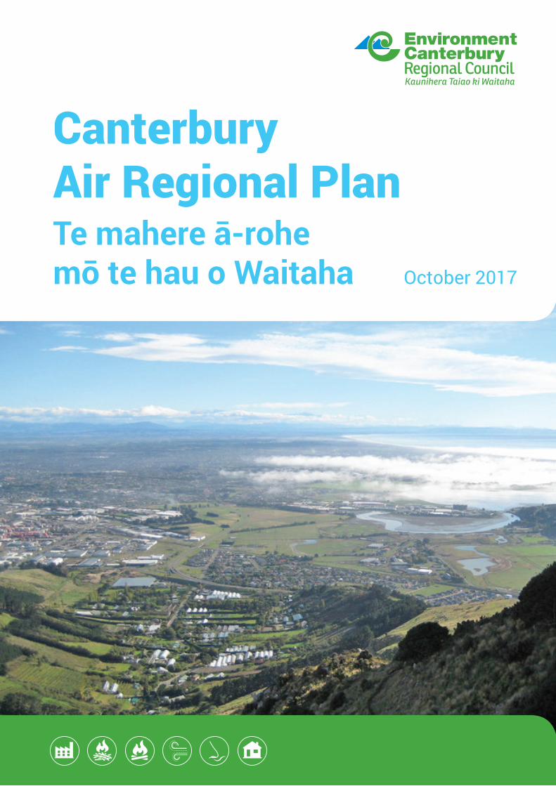
Canterbury Air Regional PlanTe mahere ā-rohe mō te hau o Waitaha October 2017


Canterbury Air Regional Plan - Te mahere ā-rohe mō te hau o Waitaha 2017
(This page is intentionally blank)
Environment Canterbury
Table of contents
Introduction - Understanding the Canterbury Air Regional Plan 1 -11
Issues of significance to Ngāi Tahu 2 -12
How the Plan Works 3 -13
Definitions and Interpretation 4 -14
Objectives 5 -15
Policies 6 -16
Rules 7 -17
Schedules 8 -18Schedule 1: Information to be provided with applications for resource consent 8 -1Schedule 2: Assessment of offensive and objectionable effects 8 -5Schedule 3: Content of smoke management plans for the outdoor burning of organic material in ruralareas 8 -14Schedule 4: Contaminants 8 -15Schedule 5: Emission Stack Heights for Large Scale Fuel Burning Devices 8 -17Schedule 6: Application of Ringelmann Scale 8 -18Schedule 7: Testing for particulate matter in exhaust gases 8 -22Schedule 8: Registration and maintenance of small-scale heating appliances burning solid fuel 8 -23Schedule 9: Small-scale heating appliance auditing process 8 -24Schedule 10: Heritage Buildings 8 -28Schedule 11: Areas affected by the Ngāi Tahu Claims Settlement Act 1998 8 -33
Clean Air Zone Map Series 9 -19
Canterbury Airsheds 10 -110
Crop Residue Burning Buffer Area Map Series 11 -111
Canterbury Air Regional Plan General Map Series 12 -112
Special Zones 13 -113
Environment Canterbury
Canterbury Air Regional Plan - Te mahere ā-rohe mō te hau o Waitaha 2017

Canterbury Air Regional Plan - Te mahere ā-rohe mō te hau o Waitaha 2017
(This page is intentionally blank)
Environment Canterbury
1 Introduction - Understanding the Canterbury Air RegionalPlan
Tīhei mauri ora.Pātai mai he aha te mea nui o te ao
Ka whakahoki auHe tangata, he tangata, he tangata.
Tīhei mauri ora.
(Translation)The breath of life.
Ask me what is the most important thing in the worldAnd I will reply
It is people, it is people, it is people.The breath of life.
- Whakataukī
The Purpose of this Plan
The Canterbury Region enjoys good air quality in most places and at most times. Consequently, air qualitycould be taken for granted. But in fact urban areas, both towns and cities, suffer from degraded air quality atregular intervals. Ambient air can be polluted by contaminants or localised air quality may be compromisedby dust, smoke or odour. The effects vary from pervasive and serious health impacts to nuisance effects thatdetract from the amenity values of an area.
The purpose of the Resource Management Act (RMA) is to promote the sustainable management of resourcesfor the benefit of people, including by “safeguarding the life-supporting capacity of air, water, soil andecosystems”. Previously Ngāi Tahu alone exercised rangatiratanga (guardianship) over the Canterbury Regionki uta ki tai (from the mountains to the sea). They regarded air as mauri (a life force) and therefore as a taonga(treasure) to be protected for the benefit of future generations. This heritage, recognised in the RMA, gave riseto the duty upon councils to consult tangata whenua to ensure that their culture and traditions are suitablyaccommodated in air and other resource management plans.
The Air Plan seeks to manage discharges to air in the best practicable manner. Its principal purpose is tomaintain air quality where it provides for people’s health and cultural wellbeing, or to improve it if it does not,whilst recognising the investment in, and significant contribution to the economy and social wellbeing ofCanterbury of industrial and trade activities that discharge into air.
Air Quality in Canterbury
Some parts of the world confront constant serious pollution from an urban concentration of heavy industry,coal-fired power stations and vehicle emissions, while in other parts smoke from large scale outdoor burningor major dust storms are the predominant issues. In comparison, most of Canterbury enjoys air quality thatranges from good to pristine. The clear air and lack of light pollution in the Mackenzie Basin provides forexcellent visibility of the night sky that has received international recognition. Our rural areas have good airquality most of the time but can be affected by burn-offs and other rural practices. Our towns and citiesexperience poorer air quality, particularly in winter, both from the burning of coal or wood to produce heatfor industry or home heating, and the burning of petrol or diesel in vehicles.
Meteorological conditions and the lie of the land may alleviate or exacerbate air pollution. For example,temperature inversions are a Christchurch characteristic. These typically occur in winter when cold air istrapped beneath a layer of warm air and pollutants cannot rise and disperse.
1 – 1Environment Canterbury
Canterbury Air Regional Plan - Te mahere ā-rohe mō te hau o Waitaha 2017
Types of Contaminants
Air contaminants come from a variety of sources and have varying physical and chemical characteristics. Suchsources are both natural and man-made (anthropogenic). The air contaminant of most concern in Canterburyand most of New Zealand is particulate matter (PM). The natural sources of PM include pollen, sea spray, andwindborne dust (soil). The Air Plan cannot control or even influence these natural sources. Fortunately, theparticles are comparatively large and are possibly less of a threat to human health.
PM is identified by reference to size, as eitherSARAH PM10 or PM2.5. PM10 comprises particles less than 10 micronswhile PM2.5 particles have a diameter less than 2.5 microns. PM can penetrate deep into the lungs and even intothe bloodstream if the particles are ultrafine. Damage to the respiratory and circulatory systems results. Thosemost at risk are young children, the elderly and people suffering from respiratory and cardiovascular disease.Air quality standards and guidelines have been established for PM10 at a national level, however there is currentlyno New Zealand guideline for PM2.5.
Health impact assessments (such as the HAPINZ study, updated 2012(1)) have been undertaken to assist inunderstanding the extent of the harm caused to human health from PM exposure. These indicate that eachyear in Canterbury more than 400 adults over 30 years of age die prematurely because of their exposure topoor air quality, while many others require admission to hospital or are rendered unwell and miss work days.
Towards the middle of the spectrum there are a number of harmful chemicals discharged from industrialactivities, vehicles and home heating, which are generally present as gases. Those include carbon monoxide,nitrogen dioxide, sulphur dioxide, benzene, benzo(a)pyrene and polycyclic aromatic hydrocarbons (PAHs).Exposure to these contaminants can cause health effects, some similar to those occasioned by exposure toPM. This group is subject to air quality standards, or guidelines, promulgated by central government. The AirPlan imposes controls upon their discharge on an activity basis and in an endeavour to ensure that the prescribedmaximum levels are not exceeded. Although localised exceedances occur occasionally in the CanterburyRegion, the risk posed by these contaminants remains secondary to that from exposure to PM.
At the other end of the spectrum are contaminants that predominantly affect wellbeing rather than physicalhealth. The main ones are smoke and dust discharges. The Air Plan imposes controls upon these dischargesby reference to the so-called FIDOL factors: the frequency, intensity, duration, offensiveness and location ofthe discharge.
Sources of Contaminants
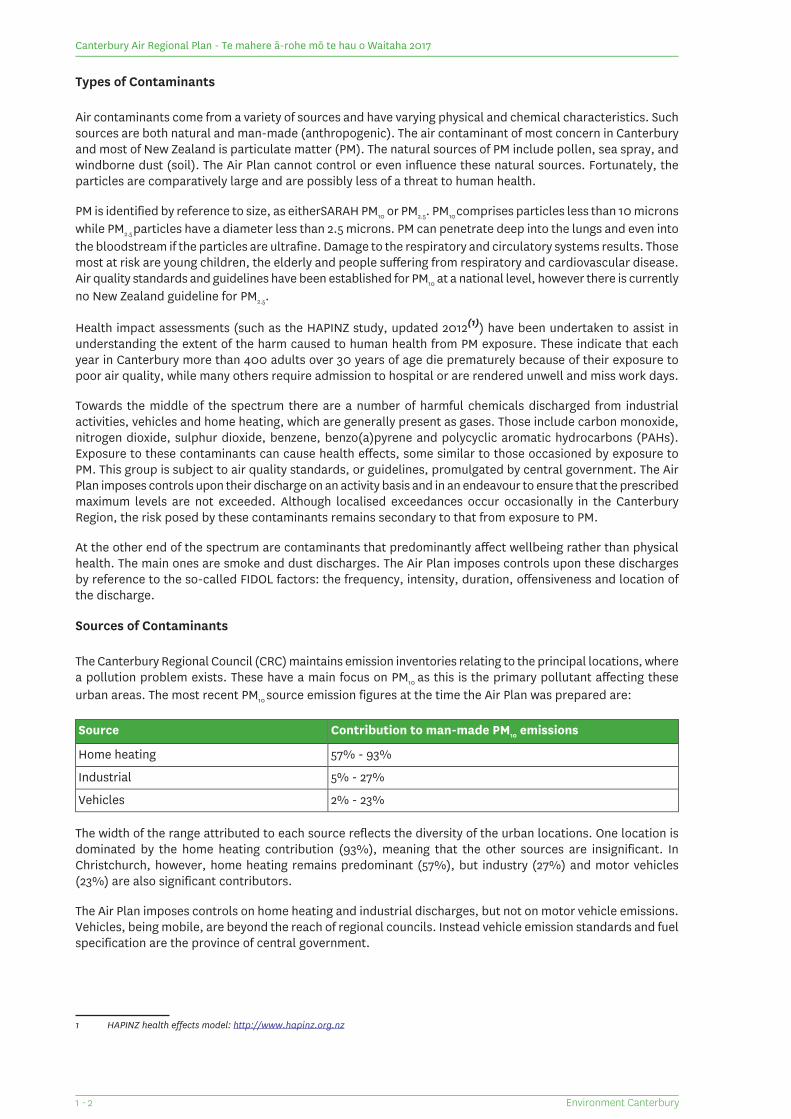
The Canterbury Regional Council (CRC) maintains emission inventories relating to the principal locations, wherea pollution problem exists. These have a main focus on PM10 as this is the primary pollutant affecting theseurban areas. The most recent PM10 source emission figures at the time the Air Plan was prepared are:
Contribution to man-made PM10 emissionsSource
57% - 93%Home heating
5% - 27%Industrial
2% - 23%Vehicles
The width of the range attributed to each source reflects the diversity of the urban locations. One location isdominated by the home heating contribution (93%), meaning that the other sources are insignificant. InChristchurch, however, home heating remains predominant (57%), but industry (27%) and motor vehicles(23%) are also significant contributors.
The Air Plan imposes controls on home heating and industrial discharges, but not on motor vehicle emissions.Vehicles, being mobile, are beyond the reach of regional councils. Instead vehicle emission standards and fuelspecification are the province of central government.
1 HAPINZ health effects model: http://www.hapinz.org.nz
Environment Canterbury1 - 2
Canterbury Air Regional Plan - Te mahere ā-rohe mō te hau o Waitaha 2017
The Understanding of Air Quality
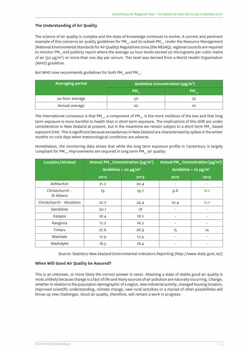
The science of air quality is complex and the state of knowledge continues to evolve. A current and pertinentexample of this concerns air quality guidelines for PM10, and its subset PM2.5. Under the Resource Management(National Environmental Standards for Air Quality) Regulations 2004 (the NESAQ), regional councils are requiredto monitor PM10 and publicly report where the average 24 hour levels exceed 50 micrograms per cubic metreof air (50 µg/m3) on more than one day per annum. This level was derived from a World Health Organisation(WHO) guideline.
But WHO now recommends guidelines for both PM10 and PM2.5:
Guideline Concentration (µg/m3)Averaging period
PM2.5PM10
255024-hour average
1020Annual average
The international consensus is that PM2.5, a component of PM10, is the more insidious of the two and that longterm exposure is more harmful to health than is short term exposure. The implications of this shift are underconsideration in New Zealand at present, but in the meantime we remain subject to a short term PM10 basedexposure limit. This is significant because exceedances in New Zealand are characterised by spikes in the wintermonths on cold days when meteorological conditions are adverse.
Nonetheless, the monitoring data shows that while the long term exposure profile in Canterbury is largelycompliant for PM10, improvements are required in long term PM2.5 air quality:
Annual PM2.5 Concentration (µg/m3)Annual PM10 Concentration (µg/m3)Location/Airshed
Guideline = 10 µg/m3Guideline = 20 µg/m3
2013201220132012
--20.421.2Ashburton
11.19.819.719Christchurch –St Albans
11.110.424.422.7Christchurch - Woolston
--1820.1Geraldine
--18.218.4Kaiapoi
--16.217.2Rangiora
141526.927.6Timaru
--17.417.9Waimate
--18.416.5Washdyke
Source: Statistics New Zealand Environmental Indicators Reporting (http://www.stats.govt.nz/)
When Will Good Air Quality be Assured?
This is an unknown, or more likely the correct answer is never. Attaining a state of stable good air quality ismost unlikely because change is a fact of life and many sources of air pollution are naturally occurring. Change,whether in relation to the population demographic of a region, new industrial activity, changed housing location,improved scientific understanding, climate change, new rural activities or a myriad of other possibilities willthrow up new challenges. Good air quality, therefore, will remain a work in progress.
1 – 3Environment Canterbury
Canterbury Air Regional Plan - Te mahere ā-rohe mō te hau o Waitaha 2017
Once this is recognised it also becomes apparent that the goal of improving ambient air quality is necessarilya long term objective. Substantial gains have already been made and improvement in air quality has beenachieved in many of the polluted urban areas within the Canterbury Region. Further improvement will be moredifficult. It will take time. Progressive improvement must be the goal. The Air Plan is crafted to incentiviseimprovement over time.
A Balanced Approach
As is aptly recognised in the RMA the sustainable management of resources, air included, may require abalancing exercise. There is often a tension between promoting people’s social, economic and cultural wellbeingand their health and safety, on the one hand; and safeguarding the life-supporting capacity of air on the other.
In this Plan the tension is most acute in relation to the need to improve air quality in areas where it is degraded,while at the same time ensuring that vulnerable households are not exposed to fuel poverty and to living incold damp houses. The strategy designed to further improve the particulate discharge levels from home heatingappliances involves requirements to decommission the existing stock of wood burners over time and replacethem with ultra-low emitting enclosed burners (ULEBs) or other clean technology. Ironically these initiatives,intended to improve health outcomes by providing improved ambient air quality, have the potential to exposepeople to adverse health impacts if the correct balance is not struck. The Air Plan seeks to avoid this perverseoutcome by ensuring that existing technology is phased out over a timeframe sufficient to enable householdersto plan for change, with assistance provided where genuine need exists.
Key Management Response for Air Quality
The management of air quality is complex. Ensuring access to good quality air while balancing the social andeconomic costs of achieving this requires a multi-pronged approach. The approach the CRC has adopted hasthe following components:
a statutory planning framework that supports the non-regulatory programmes;
non-regulatory education, advocacy and support programmes, particularly for PM10 and PM2.5 reduction;
working co-operatively with key partners.
The NESAQ sets targets for air quality improvement in polluted airsheds. It is the responsibility of the CRC tomonitor and enforce observance of these targets. This will occur through a combination of both thenon-regulatory work programme and statutory requirements.
The Statutory Planning Framework
The primary legislation for managing natural resources in New Zealand, including air quality, is the ResourceManagement Act 1991 (RMA). The single purpose of the RMA is the promotion of the sustainable managementof natural and physical resources. This involves managing the resources of the Canterbury Region in ways thatprovide for the needs of current and future generations, and ensures that adverse effects on the environmentare avoided, remedied or mitigated.
The content of an air plan is dictated to a significant extent by requirements of the RMA. Public consultationis a first requirement that precedes, and influences, the content of a plan. In achieving the purpose of the RMA,regional councils are required to give effect to higher order documents, including National Policy Statementsand National Environmental Standards.
The Canterbury Regional Policy Statement sets the overarching policy for the Region and must be given effectthrough Regional and District Plans. Chapter 14 of the Canterbury Regional Policy Statement is devoted to airquality. It identifies the key issues and also prescribes two overarching objectives and five policies to guidethe management of air quality in the Canterbury Region. The Air Plan gives effect to the Policy Statement by:
setting out objectives, policies and methods that provide a framework to reduce PM10 concentrations,including by controlling discharges of contaminants into air from home heating, industry and othersources and encouraging the uptake of cleaner technology, in polluted airsheds so that the targets setby the NESAQ can be achieved; and
Environment Canterbury1 - 4
Canterbury Air Regional Plan - Te mahere ā-rohe mō te hau o Waitaha 2017
providing a framework that enables consideration of industry offsets in accordance with Regulation 17of the Resource Management (National Environmental Standards for Air Quality) Regulations 2004, andwhich provides opportunity for industry to access offsetting opportunities in the domestic market; and
setting a framework for the management of PM10 and other contaminants discharged into air that ensuresair quality is maintained or improved across the Region, and sensitive and discharging activities areprotected from each other.
In preparing an air plan, regional councils must also have regard to other regional planning documents thatare in the course of development, including the planning initiatives of adjacent regional councils. Iwi managementplans lodged with the council must be taken into account where relevant.
Section 15 of the Resource Management Act
Section 15 of the RMA is pivotal to the preparation of air plans. It prohibits all industrial discharges ofcontaminants except those expressly allowed by a national environmental standard, a national regulation ora rule in a regional plan. On the other hand, discharges from all other sources are allowed except if theycontravene a standard, a regulation or an air plan rule. In practice this means that air plans need to containexpress provisions to accommodate industrial activity in the region; while discharges from all other sources(whether from domestic, outdoor burning or farming activities) need only be regulated where some level ofcontrol is considered necessary.
Resource Management (National Environmental Standards for Air Quality) Regulations 2004
In addition to setting targets for air quality, the NESAQ includes regulations that must be given effect throughthe regional planning framework. These important regulations impose a number of national controls, including:
prohibitions on the outdoor burning of various forms of waste;
ambient air quality standards (limits) for various contaminants in polluted urban areas gazetted asairsheds;
requirements upon regional councils to monitor PM10 levels in airsheds and decline resource consentswhere PM10 limits will be exceeded;
prohibitions on granting resource consents for the discharge of various chemical contaminants in airsheds;
design and thermal efficiency standards for domestic woodburners;
a prohibition upon domestic open fires in airsheds.
The Air Plan in many respects reflects and builds upon these national standards. It also imposes some controlsthat are more stringent than those applicable nationally, particularly through the use of the Clean Air Zoneconcept.
National guidance is also provided in the Ambient Air Quality Guidelines 2002, an update of the 1994 version.They identify limits at which a wide range of contaminants will degrade ambient air, as opposed to a safe limitto pollute up to. The document advises readers how to apply the guideline values and also initiate emissionreduction strategies. Although not legislative requirements, the guidelines have informed the approach to,and content of, some rules in the Air Plan, particularly those that govern industrial discharges.
Working with Key Partners
Ngāi Tahu, as Kaitiaki, are key partners in air quality management. The relationship of Ngāi Tahu with naturalresources and the environment in Canterbury is set out in section 3 of the Air Plan.
District Health Boards have a particular interest in improving health outcomes for Cantabrians, and inrecognition of the health effects of poor air quality, the Canterbury and the South Canterbury District HealthBoards and Community Public Health have partnered with the CRC through the development of the Air Plan.In particular, the health boards have a role in the non-regulatory aspects of improving air quality, assistingthe CRC in ensuring we deliver both clean air and warm homes. The CRC and the Canterbury District HealthBoard and its statutory body work collaboratively in relation to nuisances under Section 29 of the Health Act1956.
1 – 5Environment Canterbury
Canterbury Air Regional Plan - Te mahere ā-rohe mō te hau o Waitaha 2017
Territorial Authority partnerships are essential to managing air quality. Managing air quality requires anintegrated approach across local government. CRC’s ability to manage discharges to air, and to ensure thatthe adverse effects on surrounding communities are mitigated, is assisted where district plans provide fordischarging activities to be located in appropriate areas. Where activities that discharge contaminants into airare provided for, they must be protected from reverse sensitivity effects through provisions that ensureavoidance of the encroachment of sensitive activities into areas where discharging activities are located.
Industry can provide solutions to air quality issues through the development and adoption of cleaner technology.The Air Plan has been prepared to support and enable innovation across all sectors, and encourage uptake ofthe cleanest technology. The CRC has, through the Air Plan, encouraged the development of cleaner domesticsolid fuel burning technology, so that a range of heating options are available for the community.
Non-regulatory Programmes
The non-regulatory programmes are essential to achieving good air quality across the Region. These programmeshelp to ensure that reducing emissions of particulate, particularly from home heating, does not result in theperverse outcomes of replacing poor air quality related health impacts with cold home related health impacts.CRC recognises that implementation of the Air Plan will come at some social cost and the non-regulatory workprogramme is designed to ensure that these costs are minimised while the health benefits of improved airquality are maximised, so that the community experiences an overall benefit. These programmes are tailoredannually to suit the needs of each community in Canterbury and include the following work streams:
supporting both warm homes and clean air through heating help and assistance programmes;
education and awareness campaigns;
working with wood merchants to ensure the supply of properly seasoned wood;
encouraging development of new technology;
working closely with territorial authorities, health boards, industry and communities in order to identifyand implement solutions.
Two Factors That Have Shaped the Air Plan
The first concerns change that has affected the Region during the lifetime of the previous air plan, containedin Chapter 3 of the Canterbury Natural Resources Regional Plan. The sequence of earthquakes that commencedin late 2010 has had an influence on the Air Plan provisions. The earthquakes caused a substantial loss of theprevious housing stock, the relocation of thousands of people, dust problems from demolition work, the needfor the urgent construction of new housing and other buildings, and the use of emergency powers by theMinister for Earthquake Recovery. Innovative solutions were required, and the lessons learnt have had aninfluence in the preparation of the Air Plan.
Over a longer timeframe the Region has experienced an unprecedented growth in rural farming activity. Thistoo required accommodation in the Air Plan. The location of large scale processing infrastructure in rural areasposed new issues that required consideration; as did the scale of development of stock housing structuresand associated effluent storage and discharge facilities.
Structure of the Air Plan
The style of this plan is different to that employed in the previous Air Plan. While the coverage and subjectmatter is necessarily similar, this plan is more succinct. The provisions are not accompanied by explanationsconcerning the reasons for and results anticipated from them. In this regard the new Air Plan builds on theold, so that less is more. In addition, the Air Plan is now a stand-alone document.
Environment Canterbury1 - 6
Canterbury Air Regional Plan - Te mahere ā-rohe mō te hau o Waitaha 2017
Strategic Concepts That Underpin the Plan
A key spatial, or area–based, concept that underpins the Air Plan is a division of the Canterbury Region intothree distinct geographical areas.
These are:
Airsheds
Clean Air Zones (CAZs); and
Areas outside the CAZs.
Airsheds are a creature of the NESAQ. They are urban areas that have a PM10 exceedance history. This resultsin their being classified as an airshed with closely defined boundaries by virtue of a Ministerial Notice in theNew Zealand Gazette. This process is under the control of central government, although the PM10 monitoringthat results in this outcome is undertaken by regional councils. The NESAQ prescribes various requirementsapplicable to monitoring, exceedance levels and resource consents in polluted airsheds.
Canterbury has eight airsheds. They are in Christchurch, Rangiora, Kaiapoi, Ashburton, Timaru, Geraldine,Waimate and Washdyke. Situated on the outskirts of Timaru, Washdyke was split off from the Timaru airshedand gazetted in July 2015 some months after the Air Plan was notified. It is unique in that its pollution problemis attributable to industrial discharges, whereas in the other airsheds industry is a less significant or minorplayer.
Clean Air Zones are areas identified in Section 9 of the Air Plan, the Clean Air Zone Map Series. In general termsthe CAZs surround, and include the particular airshed, and are identified as such because discharges into theair from anywhere within the zone may impact on air quality within the polluted airshed, so there is a need formore stringent controls. A number of industrial and space heating rules are specific to the CAZs, or even to aparticular zone.
All areas outside the CAZs comprise the third spatial area. This is most of the land area within the CanterburyRegion, comprising predominantly farm land but also a large number of smaller towns. Some of these townshave pollution issues that may require regulatory control when better monitoring data is available. For now,the rules applicable to the outside area are less onerous than those tailored for application within the CAZs.
Another spatial concept is used in the Plan to complement the CAZ framework. A number of rules, applicableboth within and outside the CAZs, differentiate between properties that are 2ha or greater and propertiesunder this size limit. The larger properties have special needs in relation to disposal of organic waste (fromtrees and hedges) and also a greater capacity to internalise harmful or nuisance effects beyond their boundaries.
Crop Residue Burning Buffer Area
Section 11 to the Plan is a Crop Residue Burning Buffer Area Map Series. Two maps identify buffer areas aroundAshburton and Timaru. Some rules regulate crop residue burning by drawing a distinction between rural areas“outside”, and “inside”, the buffer areas.
1 – 7Environment Canterbury
Canterbury Air Regional Plan - Te mahere ā-rohe mō te hau o Waitaha 2017

Canterbury Air Regional Plan - Te mahere ā-rohe mō te hau o Waitaha 2017
(This page is intentionally blank)
Environment Canterbury1 - 8
2 Issues of significance to Ngāi Tahu
Ngāi Tahu
This section explains Ngāi Tahu’s traditional relationship with the natural environment, defines various tenetsthat are fundamental to that relationship and records some statutory rights and requirements framed inrecognition of Ngāi Tahu’s generational guardianship of the area that now comprises the Canterbury Region.
At a more practical level the section also sets out the information required to enable people to understandand meet their obligations under various provisions in the Air Plan that afford protection to values, and areas,of special significance to Ngāi Tahu.
The Ngāi Tahu view of the Natural World
Whakapapa
Whakapapa, although commonly defined as meaning ‘genealogy’, explains the origins of everything, past andpresent, within the Māori world. It is the central pillar of the framework, setting out and effectively explainingthe inter-relationships between the land, sky, oceans, rivers, elements, minerals, plants, animals and people,and how each was created. It is through whakapapa that all things are intricately linked, as well as having theirindividual place in the world. Ultimately it is whakapapa that connects people to each other, to their ancestors,to the land and to natural resources.
All these elements lie at the root of Ngāi Tahu existence and meaning, while values, resources, and age-oldcustoms distinguish Ngāi Tahu from other iwi and also identify hapū and iwi as mana whenua within the rohe(boundaries) of the Canterbury Region.
Taonga
It is through Ngāi Tahu genealogical ties that all natural resources - air, land, water, and indigenous biodiversity- are considered taonga, and are valued or treasured. Taonga are passed on by the ancestors to be protected,and to provide for and sustain life.
Taonga includes both tangible and intangible things. Tangible taonga includes all natural resources, importantspecies, sites where food and cultural resouces are gathered, significant landforms and special culturallandscapes. Intangible taonga includes Te Reo, and tikanga (customs). All taonga comprise part of the culturaland tribal identity of an iwi.
Wāhi taonga
Wāhi taonga are “places treasured” due to their high intrinsic values and their capacity to shape and sustainthe quality of life experience and provide for the needs of present and future generations. The ability to viewcertain wāhi taonga from a distance is important to people’s spiritural wellbeing. Poor air quality can affectpeople’s experience of wāhi taonga and their visibility; therefore, continued maintenance and protection ofair quality surrounding wāhi taonga is important to provide for people’s phsyical and cultural wellbeing.
Wāhi tapu
Wāhi tapu are places of particular significance that have been imbued with an element of sacredness orrestriction (tapu) following a certain event or circumstance (e.g. death). Wāhi tapu sites are treated accordingto local customs (tikanga and kawa) whereby the tapu nature of those sites is respected. Of all wāhi tapu,urupā (burial sites) are considered to be the most significant.
2 – 1Environment Canterbury
Canterbury Air Regional Plan - Te mahere ā-rohe mō te hau o Waitaha 2017
Kaitiaki
Kaitiaki is the exercise of guardianship over the air, sky, sea and land. Ngāi Tahu preservation of their culture,traditions and taonga is equally reflected through the system of kaitiaki.
Traditionally, kaitiaki were the non-human guardians of the environment (e.g. birds, animals, fish and reptiles)which, in effect, communicated the relative health and vitality of their respective environments to local tohunga(experts) and rangatira (leaders) who were responsible for interpreting the ‘signs’ and making decisionsaccordingly. In essence, there is no real difference to scientific practices of today, which continue to use specificindicator species and observe their behaviours to measure the state of the environment.
Kaitiakitanga
Kaitiakitanga is defined in the RMA as “the exercise of guardianship by tangata whenua of an area in accordancewith tikanga Māori in relation to natural and physical resources; and includes the ethic of stewardship.”
The Ngāi Tahu framework for managing natural resources has evolved from a distinct Polynesian world viewwhich acknowledges that people are part of the world around them and not masters of it. It then developedthrough more than 40 generations of collective experience in Te Waipounamu.
Kaitiakitanga is fundamental to the Ngāi Tahu relationship with the environment. It entails the active protectionof natural resources - air, land, water and indigenous biodiversity - to maintain and protect the mauri (lifeforce) of all taonga. Kaitiakitanga is more than guardianship. It is an inter-generational responsibility inheritedat birth to care for the environment, which is passed down from generation to generation.
Mauri
Mauri is the most important factor in relation to air quality. It is the health and spirit often described as the‘life force’ or ‘life principle’ of any given place of being, or of the air that provides life. It can also be understoodas a measure or an expression of the health and vitality of that place or being. The notion embodies the NgāiTahu understanding that there are both physical and metaphysical elements to life and that both are essentialto overall wellbeing.
It also associates the human condition with the state of the world around us. Mauri, therefore, is central tokaitiakitanga; that is, the processes and practices of active protection and responsibility by mana whenua forthe natural and physical resources of the takiwā.
Mauri can change either naturally or through intervention and Ngāi Tahu use both physical and spiritualindicators to assess its relative strength. Physical indicators include, but are not limited to, the presence andabundance of mahinga kai fit for consumption or cultural purpose. Spiritual indicators are the Kaitiaki referredto previously. They are often recalled in kōrero pūr`ākau (oral traditions) to explain the intrinsic connectionbetween the physical and metaphysical realms within each takiwā held by mana whenua.
Mauri Oho! Mauri Tū! Mauri Ora!(If the mauri or life force is awakened, and upheld, then all living things shall be sustained)
Mahinga Kai
The Ngāi Tahu Claims Settlement Act 1998 describes mahinga kai as “the customary gathering of food andnatural materials and the places where those resources are gathered.” Mahinga kai is a corner stone of theNgāi Tahu cultural identity and relationship with landscapes and waterways of Te Waipounamu.
The ability to continue to gather natural resources and to pass on these cultural values to the next generationis paramount to Ngāi Tahu whānui. This is encompassed in the natural resource philosophy of “ki uta ki tai”,from the mountains, to the sea. This reflects the holistic nature of traditional resource management, particularlythe inter-dependent nature and function of the various elements of the environment. Through the principlesof kaitiaki, Ngāi Tahu assumes a responsibility to sustainably manage mahinga kai resources for the needs offuture generations.
Environment Canterbury2 - 2
Canterbury Air Regional Plan - Te mahere ā-rohe mō te hau o Waitaha 2017
Rohe of the Canterbury Region
The entire Canterbury Region lies within the traditional takiwā of Ngāi Tahu which runs from the Sub Antarcticislands in the south to Te Pari-nui-o-Whiti (White Bluffs) in the north and to Kahurangi Point (between Karameaand Farewell Spit) on Te Tai Poutini (West Coast). Ngāi Tahu is the largest iwi (tribe) in the South Island,comprising of hapū (sub-tribes) and whānau (extended families) who continue to express their mana whenuawithin their respective areas (takiwā) through the following key precepts:
protection and perpetuation of their whakapapa
continued occupation of their ancestral lands (ahi-kā-roa)
continual use of traditional and contemporary natural resources (mahinga kai)
taking responsibility to protect and maintain the mauri (vitality) of their environment for the benefit andenjoyment of future generations.
The CRC recognises Ngāi Tahu mana whenua through its relationship and consultation with Nga Rūnanga ofthe Canterbury Region and Te Rūnanga o Ngāi Tahu.
Mana whenua
Mana whenua is the right to exercise authority over a particular area (takiwā), its resources and its people.Mana (respect, standing, authority) is passed on via whakapapa and is protected and secured through theon-going exercise of rights to resources in a manner consistent with tikanga. Inevitably with mana comesresponsibility.
Following the confinement of Ngāi Tahu property rights to native reserves, local Ngāi Tahu communities beganto establish ‘Rūnanga’ (i.e. an assembly or council) to facilitate the representation of their rights and interestsin the evolving new system of local governance and resource management.
Marae were built at the heart of these communities. They were bastions of Ngāi Tahu tikanga and kawa (customs,laws, protocols) and came to be known as “papatipu marae”; that is, the marae based communities in whichflax roots Ngāi Tahu are nurtured and raised.
With settlement of the Ngāi Tahu historic Treaty grievances in 1998 and the enactment of the Te Rūnanga oNgāi Tahu Act 1996, the tribe re-structured itself again under the auspices of one tribal rūnanga (Te Rūnangao Ngāi Tahu) with 18 regional rūnanga (Nga Rūnanga o Ngāi Tahu).
Te Rūnanga o Ngāi Tahu was established to give the tribe a legal identity and, where prudent, represent theentire tribal collective of Ngāi Tahu whānui. It has also become the ‘iwi authority’ for Ngāi Tahu for the purposesof the RMA.
Nga Rūnanga were established to represent the rights and interests of local whānau and hapū internally withinthe new tribal structure and externally with the likes of local and regional government agencies within theirrespective takiwā.
Papatipu Rūnanga
Nga Rūnanga have come to be known as ‘Papatipu Rūnanga’, but only because of their relationship to thepapatipu marae communities they represent.
The mandated representatives of Ngāi Tahu who have customary authority over air, the land, waterways andsea of their respective takiwā and responsibility for environmental issues are the Papatipu Rūnanga. Wheneverinformation or discussion is required with respect to resource consent and environmental issues it is importantto identify and contact the mandated Rūnanga responsible for the particular area.
The 10 Papatipu Rūnanga within the Canterbury Regional Council rohe are:
Te Ngāi Tūāhuriri RūnangaTe Rūnanga o Kaikōura
Te Rūnanga o KoukourārataTe hapū o Ngāi Wheke (Rāpaki)
2 – 3Environment Canterbury
Canterbury Air Regional Plan - Te mahere ā-rohe mō te hau o Waitaha 2017
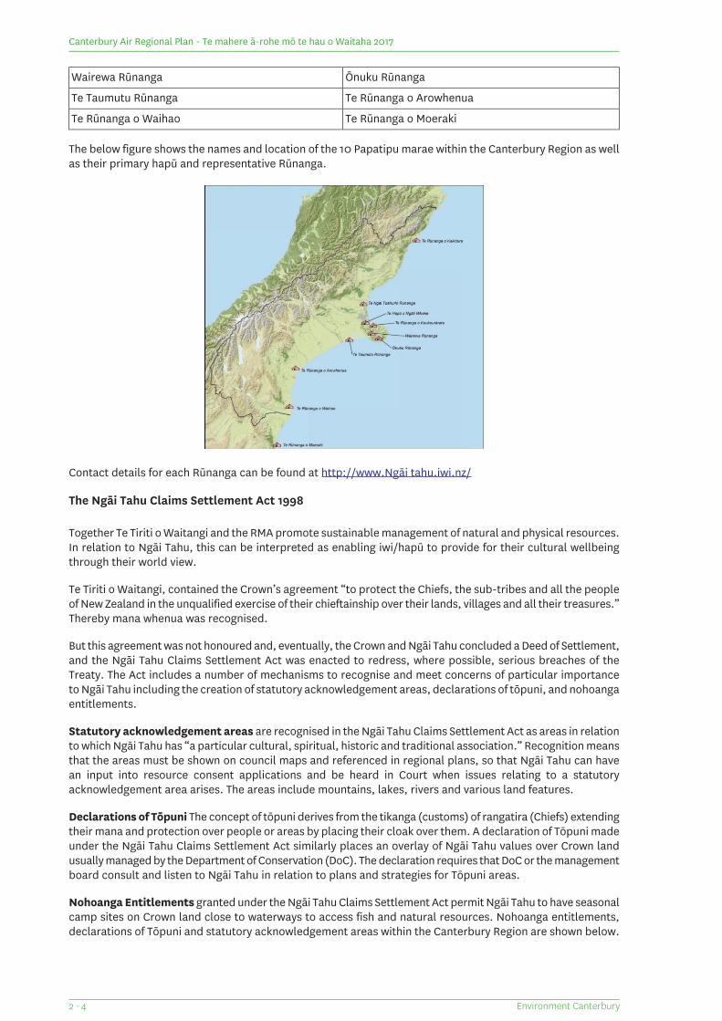
Ōnuku RūnangaWairewa Rūnanga
Te Rūnanga o ArowhenuaTe Taumutu Rūnanga
Te Rūnanga o MoerakiTe Rūnanga o Waihao
The below figure shows the names and location of the 10 Papatipu marae within the Canterbury Region as wellas their primary hapū and representative Rūnanga.
Contact details for each Rūnanga can be found at http://www.Ngāi tahu.iwi.nz/
The Ngāi Tahu Claims Settlement Act 1998
Together Te Tiriti o Waitangi and the RMA promote sustainable management of natural and physical resources.In relation to Ngāi Tahu, this can be interpreted as enabling iwi/hapū to provide for their cultural wellbeingthrough their world view.
Te Tiriti o Waitangi, contained the Crown’s agreement “to protect the Chiefs, the sub-tribes and all the peopleof New Zealand in the unqualified exercise of their chieftainship over their lands, villages and all their treasures.”Thereby mana whenua was recognised.
But this agreement was not honoured and, eventually, the Crown and Ngāi Tahu concluded a Deed of Settlement,and the Ngāi Tahu Claims Settlement Act was enacted to redress, where possible, serious breaches of theTreaty. The Act includes a number of mechanisms to recognise and meet concerns of particular importanceto Ngāi Tahu including the creation of statutory acknowledgement areas, declarations of tōpuni, and nohoangaentitlements.
Statutory acknowledgement areas are recognised in the Ngāi Tahu Claims Settlement Act as areas in relationto which Ngāi Tahu has “a particular cultural, spiritual, historic and traditional association.” Recognition meansthat the areas must be shown on council maps and referenced in regional plans, so that Ngāi Tahu can havean input into resource consent applications and be heard in Court when issues relating to a statutoryacknowledgement area arises. The areas include mountains, lakes, rivers and various land features.
Declarations of Tōpuni The concept of tōpuni derives from the tikanga (customs) of rangatira (Chiefs) extendingtheir mana and protection over people or areas by placing their cloak over them. A declaration of Tōpuni madeunder the Ngāi Tahu Claims Settlement Act similarly places an overlay of Ngāi Tahu values over Crown landusually managed by the Department of Conservation (DoC). The declaration requires that DoC or the managementboard consult and listen to Ngāi Tahu in relation to plans and strategies for Tōpuni areas.
Nohoanga Entitlements granted under the Ngāi Tahu Claims Settlement Act permit Ngāi Tahu to have seasonalcamp sites on Crown land close to waterways to access fish and natural resources. Nohoanga entitlements,declarations of Tōpuni and statutory acknowledgement areas within the Canterbury Region are shown below.
Environment Canterbury2 - 4
Canterbury Air Regional Plan - Te mahere ā-rohe mō te hau o Waitaha 2017
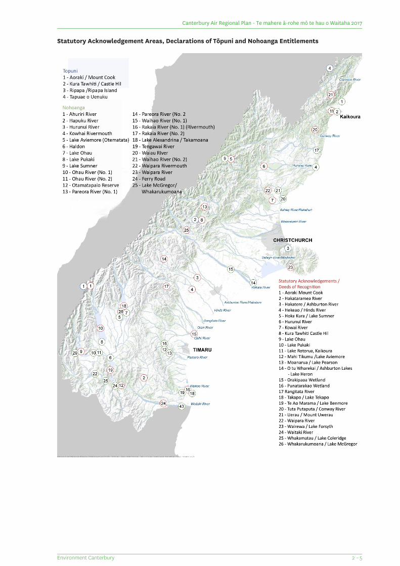
Statutory Acknowledgement Areas, Declarations of Tōpuni and Nohoanga Entitlements
2 – 5Environment Canterbury
Canterbury Air Regional Plan - Te mahere ā-rohe mō te hau o Waitaha 2017
Information available from the Canterbury Regional Council
The RMA contains information requirements relating to the iwi and hapū that exercise kaitiakitanga within anyparticular region. These requirements are of assistance to users of the Air Plan, in particular those who requirea resource consent for an activity that may cause effects adverse to the interests or values of Ngāi Tahu.
The Crown must provide to the Council details of the iwi and hapū who exercise kaitiakitanga within the region,including the particular areas over which the iwi and hapū provide stewardship. The Council must in turnmaintain an accessible record of the information provided to it.
That record must contain:
contact details for both the iwi and the hapū;
maps, or their equivalent, that show the areas over which iwi and hapū exercise kaitiakitanga;
any planning document recognised by an iwi authority provided it has been lodged with the Council.
Where, as in the Canterbury Region, there are multiple hapū represented by separate Papatipu Rūnanga,details for each hapū will be recorded.
The relevant planning documents in the present context are iwi management plans. Ngāi Tahu has set out itsresource management values, issues, objectives and policies in a number of iwi management plans throughoutthe Canterbury Region. These have been prepared in order to facilitate the exercise of Ngāi Tahu Rangatiratanga(chieftainship) over their lands, villages and all their treasures as per Article II of the Treaty / Te Tiriti, includingthe exercise of their kaitiaki responsibilities as Mana Whenua.
Iwi Planning documents provide information for assessing potential impacts on cultural values and interests.While they are not statutory instruments iwi management plans have weight under the RMA. Assuming theirrecognition by an iwi authority and lodgement with the Canterbury Regional Council, iwi management plansmust be “taken into account” if their contents are relevant to the resource management issues of the region.Local authorities must also take such plans into account when preparing regional or district plans under theRMA. In the preparation of this Plan an analysis of the iwi management plans was conducted. The CRC maintainsa relationship with Ngāi Tahu through both the Te Rūnanga and Nga Rūnanga in the Canterbury Region. TheCRC also has a joint work programme with Ngāi Tahu called “Tuia”.
Consultation with Ngāi Tahu
In the first instance Plan users should inspect the records held by the CRC to obtain information relating tosites and matters in which Ngāi Tahu have a cultural or other special interest.
Should the Council not have relevant materials on Ngāi Tahu values, then consultation with hapū is the onlymeans by which information can be obtained and it is good practice to do so. The level of consultation willvary depending on the nature of the issues and what is required to assess adverse effects on sites of culturalsignificance. In matters to do with the management of natural resources within individual takiwā, a particularRūnanga will have responsibility for management as kaitiaki and it alone should be consulted.
The need for consultation is most likely to arise in relation to rules which include a condition that a dischargemust not occur within a specified distance of “a sensitive activity, wāhi tapu, wāhi taonga or place of significanceto Ngāi Tahu”. Permitted activity rules with such a condition have an addition to the above formulation, namely“that is identified in an Iwi Management Plan”. But in relation to non-permitted activity rules where a resourceconsent application is required these additional words are not included in the condition. Accordingly, Planusers in the former category need only inspect the relevant Iwi Management Plan, while those who require aconsent will need to talk to CRC staff and in some instances consult the affected hapū as well.
The RMA and the Local Government Act 2002, require the CRC to consult with Ngāi Tahu in respect of themanagement of natural and physical resources of the Canterbury Region, including the preparation or changingof regional plans. If a resource consent application is not publicly notified, consenting authorities must decidewhether “affected person” status should be accorded to anyone. In relation to Ngāi Tahu this may mean thatTe Rūnanga or a Nga Rūnanga are to be notified depending on the area to which the application relates.
Environment Canterbury2 - 6
Canterbury Air Regional Plan - Te mahere ā-rohe mō te hau o Waitaha 2017
How the Air Plan Addresses Issues of Significance to Ngāi Tahu
To inform the development of the Air Plan a report was prepared in 2013 outlining issues of significance to NgāiTahu regarding air quality. A recommendation of the report was that the extent to which the Air Planaccommodated issues of significance to Ngāi Tahu would be shown by how well the policies and rules in thePlan achieved outcomes desired by Ngāi Tahu:
the life supporting capacity and mauri of air is maintained for future generations.
Ngāi Tahu are involved in regional decision-making on air quality issues.
sites of cultural significance, including wāhi tapu, wāhi taonga, marae, and mahinga kai are protectedfrom the adverse effects associated with the discharge of contaminants to air.
cultural amenity values are recognised in regional planning documents, and are protected from activitiesthat result in the discharge of contaminants to air.
An assessment of the provisions was undertaken to determine how well the Air Plan gave effect to the fouroutcomes desired by Ngāi Tahu. This exercise served to demonstrate that the Plan, through a mix of objectivesand central or specific policies, responded to and met each of the desired outcomes.
SUMMARY
The above has introduced the central tenets and some of the principal processes and mechanisms by whichNgāi Tahu came to manage the natural resources of Te Waipounamu. While the nature of this approach isdistinctly Māori, the intent – sustainable management – is clearly shared with wider New Zealand culture andhas been reflected in Part II of the RMA. In order to bring both cultural perspectives together in the overallmanagement of Canterbury’s air resources, this Plan has sought to integrate and weave Ngāi Tahu valuesthroughout. The result will be a region so much richer for its inclusiveness.
2 – 7Environment Canterbury
Canterbury Air Regional Plan - Te mahere ā-rohe mō te hau o Waitaha 2017

Canterbury Air Regional Plan - Te mahere ā-rohe mō te hau o Waitaha 2017
(This page is intentionally blank)
Environment Canterbury2 - 8
3 How the Plan Works
As required by section 67(1) of the Resource Management Act a regional plan must contain:
the objectives for the region
the policies to implement the objectives
the methods to implement the policies.
Otherwise the content of an Air Plan is at the discretion of the responsible regional council.
This Plan commences with three sections containing information intended to assist users of the Plan tounderstand, and apply, the plan provisions. The statutory sections containing the objectives, policies and rulesthen follow. Section 8 contains schedules that provide information and technical details and sections 9 – 13contain maps that support and amplify the rule framework.
Objectives and policies
The objectives in this Plan identify the resource management outcomes or goals for air quality in the CanterburyRegion.
The policies implement the Air Plan’s objectives, as required under section 67(1)(b) of the RMA. The Plancontains central and specific policies. Central policies apply to all activities. These policies provide an overalldirection for the management of air quality in the Region. The specific policies identify the outcomes soughtfrom the management of air quality for particular groups of activities. The policies guide decision-making onresource consent applications, and provide the rationale for the rules and the status which is given to activities.
The objectives and the policies each apply as a comprehensive suite, and must each be read and consideredtogether.
Rules
The rules in the Plan implement the policies, as required under section 67(1)(c) of the RMA. The rules have theforce and effect of regulations in statute, which means they are legally binding.
The rules determine whether a person needs to apply for a resource consent or whether the proposed activitycan be undertaken without one (known as permitted activities). The rules may also make some activitiesprohibited, which means no resource consent application can be made for that activity. An activity needs tocomply with all relevant rules in the Plan in order to be permitted.
The Plan contains general rules that apply anywhere in the Region. It also contains rules which are specific toareas within the Region, or specific to certain discharges of contaminants into air. If the discharge is notcontrolled by a general or specific rule, there will be a ‘catch all’ or ‘default’ rule that will apply, and this willspecify the status of the discharge. In accordance with section 15 of the RMA, the Air Plan has two principlesfor determining whether or not a resource consent is required for a discharge of contaminants into air:
1. A discharge of contaminants into air, which is not from an industrial or trade premise, is permittedunless it contravenes a rule in the Air Plan.
2. A discharge of contaminants into air from an industrial or trade premise is not permitted unlessexpressly allowed by a rule in the Air Plan.
There is an inter-relationship between the status an activity is given in a rule in this Plan, the effects sought tobe managed by the policies, and the environmental outcomes sought to be attained by the objectives. Therules authorise discharges by reference to what the RMA calls “classes of activities”; more simply a consenthierarchy comprises these activities:
3 – 1Environment Canterbury
Canterbury Air Regional Plan - Te mahere ā-rohe mō te hau o Waitaha 2017
Permitted activity: - A resource consent is not required. The discharging activity must, however, complywith the terms and conditions of the applicable rule, it being for the intending discharger to satisfyhimself/herself of this.
Controlled activity: - A resource consent is required, but must be granted if the terms of the rule aremet and subject to any conditions imposed on matters over which control has been reserved.
Restricted discretionary activity: - A resource consent is required, which may or may not be granted.If granted, the consent may include conditions but only related to matters of discretion stated in therule.
Discretionary activity: - As for a restricted discretionary activity, except that conditions are at large(i.e. are not restricted to matters over which discretion has been reserved).
Non-complying activity: - A resource consent is required, and may only be granted if the adverse effectsof the activity are minor or the activity is not contrary to the objectives and policies of the Plan.
Prohibited activity: - A resource consent may neither be applied for, nor granted.
When do Rules Have Legal Effect and Become Operative?
All rules in the Canterbury Air Regional Plan had immediate legal effect under section 86B(3) of the RMA fromthe date of notification (28 February 2015).
This means that from this date account must be taken of the Plan provisions in relation to any relevant resourcemanagement processes. The weight given to the provisions will increase as each step towards the Plan becomingoperative is completed.
The Plan provisions become operative when all submissions on the Plan have been considered or withdrawn,and any appeals against the provisions of the Plan have been determined. At this point the regional councilapproves the Plan and it becomes operative on a date that is to be publicly notified.
Where an activity requires a resource consent as a result of:
a rule in a proposed plan taking legal effect, or
a rule in a plan becoming operative
the activity may continue in the short term if it was previously lawful, the effects of the activity have notmaterially changed and the activity has not been discontinued. However, this description is a paraphrase ofsubsections (1) and (2) of section 20A of the RMA. Anyone who requires a resource consent in either of theabove situations should consult and solely rely on the terms of the section itself.
Resource consents
When applying for resource consent, applicants should refer to Schedule 1 of the Air Plan which sets out theminimum information requirements.
Environment Canterbury3 - 2
Canterbury Air Regional Plan - Te mahere ā-rohe mō te hau o Waitaha 2017
4 Definitions and Interpretation
The definitions are an essential part of the Air Plan, being integral and fundamental to understanding andapplying the Plan provisions. The rules in particular rely upon various definitions that define terms rangingfrom “ambient air” to “ultra-low emitting enclosed burner”, and many other concepts in between. Wheneveran objective, policy or rule uses a term that is defined in this section (except for those definitions taken directlyfrom the RMA), the defined term is shown in italics to alert plan users of the need to consult the definition.
Some of the definitions are taken directly from the RMA or other legislation. Where this is the case the sourceis identified by (RMA), or another relevant abbreviation, appearing in the left hand column underneath thewords comprising the defined term.
The table that follows comprises three parts:
general definitions
small-scale heating appliance definitions
abbreviations.
Table 2.1 General Definitions
DefinitionTerm
means properties which share a boundary with the subject property.Adjoiningproperties
means any substance, whether inorganic or organic, man-made or naturally occurring,modified or in its original state, that is used in any agriculture, horticulture or relatedactivity to eradicate, modify or control flora or fauna. For the purposes of this Plan itincludes agricultural compounds and animal remedies but excludes fertilisers, vertebratetoxic agents and oral nutrition compounds.
Agrichemical
means the air outside buildings and structures. This does not include indoor air, air in theworkplace, or contaminated air discharged from a source.
Ambient air
means those natural and physical qualities and characteristics of an area that contributeto people's appreciation of its pleasantness, aesthetic coherence, and cultural andrecreational attributes.
Amenity values(RMA)
means the best method for preventing or minimising the adverse effects on theenvironment, having regard, among other things, to:
Best practicableoption(RMA)
a. the nature of the discharge or emission and the sensitivity of the receivingenvironment to adverse effects; and
b. the financial implications, and the effects on the environment, of that optioncompared to other options; and
c. the current state of technical knowledge and the likelihood that the option can besuccessfully applied.
means materials consisting of, or including, fragments that could be discharged as dustor particulate. These materials include but are not limited to: gravel, quarried rock,fertiliser, coal, cement, flour, rock aggregate, grains, compost and woodchip.
Bulk solidmaterials
means a designated geographical area identified on the maps in Section 9.Clean Air Zone
means material that, when buried, will have no adverse effects on people or theenvironment. Cleanfill material includes virgin natural materials such as clay, soil androck, and other inert materials such as concrete or brick that are free of:
Cleanfill
a. combustible, putrescible, degradable or leachable components;
b. hazardous substances;
4 – 1Environment Canterbury
Canterbury Air Regional Plan - Te mahere ā-rohe mō te hau o Waitaha 2017
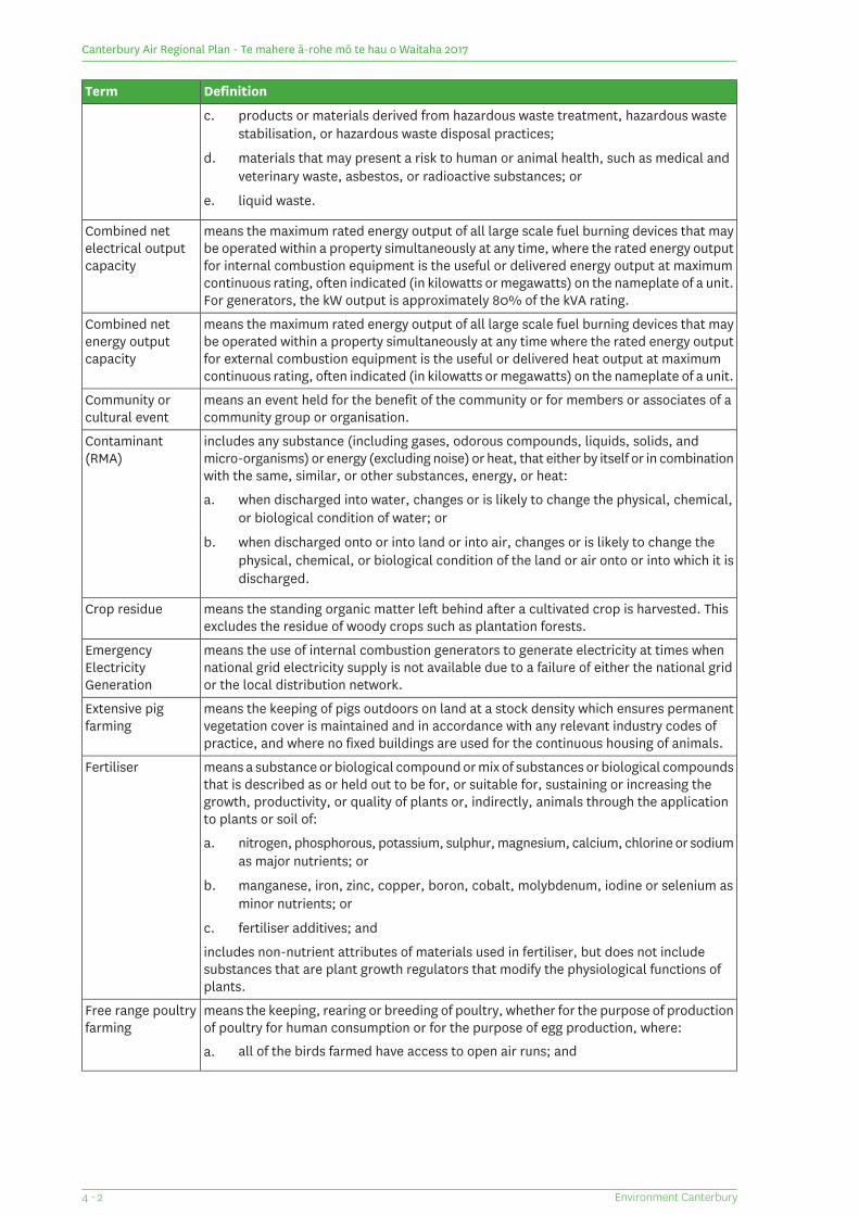
DefinitionTerm
c. products or materials derived from hazardous waste treatment, hazardous wastestabilisation, or hazardous waste disposal practices;
d. materials that may present a risk to human or animal health, such as medical andveterinary waste, asbestos, or radioactive substances; or
e. liquid waste.
means the maximum rated energy output of all large scale fuel burning devices that maybe operated within a property simultaneously at any time, where the rated energy outputfor internal combustion equipment is the useful or delivered energy output at maximumcontinuous rating, often indicated (in kilowatts or megawatts) on the nameplate of a unit.For generators, the kW output is approximately 80% of the kVA rating.
Combined netelectrical outputcapacity
means the maximum rated energy output of all large scale fuel burning devices that maybe operated within a property simultaneously at any time where the rated energy outputfor external combustion equipment is the useful or delivered heat output at maximumcontinuous rating, often indicated (in kilowatts or megawatts) on the nameplate of a unit.
Combined netenergy outputcapacity
means an event held for the benefit of the community or for members or associates of acommunity group or organisation.
Community orcultural event
includes any substance (including gases, odorous compounds, liquids, solids, andmicro-organisms) or energy (excluding noise) or heat, that either by itself or in combinationwith the same, similar, or other substances, energy, or heat:
Contaminant(RMA)
a. when discharged into water, changes or is likely to change the physical, chemical,or biological condition of water; or
b. when discharged onto or into land or into air, changes or is likely to change thephysical, chemical, or biological condition of the land or air onto or into which it isdischarged.
means the standing organic matter left behind after a cultivated crop is harvested. Thisexcludes the residue of woody crops such as plantation forests.
Crop residue
means the use of internal combustion generators to generate electricity at times whennational grid electricity supply is not available due to a failure of either the national gridor the local distribution network.
EmergencyElectricityGeneration
means the keeping of pigs outdoors on land at a stock density which ensures permanentvegetation cover is maintained and in accordance with any relevant industry codes ofpractice, and where no fixed buildings are used for the continuous housing of animals.
Extensive pigfarming
means a substance or biological compound or mix of substances or biological compoundsthat is described as or held out to be for, or suitable for, sustaining or increasing thegrowth, productivity, or quality of plants or, indirectly, animals through the applicationto plants or soil of:
Fertiliser
a. nitrogen, phosphorous, potassium, sulphur, magnesium, calcium, chlorine or sodiumas major nutrients; or
b. manganese, iron, zinc, copper, boron, cobalt, molybdenum, iodine or selenium asminor nutrients; or
c. fertiliser additives; and
includes non-nutrient attributes of materials used in fertiliser, but does not includesubstances that are plant growth regulators that modify the physiological functions ofplants.
means the keeping, rearing or breeding of poultry, whether for the purpose of productionof poultry for human consumption or for the purpose of egg production, where:
Free range poultryfarming
a. all of the birds farmed have access to open air runs; and
Environment Canterbury4 - 2
Canterbury Air Regional Plan - Te mahere ā-rohe mō te hau o Waitaha 2017
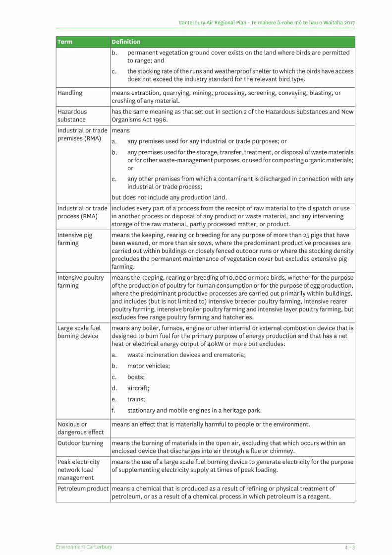
DefinitionTerm
b. permanent vegetation ground cover exists on the land where birds are permittedto range; and
c. the stocking rate of the runs and weatherproof shelter to which the birds have accessdoes not exceed the industry standard for the relevant bird type.
means extraction, quarrying, mining, processing, screening, conveying, blasting, orcrushing of any material.
Handling
has the same meaning as that set out in section 2 of the Hazardous Substances and NewOrganisms Act 1996.
Hazardoussubstance
meansIndustrial or tradepremises (RMA) a. any premises used for any industrial or trade purposes; or
b. any premises used for the storage, transfer, treatment, or disposal of waste materialsor for other waste-management purposes, or used for composting organic materials;or
c. any other premises from which a contaminant is discharged in connection with anyindustrial or trade process;
but does not include any production land.
includes every part of a process from the receipt of raw material to the dispatch or usein another process or disposal of any product or waste material, and any interveningstorage of the raw material, partly processed matter, or product.
Industrial or tradeprocess (RMA)
means the keeping, rearing or breeding for any purpose of more than 25 pigs that havebeen weaned, or more than six sows, where the predominant productive processes arecarried out within buildings or closely fenced outdoor runs or where the stocking densityprecludes the permanent maintenance of vegetation cover but excludes extensive pigfarming.
Intensive pigfarming
means the keeping, rearing or breeding of 10,000 or more birds, whether for the purposeof the production of poultry for human consumption or for the purpose of egg production,where the predominant productive processes are carried out primarily within buildings,
Intensive poultryfarming
and includes (but is not limited to) intensive breeder poultry farming, intensive rearerpoultry farming, intensive broiler poultry farming and intensive layer poultry farming, butexcludes free range poultry farming and hatcheries.
means any boiler, furnace, engine or other internal or external combustion device that isdesigned to burn fuel for the primary purpose of energy production and that has a netheat or electrical energy output of 40kW or more but excludes:
Large scale fuelburning device
a. waste incineration devices and crematoria;
b. motor vehicles;
c. boats;
d. aircraft;
e. trains;
f. stationary and mobile engines in a heritage park.
means an effect that is materially harmful to people or the environment.Noxious ordangerous effect
means the burning of materials in the open air, excluding that which occurs within anenclosed device that discharges into air through a flue or chimney.
Outdoor burning
means the use of a large scale fuel burning device to generate electricity for the purposeof supplementing electricity supply at times of peak loading.
Peak electricitynetwork loadmanagement
means a chemical that is produced as a result of refining or physical treatment ofpetroleum, or as a result of a chemical process in which petroleum is a reagent.
Petroleum product
4 – 3Environment Canterbury
Canterbury Air Regional Plan - Te mahere ā-rohe mō te hau o Waitaha 2017
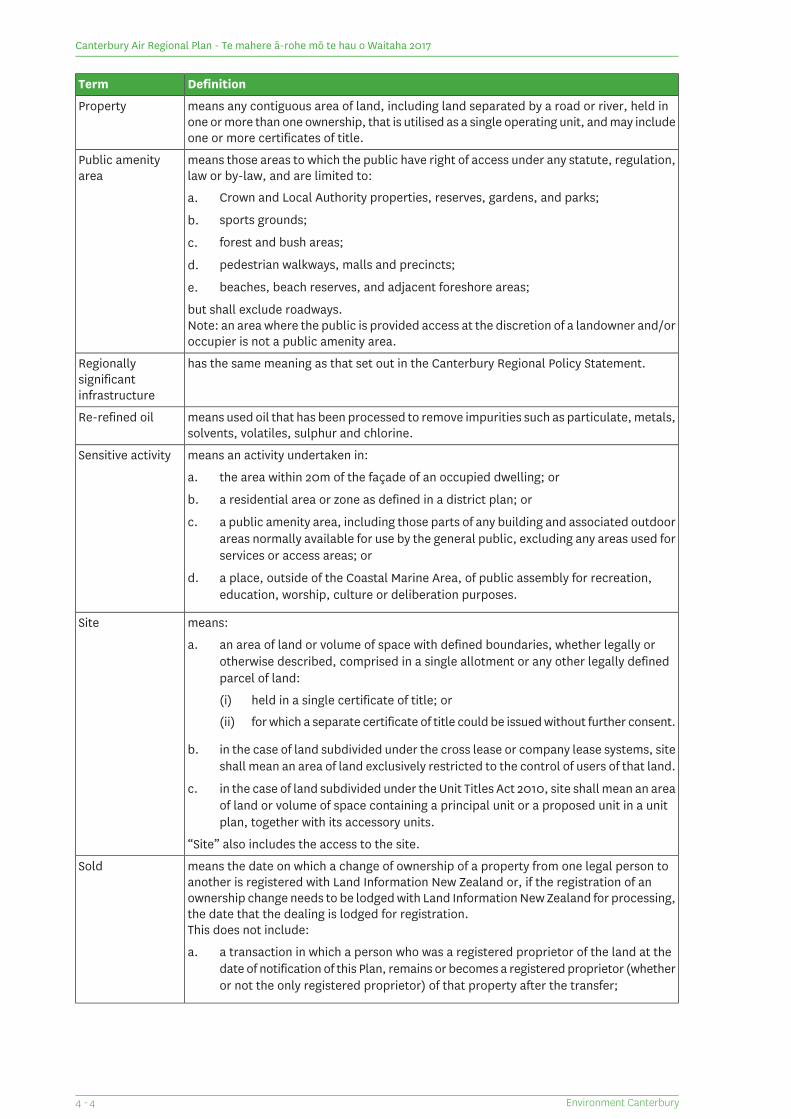
DefinitionTerm
means any contiguous area of land, including land separated by a road or river, held inone or more than one ownership, that is utilised as a single operating unit, and may includeone or more certificates of title.
Property
means those areas to which the public have right of access under any statute, regulation,law or by-law, and are limited to:
Public amenityarea
a. Crown and Local Authority properties, reserves, gardens, and parks;
b. sports grounds;
c. forest and bush areas;
d. pedestrian walkways, malls and precincts;
e. beaches, beach reserves, and adjacent foreshore areas;
but shall exclude roadways.Note: an area where the public is provided access at the discretion of a landowner and/oroccupier is not a public amenity area.
has the same meaning as that set out in the Canterbury Regional Policy Statement.Regionallysignificantinfrastructure
means used oil that has been processed to remove impurities such as particulate, metals,solvents, volatiles, sulphur and chlorine.
Re-refined oil
means an activity undertaken in:Sensitive activity
a. the area within 20m of the façade of an occupied dwelling; or
b. a residential area or zone as defined in a district plan; or
c. a public amenity area, including those parts of any building and associated outdoorareas normally available for use by the general public, excluding any areas used forservices or access areas; or
d. a place, outside of the Coastal Marine Area, of public assembly for recreation,education, worship, culture or deliberation purposes.
means:Site
a. an area of land or volume of space with defined boundaries, whether legally orotherwise described, comprised in a single allotment or any other legally definedparcel of land:
(i) held in a single certificate of title; or
(ii) for which a separate certificate of title could be issued without further consent.
b. in the case of land subdivided under the cross lease or company lease systems, siteshall mean an area of land exclusively restricted to the control of users of that land.
c. in the case of land subdivided under the Unit Titles Act 2010, site shall mean an areaof land or volume of space containing a principal unit or a proposed unit in a unitplan, together with its accessory units.
“Site” also includes the access to the site.
means the date on which a change of ownership of a property from one legal person toanother is registered with Land Information New Zealand or, if the registration of anownership change needs to be lodged with Land Information New Zealand for processing,the date that the dealing is lodged for registration.
Sold
This does not include:
a. a transaction in which a person who was a registered proprietor of the land at thedate of notification of this Plan, remains or becomes a registered proprietor (whetheror not the only registered proprietor) of that property after the transfer;
Environment Canterbury4 - 4
Canterbury Air Regional Plan - Te mahere ā-rohe mō te hau o Waitaha 2017
DefinitionTerm
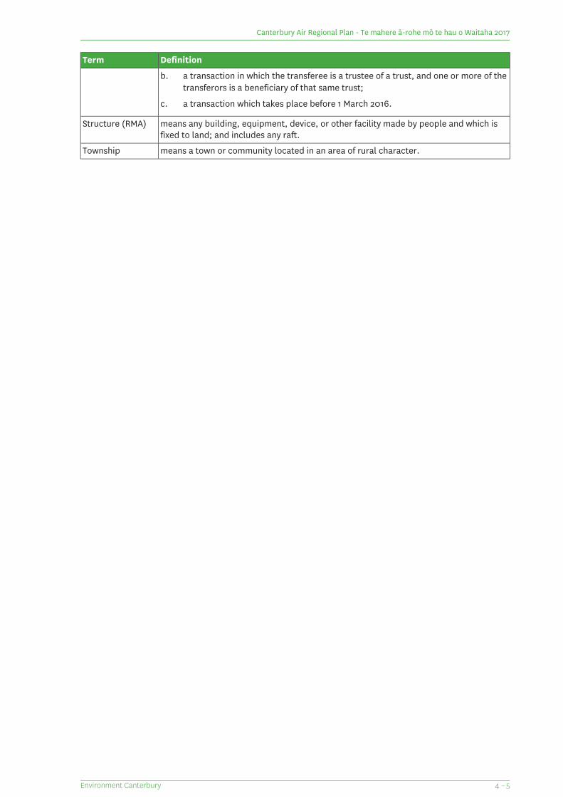
b. a transaction in which the transferee is a trustee of a trust, and one or more of thetransferors is a beneficiary of that same trust;
c. a transaction which takes place before 1 March 2016.
means any building, equipment, device, or other facility made by people and which isfixed to land; and includes any raft.
Structure (RMA)
means a town or community located in an area of rural character.Township
4 – 5Environment Canterbury
Canterbury Air Regional Plan - Te mahere ā-rohe mō te hau o Waitaha 2017
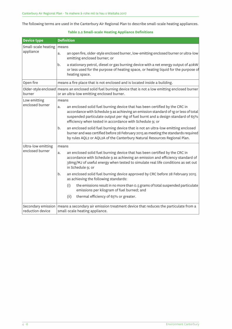
The following terms are used in the Canterbury Air Regional Plan to describe small-scale heating appliances.
Table 2.2 Small-scale Heating Appliance Definitions
DefinitionDevice type
meansSmall-scale heatingappliance a. an open fire, older-style enclosed burner, low-emitting enclosed burner or ultra-low
emitting enclosed burner; or
b. a stationary petrol, diesel or gas burning device with a net energy output of 40kW or less used for the purpose of heating space, or heating liquid for the purpose of heating space.
means a fire place that is not enclosed and is located inside a building.Open fire
means an enclosed solid fuel burning device that is not a low emitting enclosed burneror an ultra-low emitting enclosed burner.
Older-style enclosedburner
meansLow emittingenclosed burner a. an enclosed solid fuel burning device that has been certified by the CRC in
accordance with Schedule 9 as achieving an emission standard of 1g or less of totalsuspended particulate output per 1kg of fuel burnt and a design standard of 65%efficiency when tested in accordance with Schedule 9; or
b. an enclosed solid fuel burning device that is not an ultra-low emitting enclosedburner and was certified before 28 February 2015 as meeting the standards requiredby rules AQL2 or AQL2A of the Canterbury Natural Resources Regional Plan.
meansUltra-low emittingenclosed burner a. an enclosed solid fuel burning device that has been certified by the CRC in
accordance with Schedule 9 as achieving an emission and efficiency standard of38mg/MJ of useful energy when tested to simulate real life conditions as set outin Schedule 9; or
b. an enclosed solid fuel burning device approved by CRC before 28 February 2015as achieving the following standards:
(i) the emissions result in no more than 0.5 grams of total suspended particulateemissions per kilogram of fuel burned; and
(ii) thermal efficiency of 65% or greater.
means a secondary air emission treatment device that reduces the particulate from asmall-scale heating appliance.
Secondary emissionreduction device
Environment Canterbury4 - 6
Canterbury Air Regional Plan - Te mahere ā-rohe mō te hau o Waitaha 2017
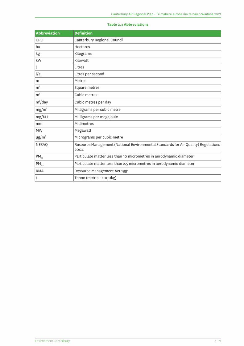
Table 2.3 Abbreviations
DefinitionAbbreviation
Canterbury Regional CouncilCRC
Hectaresha
Kilogramskg
KilowattkW
Litresl
Litres per secondl/s
Metresm
Square metresm2
Cubic metresm3
Cubic metres per daym3/day
Milligrams per cubic metremg/m3
Milligrams per megajoulemg/MJ
Millimetresmm
MegawattMW
Micrograms per cubic metreμg/m3
Resource Management (National Environmental Standards for Air Quality) Regulations2004
NESAQ
Particulate matter less than 10 micrometres in aerodynamic diameterPM10
Particulate matter less than 2.5 micrometres in aerodynamic diameterPM2.5
Resource Management Act 1991RMA
Tonne (metric - 1000kg)t
4 – 7Environment Canterbury
Canterbury Air Regional Plan - Te mahere ā-rohe mō te hau o Waitaha 2017

Canterbury Air Regional Plan - Te mahere ā-rohe mō te hau o Waitaha 2017
(This page is intentionally blank)
Environment Canterbury4 - 8
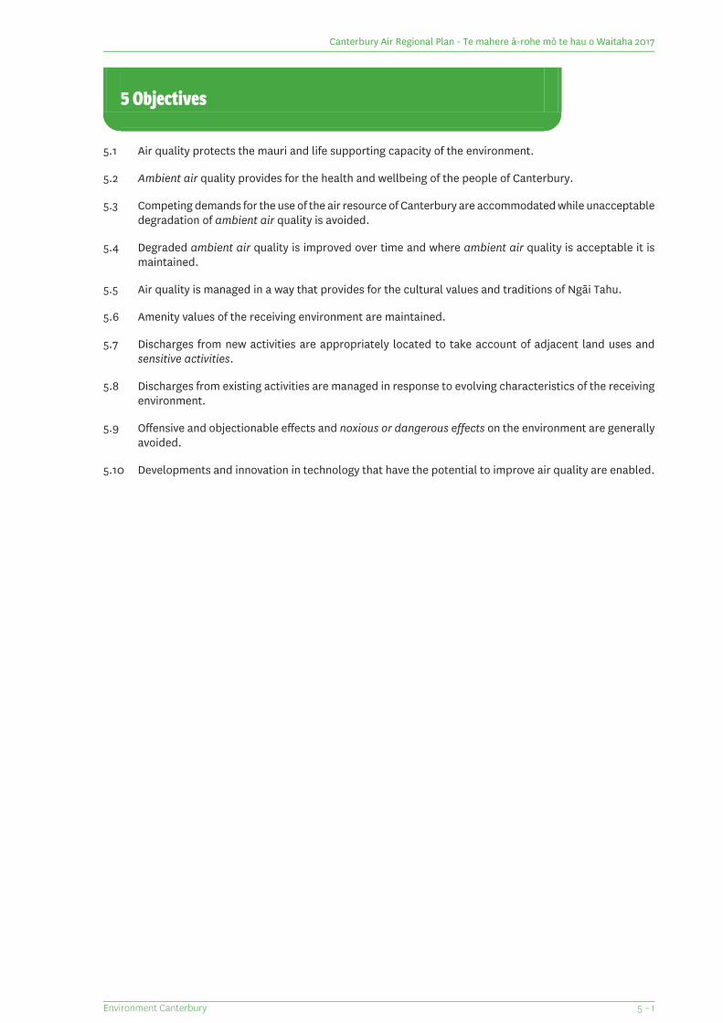
5 Objectives
5.1 Air quality protects the mauri and life supporting capacity of the environment.
5.2 Ambient air quality provides for the health and wellbeing of the people of Canterbury.
5.3 Competing demands for the use of the air resource of Canterbury are accommodated while unacceptabledegradation of ambient air quality is avoided.
5.4 Degraded ambient air quality is improved over time and where ambient air quality is acceptable it ismaintained.
5.5 Air quality is managed in a way that provides for the cultural values and traditions of Ngāi Tahu.
5.6 Amenity values of the receiving environment are maintained.
5.7 Discharges from new activities are appropriately located to take account of adjacent land uses andsensitive activities.
5.8 Discharges from existing activities are managed in response to evolving characteristics of the receivingenvironment.
5.9 Offensive and objectionable effects and noxious or dangerous effects on the environment are generallyavoided.
5.10 Developments and innovation in technology that have the potential to improve air quality are enabled.
5 – 1Environment Canterbury
Canterbury Air Regional Plan - Te mahere ā-rohe mō te hau o Waitaha 2017

Canterbury Air Regional Plan - Te mahere ā-rohe mō te hau o Waitaha 2017
(This page is intentionally blank)
Environment Canterbury5 - 2
6 Policies
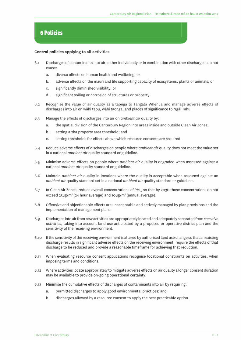
Central policies applying to all activities
6.1 Discharges of contaminants into air, either individually or in combination with other discharges, do notcause:
a. diverse effects on human health and wellbeing; or
b. adverse effects on the mauri and life supporting capacity of ecosystems, plants or animals; or
c. significantly diminished visibility; or
d. significant soiling or corrosion of structures or property.
6.2 Recognise the value of air quality as a taonga to Tangata Whenua and manage adverse effects ofdischarges into air on wāhi tapu, wāhi taonga, and places of significance to Ngāi Tahu.
6.3 Manage the effects of discharges into air on ambient air quality by:
a. the spatial division of the Canterbury Region into areas inside and outside Clean Air Zones;
b. setting a 2ha property area threshold; and
c. setting thresholds for effects above which resource consents are required.
6.4 Reduce adverse effects of discharges on people where ambient air quality does not meet the value setin a national ambient air quality standard or guideline.
6.5 Minimise adverse effects on people where ambient air quality is degraded when assessed against anational ambient air quality standard or guideline.
6.6 Maintain ambient air quality in locations where the quality is acceptable when assessed against anambient air quality standard set in a national ambient air quality standard or guideline.
6.7 In Clean Air Zones, reduce overall concentrations of PM2.5 so that by 2030 those concentrations do notexceed 25μg/m3 (24 hour average) and 10μg/m3 (annual average).
6.8 Offensive and objectionable effects are unacceptable and actively managed by plan provisions and theimplementation of management plans.
6.9 Discharges into air from new activities are appropriately located and adequately separated from sensitiveactivities, taking into account land use anticipated by a proposed or operative district plan and thesensitivity of the receiving environment.
6.10 If the sensitivity of the receiving environment is altered by authorised land use change so that an existingdischarge results in significant adverse effects on the receiving environment, require the effects of thatdischarge to be reduced and provide a reasonable timeframe for achieving that reduction.
6.11 When evaluating resource consent applications recognise locational constraints on activities, whenimposing terms and conditions.
6.12 Where activities locate appropriately to mitigate adverse effects on air quality a longer consent durationmay be available to provide on-going operational certainty.
6.13 Minimise the cumulative effects of discharges of contaminants into air by requiring:
a. permitted discharges to apply good environmental practices; and
b. discharges allowed by a resource consent to apply the best practicable option.
6 – 1Environment Canterbury
Canterbury Air Regional Plan - Te mahere ā-rohe mō te hau o Waitaha 2017
6.14 Recognise the contribution of nationally and regionally significant infrastructure to people’s social andeconomic wellbeing and provide for discharges associated with the development, operation, andmaintenance of that infrastructure.
6.15 Recognise that changes in technology may allow for improvements in the quality of a discharge overthe term of the consent and acknowledge this by imposing management and review conditions on newand replacement resource consents.
6.16 Provide for discharges of contaminants into air necessary for the protection of production species andother biodiversity from biosecurity risks.
6.17 Where a discharge causes effects that are unpredictable because of scientific uncertainty or an absenceof information adopt a precautionary approach to assessing the effects if there is a risk of high probabilityor high potential impact.
Outdoor burning
6.18 Minimise adverse effects of discharges into air from outdoor burning of organic material by establishingstandards for this activity, including when burns are allowed and requirements for the preparation andimplementation of a smoke management plan.
6.19 Avoid outdoor burning of non-organic material (other than incidental amounts) except where the burningis for fire fighting research and training, munitions, ammunition and pyrotechnic disposal or occurs inaccordance with tikanga Māori.
6.20 Minimise adverse effects on townships of discharges into air from outdoor burning of organic material,particularly where Crop Residue Burning Buffer Areas have been identified on the Planning Maps.
6.21 Allow discharges into air from outdoor cooking and outdoor burning of organic material for communityand cultural events.
Industrial and trade activities and large scale fuel burning devices
6.22 Applications for resource consent for discharges of contaminants into air from large scale fuel burningdevices and industrial or trade activities shall identify the best practicable option to be adopted tominimise effects.
6.23 Avoid significant increases in the concentration of PM10 in ambient air within a gazetted airshed byestablishing thresholds and performance standards for the discharge of PM10 within the associated CleanAir Zone.
6.24 Within Clean Air Zones, generally avoid granting resource consents to discharge PM10 whereconcentrations in the discharge exceed 250mg/m3.
6.25 Applications for resource consent for discharges into air from industrial or trade activities or large scalefuel burning devices classified as discretionary shall address:
a. where the discharge includes PM10, the mass emission rate of the proposed discharge relative tothe total emission rate of all discharges within the Clean Air Zone; and the degree to which theproposed discharge exacerbates cumulative effects within the Clean Air Zone; and
b. localised effects of the proposed discharge and the location of sensitive receptors; and
c. available mitigation and emission control options; and
d. the duration of consent being sought and the practicability for the effects of the discharge to bereduced over time.
6.26 When considering applications for resource consent for the discharge of contaminants into air fromlarge scale fuel burning devices or from industrial, trade or commercial activities, the CRC will considerthe combined effect of all consented discharges into air occurring on the property.
Environment Canterbury6 - 2
Canterbury Air Regional Plan - Te mahere ā-rohe mō te hau o Waitaha 2017
6.27 Enable discharges into air from large scale fuel burning devices for the purpose of:
a. emergency electricity generation; or
b. strategic management of electricity supply by network suppliers,
while limiting discharges to the duration of the emergency, supply crisis or excess network loading and givingpreference to the use of generators located outside Clean Air Zones.
6.28 Manage discharges of odour and dust from the storage, transfer, handling, treatment or disposal ofliquid or solid waste, by ensuring that any discharges from those activities are appropriately located.
6.29 The recovery of Lyttelton Port is provided for by expediting activities associated with the repair, rebuildand reconfiguration of the Port, while managing the effects on the environment.
Rural discharges into air
6.30 The discharge of agrichemicals and fertilisers into air is undertaken using best management practicesto minimise the risk of adversely affecting non-target locations.
6.31 Adverse effects of discharges of odour into air from farming activities are managed through performancestandards or conditions on resource consents that ensure the amenity values of the area in which thedischarge occurs are maintained and effects on sensitive activities are minimised.
6.32 Discharges of contaminants into air associated with farming activities do not cause offensive orobjectionable effects beyond the boundary of the property of origin.
Small-scale heating appliances
6.33 Improve air quality where it is degraded and maintain air quality where it is acceptable by managingdischarges from small-scale heating appliances through:
a. establishing plan provisions that stimulate the development of new technology, including thedevelopment of secondary emission reduction devices; and
b. specifying appropriate appliance performance standards and operational requirements; and
c. requiring upgrades in technology in Clean Air Zones within a specified time frame; and
d. establishing limits on visible smoke discharges and specifying fuel standards.
6.34 Enable the use of small-scale heating appliances in particular heritage buildings where those appliancesare integral to the heritage fabric of the building, including by undertaking regular review of Schedule10.
6.35 Enable the use of ultra-low emitting enclosed burners in new situations and as replacements for existingsmall-scale heating appliances.
6.36 According to the maturity of the previous controls in each Clean Air Zone, allow discharges fromlow-emitting enclosed burners in specified circumstances and timeframes.
6.37 Phase out discharges of contaminants into air from the use of open fires on properties less than 2 hectaresin Clean Air Zones.
6.38 Phase out discharges of contaminants into air from the use of older-style enclosed burners in Clean AirZones.
6 – 3Environment Canterbury
Canterbury Air Regional Plan - Te mahere ā-rohe mō te hau o Waitaha 2017

Canterbury Air Regional Plan - Te mahere ā-rohe mō te hau o Waitaha 2017
(This page is intentionally blank)
Environment Canterbury6 - 4
7 Rules
Rule Index
Rule NumberActivity
7.1 – 7.9Rules applying to all activities
7.1Must comply with all applicable rules
7.2Universal matters for control or discretion
7.3 – 7.5Odour, dust and smoke effects
7.6Noxious and dangerous effects
7.7 – 7.9Hazardous air pollutants
7.10 – 7.19Outdoor burning
7.10Burning for fire-fighting training or deflagration
7.11 – 7.13Burning of crop residue
7.14Burning vegetation, paper, cardboard or untreated wood
7.15Burning for community or cultural events
7.16Domestic cooking (including hangis, barbeques and pizza ovens)
7.17Burning for biosecurity reasons
7.18Burning animal carcasses and offal
7.19Other
7.20 – 7.30Large scale fuel burning devices
7.20 – 7.25External combustion
7.26 – 7.30Internal combustion including electricity generation
7.31 – 7.64Industrial, trade or commercial activities
7.31Lyttelton Port Recovery
7.32 – 7.40Dust generating activities
7.32 – 7.34Land development
7.35 – 7.36Bulk solid materials
7.37Seed processing
7.38Wood waste
7.39 – 7.40Abrasive blasting
7.41 – 7.44Surface coating and printing
7.41 – 7.43Spray application of paint
7.44Printing processes
7.45 – 7.51Waste management
7.45 – 7.49Landfills, cleanfills and waste transfer sites
7.50 – 7.52Human effluent treatment and disposal
7.53 – 7.62Other
7.53Petroleum products
7.54 – 7.55Drycleaning and laundries
7.56Metal working
7.57Clay firing
7.58Cooling towers and heat exchangers
7.59Cooking of animal and plant matter
7.60 – 7.62Laboratory fume cupboards, fumigation and ventilation
7.63Activities not otherwise provided for
7.64Activities giving rise to offensive and objectionable effects
7.65 – 7.80Farming
7.65 – 7.72Intensive farming
7.65 -7.66All intensive farming established prior to 1 June 2002
7.67 – 7.68Intensive poultry farming established after 1 June 2002
7 – 1Environment Canterbury
Canterbury Air Regional Plan - Te mahere ā-rohe mō te hau o Waitaha 2017
Rule NumberActivity
7.69Intensive pig farming established after 1 June 2002
7.70 – 7.71Accommodation of cattle
7.72Mushroom farming established after 1 June 2002
7.73 – 7.74Animal effluent and solid animal waste
7.75 – 7.76Offal pits
7.77 – 7.79Agrichemicals and fertilisers
7.80Activities giving rise to offensive and objectionable effects
7.81 – 7.108Small-scale heating appliances
7.81Small-scale heating appliances on industrial or trade premises
7.82 – 7.83Outside Clean Air Zones
7.84 – 7.88Within All Clean Air Zones
7.84General prohibitions
7.85Ultra-low emitting enclosed burners and small-scale heatingappliances burning liquid or gas fuel
7.86 – 7.87Small-scale heating appliances located in heritage buildings
7.88 – 7.89Small-scale heating appliances fitted with secondary emissionreduction devices
7.90 – 7.94Rangiora, Kaiapoi and Ashburton Clean Air Zones
7.95 – 7.99Christchurch Clean Air Zone
7.100 – 7.104Timaru Clean Air Zone
7.105 – 7.108Geraldine and Waimate Clean Air Zones
Environment Canterbury7 - 2
Canterbury Air Regional Plan - Te mahere ā-rohe mō te hau o Waitaha 2017
Rules applying to all activities
Notes and cross-references are included for information purposes only and do not form part of the rules andnor should they be considered a complete list.
7.1 Any activity must comply with all applicable rules in Section 7 of this Plan, except where explicitlystated to the contrary in any other applicable rule in this Plan.
7.2 In considering applications for controlled activities or restricted discretionary activities, thematters on which:
1. control is reserved;
2. or exercise of discretion is restricted;
include the lapsing period, the term of the resource consent, the review of the conditions of aresource consent, the need for a bond or financial contributions, any actual or potential adverseeffects on places of significance to Ngāi Tahu and the collecting, recording, monitoring andprovision of information concerning the exercise of a resource consent. These matters are inaddition to those listed in the applicable rule for the activity.
7.3 The discharge of odour, dust or smoke into air that is not managed by any other rule in this Planis a permitted activity provided the following conditions are met:
1. The discharge does not cause or is not likely to cause an adverse effect beyond the boundary ofthe property of origin; and
2. The discharge does not cause an offensive or objectionable effect beyond the boundary of theproperty of origin when assessed in accordance with Schedule 2.
7.4 The discharge of odour, dust or smoke into air that is not managed by any other rule in this Planand that does not meet condition 1 of Rule 7.3 is a restricted discretionary activity.
The exercise of discretion is restricted to the following matters:
1. The content of the management plan to be implemented; and
2. The frequency of the effects of the discharge; and
3. The intensity of the effects of the discharge; and
4. The duration of the effects of the discharge; and
5. The offensiveness of the discharge; and
6. The location of the effects of the discharge; and
7. The matters set out in Rule 7.2; and
8. Mitigation methods available to minimise any actual or potential environmental effects on theefficacy of the package of conditions.
7.5 The discharge of odour, dust or smoke into air that does not meet condition 2 of Rule 7.3 is anon-complying activity.
7.6 The discharge of any contaminant into air that causes a noxious or dangerous effect and that isnot otherwise classified by a rule in this Plan is a prohibited activity.
7.7 Except where provided for by Rule 7.10, the discharge of contaminants into air from outdoorburning or burning in a small-scale heating appliance of:
a. any quantity of a material listed in Part A below; or
b. a material listed in Part B below, except:
(i) where that material is present in minor quantities and cannot be readily separatedfrom the principal material being burnt; or
(ii) where the burning is on a marae and in accordance with tikanga Māori;
7 – 3Environment Canterbury
Canterbury Air Regional Plan - Te mahere ā-rohe mō te hau o Waitaha 2017
is a prohibited activity.
Part A
1. Wood painted with lead-based paint or treated with CCA timber preservative;
2. Wire that is coated with any material;
3. Materials containing asbestos;
4. All rubber;
5. Medical waste, pathological wastes, quarantine waste;
6. Batteries, chemicals, paint and other surface coating materials;
7. Tar or bitumen;
8. Used and waste oil, excluding re-refined oil;
9. Sludge from industrial processes;
10. Any container that has been used for the purpose of storing hazardous substances.
Part B
1. Wood treated or processed with preservatives (except for wood treated with CCA timberpreservative), gluing agents, or impregnated with chemicals;
2. Wood which is painted, stained or oiled (except for wood painted with lead based paint)
3. Metals and materials containing metals;
4. All plastic;
5. Animal waste;
6. Synthetic material including, but not limited to, motor vehicle parts, foams and fibreglass.
7.8 Except where prohibited under Regulations 7 to 12 of the Resource Management (NationalEnvironmental Standards for Air Quality) Regulations 2004, the discharge of contaminants intoair from burning in a large scale fuel burning device or incinerator or as part of an industrial ortrade process of any material listed in Part A or Part B of Rule 7.7 is a discretionary activity.
7.9 The discharge of contaminants into air from the outdoor burning of any waste materials withina landfill or waste transfer station or waste recovery area, but excluding landfill gas, is a prohibitedactivity.
Environment Canterbury7 - 4
Canterbury Air Regional Plan - Te mahere ā-rohe mō te hau o Waitaha 2017
Outdoor burning
Anywhere in the Region
Note: The relevant district, city or Rural Fire Authority outdoor burning bylaws should be consulted prior toundertaking any outdoor burning.
Burning for fire fighting or deflagration
7.10 The discharge of contaminants into air from:
a. the outdoor burning of buildings or other materials for the purpose of fire-fighting trainingor research; or
b. the burning or deflagration, by the New Zealand Defence Force, of ammunitions, munitionsand pyrotechnics
is a permitted activity provided the following conditions are met:
1. The fire is under the control of the Rural Fire Authority, New Zealand Fire Service, Department ofConservation, New Zealand Defence Force, Christchurch International Airport Fire Service or othernationally recognised body authorised to undertake fire-fighting training or research activities;and
2. The burning does not occur within 100m of any National Grid power line or substation unlesspermission has been obtained from the owner of the infrastructure; and
3. All properties not owned by the relevant organisation identified in Condition 1 above within a 150mradius of the point of discharge are notified in writing at least 7 days prior to the training exercise;and
4. Within a Clean Air Zone, building fires do not occur during the months of April, May, June, July,August and September; and
5. Burning is undertaken in accordance with Regulations 9 and 10 of the Resource Management(National Environmental Standards for Air Quality) Regulations 2004.
Burning of crop residue
7.11 Outside Crop Residue Burning Buffer Areas identified in Section 11 Crop Residue Burning BufferArea Map Series, the discharge of contaminants into air from burning standing crop residue is apermitted activity provided the following conditions are met:
1. The discharge does not cause an offensive or objectionable effect beyond the boundary of theproperty of origin, when assessed in accordance with Schedule 2; and
2. The burning does not occur within 100m of any National Grid power line or substation unlesspermission has been obtained from the owner of the infrastructure; and
3. The person responsible for the discharge holds a smoke management plan prepared in accordancewith Schedule 3; and
4. The discharge is managed in accordance with the smoke management plan; and
5. The smoke management plan is supplied to the CRC on request.
7.12 Outside Crop Residue Burning Buffer Areas identified in Section 11 Crop Residue Burning BufferArea Map Series, the discharge of contaminants into air from burning standing crop residue thatdoes not meet condition 1 of Rule 7.11 is a non-complying activity.
7.13 Within Crop Residue Burning Buffer Areas identified in Section 11 Crop Residue Burning BufferArea Map Series, the discharge of contaminants into air from burning standing crop residue is acontrolled activity provided the following condition is met:
1. The burning of standing crop residue is undertaken in accordance with Schedule 3.
The CRC reserves control over the following matters:
7 – 5Environment Canterbury
Canterbury Air Regional Plan - Te mahere ā-rohe mō te hau o Waitaha 2017
1. The management of the effects of the dispersal or deposition of particles beyond the boundary ofthe property of origin; and
2. The contents and application of a smoke management plan; and
3. The management of cumulative effects on the township adjacent to the buffer area; and
4. The actual and potential effects of the discharge on surrounding neighbours including any nationalgrid power line or substation; and
5. The matters set out in rule 7.2.
Burning vegetation, paper, cardboard or untreated wood
7.14 The discharge of contaminants into air from outdoor burning of vegetation (excluding standingcrop residue), paper, cardboard or untreated wood, is a permitted activity provided the followingconditions are met:
1. The discharge is on a property greater than 2ha in area; and
2. The quantity of any liquid fire accelerant used does not exceed 10 litres; and
3. The burning does not occur within 100m of any National Grid power line or substation unlesspermission has been obtained from the owner of the infrastructure; and
4. The material to be burnt is located at least 100m upwind and 50m in any other direction of anysensitive activity that is not located on the property where burning occurs unless permission hasbeen obtained from the occupier of the place or area where the sensitive activity is occurring; and
5. The material to be burnt is dry and the moisture content is unlikely to exceed 25% dry weight; and
6. If within 4 km of any township or Clean Air Zone, burning only occurs when the wind direction willcause smoke to disperse away from the township or Clean Air Zone; and
7. Burning is only of material sourced from no more than 2 adjoining properties and burning isundertaken on one of those properties; and
8. If the discharge is likely to continue for 3 days or more, a smoke management plan has beenprepared in accordance with Schedule 3 and the discharge is managed in accordance with thatsmoke management plan; and
9. Any smoke management plan required under condition 8 above is supplied to the CRC on request;and
10. Within a Clean Air Zone, the burning does not take place during May, June, July or August, exceptthat in the Geraldine, Ashburton, Waimate and Rangiora Clean Air Zones, burning may take placein the month of May between the hours of 8am and 4pm.
7.15 The discharge of contaminants into air from outdoor burning of vegetation and untreated woodas a part of a community or cultural event is a permitted activity provided the following conditionsare met:
1. Within a Clean Air Zone, the discharge does not take place during May, June, July or August; and
2. The burning does not occur within 100m of any National Grid power line or substation unlesspermission has been obtained from the owner of the infrastructure; and
3. The material to be burnt is dry and the moisture content is unlikely to exceed 25% dry weight.
7.16 The discharge of contaminants into air from outdoor burning for the purpose of cooking, includingin a hangi, barbeque, pizza oven or other small scale or domestic outdoor cooking device, is apermitted activity.
Burning for biosecurity reasons
7.17 The discharge of contaminants into air, from outdoor burning for the purpose of controllingunwanted organisms or disease control and that is undertaken as a requirement of the BiosecurityAct 1993, is a permitted activity.
Environment Canterbury7 - 6
Canterbury Air Regional Plan - Te mahere ā-rohe mō te hau o Waitaha 2017
Burning animal carcasses and offal
7.18 The discharge of contaminants into air from outdoor burning of animal carcasses and offal is apermitted activity provided the following conditions are met:
1. The discharge is on a property greater than 2ha in area; and
2. The burning does not occur within 100m of any National Grid power line or substation unlesspermission has been obtained from the owner of the infrastructure; and
3. The discharge does not occur within 100m of a property boundary.
Other
7.19 The discharge of contaminants into air from outdoor burning that does not comply with one ormore of the conditions of Rule 7.11 excluding condition 1, or one or more of the conditions of Rules7.10, 7.13, 7.14, 7.15 or 7.18, is a restricted discretionary activity.
The exercise of discretion is restricted to the following matters:
1. Any effect on the environment of not meeting the condition or conditions of the particular rulecontravened; and
2. Whether the conditions of the rule, when considered as a package, remain effective; and
3. Mitigation methods available to minimise any actual or potential environmental effects on theefficacy of the package of conditions.
7 – 7Environment Canterbury
Canterbury Air Regional Plan - Te mahere ā-rohe mō te hau o Waitaha 2017
Large scale fuel burning devices
Note; in accordance with Regulation 17 of the Resource Management ( National Environmental Standards forAir Quality) Regulations 2004, the CRC must decline an application for a resource consent for a new or increaseddischarge of PM10 if the discharge to be expressly allowed by the consent would be likely, at any time, to increasethe concentration of PM10 ( calculated as a 24-hour mean under Schedule 1 of the Resource Management(National Environmental Standards for Air Quality) Regulations 2004 by more than 2.5 micrograms per cubicmeter(µg/m3) in any part of a polluted airshed (see gazetted airsheds shown in the maps in Section 10) otherthan the site on which the consent would be exercised.
External combustion
7.20 The discharge of contaminants into air from the external combustion of fuel in any large scalefuel burning device is a permitted activity provided the following conditions, where applicable,are met:
All devices
1. The discharge is directed vertically into air and is not impeded by any obstruction above theemission stack which decreases the vertical efflux velocity below that which would occur in theabsence of such obstruction; and
2. Except for a period not exceeding two minutes in each hour of operation, the opacity of thedischarge is not darker than Ringelmann Shade No. 1, as described in Schedule 6; and
3. The emissions are discharged through an emission stack which meets the requirements set outin Schedule 5; and
4. The fuel burning equipment is maintained in accordance with the manufacturer’s specificationsat least once every year by a person competent in the maintenance of that equipment, a copy ofeach maintenance report is held for three years and made available to the CRC on request, andthe annual maintenance includes adjustment, as required, of the fuel to air mix and testing of theratio of combustion gases discharged to optimise efficiency; and
Gas fired
5. Where the discharge is from the combustion of liquefied petroleum gas or compressed naturalgas, the combined net energy output capacity of all gas-fired devices is less than or equal to 5MW;
Diesel fired
6. Where the discharge is from the combustion of diesel:
(a) the sulphur content of the fuel to be burnt does not exceed 0.001% by weight; and
(b) the combined net energy output capacity of all diesel-fired devices is less than or equal to:
(i) 500kW within a Clean Air Zone; or
(ii) 2MW outside a Clean Air Zone;
Solid fuel fired
7. Where the discharge is from the combustion of solid fuel:
(a) the combined net energy output capacity is less than or equal to 1MW; and
(b) if the discharge is within a Clean Air Zone, it replaces a discharge from an existing large scalefuel burning device (or devices) of the same or greater net energy output capacity, burningsolid fuel, that was legally established and operating up to the time of replacement; and
(c) the fuel to be burnt meets the following specifications prior to combustion:
(i) for wood pellet fuel: the specifications set out in AS/NZS 4014:6:2007, except thatpellets made from wood sawdust or wood shavings may contain incidental amountsof antisapstain chemicals; or
(ii) for wood chip fuel: the wood chips do not contain any treatment chemicals, and themoisture content is less than 25% dry weight; and
Environment Canterbury7 - 8
Canterbury Air Regional Plan - Te mahere ā-rohe mō te hau o Waitaha 2017
(d) the sulphur content of the fuel to be burnt does not exceed 1% by weight; and
(e) the concentration of PM10 in the combustion gas discharged from the emission stack(s) doesnot exceed 125mg/m3 when tested in accordance with Schedule 7 and adjusted to 0˚Celsius,dry gas basis, 101.3 kilopascals, and 8% oxygen or 12% carbon dioxide.
7.21 The discharge of contaminants into air from the external combustion of fuel in any largescale fuel burning device,that does not comply with condition 3 of Rule 7.20 is a restricteddiscretionary activity.
The exercise of discretion is restricted to the following matters:
1. Methods to mitigate or remedy localised adverse effects on air quality of the discharge ofcontaminants into air; and
2. The emission rate of contaminants; and
3. The opacity of the discharge; and
4. The extent to which the best practicable option is adopted to prevent or minimise adverse effectson air quality; and
5. Measures to disperse contaminants, including emission stack height, emission stack design andemission velocity; and
6. Maintenance of the fuel-burning equipment; and
7. The matters set out in Rule 7.2; and
8. Any effect on the environment of not meeting the condition or conditions of the particular rulecontravened; and
9. Whether the conditions of the rule, when considered as a package, remain effective; and
10. Mitigation methods available to minimise any actual or potential environmental effects on theefficacy of the package of conditions.
7.22 Outside a Clean Air Zone, the discharge of contaminants into air from the external combustionof solid fuel in any large scale fuel burning device that does not meet one or more of conditions7(c), 7(d) or 7(e) of Rule 7.20, is a restricted discretionary activity.
The exercise of discretion is restricted to the following matters:
1. Methods to mitigate or remedy localised adverse effects on air quality of the discharge ofcontaminants into air; and
2. The emission rate of contaminants; and
3. The opacity of the discharge; and
4. The extent to which the best practicable option is adopted to prevent or minimise adverse effectson air quality; and
5. Measures to disperse contaminants, including emission stack height, emission stack design andemission velocity; and
6. Maintenance of the fuel-burning equipment; and
7. The matters set out in Rule 7.2; and
8. Any effect on the environment of not meeting the condition or conditions of the particular rulecontravened; and
9. Whether the conditions of the rule, when considered as a package, remain effective; and
10. Mitigation methods available to minimise any actual or potential environmental effects on theefficacy of the package of conditions.
7.23 Within a Clean Air Zone, the discharge of contaminants into air from the external combustion ofsolid fuel in any large scale fuel burning device that does not meet condition 7 of Rule 7.20 is adiscretionary activity provided the following condition is met:
7 – 9Environment Canterbury
Canterbury Air Regional Plan - Te mahere ā-rohe mō te hau o Waitaha 2017
1. The concentration of filterable PM10 in combustion gas discharged from the emission stack(s) doesnot exceed 250mg/m3 when tested in accordance with Schedule 7 and adjusted to 0° Celsius, drygas basis, 101.3 kilopascals, and 8% oxygen or 12% carbon dioxide.
7.24 The discharge of contaminants into air from the external combustion of fuel in any large scalefuel burning device that does not meet one or more of conditions 1, 2, 4, 5 or 6 of Rule 7.20, orthe discharge of contaminants from the burning of solid fuel outside a Clean Air Zone that doesnot meet condition 7(a) of Rule 7.20, is a discretionary activity.
7.25 Within a Clean Air Zone, the discharge of contaminants into air from the external combustion ofsolid fuel in any large scale fuel burning device that does meet condition 1 of Rule 7.23 is anon-complying activity.
Internal combustion including electricity generation
7.26 The discharge of contaminants into air from the internal combustion of diesel, petrol, liquefiedpetroleum gas or compressed natural gas in any moveable large scale fuel burning device with acombined net electrical output capacity of up to 500kW is a permitted activity, provided thefollowing conditions are met:
1. The discharge occurs for no more than 48 hours if within 50m of a sensitive activity; and
2. The discharge occurs for no more than 5 days if at least 50m from a sensitive activity; and
3. The sulphur content of the fuel burnt does not exceed 0.005% by weight; and
4. Except for a period not exceeding two minutes in each hour of operation, the opacity of thedischarge is not darker than Ringelmann Shade No. 1, as described in Schedule 6.
7.27 The discharge of contaminants into air from the internal combustion of diesel, petrol, liquefiedpetroleum gas or compressed natural gas in any moveable large scale fuel burning device witha combined net electrical output capacity not greater than 500kW, and that is for the purposeof emergency electricity generation by a network lines operator is a permitted activity, providedthe following conditions are met:
1. The sulphur content of the fuel burnt does not exceed 0.005% by weight; and
2. Except for a period not exceeding two minutes in each hour of operation, the opacity of thedischarge is not darker than Ringelmann Shade No. 1, as described in Schedule 6.
7.28 The discharge of contaminants into air from the internal combustion of diesel, petrol, liquefiedpetroleum gas or compressed natural gas in any stationary large scale fuel burning devicewitha combined net electrical output capacity not greater than 300kW and that is for the purposeof emergency electricity generation, maintenance and peak electricity network load management,is a permitted activity provided the following conditions are met:
1. Emergency electricity generation occurs on the same property as it is used and the electricity isnot distributed to any external network electricity grid; and
2. If the discharge occurs more than 50m from a sensitive activity, it is through an emission stackwith a height of at least 3m above ground level; and
3. If the discharge occurs within 50m of a sensitive activity, it is through an emission stack with aheight of at least 3m above ground level, and above the roof of any building,land or other structurewithin 15m of the stack, unless the building, land or structure is on a different property to the stackand was not established nor had building consent or resource consent granted at the time thestack was established; and
4. The discharge is directed vertically into air and is not impeded by any obstruction above theemission stack which decreases the vertical efflux velocity below that which would occur in theabsence of such obstruction; and
5. The sulphur content of the fuel burnt does not exceed 0.005% by weight; and
6. The discharge can occur for maintenance and peak electricity network load management for atotal of 500 hours per calendar year; and
Environment Canterbury7 - 10
Canterbury Air Regional Plan - Te mahere ā-rohe mō te hau o Waitaha 2017
7. Within the 500 hours per calendar year set out in condition 6 above, no more than 300 hours percalendar year can be for the purpose of peak electricity network load management; and
8. Except for a period not exceeding two minutes in each hour of operation, the opacity of thedischarge is not darker than Ringelmann Shade No. 1, as described in Schedule 6; and
9. The fuel burning equipment is maintained in accordance with the manufacturer’s specificationsat least once every year by a person competent in the maintenance of that equipment and a copyof each maintenance report is held for three years and made available to the CRC on request.
7.29 The discharge of contaminants into air from the internal combustion of diesel, petrol, liquefiedpetroleum gas or compressed natural gas in any stationary large scale fuel burning devicewitha combined net electrical output capacity of:
a. 301kW to 1MW within a Clean Air Zone; or
b. 301kW to 2MW outside a Clean Air Zone
and that is for the purpose of emergency electricity generation, maintenance and peak electricitynetwork load management, is a controlled activity provided the following conditions are met:
1. Emergency electricity generation occurs on the same property as it is used and the electricity isnot distributed to any external network electricity grid; and
2. The discharge is from an emission stack with a height of at least 7m above ground level, and 3mabove the roof of any building, land or structure within 15m of the stack, unless the building orstructure is on a different property to the stack and was not established nor had building consentor resource consent granted at the time the stack was established; and
3. The discharge is directed vertically into air and is not impeded by any obstruction above theemission stack which decreases the vertical efflux velocity below that which would occur in theabsence of such obstruction; and
4. The sulphur content of the fuel burnt does not exceed 0.005% by weight; and
5. The discharge can occur for maintenance and peak electricity network load management for atotal of 500 hours per calendar year; and
6. Within the 500 hours per calendar year set out above, no more than 300 hours per calendar yearcan be for the purpose of peak electricity network load management; and
7. Except for a period not exceeding two minutes in each hour of operation, the opacity of thedischarge is not darker than Ringelmann Shade No. 1, as described in Schedule 6; and
8. The fuel burning equipment is maintained in accordance with the manufacturer’s specificationsat least once every year by a person competent in the maintenance of that equipment and a copyof each maintenance report is held for three years and made available to the CRC on request.
The CRC reserves control over the following matters:
1. Any measures necessary to prevent or minimise adverse effects on air quality; and
2. The emission rate of contaminants; and
3. The ability of the equipment to disperse contaminants, including emission stack height and design,and emission velocity; and
4. Maintenance of the internal combustion equipment; and
5. The matters set out in Rule 7.2.
7.30 The discharge of contaminants into air from the internal combustion of fuel in any large scalefuel burning device that does not comply with one or more of the conditions of Rules 7.26 to 7.29,or that is not otherwise managed by a rule in this Plan, is a discretionary activity.
7 – 11Environment Canterbury
Canterbury Air Regional Plan - Te mahere ā-rohe mō te hau o Waitaha 2017
Industrial, trade or commercial activities
Lyttelton Port Recovery
7.31 The discharge of contaminants into air, beyond the boundary of the property of origin, resultingfrom the handling or storage of bulk solid materials or from unsealed or unconsolidated surfacesassociated with the rebuild, repair or reconfiguration of the Lyttelton Port within the Port LandUse Area shown on Canterbury Air Regional Plan Map Port of Lyttelton Land Use Area (Map 13.2)in section 13, that is not otherwise permitted by Rule 7.35 or Rule 7.36 is a controlled activity.
The CRC reserves control over the following matters:
1. The contents of a dust management plan prepared in accordance with Schedule 2, which shallform part of the site-wide Construction and Environmental Management Plan; and
2. The matters set out in Rule 7.2.
Dust generating activities
7.32 The discharge of dust to air beyond the boundary of the property of origin from the constructionof buildings, land development activities, unsealed surfaces or unconsolidated land, is a permittedactivity provided the following conditions, where applicable, are met:
1. The building to be constructed is less than 3 stories in height, or where the building is greater than3 stories in height, a dust management plan is prepared in accordance with Schedule 2 andimplemented by the person responsible for the discharge into air; and
2. The area of unsealed surface or unconsolidated land is less than 1000m2, or where the area ofunsealed surface or unconsolidated land is greater than 1000m2 a dust management plan isprepared in accordance with Schedule 2 and implemented by the person responsible for thedischarge into air; and
3. The discharge does not cause an offensive or objectionable effect beyond the boundary of theproperty of origin, when assessed in accordance with Schedule 2.
7.33 The discharge of dust, beyond the boundary of the property of origin, from the construction ofbuildings, land development activities, unsealed surfaces or unconsolidated land that does notmeet condition 1 or 2 of Rule 7.32 is a restricted discretionary activity.
The exercise of discretion is restricted to the following matters:
1. The content of the management plan to be implemented; and
2. The frequency of the effects of the discharge; and
3. The intensity of the effects of the discharge; and
4. The duration of the effects of the discharge; and
5. The offensiveness of the discharge; and
6. The location of the effects of the discharge; and
7. The matters set out in Rule 7.2; and
8. Any effect on the environment of not meeting the condition or conditions of the particular rulecontravened; and
9. Whether the conditions of the rule, when considered as a package, remain effective; and
10. Mitigation methods available to minimise any actual or potential environmental effects on theefficacy of the package of conditions.
7.34 The discharge of dust into air beyond the boundary of the property of origin, from the constructionof buildings, land development activities, unsealed land or unconsolidated surfaces that doesnot meet condition 3 of Rule 7.32 is a non-complying activity.
Environment Canterbury7 - 12
Canterbury Air Regional Plan - Te mahere ā-rohe mō te hau o Waitaha 2017
7.35 The discharge of contaminants into air from the handling of bulk solid materials is a permittedactivity provided the following conditions are met:
1. The discharge of dust does not cause an offensive or objectionable effect beyond the boundaryof theproperty of origin, when assessed in accordance with Schedule 2; and
2. The handling occurs indoors, or where the handling occurs outdoors therate of handling doesnot exceed 100t per hour; or
3. Where handling occurs outdoors on less than 21 days per calendar year, the rate of handling doesnot exceed 250t per hour; and
4. Where the handling occurs outdoors and the rate of handling exceeds 20t per hour, a dustmanagement plan is prepared in accordance with Schedule 2 and implemented by the personresponsible for the discharge into air; and
5. The dust management plan is supplied to the CRC on request; and
6. The discharge does not occur within 200m of a sensitive activity, wāhi tapu, wāhi taonga or placeof significance to Ngāi Tahu that is identified in an Iwi Management Plan; and
7. Notwithstanding condition 6, where the discharge is from production blasting at a quarry site thedischarge does not occur within 500m of a sensitive activity wāhi tapu, wāhi taonga or a place ofsignificance to Ngāi Tahu that is identified in an Iwi Management Plan.
7.36 The discharge of contaminants into air from the outdoor storage of bulk solid materials is apermitted activity provided the following conditions are met:
1. The discharge of dust does not cause an offensive or objectionable effect beyond the boundaryof the property of origin, when assessed in accordance with Schedule 2; and
2. The amount of material stored does not exceed 1000t when it has an average particle size of lessthan 3.5mm; and
3. Where the storage exceeds 200t, a dust management plan is prepared in accordance with Schedule2 and implemented by the person responsible for the discharge into air; and
4. The dust management plan is supplied to the CRC on request; and
5. The discharge does not occur within 100m of a sensitive activity, wāhi tapu, wāhi taonga or placeof significance to Ngāi Tahu that is identified in an Iwi Management Plan.
7.37 The discharge of contaminants into air from the cleaning, conveying, packaging, processing,handling, treatment or storage of seeds, is a permitted activity provided the following conditionsare met:
1. The discharge of dust does not cause an offensive or objectionable effect beyond the boundaryof the property of origin, when assessed in accordance with Schedule 2; and
2. If there is a discharge of dust beyond the boundary of the property of origin, a dust managementplan is prepared in accordance with Schedule 2 and implemented by the person responsible forthe discharge into air; and
3. The dust management plan is supplied to the CRC on request; and
4. Surfaces on the property where the discharge originates, including buildings, plant/equipmentand ground surfaces, are cleaned as regularly as necessary to prevent wind-blown dispersal ordeposition of particles beyond the boundary of the property of origin.
7.38 The discharge of contaminants into air from the generation, conveyance, collection, storage orfiltration of wood waste, is a permitted activity provided the following conditions are met:
1. The discharge does not cause an offensive or objectionable effect beyond the boundary of theproperty of origin, when assessed in accordance with Schedule 2; and
2. If there is a discharge of dust beyond the boundary of the property of origin, a dust managementplan is prepared in accordance with Schedule 2 and implemented by the person responsible forthe discharge into air; and
3. The dust management plan is supplied to the CRC on request; and
7 – 13Environment Canterbury
Canterbury Air Regional Plan - Te mahere ā-rohe mō te hau o Waitaha 2017
4. The storage of wood shavings and sawdust is in a covered hopper or container; and
5. Surfaces where wood waste may accumulate are cleaned at a frequency that prevents wind-blowndispersal or deposition of wood particles beyond the boundary of the property where the dischargeoriginates.
7.39 The discharge of contaminants into air from dry or wet abrasive blasting in an enclosed booth isa permitted activity provided the following conditions are met:
1. The enclosed booth is fitted with an air extraction system that discharges all contaminants andexhaust air to an emission stack or vent; and
2. The discharge from the extraction system is at least 50m from any sensitive activity; and
3. The free silica content of a representative sample of the blast material is less than 5% by weight;and
4. The discharge is via a filtered extraction system that removes at least 95% of particulate matterfrom the discharge and the filtration system is maintained to ensure that this particulate removalefficiency is achieved at all times; and
5. There is no blasting of lead-based paints.
7.40 The discharge of contaminants into air from temporary dry or wet abrasive blasting is a permittedactivity provided the following conditions are met:
1. The discharge of dust does not cause an offensive or objectionable effect beyond the boundaryof the property of origin, when assessed in accordance with Schedule 2; and
2. The discharge into air is only from the operation of a mobile abrasive blasting unit used at any oneproperty for no more than 10 days in any 12 month period; and
3. Abrasive blasting is only undertaken when it is impracticable or unreasonable to remove ordismantle or transport a fixed object or structure to be cleaned in an abrasive blasting booth; and
4. The maximum quantity of dry abrasive blast media used does not exceed 60kg per hour; and
5. The free silica content of a representative sample of the blast material is less than 5% by weight;and
6. There is no blasting of lead-based paints; and
7. The discharge of particulate matter is contained within the immediate area of the abrasive blastingso that particulate does not escape into the environment; and
8. If there is a discharge of dust beyond the boundary of the property of origin, a dust managementplan is prepared in accordance with Schedule 2 and implemented by the person responsible forthe discharge into air; and
9. The dust management plan is supplied to the CRC on request; and
10. The abrasive blasting unit discharge is only from:
(a) dry abrasive blasting using: garnet; sodium bicarbonate; aluminium oxide; crushed glass;or agricultural sourced media such as crushed corn cobs, walnuts; or
(b) wet abrasive blasting using only water; and
11. Where the discharge occurs in relation to maintenance of the National Grid, the activity isundertaken in accordance with Regulation 25 of the National Environmental Standard for ElectricityTransmission Activities 2009.
Surface coating and printing
7.41 Except as provided for by Rule 7.42, the discharge of contaminants into air from spray applicationof paint, dye or adhesive coating materials outside a spray booth is a permitted activity providedthe following conditions are met:
1. The discharge does not cause an offensive or objectionable effect beyond the boundary of theproperty of origin, when assessed in accordance with Schedule 2; and
Environment Canterbury7 - 14
Canterbury Air Regional Plan - Te mahere ā-rohe mō te hau o Waitaha 2017
2. Where the discharge occurs within 100m of a sensitive activity, the rate of spray application doesnot exceed:
(a) 0.5l per hour and 5l per month of solvent based coating material; or
(b) 2.5l per hour and 25l per month of water based coating material containing less than 5%organic solvents by weight; and
3. Where the discharge occurs greater than 100m from a sensitive activity, the rate of spray applicationdoes not exceed:
(a) 2l per hour and 20l per month of solvent based coating material; or
(b) 10l per hour and 100l per month of water based coating material containing less than 5%organic solvents by weight; and
4. The coating material does not contain di-isocyanates or organic plasticisers; and
5. The discharge occurs greater than 10m from any sensitive activity beyond the boundary of theproperty of origin.
7.42 The discharge of contaminants into air from spray application of paint, dye or adhesive coatingmaterials to surfaces of fixed structures that cannot practicably be dismantled and transportedto a spray booth is a permitted activity provided the following conditions are met:
1. The coating material does not contain di-isocyanates or organic plasticisers; and
2. The discharge occurs at least 10m from any sensitive activity beyond the boundary of the propertyof origin.
7.43 The discharge of contaminants into air from the spray application and baking of liquid paint, dyeor adhesive coating materials in a spray booth is a permitted activity provided the followingconditions are met:
1. The discharge does not cause an offensive or objectionable effect beyond the boundary of theproperty of origin when assessed in accordance with Schedule 2; and
2. The rate of spray application does not exceed:
(a) 2l per hour, 10l per day and 100l per month of solvent based coating material; or
(b) 10l per hour, 50l per day and 500l per month of water based coating material containingless than 5% organic solvents by weight; and
3. Contaminants and exhaust air are discharged via an air extraction and filtration system to anemission stack; and
4. The filtration system removes at least 95% of particulate matter from the discharge and thefiltration system is maintained to ensure that this particulate removal efficiency is achieved at alltimes; and
5. The emission stack(s) from both spraying and baking are of a height of at least 3m above the roofof any building, land or other substantial structure within a radius of 35m from the stack, unlessthe building, land or other structure is on a different property to the stack and was not establishedor anticipated at the time the stack was established; and
6. The discharge is directed vertically into the air and is not impeded by any obstruction above thestack which decreases the vertical efflux velocity below that which would occur in the absence ofsuch obstruction; and
7. A record is kept of the type and quantity of liquid paint, dye and coating material used each monthand this record will be held for 3 years and provided to the CRC on request.
7.44 The discharge of contaminants into air from printing processes using only water based inks, dyesand additives, is a permitted activity provided the following conditions are met:
1. The discharge of odour does not cause an offensive or objectionable effect beyond the boundaryof the property of origin when assessed in accordance with Schedule 2; and
7 – 15Environment Canterbury
Canterbury Air Regional Plan - Te mahere ā-rohe mō te hau o Waitaha 2017
2. The undiluted water based inks, dyes and additives used contain less than 5% volatile organiccompounds by weight; and
3. The total quantity of hydrocarbon solvents discharged does not exceed the 5kg per day or 50kgper month, calculated from the maximum quantities stated in the material safety data sheets forthe inks used; and
4. The discharge will not cause corrosion or soiling of structures or property beyond the boundaryof the property of origin; and
5. A record is kept of the quantity and type of printing ink or dye used each month and the recordand material safety data sheets for all printing inks and dyes used are to be held for 3 years andprovided to the CRC on request.
Waste management and disposal
7.45 Within the Burwood Landfill Specific Purpose Site as shown on Map 13.1 in section 13, and exceptwhere otherwise permitted, the discharge of contaminants into air from the handling and disposalof earthquake waste, liquefaction silt or infrastructure waste, and earthworks associated withlandfill construction and rehabilitation, is a controlled activity provided the following conditionsare met:
1. The discharge is not noxious or dangerous beyond the boundary of the Burwood Landfill SpecificPurpose Site; and
2. The application for resource consent includes written comments on the proposal from: Te Rūnangao Ngāi Tahu or any papatipu rūnanga identified by Te Rūnanga o Ngāi Tahu: the Canterbury DistrictHealth Board; the Burwood-Pegasus Community Board; the Parklands Residents’ AssociationIncorporated; the Queenspark Residents’ Association; and the owners and occupiers of landadjacent to Burwood Landfill Specific Purpose Site as shown on Map 13.1 in section 13; and whereno written comments are included in the application, it is demonstrated that 10 working days wasprovided to parties to make written comments.
The CRC reserves control over the following matters:
1. The content of a dust and odour management plan prepared in accordance with Schedule 2; and
2. The extent to which matters raised in consultation are remedied or mitigated, including theproposed methods of remediation or mitigation and any effects of those proposed methods; and
3. The extent to which actual or potential adverse effects on air quality are to be mitigated, theproposed methods of mitigation, and any effects of those proposed methods; and
4. The matters set out in Rule 7.2
Notification: Pursuant to sections 95A and 95B of the RMA, an application for resource consent underthis rule will be processed and considered without public or limited notification. Note that limitednotification to affected order holders in terms of section 95F of the RMA will be necessary, where relevant,under section 95B(3) of the RMA.
7.46 Within the Burwood Landfill Specific Purpose Site as shown on Map 13.1 in section 13, and exceptwhere otherwise permitted, the discharge of contaminants into air from the handling and disposalof earthquake waste, liquefaction silt or infrastructure waste, and earthworks associated withlandfill construction and rehabilitation, that does not meet one or more of the conditions of Rule7.45 is a discretionary activity.
7.47 The discharge of contaminants into air from the storage, transfer,handling, treatment or disposalof waste, that was established on or before 1 June 2002, and where the CRC did not require aresource consent for the discharge of contaminants into air from that activity on or before 1 June2002, is a permitted activity provided the following conditions are met:
1. The discharge does not cause an offensive or objectionable effect beyond the boundary of theproperty of origin, when assessed in accordance with Schedule 2; and
Environment Canterbury7 - 16
Canterbury Air Regional Plan - Te mahere ā-rohe mō te hau o Waitaha 2017
2. The discharge is not from the treatment or discharge of hazardous substances; and
3. There is no increase in the scale, intensity, frequency or duration of the effects of the dischargeof contaminants into air from the activity.
7.48 The discharge of contaminants into air from waste transfer sites is a permitted activity providedthe following conditions are met:
1. The discharge does not cause an offensive or objectionable effect beyond the boundary of theproperty of origin when assessed in accordance with Schedule 2; and
2. The discharge does not occur within 50m of a sensitive activity on another property; and
3. The discharge is only from the handling of non-hazardous municipal solid waste, green waste, orcleanfill; and
4. If there is a discharge of odour or dust beyond the boundary of the property of origin, an odourand/or dust management plan is prepared in accordance with Schedule 2 and implemented bythe person responsible for the discharge into air; and
5. The odour and/or dust management plan is supplied to the CRC on request; and
6. The quantity of solid waste on the property does not exceed 10t per day averaged over a calendarmonth.
7.49 The discharge of contaminants into air from the disposal of cleanfill is a permitted activityprovided the following conditions are met:
1. The discharge of dust does not cause an offensive or objectionable effect beyond the boundaryof the property of origin when assessed in accordance with Schedule 2; and
2. The discharge does not occur within 200m of a sensitive activity on another property, orwithin100m of a wāhi tapu, wāhi taonga or place of significance to Ngāi Tahu that is identified in an IwiManagement Plan; and
3. The amount of material stored does not exceed 1000t when it has an average particle size of lessthan 3.5mm; and
4. If there is a discharge of dust beyond the boundary of the property of origin, a dust managementplan is prepared in accordance with Schedule 2 and implemented by the person responsible forthe discharge into air; and
5. The dust management plan is supplied to the CRC on request.
7.50 The discharge of contaminants into air from the treatment and disposal of less than 50m3 per dayof human sewage effluent averaged over a calendar month is a permitted activity provided thefollowing conditions are met:
1. The discharge of odour does not cause an offensive or objectionable effect beyond the boundaryof the property of origin, when assessed in accordance with Schedule 2; and
2. If there is a discharge of odour beyond the boundary of the property of origin, an odour managementplan is prepared in accordance with Schedule 2 and implemented by the person responsible forthe discharge into air; and
3. The odour management plan is supplied to the CRC on request; and
4. Except where the discharge is from a single dwelling or other source discharging less than 2m3
per day averaged over a calendar month, the treatment system and any surface irrigation ofeffluent is at least 20m from the boundary of the property of origin; and
5. There is no uncovered storage of screened solids or uncovered drying and storage of sludge; and
6. Spray irrigation, and storage of effluent in uncovered vessels, including oxidation ponds, occursat least 50m from the boundary of the property of origin and at least 150m from any sensitiveactivity or wāhi tapu, wāhi taonga or place of significance to Ngāi Tahu that is identified in an IwiManagement Plan.
7 – 17Environment Canterbury
Canterbury Air Regional Plan - Te mahere ā-rohe mō te hau o Waitaha 2017
7.51 The discharge of contaminants into air from reticulated sewerage networks is a permitted activityprovided the following conditions are met:
1. The discharge of odour does not cause an offensive or objectionable effect beyond the boundaryof the property of origin, when assessed in accordance with Schedule 2; and
2. Where the discharge is from an air pressure release valve, it does not occur within 100m of aresidential property or site intended for residential use, unless it is fitted with an odour mitigationdevice that prevents odour effects occurring within any residential property.
7.52 The discharge of contaminants into air from reticulated sewerage networks that does not complywith condition 2 of Rule 7.51, is a restricted discretionary activity.
The exercise of discretion is restricted to the following matters:
1. The remedy or mitigation of the effects of odour within any property where there is a sensitiveactivity; and
2. The matters set out in Rule 7.2; and
3. Any effect on the environment of not meeting the condition or conditions of the particular rulecontravened; and
4. Whether the conditions of the rule, when considered as a package, remain effective; and
5. Mitigation methods available to minimise any actual or potential environmental effects on theefficacy of the package of conditions.
Other
7.53 The discharge of contaminants into air, including vapour ventilation and displacement, from thestorage or transfer of petroleum products (including liquefied petroleum gas), is a permittedactivity provided the following conditions are met:
1. The total volume of petroleum product stored on the site is less than 1,000l; or
2. The total volume of petroleum product stored on the site is 1,000l or more, and if there is adischarge of odour or dust beyond the boundary of the property of origin, an odour managementplan is prepared in accordance with Schedule 2, implemented by the persons responsible for thedischarge into air, and supplied to the CRC on request.
7.54 The discharge of contaminants into air from dry cleaning units recovering hydrocarbon solventsemitted from fabric washing and drying processes is a permitted activity provided the followingconditions are met:
1. The discharge does not contain chlorofluorocarbons; and
2. The total mass of hydrocarbons discharged does not exceed 5kg per day or 50kg per month; and
3. A record is kept of the type and quantity of hydrocarbon cleaning solvents used each month, andthe quality of solvents recovered each month and this record shall be held for 3 years and providedto the CRC on request.
7.55 The discharge of contaminants into air from a forced extraction vent used by a laundry servingan institution, commercial, industrial or trade premise is a permitted activity provided thefollowing conditions are met:
1. The discharge does not cause an offensive or objectionable effect beyond the boundary of theproperty of origin, when assessed in accordance with Schedule 2; and
2. Where the discharge is from a laundry that uses ozone, the discharge does not occur within 50mof a sensitive activity on a different property.
7.56 The discharge of contaminants into air from mechanical grinding, cutting and shaping byapplication of heat, machining, welding, soldering or arc air gouging of metals is a permittedactivity provided the following conditions are met:
Environment Canterbury7 - 18
Canterbury Air Regional Plan - Te mahere ā-rohe mō te hau o Waitaha 2017
1. All discharges via forced extraction to a vent or emission stack are managed so that there is novisible discharge of contaminants into air; and
2. Where the discharge is within 50m of a sensitive activity and occurs via forced extraction thedischarge is filtered to remove at least 95% of particulate matter; and
3. The activity is either:
(a) undertaken in the open air, where the discharge is at least 20m from the site boundary and50m from any sensitive activity beyond the boundary of the property of origin; or
(b) undertaken inside an enclosed building; or
(c) associated with the installation, repair, or construction of a structure which is fixed to theproperty on which the activity occurs or is a part of that structure.
7.57 The discharge of contaminants into air from the production of less than 50kg dry weight per dayof clay materials or glazing materials by firing in kilns heated by electricity or combustion ofnatural gas or liquid petroleum gas, is a permitted activity.
7.58 The discharge of heat, steam or water vapour into air from cooling towers or air-cooled heatexchangers, is a permitted activity provided the following condition is met:
1. Cooling towers and heat exchangers are maintained as often as necessary to minimise the dischargeof contaminants into air.
7.59 The discharge of contaminants into air from cooking or processing by application of heat, steamor smoke of up to 10t of animal or plant matter per day is a permitted activity provided thefollowing conditions are met:
1. The discharge does not cause an offensive or objectionable effect beyond the boundary of theproperty of origin when assessed in accordance with Schedule 2; and
2. If there is a discharge of odour or dust beyond the boundary of the property of origin from thecooking or processing by application of heat, steam or smoke of between 1t and 10t of animal orplant matter per day, an odour and/or dust management plan is prepared in accordance withSchedule 2 and implemented by the person responsible for the discharge into air; and
3. The odour and/or dust management plan is supplied to the CRC on request; and
4. The discharge is not from:
(a) extraction, distillation or purification of animal fats, other than as a process incidental tothe cooking of food; or
(b) rendering and reduction of animal matter by application of heat; or
(c) the processing of skins, including fellmongery and tanning; or
(d) the roasting of more than 200kg of coffee beans per day.
7.60 The discharge of contaminants into air from laboratory fume cupboards is a permitted activityprovided the following conditions are met:
1. The discharge does not cause corrosion of any structure beyond the boundary of the property oforigin; and
2. The emission stack complies with AS/NZS 2243.8:2014 Safety in Laboratories - Fume Cupboards.
7.61 The discharge of contaminants into air during fumigation is a permitted activity provided thefollowing condition is met:
1. The discharge does not include ethylene dibromide, ethylene oxide, methyl bromide, hydrogencyanide, phosphine or chloropicrin.
7.62 The discharge of contaminants into air from the ventilation of buildings located on industrial ortrade premises, where that discharge is not via forced extraction to an emission stack or treatmentsystem, is a permitted activity provided the following conditions are met:
7 – 19Environment Canterbury
Canterbury Air Regional Plan - Te mahere ā-rohe mō te hau o Waitaha 2017

1. The discharge does not cause an offensive or objectionable effect beyond the boundary of theproperty of origin, when assessed in accordance with Schedule 2; and
2. At the point that the discharge exits the building, the concentration of any contaminant does notexceed the relevant Workplace Exposure Standard; and
3. If there is a discharge of odour or dust beyond the boundary of the property of origin, an odourand/or dust management plan is prepared in accordance with Schedule 2 and implemented bythe person responsible for the discharge into air; and
4. The odour and/or dust management plan is supplied to the CRC on request.
Activities not otherwise provided for
7.63 The discharge of contaminants into air:
1. that does not comply with one or more of the conditions of Rules 7.47 to 7.62, excludingcondition 1 of Rules 7.47, 7.48, 7.49, 7.50 7.51, 7.55, 7.59 and 7.62; or
2. that is from an industrial or trade premise and is not managed by Rules 7.47 -7.62;
and is not a prohibited activity, is a discretionary activity.
7.64 The discharge of contaminants into air that does not comply with condition 1 of Rules 7.47, 7.48,7.49, 7.50 7.51, 7.55, 7.59 and 7.62 is a non-complying activity.
Note: Those discharges into air likely to require resource consent under Rule 7.63 include, but are notlimited to, the following activities:
Printing processes usingsolvent-based inks (> 5% organicsolvent content by weight)
Glass manufactureHydrocarbon manufacture, refining orpurification
Some abrasive blastingoutsideAcid production and use
Radioactive materials production orusage (excluding use for medicalpurposes)
Ink and dye manufactureIsocyanate-containing materials –production and use (excluding spray coatingprocesses in booth using < 2 l/hr)
Adhesives manufactureAgricultural chemicalmanufactureAnodising, galvanising andelectroplating
Rendering of animal matter byapplication of heatLaminating using adhesives and resins
Asphalt productionBrewing of alcoholicbeverages
Resins, lacquers and plasticsmanufactureRubber manufacture
Metal melting, including foundries andsmelters, but excluding welding andsoldering
Brickworks Soap and detergent manufactureMilk treatment and dryingCement manufactureComposting
Spray painting in a booth, using > 2l/hr Spray painting in the open usingisocyanate-based coatings
Oil refiningOil well flaringPaint manufactureCremation
Stock food productionPaper manufactureEnamellingStripping by immersion usinghydrocarbon solvents
Particle board and plasterboard productionPharmaceutical product manufacture
FellmongeryFertiliser manufactureFibreglass application Tanning of hidesPowder coating processes (excluding filtered
discharge to internal workplace airaccording to OSH requirements)
Foam manufacture Timber drying kilnsTyre buffingWool scouring and dag crushing
The above list is not all-inclusive. It is likely that there will be other discharges into air from industrial or tradepremises, not listed, that require resource consent under this rule.
Environment Canterbury7 - 20
Canterbury Air Regional Plan - Te mahere ā-rohe mō te hau o Waitaha 2017
Farming
Intensive farming
7.65 The discharge of contaminants into air from intensive poultry farming, intensive pig farming ormushroom farming that was established at a permanent location on or before 1 June 2002, andwhere the CRC did not require a resource consent for the discharge of contaminants into air fromthat activity on or before 1 June 2002, is a permitted activity provided the following conditionsare met:
1. The discharge of odour does not cause an offensive or objectionable effect beyond the boundaryof the property of origin, when assessed in accordance with Schedule 2; and
2. From 1 June 2002 there has been no increase in the scale of the farming activity.
7.66 The discharge of contaminants into air from intensive poultry farming, intensive pig farming ormushroom farming, established prior to 1 June 2002 and that does not comply with condition 1of Rule 7.65 is a restricted discretionary activity.
The exercise of discretion is restricted to the following matters:
1. The quantity, quality and type of the discharge into air and any effects arising from that discharge,including cumulative effects; and
2. The methods to control the discharge and avoid, remedy or mitigate any adverse effects, includingthe odour and/or dust management plan; and
3. The location of the discharge, including proximity to sensitive activities; and
4. The efficient use and development of the physical resources of the existing farm; and
5. The matters set out in Rule 7.2; and
6. Any effect on the environment of not meeting the condition or conditions of the particular rulecontravened; and
7. Whether the conditions of the rule, when considered as a package, remain effective; and
8. Mitigation methods available to minimise any actual or potential environmental effects on theefficacy of the package of conditions.
7.67 The discharge of contaminants into air from intensive poultry farming, established on or after 1June 2002 where the discharge is located at least 200m from a sensitive activity is a restricteddiscretionary activity provided the following condition is met:
1. The discharge of odour does not cause an offensive or objectionable effect beyond the boundaryof the property of origin, when assessed in accordance with Schedule 2.
The exercise of discretion is restricted to the following matters:
1. The quantity, quality and type of discharge and any effects arising from that discharge, includingcumulative effects; and
2. The methods to control the discharge and avoid, remedy or mitigate any adverse effects, includingthe odour and/or dust management plan; and
3. The location of the discharge, including proximity to sensitive activities, wāhi tapu, wāhi taongaor places of significance to Ngāi Tahu; and
4. The matters set out in Rule 7.2; and
5. Any effect on the environment of not meeting the condition or conditions of the particular rulecontravened; and
6. Whether the conditions of the rule, when considered as a package, remain effective; and
7. Mitigation methods available to minimise any actual or potential environmental effects on theefficacy of the package of conditions.
7 – 21Environment Canterbury
Canterbury Air Regional Plan - Te mahere ā-rohe mō te hau o Waitaha 2017
7.68 The discharge of contaminants into air from intensive poultry farming established on or after 1June 2002 where the discharged is located less than 200m from a sensitive activity is adiscretionary activity provided the following condition is met:
1. The discharge of odour does not cause an offensive or objectionable effect beyond the boundaryof the property of origin, when assessed in accordance with Schedule 2.
7.69 The discharge of contaminants into air from intensive pig farming established on or after 1 June2002, is a restricted discretionary activity provided the following condition is met:
1. The discharge of odour does not cause an offensive or objectionable effect beyond the boundaryof the property of origin, when assessed in accordance with Schedule 2.
The exercise of discretion is restricted to the following matters:
1. The quantity, quality and type of the discharge into air and any effects arising from that discharge,including cumulative effects; and
2. The methods to control the discharge and avoid, remedy or mitigate any adverse effects, includingthe odour and/or dust management plan; and
3. The location of the discharge, including proximity to sensitive activities, wāhi tapu, wāhi taongaor places of significance to Ngāi Tahu; and
4. The matters set out in Rule 7.2; and
5. Any effect on the environment of not meeting the condition or conditions of the particular rulecontravened; and
6. Whether the conditions of the rule, when considered as a package, remain effective; and
7. Mitigation methods available to minimise any actual or potential environmental effects on theefficacy of the package of conditions.
7.70 The discharge of contaminants into air from the accommodation of more than 30 cattle (excludingcalves) in a barn or other roofed structure, whether enclosed or not, is a permitted activityprovided the following conditions are met:
1. The discharge does not cause an offensive or objectionable effect beyond the boundary of theproperty of origin, when assessed in accordance with Schedule 2; and
2. The discharge is located:
(a) at least 200m from the property boundary; and
(b) 500m from a sensitive activity on another property; and
(c) 1000m from any land zoned for urban residential use at the date the discharge commenced;or
3. Where the discharge does not comply with condition 2:
(a) the discharge was existing on 28 February 2015; and
(b) a record of the number of cattle housed in that structure as at 28 February 2015 is providedto the CRC on request; and
(c) where the number of cattle has increased compared to the number of cattle present priorto 28 February 2015 an odour management plan is prepared in accordance with Schedule 2and implemented by the person responsible for the discharge into air.
7.71 The discharge of contaminants into air from the accommodation of more than 30 cattle (excludingcalves) in a barn or other roofed structure, whether enclosed or not, that does not comply withcondition 2 or 3 of Rule 7.70 is a restricted discretionary activity.
The exercise of discretion is restricted to the following matters:
1. The quantity, quality and type of discharge into air and any effects arising from that discharge,including cumulative effects; and
Environment Canterbury7 - 22
Canterbury Air Regional Plan - Te mahere ā-rohe mō te hau o Waitaha 2017
2. The methods to control the discharge and avoid, remedy or mitigate any adverse effects, includingplant and equipment; and
3. The quality of, compliance with and auditing of any Odour Management Plan; and
4. The location of the discharge, including proximity to sensitive activities, wāhi tapu, wāhi taongaor places of significance to Ngāi Tahu; and
5. The matters set out in Rule 7.2; and
6. Any effect on the environment of not meeting the condition or conditions of the particular rulecontravened; and
7. Whether the conditions of the rule, when considered as a package, remain effective; and
8. Mitigation methods available to minimise any actual or potential environmental effects on theefficacy of the package of conditions.
7.72 The discharge of contaminants into air from mushroom farming, established after 1 June 2002,is a restricted discretionary activity provided the following condition is met:
1. The discharge of odour does not cause an offensive or objectionable effect beyond the boundaryof the property of origin when assessed in accordance with Schedule 2.
The exercise of discretion is restricted to the following matters:
1. The quantity, quality and type of the discharge into air and any effects arising from that discharge,including cumulative effects; and
2. The methods to control the discharge and avoid, remedy or mitigate any adverse effects, includingthe odour and/or dust management plan; and
3. The location of the discharge, including proximity to sensitive activities, wāhi tapu, wāhi taongaor places of significance to Ngāi Tahu; and
4. Any effect on the environment of not meeting the condition or conditions of the particular rulecontravened; and
5. Whether the conditions of the rule, when considered as a package, remain effective; and
6. Mitigation methods available to minimise any actual or potential environmental effects on theefficacy of the package of conditions.
Animal effluent and solid animal waste
7.73 The discharge of contaminants into air from the collection, storage, treatment and applicationof liquid and slurry animal effluent or solid animal effluent onto production land, is a permittedactivity provided the following conditions are met:
1. The discharge does not cause an offensive or objectionable effect beyond the boundary of theproperty of origin when assessed in accordance with Schedule 2; and
2. From 1 January 2017, an odour management plan is prepared in accordance with Schedule 2 andimplemented by the person responsible for the discharge into air; and
3. The odour management plan is supplied to the CRC on request; and
4. A record of all effluents discharged for the previous 3 months is kept by the person responsiblefor the discharge and provided to the CRC on request. The record must include:
(a) the type of effluent applied to land; and
(b) the location of the application; and
(c) the estimated daily quantity of effluent discharged at each location; and
(d) the wind direction at the time of application.
7 – 23Environment Canterbury
Canterbury Air Regional Plan - Te mahere ā-rohe mō te hau o Waitaha 2017
7.74 The discharge of contaminants into air from the collection, storage, treatment and applicationof liquid and slurry animal effluent or solid animal effluent onto production land that does notcomply with one or more of conditions 2, 3, or 4 of Rule 7.73is a restricted discretionary activity.
The exercise of discretion is restricted to the following matters:
1. The quantity, quality and type of discharge into air and any effects arising from that discharge,including cumulative effects; and
2. The methods to control the discharge and avoid, remedy or mitigate any adverse effects, includingthe odour management plan; and
3. The location of the discharge, including proximity to sensitive activities, wāhi tapu, wāhi taongaor places of significance to Ngāi Tahu; and
4. The matters set out in Rule 7.2; and
5. Any effect on the environment of not meeting the condition or conditions of the particular rulecontravened; and
6. Whether the conditions of the rule, when considered as a package, remain effective; and
7. Mitigation methods available to minimise any actual or potential environmental effects on theefficacy of the package of conditions.
Offal pits
7.75 The discharge of contaminants into air from the decay of animals, animal parts, or biodegradablewastes disposed of in an offal pit, is a permitted activity provided the following conditions aremet:
1. The discharge does not cause an offensive or objectionable effect beyond the boundary of theproperty of origin when assessed in accordance with Schedule 2; and
2. Offal not completely covered with impermeable material or soil is located greater than 150m fromany sensitive activity not located on the property of origin; or
3. Offal that is completely covered with impermeable material or soil is located greater than 50mfrom any sensitive activity not located on the property of origin.
7.76 The discharge of contaminants into air from the decay of animals or animal parts or biodegradablewastes, disposed of in an offal pit, that does not comply with condition 2 or 3 of Rule 7.75 is adiscretionary activity.
Agrichemicals and fertilisers
7.77 The discharge of contaminants into air from the application of agrichemicals or fertilisers is apermitted activity provided the following conditions are met:
1. The discharge does not cause an offensive or objectionable effect beyond the boundary of theproperty of origin when assessed in accordance with Schedule 2; and
2. The substance is approved under the Hazardous Substances and New Organisms Act 1996 andthe use and discharge of the substance is in accordance with all conditions of the approval; and
3. The application of the agrichemicals is undertaken in accordance with Appendix L4 (Storage),Part 5.3 (Use), Appendix S (Disposal) and Appendix C9 (Records) of NZS8409:2004 Managementof Agrichemicals where relevant to the particular substance and application method being used;and
4. The discharge does not have an adverse effect on vegetation or fauna beyond the boundary of thetarget location; and
5. The discharge does not have an adverse effect on any sensitive activity, non-target crops, ororganic farming systems, wāhi tapu, wāhi taonga or place of significance to Ngāi Tahu that isidentified in an Iwi Management Plan.
Environment Canterbury7 - 24
Canterbury Air Regional Plan - Te mahere ā-rohe mō te hau o Waitaha 2017
7.78 The discharge into air of contaminants from the application of agrichemicals for the purpose ofaddressing a biosecurity incursion as a requirement of the Biosecurity Act 1993 is a permittedactivity provided the following conditions are met:
1. The discharge does not cause an offensive or objectionable effect beyond the boundary of theproperty of origin when assessed in accordance with Schedule 2; and
2. The substance is approved under the Hazardous Substances and New Organisms Act 1996 andthe use and discharge of the substance is in accordance with all conditions of the approval; and
3. The application of the agrichemicals is undertaken in accordance with Appendix L4 (Storage),Part 5.3 (Use), Appendix S (Disposal) and Appendix C9 (Records) of NZS8409:2004 Managementof Agrichemicals where relevant to the particular substance and application method being used;and
4. The responsible authority advises the CRC and gives public notice not less than 48 hours prior tospraying occurring, of the following:
(a) the organism to be eradicated; and
(b) the principal actions that are to be taken in the attempt to eradicate the organism; and
(c) the geographical area of the intended spraying; and
(d) the duration of the discharge, the name of the agrichemical to be used, the rate and methodof application, and the name and contact details of the applicator.
7.79 The discharge of contaminants into air from the application of agrichemicals or fertilisers thatdoes not comply with one or more of the conditions 2, 3, 4 or 5 of Rule 7.77 or conditions 2, 3 or4 of Rule 7.78, is a restricted discretionary activity.
The exercise of discretion is restricted to the following matters:
1. The substance to be discharged including its toxicity and volatility and the carrying agent(formulation); and
2. The proposed method of application, including the type of spray equipment to be used, the sprayvolume and droplet size, the direction of spraying and the height of release above the ground;and
3. The nature of any training undertaken by the operator; and
4. Measures to avoid agrichemical spray drift or fertiliser drift beyond the target location; and
5. The extent to which the use or application complies with NZS8409:2004 Management ofAgrichemicals; and
6. Benefits to the community; and
7. The matters set out in Rule 7.2; and
8. Any effect on the environment of not meeting the condition or conditions of the particular rulecontravened; and
9. Whether the conditions of the rule, when considered as a package, remain effective; and
10. Mitigation methods available to minimise any actual or potential environmental effects on theefficacy of the package of conditions.
7.80 The discharge of contaminants into air that does not comply with condition 1 of Rules 7.65, 7.67,7.68, 7.69, 7.70, 7.72, 7.73, 7.75, 7.77 or 7.78 is a non-complying activity.
7 – 25Environment Canterbury
Canterbury Air Regional Plan - Te mahere ā-rohe mō te hau o Waitaha 2017
Small-scale heating appliances
Region Wide
Note: Rule 7.81 applies both outside and inside Clean Air Zones to accommodate small-scale heating applianceson industrial or trade premises.
7.81 The discharge of contaminants into air from a small-scale heating appliance located on anindustrial or trade premise that is not classified by Rules 7.82 to 7.108, is a permitted activity.
Outside Clean Air Zones
7.82 Outside a CleanAir Zone, the discharge of contaminants into air from a small-scale heatingappliance, including appliances fitted with a secondary emission reduction device is a permittedactivity provided either of the following conditions is met:
1. The site is 2ha or greater in area; or
2. Where the site is less than 2ha in area:
(a) there is no visible discharge for a period exceeding 15 minutes following start up or 5 minutesfollowing refuelling; and
(b) any enclosed solid fuel burner installed after 28 February 2015 is a low emitting enclosedburner, an ultra-low emitting enclosed burner; and
(c) the solid fuel to be burnt:
(i) has a sulphur content of no more than 1% by weight; and
(ii) has a moisture content no more than 25%; and
(iii) in any pellet burning device meets the fuel specifications for the device as set out inthe manufacturer’s instructions.
7.83 Outside a Clean Air Zone, the discharge of contaminants into air from a small-scale heatingappliance that does not comply with either condition 1 or condition 2 of Rule 7.82 is a prohibitedactivity.
Within Clean Air Zones
Note: Within Clean Air Zones, the relevant rules for any small-scale heating appliance burning solid fuel andfitted with a secondary emission reduction device are Rules 7.87 and 7.88.
7.84 Within any Clean Air Zone, the discharge of contaminants into air from a small-scale heatingappliance where:
1. the appliance is both on a site less than 2ha and is not registered and maintained in accordancewith Schedule 8; or
2. the appliance is an enclosed solid fuel burner installed after 28 February 2015 and is not a lowemitting enclosed burner or an ultra-low emitting burner;or
3. a visible discharge from the appliance continues for more than 15 minutes after start-up and 5minutes after refuelling; or
4. the solid fuel to be burnt:
(a) has a sulphur content greater than 1% by weight; or
(b) has a moisture content greater than 25%; or
(c) is burnt in a pellet fuel burning device and the fuel does not meet the specifications for theappliance set out in the manufacturer's instructions
is a prohibited activity.
Environment Canterbury7 - 26
Canterbury Air Regional Plan - Te mahere ā-rohe mō te hau o Waitaha 2017
7.85 Within any Clean Air Zone, the discharge of contaminants into air from an ultra-low emittingenclosed burner, or a small scale heating appliance burning liquid or gas fuel, is a permittedactivity, except where the discharge is otherwise prohibited by Rule 7.84.
7.86 Within any Clean Air Zone, the discharge of contaminants into air froma small-scale heating appliance located in a heritage building is a permitted activity providedthe following conditions are met:
1. The small-scale heating appliance is located within a heritage building that is listed in Schedule10 or a heritage building that is listed as a Category 1 heritage building by Heritage New ZealandPouhere Taonga; and
2. The small-scale heating appliance and chimney were original features of the building (includingrestored original features).
7.87 Within any Clean Air Zone, the discharge of contaminants into air from a small-scale heatingappliance in a heritage building that does not meet condition 1 or 2 of Rule 7.86 is a prohibitedactivity.
7.88 Within any Clean Air Zone on sites 2ha or greater in area, the discharge of contaminants into airfrom a small-scale heating appliance burning solid fuel and fitted with a secondary emissionreduction device is a permitted activity, except where the discharge is otherwise prohibited byRule 7.84.
7.89 Within any Clean Air Zone on sites 2ha or less in area, the discharge of contaminants into airfrom a small-scale heating appliance burning solid fuel and fitted with a secondary emissionreduction device is a restricted discretionary activity.
The exercise of discretion is restricted to the following matters:
1. The attainable standard of the discharge into air as compared against the emission and efficiencystandards for an ultra-low emitting burner as set out in the definition Table 2.2.
2. The relevant requirements of the Resource Management (National Environmental Standards forAir Quality) Regulations 2004; and
3. Methods to prevent the secondary emission reduction device being bypassed or tampered within such a way as to affect the performance of the device; and
4. Methods to ensure the consistency of performance and design life of the secondary emissionreduction device; and
5. The maintenance requirements of the secondary emission reduction device; and
6. The matters set out in Rule 7.2.
Within the Rangiora, Kaiapoi and Ashburton Clean Air Zones
7.90 Within the Rangiora, Kaiapoi and Ashburton Clean Air Zone, on sites less than 2ha in area, thedischarge of contaminants into air from an open fire is a prohibited activity.
7.91 Within the Rangiora, Kaiapoi and Ashburton Clean Air Zones on sites 2ha or greater in area, thedischarge of contaminants into air from an open fire, except where the discharge is otherwiseprohibited by Rule 7.84 is a permitted activity provided the following condition is met:
1. The discharge is from an open fire that was installed prior to 1 January 2013.
7.92 Within the Rangiora, Kaiapoi and Ashburton Clean Air Zones, the discharge of contaminants intoair from an older-style enclosed burner, except where the discharge is otherwise prohibited byRule 7.84, is a permitted activity provided either of the following conditions is met:
1. The older-style enclosed burner is located on a site that is 2ha or greater in area; or
2. The discharge does not occur after 15 years from the date of installation of that burner.
7 – 27Environment Canterbury
Canterbury Air Regional Plan - Te mahere ā-rohe mō te hau o Waitaha 2017
7.93 Within the Rangiora, Kaiapoi and Ashburton Clean Air Zones the discharge of contaminants intoair from a low emitting enclosed burner, except where the discharge is otherwise prohibited byRule 7.84, is a permitted activity provided either condition 1, or conditions 2 and 3 and 4 are met:
1. The low emitting enclosed burner is located on a site that is 2ha or greater in area; or
2. The low emitting enclosed burner is not installed after 1 January 2019; and
3. The discharge is not from a low emitting enclosed burner after:
(a) 20 years from the date of installation of that burner; or
(b) 1 January 2019
whichever is later; and
4. If installed after 28 February 2015 but before 1 January 2019, the low emitting enclosed burner islocated in:
(a) a dwelling, including an extension or alteration to that dwelling, for which a building consentwas issued prior to 31 December 2009 in Rangiora or Kaiapoi, or 31 December 2015 inAshburton; and
(b) if an existing dwelling the burner replaces an open fire, older-style enclosed burner or lowemitting enclosed burner that was lawfully operable throughout the 12 months prior to theinstallation.
7.94 Within the Rangiora, Kaiapoi and Ashburton Clean Air Zones, the discharge of contaminants intoair from an open fire that does not meet the condition of Rule 7.91; or from an older-style enclosedburner that does not meet either condition 1 or 2 of Rule 7.92; or from a low-emitting enclosedburner that does not meet either condition 1, or any of conditions 2, 3 or 4 of Rule 7.93 is aprohibited activity.
Within the Christchurch Clean Air Zone:
7.95 Within the Christchurch Clean Air Zone, on sites less than 2ha in area, the discharge ofcontaminants into air from an open fire or an older-style enclosed burner is a prohibited activity.
7.96 Within the Christchurch Clean Air Zone, on sites 2ha or greater in area, the discharge ofcontaminants into air from an open fire except where the discharge is otherwise prohibited byRule 7.84, is a permitted activity provided the following condition is met:
1. The discharge is from an open fire that was installed prior to 1 January 2013.
7.97 Within the Christchurch Clean Air Zone, on sites 2ha or greater in area, the discharge ofcontaminants into air from an older-style burner, except where the discharge is otherwiseprohibited by Rule 7.84, is a permitted activity.
7.98 Within the Christchurch Clean Air Zone the discharge of contaminants into air from a low emittingenclosed burner, except where the discharge is otherwise prohibited by Rule 7.84, is a permittedactivity provided either condition 1, or conditions 2 and 3 and 4 are met:
1. The low emitting enclosed burner is located on a site that is 2ha or greater in area; or
2. The low emitting enclosed burner is not installed after 1 January 2019; and
3. The discharge is not from a low emitting enclosed burner after:
(a) 20 years from the date of installation of that burner; or
(b) 1 January 2019
whichever is later; and
4. If installed after 28 February 2015 but before 1 January 2019, the low emitting enclosed burner islocated in:
Environment Canterbury7 - 28
Canterbury Air Regional Plan - Te mahere ā-rohe mō te hau o Waitaha 2017
a dwelling, including an extension or alteration to that dwelling, for which a building consentwas issued prior to 1 January 2003; and
(a)
(b) if an existing dwelling the burner replaces an open fire, older-style enclosed burner or lowemitting enclosed burner that was lawfully operable throughout the 12 months prior to theinstallation.
7.99 Within the Christchurch Clean Air Zone, the discharge of contaminants into air from an open firethat does not meet the condition of Rule 7.96; or from a low-emitting enclosed burner that doesnot meet either condition 1, or any of conditions 2 or 3 or 4 of Rule 7.98 is a prohibited activity.
Within the Timaru Clean Air Zone:
7.100 Within the Timaru Clean Air Zone, on sites less than 2ha in area, the discharge of contaminantsinto air from an open fire is a prohibited activity.
7.101 Within the Timaru Clean Air Zone, on sites 2ha or greater, the discharge of contaminants into airfrom an open fire, except where the discharge is otherwise prohibited by Rule 7.84, is a permittedactivity.
7.102 Within the Timaru Clean Air Zone the discharge of contaminants into air from an older-styleenclosed burner, except where the discharge is otherwise prohibited by Rule 7.84 is a permittedactivity provided either of the following conditions is met:
1. The older-style enclosed burner is located on a site that is 2ha or greater in area; or
2. The discharge does not occur after:
(a) 15 years from the date of installation of that burner; or
(b) 1 January 2017;
whichever is later.
7.103 Within the Timaru Clean Air Zone the discharge of contaminants into air from a low emittingenclosed burner except where the discharge is otherwise prohibited by Rule 7.84, is a permittedactivity provided either condition 1, or conditions 2 and 3 and 4 are met:
1. The low emitting enclosed burner is located on a site that is 2ha or greater in area; or
2. The low emitting enclosed burner is not installed after 1 January 2019; and
3. The discharge does not occur after:
(a) 15 years from the date of installation of that burner; or
(b) 1 January 2019
whichever is later; and
4. If installed after 28 February 2015, the low emitting enclosed burner is located in:
(a) a dwelling, including an extension or alteration to that dwelling, for which building consentwas issued prior to 31 December 2015; and
(b) if an existing dwelling the burner replaces an open fire, older-style enclosed burner or lowemitting enclosed burner that was lawfully operable throughout the 12 months prior to theinstallation.
7.104 Within the Timaru Clean Air Zone, the discharge of contaminants into air from an older-styleenclosed burner that does not meet either condition 1 or 2 of Rule 7.102; or from a low-emittingenclosed burner that does not meet either condition 1, or any of conditions 2 or 3 or 4 of Rule7.103 is a prohibited activity.
7 – 29Environment Canterbury
Canterbury Air Regional Plan - Te mahere ā-rohe mō te hau o Waitaha 2017
Within the Geraldine and Waimate Clean Air Zones:
7.105 Within the Geraldine and Waimate Clean Air Zones the discharge of contaminants into air froman open fire, except where the discharge is otherwise prohibited by Rule 7.84, is a permittedactivity provided either of the following conditions is met:
1. The open fire is located on a site that is 2ha or greater in area; or
2. The discharge does not occur after 31 December 2016.
7.106 Within the Geraldine and Waimate Clean Air Zones the discharge of contaminants into air froman older-style enclosed burner, except where the discharge is otherwise prohibited by Rule 7.84,is a permitted activity provided either of the following conditions are met:
1. The older-style enclosed burner is located on a site that is 2ha or greater in area; or
2. The discharge into air does not occur after the date on which the property in which the older-styleenclosed burner is located is sold or 1 January 2020, whichever is sooner.
7.107 Within the Geraldine and Waimate Clean Air Zones the discharge of contaminants into air froma low emitting enclosed burner, except where the discharge is otherwise prohibited by Rule 7.84,is a permitted activity.
7.108 Within the Geraldine and Waimate Clean Air Zones the discharge of contaminants into air froman open fire that does not meet either condition 1 or 2 of Rule 7.105; or from an older-style enclosedburner that does not meet either condition 1 or 2 of Rule 7.106, is a prohibited activity.
Environment Canterbury7 - 30
Canterbury Air Regional Plan - Te mahere ā-rohe mō te hau o Waitaha 2017
8 Schedules
Schedule 1: Information to be provided with applications for resource consent
The following are the general information requirements to assess a resource consent application to dischargecontaminants into air. This is followed by additional information required for specific activities.
The information provided will be in such detail to correspond with the scale and significance of the actual andpotential effects that the activity may have on the environment. In other words, if the environmental effectsare likely to be minor, less detail will be required than if the effects could be significant or their extent is notknown.
General information to be provided for all consent applications for discharges into air
Resource consent applications for all discharges into air must include the following information:
1. Detailed description of the activity and the contaminants (including odour, dust and particulates) to bedischarged, including the frequency, amount and concentrations where applicable.
2. A description, including diagrams, of structures involved in the discharge into air.
3. The legal description of the site.
4. A location map showing the separation distance between the discharge to property boundaries, dwellings,buildings and sensitive areas.
5. A description characterising the affected environment, including land use zoning set out in the relevantdistrict plan.
6. A detailed assessment of compliance with the relevant regional plans including how the activity andassociated activities comply with the rules for these activities.
7. A list of people who are potentially affected by the proposal. A description of any consultation undertakenwith these people, including written approvals if these have been obtained. The CRC can provide copiesof standard forms for recording of written approvals, if required.
8. A list of procedures, including maintenance for mitigating effects and the frequency that these proceduresshould occur. Where applicable, these should be in line with any relevant industry codes of practice orbest practice guidelines.
9. The consent duration being applied for.
10. Assessment of alternative options to the proposal.
Additional information to be provided for specific discharges into air
For resource consents for discharges into air of odour and/or dust
Resource consent applications for discharges into air of odour and/or dust should include the followinginformation:
1. An assessment of effects of the discharge in accordance with the following documents where applicable:MFE (2003) Good Practice Guide for Assessing and Managing Odour in New Zealand, MfE (2001) GoodPractice Guide for Assessing and Managing the Environmental Effects of Dust Emissions, relevant industry
8 – 1Environment Canterbury
Canterbury Air Regional Plan - Te mahere ā-rohe mō te hau o Waitaha 2017
best practice guidelines or industry codes of practice. This assessment will include a description of theextent of the effects as follows:
(a) the frequency of odour and/or dust effects; and
(a) the intensity of odour and/or dust effects; and
(b) the duration of the odour and/or dust effects; and
(c) the offensiveness of the odour and/or dust effects; and
(d) the location where the odour and/or dust effects can be experienced.
2. The assessment of effects discussed in 1 above may include some or all of the following techniques:
(a) comparison with the effects of existing processes of similar size and type, including reference toindustry standards and codes of practice; and
(a) dispersion modelling of contaminant emissions, where the emission rate has been measured (usingolfactometry, for example); and
(b) observation of the existing discharge and any effects; and
(c) information gathered from people that may be affected by an existing discharge, including surveysand examination of complaints records; and
(d) extrapolation from known emissions and effects of scale models or trials of the process.
3. A list of mitigation measures and procedures to ensure that the extent of effects do not constitute anoffensive or objectionable effect pursuant to Schedule 2.
4. For odorous activities, a draft odour management plan developed in accordance with Schedule 2.
5. For activities producing dust, a draft dust management plan prepared in accordance with Schedule 2should be provided which includes but is not limited to:
(a) what dust control procedures must be done and why; and
(b) who has to carry out the dust control procedure and/or ensure that they have been carried out;and
(c) how the dust control procedures will be carried out; and
(d) the anticipated outcomes; and
(e) how these outcomes will be monitored.
For resource consent applications for discharges into air from large scale fuel burning devices
Resource consent applications for discharges into air from large scale fuel burning devices should include thefollowing information:
1. The type of fuel burned, the maximum amount of fuel burned per hour and per week, and the approximatehours of operation of the device.
2. The net heat output rating of the device, and the type and age of device.
3. The height (proposed) of the emission stack above ground level and above the roof of the buildingcontaining the device
4. A description of the type of fitting attached to the top of the chimney (e.g., rain hat, cone, rain excluder,wind deflector), which may affect the emission velocity and dispersion of contaminants.
5. Where appropriate, a description of any thermal insulation of the chimney and of any control equipmentused to reduce the emission of contaminants such as sulphur dioxide.
6. Where known, a list of contaminant gases and/or particulates discharged and an estimate of their emissionrates where possible.
7. For solid fuel, the concentration of particulate matter in the emission stack(s) measured in accordancewith the methods specified in Schedule 7.
Environment Canterbury8 - 2
Canterbury Air Regional Plan - Te mahere ā-rohe mō te hau o Waitaha 2017
8. Where known, the predicted emission velocity and temperature of the discharge.
9. An assessment of the effects of the discharge on the environment. The techniques used to assess effectsmay include some or all of the following:
(a) knowledge of the effects of existing processes of similar size and type, including reference toindustry standards; and
(b) dispersion modelling of contaminant emissions, where the emission rate has been estimated bycalculation, measurement or from emission factors; and
(c) observation of the existing discharge and any effects; and
(d) information gathered from people who may be affected by an existing discharge, including surveysand examination of complaints records; and
(e) extrapolation from known emissions and results of trials using scale models or trials of the process;and
(f) identification of nearby emission sources that may contribute to the cumulative effects ofcontaminants discharged; and
(g) an assessment of the cumulative effects of the discharge, in combination with emissions from thesources identified above and background levels; and
(h) the location of nearby sensitive areas or activities that may be affected by the discharge; and
(i) the height, width and length of nearby buildings and structures that may influence wind-flow andthe dispersion of contaminants. This is best achieved by preparing a sketch map. This informationis particularly important for sources where dispersion modelling may be required.
10. A description of any proposed monitoring of the discharge or effects. This monitoring may include:
(a) measurement of emissions; and
(b) measurement of contaminant concentrations in air within or beyond the site boundary; and
(c) records of the maintenance of equipment and emission control devices to minimise emissions; and
(d) keeping records of material consumption and operating parameters related to emissions; and
(e) regular inspections of the discharge and associated processes; and
(f) recording of any complaints relating to the discharge and action taken to remedy any identifiedcause of complaint.
Information to be provided for resource consent applications for discharges into air from outdoorburning
Resource consent applications for discharges into air from outdoor burning must include the followinginformation:
1. The proposed time of year and time of day of burning.
2. Expected duration of the burn.
3. Approximate land area or volume of material to be burned.
4. The type and source of material to be burned.
5. An assessment of the effects of the discharge, having particular regard to the health, nuisance and visualeffects of particulate matter emitted from the fire.
6. Mitigation measures proposed, for example maximising distance from sensitive areas, ensuring thatvegetation is as dry as possible, and limiting burning to favourable weather conditions.
8 – 3Environment Canterbury
Canterbury Air Regional Plan - Te mahere ā-rohe mō te hau o Waitaha 2017
Information to be provided for resource consent applications for discharges into air from industrialor trade premises or processes
Resource consent applications for discharges into air from industrial or trade premises or processes mustinclude the following information:
1. A clear and concise description of all activities within the site that require resource consent for thedischarge of contaminants into air. This description should include typical hours of operation and thequantity of materials consumed in the process that leads to the discharge of contaminants into air. Asite map should be provided showing the location of all discharge sources.
2. Detail of the method of discharge from each process and the height (above ground level) of the dischargeinto air. For example, the discharge may be from a stack, a vent in the roof of a building, or a fugitiveemission from stockpiles or open doorways. In the case of emission stacks, the temperature, emissionvelocity and any fitting above the stack (such as a rain excluder) should be specified.
3. The height, width and length of nearby buildings and structures that may influence wind-flow and thedispersion of contaminants. This is best achieved by preparing a sketch map. This information is particularlyimportant for sources where dispersion modelling may be required.
4. An assessment of the effects of the discharge on the environment. The techniques used to assess effectsmay include some or all of the following:
(a) knowledge of the effects of existing processes of similar size and type, including reference toindustry standards; and
(b) dispersion modelling of contaminant emissions, where the emission rate has been estimated bycalculation, measurement or from emission factors; and
(c) observation of the existing discharge and any effects; and
(d) information gathered from people that may be affected by an existing discharge, including surveysand examination of complaints records; and
(e) extrapolation from known emissions and effects of scale models or trials of the process.
5. A list of mitigation measures proposed to prevent or reduce the predicted adverse effects. Some of thesemeasures could be imposed as conditions of consent, such as minimum stack height, maximum quantityof material processed or contaminants discharged, use and maintenance of filters, or monitoring of thedischarge.
6. A description of any proposed monitoring of the discharge or effects. This monitoring may include:
(a) measurement of emissions; and
(b) measurement of contaminant concentrations in air within or beyond the site boundary; and
(c) records of the maintenance of equipment and emission control devices to minimise emissions; and
(d) keeping records of material consumption and operating parameters related to emissions; and
(e) regular inspections of the discharge and associated processes; and
(f) recording of any complaints relating to the discharge and action taken to remedy any identifiedcause of complaint.
7. A description of any nearby emission sources that could, in combination with the proposed discharge,contribute to cumulative effects. Assess the additive effect of these emissions.
Information to be provided for resource consent applications where the effects of the activityare unknown or unpredictable due to absence of information
1. An assessment to determine the risks associated with the proposal given the lack of certain information.
Environment Canterbury8 - 4
Canterbury Air Regional Plan - Te mahere ā-rohe mō te hau o Waitaha 2017
Schedule 2: Assessment of offensive and objectionable effectsCriteria for assessing offensive or objectionable dispersal or deposition of smoke particles
The Canterbury Regional Council, for the purposes of assessing compliance with permitted activity conditions,resource consent conditions, or sections 17(3)(a), 314(1)(a)(ii) or 322(1)(a)(ii) of the RMA, and resource consentapplicants carrying out assessments pursuant to this Schedule, will have regard to the following matters whendetermining whether or not a discharge of smoke particles from a combustion source has caused anobjectionable or offensive effect:
1. The frequency of smoke events; and
2. The intensity of events, as indicated by quantity of smoke produced and the degree of effect; and
3. The duration of each smoke event; and
4. The offensiveness of the discharge, having regard to the nature of the smoke; including soiling of materialsand structures, any health effects, and associated odour; and
5. The location of the smoke, having regard to the sensitivity of the receiving environment, including takinginto account the relevant zone(s) and provisions in the relevant District Plan.
Note: odour may be associated with the smoke discharge and should also be considered in terms of the criteriafor assessing offensive and objectionable odour.
Assessment will be based on the combined impact of 1. to 5. above, determined by some or all of the followingsources, as applicable. (It will not be necessary to consider all the listed matters in items set out under points3 (a)-(h) in every case).
1. Other validated smoke complaints or events relating to smoke discharges from the same site, includingprevious validated complaints from one location.
2. Weather conditions at the time of the smoke event, particularly wind direction.
3. Information regarding operational conditions that may have caused the smoke discharge. The effectivenessof control measures used to minimise smoke emissions will be taken into account. Consideration will begiven to the extent to which good practice guidance was followed, including:
(a) Outdoor burning:
(i) the content and implementation of a smoke management plan prepared in accordance within Schedule 3.
(b) Large scale fuel burning equipment:
(i) operation according to manufacturer’s instructions and any relevant codes of practice (suchas the CRL Environmental Code of Practice for Coal Fired Boilers <5 MW Capacity); and
(ii) compliance with minimum fuel quality specifications, including: moisture content of wood;ash and fines content of coal; sulphur content (relating to odour and potential health effects);and
(iii) frequency of equipment maintenance, including ash removal, adjustment of the fuel to airratio and testing of combustion gases or compression ratio/power output (as appropriate);and
(iv) the results of any measurements of the concentration of suspended particulate matter in thecombustion gas; and
(v) compliance with minimum chimney height and design requirements.
(c) Small scale fuel burning devices:
(i) compliance with minimum fuel quality specifications, including: moisture content of wood;ash and fines content of coal; sulphur content (relating to odour and potential health effects);and
(ii) compliance with minimum chimney height and design requirements; and
8 – 5Environment Canterbury
Canterbury Air Regional Plan - Te mahere ā-rohe mō te hau o Waitaha 2017
(iii) compliance with suspended particulate emission criteria for the fuel burning device; and
(iv) operation of solid fuel burning appliances for extended periods at ‘low burn’ such that thefire smoulders (this is not regarded as good practice and can result in excessive smokeemissions).
(d) The duration of observed smoke emissions from the chimney or fire, having regard to circumstanceswhere the following guidelines are exceeded:
(i) Large scale fuel burning equipment:
(1) coal and wood burning – dark smoke (darker than Ringelmann Shade No.1) for not morethan 30 minutes in the case of a cold start and not more than four minutes during eachsucceeding hour of operation; and
(2) pellet burning - dark smoke (darker than Ringelmann Shade No.1) for not more than 15minutes in the case of a cold start and not more than two minutes during eachsucceeding hour of operation; and
(3) gas and oil burning equipment - dark smoke (darker than Ringelmann Shade No.1) fornot more than two minutes during each hour of operation.
(ii) Small scale fuel burning devices:
(1) visible smoke for not more than 15 minutes in the case of a cold start and more thanfive minutes during each succeeding hour of operation.
(e) Whether a complaint register is held at the site. In the case of large scale fuel burning equipmentor frequent outdoor burning the CRC may require the discharger to keep such a register and identifyany cause of an alleged smoke, including remedial action taken. Some existing consents includeconditions requiring that such a register be kept.
(f) Contents of smoke diaries held by people living and working in the affected area. If significantongoing effects occurs, people may be requested to keep such a diary. The diaries would recorddetails of any smoke event, including the date and time of the event, weather conditions (windspeed and direction) at that time, a description of the effect detected, and the duration of thesmoke event.
(g) Results of a public survey or field investigation commissioned by the CRC or the discharger. In thiscase, it is critical that the survey or investigation is professionally designed to ensure that credibleand reliable information is gathered.
(h) Collection of deposited particle samples and analysis to identify source (where necessary andappropriate).
Explanatory note
The extent of smoke problem will be determined from all available evidence relating to one or more events.In most cases the applicable information specified in items (e) to (h) (complaint register, diaries, surveys andanalysis of samples) will not be necessary. Ideally, good practice control measures will be implemented bythe person responsible for the discharge to remedy objectionable or offensive effects without the need for thislevel of investigation. However, for ongoing discharges with potential for significant effects or where enforcementaction is likely to be required, some or all of the techniques set out in items (e) to (h) may be required.
Criteria for assessing offensive or objectionable dust
The Canterbury Regional Council, for the purposes of assessing compliance with permitted activity conditions,resource consent conditions, or sections 17(3)(a), 314(1)(a)(ii) or 322(1)(a)(ii) of the RMA, and resource consentapplicants carrying out assessments pursuant to this Schedule, will have regard to the following matters whendetermining whether or not a dust discharge has caused an objectionable or offensive effect:
1. The frequency of dust events; and
2. The intensity of dust events, as indicated by dust quantity and the degree of effect; and
Environment Canterbury8 - 6
Canterbury Air Regional Plan - Te mahere ā-rohe mō te hau o Waitaha 2017
3. The duration of each dust event; and
4. The offensiveness of the discharge having regard to the nature of the dust, including soiling of materialsor structures and any potential health effects; and
5. The location of the dust, having regard to the sensitivity of the receiving environment, including takinginto account the relevant zone(s) and provisions in the relevant District Plan.
Assessment will be based on the combined impact of 1 to 5 above, determined by some or all of the followingsources. (It will not be necessary to consider all the listed matters in items 1 to 9 in every case).
1. Other validated dust complaints or events relating to discharges from the same site, including previousvalidated complaints from one location.
2. Collection of dust samples and analysis to identify source (where necessary and appropriate).
3. Weather conditions at the time of the dust event, notably wind speed, wind direction and rainfall.
4. Information regarding operational conditions that may have caused the complaint. The effectiveness ofdust control measures at the site will be taken into account.
5. A complaints register is held at the site. The CRC may require the discharger to keep such a register andidentify any cause of an alleged dust effect, including remedial action taken.
6. Dust monitoring both within and beyond the site boundary. This includes both deposited dust andsuspended particulate monitoring. Regard should be had to the Ministry for the Environment’s GoodPractice Guide for Assessing and Managing the Environmental Effects of Dust Emissions (January, 2001)when designing a dust monitoring programme and selecting the method of measurement.
7. Results of dispersion modelling carried out as part of an assessment of effects to predict suspendedparticulate concentrations and dust deposition. These results may be compared to the trigger levelsrecommended in the Ministry for the Environment’s Good Practice Guide for Assessing and Managing theEnvironmental Effects of Dust Emissions (January, 2001). Note that this method will have limitedapplication to dispersed area sources or small scale discharges. Its primary value lies in the predictionof the effects of point source dust discharges, such as stacks.
8. Contents of dust diaries held by people living and working in the affected area. People may be requestedto keep such a diary. The diaries would record details of any dust event, including the date and time ofthe event, weather conditions (wind speed and direction, rainfall) at that time, a description of the typeand amount of the dust detected, and the duration of the dust event.
9. Results of a public survey or field investigation commissioned by the CRC or the person responsible forthe discharge. In this case, it is critical that the survey or investigation is professionally designed to ensurethat credible and reliable information is gathered.
Explanatory note
The extent of dust problem will be determined from all available evidence relating to one or more dust events.In most cases the applicable information specified in items 6 to 9 (dust monitoring, modelling, diaries andpublic surveys) will not be necessary. Ideally, good practice dust control measures will be implemented bythe discharger to remedy objectionable or offensive effects without the need for expensive investigation.However, for large scale discharges with potential for significant effects or where enforcement action is likelyto be required, some or all of the techniques discussed in items 6 to 9 may be required.
Criteria for assessing offensive or objectionable odour
The Canterbury Regional Council, for the purposes of assessing compliance with permitted activity conditions,resource consent conditions, or sections 17(3)(a), 314(1)(a)(ii) or 322(1)(a)(ii) of the RMA, and resource consentapplicants carrying out assessments pursuant to this Schedule, will have regard to the following matters whendetermining whether or not a discharge of odour from an activity is likely to, or has caused “offensive orobjectionable” effects beyond the property boundary:
1. The frequency of odour events; and
2. The intensity of events, as indicated by the degree of strength, but taking account of character or quality;and
8 – 7Environment Canterbury
Canterbury Air Regional Plan - Te mahere ā-rohe mō te hau o Waitaha 2017
3. The duration of each odour event; and
4. The offensiveness of the discharge, having regard to the character of the odour; including reference tothe “hedonic tone”; and
5. The location of the odour, having regard to the sensitivity of the receiving environment, including takinginto account the relevant zone(s) and provisions in the relevant District Plan.
Assessment will be based on the combined impact of items 1. to 5. above, determined from some or all of thefollowing applicable information which outlines a range of assessment tools, situations where they are bestapplied and specific details regarding their implementation.
In the event that an assessment determines that a discharge has caused an "offensive or objectionable" effectbeyond the property boundary, a copy of the written assessment containing that determination will be providedto the emitter if this would result in the discharge no longer being permitted by the Plan.
The New Zealand Ministry for the Environment report Good Practice Guide for Assessing & Managing Odour inNew Zealand, (June 2003, ISBN:0-478-24090-2) suggests a national approach to assessing and managingoffensive odours and contains recommendations, based on expert advice, of good practice for the assessmentand management of odour. Table 4.1 of the Good Practice Guide provides specific procedural advice to councilofficers undertaking odour complaint investigations.
List of tools
The odour assessment tools that may be used to determine whether a discharge of odour is causing objectionableor offensive effects beyond the property boundary include the following:
1. Complaint records; and
2. Community consultation; and
3. Odour annoyance surveys, and other surveying tools such as field investigations; and
4. Odour diary programmes; and
5. Review of process controls & design, including consideration of the best practicable option; and
6. Review of site management & contingency plans; and
7. Odour emissions measurement and dispersion modelling; and
8. Analysis of site specific wind and topographical features; and
9. Experience and information from other sites where the discharge is of a similar nature and scale.
The applicability of each of these assessment tools will depend on the characteristics of the discharge and thenature of the receiving environment. The Good Practice Guide for Assessing & Managing Odour in New Zealand(2003) contains detailed guidance on the selection of appropriate tools.
Tool selection and assessment criteria
The appropriateness of the various assessment tools and recommended evaluation criteria are outlined inTables 1 and 2 below. Existing and new activities are discussed separately. When assessing potential odourfrom new activities it is important that odours released from both normal (controlled) and abnormal(un-controlled) emission scenarios are considered.
When investigating existing activities that may be causing adverse effects, it is important to ascertain the typeof adverse effect that is most likely to be occurring; in terms of “chronic” or “acute” odour effects due tonormal, controlled, or uncontrolled emissions into air. The correct identification of the type of adverse odoureffect will help in the selection of the appropriate odour assessment tool in a particular circumstance.
Use of BPO has special considerations that are fully discussed under the “Implementation Notes” section ofthis guideline. The appropriate selection of other assessment tools and associated criteria (excluding BPO)can be based upon technical matters alone.
Once specific odour assessment tools have been selected, refer to the following section (ImplementationNotes) for guidance on application.
Environment Canterbury8 - 8
Canterbury Air Regional Plan - Te mahere ā-rohe mō te hau o Waitaha 2017
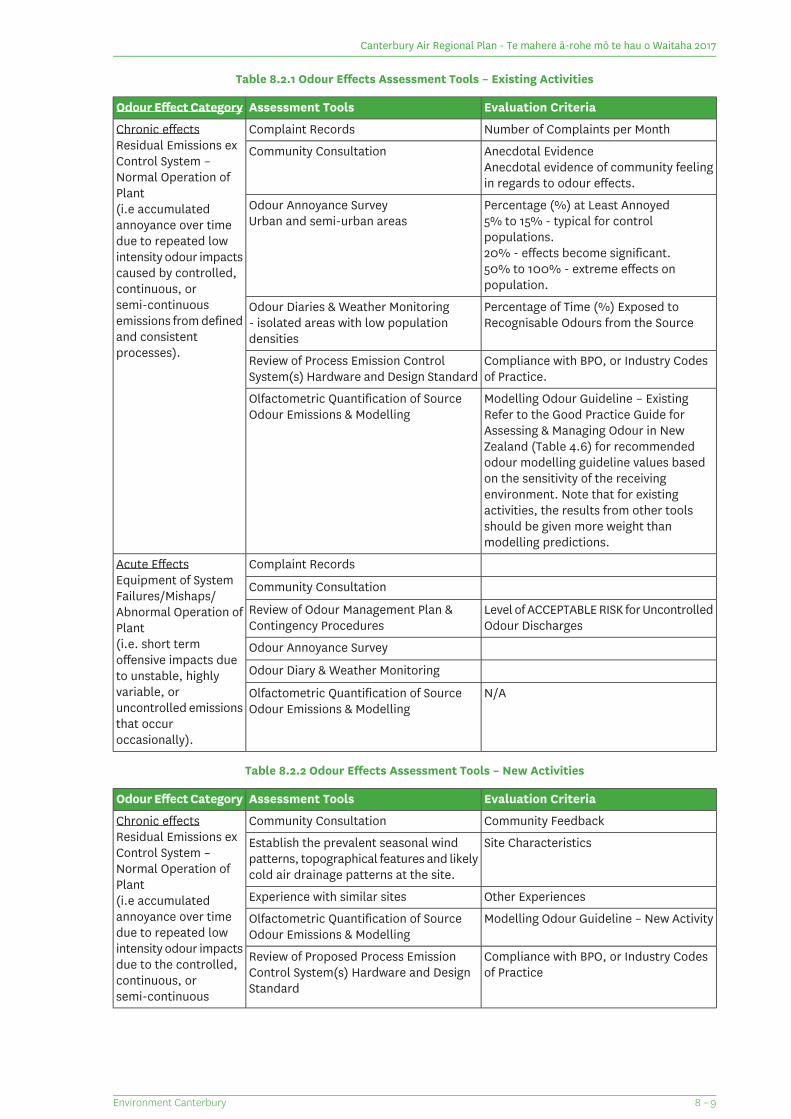
Table 8.2.1 Odour Effects Assessment Tools – Existing Activities
Evaluation CriteriaAssessment ToolsOdour Effect Category
Number of Complaints per MonthComplaint RecordsChronic effectsResidual Emissions exControl System –Normal Operation ofPlant
Anecdotal EvidenceAnecdotal evidence of community feelingin regards to odour effects.
Community Consultation
Percentage (%) at Least AnnoyedOdour Annoyance Survey(i.e accumulatedannoyance over timedue to repeated low
5% to 15% - typical for controlpopulations.20% - effects become significant.
Urban and semi-urban areas
intensity odour impacts50% to 100% - extreme effects onpopulation.
caused by controlled,continuous, or
Percentage of Time (%) Exposed toRecognisable Odours from the Source
Odour Diaries & Weather Monitoring- isolated areas with low populationdensities
semi-continuousemissions from definedand consistentprocesses). Compliance with BPO, or Industry Codes
of Practice.Review of Process Emission ControlSystem(s) Hardware and Design Standard
Modelling Odour Guideline – ExistingOlfactometric Quantification of SourceOdour Emissions & Modelling Refer to the Good Practice Guide for
Assessing & Managing Odour in NewZealand (Table 4.6) for recommendedodour modelling guideline values basedon the sensitivity of the receivingenvironment. Note that for existingactivities, the results from other toolsshould be given more weight thanmodelling predictions.
Complaint RecordsAcute EffectsEquipment of SystemFailures/Mishaps/Abnormal Operation ofPlant
Community Consultation
Level of ACCEPTABLE RISK for UncontrolledOdour Discharges
Review of Odour Management Plan &Contingency Procedures
(i.e. short termoffensive impacts dueto unstable, highly
Odour Annoyance Survey
Odour Diary & Weather Monitoring
N/AOlfactometric Quantification of SourceOdour Emissions & Modelling
variable, oruncontrolled emissionsthat occuroccasionally).
Table 8.2.2 Odour Effects Assessment Tools – New Activities
Evaluation CriteriaAssessment ToolsOdour Effect Category
Community FeedbackCommunity ConsultationChronic effectsResidual Emissions exControl System –Normal Operation ofPlant
Site CharacteristicsEstablish the prevalent seasonal windpatterns, topographical features and likelycold air drainage patterns at the site.
Other ExperiencesExperience with similar sites(i.e accumulatedannoyance over timedue to repeated low
Modelling Odour Guideline – New ActivityOlfactometric Quantification of SourceOdour Emissions & Modelling
intensity odour impacts Compliance with BPO, or Industry Codesof Practice
Review of Proposed Process EmissionControl System(s) Hardware and DesignStandard
due to the controlled,continuous, orsemi-continuous
8 – 9Environment Canterbury
Canterbury Air Regional Plan - Te mahere ā-rohe mō te hau o Waitaha 2017
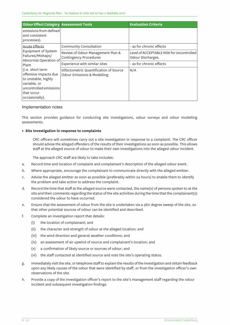
Evaluation CriteriaAssessment ToolsOdour Effect Category
emissions from definedand consistentprocesses).
- as for chronic effectsCommunity ConsultationAcute EffectsEquipment of SystemFailures/Mishaps/Abnormal Operation ofPlant
Level of ACCEPTABLE RISK for UncontrolledOdour Discharges.
Review of Odour Management Plan &Contingency Procedures
- as for chronic effectsExperience with similar sites
N/AOlfactometric Quantification of SourceOdour Emissions & Modelling
(i.e. short termoffensive impacts dueto unstable, highlyvariable, oruncontrolled emissionsthat occuroccasionally).
Implementation notes
This section provides guidance for conducting site investigations, odour surveys and odour modellingassessments.
1. Site Investigation in response to complaints
CRC officers will sometimes carry out a site investigation in response to a complaint. The CRC officershould advise the alleged offenders of the results of their investigations as soon as possible. This allowsstaff at the alleged source of odour to make their own investigations into the alleged odour incident.
The approach CRC staff are likely to take includes:
a. Record time and location of complaint and complainant’s description of the alleged odour event.
b. Where appropriate, encourage the complainant to communicate directly with the alleged emitter.
c. Advise the alleged emitter as soon as possible (preferably within 24 hours) to enable them to identifythe problem and take action to address the complaint.
d. Record the time that staff at the alleged source were contacted, the name(s) of persons spoken to at thesite and their comments regarding the status of the site activities during the time that the complainant(s)considered the odour to have occurred.
e. Ensure that the assessment of odour from the site is undertaken via a 360 degree sweep of the site, sothat other potential sources of odour can be identified and described.
f. Complete an investigation report that details:
(i) the location of complainant; and
(ii) the character and strength of odour at the alleged location; and
(iii) the wind direction and general weather conditions; and
(iv) an assessment of air upwind of source and complainant’s location; and
(v) a confirmation of likely source or sources of odour; and
(vi) the staff contacted at identified source and note the site’s operating status.
g. Immediately visit the site, or telephone staff to explain the results of the investigation and obtain feedbackupon any likely causes of the odour that were identified by staff, or from the investigation officer’s ownobservations of the site.
h. Provide a copy of the investigation officer’s report to the site’s management staff regarding the odourincident and subsequent investigation findings.
Environment Canterbury8 - 10
Canterbury Air Regional Plan - Te mahere ā-rohe mō te hau o Waitaha 2017
2. Odour annoyance surveys
Odour annoyance surveys are recommended when communities are sufficiently large to allow for astatistically significant odour survey to be instigated.
There are a number of considerations that must be made before an odour annoyance survey is undertaken.These include the existence of appropriate survey population sizes and the appropriate selection ofgroups within the general survey area. Odour annoyance surveys conducted to date have generallyaimed for a target of 50 to 70 responses from any one sub-group of the community, which provides atheoretical survey margin of error in the order of 10%.
Sub-groups are normally defined by their general location with respect to the odour source, such thatpersons living or working within the sub-group receive a similar level of odour impact and during thesame types of wind condition. A useful approach for selecting a sub-group of the survey population isto map out as large an area as possible that will receive a similar level of odour impact for some generalwind condition. In most cases, it is necessary to have three or four sub-groups within an overall surveyarea.
As survey sub-groups are selected for their differing levels of odour exposure, and/or differing directionsfrom the source, the results from such groups should generally stand alone (and not be averagedtogether to provide an overall result), when assessing adverse effects. There is now a significant bodyof odour annoyance survey results for control populations within New Zealand. But it is still preferablethat a control population that is relevant to the survey population is included within the survey design.
It is normal practice to survey residential areas by telephone interview during 7:00 pm to 9:00 pm ona single evening. This allows the survey to be completed quickly and with minimal opportunity forrespondents to communicate with each other about the survey. However on some occasions the surveymay include commercial, industrial zones or educational zones. In these instances, face to faceinterviewing may be the only practical method to complete the odour annoyance survey questionnaireswithin a day or less.
Before completing an odour survey, considerable effort is sometimes necessary to consider the prevalentwind directions within the area, define the target survey sub-groups and ascertain the most practicalapproach for conducting interviews in each case. Note that completing a survey over an extensive areaof a community, without the sufficient pre-analysis of appropriate sub-groups will almost certainlyresult in averaged survey data that is little use.
Odour annoyance survey margins of error can be calculated by fitting a generalised linear model withbinomial errors to the proportion of respondents using a general statistical package such as Genstat 5for Windows 5th edition. This allows for a summary of the 95-percentile confidence intervals for thepercentage of the population who are “at-least annoyed” due to all sources and that is attributed to aparticular odour annoyance source.
3. Odour diary programmes
Diary records from members of the public can be very useful to help improve the general understandingof what specific source is causing incidents of odour effect beyond the boundary and under whatcircumstances. In such cases the aim of the programme is focused towards improving the understandingof the odour sources. This can be important for complex processing sites that have numerous potentialsources of odour. It is important that plant operators record the status of plant operations that wereassociated with the recorded odour incidents and description of the odour to assist in identifying thelikely odour source.
The second common reason for undertaking an odour diary programme is to allow the extent of odourimpacts at a location to be quantified and their environmental significance to be assessed. In thiscircumstance it is important to focus upon the frequency and duration of odour impacts and thedescription of the odour. This allows the percentage of time exposed to recognisable odours to beestimated, as well as the weather conditions that typically lead to these events.
8 – 11Environment Canterbury
Canterbury Air Regional Plan - Te mahere ā-rohe mō te hau o Waitaha 2017
Generally odour annoyance surveys should be undertaken in preference to odour diary programmes forassessing environmental effects. However, when odour impacts are very infrequent, yet capable ofcausing significant short-term effects, then an odour diary programme may be more effective than anodour annoyance survey for monitoring the adverse effects upon the community.
4. Odour emissions measurement & dispersion modelling
The measurement of odour emissions and subsequent dispersion modelling is a complex process thatrequires a high level of expertise to undertake successfully. Reference should be made to detailedguidance provided in the Good Practice Guide for Assessing & Managing Odour in New Zealand (2003)and the Good Practice Guide for Atmospheric Dispersion Modelling (2004). Both guidance documentsare available online at www.mfe.govt.nz
5. Best practicable option (BPO)
The BPO is defined by the RMA as the best method for minimising the discharge of contaminants whentaking the following into account:
a. the nature of the discharge and receiving environment; and
b. the financial implications; and
c. current state of technical knowledge and likelihood that the option will be successful.
Implementation of BPO normally requires an air pollution control expert and/or an individual withindustry specific expertise to assess whether or not proposed odour emission control measures representthe use of BPO in any particular instance. Because the RMA’s definition of BPO allows for a substantialdegree of discretion, experts may not always agree on what represents BPO in a specific circumstance.The BPO for any one activity often changes over time, as technology advances.
The Good Practice Guide for Assessing & Managing Odour in New Zealand (2003) contains furtherdiscussion on the application of BPO under the RMA.
Content of dust, odour and smoke management plans
Management plans, for dust, smoke and odour must describe the practices and actions, or targets whererequired, that the person responsible for the discharge of contaminants into air will take to ensure that theoverall effect of the frequency, intensity, duration, offensiveness and location of the discharge is not offensiveor objectionable.
The management plan can form part of a Farm Environment Plan prepared and implemented in accordancewith Schedule 7 Part A of the Canterbury Land and Water Regional Plan.
The level of detail required for the odour, smoke or dust management plan is relative to the scale of thedischarge and the likelihood of the effect being offensive or objectionable.
The specific requirements of a smoke management plan for the outdoor burning of organic material in ruralareas are set out in Schedule 3. For clarity, a smoke management plan addressing the matters set out inSchedule 3 will be considered to comply with the information requirements of Schedule 2.
A management plan that does not form part of a Farm Environment Plan prepared and implemented inaccordance with Schedule 7 Part A of the Canterbury Land and Water Regional Plan must include the following:
1. A description of the activity that will result in the discharge of contaminants into air; and
2. A description of how often the contaminants will be discharged - e.g. constant, daily, between 10am and2pm on weekdays, only on windy days, once a month; and
3. A description of the intensity and character of the discharge - e.g. is the odour very pungent or light, isthere likely to be a lot of dust or just a small amount and is it fine or course, is the smoke light or dark?;and
Environment Canterbury8 - 12
Canterbury Air Regional Plan - Te mahere ā-rohe mō te hau o Waitaha 2017
4. A description of the maximum duration of the effect of the discharge - e.g. what is the prevailing windand how often will sensitive activities or neighbours be affected by the discharge? Will the effect occurduring times when neighbours would be more or less effected?; and
5. A description of the offensiveness of the discharge - e.g. what are the characteristics of the odour? Is itan unpleasant odour such as sewage, or is it something that is often considered pleasant such as thesmell of baking bread? Is the dust a particular colour that will make property appear dirty, or does itcontain corrosive elements? Is the dust very fine? Is the smoke thick and acrid?; and
6. A description of the location of the discharge, including a description of the activities that occur onneighbouring properties and location of any sensitive activities that may be affected. A sketch plan shouldbe prepared showing the location of the discharge and the location of sensitive receptors (such asdwellings, schools, meeting places, retail premises) and the separation distance between these receptorsand the discharge; and
7. An explanation as to how any adverse effects on sites that are sensitive to Ngāi Tahu, such as statutoryacknowledgement areas, silent file areas or wāhi tapu or wāhi taonga are to be managed; and(2)
8. A description of the management practices being implemented to minimise the discharge or the effectsof the discharge of contaminants - e.g. filters replaced regularly, equipment cleaned regularly, inputtypes, limiting discharges to certain times or conditions (wind direction etc), effluent management system(design features, maintenance etc), filter types, design of stacks and vents, process features (stocknumbers, feed type, type of detergent/ink/oil/chemical used), methods for dampening down dust, oilingroads, flocculent use, establishment of vegetation etc. Reference should be made to controlsrecommended in any relevant good practice guides for the activity; and
9. For smoke management, plans will address the matters set out in Schedule 3.
A management plan that does form part of a Farm Environment Plan prepared and implemented in accordancewith Schedule 7 Part A of the Canterbury Land and Water Regional Plan must include the following:
1. A description of the good management practices to be implemented to actively manage the frequency,intensity, duration, offensiveness and location of the effects of the odour, dust or smoke under therelevant Farm Environment Plan objectives. For the collection, storage, treatment or application of animaleffluent to land, reference should be made to the section on "how to avoid pond odour problems" in theDairyNZ Effluent Technical Note: Odour Management for Storage Ponds; and
2. Explanation as to how any adverse effects on sites that are sensitive to Ngāi Tahu, such as statutoryacknowledgement areas, silent file areas or wāhi tapu or wāhi taonga are to be managed; and(3)
3. An outline of actions and targets for improvement where risks or issues have been identified. For thecollection, storage, treatment and application to land of animal effluent reference should be made tothe section on "dealing with an odour issue" in the DairyNZ Effluent Technical Note: Odour Managementfor Storage Ponds.
2 If in any doubt, the landowner should contact te Rūnanga o Ngāi Tahu or the appropriate papatipu rūnanga.3 If in any doubt, the landowner should contact te Rūnanga o Ngāi Tahu or the appropriate papatipu rūnanga.
8 – 13Environment Canterbury
Canterbury Air Regional Plan - Te mahere ā-rohe mō te hau o Waitaha 2017
Schedule 3: Content of smoke management plans for the outdoor burning of organic material in ruralareasA smoke management plan required by the conditions of rules 7.11 and 7.14 or conditions of resource consentpursuant to rule 7.13 is to contain the following information:
1. Dates of the intended burn - the dates may change if conditions are not favourable on the intended dates,and a note should be kept of the actual burn dates from ignition to when the fire is extinguished.
2. Type of material to be burnt - is it standing crop residue, shelter belt clippings, stumps, entire hedges,forestry debris; paper, cardboard or untreated timber.
3. Forecast windspeed and direction for the actual duration of the fire. Ideally windspeed will be between1 and 15km per hour. For burns planned to take place over a timeframe of more than three days, thesmoke management plan will identify prevailing wind conditions for the time of year.
4. Condition of the material to be burnt - for example: is it green or seasoned; wet or dry; is the materiallarge solid pieces such as tree stumps or smaller loose material such as branches or a combination?
5. Identification of potentially affected parties and sensitive activities - include neighbours living closeenough to be affected, Transit New Zealand if the burn is close to a state highway, New Zealand FireService if it is likely the public will call to raise concerns about the fire.
6. The methods for minimising impacts on people effected - examples include but are not limited to:
(a) Choosing a day to burn when neighbours are away or not likely to be effected;
(b) Burning when wind is blowing away from effected people or sensitive activities;
(c) Locating the fire in a remote area, or at a suitable distance from sensitive activities;
(d) Having machinery available to keep the fire burning hot, or extinguish it if necessary;
(e) Preparing the fire so that the material will burn fast and hot and not slowly smoulder;
(f) Notifying neighbours that you are going to burn; notifying the New Zealand Fire Service before theburn;
(g) Having traffic management in place if the burn causes reduced visibility on roads; not burning incool calm conditions as smoke is unlikely to disperse.
The Canterbury Land and Water Regional Plan manages hill and high country vegetation clearance and shouldbe consulted prior to undertaking any burning in the hill and high country. Check with CRC if in doubt.
A fire permit may be required from:
1. The relevant district or city council;
2. The relevant rural fire authority; or
3. The Department of Conservation, when burning occurs within one kilometre of land administered by theDepartment or when burning occurs in an area owned by the Crown.
Vegetation burning on Crown land may require consent under the Land Act 1948, from the Commissioner ofCrown Lands.
Environment Canterbury8 - 14
Canterbury Air Regional Plan - Te mahere ā-rohe mō te hau o Waitaha 2017
Schedule 4: Contaminants
The main air quality contaminants of interest in the Canterbury Region are discussed below.
PM10 can get deep within our lungs and cause wide ranging health and respiratory problems. The main sourceof PM10 in urban areas is home heating, but industry and transportation also emit PM10. There is no safe levelof PM10 exposure. Acceptable levels of PM10 have been set nationally by the NESAQ, based on the World HealthOrganisation Guideline for PM10. This is a limit of fifty micrograms of PM per cubic metre (50μg/m3) averagedover a 24 hour period. One exceedance of this standard is allowed each year and targets for compliance withthis health-based standard are set for each polluted airshed.
PM2.5 is a component of PM10 consisting of particles of 2.5 microns and smaller. Due to their smaller size theycan get deeper within our lungs. PM2.5 emission sources include home heating, transport and industry. Thereare no national guidance values for PM2.5, but the World Health Organisation recommends a limit of 25 microgramsof PM2.5 per cubic metre (25μg/m3) averaged over a 24 hour period.
It is likely the World Health Organisation guidance values for PM2.5 are regularly exceeded in all of Canterbury'spolluted airsheds. Monitoring shows these values are regularly exceeded in Christchurch and Timaru.
Nitrogen dioxide is a gas that can aggravate asthma symptoms and reduce lung development in children. Themain source of nitrogen dioxide is motor vehicles. Monitoring of nitrogen dioxide in Canterbury has beenundertaken in areas with a high volume of traffic. Even in these congested areas, monitoring shows nitrogendioxide remains below the Ministry for the Environment's guideline values.
Carbon monoxide is a gas that can aggravate heart conditions, and reduce the amount of oxygen received bybody tissues. The main sources of carbon monoxide in Canterbury are home heating and vehicle emissions. Inmost of Canterbury, carbon monoxide levels remain below the Ministry for the Environment's guideline values.However, there are infrequent breaches of guideline values in Christchurch.
Sulphur dioxide is associated with, and can aggravate, respiratory conditions. In Canterbury, the main sourceof sulphur dioxide is industrial emissions. As with carbon monoxide, in most of Canterbury sulphur dioxidelevels remain below the Ministry for the Environment's guideline values. However, there are infrequent breachesof guideline values in Christchurch.
Benzo(a)pyrene is associated with health problems ranging from respiratory irritation to cancer. Home heatingis the main source of benzo(a)pyrene in Canterbury. Concentrations of Benzo(a)pyrene exceed the Ministry forthe Environment's guideline values in Christchurch and Timaru.
Ambient Air Quality Standards are set by the Resource Management (National EnvironmentalStandards for Air Quality) Regulations 2004 for the following contaminants
1. Carbon monoxide (8 hour average)
2. Nitrogen dioxide (1 hour average)
3. Ozone (1 hour average)
4. PM10 (24-hour average)
5. Sulphur dioxide (1 hour average)
Health-based ambient air quality guidelines are set for the following contaminants (Ambient AirQuality Guidelines 2002 Update):
1. Hydrogen sulphide
2. Lead
3. Benzene (year 2002)
4. Benzene (year 2010)
5. 1,3-Butadiene
8 – 15Environment Canterbury
Canterbury Air Regional Plan - Te mahere ā-rohe mō te hau o Waitaha 2017
6. Formaldehyde
7. Acetaldehyde
8. Benzo(a)pyrene
9. Mercury (inorganic)
10. Mercury (organic)
11. Chromium VI
12. Chromium and metal chromium III
13. Arsenic (inorganic)
14. Arsine
15. Carbon monoxide
16. Nitrogen dioxide
17. Ozone
18. PM10
19. Sulphur dioxide
Environment Canterbury8 - 16
Canterbury Air Regional Plan - Te mahere ā-rohe mō te hau o Waitaha 2017
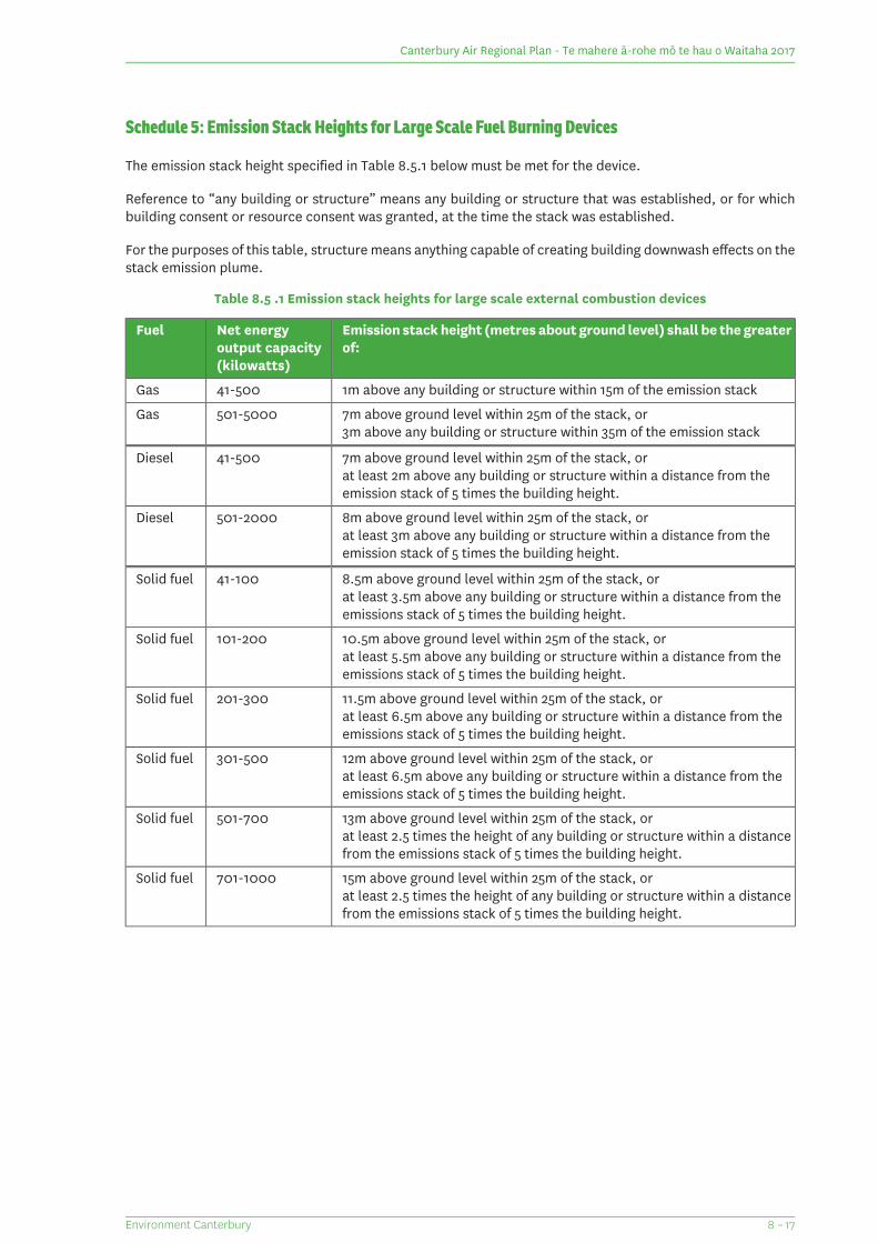
Schedule 5: Emission Stack Heights for Large Scale Fuel Burning Devices
The emission stack height specified in Table 8.5.1 below must be met for the device.
Reference to “any building or structure” means any building or structure that was established, or for whichbuilding consent or resource consent was granted, at the time the stack was established.
For the purposes of this table, structure means anything capable of creating building downwash effects on thestack emission plume.
Table 8.5 .1 Emission stack heights for large scale external combustion devices
Emission stack height (metres about ground level) shall be the greaterof:
Net energyoutput capacity(kilowatts)
Fuel
1m above any building or structure within 15m of the emission stack41-500Gas
7m above ground level within 25m of the stack, or501-5000Gas3m above any building or structure within 35m of the emission stack
7m above ground level within 25m of the stack, or41-500Dieselat least 2m above any building or structure within a distance from theemission stack of 5 times the building height.
8m above ground level within 25m of the stack, or501-2000Dieselat least 3m above any building or structure within a distance from theemission stack of 5 times the building height.
8.5m above ground level within 25m of the stack, or41-100Solid fuelat least 3.5m above any building or structure within a distance from theemissions stack of 5 times the building height.
10.5m above ground level within 25m of the stack, or101-200Solid fuelat least 5.5m above any building or structure within a distance from theemissions stack of 5 times the building height.
11.5m above ground level within 25m of the stack, or201-300Solid fuelat least 6.5m above any building or structure within a distance from theemissions stack of 5 times the building height.
12m above ground level within 25m of the stack, or301-500Solid fuelat least 6.5m above any building or structure within a distance from theemissions stack of 5 times the building height.
13m above ground level within 25m of the stack, or501-700Solid fuelat least 2.5 times the height of any building or structure within a distancefrom the emissions stack of 5 times the building height.
15m above ground level within 25m of the stack, or701-1000Solid fuelat least 2.5 times the height of any building or structure within a distancefrom the emissions stack of 5 times the building height.
8 – 17Environment Canterbury
Canterbury Air Regional Plan - Te mahere ā-rohe mō te hau o Waitaha 2017
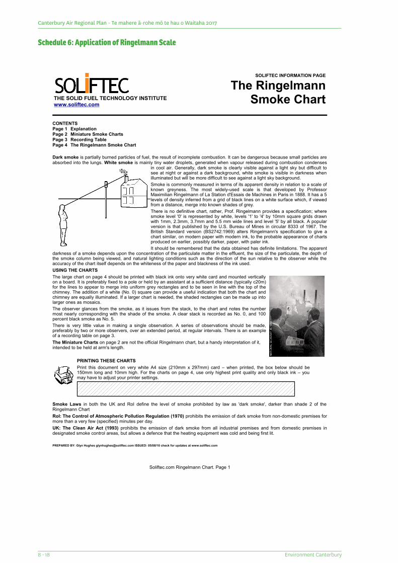
Schedule 6: Application of Ringelmann Scale
THE SOLID FUEL TECHNOLOGY INSTITUTEwww.soliftec.com
SOLIFTEC INFORMATION PAGE
The RingelmannSmoke Chart
CONTENTSPage 1 ExplanationPage 2 Miniature Smoke ChartsPage 3 Recording TablePage 4 The Ringelmann Smoke Chart
Dark smoke is partially burned particles of fuel, the result of incomplete combustion. It can be dangerous because small particles are absorbed into the lungs. White smoke is mainly tiny water droplets, generated when vapour released during combustion condenses
in cool air. Generally, dark smoke is clearly visible against a light sky but difficult to see at night or against a dark background, white smoke is visible in darkness when illuminated but will be more difficult to see against a light sky background.Smoke is commonly measured in terms of its apparent density in relation to a scale of known greyness. The most widely-used scale is that developed by Professor Maximilian Ringelmann of La Station d'Essais de Machines in Paris in 1888. It has a 5 levels of density inferred from a grid of black lines on a white surface which, if viewed from a distance, merge into known shades of grey.There is no definitive chart, rather, Prof. Ringelmann provides a specification; where smoke level '0' is represented by white, levels '1' to '4' by 10mm square grids drawn with 1mm, 2.3mm, 3.7mm and 5.5 mm wide lines and level '5' by all black. A popular version is that published by the U.S. Bureau of Mines in circular 8333 of 1967. The British Standard version (BS2742:1969) alters Ringelmann's specification to give a chart similar, on modern paper with modern ink, to the probable appearance of charts produced on earlier, possibly darker, paper, with paler ink.It should be remembered that the data obtained has definite limitations. The apparent
darkness of a smoke depends upon the concentration of the particulate matter in the effluent, the size of the particulate, the depth of the smoke column being viewed, and natural lighting conditions such as the direction of the sun relative to the observer while the accuracy of the chart itself depends on the whiteness of the paper and blackness of the ink used.USING THE CHARTSThe large chart on page 4 should be printed with black ink onto very white card and mounted vertically on a board. It is preferably fixed to a pole or held by an assistant at a sufficient distance (typically c20m) for the lines to appear to merge into uniform grey rectangles and to be seen in line with the top of the chimney. The addition of a white (No. 0) square can provide a useful indication that both the chart and chimney are equally illuminated. If a larger chart is needed, the shaded rectangles can be made up into larger ones as mosaics.The observer glances from the smoke, as it issues from the stack, to the chart and notes the number most nearly corresponding with the shade of the smoke. A clear stack is recorded as No. 0, and 100 percent black smoke as No. 5.There is very little value in making a single observation. A series of observations should be made, preferably by two or more observers, over an extended period, at regular intervals. There is an example of a recording table on page 3.The Miniature Charts on page 2 are not the official Ringelmann chart, but a handy interpretation of it, intended to be held at arm's length.
PRINTING THESE CHARTSPrint this document on very white A4 size (210mm x 297mm) card – when printed, the box below should be 150mm long and 10mm high. For the charts on page 4, use only highest print quality and only black ink – you may have to adjust your printer settings.
Smoke Laws in both the UK and RoI define the level of smoke prohibited by law as 'dark smoke', darker than shade 2 of the Ringelmann Chart RoI: The Control of Atmospheric Pollution Regulation (1970) prohibits the emission of dark smoke from non-domestic premises for more than a very few (specified) minutes per day. UK: The Clean Air Act (1993) prohibits the emission of dark smoke from all industrial premises and from domestic premises in designated smoke control areas, but allows a defence that the heating equipment was cold and being first lit.
PREPARED BY: Glyn Hughes [email protected] ISSUED: 05/08/10 check for updates at www.soliftec.com
Soliftec.com Ringelmann Chart. Page 1
Environment Canterbury8 - 18
Canterbury Air Regional Plan - Te mahere ā-rohe mō te hau o Waitaha 2017
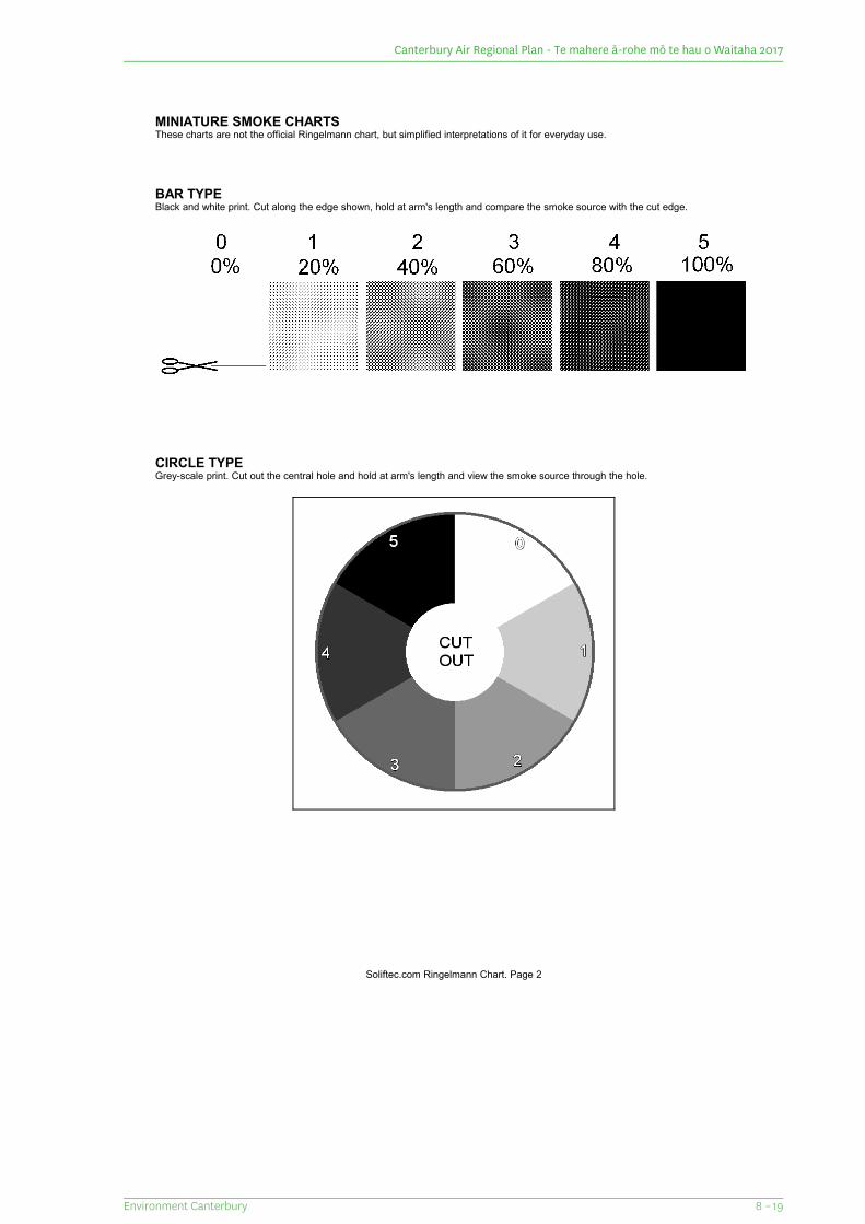
MINIATURE SMOKE CHARTSThese charts are not the official Ringelmann chart, but simplified interpretations of it for everyday use.
BAR TYPEBlack and white print. Cut along the edge shown, hold at arm's length and compare the smoke source with the cut edge.
CIRCLE TYPEGrey-scale print. Cut out the central hole and hold at arm's length and view the smoke source through the hole.
Soliftec.com Ringelmann Chart. Page 2
8 – 19Environment Canterbury
Canterbury Air Regional Plan - Te mahere ā-rohe mō te hau o Waitaha 2017
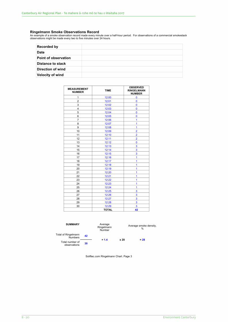
Ringelmann Smoke Observations RecordAn example of a smoke observation record made every minute over a half-hour period. For observations of a commercial smokestack observations might be made every two to five minutes over 24 hours.
Recorded byDatePoint of observationDistance to stackDirection of windVelocity of wind
MEASUREMENT NUMBER TIME
OBSERVED RINGELMANN
NUMBER1 12:00 02 12:01 03 12:02 04 12:03 05 12:04 06 12:05 07 12:06 18 12:07 19 12:08 1
10 12:09 211 12:10 212 12:11 213 12:12 014 12:13 315 12:14 316 12:15 317 12:16 118 12:17 119 12:18 120 12:19 121 12:20 122 12:21 123 12:22 124 12:23 125 12:24 126 12:25 327 12:26 328 12:27 329 12:28 330 12:29 3
TOTAL 42
SUMMARY Average Ringelmann
NumberAverage smoke density,
%
Total of Ringelmann Numbers 42
= 1.4 x 20 = 28Total number of
observations 30
Soliftec.com Ringelmann Chart. Page 3
Environment Canterbury8 - 20
Canterbury Air Regional Plan - Te mahere ā-rohe mō te hau o Waitaha 2017
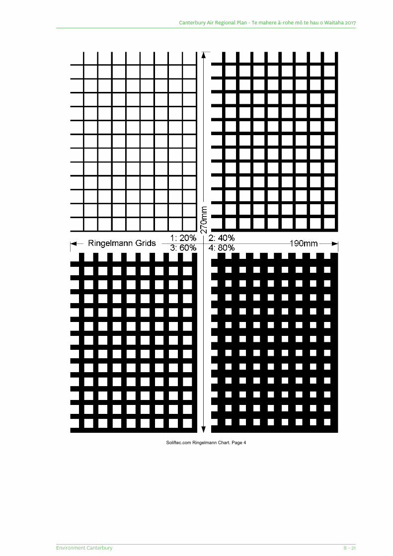
Soliftec.com Ringelmann Chart. Page 4
8 – 21Environment Canterbury
Canterbury Air Regional Plan - Te mahere ā-rohe mō te hau o Waitaha 2017
Schedule 7: Testing for particulate matter in exhaust gasesCombustion sources having a net energy output capacity of less than or equal to 2MW within a CleanAir Zone or 5MW outside a Clean Air Zone
As a minimum requirement the particulate sampling must comply with either ISO9096:2003(E), ASTMD3685M-98, AS 4323.2-1995, USEPA Method 5, USEPA Method 17 or a current equivalent method that complieswith the fundamental sampling requirements of ISO9096:2003(E). Where this methodology is used alone, itwill be assumed for compliance purposes that all particulate matter is PM10. In circumstances where additionalsize specific sampling is necessary to demonstrate compliance with PM10 emission limits in the Plan, theparticulate sampling must comply with USEPA Method 201 or USEPA Method 201A or a current equivalentmethod that complies with the fundamental sampling requirements of that method.
Combustion sources having a net energy output capacity of more than 2MW within a Clean Air Zoneor 5MW outside a Clean Air Zone
For these larger combustion sources both filterable and condensable particulate matter are to be measured.As a minimum requirement the filterable particulate sampling must comply with either ISO9096:2003(E), ASTMD3685M-98, AS 4323.2-1995, USEPA Method 5, USEPA Method 17 or a current equivalent method that complieswith the fundamental sampling requirements of ISO9096:2003(E). Where this methodology is used alone itwill be assumed for compliance purposes that all filterable particulate matter discharged is PM10. Incircumstances where additional size specific sampling is necessary to demonstrate compliance with PM10
emission limits in the Plan, the filterable particulate sampling must comply with USEPA Method 201 or USEPAMethod 201A or a current equivalent method that complies with the fundamental sampling requirements ofthat method. The condensable particulate sampling must comply with USEPA Method 202 or a current equivalentmethod that complies with the fundamental sampling requirements of that method. The test results shouldspecify total particulate matter as the sum of filterable and condensable components.
For all combustion sources of any output, the emission testing must be undertaken:
1. By a person competent in stack emission testing;
2. By an organisation that is ISO 17025 accredited (IANZ) for the methods being used; and
3. Must occur when all fuel burning equipment is operating at greater than 50% of the maximum continuousrating.
An emission test must constitute three samples.
Test results must be adjusted to 0° Celcius, 101.3 kilopascals, and 8% oxygen or 12% carbon dioxide on a drygas basis. For the purpose of this adjustment the concentration of carbon dioxide or oxygen will be analysedusing suitably calibrated equipment. The results shall include a description of the methods used, the rate offuel combustion during testing and any assumptions made.
Discharges via a saturated stack
Where discharges occur via a saturated stack, the testing method will be agreed with the CRC.
Environment Canterbury8 - 22
Canterbury Air Regional Plan - Te mahere ā-rohe mō te hau o Waitaha 2017
Schedule 8: Registration and maintenance of small-scale heating appliances burning solid fuel
Registration and maintenance
If located within a Clean Air Zone, the owner of a small scale heating appliance burning solid fuel must providethe following information to the CRC when an appliance is installed or when ownership of the appliance changes:
1. The full name(s) of the appliance owners;
2. The contact details for the appliance owners;
3. The site address or legal description of the property on which the appliance is installed;
4. The appliance type, make and model.
Upon request by a CRC officer, the person responsible for the small-scale heating appliance must provide thefollowing information to the CRC:
1. A record of maintenance of the appliance in accordance with manufacturers' instructions (can be receipts,photographs or diary entries).
8 – 23Environment Canterbury
Canterbury Air Regional Plan - Te mahere ā-rohe mō te hau o Waitaha 2017
Schedule 9: Small-scale heating appliance auditing process
Audit schedule for low emitting enclosed burners: information required to demonstrate that a burnerachieves the required standards.
National regulations
The appliance must meet any regulations specific to enclosed burners in any relevant Regulations. At the timeof publication these regulations are set out in the Resource Management (National Environmental Standardsfor Air Quality) Regulations 2004.
Test method
The low emitting enclosed burner (including pellet burners) must be tested to demonstrate that it achievesthe emissions and efficiency standards using a test methodology consistent with the Resource Management(National Environmental Standards for Air Quality) Regulations 2004.
Test laboratory or practitioner accreditation
The testing must be undertaken by an independent laboratory or practitioner accredited by an accreditationauthority to carry out the tests involved.
Burner identification
Information needs to be supplied to the testing laboratory or test practitioner, and subsequently to the CRCwith the test report, to uniquely identify the burner unit tested and define all of those parameters that mayaffect the performance of the enclosed burner, including dimensioned assembly drawings with specificationof major components.
Information to be provided to the Canterbury Regional Council
A copy of the following documentation must be provided to the CRC:
1. Test report for emissions and efficiency; and
2. Design drawings and detailed description of the enclosed burner (and water booster if fitted) includingpart identification numbers which match the specifications of the test model to the production model;and
3. Dimensioned assembly drawings with specification of major components; and
4. Sales brochure (if available); and
5. Manufacturer's installation and operating instructions; and
6. Proposed authorisation label.
Technical audit and report
On receipt of the above information, CRC will certify a burner as meeting the appropriate standards if thefollowing criteria are met.
1. A representative example of the enclosed burner is made available for inspection; and
2. The enclosed burner achieves the emissions and efficiency requirements of the Air Plan and the ResourceManagement (National Environmental Standards for Air Quality) 2004; and
3. The burner achieves the enclosed burner design criteria specified in Table 2.2 of the Air Plan; and
4. The summary results in the test report accurately reflect the results recorded in the test runs raw data;and
Environment Canterbury8 - 24
Canterbury Air Regional Plan - Te mahere ā-rohe mō te hau o Waitaha 2017
5. The dimensional information and description provided in the test report is consistent with that shownon the drawings; and
6. The representative enclosed burner is consistent with both the drawings and what was tested.
Five yearly audit
The enclosed burner will be subject to a physical audit of a production model not less than once every fiveyears to determine whether the unit is consistent with the drawings supplied and what was tested for.
Audit schedule for ultra-low emitting enclosed burners: information required to demonstrate thata burner achieves the required standards.
Enclosed burner design
The enclosed burner must be designed to achieve the efficiency and emissions standards when operated by aperson in their own home. This means:
1. The burner cannot be reasonably operated in such a way as to bypass the technology (taking into accountimprovements in available technology over time) that results in ultra-low emissions; and
2. The burner cannot be reasonably tampered with in such a way as to affect its performance - this meansthat is unable to be tampered with using hand tools available in a home such as screwdrivers, spannersand files; and
3. The burner is designed to perform to achieve the emissions and efficiency standard when operated by aperson in their own home; and
4. If maintenance such as cleaning or filter changing is required for the technology to be effective in achievingthe emissions and efficiency standard there must be a process in place to ensure this happens; and
5. The technology for reducing PM10 emissions must be designed to be effective for the duration of theenclosed burner's life.
National regulations
The enclosed burner must meet the minimum requirements of any regulations specific to enclosed burners inany relevant national standards. At the time of publication these regulations are set out in the ResourceManagement (National Environmental Standards for Air Quality) Regulations 2004.
Test method
To be considered to meet the definition of an ultra-low emitting enclosed burner, devices must be tested tosimulated real life conditions, unless the burner is a pellet burner that can be tested in accordance with testmethodology that is consistent with the Resource Management (National Environmental Standards for AirQuality) Regulations 2004. This is a test that is more stringent than the minimum requirements of the ResourceManagement (National Environmental Standards for Air Quality) Regulations 2004.
Test operating regime
The enclosed burner is to be tested over the normal operating regime of the enclosed burner and operatedover a range of output settings: i.e. at maximum and minimum outputs. Results at nominal (maximum) outputsetting would not be accepted unless the enclosed burner can be operated only at this output setting.
The testing must involve a minimum of two tests that include start-up, a period of operation at maximum heatoutput, and a period of operation at minimum heat output reflecting the normal operating conditions for theenclosed burner.
To be valid, results from each test period phase (high and low output) must be within 10% of the mean valueof the tests for this corresponding phase.
8 – 25Environment Canterbury
Canterbury Air Regional Plan - Te mahere ā-rohe mō te hau o Waitaha 2017
Fuel
For log burners, the enclosed burner is to be tested using commercially available wood, including knots andbark, and including test phases for softwood, hardwood and partially seasoned softwood.
For other types of burners that can only operate on a specified fuel, the enclosed burner must be tested usingthe specified fuel for the appliance - for example, this applies to pellet fires.
Efficiency determination
The efficiency may be determined by either a calorimeter room method or a stack loss method.
The efficiency must be converted to gross calorific basis.
The average efficiency must be calculated for the full range of test runs as per the test operating regime above.
The results need to be averaged.
Particulate measurement
The measurement of particulates must be by a method that determines all those particulates that will formwhen the discharge is cooled to not more than 32oC. This includes filterable particulates plus condensables.
In some cases, tests that do not necessarily measure all particulates that would be collected from a dilutiontunnel method with filters at 32oC can be considered with an appropriate scaling that takes this intoconsideration.
Test laboratory or practitioner accreditation
The testing must be undertaken by an independent laboratory or practitioner holding applicable accreditation.
Burner identification
Information needs to be supplied to the testing laboratory or test practitioner, and subsequently to the CRCwith the test report, to uniquely identify the burner unit tested and define all of those parameters that mayaffect the performance of the enclosed burner, including dimensioned assembly drawings with specificationof major components.
Information to be provided to the Canterbury Regional Council
A copy of the following documentation must be provided to the CRC:
1. Test report for emissions and efficiency; and
2. Design drawings and detailed description of the enclosed burner (and water booster if fitted) includingpart identification numbers which match the specifications of the test model to the production model;and
3. Dimensioned assembly drawings with specification of major components; and
4. Sales brochure (if available); and
5. Manufacturers installation and operating instructions; and
6. Proposed authorisation label.
Technical audit and report
On receipt of the above information, CRC will certify a burner as meeting the appropriate standards for anultra-low emitting enclosed burner if the following criteria are met.
1. A representative example of the enclosed burner is made available for inspection; and
Environment Canterbury8 - 26
Canterbury Air Regional Plan - Te mahere ā-rohe mō te hau o Waitaha 2017
2. The enclosed burner achieves the emissions and efficiency requirements of the Air Plan and the ResourceManagement (National Environmental Standards for Air Quality) 2004; and
3. The enclosed burner achieves the enclosed burner design criteria specified in Table 2.2 of the Air Plan;and
4. The summary results in the test report accurately reflect the results recorded in the test runs raw data;and
5. The dimensional information and description provided in the test report is consistent with that shownon the drawings; and
6. The representative enclosed burner is consistent with both the drawings and what was tested.
Five yearly audit
The enclosed burner will be subject to a physical audit of a production model not less than once every fiveyears to determine whether the unit is consistent with the drawings supplied and what was tested for.
8 – 27Environment Canterbury
Canterbury Air Regional Plan - Te mahere ā-rohe mō te hau o Waitaha 2017
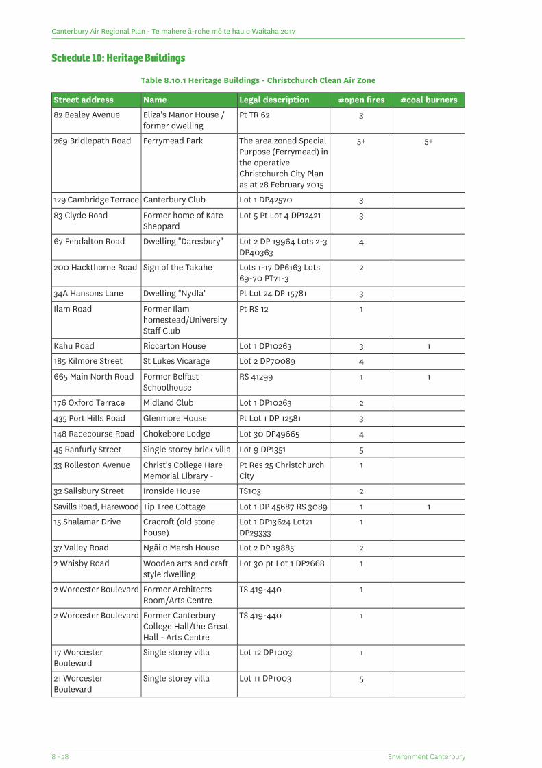
Schedule 10: Heritage Buildings
Table 8.10.1 Heritage Buildings - Christchurch Clean Air Zone
#coal burners#open firesLegal descriptionNameStreet address
3Pt TR 62Eliza's Manor House /former dwelling
82 Bealey Avenue
5+5+The area zoned SpecialPurpose (Ferrymead) inthe operativeChristchurch City Planas at 28 February 2015
Ferrymead Park269 Bridlepath Road
3Lot 1 DP42570Canterbury Club129 Cambridge Terrace
3Lot 5 Pt Lot 4 DP12421Former home of KateSheppard
83 Clyde Road
4Lot 2 DP 19964 Lots 2-3DP40363
Dwelling "Daresbury"67 Fendalton Road
2Lots 1-17 DP6163 Lots69-70 PT71-3
Sign of the Takahe200 Hackthorne Road
3Pt Lot 24 DP 15781Dwelling "Nydfa"34A Hansons Lane
1Pt RS 12Former Ilamhomestead/UniversityStaff Club
Ilam Road
13Lot 1 DP10263Riccarton HouseKahu Road
4Lot 2 DP70089St Lukes Vicarage185 Kilmore Street
11RS 41299Former BelfastSchoolhouse
665 Main North Road
2Lot 1 DP10263Midland Club176 Oxford Terrace
3Pt Lot 1 DP 12581Glenmore House435 Port Hills Road
4Lot 30 DP49665Chokebore Lodge148 Racecourse Road
5Lot 9 DP1351Single storey brick villa45 Ranfurly Street
1Pt Res 25 ChristchurchCity
Christ's College HareMemorial Library -
33 Rolleston Avenue
2TS103Ironside House32 Sailsbury Street
11Lot 1 DP 45687 RS 3089Tip Tree CottageSavills Road, Harewood
1Lot 1 DP13624 Lot21DP29333
Cracroft (old stonehouse)
15 Shalamar Drive
2Lot 2 DP 19885Ngāi o Marsh House37 Valley Road
1Lot 30 pt Lot 1 DP2668Wooden arts and craftstyle dwelling
2 Whisby Road
1TS 419-440Former ArchitectsRoom/Arts Centre
2 Worcester Boulevard
1TS 419-440Former CanterburyCollege Hall/the GreatHall - Arts Centre
2 Worcester Boulevard
1Lot 12 DP1003Single storey villa17 WorcesterBoulevard
5Lot 11 DP1003Single storey villa21 WorcesterBoulevard
Environment Canterbury8 - 28
Canterbury Air Regional Plan - Te mahere ā-rohe mō te hau o Waitaha 2017
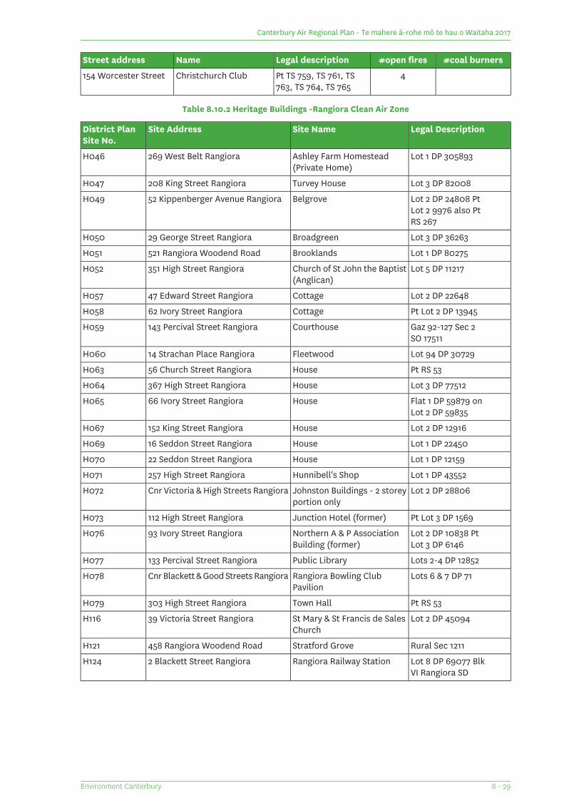
#coal burners#open firesLegal descriptionNameStreet address
4Pt TS 759, TS 761, TS763, TS 764, TS 765
Christchurch Club154 Worcester Street
Table 8.10.2 Heritage Buildings -Rangiora Clean Air Zone
Legal DescriptionSite NameSite AddressDistrict PlanSite No.
Lot 1 DP 305893Ashley Farm Homestead(Private Home)
269 West Belt RangioraH046
Lot 3 DP 82008Turvey House208 King Street RangioraH047
Lot 2 DP 24808 PtBelgrove52 Kippenberger Avenue RangioraH049Lot 2 9976 also PtRS 267
Lot 3 DP 36263Broadgreen29 George Street RangioraH050
Lot 1 DP 80275Brooklands521 Rangiora Woodend RoadH051
Lot 5 DP 11217Church of St John the Baptist(Anglican)
351 High Street RangioraH052
Lot 2 DP 22648Cottage47 Edward Street RangioraH057
Pt Lot 2 DP 13945Cottage62 Ivory Street RangioraH058
Gaz 92-127 Sec 2Courthouse143 Percival Street RangioraH059SO 17511
Lot 94 DP 30729Fleetwood14 Strachan Place RangioraH060
Pt RS 53House56 Church Street RangioraH063
Lot 3 DP 77512House367 High Street RangioraH064
Flat 1 DP 59879 onHouse66 Ivory Street RangioraH065Lot 2 DP 59835
Lot 2 DP 12916House152 King Street RangioraH067
Lot 1 DP 22450House16 Seddon Street RangioraH069
Lot 1 DP 12159House22 Seddon Street RangioraH070
Lot 1 DP 43552Hunnibell's Shop257 High Street RangioraH071
Lot 2 DP 28806Johnston Buildings - 2 storeyportion only
Cnr Victoria & High Streets RangioraH072
Pt Lot 3 DP 1569Junction Hotel (former)112 High Street RangioraH073
Lot 2 DP 10838 PtNorthern A & P AssociationBuilding (former)
93 Ivory Street RangioraH076Lot 3 DP 6146
Lots 2-4 DP 12852Public Library133 Percival Street RangioraH077
Lots 6 & 7 DP 71Rangiora Bowling ClubPavilion
Cnr Blackett & Good Streets RangioraH078
Pt RS 53Town Hall303 High Street RangioraH079
Lot 2 DP 45094St Mary & St Francis de SalesChurch
39 Victoria Street RangioraH116
Rural Sec 1211Stratford Grove458 Rangiora Woodend RoadH121
Lot 8 DP 69077 BlkRangiora Railway Station2 Blackett Street RangioraH124VI Rangiora SD
8 – 29Environment Canterbury
Canterbury Air Regional Plan - Te mahere ā-rohe mō te hau o Waitaha 2017
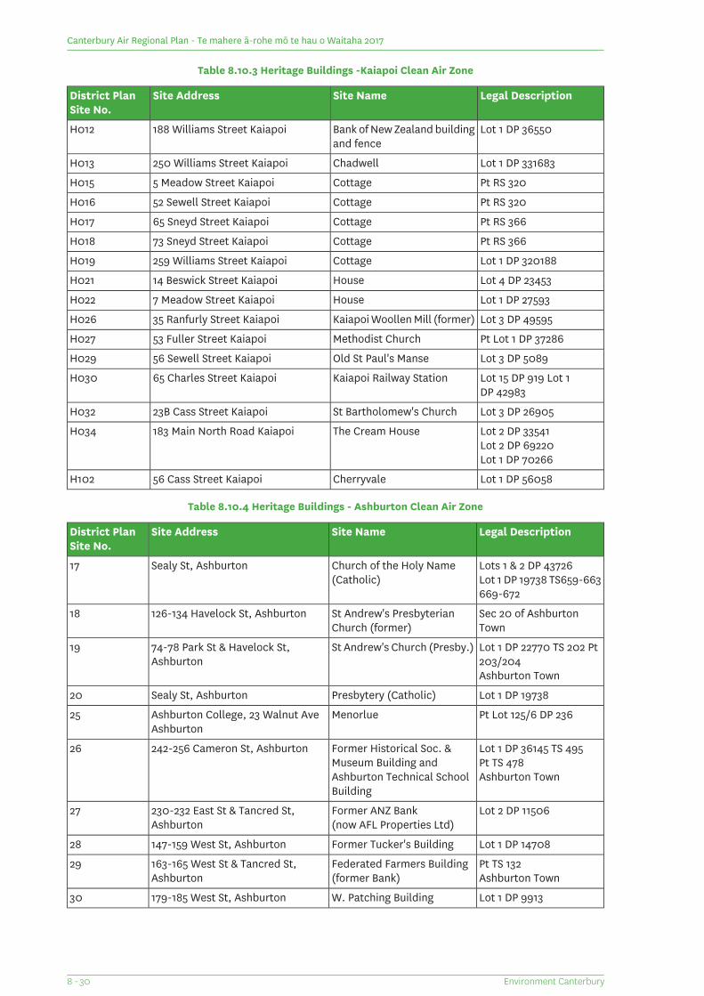
Table 8.10.3 Heritage Buildings -Kaiapoi Clean Air Zone
Legal DescriptionSite NameSite AddressDistrict PlanSite No.
Lot 1 DP 36550Bank of New Zealand buildingand fence
188 Williams Street KaiapoiH012
Lot 1 DP 331683Chadwell250 Williams Street KaiapoiH013
Pt RS 320Cottage5 Meadow Street KaiapoiH015
Pt RS 320Cottage52 Sewell Street KaiapoiH016
Pt RS 366Cottage65 Sneyd Street KaiapoiH017
Pt RS 366Cottage73 Sneyd Street KaiapoiH018
Lot 1 DP 320188Cottage259 Williams Street KaiapoiH019
Lot 4 DP 23453House14 Beswick Street KaiapoiH021
Lot 1 DP 27593House7 Meadow Street KaiapoiH022
Lot 3 DP 49595Kaiapoi Woollen Mill (former)35 Ranfurly Street KaiapoiH026
Pt Lot 1 DP 37286Methodist Church53 Fuller Street KaiapoiH027
Lot 3 DP 5089Old St Paul's Manse56 Sewell Street KaiapoiH029
Lot 15 DP 919 Lot 1Kaiapoi Railway Station65 Charles Street KaiapoiH030DP 42983
Lot 3 DP 26905St Bartholomew's Church23B Cass Street KaiapoiH032
Lot 2 DP 33541The Cream House183 Main North Road KaiapoiH034Lot 2 DP 69220Lot 1 DP 70266
Lot 1 DP 56058Cherryvale56 Cass Street KaiapoiH102
Table 8.10.4 Heritage Buildings - Ashburton Clean Air Zone
Legal DescriptionSite NameSite AddressDistrict PlanSite No.
Lots 1 & 2 DP 43726Church of the Holy Name(Catholic)
Sealy St, Ashburton17Lot 1 DP 19738 TS659-663669-672
Sec 20 of AshburtonTown
St Andrew's PresbyterianChurch (former)
126-134 Havelock St, Ashburton18
Lot 1 DP 22770 TS 202 Pt203/204
St Andrew's Church (Presby.)74-78 Park St & Havelock St,Ashburton
19
Ashburton Town
Lot 1 DP 19738Presbytery (Catholic)Sealy St, Ashburton20
Pt Lot 125/6 DP 236MenorlueAshburton College, 23 Walnut Ave25Ashburton
Lot 1 DP 36145 TS 495Former Historical Soc. &Museum Building andAshburton Technical SchoolBuilding
242-256 Cameron St, Ashburton26Pt TS 478Ashburton Town
Lot 2 DP 11506Former ANZ Bank230-232 East St & Tancred St,Ashburton
27(now AFL Properties Ltd)
Lot 1 DP 14708Former Tucker's Building147-159 West St, Ashburton28
Pt TS 132Federated Farmers Building163-165 West St & Tancred St,Ashburton
29Ashburton Town(former Bank)
Lot 1 DP 9913W. Patching Building179-185 West St, Ashburton30
Environment Canterbury8 - 30
Canterbury Air Regional Plan - Te mahere ā-rohe mō te hau o Waitaha 2017
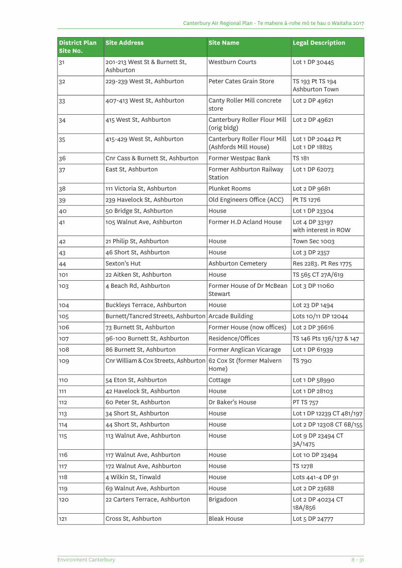
Legal DescriptionSite NameSite AddressDistrict PlanSite No.
Lot 1 DP 30445Westburn Courts201-213 West St & Burnett St,Ashburton
31
TS 193 Pt TS 194Peter Cates Grain Store229-239 West St, Ashburton32Ashburton Town
Lot 2 DP 49621Canty Roller Mill concretestore
407-413 West St, Ashburton33
Lot 2 DP 49621Canterbury Roller Flour Mill415 West St, Ashburton34(orig bldg)
Lot 1 DP 20442 PtCanterbury Roller Flour Mill415-429 West St, Ashburton35Lot 1 DP 18825(Ashfords Mill House)
TS 181Former Westpac BankCnr Cass & Burnett St, Ashburton36
Lot 1 DP 62073Former Ashburton RailwayStation
East St, Ashburton37
Lot 2 DP 9681Plunket Rooms111 Victoria St, Ashburton38
Pt TS 1276Old Engineers Office (ACC)239 Havelock St, Ashburton39
Lot 1 DP 23304House50 Bridge St, Ashburton40
Lot 4 DP 33197Former H.D Acland House105 Walnut Ave, Ashburton41with interest in ROW
Town Sec 1003House21 Philip St, Ashburton42
Lot 3 DP 2357House46 Short St, Ashburton43
Res 2283. Pt Res 1775Ashburton CemeterySexton's Hut44
TS 565 CT 27A/619House22 Aitken St, Ashburton101
Lot 3 DP 11060Former House of Dr McBeanStewart
4 Beach Rd, Ashburton103
Lot 23 DP 1494HouseBuckleys Terrace, Ashburton104
Lots 10/11 DP 12044Arcade BuildingBurnett/Tancred Streets, Ashburton105
Lot 2 DP 36616Former House (now offices)73 Burnett St, Ashburton106
TS 146 Pts 136/137 & 147Residence/Offices96-100 Burnett St, Ashburton107
Lot 1 DP 61939Former Anglican Vicarage86 Burnett St, Ashburton108
TS 79062 Cox St (former MalvernHome)
Cnr William & Cox Streets, Ashburton109
Lot 1 DP 58990Cottage54 Eton St, Ashburton110
Lot 1 DP 28103House42 Havelock St, Ashburton111
PT TS 757Dr Baker's House60 Peter St, Ashburton112
Lot 1 DP 12239 CT 481/197House34 Short St, Ashburton113
Lot 2 DP 12308 CT 6B/155House44 Short St, Ashburton114
Lot 9 DP 23494 CT3A/1475
House113 Walnut Ave, Ashburton115
Lot 10 DP 23494House117 Walnut Ave, Ashburton116
TS 1278House172 Walnut Ave, Ashburton117
Lots 441-4 DP 91House4 Wilkin St, Tinwald118
Lot 2 DP 23688House69 Walnut Ave, Ashburton119
Lot 2 DP 40234 CT18A/856
Brigadoon22 Carters Terrace, Ashburton120
Lot 5 DP 24777Bleak HouseCross St, Ashburton121
8 – 31Environment Canterbury
Canterbury Air Regional Plan - Te mahere ā-rohe mō te hau o Waitaha 2017
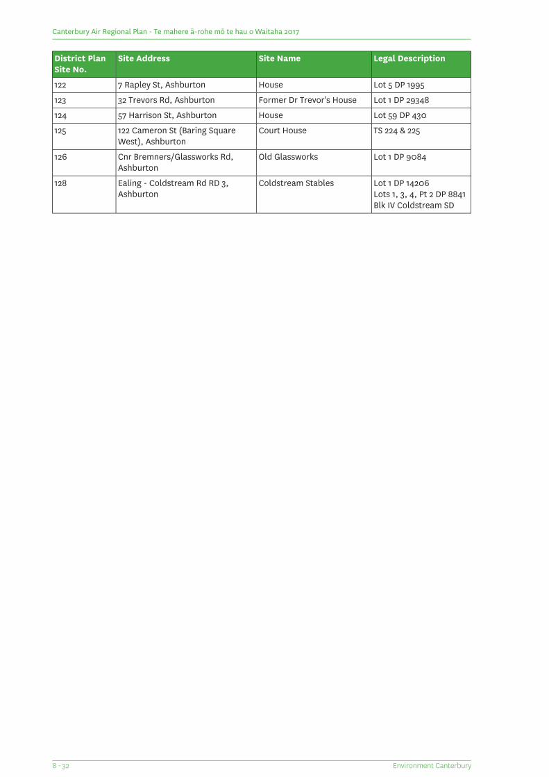
Legal DescriptionSite NameSite AddressDistrict PlanSite No.
Lot 5 DP 1995House7 Rapley St, Ashburton122
Lot 1 DP 29348Former Dr Trevor's House32 Trevors Rd, Ashburton123
Lot 59 DP 430House57 Harrison St, Ashburton124
TS 224 & 225Court House122 Cameron St (Baring SquareWest), Ashburton
125
Lot 1 DP 9084Old GlassworksCnr Bremners/Glassworks Rd,Ashburton
126
Lot 1 DP 14206Coldstream StablesEaling - Coldstream Rd RD 3,Ashburton
128Lots 1, 3, 4, Pt 2 DP 8841Blk IV Coldstream SD
Environment Canterbury8 - 32
Canterbury Air Regional Plan - Te mahere ā-rohe mō te hau o Waitaha 2017
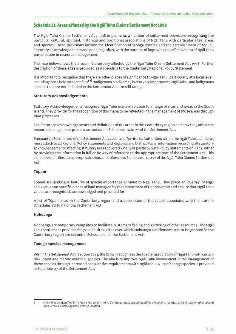
Schedule 11: Areas affected by the Ngāi Tahu Claims Settlement Act 1998
The Ngāi Tahu Claims Settlement Act 1998 implements a number of settlement provisions recognising theparticular cultural, spiritual, historical and traditional associations of Ngāi Tahu with particular sites, areasand species. These provisions include the identification of taonga species and the establishment of tōpuni,statutory acknowledgements and nohoanga sites, with the purpose of improving the effectiveness of Ngāi Tahuparticipation in resource management.
The map below shows the areas in Canterbury affected by the Ngāi Tahu Claims Settlement Act 1998. Furtherdescription of these sites is provided as Appendix 1 to the Canterbury Regional Policy Statement.
It is important to recognise that there are other places of significance to Ngāi Tahu, particularly at a local level,including those held on silent files(4). Indigenous biodiversity is also very important to Ngāi Tahu, and indigenousspecies that are not included in the Settlement Act are still taonga.
Statutory acknowledgements
Statutory Acknowledgements recognise Ngāi Tahu mana in relation to a range of sites and areas in the SouthIsland. They provide for the recognition of this mana to be reflected in the management of those areas throughRMA processes.
The Statutory Acknowledgements and definitions of the areas in the Canterbury region and how they affect theresource management process are set out in Schedules 14 to 77 of the Settlement Act.
Pursuant to Section 220 of the Settlement Act, Local and Territorial Authorities within the Ngāi Tahu claim areamust attach to all Regional Policy Statements and Regional and District Plans, information recording all statutoryacknowledgements affecting statutory areas covered wholly or partly by such Policy Statements or Plans, eitherby providing the information in full or by way of reference to the appropriate part of the Settlement Act. Thisschedule identifies the appropriate areas and references Schedules 14 to 77 of the Ngāi Tahu Claims SettlementAct.
Tōpuni
Tōpuni are landscape features of special importance or value to Ngāi Tahu. They place an ‘overlay’ of NgāiTahu values on specific pieces of land managed by the Department of Conservation and ensure that Ngāi Tahuvalues are recognised, acknowledged and provided for.
A list of Tōpuni sites in the Canterbury region and a description of the values associated with them are inSchedules 80 to 93 of the Settlement Act.
Nohoanga
Nohoanga are temporary campsites to facilitate customary fishing and gathering of other resources. The NgāiTahu Settlement provides for 72 such sites. Sites over which Nohoanga Entitlements are to be granted in theCanterbury region are set out in Schedule 95 of the Settlement Act.
Taonga species management
Within the Settlement Act (Section 288), the Crown recognises the special association of Ngāi Tahu with certainbird, plant and marine mammal species. The aim is to improve Ngāi Tahu involvement in the management ofthese species through increased consultative requirements with Ngāi Tahu. A list of taonga species is providedin Schedule 97 of the Settlement Act.
4 Silent files as identified in Te Maire Tau (et al.). 1990 Te Whakatau Kaupapa identifies the general location of wāhi tapu or other specialsites without disclosing their precise location.
8 – 33Environment Canterbury
Canterbury Air Regional Plan - Te mahere ā-rohe mō te hau o Waitaha 2017
Statutory Acknowledgement Areas
What are statutory acknowledgements?
A statutory acknowledgement is an acknowledgement by the Crown of the special relationship of Ngāi Tahuwith identifiable areas. Namely the particular cultural, spiritual, historical and traditional association of NgāiTahu with those areas (known as statutory areas).
The statutory areas within the Canterbury region are identified on the map below.
What are the purposes of statutory acknowledgements?
The purposes of Statutory Acknowledgements are:
1. To ensure that the particular association of Ngāi Tahu with certain significant area in the South Islandare identified and that Te Rūnanga o Ngāi Tahu is informed when a proposal may affect one of theseareas.
2. To improve the implementation of Resource Management Act 1991 processes, in particular by requiringconsent authorities to have regard to statutory acknowledgements when making decision on theidentification of affected parties.
Who may be affected by statutory acknowledgements?
You may be affected by a statutory acknowledgement if you are applying for resource consent for an activitythat is within, adjacent to, or directly impacting on a statutory area.
What happens when you apply?
If you are applying for resource consent for an activity within, adjacent to, or directly impacting on a statutoryarea:
1. The local authority must send a summary of your resource consent application to Te Rūnanga o NgāiTahu, and
2. The local authority must have regard to the statutory acknowledgement in going through thedecision-making process on whether Te Rūnanga o Ngāi Tahu is an affected party in relation to theresource consent application.
How can statutory acknowledgements be used in submissions?
How statutory acknowledgements can be used in submission is set out in section 211 of the Ngāi Tahu ClaimsSettlement Act 1998. Pursuant to section 211:
Te Rūnanga o Ngāi Tahu and any member of Ngāi Tahu Whānui may cite the relevant statutoryacknowledgement in submission to, and in proceedings before a consent authority or the EnvironmentCourt concerning activities within, adjacent to, or impacting directly on a statutory area as evidenceof Ngāi Tahu’s association with the statutory area.
The content of the association, as recorded in a statutory acknowledgement, is not by virtue of thestatutory acknowledgment binding as deemed fact upon consent authorities, the Environment Court,parties to proceedings before those bodies, or any other person able to participate in thoseproceedings, but the statutory acknowledgement may be taken into account by them.
Neither Te Rūnanga o Ngāi Tahu nor any member of Ngāi Tahu Whānui is precluded from statingthat Ngāi Tahu has any association with the statutory area not described in the relevant statutoryacknowledgment, nor does the content or existence of the statutory acknowledgement derogate fromany such statement.
Environment Canterbury8 - 34
Canterbury Air Regional Plan - Te mahere ā-rohe mō te hau o Waitaha 2017
Purpose of statutory acknowledgements
Pursuant to section 215, and without limiting section 216-219 of the Ngāi Tahu Claims Settlement Act 1998 thepurposes of statutory acknowledgements are:
1. To require that consent authorities forward summaries of resource consent applications to Te Rūnangao Ngāi Tahu, as required by regulations made pursuant to section 207; and
2. To require that consent authorities, the Historic Places Trust, or the Environment Court, as the case maybe, have regard to the statutory acknowledgements in relation to the statutory areas, as provided insection 208 to 210; and
3. To empower the Minister of the Crown responsible for management of the statutory areas, or theCommissioner of Crown Lands, as the case may be, to enter into deeds of recognition, as provided insection 212; and
4. To enable Te Rūnanga o Ngāi Tahu and any member of Ngāi Tahu Whānui to cite statutoryacknowledgements as evidence of the association of Ngāi Tahu to the statutory areas, as provided insection 211.
Limitations on effect of statutory acknowledgements
1. These statutory acknowledgements do not affect, and are not to be taken into account in, the exerciseof power, duty, or function by any person or entity under any statute, regulation, or bylaw; and
2. without limiting paragraph 1, no person or entity, in considering any matter or making any decision orrecommendation under the statute, regulation, or bylaw, may give any greater or lesser weight to NgāiTahu’s association with these areas (as described in the statutory acknowledgements) that that personor entity would give under the relevant statute, regulation, or bylaw, if these statutory acknowledgementdid not exist.
Except as expressly provided in this Act, these statutory acknowledgements do not affect the lawful rights orinterests of any person who is not a party to the deed of settlement. Except as expressly provided for in thisAct, these statutory acknowledgements do not, of themselves, have the effect of granting, creating, or providingevidence of any estate or interest in, or any rights of any kind whatsoever relating to these statutoryacknowledgement areas.
Coastal marine area statutory acknowledgements
There are also two statutory acknowledgments within the Canterbury Region in the Coastal Marine Area. Theseare Te Tai o Marokura (Kaikōura Coastal Marine Area) and Te Tai o Mahaanui (Banks Peninsula Coastal MarineArea).
8 – 35Environment Canterbury
Canterbury Air Regional Plan - Te mahere ā-rohe mō te hau o Waitaha 2017

Canterbury Air Regional Plan - Te mahere ā-rohe mō te hau o Waitaha 2017
(This page is intentionally blank)
Environment Canterbury8 - 36

9 Clean Air Zone Map Series
9 – 1Environment Canterbury
Canterbury Air Regional Plan - Te mahere ā-rohe mō te hau o Waitaha 2017
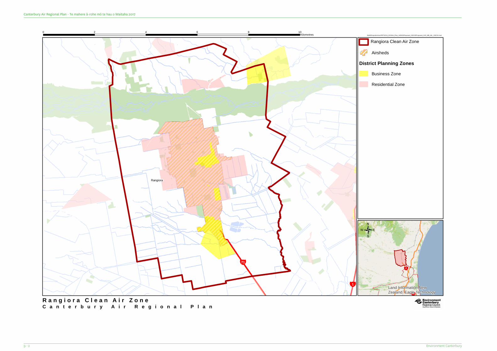
¥1
¥71
Rangiora
Land Information NewZealand, Eagle Technology
C a n t e r b u r y A i r R e g i o n a l P l a n
\\fs06\ProjectArchive\PET\2014_2015\Air_Plan_140324\Proposed_150115\Proposed_CAZ_MB_A4L_150216.mxd0 2 4 6 8 10Kilometres
R a n g i o r a C l e a n A i r Z o n e
Airsheds
District Planning ZonesBusiness Zone
Residential Zone
/
Rangiora Clean Air Zone
Environment Canterbury9 - 2
Canterbury Air Regional Plan - Te mahere ā-rohe mō te hau o Waitaha 2017
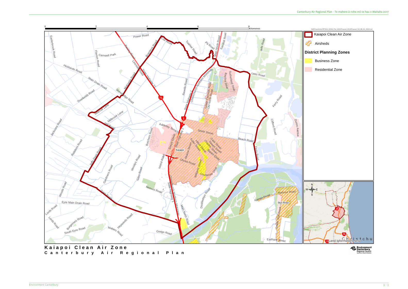
¥71
¥1
Mabers Road
Old N
orth R
oad
Lords Road
Pa Road
Akaro
a Stre
etSta
te Hig
hway
1
Sand
hill R
oad
Jelfs
Road
State Highway 1
Ferry Road
Sney
d Stre
et
Millbrook Lane
Camwell Park
Millcroft Lane
Harbour Road
Fuller Street
Lords Road
Hilton Street
Courtenay Drive
Wood
s Roa
d
Cox Road
Dunns Aven ue
Bayliss Drive
Tuahiwi Road
Earlham Street
Smith Street
Sutherland Drive
Main
North
Roa
d
Gardi
ners
Road
Easterbrook Road
Ohoka Road
Mulcock
s Roa
d
State
Highw
ay 1
Mood
ysRo
ad
Eyre Main Drain Road
Threlkelds Road
Paisley Road
Charles Street
Cass Street
Sewell Street
Adderley Terrace
Neeves Road
Power Road
Bramley
s Road
Doub
ledays
Road
Jackso
ns Ro
ad
Heywards
Road
Raven Quay
Flaxton Road
Skewbridge Road
Lowe
r Styx
Roa
d
Burge
sses Road
Hicklands Road
Butch
ers Ro
ad
Lowe
r Cam
side R
oad
Radde
ns Ro
ad
Jeffs D
rain Ro
ad
Greigs Road
Main North Road
Reve
lls Ro
ad
Lees Road
Giles
Road
Beach Road
South Eyre Road
Kainga Road
Clifford Road
Ferry R
oad
Christchurch Northern Motorway
Island
Road
Chris
tchurc
h North
ernMoto
rway
Lineside Road
Main Drain Road
State Highway 71
Willia
ms St
reet
Mill Road
Tram RoadStyx River
Kaiapoi
Land Information New
C a n t e r b u r y A i r R e g i o n a l P l a n
\\fs06\ProjectArchive\PET\2014_2015\Air_Plan_140324\Proposed_150115\Proposed_CAZ_MB_A4L_150216.mxd0 2 4 6 8Kilometres
K a i a p o i C l e a n A i r Z o n e
Airsheds
District Planning ZonesBusiness Zone
Residential Zone
/
Kaiapoi Clean Air Zone
9 – 3Environment Canterbury
Canterbury Air Regional Plan - Te mahere ā-rohe mō te hau o Waitaha 2017
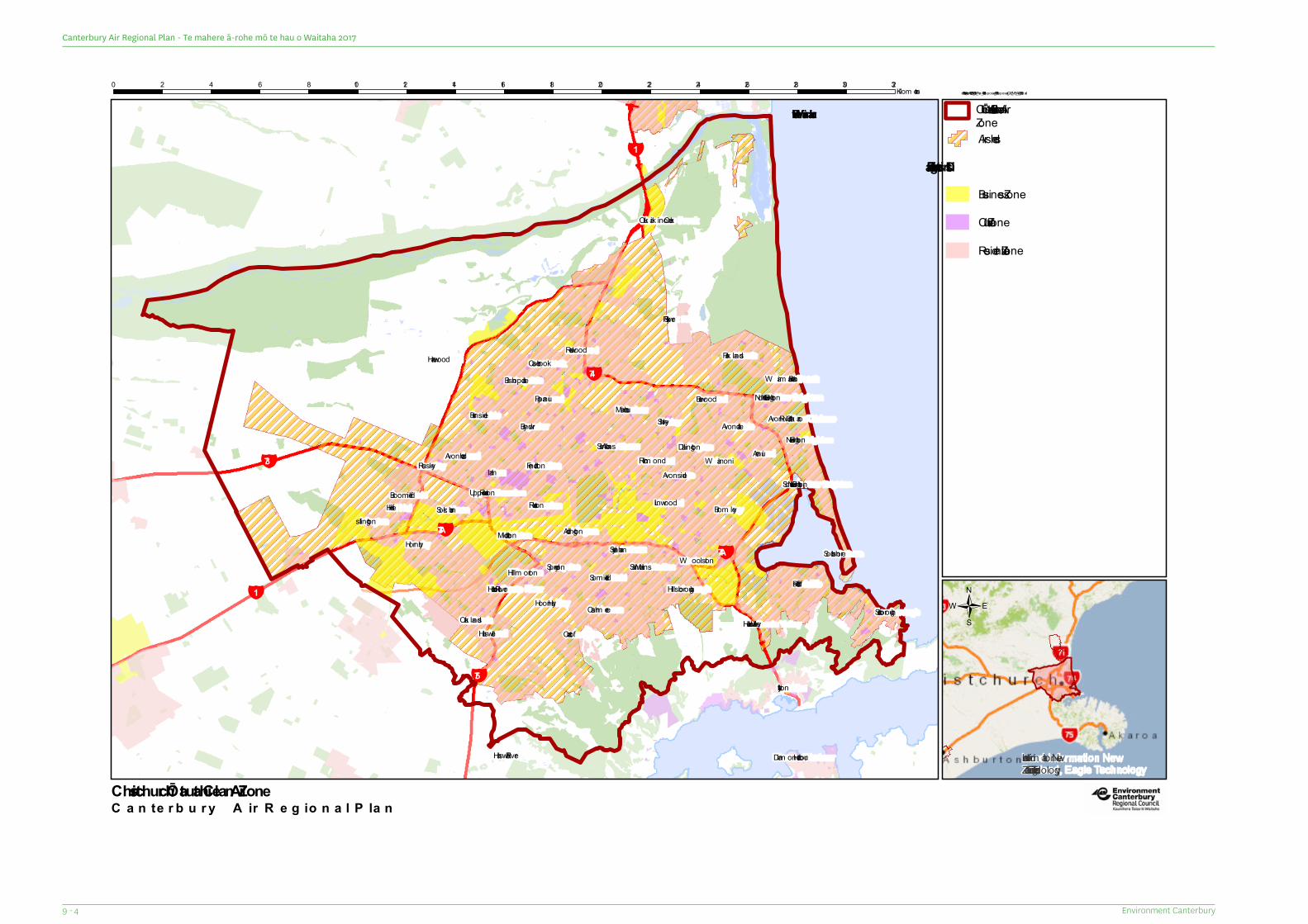
¥74A
¥74
¥75
¥73
¥73A
¥1
¥1
Waimakariri River
Avon River/Otak aro
Otukaik ino Creek
Halswell River
Heathcote River
Styx River
Hei Hei
Burnside
Ilam
Addington
Saint Albans
Shirley
Avonside
New Brighton
South New Brighton
Redcliffs
W oolstonSaint MartinsSouthshore
Scarborough
Broom field
Islington
Russley
CasebrookRedwood
Mairehau
Richm ond
Heathcote ValleyHalswell
Sockburn
Avonhead
Upper RiccartonRiccarton
Papanui
Dallington
Linwood
Aranui
North New BrightonW aim airi Beach
Harewood Park lands
HillsboroughSom erfield
Sydenham
Cashm ere
Hillm orton
Oak landsHoon Hay
Middleton
Fendalton
Bryndwr
Bishopdale
W ainoni
Burwood
Avondale
Brom ley
Spreydon
Hornby
Cracroft
Lyttelton
Diam ond Harbour Land Inform ation NewZealand, Eagle Technology
C a n te rb u ry A ir R e g io n a l P la n
\\fs06\ProjectArchive\PET\2014_2015\Air_Plan_140324\Proposed_150115\Proposed_CAZ_MB_A4L_150216.m xd0 2 4 6 8 10 12 14 16 18 20 22 24 26 28 30 32Kilom etres
Christchurch / Ōtautahi Clean Air Zone
Airsheds
District Planning ZonesBusiness Zone
Cultural Zone
Residential Zone
/
Christchurch / Ōtautahi Clean AirZoneD
• •
Environment Canterbury9 - 4
Canterbury Air Regional Plan - Te mahere ā-rohe mō te hau o Waitaha 2017
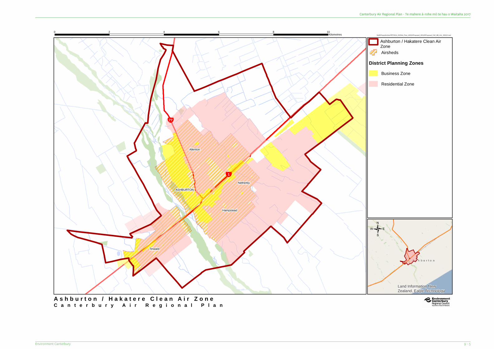
¥1
¥77
Netherby
Hampstead
Allenton
ASHBURTON
Tinwald
Land Information NewZealand, Eagle Technology
C a n t e r b u r y A i r R e g i o n a l P l a n
\\fs06\ProjectArchive\PET\2014_2015\Air_Plan_140324\Proposed_150115\Proposed_CAZ_MB_A4L_150216.mxd0 2 4 6 8 10Kilometres
A s h b u r t o n / H a k a t e r e C l e a n A i r Z o n e
Airsheds
District Planning ZonesBusiness Zone
Residential Zone
/
Ashburton / Hakatere Clean AirZone
9 – 5Environment Canterbury
Canterbury Air Regional Plan - Te mahere ā-rohe mō te hau o Waitaha 2017
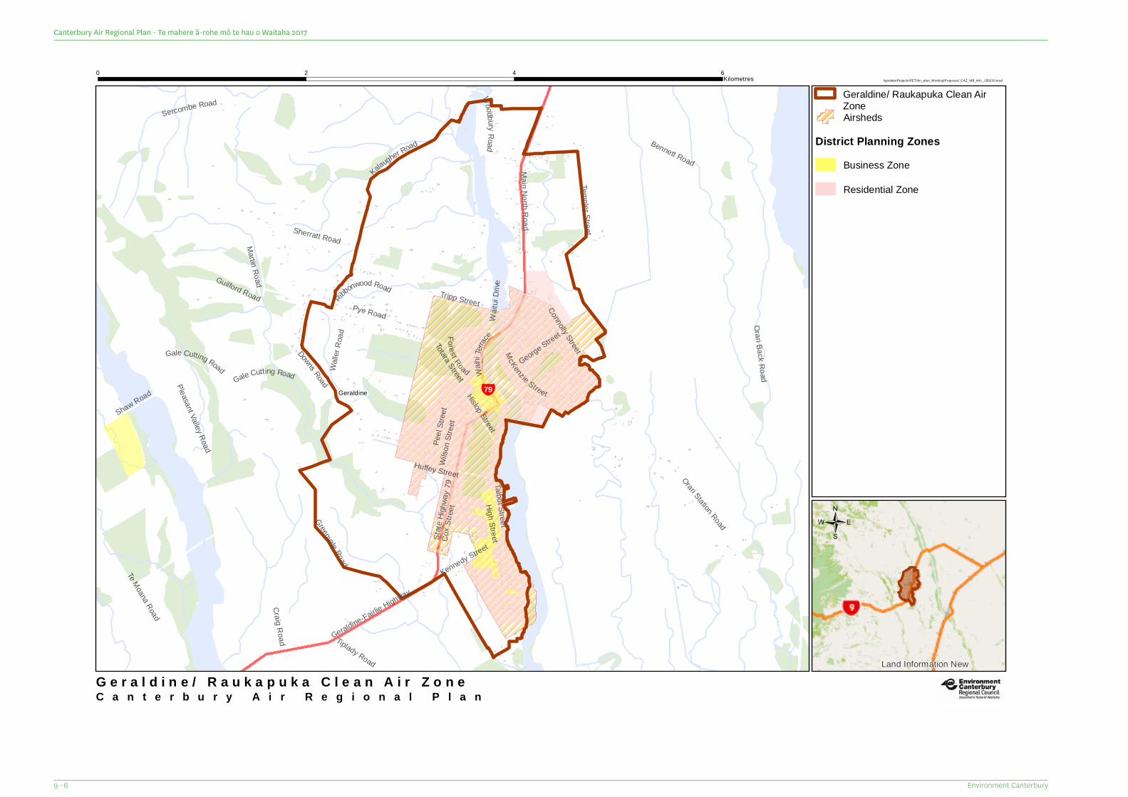
¥79
Craig Road
High Street
Fo rest RoadWalle
r Roa
d
Tiplady Road
Waihi
Terrac
e
George Street
Totara Street
Tripp Street
Sherratt Road
Gale Cutting Road
Huffey Street
Kennedy Street
Rib
bonwood Road
Connolly Street
Shaw Road
Wilso
n Stre
et
Gale Cutting Road
Martin Road
Peel
Stree
t
Hislop StreetWoodb uryRoad
Pye Road
Guilford Road
McKenzie Street
Templer Street
Te Moana Road
Kalaugher Road
Sercombe Road
Cox S
tree t
Wait
uiDr
ive
Geraldine-Fairlie HighwayMain North Road
Bennett Road
Talbot StreetGreenvale Road
Orari Station Road
Pleasant Valley Road
Downs Road
Orari Back Road
State
Highw
ay79
Geraldine
Land Information New
C a n t e r b u r y A i r R e g i o n a l P l a n
\\gisdata\Projects\PET\Air_plan_Working\Proposed_CAZ_MB_A4L_150216.mxd0 2 4 6
Kilometres
G e r a l d i n e / R a u k a p u k a C l e a n A i r Z o n e
Airsheds
District Planning ZonesBusiness Zone
Residential Zone
/
Geraldine/ Raukapuka Clean AirZone
Environment Canterbury9 - 6
Canterbury Air Regional Plan - Te mahere ā-rohe mō te hau o Waitaha 2017
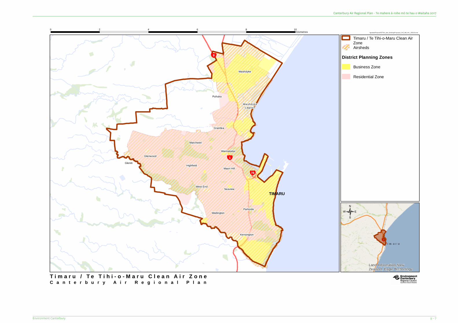
¥78
¥1
¥8
Wa shd ykeLag oo n
TIMARU
Gleniti
Kensington
Watlington
Highfield
Waimataitai
Parkside
Maori Hill
Marchwiel
Washdyke
SeaviewWest End
Glenwood
Grantlea
Puhuka
Land Information NewZealand, Eagle Technology
C a n t e r b u r y A i r R e g i o n a l P l a n
\\gisdata\Projects\PET\Air_plan_Working\Proposed_CAZ_MB_A4L_150216.mxd0 2 4 6 8 10
Kilometres
T i m a r u / T e T i h i - o - M a r u C l e a n A i r Z o n e
Airsheds
District Planning ZonesBusiness Zone
Residential Zone
/
Timaru / Te Tihi-o-Maru Clean AirZone
9 – 7Environment Canterbury
Canterbury Air Regional Plan - Te mahere ā-rohe mō te hau o Waitaha 2017
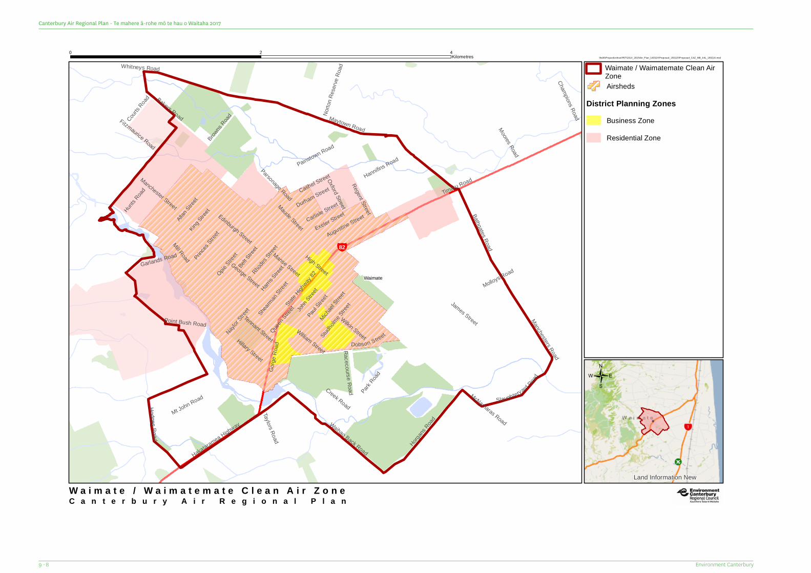
¥82
Maude Street
Durham Street
Creek Road
Michael
Street
George Street
Tennant Street
Courts R
oad
Moores Road
Browns
RoadNayl
or Stree
t
James Street
Manse Street
Dobson Street
Augustine Street
Taylors Road
Hillary Street
Exeter Street
Studhol
me Stree
t
Paul Stree
t
Princes
Street
Carlisle Street
Manchester StreetOpie
Street
John S
treet
Edinburgh Street
Norto
n Res
erve R
oad
Cashel Street
Racecourse Road
Wilkin Street
Oxford StreetRegent Street
Champions Road
Hannifins Road
Harris S
treet
Gorge
Roa
d
Allan Stree
tKing
StreetHunt
s Road
Hodges Road
William Street
Belt Stree
t
Mt John Road
Rhodes
Street
Slaughteryard Road
Shearman
Street
Bathgates Road
Bakers Road
Painstown Road
Horgans
Road
Park Road
Hakataramea Highway
Whitneys Road
Manchesters Road
Fitzmaurice Road
Garlands Road
Waihao Back Road
Queen S
treet
Point Bush Road
Parsonage Road
McNamaras Road
Molloys Road
Mill Road
Maytown Road
Timaru Road
High StreetState
Highway
82 Waimate
Land Information New
C a n t e r b u r y A i r R e g i o n a l P l a n
\\fs06\ProjectArchive\PET\2014_2015\Air_Plan_140324\Proposed_150115\Proposed_CAZ_MB_A4L_150216.mxd0 2 4Kilometres
W a i m a t e / W a i m a t e m a t e C l e a n A i r Z o n e
Airsheds
District Planning ZonesBusiness Zone
Residential Zone
/
Waimate / Waimatemate Clean AirZone
Environment Canterbury9 - 8
Canterbury Air Regional Plan - Te mahere ā-rohe mō te hau o Waitaha 2017

10 Canterbury Airsheds
10 – 1Environment Canterbury
Canterbury Air Regional Plan - Te mahere ā-rohe mō te hau o Waitaha 2017
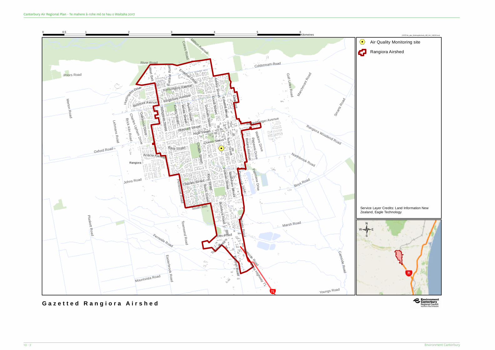
%2%2
¥71
Ellis Road
Townsend Road
Kinley Street
B al la
r atRo
ad
Buckleys Road
Papawai Drive
Rata Street
Kotare Avenue
Cones Road
Ashgrove Street
Queen Street
Oa kg rove Drive
PalmviewDrive
Edward Stree t
Millton Avenue
Railway Road
Belmont Avenue
Youngs RoadDurham Street
Hunti
ngd
on Drive
Pentecost Road
Bush Street
Brick Kiln Road
Ayers Street
Ivory Street
Charles Upham Drive
Enverton Drive
Kensington Avenue
Good Street
Watkins Drive
Newnham StreetTodds R
oad
Oakwood Drive
Charles Street
Acacia Avenue
White Street
Easterbrook Road
March
mont R
oad
Church Street
Kippenberger Avenue
Blackett Street
Kingsbury Avenue
Smart
s Roa
d
Mountvista Road
Flaxton Road
State Highway 71
Priors Road Golf Links RoadSouth Belt
Rangiora Woodend Road
Percival Street
Lineside Road
High Street
Camside Ro ad
Ashley StreetMerton Road
Marsh Road
Northbrook Road
King Street
River RoadWest Belt
East Belt
Boys Road
Oxford Road
Plaskett Road
Coldstream Road
Lehmans Road
Fernside Road
Johns Road
Rangiora
Z:\PET\Air_plan_Working\Airsheds_MB_A4L_160203.mxd0 1 2 3 4 5 60.5
Kilometres
G a z e t t e d R a n g i o r a A i r s h e d
%2 Air Quality Monitoring site
/
Service Layer Credits: Land Information NewZealand, Eagle Technology
Rangiora Airshed
Environment Canterbury10 - 2
Canterbury Air Regional Plan - Te mahere ā-rohe mō te hau o Waitaha 2017
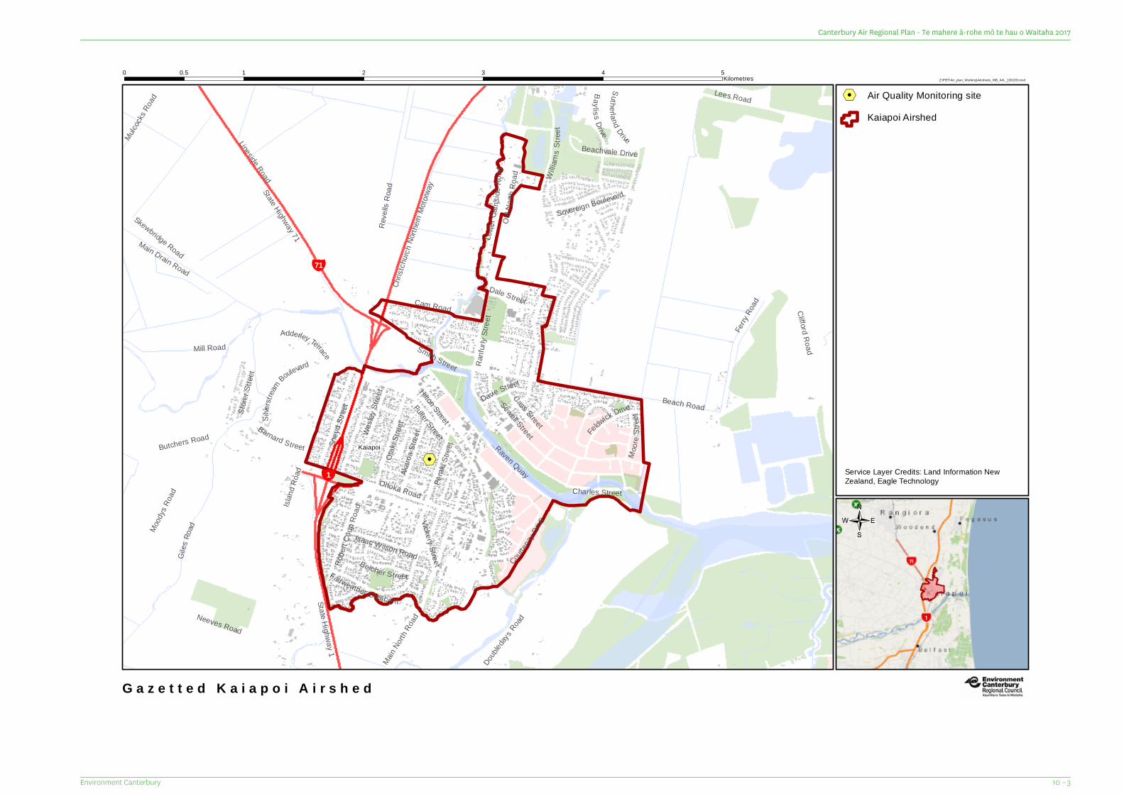
%2
¥71
¥1
Cam Road
Moor e
Stree
t
Davie Street
Dale Street
Store
r Stre
et
Old N
orth R
oad
Barnard Street
Doubled
aysRoad
Belcher Street
Vickery Street
Ranfu
rly St
reet
Feldwick Drive
Mulcock
s Roa
d
Perak
i Stre
et
Akaro
a Stre
etWesle
y Stre
et
Isaac Wilson Road
Otak
i Stre
et
Sovereign Boulevard
Sney
d Stre
et
Main No
rth Ro
ad
Main Drain Road
Robe
rt Cou
p Roa
d
Baylis s DriveSuther la nd Drive
Skewbridge Road
Fairweather Crescent
Fuller Street
Hilton Street
Courten
ayDri
ve
Smith Street
Beachvale Drive
Silver
stream
Boulevard
Ohoka Road
Neeves Road
State Highway 1
Mood
ys Ro
ad Charles Street
Cass Street
Sewell Street
Adderley Terrace
Butchers Road
Lees Road
Ferry
Road
Mill Road
Reve
lls Ro
ad
Raven QuayLo
werC
amsi d
e Ro a
d
G iles
Road
Lineside Road
Beach Road
State Highway 71
Clifford Road
Island
Roa
d
Chris
tchurc
h Nort
hern
Motor
way Wi
l li am s
S tree
t
Kaiapoi
Z:\PET\Air_plan_Working\Airsheds_MB_A4L_160203.mxd0 1 2 3 4 50.5
Kilometres
G a z e t t e d K a i a p o i A i r s h e d
%2 Air Quality Monitoring site
/
Service Layer Credits: Land Information NewZealand, Eagle Technology
Kaiapoi Airshed
10 – 3Environment Canterbury
Canterbury Air Regional Plan - Te mahere ā-rohe mō te hau o Waitaha 2017
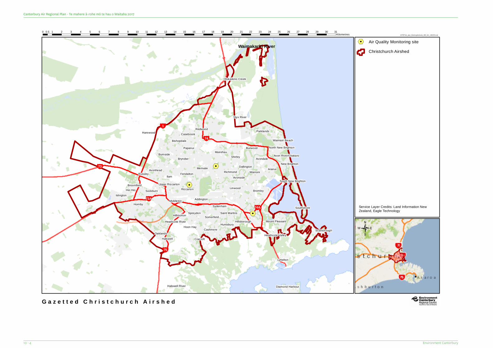
%2
%2
%2
%2
¥1
¥74A
¥74
¥75
¥73
¥73A
Waimakariri River
Avon River/Otakaro
Otukaikino Creek
Halswell River
Heathcote River
Styx River
Sockburn
Avonhead
Upper RiccartonRiccarton
Papanui
Merivale Dallington
Linwood
Aranui
North New Brighton
Waimairi Beach
Harewood Parklands
Mount PleasantHillsboroughHuntsbury
Somerfield
Sydenham
Cashmere
Hillmorton
OaklandsHoon Hay
Hei Hei
Burnside
Ilam
Addington
Shirley
Avonside
New Brighton
South New Brighton
Saint MartinsSouthshore
Scarborough
Middleton
Fendalton
Bryndwr
Bishopdale
Wainoni
Burwood
Avondale
Bromley
Spreydon
Hornby
Cracroft
Broomfield
Islington
Russley
CasebrookRedwood
Mairehau
Richmond
Heathcote ValleyHalswell
Lyttelton
Diamond Harbour
Z:\PET\Air_plan_Working\Airsheds_MB_A4L_160203.mxd0 1 2 3 4 5 6 7 8 9 10 11 12 13 14 15 16 17 18 19 20 21 22 23 24 25 26 27 28 29 30 310.5
Kilometres
G a z e t t e d C h r i s t c h u r c h A i r s h e d
%2 Air Quality Monitoring site
/
Service Layer Credits: Land Information NewZealand, Eagle Technology
Christchurch Airshed
Environment Canterbury10 - 4
Canterbury Air Regional Plan - Te mahere ā-rohe mō te hau o Waitaha 2017
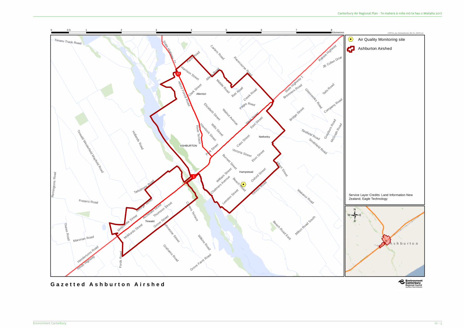
%2%2¥1
¥77
Leeston Street
Clark Street
McGr
ath Ro
ad
Gray
burn
Road
Burnett Street
Victoria Street
George Street
Beach Road
Park Stree
t
River Terrace
JB Cullen Drive
Pages Road
Carters Road
Fords
Roa
d
Rem i
ngton
sRo a
d
Wills Street
Havelock Street
Walnut Avenue
Oxford Street
Timaru Track Road
Grove Farm
RoadElizabeth Street
Taits Road
Glassworks Road
Belt Road
Creek Road
Eton Street
Johnstone Street
Cass Street
Farm Road
Company Road
Albert Street
Thews Road
Carters Terrace
Alford Forest Road
Tarbottons Road
Grahams Road
McMurdo Street
Allens Road
Grove Stree
t
Harrison Street
Bremners Road
Hinds Highway
Trevors R
oadWilliam Street
Maronan Road
Hendersons Road
Chalmers Avenue
Middle Road
Smithfield Road
Bridge Street
Thomson StreetFrasers Road
Melcombe Street
Wilkins Road
Seafield Road
Archibald
Street
East Stree
tWest S
treet
Hollands Road
Racecourse Road
Rakaia Highway
Milton Road SouthBeach Road East
Tinwald Westerfield Mayfield Road
Wakanui Road
State Highway 77
State Highway 1
Netherby
Hampstead
Allenton
ASHBURTON
Tinwald
Z:\PET\Air_plan_Working\Airsheds_MB_A4L_160203.mxd0 1 2 3 4 5 6 7 80.5
Kilometres
G a z e t t e d A s h b u r t o n A i r s h e d
%2 Air Quality Monitoring site
/
Service Layer Credits: Land Information NewZealand, Eagle Technology
Ashburton Airshed
10 – 5Environment Canterbury
Canterbury Air Regional Plan - Te mahere ā-rohe mō te hau o Waitaha 2017
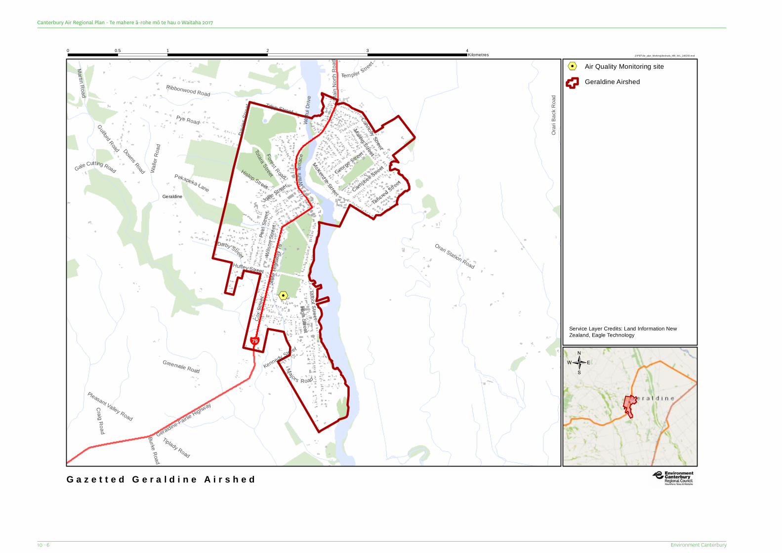
%2%2
¥79
Burke Road
Davie
s Stre
et
Jollie Street
Main
North
Roa
d
Majors Road
Darby Street
Craig Road
High Street
Tancred Street
Forest Road
Templer Street
Walle
r Roa
d
Maling Street
Campbell Street
Waihi
Ter ra
ce
Martin Road
Tiplady Road
George StreetTotara StreetPekapeka Lane
Gale Cutting Road
Waitu
i Driv
e
Guilford Road
Tripp Street
Huffey Street
Kennedy Street
Ribbonwood Road
Connolly Street
Wilso
n Stre
et
Peel
Stree
t
Pleasant Valley Road
Hislop Street
Orari
Back
Roa
d
Pye Road
McKenzie Street
Cox S
treet
Geraldine-Fairlie Highway
Downs Road
Talbot Street
Orari Station Road
Greenvale Road
State
High
way 7
9
Geraldine
Z:\PET\Air_plan_Working\Airsheds_MB_A4L_160203.mxd0 1 2 3 40.5
Kilometres
G a z e t t e d G e r a l d i n e A i r s h e d
%2 Air Quality Monitoring site
/
Service Layer Credits: Land Information NewZealand, Eagle Technology
Geraldine Airshed
Environment Canterbury10 - 6
Canterbury Air Regional Plan - Te mahere ā-rohe mō te hau o Waitaha 2017

%2
WashdykeLagoon
¥1
¥8
Kelvin StreetTyne Street
Cartwrights Road
Sheffield Street
Kent Street
Selwyn Street
Grants Road
Morga
ns R
oad MacDonald Street
Lindsay StreetAndrew Street
Luxmoore Road
Jellicoe Street
Timaru
-Tem u
kaHig
hway
Pleasant Point Highway
Racecourse Road
Old North Road
EvansStr
eet
Aorangi Road
Kellands Hill Road
Pages Road
Sead
own R
oad
State Highway 8
Washdyke Flat Road
Mead
ows R
oad
Hilton
Highw
ay
State Highway 1
Waimataitai
Marchwiel
Washdyke
Grantlea
Puhuka
Z:\PET\Air_plan_Working\Airsheds_MB_A4L_160203.mxd0 1 2 3 4 50.5
Kilometres
G a z e t t e d W a s h d y k e A i r s h e d
%2 Air Quality Monitoring site
/
Service Layer Credits: Land Information NewZealand, Eagle Technology
Washdyke Airshed
10 – 7Environment Canterbury
Canterbury Air Regional Plan - Te mahere ā-rohe mō te hau o Waitaha 2017
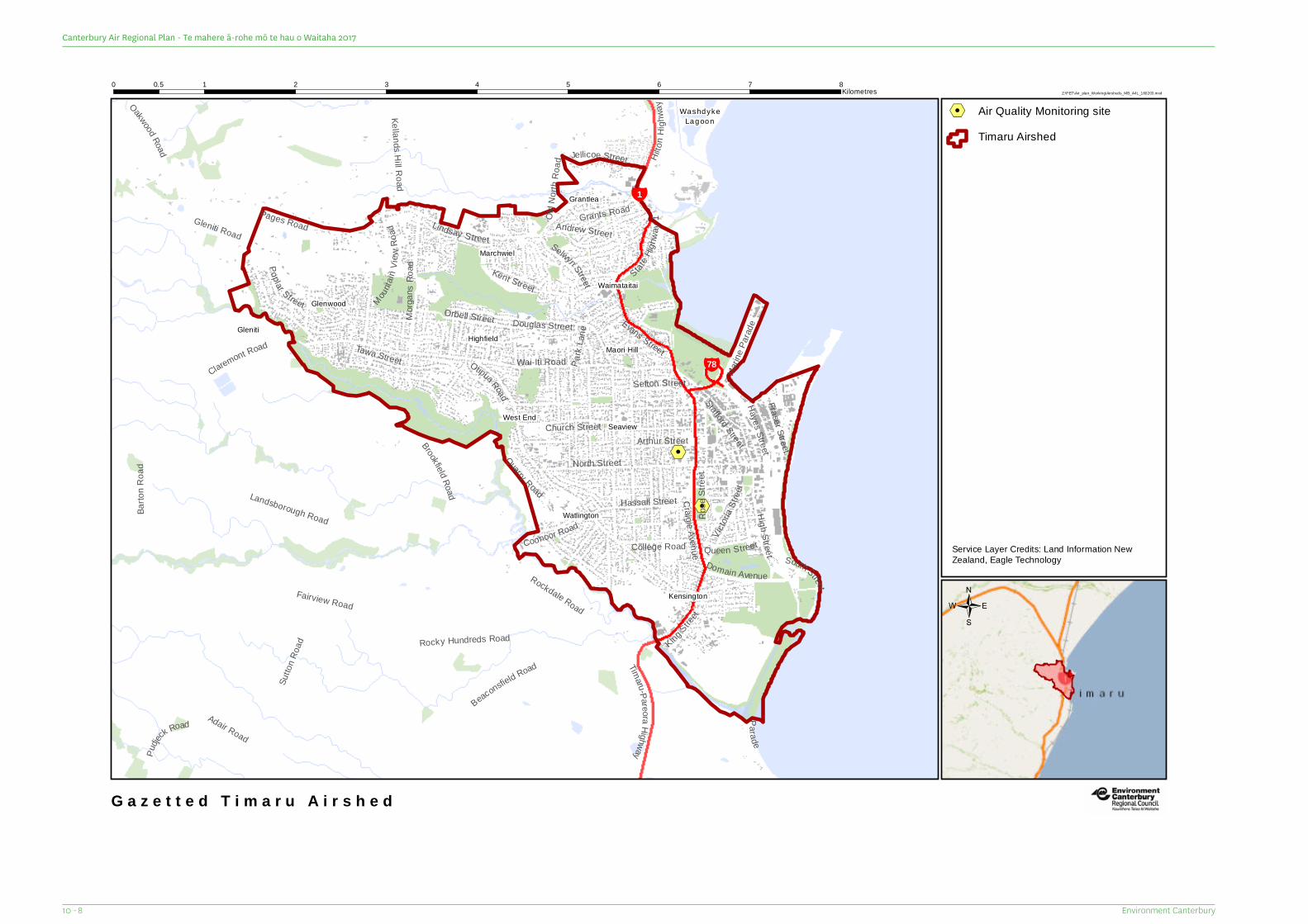
%2
%2
WashdykeLagoon
¥78
¥1
Marin
e Para
de
Brookfield Road
Parade
Park
L ane
Sefton Street
Tawa Street
Kent Street
Hayes Street
Poplar S treet
Fraser Street
Quarry Road
Rose
Stree
t
H ilton
High
way
Queen Street
Grants RoadLindsay Street
College Road
Andrew Street
Victor
iaSt r
eet
Jellicoe Street
Domain Avenue
Coonoor Road
Pudje
ck Road
Arthur Street
Orbell Street
Old N
orth R
oad
Craig ie Avenue
Hassall Street
High Street
Kellands Hill Road
Stafford StreetSouth StreetRockdale Road
Oakwood Road
Douglas Street
Morga
n sRo
a d
Mountai
n Vie w
Road
Timaru-Pare oraHighway
Selwyn Street
Sutto
n Roa
d King Street
Adair Road
Church Street
Rocky Hundreds Road
North Street
Claremont Road
Barto
n Roa
d
Evans Street
Gleniti Road
Beaconsfield Road
Otipua Road
Wai-Iti Road
Pages Road
Fairview Road
Landsborough Road
StateHig
hwa y
1
Gleniti
Kensington
Watlington
Highfield
Waimataitai
SeaviewWest End
Glenwood
Grantlea
Maori Hill
Marchwiel
Z:\PET\Air_plan_Working\Airsheds_MB_A4L_160203.mxd0 1 2 3 4 5 6 7 80.5
Kilometres
G a z e t t e d T i m a r u A i r s h e d
%2 Air Quality Monitoring site
/
Service Layer Credits: Land Information NewZealand, Eagle Technology
Timaru Airshed
Environment Canterbury10 - 8
Canterbury Air Regional Plan - Te mahere ā-rohe mō te hau o Waitaha 2017
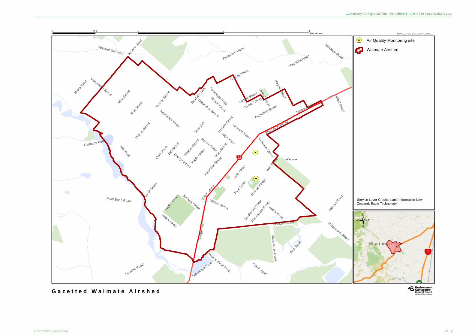
%2
%2¥82
Maude Street
Town B
elt
Wall Stree
t
Milford StreetBro
wns Road
Victori
a Stree
t
Herbert
Street
Smith
Street
Coronation Street
Cameron Street
Leonard Street
Creek RoadSettlement Road
Butche
rs Lane
Michael
Street
George Street
Tennant StreetInn
es Stree
tMcNamaras Road
Naylor S
treet
Manse Street
Dobson Street
Augustine Street
Hillary Street
Molloys
Road
Exeter Street
Maytown Road
Moorhou
se Stree
t
Studho
lme Stree
t
Paul Stree
t
Princes
Street
Carlisle Street
Manchester Street
Fitzmaurice Road
Opie Stree
t
Mt John Road
John S
treet
Edinburgh Street
Cashel Street
Racecourse RoadWilkin Street
Waihao Back Road
Oxford StreetRegent Street
Hannifins Road
Harris S
treet
Gorge
Roa
d
Allan S
treetHunt
s Road
King S
treet
Garlands Road
William Street
Belt Stree
tRhod
es Stree
t
Painstown Road
Shearman
Street
Park R
oad
Timaru Road
Parsonage Road
Point Bush Road Queen S
treet
Mill Road
High Street
State Highway 82
Waimate
Z:\PET\Air_plan_Working\Airsheds_MB_A4L_160203.mxd0 1 2 30.5
Kilometres
G a z e t t e d W a i m a t e A i r s h e d
%2 Air Quality Monitoring site
/
Service Layer Credits: Land Information NewZealand, Eagle Technology
Waimate Airshed
10 – 9Environment Canterbury
Canterbury Air Regional Plan - Te mahere ā-rohe mō te hau o Waitaha 2017

11 Crop Residue Burning Buffer Area Map Series
11 – 1Environment Canterbury
Canterbury Air Regional Plan - Te mahere ā-rohe mō te hau o Waitaha 2017
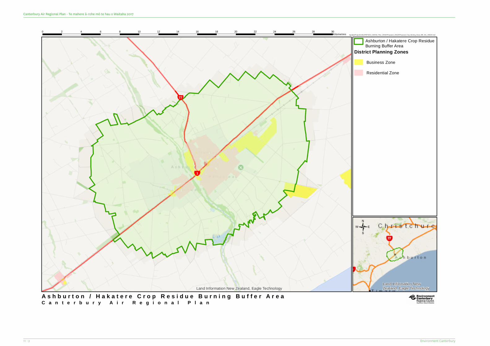
¥77
¥1
Land Information New Zealand, Eagle TechnologyLand Information NewZealand, Eagle Technology
C a n t e r b u r y A i r R e g i o n a l P l a n
\\gisdata\ProjectArchive\PET\2014_2015\Air_Plan_140324\Proposed_150115\Proposed_Crop_Burning_Areas_MB_A4L_150216.mxd0 2 4 6 8 10 12 14 16 18 20 22 24 26 28 30
Kilometres
A s h b u r t o n / H a k a t e r e C r o p R e s i d u e B u r n i n g B u f f e r A r e a
/
Ashburton / Hakatere Crop ResidueBurning Buffer Area
District Planning ZonesBusiness Zone
Residential Zone
Environment Canterbury11 - 2
Canterbury Air Regional Plan - Te mahere ā-rohe mō te hau o Waitaha 2017
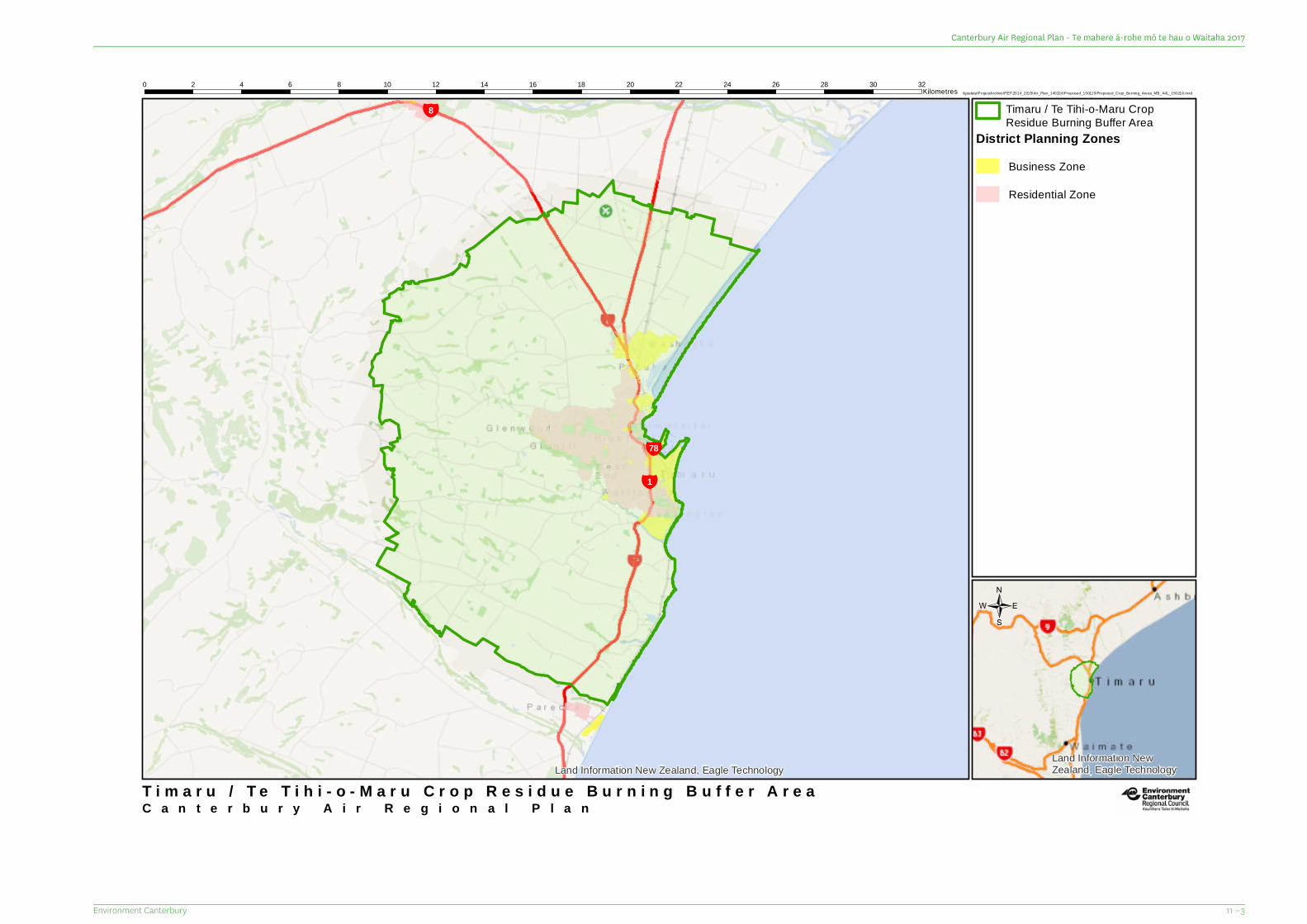
¥78
¥1
¥8
Land Information New Zealand, Eagle TechnologyLand Information NewZealand, Eagle Technology
C a n t e r b u r y A i r R e g i o n a l P l a n
\\gisdata\ProjectArchive\PET\2014_2015\Air_Plan_140324\Proposed_150115\Proposed_Crop_Burning_Areas_MB_A4L_150216.mxd0 2 4 6 8 10 12 14 16 18 20 22 24 26 28 30 32
Kilometres
T i m a r u / T e T i h i - o - M a r u C r o p R e s i d u e B u r n i n g B u f f e r A r e a
/
Timaru / Te Tihi-o-Maru CropResidue Burning Buffer Area
District Planning ZonesBusiness Zone
Residential Zone
11 – 3Environment Canterbury
Canterbury Air Regional Plan - Te mahere ā-rohe mō te hau o Waitaha 2017

12 Canterbury Air Regional Plan General Map Series
12 – 1Environment Canterbury
Canterbury Air Regional Plan - Te mahere ā-rohe mō te hau o Waitaha 2017
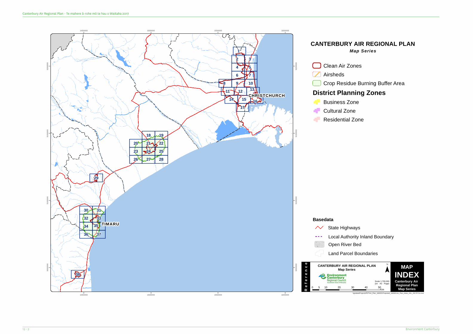
TIMARU
CHRISTCHURCH
1714 15 16
11 12 138 9 10
6 754
2 31
23 24 2520 21 22
18 19
26 27 28
29
34 3532 3330 31
36 37
38
1450000
1450000
1500000
1500000
1550000
1550000
1600000
1600000
5050
000
5050
000
5100
000
5100
000
5150
000
5150
000
5200
000
5200
000
CANTERBURY AIR REGIONAL PLANMap Series
MAPINDEXCanterbury Air Regional Plan
Map Series
CANTERBURY AIR REGIONAL PLANMap Series
Scale 1:700,000(on A3 Page)
Ref
eren
ce ¯
\\gisdata\Projects\PET\Air_Plan_160201\Proposed_160301\Air_Plan_Index_A3L_20170714.mxd
0 10 20 30 40 505 Km
Basedata
Local Authority Inland BoundaryOpen River BedLand Parcel Boundaries
State Highways
Clean Air ZonesAirshedsCrop Residue Burning Buffer Area
District Planning ZonesBusiness ZoneCultural ZoneResidential Zone
Environment Canterbury12 - 2
Canterbury Air Regional Plan - Te mahere ā-rohe mō te hau o Waitaha 2017
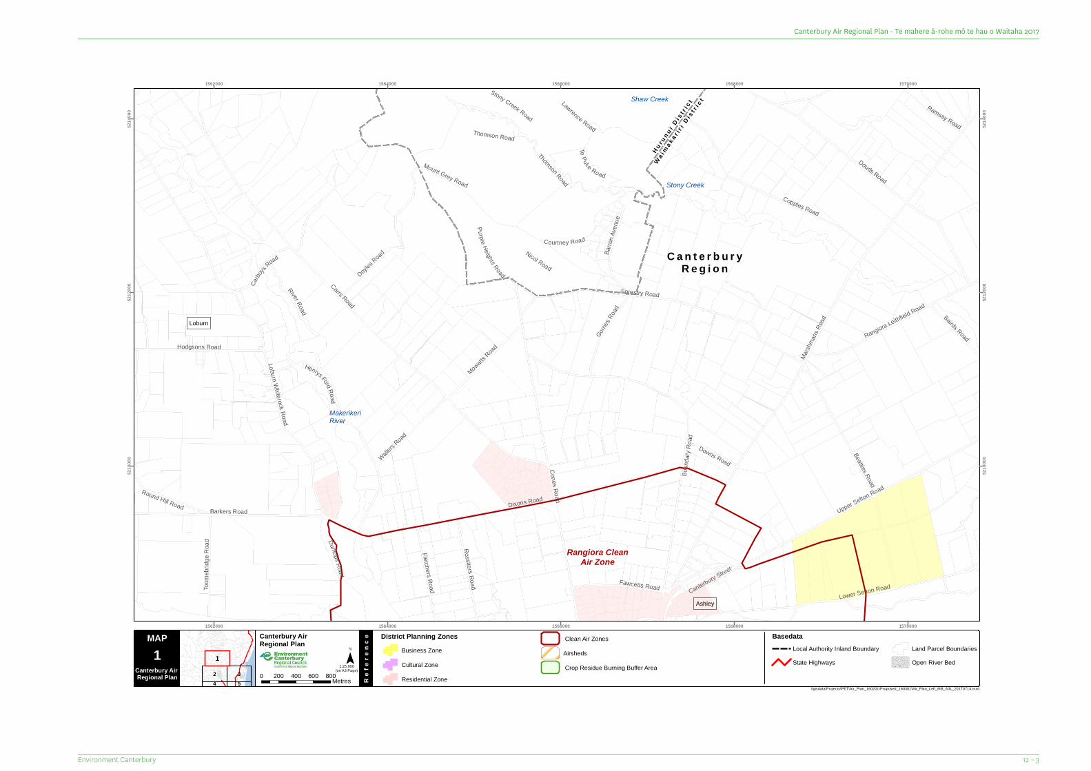
C a n t e r b u r yR e g i o n
Hu r un u i D i s
t r ic t
Wa ima k a r i r
i D i st r i
c t
Round Hill Road
Henrys Ford Road
Downs Road
Bairds Road
Ramsay Road
Carbo
ys Road
Purple Heights RoadCanterbury Street
Courtney Road
Te Puke Road
Stony Creek Road
Gorries
Road
Fletchers Road
River Road
Toom
ebrid
ge R
oad Dunlops Road
Mowatts Road
Barro
n Ave
nueRossiters Road
Thomson Road
Hodgsons Road
Nicol Road
Copples Road
Wallers R
oad
Thomson Road
Doyles R
oad
Fawcetts Road
Rangiora Leithfield Road
Barkers Road
Beatties Road
Lawrence Road
Upper Sefton Road
Cones Road
Douds Road
Lower Sefton Road
Forestry Road
Mount Grey Road
Boun
dary
Road
Dixons Road
Loburn Whiterock Road
Carrs Road
Marsh
mans
Road
Shaw Creek
Stony Creek
MakerikeriRiver
Ashley
Loburn
Rangiora CleanAir Zone
1562000
1562000
1564000
1564000
1566000
1566000
1568000
1568000
1570000
1570000
5210
000
5210
000
5212
000
5212
000
5214
000
5214
000
2 354
1
MAP Canterbury Air Regional Plan
Re
fere
nce
¯(on A3 Page)
\\gisdata\Projects\PET\Air_Plan_160201\Proposed_160301\Air_Plan_Left_MB_A3L_20170714.mxd
1Canterbury Air Regional Plan 0 200 400 600 800Metres
District Planning ZonesBusiness ZoneCultural ZoneResidential Zone
1:25,000
BasedataLocal Authority Inland BoundaryState Highways
Land Parcel BoundariesOpen River Bed
AirshedsClean Air Zones
Crop Residue Burning Buffer Area
12 – 3Environment Canterbury
Canterbury Air Regional Plan - Te mahere ā-rohe mō te hau o Waitaha 2017
C a n t e r b u r yR e g i o n
¥71
Ellis Road
Green Str eet
Townsend Road
Kinley Street
George Street
Galatos Street
Balla
rat R
oad
Buckleys Road
Papawai Drive
Rata Street
Martyn Street
Rowse Street
Kotare Avenue
Boundary Road
Easterbrook RoadAshgrove Street
Queen Street
Oakgrove Drive
PalmviewDrive
State Highway 71
Edward Street
Elm DriveRailway Road
Belmont Avenue
Flaxton Road
Durham Street
Mairaki Road
Huntin
gdon Drive
Pentecost Road
Bush Street
Koura Drive
Millton Avenue
Ayers StreetWhite Street
Ivory Street
C harles UphamDrive
Enverton Drive
Kensington Avenue
Good Street
Watkins Drive
Newnham Street
Rangiora Woodend RoadLineside Road
Victoria Street
Todds Road
Oakwood Drive
Charles Street
Mount Thomas Road
Acacia Avenue
White Street
Lower Sefton Road
March
mont
Road
Church Street
Blackett Street
Kingsbury Avenue
ConesRoad
Golf Links Road
South Belt
Bridge Road
Percival StreetHigh Street
Ashley Street
Marsh Road
Boys Road
Merton Road
O'Roarkes Road
Northbrook RoadKing Street
River Road
West Belt
Plaskett Road
Coldstream Road
East Belt
Lilly Road
Swannano
a Road
Mount Thomas Road
Fernside Road
Dalziels Road
Lehmans Road
Priors Road
Johns Road
Oxford Road
AshleyRiver/Rakahuri
MakerikeriRiver
South Brook
North BrookFernside
Coldstream
Rangiora
Southbrook
RangioraAirshed
Rangiora CleanAir Zone
1560000
1560000
1562000
1562000
1564000
1564000
1566000
1566000
1568000
1568000
5204
000
5204
000
5206
000
5206
000
5208
000
5208
000
1
4
3
5
2
MAP Canterbury Air Regional Plan
Re
fere
nce
¯(on A3 Page)
\\gisdata\Projects\PET\Air_Plan_160201\Proposed_160301\Air_Plan_Right_MB_A3L_20170714.mxd
Map Series 0 200 400 600 800Metres
1:25,000
MAP2
CanterburyAirRegional Plan
BasedataLocal Authority Inland BoundaryState Highways
Land Parcel BoundariesOpen River Bed
District Planning ZonesBusiness ZoneCultural ZoneResidential Zone
Airsheds
Clean Air Zones
Crop Residue Burning Buffer Area
Environment Canterbury12 - 4
Canterbury Air Regional Plan - Te mahere ā-rohe mō te hau o Waitaha 2017
C a n t e r b u r yR e g i o n
¥1
Wai
ma k
a ri r
i Di s
t ri c
t
Allin Drive
GibbsDrive
Marsh Road
Welsford Street
Waiora Lane
Tahuna Street
Judsons Road
Harris Road
Stokes Road
Waikoruru Road
Greens Road
Aroh
a Stre
etLa
kesid
e Driv
e
Preeces Road
Whakatipu Street
Gateh
ouse
Lane
Queens Avenue
Te Pouapatuki Road
Hewitts Road
Copp
er Be
ech R
oad
Tutaipatu Avenue
Park
Terra
ce
Tutaipatu Avenue
Hakatere Road
Kings Avenue
Parsonage Road
Eders Road
Arah
uraRo
ad
TeKo
hang
aDriv
eKawa
ri Driv
e
Te Hurunui Drive
Coldstream Road
Boys Road
Topito Road
Okaihau Road
Petries Road
Wards Road
Pegasus Main S tr eet
Legg
itts R
oad
Turiwhaia Road
Camside Road
Infinity Drive
Cams
ideRo
ad
Tiritiri Moana DriveCh
innery
s Roa
d
Maple
ham
Drive
Pegasus Boulevard
Waikuku Beach RoadSm
arts R
oad
Kaiapoi
Pa Road
Tuahiwi Road
Gladstone Road
Gressons Road
Tulls Road
Rangiora Woodend Road
StateHigh
way1
Main North
Road
CamRiver/Ruataniwha
TūtaepatuLagoon
WaikukuStream
Waikuku Beach
Woodend
Waikuku
Pegasus
Rangiora CleanAir Zone
1570000
1570000
1572000
1572000
1574000
1574000
1576000
1576000
1578000
1578000
5204
000
5204
000
5206
000
5206
000
5208
000
5208
000
1
2
4 56 7
3
MAP Canterbury Air Regional Plan
Re
fere
nce
¯(on A3 Page)
\\gisdata\Projects\PET\Air_Plan_160201\Proposed_160301\Air_Plan_Left_MB_A3L_20170714.mxd
3Canterbury Air Regional Plan 0 200 400 600 800Metres
District Planning ZonesBusiness ZoneCultural ZoneResidential Zone
1:25,000
BasedataLocal Authority Inland BoundaryState Highways
Land Parcel BoundariesOpen River Bed
AirshedsClean Air Zones
Crop Residue Burning Buffer Area
12 – 5Environment Canterbury
Canterbury Air Regional Plan - Te mahere ā-rohe mō te hau o Waitaha 2017
C a n t e r b u r yR e g i o n
¥71
Siena PlaceAschens Road
Dawsons Road
Keetly Pl ace
Truro Close
Warwick Road Velino Place
Whites R
oad
Tristram Road
Modena Place
Egans Road
Mandeville Road
Power Road
Millbrook Lane
Verona PlaceRoscrea Place
Dawsons Road
Camwell Park
Clear View Lane
Vicenza Drive
Millcroft Lane
O'Roarkes Road
Mand
alea R
oad
Youngs Road
Butchers Road
Two C
hain R
oad
Jeffs D
rain R
oad
Mulcock
s Road
Threlkelds Road
Barkers Road
Paisley Road
McRo
berts
Road
McHughs Road
Radde
ns Ro
ad
Plaskett Road
Cullen Avenue
Pattersons Road
Skewbridge Road
Mountvista Road
Jackso
ns Ro
ad
Easterbrook Road
Fernside Road
State Highway 71
Lineside Road
Ashworths RoadFlaxton Road
Hicklands Road
Wards Road
No 10 Road
Tram Road
Bradleys Road
Mill Road
Main Drain Road
Ohoka Stream
MandevilleNorth
Ohoka
Wetheral
WilsonsSiding
Rangiora CleanAir Zone
KaiapoiClean
Air Zone
1560000
1560000
1562000
1562000
1564000
1564000
1566000
1566000
1568000
1568000
5198
000
5198
000
5200
000
5200
000
5202
000
5202
000
5
2
6
3
7
4
MAP Canterbury Air Regional Plan
Re
fere
nce
¯(on A3 Page)
\\gisdata\Projects\PET\Air_Plan_160201\Proposed_160301\Air_Plan_Right_MB_A3L_20170714.mxd
Map Series 0 200 400 600 800Metres
1:25,000
MAP4
CanterburyAirRegional Plan
BasedataLocal Authority Inland BoundaryState Highways
Land Parcel BoundariesOpen River Bed
District Planning ZonesBusiness ZoneCultural ZoneResidential Zone
Airsheds
Clean Air Zones
Crop Residue Burning Buffer Area
Environment Canterbury12 - 6
Canterbury Air Regional Plan - Te mahere ā-rohe mō te hau o Waitaha 2017
C a n t e r b u r yR e g i o n
¥71
¥1
Wai
mak
ari r
i Di s
t ri c
t
Davie Street
Dale Street
Storer
Stree
t
Old N
orth R
oad
Barnard Street
Barke
rs Road
Perak
i Stre
et
Main Drain Road
Ferry RoadAkaro
a Stre
et
Church Bush Road
Youngs Road
Ranfu
rly St
reet
Skewbridge RoadFel
dwick Drive
Pa Road
Wesle
y Stre
et
Camside Road
StateHighway 1
Otak
i Stre
et
Te Pouapatuki Road
Ferry
Roa
d
Sand
hill R
oad
Sovereign Boulevard
Giles Road
Sney
d Stre
et
Charles Street
Sand
hill R
oad
Topito Road
Fuller StreetHilton Street
Dunns Avenue
Cox Road
Power Road
Baylis
s Driv
e
Smith Street
Sutherland Drive
Fullers Road
Raven Quay
Beachvale Drive
Silve
rstream
Boulevard
State
Highw
ay 1
Butch
ers R
oad
Cass Street
Sewell Street
Jelfs RoadMill Road
Gree
nsRo
ad
Island Road
Tuahiwi Road
Bramley
s Road
Main
North
Roa
d
Lowe
r Cam
side R
oadReve
lls Ro
ad
Lees Road
Lineside RoadState Highway 71
Beach Road
Clifford Road
Woodend Beach Road
Ferry R
oad
Willia
msStr
eet
Chris
tchurc
h Nort
hern
Motor
way
Kaiapoi River
CamRiver/Ruataniwha
Kairaki Creek
Woodend Beach
Tuahiwi
Flaxton
The PinesBeach
Ohapuku
KairakiKaiapoi
KaiapoiAirshed
RangioraClean
Air Zone
Kaiapoi CleanAir Zone
1570000
1570000
1572000
1572000
1574000
1574000
1576000
1576000
1578000
1578000
5198
000
5198
000
5200
000
5200
000
5202
000
5202
000
32
4
6 7
1
9 108
5
MAP Canterbury Air Regional Plan
Re
fere
nce
¯(on A3 Page)
\\gisdata\Projects\PET\Air_Plan_160201\Proposed_160301\Air_Plan_Left_MB_A3L_20170714.mxd
5Canterbury Air Regional Plan 0 200 400 600 800Metres
District Planning ZonesBusiness ZoneCultural ZoneResidential Zone
1:25,000
BasedataLocal Authority Inland BoundaryState Highways
Land Parcel BoundariesOpen River Bed
AirshedsClean Air Zones
Crop Residue Burning Buffer Area
12 – 7Environment Canterbury
Canterbury Air Regional Plan - Te mahere ā-rohe mō te hau o Waitaha 2017
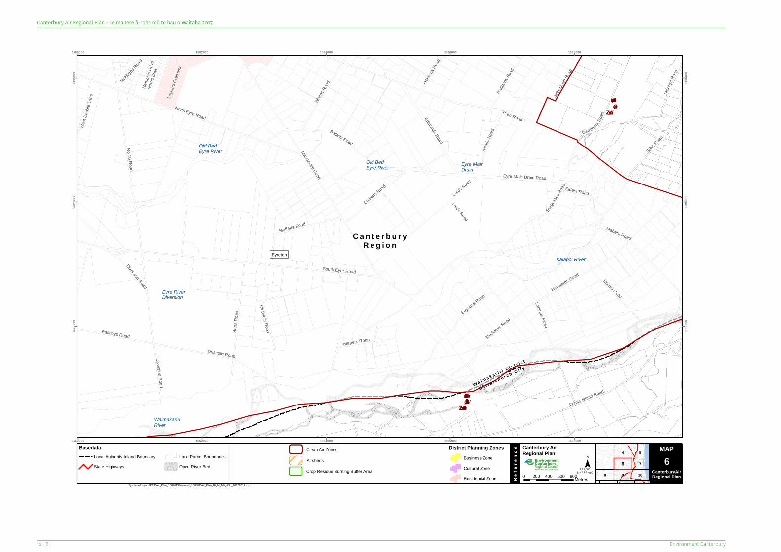
C a n t e r b u r yR e g i o n
Wa i m a k a r i r i D i s t r i c t
C h r i s t c h u r c h C i t y
Whites R
oad
Harrs
Roa
d
Elders Road
Lorimas RoadMabers Road
Lords Road
Madeleys Road
Jackso
ns Ro
ad
Hamp
tonDr
iveNo
rris D
rive
McHughs R
oad
Clothiers Road
Leyla
nd Cr
esce
nt
West
Denb
ieLa
ne
Harpers Road
Taylors Road
Diversion Road
Radde
ns Ro
ad
Mood
ysRo
ad
Wood
s Roa
d Gardiners Road
Pashbys Road
Chiltons R
oad
Eyre Main Drain Road
Jeffs D
rain R
oad
Giles Road
Baynons Road
Edmunds Road
Moffatts Road
Diversion Road
Lords Road
Burge
sses R
oad
Driscolls Road
Baileys Road
No 10 Road
Coutts Island Road
North Eyre Road
Mandeville Road
Heywards Road
Tram Road
South Eyre Road
WaimakaririRiver
Eyre RiverDiversion
Kaiapoi River
Old BedEyre River
Old BedEyre River
Eyre MainDrain
Eyreton
KaiapoiCleanAir Zone
Christchurch/ Ōtautahi
Clean Air Zone
1560000
1560000
1562000
1562000
1564000
1564000
1566000
1566000
1568000
1568000
5192
000
5192
000
5194
000
5194
000
5196
000
5196
000
8
54
9
7
10
6
MAP Canterbury Air Regional Plan
Re
fere
nce
¯(on A3 Page)
\\gisdata\Projects\PET\Air_Plan_160201\Proposed_160301\Air_Plan_Right_MB_A3L_20170714.mxd
Map Series 0 200 400 600 800Metres
1:25,000
MAP6
CanterburyAirRegional Plan
BasedataLocal Authority Inland BoundaryState Highways
Land Parcel BoundariesOpen River Bed
District Planning ZonesBusiness ZoneCultural ZoneResidential Zone
Airsheds
Clean Air Zones
Crop Residue Burning Buffer Area
Environment Canterbury12 - 8
Canterbury Air Regional Plan - Te mahere ā-rohe mō te hau o Waitaha 2017
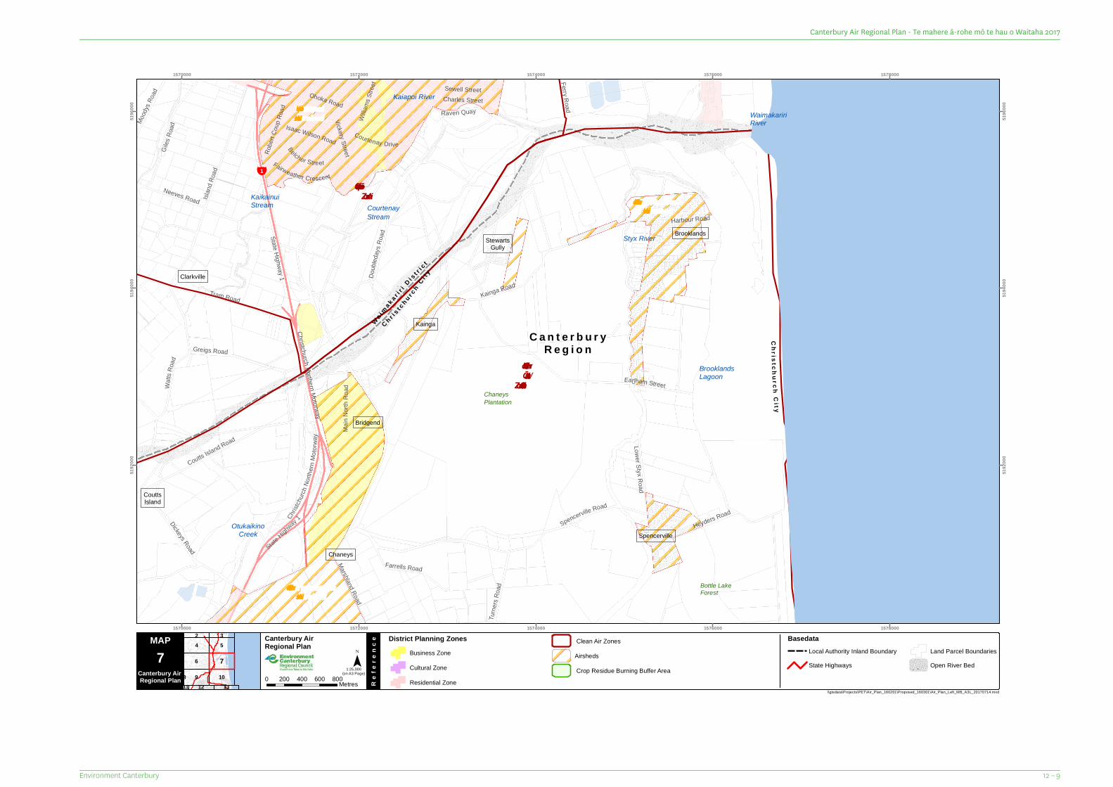
C a n t e r b u r yR e g i o n
¥1
Wa i ma k a r i r
i D i s t r ic t
C h r i st c
h u r ch
C i t y
Chri s tc hu rchC it y
Ferry Road
State Highway 1
Sewell Street
Watts
Road
Belcher Street
Vickery Street
Mood
ys Ro
ad
Isaac Wilson Road
Charles Street
StateHigh
way1
Robe
rt Cou
p Roa
d
Farrells Road
Marshland Road
Fairweather Crescent
Willia
ms St
reet
Harbour Road
Raven Quay
Courtenay Drive
Turne
rs Ro
ad
Ohoka Road
Earlham Street
Heyders Road
Giles
Road
Dickeys Road
Neeves Road
Doub
leday
s Roa
d
Coutts Island Road
Tram Road
Island
Roa
d
Greigs Road
Christ
churc
h Nort
hern
Motor
way
Spencerville Road
Kainga Road
Christchurch Northern Motorway
Lower Styx Road
Main
North
R oad
Bottle LakeForest
ChaneysPlantation
CourtenayStream
Kaiapoi River
WaimakaririRiver
OtukaikinoCreek
BrooklandsLagoon
Styx River
KaikainuiStream
Bridgend
Brooklands
Kainga
StewartsGully
Chaneys
Spencerville
Clarkville
CouttsIsland
ChristchurchAirshed
ChristchurchAirshed
KaiapoiAirshed
Kaiapoi CleanAir Zone
Christchurch/ Ōtautahi
Clean Air Zone
1570000
1570000
1572000
1572000
1574000
1574000
1576000
1576000
1578000
1578000
5192
000
5192
000
5194
000
5194
000
5196
000
5196
000
54
6
9 10
2 3
1312811
7
MAP Canterbury Air Regional Plan
Re
fere
nce
¯(on A3 Page)
\\gisdata\Projects\PET\Air_Plan_160201\Proposed_160301\Air_Plan_Left_MB_A3L_20170714.mxd
7Canterbury Air Regional Plan 0 200 400 600 800Metres
District Planning ZonesBusiness ZoneCultural ZoneResidential Zone
1:25,000
BasedataLocal Authority Inland BoundaryState Highways
Land Parcel BoundariesOpen River Bed
AirshedsClean Air Zones
Crop Residue Burning Buffer Area
12 – 9Environment Canterbury
Canterbury Air Regional Plan - Te mahere ā-rohe mō te hau o Waitaha 2017
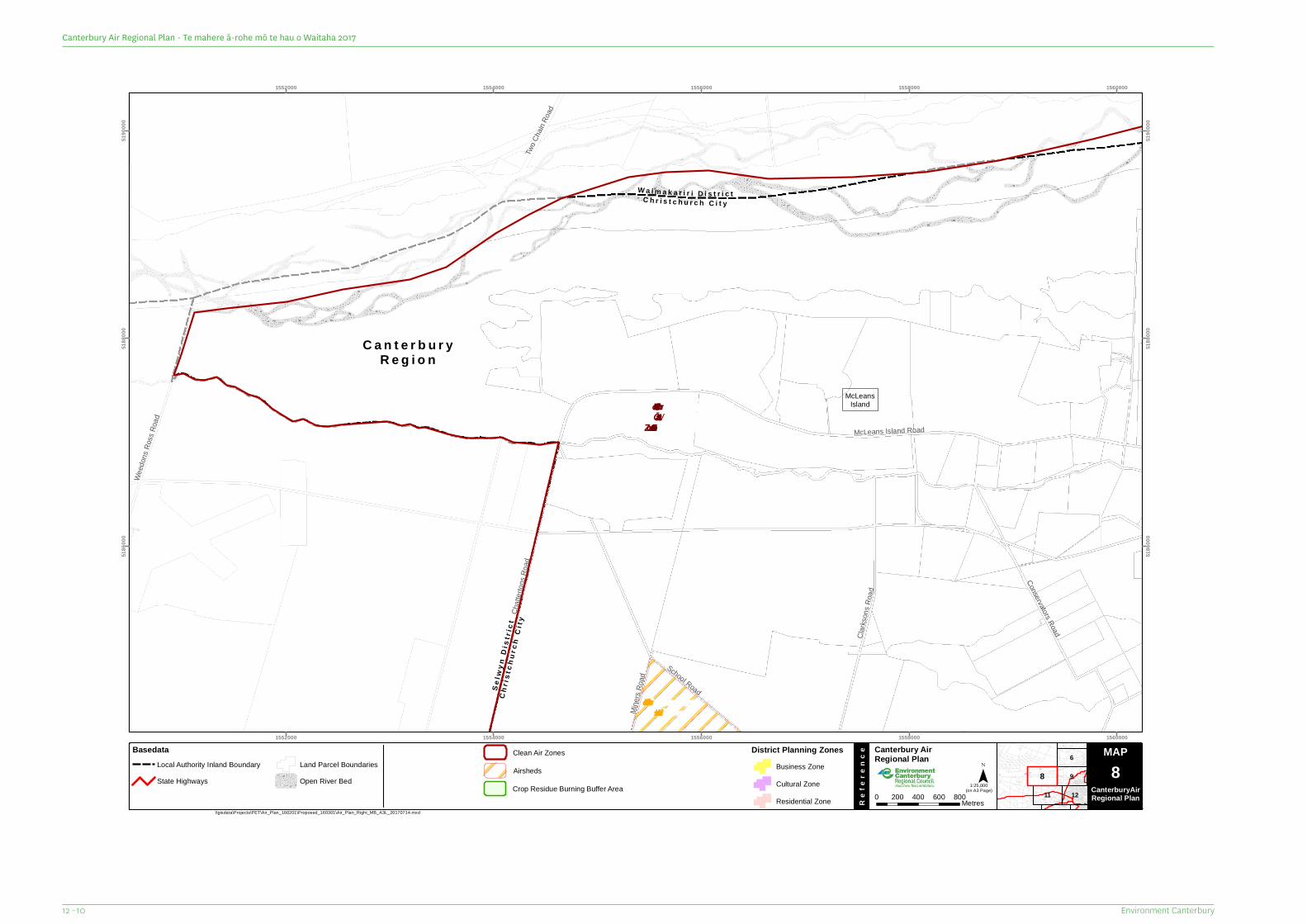
C a n t e r b u r yR e g i o n
W a i m a k a r i r i D i s t r i c tC h r i s t c h u r c h C i t y
Chr i
s tc h
u rc h
Ci t
y
S el w
y n D
i st r
i ct
Mine
rs Ro
ad
Two C
hain R
oad
School Road
Weed
ons R
oss R
oad
Clarks
ons R
oad
Conservators Road
Chatt
erton
s Roa
d
McLeans Island Road
McLeansIsland
ChristchurchAirshed
Christchurch/ Ōtautahi
Clean Air Zone
1552000
1552000
1554000
1554000
1556000
1556000
1558000
1558000
1560000
1560000
5186
000
5186
000
5188
000
5188
000
5190
000
5190
000
6
9
11 12
8
MAP Canterbury Air Regional Plan
Re
fere
nce
¯(on A3 Page)
\\gisdata\Projects\PET\Air_Plan_160201\Proposed_160301\Air_Plan_Right_MB_A3L_20170714.mxd
Map Series 0 200 400 600 800Metres
1:25,000
MAP8
CanterburyAirRegional Plan
BasedataLocal Authority Inland BoundaryState Highways
Land Parcel BoundariesOpen River Bed
District Planning ZonesBusiness ZoneCultural ZoneResidential Zone
Airsheds
Clean Air Zones
Crop Residue Burning Buffer Area
Environment Canterbury12 - 10
Canterbury Air Regional Plan - Te mahere ā-rohe mō te hau o Waitaha 2017
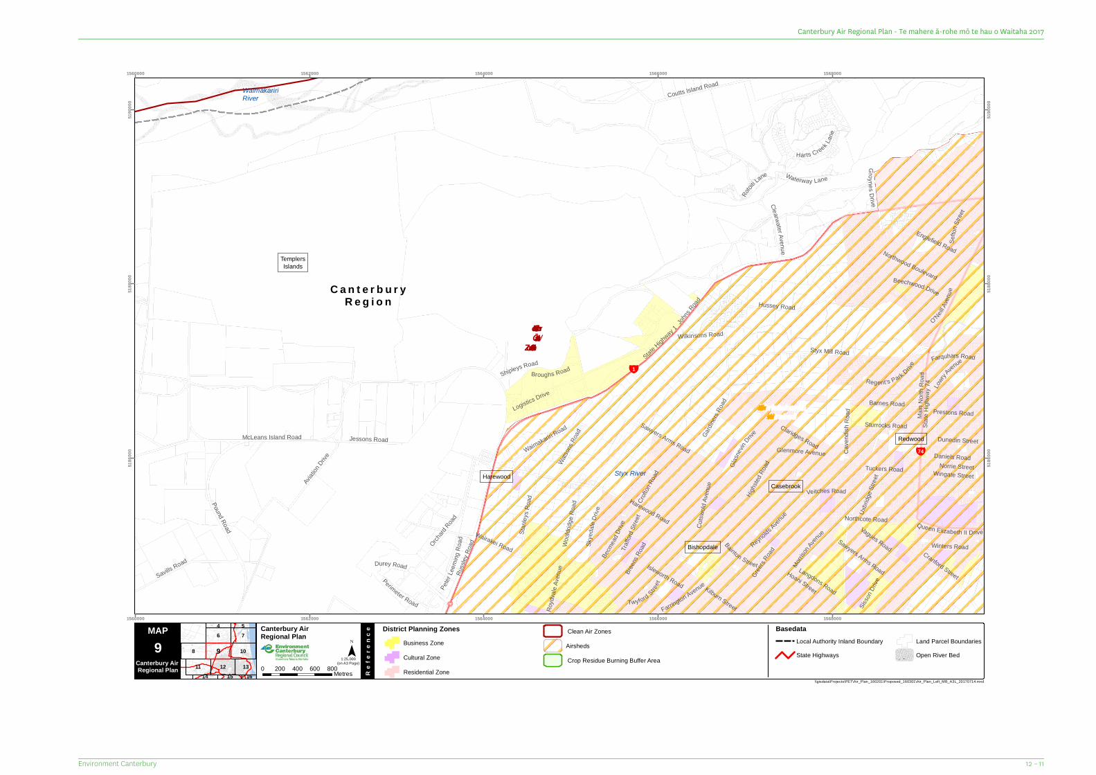
C a n t e r b u r yR e g i o n
¥74
¥1Shipleys RoadBroughs Road
Sefto
n Stre
et
Kilburn Street Sisson
Drive
Bainton Street
Uxbri
dge S
treet
Morriso
n Aven
ue
Norrie Street
Wilkinsons Road
Royd
vale
Aven
ue
Twyford Street
Dunedin Street
Traffo
rdStr
eet
Waterway Lane
Glenmore Avenue
O'NeillAv
enue
Becm
ead D
rive
Rotoit
i Lane
Perimeter Road
Groynes Drive
Prestons Road
Peter
Leem
ingRo
adWingate Street
Daniels Road
Isleworth RoadSk
yeda
leDr
ive
Jessons Road
Farquhars Road
Winters Road
Queen Elizabeth II Drive
Watson
s Roa
d
Tuckers RoadGlasne
vinDrive
Sturrocks Road
Barnes Road
Waimakariri Road
Cotsw
oldAv
enue
Crofto
n Roa
d
LowryAvenue
Englefield Road
Vagues Road
Beechwood Drive
Hoani Street
Woold
ridge
Roa
d
Stanle
ys R
oad
Regent's Park Drive
Aviatio
n Drive
Veitches Road
Logistics Drive
Farrington Avenue
Breen
s Roa
d
Cranford Street
Harts Creek Lane
Durey Road
Reynolds Avenue
Langdons Road
Clearwater Avenue
Sawyers Arms RoadSavills Road
Greers
Road
Northcote Road
Coutts Island Road
Northwood Boulevard
Claridges Road
Hussey Road
Russl
ey Ro
ad
Cave
ndi sh
Road
Orchard
Road
Pound Road
Styx Mill Road
Highst
ed Ro
ad
Wairakei Road
Gardi
ners
Road
Sawyers Arms Road
State
Highw
ay 74
Harewood Road
Main
North
Roa
d
McLeans Island Road
Johns
Road
State Highw
ay 1
WaimakaririRiver
Styx RiverCasebrook
Harewood
Bishopdale
Redwood
TemplersIslands
ChristchurchAirshed
Christchurch/ Ōtautahi
Clean Air Zone
1560000
1560000
1562000
1562000
1564000
1564000
1566000
1566000
1568000
1568000
5186
000
5186
000
5188
000
5188
000
5190
000
5190
000
8
6 7
11 12
10
13
4 5
1514 16
9
MAP Canterbury Air Regional Plan
Re
fere
nce
¯(on A3 Page)
\\gisdata\Projects\PET\Air_Plan_160201\Proposed_160301\Air_Plan_Left_MB_A3L_20170714.mxd
9Canterbury Air Regional Plan 0 200 400 600 800Metres
District Planning ZonesBusiness ZoneCultural ZoneResidential Zone
1:25,000
BasedataLocal Authority Inland BoundaryState Highways
Land Parcel BoundariesOpen River Bed
AirshedsClean Air Zones
Crop Residue Burning Buffer Area
12 – 11Environment Canterbury
Canterbury Air Regional Plan - Te mahere ā-rohe mō te hau o Waitaha 2017
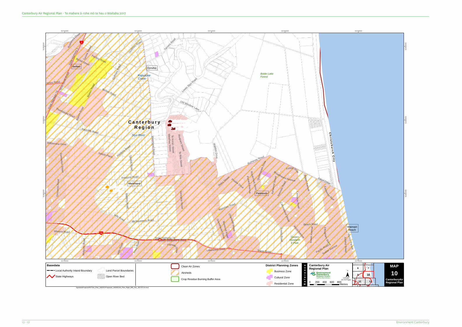
C a n t e r b u r yR e g i o n
¥74
¥1
Chr is tc h u rc hC i t y
Jutland Street
Johns Road
Frosts Road
Guthries
Road
Richill Street
Selkirk Place
Forest Drive
Ashw
oodS
treet
Georgina Street
Eastwood Rise
Rushm
ore
Drive
Reka Street
Bower Avenue
Innes
Road
Hills R
oad FairwayDrive
Philp
otts R
oad
Willowview Drive
Ascot Avenue
Chartwell Street
Blake
s Roa
dBla
kes Ro
ad
Dunbarton Street
Lamorna Road
PuharaAve nu e
Thompsons Road
Quaids Road
Ruapani Street
Greenhaven Drive
Cottonwood Street
Lakewood Drive
McSaveneys Road
Putake Drive
Inwoo
ds Ro
ad
Tedder Avenue
Old Windsor Lane
Winters Road
Tyron
e Stre
et
Marine Parade
Metehau Street
Pacific Road
State
Highw
ay 74
EffinghamStreet
Walters Road
Guthr
ies Ro
ad
Factory Road
Broadhaven Avenue
Waitikiri Dri ve
Te Rito Street
Royal Park Drive
Quee
nspa
rkDr
ive
Turner
s Road
Te Korari Street
Bowe
r Ave
nue
Beach Road
Hawkins Road
Grim
seys
Roa
d
Travis Road
Aston Drive
State
Highw
ay 1
Burwood Road
Hills Road
Radcliffe Road
Belfast Road
Main N
orth R
oad
Rothesay Road
Mairehau Road
Lower Styx
Road
Prestons Road
Queen Elizabeth II Drive
Marshland Road
State Highway 74
Bottle LakeForest
QueenElizabeth
II Park
KaputoneCreek
Styx River
Parklands
Marshland
Belfast
WaimairiBeach
Ouruhia
ChristchurchAirshed
Christchurch /Ōtautahi CleanAir Zone
1570000
1570000
1572000
1572000
1574000
1574000
1576000
1576000
1578000
1578000
5186
000
5186
000
5188
000
5188
000
5190
000
5190
000
6
9
7
12 13
10
MAP Canterbury Air Regional Plan
Re
fere
nce
¯(on A3 Page)
\\gisdata\Projects\PET\Air_Plan_160201\Proposed_160301\Air_Plan_Right_MB_A3L_20170714.mxd
Map Series 0 200 400 600 800Metres
1:25,000
MAP10
CanterburyAirRegional Plan
BasedataLocal Authority Inland BoundaryState Highways
Land Parcel BoundariesOpen River Bed
District Planning ZonesBusiness ZoneCultural ZoneResidential Zone
Airsheds
Clean Air Zones
Crop Residue Burning Buffer Area
Environment Canterbury12 - 12
Canterbury Air Regional Plan - Te mahere ā-rohe mō te hau o Waitaha 2017
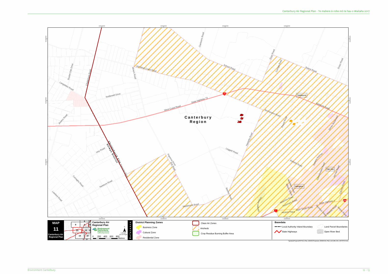
C a n t e r b u r yR e g i o n
¥73A
¥73
¥1
Ch r i s t c h u r c h C i t y
S e l w y n D i s t r i c t
Amyes Road
Wilson Street
Hickory Place
Seymour Street
Paparua Drive
Corin
ga Ro
ad
Mortlake Street
Isling
to nAv
enue
Ivey Road
Kanie
reAven
ue
Shands RoadForemans Road
Leggett Road
Clarks
ons R
oad
Lawford Road
Carm
enRo
ad
Scarl
et Oa
k Driv
e
Hei H
ei Ro
adGr
ays R
oad
Jarnac
Boule
vard
Langdales Road
Gilbe
rthorp
es Ro
ad
Barters Road
Kettlewell Drive
Roberts Road
Yaldhurst Road
Guys
Road
Maddisons Road
Ryans Road
Jowers
Road
Curraghs Road
Main South Road
Miners Road
Chatt
erton
s Roa
d
Dawsons Road
Waterloo Road
State Highway 1
Kirk Road
Haske
tts Ro
ad
Newtons Road
School Road
Buchanans Road
Old West Coast Road
Poun
d Roa
d
West Coast RoadState Highway 73
Hei Hei
Yaldhurst
Islington
ChristchurchAirshed
Christchurch/ Ōtautahi
Clean Air Zone
1554000
1554000
1556000
1556000
1558000
1558000
1560000
1560000
5180
000
5180
000
5182
000
5182
000
5184
000
5184
000
8 9
14
12
15
6
17
107
1311
MAP Canterbury Air Regional Plan
Re
fere
nce
¯(on A3 Page)
\\gisdata\Projects\PET\Air_Plan_160201\Proposed_160301\Air_Plan_Left_MB_A3L_20170714.mxd
11Canterbury Air Regional Plan 0 200 400 600 800Metres
District Planning ZonesBusiness ZoneCultural ZoneResidential Zone
1:25,000
BasedataLocal Authority Inland BoundaryState Highways
Land Parcel BoundariesOpen River Bed
AirshedsClean Air Zones
Crop Residue Burning Buffer Area
12 – 13Environment Canterbury
Canterbury Air Regional Plan - Te mahere ā-rohe mō te hau o Waitaha 2017
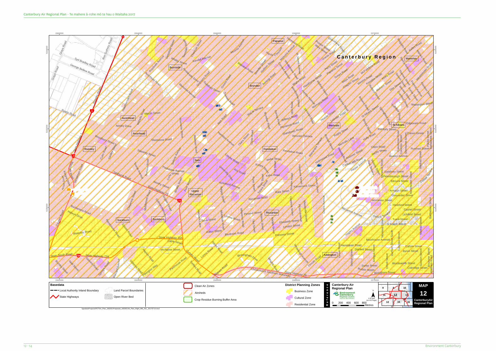
C a n t e r b u r y R e g i o n
¥1,73
¥73
¥73A
¥1
Otara Stree
tTika Street
Arts Road
Rata Street
Darvel Street
Grov
e Roa
d
Derby Street
Lyndon Street
Hewitts Road
Strowan Road
Dee Street
Pilkington Way
Worthy Street
Yardl
eyStr
eet
Andover Street
BalgayStreet
Whitby Street
Garvins Road
Hartley Avenue
Clare Road
Browns Road
Thames Street
Severn Street
Lunns Road
Holmwood Road
Nancy Avenue
Mary Street
Cable Street
Guildford Street
Lochee Road
Charl
cott S
treet Proctor Street
Truman Road
Deep
dale
Stree
t
Arthur Street
Ambleside Drive
Jennife
r Stree
t
Princess Street
Matsons
Avenue
Windermere Road
Hawthorne Street
Warrington Street
Grassmere Street
Wroxton Terrace
Oxford Terrac
e
Weka Street
Hudson Street
Flockton Street
Worcester Street
Kintyre Drive
Plynlimon Road
Harva
rdAv
enue
Montr
eal S
treet
Perry Street
English Street
Trafalgar Stre et
Mahars Road
Spring
s Road
Treffers Road
Gray
s Roa
d
Orbe
ll Stre
et
Carlton Mill Road
Ranfurly Street
Kirkwood Avenue
Tui S
treet
Ruskin Street
Brisb
ane S
treet
Forfar Street
HounslowS treet
University Drive
Toorak Avenue
Carlyle Street
Coleridge Street
Stead
man R
oad
Westholme Street
Brynley Street
Paparoa Street
Wai-Iti Terrace
Gray
s Roa
d
Brodie
Stree
t
Garreg Road
Wigram Road
Colman Avenue
Parkstone Avenue
Kotare Street
Solwa
y Aven
ueKahu Road
Ron G
uthrey
Road
Kellys Road
Cutts
Road
Hinau S
tr eet
Philpotts Road
Watford Street
Wairarap
a Terrac
e
Victoria Street
Neill Street
McFaddens Road
Bristol Street
Arco
nDriv
e
Francis Avenue
Norto
nsRo
ad
Harewood Road
MashamRoad
Tomes Road
Byron Street
Merivale LaneRugby Street
Hansons Lane
Staveley Street
Wainui Street
Grants Road
Caled
onian
Roa
d
Pack
e Stre
et
Sherb
orne S
treet
Middleton Road
Burke Street
Wharenui Road
Gass
on S
treetDisraeli Street
Kilmarnock Street
Malvern Street
Teesd
aleSt
reet
Leinster Road
Epsom Road
Chapter Street
Mandeville Street
St James Ave nue
Mersey Street
Parkhouse Road
Holly Road
Hagley Avenue
Normans Road
Madra
s Stre
et
Peer
Stree
t
Halwyn Drive
Vickerys Road
Chey
enne
Stree
t
Whiteleigh Avenue
Picton AvenueHarakeke Street
Park Terrace
Creyke Road
Heaton Street
Purchas Street
Canon Street
Bryndwr Road
Pu ri ri St reet
Walth
am R
oad
CorfeStreet
Mays Road
Clarence Street
Merrin StreetSt Albans Street
Wrights Road
McAlpine StreetBirmingham Drive
Suva Street
Hazeldean Road
Annex Road
Apsley Drive
Ryans Road
Woodbury Street
Cashel Street
Elizabeth StreetLichfield Street
Harper Avenue
Mooray Avenue
Strav
enRo
ad
Harris Crescent
Hamilton Avenue
Blighs Road
Totara
Street
Selw
yn St
reet
Edgeware Road
Wordsworth Street
Rutland Street
Roydval
e Aven
ue
Matipo Street
State Highway 73A
Midd
lepark
Road
Rossall Street
Syd Bradley RoadGeorge Bellew Road
Oxford Terrace
Peterborough Street
Springfield RoadJeffreys Road
Riccarton Avenue
Glandovey Road
Antig
ua S
treet
Lincoln Road
Kendal Avenue
Salisbury Street
Condell Avenue
Hayton Road
Kilmore Street
Peverel Street
Aorangi Road
Armagh Street
Hereford Street
Gloucester Street
Colom
bo St
reet
Durha
m St
reet S
outh
Hawth
ornde
n Roa
d
Barba
does
Stree
t
Dean
s Ave
nue
Tuam Street
Waterloo Road
Buchanans Road
Westmins
ter Stree
t
Carm
en Ro
ad
Bealey Avenue
Idris
Road
Colom
bo St
reet
Weston Road
Barba
does
Stree
t
St Asaph Street
Fendalton Road
Knowles Street
Montr
eal S
treetRacecourse Road
Madra
s Stre
et
Maidstone Road
Curletts RoadState Highway 73A
Brougham Street
Withe
lls Ro
ad
Cranford Street
Graham
s Road
Christchurch Southern Motorway
Innes Road
Greers R
oad
Moorhouse Avenue
Manc
heste
r Stre
et
Papanui Road
Waimairi Road
Riccarton Road
Russl
ey Ro
ad
Wairakei Road
Clyde
Roa
d
Ilam Road
Yaldhurst Road
Main South Road
Memorial Avenue
Blenheim Road
Avonhead Road
State Highway 76
State
Highw
ay 1
State Highway 73
SouthHagleyPark
NorthHagleyParkAlbert Lake
WaimairiStream
Ilam Stream
WairarapaStream
AvonRiver/Ōtakaro
OkeoverStream
Addington
Burnside
Ilam
Avonhead
Sockburn
St Albans
Russley
Riccarton
Merivale
UpperRiccarton
Papanui
Sockburn
Fendalton
Avonhead
Mairehau
Bryndwr
ChristchurchAirshed
Christchurch/ Ōtautahi
Clean Air Zone
1562000
1562000
1564000
1564000
1566000
1566000
1568000
1568000
1570000
1570000
5180
000
5180
000
5182
000
5182
000
5184
000
5184
000
98
11
14 15
10
13
16
12
MAP Canterbury Air Regional Plan
Re
fere
nce
¯(on A3 Page)
\\gisdata\Projects\PET\Air_Plan_160201\Proposed_160301\Air_Plan_Right_MB_A3L_20170714.mxd
Map Series 0 200 400 600 800Metres
1:25,000
MAP12
CanterburyAirRegional Plan
BasedataLocal Authority Inland BoundaryState Highways
Land Parcel BoundariesOpen River Bed
District Planning ZonesBusiness ZoneCultural ZoneResidential Zone
Airsheds
Clean Air Zones
Crop Residue Burning Buffer Area
Environment Canterbury12 - 14
Canterbury Air Regional Plan - Te mahere ā-rohe mō te hau o Waitaha 2017
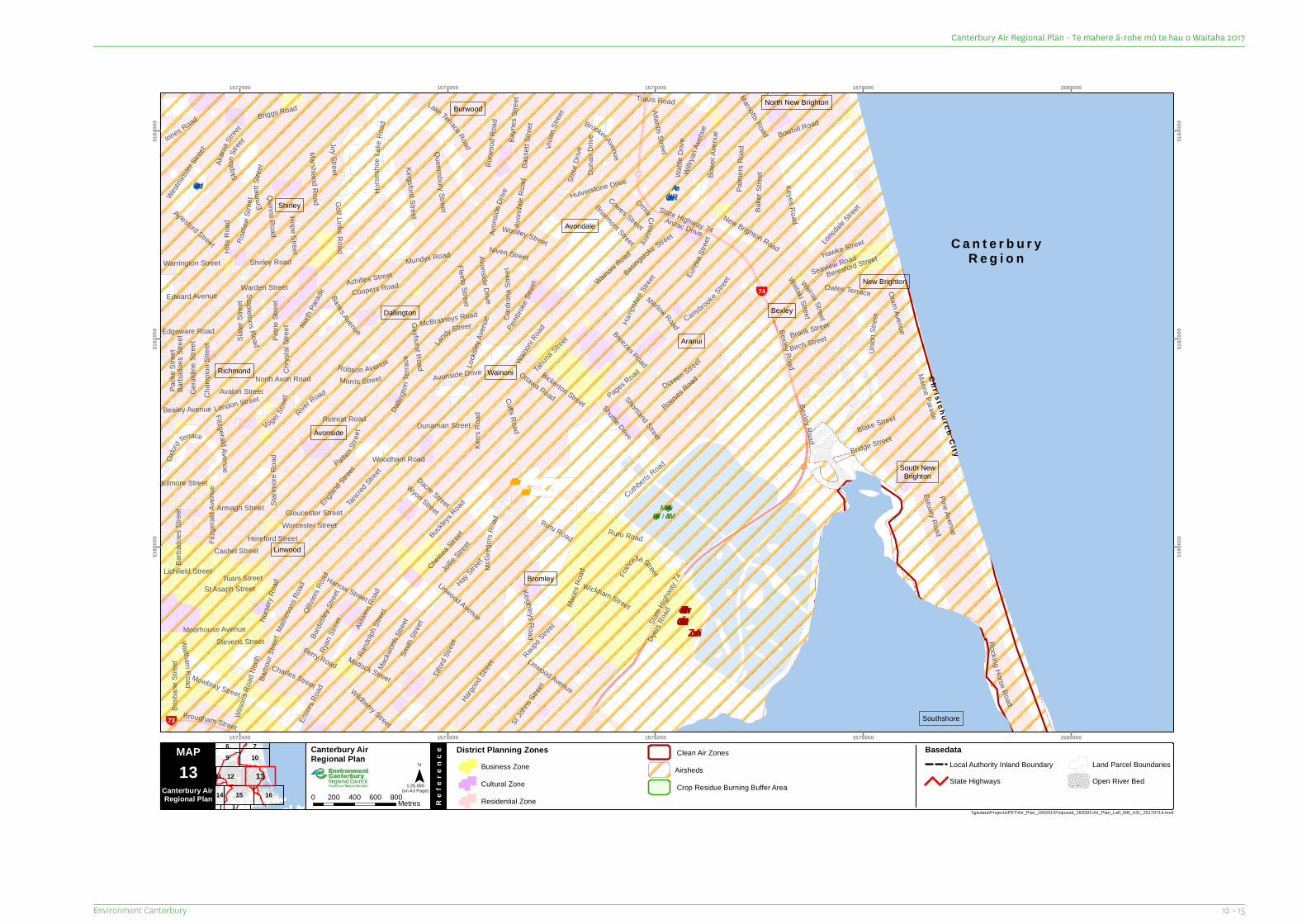
C a n t e r b u r yR e g i o n
¥73
¥74
Ch r i s t ch u r c hC i t y
Tahuna
StreetBirch Street
Ryan
Stree
t
Raupo Stree
t
Avalon Street
Shuttle Drive Blake Street
Wyon Street
Dacre Street
Stevens Street
Seaview Road
Vogel Stre
et
Mundys Road
Doreen Street
Morris Street
Duna
ir Driv
e
Akaro
a Stree
t
Cowes Street
Chrys
tal St
reet
PattenStr
eet
London Street
Harrow Street
Matlock Street
Bayn
es St
reet
Bealey Avenue
Skipto
n Stree
t
Kilmore Street
Lichfield StreetWickham Street
Lan
dy Street
Cardr
o naS
treet
Cuffs Road
Marriotts Road
Hope Street
Dunarnan Street
Mathe
sons R
oad
Wildberry Street
Brook Street
Warrington Street
Edgeware Road
Edward Avenue
Robson Avenue
Fitzgerald Av en ue
Briarmont Street
Coopers Road
St Joh
ns Str
eet
Basingstoke Street
Mowbray Street
Chelsea
Street
Bexley Road
Barbo
ur Str
eet
Stour
Drive
Niven Street
Owles Terrace
Brisb
ane S
treet
Jollie S
treet
Pembro
keStr
eet
Golf Link sR oad
Charles Street
Achilles Street Wairoa Street
Atlantis Street
Burw
oodR
o ad
Woolley Street
Westmins
ter St
reet
Brougham Street
Beresford Street
North
Parad
e
Nurse
ry Ro
ad
Ensor
s Roa
d
Oram Avenue
Orrick Crescent
Ottawa Road
Risela
wStr
eet
Lonsda
le Stree
tQueensbury StreetAylesford Street
Mackw
orth S
treet
Hargood
Stree
t
Banks Avenue
Rand
olph S
treet
Avon
side D
rive
Pack
e Stre
et
Hawke Street
Innes Road
Cham
pion S
treet
B ass
ettSt r
eet
Bickerton Street
Willry
an Av
enue
Retreat Road
CarisbrookeStree
t
BrookerAvenueWa
ttle D
rive
Fleete Street
Eurek
a Stre
et
Warden Street
Shirley Road
Vivian
Stree
t
Ruru Road
Avon
dale
Road
Borde
sley S
treet
Marlow Road
WalthamR oad Tilf
ord St
reet
Rowses Road
Travis Road
Bake
r Stre
et
Waitaki Street
Ollivie
rs Ro
ad France
llaStreet
North Avon Road
Keighleys Road
Ruru Road
Wilso
ns Ro
ad No
rth Linwood Avenue
Kerrs
Roa
d
Tancre
d Stree
t
Moorhouse Avenue
McBratneys Road
Slater
Stree
t
Petrie
Stree
t
Smith
Stree
t
Briggs Road
Bowhill Road
Dallin
gton T
errac
e
Oxford
Terrace
Joy Street
Stapl eton s Road
Buckleys
Road
Aldwin
s Roa
d
Palm
ers R
oad
Bowe
r Ave
nue
Hay Stree
t
Wainoni
Road
Rocking Horse Road
Mace
s Roa
d
Bridge Street
Keyes Road
England
Street
Union
Stree
t
St Asaph Street
Hamp
shire
Street
Cuthberts Road
Horse
sho e
Lake
Road
Avons ide Drive
Kingsford Street
Geral
dine S
treet
Emme
tt Stre
et
Gayhurst Road
McG r
egors
Road
Fitzg
erald
Aven
ue
Armagh Street
Quinns Road
Tuam Street
Bexley Road
Marshland Road
Barba
does
Stree
t
Hulverstone Drive
Wainoni R
oad
Barba
does
Stree
t
Woodham Road
Stanm
ore R
oad
Shortland Street
Hereford Street
Estuary Road
Cashel Street
Locks
ley Av
enue
Lake Terrace Road
Pine Avenue
RiverRoad
Worcester Street
Hills
Road
Gloucester Street
Anzac Drive
Ferry RoadDy
ers Ro
ad
Pages Road
Breezes Road
State Highway 74
State
Highw
ay74Linwood Avenue
Avonside Drive Marine Parade
New Brighton Road
Te Huingi ManuWildlife Refuge
Dudley Creek AvonRiver/Ōtakaro
North New Brighton
Avondale
Avonside
Bexley
Wainoni
Southshore
Linwood
New Brighton
Burwood
Bromley
Shirley
Dallington
Aranui
South NewBrighton
Richmond
ChristchurchAirshed
Christchurch /Ōtautahi CleanAir Zone
1572000
1572000
1574000
1574000
1576000
1576000
1578000
1578000
1580000
1580000
5180
000
5180
000
5182
000
5182
000
5184
000
5184
000
9
12
15
10
1614
76
17
11 13
MAP Canterbury Air Regional Plan
Re
fere
nce
¯(on A3 Page)
\\gisdata\Projects\PET\Air_Plan_160201\Proposed_160301\Air_Plan_Left_MB_A3L_20170714.mxd
13Canterbury Air Regional Plan 0 200 400 600 800Metres
District Planning ZonesBusiness ZoneCultural ZoneResidential Zone
1:25,000
BasedataLocal Authority Inland BoundaryState Highways
Land Parcel BoundariesOpen River Bed
AirshedsClean Air Zones
Crop Residue Burning Buffer Area
12 – 15Environment Canterbury
Canterbury Air Regional Plan - Te mahere ā-rohe mō te hau o Waitaha 2017
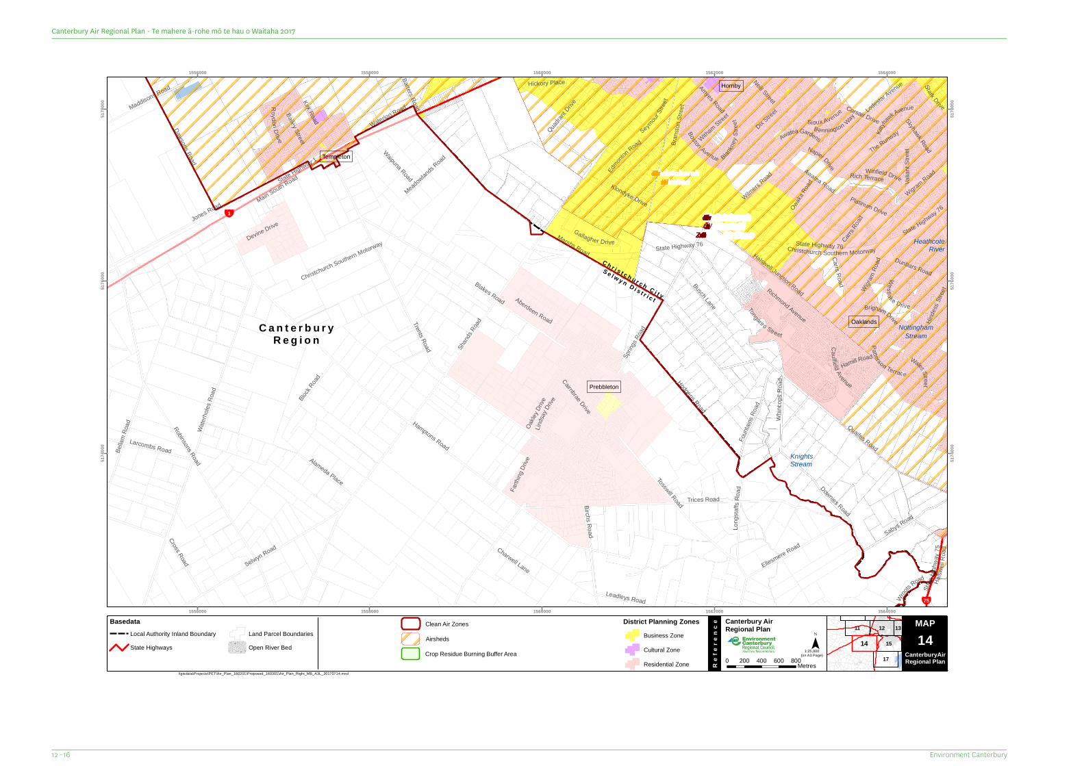
C a n t e r b u r yR e g i o n
¥75
¥1
C h r i s t c h u r c h C i t y
S e l w y n D i s t r i c t
Stark Drive
Dix Street
Carrs Road
Neill Street
Owaka
Road
Oakle
y Drive
Barters Road
Carrs Road
Hinde
ss Str
eet
Skyhawk Road
Quadran
t Drive
Hickory Place
Winfield Drive
Hamill Road
Wroots Road
Witham Street
Lindsa
y Drive
Brigham Drive
Valia
nt Str
eet
Charwell Lane
Rich Terrace
Waipuna Road
Klondyke Drive Platinum Drive
Bennington Way
Cairnbrae Drive
Awatea Gardens
Boston Avenue
Leadleys Road
Wigram Road
Tongariro Street
Edmont
on Road
Gallagher Drive
Halsw
ellRo
ad
Farth
ingDr
ive
Westlake Drive
Meadowlands Road
Alameda Place
Bailey Street
Busch LaneAmyes Road
Seymour
Stree
t
Block
Road
Napier Drive
Roydon Drive
State Highway 76
Sioux Avenue
State
Highw
ay75
Ca ulfie ld Avenue
Dunbars Road
Kirk Road
Patterson Terrace
Richmond Avenue
Larcombs Road
Blankn
eySt
reet
Lodestar Avenue
Wilmers Road
Bran
ston S
treet
Wigram
Road
Foun
tains
Road
Maddisons Road
Sabys Road
Wales Street
State Highway 76Christchurch Southern Motorway
The Runway
Long
staf fs
Road
Bella
m Ro
ad
Aberdeen Road
Devine Drive
Cross Road
Downies Road
Corsair Drive
Ellesmere Road
Hodgens Road
Waterloo Road
Dawsons Road
Birchs Road
Awatea Road
Selwyn Road
Whinc
ops R
oad
Kittyh
awk Avenue
Quaifes Road
Jones Road
Tosswill Road
State Highway 76
Blakes Road
Trices Road
Robinsons Road
Trents Road
Water
holes
Road
State Highway 1
Main South Road
Marshs Road
Hamptons Road
Halswell Junction Road
Spring
s Road
Shand
s Road
Christchurch Southern Motorway HeathcoteRiver
NottinghamStream
KnightsStream
Prebbleton
Templeton
Hornby
Oaklands
ChristchurchAirshed
Christchurch/ Ōtautahi
Clean Air Zone
1556000
1556000
1558000
1558000
1560000
1560000
1562000
1562000
1564000
1564000
5174
000
5174
000
5176
000
5176
000
5178
000
5178
000
11 12
15
17
13
14
MAP Canterbury Air Regional Plan
Re
fere
nce
¯(on A3 Page)
\\gisdata\Projects\PET\Air_Plan_160201\Proposed_160301\Air_Plan_Right_MB_A3L_20170714.mxd
Map Series 0 200 400 600 800Metres
1:25,000
MAP14
CanterburyAirRegional Plan
BasedataLocal Authority Inland BoundaryState Highways
Land Parcel BoundariesOpen River Bed
District Planning ZonesBusiness ZoneCultural ZoneResidential Zone
Airsheds
Clean Air Zones
Crop Residue Burning Buffer Area
Environment Canterbury12 - 16
Canterbury Air Regional Plan - Te mahere ā-rohe mō te hau o Waitaha 2017
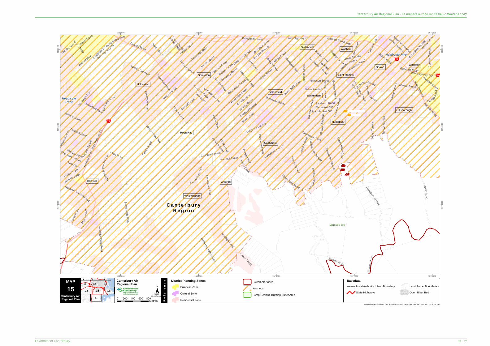
C a n t e r b u r yR e g i o n
¥73
¥74A
¥75
Ngaio Street
Mavin Road
The Runway
York
Stree
t
Kairos Street
Hurunui Street
Hinde
ss Str
eet
Fern Drive
Rahera Street
Rydal Street
Torrens Road
Redruth Avenue
Sandwich Road
Sonter Road
Nicholls Road
Victors Road
Wyn Street Curries Road
Martin Avenue
Norw
ood S
treet
McBeath Avenue
Tankerville Road
Stourbridge StreetWychbury S
treet
Beckford Road
Bengal Drive
Euph
rasie Drive
Ensig
n Stre
et
Sylvan Street
MacKenzie Avenue
Maunsell Street
Checketts Avenue
Hastings Street East
Ensor
s Roa
d
MuirAv
e nue
Balcairn Street
Grange Street
Frankleigh Stree
t
MacMillan Avenue
Coronation Street
Wales Street
Landsdowne Terrace
Longhu
rstTe
rrace
Samuel Street
Malcolm AvenueRoberta Drive
Bletsoe Avenue
Birdw
oodA
venu
e
Kaiwara Street
Hayton Road
State Highway 74ATennyson Street
Conway Street
Sullivan AvenueWaltham Road
Cobham Street
Fisher Avenue
King Street
Stanbury Avenue
Ravensdale Rise
Domain Terrace
Rowley Ave nue
Neville Street
Riverlaw Terrace
Cumn
orTe
r race
Albert
Terra
ce
Southampton Street
Huxley Street
St Martins Road
Ayns
leyTe
rrace
Annex Road
Kidson Terrace
Roker Street
Studholme Street
Palat
ineTe
rraceMathers R
oad
Halswell Junction Road
Dunbars Road Verno
n Terr
ace
Garlands Road
Edinburgh Street Radley
Street
Hollis
s Ave
nue
Somerfield Street
Saby
s Roa
d
Wilsons Road South
Bowenvale Avenue
Lincoln Road
Richards
onTer
race
Summit Road
McMaho
n Drive
Sutherlands Road
Strickland Street
Simeon Street
Shalamar Drive
Port Hills Road
Rose StreetBibiana Street
William
Britta
nAve
nue
Riverlaw Terrace
Warren Crescent
Waim
eaTe
rrace
Curletts Road
Milns Road
State Highway 76
Aidanfield Drive
Major AitkenDrive
Milton Street
Wigram Road
Penruddock
Rise
Selwyn Street
Hoon Hay Valley Road
Kennedys Bush Road
Colom
bo St
reet
Easte rn Terrace
Hendersons Road
Ashgrove Terrace
Hackthorne Road
Lyttelton Street
Christch
urchSouthern Motorway
State Highway 76
Opawa RoadFifield Terrace
Barrington StreetHoon Hay Road
Summ
it Roa
d
Huntsbury Avenue
Rapaki Road
Centaurus Road
Worsleys Road
Spark
s Road
Brougham Street
Dyers Pass Road
State Highway 76
Halsw
ell Ro
ad
Cashmere Road
State
Highw
ay 75
Victoria Park
HeathcoteRiver
Heathcote River
Cracroft
Hoon Hay
Somerfield
Saint Martins
Hillsborough
Huntsbury
Hillmorton
Woolston
Cashmere
Beckenham
Halswell
Waltham
Westmorland
Spreydon
Sydenham
Opawa
ChristchurchAirshed
Christchurch /Ōtautahi CleanAir Zone
1566000
1566000
1568000
1568000
1570000
1570000
1572000
1572000
1574000
1574000
5174
000
5174
000
5176
000
5176
000
5178
000
5178
000
14
12
17
13
16
1198 10
15
MAP Canterbury Air Regional Plan
Re
fere
nce
¯(on A3 Page)
\\gisdata\Projects\PET\Air_Plan_160201\Proposed_160301\Air_Plan_Left_MB_A3L_20170714.mxd
15Canterbury Air Regional Plan 0 200 400 600 800Metres
District Planning ZonesBusiness ZoneCultural ZoneResidential Zone
1:25,000
BasedataLocal Authority Inland BoundaryState Highways
Land Parcel BoundariesOpen River Bed
AirshedsClean Air Zones
Crop Residue Burning Buffer Area
12 – 17Environment Canterbury
Canterbury Air Regional Plan - Te mahere ā-rohe mō te hau o Waitaha 2017
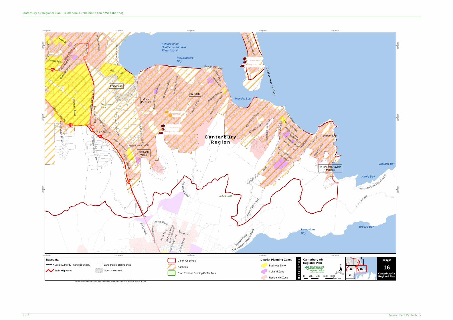
C a n t e r b u r yR e g i o n
¥74
¥73
¥74A
Chr is t ch ur chC i t y
Days Road
State Highway 74
Dryden Street
Godle
y DriveHead
Street
Truro Street
Celia Street
Campbell Street
Ti Rakau Dr iv e
Laing Crescent
Augusta Street
Mauger Drive
Ross
Terrac
eCo
rnwall
Road
Arnold Street
Ferrymead Park Drive
Oxfor
d Stre
et
Bamford
Stree
t
Broad leaf Lane
Barton Street
Colenso Street
Scruttons Road
D yers
Road
State
Highw
ay 74
Wiggins Street
AvocaVall eyR oad
Rutherfo
rdStr
eet
Horot ane Valley Road
Flinders Road
H aw khurst Road Jacks
ons R
oad
Martindales Road
Humph reys D rive
Pano
rama Road
Chapmans Road
Rocking Horse Road
Somes Road
Cante
rbury
Stree
t
Beachville Road
Solea
resAv
enue
Ferry Road
Nayland Street
Esplanade
State Highway 76
Wake
field
Aven
ue
Ferry Road
State High
way74A
Glenst
raeRo
ad
Clifton Terrace
Richm
ond H
il l Roa
d
Sumner Road
Heberden
Avenue
Old Sumner Lyttelt
onRo
adEv
ans P
assRoad
Monck
s Spur
Road
Cumn
orTe
rrace
Major
Hornb
rook R
oad
Bridle Path
Captain ThomasRoad
Taylors Mistake Bay (Beach)
Bridle Path RoadPort Hills Road
Main Road
Mt Pl
easa
nt Ro
ad
Tunnel Road
Summit R
oad
FerrymeadPark
Jollies Bush
Harris Bay
Boulder Bay
McCormacksBay
Moncks Bay
Breeze BayLivingstoneBay
Estuary of theHeathcote and AvonRivers/Ihutai
HeathcoteValley
Ferrymead
Redcliffs
Scarborough
Te Onepoto/TaylorsMistake
MountPleasant
ChristchurchAirshed
Christchurch/ Ōtautahi
Clean Air Zone
Christchurch/ Ōtautahi
Clean Air Zone
1574000
1574000
1576000
1576000
1578000
1578000
1580000
1580000
1582000
1582000
5174
000
5174
000
5176
000
5176
000
5178
000
5178
000
15
13
17
12
16
MAP Canterbury Air Regional Plan
Re
fere
nce
¯(on A3 Page)
\\gisdata\Projects\PET\Air_Plan_160201\Proposed_160301\Air_Plan_Right_MB_A3L_20170714.mxd
Map Series 0 200 400 600 800Metres
1:25,000
MAP16
CanterburyAirRegional Plan
BasedataLocal Authority Inland BoundaryState Highways
Land Parcel BoundariesOpen River Bed
District Planning ZonesBusiness ZoneCultural ZoneResidential Zone
Airsheds
Clean Air Zones
Crop Residue Burning Buffer Area
Environment Canterbury12 - 18
Canterbury Air Regional Plan - Te mahere ā-rohe mō te hau o Waitaha 2017
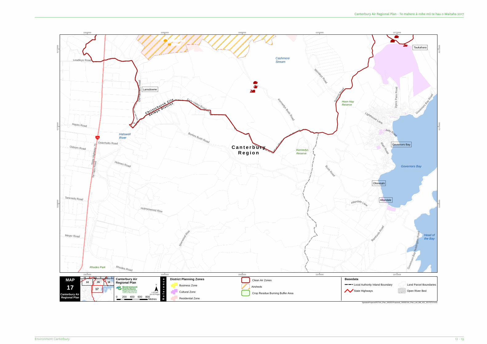
C a n t e r b u r yR e g i o n
¥75
C h r i s t c h u r c h C i t y
S e l w y n D i s t r i c t
Lighthouse Lane
Jetty Road
Sherw
oodRise
Osterholts Road
Rhodes Road
Meyer Road
Tancreds Road
Osborn Road
Hayes Road
Holmes Road
Allandale Lane
Leadleys Road
Main Road
Bamford
s Road
Governor
s BayRo
ad
Worsleys Road
Early Valley Road
Holmeswood Rise
Dyers
Pas
s Roa
d
Bush Road
Gove
rnors
Bay T
eddin
gtonR
oad
Burkes Bush Road
Kennedys Bush Road
Tai Ta
pu Ro
adState
Highw
ay 75
Old T
ai Ta
pu Ro
ad
Summ
it Road
Rhodes Park
KennedysReserve
Hoon HayReserve
HalswellRiver
CashmereStream
Governors Bay
Head ofthe Bay
Taukahara
Allandale
Governors Bay
Ohinetahi
Lansdowne
ChristchurchAirshed
Christchurch /Ōtautahi Clean Air
Zone
Christchurch/ Ōtautahi
Clean Air Zone
1564000
1564000
1566000
1566000
1568000
1568000
1570000
1570000
1572000
1572000
5168
000
5168
000
5170
000
5170
000
5172
000
5172
000
14 15 1612 1311
17
MAP Canterbury Air Regional Plan
Re
fere
nce
¯(on A3 Page)
\\gisdata\Projects\PET\Air_Plan_160201\Proposed_160301\Air_Plan_Left_MB_A3L_20170714.mxd
17Canterbury Air Regional Plan 0 200 400 600 800Metres
District Planning ZonesBusiness ZoneCultural ZoneResidential Zone
1:25,000
BasedataLocal Authority Inland BoundaryState Highways
Land Parcel BoundariesOpen River Bed
AirshedsClean Air Zones
Crop Residue Burning Buffer Area
12 – 19Environment Canterbury
Canterbury Air Regional Plan - Te mahere ā-rohe mō te hau o Waitaha 2017
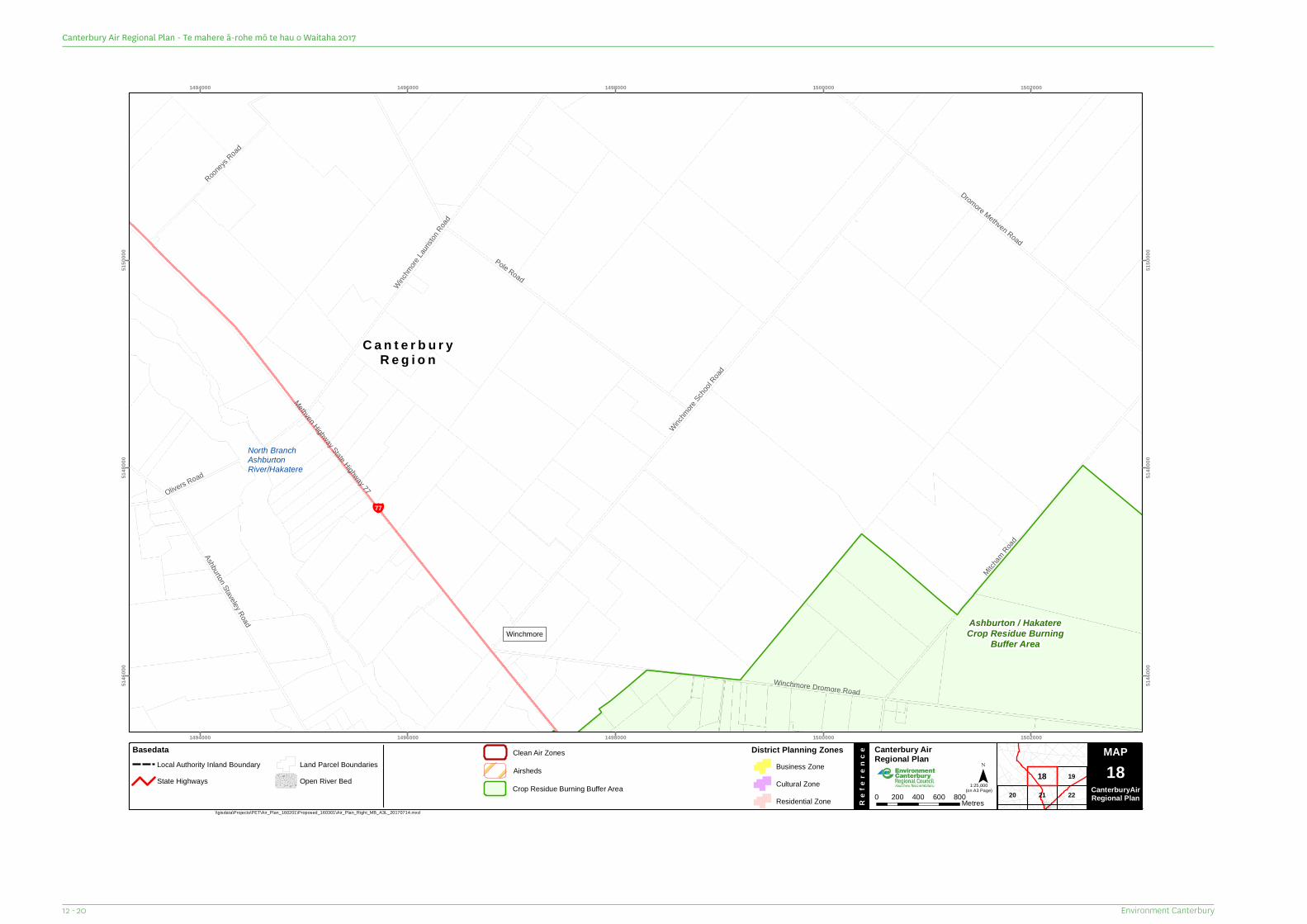
C a n t e r b u r yR e g i o n
¥77Olivers Road
Rooneys
Road
Ashburton Staveley Road
Dromore Methven Road
Winchm
ore La
uriston
Road
Mitcham
Road
Pole Road
Winchm
ore Scho
ol Road
Winchmore Dromore Road
State Highway 77
Methven HighwayNorth BranchAshburtonRiver/Hakatere
WinchmoreAshburton / HakatereCrop Residue Burning
Buffer Area
1494000
1494000
1496000
1496000
1498000
1498000
1500000
1500000
1502000
1502000
5146
000
5146
000
5148
000
5148
000
5150
000
5150
000
20 21
19
22
18
MAP Canterbury Air Regional Plan
Re
fere
nce
¯(on A3 Page)
\\gisdata\Projects\PET\Air_Plan_160201\Proposed_160301\Air_Plan_Right_MB_A3L_20170714.mxd
Map Series 0 200 400 600 800Metres
1:25,000
MAP18
CanterburyAirRegional Plan
BasedataLocal Authority Inland BoundaryState Highways
Land Parcel BoundariesOpen River Bed
District Planning ZonesBusiness ZoneCultural ZoneResidential Zone
Airsheds
Clean Air Zones
Crop Residue Burning Buffer Area
Environment Canterbury12 - 20
Canterbury Air Regional Plan - Te mahere ā-rohe mō te hau o Waitaha 2017
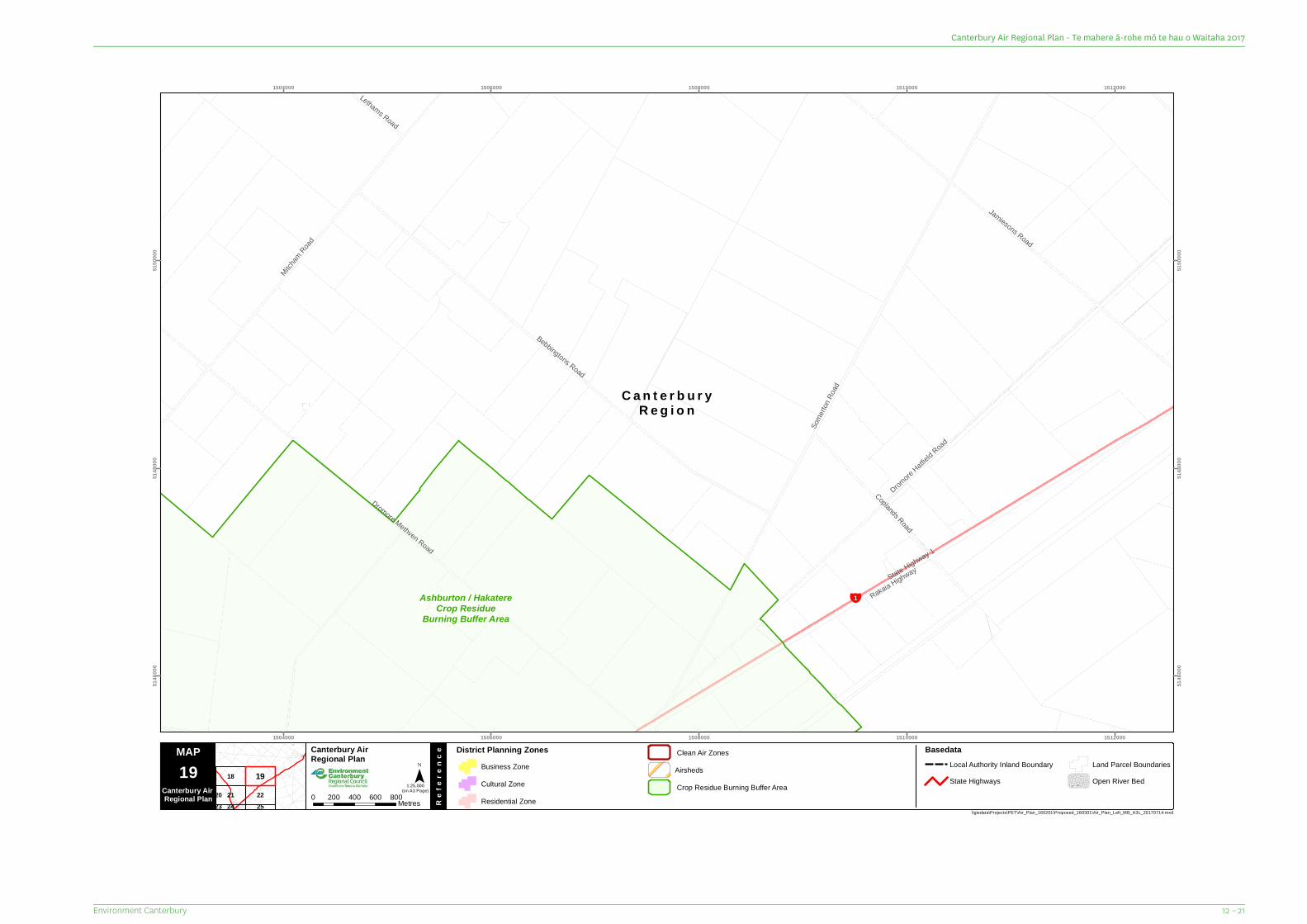
C a n t e r b u r yR e g i o n
¥1
Lethams Road
Coplands Road
Jamiesons Road
Mitcham
Road
Bebbingtons Road
State Highway 1
Rakaia Highway
Dromore Methven Road
Dromore
Hatfield R
oad
Some
rton R
oad
Ashburton / HakatereCrop Residue
Burning Buffer Area
1504000
1504000
1506000
1506000
1508000
1508000
1510000
1510000
1512000
1512000
5146
000
5146
000
5148
000
5148
000
5150
000
5150
000
18
21 222524
2023
19
MAP Canterbury Air Regional Plan
Re
fere
nce
¯(on A3 Page)
\\gisdata\Projects\PET\Air_Plan_160201\Proposed_160301\Air_Plan_Left_MB_A3L_20170714.mxd
19Canterbury Air Regional Plan 0 200 400 600 800Metres
District Planning ZonesBusiness ZoneCultural ZoneResidential Zone
1:25,000
BasedataLocal Authority Inland BoundaryState Highways
Land Parcel BoundariesOpen River Bed
AirshedsClean Air Zones
Crop Residue Burning Buffer Area
12 – 21Environment Canterbury
Canterbury Air Regional Plan - Te mahere ā-rohe mō te hau o Waitaha 2017
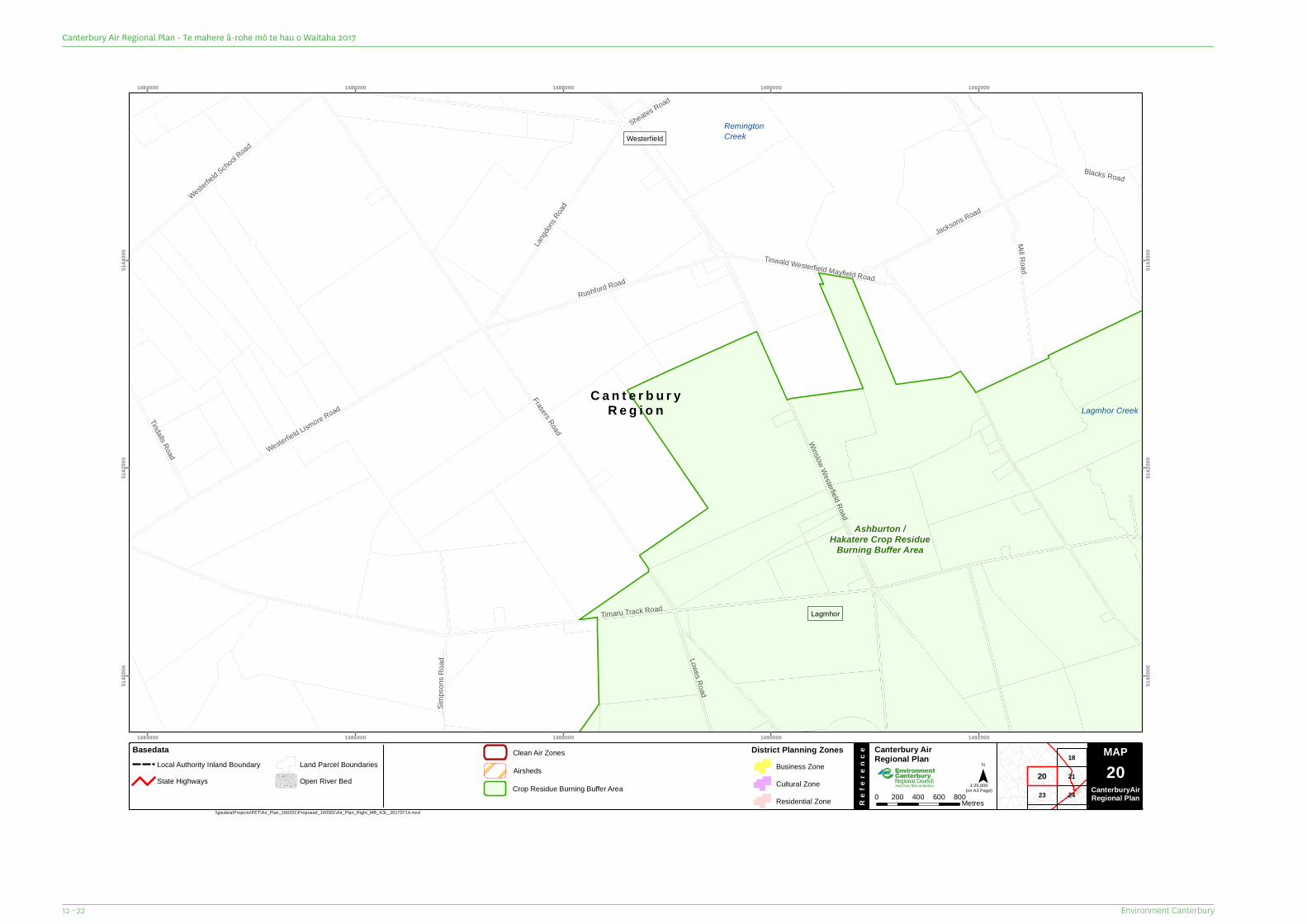
C a n t e r b u r yR e g i o n
Sheates Road
Blacks Road
Simps
ons R
oad Lowes Road
Tindalls Road
Jacksons RoadWester
field Scho
ol Road
Langdo
ns Ro
ad
Rushford RoadMill Road
Westerfield Lismore Road
Winslow Westerfield Road
Frasers Road
Tinwald Westerfield Mayfield Road
Timaru Track Road
RemingtonCreek
Lagmhor Creek
Westerfield
Lagmhor
Ashburton /Hakatere Crop Residue
Burning Buffer Area
1484000
1484000
1486000
1486000
1488000
1488000
1490000
1490000
1492000
1492000
5140
000
5140
000
5142
000
5142
000
5144
000
5144
000
23
21
18
24
20
MAP Canterbury Air Regional Plan
Re
fere
nce
¯(on A3 Page)
\\gisdata\Projects\PET\Air_Plan_160201\Proposed_160301\Air_Plan_Right_MB_A3L_20170714.mxd
Map Series 0 200 400 600 800Metres
1:25,000
MAP20
CanterburyAirRegional Plan
BasedataLocal Authority Inland BoundaryState Highways
Land Parcel BoundariesOpen River Bed
District Planning ZonesBusiness ZoneCultural ZoneResidential Zone
Airsheds
Clean Air Zones
Crop Residue Burning Buffer Area
Environment Canterbury12 - 22
Canterbury Air Regional Plan - Te mahere ā-rohe mō te hau o Waitaha 2017
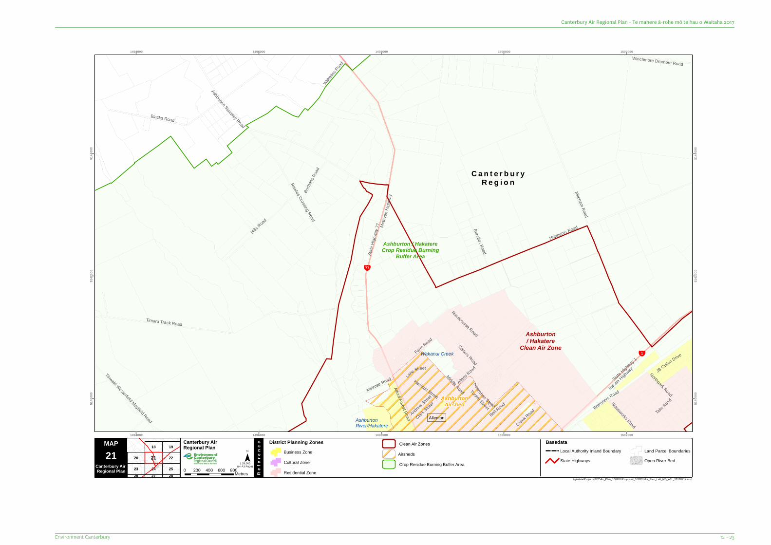
C a n t e r b u r yR e g i o n
¥1
¥77
Andrew Street
Wakelins
Road
Clark Street
Melrose Road Lane Street
Creek R
oad
Tucker Street
Northpark Road
Glassworks Road
Hanrahan Street
Carters RoadRundles Road
Bucha
nsRo
ad
JB Cullen Drive
Alford Forest Road Belt Road
Winchmore Dromore Road
Taits Road
Farm Road
Tinwald Westerfield Mayfield Road
Hills Road
Bremners Road
Harrison Street
Allens R
oad
Middle Road
Blacks Road
Timaru Track Road
Rakaia H
ighway
State Highway 1
Ashburton Staveley Road
Hepburns Road
Rawles Crossing Road
Racecourse Road
Mitcham Road
Methv
enHig
hway
State
Highw
ay 77
AshburtonRiver/Hakatere
Wakanui Creek
Allenton
AshburtonAirshed
Ashburton/ Hakatere
Clean Air Zone
Ashburton / HakatereCrop Residue Burning
Buffer Area
1494000
1494000
1496000
1496000
1498000
1498000
1500000
1500000
1502000
1502000
5140
000
5140
000
5142
000
5142
000
5144
000
5144
000
20
23
18
24
22
19
25282726
21
MAP Canterbury Air Regional Plan
Re
fere
nce
¯(on A3 Page)
\\gisdata\Projects\PET\Air_Plan_160201\Proposed_160301\Air_Plan_Left_MB_A3L_20170714.mxd
21Canterbury Air Regional Plan 0 200 400 600 800Metres
District Planning ZonesBusiness ZoneCultural ZoneResidential Zone
1:25,000
BasedataLocal Authority Inland BoundaryState Highways
Land Parcel BoundariesOpen River Bed
AirshedsClean Air Zones
Crop Residue Burning Buffer Area
12 – 23Environment Canterbury
Canterbury Air Regional Plan - Te mahere ā-rohe mō te hau o Waitaha 2017
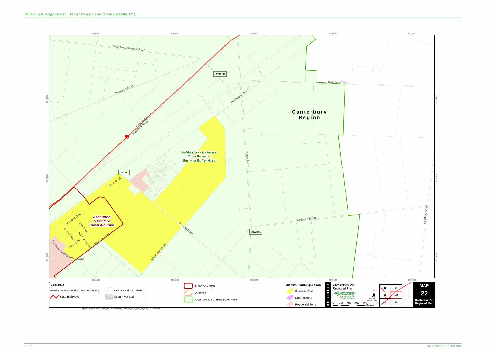
C a n t e r b u r yR e g i o n
¥1
Rainey Way
Office Road
Lynn Street
Crum StreetAshford Avenue
Drummond and Etheridge Walk
JB Cullen Drive
Milton R
oad North
Hanrahans Road
Company Road
Chert
sey R
oad
Fairfield Road
Winchmore Dromore Road
Hepburns RoadTaverners Road
Stanley Road
Singletree Road
State Highway 1
Rakaia H
ighway
Fairton
Dromore
Newland
Ashburton/ Hakatere
Clean Air Zone
Ashburton / HakatereCrop Residue
Burning Buffer Area
1504000
1504000
1506000
1506000
1508000
1508000
1510000
1510000
1512000
1512000
5140
000
5140
000
5142
000
5142
000
5144
000
5144
000
21
18
24
19
25
22
MAP Canterbury Air Regional Plan
Re
fere
nce
¯(on A3 Page)
\\gisdata\Projects\PET\Air_Plan_160201\Proposed_160301\Air_Plan_Right_MB_A3L_20170714.mxd
Map Series 0 200 400 600 800Metres
1:25,000
MAP22
CanterburyAirRegional Plan
BasedataLocal Authority Inland BoundaryState Highways
Land Parcel BoundariesOpen River Bed
District Planning ZonesBusiness ZoneCultural ZoneResidential Zone
Airsheds
Clean Air Zones
Crop Residue Burning Buffer Area
Environment Canterbury12 - 24
Canterbury Air Regional Plan - Te mahere ā-rohe mō te hau o Waitaha 2017
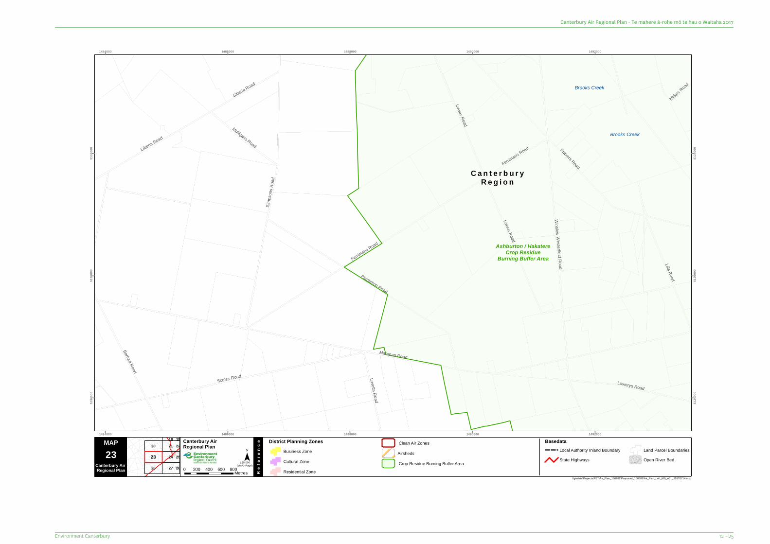
C a n t e r b u r yR e g i o n
Millars Road
Scales Road
Ferrimans Road
Siberia Road
Lovetts Road
Mulligans Road
Ferrimans Road
Lowerys Road
Lills Road
Lowes Road
Siberia Road
Barford Road
Lowes Road
Plantation Road
Simps
ons R
oad
Frasers Road
Winslow Westerfield Road
Maronan Road
Brooks Creek
Brooks Creek
Ashburton / HakatereCrop Residue
Burning Buffer Area
1484000
1484000
1486000
1486000
1488000
1488000
1490000
1490000
1492000
1492000
5134
000
5134
000
5136
000
5136
000
5138
000
5138
000
20
26
21
27
24
1822
25
28
19
23
MAP Canterbury Air Regional Plan
Re
fere
nce
¯(on A3 Page)
\\gisdata\Projects\PET\Air_Plan_160201\Proposed_160301\Air_Plan_Left_MB_A3L_20170714.mxd
23Canterbury Air Regional Plan 0 200 400 600 800Metres
District Planning ZonesBusiness ZoneCultural ZoneResidential Zone
1:25,000
BasedataLocal Authority Inland BoundaryState Highways
Land Parcel BoundariesOpen River Bed
AirshedsClean Air Zones
Crop Residue Burning Buffer Area
12 – 25Environment Canterbury
Canterbury Air Regional Plan - Te mahere ā-rohe mō te hau o Waitaha 2017
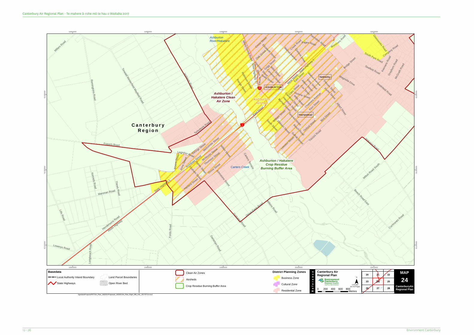
C a n t e r b u r yR e g i o n
¥1
¥77
Leeston S
treet
South Park Road
East Street
BirdStree
t
Porter Street
Sealy Street
Anne
Stree
tSuffolk StreetWilkin Street
Agnes Street
Graham Street
Brya
ntStr
eetLagmhor Road
Bremners Road
Saunders Road
Harland Street
Magnolia Drive
Queens Drive
Range Street
Long
beac
h Roa
d
Grigg Stree
t
Glassworks Road
McGr
ath Ro
ad
Cross Street
Gray
burn
Road
Keen
ans R
oad
Wills Street
Cameron StreetCox Street
Burnett Street
Aitken StreetWalnut Avenue
Havelock Street
Lills Road
Victoria Street
George Street
Beach Road
River Te rrace
Creek R
oad
Lowerys Road
Kennels Road
Pages Road
Grey Street
Alford Forest Road
Robinson Street
Oak Grove
Dobson Street
South Street
Elizabeth StreetWills Street
Cameron Street
Havelock Street
Walnut Avenue
Oxford Street
Millars Road
Tancred Street
Grove Farm Road
Princes Street
Eton Stree
t
Cochranes R
oad
Johnstone Street
Cass Street
Albert Street
Thews Road
Carters Terrace
Company Road
Tarbottons Road
McMurdo Street
Grove Street
Gartartan Road
Trevors R
oad
William Stree
t
State Highway 77
Chalmers Aven
ue
Bridge Street
Fords
Roa
d
Smithfield Road
Thomson StreetMelcombe Street
Archibald Street
East Stree
t
West Street
Hollands Road
Seafield RoadState Highway 1
Remingtons Road
Grahams Road
Maronan Road
Milton Road S
outh
Wilkins Road
Frasers Road
Hinds Highway
Hendersons Road
Wakanui Road
Tinwald Westerfield Mayfield Road
Beach Road East
State Highway 1
AshburtonRiver/Hakatere
Carters Creek
Netherby
ASHBURTON
Hampstead
AshburtonAirshed
Ashburton /Hakatere Clean
Air Zone
Ashburton / HakatereCrop Residue
Burning Buffer Area
1494000
1494000
1496000
1496000
1498000
1498000
1500000
1500000
1502000
1502000
5134
000
5134
000
5136
000
5136
000
5138
000
5138
000
20
26
23
21
27
22
28
2524
MAP Canterbury Air Regional Plan
Re
fere
nce
¯(on A3 Page)
\\gisdata\Projects\PET\Air_Plan_160201\Proposed_160301\Air_Plan_Right_MB_A3L_20170714.mxd
Map Series 0 200 400 600 800Metres
1:25,000
MAP24
CanterburyAirRegional Plan
BasedataLocal Authority Inland BoundaryState Highways
Land Parcel BoundariesOpen River Bed
District Planning ZonesBusiness ZoneCultural ZoneResidential Zone
Airsheds
Clean Air Zones
Crop Residue Burning Buffer Area
Environment Canterbury12 - 26
Canterbury Air Regional Plan - Te mahere ā-rohe mō te hau o Waitaha 2017
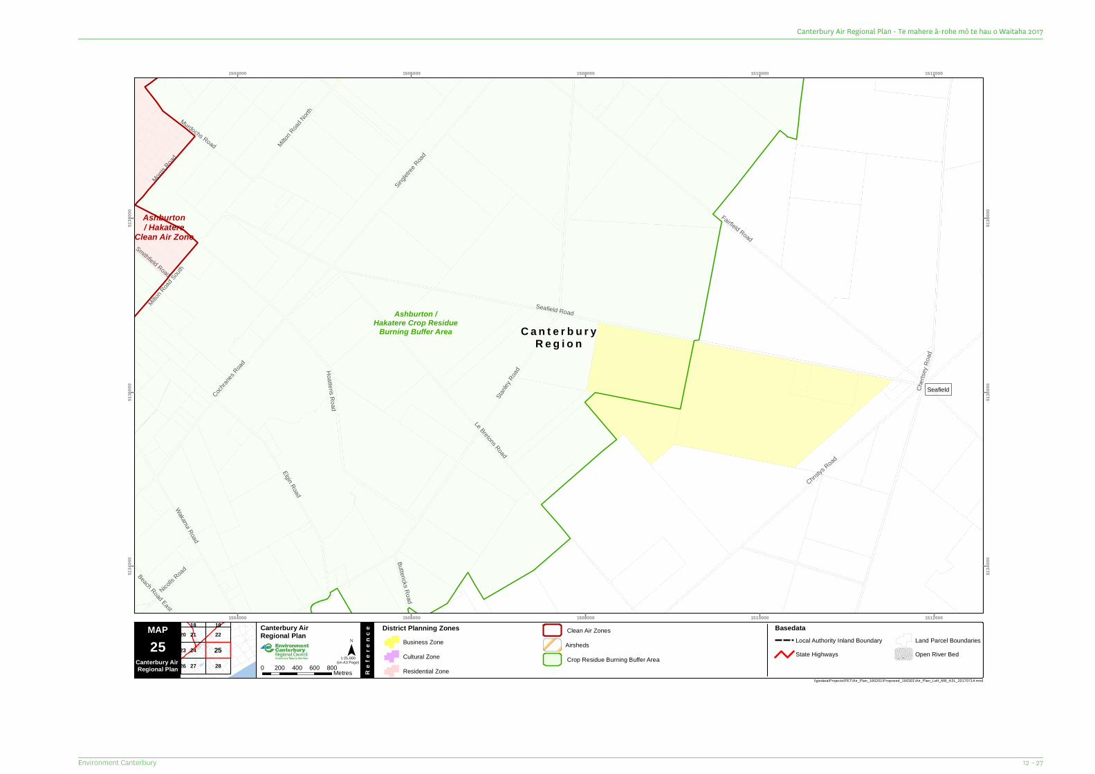
C a n t e r b u r yR e g i o n
Milton R
oad North
Nicolls R
oad
Smithfield Road
Buttericks Road
Beach Road East
Morris R
oad
Milton R
oad Sout
h
Murdochs Road
Wakanui Road
Elgin Road
Singletr
ee Road
Cochran
es Road Hoattens Road
Christys
Road
Le Bretons Road
Fairfield Road
Chert
sey R
oad
Stanle
y Road
Seafield Road
Seafield
Ashburton/ Hakatere
Clean Air Zone
Ashburton /Hakatere Crop Residue
Burning Buffer Area
1504000
1504000
1506000
1506000
1508000
1508000
1510000
1510000
1512000
1512000
5134
000
5134
000
5136
000
5136
000
5138
000
5138
000
21
27
24
28
2218 19
26
23
20
25
MAP Canterbury Air Regional Plan
Re
fere
nce
¯(on A3 Page)
\\gisdata\Projects\PET\Air_Plan_160201\Proposed_160301\Air_Plan_Left_MB_A3L_20170714.mxd
25Canterbury Air Regional Plan 0 200 400 600 800Metres
District Planning ZonesBusiness ZoneCultural ZoneResidential Zone
1:25,000
BasedataLocal Authority Inland BoundaryState Highways
Land Parcel BoundariesOpen River Bed
AirshedsClean Air Zones
Crop Residue Burning Buffer Area
12 – 27Environment Canterbury
Canterbury Air Regional Plan - Te mahere ā-rohe mō te hau o Waitaha 2017
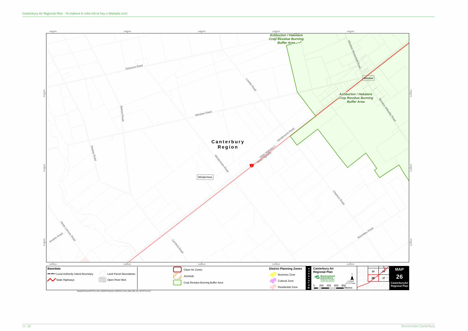
C a n t e r b u r yR e g i o n
¥1
Annetts Road
Lynnford Road
Winslow Westerfield Road
Hinds Lismore Road
Winslow Willowby Road
Boundary Road
Lovetts Road
Chatmos Road
Barford Road
Dicksons Road
Swamp Road
Windermere Road
Hendersons Road
Winslow Road
Hinds HighwayState Highway 1
Winslow
Windermere
Ashburton / HakatereCrop Residue Burning
Buffer Area
Ashburton / HakatereCrop Residue Burning
Buffer Area
1484000
1484000
1486000
1486000
1488000
1488000
1490000
1490000
1492000
1492000
5128
000
5128
000
5130
000
5130
000
5132
000
5132
000
23
27
24
26
MAP Canterbury Air Regional Plan
Re
fere
nce
¯(on A3 Page)
\\gisdata\Projects\PET\Air_Plan_160201\Proposed_160301\Air_Plan_Right_MB_A3L_20170714.mxd
Map Series 0 200 400 600 800Metres
1:25,000
MAP26
CanterburyAirRegional Plan
BasedataLocal Authority Inland BoundaryState Highways
Land Parcel BoundariesOpen River Bed
District Planning ZonesBusiness ZoneCultural ZoneResidential Zone
Airsheds
Clean Air Zones
Crop Residue Burning Buffer Area
Environment Canterbury12 - 28
Canterbury Air Regional Plan - Te mahere ā-rohe mō te hau o Waitaha 2017
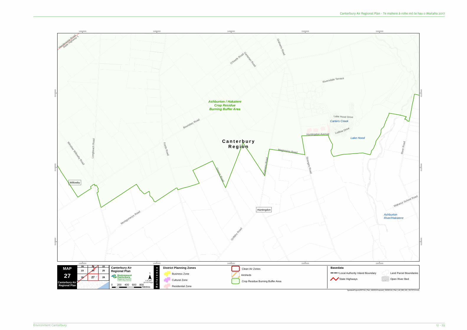
C a n t e r b u r yR e g i o n
O'Keefe Road
Hendersons Road
Ludlow Drive
State Highway 1
Wakanui School Road
Grahams Road
Maginness Road
Riversdale Terrace
Huntingdon Avenue
Gartartan Road
Montgomerys Road
Winslow Willowby Road
Griffiths
Road
Lake Hood Drive
Greens Road
River
Road
Grah
ams R
oad Stranges Road
Long
beac
h Roa
d
Fords Road
Boundary Road Carters Creek
AshburtonRiver/Hakatere
Lake Hood
Willowby
Huntingdon
Ashburton / HakatereCrop Residue
Burning Buffer Area
1494000
1494000
1496000
1496000
1498000
1498000
1500000
1500000
1502000
1502000
5128
000
5128
000
5130
000
5130
000
5132
000
5132
000
26
23 24
28
2520 21 22
27
MAP Canterbury Air Regional Plan
Re
fere
nce
¯(on A3 Page)
\\gisdata\Projects\PET\Air_Plan_160201\Proposed_160301\Air_Plan_Left_MB_A3L_20170714.mxd
27Canterbury Air Regional Plan 0 200 400 600 800Metres
District Planning ZonesBusiness ZoneCultural ZoneResidential Zone
1:25,000
BasedataLocal Authority Inland BoundaryState Highways
Land Parcel BoundariesOpen River Bed
AirshedsClean Air Zones
Crop Residue Burning Buffer Area
12 – 29Environment Canterbury
Canterbury Air Regional Plan - Te mahere ā-rohe mō te hau o Waitaha 2017
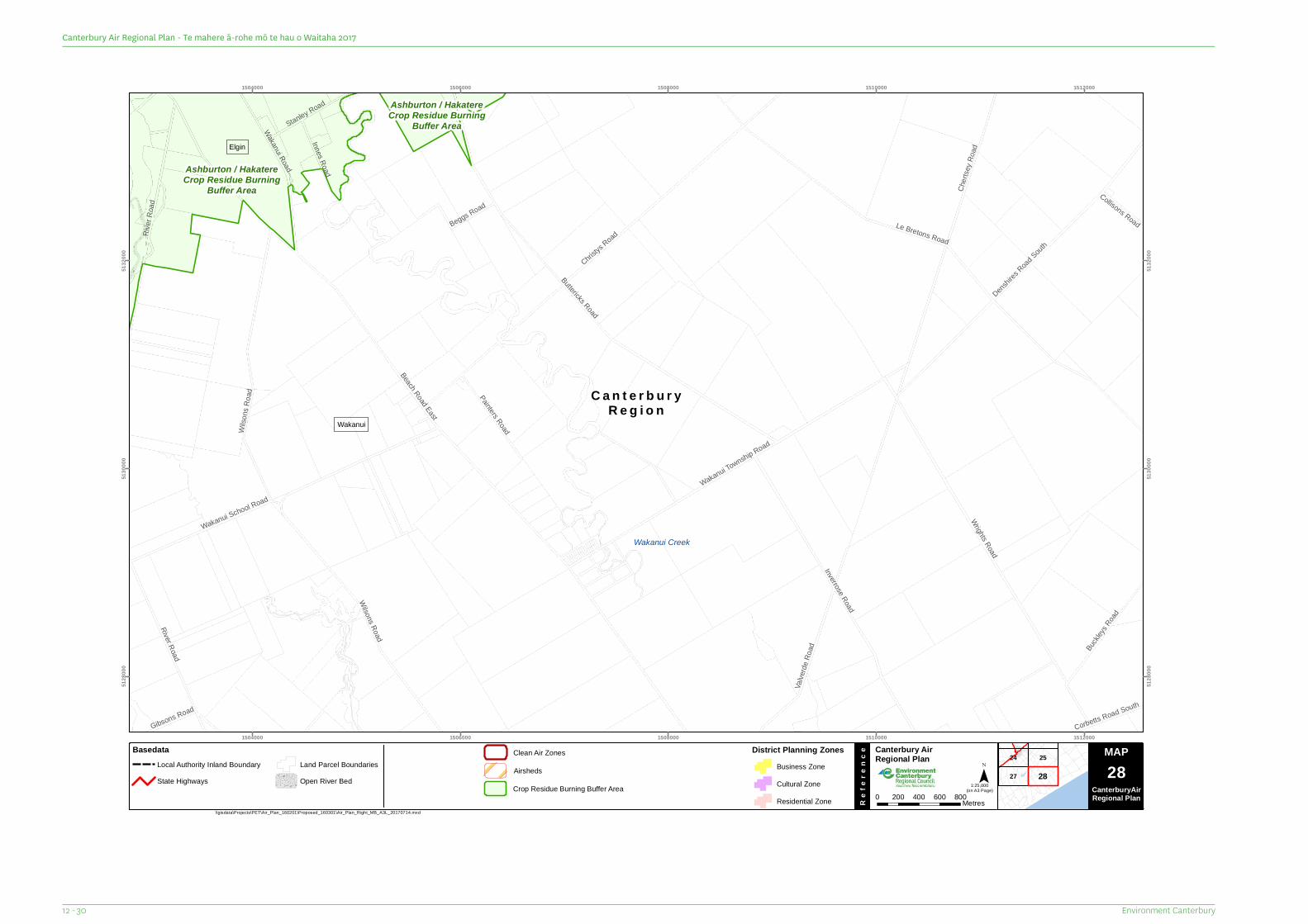
C a n t e r b u r yR e g i o n
Collisons Road
Corbetts Road South
Gibsons Road
Innes Road
Stanley Road
Beggs Road
Painters Road
Buckl
eys Road
Chert
sey R
oad
Valve
rde Ro
ad
Wakanui Road
River Road
River
Road
Wilso
ns R
oad
Wilsons Road
Inverrose Road
Wrights Road
Wakanui School Road
Denshire
s Road
South
Wakanui Township Road
Christys
Road
Buttericks Road
Le Bretons Road
Beach Road East
Wakanui Creek
Wakanui
Elgin
Ashburton / HakatereCrop Residue Burning
Buffer Area
Ashburton / HakatereCrop Residue Burning
Buffer Area
1504000
1504000
1506000
1506000
1508000
1508000
1510000
1510000
1512000
1512000
5128
000
5128
000
5130
000
5130
000
5132
000
5132
000
27
24 25
28
MAP Canterbury Air Regional Plan
Re
fere
nce
¯(on A3 Page)
\\gisdata\Projects\PET\Air_Plan_160201\Proposed_160301\Air_Plan_Right_MB_A3L_20170714.mxd
Map Series 0 200 400 600 800Metres
1:25,000
MAP28
CanterburyAirRegional Plan
BasedataLocal Authority Inland BoundaryState Highways
Land Parcel BoundariesOpen River Bed
District Planning ZonesBusiness ZoneCultural ZoneResidential Zone
Airsheds
Clean Air Zones
Crop Residue Burning Buffer Area
Environment Canterbury12 - 30
Canterbury Air Regional Plan - Te mahere ā-rohe mō te hau o Waitaha 2017
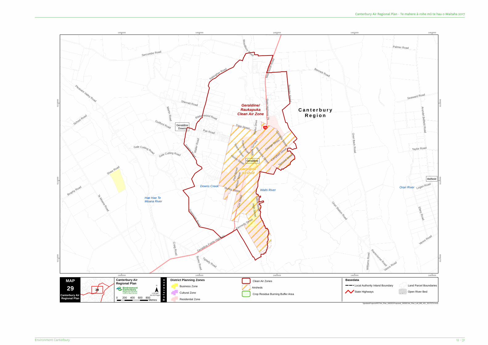
C a n t e r b u r yR e g i o n
¥79
Craig Road
High Street
Tancred Street
Forest RoadWalle
r Roa
d
Campbell Street
Logan Road
Burke Road
Waihi
Terrac
e
George Street
Vance Road
Willia
ms R
oad
Totara StreetVance Road
Tripp Street
Sherratt Road
Taylor RoadGale Cutting Road
Huffey Street
Kennedy Street
Ribbonwood RoadRacecourse Road
Connolly Street
Tiplady Road
Wilso
n Stre
et
Gale Cutting Road
Brophy Road
Martin Road
Palmer Road
Peel
Stree
t
Hislop Street
Seaward Road
Pye Road
School RoadGuilford Road
Shaw Road
Ellery Road
McKenzie Street
Woodbury Road
Templer Street
Kalaugher Road
Cox S
treet
Waitu
i Driv
eGeraldine-Fairlie Highway
Main
North
Roa
d
Bennett Road
Talbot StreetGreenvale Road
Orari Station Road
Te Moana Road
Arundel Belfield Road
Downs Road
Sercombe Road
Orari Back Road
Pleasant Valley Road
State Highway 79
Hae Hae TeMoana River
Downs Creek Orari RiverWaihi River
GeraldineDowns
Belfield
Geraldine
GeraldineAirshed
Geraldine/Raukapuka
Clean Air Zone
1456000
1456000
1458000
1458000
1460000
1460000
1462000
1462000
1464000
1464000
5114
000
5114
000
5116
000
5116
000
5118
000
5118
000
29
MAP Canterbury Air Regional Plan
Re
fere
nce
¯(on A3 Page)
\\gisdata\Projects\PET\Air_Plan_160201\Proposed_160301\Air_Plan_Left_MB_A3L_20170714.mxd
29Canterbury Air Regional Plan 0 200 400 600 800Metres
District Planning ZonesBusiness ZoneCultural ZoneResidential Zone
1:25,000
BasedataLocal Authority Inland BoundaryState Highways
Land Parcel BoundariesOpen River Bed
AirshedsClean Air Zones
Crop Residue Burning Buffer Area
12 – 31Environment Canterbury
Canterbury Air Regional Plan - Te mahere ā-rohe mō te hau o Waitaha 2017
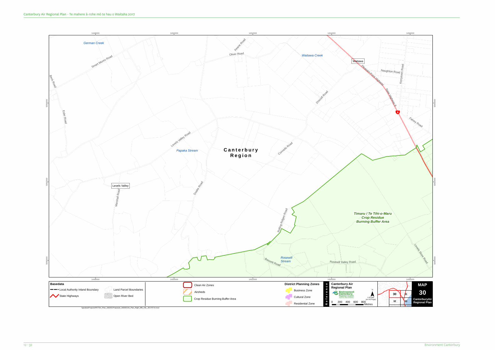
C a n t e r b u r yR e g i o n
¥8
Beck Road
Marsh
all R
oad
Keane R
oad
Connells Road
Falvey Road
Levels Store Road
Bassett Road
EslerRoad
Naughton Road
Kerry
town R
oad
Oliver Road
Rosewill Valley Road
Driscoll
Road
Smart Munro Road
State Highway 8
Pleasant Point Highway
Doake
Road
Rollin
g Ridg
esRo
ad
Levels Valley Road
German Creek
Papaka Stream
Waitawa Creek
RosewillStream
Waitawa
Levels Valley
Timaru / Te Tihi-o-MaruCrop Residue
Burning Buffer Area
1448000
1448000
1450000
1450000
1452000
1452000
1454000
1454000
1456000
1456000
5090
000
5090
000
5092
000
5092
000
5094
000
5094
000
32
31
33
30
MAP Canterbury Air Regional Plan
Re
fere
nce
¯(on A3 Page)
\\gisdata\Projects\PET\Air_Plan_160201\Proposed_160301\Air_Plan_Right_MB_A3L_20170714.mxd
Map Series 0 200 400 600 800Metres
1:25,000
MAP30
CanterburyAirRegional Plan
BasedataLocal Authority Inland BoundaryState Highways
Land Parcel BoundariesOpen River Bed
District Planning ZonesBusiness ZoneCultural ZoneResidential Zone
Airsheds
Clean Air Zones
Crop Residue Burning Buffer Area
Environment Canterbury12 - 32
Canterbury Air Regional Plan - Te mahere ā-rohe mō te hau o Waitaha 2017
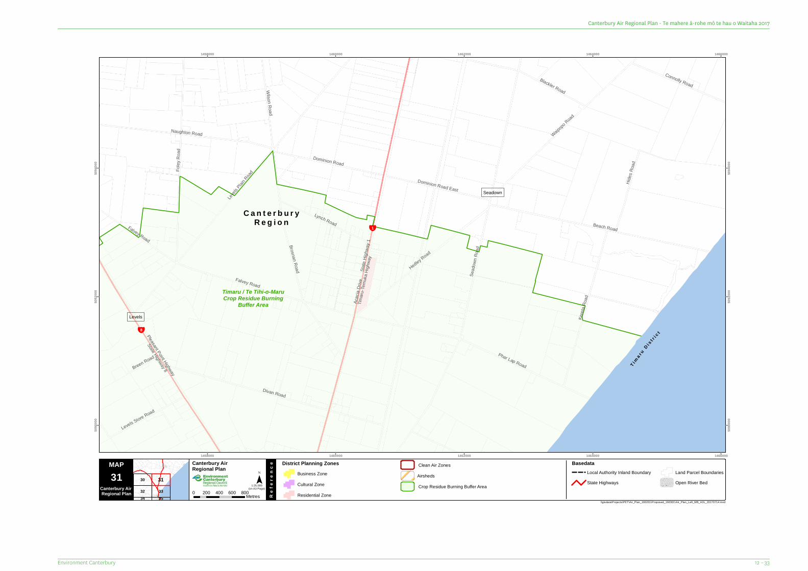
C a n t e r b u r yR e g i o n
¥1
¥8
T ima ru
D i s t r ic t
Breen Road
Falvey Road
Divan Road
Acac
ia Dr
ive
Blackler RoadWilson Road
Falvey Road
Lynch Road
Connolly Road
Levels Store Road
Dominion Road East
Phar Lap Road
Dominion Road
Hides
Roa
d
Keret
a Roa
d
Hedley Road
Naughton Road Waipopo
Road
Foley
Roa
d
Brosnan Road
Pleasant Point Highway
State Highway 8
Beach RoadLev
els Plain
Road
State
Highw
ay 1
Timaru
-Temu
ka Hi
ghwa
y
Sead
own R
oad
Levels
Seadown
Timaru / Te Tihi-o-MaruCrop Residue Burning
Buffer Area
1458000
1458000
1460000
1460000
1462000
1462000
1464000
1464000
1466000
1466000
5090
000
5090
000
5092
000
5092
000
5094
000
5094
000
30
32 333534
31
MAP Canterbury Air Regional Plan
Re
fere
nce
¯(on A3 Page)
\\gisdata\Projects\PET\Air_Plan_160201\Proposed_160301\Air_Plan_Left_MB_A3L_20170714.mxd
31Canterbury Air Regional Plan 0 200 400 600 800Metres
District Planning ZonesBusiness ZoneCultural ZoneResidential Zone
1:25,000
BasedataLocal Authority Inland BoundaryState Highways
Land Parcel BoundariesOpen River Bed
AirshedsClean Air Zones
Crop Residue Burning Buffer Area
12 – 33Environment Canterbury
Canterbury Air Regional Plan - Te mahere ā-rohe mō te hau o Waitaha 2017
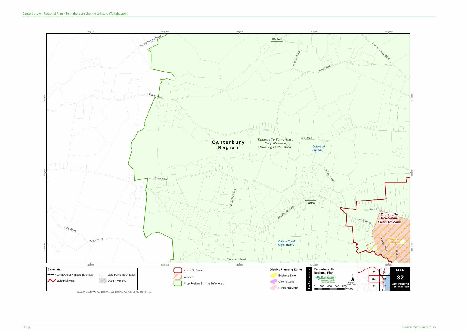
C a n t e r b u r yR e g i o n
Sprin
g Roa
d
Poplar Street
Cliffs Road
Oakwood Road
Basse
tt Roa
d
Rosewill Valley Road
Pages Road
Claremont Road
Taiko Road
Gleniti Road
Rolling Ridges Road
King Road
Broc
kley R
oad
Rosebrook Road
Spur Road
Fraser Road
Hadlow Road
Otipua CreekNorth Branch
OakwoodStream
Hadlow
Rosewill
TimaruAirshed
Timaru / TeTihi-o-Maru
Clean Air Zone
Timaru / Te Tihi-o-MaruCrop Residue
Burning Buffer Area
1448000
1448000
1450000
1450000
1452000
1452000
1454000
1454000
1456000
1456000
5084
000
5084
000
5086
000
5086
000
5088
000
5088
000
30
34
31
33
35
32
MAP Canterbury Air Regional Plan
Re
fere
nce
¯(on A3 Page)
\\gisdata\Projects\PET\Air_Plan_160201\Proposed_160301\Air_Plan_Right_MB_A3L_20170714.mxd
Map Series 0 200 400 600 800Metres
1:25,000
MAP32
CanterburyAirRegional Plan
BasedataLocal Authority Inland BoundaryState Highways
Land Parcel BoundariesOpen River Bed
District Planning ZonesBusiness ZoneCultural ZoneResidential Zone
Airsheds
Clean Air Zones
Crop Residue Burning Buffer Area
Environment Canterbury12 - 34
Canterbury Air Regional Plan - Te mahere ā-rohe mō te hau o Waitaha 2017
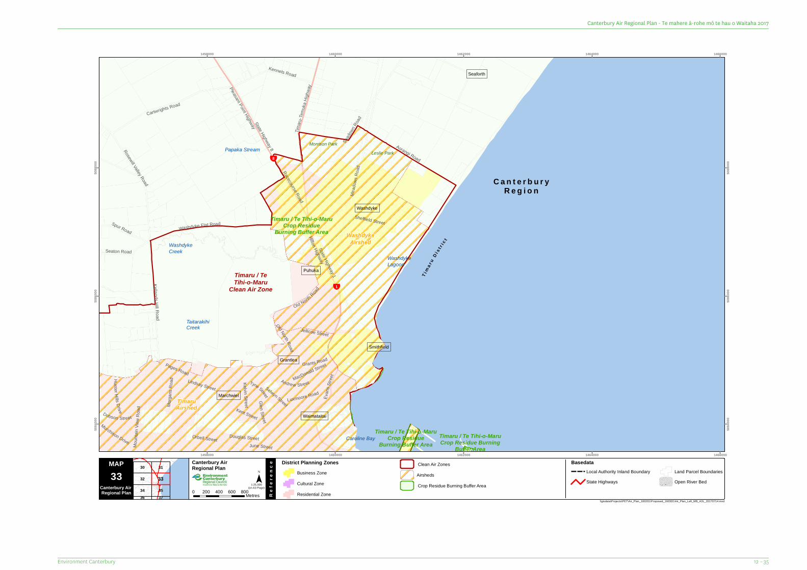
C a n t e r b u r yR e g i o n
¥1
¥8
T im a r
uD i s
t r ic t
Kelvin Street
June Street
Tyne Street
Hun t er H ills Drive
Glen Street
Dobson Street
Sheffield Street
Kent StreetMurchison Drive
Spur Road
Grants Road
Seaton Road
MacDonald Street
Lindsay StreetAndrew Street
Luxmoore Road
Jellicoe Street
Orbell Street
Racecourse Road
Old North Road
Kennels Road
Morga
ns R
oad
Old North
Road
Selwyn Street
Moun
tain V
iew R
oad
Douglas Street
Aorangi Road
Timaru
-Temu
ka Hi
ghwa
yPleasant Point Highway
Kellands Hill Road
Cartwrights Road
Rosewill Valley Road
Evan
s Stre
et
Washdyke Flat Road
Pages Road
Mead
ows R
oad
Seado
wn Ro
ad
Hilton Highway
State Highway 8
State Highway 1
Morrison ParkLeslie Park
WashdykeCreek
Papaka Stream
WashdykeLagoon
Caroline Bay
TaitarakihiCreek
Waimataitai
Grantlea
Smithfield
Marchwiel
Seaforth
Puhuka
Washdyke
TimaruAirshed
WashdykeAirshed
Timaru / TeTihi-o-Maru
Clean Air Zone
Timaru / Te Tihi-o-MaruCrop Residue Burning
Buffer Area
Timaru / Te Tihi-o-MaruCrop Residue
Burning Buffer Area
Timaru / Te Tihi-o-MaruCrop Residue
Burning Buffer Area
1458000
1458000
1460000
1460000
1462000
1462000
1464000
1464000
1466000
1466000
5084
000
5084
000
5086
000
5086
000
5088
000
5088
000
30
32
34
31
353736
33
MAP Canterbury Air Regional Plan
Re
fere
nce
¯(on A3 Page)
\\gisdata\Projects\PET\Air_Plan_160201\Proposed_160301\Air_Plan_Left_MB_A3L_20170714.mxd
33Canterbury Air Regional Plan 0 200 400 600 800Metres
District Planning ZonesBusiness ZoneCultural ZoneResidential Zone
1:25,000
BasedataLocal Authority Inland BoundaryState Highways
Land Parcel BoundariesOpen River Bed
AirshedsClean Air Zones
Crop Residue Burning Buffer Area
12 – 35Environment Canterbury
Canterbury Air Regional Plan - Te mahere ā-rohe mō te hau o Waitaha 2017
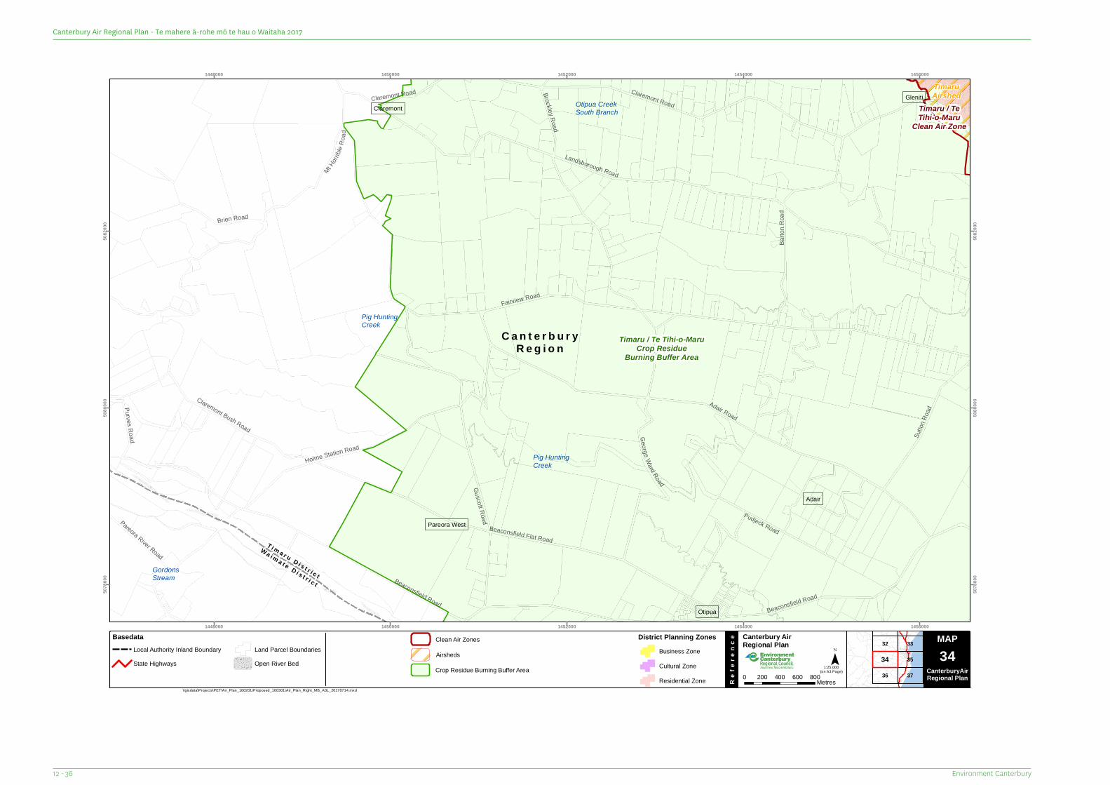
C a n t e r b u r yR e g i o n
T i m a r u D i s t r i c t
Wa i m a t e D i s t r i c t
Guscott Road
Brien Road
Claremont Road
Pareora River Road
Sutto
n Roa
dPurves Road
Barto
n Roa
d
Claremont Bush Road
Brockley Road
Pudjeck Road
George Ward Road
Beaconsfield Road
Mt Horr
ible R
oad
Beaconsfield Flat Road
Beaconsfield Road
Holme Station Road
Claremont Road
Adair Road
Landsborough Road
Fairview Road
GordonsStream
Pig HuntingCreek
Otipua CreekSouth Branch
Pig HuntingCreek
Pareora West
Claremont
Otipua
Adair
GlenitiTimaruAirshed
Timaru / TeTihi-o-Maru
Clean Air Zone
Timaru / Te Tihi-o-MaruCrop Residue
Burning Buffer Area
1448000
1448000
1450000
1450000
1452000
1452000
1454000
1454000
1456000
1456000
5078
000
5078
000
5080
000
5080
000
5082
000
5082
000
36
32 33
37
3534
MAP Canterbury Air Regional Plan
Re
fere
nce
¯(on A3 Page)
\\gisdata\Projects\PET\Air_Plan_160201\Proposed_160301\Air_Plan_Right_MB_A3L_20170714.mxd
Map Series 0 200 400 600 800Metres
1:25,000
MAP34
CanterburyAirRegional Plan
BasedataLocal Authority Inland BoundaryState Highways
Land Parcel BoundariesOpen River Bed
District Planning ZonesBusiness ZoneCultural ZoneResidential Zone
Airsheds
Clean Air Zones
Crop Residue Burning Buffer Area
Environment Canterbury12 - 36
Canterbury Air Regional Plan - Te mahere ā-rohe mō te hau o Waitaha 2017
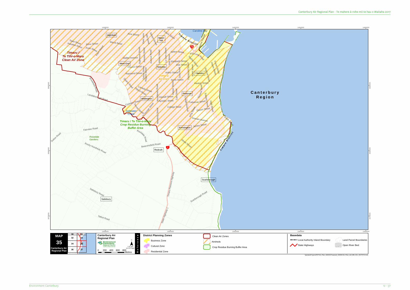
C a n t e r b u r yR e g i o n
¥78
¥1 T ima r
uD i s
t r ic t
T i m a r u D i s t r i c t
Marin
e Para
de
Brookfield Road
Raymond Street
Edward Street
Dee Street
Sutton Road
Devon Street
Shaw Street
Nile Street
Puriri Street
June Street
Kauri
Street
Aynsley Street
Rege
nt St
reet
Park
Lane
Oxfor
d Stre
et
Rimu Street
St Geor
ge Str
eet
Sophia Street
Selwyn Street
Pres
ton S
treet
Rathm
ore St
reet
Sefton Street
Bank
Stre
et
Maltby Avenue
York
Stree
t
James StreetMowb
ray St
reet
Tawa StreetPukatea Street
Port Loop Road
Catherine Street
Elizabeth Street Hayes Street
Evans Street
Fraser Street
Canada Street
Quarry Road
Heaton Street
Wood
lands
Roa
d
Queen Street
Grey
Roa
d
Harpe
r Stre
etCa
in St
reet
College Road
Victor
iaSt
reet
Domain Avenue
Coonoor Road
Arthur Street
Le C
ren St
reet
Aven
ue R
oad
Wilso
n Stre
et
Theo
dosia
Stre
et
CraigieAvenue
Hassall Street
High Street
Stafford Street
South Street
Rockdale Road
Salisbury Road
Scarborough RoadKin
g Stre
et
Talbot Road
Church Street
Rocky Hundreds Road
Landsborough Road
North Street
Fairview Road
Timaru
-Pare
ora H
ighwa
y
Otipua Road
Wai-Iti Road
Beaconsfield Road
State
Highw
ay 1
RosedaleGardens
SaltwaterCreek
Caroline Bay
West End
Watlington
Seaview
MaoriHill
Scarborough
Highfield
Redruth
Salisbury
Kensington
TIMARU
Parkside
TimaruAirshed
Timaru /Te Tihi-o-MaruClean Air Zone
Timaru / Te Tihi-o-MaruCrop Residue Burning
Buffer Area
1458000
1458000
1460000
1460000
1462000
1462000
1464000
1464000
1466000
1466000
5078
000
5078
000
5080
000
5080
000
5082
000
5082
000
36
32
34
37
3330 31
35
MAP Canterbury Air Regional Plan
Re
fere
nce
¯(on A3 Page)
\\gisdata\Projects\PET\Air_Plan_160201\Proposed_160301\Air_Plan_Left_MB_A3L_20170714.mxd
35Canterbury Air Regional Plan 0 200 400 600 800Metres
District Planning ZonesBusiness ZoneCultural ZoneResidential Zone
1:25,000
BasedataLocal Authority Inland BoundaryState Highways
Land Parcel BoundariesOpen River Bed
AirshedsClean Air Zones
Crop Residue Burning Buffer Area
12 – 37Environment Canterbury
Canterbury Air Regional Plan - Te mahere ā-rohe mō te hau o Waitaha 2017
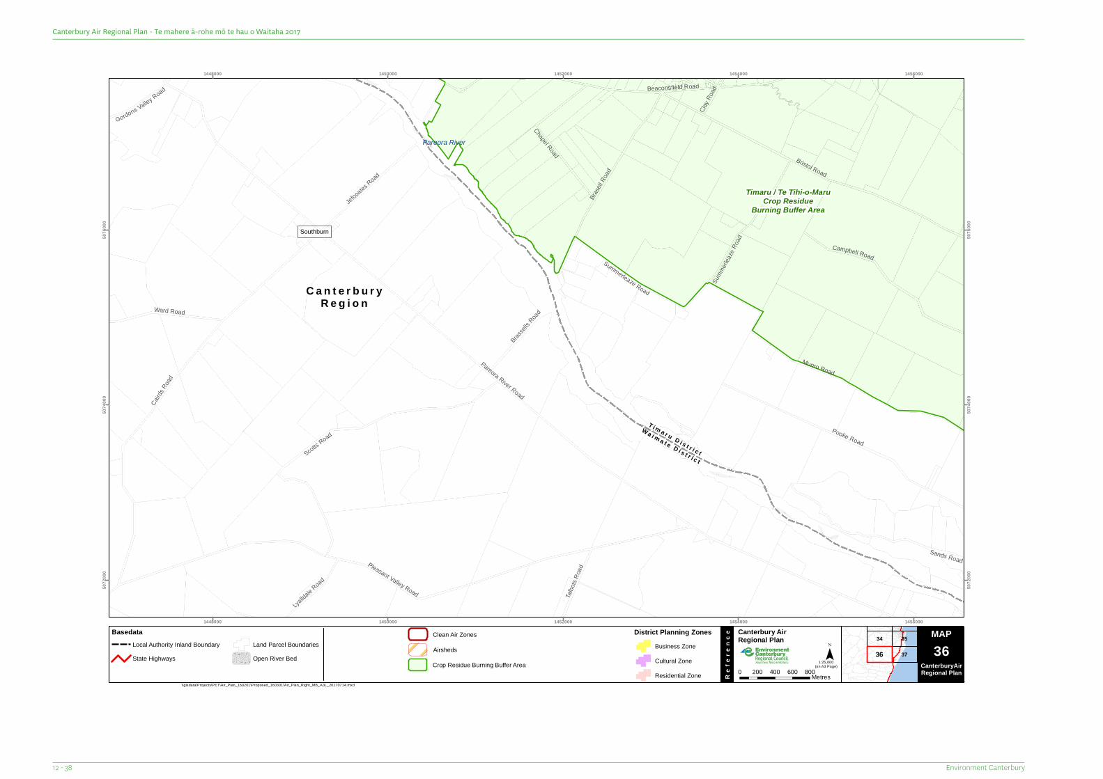
C a n t e r b u r yR e g i o n
T i m a r u D i s t r i c t
Wa i m a t e D i s t r i c t
Clay R
oad
Sands RoadChapel Road
Gordons Valley Road
Talbo
ts Roa
d
Lyallda
le Road
Scotts Road
Ward Road
Jefcoates
Road
Brassel
ls Road
Summerl
eaze
Road
Summerleaze Road
Campbell Road
Brasel
l Road
Beaconsfield Road
Pooke Road
Munro Road
Bristol Road
Cairds
Road
Pleasant Valley Road
Pareora River Road
Pareora River
Southburn
Timaru / Te Tihi-o-MaruCrop Residue
Burning Buffer Area
1448000
1448000
1450000
1450000
1452000
1452000
1454000
1454000
1456000
1456000
5072
000
5072
000
5074
000
5074
000
5076
000
5076
000
34
37
35
36
MAP Canterbury Air Regional Plan
Re
fere
nce
¯(on A3 Page)
\\gisdata\Projects\PET\Air_Plan_160201\Proposed_160301\Air_Plan_Right_MB_A3L_20170714.mxd
Map Series 0 200 400 600 800Metres
1:25,000
MAP36
CanterburyAirRegional Plan
BasedataLocal Authority Inland BoundaryState Highways
Land Parcel BoundariesOpen River Bed
District Planning ZonesBusiness ZoneCultural ZoneResidential Zone
Airsheds
Clean Air Zones
Crop Residue Burning Buffer Area
Environment Canterbury12 - 38
Canterbury Air Regional Plan - Te mahere ā-rohe mō te hau o Waitaha 2017
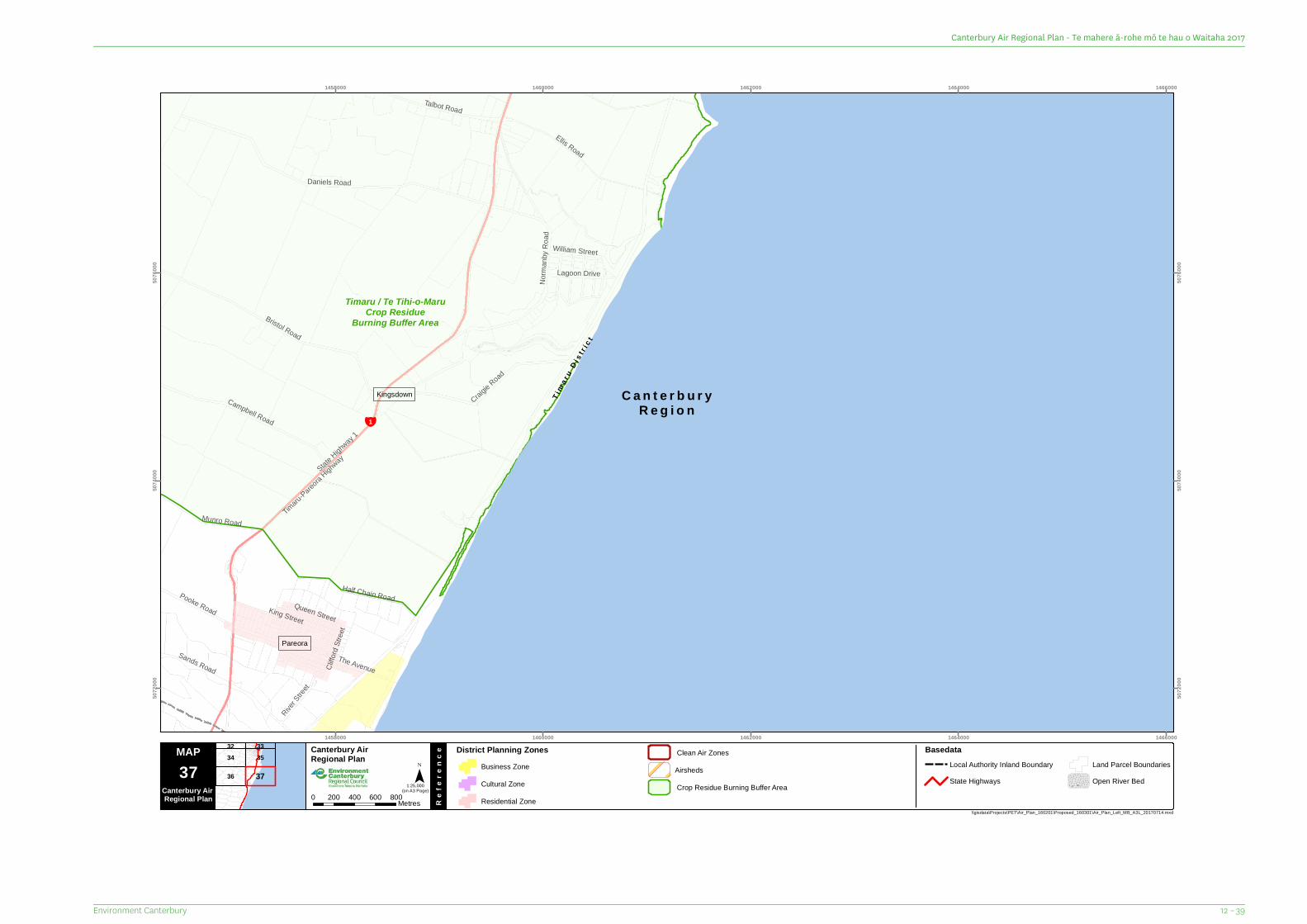
C a n t e r b u r yR e g i o n
¥1
Tim
a ru
D i st r i
c t
Cliffo
rd Str
eet
William Street
Queen Street
River S
treet
Lagoon Drive
Sands Road
Pooke Road King Street
Munro Road
Talbot Road
The Avenue
Ellis Road
Half Chain Road
Campbell Road
Craigie Road
Norm
anby
Roa
d
Bristol Road
Daniels Road
Timaru
-Pareora
Highway
State Highw
ay 1
Kingsdown
Pareora
Timaru / Te Tihi-o-MaruCrop Residue
Burning Buffer Area
1458000
1458000
1460000
1460000
1462000
1462000
1464000
1464000
1466000
1466000
5072
000
5072
000
5074
000
5074
000
5076
000
5076
000
36
34 3532 33
37
MAP Canterbury Air Regional Plan
Re
fere
nce
¯(on A3 Page)
\\gisdata\Projects\PET\Air_Plan_160201\Proposed_160301\Air_Plan_Left_MB_A3L_20170714.mxd
37Canterbury Air Regional Plan 0 200 400 600 800Metres
District Planning ZonesBusiness ZoneCultural ZoneResidential Zone
1:25,000
BasedataLocal Authority Inland BoundaryState Highways
Land Parcel BoundariesOpen River Bed
AirshedsClean Air Zones
Crop Residue Burning Buffer Area
12 – 39Environment Canterbury
Canterbury Air Regional Plan - Te mahere ā-rohe mō te hau o Waitaha 2017
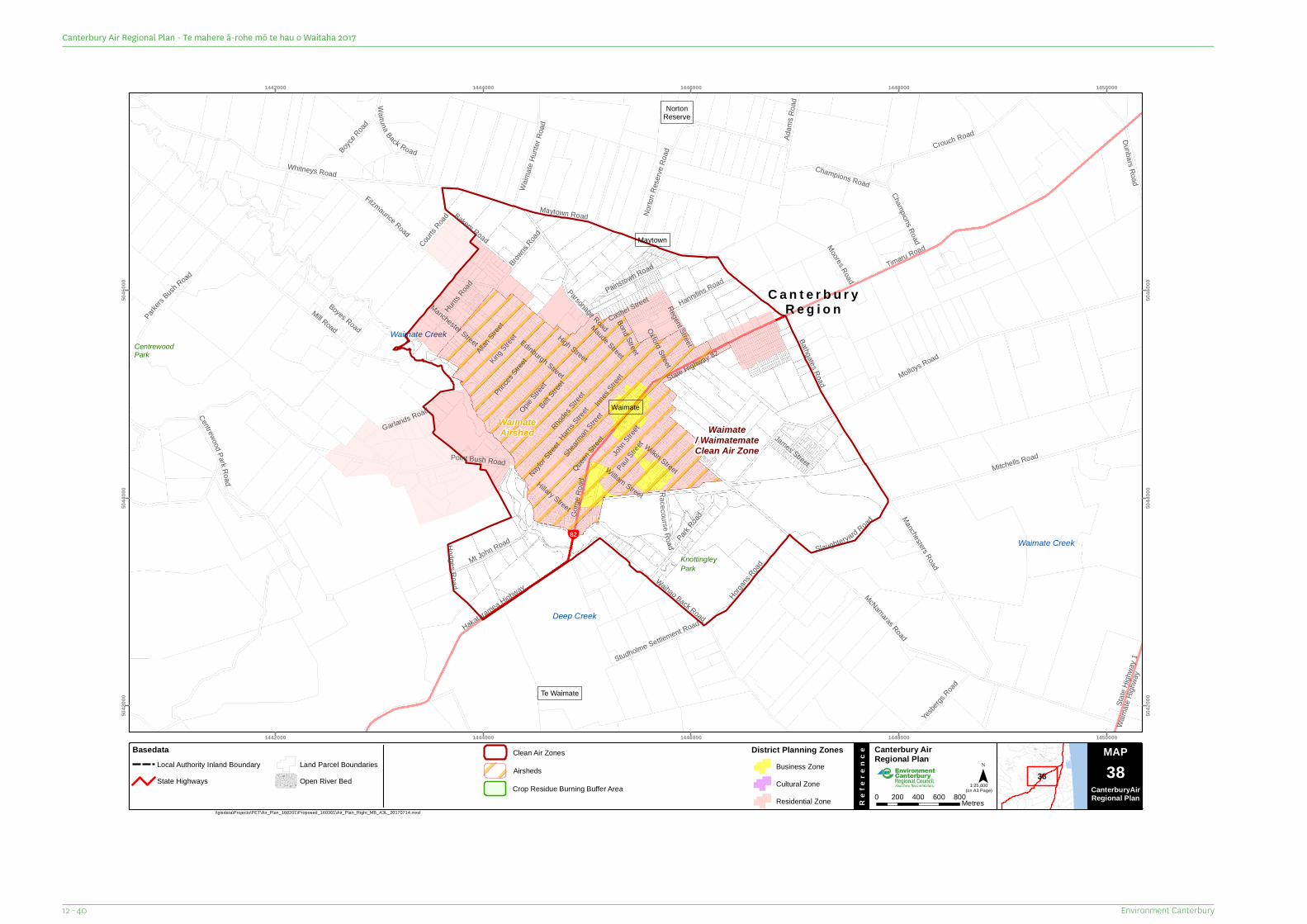
C a n t e r b u r yR e g i o n
¥82
Maude Street
Boyes Road
Innes
Street
Courts R
oad
Moores Road
Browns
RoadNayl
or Stree
t James Street
Bond Street
Adam
s Roa
d
Hillary Street
Paul Stree
t
Princes
Street
Manchester Street
Opie Stree
t
John S
treet
Edinburgh Street
Cashel Street
Racecourse Road
Wilkin Street
Oxford StreetRegent Street
Dunbars Road
Champions Road
Hannifins Road
Harris S
treet
Yesber
gs Road
Gorge
Roa
d
Allan Stree
tKing
Street
Hunts R
oad
Hodges Road
William Street
Belt Stree
t
Boyce R
oad
Mt John Road
State
Highw
ay 1
Waim
ate Hi
ghwa
y
Rhodes
Street
Slaughteryard Road
Shear
manStree
t
Studholme Settlement Road
Champions Road
Bathgates Road
Bakers Road
Waituna Back Road
Painstown Road
Horgans
Road
Waim
ateHu
nter R
oad
Park Road
Parkers
BushRoad
Garlands Road
Crouch Road
Queen S
treet
Fitzmaurice Road
Parsonage Road
Norto
n Res
erve R
oad
Point Bush Road
Centrewood Park Road
Mitchells Road
Maytown Road
Hakataramea Highway
High Street
Waihao Back Road
Manchesters Road
Whitneys Road
McNamaras Road
Molloys Road
Timaru Road
Mill Road
State Highway 82CentrewoodPark
KnottingleyPark
Deep Creek
Waimate Creek
Waimate Creek
Waimate
NortonReserve
Te Waimate
Maytown
WaimateAirshed Waimate
/ WaimatemateClean Air Zone
1442000
1442000
1444000
1444000
1446000
1446000
1448000
1448000
1450000
1450000
5042
000
5042
000
5044
000
5044
000
5046
000
5046
000
38
MAP Canterbury Air Regional Plan
Re
fere
nce
¯(on A3 Page)
\\gisdata\Projects\PET\Air_Plan_160201\Proposed_160301\Air_Plan_Right_MB_A3L_20170714.mxd
Map Series 0 200 400 600 800Metres
1:25,000
MAP38
CanterburyAirRegional Plan
BasedataLocal Authority Inland BoundaryState Highways
Land Parcel BoundariesOpen River Bed
District Planning ZonesBusiness ZoneCultural ZoneResidential Zone
Airsheds
Clean Air Zones
Crop Residue Burning Buffer Area
Environment Canterbury12 - 40
Canterbury Air Regional Plan - Te mahere ā-rohe mō te hau o Waitaha 2017

13 Special Zones
13 – 1Environment Canterbury
Canterbury Air Regional Plan - Te mahere ā-rohe mō te hau o Waitaha 2017
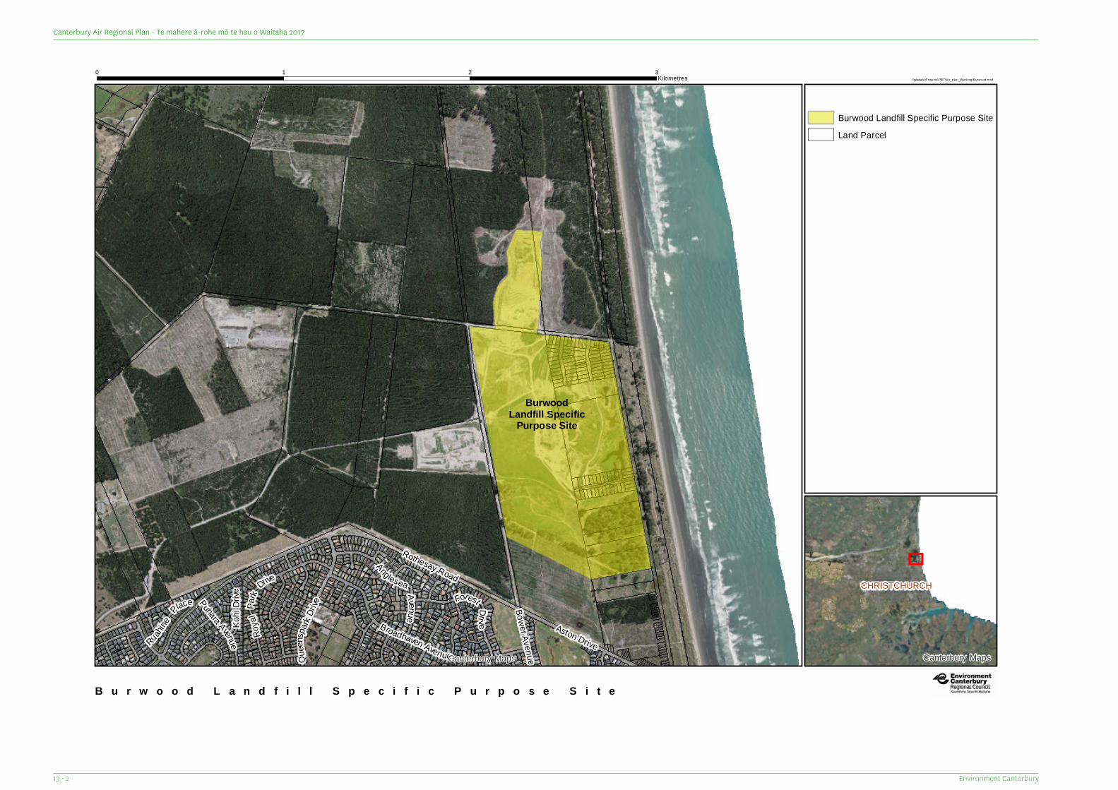
Ruahine
Place
Kohi
Drive
Bower AvenueQuee
nspark
DrivePuhara Avenue
Forest Drive
Anglesea Avenue
Aston Drive
Roya
lPark
Drive
Broadhaven Avenue
Rothesay Road
BurwoodLandfill Specific
Purpose Site
Canterbury Maps
B u r w o o d L a n d f i l l S p e c i f i c P u r p o s e S i t e
\\gisdata\Projects\PET\Air_plan_Work ing\Burwood.mxd0 1 2 3
Kilometres
/
Burwood Landfill Specific Purpose SiteLand Parcel
CHRISTCHURCH
Canterbury Maps
Environment Canterbury13 - 2
Canterbury Air Regional Plan - Te mahere ā-rohe mō te hau o Waitaha 2017
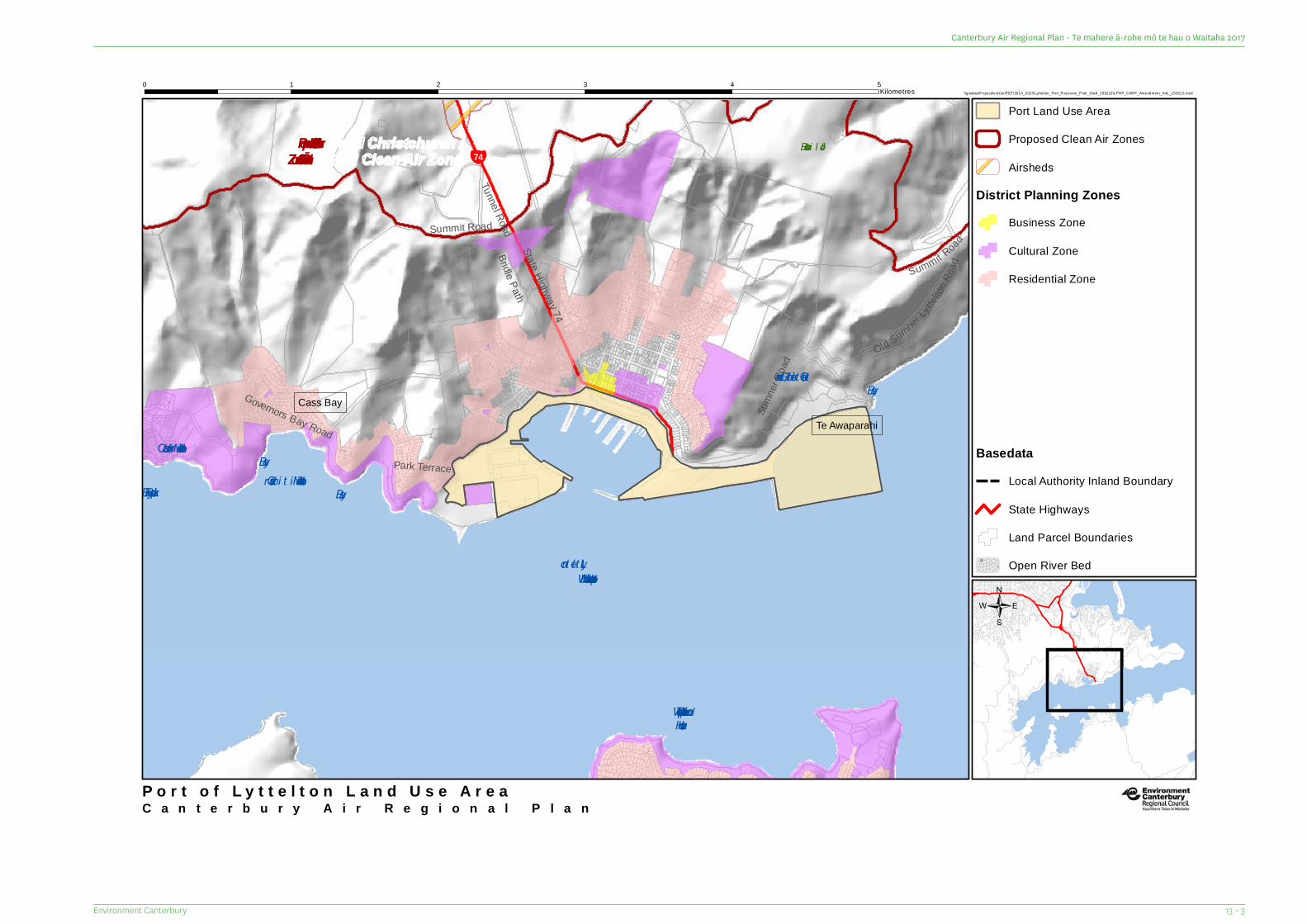
¥74
Park Terrace
Old SumnerLyt
telton
Road
Tunnel Road
Governors Bay Road
Summit RoadBridle PathState Highway 74
Sumn
er Ro
ad
Summit Road
Jollies Bush
Motukauatirahi/CassBay
Rapaki Bay
Otokitoki/GollansBay
LytteltonHarbour/Whakaraupō
Te Waipapa/DiamondHarbour
Motukauatiiti/CorsairBay
Cass BayTe Awaparahi
Proposed Christchurch /Ōtautahi Clean Air Zone
C a n t e r b u r y A i r R e g i o n a l P l a n
\\gisdata\ProjectArchive\PET\2014_2015\Lyttelton_Port_R ecovery_Plan_Draft_150210\LPRP_CARP_Amendment_A4L_150313.mxd0 1 2 3 4 5
Kilometres
P o r t o f L y t t e l t o n L a n d U s e A r e a
Port Land Use Area
Proposed Clean Air Zones
Airsheds
District Planning ZonesBusiness Zone
Cultural Zone
Residential Zone
/
BasedataLocal Authority Inland Boundary
State Highways
Land Parcel Boundaries
Open River Bed
13 – 3Environment Canterbury
Canterbury Air Regional Plan - Te mahere ā-rohe mō te hau o Waitaha 2017


Christchurch200 Tuam Street PO Box 345 Christchurch 8140P. 03 365 3828
Timaru75 Church Street PO Box 550 Timaru 7940P. 03 687 7800
Kaikōura96 West End PO Box 59 Kaikoura 7340P. 03 319 5781
Environment Canterbury OfficesFacilitating sustainable development in the Canterbury regionwww.ecan.govt.nz
R17/36


