Embed Size (px)
Citation preview

Official County Code of Douglas County, Kansas
Page 1
CHAPTER 1. ADMINISTRATION
Article 1. GENERAL PROVISIONS ................................................................................. 1 Article 2. BOARD OF COUNTY COMMISSIONERS ....................................................... 5 Article 3. OFFICE OF COUNTY ADMINISTRATOR........................................................ 7 Article 4. PERSONNEL POLICIES, REGULATIONS AND POSITIONS ......................... 9 Article 5. PUBLIC RECORDS ....................................................................................... 14 Article 6. PURCHASING POLICIES AND SERVICE AGREEMENTS ........................... 17 Article 7. DEPOSIT AND INVESTMENT OF PUBLIC FUNDS ...................................... 18 Article 8. ADVISORY COUNCILS AND BOARDS ......................................................... 19 Article 9. SMOKING IN PUBLIC BUILDINGS AND VEHICLES .................................... 21 Article 10. OFFICIAL COUNTY NEWSPAPER ............................................................. 22 Article 11. ISSUANCE OF TEMPORARY NOTES ........................................................ 22 Article 12. DESIGNATION OF VEHICLES AS AUTHORIZED EMERGENCY
VEHICLES ............................................................................................... 23 Article 13. CEREAL MALT BEVERAGES AND ALCOHOLIC BEVERAGES ................ 24 Article 14. ECO2 COMMISSION ................................................................................... 25 Article 15. TOWING....................................................................................................... 27
ARTICLE 1. GENERAL PROVISIONS
1-101 CODE DESIGNATED. The chapters, articles and sections herein shall constitute and be designated “The Code of the County of Douglas, Kansas,” and may be so cited. The Code may also be cited as the “Douglas County Code.” (Code)
1-102 DEFINITIONS. In the construction of this Code and of all resolutions of the County, the following definitions and rules shall be observed, unless such construction would be inconsistent with the manifest intent of the Board of County Commissioners or the context clearly requires otherwise:
a) Board, Board of County Commissioners, Commission, County Board, County Commission shall mean the Board of County Commissioners of Douglas County, Kansas.
b) Code shall mean “The Code of the County of Douglas, Kansas.”
c) Computation of Time. The time within which an act is to be done shall be computed by excluding the first and including the last day; and if the last day be a Saturday, Sunday or legal holiday, that day shall be excluded.
d) County means the County of Douglas in the State of Kansas.

Official County Code of Douglas County, Kansas
Page 2
e) Delegation of Authority. Whenever a provision appears requiring or authorizing the head of a department or officer of the County to do some act or perform some duty, it shall be construed to authorize such department head or officer to designate, delegate and authorize subordinates to do the required act or perform the required duty unless the terms of the provision designate otherwise.
f) Gender. Words importing the masculine gender include the feminine and neuter.
g) In the County shall mean and include all territory over which the County now has, or shall hereafter acquire, jurisdiction for the exercise of its police powers or other regulatory powers.
h) Joint Authority. All words giving a joint authority to three or more persons or officers shall be construed as giving such authority to a majority of such persons or officers.
i) Month shall mean a calendar month.
j) Number. Words used in the singular include the plural and words used in the plural include the singular.
k) Oath. Oath includes an affirmation in all cases in which, by law, an affirmation may be substituted for an oath, and in such cases the word “swear” is equivalent to the word “affirm.”
l) Officers, departments, etc. Officers, departments, boards, commissioners and employees referred to in this Code shall mean officers, departments, boards, commissioners and employees of the County, unless the context clearly indicates otherwise.
m) Owner as applied to a building or land shall include not only the owner of the whole, but any part owner, joint owner, tenant in common or joint tenant of the whole or a part of such building or land.
n) Person includes a firm, partnership, association of persons, corporation, organization or any other group acting as a unit, as well as in individual.
o) Property includes real, personal and mixed property.
p) Real Property includes lands, tenements, and hereditaments, and all rights thereto and interest therein, equitable as well as legal.
q) Shall, May. “Shall” is mandatory. “May” is permissive.
r) Sidewalk means any portion of a street between the curb line and the adjacent property line intended for the use of pedestrians.

Official County Code of Douglas County, Kansas
Page 3
s) Signature, subscription includes a mark when the person cannot write, when his or her name is written near such mark and is witnessed by a person who writes his or her own name as a witness.
t) State shall be construed to mean the State of Kansas.
u) Street means and includes public streets, avenues, boulevards, highways, road, alleys, lanes, viaducts, bridges and the approaches thereto and all other public thoroughfares in the county.
v) Tenant or Occupant as applied to a building or land shall include any person holding a written or oral lease of or who occupies the whole or a part of such building or land, whether alone or with others.
w) Tenses. Words used in the past or present tense include the future as well as the past and present.
x) Writing or Written may include printing, engraving, lithography and any other mode of representing words and letter, except those cases where the written signature or the mark of any person is required by law.
y) Year means a calendar year, except where otherwise provided. (Code)
1-103 EXISTING RESOLUTIONS. The provisions appearing in this Code, so far as they are in substance the same as those of resolutions existing at the time of the effective date of this Code, shall be considered as continuations thereof and not a new enactment. (Code)
1-104 EFFECT OF REPEAL. The repeal of a resolution shall not revive a resolution previously repealed, nor shall such repeal affect any right which has accrued, any duty imposed, any penalty incurred or any proceeding commenced under or by virtue of the resolution repealed, except as shall be expressly stated therein. (Code)
1-105 CATCHLINES OF SECTIONS. The catchlines of the sections of this Code printed in capital letters are intended as mere catchwords to indicate the contents of the section and shall not be deemed or taken to be titles of such sections, nor as any part of any section, nor, unless expressly so provided, shall they be so deemed when any section, including its catchline, is amended or reenacted. (Code)
1-106 PARENTHETICAL AND REFERENCE MATTER. The matter in parenthesis at the ends of sections is for information only and is not a part of the Code. Citations indicating only the source and the text may or may not be changed by this Code. Reference matter not in parenthesis is for information only and is not a part of this Code. (Code)

Official County Code of Douglas County, Kansas
Page 4
1-107 AMENDMENTS; REPEAL. Any portion of this Code may be amended by specific reference to the section number as follows; “Section (article or chapter) ____ of the Code of the County of Douglas is hereby amended to read as follows: (the new provisions shall then be set out in full)….” A new section not heretofore existing in the Code may be added as follows: “The Code of the County of Douglas is hereby amended by adding a section (or article or chapter) which reads as follows: (the new provisions shall be set out in full).” All sections, articles, or chapters to be repealed shall be repealed by specific reference as follows: “Section (article or chapter) ____ of the Code of the County of Douglas is hereby repealed.” (Code)
1-108 RESOLUTIONS; SUBJECT AND TITLE; AMENDMENT. No resolution shall contain more than one subject, which shall be clearly expressed in its title; and no section or sections of a resolution shall be amended unless the amending resolution contains the entire section or sections amended and the section or sections amended shall be repealed. (Code)
1-109 SAME; PUBLICATION; EFFECTIVE DATE. Resolutions, including amendments, additions or repeals to the Code, adopted by the Board of County Commissioners shall be published in the official County newspaper if such publication is required by State statute, or if the resolution requires such publication. Except when another effective date is stated in a resolution, published resolutions shall become effective upon publication or, if so required, final publication. All other resolutions shall become effective upon adoption, unless a different effective date is provided for therein. (Code)
1-110 SAME; RESOLUTION RECORDS. Following adoption of each resolution, the County clerk shall enter the same in the resolution records of the County. (Code)
1-111 ALTERING CODE. It shall be unlawful for any person, firm, corporation, or other group to change or amend, by additions or deletions, any part or portion of this Code, or to insert or delete pages or portions thereof, or to alter or tamper with such Code in any manner whatsoever which will cause the law of the County of Douglas to be misrepresented thereby. This restriction shall not apply to amendments or revisions of the Code authorized by resolution duly adopted by the Board of County Commissioners. (Code)
1-112 SCOPE. Any person convicted of doing any of the acts or things prohibited, made unlawful, or failing to do any of the things commanded to be done, as specified and set forth in this Code, shall be deemed in violation of the Code

Official County Code of Douglas County, Kansas
Page 5
and punished in accordance with Section 1-113. Each day any violation of this Code continues shall constitute a separate offense. (Code)
1-113 GENERAL PENALTY. Whenever any offense is declared by any provision of this Code, absent a specific or unique punishment prescribed, the offender shall be punished in accordance with K.S.A. 19-101d (as amended). (Code)
1-114 SEVERABILITY. If, for any reason, any chapter, article, section, subsection, sentence, clause or phrase of this Code or the application thereof to any person or circumstance is declared to be unconstitutional or invalid or unenforceable, such decision shall not affect the validity of the remaining portions of the Code. (Code)
ARTICLE 2. BOARD OF COUNTY COMMISSIONERS
1-201 COMMISSION POWERS. The powers of Douglas County as a body politic and corporate shall be exercised by the Board of County Commissioners pursuant to K.S.A. 19-103 (1995). (Code)
1-202 SAME; NUMBER, DISTRICTS. The Board of County Commissioners shall consist of three (3) qualified electors. The Commission shall divide the County into three (3) commissioner districts as provided by law in K.S.A. 19-201 et. seq. (as amended). (Code)
1-203 REGULAR MEETINGS. The Board of County Commissioners shall meet at 9:00 a.m. on Monday and 6:35 p.m. on Wednesday every week at the County Courthouse Commission meeting room. When such meeting day shall be on a legal holiday (or any other day observed as a holiday by the County), the Board may fix the succeeding day not observed as a holiday as a regular meeting day. Upon a motion properly made and seconded, the board may cancel or reschedule any regular meeting of the Board or change the location of the meeting. All regular meetings will be convened pursuant to K.S.A. 75-4317 et seq and an agenda for each regular meeting will be prepared. (Code)
1-204 SPECIAL MEETINGS. The Board may meet in special session on the call of the Chairman for the transaction of any general or special business or at the request of a majority of the members on the Board. All special meetings will be convened pursuant to K.S.A. 75-4317 et seq and an agenda for each special meeting will be prepared. The nature of the business to be transacted at any called meeting shall be governed by the matters and things set out in the agenda for said meeting. (K.S.A. 19-209 (as amended)). (Code)

Official County Code of Douglas County, Kansas
Page 6
1-205 MEETING PROTOCOL. Meetings of the Board of County Commissioners will be convened by the Chairman at the time stated on the meeting agenda. The meetings will thereafter be conducted pursuant to Robert’s Rules of Order.
a) Agenda items will be generally reviewed as follows:
b) Agenda item presented and explained by requesting party.
c) Commissioner discussion and questions.
d) Public input.
e) Final discussion and action by commissioners.
Persons attending meetings may be allowed to address the Board on agenda items when they have been recognized by the Chairman. However, no person has a right to be disruptive.
1-206 After discussion of an agenda item, the Board may take action by formal motion. A formal motion must be stated, seconded, and voted on by public vote of each participating commissioner. No secret ballots are allowed.
1-207 EXECUTIVE SESSIONS. The Board of County Commissioners may hold executive sessions pursuant to K.S.A. 75-4319. In order to go into executive session the provisions of K.S.A. 75-3419(a) shall be followed.
1-208 ROUTINE BUSINESS, ABSENCE OF QUORUM. In the event that the temporary absence or illness of two members of the Board prevents a regularly scheduled meeting of the Board due to the lack of a quorum, the remaining Commissioner is hereby empowered to transact all routine administrative business of the Board. “Routine Administrative Business” shall include, but not be limited to:
a) Approval of all valid claims, employee expense vouchers and payroll vouchers;
b) Approval of all personnel actions consistent with the Douglas County Personnel Policy and other resolutions or policies of the Board;
c) Approval of the purchase of supplies, equipment or contract services in accordance with the Douglas County Purchasing Guidelines, including the issuance of notices or solicitation of bids and approval of successful bids, when such purchases are necessary in order to:
1) Avoid additional expense to the County; or
2) Avoid undue delay in the completion of a project or activity that has received previous commissioner authorization; or

Official County Code of Douglas County, Kansas
Page 7
3) Avoid public inconvenience or a threat to the public health, safety or welfare; or
4) Any engineering, utility, right-of-way and construction contracts for County road and bridge projects that have received previous Commission authorization. (Res. 85-49)
1-209 SAME; REPORT AND RATIFICATION. At the next regularly scheduled meeting of the Board at which a quorum is present, the Commissioner who exercised the power delegated by Section 1-207 of the Code shall make a full report on the routine administrative actions taken pursuant thereto. Upon a motion properly made and seconded, all such actions may be ratified by the Board. (Res. 85-49)
ARTICLE 3. OFFICE OF COUNTY ADMINISTRATOR
1-301 OFFICE OF COUNTY ADMINISTRATOR; ESTABLISHED. There is hereby established the Office of the Douglas County Administrator. The County Administrator shall be selected on the basis of administrative and executive ability, education, experience and knowledge of government operations. The County Administrator shall be appointed and be subject to removal by a majority of the County Commission and the County Administrator shall receive all benefits received by County department heads and employees. The County Administrator shall serve in the "Classified-Exempt” service under the Douglas County Personnel Policy. (Res. 86-8-7, Sec. 1)
1-302 SAME; DUTIES. The County Administrator shall be the chief administrative officer of the County. Subject to the supervision and discretion of the County Commission, the County Administrator shall carry out the following duties and responsibilities within the limits of and in conformance with the requirements of Federal, State, and County laws and policies:
a) Attend all meetings of the County Commission and present proposed policies, programs and plans aimed at addressing overall County needs for review, revision and approval by the County Commission; and
b) Present an annual recommended operating budget, capital improvements program and long range strategic plan for all County operations for review, revision, and adoption by the County Commission; and
c) Identify and recommend individuals to the County Commission for appointment to boards and commissions; and

Official County Code of Douglas County, Kansas
Page 8
d) Recommend individuals to the County Commission for appointment to offices for which the County Commission is the appointing authority by law. Evaluate and recommend the compensation, suspension or dismissal of all such appointed administrative officers; and
e) Coordinate and supervise the administrative operation of the departments of all officials appointed by the County Commission. All officers and employees therein shall be administratively responsible to the County Administrator; and
f) Administer and supervise the operations of the Administrative Services Department and the divisions thereof as established under Section 1-303; and
g) In conjunction with the County Commission, prepare the meeting agenda of the County Commission; and
h) Coordinate the administrative services of County departments and agencies, offices of elected officials, and advisory and governing boards appointed by the County Commission. Provide technical assistance to such departments, offices, agencies and boards as needed; and
i) Coordinate county programs and operations with other local government units, Federal and State governments, the Kansas Association of Counties and other governmental and nongovernmental entities; and
j) Supervise, evaluate and recommend the compensation and discipline of personnel in the County Commissioner’s department; and
k) Execute such contracts and other documents as approved by the County Commission; and
l) Approve the appointment, compensation, discipline, and change in status of personnel in the departments of all officials appointed by the County Commission. Review and approve such actions within the departments of elected County officials for compliance with the personnel, budget and other policies of the County Commission. All employees affected by such decisions shall continue to have access to all appellate and other rights granted them by the Douglas County Personnel Policy; and
m) Monitor and provide regular reports to the County Commission concerning adherence by County departments to the personnel, purchasing, budget, accounting and other administrative policies of the County Commission; and
n) Perform such other duties as shall be lawfully delegated by the County Commission. (HR 86-8-7, sec. 1)

Official County Code of Douglas County, Kansas
Page 9
1-303 ADMINISTRATIVE SERVICES DEPARTMENT ESTABLISHED. There is hereby established within Douglas County government a Department of Administrative Services. The Department shall be under the administrative supervision of the Assistant County Administrator, and shall be responsible for the areas of Personnel, Risk Management, Budget, Purchasing, Accounting, Division of Information Services (HR 97-6-1) and Switchboard. The Director shall be appointed by the County Administrator, confirmed by the County Commission, and considered as “Classified-Exempt” under the Douglas County Personnel Policy. Within the limits of appropriations provided therefor, the Assistant County Administrator shall appoint, evaluate, compensate, suspend and dismiss all employees of the Department of Administrative Services. (HR 94-2-2, Sec. 3)
1-304 COUNTY COUNSELOR. The County Counselor shall be appointed by the County Commission and shall be responsible thereto. The County Counselor shall serve to protect the County’s interest in all legal proceedings and matters and shall carry out the following duties:
a) Provide direct legal counsel, advice and services to the County Commission, County Administrator, County department heads and elected officials; and
b) Ensure County policies, programs and operations are in compliance with statutory and other legal requirements by providing review and oversight thereof; and
c) Represent the County in all legal proceedings; and
d) Carry out such other duties or projects of a legal nature as provided by law or as the County Commission or County Administrator may from time to time direct or request. (HR 86-8-7, Sec. 3)
ARTICLE 4. PERSONNEL POLICIES, REGULATIONS AND POSITIONS
1-401 POSITION CLASSIFICATION SYSTEM. The County Commission is hereby authorized to establish and adopt by ordinary resolution a position classification system for use in all the departments of Douglas County government. The position classification system may be amended by motion as needed from time to time and shall, at a minimum, consist of the following:
1-402 PAY PLAN.
a) The County Commission is hereby authorized to adopt by ordinary resolution a pay plan containing appropriate pay grades and steps. The pay plan shall:

Official County Code of Douglas County, Kansas
Page 10
1) Provide for equal compensation for work of equivalent responsibility;
2) Establish a method of rewarding employees for continued service; and
3) Establish pay rates which compare favorably with those of other public and private organization competing for well qualified employees for positions similar to those found in County government. The pay plan shall provide for the annual compensation of the individuals holding the offices of Clerk, Register of Deeds, Sheriff and Treasurer and the employees thereof.
b) The pay plan may be amended by ordinary resolution as needed from time to time to keep the pay plan current. Policies for continuing administration of the pay plan also may be amended by ordinary resolution. (HR 86-7-6, Sec. 2)
1-403 RELATED COMPENSATION POLICIES. The County Commission is hereby authorized to adopt such related personnel and compensation policies as it deems necessary to effectuate the position classification system and pay plan. Such policies may include, but shall not be limited to, matters concerning compensation for tenure of service (longevity), performance appraisal, probation, and limits on additional compensation. (HR 86-7-6, Sec. 3)
1-404 INCORPORATION OF PERSONNEL POLICY. There is hereby adopted and incorporated by reference the Douglas County Personnel Policy. This policy may be amended by motion of the Commission.
1-405 SAME; DISTRIBUTION. Each Douglas County department shall have a minimum of one (1) personnel policy manual accessible to employees within the department. It shall be the responsibility of the Assistant County Administrator to distribute such personnel policy manuals and to maintain a list of the location of all such manuals. (Res. 95-15, Sec. 2)
1-406 PUBLIC SAFETY EMPLOYEE SMOKING POLICY; DEFINITIONS. The following words and phrases when used in Sections 1-407– 1-408 of this Code shall, for the purposes of those sections, have the meanings respectively ascribed to them herein:
a) Public Safety Employee means any employee eligible for coverage by the Kansas Police and Firemen’s Retirement System.

Official County Code of Douglas County, Kansas
Page 11
b) Smoke/smoking means inhaling, exhaling, burning or carrying any lighted cigar, cigarette, pipe or weed. Such terms also mean chewing, sniffing or otherwise using smokeless tobacco.
c) Physical Fitness Test means a series of tests designed to measure an individual’s overall physical fitness and approved by the County Administrator. (HR 98-2-2, Sec 2)
1-407 SAME; NON-SMOKING AS A CONDITION OF EMPLOYMENT. On and after the effective date of this resolution, all eligible public safety employees who are offered and accept employment with Douglas County shall agree as a condition of such employment to refrain from smoking during the scheduled workday and while off duty. A violation of this condition of employment shall constitute insubordination as defined by Sections 6.18 and 6.19 of the Douglas County Personnel Policy, as amended. Such violation shall be subject to the appropriate disciplinary action as provided therein. (HR 98-2-2, Sec. 3)
1-408 PHYSICAL FITNESS REQUIREMENTS.
a) Pre-employment. On and after the effective date of this section, all final candidates for public safety positions shall be administered a physical fitness test. Candidates must achieve an overall score at or above the 40th percentile in order to be eligible for employment for a public safety position. In the event of extenuating circumstances, the County Administrator (or his/her designee) may make exceptions to the 40th percentile requirement. When such an exception has been granted, the individual shall be required to achieve the 40th percentile on the physical fitness test prior to the completion of the individual’s first year of employment.
b) Post-employment. Each public safety employee shall be required to take an annual physical test. In order to be eligible for a merit and/or bonus award for the calendar year, the employee must achieve at least the 40th percentile total score on the physical fitness test.
1) Exceptions.
(a) Personal Medical Condition. Should an employee be unable to perform the physical fitness test due to a medical condition not caused by a work-related activity, the employee must submit a written note from his/her personal physician detailing (1) the condition preventing the employee from participating in the testing; (2) how long this medical condition is expected to continue. Should the condition be expected to continue beyond the calendar year, for the purposes of determining

Official County Code of Douglas County, Kansas
Page 12
merit eligibility, the employee will be assigned the previous year’s physical fitness test score. Should a public safety employee be unable to participate in physical fitness testing for two (2) or more consecutive years due to one (1) or more medical conditions, in addition to the physician’s note as described above, the employee will be required to provide a statement from his/her personal physician that the employee is able to perform all the duties of the job as described in his/her job description, which is to be provided to the physician by the department head.
(b) If the medical condition is due to a work-related injury and treatment is being supervised by Douglas County, such medical notes will be requested by Douglas County of the treating physician.
2) REFUSAL. Refusal to participate in the physical fitness testing program and/or refusal to provide a qualifying statement from a physician, shall be considered insubordination and shall be subject to the appropriate disciplinary processes as described in the Douglas County Personnel Policy. (HR 98-2-2)
1-409 OFFICES OF COUNTY AUDITOR AND ASSISTANT COUNTY AUDITOR ESTABLISHED. The offices of County Auditor and Assistant County Auditor are hereby established. The County Auditor and Assistant County Auditor shall be appointed by the Board for a term of two years commencing January 1 of odd-numbered years, to serve until December 31 of the following even-numbered year or until a successor is appointed and qualified. The appointment of the County Auditor and Assistant County Auditor shall be by motion and vote by the board and shall be placed in the minutes of the Board. (HR 89-4-1, Sec. 1)
1-410 SAME; COMPENSATION. The compensation of the County Auditor and Assistant County Auditor shall be as determined by the Board. Such offices may be held by persons who are also employed by Douglas County in some other capacity, and the Board shall determine whether the additional duties of such offices shall result in additional compensation. (HR 89-4-1, Sec. 2)
1-411 SAME; DUTIES.
a) The duties of County Auditor shall be as directed by the Board and shall specifically include the duty to audit and approve claims pursuant to the “Uniform Procedure for Payment of Claims and Other Indebtedness”

Official County Code of Douglas County, Kansas
Page 13
under K.S.A. 12-105a and K.S.A. 12105b. The Assistant County Auditor shall perform such duties in the absence of the County Auditor.
b) In the absence or other unavailability of the Assistant County Auditor to audit and approve claims, such duties shall be exercised by the County Counselor of Douglas County. (HR 89-4-1, Sec. 3)
1-412 CHARTER RESOLUTION 07-6-2. Sections 1-409, 1-410, 1-411 are amended by and subject to the provisions of Charter Resolution No. 07-6-2, which provides as follows:
a) Section 1. Exemption. The County, by the power vested in it by K.S.A. 19-101b, hereby elects to exempt itself from and make inapplicable to it, the provisions of K.S.A. 19-620, K.S.A. 19-621, and K.S.A. 19-626.
b) Section 2. Substitute Provisions for K.S.A. 19-620. The County, by the power vested in it by K.S.A. 19-101b, hereby provides substitute and alternate provisions for K.S.A. 19-620 as follows:
The Board of County Commissioners shall have the power to appoint a person as the County Auditor, to serve at the pleasure of the Board of County Commissioners, until such person is removed from office or resigns from office, whichever occurs first. In addition to other duties authorized or required by law, the County Auditor shall perform such duties as the Board of County Commissioners may, from time to time, prescribe.
c) Section 3. Substitute Provisions for K.S.A. 19-621. The County, by the power vested in it by K.S.A. 19-101b, hereby provides substitute and alternate provisions for K.S.A. 19-621 as follows:
Within 10 days after being appointed as County Auditor, such person shall execute and file with the County Clerk, a surety bond in favor of the
County, in the penal sum of $20,000 or such greater amount as the Board of County Commissioners may require. The bond shall be conditioned that the County Auditor will faithfully perform the duties of his or her office. The bond and surety thereon shall be approved by the Board of County Commissioners, which approval shall be made a part of its records. A bond conditioned and approved as set forth above, and executed by a surety authorized to do business under the laws of the State of Kansas, shall constitute sufficient surety, and the premium on said bond shall be pay by the County.
d) Section 4. Substitute Provisions for K.S.A. 19-626. The County, by the power vested in it by K.S.A. 19-101b, hereby provides substitute and alternate provisions for K.S.A. 19-626 as follows:

Official County Code of Douglas County, Kansas
Page 14
The Douglas County Auditor shall receive such salary, together with such cost of living adjustments, as the Board of County Commissioners may, from time to time, determine appropriate.
ARTICLE 5. PUBLIC RECORDS
1-501 PUBLIC RECORDS; FEES FOR ACCESS OR COPIES. The Board delegates to the County Administrator the authority and duty to adopt and, from time to time, amend a fee schedule for the various custodians of the records of Douglas County to use when assessing charges for access to and copies of the public records of Douglas County. The fee schedule, however, shall not assess charges in excess of those permitted by applicable law. (Res. 15-21, Sec. 1)
1-502 ADVANCE PAYMENT; WHEN NECESSARY. County records custodians may require advance payment of estimated fees when the total fees will exceed $1.00, when the request is made through mail or electronic communication, or when it is determined by advance payment is advisable to ensure prompt payment of applicable charges. (Res. 15-21, Sec. 1)
1-503 DEPOSIT OF CHARGES. The records custodians of the various departments of Douglas County shall remit all money received pursuant to Section 1-501 of this Code to the County Treasurer at least monthly. Upon receipt, the County Treasurer shall deposit the entire amount and credit the same to the general fund of the County, unless otherwise specifically provided by law. (Res. 15-21, Sec. 1)
1-504 LOCAL FREEDOM OF INFORMATION OFFICER. Pursuant to K.S.A. 45-226, the County Administrator shall appoint a freedom of information officer. The local freedom of information officer shall be available to the general public and records custodians to answer questions, resolve disputes, and assist in appropriately responding to requests for inspecting and copying public records. (Res. 15-31, Sec. 1)
1-505 OFFICIAL CUSTODIANS.
a) APPOINTMENT. Except as otherwise provided by other applicable law, all department heads are official records custodians for public records on file in their respective departments.
b) SUBORDINATE OFFICERS. Each of the official custodians appointed in subsection (a) of this section may designate any subordinate officers or employees to serve as record custodians. Such record custodians

Official County Code of Douglas County, Kansas
Page 15
shall have such duties and powers as are set out in the Kansas Open Records Act.
c) DUTIES OF CUSTODIANS. All Douglas County officers and employees appointed or designated under this section shall:
1) Protect public records from damage and disorganization.
2) Prevent excessive disruption of the essential functions of the Douglas County.
3) Provide assistance and information upon request and ensure efficient and timely action and response to all written applications for inspection or copying of public records.
4) Comply with the Kansas Open Records Act and carry out the procedures adopted for inspecting and copying public records.
d) WRITTEN REQUESTS TO BE DIRECTED TO CUSTODIANS.
1) All members of the public, in seeking access to, or copies of, a public record in accordance with the provisions of the Kansas Open Records Act, shall address their written requests to the custodian charged with responsibility for the maintenance of the record sought to be inspected or copied.
2) Whenever any Douglas County officer or employee appointed or designated as a custodian under this section is presented with a written request for access to, or copy of, a public record, which record the custodian does not possess and for which the custodian has not been given responsibility to keep and maintain, the custodian shall so advise the person requesting the record. The person making the request shall be informed as to which custodian the request should be addressed to, if such is readily known by the custodian receiving the request. (Res. 15-31, Sec. 1)
1-506 ACCESS AND COPYING PROCEDURES. The following procedures are adopted and shall be applied by each official custodian and record custodian.
a) Consistent with the policy, duties and procedures established by the Kansas Open Records Act, all Douglas County record custodians shall provide full access and assistance in a timely and efficient manner to persons who request access to open public records in writing. Certain records, however, may be excluded from public access. These records are identified and K.S.A. 45-221(a).
b) Record custodians may adopt and apply additional open public record access and copy procedures consistent with the policies of the Douglas County and with the provisions of the Kansas Open Records Act.

Official County Code of Douglas County, Kansas
Page 16
c) Record custodians may adopt and apply procedures that will ensure the protection and preservation of public records with respect to the manner in which such records are inspected and copied.
d) Record custodians shall take necessary measures, not inconsistent with their duties, to provide access to open public records and to ensure that the essential functions of the custodian's office, department or agency are not disrupted by requests for record inspection and copying.
e) A records custodian may require a written request for inspection of public records but shall not otherwise require a request to be made in any particular form. Except as otherwise provided by Kansas Open Records Act and this section, a records custodian shall not require that a request contain more information than the requester’s name and address and the information necessary to ascertain the records to which the requester desires access and the requester’s right of access to the records. A records custodian may require proof of identity of any person requesting access to a public record. No request shall be returned, delayed or denied because of any technicality unless it is impossible to determine the records to which the requester desires access.
f) Each written request for access to a public record shall be acted upon as soon as possible, but not later than the end of the third business day following the date that the request is received. If access to the public record is not granted immediately, the custodian shall give a detailed explanation of the cause for further delay and the place and earliest time and date that the record will be available for inspection.
g) If the written request for access is denied, the custodian shall provide, upon request, a written statement of the grounds for denial. Such statement shall cite the specific provision of law under which access is denied and shall be furnished to the requester not later than the end of the third business day following the date that the request for the statement is received.
h) The custodian may refuse to provide access to a public record, or to permit inspection, if a request is not in writing, places an unreasonable burden in producing public records or if the custodian has reason to believe that repeated requests are intended to disrupt other essential functions of the public agency. However, refusal under this subsection must be sustained by preponderance of the evidence.
i) If access to public records or the purpose for which the records may be used is limited pursuant to K.S.A. 45-221 or 45-230, and amendments thereto, the records custodian may require a person requesting the records or information therein to provide written certification that:

Official County Code of Douglas County, Kansas
Page 17
1) The requester has a right of access to the records and the basis of that right; or
2) The requester does not intend to, and will not: (A) Use any list of names or addresses contained in or derived from the records or information for the purpose of selling or offering for sale any property or service to any person listed or to any person who resides at any address listed; or (B) sell, give or otherwise make available to any person any list of names or addresses contained in or derived from the records or information for the purpose of allowing that person to sell or offer for sale any property or service to any person listed or to any person who resides at any address listed. (Res. 15-31, Sec. 1)
ARTICLE 6. PURCHASING POLICIES AND SERVICE AGREEMENTS
1-601 ADMINISTRATION. There is hereby adopted and incorporated by reference for the purpose of establishing purchasing policies and procedures the document entitled the Douglas County Purchasing Policy. This policy may be amended by motion of the Commission.
1-602 CONTRACTS FOR PERSONAL PROPERTY TAX COLLECTION. The County Commission may employ or enter into such contract or contracts it deems advisable with attorneys or other persons to assist the County in the collection of personal property taxes remaining unpaid from and after the date the same became a judgment of the County against the person or persons responsible therefor as provided in K.S.A. 1985 Supp. 79-2101, as amended. Any such contract shall be in writing and may be on a contingent fee basis, but in no event shall such fee exceed 50 percent of the amount collected. Any taxes so collected shall be credited ratably to the funds for which said taxes were levied. (HR 86-8-8, Sec. 1)
1-603 SAME; BOND, REPORT. Any person, other than the sheriff, with whom the County has contracted for the collection of personal property taxes shall furnish a good and sufficient bond, in an amount to be fixed by the County Commission, for the faithful discharge of his or her duties and for the payment to the County of all moneys collected pursuant to the contract. Such contract shall provide that the contract collector shall, at least monthly, on a date fixed in the contract, file with the County Treasurer a verified report and account of the taxes collected during the preceding month and at the same time, the contract collector shall pay to the County Treasurer the full amount collected during such month. (HR 86-8-8, Sec. 2)

Official County Code of Douglas County, Kansas
Page 18
1-604 TREASURER ACCEPT PARTIAL PAYMENTS. In order to facilitate the systematic collection and payment of delinquent personal property taxes, the County Treasurer is hereby authorized to accept any partial payments of personal property taxes that may be collected by the contract collector and paid to the County Treasurer. At his or her discretion, the County Treasurer also may accept such other partial payments as the Treasurer may deem advisable. The acceptance of any partial payments, however, shall not relieve the taxpayer of the obligation to pay the interest penalty prescribed by K.S.A. 79-2004a on the full amount of the personal property tax judgment until the tax debt is paid in full. (HR 86-8-8, Sec. 3)
ARTICLE 7. DEPOSIT AND INVESTMENT OF PUBLIC FUNDS
1-701 DEPOSITORIES OF ACTIVE FUNDS.
a) The Board of County Commissioners shall, from time to time, designate by official action recorded on its minutes, those financial institutions that shall serve as depositories of such of the County’s funds that are required for payment of current claims and expenses of the County. Only those state and nationally chartered banks, savings and loan associations, and savings banks that are eligible to serve as depositories pursuant to K.S.A. 9-1401 and amendments thereto may be designated as depositories of such active funds. (Res. 11-10, Sec.1)
b) The County Investment Officer and the Assistant County Administrator shall, from time to time, issue a request for bids to all financial institutions eligible to serve as a depository of County funds, requesting bids for the total cost of administering the County’s active account. Upon receipt of such bids and analysis thereof by the County Investment Officer and the Assistant County Administrator, the Board of County Commissioners shall select a primary depository institution for such funds. (R-01-38, Sec. 1)
c) If required by the Board of County Commissioners or the County Investment Officer, each official depository designated by the Board shall enter into a depository contract with the Board detailing the terms of the deposit of County funds therein. (Res. 11-10, Sec.1)
1-702 INVESTMENT OF IDLE FUNDS. The County Investment Officer shall deposit County funds not immediately required for the purposes for which collected or received in accordance with the provision of K.S.A. 12-1675 et seq., as amended and this Article. (R-01-38, Sec. 1)
1-703 INVESTMENT POLICY. In investing the County’s funds, the primary objectives of the Board of County Commissioners are (in order of priority): (1)

Official County Code of Douglas County, Kansas
Page 19
safety of principal, (2) maintenance of adequate liquidity, and (3) maximization of earnings from County funds. To satisfy the first two objectives and also satisfy the third objective, it is the policy of the Board of County Commissioners that an aggressive cash management program and investment policy be pursued to take advantage of investment interest as a viable and material revenue source for all operating and capital funds. It is further the policy of the Board of County Commissioners to invest its funds and use the earnings from the investment of its funds in a manner consistent with all applicable state and local laws. (R-01-38, Sec. 1)
1-704 COUNTY INVESTMENT OFFICER. The Douglas County Treasurer is hereby designated the official County Investment Officer. The County Investment Officer shall invest the County’s funds in accordance with the provisions of this Article. In furtherance of this office, the County Investment Officer shall do the following: (1) Maintain economic forecasts and investment strategies; (2) solicit and evaluate possible investment opportunities; (3) prepare reports on collateral and ensure sufficient collateral has been established; and (4) in consultation with the Assistant County Administrator, prepare reports on the cash flow needs of the County and the County’s available liquid funds to determine when additional idle funds will be available for investment or when invested idle funds will be needed. (Res. 11-10, Sec. 1)
1-705 (Repealed, Res. 11-10, Sec.1)
1-706 OVERSIGHT OF BOARD OF COUNTY COMMISSIONERS. The activities of the County Investment Officer under this Article shall be subject to the oversight and control of the Board of County Commissioners. (Res. 11-10, Sec. 1)
ARTICLE 8. ADVISORY COUNCILS AND BOARDS
1-801 LAWRENCE-DOUGLAS COUNTY ADVISORY COUNCIL ON ECONOMIC DEVELOPMENT.
a) There is hereby established the Lawrence-Douglas County Advisory Council on Economic Development. The Council shall consist of seven members, three of whom shall be appointed by the Douglas County Board of County Commissioners and three of whom shall be appointed by the City of Lawrence. One member shall be jointly appointed.
b) The individuals who are first appointed to serve on the Council shall serve for the following terms of office or until their successors are

Official County Code of Douglas County, Kansas
Page 20
appointed and qualified: two City appointees and two County appointees shall serve initial terms of four years; the joint appointee and one City appointee and one County appointee shall serve initial terms of two years.
c) After appointment of the initial members of the Advisory Council, all individuals appointed to the Council shall serve terms of office of four years. No person may serve more than two consecutive four year terms on the Council. Each appointee shall continue to serve on the Council until his or her successor is appointed and qualified.
d) One City Commissioner, the City Manager, one County Commissioner and the County Administrator shall serve as non-voting ex-officio members of the council. (Res. 89-44, Sec. 1)
1-802 SAME; FUNCTIONS. The Advisory Council shall carry out the following functions and responsibilities:
a) Meet at least on a quarterly basis with representatives of the economic development marketing program to review progress with the retention and recruitment of manufacturing and other businesses which may have a significant economic impact on the Lawrence-Douglas County area.
b) Review the proposed budget of the economic development marketing program each year and recommend to the County and City a level of funding in support of the program for the next fiscal year; and
c) Review on an ongoing basis the economic development policies of the City and County and advise the City and County thereon. (Res. 89-44, Sec. 2)
1-803 DOUGLAS COUNTY FAIR BOARD, ANNUAL APPOINTMENT. On or before November 1 of each year, the Board of County Commissioners shall appoint 10 residents of the County to serve on the Douglas County Fair Board. No more than one individual shall be appointed from each of the nine townships and the City of Lawrence. (HR 88-95, Sec. 1)
1-804 SAME; TERMS AND VACANCIES. Individuals appointed to serve on the Douglas County Fair Board by the Board of County Commissioners may serve a maximum of six one-year terms of office. Each such term shall commence on February 1 and conclude on January 31 of the following year. If a board member resigns, an appointment shall be made by the Board of County Commissioners to fill the unexpired one year term. Any such appointee shall be eligible to serve the remaining number of one-year terms of the person they replace, and at the end of such period that person may be

Official County Code of Douglas County, Kansas
Page 21
considered by the Board of County Commissioners for appointment for six one-year terms. (HR 88-9-5, Sec. 2)
1-805 SAME; RESPONSIBILITIES. As provided in K.S.A. 2-133, the Douglas County Fair Board of its executive board shall have responsibility for the management and control of the business of the fair association and its property, subject to the approval of the Board of County Commissioners. At the December meeting, the Fair Board may invite the newly appointed members of the Fair Board whose terms of office shall commence on February 1 of the succeeding year to meet in joint session with the current Fair Board. Such joint meeting shall be held for the purpose of insuring continuity of board operations. (HR 88-9-5, Sec. 3)
1-806 TERM LIMITS FOR BOARDS AND COMMISSIONS.
a) Neither the Board of County Commissioners nor any individual member of the Board of County Commissioners shall reappoint any individual to any particular board, authority, committee, commission, council, or other body, whether purely advisory, having specific authority or a combination of both, if such individual shall have already served two full consecutive terms or six full consecutive years, whichever is longer. For purposes of determining eligibility for reappointment, the unexpired term of an individual appointed to fill an unexpired term shall not count as a full term of service and the years in the unexpired term shall not count as years of service.
b) The limitation of paragraph (a) shall not apply to the extent it is in conflict with term limits set forth in any applicable statute, resolution, interlocal agreement, or other governing document relating to the appointment of individuals to any particular board, authority, committee, commission, council or other body.
c) The limitation of paragraph (a) shall not apply to limit the reappointment of employees or officials of Douglas County to any particular board, authority, committee, commission, council or other body or to limit the appointment of ex officio members to any such body. (HR 04-1-1, Sec. 1)
ARTICLE 9. SMOKING IN PUBLIC BUILDINGS AND VEHICLES
1-901 It shall be unlawful for any person to smoke within a building or vehicle which is owned or leased by Douglas County, Kansas.
1-902 There shall be no areas within buildings or vehicles which are owned or leased by Douglas County, Kansas, designated as smoking areas. The

Official County Code of Douglas County, Kansas
Page 22
County Administrator may designate areas outside of buildings owned or leased by the County as areas in which smoking is permitted.
1-903 Smoking shall be defined as the use of cigarettes, cigars, pipes, and shall include nicotine delivery devices that create a smoke or vapor, such as e-cigarettes and vaporizers.
1-904 Violation of this Article shall be deemed to be in violation of the provisions of the Kansas Indoor Clean Air Act, K.S.A. 21-6109 through 21- 6116, inclusive, as amended. To the extent that the prohibitions in this Article are broader than the foregoing act, violations may be prosecuted the same as violations of county codes and regulations, and the penalty shall be the same as for violations of K.S.A. 21-6110, as amended. (HR 14-10-3, Sec. 1)
ARTICLE 10. OFFICIAL COUNTY NEWSPAPER
1-1001 OFFICIAL COUNTY NEWSPAPER. The Lawrence Journal World is the official county newspaper.
1-1002 PUBLICATION OF QUARTERLY STATEMENTS. In addition to publication in the official county newspaper, all quarterly statements published by the county shall be published in The Baldwin Ledger and The Eudora News.
ARTICLE 11. ISSUANCE OF TEMPORARY NOTES
1-1101 FACTORS TO BE CONSIDERED TO DETERMINE WHEN NOTES WILL BE PURCHASED AS AN INVESTMENT. The Director of Assistant County Administrator or his/her designee will consult with the County Treasurer to determine the desirability of purchasing temporary notes of the County on a case by case basis. The factors to be considered shall include, but not be limited to, the amount of liquid funds available in the County treasury, the future cash needs of the County, the length of the term of the notes, and the amount of the notes. (Res. 96-46, Sec. 1)
1-1102 INTEREST PAID ON NOTES. One of the following formulas, at the discretion of the County Administrator or his/her designee, shall be used to determine the interest rate to be paid on notes purchased by the County:
a) The annual interest rate, determined by the County Treasurer, shall be an amount equal to the Investment Rate established for the State of Kansas pursuant to K.S.A. 75-4210 not greater than two (2) weeks prior to the issuance of the temporary notes plus fifty (50) basis points.

Official County Code of Douglas County, Kansas
Page 23
b) The annual interest rate shall be an amount equal to the lowest of three (3) solicited rates from banks involved in the purchase of bank-qualified notes not greater than two (2) weeks prior to the issuance of the temporary notes. (Res 96-46, Sec. 1)
ARTICLE 12. DESIGNATION OF VEHICLES AS AUTHORIZED EMERGENCY VEHICLES
1-1201 APPLICATIONS. Prior to any vehicle being designated an authorized emergency vehicle the owner shall submit an application to the Sheriff of Douglas County, hereinafter call Sheriff. The application shall be on such form as the Sheriff provides.
1-1202 REVIEW OF APPLICATIONS. After receipt of an application the Sheriff shall review the application and make such further investigation as the Sheriff deems necessary.
1-1203 DESIGNATION OF VEHICLES. If, after review of the application, the Sheriff finds that the designation of such vehicle is necessary to the preservation of life or property or to the execution of emergency governmental function, the Sheriff shall issue, in writing, a designation of the vehicle as an authorized emergency vehicle.
1-1204 USE OF VEHICLES. The document furnished by the Sheriff designating a vehicle as an authorized emergency vehicle shall be carried in the vehicle at all times and shall be used in compliance with the statutes pertaining to emergency vehicles. A vehicle designated as an authorized emergency vehicle shall be operated for the emergency purpose set out in the application for designation as an authorized emergency vehicle and shall at all times be used in compliance with the statues pertaining to emergency vehicles.
1-1205 IMPROPER USE OF VEHICLE. Whenever the Sheriff shall receive information that a vehicle that has been designated as an emergency vehicle has been or is being operated in violation of the statues pertaining to emergency vehicles or these regulations, if it is the first such violation by the owner or operator of said vehicle reported to the Sheriff, he shall send a warning notice by certified mail, return receipt requested, advising the owner of the violations complained of an admonishing the owner that any further violation will result in cancellation of the designation of the vehicle as an authorized emergency vehicle. Upon receipt of information of a subsequent violation of the statutes pertaining to emergency vehicles or of these regulations by an operator the designated vehicle or another designated
Official County Code of Douglas County, Kansas
Page 24
vehicle owned by the same owner, the Sheriff shall notify the owner of said vehicle of the purported violations by certified mail, return receipt requested, and shall give the owner ten (10) days from the date of mailing of the notice in which to show good cause why the designation should not be cancelled. Upon receipt of the response the Sheriff shall review the same if the Sheriff deems the response to be inadequate, or if no response is received within ten (10) days of the mailing of the notice, the Sheriff shall enter an order canceling the designation of the vehicle as an authorized emergency vehicle. A copy of the order of cancellation shall be mailed to the owner by certified mail, return receipt requested.
1-1206 DEFINITION. The term “owner” as used herein shall include any public official operating or causing to be operated any designated emergency vehicle.
ARTICLE 13. CEREAL MALT BEVERAGES AND ALCOHOLIC BEVERAGES
1-1301 SUNDAY SALES FOR ON PREMISES CONSUMPTION. Pursuant to K.S.A. 41-2704(b)(2), Sunday sale of cereal malt beverage is hereby authorized in Douglas County, Kansas at any place of business licensed to sell cereal malt beverage for consumption on premises, which derives not less than 30% of its gross receipts from the sale of food for consumption on the licensed premises. (Res. 05-25, Sec. 1)
1-1302 SUNDAY SALES FOR OFF PREMISES CONSUMPTION. Pursuant to Section 9(a) of Senate Bill 298, 2005 Kansas Session Laws Chapter 201, the Board hereby (i) expands permissible days of sale at retail of cereal malt beverage in the original package to allow such sale within the unincorporated area of Douglas County on any Sunday, except Easter, between the hours of 12 noon and 8 p.m.; and (ii) expands permissible days of sale at retail of alcoholic liquor in the original package, to the extent licensing of such sale of alcoholic liquor is otherwise authorized within the unincorporated area of Douglas County, to allow such sale within the unincorporated area of the Douglas County on any Sunday, except Easter, between the hours of 12 noon and 8 p.m. and on Memorial Day, Independence Day and Labor day. (Res. 06-10, Sec. 1)
1-1303 DEFINITIONS. The term cereal malt beverage used in Section 11302 shall have the same meaning as in the Kansas Cereal Malt Beverage Act; and the term “alcoholic liquor” used in Section 1-1302 shall have the same meaning as in the Kansas Liquor Control Act. (Res. 06-10, Sec. 2)

Official County Code of Douglas County, Kansas
Page 25
ARTICLE 14. ECO2 COMMISSION
1-1401 ESTABLISHMENT OF COMMISSION. The ECO2 Commission (pronounced “ECO Squared Commission”) is hereby established as a joint advisory commission to the City and the County. (Res. 04-22, Sec. 1)
1-1402 PURPOSE OF COMMISSION. The ECO2 Commission shall report to and advise both the City and the County on matters relating to its dual goals of (i) preservation, access, and management of open space, and (ii) acquisition of land, facilities and other supports to expand job opportunities in Douglas County, Kansas, including financing of both purposes. (Res. 04-22, Sec. 2)
1-1403 GUIDING PRINCIPLES. The ECO2 Commission shall be guided by the following three principles: (i) participation of landowners should be wholly voluntary and the ECO2 Commission shall not recommend the involuntary taking of private property; (ii) to the extent possible and in order to maximally leverage available funds, the ECO2 Commission shall emphasize partnerships with developers, land trusts, and other parties positioned to advance the dual goals of economic development and open space preservation; and (iii) the ECO2 Commission should not break the dual goals of economic development and open space preservation and pursue either separately. (Res. 04-22, Sec. 3)
1-1404 ADVISORY COMMISSION: ADDITIONAL DUTIES. The ECO2 Commission shall initially serve in an advisory capacity. The City, the County, and other incorporated cities within Douglas County may, by separate agreement between themselves, assign additional duties and responsibilities to the ECO2 Commission, including but not limited to preparing, approving and implementing the annual operating budget; managing acquired funding and real assets; hiring administrative staff; and entering into contracts in furtherance of the goals of the ECO2 Commission. (Res. 04-22, Sec. 4)
1-1405 NUMBER AND QUALIFICATIONS OF MEMBERS. The ECO2 Commission shall be comprised of eight members, each of whom shall reside within the geographic boundary of Douglas County, Kansas and none of whom shall hold either a salaried position or elective office with any City government in Douglas County or the County government; provided, however, that the initial appointments made to the ECO2 Commission in June of 2004 may include members who served on the ECO2 Initiative prior to adoption of the Joint Resolution that do not reside in Douglas County. Those members shall be exempt from the residency requirement until their initial term of appointment expires. Membership on the ECO2 Commission shall be voluntary and no

Official County Code of Douglas County, Kansas
Page 26
member shall receive payment for service on the commission. (Res. 04-22, Sec, 5; Res. 05-14, Sec. 1)
1-1406 APPOINTMENTS. The Mayor of the City and the Chair of the County Commission shall jointly appoint the members to the ECO2 Commission upon recommendation of the ECO2 Commission. In each case, appointments shall be made with the consent of a majority of each respective body. The appointments shall consist of the following: three members representing economic development interests, three member representing open space interests, and two members representing farm advocacy interest. (Res. 04-22, Sec. 6)
1-1407 REGULAR TERMS: TERM LIMITS. ECO2 shall recommend to the City and County Commissions a staggered term structure that provides for both continuity and the periodic introduction of new members and ideas. (Res. 04-22, Sec. 7)
1-1408 INITIAL TERMS. ECO2 shall recommend to the City and County Commissions initial term lengths that set in motion the staggered term structure noted in Section 1-2207. (Res. 04-22, Sec. 8)
1-1409 INITIAL MEETING. The ECO2 Commission shall initially convene at such time and place as shall be fixed by the Chair of the County and the Mayor of the City and shall thereupon proceed to organize and elect a Chair and Vice-Chair and to fix and determine times and places of future meetings. (Res. 04-22, Sec. 9)
1-1410 BYLAWS. The ECO2 Commission shall prepare bylaws to govern the Commission’s structure and decision making process and shall submit said bylaws to the City and County for joint approval. At a minimum, the bylaws shall require the same representative structure of the Commission’s members as set forth in this Resolution and shall further require the affirmative vote of at least three-fourths of all then-current members appointed and serving on the Commission to recommend project funding or take other significant Commission-related action. Until such time that the bylaws are prepared and approved by the City and County, the Commission shall have a Chair who shall call and preside over all meeting of the Commission and a Vice-Chair who shall serve in the absence of the Chair. (Res. 04-22, Sec. 10)
1-1411 OPEN MEETINGS AND OPEN RECORDS. All meetings of the ECO2 Commission shall be held in compliance with the Kansas Open Meetings Act

Official County Code of Douglas County, Kansas
Page 27
and its records shall be subject to the Kansas Open Records Act. (Res. 04-22, Sec. 11)
1-1412 WITHDRAWAL BY CITY OR COUNTY. Either the City or the County may withdraw its support of the ECO2 Commission and terminate the ECO2 Commission’s role with respect to such body upon not less than thirty (30) days’ notice to the other governmental body. (Res. 04-22, Sec. 12)
1-1413 EVALUATION OF COMMISSION. Both the County and City shall, approximately five years from the effective date of this Resolution, review whether the continued existence of the ECO2 Commission is necessary or desirable, and if so, whether any amendments should be made to this Resolution or to the responsibilities of the ECO2 Commission. If neither the County of the City takes formal action to terminate the continued existence of the ECO2 Commission or make any amendments to this Resolution or the ECO2 Commission’s responsibilities, the ECO2 Commission shall continue according to the provisions of this Resolution. (Res. 04-22, Sec. 13)
ARTICLE 15. TOWING
1-1501 TOWING/IMPOUNDING VEHICLES.
a) Authority to Tow. The Sheriff’s Office and its members may cause any vehicle to be immediately towed under any of the following circumstances, without the prior consent or authorization of the owner or operator of the vehicle:
1) When a vehicle is unattended or abandoned upon a public road or public property and either is parked in a tow zone, interferes with the normal movement of traffic or public business, or otherwise poses a danger to the public health, safety or welfare; or
2) When a vehicle is unattended or abandoned upon a public road or public property for a period of 48 hours; or
3) When a vehicle has been reported stolen or taken without the consent of its owner; or
4) When the owner or operator of a vehicle is unable to provide for its custody or removal; or
5) When a vehicle upon a public road or public property (or adjacent to a public road as a result of an accident) is so disabled or unsafe as a result of an accident or otherwise as to constitute an obstruction to traffic or otherwise poses a danger to the public health, safety or welfare, and the owner or operator of the vehicle is

Official County Code of Douglas County, Kansas
Page 28
unable or refuses to provide for its custody or removal (the failure of the owner or operator to request a specific tow service provider that is willing and able to respond within the timeframe that the Sheriff’s Office or its members determines necessary under the exigencies of the situation shall be deemed the refusal to provide for its removal); or
6) When the person in charge of a vehicle has been arrested or otherwise taken into custody or detained for an alleged offense; or
7) When a vehicle has been used in the commission of a crime or is otherwise subject to seizure as evidence in a criminal prosecution; or
8) When a vehicle is subject to seizure or forfeiture under the laws of Kansas or the United States; or
9) Any other reason authorized by applicable law.
b) Authority to Impound. The Sheriff’s Office and its members may cause any vehicle to be immediately impounded as they deem necessary within the normal course of business. Any vehicle so impounded for evidence shall be disposed of in accordance with any orders of a court having jurisdiction over the matter, or as otherwise allowed by law once the vehicle is no longer needed for evidentiary purposes. (Res. HR 12-9-2, Sec. 1)
1-1502 NOTICE TO OWNER OF TOWED VEHICLE. Whenever any vehicle is towed pursuant to the provisions of Section 1-1501 of this Article, as amended, the tow service provider shall comply with all notice provisions as outlined in K.S.A. 8-1102 through 8-1104, and amendments thereto. (Res. HR 12-9-2, Sec. 1)
1-1503 RELEASE OF TOWED VEHICLE. Unless the vehicle is being held or seized as evidence, all vehicles towed pursuant to the provisions of this Article shall be released to the owner or authorized representative by the tow service provider upon satisfaction of the provisions as outlined in K.S.A. 8-1102 through 8-1108, and amendments thereto, except fees and charges shall not exceed those provided for in Section 1-1513 of this Article, as amended. Res. HR 12-9-2, Sec. 1)
1-1504 SALE OF VEHICLE. An authorized tow service provider may proceed to dispose of towed vehicles, or to foreclose any possessory lien created by operation of law, in the manner provided in K.S.A. 8-1102 through 8-1108, and amendments thereto, unless a hold has been requested for a particular

Official County Code of Douglas County, Kansas
Page 29
vehicle by the Sheriff’s Office or other law enforcement agency. (Res. HR 12-9-2, Sec. 1)
1-1505 CONTRACT TOWING. It is hereby declared and found by the Board of County Commissioners to be of vital importance to the safety of the traveling public for disabled or abandoned vehicles and vehicles found on public streets to be removed as promptly as possible; that delay in removal can impede the movement of traffic unnecessarily and can cause further accidents; that the solicitation of tows at accident scenes can lead to unnecessary traffic congestion and unsafe and chaotic conditions; and, as a result, that the towing of vehicles from public roads and public property is a matter affecting public safety. Consequently, vehicle tows should be subject to contracts with the County for the purpose of safeguarding the public.
It is further declared and found by the Board of County Commissioners that the practice of towing, removing and storing of vehicles are matters affecting public safety and require uniformity, efficiency, dependability, and consistency, and any person desiring to perform towing operations for the Sheriff’s Office and other County officials shall enter into a Tow Service Provider Contract and comply with the provisions of this Article. The purpose of these Tow Service Provider Contracts and the provisions of this Article are to provide a uniform, efficient, dependable, and consistent system for obtaining services from tow companies which are engaged in or which intend to engage in the practice of towing, removing and storing of vehicles at the request of the Sheriff’s Office and other County officials.
Any person desiring to perform tow services at the request of the Sheriff’s Office or other County official and who meets the requirements of all other provisions of this Article and enters into a Tow Service Provider Contract shall be eligible to be placed on the County contract tow rotation list and be called on a rotation basis. (Res. HR 12-9-2, Sec. 1)
1-1506 TOWING SERVICE PROVIDER CONTRACT REQUIRED. Each tow service provider seeking placement on the County contract tow rotation list and designation as an authorized tow service provider to perform tow services at the request of the Sheriff’s Office, the Emergency Communications Department, or other County official shall make written application to the County Administrator or his designee at least 30 days prior to the desired effective date and shall enter into a Tow Service Provider Contract with the County, in form and substance that the County Administrator approves. Each Tow Service Provider Contract shall generally be for a calendar year and

Official County Code of Douglas County, Kansas
Page 30
renewal applications should be submitted at least 30 days prior to the expiration date of the then-current contract term. A tow service provider may terminate its designation as an authorized tow service provider, and therefore be removed from the County contract tow rotation list, by providing 5 calendar days advance written notice to the County Administrator. (Res. HR 12-9-2, Sec. 1)
1-1507 CONTRACT TOW REQUIREMENTS. The following requirements and criteria shall be met by any tow service provider desiring placement on the County contract tow rotation list and designation as an authorized tow service provider pursuant to a Tow Service Provider Contract:
a) Exclusive of state recognized holidays, each authorized tow service provider shall have a representative available (by phone or at the premises where a towed vehicle is stored) from 8:00 a.m. to 5:30 p.m., Monday through Friday to release any towed vehicle within one hour of the owner’s or authorized representative’s request. No additional charge shall be assessed for releasing a vehicle during these days and hours. During all other times, the authorized tow service provider shall have a representative available by phone and able to meet the owner or authorized representative at the premises where the towed vehicle is stored or kept for releasing a vehicle. For a vehicle released during these other times, the authorized tow service provider may not assess a fee in excess of the maximum charges provided for in Section 1-1513 of this Article, as amended. Each authorized tow service provider shall conspicuously post a sign at the front of its business stating the business name and a telephone number where information can be obtained about any vehicle towed or stored by the business. If an authorized tow service provider’s phone number changes during the term of any Tow Service Provider Contract, the authorized tow service provider shall provide the County Administrator with the new number before the change becomes effective.
b) Each authorized tow service provider shall have drivers and wrecker services available to respond to tow requests on a 24 hour per day, 7 days a week basis.
c) Each authorized tow service provider shall clean-up accident debris including but not limited to dirt, broken glass, metal, and other car pieces associated with the vehicle being towed, including but not limited to the use of oil dry or a similar product to clean up any fluid spills, unless otherwise directed by an official overseeing or having jurisdiction of the accident.

Official County Code of Douglas County, Kansas
Page 31
d) Each authorized tow service provider must have properly zoned adequate storage facilities within the County. Outside storage areas shall be fenced, with at least 6 foot high chain link or similar security fence and shall be adequately secured.
e) Each authorized tow service provider must have available storage area which is totally enclosed within a building for the protection and security of vehicles with broken windows and valuable property left in vehicles.
f) Each authorized tow service provider must agree to handle and tow abandoned vehicles in addition to tow requests received for damaged or disabled vehicles.
g) Each authorized tow service provider must provide the County with proof of the following insurance protection:
1) Public liability insurance indemnifying the public generally against damages arising out of the operation of the wrecker service. The authorized tow operator shall be responsible for entering the County on such policy or policies of insurance as a named insured. Such policy or policies of insurance shall be in an amount of at least $500,000.00 for one person, $500,000.00 for one accident, and $500,000.00 property damage and a minimum aggregate limit of $1,000,000.00. This coverage can be provided as a combined single limit.
2) Garage keeper's minimum liability policy covering fire, theft or damage to or loss of property while in tow or otherwise in the care, custody and control of the authorized tow operator. Such policy or policies of insurance shall be in an amount of at least $100,000.00 for each individual claim up to a maximum aggregate limit of $200,000.00 per occurrence.
Proof of insurance must be furnished on standard Acord© certificate of insurance forms. The County is to be named as a named insured on all required insuring agreements and each certificate must state that the County will be given 10 days advanced written notice if the policy is canceled or changed.
h) Each authorized tow service provider must enter into and sign a Tow Service Provider Contract with the County.
i) Each authorized tow service provider must provide the County with proof that it has a valid certificate of public service issued from the Kansas Corporation commission. (Res. HR-12-9-2, Sec. 1)
j) Each authorized tow service provider must be in compliance with all city, county, state, and federal laws. Any tow operator not in compliance with

Official County Code of Douglas County, Kansas
Page 32
all city, county, state, and federal laws by the end of any given calendar year shall be required at that time to deliver to Douglas County such documentation evidencing progress toward compliance with any such incompliance.
k) Each authorized tow service provider that is a legal entity formed by filing with the Kansas Secretary of State or any other state must be active and in good standing in the state of formation and, if a foreign entity, must be registered to do business in the State of Kansas.
l) Each tow service provider entering into a Tow Service Provider Agreement and desiring to become an authorized tow service provider so as to be placed on the county tow rotation list must be separate and distinct from any other authorized tow service provider on the county tow rotation list, and cannot be affiliated with another authorized tow service provider having the effect of taking two slots on the county tow rotation list when, in fairness and reality, it should only take one slot. Evidence of separate and distinct tow operators includes, but is not limited to, separate certificate of public service from the Kansas Corporation Commission; separate insurance policies; separately owned equipment, such as trucks, dollies, etc.; separate offices or arm’s length leases for share office space; separate storage facilities or arm’s length leases for shared storage facilities; separate accounting records and income tax filings; financial independence, such that no authorized tow operator is dependent upon financing from another authorized tow service provider; and the ownership of each tow service provider, together with who benefits from operating profits and is burdened by operating losses, is substantially different. In the case of personnel, a stricter level of scrutiny will be used to determine if a tow operator is dependent upon the personnel of another tow operator. To facilitate separation of operations within a sanctioned shared office space environment, clerical staff may be shared only in the event that separate phone numbers are maintained for each tow office and if written documentation exists representing the relationship between tow operators and shared personnel. In the event drivers or other non-clerical personnel are shared between tow operators, documentation evidencing the nature of the shared relationship may be requested. This documentation could be in the form of a contract or agreement and should include a description of the employee-employer relationship with details regarding how transitions from one tow operator employer to another transpire as well as how each company compensates the shared employee(s). Each tow operator desiring to become an authorized tow operator may be required to deliver to Douglas County such documentation as Douglas County reasonably requests to verify the independence of tow operators,

Official County Code of Douglas County, Kansas
Page 33
including but not limited to motor vehicle titles and evidence of ownership of other equipment, lease agreements for use of office and storage space necessary to conduct towing operations, payroll information, and other documentation establishing that no tow operator is dependent upon the equipment or personnel of any other tow operator to provide its towing operations. Douglas County shall have the authority to suspend or revoke any Tow Service Provider Agreement if it determines that two or more authorized tow service providers are not separate and distinct from each other.
m) The criteria and requirements set forth in this Subsection A through I of this Section shall not apply when the owner or operator of the vehicle to be towed requests services from a specific tow service provider and the vehicle is towed by that provider. (Res. HR 14-10-05, Sec. 1)
1-1508 COUNTY CONTRACT TOW ROTATION LIST. Based upon information provided by the County Administrator or his designee, the Emergency Communications Department shall maintain a list of authorized tow service providers to be used in providing rotation tow services for the County.
a) When a tow is needed, the law enforcement officer will communicate the need for a tow to the dispatcher on duty. On receiving this communication, the dispatcher shall, as a general rule, call the next authorized tow service provider on the County contract tow rotation list to remove the vehicle and that authorized tow service provider shall then be moved to the bottom of the list. On each succeeding communication, the next tow service provider on the list is generally assigned. In the event an authorized tow service provider cannot be reached by the dispatcher or cannot provide the requested tow within the timeframe required, that authorized tow service provider shall forfeit its turn, that authorized tow service provider shall be moved to the bottom of the list, and the dispatcher shall generally call the next succeeding authorized tow service provider on the list. If an authorized tow service provider at the top of the contract tow rotation list is dispatched and the dispatch does not result in a vehicle tow due to no fault of the authorized tow service provider, such authorized tow service provider shall be moved back to the top of the list. The dispatcher shall keep a continuous rotation of each authorized tow service provider on the master County contract tow rotation list.
b) The County contract tow rotation list provided for in this Article may be used for tows that are initiated by law enforcement officers or other officials of other jurisdictions within the County if the governing body of that jurisdiction specifically requests the Emergency Communications Department to use such list for its tows, in which case, the provisions of

Official County Code of Douglas County, Kansas
Page 34
this Article and the Tow Service Provider Contract shall apply to such tows.
c) Placement on the County contract tow rotation list shall be by alphabetical order. In the event a new tow service provider becomes authorized, it shall be placed on the list in alphabetical order, regardless of its resulting place in the rotation.
The Sheriff’s Office and other County officials shall not be obligated to use the County contract tow rotation list for any of the following:
1) special events where one or more tows may be necessary;
2) tows involving impounding of a vehicle for evidentiary or other criminal investigation or law enforcement purposes; or
3) tows involving County owned vehicles. Instead, the County may enter into an agreement with one or more tow service providers as needed for any such purposes. For purposes of this Section, special events shall include, but not be limited to, concerts, festivals, sobriety checkpoints, or any other similar event. (Res. HR 12-9-2, Sec. 1)
1-1509 MAXIMUM FEES AND CHARGES. No authorized tow service provider towing a vehicle pursuant to the County contract tow rotation list, and no any towing company towing a vehicle, without the prior consent or authorization of the owner or operator of the vehicle shall charge any towing, storage, or related fees in addition to or in excess of those provided for in Section 1-1513 of this Article, as amended. The County shall not be responsible for unpaid towing charges for such contract tows except as agreed to in writing by a County official. (Res. HR 12-9-2, Sec. 1)
1-1510 SUSPENSION OR REVOCATION OF APPROVAL AND AUTHORIZATION; GROUNDS.
a) Suspension or Revocation. The County Administrator or his designee may order that the approval and authority of an authorized tow service provider be suspended or revoked. Any such suspension shall temporarily remove the tow service provider from the contract tow rotation list and may be effective a maximum of 60 calendar days after any noted deficiency is corrected, with the period of suspension to be determined by the County Administrator or his designee. Any such revocation shall permanently remove the tow service provider from the contract tow rotation list and shall terminate the Tow Service Provider Contract with the tow service provider. A revoked tow service provider may be reinstated after entering into a new Tow Service Provider

Official County Code of Douglas County, Kansas
Page 35
Contract but only upon terms and conditions that lead the County Administrator or his designee to conclude that whatever problems or deficiencies had existed are permanently remedied. Such suspension or revocation may be based upon good cause, including but not limited to any one or more of the following:
1) The tow service provider obtained its authority as an authorized tow service provider by fraudulent conduct or false statements;
2) The tow service provider has failed to comply with the provisions of this Article;
3) The tow service provider violated the fee and charge schedule by overcharge;
4) The tow service provider has consistently refused to respond to requests for services from the Emergency Communications Department or the Sheriff’s Office or has consistently failed to answer telephone calls from them at the telephone number supplied by the tow service provider;
5) The tow service provider has responded to the scene of an accident, emergency, or impoundment situation, when not specifically called to do so, and solicited wrecker or towing business; and
6) The County is not satisfied with the general services of the owner and/or employees of the tow service provider or with the cooperation it has received from such tow service provider or other justifiable cause.
b) Appeal: Such suspension or revocation shall be by written notice to the tow service provider and shall contain the reasons for the suspension or revocation. The tow service provider may appeal such decision to the Board of County Commissioners or its designee by filing notice with the County Administrator within 10 calendar days of the notice of suspension or revocation. The Board of County Commissioners or its designee shall have the power to reverse, alter, modify, uphold or increase any suspension or revocation.
c) No Vested Rights: Nothing in this Article, the County’s designation as an authorized tow service provider, the County’s entering into a Tow Service Provider Contract with any tow service provider, or the County’s utilization of any tow service provider for tows shall confer any vested property rights upon the tow service provider to continue as an authorized tow service provider, to remain on the County contract tow rotation list, or to tow any vehicle for the County. (Res. HR 12-9-2, Sec. 1)

Official County Code of Douglas County, Kansas
Page 36
1-1511 SOLICITATION PROHIBITED. No tow service provider or tow service provider’s employee, driver or contractor shall stop, stand or park a tow truck at or near the scene of an accident or at or near a disabled vehicle within the unincorporated areas of the County for the purpose of soliciting an agreement for towing services, unless such tow service provider, employee, driver or contractor has been called to the scene by the Emergency Communications Department, the Sheriff’s Office, another law enforcement agency, or by the owner or authorized representative of an involved vehicle. (Res. HR 12-9-2, Sec. 1)
1-1512 ACCESS TO PERSONAL PROPERTY. Any owner or authorized representative of a vehicle towed pursuant to this Article shall have access to personal property that is not affixed to such vehicle for up to 96 hours after such vehicle has been towed, and such personal property shall be released to said owner or authorized representative within one hour of the owner or authorized representative’s request; except, however, if it is being held or seized as evidence. By becoming an authorized tow service provider and being placed on the County contract tow rotation list, each authorized tow service provider waives any possessory lien, to the extent it even has one, in any such personal property. The authorized tow service provider shall not charge any additional fee for retrieval of personal property during the hours and days specified in Section 1-1507 of this Article, as amended. For personal property released during other times, the authorized tow service provider may not assess a charge in excess of the maximum fee provided for in Section 1-1513 of this Article, as amended. (Res. HR 12-9-2, Sec. 1)
1-1513 MAXIMUM TOW, STORAGE, AND RELATED FEES.
a) Charges for towing, storage and other related services in connection with any vehicle towed or impounded pursuant to the County contract tow rotation list or otherwise towed without the prior consent or authorization of the owner or operator of the vehicle shall not exceed the maximum fees and charges that the Board of County Commissioners adopts by resolution, as amended and in effect from time to time. These charges are the sole and exclusive charges that may be legally imposed for such towing, storage and other related services and it shall be unlawful to charge fees in addition to or in excess of such maximum fees and charges. All other charges not identified in this Article or by resolution are expressly prohibited, including, without limitation, fuel surcharges, gate fees or other similar unauthorized fees to retrieve vehicles or remove personal property.

Official County Code of Douglas County, Kansas
Page 37
b) These fees include clean-up of all accident debris, including but not limited to the use of oil dry or a similar product to clean up any fluid spills.
c) A tow service provider or other tow operator may charge a full day’s storage fee for any portion of a day the vehicle is stored; provided, however, that no fee shall be charged if the owner or authorized representative retrieves the vehicle within the first 24 hours; provided further that no fee shall be charged for any additional day if a vehicle is stored for the additional day as a result of the tow service provider’s or tow operator’s failure to release the vehicle to the owner or authorized representative as required of authorized tow service providers in this Article. (Res. HR 12-9-2, Sec. 1)
1-1514 SEVERABILITY. If any provision of this Article or the application thereof to any person or circumstance is held invalid, the invalidity shall not affect other provisions or applications of this Article which can be given effect without the invalid provision or application, and to this end the provisions of this Article are severable. (Res. HR 12-9-2, Sec. 1)
1-1515 PENALTY.
a) Anyone who directly or indirectly violates any provision of this Article shall be guilty of a misdemeanor fined not less than $100 nor more than $500, or by up to one month imprisonment in jail, or both such fine and imprisonment.
b) Any penalty imposed by this provision shall be in addition to any other remedy at law or equity available to the County, including but not limited to damages for any failure to comply with the provisions of a Tow Service Provider Contract.(Res. HR 12-9-2, Sec. 1)

Official County Code of Douglas County, Kansas
Page 1
CHAPTER 2. ANIMAL CONTROL
Article 1. DEFINITIONS ............................................................................. 1 Article 2. ENFORCEMENT, IMPOUNDMENT, AND KENNELS ................ 3 Article 3. EXOTIC ANIMALS ...................................................................... 6 Article 4. NUISANCE ANIMALS AND DANGEROUS DOGS ..................... 7 Article 5. VICIOUS ANIMALS .................................................................. 16 Article 6. RECKLESS PET ONNERS....................................................... 17 Article 7. INVALIDITY AND SEVERABILITY ........................................... 18
ARTICLE 1. DFINITIONS
2-101 As used in this Chapter, unless the context clearly indicates otherwise, the following words and terms shall have the following meanings:
a) Administrative Hearing Officer means a hearing officer appointed by the Douglas County Board of Commissioners to hear and adjudicate violations of this Chapter through a finding and order.
b) Animal means any live vertebrate creature except a human.
c) Animal Shelter means the facility or facilities contracted with or operated by Douglas County for the purpose of impounding or caring for animals held under the authority of this chapter or state law.
d) Bite injury means any contact between an animal's mouth and teeth and the skin of a bite victim which causes visible trauma, such as a puncture wound, laceration, abrasion, bruise or other piercing of the skin.
e) Cat means any member of the species, felis domesticus.
f) Commercial Kennel means any agricultural or residential parcel where four or more dogs or cats, or both, are maintained overnight in any one week for boarding, training or similar purposes for a fee or compensation, or where dogs or cats are produced for sale or sold, as determined by an Enforcement Officer.
g) Dangerous Dog means any dog which has:
1) Caused a bite injury, other than severe injury, to any person, or
2) Killed another dog or cat, or
3) Caused severe injury to, or killed, equine, or livestock.

Official County Code of Douglas County, Kansas
Page 2
h) Dog means any members of the species, canis familiaris.
i) Enforcement Officer means a law enforcement officer, deputy, or humane investigator, with jurisdiction to enforce this Chapter in Douglas County, KS.
j) Euthanasia means the humane destruction of an animal that may be accomplished by any of those methods authorized by K.S.A. 47-1718.
k) Equine means a horse, pony, mule, jenny, or donkey.
l) Exotic animal means any non-human primate or prosimian (chimpanzees, monkeys), any venomous snake, or constricting snake fully grown over eight feet in length, any member of the canidae, felidae, ursidae, macropodidae or proboscidae families, including hybrids thereof, and which include:
1) Any member of the dog (canid) family not customarily domesticated by man, or any hybrids thereof, including wolf hybrids which are a cross between a wolf and a domestic dog, but not including domestic dogs (Canis familiaris);
2) Any member of the cat family weighing over fifteen (15) pounds not customarily domesticated by man, or any hybrids thereof, but not including domestic cats (Felis catus);
3) Any member of the bear (ursidae) family, or any hybrids thereof; and
4) Any member of the elephant (proboscidae) family, or any hybrids thereof.
m) Fowl means domestic birds commonly kept for the production of meat, eggs, companionship, aesthetic, or feathers. Fowl shall include, but not be limited to, chickens, ducks, turkeys, geese, swans, peafowl, guinea fowl, ostriches, and emus.
n) Health director or director of health means the director of the Lawrence-Douglas County Health Department. The term includes the director's authorized representative.
o) Livestock means cattle, sheep, goats, pigs, llamas and alpacas. Livestock excludes fowl and equine.
p) Owner means any person having a right of property in an animal, or who keeps or harbors an animal, or who has it in his care or residence, or acts as its custodian. A parent or legal guardian shall be deemed to be an owner of animals owned or maintained by minors upon their premises.

Official County Code of Douglas County, Kansas
Page 3
q) Person means any individual, corporation, partnership, organization, or institution commonly recognized by law as a unit.
r) Severe Injury means disfigurement, protracted impairment of health, or impairment of the function of any bodily organ.
s) Vicious animal means any animal which has caused severe injury to any person. (Res. No. 21-50, Sec. 1)
ARTICLE 2. ENFORCEMENT, IMPOUNDMENT AND KENNELS
2-201 Any animal found by an Enforcement Officer to be in violation of this Chapter may be impounded by an Enforcement Officer and placed in the Animal
2-202 All costs and fees associated with impounding, boarding, and medical care of an animal pursuant to this Chapter shall be paid to the Animal Shelter before the animal is released to the owner. Notwithstanding required hold times in other sections of this Chapter, if a known owner has not reclaimed their animal within 24 hours of notification, the Animal Shelter may send written notice to the known owner to immediately retrieve the animal from the shelter. If, 10 days after notice being provided, the animal is not retrieved, the animal shall become the property of the Animal Shelter. In the event that the owner of such animal fails to pay such costs and fees, the County or Animal Shelter shall be entitled to seek reimbursement of costs either in an independent civil proceeding or the costs may be requested as restitution as part of any applicable criminal proceeding.
2-203 The Douglas County Commission shall provide an Animal Shelter or shelters for the reception and humane care of animals impounded under this Chapter, and for this purpose may contract with any governmental entity, nonprofit organization, or association, or licensed veterinarian upon such terms and conditions as are mutually deemed appropriate.
2-204 Interference with Enforcement Officers Prohibited. It shall be unlawful for any person to knowingly obstruct, resist, or oppose an Enforcement Officer in the process or execution or the attempt to serve any summons, citation, writ, warrant, or order; conceal, destroy or materially alter evidence; or otherwise interfere with any person appointed or given authority under this Chapter in the performance of his or her official duties as prescribed herein. It shall be unlawful for any person to refuse to identify himself or herself by correct name and address when asked to do so by an Enforcement Officer when the officer has reasonable suspicion to believe that such person has violated this Chapter.

Official County Code of Douglas County, Kansas
Page 4
2-205 Refusal to Deliver Animals Prohibited. It is unlawful for a person to refuse to deliver an animal to an Enforcement Officer or to the Animal Shelter when requested to do so under impoundment provisions of this Chapter.
2-206 Removal of Animals from Enforcement Officers or Animal Shelter Prohibited. It is unlawful to remove an animal from the custody of an Enforcement Officer, Animal Shelter, or other location at which an animal is located when such animal has been impounded by such officer under the provisions of Chapter or state law when such removal is unauthorized.
2-207 No Limitation in Rabies Cases. The provisions of this Chapter shall not reduce or otherwise limit any applicable law that requires the impounding or holding of animals for observation following exposure by an animal that could possibly carry rabies or other communicable diseases. In addition, nothing in this Chapter shall prohibit the humane destruction of an animal suspected of carrying rabies if such destruction is done in compliance with other applicable law. In the event that an animal would otherwise be impounded under this Section, but is held at a different location for observation, the animal shall be impounded under this Section immediately upon expiration of the observation period.
2-208 Impoundment of At-Large Animals.
a) A dog, cat or other animal found to be turned loose by an owner or at-large by an Enforcement Officer or person, within the boundaries or unincorporated area of Douglas County, may be impounded in the Animal Shelter.
b) The Animal Shelter shall make a record of all dogs, cats, or other animals so impounded with their description, date of impoundment and rabies vaccination number. The animal shall be listed and viewable for the public to inspect.
c) If the animal is microchipped or if the owner is known or reasonably ascertainable, the Animal Shelter shall provide notice of impoundment to the known owner. Providing notice does not extend the time in which the animal shall be held before release or disposition.
d) If the animal appears to be at-large with no owner and within 3 business days from the date any animal is impounded the owner of such animal does not claim his or her animal, the animal shall become the property of the Animal Shelter. (Ref. K.S.A. §47-1710)

Official County Code of Douglas County, Kansas
Page 5
e) The owner or custodian of an animal disposed of pursuant to this Section shall not be entitled to recover damages for the disposition of such animal.
2-209 Any animal impounded pursuant to this Chapter, excluding Sec. 2-407 (Vicious Animal), may be released while the matter is pending in District Court or administrative hearing process upon the recommendation of an Enforcement Officer. If, in the opinion of an Enforcement Officer or Animal Shelter, the animal would constitute a menace to the health, safety or welfare of the public if released from custody, or may be subject to additional harm or violations, the animal may be held pending adjudication of the matter.
2-210 Enforcement. Enforcement Officers are empowered to enforce this Chapter and work with Code Enforcement to enforce any domestic animal-related inspections, conditional use permits, and site visits to aid in enforcement of other Chapters of the Douglas County Code, and abate any nuisances. It is unlawful to knowingly impede the duties of an Enforcement Officer.
2-211 Commercial Kennel.
a) Noise. No person shall maintain any commercial kennel which, by creating a noise for frequent or prolonged periods of time by day or night, disturbs the peace and quiet of any person or family of ordinary sensitivity within the vicinity of the noise.
b) Odor. It shall be unlawful to maintain any commercial kennel which by the nature of its maintenance or by the numbers of the same shall create an offensive odor so as to be objectionable to any person of ordinary sensitivity living within the vicinity of the odor.
c) It shall be unlawful for any person to maintain a commercial kennel without first obtaining a conditional use permit from Douglas County Board of Commissioners.
d) It shall be unlawful for any person to maintain a commercial kennel without first obtaining a conditional use permit from Douglas County Board of Commissioners.
1) Any pens, runs, cages or kennels shall be located at least 500 feet from any property lines.
2) A minimum of 20 acres is required for a kennel.
3) Adequate water supply must be provided for drinking and cleaning and appropriate sewage and waste management measures, approved by the Health Department, must be followed to eliminate odor.

Official County Code of Douglas County, Kansas
Page 6
4) The site plan must show contours so appropriate drainage of cleaning water and storm water runoff can be determined.
5) Shelters must be provided with heating and cooling units to protect the animals from extreme temperatures.
6) An exercise area such as an individual dog run or an exercise yard which may also be used for training and obedience classes must be provided.
7) Runs shall be adequately fenced and roofed to contain animals.
8) The building design, site layout, and/or other features must result in a facility that does not create noise which negatively impacts nearby properties.
9) There must be an occupied residential home on the property of the commercial kennel and the occupant’s name and telephone number must be listed on the permit application and subsequent renewals. (ref. 12-306-23, and 12-306-23.01)
2-212 Penalties. Any person violating any of the provisions of this Article shall be issued a notice of violation and fine, and notice of hearing which shall be served not less than 10 days prior to the date of such hearing in front of the Administrative Hearing Officer. The Administrative Hearing Officer, upon finding and order, and after examining the record for any prior conviction, finding, order, or record to determine if the person has previously been found in violation of the same offense, may fine the person according to the following schedule:
a) First violation, fine of $100.
b) Second or subsequent violation, fine of $200 to $500.
(Ref. K.S.A. §77-501 through 77-566, et. seq.)
(Res. No. 21-50, Sec. 1)
ARTICLE 3. EXOTIC ANIMALS
2-301 It is unlawful to own or possess an Exotic Animal in Douglas County, Kansas.
2-302 Exclusion, Zoos, and Other Facilities - The provisions of this Section shall not apply to properly maintained zoological parks accredited by the Association of Zoos and Aquariums; licensed or accredited medical institutions; accredited educational institutions; veterinary clinics or humane societies in possession of exotic animals for impoundment, treatment, or rehabilitation purposes; or

Official County Code of Douglas County, Kansas
Page 7
wildlife rescue facilities as designated by the Kansas Department of Wildlife and Parks.
2-303 Exclusion, Transitional Transporting - The provisions of this Section shall not apply to persons transporting exotic animals through Douglas County, provided that the transit time through Douglas County shall not be more than 6 hours, during which time, no exotic animal may be sold, exchanged, adopted, displayed, and no event or service that involves the exotic animal may occur. This includes any contact, whether direct or indirect, with the public.
2-304 Penalties. Any person violating any of the provisions of this Article shall immediately remove the animal from Douglas County. Any person violating any of the provisions of this Article shall be issued a notice of violation and fine, and notice of hearing which shall be served not less than 10 days prior to the date of such hearing in front of the Administrative Hearing Officer. The Administrative Hearing Officer, upon finding and order, and after examining the record for any prior conviction, finding, order, or record to determine if the person has previously been found in violation of the same offense, may fine the person according to the following schedule:
a) First violation, fine of $100.
b) Second or subsequent violation, fine of $200 to $500.
(Ref. K.S.A. §77-501 through 77-566, et. seq.) (Res. No. 21-50, Sec. 1)
ARTICLE 4. NUISANCE, DANGEROUS, AND VICIOUS ANIMALS
2-401 Property.
a) It shall be unlawful for any person owning or possessing an animal to permit or allow such animal to go upon any road, trail, private lands or premises without the permission of the owner of such premises, and tear up, destroy, or damage the property therein. This is including, but not limited to, gardens, flowerbeds, agriculture, and outbuildings.
b) It shall be unlawful to own, keep, harbor, or possess any dog or cat on a premises not occupied by persons as determined by an Enforcement Officer.
c) It shall be unlawful to own or possess dogs or cats which, by creating a noise for frequent or prolonged periods of time by day or night, disturbs
Official County Code of Douglas County, Kansas
Page 8
the peace and quiet of any person or family of ordinary sensitivity within the vicinity of the noise.
d) It shall be unlawful to own or possess dogs or cats which, by the nature of their maintenance or by the numbers of the same shall create an offensive odor so as to be objectionable to any person of ordinary sensitivity living within the vicinity of the odor.
2-402 Running at large—Prohibited; exceptions.
a) It shall be unlawful for any person to own, keep or harbor any dog and to permit or allow the dog to run at large within the county. For the purpose of this section, any dog shall be deemed to have been permitted or allowed by its owner to run at large when a complaint is filed that alleges the animal is found outside the real property lines of the owner and not effectively under the control of its owner.
b) Official use of dogs by any governmental unit shall be deemed in compliance with subsection (a) of this section.
c) An owner, while participating in or training for obedience classes or trials, shall be deemed to be in compliance with subsection (a) of this section. Evidence of this shall be shown by the fact that the dog and owner are going through standard obedience exercises, the owner has a leash on the owner's person, and the dog is under immediate control. The dog's tags must be readily available on the owner's person.
2-403 Animal Injury.
a) It shall be unlawful for any person to own, keep, or harbor an animal that, without provocation, causes injury to another domestic dog or owned cat, equine, or livestock, excluding severe injury or death as covered in Sec. 2-407 “Dangerous Dog,” regardless of the purpose for which the livestock is owned. This section shall not apply to animals injured while willfully trespassing on the owner, keeper, or harborer of the offending animal’s premises.
b) It shall be unlawful for any person to own, keep, or harbor an animal that, without provocation, causes death to any owned fowl. This section shall not apply to fowl found off the premises of the owner of the fowl.
2-404 Animals putting person in fear. No person shall own, keep or harbor any animal that without provocation, interferes with, chases, bites, or jumps upon any persons or animal, or behaves in a way that a reasonable person would find threatening, on a public right of way or off the property of the owner, keeper, or harborer of the offending animal.

Official County Code of Douglas County, Kansas
Page 9
2-405 Nuisance Animals, Same—Declaration.
a) Upon the Administrative Hearing Officer’s finding and order for a third time involving the same animal in any 24-month period of subsections 401, 402, or 403 in any combination thereof, or first finding and order of violating of section 404 shall constitute a “Nuisance Animal.” The Douglas County Clerk’s Office shall create and maintain a list of Nuisance Animals upon final disposition of a Nuisance Animal declaration by the Administrative Hearing Officer.
b) No animal may be declared a nuisance if, at the time of violations the person or animal was teasing, tormenting, abusing or assaulting the alleged Nuisance Animal. No animal may be declared a nuisance if the animal was protecting or defending a human being or animal within the immediate vicinity of the animal from what a reasonable person would perceive as an unjustified attack or assault.
c) No person owning, harboring or having the care or custody of a Nuisance Animal shall suffer or permit such animal to go unconfined beyond the premises of such person unless such dog is securely leashed and muzzled or otherwise securely restrained.
d) A Nuisance Animal is "unconfined" if while on the premises of its owner such animal is not securely confined indoors or confined in a securely enclosed and locked pen upon the premises of the person. Such pen must be adequate to ensure the confinement of such dog upon the premises.
e) The owner of a Nuisance Animal shall attend and complete a training class approved by the Enforcement Officer that is designated to teach the owner how to manage or correct problem behavior. The class must be completed and receipt thereof sent to the Douglas County Clerk’s Office within 60 days following finding and order of the triggering offense and Nuisance Animal declaration.
f) Failure to keep a Nuisance Animal according to the above requirements shall be a separate violation of this Article.
g) Upon the owner’s request, the County may remove any animal from the list of Nuisance Animals if there are no additional instances of the behavior described in this Section within 24 months of the date of conviction and designation of a Nuisance Animal, and the owner has complied with all keeping restrictions outlined in this subsection without incident. Request shall be made to the County Clerk in writing and forwarded to the Administrative Hearing Officer for determination.
2-406 Dangerous Dogs.

Official County Code of Douglas County, Kansas
Page 10
a) It shall be a violation of this section to own, keep, or harbor a Dangerous Dog. The Douglas County Clerk’s Office shall create and maintain a list of Dangerous Dogs upon final disposition of a Dangerous Dog violation by the Administrative Hearing Officer.
b) Notwithstanding the definition of a Dangerous Dog, no dog may be declared dangerous if any injury or damage is sustained by a person or animal who, at the time such injury or damage was sustained, was:
1) Trespassing on the real property of the owner or keeper of the animal, or;
2) A member of the household, or;
3) Was teasing, tormenting, abusing or assaulting the dog or was committing or attempting to commit a crime, or;
4) If the dog was protecting or defending a human being or animal within the immediate vicinity of the animal from what a reasonable person would perceive as an unjustified attack or assault.
5) The provisions of this article shall not apply to a police dog being used to assist one or more Law Enforcement Officers acting in an official capacity.
c) Notwithstanding the definition of a Dangerous Dog, no dog may be declared dangerous based solely on size or breed, or mix of breed; or if death to a dog or cat occurred solely due to a size disparity between the animals and there was no sustained vicious attack on the dog or cat.
d) Any dog impounded under probable cause of being a Dangerous Dog and which in the judgment of the Enforcement Officer would constitute a menace to the health, safety or welfare of the public if released from custody, may be held pending the hearing of the violation of 2-406(a). If not so determined, the dog may, after having been held pursuant to K.A.R. 28-1-13, be returned to its owner until final determination is made by the Administrative Hearing Officer as to whether a violation of this section has occurred. If returned pending the final disposition of the case, the dog must be kept securely confined and must be muzzled while in public until final determination is made as to whether a violation of this section occurred.
e) Within the notice of violation in 2-407, the Enforcement Officer shall include the following:
1) A description of the animal; and,
2) The name and address of the owner, keeper or harborer of the animal, if known; and,
Official County Code of Douglas County, Kansas
Page 11
3) The facts upon which the violation is based; and,
4) The restrictions placed on the animal as a result of the violation pending the outcome of the hearing.
f) Any violation of this section shall be punishable pursuant to the provisions of 2-407.
g) Upon finding and order of owning, keeping, or harboring a Dangerous Dog, and the dog returning to its owner, the dog shall be kept subject to the following standards:
1) Leash and Muzzle. No person shall permit a Dangerous Dog to go outside its home, kennel, or pen unless such dog is securely leashed with a leash no longer than four feet in length. No person shall permit a Dangerous Dog to be kept on a chain, rope or other type of leash outside its kennel or pen unless a person is in physical control of the leash. Such dogs may not be leashed to inanimate object such as trees, posts, or buildings. In addition, all Dangerous Dogs on a leash outside the dog's home or kennel must be muzzled by a muzzling device sufficient to prevent such animal from biting persons or other animals.
2) Confinement. All Dangerous Dogs shall be securely confined indoors or in a securely enclosed and locked pen or kennel when not indoors, except when leashed and muzzled as above provided. Such pen, kennel or structure must have secure sides and a secure top attached to the sides. All structures used to confine Dangerous Dogs must be locked with a key or other locking mechanism. Such structure must have a secure bottom or floor attached to the sides of the pen or the sides of the pen must be embedded in the ground no less than two feet. All such structures must be adequately lighted and ventilated and kept in a clean and sanitary condition, and must not be the primary enclosure for keeping of the animal. Enforcement Officers shall have the authority to monitor and inspect the keeping of all Dangerous Dogs.
3) Confinement Indoors. No Dangerous Dog may be kept on a porch, patio or in a part of a house or structure that would allow the dog to exit such building on its own volition. In addition, no such dog may be kept in a house or structure when screen doors are the only obstacle preventing the dog from exiting the structure.
4) Signs. All owners of Dangerous Dogs within the county shall within 10 days of conviction, display in a prominent place on their premises a sign easily readable by the public, invitees, or

Official County Code of Douglas County, Kansas
Page 12
licensees, using the words Beware of Dog or Beware of Dangerous Dog.
5) Insurance. All owners of Dangerous Dogs must within 10 days of conviction provide to the Douglas County Clerk proof of liability insurance in a single incident amount of no less than $200,000 for bodily injury to or death of any person or persons or for damage to property owned by any persons which may result from the ownership, keeping or maintenance of such dog. The insurance policy will provide that no cancellation of the policy will be made unless 10 days written notice is first given to the Douglas County Clerk’s Office.
6) Identification Photographs. All owners of Dangerous Dogs must within 10 days of conviction provide to the Douglas County Clerk’s Office two color photographs of the registered animal clearly showing the color and approximate size of the dog.
7) Microchip. All owners of Dangerous Dogs must within 10 days of conviction microchip the animal if not already microchipped and provide microchip information to the Douglas County Clerk’s Office to register the animal as dangerous.
8) Spaying/Neutering. All owners of Dangerous Dogs must within 10 days of conviction spay or neuter the animal and provide proof of sterilization to the Douglas County Clerk’s Office.
9) Training Class. The owner of the Dangerous Dog shall attend and complete a training class approved by the Enforcement Officer that is designated to teach the owner how to manage or correct problem behavior. The class must be completed and receipt thereof sent to the Douglas County Clerk’s Office within 90 days following conviction.
10) Sale or Transfer of Ownership Prohibited. Sale - No person shall sell, barter or in any other way dispose of a Dangerous Dog to any person within the county unless the recipient person resides permanently in the same household and on the same premises as the registered owner of such dog; provided that the registered owner of a Dangerous Dog may sell or otherwise dispose of a registered dog or the offspring or such dog to persons who do not reside within the county. If the owner sells or transfers ownership outside of Douglas County, the owner shall notify the Douglas County Clerk’s Office of the name and address of the transferee. The Douglas County Clerk’s Office shall report the Dangerous Dog designation to the County in which the animal will be kept.

Official County Code of Douglas County, Kansas
Page 13
11) Removal from List. Upon the owner’s written request, and approval by the Administrative Hearing Officer, the County may remove any dog from the list of Dangerous Dogs if there are no additional instances of the behavior described in this Section within 24 months of the date of conviction and designation of a Dangerous Dog and the owner has complied with all keeping standards outlined in this subsection.
12) Failure to Comply. It shall be unlawful for the owner of a dog deemed by the County to be a Dangerous Dog to fail to comply with the keeping standards and conditions set forth in this Section. Any dog previously found to be dangerous and which is found to be the subject of a violation of this Section shall be subject to immediate seizure and impoundment. Failure to comply with the provisions of this Section is deemed a separate offense. Upon finding and order, the Administrative Hearing Officer shall order the immediate removal of the animal from the county, may order the animal humanely euthanized, or may order the surrender of the animal to the Animal Shelter for disposition.
2-407 Penalties. Any person violating any of the provisions of this Article shall be issued a notice of violation and fine, and notice of hearing which shall be served not less than 10 days prior to the date of such hearing in front of the Administrative Hearing Officer. The Administrative Hearing Officer, upon finding and order, and after examining the record for any prior conviction, finding, order, or record to determine if the person has previously been found in violation of the same offense, may fine the person according to the following schedule:
a) First violation of 2-401 and 2-402, fine of $100.
b) Second or subsequent violation of 2-401 and 2-402, fine of $200 to $500.
c) First violation of 2-403, 2-404, 4-405, or 2-406, fine of $200 to $500.
d) Second or subsequent violation of 2-403, 2-404, 4-405, or 2-406, fine of $500 to $1,000.
e) Restitution. The Administrative Hearing Officer shall order reasonable restitution allowable by law in connection with any violation of this Article.
f) Other Remedies. The County shall have such other remedies as are and as may be from time to time provided by other applicable law.
2-408 Bites; Confinement.

Official County Code of Douglas County, Kansas
Page 14
a) Dogs, Cats, or Ferrets Exposing Humans. Any dog, cat, or ferret that causes any penetration of the skin by the teeth or any contamination of mucous membranes or fresh, open cuts in a person’s skin with saliva shall be confined according to the following schedule, regardless of vaccination history:
1) Owned or Wanted Dog, Cat, or Ferret. Beginning on the day of the exposure, any owned or wanted dog, cat, or ferret shall be observed for ten (10) days pursuant to a Confinement Order prepared by an Enforcement Officer. The Confinement Order shall detail the facts of the incident including how the human was potentially exposed to rabies. If the incident did not cause severe injury and the owner has proof of current rabies vaccination, the Enforcement Officer, in his or her discretion, may determine that the animal may be confined at the residence of the owner. Any other confinement shall be done at the Animal Shelter or veterinary clinic. The exact period of confinement may be longer than ten (10) days at the discretion of the observing veterinarian. The owner shall be liable for all costs and fees incurred.
2) Unowned, Stray, or Unwanted Dog, Cat, or Ferret. Any healthy unowned, unwanted, or stray dog, cat, or ferret shall be confined in the Animal Shelter for ten (10) days for observation. If the severity of the exposure to a person is such that it creates a high risk of potential rabies exposure, the Animal Shelter shall have the authority to waive any holding period and euthanize immediately for urgent testing.
b) Dogs, Cats, or Ferrets Exposed By Other Animals. Any dog, cat, or ferret that has been exposed to rabies through any penetration of the skin by the teeth or any contamination of mucous, open cuts in the animal’s skin with saliva by a bat or a wild terrestrial carnivore, as defined in the most current version of the Kansas Department of Health and Environment Investigation Guidelines, shall be reported to an Enforcement Officer. The Enforcement Officer will issue an Observation Order or Confinement Order according to the following schedule:
1) Dogs, cats, and ferrets that have appropriate documentation of current rabies vaccination shall receive an immediate booster vaccination by a licensed veterinarian within 96 hours of exposure and shall be kept under the owner’s control and observed for forty- five (45) days by an Observation Order. The Observation Order shall detail the facts of the exposure and the date and certification number of the current rabies vaccination. If the booster vaccination was given later than 96 hours after exposure, the Lawrence-

Official County Code of Douglas County, Kansas
Page 15
Douglas County Health Department has the authority to extend the observation period and instruct the Enforcement Officer to issue the appropriate order.
2) Dogs and cats that are overdue for the rabies vaccination and have appropriate documentation of a previous vaccination shall receive an immediate booster vaccination by a licensed veterinarian within 96 hours of exposure and shall be kept under the owner’s control and observed for forty-five (45) days by an Observation Order. If the booster vaccination was given later than 96 hours after exposure, the Lawrence-Douglas County Health Department has the authority to extend the observation period and instruct the Enforcement Officer to issue the appropriate order.
3) Dogs and cats that are overdue for the rabies vaccination and have no documentation of a previous vaccination shall be reported to the Lawrence-Douglas County Health Department and may be required to be observed for forty-five (45) days or confined for up to four months. The Lawrence-Douglas County Health Department shall instruct an Enforcement Officer to issue the appropriate order.
4) Ferrets that are overdue for the rabies vaccination shall be evaluated on a case-by-case basis by the Lawrence-Douglas County Health Department who shall then instruct an Enforcement Officer to issue the appropriate order.
5) Dogs, cats, and ferrets that have never been vaccinated against rabies shall be euthanized immediately or, if the owner is unwilling to euthanize, shall receive an immediate booster vaccination by a licensed veterinarian within 96 hours of exposure. The dog or cat shall be confined at a licensed Animal Shelter or veterinary clinic for four (4) months, or six (6) months for ferrets pursuant to a Confinement Order prepared by an Enforcement Officer. If the booster vaccination was given later than 96 hours after exposure, the confinement period shall extend to six (6) months pursuant to a Confinement Order prepared by an Enforcement Officer. The owner shall be liable for all costs and fees incurred.
c) Any owner who fails to comply with the provisions of this Section, within twenty-four (24) hours or one (1) business day of notification, shall be deemed in violation of this Article and the officer shall take such animal into custody and commit it for the above described confinement period.
d) Kansas Department of Health and Environment Rabies Control Requirements shall apply under this Section, unless the provisions of this Chapter require more stringent procedures. (Res. No. 21-50, Sec. 1)

Official County Code of Douglas County, Kansas
Page 16
ARTICLE 5. VICIOUS DOGS
2-501 Vicious Animals.
a) It shall be a violation of this Section to own a vicious animal within the county.
b) A vicious animal does not include an animal that has caused severe injury to any person while a person was committing a criminal offense, or willful trespass on the property of the owner of the animal that caused severe injury. The provisions of this article shall not apply to a police dog being used to assist one or more Law Enforcement Officers acting in an official capacity.
c) Initiation of Criminal Proceeding. In addition to any other method of initiating a criminal proceeding under applicable law, any Enforcement Officer may, with probable cause, initiate a criminal proceeding under this Article by making an offense report and serving a citation and notice to appear in district court upon the alleged violator. The offense report shall be forwarded to the district attorney for prosecution.
2-502 Penalties. Any violation of this Article shall be heard in Douglas County District Court. Any person violating any of the provisions of this Article shall, upon conviction and after a court examination of any prior conviction record to determine if the person has previously been convicted of the same offense, be sentenced by the court according to the following schedule:
a) First violation of 2-501 shall be a fine of up to $1,000 or, confinement in the county jail not to exceed one year, or by both fine and imprisonment.
b) Any second or subsequent violation of 2-501 shall be a fine of up to $2,500 and, in addition, confinement in the county jail not to exceed one year, or by both fine and imprisonment.
c) Each day’s violation shall constitute a separate offense under this Article.
d) After notice of violation under this Article, within 30 days of the animal being impounded, a disposition hearing shall be held in front of an Administrative Hearing Officer regarding the disposition of the animal.
1) The Administrative Hearing Officer shall order that the animal be removed from the county or humanely euthanized, and direct the Animal Shelter or its veterinary designee to ensure that the order is enforced.
2) If the Administrative Hearing Officer orders the animal to be humanely euthanized pursuant to this subsection, that decision

Official County Code of Douglas County, Kansas
Page 17
shall be final unless the owner appeals to the Douglas County District Court. If an appeal is timely filed, the district court shall suspend the euthanasia order pending the final determination of the underlying criminal charge by the court.
3) If the animal is ordered removed from the county, the address in which the animal will reside shall be reported to the Douglas County Clerk’s Office. If the animal is sold or transferred out of Douglas County, the owner shall notify the Douglas County District Attorney’s Office prior to the sale or transfer. The Douglas County District Attorney’s Office shall report the vicious animal determination to the County in which the animal will be kept.
e) Restitution. The court shall order reasonable restitution allowable by law in connection with any violation of this Article.
f) Other Remedies. The County shall have such other remedies as are and as may be from time to time provided by other applicable law. (Res. No. 21-50, Sec. 1)
ARTICLE 6. RECKLESS PET OWNERS
2-601 Any person found in violation of Chapter 2 of the Douglas County Code three (3) or more times in a 24 (twenty-four) month period shall be declared a Reckless Pet Owner.
2-602 Any person found in violation of Chapter 2 of the Douglas County Code three (3) or more times in a 24 (twenty-four) month period shall be declared a Reckless Pet Owner.
a) name and address of the person subject to the declaration, and;
b) the description, violation, and convictions that lead to the declaration, and;
c) the name and description of all pets subject to the effects of the declaration, and:
d) instructions on appealing the declaration to the Administrative Hearing Officer.
2-603 Once declared a Reckless Pet Owner, the person shall not own, keep, possess, or harbor any additional animals for a period of 3 (three) full years from the date of the declaration. (Res. No. 21-50, Sec. 1)

Official County Code of Douglas County, Kansas
Page 18
ARTICLE 7. INVALIDITY AND SEVERABILITY
2-701 Partial Invalidity. If any provision of this Chapter or the application thereof to any person or circumstance is held invalid, the invalidity shall not affect other provisions or applications of this Chapter which can be given effect without the invalid provision or application, and to this end the provisions of this Chapter are severable.
2-702 Jurisdiction. The provisions of this Chapter shall apply to the unincorporated areas within Douglas County, Kansas and, in addition, shall apply within the city boundaries of any incorporated city located within Douglas County, Kansas, that adopts an ordinance or resolution or takes other formal action consenting to have this Chapter apply within such city’s boundaries; provided, however, that any city’s election to have this Chapter apply within such city’s boundaries shall not, by implication, serve to repeal or invalidate any other animal control regulations otherwise applicable within such city. (Res. No. 21-50, Sec. 1)

Official County Code of Douglas County, Kansas
Page 1
CHAPTER 3. BUILDING AND HOUSING
Article 1. RESERVED ................................................................................ 1 Article 2. RESERVED ................................................................................ 1 Article 3. RESERVED ................................................................................ 1 Article 4. RESERVED ................................................................................ 1 Article 5. SANITARY CODE ....................................................................... 1 Article 6. FAIR HOUSING ........................................................................ 46
ARTICLE 1. RESERVED
ARTICLE 2. RESERVED
ARTICLE 3. RESERVED
ARTICLE 4. RESERVED
ARTICLE 5. SANITARY CODE
3-501 DECLARATION OF NECESSITY. The Board of County Commissioners of Douglas County, Kansas (the “Board”) declares that the proposed Douglas County Sanitary Code is necessary for the protection of the health and welfare of the public. (Res. 08-44, Sec.1)
3-502 ADOPTION OF CODE. The Douglas County Sanitary Code, as proposed by the Lawrence-Douglas County Health Board and submitted to and, on August 7, 2008, approved by the Secretary of Health and Environment of the State of Kansas, and as presented to the Board at the public hearing on October 15, 2008, is hereby adopted and the provisions thereof are incorporated and made a part of this Resolution as if fully set forth within the text of this code. (Res. 08-44, Sec. 2)
3-503 PURPOSE OF CODE. The purpose of the Douglas County Sanitary Code is to set forth procedures and regulations that shall be followed and administered to promote and protect the health, safety, comfort and general welfare of the people of Douglas County, Kansas. Enforcement of the Douglas County Sanitary Code will reduce and retard the development of environmental conditions that are hazardous or could be potentially hazardous to the public’s health and safety. (Res. 08-44, Sec. 3)
3-504 AREAS SUBJECT TO THE CODE. The boundaries of the areas to be subjected to the Douglas County Sanitary Code are the boundaries of

Official County Code of Douglas County, Kansas
Page 2
Douglas County, Kansas; provided that, the Douglas County Sanitary Code shall not apply to incorporated cities within Douglas County, Kansas or to any premises under one ownership which exceeds 650 acres in area and which is used only for agricultural purposes. For this purpose, "agricultural purposes" means a purpose related to the production of livestock or crops. (Res. 08-44, Sec. 4)
3-505 COPIES AVAILABLE FOR INSPECTION. Copies of the Douglas County Sanitary Code adopted by this Resolution 08-44 are available for public inspection at the Lawrence-Douglas County Health Department, 200 Maine, Suite B, Lawrence, Kansas. (Res. 8-44, Sec. 5)
3-506 REPEAL OF PRIOR RESOLUTION. . Resolution No. 01-37 and the prior version of the Douglas County Sanitary Code adopted by Resolution No. 01-37 are hereby repealed and replaced by this Resolution and the Douglas County Sanitary Code adopted by this Resolution. (Res. 8-44, Sec.6)
3-507 EFFECTIVE DATE. This Resolution shall take effect and be in force from and after publication once in the official Douglas County newspaper. (Res. 8-44, Sec. 7)
SANITARY CODE DOUGLAS COUNTY, KANSAS
CHAPTER 1 ADMINISTRATIVE PROCEDURES SECTION 1 AUTHORITY AND POLICY 1-1.1 Legal Authority. This code is adopted under the authority granted to the Board of County
Commissioners by K.S.A. 19-3701 et. seq. as amended. 1-1.2 Purpose. The purpose and intent of this code is to set forth procedures and regulations that shall be
followed and administered to promote and protect the health, safety, comfort and general welfare of the people of Douglas County, Kansas. The enforcement of this code will reduce and retard the development of environmental conditions that are hazardous or could potentially be hazardous to people’s health and safety.
1-1.3 Title. This code shall be known and referred to as the Douglas County Sanitary Code. 1-1.4 Applicability. The standards shall not apply to incorporated cities or to any premises under one
ownership which exceeds 650 acres in area and which is used only for agricultural purposes. For the purposes of these standards “agricultural purposes” means a purpose related to the production of livestock or crops.
1-1.5 Effective Date. This code shall take effect and be in force from and after its adoption by county resolution and publication of the resolution once in the official county newspaper.
SECTION 2 DEFINITIONS The following words and phrases, when used in this code, shall have the meanings ascribed to them in
this section, unless indicated otherwise. 1-2.1 Administrative Rules: those rules and regulations contained in Chapter 1 of this code which
prescribe general procedures to be followed in the administration of the code adopted by the county.
1-2.2 Authorized Representative: any employee of the Lawrence-Douglas County Health Department who is designated by the Health Officer to administer this code.
1-2.3 Board of County Commissioners: the Board of County Commissioners of Douglas County, Kansas. 1-2.4 Board of Health: the Lawrence-Douglas County Health Board.

Official County Code of Douglas County, Kansas
Page 3
1-2.5 Health Officer: the legally appointed Health Officer of Douglas County or his/her duly authorized representative.
1-2.6 KDHE: the Kansas Department of Health and Environment. 1-2.7 Local Health Department: the Lawrence-Douglas County Health Department; also referred to herein
as “Health Department”. 1-2.8 Person: any individual, association, firm, partnership, corporation or government entity. 1-2.9 Premises: any one or more lots or tracts of land, including all buildings, structures, or facilities
located thereon. 1-2.10 Sanitary Code: rules, standards and regulations adopted by the county designed to minimize or
control those environments and environmental conditions that may adversely affect the health and well being of the public. Such environments and environmental conditions may include but are not restricted to: wastewater and wastewater disposal; water supply; food and food handling. Whenever the term “code” is used herein, such reference shall be to the Sanitary Code of Douglas County, Kansas.
SECTION 3 ADMINISTRATIVE POWERS AND PROCEDURES 1-3.1 Right of Entry. The Health Officer or his/her authorized representative may, at any reasonable time,
enter upon, examine and/or survey all such premises, establishments and buildings as he/she shall deem necessary for the enforcement of this code. In the event that the owner or person lawfully in control of the premises refuses to consent to such entry, then, upon application by the Health Officer or his/her authorized representative, any court of competent jurisdiction shall issue an exparte order requiring the owner or person lawfully in control of the premises to permit entry upon the premises and permitting the Health Officer, when accompanied by the county sheriff, to enter forcibly upon the premises and conduct the examination and/or survey.
1-3.2 Permit and License. a. Applications for Permits and Licenses. All persons required by this code to obtain a
permit or license shall make application for such permit or license to the Health Department on standard forms provided for that purpose.
b. Issuance of Permit or License. After receipt of an application for a permit or license required by this code, the Health Officer shall begin such investigations and inspections as he/she shall deem necessary to determine whether the permit or license should be issued or denied, and shall issue or deny the permit or license within a reasonable period of time, depending upon information and data requested. If the permit or license is denied, the Health Officer shall send the applicant a written notice with the reasons for denial stated thereon.
c. Permit Non-transferable. No permit or license required by this sanitary code shall be transferable, nor shall any fees required and paid therefore be refunded.
d. Errors and Omissions. 1) The issuance of a permit shall not prevent the Health Department from thereafter requiring the correction of errors in plans and specifications or from preventing construction activity being carried on thereunder when such activity would be in violation of this code or of any other code or resolution or from revoking any permit or license when issued in error.
2) The Health Department may, in writing, suspend or revoke a permit issued under provisions of this code whenever the permit is issued in error or on the basis of incorrect information provided by the applicant.
e. Standard Fees. For the purpose of defraying all or part of the costs of administration of this code, the Lawrence-Douglas County Health Board shall establish a schedule of fees for all permits and licenses required by the code, payable upon submission of the application for such permit or license.
1-3.3 Notices, Orders, Appeals. a. Notice of Violations. Whenever the Health Officer determines that there has been, or is
likely to be, a violation of any provisions of this code, he/she shall give notice of such alleged violation. The notice: 1) Shall be in writing; 2) Shall identify the code violation and the factual basis therefore;

Official County Code of Douglas County, Kansas
Page 4
3) Shall specify necessary corrective action; 4) Shall specify a reasonable period of time for performance of any corrective action and/or work required by the notice; and 5) Shall be properly served upon the owner or occupant of the premises; provided, that such notice shall be deemed properly served upon such owner or occupant when a copy thereof has been sent by registered or certified mail to the last known address of the owner or occupant as identified on the latest county tax rolls. If properly addressed and mailed, the failure of an owner or occupant to actually receive or sign for receipt of such notice shall not affect the validity of service of such notice. The failure of the Health Officer to serve such a notice upon the owner or occupant shall not be a defense to any criminal prosecution for violation of any provision of this code.
b. Request and Hearing for Review of Notices and Decisions; Variances. Any person aggrieved by any notice or decision by the Health Officer under the provisions of this sanitary code, or aggrieved by the strict application of specific provisions hereof, may request, and shall be granted, a hearing on the matter before the Board of Health; provided that if such request is to review a notice or decision by the Health Officer, such person shall file the request with the Board of Health within ten working days after the date of issuance of the notice or decision. For good cause, the Board of Health may grant extensions to the ten day request period. Any request for hearing shall be in writing and set forth the grounds upon which the request is made. Upon receipt of such request, the Board of Health shall set a time and place for such hearing, and shall provide written notice thereof to the requestor. At such hearing, the requestor shall be given an opportunity to be heard and to show why such notice or decision should be modified or withdrawn, or why a variance or waiver of the strict application of specific provisions hereof should be granted. After such hearing, the Board of Health may sustain, modify, or withdraw the notice or decision. In addition, the Board of Health may grant a variance or waiver of the strict application of specific terms of this code in cases in which it is impossible or impractical to strictly comply with such terms and the variance or waiver will not undermine the health, safety, comfort and general welfare of the people of Douglas County, Kansas. The Board of Health shall notify the requestor of its decision in writing. The decision of a majority of the Board of Health on such appeals shall be final, with no right of appeal to the Board of County Commissioners. Any persons aggrieved by the final decision of the Board of Health may appeal such decision to the district court in the same manner that final decisions of the Board of County Commissioners are appealed.
c. Emergency Orders. Whenever the Health Officer finds that an emergency exists which requires immediate action to protect the public health, he/she may, without notice or hearing, issue an order reciting the existence of such an emergency and require that such action be taken as he/she may deem necessary to meet the emergency, including the suspension of the permit. Notwithstanding any other provisions of this code, such order shall be effective immediately and shall be enforceable in Douglas County District Court.
1-3.4 Records, Permit Applications. Applications for permits or licenses required by this code shall be filed with the Health Department.
1-3.5 Disclaimer of Liability. This code shall not be construed or interpreted as imposing upon the County or any city adopting this code its officials or employees (1) any liability or responsibility for damages to any property; or (2) any warranty that any system, installation or portion thereof that is constructed or repaired under permits and inspections required by this code will function properly. In addition any employee charged with the enforcement of this code, acting in good faith and without malice in the discharge of his or her duties, shall not thereby be personally liable and is hereby relieved from personal liability for damage that may occur to any person or property as a result of any act required by this code in the discharge of his or her duties.
1-3.6 Separability. No decision of a Court of competent jurisdiction declaring any section, subsection, paragraph, sentence, clause or phrase of this code invalid, shall affect the remaining
Official County Code of Douglas County, Kansas
Page 5
portion of this code, which shall remain in full force and effect; and to this end the provisions of this code are hereby declared to be severable and shall be presumed to have been adopted knowing that the part of section declared invalid would be so declared.
1-3.7 Penalties and Enforcement Procedures. Any person who shall willfully violate any provision of this code, shall be subject to the penalties provided for such violation pursuant to K.S.A. 19-3707. Each day’s violation shall constitute a separate fineable offense. In addition, the Health Department is hereby authorized to apply to the District.
SANITARY CODE DOUGLAS COUNTY, KANSAS
CHAPTER 2 CONVENTIONAL, ALTERNATIVE, EXPERIMENTAL, AND INNOVATIVE ON-SITE SEWAGE MANAGEMENT SYSTEMS SECTION 1 DEFINITIONS In addition to the definitions provided in Chapter 1 of this code, the words, terms and phrases listed
below, for purposes of this Chapter 2, are defined as follows: 2-1.1 Absorption Field: a configuration of on-site trenches installed to absorb sewage effluent from a
septic tank or other sewage solids removal device. 2-1.2 Absorption Pit: a pit or hole in which gravel is placed, which receives sewage effluent. 2-1.3 Absorption Trench: a trench that is laid to convey and distribute septic tank effluent. 2-1.4 Alternative On-Site Sewage Management System: any on-site sewage management system which
has been approved by the Health Department, and has proven reliability and performance in field use, but which differs in design or operation from approved conventional septic tank and absorption-field systems.
2-1.5 Approval or Approved: accepted or acceptable by the Health Department in accordance with applicable specifications stated herein or with additional criteria accepted by the Department.
2-1.6 Available Sewer: any Public Sewer within 200 feet of a building which is permitted by the owner of the public sewer to be connected to the public sewer system.
2-1.7 Buildable Lot: any lot, parcel, or tract of land which has been determined by the Douglas County Zoning and Codes Department to meet all requirements necessary for issuance of a building permit.
2-1.8 Building Sewer: that part of the piping of a drainage system beyond the building which receives and conveys liquid wastes to a Public Sewer, private sewer, on-site sewage management system or other disposal system.
2-1.9 Chamber System: an absorption field that utilizes vaulted plastic chambers rather than gravel. 2-1.10 Cistern: a container or receptacle utilized to contain potable water delivered from a public water
supply for household domestic uses. To be approved by the Health Department, cisterns shall have a minimum capacity of 1,000 gallons and meet minimum standards for material, design and construction.
2-1.11 Composting Toilet: a biological composting unit used for the disposal of human excreta. 2-1.12 Conventional On-Site Sewage Management System: a system that includes a septic tank,
absorption field, and all other elements intended to be used for management and disposal of sewage on-site.
2-1.13 Domestic Sewage: sewage originating primarily from kitchen, bathroom, and laundry sources, including waste from food preparation, dishwashing, garbage-grinding, toilets, baths, showers, and sinks.
2-1.14 Experimental or Innovative On-Site Sewage Management System: any on-site sewage management system which has been approved by the Health Department and is installed for testing and observation.
2-1.15 Floodplain: the 100-year Floodplain. 2-1.16 Grade: the ratio of vertical drop of pipe invert, trench bottom, or ground surface to the horizontal
distance transversed. 2-1.17 Grease Trap: a device that captures grease in sewage and from which the grease may be
removed for proper disposal. 2-1.18 Health Department: the Lawrence-Douglas County Health Department. 2-1.19 Industrial or Commercial Wastes: any wastes produced as a by-product of any industrial or
commercial process or operation, other than domestic sewage.

Official County Code of Douglas County, Kansas
Page 6
2-1.20 Installer License: an annual license issued by the Health Department authorizing an individual to install, construct, repair, or alter on-site sewage management systems in Douglas County, Kansas.
2-1.21 KDHE: the Kansas Department of Health and Environment. 2-1.22 Lagoon or Sewage Lagoon: an artificial pond designed to exclude surface water and receive raw
sewage through a submerged sewer for biological decomposition. 2-1.23 Lateral Rock: washed gravel or washed crushed stone ranging in size from three-fourths (3/4) inch
to two (2) inches in diameter (p. 12, KDHE Bulletin 4-2, or as amended). 2-1.24 Lot: the smallest basic portion of a subdivision or other tract of land, normally intended to be
developed and transferred individually. 2-1.25 Multi-Family Building: any building intended to be occupied as living quarters by more than one
family. 2-1.26 Non-Public Water Supply: all water supplies for domestic uses that do not meet the definition of
Public Water Supply. 2-1.27 Non-Residential Building: any building intended to be utilized for business, religious, or commercial
purposes, which is not intended to be occupied by one or more persons as living quarters.
2-1.28 On-Site Sewage Management System: a conventional, alternative, experimental, or innovative sewage disposal system which serves a single family residential building or a single non-residential building.
2-1.29 Package Plant: an approved watertight structure installed underground to receive, agitate and aerate sewage from a building sewer, effecting separation and organic decomposition of sewage solids and discharging effluent to an absorption field.
2-1.30 Private Water Supply: any water supply line which is privately owned and not owned by a public water supply.
2-1.31 Pit Privy: an enclosed structure having a seat with one or more holes over an earthen pit, serving as an outdoor toilet, which is not connected to a water supply or an absorption field.
2-1.32 Public Water Supply: a system for delivery to the public of piped water for human consumption that has at least ten (10) service connections or regularly serves at least twenty-five (25) individuals daily at least sixty (60) days out of the year. This term includes any source, treatment, storage, or distribution facilities used in connection with the system.
2-1.33 Public Sewer: any public or community sewerage system for collection, treatment and disposal, including sewers, treatment plants, pumping stations, force mains and all other elements owned, operated or managed by a public entity (including agents thereof) and serving more than one residential premises.
2-1.34 PVC: polyvinyl chloride. 2-1.35 Sanitary Privy: a covered facility with a water-tight vault designed to receive, store and provide
treatment for periodic removal of non-water carried wastes from the human body. 2-1.36 Septic Tank: an approved watertight structure installed underground to receive sewage from a
building sewer, effecting separation and organic decomposition of sewage solids and discharging effluent to an absorption field.
2-1.37 Sewage Holding Tank: a watertight receptacle used to contain domestic sewage discharged from a building which has a water supply and does not discharge to an On-Site Sewage Management System or Public Sewer.
2-1.38 Sewage Vault: a watertight receptacle used to contain sewage generated from a building which does not have a water supply and does not discharge to an On-Site Sewage Management System or Public Sewer.
2-1.39 Single Family Residential Building: any building intended to be occupied by one family as living quarters.
2-1.40 Subdivision Regulations: the Lawrence-Douglas County Subdivision Regulations. 2-1.41 Toilet: a sanitary fixture meeting Health Department and plumbing code requirements for receipt
and conveyance of human body wastes. 2-1.42 Water Supply Main: any water line, including the water meter, which is owned by a public water
supply.

Official County Code of Douglas County, Kansas
Page 7
2-1.43 Water Well: any excavation that is drilled, cored, bored, washed, driven, dug, jetted, or otherwise constructed when the intended use of such excavation is for the location, diversion, artificial recharge or acquisition of groundwater.
SECTION 2 DISPOSAL OF DOMESTIC SEWAGE 2-2.1 No person shall urinate or defecate in a public place other than in a toilet or other disposal receptacle
approved by the Health Department. Flush toilets must be connected to a public sewer, an approved on-site sewage management system, or an approved sewage lagoon. Privies must meet requirements of the Health Department as to design and installation in lieu of a flush toilet and must be specifically approved by the Health Department.
2-2.2 All sinks, lavatories, garbage disposals, dishwashers, clothes washing machines, shower baths, bathtubs, basins and similar plumbing fixtures or appliances shall be connected to a public sewer, an approved on-site sewage management system, or an approved sewage lagoon.
2-2.3 Foundation drain water or other non-sewage or surface water must not go into the septic tank or on-site sewage management system. Only domestic sewage shall be permitted to discharge to an approved on-site sewage management system.
2-2.4 No household, industrial or commercial wastes shall be discharged into any watercourse, impoundment, storm sewer or public thoroughfare. The discharge of sewage into cesspools, absorption pits, abandoned wells, cisterns, streams, or upon the surface of the ground shall be prohibited. In no case shall treated or untreated sewage, or the effluent from a septic tank or on-site sewage management system, be permitted to drain directly or indirectly into a ditch or stream, nor shall it be allowed to surface or run or drain across any adjacent land.
2-2.5 In the event that a failure of an on-site sewage management system occurs and it is determined by the Health Department that the system cannot be repaired, then either connection to a public sewer shall be made or a new approved on-site sewage management system shall be installed.
2-2.6 Where no public sewer is available or where conventional on-site sewage management is not possible, experimental, innovative, or alternative systems may be considered for approval by the Health Department.
2-2.7 On-site sewage management systems shall be maintained in sanitary condition by regular maintenance and/or repair.
2-2.8 No two or more residential and/or non-residential buildings shall be connected to the same on-site
sewage management system without written approval from the Health Department or KDHE.
2-2.9 All onsite wastewater systems shall be designed, constructed and operated in accordance with standards set forth in KDHE Bulletin 4-2 “Minimum Standards for Design and Construction of Onsite Wastewater Systems” published March, 1997, as amended, by KDHE and Kansas State University Agricultural Experiment Station and Cooperative Extension Service. KDHE Bulletin 4-2 is hereby adopted by reference and is included herein as an Appendix to this Code.
SECTION 3 TOILETS 2-3.1 Every newly constructed residential building shall be provided with at least one flush toilet in
accordance with the provisions of this regulation. 2-3.2 Flush toilets shall at all times be provided with sufficient water and pressure to provide adequate
flushing. 2-3.3 Composting toilets or electrically incinerating toilets may be approved by the Health Department on
an individual basis only if the use of such devices does not create a public health nuisance.
SECTION 4 CONNECTION TO SEWER 2-4.1 The owner, lessee or agent thereof of any building, residence or other facility designed or used for
human occupancy or congregation, shall provide on the premises a system to dispose of the sewage generated within the building, residence or other facility.
2-4.2 If a public sewer is available and a new building is being constructed then the building sewer shall be connected to the available sewage system.

Official County Code of Douglas County, Kansas
Page 8
2-4.3 A public sewer shall be considered available if it is within two hundred (200) feet of the building, and connection to the sewerage system is permitted by the owner of the available public sewage system.
2-4.4 When a public sewer has become available to premises served by an on-site sewage management system and failure of the on-site sewage management system occurs, the owner, lessee or agent shall be required to connect properties affected to the available public sewer system within 30 days.
SECTION 5 SEWAGE CONDUITS FOR ON-SITE SEWAGE MANAGEMENT SYSTEMS 2-5.1 Size of sewage conduits. Sewage conduits connecting component parts of on-site sewage
management systems shall be a minimum of four (4) inches in diameter. 2-5.2 Materials. All pipe and fittings used in sewage conduits and/or in absorption fields shall meet
nationally-recognized standards for their designated use, such as standards published by the American Society for Testing and Materials or the National Sanitation Foundation, and shall have been approved by the Health Department for use in on-site sewage management systems. Sewage conduits under driveways or similar areas of load or impact shall be of material capable of withstanding maximum anticipated loads. All perforated sewer pipe shall be constructed of PVC and shall be marked to indicate it meets or exceeds a three thousand (3,000) pound “crush test” rating. All non-perforated sewer pipe shall be constructed of PVC. All non-perforated sewer pipe from the building to the septic tank, and the first ten (10) feet exiting the septic tank, shall be marked to indicate it meets or exceeds a Schedule 40 pipe or heavier (p. 8, KDHE Bulletin 4-2, or as amended). All non-perforated sewer pipe beyond that point shall be marked to indicate it meets or exceeds an SDR-35 or three thousand five hundred (3,500) pound “crush test” rating.
2-5.3 Construction. Sewage conduits (other than perforated pipe used in absorption fields) shall be installed with sealed, watertight, root-resistant joints and shall be laid on a firm foundation. This shall not be subject to settling, and shall be installed at a grade not less than one-eighth (1/8) inch per foot. All pipe from the structure to the absorption field shall be laid “bells up” if bell-and-spigot pipe is used.
2-5.4 Cleanouts. Cleanouts shall be placed outside the building at the junction of the building drain and building sewer and at intervals not to exceed one hundred (100) feet between the building and septic tank.
2-5.5 The building sewer shall not cross above or below any private water line and shall be a minimum
horizontal distance of ten (10) feet from a private water line (p. 4, KDHE Bulletin 4-2, or as amended), unless the building was constructed prior to October 10, 1997. The building sewer shall be covered by a minimum of twelve (12) inches of soil.
2-5.6 The building sewer shall not cross above or below any public water main and shall be a minimum horizontal distance of twenty five (25) feet from any public water line or water meter (p. 4, KDHE Bulletin 4-2, or as amended), unless written approval is granted by the public water supplier. SECTION 6 ON-SITE SEWAGE MANAGEMENT SYSTEMS 2-6.1 Permits Required
a. No person shall be issued a building permit without having first obtained from the Health Department a permit to construct an on-site sewage management system. A fee shall be charged by the Health Department for the on-site sewage management system permit.
b. No person shall construct, repair or alter an on-site sewage management system without obtaining a construction permit for such purpose from the Health Department. No permit for the construction, repair or alteration of an on-site sewage management system shall be issued until the Health Department has inspected and approved the site and the proposed location and design of the on-site sewage management system. A fee shall be charged by the Health Department for the service. No on-site sewage management system constructed, altered or repaired may be covered totally or in part until it has been inspected and approved by the Health Department. The system may be inspected by the Health Department at any stage of construction.

Official County Code of Douglas County, Kansas
Page 9
Permits for the construction, repair, or alteration of an on-site sewage management system shall be valid for two years from the date issued.
c. All applicants, or agents for the applicants, will be required to sign an application form to acknowledge the on-site sewage management system must be inspected and installed according to the approved plan and requirements of the Douglas County Sanitary Code.
d. No house or structure shall be occupied or used until a final inspection shows the on-site sewage management system has been approved by the Health Department.
e. An owner or agent for the owner may request an on-site review by the Health Department of a lot without obtaining a permit to construct the system. A fee shall be charged for this consultation service.
f. No portion of an on-site sewage management system shall be located within the floodplain for any land divisions after January 1, 2007 [Subdivision Regulation 20-811 (d) (2) (iii), p. 57, or as amended].
g. For individual lots, tracts, or parcels which contain three (3) or more adjoining acres but less than five (5) adjoining acres, no permit for the construction of a new on-site sewage management system shall be issued after the effective date of this Sanitary Code before a water supply is approved by the Health Department. Approval of the water supply shall include one of the following requirements: 1) A letter of confirmation has been issued by the appropriate public water supply
district that a water meter has been purchased for the property. [Subdivision Regulation 20-811 (e) (1) p. 58, or as amended].
2) A permit has been issued by the Health Department for a private cistern to be constructed. Cisterns shall not be installed on lots, tracts, or parcels divided on or after January 1, 2007, within the City of Lawrence Urban Growth Area (a public water supply is required). [Subdivision Regulation 20-811 (e) (1) p.58, or as amended].
h. For individual lots, tracts, or parcels which contain five (5) or more adjoining acres, no permit for the construction of a new on-site sewage management system shall be issued after the effective date of this Sanitary Code before the water supply is approved by the Health Department. Approval of the water supply shall include one of the following requirements: 1) A letter of confirmation has been issued by the appropriate public water supply
district that a water meter has been purchased for the property. [Subdivision Regulation 20-811 (e) (1) p. 58, or as amended].
2) A permit has been issued by the Health Department for a private water well to be constructed. Lots, tracts, or parcels divided after January 1, 2007, and are located within the City of Lawrence Urban Growth Area, shall use private water wells for irrigation purposes only and the wells shall not be connected to a residential or commercial building (a public water supply is required) [Subdivision Regulation 20-811 (e) (1) p. 58, or as amended].
3) A permit has been issued by the Health Department for a private cistern to be constructed. Cisterns shall not be installed on lots, tracts, or parcels divided on or after January 1, 2007, within the City of Lawrence Urban Growth Area. [Subdivision Regulation 20-811 (e) (1) p. 58, or as amended].
2-6.2 Installer License Required a. No person shall install, construct, repair, or alter an on-site sewage management
system without having first obtained an annual installer license from the Health Department. An annual fee shall be charged by the Health Department for the license.
b. An installer license may be issued to a commercial contractor or homeowner. A homeowner shall install, repair, or alter an on-site sewage management system located on his/her property only.
c. A licensed installer shall be on site at all times when an on-site sewage management system is being installed, constructed, repaired, or altered.

Official County Code of Douglas County, Kansas
Page 10
d. The licensed commercial contractor shall be responsible for informing the property owner regarding recommended maintenance of an on-site sewage management system that the contractor installs, repairs, or alters.
e. No person shall receive an installer license from the Health Department without having first passed a written examination. A minimum of seventy (70) percent of the answers on the written examination shall be answered correctly to receive the installer’s license.
f. Written examinations may be taken at any time during the calendar year. Any person wishing to take a written examination may do so by making an appointment with the Health Department. There will be a test fee for taking the examination.
g. Annual licenses shall expire on December 31 of the calendar year in which they are issued. The annual license fee shall be the same for any fraction of the year as for the entire year.
h. Installer License Revocation. A license may be revoked for continued failure to comply with the requirements of this Sanitary Code.
2-6.3 Area Requirements a. Residential Parcels, Tracts, or Lots. For the unincorporated areas of Douglas County,
Kansas, an individual on-site sewage management system shall not be constructed upon any parcel, tract, or lot of less than: 1) Three (3) adjoining acres when a public water supply or cistern is provided. Any land
divided after January 1, 2007, which is located within the floodplain shall not be counted in calculating lot area for the purpose of meeting minimum lot area requirements for on-site sewage management systems [Subdivision Regulation 20-811 (d) (2) (ii), p. 57, or as amended]. Cisterns shall not be installed on lots, tracts, or parcels divided on or after January 1, 2007, within the City of Lawrence Urban Growth Area [Subdivision Regulation 20-811 (e) (1), p.58, or as amended].
2) Five (5) adjoining acres when a water well is provided. Any land divided after January 1, 2007, which is located within the floodplain shall not be counted in calculating lot area for the purpose of meeting minimum lot area requirements for on-site sewage management system use [Subdivision Regulation 20-811 (d) (2) (i), p.57, or as amended].
New private water wells constructed after the effective date of this Sanitary Code, which are located within the City of Lawrence Urban Growth Area, shall be installed for irrigation purposes only, and shall not be connected to any residential or commercial building [Subdivision Regulation 20-811 (e) (1), p. 58, or as amended].
3) The exemptions to this requirement are when: a) A division of property which is less than the above stated minimums has
occurred and has been filed with the Douglas County Register of Deeds prior to October 10, 1997.
b) A property is exempt under Section 21-4.07 of the Douglas County Zoning Regulations.
c) Any lands divided prior to January 1, 2007, shall not be required to meet the floodplain requirements [Subdivision Regulation 20-801 (d)(2)(ii), p. 7, or as amended].
b. Non-Residential Parcels, Tracts, or Lots. For the unincorporated areas of Douglas County, Kansas, an individual on-site sewage management system shall not be constructed upon any parcel, tract, or lot of less than: 1) Three (3) adjoining acres when a public water supply or cistern is provided. Any land
divided after January 1, 2007, which is located within the floodplain shall not be counted in calculating lot area for the purpose of meeting minimum lot area requirements for on-site sewage management systems [Subdivision Regulation 20-811 (d) (2) (ii), p. 57, or as amended]. Cisterns shall not be installed on lots, tracts, or parcels divided on or after January 1, 2007, within the City of Lawrence Urban Growth Area [Subdivision Regulation 20-811 (e) (1), p. 58, or as amended].
2) Five (5) adjoining acres when a water well is provided. Any land divided after January 1, 2007, which is located within the floodplain, shall not be counted in

Official County Code of Douglas County, Kansas
Page 11
calculating lot area for the purpose of meeting minimum lot area requirements for on-site sewage management system use [Subdivision Regulation 20-811 (d) (2) (i), p. 57, or as amended].
New private water wells constructed after the effective date of this Sanitary Code, which are located within the City of Lawrence Urban Growth Area, shall be installed for irrigation purposes only, and shall not be connected to any residential or commercial building [Subdivision Regulation 20-811 (e) (1), p. 58, or as amended].
3) The exemptions to this requirement are when: a) A division of property which is less than the above stated minimums has
occurred and has been filed with the Douglas County Register of Deeds prior to October 10, 1997.
b) A property is exempt under Section 21-4.07 of the Douglas County Zoning Regulations.
c) Any lands divided prior to January 1, 2007, shall not be required to meet the floodplain requirements [Subdivision Regulation 20-801 (d)(2)(ii), p. 7, or as amended].
4) Reserve area for absorption field required. A reserve area for a future secondary absorption field shall be required for all new non-residential building sites constructed
after the effective date of this Sanitary Code. The reserve area shall be the same size as the area required for the primary absorption field.
2-6.4 Data Requirements a. Residential. The following shall be submitted to and accepted by the Health Department
before issuance of a permit to construct an on-site sewage management system: 1) An application form including the following:
a) Name, address and phone number of applicant and owner. b) Location of building site, including legal description with section, township and
range. c) Number of bedrooms in the home.
2) A drawing of the lot or site, showing: a) Overall dimensions of the lot. b) Location of buildings, driveways and geographical features near the proposed
absorption field. c) Location and type of all water supplies, and location of all water service lines. d) Layout of entire on-site sewage management system, including septic tank,
absorption field, interconnecting lines, and / or any other components. e) Location of foundation footing or any other non-sewage drain(s). f) An arrow indicating North direction.
3) Other supportive data or information required by the Health Department. 4) A letter from the Douglas County Zoning and Codes Department which states that
the lot, tract or parcel is a Buildable Lot. 5) For lands divided after January 1, 2007, a copy of a Certificate of Survey which
clearly displays what acreage, if any, is included within the floodplain and what acreage, if any, is included outside the floodplain [Subdivision Regulation 20-811 (d) (2) (i) & (ii), p. 57, or as amended].
b. Non-Residential. The following data shall be submitted to and accepted by the Health Department prior to issuance of a permit to construct an on-site sewage management system:
1) An application form including the following: a) Name, address and phone number of applicant and owner. b) Location of building site, including legal description with section, township and
range. 2) A site plan of the entire property under development showing:
a) Overall dimensions of the lot, area in square feet. b) Location of buildings, structures, driveways, parking, access roads, loading
areas, receptacle locations, buffers, public and private easements and any

Official County Code of Douglas County, Kansas
Page 12
geographical features near the proposed on-site sewage management system.
c) Location and type of all water supplies and location of all water service lines. d) Layout of entire on-site sewage management system, including septic tank,
absorption field, interconnecting lines, and/or any other components. e) Location of foundation footing or any other non-sewage drain(s) f) An arrow indicating North direction.
3) Other supportive data or information required by the Health Department, including but not limited to size of building, type of establishment, anticipated water usage and peak daily sewage flow, whether the sanitary facilities are for private and/or public use, an estimate of the maximum number of customers, employees, etc., all water-using equipment or appliances, the specific use of the facilities including identification of any industrial or commercial wastes that may be discharged from the building, existing and proposed topography, and proposed drainage.
4) A letter from the Douglas County Zoning and Codes Department which states that the lot, tract or parcel is a Buildable Lot.
5) For lands divided on or after January 1, 2007, a copy of a Certificate of Survey which clearly displays what acreage, if any, is included within the floodplain and what acreage, if any, is included outside the floodplain [Subdivision Regulation 20-811 (d) (2) (i) & (ii), p. 57, or as amended].
2-6.5 Field Data Requirements a. Water Table Borings. Borings to determine groundwater elevation in low areas may be
required by the Health Department. Borings shall be made to a minimum depth of seven (7) feet. Water table elevations shall not be recorded until sufficient time has elapsed for stabilization of groundwater (such stabilization in clay soils may require several hours or overnight). Location, identification number and depth to water table shall be recorded on the plat or site plan which may indicate topography, if required. Other records of water table elevation, including seasonal peaks, may be submitted or required.
b. Rock Borings. Where surface outcroppings or subsurface rock or hard-pan exist or are suspected, a sufficient number of borings to a minimum depth of four (4) feet may be required by the Health Department to determine if such conditions may interfere with installation, performance or repair of the proposed on-site sewage management system. Boring locations and data shall be recorded by number on the plat or site plan which may indicate topography, if required.
c. Evidence of the presence of water in the borings shall negate the use of conventional on-site sewage management systems in that area. Innovative or alternative systems may be reviewed on an individual basis. Evidence of rock in the borings may negate the use of a conventional on-site sewage management system in that area.
d. Soil or groundwater test holes for an on-site sewage management system shall be required, reviewed, and approved by the Director of the Health Department [Subdivision Regulation 20-808 (d) (5) (ii), p. 35, or as amended]. Soil analysis and other field tests may be required. The number, depth and location shall be determined by the Health Department. If test holes are left unattended, they shall be “benched” for safety reasons (see Figure A).
e. The location of the house must be staked or flagged and the absorption field area must be staked or flagged.
SECTION 7 SEPTIC TANKS 2-7.1 All septic tanks shall be designed and constructed according to the specifications set forth by the
Kansas Department of Health and Environment’s Bulletin 4-2. 2-7.2 There shall be no permanent structure (patio, building, driveway, etc.) over the tank, lateral or other
part of an on-site wastewater system (p. 6, KDHE Bulletin 4-2, or as amended). 2-7.3 All abandoned or unused septic tanks, cesspools, seepage pits, or other holes that have received
wastewater shall be emptied and plugged following procedures described in K-State Research and Extension bulletin MF-2246 (p. 6, KDHE Bulletin 4-2, or as amended).

Official County Code of Douglas County, Kansas
Page 13
2-7.4 Compacting of the absorption field during placement of the septic tank shall be avoided (p. 9, Bulletin 4-2, or as amended).
2-7.5 Where natural soil is not suitable, tanks shall be placed on a bed of at least four (4) inches of sand, pea gravel, or crushed non-corrosive granular material. Material shall be no larger than two (2) inches in diameter (p. 9, KDHE Bulletin 4-2, or as amended).
2-7.6 Septic tanks shall be watertight (p. 7, KDHE Bulletin 4-2, or as amended). 2-7.7 Special Considerations for Fiberglass, Fiberglass Reinforced Polyester, and Polyethylene Tanks (p.
9, KDHE Bulletin 4-2, or as amended): a. All tanks shall be sold and delivered by the manufacturer completely assembled. b. Tanks shall be structurally sound and support external forces as specified above when
empty and internal forces when full. Tanks shall not deform or creep resulting in deflection more than 5 percent in shape as a result of loads imposed.
c. Tanks and all below grade fittings and connections shall be water tight. d. Tanks shall be placed on a bed of at least four (4”) inches of sand, pea gravel, or
crushed non-corrosive granular material. Material shall be no larger than two (2”) in diameter (p. 9, Bulletin 4-2, or as amended).
e. Plastic tanks shall not be used in high or seasonally high water tables (p. 10, KDHE Bulletin 4-2, or as amended).
f. Fiberglass or plastic septic tanks shall be installed according to the manufacturer’s specifications to ensure that the installation will not void the manufacturer’s warranty.
2-7.8 Location. The septic tank shall be located as set forth in Table 1. No septic tank shall be installed after the effective date of this Sanitary Code within: a. Ten (10) feet of any house or other building. b. Twenty-five (25) feet of any public water main, water meter (p. 4, KDHE Bulletin 4-2, or
as amended), or in-ground swimming pool. c. Fifty (50) feet of any private water well, cistern, surface water course, creek bank,
stream, pond, river, or lake (p. 4, KDHE Bulletin 4-2, or as amended). d. One hundred (100) feet of any public water supply well or suction line (p. 4, KDHE
Bulletin 4-2, or as amended). e. Any floodplain, unless the lot, parcel or tract of land was divided prior to January 1,
2007 [Subdivision Regulation 20-811 (d) (2) (iii) p. 57, or as amended]. f. The Health Department, after site inspection, may stipulate greater separation than
cited herein, due to adverse on-site conditions including location of a well on-site or nearby, site configuration or structural placement, sub-surface soil characteristics, and/or groundwater interference.
2-7.9 Capacity. The minimum liquid capacity of septic tanks shall be sized as follows (p. 6, Table 7, KDHE Bulletin 4-2, or as amended):
1 to 3 bedrooms: 1,000 gallons 4 bedrooms: 1,200 gallons 5 bedrooms: 1,500 gallons
2-7.10 Foundation and Backfill. Septic tanks shall be constructed or installed level on a foundation that will prevent settling. Where natural soil is not suitable, tanks shall be placed on a bed of at least four (4) inches of sand, pea gravel, or crushed non-corrosive granular material. Material shall be no larger than two (2) inches in diameter (p. 9, KDHE Bulletin 4-2, or as amended). Backfill shall be free of voids, stumps, broken masonry or other such materials. The lid of the tank shall be covered with earth.
2-7.11 Access and Inspection. Septic tanks shall have an access manhole with twenty (20) inches minimum dimension for each compartment that shall extend to the surface of the ground. When any opening larger than eight (8) inches extends to the surface, that opening shall be child and tamper-resistant. Ways to accomplish this include lids weighing at least sixty-five (65) pounds, locks, or anchors that are not removable without special tools (p. 8, KDHE Bulletin 4-2, or as amended).
2-7.12 Inlet Pipe. The inlet invert should be located at least three (3) inches above the liquid level in the tank. A vented inlet tee shall be used to divert the incoming sewage downward. It shall extend at least twelve (12) inches below the liquid level, but the penetration must not be greater than that provided by the outlet device.

Official County Code of Douglas County, Kansas
Page 14
2-7.13 Outlet Pipe. The outlet device shall extend eighteen (18) inches below the liquid surface. A vented outlet tee shall be provided.
2-7.14 Sealed. A watertight seal shall be made around the inlet and outlet pipes with a rubber gasket or bonding compound that will adhere both to the concrete septic tank and the
exterior surfaces of the inlet and outlet pipes. The lid shall be sealed to the walls of the tank. Any holes in the tank shall be sealed so that the tank is watertight.
2-7.15 The top of the septic tank shall be a maximum of twelve (12) inches from the finished grade (KDHE Bulletin 4-2, p. 7, or as amended).
2-7.16 Septic tanks are illustrated in Figure B. SECTION 8 ABSORPTION FIELDS 2-8.1 Area Computation. The following criteria shall be used to determine the amount of absorption field
required: a. Single Family Residential Buildings 1) Alternative systems. Alternative systems which have been approved by the Health
Department shall be required if either or both of the following conditions are present: a) Heavy clay: the soil type in the absorption site is a heavy clay of the Leanna,
Wabash, or Woodson series (as determined by the USDA Soil Survey of Douglas County), with or without slope; or
b) Slowly permeable soil with level surface area: the soil type in the absorption site is of any slowly permeable soil series (0.2 inches per hour or less, as determined by the USDA Soil Survey of Douglas County) and the undisturbed absorption site has a level surface area.
2) Conventional Septic Tank-Lateral Field Systems a) Conventional sequential step-down septic tank-lateral field systems may be utilized in sloping, slowly permeable soils except Leanna, Wabash, or Woodson series (as determined by the USDA Soil Survey of Douglas County). The absorption field in those conditions shall be sized as follows: Number of bedrooms 1 2 3 or more Square feet of absorption trench 1,200 2,300 2,500 Linear feet of 3’ wide trench 400 767 834 b) Conventional septic tank-lateral field systems may be utilized in sloping or level moderately to rapidly permeable soils (as determined by the USDA Soil Survey of Douglas County). The absorption field in those conditions shall be sized as follows: Number of bedrooms 1 2 3 or more Square feet of absorption trench 800 1,500 1,800 Linear feet of 3’ wide trench 267 500 600
b. Non-Residential Buildings. Requirements for the size of absorption field shall be determined by the Health Department. Professional manuals such as the EPA Design Manual, International Plumbing Code, or the Uniform Plumbing Code may be referred to for guidance to help determine adequate sizing. When expected non-farm water usage exceeds ten thousand (10,000) gallons per month, the owner(s) of the establishment shall construct a dual absorption field system according to Health Department regulations, or construct a commercial lagoon system according to KDHE regulations.
c. Multi-Family Buildings. Requirements for the size of absorption fields which will serve multi-family buildings (i.e., group boarding homes, foster care homes, etc.)
shall follow the same sizing requirements as for a single-family residence. When expected non-farm water usage exceeds ten thousand (10,000) gallons per month, the owner(s) of the establishment shall construct a dual absorption field system according to Health Department regulations, or construct a commercial lagoon system according to KDHE regulations.

Official County Code of Douglas County, Kansas
Page 15
d. Existing Buildings. Absorption fields constructed or repaired which serve existing buildings shall follow the same absorption field sizing requirements as newly constructed buildings whenever possible. When site or area constraints will not allow adequate area to accomplish sizing requirements for new construction, then absorption fields shall be sized as large as physically possible to meet the same requirements as that of new construction. All other requirements for septic tank and absorption field construction and installation shall be required as stated within these regulations.
e. Other. The absorption field size shall be determined by the Health Department based on the anticipated loading, water use, and sewage produced. A minimum of two hundred (200) lineal feet of absorption trench shall be required.
2-8.2 Absorption Field Location Restrictions. Unless otherwise approved by the Health Department, the absorption field shall be located as set forth in Table 1. Unless otherwise approved by the Health Department, no part of an absorption field installed after the effective date of this Sanitary Code shall be located within: a. Ten (10) feet of any private water line, septic tank, foundation drain, buried utility line,
driveway, property line, or drop-off. b. Twenty-five (25) feet of any house or other building, water meter (p. 4, KDHE Bulletin
4-2, or as amended), or public water main. c. Fifty (50) feet of any cistern, in-ground swimming pool, surface water course, creek
bank, stream, river, pond, or lake (p. 4, KDHE Bulletin 4-2, or as amended). d. One hundred (100) feet of any water well. e. Absorption fields constructed upon lands divided after January 1, 2007, shall not be
installed in the floodplain [Subdivision Regulation 20-811 (d) (2) (iii), p. 57, or as amended], nor where groundwater or adverse geological formations may interfere with the absorption of treated sewage or result in the contamination of groundwater by sewage.
f. The Health Department may require that a licensed surveyor stake or flag the floodplain [Subdivision Regulation 20-811 (d) (2) (iii), p. 57, or as amended] in areas where it is difficult to determine floodplain locations.
g. Absorption fields shall not be installed in areas subject to excessive surface water, ponding, or runoff, including but not limited to storm water and discharge from building gutters.
h. No absorption field, or any portion thereof, shall be placed within any fill material unless such fill material is specifically approved in writing by the Health Department prior to installation of the absorption field. Installation of any absorption field within fill material not approved by the Health Department may be cause for revocation of the on-site sewage management system construction permit.
i. The Health Department, after site inspection, may require variations of these distances due to adverse conditions relative to topography, subsurface soil characteristics, and/or groundwater sources. No part of the absorption field shall be covered by buildings or pavement or be used for vehicular traffic or parking.
2-8.3 Site Preparation The area in which the on-site sewage management system is proposed to be constructed shall not have
any of the original topsoil removed from the area without specific written approval from the Health Department. Removal of topsoil from the area may be cause for revocation of the on-site sewage management system construction permit.
2-8.4 General Requirements for Design and Construction of Absorption Fields a. An absorption trench shall not exceed one hundred (100) feet in length from where it is
fed unless specific approval is given by the Health Department. b. Absorption trenches shall be between twenty-seven (27) inches and thirty-nine (39)
inches in depth. c. The trench shall be thirty-six (36) inches wide, unless otherwise specifically approved
by the Health Department.

Official County Code of Douglas County, Kansas
Page 16
d. Installation of absorption trenches must be along contour lines that the level trenches of uniform depth can be constructed unless otherwise specifically approved by the Health Department.
e. There shall be a minimum of twelve (12) inches of earth cover over the lateral rock or chamber system and a maximum of twenty-four (24) inches of earth cover over the lateral rock or chamber system.
f. Excavation for absorption trenches in wet clay soils and smearing of trench walls and bottoms shall be avoided since reduced permeability may result and approvals may be voided thereby.
g. The ground surface of the absorption field area shall be so graded as to prevent the accumulation of surface water and to minimize the flow of surface water over the absorption field. Test holes, diverter ditches or flow control devices will be required under some circumstances. It may be necessary to prepare the ground for the absorption field, such as by removal of rocks, trees, or replacement of soil. The Health Department may require that the preparation work for the absorption field be inspected and approved prior to the installation of the absorption field.
h. There shall be a minimum of four (4) feet between the bottom of the absorption trench and any groundwater table.
i. There shall be a minimum distance of fifteen (15) feet between absorption trench sidewalls, or eighteen (18) feet between trench centers, unless specifically approved by the Health Department.
2-8.5 General Requirements for Field Layout Methods a. Sequential Step-Down or “Overhead” Conventional System. This method is well suited
to terrain with a slope. In this system, effluent is not distributed equally to all the absorption trenches. Instead, the trenches are filled sequentially, and diversion to the next trench does not occur until the fluid level in the preceding trench reaches slightly above the top of the rock fill or chamber system. 1) The overhead distribution line must be connected toward the center of each
absorption trench, unless specifically approved by the Health Department. 2) The overhead distribution line must be set on a firm foundation of undisturbed
earth or compacted earth or sand. Gravel shall not be placed beneath the overhead line.
3) The sequential system is illustrated in Figure C. b. Level Field Conventional System. On flat terrain the level field method may be used.
When this method is used, all distribution trenches shall be installed level and at the same elevation, shall not exceed one hundred (100) feet in length, and shall be connected at the ends to form a continuous system. A standard tee fitting shall be used to distribute treated sewage. A standard tee fitting shall be used to effect a juncture of the ends of any three distribution lines. The level field method is illustrated in Figure D.
2-8.6 Additional Requirements for Absorption Fields Utilizing Lateral Rock The following requirements are in addition to all other requirements noted within these regulations. a. A fifteen (15) inch depth of three-fourths (3/4) to two (2) inch (p. 12, KDHE Bulletin 4-
2, or as amended) washed lateral rock (i.e., aggregate) shall be provided in the bottom of the trench (as detailed in “c” below).
b. Perforated pipe shall be laid in the center of the lateral rock. Perforations shall be oriented toward the bottom of the trench.
c. Lateral rock shall be placed under the perforated pipe to a minimum depth of six (6) inches and shall extend the full length of the trench. Five (5) inches of lateral rock shall cover the perforated pipe.
d. A continuous layer of permeable material shall be placed over the lateral rock before backfilling with the earth cover. The permeable material shall be four (4) to six (6) inches of hay or straw, or another material approved by the Health Department.
Official County Code of Douglas County, Kansas
Page 17
2-8.7 Additional Requirements for Absorption Fields Utilizing Chamber Systems The following requirements are in addition to all other requirements noted within these regulations.
a. Inspection ports may be required by the Health Department for monitoring purposes. b. The end plates of each chamber trench shall be constructed of plastic, made by the
manufacturer of the chamber system, and shall be securely fastened to the chambers with screws.
c. All chamber systems shall be required to have washed lateral rock, hay, straw, or filter fabric placed between the excavated trench and the outside sidewalls of the chamber units to prevent infiltration of soil into the chamber units.
d. The overhead distribution pipe shall be fed into the top of the chamber (unless otherwise specifically approved by the Health Department) with a standard PVC tee fitting. The PVC tee shall extend downward midway into the depth of the chamber.
2-8.8 Alternative and Experimental On-Site Sewage Management Systems a. Consideration of Alternative Systems. Where appropriate, and after thorough
assessment of alternatives, the Health Department will consider alternative on-site sewage management systems and/or site modifications for conventional or alternative systems in areas of marginal suitability.
b. Priorities. Priority consideration will be given to those proposals for alternative sewage disposal systems whose implementation may resolve existing sewage management problems.
c. Review and Approval of Alternative On-Site Sewage Management Systems. Those desiring to install an alternative on-site sewage management system may be required to submit the following information to the Health Department: 1) Plans and specifications including type and location of site modifications, along
with any engineering, laboratory, or field data required. 2) Provisions for a backup system, including reservation of undisturbed space. 3) Any additional information required for complete understanding and decision
formulation by the Health Department. If the proposal for the system is approved, those making application will be informed by the Health Department of responsibilities for maintenance and of any monitoring procedures deemed appropriate by the Health Department. Reduction of water usage by installation of water-conserving fixtures and devices may be required.
d. Experimental and Innovative on-site sewage disposal systems. The Health Department may consider proposals for the use of experimental and innovative on-site sewage management systems for testing and observation.
e. The Health Department may require the alternative, experimental and innovative on-
site sewage disposal systems to be designed by a professional engineer and may ask for review of the proposal by KDHE.
f. Maintenance Requirements. Any owners and/or operators of any alternative or
experimental on-site sewage management systems permitted after the effective date of this Sanitary Code shall maintain a contract for, at a minimum, the annual inspection of the system and pertinent components and prescribed maintenance with a licensed installer, licensed maintenance technician, or representative of the manufacturer of the system. A copy of the inspection report, along with a report of any corrective actions taken as prescribed by the inspection report, shall be filed with the Health Department within sixty (60) calendar days of the date of inspection.
2-8.9 Grease Traps a. Grease Traps Required. Grease traps are neither necessary nor recommended for on-
site sewage management systems serving residences, but shall be required for those serving commercial or industrial establishments where it is determined by the Health Department that introduction of grease into the on-site system might adversely affect it.
b. Grease Trap Design. Grease trap plans and specifications shall be submitted to the Health Department for approval. No human waste shall pass through the grease trap.

Official County Code of Douglas County, Kansas
Page 18
No grease trap shall have less than one hundred twenty-five (125) gallons capacity and effluent shall be directed to the septic tank.
c. Construction. Grease traps shall be located, installed and constructed so that they will reduce the temperature of kitchen wastes to permit congealing of grease. Easy access for cleaning and grease removal shall be provided.
2-8.10 Sewage Lift Pumps In the event that the sewage generated from a building or residence cannot be plumbed to an absorption field or sanitary sewer by gravity, then a sewage lift pump with the necessary appurtenances as determined by the Health Department may be required. The pump chamber must be sealed, odor proof and watertight.
Section 9 Aeration Systems (Package Plants) 2-9.1 The use of preassembled aeration systems, usually referred to as “package plants,” may be approved
by the Health Department. When used individually in a residential installation, their volume shall be equal to or greater than that required of a septic tank. The effluent shall be discharged to an absorption field as required for septic tanks. Their flow-through ability must not be affected by a power failure. If the effluent from the package plant is not discharged to an on-site sewage management system, then a permit is required from KDHE before the package plant can be installed.
SECTION 10 OTHER 2-10.1 Cesspools and Absorption Pits. Cesspools and absorption pits shall be prohibited for new or
permanent installations. 2-10.2 Portable Toilets. Portable toilets equipped with holding or storage tanks, chemical or otherwise, shall
be prohibited except on a temporary basis as determined acceptable by the Health Department. Portable holding tanks serving camping, recreation vehicles, and boats are acceptable.
2-10.3 Sewage Holding Tanks. a. Sewage holding tanks shall not be permitted for any newly constructed building after the
effective date of this Sanitary Code. Holding tanks shall be permitted only for existing buildings on a case-by-case basis when a health hazard has been determined by the Health Department, and only when it is not possible or feasible to utilize any other type of on-site sewage management system, or connect to any public sewer. A written permit for the use of any sewage holding tank shall be required by the Health Department. The Health Department retains the right to revoke any said written permit at any time.
b. All sewage holding tanks shall be pumped out by septage waste haulers who have been licensed by the Health Department. The Health Department shall require that the licensed septage waste hauler report in writing to the Health Department each time a sewage holding tank has been pumped out.
c. All sewage holding tanks shall be a minimum of one thousand five hundred (1,500) gallon capacity, and shall be equipped with an alarm system which alerts the owner and/or operator before the sewage holding tank causes overflow of septage onto the surface of the ground, or backup of septage into the building it serves.
2-10.4 Sewage Vaults Sewage vaults shall be permitted by the Health Department on a case-by-case basis. Sewage vaults may
be permitted for camping or recreational areas. All sewage vaults shall be a minimum of one thousand (1,000) gallon capacity and shall be pumped out by septage waste haulers who have been licensed by the Health Department. A permit shall be required for the construction of a sewage vault. No water supply shall be connected to the sewage vault.
2-10.5 Sanitary Privies
No person, company, or corporation or institution shall excavate, drill, construct or use or permit to be constructed or used any well, pit mine shaft or subsurface excavation for the disposal of untreated or inadequately treated domestic sewage.
SECTION 11 REAL ESTATE TRANSFER OF OWNERSHIP 2-11.1 Whenever ownership is transferred of any property connected to or served by an on-site sewage
management system, or lagoon, the Health Department shall inspect the condition of the

Official County Code of Douglas County, Kansas
Page 19
wastewater management system being used, prior to the transfer of ownership. A fee shall be charged to the owner by the Health Department for the inspection.
2-11.2 Any on-site sewage management system, or lagoon, that is found to be discharging sewage, and / or creating a public health hazard, shall be repaired or replaced, as determined by the Health Department, and approved within thirty (30) days of discovery.
2-11.3 Uncovering of the inspection manhole of the septic tank shall be the responsibility of the owner, and the septic tank shall be inspected by the Health Department prior to the transfer of ownership.
2-11.4 The septic tank shall be pumped out by a Licensed Septage Hauler before the transfer of ownership. The owner shall be responsible for this cost.
2-11.5 Septic tanks shall be of water-tight design and in good repair. 2-11.6 If the property being transferred utilizes a water well as a potable water source, the Health
Department shall inspect the water well casing and well seal for compliance with KDHE regulations. A water sample shall be taken by the Health Department and screened for coliform
bacteria and nitrate compounds. 2-11.7 Any abandoned water well(s) located upon the property shall be plugged by the owner in accordance
with KDHE regulations. 2-11.8 In the event that the owner, or person paying for the inspection, believes that the inspection or the inspection report was conducted negligently or in a manner that failed to disclose deficiencies, and a claim is made against the Health Department for damages, the liability of the Health Department shall be limited to the cost of the inspection only.
Table 1 Location of On-Site Sewage Management System See 2-8.2 – Absorption Field
Location Restrictions
Minimum Horizontal Distance (Feet) Required
from: to Septic Tank to Absorption Field
House or other building 10 25 Private water line (p. 4, KDHE Bulletin 4-2, or as amended) 10 10
Absorption trench 10 Septic tank 10 Foundation drain 10 10 Buried utility line 10 10 Driveway 10 10 Property line 10 10 Drop-off 10 10 Public water main 25 25 Water meter (p. 4, KDHE Bulletin 4-2, or as amended) 25 25
Cistern 50 50 In-ground swimming pool 25 50

Official County Code of Douglas County, Kansas
Page 20
Private water well 50 100 Surface water course, creek bank, stream, river, pond, or lake (p. 4, KDHE Bulletin 4-2, or as amended)
50
50
Public water supply well or suction line (p. 4, KDHE Bulletin 4-2, or as amended) 100 100

Official County Code of Douglas County, Kansas
Page 21

Official County Code of Douglas County, Kansas
Page 22
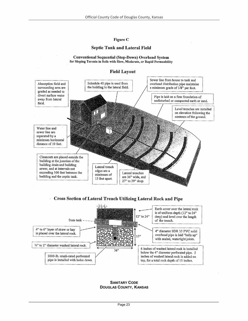
Official County Code of Douglas County, Kansas
Page 23
SANITARY CODE
DOUGLAS COUNTY, KANSAS

Official County Code of Douglas County, Kansas
Page 24
CHAPTER 3 SINGLE-FAMILY WASTE STABILIZATION PONDS (LAGOONS) SECTION 1 DEFINITIONS In addition to the definitions provided in Chapter 1 of this code, the words, terms and phrases listed below,
for purposes of this Chapter 3, are defined as follows: 3-1.1 Approval or Approved: accepted or acceptable by the Health Department in accordance with
applicable specifications stated herein or with additional criteria accepted by the Department.
3-1.2 Floodplain: the 100-Year Floodplain. 3-1.3 Health Department: the Lawrence-Douglas County Health Department. 3-1.4 Lagoon or Sewage Lagoon: an artificial pond designed to exclude surface water and receive raw
sewage through a submerged sewer for biological decomposition. 3-1.5 Public or Community Sewerage System: any sewage collection, treatment and disposal system,
including sewers, treatment plants, pumping stations, force mains and all other elements owned, operated or managed by a public entity (including agents thereof) and serving more than one residential premises.
SECTION 2 AREA REQUIREMENTS 3-2.1 Residential Parcels, Tracts, or Lots. For the unincorporated areas of Douglas County, Kansas, an
individual waste stabilization pond (lagoon) shall not be constructed upon any parcel, tract, or lot of less than ten (10) adjoining acres.
The exceptions to this requirement are when: a. A division of property, which is less than the above stated minimum, has occurred and
has been filed with the Douglas County Register of Deeds prior to October 10, 1997; or
b. A property is exempt under Section 21 - 4.07 of the Douglas County Zoning Regulations.
SECTION 3 USE OF SINGLE-FAMILY WASTE STABILIZATION PONDS (LAGOONS) 3-3.1 The use of an individual waste stabilization pond, usually referred to as a lagoon, will be considered
only when located within slowly permeable soils of 0.2 inches per hour or less, as determined by the USDA Soil Survey of Douglas County.
SECTION 4 PERMIT REQUIRED 3-4.1 No person shall be issued a building permit without having first obtained from the Health
Department a permit to construct a lagoon. A fee shall be charged by the Health Department for the permit.
3-4.2 No person shall construct, repair or alter a lagoon without obtaining a construction permit for such purpose from the Health Department. No permit for the construction, repair or alteration of a lagoon shall be issued until the Health Department has inspected and approved the site and the proposed location and design of the lagoon. The lagoon may be inspected by the Health Department at any stage of construction.
3-4.3 All applicants will be required to sign an application form to acknowledge the lagoon must be inspected and installed according to the approved plan.
3-4.4 No house or structure shall be occupied or used until a final inspection shows the lagoon has been approved by the Health Department.
SECTION 5 INSTALLER LICENSE REQUIRED 3-5.1 No person shall install, construct, repair, or alter a lagoon without having first obtained an annual
Installer License from the Health Department. An annual fee shall be charged by the Health Department for the license.
3-5.2 An Installer License may be issued to a commercial contractor or homeowner. A homeowner shall install, repair, or alter lagoon located on his/her property only.
3-5.3 A licensed installer shall be on site at all times when the lagoon is being installed, constructed, repaired, or altered.
3-5.4 The licensed commercial contractor shall be responsible for informing the property owner regarding recommended maintenance of a lagoon that the contractor installs, constructs, repairs, or alters.

Official County Code of Douglas County, Kansas
Page 25
3-5.5 No person shall receive an Installer License from the Health Department without having first passed a written examination. A minimum of 70 percent of the answers on the written examination shall be answered correctly to receive the Installer’s License.
3-5.6 Written examinations may be taken at any time during the calendar year. Any person wishing to take a written examination may do so by making an appointment with the Health Department. There will be a test fee for taking the examination.
SECTION 6 DATA REQUIREMENTS 3-6.1 The following shall be submitted to and accepted by the Health Department before issuance of a
permit to construct a lagoon. a. An application form including the following: 1) Name, address and phone number of applicant and owner. 2) Location of building site, including legal description with section, township and range. 3) Number of bedrooms, number of persons to live in the home and a list of all water-
using appliances. b. A drawing of the lot or site, showing: 1) Overall dimensions of the lot; 2) Location of buildings, driveways, public and private easements and geographical
features near the proposed lagoon; 3) Location and type of water supply and location of water service lines;
4) Layout of entire lagoon system; lagoon, diversion box, if used, and interconnecting lines;
5) Proposed size and location of lagoon; 6) Foundation, footing or any other non-sewage drain location; 7) Arrow indicating North direction; and
c. Other supportive data or information required by the Health Department. 3-6.2 Field Data. Field data including the following:
a. The permeability class of the soil layers at and below the proposed floor of the lagoon and the interior dikes of the lagoon.
b. The depth to permanent or fluctuating water table. c. The depth to hardrock, bedrock or other impervious materials. d. The slope of the proposed lagoon area. e. The percentage by volume of coarse fragments greater than ten (10) inches in
diameter. f. The percentage of soil surface covered by coarse fragments greater than ten (10)
inches in diameter. g. The unified soil group at and below the bottom and sides of the lagoon based on the
unified soil-engineering classification system. Soil and groundwater test holes shall be made to a minimum depth of four (4) feet below the proposed floor of the lagoon. If test holes are left unattended, they shall be “benched” for safety reasons (see Figure A).
3-6.3 Percolation Tests. Percolation tests may be required by the Health Department. a. Preparation of Percolation Test Holes. Percolation test holes shall be dug or bored with
vertical sides, shall be four (4) inches in width and shall extend to the proposed depth of the Single-family Waste Stabilization Pond. Sides and bottom of test holes shall be scratched with a pointed instrument to remove smeared soil surfaces and to provide a natural soil interface into which water may percolate. Loose material shall be removed and two (2) inches of fine gravel or coarse sand shall be added to the test hole. Test holes shall not be located in or near draws, banks, stump holes or any other location where percolation rates derived would not be representative of typical soil and terrain conditions. Six or more percolation tests shall be made in separate test holes spaced uniformly over the proposed Single-family Waste Stabilization Pond site.
b. Saturation and Swelling of Soil. Percolation test holes shall be filled with water and shall be kept filled until the soil is saturated and clays have had an opportunity to swell. No tests shall be performed until the soil has been soaked at least four (4) hours. The Health Department may require that the test holes be soaked overnight.

Official County Code of Douglas County, Kansas
Page 26
c. Percolation Rate Measurement. After soaking, water depths in the percolation test holes shall be adjusted until six (6) inches of water remains over the gravel. From a fixed reference point, established at or near ground surface, repeated measurements shall be made at equal time intervals of the distance in inches from the reference point to the water surface. Water shall be added to restore a six (6) inch depth if the water falls to less than two (2) inches above the gravel.
Measurements shall be continued until a constant percolation rate is evidenced (i.e. the water surface drops the same distance each time interval). The time in minutes
required for the water column to drop one inch at this constant rate shall be recorded as the percolation rate. When percolation rates vary significantly within the proposed area, additional tests may be required and data on all tests performed must be submitted for review.
SECTION 7 EXISTING SINGLE-FAMILY WASTE STABILIZATION PONDS 3-7.1 Any lagoon lawfully installed prior to the effective date of these standards may remain in use if, and
so long as, it continues to operate in accordance with the original design and location and does not present any hazard to the public health, safety or welfare. Any replacement, alteration, enlargement, repair, removal, conversion, improvement or demolition shall comply with the requirements of these standards or as amended.
SECTION 8 CONNECTION TO SEWER – SINGLE-FAMILY WASTE STABILIZATION PONDS 3-8.1 If a public or community sewage system becomes available to a premise served by a Single-family
Waste Stabilization Pond, the owner, lessee or agent shall be required to connect the properties affected to the public or community sewage system within 90 days.
3-8.2 The waste stabilization pond shall be abandoned by dewatering and pushing in the dikes and returning the area to the contours it had before construction of the waste stabilization pond.
3-8.3 A public or community sewage system shall be considered available if it is within 200 feet of a building connected to the Single-family Waste Stabilization Pond.
SECTION 9 CONNECTION TO SINGLE-FAMILY WASTE STABILIZATION POND 3-9.1 All sinks, flush toilets, lavatories, garbage disposals, dishwashers, clothes washing machines,
shower baths, bath-tubs, basins and similar plumbing fixtures or appliances shall be connected to the Single-family Waste Stabilization Pond.
3-9.2 If water from roof drains and/or foundation drains is discharged into the lagoon, then provision shall be made so that this water can be diverted from the pond when the lagoon is at capacity.
SECTION 10 SIZE OF SINGLE-FAMILY WASTE STABILIZATION PONDS 3-10.1 The following criteria shall be used to determine the size of the Single-family Waste Stabilization
Pond: a. If the house has 3 bedrooms or less or if it will serve 5 persons or less, then the
smaller lagoon shall be required. The smaller lagoon is illustrated in Figure B. b. If the house has 4 or 5 bedrooms and will serve 6, 7 or 8 persons, then the larger
lagoon shall be required. The larger lagoon is illustrated in Figure C. c. If there is any question about size, then the larger lagoon, Figure C, shall be required.
For instance, if the house has 3 bedrooms and is occupied by 6 persons, the larger size will be used.
SECTION 11 SINGLE-FAMILY WASTE STABILIZATION POND REQUIREMENTS 3-11.1 If percolation tests are required then the percolation rate shall be slower than or equal to 1-inch fall
per hour in the area of the Single-family Waste Stabilization Pond. 3-11.2 If undisturbed soil forms the bottom of the lagoon, then the bottom of the lagoon shall not be closer
than four (4) feet to bedrock. 3-11.3 When the pond excavation penetrates or terminates in either a rock strata or porous (sand or
gravel) strata the excavation shall be extended a distance of one foot on both the bottom and side slopes. The areas of supplemental excavation shall be filled with a non-permeable earthen material to limit seepage from the pond to a maximum value of ¼ inch per day. This may be accomplished by using a clay soil which is free of rocks. If a clay soil is not available, the fill soil shall be mixed with bentonite clay at the manufacturer’s recommended rate and then compacted.

Official County Code of Douglas County, Kansas
Page 27
3-11.4 The normal ground water elevation shall be at least ten (10) feet below ground surface and four (4) feet below the bottom of the lagoon.
SECTION 12 LOCATION REQUIREMENTS 3-12.1 Unless otherwise approved by the Health Department, the single-family waste stabilization pond
shall be located as set forth in Table 1. No single-family waste stabilization pond shall be installed within: a. Twenty-five (25) feet of any private water line or water meter (p. 4, KDHE Bulletin 4-2,
or as amended). b. Fifty (50) feet of any house or ther building. c. Fifty (50) feet of any cistern, in-ground swimming pool, surface water course, creek
bank, stream, river, pond, or lake (p. 4, KDHE Bulletin 4-2, or as amended). d. One hundred (100) feet of any property line, including right-of-way. e. One hundred (100) feet of any water well.
3-12.2 No single-family waste stabilization pond permitted after January 1, 2007, shall be installed within the floodplain nor where groundwater or adverse geological formations may result in the contamination of groundwater by sewage.
3-12.3 All distances shall be measured from inside top of the waste stabilization pond dike. SECTION 13 MINIMUM DESIGN AND CONSTRUCTION 3-13.1 Sewage Conduits
a. Size of sewage conduits – Sewage conduits connecting component parts of Single-family Waste Stabilization Pond systems shall be a minimum of four (4) inches in diameter.
b. Materials – All pipe and fittings used in sewage conduits shall be constructed of PVC and meet nationally-recognized standards for their designated use-such as Standards published by the American Society for Testing and Materials or the National Sanitation Foundation and shall have been approved by the Health Department for use in on-site management systems. Sewage conduits under driveways or similar areas of load or impact shall be of material capable of withstanding maximum anticipated loads. All sewage pipe shall be marked to indicate it meets or exceeds a Schedule 40 or heavier “crush test” rating.
c. Construction – Sewage conduits shall be installed with sealed, watertight, root-resistant joints and shall be laid on a firm foundation. This shall not be subject to settling, and shall be installed at a grade not less than one-eighth (⅛) inch per foot.
All pipe from the structure to the Single-family Waste Stabilization Pond shall be laid “bells up” if bell and spigot pipe is used.
d. Cleanouts – Cleanouts shall be placed at the junction of the building drain and building sewer at intervals not to exceed 100 feet in straight runs and as required by the Health Department.
A capped cleanout shall be placed near the junction of the sewer and the Single-family Waste Stabilization Pond at the nearest point where the flowline will be above the maximum pond water level. This cleanout shall be located so that water will not flow out of the pipe during the periods when the pond is full. This cleanout shall be accessible during the full pond stage.
3-13.2 Dike Requirements a. All dike slopes shall be 3½ feet horizontal to 1 foot vertical. b. The top of the dike shall be smoothed to a width of five feet to facilitate fencing. c. The dike shall be smooth with no clods, rocks, or ruts that will interfere with a mower. d. The top of the dike shall be below the point where sewage exits the house. e. Surface drainage shall not enter the pond. Surface drainage shall be diverted around
the pond. 3-13.3 Watering Requirements
a. The lagoon shall be prewatered to a depth of 2½ feet. b. Operating water depth shall be maintained between 1½ and 5 feet. c. Roof drains may be discharged to the sewer system provided there is a control
arrangement which can divert this water from the sewer system during times of high water in the pond. Water shall be added as needed.
Official County Code of Douglas County, Kansas
Page 28
d. The minimum dike freeboard shall be 2½ feet. e. If the pond appears that it will overflow then the Lawrence-Douglas County Health
Department shall be contacted for emergency procedures. 3-13.4 Outflow Pipe
a. The outflow pipe shall terminate about one foot from the center of the bottom of the pond. An extension shall be provided which will allow discharge of sewage at that point.
3-13.5 Fencing Requirements a. Fencing shall be installed to a minimum height of four feet. b. Corner posts shall be of substantial construction. Creosote, Osage orange or pipe
corner posts are acceptable. They shall be cemented and provided with a “H” or “N” style brace at each corner.
c. A four foot high hung gate with a lock shall be provided. The gate width shall be no less than four feet.
d. The fencing shall be installed no closer than four feet from the top inside edge of the dike.
e. Chain link fence or fencing with openings no greater than 4” x 4” is acceptable. In areas where livestock will have access to the fence, the fence posts shall be tall enough to install two strands of barbed wire or a single strand of electric fencing at the top of the fencepost.
f. Fence posts shall be no further than twelve (12) feet apart. Fencing is illustrated in Figures D-E-F-G at the end of the document.
g. No other fencing can be installed unless specific written approval is granted by the Health Department.
h. All fencing requirements shall be completed and approved by the Health Department prior to occupancy of the residence.
3-13.6 Seeding and Sterilization a. The pond bottom and interior dikes up to two (2) feet elevation shall be treated with a
herbicide at the manufacturer’s recommended sterilization rate. Care shall be taken not to apply herbicide above the two (2) feet elevation level where grass will be seeded.
b. All dike area not sterilized shall be seeded with a densely growing, short-rooted grass, such as Blue, Fescue, Brome or Bermuda.
SECTION 14 OPERATION AND MAINTENANCE DIRECTIONS 3-14.1 The dikes shall have a good stand of groundcover established and maintained on it. This grass
must be a short-rooted perennial such as Blue, Fescue, Brome or Bermuda. Once this vegetation is established it shall be regularly maintained. Trees and tall weeds shall not be allowed to develop in the dike area. Vegetation shall not be allowed to grow higher than six (6) inches.
3-14.2 Water vegetation shall be controlled at first appearance. All trees and weeds, such as cattails and duckweed, shall be removed as soon as the first ones develop in the water. Trees and weeds shall be removed from the water so that they do not contribute to the organic loading of the pond.
3-14.3 The water depth shall be maintained between 1½ and 5 feet. 3-14.4 Any damage to the dikes shall be repaired by reshaping the area to the original plan and then
establishing a good stand of groundcover on the worked areas. Surface water shall be diverted around the pond so it will not contribute to the hydraulic loading of the pond or create an erosion problem.
3-14.5 The waste stabilization pond, fence, gate and pipe, shall be maintained in the condition called for in the original plans and specifications.
3-14.6 Animal and waterfowl shall not be confined within the pond fence. Figure A
“Benched” Test Hole See 3-5.2. Field Data Requirements

Official County Code of Douglas County, Kansas
Page 29
10-Foot Deep Test Hole for Lagoon
Figure B The Smaller Single-Family Waste Stabilization Pond

Official County Code of Douglas County, Kansas
Page 30
Figure C The Larger Single-Family Waste Stabilization Pond

Official County Code of Douglas County, Kansas
Page 31
Figure D Fencing: The Standard Fence
Installation of Line Posts and Fencing

Official County Code of Douglas County, Kansas
Page 32
39 Figure E
Fencing: Standard Bracing for “N” Style Corners

Official County Code of Douglas County, Kansas
Page 33
Figure F Fencing: Standard Bracing for “H” Style Corners

Official County Code of Douglas County, Kansas
Page 34
Figure G Fencing: Standard Hung Gate with “H” Style Bracing

Official County Code of Douglas County, Kansas
Page 35
SANITARY CODE
DOUGLAS COUNTY, KANSAS CHAPTER 4 WATER SUPPLIES SECTION 1 DEFINITIONS
In addition to the definitions provided in Chapter 1 of this code, the words, terms and phrases listed below, for purposes of this Chapter 4, are as follows:
4-1.1 Abandoned Water Well: a water well determined by the Kansas Department of Health and Environment to be a well which meets any of the following criteria: a. Use has been permanently discontinued. b. Pumping equipment has been permanently removed. c. The well is in such a state of disrepair that it cannot be used to supply water, or has the
potential for transmitting surface contaminants into the aquifer, or both.

Official County Code of Douglas County, Kansas
Page 36
d. The well poses a potential health or safety hazard. e. The well is in such condition that it cannot be placed in active or inactive status.
4-1.2 Active Well: a water well which is an operating well used to withdraw water, monitor or observe groundwater conditions.
4-1.3 Annular Space: the space between the well casing and the well bore or the space between two or more strings of well casing.
4-1.4 Aquifer: an underground formation that contains and is capable of transmitting groundwater. 4-1.5 Backflow: the undesirable reversal of flow of water or mixtures of water and other liquids, gases or
other substances into the distribution pipes of the potable supply of water from any source or sources.
4-1.6 Cistern: a container or receptacle utilized to contain potable water delivered from a public water supply for household domestic uses. The cistern shall be a minimum capacity of 1,000 gallons and the construction material of the cistern shall be approved by the Health Department.
4-1.7 Confined Aquifer: an aquifer overlain and underlain by impermeable layers. Groundwater in a confined aquifer is under pressure greater than atmospheric pressure and will rise in a well above the point at which it is first encountered.
4-1.8 Construction of Water Wells: all acts necessary to obtain groundwater by any method for any use including, without limitation, the location of and excavation for the well.
4-1.9 Cross-Connection: any unprotected actual or potential connection or structural arrangement between a public or a consumer’s potable water system and any other source or system through which it is possible to introduce into any part of the potable system any used water, industrial fluid, gas, or substance other than the intended potable water with which the system is supplied. By-pass arrangements, jumper connections, removable sections, swivel or change-over devices and other temporary or permanent devices through which or because of which temporary or permanent devices through which or because of which “backflow” can or may occur are considered to be cross-connections.
4-1.10 Domestic Uses: the use of water by any person or family unit or household for household purposes, or for the watering of poultry, farm and domestic animals used in operating a farm, or for the watering of less than one thousand (1,000) head of livestock, or for the
irrigating of lands not exceeding a total of two acres in area for the growing of gardens, orchards and lawns.
4-1.11 Floodplain: the 100-year floodplain. 4-1.12 Groundwater: the part of the subsurface water which is in the zone of saturation. 4-1.13 Grout: cement grout, neat cement grout, bentonite clay grout or other material approved by the
department used to create a permanent impervious watertight bond between the casing and the undisturbed formation surrounding the casing or between two or more strings of casing. a. Neat cement grout is a mixture consisting of one ninety-four (94) pound bag of portland
cement to five to six gallons of clean water. b. Cement grout is a mixture consisting of one ninety-four (94) pound bag of portland
cement to an equal volume of sand having a diameter no larger than 0.080 inches (2 millimeters) to five to six gallons of clean water.
c. Bentonite clay grout is a mixture consisting of water and commercial grouting or plugging sodium bentonite clay containing high solids such as that manufactured under the trade name of “volclay grout”, or an equivalent as approved by the Kansas Department of Health and Environment. 1) The mixture shall be per the manufacturer’s recommendations to achieve a weight
of not less than 9.4 pounds per gallon of mix. Weighting agents may be added as per the manufacturer’s recommendations.
2) Sodium bentonite pellets, tablets or granular sodium bentonite may also be used provided they meet the specifications listed in 4-1.13.c. above.
3) Sodium bentonite products that contain low solids, are designed for drilling purposes or that contain organic polymers shall not be used.
4-1.14 Grout Tremie Pipe or Grout Pipe: a steel or galvanized steel pipe or similar pipe having equivalent structural soundness that is used to conduct pumped grout to a point of selected

Official County Code of Douglas County, Kansas
Page 37
emplacement during the grouting of a well casing or plugging of an abandoned well or test hole.
4-1.15 Health Department: the Lawrence-Douglas County Health Department. 4-1.16 Heat Pump Hole: a hole drilled to install piping for an earth coupled water source heat pump
system, also known as a vertical closed loop system. 4-1.17 Inactive Status: a water well which is not presently operating but is maintained in such a way it can
be put back in operation with a minimum of effort. 4-1.18 KDHE: the Kansas Department of Health and Environment. 4-1.19 License: a document issued by the Kansas Department of Health and Environment to qualified
persons making application therefore, authorizing such persons to engage in the business of water well contracting.
4-1.20 Non-Public Water Supply: all water supplies for domestic uses which do not meet the definition of public water supply.
4-1.21 Pitless Well Adapter or Unit: an assembly of parts installed below frost line which will permit pumped groundwater to pass through the wall of the casing or extension thereof and prevent entrance of contaminants.
4-1.22 Public Water Supply System: a system for delivery to the public of piped water for human consumption that has at least ten (10) service connections or regularly serves at least twenty-five (25) individuals daily at least sixty (60) days out of the year. This term includes any source, treatment, storage or distribution facilities used in connection with the system.
4-1.23 Pump Pit: a watertight structure constructed at least two feet away from the water well and below ground level to prevent freezing of pumped groundwater and which houses the pump or pressure tank, distribution lines, electrical controls, or other appurtenances.
4-1.24 Reconstructed Water Well: an existing well that has been deepened or has had the casing replaced, repaired, added to or modified in any way for the purpose of obtaining groundwater.
4-1.25 Sanitary Well Seal: a manufactured seal, approved by the Kansas Department of Health and Environment and Lawrence-Douglas County Health Department, installed at the top of the well casing which, when installed, creates an air and watertight seal to prevent contaminated or polluted water from gaining access to the groundwater supply.
4-1.26 Static Water Level: the highest point below or above ground level which the groundwater in the well reaches naturally.
4-1.27 Test Hole or Hole: any excavation constructed for the purpose of determining the geologic, hydrologic and water quality characteristics of underground formations.
4-1.28 Treatment: the stimulation of production of groundwater from a water well, through the use of hydrochloric acid, muriatic acid, sulfuric acid, calcium, or sodium hypochlorite, polyphosphates or other chemicals and mechanical means, for the purpose of reducing or removing iron and manganese hydroxide and oxide deposits, calcium and magnesium carbonate deposits and slime deposits associated with iron or manganese bacterial growths which inhibit the movement of groundwater into the well.
4-1.29 Uncased Test Hole: any test hole in which casing has been removed or in which casing has not been installed.
4-1.30 Unconfined Aquifer: an aquifer containing groundwater at atmospheric pressure. The upper surface of the groundwater in an unconfined aquifer is the water table.
4-1.31 WWC-5 Form: a water well drilling report completed by a well driller licensed by the Kansas Department of Health and Environment (KDHE).
4-1.32 Water Well: any excavation that is drilled, cored, bored, washed, driven, dug, jetted, or otherwise constructed when the intended use of such excavation is for the location, diversion, artificial recharge or acquisition of groundwater.
4-1.33 Water Well Contractor: any individual, firm, partnership, association or corporation who shall construct, reconstruct or treat a water well. The term shall not include: a. An individual constructing, reconstructing or treating a water well located on land
owned by the individual, when the well is used by the individual for farming, ranching, or agricultural purposes or for domestic purposes at the individual’s place of abode.

Official County Code of Douglas County, Kansas
Page 38
b. An individual who performs labor or services for a licensed water well contractor at the contractor’s direction and under the contractor’s supervision.
SECTION 2 WATER SUPPLY REQUIRED 4-2.1 Owners of private homes that are used as a principle residence and all rented or leased homes
shall furnish at least one convenient outlet supplying an adequate quantity of potable water. Owners of permanent establishments shall furnish an adequate supply of safe water for the clientele.
4-2.2 For individual lots, tracts, or parcels which contain a minimum lot area of three (3) adjoining acres but less than five (5) adjoining acres, no permit for the construction of a new on-site sewage management system will be issued after the effective date of this Sanitary Code before approval of the water supply by the Health Department. Approval of the water supply shall include one of the following requirements: a. A letter of approval has been issued by the appropriate public water supply that a water
meter has been purchased for the property [Subdivision Regulation 20-811 (e) (1), p. 58, or as amended].
b. A permit has been issued by the Health Department for a private cistern to be constructed. Cisterns shall not be installed on lots, tracts, or parcels divided after January 1, 2007, within the City of Lawrence Urban Growth Area (a public water supply is required for such lots) [Subdivision Regulation 20-811 (e) (1), p. 58, or as amended].
4-2.3 For individual lots, tracts, or parcels which contain a minimum lot area of five (5) adjoining acres, no permit for the construction of a new on-site sewage management system shall be issued after the effective date of this Sanitary Code before approval of the water supply by the Health Department. Approval of the water supply shall include one of the following requirements: a. A letter of approval has been issued by the appropriate public water supply that a water
meter has been purchased for the property [Subdivision Regulation 20-811 (e) (1), p. 58, or as amended].
b. A permit has been issued by the Health Department for a private well to be constructed. Lots, tracts, or parcels divided after January 1, 2007, which are located within the Urban Growth Area shall not use private water wells as the primary potable water source (a public water supply is required for such lots) [Subdivision Regulation 20-811 (e) (1), p.58, or as amended].
c. A permit has been issued by the Health Department for a private cistern to be constructed. Cisterns shall not be installed on lots, tracts, or parcels divided after January 1, 2007, within the City of Lawrence Urban Growth Area (a public water supply is required for such lots) [Subdivision Regulation 20-811 (e) (1), p. 58, or as amended].
SECTION 3 PUBLIC WATER SUPPLIES 4-3.1 State Permit. No person shall operate a public water supply without obtaining a permit from the
Kansas Department of Health and Environment. 4-3.2 State Approved Plans. No person shall construct any public water supply on any property subject to
the provisions of this code until the plans and specifications have been submitted and approved by the Kansas Department of Health and Environment. A copy of the plans and specifications shall be made available to the Lawrence-Douglas County Health Department if requested by the Lawrence-Douglas County Health Department.
SECTION 4 NON-PUBLIC WATER SUPPLIES 4-4.1 No person shall construct a non-public water supply without approval from the Health Department. 4-4.2 Use of surface water (lakes, ponds, or streams) as a source of water for a non-public water supply
shall not be permitted. SECTION 5 NON-PUBLIC WATER SUPPLIES WITH TWO (2) OR MORE SERVICE CONNECTIONS 4-5.1 Permit
Required a. No permit for constructing a non-public water supply with two (2) or more service
connections shall be issued to any person when in the discretion of the Lawrence-Douglas County Health Department the property can be served by a public water supply.
b. No person shall construct, repair or alter a non-public water supply with two (2) or more service connections without obtaining a construction permit for such purpose

Official County Code of Douglas County, Kansas
Page 39
from the Lawrence-Douglas County Health Department. No permit for the construction, repair or alternation of the water supply shall be issued until the Lawrence-Douglas County Health Department has inspected and approved the site and the proposed location and design of the water supply. A fee shall be charged by the Lawrence-Douglas County Health Department for the service. The water supply may be inspected by the Lawrence-Douglas County Health Department at any stage of construction.
c. The Lawrence-Douglas County Health Department may require the water supply to be designed by a professional engineer and may ask for review of the proposal by the Kansas Department of Health and Environment.
4-5.2 Operation and Maintenance Requirements a. The owner of the water supply or his/her representative shall immediately notify the
Lawrence-Douglas County Health Department of a situation with the water system including a breakdown or loss of water service which presents or may present an imminent and substantial endangerment to health.
b. Newly constructed or repaired water distribution mains and finished water storage facilities shall be flushed and disinfected before use in accordance with methods acceptable to the Lawrence-Douglas County Health Department.
c. The water supply shall be operated and maintained to provide a minimum positive pressure of twenty (20) psi (140kN/m²) throughout the distribution system except under extraordinary conditions such as unusual peak fire flow demand or major distribution system breaks.
d. No person shall operate or maintain a non-public water supply system with two (2) or more service connections that has been: 1) Constructed or reconstructed after October 10, 1997, until it has been inspected and
a permit issued by the Lawrence-Douglas County Health Department. 2) Temporarily or permanently enjoined as a public health nuisance by a court of
competent jurisdiction. 3) Found by the Lawrence-Douglas County Health Department not to comply with the
provisions of these standards and a written notice thereof has been given to the owner or his/her agent.
4-5.3 Water Samples and Use of a Non-Public Water Supply with Two (2) or More Service Connections In addition to the requirements which pertain to non-public water wells, the following shall be done and reviewed by the Lawrence-Douglas County Health Department prior to the issuance of a permit, to assure water quality for the public: a. A bacterial analysis is to be done initially and at least annually thereafter. b. A partial chemical analysis is to be done initially and every three (3) years thereafter. c. Other tests such as a screen for pesticides, volatile organic chemicals and heavy
metals may be required, at the direction of the Lawrence-Douglas County Health Department to protect the public’s health.
d. The water samples shall be collected by the Lawrence-Douglas County Health Department and sent to Kansas Department of Health and Environment lab or other state certified labs for analysis. The fee for the analysis is the responsibility of the owner of the water supply or his/her representative.
SECTION 6 CISTERNS 4-6.1 New cisterns shall not be installed on lots, tracts, or parcels divided after January 1, 2007, within the
City of Lawrence Urban Growth Area (a public water supply is required for such lots) [Subdivision Regulation 20-811 (e) (1), p. 58, or as amended].
4-6.2 Permit Required. No permit for the construction of a cistern shall be issued until the Health Department has inspected and approved the site and the proposed location and design of the cistern. A fee shall be charged by the Health Department for the construction permit. The cistern and water system may be inspected by the Health Department at any stage of construction.
4-6.3 Minimum Standards. Cisterns constructed after the effective date of this Sanitary Code shall meet the following requirements: a. Cisterns shall be constructed of monolithic concrete or “food grade” plastic. b. Cisterns shall have a minimum capacity of one thousand (1,000) gallons.

Official County Code of Douglas County, Kansas
Page 40
c. Cisterns shall be filled with potable water delivered from a public water supply. 4-6.4 Location Requirements. No cistern shall be installed after the effective date of this Sanitary Code
within: a. Fifty (50) feet of any septic tank. b. Fifty (50) feet of any septic absorption field. c. Any areas where rainwater is likely to enter the cistern.
SECTION 7 NON-PUBLIC WATER WELLS
4-7.1 Permit Required. No person shall construct a non-public water well for domestic uses without obtaining a construction permit for such purpose from the Lawrence-Douglas County Health Department. No permit for the construction shall be issued until the Lawrence-Douglas County Health Department has inspected and approved the site and the proposed location and design of the non-public water well. A fee shall be charged by the Lawrence-Douglas County Health Department. The system and well may be inspected by the Lawrence-Douglas County Health Department at any stage of construction. SECTION 8 MINIMUM STANDARDS FOR NON-PUBLIC WATER WELLS
Construction regulations for all wells other than public water supply: 4-8.1 Area Requirements
a. No well shall be located upon any parcel, tract, or lot of less than five (5) adjoining acres whereon an on-site sewage management system is utilized.
b. Any land divided after January 1, 2007, which is located within the floodplain shall not be counted in calculating lot area for the purpose of meeting minimum lot area requirements for on-site sewage management systems [Subdivision Regulation 20-811 (d) (2) (i), p.57, or as amended]. Lots, tracts, or parcels divided after January 1, 2007, which are located within the Urban Growth Area shall not use private water wells as the primary potable water source (a public water supply is required for such lots) [Subdivision Regulation 20-811 (e) (1), p. 58, or as amended].
The exemptions to this requirement are when: 1). A division of property, which is less than the above stated minimum, has occurred
and has been filed with the Douglas County Register of Deeds prior to October 10, 1997; or
2) A property is exempt under Section 21-4.07 of the Douglas County Zoning Regulations.
3) Any lands divided prior to January 1, 2007, shall not be required to meet the floodplain requirements [Subdivision Regulation 20-801 (d), p. 7, or as amended].
4-8.2 Location Requirements a. Unless otherwise approved by the Health Department, the well shall be located as set
forth in Table 3. After the effective date of this Sanitary Code, no new well shall be installed within: 1) Fifteen (15) feet of any utility line. 2) Twenty-five (25) feet of any property line, allowing public right-of-ways to be
counted. 3) Fifty (50) feet of any residential building or any other building which has the
potential to be treated for termites. 4) Fifty (50) feet of any septic tank, surface water course, creek bank, stream, pond,
river, or lake (p. 4, KDHE Bulletin 4-2, or as amended). 5) Fifty (50) feet of any sewer line or pressure sewer line. 6) One hundred (100) feet of any abandoned cesspool, inactive well, barnyard,
feedlot, waste stabilization pond (lagoon), manure storage, pit privy, or septic system absorption field.
7) One hundred fifty (150) feet of any chemical storage, fertilizer storage, fuel storage, pesticide storage or landfill.
8) Any floodplain. b. Proper drainage in the vicinity of the well shall be provided so as to prevent the
accumulation and ponding of surface water within fifty (50) feet of the well. The well shall not be located in a ravine or any other drainage area where surface water may flow into the well.

Official County Code of Douglas County, Kansas
Page 41
c. The water well shall be so located as to minimize the potential for contamination of the delivered or obtained groundwater and to protect groundwater aquifers from pollution and contamination.
d. After the effective date of this Sanitary Code, any newly constructed well shall be located within the boundaries of the same legally described lot, tract, or parcel as the building(s) for which the well supplies water.
4-8.3 Grouting For Constructed or Reconstructed Wells a. Constructed or reconstructed wells shall be sealed by grouting the annular space
between the casing and the well bore from ground level to a minimum of twenty (20) feet or to a minimum of five feet into the first clay or shale layer, if present, whichever is greater. If a pitless well adapter or unit is being installed, the grouting shall start below the junction of the pitless well adapter or unit where it attaches to the well casing and shall continue a minimum of twenty (20) feet below this junction or to a minimum of five feet into the first clay or shale layer whichever is greater.
b. To facilitate grouting, the grouted interval of the well bore shall be drilled to a minimum diameter at least three inches greater than the maximum outside diameter of the well casing. If a pitless well adapter or unit is being installed on the well’s casing, the well bore shall be a minimum diameter of at least three inches greater than the outside maximum diameter of the well casing through the grouted interval below the junction of the pitless well adapter or unit where it attaches to the well casing.
c. If groundwater is encountered at a depth less than the minimum grouting requirement, the grouting requirement may be modified to meet local conditions if approved by the Kansas Department of Health and Environment.
d. Waters from two or more separate aquifers shall be separated from each other in the bore hole by sealing the bore hole between the aquifers with grout.
4-8.4 Well Casing a. Asbestos-cement well casing (transite) shall not be used in water wells that produce
water for human consumption or food processing. b. All wells shall have durable watertight casing from at least one foot above finished
ground surface to the top of the producing zone of the aquifer. In no event shall the watertight casing extend less than twenty (20) feet below the ground level. Exceptions to either of the above may be granted by the Kansas Department of Health and Environment if warranted by local conditions. The casing shall be clean and serviceable and of a type to guarantee reasonable life so as to insure adequate protection to the aquifer or aquifers supplying the groundwaters. Used, reclaimed, rejected, or contaminated pipe shall not be used for casing any well. All water well casing shall be approved by the Kansas Department of Health and Environment.
c. All groundwater producing zones that are known or suspected to contain natural or man-made pollutants shall be adequately cased and grouted off during construction of the well to prevent the movement of the polluted groundwater to either overlying or underlying fresh groundwater zones.
d. The well casing shall terminate not less than one (1) foot above the finished ground surface. No opening shall be made through the well casing except for installation of a pitless well adapter so designed and fabricated to prevent soil, subsurface and surface water from entering the well.
4-8.5 Well Vents Well vents shall be used and shall terminate not less than one foot above ground surface and shall be screened with 16-mesh, brass, bronze, copper screen or other screen materials approved by the Kansas Department of Health and Environment and turned down in a full one hundred eighty (180) degree return bend so as to prevent the entrance of contaminating materials.
4-8.6 Temporary Capping All wells, when unattended during construction, reconstruction, treatment or repair, or during use as cased test holes, observation or monitoring wells, shall have the top of the well casing securely capped in a watertight manner to prevent contaminating or polluting materials from gaining access to the groundwater aquifer.
Official County Code of Douglas County, Kansas
Page 42
4-8.7 Sanitary Well Seal The top of the well casing shall be sealed by installing a sanitary well seal which has been approved by KDHE.
4-8.8 Pump Pit a. Any pump pit shall be constructed at least two feet away from the water well. The pipe
from the pump or pressure tank in the pump pit to the water well shall be sealed in a watertight manner where it passes through the wall of the pump pit.
b. Water wells shall not be constructed or reconstructed in pits, basements, garages or crawl spaces.
4-8.9 Pump Mounting a. All pumps installed directly over the well casing shall be so installed that an airtight and
watertight seal is made between the top of the well casing and the gear or pump head, pump foundation or pump stand.
b. When the pump is not mounted directly over the well casing and the pump column pipe or pump suction pipe emerges from the top of the well casing, a sanitary well seal shall be installed between the pump column pipe or pump suction pipe and the well casing. An airtight and watertight seal shall be provided for the cable conduit when submersible pumps are used.
4-8.10 Cleaning of Well Prior to completion of a constructed or reconstructed well, the well shall be cleaned of mud, drill cuttings and other foreign matter so as to make it suitable for pump installations.
4-8.11 Toxic Materials Toxic materials shall not be used in the construction, reconstruction, treatment or plugging of a water well unless those material are thoroughly flushed from the well prior to use.
4-8.12 Natural Organic or Nutrient Producing Material Natural organic or nutrient producing material shall not be used during the construction, reconstruction or treatment of a well unless it is thoroughly flushed from the well and the groundwater aquifer or aquifers before the well is completed. Natural organic or nutrient producing material shall not be added to a grout mix used to grout the well’s annular space.
4-8.13 Disinfection Water well disinfection for wells constructed or reconstructed for human consumption or food processing. a. Gravel for gravel-packed wells shall be disinfected by immersing the gravel in chlorine
solution containing not less than two hundred (200) milligrams per liter (mg/1) of available chlorine before it is placed in the wells annular space.
b. Constructed or reconstructed wells shall be disinfected by adding sufficient hypochlorite solution to them to produce a concentration of not less than one hundred (100) mg/1 of available chlorine when mixed with water in the well.
c. The pump, casing, screen and pump column shall be washed down with a two hundred (200) mg/1 available chlorine solution.
d. All persons constructing, reconstructing, or treating, a water well and removing the pump or pump column, replacing a pump, or otherwise performing an activity which has potential for contaminating or polluting the groundwater supply shall be responsible for adequate disinfection of the well, well system and appurtenances thereto.
e. All drilling waters used during the construction or reconstruction of any water well shall be initially disinfected by mixing with the water enough sodium hypochlorite to produce at least one hundred (100) milligrams per liter (mg/1) of available chlorine.
SECTION 9 ABANDONED WELLS 4-9.1 All abandoned wells shall be plugged in accordance with Kansas Department of Health and
Environment regulation. SECTION 10 GENERAL OPERATING REQUIREMENTS 4-10.1 Water Well Record

Official County Code of Douglas County, Kansas
Page 43
a. A water well contractor who constructs, reconstructs or plugs a water well shall submit a copy of the water well record, form WWC-5, to the Lawrence-Douglas County Health Department and the Kansas Department of Health and Environment within thirty (30) days after the construction, reconstruction or plugging of the water well. The copy sent to the Lawrence-Douglas County Health Department shall be mailed to: 200 Maine Street, Suite B, Lawrence, Kansas 66044.
b. A landowner who constructs, reconstructs or plugs a water well which will be or was used by the landowner for farming, ranching or agricultural purposes or is located at the landowner’s place of abode, shall submit a copy of the water well record, form WWC-5, to the Lawrence-Douglas County Health Department and the Kansas Department of Health and Environment within thirty (30) days after the construction, reconstruction or plugging of the water well.
4-10.2 Artificial Recharge and Return. The Construction of artificial recharge wells and freshwater return wells shall comply with all applicable rules and regulations of the Kansas Department of Health and Environment.
4-10.3 Well Tests. When a pumping test is run on a well, results of the test shall be reported on the water well record, form WWC-5, or a copy of the contractor’s record of the pumping test shall be attached to the water well record.
4-10.4 Water Samples. a. Within 30 days after receipt of the water well record, form WWC-5, the Kansas
Department of Health and Environment or Lawrence-Douglas County Health Department may request the contractor, or landowner who constructs or reconstructs his or her own water well, to submit a sample of water from the well for chemical analysis.
b. All wells constructed or reconstructed after September 20, 1993, should be sampled for coliform bacteria and parts per million (ppm) of nitrate-nitrogen. A fee may be charged by the Lawrence-Douglas County Health Department for the service.
c. Samples of water from any water supply may be taken and examined by the Lawrence-Douglas County Health Department whenever deemed necessary for the detection of pollution, compliance or unwholesomeness. The Lawrence-Douglas County Health Department may refuse to take or examine samples of water from any water supply which is not adequately protected from surface contamination.
d. The Lawrence-Douglas County Health Department may condemn and prohibit use or require repairs of any water supply which is determined to be a present danger to the public health.
SECTION 11 CROSS-CONNECTION AND BACK-SIPHONAGE 4-11.1 No person shall install and maintain a cross-connection between any public water supply and any other water supply.
Table 1 Kansas Department of Health and Environment Approved
Water Well Casing [Authorization K.A.R. 28-30-6(h)]
Water Well Casing for Water Wells other than Public Water Supply and Reservoir Sanitation Zone Water Wells
Steel and Wrought Iron
Minimum Wall Thickness

Official County Code of Douglas County, Kansas
Page 44
Depth of Casing (Feet)
Nominal Diameter (Gauge or Inches)* 4 6 8 10 12 14 16 18 24 30
0-100 10 10 10 10 10 10 10 10 7 0.219 100-200 10 10 10 10 10 7 7 7 0.219 0.219 200-400 10 10 10 10 7 7 7 0.219 0.250 0.250 400-600 7 7 7 7 7 7 0.219 0.250 0.312 0.312
600 or more 7 0.219 0.219 0.219 0.219 0.219 0.250 0.375 0.375 0.375
* Whole numbers indicate the U.S. standard gauge (10 gauge = 0.141 inches and 7 gauge = 0.179 inches).
*Decimal numbers indicate thickness in inches
Table 2 Kansas Department of Health and Environment Approved Water Well Casing
[Authorization K.A.R. 28-30-6(h)]
Water Well Casing for Water Wells other than Public Water Supply and Reservoir Sanitation Zone Water Wells
Thermalplastic Polyvinyl Chloride (PVC)
Styrene Rubber (SR) which is the same as Rubber Modified Polystyrene (RMP) Acrylonitrile-Butadiene-Stryene (ABS)
Minimum Wall Thickness (Inches) and Tolerances (Inches) made in Standard Dimension Ratios (SDR)
Nominal Pipe Size
SDR 26 SDR 21 SDR 17 SDR 13.5 Minimum Tolerance Minimum Tolerance Minimum Tolerance Minimum Tolerance
2 0.113 0.02 0.14 0.02 0.176 0.021 2.5 0.137 0.02 0.169 0.02 0.213 0.025 3 0.167 0.02 0.206 0.025 0.259 0.031 3.5 0.19 0.023 0.235 0.028 0.296 0.036 4 0.173 0.021 0.214 0.026 0.265 0.032 0.333 0.040 5 0.214 0.027 0.265 0.032 0.327 0.039 0.412 0.049 6 0.255 0.031 0.316 0.038 0.39 0.047 0.491 0.058 8 0.332 0.04 0.41 0.049 0.508 0.061 10 0.413 0.05 0.511 0.061 0.632 0.076 12 0.490 0.059 0.606 0.073 0.75 0.09 14 0.539 0.065 16 0.616 0.074
Table 3
Location of Water Well
See 4-9.2 – Location Restrictions
Minimum Horizontal Distance (Feet) Required

Official County Code of Douglas County, Kansas
Page 45
from: to Water Well Utility line 15 Property line, allowing public right-of-way to be counted 25 Residential building or any other building which has the potential to be treated for termites
50
Septic tank 50 Surface water course, creek bank, stream, pond, river, or lake (p. 4, KDHE bulletin 4-2, or as amended)
50
Abandoned cesspool 100 Inactive well 100 Barnyard or feedlot 100 Waste stabilization pond (lagoon) 100 Manure storage 100 Pit privy 100 Septic system absorption field 100 Chemical storage 150 Fertilizer storage 150 Fuel storage 150 Pesticide storage 150 Landfill 150
SANITARY CODE
DOUGLAS COUNTY, KANSAS CHAPTER 5 SEPTAGE WASTE HAULERS SECTION 1 SEWAGE REMOVAL PERMIT 5-1.1 No person, firm or corporation may remove, transport, or dispose of the contents of septic tanks, or
onsite sewage management systems without having first obtained from the Lawrence-Douglas County Health Department an annual sewage removal permit. The application for the permit shall be submitted in writing on forms provided by the Health Department.
5-1.2 The application shall include: a. Business name and address. b. Name and address of the applicant. c. License tag number and identification number of vehicle. d. Manner by which such contents are to be removed, transported, and given final
disposal. e. Written documentation that sewage removed and transported will be accepted at
disposal sites. 5-1.3 A fee shall be charged by the Health Department for the Sewage Removal Permit. SECTION 2 DISPOSAL METHODS 5-2.1 Disposal of sewage from onsite sewage management systems shall be by:
a. Discharge to a public or community sewerage system, or

Official County Code of Douglas County, Kansas
Page 46
b. By another method and disposal site approved by the Lawrence-Douglas County Health Department. Disposal shall require written permission of the appropriate governmental jurisdiction or land owner and the Health Department.
5-2.2 Septage shall be pumped from the septic tank manhole, and not from the inspection risers. SECTION 3 ADDITIONAL REQUIREMENTS FOR LAND APPLICATION OF SEPTAGE
5-3.1 The licensee shall comply with all the requirements mandated under Title 40, Part 503, of the Code of Federal Regulations.
5-3.2 All land application sites shall be inspected and approved in writing by the Health Department prior to any land application use.
5-3.3 Application rates shall not exceed 30,000 gallons per acre, per year. 5-3.4 No land application sites activated into service after the effective date of this Sanitary Code shall be
permitted within the FEMA-designated 100-year floodplain. 5-3.5 No application onto any surface such as frozen or saturated soil shall be permitted, if any run-off to
the waters of the State is likely to occur. 5-3.6 No land application sites shall be permitted within 100 feet of a property line. 5-3.7 No septage application shall be permitted into a private wastewater lagoon or sanitary landfill. 5-3.8 No application shall be permitted within one-half mile of a public water supply well. SECTION 4 VEHICLE IDENTIFICATION 5-4.1 The name of the person or firm engaging in the removal of sewage from onsite sewage management
systems shall be lettered on both sides of each vehicle used for sewage removal purposes. Letters and numerals shall not be less than two (2) inches in height.
SECTION 5 VEHICLE MAINTENANCE 5-5.1 Every vehicle used for removal of sewage from onsite sewage management systems shall be
equipped with a watertight tank or body. All pumps, hose lines, valves and fittings shall be maintained so as to prevent leakage. The operator shall demonstrate that the equipment is in good operating condition and will perform its function without leakage or spillage.
SECTION 6 REVOCATION OF SANITARY SERVICES LICENSE 6-1.1 A permit may be revoked for failure to comply with these regulations.`-
ARTICLE 6. FAIR HOUSING
3-601 KANSAS ACT AGAINST DISCRIMINATION; ENDORSEMENT. The Board of County Commissioners hereby endorses and affirmatively supports the provisions of the Kansas Act Against Discrimination which prohibits discrimination in housing practices. The statutory provisions found in K.S.A. 44-1015 et seq. prohibit discrimination in the sale or rental of real property, or in the provision of services or facilities in connection therewith because of race, religion, color, sex, national origin or ancestry. The board affirms its commitment to the principles contained in K.S.A. 44-1015 et seq., and urges any person who believes he or she is the victim of a discriminatory housing practice in violation of such law to file a complaint with the Kansas Commission on Civil Rights. (Res. 89-26, Sec. 1)
3-602 SAME; COPIES. In furtherance of the anti-discrimination provisions of the Kansas Act Against Discrimination, the Board of County Commissioners shall keep on file in its office and in the office of the Douglas County Clerk copies of the Kansas Act Against Discrimination and the complaint procedures handbook of the Kansas Commission on Civil Rights. Any individual who is

Official County Code of Douglas County, Kansas
Page 47
interested in reviewing such information will be afforded that opportunity upon request. (Res. 89-26, Sec. 2)

Official County Code of Douglas County, Kansas
Page 1
CHAPTER 4. CABLE TELEVISION
Article 1. CABLE TELEVISION .................................................................. 1
ARTICLE 1. CABLE TELEVISION
4-101 DEFINITIONS.
a) Person means any individual, partnership, association, corporation, legal entity or organization of any kind.
b) Cable Television System means a system composed of, without limitations, antenna, cables, wires, lines, towers, wave guides, or any other conductors, converters, equipment or facilities for the purpose of the distribution on a community antenna television system of television programs by means of high antenna or microwave transmission amplified and distributed by coaxial cable to the premises of its subscribers.
c) Franchise means a nonexclusive authorization to use the roads, public ways and dedicated easements of the county to construct, operate, maintain or lease a cable television system and provide cable television service within the unincorporated areas of the county. (HR 85-7-1, Sec. 7)
4-102 REGULATORY PURPOSE. The county shall supervise and regulate all cable telephone service business operating within the unincorporated areas of the county so far as may be necessary to prevent such operation and service from having detrimental consequences to the public interest. For this purpose the county may promulgate and enforce such reasonable rules and regulations as it may deem necessary with reference to commencement of operation, territory of operation, the extension of service equitably to all parts of the franchise area, abandonment of facilities, elimination of unjust discrimination among subscribers, financial responsibility, insurance covering personal injury and property damage, safety of equipment, use of streets, alleys, dedicated easements and other public places, and reasonable grounds for forfeiture of franchise rights. (HR 85-7-1, Sec. 1)
4-103 FRANCHISE REQUIRED. It shall be unlawful for any person, firm or corporation acting in its own behalf or under a lease with or pole contract from any public utility to construct, install, operate or maintain a cable television service in, on, over, under, upon, across, from and along the streets, alleys, sidewalks, public property and public ways within the unincorporated areas of

Official County Code of Douglas County, Kansas
Page 2
the county without first obtaining from the county a franchise authorizing the same under such reasonable conditions as the circumstances may require. The county hereby is authorized to grant or extend one or more such franchises for a term not to exceed 20 years from the date of such grant or extension. No person, firm or corporation shall ever be granted an exclusive franchise. Such franchises shall take the form of a resolution authorizing the construction, operation, and maintenance of cable television systems, shall set forth conditions accompanying the grant of franchise, shall provide for regulation and use of the system, shall provide penalties for violation of the franchise provisions, and shall provide for a franchise fee. (HR 85-7-1, Sec. 2)
4-104 FILING OF PROPOSED RATES. Every applicant for a franchise shall file with the county a schedule of its proposed rates and charges for its proposed services. (HR 85-7-1, Sec. 3)
4-105 FILING OF MAP OF FACILITIES. There shall be filed with the county by the person, firm or corporation providing cable television service a proper map showing and describing the exact location of all of its facilities within the county streets, alleys and public ways including underground cables and equipment. (HR 85-7-1, Sec. 4)
4-106 FRANCHISE FEE. The county by resolution shall levy a franchise fee or tax, including annual fixed charges as may be prescribed in the franchise resolution. Such fixed charge may consist of a percentage of the gross receipts derived from the service permitted by the franchise from consumers or recipients of such service located within the unincorporated areas of the county. Such levies, taxes or fees including all forms of consideration to such county and including initial lump sum payments must be reasonable and shall be generally in conformance with standards, if any, established by Federal Communications Commission regulations or other applicable laws. (HR 85-7-1, Sec. 5)
4-107 VIOLATION OF FRANCHISE, PROHIBITION OF OPERATION WITHOUT FRANCHISE. In the event of violation of any county franchise provision, by any duly franchised person or entity furnishing cable television service, the county before taking any action to declare a forfeiture shall serve written notice of such violation upon the franchise holder with directions to correct such violation, or show cause why such violation should not be corrected at a public hearing held not less than 30 days from the date of service of such written notice. Continued violation of any county franchise provision of this

Official County Code of Douglas County, Kansas
Page 3
chapter may be enjoined by the district court. Any person, firm or corporation acting in its own behalf or under a lease with or pole contract from any public utility which attempts to or does construct, install, operate or maintain a cable television service in, on, over, under, upon, across, from or along the roads, alleys, sidewalks, public property and public ways within the unincorporated area of the county without possessing a valid franchise from the county as authorized by this chapter shall be guilty of a Class C misdemeanor. Each day such act continues shall constitute a separate offense. (HR 85-7-1, Sec. 6)

Official County Code of Douglas County, Kansas
Page 1
CHAPTER 5. EMERGENCY MEDICAL SERVICES AND EMERGENCY PREPAREDNESS
Article 1. DEPARTMENT AND DIVISIONS ................................................ 1 Article 2. EMERGENCY MEDICAL SERVICE RATES .............................. 4 Article 3. RECOVERY OF EXPENSES FOR RELEASE OF
HAZARDOUS MATERIAL .................................................... 6 Article 4. LOCAL EMERGENCY MANAGEMENT PLANNING .................. 8 Article 5. AMBULANCE SERVICE LICENSE REQUIREMENTS
AND REGULATIONS ......................................................... 16
ARTICLE 1. DEPARTMENT AND DIVISIONS
5-101 DEPARTMENT OF EMERGENCY MEDICAL SERVICES AND EMERGENCY MANAGEMENT ESTABLISHED. In order to consolidate and coordinate the administration, planning and execution of emergency medical services and emergency preparedness activities in Douglas County, there is hereby established a Department of Emergency Medical Services and Emergency Management, consisting of an ambulance service division and an emergency management division. The department shall be under the administrative supervision of a director who shall be appointed by the county commission upon the recommendation of the county administrator. (Res. 86-15, Sec. 1) (Res. 95-53, §1,2)
5-102 AMBULANCE SERVICE DIVISION.
a) The ambulance service division shall be responsible for the operation of the Douglas County ambulance service under the authority of K.S.A. 65-4301, et seq., and amendments thereto, other applicable state and local laws, and such policies as shall be adopted by the county commission. The division also shall be responsible for such other duties as shall be assigned by the director of the department of emergency medical services and emergency management. Responsibility for administration of additional or new programs shall be approved by the county commission.
b) All of the powers, duties, functions and budget authority of the existing Douglas County ambulance service are hereby transferred to and conferred upon the department of emergency medical services and emergency management and the ambulance service division thereof. Such powers shall be exercised under the direction and supervision of

Official County Code of Douglas County, Kansas
Page 2
the director of the department of emergency medical services and emergency management.
c) Whenever the Ambulance Service Operations Director, or words of like effect, are referred to or designated by statute, resolution, contract or other document, such references or designations shall be deemed to apply to the Director of the Department of Emergency Medical Services and Emergency Management. (Res. 86-15, Sec. 2) (Res. 95-53, §1,2)
5-103 EMERGENCY MANAGEMENT DIVISION.
a) The emergency management division shall be administered by the emergency management coordinator, who shall be appointed by the director of the department of emergency medical services and emergency management, with the approval of the county administrator. The emergency management coordinator shall be in the classified-exempt service under the Douglas County personnel policy, and shall be subject to removal only with the approval of the county administrator.
b) The Division of Emergency Management shall be granted the authority necessary to carry out the functions enumerated in Section 5-103(c) of this Code.
c) The Division of Emergency Management shall be the Douglas County Disaster Agency required by K.S.A. 48-929(a). The emergency management division shall be responsible for the administration of all state and county laws concerning emergency preparedness. The division also shall be responsible for such other duties as shall be assigned by the director of the department of emergency medical services and emergency management. Responsibility for administration of additional or new programs shall be approved by the county commission. The division shall coordinate its activities with all local, state and federal agencies as required to effectuate the laws of Douglas County and the State of Kansas. The duties and responsibilities of the Division of Emergency Management as carried out under the direction of the Coordinator shall include the following:
1) Coordination of response and recovery activities during and following disaster emergency;
2) Development and maintenance of a county hazard analysis;
3) Development of a local emergency planning program and maintenance of an all-hazard emergency operations plan for the county;
4) Implementation of a local technological hazards program which includes participation on the local emergency planning committee

Official County Code of Douglas County, Kansas
Page 3
as provided for in K.S.A. 65-5703 and the development and coordination of a radiological protection system for the county;
5) Development and maintenance of an active public education program, both through direct public presentations and contacts with the local news media;
6) Development of an emergency exercise program to test the capability of the county to implement the emergency operations plan;
7) Development and coordination of a county emergency management training program;
8) Development and coordination of county hazard warning and notification systems;
9) Coordination of all requests by the county for assistance from other jurisdictions and the state and federal governments during a disaster emergency;
10) Identification of mitigation actions necessary within the county to prevent hazards or to lessen their impact; and
11) Provide advice and assistance to the County Commission in preparation of emergency declarations under K.S.A. 48-932.
d) All of the powers, duties, functions and budget authority of the existing department of emergency preparedness are hereby transferred to and conferred upon the department of emergency medical services and emergency management and the emergency management division thereof. Such powers shall be exercised by the emergency preparedness coordinator of such division, under the direction and supervision of the director of the department of emergency medical services and emergency management.
e) Douglas County will provide support to the Division of Emergency Management including:
1) Office space and clerical support sufficient to perform the required emergency preparedness functions;
2) Transportation or reimbursement for private transportation used of official duties;
3) Communication arrangements that allows for 24-hour a day notification to the Division of Emergency Management;
4) The identification of at least one person to serve as an alternate coordinator when the Coordinator is not available.

Official County Code of Douglas County, Kansas
Page 4
f) Whenever the emergency management director and the department of emergency management, or words of like effect, are referred to or designated by statute, resolution, contract or other document, such references or designations shall be deemed to apply to the department of emergency medical services and emergency management and the director thereof, respectively, and the emergency management division and, where applicable, the coordinator thereof, established by this article.
g) All agencies and employees of Douglas County will cooperate with the Division of Emergency Management in all matters pertaining to emergency preparedness. (Res. 86-15, Sec. 3) (Res. 95-53, Sec. 1,2)
ARTICLE 2. EMERGENCY MEDICAL SERVICE RATES
5-201 EMERGENCY MEDICAL SERVICE RATES. The rates for ambulance service in Douglas County shall be as follows:
a) ALS 2: All inclusive advanced life support emergency and routine service provided where at least three medications are administered by intravenous push/bolus or by continuous infusion excluding crystalloid, hypotonic, isotonic, and hypertonic solutions (Dextrose, Normal Saline, Ringer’s Lactate) or one ALS procedure (e.g. Manual defibrillation/cardioversion, endotracheal intubation, central venous line, cardiac pacing, chest decompression, surgical airway, intraossesous line) is provided:
1) January 1, 2016 to December 31, 2016: base rate $712.00 plus $8.49 per loaded mile.
2) January 1, 2017 to December 31, 2017: base rate $743.00 Plus $8.86 per loaded mile.
3) January 1, 2018 to December 31, 2018: base rate $774.00 plus $9.23 per loaded mile.
b) Emergency ALS: All inclusive advanced life support emergency and routine service where specialized services are provided:
1) January 1, 2016 to December 31, 2016: base rate $643.00 plus $8.49 per loaded mile.
2) January 1, 2017 to December 31, 2017: base rate $671.00 plus $8.86 per loaded mile.
3) January 1, 2018 to December 31, 2018: base rate $699.00 plus $9.23 per loaded mile
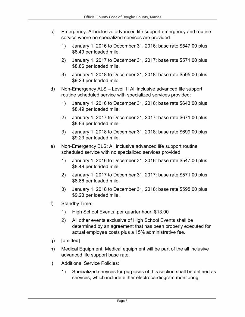
Official County Code of Douglas County, Kansas
Page 5
c) Emergency: All inclusive advanced life support emergency and routine service where no specialized services are provided
1) January 1, 2016 to December 31, 2016: base rate $547.00 plus $8.49 per loaded mile.
2) January 1, 2017 to December 31, 2017: base rate $571.00 plus $8.86 per loaded mile.
3) January 1, 2018 to December 31, 2018: base rate $595.00 plus $9.23 per loaded mile.
d) Non-Emergency ALS – Level 1: All inclusive advanced life support routine scheduled service with specialized services provided:
1) January 1, 2016 to December 31, 2016: base rate $643.00 plus $8.49 per loaded mile.
2) January 1, 2017 to December 31, 2017: base rate $671.00 plus $8.86 per loaded mile.
3) January 1, 2018 to December 31, 2018: base rate $699.00 plus $9.23 per loaded mile.
e) Non-Emergency BLS: All inclusive advanced life support routine scheduled service with no specialized services provided
1) January 1, 2016 to December 31, 2016: base rate $547.00 plus $8.49 per loaded mile.
2) January 1, 2017 to December 31, 2017: base rate $571.00 plus $8.86 per loaded mile.
3) January 1, 2018 to December 31, 2018: base rate $595.00 plus $9.23 per loaded mile.
f) Standby Time:
1) High School Events, per quarter hour: $13.00
2) All other events exclusive of High School Events shall be determined by an agreement that has been properly executed for actual employee costs plus a 15% administrative fee.
g) [omitted]
h) Medical Equipment: Medical equipment will be part of the all inclusive advanced life support base rate.
i) Additional Service Policies:
1) Specialized services for purposes of this section shall be defined as services, which include either electrocardiogram monitoring,

Official County Code of Douglas County, Kansas
Page 6
intravenous solutions administration or advanced airway establishment.
2) The all-inclusive base rates will consist of all disposable supplies including pharmaceuticals and solutions.
3) When a helicopter is used instead of an ambulance to transport the patient from the scene, the patient will be charged the applicable base rate.
4) When a patient receives specialized services and is not transported, the patient will be charge the applicable base rate.
5) When service is rendered and either the City of Lawrence or Douglas County would be responsible for the fee, the all fees will be waived.
6) When service is provided for emergency service personnel while performing their official duties the fee(s) will be waived.
7) Lawrence-Douglas County Fire Medical shall accept assignment on all Medicare or Medicaid claims or when Medicare/Medicaid benefits have been waived by a beneficiary in conjunction with a managed care plan. In addition, Lawrence-Douglas County Fire and Medical shall accept allowable amounts from the State Crime Victims Fund, the Veterans Administration, Tricare/Champus and Worker Compensation claims.
8) Lawrence-Douglas County Fire Medical shall be a contracting provider of ambulance services for Blue Shield of Kansas.
9) All ambulance services must be provided by a Kansas licensed advanced life support capable ambulance. (Res. 16-01, Sec. 1)
ARTICLE 3. RECOVERY OF EXPENSES FOR RELEASE OF HAZARDOUS MATERIAL
5-301 DEFINITIONS.
a) Emergency action shall mean all of the concerted activities conducted in order to prevent or mitigate injury to human health or the environment from a release or threatened release of an hazardous material into or upon the environment.
b) Governmental entities shall mean the University of Kansas; the Cities of Baldwin City, Eudora, Lawrence, and Lecompton; Douglas County; rural fire districts; townships; and any entity responding under a mutual aid agreement with any of these entities.
c) Person shall mean any individual, corporation, association, partnership, firm, trustee, or legal representative.

Official County Code of Douglas County, Kansas
Page 7
d) Recoverable expenses are all those expenses that are reasonable and necessary for the emergency action. Recoverable expenses include, but are not limited to:
1) Disposable materials and supplies acquired, consumed, and expended specifically for the purpose of the emergency action.
2) Any additional compensation payment to employees, consultants and contracts for the time and efforts devoted to the emergency action beyond the usual compensation of those employees normally on duty. There must be an explicit request for mutual or outside aid form the agency with jurisdiction for these additional expenses to be recoverable. (The usual compensation of employees normally on duty is not intended to be a recoverable expense.)
3) Rental or leasing of equipment used specifically for the emergency action (e.g., protective equipment or clothing, scientific and technical equipment.)
4) Replacement costs for equipment that is contaminated beyond reuse or repair that is owned by the governmental entity.
5) Decontamination of equipment contaminated during the emergency action.
6) Other special services specifically required for the emergency action.
7) Laboratory costs of analyzing samples taken during the emergency action.
8) Any costs of clean-up, storage, or disposal of the release material.
9) Costs associated with the services, supplies and equipment procured for a specific evacuation.
10) Medical expenses incurred as a result of emergency action.
11) Legal expenses that may be incurred as a result of the emergency action, including efforts to recover expenses pursuant to this resolution.
e) Release shall mean any spilling, leaking, pumping, pouring, emitting, emptying, discharging, injection, escaping, leaching, dumping, or disposing into or upon the environment.
f) Threatened Release shall mean a condition which exists when a release is likely to occur unless preventive measures are immediately taken to prevent such release. (Res. 94-5, Sec. 2)

Official County Code of Douglas County, Kansas
Page 8
5-302 LIABILITY. Any and all persons responsible for a release or threatened release which results in an emergency action shall be liable to the governmental entities for the recoverable expenses resulting from the emergency action. (Res. 94-5, Sec. 3)
5-303 RECOVERY OF EXPENSES.
a) The staffs of the governmental entities involved in the emergency action shall keep a detailed record of its recoverable expenses resulting from the emergency action. Promptly after completion of the emergency action, the staffs shall certify these expenses to the Director of Emergency Medical Services and Emergency Management. The Director of Emergency Medical Services and Emergency Management, or his or her designee, shall give any and all persons responsible for the emergency action a written itemized claim for the total certified expenses incurred by the governmental entity as part of the emergency action. The claim shall specify that if not paid in full within thirty (30) days, the County may initiate a civil action for the collection of the claim. Moneys recovered under this resolution shall be credited to the appropriate funs of the governmental entity from which moneys were expended in performing the emergency action.
b) The Douglas County Administrator is hereby authorized to have a legal action brought on behalf of the County to recover any such claim which has not been paid within the specified thirty (30) days.
c) This civil remedy shall be in addition to, and not in lieu of, any criminal prosecution or penalty. (Res. 94-5, Sec. 4)
5-304 This remedy shall be in addition to any other remedies the governmental entities have at law. This remedy shall not preclude the Ambulance Service Division from either participating in this claim or assessing fees for service in accordance with the adopted fee schedule. (Res. 94-5, Sec. 5)
ARTICLE 4. LOCAL EMERGENCY MANAGEMENT PLANNING
5-401 PURPOSES.
a) To provide for the preparation and execution of the disaster management plans for the protection of persons and property within Douglas County in accordance with the provisions and requirements of Kansas Statutes Annotated 48-904 through 48-939, and K.A.R. 56-2-1 et seq. specifying the standards for local disaster agencies.
b) To provide for carrying out the requirements of both Kansas and Federal laws as they relate to the responsibilities of the local emergency

Official County Code of Douglas County, Kansas
Page 9
planning committee, and as specified in K.S.A. 65-5701 through 65-5710 as amended by the 1991 Kansas Session Laws and the Federal Emergency Planning and Community Right-to-Know Act of 1986.
c) To create a single body that will serve the function of both an advisory body to the Douglas County Commission and to the governing bodies of the Cities on emergency management concerns and as the Local Emergency Planning Committee for Douglas County. (Res. 06-38)
5-402 DEFINITIONS.
a) Emergency Management means the preparation for and the carrying out of all emergency functions, other than functions for which military forces or other Federal agencies are primarily responsible, to mitigate or prevent, to prepare for, to respond to and to recover from disasters.
b) Director means the chief operational officer of the Department of Emergency Management.
c) Board means the Emergency Management Board of Douglas County. (Res. 06-38)
5-403 ORGANIZATION OF THE BOARD.
a) There is hereby created a Douglas County Emergency Management Board, hereinafter referred to as the "Board", which shall consist of members to be selected as follows:
Appointed by the Board of Commissioners of Douglas County:
1) A member of the Board of Commissioners of Douglas County or their designee for a term of one (1) year.
Appointed by the Douglas County Emergency Management Board:
2) An appointee of an individual to represent an emergency management organization or emergency support function to serve a term of 3 years.
3) An appointee to represent the disaster mass care function to serve for a term of 3 years.
4) An appointee to represent the public information function to serve for a term of 3 years.
5) An appointee to represent a community group or social service agency with an interest in emergency preparedness for a term of 3 years.

Official County Code of Douglas County, Kansas
Page 10
6) An appointee to represent a transportation organization to serve for a term of 3 years.
7) An appointee to represent owners and operators of facilities subject to the provisions of the Emergency Planning and Community Right-to- Know Act of 1986. Such appointment to last for a term of 3 years.
8) An appointee of an individual with a background in chemistry and an interest in chemical emergency preparedness for a term of 3 years.
Appointed by other entities:
9) A member from each of the governing bodies of Baldwin, Eudora, Lawrence and Lecompton or a designee from each for a term of one (1) year.
10) A fire chief from one of the County township fire departments or the fire departments of Baldwin or Eudora selected by the Douglas County Fire Chief’s Association for a term of 3 years.
11) The chief administrative officer of Lawrence Memorial Hospital or his/her designee.
12) The Director of the Douglas County Health Department or his/her designee.
13) An appointee by the Provost of the Lawrence Campus of the University of Kansas of a university official with an interest in emergency preparedness. Such appointment to last for a term of 3 years.
14) An appointee by the Superintendent from the Lawrence, Baldwin and Eudora public school districts in Douglas County. Such appointments to last for a term of 3 years.
15) An appointee by the President of Haskell Indian Nations University with an interest in emergency preparedness. Such appointment to last for a term of 3 years.
16) An appointee of the Douglas County Veterinary Medical Association for a term of 3 years.
17) An appointee of a private, local utility provider for a term of 3 years.
Permanent Members:
18) The Douglas County Sheriff.
19) The Lawrence Police Chief or his/her designee.

Official County Code of Douglas County, Kansas
Page 11
20) The Baldwin Police Chief during even numbered years and the Eudora Police Chief during odd numbered years.
21) The University of Kansas Police Chief or his/her designee.
22) The Director of Lawrence-Douglas County Fire Medical Department or his/her designee.
23) The Director of the Douglas County Emergency Communications Center.
24) The Douglas County Public Works Director during even numbered years and the Lawrence Public Works Director during odd numbered years.
b) By July 31 each year the County Commission shall submit the current membership of the Board to the state emergency response commission as the County Commission nominees to the Douglas County Local Emergency Planning Committee. In addition, when the membership changes for whatever reason, the change will be forwarded to the state emergency response commission by the County Commission as nominations to the Local Emergency Planning Committee.
c) When appointed by the state emergency response commission as members of the Douglas County Emergency Management Board the members will serve on the Board and as the Local Emergency Planning Committee. If the state emergency response commission refuses to appoint a County Commission nominee the original appointing body will appoint an alternate person to the Board for nomination to the local emergency planning committee.
d) In the event of resignation, death, or incapacity to serve of any member of the Board, the original appointing body will fill the position.
e) The Board shall organize annually on or before June 30th of each year and elect officers including a Chairman, Vice Chairman and 3 Executive Committee Members. The Executive Committee shall consist of these 5 officers.
f) The members of the Board shall serve without compensation.
g) The Board shall be provided with appropriate office space, supplies and equipment in the Emergency Operations Center, but it shall incur no expense until the same has been authorized by the County Commission, and such funds from which such expenses shall be payable have been designated. Nothing herein shall be construed as requiring such authorization or designation where work is done for the benefit of the Board by a regular officer, office, department, board, or other agency of the County. (Res. 06-38)

Official County Code of Douglas County, Kansas
Page 12
5-404 POWERS AND DUTIES OF THE BOARD.
a) To adopt, amend and repeal rules and regulations and bylaws governing its procedure and activities.
b) To serve as an advisory board to the Douglas County Commission, the Cities of Baldwin, Eudora, Lawrence and Lecompton in Douglas County, the Director and to cooperate with any Federal and State agencies created and existing from time to time for the purposes of effectuating emergency management.
c) To act jointly and cooperate with other emergency management organizations and local emergency planning committees and the state emergency response commission.
d) To create committees, either within or without its membership, and to enroll volunteer organizations to aid in the discharge of its power and duties.
e) To serve as an advisory board in investigations and report to the Governing Body of Cities and/or County Commission with recommendations for ordinances, resolutions or other appropriate actions as it may deem necessary with respect to the type of activity of matters of public concern of welfare, in so far as the same shall or may be related to defense and relief from the effects of manmade or natural disasters. Such investigations, reports, and recommendations shall be made available to the Adjutant General when and as required by law.
f) To request the cooperation and assistance of the agencies and officials of the Cities of Baldwin, Eudora, Lawrence and Lecompton, the County of Douglas and the State of Kansas for the purposes of effectuating emergency management.
g) To advise the County Commission and the Director concerning the annual budget of the Department of Emergency Management, purchase of new equipment, hiring of personnel and adoption of the Douglas County, Kansas Disaster Management Plan.
h) To Approve and recommend to the Douglas County Commission an all-hazards Disaster Management Plan including a chemical emergency plan in accordance with the requirements of the federal Emergency Planning and Community Right-to-Know Act of 1986.
i) After being appointed by the state emergency response commission, to serve as the Local Emergency Planning Committee for Douglas County. (Res. 06-38)
5-405 AUTHORITY AND DUTIES OF THE EXECUTIVE COMMITTEE.

Official County Code of Douglas County, Kansas
Page 13
a) The Executive Committee shall serve in an administrative capacity for the Board.
b) The Committee shall review the annual budget and recommend action to the Board.
c) The Committee shall participate in the hiring of and consult with the County Administrator on the performance evaluation of the Director.
d) The Committee shall have the power to request an appointing body to replace a Board member who fails to attend a reasonable number of Board meetings.
e) The Executive Committee shall have such duties and authority as specified and delegated by the Board. (Res. 06-38)
5-406 AUTHORITY AND DUTIES OF THE DIRECTOR OF DOUGLAS COUNTY EMERGENCY MANAGEMENT. The Department of Emergency Management shall be granted the authority necessary to carry out the functions of K.A.R. 56-2-2, and as enumerated in this resolution. The Director is hereby empowered:
a) To request the Chairman of the County Commission, the Mayors of each of the cities, or the Governing Bodies of the Cities or the County Commission to proclaim a state of disaster emergency when a disaster has occurred or the threat of a disaster is imminent or to request the termination of a state of disaster emergency.
b) To serve as the lead staff position to assist the Board in carrying out its duties and responsibilities.
c) To provide the vision, direction and emergency management subject matter expertise to heighten a state of emergency readiness in Douglas County.
d) To coordinate the mitigation, preparedness, response and recovery efforts of emergency management in the Cities and County for the accomplishment of the purpose of this resolution.
e) To enhance emergency resources and capabilities through facilitating the coordination and the cooperation among governmental agencies, volunteers, citizens, private sector agencies, businesses and community organizations, services and staff in the emergency management efforts of the Cities and County.
f) To exercise the emergency management responsibilities of the Department pursuant to programs and methods approved by the Board and the County Commission.

Official County Code of Douglas County, Kansas
Page 14
g) To supervise the operational functions of the Douglas County Department of Emergency Management.
h) To represent the Douglas County Department of Emergency Management in dealings with the public, private business and industry, and government agencies pertaining to emergency management functions.
i) To coordinate the mitigation, preparedness, response and recovery activities before, during and following a disaster emergency.
j) To develop and maintain a county hazard analysis, a mitigation plan, and a continuity of government plan.
k) To develop a local emergency planning program and maintain an all-hazard emergency management plan that addresses natural hazards, chemical, biological, explosive, or nuclear events.
l) To implement a local technological hazards program that includes participation on the local emergency planning committee as provided for in K.S.A. 65-5703, and the development and coordination of a radiological protection program.
m) To develop and maintain an active public education program, both through direct public presentations and contacts with the local news media.
n) To develop an exercise program to test the capability of the county, the cities, the public safety and support organizations and the citizens to implement the emergency management plan.
o) To develop and coordinate an emergency management training program to enhance the readiness capability of governmental agencies, volunteers, citizens, private sector agencies, businesses, and first responders.
p) To develop and coordinate a county emergency warning and notification system to notify the public of impending threats or other emergency information.
q) To secure disaster assistance in support of local disaster emergency efforts through coordination with other jurisdictions, the state, and the federal government.
r) To coordinate the recruitment, training, registration and identification of volunteer emergency workers necessary to support emergency response and recovery efforts. (Res. 06-38)
5-407 SUPPORT PROVIDED TO THE DEPARTMENT OF EMERGENCY MANAGEMENT.

Official County Code of Douglas County, Kansas
Page 15
Douglas County will provide, at a minimum, the support specified in K.A.R. 562-2 to the Department of Emergency Management including:
a) Office space and clerical support sufficient to perform the required emergency management functions.
b) Transportation or reimbursement for private transportation used for official duties.
c) Communications arrangement that allows for 24-hour a day notification to the Department of Emergency Management staff.
d) The identification of at least one person to serve as an alternate director when the Director is not available.
e) The cooperation of all agencies and employees of Douglas County in all matters pertaining to emergency management. (Res. 06-38)
5-408 SUCCESSION. In normal operational circumstances when the Director is unavailable one of the appointed Assistant Directors shall assume the duties and responsibilities of the Coordinator. In a disaster or extreme emergency situation where the Director is unavailable, the Assistant Director or his/her designee shall assume the duties of the Director. If the Assistant Director is unavailable, the Douglas County Sheriff will assume the duties and responsibilities of the Director. (Res. 06-38)
5-409 ORGANIZATION OF EMERGENCY MANAGEMENT. All officials and employees of the Cities and Counties, together with those volunteer forces enrolled to provide aid during a disaster, and all groups, organizations and persons who may by agreement or operation of law be charged with duties incidental to the protection of life and property in the Cities and County during such disaster shall constitute the Emergency Management organization of the Cities of Baldwin, Eudora, Lawrence, Lecompton and the County of Douglas, State of Kansas. (Res. 06-38)
5-410 BUDGET AND EXPENDITURES. The Department of Emergency Management shall prepare a proposed annual budget estimating the amount of funds necessary to carry out the programs of Emergency Management. After review and approval by the Board the annual budget shall be submitted to the County Commission. Special projects in the Cities of Douglas County may be funded by the individual city after approval of the City's Governing Body. (Res. 06-38)

Official County Code of Douglas County, Kansas
Page 16
5-411 HAZARDOUS MATERIALS. The Lawrence/Douglas County Fire and Medical Department is hereby designated the hazardous materials incident command agency for Douglas County and all cities therein. (Res. 06-38)
5-412 TERMINATION OF THE BOARD. The Douglas County Emergency Management Board shall terminate or cease activities whenever the Board is dissolved or suspended by action of the Governing Body of the Cities and/or the County Commission. If such dissolution or suspension takes place, the members of the Board shall continue to constitute the membership of the Local Emergency Planning committee, and the Committee shall function in that capacity unless dissolved by the state authority. (Res. 06-38)
5-413 DECLARATION OF NECESSITY. This resolution is hereby declared necessary for the preservation of the public peace, health and safety and shall become effective when adopted by the governing bodies of Douglas County and the Cities of Baldwin, Eudora, Lawrence and Lecompton, in the State of Kansas, and the Local Planning Committee of Douglas County, Kansas. (Res. 06-38)
ARTICLE 5. AMBULANCE SERVICE LICENSE REQUIREMENTS AND REGULATIONS
5-501 DEFINITIONS. As used in this Article, the following words and phrases shall have the meanings respectively ascribed to them herein:
a) Ambulance means a vehicle or vehicles for hire, equipped or used for the transportation of wounded, injured, sick, invalid, or deceased persons. The term "ambulance" shall not include the vehicle or vehicles used for the purpose of transporting deceased persons for funeral or burial purposes. The term “ambulance" shall not include helicopters or airplanes.
b) Ambulance Service means the operation, provision, or the holding out to the public of such operation or provision, of an Ambulance or Ambulances.
c) Attendant means an emergency medical technician or a mobile intensive care technician, as said terms are defined in K.S.A. 65-4301, whose primary function is ministering to the needs of persons requiring emergency medical services.
d) Driver/Attendant means an individual who satisfies the criteria for an attendant and who also drives ambulance vehicles for an operator with a license issued pursuant to this Article.
e) City means the City of Lawrence, Douglas County, Kansas, having geographical limits as now existing or hereinafter altered.

Official County Code of Douglas County, Kansas
Page 17
f) County means Douglas County, Kansas.
g) EMS Board means the State of Kansas Emergency Medical Services Board.
h) Health Officer means the Director of the Lawrence-Douglas County Health Department.
i) Person means any individual, firm, partnership, corporation, municipal corporation or other association of persons.
j) Type I, II, and III means that class of ambulance services and ambulances as defined by law and the regulations of the EMS Board.
k) Rules and Regulations promulgated by the EMS Board means duly adopted regulations of the Emergency Medical Services Board as now existing or hereinafter adopted or amended.
l) Operator means any person who has a license granted pursuant to this Article to operate an ambulance service within the County and the City.
m) Regularly offers and provides means initiating ambulance service within either Lawrence or Douglas County.
n) Shall is always mandatory and not merely directory.
o) Termination means the involuntary withdrawal of the rights and duties conferred by the license for the unexpired term of such license by action of the City and the County, pursuant to the authority of this Article.
p) Surrender means the voluntary relinquishment of the rights and duties conferred by a license for the unexpired term of such license by action of the operator.
5-502 LICENSE REQUIRED FOR OPERATION OF AMBULANCE SERVICE; PROHIBITION AND PENALTY. On and after March 15, 2000 no person except those awarded a joint City County license pursuant to this Article shall use the streets or other public ways of the City or the County to operate an ambulance service which regularly offers and provides such transportation to residents of the City or the County. No person shall regularly offer and provide an ambulance or ambulance service within Douglas County or Lawrence which is in violation of the provisions of this Article or which is not a Type I ambulance service. Either the City or the County shall have the authority to seek and obtain legal remedies to enforce the provisions of this Article, including the authority to seek and obtain an injunction to prohibit persons from providing an ambulance service in violation of the provisions of this Article. In addition to such legal remedies, it shall be a violation of the laws of the City of Lawrence to regularly offer and provide an ambulance

Official County Code of Douglas County, Kansas
Page 18
service within the City of Lawrence, and upon conviction of a violation of this Article such person shall be fined a minimum of $1000.00 per day for each and every violation. Each day of a violation shall be a separate offense. (Res. 00-2)
5-503 TYPE OF SERVICE REQUIRED FOR LICENSED OPERATION. Any ambulance service granted a license by the City and County shall provide Type I service as defined by rules and regulations of the EMS Board. All ambulances shall be Type I ambulances. All equipment, personnel, and services offered and provided by the operator shall conform to such regulations.
5-504 FINDING PREREQUISITE TO ISSUANCE OF AMBULANCE LICENSE. After February 1, 2000, no person shall engage in the operation of any ambulance service nor shall any license be granted to operate an ambulance service pursuant to this Article until (a) The Board of County Commissioners of Douglas County, Kansas approve the granting of license and (b) the governing body of the City of Lawrence, Kansas approve the granting of the license. For purposes of this Article, the license awarded shall be considered a joint non-exclusive license from both the City and the County, requiring the approval of the City and the County prior to issuance, suspension, removal, or conditioning. Both the City and the County shall first find that public convenience will be promoted and public necessity requires such ambulance service under the terms and provisions of this Article.
5-505 APPLICATION FOR LICENSE. Any person may apply for a license to operate an ambulance service by filing with the City Clerk an application for such license on such forms and containing such information as the Health Officer, City, and County, shall require, including, but without limitation, the following:
a) The name and address of the applicant, or, if a firm, partnership, association, corporation, municipal corporation, company, or organization of any kind, the names and addresses of persons owning a financial interest therein.
b) The number and type of ambulances proposed to be operated by the applicant, together with a current state license for each vehicle.
c) The location, description, and zoning of the place or places from which such ambulances are intended to operate. In the event a special permit exists for any such location, the date special permit for such location was issued by the City or the County.

Official County Code of Douglas County, Kansas
Page 19
d) A copy of the proposed liability insurance policy which complies with this Article.
e) A verified financial statement of the operator at the time the application is submitted.
f) A list of the proposed charges to be made by the applicant for services rendered to the public in the event a license is awarded under the provisions of this Article.
g) A request for inspection of equipment as required by this Article.
5-506 RECOMMENDATION OF HEALTH OFFICER, DETERMINATION BY CITY AND COUNTY. After filing of an application for a license the Health Officer shall review the application to determine its sufficiency and compliance with the provisions of this Article. The Health Officer shall forward the application for review and approval or disapproval to both the City and the County. The City and the County shall determine whether the public convenience would be promoted and the public necessity would require such ambulance service. The City and the County shall after notice hold public hearings at a regularly scheduled or specially scheduled meetings of such governing bodies, but in no event shall more than forty-five (45) days elapse between the filing of an application and the holding of such hearing. The final decision of the City and the County shall be announced within a reasonable time thereafter, unless the applicant consents to an extension of the time for the announcement of the decision.
a) In the consideration of whether the public convenience would be promoted and the public necessity would require such ambulance service, the City and the County shall consider, but shall not be limited to the following criteria:
1) Whether the applicant's proposed ambulance service would be an unnecessary duplication of existing ambulance services, including whether existing services adequately serve public needs; and
2) Whether the applicant's proposed ambulance service would harm the financial or operational integrity of existing ambulance services; including whether the proposed ambulance service would cause existing ambulance services to need public financial assistance, or additional public financial assistance, to continue operations which are viable, efficient and effective.
5-507 ISSUANCE; DENIAL. If the City and the County shall find that the application complies with the requirements of this Article, a joint non-exclusive license shall be granted by the City and the County, and kept on file in offices of the

Official County Code of Douglas County, Kansas
Page 20
City and the County. In the event the City or the County, or either entity acting separately finds that the application does not meet the requirements of this Article such license shall not be issued.
5-508 TERMS OF LICENSE. The term of each license shall be for five (5) years. Renewal of the license shall be through the same procedure used to obtain an initial license.
5-509 SERVICE REQUIREMENTS. The operator shall at all times during the term of license provide ambulance service to all residents of the City and the County without discrimination on the basis of insurability or economic status of the person or persons to receive ambulance service . The operator shall at all times during the term of the license provide ambulance service to all geographical areas of the City and the County.
5-510 COMPLIANCE WITH APPLICABLE LAWS; REGULATIONS. The operator shall comply with all applicable city, state, county, and federal laws and regulations.
5-511 RATES.
a) The operator shall at all times comply with the maximum rates and fee schedules filed with the City Clerk and approved by the City and the County.
b) Any proposed change in maximum rates or the rate schedule shall be filed with the City Clerk at least thirty (30) days preceding the proposed effective date of such rates accompanied by financial statements and documents from which the reasonableness of such rates can be determined.
c) Any proposed change in maximum rates or the rate schedule shall be submitted to the County and the City for approval. The County and the City shall approve any proposed change if such proposal is found to be reasonable as defined in subsection "e."
d) The County and the City shall at no time take any action regarding approval of maximum rates or the rate schedule which shall prohibit the operator from earning a reasonable rate of return upon the value of the property used and useful in providing such ambulance service. A reasonable rate of return means receipt of revenues from patient charges and public funds, if any, equal to the sum of operating costs, depreciation reserves, and growth and development costs of the operator.

Official County Code of Douglas County, Kansas
Page 21
e) “Reasonable rates” means maximum rates and a rate schedule which when used as the basis to project future revenues yields a projected reasonable rate of return as defined in subsection "d". If approved rates do not provide such a reasonable rate of return, subsequently proposed rates shall be approved so as to cure the deficit incurred, as well as provide a reasonable rate of return.
f) The City and the County shall consider the proposed maximum rates and fee schedules within fifteen (15) days after the filing thereof, provided, however, that the County and the City shall make written approval or disapproval, in whole or in part, of said proposal within twenty (20) days after the filing thereof, unless the operator consents to a reasonable time for such action more than twenty (20) days after the filing of the proposed rate schedule.
g) If the County and the City take no final action within forty-five (45) days after the filing of such proposal or within the reasonable time agreed to by the operator, the proposal shall be deemed approved and the operator may institute such rate change.
5-512 INSPECTIONS. Every ambulance service operator shall be subject to inspection at any time, at any place within the County, by either the Health Officer or his/her designated representative, in order to determine whether said service is complying with all applicable laws and regulations of the City, the County, and the State.
5-513 INSPECTION OF BOOKS AND RECORDS. Upon request of the City or County, the operator shall make the books and records of the operator available for inspection by the City or County or a certified public accountant designated by the City or County at the office of the operator during regular business hours.
5-514 LIABILITY INSURANCE STANDARDS.
a) During the term of such license and during such time as the operator is providing service pursuant to such license, there shall be on file with the City Clerk an insurance policy, approved as to form and endorsed by the City providing liability coverage for each and every ambulance owned, operated, or leased by the operator.
b) Minimum coverage of said insurance policy shall be in the amounts of three hundred thousand dollars ($300,000.00) for any one person killed or injured in any one accident or occurrence and five hundred thousand dollars ($500,000.00) for more than one person injured or killed in any one accident or occurrence with passenger or patient hazard included in

Official County Code of Douglas County, Kansas
Page 22
the policy. Such policy shall also provide one hundred thousand dollars ($100,000.00) minimum coverage for all damage arising out of injury to or destruction of property.
5-515 INSPECTION PREREQUISITE TO ISSUANCE. Before the issuance of any license, the Health Officer or his or her designee shall inspect or cause to be inspected the ambulances, equipment, and premises designated in such application. No ambulance service license shall be issued until the Health Officer certifies to the City and the County that the applicant has complied with all state laws and regulations, local ordinances, and county resolutions relating to health, safety, sanitation, and emergency medical service. The licensee shall submit a copy of the annual State license update to the Health Officer.
5-516 RENEWAL OF LICENSE. At any time within ninety (90) days prior to the expiration of a license issued pursuant to this Article and at any time after such expiration, revocation, or surrender of a license issued pursuant to this Article, the operator may apply for a license for an additional term not to exceed five (5) years, subject to all the provisions of this Article.
5-517 REVOCATION OF LICENSE; PROCEDURE. Any ambulance service may have its license revoked or suspended for violation of the provisions of this Article. A suspension or revocation must be a joint action of the governing bodies of the City and the County. Before any license is suspended or revoked, the licensee shall be given written notice, to the address stated in the application for a license, of the public hearing to be conducted on the proposed license revocation or suspension Such written notice shall be mailed, postage pre-paid, at least ten (10) days prior to the public hearing and shall contain the proposed grounds for the revocation or suspension The licensee may appear and present such relevant evidence as appropriate at the public hearing. The City and the County shall issue a written order on the proposed suspension or revocation within thirty (30) days of the public hearing. The licensee shall have the authority to continue to operate pursuant to the license pending the determination of the proposed revocation or suspension, unless the Health Officer determines that the continued operation would endanger public health and safety in which case the licensee shall cease and desist from operation pending the determination of the City and County governing bodies on the proposed suspension or revocation.
5-518 VEHICLE SPECIFICATIONS. Each ambulance of the operator shall meet the ambulance specifications promulgated by the EMS Board. No ambulance service shall acquire an ambulance for use in the County unless the
Official County Code of Douglas County, Kansas
Page 23
ambulance complies with the required ambulance specifications for conforming ambulances.
5-519 VEHICLE EQUIPMENT. Every Type I ambulance of the operator shall be equipped at all times with that medical equipment required by the current EMS Board regulations to be carried in the ambulance except as may be specifically waived by the EMS Board. The Health Officer shall be notified of the application for any waiver presented, in advance of any presentment. The Health Officer shall recognize such waivers.
5-520 NUMBER OF OPERATION VEHICLES REQUIRED. No ambulance service shall operate within the City or County with less than four (4) fully staffed and operational ambulances, all of which shall contain all required equipment and meet all of the requirements of this Article and the regulations promulgated by the EMS Board applicable to Type I ambulances. (Res. 99-49)

Official County Code of Douglas County, Kansas
Page 1
CHAPTER 6. FIRE SAFETY
Article 1. OUTDOOR BURNING ................................................................ 1 Article 2. USE AND SALES OF FIREWORKS ........................................... 6 Article 3. FIREWORKS DISPLAYS .......................................................... 15
ARTICLE 1. OUTDOOR BURNING
6-101 OUTDOOR BURNING
a) Persons conducting any outdoor open burning regulations, shall notify the Douglas County Emergency Communication Center or Jurisdictional Fire Department of such intention to burn prior to the burn and provide the following information and agree to the stated conditions:
1) Location of the intended burn and the name, address, and telephone number of the person responsible for the open burning.
2) Duration and schedule of the burning.
3) Description of the proposed open burning.
b) All outdoor burning shall be conducted in accordance with the Kansas Department of Health and Environment rules and regulations for Open Burning (K.A.R. 28-19-645 thru K.A.R. 28-19-648). For the purpose of these regulations “Agricultural Open Burning” of vegetation such as grass, woody species, crop residue, and other dry plant growth for the purpose of crop, range, pasture, wildlife or watershed management shall be exempt from the prohibition on the open burning of any materials imposed by K.A.R. 28-19-645, provided they follow all other conditions.
c) Nothing in this resolution shall relieve any property owner or other responsible parties from the obligations of obtaining the proper permit from the Kansas Department of Health and Environment.
d) The Officer in Charge or his/her designee of any fire service agency shall have the authority to deny any person permission to conduct open burning within their fire protection jurisdiction based upon the current or expected weather conditions, the availability of fire suppression and support resources, or other conditions which may create an unreasonable risk to the public’s safety. (HR Resolution 17-3-1, Sec. 1)
6-102 OPEN BURNING ONLY ALLOWED IN LIMITED SITUATIONS. No person shall conduct any open burning in the unincorporated areas of Douglas County except as allowed by the regulations, conditions, and limitations set forth in this Article. Allowed open burning is limited to the following:

Official County Code of Douglas County, Kansas
Page 2
a) Agricultural open burning. The open burning of vegetation such as grass, woody species, crop residue, and other dry plant growth for the purpose of crop, range, pasture, wildlife or watershed management (this includes the burning of routine brush piles accumulated from the property); provided, however, brush, limbs, and other materials brought from offsite shall not be burned.
b) Residential open burning. Open burning at a residential premise containing five or less dwelling units and incidental to the normal habitation of the units.
c) Ceremonial and cooking open burning. Open burning for cooking or ceremonial purposes on public or private land regularly used for recreational purposes. A ceremonial and cooking open burning fire shall not exceed five feet in diameter at its base. Ceremonial and cooking open burning fires that exceed this limitation require a permit granted pursuant to Section 6-107.
d) Construction open burning. Open burning of clean wood from construction projects carried on at the construction site; provided, however, materials other than wood or materials brought from offsite shall not be burned.
e) Specifically approved open burning. Open burning in accordance with a permit granted pursuant to Section 6-107. (HR Res. 17-3-1, Sec. 1)
6-103 OPEN BURNING REGULATIONS. Persons conducting open burning, as allowed in Section 6-101, shall comply with the following regulations:
a) A person shall not conduct an open burn that creates a traffic safety hazard. If conditions exist that may result in smoke blowing toward a public roadway, the person conducting the burn shall give adequate notification to the Highway Patrol, Sheriff’s Office, or other appropriate state or local traffic control authorities before burning.
b) A person shall not conduct an open burn that creates an airport safety hazard. If smoke may affect visibility at an airport, the person conducting the burn shall give adequate notification to the appropriate airport authorities before burning.3
c) The person conducting the burn shall ensure that the burning is supervised until the fire is extinguished.
d) The person conducting the burn shall notify Douglas County Communications Center or the local fire control authority with jurisdiction over the area before the burning begins. (HR Res. 17-3-1, Sec. 1)

Official County Code of Douglas County, Kansas
Page 3
6-104 OPEN BURNING PROHIBITED.
a) Notwithstanding any other provision in this Article, open burning is only allowed during a Low, Moderate, or High Rangeland Fire Index.
b) Open burning is prohibited during Very High, Extreme or Red Flag categories of the Rangeland Fire Index.
c) Open burning may be prohibited when a local determination is made by the County Administrator or his/her designee that a threat to the area exists or due to any other variables that could affect fire burning. These variables include, but are not limited to:
1) Local jurisdictional authority
2) Rangeland Fire Index is High, but the forecast is for sustained winds of greater than 15mph.
3) Rangeland Fire Index is Low or Moderate, but the forecast is for sustained winds greater than 20mph.
4) Resource limitations
5) Local conditions of dryness
d) Open burning is prohibited on those days when a local or state governmental entity has imposed a county-wide or state-wide burning ban that includes the proposed burn location as set forth in 6-104 or other applicable law. (HR Res. 17-3-1, sec. 1)
6-105 DECLARATION OF EMERGENCY.
a) As provided in K.S.A. 48-932, the Chair of the Board may declare that, due to low moisture conditions, or other relevant conditions, an emergency exists and that the outdoor burning ban provided for in Section 6-103 shall take effect and be in force for periods not in excess of seven days at a time. Such restrictions shall take effect and be in force 24 hours after the filing thereof with the Douglas County Clerk.
b) As an alternative to the procedure contained in paragraph (a) of this Section, a majority of the Board may declare by ordinary motion that, due to low moisture conditions, or other relevant conditions, an emergency exists and that the outdoor burning ban provided for in Section 6-103 shall be in force for such time period as determined appropriate by the Board. Such restrictions shall take effect and be in force 24 hours after the filing thereof with the Douglas County Clerk. (HR Res. 17-3-1, Sec. 1)
6-106 OUTDOOR BURNING PROHIBITIONS DURING BURN BANS. Except as provided in Section 6-106, during periods of an outdoor burning ban in

Official County Code of Douglas County, Kansas
Page 4
accordance with Section 6-103 and an emergency declared in accordance with Section 6-104, the outdoor burning ban includes, but is not limited to the following:
a) The careless use and disposal of smoking materials, including, but not limited to, cigarettes, cigars and pipes. All smoldering remains shall be discarded in inflammable containers and in a manner to reduce the potential for fires.
b) Building, maintaining, attending or using any open fire or campfire, except in permanent stoves or fireplaces or in barbecue grills in developed recreational sites or on residential home sites.
c) Burning of all fence rows, fields, wild lands, ravines, trash, debris or other areas or materials. Such burning may be exempted from these restrictions when it is necessary for crop survival and has been specifically approved in writing by both the Douglas County Sheriff’s Office and the fire chief of the jurisdiction in which the burning is to take place. Crop survival means the burning of stubble in preparation for the planting of a crop. (HR Res. 17-3-1, Sec. 1)
6-107 BURN PERMITS.
a) A permit allowing an owner or operator to burn despite a burning ban under Section 6-104 or a burning ban under Section 6-105 may be granted by the Board of County Commissioners upon the filing of an application therefore by the owner or operator of any business or governmental authority in Douglas County, if the Board of County Commissioners finds the following conditions are satisfied:
1) The burning of trash, debris, or waste that is a byproduct of the operation of the business or governmental operations is a business or governmental necessity.
2) Such burning will be carried out at a location, at such a time, and in a manner that does not pose an unreasonable risk to neighboring property and the public health, safety and welfare.
3) The business or governmental authority presents evidence of insurance determined by the Board to be adequate to insure against loss of life, other personal injury, or damage to any property occurring on or off the business premises that results either directly or indirectly from such burning operation.
4) The business or governmental authority is in compliance with all other laws, rules or regulations of Douglas County at the time the permit is granted.

Official County Code of Douglas County, Kansas
Page 5
5) The proposed burn complies with all other applicable laws, rules or regulations, including but not limited to permit and other requirements of Kansas agencies.
b) Any permit granted by the Board of County Commissioners in accordance with this Section shall be subject to revocation at any time by a majority vote of the Board of County Commissioners if the Board of County Commissioners determines that the owner or operator is not conducting the burn in accordance with the conditions of the permit or if one or more of the findings made in accordance with Subsection (a) of this Section are no longer applicable.
c) The Board of County Commissioners may impose such conditions upon the approval of a permit as it deems appropriate under the circumstances.
d) Any burn pursuant to a permit must be conducted in compliance with all conditions that the Board of County Commissioners may place upon the burn.
e) The person conducting the burn pursuant to a permit must to be in possession of the permit issued under the authority of the Board of County Commissioners pursuant to this Section, and shall present the permit to any law enforcement officer, representative of the jurisdictional fire department, or any Douglas County employee upon request.
6-108 PRESUMPTION. In levying a criminal penalty or civil fine for any violation or failure to comply with any provision of this Article, it shall be considered prima facie evidence that the person owning, occupying, or controlling any property upon which open burning is conducted voluntarily caused or permitted such burning to occur. (HR Res. 17-3-1, Sec. 1)
6-109 INTERPRETATION AND SEVERABILITY. This Article is supplementary to other provisions or remedies authorized or prescribed by any other applicable law or rule or regulation enacted thereunder. The invalidity of any particular provisions of this Article shall not affect the validity of any other provision. This Article shall be liberally construed to the fullest extent permitted by law to effectuate the broad remedial purposes for which it is intended. (HR Res. 17-3-1, Sec. 1)
6-110 ENFORCEMENT AND PENALTIES.
a) Illegal Open Burning. Except as specifically permitted and in compliance with the terms and conditions in this Article, it shall be unlawful for any person to cause or permit any open burning of any wastes, structures,

Official County Code of Douglas County, Kansas
Page 6
vegetation, or any other materials in the unincorporated areas of Douglas County.
b) General Violation. Any person who violates or fails to comply with any provisions of this Article or engages in conduct in violation of this Article shall be guilty of a Class C misdemeanor.
c) Violation of a Burn Ban. A person conducting or responsible for a knowing and willful open burn in violation of a county or state-wide burn ban shall be guilty of a Class A misdemeanor in accordance with K.S.A. 48-939.
d) Initiation of Criminal Proceedings. In addition to any other method of initiating a criminal proceeding under applicable law, any law enforcement officer or fire official of a governmental entity may initiate a criminal proceeding under this Article by making an offense report and forwarding a copy to the district attorney for prosecution or by serving a citation and notice to appear in court upon the alleged violator.(HR Res. 17-3-1, Sec. 1)
ARTICLE 2. USE AND SALES OF FIREWORKS
6-201 DEFINITIONS. As used in this Article, unless the context clearly indicates otherwise, the following words and terms have the following meanings:
a) Fireworks mean any combustible or deflagrating composition, article, or device suitable for the use of the public for the purpose of producing a visible or audible effect by combustion, deflagration, or detonation and previously approved for transportation by the chemical laboratory of the United States Department of Transportation.
b) Fireworks Stand means any permanent or temporary building, trailer, tent, display, awning, canopy, temporary membrane structure, or location from which a Person sells or otherwise distributes Fireworks in the unincorporated areas of Douglas County, Kansas.7
c) Operator means any Person who sells or otherwise distributes Fireworks or owns, manages or operates a Fireworks Stand.
Person means an individual, organizational entity of any type, partnership, church, corporation, limited liability company, trust, association of any type, or any agent, officer, employer, committee, or group of any of the foregoing.
d) Sky Lantern an unmanned self-contained luminary device that uses heated air produced by an open flame or produced by another source to become or remain air-borne. (HR Res. 21-9-2, Sec. 1)

Official County Code of Douglas County, Kansas
Page 7
6-202 USE OF FIREWORKS PROHIBITED. It shall be unlawful to ignite, explode, discharge, or use any Fireworks in the unincorporated area of the County, except as follows:
a) Date and Time Limitations. The use of Fireworks shall be allowed only during the following dates and times:
July 1 7:00 A.M. to 10:00 P.M.
July 2 7:00 A.M. to 10:00 P.M.
July 3 7:00 A.M. to Midnight.
July 4 7:00 A.M. to Midnight.
b) Special Permit. The use of Fireworks may be allowed at dates and times other than those contained in Section 6-202(a) pursuant and strictly in compliance with a permit issued pursuant to Section 6-304 of the Douglas County Code.
c) Prohibited Locations. Notwithstanding the provisions of Section 6-202(a), it shall be unlawful to ignite, explode, discharge, or use any Fireworks:
1) within 1,000 feet of any hospital, sanitarium or infirmary; or
2) within 100 feet of any Fireworks Stand; or
3) into, under, from, or on a car or vehicle, whether moving or standing still; or
4) on any public roadway or the right-of-way adjoining a public roadway; or
5) on any public or private property without the express permission and, with respect to private property, direct supervision of the owner, occupier, or other Person having control of such property; or
6) on any County owned properties, with the exception of designated portions of Lone Star Lake Park and Wells Overlook Park, unless sponsored by the governing body.
d) Prohibited Fireworks. Notwithstanding the provisions of Section 6202(a), it shall be unlawful to ignite, explode, discharge, or use Fireworks prohibited under the laws of the State of Kansas, with the exception it shall be unlawful to ignite, explode, discharge, or use Fireworks commonly referred to as "bottle rockets" or “sky lanterns” even if otherwise permitted under the laws of the State of Kansas. (HR Res. 21-9-2, Sec. 1)
6-203 SALE OF FIREWORKS. It shall be unlawful to sell or otherwise distribute Fireworks at a Fireworks Stand, except as follows:

Official County Code of Douglas County, Kansas
Page 8
a) Date Limitations. The sale or distribution of Fireworks shall be allowed only on the following dates within the unincorporated areas of Douglas County, Kansas: July 1, July 2, July 3, and July 4.
b) Prohibited Fireworks. Sale or other distribution of Fireworks shall be limited to 1.4G or Class "C" Fireworks authorized under the laws of the State of Kansas, with the exception that the sale or other distribution of Fireworks commonly referred to as "bottle rockets" or “sky lanterns” is prohibited.
c) Permit Required. The sale or other distribution of Fireworks at a Fireworks Stand shall not be done without obtaining and holding a valid Fireworks Stand permit, issued by Douglas County Department of Zoning & Codes in accordance with this Article.
d) Supervision. A person 18 years of age or older shall be present to supervise the operation of the stand at all times.
e) Appropriate Zoning. Fireworks Stands may only be located on, and permits may only be issued for, property as allowed by the Douglas County Zoning Regulations as they exist on the date the permit is granted. Fireworks Stands are allowed only in AG-1, AG-2, GB, LI, GI, and BSC Districts. (HR Res. 21-9-2, Sec. 1)
6-204 PERMIT APPLICATION FOR FIREWORKS STAND. Applications for a Fireworks Stand permit shall be on forms and according to procedures prepared by the Douglas County Department of Zoning & Codes and shall be accompanied by an application fee as determined by the Zoning and Codes fee schedule. A pre-application is required for Zoning and Codes to issue a situs address on vacant parcels and to review these regulations with the applicant. Applications will not be made available or accepted before April 1st of each year and must be received by the Douglas County Department of Zoning & Codes on or before the close of business on June 7th of that same year. If June 7th is a day on which the office of the Department of Zoning & Codes is closed, the application must be received on or before the close of business on the next succeeding business day after June 7th. Submitted applications shall, at a minimum, contain the following information:
a) The name, address, legal description, and phone number of the owner of the real estate upon which the Fireworks Stand is to be operated;
b) The name, address, and phone number of the Operator of the Fireworks Stand;
c) A copy of the Distributors State of Kansas Fireworks Distribution Permit:

Official County Code of Douglas County, Kansas
Page 9
1) Each operator of a temporary retail stand shall maintain a list of what consumer firework items are on the premises, indicating the Kansas licensed distributor from whom those items were purchased. This list shall be provided to law enforcement, the fire department, or the local authority, upon request.
d) Proof of liability insurance (a minimum of $1,000,000 required);
e) A detailed site plan of the property on which the Fireworks Stand is to be located, showing the location of the Fireworks Stand; the location of all buildings, highways and any lines of communication; and the location of the off-street parking area designated for the Fireworks Stand;
f) If a sign will be used to advertise the Fireworks Stand, the detailed site plan must show the location and size of the sign; and
g) The application shall contain a copy of the Operator's current Kansas Retailers' Sales Tax Registration Certificate.
No permit shall be issued if the Fireworks Stand does not or will not comply with the provisions of this Article. In addition, the Department of Zoning & Codes is authorized to deny a permit to an Operator who has previously failed to comply with Douglas County regulations governing the sale of Fireworks and the operation of a Fireworks Stand. (HR Res. 21-9-2, Sec. 1)
6-205 FIREWORKS STAND REQUIREMENTS. All Fireworks Stands shall be subject to and operate in compliance with the following minimum requirements:
a) Compliance with the Law. The tract of real estate on which the Fireworks Stand is located, and any and all buildings thereon (whether or not the buildings are actually used in connection with the Fireworks Stand), shall not be found to be in active violation of any of the County's zoning, site-planning, building, plumbing, mechanical or electrical codes on or before the application for the permit is submitted. No permit shall be issued for a Fireworks Stand to be located on any real estate if any such violations have been determined on or before the application for the permit is submitted. In addition, any temporary or permanent structure used in connection with the Fireworks Stand shall comply with all applicable building codes relevant to the sale and storage of Fireworks, whether or not found to be in violation on or before the application for the permit is submitted. In addition, each Operator shall comply with all applicable local, state and federal laws and regulations, regardless of whether those legal requirements are specifically referenced herein. Without limiting the foregoing, all electrical systems and equipment, including temporary electrical connections, used in conjunction with the Fireworks

Official County Code of Douglas County, Kansas
Page 10
Stand shall be installed and used in compliance with the National Electric Code or other applicable electric code, as then adopted and in force in the unincorporated areas of Douglas County, Kansas.
b) Distance from Road. All Fireworks Stands shall be located at least 25 feet from any road rights-of-way or highway rights-of-way. Fireworks Stands must be oriented in a way that does not conflict with road line of sight.
c) Distance from Flammable Materials. No Fireworks shall be stored or sold within 100 feet of any source of flame, sparks, or more than one gallon of any explosive, flammable, combustible, or volatile material; provided, however, that the foregoing shall not apply to operable motor vehicles located more than 25 feet away from stored Fireworks or the Fireworks Stand. Generators shall be no closer than 50 feet of any Fireworks or Fireworks Stand.
d) Fireworks, Open Flames and Hot Objects. Fireworks, open flames and devices capable of igniting combustible materials shall not be used, discharged or exploded within 100 feet of any Fireworks Stand.
e) No Smoking/Alcoholic Beverages. Smoking and alcoholic beverages shall not be permitted within 100 feet of any Fireworks Stand or any adjacent areas where Fireworks are stored, sold or displayed. "FIREWORKS FOR SALE—NO SMOKING" signs shall be conspicuously posted inside and outside of the storage and/or sales location. The Operator shall enforce this provision with respect to all Persons at the Fireworks Stand. Both the Operator and the Person violating this provision may be subject to prosecution pursuant to Section 6-207.
1) If smoking areas are established outside the required 100 feet, smoking receptacles must be provided.
f) Use of Awnings, Canopies, Temporary Membrane Structures and Tents. The use of awnings, canopies, temporary membrane structures or tents shall, in addition to all other requirements, comply with the following requirements:
1) Location. No temporary membrane structure, canopy or tent shall be located within twenty 20 feet of property lines, buildings, other temporary membrane structures, tents, awnings, and/or canopies.
2) Permanent Structures. Shall meet all applicable federal, state, and local codes. Compliance with life-safety, fire prevention, structural integrity, and occupancy is required.

Official County Code of Douglas County, Kansas
Page 11
3) Flame-retardant Treatments. The sidewalls, drops, and tops of awnings, canopies, temporary membrane structures and tents shall be composed of flame-resistant material or shall be treated with a flame-retardant material. All tents, membranes, structures, sidewalls, curtains, etc. must be flame retardant to NFPA 701 (this includes a permanently affixed label that identifies size and material type).
g) Means of Egress.
1) Location of Exits. Exits shall be spaced at approximately equal intervals around the perimeter of the Fireworks Stand and shall be located such that all points are no more than 75 feet from any exit.
2) Number of Exits. Every Fireworks Stand shall have at least 2 exits.
3) Maintenance of Exits. The required width of exits, aisles and passageways to a public way shall not be less than 48 inches in width. Guide wires and other support members shall not cross a means of egress.
4) Exit Signs. Exit signs shall be installed at required exit doorways and where otherwise necessary to clearly indicate the direction of egress. Exit signs may be no smaller than 8.5” x 11”.
h) Fire Extinguisher/Telephone. Each Fireworks Stand shall have at least 2 approved and operable fire extinguishers (2A1 OBC minimum) and telephone on site for emergencies at all times. The names and telephone numbers of the principal owner and manager of the Firework Stand shall be legibly written or printed and posted in a visible, unobstructed place viewable from the front door of the establishment. This information shall be kept current so the constituents or general public know whom to contact in case of an emergency. Extinguishers shall be placed in a clearly designated location within the tent site and accompanied by an 8.5” x 11” yellow placard.
i) On-Site Security. Any overnight temporary lodging must be identified on the site-plan and requires waste approval from the Lawrence-Douglas County Health Department.
j) Posting of Rules. Each Fireworks Stand shall display a 3 foot by 3 foot sign visible to the public advising of the following rules:
1) Fireworks shall only be discharged on private property in the unincorporated areas of Douglas County, Kansas if an adult owner, occupier, or person having control of the property consents to and provides direct supervision of the discharge of fireworks.
2) Fireworks shall not be discharged on any public street or roadway.

Official County Code of Douglas County, Kansas
Page 12
3) Fireworks may be discharged in the unincorporated areas of Douglas County, Kansas only during the following dates and times:
July 1 7:00 A.M. to 10:00 P.M. July 2 7:00 A.M. to 10:00 P.M. July 3 7:00 A.M. to Midnight. July 4 7:00 A.M. to Midnight
4) No smoking or alcoholic beverages are allowed at the Fireworks
Stand.
5) Violations are punishable by fines and/or confiscation of Fireworks.
k) Parking. Off street parking must be provided for all employees and customers, which shall be a minimum of 25 feet away from the Fireworks Stand and any Fireworks storage areas. Temporary parking does not need to be on an approved surface, but must be outside of the public right-of-way. Parking areas on grass must be mowed and maintained for the duration of the permit.
l) Site Preparation. Weeds and grass must be mowed within 100 feet of the Fireworks Stand. Brush, hay, logs, and other flammable materials must be at least 100 feet from the Fireworks Stand. Grass and weeds must be mowed within a 30-foot diameter of any pedestrian path. The site must be mowed and maintained for the duration of the permit.
m) Temporary Stand Removal. The temporary stand and signs shall be removed on or before July 8th. An extension by the Zoning and Codes office may be permitted with a written request by the applicant. The extension request may be denied if the request is not made in good faith or lacks merit.
n) Damage Deposit/Bond. Any Fireworks Stand which gains its principle means of ingress/egress by crossing either a public hike or bike path shall post a $1,000 refundable bond or pay a $1,000 deposit to ensure that the path is not damaged by the operation. The bond shall be made payable to Douglas County.
o) Advertising Sign. Only two advertising signs can be erected to advertise each Fireworks Stand, which may be illuminated but shall not be flashing or animated. Neither sign may be larger than 32 sq. ft. Signs must be located in the front of the Fireworks Stand but not on the road or highway rights-of-way, and shall not represent a safety hazard. Sign size and locations, with dimensions, must be shown on the site plan. No off-site signs are permitted.

Official County Code of Douglas County, Kansas
Page 13
p) Sales Tax Registration Certificate. The Operator shall conspicuously display its current Kansas Retailers’ Sales Tax Registration Certificate at the Fireworks Stand.
q) Only Fireworks May be Sold. Unless applicable zoning regulations and approved site-plans allow the sale of other items at retail, only Fireworks-related items may be sold at Fireworks Stands and sale of other items is strictly prohibited.
r) Fireworks Stand Permit. The Operator shall conspicuously display its Fireworks Stand permit at the Fireworks Stand.
s) Original Packaging. All Fireworks shall remain in original packaging, unless otherwise permitted pursuant to regulations of the Kansas Fire Marshall.
t) Public Notice. The Operator shall send public notice to all property owners in a 1,000-foot radius of the property used for fireworks distribution prior to submitting their application to Zoning and Codes.
1) If the foregoing area includes area within the corporate limits of a city, the list shall include owners of property extending 400 feet into the corporate limits of the city.
2) The list shall be a certified list obtained from the Douglas County Clerk’s Office (785-832-5160) and must have been obtained within 30 days of the date the registration is submitted.
3) The applicant shall mail a letter which contains, at a minimum, the information below to the property owners on the list to advise them of the proposed Firework Stand and provide them the opportunity to contact the applicant or the Zoning and Codes Department if they have any questions or concerns.
Notification Language without Firework Display “Dear Homeowner,
This letter serves to inform you that a Firework Stand located at (a temporary situs address assigned by Zoning and Codes is required) is being permitted with Douglas County Zoning and Codes. The Firework Stand will consist of (brief description of the event and dates). Please contact me at (phone number, email) with any questions regarding this permitted stand or the Douglas County Zoning and Codes Department at [email protected]”
Notification Language with Firework Display “Dear Homeowner,

Official County Code of Douglas County, Kansas
Page 14
This letter serves to inform you that a Firework Stand located at (a temporary situs address assigned by Zoning and Codes is required) is being permitted with Douglas County Zoning and Codes. The Firework Stand will consist of (brief description of the event and dates, Description of discharge time and duration). Please contact me at (phone number, email) with any questions regarding this permitted stand or the Douglas County Zoning and Codes Department at [email protected]”
4) A copy of the letter, the property owner list, and certification of the date the letters were mailed to the address on the list shall be submitted as part of the application. (HR Res. 21-9-2, Sec. 1)
6-206 INSPECTIONS OF FIREWORKS STANDS; REVOCATION OF PERMIT. One or more inspections of the proposed site for the Fireworks Stand may be required to ensure compliance with this Article prior to or after issuing the permit. Inspections may be made by any Douglas County law enforcement officer, code enforcement officer, or personnel of any applicable fire department. By submitting any application for a Fireworks Stand permit, the applicant shall be deemed to have consented to all such inspections. If the applicant does not own the subject property, the filing of an application shall be deemed to be a representation by the applicant that the applicant has permission of the owner of the land that that the applicant is authorized to consent to such inspection. Any permit previously issued may be revoked or suspended upon notice to the Operator if the Fireworks Stand is not operating in compliance with the provisions of this Article. Upon revocation or suspension of the permit, the Operator of the Fireworks Stand shall immediately cease sale of all Fireworks until the Fireworks Stand is brought into compliance and the permit is reinstated. (HR Res. 21-9-2, Sec. 1)
6-207 VIOLATIONS, ENFORCEMENT AND PENALTIES.
a) Criminal Penalties. Any Person who violates the provisions of this Article shall be guilty of a misdemeanor, punishable by a fine in an amount not to exceed $500, confinement in the county jail for a period not to exceed one month, or both.
b) Initiation of Proceedings. In addition to any other method of initiating a criminal proceeding under applicable law, criminal proceeding may be initiated for violation of any provision of this Article by making an offense report and serving a uniform complaint and notice to appear upon the accused. The offense report may be forwarded to the district attorney for prosecution.
Official County Code of Douglas County, Kansas
Page 15
c) Continuing Violation. Each day that any violation occurs shall constitute a separate offense and shall be punishable as a separate violation. Provided, however, that if any person is found guilty of a violation hereunder and it shall appear to the court that the violation complained of is continuing, then in addition to the penalty set forth, the court shall enter such order as it deems appropriate to cause the violation to be abated.
d) Confiscation of Fireworks. In addition to the other provisions of this Section, whenever a Douglas County law enforcement officer, code enforcement officer, or personnel of any applicable fire department has probable cause to believe that a person possesses Fireworks with intent to violate the provisions of this Article or has violated the provisions of this Article, the law enforcement officer, code enforcement officer or personnel of the applicable fire department may confiscate Fireworks from such person. (HR Res. 21-9-2, Sec. 1)
6-208 BURNING BAN. In the event that the Douglas County Board of County Commissioners has declared a burning ban during the 1st, 2nd, 3rd, and 4th days of July in any year, no Fireworks shall be sold or discharged and no Fireworks Stands may be operated on such days. All permit fees for Firework Stands shall be refunded to the permit applicants. (HR Res. 21-9-2, Sec. 1)
6-209 PARTIAL INVALIDITY. If any provision of this Article or the application thereof to any person or circumstance is held invalid, the invalidity shall not affect other provisions or applications of this Article which can be given effect without the invalid provision or application, and to this end the provisions of this Article are severable. (HR Res. 21-9-2, Sec. 1)
6-210 JURISDICTION. The provisions of this Article shall apply to the unincorporated areas of Douglas County, Kansas. (HR Res. 21-9-2, Sec. 1)
ARTICLE 3. FIREWORKS DISPLAYS
6-301 DEFINITIONS. As used in this Article, unless the context clearly indicates otherwise, the following words and terms have the following meanings:
a) Fireworks Display means a presentation of fireworks for a public or private gathering on any day of the year; provided, however, that public or private displays of consumer fireworks (class C fireworks), as classified by the U.S. Department of Transportation, during the dates and times permitted in Article 2 shall not be deemed a “Fireworks Display” and shall not be regulated by this Article.
Official County Code of Douglas County, Kansas
Page 16
b) Operator means the Person possessing a valid Fireworks Operators license issued by the Kansas Fire Marshal Department and identified as having primary responsibility for the conduct of the Fireworks Display. Operate means an Operator’s conducting of a Fireworks Display.
c) Person means an individual, organizational entity of any type, partnership, church, corporation, limited liability company, trust, association of any type, or any agent, officer, employer, committee, or group of any of the foregoing.
d) Sponsor means the Person sponsoring the Fireworks Display. (HR 04-7-2, Sec. 1)
6-302 UNLAWFUL ACTS CONCERNING PUBLIC FIREWORKS DISPLAYS. It shall be unlawful for any Person to Sponsor a Fireworks Display or participate in igniting the fireworks in a Fireworks Display unless the Board of County Commissioners has previously issued a permit for the Fireworks Display pursuant to Section 6-304. If a permit has been issued, it shall be unlawful for any Person to Sponsor a Fireworks Display or participate in igniting the fireworks in the Fireworks Display unless done in strict compliance with such permit. (HR 04-7-2, Sec. 1)
6-303 REQUIREMENTS FOR FIREWORKS DISPLAYS. To insure that qualified individuals are present to operate the Fireworks Display and to provide adequate safety to the spectators and fire protection for surrounding property, each Fireworks Display shall comply with the following requirements:
a) The Operator and assistants shall provide positive picture identification upon request and the Operator shall provide proof of having received a Fireworks Operators license issued by the Kansas Fire Marshal.
b) The Operator or the Sponsor shall obtain a permit from the Chief or the Chief’s designee of the fire department having jurisdiction prior to performing the Fireworks Display, as required by National Fire Protection Association Pamphlet No. 1123, Code for Fireworks Display, incorporated by reference in K.A.R. 22-1-3.
c) The Operator or Sponsor shall demonstrate financial responsibility by providing proof of insurance or by other appropriate means.
d) The Operator or the Sponsor shall consult with the Chief or the Chief’s designee of the fire department having jurisdiction to determine the level of fire protection required and shall provide adequate fire protection for the display.
e) Public access to the discharge site shall not be allowed.

Official County Code of Douglas County, Kansas
Page 17
f) The Operator shall have the primary responsibility for safety. The Operator shall ensure that all assistants are fully trained in the proper performance of their assigned tasks and that they are knowledgeable of safety hazards. While the Operator is allowed to actively participate in the firing of fireworks, safety shall be the primary concern.
g) If high winds, dry vegetation, lack of precipitation, or other adverse weather conditions prevail, such that in the opinion on of the Chief or the Chief’s designee of the fire department having jurisdiction or the Operator, a significant safety danger exists, the Fireworks Display shall be postponed until weather conditions improve to an acceptable level.
h) Operator and assistants shall only use flashlights or electrical lighting for artificial illumination.
i) No smoking shall be allowed within 50 feet of any area where fireworks or other pyrotechnic materials are present.
j) No individual shall be allowed in the discharge area while under the influence of alcohol, narcotics, or other drugs that could adversely affect judgment, movement, or stability.
k) The fallout area shall be a large open area. Spectators, vehicles, or readily combustible materials shall not be located within the fallout area during the display. The area selected for the discharge site, spectator-viewing area, parking area, and the fallout area shall be inspected and approved by the Chief or the Chief’s designee of the fire department having jurisdiction.
l) All Fireworks Displays shall comply with then current regulations and guidelines of the Kansas Fire Marshal, including K.A.R. 22-1-3, which incorporates by reference National Fire Protection Association Pamphlet No. 1123, Code for Fireworks Display. (HR 04-7-2, Sec. 1)
m) The Operator or the Sponsor shall obtain a permit from the Douglas County Department of Zoning & Codes and comply with any additional requirements imposed in connection with issuance of the permit. Any Person aggrieved by the decision of the Douglas County Department of Zoning & Codes with respect to the denial of any such permit or additional requirements placed upon granting the permit or operation of the Fireworks Display may appeal to the Board of County Commissioners. (HR 07-6-5, Sec. 1)
6-304 PERMIT FROM DEPARTMENT OF ZONING & CODES. Notwithstanding the provisions of Section 6-202 of the Douglas County Code (currently prohibiting all fireworks on all days other than July 2, 3, and 4 of each year) as amended, the Douglas County Department of Zoning and Codes may issue permits for a

Official County Code of Douglas County, Kansas
Page 18
Fireworks Display on any day of the year. Any Person who obtains a permit from the Douglas County Department of Zoning & Codes in accordance with this Section may lawfully Sponsor, Operate, conduct, and assist in the operation of a Fireworks Display in accordance the requirements of Section 6-303 and the provisions of such permit. (HR 07-6-5, Sec. 2)
6-305 PERMIT APPLICATION. Applications for a Fireworks Display permit shall be on forms and according to procedures prepared by the Douglas County Department of Zoning & Codes and shall be submitted with a filing fee in an amount set by the Board of County Commissioners from time to time. Applications shall, at a minimum, provide the following information:
1) The name, address, and phone number of the Sponsor of the Fireworks Display;
2) The name, address, and phone number of the Operator of the Fireworks Display;
3) The name, address, and phone number of the supplier of the fireworks to the Operator, if different from the Operator;
4) Evidence of financial responsibility by the Sponsor or Operator of the Fireworks Display in the form of an insurance certificate or other appropriate documentation;
5) The date and time of day at which the Fireworks Display is to be held and, if desired, an alternative date and time in the event the Fireworks Display is postponed;
6) The exact location planned for the Fireworks Display;
7) Evidence that the Kansas Fire Marshal has issued a Fireworks Operator’s license to the Operator;
8) The approximate number and kinds of fireworks to be discharged;
9) A diagram of the grounds on which the Fireworks Display is to be held showing the point at which the fireworks are to be discharged, the location of all buildings, highways and any lines of communication, the lines behind which the audience is to be restrained, and the location of other possible overhead obstructions;
10) Evidence that the permit from the Chief or the Chief’s designee of the fire department having jurisdiction has issued a permit for the proposed Fireworks Display or an acknowledgement that it is illegal to conduct the proposed Fireworks Display without first obtaining such a permit.

Official County Code of Douglas County, Kansas
Page 19
If the Fireworks Display only includes consumer fireworks (class C fireworks), as classified by the U.S. Department of Transportation, the Fireworks Display need not have an Operator and the Board of County Commissioners may waive other requirements that it determines unnecessary to adequately protect health, welfare, and property. Unless the Fireworks Display permit states otherwise, the permit shall be deemed to incorporate a requirement that the Fireworks Display be conducted strictly in accordance with the permit application. (HR 04-7-2, Sec. 1)
6-306 AUTHORITY HAVING JURISDICTION. For purposes of National Fire Protection Association Pamphlet No. 1123, Code for Fireworks Display, which the Kansas Fire Marshal has incorporated by reference at K.A.R. 22-1-3, the “authority having jurisdiction” shall be the Fire Chief or the Fire Chief’s designee of the fire department having jurisdiction of the area within which the Fireworks Display is held. (HR 04-7-2, Sec. 1)
6-307 CRIMINAL PENALTIES. Any Person who violates the provisions of Section 6-302 or engages in conduct in violation of the requirements of Section 6-303 shall be guilty of a misdemeanor, punishable by a fine in an amount not to exceed $500, confinement in the county jail for not to exceed one month, or both. (HR 04-7-2, Sec. 1)
6-308 PARTIAL INVALIDITY. If any provision of this Article or the application thereof to any person or circumstance is held invalid, the invalidity shall not affect other provisions or applications of this Article which can be given effect without the invalid provision or application, and to this end the provisions of this Article are severable. (HR 04-7-2, Sec.
6-309 JURISDICTION. The provisions of this Article shall apply to the unincorporated areas within Douglas County, Kansas and, in addition, shall apply within the city boundaries of any incorporated city located within Douglas County, Kansas that adopts an ordinance or resolution or takes other formal action consenting to have this Article apply within such city’s boundaries. (HR 04-7-2, Sec. 1)
6-310 ADVERSE WEATHER CONDITIONS. If high winds, dry vegetation, lack of precipitation, or other adverse weather conditions prevail, such that in the opinion on of the Chief or the Chief’s designee of the fire department having jurisdiction or the Operator, a significant safety danger exists, the Fireworks Display shall be postponed until weather conditions improve to an acceptable level. In addition, notwithstanding the issuance of a Fireworks Display permit in accordance with this Article, the Board of County Commissioners may

Official County Code of Douglas County, Kansas
Page 20
order the postponement of the Fireworks Display for the same reasons. (HR 04-7-2, Sec. 1)
Official County Code of Douglas County, Kansas
Page 1
CHAPTER 7. NUISANCES
Article 1. PROHIBITING THE MAINTENANCE, COMMISSION AND CAUSING OF NUISANCES WITHIN THE COUNTY .............................................................................. 1
Article 2. NOISE CONTROL ...................................................................... 2
ARTICLE 1. PROHIBITING THE MAINTENANCE, COMMISSION AND CAUSING OF NUISANCES WITHIN THE COUNTY
7-101 NUISANCES DEFINED AND PROHIBITED. It shall be unlawful for any person to permit, cause, keep or maintain any nuisance, or cause to be committed, caused, kept or maintained any nuisance within Douglas County. Anything which is dangerous to or violates the health, peace, or welfare of any citizen of Douglas County, Kansas, is hereby deemed and declared to be a nuisance. (HR 93-6-5, Sec. 1)
7-102 EXEMPTIONS. The following activities shall not be deemed a nuisance as defined herein:
a) Any activity normally associated with the operation of an agricultural, farming or ranching business; and
b) The normal operation of any industrial business which is being carried on in an area zoned for such use or for which a conditional use permit has been issued by the Board. (HR 93-6-5, Sec. 2)
7-103 ABATEMENT; NOTICE. Whenever the Board determines that any nuisance, as herein defined, exists on any premises within the County, it shall be the duty of the Board (or its designated representative) to notify in writing the owner or occupant thereof of the existence of such a nuisance, specifying the measures necessary to abate such nuisance and requiring its abatement. The notice to abate such nuisance must be served on the occupant of the premises personally, or if there is no such occupant, then the notice must be sent to the owner or agent of the owner of such premises by United States mail, postage prepaid, to the address of such owner or agent. (HR 93-6-5, Sec. 3)
7-104 ABATEMENT; DUTY OF OWNER; FAILURE TO COMPLY. Upon receipt of the notice specified by 7-103, above, it shall be the duty of the owner or occupant receiving notice to abate the nuisance within the time specified in the notice and it shall be unlawful for any such occupant or owner to fail to

Official County Code of Douglas County, Kansas
Page 2
take remedial action. In the event such occupant, owner or agent shall fail, neglect or refuse to comply with the terms of the notice, or in case the Board or its designated representative after having used due diligence, is unable to locate any occupant, owner or agent, the Board shall have the authority to take remedial action. (HR 93-6-5, Sec. 4)
7-105 ENFORCEMENT.
a) Injunction. The Board may bring an action in the District Court of Douglas County to enjoin the nuisance and upon a finding that a nuisance exists the Court shall make an order enjoining the nuisance and granting such further relief as is necessary to protect the interest of the citizens of Douglas County, Kansas.
b) Temporary Abatement. In the event that the Sheriff of Douglas County, Kansas, determines that an emergency exists wherein a nuisance, as defined herein, presents an immediate risk to the health, peace, or welfare of any citizen of Douglas County, Kansas, and irreparable harm may occur if the nuisance is not immediately abated, he may enter upon the premises and temporarily abate the nuisance in such manner as he believes will best protect the citizens of the County. Before any permanent abatement takes place the notice procedures set forth herein shall be followed. (HR 93-6-5, Sec. 5)
ARTICLE 2. NOISE CONTROL
7-201 NOISE DISTURBANCEPROHIBITED. No person or group of persons, regardless of number, shall make, continue, or cause to be made, or assist in making or continuing to make, any Noise Disturbance in the unincorporated areas of Douglas County. Any person creating any such Noise Disturbance and/or permitting such Noise Disturbance to be created in, or emanate from, any property under his or her care, custody or control shall be presumed responsible for any such noise. (HR 11-7-3, Sec 1)
7-202 NOISE DISTURBANCE DEFINED. For the purposes of this Article, a “Noise Disturbance” shall mean any sound, including but not limited sounds emitted from any mechanical or electronic device under the control of a person, which, because of its volume level, duration or character, (i) annoys, disturbs, injures, or endangers the comfort, health, peace or safety of reasonable persons of ordinary sensibilities, and (ii) interferes seriously with neighboring residents’ reasonable use and enjoyment of their properties. (HR 10-6-3, Sec 1)

Official County Code of Douglas County, Kansas
Page 3
7-203 EXEMPTIONS. The prohibitions of Section 7-201 shall not apply to any of the following:
a) Any activity normally associated with the operation of an agricultural, farming or ranching business; and
b) The normal operations of any industrial business being carried on in an area zoned for such use or for which a conditional use permit has been issued by the Board of County Commissioners; (HR 10-6-3, Sec 1)and
c) Governmental operations, safety signals, warning devices, emergency signaling devices, or operation of emergency vehicles; and
d) Emergency work necessary to restore property to a safe condition, including but not limited to work necessary to repair or restore services provided by public service or utility companies such as water, gas, telephone, and electricity, or to protect a person and property from eminent danger; and
e) Railroads or lawfully operated aircraft; and
f) The lawful discharge of firearms between the hours of 7:00 a.m. and 10:00 p.m. or in connection with lawful hunting activities (HR 11-7-3, Sec 2); and
g) Otherwise lawful discharge of fireworks; and
h) Engine noise from normal and otherwise lawful operation of motor vehicles on public roads, or on private roads and private drives while traveling directly to and from a public road (the operation or permitting the use or operation of any motor vehicle, including but not limited to a motorcycle, sports utility vehicle, three wheeler, four wheeler, or other all-terrain vehicle on private property for entertainment purposes is not exempt); and
i) Activities of a temporary duration, including but not limited to musical or theatrical productions, sporting events, fireworks displays and temporary business uses, that are specifically approved by a permit or authorization approved by the Board of County Commissioners or by an authorized officer or employee of Douglas County; provided, however, that a Noise Disturbance from construction, excavation or demolition activities shall not be exempt under this Section simply by the issuance of a building, excavation or demolition permit. (HR 10-6-3, Sec 1)
7-204 INTERPRETATION AND SEVERABILITY: This Article is supplementary to other provisions or remedies authorized or prescribed by any other applicable law or rule or regulation enacted thereunder. The invalidity of any particular provision of this Article shall not affect the validity of any other provision. This

Official County Code of Douglas County, Kansas
Page 4
Article shall be liberally construed to the fullest extent permitted by law to effectuate the broad remedial purposes for which it is intended. (HR 10-6-3, Sec 1)
7-205 ENFORCEMENT AND PENALTIES: The violation of Section 7-201 shall cause such person to be subject to one or more of the following enforcement provisions:
a) Criminal Proceedings. Any person who violates any provision of this Article shall be guilty of a misdemeanor, punishable as follows:
1) First offense in a twelve-month period, a fine of $100.
2) Second offense in a twelve-month period, a fine of not less than $100 or more than $250, or up to 30 days confinement in the county jail, or both.
3) Third and subsequent offense in a twelve-month period, a fine of not less than $250 or more than $500, or up to 90 days confinement in the county jail, or both.
b) Commencement of Prosecution. The prosecution for the violation of this Article shall be commenced by the filing of a complaint with the district court or the service of the complaint and a notice to appear upon the accused person.
c) Continuing Violation. Each day that any violation occurs shall constitute and shall be punishable as a separate offense. If any person is found guilty of a violation hereunder and it shall appear to the court that the violation complained of is recurring or continuing, then in addition to the penalty set forth, the court shall enter such order as it deems appropriate to enjoin or otherwise cause the violation to be abated.
d) Other remedies. No provision of this Article shall be construed to impair any common law or statutory cause of action or other legal remedy of any person for injury or damage arising from the commission of any act that would constitute a violation of this Article. (HR 10-6-3, Sec 1)

Official County Code of Douglas County, Kansas
Page 1
CHAPTER 8. PARKS, FAIRGROUNDS AND OTHER COUNTY FACILITIES
Article 1. DOUGLAS COUNTY 4-H FAIRGROUNDS ................................ 1 Article 2. LONE STAR PARK AND LAKE .................................................. 8 Article 3. WELLS OVERLOOK COUNTY PARK ...................................... 20 Article 4. PROHIBITION OF NUDITY ON PUBLIC PROPERTY. ............ 21 Article 5. PROHIBITION OF MOTORIZED VEHICLES AND
ANIMALS ON PATHS ........................................................ 22
ARTICLE 1. DOUGLAS COUNTY 4-H FAIRGROUNDS
8-101 RESERVATIONS.
a) Priorities. The Douglas County Fair shall be entered on the reservations schedule first and have priority over other events during Fair Week. This priority shall be followed by 4-H, other Extension and County or other government agency sponsored activities in order of requests and building availability. If the director determines it necessary, the director is authorized to move previously scheduled regular (i.e. weekly, biweekly, monthly, etc.) meetings or activities to a different facility in order to accommodate specific meeting needs of the County Extension Service, Douglas County or other government agency, or the needs of other groups requiring the use of a particular facility for a major event.
b) Administration. The Director of Buildings and Grounds shall be responsible for Building and Grounds, and for all requests for reservation of facilities at the Fairgrounds. Except for major events, which are defined in section 8-103, all reservations shall be made with the Director at least two weeks prior to the date of the activity. The Director or the person delegated that duty by the Director shall give copies of the completed reservation forms to the Director, the Commissioners' Secretary, the Extension Office, and the person requesting the reservation.
c) Limitations on Reservations; Multiple Reservations. Except for major events, which are defined in section 8-103, no facility may be reserved for more than two (2) consecutive days without the approval of the Director. Except for “major events”, no reservation shall be accepted more than 12 months in advance of the event or activity. Any individual may reserve a facility up to 12 months in advance for purposes of regular meetings or activities. Such advance reservations for monthly use may be renewed on a year-to-year basis. The failure for two

Official County Code of Douglas County, Kansas
Page 2
consecutive months to use a facility which has been reserved for regular monthly meetings may result in the forfeiture of any additional reservations that have been made by the same group or individual for that purpose.
d) Holidays; Fairgrounds Unavailable. The fairgrounds shall be closed and unavailable for use on all holidays designated by the Board of County Commissioners. (HR 97-11, Sec. 1)
e) Exceptions. Except for “major events” and functions of the County Extension Service, Douglas County 4-H Clubs, Douglas County or any other governmental agency, any individual or group reserving the fairgrounds or any fairgrounds facility shall post a cash deposit with the fairgrounds caretaker within 14 calendar days of the date the reservation is made, to guarantee the reservation and that all facilities and grounds are cleaned and returned to their original condition immediately after the use or event. The failure to do so may result in the cancellation of the reservation or the forfeiture of the deposit, as the case may be. All deposits so forfeited shall be deposited by the director in the county treasury to the credit of the fair fund. The amount of the deposit shall be determined by the County Administrator and set forth in the Schedule of Fees identified in Section 8-105. (HR-06-3-2, Sec. 1)
8-102 ELIGIBLE USES OF FAIRGROUNDS.
a) General Policy. Unless otherwise prohibited herein, the Fairgrounds facilities may be used by any individual, family, or organization that agrees to abide by the policies, rules and regulations contained in this Code.
b) Student Functions. Fairgrounds facilities shall be available for activities sponsored by students or student groups, including parties and dances, if the Director receives adequate assurances in writing that the activity will be supervised by a sufficient number of parents or other individuals 21 years of age or older who agree to be responsible for the student activity. If such supervision is not provided, the Director may cancel the reservation for the scheduled event.
c) Restrictions on Animals and Vehicles. With the exception of seeing eye dogs or other working dogs that are actually assisting a disabled person, no animals are allowed in Buildings 1 and 2. No animals or vehicles are allowed in the park area in the southwest corner of the Fairgrounds without prior Commission approval.
d) Camping.
Official County Code of Douglas County, Kansas
Page 3
1) Except during the Douglas County Fair, Boy Scouts, Girl Scouts, and other youth groups, including those sponsored by religious organizations, may camp on the east side of the park area if adequate adult supervision is provided. Camping also is allowed in the same area in conjunction with other scheduled, approved events. Unless otherwise authorized, all campers shall use the judging arena rest rooms.
2) During the Douglas County Fair overnight camping at the fairgrounds may occur as authorized by the Douglas County Fair Board. Each individual authorized by the Fair Board to be present on the fairgrounds for overnight camping shall be required to possess and display upon request of the Fair Board's representatives an identification card or pass issued by the Fair Board. The Fair Board may adopt rules and regulations governing the issuance of such identification cards or passes overnight camping and governing conduct during such camping. Such rules and regulations shall be approved by the Board of County Commissioners. A failure to abide by the requirements of such rules and regulations shall constitute grounds for immediate ejection from the fairgrounds by authorized representatives of the Fair Board. Furthermore, such failure also shall constitute a violation of this article and shall be punishable by a fine as provided in section 8-108.
e) Sales of Goods or Services. Organizations using the fairgrounds facilities may authorize the sale of goods, products or services that bear some reasonable relationship to the scheduled activity. A list of such vendors shall be provided to the Director, and the County Administrator one week prior to the scheduled event. (HR 78-7-3, Sec. 2; HR 88-4-3, Sec. 2, 97-11)
8-103 INSURANCE AND PERFORMANCE DEPOSITS FOR MAJOR EVENTS.
a) Major Events. Major events, as used in this article, shall include, but not be limited to: circuses; demolition derbies; carnivals; livestock, pet or animal shows; antique car shows and swap meets, baseball, softball and soccer games; and extended trailer or tent camping. The Director shall determine which activities not listed herein also shall constitute major events subject to the requirements of this section. (HR 88-4-3, Sec. 3, 97-11, Sec. 3)
b) Liability Insurance Required. General liability insurance shall be required for all activities of organizations which constitute major events. A certificate of insurance for such major events shall be filed by the sponsors with the fairgrounds caretaker no less than 30 calendar days in

Official County Code of Douglas County, Kansas
Page 4
advance of the event. The certificate of insurance shall provide evidence of a general liability insurance policy covering the sponsoring group for the scheduled activity in the minimum bodily injury coverage. The certificate of insurance shall be forwarded to the Assistant County Administrator for review and approval. No major event may be publicized by the sponsor thereof until such approval has been granted. (HR-06-3-2, Sec. 2)
c) Performance Deposit. Within 14 calendar days of the date the reservation is made for each “major event”, the sponsors of major events thereof also shall post with the fairgrounds caretaker cash, a money order or a cashier check as a deposit to guarantee the reservation and that all facilities are cleaned and returned to their original condition within 24 hours of the last activity or performance. The amount of the deposit shall be determined by the County Administrator and set forth in the Schedule of Fees identified in Section 8-105. (HR-06-3-2, Sec. 2)
d) Exceptions. No activities of Douglas County or its officers, the Douglas County 4-H Clubs or the Douglas County Extension Service shall be considered major events and subject to the requirements of this section. (HR 88-4-3, Sec. 3, 97-11, Sec. 3)
8-104 RESPONSIBILITY FOR DAMAGE TO FACILITIES.
a) Entity Responsible.
1) The organization or individual reserving facilities at the Fairgrounds shall be responsible for informing all participants about the policies, rules and regulations governing the use of the Fairgrounds.
2) The organization or individual using the facility shall be responsible for all damages to facilities as set forth in this Code. The rules and regulations shall be posted for public inspection in Buildings 1, 2 and 21.
3) These Code Sections and any subsequently adopted rules and regulations shall be posted for public inspection in Buildings 1, 2, and 21. (HR 97-11, Sec. 4)
b) Additional Deposit; When Required. In the event a Fairgrounds facility is not cleaned and restored by a user group to its original condition as provided in the Fairgrounds rules and regulations, the Director shall request the responsible group or individual to return to complete the cleanup. If the cleanup is not completed within the time specified by the Director, the group shall be billed by the Director for the actual cost thereof and fined an additional $100.00. Furthermore, the group shall be prohibited from further use of any facility without the approval of the

Official County Code of Douglas County, Kansas
Page 5
County Commission. If such approval is granted, the group shall deposit cash, a money order or cashier's check with the Commission in the amount of $200.00 prior to the use of any building or $500.00 prior to the use of the livestock barns. This deposit shall be in addition to any deposit determined by the County Administrator and set forth in the Schedule of Fees identified in Section 8-105. (HR-06-3-2, Sec. 3)
c) Application and use refusal due to prior failure to comply with rules, misuse of facilities, or failure to care for property. If any group, individual or entity requesting use of the fairgrounds has on prior occasion previously used the grounds and (1) failed to comply with use regulations and rules adopted by the County, (2) failed to properly care for or clean up the property or facilities, or (3) allowed or caused significant damage to the property or facilities, the County Administrator may thenceforth discretionarily decline to approve an application for use and deny future use by the same group, individuals or entity in question. (HR 97a-11)
8-105 USAGE FEES.
a) Schedule of Fees. Usage fees for facilities at the Fairgrounds shall be set at such amount as the County Administrator shall, from time to time, set. The County Administrator shall set and amend the schedule of fees for usage of the facilities at the Fairgrounds (the “Schedule of Fees”) in accordance with policy directives given by the Board, based upon the percentage of operating costs of the Fairgrounds that the Board desires to recover from usage fees. The Schedule of Fees may also contain requirements for deposits for the usage of specified facilities. The Board may, at any time, overrule or amend the Schedule of Fees set by the County Administrator. The Schedule of Fees in effect as of the effective date of this Section shall continue until the County Administrator adopts a new Schedule of Fees.
b) Waiver of Event Fees. No fees shall be charged to Douglas County or its offices, the Douglas County 4-H Clubs, or the Douglas County Extension Service for usage of the Fairgrounds. In addition, with the consent of the County Administrator, fees may be waived for charity events that benefit citizens of Douglas County and youth organizations that contribute to and benefit the youth of Douglas County. Examples of such groups and events include the Salvation Army’s Share the Warmth coat give-away and Round-Up for Hunger, Boy Scouts, Girl Scouts, youth sports, Campfire Girls and Boys, and the United Way.
c) Damage. All groups and individuals using these facilities shall be held responsible for and shall pay for any and all damages done to the

Official County Code of Douglas County, Kansas
Page 6
ground, building or contents which may occur during or as a result of such use.
d) Changes In Fees. Groups or individuals making and receiving conformations of reservations prior to the effective date of any change in the Schedule of Fees, for a reservation to take place less than 6 months from the effective date of the change, shall be charged the usage fees based upon the Schedule of Fees in effect as of the confirmation of the reservation. (HR-06-3-2, Sec. 4)
8-106 RULES AND REGULATIONS.
a) Alcohol. Pursuant to K.S.A. 41-719 (e), the Board exempts the Douglas County Fairgrounds from K.S.A. 41-719 (c). Alcoholic liquor, wine, beer or cereal malt beverages may be served, consumed, possessed or carried on the Fairgrounds premises, but only in accordance with policies, procedures, and permits of Douglas County. The Board will adopt policies and procedures, authorizing the County Administrator, or his or her designee, to issue event permits for the serving, consumption, possession, and carrying or alcoholic liquor, wine, beer, and cereal melt beverages on the Fairgrounds premises. Violators shall be subject to fine under Section 8-107. (Res. 15-026, Sec. 1)
b) Equipment. All equipment shall be cleaned and returned to its original place. All tables, chairs and coat racks shall be put away. Floors and restrooms shall be cleaned. Any decorations, garbage and trash shall be deposited in outside trash barrels. Any excess trash shall be disposed of by the sponsoring group or individual.
c) Electrical. Upon leaving a facility, all lights and electrical equipment and appliances shall be turned off, during the heating season, the thermostat shall be turned to 60 degrees, and all air conditioning equipment that is in use shall be turned off.
d) Closing. All activities shall be completed by 12:30 a.m. Buildings and windows shall be locked upon leaving. Buildings 1 and 2 may be locked by pressing in on the lock in the end of the door handle on the inside of the door, then stepping outside and closing the door. Building 21 will be locked by the Director or the person delegated that duty by the Director. (HR 88-4-3, Sec. 6) (Res. 97-11, Res. 97-11a)
8-107 PENALTIES.
a) In addition to all other penalties provided by law, a violation of the provisions of this Article shall be punishable by a fine of up to $250.00. (R 01-43, Sec. 1)

Official County Code of Douglas County, Kansas
Page 7
8-108 GUN SALES.
a) It shall be unlawful for any person to offer, display for sale, or sell firearms at the Douglas County Fairgrounds, or any part thereof, unless such person is a licensed importer, a licensed manufacturer, a licensed dealer, or an agent of any of the foregoing. All such licensed importers, licensed manufacturers, and licensed dealers must have proof of licensure readily available for inspection and shall provide such proof to any representative of Douglas County or any law enforcement officer upon demand. The group, organization, or individual reserving the Douglas County Fairgrounds, or any part thereof for a gun show or other event at which firearms are offered, displayed for sale, or sold (including swap meets, flea markets and auctions) shall be responsible to ensure that all persons offering, displaying for sale, or selling firearms are licensed importers, licensed manufacturers, and licensed dealers and to further ensure that all such licensees have proof of such license available for inspection as required herein. The failure to comply with the foregoing provisions shall, in addition to other penalties provided by law, subject the violator to the penalties imposed in Section 8-107(a).
b) The group, organization, or individual using the Fairgrounds or any part thereof for a gun show or other event at which firearms will be offered, displayed for sale, or sold shall, prior to such event, sign an agreement by which it acknowledges reading and understanding this Section 8-108, agreeing to comply with its provisions, and agreeing to pay a fine up to the amount set forth in Section 8-107(a) for each violation of this Section.
c) If a group, organization, or individual reserving the Fairgrounds for a gun show or other event at which firearms will be offered, displayed for sale, or sold fails to ensure compliance with this Section, the County Administrator may discretionarily decline to approve an application for use and deny future use by the same group, organization, individual, or any affiliate of such group, organization, or individual.
d) Any gun show or other event held at the Fairgrounds at which firearms will be offered, displayed for sale, or sold shall be considered a “major event” as defined in Section 8-103(a).
e) For purposes of this Section, the following terms have the following definitions:
1) The term firearm shall have the meaning set forth at 18 U.S.C. 921(a)(3), as amended.
2) The term gun show shall mean any show or similar event at which firearms are offered for sale, displayed for viewing, or actually sold.

Official County Code of Douglas County, Kansas
Page 8
3) The term licensed dealer shall have the meaning set forth at 18 U.S.C. 921(a)(11), as amended.
4) The term licensed importer shall have the meaning set forth at 18 U.S.C. 921(a)(9), as amended.
5) The term licensed manufacturer shall have the meaning set forth at 18 U.S.C. 921(a)(10), as amended. (R 01-43, Sec. 2)
8-109 DANGEROUS EXOTIC ANIMALS.
a) It is unlawful to Own or Possess a Dangerous Exotic Animal at the Douglas County Fairgrounds without the explicit approval of the Board of County Commissioners of Douglas County, Kansas. The approval of any employee or other official of Douglas County shall not constitute the approval of the Board of County Commissioners.
b) For purposes of this Section, the following terms have the following definitions:
1) The term Own or Possess shall have the meaning set forth in Section 2-101of the Douglas County Code, as amended.
2) The term Dangerous Exotic Animal shall have the meaning set forth in Section 2-101of the Douglas County Code, as amended. (HR 05-7-6, Sec. 3)
ARTICLE 2. LONE STAR PARK AND LAKE
8-201 The Rules and Regulations governing Lone Star Lake Park (hereinafter the “Park”) are as follows:
8-201.1 GENERAL RULES AND REGULATIONS. The following use rules and regulations for the Park are hereby adopted:
(a) Except as provided herein, the Park is open to the public. Visitors are welcome to use it for the various activities permitted during the times permitted. Fees are charged for certain activities as described herein.
(b) All Park rules and regulations shall be enforced 24 hours a day by the Douglas County Sheriff. The Camp Host and County employees shall report observed violations to the Douglas County Sheriff.
(c) The Park shall be open only during the hours of 6:00 a.m. to 10:00 p.m. with the exception of those in the Park area for the express and demonstrated purpose of fishing or camping.

Official County Code of Douglas County, Kansas
Page 9
Quiet hours shall be observed from 10:00 p.m. until 6:00 a.m. in all areas of the Park.
(d) The destruction of any sign, guidepost, or property of any kind is unlawful. This includes the peeling of bark, carving and chopping trees, cutting branches, driving nails, digging ground from roots, and the removal of trees, shrubs and plants, picking wild flowers, and other destruction of public property.
(e) The discharge or use of any firearm, air gun, spring gun, blank gun, paintball gun, slingshot, blow gun or any other device in which force is used to propel projectiles is prohibited. This prohibition shall not apply to any law enforcement officer who is engaged in the discharge of official duties.
(f) Fireworks are allowed in designated areas on the dates and times allowed by the Board of County Commissioners.
(g) Throwing of cans, bottles, paper, junk or refuse of any kind on the ground or in the Lake is prohibited. The alteration, destruction or removal of seats, tables, park buildings, and other park equipment is prohibited.
(h) Washing or throwing of waste of any kind around water faucets or fountains or the use of woods as toilets, or the use of toilets as bathhouses is prohibited.
(i) Building or starting fires in the open or in any place except in county provided fire rings and grills, or personal grills used for cooking purposes only is prohibited.
(j) No cats, dogs or other pets shall be allowed (a) in the swimming area, (b) on the swimming beach, or (c) on any dock. Unless in a designated Off-Leash area, dogs shall not be allowed in other areas of the Park unless restrained by a chain or controlled by a leash of no longer than 6 feet. This paragraph shall not apply to dogs present to assist the blind, the visually impaired and persons who are otherwise disabled, pursuant to the legislative declaration of public policy set forth at K.S.A. 39-1101 et seq. and amendments thereto.
(k) The speed limit on Park roads is 20 miles per hour except where otherwise posted.
(l) Horseback riding in the Park is prohibited. Driving automobiles, all-terrain vehicles (ATV’s), motorcycles or other motorized vehicles anywhere other than on developed roads and in developed parking lots is prohibited.

Official County Code of Douglas County, Kansas
Page 10
(m) Camping in the Park is prohibited except by permit in the designated camping area. Persons using the campground must comply with the Park Rules and Regulations Pertaining to Camping (see Section 8-201.5).
(n) It is prohibited to engage in disorderly conduct at the Park. Disorderly conduct shall include:
(1) Those acts prohibited by K.S.A. 21-4101, and amendments thereto, which is hereby incorporated herein by this reference; or
(2) Intoxication due to the consumption of alcohol, drugs, or controlled substances or a combination thereof.
(o) There is no lifeguard is on duty. All persons swim at their own risk. Bathing, swimming, and wading is prohibited, except in the designated swimming area from May 1 through September 15 from dawn (30 minutes before sunrise) to dusk (30 minutes after sunset) or as otherwise permitted by the Director of Public Works or the Board of County Commissioners. Bathing, swimming and wading in the cabin arm of Lone Star Lake (hereinafter the “Lake”) by lake front property owners or their guests is permitted only within 50 feet of each lake front property owner’s shoreline. Swimming beneath docks or dock catwalks is prohibited anywhere in the Lake including the designated swimming area and in the cabin arm of the Lake.
(p) The use of rubber rafts, air mattresses, tubes and other flotation devices which are not U.S. Coast Guard approved is prohibited (i) outside of public swimming areas and (ii) more than 50 feet from the shoreline in public swimming areas. This prohibition does not include inflatable float tubes, inflatable pontoon boats, inflatable canoes, inflatable kayaks, or other inflatable personal watercraft manufactured and designed primarily for fishing while such watercraft is used for fishing activities.
(q) Ice skating, ice boating, ice sledding, and ice fishing on the Lake are prohibited.
(r) The Park is a game sanctuary. Hunting, shooting, killing, trapping, injuring, pursuing, harassing or molesting in any way any bird or animal on or within the Park is prohibited.
(s) The use of unmanned aerial vehicles, i.e., drones are prohibited in the campground and the swimming arm areas.

Official County Code of Douglas County, Kansas
Page 11
(t) The use of water craft on the Lake is subject to State of Kansas laws and regulations, and amendments thereto, which are incorporated herein by this reference, and rules and regulations set forth in Section 8-201.3 and Section 8-201.4.
(u) The possession, use or consumption on Park property of any controlled substance in violation of K.S.A. 65-4101 et seq., and amendments thereto, is prohibited. The possession, use or consumption of alcohol, alcoholic liquor or beer, as such terms are defined in K.S.A. 41-102, and amendments thereto, or cereal malt beverage, as such term is defined in K.S.A. 41-2701, and amendments thereto, is prohibited in or on the designated beach area(s), any floating dock, the established swimming area, and where otherwise prohibited by State of Kansas law. No alcohol, alcoholic liquor, or cereal malt beverage may be possessed, used or consumed in or from containers with a capacity in excess of one U.S. gallon.
(v) The Board may adopt special rules to govern special events.
(w) Parking is prohibited on Park roads at such locations as the Board or the Director of Public Works determines necessary or advisable to facilitate traffic flow or enhance the safety or enjoyment of the patrons of the Park; provided that the Director of Public Works shall post appropriate “No Parking” signage prior to enforcement. Without limiting No Parking areas on other Park roads, each of the following locations are designated and shall be appropriately signed to prohibit parking:
(1) The road across the Lake Dam and the Spillway, more particularly described as follows: Commencing at the east end of the Lake Dam Flood Wall, which is 230 feet east of the intersection of Douglas County Route No. 1-W, also known as E. 582 Road, and Douglas County Route No. 1-E, also known as E. 715 Road, thence westerly across the Lone Star Lake Dam a distance of approximately 1,880 feet, thence southerly on a curve to the left across the Lone Star Lake Spillway a distance of 380 feet to the intersection with a side road leading toward the lake and terminating at said intersection.
(2) The road past the Marina and Swimming Beach area, more particularly described as follows: Beginning at a point approximately 277.47 feet North and 218.60 feet East of the Southeast corner of the North half of the

Official County Code of Douglas County, Kansas
Page 12
Northeast Quarter (N. ½, N.E. ¼) of Section 14, Township 14 South, Range 18 East of the Sixth Principal Meridian, said point being on the centerline of Route 1-E, thence Westerly on the centerline of said Route 1-E to a point approximately 460.82 feet North and 724.28 feet West of the Southeast corner of the North half of said Northeast Quarter (N. ½, N.E. ¼) and terminating at said point. Also, from a point on said centerline of Route 1-E, approximately 650 feet westerly from said point of beginning, thence southerly along the centerline of a side road 400 feet and terminating at that point. (Res. No. 20-22, Sec.1)
8-201.2 RULES AND REGULATIONS PERTAINING TO FISHING. The following rules and regulations pertaining to fishing are hereby adopted:
(a) Fishing in the Lake is subject to State of Kansas laws and regulations. All laws of the State of Kansas, as amended, pertaining to fishing in state lakes are hereby adopted and incorporated herein by reference.
(b) Except from the designated accessible fishing dock on the north shore of the swimming arm, it shall be unlawful for any person to fish in the swimming arm from May 1st through September 15th, or to fish in any part of the Lake where “No Fishing” signs have been posted. Fishing with a seine, throwline, trotline, spear, bow, hand fishing or any other method than with a pole and line is illegal. (Res. No. 20-22, Sec. 1)
8-201.3 RULES AND REGULATIONS PERTAINING TO BOATS, MOTORS AND BOATING. The following rules and regulations pertaining to boats, boating and motors are hereby adopted:
(a) The boating and watercraft regulations of the State of Kansas as set forth in K.S.A. 32-1101 et seq., and amendments thereto, and the regulations adopted pursuant thereto, are hereby adopted and incorporated herein by reference.
(b) All persons keeping, maintaining, operating or riding in boats on the Lake do so entirely at their own risk.
(c) The use of inboard motor boats, jet skis, wave runners, and similar personal watercraft is prohibited on the Lake. Inboard-outboard and outboard motor boats shall be permitted.

Official County Code of Douglas County, Kansas
Page 13
(d) All power boat activity is prohibited in the swimming arm from May 1st to September 15th. Canoes, kayaks and stand up paddle boards (SUP’s) are permissible in the swimming arm during this period. All minors involved in such activity shall be supervised by persons 21 years of age or older and there shall be no interference with swimming activities of Lake Patrons or with fishing activities from the designated accessible fishing dock on the north shore of the swimming arm.
(e) No boats shall be left unattended on the Lake overnight. Cabin owners may use their own private docks. All boats shall be launched at boat ramps.
(f) Except when fishing or going to or from the shore, no motor boats shall be operated within 100 feet of shoreline. Operators of motor boats shall be extremely careful and prudent at all times so as not to endanger life or safety, unnecessarily discomfort others, or interfere with any person who may be fishing from the shore. (Res. No. 20-22, Sec.1)
8-201.4 RULES AND REGULATIONS PERTAINING TO WATER SKIING AND BOAT SPEED. The following ski and speed regulations are hereby adopted:
(a) The minimum crew of any skiing boat shall be not less than one pilot and one observer.
(b) No owner or person in possession of a ski boat shall permit a person under 14 years of age to operate the ski boat. Persons 14 through 17 years of age shall not operate a ski boat unless accompanied and under the direct and audible supervision of a parent or other person 21 years of age or older.
(c) All skiers shall wear U.S. Coast Guard approved life preservers while skiing, and all other State of Kansas safety regulations shall apply to both skier and boat. Those waiting to ski shall not wade or swim.
(d) All areas of the Lake are “No Wake” areas, except for the designated ski area. The speed limit in the designated ski area on non-ski days is 8 mph. Skiing outside of the ski buoy markers is prohibited.
(e) Skiing is allowed on Lone Star Lake only on and between May 20 and September 15 each year on Wednesday through Sunday of each week, on Memorial Day, the Fourth of July, and Labor Day, and on such other days as the Board of County Commissioners of Douglas County, Kansas approve.

Official County Code of Douglas County, Kansas
Page 14
Skiing is only allowed on such days between 12:00 noon and 8:00 p.m., and at such other times as the Board approves. Skiing is prohibited on all other days and at all other times.
(f) Speed limits in “Fishing Only” water shall be trolling speed which shall not create a wake. (Res. No. 20-22, Sec. 1)
8-201.5 RULES AND REGULATIONS PERTAINING TO CAMPING. The following rules and regulations pertaining to camping are hereby adopted:
(a) The Park camping season shall be from April 1st to October 15th. The Park shall be closed for camping from October 16th through March 31st. A Park Permit for camping is required. No reservations are accepted. Check out time is 4:00 PM.
(b) Quiet hours shall be observed from 10:00 p.m. to 6:00 a.m. No noise or activity shall be discernible outside each campsite during such quiet hours.
(c) You must be 18 years of age or older to rent a campsite.
(d) Camping facilities are for recreational camping only. No camping term at the Park shall exceed fourteen continuous calendar days. Any camping term in excess of fourteen continuous calendar days shall be followed by an absence of at least five continuous calendar days.
(e) Camping shall be allowed only at developed sites designated for camping.
(f) A maximum of two camping shelters shall be allowed per camping site with a maximum of 8 persons per site. A suitable camping shelter is required. A suitable camping shelter is one whose primary purpose is for camping and is appropriate for anticipated weather during the camping visit. Suitable shelter may include camping gear intended to protect the camper from the elements. Other than recreational vehicles, vans converted for camping, or truck beds equipped with a camper unit or camping shell cover, a suitable camping shelter does not include motor vehicles.
(g) Violation of any camping regulation shall result in immediate revocation of the camping permit and expulsion from the Park. In addition, penalties as described in Section 8-201.8 may be enforced.
(h) The Director of Public Works may allow non-profit groups special permission to exceed the number of camping shelters

Official County Code of Douglas County, Kansas
Page 15
and campers allowed on any specific camp site. (Res. No. 20-22, Sec.1)
8-201.6 RULES AND REGULATIONS PERTAINING TO THE SPILLWAY. Douglas County Home Rule Resolution No. HR-01-8-2, codified at Section 8-202 of the Douglas County Code, relating to the Lake Spillway located at the west end of the earthen dam forming the north shore of the Lake, stipulates that unauthorized access to the spillway is restricted in the following areas:
All areas within 25 feet on either side of the concrete portion of the spillway from the northern edge of County Route No. 1-West where it crosses the spillway to the northern edge of the spillway stilling basin where the spillway becomes Washington Creek.
As set forth in Section 8-202 (c) of the Douglas County Code, any person who violates those restrictions shall be guilty of a misdemeanor, punishable by a fine in the amount of $250.00. See Section 8-202 of the Douglas County Code for further information concerning regulating access to and use of the spillway. (Res. No. 20-22, Sec. 1)
8-201.7 FEES FOR PERMITS ISSUED FOR THE LONE STAR LAKE PARK. The following permit fees for camping are hereby adopted:
(a) Camp Site No Electricity $11.00 (per day)
(b) Camp Site w/Electricity $16.00 (per day)
(Res. No. 20-22, Sec. 1)
8-201.8 PENALTIES FOR FAILURE TO COMPLY. The following are hereby adopted:
(a) Any violation of any of the rules and regulations set forth in Section 8-201.1 through this Section 8-201.8, inclusive, shall be deemed a misdemeanor punishable upon conviction thereof by a fine not exceeding $100.00, or a term of confinement not exceeding thirty days in the county jail, or both such fine and imprisonment.
(b) In addition to any other method of initiating a criminal proceeding under applicable law, criminal proceeding may be initiated for violation of any provision of Section 8-201.1 through this Section 8-201.8 by making an offense report and serving a uniform complaint and notice to appear upon the accused. The offense report shall be forwarded to the district attorney for prosecution.
Official County Code of Douglas County, Kansas
Page 16
(c) Each day that any violation occurs shall constitute a separate offense and shall be punishable as a separate violation. Provided, however, that if any person is found guilty of a violation hereunder and it shall appear to the court that the violation complained of is continuing, then in addition to the penalty set forth, the court shall enter such order as it deems appropriate to cause the violation to be abated.
(d) Compliance with the rules and regulations set forth in Section 8-201.1 through 8-201.7, inclusive, is mandatory and is a prerequisite to the use and enjoyment of the Park. Therefore, in addition to the penalties set forth in Section 8-201.8.a, the privilege of any person to use and enjoy the Park may be temporarily suspended or revoked by the Douglas County Sheriff, the Director of Public Works, or their designees for violation of any of the rules and regulations contained herein. Such suspension or revocation may apply to the use or enjoyment of all Park facilities or may be limited to specific items, such as operation of a boat on the Lake. Any such suspension or revocation shall, but only at the request of the alleged violator, be reviewed within two (2) working days by the County Administrator or his/her designee who shall either affirm or reverse the action. A decision to affirm may be appealed to the Board of County Commissioners but such appeal shall be filed within three working days. Revocation of the privilege of a person to operate a boat on the Lake may only be restored by making application to the Board of County Commissioners. The Douglas County Sheriff shall enforce any temporary suspension or revocation. Violation of a temporary suspension or revocation shall be unlawful and shall give rise to a separate offense hereunder. (Res. No. 20-22, Sec. 1)
8-201.9 DESIGNATION OF AREAS AND MAPS. Whenever these regulations reference designated areas, such as designated swimming area, designated skiing area, or designated camping areas, the reference shall mean those areas designated by the Director of Public Works for such use. The Director of Public Works shall appropriately mark all designated areas and may cause maps of the Park to be prepared and distributed providing information as to the location of each designated area. (Res. No. 20-22, Sec. 1)
8-202 PROHIBITING SPILLWAY ACCESS
a) Purpose. The Board of County Commissioners of Douglas County, Kansas enacts this Resolution for the purpose of preventing the

Official County Code of Douglas County, Kansas
Page 17
unauthorized use of, and access to Restricted Areas of the Lone Star Lake Spillway.
b) Authority. This Resolution is enacted under the authority vested in the County Commissioners of Douglas County, Kansas by K.S.A. 19-101 et. seq. and the County’s general police powers.
c) Definitions. As used in this Resolution, the following words and phrases shall have the following definitions:
1) The Lone Star Lake Spillway. The “Lone Star Lake Spillway” and the “Spillway” refer to the artificially created outlet to Lone Star Lake located at the west end of the earthen dam that forms the north shore of Lone Star Lake in Marion Township, Douglas County, Kansas.
2) Restricted Areas of the Spillway. The “Restricted Area of the Spillway” shall include all areas within 25 feet on either side of the concrete portion of the Spillway, and shall extend north from the northern edge of Douglas County Route 1 West, where it crosses the Spillway, to the northern edge of the Spillway stilling basin, where the Spillway becomes Washington Creek. The Restricted Area of the Lone Star Lake Spillway shall be marked by signed placed by the Department of Public Works.
3) Authorized Persons. “Authorized Persons” shall be those persons authorized to use and access the Restricted Areas of the Spillway, as follows:
(a) County employees or private contractors and their employees under contract to Douglas County may access the Spillway for the purposes of inspections, maintenance and repair of the Spillway.
(b) Other persons who have obtained authorization to use or access the Spillway from the Douglas County Engineer, the Douglas County Administrator, the Board of County Commissioners or from another person or entity that the Douglas County Engineer, the Douglas County Administrator, or the Board of County Commissioners has designated as approved to grant such authorization.
(c) Other representatives of local, county, state, and federal agencies requiring use or access the Spillway in the performance of their official duties, including law enforcement activities and purposes relating to the safety or welfare of the general public.

Official County Code of Douglas County, Kansas
Page 18
(d) Unauthorized Persons. “Unauthorized Persons” shall be any person who is not an Authorized Person under Section 3.3.
d) Prohibited Access/Use of Restricted Area of the Lone Star Lake Spillway. It is hereby declared unlawful for an Unauthorized persons to access, use, or trespass upon the Restricted Area of the Lone Star lake Spillway.
e) Enforcement. The provisions of this Resolution shall be enforced as follows:
1) Criminal Proceedings. Any person who violates the provisions of this Resolution shall be guilty of a misdemeanor, punishable by a fine in the amount of $250.00
2) Initiation of Criminal Proceedings. In addition to any other method of initiating a criminal proceeding under applicable law, any law enforcement officer may initiate a criminal proceeding under this Resolution by making an offense report and serving a citation and notice to appear in court upon the alleged violator. The offense report shall be forwarded to the district attorney for prosecution.
3) Other Remedies. The provisions of this Resolution shall not limit any remedies that the Douglas County may have for unauthorized access to or destruction of County property as may be from time to time provided by other applicable law. (Res. No. HR-01-8-2)
8-203 CONSTRUCTION OF PRIVATE PROPERTY IMPROVEMENTS ON COUNTY PROPERTY WITHIN LONE STAR PARK.
a) PURPOSE. Subject to the County Engineer’s approval, the owner of a residential parcel located within the boundaries of Lone Star Park may extend certain private property improvements onto County property. These requirements are intended to facilitate landowner access and enjoyment of the lake, and to protect the interests and safety of the public.
b) IMPROVEMENTS ALLOWED.
1) concrete or masonry sidewalks not exceeding six feet in width;
2) concrete or wood stairways not exceeding six feet in width;
3) concrete, masonry or wood retaining walls not exceeding four feet in height;
4) one concrete or masonry patio not exceeding 200 square feet in area;

Official County Code of Douglas County, Kansas
Page 19
5) one concrete or masonry patio not exceeding 200 square feet in area;
6) one or two dock structures constructed of wood or steel, with a combined area on the water not exceeding 800 square feet.
c) ROOFS. Roofs may be allowed on dock structures on the lake, provided that the total structure height does not exceed 17 feet above the water surface. Roofs, canopies or similar coverings will not be allowed on patios or decks. Multiple story structures will not be allowed.
d) ACCESS TO THE SHORELINE AND LAKE. The property owner may construct and maintain the improvements listed in 8-203(b) in the area between their property and the lake. The building setback lines on the parcel will be used to further define where improvements may be constructed. All improvements must be contained within an area determined by extending the side setback lines to the shoreline, continuing an additional 50 feet into the lake. Dock structures must be contained within a distance of 50 feet from the shoreline. Improvements must not obstruct a roadway, driveway or walkway used by other landowners or the public.
e) ACCESS TO ROADS, DRIVES AND PARKING. The property owner may construct sidewalks or stairways as listed in 8-203(b) to gain access to adjacent driveways or parking areas. Improvements must not obstruct a roadway, driveway or walkway used by other landowners or the public. These improvements will not be allowed if they have the potential to impact park operations or maintenance.
f) ADDITIONAL LIMITATIONS. The improvements listed in 8-203(b) must be planned and constructed to avoid adverse impacts to the lake, shoreline or hillsides. Excavations will not be allowed if they have the potential to destabilize the shoreline or hillsides. Excavation, footings or ground anchors will not be allowed below the water surface of the lake. Soil, rock or other fill material will not be allowed in the lake.
g) PERMITTING AND APPROVAL.
1) Prior to construction or modification of any of the improvements listed in 8-203(b), the property owner must obtain a letter of approval from the County Engineer. The property owner must provide a plan drawing of the proposed improvement with enough information to determine compliance with this code.
2) Prior to construction or modification of any dock structure, the property owner must also obtain a building permit from the Douglas County Zoning and Codes Department. The structure must comply with the design standards provided by the County. Structures not

Official County Code of Douglas County, Kansas
Page 20
covered by prescriptive requirements of the building code must be designed by an engineer licensed in Kansas. The work will be subject to the inspection and approval requirements outlined for building permits in Chapter 13 of this code.
h) MAINTENANCE. The improvements allowed in 8-203(b) shall be maintained by the private property owner. Structures shall be maintained and repaired as necessary to prevent unsafe conditions or hazards to the public.
i) EXISTING NONCONFORMING IMPROVEMENTS. An existing improvement that is not in compliance with this code may be allowed to remain if it existed prior to January 1, 2021 and it does not create an unsafe condition or hazard to the public. Any alteration or replacement of the existing nonconforming improvement must meet the requirements of this code.
j) VIOLATIONS. The County Engineer, or the Building Official, or their representatives may at any time inspect improvements made on County property. If an improvement is found to violate this code, the County will notify the property owner of the violation and necessary corrections to be made within 90 days. If the property owner fails or refuses to correct the violation within 90 days, the County may remove the improvement at the property owner’s expense.
k) UNSAFE CONDITIONS. If an improvement is found to be unsafe, or to present a possible hazard to the public or the user, the County will notify the property owner of the unsafe condition and necessary corrections to be made within 14 days. If the property owner fails or refuses to correct the violation within 14 days, the County may remove the improvement at the property owner’s expense. (Res. No. HR-21-1-6, Sec. 2)
ARTICLE 3. WELLS OVERLOOK COUNTY PARK
8-301 WELLS OVERLOOK RULES AND REGULATIONS. Wells Overlook County Park is open and free to the public. Visitors are welcome to use it for the various activities permitted.
a) The destruction of any sign, guidepost, or property of any kind is unlawful. This includes the peeling of bark, carving and chopping trees, cutting branches, driving nails, digging ground from roots, and the removal of trees, shrubs and plants, picking wild flowers, and other injuries.
b) The possession of firearms or other weapons in the park is unlawful.
Official County Code of Douglas County, Kansas
Page 21
c) Throwing of tin cans, bottles, paper, junk or refuse of any kind on the ground, or the misuse or abuse of seats, tables, park buildings and other park equipment is prohibited.
d) Washing or throwing of waste of any kind around water faucets or fountains or the use of woods as toilets is prohibited.
e) Building or starting fires in the open or in any place except where there proper provisions have been made is prohibited.
f) Dogs in the park must be tied with a chain or controlled by a leash. They are not allowed to run loose about the park.
g) Speed limit on park roads for vehicles is 10 miles per hour except where otherwise posted.
h) Horseback riding and the driving of automobiles or other vehicles on picnic grounds children's playgrounds, and areas posted against such traffic or use are prohibited.
i) Camping in the park is prohibited.
j) Disorderly conduct in the way of drunkenness, vile language, and fighting is prohibited. Indecent exposure is prohibited.
k) The use of intoxicating liquors on park premises is prohibited.
l) Wells Overlook County Park is a game sanctuary. Hunting, shooting, killing, trapping, injuring, pursuing, or molesting any way any bird or animal on or within the park is prohibited.
m) The park area is open only between the hours of 6:00 a.m. to 10:00 p.m.
n) Special rules will be adopted to govern special events.
o) The park superintendent is a deputy sheriff and is assisted by special deputies to preserve order and make arrests for violation of rules. (Res. 74-31, Sec. 1)
8-302 PENALTIES. Any person violating such rules and regulations shall be guilty of a misdemeanor and upon conviction shall be punished by a fine not exceeding $100 or commitment to the county jail for a period not exceeding 30 days or both such fine and imprisonment. (Res. 74-31, Sec. 1)
ARTICLE 4. PROHIBITION OF NUDITY ON PUBLIC PROPERTY.
8-401 NUDITY ON PUBLIC PROPERTY; DEFINITIONS.
a) Nude shall mean any state of undress in which the human genitals, pubic region, buttock or female breast, at a point below the top of the areola, is less than completely and opaquely covered.

Official County Code of Douglas County, Kansas
Page 22
b) Public Park and Recreation Area shall mean all real property in the unincorporated area of Douglas County that is owned, operated or managed by Douglas County, the State of Kansas, or the United States of America, or any agency thereof, or any other local unit of government, which is open for public visitation and usage for park or recreational purposes.
c) Public Rights-of-Way shall mean all real property in which Douglas County has acquired an interest for roadway construction and maintenance purposes, including all improved or unimproved portions thereof. Public rights-of-way also shall include all bridges, culverts, and all appurtenances thereto used in connection with roadways constructed and maintained by Douglas County or any township thereof. (HR 90-4-1, Sec. 1)
8-402 PUBLIC NUDITY PROHIBITED. It shall be unlawful to be nude in any public park and recreation area or on any public rights-of-way in the unincorporated area of Douglas County. This shall include, but not be limited to, nudity during the acts of swimming, sunbathing, changing into or out of swimming garments or other clothes, or any similar act in any such area that is not enclosed or shielded from public view. (HR 90-4-1, Sec. 2)
8-403 PENALTY. Any person who violates section 8-402 shall be subject to a fine of up to $50. (HR 90-4-1, Sec. 3)
ARTICLE 5. PROHIBITION OF MOTORIZED VEHICLES AND ANIMALS ON PATHS
8-501 PROHIBITION TO MOTORIZED VEHICLES. Other than those vehicles specifically authorized for maintenance purposes, it shall be unlawful to operate or park a motorized vehicle, other than that propelled by a human, upon any pathway or any bike, foot and hike path that is not otherwise designated for use or parking of such types of vehicles. (Res. 97-36, Sec. 1)
8-502 DEFINITION. Motorized and other prohibited vehicles shall include any device in, upon or by which any person or property is or may be transported or drawn, that is self-propelled by any means other than by human power. Motorized vehicles prohibited by this Article shall include but shall not be limited to cars, trucks, tractors, trailers, passenger vehicles, mopeds, motorized bicycles, motorcycles, go-karts and ATVs. (Res. 97-36, Sec. 2)
8-503 RIDING ANIMALS PROHIBITED. No animal of any kind shall be ridden on bike, foot and hike paths nor shall they in any way be used to propel or draw

Official County Code of Douglas County, Kansas
Page 23
any vehicle or human on the designated bike, foot and hike paths. (Res. 97-36, Sec. 3)
8-504 DEFINITION. Animal shall mean any horse, mule, donkey, or canine. (Res. 97-36, Sec. 4)
8-505 PENALTY. Any person found guilty of violating this resolution shall be guilty of a Class C misdemeanor or subject to a civil fine not to exceed $100.00 per each violation. (Res. 97-36, Sec. 5)

Official County Code of Douglas County, Kansas
Page 1
CHAPTER 9. PUBLIC WORKS
Article 1. GENERAL PROVISIONS ............................................................. 1 Article 2. CONSTRUCTION PERMITS AND STANDARDS ......................... 9 Article 3. TRAFFIC CONTROL .................................................................. 29 Article 4. MINIMUM MAINTENANCE ROAD DECLARATION ................... 31 Article 5. PUBLIC ROAD ACCESS MANAGEMENT STANDARDS .......... 33 Article 6. PERMITS FOR OVERSIZE OR OVERWEIGHT VEHICLES ...... 43
ARTICLE 1. GENERAL PROVISIONS
9-101 DEPARTMENT ESTABLISHED; DIRECTOR. A department of public works is hereby created, in accordance with the provisions of K.S.A. 19- 4501 et seq. The head of the department, who shall be titled the director of public works, shall be the county engineer, and he or she shall manage and direct the department and its employees as provided by law and in accordance with rules and regulations adopted by the board. (Res. 72-27, Sec. 1)
9-102 OPERATIONS DIVISION ESTABLISHED. There is hereby established an operations division in the Douglas County public works department. The operations division shall be administered by a division manager who shall be appointed by the director of public works with the approval of the county administrator and confirmed by the county commission. The division manager shall be in the classified-exempt service under the Douglas County personnel policy. Unless later modified by resolution of the county commission, the incumbent manager of the operations division shall be accorded all fringe benefits available to county department heads under the Douglas County personnel policy. Successors to the incumbent shall receive the general employee benefit package. The division manager of the operations division shall be subject to removal only with the approval of the county commission. (Res. 87-9 Sec. 1)
9-103 PURPOSE OF OPERATIONS DIVISION. The operations division of the department of public works shall be responsible for the administration and coordination of all fleet maintenance, bridge maintenance, roadway maintenance, and vegetation control activities of the department of public works. The division also shall be responsible for such other duties as shall be assigned by the director of public works with the approval of the county administrator; however, the assignment of responsibility for the administration of additional or new programs to the operations division shall be approved by

Official County Code of Douglas County, Kansas
Page 2
the county commission. All the powers, duties, functions and budget authority of the existing operations division and division of vegetation control are hereby transferred to and conferred upon the department of public works and the operations division therein. Such power shall be exercised by the operations division manager, under the direction and supervision of the director of public works and his or her deputy. (Res. 87-9, Sec. 2)
9-104 COMPENSATION. The operations division manager shall be assigned to pay grade 15 of the Douglas County pay plan. There is hereby created the position classification of vegetation control superintendent which shall be assigned to pay grade 10 of the Douglas County pay plan. (Res. 87-9, Sec. 3)
9-105 COUNTY SALES OF CHEMICALS. All chemical materials purchased from Douglas County for application on privately owned lands in the county shall be paid for within 30 days of delivery. If any purchaser fails to make payment within 30 days, additional chemical materials shall not be sold such person by the Douglas County weed supervisor unless payment is made in full on the delinquent accounts and for the additional chemicals at the time of sale in cash, certified check or money order from the purchaser. (HR 86-1-1, Sec. 1)
9-106 SAME; PENALTY AND COLLECTION. The provisions of section 9-107 are supplemental to the penalty and collection procedures contained in K.S.A. 2-1320, and amendments thereto. (HR 86-1-1, Sec. 2)
9-107 CONSTRUCTION WORK WITHIN THE PUBLIC RIGHT-OF-WAY. (Res 16-22, Sec.1)
9-107.1 DEFINITIONS.
(a) Construction work as used in this article means any of the following activities:
(1) Excavation, fill, grading, paving or other modification of the ground surface;
(2) Construction of any post, pole, sign, wall, fence, gate, structure, enclosure or other fixed object;
(3) Construction of any footing, foundation, vault, manhole or other buried structure;
(4) Installation of any pipe, pipeline, conduit, cable, wire, antenna, equipment or related fixtures; or
(5) Planting of trees or other vegetation that would create a physical or visual barrier; or

Official County Code of Douglas County, Kansas
Page 3
(6) Removal of trees or tree limbs or other vegetation by physical or chemical means to accommodate public utilities.
(b) Person means any individual, association, firm, partnership, corporation, public utility or private entity.
(c) Public right-of-way means the area of real property in which the County has a dedicated or acquired right-of-way interest for the purpose of constructing and maintaining travel lanes, roadside ditches, culverts, bridges, signage and other features of a public road.
(d) Public utility means those utilities identified in K.S.A. 66-104, and amendments thereto.
(e) Public utility facility or facility means a pipe, pipeline, conduit, cable, wire, vault, manhole, enclosure, structure, post, pole, sign, marker, antenna, fixture, equipment or any other object installed and maintained by a public utility. (Res 16-22, Sec.1)
9-107.2 WRITTEN PERMISSION REQUIRED.
(a) It shall be unlawful for any person to do any construction work within, above or below the public right-of-way of a road or bridge maintained by the county, without first obtaining written permission from the director of public works.
(b) It shall be unlawful for any person to do any construction work within, above or below the public right-of-way of a road maintained by a township, without first obtaining written permission from the director of public works or township trustee.
(c) The owner of frontage along a public right-of-way may plant grass seed, mow, trim, and apply appropriate weed control practices as recommended by the Noxious Weed Director or Kansas Department of Agriculture within that public right-of-way without obtaining the written permission in (a) or (b).
(d) The owner of an existing public utility facility within the public right-of- way may perform maintenance work on that facility without obtaining the written permission in (a) or (b) provided that the maintenance work does not include construction work as defined in 9-107-1.
(e) The director of public works may develop minimum standards for allowable construction within the public right-of-way. The director of public works and the township trustees shall apply

Official County Code of Douglas County, Kansas
Page 4
those minimum standards when reviewing work within the public right-of-way, to ensure the continued integrity and safety of roads, culverts and bridges within the county. The director of public works or township trustee may require more stringent standards when, in their opinion, such more stringent standards are necessary to ensure the continued integrity and safety of roads, culverts and bridges within the county. (Res. 16- 22, Sec. 1)
9-107.3 ENTRANCE PERMITS. When a property owner proposes to construct or improve an entrance within or connecting to the public right-of-way, the approval required in 9-107-2 shall be in the form of an entrance permit. The director of public works shall develop standards and forms as necessary for the issuance of entrance permits. The applicant shall pay a $75 permit application fee with each new application to construct or improve an entrance. (Res 16-22, Sec.1)
9-107.4 UTILITY PERMITS. When a public utility or its contractor proposes to construct, install, improve or modify facilities, or remove trees or limbs within, above or below the public right-of-way, the approval required in 9- 107-2 shall be in the form of a utility permit. The director of public works shall develop standards and forms as necessary for the issuance of utility permits. A utility permit shall only be issued to a public utility if the applicant has the legal authority to occupy and use the public right-of-way for the purposes identified in the application for the permit. The public utility will reimburse Douglas County for fees for any consulting services needed in reviewing and approving the application or inspecting the installation, as determined necessary by the director of public works. (Res 16-22, Sec.1)
9-107.5 INSURANCE REQUIRED. Any person occupying the public right-of-way for the purpose of doing construction work or for the purpose of maintaining an existing public utility facility shall do so only after obtaining the following minimum insurance coverage to be in effect for the duration of the work:
(a) Commercial general liability insurance for a combined single limit of a minimum amount of $500,000 for bodily injury and property damage;
(b) Automobile liability insurance for a combined single limit of a minimum amount of $500,000 for bodily injury and property damage that covers owned, hired, and non-owned vehicles; and

Official County Code of Douglas County, Kansas
Page 5
(c) Obtain insurance only from insurers authorized to transact insurance business in Kansas as an authorized insurer.
(d) For utility attachments to bridges or other structures, the minimum insurance coverage shall equal the replacement value of the bridge or structure, as determined by the director of public works. (Res 16-22, Sec.1)
9-107.6 TRAFFIC CONTROL REQUIRED. Any person occupying the public right- of-way for the purpose of doing construction work or for the purpose of maintaining an existing public or private utility facility shall do so only after providing, erecting and maintaining all traffic control devices necessary to protect the public and workers. All traffic control devices must conform to the current edition of the Manual on Uniform Traffic Control Devices (MUTCD) in terms of quality, quantity and placement. Construction work within the public right-of-way is prohibited unless and until the required traffic control is in place. (Res 16-22, Sec.1)
9-107.7 PERMIT REVOCATION. The director of public works or township trustee may revoke the permit and remove any work performed for failure to complete a project as described in the Permit or failure to comply with established policy. The Utility Company or right-of-way occupant shall reimburse the director of public works or township trustee, as appropriate, for any cost incurred by the county and/or township to restore the right-of- way. The director of public works or township trustee will not authorize any other permits for the Utility Company or right-of-way occupant until they have either reimbursed the county and/or township or restored the right-of-way. (Res 16-22, Sec.1)
9-107.8 PENALTY. Any person that is determined by the district court to have failed to comply with the provisions of this article shall be subject to the injunction provisions of K.S.A. 19-101d, and amendments thereto. Any person that is determined by the district court to have committed a second violation of this article within 12 months of a previous violation shall be subject to the maximum penalties prescribed for conviction of a Class C misdemeanor. (Res 16-22, Sec.1)
9-108 POLICY ON PLACEMENT OF PUBLIC UTILITIES WITHIN PUBLIC RIGHT-OF-WAY. (Res 16-22, Sec.1)
9-108.1 REMOVAL OR RELOCATION. Any utility permit issued pursuant to this article shall be conditioned upon the agreement of the applicant to move the permitted facility at no expense to Douglas

Official County Code of Douglas County, Kansas
Page 6
County or any township thereof in the event of a road improvement in the area within the right-of- way where the applicant's facility is located. Such agreement by the applicant shall be without reservation. The applicant shall agree to move the facility within 90 days after notification by the county or township, or four weeks prior to construction project bid letting, whichever is later.
9-108.2 NOTICE. The public utility or its subcontractor(s) shall notify the director of public works and/or township trustee when permitted work commences and when the work is completed. (Res 16-22, Sec.1)
9-108.3 LIABILITY.
(a) The public utility assumes all risk and liability for accidents and damages that may occur to persons or property from work performed under a utility permit.
(b) Douglas County shall not be liable for damage to any utility not installed in the location authorized by any permit or agreement issued pursuant to this policy.
9-108.4 UTILITY CORRIDOR. Public utility facilities paralleling the road shall be located as close to the right-of-way line as possible. Underground facilities should be located within ten feet of the right-of-way line. Overhead facilities should be located within three feet of the right-of-way line.
9-108.5 CLEAR ZONE LIMITATIONS. Above ground public utility facilities shall not be located on the ground within the roadside clear zone available for errant vehicles, unless otherwise approved by the director of public works. The appropriate clear zone is site specific based on speed, traffic count, and cross section at the location. The director of public works shall determine appropriate clear zone dimension standards and/or appropriate clear zone dimensions at a particular location.
9-108.6 VERTICAL CLEARANCE. The depth of cover over buried public utility facilities and the vertical clearance under overhead public utility facilities shall comply with standards determined by the director of public works. (Res 16-22, Sec.1)
9-108.7 MAXIMUM HEIGHT. The maximum height of any public utility facility shall be 65 feet. (Res 16-22, Sec.1)
9-108.8 MAXIMUM WIDTH.
(a) Measured perpendicular to the road, the combined width of all of the underground facilities owned by one public utility shall not exceed five feet, except where necessary to cross

Official County Code of Douglas County, Kansas
Page 7
the road. Road crossings shall be aligned as close to perpendicular as possible.
(b) Measured parallel to the road and at the ground surface, the combined width of all of the above ground facilities owned by one public utility shall not exceed five feet within any 50 foot length of road.
(c) Measured perpendicular to the road and at the ground surface, the maximum width of any above ground facility shall not exceed three feet.
9-108.9 COMPLIANCE. Any utility permit issued pursuant to this article shall be conditioned upon the agreement of the applicant to remove or relocate the permitted facility at no expense to Douglas County or any township thereof in the event the facility does not comply with the size or location requirements of the approved permit. (Res 16-22, Sec.1)
9-109 LEFT INTENTIONALLY BLANK
9-110 LEFT INTENTIONALLY BLANK
9-111 LEFT INTENTIONALLY BLANK
9-112 LEFT INTENTIONALLY BLANK (Res. 16-22. Sec. 1)
9-113 POLICY ON ESTABLISHING OR EXTENDING PUBLIC ROADS. The Board hereby adopts the following policy & review criteria to use in the deliberation to of a petition from one or more landowners to establish a new public road or extend an existing public road right-of-way, and in determining whether the new road is appropriate and in the public’s interest, or that it will be of public utility.
The criteria for evaluation of such petitions are provided in the following tables. A petition must be accompanied by written responses to the following criteria before it will be placed on a Commission’s agenda for public discussion.

Official County Code of Douglas County, Kansas
Page 8
CATEGORY EVALUATION & REVIEW CRITERIA
I. Economic Considerations
Cost benefit analysis prepared by the petitioner that provides the County Commission with the following information for review:
1. an estimate of the cost of road construction; 2. an estimate of the total maintenance cost to the
Township [based on cost figures provided by the County Engineer to the petitioner]; and,
3. a realistic estimate of the tax appraisal value and the number of additional homes to be built with access from the proposed road over a period of no more than 10 years.
II. Road Network Considerations
The proposed road will be an improvement to the current road network in the Township it is located in and the appropriate Township Board and the County Engineer have reviewed and recommended approval.
The County Commission may also consider safety and environmental issues when deliberating on a petition for a new road. The landowners petitioning for a new road may also request review under the safety and/or environmental criteria to lend additional support to and/or justification for the request for a new public road. The safety and environmental criteria are in the following table:
CATEGORY EVALUATION & REVIEW CRITERIA
III. Safety & Environmental Considerations
1. The proposed road will provide a safer way to access existing residential properties than currently exists;
2. The proposed road will improve connectivity across a one-mile square grid by the addition of a through road that would improve emergency and/or safety vehicle response time to residences within the one-mile square grid;
3. The proposed road would eliminate: a steep slope approach, a low water crossing, a railroad crossing, or other similar safety concern; or
4. The proposed road will create an alternative access to an otherwise developable parcel, which reduces the development impact on environmental features such as FEMA floodplain; jurisdictional wetland; or significant stands of mature trees.

Official County Code of Douglas County, Kansas
Page 9
The foregoing evaluation and review criteria are not exclusive and the Board may consider other factors that it deems important to any individual case. The foregoing policy considerations, however, need not necessary apply to (1) widening existing public roads, (2) accepting the dedication of roads in platted subdivisions, or (3) establishing new or extending existing public roads at the Board’s initiative. (Res. HR-08-5-2)
ARTICLE 2. CONSTRUCTION PERMITS AND STANDARDS
9-201 PERMIT FEES. The fees for the issuance of permits by the county engineer (Douglas County director of public works) in accordance with section 11-708 shall be:
a) Roadways
1) Earth Grading--$0.39 per linear foot
2) Rock Base or Light Type Surfacing - $0.23 per linear foot
3) Prime and Double Seal Coat - $0.15 per linear foot
b) Structures
1) Single Cell Reinforced Concrete Box Culverts - $610 each
2) Double Cell Reinforced Concrete Box Culverts - $916 each
3) Cross Road Corrugated Steel Pipes - (18 in. - 36 in.)- $76 each
4) Cross Road Corrugated Steel Pipes - (42 in. - 72 in.)-$153 each (Res. 91-10, Sec.1)
9-202 CONSTRUCTION REGULATIONS FOR PRIVATE ENTRANCES ONTO COUNTY MAINTAINED ROADS.
9-202.1 ENTRANCE PERMITS. Any person wishing to install and construct a culvert or entrance into private property from a county maintained road shall do all of the following:
(a) Obtain approval of the location plan and culvert size from the county Engineer.
(b) Pay a permit and inspection fee of $75.
(c) Comply with the directions and requirements of the County Engineer including, but not limited to, the specifications for entrance installation, the initial specifications of which are attached hereto as Exhibit 9-202- 1c.1, and the standards for entrance installation, the initial standards of which are attached

Official County Code of Douglas County, Kansas
Page 10
hereto as Exhibit 9-202-1c.2. Said specifications and standards are hereby adopted by reference and incorporated herein. The County Engineer is authorized to amend and supplement said specifications or standards from time to time as the County Engineer determines, in the exercise of the County Engineer’s engineering judgment, reasonable; provided, however, that the County Engineer may not amend or supplement said specifications or standards in a way that significantly increases the cost of installing the entrance, unless the County Engineer receives approval from Board of County Commissioners. Copies of the then current specifications and standards shall be available in the office of the County Engineer.
Official County Code of Douglas County, Kansas
Page 11

Official County Code of Douglas County, Kansas
Page 12
Official County Code of Douglas County, Kansas
Page 13

Official County Code of Douglas County, Kansas
Page 14

Official County Code of Douglas County, Kansas
Page 15

Official County Code of Douglas County, Kansas
Page 16

Official County Code of Douglas County, Kansas
Page 17

Official County Code of Douglas County, Kansas
Page 18

Official County Code of Douglas County, Kansas
Page 19
(d) Obtain inspection and approval of the installed culvert by the County Engineer.
9-202.2 SHARED ENTRANCES.
(a) A shared entrance is an entrance intended to serve more than one property. It is typically located on or near a common property line shared by adjacent property owners or developers. A shared entrance is desirable because it eliminates an additional point-of-conflict along the roadway, thereby reducing the possibility of traffic accidents.
(b) When conditions allow, the County Engineer may require the installation of a shared entrance onto County maintained roads in order to reduce the number of entrances and maintain desirable entrance spacing. A typical example for the requirement of shared entrances is when a series of relatively small, adjacent tracts are developed or development is expected in the near future. A shared entrance may also be required by the County Engineer to maximize sight distance depending on roadway and site conditions.
(c) A shared entrance onto a County maintained road shall be contained on public road right-of-way, and upon proper installation and acceptance shall be maintained by the County in a manner similar to maintenance of other private entrances on County maintained roads.
(d) Construction of a shared entrance onto a County maintained road shall conform to the directions and requirements of the County Engineer including, but not limited to, the specifications for entrance installation, the initial specifications of which are attached hereto as Exhibit 9-202- 1c.1 (to the extent applicable to a shared entrance) and standards for shared entrance installation, the initial standards of which are attached hereto as Exhibit 9-202-2d. Said specifications and standards are hereby adopted by reference and incorporated herein. The County Engineer is authorized to amend and supplement said specifications or standards from time to time as the County Engineer determines, in the exercise of the County Engineer’s engineering judgment, reasonable; provided, however, that the County Engineer may not amend or supplement said specifications or standards in a way that significantly increases the cost of installing the shared entrance, unless the County Engineer receives approval from the Board of County Commissioners. Copies of the then current specifications and

Official County Code of Douglas County, Kansas
Page 20
standards shall be available in the office of the County Engineer.

Official County Code of Douglas County, Kansas
Page 21
(e) A properly constructed and approved shared entrance onto county rights-of-way (including township maintained roads) shall not be deemed a private road or street, and shall not be prohibited by the Joint Subdivision Regulations of the City of Lawrence and Douglas County, as in effect on the effective date of this Resolution; provided, however that the portion of the entrance that is shared must be within the county right-of-way. Any shared portion of the entrance and driveway that extends beyond the boundaries of the county right-of-way shall be deemed a private road or street and prohibited by such Subdivision Regulations. Shared entrances onto township maintained roads must be constructed and approved in accordance with regulations or policies of the applicable township.
9-202.3 COUNTY ENGINEER DISCRETION. The County Engineer is hereby delegated and granted the authority to permit a variance from the specifications and standards referenced in Sections 9-202-1c and 9-202- 2d, as from time to time amended, on a case-by-case basis in situations in which the County Engineer determines, in the exercise of the County Engineer’s engineering judgment, that strict application of the specifications or standards will involve increased risk to property or public safety, or that strict application of construction requirements are not appropriate for the specific site conditions. In the event that the County Engineer exercises the County Engineer’s engineering judgment to permit a variance from the above specifications and standards in any particular instance, the County Engineer shall set forth in writing the reasons for such decision and maintain such writing in the files relating to the subject entrance, unless the variance is a minor variance of the construction requirements due to specific site conditions.
9-202.4 VIOLATIONS.
(a) Any person who shall install or construct a culvert or entrance into private property from a county maintained road without obtaining a permit as required by this Section 9-202 shall be guilty of violating this Section and the Resolution enacting this Section.
(b) Any person who shall obtain a permit as required by this Section 9-202 to install or construct a culvert or entrance into private property from a county maintained road, but (i) shall install or construct the culvert in such a manner so as to not

Official County Code of Douglas County, Kansas
Page 22
comply with the plans and specifications approved by the County Engineer and (ii) shall fail to remedy the deficiencies within thirty (30) days of notice by the County Engineer sent to the property owner by certified mail, return receipt requested, or within such additional time as the County Engineer may grant, shall be guilty of violating this Section 9-202 and the Resolution enacting this Section. In addition, if the deficiencies are not remedied within said thirty (30) day period, or within such additional time as the County Engineer may grant, the Department of Public Works may abate such violation at the expense of the owner of the property.
(c) Any person who shall violate the provisions of this Section 9-202 shall be civilly liable to Douglas County in the amount of $100, which civil liability shall be in addition to criminal liability set forth in K.S.A. 68-543 and shall be in addition to costs of Douglas County in abating any violation. Each day that the violation exists shall be deemed a separate violation.
9-202.5 ASSESSMENT OF COSTS OF ABATEMENT; NOTICE OF COSTS; APPEAL.
(a) The Department of Public Works shall keep an itemized account of the expenses, including labor, materials, and equipment costs, incurred by the County in the abatement of any violations of this Section 9-202. Following an abatement, the Department of Public Works shall cause an assessment entitled “Notice of Costs” to be mailed to the property owner by certified mail, return receipt requested. The owner shall have thirty (30) days from the date of the Notice to make full payment. The Notice of Costs shall state:
(1) The common or legal description of the property, or both;
(2) The nature of the violation that was abated;
(3) The nature of the work performed to abate the violation;
(4) The amount of the costs incurred for the abatement of the nuisance either in a lump sum or in an itemized form;
(5) That the failure to pay the entire amount within sixty (60) days shall allow the County to file a lien against the property or to pursue litigation for the recovery of the costs, or both. Partial payments will not be accepted and shall be considered as nonpayment under this Section; and

Official County Code of Douglas County, Kansas
Page 23
(6) That an appeal of the proposed assessment must be made in writing and received by the Department of Public Works within sixty (60) days from the date of the Notice.
(b) Upon the expiration of the sixty (60) day period, if no appeal has been received by the Department of Public Works, a copy of the Notice of Costs shall be forwarded to the County Clerk who shall enter the amount on the County assessment roll, which shall constitute a special assessment against and a lien upon the property and shall be collected as any other assessment by the County.
(c) If a written appeal of the proposed assessment is received by the Department of Public Works prior to the expiration of the sixty (60) day period, an appeal of the assessment before the County Administrator or his designee shall be scheduled by the Department of Public Works for a date no sooner than twenty (20) days following the date the appeal was received. Written notice of the time and place of the hearing shall be given to each appellant by first class mail at the address provided with the written appeal request, and shall be mailed at least fifteen (15) days before the date set for the hearing. The appeal hearing shall be conducted by the County Administrator or his designee, who shall make a written determination of whether the assessment was authorized by this Section 9-202 and whether the amount of the charges should be canceled, reduced, or remain the same. If the County Administrator or his designee determines that the proposed assessment, or any part of it, is proper and authorized, the County Administrator or his designee shall so certify to the County Clerk who shall enter the amount on the County assessment roll, which shall constitute a special assessment against and a lien upon the property and shall be collected as any other assessment by the County. The decision of the County Administrator or his designee shall be considered a final order of the Board of County Commissioners.
(d) The County Administrator or his designee may reduce or cancel a proposed assessment if it is determined that any of the following did not substantially conform to the provisions of this Section:
(1) The notice of violation;
(2) The work performed by the Department of Public Works in abating the violation; and

Official County Code of Douglas County, Kansas
Page 24
(3) The computation of charges incurred in abating the violation.
(e) If, after a lien has been entered in the assessment roll, there is a written request of the owner who alleges that the owner did not receive notice of the proposed assessment, the County Clerk shall refer the matter for appeal procedures pursuant to Subsection 9-202-5.d. The lien may be canceled or reduced by the County Administrator or his designee if, after hearing, it is determined:
(1) The owner did not receive notice of the proposed assessment; and
(2) The circumstances are such that a reduction or cancellation of the charges would have been appropriate had the owner received notice of the proposed assessment.
(f) Immediately upon its being placed on the assessment roll, the assessment shall be deemed to be complete, the several amounts assessed shall be payable, and the assessments shall be liens against the lots or parcels of land assessed, respectively. The lien shall be subordinate to all existing special assessment liens previously imposed upon the same property and shall be paramount to all other liens except for state and county property taxes, which shall be upon the same parity. The lien shall continue until the assessment and all interest due and payable thereon are paid.
(g) The County Clerk shall add the amount of the assessment to the next regular tax bill levied against the property. All assessments remaining unpaid after thirty (30) days from the date of recording on the assessment roll shall be come delinquent and shall bear interest at the rate of interest for delinquent ad valorem real property taxes. The County Treasurer shall collect the assessment at the same time and in the same manner as ordinary property taxes. All laws applicable to the levy, collection and enforcement of property taxes shall be applicable to such assessment.
(h) The person who is the owner of the property at the time at which the notice of violation is sent shall be personally liable for the amount of the assessment, including all interest, civil penalties, and other charges.

Official County Code of Douglas County, Kansas
Page 25
(i) Nothing in this Subsection shall limit the County from utilizing other collection methods to recoup abatement costs.
9-202.6 SAVINGS CLAUSE. If any section, subsection, sentence, clause, or phrase of this Section 9-202 is for any reason held to be invalid or unconstitutional by final decision of any court of competent jurisdiction, such decision shall not affect the validity of the remaining portions of this Section. The Board of County Commissioners declares that it would have adopted this Section and each subsection, sentence, clause, or phrase, despite the fact that any one or more subsections, sentences, clauses, or phrases would be declared invalid or unconstitutional. (HR Res. 09-2-2 replaced Res. 02-12-8)
9-203 MINIMUM DESIGN AND CONSTRUCTION STANDARDS FOR LOCAL AND COLLECTOR ROADS OTHER THAN IN INDUSTRIAL AND COMMERCIAL SUBDIVISIONS, IN DOUGLAS COUNTY, KANSAS, ARE AS FOLLOWS:
a) General. These standards are to be minimum standards set forth for the various improvements herein outlined. If conditions dictate, these standards may be varied with the consent of the County Engineer. It shall be the responsibility of the County Engineer to outline the reasons for any significant variations and, if requested, submit those reasons to the Board of County Commissioners for its approval.
The “Standard Specifications for State Road and Bridge Construction” adopted by the Kansas Department of Transportation (KDOT), 2015 or current edition, shall be the standard construction specifications unless otherwise noted in this Section.
The “LPA Project Development Manual”, Chapter 5, 2018 or current edition, as distributed by KDOT, shall be the minimum road design standards unless otherwise noted in this Section. Although these standards allow design flexibility in certain circumstances, the County Engineer must approve any deviations from the tabled design standards.
Bridge design shall conform to the standards in the KDOT “Design Manual, Volume III – Bridge Section”, current edition, unless otherwise noted in this Section. The County Engineer must approve any deviations from the standards in that manual.
Drainage structure design shall conform to the standards in the KDOT “Design Manual, Volume 1, (Part C), Elements of Drainage & Culvert Design”, current edition, unless otherwise noted in this Section. The County Engineer must approve any deviations from the standards in that manual.

Official County Code of Douglas County, Kansas
Page 26
Road classifications shall be as shown on the latest MPO-KDOT-FHWA Roadway Functional Classification Map, unless otherwise noted. For new roads, the proposed roadway classification and appropriate design standards will be determined by the County Engineer.
b) Design Details.
1) Right-of-Way: Minimum widths shall be as stipulated in latest version of the Subdivision Regulations, Subdivision Design Standards, or wider as required to accommodate the grading section. Note: Road classifications shown in Subdivision Design Standards are based on Access Management road classifications, which may differ from the MPO-KDOT-FHWA Roadway Functional Classification Map.
2) Earthwork: The minimum depth of roadside ditch shall be 2.0 feet, measured from the top of the roadway subgrade, unless otherwise approved by the County Engineer. The minimum compaction efforts required for fill sections shall be Type B (MR-90).
3) Road Surface Materials:
(a) Local Aggregate Road: 2-inch SS-3 road rock on 4-inch compacted Combined Material (AB-3) with 4% crown.
(b) Local Road (Hard Surfaced):
(1) Alternate (1): 4-inch compacted AB-3 with 4-inch Asphaltic Concrete Surface, 2 to 4% crown.
(2) Alternate (2): 8-inch compacted AB-3 with a prime and double chip seal, 2% to 4% crown.
(c) Minor Collector Aggregate Road: 2-inch SS-3 road rock on 6-inch compacted Combined Material (AB-3) with 4% crown.
(d) Minor Collector Road (Hard Surfaced):
(1) Alternate (1): 6-inch compacted Combined Material (AB-3) with 4-inch Asphaltic Concrete surface, 2% to 3% crown.
(2) Alternate (2): 10-inch compacted combined material (AB-3) with Prime and Double Chip Seal, 2% to 3% crown.
(3) Alternate (3): 6-inch full depth Asphaltic Concrete with 2% to 3% crown.
(e) Major Collector Aggregate Road: 2-inch SS-3 road rock on 8-inch compacted Combined Material (AB-3) with 4% crown.
(f) Major Collector Roads (Hard Surfaced): Pavement section to be approved by County Engineer. Pavement design should utilize design guidelines and methods from widely accepted

Official County Code of Douglas County, Kansas
Page 27
industry sources, e.g. AASHTO, FHWA, and National Asphalt Pavement Association. Cross slope shall be 2%.
4) Prime and Double Chip Seal Rates of Application:
(a) Alternate 1
(1) MC-30 Prime - 0.3 gallons per square yard.
(2) RC-800 Seal - 0.35 gallons per square yard (for each of 2 seals).
(3) Cover Material (CM-K) – 0.01 cubic yards/ square yard (for each of 2 seals).
(b) Alternate 2
(1) MC-30 Prime – 0.3 gallons per square yard.
(2) CRS-1HP Seal – 0.35 gallons per square yard (for each of 2 seals).
(3) Cover Material (CM-K) – 0.01 cubic yards/square yard (for each of 2 seals).
(c) Alternate 3
(1) MC-30 Prime – 0.3 gallons per square yard.
(2) CRS-1HP Seal – 0.36 gallons per square yard (for each of 2 seals).
(3) Cover Material (CM-L-2)—0.009 cubic yards/square yard (for each of 2 seals).
5) Bridge design live loading: HL-93 for new bridges
6) County-maintained drainage structures on local roads shall be designed to pass the 10-year return interval storm runoff (Q10). County maintained structures on major and minor collector roads shall be designed to pass the 25-year return interval storm runoff (Q25). Design headwater elevation shall be below road subgrade elevation. For drainage structures on dead end roads with residential development or other critical access needs, the County Engineer may require a higher level of service.
7) For new roads, roadway shall be surfaced full roadway width, which includes shoulders. For relatively short-length projects, e.g. culvert replacement projects, on existing roads, roadway surfacing width shall be at least 18’ wide or match existing traveled way width, whichever is wider, and additional culvert length will be provided to accommodate future surface widening to meet tabled design standards.

Official County Code of Douglas County, Kansas
Page 28
8) Minimum crossroad drainage structure shall be reinforced concrete or aluminized corrugated metal pipe, 18-inch diameter meeting the Kansas Department of Transportation Standards for strength and thickness. Minimum cover over crossroad pipe culverts shall be 18 inches, unless otherwise approved by County Engineer.
9) Entrances shall comply with the current Douglas County construction standards for entrances on county routes. Entrance pipes shall be reinforced concrete or aluminized corrugated metal pipe, minimum 12-inch diameter, meeting Kansas Department of Transportation Standards for strength and thickness.
10) Construction Traffic Control Details shall be shown on the plans and submitted to the County Engineer for approval prior to construction.
c) Construction Specifications.
1) All base and surfacing material shall be placed under the supervision of the County Engineer or his/her representative.
2) Combined Material (AB-3) shall be mixed to specified moisture content utilizing the Central Plant Method or Travel Plant Method. The road mix method may be used for aggregate surfaced roads and hard surfaced roads requiring less than 500 tons of base material. The specified moisture content shall be the optimum moisture content as determined by laboratory analysis.
3) The Combined Material (AB-3) base for hard surfaced roads shall be placed full lane width. Placement methods must be pre-approved by the County Engineer or his/her representative. The material shall be distributed at the desired uniform rate, and placed in a manner to minimize segregation. Areas of segregation shall be remedied by the contractor as directed by the County Engineer or his/her representative.
4) If the required compacted depth of the aggregate base course or shoulder exceeds six inches, construction shall be in two or more lifts of approximate equal thickness.
5) Immediately after placing the base material, the aggregate base course shall be compacted to a density of not less than 95% of maximum standard Proctor density. Final surface of base course shall be to uniform line and grade per plans.
6) The compacted base course shall be maintained and cured until the moisture content of the entire thickness of the base does not exceed 70 percent of optimum moisture content.

Official County Code of Douglas County, Kansas
Page 29
7) The County Engineer or his/her representative shall determine when the surface of the base has cured sufficiently to permit the bituminous application or other surfacing to be applied. If the Contractor chooses not to apply the bituminous prime or other surfacing at that time, he must maintain the surface at his expense (including application of the necessary water) until such time as it is applied.
8) The design application rates for prime and seal coats may be adjusted in the field by the County Engineer or his/her representative depending on traffic, weather, and surface conditions
9) The bituminous prime coat shall have sufficient time to thoroughly penetrate the base before application of the first seal.
10) The second seal coat shall not be applied until 30 days after the application of the first seal coat unless otherwise approved by the County Engineer. [Res. 20-02, Sec. 1]
ARTICLE 3. TRAFFIC CONTROL
9-301 SPEED LIMITS
a) Except as provided in K.S.A. 8-1557, and amendments thereto, the limits specified in this subsection or established as authorized by law shall be maximum lawful speeds, and no person shall operate a vehicle at a speed in excess of such maximum limits:
1) In any urban district, 30 miles per hour, except where otherwise posted;
2) on any separated multilane highway, as designated and posted by the secretary of transportation, 70 miles per hour;
3) on any county or township highway, 55 miles per hour, except where otherwise posted; and
4) on all other highways, except where otherwise posted, 65 miles per hour.
b) Pursuant to K.S.A. 8-1560, the county commission may determine based on an engineering and traffic investigation or without an engineering and traffic investigation, the proper maximum speed for such county or township highways and shall declare a reasonable and safe maximum limit thereon , and that limit shall be effective when posted upon appropriate fixed or variable signs.
c) Pursuant to subsection b, the county commission hereby declares that all speed limits posted as of the time this Code is adopted are the

Official County Code of Douglas County, Kansas
Page 30
reasonable and safe maximum limit thereon. Any alteration to these speed limits will be made by resolution, will be included in Appendix B to this Code and shall be effective when posted upon appropriate fixed or variable signs.
9-302 GROSS WEIGHT LIMITS
a) The Director of Public Works may determine and declare upon the basis of an engineering investigation, the maximum gross weight limits for any roadway or bridge within the county, and these limits shall be effective when posted upon appropriate signs adjacent to said roadway or bridge. No person, firm, association, partnership or corporation shall drive a vehicle in excess of the posted gross weight limits upon such roadways or bridges with written permission of the Director of Public Works.
b) When the department of transportation shall determine upon the basis of an engineering investigation maximum gross weight limits on any bridge which is on a state highway connecting link, said maximum gross weight limits shall be effective at all times when appropriate signs giving notice thereof are erected adjacent to said bridges.
c) Pursuant to subsection (a), the Director of Public Works hereby declares that all maximum gross weight limits posted as of the time this Code is adopted are effective as posted. Any alteration to these gross weight limits will be documented by the Director of Public Works, will be kept for public inspection in the Public Works office, and will shall be effective when posted upon appropriate fixed or variable signs.
9-303 PARKING REGULATIONS
a) The county commission may determine based on an engineering and traffic investigation or without an engineering and traffic investigation, whether or not parking should be allowed along all or a portion of any county or township highways and shall declare the parking regulation which shall be effective when posted upon appropriate fixed or variable signs.
b) Pursuant to subsection a, the county commission hereby declares that all no parking signs posted as of the time this Code is adopted are effective as posted. Any alteration to these speed limits will be made by resolution, will be included in Appendix C to this Code and shall be effective when posted upon appropriate fixed or variable signs.
9-304 OTHER TRAFFIC CONTROL DEVICES
a) The Director of Public Works may determine and declare all traffic regulations not set forth above for any roadway or bridge within the
Official County Code of Douglas County, Kansas
Page 31
county, and these limits shall be effective when posted upon appropriate signs adjacent to said roadway or bridge.
b) Pursuant to subsection (a), the Director of Public Works hereby declares that all regulatory signs and traffic control devices posted as of the time this Code is adopted are effective as posted. Any alteration to these traffic regulations will be documented by the Director of Public Works, will be kept for public inspection in the Public Works office, and will shall be effective when posted upon appropriate fixed or variable signs.
c) The Director of Public Works shall place, maintain, change and remove traffic control signs, signals, and devices, when required to make effective and carry out the provisions of this Code or any resolution of the County, and may place, maintain, change and remove such additional traffic control devices as he or she may deem necessary to regulate traffic or to warn or guide traffic.
9-305 EMERGENCY, TEMPORARY, AND EXPERIMENTAL REGULATIONS. The Sheriff or the Director of Public Works is hereby empowered to make emergency, temporary or experimental regulations, including speed limits, effective upon signs being properly posted, as follows: to establish no parking zones on special occasions or to expedite traffic for safety purposes; to make and enforce temporary regulations in construction zones; and to make and enforce temporary or experimental regulations to cover emergencies or special conditions or to determine the advisability of permanent regulations for recommendation to the Board of County Commissioners, and test traffic-control devices under actual conditions of traffic. When the Sheriff or Director of Public Works exercises this emergency authority, the County Commission shall be notified of the temporary regulation within five (5) working days of the action. No emergency, temporary or experimental regulations created pursuant to this Section shall remain in force for more than 90 days. (Res. HR-03-1-1, Sec. 2).
ARTICLE 4. MINIMUM MAINTENANCE ROAD DECLARATION
9-401 GUIDELINES ESTABLISHED. The Board hereby establishes the following guidelines for the declaration of minimum maintenance roads. Such guidelines are intended to be reviewed by the Board of County Commissioners whenever requests or recommendations are made for the declaration of minimum maintenance roads. The failure of any road(s) proposed for minimum maintenance status to meet all the following guidelines shall not prohibit the Board of County Commissioners from adopting a resolution declaring a road(s) as minimum maintenance:

Official County Code of Douglas County, Kansas
Page 32
a) Roads which have been constructed with federal aid monies shall not be declared as minimum maintenance roads;
b) The average daily traffic volume on the road should be less than 24 trips per day;
c) The primary use of the road should be to provide access for low speed agricultural vehicles;
d) A residence, residential subdivision, or other intensive land use located on the road must have an available alternative access even if it is not as convenient;
e) Physical problems with routine maintenance such as difficult soil conditions or expensive drainage correction problems shall be given strong weight in a minimum maintenance road designation; and
f) A minimum maintenance level of service will not have a significant impact on local traffic circulation and traffic will be able to utilize other local roads with minimal hardship. (Res. 92-10-2, Sec. 1)
9-402 DISCONTINUATION OF MINIMUM MAINTENANCE DECLARATION. The procedure for discontinuance of a minimum maintenance road designation shall be the same as that provided in K.S.A. 68-5, 102, and amendments thereto for establishment of such a road. (Res. 92-10-2, Sec. 2)
9-403 SPECIAL NOTICE PROCEDURE. All owners of land adjacent to roads proposed for minimum maintenance status shall be notified by first class mail no less than ten (10) days prior to a public hearing on such proposal by the Board of County Commissioners. The failure to send or receive such notice shall not invalidate any minimum maintenance road proceeding. (Res. 92-10-2, Sec. 3)
9-404 HEARING BEFORE THE TOWNSHIP BOARD OF HIGHWAY COMMISSIONERS. Upon the adoption of a resolution by the Board making the determination that one or more roads or parts of roads may be declared minimum maintenance roads as provided by K.S.A. 68-5-102(b), the Board shall send a copy of the resolution to the Township Board of Highway Commissioners in each township in which a portion of the road which is to be vacated is located, and the Township Board of Highway Commissioners shall hold a public hearing on the proposal to declare such road or roads to be minimum maintenance. In the event that a Township Board of Highway Commissioners desires to have a road or roads declared to be minimum maintenance roads, prior to submitting the request to the County Commissioners, the Township Board of Highway Commissioners shall hold a

Official County Code of Douglas County, Kansas
Page 33
public hearing on the proposal to declare the road or roads to be minimum maintenance roads. In either such event, the Township Board or Boards shall cause to be published once in the official County paper at least ten (10) days prior to the date of the hearing a notice of a public hearing to be held stating the description of the road to be declared to be a minimum maintenance road and the date, time, and place of the hearing, and all owners of land adjacent to the portion of the road or roads proposed for minimum maintenance status shall be notified by first class mail no less than ten (10) days prior to the public hearing. Any person wishing to appear at such hearing and give evidence or testimony thereon may do so. At the conclusion of such hearing, the Township Board shall make a recommendation to the Board of County Commissioners as to what roads or parts of roads described in such resolution should be declared to be minimum maintenance roads. (Res. 94-2-1, Sec. 1)
ARTICLE 5. PUBLIC ROAD ACCESS MANAGEMENT STANDARDS
9-501 The Entrance Spacing Standards for Entrance Permits for platted and unplatted property onto public roads in the unincorporated areas of Douglas County (regardless of which governmental entity maintains the public road) are hereby adopted as follows:
Access Class (feet) Minimum
Frontage
(feet) Desirable Entrance Spacing
(feet) Corner Clearance From Intersection
Freeway: Subject to KDOT policy Principal Arterial:* 1320 1320 820
Minor Arterial: 660 660 600
Major Collector: Posted or design speed (as determined by County Engineer) 55 mph less than 55 mph
660 500
660 500
600 450
Minor Collector:
330
330
250
Local: 250 250 200
*Access to state and federal highways subject to KDOT policy. Some Entrance Spacing Standards concepts are shown on Figure 9-501.

Official County Code of Douglas County, Kansas
Page 34
Notwithstanding the foregoing, no entrance permit other than a field permit may be issued for entrance onto a public road that is then designated a “minimum maintenance road” pursuant to K.S.A. 68-5,102, as amended. (Res. HR-06-10-7; Res. HR-07-1-1)

Official County Code of Douglas County, Kansas
Page 35

Official County Code of Douglas County, Kansas
Page 36

Official County Code of Douglas County, Kansas
Page 37
9-502 No property for which a deed, an affidavit of equitable interest, or plat of survey is recorded with the Office of the Douglas County Register of Deeds on or before October 25, 2006, which instrument identifies the property as a separate tract of real estate, shall be denied an entrance permit onto a public road classified as Minor Collector or Local for purposes of construction of a residential dwelling solely for the reason that the property does not have sufficient frontage along a public road if the property has not been further divided since the effective date of Section 9- 501 and any of the following apply with respect to the subject property:
a) It has 250 feet of frontage along a public road right-of-way and the dwelling or mobile home gains its primary access directly to and from an existing public roadway within such public road right-of- way; or
b) It has 250 feet of frontage along a public road right-of-way and the dwelling or mobile home will gain its primary access directly to and from a public roadway to be constructed within such public road right-of-way if (1) engineered plans for construction or improvement of the public roadway to current county standards have been approved by the County Engineer, and (2) a sufficient bond or letter of credit, in an amount determined by the County Engineer, is provided to ensure construction or improvement of the public roadway to current County standards; or
c) It has access to a public road by virtue of a private road approved by the Board prior to October 30, 2006; or
d) Is located within a subdivision which has been platted as provided in the Subdivision Regulations for the unincorporated area of Douglas County; or
e) A deed or an affidavit of equitable interest for the property was recorded with the Register of Deeds on or before August 17, 1994 describing the property as a single tract under one ownership and the property would have been eligible for a residential entrance permit on the date of recordation; or
f) A variance of the above requirements is granted by the Board of Douglas County Commissioners, based upon a finding that all of the following conditions have been met:
1) That the variance requested arises from such condition which is unique and is created by this Article and not by an action or actions of the property owner;
2) That the granting of this variance will not adversely affect the rights of adjacent property owners or residents;
Official County Code of Douglas County, Kansas
Page 38
3) That the strict application of the provisions of this Article will constitute unnecessary hardships upon the property owner represented in the application;
4) That the variance desired will not adversely affect the public health, safety, morals, order, convenience, or general welfare; and
5) That granting the variance desired will not be opposed to the general spirit and intent of this Article.
The provisions of this Section shall not apply to property divided after October 30, 2006. (Res. HR-06-10-7; Res. HR-10-1-1)
9-503 For purposes of this Article, the following words shall have the following definitions:
a) The term field permit means an entrance permit which allows access to a public road only for agricultural purposes, but not for purposes of access to a residential or commercial building. No entrance permit for the construction or placement of dwellings, mobile home, or commercial building shall be issued with respect to property that gains its access to an adjacent public road by a field permit.
b) The term frontage means the portion of private property touching the adjacent public road right-of-way from which the property gains its primary access, provided, however, that such private property must have a depth equal or greater than required by applicable Zoning Regulations or Subdivision Regulations.
c) The term public road right-of-way means any right of way within which a public road may be constructed, whether or not a public road actually is constructed, including state highways, county roads, township roads, and any other road that has been dedicated to and accepted for public use.
d) The term public road means the part of the public road right-of-way that is improved and ordinarily used by the public for vehicular traffic, but does not include the shoulder, and, where a highway includes two or more separate roads, the term public road refers to any one road separately and not to all of the roads collectively. (Res. HR-06-10-7)
9-504 The Minimum Public Road Spacing Standards for spacing between new public roads intersecting with other public roads (regardless of which governmental entity maintains the public road) for purposes of approval of subdivision plats pursuant to the Douglas County Subdivision Regulations shall depend upon the road classification of the other public road and are hereby adopted as follows:

Official County Code of Douglas County, Kansas
Page 39
Access Class (feet) Minimum Public Road Spacing
Freeway: Subject to KDOT policy
Principal Arterial:* 2640
Minor Arterial: 1320
Major Collector: Posted or design speed (as determined by County Engineer) 55 mph less than 55 mph
1320 1320
Minor Collector: 1320
Local: 660
*Access to state and federal highways subject to KDOT policy. Some Minimum Public Road Spacing Standards concepts are shown on Figure 9-501. (Res. HR-06-10-7)
9-505 The Minimum Frontage Spacing , Desirable Entrance Spacing and Minimum Public Road Spacing standards set forth in Section 9-501 and Section 9-504 are based upon a one-mile section being exactly 5280 feet. Thus, distances of 2640, 1320 feet, 660 feet and 330 feet are intended to require 1/2 mile, 1/4 mile, 1/8 mile, and 1/16 mile nominal distances, respectively. If any particular one-mile section is shorter than 5280 feet, the distances set forth in Section 9-501 and Section 9-504 shall vary proportionately. For instance, if a section has a length of 5275 feet, the minimum frontage along a Principal Arterial abutting that section is 1318.75 feet (1320 x 5275/5280), thus allowing as many as four entrances along that section. (Res. HR-06-10-7)
9-506 The road classifications shown on Exhibit 9-506, Road Classifications is adopted as the Road Classification Map for the Access Management Standards. (Res. HR 13-2-1)

Official County Code of Douglas County, Kansas
Page 40

Page 41 Official county code of Douglas County, Kansas
9-507 Recognizing that configuration of existing land parcels, topography, sight distances, and other engineering considerations may make it impractical or undesirable to strictly comply with the desirable entrance spacing standards and corner clearance standards set forth in Section 9-501, and further recognizing the strict compliance with the minimum frontage, desirable entrance spacing, and corner clearance standards, may impair a property owner's right to access abutting public roads, the County Engineer is hereby authorized to grant exceptions to the standards set forth in Section 9-501 as follows: (i) if sound engineering design practices for a particular tract dictate different spacing of entrances, the County Engineer may grant exceptions to the desirable entrance spacing standards and the corner clearance standards; and (ii) if provisions of state common law requires access to property abutting public roads, the County Engineer may grant exceptions to the minimum frontage standards. Entrance permits issued pursuant to clause (ii) shall be issued only to comply with state law requiring access to property abutting public roads and shall be limited to a field permit.
In addition, the County Engineer is authorized to grant exceptions to strict compliance with the standards set forth in Section 9-501 upon the division of a tract of property, on which a residential building existed on December 31, 2006, if the property owner or owners entered into an agreement with the County Engineer, to be recorded with the Office of the Douglas County Register of Deeds, limiting the location, number, and type of current and future entrance permits to be granted each resulting division, as the County Engineer determines necessary or advisable to substantially comply with the purpose and intent of these Access Management Regulations; provided, however, that the total number of permissible entrance permits onto the public road for access to a residential or commercial building shall not be increased as a result of any such agreement.
The decision of the County Engineer pursuant to this Section may be appealed to the designee of the Board of County Commissioners and to the Board of County Commissioners in accordance with Section 9-512. (Res. HR-08-4-1)
9-508 No building permit shall be issued for construction on a tract of land that gains its primary access from (i) a public road, unless a lawful entrance permit has first been issued, provided, however, that no building permit for a residential, commercial, or industrial use shall be issued if the entrance permit is a field

Page 42 Official county code of Douglas County, Kansas
permit; or (ii) a private road, unless approved by the Board. (Res. HR-06-10-7)
9-509 Entrance Permits onto township-maintained roads classified as Minor Collector or higher classification shall be issued according to the following process:
a) Each respective Township shall administer and issue entrance permits onto roads that it maintains.
b) The County Engineer or designee shall provide the following information on the township entrance permit:
1) Certification that proposed entrance installation meets the requirements of this Article.
2) Required or optimal entrance location, if any.
3) Approved entrance type (single, shared, residential, field, commercial, etc.)
c) No building permit shall be issued for a tract of land that gains its primary access from a township-maintained road classified as Minor Collector or higher unless the entrance permit includes approval of the County Engineer or designee. (Res. HR-06-10-7)
9-510 Entrance Permits onto township-maintained roads classified as Local shall be issued by the appropriate Township, and do not require approval of the County Engineer or designee. (Res. HR-06-10-7)
9-511 If the County Engineer, in the County Engineer’s professional opinion, determines that a proposed entrance may result in an unreasonable safety risk to the traveling public or property owner due to configuration of land parcels, topography, sight distances, traffic characteristics or other engineering considerations, and if no feasible means of mitigation or alternative entrance location exists along the property frontage, the County Engineer is authorized to deny an entrance permit for purposes of construction of a residential dwelling, even if the frontage along the public road satisfies the standards set forth in Section 9-501 or is exempt from those standards based upon Section 9-502. (Res. HR-06-10-7)
9-512 If any owner of a tract of property is denied an entrance permit onto a public road for purposes of construction of a residential dwelling pursuant to the provisions of Section 9-502 solely for the reason that the property does not have sufficient frontage along a public road, and that the property is located on a public road classified as anything other than a Local or Minor Collector

Page 43 Official county code of Douglas County, Kansas
road (in other words, the property satisfies one of the criteria in 9-502 but is not located on a Local or Minor Collector road), the owner may file an application with the Douglas County Department of Public Works for a variance to the strict application of this Article. Such request shall provide justification for the requested variance and shall be heard by the designee of the Board of County Commissioners within a reasonable time after the filing of the application. In addition to other relevant issues, the person hearing the owner’s application may consider and require alternatives to the requested entrance permit so as to reduce the number of entrances onto the public road, including but not limited to requiring shared entrances, frontage roads, obtaining an entrance from a different road, or combining adjacent tracts of property under the same ownership or control into one tract. In reaching a decision on the owner’s application, the designee of the Board of County Commissioners shall consider the economic impact of the denial of an entrance permit or the requirement of an alternative entrance, the extent to which the denial or alternative requirement interferes with the owner’s reasonable investment-backed expectations, and the adverse impacts of the proposed access to the safety of the public road. The designee’s decision shall be in writing and shall be promptly conveyed to the owner. Any owner adversely affected by the decision of the designee of the Board of County Commissioners may appeal the decision to the Board of County Commissioners by written notice filed with the Board within 30 days of the written decision of the designee, specifically stating the basis for the appeal and the requested relief. The Board of County Commissioners may affirm, reverse, or affirm in part and reverse in part the decision of the designee, or may remand the application back to the designee for further consideration in accordance with instructions provided by the Board. (Res. HR-06-10-7; Res. HR-10-1-1)
9-513 If any provision or condition of this Article shall be held to be invalid or unenforceable, the validity or enforceability of the remaining provisions and conditions will not be affected thereby. (Res. HR-06-10-7)
ARTICLE 6. PERMITS FOR OVERSIZE OR OVERWEIGHT VEHICLES
9-601 DEFINITIONS. For purposes of this Article, the following terms have the following definitions:
a) Applicant means a Person who applies for a Permit.
b) Application means an application for a Permit, including an application pursuant to K.S.A. 8-1911, and amendments thereto, and K.S.A. 17-1915, and amendments thereto.

Page 44 Official county code of Douglas County, Kansas
c) Board means the Board of Douglas County Commissioners.
d) County Road means any public road in the unincorporated areas of Douglas County, Kansas under the Board’s jurisdiction, including Township-maintained roads but excluding any highway under the jurisdiction of the Secretary of the Kansas Department of Transportation.
e) Director means the Director of the Douglas County Department of Public Works or designee.
f) Permit means a permit issued pursuant to this Article to operate or move an oversize vehicle on a County Road or bridge.
g) Person means an individual, trust, trustee, limited liability company, corporation, partnership, and any other association or organization.
h) Trustee means the Trustee of the applicable Township or designee.
9-602 DESIRE TO EXERCISE POWERS. The Board desires to exercise the powers conferred upon it by K.S.A. 8-1911, and amendments thereto, to issue or deny permits of oversize and overweight loads and, in addition, exercises its home rule authority to adopt additional regulations not inconsistent with K.S.A. 8-1911.
9-603 TRANSFER AND DELEGATION OF PERMITTING AUTHORITY. The Board finds that
a) the authority of the Douglas County Clerk to issue permits pursuant to K.S.A. 17-1915, and amendments thereto (to permit operation of vehicles having a height of 16 feet or more), and
b) the authority of the Board to issue permits pursuant to K.S.A. 8-1911, and amendments thereto (to permit operation of oversize or overweight vehicles), both relating to public roads under the Board’s jurisdiction, can be more efficiently and effectively exercised by the Director, and the Board hereby transfers and delegates such permitting authority to the Director. The Douglas County Clerk and other Douglas County offices shall forward any such applications to the Director and the Director shall handle such applications in accordance with this Article.
9-604 UNLAWFUL USE OF PUBLIC ROADS. It shall be unlawful to operate or move on a County Road, or for the owner or lessee to cause or knowingly permit to be operated or moved, a vehicle or combination of vehicles if the vehicle or combination of vehicles is of a size or weight of vehicle or load exceeding the maximum specified under Article 19 of Chapter 8 of the Kansas Statutes Annotated, and amendments thereto, or of a height exceeding the maximum specified at K.S.A. 17-1914, and amendments
Page 45 Official county code of Douglas County, Kansas
thereto, without first receiving a Permit for such operation. The Permit may be for a single trip or for annual operation. Further, it shall be unlawful to violate the terms and conditions, or for the owner or lessee to cause or knowingly permit the violation of the terms and conditions, of any Permit issued pursuant to this Article, including but not limited to failing to follow the permitted route on the permitted date.
9-605 APPLICATION FOR PERMIT. Before operating or moving a vehicle or combination of vehicles of a size or weight for which a Permit is required under Section 9-604, or before the owner or lessee causes or knowingly permits any such operation or move, an Application shall be filed with the Director to permit such operation or move. The Director shall review the Application for the possible need for professional consultation, and, if deemed necessary by the Director, shall inspect each route/location for which such approval is requested, and, if determined appropriate, approve the issuance of a Permit therefor, with such terms and conditions as the Director determines appropriate. The Director shall take reasonable effort to accommodate the needs of each Applicant while at the same time considering the continued integrity and safety of County Roads and bridges. An Application may be denied upon the Director’s determination that the granting of the Permit would compromise the integrity or safety of County Roads.
9-606 TOWNSHIP-MAINTAINED ROADS. If the Director determines that any Application includes a route/location involving the use of Township- maintained roads, the Director shall forward such Application or otherwise communicate the information from such Application to the Trustee of the appropriate Township. The Trustee shall review such Application, inspect each route/location for which such approval is requested, and make a recommendation to the Director to issue or deny a Permit for such route/location, with or without conditions. The Trustee should take reasonable effort to accommodate the needs of each Applicant while at the same time considering the continued integrity and safety of the applicable Township-maintained County Road. The Trustee’s involvement is in an advisory role. Only the Director may issue the Permit.
9-607 PROFESSIONAL CONSULTATION. The Director is authorized and has sole discretion to utilize professional consultants for all or any portion of the review of an Application. When the Director determines professional consultation is necessary, the Applicant shall deposit an amount that the Director estimates as compensation for professional consultation. The Director shall then retain

Page 46 Official county code of Douglas County, Kansas
the professional consultant on the matters the Director determines necessary. If the deposited amount is greater than the actual consultation fee, the overage shall be refunded to the Applicant upon Permit issuance or denial. If the deposited amount is less than the actual consultation fee, the underage shall be paid by the Applicant prior to Permit issuance.
9-608 PERMIT TERMS AND CONDITIONS; PERMIT DURATION AND FREQUENCY OF USE. Any Person operating or moving a vehicle or combination of vehicles pursuant to a Permit shall comply with all provisions of this Article and all terms and conditions of the Permit. Term of the Permit shall be 14 calendar days from the issuance date of the Permit. The Director may extend a Permit term for just cause. Term of the annual Permit shall be 365 calendar days from the issuance date of the Permit.
9-609 APPLICATION PROCESS AND INFORMATION TO BE SUBMITTED. The Director shall determine procedural matters for submitting an Application and issuance of a Permit based on the following general guidelines. The Director shall develop such forms and standards as the Director determines necessary for the issuance of Permits pursuant to this Article. At a minimum, the Application shall contain details on the vehicle or combination of vehicles, load or cargo, requested route, and the requested date of the operation or move. The Applicant shall provide any additional information the Director determines necessary. Absent exigent circumstances, the Application, together with the Application fee, proof of required insurance, and all other required documentation shall be submitted no later than 3 days prior to the requested date for the Permit.
9-610 APPLICATION FEE. The Application fee for a single trip Permit is based on the following guidelines.
Base fee ............................................................................................. $ 50.00 Additional fee based on travel length on County Roads ....................................................................... $ 10.00 per mile Professional consultation fee, if required ................................... As estimated
The base fee is not refundable, even if a single trip Permit is not issued.
The Application fee for an annual Permit is based on the following guidelines.
Base fee ............................................................................................ $300.00 Professional consultation fee, if required ................................... As estimated

Page 47 Official county code of Douglas County, Kansas
9-611 APPLICANT RESPONSIBILITY AND SECURITY DEPOSIT. The Applicant shall be personally responsible for any and all damage occurring as a result of the permitted activity. Prior to issuance of any single trip Permit, the Applicant shall deposit with the Director a certified cashier's check or other official check in the amount of $1,000.00, payable to Douglas County. If the Director determines a proposed permitted activity poses greater risk of damage to County Roads and bridges than routine transportation of oversize and/or overweight vehicles and/or loads, the Director may condition issuance of a Permit upon provision of a larger deposit. A security deposit will not be required for issuance of an annual Permit.
The Applicant shall replace any traffic control or directional signs moved to allow for the load to pass IMMEDIATELY UPON PASSAGE OF THE LOAD.
Upon completion of the move, the Director shall, if deemed necessary by the Director, inspect the route/location and determine the extent of any damage caused. The Director shall notify the Applicant of any such damage. The Applicant shall cause such damage to be repaired within 48 hours if the damage is of a type the Director permits third-parties to repair. Failure to repair any damage shall be a violation of this Article and is subject to the penalties contained herein.
If the Applicant fails or refuses to repair such damage or if the damage is of the type the Director does not permit third-parties to repair, the Director shall cause such damage to be repaired. The cost of repairs shall be deducted from any funds deposited by the Applicant and the balance shall be refunded. If the cost of repairs exceeds any funds deposited, the Applicant shall pay the County and/or Township the amount of the excess within 30 days of the date the Director mails notice to the Applicant of the excess.
9-612 APPLICANT INSURANCE AND PROOF THEREOF. The Applicant, driver(s), vehicle(s) and/or load(s) thereon shall carry liability insurance in the following amounts:
a) Housetrailers, manufactured homes, and mobile homes not exceeding 16 ½ feet in width: insurance amount as provided by K.S.A. 8-1911(h)(3), and amendments thereto;
b) All others: combined single limit of a minimum of $500,000.00 for bodily injury and property damage.

Page 48 Official county code of Douglas County, Kansas
Proof of insurance shall be provided to the Director prior to issuance of a Permit and such proof of insurance shall accompany the vehicle, item, and/or person insured during any activity permitted.
9-613 PERMIT DISPLAY. Any Permit issued pursuant to this Article shall be present and available for inspection by any law enforcement officer or other authorized agent, as designated by the Director or Trustee, during all activities permitted. Any sticker or decal issued with the Permit shall be displayed on the load and/or vehicle in a manner the Director directs.
9-614 TRAFFIC CONTROL. Applicants and other holders of Permits shall comply in all respects with the latest edition and addenda of the "Manual on Uniform Traffic Control Devices" and any other requirements the Director determines necessary, and shall pay for all costs thereof.
9-615 PENALTY. Any Person who fails to comply with the provisions of this Article, including violation of terms and conditions of a Permit when operating a vehicle pursuant to a Permit, shall be guilty of a Class C misdemeanor and subject to the maximum penalties prescribed by Chapter 21 of the Kansas Statutes Annotated for conviction of a Class C misdemeanor and, in addition, subject to an action brought by the Board or the Director enjoining such violation pursuant to the provisions of K.S.A. 19-101d, and amendments thereto, and/or penalties provided for violations of Article 19 of Chapter 8 of the Kansas Statutes Annotated, and amendments thereto. Any Person who violates the provisions of this Article a second time within 12 months of a previous violation shall be guilty of a Class B misdemeanor and subject to the maximum penalties prescribed by Chapter 21 of the Kansas Statutes Annotated for conviction of a Class B misdemeanor. If the Director determines any Person has not complied with the provisions of this Article and the rules and regulations of the Director relating thereto, the Director may revoke any annual Permit, if applicable, and may withdraw the privilege of such Person from receiving additional Permits in the future. Any Person who fails to comply with the provisions of this Article and is apprehended during an unauthorized activity shall: 1) immediately cease all unauthorized activity; 2) be issued a citation, notice to appear, or warrant by a law enforcement officer; and 3) apply for a Permit, as provided by this Article.
9-616 TYPICAL VEHICLES AND LOADS INCLUDED. Typical vehicles and/or loads covered by this Article include, but are not limited to, the following: Any vehicle, trailer or load with a width greater than 8 1/2 feet; any vehicle, trailer or load with a height greater than 14 feet; and any vehicle, trailer or load with

Page 49 Official county code of Douglas County, Kansas
the weight on any wheel exceeding 10,000 pounds. Examples are: hauled construction vehicles; houses being relocated; and house trailers, manufactured homes, or mobile homes. Vehicle/load combinations must meet the requirements of K.A.R. 36-1-37(a), as amended, to be eligible for movement under an annual permit.
9-617 EXEMPTIONS. The following vehicles and/or loads are exempted from the provisions of this Article: Farm tractors, combines, fertilizer dispensing equipment or other farm machinery, or machinery being transported to be used for terracing or soil or water conservation work upon farms; and vehicles owned by counties, cities and other political subdivisions of Kansas, except this Section shall not exempt trucks owned by counties, cities and other political subdivisions specifically designed and equipped and used exclusively for garbage, refuse or sold waste disposal operations from the maximum gross weight limitations contained in the table in K.S.A. 8-1909, and amendments thereto.
9-618 ADDITIONAL POWERS, RULES, AND REGULATIONS. The Director is authorized to establish and enforce such additional rules and regulations necessary for the orderly administration of this Article. Without limiting the scope of the Director’s authority in establishing and enforcing rules and regulations to administer this Article, the Director is authorized to adopt rules and regulations generally restricting annual permit holders to the use of County routes and limiting the dimensions, weights, and types of vehicle/load combinations eligible for an annual Permit. The violation of any such rule or regulation shall constitute a violation of this Article.

Official County Code of Douglas County, Kansas
Page 1
CHAPTER 10. SOLID WASTE MANAGEMENT
Article 1. GENERAL PROVISIONS ........................................................... 1 Article 2. DEFINITIONS ............................................................................. 1 Article 3. SOLID WASTE STORAGE ......................................................... 4 Article 4. SOLID WASTE COLLECTION AND TRANSPORTATION. ........ 6 Article 5. SOLID WASTE PROCESSING FACILITIES .............................. 8 Article 6. PERMITS. ................................................................................... 9 Article 7. PENALTIES .............................................................................. 12 Article 8. DOUGLAS COUNTY SOLID WASTE MANAGEMENT
PLAN .................................................................................. 13 Article 9. REFUSE VEHICLE COVERS ................................................... 13
ARTICLE 1. GENERAL PROVISIONS
10-101 SCOPE AND CONTENT. These rules and regulations establish minimum standards for the storage, collection, transportation, processing, utilization and final disposal of solid waste by any person, industry, or city in Douglas County. Nothing in these regulations shall interfere with the right of incorporated areas to enact ordinances for control of solid waste management practices. (Res. 76-28, Sec. 1)
ARTICLE 2. DEFINITIONS
10-201 DEFINITIONS. For the purposes of this article the following terms shall be deemed to have the meaning indicated below:
a) Agricultural Waste -- Solid waste resulting from the production of farm or agricultural products.
b) Air Pollution -- The presence in the outdoor atmosphere of one or more air contaminates in such quantities and duration as is, or tends significantly to be, injurious to human health or welfare, animal or plant life, or property, or would unreasonably interfere with the enjoyment of life or property.
c) Board -- The Board of Commissioners of Douglas County, Kansas.
d) Bulky Waste -- Large items of solid waste including, but not limited to, appliances, furniture, tires, large auto parts, trees and branches.
e) Commercial Waste -- All solid waste emanating from establishments engaged in business. This category include, but is not limited to, solid

Official County Code of Douglas County, Kansas
Page 2
waste originating in stores, markets, office buildings, restaurants, shopping centers and theaters.
f) Construction and Demolition Waste -- Waste building materials and rubble resulting from construction, remodeling, repair or demolition operations on houses, commercial buildings, other structures and pavements.
g) Demolition Landfill -- A landfill used exclusively for the disposal of demolition wastes.
h) Dump -- A collection or consolidation of solid waste from one or more sources at a central disposal site which has little or no management.
i) Department -- The Kansas Department of Health and Environment.
j) Garbage -- The animal and vegetable waste resulting from the handling, processing, storage, packaging, preparation, sale, cooking and serving of meat, produce and other foods and shall include unclean containers.
k) Gross Weight -- The empty weight of truck or combination of truck or trucktractor and any type of trailer, plus the maximum weight of cargo which will be transported on or with the same.
l) Ground Water -- Water in the ground that is in the zone of saturation.
m) Hazardous Wastes -- Solid and liquid wastes which require special handling and disposal to protect and conserve the environment including pesticides, acids, caustics, pathological wastes, radioactive materials, flammable or explosive material, oils and solvents, and similar chemicals and materials and including containers and materials that have been contaminated with hazardous wastes.
n) Incineration -- The controlled process of burning solid, liquid and gaseous combustible wastes for the purpose of volume and weight reduction in facilities designed for such use and approved by the Kansas Department of Health and Environment.
o) Incinerator -- Any device or structure used for the destruction, or volume reduction of garbage, rubbish, or other liquid or solid waste materials by combustion pursuant to disposal or salvaging operations.
p) Industrial Waste -- All solid waste resulting from manufacturing and industrial processes and liquid waste resulting from manufacturing or industrial processes which is not suitable for discharge to a sanitary sewer or treatment in a community sewage treatment plant.
q) Mixed Refuse -- A mixture of solid waste containing both putrescible and nonputrescible materials.
Official County Code of Douglas County, Kansas
Page 3
r) Non-Putrescible -- Substances which are not nitrogenous or organic and will not undergo bacterial decomposition or become putrid.
s) Nuisance -- Anything which (1) is injurious to health, or is offensive to the senses or any obstruction to the free use of property so as to interfere with the comfortable enjoyment of life or property, or (2) adversely affects an entire community or neighborhood, or any substantial number of persons even though the extent to the annoyance or damage inflicted upon individuals may be unequal, and (3) is caused by or is a result of the handling or disposal of solid wastes.
t) Processing -- Any technology applied for the purpose of reducing the bulk or hazards or solid waste materials or any technology designed to convert part or all of the solid waste materials for reuse.
u) Putrescible -- A substance, usually nitrogenous and organic, which is liable to undergo bacterial decomposition and become putrid.
v) Refuse -- Unwanted or discarded material resulting from commercial, industrial and agricultural operations and from normal community activities. Refuse includes in part the following: garbage; rubbish; ashes and other residue after burning; street refuse; dead animals; animal waste; motor vehicles; agricultural, commercial and industrial waste; construction and demolition waste, and sewage treatment residue; provided, however, that the term "refuse" does not include any uncontaminated earth, stone or minerals.
w) Rubbish -- Non-putrescible solid waste consisting of both combustible and noncombustible wastes such as paper wrappings, cigarettes, cardboard, cans, yard clippings, leaves, wood, glass, rags, bedding, crockery, and similar materials.
x) Salvaging -- The controlled removal of reusable materials.
y) Sanitary Landfill -- A method of disposing solid wastes on land without creating nuisances or hazards to the public health or safety by confining refuse to the smallest practical area, compacting it to the smallest practical volume by employing power equipment, and covering it with a layer of compacted earth or other suitable cover material at the conclusion of each day's operation.
z) Solid Waste Administrator -- Person appointed by the Board of County Commissioners to coordinate the county solid waste program.
aa) Solid Waste Disposal Area -- Any area used for the disposal of refuse from more than one residential premise, or one or more commercial, industrial, manufacturing, or municipal operation.

Official County Code of Douglas County, Kansas
Page 4
bb) Solid Waste Management System -- The entire process of storage, collection, transportation, processing, and disposal of solid waste by any city, authority, county or any combination thereof, or by any person engaging in such process as a business.
cc) Solid Waste -- Garbage, refuse, and other discarded material including, but not limited to, solid and liquid waste materials resulting from industrial, commercial, agricultural and domestic activities.
dd) Solid Waste Processing Facility -- Incinerator, compost plant, transfer station or any other location where solid wastes are consolidated, temporarily stored or salvaged prior to being transported to final disposal site.
ee) Vector (of Disease) -- An animal or insect which transmits infectious diseases from one person or animal to another by biting the skin or mucous membrane or by depositing infective material on the skin, or on another object.
ff) Water Pollution -- Contamination, or other alternation of the physical, chemical or biological properties of any waters of the state as will, or is likely to, create a nuisance or render such waters harmful, detrimental, or injurious to public health, safety or welfare, or to the plant, animal, or aquatic life of the state, or unsuitable for other legitimate beneficial uses.
gg) Waters of the State -- All streams and springs, and all bodies of surface or ground water, whether natural or artificial, within the boundaries of the state. (Res. 76-28, Sec. 2)
ARTICLE 3. SOLID WASTE STORAGE
10-301 GENERAL. The owner and/or occupant of any dwelling, business establishment or industrial plant shall provide sanitary storage for all solid waste produced on his or her property which meets standards set forth in this chapter or standards in the municipality in which such is located. All solid waste shall be stored so that (1) it does not attract rats, flies, mosquitoes or other vectors; (2) it does not provide shelter or a breeding place for vectors; (3) it does not create a health or safety hazard; (4) it is not unsightly; and (5) the production of offensive odors is minimized. Each premises shall be provided with a sufficient number of acceptable containers to accommodate all solid waste materials other than bulky wastes that accumulate on the premises between scheduled removal of these materials. The containers and the area surrounding them shall be maintained in a clean, neat and sanitary condition at all times. (Res. 76-28, Sec. 3.1)

Official County Code of Douglas County, Kansas
Page 5
10-302 SOLID WASTE STORAGE CONTAINERS. Solid waste from residential, commercial and industrial establishments shall be stored in approved solid waste containers. Where the quantity of waste is not large, the approved containers shall be no larger than a 32 gallon galvanized metal or other suitable container which is leakproof, waterproof, vector proof and equipped with a closefitting lid and handles or bails. On commercial and industrial premises where the quantity of waste generated is large and where the use of individual storage containers is impractical, bulk containers may be used for on-premise storage of waste. The bulk container may be equipped with compaction equipment and shall be of such size, design, and capacity as to be compatible with the collection equipment. Containers shall be constructed of durable metal or plastic material; be easily cleaned, and be equipped with tight-fitting lids or doors that can be easily opened and closed. (Res. 76-28, Sec. 3.2)
10-303 SPECIFIC STORAGE STANDARDS FOR GARBAGE AND PUTRESCIBLE WASTE.
a) Garbage and putrescible wastes shall be stored in rigid containers that are durable, rust resistant, nonabsorbent, water tight and rodent proof. The container shall be easily cleanable; fitted with close fitting lids, fly tight covers; and provided with suitable handles or bails to facilitate handling; or
b) Stored in rigid containers equipped with disposable liners made of reinforced kraft paper or polyethylene or other similar material designed for storage of garbage; or
c) Stored in nonrigid disposable bags constructed of reinforced kraft paper or polyethylene designed for storage of garbage. The bag shall be provided with a wall-hung or free standing holder which supports and seals the bag; prevents insects, rodents and dogs from access to the contents; and prevents rain and snow from falling into the bag; or
d) Stored in other types of containers meeting the general requirements of section 10-301 and acceptable to the collection agency. (Res. 76-28, Sec. 3.3)
10-304 MIXED REFUSE. When garbage and putrescible wastes and nonputrescible refuse are stored together, the container shall meet the standards and requirements for garbage containers. On premises where the quantity of refuse generated is large and where the use of individual storage containers is impractical, bulk containers may be used for on-premises storage of refuse. The bulk container may be equipped with compaction equipment and shall be

Official County Code of Douglas County, Kansas
Page 6
of such size, design, and capacity as to be compatible with the collection equipment. Containers shall be constructed of durable metal or other nonrusting material which does not become brittle in cold weather; can be easily cleaned, and equipped with tight-fitting lids or doors that can be easily closed and opened. (Res. 76-28, Sec. 3.4)
10-305 HAZARDOUS WASTES. Hazardous wastes shall be stored in compliance with Kansas Department of Health and Environment requirements and in a manner which will prevent spillage, leakage of liquids, and/or the concentration or generation of harmful or explosive vapors or offensive odors from the stored materials. Containers for hazardous wastes shall be durable, corrosion resistant, water-tight construction and shall be provided with tight- fitting lids or covers. Containers shall be properly labeled, and kept in safe location protected from tampering by unauthorized persons. Other types of storage containers may be used when written approval of the Kansas Department of Health and Environment has been obtained for use of a container at a specific location for a specific purpose. All piping, valves and other appurtenances associated with the storage and transfer of hazardous wastes shall be constructed of corrosion - resistant materials and shall be maintained in a leak-proof condition. (Res. 76-28, Sec. 3.5)
10-306 NONPUTRESCIBLE BULKY WASTES. Nonputrescible bulky wastes shall be stored for collection in any manner that does not create a health hazard, fire hazard, rodent harborage, or permit any unsightly conditions to develop. (Res. 76-28, Sec. 3.6)
ARTICLE 4. SOLID WASTE COLLECTION AND TRANSPORTATION.
10-401 GENERAL. All solid waste generated within Douglas County shall be removed from the premises on which it was generated as often as necessary to prevent nuisance conditions from occurring as determined by the Douglas County health department. (Res. 76-28, Sec. 4.1)
10-402 RESIDENTIAL SOLID WASTE COLLECTION.
a) Urban Areas. In the cities of Lawrence, Baldwin, Eudora and Lecompton the collection of residential solid waste shall be left to the discretion of each municipality.
b) Rural Areas. In the unincorporated areas of the county the individual residents shall be responsible for the handling, disposal and cost of their own solid waste. Each resident shall have the option of transporting his or her solid waste to the county landfill and be responsible for gate fee, or of employing a licensed private

Official County Code of Douglas County, Kansas
Page 7
solid waste collector of his or her choice. Provided, however, that rubbish may be utilized on private property for control of soil erosion if such use does not constitute a health hazard to the public. (Res. 76-28, Sec. 4.2)
10-403 COMMERCIAL AND INDUSTRIAL SOLID WASTE COLLECTION. The owner and/or occupant of each commercial or industrial establishment in the county is responsible for the collection of all solid waste generated upon any such premises. All such commercial and industrial solid waste shall be collected and transported in accordance with sections 10-403(a) or (b) whichever is applicable.
a) Urban Areas -- In the cities of Lawrence, Baldwin, Eudora and Lecompton, the collection and transportation of commercial and industrial solid waste shall be left to the discretion of each municipality.
b) Rural Areas -- In unincorporated areas of the county each commercial or industrial establishment shall have the option of transporting its own solid waste to the landfill or of employing a licensed private solid waste collectors of its choice.
c) Frequency of Collection -- Garbage and putrescible materials shall be removed from commercial and industrial properties at least twice each week or as often as necessary to prevent unhealthy or nuisance conditions. Non-putrescible materials shall be removed from commercial and industrial properties at least twice each week or as often as necessary to prevent overfilling of storage facilities or creation of fire hazards. (Res. 76-28, Secs. 4.3:4.3.3)
10-404 HAZARDOUS WASTES. Hazardous materials shall be removed from commerial and industrial premises as often as is necessary to prevent explosions or fire hazards. Whenever hazardous wastes, in any quantity which could be reasonably expected to be hazardous to public health or the environment, are to be transported off the premises to a disposal site, the producer of such wastes: (1) shall render them harmless, or shall issue a bill of lading to accompany each shipment of wastes; (2) shall provide such information as is necessary to insure safe handling; (3) and shall make prior arrangements with the management of the disposal area, processing facility, or salvage company, to permit the operation of the disposal area to be altered as is necessary for safe handling. Every producer of hazardous wastes shall provide labels for all containers. (Res. 76-28, Sec. 4.3.3)
10-405 COLLECTION EQUIPMENT. All vehicles and equipment used for collection and transportation of solid waste materials shall be designed, constructed,

Official County Code of Douglas County, Kansas
Page 8
maintained and operated in a manner that will prevent the escape of any solid, semi-liquid, or liquid wastes from the vehicle or container onto the ground, street, or highway. No solid waste shall be transported in the loading hopper of compaction-type bodies. All vehicles used for the collection and transportation of solid waste in Douglas County shall be maintained in a safe, clean and sanitary condition.
Inspection of Collection Vehicles -- All vehicles used for solid waste collection shall be inspected and approved by a state licensed vehicle inspection agency and the solid waste administrator for compliance with this chapter and state statutes relating to mechanical safety of equipment and safe operation of motor vehicles. All vehicles used by solid waste collection shall be inspected by a state licensed vehicle inspection station and the solid waste administrator every 12 months. Any deficiencies shall be noted at the time of the inspection, and no collector shall be allowed to haul solid waste in that vehicle until such time as the deficiency has been corrected. (Res. 76-28, Sec. 4.4.1)
10-406 SEMIANNUAL REPORTS. All private solid waste collectors shall file a written report with the solid waste administrator on forms prescribed and furnished by him or her on April 10th, and October 10th of each year. Such report shall list the names and addresses of all customers whom the collectors serviced during the six preceding calendar months.
Semiannual reports shall cover only those customers receiving collection on a regular basis in unincorporated areas of Douglas County. No special or one time collection shall be included in the report.
Failure to comply with the provisions hereof shall be sufficient cause for cancellation of the collector's permit. (Res. 76-28, Sec. 4.5)
ARTICLE 5. SOLID WASTE PROCESSING FACILITIES
10-501 GENERAL. Solid wastes shall be disposed of at a processing facility or disposal site approved by solid waste administrator and complying with all requirements of the Kansas Department of Health and Environment and appropriate zoning regulations of Douglas County.
No person shall dispose of any solid waste by depositing or dumping the same in or upon any street, alley, road, highway, park or public grounds, or along the banks, or in any river, stream, drainage canal, drainage ditch, creek, or natural water course, or any other place within Douglas County

Official County Code of Douglas County, Kansas
Page 9
except at an approved processing facility or disposal site. Provided, however, that upon private rural property rubbish may be utilized for control of soil erosion if such use does not constitute a public health hazard. All commercial private solid waste collectors must be able to prove, through dumping receipts, continuous use of such processing facility or disposal site. (Res. 76-28, Sec. 5.1)
10-502 INCINERATORS. Combustible solid waste may be burned in incinerators that conform with the provisions of the air quality control act K.S.A. 1975 Supp. 65-3001 through 65-3020 and regulations adopted thereunder, with all local zoning regulations, and which are approved by the Kansas Department of Health and Environment. (Res. 76-28, Sec. 5.2.1)
10-503 TRANSFER STATIONS AND WASTE SHREDDING PLANTS. Solid wastes may be shredded, separated, and consolidated at shredding or separating plants or transfer stations which are approved by the Kansas Department of Health and Environment and meet appropriate zoning regulations of Douglas County. (Res. 76-28, Sec. 5.2.2)
10-504 SOLID WASTE DISPOSAL FACILITIES. All nonhazardous solid wastes and residues from solid waste processing operations shall be disposed of in registered sanitary landfills located on sites approved by the Kansas Department of Health and Environment and meeting appropriate zoning regulations of Douglas County.
No materials of a hazardous nature, including but not limited to, sewage solids, oil sludge, dye concentrates, waste chemicals, pathological and biological wastes, radioactive materials or explosives, shall be disposed of in a sanitary landfill until the locations, method of disposal, and site factors have been evaluated by the department and the specific arrangements for handling the materials have been approved.
Nonputrescible rubble and demolition waste materials such as brick, mortar, broken concrete, rock, dirt, and similar materials produced in connection with demolition of buildings, streets and other structures may be disposed of in approved demolition landfills holding valid permits from the department. (Res. 76-28, Sec. 5.3)
ARTICLE 6. PERMITS.
10-601 GENERAL. No person, excepting municipalities and the county, shall engage in the business of collecting, transporting, processing or disposing of solid

Official County Code of Douglas County, Kansas
Page 10
waste within Douglas County without first obtaining a permit appropriate for this particular operation. Provided, however, that these provisions shall not be deemed to apply to the employees of the holder of any such permit. (Res. 76-28, Sec. 6.1)
10-602 COLLECTION AND TRANSPORTATION VEHICLE PERMITS. Any person desiring to collect and/or transport solid waste in Douglas County shall obtain an annual permit from the solid waste administrator for each vehicle to be used for said collection and/or transportation of solid waste. Provided, however, that this requirement shall not be construed to apply to vehicles operated by Douglas County or any municipality within the county. Provided further, however, that this requirement shall not be construed to apply to licensed persons, firms or corporations engaged in the occupations known as tree trimmers or surgeons, or to persons transporting their own solid waste to a processing or disposal site. However, such persons who are not required to obtain a permit hereunder shall comply with all other regulations of the county or appropriate municipality pertaining to the transportation of solid waste. (Res. 76-28, Sec. 6.2)
10-603 INSPECTION. Prior to the issuance of any permit, all vehicles shall be inspected in accordance with the provisions of section 10-405. (Res. 76-28, Sec. 6.2.1)
10-604 INSURANCE. No permit shall be issued pursuant to section 10-602 until and unless the applicant, in addition to all the other requirements set forth, shall file and maintain with the solid waste administrator evidence of a satisfactory public liability insurance policy, covering all operation of such applicant pertaining to such business and all vehicles to be operated in the conduct thereof, as follows:
Vehicular liability coverage in the amount of not less than $250,000 for each person and not less than $500,000 for each occurrence of bodily injury liability and not less than $100,000 for each occurrence of property damage liability.
Should any such policy be cancelled or reduced, the solid waste administrator shall be notified of such cancellation or reduction by the insurance carrier in writing not less than 30 days prior to the effective date of such cancellation or reduction and provisions to that effect shall be incorporated in such policy, which shall also place upon the company writing such policy the duty to give such notice. (Res. 76-28, Sec. 6.2.2; Res. 78-8)
Official County Code of Douglas County, Kansas
Page 11
10-605 APPLICATION FOR PERMIT. Each person required to have a permit to collect and/or transport solid waste in Douglas County shall file with the solid waste administrator an application for such permit in such form as shall be prescribed. (Res. 76-28, Sec. 6.2.3)
10-606 TERM OF PERMIT. The term of all permits to be issued hereunder shall be for a period of one year commencing on January 1st and expiring on December 31st of the same year. (Res. 76-28, Sec. 6.2.4)
10-607 PERMIT FEES. The following fees shall be paid in advance by the applicant for a permit to collect and/or transport solid waste within the county:
Each Vehicle Fee For a gross weight of 6,000 lbs. or less $ 15 For a gross weight of 6,000 lbs. and not more than 12,000 lbs. ............. $30 For a gross weight of 12,000 lbs. and not more than 20,000 lbs. .......... $50 For a gross weight of 20,000 lbs. and not more than 30,000 lbs. ........... $70 For a gross weight of 30,000 lbs. and not more than 42,000 lbs. ........... $90 For a gross weight of 42,000 lbs. or more. ........................................... $125 (Res. 76-28, Sec. 6.2.5)
10-608 NEW APPLICATIONS AND REFUNDS. New applicants shall pay a prorated fee based on the number of months remaining in the permit year and the above fee schedules. Once a fee has been paid, no refunds shall be made. (Res. 76-28, Sec. 6.2.6)
10-609 DISPOSITION OF PERMIT FEE REVENUE. All revenue received from permit fees shall be credited to a fund for solid waste administration and enforcement of these regulations. (Res. 76-28, Sec. 6.2.7)
10-610 VEHICLE PERMIT NUMBERS. All motor vehicles operating under the permit required by this chapter shall display the county permit number so issued on each side of the vehicle in numerals two inches in height, in such a manner that the number shall be clearly visible at all times. (Res. 76-28, Sec. 6.2.8)
10-611 TRANSFERRING OF PERMIT. No permit issued hereunder shall be assigned or transferred by persons holding same as permit holder. Such permit holder may, however, change the registration of the vehicle operated under his or her permit upon the following conditions:

Official County Code of Douglas County, Kansas
Page 12
a) Vehicle to be newly registered shall be inspected by a state licensed vehicle inspection station and approved by the solid waste administrator in the manner hereinbefore provided.
b) The registration of the vehicle theretofore operated under such permit shall be surrendered.
c) The sum of $10 shall be paid by the permit holder to Douglas County as a fee for the transfer of registration of such vehicle.
d) If the vehicle to be registered is of greater gross weight than the vehicle originally registered, the permit holder shall pay an additional sum to equal the difference between the original and new fees. (Res. 76-28, Sec. 6.2.9:6.2.9.4)
10-612 REVOCATION OF PERMIT; RIGHT OF APPEAL. In the event any permit holder shall fail to comply with written notice of a violation of any of the provisions of this article, the solid waste administrator may, upon two calendar days written notice to such permit holder, suspend or cancel such permit to collect and/or transport solid waste within the county and so notify the Board of County Commissioners of such action. The permit holder shall cease to collect and/or transport solid waste in the county upon receipt of such notice. Any permit holder feeling aggrieved at such revocation may appeal, within five working days, the action of the solid waste administrator to the board. In no event will any portion of the permit fee be refunded to the holder upon revocation of such permit. (Res. 76-28, Sec. 6.2.10)
10-613 SANITARY LANDFILL PERMIT. No sanitary landfill may be established or operated in Douglas County unless that landfill has been designed and constructed in accordance with the Kansas Department of Health and Environment's solid waste guidelines and regulations and unless a valid permit has been issued by the department, and appropriate zoning regulations of Douglas County observed. (Res. 76-28, Sec. 6.3.1)
10-614 DEMOLITION LANDFILL PERMIT. Any person may establish and operate a private landfill for the disposal of construction and demolition wastes provided he or she shall first apply for and obtain a permit from the Kansas Department of Health and Environment to operate the sites as a landfill for construction and demolition wastes and may do so as long as the permit shall remain in force and the site is operated in accordance with the provisions of this article and the specific requirements of the permit. (Res. 76-28, Sec. 6.3.2)
ARTICLE 7. PENALTIES

Official County Code of Douglas County, Kansas
Page 13
10-701 VIOLATIONS. Any person violating any of the provisions of sections 10-101:614 or any lawful rules or regulations promulgated pursuant thereto, upon conviction, shall be punished by a fine of not less than $5 not more than $500; provided, that each day's violation thereof shall constitute a separate offense for the purpose hereof. (Res. 76-28, Sec. 7)
ARTICLE 8. DOUGLAS COUNTY SOLID WASTE MANAGEMENT PLAN
10-801 ADOPTION. The Douglas County Solid Waste Management Plan is hereby adopted for implementation according to law in Douglas County after such plan is duly approved by the Kansas Department of Health, Division of Environmental Health. (Res. 72-24)
ARTICLE 9. REFUSE VEHICLE COVERS
10-901 REFUSE VEHICLE COVERS; DEFINITIONS. The following words and phrases when used in this article shall have the meanings respectively ascribed to them in this section.
a) Person means individual, partnership, firm, trust, company, association, corporation, institution, or political subdivision.
b) Solid waste means garbage, refuse, trash, debris or other discarded materials including, but not limited to, solid, semisolid, sludges, liquid and contained gaseous waste materials resulting from industrial, commercial (including construction activities), agricultural and domestic activities. Such term shall not include agricultural products of any kind or materials used in the construction, maintenance or improvements of highways and roads.
c) Vehicle means every device in, upon or which any person or property is or may be transported or drawn upon a highway, except devices moved by human power or used exclusively upon stationary rails or tracks. (Res. 86-9-10, Sec. 1)
10-902 TRANSPORTATION OF SOLID WASTE WITHOUT COVER ROHIBITED. It shall be unlawful for any person to operate or cause to be operated a vehicle containing solid waste unless the solid waste contained in such vehicle is fully covered by a metal, wood, canvas, plastic or other cover material adequate to secure such solid waste to the vehicle to prevent spilling, leaking, blowing or other loss of the solid waste from the vehicle. (Res. 86-9- 10, Sec. 2)
10-903 SAME; PENALTY. Any person convicted of violating section 10-902 shall be fined as follows:

Official County Code of Douglas County, Kansas
Page 14
a) Upon a first conviction, the fine shall not be less than $25 nor more than $500; or
b) Upon a second or subsequent conviction, the fine shall not be less than $50 nor more than $500. (Res. 86-9-10, Sec. 3)
10-904 10-904. SAME; APPLICATION TO UNINCORPORATED AREAS AND CERTAIN CITIES. Article 10 shall be effective within the unincorporated areas of the county. The governing body of any city in Douglas County may consent to the operation of this article within the corporate limits of such city by adoption of a resolution. (Res. 86-9-10, Sec. 4)

Article 8 – Subdivision Design and Improvements Page 8 - 1
Effective July 1, 2006 Land Development Code December 21, 2021
ARTICLE 8. SUBDIVISION DESIGN AND IMPROVEMENTS
20-801 General 20-802 General Review and Approval Procedures 20-803 Property Divisions in Service Area 1, Lawrence Urban Growth Area 20-804 Cluster Developments in Urban Growth Areas 20-805 (Reserved) 20-806 Property Divisions in the Rural Area (Outside Urban Growth Areas) 20-807 Certificate of Survey, Administrative Review Procedures 20-808 Minor Subdivisions/Replats 20-809 Major Subdivisions 20-810 Subdivision Design Standards 20-811 Public Improvements Standards 20-812 (Reserved) 20-813 Administration and Enforcement 20-814 Building Setbacks, Enforcement and Exceptions 20-815 Interpretations, Rules of Construction and Definitions
See Subdivision Regulations for Lawrence and Unincorporated Douglas County.

Lawrence/Douglas County | Subdivision Regulations| December 21, 2021
SUBDIVISION REGULATIONS for
Lawrence and
the Unincorporated Areas of Douglas County, KS
Regulations Governing Land Divisions in the City of Lawrence and
the Unincorporated Areas of Douglas County, Kansas
Chapter 20, Article 8 of the Lawrence Development Code AND
Chapter 11, Article 1 of the Douglas County Code
December 19, 2006 Edition Amended: 09/11/07; 12/04/07; 03/25/08; 09/10/08; 01/06/09; 12/08/10; 01/10/12; 07/10/18; 03/17/20; 08/17/21; 09/07/21;
10/12/21; 12/21/21
Article 8 Subdivision Design and Improvements Contents of Article
Lawrence/Douglas County | Subdivision Regulations| December 21, 2021
Approval and Amendment Dates: Original December 19, 2006 Edition
Ordinance 8064/Resolution 06-41, published December 31, 2006 Approved by Lawrence City Commission on December 19, 2006
Approved by the Board of Douglas County Commissioners on December 20, 2006
Amended September 11, 2007: Joint Ordinance/Resolution No. 8193, published November 9, 2007
Approved by the Board of Douglas County Commissioners on September 10, 2007 Approved by the Lawrence City Commission on September 11, 2007
Amended December 4, 2007:
Joint Ordinance No. 8230/Resolution 08-03, published January 28, 2008 Approved by the Board of Douglas County Commissioners on November 14, 2007
Approved by the Lawrence City Commission on November 20, 2007 and December 4, 2007
Amended March 25, 2008:
Joint Ordinance No. 8255/Resolution 08-14, published April 25, 2008 Approved by the Board of Douglas County Commissioners on November 14, 2007
Approved by the Lawrence City Commission on March 25, 2008.
Amended September 10, 2008: Joint Ordinance No. 8301/Resolution 08-41, published September 27, 2008
Approved by the Board of Douglas County Commissioners on September 3, 2008 Approved by the Lawrence City Commission on September 9, 2008.
Amended January 6, 2009:
Joint Ordinance No. 8364/Resolution 09-06, published February 28, 2009 Approved by the Board of Douglas County Commissioners on February 11, 2009
Approved by the Lawrence City Commission on February 10, 2009.
Amended December 8, 2010 Joint Ordinance No. 8317/Resolution 10-30, published December 28, 2010
Approved by the Board of Douglas County Commissioners on December 8, 2010. Approved by the Lawrence City Commission on December 7, 2010.
Amended January 10, 2012
Joint Ordinance No. 8690/Resolution 12-01, published January 16, 2012 Approved by the Board of Douglas County Commissioners on January 4, 2012.
Approved by the Lawrence City Commission on January 3, 2012.
Amended July 10, 2018 Ordinance No. 9505 published July 16, 2018
Resolution 18-27 published December 6, 2018 Approved by the Board of Douglas County Commissioners on October 17, 2018.

Article 8 Subdivision Design and Improvements Contents of Article
Lawrence/Douglas County | Subdivision Regulations| December 21, 2021
Approved by the Lawrence City Commission on July 10, 2018.
Amended September 11, 2018 Ordinance No. 9515 published September 15, 2018
Resolution 18-26 published October 8, 2018 Approved by the Board of Douglas County Commissioners on October 3, 2018.
Approved by the Lawrence City Commission on September 11, 2018.
Amended March 17, 2020 Ordinance No. 9742 published March 22, 2020
Resolution 20-07 published March 22, 2020 Approved by the Board of Douglas County Commissioners on March 18, 2020.
Approved by the Lawrence City Commission on March 17, 2020.
Amended August 17, 2021 Ordinance No. 9852 published August 21, 2021
Resolution 21-27 published August 21, 2021 Approved by the Board of Douglas County Commissioners on August 4, 2021.
Approved by the Lawrence City Commission on August 17, 2021.
Amended September 7, 2021 Ordinance No. 9833 published September 11, 2021
Resolution 21-37 published September 11, 2021 Approved by the Board of Douglas County Commissioners on September 15, 2021.
Approved by the Lawrence City Commission on September 7, 2021.
Amended October 12, 2021 Ordinance No. 9870 published October 16, 2021
Resolution 21-41 published October 16, 2021 Approved by the Board of Douglas County Commissioners on September 29, 2021.
Approved by the Lawrence City Commission on October 12, 2021.
Amended December 21, 2021 Ordinance No. 9807 published December 28, 2021
Resolution 22-05 published December 28, 2021 Approved by the Board of Douglas County Commissioners on January 19, 2022.
Approved by the Lawrence City Commission on December 21, 2021.
Official Copy as Adopted by Ordinance and Resolutions listed above. __________________________ /s/ Sherri Riedemann, City Clerk __________________________
/s/ Jameson D. Shew, County Clerk

Article 8 Subdivision Design and Improvements Contents of Article
Lawrence/Douglas County | Subdivision Regulations| December 21, 2021

Article 8 Subdivision Design and Improvements Contents of Article
Lawrence/Douglas County | Subdivision Regulations| December 21, 2021
Article 8. Subdivision Design and Improvements
Contents of Article
Article 8. Subdivision Design and Improvements ............................ 1
20-801 General ................................................................................................. 5 (a) Purpose and Intent ........................................................................................................... 5
(b) Jurisdiction ....................................................................................................................... 6
(c) Applicability ...................................................................................................................... 6
(d) Exemptions ...................................................................................................................... 7
(e) Vested Rights ................................................................................................................. 10
(f) Combination of Unplatted Lands in Unincorporated Douglas County ........................... 12
20-802 General Review and Approval Procedures ......................................... 13 (a) Authority to File Applications ......................................................................................... 13
(b) Form of Application ........................................................................................................ 13
(c) Pre-application Meetings ............................................................................................... 13
(d) Notices . ........................................................................................................................ 13
(e) Application Processing Cycles ....................................................................................... 15
(f) Application Review and Recording Fees ....................................................................... 15
(g) Application Completeness, Accuracy and Sufficiency ................................................... 15
(h) Applications Containing Technical Deficiencies ............................................................ 16
(i) Applicability .................................................................................................................... 16
20-803 Specific Provisions for Land Divisions Within Urban Growth Areas ... 17 (a) Prerequisite to Development Within Eudora Urban Growth Area ................................. 17
(b) Prerequisite to Development in Lawrence Urban Growth Area ..................................... 17
20-804 Cluster Developments in the Urban Growth Areas ............................. 18 (a) Purpose .......................................................................................................................... 18
(b) Applicability .................................................................................................................... 18
(c) Immediate Development Acreage and Future Development Acreage .......................... 19
(d) Restrictive Covenant ...................................................................................................... 24
(e) Cluster Developments – After Annexation ..................................................................... 24
(f) Application ..................................................................................................................... 24
(g) Administrative Review and Consideration Procedures .................................................. 25
20-805 (RESERVED) ........................................................................................ 25 20-806 Certificate of Survey Property Divisions in the Unincorporated Area of
Douglas County ................................................................................................. 27 (a) Purpose .......................................................................................................................... 27
Article 8 Subdivision Design and Improvements Contents of Article
Lawrence/Douglas County | Subdivision Regulations| December 21, 2021
(b) Definitions ...................................................................................................................... 27
(c) Applicability .................................................................................................................... 27
(d) Rural Development Parcel (RDP) .................................................................................. 28
20-807 Certificate of Survey, Administrative Review Procedures .................. 31 (a) Purpose .......................................................................................................................... 31
(b) Authority ......................................................................................................................... 31
(c) Applicability .................................................................................................................... 31
(d) Application ..................................................................................................................... 32
(e) Requirements and Material to be Included .................................................................... 33
(f) Criteria for Review ......................................................................................................... 35
(g) Review and Action by the Planning Director ................................................................. 35
(h) Amending an Approved Certificate of Survey ................................................................ 36
(i) Appeals Process for Sections 20-804 and 20-806 .......... Error! Bookmark not defined.
(j) Certificate of Survey Expiration ..................................................................................... 37
20-808 Minor Subdivisions/Replats ............................................................... 38 (a) Purpose .......................................................................................................................... 38
(b) Authority ......................................................................................................................... 38
(c) Applicability .................................................................................................................... 38
(d) Criteria for Review ......................................................................................................... 40
(e) Application ..................................................................................................................... 41
(f) Contents ......................................................................................................................... 42
(g) Review and Action by the Planning Director ................................................................. 43
(h) Review and Action by the Governing Body ................................................................... 44
(i) Signatures on Minor Subdivision/Replat following Action by the Governing Body ........ 44
(j) Processing after Approval of Minor Subdivision/Replat ................................................. 44
(k) Minor Subdivision/Replat Expiration .............................................................................. 44
20-809 Major Subdivisions ............................................................................. 45 (a) Purpose .......................................................................................................................... 45
(b) Applicability .................................................................................................................... 45
(c) Applications and Procedures ......................................................................................... 45
(d) Criteria for Review ......................................................................................................... 46
(e) Preliminary Plat – Application ........................................................................................ 46
(f) Preliminary Plat Contents .............................................................................................. 47
(g) Review and Action by the Planning Commission .......................................................... 52
(h) Phasing for Final Plats ................................................................................................... 53
(i) Effects of Approval by the Planning Commission .......................................................... 54
(j) Preliminary Plat Expiration ............................................................................................. 54
(k) Final Plat – Application .................................................................................................. 55

Article 8 Subdivision Design and Improvements Contents of Article
Lawrence/Douglas County | Subdivision Regulations| December 21, 2021
(l) Final Plat Contents ......................................................................................................... 55
(m) Final Plat – Review and Action by Planning Director .................................................... 59
(n) Final Plat – Review and Action by Governing Body ...................................................... 60
(o) Signatures on Final Plat ................................................................................................. 61
(p) Processing after Approval of Final Plat .......................................................................... 61
(q) Final Plat Expiration ....................................................................................................... 62
20-810 Subdivision Design Standards ............................................................ 63 (a) General . ........................................................................................................................ 63
(b) Frontage ......................................................................................................................... 63
(c) Access .. ........................................................................................................................ 64
(d) Blocks.. .......................................................................................................................... 65
(e) Streets. .......................................................................................................................... 66
(f) Street and Road Names and Lot and Block Numbering ................................................ 72
(g) Lot and Block Numbering .............................................................................................. 73
(h) Easements ..................................................................................................................... 73
(i) Parks, Open Space Schools and Other Public Facilities ............................................... 74
(j) Land In Floodplain Overlay Districts .............................................................................. 74
(k) Protection of Environmentally Sensitive Lands ............................................................. 75
(l) Soils and Soil Testing – City of Lawrence ..................................................................... 77
(m) Soils and Soil Testing – Unincorporated Area of the County ........................................ 77
20-811 Public Improvements Standards ........................................................ 78 (a) General Public Improvement Construction Standards .................................................. 78
(b) Streets or Roads ............................................................................................................ 79
(c) Sidewalks and Pedestrian Ways ................................................................................... 79
(d) Wastewater Disposal Systems ...................................................................................... 81
(e) Water Supply ................................................................................................................. 83
(f) Telephone, Cable Television Electrical Lines ................................................................ 84
(g) Street Trees ................................................................................................................... 84
(h) Completion of Public Improvements .............................................................................. 90
(i) Escrow Deposit .............................................................................................................. 91
(j) Irrevocable Letter of Credit ............................................................................................ 92
(k) Lot Pinning ..................................................................................................................... 93
20-812 (Reserved) .......................................................................................... 94 20-813 Administration and Enforcement ....................................................... 95
(a) Planning Director Powers and Duties ............................................................................ 95
(b) Planning Commission Powers and Duties ..................................................................... 95
(c) Dedications or Vacations ............................................................................................... 95
(d) Building Permits in the Unincorporated Area of Douglas County .................................. 96

Article 8 Subdivision Design and Improvements Contents of Article
Lawrence/Douglas County | Subdivision Regulations| December 21, 2021
(e) Building Permits in the City of Lawrence ....................................................................... 97
(f) Appeals .......................................................................................................................... 97
(g) Variances ....................................................................................................................... 98
(h) Design Variances for Planned Development ................................................................. 98
(i) Enforcement and Penalties ............................................................................................ 99
(j) Violations ....................................................................................................................... 99
(k) Penalties; Remedies ...................................................................................................... 99
20-814 Building Setbacks, Enforcement, Exceptions ................................... 101 (a) Building or Setback Lines On Major Streets or Highways ........................................... 101
(b) Exceptions ................................................................................................................... 101
(c) Appeal – Setback ......................................................................................................... 102
(d) Enforcement ................................................................................................................. 102
(e) Interpretation ................................................................................................................ 102
20-815 Interpretations, Rules of Construction and Definitions ................... 103 (a) Interpretation and Rules of Construction ..................................................................... 103
(b) Definitions .................................................................................................................... 104

Article 8 Subdivision Design and Improvements Section 20-801 General
Lawrence/Douglas County | Subdivision Regulations| December 21, 2021 5 of 124
20-801 General
(a) Purpose and Intent
(1) The purpose of the Subdivision Regulations of this Article is to ensure that the division of land, which, in many instances, is an initial step in Urbanization, will serve the public interest and general welfare. Since the allocation and arrangement of Parcels of land for both private uses and public uses helps to influence the health, safety, economy, livability, and amenities of an area, these regulations are intended to:
(i) Provide for the harmonious and orderly development of land within the City and the Unincorporated Area of Douglas County by making provisions for adequate open space, continuity of the transportation network, recreation areas, drainage, utilities and related Easements, light and air, and other public needs;
(ii) Contribute to conditions conducive to health, safety, aesthetics, convenience, prosperity, and efficiency; and
(iii) Provide for the conservation and protection of human and natural resources.
(2) The Subdivision Regulations of this Article are designed, intended and should be administered to:
(i) Ensure that in the City and in the Unincorporated Area of Douglas County is in accordance with the Comprehensive Plan; any adopted watershed/sub-basin plans, sector or Neighborhood Plans covering the subject Subdivision; the applicable Zoning Regulations enacted to implement those plans; and the Lawrence/Douglas County MPO Transportation Plan;
(ii) Provide for the conservation of existing neighborhoods and facilitate the development of new neighborhoods;
(iii) Prevent the development of substandard Subdivisions and blighted areas that will be a detriment to the community;
(iv) Coordinate the development of each Parcel of land with the existing community and facilitate the proper of adjoining land;
(v) Provide adequate and accurate records of all land Divisions;
(vi) Ensure that the cost of Improvements, which benefit primarily the Tract of land being developed, be borne primarily by the Owners or Developers of the subject Tract, and that the cost of Improvements that provide benefits to the subject Tract and the community as a whole be shared by the Developer and the community;

Article 8 Subdivision Design and Improvements Section 20-801 General
Lawrence/Douglas County | Subdivision Regulations| December 21, 2021 6 of 124
(vii) Ensure that Subdivisions are designed and developed in a manner that is consistent with all applicable flood protection and storm water management regulations and other applicable land use and development regulations of Lawrence and Douglas County;
(viii) Provide for the efficient arrangement and orderly location of Street/Roads;
(ix) Encourage the reduction of vehicular congestion and support multi-modal transportation design standards in a manner that supports multi-modal transportation;
(x) Provide for the reservation or Dedication of lands for open space and other community facilities;
(xi) Require the provisions of off-site and On-Site Public Improvements that are necessary to serve land being developed;
(xii) Provide for any other services, facilities and Improvements deemed necessary to serve land being developed; and
(xiii) Establish Building Envelope lines.
(b) Jurisdiction
(1) The Subdivision Regulations of this Article shall apply to all lands within the City of Lawrence and the Unincorporated Area of Douglas County.
(2) In some cases, different standards are established for lands within the City, the Urban Growth Areas and the Rural Area. Unless otherwise expressly stated, however, all regulations and standards of this Article shall apply with equal force to land located in incorporated and Unincorporated Areas.
(c) Applicability
(1) Unless expressly addressed as an exemption in Section 20-801(d) below, no Lot, Tract or Parcel of land shall be divided into two or more parts for the purpose of sale, transfer or Development, whether immediate or future, except through the procedures and in accordance with the standards set forth in this Article.
(2) For property within the incorporated city limits of Lawrence, unless otherwise exempt herein, no building permit shall be issued unless the property is Platted as a Lot of Record.
(i) Electrical permits, mechanical permits, and plumbing permits that are required for the general maintenance, repair, or replacement of existing equipment -- necessary to meet basic life, safety, or habitability requirements -- may be issued whether or not the property is Platted as a Lot of Record.

Article 8 Subdivision Design and Improvements Section 20-801 General
Lawrence/Douglas County | Subdivision Regulations| December 21, 2021 7 of 124
(3) If Subdivision or Platting of a property is required within the City of Lawrence in order to receive a building permit prior to development, the Subdivider shall preliminarily Plat all of their contiguously owned lands that are not Platted.
(d) Exemptions
(1) The purpose of this sub-section is to list specifically those divisions and transfers of land that are entirely exempt from regulation under this Article. This sub-section shall be strictly construed, so that any transaction failing in any way to meet one, or more, of the requirements for exemption shall be subject to the full effect of this Article.
(2) The following divisions and transfers of land are exempt from the requirement that divisions occur only in accordance with the standards and procedures set forth in this Article and may be accomplished by deed or other instrument of transfer without any reference to this Article:
(i) A division created exclusively for Agricultural Purposes, when that division does not involve the creation of any new Public Streets, public Roads, or public Easements or residential development;
(ii) A division occurring through the sale or transfer of any Lot that has been legally Platted in accordance with Subdivision Regulations in effect at the time of the Platting;
(iii) A division used exclusively for cemetery purposes and Accessory uses associated therewith;
(iv) A division occurring through the transfer of land for use as a Right-of-Way for widening a Road or railroad or as an Easement for public purposes or public utilities, when no new Street/Road or Easement of Access is involved;
(v) A division of unplatted land in the Unincorporated Area of the County [commonly utilized with Section 20-801(f)] for the purpose of combination with an existing Parcel so long as the remaining portion of the unplatted land retains the minimum dimensional requirements for a Certificate of Survey;
(vi) A division of 5 acres or greater within the Unincorporated Area of the County that occurred on or before June 1, 2005 and that was not lawfully created through the Exemptions section of the Subdivision Regulations in effect at the time of the division, provided said division meets the minimum Frontage requirements in the County’s Access Management Standards or provided said division has a minimum Frontage of 250’ on a Local or Minor Collector classified Road;

Article 8 Subdivision Design and Improvements Section 20-801 General
Lawrence/Douglas County | Subdivision Regulations| December 21, 2021 8 of 124
(vii) An Agricultural Subdivision Boundary Survey division of property in the Ag-1 District within the Unincorporated Area of the County is permitted without review under these Subdivision Regulations provided the following standards are met:
a. Each new Parcel shall have direct take Access to a Full Maintenance Road and meet the road Frontage required in the Access Management Standards;
b. Each new Parcel shall be a minimum of 20 acres in area;
1. For purposes of determining compliance with the 20 acre minimum Parcel area, an entire half of a quarter-quarter section (e.g. West ½ of the Southeast ¼ of the Southeast ¼) shall be deemed to be a 20 acre Parcel.
2. In calculating the size of a Parcel, the Parcel size shall be deemed to include ½ of the adjoining Right(s)-of-Way if this inclusion is necessary for the Parcel to conform to the applicable minimum Parcel size.
3. Parcels in an Agricultural Subdivision Boundary Survey may be reduced to the minimum area permitted by the Douglas County Sanitary Code, provided the development on the remainder of the Parcel is prohibited with the recording of an executed Agricultural/Natural Resource Protection Agreement.
c. The Right-of-Way provided on the adjacent roads meets the minimum width standards of Section 20-810(e)(5).
1. If the property within the survey is located adjacent to public Right(s)-of-Way that does not meet the minimum width standards of Section 20-810(e)(5), one-half the required Right-of-Way width based on the Road’s classification established in the County’s Access Management Standards shall be dedicated prior to the recording of the survey.
2. All necessary Dedications shall be by separate instrument, satisfactory to the County Counselor, and recorded at the Register of Deeds.
d. Agricultural Subdivision Boundary Surveys are to be reviewed by the County Surveyor and the Zoning and Codes Director to determine compliance with these standards.
e. The Parcels created through the Agricultural Subdivision
Boundary Survey are eligible for building permits for uses permitted in the district provided the requirements of the Douglas County Sanitary Code are met for uses which require on-site sewage management systems.

Article 8 Subdivision Design and Improvements Section 20-801 General
Lawrence/Douglas County | Subdivision Regulations| December 21, 2021 9 of 124
(viii) A correction of a description in a prior conveyance provided that the correcting instrument (commonly called a Correction Survey used to make a Boundary Line Adjustment between two existing Parcels) contains a reference to the original instrument of conveyance by date, book and page and other description. Within a reasonable time after receiving a correction instrument, the Register of Deeds shall deliver a copy of the correction instrument to the Planning Director; or
(ix) Within the City of Lawrence, the division of land to allow for the sale of individual attached or detached residential Dwellings in a townhouse development; provided that, the following conditions are met:
a. The land has been developed with and is occupied by an attached or detached Dwelling.
b. The land being divided or transferred under this exemption is covered by a recorded declaration of covenants subjecting the land and Improvements thereon to procedures and conditions regulating the manner in which Improvements may be expanded, reconstructed and maintained;
c. Prior to recording of the first division for a townhouse development, a development plan, or similar document, shall be recorded at the Register of Deeds showing at a minimum: 1. The entire townhouse development, 2. A legal description of the boundaries of the entire
development, 3. Any Tracts for common Ownership, maintenance or use,
ponds or drainage areas, and 4. The intended Tracts, Parcels or general building locations
(along with building numbers or proposed addresses) for division into townhouse units.
d. If the declaration allows additional land to be submitted to the townhouse development, the location and description of the additional land shall also be shown.
(x) Within the Unincorporated Area of the County, a division of property within the AG-2 Zoning District (commonly called a Homestead Exemption Survey) created to divide off a residential building that existed On-Site on December 31, 2006, and grounds, from a larger Parcel provided that the following conditions are met:
a. The minimum size of the new Parcel upon which the residential building is located meets both the County’s Sanitary Code requirements for Access to a Potable Water supply and the Height, Area and Bulk Requirements in of the Douglas County Zoning Regulations;

Article 8 Subdivision Design and Improvements Section 20-801 General
Lawrence/Douglas County | Subdivision Regulations| December 21, 2021 10 of 124
b. The On-Site Sewage Management System is located entirely on the new Parcel upon which the residential building it serves is located and is in compliance with the County’s Sanitary Code requirements;
c. The new Parcel on which the residential building is located meets the minimum Frontage and entrance spacing requirements established in the County’s Access Management Standards.
d. The remaining undevelopable Parcel must have access to the adjacent roadway, either through an easement or physical connection to the Road that is a minimum of 30 feet in width.
e. The Right-of-Way provided on the adjacent roads meets the minimum width standards of Section 20-810(e)(5).
1. If the property within the survey is located adjacent to public Road Right(s)-of-Way that does not meet the minimum width standards of Section 20-810(e)(5), one-half the required Right-of-Way standard based on the Road’s classification established in the County’s Access Management Standards shall be dedicated prior to the recording of the survey.
2. All necessary Dedications shall be by separate instrument, satisfactory to the County Counselor, and recorded at the Register of Deeds.
f. Homestead Exemption Surveys are to be reviewed by the County Surveyor and the Zoning and Codes Director to insure compliance with these standards prior to being recorded at the Register of Deeds.
g. Such legally created Parcel of land on which the residential building is located shall not be subject to further review under this Article, unless or until this Parcel is further divided.
(e) Vested Rights
(1) A division of land created in conformance with this Article, or created in conformance with the Exemption section of the previously adopted Subdivision Regulations that were in effect prior to December 20, 2006, and said division of land was filed and recorded as a Plat of survey, deed, or affidavit of equitable interest identifying the division as a separate Tract of real estate at the Register of Deeds office:
(i) On or before June 1, 2005; or
(ii) After June 1, 2005, and as of December 31, 2006, provided a division of land made after June 1, 2005, met the 10 acre requirement and

Article 8 Subdivision Design and Improvements Section 20-801 General
Lawrence/Douglas County | Subdivision Regulations| December 21, 2021 11 of 124
other requirements for a residential building permit pursuant to Douglas County Resolution No. 05-6-5 and resolutions extending such Resolution, shall remain lawfully existing, retaining established rights to the issuance of a building permit, subject to additional regulatory authority of the Governing Body.
Such legally created Parcel shall not be subject to further review under this Article; unless or until it is further divided.
(2) Lot of Record or Non-Conforming Lots/Parcels
(i) In the City of Lawrence, a Lot of Record or Parcel created before the Effective Date of this Article that has been maintained in individual Ownership, may be used for residential purposes for a detached Dwelling or for another use that is allowed in the UR (Urban Reserve) District without further review under this Article, until such Lot of Record or Parcel is further Subdivided.
(ii) In the City of Lawrence, Nonconforming Lots/Parcels that meet the requirements of Section 20-1504 of the Land Development Code may be used in accordance with Article 15 without further review under this Article, until such Lot/Parcel is further Subdivided.
(iii) In the City of Lawrence, properties which include partial Lot descriptions or multiple Lot descriptions which were created prior to December 19, 2006, are not subject to review under this Article if the property meets the standards of either the zoning district that it was governed by when the property was created or the current zoning district in which it is located unless the development pattern of the property is altered.
(iv) For property in the Unincorporated Areas of Douglas County, a Lot of Record or a Parcel lawfully created within the A (Agricultural) District, A-1 (Suburban-Home Residential) District, or R-1 (Single-Family Residential) District in the Unincorporated Area of Douglas County on or before December 31, 2006, that has been maintained in individual Ownership, may be used for residential purposes for a single-family home or for another use allowed within the District the property is located in, without further review under this Article, until such Lot of Record or Parcel is further Subdivided.
(3) Upon the recording of a Final Plat, development rights in land covered by that Plat shall vest in accordance with K.S.A. 12-764. This vesting shall be effective only so long as the same general category of residential uses is continued; any significant change of use shall subject the property to additional review and the applicability of additional regulations, which may affect some rights that are vested as to the particular use and the particular pattern of development. The development rights for a single-family residential Subdivision shall expire in accordance with K.S.A. 12-764.

Article 8 Subdivision Design and Improvements Section 20-801 General
Lawrence/Douglas County | Subdivision Regulations| December 21, 2021 12 of 124
(f) Combination of Unplatted Lands in Unincorporated Douglas County
(1) A vested Parcel may be combined with another unplatted Parcel and retain the right to a building permit for one principal building for residential purposes on the newly created Land Combination provided:
(i) A survey of the Land Combination is filed at the Register of Deeds;
(ii) All land covered by the survey is owned by the same person or persons; and
(iii) The Owner requests in writing that the County Clerk combines the constituent Parcels for tax parcel purposes.

Article 8 Subdivision Design and Improvements Section 20-802 General Review & Approval Procedures
Lawrence/Douglas County | Subdivision Regulations| December 21, 2021 13 of 124
20-802 General Review and Approval Procedures
(a) Authority to File Applications
Unless otherwise expressly stated, applications for review and approval under this Article may be initiated by all the Owners of the property that is the subject of the application; or the Owners’ authorized Agent.
(b) Form of Application
(1) Applications required under these Subdivision Regulations shall be submitted in a form and in the numbers of copies required by the Planning Director. All application materials must be submitted in both print and electronic format.
(2) The Planning Director shall develop checklists of application submittal requirements and make those checklists available to the public. The application also shall contain all materials required by:
(i) Section 20-807(d)&(e) for Certificate of Survey applications;
(ii) Section 20-808(e) for Minor Subdivision/Replat applications;
(iii) Section 20-809(f) for Preliminary Plat applications; or
(iv) Section 20-809(l) for Final Plat applications, whichever is applicable.
(c) Pre-application Meetings
All applicants submitting applications for approvals must attend a pre-application meeting with Planning Staff. Pre-application meetings shall be scheduled by the applicant to allow adequate time to review and respond to issues raised at the pre-application meeting. The meeting shall occur at least 7 working days before submitting an application.
(d) Notices
The notice provisions of this section apply to the Major Subdivision process except as otherwise expressly stated.
(1) Content
(i) Newspaper and Mailed Notice All newspaper and Mailed notice shall:
a. Indicate the date, time and place of the public hearing or date of action that is the subject of the notice;
b. Describe the property involved in the application by Street or Road address or by general description;
c. Describe the nature, scope and purpose of the application or proposal; and

Article 8 Subdivision Design and Improvements Section 20-802 General Review & Approval Procedures
Lawrence/Douglas County | Subdivision Regulations| December 21, 2021 14 of 124
d. Indicate where additional information on the matter can be obtained.
(2) Newspaper Notice When the provisions of these Subdivision Regulations require that “Newspaper Notice” be provided, the Planning Director is responsible for ensuring notice is published in the official newspaper of the City of Lawrence or Douglas County. The notices shall appear in the newspaper at least 20 days before the date of the public hearing.
(3) Mailed Notice When the provisions of these Subdivision Regulations require that “Mailed Notice” be provided:
(i) Owner Notice; Radius The official responsible for accepting the application shall mail notice to the record Owner of the subject property and all Owners of property located within 200 feet of the subject property if in the City of Lawrence and within 1,000 feet of the subject property if located in the Unincorporated Areas of Douglas County. If the subject property Abuts a City limits, the area of notification shall be extended to at least 200 feet inside the City or 1,000 feet into the Unincorporated Area.
(ii) Notice to Registered Neighborhood Associations The official responsible for accepting the application shall mail or e-mail notice to any Registered Neighborhood Associations whose boundaries include or are contiguous to the subject property.
(iii) Ownership Information The applicant is responsible for providing certified Ownership information. Current Ownership information shall be obtained from the Douglas County Clerk. Ownership information will be considered current if, at the time of submission, it is no more than 30 days old.
(iv) Timing of Notice Required notices shall be deposited in the U.S. mail at least 20 days before the public hearing, meeting, or date of action that is the subject of the notice. When required notices have been properly addressed and deposited in the mail, failure of a party to receive such notice will not be grounds to invalidate any action taken.
(4) Administrative Processes
(i) Minor Subdivision/Replats and Final Plats Subdivision or consolidation of property through the Minor Subdivision/Replat and Final Plat processes are administrative processes and do not require individual newspaper or mailed notice.

Article 8 Subdivision Design and Improvements Section 20-802 General Review & Approval Procedures
Lawrence/Douglas County | Subdivision Regulations| December 21, 2021 15 of 124
(ii) Certificates of Survey Division of property through the Certificate of Survey process is an administrative process and does not require individual newspaper or mailed notice.
(e) Application Processing Cycles
Officials responsible for accepting applications may, after consulting with review and decision-making bodies, publish processing cycles for applications. Processing cycles may establish:
(1) The official date upon which a completed application was submitted;
(2) Deadlines before consideration;
(3) Dates of regular meetings;
(4) The scheduling of staff reviews and staff reports on complete applications; and,
(5) Any required time frames for action by review and decision-making bodies.
(f) Application Review and Recording Fees
Applications shall be accompanied by the review has been established by the applicable Governing Body. Fees are not required for applications initiated by review or decision-making bodies. Application review fees are nonrefundable. Additional recording fees are required prior to recording approved documents at the Register of Deeds and will be collected at that time.
(g) Application Completeness, Accuracy and Sufficiency
(1) An application will be considered complete and ready for processing only if it is: submitted in the required number and form; includes all required information; and, is accompanied by the required fees.
(2) Within 5 working days of application filing, the Planning Director shall determine whether the application includes all information required by these Subdivision Regulations. If an application does not include all of the required information, it will be deemed incomplete. If an application includes all of the required information, it will be deemed complete. Written notice of the incompleteness and the specific information lacking shall be provided to the applicant or the applicant’s Agent.
(3) No processing of incomplete applications shall occur and incomplete applications will be removed from the processing cycle. When the deficiencies are corrected, the application will be placed in the next processing cycle. If the deficiencies are not corrected by the applicant within 60 days, the

Article 8 Subdivision Design and Improvements Section 20-802 General Review & Approval Procedures
Lawrence/Douglas County | Subdivision Regulations| December 21, 2021 16 of 124
application will be considered withdrawn. No refund of a review fee shall be made for applications that are withdrawn.
(4) Applications deemed complete will be considered to be in the processing cycle and will be reviewed by Planning Staff and other review and decision-making bodies in accordance with the procedures of these Subdivision Regulations.
(h) Applications Containing Technical Deficiencies
(1) The Planning Director may require that applications be revised before being placed on the agenda of the Planning Commission or Governing Body, if the Planning Director determines that:
(i) The application contains one or more significant inaccuracies or omissions that hinder timely or competent evaluation of compliance with this Article;
(ii) The application contains multiple minor inaccuracies or omissions that hinder timely or competent evaluation of compliance with this Article;
(iii) The application cannot be approved without a Variance or some other change or modification that the decision-making body for that application does not have the authority to grant or approve. This determination shall be made in written form to the applicant. If the determination is based on this sub-section (iii), it shall include an explanation of what Variance, change or modification would be required to allow approval of the application.
(2) Applications that contain the aforementioned types of inaccuracies or that substantially fail to comply with this Article shall be revised before they will be placed on an agenda of the Planning Commission or Governing Body.
(3) Action or inaction by the Planning Director under this section may be appealed to the appropriate Governing Body in accordance with Section 20-807(h) or Section 20-813(f), whichever is applicable.
(i) Applicability
Unless expressly exempted under Section 20-801(d), no Subdivision or Rural Development Parcel may be created and no Certificate of Survey may be recorded with the Register of Deeds until the division has been approved in accordance with the applicable Review and Approval Procedures of this Article.

Article 8 Subdivision Design and Improvements Section 20- 803 Property Divisions in Service Area 1, Lawrence Urban Growth Area
Lawrence/Douglas County | Subdivision Regulations| December 21, 2021 17 of 124
20-803 Specific Provisions for Land Divisions Within Urban Growth Areas
(a) Prerequisite to Development within the Eudora Urban Growth Area
No division of land within Tier 2 of the Eudora Urban Growth Area, shall be approved until the land proposed for division has been annexed into the City of Eudora, with the following exceptions:
(1) Land divisions listed in Article 1 as exempt from these regulations; or
(2) Property that has been preliminarily or finally platted, if the City of Eudora determines that additional divisions or reconfiguration of lots may occur without annexation.
(b) Prerequisite to Development within the Lawrence Urban Growth Area
No division of land in Tier 2 of the Lawrence Urban Growth Area, shall be approved until the land proposed for division has been annexed into the City of Lawrence, with the following exceptions:
(1) Land divisions listed in Article 1 as exempt from these regulations, or
(2) Property that has been preliminarily or finally platted, divided through the Cluster Development Certificate of Survey process, or that had A-1 or R-1 zoning that converted to CP zoning upon the adoption of the 2020 County Zoning Regulations if the City determines that additional division or reconfiguration of lots may occur without annexation.

Article 8 Subdivision Design and Improvements Section 20-804 Cluster Developments in the Urban Growth Areas
Lawrence/Douglas County | Subdivision Regulations| December 21, 2021 18 of 124
20-804 Cluster Developments in the Urban Growth Areas
(a) Purpose
The purpose of this Section is to establish requirements for the Cluster Development Certificate of Survey and the procedure to be followed, when such is permissible in accordance with Section 20-803, as amended. Cluster Development Land Divisions are possible only on properties within the CP (Cluster Preservation) Zoning District. The procedure contemplates that forethought and design considerations will be employed to identify the future Urban Density development of the land Parcel prior to any division occurring, and that based on these considerations, 3 acre or larger Rural Development Parcels may be created when they allow for future divisions through a ‘Build Out Plan’ of the Rural Development Parcels, at some future time, to create Urban Lots and Blocks and connective Street networks in accordance with the Design Standards in the Subdivision Regulations for the city associated with the Urban Growth Area. These regulations will result in Rural Development Parcels that retain their rural character for the immediate future, but will also allow for more efficient transition to Urban Density development as subsequent circumstances dictate.
(b) Applicability
(1) New land divisions through the Cluster Development Certificate of Survey procedures are permitted only on land within the City of Lawrence Urban Growth Area that was zoned CP (Cluster Preservation) prior October 1, 2021, provided that the City does not require annexation prior to division. New land divisions or amendments to existing Cluster Development Certificates of Survey must comply with the standards in this section:
(i) For purposes of determining compliance with the 20 acre minimum Parcel area, an entire half of a quarter-quarter section (e.g. West ½ of the Southeast ¼ of the Southeast ¼) shall be deemed to be a 20 acre Parcel.
(ii) In calculating the size of a Parcel, the Parcel size shall be deemed to include ½ of the adjoining Road Right(s)-of-Way if this inclusion is necessary for the Parcel to conform to the applicable minimum Parcel size.

Article 8 Subdivision Design and Improvements Section 20-804 Cluster Developments in the Urban Growth Areas
Lawrence/Douglas County | Subdivision Regulations| December 21, 2021 19 of 124
(c) Immediate Development Acreage and Future Development Acreage
Lands divided pursuant to this Section shall be developed as a Cluster Development and shall be identified as either the Immediate Development Area or the Future Development Area in accordance with the following requirements.
(1) Immediate Development Area. The Immediate Development Area of a Cluster Development shall not exceed 60% of the total acreage of the proposed development included in the Certificate of Survey. The Immediate Development Area may further be divided into no more than 4, Rural Development Parcels (RDPs) subject to the requirements of this Section. Rural Development Parcels shall be located only in the Immediate Development Area. Individual Rural Development Parcels shall only take Access from a Cross Access Easement and shall be laid out in a manner that minimizes adverse impacts to the Future Development Area. Development of the Immediate Development Area, to the greatest extent practicable, shall conform to the following requirements:
(i) Minimum Parcel Acreage and dimensional standards Rural Development Parcels shall be laid-out and designed to comply with all applicable zoning district regulations listed in the County Zoning Regulations. The minimum Rural Development Parcel size shall be 3 acres.
(ii) Location of Rural Development Parcels The Cluster Development, shall be designed and developed in accordance with the requirements in this sub-section:
a. Clustered to take Access from Cross Access Easements to minimize Access points to the adjacent public Right(s)-of-Way. 1. Cross Access Easements shall be established by a
separate legal instrument, acceptable to the legal counsel of the nearby city and the Easement shall be filed recorded at the Register of Deeds as a Restrictive Covenant of the Cluster Development that prohibits development of the Future Development Area until, upon annexation, the Cross Access Easement is dedicated to the annexing city as public Road Right-of-Way.
2. The Cross Access Easements shall be written so that, upon annexation by a city, the Cross Access Easement shall be in acceptable form and dimensions to be dedicated to the City as public Road Right(s)-of-Way, to allow for construction of Streets within the Cross Access Easements to meet the then current city Street standards.

Article 8 Subdivision Design and Improvements Section 20-804 Cluster Developments in the Urban Growth Areas
Lawrence/Douglas County | Subdivision Regulations| December 21, 2021 20 of 124
b. Planned and laid out to allow for future Subdivision of the Rural Development Parcels into Platted Lots at an Urban Density commensurate with the zoning and Subdivision Regulations of the annexing city.
(iii) Utility – Water All Rural Development Parcels shall obtain Publicly Treated Water delivered through a water meter.
(iv) Utility – Wastewater All Rural Development Parcels shall have an On-Site Sewage Management System approved by the Director of Lawrence/Douglas County Health Department or a connection to a wastewater disposal system approved by the Kansas Department of Health and Environment.
a. County Health Code Restriction in Floodplain On-Site Sewage Management Systems shall be located outside the FEMA designated regulatory Floodplain.
(v) Building Envelopes The buildable area for each Rural Development Parcel within the Immediate Development Area shall be defined by Building Envelopes and structure placement is governed by the setbacks established in the Douglas County Zoning Regulations.
a. Rural Development Parcels shall be planned and arranged to allow for the future Subdivision of these Parcels into Urban Streets and Blocks that conform to the development regulations of the city associated with the Urban Growth Area.
b. The buildable area for each Rural Development Parcel shall be defined by Building Envelopes which accommodate the future Block layout and exclude lands which have been identified for protection as Environmentally Sensitive Lands.
c. The Building Envelopes for each Rural Development Parcel shall be shown on the Certificate of Survey.

Article 8 Subdivision Design and Improvements Section 20-804 Cluster Developments in the Urban Growth Areas
Lawrence/Douglas County | Subdivision Regulations| December 21, 2021 21 of 124
(vi) Access
a. The development shall have direct Access to a Road that meets or exceeds the County’s Rock Road Standard.
b. The service drive constructed within the Cross Access Easement shall be constructed, at a minimum, to meet the County’s Rock Road Standard, and the minimum width of traveled-way plus shoulder shall be 20 feet. 1. As an alternative, when a Cross Access Easement
provides Access to only one or two Rural Development Parcels in the Immediate Development Area, a waiver from this construction standard may be permitted if approved by the County Engineer and when provisions for future improvement to Road standards are included in the Restrictive Covenants.
c. Only one Access point shall be allowed for the entire development unless a separate Access point is necessary to allow Access to prevent intrusion or damage to the Environmentally Sensitive Lands being conserved and protected.
(vii) Steep Slopes The Building Envelopes of Rural Development Parcels shall not contain any slopes greater than 15%.
(viii) Minimum Road Right(s)-of-Way
a. If the Cluster Development is located adjacent to public Road Right-of-Way that does not meet the minimum width standards of Section 20-810(e)(5), approval of the application for division pursuant to this Section 20-804 shall be subject to a condition that the Subdivider dedicate, by separate instrument to the County, ½ the additional land necessary to bring the Road(s) adjoining the Cluster Development to the required Right-of-Way standard based on the Road’s classification established in the County’s Access Management Standards.
b. All necessary Dedications shall be by separate instrument, satisfactory to the County Counselor, and recorded with the Register of Deeds.
c. No final action may be taken on the Certificate of Survey until this additional Road Right-of-Way has been dedicated.
(ix) Minimum Frontage and Entrance Spacing Requirements

Article 8 Subdivision Design and Improvements Section 20-804 Cluster Developments in the Urban Growth Areas
Lawrence/Douglas County | Subdivision Regulations| December 21, 2021 22 of 124
a. The Cluster Development must meet the minimum Frontage and Entrance Spacing Requirements established in the County’s Access Management Standards. The Frontage and Entrance Spacing Requirements are based on the classification of the Road upon which the Cross Access Easement is proposed to take Access.
b. Minimum RDP Frontage on the Cross Access Easement is not subject to the Frontage requirements in Section 12-318 of the Douglas County Zoning Regulations.
(x) Drainage Easements If any portion of the Rural Development Parcel lies in a FEMA designated regulatory Floodplain, or if drainage Channels or Swales exist on the Rural Development Parcel that carry runoff from adjacent property or Public Street/Roads, the FEMA designated regulatory Floodplain or drainage Channel or Swale shall be protected by grant of an Easement, or other similar device, evidenced by separate legal instrument, as may be required by the Planning Director and acceptable to the County Counselor.
(xi) Restrictive Covenants Property in the Immediate Development Area shall be subject to a Restrictive Covenant as set forth in Section 20-804(d).
(2) Future Development Area The Future Development Area shall meet the requirements set forth in this sub-section:
(i) Minimum Requirement. A minimum of 40% of the total Cluster Development shall be designated as Future Development Area. To the extent practical, the Future Development Area should be one contiguous area of land for future planning purposes.
(3) Conservation of Natural Resources No matter where located within the boundaries of the Certificate of Survey, land that is or contains Environmentally Sensitive Lands identified in Section 20-810(k), to the greatest extent reasonably practicable, shall be conserved and protected through the recording with the Register of Deeds of either a Temporary Set Aside Agreement or a permanent Conservation Easement.
(i) Temporary Set Aside Agreement

Article 8 Subdivision Design and Improvements Section 20-804 Cluster Developments in the Urban Growth Areas
Lawrence/Douglas County | Subdivision Regulations| December 21, 2021 23 of 124
a. A Temporary Set Aside Agreement shall prohibit development, while the lands are located within the Urban Growth Area that would significantly impair or interfere with the environmental, geographical or historical characteristics of the identified natural resources.
b. The Temporary Set Aside Agreement shall be provided to the City and County by separate legal instrument, satisfactory to the County Counselor and City Manager or other appropriate city official.
c. The City will have regulatory authority over the Temporary Set Aside Agreement only after the property has been annexed into the City.
d. Within 2 years of the date of annexation into the City, the Temporary Set Aside Agreement will expire unless further action is taken by either the City or the property Owner to secure its continuance.
(ii) Conservation Easement a. A permanent Conservation Easement may be established by an
Owner that desires a more permanent and perpetual method of protecting and conserving natural resources. The areas of land that a permanent Conservation Easement may cover include those lands identified in Section 20-810(k), or similar sensitive lands.
b. A permanent Conservation Easement shall be established to retain the environmental, geographical or historical characteristics of the land.
c. It shall be conveyed to a public or nonprofit organization that protects and preserves lands of ecological, scenic, historic, agricultural, or recreational significance.
d. A permanent Conservation Easement created for protecting natural resources may or may not be sufficient to meet the requirements for re-evaluation by the county for land appraisal and taxation purposes.
(4) Restriction on Subsequent Divisions Any further division for development purpose is prohibited until annexation or until an amended Certificate of Survey is approved and filed recorded with the Register of Deeds.
(5) Restrictive Covenant The Immediate and Future Development Areas shall be subject to a Restrictive Covenant as set forth in Section 20-804(d).

Article 8 Subdivision Design and Improvements Section 20-804 Cluster Developments in the Urban Growth Areas
Lawrence/Douglas County | Subdivision Regulations| December 21, 2021 24 of 124
(d) Restrictive Covenant
The Immediate Development Area and Future Development Area each shall be restricted by a separate instrument, satisfactory to the County Counselor, which shall:
(1) Incorporate by reference and have attached as an exhibit the Build Out Plan;
(2) Require future division of the Rural Development Parcels to conform to the Build Out Plan or the Subdivision Regulations in place at that time;
(3) For the Immediate Development Area, limit each Rural Development Parcel to one principal Dwelling and accessory buildings until annexation into a city and municipal water and Sanitary Sewer service are extended to the property;
(4) For the Future Development Area, any further division for development purposes is prohibited until annexation or until an amended Certificate of Survey is approved and recorded with the Register of Deeds;
(5) Restrict the location of structures within the Immediate Development Area to Building Envelopes that have been created to allow for the future Subdivision of the Immediate Development Area into Blocks of an Urban Density that avoids interference with planned future Street/Roads, Easements and setbacks;
(6) Be binding upon the Owner and all of its successors and assigns, and shall constitute a covenant running with the land, expiring at the time the subject property is annexed by a city; and
(7) Be in a recordable form and be recorded with the Register of Deeds.
(e) Cluster Developments – After Annexation
(1) Upon Annexation, development shall occur in accordance with the Build Out Plan or an approved plan meeting the Subdivision Regulations in place at the time. If, however, the appropriate city’s plans or regulations for the area covered by the Build Out Plan recommend a different type of land use or scale of development, the property shall be Platted to conform to the city’s current plans and regulations.
(2) Upon Annexation, all future divisions of land in the Immediate Development Area or Future Development Area shall be made in accordance with Section 20-809, Major Subdivisions for the City of Lawrence, or in accordance with the applicable procedures set forth in the annexing city’s Subdivision Regulations.
(f) Application
Any person having legal or equitable interest in property that meets the criteria required by this Section may file, with the Planning Director, an application for a division of land in conformance with this Section. The completed application must:

Article 8 Subdivision Design and Improvements Section 20-804 Cluster Developments in the Urban Growth Areas
Lawrence/Douglas County | Subdivision Regulations| December 21, 2021 25 of 124
(1) Satisfy the requirements of Section 20-802;
(2) Be submitted with an approved application form supplied by the Planning Department;
(3) Be submitted in both print and electronic format; and,
(4) Shall be accompanied by the application materials listed in 20-807(d).
(g) Administrative Review and Consideration Procedures The Planning Director shall review all applications for Cluster Developments pursuant to this Section in accordance with the Certificate of Survey administrative review procedures set forth in Section 20-807.
20-805 (RESERVED)

Article 8 Subdivision Design and Improvements
Section 20-805 [RESERVED]
Lawrence/Douglas County | Subdivision Regulations| December 21, 2021 26 of 124

Article 8 Subdivision Design and Improvements
Section 20-806 Property Divisions in the Rural Area (Outside the UGAs)
Lawrence/Douglas County | Subdivision Regulations| December 21, 2021 27 of 124
20-806 Certificate of Survey Property Divisions in the Unincorporated Area of Douglas County
(a) Purpose
Plan 2040, the Comprehensive Plan for Unincorporated Douglas County and Lawrence, recommends that the rural character be protected and preserved with strong growth management principals that include minimizing agricultural land conversion to other non-agricultural uses and maintaining working lands and high-quality agricultural soils for future generations.
(b) Definitions
When used in this Section 20-806, the following terms have the following meanings:
(1) Original Tract – shall be composed of a Parcel or a combination of all adjacent Parcels under a single Ownership [not separated by public Right(s)-of-Way] that share common boundary lines or two separate Ownerships that share a common boundary line, for the purpose of creating one Parent Parcel.
(2) Parent Parcel – an area of 20 acres or more surveyed solely for the purpose of creating one or more Rural Development Parcels.
(3) Rural Development Parcel – a Parcel created from the Parent Parcel through the administrative Certificate of Survey process to make the new land division eligible for a building permit.
(c) Applicability
Rural Certificates of Survey are permitted only on land within the AG-2, Transitional Agriculture District. Rural Development Parcels and tracts may be created according to the following requirements:
(1) The Owner of the land must identify a Tract of land, which shall be a minimum of 20 acres and take Access to a Full Maintenance Road, in accordance with this Section. The Tract containing the area for the proposed Rural Development Parcel(s) shall be known as the “Parent Parcel”. The land from which the Parent Parcel is identified shall be known as the “Original Tract”.
(i) For purposes of determining compliance with the 20 acre minimum Tract area, entire half of a quarter-quarter section (e.g. West ½ of the Southeast ¼ of the Southeast ¼) shall be deemed to be a 20 acre Tract.
(ii) In calculating the size of a Tract, the Tract size shall be deemed to include ½ of the adjoining Road Right(s)-of-Way or Easements if such inclusion is necessary for the Tract to conform to the applicable minimum Tract size.

Article 8 Subdivision Design and Improvements
Section 20-806 Property Divisions in the Rural Area (Outside the UGAs)
Lawrence/Douglas County | Subdivision Regulations| December 21, 2021 28 of 124
(d) Rural Development Parcel (RDP)
(1) Up to 2 Rural Development Parcels (RDP) may be created by dividing a Parent Parcel.
(2) Rural Development Parcels can be created through the Certificate of Survey process only when the Planning Director finds that the division does not involve or result in the creation of any minimum maintenance or Full Maintenance new Roads or Road Rights-of-Way or Easements; and, the division is made in accordance with the following requirements:
(i) Minimum Rural Development Parcel Area and dimensional standards a. Rural Development Parcels shall be laid-out and designed to
comply with all applicable zoning district regulations listed in the County Zoning Regulations. Each Rural Development Parcel shall have the minimum area required in Section 12-303-2 in the County Zoning Regulations. The minimum Parcel area shall also meet the County Sanitary Code minimum requirements for On-Site Sewage Management System;
b. The area of Rural Development Parcels may be reduced to the minimum permitted by the Douglas County Sanitary Code; provided development on the remaining tract/parcel is prohibited with the recording of an executed Agricultural/Natural Resource Protection Agreement.
1. This agreement will remain in effect until the property is annexed into a city or the property is rezoned to a district which permits greater density.
(ii) Development Access Each Rural Development Parcel shall have direct Access to a Full Maintenance Road;
(iii) County Health Code Requirements a. The applicant has provided evidence that each Rural
Development Parcel will satisfy all applicable health and sanitation requirements of the Lawrence/Douglas County Health Department;
b. On-Site Sewage Management Systems shall have a minimum of 3 acres located outside the FEMA designated regulatory Floodplain.
(iv) Grouping Divisions When a Parent Parcel has previously been identified and filed of record from an Original Tract, any subsequent Parent Parcel identified from that Original Tract shall, where practicable, be located with one boundary line adjacent to the previously created Parent Parcel to

Article 8 Subdivision Design and Improvements
Section 20-806 Property Divisions in the Rural Area (Outside the UGAs)
Lawrence/Douglas County | Subdivision Regulations| December 21, 2021 29 of 124
encourage the grouping of Rural Development Parcels to facilitate the efficient provision of Infrastructure and other public services.
(v) Minimum Frontage and Entrance Spacing Requirements. Each Rural Development Parcel must meet the minimum Frontage and Entrance Spacing Requirements established in the County’s Access Management Standards. The Frontage and Entrance Spacing Requirements are based on the classification of the Road upon which the Rural Development Parcel is proposed to take Access.
(vi) Minimum Road Right(s)-of-Way
a. If the Original Tract/Parent Parcel Division is located adjacent to public Road Right(s)-of-Way that does not meet the minimum width standards of Section 20-810(e)(5), approval of the application for division of land pursuant to this Section 20-806 will be subject to the condition that the Owner dedicate, by separate instrument to the County, ½ the additional land necessary to bring the Road(s) adjoining Original Tract/Parent Parcel to the required Right-of-Way standard based on the Road’s classification established in the County’s Access Management Standards.
b. All necessary Dedications shall be by separate instrument, satisfactory to the County Counselor, and recorded at the Register of Deeds.
c. No final action may be taken on the Certificate of Survey until this additional Road Right-of-Way has been dedicated.
(vii) Building Envelope
a. When a Rural Development Parcel includes lands identified for Protection of Environmentally Sensitive Lands in Section 20-810(k), a Building Envelope is required to be shown on the Parcel and it shall not include the areas and sites identified for resource preservation.
b. A Building Envelope is not required on a Rural Development Parcel that does not include lands within the categories identified for resource preservation in Section 20-810(k); however, structure placement is governed by the setbacks established in the Douglas County Zoning Regulations.

Article 8 Subdivision Design and Improvements
Section 20-806 Property Divisions in the Rural Area (Outside the UGAs)
Lawrence/Douglas County | Subdivision Regulations| December 21, 2021 30 of 124
(viii) Conservation Easement
a. A permanent Conservation Easement may be established by an Owner that desires a more permanent and perpetual method of protecting and conserving natural resources. The areas of land that a permanent Conservation Easement may cover include those lands identified in Section 20-810(k), or similar sensitive lands.
b. A permanent Conservation Easement shall be established to retain the environmental, geographical or historical characteristics of the land.
c. It shall be conveyed to a public or nonprofit organization that protects and preserves lands of ecological, scenic, historic, agricultural, or recreational significance.
d. A permanent Conservation Easement created for protecting natural resources may or may not be sufficient to meet the requirements for re-evaluation by the county for land appraisal and taxation purposes.
(3) With respect to any division made according to this Section, the subsequent Rural Development Parcels shall be considered Parcels but shall not be considered Platted Lots created through a Major or Minor Subdivision/Replat process. Each Rural Development Parcel shall be eligible for the issuance of building permits for permitted and accessory uses, buildings and structures.

Article 8 Subdivision Design and Improvements
Section 20- 807 Certificate of Survey, Administrative Review Procedures
Lawrence/Douglas County | Subdivision Regulations| December 21, 2021 31 of 124
20-807 Certificate of Survey, Administrative Review Procedures
(a) Purpose
The purpose of the Certificate of Survey review procedure is to provide an administrative process for creating an accurate record of the description and location of Rural Development Parcel divisions created in conformance with Sections 20-804 or 20-806, whichever is applicable, without requiring full compliance with the regulations of Section 20-809, Major Subdivisions.
(b) Authority
The Planning Director is authorized to review and approve applications for land divisions made in conformance with Sections 20-804 and 20-806, subject to the requirements of this Section. This review procedure allows for an administrative approval process with final action by the Planning Director.
(c) Applicability
An application for a division of land submitted with a complete Certificate of Survey shall be considered for approval in the following circumstances:
(1) The proposed division meets the criteria of one of the types of division authorized by Sections 20-804 or 20-806, for review in conformance with this Section.
(2) Rural Development Parcels are eligible for Certificate of Survey approval only one time; however, an amended Certificate of Survey may be recorded when it:
(i) Includes the same land area as the original Certificate of Survey; (or more) and,
(ii) When it meets the applicable requirements in Sections 20-804 or 20-806.
(3) For the purpose of interpreting the applicability of the Certificate of Survey administrative review procedure, any proposed development or division of land, which the Planning Director determines is intended to evade the Major Subdivision procedures of Section 20-809 because it would result in a de facto Major Subdivision through the combination of previous contiguous Certificates of Survey, is not eligible to use the Certificate of Survey review procedure.

Article 8 Subdivision Design and Improvements
Section 20- 807 Certificate of Survey, Administrative Review Procedures
Lawrence/Douglas County | Subdivision Regulations| December 21, 2021 32 of 124
(d) Application
Applications for a Certificate of Survey shall be submitted to the Planning Director in conformance with the general requirements of Section 20-802; be submitted in both print and electronic format; and be accompanied by:
(1) The applicable review and recording fees;
(2) Proof of legal or equitable interest in the property;
(3) Proof that there are no unpaid taxes on the subject property in the form of a certificate that all taxes and special assessments due and payable have been paid; and
(4) One paper and one electronic copy of a Certificate of Survey that complies with the requirements of Section 20-807(e).
(5) In addition, for Cluster Developments in an Urban Growth Area:
(i) A Build Out Plan illustrating the following with respect to both the Immediate Development Area and Future Development Area:
a. A realistic future Urban Block layout designed consistent with the Comprehensive Land Use Plan of the applicable city and the Subdivision Design Standards and Public Improvement Standards set forth in Sections 20-810 and 20-811 for the City of Lawrence or in the Subdivision Regulations set forth in the annexing city’s regulations;
b. The layout of future Streets/Roads; provided that, Local Streets/Roads shall be planned to provide Street/Road connections to adjoining Parcels, neighborhoods, or future development open spaces, at a spacing of 600’ to 800’ as a means of discouraging the reliance on County and State Roads or highways for local trips;
c. Block level Easement locations for utilities and storm water drainage;
d. Locations of Building Envelopes for each Rural Development Parcel that are respective of the future Urban Street and Block layout; and,
e. Supplemental written information that demonstrates how public utilities may be extended to the Subdivision to accommodate future Urban Density development.
(ii) For applications within Urban Growth Areas, an executed annexation agreement allowing annexation by the city that’s Urban Growth Area the development is located within based on the adopted annexation policies of that city, when the city requires such an agreement.
(iii) For properties with Environmentally Sensitive Lands identified in Section 20-810(k) and designated for protection, a proposed

Article 8 Subdivision Design and Improvements
Section 20- 807 Certificate of Survey, Administrative Review Procedures
Lawrence/Douglas County | Subdivision Regulations| December 21, 2021 33 of 124
Temporary Set Aside Agreement or permanent Conservation Easement and a copy of proposed Restrictive Covenants as identified in Section 20-804(c)(3).
(e) Requirements and Material to be Included
A Certificate of Survey shall comply with the following requirements:
(1) The Certificate of Survey shall be legibly drawn on Mylar with permanent ink or printed or reproduced by a process guaranteeing a permanent record and shall be a minimum size of 11 inches by 17 inches;
(2) The Certificate of Survey shall show or contain on its face the following information; provided, however, that the licensed Land Surveyor may, at his or her discretion, provide additional information regarding the survey:
(i) A title or title block including the quarter-section, section, township, range and principal meridian in which the surveyed land is located. A Certificate of Survey shall not bear the title “Plat,” “Subdivision” or any title other than “Certificate of Survey;”
(ii) A note stating “This Certificate of Survey was not prepared for the purpose of the Platting of land. No further divisions of the Parcels created by this survey shall occur until the property is Subdivided in accordance with all applicable Subdivision Regulations of Douglas County or the city into which it is annexed or until an Amended Certificate of Survey is approved and recorded with the Register of Deeds.”;
(iii) The name(s) of the person(s) who own the land and who commissioned the survey and the names of any adjoining Platted Subdivisions;
(iv) The date the survey was completed;
(v) A north arrow;
(vi) A written and graphic scale.
(vii) A narrative legal description of the property surveyed, including a Benchmark or other vertical reference point tied to the United States Geological Survey;
(viii) A location map showing the property surveyed in relation to property Ownership lines within the same section and the nearest existing public Right(s)-of-Way;
(ix) The dimensions and locations of all of the Parcels indicated on the survey, including dashed lines to depict the future Urban Street and Block layout in the Build Out Plan. This requirement is not applicable to a Certificate of Survey prepared in accordance with Section 20-806;

Article 8 Subdivision Design and Improvements
Section 20- 807 Certificate of Survey, Administrative Review Procedures
Lawrence/Douglas County | Subdivision Regulations| December 21, 2021 34 of 124
(x) A numbering system or other clear and simple method of identifying each Parcel within the Certificate of Survey;
(xi) The location and width of public Right(s)-of-Way, existing and proposed;
(xii) The location of any Easements, existing and proposed;
(xiii) The dimensions of all existing structures in relation to existing and proposed Parcel lines, and based on the future Urban Street and Block layout shown in the Build Out Plan, if applicable;
(xiv) Building Envelopes, when required, shall be shown for every Rural Development Parcel and shall not include Environmentally Sensitive Lands as identified in Section 20-810(k) that have been designated for protection;
(xv) Except for divisions made in conformance with Section 20-806, Building Envelopes shall be designed to allow for the placement of principal structures on Parcels that will facilitate future further Subdivision of the Rural Development Parcel into Urban Streets and Blocks;
(xvi) A note stating the specific Section [20-804 or 20-806] pursuant to which the division is being made;
(xvii) For Cluster Certificates of Survey, Restrictive Covenants, Temporary Set Aside Agreements, or Conservation Easements required by the proposed division shall be noted with book and page number in which the covenants, Temporary Set Aside Agreements, or Conservation Easement are recorded;
(xviii) The signature of the Owner, properly acknowledged;
(xix) The dated signature and seal of the Kansas licensed Land Surveyor responsible for the survey along with a note stating: “This survey complies with the Kansas Minimum Standards for Boundary Surveys”;
(xx) A line on the survey for the review date and signature of the County Surveyor beneath a note stating: “Reviewed in compliance with K.S.A. 58-2005”;
(xxi) A line for the approval date and signature of the Planning Director under a note stating: “Approved as a Certificate of Survey under the Subdivision Regulations of the City of Lawrence & the Unincorporated Area of Douglas County”; or the Subdivision Regulations of the appropriate City; and
(xxii) A line for identification of book and page of the Register of Deeds recording information.

Article 8 Subdivision Design and Improvements
Section 20- 807 Certificate of Survey, Administrative Review Procedures
Lawrence/Douglas County | Subdivision Regulations| December 21, 2021 35 of 124
(3) Before approval of a Certificate of Survey in the Lawrence Urban Growth Area that will not be served by City of Lawrence utilities, the property Owner shall provide written documentation to the Lawrence-Douglas County Health Officer and the Lawrence-Douglas County Planning Director that Publicly Treated Water, delivered through a water meter, is available to and will be provided for all Rural Development Parcels.
(f) Criteria for Review
An application for a division requiring an approved Certificate of Survey shall be approved if, and only if, it meets all of the following criteria:
(1) The proposed division meets the requirements for a division of land under Sections 20-804 or 20-806, as applicable;
(2) The Certificate of Survey meets all of the requirements of Section 20-807;
(3) The proposed Rural Development Parcels and all other aspects of the proposed Certificate of Survey conform with the current Comprehensive Plan of Lawrence and Douglas County or, where applicable, the Comprehensive Plan of another city in Douglas County;
(4) The Certificate of Survey conforms to the County’s Access Management Standards and does not preclude or interfere with the subsequent logical continuation of any Street/Roads shown thereon affecting the land included in the proposed Certificate of Survey.
(5) If additional Right-of-Way is needed to meet the minimum required for the classification of Road Accessed by the development in the Certificate of Survey, the Certificate of Survey review process shall be suspended for up to 90 days to allow for Dedication by separate instrument of the necessary Right-of-Way. If the criteria for review are not met by the end of the suspension period, this shall be sufficient cause for rejecting an application for a Certificate of Survey;
(6) The Certificate of Survey is consistent with any conditions imposed on any previous division of any part of the same land;
(7) The proposed Certificate of Survey complies with the Kansas Minimum Standards for Boundary Surveys.
(g) Review and Action by the Planning Director
(1) The General Review and Approval Procedures set forth in Section 20-802 shall apply to all applications under this Section.
(2) Upon receipt of a complete application, the Planning Director shall review the application for conformance with applicable regulations.
(3) The Planning Director shall conduct the review of the application within 30 days of receipt of the complete application. If the Planning Director finds that the Certificate of Survey conforms to all of the standards set forth in this

Article 8 Subdivision Design and Improvements
Section 20- 807 Certificate of Survey, Administrative Review Procedures
Lawrence/Douglas County | Subdivision Regulations| December 21, 2021 36 of 124
Article, the Director shall sign and indicate on an original copy of the Survey “Approved as a Certificate of Survey under the Subdivision Regulations of the City of Lawrence & the Unincorporated Area of Douglas County” with the date of approval.
(4) If the Planning Director finds that the Certificate of Survey fails in any way to conform to the standards set forth in this Article or that the proposed division is not eligible for administrative approval pursuant to this Section, the Planning Director shall refuse to approve the proposed Certificate of Survey and shall notify the applicant by letter, within the 30 day review period, of the reason(s) for that refusal. If the deficiency or other reason for denial can be cured through action of the applicant, the applicant may submit a revised application and Certificate of Survey within 45 days after receipt of the letter and shall not be required to pay an additional fee.
(5) If approved, the Certificate of Survey shall be recorded by the Planning Director with the Douglas County Register of Deeds. A copy shall be kept by the Planning Director, and a copy shall be furnished to the applicant and to the County Zoning & Codes office.
(h) Amending an Approved Certificate of Survey
An approved Certificate of Survey may be amended for a Parent Parcel created in accordance with Section 20-806 or, prior to annexation by a city, in accordance with Section 20-804 for Lawrence’s or another city’s Urban Growth Area. The amendment may occur when there is an application to revise an area designated as a Rural Development Parcel, Immediate Development Area, Future Development Area, or the layout of Rural Development Parcels and future Streets or Blocks on the Build Out Plan. The Future Development Area cannot be revised for those portions that include Environmentally Sensitive Lands identified in Section 20-810(k), permanent Conservation Easement(s), or Temporary Set Aside Agreement(s). A revision to approved Access to the development (location of Cross Access Easement or individual Driveway Access) from public Road Right-of-Way shall be permitted only upon written recommendation from the County Engineer that revising the point of Access to the public Road is desirable for public safety.
(1) An amendment to an approved Certificate of Survey shall:
(i) Include the entire land area of the original Certificate of Survey (may include additional land) and be signed by all of the current Owners of land within the entire land area of the original Certificate of Survey;
(ii) Be submitted in the same form as an original Certificate of Survey and meet the requirements in Section 20-807(d) through (g);
(iii) Comply with the Subdivision Regulations in effect at the time the amended Certificate of Survey application is submitted for review; and
(iv) For each amended Certificate of Survey, the creation of new Rural Development Parcels in addition to those created originally shall only be permitted if an additional Rural Development Parcel is permitted

Article 8 Subdivision Design and Improvements
Section 20- 807 Certificate of Survey, Administrative Review Procedures
Lawrence/Douglas County | Subdivision Regulations| December 21, 2021 37 of 124
according to Sections 20-804 and 20-806 and/or by the County’s Access Management Standards.
(2) An amendment of a Certificate of Survey shall not alter future Street layouts that would conflict with a Build Out Plan approved for an adjacent property.
(i) Certificate of Survey Expiration
(1) If an approved Certificate of Survey has not been recorded at the Register of Deeds office, the approval of a Certificate of Survey shall be effective for no more than 24 months from the date of approval unless all conditions of approval have been completed or an extension has been granted by the Planning Director for good cause.
(2) Such request for extension must be submitted to the Planning Director prior to the expiration of the original 24 month approval period.

Article 8 Subdivision Design and Improvements
Section 20-808 Minor Subdivisions/Replats
Lawrence/Douglas County | Subdivision Regulations| December 21, 2021 38 of 124
20-808 Minor Subdivisions/Replats
(a) Purpose
The purpose of this administrative process is to provide an economical and efficient procedure for the adjustment of Platted Lot Lines or partially Platted Lot Lines in developed areas through a Resubdivision or Replat procedure, where an adjustment involves little or no expansion of the public Infrastructure. The Minor Subdivision/Replat process allows for a one-step Resubdivision approval process with final action by the Planning Director.
(1) Partially Platted Lot Lines occur when, as the result of a vacation, a public Right of Way or other property becomes the property of the owner of an adjoining Platted Lot. The Platted Lot may be Replatted to incorporate the vacated property through the Minor Subdivision process.
(b) Authority
The Planning Director is hereby authorized to review and approve Minor Subdivisions/Replats in accordance with the procedures of this Section.
(c) Applicability
(1) Within the City of Lawrence, a Platted Lot may be divided into 4 or fewer Platted Lots by using the Minor Subdivision/Replat procedures of this section; provided, that:
(i) No new Street or extension of an existing Street is created, or
(ii) A Vacation of Streets, Alleys, Setback Lines, Access Control or Easements is required or proposed.
(iii) As an alternative, if Right-of-Way or Easements are proposed to be dedicated or vacated, the Minor Subdivision/Replat shall be placed on the Governing Body’s agenda for approval of the subject Vacation or acceptance of additional Dedications after mailed notice to surrounding property Owners and prior to final administrative approval of the Minor Subdivision/Replat.
(2) Within the Unincorporated Area of the County, a Platted Lot may be divided into 2 Platted Lots by using the Minor Subdivision/Replat procedures of this section, with the exception noted in Section 20-803, provided that:
(i) Each resulting Lot has a minimum Lot area that conforms to the County Sanitation Requirements for minimum Lot area;
(ii) The Platted Lot takes Access from a Hard Surfaced Road or from a Road that meets or exceeds the County’s Rock Road Standard;
(iii) No new Road or extension of an existing improved Road is created, or

Article 8 Subdivision Design and Improvements
Section 20-808 Minor Subdivisions/Replats
Lawrence/Douglas County | Subdivision Regulations| December 21, 2021 39 of 124
(iv) A Vacation of Roads, Setback Lines, Access Control or Easements is required or proposed; and,
(v) The Minor Subdivision/Replat is not prohibited by any other Section of this Article.
(vi) As an alternative, if Right-of-Way or Easements are proposed to be dedicated or vacated, the Minor Subdivision/Replat shall first be placed on the Governing Body’s agenda for approval of the subject Vacation or acceptance of additional Dedications after mailed notice to surrounding property Owners and prior to final administrative approval of the Minor Subdivision/Replat.
(3) The merger or consolidation of full Lots or full Lots with portions of Platted Lots into a fewer number of Lots shall be processed as a Minor Subdivision/Replat;
(4) For the purpose of interpreting the Minor Subdivision/Replat eligibility criteria of this sub-section, any proposed Subdivision that the Planning Director determines is designed, intended, or by proximity to a previous Minor Subdivision or Replat would evade the Major Subdivision procedures of this section by resulting in a de facto Major Subdivision, shall not be eligible for the Minor Subdivision/Replat process;
(5) Lots are eligible only one time for approval of a division or consolidation through the Minor Subdivision/Replat process and any further divisions or consolidations of the originally Platted or newly created Lots shall be processed as Major Subdivisions; however,
(i) Lot Line adjustments or mergers that do not increase the total number of Lots may be accomplished through the Minor Subdivision/Replat process even if the property had previously been part of a Minor Subdivision or Replat.

Article 8 Subdivision Design and Improvements
Section 20-808 Minor Subdivisions/Replats
Lawrence/Douglas County | Subdivision Regulations| December 21, 2021 40 of 124
(d) Criteria for Review
A Lot or group of Lots submitted as a Minor Subdivision/Replat shall be approved if all of the following criteria are met: (1) The proposed division(s) or consolidation(s) meets the criteria of one of the
types of divisions or consolidations eligible for review through the Minor Subdivision/Replat process under Section 20-808(c);
(2) All Lots created through the Minor Subdivision/Replat process conform to the Lot size requirements of the underlying zoning district;
(3) Each Lot resulting from the division or consolidation will have direct Access to an existing Public Street/Road that meets current adopted Access and Public Improvement Standards or will meet such standards as a result of Improvements required as a condition of approval of the Minor Subdivision/ Replat;
(4) If the property is located adjacent to a Public Street/Road Right-of-Way that does not meet the minimum Right-of-Way standard of Section 20-810(e)(5), approval of the Minor Subdivision/Replat will be subject to the condition that the Subdivider dedicate to the City or County, as applicable, one-half the additional land necessary to bring the Road(s) adjoining the land to be divided to the required minimum Right-of-Way standards. (i) All necessary off-site Dedications shall be recorded by separate
instrument with the Register of Deeds and proof of these Dedications shall be provided to the Planning Director. No final action shall be taken on the Minor Subdivision/Replat until this additional Right-of-Way Dedication has been recorded.
(ii) All necessary On-Site Dedications may be recorded by separate instrument with the Register of Deeds office or may be provided on the Minor Subdivision/Replat; however, the Minor Subdivision/Replat shall be placed on the Governing Body’s agenda for acceptance of the additional Right-of-Way after mailed notice and prior to final approval of the Minor Subdivision/Replat.
(5) Any additional public Easements necessary to serve the property shall be Dedicated prior to final approval of the Minor Subdivision/Replat, either by: (i) Separate instrument, or (ii) The Minor Subdivision/Replat is placed on the Governing Body’s
agenda for acceptance of the additional Easements after mailed notice and prior to final approval of the Minor Subdivision/Replat.
(6) If any portion of the property within the Minor Subdivision/Replat lies in a FEMA designated regulatory Floodplain, or if drainage Channels or Swales exist on the property that carry runoff from adjacent property or Public Street/Roads, the FEMA designated regulatory Floodplain or drainage Channel or Swale shall be protected by grant of Easement, Dedication or other similar device as may be required by the Planning Director. No final action shall be

Article 8 Subdivision Design and Improvements
Section 20-808 Minor Subdivisions/Replats
Lawrence/Douglas County | Subdivision Regulations| December 21, 2021 41 of 124
taken on the Minor Subdivision/Replat until this Dedication has been recorded, either by:
(i) Separate instrument, or
(ii) The Minor Subdivision/Replat is placed on the Governing Body’s agenda for acceptance of the additional Right-of-Way or Easements after mailed notice and prior to final approval of the Minor Subdivision/Replat.
(7) The Owner shall provide written documentation for divisions or combination of Lots in the Unincorporated Area of the County to the Planning Director providing proof that the proposed Lots will have:
(i) Access to Publicly Treated Water delivered through a water meter; and,
(ii) Test holes for an On-Site Sewage Management System have been reviewed and approved by the Director of Lawrence/Douglas County Health Department.
(8) The proposed Lots and all other aspects of the proposed Minor Subdivision/Replat conforms with the current Comprehensive Plan of Lawrence and Douglas County;
(9) The Minor Subdivision/Replat conforms with the adopted Major Thoroughfares Map referenced in the Comprehensive Plan and does not preclude or interfere with the subsequent logical continuation of any Street/Roads shown thereon affecting the land included in the proposed Minor Subdivision/Replat or the original Platted Subdivision;
(10) The proposed Minor Subdivision/Replat is consistent with any conditions imposed on the original Platted Subdivision from which the Lots being divided or consolidated were originally Platted; and,
(11) The Minor Subdivision/Replat conforms to the Kansas Minimum Standards for Boundary Surveys.
(e) Application
(1) Requests for Minor Subdivision/Replat approval shall be submitted to the Planning Director.
(2) Each application shall be submitted on a form provided by the Planning Director; be submitted in both print and electronic format; and shall be accompanied by:
(i) The applicable review and recording fees;
(ii) Copies of scaled drawings of a Minor Subdivision/Replat as required by the Planning Director, certified by a licensed Land Surveyor; and
(iii) A certificate that all taxes and special assessments due and payable have been paid.

Article 8 Subdivision Design and Improvements
Section 20-808 Minor Subdivisions/Replats
Lawrence/Douglas County | Subdivision Regulations| December 21, 2021 42 of 124
a. Any unpaid special assessments shall be noted with the application submittal and a proposed redistribution plan for these unpaid special assessments, which meets the City Clerk and City Engineer requirements for Lots within the City of Lawrence or with the County Clerk and County Engineer requirements for Lots within the Unincorporated Area of Douglas County, also shall be submitted with the application.
(iv) If Dedication or Vacation of Easements or Rights-of-Way is proposed, a certified copy of a property Ownership list to provide mailed notice in accordance with 20-802(d)(3).
(f) Contents
(1) The Minor Subdivision/Replat shall contain the following information:
(i) A title that includes the original Lot numbers and Subdivision name and an indication that this is a Minor Subdivision/Replat of said Lots in the Subdivision;
(ii) Legal description of the property, including a Benchmark or other vertical reference point tied to the United States Geological Survey;
(iii) Location map identifying community features and the nearest existing public Right(s)-of Way within a one mile radius of the site;
(iv) Location and dimensions of existing and/or proposed Easements and utilities;
(v) Dimensions and locations of the new Lots to be created through the division or consolidation;
(vi) Location and width of Driveways, existing and proposed;
(vii) Dimensions of all existing structures in relation to existing and proposed Lot Lines;
(viii) Signature of the Owner, properly attested;
(ix) A signature and date line for approval by the Planning Director, stating “Approved as a Minor Subdivision/Replat under the Subdivision Regulations of the City of Lawrence and the Unincorporated Area of Douglas County”;
(x) A signature and date line for the appropriate Governing Body Chair indicating acceptance or approval, if the Minor Subdivision/Replat proposes either the Dedication or Vacation of Easements or Right-of-Way;
(xi) A line on the survey for the review date and signature of the County Surveyor beneath a note stating: “Reviewed in compliance with K.S.A. 58-2005”;
Article 8 Subdivision Design and Improvements
Section 20-808 Minor Subdivisions/Replats
Lawrence/Douglas County | Subdivision Regulations| December 21, 2021 43 of 124
(xii) A dated signature and seal of the licensed Land Surveyor responsible for the survey and a note stating: “This survey conforms to the Kansas Minimum Standards for Boundary Surveys.”; and,
(xiii) A note on the face of the Minor Subdivision/Replat which states: “Further division or consolidation of any Lots contained in this Minor Subdivision/Replat is prohibited, and shall be processed as a Major Subdivision, unless the action meets the exception noted in Section 20-808(c)(5)(i).”
(g) Review and Action by the Planning Director
(1) Upon receipt of a complete application, the Planning Director shall review the application for conformance with applicable regulations.
(2) The Planning Director shall conduct the review of the application within 30 days of receipt of the complete application. If the Planning Director finds that the Minor Subdivision/Replat conforms to all of the standards set forth in this Section, the Director shall sign and date an original Mylar copy of the Minor Subdivision/Replat.
(3) If the Minor Subdivision/Replat proposes either the Dedication or Vacation of Easements or Rights-of-Way, the Planning Director shall:
(i) Provide mailed notice to surrounding property Owners as established in Section 20-802(d); and
(ii) Place the Minor Subdivision /Replat on the Governing Body’s agenda for either acceptance of Dedications or approval of proposed Vacations.

Article 8 Subdivision Design and Improvements
Section 20-808 Minor Subdivisions/Replats
Lawrence/Douglas County | Subdivision Regulations| December 21, 2021 44 of 124
(4) If the Planning Director finds that the Minor Subdivision/Replat fails in any way to conform to the standards set forth in this Section or that the proposed division or consolidation is not eligible for consideration as an Minor Subdivision/Replat, the Planning Director shall refuse to approve the proposed Minor Subdivision/Replat and shall notify the applicant by letter of the reason(s) for such refusal. If the deficiency or other reason for denial can be cured through action of the applicant, the applicant may submit a revised application and map within 45 days after receipt of such letter and shall not be required to pay an additional fee. If the reason for denial is that the proposed division or consolidation is not eligible for consideration as a Minor Subdivision/Replat because the Replat does not meet all of the criteria in Section 20-808(d), the Subdivider may submit an application for Major Subdivision approval at any time.
(5) The Planning Director shall forward a signed, original Mylar copy of the Minor Subdivision/Replat to the Register of Deeds for recording.
(6) Appeals of the Planning Director’s decision on a Minor Subdivision/Replat shall be subject to Section 20-813(f)(1).
(h) Review and Action by the Governing Body
If the Planning Director determines that the Minor Subdivision/Replat includes a proposal to dedicate or vacate Easements and/or Rights-of-Way, the Minor Subdivision/Replat shall be placed on the Governing Body’s agenda for acceptance or Vacation of Easements and/or Rights-of-Way following the appropriate review process, mailed notice and prior to the Planning Director’s final approval of the application.
(i) Signatures on Minor Subdivision/Replat following Action by the Governing Body
If the Minor Subdivision/Replat includes the Dedication or Vacation of Easements and/or Rights-of-Way and the Governing Body has accepted the Dedication or approved the Vacation, the Planning Director shall submit the Minor Subdivision/Replat to the Mayor or Chairperson of the Board of County Commissioners, as applicable, for signatures.
(j) Processing after Approval of Minor Subdivision/Replat
(1) Prior to the Minor Subdivision/Replat being recorded with the Register of Deeds, a digital version of the Minor Subdivision/Replat shall be submitted to the Planning Director in a format approved by the Planning Director as identified in the application packet.
(2) Errors found in closure or internal dimensions shall be corrected prior to filing recording the Minor Subdivision/Replat.
(k) Minor Subdivision/Replat Expiration
(1) Approval of a Minor Subdivision/Replat by the Planning Director and acceptance of Dedications by the appropriate Governing Body shall be effective

Article 8 Subdivision Design and Improvements
Section 20-808 Minor Subdivisions/Replats
Lawrence/Douglas County | Subdivision Regulations| December 21, 2021 45 of 124
for no more than 24 months from the date of acceptance unless all conditions of approval have been completed or an extension has been granted by the Planning Director for good cause.
(2) Such request for extension must be submitted to the Planning Director prior to the expiration of the original 24 month approval period.
20-809 Major Subdivisions
(a) Purpose
The Major Subdivision procedures of this Section are intended to provide a standardized review process for Preliminary and Final Plats. The Major Subdivision process requires a two-step review process with Preliminary Plat approval by the Planning Commission, and Final Plat approval by the Planning Director. In addition, Final Plats that include Dedication or Vacation of Easements and/or Rights-of-Way, require action by the appropriate Governing Body.
(b) Applicability
(1) The Major Subdivision procedures of this section apply to all land divisions or consolidations that are not eligible for review in conformance with the Certificate of Survey Administrative Review Procedures or the Minor Subdivision/Replat process.
(2) Major Subdivisions are permitted in the Unincorporated Area of Douglas County only within the CP (Cluster Preservation), LS (Lone Star Lake Lot Residential), LB (Lake Oriented Business), RT (Rural Tourism Business), GB (General Business), LI (Light Industrial), GI (General Industrial), V (Village), and BSC (Big Springs Community Zoning Districts, with the exceptions noted in Section 20-803.
(c) Applications and Procedures
(1) The General Review and Approval Procedures set forth in Section 20-802 shall apply to all applications under this Section.
(2) Specific application and Preliminary Plat contents are provided in Section 20-809(e) & (f).
(3) Specific application and Final Plat contents are provided in Section 20-809(l) & (m).

Article 8 Subdivision Design and Improvements
Section 20-809 Major Subdivisions
Lawrence/Douglas County | Subdivision Regulations| December 21, 2021 46 of 124
(d) Criteria for Review
Approval or disapproval of Major Subdivisions shall be based on the following criteria:
(1) Each Lot resulting from the division will have direct Access to a Public Street/Road that has been accepted by the county or city or a Private Street that has been approved as part of a Planned Development;
(2) Each Lot resulting from the division will conform with the minimum Lot size and other dimensional requirements applicable to the property through the Zoning District regulations;
(3) The proposed Major Subdivision and all Lots within it conform fully with the standards set forth in Section 20-810;
(4) The proposed Lots and all other aspects of the proposed Major Subdivision conforms with the current Comprehensive Plan of Lawrence and Douglas County; and watershed/sub-basin plans, sector or Neighborhood Plans;
(5) The proposed Major Subdivision conforms with any adopted Major Thoroughfares Map and provides for the logical continuation of any Street/Roads shown thereon affecting the land included in the proposed Major Subdivision;
(6) The proposed Major Subdivision shall provide for a logical connection of Streets between adjacent Subdivisions taking into consideration constraints from steep Topography and other natural features that may limit Street connectivity but allow for pedestrian connectivity, shall conform with adopted watershed/sub-basin plans, sector or Neighborhood Plans for Street layout;
(7) The proposed Major Subdivision conforms to the adopted master plans for the water and wastewater systems and conforms to the overall drainage basin master plan; and
(8) The Major Subdivision Plat conforms to the Kansas Minimum Standards for Boundary Surveys.
(e) Preliminary Plat – Application
A Subdivider shall apply for Preliminary Plat approval by submitting an application to the Planning Director.
(1) Each application shall be accompanied by: (i) The applicable filing fee; (ii) A completed Major Subdivision-Preliminary Plat application form; (iii) The required number of paper copies and an electronic copy of a
complete submission of a Preliminary Plat; (iv) A certified copy of a property Ownership list to provide Mailed Notice
in accordance with 20-802(d)(3); and (v) A drainage plan.

Article 8 Subdivision Design and Improvements
Section 20-809 Major Subdivisions
Lawrence/Douglas County | Subdivision Regulations| December 21, 2021 47 of 124
(f) Preliminary Plat Contents
The Preliminary Plat shall be drawn to a scale where all features presented are readable.
(1) Materials to be Included The Preliminary Plat shall:
(i) State the name of the proposed Subdivision;
(ii) List names and addresses of the Subdivider, the land planner or Subdivision designer (if any) and the licensed Land Surveyor;
(iii) Show date of preparation, north arrow and graphic scale;
(iv) Identify the Plat as a Preliminary Plat;
(v) Give a legal description of the proposed Subdivision complete with section, township, range, principal meridian, county, and acreage. Show the location of the nearest section and/or quarter-section corner on the Plat, with a description tying it to the point of beginning for the Subdivision.
(vi) A Replat shall not be required to be referenced to a section and/or quarter-section corner, provided the original Plat for the subject Replat is tied to at least one of these corner monuments;
(vii) Include location, description and elevation of all Benchmarks established or source used for vertical control. There must be at least one established vertical control point as the basis for the topographic survey included with the application;
(viii) Show names of adjoining Subdivisions or, in the case of unplatted land, the names of the Owner or Owners of adjoining property;
(ix) Show Topography (contour interval not greater than 2 feet) of the site. Topography shall be consistent with City of Lawrence and/or Douglas County aerial Topography. Where Land Disturbance, Grading or development has occurred on a site or within 100 feet of the subject site since the date the City of Lawrence and/or Douglas County, whichever is applicable, obtained aerial Topography, an actual field survey shall be required for the topographic data in the vicinity of the disturbed area;
(x) Show on the face of the Plat or on a separate sheet, a general location of the proposed Subdivision. The general location map shall be drawn to an appropriate scale and shall show the relationship of the proposed Subdivision to the following:
a. The nearest Intersection of Public Streets;

Article 8 Subdivision Design and Improvements
Section 20-809 Major Subdivisions
Lawrence/Douglas County | Subdivision Regulations| December 21, 2021 48 of 124
b. If not in the City, any state highway located within one-half mile of the property;
c. If in the City, any public school or park located within one-quarter mile of the property. If in the County, any public school located within one mile of the property;
d. If in the Urban Growth Area, the nearest City Limits, and the nearest boundary of the Urban Growth Area;
e. The zoning of the property and any other Zoning Districts located within one-quarter mile (if in the City or within the Urban Growth Area) or within one-half mile (if in the Rural Area).
(xi) Conservation of Natural Resources No matter where located within the boundaries of the Subdivision, Environmentally Sensitive Lands identified in Section 20-810(k), to the greatest extent reasonably practicable, shall be conserved and protected by being placed in a tract or easement on the plat or through the recording with the Register of Deeds of either a Temporary Set Aside Agreement or a permanent Conservation Easement with the provisions noted in Section 20-810(k)(4).
a. Temporary Set Aside Agreement
1. A Temporary Set Aside Agreement shall prohibit development, while the lands are located within the Urban Growth Area that would significantly impair or interfere with the environmental, geographical or historical characteristics of the identified natural resources.
2. The Temporary Set Aside Agreement shall be provided to the City and County by separate legal instrument, satisfactory to the County Counselor and City Manager or other appropriate city official.
3. The City will have regulatory authority over the Temporary Set Aside Agreement only after the property has been annexed into the City.
4. Within 2 years of the date of annexation into the City, the Temporary Set Aside Agreement will expire unless further action is taken by either the City or the property Owner to secure its continuance.
b. Conservation Easement
1. A permanent Conservation Easement may be established by an Owner that desires a more permanent and perpetual method of protecting and conserving natural

Article 8 Subdivision Design and Improvements
Section 20-809 Major Subdivisions
Lawrence/Douglas County | Subdivision Regulations| December 21, 2021 49 of 124
resources. The areas of land that a permanent Conservation Easement may cover include those lands identified in Section 20-810(k), or similar sensitive lands.
2. A permanent Conservation Easement shall be established to retain the environmental, geographical or historical characteristics of the land.
3. It shall be conveyed to a public or nonprofit organization that protects and preserves lands of ecological, scenic, historic, agricultural, or recreational significance.
4. A permanent Conservation Easement created for protecting natural resources may or may not be sufficient to meet the requirements for re-evaluation by the county for land appraisal and taxation purposes.
(2) Existing Conditions The Preliminary Plat shall also show the following existing conditions:
(i) Location of any area designated as Floodplain, location and direction of the flow of existing water courses; and the surface elevation of the regulatory flood.
(ii) Location of any area in the Floodplain Overlay District, location and direction of flow of all water courses; and base flood elevation at water course entrances to and exits from the proposed Subdivision;
(iii) Location of section lines, private or Public Streets, Alleys, Easements, and city boundaries within and immediately adjacent to the proposed Subdivision;
(iv) Location of natural features such as unique topographic features, lakes, Stream Corridors, and insofar as can reasonably be shown, natural features to be removed;
(v) Boundaries of Stands of Mature Trees, Jurisdictional Wetlands, historic sites and archaeological sites on the property proposed for Subdivision as identified on the GIS Baseline Environmentally Sensitive Lands Map maintained by the Planning Director;
(vi) Existing use of the property, including the location of all existing buildings, indicating those that will be removed and those that will remain on the property after the Final Plat is recorded;
(vii) Horizontal location and vertical elevation (if available) of existing Sanitary Sewers, storm water sewers, and Culverts within and adjacent to the proposed Subdivision, and the location of existing water mains, underground wiring, pipelines, and gas lines;
(viii) Zoning of all land within and adjacent to the Tract;

Article 8 Subdivision Design and Improvements
Section 20-809 Major Subdivisions
Lawrence/Douglas County | Subdivision Regulations| December 21, 2021 50 of 124
(ix) Location, description and elevation of all Benchmarks established or source used for vertical control;
(x) Types of soil, with the soil types generally indicated on the Preliminary Plat or a supplemental sheet; and,
(xi) For a Subdivision that will rely on the use of On-Site Sewage Management Systems, a summary of available information on the subsurface Water Table, including the depth of the Water Table at the highest, lowest and typical locations within the Subdivision.
(3) Proposed Improvements The Preliminary Plat shall further show the following:
(i) Proposed Streets (including location, width, names, approximate grades), and their relation to Platted Streets or to proposed Streets as shown on any Watershed/Sub-basin Plan, sector or Neighborhood Plan of adjacent property;
(ii) Easements, showing width and general purpose;
(iii) Layout of all new municipal utilities proposed to serve the Subdivision;
(iv) Blocks and Lots, showing approximate dimensions and proposed Block and Lot numbers;
(v) Sites designated for other than single-family use by the adopted comprehensive or appropriately adopted Watershed/Sub-basin Plan, Sector or Neighborhood Plan. (Such plan shall be referenced on the face of the Plat);
(vi) Sites proposed for Dedication as drainageway, park, school, or other public purposes;
(vii) Sites proposed by the applicant for land uses not in conformance with adopted comprehensive or Neighborhood Plans accompanied by a note on the face of the Plat stating that approval of the Preliminary Plat does not certify approval of these proposed land uses.
(viii) If requested by Planning Staff, the Building Envelope for proposed Lots.
a. Lots that are not rectangular or that have a single dimension of less than 55 feet shall include the Building Envelope permitted under the current Zoning District regulations. A typical Building Envelope diagram may be provided where the majority of Lots are the same size.
b. A note referring to such Building Envelope shall be included on the face of the Preliminary Plat regarding the applicable Zoning District and the date of the Zoning provisions on which the preparer has relied in designating the Building Envelope.

Article 8 Subdivision Design and Improvements
Section 20-809 Major Subdivisions
Lawrence/Douglas County | Subdivision Regulations| December 21, 2021 51 of 124
(4) Supplemental Data The following supplementary data and information shall be submitted with the Preliminary Plat or be included thereon:
(i) A table, shown on the face of the Plat, including this data: a. Gross acreage of the Subdivision; b. Acreage within each Zoning District; c. Acreage to be dedicated for Streets or Roads, if any; d. Acreage to be dedicated for public uses other than Roads, if
any; e. Total number of building Lots; f. Maximum, minimum, and average Lot size; and g. Phasing schedule if proposing phasing of Final Platting.
(ii) A statement on the face of the Plat, stating the method to be used for financing Public Improvements in the Subdivision and providing references to statutes, covenants or other sources for further information on the details of such financing. Such statement shall contain a heading saying “Provision and Financing of Roads, Sewer, Water and Other Public Services”. At a minimum such statement shall indicate:
a. Whether the Subdivision will have Public Streets and Roads, Private Streets and Roads or a combination thereof;
b. Whether the Subdivision will provide connections to a public water source (naming the source);
c. Whether the Subdivision will provide connections to a public system for wastewater treatment (naming the system) or will rely on On-Site Sewage Management Systems or other On-Site wastewater treatment systems;
d. Whether purchasers of Lots in the Subdivision will be subject to special assessments or other costs or fees specific to the Subdivision to pay for the capital costs of Streets, Roads, water lines and treatment, and/or wastewater lines and treatment; and
e. Whether the provision of improved Roads, water service and/or wastewater service will depend in any way on a vote, petition or other collective action of property Owners in the Subdivision.
(iii) A separate narrative, explaining in detail the general nature and type of Public Improvements proposed for the Subdivision, and the manner by which the Subdivider intends to provide for their installation, as for example, by Public Improvement Petition, actual construction, escrow deposit, or performance bond. If other than by Public Improvement

Article 8 Subdivision Design and Improvements
Section 20-809 Major Subdivisions
Lawrence/Douglas County | Subdivision Regulations| December 21, 2021 52 of 124
Petition, the approximate time for completion of such Improvements should be indicated.
(iv) Notation on the face of the Plat that all new telephone, cable television and electrical lines (except high voltage lines) must be located underground when in the City of Lawrence or in Lawrence Urban Growth Area.
(v) Notation on the face of the Plat that the Developer is responsible for the cost of any relocation of existing utilities, if necessary to serve the proposed Subdivision.
(5) Stormwater Drainage – City of Lawrence
(i) Supplemental Data The Preliminary Plat shall contain data, information and supplemental maps of surrounding property in sufficient detail regarding storm water drainage issues, as determined by the Planning Director or the Planning Commission. The Planning Director or the Planning Commission may request additional data, information and supplemental maps from the applicant regarding storm water drainage, as appropriate.
(ii) Minimum Floor Elevations On Lots adjacent to all drainage Easements and on drainageways that are designated by the Director of the Municipal Services and Operations or his or her designee, the Preliminary Plat shall indicate:
a. The required minimum habitable floor elevations for structures on Lots; or,
b. The minimum elevation for a foundation opening(s) which shall be certified by a licensed Land Surveyor or Engineer.
c. A note that states: If a basement is built on a Lot where a minimum elevation has been established, the building design is encouraged to incorporate a sump pump.
(g) Review and Action by the Planning Commission
(1) The Planning Commission shall conduct the review of the application at the meeting at which it is scheduled by the Planning Director, unless the Subdivider requests deferral to a future meeting. The Planning Commission shall determine if the Preliminary Plat conforms to the requirements of the Subdivision Regulations and such determination shall be made within 60 days

Article 8 Subdivision Design and Improvements
Section 20-809 Major Subdivisions
Lawrence/Douglas County | Subdivision Regulations| December 21, 2021 53 of 124
after the first meeting the Planning Director has placed the submitted Plat on a Planning Commission agenda for action.
(2) If the Planning Commission finds that the proposed Preliminary Plat conforms to all of the criteria set forth in Section 20-809(d) the Planning Commission shall approve the Preliminary Plat.
(3) If the Planning Commission finds that the proposed Preliminary Plat fails in any way to conform to the standards set forth in Section 20-809(d), the Planning Commission shall, by motion, deny approval to the proposed Preliminary Plat and shall state in the motion the reason(s) for that denial.
(4) The Planning Director shall give written notice to the Subdivider of the action of the Planning Commission. If the Preliminary Plat has been disapproved, or conditionally approved, the notice shall specifically state the ways in which the Preliminary Plat fails to conform to these Subdivision Regulations.
(5) If the deficiency or other reason for denial can be cured through action of the applicant, the applicant may submit a revised application and Preliminary Plat within 60 days after receipt of the written notice and shall not be required to pay a further fee. In case of a resubmission, the Planning Commission shall consider the resubmitted application at the next meeting occurring at least 21 days after receipt of the complete resubmission by the Subdivider.
(6) If the Planning Commission fails to act on the Preliminary Plat within 60 days of the date of their first meeting occurring after the receipt of a Preliminary Plat on their agenda, the Subdivider may, by letter, apply to the Planning Director for a “Certificate of Deemed Approval”. If the Planning Director finds that a complete application was received at least 60 days before the date of the letter and placed on a Planning Commission agenda, and that no action has been taken by the Planning Commission, the Planning Director shall issue a “Certificate of Deemed Approval” indicating that “this Preliminary Plat shall be deemed approved due to a failure of the Planning Commission to take timely action in accordance with K.S.A. 12-752(b), as amended.”
(h) Phasing for Final Plats
(1) A Preliminary Plat may, at the option of the applicant, contain a proposed schedule for submitting Final Plat applications in phases. The Planning Commission may approve the proposed phasing plan if it finds that:
(i) The area represented by each proposed phase is of sufficient size to permit the economical installation of Public Improvements;
(ii) All parts of the necessary public and private Improvements Plans to serve the Subdivision will be provided concurrently with the phase which will first be served by those Improvements or part thereof, or with an earlier phase; and

Article 8 Subdivision Design and Improvements
Section 20-809 Major Subdivisions
Lawrence/Douglas County | Subdivision Regulations| December 21, 2021 54 of 124
(iii) All perimeter Rights-of-Way shall be dedicated for the entire Preliminary Plat with the first Final Plat phase of the approved Preliminary Plat.
(i) Effects of Approval by the Planning Commission
(1) Approval of the Preliminary Plat by the Planning Commission shall constitute approval of “the Plat” for purposes of K.S.A. 12-752, subject only to the following:
(i) Submission of a Final Plat, in the form and containing all of the information required by Section 20-809(k). The Final Plat shall be in substantial compliance with the Planning Commission’s approval of the Preliminary Plat, including satisfying any conditions imposed on that approval; and
(ii) Completion of Street/Roads, Roads and Public Improvements required by the terms of the approval of the Preliminary Plat, or provision of satisfactory Guarantees of Completion of Improvements, in accordance with Section 20-811(h)(2).
(j) Preliminary Plat Expiration
(1) Approval of a Preliminary Plat by the Planning Commission shall expire:
(i) Twenty four months from the date approval was granted, unless a complete application for Final Plat is submitted by that approval date.
(2) Upon application by the Subdivider, the Planning Commission may, if the cause of failure of the Subdivider to submit a Final Plat is beyond the Subdivider’s control, grant an extension of the time beyond this period, for a 24 month period for good cause shown. Such request for extension must be submitted to the Planning Director prior to the expiration of the 24 month approval period.
(i) The Planning Director shall place such request, with any recommendation, on the next available Planning Commission agenda based on the adopted submittal schedule.
(ii) The Planning Director shall notify the applicant by mail of the date of the proposed consideration by the Planning Commission. Mailed notice of the extension request shall also be provided by the Planning Office in accordance with Section 20-802(d). On that date, the Planning Commission shall hear from the applicant and the Planning Director and may hear from other interested parties.
(3) If a Final Plat has not been submitted, approved, and recorded within this 24 month period, or within an extension period, a Preliminary Plat must be

Article 8 Subdivision Design and Improvements
Section 20-809 Major Subdivisions
Lawrence/Douglas County | Subdivision Regulations| December 21, 2021 55 of 124
resubmitted to the Planning Commission, reviewed and considered by the Planning Commission in accordance with the procedures set forth herein.
(k) Final Plat – Application
The Subdivider may initiate review of the Final Plat at any time after approval of the Preliminary Plat by the Planning Commission, including satisfaction of all conditions of Preliminary Plat approval. The Final Plat shall be processed in accordance with the provisions of Section 20-809(m).
(1) Each application shall be accompanied by:
(i) The applicable filing fee;
(ii) A completed Major Subdivision-Final Plat application form;
(iii) The required number of paper copies and an electronic copy of a complete submission of a Final Plat; and
(iv) All of the materials required by Section 20-809(l), as well as any additional materials required by the application form provided by the Planning Director.
(2) The Final Plat application shall be accompanied by all required fees; however, the fees necessary for recording the Final Plat at the Register of Deeds office may be submitted after approval;
(3) The Final Plat shall be in the format and contain the information required by Section 20-809(l), except that the Subdivider, at the Subdivider’s discretion, may delay submission of the final recording and electronic copies of the Final Plat until final action on the Final Plat by the Planning Director and, if applicable, by the Governing Body; and
(4) For Final Plats which represent only a phase of an approved Preliminary Plat and include minor revisions from the approved Preliminary Plat, as reflected in 20-809(m)(2)(i), a revised Preliminary Plat that includes the proposed revisions shall be submitted with the Final Plat application for record keeping purposes.
(l) Final Plat Contents
(1) Format The Final Plat shall be prepared by a licensed Land Surveyor with black ink on permanent reproducible material meeting the current standards provided by the Register of Deeds. All drawings and signatures of certification shall be in waterproof ink. The overall sheet size shall be 24 inches by 36 inches.
(2) Material to be Included The Final Plat shall show:
(i) Descriptive information, which shall:

Article 8 Subdivision Design and Improvements
Section 20-809 Major Subdivisions
Lawrence/Douglas County | Subdivision Regulations| December 21, 2021 56 of 124
a. State the name of the proposed Subdivision; b. Show date of preparation, north arrow and graphic scale; c. Give a legal description of the proposed Subdivision complete
with section, township, range, principal meridian, county, and acreage. Show the location of the nearest section and/or quarter-section corner on the Plat, with a description tying it to the point of beginning for the Subdivision.
d. A Replat shall not be required to be referenced to a section and/or quarter-section corner, provided the original Plat for the subject Replat is tied to at least one of these corner monuments;
e. Show names of adjoining Subdivisions or, in the case of unplatted land, the names of the Owner or Owners of adjoining property;
f. Easements, showing width and general purpose; g. Sites proposed for Dedication as drainageway, park, school, or
other public purposes.
(ii) In addition, the following information is required which is similarly required on the Preliminary Plat:
a. Location of any area within a Floodplain Overlay District zoning district;
b. Boundaries of significant Stands of Mature Trees, Jurisdictional Wetlands, historic sites and archaeological sites on the property proposed for Subdivision; protected environmentally sensitive lands as shown on the Preliminary Plat.
c. For properties within the City, the environmentally sensitive lands shall be located within a Tract or Easement and the Plat shall contain information regarding Ownership and maintenance of the Tract or Easement as well as the protection measures for the environmentally sensitive lands.
d. For properties within the Urban Growth Area of a city in the unincorporated portion of the county, the following items are also required on the Final Plat:
Environmentally Sensitive Lands that have been designated for protection through placement in a tract or easement, and/or the recording information for the Temporary Set-Aside Agreement or Conservation Easement.
e. For properties within the unincorporated portions of the County, the Plat shall include a Building Envelope which excludes the environmentally sensitive lands and notes the

Article 8 Subdivision Design and Improvements
Section 20-809 Major Subdivisions
Lawrence/Douglas County | Subdivision Regulations| December 21, 2021 57 of 124
maintenance responsibility and protection measures of the protected lands.
f. Proposed Streets (including location and proposed names), and their relation to Platted Streets or to proposed Streets as shown on any adopted general development plan of adjacent property; and,
g. Block and Lot numbers and dimensions of Blocks and Lots.
(iii) Accurate dimensions for all lines, angles, and curves used to describe boundaries, Streets, Easements and areas to be reserved for public use. Data for all curves shall include radius, arc length, chord length, and central angle;
(iv) For land located in a Floodplain, as defined and regulated under Chapter 20, Article 12 of the City Code and Section 12-328 of the Zoning Regulations for the Unincorporated Area of Douglas County, the following:
a. The total area of each Lot located in the designated Floodplain; b. The Minimum Building Elevation and Minimum Elevation of
Building Opening, as determined from Chapter 20, Article 12 of the City Code or Section 12-328 of the Zoning Regulations for the Unincorporated Area of Douglas County.
(v) On Lots adjacent to all drainage Easements and on drainageways that are designated by the Director of the Municipal Services and Operations or his or her designee, the Final Plat shall indicate:
a. The required minimum habitable floor elevations for structures on Lots; or,
b. The minimum elevation for a foundation opening(s) which shall be certified by a licensed Land Surveyor or Engineer.
c. A note that states: If a basement is built on a Lot where a minimum elevation has been established, the building design is encouraged to incorporate a sump pump.
(vi) For any Lot including or adjacent to a Lot including environmentally sensitive lands as defined in Section 20-810(k) [County Code Section 11-110(k)] designation of a Building Envelope within which a building may be built after compliance with all applicable setback, Floodplain and sensitive land standards;
(vii) The dated signature and seal of the licensed Land Surveyor responsible for the survey and a note stating: “This survey conforms to the Kansas Minimum Standards for Boundary Surveys”;
(viii) Acknowledged certifications on the face of the Final Plat as listed below (may be combined where appropriate):

Article 8 Subdivision Design and Improvements
Section 20-809 Major Subdivisions
Lawrence/Douglas County | Subdivision Regulations| December 21, 2021 58 of 124
a. A certificate signed by all parties having any record, title or interest of record in the land Subdivided, showing their consent to the preparation and recording of the Plat;
b. A certificate, signed by the Owner or Owners, dedicating all Parcels of land which are intended for public use;
(ix) The endorsement of the Planning Commission as evidenced by the signature of its Chairperson;
(x) Acceptance of Dedication by the appropriate Governing Body, as indicated by the signature of the Chairperson of the Board of County Commissioners, the Mayor or another Person authorized to sign on behalf of either;
(xi) As a separate document, a certificate that all taxes and special assessments due and payable have been paid.
a. In the case of unpaid special assessments, a proposed redistribution of such unpaid special assessments which meets the county or city’s requirements and is acceptable to the County or City Clerk and County Public Works Director or City’s Municipal Services and Operations Director.
(xii) A note shall be placed on the Final Plat indicating that additional information concerning drainage and structural elevations are placed on the Preliminary Plat, if such requirement has been placed on the Preliminary Plat.
(xiii) A line shall be provided on the Plat for the review date and signature of the County Surveyor beneath a note stating: “Reviewed in compliance with K.S.A. 58-2005”.
(xiv) A reference line shall be provided on the Plat indicating the book and page where the Master Street Tree Plan is recorded at the Register of Deeds.
(xv) A note shall be placed on the Final Plat designating any Lots Abutting a Half-Street and that take sole Access from that Public Right-of-Way as non-buildable in accordance with Section 20-810(e)(9)(ii).
(xvi) Evidence shall be submitted with the Final Plat providing one or more of the means of ensuring completion of required Public Improvements identified in Section 20-811(h).

Article 8 Subdivision Design and Improvements
Section 20-809 Major Subdivisions
Lawrence/Douglas County | Subdivision Regulations| December 21, 2021 59 of 124
(m) Final Plat – Review and Action by Planning Director
(1) After approval or approval with conditions of a Preliminary Plat by the Planning Commission and prior to final approval of Public Improvement Plans, the Subdivider shall have prepared for recording a Final Plat, which is consistent with the action of the Planning Commission and with the formatting and content requirements of Section 20-809(l).
(2) If the Planning Director finds that the submitted Final Plat conforms with the content requirements of Section 20-809(l) and in substantial compliance with the Preliminary Plat approved by the Planning Commission, including satisfying any conditions incorporated in that approval, the Planning Director shall approve the Final Plat and attach to it a formal certification that the submitted Final Plat:
(i) Is in substantial compliance with the Preliminary Plat approved by the Planning Commission. The Final Plat shall be deemed to be in substantial compliance with the previously approved Preliminary Plat if one or more of the following criteria are met, as applicable:
a. No change.
b. Increase or reduction, less than or equal to ten percent, of the number of approved Lots, Parcels or Tracts shown within the approved phase of the Preliminary Plat.
c. Minor adjustments to Rights-of-Way lines, Easement lines and/or property lines to account for technical changes related to the proposed Public Improvement Plans.
d. Modifications to Easements and Rights-of-Way when the general form of the approved Preliminary Plat with regard to overall layout, public and/or private vehicular and pedestrian connection, area set aside for public space and/or open space, and required utility corridors is maintained.
(ii) Satisfies any conditions of approval imposed by the Planning Commission;
(iii) Includes the same proposed Dedications subject to minor technical adjustments as described in Section 20-809(m)(2)(i)(a) through (d), above;
(iv) Represents a Plat for which all required Public Improvements have been completed, or for which adequate Guarantee of Improvements has been provided as identified in Section 20-811(h); and
(v) Is otherwise consistent with the requirements of this Article for a Final Plat.

Article 8 Subdivision Design and Improvements
Section 20-809 Major Subdivisions
Lawrence/Douglas County | Subdivision Regulations| December 21, 2021 60 of 124
(3) If the Planning Director finds that the submitted Final Plat is deficient as to format or content or otherwise technically deficient, the Planning Director shall notify the Subdivider of the deficiency(ies) within 5 working days.
(4) If the Planning Director finds that the submitted Final Plat does not substantially comply with the approved Preliminary Plat, including any conditions incorporated in such approval, and with the proposed Dedications shown on the Preliminary Plat, subject to Section 20-809(m)(2)(i)(a) through (d), the Planning Director shall place the Final Plat on the agenda of the next Planning Commission meeting following the notice provisions of Section 20-802(d), for further consideration in accordance with the Preliminary Plat review and action provisions of Section 20-809(g).
(5) The Planning Commission approval of the Preliminary Plat combined with the Planning Director’s approval as to form and substantial compliance with the approved Preliminary Plat shall constitute Planning Commission approval of the Final Plat. No further action by the Planning Commission shall be necessary or required.
(n) Final Plat – Review and Action by Governing Body
(1) A Final Plat that has been approved by the Planning Director shall be submitted to the Governing Body, as applicable, for its consideration of acceptance of the Dedication of Street/Roads and other public Rights-of-Ways, service, and utility Easements and any land dedicated for public purposes.
(2) The Governing Body shall accept or refuse the Dedication of land for public purposes within 30 days after the first meeting of the Governing Body following the date of the Final Plat’s submission to the Clerk of the appropriate Governing Body. The Governing Body may defer action for an additional 30 days for the purpose of allowing for modifications to comply with the requirements established by the Governing Body. No additional review and recording fees shall be assessed during that period.
(3) If the Governing Body defers or refuses these Dedications, it shall advise the Planning Director of the reasons thereof.
(4) Failure of the Governing Body of the city or of the county to accept affirmatively a Dedication shown on the Final Plat shall be deemed to be a refusal of the proposed Dedication.
(5) The respective Governing Bodies maintain full legislative discretion to reject any proposed Dedication, regardless of the approval of the Final Plat. If the Governing Body rejects part or all of a proposed Dedication, the Subdivider may amend the Final Plat and resubmit it for consideration by the Planning Director without the rejected Dedication; if the Subdivider takes no action within 60 days of the rejection of any proposed Dedication, it shall constitute failure of a material condition of the approval of the Final Plat and the Final Plat shall be deemed to have been rejected.

Article 8 Subdivision Design and Improvements
Section 20-809 Major Subdivisions
Lawrence/Douglas County | Subdivision Regulations| December 21, 2021 61 of 124
(o) Signatures on Final Plat
If the Planning Director has approved and certified the Final Plat in accordance with Section 20-809(m), the Planning Director within 5 working days of receipt of the recordable copies of the Final Plat, shall submit the Final Plat to the Chair of the Planning Commission and to the Mayor or Chairperson of the Board of County Commissioners, as applicable, for signatures. Each of these persons shall, if he or she accepts the certification of the Planning Director, sign the Final Plat, including the “Acceptance of Dedications” certificate; if any of these persons refuse to sign the Final Plat, he or she shall refer the Final Plat to the Planning Commission for consideration at its next meeting in accordance with the requirements of Section 20-809(g), together with a memorandum explaining the reasons why such person refused to sign it.
(p) Processing after Approval of Final Plat
(1) After all signatures have been obtained and all other requirements of this Article have been completed, the Planning Director shall forward the recordable copy of the Final Plat to the Register of Deeds for recording. The recorded version of the Plat shall bear the endorsements provided in Section 20-809(l) including the endorsement by the Governing Body accepting the Dedications.
(2) Upon approval and acceptance of all Final Plats that create new Street/Roads or other Public Improvements, detailed Street/Road and/or utility plans shall be submitted to and approved by either the County Engineer or City Engineer, as applicable, prior to recording of the Final Plat, and these plans shall include the following:
(i) Plan, profile, ditch grades, and cross-sections of all Street/Roads, Alleys and other public ways; and,
(ii) Drainage areas and size and length of cross-Road drainage structures.
(3) Prior to the Final Plat being recorded with the Register of Deeds, a digital version of the Plat shall be submitted to the Planning Director in a format approved by the Planning Director. The digital file shall be registered to the State Plane Coordinate Grid System used by the city and county.
(4) Errors found in closure or internal dimensions shall be corrected prior to recording the Final Plat at the Register of Deeds.

Article 8 Subdivision Design and Improvements
Section 20-809 Major Subdivisions
Lawrence/Douglas County | Subdivision Regulations| December 21, 2021 62 of 124
(q) Final Plat Expiration
(1) Approval of a Final Plat by the Planning Director and acceptance of Dedications by the appropriate Governing Body shall be effective for no more than 24 months from the date of acceptance unless all conditions of approval have been completed, unless an extension has been granted by the Planning Director for good cause.
(2) Such request for extension must be submitted to the Planning Director prior to the expiration of the original 24 month approval period.

Article 8 Subdivision Design and Improvements
Section 20- -810 Subdivision Design Standards
Lawrence/Douglas County | Subdivision Regulations| December 21, 2021 63 of 124
20-810 Subdivision Design Standards
(a) General
(1) Applicability All Subdivisions shall comply with the Design Standards of this Section and the Public Improvement Standards of Section 20-811.
(2) Design of Lots
(i) Lots shall be laid-out and designed to comply with all applicable zoning district regulations. The size, width, depth, shape, and orientation of each Lot in a Subdivision shall also take into consideration Topography (steepness of slope and gradient), physical features, type of use contemplated and effect on adjacent Lots.
(ii) Lots for commercial and industrial use shall be of size and arrangement to allow for off-Street/Road parking and loading facilities.
(iii) Double-Frontage and Reverse-Frontage Lots shall be avoided except where they are necessary to provide for the separation of residential development from Collector and Arterial Street/Roads or to overcome challenges of steep Topography and orientation.
(iv) A planting screen Easement of a minimum 20 feet, with or without a berm, shall be provided along the portion of the Lots Abutting such an Arterial Street/Road if required by the Planning Commission.
(v) Corner Lots shall be a minimum of 20% wider than the minimum Lot Width required in the applicable zoning district to allow for appropriate building setbacks and sufficient yard space.
(3) Plans for Resubdivision
(i) Whenever an area is divided into residential Lots with a Lot area of one acre or greater, and there is a possibility that such Lots may eventually be re-subdivided into smaller Lots, consideration shall be given to the Street, and Lot arrangement of the original Subdivision so that additional Streets can be opened later to permit a logical arrangement of smaller Lots.
(ii) Provision of Easements or Right-of-Way for the future opening and extension of such Streets and for gravity sewers and stormwater drainage shall be made a condition of Preliminary Plat approval.
(b) Frontage
All Lots shall have Frontage on a Public Street unless Lot Frontage is approved on a Private Street as part of a Planned Development.

Article 8 Subdivision Design and Improvements
Section 20- -810 Subdivision Design Standards
Lawrence/Douglas County | Subdivision Regulations| December 21, 2021 64 of 124
(c) Access
(1) City of Lawrence For Lots located within the City, Access shall be provided directly from a Street or as follows:
(i) An Alley may provide the primary vehicular Access to one or more Lots in a Subdivision, provided that each such Lot shall have Street Frontage on a Public Street unless designed as part of a Planned Development.
(ii) Alley Access is particularly appropriate where the Street Frontage for the Lot is on a Collector or Arterial Street.
(iii) Residential shared Driveways are permitted when a recorded Access Easement is provided.
(iv) Joint-Use Driveways in Lawrence with a minimum paved width of 24 feet may be approved as part of the Subdivision approval process for non-residential developments (e.g., shopping centers, industrial/business parks), if there is a city approved Easement of record ensuring perpetual Access to the Joint-Use Driveway by all Lots with Frontage and providing for the perpetual Ownership, continuance and maintenance of the Joint-Use Driveway.
(v) Joint-Use Driveways shall not be considered as parking or loading space or as an aisle for Access to individual parking spaces in computing conformance with the parking requirements of the Development Code.
(vi) Joint use Access points may be approved within Lawrence when located wholly within the dedicated Public Street Right-of-Way.
(2) Unincorporated Area of the County For Lots located within the Unincorporated Areas of the County, Access shall be directly from a Road or as follows:
(i) Joint-Use Driveways are not permitted in the Unincorporated Area of the County.
(ii) Shared Driveway Approaches serving residential uses may only be approved with the filing of an instrument for joint maintenance of the Driveway Approach area and only when individual Driveways are separately maintained beyond the Road Easement or Right-of-Way line.
(iii) Joint use Access points may be approved when located wholly within the dedicated or public Road Easement.

Article 8 Subdivision Design and Improvements
Section 20- -810 Subdivision Design Standards
Lawrence/Douglas County | Subdivision Regulations| December 21, 2021 65 of 124
(d) Blocks
(1) General The lengths, widths, and shapes of Blocks shall be determined with due regard to:
(i) Limitations and opportunities of Topography and other physical features such as utilities, Floodplains, Jurisdictional Wetlands and natural storm drainage patterns;
(ii) Provision of building sites adequate for the uses contemplated;
(iii) Zoning requirements as to Lot sizes and dimensions; and
(iv) Need for convenient Access, circulation, and control of Street traffic for safety.
(2) Length
(i) City of Lawrence Block length for Local Streets within the City of Lawrence shall not exceed 800 feet in length (centerline to centerline of Streets) unless the Subdivider demonstrates to the satisfaction of the Planning Commission that:
a. There are Pedestrian Ways at intervals of 700 feet or less, replacing the connection that would exist as a Sidewalk along the Street; and
b. The proposed Block must be greater than 800 feet in length because physical conditions preclude a Block length of less than 800 feet. Such conditions may include, but are not be limited to, Topography or the existence of natural resource areas such as Jurisdictional Wetlands, Floodplains, wildlife habitat areas, steep slopes or Woodlands.
(ii) Unincorporated Area of the County [Reserved]
(3) Width A residential Block shall have sufficient width to allow for two tiers of Lots of appropriate depth unless it adjoins a limited-Access, Collector, or Arterial Street, railroad or other nonresidential use, in which case it may have a single tier of Lots that exceed the minimum Lot area required in the zoning district.
(4) Shape Blocks may be irregular in shape, provided their design meets the requirements of Lot standards, traffic flow and control considerations and any adopted watershed/ sub-basin plans, Sector or Neighborhood Plan.

Article 8 Subdivision Design and Improvements
Section 20- -810 Subdivision Design Standards
Lawrence/Douglas County | Subdivision Regulations| December 21, 2021 66 of 124
(e) Streets
(1) General
(i) Local Streets within the City of Lawrence should be less than 1,320 feet in length.
a. Local Streets exceeding 800 feet in length shall include Traffic Calming Devices, shown in an adopted City of Lawrence Traffic Calming Policy document as maintained by the Municipal Services and Operations Director.
(ii) All Streets within Subdivisions shall be laid-out, arranged and designed in accordance with any adopted watershed/sub-basin plans, Sector or Neighborhood Plan or, in the absence of such a plan, with all applicable standards of this Article.
(iii) Arterial and Collector Streets shall be laid-out, arranged and designed in accordance with any adopted Major Thoroughfares Map or corridor plan.
(iv) Subdivisions shall provide a logical Street layout in relation to topographical conditions, public convenience, safety and the proposed use of the land to be served by such Streets.
(v) At time of Preliminary Plat approval, the full Right-of-Way for all boundary line and Full Maintenance Roads under the applicant’s Ownership control shall be annexed to the City.
(2) Connections
(i) Street connections shall provide Access to adjoining lands, existing and proposed Streets.
(ii) Every Subdivision shall provide for at least one Street connection to each adjacent Subdivision or future adjacent Subdivision.
a. Any existing or Platted Street that terminates at the boundary line of a proposed Subdivision shall be continued into the proposed Subdivision in such a manner as to provide Street connections to adjoining lands and Streets within the proposed Subdivision or,
b. Local Streets may terminate in a Cul-de-sac if an existing environmental feature dictates the design.
(iii) Streets shall provide connections to adjacent undeveloped land in accordance with the adopted Major Thoroughfares Map.
(iv) Proposed Subdivisions that have Access to the public Road system via a Single Outlet must comply with the currently adopted International Fire Code. IFC requirements may limit the total number of Lots or residential Dwelling units permitted; total amount of square feet constructed; or the type of construction allowed.

Article 8 Subdivision Design and Improvements
Section 20- -810 Subdivision Design Standards
Lawrence/Douglas County | Subdivision Regulations| December 21, 2021 67 of 124
(v) Residential Collector Streets shall provide connections to nonresidential uses within the neighborhood and shall not typically intersect with Arterial Streets.
a. Bicycle & pedestrian facilities are strongly recommended for Residential Collectors.
b. Various traffic-calming treatments may be used to reduce travel speeds.
c. Residential Collector Streets with adjacent residential land uses should, in most cases, be limited to two lanes.
d. Residential Collector Streets that connect neighborhoods to shopping areas shall be designed to have indirect connections to Arterial Streets.
(vi) Streets longer than one Lot that terminate at the property boundaries of undeveloped land shall provide an improved temporary Turn-around.
(3) Intersecting Streets
(i) Local Streets generally should not intersect Arterial Streets. The Planning Commission, with the City Engineer’s recommendation, may approve a new connection of a Local Street to an Arterial Street:
a. Where it finds that such connection is part of the best traffic solution for the new Subdivision; and
b. Where the Subdivider will add turn lanes or other Improvements recommended by the City Engineer to the Arterial Street to minimize the impact of the connection on the functioning of the Arterial Street.
(ii) Local Streets intersecting opposite sides of another Local or Collector Street when offset shall be offset 300 feet or more.
(iii) Streets shall intersect as nearly as possible at right angles.
(iv) Not more than two Streets shall intersect at any one point.
(4) Requirements When Access Barriers Exist Wherever a proposed Subdivision contains or is adjacent to a Marginal Access Street or Road; an Arterial Street or a railroad Right-of-Way; the Planning Commission, as part of the Preliminary Plat approval, shall require the following for the protection for the integrity and subsequent safety, efficiency and economy of the Marginal Access, Arterial, or railroad Right-of-Way:
(i) Dedication of a Local Street or Road to provide ingress and egress to and from such Blocks or Lots;
(ii) A Street or Road approximately parallel to and on each side (where applicable) of such Marginal Access Street or Road, Arterial Street or railroad Right-of-Way at a distance suitable for the appropriate use of the land between such Streets or Roads;

Article 8 Subdivision Design and Improvements
Section 20- -810 Subdivision Design Standards
Lawrence/Douglas County | Subdivision Regulations| December 21, 2021 68 of 124
(iii) Reverse Frontage Lots with Access Control provisions along the rear property line; or
(iv) Adequate distance between such parallel Streets or Roads and the Arterial, Marginal Access Street or Road, or railroad so as to provide for proper approach grades and future grade separation.
(5) Cross-Sections
(i) City of Lawrence All Platted Subdivisions lying within the City of Lawrence shall comply with the following cross-section standards:
Street Type
Right-of-Way
Min. Width (feet)
Principal Arterial 150
Minor Arterial (3 lane) 100
Collector 80
Residential Collector 60
Local 60
Limited Local 50
Cul-de-sac 60
Marginal Access (Frontage Road)
60
a. Pavement width constructed according to City standards. b. Additional r-o-w may be necessary at Intersections. c. Paved bulb with 50’ radius is required/60’ minimum r-o-w radii
required.

Article 8 Subdivision Design and Improvements
Section 20- -810 Subdivision Design Standards
Lawrence/Douglas County | Subdivision Regulations| December 21, 2021 69 of 124
(ii) Unincorporated Area of the County All residential developments and nonresidential Subdivisions within the Unincorporated Area shall comply with the following minimum cross-section standards:
Street Type
Right-of-Way
Min. Width (feet)
Principal Arterial (w/ median)
150
Principal Arterial (w/o median)
120
Minor Arterial 100
Major Collector 80
Minor Collector 70
Local 70
a. Right-of-Way shall be sufficient to include top of ditch back
slopes; may be variable b. Road design shall meet design standards contained in KDOT’s
“Project development Manual for Non-National Highway System Local Government Road and Street Projects” and/or AASHTO Green Book standards.

Article 8 Subdivision Design and Improvements
Section 20- -810 Subdivision Design Standards
Lawrence/Douglas County | Subdivision Regulations| December 21, 2021 70 of 124
(6) Grades The finished grade for all Streets and Roads shall be at or above the base flood elevation. The grades of Streets and Roads shall comply with the following standards:
Street Type Maximum Grade (%)
Minimum Grade (%)
Arterials (Principal and Minor):
City or Urban Growth Area 5 1.0
Rural Area 5 1.0
Collector (Major or Minor) 8 1.0
Marginal Access 10 1.0
Local 10 1.0
(i) The City or County Engineer, as applicable, shall be authorized to approve minor deviations for short distances from these grade standards when it is determined that compliance with these standards is impracticable.
(ii) Within the City of Lawrence, maximum grade of Streets serving industrial areas shall be 5% regardless of Street classification.
(7) Radii of Curvature The minimum radius of curvature of the centerline of Arterial and Collector Street shall meet design standards contained in KDOT’s “Project development Manual for Non-National Highway System Local Government Road and Street Projects” and/or AASHTO Green Book standards.
(8) Cul-de-sacs
(i) Cul-de-sac lengths shall not exceed 10 times the required minimum Lot Width of the base zoning district or 1,000 feet (1,320 feet in Unincorporated Area), whichever is less.
a. A Cul-de-sac’s length shall be measured from the center point of the Cul-de-sac bulb or Turn-around to the centerline of the Right-of-Way of the nearest intersecting through Street.
(ii) Maximum Cul-de-sac length may be increased by up to 25% above the maximum allowed by Section 20-810(e)(8)(i) during the Preliminary Plat approval process if the Planning Commission determines that the proposal meets all of the following criteria:

Article 8 Subdivision Design and Improvements
Section 20- -810 Subdivision Design Standards
Lawrence/Douglas County | Subdivision Regulations| December 21, 2021 71 of 124
a. It is impracticable to connect the Street to another Street or to provide a looped Street or other means of Access that would avoid the Cul-de-sac or allow the Cul-de-sac to meet the length limit because: 1. The area is separated from other parts of the Subdivision
or a possible Street connection by Floodplains, Jurisdictional Wetlands, or steep slopes greater than 10% or other natural resource areas; and
2. Other properties adjoining the area have already been
Subdivided or developed in a manner that precludes connecting the Cul-de-sac to an existing or proposed Street.
b. Use of Cluster Housing provisions of this Development Code would not reasonably allow compliance with the Cul-de-sac length limit of Section 20-810(e)(8) and realization of at least 75% of the maximum Lot density allowed by the site’s base zoning; and
c. The degree of increase in allowable Cul-de-sac length is the minimum necessary to allow the above findings.
d. The Subdivider bears the burden of demonstrating that all criteria have been met.
(iii) In Subdivisions with Cul-de-sacs, Easements may be required to ensure that the water supply system is looped.
(iv) If a Cul-de-sac is longer than 600 feet, the Subdivision shall include Pedestrian Easements at the terminus of the Cul-de-sac to provide pedestrian connections to and from the Cul-de-sac, in accordance with 20-810(h)(4)(iii).
(9) Half-Streets
(i) Whenever Right-of-Way for one-half of a Street has been dedicated to bring that Street to then-current standards, regardless of whether that half of the Street has been improved, and a Subdivision of land adjoining the other half of the Street is proposed, the remainder of the Right-of-Way shall be dedicated and improved by the Subdivider.
(ii) No building permits shall be issued for Lots with Access only to a Half-Street until the entire remainder of the Street Right-of-Way between the two nearest intersecting Streets and passing in front of the subject Lot(s) is dedicated and improved.

Article 8 Subdivision Design and Improvements
Section 20- -810 Subdivision Design Standards
Lawrence/Douglas County | Subdivision Regulations| December 21, 2021 72 of 124
(10) Private Streets and Roads
(i) Unincorporated Area of the County a. Private Roads are prohibited in the Unincorporated Area of
Douglas County, except for those that were approved prior to December 15, 1998.
b. Before Douglas County will consider a request to assume maintenance of any existing Private Road, by Dedication or otherwise, the Road must be brought into compliance with all applicable Road and Right-of-Way standards.
(ii) City of Lawrence a. New Private Streets in the City are permitted only in Planned
Developments approved by the Planning Commission and City Commission.
b. Private Streets shall be built to City Street construction standards and maintained by the Landowner.
(11) Alleys
(i) Alleys shall be provided in commercial and industrial districts, except that the Planning Director may waive this requirement where other definite or assured provisions are made for service Access, off-Street loading and unloading and parking spaces consistent with and adequate for the uses proposed.
(ii) Alleys shall have a minimum unobstructed Right-of-Way width of 20 feet.
(iii) Alleys shall comply with the construction standards of the city and/or county, as determined by the City or County Engineer.
(iv) Intersecting Alleys shall be prohibited except when no feasible alternative exists. When Alley Intersections are unavoidable, a turning radius shall be provided to permit safe vehicular movement.
(v) Alleys that serve dock areas shall be designed with adequate Turn-around facilities.
(f) Street and Road Names and Lot and Block Numbering
(1) City of Lawrence
(i) Street names shall be proposed by the Subdivider, reviewed by the Municipal Services and Operations Director, and approved by the City Commission. The approval of Street names shall be within the legislative discretion of City Commission, subject to the following standards:
a. Compass directions shall not be used as part of Street names; b. The identifiers “Court and “Circle” shall be used as follows:

Article 8 Subdivision Design and Improvements
Section 20- -810 Subdivision Design Standards
Lawrence/Douglas County | Subdivision Regulations| December 21, 2021 73 of 124
1. A Court identifies a Dead-End or Cul-de-sac; and 2. A Circle identifies a Street where both ends terminate at
the same Roadway. c. Streets that run in an east – west direction shall be named as
numbered Streets;
(ii) Existing Street names shall be used where the Street to be named is, or would be, a logical extension of an existing Street even though separated by undeveloped land, natural physical barriers or man-made obstructions; and
(iii) Where a proposed Street is shown on an adopted Major Thoroughfares Map and such map indicates a name for that Street, that name shall be used.
(2) Unincorporated Area of the County Road names in the unincorporated County shall be named in accordance with the E911 Emergency Management System.
(g) Lot and Block Numbering
Lot numbers shall be assigned by starting in the northeast corner of each Block and proceeding in a counterclockwise direction. When a Street or Road separates a group of Lots, a new Block shall be identified, and the Lots within the new Block shall be numbered as herein specified.
(h) Easements
(1) Permanent Utility Easements Permanent utility Easements shall be provided where necessary to accommodate utilities that will serve the Subdivision. Permanent utility Easements shall be provided where necessary to allow for utility service in and through the proposed Subdivision. Where such an Easement is necessary, it shall be centered on rear or side Lot Lines, as applicable, and shall be at least 30 feet and 15 feet wide respectively, except that Easements for Street lighting purposes only need not exceed 10 feet in width.
(2) Temporary Utility Easements Temporary utility Easements shall be provided where necessary to accommodate the installation of utilities that will serve the Subdivision. Temporary utility Easements shall be centered on rear or side Lot Lines and shall be at least 30 feet and 25 feet wide respectively. The temporary utility Easement shall expire after the initial installation of the required utilities. After the expiration of a temporary utility Easement, the permanent utility Easement will govern.

Article 8 Subdivision Design and Improvements
Section 20- -810 Subdivision Design Standards
Lawrence/Douglas County | Subdivision Regulations| December 21, 2021 74 of 124
(3) Drainage Easements Drainage Easements for water courses, drainage Swales or streams which traverse a Subdivision may be required. Drainage Easements shall be exclusively for that use and separate from the Dedication of other utility Easements. Upon the request of the Planning Director, the City or County Engineer, as applicable, shall make recommendation to the Planning Commission regarding the desired width of the Drainage Easement. Such study and report shall be based on the 100-year flood depth (if known), or the regulatory flood elevation when provided by the Federal Insurance Administration.
(4) Pedestrian Easements
(i) Pedestrian Easements shall be required when Block lengths for Local Streets exceed 800 feet in length. Such Easements shall extend entirely across the width of the Block at approximately the midpoint of the Block.
(ii) Additional Pedestrian Easements should be required within the City and Urban Growth Area to provide pedestrian connections from a Subdivision to schools, parks, shopping, employment or other nearby uses and to link pedestrian routes in adjacent Subdivisions or neighborhoods, including a pedestrian connection at the terminus of each Cul-de-sac.
(iii) Easements for Pedestrian Ways shall have a minimum width of 12 feet.
(iv) The Planning Commission may waive this requirement where, due to Topography or physical barriers, the Pedestrian Easement would not form a logical part of the larger pedestrian circulation system through the approval of the Preliminary Plat.
(i) Parks, Open Space Schools and Other Public Facilities
The Planning Commission shall encourage the donation, reservation, or Dedication of sites for parks, open space, schools and other public facilities in accordance with the Lawrence Parks and Recreation Comprehensive Master Plan.
(j) Land In Floodplain Overlay Districts
Land within a Floodplain Overlay District shall be subject to the Flood Protection Standards of Article 12, Chapter 20, City Code and to the Flood Protection Standards of Section 12-328 of the Zoning Regulations for the Unincorporated Area of Douglas County.

Article 8 Subdivision Design and Improvements
Section 20- -810 Subdivision Design Standards
Lawrence/Douglas County | Subdivision Regulations| December 21, 2021 75 of 124
(k) Protection of Environmentally Sensitive Lands
(1) Definition of Environmentally Sensitive Lands Certificates of Survey land divisions and Platted Subdivisions shall be designed to protect environmentally sensitive lands which contain natural resources and environmentally sensitive areas. Environmentally sensitive lands are listed below in a priority order for protection:
(i) Regulatory floodway, designated on the FEMA Flood Insurance Rate Map for Douglas County and identified on the GIS Baseline Environmentally Sensitive Lands Map;
(ii) Regulatory floodway fringe, designated on the FEMA Flood Insurance Rate Map for Douglas County based on the 100 year storm and identified on the GIS Baseline Environmentally Sensitive Lands Map;
(iii) Jurisdictional Wetlands, as determined by the Army Corps of Engineers;
(iv) Stream Corridors as defined in these regulations and identified on the GIS Baseline Environmentally Sensitive Lands Map;
(v) Native Prairie and Restored Prairie which have been voluntarily listed for protection;
(vi) Prime Farmland as defined by the Natural Resource Conservation Service
(vii) Stands of Mature Trees, as defined in these Regulations and identified on the GIS Baseline Environmentally Sensitive Lands Map with priority to Heritage Woodlands (old growth forests); and
(viii) Archaeological or historic sites listed on local, state, or federal registers and identified on the GIS Baseline Environmentally Sensitive Lands Map.
(2) Determination of environmentally sensitive lands. The presence of environmentally sensitive lands shall be determined from an examination of the site and the following resources:
(i) FEMA Flood Insurance Rate Map for Douglas County, most current adopted map;
(ii) US Fish and Wildlife Service National Wetland Inventory Maps;
(iii) GIS Baseline Environmentally Sensitive Lands Map;
(iv) Kansas State Historical Society Archeological and Historic Resources Inventory; and
(v) Douglas County Heritage Conservation Council Resources Inventory; and

Article 8 Subdivision Design and Improvements
Section 20- -810 Subdivision Design Standards
Lawrence/Douglas County | Subdivision Regulations| December 21, 2021 76 of 124
(vi) Other resources which may be appropriate.
(3) Protection Standards for Environmentally Sensitive Lands – City of Lawrence
(i) Section 20-1101(d)(2)(i) of the Land Development Code limits the required protection of environmentally sensitive lands to a maximum protection area of 20% of the total land area of residentially zoned property.
(ii) Section 20-1101(d)(2(ii)(b) requires that when Platting, environmentally sensitive lands to be protected shall be placed within Tracts or Easements and information regarding Ownership and maintenance responsibility of the Tract or Easement, as well as protection measures, shall be included on the Preliminary and Final Plat.
(iii) Section 20-1101(e) contains information on density bonuses which may be possible when environmentally sensitive lands are protected in greater amounts than required.
(iv) Section 20-1101(d)(2)(ii)(a) requires that a Sensitive Areas Site Plan be submitted prior to, or concurrent with, all Subdivision applications for properties containing environmentally sensitive lands. The requirements of a Sensitive Areas Site Plan are found in Section 20-1101(f).
(4) Protection Standards for Environmentally Sensitive Lands – Unincorporated Area of the County
(i) Per Sections 20-804(c)(3) [County Code Sections 11-104(c)(3)], Certificates of Survey land divisions within the UGA shall protect environmentally sensitive lands through the filing of a Temporary Set Aside Agreement or a permanent Conservation Easement with the Register of Deeds.
(ii) Per Section 20-806(d)(2)(vii) [County Code Section 11-106(d)(2)(vii)] Certificates of Survey outside the UGA for properties which contain environmentally sensitive lands shall designate Building Envelopes which exclude the protected environmentally sensitive lands.
(iii) All Plats which include environmentally sensitive lands shall protect them through one of the following methods:
a. The filing of a Temporary Set Aside Agreement or permanent Conservation Easement with the Register of Deeds.
b. Placement of the environmentally sensitive lands within Tracts or Easements. Information regarding Ownership and maintenance responsibility of the Tract or Easement, as well as protection measures shall be included on the Preliminary and Final Plat.
(iv) Protection of environmentally sensitive lands is encouraged to the maximum amount possible, but required protection is limited to 40%

Article 8 Subdivision Design and Improvements
Section 20- -810 Subdivision Design Standards
Lawrence/Douglas County | Subdivision Regulations| December 21, 2021 77 of 124
of the site included in the Certificate of Survey and 20% of the total site for Platted properties.
(l) Soils and Soil Testing – City of Lawrence
Soils shall be identified based on the Soil Conservation Survey soils categories and characteristics. Soils test shall be obtained to verify sub-surface soil characteristics for rocky or unstable soil types, when requested by the City Engineer, for areas proposed to be dedicated for City of Lawrence public Rights-of-Way and public Easements.
(m) Soils and Soil Testing – Unincorporated Area of the County
Soils shall be identified based on the Soil Conservation Survey soils categories and characteristics. Soils test holes shall be conducted in accordance with the Douglas County Sanitary Code.

Article 8 Subdivision Design and Improvements
Section 20-811 Public Improvement Standards
Lawrence/Douglas County | Subdivision Regulations| December 21, 2021 78 of 124
20-811 Public Improvements Standards
(a) General Public Improvement Construction Standards
(1) Standards All Public Improvements, including but not limited to water, sanitary sewer, Streets, curbs, gutters, storm sewers and storm drainage, roundabouts, pedestrian facilities, Traffic Calming Devices or traffic control devices shall comply with the construction standards established by the City Engineer or County Engineer, as applicable. Such standards are incorporated herein by reference.
(2) Administration and Fees
(i) Compliance with the items listed in Section 20-811(a)(1) and use of appropriate construction methods shall be determined by the County or City Engineer, as applicable.
(ii) A permit shall be issued by the County or City Engineer, as applicable for the construction of a future Public Improvement prior to commencement of any work activity associated with the improvement.
(iii) A fee in an amount determined by resolution of the Governing Body shall be charged for the permit.
(3) Pre-Pinning in the Unincorporated Area of the County In the Unincorporated Area of Douglas County, at or before the time of construction of Public Improvements, sufficient grade and alignment stakes shall be set by a licensed Land Surveyor, engaged by the Subdivider to assure compliance with plan, profile and drainage of Streets and such other Public Improvements as are proposed and submitted with the Final Plat and approved by the County Engineer.
(i) Compliance with the items listed above and use of appropriate construction methods shall be determined by the County Engineer.
(ii) A permit shall be issued by the County Engineer for the construction of a future Public Improvement prior to commencement of any work activity associated with the improvement.
(iii) A fee in an amount set by Resolution of the County Commission shall be charged for the permit.
(iv) This sub-section shall apply only to Subdivisions in which the complete Lot pinning required by Section 20-811(k) has not been completed at the time that the first Public Improvements are installed.

Article 8 Subdivision Design and Improvements
Section 20-811 Public Improvement Standards
Lawrence/Douglas County | Subdivision Regulations| December 21, 2021 79 of 124
(b) Streets or Roads
(1) City of Lawrence Subdivision Streets located within the incorporated city limits shall be constructed to comply with standards adopted by the City of Lawrence.
(2) Urban Growth Areas Subdivision Streets and Roads located within the Urban Growth Areas shall be constructed to the Street and Road standards of the City that established the Urban Growth Area.
(3) Rural Area Subdivision Roads located within the Rural Area shall be constructed to the higher of the following standards:
(i) Road standards adopted by the Township(s) in which the Road is located;
(ii) Standards for the Road classification specified on Exhibit 9-506 of the County’s Access Management Regulations, Chapter IX of the County Code.
(iii) Other adopted County standards applicable to a Road of the classification and/or location of the proposed Road; or
(iv) At a minimum, adopted Douglas County Rock Roadway Standard.
(c) Sidewalks and Pedestrian Ways
(1) City of Lawrence and Urban Growth Areas Sidewalks and Pedestrian Ways shall be provided in the City of Lawrence in accordance with the standards of this sub-section:
(i) Public Sidewalks shall be installed on both sides of all Streets, as follows:
Street Type
Minimum Sidewalk Width (feet)
Local 5; Minimum width of 4 feet allowed in the Original Townsite Area
Collector 5
Arterial 6; A designated 10’ Bicycle/Recreation Path on one side of the Street and a 6’ Sidewalk on the other side
(ii) Sidewalks shall be constructed in accordance with standards and specifications adopted by the applicable Governing Body and in accordance with Public Improvement Plans for the development.

Article 8 Subdivision Design and Improvements
Section 20-811 Public Improvement Standards
Lawrence/Douglas County | Subdivision Regulations| December 21, 2021 80 of 124
(iii) Variances
a. If the Planning Commission takes no specific action on a proposed Variance for part or all of a Sidewalk requirement, the Variance shall be deemed to be denied. In reviewing Variance requests from the standard Sidewalk width, special consideration shall be given to walks adjacent to Collector or Arterial Streets located in historic districts and areas with severe site Topography which would make it impractical or difficult to build a Sidewalk in accordance with the above standards.
(iv) Sidewalks
a. Sidewalks required to be constructed within the Street Right of Way may be constructed concurrently with the paving of the adjacent Roadway or with the first phase of development or redevelopment, adjacent to any improved Street.
b. All required sidewalks shall be constructed no later than: 1. Two years after a plat has been recorded with the
Register of Deeds for properties or projects that only require a Major Subdivision or Minor Subdivision/Replat, or
2. Completion of any development activity subject to review per Chapter 20 or Chapter 21 of the City Code that requires the installation of Sidewalks. Examples include but are not limited to projects that require a Site Plan, Final Development Plan, or Special Use Permit.
3. An extension of these deadlines may be granted subject to approval by the Planning Director and City Engineer.
c. Required sidewalks shall be completed prior to final building inspections in all cases, except when, for good cause shown, the Planning Director and City Engineer approve an exemption from this requirement.
1. Exemptions from this requirement may only be approved when an alternate construction deadline is agreed upon.
(v) Pedestrian Ways
a. Where an approved Preliminary Plat shows a Pedestrian Way other than a Sidewalk, an improved Pedestrian Way not less than five feet wide in the Easement space dedicated for that purpose shall be provided by the Subdivider.
b. Pedestrian Way Easements shall be improved in accordance with adopted City construction standards for Sidewalks and

Article 8 Subdivision Design and Improvements
Section 20-811 Public Improvement Standards
Lawrence/Douglas County | Subdivision Regulations| December 21, 2021 81 of 124
shall conform to all accessibility requirements of the Americans with Disabilities Act.
c. Completion of such Improvements shall be guaranteed in accordance with Section 20-811(h)(2) or subject to site plan review or non-residential development standards.
d. The responsibility for paving the Pedestrian Way shall be the Developer’s, and these Pedestrian Ways shall be constructed concurrent with the paving of the most adjacent Roadway, unless otherwise provided by the Planning Director in acting on the Final Plat.
e. The responsibility for maintenance of the Pedestrian Way shall be that of adjacent property Owners or the Home Owners Association for the Subdivision.
(vi) The total cost of all Sidewalks, except those that are part of an improvement district, shall be borne by the Developer or property owner at the time of construction. In any improvement district, the total cost of all Sidewalks shall be borne by the property or properties benefited by the improvement district.
(vii) Public Improvement Petitions shall include the construction of Sidewalks or Pedestrian Ways, except where the Planning Commission has specifically waived the installation as provided in Section 20-813(g). The total cost of all Sidewalks or Pedestrian Way Improvements shall be borne by the property benefited in the improvement district.
(2) Urban Growth Areas An Agreement Not to Protest the Formation of a Future Benefit District for the construction of Sidewalks may be required as a condition of approval for Platted Subdivisions in the Urban Growth Areas in accordance with the standards of Section 20-811(c)(1) for the Lawrence UGA or the standards of the applicable city’s UGA.
(3) Rural Area The Planning Commission may recommend and the Board of County Commissioners shall be authorized to require Sidewalks in other Major Subdivisions when deemed necessary to provide for safe pedestrian connections to nearby schools, parks, shopping, employment or other uses or activities.
(d) Wastewater Disposal Systems
(1) City of Lawrence and Urban Growth Areas
(i) The approval of any Subdivision requiring connection to the City of Lawrence wastewater system is contingent upon the availability and

Article 8 Subdivision Design and Improvements
Section 20-811 Public Improvement Standards
Lawrence/Douglas County | Subdivision Regulations| December 21, 2021 82 of 124
adequacy of the City to provide wastewater services to the area being Subdivided.
a. It is the applicant’s responsibility to ensure their proposed development takes into consideration the City’s long-range plans, studies, reports, and similar documents for wastewater services, including submission of a Downstream Sanitary Sewer Study in accordance with Administrative Policy No. 76.
b. Failure to conform to these provisions warrant denial of the Subdivision Plat.
(ii) On-Site Sewage Management Systems are prohibited on any land which is Platted under these regulations and is located in the City of Lawrence or in Service Area 1 of the Urban Growth Area of Lawrence.
(2) Urban Growth Area and Rural Area
(i) On-Site Sewage Management Systems may be permitted in Subdivisions in Service Areas 2-4 of Lawrence’s Urban Growth Area, other City’s Urban Growth Areas, or in Subdivisions in the Rural Area, subject to the following minimum Lot area standards:
a. For Lots that use well water as the primary Potable Water source, the minimum Lot area for an On-Site Sewage Management System is 5 acres. Any land located within the Floodplain shall not be counted in calculating Lot area for the purpose of meeting minimum Lot area requirements for On-Site Sewage Management System use;
b. For all other Lots, the minimum Lot area requirement for an On-Site Sewage Management System is 3 acres. Any land located within the Floodplain shall not be counted in calculating Lot area for the purpose of meeting minimum Lot area requirements On-Site Sewage Management System;
c. No portion of an On-Site Sewage Management System shall be located within the FEMA designated Floodplain; and,
d. Calculation shall not include land dedicated for Rights-of-Way or exclusive Easements.
(ii) Community Sewage collection and treatment facilities (including lagoons) may be provided for Subdivided or newly created Lots in the Urban Growth Areas or for any other newly created Lots not suitable for an On-Site Sewage Management System.
a. Such systems shall be subject to approval by the Kansas Department of Health and Environment and shall be designed to allow for future connection to a public sewer system.

Article 8 Subdivision Design and Improvements
Section 20-811 Public Improvement Standards
Lawrence/Douglas County | Subdivision Regulations| December 21, 2021 83 of 124
b. Maintenance of such facilities shall be provided by a Home or Property Owners Association, benefit district (if then permitted under Kansas law), or other appropriate entity. Evidence shall be submitted at the time of Subdivision approval showing the establishment of such an entity to be responsible for maintenance and management of the system.
(iii) In situations in which an On-Site Sewage Management System has been proposed, no Subdivision shall receive final approval until the Subdivider has presented evidence that the On-Site Sewage Management System, as a method of Sewage disposal for the Subdivision, has been approved by the Director of the Lawrence-Douglas County Health Department.
(3) On-Site Sewage Management Systems shall be constructed in accordance with the Douglas County Sanitary Code, Resolution 09-44, as amended.
(e) Water Supply
(1) City of Lawrence and Urban Growth Areas
(i) The approval of any Subdivision requiring connection to the City of Lawrence municipal water system is contingent upon the availability and adequacy of the City to provide water services to the area being Subdivided.
a. It is the applicant’s responsibility to ensure their proposed development takes into consideration the City’s long-range plans, studies, reports, and similar documents for water services in accordance with Administrative Policy No. 52.
b. Failure to conform to these provisions warrant denial of the Subdivision Plat.
(ii) Before approval of a Final Plat within Lawrence’s Urban Growth Area that will not be served by the City of Lawrence utilities, the Subdivider shall provide written documentation to the Lawrence-Douglas County Health Department Director and the Lawrence-Douglas County Metropolitan Planning Director that Publicly Treated Water, delivered through a water meter is available to and will be provided for all Lots.
(iii) Before approval of a Final Plat for land located within the City of Lawrence or Lawrence’s Urban Growth Area, the Subdivider must sign an agreement to connect to a municipal water system when public water lines are within 1,000 feet of any planned development on the property and such connection is feasible.
(2) Urban Growth Area and Rural Area
(i) In the Unincorporated County, Subdividers are required to consult with the applicable Fire Department and Rural Water District to determine if

Article 8 Subdivision Design and Improvements
Section 20-811 Public Improvement Standards
Lawrence/Douglas County | Subdivision Regulations| December 21, 2021 84 of 124
the provision of fire hydrants as part of the Public Water Supply system is feasible.
(ii) Where determined by the Fire Department and Rural Water District to be feasible, fire hydrants must be provided.
(iii) Where existing water pressure is insufficient for fire hydrants as part of the Public Water Supply, or where there is no Publicly Treated Water supply, the Subdivider must install dry hydrants adjacent to a pond or other water storage device with sufficient capacity, and in an appropriate location, to support firefighting needs as determined by the applicable Fire Department.
(f) Telephone, Cable Television Electrical Lines
(1) Telephone, cable television and electrical lines must be located underground when located in the City of Lawrence or Subdivisions in Lawrence’s Urban Growth Area. This provision shall not apply to high voltage electrical lines.
(2) The Developer is responsible for the cost of any relocation of existing utilities, if necessary to serve the proposed Subdivision.
(g) Street Trees
All Subdivisions within the City of Lawrence or Lawrence’s Urban Growth Area shall be required to provide a Master Street Tree Plan that meets the standards of this sub-section.
(1) Minimum Tree Requirements Street trees shall consist of canopy shade and/or ornamental trees, as defined below and meeting the following minimum requirements:
(i) Size Medium or large trees, as defined by Section 18-103(e) of the Code of the City of Lawrence, Kansas, and amendments thereto, which can reach a mature height of 45 feet or greater are required except that ornamental trees planted pursuant to Section 20-811(g)(2)(iv) are not subject to the 45 feet height requirement. The minimum trunk Caliper of Street trees, at the time of planting, measured six inches above the ground in accordance with the American Nurseryman Standards shall be as follows:
Street Tree Type
Minimum Trunk Caliper (inches)
Mature Height (feet)
Canopy Shade
2 (ball and burlap or equivalent) At least 45

Article 8 Subdivision Design and Improvements
Section 20-811 Public Improvement Standards
Lawrence/Douglas County | Subdivision Regulations| December 21, 2021 85 of 124
Ornamental 2 (ball and burlap or equivalent) No more than 20
(ii) Number One tree shall be provided for every 40 feet of Street Frontage. The Planning Director may approve a Master Street Tree Plan that varies from this requirement to allow for Driveways, utilities, and Intersection visibility requirements.
(iii) Minimum Species Diversity The following minimum requirements shall apply to all Master Street Tree Plans. To prevent uniform insect or disease susceptibility, a mix of species shall be provided. The City Parks and Recreation Director shall, upon request, provide a list of trees that are acceptable to satisfy the requirements for Master Street Tree Plans. To promote diversity in the Urban forest, the number of trees required to be planted shall be in accordance with the following requirements:
Number of Trees per Plat
Minimum Number of Species
1–10 1
11–20 2
21–30 3
31–40 4
41+ 6
(2) Planting Location and Spacing
(i) Location in RS and RM12D Zoning Districts
a. Street trees shall be located in the front yard, building setback and/or adjacent to the Right-of-Way at a distance not greater than 10 feet from the boundary line of the Right-of-Way; where practical.
b. Street trees shall be planted after planned utilities have been installed.
c. Trees shall be planted no closer than 8 feet from existing underground utility lines, where practical and approved by the Planning Director.
d. On corner Lots, no tree shall be planted nearer than 50 feet from the intersecting curb lines of the two Streets.
Article 8 Subdivision Design and Improvements
Section 20-811 Public Improvement Standards
Lawrence/Douglas County | Subdivision Regulations| December 21, 2021 86 of 124
e. No tree shall be planted between the curb and the Sidewalk if the clear space is less than 3 feet wide.
(ii) Location in all Other Zoning Districts
a. Street trees shall be located either within the Street Right-of-Way or within the required front yard building setback, PROVIDED,
b. No tree is located farther than 30 feet from the back of the curb, with the exception of Lots on the radius of a Cul-de-sac which shall be located not greater than 45 feet from the back of the curb, where practical.
c. Street trees shall be planted after planned utilities have been installed.
d. Trees shall be planted no closer than 8 feet from existing utility lines, where practical and approved by the Planning Director.
e. On corner Lots, no tree shall be planted nearer than 50 feet from the intersecting curb lines of the two Streets.
f. No tree shall be planted between the curb and the Sidewalk if the clear space is less than 3 feet wide.
(iii) Spacing
a. Street trees shall be evenly spaced along the Street Frontage.
b. As alternative, Street trees may be clustered, if based on Planning Director evaluation, conditions exist which dictate building location and Driveway placement which interrupts the even spacing of Street trees. Such conditions include: 1. The Lot is on a corner; 2. The presence of existing trees, which qualify for credit
under Section 20-811(g)(5);and/or 3. Topographic conditions (i.e. steep gradient, rock
outcroppings).
(iv) Overhead Lines and Fixtures If the planting site will prevent the growth of canopy shade trees due to overhead utility lines, ornamental trees shall be permitted as a substitution for the canopy shade trees in accordance with the Location and Spacing requirements of this Section and shall be subject to the following requirements:
a. The canopy of the ornamental tree(s) shall be no closer than 10 feet from the overhead lines and its mature height shall not exceed 20 feet; and
Article 8 Subdivision Design and Improvements
Section 20-811 Public Improvement Standards
Lawrence/Douglas County | Subdivision Regulations| December 21, 2021 87 of 124
b. The ornamental tree(s) shall be planted at least 15 feet away from any Street light.
(v) Cul-de-sac Lots Lots on Cul-de-sacs that have a Street Frontage of 45’ or less shall be required to provide only one Street tree per Lot.
(3) Master Street Tree Plan
(i) A proposed written and graphic Master Street Tree Plan shall be submitted at the time a Final Plat is submitted to the Planning Department for review.
(ii) Prior to recording the Final Plat with the Register of Deeds, the applicant shall provide a Master Street Tree Plan that is signed and properly acknowledged by the property Owner(s). The Master Street Tree Plan shall be written to be binding on present and future property Owners. A reference line shall be provided on the Final Plat indicating the book and page where the Master Street Tree Plan is filed which shall be completed at the time the Final Plat is recorded at the Register of Deeds.
(iii) The Master Street Tree Plan shall be prepared in a format established by the Planning Director and shall include the following information:
a. A list of acceptable Street tree types;
b. The number of trees to be provided for each Lot;
c. The number, location and size of existing trees proposed to be saved and applied to the fulfillment of this requirement;
d. The provisions to be taken pursuant to Section 18-107 of the Code of the City of Lawrence, Kansas during construction for the protection of existing trees to be saved (if any);
e. If trees are proposed in Street medians, provisions for maintenance (including how water line extensions will be paid); and
f. The identification of power line locations.
(4) Provision of Right of Entry
(i) Each Final Plat for detached or attached single Dwelling residential structures to be built on individual Platted Lots in a City residential

Article 8 Subdivision Design and Improvements
Section 20-811 Public Improvement Standards
Lawrence/Douglas County | Subdivision Regulations| December 21, 2021 88 of 124
Subdivision in RS and RM12D zoning districts shall contain the following note on the face of the Final Plat: “The City is hereby granted a temporary right of entry to plant the required Street trees pursuant to Section 20-811(g) of the City Subdivision Regulations.”
(ii) For Final Plats filed before January 1, 2002, for detached or attached single Dwelling residential structures to be built on individual Platted Lots in a City residential Subdivision in RS and RM12D zoning districts, the property Owner of undeveloped Lots for which a city building permit has not been issued shall sign a consent form and submit it with the building permit application granting the City of Lawrence temporary right of entry to plant the required Street trees pursuant Section 20-811(g) of the City Subdivision Regulations.
(5) Credits for Existing Trees Existing trees may be applied toward the fulfillment of this Street tree requirement when:
(i) All of the following conditions exist:
a. The tree is healthy and of a species the Director of the Parks and Recreation Department or his/her designee determines to be desirable as a Street tree;
b. The existing tree is within the Street Right-of-Way or within 30 feet of the back of the curb or proposed curb line;
c. The tree(s) Caliper of a canopy shade tree is at least four inches measured six inches from the ground, or in the case of an ornamental tree, the tree Caliper is at least two inches, measured six inches from the ground, in accordance with the American Nurseryman Standards;
d. The applicant has submitted a tree protection plan that conforms with the requirements of Section 18-107 of the Code of the City of Lawrence, Kansas, and amendments thereto, and
e. The existing or proposed location of overhead utility lines along the Street Right(s)-of-Way will not prevent the full growth of the Street tree.
(6) Timing of Landscape Placement
(i) The timing of, and manner in which the Street trees shall be planted for detached or attached single Dwelling residential structures to be built on individual Platted Lots in city residential Subdivisions in RS and RM12D Zoning Districts shall be in accordance with City Administrative Policy No. 83.
(ii) For all other required Street trees not covered by (i) above, and/or developments requiring a site plan or development plan:

Article 8 Subdivision Design and Improvements
Section 20-811 Public Improvement Standards
Lawrence/Douglas County | Subdivision Regulations| December 21, 2021 89 of 124
a. Trees shall be installed, after other Public Improvements, if water is available for their care and maintenance. The property Owner or his designee shall be required to guarantee planting of the tree at the time a building permit application is submitted.
b. Street trees shall be planted prior to final building inspection or the issuance of an occupancy permit. Consideration shall be given to seasons of the year and adverse weather conditions in requiring completion of tree planting PROVIDED, the guarantee for planting is extended to the date of completion of tree planting.
c. Guarantee shall be provided in the following form: 1. A cash escrow deposit in a financial institution authorized
to do business in Kansas in an amount set forth in the City of Lawrence Administrative Policy No. 83. This escrow deposit shall be invested and reinvested by such bank or savings and loan, the interest or discount from which shall be paid to the Subdivider upon final release of such escrow deposit as determined by Section 20-811(i). Money will be withdrawn to pay the Developer or a designated nursery after the installation of said trees and prior to the issuance of a final certificate of inspection; or
2. The appropriate Governing Body, at its discretion, may accept an irrevocable letter of credit from a financial institution or a corporate surety performance bond in lieu of a cash escrow deposit to insure the planting of the required Street trees.
(7) Continuing Maintenance
(i) Continuing maintenance of trees planted by the City shall be in accordance with the maintenance provisions set forth in City of Lawrence Administrative Policy No. 83.
(ii) For all other required Street trees not covered by Section 20-811(g) and/or developments requiring a site plan or development plan, the on-going maintenance of trees, once planted, shall be the responsibility of the property Owner adjacent to the public Right-of-Way or Private Street. If a Street tree dies or fails to be planted within one calendar year of issuance of an occupancy permit, the City shall notify the property Owner of the need to plant or replace the tree(s) as applicable. Should the property Owner fail to plant or replace the tree within 30 days of notification, the City shall reserve the right to cause the required trees to be installed and the cost of the tree(s), plus the cost of installation of the tree(s), shall be assessed to the property Owner.

Article 8 Subdivision Design and Improvements
Section 20-811 Public Improvement Standards
Lawrence/Douglas County | Subdivision Regulations| December 21, 2021 90 of 124
(h) Completion of Public Improvements
Before a Final Plat or Minor Subdivision/Replat may be recorded, the Subdivider shall:
(1) Provide written certification from the City or County Engineer, as applicable, that all required Public Improvements in that portion of a Subdivision authorized for development have been completed in accordance with applicable Design and Public Improvement Standards of this Article; or
(2) Provide for one or more of the following means of ensuring completion of required Public Improvements:
(i) A Public Improvement Petition for construction and installation of all or a portion of the required Public Improvements.
(ii) A cash escrow deposit in an amount estimated by the appropriate Engineer to be sufficient to assure the appropriate Governing Body of the construction and installation of the uncompleted portion of the required Public Improvements in accordance with applicable improvement standards;
(iii) An irrevocable letter of credit from a financial institution qualified to do business in Kansas, in a form satisfactory to the appropriate Governing Body, in an amount estimated by the appropriate Engineer to be sufficient to assure the appropriate Governing Body of the construction and installation of required Public Improvements in accordance with applicable improvement standards; or
(iv) Approval subject to conditions: a. The Planning Director may approve the Final Plat subject to the
condition that it not be recorded until the City Engineer or County Engineer, as applicable, has determined that all required Public Improvements have been completed in accordance with the standards of this Article and related design standards of the applicable local government.
b. If the required Improvements are not timely completed, the City Engineer or County Engineer with the Planning Director may submit the Final Plat to the appropriate Governing Body for further consideration; after giving the Subdivider an opportunity to be heard, the appropriate Governing Body may:

Article 8 Subdivision Design and Improvements
Section 20-811 Public Improvement Standards
Lawrence/Douglas County | Subdivision Regulations| December 21, 2021 91 of 124
c. Authorize the Planning Director to rescind the approval of the Plat, require additional assurance for completion of the Public Improvements,
d. Authorize the recording of the Final Plat without further Improvements, or
e. Extend the timeline for completion of the Public Improvements.
(v) The appropriate Governing Body may, at its discretion, determine which of such methods for ensuring completion of required Public Improvements shall be required.
(i) Escrow Deposit
(1) The amount of the cash escrow deposit determined in accordance with Section 20-811(h)(2)(ii) shall be deposited by the appropriate Governing Body in a special escrow account in the commercial bank in which the funds of such appropriate Governing Body are then deposited.
(2) This escrow deposit shall be invested and reinvested by such bank in short-term government securities, the interest or discount from which shall be paid to the Subdivider upon final release of such escrow deposit as hereinafter provided.
(3) Upon written certification from the City or County Engineer, as applicable, that the required Improvements have been 30% completed, the appropriate Governing Body shall release 30% of such escrow deposit to the Subdivider.
(4) Upon a like certification that the required Public Improvements have been 50% and thereafter, 75% completed, the appropriate Governing Body shall release 20% and 25% respectively, of the original escrow deposit to the Subdivider.
(5) Upon written certification from the appropriate Engineer that the required Public Improvements have been completed in accordance with applicable improvement standards, the balance of such escrow deposit, together with all earnings accrued thereon, shall be released to the Subdivider.

Article 8 Subdivision Design and Improvements
Section 20-811 Public Improvement Standards
Lawrence/Douglas County | Subdivision Regulations| December 21, 2021 92 of 124
(j) Irrevocable Letter of Credit
(1) The amount of an irrevocable letter of credit determined in accordance with Section 20-811(h)(2)(iii) shall be submitted by the Subdivider to the City or County Engineer, County Public Works Director or City Municipal Services and Operations Director, or other designated representative.
(2) By the 10th of each month, the City or County Engineer or other designated representative shall certify to an Agent of the financial institution, estimates of the amount of work completed by the contractor.
(3) The financial institution may submit a new letter of credit, which would reflect the balance of work remaining to be completed as determined by the City or County Engineer to replace the previous letter of credit.
(4) Ten percent of the total project cost shall be retained until the City Engineer or County Engineer, whichever is appropriate, has accepted all of the Public Improvements in that phase of the Subdivision.
Article 8 Subdivision Design and Improvements
Section 20-811 Public Improvement Standards
Lawrence/Douglas County | Subdivision Regulations| December 21, 2021 93 of 124
(k) Lot Pinning
(1) Pins for all corners of the Subdivision and for all Lot corners shall be set and the completion of the setting certified by the responsible Land Surveyor before a Final Plat or Replat is recorded.
(2) As an alternative to Section 20-811(k)(1), before the recording of a Final Plat or Minor Subdivision/Replat with the Register of Deeds, the Developer or Owner shall provide certification to the Planning Director that the Subdivision’s boundaries are pinned and there is a contract with a licensed Land Surveyor to pin the Lots after completion of Street and Public Improvements.
(3) A Major Subdivision can be pinned or staked in phases that are coincident with:
(i) The Street construction and development phase;
(ii) The placement of utilities within the designated utility Easements phase; and
(iii) The pouring of building foundations for slabs for building construction (issuance of a building permit phase).
(4) At the time the Public Improvement Plans are submitted to the Municipal Services and Operations Director for approval, the center lines of Right(s)-of-Way shall be identified by establishing the following control points:
(i) Points of Intersection (PI);
(ii) Points of Tangency (PT); and,
(iii) Points of Curvature (PC).
(5) Simultaneously with the construction of Public Improvements, staking or pinning of the Subdivision boundary corners and key points along the Easement(s) shall be completed to provide the following information:
(i) The Intersection of four or more Lots;
(ii) Points of curvature; and
(iii) Points of Intersection with other Easements.
(6) At the time of application for a building permit, the Developer or builder of the Lot shall present certification (letter stamped by a licensed Land Surveyor) to the Building Safety Manager to assure Lot corners are pinned and pins are found or set.

Article 8 Subdivision Design and Improvements
Section 20-812 [Reserved]
Lawrence/Douglas County | Subdivision Regulations| December 21, 2021 94 of 124
20-812 (Reserved)
Article 8 Subdivision Design and Improvements Section 20-813 Administration and Enforcement
Lawrence/Douglas County | Subdivision Regulations| December 21, 2021 95 of 124
20-813 Administration and Enforcement
(a) Planning Director Powers and Duties
The Planning Director shall have the following powers and duties under this Article:
(1) Maintain permanent and current records with respect to these regulations, including amendments thereto;
(2) Receive all pre-applications together with other necessary information;
(3) Distribute copies of applications and other necessary information to other appropriate governmental agencies and departments for their review and recommendations;
(4) Review applications of land division for compliance with these regulations;
(5) Present reports and recommendations to the Planning Commission and Governing Bodies;
(6) File approved Final Plats, Minor Subdivision/Replats, and Certificates of Surveys with the Register of Deeds;
(7) Make such other determinations and decisions as may be required by these regulations or by the Planning Commission.
(b) Planning Commission Powers and Duties
The Planning Commission shall have the following powers and duties under this Article:
(1) Review and approve, conditionally approve, or disapprove Preliminary Plats;
(2) Grant or deny Variances to the Design Standards of this Article as per Section 20-813(g);
(3) Make such other determinations and decisions as may from time to time be required by these regulations, or by applicable state law.
(c) Dedications or Vacations
The applicable Governing Bodies shall be responsible for accepting the Dedication or approving the Vacation of Rights-of-Way for Public Streets, Roads and public Easements.

Article 8 Subdivision Design and Improvements Section 20-813 Administration and Enforcement
Lawrence/Douglas County | Subdivision Regulations| December 21, 2021 96 of 124
(d) Building Permits in the Unincorporated Area of Douglas County
No building permit shall be issued for any building or structure in the Unincorporated Area of the County unless the Douglas County Zoning & Codes Director finds that:
(1) The proposed building or structure shall be located:
(i) On a Platted Lot shown on an approved and recorded Final Plat for a Subdivision or on a Residential Development Parcel shown on an approved and recorded Certificate of Survey;
(ii) On a Platted Lot or land division in existence on the Effective Date of these regulations that has a vested right under these requirements pursuant to Section 20-801(e);
(iii) On a Platted Lot or land division, created through a valid Exemption to these regulations or to the Subdivision Regulations that were in effect at the time when the Lot or land division was created as identified in Section 20-801(d); or
(iv) On a recorded Land Combination, created pursuant to Section 20-801(f).
(2) A building permit may be issued for improvement of an existing residential building in the Unincorporated Area of the County if the Douglas County Zoning & Codes Director finds that the existing residential building:
(i) Was built on the site prior to the Effective Date of these regulations; and,
(ii) Is located on a land Parcel of sufficient size to meet the County’s Sanitary Code requirements.
(3) All Public Improvements required as a condition of approval of the Final Plat on which the Lot is shown have been completed or the Subdivider has provided security for the completion of such Improvements, in accordance with Section 20-811(h)(2);
(4) A certification, signed by a licensed Land Surveyor, has been presented as proof of pinning for each of the Lots for which building permits are requested; and,
(5) There has been compliance with any conditions of Final Plat or Certificate of Survey approval.

Article 8 Subdivision Design and Improvements Section 20-813 Administration and Enforcement
Lawrence/Douglas County | Subdivision Regulations| December 21, 2021 97 of 124
(e) Building Permits in the City of Lawrence
No building permit shall be issued for any building or structure in the City of Lawrence unless the Planning Director finds that:
(1) All Public Improvements required as a condition of approval of the Final Plat or Minor Subdivision, where allowed by the City Code, on which the Lot is shown have been completed or the Subdivider has provided security for the completion of such Improvements, in accordance with Section 20-811(h)(2);
(2) A certification, signed by a licensed Land Surveyor, has been presented as proof of pinning for each of the Lots for which building permits are requested; and
(3) There has been compliance with:
(i) All applicable Design Standards and Public Improvement requirements of this Article;
(ii) All applicable Review and Approval Procedures of Section 20-802; and
(iii) Any conditions of Final Plat or Minor Subdivision, where allowed by the City Code, approval; or
(4) The property is a Lot of Record, as that term is defined at Section 20-815(b) of the City Code, as amended, or a Nonconforming Lot, as that term is defined at Section 20-1504(a) of the City Code, as amended.
(i) Electrical permits, mechanical permits, and plumbing permits that are required for the general maintenance, repair, or replacement of existing equipment -- necessary to meet basic life, safety, or habitability requirements -- may be issued whether or not the property is a Lot of Record or a Nonconforming Lot.
(f) Appeals
(1) From Decision of the Planning Director Unless otherwise provided, a person aggrieved by a decision of the Planning Director under these Subdivision Regulations may appeal the decision to the Lawrence Board of Zoning Appeals in accordance with Section 20-1311 of the City Code or the Douglas County Board of Zoning Appeals in accordance with Section 12-323 of the County Code, as applicable. Such appeal shall be filed within 30 days of the date of the letter, memo, staff report or other written representation of the decision of the Planning Director which was reasonably available to the person aggrieved. An appeal not timely filed is barred.
(2) From Decision of the Douglas County Zoning and Codes Director Unless otherwise provided, a person aggrieved by a decision of the Douglas County Zoning & Codes Director under these Subdivision Regulations may appeal the decision to the Douglas County Board of Zoning Appeals in accordance with Section 12-323 of the Douglas County Zoning Regulations. Such appeal shall be filed within 30 days of the date of the letter, memo, staff
Article 8 Subdivision Design and Improvements Section 20-813 Administration and Enforcement
Lawrence/Douglas County | Subdivision Regulations| December 21, 2021 98 of 124
report or other written representation of the decision of the Zoning and Codes Director which was reasonably available to the person aggrieved. An appeal not timely filed is barred.
(3) From Decision of Planning Commission A person aggrieved by a decision of the Planning Commission under these Subdivision Regulations may appeal the decision to the City Commission (in the case of a matter involving land in the City) or to the Board of County Commissioners (in the case of a matter involving land in an unincorporated part of the County). Such appeal shall be filed within 30 days of the date of the meeting of the Planning Commission at which the action appealed from was taken. An appeal not timely filed is barred.
(4) From Decision of Governing Body A person aggrieved by a decision of the Board of County Commissioners or the Lawrence City Commission under these Subdivision Regulations may pursue any available cause of action in a court of competent jurisdiction, subject to the rules of civil procedure then in effect and subject to any limitations imposed by Kansas law.
(g) Variances
In cases where there is hardship in carrying out the literal provisions of the Design Standards of these regulations (such as Design Standards for Lot Width, Lot area, Block depth, etc.) or Public Improvement Standards of these regulations, the Planning Commission may grant a Variance from such provisions, except that in cases where there is hardship in carrying out the literal provisions found in Section 20-811(d) regarding wastewater disposal systems, the appropriate Governing Body may grant a Variance from such provisions.
(1) An application for a Variance shall be made to the Planning Director. The Planning Commission shall give the applicant and any other interested persons an opportunity to be heard with respect to the proposed application for a Variance from the provisions of the regulations.
(2) A Variance shall not be granted unless all of the following apply:
(i) Strict application of these regulations will create an unnecessary hardship upon the Subdivider;
(ii) The proposed Variance is in harmony with the intended purpose of these regulations; and,
(iii) The public health, safety and welfare will be protected.
(h) Design Variances for Planned Development
When a Plat is presented which includes land for which a Planned Development plan has been approved, the Planning Commission may vary the Design Standards in

Article 8 Subdivision Design and Improvements Section 20-813 Administration and Enforcement
Lawrence/Douglas County | Subdivision Regulations| December 21, 2021 99 of 124
these regulations as necessary to conform to such approved Preliminary and Final Development Plans.
(i) Enforcement and Penalties
It shall be the duty of the Douglas County Zoning & Codes Director, the City Codes Enforcement Manager, and the Planning Director to enforce the Subdivision Regulations of this Article.
(j) Violations
The following shall constitute violations of these Subdivision Regulations:
(1) To submit for recording, any Subdivision Plat, land division or other Development Plan that has not been approved in accordance with the procedures of these Subdivision Regulations or that does not qualify for an exemption under these Subdivision Regulations;
(2) To engage in the construction of a building or development or division of land, requiring one or more approvals under these Subdivision Regulations without obtaining all such required approvals;
(3) To engage in the construction of a building or development or division of land, requiring one or more approvals under these Subdivision Regulations in any way inconsistent with any such approval or any conditions imposed thereon;
(4) To violate the terms of any approval granted under these Subdivision Regulations or any condition imposed on such approval; or
(5) To violate any lawful order issued by any person or entity under these Subdivision Regulations.
(k) Penalties; Remedies
The following penalties and remedies shall be available to the City and County in enforcing these Subdivision Regulations:

Article 8 Subdivision Design and Improvements Section 20-813 Administration and Enforcement
Lawrence/Douglas County | Subdivision Regulations| December 21, 2021 100 of 124
(1) The City or County may seek an injunction or other equitable relief in the District Court to stop any violation of these Subdivision Regulations or of a permit, certificate or other form of authorization granted hereunder.
(2) The City or County may seek a Court order from the District Court in the nature of mandamus, abatement or other action or proceeding to abate or remove a violation or to restore otherwise the premises in question to the condition in which they existed prior to the violation.
(3) The City or County may seek such criminal or civil penalties as are provided by Kansas law, City or County Code. For purposes of these penalties, each day’s violation shall constitute a separate offense.
(4) The City’s Building Safety Manager or the Douglas County Zoning & Codes Director may deny or withhold all permits, certificates or other forms of authorization on any land, or structure or Improvements thereon:
(i) Which has been divided or Subdivided other than in accordance with the requirements of these Subdivision Regulations; or
(ii) On which there is an uncorrected violation of these Subdivision Regulations.
(5) Any permit or other form of authorization required under these Subdivision Regulations may be revoked by the City’s Building Safety Manager, the Douglas County Zoning & Codes Director, the Planning Director, or by any City or County official with authority to issue such permit when the official determines: (i) That there is departure from the plans, specifications, or conditions as
required under terms of the Subdivision approval; (ii) That the Subdivision approval was procured by false representation or
was issued by mistake; or (iii) That any of the provisions of these Subdivision Regulations are being
violated.
(6) Written notice of revocation shall be served upon the Owner, the Owner’s Agent or contractor, or upon any person employed on the building or structure for which such permit was issued, or shall be posted in a prominent location, and thereafter construction shall stop.
(7) Whenever a building or part thereof is being constructed, reconstructed, altered or repaired in violation of these Subdivision Regulations, the City’s Building Safety Manager or the Douglas County Zoning & Codes Director may order the work to be immediately stopped. (i) The stop-work order shall be in writing and directed to the person
doing the work. The stop-work order shall state the specific work to be stopped, the specific reasons for the stoppage, and the conditions under which the work may be resumed.
(ii) Violation of a stop-work order constitutes a misdemeanor.

Article 8 Subdivision Design and Improvements Section 20-813 Administration and Enforcement
Lawrence/Douglas County | Subdivision Regulations| December 21, 2021 101 of 124
(8) Where a violation of these Subdivision Regulations involves a failure to comply with approved plans, or conditions to which the approval of such plans was made subject, the Planning Commission may, upon notice to the applicant and other known parties in interest (including any holders of building permits affected): (i) Revoke the plan or other approval or (ii) Condition its continuance on:
a. Strict compliance with these Subdivision Regulations, b. The provision of financial security to ensure that construction is
completed in compliance with approved plans, or c. Such other conditions as the city may reasonably impose.
20-814 Building Setbacks, Enforcement, Exceptions
(a) Building or Setback Lines On Major Streets or Highways
(1) Purpose As part of the Comprehensive Plan, the City and County have identified major entrances or gateways to the City and the Urban Growth Area around it. To enhance the appearance of those gateways, it is the intent of the City and the County to create a greenway effect along the major corridors through those gateways.
(2) Building and parking Setback Lines are hereby established on certain major Streets or highways as follows:
(i) West Sixth Street from K10 (South Lawrence Trafficway) to Wakarusa Drive and West Sixth Street from Monterey Way to Folks Road: a Setback Line of 50 feet.
(3) Building and parking setback limits on West Sixth Street from Wakarusa Drive to Folks Road shall be based on the approved zoning for each Tract of land.
(b) Exceptions
(1) In the event that a governmental taking or acquisition for Right-of-Way, Easement or other governmental use would reduce a setback that previously complied with this Section, that reduction in setback shall not be deemed to constitute a violation of this Section.
(2) Any non-conforming residential building or structure located within the 50 foot building and parking setback, which is damaged by fire, flood, explosion, wind, earthquake, war, riot, or other calamity or Act of God, may be restored or reconstructed provided; said restoration or reconstruction occurs on the

Article 8 Subdivision Design and Improvements Section 20-814 Building Setbacks, Enforcement, Exceptions
Lawrence/Douglas County | Subdivision Regulations| December 21, 2021 102 of 124
original foundation. The building or structure may not be rebuilt to a greater density or intensity than existed before the damage.
(c) Appeal – Setback
Notwithstanding Section 20-813, any appeal of the building and parking Setback Line established for major Streets or highways shall be to the Board of Zoning Appeals of the applicable jurisdiction, provided that no appeal shall be required in the instance of the reduction in a setback resulting from a governmental taking or acquisition for Right-of-Way, Easement, or other governmental use, as provided in Section 20-814(b) (1). The Board of Zoning Appeals shall have the power to modify or vary the building and parking Setback Line in specific cases in order that unwarranted hardship, which constitutes a complete deprivation of use as distinguished from merely granting a privilege, may be avoided. In the absence of such a hardship, the intended purpose of the building and parking Setback Line shall be strictly observed.
(d) Enforcement
No building or occupancy permit shall be issued for any new building within the Plat approval jurisdiction of the City of Lawrence, or the Unincorporated Area of Douglas County, which fails to comply with the requirements of Section 20-814.
(e) Interpretation
The provisions of Section 20-814 shall not be interpreted to deprive the Owner of any existing property or of its use or maintenance for the purpose to which such property is then lawfully devoted.

Article 8 Subdivision Design and Improvements Section 20-814 Building Setbacks, Enforcement, Exceptions
Lawrence/Douglas County | Subdivision Regulations| December 21, 2021 103 of 124
20-815 Interpretations, Rules of Construction and Definitions
(a) Interpretation and Rules of Construction
(1) Where the conditions imposed by the provisions of these regulations are either more restrictive or less restrictive than comparable conditions imposed by any other provisions of any other applicable law, ordinance, resolution, rule, or regulation of any kind, the regulations which are more restrictive and impose higher standards or requirements shall govern.
(2) The provisions of these regulations are not intended to abrogate any Easement, covenant, or other private agreement; provided, that where the requirements of these regulations are more restrictive or impose higher standards or regulations than such Easement, covenant, or other private agreement, the requirements of these regulations shall govern.
(3) A division of land, which was not lawful at the time of the adoption of these regulations on December 31, 2006, shall not become or be made lawful solely by reason of adoption of these regulations.
(4) The provisions of these regulations are cumulative and are additional limitations upon all other laws and ordinances heretofore passed or which may be passed hereafter governing any subject matter in the provisions of these regulations.

Article 8 Subdivision Design and Improvements
Section 20-815 Interpretations, Rules of Construction and Definitions
Lawrence/Douglas County | Subdivision Regulations| December 21, 2021 104 of 124
(b) Definitions
(1) Words used in this Article have the standard dictionary definition unless they are defined in this section. Words defined in this section shall have the specific meaning assigned, unless the context expressly indicates another meaning.
(2) Words or terms that are specifically defined in the Subdivision Regulations, and specifically used in the context of these regulations, are distinguished by being in Title Case and in Blue Text in the original code document.
(3) The words “shall”, “will”, “shall not”, and “may not” are mandatory.
(4) The word “may” is permissive.
(5) The word “and” indicates that all connected items or provisions apply.
(6) The word “or” indicates that the connected items or provisions may apply singularly and in combination.
(7) Floodplain terms referenced in this Article are defined in Section 20-1205 of the Land Development Code of the City of Lawrence and Section 12-303 of the Zoning Regulations for Douglas County.
Term Definition
Abut To physically touch or border upon; or to share a common property line.
Access A way or means of approach to provide vehicular or pedestrian physical entrance to a property.
Access Control Access Control is the limitation of public Access rights to and from properties Abutting Streets or highways. Access Control is used on Arterial Streets and higher functional classes of Streets to preserve traffic service levels and safety.
Agent (of Owner or Applicant)
Any person who can show certified written proof that he or she is acting for the LandOwner or applicant.
Agricultural Purposes A purpose that is directly related to the agricultural activity on the land which shall include: (a) the cultivation and tillage of the soil; (b) dairying; (c) the production, cultivation, growing or harvesting of any agricultural or horticultural commodity; (d) the raising or training of livestock, bees, fur-bearing animals,

Article 8 Subdivision Design and Improvements
Section 20-815 Interpretations, Rules of Construction and Definitions
Lawrence/Douglas County | Subdivision Regulations| December 21, 2021 105 of 124
Term Definition or poultry; or (e) any practices performed by a farmer or on a farm, incident to or in connection with such farming operations. The term "agriculture purpose" does not mean the processing for sale or handling for sale a commodity or product grown or produced by a person other than the farmer or the farmer's employees. In all cases, an agricultural purpose does not include a structure used as a residential Dwelling or an On-Site Sewage Management System.
Alley A public or private way not more than 20 feet wide primarily designed to serve as a secondary means of Access to Abutting property.
Benchmark Surveying mark made in some object which is permanently fixed in the ground, showing the height of that point in relation to National Geodetic Vertical Datum (NGVD) and City or County Datum.
Block A Parcel of land entirely surrounded by Public Streets, highways, railRoad rights-of-way, public walks, parks or green strips, or drainage Channels or a combination thereof.
Bore Hole or Soil Boring Soil test(s) conducted by drilling or auguring a hole through the native soil and logging the descriptions of the soil stratification, characteristics, moisture content, presence of Groundwater, and other relevant observations in accordance with the Unified Soil Classification System, USDA’s Soil Textural Triangle, or other professional soil description system as approved by the applicable local health department.
Boundary Line Adjustment
A change in the boundary between adjoining lands that does not create an additional building site and that, when completed, will result in Tracts/Parcels of land that meet minimum Road Frontage requirements OR Lots that comply with the Lot Design Standards of Section 20-810(a)(2) and with the Zoning District regulations that apply to the subject property.
Boundary Line Street (or Road)
A Street or Road that forms a part of the boundary line of a City.
Build Out Plan A future Subdivision layout that has been planned and designed to the Urban Street and Block level based on existing Topography and the Design Standards in the Subdivision Regulations of the city associated with the Urban Growth Area. The Build Out Plan identifies an internal Street network that has connectivity to

Article 8 Subdivision Design and Improvements
Section 20-815 Interpretations, Rules of Construction and Definitions
Lawrence/Douglas County | Subdivision Regulations| December 21, 2021 106 of 124
Term Definition existing and planned Collector and/or Arterial Streets, including Blocks for future Urban development, and the general location of utility and drainage Easements.
Buildable Lot A Lot for which a building permit can be obtained. Property that is designated as a “Tract” of land is not a Buildable Lot, unless the Tract is identified for specific uses, such as signs, area markers or public utilities, as part of the Subdivision process.
Building Envelope The buildable area of a Lot or a Residential Development Parcel defined by the minimum required setbacks of the applicable Zoning Regulations and excluding lands identified to be protected per Section 20-810(k) [County Code Section 11-110(k)].
Caliper The American Association of Nurserymen standard for trunk measurement of nursery stock, as measured at 6 inches above the ground for trees up to and including 4 inch Caliper size, and as measured at 12 inches above the ground for larger sizes.
Certificate of Survey A legal instrument approved pursuant to Section 20-807; this is a narrowly used term and this instrument is not considered a “Plat” or a ‘Subdivision” as defined herein.
Channel A watercourse with a definite bed and banks which confine and conduct the normal continuous or intermittent flow of water.
Cluster Development
A form of residential development permitted in the Urban Growth Areas that requires Residential Development Parcel s to take Access from a common Cross Access Easement and to set aside common areas and to plan for the conservation of natural resources.
Comprehensive Plan The Comprehensive Plan for the city or county, officially approved or adopted to provide long-range Development policies, and which may include, among other things, the plan for land use, land Subdivision, circulation, and community facilities.
County’s Access Management Standards
Access and minimum Frontage standards in the Douglas County Code, Chapter IX, Article 5.
County’s Rock Road Standard
Standards as delineated in Chapter IX, Section 203 of the Douglas County Code.
Cul-de-sac A Street that has one outlet and is permanently terminated by a vehicle Turn-around at the other end. This is a sub-category of

Article 8 Subdivision Design and Improvements
Section 20-815 Interpretations, Rules of Construction and Definitions
Lawrence/Douglas County | Subdivision Regulations| December 21, 2021 107 of 124
Term Definition Streets with a Single Outlet.
Culvert A drain, ditch or conduit not incorporated in a closed system, which carries drainage water under a Driveway, Roadway, railRoad, pedestrian walk or public way.
Curb Cut The opening along the curb line at which point vehicles may enter or leave a Roadway.
Datum, City A reference point from which heights or depths are calculated within the City of Lawrence. All reference marks using City Datum are required to also denote NGVD elevation.
Dedication Gift or donation of property by the Owner to a governmental unit. The transfer is conveyed by a Plat or a written separate instrument. The act of dedicating is completed with a formal acceptance by the Governing Body.
Design Standards, Subdivision
All requirements and regulations relating to design and layout of Subdivisions contained in Section 20-810.
Detention Pond A facility for the temporary storage of stormwater runoff. The stormwater may be released to downstream facilities at a designed rate of flow.
Developer The legal or beneficial Owner or Owners of a Lot or of land proposed to be Subdivided including the holder of an option or contract to purchase, or other person having enforceable proprietary interests in the land.
Double Frontage Lot (or Through Lot)
A Lot with two opposite Lot Lines Abutting upon Streets or Roads which are substantially parallel.
Douglas County Zoning & Codes Director
The director of the Douglas County Zoning and Codes Department or such Person’s designee with primary responsibility for enforcement and administration of the Zoning and Building Code Regulations of Douglas County.
Drainage System Pipes, waterways, natural features and man-made Improvements designed to carry stormwater drainage.
Driveway A privately owned means of providing direct vehicle Access to Streets.

Article 8 Subdivision Design and Improvements
Section 20-815 Interpretations, Rules of Construction and Definitions
Lawrence/Douglas County | Subdivision Regulations| December 21, 2021 108 of 124
Term Definition
Driveway Apron or Driveway Approach
For property within the City of Lawrence: The Driveway area located between the Sidewalk and the curb. When there is no Sidewalk, the apron or approach shall be defined as extending a minimum of six (6) feet from the back of the curb toward the Lot Line. For property in the Unincorporated Areas: The improved surface located between existing edge of Road surface and the existing Right-of-Way line and installed in accordance with Douglas County Public Works Department standards.
Driveway, Joint-Use A privately owned Driveway that provides Access to 2 or more Lots in a non-residential Development, such as in a shopping center (with outLots) or a business or industrial park.
Dwelling A building or portion thereof designed or used exclusively as the residence or sleeping place of one or more persons, but not including a tent, trailer or recreational vehicle.
Easement A grant by a property Owner to the public, a corporation, or persons for the use of land for specific purposes.
Easement, Access An Easement created for the purpose of providing vehicular or pedestrian Access to a property.
Easement, Conservation A non-possessory interest of a holder in real property imposing limitations or affirmative obligations, the purposes of which include retaining or protecting natural, scenic or open-space values of real property, assuring its availability for agricultural, forest, recreational or open-space use, protecting natural resources, maintaining or enhancing air or water quality or preserving the historical, architectural, archaeological or cultural aspects of real property. In case of any conflict between this definition and K.S.A. 58-3810, as it may be amended from time to time, the amended statute shall control and shall be used in the construction and interpretation of these regulations.
Easement, Cross Access An Easement between two or more adjacent Parcels creating rights to utilize a service drive providing vehicular Access among those Parcels so the driver need not enter the Public Street system, except at a limited Access point.

Article 8 Subdivision Design and Improvements
Section 20-815 Interpretations, Rules of Construction and Definitions
Lawrence/Douglas County | Subdivision Regulations| December 21, 2021 109 of 124
Term Definition
Effective Date December 31, 2006, the date Joint Ordinance No. 8064/ Resolution No. 06-41 adopting this Article 8, Chapter 20, Code of the City of Lawrence and Chapter 11, of the Douglas County Code took effect.
Floodplain The land area inundated by a flood of a given magnitude as determined by the Flood Insurance Study or based on an approved Hydrologic and Hydraulic Study.
Force Main A sanitary sewer line through which wastewater is pumped rather than carried by gravity flow.
Frontage Road A “Street, Marginal Access” located in front of the properties that it Abuts.
Frontage The boundary of a Lot or Residential Development Parcel that Abuts a Street or a Road Right-of-Way.
Full Maintenance Road A Road in the Unincorporated Area of the County that receives maintenance on a regular basis in accordance with its Road classification and traffic counts.
Governing Body The respective City Commission or City Council within the incorporated limits of the City of Lawrence, Baldwin City, Eudora, or Lecompton and the Board of County Commissioners within the Unincorporated Area of Douglas County.
Grading The act of excavation or filling or a combination of both or any leveling to a smooth horizontal or sloping surface on a property, but not including normal cultivation associated with an agricultural operation.
Groundwater Any subsurface water in the zone of saturation, including but not limited to spring water, perched Water Tables, seasonal Water Tables and aquifers.
Half-Street The Right-of-Way for a Street bordering one or more property lines of a Subdivision to which the Subdivider has allocated only a portion of the required Street Right-of-Way width.
Hard Surfaced Road A properly constructed and maintained Road surface with asphaltic concrete, Portland cement concrete or with chip sealed aggregate base.

Article 8 Subdivision Design and Improvements
Section 20-815 Interpretations, Rules of Construction and Definitions
Lawrence/Douglas County | Subdivision Regulations| December 21, 2021 110 of 124
Term Definition
Home Owners Association
A community association, other than a condominium association, which is organized in a Development in which individual Owners share common interests in open space or facilities. The Home Owners Association usually holds title to reserves, manages and maintains the common property, and enforces certain covenants and restrictions. Condominium associations differ from Home Owners Associations in that condominium associations do not have title to the common property.
Homestead Exemption Survey
A boundary survey creating a new Parcel from the division of a vested Parcel, for a residence that existed on the vested Parcel on 12/31/2006, which was made in accordance with Section 20-801(d)(2)(ix). The vested rights from the original Parcel remain with the existing residence, transferring to the new residential Parcel when the survey is recorded at the Register of Deeds.
Improvements All facilities constructed or erected by a Subdivider to permit and facilitate the use of Lots and Blocks for residential, institutional, business or manufacturing purpose. Improvements include all facilities listed in Section 20-811.
Infrastructure Facilities and services under the control of a governmental agency needed to sustain all land uses or activities in a community. Infrastructure includes water lines, sewer lines, and other utilities, Streets and Roads, communications, and public facilities, such as fire stations, parks, schools, and other similar type uses.
Intersection Where two or more Streets cross at-grade.
Jurisdictional Wetland Wetlands which are regulated by Section 404 of the Clean Water Act and are under the regulatory jurisdiction of the Army Corps of Engineers (Corps) and the Environmental Protection Agency (EPA).
Land Combination The combination of a vested division of land in the Unincorporated Area with additional acreage to increase the overall acreage of an individual residential Parcel.
Land Disturbance Any activity involving the clearing, cutting, excavating, filling, or Grading of land or any other activity that alters land Topography or vegetative cover.
Land Surveyor One who is licensed by the State of Kansas as a Land Surveyor and

Article 8 Subdivision Design and Improvements
Section 20-815 Interpretations, Rules of Construction and Definitions
Lawrence/Douglas County | Subdivision Regulations| December 21, 2021 111 of 124
Term Definition is qualified to make accurate field measurements and to mark, describe, and define land boundaries.
Lot A designated area of land established by Plat or Subdivision to be used, transferred, developed or built upon as a unit.
Lot, Reverse Frontage A Through Lot that is not Accessible from one of the parallel or non-intersecting Streets upon which it fronts.
Lot Depth The distance between the midpoint of the front Lot Line and the mid-point of the rear Lot Line.
Lot Line, “or Residential Development Parcel Line”
The perimeter of a Lot or a Residential Development Parcel.
Lot Width, “or Residential Development Parcel Width”
The distance between the side Lot Lines of a Lot, or the side lines of a Residential Development Parcel measured at the required front Setback Line.
Lot of Record A legally created Lot recorded at the Register of Deeds as part of a Plat or Subdivision.
Major Thoroughfares Map(s)
A plan adopted by the Metropolitan Planning Organization, the Planning Commission and the Governing Body(ies) identifying and classifying the major Streets and Roads in the community.
Metes and Bounds A method of describing the boundaries of land by directions and distances from a known point of reference.
Minimum Elevation of Building Opening
The minimum elevation above sea level at which a building located in the Floodplain may have a door, window, or other opening.
Minor Subdivision See “Subdivision, Minor/Replat”
Neighborhood Plan See “Sector Plan”
Off-Site Improvements
Improvements located on property outside the perimeter of the Subdivision that are determined by the Planning Commission to be necessary because of the proposed Subdivision, e.g., construction of Streets, signalization of Intersections, drainage Channels,

Article 8 Subdivision Design and Improvements
Section 20-815 Interpretations, Rules of Construction and Definitions
Lawrence/Douglas County | Subdivision Regulations| December 21, 2021 112 of 124
Term Definition extension of public utilities, etc.
On-Site Sewage Management System
A conventional, alternative, experimental, or innovative Sewage disposal system which serves a single family residential building or a single non-residential building.
On-Site Located within the perimeter of the property that is subject to an application for Subdivision or a Certificate of Survey approval.
Open Space, Common Land within a Subdivision, which is designed and intended for the common use or enjoyment of the residents of the Development and may include such complementary structures and Improvements as are necessary and appropriate. Common Open Space may be Platted as a Tract which is owned and maintained by a Home Owners Association or a property Owners association.
Original Townsite Area The original Townsite of the City of Lawrence, as shown on the “Original Townsite Map” available for public inspection from the Planning Director.
Original Tract
A Parcel or a combination of all adjacent Parcels under a single Ownership [not separated by public Right(s)-of-Way] that share common boundary lines or two separate Ownerships that share a common boundary line, for the purpose of creating one Parent Parcel.
Outlet, Single A single connection between the Street or Road system in a particular Subdivision or other development and the Street system shown on the Major Thoroughfare Map; a Cul-de-sac is a sub-category of Streets with Single Outlets, but a loop Road or more complex system within a development may also have Access to the Street system through a Single Outlet.
Overlay District A special zoning district that has been “overlaid” on a base zoning classification to alter some or all the base district Zoning Regulations.
Owner An individual, association, partnership or corporation having legal or equitable title to land other than legal title held only for the purpose of security. For the purpose of notice, the Owner may be determined using the latest Douglas County Appraiser’s assessment roll.

Article 8 Subdivision Design and Improvements
Section 20-815 Interpretations, Rules of Construction and Definitions
Lawrence/Douglas County | Subdivision Regulations| December 21, 2021 113 of 124
Term Definition
Package Plant A prefabricated or pre-built wastewater treatment plant.
Parcel A Lot or contiguous Tracts owned and recorded as the property of the same persons or controlled by a single entity.
Parent Parcel An area of 20 acres or more surveyed solely for the purpose of creating one or more Residential Development Parcel s.
Pedestrian Easement A strip of land dedicated for public use which is dedicated across a Block for the purpose of providing pedestrian Access to adjacent areas.
Pedestrian Way A public walk dedicated entirely through a Block, from Street to Street, or providing Access to a school, park, recreation area, employment or shopping center.
Percolation Test A test designed to determine the ability of ground to absorb water and used in determining the suitability of a soil for drainage or for the use of a septic system.
Percolation Downward flow or infiltration of water through the pores or spaces of rock or soil.
Planning Area The area considered in the development of a Comprehensive Plan for cities in Douglas County.
Planning Commission The Lawrence/Douglas County Metropolitan Planning Commission.
Planning Director The Lawrence/Douglas County Metropolitan Planning Director.
Plat (or Subdivision Plat)
A complete and exact map representing a Tract of land, showing the boundaries and location of individual Lots, Easements, and Streets which has been approved by the Planning Commission and recorded in the office of the County Register of Deeds. The term includes a Replat. (To Plat as an action) – To Subdivide a property in accordance with these regulations.
Plat, Preliminary
A map of proposed land Subdivision showing the character and proposed layout of the Parcel in sufficient detail to indicate its’ its
Article 8 Subdivision Design and Improvements
Section 20-815 Interpretations, Rules of Construction and Definitions
Lawrence/Douglas County | Subdivision Regulations| December 21, 2021 114 of 124
Term Definition suitability for the proposed Subdivision.
Plat, Final
A map of a land Subdivision prepared in a form suitable for filing of record with necessary affidavits, Dedications, restrictions, and acceptances, and with complete bearings and dimensions of all lines defining Lots and Blocks, Streets, Alleys, Easements, public areas and other dimensions of land.
Potable Water Water suitable for drinking or cooking purposes.
Public Improvement Petition
A legal instrument which serves as the basis for initiation of a Public Improvement project by the Governing Body. A Public Improvement Petition is frequently used during the Subdivision Platting process to guarantee the construction of certain Improvements that are required as conditions of Plat approval, such as Street paving, Sidewalks, water and sewer lines, and stormwater and drainage Improvements.
Public Improvements Any Infrastructure constructed for which a municipality may ultimately assume responsibility for maintenance and operation or which may affect an improvement for which a municipality is responsible.
Public Improvement Plans
The engineering plans and specifications necessary to construct all Infrastructure Improvements needed to serve a proposed Subdivision or development.
Public Utility Facilities Telephone, electric and cable television lines, poles, equipment and structures; water lines, holding towers or gas pipes, mains, valves or structures; sewer pipes, valves or structures; Pumping Stations; telephone exchanges and repeater stations; and all other facilities, equipment and Structures necessary for conducting a service by a government, public or private utility provider.
Public Water Supply A system outside of incorporated cities for delivery to the public of piped water for human consumption that has at least 10 service connections or regularly serves at least 25 individuals daily at least 60 days out of the year. This term includes any source, treatment, storage, or distribution facilities used in connection with the system.
Publicly Treated Water Water supplied for domestic purposes by a municipality or by a Rural Water District and approved by the Kansas State Department of Health.
Pumping Station A pumping facility that transports wastewater between two gravity

Article 8 Subdivision Design and Improvements
Section 20-815 Interpretations, Rules of Construction and Definitions
Lawrence/Douglas County | Subdivision Regulations| December 21, 2021 115 of 124
Term Definition flow sewer lines. A Pumping Station is used when topographic conditions do not allow a continuous gravity flow system.
Replat (or Resubdivision)
The further division of a Tract of land which has previously been lawfully Subdivided and for which a Plat of such prior Subdivision has been duly recorded. A Replat is processed as an administrative review in accordance with the Minor Subdivision/Replat procedures in Section 20-808.
Residential Development Parcel
A Parcel created from the Parent Parcel through the administrative Certificate of Survey process to make the new land division eligible for a residential building permit.
Restrictive Covenant A restriction on the use of land traditionally set forth in a deed. Restrictions are also placed of record by separate instruments including Home Owners Association agreements. The Restrictive Covenant usually runs with the land.
Right-of-Way An area dedicated to public use for pedestrian and vehicular movement, which may also accommodate public utilities.
Road or Roads Same as “Street” or “Streets”.
Road, Stub A short section of public Road or Road Easement dedicated to provide future Access to an adjacent unPlatted Tract of property.
Roadway The paved or improved area of a Street Right-of-Way, exclusive of Sidewalks, Driveways, or related uses.
Rural Area The area of Unincorporated Douglas County lying outside the Urban Growth Areas of Lawrence, Baldwin City, Eudora and Lecompton.
Sanitary Sewers Pipes that carry only domestic, industrial or commercial Sewage and into which storm, surface and ground waters are not intentionally admitted.
Sector Plans Plans that encompass one or more sections of land with the purpose being to use geographic and demographic information to develop a detailed land use vision of future development or redevelopment of a study area.
Setback Line The line that is the required minimum distance from the Street right- of-way line or any other Lot Line that establishes the area within which the principal Structure must be erected or placed.

Article 8 Subdivision Design and Improvements
Section 20-815 Interpretations, Rules of Construction and Definitions
Lawrence/Douglas County | Subdivision Regulations| December 21, 2021 116 of 124
Term Definition
Sewage Lagoon An artificial pond designed to exclude surface water and receive raw Sewage through a submerged sewer for biological decomposition.
Sewage The total of organic waste and waste water generated by residential, industrial and commercial establishments.
Sidewalk A paved, surfaced, or leveled area, paralleling and usually separated from the Street, used as a pedestrian walkway.
Stand of Mature Trees An area of ½ acre (21,780 sq ft) or more located on the ‘development land area’ or on other contiguous properties containing trees that are 25 feet or more in height, or are greater than 8” Caliper, in an amount adequate to form a continuous or nearly continuous canopy. (Canopy may be determined from resources such as, but not limited to, NAIP: National Agricultural Imaging Program; City/County GIS aerials; and field surveys.)
Stormwater Detention Any storm drainage technique that retards or detains runoff, such as a detention or retention basin.
Stream Corridor A strip of land 100 feet wide, of which the centerline shall be the centerline of a stream that is not an ephemeral stream: a stream where flow occurs for only a short time after extreme storms and does not have a well-defined Channel, similar to a drainage way.
Street or Streets (or Roads)
Any vehicular way(s) which: (1) is an existing state, county or municipal Roadway; or (2) is shown upon a Plat approved pursuant to law; or (3) is approved by other official action.
Street, Arterial Arterial Streets are the highest level of Street classification, generally providing for longer distance trips with relatively high traffic volumes and high speeds for the context. Principal Arterials permit traffic flow through the Urban area and between major destinations. Minor Arterials collect and distribute traffic from principal Arterials and expressways to Streets of lower classification, and, in some cases, allow traffic to directly Access destinations.
Street, Collector A Collector Street provides for land Access and traffic circulation within and between residential neighborhoods and commercial and industrial areas. They distribute traffic movements from these areas to the Arterial Streets. Collectors do not typically

Article 8 Subdivision Design and Improvements
Section 20-815 Interpretations, Rules of Construction and Definitions
Lawrence/Douglas County | Subdivision Regulations| December 21, 2021 117 of 124
Term Definition accommodate long through trips and are not continuous for long distances.
Street, Cul-de-sac A Street having only one outlet and being permanently terminated by a vehicle Turn-around at the other end.
Street, Dead-End A Street having only one outlet and which does not benefit from a Turn-around at its end.
Street, Expressway Any divided Street or highway with no Access from Abutting property and which has either separated or at-grade Access from other Public Streets and highways.
Street, Freeway Any divided Street or highway with complete Access Control and grade separated interchanges with all other Public Streets and highways.
Street, Limited Local A Local Street providing Access to not more than eight Abutting single-family residential Lots.
Street, Local Local Streets provide direct Access to adjacent land uses. Direct Access from a Local Street to an Arterial Street is typically discouraged.
Street, Marginal Access A Street that is generally parallel and adjacent to an Arterial Street or other limited-Access Street and that is designated to provide direct Access to adjacent property. Marginal Access Streets are commonly known as “Frontage Roads”.
Street, Private (City) Any Tract of land or Access Easement set aside to provide vehicular Access within a Planned Development that is not dedicated or intended to be dedicated to the City and is not maintained by the City. Owners of a Private Street may choose to gate Access to this type of Street from the general public.
Street, Private (County) Private Roads in the Unincorporated County are Roads not dedicated for public use that were approved by the County Commission prior to December 15, 1998.
Street, Public
A way for vehicular traffic, whether designated as a Local, Collector, Arterial, Freeway or other designation, which is improved to City standards, dedicated for general public use, and maintained

Article 8 Subdivision Design and Improvements
Section 20-815 Interpretations, Rules of Construction and Definitions
Lawrence/Douglas County | Subdivision Regulations| December 21, 2021 118 of 124
Term Definition by the City. The term shall also include Alleys.
Street, Residential Same as “Local Street”.
Street, Residential Collector
Residential collector is a special category of Collector Street characterized by lower speeds & the residential nature of land uses along the corridor. These Streets are designed to connect residential areas in neighborhoods to non-residential uses but do not connect to Arterial Streets.
Street, Stub A short section of Street Right-of-Way Platted to provide future Access to an adjacent unPlatted Tract of property.
Subdivide
The act or process of creating a Subdivision.
Subdivider The Owner, or any other person, firm or corporation, authorized by the Owner, undertaking proceedings under the provisions of these regulations for the purpose of subdividing and Platting land.
Subdivision Any land, vacant or improved, which is divided or proposed to be divided into two or more Lots, Parcels, or Tracts for the purpose, whether immediate or future, of sale or building development, including ReSubdivision, but not including property described through the “Certificate of Survey” Administrative Procedure as is separately defined.
Subdivision, Major A two-step review process including Planning Commission approval of a Preliminary Plat and administrative approval of a Final Plat to create a Subdivision in accordance with Section 20-809.
Subdivision, Minor A one-step administrative review process that provides for ReSubdivision of previously Platted property where little or no expansion of Public Infrastructure is involved. The Minor Subdivision/Replat is completed in accordance with Section 20-808.
Subdivision Regulations For the City of Lawrence, Article 8 in Chapter 20 of the City Code, as adopted and amended from time to time by Ordinance adopted by the City Commission. For Douglas County, Chapter XI in the County Code, as adopted and amended from time to time by Resolution adopted by the Board of County Commissioners.
Swale A shallow ditch lined with grass or other vegetation for the purpose of carrying stormwater from one location to another and filtering sediments and other pollutants from stormwater runoff.
Article 8 Subdivision Design and Improvements
Section 20-815 Interpretations, Rules of Construction and Definitions
Lawrence/Douglas County | Subdivision Regulations| December 21, 2021 119 of 124
Term Definition
Temporary Set Aside Agreement
An agreement relating to land located within the Urban Growth Area that contains the resources identified in Section 20-810(k) that, as reasonably practicable, requires the retention of the environmental, geographical, or historical characteristics of the land and prohibits any use or activity that will significantly impair, interfere with, or destroy these characteristics.
Topography The configuration of a surface area showing National Geodetic Vertical Datum (NGVD).
Tract When part of a Platted Subdivision, a Tract is a Parcel reserved for open space, storm drainage, Easement purposes or an otherwise specific and restricted use.
Traffic Calming Device Physical traffic control or intervention measures designed to reduce the negative effects of motor vehicle use, alter driver behavior and improve conditions for non-motorized Street users.
Turn-around An area at the closed end of a Street with a single common ingress and egress within which vehicles may reverse their direction.
Unnecessary Hardship The condition resulting from application of these regulations when viewing the property in its environment that is so unreasonable as to become an arbitrary and capricious interference with the basic right of private property Ownership, or convincing proof exists that it is impossible to use the property for a conforming use, or sufficient factors exist to constitute a hardship that would in effect deprive the Owner of their property without compensation. Mere financial loss or the loss of a potential financial advantage does not constitute Unnecessary Hardship.
Unincorporated Area That portion of Douglas County lying outside any incorporated municipality.
Urban An area generally characterized by residential, commercial and industrial development, as well as the availability of public services required for that development, specifically a municipal water and sewer system, an extensive network of Streets, public transit and other such services (such as municipal fire protection or senior services). Development not providing such services may be considered non-Urban or rural.
Urban Density A residential density that resembles the built and developed density of the city for which an Urban Growth Area was projected and adopted.

Article 8 Subdivision Design and Improvements
Section 20-815 Interpretations, Rules of Construction and Definitions
Lawrence/Douglas County | Subdivision Regulations| December 21, 2021 120 of 124
Term Definition
Urban Growth Area – Lawrence
The area that is defined in the City and County Comprehensive Land Use Plan as the Urban Growth Area (UGA) surrounding the City of Lawrence.
Urban Growth Area – [other cities in the County]
The area defined by a city’s master plan as land that will be annexed into the city within the land use planning period to accommodate the future growth and development of neighborhoods, businesses and industries by the extension of city Infrastructure and services.
Vacation
The termination of, or termination of an interest in, an Easement, Right-of-Way or public Dedication of land.
Variance Permission to depart from the Design Standards (20-810) or Public Improvement Standards (20-811) of the regulations when the application of a specific standard is so unreasonable that it would prevent the logical Subdivision of the property.
Water Table The upper surface of Groundwater, or that level below which the soil is seasonally saturated with water.
Woodlands Natural hardwood forests, whether or not actively forested.
Zoning Regulations The remainder of Chapter 20 of the City Code or Chapter 12 of the Douglas County Code.

FIRST ADOPTED BY THE BOARD OF COUNTY COMMISSIONERS, SEPTEMBER 23, 1966
RE-CODIFIED BY THE BOARD OF COUNTY COMMISSIONERS, FEBRUARY 19, 2020
Chapter XII, Article 3 of the Douglas County Code Incorporated into the Douglas County Code by Resolution No. 09-11
Amendments: Resolution 13-13 Nanobrewery Resolution 14-12 Revisions to Agritourism Resolution 15-23 Value-added Agricultural Business Resolution 16-16 Floodplain Management Revisions Resolution 16-26 Small Scale Industrial Resolution 17-19 Wireless Facilities Resolution 17-12 Wind Energy Resolution 20-04 Re-codified Zoning Regulations
CONTAINING ALL AMENDMENTS THROUGH February 19, 2020
OFFICIAL COPY

CHAPTER 12. ZONING AND PLANNING
Article 1. Lawrence-Douglas County Planning Commission Article 2. Board of Zoning Appeals Article 3. Zoning Regulations
___________________________________________________________ ARTICLE 1. LAWRENCE-DOUGLAS COUNTY PLANNING COMMISSION 12-101. JOINT COMMISSION CREATED. There is hereby created the Lawrence-Douglas
County Planning Commission as authorized by Chapter 101 of the Session Laws of 1957 (K.S.A. 12-716 through 721), as amended. The term “Planning Commission” as it appears in the following sections shall mean the Lawrence-Douglas County Planning Commission. (Res. 69-8)
12-102. MEMBERSHIP. The planning commission shall consist of ten members, five of whom
shall be appointed by the mayor of the City of Lawrence and five by the chairman of the County Board of Commissioners. In each case, appointments shall be made by and with the consent of their respective governing bodies. Initially, the city shall name in the manner provided above, two appointees whose terms shall be for one year; two appointees whose terms shall be for two years; and one appointee whose term shall be for three years. The county shall name, in the manner provided above, one appointee whose term shall be for one year; two appointees whose terms shall be for two years; and two appointees whose terms shall be for three years, thereafter all appointments shall be for terms of three years, except that appointments made to fill a vacancy that occurs before the expiration of a member’s term shall be for the remainder of that unexpired term only. The terms of the original members of the planning commission shall commence on the 1st day of June, 1969, and shall expire on the 1st day of June of the year for which the term of office is completed.
Every member of the planning commission shall be a resident of Douglas County and shall hold no salaried or elected office with either city or county government. Members shall serve without compensation, but they may be reimbursed for expenses incurred in the performance of assigned duties. (Res. 69-8)
12-103. MEETINGS; OFFICERS. The planning commission shall convene for its first meeting
at such time and place as shall be fixed by the chairman of the Board of County Commissioners and mayor of the City of Lawrence and shall thereupon proceed to organize and elect officers and fix and determine times and places of future meetings, which said meetings shall be not less frequent than once a month. The planning commission shall elect one member as chairman and one member as vice-chairman. The terms of the chairman and vice-chairman shall be for one year or until his successor shall have been elected and qualified. Special meetings of the planning commission may be called by the chairman, or in his absence, by the vice-chairman. A quorum of the Lawrence-Douglas County Planning Commission shall consist of six members. (Res. 69-8)
12-104. POWERS; DUTIES. The planning commission shall have such powers and duties as
are authorized by state law and provided for herein, and it shall take over and perform the powers, duties, and functions heretofore vested in the Lawrence City Planning

Page 2 of 4
Commission and the Douglas County Planning Commission, respectively. As a primary function the planning commission shall be responsible for the preparation, adoption, and maintenance of long range comprehensive plans to guide the future development of the Lawrence-Douglas County land area. As such general plans shall consist of a land-use element, a circulation element, a parks and recreation element, and a public facilities element. The planning commission shall cause zoning studies to be made, and subdivision regulations to be prepared; and it shall submit to the governing bodies its recommendations relating to the zoning of lands and the control of subdivisions within their respective jurisdictions. Such studies and recommendations shall take into account the existing zoning and subdivision regulations, the anticipated physical, economic, and population trends, the distribution and density of population and proposed building intensities, as well as classes of use to be authorized. Recommended development plans for public facilities, urban renewal, environmental sanitation, and area beautification shall also be considered.
The planning commission shall see that the comprehensive plans are altered as necessary to serve as a continuous guide to future long range planning, and that statements are prepared annually to show the recent and past growth, development trends and anticipated growth for the succeeding year, and the bearing of such trends upon the comprehensive plan. The City Commissioners of the city shall exercise legislative authority over zoning, subdivision control, and other planning regulations within the corporate limits of the city and; the Board of County Commissioners shall exercise similar authority over the unincorporated area of Douglas County. However, the planning commission shall inform both governing bodies of recommendations made to either of them, and it may recommend that they meet in joint session to consider matters that appear to call for parallel legislation. (Res. 69-8)
12-105. ANNUAL BUDGET. The Board of County Commissioners and the City of Lawrence shall by agreement provide for an annual budget, and pursuant to said agreement shall appropriate funds for the expenses and costs of staff services, office space and equipment, contractual services, and other relevant expenses required to carry out the purposes and functions of the planning commission. The City of Lawrence shall employ the necessary staff personnel and shall provide office space; and except as otherwise agreed upon for any fiscal year the Board of County Commissioners shall direct the county treasurer to pay semiannually to the city finance director one-sixth of the agreed budget: Provided, That either city or county may authorize, on its own initiative or in conjunction with the other, expenditures for special purposes in addition to the amounts specified in the agreed budget. (Res. 69-8)
12-106. PRIOR ACTIONS RATIFIED. All planning and zoning actions of every kind or
character heretofore taken by the Lawrence City Planning Commission and by the Douglas County Planning Commission shall be continued in full force and effect and shall in no way be affected by this joint resolution and ordinance, except that the advisory functions of the City of Lawrence and the Douglas County Planning Commission as related to planning and zoning activities shall be transferred as of June 1, 1969, to the planning commission. All petitions for zoning change, petitions for vacation of streets, alleys and other public ways, request for changes in street names, requests for approval of plats and dedications and all other matters pending before either of the above mentioned planning commission upon the effective date of this

Page 3 of 4
ordinance shall continue to be processed by such commissions until such matters are concluded or until August 1, 1969, whichever event may be sooner. Any uncompleted and unclosed matter shall on August 1, 1969, be transferred to and become the responsibility of the Lawrence-Douglas County Planning Commission and its planning staff. All records, files, minutes, maps, plats, and other property of the Lawrence City Planning Commission shall be made available to the Lawrence-Douglas County Planning Commission on August 1, 1969, subject only to the annual renewal of the budget agreement.
The planning commission shall have authority to negotiate and enter into agreements with other incorporated areas in Douglas County or with other planning agencies outside Douglas County to provide or receive planning services: Provided, that any such agreement shall become effective upon approval of the Lawrence City Commission and the Douglas County Board of Commissioners, and of the governing authority of the other governments concerned. Nothing in this article shall be construed to abolish or to affect the authority of the County Board of Zoning Appeals or the Lawrence City Board of Zoning Appeals. (Res. 69-8)
12-107. JOINT AGREEMENT. This joint resolution and ordinance shall constitute an agreement between the City of Lawrence and Douglas County as contemplated in Section 101, Session Laws of 1957 and shall also constitute a resolution of the Board of County Commissioners and an ordinance of the City of Lawrence. (Res. 69-8)
12-108. SEPARABILITY. If this joint resolution and ordinance, or any part thereof shall be
held or determined to be unconstitutional, illegal, ultravires, or void, the same shall not be held or construed to change or annul any provisions hereof which may be legal or lawful; and in the event this joint resolution and ordinance or any part thereof, shall be held unconstitutional, illegal, ultravires, or void, the same shall not affect any action heretofore taken by the City planning commission or the Douglas County planning commission as heretofore established and constituted. (Res. 69-8)
12-109. PREVIOUS COMMISSION ABOLISHED. The city planning commission of the City of
Lawrence and the Douglas County planning commission are hereby abolished in the manner and at the time hereinabove provided for. (Res. 69-8)
12-110. JOINT HEARINGS WITH OTHER CITY PLANNING COMMISSIONS. The Board of
County Commissioners of Douglas County, Kansas, hereby establishes the following policy for review of zoning and subdivision requests within three miles of a corporate city’s limits: Whenever a development proposal requiring zoning and subdivision review is located in the unincorporated portion of Douglas County and within three miles of the corporate city limits of the cities of Baldwin City, Eudora, or Lecompton, it shall be the responsibility of the Lawrence-Douglas County Planning Commission to notify the affected city and arrange a joint hearing of both planning commissions to review said development proposal. Said hearing shall be held at the Douglas County Courthouse following proper notice to the public. Following said hearing, the Board of County Commissioners shall receive a recommendation from each planning commission for their consideration during the final review process. (Res. 80-5)

Page 4 of 4
ARTICLE 2. BOARD OF ZONING APPEALS 12-201. BOARD OF ZONING APPEALS; MEMBERS. The Board of Zoning Appeals is hereby
created. The board shall consist of five members, all of whom shall be residents of that portion of the county within the jurisdiction of the resolution and one member may be a member of the Planning Commission. Members are to be appointed by the Board of County Commissioners and shall serve without compensation. Of the members first appointed, one shall serve for one year, two for two years, and two for three years. Thereafter, members shall be appointed for terms of three years each. Vacancies shall be filled by appointment for the unexpired term. The board shall adopt rules for the conduct of its business, such rules to be made available to the public. An affirmative vote of a majority of the Board shall be required to overrule any decision, ruling or determination of the official charged with enforcement of this resolution, or to approve any special exception or variance. (Res. 92-2, Sec. 10)
12-202. SAME; MEETINGS. The Board of Zoning Appeals shall annually elect one of its
members as chairperson. The Board shall appoint a secretary who may be an officer or an employee of the governing authority, and shall adopt rules in accordance with the provisions of any ordinance or resolution adopted pursuant to this act. Meetings of the Board shall be held at the call of the chairperson, and at such other times as the Board may determine. The chairperson, or in his or her absence the acting chairperson, may administer oaths. The Board shall keep minutes of its proceedings, showing evidence presented, the findings of fact by the Board, the decision of the board, and the vote of each member upon each question, or if absent or failing to vote, indicating such fact, and shall keep records of its examinations and other official actions, all of which shall be immediately filed in the office of the Board, and shall be a public record. The Board of County Commissioners may establish a scale of reasonable fees to be paid in advance by the party appealing.
The Board of Zoning Appeals shall administer the details of appeals from or other matters referred to it regarding the application of the zoning resolution as hereinafter provided. The board shall fix a reasonable time for the hearing of an appeal or any other matter referred to it. Notice of the time, place and subject of such hearing shall be published once in the official county newspaper at least 20 days prior to the date fixed for hearing. A copy of the notice shall be mailed to each party to the appeal and to the appropriate planning commission. Upon the hearing any party may appear in person or by agent or by attorney. (Res. 92-2, Sec. 13; Code 1990)
12-203. SAME; POWERS. The Board of Zoning Appeals shall have such powers as are
established and set forth in the county Zoning Regulations. (Res. 85-46, Sec. 23-2; Code 1990)

12-301 Introductory Provisions Page 1
12-301 INTRODUCTORY PROVISIONS
SECTION 301 INTRODUCTORY PROVISIONS 12-301-1 Official Title and Authority 12-301-2 Applicability 12-301-3 Purpose 12-301-4 General Rules of Interpretation 12-301-5 Conflicting Provisions 12-301-6 Transitional Provisions 12-301-7 Validity
12-301-1 OFFICIAL TITLE AND AUTHORITY These regulations shall be known and may be cited as the “Zoning and Land Use Regulations for the Unincorporated Territory of Douglas County, Kansas”. For convenience, it is referred to throughout this document as the “Zoning Regulations”. Except where otherwise indicated, these Zoning Regulations were prepared and adopted under the authority granted to Douglas County by K.S.A. 12-741 et seq., and amendments thereto. 12-301-2 APPLICABILITY The Zoning Regulations apply to all development activity, public and private, within the unincorporated territory of Douglas County, Kansas with the following exception: a. The Zoning Regulations shall not apply to land or structures determined by the Zoning and
Codes Director to be exempt due to their being used strictly for agricultural purposes in compliance with (K.S.A. 19-2908) except:
1) All new agricultural exempt buildings, shall be subject to setback requirements from
public roads so as to protect the future use and improvement of such roads. (K.S.A. 19-2960)
2) Floodplain regulations (Section 12-312) shall apply to agricultural exempt buildings,
(K.S.A. 19-2921)
b. Agricultural Exemption The Douglas County Zoning and Codes Director has the authority to determine when an agricultural use exemption is warranted in accordance with the criteria specified in this section and state law. Upon such determination, the Director shall issue a letter granting the exemption and a record of such exemption shall be maintained by the Zoning and Codes Office.
1) To receive an agricultural exemption, the landowner requesting the exemption must
complete and submit an application on forms provided by the Director of Zoning and Codes along with all required supplemental documentation. No application fee shall be charged for an agricultural use exemption determination.
2) To qualify for an agricultural exemption the Director of Zoning and Codes must
determine there is an agricultural use, as defined in these regulations and state law, on the subject property. This can be demonstrated with IRS forms, or with an inspection of the agricultural operations.

12-301 Introductory Provisions Page 2
12-301-3 PURPOSE a. These Zoning Regulations have been made in accordance with, and are intended to
implement the recommendations in, the Comprehensive Land Use Plan adopted jointly by Douglas County and the City of Lawrence and other applicable plans adopted by the Board of County Commissioners, hereinafter collectively referred to as the ‘Comprehensive Plan’ in a manner that protects and promotes the public health, safety and general welfare of the citizens of Douglas County, Kansas.
b. These regulations are intended to permit appropriate development within the unincorporated
area while recognizing agriculture as a principal land use. c. Development is regulated to:
1) Promote the public health, safety, comfort, convenience, prosperity, and general welfare;
2) Preserve environmentally sensitive lands;
3) Provide for safe and convenient traffic circulation;
4) Lessen or avoid the hazards to persons and damage to property resulting from the accumulation or runoff of storm or flood waters;
5) Insure compatibility of nearby land uses;
6) Protect and maintain the unique and irreplaceable resources, natural resources, and
agricultural land within the unincorporated portion of the county; and
7) Maintain the rural character; 12-301-4 GENERAL RULES OF INTERPRETATION a. Numbering Style
The first two numerals in a section number correspond to the Douglas County Code (“County Code”) chapter in which the section is located—Chapter 12. To the right of the dash, the first number is the article of Chapter 12 that contains the Zoning Regulations—Article 3. The following 2 numbers represent the section the text is located within. Numbers to the right of the dash indicate the subsection. Thus, “12-301-4.01” indicates that subsection 4.01 is in Section 1 of Article 3 of Chapter 12 of the County Code.
b. Meaning
The language of the Zoning Regulations shall be read literally. Regulations are no more or less strict that stated. Words used in the Zoning Regulations have the standard dictionary definition unless they are defined in Section 12-315.
c. Usage
1) Words in the singular include the plural and the reverse is true. 2) Words in the present tense include the future tense and the reverse is true. 3) Words ‘shall’, ‘will’, ‘shall not’ and ‘may not’ are mandatory.

12-301 Introductory Provisions Page 3
4) The words ‘may’, and ‘should’ are permissive. 5) When used with numbers, ’up to x‘, ’not more than x‘, and ’a maximum of x‘, all include
x. d. Fractions
1) When a regulation is expressed in terms of a minimum requirement, such as the number of parking spaces required per use, any fractional result shall be rounded up to the next consecutive whole number.
2) When a regulation is expressed in terms of maximum limits, such as maximum building
area permitted, any fractional result shall be disregarded and only the smallest applicable whole number shall be considered.
e. Headings, Illustrations and Text In case of any difference of meaning or implication between the text of the Zoning
Regulations and any heading, drawing, table, figure, or illustration, the text controls. f. References to Other Regulations All references in the Zoning Regulations to other County, State, or Federal regulations are
for informational purposes only and do not constitute a complete list of such regulations. These references do not imply any responsibility by the County to enforce any State or Federal regulations.
g. Current Versions and Citations All references in the Zoning Regulations to other County, State, or Federal regulations refer
to the most current version and citation for those regulations, unless specifically indicated otherwise. Where the referenced regulations have been repealed, the Zoning Regulations requirements for compliance are no longer in effect.
h. Lists and Examples Unless otherwise specifically indicated, lists of items or examples that use ‘including’, ‘such
as’ or similar terms are intended to provide examples only and do not constitute complete lists.
i. Delegation of Authority Whenever these Zoning Regulations require the department director or another officer, staff
or employee of the County to perform an act or duty, the department director or officer shall have the authority to delegate that responsibility to others over whom they have authority unless such delegation is expressly prohibited by these regulations.
j. Public Officials and Agencies All employees, public officials, boards, and agencies to which references are made are
those of Douglas County unless otherwise expressly stated. 12-301-5 CONFLICTING PROVISIONS a. Conflict with State or Federal Regulations If the provisions of the Zoning Regulations are inconsistent with the laws and regulations of
the State or Federal government, the more restrictive provision shall control, to the extent permitted by law. The more restrictive provision is the one that imposes greater development restrictions or more stringent controls. Nothing in the Zoning Regulations shall be interpreted

12-301 Introductory Provisions Page 4
as requiring a violation of State or Federal law. b. Conflict with Other County Regulations If the provisions of the Zoning Regulations are inconsistent with one another, or if they
conflict with other County regulations, the more restrictive provision shall control. The more restrictive provision is the one that imposes greater development restrictions or more stringent controls.
c. Conflict with Private Agreements and Covenants The Zoning Regulations are not intended to abrogate, annul, or otherwise interfere with any
easement, covenant, or other private agreement or legal relationship otherwise in conformance with the Zoning Regulations.
12-301-6 TRANSITIONAL PROVISIONS 12-301-6.01 Applications Submitted Before the Effective Date a. Any use or development activity for which a complete application was submitted to the
Planning Office or Zoning and Codes Office before the effective date of these revised Zoning Regulations, or any amendment thereto, and pending approval on the effective date may, at the applicant’s option, be reviewed under the terms of the Zoning Regulations in effect at the time of application.
b. If approved, such uses or development activities may be carried out in accordance with the
standards in effect at the time of application. c. Any re-application for an expired permit shall comply with the Zoning Regulations in effect
at the time of re-application.
12-301-6.02 Permits Issued Before the Effective Date a. Any use or development activity for which a permit was duly issued before the effective date
of any amendment to the Zoning Regulations may be completed in conformance with the issued permit and other applicable permits and conditions, and such regulations that were in effect at the time the permit was issued, even if such use or development activity does not fully comply with the provisions of the revised Zoning Regulations.
b. If the use or development activity is not commenced or completed in accordance with the
applicable permit terms, the director of the department responsible may, upon receipt of a written request and payment of any required fee, grant one 6-month time extension. If the use is not commenced or completed within the time allowed under the original permit or extension, then the use or development activity shall be completed or occupied only in strict compliance with the requirements of the revised Zoning Regulations.
12-301-6.03 Violations Continue Any violation of the previously approved Zoning Regulations shall continue to be a violation under these revised regulations and shall be subject to the penalties and enforcement measures listed in Section 13 unless the use or development activity is consistent with the express terms of the revised Zoning Regulations, in which case enforcement action will cease, except to the extent of collecting penalties for violations that occurred before the effective date of the revised regulations. The adoption of the revised Zoning Regulations does not affect nor prevent any pending or future prosecution of, or action to abate violations of the previous Zoning Regulations that occurred prior to the effective date.

12-301 Introductory Provisions Page 5
12-301-7 VALIDITY If any portion of the Zoning Regulations is held to be invalid or unconstitutional by a court of competent jurisdiction, that portion held to be invalid or unconstitutional is to be deemed severed from the Zoning Regulations and will in no way affect the validity of any other portion of the Zoning Regulations.

12-302 Zoning Districts, Maps, General Provisions Page 5
12-302 ZONING DISTRICTS, ZONING MAP, AND GENERAL PROVISIONS
SECTION 302 ZONING DISTRICTS, ZONING MAP, AND GENERAL PROVISIONS 12-302-1 Zoning Districts 12-302-2 Official Zoning District Map 12-302-3 Regulations within Districts 12-302-4 Rules for Interpretation of Zoning District Boundaries 12-302-5 General Provisions
12-302-1 ZONING DISTRICTS The zoning districts listed below establish the basic zoning regulations that apply to all properties classified in, or shown on, the Official Zoning District Map as in that Zoning District. The Zoning District regulations control the types of uses allowed and the way in which uses, buildings, and structures may be developed on a property.
12-302-1.01 CONVERSION OF EXISTING ZONING DISTRICTS The Zoning District Map designations in effect prior to the effective date of the revised Zoning Regulations are converted as follows:
Previous Map Designations New Map Designations Agricultural Districts
A (Agricultural) AG-1 (Agricultural) (parcels with 20 acres or more) AG-2 (Transitional Agricultural) (parcels with less than 20 acres)
V-C (Valley Channel)
Residential Districts A-1 (Suburban Home Residential) CP (Clustered Preservation) R-1 (Single Family Residential)
Business Districts B-1 (Neighborhood Business) GB (General Business) B-2 (General Business) B-3 (Limited Business) LB (Lake Oriented Business) R-T (Rural Tourism Business) RT (Rural Tourism Business)
Zoning Districts AG-1 Agricultural District AG-2 Transitional Agricultural District CP Clustered Preservation District LS Lone Star Lake Lot Residential District LB Lake Oriented Business District RT Rural Tourism District GB General Business District LI Light Industrial District GI General Industrial District V Village District
BSC Big Springs Community District FW Floodway Overlay District FF Floodway Fringe Overlay District
EWP Eudora Source Water Protection Overlay District ASO Airspace Overlay District

12-302 Zoning Districts, Maps, General Provisions Page 6
Industrial Districts I-1 (Limited Industrial) LI (Light Industrial) I-2 (Light Industrial) I-3 (Heavy Industrial)
GI (General Industrial) I-4 (Heavy Industrial) Overlay Districts
F-W (Floodway) F-W (Floodway) F-F (Floodway Fringe) F-F (Floodway Fringe) EWP (Eudora Source Water Protection) EWP (Eudora Source Water Protection)
12-302-2 OFFICIAL ZONING DISTRICT MAP a. The boundaries of the zoning districts established by the Zoning Regulations are shown on
the map or a series of maps designated as the "Official Zoning District Map of Douglas County, Kansas, February 19, 2020 and as amended from time to time.
b. This Zoning District Map, and all notations, dimensions, references, data, and other
information shown thereon is adopted and made a part of the Zoning Regulations as fully as if it were included in the pages of these Zoning Regulations.
c. The Official Zoning District Map shall be maintained by the Director of Zoning and Codes in
accordance with K.S.A. 12-753. In case of any dispute regarding the zoning classification of property subject to the Zoning Regulations, the original maps maintained by the Director of Zoning and Codes shall govern. The Director of Zoning and Codes is responsible for producing all updates of the Official Zoning District Map.
d. The Zoning District Map, clearly showing the zoning district boundaries and zoning district
names/designations, shall be available for public inspection in the Zoning and Codes Office. The official map shall be revised to show such district boundary changes once the resolution adopting the change has been published in the official newspaper in accordance with the provisions in Section 12-307-4.09(e).
12-302-3 REGULATIONS WITHIN DISTRICTS A district name or abbreviation shown on the Zoning District Map indicates that the zoning regulations pertaining to the designated zoning district extend throughout the entire area of the unincorporated territory of the County within the jurisdiction of the Zoning Regulations contained within the district boundary lines shown by such name or abbreviation, except as otherwise provided by this section. 12-302-4 RULES FOR INTERPRETATION OF ZONING DISTRICT BOUNDARIES Where uncertainty exists with respect to the boundaries of the various districts as shown on the Zoning District Map or Floodplain Overlay Districts Map, both incorporated and made a part of the Zoning Regulations, the following rules apply: a. In cases where a boundary line is given a position within right-of-way or an easement for
road right-of-way, or a navigable or non-navigable stream, it shall be deemed to be in the center of the road right-of-way or easement for road right-of-way or stream, and if the actual location of such road right-of-way or easement for road right-of-way, or stream varies slightly from the location as shown on the District Map, then the actual location shall control.
b. In cases where a boundary line is shown as being located a specific distance from a road

12-302 Zoning Districts, Maps, General Provisions Page 7
right-of-way or easement for road right-of-way, or other physical feature, this distance shall control.
In cases where a boundary line is shown adjoining or coincident with a railroad, the boundary line shall be deemed to be in the center of the railroad right-of-way.
c. In cases where the Floodway or Floodway Fringe Overlay District boundaries are in dispute, the Director of Zoning and Codes shall make the necessary interpretation. The regulatory flood elevation for the point in question shall be the governing factor in locating the district boundary on the land. Section 12-312 provides additional information regarding the Floodplain Overlay Districts and the Floodplain Overlay District Maps.
12-302-5 GENERAL PROVISIONS Except as hereinafter provided: 12-302-5.01 PERMITTED USES All land, buildings or part thereof shall be used only for a use permitted in the Zoning District in which the land or building is located. 12-302-5.02 BUILDING PERMITS If required by these Zoning Regulations, building permits shall be as required by Chapter 13, Construction Codes of Douglas County, Kansas. 12-302-5.03 DIMENSIONAL STANDARDS No building shall be constructed converted, or structurally altered except in conformity with the Dimensional Standards, listed in Section 12-303, for the Zoning District in which the building is located, unless a variance from these standards has been obtained from the Board of Zoning Appeals. 12-302-5.04 RIGHT-OF-WAY OR EASEMENT FOR ROAD RIGHT-OF-WAY No building shall be constructed, enlarged, altered, repaired, or relocated, to occupy land within the required right-of-way or easement for road right-of-way of any existing or future road shown on the officially adopted Major Thoroughfare Map within the Douglas County Access Management Standards. (Section 9-506, County Code) 12-302-5.05 PRINCIPAL STRUCTURES Every structure hereafter erected or structurally altered shall be located on a platted lot or an eligible parcel as herein defined and, except as hereinafter provided, in no case shall there be more than one principal structure on a lot or eligible parcel for residential purposes. 12-302-5.06 SANITATION AND WATER SUPPLY Those areas not served by approved public utilities shall adhere to the following regulations: a. Sewage Management Systems
1) Sewage Management shall comply with the Douglas County Sanitary Code. 2) A permit shall be obtained from the Lawrence-Douglas County Health Department
prior to the installation of any septic systems. 3) Inspection of on-site sewage management systems by the Health Authority is required
prior to the sale of any property which contains such a system.

12-302 Zoning Districts, Maps, General Provisions Page 8
4) The discharge of sewage into seepage pits, abandoned wells, cisterns, streams or
upon the surface of the ground is prohibited. In no case shall treated or untreated sewage, or the effluent from an on-site sewage management system be permitted to drain directly or indirectly into a ditch or stream, nor shall it be allowed to surface, run, or drain across any other adjacent land. The system may be inspected by the Health Authority at any stage in construction.
5) Individual on-site sewage management systems shall not be constructed upon lots with
less than 3 contiguous acres which are not encumbered by floodplain. 6) Plans for on-site sewage management systems must be submitted to the Health
Authority for review. Approval by the Health Authority is required prior to construction. Written standards are available at the Lawrence-Douglas County Health Department.
7) On-site sewage management systems shall be property maintained per approval of the
Health Authority. b. Disposal of Solid Waste
Disposal of solid waste shall occur in accordance with Chapter 10 of the County Code. 1) Disposal of garbage, rubbish, refuse, and other solid waste is permitted only in a
designated public or private landfill which is located and maintained in compliance with County Zoning Regulations and in such a manner that health hazards and offensive odors are not produced.
2) The discarding, dropping, throwing, or storing of litter, appliances, vehicles, or other
trash in roads, ditches, abandoned wells, intermittent streambeds, streams, or other bodies of water on public or private property is prohibited.
c. Public Water Supplies
1) All public water supply systems shall be subject to inspection and sampling by the Health Authority at any reasonable time and shall be constructed, maintained and operated in a manner which does not constitute a health hazard.
2) Water systems yielding samples containing coliform bacterial or other demonstrable
surface contaminants shall be considered unsafe for drinking purposes and shall be considered a public health hazard.
d. Private Water Supplies
Where connection is not to be made to municipal or approved communal potable water system, a building permit will not be issued unless provision is made for a safe and adequate supply of drinking water that has been approved by the Health Authority, unless the Zoning and Codes Director determines that a connection to water is not required for the proposed use.

12-303 Zoning Districts Page 9
12-303 ZONING DISTRICTS
SECTION 303 ZONING DISTRICTS 12-303-1 AG-1 (Agricultural) District 12-303-2 AG-2 (Transitional Agricultural) District 12-303-3 CP (Clustered Preservation) District 12-303-4 LS (Lone Star Lake Lot Residential) District 12-303-5 LB (Lake Oriented Business) District 12-303-6 RT(Rural Tourism Business) District 12-303-7 GB (General Business) District 12-303-8 LI(Light Industrial) District 12-303-9 GI(General Industrial) District 12-303-10 V (Village) District 12-303-11 BSC (Big Springs Community) District 12-303-12 Overlay Zoning Districts
12-303-1 AG-1 (AGRICULTURAL) DISTRICT The AG-1 District is intended to accommodate a full range of agricultural activities such as the raising of crops or livestock as well as the processing and sale of agricultural products raised on the premises and, at the same time, to offer protection to agricultural land and land uses. Maintaining an inventory of productive, or potentially productive, agricultural land is a principal goal within the unincorporated portion of the county. The district is also intended to provide protection for watersheds and water supplies, forest areas, and scenic areas; to promote the conservation of fish and wildlife; and to prevent the untimely scattering of more dense urban development. The standards of the AG-1 District are designed to permit limited development that is compatible with the existing rural character and agricultural land uses. 12-303-1.01 Permitted Uses a. A building or land shall be used only for the uses listed in the Permitted Use Table in
Section 12-304-3. Uses intended to support and encourage agriculture, such as Agritourism, Value-Added Agriculture Business, Commercial Grain Storage, Small Scale Ag Related Research Facility, and Ancillary Agricultural Retail Sales are permitted in the AG-1 District.
b. Any request to change the use of land in the AG-1 (Agricultural) District from agriculture
to a non-agricultural use will be evaluated with regards to the suitability of the property for agricultural uses in order to maintain a strong inventory of agricultural land and may require rezoning or approval of a conditional use permit.
12-303-1.02 Accessory Uses and Structures Accessory uses and structures are permitted in connection with any lawfully established principal use, except as otherwise expressly provided in these Zoning Regulations. Accessory uses and structures are subject to the same dimensional standards as the principal use and structure. 12-303-1.03 Dimensional Standards Unless otherwise expressly stated, the dimensional standards provided in the chart below apply to all development in the AG-1 District. Additional dimensional standards are contained in Section 12-305.

12-303 Zoning Districts Page 10
AG-1 Principal Arterial
Minor Arterial
Major Collector
Minor Collector Local
Base Setback (from road centerline)
75/60 [1] 50’ 40’ 35’ 35’
Front and Exterior Side
Setback (from Base Setback)
150’ 100’ 100’ 75’ 50
Interior Side Setback 30’ 30’ 30’ 30’ 30’
Rear Setback 30’ 30’ 30’ 30’ 30’ Minimum Parcel
Area 20[2] 20[2] 20[2] 20[2] 20[2]
Minimum frontage 1320’ [3] 660’ [3] 660’/500’
[3] [4] 330’ [3] 250’ [3][5]
Minimum width at Minimum
Depth 1188’ 594’ 594’/450’
[4] 297’ 225’
Minimum Depth 300 250’ 250’ 250’ 250’
Maximum Height 35’ 35’ 35’ 35’ 35’ Maximum Density
1 du/20 acres
1 du/20 acres
1 du/20 acres
1 du/20 acres
1 du/20 acres
[1] 1st number is base setback for principal arterial with median/ 2nd number is base setback for principal arterial
without median [2] Parcels with less area may be created when maximum density is maintained with an Agricultural Preservation
Easement. [3] Minimum frontage requirement applies along the road which the property fronts on and takes access to. [4] 1st number is frontage required when the posted or design speed, as determined by the County Engineer, is
greater than, or equal to, 55 mph/ 2nd number is frontage required when the posted or design speed, as determined by the County Engineer, is less than 55 mph.
[5] There is no minimum frontage or width requirement for properties served by Commission approved private
roads established per Home Rule Resolution No. HR-09-10-3 or for properties that connect to, and take access from, the terminus of a ‘dead end’ road; however, a means for turnaround of emergency and road maintenance vehicles must be provided at the end of dead end roads, e.g. enough public road right-of-way and a wide entrance to permit 3-point turns, or a bulb cul-de-sac.

12-303 Zoning Districts Page 11
12-303-1.04 Use Specific Regulations Use Specific Regulations are noted in the Permitted Use Table in Section 12-304-3 with an asterisk and the pertinent section of the Zoning Regulations is referenced in the column to the right labeled ‘Use Standards’. 12-303-1.05 Other Regulations There are a number of other regulations that may apply to development in this district including but not limited to the following:
a. General Development Standards – Section 12-314 b. Landscaping/Screening – Section 12-305 c. Off-Street Parking and Loading – Section 12-311 d. Sign Regulations – Section 12-314 e. Lighting Standards – Section 12-314 f. Additional Dimensional Standards-Section 12-305

12-303 Zoning Districts Page 12
12-303-2 AG-2 (TRANSITIONAL AGRICULTRAL) DISTRICT a. The AG-2 (Transitional Agricultural) District will provide an appropriate zoning
designation for low density development that retains the character of a rural area with limited residential development. This District is intended to accommodate low-density rural development in areas that are not well-suited for agriculture or development that has been designed to accommodate agricultural land uses in the area. For this reason, rezoning requests to this district will be evaluated on a case-by-case, site-by-site basis. Due to the unique purpose and nature of this district it may not be provided in uniform areas, as is common with most zoning districts, but may be provided in very small areas located throughout the unincorporated portion of the county.
b. In addition, the AG-2 District is intended to accommodate lands which are currently
located in the A (Agricultural) District but have inadequate parcel area for the AG-1 District (e.g. land was divided into less than 20 acres, prior to the adoption of these regulations).
c. The AG-2 District will allow the zoning maps to more clearly represent the current land
uses in an area. The AG-1 District will include larger parcels with agricultural or open space land uses and the AG-2 District will include smaller parcels and land that has been divided for residential development. Agriculture remains a permitted and encouraged use in the AG-2 District.
12-303-2.01 Applicability Rezoning to the AG-2 District is required prior to the development of parcels with less than 20 acres that do not meet the exemption from the dimensional standards in the AG-1 District, Section 12-301.2 or Section 11-101(c)(vii) of the Subdivision Regulations. In addition to the criteria listed in Section 12-307-4.06 of these Regulations, rezoning applications to the AG-2 District shall be evaluated for the suitability of the property for agricultural uses to minimize the loss or conversion of agriculturally productive land, or potentially productive agricultural land. 12-303-2.02 Permitted Uses A building or land shall be used only for the principal uses listed in the Permitted Use Table in Section 12-304-3. 12-303-2.03 Accessory Uses Accessory uses and structures are permitted in connection with any lawfully established principal use, except as otherwise expressly provided in these Zoning Regulations. Accessory uses and structures are subject to the same dimensional standards as the principal use and structure. 12-303-2.04 Dimensional Standards Unless otherwise expressly stated, the dimensional standards provided in the chart below apply to development in the AG-2 District. Additional dimensional standards are contained in Section 12-305.

12-303 Zoning Districts Page 13
AG-2 Principal Arterial
Minor Arterial Major Collector Minor
Collector Local
Base Setback 75/60 [1] 50’ 40’ 35’ 35’
Front and Exterior Side
Setback 150’ 100’ 100’ 75’ 50’
Interior Side Setback 30’ 30’ 30’ 30’ 30’
Rear Setback 30’ 30’ 30’ 30’ 30’
Minimum Area
10 acres [2]
10 acres [2]
10 acres [2]
10 acres [2]
10 acres [2]
Minimum frontage 1320’[3] 660’ [3] 660’/500’[][3][4] 330’[3] 250’[3]
Minimum width at
Minimum Depth
1188’ 594’ 594’/450’[4] 297’ 225’
Minimum Depth 300 250’ 250’ 250’ 250’
Max. Height 35’ 35’ 35’ 35’ 35’ Maximum Density
1 du / 10 acres
1 du / 10 acres
1 du / 10acres 1 du / 10 acres
1 du / 10 acres
[1] 1st number is base setback for principal arterial with median/ 2nd number is base setback for principal arterial
without median [2] The minimum area requirement applies to properties divided after the effective date of these regulations.
Parcels or lots that were legally created prior to the effective date that have less than this minimum area are vested. Parcels with less area may be created when maximum density is maintained with an Agricultural Preservation Easement.
[3] Minimum frontage requirements apply along the road which the property fronts on and takes access to. There
is no minimum frontage for properties served by Commission approved private roads established per Home Rule Resolution No. HR-09-10-3 or for properties that connect to, and take access from, the terminus of a ‘dead end’ road; however, a means for turnaround of emergency and road maintenance vehicles must be provided at the end of dead end roads, e.g. enough public road right-of-way and a wide entrance to permit 3-point turns, or a bulb cul-de-sac.
[4] 1st number is frontage required when the posted or design speed, as determined by the County Engineer, is
greater than, or equal to, 55 mph/ 2nd number is frontage required when the posted or design speed, as determined by the County Engineer, is less than 55 mph.

12-303 Zoning Districts Page 14
12-303-2.05 Use Specific Regulations Use Specific Regulations are noted in the Permitted Use Table in Section 12-304-3. with an asterisk and the pertinent section of the Zoning Regulations is referenced in the column to the right labeled ‘Use Standards’. 12-303-2.06 Other Regulations There are a number of other regulations that may apply to development in this district including but not limited to the following:
g. General Development Standards – Section 12-314 h. Landscaping/Screening – Section 12-305 i. Off-Street Parking and Loading – Section 12-311 j. Sign Regulations – Section 12-314 k. Lighting Standards – Section 12-314 l. Additional Dimensional Standards-Section 12-305

12-303 Zoning Districts Page 15
12-303-3 (CP) CLUSTERED PRESERVATION DISTRICT The CP (Clustered Preservation) District accommodates lands which were zoned A-1 (Suburban Home Residential) District and R-1 (Single-Family Residential) Districts within the Urban Growth Area or were divided through a cluster development certificate of survey prior to the effective date of these revised Zoning Regulations. The District also provides a suitable zoning district for medium density residential development within the Urban Growth Area while preserving agricultural lands and open space by clustering development. Existing A-1 Zoning outside of the urban growth area will convert to the CP District with the adoption of these regulations; however, no new rezoning to the CP District shall occur on any land outside the Urban Growth Area. 12-303-3.01 Applicability a. Rezoning to the CP District is required within the Urban Growth Area prior to the
development of residential uses at a higher density than is permitted in the AG-2 District (greater than 1dwelling unit per 10 acres). This district is intended to accommodate land divisions of up to 4 rural development parcels through a cluster development certificate of survey and the platting of residential subdivisions. Rezoning requests from the AG-1 or AG-2 District will be evaluated to minimize the loss or conversion of productive, or potentially productive, agricultural lands.
b. The district permits the clustering of residential development, thereby allowing
agricultural or open space preservation on a minimum of 40% of the total property area. It may be possible to cluster development on smaller lots than required by the density and dimensional standards in this section, provided the Health Department approves an engineered wastewater system which is governed by an improvement district, a public water supply system is available, and a protected agricultural or open space area exceeding the required minimum of 40% of the total site area is provided.
c. Lots or Rural Development Parcels shall be clustered (contiguous), unless necessary to
be separated to protect environmentally sensitive lands or productive agricultural land. 12-303-3.02 Permitted Uses A building or land shall be used only for the principal uses listed in the Permitted Use Table in Section 12-304-3. 12-303-3.03 Accessory Uses Accessory uses and structures are permitted by right in connection with any lawfully established principal use, except as otherwise expressly provided in these Zoning Regulations. Accessory uses and structures are subject to the same dimensional standards as the principal use and structure. 12-303-3.04 Dimensional Standards Unless otherwise expressly stated, the dimensional standards provided in the chart below apply to development in the CP District. Additional dimensional standards are contained in Section 12-305.

12-303 Zoning Districts Page 16
CP Principal Arterial
Minor Arterial
Major Collector
Minor Collector Local
Base Setback (from road centerline)
75/60 [1] 50’ 40’ 35’ 35’
Front and Exterior Side
Setback (from Base Setback)
150’ 100’ 100’ 75’ 50
Interior Side Setback 10’ 10’ 10’ 10’ 10’
Rear Setback 30’ 30’ 30’ 30’ 30’ Minimum Lot/Parcel
Area*
3 acres [2]
3 [2]
3 [2]
3 [2]
3 [2]
Minimum frontage 1320’[3] 660’ [3] 660’/500’
[3][4] 330’[3] 250’[3][5]
Minimum width at
Minimum Depth
1188’ 165’ 594’/450’[4] 297 225’
Minimum Depth 300 250’ 250’ 250’ 250’**
Max. Height 35’ 35’ 35’ 35’ 35’ Maximum Density
1 du / 3 acres
1 du / 3 acres
1 du / 3 acres
1 du / 3 acres
1 du / 3 acres
[1] 1st number is base setback for principal arterial with median/ 2nd number is base setback for principal arterial without median.
[2] Lot area must comply with Douglas County Sanitary Code requirements.
a. The minimum area requirement applies to properties divided after the effective date of these regulations. Properties divided prior to the effective date with less than this minimum area, will be subject to the nonconforming lot provisions of Section 12-308-4.
[3] Minimum frontage requirement applies along the road which the property fronts on and takes access to. [4] 1st number is frontage required when the posted or design speed, as determined by the County Engineer, is
greater than, or equal to, 55 mph/ 2nd number is frontage required when the posted or design speed, as determined by the County Engineer, is less than 55 mph.
[5] Minimum frontage of 50 feet is required for properties that take access from a cul-de-sac. There is no
minimum frontage or width requirement for properties that connect to, and take access from, the terminus of a ‘dead end’ road; however, a means for turnaround of emergency and road maintenance vehicles must be provided at the end of dead end roads, e.g. enough public road right-of-way and a wide entrance to permit 3-point turns, or a bulb cul-de-sac.

12-303 Zoning Districts Page 17
12-303-304 Use Specific Regulations Use Specific Regulations are noted in the Permitted Use Table in Section 12-304-3 with an asterisk and the pertinent section of the Zoning Regulations is referenced in the column to the right labeled ‘Use Standards’. 12-303-3.05 Other Regulations There are a number of other regulations that may apply to development in this district including but not limited to the following:
a. General Development Standards – Section 12-314 b. Landscaping/Screening – Section 12-305 c. Off-Street Parking and Loading – Section 12-311 d. Sign Regulations – Section 12-314 e. Lighting Standards – Section 12-314 f. Additional Dimensional Standards-Section 12-305

12-303 Zoning Districts Page 18
12-303-4 LS (LONE STAR LAKE LOT RESIDENTIAL) DISTRICT The purpose of the LS (Lone Star Lake Lot Residential) District is to establish a district that recognizes the lake lots or tracts previously created by plat within Douglas County at Lone Star County Lake, which are unique and distinctive from other lake lot developments and which are each served by public water and private sewer, and to maintain overall density and development standards contained within said Douglas County Lake developments. The District is not to be used for the creation of additional lots or tracts of a similar nature. 12-303-4.01 Permitted Uses A building or land shall be used only for the purposes shown in the Permitted Use Table in Section 12-304-3. 12-303-4.03 Accessory Uses and Structures Accessory uses and structures are permitted by right in connection with any lawfully established principal use, except as otherwise expressly provided in these Zoning Regulations. Accessory uses and structures are subject to the same regulations as the principal use and structure. 12-303-4.04 Dimensional Standards Unless otherwise expressly stated, the dimensional standards provided in the chart apply to development in the LS District. Additional dimensional standards are contained in Section 12-305.
LS Local Road Front and Exterior
Side Setback 20’ from the right-of-
way line Interior Side
Setback 6’
Rear Setback 10’ Max. Height 35’
Min. Area 1,600 sq ft a. Lot Dimensions
No minimum lot area is established for legal lots of record as of the date of the adoption of these regulations; however, it is anticipated that every such lot shall provide sufficient setbacks as specified herein and still provide adequate building area.
b. Lot Area
No minimum lot area is established for legal lots of record as of the date of the adoption of these regulations. Additional area may be required per the Douglas County Sanitary Code for on-site sewage management system.
12-303-4.05 Use Specific Regulations Use Specific Regulations are noted in the Permitted Use Table in Section 12-304-3 with an asterisk and the pertinent section of the Zoning Regulations is referenced in the column to the right labeled ‘Use Standards’. 12-303-4.06 Other Regulations There are a number of other regulations that may apply to development in this district including

12-303 Zoning Districts Page 19
but not limited to the following: a. General Development Standards – Section 12-314 b. Landscaping/Screening – Section 12-305 c. Off-Street Parking and Loading – Section 12-311 d. Sign Regulations – Section 12-314 e. Lighting Standards – Section 12-314 f. Additional Dimensional Standards-Section 12-305

12-303 Zoning Districts Page 20
12-303-5 LB (LAKE ORIENTED BUSINESS) DISTRICT The LB (Lake Oriented Business) District is intended to accommodate the grouping of uses that serve the users of, or are dependent upon, the recreational lakes in the County (Clinton Lake, Lone Star Lake, Douglas County Lake, Ski Lake, and Lakeview Lake). 12-303-5.01 Permitted Uses A building or land shall be used only for the purposes listed in the Permitted Use Table in Section 12-304-3. 12-303-5.02 Accessory Uses Accessory uses and structures are permitted in connection with any lawfully established principal use, except as otherwise expressly provided in these Zoning Regulations. Accessory uses and structures are subject to the same regulations as the principal use or structure. 12-303-5.03 Dimensional Standards Unless otherwise expressly stated, the Dimensional standards provided in the chart below apply to development in the LB District. Additional dimensional standards are contained in Section 12-305.
LB Principal Arterial
Minor Arterial
Major Collector
Minor Collector Local
Base Setback
(from road centerline)
75’/60’ [1] 50’ 40’ 35’ 35’
Front and Exterior Side
Setback (from Base Setback)
80’ 40’ 40’ 40’ 40
Interior Side 10’/20/ [2] 10’/20/ [2] 10’/20/ [2] 10’/20/ [2] 10’/20/ [2]
Rear 30’ 30’ 30’ 30’ 30’ Minimum
Area 15,000 sq ft
[3] 15,000 sq ft
[3] 15,000 sq ft
[3] 15,000 sq ft
[3] 15,000 sq ft
[3] Minimum frontage 75’ [4] 75’ [4] 75’ [4] 75’ [4] 75’ [4][5]
Minimum Depth 125’ 125’ 125’ 125’ 125’
Maximum Height 35’ 35’ 35’ 35’ 35’
[1] 1st number is base setback for principal arterial with median/ 2nd number is base setback for principal arterial
without median [2] First number is setback when adjacent to a non-residentially zoned or developed property. Second number
is setback when adjacent to a residential use or residentially zoned property.

12-303 Zoning Districts Page 21
[3] Additional area may be required per the Douglas County Sanitary Code for on-site sewage management system for properties platted after the effective date of these regulations.
[4] Minimum frontage requirements apply along the road which the property fronts on and takes access to. [5] Minimum frontage of 50 feet is required for properties that take access from a cul-de-sac. There is no
minimum frontage or width requirement for properties that connect to, and take access from, the terminus of a ‘dead end’ road; however, a means for turnaround of emergency and road maintenance vehicles must be provided at the end of dead end roads, e.g. enough public road right-of-way and a wide entrance to permit 3-point turns, or a bulb cul-de-sac.
12-303-5.04 Use Specific Regulations Use Specific Regulations are noted in the Permitted Use Table in Section 12-304-3 with an asterisk and the pertinent section of the Zoning Regulations is referenced in the column to the right labeled ‘Use Standards’. 12-303-5.05 Other Regulations There are a number of other regulations that may apply to development in this district including but not limited to the following:
a. General Development Standards – Section 12-314 b. Landscaping/Screening – Section 12-305 c. Off-Street Parking and Loading – Section 12-311 d. Sign Regulations – Section 12-314 e. Lighting Standards – Section 12-314 f. Additional Dimensional Standards-Section 12-305

12-303 Zoning Districts Page 22
12-303-6 RT (RURAL TOURISM BUSINESS) DISTRICT The RT District is intended to provide a suitable zoning district for uses associated with Rural Tourism, such as recreation and conference uses. The District is intended to accommodate Rural Tourism uses that occupy significant land areas or that may be more intense or larger in scale than uses than could be permitted as Agritourism or with a Conditional Use Permit. The regulations are designed to offer maximum flexibility for the use while insuring compatibility with nearby land uses and the rural character of the area. 12-303-6.01 Permitted Uses A building or land shall be used only for the principal uses listed in the Permitted Use Table in Section 12-304-3. a. The only uses permitted in the RT District are uses that the Zoning and Codes Director
has determined constitute Rural Tourism Uses, as defined in this Section, and their accessory uses.
b. Accessory uses that are associated with the Rural Tourism use but do not constitute a
rural-tourism use themselves, are permitted as accessory uses and may be located (operate) on the site only when the Rural Tourism use is present and active.
c. Rural Tourism uses may exist alone or may be several uses combined, and may include
accessory uses. For instance, a corporate retreat (social assembly) may have meeting rooms, recreational facilities, and a restaurant.
d. Principal Rural Tourism Uses are the uses that make up the Rural Tourism component
of the use. These uses include, but are not limited to, uses such as outdoor recreation, parks, areas for picnicking, riding stables, bike paths, hiking trails and other similar uses; open air theater (excluding drive-ins); places of social assembly; lodging such as lodges, cabins, bed and breakfasts, or campgrounds; libraries, museums, art galleries and other similar uses.
e. Accessory Rural Tourism uses are uses that do not constitute a Rural Tourism use on
their own, but may enhance the rural tourism use.
1) These uses shall be incidental to the rural tourism use and must occur in conjunction with a principal rural tourism use.
2) Accessory uses that would enhance rural tourism uses could include, but are not
limited to, personal service uses such as beauty salons/spas, photographic or artist studios, restaurants, retail stores (limited), indoor sports or recreation, including billiard parlors, physical fitness centers, swimming pools; residential dwellings when associated with the tourism use as caretaker or manager residence, or as part of a living museum; religious institutions, and community buildings.
f. A concept plan must be submitted with any rezoning request to the RT District.
1) The site plans submitted for the project, including the concept plan, must clearly
identify the principal Rural Tourism uses and the accessory uses as defined in this Section.

12-303 Zoning Districts Page 23
2) Principal uses in the RT District shall be limited to those, and only those, approved with the rezoning by resolution. Any change in the principal uses shall require rezoning of the property.
3) Rural Tourism zoning is intended to accommodate larger scale commercial tourism
projects that are compatible with, and benefit from, the rural character of the area.
12-303-6.02 Site Design Criteria a. Uses in the Rural Tourism District shall integrate with and maintain or enhance the rural
character of the area; b. Facilities shall be designed to preserve natural resources and integrate with the rural
environment through appropriate land use, site design, buffering, or other methods; c. A site-specific site plan shall be submitted with rezoning applications to demonstrate that
the site design criteria noted above have been met. The following items are required on all site plans for uses in the Rural Tourism District: 1) A minimum 200 ft buffer area provided around the perimeter of the site; and 2) Uses permitted within this buffer area shall be limited to agriculture or other low-
impact uses. These uses shall be noted on the site plan along with the party or entity responsible for maintenance of the buffer area.
12-303-6.03 Dimensional Standards Unless otherwise expressly stated, the dimensional standards provided in the chart apply to development in the RT District. Additional dimensional standards are contained in Section 12-305.
RT Principal Arterial
Minor Arterial
Major Collector
Minor Collector Local
Base Setback
(from road centerline)
75’/60’ [1] 50’ 40’ 35’ 35’
Front and Exterior Side
Setback (from Base Setback)
40’ 40’ 40’ 40’ 40’
Interior Side 20’ 20’ 20’ 20’ 20’ Rear 30’ 30’ 30’ 30’ 30’
Minimum Area 10 acres 5 acres 5 acres 3 acres 3 acres
Min. Frontage 1320’ [2] 500’ [2] 500’ / 660’
[2] [3] 330’ [2] 250’ [2][4]
Max. Height 35’ 35’ 35’ 35’ 35’

12-303 Zoning Districts Page 24
[1] 1st number is base setback for principal arterial with median/ 2nd number is base setback for principal arterial
without median [2] Minimum frontage requirement applies along the road which the property fronts on and takes access to. [3] 1st number is frontage required when the posted or design speed, as determined by the County Engineer, is
greater than, or equal to, 55 mph/ 2nd number is frontage required when the posted or design speed, as determined by the County Engineer, is less than 55 mph.
[4] Minimum frontage of 50 feet is required for properties that take access from a cul-de-sac. There is no
minimum frontage or width requirement for properties that connect to, and take access from, the terminus of a ‘dead end’ road; however, a means for turnaround of emergency and road maintenance vehicles must be provided at the end of dead end roads, e.g. enough public road right-of-way and a wide entrance to permit 3-point turns, or a bulb cul-de-sac.
12-303-6.06 Use Specific Regulations Use Specific Regulations are noted in the Permitted Use Table in Section 12-304-3 with an asterisk and the pertinent section of the Zoning Regulations is referenced in the column to the right labeled ‘Use Standards’. 12-303-6.07 Other Regulations There are a number of other regulations that may apply to development in this district including but not limited to the following:
a. General Development Standards – Section 12-314 b. Landscaping/Screening – Section 12-305 c. Off-Street Parking and Loading – Section 12-311 d. Sign Regulations – Section 12-314 e. Lighting Standards – Section 12-314 f. Additional Dimensional Standards-Section 12-305

12-303 Zoning Districts Page 25
12-303-7 GB (GENERAL BUSINESS) DISTRICT The purpose of the GB District is to provide commercial space in appropriate locations for a variety of business, commercial, and service uses along principal arterials and other major thoroughfares where a general mixture of commercial and service uses now exists, or where the businesses could serve the motoring public or residents in the area. General Business uses are not characterized by extensive warehousing; frequent heavy trucking activity; open storage of material, equipment or merchandise; or the nuisance factors of dust, odor, and noise associated with manufacturing. 12-303-7.01 Access The district is intended for application along higher classification roads such as principal arterials or at the intersections of principal arterials with major collector or minor arterial roads, as designated in the Douglas County Access Management Map. 12-303-7.02 Permitted Uses A building or land shall be used only for the purposes listed in the Permitted Use Table in Section 12-304-3. 12-303-7.03 Accessory Uses Accessory uses and structures are permitted in connection with any lawfully established principal use, except as otherwise expressly provided in these Zoning Regulations. Accessory uses and structures are subject to the same regulations as the principal use and structure. 12-303-7.04 Dimensional Standards Unless otherwise expressly stated, the dimensional standards provided in the chart apply to development in the GB District. Additional dimensional standards are contained in Section 12-305.
GB Principal Arterial
Minor Arterial
Major Collector
Minor Collector Local
Base Setback (from road centerline)
75’/60’ [1] 50’ 40’ 35’ 35’
Front and Exterior Side
Setback (from Base Setback)
80’ 40’ 40’ 40’ 40’
Interior Side 10’/20’ [2] 10’/20’ [2] 10’/20’ [2] 10’/20’ [2] 10’/20’ [2]
Rear Setback 30’ 30’ 30’ 30’ 30’
Minimum Area 15,000 sq ft [3]
15,000 sq ft [3]
15,000 sq ft [3]
15,000 sq ft [3]
15,000 sq ft [3]
Minimum frontage 75’ [4] 75’ [4] 75’ [4] 75’ [4] 75’ [4]
Min. Depth 75’ 75’ 75’ 75’ 75’ Max. Height 45’ 45’ 45’ 45’ 45’

12-303 Zoning Districts Page 26
[1] 1st number is base setback for principal arterial with median/ 2nd number is base setback for principal arterial
without median [2] First number is setback when adjacent to a non-residentially zoned or developed property. Second number
is setback when adjacent to a residential use or residentially zoned property. [3] Additional area may be required per the Douglas County Sanitary Code for on-site sewage management
system for properties platted after the effective date of these regulations. [4] Minimum frontage requirements apply along the road which the property fronts on and takes access to.
12-303-7.05 Use Specific Regulations Use Specific Regulations are noted in the Permitted Use Table in Section 12-304-3 with an asterisk and the pertinent section of the Zoning Regulations is referenced in the column to the right labeled ‘Use Standards’. 12-303-7.06 Other Regulations There are a number of other regulations that may apply to development in this district including but not limited to the following:
a. General Development Standards – Section 12-314 b. Landscaping/Screening – Section 12-305 c. Off-Street Parking and Loading – Section 12-311 d. Sign Regulations – Section 12-314 e. Lighting Standards – Section 12-314 f. Additional Dimensional Standards-Section 12-305

12-303 Zoning Districts Page 27
12-303-8 LI (LIGHT INDUSTRIAL) DISTRICT The purpose of the Light Industrial District is to provide space in appropriate areas and locations for industrial and manufacturing uses that are relatively free from offense and are compatible with less-intense commercial and residential uses. This district is intended primarily for light manufacturing, fabricating, service industries, warehousing, and wholesale trade and distributing in areas with access by major thoroughfares or railroads. 12-303-8.01 Access The district is intended for properties with access on arterial roads and highways and/or railroads. 12-303-8.02 Permitted Uses A building or land shall be used only for the purposes shown in the Permitted Use Table in Section 12-304-3. 12-303-8.03 Accessory Uses Accessory uses and structures are permitted in connection with any lawfully established principal use, except as otherwise expressly provided in these Zoning Regulations. Accessory uses and structures are subject to the same regulations as the principal use and structure. 12-303-8.04 Dimensional Standards Unless expressly stated, the dimensional standards provided in the chart apply to development in the LI District. Additional dimensional standards are contained in Section 12-305.
LI Principal Arterial
Minor Arterial
Major Collector
Minor Collector Local
Base Setback
(from road centerline)
75’/60’ [1] 50’ 40’ 35’ 35’
Front and Exterior Side
Setback (from Base Setback)
80’ 50’ 50’ 50’ 50’
Interior Side Setback 20’ 20’ 20’ 20’ 20’
Rear Setback 30’ 30’ 30’ 30’ 30’
Minimum Area
20,000 sq ft [2]
20,000 sq ft [2]
20,000 sq ft [2]
20,000 sq ft [2]
20,000 sq ft [2]
Minimum frontage 75’ [3] 75’ [3] 75’ [3] 75’ [3] 75’ [3]
Minimum Depth 200’ 200’ 200’ 200’ 200’
Maximum Height 55’ 55’ 55’ 55’ 55’

12-303 Zoning Districts Page 28
[1] 1st number is base setback for principal arterial with median/ 2nd number is base setback for principal arterial
without median [2] Additional area may be required per the Douglas County Sanitary Code for on-site sewage management
system for properties platted after the effective date of these regulations. [3] Minimum frontage requirements apply along the road which the property fronts on and takes access to.
12-303-8.05 Use Specific Regulations Use Specific Regulations are noted in the Permitted Use Table in Section 12-304-3 with an asterisk and the pertinent section of the Zoning Regulations is referenced in the column to the right labeled ‘Use Standards’. 12-303-8.06 Other Regulations There are a number of other regulations that may apply to development in this district including but not limited to the following:
a. General Development Standards – Section 12-314 b. Landscaping/Screening – Section 12-305 c. Off-Street Parking and Loading – Section 12-311 d. Sign Regulations – Section 12-314 e. Lighting Standards – Section 12-314 f. Additional Dimensional Standards-Section 12-305

12-303 Zoning Districts Page 29
12-303-9 GI (GENERAL INDUSTRIAL) DISTRICT The purpose of the General Industrial District is to accommodate moderate- and high-impact industrial uses for which space is not available or the use is not appropriate for location within the urbanized areas of the county, including large-scale or specialized industrial operations requiring good transportation access, and ready access to public facilities and services 12-303-9.01 Access This district is intended for application along principal arterial roads and freeways, as designated in the Douglas County Access Management Map. 12-303-9.02 Permitted Uses A building or land shall be used only for the purposes shown in the Permitted Use Table in Section 12-304-3. 12-303-9.03 Accessory Uses Accessory uses and structures are permitted in connection with any lawfully established principal use, except as otherwise expressly provided in these Zoning Regulations. Accessory uses and structures are subject to the same regulations as the principal use and structure. 12-303-9.04 Dimensional Standards Unless expressly stated, the Dimensional standards provided in the chart apply to development in the GI District. Additional dimensional standards are contained in Section 12-305.
GI Principal Arterial
Minor Arterial
Major Collector
Minor Collector Local
Base Setback (from road centerline)
75’/60’ [1] 50’ 40’ 35’ 35’
Front and Exterior Side
Setback (from Base Setback)
150’ 100’ 100’ 75’ 50’
Interior Side 15’/25/ [2] 15’/25/ [2] 15’/25/ [2] 15’/25/ [2] 15’/25/ [2]
Rear Setback 20’/30’ [2] 20’/30’ [2] 20’/30’ [2] 20’/30’ [2] 20’/30’ [2]
Minimum Area 15,000 sq ft [3]
15,000 sq ft [3]
15,000 sq ft [3]
15,000 sq ft [3]
15,000 sq ft [3]
Minimum frontage 100’ [4] 100’ [4] 100’ [4] 100’ [4] 100’ [4]
Minimum Depth 150’ 150’ 150’ 150’ 150’ Maximum
Height 75’ 75’ 75’ 75’ 75’
[1] 1st number is base setback for principal arterial with median/ 2nd number is base setback for principal arterial
without median

12-303 Zoning Districts Page 30
[2] First number is setback when adjacent to a non-residentially zoned or developed property. Second number is
setback when adjacent to a residential use or residentially zoned property. [3] Additional area may be required per the Douglas County Sanitary Code for on-site sewage management system
for properties platted after the effective date of these regulations. [4] Minimum frontage requirements apply along the road which the property fronts on and takes access to.
12-303-9.05 Use Specific Regulations Use Specific Regulations are noted in the Permitted Use Table in Section 12-304-3 with an asterisk and the pertinent section of the Zoning Regulations is referenced in the column to the right labeled ‘Use Standards’. 12-303-9.06 Other Regulations There are a number of other regulations that may apply to development in this district including but not limited to the following:
a. General Development Standards – Section 12-314 b. Landscaping/Screening – Section 12-305 c. Off-Street Parking and Loading – Section 12-311 d. Sign Regulations – Section 12-314 e. Lighting Standards – Section 12-314 f. Additional Dimensional Standards-Section 12-305

12-303 Zoning Districts Page 31
12-303-10 V (VILLAGE) DISTRICT The purpose of the V (Village) District is to encourage the continued existence of small unincorporated towns by establishing a unique set of dimensional and density standards and allowing a variety of uses without the requirement to rezone. Any non-residential development proposed in the Village District shall be evaluated for compatibility with the historic character of the unincorporated town. a. The development of new villages is not contemplated under these provisions. b. The boundaries of the village zoning district shall be as established with these zoning
regulations. Expansion of villages is not encouraged but may occur when the expansion is squaring off the Village District boundary or allows for the expansion of an existing use onto an undeveloped adjacent parcel.
12-303-10.01 Permitted Uses A building or land shall be used only for the purposes shown in the Permitted Use Table in Section 12-304-3. 12-303-10.03 Accessory Uses And Structures Accessory uses and structures are permitted in connection with any lawfully established principal use, except as otherwise expressly provided in these Zoning Regulations. Accessory uses and structures are subject to the same regulations as the principal use and structure. 12-303-10.04 Dimensional Standards Unless otherwise expressly stated, the dimensional standards provided in the chart apply to development in the V District. Additional dimensional standards are contained in Section 12-305.
V Principal Arterial
Minor Arterial
Major Collector
Minor Collector Local
Base Setback (from road centerline)
75/60 [1] 50’ 40’ 35’ 35’
Front and Exterior Side
Setback (from Base Setback)
25’ 25’ 25’ 25’ 25’
Interior Side Setback 10’ 10’ 10’ 10’ 10’
Rear Setback 30’ 30’ 30’ 30’ 30’
Min. Area 10,000 sq ft [2]
10,000 sq ft [2]
10,000 sq ft [2]
10,000 sq ft [2]
10,000 sq ft [2]
Min. frontage 75’ [3] 75’ [3] 75’ [3] 75’ [3] 75’ [3][4] Min. depth 120 120 120 120 120
Max. Height 35’ 35’ 35’ 35’ 35’ [1] 1st number is base setback for principal arterial with median/ 2nd number is base setback for principal arterial
without median. [2] Additional area may be required per the Douglas County Sanitary Code for on-site sewage management system

12-303 Zoning Districts Page 32
for properties platted after the effective date of these regulations. [3] Minimum frontage requirements apply along the road which the property fronts on and takes access to. [4] Minimum frontage of 50 feet is required for properties that take access from a cul-de-sac. There is no minimum
frontage or width requirement for properties that connect to, and take access from, the terminus of a ‘dead end’ road; however, a means for turnaround of emergency and road maintenance vehicles must be provided at the end of dead end roads, e.g. enough public road right-of-way and a wide entrance to permit 3-point turns, or a bulb cul-de-sac.
12-303-10.05 Use Specific Regulations Use Specific Regulations are noted in the Permitted Use Table in Section 12-304-3 with an asterisk and the pertinent section of the Zoning Regulations is referenced in the column to the right labeled ‘Use Standards’. 12-303-10.06 Other Regulations There are a number of other regulations that may apply to development in this district including but not limited to the following:
a. General Development Standards – Section 12-314 b. Landscaping/Screening – Section 12-305 c. Off-Street Parking and Loading – Section 12-311 d. Sign Regulations – Section 12-314 e. Lighting Standards – Section 12-314 f. Additional Dimensional Standards-Section 12-305

12-303 Zoning Districts Page 33
12-303-11 BSC (BIG SPRINGS COMMUNITY) DISTRICT) The purpose of the BSC (Big Springs Community) District is to encourage the continued existence and growth of Big Springs, a mixed use community, by establishing a unique set of dimensional and density standards and allowing a variety of uses without the requirement to rezone. a. The boundaries of the Big Springs Community zoning district shall be as established with
these zoning regulations. Expansion of the district is not encouraged but may occur when the expansion is squaring off the district boundary or allows for the expansion of an existing use onto an undeveloped adjacent parcel.
12-303-11.01 Permitted Uses A building or land shall be used only for the purposes shown in the Permitted Use Table in Section 12-304-3. 12-303-11.02 Accessory Uses and Structures Accessory uses and structures are permitted in connection with any lawfully established principal use, except as otherwise expressly provided in these Zoning Regulations. Accessory uses and structures are subject to the same regulations as the principal use and structure. 12-303-11.03 Dimensional Standards Unless otherwise expressly stated, the dimensional standards provided in the chart apply to development in the BSC District. Additional dimensional standards are contained in Section 12-305.
BSC Principal Arterial
Minor Arterial
Major Collector
Minor Collector Local
Base Setback (from road centerline)
75/60 [1] 50’ 40’ 35’ 35’
Front and Exterior Side
Setback (from Base Setback)
25’ 25’ 25’ 25’ 25’
Interior Side Setback 10’ 10’ 10’ 10’ 10’
Rear Setback 30’ 30’ 30’ 30’ 30’
Min. Area* 10,000 sq ft [2]
10,000 sq ft [2]
10,000 sq ft [2]
10,000 sq ft [2]
10,000 sq ft [2]
Min. frontage 75’ [3] 75’ [3] 75’ [3] 75’ [3] 75’ [3][4] Min. depth 120 120 120 120 120
Max. Height 35’ 35’ 35’ 35’ 35’ [1] 1st number is base setback for principal arterial with median/ 2nd number is base setback for principal arterial
without median. [2] Additional area may be required per the Douglas County Sanitary Code for on-site sewage management system
for properties platted after the effective date of these regulations. [3] Minimum frontage requirements apply along the road which the property fronts on and takes access to.
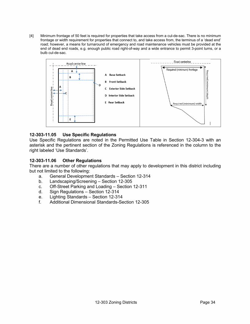
12-303 Zoning Districts Page 34
[4] Minimum frontage of 50 feet is required for properties that take access from a cul-de-sac. There is no minimum
frontage or width requirement for properties that connect to, and take access from, the terminus of a ‘dead end’ road; however, a means for turnaround of emergency and road maintenance vehicles must be provided at the end of dead end roads, e.g. enough public road right-of-way and a wide entrance to permit 3-point turns, or a bulb cul-de-sac.
12-303-11.05 Use Specific Regulations Use Specific Regulations are noted in the Permitted Use Table in Section 12-304-3 with an asterisk and the pertinent section of the Zoning Regulations is referenced in the column to the right labeled ‘Use Standards’. 12-303-11.06 Other Regulations There are a number of other regulations that may apply to development in this district including but not limited to the following:
a. General Development Standards – Section 12-314 b. Landscaping/Screening – Section 12-305 c. Off-Street Parking and Loading – Section 12-311 d. Sign Regulations – Section 12-314 e. Lighting Standards – Section 12-314 f. Additional Dimensional Standards-Section 12-305

12-303 Zoning Districts Page 35
12-303-12 OVERLAY ZONING DISTRICTS The purpose of Overlay Zoning Districts is to provide a tool for addressing special development situations or accomplishing special zoning goals. Overlay districts are a layer of additional performance standards or requirements that are added to, or ‘overlaid’ on top of the requirements in the underlying Zoning District. 12-303-12.01 Floodway and Floodway Fringe Overlay Districts (FW) (FF) The Floodplain Management Regulations are implemented as an overlay district. The provisions for the FW (Floodway) and FF (Floodway Fringe) Overlay Districts are contained in Section 12-312, Floodplain Management Regulations. The standards of the overlay district apply in addition to the base district. Where there is a conflict the provisions of the overlay district govern. 12-303-12.02 Eudora Source Water Protection Overlay District (EWP) a. A Source Water Protection Overlay District has been identified to implement the City of
Eudora’s Source Water Protection Plan. The standards and regulations established by the Overlay District shall apply in addition to the underlying zoning district restrictions. Where there is a conflict, the Overlay District standards and regulations shall govern.
b. This Overlay District encompasses the City of Eudora’s designated public water sources
and a two-mile radius around each water source. Only the unincorporated areas within a two-mile radius of the water sources will be subject to the protection measures outlined below. The official Eudora Source Water Protection Overlay District (EWP) map is located in the City of Eudora Source Water Protection Plan, which is available at the Lawrence-Douglas County Planning Office and Eudora City Hall.
c. For development applications within the City of Eudora’s Source Water Protection Overlay
District which include the following uses, the associated water quality protection measures shall be utilized and noted on site plans, certificates of survey, and plats:
Use Water Quality Protection Measure
Auto Truck Repair Service Discharge to Publicly Owned Treatment Works (POTW). Manage oil products and used oil so that it is not in contact with water.
Construction and Mining Machinery Discharge to POTW. Golf Course Proper application of fertilizers and pesticides.
Proper cleaning of equipment and disposal of chemicals.
Highway and Street Construction Erosion and sediment control. Meat Packing Plant Manufacturing Wastewater pre-treatment and/or discharge to
POTW. Single-family Housing Construction Proper cleaning and disposal of household
hazardous waste. Proper storage, application, and clean up of pesticides and fertilizers.
Veterinary Services, Specialties Discharge to POTW. Deciduous Tree Fruit Orchard Minimize the use of chemicals and pesticides.
Maintain good erosion control practices. Farm Product Warehousing and Storage
Keep the area clean of grain. Use grease traps.
General Farm, Primarily Crop Maintain good erosion control practices and minimize the use of chemicals.

12-303 Zoning Districts Page 36
Use Water Quality Protection Measure Repair Services, Not Elsewhere Classified
Discharge to POTW.
12-303-12.04 Airspace Overlay District (ASO) The airspace protection standards and regulations established by this overlay zone shall apply in addition to the underlying zoning district restrictions. Where there is a conflict, the overlay district standards and regulations shall apply. a. Purpose
The ASO, Airspace Overlay District, is intended to prevent the creation and establishment of hazards to life and property in the vicinity of any public airport within Douglas County, to protect users of the airport, and prevent any unreasonable limitation or impairment on the use and expansion of the airport.
b. Authority
The regulations of this District are adopted under the authority granted by K.S.A. Sections 3-701 through 3-713.
c. Applicability
The Airspace Overlay District regulations apply to all land or water area lying within the established Airport Control Instrument Approach Zones, Non-Instrument Approach Zones, Transition Zones, Horizontal Zones, and Conical Zones as shown on the Airspace Overlay District Map.
d. Sub-zones Established
In order to carry out the provisions of this Overlay District, the following Airspace Zones are established. The Airspace Zones shall be included in the Airspace Overlay District and shown on the Official Zoning District Map.
1) Instrument Approach Zone. The Instrument Approach Zone is established at each end
of all runways used for instrument landings and takeoffs. The Instrument Approach Zones have a width of 1,000 feet at a distance of 200 feet beyond the end of each instrument runway, widening thereafter uniformly to a width of 16,000 feet at a distance of 50,200 feet beyond each end of the runway, its centerline being the continuation of the centerline of the runway. The Approach Zone extends outward and upward at a slope of 50 ft (horizontal) to 1 ft (vertical) for a horizontal distance of 10,000 ft and at a slope of 40 ft (horizontal) to 1 ft (vertical) to a point 50,200 ft from the end of the runway.
2) Non-Instrument Approach Zone. The Non-Instrument Approach Zone is established at
each end of all runways used for non-instrument landings and takeoffs. This zone has a width of 500 feet at a distance of 200 feet beyond the end of each non-instrument runway, widening thereafter uniformly to a width of 2,500 feet at a distance of 10,200 feet beyond each end of the runway, its centerline being the continuation of the centerline of the runway. The surface slope is 20 ft (horizontal) to 1 ft (vertical).
3) Transition Zone. The Transition Zone is established adjacent to each instrument and
non-instrument runway and approach zone as indicated on the Official Zoning District Map. Transition Zones symmetrically located on either side of runways have variable widths as shown on the Official Zoning District Map. Transition Zones extend outward

12-303 Zoning Districts Page 37
from a line of 250 feet on either side of the centerline of a non-instrument runway for the length of such runway plus 200 feet on each end; and 500 feet on either side of the centerline of an instrument runway for the length of such runway plus 200 feet on each end; and are parallel and level with such runway centerlines. The Transition Zones along such runways slope upward and outward 1 foot vertically for each 7 feet horizontally to the point where they intersect the surface of the Horizontal Zone. Further, Transition Zones are established adjacent to both Instrument and Non-Instrument Approach Zones for the entire length of these Approach Zones. These Transition Zones have variable widths, as shown on the Official Zoning District Map. Such transition zones flare symmetrically with either side of the runway Approach Zones from the base of such zones and slope upward and outward at the rate of 1 foot vertically for each 7 feet horizontally to the points where they intersect the surfaces of the Horizontal and Conical Zones. Additionally, Transition Zones are established adjacent to the Instrument Approach Zone where it projects through and beyond the limits of the Conical Zone, extending a distance of 5,000 feet measured horizontally from the edge of the Instrument Approach Zones at right angles to the continuation of the centerline of the runway.
4) Horizontal Zone A Horizontal Zone is that area within a circle with its center at the Airport Reference Point and having a radius of 7,000 feet. The Horizontal Zone does not include the Instrument and Non-Instrument Approach Zones or the Transition Zones.
5) Conical Zone A Conical Zone is the area that commences at the periphery of the Horizontal Zone and extends outward a distance of 5,000 feet. The Conical Zone does not include the Instrument Approach Zone and Transition Zones.
e. Height Limitations
No structure may be erected, altered, or maintained in any Airspace Zone to a height in excess of the height limit established for such Zone, except as otherwise provided in this section. The following height limitations are hereby established for each of the Airspace Zones:
1) Instrument Approach Zone
One foot in height for each 50 feet in horizontal distance beginning at a point 200 feet from and at the centerline elevation of the end of the instrument runway and extending to a distance of 10,200 feet from the end of the runway; thence 1 foot in height for each 40 feet in horizontal distance to a point 50,200 feet from the end of the runway.
2) Non-Instrument Approach Zone
1 foot in height for each 20 feet in horizontal distance beginning at a point 200 feet from and at the centerline elevation of the end of the non-instrument runway and extending to a point 10,200 feet from the end of the runway.
3) Transition Zone
One foot in height for each 7 feet in horizontal distance beginning at any point 125 feet normal to (perpendicular) and at the elevation of the centerline of non-instrument runways, extending 200 feet beyond each end thereof, and 500 feet normal to (perpendicular) and at the elevation of the centerline of the instrument runway, extending 200 feet beyond each end thereof, extending to a height of 150 feet above
12-303 Zoning Districts Page 38
Airport elevation. In addition to the foregoing, there are established height limits of 1 foot vertical height for each 7 feet horizontal distance measured from the edges of all Approach Zones for the entire length of the Approach Zones and extending upward and outward to the points where they intersect the horizontal or conical surfaces. Further, where the Instrument Approach Zone projects through and beyond the Conical Zone, a height limit of 1 foot for each 7 feet of horizontal distance shall be maintained beginning at the edge of the Instrument Approach Zone and extending a distance of 5,000 ft from the edge of the Instrument Approach Zone measured to normal to (perpendicular to) the centerline of the runway extended.
4) Horizontal Zone Height may not exceed 150 feet above the Airport elevation. 5) Conical Zone One foot in height for each 20 feet in horizontal distance beginning at the periphery
of the Horizontal Zone, extending to a Height of 400 feet above the Airport elevation.
f. Performance Standards Notwithstanding any other provision of this section, no use or development activity may occur on land within any Airspace Overlay District that:
1) creates electrical interference with radio communications between the airport and
aircraft, including radio and television transmitting towers or studios and large radiation or X-ray equipment;
2) includes aboveground storage of petroleum or any other explosive material; 3) emits smoke or odor; 4) contains lights or signals that may be confused with airport navigational lights; 5) results in glare to pilots approaching, leaving or circling the airport or that impairs
visibility in the District; 6) provides private airfields or runways for the use of aircraft other than those used in
the principal airport in the district; or 7) otherwise endangers the landing, taking-off, or maneuvering of aircraft.
g. Nonconformities 1) The regulations set forth in this section do not require the removal, lowering, or other
change of any structure not conforming to these regulations or otherwise interfere with the continuance of any nonconforming use, except as provided in Section 12-303-12.04(k), exceptions, and 12-303-12.04(m),hazard marking and lighting.
2) The County may require, upon 30-days written notice, any person, firm, association,
or corporation owning and maintaining any nonconforming pole or pole line upon the roads and highways immediately adjoining the airport to remove, lower, change, or alter said nonconforming pole or pole line. Prior to the removal, lowering, or changing of the pole or pole line, the owner or owner of the airport, shall pay said person, firm, association or corporation the reasonable and necessary expense of removing,

12-303 Zoning Districts Page 39
lowering or changing said pole or pole lines; or in lieu thereof shall execute good and sufficient bond with corporate surety thereon as security for the payment of the reasonable and necessary expense of removing, lowering or changing such pole or pole lines. The reasonable and necessary expense of removing, lowering or changing said pole or pole lines may include, among other items of expense, the actual cost of:
a) constructing underground conduits and the construction of such wires and
equipment in such conduits; and b) rerouting wires together with the poles, cross arms, and other equipment
connected thereto, together with the cost, if any, of new right-of-way made necessary by such rerouting.
h. Airspace Overlay Permits
1) Except as specifically provided by the exceptions stated in 12-303-11.04(k), no material change may be made in the use of land and no structure may be erected, altered, or otherwise established in any Airspace Overlay District unless an Airspace Overlay District permit (ASO permit) has been applied for and granted.
2) Each application for an ASO permit shall indicate the purpose for which the permit is
desired, with sufficient information to allow a determination as to whether the resulting use or structure would conform to the regulations set forth in this section. If such determination is in the affirmative, the permit shall be granted.
3) No ASO permit may be granted that would allow the establishment or creation of an
Airport Hazard or permit a nonconforming use, or structure to be made or become higher, or become a greater hazard to air navigation than it was on the effective date, or the effective date of any amendments hereto, or than it is when the application for a permit is made. Except as provided herein, all applications for permits shall be granted.
i. Nonconforming Structures
Before any nonconforming structure may be replaced, substantially altered or repaired, rebuilt, or increased in height, an ASO permit shall be obtained authorizing such replacement, alteration, change or repair.
j. Exceptions
1) In the area lying within the limits of the Horizontal Zone and the Conical Zone, no ASO permit will be required for any structure less than 75 feet in vertical height above the ground, except where, because of terrain, land contour or topographic features, such structure would extend above the height limits prescribed for such zones.
2) In the areas lying within the limits of the Instrument and Non-Instrument Approach
Zones but at a horizontal distance of not less than 4,200 feet from each end of the runways no ASO permit will be required for any structure less than 75 feet in vertical height above the ground, except where, because of terrain, land contour or topographic features, such structure would extend above the height limits prescribed for the Instrument or Non-Instrument Approach Zone.
3) In the areas lying within the limits of the Transition Zones beyond the perimeter of the
Horizontal Zone, no ASO permit will be required for any structure less than 75 feet in

12-303 Zoning Districts Page 40
vertical height above the ground except where such structure, because of terrain, land contour or topographic features would extend above the height limit prescribed for such Transition Zones.
4) Nothing contained in any of the foregoing exceptions will be construed as permitting
or intending to permit any construction, or alteration of any structure in excess of any of the height limits established by this section.
k. Variances
Any person desiring to erect any structure or increase the height of any structure, or otherwise use his property in violation of the Airspace Overlay District regulations, may apply to the Board of County Commissioners of Douglas County for a variance from the zoning regulations in question. Such variances will be allowed where a literal application or enforcement of the regulations would result in practical difficulty or unnecessary hardship and the relief granted would not be contrary to the public interest but do substantial justice and be in accordance with the spirit of this section: Provided, that any variance may be allowed subject to any reasonable conditions that the Board of County Commissioners may deem necessary to effectuate the purposes of this section.
l. Hazard Marking and Lighting Any permit or variance granted may, if such action is deemed advisable to achieve the purposes of this section and be reasonable in the circumstances, be so conditioned as to require the owner of the structure in question to permit the City of Lawrence, at its own expense, to install, operate, and maintain thereon such markers and lights as may be necessary to indicate to flyers the presence of an Airport Hazard.
m. Administration and Enforcement
For the purposes of this section and pursuant to K.S.A. 3-707, the Lawrence/Douglas County Metropolitan Planning Commission shall be the Airport Zoning Commission and will have responsibility for administering and enforcing the regulations set forth in this section.
1) In particular, the Airport Zoning Commission shall review all ASO permit applications
and determine if such should be granted. If an application is found to conform to all the Airspace Overlay District regulations, the Airport Zoning Commission shall grant the permit.
2) Applications for permits and variances shall be made to the Planning Director upon
forms furnished by the Planning Director.
a) Applications for permits shall be submitted at least 35 days prior to a regular meeting of the Planning Commission.
b) Applications for variances shall be submitted at least 35 days prior to a regular
meeting of the Board of County Commissioners.
n. Conflicting Regulations In the event of conflict between the Airspace Overlay District regulations and any other
regulations applicable to the same area, whether the conflict be with respect to the height of structures, use of land, or any other matter, and whether such other regulations were adopted by Douglas County or any other unit of local government, the more stringent limitation or requirements as to Airport Hazards will govern and prevail.

Feb BoCC with PC revisions shown 12-304 Permitted Use Table Page 41
12-304 PERMITTED USE TABLE
SECTION 304 PERMITTED USE TABLE 12-304-1 Permitted Use Table 12-304-2 Unlisted Uses 12-304-3 Permitted Use Table
12-304.1 PERMITTED USE TABLE The Permitted Use Table in Section 12-304(b) lists the principal uses allowed within each of the Zoning Districts. The symbols used in the Use Table are explained below: a. [P] Permitted Uses A ‘P’ indicates that a use is permitted by-right, subject to compliance with all
applicable local, state and federal regulations including the requirements of the Zoning Regulations.
b. [C] Conditional Uses A ‘C’ indicates that the use is allowed only if reviewed and approved in accordance
with the Conditional Use procedures of Section 12-307-2. c. A [‘P’/‘C’] indicates that in some instances the use is permitted-by-right, while in
others a Conditional Use Permit is required. The use specific standards will provide the criteria for each.
d. [A] Accessory Uses An ‘A’ indicates that a use is only permitted as accessory to a principal use, subject
to compliance with all applicable local, state and federal regulations, including the requirements of the Zoning Regulations.
e. [-] Uses not permitted.
A dash indicates that the use is not permitted within that Zoning District.
f. [*] Use-Specific Standards Many permitted uses, whether permitted by-right, or as conditional or accessory
uses, are subject to compliance with use-specific standards and conditions. An asterisk after the ‘P’, ‘C’, or ‘A’ use code identifies that the use is subject to use-specific standards and conditions. The sections in which these standards and conditions are located are identified in the far right column titled ‘Use Specific Standard’.
12-304-2 UNLISTED USES a. If an application is submitted for a use that is not listed in the Permitted Use Table,
the Director of Zoning and Codes is authorized to classify the unlisted use into an existing land use category that most closely fits the unlisted use using the following factors:
1) The description of each activity in relationship to the characteristics of each
use category;
2) The relative amount of site or floor space and equipment devoted to each activity;

12-304 Permitted Use Table Page 42
3) Relative amounts of sales from each activity; 4) The relative number of employees in each activity; 5) Hours of operation; 6) Classification of the use in the North American Industry Classification System
(NAICS); 7) Building and site arrangement; 8) Number and types of vehicles used with each activity; 9) The relative number of vehicle trips generated by each activity; 10) How the use advertises itself; and 11) Whether each individual activity would be likely to be found independent of
the other activities on the site.
g. If no similar use determination can be made, the Planning Director shall begin the initiation process to the text of the Zoning Regulations to define the use, establish any necessary use-specific standards, and clarify where such use shall be allowed.
h. If a specific use in a district requires a Conditional Use Permit, that specific use shall
not be interpreted to fall within a more general use permitted by right in such district. The specific use shall require a Conditional Use Permit

12-304 Permitted Use Table Page 42
12-304-3 PERMITTED USE TABLE
A = Accessory use P = Permitted use C = Requires
Conditional Use Permit
PG-Parking Group *=Specific Use
Standards
Agricultural Agriculture P* P* P* P* P* P* P* P* P* P* P* 306-3
Hobby Farm P P P* P - A - - - P - 306-4
Agritourism P*/C* P*/C* - - - - - - - - - 306-5 PG 2
Ancillary Agricultural Retail sales P*/C P*/C - - A A P - - C P
306-7 PG 6
Commercial Grain Storage C* C* - - - - P P P C C PG 4
Commercial Riding Stable or Academy C* C* - - P P P - - C P 306-35
PG 3 Commercial Slaughtering/
Processing General - - - - - - - - C - - PG 4
Commercial Slaughtering/ Processing Limited
C C - - - - C C C - C PG X
Farm Stand A* A* A* A* P* P* P* P* - P* P* 306-17 PG 6
Farmer's Market C* C* A* - P* P* P* P* P* P* 306-18 PG 5
Sale Barn/Auction House C* C* - - - - P* P* P* C* P* 306-36 PG 17
Value Added Agricultural Business
P*/C*
P*/C* - - A* A* C* P* P* C* P/C*
306-42 PG 14
Residential
Accessory Dwelling Unit A* A* A* - - - - - - A* A*
306-1 PG 1
Caretaker/Manager’s Residence - - - - A* A* A* A* A* P* A* 306-11
PG 1
Detached Dwelling including Residential Design
Manufactured Homes P* P* P* P* - - - - - P* P*
306-14 306-34 PG 1
Group Home, General
C* C* C* C* - - - - - C C PG 1
Group Home, Limited
P* P* P* P* - - - - - P P PG 1
AG-2
AG-1
CP LS
LB
RT GB
LI
GI
V BSC
USE
ST
DS

12-304 Permitted Use Table Page 42
A = Accessory use P = Permitted use C = Requires
Conditional Use Permit
PG-Parking Group *=Specific Use
Standards
Home Occupations, Type 1 P* P* P* P* - - - - - P* P* 306-21 PG 14
Home Occupations, Type 2 P* C* C* C* - - - - - C* C* 306-22 PG 14
Farm Employee Housing C* C* - - - - - - - - - PG 1 Commercial Uses
Bank/Financial Institution - - - - P A P - - C P PG 7 Bar or Tavern - - - - P A P - - C P PG 10
Boat or Other Recreational Vehicles Sales/ Rental/
Service - - - - P A P P P C P PG 18
Contractor Shop/Yard - - - - - - P P P C P PG 9 Construction Sales &
Services - - - - - - P P P - P PG 9
Commercial Dog Kennel C* C* - - - - P* P* P* - P* 306-23 PG 17
Animal Services - - - - - - P P - C P PG X Fireworks Sales P* P* - - P* - P* P* P* P* P* 306-19
Gas and Fuel Sales - - - - P A P P P C P PG8 Heavy Equipment Sales and
Rentals - - - - - - P - P - P PG 20
Animal Hospital or Clinic C* C* - - - A* P* P* P* C* P* 306-8 PG X
Landscape and Lawn Care Businesses - - - - - - P P P C P PG 14
Light Equipment Sales and Rentals - - - - - - P P P - P 306.24
PG 20 Offices - - - - - - P - - C P PG 7
Personal Services - - - - P A P - - C P PG 7 Meat Lockers - - - - P - P P P C P PG X
Restaurant - - - - P A P - - C P PG 9 Retail Sales - - - - P* A* P* - - C* P* 306-46
PG 6 Sexually Oriented Business - - - - - - C* C* - - C* 306-38
PG 9 Community Facilities
Cemeteries C C - - - - - - - C - PG X
Colleges and Schools - C - - - - P P* P* C P 306-47 PG 11
AG-2
AG-1
CP LS
LB
RT GB
LI
GI
V BSC
USE
ST
DS

12-304 Permitted Use Table Page 42
A = Accessory use P = Permitted use C = Requires
Conditional Use Permit
PG-Parking Group *=Specific Use
Standards
Day Care Center - C*/A*
C*/A* C* C* A* P* P* P* C* P* 306-12
PG 14
Day Care Home P* P* P* P* - - - - - P* P* 306-13 PG 14
Day Care Home Non-occupant Provider C C C C - - - - - C P PG 14
Fairgrounds C C - - - P C P - C P PG X Community Center,
Libraries, Museums or Art Galleries
C C - - P P P - - C P PG 7
Non-profit Educational or Philanthropic Institutional
Uses C C - - - - P - - C P PG X
Government Buildings C C C C P - P P P C P PG 7
Religious Institution, Small C* C* C* C* P* A* P* - - P* P* 306-33 PG 13
Religious Institution, Large - C* - - - - P* - - C* P* 306-33 PG 13
Industrial/Warehouse Asphalt or Concrete Batch
Plant - - - - - - - P P - - PG 4
Boat/RV Storage - C - - P C P P P - P PG X
Landfill C* C* C* - C* C* C* C* C* - C* 306-24 PG 14
Exterior Storage - - - - A* A* A* A* P* A* A* 306-16 PG X
Farm Implement Repair Service C C - - - - P P P C P PG 18
Heavy Equipment Repair/Service - - - - - - - P P C - PG 18
Equipment Storage (Light or Heavy) C* C* - - - - - P* P* C* - 306-25
PG 14 Light Equipment Repair/Service - - - - - - P P P C P PG 18
Manufacturing & Production, General - - - - - - - - P* - - 306-26
PG 4 Manufacturing & Production,
Light - - - - - - - P* P* C* - 306-26 PG 4
Mini- or Self-Storage - C* - - C* - P* P* P* - P* 306-28 PG 19
Small Scale Industrial Uses C* C* - - - - P* P P C* P* 306-39 PG 14
General Service and Repair Establishment - - - - - - P P P C P PG 14
AG-2
AG-1
CP LS
LB
RT GB
LI
GI
V BSC
USE
ST
DS

12-304 Permitted Use Table Page 42
A = Accessory use P = Permitted use C = Requires
Conditional Use Permit
PG-Parking Group *=Specific Use
Standards
Mining, Excavation and/or Extraction of Natural
Resources C* C* - - C* C* C* C* C* - C* 306-27
PG 4
Salvage Yards - - - - - - - - C* - - 306-37 PG 14
Wholesale Storage & Distribution/ Warehousing - - - - - - P* P P - P 306-43
PG 4 Research Facility, Ag
Related P/C P/C - - - - P P P - P PG 4
Medical Medical or Dental Clinics or
Offices - - - - - - P - - C P PG 7
Extended Care Facility - - - - - - C* - - C* C* 306-29 PG 16
Utilities Major Utilities C C C - - - - P P C - PG 4 Minor Utilities P P P P P P P P P P P PG 14
Wind Turbine/Residential or Accessory A* A* A* A* A* A* A* A* A* A* A*
Wind Energy Conversion System/ Commercial C* - - - - - C* C* C* - C* 306-44
PG 14 Communications
Amateur and Receive Only Antennas P P P - P P P P P P P
Radio, Television, and Microwave Towers C* C* C* - C* C* C* C* C* C* C* 306-31
PG 14 Wireless Facilities C* C* C* - C* C* C* C* C* C* C* 306-45
PG 14 Temporary
Special Event P* P* P* P* P* P* P* P* P* P* P* 306-40 PG X
Temporary Business Use P* P* P* P* P* P* P* P* P* P* P* 306-41 PG X
Temporary Housing During Construction P* P* P* P* P* P* P* P* P* P* P* 306-2
PG X Lodging (transient accommodations) Vacation Rentals C C C C C P - - - C P PG 1 Bed & Breakfast C* C* C* - P* P* - - - C* P* 306-9
PG15 Campgrounds, Developed
and Primitive C* - - - P* P* - - - - - 306-10
Camping, Personal and Special Event
P*/A* A* A* - P* P* - - - - P* 306-10
Motel/Hotel - - - - P P P - - C P PG 15 Recreation and Entertainment
Event Center/ Public Assembly C C - - P P P - - C P 306-15
PG 13
AG-2
AG-1
CP LS
LB
RT GB
LI
GI
V BSC
USE
ST
DS

12-304 Permitted Use Table Page 42
A = Accessory use P = Permitted use C = Requires
Conditional Use Permit
PG-Parking Group *=Specific Use
Standards
Indoor Sports or Recreation Facility - C - - - A P P C C P PG 13
Nature Preserve P P P P P P P P P P P Outdoor Sports or Recreation Facility - C* - - P* P* C* P* - C* C* 306-30
PG X Public Parks/ Playgrounds P/C P/C P/C - P P P P P P P PG X
Recycling Commercial Compost C C - - - - - P P - - PG 14
Recycling Collection Center C* C* C* - P* P* P* P* P* P* P* 306-32 PG 9
Recycling Processing - - - - - - - P P - - PG 4 Transportation
Private Airstrip/ Heliport (Public or Private) C* C* - - - - - C* C* - - 306-6
306-20
AG-2
AG-1
CP LS
LB
RT GB
LI
GI
V BSC
USE
ST
DS

12-305 Add’tl Dimensional Standards Page 47
SECTION 12-305 ADDITIONAL DIMENSIONAL STANDARDS The standards listed in this section qualify or supplement the dimensional standards provided for each zoning district in Section 3 or dimensional standards provided elsewhere in these regulations. 12-305-1 REQUIRED SETBACKS 12-305-1.01 Exceptions to Required Setbacks Required setbacks extend the full width and depth of a lot and shall be unobstructed from the ground to the sky with the following exceptions:
a. Ordinary projections of sills, belt courses, window air conditioning units, chimneys, cornices,
and other architectural features may project up to 2.0 feet into a required yard. b. Open or lattice-enclosed fire escapes, exterior stairways and balconies opening upon fire
towers, and the ordinary projections of chimneys and flues may project into the required rear yard for a distance of not more than 5 feet, but only where the same are so placed as not to obstruct light and ventilation on adjacent properties.
c. Gas and fuel station pumps and pump islands may be located in the required setback;
provided, however, that they are no closer than 25 feet from the base setback. d. An ornamental fence or wall up to 3.5 feet in height may be located within a required front
setback but may not extend beyond the base setback or within the road right-of-way. e. Ornamental fences or walls up to 7 feet in height may be located within a required rear
setback or the portion of a required side setback behind the required front setback. f. Security fences up to 7 feet in height may be located within any required setback in the LI
or GI Districts or with any use requiring a CUP, provided it is approved by the Board of County Commissioners, but may not extend beyond the base setback or within the road right-of-way.
g. Open, horizontal structures such as uncovered decks and patios, that are no more than 30
inches in height may be located within a required rear or side yard; provided they are not located closer than 5 feet to the rear or side property line and may extend up to 5 feet into the required front yard.
12-305-1.02 Measurement of Setbacks a. Front Setback
1) The front setback is measured from the Base Setback as defined in Section 12-315-2 or from the road right-of-way or road easement line if an area has been designated for the future opening or widening of a road that exceeds the Base Setback.
2) On through lots or eligible parcels (lots or parcels with road frontage on both the front and the rear), the required front setback shall be provided on both the front and rear of the lot or parcel.
b. Side Setbacks
1) The exterior side yard is measured from the Base Setback as defined in Section 12-305(a) or from the road right-of-way or road easement line if an area has been

12-305 Add’tl Dimensional Standards Page 48
designated for the future opening or widening of a road that exceeds the Base Setback.
2) For the purpose of the side setback regulations, a group of business or industrial
buildings separated by common or party walls shall be considered as one building occupying one lot or eligible parcel.
c. Additional Setback for Corner Visibility
No sign, fence, wall, hedge, landscaping or other material or structure or other obstruction to vision, extending to a height in excess of 3 feet above the established road grade shall be erected, planted, or maintained within the area of a corner lot identified as the ‘clear sight triangle’.
1) At intersections, the clear sight triangle is the triangle formed by the connection of
imaginary lines along each leg of each intersecting road (measured from the edge of the roadway), extending:
a) 25 feet along each leg of a road that has STOP signs;
b) 250 feet along each leg of a road that does not have a STOP signs; or
c) 25 feet along each leg of both roads located at an ALL-WAY STOP intersection.
All way stop. Triangle sides, 25 feet on all roads. One road stops. Triangle sides, 25 ft on road with
stop sign, 250 ft on road without stop sig.
No stop signs. 250 ft on both roads.
12-305 Add’tl Dimensional Standards Page 49
12-305-2 DIMENSIONAL STANDARDS 12-305-2.01 Exception to Minimum Area Requirement: Minimum area requirements shall not apply to those parcels created through an approved Agricultural Lot Split or Homestead Survey in accordance with the Douglas County Subdivision Regulations and which are subject to the Agricultural Protection Agreement (APA) filed with the Douglas County Register of Deeds; with the exception of area requirements established with the Douglas County Sanitary Code.
12-305-2.02 Exceptions and Modifications to Height Standards a. The maximum height standards do not apply to the following features: chimneys, church
spires, conveyors, cooling towers, elevator bulkheads, fire towers, flag poles, grain elevators, silos, wireless facilities, radio and other towers, wind conversion energy systems, smoke stacks, water towers and standpipes.
b. Except in the Airspace Overlay District, the height regulations in these Zoning Regulations shall not apply to belfries, chimneys, church spires, conveyors, cooling towers, elevator bulkheads, fire towers, flag poles, grain storage structures, monuments, ornamental towers and spires, radio and television antennas, silos, smoke stacks, stage towers or scenery lofts, tanks, or water towers and standpipes.
c. Whenever any building in the LI (Light Industrial) District adjoins or abuts upon a residential
district, or residentially developed property, such building shall not exceed 35 feet in height, unless it is set back 1 foot from all required side and rear yard lines for each foot of additional height above 35 feet.
d. Whenever any building or structure in the GI (General Industrial) District adjoins or abuts a
residential district or residentially developed property, such building or structure shall not exceed 50 feet in height unless set back 1 foot from all required side and rear yard lines for each foot of additional height above 50 feet.

12-306 Use Specific Standards Page 50
12-306 USE SPECIFIC STANDARDS SECTION 12-306 USE SPECIFIC STANDARDS
12-306-1 Accessory Dwelling Units 12-306-2 Accessory Structures 12-306-3 Agriculture 12-306-4 Hobby Farm 12-306-5 Agritourism 12-306-6 Airstrips, Private 12-306-7 Ancillary Agricultural Retail Sales 12-306-8 Animal Hospital or Clinic 12-306-9 Bed and Breakfasts 12-306-10 Campgrounds 12-306-11 Caretaker/Manger Residence 12-306-12 Day Care Center 12-306-13 Day Care Home 12-306-14 Detached Single-Family Dwelling 12-306-15 Event Center/Public Assembly 12-306-16 Exterior Storage 12-306-17 Farm Stand 12-306-18 Farmer’s Market 12-306-19 Fireworks Sales 12-306-20 Heliports 12-306-21 Type 1 Home Occupation 12-306-22 Type 2 Home Occupation 12-306-23 Kennel, Dog, Commercial 12-306-24 Landfill 12-306-25 Equipment Storage 12-306-26 Mfg and Production Uses (Light or General) 12-306-27 Mining and Excavation 12-306-28 Mini- or Self-Storage 12-306-29 Extended Care Facility 12-306-30 Outdoor Sports or Recreation Facility 12-306-31 Radio, Television, and Microwave Towers 12-306-32 Recycling Collection Facilities 12-306-33 Religious Institutions and Assembly 12-306-34 Residential Design Manufactured Homes 12-306-35 Riding Stable/Academy, Commercial 12-306-36 Sale Barn/Auction House 12-306-37 Salvage/Junk Yards 12-306-38 Sexually Oriented Business 12-306-39 Small Scale Industrial Uses 12-306-40 Special Events 12-306-41 Temporary Business Uses 12-306-42 Value Added Agricultural Business 12-306-43 Wholesale Storage & Distribution/Warehouse 12-306-44 Wind Energy Conversion Systems 12-306-45 Wireless Facilities 12-306-46 Retail Sales 12-306-47 Schools and Colleges 12-306-48 Cluster Housing (Reserved)

12-306 Use Specific Standards Page 51
12-306-1 ACCESSORY DWELLING UNITS. 12-306-1.01 Purpose Accessory Dwelling Units are allowed in certain situations to create additional housing options for a relative/family member, caregiver, or farm employee while maintaining the rural character of unincorporated Douglas County.
12-306-1.02 Occupancy. a. The Accessory Dwelling Unit shall be occupied by one of the following for not less than three
years following the issuance of the certificate of occupancy for the Accessory dwelling Unit: (1) a relative/family member, (2) a caregiver, or a (3) farm employee.
b. An Affidavit of Occupancy shall be provided to the Zoning and Codes Director prior to the
issuance of a Certificate of Occupancy. c. The length of occupancy can be reduced in the instance that the Accessory Dwelling Unit
was occupied initially by a relative and the relative is deceased or the Accessory Dwelling Unit was initially occupied by a caregiver and the recipient of the care no longer lives in the home or is deceased.
12-306-1.03 Means of Establishment An Accessory Dwelling Unit may be established by one of the following means: a. Conversion of existing space within a principal dwelling or construction of an addition to a
principal dwelling. b. Conversion of existing space within an accessory structure or construction of an addition to
an accessory structure.
c. Construction of a separate accessory structure which will include the Accessory Dwelling Unit.
12-306-1.04 Standards that apply to all Accessory Dwelling Units: a. One Accessory Dwelling Unit is permitted on a vested parcel, platted lot or a Residential
Development Parcel, which contains a dwelling. This dwelling will be considered the principal dwelling.
b. An Accessory Dwelling Unit shall not be allowed within, or attached to, a mobile home but
may be allowed within a manufactured home. c. All Accessory Dwelling Units, whether new construction or conversion of existing space,
shall comply with the Douglas County Construction Codes. d. An Accessory Dwelling Unit may be located within a structure which the Zoning and Codes
Director has determined is a legal nonconforming structure with respect to building height or setbacks provided any addition to the structure does not extend or increase the degree of nonconformity.
e. The Accessory Dwelling Unit, if located in a newly constructed detached accessory
structure, shall be located a minimum distance of 25 ft from the primary structure.

12-306 Use Specific Standards Page 52
f. An Accessory Dwelling Unit that is located within, or attached to, the principal dwelling may utilize the same septic system as the principal dwelling provided the septic system is adequately sized per the Douglas County Health Department requirements.
g. Solid waste management systems for Accessory Dwelling Units must comply with the
Douglas County Sanitary Code.
h. The Accessory Dwelling Unit and the principal dwelling unit shall share a common access point on the adjacent road unless site conditions prohibit the use of the shared access point. In that case, a separate entrance requires approval by the County Engineer. To the greatest extent feasible, existing access points shall be utilized.
1) A shared access point/driveway must be used whenever possible to maintain the
appearance of a single dwelling.
i. An Accessory Dwelling Unit may have an area of up to 1,000 sq ft. This area may be increased to 1,400 sq ft provided the area of the Accessory Dwelling Unit is not greater than 80% of the area of the primary dwelling.
j. Separate sale or ownership of an Accessory Dwelling Unit is prohibited, unless the parcel
or lot is subdivided in accordance with the Subdivision Regulations, creating a separate lot or Residential Development Parcel for each dwelling.
k. The accessory dwelling unit shall not be used as a short term lodging use such as a bed &
breakfast.
l. An Accessory Dwelling Unit is subject to the same occupancy limits as the principal dwelling. (one family, or group living as a household unit--limited to 4 adults if any of the residents are not related).
m. The following area requirements apply to a detached Accessory Dwelling Unit:
1) A minimum of 3 acres outside the regulatory floodplain must be provided for the septic systems of the principal dwelling and Accessory Dwelling Unit (6 acres total) if the dwellings are served by Rural Water or other public water source.
2) A minimum of 5 acres outside the regulatory floodplain must be provided for the septic
systems of the principal dwelling and Accessory Dwelling Unit (10 acres total) if the dwellings are served by well water.
12-306.1.05 Additional Standards for Accessory Dwelling Units in the AG-2 and CP Districts:
a. The Accessory Dwelling Unit, if detached, should be located behind the front plane of the principal dwelling whenever possible.
b. Either the Accessory Dwelling Unit or the principal dwelling shall be occupied by the owner of the property.
12-306.1.06 Accessory Dwelling Unit Permit: Accessory Dwelling Units must be permitted by the Zoning and Codes Director prior to their

12-306 Use Specific Standards Page 53
establishment. This process is administrative unless the Accessory Dwelling Unit is located on a property which also has a Conditional Use or a Type 2 Home Occupation.
a. The Permit application, available from the Zoning and Codes Office, shall be provided to the
Zoning and Codes Office along with a plot plan with the following information, at a minimum:
1) Locations of both the principal and accessory dwellings; 2) Property boundaries. For large properties, the boundaries in the area of the dwellings
may be shown; 3) The distance between the structures and the property boundaries. 4) Location of access drive. 5) Area and height of the principal and accessory dwellings. 6) Locations of the septic system(s);
b. The Zoning and Codes Director shall review the \application to insure compliance with the
Accessory Dwelling Unit Standards and the required setbacks.
c. When approved, the permit is completed with the filing of an Affidavit of Occupancy with the Zoning and Codes Director.
1) The affidavit shall note that the occupant of the Accessory Dwelling Unit shall be either
a relative/family member, caregiver, or farm employee for not less than 3 years after the Certificate of Occupancy is issued for the Accessory Dwelling Unit.
2) In the AG-2 and CP Districts, the affidavit shall also note the requirement that one of
the dwelling units is to be occupied by the owner of the property. d. Accessory Dwelling Unit Permit requiring Board of County Commission Approval.
A permit for an Accessory Dwelling Unit on a property with a Conditional Use Permit or a Type 2 Rural Home Occupation Business may not be administratively approved, but requires approval by the Board of County Commissioners.
1) The permit application shall be reviewed by the Zoning and Codes Director for
compliance with the standards in this section and a recommendation forwarded to the Board of County Commissioners.
2) The Board of County Commissioners may approve the Accessory Dwelling Unit in
addition to the other uses on the property if they determine the combined uses are compatible with nearby land uses.
3) The applicant shall provide written notice of the Accessory Dwelling Unit as noted
below: i. The applicant shall obtain a list of property owners within 2,640 ft of the vested
parcel, Residential Development Parcel, or platted lot on which the Accessory Dwelling Unit is proposed from the Douglas County Clerk’s Office. If the notification area includes land within the corporate limits of a city, the list shall

12-306 Use Specific Standards Page 54
extend 400 feet into the city. If the notification area extends into the adjacent County, notice must be sent to property owners in the adjacent County.
ii. The applicant shall mail a letter which contains the information below to the
property owners on the list to advise them of the proposed Accessory Dwelling use and provide them the opportunity to contact the applicant or the Zoning and Codes Department if they have questions:
“An Accessory Dwelling Unit at ____(ADDRESS)__ is in the process of being permitted by Douglas County. The property at __(ADDRESS)___also contains_____(NAME OF BUSINESS)____ a Type 2 Rural Home Occupation Business or Conditional Use and therefore requires approval of the Douglas County Board of County Commissioners. Please contact me at ____(PHONE NUMBER, EMAIL ADDRESS)____ with any questions regarding this registration or the Douglas County Zoning and Codes Department at 785-331-1343 for information.”
iii. A copy of the notification letter, the certified property owner list, and
certification of the dates the letters were mailed to the addresses on the list shall be included with the Accessory Dwelling Unit registration materials noted in Section 12-306-1.06(a).
iv. The Accessory Dwelling Unit permit application will be placed on a Board of
County Commissioner’s agenda for consideration a minimum of 20 days following the date of the letter.
4) When approved, the permit is completed with the filing of an Affidavit of Occupancy
with the Zoning and Codes Director that includes the legal description of the property and identifies the structure as an Accessory Dwelling Unit subject to the standards in Section 12-306-1 of the Zoning Regulations.
i. The affidavit shall note that the occupant of the Accessory Dwelling Unit shall be
either a relative/family member, caregiver, or farm employee for not less than 3 years after the Certificate of Occupancy is issued for the Accessory Dwelling Unit.
ii. In the AG-2 and CP Districts, the affidavit shall also note the requirement that one of the dwelling units is to be occupied by the owner of the property.
12-306-2 ACCESSORY STRUCTURES: 12-306-2.01 Construction and Use Accessory structures shall be constructed in conjunction with or after the principal building and no accessory structure shall be used when the main building on the eligible parcel is not being used with the following exceptions: a. A temporary Certificate of Occupancy has been issued by the Zoning and Codes Director
for use as storage or temporary dwelling during an active building permit. b. An accessory structure located without a principal structure on a Residential Development
Parcel (RDP) as a result of a Certificate of Survey may continue to be used until the Residential Development Parcel has transferred to different ownership; however, the use will be regulated as a nonconforming use per Section 12-308-2.

12-306 Use Specific Standards Page 55
c. A structure that is accessory to a use of the land, such as a shed for athletic equipment on a property with an athletic field.
12-306-2.02 Accessory Structure Standards a. Accessory structures shall not be constructed or placed within a dedicated easement. b. Accessory structures shall be constructed on the same lot or parcel as the principal structure
or use of the land. c. An accessory structure shall be used for a use that is accessory to the use of the principal
structure or the land. d. Off-site fabricated storage structures or containers, including steel cargo containers can be
used as accessory structures provided the following standards are met:
1) The structures/containers shall be securely anchored, per building code. 2) The structures are not permitted in regulatory floodplain, unless approved with a
floodplain development permit and securely anchored with an engineered tie-down system.
3) No stacking of containers is allowed. 4) The structures/containers are painted and well maintained. 5) No more than two structures/containers are permitted on a property. 6) The structures/containers are subject to the structure setbacks applicable to the
zoning district in which the container is located and shall be located behind the front plane of the house on residentially developed properties or properties zoned AG-2 or CP.
12-306-3 AGRICULTURE Agricultural uses which meet the exemption criteria of Resolution 08-25 are exempt from the provisions of these Regulations except as noted below: a. Agricultural structures must comply with the Floodplain Management Regulations and
setbacks from adjacent road right-of-way. b. An Agricultural Use Exemption application for an agricultural building must be submitted to
the Zoning and Codes Office prior to construction so the exempt status can be documented.
12-306-4 HOBBY FARM The following standards apply to this use in the CP Zoning Districts: a. A Hobby Farm is permitted, to such an extent as not to be objectionable to surrounding
residents by reason of odor, dust, noise, or other factors.
b. No retail or wholesale business office or store shall be maintained on the property.

12-306 Use Specific Standards Page 56
12-306-5 AGRITOURISM Agritourism is recognized as a vital tool for sustaining the family farm and represents significant economic potential for the community in general. These regulations are intended to foster and promote agritourism in keeping with the State of Kansas policy of encouraging agritourism, while ensuring that the public health, safety, and welfare are protected.
12-306-5.01 Purpose a. Agritourism profits from the rural experience and should be designed and operated in such
a manner as to maintain or enhance the rural character. These regulations were developed to allow Agritourism within the Agricultural Zoning District with adequate review to insure compatible development with the nearby land uses and the character of the area.
b. Agritourism uses which meet the definition set forth in these Regulations and are registered with the State and with the County may occur as permitted in this section without any additional review under Section 12-307-2, Conditional Use Permits; Section 12-307-3, Site Plan Regulations; or Section 12-306-39, Special Event Permits, although other State and local regulations shall apply.
12-306-5.02 Determination of use Agritourism Registration forms shall be jointly reviewed by the Director of Zoning and Codes and the Planning Director within 7 working days of submittal to determine if the proposed use(s) meet the definition of Agritourism set forth in these Regulations.
a. If additional descriptive information is necessary for the determination, this information will
be provided by the registrant and kept as a part of the registration. b. The applicant for the Agritourism registration may file an appeal from the Director’s
determination. Appeals from the determination shall be made to the Board of County Commissioners. An appeal must be filed within 30 days of notification of the determination to the applicant. The appeal will be considered at the next available Commission meeting.
12-306-5.03 Levels of Agritourism Uses a. Agritourism uses which the Zoning and Codes Director determines meet the definition of
‘Agriculture,’ provided in Section 12-315 are subject to Section 12-306.3 of these regulations.
b. Tier 1 (low intensity) Agritourism Uses Tier 1 Agritourism involves low intensity uses that are not expected to generate noise, or other impacts, to the level that they would have negative impacts on surrounding properties. Tier 1 Agritourism uses include, but are not limited to the following:
1) Farmers Markets with 10 or fewer vendors, 2) Seasonal Corn Mazes and Pumpkin Patches visits and activities, 3) Farm-related Interpretative Facilities, Exhibits, and Tours, 4) Historical, Cultural, or Agriculturally Related Educational and Learning Experiences 5) Recreation-related Operations (Fishing, Hunting, Bird Watching, Hiking, etc.), 6) Equestrian Facilities, 7) Farm Stays, 8) Farm Winery Tours and Events,

12-306 Use Specific Standards Page 57
9) Small scale assembly type uses such as weddings, receptions, etc., 10) Small-scale entertainment such as the integration of music, theatre, or arts to enhance
the rural experience, 11) Ancillary Retail Sales; and, 12) Other uses that may be determined on a case-by-case basis to meet the intent of the
Tier 1 definition.
c. Tier 2 (medium intensity) agritourism uses Tier 2 uses include higher intensity activities or have higher attendance than Tier 1 uses. Examples of Tier 2 Agritourism uses include, but are not limited to: 1) Uses that would be considered a Tier 1 use that do not meet the Tier 1 standards
provided in this section; 2) Farmers Markets with more than 10 vendors; 3) Overnight stays such as Bed and Breakfasts, Farm Stays, or camping. 4) Assembly type uses such as fairs or festivals which are historical, cultural, or
agriculturally related. 5) Other uses that may be determined on a case-by-case basis to meet the intent of the
Tier 2 definition. 12-306-5.04 Standards that apply to both tier 1 and tier 2 agritourism uses a. The Agritourism use is located on a parcel, or one of a number of contiguous parcels under
the same ownership as land uses which meet the definition of ‘Agriculture” or on a working farm or ranch as determined by the Zoning and Codes Director. (Contiguous shall mean lands that are adjacent and road, railroad, and other rights-of-way and easements shall not exclude parcels from being contiguous.)
b. The Agritourism operator, the person with the financial and legal responsibility for the
Agritourism activity, shall be limited to the property owner or operator, his/her family members and employees (whether paid or unpaid).
c. Adequate parking including ADA parking (where applicable) shall be provided on-site for the
use. 1) No parking may occur on adjacent roads or adjacent road right-of-way. 2) For the purpose of calculating parking requirements, parking is calculated at a rate of
1 parking space per 2 attendees.
d. No motors or motorized vehicles, with the exception of agricultural machinery and vehicles or electric motors, will be utilized for the Agritourism Use.
e. Parking areas (excluding overflow areas) that are within view of residences or the road right-
of-way shall be screened from view with landscaping and/or fencing. Screening materials may not be located within or along the right-of-way. Alternate forms of screening may be utilized, provided the Zoning or Codes Director or the Board of County Commissioners, as applicable, determine they will provide effective screening of the parking area.
f. Exterior lighting should be limited as much as possible to maintain the rural character and
should be on only when the use is occurring. If exterior lighting is proposed, a plan shall be

12-306 Use Specific Standards Page 58
provided which shows the location of lighting for the Agritourism activity and the type of lighting fixtures being used as well as means taken to shield the lighting to insure no trespass or glare to adjacent properties.
g. Sanitary facilities shall be provided in accordance with Lawrence Douglas County Health
Department requirements for the proposed use and anticipated attendance.
12-306-5.05 Tier 1 Agritourism Use Standards a. The Agritourism operator, the person with the financial and legal responsibility for the
Agritourism activity, must reside on the parcel, or one of a number of contiguous parcels (as defined in this section), containing the Agritourism use.
b. Parking for the Agritourism use is limited to no more than 40 parking spaces;
c. In order to minimize noise from the agritourism use the Outdoor amplification of sound: such
as auctioneering speakers or amplified music (with the exception of a stereo or radio) is prohibited.
d. Ancillary retail sales shall be a subordinate and ancillary portion of the Agritourism Use. The
area designated for ancillary retail sales shall not exceed 500 sq ft. 12-306-5.06 Administrative waiver provision The Director of Zoning & Codes may waive the standards for a Tier 1 Agritourism use if it is determined that the Agritourism use, by virtue of the size or type of use proposed, the location of the use, or other site specific characteristics, will not generate noise or other impacts that negatively impact surrounding properties. 12-306-5.07 Tier 1 agritourism registration process a. The Agritourism operator shall submit the following materials to the Zoning and Codes
Office: 1) Submitted State Agritourism Registration.
2) Completed Douglas County Agritourism Registration form. 3) Site plan which illustrates the use and its conformance with the Zoning Regulations as
well as the relationship of the use to the surrounding properties or right-of-way. At a minimum, the following items must be included:
i. All structures to be utilized for the agritourism use identified on the plan with
dimensions, including the distance to the nearest property line. ii. Areas where the agritourism use will occur and any areas where visitors would
be allowed shown and labeled on the plan. iii. Access and parking areas shown and dimensioned, noting the number of spaces
provided. For determination of parking requirements, parking is calculated at a rate of 1 parking space per 2 attendees.
iv. The water and sanitation facilities provided per the County Health Department
approval.

12-306 Use Specific Standards Page 59
v. Locations where exterior lighting for the Agritourism use is proposed, including the height and direction of the lighting, the type of lighting fixtures, and the means taken to shield the lighting to prevent or reduce trespass or glare to adjacent properties.
vi. Hours of operation noted. vii. Anticipated attendance noted based on building occupancy determined by a
licensed professional based on the building code or limited occupancy established with the restrictions of use. Attendance is not necessarily limited to that which can be served by available parking, as participants may arrive by bus or alternative forms of transportation.
viii. Materials required as part of the required public notice.
b. A 20 day property owner notification period is required. Notice of the proposed Agritourism
Use must be provided to the property owners as follows:
1) The applicant shall obtain a list of property owners within ½ mile (2,640 ft) of the property on which the Agritourism activity is to occur from the Douglas County Clerk’s Office.
i. If the notification area includes land within the corporate limits of a city, the list
shall include owners of property within the ½ mile (2,640 ft) notification area that extend 400 feet into the city. If the notification area extends into the adjacent County, notice must be sent to property owners in the adjacent County.
ii. The list shall have been obtained within 30 days of the date the registration is submitted.
2) The applicant shall mail a letter which contains, at a minimum, the information below
to the property owners on the list to advise them of the proposed Agritourism use and provide them the opportunity to contact the applicant or the Zoning and Codes Department if they have any questions.
“An Agritourism use located at _______ is in the process of being registered with Douglas County. The Agritourism use will consist of (brief description of the event) . Please contact me at (phone number, email) with any questions regarding this registration or the Douglas County Zoning and Codes Department at 785-331-1343.”
3) A copy of the letter, the property owner list, and certification of the date the letters were
mailed to the address on the list shall be submitted as part of the registration.
c. The registration materials shall be reviewed by the Director of Zoning and Codes with the following approval criteria:
1) The nature of the use is compatible with adjacent land uses and enhances or maintains
the rural character of the unincorporated portion of the county. 2) The proposed arrangement of buildings, off-street parking, access, and lighting is
compatible with adjacent land uses and maintains the rural character of the area;

12-306 Use Specific Standards Page 60
3) Adequate screening is provided between the parking area and adjacent residences or
road rights-of-way. 4) The vehicular ingress and egress to and from the site provides for safe, efficient and
convenient movement of traffic; d. The Zoning and Codes Director may apply conditions to the registration, such as limitation
on the hours, location, or the activity itself if, in the Director’s opinion, the conditions are necessary to mitigate off-site impacts or to protect the health, safety, and welfare of the Agritourism participants.
12-306-5.08 Tier 1 agritourism change of use Only those activities specifically listed in the registration form and approved by the Director are allowed to occur as Agritourism. Any change in proposed uses such as a new activity, increased parking, or expanded area of activity would require:
a. The modification of the registration with the State, if necessary. b. Resubmittal of the Douglas County Registration Form and revised site plan to the Zoning
and Codes Office for a determination of compliance with the definition of Agritourism (if a new use is proposed) and registration through the processes established in this section.
c. Engaging in any activity not listed on the registration or operating out of compliance with the
plans and conditions approved with the registration would be considered a violation subject to the enforcement provisions of Section 12-319.
12-306-5.09 Tier 1 agritourism duration and re-registration The Agritourism use may continue as long as the use complies with the conditions and standards that were applied with the registration. a. The Douglas County Agritourism Registration coincides with the State Registration. Re-
registration with the County is required when the State registration is renewed, every 5 years.
b. To re-register the use, the Agritourism operator shall submit an updated State Registration
to the Director of Zoning and Codes.
12-306-5.10 Tier 2 agritourism use standards The following use standards apply to all Tier 2 Agritourism uses:
a. The area designated for ancillary retail sales shall not exceed 500 sq ft unless a larger area
is approved by the Board of County Commissioners.
b. With the exception of agricultural activities, no activities associated with the Agritourism use may occur within 50 ft of a property line of the subject parcel or the perimeter of a group of contiguous parcels. The County Commission may vary this separation requirement depending on the nature of the Agritourism activity and the adjacent property.

12-306 Use Specific Standards Page 61
12-306-5.11 Waiver provision The Board of County Commissioners may waive the Tier 2 use standards if they determine that the Agritourism use, by virtue of the size or type of use proposed, the location of the use, and other site-specific characteristics, will not significantly impact surrounding properties. 12-306-5.12 Tier 2 agritourism uses registration process a. The Agritourism operator shall submit the following materials to the Zoning and Codes
Office:
1) Copy of the submitted State Agritourism Registration. 2) Completed Douglas County Agritourism Registration form. 3) Site plan meeting the requirements outlined in Section 12-306-5.07. 4) Information from the applicable fire department regarding access to the proposed
Agritourism Activity area. b. A minimum 20 day notification period is required. The Commission will hold a public hearing
on the proposed use at the time and place listed in the public notice.
1) The County Zoning and Codes Office shall mail notice to all property owners within ½ mile (2,640 ft) of the proposed use and the date and time the use will be considered by the Board of County Commissioners.
2) If the notification area includes land within the corporate limits of a city, the list shall
include owners of property within the ½ mile (2,640 ft) notification area that extend 400 feet into the city. If the notification area extends into the adjacent County, notice must be sent to property owners in the adjacent County.
3) For Agritourism uses that will be located on an unpaved road, the Zoning and Codes
Office shall mail notices to all property owners of residentially developed property on an unpaved road which would be considered the most direct route to the nearest hard-surfaced road.
c. The Director of Zoning and Codes shall review the registration application with the criteria
noted in this section and provide a report with recommendation to the Commission. 1) The proposed arrangement of buildings, off-street parking, access, lighting is
compatible with adjacent land uses; 2) Adequate screening is provided between the parking area and adjacent residences or
road rights-or-way.
3) The vehicular ingress and egress to and from the site provides for safe, efficient and convenient movement of traffic including emergency vehicles;
4) The nature of the use is compatible with adjacent land uses and enhances or maintains
the rural character of the unincorporated portion of the county.

12-306 Use Specific Standards Page 62
5) Suitability of the existing road network system for the traffic expected to be generated by the Agritourism use. Road improvements may be required in some cases.
d. The Board of County Commissioners may take one of the following actions on the
registration: 1) Approve the registration, including waiving any standard deemed reasonable to waive; 2) Approve the registration with conditions/restrictions such as limitation on the size of
buildings and parking areas, establishment of operating hours; establishment of buffering, limitation on activities; road improvements; etc;
3) Return the registration to staff with request for more information; or
4) Deny the registration.
12-306-5.13 Change of Use Only those activities specifically listed in the registration form and approved by the Directors are allowed to occur as Agritourism. Any change in proposed uses such as a new activity, increased parking, expanded area of activity would require:
1) The modification of the registration with the State, if necessary. 2) Resubmittal of the revised registration form and revised site plan to the Zoning and
Codes Office for a determination of compliance with the definition of Agritourism provided in this Section by the Director of the Zoning and Codes Office and the Planning Director and registration through the processes established above.
3) The Zoning and Codes Director, following notification of neighbors within 2,640 feet,
may approve minor changes to the plan (changes that do not include an additional use or an increase in agritourism activity or parking area above 25% of the previous activity or parking area) administratively.
4) Engaging in any activity not listed on the registration, or operating out of compliance
with the plans and conditions approved with the registration shall be considered a violation subject to the enforcement provisions of Section 12-313-9.
12-306-5.14 Duration and Review The Agritourism Use may continue as long as the use complies with the conditions and standards that were applied with the registration. Re-registration is required.
1) The Douglas County Agritourism Use registration coincides with the State Registration. Re-registration with the County is required when the State registration is renewed, every 5 years.
2) A Tier 2 use that received County Commission approval may be re-registered
administratively by the Zoning and Codes Director if the use remains the same as on the original registration and no unresolved complaints are on file.

12-306 Use Specific Standards Page 63
12-306-6 AIRSTRIPS, PRIVATE Private runways and airstrips are limited to small airplanes of 12,500 pounds or less. Each runway or airstrip is evaluated in the Conditional Use Permit approval process so that safety issues and the impact of the airstrip on surrounding land uses can be considered.
12-306-6.01 Design Standards The airstrip design must comply with the standards provided in from the Federal Aviation Administration (FAA) regulations particularly Federal Aviation Regulation (FAR) Part 77 Airspace Obstruction Analysis and FAA Advisory Circulars 150-5300-14 and 150-5325-4; or new guidelines as they are adopted by the FAA. At a minimum the following standards shall apply, unless these guidelines conflict with new guidelines adopted by the FAA: a. Minimum Length of Airstrip
Approach Speed less than 30 knots … .............. 300 ft Approach Speed between 30 and 50 knots, inclusive 800 ft
b. Obstacle Free Zones
The runway primary surface, the approach surface, and the transitional zone as defined by the FAA in FAR Part 77 shall be obstacle free.
1) The Primary Surface is centered longitudinally on a runway centerline in the
dimensions shown in the following chart:
Primary Surface (aerial view). The Primary Surface is centered longitudinally on runway. Width measurement is from side to side and the length measurement may extend beyond the end of the runway. Primary Surface Dimensions Type of airstrip surface Length: improved, hard surface 200’ beyond each end of
runway unimproved, not hard surface ends with the runway Type of approach Width:
utility/visual 250’ utility w/non-precision instrument approaches 500’
2) The Approach Surface is longitudinally centered on the extended runway centerline
and extends outward and upward from each end of the primary surface. An approach surface is applied to each end of each runway based upon the type of approach available or planned for that runway end. The width of the approach surface is equal to the width of the primary surface at each end of the runway. Dimensions of the approach surface for different types of runway are noted in the table below:
Runway Primary Surface area

12-306 Use Specific Standards Page 64
3) Transitional surfaces extend outward and upward at right angles to the runway
centerline and the runway centerline, extended at a slope of 7 to 1 from the sides of the primary surface and from the sides of the approach surfaces until it reaches 150 feet above the highest point on any runway (airstrip elevation).
Transitional surface. (a) horizontal view (b) aerial view
4) The Runway Protection Zone (RPZ) is an area off the runway end which is intended
to enhance the protection of people and property on the ground. There may be obstacles within the controlled activity area but an airstrip will not be permitted if incompatible objects and activities exist in the RPZ Zone. The RPZ is trapezoidal in shape and centered about the extended runway centerline. The controlled activity area and a portion of the runway Obstacle Free Area are the two components of the RPZ. The RPZ dimension for a particular runway end is a function of the type of aircraft and approach visibility minimum associated with that runway end. The RPZ begins 200 ft beyond the end of the area usable for takeoff or landing. When determining if a location is suitable for an airstrip, the RPZ area must be evaluated for incompatible uses which include: churches, schools, office buildings, fuel storage facilities, parking areas and other similar uses.
Runway Protection Zone Dimensions of Runway Protection Zone
Approach Surface (shown on one end of the runway, but applies to both) Type of Approach Width Length Slope Utility w/visual 1,250’ 5,000’ 10 to 1 Utility w/non-precision instrument 2,000’ 10,000’ 50 to 1
Runway
Primary Surface Ground level
Approach Surface
Runway
Primary Surface Runway
Protection Zone
Central Portion
CONTROLLED
ACTIVITY AREA
Runway Primary Surface Transitional Surface
Transitional Surface
Ground level
Runway
Primary Surface
Horizontal View Aerial View
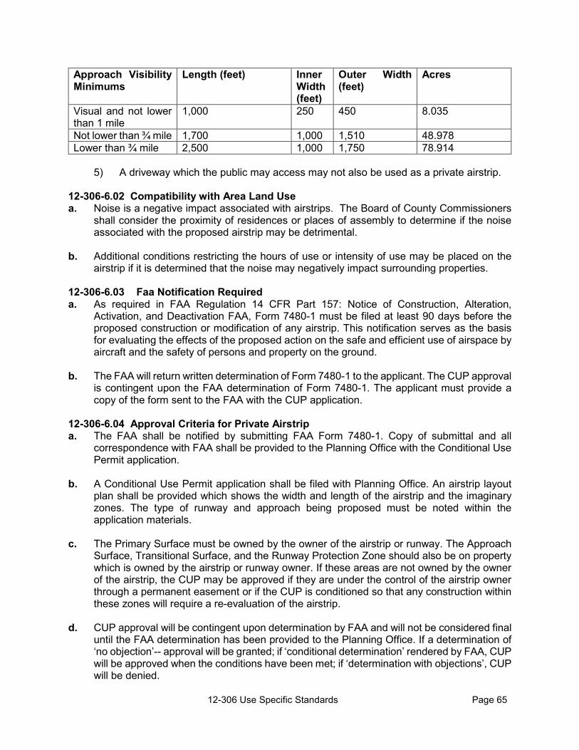
12-306 Use Specific Standards Page 65
Approach Visibility Minimums
Length (feet) Inner Width (feet)
Outer Width (feet)
Acres
Visual and not lower than 1 mile
1,000 250 450 8.035
Not lower than ¾ mile 1,700 1,000 1,510 48.978 Lower than ¾ mile 2,500 1,000 1,750 78.914
5) A driveway which the public may access may not also be used as a private airstrip.
12-306-6.02 Compatibility with Area Land Use a. Noise is a negative impact associated with airstrips. The Board of County Commissioners
shall consider the proximity of residences or places of assembly to determine if the noise associated with the proposed airstrip may be detrimental.
b. Additional conditions restricting the hours of use or intensity of use may be placed on the airstrip if it is determined that the noise may negatively impact surrounding properties.
12-306-6.03 Faa Notification Required a. As required in FAA Regulation 14 CFR Part 157: Notice of Construction, Alteration,
Activation, and Deactivation FAA, Form 7480-1 must be filed at least 90 days before the proposed construction or modification of any airstrip. This notification serves as the basis for evaluating the effects of the proposed action on the safe and efficient use of airspace by aircraft and the safety of persons and property on the ground.
b. The FAA will return written determination of Form 7480-1 to the applicant. The CUP approval is contingent upon the FAA determination of Form 7480-1. The applicant must provide a copy of the form sent to the FAA with the CUP application.
12-306-6.04 Approval Criteria for Private Airstrip a. The FAA shall be notified by submitting FAA Form 7480-1. Copy of submittal and all
correspondence with FAA shall be provided to the Planning Office with the Conditional Use Permit application.
b. A Conditional Use Permit application shall be filed with Planning Office. An airstrip layout
plan shall be provided which shows the width and length of the airstrip and the imaginary zones. The type of runway and approach being proposed must be noted within the application materials.
c. The Primary Surface must be owned by the owner of the airstrip or runway. The Approach
Surface, Transitional Surface, and the Runway Protection Zone should also be on property which is owned by the airstrip or runway owner. If these areas are not owned by the owner of the airstrip, the CUP may be approved if they are under the control of the airstrip owner through a permanent easement or if the CUP is conditioned so that any construction within these zones will require a re-evaluation of the airstrip.
d. CUP approval will be contingent upon determination by FAA and will not be considered final
until the FAA determination has been provided to the Planning Office. If a determination of ‘no objection’-- approval will be granted; if ‘conditional determination’ rendered by FAA, CUP will be approved when the conditions have been met; if ‘determination with objections’, CUP will be denied.

12-306 Use Specific Standards Page 66
e. For determining if obstacles are located within the obstacle free areas, a roadway will be
considered to contain an obstacle of 14 ft (the height of a large farm vehicle or implement). f. The following land uses are prohibited from the Runway Protection Zone: residences, places
of public assembly, and fuel storage facilities. g. An airstrip shall not be approved if there are obstructions in the obstacle free zones (primary
surface, approach surface, or transitional surface).
h. The CUP approval of an airstrip does not constrain the development potential on adjacent properties, unless easements have been put in place. The airstrip CUP approval is contingent upon the maintaining of obstacle free zones. If structures or other obstacles are constructed in obstacle free zones, the airstrip CUP approval will be re-evaluated. If it is possible, the airstrip can be reconfigured to avoid conflict with the new structures/items. If reconfiguration isn’t possible, the airstrip CUP will be returned to the Board of County Commissioners for amendment, if it is possible to reconfigure or relocate the airstrip to avoid conflict in the obstruction free zones, or for revocation of the CUP approval if it isn’t possible to resolve the conflict.
12-306-7 ANCILLARY AGRICULTURAL RETAIL SALES a. Ancillary non-agricultural retail sales associated with a greenhouse, nursery, or other
agricultural use is permitted with site plan approval for up to 500 sq ft of sales area. Sales area greater than 500 sq ft for ancillary retail goods requires approval through a Conditional Use Permit.
b. Ancillary retail sales associated with an Agritourism use are permitted when registered as
part of the Agritourism use.
12-306-8 ANIMAL HOSPITAL OR CLINIC a. Standards that apply in all districts in which they are permitted:
1) A hospital or clinic for large animals shall be located on a lot or eligible parcel
containing 5 acres or more. 2) All buildings, structures, pens for large animals, or open pens, runs, cages or kennels
for small animals shall be located at least 200 feet from any property lines. 3) The site plan shall include a drainage plan to show how cleaning water and stormwater
runoff will leave the property. 4) KDHE approval of waste water management plan.
b. Standards that apply in the GI District:
1) Permitted only as an accessory use to a research facility.
12-306-9 BED AND BREAKFASTS a. A Bed and Breakfast with 3 or fewer guest bedrooms may be operated as an accessory use
to the principal use of an owner-occupied structure or may have an on-site resident manager.

12-306 Use Specific Standards Page 67
b. A Bed and Breakfast establishment with 4 or more guest bedrooms is required to have a full-time resident manager or owner on the site and must be licensed by the State of Kansas to do business.
c. The establishment shall not contain restaurant facilities but may provide food service for
overnight or other transient guests only.
12-306-10 CAMPGROUNDS 12-306-10.01 General Standards a. Campgrounds may not be located on properties/parcels that are less than 5 acres. b. Gross density shall not exceed 20 campsites per acre with no more than 2 camping units
on any campsite. c. The water supply system and sewage management measures shall be designed,
constructed, and maintained in compliance with the Lawrence-Douglas County Health Department regulations and recommendations.
d. An attendant or caretaker shall be available at all times to keep the park, its facilities and
equipment in a clean, orderly, and sanitary condition. (Primitive campgrounds are exempt from this requirement.)
e. No camping units/camp sites may be rented or occupied by the same party for periods that
exceed 14 days and are not to be for individual sale or ownership.
f. Fires will be permitted only in facilities which have been provided for such purposes. All fire or cooking facilities shall be located, constructed, maintained, and used to minimize fire hazard and smoke nuisance in the campground and the neighboring properties.
g. No campfires permitted when the County Burn Ban is in effect.
h. All camping spaces shall be graded nearly level, except that each space shall be designed
to provide drainage to a stormwater detention area, as required by the County Engineer. (Primitive and Family/Personal campgrounds are exempt from this requirement.)
i. Campsite ID numbers, at least 4” in height, shall identify each space and shall remain
visible when in use. (Primitive and Family/Personal campgrounds are exempt from this requirement.)
j. Campsite Design Standards;
1) Campsite width: 20 ft 2) Campsite set back: 25 ft from local road right-of-way,
50 ft from collector or arterial, 20/30 ft from side and rear property lines.
50 ft from river bank 20 ft from interior drive 8 ft from fire pit, or other source of open flame

12-306 Use Specific Standards Page 68
3) Landscaping i. The campground shall be adequately landscaped to provide a buffer from
nearby properties and roadways, and to prevent erosion. ii. A minimum 100 ft landscaped buffer is required for park areas adjacent to
private lands in a Residential zoning district. iii. If the proposed campground would be visible from a residence on an abutting
property, fencing and/or buffering vegetation shall be installed. Fences shall be no less than six feet in height, and shall be sight obscuring. (This requirement may be waived if the recreational vehicle park or campground owner is also the owner of the contiguous residence.)
4) Access
i. Access drives must have all weather surfacing and a minimum width of 24 feet for two-way traffic and 15 feet for one-way traffic with a vertical clearance of at least 13 feet, 6 inches. (Primitive campsites with no vehicular access are exempt from this parking requirement.)
ii. Campgrounds must be designed so that vehicles wait on the interior access
drive, rather than the adjacent road, for access into the campground. iii. All interior drives shall be looped, or a turnaround meeting fire apparatus
access requirements shall be provided at the end of all roads.
5) Parking i. Minimum of 1 parking space required per campsite. (Primitive campsites with
no vehicular access are exempt from this parking requirement.) ii. Adequate barriers shall be provided to confine vehicles to driveways and
parking spaces.
12-306-10.02 Standards specific to campgrounds which permit camping vehicles (RV campgrounds)
a. Each RV campsite shall provide at least 900 sq ft of space. b. Wheels and tires shall not be removed from any RV nor skirting applied. c. RV pad area must use an all-weather surface (such as gravel, asphalt, etc.) as approved
by the County Engineer. d. All camping vehicles (RVs) shall have current licensing and registration and be in operable
road worthy condition, as applicable.
e. Each RV campsite shall abut an internal road which provides unobstructed access to a public road.
f. Sewage disposal methods shall comply with the Douglas County Sanitary Code and
require approval of the Health Code Official.

12-306 Use Specific Standards Page 69
12-306-10.03 Standards specific to tent camping. a. Each tent campsite shall provide at least 600 sq ft of space. b. Group tent sites shall be permitted as long as the maximum number of sites of the group
site is designated and the group site density does not exceed 20 campsites per acre. 12-306-10.04 Table
Type of campground Family/Personal camping
Special Event Campgrounds Primitive Campground Developed
Campground
Purpose and needs
To allow property owners, the use of their property for their own, and their families and
friends, camping purposes.
To provide for safe and temporary housing
accommodations for tourists and guests during an event
which is permitted as a Special Event
To provide for safe and enjoyable camping facilities
in areas which have minimal development to
maximize the natural character of the area
To provide for safe and enjoyable camping facilities which have been developed to
accommodate campers in any type of camping unit. May also include
amenities such as showers.
Time limits
14 cumulative days in a calendar year. More requires a no-fee permit from the Zoning and Codes Director.
Time frame approved for the Special Event
14 days per visit. Each visit must be separated by 1
week.
14 days per visit. Each visit must be separated
by 1 week.
SITE PLAN REQ. No Yes Yes Yes
Types of accommodations
Tents, campers, recreational vehicles,
etc. Tents, campers,
recreational vehicles, etc. Tents, yurts, and other low
impact camping units
Any type of camping unit such as a tent,
cabin, RV, motor home, no permanent housing
Type of facilities and amenities
Any accessory uses permitted with the
principal use of the land
Any facilities/uses that are approved as part of the Special Event Permit
Minimal facilities/uses needed to accommodate
campers, that are approved as part of the Conditional
Use permit
Any facilities/uses permitted in the
applicable zoning district that are
approved as part of the Conditional Use Permit
Minimum area needed to have a campground n/a As approved with the
Special Event Permit 5 acres 5 acres
Maximum density As approved with the Special Event Permit 20 campsites per acre 20 campsites per acre
Approval Zoning and Codes permit required for camping beyond 14
days per year
Special Event Permit with Board of County
Commissioners approval
Conditional Use Permit (Camping that is accessory to an Agritourism use
would be included in the Agritourism registration, which require Board of County Commissioners approval.
12-306-10.05 Family /Personal)Camping: a. Camping units shall comply with setback requirements for the zoning district in which they
are located. b. Private camping may occur up to 14 cumulative days in a calendar year without a permit.
1) After those 14 days, property owners may request a no-fee permit to camp for up to
30 days in a calendar year. (One renewal may be granted) The permit will require Health Department approval of sanitary provisions.
c. Private camping may be permitted for an extended time frame, beyond 30 days, when approved by the Director of Zoning and Codes as being an accessory use to the construction

12-306 Use Specific Standards Page 70
of a residence. The camping unit may not be used as a dwelling after the residence is issued a Certificate of Occupancy.
d. For properties without a principal residence, camping units must be moved on and off (or stored within an enclosed structure) when not used for camping
12-306-11 CARETAKER/MANAGER RESIDENCE a. A caretaker/manager residence may be located within a detached dwelling or within the
principal structure. b. The caretaker/manager living in the residence must be employed on the premises. 12-306-12 DAY CARE CENTER a. A wall or fence at least 4 feet in height must be maintained around the perimeter of any play
area. b. A Day Care Center requires approval of a Conditional Use Permit except when it operates
as an accessory use to a school, religious institution, or other use that was approved with a site plan.
12-306-13 DAY CARE HOME, a. A day care home is limited to the care of 12 or fewer individuals.
b. A day care home must be an accessory use to an occupied residence.
12-306-14 DETACHED SINGLE-FAMILY DWELLING Only one principal detached single-family dwelling may be constructed on any platted lot or vested parcel with the following exception: a. Multiple Farm Employee Housing units may occur on a parcel when approved with a
Conditional Use Permit.
12-306-15 EVENT CENTER/PUBLIC ASSEMBLY Roads on primary route to property will be evaluated through the site planning process to determine the size of event which may be accommodated or the types of road improvements which may be necessary. 12-306-16 EXTERIOR STORAGE a. Standards that apply in the V, BSC, LB, RT, and GB Districts: Material storage yards, in connection with retail sales of products where storage is incidental to the approved occupancy of a store, is permitted provided:
1) All products and materials shall be stored in a completely enclosed building, or enclosed by a masonry wall, fence, or hedge, or a combination of these features which is at least 6 feet in height. Stored materials and equipment shall not exceed the height of the enclosure.
2) Storage of vehicles and equipment used in connection with the permitted trade or
business is permitted within a wall, fence or hedge. This does not include the storage of heavy equipment, such as road-building or excavating equipment.

12-306 Use Specific Standards Page 71
3) Exterior storage areas shall be located in compliance with the setbacks in the applicable zoning district.
b. Standards that apply in the LI and GI Districts:
1) Material storage yards are permitted as an accessory or principal use of the site provided exterior storage is screened from adjacent residential zoning districts or residentially developed property, and the adjacent road by a wall, fence or hedge or a combination of these features which is at least 6 feet in height.
2) Exterior storage areas shall be located in compliance with the setbacks in the
applicable zoning district.
12-306-17 FARM STAND 12-306-17.01 General Standards a. Any structure used for the farm stand shall be located a minimum of 25 ft from the edge pf
the roadway.
b. Any structure used for the farm stand shall be located so that it does not interfere with sight distance for a corner property (Section 12-305)
c. Adequate area shall be provided on the site to allow one customer vehicle parking space. d. No parking associated with the farm stand shall occur along the roadway or in the road right-
of-way.
12-306-17.02 Standards that apply in the CP District No farm stand shall be permanently maintained on the property. Stands are permitted from March 15th through October 31st.
12-306-18 FARMER’S MARKET a. Adequate off-street parking shall be provided so that customers are parking on private
property rather than road right-of-way. Customer parking in the road right-of-way is prohibited.
b. Structures are subject to the Dimensional Standards in Section 12-303.
12-306-19 FIREWORKS SALES A permit must be obtained from the Zoning and Codes Office for any fireworks sales operations within the unincorporated area of Douglas County. The fireworks sales may operate only on the times and dates listed on the permit. In addition to the permit the following conditions apply: a. No shooting of fireworks shall be permitted within 100 feet of the fireworks stand. b. A temporary stand shall be located at least 25 feet from road or highway right-of-way. c. Sales cannot occur in an Agricultural Exempt building.
d. Off-street parking must be provided for employees and customers. e. Weeds and grass must be cut back within 100 feet of the stand.

12-306 Use Specific Standards Page 72
f. The stand may not be located in any area where its proximity to other explosive or flammable
materials will create safety hazards. g. Temporary identification or advertising signs shall be placed as authorized in writing on the
permit. h. The temporary stand and signs shall be removed on or before the 8th day of July. i. Sale or other distribution of fireworks, under the permit, shall be limited to fireworks
authorized under the laws of the State of Kansas, with the exception that the sale or other distribution of fireworks known as ‘bottle rockets’ is prohibited.
12-306-20 HELIPORTS a. Only heliports developed for exclusive use of the owner and persons authorized by the
owner are permitted within the unincorporated portions of Douglas County. b. Each heliport is evaluated in the Conditional Use Permit approval process so that safety
issues and the impact of the heliport on surrounding land uses can be considered. c. FAA Notification is required for new heliports or changes to the heliport through the submittal
of FAA Form 7480-1 (Figure 1-1), a heliport layout diagram, and a heliport location map. The applicant must provide a copy of the form sent to the FAA with the CUP application. A copy of the FAA determination must be provided to the Planning Office as a condition of the Conditional Use Permit approval.
12-306-21 TYPE 1 HOME OCCUPATIONS Type I Home Occupations include incidental and accessory home occupation uses that can be conducted wholly within the dwelling unit and that are ancillary to the primary residential use of the property. Type I Home Occupations are uses that are incidental and accessory to the primary residential use, and as such, are activities that are compatible with residential or farm activities. a. Typical Type I Home Occupations include uses such as fine art studios or instruction; small
educational classes, home crafts; professional offices; office facilities for salespersons when no sales occur on the premises; offices for service-type businesses such as insurance agents, decorators, and tax advisors; and personal services such as seamstresses and beauty or barber shops.
b. The following uses are expressly prohibited as Type I Home Occupations. This list of
prohibited uses is not intended as an exhaustive list. Uses that are similar to those listed below may be prohibited and other uses may be prohibited based on their inability to comply with all applicable standards of this Section. 1) Auto and other vehicle repair; 2) Funeral homes; 3) Medical or dental offices, clinics, or hospitals, which generate or results in
biohazardous materials. 4) Renting of trailers, cars, or other equipment; 5) Restaurants; 6) Tourist homes; Vacation Rentals 7) Contractor’s equipment and material storage;

12-306 Use Specific Standards Page 73
12-306-21.01 Type 1 Home Occupation Standards a. The operator of the home occupation must reside on the site of the home occupation. b. A Type I Home Occupation shall not occupy more than 50% of the gross square footage of
the principal dwelling unit. c. No equipment shall be used that creates noise, vibration, electrical interference, smoke or
particulate matter emission that is perceptible beyond the property lines of the subject parcel.
d. There shall be no visible evidence of the conduct of a Type I Home Occupation, other than
a permitted sign. All equipment, materials, goods and vehicles shall be stored indoors or otherwise completely screened from view of adjacent parcels and rights-of-way.
e. A maximum of 2 non-resident employees are allowed. f. No inventory of products shall be displayed or sold on the premises other than what has
been produced on the premises or the incidental sale of goods that are associated with the Home Occupation (beauty products with a beauty salon or art supplies for an art class, for example).
g. The home occupation activity shall be conducted wholly within the dwelling unit.
h. No off-street parking spaces shall be provided exclusively for a Type I Home Occupation.
Parking spaces required for the primary residential use will need to serve the needs of the Home Occupation.
i. Classes are limited to no more than 6 students at one time.
12-306-21.02 Registration of Home Occupations a. Home Occupations must be registered with the Zoning and Codes Office. The application
form is available from the Douglas County Zoning and Codes Office. The registration and approval process is an administrative procedure.
b. Upon submittal of a completed application, the Zoning and Codes Director will verify that
the requested use is compliant with the provisions of the standards in Section 12-306-21.01. c. If the operator/owner of a Home Occupation does not own the real estate on which the
Home Occupation is conducted, an affidavit of equitable interest or a copy of a lease evidencing a leasehold interest can be submitted as a substitute for fee simple ownership of the real estate.
d. A Home Occupation permit will be issued for a use if it is found to be compliant with the conditions and standards in Section 12-306-21.01.
e. The Home Occupation use permit is valid for a period of twelve months from the date of issuance.
f. To renew the permit, a renewal application form must be filed at the Douglas County Zoning and Codes Office. Renewal of a Home Occupation Permit for the same use can be requested either by mail or in person. 1) It is the responsibility of the Home Occupation business owner to annually renew the

12-306 Use Specific Standards Page 74
use permit. g. The fees charged for the initial permit and for the renewal permit are based on a separate
Fees and Enforcement Policy resolution adopted by the Board of County Commissioners. A fee schedule is available at the Zoning and Codes Office.
12-306-21.03 Appeals Of Decisions Concerning Home Occupations a. Any applicant for a home business that is dissatisfied with the final determination of the
Douglas County Zoning and Codes Director as it relates to Home Occupation registration may appeal such determination to the Board of County Commissioners.
1) The provisions in Sections 12-306-21 are not provisions that can be appealed to the
County Board of Zoning Appeals.
b. The Board of County Commissioners may appoint a hearing officer to hear and decide appeals made from subsection (a) in this section. In the event that there is a single commissioner so appointed, the decision of that Commissioner shall be deemed to have been made by the entire Board of County Commissioners and the aggrieved person shall have no right to appeal to the entire Commission.
c. Any person who is dissatisfied with the decision of the Board of County Commissioners may
appeal such decision to the District Court, as provided by law. d. A final determination of the Board of County Commissioners shall not be a prerequisite to
the commencement of any enforcement action against any person allegedly violating the Zoning Regulations.
12-306-21.04 Permit Non-Transferable The Home Occupation Permits are valid for the registered use and for the current owner of the real estate at the described location on the use permit. The use permit is non-transferable. 12-306-22 TYPE 2 HOME OCCUPATIONS Type II Home Business Occupations are uses that are incidental and accessory to the primary residential use, and as such, are activities that are compatible with residential or farm activities. Type II Home Occupations are more intense occupations in that they have more employees than the Type 1 Occupations or occur in an accessory structure that is ancillary to the primary residential use of the property. Type 1 occupations that exceed the Type 1 standards are considered Type 2. Such occupations are often service-oriented or involve production of materials for sales off premises. a. Type 2 Home Occupations include the assembly, distribution, maintenance, and repair of
agricultural implements and equipment; assembly of mechanical devices and components; automobile painting, upholstering, and other mechanical or body repairs; welding and machine shops; and contractor’s equipment and material storage, or uses that the Director of Zoning and Codes determines to be similar in impacts to nearby land uses, in addition to uses permitted as Type 1 Home Occupations that do not meet the standards for a Type 1 Home Occupation.
b. The following uses are expressly prohibited as Type 2 Home Business Occupations. This
list of prohibited uses is not intended as an exhaustive list. Other uses will be prohibited based on their inability to comply with all applicable standards of this Section.

12-306 Use Specific Standards Page 75
1) Auto and other vehicles repair (except as noted above); 2) Funeral homes; 3) Medical or dental offices which result in, or generate, biohazardous materials. 4) Renting of trailers, cars, or other equipment; 5) Restaurants; 6) Tourist homes; 7) Exterior storage of Contractor’s equipment and material;
12-306-22.01 Type 2 Home Occupations standards: a. A maximum of 4 Nonresident Employees; b. The home occupation activity shall be conducted within the dwelling unit or within an
accessory building that is no greater than 3,600 square feet in gross area. (An accessory structure in use by a rural home business occupation on August 16, 2000, for a use permitted in Type 2 Home Occupations is not subject to the maximum size limitation of 3,600 square foot. The use or use area existing on August 16, 2000 cannot be enlarged or expanded under the Type 2 Home Occupation regulations);
c. The majority of work related to agricultural implement repair or grading and earthwork
activities must be conducted off premises; d. No equipment shall be used that creates noise, vibration, electrical interference, smoke or
particulate matter emission from a dwelling or accessory structure that is perceptible beyond the property lines of the subject parcel;
e. All equipment, materials, and vehicles used for the home occupation shall be stored indoors
or otherwise completely screened from view of adjacent parcels and rights-of-way; f. No inventory of products shall be displayed or sold on the premises other than what has
been produced on the premises; or the incidental sale of goods that are associated with the Home Occupation (beauty products with a beauty salon or art supplies for an art class, for example).
g. A minimum site area of 5 acres is required for all Type 2 Home Occupations established
after August 16, 2000. h. The site containing the Type 2 Home Occupation must have direct access to a public road. i. A minimum of one parking space shall be provided for each non-resident employee, based
on the maximum number of employees present at any one time. j. All parking spaces shall be located a minimum of 50 feet from property lines and public
rights-of-way, and shall be screened by landscaping, a fence, or buildings to minimize visibility from the public rights-of-way or from adjacent residences.
k. All automotive, welding, and machine shop work must be conducted entirely inside an
enclosed structure without any outdoor storage of vehicles, parts or equipment. l. Contractor’s equipment and material storage shall be totally enclosed in a building without

12-306 Use Specific Standards Page 76
any outdoor storage of vehicles, parts, or equipment. 12-306-22.02 Registration of Home Occupations a. Home Occupations must be registered with the Zoning and Codes Office. The application
form is available from the Douglas County Zoning and Codes Office. The registration and approval process is an administrative procedure.
b. Upon submittal of a completed application, the Zoning and Codes Director will verify that
the requested use is compliant with the provisions of the standards in or Section 12-306-22.01.
c. If the operator/owner of a Home Occupation does not own the real estate on which the
Home Occupation is conducted, an affidavit of equitable interest or a copy of a lease evidencing a leasehold interest can be submitted as a substitute for fee simple ownership of the real estate.
d. A Home Occupation permit will be issued for a use if it is found to be compliant with the
conditions and standards in Section 12-306-22.01. e. The Home Occupation use permit is valid for a period of twelve months from the date of
issuance. f. To renew the permit, a renewal application form must be filed at the Douglas County Zoning
and Codes Office. Renewal of a Home Occupation Permit for the same use can be requested either by mail or in person. i. It is the responsibility of the Home Occupation business owner to annually renew the
use permit. g. The fees charged for the initial permit and for the renewal permit are based on a separate
Fees and Enforcement Policy resolution adopted by the Board of County Commissioners. A fee schedule is available at the Zoning and Codes Office.
12-306-22.03 Appeals Of Decisions Concerning Home Occupations a. Any applicant for a home business that is dissatisfied with the final determination of the
Douglas County Zoning and Codes Director as it relates to Home Occupation registration may appeal such determination to the Board of County Commissioners.
1) The provisions in Sections 12-306-22 are not provisions that can be appealed to the
County Board of Zoning Appeals.
b. The Board of County Commissioners may appoint a hearing officer to hear and decide appeals made from subsection (a) in this section. In the event that there is a single commissioner so appointed, the decision of that Commissioner shall be deemed to have been made by the entire Board of County Commissioners and the aggrieved person shall have no right to appeal to the entire Commission.
c. Any person who is dissatisfied with the decision of the Board of County Commissioners may
appeal such decision to the District Court, as provided by law.

12-306 Use Specific Standards Page 77
d. A final determination of the Board of County Commissioners shall not be a prerequisite to the commencement of any enforcement action against any person allegedly violating the Zoning Regulations.
12-306-22.04 Permit Non-Transferable The Home Occupation Permits are valid for the registered use and for the current owner of the real estate at the described location on the use permit. The use permit is non-transferable. 12-306-23 KENNEL, COMMERCIAL DOG 12-306-23.01 Standards that apply in all districts: a. Any open pens, runs, cages or kennels shall be located at least 500 feet from any property
lines.
b. A minimum of 20 acres is required for a kennel. c. Adequate water supply must be provided for drinking and cleaning and appropriate sewage
and waste management measures, approved by the Health Department, must be followed to eliminate odor.
d. The site plan must show contours so appropriate drainage of cleaning water and stormwater
runoff can be determined. e. Shelters must be provided with heating and cooling units to protect the animals from extreme
temperatures. f. An exercise area such as an individual dog run or an exercise yard which may also be used
for training and obedience classes must be provided. g. Runs shall be adequately fenced and roofed to contain animals. h. The building design, site layout, and/or other features must result in a facility that does not
create noise which negatively impacts nearby properties.
12-306-23.02 Standards that apply in the AG-1 District Must be located on a property with a residence or veterinary clinic and be operated by the resident or veterinarian staff.
12-306-24 LANDFILL A landfill is generally defined as a place to dispose of refuse and other waste material by burying it and covering it over with soil, especially as a method of filling in or extending usable land. The term ‘landfill’ encompasses many types of landfills such as Sanitary, Industrial, Solid Waste, Construction and Demolition Waste, and Clean Rubble. Definitions for the various types of landfills are provided in Chapter 10 of the County Code, ‘Solid Waste Management’. a. All landfills require approval of a Conditional Use Permit with the exception of landfills that
meet both of the following criteria: 1) The waste materials being disposed were produced on site (i.e. were not hauled to the
site); and 2) The waste materials consist only of Clean Rubble, as defined in Chapter 10 of the
County Code.

12-306 Use Specific Standards Page 78
b. The following general standards shall apply to all landfills which require CUP approval:
1) For all landfills that require a KDHE permit, the applicant shall hold a valid, state-issued permit at all times such landfill is in operation.
2) For all landfills that require a County permit, per Chapter 10 of the County Code, the
applicant shall hold a valid, County-issued permit at all times such landfill is in operation.
3) The landfill operation shall be limited to the disposal of waste included in the definition
of that type of landfill in K.S.A. 65-3424. 4) The applicant shall submit complete plans for the design and operation of the landfill,
providing detail as to such matters as noise and dust control, stormwater drainage and detention or retention, hours of operation, truck route, interior roads, fire suppression, security, lighting, screening, and reclamation.
5) Minimum setbacks for any excavation, or fill, associated with the landfill shall be
established at a rate of 1 ft for each ft of depth excavated, in accordance with K.S.A. 49-501 and shall be a minimum of 100 ft from any road right-of-way and 30 ft from all other property lines. Additional setbacks may be required based on topography, visibility of site, adjacent land use, drainage issues, etc. Setbacks must be maintained free of any activity, either surface or subsurface.
6) If the County determines that any road associated with the use is inadequate for the
expected quantities of traffic, especially with respect to heavy truck traffic, the applicant shall be required to improve and maintain the road(s) to a standard acceptable to the County. An Improvement and Maintenance Agreement between the applicant and the County shall be required to assure that the road(s) used by the operation will be appropriately improved and maintained.
7) Landfill operations may require screening, depending on the location, and as
determined by the Board of County Commissioners. 8) If more than 1 acre of land is to be disturbed, a Storm Water Pollution Prevention Plan
(SWP3) must be submitted to KDHE and approved prior to commencement of the landfill. A copy of the approved SWP3 must be provided to the Planning Office prior to final approval of the CUP to insure the CUP complies with the provisions of the SWP3.
9) At a minimum, the reclamation plan shall show the finished grade of the property, note
the amount of top soil to be placed over the landfill, the type of vegetation to be installed (seed mix, etc.), and the proposed use following reclamation.
10) Landfills shall not be located within a special hazard flood area except that:
i. Clean Rubble Landfills may be used to fill in ponds, borrow pits, or other
depressions in the special hazard flood area. Grading (fill or excavation), dredging, and any development must comply with Douglas County Floodplain Management Regulations.

12-306 Use Specific Standards Page 79
i. If approved, the CUP shall be limited to a specific timeframe. If the landfill activity is not completed within this timeframe, the applicant may request in writing that the CUP be placed on the County Commission agenda for consideration of renewal. The request for renewal should be made prior to the expiration date and public notification of the meeting shall be provided by staff.
12-306-25 EQUIPMENT STORAGE a. Open or enclosed storage must meet the minimum yard requirements of the district in which
it is located. b. Open storage must be screened by a view reducing wall, fence or landscaping material from
adjacent public roads and residences.
12-306-26 MANUFACTURING AND PRODUCTION USES (LIGHT OR GENERAL) 12-306-26.01 Standards that apply in the GB District a. No outside storage of material is permitted. b. No industrial use in the GB District shall occupy more than 6,000 sq. ft of floor area.
12-306-26.02 Standards that apply in the GI District a. Any industry conforming to applicable regulations of the State of Kansas concerning health,
safety, and industrial hazard is permitted, so long as it is not maintained as a nuisance. 12-306-26.03 Standards that apply in the LI District a. All industrial uses shall be conducted within a completely enclosed building with no open
storage of raw, in-process, or finished material and supplies or waste material. b. Finished or semi-finished products manufactured on the premises may be stored in the open
if screened from the road and adjacent residential property by landscaping, fences, or walls. 12-306-26.04 Standards that apply in all districts: a. Adequate parking and loading space shall be provided on-site for all employees and traffic
to the facility. b. Loading operations shall be conducted at the side or rear of buildings. c. The front yard shall be landscaped with trees, grass, shrubs, or pedestrian walks and
maintained in a neat and attractive condition. d. All fencing shall have a uniform and durable character and shall be properly maintained.
12-306-27 MINING AND EXCAVATION 12-306-27.01 Existing Uses Mining and excavation of mineral or raw materials including, but not limited to: stone, sand, gravel or other building materials and the manufacturing, processing, storage and selling of said minerals and materials shall be permitted to continue in operation in the AG-1(Agricultural) District; and Floodway and Floodway Fringe Overlay Districts only on those areas under lease and on record at the time countywide zoning went into effect, September 23, 1966.
12-306-27.02 Standards The following standards apply to all mining and excavation activities:

12-306 Use Specific Standards Page 80
a. All mining and excavation activities shall observe the following setbacks: 1) No excavation or other quarrying or mining activity shall be permitted within 300 ft of
a residence or 200 ft of a residential zoning district, whichever is greater. 2) No excavation or other quarrying or mining activity shall be located closer than 50 ft
from any adjoining property under separate ownership. 3) No excavation or other quarrying or mining activity shall occur closer than 100 ft from
any right-of-way. 4) The setback areas may be used for the erection of berms or other screening features
required by the conditional use permit. b. Berms at a maximum of 3:1 slope shall be installed along the right-of-way adjacent to any
quarrying activity and along the property lines between the use and any adjacent residential use to screen activities from the right-of-way or adjacent residential property unless the existing vegetation or topography provides an effective screen.
1) As an alternative, berms may be installed within the interior of the site if the berms
provide an effective screen for activities from the right-of-way or adjacent residential use.
c. If blasting is to occur, a pre-excavation seismology study shall be conducted at the property boundaries and at any residence within 1,000 feet that requests it prior to the commencement of the quarry use. 1) Notice of this study shall be mailed to all property owners as identified on the Certified
Douglas County Property Owner List required for the Conditional Use application. 2) A copy of the study shall be provided to the Zoning and Codes Office to be maintained
in the file and a copy shall be maintained on site.
d. The Applicant or operator shall provide a surety bond, reclamation bond, Certificate of Deposit or Letter of Credit, in a format acceptable to the Planning Director, to ensure that the site is reclaimed as outlined in the approved Reclamation Plan. 1) The bond amount shall be established based on engineering or contractor estimates
for reclamation of the mined area, or area proposed to be mined, as shown on the reclamation plan.
12-306-27.03 Application materials a. The plans submitted with the application must show relevant information including specific
setbacks, phasing, prevailing winds, road networks, dust management plan, water use, ground water table, drainage study, and other information as may be deemed necessary to make an informed decision. At a minimum the plans shall include: 1) The boundary of the entire tract; 2) Vehicular access routes and surfacing; 3) The lateral extent and area, in acres, of the proposed excavation;

12-306 Use Specific Standards Page 81
4) Distances from the lateral extent of the excavation to all property lines; 5) The depth of the proposed excavation; 6) Existing topography; 7) Existing ground cover and location of any environmentally sensitive lands as identified
in Section 20-810(i) of the Subdivision Regulations; and 8) Information regarding the blasting being proposed.
b. An operation plan which indicates the excavation method to be utilized, provisions for the
storage and handling of overburden, the location of over burden piles, the location and phasing of mining activities, storage areas for top soil, the location of berms and information regarding the removal of the berms shall be submitted with the application.
c. A drainage study which shows the pre-mining drainage, the mining drainage, and the post-reclamation drainage. Shall be submitted with the application.
1) The County Engineer shall evaluate the drainage study to insure that off-site impacts
are minimized. 2) More detailed drainage studies will be provided prior to mining in any phase.
d. A reclamation plan that described in general how the excavated area will be reclaimed shall
be provided with the application. This plan shall show the remaining water features on the property and contours so it can be determined that proper drainage is provided. The following standards apply to the reclamation:
1) Sequential reclamation shall be utilized whenever possible. 2) The reclamation plan shall include a proposed schedule for completion of operations
and reclamation. 3) The type of reclamation proposed will depend on the final use anticipated for the
property. 4) Any remaining water bodies shall have banks with a maximum slope of 3:1 for the first
5 feet below water level. Banks above the anticipated water level shall have a maximum slope of 3:1 unless the County Engineer determines slopes of higher ratio are stable.
5) Up to 10 acres may be opened and mined from in a subsequent phase prior to the
approval of the reclamation of the previous phase. Before moving into the subsequent phase, a detailed reclamation for the current phase must be provided to the Planning Office for review and approved by the County Commission.
e. A dust control plan which describes the precautions and maintenance activities the operator
will undertake to prevent fugitive dust contamination from the site and from the principal access route to the site.

12-306 Use Specific Standards Page 82
1) The principal access route will be defined as the route of least distance between the
furthest entrance to the property involved and a paved public highway approved by the County Engineer. The principal access route to be used will be designated by the County Engineer and may not be deviated from except upon prior written approval of the County Engineer.
2) Fugitive dust contamination from the site and/or from the access road must be
minimized by the application of dust palliative measures approved by the County Engineer at appropriate intervals. The applicant shall describe in detail what methods they will use and at what intervals. The County engineer shall determine if the proposed plan is adequate to alleviate off-site impacts from fugitive dust contamination resulting from the operation. If the measures prove to be ineffective, additional dust control methods may be required by the County Commission.
f. A traffic study evaluating the expected impact of the operation on all township and county
roads that could be affected by the activity. As a requirement of the conditional use permit the operator shall agree to reimburse the township or county for any repair of damage to the principal access route due to ongoing truck traffic resulting from the operation and to bring the road to the condition that existed prior to the operation. The following procedure shall be used to determine the extent of the damage and to accomplish the appropriate reimbursement: 1) The extent of reimbursement to be paid for the repair of damages shall be determined
by the County Engineer by conducting an assessment of the road conditions, in cooperation with the operator/property owner, prior to the activity commencing and following the completion of the activity or the development of significant road damage, whichever occurs first. Any funds collected from the operator/property owner for damages to the road shall be used solely to repair the damages caused by the operation and for no other purposes. The repairs to the damaged roads shall be completed no later than 1 year after the damage occurs or the completion of the activity; or the funds shall be returned to the operator/property owner. In lieu of the financial measures, the operator/property owner may execute an agreement, running in favor of the county, that would require the operator/property owner to repair the road damages directly, using the operator/property owner’s resources upon notification by the County. Failure to perform the repair immediately upon notification would constitute a violation of the conditions of the CUP and excavation or processing activities approved with the CUP would cease until the repairs had been made.
2) The operator/property owner may appeal the decision of the County Engineer to the County Commissioners. A decision by the Board of Commissioners will be made no later than 60 days after the appeal request has been filed with the Zoning and Codes Office.
12-306-28 MINI- OR SELF-STORAGE Mini- or self-storage facilities shall meet the following locational criteria and development standards: a. Mini-or self-storage facilities shall be located within an Urban Growth Area or within an
appropriate zoning district.
12-306 Use Specific Standards Page 83
b. Facility should be located within a ¼ mile of a hard surfaced road classified as ‘collector’ or higher.
c. Security fencing and lighting shall be provided for the entire facility. Security fencing is
fencing which permits visibility while obstructing access. An example would be a 6 foot high chain link fence.
d. All outdoor lights shall, to the maximum extent feasible, confine emitted light on the property
on which the light is located and shall not be directed upwards toward the sky. All lights are to be shielded to reflect or direct light away from adjoining property but may be of sufficient intensity to discourage vandalism and theft. No light poles may be higher than 15 ft. Photometric plans shall be submitted with the site plan. Maximum illumination at lot line is as follows: 1) .2 foot-candles, or less, if adjacent to a residentially zoned or developed property. 2) 1 foot-candle if adjacent to non-residentially zoned or developed property.
e. Screening, must be provided on any side which abuts a residentially zoned district or
residentially developed property with a view reducing wall, fence, berm landscaping materials or a combination of these.
f. Access drives shall be a minimum of 20 feet wide for one-way traffic and 25 feet for two-
way traffic (to allow parking within the drive aisles). g. Off-street parking shall be required on the basis on one space for each 8,000 square feet of
floor area in the facility, plus one space for each employee, but in no case shall the number be less than five spaces.
h. All storage shall be kept within an enclosed building, unless a portion is designated for
covered (non-enclosed) or exterior vehicle storage. This area may be used for storage of trucks, automobiles, trailers, boats or recreational vehicles, including motor homes.
1) Exterior storage of unregistered and/or disassembled vehicles is prohibited. 2) Any covered (non-enclosed) or exterior vehicle storage shall be screened from
adjacent public roads, residentially zoned properties or residentially developed property with a view reducing wall, fence, landscaping materials or a combination of these measures.
i. Access drives and parking spaces must be shown on the site plan and physically designated
on the site. One vehicle and trailer will be permitted per stall. j. Activities which are prohibited on the premises include miscellaneous or garage sales,
commercial shipping and receiving, and the servicing or repair of motor vehicles, boats, trailers, lawn mowers and other similar equipment. Storage spaces shall not be used for storage of commercial or industrial trucks and/or trailers, workshops, hobby shops, manufacturing or similar uses. Human occupancy shall be limited to that required to transport, arrange and maintain stored materials.
k. The area shall be properly policed by the owner or operator for removal of trash and debris.

12-306 Use Specific Standards Page 84
l. Keyless keypad entry system is required, or a similarly secure entry system with monitoring
ability. m. All storage units shall be oriented toward the interior of the site. Doors may not be located
along or visible from the perimeter of the site.
12-306-29 EXTENDED CARE FACILITY a. The facility must be located on a hard-surfaced road.
b. The facility must be in an area which is served by fire/medical emergency vehicles. c. Adequate on-site sewage management system must be provided and approved by the
Lawrence-Douglas County Health Department. d. Water supply must be approved by the Lawrence-Lawrence-Douglas County Health
Department.
12-306-30 OUTDOOR SPORTS OR RECREATION FACILITY Excluded from these use standards are recreation facilities that are accessory to a residence. a. Game fields, and courts shall not be located within 25 feet of the side or rear property lines. b. View reducing fencing and/or landscaping shall be provided to screen outside uses and
parking areas from abutting residentially developed properties. Parking areas outside the fenced area shall be screened with hedges at least three and one-half feet (3 ½’) in height around parking area to screen adjoining residentially developed properties, or roadway from headlights.
c. Any above-ground pumps and filters shall be at least 50 ft from abutting properties and screened to minimize noise trespass to adjoining properties.
d. Dispensing of food, beverages, candy, tobacco, ice cream and sandwiches shall be from
vending machines or small snack bar, concession stand or dining facility operated on the premises during the hours the recreational facility is open for use and shall not be open to the general public.
1) The dispensing of food and concessions is to be operated as an accessory use to the
recreational use. 2) Drive-thru facilities are expressly prohibited. 3) Food preparation and dispensing shall comply with the Douglas County Health Code
and regulations of the State of Kansas. 4) Off-site advertising of food or food services is prohibited.
12-306-31 RADIO, TELEVISION, AND MICROWAVE TOWERS. 12-306-31.01 Purpose. This section establishes standards for the use and construction of radio or television broadcasting towers and/or apparatus, microwave transmitting and/or receiving towers and/or stations, or any tower or other similar structure 100 feet or more in height from the ground, or 40 feet in height as

12-306 Use Specific Standards Page 85
measured to the highest point of the tower/antenna if mounted on a structure or building, or of any height if lighted; whether publicly or privately owned with the exception of Wireless Facilities.
12-306-31.02 Development Plan Required. At the time of application for Conditional Use Permit the applicant shall submit a development plan in sufficient detail, as determined by the staff of the Planning Department, to evaluate its conformance with applicable standards and guidelines. The development plan shall include: a. Written authorization from the property owner of the proposed tower site. b. A site plan drawn to scale showing the property boundaries, tower, guy wire anchors and
other apparatus, existing and proposed structures, proposed transmission buildings and/or other accessory uses, access road(s) location, access road surface material, parking area, fences, location and content of warning sign, exterior lighting specifications, a landscaping plan, land elevation contours, and existing land uses surrounding the site. If any accessory building is proposed, details of the building including elevations and proposed use of the building is required to be submitted with the application.
c. A report or written information which describes the tower height and design including a
cross-section of the structure; engineering specifications prepared by a qualified professional engineer, licensed to practice in the State of Kansas detailing construction of tower, base and guy wire anchorage; the proposed painting and lighting schemes; and describes the tower's capacity, including the number and type of antennas that it can accommodate.
12-306-31.03 Additional Public Notice a. In addition to the written notice to owners within ½ mile (2,640 ft) of the tower request which
is provided by the Planning Office, all owners of record of unincorporated property located within a one-mile radius of the proposed tower request must also be notified with written notice by the applicant. The applicant shall submit a Certificate of Mailing for the notice required by this Section, and a list of notified property owners at the time of application for a Conditional Use Permit. An application for a Conditional Use Permit for a communication tower shall not be valid without an executed Certificate of Mailing. The notice shall be sent by regular mail, postage pre-paid, by the applicant. The notice shall provide:
1) A brief description and location of the proposed tower; 2) Projected date for construction; 3) The person, with contact telephone number and address, designated by the applicant
to respond to questions concerning the proposed tower; 4) The date the Conditional Use Permit application will be submitted to the Planning
Office for review and process; 5) A statement with substantially the following information:
Notice of Conditional Use Permit (CUP) Consideration pending before the Lawrence-Douglas County Planning Office.
This letter is being sent to the owners of unincorporated property for the purpose of

12-306 Use Specific Standards Page 86
informing the property owner(s) and other interested parties about the proposed tower development describe further in this letter. This letter does not grant the recipient and/or property owner any additional legal rights to challenge the proposed development, instead, it is being provided solely to advise property owner(s) of the pending development. For further information, contact the applicant's designated representative or the Lawrence-Douglas County Planning Office at (785) 832-3150.
6) The failure to receive the additional notice by a property owner shall not affect the validity of the Conditional Use Permit approval or consideration.
12-306-31.04 General Provisions a. An effort in good faith must be made to locate new antenna on existing towers, or other
structures. A request for a new tower must be accompanied by evidence that application was made to locate on existing towers, with no success.
b. The owner at the owner’s expense shall remove any tower that is not in use for a period of one year, unless a request for an extension has been approved by the Board of County Commissioners.
c. A sign shall be posted on the tower or the exterior fence around the base of the tower noting
the name and telephone number of the tower owner/operator.
12-306-31.05 Setbacks a. A ground mounted tower shall be set back from the nearest property line a distance which
is at least equal to the height of the tower, measured from the center of the tower.
b. The setback for a tower mounted on the roof of a building or on top of other structures may be determined from either the edge of the property line or the edge of the roof as follows:
1) The tower shall be set back a distance which is at least equal to the total height of the
structure and tower from the nearest property line, measured from the center of the tower (similar to a ground-mounted tower), or
2) If the overall setback above is not met, the tower shall be set back a distance equal to
the height of the tower above the roof/structure from the edge of the roof. c. The Planning Commission may recommend and the Governing Body may approve a waiver
from these setback requirements if it finds that all of the following conditions are met: 1) The waiver will not adversely affect the public health, safety, or general welfare of the
community;
2) The waiver will not adversely affect the rights of adjacent property owners or residents;
3) Strict application of the provisions of this section would constitute unnecessary hardship on the Owner/Applicant; and
4) The waiver is appropriate under the circumstances.
d. Additional setbacks may be required to contain ice-fall or debris from tower failures and/or
to preserve the privacy of adjoining residential and public property. Setbacks shall apply to

12-306 Use Specific Standards Page 87
all tower parts including guy wire anchors, and to any accessory facilities.
12-306-31.06 Development Standards a. The height of a tower shall meet the setback requirements as stated in this chapter.
b. All towers should be located in areas zoned commercial, industrial, or agricultural, except
that towers may be permitted in areas zoned residential if it can be demonstrated that all reasonable efforts were made to locate the proposed tower in non-residentially zoned areas.
c. All towers and accessory facilities shall be sited to have the least practical adverse visual
effect on the environment. Towers shall not be lighted except to assure human safety as required by the Federal Aviation Administration (FAA). Towers should be a galvanized finish or painted gray or light blue unless other standards are required by the FAA. In all cases, mono pole towers shall be preferable to guyed towers or free standing structures. Towers should be designed and sited so as to avoid, whenever possible, application of FAA lighting and painting requirements.
12-306-32 RECYCLING COLLECTION FACILITIES The standards below apply to all recycling facilities with the exception of a recycling facility which is located within a building: a. Recycling collection facilities shall be limited to one area per property, parcel or tract of land
under common ownership dedicated to such facilities.
b. Any recycling collection facility shall be located within the designated area as shown on the approved site plan.
12-306-33 RELIGIOUS INSTITUTIONS AND ASSEMBLY Access should be limited to roads with a classification of ‘collector’ or higher but can be taken from a local road provided it is within close proximity, less than 0.25 miles or 1,320 feet, from an intersection with a collector or arterial road. 12-306-34 RESIDENTIAL DESIGN MANUFACTURED HOMES Same conditions apply as for single family homes with the following additional conditions: a. Minimum dimensions of body width shall be 22 feet; b. Minimum roof pitch shall be 2.5” in height to 12 running inches; c. Siding material shall be wood, masonry, composition board or finished aluminum lap siding
or other materials normally found on site built homes. d. Roofing materials shall be wood shingles, composition shingles or fiberglass shingles,
asphalt shingles, clay or concrete tile or slate; e. On level sites, the main floor shall be no greater than 20” above finished grade at the
foundation. On sloping or irregular sites, the side closest to grade level shall not be greater than 20” above finished grade at the foundation; and
f. The home shall be permanently mounted on a foundation or basement which meets the
provisions of the Building Code.

12-306 Use Specific Standards Page 88
12-306-35 RIDING STABLE/ACADEMY, COMMERCIAL 12-306-35.01 Standards that Apply in the AG-1 and AG-2 Districts: a. Stables may be used for the commercial boarding of horses or one-on-one instruction by
the property owner or manager without requiring a site plan or approval as a Home Occupation.
b. Stables that have any other commercial components, such as renting horses for rides, riding
classes, or other uses will require site planning or approval as a Home Occupation. c. Any buildings for keeping of animals shall be located at least 200 feet from any side or rear
property lines that abut residentially zoned or developed property. 12-306-36 SALE BARN /AUCTION HOUSE a. Adequate off-street parking areas must be provided to accommodate both vehicles and
trailers. b. Loading area must be screened from view of road rights-of-way or residential properties with
a fence, wall or view reducing landscaping or a combination of these features. c. Livestock sales must have sewage and waste disposal measures approved by the
Lawrence-Lawrence-Douglas County Health Department or Kansas Department of Health and Environment identified in their site plan.
12-306-37 SALVAGE/JUNK YARDS a. All exterior storage and processing areas shall be screened as follows:
1) A salvage yard abutting a collector or arterial road must be screened from the road
right-of-way or road easement by a solid masonry wall or solid wood fence at least 6 feet in height and be designed and located to prevent visibility of stored or stacked material. The fence shall be located no closer than 15 feet to any road right-of-way or road easement. In no case shall the height of the solid fence exceed 10 feet.
2) A salvage yard abutting a local road must be screened from the road right-of-way or
road easement through view reducing means, such as fencing or landscaping.
3) Fencing shall be placed along the side and rear of all processing and storage areas and may be of any approved type. Live screening may be used in lieu of fencing where deemed appropriate.
b. No open burning of junked, salvaged, or discarded materials is permitted. Incinerators may
be used for burning of wastes or the conducting of salvage operations if such incinerators are of a type approved by the Kansas State Department of Health and Environment.
c. Salvage, junked, and/or discarded materials shall not be placed in environmentally sensitive areas, nor shall they be buried.
12-306-38 SEXUALLY ORIENTED BUSINESS Sexually Oriented Businesses include, but are not limited to, the following: Adult arcades, Adult media outlet, Adult cabarets, Adult motion picture theaters, Adult retail establishment, Adult theaters, Escort agencies, Nude model studios, and Sexual encounter centers.

12-306 Use Specific Standards Page 89
12-306-38.01 Development Standards The following development standards provide location and operational requirements which shall be adhered to and complied with and certified as to their existence when making application for a Conditional Use Permit for the operation of a Sexually Oriented Business. A Conditional Use Permit cannot be granted if these standards are not met.
a. Sexually Oriented Businesses shall not be located within 1,000 feet of any other Sexually
Oriented Business, or within 1,000 feet of any residence, residential zoning, church, school, park or playground, or any other area where large numbers of individuals under the age of 18 regularly attend or congregate. Measurements shall be made in a straight line, without regard to intervening structures or objects, from the nearest point on the property lines of applicant’s premises to the nearest point on the property line of the residence, school, church, park or playground.
b. Sexually Oriented Businesses proposed for any building, structure, or open space shall meet all requirements of this and other county, state and health regulations pertaining to buildings and structures; parking; zoning; signage; and on-site and off-site improvements; as provided in the other applicable ordinances, resolutions and regulations of the Unincorporated Territory of Douglas County, Kansas.
c. The interior of a Sexually Oriented Business shall be adequately lighted (as defined in
Subsection vi below) and constructed so that every portion thereof, with the exception of restrooms, is readily visible to the clerk or other supervisory personnel from the counter or other regular station where payment is made for the stock in trade, fare, or live entertainment offered in such establishment. Private or semi-private viewing rooms or booths are prohibited.
d. The lobby or entrance area of a Sexually Oriented Business shall be designed to minimize
the obstruction of sidewalks or pedestrian paths during operating hours and to prevent the interior of the establishment from being viewed from the exterior. Exterior lighting shall be provided at a minimum of two (2) foot-candles of illumination at the entrance and in the parking lot.
e. All sexually oriented graffiti shall be prohibited. Any existing sexually oriented graffiti shall
be immediately removed from the interior or exterior of a building uses for adult entertainment business or of a vacant building formally used for such purpose upon adoption of this regulation.
f. All areas within a Sexually Oriented Business shall be illuminated at a minimum of one and
one/forth (1.25) foot candles, minimally maintained and evenly distributed at ground level. g. No materials that graphically depict “specified anatomical activities” or “specified anatomical
areas”, or that are characterized by their emphasis on matter depicting, describing, or relating to “specified sexual activities” or “specified anatomical areas” shall be permitted in restrooms.
h. All live entertainment shall take place in an area which is at least two feet (2’) above the
primary level of the customer floor level and at least six (6) feet from all members of the public and which is separated by a rail or other physical barrier designed to obstruct any contact between any entertainer and the public.

12-306 Use Specific Standards Page 90
i. The names and telephone numbers of the principal owner and manager of the adult
entertainment business shall be legibly written or printed and posted in a visible, unobstructed place viewable from the front door of the establishment. This information shall be kept current so the constituents or general public know whom to contact in case of an emergency.
j. Illegal activities shall not be permitted to occur on the premises. All measures necessary to
eliminate illegal activities on the premises shall be taken as soon as they are known to exist.
k. All Sexually Oriented Businesses shall permit law enforcement and code enforcement officers to inspect the premises at any time without advance notice during normal business hours.
l. All Sexually Oriented Businesses shall comply with all laws regarding the protection of
minors from harmful materials. m. All Sexually Oriented Businesses shall take all necessary & reasonable measures to control
patrons’ conduct which results in disturbances; vandalism; criminal activity; or crowd control problems which occur inside or outside the premises; traffic control problems; or the creation of a public or private nuisance; or the obstruction of another business’s property.
12-306-38.02 Expansion of Use a. Any substantial enlargement of the use area shall be subject to compliance with the Sexually
Oriented Business operation and locational standards set forth in this section, prior to such alteration or expansion.
b. Any nonconforming Sexually Oriented Business proposed to be substantially enlarged shall first be required to obtain a Conditional Use Permit.
12-306-38.03 Criminal Offense The violation of any law, which is a criminal offense for which the operator or owner of a Sexually Oriented Business is convicted, shall be cause for immediate and automatic suspension and or revocation of the Conditional Use Permit authorizing the establishment and operation of the Sexually Oriented Business. 12-306-39 SMALL SCALE INDUSTRIAL USES a. A small scale industrial use is an industrial use that is operated on residential property and
was originally registered as a Home Occupation but now exceeds the standards of the Type II Home Occupation. The use is of such a scale as to be compatible with nearby land uses, while maintaining the rural character of the area.
b. Small Scale Industrial Uses permitted as Conditional Uses include establishments primarily engaged in on-site production or assembly of goods by hand manufacturing involving the use of hand tools and small-scale equipment. Typical uses include:
1) On-site production of goods by hand or artistic endeavor; 2) Placement of digital or analog information on a physical or electronic medium; 3) Light manufacturing, predominately from previously prepared materials, of finished

12-306 Use Specific Standards Page 91
products or parts, provided the noise, light, smell, or vibration does not extend beyond the site;
4) Research of an industrial or biotechnical nature; 5) Food Production, such as a bakery or a meat processing facility with no on-site
slaughter; 6) Moving picture production such as movies, videos, and television; and 7) Similar small scale industrial uses which do not create any more danger to health and
safety in surrounding areas and which do not create any more offensive noise, vibration, smoke, dust, lint, odors, heat, or glare that that which is generally associated with light industrial uses of the type specifically permitted.
c. Standards to maintain consistency with the Comprehensive Plan recommendations for
Industrial uses and to insure compatibility with nearby land uses and the character of the area are listed below: 1) The proposed use shall be located primarily outside of the regulatory floodplain. 2) Vegetative cover and wildlife habitat on the site shall be preserved, along with other
environmentally sensitive areas to act as buffers and site amenities. 3) The site shall have adequate utilities, infrastructure, and services for the proposed
use. 4) The total square footage of all buildings used in the operation and storage shall not
exceed 10,000 sq. ft. unless a larger area is approved by the Board of County Commissioners.
5) The establishment may employ up to 15 full-time, non-resident employees. 6) All business activity shall be conducted within the structure with no outdoor storage of
materials or product. 7) Parking spaces for all employees and loading areas must be provided on the site. No
loading activity or parking is to occur on the adjacent roadway. 8) The use does not require Federal air quality discharge permits. 9) The use shall not generate offensive off-site external effects (such as noise, glare,
vibrations, etc.) 10) The site shall be located on a full maintenance public road.
i. Traffic information shall be provided, as requested by the County Engineer, to insure the suitability of the adjacent roads to handle the anticipated traffic to be generated by the use.
ii. Improvements to the access point to meet current standards, or roadway
improvements needed due to traffic generated by the use, or spacing of access

12-306 Use Specific Standards Page 92
drives, all as identified by the County Engineer, shall be required as part of the Conditional Use.
iii. The property must, at a minimum, meet the Access Management Standards for
residential properties.
11) Exterior lighting associated with the use shall be limited. The Conditional Use site plan shall show the location of proposed exterior lighting with the height noted. Lighting spec sheets shall be provided with the plans to illustrate the means taken to eliminate glare. Full cut-off fixtures shall be provided; however, low level lighting (less than 2,600 lumens or 150 watt incandescent bulb) does not require full cut-off fixtures.
12) New structures for the use should be of a type that is common to the rural area, rather
than industrial, to maintain the rural character of the area. 13) No shift work/24 hour a day businesses shall be permitted. Business shall operate with
defined working hours. 12-306-40 SPECIAL EVENTS The term “Special Event” shall mean a short-term use of land or structures which is not otherwise included as a permitted or accessory use by these Zoning Regulations.
12-306-40.01 Purpose and Intent a. The purpose of this section is to establish procedures and standards for conducting short-
term Special Events on private property within the unincorporated area of Douglas County. b. The regulations in this section are intended to provide an efficient procedure for processing
Special Event applications while promoting the health, safety and welfare of all persons in the county by ensuring that Special Events do not create disturbances, become nuisances, disrupt traffic, or threaten or damage persons or property.
12-306-40.02 Exempt Events The following types of events are exempt from the requirement to have a Special Event Permit: a. Private gatherings held by the property owner or resident for which no admission or fee is
charged for use of the property or facilities and no admission or entrance fee is charged, (such as wedding receptions or family reunions).
b. Garage sale, estate or farm auction, or similar event. A maximum of 2 of these events are permitted through this exemption per calendar year.
c. Fundraising or non-commercial events for nonprofit religious, political, educational or
community service organizations which meet all of the following criteria and standards:
1) Event is conducted entirely on private property; 2) Any structure used in conjunction with the Special Event shall meet all applicable yard
setbacks and shall be subject to a valid building permit; 3) The event shall be restricted to hours of operation between 8 AM and 11 PM; 4) Maximum duration of 7 days;

12-306 Use Specific Standards Page 93
5) Maximum of 4 events on a property per calendar year; and 6) Signs displayed in conjunction with use shall comply with sign regulations for the Zoning
District in which the property is located. 12-306-40.3 Events Which Require Special Event Permits a. Events which do not meet the criteria for exemption listed in Section 12-306-40.02 require
a Special Event Permit. 1) These include events which are open to the general public, whether or not an
admission or entrance fee is charged. These events include, but are not limited to auctions, markets, sporting events, rallies, concerts, performances, festivals, fairs, carnivals, fundraisers, or similar public gatherings.
b. Events may occur either with or without the sale or provision of alcoholic liquor or cereal
malt beverages. The property owner or sponsor of the event is responsible for obtaining necessary liquor licenses.
12-306-39.04 Permit Approval Process a. Special Event Permits may be approved administratively or may require approval by the
Board of County Commissioners, depending on the nature of the activity and the potential impacts to the surrounding properties.
b. Special Events which do not meet the criteria listed in Section 12-306-40.05 or the
standards listed in Section 12-306-40.06 or have characteristics that the Director of Zoning and Codes determines may constitute a nuisance or danger shall require approval of the Board of County Commissioners.
12-306-40.05 Criteria for Administrative Review The permit may be processed administratively if the Director of Zoning and Codes determines the Special Event Permit application meets all of the following criteria: a. The principal route to the event is on a road network suitable for the anticipated attendance,
per the determination of the County Engineer or township official;
b. Event hours between 8 AM and 11 PM; c. The event lasts no more than 14 days;
d. Expected attendance on site at one time no more than 100 persons. e. Up to 4 events within the calendar year may be permitted administratively for a property.
Additional events require approval by the Board of County Commissioners; and f. The event does not propose any overnight sleeping or camping, whether or not
accommodations are provided. 12-306-40.6 General Standards In addition to the criteria noted above, all Special Events shall comply with the following performance standards and any additional conditions deemed necessary by the Director of

12-306 Use Specific Standards Page 94
Zoning and Codes, or the Board of County Commissioners, if applicable, in order to minimize any negative impacts to surrounding properties and protect the public health, safety and welfare. a. Noise
The County Noise Regulations (including Section 7-201 et seq. of the Douglas County Code, as amended) shall be observed.
b. Parking Adequate off-street parking areas (including accessible parking) are provided for the event.
1) Accessible parking must be located as near to the event area as possible.
2) Parking shall be provided on the same property as the event to the fullest extent
possible. 3) No parking shall occur on the public right-of-way 4) Parking may be located on adjoining property with advance written consent of the
affected landowner. A copy of the written consent shall be provided to the Director of Zoning and Codes prior to approval of the permit.
c. Location of Event
1) The event shall not interfere with access into the site for emergency vehicles. 2) No Special Events are permitted to be located within the regulatory floodway.
d. Health and Sanitation
All requirements of the Lawrence-Douglas County Health Department shall be met.
e. Lighting. All lighting sources shall be shielded or aimed so the direct illumination is confined to the property on which the Special Event is located.
1) The operation of searchlights or similar lighting sources is prohibited. 2) Flashing light source is prohibited. 3) Animated or lighted signs are prohibited.
f. Other Permits and Laws
Any required local or state permits or licenses, etc., shall be obtained before the Special Event Permit is issued and the event shall comply with all applicable sales tax and other laws of Douglas County.
g. Structures
Any structure used for a Special Event must comply with Douglas County Construction Codes.
h. Site Restoration

12-306 Use Specific Standards Page 95
The site shall be left free of debris, litter or any other unsightly evidence of the use upon completion or removal of the use and shall thereafter be used only in accordance with the applicable provisions of the zoning regulations.
12-306-40.7 Review and Approval Procedure Special Events which do not meet the exemption criteria listed in Section 12-306-40.02 shall obtain a Special Event Permit through the following procedure: a. Submittal of a completed Special Event Permit application, and the appropriate application
fee to the Douglas County Zoning and Codes Department. 1) The application must be provided at least 28 days prior to the event to allow time for a
review of the application and notification of neighbors. The Director of Zoning and Codes shall make a determination within 7 calendar days of the submittal as to whether the permit may be approved administratively or requires Board of County Commissioners approval.
2) Applications which are referred to the Board of County Commissioners for approval
will be reviewed and placed on the next available agenda.
b. The applicant shall obtain a list of property owners within ½ mile (2,640 ft) of the property on which the Special Event is proposed from the Douglas County Clerk’s Office. If the foregoing area includes area within the corporate limits of a city, the list shall include owners of property extending 400 feet into the corporate limits of the city. The applicant shall mail a letter which contains the information below to the property owners on the list to advise them of the proposed event and provide them the opportunity to contact the applicant or the Zoning and Codes Department if they have any questions.
A Special Event Permit is being proposed for property located at ________________. The event will consist of (brief description of event) and will run from _______ to ___________between the hours of __________. A Special Event Permit application will be submitted to the Douglas County Zoning and Codes Department.
Please contact me at ________________________________ with any questions regarding this event, or the Douglas County Zoning and Codes Department at 785-331-1343.
The applicant must provide a copy of the letter, the property owner list and certification of the date the letters were mailed to the addresses on the list with their application.
c. A Special Event Permit may be administratively issued by the Director of Zoning and Codes if the criteria listed in Section 12-306-40.05 and the standards listed in Section 12-306-40.06 are met and the Director determines the event will not create a public nuisance or danger.
d. Special Events which do not meet the criteria for administrative approval, or are determined to constitute a potential nuisance or danger to the public, shall be referred to the Board of County Commission for action.
12-306 Use Specific Standards Page 96
e. Following the approval of the Special Event, a permit shall be issued to the applicant at no additional charge. The permit shall be kept on the premises during the duration of the event.
12-306-41 TEMPORARY BUSINESS USES Temporary business uses may be permitted in any district upon the review and finding of the Board of County Commissioners that the proposed use is in the public interest. In making such determination, the Board shall consider the intensity and duration of the use, the traffic that can be expected to be generated by the use, the applicant's plans for dealing with sanitation and other public health and safety issues, and other factors which the Board in its discretion determines will affect the public health, safety and welfare. 12-306-41.01 Temporary Business Use defined. a. "Temporary business use" shall mean the carrying on of any of the activities enumerated in
subparagraph (2) of this Section 12-319-5.01on real property located in the unincorporated area of Douglas County, Kansas, which is not owned and regularly used by the applicant/sponsor of such activity for such purpose; provided that, "temporary business use" shall not include the activities of persons, families, groups or social or religious organizations that conduct fund raising, social or religious activities on real groups for such activity. An activity enumerated in subparagraph (b), below, held on property which is leased or borrowed for the purpose of conducting the activity shall be presumed to be a "temporary business use" which is subject to the requirements of this Section 12-319-5.
b. Temporary business uses shall include the following activities conducted only for a temporary and specified duration for projects occurring within Douglas County:
1) Batching or rock-crushing plant, including concrete or asphalt. 2) Construction building or construction materials yard. 3) Real estate tract sales office. 4) Flea market or swap meet. 5) Movie or video filming operations involving a combined crew, cast and extras of greater
than ten (10) persons, except that one permit may be acquired for a single movie or video filming operation at different locations over a six (6) month period provided the applicant therefore informs the Douglas County Sheriff of each filming location twenty-four (24) hours prior to commencing filming operations.
6) Any other similar business use of a temporary and specified duration generating no
more traffic or other effects on neighboring property than the foregoing.
12-306-41.02 Application Procedure a. An applicant for a Temporary Business Use Permit shall make application to the Zoning and
Codes office no less than 28 days before the date of commencement of the proposed Temporary Business Use. 1) For good cause shown, the Board of County Commissioners may allow an application
to be filed on shorter notice.

12-306 Use Specific Standards Page 97
b. All applications shall be accompanied by a non-refundable application fee in an amount set by resolution of the Board of County Commissioners. A fee schedule is available in the Zoning and Codes Office.
c. The application shall identify each sponsor of the temporary business use or other persons with a financial interest in the proposed activity.
d. The application shall be accompanied by a Traffic Impact Study which evaluates the amount and type of traffic expected with the temporary business use and the impact on the nearby road network.
e. Each temporary business use application shall be accompanied by a temporary business use plan.
12-306-41.03 Temporary Business Use Plan The temporary business use plan shall explain the activity, the number of persons anticipated to attend, the location of the event, and detailed information concerning the applicant's plans and procedures for the following:
a. Controlling traffic, parking, and road conditions during the temporary business use, including
provision for off-road parking; b. Addressing health and sanitation concerns at the site, including toilet and drinking water
facilities and supplies adequate to meet the anticipated employees, customers, etc., including certification by the Lawrence-Douglas County Health Department that all sanitation and health concerns have been adequately addressed in the applicant’s plans
c. Providing adequate illumination at the site if the temporary business use occurs at night. d. Providing security at the site, if needed, including the hiring of private security guards. e. Providing adequate fire safety precautions at the site, including consultation with the
township fire department and approval prior to the commencement of the temporary business use.
f. Evidence that the applicant has secured, or can secure, adequate general liability and
property insurance coverage for the temporary business use.
12-306-41.04 Public Notice Requirements a. Upon receipt of the application for a temporary business use permit, the Director of Zoning
and Codes shall notify the applicant of the date scheduled for a public hearing on such application before the Board of County Commissioners.
b. No less than 10 days prior to the public hearing the Director of Zoning and Codes shall send
notice of the date, time and place of the hearing by first class mail to the following persons:
1) The owners and occupants of properties within ½ mile (2,640 ft) of the boundaries of the site at which the proposed use will occur.
2) If the foregoing area includes area within the corporate limits of a city, the list shall
include owners of property extending 400 feet into the corporate limits of the city.

12-306 Use Specific Standards Page 98
3) If the foregoing area includes area within an adjacent county, the applicant shall provide a certified list of property owners within the notification area from the County Clerk or other designated department in the adjacent county.
4) The owners and occupants of residential structures served by driveways which take
access from the public road which shall serve as the primary access to the proposed site and that are within 1 mile of the main entrance to such site.
5) The public notice provided shall also contain a copy of the temporary business use
plan required in Section 12-306(b)(2)(i) or a summary thereof and shall include a statement that additional information may be obtained from the Zoning and Codes Office.
6) The failure of any of the above described persons to receive the notice shall not
invalidate any proceedings held concerning a temporary business use permit application.
7) The notice required by this subsection shall only be required to be sent to the non-
owner occupants of properties described herein if the names and addresses of such persons can be ascertained from records of the County that are available to the Director of Zoning and Codes.
12-306-41.05 Public Hearing and Decision by Board a. Each application for a Temporary Business Use Permit be the subject of a public hearing
before the Board of County Commissioners on the date and at the time and place set out in the notice required to be given under Section 12-307(b)(2)(ii)
b. After the public hearing, the Board may approve or deny the permit, or the Board may
continue the hearing or defer a decision on the permit application until a subsequent meeting.
c. In making its determination, the Board shall consider the intensity and duration of the use,
the traffic that can be expected to be generated by the use, the applicant's plans for dealing with sanitation and other public health and safety issues, and other factors which the Board in its discretion determines will affect the public health, safety and welfare.
d. If the permit is approved, the Board shall establish the effective time period for the permit
and all conditions under which the permit is granted. Such conditions may include, but shall not be limited to a requirement that a cash bond be posted by the applicant to reimburse Douglas County for the cost of any overtime incurred by County staff in responding to calls by law enforcement personnel and the provision of other services in connection with the permitted activity.
1) If a bond was required, within 14 days after the conclusion of the use the County
Administrator shall review all costs incurred by the County, shall deduct the amount of the costs from the bond, and shall refund the balance of the cash bond to the applicant.
12-306-41.06 Permit When the conditions of approval have been met, the Zoning and Codes Director shall issue a Temporary Business Use Permit.

12-306 Use Specific Standards Page 99
a. The Permit shall list the conditions of approval and the time frame of the approved use.
b. The Temporary Business Use Permit issued shall be available on site for inspection for the duration of the business use.
c. Any permit issued under this section may not be assigned by the applicant to any other person without the consent of the Board of County Commissioners.
12-306-42 VALUE ADDED AGRICULTURAL BUSINESS 12-306-42.01 Approvals required A Value Added Agricultural Business may be permitted by right, with a Conditional Use Permit or as a Home Occupation based on the following criteria: a. A Value Added Agricultural Business that is determined by the Zoning and Codes Director
to meet the agricultural exemption criteria as defined in Section 12-301-2 and that utilizes only commodities that are produced on-site is a use permitted by right and no additional approvals are required. 1) Per Section 12-301-2, an Agricultural Exemption application must be submitted to the
Zoning and Codes Director for determination of agricultural use. b. A Value Added Agricultural Business that utilizes any commodities which are not produced
on-site shall require registration as a Home Occupation, approval of a Conditional Use Permit or rezoning to a zoning district that permits the use.
12-306-42.02 Standards Value Added Agricultural Businesses which require a Conditional Use Permit or rezoning shall meet each of the following location and development standards (Value Added Agricultural businesses which register as a home-occupation are subject to the home occupation regulations): a. A maximum of 4 non-resident, full-time employees shall be allowed. b. The total square footage for all buildings used in the operation, production, and storage of
materials shall not exceed 10,000 square feet. c. Structures are required to be upgraded to meet County building code requirements if used
for more than storage of raw agricultural materials. d. No part of the production of the value-added product may result in dispersal of smoke or
particulate matter emissions that exceeds federal EPA standards. e. All equipment used in the production of the value-added product shall be located wholly
within a building or structure, or be screened from public rights-of-way and adjacent residential buildings.
f. The associated noise and vibrations from the production operation shall not be perceptible at the site boundary/property lines.
g. Storage of products shall be enclosed within a building or structure or screened so that it is not visible from the site boundary/property lines.
h. The site must have direct access to a full maintenance public road. i. Properties must meet the same Access Management Regulations as residential dwellings,
at a minimum Additional standards may be applied following the review traffic study which evaluates the anticipated traffic generated by the use and resulting traffic safety impacts.

12-306 Use Specific Standards Page 100
12-306-43 WHOLESALE STORAGE & DISTRIBUTION/WAREHOUSE 12-306-43.01 Standards that apply in the GB District: Wholesale establishment or warehouse in a completely enclosed building so long as floor area devoted to such uses shall not exceed 20,000 square feet.
12-306-44 WIND ENERGY CONVERSION SYSTEMS 12-306-44.01 Definitions a. Small Wind Energy Conversion System (SWECS). Small wind turbines for personal or
small commercial use described as: 1) Wind Turbine – a device or structure used to convert energy from the wind into electric
power. May also be known as windmill or wind pump; devices used to power or run machinery or for pumping ground water; and
2) Maximum capacity to produce up to 50 kW of electrical power, for consumption on site
and not for transfer or sale to a third party.
b. Large Wind Energy Conversion System (CWECS). A single wind turbine or system, collection or group of large wind turbines, connected to transmission, collector or feeder lines and energy conversion uses that collect, transmit and store electrical energy for use in a larger electrical network exclusive of individual use. Also known as Commercial Wind Energy Conversion System Project.
c. Prescribed Burning. The controlled application of fire to naturally occurring or naturalized vegetative fuels under specified environmental (weather) conditions in accordance with a written prescription that is designed to confine the fire to a predetermined area and to accomplish planned land management objectives.
d. Road agreement for maintenance. An agreement executed between the applicant and
governing body, having jurisdiction over said roads, identifying the responsibilities, cost, upkeep, fees for maintenance of a specific route used for the construction, operation, and decommissioning of a wind energy conversion system.
e. Extraordinary Events. Any of the following with respect to an approved Large Wind Energy
Conversion System: Tower collapse, Turbine failure, Thrown/broken blade or hub, Collector/feeder line failure, Injured worker or citizen, Kills of threatened or endangered species, or Discovery of an unexpectedly large number of dead birds of any variety on site.
12-306-44.02 Large Wind Energy Conversion System (Commercial Wind Energy
Conversion Systems). a. Purpose of Regulations. It is the purpose of this section to provide details related to any
application for a Commercial Wind Energy Conversion System (CWECS) Project; create a process to permit the development of a CWECS; provide a basis for public discussion and informed comment on the CWECS; and identify significant environmental, social, and economic effects related to the CWECS Project.
b. Intent of Regulations. It is the intent of this section to address major issues associated with
the project; however, issues not listed may be deemed significant and issues may emerge as significant during the course of review.
1) These regulations are not intended to restrict installation of Small Wind Energy
Conversion Systems authorized and governed by Chapter 13 Construction Codes of

12-306 Use Specific Standards Page 101
Douglas County Kansas. Small Wind Energy Conversion Systems (SWECS) are expressly exempt from the Conditional Use Permit process.
2) These requirements specify the maps, information surveys, and studies that must be
submitted as part of the Conditional Use Permit (CUP) application. If approved, one CUP will be issued for the entirety of real property included within the perimeter of the proposed CWECS Project. In the event the application includes multiple properties, the applicant shall provide written evidence of land owner consent for any parcel contained within the CUP application.
3) At the time of application for a Conditional Use Permit the applicant shall be required
to make surrounding property owners aware of a potential development application. In addition to notifying property owners within 1,000 feet of the CWECS project per section 12-324, the applicant must provide written notice to all owners of record of unincorporated property located within one mile radius of the proposed request. The applicant shall submit a certificate of mailing for the notice required by this section, and a list of notified property owners at the time of the application. The notice shall be sent by regular mail and shall include a brief description of the project, proposed construction date, date the application will be submitted to the planning office, the person with contact information (phone, address) designated by the applicant to respond to questions concerning the proposed application and the following statement:
This letter is being sent to the owners of nearby property for the purpose of informing the property owners and other interested parties about the proposed CWECS project described further in this letter. This letter does not grant the recipient and/or property owner any additional legal rights to challenge the proposed development, instead, it is being provided solely to advise property owner(s) of the pending development. For further information, contact the applicant’s designated representative or the Lawrence-Douglas County Planning Office at 785-832-3150.
4) Location Criteria. The purpose of this section is to identify appropriate location criteria for siting wind turbines. Wind turbines shall be subject to section 12-328 of the County Zoning Regulations and are prohibited from location within any federally designated floodway [F-W Overlay District].
12-306-44.03 Conditions Required for Approval. In addition to the findings of fact listed in section 12-307-2.07 the additional considerations shall be evaluated. a. The applicant shall demonstrate its ability to strictly conform to all applicable performance
standards detailed in these Regulations as well as applicable State and Federal law and regulations.
b. Key Issues. Key issues relating to CWECS include, but are not limited to:
1) Visual Impact; 2) Noise Impact;
12-306 Use Specific Standards Page 102
3) Wildlife Habitat/ Native Flora and Fauna/ “Heritage Habitat Areas” [A Natural Areas Inventory of Douglas County in Northeast Kansas Prepared by the Kansas Natural Heritage Inventory, Kansas Biological Survey];
4) Bird migration/strike; 5) Endangered or Threatened Species; 6) Water Quality and Soil Erosion; 7) Infrastructure, including roads and bridges for construction access; 8) Aviation/FAA; 9) Reception Interference; 10) Cultural Heritage; 11) Maintenance of the Rural Character; 12) Cumulative Impact; 13) Company experience, reputation, and financial ability; 14) Removal/Reclamation; 15) Bond agreement; and 16) Specific requirements for building and construction.
12-306-44.04 Development/Site Plan Requirements. As part of the CUP application, the applicant shall submit a CWECS Development Plan. a. Each CWECS plan shall include the following:
1) Name of the project; 2) Name / address of land owner and land developer; 3) Narrative describing phases of construction (if applicable); 4) Concept plan showing the general location of turbines, electric collector and feeder
lines, electrical equipment, substations, maintenance roads, and other associated facilities to be located on the subject property; equipment storage buildings or exterior storage areas;
5) Extent of area of subject property to be disturbed or cleared for access, construction,
operation and maintenance; 6) Boundaries of the 100-year floodplain as identified on the Federal Insurance
Administration's "Flood Hazard Boundary Maps" of Douglas County, Kansas; and,

12-306 Use Specific Standards Page 103
7) The location of any underground pipelines and other utility easements. 8) Provision of the following notes on the plan that state:
i. Decommissioned equipment shall be removed from the site and the foundations
shall be removed to a depth of four (4) feet below the ground surface.
ii. The CWECS and its associated facilities shall not be operated so as to cause microwave, television, radio, telecommunications or navigation interference contrary to Federal Communications Commission (FCC) regulations or other law.
iii. During site clearance and construction, silt fences and other temporary erosion
controls shall be installed and left in place until new native vegetation covers the bare ground around the turbines.
iv. This CUP shall not be transferred from one party to a different person or entity
without approval of the Board of County Commissioners. Applicant shall notify the Board of County Commissioners and the Director of Zoning and Codes, in writing, of a transfer from one party to another. All CUP transferees shall be required to meet the same conditions as the original Applicant. The transferee shall also meet the surety bond/escrow requirement to ensure the CWECS is decommissioned and removed to CUP specifications at the end of the project’s useful lifespan or in case of abandonment The Commission may, in its discretion, provide for conditions that allow bank financing of a CWECS project, including a mortgage or lien on project assets, but any transfer or assignment of an interest in the CUP will remain subject to prior approval of the Board of County commissioners.
b. Supplemental information. All detailed technical information that supports the proposal
should be included in appendices. The following information must be submitted with the application:
1) Vicinity Map. Two (2) maps showing project location and vicinity within Douglas
County. 2) Demonstration of Qualifications to include the following information:
i. Name and address of the developer, and ii. Statement from the developer providing relevant information regarding:
(a) Qualifications and experience in commercial wind energy development; (b) Environmental management history of the company; (c) Financial information regarding the applicant's ability to construct, operate,
and maintain the CWECS; and (d) Financial information regarding applicant's ability to meet the
decommissioning escrow-bond requirements. (Note to Applicant: K.S.A. 45-221, Section 33 generally exempts financial information submitted by contractors in qualification statements from being open to the public.)

12-306 Use Specific Standards Page 104
3) Relevant background information on the project, including a general overview of the project location, timeframe and project life, phases of development, and possibilities for future expansion.
4) Map of residential uses and structures within 1000' of the site boundary [for each
individual wind turbine included in the application]; 5) Environmental guidelines and industry codes of practice that will be followed if the
project is approved. 6) An inventory of existing wildlife, endangered and threatened species, wetlands, flora,
fauna and geoconservation areas and other biologically sensitive areas within the site. 7) Soil Erosion, Sediment Control, and Storm Water Runoff. Applicant shall develop a
Soil Erosion, Sediment Control, and Storm Water Runoff Plan, per the approval of the County Public Works Director or his designee.
8) Archeological reconnaissance survey within the site that will be impacted by the
construction or operation of the CWECS. The survey shall be provided to the State Historic Preservation Office (SHPO) to determine if cultural resources are present. Any unrecorded cultural resources that are found shall be evaluated for integrity and potential listing on the National Register of Historic Places. Undocumented resources that are eligible for listing on the National Register of Historic Places shall be avoided. All archaeological investigations shall meet the SHPO standards and guidelines.
9) A transportation route plan to be used for construction shall be coordinated with the
Douglas County Department of Public Works. Execution of a road agreement, approved by the Department of Public Works, prior to issuance of a building permit for construction. Dust control plan to be implemented during construction phase and for regular maintenance as needed.
10) A plan detailing all off-site construction improvements needed for the project including,
but not limited to, the following: i. Requirements for new transportation infrastructure and/or upgraded, realigned,
or new roads. ii. Proposed agreement for road maintenance requirements as applicable for the
development and continued operation of the CWECS. iii. Changes to electrical substations. iv. Changes to existing power transmission systems, including any upgrades to
existing transmission lines within Douglas County. v. Requirements for the realignment of other utilities affected by the project.
11) A plan detailing the Mitigation Measures used to demonstrate reasonable efforts to
address the following:

12-306 Use Specific Standards Page 105
i. Fire Safety: Show how the towers and equipment are protected from fire within the site and from fire originating from outside the site such as with prescribed burning and non-prescribed burning (natural or accidental).
ii. High angle rescue. iii. Extraordinary Event response plan: Within 48 hours of the occurrence of an
Extraordinary Event, the Applicant shall notify the Director of Zoning and Codes. In the event of extraordinary avian mortality, the Applicant shall, within 30 days of the occurrence, submit a report to the Director of Zoning and Codes, to the Kansas Department of Parks and Wildlife, and to the U.S. Fish and Wildlife Service describing the cause of the occurrences and the steps taken to avoid future occurrences.
iv. Noise impact. v. Applicant shall submit proof of having submitted FAA form 7460 (notice to build)
at the time of application.
c. Operation and Maintenance Plan. Operation and maintenance requirements (including frequency of maintenance activities) for the turbines and transmission lines. Width of transmission line easements required, and any restrictions necessary on land use, development, and access within said easement.
12-306-44.05 Design Standards. The following design standards are applicable to Commercial Wind Energy Conversion Systems Projects (CWECS) and are not intended to be applicable to SWECS. The following design standards may be modified, for a particular project, by the governing body (County Commission) following a public hearing held by the Planning Commission. It is the applicant’s burden to demonstrate that the public health, safety, welfare, will be preserved and maintained if the standards are modified.
a. Setback. This section governs the setback of a tower from adjacent property lines not within
the CUP. Interior setbacks of properties within the CUP may be reduced at the discretion of the governing body
. 1) A setback shall be equal to 110% of the height of tower plus length of blade. 2) No turbine shall be located closer than 1500 feet to a residential structure. 3) Additional or reduced setback requirements may be imposed as conditions to the
project, depending on the circumstances.
b. Lowest point. The rotor blades shall be at least 100 feet above ground level at the base of the tower.
c. Lighting. All turbines and accessory facilities shall be sited to minimize adverse visual effect
on the environment. Towers over 100 feet but less than 200 feet in height must be lit for aircraft safety consistent with the intent of FAA regulations, even if not strictly applicable, but lighting beyond what is necessary for aircraft safety will not be allowed. Towers more

12-306 Use Specific Standards Page 106
than 200’ shall be lit consistent with the Federal Aviation Administration (FAA) design guidelines.
d. Structure. Structures for wind turbines shall be self-supporting tubular towers painted a
neutral color such as a white or pale gray. A lattice structure shall be prohibited. e. Logos. Logos or advertisements are prohibited on these structures. f. Identification Number. Each structure for wind turbine shall be marked with a visible
identification number located no higher than fifteen (15) feet above ground level. g. Turbine Access Roads. Access roads shall be shown on the site plan and shall require
approval of the County Public Works Director or his designee. 1) Access roads shall be low profile roads so farming equipment can cross them.
2) Where an access road is to cross a stream or drainage way, it shall be designed and
constructed per the approval of the County Public Works Director or his designee and comply with applicable FEMA and Kansas Department of Agriculture — Division of Water Resources regulations pertaining to building a structure in a flood zone.
12-306-44.06 Decommissioning/Restoration/Abandonment Plan. Applicant shall submit a Decommissioning Plan describing the manner in which the CWECS will be dismantled and removed from the site at the end of its useful life. a. All aboveground components of the CWECS shall be removed.
b. Foundations shall be removed to four (4) feet below ground level. Remainder of foundation
may be left intact. c. Access roads shall be removed unless specified by the property owner that they are
intended to remain. d. Land shall be restored to pre-permit conditions, using either productive top soil or re-seeded
in native grasses. e. Applicant shall submit documentation showing financial capability to carry out the
decommissioning and restoration requirements. f. When a completed CWECS project does not produce any electric energy for a period of one
(1) year, and there is no demonstrated plan to restore the equipment to operating condition, the Director of Zoning and Codes may notify the landowner and/or holder of the CUP that the CWECS project is deemed abandoned.
g. If the landowner or holder of the CUP for the CWECS project does not cause the project to
resume production of electricity within one (1) year from the date of the notice referenced above, the landowner and the CUP holder shall be jointly responsible to commence and shall complete abatement of the CWECS project as set forth in the Douglas County Zoning Regulations. The Board of County Commissioners may require Applicant (Holder of the CUP) to decommission any commercial abandoned turbine, even if other turbines in the project are active.

12-306 Use Specific Standards Page 107
h. At the end of the CWECS's useful life, or if CWECS is abandoned, the site shall be restored in accordance with the requirements of this condition within eighteen (18) months.
12-306-44.07 Bond Agreement. a. Bond Requirement:
1) Applicant shall obtain a surety bond naming Douglas County, Kansas, as payee in a form and amount as specified by acceptable to the Board of County Commissioners. Applicant shall maintain said bond through the lifespan of the CWECS. Bondholder shall provide the County annual notification of bond status. Bondholder shall provide the County 30-days written notice of any cancellation thereof.
2) In the event the Applicant or CUP holder is in non-compliance or default due to non-
payment, the County shall have the right to call said bond and use it for decommissioning purposes. Should there be any remaining balance; the County shall have the right to withhold refund payment until the decommissioning process is completed to the County's satisfaction.
b. Liability on Termination or Expiration:
1) In the event of termination of this CUP for any reason, the CUP holder shall remain liable to the County for any expense incurred by the County that is above and beyond what is covered by the surety bond, escrow account, and/or insurance policy.
2) The CUP holder shall remain liable to the County for any unspent funds, the expenditure or use of the funds in a manner or for a purpose not authorized by this agreement and/or damages as a result of any breach of this agreement by the CUP holder.
3) The County shall have the right, at any time prior or subsequent to any remedies, including seeking injunctive or other equitable relief, to enforce the provisions of this agreement and/or recover funds, which are unspent, expended or used in an unauthorized manner, or for an unauthorized purpose and/or damages sustained by the County as a result of any breach of this agreement by the CUP holder.
c. Non-Liability: Nothing in this agreement or otherwise shall impose any liability or duty
whatsoever on Douglas County or any of its agencies, including, but not limited to, any liability for taxes, wages, or any other employee benefits for any person or entity. Contractors, suppliers, or consultants accepting and relying on documents, materials, and other information from the Applicant or CUP holder will do so on their own responsibility and at their risk.
12-306-45 WIRELESS FACILITIES 12-306-45.01 Purpose. The Governing Body recognizes that facilitating the development of wireless service technology benefits both the residents and the economic development of Douglas County. The purpose of these standards is to ensure that residents, businesses, and industry within the county enjoy reliable access to wireless telecommunications networks, while, at the same time, safeguarding the health, safety, welfare, and aesthetics of the county. Accordingly, these standards are intended to ensure that the location, installation, construction, and modification of Wireless Facilities within the unincorporated portion of the county comply with all Federal and State laws and regulations.
12-306 Use Specific Standards Page 108
12-306-45.02 Definitions. The following words, terms, and phrases, when used in this Section, shall, except where the context clearly indicates otherwise, have the following meanings: a. Accessory Equipment means any equipment serving or being used in conjunction with
Wireless Facilities or Wireless Support Structures, including but not limited to utility or transmission equipment, power supplies, generators, batteries, cables equipment buildings, cabinets and storage sheds, shelters, or similar structures.
b. Antenna means telecommunications equipment that transmits or receives radio waves necessary for the provision of Wireless Services.
c. Co-location means the mounting or installation of Wireless Facilities, including Antennas,
on a building, structure, Wireless Support Structure, utility pole, or other existing structure for the purposes of transmitting or receiving radio waves for telecommunications purposes.
d. Disguised Wireless Facility means any Wireless Facility that is integrated as an architectural
feature of a structure so that the existence of the Wireless Facility is not readily apparent to the casual observer, or any Wireless Support Structure that is disguised to resemble a tree, flag pole, steeple, clock tower, or other similar building element.
e. Major Modification means any improvement that results in a substantial change to a
Wireless Facility or to a Wireless Support Structure. Major modifications include, but are not limited to increasing the height of the Wireless Support Structure by more than ten feet or ten percent, whichever is greater, expansion of the area of Accessory Equipment, and any similar improvement. Co-location of new Wireless Facilities, including Antennas, on an existing Wireless Support Structure shall not be deemed a Major Modification.
f. Minor Modification means any improvement that results in some material change to a
Wireless Facility or a Wireless Support Structure, but of a level, quantity, or intensity that is less than a Major Modification.
g. Monopole means a single, free-standing, pole-type structure supporting Wireless Facilities,
including Antennas. h. Ordinary Maintenance means maintenance to ensure that Wireless Facilities, Wireless
Support Structures, and Accessory Equipment are maintained in safe operating condition. Ordinary Maintenance shall include, but not be limited to inspections, modifications of Wireless Facilities and Wireless Support Structures to ensure structural integrity, exchanging Antennas or Accessory Equipment on a like-for-like basis, relocating Antennas already in place, or other similar actions that fall short of being a Minor Modification.
i. Wireless Facility means any equipment at a fixed location that enables wireless
telecommunications between user telecommunications devices and telecommunications networks.
j. Wireless Service Provider means a provider of Wireless Services. k. Wireless Service means “personal wireless services,” “personal wireless service facilities,”
and “commercial mobile services” as those terms are defined at 47 U.S.C. § 332(c)(7)(C)

12-306 Use Specific Standards Page 109
and (d), as amended, which are provided to telecommunications devices through the implementation and use of Wireless Facilities.
l. Wireless Support Structure means any freestanding structure, such as a Monopole, or other
self-supporting tower, or other suitable structure designed to support or capable of supporting Wireless Facilities, including Antennas. Wireless Support Structures do not include telephone poles, electrical utility poles, or any towers used for the distribution or transmission of electrical services.
12-306-45.03 Approvals Required. a. Conditional Use Permit. No new Wireless Facility, no new Wireless Support Structure, no
Co-location that results in a Major Modification of an existing Wireless Facility or Wireless Support Structure, and no Major Modification of an existing Wireless Facility or Wireless Support Structure shall be allowed in any zoning district of the unincorporated portion of the county absent the issuance, upon application, of a Conditional Use Permit in accordance with the procedures established at Section 12-319-1 of these Regulations, as amended.
b. Site Plan. No Co-location that is a Minor Modification of an existing Wireless Facility or Wireless Support Structure and no Minor Modification of an existing Wireless Facility or Wireless Support Structure shall be allowed in any zoning district of the unincorporated portion of the county absent approval, upon application, of a Site Plan in accordance with the procedures established at 12-319A of these Regulations, as amended.
12-306-45.04 Terms of Approval; Renewal; Limits. a. Term. Any Conditional Use Permit or Site Plan Approval issued hereunder, assuming all
conditions of approval are met and maintained, shall be valid for a period of ten years. Any renewal thereof, which shall be subject to administrative approval, shall be for a period of five years. At the time of renewal, the Owner/Applicant shall demonstrate to the Planning Director that the Wireless Facility or Wireless Support Structure remains in compliance with the original conditions of approval.
b. Limits. Commencing on the date of issuance of any Conditional Use Permit or Site Plan Approval hereunder, the Owner/Applicant shall have a period of one year in which to commence construction or installation of the Wireless Facility or Wireless Support Structure and shall thereafter diligently pursue construction or installation to its completion. Failure to commence construction or installation within one year of receiving a permit or approval or failure to diligently pursue construction or installation to its completion shall cause the Conditional Use Permit or Site Plan Approval to lapse and to be deemed null and void.
12-306-45.05 Application. At the time of application for a Conditional Use Permit or for Site Plan Review for any Wireless Facility or Wireless Support Structure, the Owner/Applicant shall submit the following: a. A completed Application, on a form supplied by the Planning Director, signed by the
Owner(s) of the subject property or signed by an Applicant if accompanied by written authorization of the Owner(s) granting to the Applicant the authority to submit the Application in behalf of the Owner.
b. Elevation drawings showing the height of the proposed Wireless Facility including Antennas (and any lightning rod or lightning arrester), and all Accessory Equipment, including any buildings and structures.

12-306 Use Specific Standards Page 110
c. A Site Plan, drawn to scale, including:
1) the information required by Section 12-319A-4 of these Regulations, as amended; 2) the location of existing or proposed Wireless Facilities or Wireless Facility Support
Structures; 3) the location of other existing or proposed structures; 4) the location of accessory equipment and/or other accessory uses; 5) the location of access road(s), access road surface materials, and any parking area; 6) the height, location, and construction materials of fences or other barriers; 7) a Landscape Plan, in accordance with Section 12-319A-4.10 of these Regulations, as
amended; 8) elevation contours; and 9) zoning and uses of properties neighboring the subject property.
d. If the project involves a new Wireless Support Structure, a signed and sealed report from a
qualified professional engineer, licensed to practice in the State of Kansas, that includes: 1) the height and design of the proposed Wireless Support Structure; 2) the height for all potential mounting positions for Antennas and the minimum
separation distances between Antennas; 3) the capacity of the Wireless Support Structure, including the number and types of
Antennas that can be accommodated; 4) a statement that the Wireless Support Structure is designed, in accordance with this
Section, to collapse upon itself in the event of failure, including the projected fall zone of any such Wireless Support Structure; and
5) any other information that may be necessary or requested by the Planning Director to
evaluate the Application.
e. If the project involves a new Wireless Support Structure, the application shall include: 1) line-of-sight diagrams or photo simulations showing the proposed Wireless Support
Structure against the skyline and viewed from at least three different vantage points within the surrounding area;
2) a statement that the Owner/Applicant considered Co-location, where it considered Co-
location, and why Co-location would not meet the Owner/Applicant’s needs; and 3) a statement that the proposed Wireless Support Structure will be made available to
other Wireless Service Providers for Co-location at commercially reasonable rates, or

12-306 Use Specific Standards Page 111
a statement that the Owner/Applicant is seeking a waiver of the Co-location requirement and why such waiver is being sought.
f. If the project involves Co-location on an existing structure, a signed and sealed report from
a qualified professional engineer, licensed to practice in the State of Kansas, which establishes that the existing building or structure is structurally sound and can safely accommodate the proposed Co-location.
g. If the project involves a new Wireless Support Structure or a Major Modification of an existing Wireless Support Structure, a fee, not to exceed $2,000, as established by the Governing Body, which amount shall recapture the County’s costs of processing the application.
h. If the project involves a Co-location or anything else that is not a Major Modification, a fee,
not to exceed $500, as established by the Governing Body, which amount shall recapture the County’s costs of processing the application.
i. If the project involves a new Wireless Support Structure, all owners of record of
unincorporated property located within a one-mile radius of the proposed structure must be notified with written notice by the applicant. The applicant shall submit a Certificate of Mailing for the notice required by this Section, and a list of notified property owners at the time of application for a Conditional Use Permit. An application for a Conditional Use Permit for a communication tower shall not be valid without an executed Certificate of Mailing. The notice shall be sent by regular mail, postage pre-paid, by the applicant. The notice shall provide:
1) A brief description and location of the proposed tower; 2) Projected date for construction; 3) The person, with contact telephone number and address, designated by the applicant
to respond to questions concerning the proposed tower; 4) The date the Conditional Use Permit application will be submitted to the Planning
Office for review and process; 5) A statement with substantially the following information:
Notice of Conditional Use Permit (CUP) Consideration pending before the Lawrence-Douglas County Planning Office. This letter is being sent to the owners of unincorporated property for the
purpose of informing the property owner(s) and other interested parties about the proposed tower development describe further in this letter. This letter does not grant the recipient and/or property owner any additional legal rights to challenge the proposed development, instead, it is being provided solely to advise property owner(s) of the pending development. For further information, contact the applicant's designated representative or the Lawrence-Douglas County Planning Office at (785) 832-3150.
j. The failure to receive the additional notice by a property owner shall not affect the validity of
the Conditional Use Permit approval or consideration.

12-306 Use Specific Standards Page 112
12-306-45.06 General Standards. a. Co-location:
1) Wireless Support Structures shall be designed to accommodate at least three Wireless
Service Providers. The compound area supporting the Wireless Support Structure likewise shall be of adequate size to accommodate Accessory Equipment for at least three Wireless Service Providers.
2) Whenever it is economically and technically feasible, and it is aesthetically
appropriate, as determined by the Governing Body, the Planning Commission, or the Planning Director, Disguised Wireless Facilities shall be designed to accommodate the Co-location of other Wireless Service Providers.
3) Upon written request of the Owner/Applicant. the Governing Body, the Planning
Commission, or the Planning Director may waive the County’s Co-location requirements if it is determined, as demonstrated by technical evidence presented by the Owner/ Applicant, that Co-location at the site is non-essential to the public interest, that construction of a shorter Wireless Support Structure with fewer Wireless Facilities, including Antennas, will promote community compatibility or interests, or that Co-location would cause interference with other existing Wireless Facilities.
b. Building Permits: All new Wireless Support Structures, all major modifications of existing
Wireless Facilities, and all Accessary Equipment shall not be installed or constructed without the issuance of a Building Permit in accordance with Chapter 13 of the County Code.
c. Replacement of Existing Wireless Facilities: The replacement of any existing Wireless Facility or Wireless Support Structure shall require compliance with the terms of this Section and shall require, as may be pertinent, either approval and issuance of a Conditional Use Permit in accordance with the procedures established at Section 12-319-4.1 of these Regulations, as amended, or approval of a Site Plan in accordance with the procedures established at Section 12-319A of these Regulations, as amended.
d. Setbacks:
1) A ground mounted tower shall be set back from the nearest property line a distance which is at least equal to the height of the tower, measured from the center of the tower base.
2) A tower mounted on the roof of a building or on top of other structures shall be set
back either:
i. a distance which is at least equal to the total height of the structure and tower from the nearest property line, measured from the center of the tower (similar to a ground-mounted tower), or
ii. a distance which is at least equal to the height of the tower above the
roof/structure from the edge of the roof.

12-306 Use Specific Standards Page 113
3) Setback Waiver: The Planning Commission may recommend and the Governing Body may approve a waiver from these setback requirements if it finds that all of the following conditions are met:
i. the waiver will not adversely affect the public health, safety, or general welfare
of the community; ii. the waiver will not adversely affect the rights of adjacent property owners or
residents; iii. strict application of the provisions of this section would constitute unnecessary
hardship on the Owner/Applicant; and iv. the waiver is appropriate under the circumstances.
4) Additional Setback: Additional setbacks may be required to contain ice fall or debris from
tower failures and/or to preserve the privacy of adjoining residential and public property.
e. Height: The height of a tower is unregulated but all towers must comply with FAA regulations.
f. Separation Requirements:
1) All new Wireless Facilities, except Disguised Wireless Facilities, shall be located a minimum of 1,000 feet from existing Wireless Support Structures. The distance shall be measured from the base of the existing Wireless Support Structure to the base of the proposed Wireless Facility.
2) The Planning Commission may recommend and the Governing Body may grant a
waiver from the 1,000-foot separation requirement if the Owner/Applicant demonstrates that a waiver will not adversely affect the public health, safety, or general welfare of the community and that strict application of this section would constitute unnecessary hardship.
g. Design Standards:
1) Access: Access shall be provided to all Wireless Facilities, Wireless Support Structures, and accessory equipment per the approval of the County Public Works Director.
2) Accessory Equipment:
i. All accessory equipment that are buildings, cabinets, storage sheds, and shelters shall be used only to store equipment and other supplies necessary for the operation of the Wireless Facility or Wireless Support Structure. Equipment not used in direct support of such operation shall not be stored on the site.
ii. All accessory equipment that are buildings or structures shall require a Building
Permit, and shall conform to Height and Setback restrictions established for the zoning district in which the site is located.

12-306 Use Specific Standards Page 114
iii. All Accessory Equipment shall be designed to be compatible with and to blend into its surrounding environment through the use of color, camouflage, screening, landscaping, and architecture.
iv. Lighting of Accessory Equipment for basic security purposes is permitted.
However, such lighting shall be shielded and shall be directed downward. Floodlights are prohibited.
v. The addition of related equipment to any building or structure that is Accessory
Equipment shall not increase the height of said building or structure more than 20% of the height of the existing building or structure; or more than the maximum height allowed in the zoning district in which the site is located, whichever is less.
3) Antennas:
i. No Antenna may be attached to any Wireless Support Structure or Co-located on any other structure, unless the Wireless Support Structure or other structure is at least forty feet in height.
ii. The addition or Co-location of any Antenna on a Wireless Support Structure or
any other structure shall not increase the height of said building or structure (a) more than 20% or (b) more than the maximum height allowed in the zoning district in which the site is located, whichever is less.
iii. Antennas Co-located on existing structures shall not be subject to Setback
requirements. iv. No antenna may be Co-located on any structure listed in the National Register
of Historic Places or the Register of Historic Kansas Places until the State Historic Preservation Officer has been given notice and an opportunity to investigate and comment upon the proposed project.
v. To the extent that it is feasible and the engineer’s report demonstrates that the
roof is structurally sound and can safely accommodate it, any Accessory Equipment to an Antenna Co-located on an existing structure shall be located on the roof of the existing building or structure provided that said Accessory Equipment shall not occupy more than 25% of the total roof area and the Accessory Equipment is shielded from view from neighboring properties and rights of way.
4) Cables/Conduit: All cable runs should be through portals and maintained within the
Wireless Support Structure. Where cable or conduit is required to be located on the outside of any Wireless Support Structure, the cable or conduit shall be painted or covered by material to match the color of the Wireless Support Structure.
5) Color: The color of the tower shall comply with the standards set by the Federal
Aviation Administration (FAA) or the County. 6) Disguised Wireless Facilities:
i. A Disguised Wireless Facility must be enclosed, camouflaged, screened, obscured, or otherwise not apparent to the casual observer. A Disguised Wireless Facility must be integrated into another structure as an architectural

12-306 Use Specific Standards Page 115
facility or must be designed to resemble an object or structure that does not have the appearance of a monopole or other Wireless Facility.
ii. The Disguised Wireless Facility must meet the requirements of the underlying
zoning district, including, but not limited to height, setback, and use restrictions.
7) Landscaping: Screening landscaping required for the Wireless Facility shall be maintained by the Owner/ Applicant. In cases where the property is not visible from adjacent properties or rights of way or where landscaping is not necessary, appropriate, or feasible, the Governing Body, the Planning Commission, or the Planning Director may waive this requirement.
8) Lighting and Marking: All lighting necessary to comply with the FAA, FCC, or the
County lighting requirements. Lighting shall consist of dual lighting structures with day time strobe lights on medium intensity and night time red lights only. No high intensity strobes or night time strobes shall be permitted. Further, all towers requiring lighting shall provide battery backup or other alternative power source to assure lighting operations during times of power outages.
9) Security and Fencing: Ground-mounted Accessory Equipment and related structures
shall be secured and enclosed within fencing not less than six feet in height. Fencing shall be constructed with materials that are designed to be compatible with and to blend in to the surrounding areas. Every Wireless Facility shall be protected from trespass by unauthorized persons to discourage climbing of structures.
10) Signage: No advertising or other display shall be permitted on any Wireless Facility or
Wireless Support Structure, unless such is required by the FCC, the FAA , or the County.
11) Wireless Support Structures:
i. All new Wireless Support Structures shall be of monopole design. Guyed and lattice towers are prohibited.
ii. All new Wireless Support Structures located in districts zoned residential, or
located within 500 feet of any property or district zoned residential, shall be Disguised Wireless Facilities as defined in this Section.
iii. All Wireless Support Structures shall be designed and constructed such that if a
failure does occur, the Wireless Support Structure will collapse on itself and will not collapse on structures at or near the site.
iv. No Wireless Support Structure shall, except during construction, have a platform,
crow’s nest, or like structure surrounding it or attached to it.
12-306-45.07 Final Decision. a. Time Limits. Within 150 calendar days of receiving an application for a new Wireless Support
Structure or within 90 calendar days of receiving any other application hereunder, the County shall:
1) review the application in light of the standards of this Section and applicable provisions
of the County Code;

12-306 Use Specific Standards Page 116
2) make a final decision to approve or disapprove the application; and 3) advise the Owner/Applicant by written notice of the County’s final decision, which final
decision shall be supported by written substantial evidence in the record. Such final decision shall be deemed effective on the date of the written notice.
b. Commencement of Time. The time limits for final decision shall commence upon the
County’s acceptance of a complete application. If an application is incomplete, the County shall notify the Owner/Applicant within thirty days of its deficiencies and, in such case, the time limits shall not commence until a complete application has been submitted and accepted. Alternatively, the time limits may commence upon a date agreed upon in writing by the County and the Owner/Applicant.
c. Effect of Lapse of Time. Unless otherwise agreed upon by the Owner/Applicant and the
County, an application shall be deemed approved if (i) the County fails to issue a final decision with the time limits established at subsection g(1) and (ii) the Owner/Applicant provides to the County written notice that the applicable time limits have lapsed.
d. Appeal. Any party aggrieved by the County’s final decision approving or disapproving an
application or any party aggrieved by the Owner/Applicant’s written notice that the time limits have lapsed may appeal said result to the District Court of Douglas County, Kansas, in accordance with K.S.A. 60-2101(d), as amended.
12-306-45.08 Miscellaneous Provisions. a. Abandonment and Removal. Any Wireless Facility or Wireless Support Structure that is not
operated for a period of one year shall be deemed abandoned. The Owner/Applicant shall remove any abandoned Wireless Facility or Wireless Support Structure at his, her, or its expense within 180 days after abandonment.
b. Interference. All Wireless Facilities shall be constructed, installed, operated, and maintained in accordance with all applicable federal, state, and local laws, resolutions, and regulations so as not to interfere or cause interference with existing telecommunications, including but not limited to radios, televisions, computers, and City and/or County emergency broadcast systems.
c. Nonconforming Wireless Facilities. Wireless Facilities and Wireless Support Structures that
were legally permitted on or before the effective date of this Ordinance shall be considered lawful nonconforming structures.
1) Major Modifications and Minor Modifications to nonconforming structures shall be
permitted in accordance with the provisions of this Section. 2) Replacement of any nonconforming structure shall be with a structure that complies
with the provisions of this Section. If any nonconforming facility or structure is damaged by more than 60% of its fair market value, it shall only be replaced by a conforming facility or structure if it is legal to do so.
3) Ordinary Maintenance. Ordinary Maintenance, as defined herein, shall be exempt from
the permitting and approval requirements of this Section.

12-306 Use Specific Standards Page 117
12-306-45.09 Exemptions. The provisions of this Section shall not apply to the following: a. Any Wireless Facility, including Amateur and Receive-only Antennas, that are:
1) less than 75 feet in height; 2) located in the Rear Yard of a residentially zoned Parcel; and 3) Owned and operated by a federally licensed amateur radio operator. 4) Wireless Facilities that are exempt under this Subsection shall not be considered, be
deemed available, or be used for Co-location.
b. Broadcast Towers; and/or
c. Satellite Dishes.
12-306-46 RETAIL SALES There shall be no slaughtering of animals or poultry on the premises of any retail store. 12-306-47 SCHOOLS AND COLLEGES 12-306.47.01 Standards that apply in the LI and GI Districts Only Vocational/technical schools are permitted within these Districts 12-306-48 CLUSTER HOUSING (Reserved)

Development Review Procedures Page 117
SECTION 12-307 DEVELOPMENT REVIEW PROCEDURES
TABLE OF CONTENTS: 12-307-1 General Provisions 12-307-2 Conditional Uses 12-307-3 Site Plans 12-307-4 Zoning Map Amendments 12-307-5 Zoning Text Amendments 12-307-6 Written Interpretations 12-307-7 Variances 12-307-8 Appeals of Administrative Orders, Requirements,
Decisions, or Determinations 12-307-1 GENERAL PROVISIONS 12-307-1.01 Summary of Procedures The following table provides a summary of the procedures in this Section. In the event of conflict between this summary table and the detailed procedures in these Regulations, the detailed procedures govern.
Procedure Review and Decision-Making Bodies
Notice Staff PC BZA BoCC
Conditional Use R <R> DM2 N, P , M Amendment, revocation of CUP <DM2> N, L
Site Plan R DM2 P, M, Zoning Map Amendments R <R> DM2 P , N, M Zoning Text Amendment R <R> DM2 N Written Interpretations DM1 A -- Zoning Variance R <DM2> N ,M Appeals of Administrative Decisions <DM2> N
KEY: PC: Planning Commission BZA: Board of Zoning Appeals BoCC: Board of County Commissioners R: Review Body; responsible for review and recommendation DM: Decision-Making Body; responsible for final decision to approve or deny A: Authority to hear and decide appeal
< >: Public Hearing Required [2] Decision may be appealed to District Court.
Notice: N--Newspaper notice, P--Posted signs, M--Mailed notice; L: Letter to property owner or tenant, L2: Letter to townships and cities
12-307-1.02 Applications a. Authority to file applications
Unless otherwise expressly stated, applications for review and approval under these Regulations may be initiated by the owner(s) of the property that is the subject of the application, the landowners’ authorized agent, or any review or decision making body.
b. Form of application

Development Review Procedures Page 118
Applications required under these Regulations shall be submitted in a form and in such numbers as required by the official responsible for accepting the application. Officials responsible for accepting applications shall develop checklists of submittal requirements and make those checklists available to the public. 1) Application forms and checklists of required submittal information for Zoning Map
Amendments, Text Amendments, Conditional Use Permits, and Site Plans are available at the Planning Office.
2) Application forms and checklists of required submittal information for Zoning Variances, Home Occupations, Temporary Business Uses, Agritourism Registrations, and Special Events, are available at the Zoning and Codes Office.
c. Application filing fees
1) Applications shall be accompanied by the fee amount that has been established by the Board of County Commissioners.
2) Fee schedules shall be available in the office responsible for accepting the applications and shall be made available to the public.
3) Fees are not required with applications initiated by review or decision-making bodies.
4) Application fees are nonrefundable.
d. Application completeness
1) An application will be considered complete and ready for processing only if it is submitted in the required number and form, includes all required supplemental materials, and is accompanied by the required filing fee.
2) Staff will provide written notice to the applicant of any incomplete applications within 7 calendar days of submittal. The notice shall include an explanation of the application’s deficiencies.
3) Incomplete applications may be pulled from the processing cycle. When the
deficiencies are corrected, the application will be placed in the next processing cycle.
4) The official responsible for processing the item, the Planning Director or the Director of Zoning and Codes, may require that applications or plans be revised before being placed on the agenda of the Planning Commission, the Board of Zoning Appeals, or the Board of County Commissioners if the responsible official determines:
a) That the application or plan contains inaccuracies or omissions that hinder timely
or competent evaluation of the application’s/plan’s compliance with these Regulations; or
b) The plan cannot be approved without a variance or some other change or modification that the decision-making body for that application or plan does not have the authority to make.

Development Review Procedures Page 119
5) Action or inaction by the responsible official under this section may be appealed to the Board of Zoning Appeals.
12-307-1.03 Continuation of Public Hearings a. A public hearing for which proper notice was given may be continued by the Board of Zoning
Appeals, the Planning Commission, or the Board of County Commissioners to a later date without providing additional notice as long as the continuance is set for a specified date and time and that date and time is announced at the time of the continuance.
b. If a public hearing is tabled or deferred by the Board of Zoning Appeals, the Planning Commission, or the Board of County Commissioners for an indefinite period of time or postponed more than 3 months from the date of the originally scheduled public hearing, new public notice shall be given, in accordance with the notice requirements of the respective procedure, before the rescheduled public hearing.
12-307-1.04 Action by Review Bodies a. Review bodies may take any action that is consistent with these Regulations, any adopted
County policy or resolution, any by-laws that may apply to the review body, and the notice that was provided.
b. The review body’s action may include recommending approval of the application,
recommending approval with modifications or conditions, or recommending denial of the application. The review body may defer action on the item and return it to staff for further review provided the decision-making body provides information as to the reason for additional review or the purpose of the additional review.
c. The review body may recommend conditions, modifications, or amendments if the effect of
the condition, modification, or amendment is to allow a less intensive use or Zoning District than indicated in the application, reduce the impact of the development, or reduce the amount of land area included in the application.
d. Review bodies may not recommend a greater density of development, a more intensive use,
or a more intensive zoning district than was indicated in the public notice. e. Review bodies are not required to recommend approval of the maximum density or intensity
of use allowed.
12-307-1.05 Action by Decision Making Bodies a. Decision-making bodies may take any action that is consistent with these Regulations, any
adopted County policy or resolution, any by-laws that may apply to the review body, and the notice that was provided.
b. The decision-making body’s action may include approving the application, approving the
application with modifications or conditions, or denying the application. The decision-making body may defer action on the item and return it to the review body for further consideration or to staff for further review provided the decision-making body provides information as to the reason for additional review or the purpose of the additional review.
12-307-1.06 Deferred Items

Development Review Procedures Page 120
a. Once on a published and distributed agenda for the Planning Commission, Board of County Commissioners, or Board of Zoning Appeals, action of the commission or board is required to defer an item.
b. The applicant may defer an item prior to publication of the agenda by submitting a written request to the official responsible for processing and reviewing that application; either the Planning Director or Director of Zoning and Codes.
12-307-1.07 Inactive Files a. Inactive files are files for which no new information responding to a request for additional
information or providing additional information essential to completing a review of the request has been submitted within a period of 12 or more months.
b. The official responsible for processing and reviewing the application may notify the applicant
in writing that a file has been closed when the file has been inactive for a period of time equal to or exceeding 12 months. Requests for action after a file has been declared inactive and the applicant has been notified require resubmittal as a new application. Review fees are required to be paid as part of the resubmittal.
12-307-1.08 Public Notice The following notice provisions apply except where other provisions are expressly stated. a. Newspaper Notice.
1) Newspaper notices shall indicate the date, time, and place of the public hearing or date of action that is the subject of the notice; describe the property involved in the application by address or general location; describe the nature, scope, and purpose of the application; and indicate where additional information can be obtained.
2) When newspaper notice is required, the official responsible for processing and
reviewing the application is responsible for ensuring that notice is published in the official newspaper of the county at least 20 days prior to the date of the public hearing.
b. Mailed Notice.
1) Mailed notices shall indicate the date, time, and place of the public hearing or date of action that is the subject of the notice; describe the property involved in the application by address or general location; describe the nature, scope, and purpose of the application; and indicate where additional information can be obtained.
2) Notice shall be mailed to the record owner of the subject property and all owners of
property located within ½ mile (2,640 ft) of the subject property, as listed on a Certified Property Owner List provided by the Douglas County Clerk.
a) The applicant is responsible for providing certified ownership information.
Current ownership information for properties within Douglas County shall be obtained from the Douglas County Clerk. Ownership information shall be considered current if, at the time of submission, it is no more than 30 days old. Unless noted otherwise in specific sections, the Planning Office or Zoning and Codes Office shall be responsible for sending the mailed notice.

Development Review Procedures Page 121
b) If the foregoing area includes area within the corporate limits of a city, the list shall include owners of property extending 400 feet into the corporate limits of the city.
c) If the foregoing area includes area within an adjacent county, the applicant shall
provide a certified list of property owners within the notification area from the County Clerk or other designated department in the adjacent county.
3) Required notices shall be deposited in the US mail at least 20 days before the public
hearing, meeting, or date of action that is the subject of the notice. When required notices have been property addressed and deposited in the mail, failure of a party to receive such notice will not be grounds to invalidate any action taken.
c. Posted notice.
1) Posted notices shall indicate the date, time, and place of the public hearing or date of action that is the subject of the notice; state the language ‘Development Activity Proposed’; and indicate where additional information can be obtained.
2) Posted notice shall be in the form of official signs provided by the agency reviewing
the item (Zoning and Codes or Planning Office). 3) Posted notice shall be clearly visible from each public road bordering the subject
property. At least one sign shall be posted on each road frontage.
a) For applications that do not abut public roads, the Planning Director or Director of Zoning and Codes is authorized to approve an alternative form of posted notice that will be visible to passers-by.
4) Posted notice shall remain in place for at least 20 days before the public hearing,
meeting, or date of action that is the subject of the notice. Failure to properly post or maintain such signs is grounds for deferral or denial of the application.
5) The applicant shall be responsible for posting and maintaining the signs and will
remove notice signs required by this section within 10 days of the date that action is taken on the item or the item is withdrawn.
12-307-1.09 Written Findings Unless otherwise specifically provided in these Regulations, written findings are not required for a final decision on any application. a. Provided, however, that any decisions may be expressly made subject to the subsequent
adoption of written findings and, in such cases, the decision shall not be considered final until such findings are adopted.
b. Provided further, that where an appeal of any quasi-judicial decision has been filed in the
District Court of Douglas County pursuant to K.S.A. 12-760 or K.S.A. 60-2101(d) in cases where written findings have not been adopted, written findings shall be adopted by the approving authority within 45 days of service of the appeal on the County and thereafter shall be certified to the District Court as part of the administrative record. The 45-day time period for adoption and certification of findings may be extended at the discretion of the

Development Review Procedures Page 122
body making the decision but shall be done in a manner so as to not interfere with the District Court proceedings.
12-307-1.10 Where Resolution Required Adoption of a resolution is required in the case of Zoning Text Amendments, Zoning Map Amendments, and Conditional Uses. In such instances, the decision approving the application shall not be deemed to be final until the resolution has been published in an official County newspaper. 12-307-2 CONDITIONAL USES a. A conditional use permit provides a public hearing process for the establishment of land
uses which may be desired in the community but which, by the nature or scale of the use, have the potential to negatively impact surrounding land uses, the character of the area, the road network, or other features in the area.
b. Uses which are permitted in each zoning district with approval of a conditional use permit
are marked in the permitted use table in Section 12-304 with a ‘C’. The conditional use permit process is intended to insure that the proposed uses are appropriate in the unincorporated portion of Douglas County; especially those land uses that are of a sensitive nature due to the intensity of the use or environmental impacts associated with the normal operation of the business or activity.
c. The Governing Body’s action on a conditional use permit is a purely discretionary act that
will be decided based upon the facts and circumstances discovered in the review of each application. There is no implied "right" for any person or landowner to obtain a conditional use permit for any use on any property.
12-307-2.01 Automatic Conditional Use Status If an existing use was permitted in a zoning district without a conditional use permit at the time it was established, but is now regulated as a conditional use, the use will be considered an approved Conditional Use and will be allowed to continue without a public hearing. Any alterations or expansions of the use are subject to the conditional use amendment procedures of Section 12-307-2.12.
12-307-2.02 Application A conditional use permit application shall be submitted to the Planning Office requesting such establishment or change. The submittal of a conditional use permit application shall include such plans and accompanying data as to demonstrate conformance with the requirements of the Zoning Regulations. a. A pre-application meeting with a member of the Planning Staff is required at least 7 days
prior to the formal submission of a conditional use permit application. b. Conditional use permit applications shall be submitted to the Planning Office in accordance
with the Planning Commission submission deadlines.
12-307-2.03 Public Hearing Notice Newspaper, posted, and mailed notice of the Planning Commission’s public hearing shall be provided as listed in Section 12-307-1.08.

Development Review Procedures Page 123
a. The Planning Office shall be responsible for the newspaper and mailed notice. The Planning
Office shall provide the signs for the posted notice, but it is the applicant’s responsibility to post and maintain the signs.
12-307-2.04 Staff Review And Report The Planning Director will review each Conditional Use Permit application in accordance with the review and decision-making criteria of Section 12-307-2.05. Based on the results of that review, the Planning Director will provide a report on the Conditional Use Permit application to the Planning Commission and Board of County Commissioners. 12-307-2.05 Planning Commission’s Review And Recommendation The Planning Commission shall hold a public hearing on the proposed Conditional Use Permit, review the Conditional Use Permit application in accordance with the review and decision-making criteria noted in Section 12-307-2.05 and submit a recommendation that the Board of County Commissioners either approve, approve with conditions, or deny the proposed Conditional Use Permit. a. The Planning Commission may also defer the item with direction to staff or the applicant to
provide additional information needed for their decision. b. A majority of the members of the Planning Commission present and voting at the hearing
shall be required to recommend approval or denial of the Conditional Use Permit to the Board of County Commissioners.
c. If the Planning Commission fails to make a recommendation on a Conditional Use, the
Planning Commission shall be deemed to have made a recommendation of denial.
12-307-2.03 Protest Petition A protest petition may be filed in opposition to a Conditional Use Permit application. If the petition is found to be valid a ¾ vote of all of the members of the Board of County Commissioners is required to approve the Conditional Use Permit application, regardless of the Planning Commission’s recommendation. The supermajority voting requirement, however shall not apply if K.S.A. 12-757(g) or other applicable law which requires approval by only a majority of the Board of County Commissioners
a. A protest petition will be considered ‘valid’ if it meets both the following requirements:
i. It is signed by the owner or owners of 20% or more of the real property within the area required by KS Statute to be notified of the Conditional Use Permit public hearing (property within 1,000 feet radius of the land for which the rezoning is proposed. If the foregoing area includes area within the corporate limits of a city, the list shall include owners of property extending 200 feet into the corporate limits of the city.), excluding roads and public ways. Each and every owner of a single piece of property must sign the protest petition, but all are considered as a single owner in determining the sufficiency of the petition; and
ii. It is filed with the County Clerk before 5:00 p.m. within 14 days after the date of the
conclusion of the Planning Commission public hearing.
b. A property owner list for the notification area can be obtained from the County Clerk’s office. The protest petition forms are available in the Planning Office.
Development Review Procedures Page 124
12-307-2.04 County Commission Action Following receipt of the Planning Commission's recommendation, the Board of County Commissioners shall take one of the following actions on the Conditional Use Permit application: a. Approve with adoption of resolution, approve with conditions or modifications with adoption
of resolution, or deny. 1) A 2/3 majority vote of the membership of the Board of County Commissioners is
required to override the Planning Commission’s recommendation.
b. Return the application to the Planning Commission for further consideration, with a statement specifying the basis for the Board of County Commissioners’ failure to approve or disapprove.
1) The Planning Commission, after considering the explanation of the Board of County
Commissioners, may resubmit its original recommendations with its reasons for doing so, or submit new and amended recommendations.
2) Upon the receipt of such recommendations, the Board of County Commissioners may,
by a simple majority vote, approve the Conditional Use Permit application, approve it with conditions or modifications, or deny it.
3) If the Planning Commission fails to deliver its recommendations to the Board of County
Commissioners following the Planning Commission’s next regular meeting after receipt of the Board of County Commissioners’ report, the Board of County Commissioners will consider such course of inaction on the part of the Planning Commission as a resubmission of the original recommendations and proceed accordingly.
c. The Board of County Commissioners may act by a simple majority vote, except for the
following cases: 1) Action that is contrary to the Planning Commission’s recommendations, in which case
the decision shall be by a 2/3 majority vote of the full membership of the County Commission; or
2) Approval, or approval with conditions or modifications, when a valid protest petition
has been submitted in accordance with Section 12-307-2.03 in which case the decision shall be by a 3/4 majority vote of the full membership of the Commission.
d. Following the approval of the Conditional Use Permit application and adoption of the
resolution, the use may commence when the applicant has obtained a permit for the conditional use from the Zoning and Codes Office as well as any building permits needed to accommodate the new use.
12-307-2.05 Review And Decision-Making Criteria In reviewing and making decisions on proposed Conditional Use Permits, review and decision-making bodies shall consider at least the following factors:
1) Whether the proposed use complies with all applicable provisions of these

Development Review Procedures Page 125
Regulations; 2) Whether the proposed use is compatible with zoning and land uses of nearby
properties in terms of scale, site design, and operating characteristics, including hours of operation, traffic generation, lighting, noise, odor, dust, and other external impact;
3) Whether the proposed use is compatible with the character of the area; 4) Suitability of subject property for the uses to which it has been restricted and for the
uses which are proposed;
a. Special consideration shall be given to properties in the A District that are well suited for agricultural uses; as the intent of these regulations is to permit other uses while maintaining the county’s inventory of agricultural property.
2) Whether the use will cause significant adverse impacts on the natural environment; 3) Whether the use will cause significant adverse impacts on community facilities, the
transportation network, or utilities in the area. 4) Whether the use is in conformance with the Comprehensive Plan or other adopted
plans for the area;
5) Whether it is appropriate to limit the period of time the proposed use is to be allowed and, if so, what that time period should be; and
6) Professional staff recommendation.
12-307-2.06 Application Materials Each application for a Conditional Use Permit shall be accompanied by the following: a. A certified property owner list from the Douglas County Clerk for all owners of property
located within ½ mile (2,640 ft) feet of the subject property within Douglas County.
1) If the foregoing area includes area within the corporate limits of a city, the list shall include owners of property extending 400 feet into the corporate limits of the city.
2) If the foregoing area includes area within an adjacent county, the applicant shall
provide a certified list of property owners within the notification area from the County Clerk or other designated department in the adjacent county.
b. The review fee, which is listed on the fee schedule in the Planning Office; and
c. Such plans and accompanying data as to demonstrate conformance with the requirements
of the Zoning Regulations.
1) Professionally prepared traffic and/or drainage information/study shall be provided as requested by the county engineer to allow for a thorough review of potential impacts of proposed use and to evaluate if the transportation network is adequate for the proposed use.

Development Review Procedures Page 126
2) The application materials and plans shall be submitted in paper (one copy) and
electronic (PDF) formats.
12-307-2.07 Time Limitations on Approval a. If requested improvements or uses are not implemented, or a building permit is not obtained
for the site, within 2 years from the date of the Conditional Use Permit approval by the Board of County Commissioners, the Conditional Use Permit approval shall become null and void.
b. Applicants may request the Board of County Commissioners to approve a one-year time
extension if the request is submitted to the Planning Office prior to the expiration date.
12-307-2.08 Assurance of Performance (Bonds) The Board of County Commissioners may require the applicant to file with the County Clerk, a performance bond during the period of construction, reconstruction, or alteration, such bond to be in an amount determined by the Commissioners to be sufficient to insure completion of plans as submitted.
12-307-2.09 Additions or Structural Alterations to Conditional Uses Additions or structural alterations to Conditional Uses after they have been approved will be processed in the following manner: a. The Planning Director may administratively approve changes to the Conditional Use site
plan which the Planning Director determines are minor; that is, the revised site plan will be substantially similar to the approved site.
b. Changes to the site plan which are determined by the Planning Director to be other than
minor shall be provided to the Board of County Commissioners for approval.
12-307-2.10 Changes to The Conditional Use or Conditions of Approval Any change in use or any change in conditions or restrictions placed on the Conditional Use will require an amended Conditional Use application with the same public notification and approval process as required for the original Conditional Use.
12-307-2.11 Amendment, Suspension and Revocation a. The Board of County Commissioners is authorized to amend, suspend, or revoke an
approved Conditional Use Permit if the Board of County Commissioners make one of the following findings:
1) A violation of a condition of the Conditional Use Permit has occurred; 2) A violation of County Code provisions governing the Zoning Regulations has occurred;
or 3) A violation of other applicable Code provisions or any state or federal law or regulation
by the property owner or agents of the property owner has occurred, provided that such violations relate to the conduct or activity authorized by the Conditional Use Permit or the qualifications of the property owner or agents of the property owner to engage in such conduct or activity.

Development Review Procedures Page 127
b. The Board of County Commissioners is authorized to amend, suspend or revoke an approved Conditional Use Permit in accordance with the following process:
1) Upon its own initiative, or upon the recommendation of County staff or the Planning
Commission, the Board of County Commissioners may establish a public hearing date to consider the proposed amendment, suspension, or revocation of an approved Conditional Use Permit. Notices of the public hearing shall be mailed to the property owner of record and the tenant of the property with the Conditional Use Permit by certified mail, return-receipt requested, no less than 20 days prior to the public hearing date. One notice of the public hearing shall be published in the official county newspaper no less than 20 days prior to the date of the public hearing.
2) At the public hearing, the Board of County Commissioners shall receive and consider
all relevant information and evidence concerning the Conditional Use Permit. The Board of County Commissioners may continue the public hearing and retain jurisdiction over the proposed amendment, suspension, or revocation as it deems appropriate.
3) After the conclusion of the public hearing, The Board of County Commissioners shall
consider all relevant information and evidence concerning the Conditional Use Permit. The Board of County Commissioners may amend, suspend, or revoke the Conditional Use Permit if it finds, based upon a preponderance of the information and evidence, that such action is supportable in fact.
4) Any motion for the amendment, suspension, or revocation of a Conditional Use Permit shall clearly state the following:
a) The grounds for revocation, which may include incorporation of findings
presented by County staff; b) The terms and conditions of such change and at what time further review shall
be appropriate; and c) The terms and conditions of the amendment to the Conditional Use Permit.
12-307-2.12 Resolution The approved Conditional Use Permit resolution shall be published in the official County newspaper. 12-307-2.13 Appeal Within 30 days of the Board of County Commission’s decision on the Conditional Use Permit, any person aggrieved by such decision may maintain an action in District Court to determine the reasonableness of the final decision. 12-307-3 SITE PLAN REVIEW AND APPROVAL 12-307-3.01 Purpose The purpose of requiring site plan review and approval is to ensure compliance with the standards of these Regulations prior to the commencement of development activity and to ensure the compatible arrangement of buildings, off-street parking, lighting, landscaping, ingress and egress, and drainage in a manner that will promote safety and convenience for the public.

Development Review Procedures Page 128
12-307-3.02 Applicability The following site plan requirements do not apply to single-dwelling residences or their accessory structures. The conditions and requirements of this section shall be in full force and effect in each and all of the following instances: a. Whenever development, other than single-dwelling residences and their accessory
buildings, is proposed;
b. Whenever development is proposed to a nonconforming use, including changes to a structure housing a non-conforming use or the expansion of a non-conforming use;
c. Whenever a use is altered, changed, or intensified in a manner that increases parking, or
outside storage requirements; d. Whenever a building addition or expansion is proposed; e. Whenever a development proposes the alteration of the parking area, access aisles or
circulation pattern; or f. Whenever a site plan is required in any other part of the Zoning Regulations. 12-307-3.03 Building Permits No building permit shall be issued for the erection or alteration of a structure or building meeting any of the criteria in Section 12-307-7.02 until a site plan has been submitted and approved as set forth herein.
12-307-3.04 Presubmittal Meeting A pre-submittal meeting is required with a member of the Planning Staff seven days prior to the submittal of the site plan application. 12-307-3.05 Administrative And Commission Site Plans a. Revisions to previously approved site plans which the Planning Director determines are
minor, i.e. the proposal is substantially similar to the approved site, may be processed administratively.
b. Changes to a previously approved site plan that substantially rearranges parking,
landscaping, drainage, lighting, or proposes a more intense use, requires staff review and consideration by the Board of County Commissioners.
c. All new site plans require staff review and consideration by the Board of County
Commissioners.
12-307-3.06 Application Materials One paper copy and one electronic copy (pdf) of the following materials shall be submitted to the Planning Office: a. An application form provided by the Planning Office. If the application is not signed by the
property owner, an executed Owner Authorization Form shall be required.

Development Review Procedures Page 129
b. Site plan and accompanying data as to demonstrate its conformance with the requirements of the Zoning Regulations.
c. A certified property owner list from the County Clerk for all owners of property located within
½ mile (2,640 ft) feet of the subject property within Douglas County.
1) If the foregoing area includes area within the corporate limits of a city, the list shall include owners of property extending 400 feet into the corporate limits of the city.
2) If the foregoing area includes area within an adjacent county, the applicant shall
provide a certified list of property owners within the notification area from the County Clerk or other designated department in the adjacent county.
d. Executed certificate of mailing of the required mailed notification (Section12-307-3.07) and
a sample of the letter used for the notification; e. The review fee which is listed on the fee schedule in the Planning Office; and f. Professionally prepared traffic or drainage information/study provided as required by the
County Public Works Department.
12-307-3.07 Mailed Notification Notice is not required for site plans which the Planning Director has determined propose a minor change; i.e. the proposed changes are of such a nature that the revised site plan will be substantially similar to the approved site. In all other cases the following notification procedures apply: a. The applicant shall mail written notice of the proposed consideration of a site plan to all
owners listed on the certified property owner list prior to the submission of the site plan application to the Planning Office. The notice can be mailed by regular mail and the applicant shall submit a Certificate of Mailing, on a form provided by the Planning Office, for the notice at the time of submission of the proposed site plan.
b. All mailed notices shall:
1) Describe the property involved in the application by address or by general description;
2) Provide a brief description of the proposed development or significant alteration to existing development;
3) List the projected date of construction of the proposed use;
4) List the person, with contact telephone number and address, designated by the
applicant to respond to questions concerning the proposed site plan;
5) Note the date the site plan application will be submitted to the Planning Office for review; and
6) Include a statement with substantially the following information:

Development Review Procedures Page 130
“NOTICE OF SITE PLAN CONSIDERATION PENDING BEFORE THE LAWRENCE-DOUGLAS COUNTY PLANNING OFFICE’
This letter is being sent to the owner of property within ½ mile (2,640 ft) of the proposed development described further in this letter. It is being sent for the purpose of informing the property owner and other interested parties about the proposed development. This letter does not grant the recipient and/or property owner any legal rights to challenge the proposed development, instead, it is being provided solely to advise property owners in the area of the pending proposed development. For further information, contact the applicant’s designated representative or the Lawrence-Douglas County Planning Office at (785) 832-3150.”
c. The applicant is responsible for mailing notice to all property owners listed on the certified
property owner list prior to the submittal of the site plan application. 1) When required notices have been properly addressed and deposited in the mail, failure
of a party to receive such notice will not be grounds to invalidate any action taken by the Planning Commission or Board of County Commissioners.
12-307-3.08 Posted Notice All site plans, with the exception of those which the Planning Director has determined constitute a minor change as defined in Section 12-307-3.05, require posted notice as outlined in Section 12-307-1.08.
12-307-3.09 Review Process a. Site plans requiring County Commission approval.
1) Planning Staff shall review the site plan for conformance with these Regulations, schedule the application on a County Commission agenda, and make a report, with recommendations, to the Board of County Commissioners.
2) After receiving the report of the Planning Staff, the Board of County Commissioners
may receive comment on the item and shall take one of the following actions: approve the site plan, with or without conditions; deny the site plan; or defer action with direction to staff or the applicant for additional information.
b. Administrative site plans.
1) Planning Staff shall review the site plan for conformance with these Regulations, and make a report with recommendations to the Planning Director.
2) The Planning Director may take one of the following actions: approve the site plan,
with or without conditions; or deny the site plan.
12-307-3.10 Site Plan Contents A site plan shall: a. Be prepared by an architect, engineer, landscape architect, or other qualified individual, per
the standards of these regulations at a scale of 1 inch equals 50 feet or larger;

Development Review Procedures Page 131
b. Be arranged so that the top of the plan represents north or, if otherwise oriented, is clearly and distinctly marked;
c. Include a written and graphic scale and a north arrow; d. Show boundaries and dimensions graphically, and contain a written legal description of the
property; e. Show the present and proposed topography of the area by contour lines at an interval of not
more than 5 feet; f. Show, by use of directional arrow, the proposed flow of storm drainage from the site; g. Show the location of existing and proposed structures and indicate the number of stories,
height, gross floor area, and entrances to all structures; h. Show the location and dimensions of existing and proposed access points, drive aisles, off-
street parking, loading zones and walkways; i. Indicate location, height, and materials for screening walls and fences; j. List the type of surfacing and base course proposed for all parking, loading and walkway
areas;
k. Show the location and size, and provide a landscape schedule of all perimeter and interior landscaping including grass, ground cover, trees and shrubs. The schedule must show that landscape materials will be no smaller or less dense than the following standards: 1) Ground cover: 2" Pots on 6 - 8" centers, or 6" pots on 10 - 12" centers 2) Shrubs: 18 - 24", 2 gallon size (spreading evergreens - 5 gallon container size or
Balled & Burlapped) 3) Ornamental trees: 1 1/2 - 1 3/4" ca. (smaller ornamental trees are to be 5 - 6' in height) 4) Shade trees: 2 - 2 1/2" ca. 5) Coniferous trees: 6 - 8', (Balled & Burlapped)
l. Describe the proposed use of the site and list the number of required off-street parking spaces. If the exact use is not known at the time a site plan is submitted for review, off-street parking requirements shall be calculated by the general use group using the greatest off-street parking requirement of that use group;
m. Show the proposed location, indicate the direction, and list the amount of illumination of
proposed lighting together with information on screening proposed for the lighting and steps taken to prevent glare; a point by point illumination array may be required for parking lot lighting.
n. Show location and dimensions of each outdoor storage area, including trash storage; and o. Provide a note indicating that the site plan for a public or governmental building(s) and
facility(ies) has been designed to comply with the provisions of the Americans with

Development Review Procedures Page 132
Disabilities Act Accessibility Guidelines (ADAAG) for buildings and facilities, appendix A to 28 CFR part 36.
12-307-3.11 Approval Criteria Planning Staff shall make a report based on a review of the site plan with the following criteria: a. That the proposed use is a permitted use in the District in which the property is located or is
an allowed nonconforming use; b. That the site plan contains only platted land, vested parcel (as defined in the Subdivision
Regulations, Chapter 11 County Code), or nonconforming lot as defined in Section 12-308-4.
c. The site plan is compliant with these Zoning Regulations and other adopted policies or
standards of County agencies; d. That the proposed arrangement of buildings, off-street parking, access, lighting,
landscaping, and drainage is compatible with adjacent land uses; e. That the vehicular ingress and egress to and from the site and circulation within the site
provides for safe, efficient, and convenient movement of traffic, not only within the site but on adjacent roadways as well;
f. That the site plan provides for the safe movement of pedestrians within the site; g. That there is a sufficient mixture of grass, trees, and shrubs within the interior and perimeter
(including public right-of-way) of the site so that the proposed development will be in harmony with adjacent land uses and will provide a pleasing appearance to the public. Any part of the site plan area not used for building, structures, parking or access ways shall be landscaped with a mixture of grass, trees, and shrubs; and
h. That all outdoor storage areas, including trash areas, are adequately screened from
adjacent right-of-way and properties.
12-307-3.12 Assurance of Performance The Board of County Commissioners may require the applicant to file a cash deposit or performance bond with the Douglas County Clerk as a condition of approval, to insure completion of approved landscaping, fencing, off-street parking, and loading, drainage and other specific items of the site plan. The amount of the deposit or performance bond shall be recommended by the Planning Staff, based upon current costs, and set by the Board of County Commissioners. a. If upon inspection of the completed project by the Director of Zoning and Codes, it is found
that the conditions of the site plan have been met, the deposit or performance bond shall be released to the applicant.
b. If the applicant does not comply within a reasonable time with the conditions of the site plan,
the Director of Zoning and Codes shall give written notice to the applicant and the bonding company. (Reasonable time shall be determined by the life of the performance bond as stated thereupon, less 60 days.)

Development Review Procedures Page 133
c. If the conditions of the site plan have not been met 30 days prior to the expiration of the performance bond, the county shall bring such action as is necessary to insure completion of the site plan conditions.
1) However, if the applicant can show that he has tried to the utmost of his ability to meet
the conditions of the site plan within the time period allotted, but that adversities not of his making have been the cause of his failures to meet the site plan conditions, the Board of County Commissioners may require that he extend the performance bond for a specified period of time. In general, no initiation of commercial, or office activity shall take place before all of the conditions of the site plan and other provisions of the Zoning Regulations have been satisfied.
d. That consideration shall be given to seasons of the year and adverse weather conditions in
requiring completion of landscaping plans before initiation of such activity. Where it has been determined that adverse weather has delayed landscaping, the commercial or office activity may commence with the provision that the landscaping must be completed within 6 months.
e. Commencement of an activity on an a lot or eligible parcel having an approved site plan
without completion of site plan conditions, except as noted above, shall be considered a violation of the Zoning Regulations.
12-307-3.13 Time Limitations a. If a building permit has not been issued for the site within 2 years from the date of the site
plan approval by the Board of County Commissioners or the Planning Director, the site plan shall be and become null and void.
b. For good cause shown, the expiration date may be extended by the Board of County
Commissioners for a period not to exceed 1 year. The application for extension must be made in writing to the Planning Director and will be considered only if received before the expiration date of the site plan. The Planning Director shall place such request, with any recommendation of the Planning Director on the agenda of the Commission.
c. No action by the County shall be necessary to cause the site plan to expire. Its expiration
shall be considered a condition of the original approval. After the expiration date, or extended expiration date, any further application for a building permit or for other development activity on the site shall be considered as though the site plan had not been granted.
12-307-4 ZONING MAP AMENDMENTS The Board of County Commissioners may, from time to time, amend, supplement, or change, by resolution, the boundaries of the districts herein established. The resolution shall become effective upon publication in the official county paper.
12-307-4.01 Initiation An amendment to the zoning map, rezoning, may be initiated by the Board of County Commissioners or the Planning Commission. An amendment to a specific property may be initiated by an application of the owner of the property affected. Any proposed amendment shall follow the process set forth in this section after initiation.

Development Review Procedures Page 134
12-307-4.02 Application a. Application for a zoning map amendment shall be submitted to the Planning Office upon
appropriate forms available from the Planning Office. Such application shall be made in accordance with the Planning Commission submission deadlines.
b. A pre-application meeting with a member of the Planning Staff is required at least 7 days
prior to the formal submission of a zoning map amendment application.
12-307-4.03 Application Materials Each application for a zoning map amendment shall be accompanied by the following: a. A conceptual plan and data necessary to demonstrate that the proposed amendment is in
general conformance with the Comprehensive Plan;
b. A general location map, showing the location of the property in relation to at least one intersection of two public, full-maintenance roads;
c. If such proposed amendment is not a general revision of the existing regulations and affects
specific property, the property shall be designated by legal description or a general description sufficient to identify the property under consideration; and
d. A certified list from the Douglas County Clerk of all owners of property located within the
required notification area which is ½ mile (2,640 feet) of the subject property.
1) If the foregoing area includes area within the corporate limits of a city, the list shall include owners of property within the ½ mile (2,640 foot) notification area up to 400 feet within the corporate limits of the city.
2) If the foregoing area includes area within an adjacent county, the applicant shall provide
a certified list of property owners within the notification area from the County Clerk or other designated department in the adjacent county.
12-307-4.04 Public Hearing Notice Newspaper and mailed notice of the Planning Commission’s public hearing on zoning map amendments shall be provided by Planning Staff per the provisions in Section 12-307-1.08. The applicant shall ensure that notice is posted on the subject property, per Section 12-307-1.08(c). a. The Planning Director is responsible for mailing notice to the owner of the subject property
and all property owners listed on the certified property owner list. Required notices shall be mailed at least 20 days before the public hearing.
b. When required notices have been properly addressed and deposited in the mail, failure of a part to receive such notice shall not invalidate any subsequent action taken by the Planning Commission or the Board of County Commissioners.
12-307-4.05 Lesser Change Table a. Pursuant to K.S.A. 12-757 the Planning Commission has adopted a "Lesser Change Table."
The Lesser Change Table is for the use of the Planning Commission in determining the hierarchy of Zoning Districts and for determining when public notification or re-notification is required. The table lists zoning classifications in descending order from the least intense to

Development Review Procedures Page 135
the most intense zoning district. b. In accordance with the cited statute, a recommendation or action to amend the zoning map
to assign the ‘lesser change’ zoning district to the land, rather than the zoning district advertised in the notice, shall not require further notice. A recommendation or action to amend the zoning map to assign any zoning district other than the one advertised in the notice or one listed in the Lesser Change Table will be inconsistent with the advertised hearing and shall require re-advertising and the holding of a new hearing, after proper notice. Such recommendation or action by the Planning Commission or the County Commission shall be construed as an instruction to the Planning Director to set a new hearing and to give notice of the proposed hearing, including the new Zoning District in the notice.
c. For purposes of K.S.A. 12-757, the zoning districts that are available for rezoning through
lesser change are listed in the following table
Table of Lesser Change Advertised/Proposed
Zoning District Districts to be Considered a
‘Lesser Change’
AG-1 None AG-2 AG-1 CP AG-2, AG-1 LS None RT AG-1 LB AG-1 GB LB, RT, AG-1 LI AG-1 GI LI
12-307-4.06 Evaluation Criteria In reviewing and making decisions on proposed zoning map amendments, review and decision-making bodies shall consider at least the following factors: a. Zoning and uses of nearby property;
b. Character of the area; c. Suitability of subject property for the uses to which it has been restricted under the
regulations of the current zoning district; d. Length of time subject property has remained vacant as zoned; e. Extent to which removal of restrictions will detrimentally affect nearby properties;
f. The gain, if any, to the public health, safety and welfare due to denial of the application as
compared to the hardship imposed upon the landowner, if any, as a result of denial of the application;

Development Review Procedures Page 136
g. Conformance with the comprehensive plan; h. Conformance with plans for the area, as reflected in adopted area and/or sector plans
including the property or adjoining property;
i. The suitability of the property for agricultural uses. This shall be evaluated with each rezoning request from the A District to maintain an adequate inventory of productive, or potentially productive, agricultural land;
j. Impact on environmentally sensitive lands; and,
k. Professional staff recommendation. 12-307-4.07 Review Process—Planning Commission a. All such proposed amendments shall first be reviewed by the Planning Director in
accordance with the review and decision-making criteria of Section 12-307-4.06. Based on the result of this review, the Planning Director will provide a report and recommendation on the proposed amendment to the Planning Commission.
b. The Planning Commission shall hold a public hearing on the proposed zoning map amendment. The hearing may be adjourned from time to time and at the conclusion of the same, the Planning Commission shall prepare its recommendations based on the review and decision-making criteria of Section 12-307-4.06 and forward the application to the Board of County Commissioners with a recommendation for approval, approval with conditions or modifications, or denial of the proposed amendment.
c. A majority of the members of the Planning Commission present and voting at the hearing shall be required to recommend approval or denial of the amendment to the Board of County Commissioners.
1) If the Planning Commission fails to make a recommendation on a rezoning request, the Planning Commission shall be deemed to have made a recommendation of denial.
2) The Planning Commission may recommend conditions or modifications if the effect of
the condition or modification is to limit the allowed uses, to allow a lesser change from the rezoning requested in the proposed amendment, or to reduce the area included in the amendment.
3) The Planning Commission may not recommend greater density of development,
intensity of use, or a more intense zoning district classification than was specified in the published notice.
12-307-4.08 Protest Petition A protest petition may be filed in opposition to a zoning map amendment. If the petition is found to be valid, a 3/4 vote of all of the members of the Board of County Commissioners is required to approve the Zoning Map Amendment, regardless of the Planning Commission’s recommendation. The supermajority voting requirement, however shall not apply if K.S.A. 12-757(g) or other applicable law requires approval by only a majority of the Board of County Commissioners.
a. A protest petition will be considered ‘valid’ if it meets both the following requirements:

Development Review Procedures Page 137
i. The petition is signed by the owner or owners of 20% or more of the real property within the area required by KS Statute to be notified of the Conditional Use Permit public hearing (property within 1,000 feet radius of the land for which the rezoning is proposed. If the foregoing area includes area within the corporate limits of a city, the list shall include owners of property extending 200 feet into the corporate limits of the city.), excluding roads and public ways. Each and every owner of a single piece of property must sign the protest petition, but all are considered as a single owner in determining the sufficiency of the petition; and
ii. The petition is filed with the County Clerk before 5:00 p.m. within 14 days after the date of the conclusion of the Planning Commission public hearing.
b. A property owner list for the notification area can be obtained from the County Clerk’s office.
12-307-4.09 Board of County Commissioners Action When the Planning Commission submits a recommendation of approval, approval with conditions or modifications, or denial of a proposed amendment, the Board of County Commissioners may take one of the following actions: a. Approve with adoption of resolution, approve with conditions or modifications with adoption
of resolution, or deny the proposed amendment.
1) A 2/3 majority vote of the membership of the Board of County Commissioners is required to override the Planning Commission’s recommendation.
b. Return the proposed amendment to the Planning Commission for further consideration, with
a statement specifying the basis for the Board of County Commissioners' failure to approve or disapprove. 1) The Planning Commission, after considering the explanation by the Board of County
Commissioners, may resubmit its original recommendation with its reasons for doing so or submit a new and amended recommendation.
2) Upon the receipt of such recommendation, the Board of County Commissioners may, by a simple majority vote, approve the proposed amendment, approve it with conditions or modifications, or deny it.
3) If the Planning Commission fails to deliver its recommendation to the Board of County
Commissioners following the Planning Commission's next regular meeting after receipt of the Board of County Commissioners' report, the Board of County Commissioners shall consider such course of inaction on the part of the Planning Commission as a resubmission of the original recommendation and proceed accordingly.
c. The Board of County Commissioners may allow or impose conditions or modifications on
the proposed amendment if the effect of the condition or modification is to limit the allowed uses, to allow a zoning classification of lesser change, or to reduce the amount of land area included in the proposed amendment.
d. The Board of County Commissioners may not approve a greater density of development,
intensity of use, or a more intense zoning district classification than was specified in the

Development Review Procedures Page 138
published notice. e. The proposed rezoning shall become effective upon publication of the adopting resolution
in the official County newspaper.
12-307-4.10 Conditions a. When the procedures of these Regulations allow the Planning Commission to recommend,
or the Board of County Commissioners to approve, applications for zoning map amendment with conditions, the conditions shall relate to a situation created or aggravated by the proposed use or development.
b. When conditions are imposed which require completion before the zoning resolution may
be published, an application shall not be deemed to be approved until the applicant has complied with all the conditions.
12-307-4.11 Appeals Within 30 days of the Board of County Commission’s decision on the zoning map amendment, any person aggrieved by such decision may maintain an action in District Court to determine the reasonableness of the final decision. 12-307-4.12 Limitation on Successive Applications Withdrawal of an original application after it has been advertised for public hearing shall constitute denial of the application as if the public hearing had been held and concluded.
a. A successive application shall not be accepted for a period of 12 months from the date of
the Board of County Commissioners’ denial of the original application unless a successive application is substantially different from the original application that was denied.
b. A successive application which is determined to be substantially different based on the
following criteria may be accepted:
1) A different zoning district category has been applied for; or 2) Specific responses to the reasons for the denial set forth in the findings of fact by the
Board of County Commissioners are, in the opinion of the Planning Director, addressed in the resubmission.
12-307-4.13 Date of Effect The Zoning Regulations map amendment will become effective upon publication of the adopting resolution in the official County newspaper. 12-307-5 ZONING TEXT AMENDMENTS The Board of County Commissioners may, from time to time, amend, supplement, or change these Zoning Regulations by resolution. The resolution shall become effective upon publication in the official county paper.
12-307-5.01 Initiation a. An amendment to the text of the Zoning Regulations may be initiated by the Board of County
Commissioners or the Planning Commission and adopted in accordance with the rules of that body.

Development Review Procedures Page 139
b. Applications for text amendments may be submitted by private parties and shall be filed with
the Planning Director. 1) The application shall be in writing and shall include the proposed text and the reasons
for proposing the amendment. The Planning Director shall forward the application to the Board of County Commissioners for review and consideration of initiating the amendment taking into consideration the need for the amendment.
12-307-5.02 Public Hearing Notice Newspaper notice of the Planning Commission’s public hearing on zoning text amendments shall be provided by Planning Staff as provided in Section 12-301-1.08(a). 12-307-5.03 Staff Review/Report The Planning Director will review each proposed text amendment in accordance with the review and decision-making criteria of Section 12-307-5.06 and, if deemed necessary, distribute the proposed amendment to other agencies and reviewers. Based on the results of those reviews, the Planning Director will provide a report with recommendation on the proposed amendment to the Planning Commission and Board of County Commissioners. 12-307-5.04 Planning Commission’s Review/Recommendation The Planning Commission shall hold a public hearing on the proposed text amendment, review the proposed text amendment in accordance with the review and decision-making criteria of Section 12-307-5.06 and recommend that the Board of County Commissioner’s approve with adoption of a resolution, approve with modifications with adoption of a resolution, or deny the proposed amendment. The Planning Commission is also authorized to forward the proposed amendment to the Board of County Commissioners with no recommendation.
12-307-5.05 Board Of County Commissioners Action After receiving the Planning Commission’s recommendation, the Board of County Commissioners shall take one of the following actions on the proposed text amendment: a. Approve, approve with modifications, or deny; or b. Return the application to the Planning Commission for further consideration, together with
a written explanation of the reasons for the Board of County Commissioner’s failure to approve or disapprove. 1) The Planning Commission, after considering the explanation by the Board of County
Commissioners, may resubmit its original recommendations with its reasons for doing so or submit a new or amended recommendation.
2) Upon the receipt of such recommendation, the Board of County Commissioners may, by a simple majority vote, approve the proposed text amendment, approve it with modifications, or deny it.
3) If the Planning Commission fails to deliver its recommendations to the Board of County Commissioners following the Planning Commission’s next regular meeting after receipt of the Board of County Commissioners’ report, the Board of County Commissioners will consider such course of inaction on the part of the Planning Commission as a resubmission of the original recommendations and proceed accordingly.
12-307-5.06 Review And Decision-Making Criteria

Development Review Procedures Page 140
In reviewing and making decisions on proposed zoning text amendments, review bodies shall consider at least the following factors: a. Does the proposed text amendment correct an error or inconsistency in the Zoning
Regulations or meet the challenge of a changing condition? b. Does the proposed text amendment advance a clear public purpose? c. Does the proposed amendment affect the adequacy of existing or planned facilities and
services? d. Does the proposed text amendment result in reasonably compatible land use relationships? e. Will the proposed text amendment advance the interest of the citizens of Lawrence and rural
Douglas County as a whole, not solely those having immediate interest in the affected area? f. Is the proposed text amendment consistent with the Comprehensive Plan and the stated
purpose of these Regulations, Section 12-301-3.
12-307-5.07 Date of Effect The Zoning Regulations text amendment will become effective upon publication of the adopting resolution in the official County newspaper. 12-307-6 WRITTEN INTERPRETATIONS Requests for written interpretations of these Regulations shall be submitted in writing to the Director of Zoning and Codes. 12-307-6.01 Procedure a. Following the submittal of a complete application on a form established by the Director of
Zoning and Codes, the Director shall review and evaluate the issue for which an interpretation is requested, consult with the Planning Director and staff, as necessary; request additional information or documentation as necessary and render a written interpretation.
b. Within ten working days after a request for an interpretation has been submitted, the Director
of Zoning and Codes shall provide the interpretation to the applicant in writing and shall file a copy of the interpretation in the official record of interpretations, which is available for public inspection.
12-307-6.02 Appeals Appeals of the Director of Zoning and Codes written interpretation may be taken to the Board of Zoning Appeals. If the appeal results in a change of interpretation, the new interpretation shall be filed in the official record of interpretations maintained by the Director of Zoning and Codes.
a. The appeal must be filed with the Board of Zoning Appeals within 10 working days after the
Director of Zoning and Codes’ decision. b. Appeals may be filed by any person aggrieved, any officer of the County, or any
governmental agency or body affected by any interpretation.
Development Review Procedures Page 141
c. The procedure for filing appeals is contained in Section 12-308. 12-307-7 VARIANCES
12-307-7.01 Authority and Applicability The zoning variance procedures of this section authorize the Board of Zoning Appeals to approve, in specific cases, variances from specific zoning standards of these Regulations that will not be contrary to public interest and where, owing to special conditions, a literal enforcement of zoning standards would result in ‘unnecessary hardship’.
a. The Board of Zoning Appeals is not authorized to approve a variance that would allow a use
that is not permitted in the applicable zoning district.
12-307-7.02 Application Filing Zoning variance applications shall be filed with the Director of Zoning and Codes. a. The application and plans, if needed, shall be provided to the Director on forms provided by
the Zoning and Codes office; along with the fee for such application as established by the Board of County Commissioners.
b. A pre-application meeting is required with Zoning and Codes staff a minimum of 7 days prior
to submittal of the application.
12-307-7.03 Public Hearing Notice Newspaper and mailed notice of the Board of Zoning Appeals’ public hearing shall be provided per the provisions in Section 12-307-1.08. 12-307-7.04 Staff Review/Report The Zoning and Codes Director will review each proposed variance application in accordance with the review and decision-making criteria of Section and, if deemed necessary, distribute the variance application to other agencies and reviewers. Based on the results of those reviews, the Zoning and Codes Director will provide a report on the variance application to the Board of Zoning Appeals. 12-307-7.05 Board of Zoning Appeals’ Hearing and Decision a. The Board of Zoning Appeals shall hold a public hearing on the proposed variance and
review the application in accordance with the applicable review and decision-making criteria of Section 12-307-7.07.
b. Following the public hearing the Board of Zoning Appeals shall consider the
recommendation of the Director of Zoning and Codes and evidence provided at the public hearing and shall take one of the following actions: approve the variance; approve the variance with conditions; or deny the variance.
12-307-7.06 Variance from Floodplain Regulations Review and Decision-Making Criteria a. The Board of Zoning Appeals may approve a zoning variance from the floodplain regulations
of Chapter 12, only after considering all technical evaluations, relevant factors, and standards specified in Section 12-312. In addition, the following factors shall be considered:
1) The danger of injury from materials swept onto other lands.

Development Review Procedures Page 142
2) The danger of life and property due to flooding or erosion damage; 3) The susceptibility of the proposed facility and its contents to flood damage and the
effect of such damage on the individual owner or occupant. 4) The importance of the services provided by the proposed facility to the community; 5) The necessity to the facility of a waterfront location, where applicable; 6) The availability of alternative locations, not subject to flooding or erosion damage, for
the proposed use; 7) The compatibility of the proposed use with existing and anticipated development; 8) The relationship of the proposed use to the Comprehensive Plan and Floodplain
management program for that area; 9) The safety of access to the property in times of flood for ordinary and emergency
vehicles; 10) The expected heights, velocity, duration, rate of rise and sediment transport of the
flood waters and the effects of wave action, if applicable, expected at the site; and 11) The costs of providing governmental services during and after flood conditions,
including maintenance and repair of public utilities and facilities such as sewer, gas, electrical, and water systems, and streets and bridges.
b. Variances shall not be approved within the regulatory floodway if any increase in flood levels during the regulatory food would result.
c. Variances shall be issued only upon a determination that the variance is the minimum
necessary, considering the flood hazard to afford relief. d. Variances shall be issued only upon:
1) A showing of good and sufficient cause, 2) A determination that failure to grant the variance would result in exceptional hardship
to the applicant, and 3) A determination that the granting of a variance will not result in increased flood heights,
additional threats to public safety, extraordinary public expense, create nuisances, or conflict with existing local laws or ordinances.
e. Upon consideration of the above factors and purpose of the Floodplain Management
Regulations, Section 12-312-1, the Board of Zoning Appeals may attach such conditions to the granting of variances as it deems necessary.
f. Any applicant to whom a variance is granted shall be given a written notice that the cost of

Development Review Procedures Page 143
flood insurance will be commensurate with the increased risk resulting from the reduced lowest floor elevation.
g. The Director of Zoning and Codes shall maintain the records of all variances and report any
variances to the Federal insurance Administration upon request.
12-307-7.07 Variance from Regulations, Other than the Floodplain Regulations The Board of Zoning Appeals may approve a zoning variance from regulations, other than the Floodplain Regulations in Chapter 12, upon the finding that all of the following conditions have been met:
a. That the variance request arises from such conditions that are unique to the property in
question and not ordinarily found in the same zoning or district and are not created by actions of the property owner or applicant;
b. That granting the variance would not adversely affect the rights of adjacent property owner
or residents; c. That strict application of the regulations for which the variance is requested would constitute
unnecessary hardship upon the property owner represented in the application; d. That the variance desired would not adversely affect the public health, safety, morals, order,
convenience, prosperity, or general welfare; and e. That granting the variance desired would not be opposed to the general spirit and intent of
these Regulations. 12-307-7.08 Filing and Mailing of Decision Every decision or determination by the Board of Zoning Appeals shall be filed in the Zoning and Codes Office and mailed to the applicant and all other parties who have made a written request for notification. 12-307-7.09 Expiration of Approval In the event the landowner fails to obtain a building permit or fails to commence the development activity within 24 months after final approval of the variance, then such variance shall expire. a. For good cause shown, the expiration date may be extended by the Board of Zoning
Appeals for a period not to exceed 2 years. A written request for extension must be made to the Director of Zoning and Codes and will be considered only if received before the expiration date of the variance.
b. The Zoning and Codes Director shall place such request, with any recommendation, on the
agenda of the Board of Zoning Appeals. The Zoning and Codes Director shall notify the applicant of the date of the proposed consideration and will provide mailed notification to property owners per the provisions in Section 12-307-1.08.
12-307-8 APPEALS OF ADMINISTRATIVE ORDERS, REQUIREMENTS, DECISIONS,
OR DETERMINATIONS
12-307-8.01 Applicability

Development Review Procedures Page 144
Unless specifically provided for otherwise in these Regulations, the Board of Zoning Appeals is authorized to hear and decide appeals where it is alleged there is an error in any order, requirement, decision, or determination made by an administrative official in the administration or enforcement of the provisions of these Regulations. Staff review/reports required by these Regulations and considered by the Planning Commission at a public hearing or presented to the Board of County Commissioners for consideration shall not be considered an order, requirement, decision, or determination and shall not be appealable to the Board of Zoning Appeals.
a. The Planning Commission is not an ‘administrative official’ for purposes of these
Regulations and the Board of Zoning Appeals shall have no jurisdiction to consider an appeal from any action, determination, or failure to act by the Planning Commission.
b. Review procedures of these Regulations are not administrative orders, requirements,
decisions, or determinations and the Board of Zoning Appeals shall have no jurisdiction to consider an appeal from any of the review procedures.
12-307-8.02 Application Appeals of administrative decisions shall be filed with the Director of Zoning and Codes. The appeal shall be filed within 10 working days after the administrative official’s order, requirement, decision, or determination. Appeals may be filed by any person aggrieved, or by any officer of the County, or any governmental agency or body affected by any decision of an administrative official. 12-307-8.03 Effect of Application The filing of an application for an appeal of administrative order, requirement, decision, or determination stays all proceedings in furtherance of the action appealed, unless the official whose decision is being appealed certifies to the Board of Zoning Appeals, after the appeal is filed, that, because of facts stated in the certification (a) a stay would cause immediate peril to life or property or (b) the situation appealed from is transitory in nature, and therefore, an appeal would seriously interfere with enforcement of these Regulations.
a. In each instance, the official whose decision is being appealed shall place in the certificate
facts to support the conclusions. b. In such cases, proceedings will not be stayed other than by a restraining order, which may
be granted by a court of record.
12-307-8.04 Record of Administrative Decision The official whose decision is being appealed shall provide the Board of Zoning Appeals with all documents constituting the record upon which the action being appealed was taken.
12-307-8.05 Public Hearing Notice Newspaper and mailed notice of the Board of Zoning Appeals’ public hearing on the appeal shall be provided in accordance with Section 12-307-1.08. A copy of the notice shall also be mailed to each party to the appeal at least 20 days before the date of the hearing. 12-307-8.06 Review and Decision a. The Board of Zoning Appeals shall hold a public hearing on the appeal and, following the
close of the public hearing, take final action based on the procedures and requirements of this section.

Development Review Procedures Page 145
b. In exercising the appeal power, the Board of Zoning Appeals, has all the powers of the official from whom the appeal is taken, and the Board of Zoning Appeals may reverse, affirm wholly or in part, or may modify the decision being appealed.
c. If the Board of Zoning Appeals determines that it is necessary to obtain additional evidence
to resolve the matter, it shall remand the appeal to the official from whom the appeal is taken, with directions to obtain the needed evidence and to reconsider the decision in light of that evidence.
12-307-8.07 Approval Criteria: Findings Of Fact The Board of Zoning Appeals may reverse an order, requirement, decision, or determination of any administrative official only when the Board of Zoning Appeals finds substantial, factual evidence in the official record of the application that the administrative official erred. The decision of the Board of Zoning Appeals shall be supported by written findings of fact prepared by the Board of Zoning Appeals. 12-307-8.08 Filing and Mailing of Decision Every decision or determination by the Board of Zoning Appeals shall be: a. Filed in the office of the County Clerk not more than 7 working days following the date of
hearing; and b. Mailed to the applicant and all other parties who have made a written request for notification
not more than 7 working days following the date of the hearing. 12-307-8.09 Date of Effect Decisions on appeals become effective on the date the Board of Zoning Appeals makes its decision. 12-307-8.10 Appeals Within 30 days of the date of effect of the Board of Zoning Appeals’ decision, any person aggrieved by such decision may maintain an action in District Court to determine the reasonableness of the final decision

-308 Nonconformities Page 146
12-308 NONCONFORMITIES 12-308-1 General 12-308-2 Nonconforming Uses 12-308-3 Nonconforming Structures 12-308-4 Nonconforming Lots
12-308-1 GENERAL 12-308-1.01 Scope The regulations of this Section govern uses, structures, lots, signs and other situations that came into existence legally but that do not conform to one or more requirements of the Zoning Regulations. These are referred to in the Zoning Regulations as “nonconformities.” Nonconformities are legal situations and have legal status under the Zoning Regulations. 12-308-1.02 General Policy To encourage development consistent with the Zoning Regulations and to provide landowners with reasonable use of their land, it is the general policy of the County to allow uses, structures, signs, lots and other situations that came into existence legally, in conformance with then-applicable requirements, to continue to exist and be put to productive use, but to bring as many aspects of such situations into compliance with these existing Regulations as is reasonably possible. Provided, however that where a previously complying building or structure no longer complies with these Regulations solely because of a governmental taking or acquisition, the failure to comply created by the taking, acquisition, shall not create or constitute a nonconformity. 12-308-1.03 Intent The regulations of this Section are intended to: a. Recognize the interests of landowners in continuing to use their property; b. Promote reuse and rehabilitation of existing buildings; and c. Place reasonable limits on the expansion and alteration of nonconformities that have the
potential to affect adversely surrounding properties or the County as a whole.
12-308-1.04 Authority to Continue Any nonconformity that existed on the effective date of these Regulations, or any legal use that becomes nonconforming upon the adoption of any amendment to these Regulations, may be continued in accordance with the provisions of this Section.
12-308-1.05 Determination of Nonconformity Status The burden of proving that a nonconformity exists rests with the subject landowner. 12-308-1.06 Change of Tenancy or Ownership Nonconformity status runs with the land and is not affected by changes of tenancy, ownership, or management.
12-308-2 NONCONFORMING USES 12-308-2.01 Definition A nonconforming use is a land use that was legally established, but that is no longer allowed by

-308 Nonconformities Page 147
the use regulations of the zoning district in which it is located. Nonconforming uses may continue subject to the provisions of this Section. 12-308-2.02 Change or Expansion A nonconforming use shall not be changed or expanded except as follows: a. Such change is required by law or order; b. The use is changed to a use permitted in the district in which it is located; c. A nonconforming use may be changed to another similar or less intensive use if reviewed
and approved by the Zoning and Codes Director upon a finding that the new use is no more intensive in character than the original nonconforming use.
d. Authority has been granted by the Board of County Commissioners to expand a nonconforming use
12-308-2.03 Moving A nonconforming use may not be moved in whole or in part to another location on the premises unless the movement or relocation eliminates or decreases the extent of nonconformity.
12-308-2.04 Loss of Nonconformity Status a. When a nonconforming use is abandoned, the use’s nonconforming status is lost and any
subsequent use of the premises shall comply with the regulations of the Zoning District in which it is located. A nonconforming use will be considered abandoned when any of the following occurs:
1) the intent of the owner to discontinue the use is apparent; 2) with respect to any use other than a dwelling, the use has been discontinued for a
period of 12 months or more and no concerted effort has been undertaken by the owner to continue the use;
3) the characteristic equipment and furnishings associated with the nonconforming use
have been removed from the premises and have not been replaced by similar equipment within 90 days, unless other facts show intention to resume the nonconforming use;
4) the nonconforming use has been replaced by a conforming use; or
b. When a building or structure housing a nonconforming non-residential use is damaged to
the extent of more than 50% of its fair market value, the nonconformity status of the use is considered lost and the use may not be restored.
c. The nonconformity status of a residential use is not lost when the structure housing it is
damaged to any degree. The structure may be rebuilt in compliance with these Regulations and the nonconforming residential use may continue. 1) A building permit must be obtained within 12 months of the time the damage occurred
and construction diligently pursued or the nonconforming use will be considered abandoned.

-308 Nonconformities Page 148
12-308-2.05 Registration of Nonconforming Use a. The rights given to those using or owning property involving a nonconforming use to expand
or alter that nonconforming use are specifically conditioned on the registration of the nonconforming use with the Director of Zoning and Codes.
b. For nonconforming uses that are known to the Zoning and Codes Office to be in existence
on the Effective Date, the Director shall develop a database of these uses for the tracking of nonconformities.
c. Landowners of nonconforming uses that are not known to the Zoning and Codes Office to
be in existence on the Effective Date shall be required to register their nonconforming use before altering or expanding that use.
12-308-3 NONCONFORMING STRUCTURES 12-308-3.01 Definition A nonconforming structure is any building or structure that was legally established, but no longer complies with the dimensional standards listed in these Regulations for the applicable zoning district; provided, however, that where a previously conforming structure no longer conforms with these Regulations solely as a result of a governmental taking or acquisition for public road easement or right-of-way, the dedication of public road easement or right-of-way, or other governmental use, the failure to conform created by the taking or acquisition shall not constitute a nonconformity. Nonconforming structures may remain and may continue to be used, subject to the regulations in this Section. 12-308-3.02 Structural Alterations a. Structural alterations, including enlargements, are permitted if the structural alteration does
not increase the extent of nonconformity.
1) A nonconforming structure may be expanded to the extent of the nonconformity in the side and rear yards as long as there is no greater encroachment into a required setback.
2) No expansion is permitted into the required front yard.
12-308-3.03 Use A nonconforming structure may be used for any use allowed in the Zoning District. 12-308-3.04 Moving or Relocation A nonconforming structure may be moved in whole or in part to another location on the premises only if the movement or relocation decreases or eliminates the nonconformity.
12-308-3.05 Replacement a. Non-residential
When nonconforming structures that house non-residential uses are damaged to the extent of more than 50% of its fair market value the structure shall not be restored except in conformity with the regulations of the zoning district in which it is located.

-308 Nonconformities Page 149
b. Residential When a nonconforming structure housing a residential use is damaged to the extent of more than 50% of its fair market value the structure shall be permitted to rebuild in the former location subject to the following provisions:
1) The structure may not be located in the Floodway Overlay District. 2) A building permit for the restoration is obtained within 12 months of the date of
occurrence of the damage, and once issued, construction is diligently pursued. 12-308-3.06 Repairs and Maintenance a. Incidental repairs and normal maintenance necessary to keep a nonconforming structure in
sound condition are permitted unless such repairs are otherwise expressly prohibited by these Zoning Regulations.
b. Nothing in this Section shall be construed to prevent structures from being structurally strengthened or restored to a safe condition, in accordance with an official order of the County Zoning and Codes Office, the Lawrence-Douglas County Health Department, or other entity.
12-308-4 NONCONFORMING LOTS 12-308-4.01 Definition A nonconforming lot is a tract of land, designated on a duly recorded subdivision plat or by a duly recorded deed, or by other lawful means, that was established prior to adoption of the County’s first Zoning Regulations or that complied with all applicable area, width and depth standards of the Zoning District in which it was located at the time of its creation, but which does not comply with the minimum area, width and depth requirements of the zoning district in which it is now located. Provided, however, that where a previously complying lot no longer complies with the regulations of these Regulations solely as a result of a governmental taking or acquisition for road easement or right-of-way, easement or other governmental use, the failure to comply created by the taking or acquisition shall not constitute a nonconformity. 12-308-4.02 Development a. A nonconforming lot may be used for any use allowed in the zoning district. b. A nonconforming lot or eligible parcel may be developed to the extent that the development
can be accomplished in accordance with the dimensional standards in Section 12-303 and 12-305.
c. The owner of a nonconforming lot shall not take any voluntary action that will further reduce
the lot area. Any such action by the owner may be prosecuted as a violation of these Regulations.
d. If the actual lot width is inadequate to provide for driveway access to the lot from an
improved road, the protection of this Section shall not apply.

12-309 Board of Zoning Appeals Page 151
12-309 THE BOARD OF ZONING APPEALS Section 12-309-1 Organization Section 12-309-2 Powers
12-309-1 ORGANIZATION The Board of Zoning Appeals, previously created, shall continue in effect with the powers and authority provided in this section. 12-309-1.01 Membership a. The Board shall consist of five members, all of whom shall be residents of the
unincorporated areas of Douglas County. b. No more than one member may also be a member of the Planning Commission. c. Members are to be appointed by the Board of County Commissioners and shall serve without
compensation. d. Members shall be appointed for terms of three years each. e. Members may serve successive terms. f. A member of the Board of Zoning Appeals, once qualified, can thereafter be removed during
their term of office only for cause and after public hearing. g. In the event of the death, resignation, or removal of any member before the expiration of
the term, a successor shall be appointed by the Board of County Commissioners for the unexpired term of the member.
12-309-1.02 Officers The Board of Zoning Appeals shall annually elect one of its members as chairperson and one as vice-chairperson.
12-309-1.03 Rules and Meetings a. The Board of Zoning Appeals shall adopt rules for the conduct of its business and such rules
shall be made available to the public. b. The Board shall adopt a schedule of meetings annually which shall be available at the Zoning
and Codes Office. c. The chairperson, or in his absence the vice-chairperson, shall preside at all meetings, decide
all points of order or procedure, and as necessary, administer oaths and compel the attendance of witnesses.
d. The Board of Zoning Appeals shall keep minutes of its proceedings, showing evidence
presented, the findings of fact made by the Board, the decision of the Board, and the vote of each member upon each question, or if absent or failing to vote, indicating such fact.
e. The Board shall keep records of its examinations and other official actions, all of which shall

12-309 Board of Zoning Appeals Page 152
be filed in the Zoning and Codes Office and shall be a public record.
12-309-1.04 Quorum a. A quorum of the Board of Zoning Appeals is 3 members of the 5 member Board. A quorum
is required to conduct any business by the Board. b. If a meeting is called and a quorum is not present at the specified meeting time, the
chairperson of the board or his designee shall immediately declare a lack of quorum and schedule a new meeting date and time for continuance of the published meeting and public hearings.
12-309-1.05 Vote a. An affirmative vote of a majority of the members of the Board present and voting shall be
required to overrule any decision, ruling, or determination of the official charged with enforcement of these Regulations, or to approve any variance.
b. A tie vote of the Board, or the lack of approval of a motion by a majority of members present
and voting shall be considered a denial of the request. 12-309-2 POWERS
12-309-2.01 Appeals a. The Board shall have power to hear and decide appeals where it is alleged there is error in
any order, requirement, decision or determination made by the Director of Zoning and Codes in the enforcement of the Zoning Regulations.
b. The Board, in conformity with the provisions of these Regulations, may reverse or affirm,
wholly or partly, or may modify the order, requirement, decision, or determination, and to that end shall have all the powers of the office from whom the appeal is taken, may attach appropriate conditions, and may issue or direct the issuance of a permit.
12-309-2.02 Variances a. The Board of Zoning Appeals shall have the power to hear and decide variances requested
from the specific terms of these Regulations. b. The Board, in conformity with the provisions of these Regulations, may grant the variance,
wholly or partly, and may attach appropriate conditions; or the Board may deny the variance request.

12-310 Building Permits/Certificates of Occupancy Page 153
12-310 CERTIFICATES OF OCCUPANCY AND BUILDING PERMITS 12-310-1 Building Permits 12-310-2 Certificates of Occupancy
12-310-1. BUILDING PERMITS 12-310-1.01 No building, structure, manufactured or mobile home shall be erected, constructed, altered, moved, converted, extended or enlarged, except for ordinary repairs, without the owner or owners first having obtained a building permit or an exemption in accordance with Section 106.2 of the County Code, established by Home Rule Resolution No. 07-4-3 in the case of agricultural structures, from the Director of Zoning and Codes. A building permit is also required for a change of use. A change of use occurs when there is any change in the use of a building that could trigger a change in the code requirements that apply to the site or structure. For example, agricultural exempt structure that is requesting a change of use to residential. 12-310-1.02 Conformity with Regulations Such permit shall require conformity with the provisions of the Douglas County Zoning Regulations and shall be issued in accordance with and subject to all applicable provisions of all applicable subdivision regulations, construction codes, rules and similar regulations. 12-310-1.03 Validity When issued, a building permit shall be valid for the period stated in the adopted construction code. 12-310-1.04 Fees Charges for building permits, inspections, and related fees shall be set and amended by the Board of County Commissioners from time to time. A fee schedule is available at the Zoning and Codes Office.
12-310-1.05 Penalty Any person who fails to obtain a building permit prior to commencing construction on the property shall pay a fee as set by Section 12-310-1.04 in addition to the cost of the building permit. The fee is set by the Board of County Commissioners and is listed on the fee schedule at the Zoning and Codes Office. 12-310-1.06 Granting of Building Permits in the Floodplain Overlay Districts The granting of a building permit for the erection, moving, altering, or enlarging of any building or structure in the regulatory floodplain shall not constitute a representation or warranty of any kind or nature by the Douglas County or any agency or employee thereof; of the practicability or safety of any action or improvement described by such permit and shall create no liability upon or course of action against the County or any agency or employee thereof for any damage that may result pursuant thereto. 12-310-1.07 Building Permit Applications. In addition to documents and other information required pursuant to applicable building codes and other regulations, all applications for building permits shall be accompanied by the following:
12-310 Building Permits/Certificates of Occupancy Page 154
a. Two complete sets of printed construction plans; may be subject to electronic submittal per Zoning and Codes Director.
b. A recorded deed; c. Evidence that a road access entrance permit has been issued by the Douglas County Public
Works Department, Kansas Department of Transportation, or Township Board as appropriate;
d. Evidence that a sewage disposal system permit and water supply permit has been issued by the Lawrence-Douglas County Health Department or other appropriate agency or that no such permits are necessary;
e. A recorded boundary survey (prepared by a Kansas licensed land surveyor) reflecting the deeded property and a building site plan (prepared by a Kansas licensed professional) in duplicate or as required by the Director of Zoning and Codes; and,
f. A building site plan drawn at a scale of 1 in. = 50 ft, for parcels with 1 acre or less; or a scale of 1 in. = 100 ft for parcels with more than 1 acre.
g. The building site plan shall note or show the following: 1) Location of proposed building(s) on the lot or eligible parcel. 2) Required street right-of-way line, base setback line, and required yard setback line. 3) All easements, public or private; 4) Sewer or septic tank location; 5) Source of potable water supply and location. 6) The proposed use of all lands and buildings. 7) Required setbacks per the zoning district. 8) Title block, containing a north arrow, date, legal description of the property, and name
of owner. 9) Road access entrance location, culvert size, and materials, as approved by the Douglas
County Public Works Department, Kansas Department of Transportation, or Township Board, as appropriate.
10) Regulatory floodplain and contours if present, subject to the Zoning and Codes Director’s discretion.
h. A record of the original copy of such applications and materials shall be kept in the Zoning and Codes Office and a duplicate copy shall be kept at the building site at all times during construction.
12-310-2 CERTIFICATES OF OCCUPANCY No premises shall be used, and no buildings hereafter erected or structurally altered shall be used, occupied, or changed in use, except for those agricultural uses which qualify for an agricultural exemption or uninhabited accessory structures, until a certificate of occupancy has been issued by the Director of Zoning and Codes, stating that the building or proposed use of a building or premises complies with the building laws and the provisions of these regulations.

12-310 Building Permits/Certificates of Occupancy Page 155
12-310-2.01 Application a. Certificates of occupancy are coincidental to the application for a building permit. b. A certificate of occupancy shall be issued after the erection or structural alteration of such
buildings that have been completed in conformity with the provisions of these regulations. c. A record of all certificates of occupancy shall be kept on file in the Zoning and Codes Office.

12-311 Parking and Loading Page 156
12-311 PARKING AND LOADING 12-312-1 General 12-312-2 Parking Requirements 12-312-3 Parking Design Standards 12-312-4.1 Joint-Use and Off-Site Facilities 12-312-4.2 ADA Accessible Parking Requirements 12-312-4.3 ADA Parking Design Standards 12-312-4.4 Parking Performance Standards 12-312-4.5 Loading Requirements
12-311-1 GENERAL The parking and loading requirements in this section are intended to insure that the off-street parking and loading demands of various land uses will be met without negatively impacting nearby land uses or roads. 12-311-1.01 Applicability Except as otherwise provided in these Regulations, the parking and loading standards of this section shall apply to:
a. All new structures and all new uses,
b. The expansion of any building or structure, or the change or addition of any use.
12-311-1.02 Nonconforming Parking Nonconforming parking or loading is parking or loading that was provided in compliance with the parking requirements in place at the time the property developed, but that no longer complies with the requirements, either the number of parking or loading spaces or the dimensional requirements, due to a change in the regulations.
a. Additional parking and loading spaces are required only to serve the new or expanded
structure or new or revised use; not the entire existing building or use. There is no requirement to address lawfully created non-conforming existing parking or loading deficits.
12-311-2 PARKING REQUIREMENTS 12-311-2.01 Parking Group Table
Parking Group Requirement
1
2 spaces per dwelling unit 1 space per ADU 1 space per manager’s residence 2 spaces per group home, limited 1 space per group home, general plus 1 per employee
2 1 per 2 anticipated attendees unless activity will utilize busses or alternative forms of transportation
3
1 space per employee on largest shift, plus 1 per 5 stalls, If lessons or spectator activities are provided, parking would be evaluated on anticipated attendance.
4 1 space per employee on largest shift, if 24 hour day operation, additional spaces as needed for shift change
5 1 parking space per vendor

12-311 Parking and Loading Page 157
6 1 per 200 gross square feet (For ancillary sales or farm stand, the sales area is measured)
7 1 per 300 gross square feet
8 1 at each gas pump, with 1 at one end of the pump island + 1 per employee; additional parking required for convenience store
9 1 per 100 sq ft of customer service area plus 1 per employee on largest shift
10 1 per 3 occupants based on max. occupancy
11
Elementary and middle school: 1 per employee on largest shift plus 1 space per 5 seats in the main assembly area. High school: 1 per employee on largest shift plus 1 space per 5 seats in the main assembly area plus 1 space per 3 students.
13
Assembly/Spectator Entertainment: 1 per 4 seats in main assembly or spectator area Participant Sports: 1 per 500 square foot of customer/activity area
14 1 per employee on largest shift
15 1 per guestroom 16 1 per 3 beds plus 1 per employee
17 1 per employee on largest shift plus 1 per 10 animals permitted
18 2 per service bay plus 1 per 5,000 square foot of outdoor display plus 1 per 500 square foot of indoor display area if any display is provided.
19 4 plus 1 per 100 storage units
20 1 per 5,000 square foot of outdoor display plus 1 per 500 square foot of indoor display area if any display is provided.
x
As determined by the Planning or Zoning and Codes Director, as applicable, after review of information provided by the applicant related to the intensity of use and demonstrated parking needs
12-311-2.02 Calculating Parking Requirements a. When the result of the calculation of required spaces results in a fractional number, the
fraction shall be rounded up to the next consecutive whole number. b. The parking space requirements for a use not specifically assigned a use group shall be the
same as for a listed use of similar characteristics of parking demand generation. c. In the case of mixed uses, uses with different parking requirements occupying the same
building or premises, or in the case of joint use of a building or premises by more than one

12-311 Parking and Loading Page 158
use having the same parking requirements, the parking spaces required shall equal the sum of the requirements of the various uses computed separately unless joint-use parking as provided in Section 12-311-5 is approved.
12-311-3. PARKING DESIGN STANDARDS
12-311-3.01 General a. Paved parking areas shall be adequately marked with at least two (2) inch wide stripes of
traffic paint, for channelization and movement of vehicles.
b. Each row of parking in a paved parking area shall terminate in a curbed parking island, a minimum of 8 feet wide, which is landscaped with 1 tree and 3 shrubs or 2 trees.
c. At a minimum, parking spaces are to be 9 ft wide and 18 ft long. Parking spaces size may
need to be increased if trailers or large vehicles are anticipated.
d. Additional plans may be required to be prepared and presented to assure proper design and construction of any off-street parking spaces and their access drives, if the County Engineer determines that the conditions of the site are such that compliance with these requirements may be difficult, may pose a potential problem with adjacent properties, or if the proposed use requires parking for buses, tractor-trailer semis, or other such large vehicles.
1) Larger or additional spaces may be required to accommodate such vehicles.
12-311-3.02 Surfacing a. An off-street parking space is an all-weather surfaced area that is not located within a street
or alley. 1) All off-street parking spaces and their access drives, including residential, shall be
paved with gravel at a minimum.
2) All off-street parking spaces and their access drives required for all (non-residential) commercial and industrial uses shall be paved with an asphalt or concrete surface if the adjoining road is also paved with asphalt or concrete. Said paving shall be completed before the activity or use can commence. i. This requirement does not apply to over-flow parking (parking in excess of that
required for the use, typically for infrequent activities with heavier parking demand).
12-311-3.03 Stormwater Drainage All off-street parking spaces, and their access drives, shall be planned and engineered to assure proper drainage of surface water. Positive drainage shall be provided on such lot or parcel and discharge of the same shall be through defined drainage courses. No drainage shall be directed over adjoining lands unless approved by the County Engineer. 12-311-3.04 Location a. When located in a residential zoning district, parking shall not be permitted within a required
front yard setback except in permitted driveways.

12-311 Parking and Loading Page 159
b. Parking area shall be located on the same lot or parcel with the use, unless off-site parking is provided in compliance with Section 12-311-5.
12-311-4 PARKING PERFORMANCE STANDARDS
a. All required off-street parking spaces, access drives, and loading areas shall be maintained
in good condition and free of all weeds, dust, trash and other debris.
b. Required parking spaces shall be permanently reserved for the loading, unloading, and parking of licensed motor vehicles in operating condition.
1) Required spaces may not be used for the display of goods for sale or lease or for long-
term storage of vehicles or goods.
2) No business shall be conducted on any parking lot except when conducted in compliance with these Regulations.
12-311-5 JOINT-USE AND OFF-SITE PARKING a. All required parking spaces shall be located on the same parcel or lot with the building or
use being served, except that off-site parking spaces, spaces that are located on another parcel or lot. May be used to meet the parking requirement provided the spaces are not more than 300 feet from the main entrance of the use being served.
b. Up to 50 percent of the parking spaces required for entertainment/spectator sport, indoor
participant sports, restaurants or bars/taverns, and up to 100 percent of the parking spaces required for a religious institution may be provided and used jointly by banks, offices, retail stores, and similar uses not normally open, used, or operated during the same hours; provided, however, that a written agreement thereto is properly executed and filed as specified below.
1) In any case where the required parking spaces are not located on the same lot or
eligible parcel with the building or use served, and/or where such spaces are collectively or jointly provided and used, a written agreement thereby assuring their retention for such purposes shall be properly drawn and executed by the parties concerned, approved as to form by the County Counselor and shall be filed with the application for a building permit.
12-311-6 ADA ACCESSIBLE PARKING a. A portion of the total number of off-street parking spaces in each off-street parking area shall
be specifically designated, located, and reserved for use by persons with physical disabilities. 1) Single-family dwellings are exempt from the requirements to provide accessible
parking spaces. However, accessible parking spaces shall be provided on request of residents with disabilities.
2) The following table shows the minimum number of accessible parking spaces, auto and van, to be provided for persons with disabilities:

12-311 Parking and Loading Page 160
Total Parking Spaces Provided Auto (Total) Van Accessible 1-25 1 1 26-50 2 1 51-75 3 1 76-100 4 1 101-150 5 1 151-200 6 1 201-300 7 1 301-400 8 1 401-500 9 1 501-1000 2% of total spaces 1 per 8 accessible
spaces Over 1000 20 spaces plus 1 space
for every 100 spaces over 1000
1 per 8 accessible spaces
3) Facilities providing medical care and other services for persons with mobility
impairments shall provide accessible parking spaces as follows: i. Hospital outpatient units and facilities shall provide 10 percent of the total number
of parking spaces provided serving each such outpatient unit or facility. ii. Units and facilities that specialize in treatment or services for persons with
mobility impairments shall provide 20 percent of the total number of parking spaces provided serving each such unit or facility.
iii. Single-family dwellings are exempt from the requirements to provide accessible
parking spaces. However, accessible parking spaces shall be provided on request of residents with disabilities.
12-311-6.01 ADA Accessible Design Standards a. The location and minimum stall size of such an accessible parking space shall meet the
standards adopted in the Americans with Disabilities Act Accessibility Guidelines (ADAAG) for buildings and facilities, appendix A to 28 CFR part 36.
b. Accessible parking spaces for persons with disabilities shall also be signed in accordance with said standards under the ADAAG of 1990 and State Statutes. Curb ramps shall be provided wherever an accessible route crosses a curb in the parking lot in accordance with said standards under the ADAAG of 1990.
c. Required spaces for persons with disabilities shall be located in close proximity to building
entrances and be designed to permit occupants of vehicles to reach the building entrance on an unobstructed path.
d. All parking spaces reserved for persons with disabilities shall comply with the parking space
dimension standards of this section, provided that access aisles shall be provided immediately abutting such spaces, as follows:
1) Car–accessible spaces shall have at least a 5-foot wide access aisle abutting the
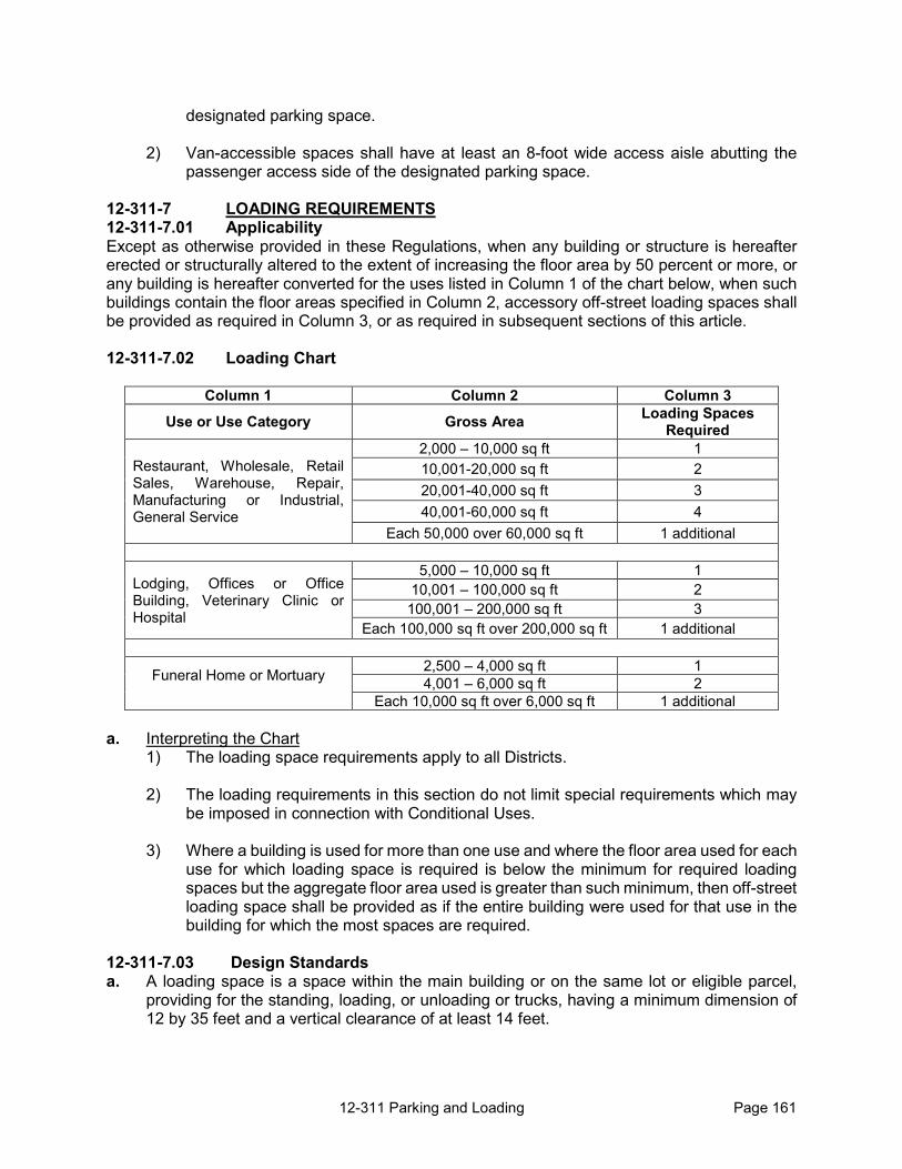
12-311 Parking and Loading Page 161
designated parking space.
2) Van-accessible spaces shall have at least an 8-foot wide access aisle abutting the passenger access side of the designated parking space.
12-311-7 LOADING REQUIREMENTS 12-311-7.01 Applicability Except as otherwise provided in these Regulations, when any building or structure is hereafter erected or structurally altered to the extent of increasing the floor area by 50 percent or more, or any building is hereafter converted for the uses listed in Column 1 of the chart below, when such buildings contain the floor areas specified in Column 2, accessory off-street loading spaces shall be provided as required in Column 3, or as required in subsequent sections of this article. 12-311-7.02 Loading Chart
Column 1 Column 2 Column 3 Use or Use Category Gross Area Loading Spaces
Required
Restaurant, Wholesale, Retail Sales, Warehouse, Repair, Manufacturing or Industrial, General Service
2,000 – 10,000 sq ft 1 10,001-20,000 sq ft 2 20,001-40,000 sq ft 3 40,001-60,000 sq ft 4
Each 50,000 over 60,000 sq ft 1 additional
Lodging, Offices or Office Building, Veterinary Clinic or Hospital
5,000 – 10,000 sq ft 1 10,001 – 100,000 sq ft 2 100,001 – 200,000 sq ft 3
Each 100,000 sq ft over 200,000 sq ft 1 additional
Funeral Home or Mortuary
2,500 – 4,000 sq ft 1 4,001 – 6,000 sq ft 2
Each 10,000 sq ft over 6,000 sq ft 1 additional a. Interpreting the Chart
1) The loading space requirements apply to all Districts.
2) The loading requirements in this section do not limit special requirements which may be imposed in connection with Conditional Uses.
3) Where a building is used for more than one use and where the floor area used for each
use for which loading space is required is below the minimum for required loading spaces but the aggregate floor area used is greater than such minimum, then off-street loading space shall be provided as if the entire building were used for that use in the building for which the most spaces are required.
12-311-7.03 Design Standards a. A loading space is a space within the main building or on the same lot or eligible parcel,
providing for the standing, loading, or unloading or trucks, having a minimum dimension of 12 by 35 feet and a vertical clearance of at least 14 feet.

12-311 Parking and Loading Page 162
b. No unenclosed loading platform, space or area shall be constructed on any side of a building that is adjacent to a residential zoning district or area.

12-312 FLOODPLAIN MANAGEMENT REGULATIONS Page 163
12-312 FLOODPLAIN MANAGEMENT REGULATIONS
SECTION 12-312 FLOODPLAIN MANAGEMENT REGULATIONS 12-312-1 Statement of Purpose and Intent 12-312-2 Floodplain Overlay Districts 12-312-3 Floodplain Overlay Districts Map 12-312-4 Flood Insurance 12-312-5 Floodplain Development within the City of Lawrence Urban
Growth Area (UGA) 12-312-6 Development Standards and Criteria 12-312-7 Administration and Records 12-312-8 Development Permit 12-312-9 Certification of Elevation 12-312-10 Non-conforming Uses and Structures in the Floodplain 12-312-11 Areas of Shall Flooding (Zone AO and Zone AH) 12-312-12 Amendments 12-312-13 Definitions
12-312-1 STATEMENT OF PURPOSE AND INTENT 12-312-1.01 Statement of Purpose The management regulations set forth in this Section are the floodplain management regulations for the unincorporated portions of Douglas County. The purpose of these regulations is to protect individuals and property from flood hazards or flooding by providing for the orderly and safe development of the floodplain for the most advantageous uses which are consistent with the health, safety, and welfare of the general public and which are also consistent with sound practices for utilizing those areas required for the conveyance of specified stream flows in the regulatory floodway. This article is also used to establish or maintain the Community’s eligibility for participation in the National Flood Insurance Program (NFIP) as defined in 44 Code of Federal Regulations (CFR) 512.22 (a) (3); and to meet the requirements of 44 CFR 60.3(d), K.S.A. 12-741, K.S.A. 12-766 and K.A.R. 5-44-4 by applying the provisions of this Article. 12-312-1.02 Intent a. The intent of these regulations is to avoid additional costs for home owners upon
annexation and to minimize losses due to floods or flood waters by provisions designed to: 1) Prohibit the placement of fill, materials, and structures which would obstruct flood flows
and decrease the storage capacity of the regulatory floodway unless it can be demonstrated through hydrologic and hydraulic analyses performed in accordance with standard engineering practice that the proposed encroachment would not result in any increase in flood levels within the community during the occurrence of the base flood discharge.
2) Require structures in the floodplain and public utilities vulnerable to floods be provided with flood protection at the initial construction stage.
3) Protect individuals from the purchase of lands rendered unsuitable for intended uses
by their proximity to floodplain.
4) Minimize public expenditures for flood control projects and damage to public

12-312 FLOODPLAIN MANAGEMENT REGULATIONS Page 164
improvements within the floodplain.
5) Maintain property values adjacent to the floodplain and minimize flood blight areas.
6) Assure eligibility for property owners in the Federal Flood Insurance Program.
7) Ensure that development is reasonably safe from flooding.
b. These regulations are designed and intended to be administered in a manner which will:
1) Restrict or prohibit uses dangerous because of water and erosion hazards or which will result in undue increases in erosion, flood heights, or velocities.
2) Control grading (fill or excavation), dredging, and development which may unduly
increase the potential for flood damage. 3) Require that uses protect private and public investments by requiring floodproofing. 4) Control alteration of floodplains, stream channels and natural barriers which
accommodate or channel floodwaters. 5) Prevent or regulate construction of barriers that unnaturally divert flood waters or
cause increased flood hazards. Construction in floodplains should be directed to the outer limits of the Floodway Fringe before it is allowed to encroach further into the regulatory floodplain.
12-312-2 FLOODPLAIN OVERLAY DISTRICTS The floodplain overlay districts shall include only those areas designated as floodplain by the Federal Insurance Study or by an approved Hydrologic and Hydraulic Study. The floodplain overlay districts consist of: the "F-W" floodway overlay district; and, the "F-F" floodway fringe overlay districts. 12-312-3 FLOODPLAIN OVERLAY DISTRICTS MAP The official floodplain overlay districts map shall be used in conjunction with the official zoning districts map. The official floodplain overlay districts map shall show the boundaries of the "F-W" floodway and the "F-F" floodway fringe overlay districts. These boundaries shall be consistent with the Floodway and Floodway Fringe as identified by the Federal Emergency Management Agency (FEMA) through a scientific and engineering report entitled, "The Flood Insurance Study for the County of Douglas, Kansas, and Incorporated Areas September 2, 2015 ”, with the accompanying Flood Insurance Rate Maps and revisions thereto. 12-312-4 FLOOD INSURANCE No part of this Section or any regulation therein shall be construed as affecting the eligibility for flood insurance of any structure existing at the time of publication of the Flood Insurance Rate Maps.

12-312 FLOODPLAIN MANAGEMENT REGULATIONS Page 165
12-312-5 FLOODPLAIN DEVELOPMENT WITHIN THE CITY OF LAWRENCE URBAN GROWTH AREA (UGA)
12-312-5.01 Development of Property in the Floodplain Overlay District. Development of land or subdivision of property (including lot splits) within the City of Lawrence Urban Growth Area (UGA) and a floodplain overlay district shall be permitted only where an approved hydrologic and hydraulic study demonstrates that there will be no rise in the base flood elevation and no increase in flood velocities at any point resulting from the proposed development. a. Property platted prior to June 1, 2005, may develop and/or re-plat or subdivide (including lot
splits) for non-residential uses without conducting a hydrologic and hydraulic study. Such development is still subject to the remaining sections of this Article.
b. Development of undeveloped property that was platted prior to June 1, 2005 may occur without conducting a hydrologic and hydraulic study until January 1, 2007. Such development is still subject to the remaining sections of this Article. After January 1, 2007 development of the property is subject to all sections contained within this Section.
12-312-5.02 Floodway Restrictions. Any encroachment, including fill, new construction, substantial improvements, or other development is prohibited within the F-W Overlay District, except for the following structures: a. Flood control and stormwater management structures;
b. Road improvements and repair; c. Utility easements/Rights-of Way; and, d. Public improvements or public structures for bridging the Floodway. 12-312-5.03 Hydrologic and Hydraulic Study a. Hydrologic and hydraulic studies shall comply with the following standards:
1) The study shall be signed and sealed by a professional engineer, licensed in the State
of Kansas;
2) The study shall be submitted for approval by the Douglas County Director of Public Works concurrent with the initial submittal of a floodplain development permit application, preliminary plat, development plan or site plan;
3) Hydrologic and hydraulic methods of analysis shall be consistent with those used in
the current Flood Insurance Study for Douglas County;
4) The study shall extend an adequate distance upstream and downstream of the proposed development to encompass the hydraulic effects of the proposed development;
5) The study shall determine the water surface elevations of the base flood for the
existing stream and for any proposed development. Based on the assumption of full watershed development and other factors, the findings of the hydrologic and hydraulic study may differ from the Flood Insurance Study. At a given location, the higher water

12-312 FLOODPLAIN MANAGEMENT REGULATIONS Page 166
surface elevation shall be the base flood elevation for compliance with the provisions of this section;
6) The study shall identify the velocities of the base flood for the existing stream and
for any proposed development;
7) The study shall determine the areas of inundation of the base flood for the existing stream and for any proposed development. The area of inundation shall be dimensioned to the property corners for use in revising the floodplain overlay districts on all property within the extent of the study; and,
8) In areas outside Zone AE, the study shall also identify the Floodway for the
proposed development. b. For a hydrologic and hydraulic study that proposes an alteration of FEMA’s designated
floodplain or Floodway, a letter of map revision (LOMR) must be obtained before a building permit will be used for any lot containing a Zone A, AE, AH or AO of the current FIRM.
12-312-5.04 Land Disturbance. Land disturbance or removal of vegetation within the floodplain overlay districts shall be minimized to the extent possible. When excavation, grading, removal of vegetation or other modifications to the cross-sectional geometry of the floodplain are proposed in order to meet the requirements set forth in section 12-328-5.01, those modifications shall comply with the following: a. Construction plans shall be prepared for the proposed modifications and shall be submitted
for review and approval by the Douglas County Director of Public Works. b. As approved by the Douglas County Director of Public Works:
1) Channel lining materials shall be limited to native vegetation, stabilized as necessary to prevent erosion. The use of concrete lining, pipe or other structural materials shall be minimized;
2) Within the area of inundation, all disturbed areas above the channel lining shall be
restored with native vegetation, including trees, to promote wildlife habitat; and, 3) Channel designs shall preserve existing low-flow channels to the extent possible.
12-312-6 DEVELOPMENT STANDARDS AND CRITERIA 12-312-6.01 General Standards. Development in areas that are included in the floodplain overlay districts shall be required to meet the following general standards: a. No structure, fill, or other uses within the floodway overlay district shall be permitted which
will increase the base flood elevation.
b. Public improvements shall be waterproofed to the base flood elevation. Any space below the base flood elevation shall be watertight with walls substantially impermeable to the passage of water with structural components having the capabilities of resisting hydrostatic and hydrodynamic loads and the effects of buoyancy. The interior and content of the structures shall remain substantially dry.

12-312 FLOODPLAIN MANAGEMENT REGULATIONS Page 167
c. Water lines shall be designed to eliminate infiltration of flood waters into systems. e. Sewer lines shall be designed to eliminate infiltration of flood waters into systems and
discharge from the systems into the floodwaters. f. Residential Construction: New construction or substantial improvements of a residential
structure shall be elevated, anchored to prevent flotation, collapse, or lateral movement of the structure and shall be constructed to resist and minimize flood damage. Construction shall be with materials resistant to flood damages, utilizing methods and practices that minimize flood damages, and with electrical, heating, ventilation, plumbing, and air conditioning equipment and other service facilities that are designed and/or located so as to prevent water from entering or accumulating within the components during conditions of flooding.
g. Non-Residential Construction: All new construction and substantial improvements that fully
enclose areas below the lowest floor which are usable solely for parking of vehicles, building access or storage in an area other than a basement; and, which are subject to flooding shall be designed to automatically equalize hydrostatic flood forces on exterior walls by allowing for the entry and exist of floodwaters. Designs for meeting this requirement must either be certified by a registered professional engineer or architect or meet or exceed the following minimum criteria; A minimum of two openings having a total net area of not less than one square inch for every square foot of enclosed area subject to flooding shall be provided. The bottom of all openings shall be no higher than one foot above grade. Openings may be equipped with screens, louvers, valves, or other coverings or devices provided that they permit the automatic entry and exit of floodwaters.
h. Storage of materials or equipment may be allowed if not subject to major damage by floods
and firmly anchored to prevent floatation or if readily removable from the area within the time available after the flood warning. Storage of materials that are buoyant, flammable, explosive or potentially injurious to human life at times of flooding shall not be permitted.
h. On site waste disposal systems shall be designed to avoid impairment due to flooding. i. All new construction and substantial improvements that fully enclose areas below the lowest
floor that are subject to flooding shall be designed to automatically equalize hydrostatic flood forces on exterior walls by allowing for the entry and exit of floodwaters. Designs for meeting this requirement must either be certified by a registered professional engineer or architect or meet or exceed the following minimum criteria: A minimum of two openings having a total net area of not less than one square inch for every square foot of enclosed area subject to flooding shall be provided. The bottom of all openings shall be no higher than one foot above grade. Openings may be equipped with screens, louvers, valves, or other coverings or devices provided that they permit the automatic entry and exit of floodwaters.
j. Until a Floodway is designated, no new construction, substantial improvements, or other
development, including fill, shall be permitted within any unnumbered or numbered A zones, or AE zones on the FIRM, unless it is demonstrated that the cumulative effect of the proposed development, when combined with all other existing and anticipated development, will not increase the water surface elevation of the base flood more than one foot at any point within the community.

12-312 FLOODPLAIN MANAGEMENT REGULATIONS Page 168
12-312-6.02 Specific Standards. In addition to these general standards, development shall be required to meet the following specific standards: a. Residential Construction. New construction and substantial improvement of residential
structures shall have the lowest floor, including basement and all HVAC and mechanical equipment, elevated: a) a minimum of two feet above the base flood elevation when located within the Urban Growth Area (UGA) of Lawrence, or, b) a minimum of one foot above the base flood elevation when located outside the Urban Growth Area of Lawrence but within the unincorporated area of Douglas County.
b. Non-Residential Construction. All new construction and substantial improvements of non-residential structures, including all HVAC and mechanical equipment, shall have a) the lowest floor (including basement) elevated a minimum of one foot above the base flood elevation; or, b) together with attendant utility and sanitary facilities, be designed so that below the base flood elevation the structure is watertight with walls substantially impermeable to the passage of water and with structural components having the capability of resisting hydrostatic and hydrodynamic loads and the effects of buoyancy; and c) a registered professional engineer or architect shall develop and/or review the structural design, specifications and plans for the construction and shall certify that the design and methods of construction are in accordance with accepted standards of practice for meeting applicable provisions of the Federal Emergency Management Regulations [44FR311177, the Section 60.3 (c)(3)(ii) & Section 60.3 (c)(8)(ii), and amendments thereto.]
c. Existing Manufactured (Mobile) Home Park – All manufactured homes to be placed in an existing park located in a floodplain overlay district are required to be firmly secured to an adequately anchored foundation system to resist floatation, collapse, or lateral movement, which may include, but is not limited to, the use of over-the-top or fame ties to ground anchors. (This requirement is in addition to applicable State and local anchoring requirements for resisting wind forces.)
d. Manufactured (mobile) homes to be placed or substantially improved in an expansion to an
existing manufactured (mobile) home park where the repair, reconstruction, or improvement of the streets, utilities and pads equals or exceeds 50 percent of the value of the streets, utilities and pads before the repair, reconstruction or improvement has commenced are required to have the manufactured home chassis elevated by reinforced piers or other foundation elements of at least equivalent strength that are no less than thirty-six inches in height above grade and be securely attached to an adequately anchored foundation such that the lowest floor of the manufactured home is elevated at least two feet above the base flood elevation.
e. A licensed land surveyor or professional engineer shall certify that the elevation of a
proposed structure is above the specified base flood elevation. f. In areas where a base flood elevation has not been provided by the FIS, the county shall
obtain, review and reasonably utilize any base flood elevation and Floodway data available from federal, state or other sources until such other data has been provided by FEMA for use and enforcement of this chapter.

12-312 FLOODPLAIN MANAGEMENT REGULATIONS Page 169
g. Require that recreational vehicles placed on sites within the identified floodplain on the community’s FIRM either 1) be on the site for fewer than 180 consecutive days, 2) be fully licensed and ready for highway use, or 3) meet the permit requirements and the elevation and anchoring requirements for manufactured homes in this ordinance. A recreation vehicle is ready for highway use if it is on its wheels or jacking system, is attached to the site only by quick disconnect type utilities and security devices, and has no permanently attached additions.
h. All proposals for development must include base flood elevation data. i. In Zone AO and AH, adequate drainage paths shall be required around structures on slopes,
in order to guide floodwaters around and away from proposed structures. 12-312-6.03 Letter of Map Revision (LOMR). Structures placed on property that has been removed from the floodplain by a LOMR shall have the lowest floor, including basement, elevated above the base flood elevation in compliance with section 12-328-6-02.
12-312-7 ADMINISTRATION AND RECORDS 12-312-7.01. Administration. The Director of Zoning and Codes shall be vested with the administration of these regulations. It shall be his responsibility to review all requests for floodplain development permits and to enforce the regulations in this Section. Each permit shall be reviewed in consideration with the following: a. Satisfying all the requirements of this Section. b. Obtaining all the necessary permits from federal, state, or local government agencies prior
to approval of the development permit. c. The location of the proposed development in relation to the Floodway and the assurance
that any encroachment meets the standards in this Section, and K.S.A. 12-766. 12-312-7.02. Records. The Director of Zoning and Codes, as administrator of these regulations, shall record and maintain a record of all development permits issued. Documentation of these permits shall include: a. The proposed use, residential or non-residential; b. The elevation of the regulatory floodway for the area developed; and, c. Certification that the elevation of the lowest floor is above the base flood elevation by the
required; one foot in the unincorporated area of the County outside the Lawrence Urban Growth Area or, two feet within the Urban Growth Area of Lawrence.
d. The Director of Zoning and Codes shall submit a biennial report on the appropriate federal
annual report form to the Administrator concerning the community's participation in the Federal Insurance Program.
12-312-8. DEVELOPMENT PERMIT 12-312-8.01 No development shall be made in, on, or over any land designated by this

12-312 FLOODPLAIN MANAGEMENT REGULATIONS Page 170
Section and shown on the official floodplain overlay district map as being within the floodway overlay districts without obtaining approval from the Director of Zoning and Codes. 12-312-8.02 Application for a development permit shall be made by the property owner or his certified agent to the Director of Zoning and Codes upon appropriate forms. Such application shall be made at least ten days prior to the approval of a development permit. The application shall be accompanied by a fee of Fifty Dollars; no part shall be returnable to the applicant after review of the permit request has begun. The application fee shall be made payable to the Director of Zoning and Codes.
12-312-8.03 Information required. An application for a development permit shall be accompanied by the following information: a. Identification and description of proposed use or development;
b. Legal description of the property; c. Plan of the proposed development or use at a scale of one inch equals fifty feet or larger
showing the Floodway and Floodway Fringe as designated by the Federal Insurance Administrator;
d. Use and type of structures proposed; e. The elevation (in relation to mean sea level) of the lowest floor, including basements, of all
structures or proposed fill; f. A statement of the elevation flood proofed by a licensed land surveyor or professional
engineer; g. Proposed developments which include alteration of watercourses must:
1) In river or tributary situations, the Director of Zoning and Codes will notify any adjacent community, state coordinating agency for the National Flood Insurance Program, and the Federal Insurance Administration prior to any alteration or relocation of a watercourse.
2) Evidence submitted by the applicant's engineer or architect showing that no adverse impacts will result from the alteration and the flood carrying capacity within the altered or relocated portion of the watercourse is not diminished.
h. Any additional data which the Director of Zoning and Codes or County Engineer requests
which is pertinent to the issuance of a development permit.
12-312-9 CERTIFICATION OF ELEVATION Within sixty days after a building permit has been issued, a certification of elevation must be received, approved and recorded at the Director of Zoning & Codes’ Office. The development permit must include certification from a land surveyor or professional engineer (licensed to do business in the State of Kansas) that the lowest floor, including basement, is a minimum of one foot above the base floodplain elevation. The building permit is null and void after said sixty day period if such certification is not provided. Occupancy of the structure shall

12-312 FLOODPLAIN MANAGEMENT REGULATIONS Page 171
be illegal prior to the approval of a development permit.
12-312-10 NON-CONFORMING USES AND STRUCTURES IN THE FLOODPLAIN All non-conforming uses and structures within a floodway or regulatory floodway fringe overlay districts shall be subject to the following requirements in addition to other provisions of the County's Zoning Resolution. 12-312-10.01 No non-conforming use or structure shall be altered, repaired or modified unless a permit is issued under this Section. 12-312-10.02 No permit for the alteration, repair or modification of a non-conforming use in the Floodway Fringe shall be issued unless such alteration, repair or modification includes flood proofing by elevation to or above the base flood elevation. No permits shall be issued for alteration, repair or modification in the Floodway that will obstruct flow or increase the height of the base flood. 12-312-10.03 Uses or adjuncts thereof, which are or become nuisances shall not be entitled to continue as non-conforming uses. 12-312-10.04 The Director of Zoning and Codes, before issuing a development permit for the alteration, repair or modification of a non-conforming use or structure, shall request a decision from the Board of Zoning Appeals in determining the adequacy of the proposed flood proofing measures for the proposed alteration, repair or modification of the non-conforming use or structure. The Board of Zoning Appeals shall make this determination in accordance with the following specific criteria: a. The susceptibility of the structure or use to flood damage. b. The availability and expense of alternate floodproofing techniques. c. The safety of the flood proofing measures.
12-312-11 AREAS OF SHALLOW FLOODING (ZONE AO AND ZONE AH) The following provisions apply to areas designated as Zone AO and Zone AH: 12-312-11.01 Zone AO. a. All development and substantial-improvements of residential structures, including mobile
homes or manufactured homes, shall have the lowest floor, including basement, elevated above the highest adjacent grade at least as high as the depth number specified in feet on the community’s FIRM (at least two feet if no depth number is specified);
b. All development and substantial-improvements of any commercial, industrial, or other non-
residential structures shall have the lowest floor, including basement, elevated above the highest adjacent grade as least as high as the depth number specified in feet on the community FIRM (at lease two feet if no depth number is specified) or together with attendant utilities and sanitary facilities be completely floodproofed to that so that the structure is watertight with walls substantially impermeable to the passage of water and with structural components having the capability of resisting hydrostatic and hydrodynamic loads and effects of buoyancy; and
c. Drainage paths must be provided adequately to guide floodwaters around structures.

12-313 Violations Page 176
12-313 VIOLATION, PENALTIES AND ENFORCEMENT
SECTION 12-313 VIOLATION, PENALTIES, AND ENFORCEMENT 12-313-1 Responsibility for Enforcement 12-313-2 Compliance Required 12-313-3 Violations 12-313-4 Liability 12-313-5 Remedies and Enforcement Powers 12-313-6 Enforcement by Others 12-313-7 Continuation of Previous Enforcement Actions 12-313-8 Remedies Cumulative 12-313-9 Enforcement Procedures
12-313-1 RESPONSIBILITY FOR ENFORCEMENT The Director of Zoning and Codes is responsible for enforcing the Zoning Regulations, except as otherwise expressly stated. 12-313-2 COMPLIANCE REQUIRED All buildings and land used and all buildings and structures erected, converted, enlarged, reconstructed, moved or structurally altered shall comply with all applicable provisions of these Regulations. 12-313-3 VIOLATIONS 12-313-3.01 Types of Violations Unless otherwise expressly stated by these Regulations or state law, any violation of the Zoning Regulations, including but not limited to the following, will be subject to the remedies and penalties provided for in this Section. a. to use land or buildings in any way not consistent with the requirements of the Zoning
Regulations;
b. to engage in development activity in any way not consistent with the requirements of these Regulations;
c. to engage in the use of a building or land, the use or installation of a sign, or development
activity requiring one or more permits or approvals under these Regulations without obtaining all such required permits or approvals;
d. to engage in the use of a building or land, the use or installation of a sign, or development
activity requiring one or more permits under these Regulations in any way inconsistent with any such permit or approval or any conditions imposed thereon;
e. to obstruct or destroy any notice required to be posted or otherwise given under these
Regulations; or f. to violate any lawful order issued by any person or entity under these Regulations. 12-313-3.02 Continuing Violations

12-313 Violations Page 177
Each day that a violation remains uncorrected after receiving notice of the violation from the County constitutes a separate violation of the Zoning Regulations for purposes of calculating cumulative penalties.
12-313-4 LIABILITY The owner, tenant or occupant of any land or structure, shall be presumed to know of activity occurring on the premises and thus may be charged with a violation under these Regulations for any violation occurring on any premises. Where an architect, engineer, contractor, builder, land surveyor, agent or other person appears to have participated directly in a violation of these Regulations, the Director of Zoning and Codes may also charge such person with a violation of these Regulations. All persons found to be responsible for the actions or inactions leading to a violation may be charged jointly and severally with violations as a result of the same incident or circumstances.
12-313-5 REMEDIES AND ENFORCEMENT POWERS 12-313-5.01 Withhold Permits And Approvals The Director of Zoning and Codes may deny or withhold all permits, certificates, or other forms of authorization on any land, or structure or improvements thereon: a. upon which there is an uncorrected violation of a provision of these Regulations or of a
condition or qualification of a permit, certificate, approval or other authorization previously granted by the County;
b. owned or being developed by a person who owns, developed or otherwise caused an
uncorrected violation of a provision of these Regulations or of a condition or qualification of a permit, certificate, approval or other authorization previously granted by the County.
12-313-5.02 Approval of Permits and Approval with Conditions Instead of withholding or denying a permit or other authorization, the official with authority to approve the permit or authorization may grant such authorization only if adequate assurances are in place to ensure correction of the violation and provided that granting the permit or authorization will not compromise the public health, safety or general welfare.
12-313-5.03 Revoke Permits and Approvals Any permit or other form of authorization required under these Regulations may be revoked by the Director of Zoning and Codes or by any County official with authority to issue such permit when the Director of Zoning and Codes or other County official determines one of the following: a. there is departure from the plans, specifications, or conditions as required under terms of
the permit; b. the development permit was procured by false representation or was issued in error; c. or any of the provisions of these Regulations are being violated.
12-313-5.04 Stop Work Whenever a building or land development, or part thereof, is being constructed, reconstructed, altered or repaired in violation of these Regulations, the Director of Zoning and Codes may order

12-313 Violations Page 178
the work to be immediately stopped.
a. The stop-work order shall be in writing and directed at the person doing the work. The stop-work order shall state the specific work to be stopped, the specific reasons for the stoppage, and the conditions under which the work may be resumed.
b. Violation of a stop-work order constitutes a violation of these Regulations and is subject to the remedies provided in this Section.
12-313-5.05 Revoke Plans or Related Approvals Where a violation of these Regulations involves a failure to comply with approved plans, or conditions to which the approval of such plans was made subject, the County may, upon notice to the applicant and other known parties in interest (including any holders of building permits affected), revoke the plan or other approval or condition its continuance on strict compliance with these Regulations, the provisions of financial security to ensure that construction is completed in compliance with approved plans, or such other conditions as the County may reasonably impose. Any required financial security shall be in a form approved by the County.
12-313-5.06 Forfeiture and Confiscation of Signs Any sign installed or placed on public property, except in compliance with the applicable regulations of the County resolutions and regulations, will be subject to forfeiture to the County and to confiscation. In addition to other remedies and penalties of this Section, the County has the right to recover from the sign owner, or person who placed the sign, the full costs of sign removal and disposal.
12-313-5.07 Legal Relief The County may commence a civil action or proceeding in District Court to stop any violation of these Regulations or of a permit, certificate or other form of authorization granted hereunder, to remove a violation, or to restore the premises in question to the condition in which they existed prior to violation. The relief sought may include: a. an injunction or other equitable relief; b. an order in the nature of mandamus or abatement; c. a judgment or order enforcing any requirement of, or under, these Regulations to pay a fee
or reimburse, or compensate the County, including when the County is required or authorized to take specified action at the expense of the landowner; or
d. any other judgment or order available under Kansas law.
12-313-5.08 Criminal Penalties Any person, firm, or corporation who shall violate any of the provisions of these Regulations, or fail to comply with any order or regulation thereunder, or who shall engage in development activity in violation of any specifications or plans submitted and approved thereunder, or any certificate or permit issued thereunder, shall, of each and every violation and non-compliance respectively be deemed guilty of a misdemeanor, and upon conviction therefore shall be, for each offense: a. fined a sum not less than $10 nor more than $500; b. imprisoned for not more than 6 months; or c. both fined and imprisoned.

12-313 Violations Page 179
12-313-5.09 Other Penalties and Remedies The County may seek such other penalties and remedies, and employ such other enforcement powers, as are provided by Kansas law for violations of zoning, subdivision, sign or related provisions. 12-313-6 ENFORCEMENT BY OTHERS 12-313-6.01 Citizens Pursuant to K.S.A. 12-761(b), any person, the value or use of whose property is or may be affected by a violation of these Regulations, is authorized to maintain a suit or action in any court of competent jurisdiction to enforce the provisions of these Regulations and to abate nuisances maintained in violation thereof.
12-313-6.02 State Officials Pursuant to K.S.A. 12-761(c) and in the case of violations to the flood protection regulations, Section 12-312, the Attorney General and the Chief Engineer of the Division of Water Resources of the Kansas Board of Agriculture are authorized, in addition to other remedies, to institute injunction, mandamus, or other appropriate action or proceeding to prevent, correct or abate the violation.
12-313-7 CONTINUATION OF PREVIOUS ENFORCEMENT ACTIONS Nothing in these Regulations prohibits the County’s continuation of previous enforcement actions, undertaken by the County pursuant to previous and valid resolutions, regulations and laws. 12-313-8 REMEDIES CUMULATIVE The remedies and enforcement powers established in these Regulations are cumulative, and the County may exercise them in any order. 12-313-9 ENFORCEMENT PROCEDURES 12-313-9.01 Non-Emergency Matters In the case of violations of these Regulations that do not constitute an emergency or require immediate attention, the County shall give notice of the nature of the violation to the landowner or to any other person who is violating these Regulations or to any applicant for any relevant permit, after which the persons receiving notice will have 10 days to correct the violation before further enforcement action will be taken. Notice shall be given in person, by United States Mail, or by posting notice on the premises. Notices of violation shall state the nature of the violation and the time period for compliance and may state the corrective steps necessary and the nature of subsequent penalties and enforcement actions should the situation not be corrected.
12-313-9.02 Emergency Matters In the case of violations of these Regulations that constitute an emergency situation as a result of public health or safety issues or public concerns or violations that will create increased problems or costs if not remedied immediately, the County may use the enforcement powers available under these Regulations without prior notice, but the County shall attempt to give notice simultaneously with beginning enforcement action. Notice may be provided to the landowner, to any other person who is violating these Regulations and to applicants for any relevant permit.
12-312 FLOODPLAIN MANAGEMENT REGULATIONS Page 172
12-312-11.02 Zone AH. a. The development standards for all areas of special flood hazard where base flood elevation
has been provided shall be required as set forth in section 12-328-6 et al; and,
b. Drainage paths must be provided adequately to guide floodwaters around structures. 12-312-12 AMENDMENTS The regulations, restrictions, and boundaries set forth in this section may from time to time be amended, supplemented, changed, or repealed to reflect any and all changes in the National Flood Disaster Protection Act of 1973, provided, that prior to the adoption thereof, the Board of County Commissioners shall submit to the chief engineer of the Division of Water Resources of the State Board of Agriculture any ordinance, resolution, regulation or plan that proposes to create or to effect any change in a floodplain zone or district, or that proposes to regulate or restrict the location and use of structures, encroachments, and uses of land within such an area. The chief engineer may require, pursuant to rules and regulations, each submission hereunder to be accompanied by complete maps, plans, profiles, specifications and textual matter. The chief engineer shall approve or disapprove any such ordinance, resolution, regulation or plan or changes thereof within 90 days of the date of receipt of all such data required by the chief engineer as specified in rules and regulations adopted thereby. If the chief engineer fails to approve or disapprove within the 90 day period required by this section, such ordinance, resolution, regulation or plan or change thereof shall be deemed approved. The chief engineer shall provide, in writing, specific reasons for any disapproval.
12-312-13 DEFINITIONS The following definitions are applicable to only the terms found in this section. 12-312-13.01 Agency. The Federal Emergency Management Agency (FEMA).
12-312-13.02 Areas of Special Flood Hazard. The land in the floodplain within a community subject to a one percent or greater chance of flooding in any given year.
12-312-13.03 Base Flood. The flood having a one percent chance of being equaled or exceeded in any given year.
12-312-13.04 Base Flood Elevation. The water surface elevation of the base flood as determined by the Flood Insurance Study or by an approved Hydrologic and Hydraulic Study, whichever is higher.
12-312-13.05 Community. Any State or area or political subdivision thereof, which has authority to adopt and enforce floodplain management regulations for the areas within its jurisdiction.
12-312-13.06 Development. Any man-made change to improved or unimproved real estate, including but not limited to, building or other structure, mining, fill, dredging, grading, paving, excavation or drilling operations (excluding wells for potable water), or storage of equipment or materials.
12-312-13.07 “Eligible Community”. A community for which the Administrator has authorized the sale of flood insurance under the National Flood Insurance Program (NFIP).

12-312 FLOODPLAIN MANAGEMENT REGULATIONS Page 173
12-312-13.08 Existing Construction. For the purposes of determining rates, structures for which the “start of construction” commenced before the effective date of the FIRM or before January 1, 1975, for FIRMs effective before that date. “existing construction” may also be referred to as “existing structures”.
12-312-13.09 Existing Manufactured Home, Park or Subdivision. A manufactured home, park or subdivision for which the construction of facilities for servicing the lot(s) on which the manufactured homes are to be affixed (including, at a minimum, the installation of utilities, either final site grading or the pouring of concrete pads, and the construction of streets) are completed before March 2, 1981, the effective date of the adoption of the first County floodplain management regulations.
12-312-13.10 Existing Structures. (See “Existing Construction”)
12-312-13.11 Expansion to an Existing Manufactured Home Park or Subdivision. The preparation of additional sites by the construction of facilities for servicing the lots on which the manufactured homes are to be affixed (including the installation of utilities, either final site grading or pouring of concrete pads, or the construction of streets.)
12-312-13.12 Flood. A general and temporary condition of partial or complete inundation of normally dry land areas from: 1) the overflow of inland waters; 2) the unusual and rapid accumulation or runoff of surface waters from any source; and 3) the collapse or subsidence of land along the shore of a lake or other body of water as a result of erosion or undermining caused by waves or currents of water exceeding anticipated cyclical levels or suddenly caused by an unusually high water level in a natural body of water, accompanied by a severe storm, or by an unanticipated force of nature, such as flash flood, or by some similarly unusual and unforeseeable event which results in flooding as defined above in item 1).
12-312-13.13 Flooding. [See “Flood”].
12-312-13.14 Flood Insurance Rate Map (FIRM). The official map of a community on which both the special flood hazard areas and the risk premium zones have been delineated.
12-312-13.15 Flood Insurance Study (FIS). An examination, evaluation, and determination of flood hazards and, if appropriate, corresponding water surface elevations.
12-312-13.16 Floodplain. The land area inundated by a flood of a given magnitude as determined by the Flood Insurance Study or by an approved Hydrologic and Hydraulic Study.
12-312-13.17 Floodplain Management. The operation of an overall program of corrective and preventive measures for reducing flood damage, including but not limited to emergency preparedness flood control works, and floodplain management regulations.
12-312-13.18 Floodplain Management Regulations. Zoning ordinances, subdivision regulations, building codes, health regulations, special purposes (such as floodplain and grading ordinances) and other applications of police power. The term describes such state or local regulations, in any combination thereof that provide standards for the purpose of flood damage prevention and reduction.
12-312-13.19 Floodproofing. Any combination of structural and nonstructural additions,

12-312 FLOODPLAIN MANAGEMENT REGULATIONS Page 174
changes, or adjustments to structures that reduce or eliminate flood damage to real estate or improved real property, water and sanitary facilities, or structures and their contents.
12-312-13.20 Floodway. The channel of a river or other watercourse and the adjacent land areas that must be reserved in order to discharge the base flood without cumulatively increasing the water surface elevation more than one foot.
12-312-13.21 Floodway Encroachment Lines. The lines marking the limits of Floodways on Federal, State and local floodplain maps.
12-312-13.22 Floodway Fringe. The area outside the Floodway encroachment lines, but still subject to inundation by the regulatory flood.
12-312-13.23 Freeboard. A factor of safety usually expressed in feet above a flood level for purposes of floodplain management. “Freeboard” tends to compensate for the many unknown factors that could contribute to flood heights greater than the height calculated for a selected size flood and Floodway conditions, such as bridge openings and the hydrological effect of urbanization of the watershed.
12-312-13.24 Habitable Floor. Any floor usable for living purposes, which include working, sleeping, eating, cooking or recreation, or a combination thereof.
12-312-13.25 Highest Adjacent. The highest natural elevation of the ground surface prior to construction next to the proposed walls of a structure.
12-312-13.26 Historic Structure. Any structure that is: a) Listed individually in the National Register of Historic places (a listing maintained by the Department of Interior) or preliminary determined by the Secretary of the Interior as meeting the requirements for individual listing on the National Register; b) certified or preliminary determined by the Secretary of the Interior as contributing to the historical significance of a registered historic district or a district preliminary determined by the Secretary to qualify as a registered historic district; c) individually listed on a state inventory of historic places in states with historic preservation programs which have been approved by the Secretary of the Interior; or d) individually listed on a local inventory of historic places in communities with historic preservation programs that have been certified either: 1) by an approved state program as determined by the Secretary of the Interior or 2) directly by the Secretary of the Interior in states without approved programs.]
12-312-13.27 Hydrologic and Hydraulic Study. An engineering study that is done in accordance with section 12-328-5.03 et al.
12-312-13.28 Lowest Floor. The lowest floor of the lowest enclosed area (including basement). An unfinished or flood resistant enclosure, usable solely for parking of vehicles, building access or storage, in an area other than a basement area, is not considered a building’s lowest floor, provided that such enclosure is not built so as to render to structure in violation of the applicable non-elevation design requirements of this ordinance.
12-312-13.29 Manufactured Homes [See “Mobile Home”]
12-312-13.30 Market Value. An estimate of what is fair, economic, just and equitable value under normal local market conditions. If market value cannot be determined, the construction estimate can be used.

12-312 FLOODPLAIN MANAGEMENT REGULATIONS Page 175
12-312-13.31 Mean Sea Level. For purposes of the National Flood Insurance Program (NFIP), the National Geodetic Vertical Datum (NGVD) of 1929 or other datum, to which base flood elevations shown on a community’s Flood Insurance Rate Map (FIRM) are reference.
12-312-13.32 Mobile or Manufactured Home. A structure, transportable in one or more sections, that is built on a permanent chassis and is designed for use with or without a permanent foundation when attached to the required utilities. The terms “mobile home” or “manufactured home” does not include a “recreational vehicle”.
12-312-13.33 New Construction. For the purposes of determining insurance rates, structures for which the “start of construction” commenced on or after the effective date of an initial FIRM or after December 31, 1974, whichever is later, and includes any subsequent improvements to such structures. For floodplain management purposes, “new construction” means structures for which the “start of construction” commenced on or after the effective date of the floodplain management regulations adopted by a community and includes any subsequent improvements to such structure.
12-312-13.34 Overlay District. A special zoning district that has been ”overlaid” on a base zoning classification to add to or alter some or all of the base district zoning regulations.
12-312-13.35 Participating Community. [See “Eligible Community”]
12-312-13.36 Person. Includes any individual or group of individuals, corporation, partnership, association, or any other entity, including Federal, State, and local governments and agencies.
12-312-13.37 Principally Above Ground. When at least 51 percent of the actual cash value of the structure, less land value, is above ground.
12-312-13.38 Recreational Vehicle. A vehicle which is a) built on a single chassis; b) 400 square feet or less when measured at the largest horizontal projections; c) designed to be self-propelled or permanently able to be towed by a light-duty truck; and d) designed primarily not for use as a permanent dwelling but as temporary living quarters for recreational, camping, travel, or seasonal use. A recreational vehicle is ready for highway use if it is on its wheels or jacking system, is attached to the site only by quick-disconnect type utilities and security devices, and has no permanently attached additions.
12-312-13.39 Special Flood Hazard Area (SFHA). See [“Area of Special Flood Hazard”].
12-312-13.40 Start of Construction. This includes substantial improvements, and means the date the building permit was issued, provided the actual start of construction, repair reconstruction, placement, or other improvement was within 180 days of the permit date. The actual start means the first placement of permanent construction of a structure on a site, such as the pouring of slab or footings, the installation of piles, the construction of columns, or any work beyond the state of excavation or placement of a manufactured home on a foundation. Permanent construction does not include land preparation, such as clearing, grading, and filling; nor does it include the installation of streets and/or walkways; nor does it include excavation for a basement, footing, piers, or foundations or the erection of temporary forms; nor does it include the installation on the property of accessory buildings, such as garages or sheds not occupied as dwelling units or not part of the main structure.

12-312 FLOODPLAIN MANAGEMENT REGULATIONS Page 176
12-312-13.41 State Coordinating Agency. The Division of Water Resources, Kansas Department of Agriculture, or other office designated by the governor of the state or by state statute at the request of the Administrator to assist in the implementation of the National Flood Insurance Program (NFIP) in that state.
12-312-13.42 Structure. For the purpose of this section the definition of structure shall mean, for floodplain management purposes, a walled and roofed building, including a gas or liquid storage tank that is principally above ground, as well as a manufactured home. “Structure” for insurance purposes, means a walled and roofed building, other than a gas or liquid storage tank that is principal above ground and affixed to a permanent site, as well as a manufactured home on a permanent foundation. For the latter purpose, the term includes a building while in the course of construction, alteration or repair, but does not include building materials or supplies intended for use in such construction, alteration or repair, unless such materials or supplies are within an enclosed building on the premises.
12-312-13.43 Substantial Damage. Damage of any origin sustained by a structure whereby the cost of restoring the structure to it’s before damage condition would equal or exceed 50% of the market value of the structure before the damage occurred.
12-312-13.44 Substantial Improvement. Any repair, reconstruction, or improvement of a structure, the cost of which equals or exceed 50 percent of the market value of the structure; either 1) before the improvement or repair is started or 2) if the structure has been damaged and is being restored, before the damage occurred. For the purposes of this definition, “substantial improvement” is considered to occur when the first alteration of any wall, ceiling, floor, or other structural part of the building commences, whether or not that alteration affects the external dimensions of the structure. The term does not, however, include either 1) any project for improvement of a structure to comply with existing state or local health, sanitary, or safety code specifications which are solely necessary to assure safe living conditions, or 2) any alteration of a structure listed on the National Register of Historic Places or a State Inventory of Historic Places.
12-312-13.45 Urban Growth Area. The area that is defined in the City and County Comprehensive Land Use Plan as the Urban Growth Area (UGA) surrounding the City of Lawrence.
12-312-13.46 Variance. A grant of relief by the community from the terms of floodplain management regulation. Flood insurance requirements remain in place for any varied use or structure and cannot be varied the community.
12-312-13.47 Violation. The failure of a structure or other development to be fully compliant with the community’s floodplain management regulations. A structure or other development without the elevation certificate, other certifications, or other evidence of compliance required by this ordinance is presumed to be in violation until such time as that documentation is provided.
12-312-13.48 Water Surface Elevation. The height, in relation to the National Geodetic Vertical Datum (NGVD) of 1929 (or other datum where specified) of floods of various magnitudes and frequencies in the floodplain.
12-312-13.49 Zone A. The special flood hazard area inundated by 100-year flood where no base flood elevations have been determined.
12-312-13.50 Zone AE. The special flood hazard area inundated by 100-year flood where the

12-312 FLOODPLAIN MANAGEMENT REGULATIONS Page 177
base flood elevations have been determined.
12-312-13.51 Zone AH. The special flood hazard area inundated by 100-year flood depths of 1 to 3 feet (usually areas of ponding); where base flood elevations have been determined.
12-312-13.52 Zone AO. The special flood hazard area inundated by 100-year flood depths of 1 to 3 feet (usually sheet flow on sloping terrain); where average depths have been determined. For areas of alluvial fan flooding velocities have also been determined.

12-314 General Regulations and Standards Page 180
12-314 GENERAL REGULATIONS/STANDARDS
SECTION 12-314 GENERAL REGULATIONS/STANDARDS 314-1 Sign Regulations 314-2 Protection of Environmentally Sensitive Lands 314-3 Lighting
12-314.1 SIGN REGULATIONS 12-314-1.01 Purpose These regulations are intended to: a. Protect the general public from damage and injury which may be caused by the faulty and
unregulated construction of signs; b. Prevent the obstruction of traffic visibility and confusion with traffic control devices resulting
from improperly placed and designed signs; and c. Ensure the visual quality of signs while preserving and promoting the rural aesthetic quality
in unincorporated Douglas County Kansas. 12-314-1.02. Applicability All signs must comply with the standards within this section. 12-314-1.03 Sign Permit No person shall install, erect, construct, hang, or alter any sign without first obtaining a Sign Permit from the Director of Zoning and Codes with the following exceptions:
a. Governmental Signs;
b. Temporary signs which meet the standards established at Section 12-314-1.13;
c. Minor Signs; and
d. Fuel Pump Signs and Fuel Pump Topper Signs 12-314-1.04 Application and Review Process Application for a sign permit shall be made to the Director of Zoning and Codes on a form provided by that office along with the required fee, as established by the Board of County Commissioners.
a. The applicant shall complete the application and shall provide sufficient information to allow a full and accurate overview of the proposed sign, sign alteration, or replacement of sign copy or sign face.
b. The Director of Zoning and Codes shall examine each application for a sign permit. Within 28 days of receiving an application, the Director shall approve the application unless:
1) The application is incomplete;

12-314 General Regulations and Standards Page 181
2) The application is determined to be fraudulent, to include a material misrepresentation, or to contain a false statement; or
3) The Zoning and Codes Director determines that the proposed sign or the proposed
sign alteration does not conform to the sign regulations or other pertinent law.
12-314-1.05 Sign Permit Duration Each sign permit shall be valid for a period of 180 days after issuance.
a. If the proposed sign or alteration is not completed and final approval of the sign is not obtained within that 180-day period, then the sign permit shall expire and shall be null and void; however,
b. Upon a showing of good cause, the Director of Zoning and Codes may grant an additional
180 days within which to complete the work and to obtain Final Approval. 12-314-1.06 Sign Permit Suspension or Revocation a. The Director of Zoning and Codes shall have the authority to suspend or revoke any sign
permit issued hereunder if the Director finds that the sign permit was issued on incorrect, inaccurate, or incomplete information, or the applicant’s work is undertaken or performed in violation of the sign code or any other pertinent law.
b. Any Notice of Suspension or Notice of Revocation shall be transmitted to the applicant in
writing. The notice shall inform the applicant of the reason for suspension or revocation, and shall state that the applicant has 14 days from the date noted on the notice in which to file any written Notice of Appeal with the Director of Zoning and Codes.
1) The Notice of Appeal shall state concisely the decision being appealed and why the
appellant believes the decision is in error or otherwise in violation of the Sign Code or other pertinent law.
2) The Board of Zoning Appeals shall hear appeals of the Director’s administrative determination per Section 12-307-8.
12-314-1.07 Inspections The Director of Zoning and Codes may, from time to time, as deemed necessary, inspect any sign subject to the sign code to determine whether the sign is in good repair, in a proper state of preservation, and is otherwise in compliance with the sign code.
a. If the sign is in disrepair or is in violation of the sign code or other pertinent law, the Director shall issue a Notice and Order to the sign owner pursuant to Section 12-314-1.14 of this Article.
b. Upon completion of any sign or alteration of any sign, for which a sign permit was issued,
the applicant shall inform the Director of Zoning and Codes, who shall make a final inspection. If the sign is compliant with the sign permit, sign code and other pertinent laws, the Director shall issue Final Approval of the Sign. If the sign is not in compliance with the sign permit, the sign code and other pertinent laws, the Director shall issue a Notice and Order pursuant to Section 12-314-1.14 of this Article.

12-314 General Regulations and Standards Page 182
12-314-1.08 Sign Standards All signs shall be installed, erected, constructed, hung, or altered in accordance with these sign standards and all other pertinent laws in effect and enforced by the County and other regulatory agencies.
12-314-1.09 Dimensions. a. Detached Signs. The area of a detached sign shall be computed by the entire area of the
sign face, of the sign structure, sign cabinet or module, enclosed by the border of the frame. b. Wall, window or other building-mounted signs. The size of the sign shall be measured by
the area of the background.
c. Height. Sign height is measured from the lowest grade directly below the sign to the highest point on the sign or sign structure.
d. Clearance. Sign clearance is measured from the highest point of the ground directly below
the sign to the lowest point on the sign structure enclosing the sign face. 12-314-1.10 Standards Applicable To All Signs a. Maintenance. All signs, together with all supports, braces, guys, and anchors, shall be
maintained in good repair and in a proper state of preservation.
b. Location. Signs shall not be located in any of the following:
1) A public road right-of-way, except for governmental signs installed by the County or Township, or other similar signs required by applicable federal, state, or local law;
2) The sight distance triangle.
3) A public utility or drainage easement.
c. Illumination. All illuminated signs shall be designed to eliminate negative effects on surrounding public right-of-way and adjacent properties. 1) The light associated with an illuminated sign shall not flash, oscillate, or otherwise
create a negative effect on residential uses in direct line-of-sight of the sign. 2) External light sources illuminating any externally illuminated sign shall be directed
and shielded to limit direct illumination of any object other than the sign.
12-314-1.11 Prohibited Signs. The following sign types are not permitted:
a. Billboard signs;
b. Pole signs within the Urban Growth Area;
c. Electronic Messaging Centers;
d. Animated Signs;

12-314 General Regulations and Standards Page 183
e. Flashing Signs;
f. Mobile Signs;
g. Off-premise sign with a commercial content (not directional signage);
h. Any sign that makes use of any work, phrase, symbol, or character in such a manner as to interfere with, mislead, or confuse traffic on a public right-of-way; and
i. Any sign displaying any material, be it words, scenes, or graphics, that are obscene,
indecent, immoral, or harmful to minors within the meaning of K.S.A. 21-6401, as amended.
12-314-1.12 Sign Regulations per Zoning District On-premise signs are permitted in the following districts subject to the following standards:
a. AG-1 District 1) Maximum of one sign per lot/parcel and one building mounted sign per building. 2) Maximum size of 32 square feet per sign
3) Internally illuminated signs not permitted. 4) The sign may be externally illuminated, but illumination is to be turned off at the end
of business hours. 5) Free standing signs must be set back a minimum of 10 feet from a road right-of-way,
unless along a Federal or State Highway when the state or federal regulations shall apply.
b. AG-2 and V Districts
1) Maximum of one sign per lot/parcel and one building mounted sign per building. 2) Maximum size of 20 square feet. 3) Internally illuminated signs not permitted. 4) The sign may be externally illuminated, but illumination is to be turned off at the end
of business hours. 5) Free standing signs must be set back a minimum of 10 feet from a road right-of-way,
unless along a Federal or State Highway when the state or federal regulations shall apply.
c. LS DISTRICT
1) Maximum of one sign per building. 2) Maximum size of 8 square feet.
3) No illuminated signs permitted

12-314 General Regulations and Standards Page 184
4) Free standing signs must be set back a minimum of 10 feet from a road right-of-way, unless along a Federal or State Highway when the state or federal regulations shall apply.
d. LB and RT DISTRICT
1) Building Mounted Sign: i. Each business may have sign attached flat to the face of the building. ii. The sign may not exceed 32 square feet in area.
iii. Internally illuminated signs not permitted. iv. The sign may be externally illuminated, but illumination is to be turned off at the
end of business hours.
2) Free Standing Marker i. One free standing sign is permitted per lot/parcel. ii. The sign shall not be more than 4 feet in height from the ground and shall be
limited to 32 square feet in area. iii. Free standing signs must be set back a minimum of 10 feet from a road right-
of-way, unless along a Federal or State Highway when the state or federal regulations shall apply.
iv. Internally illuminated signs not permitted. v. The sign may be externally illuminated, but illumination is to be turned off at the
end of business hours.
e. GB, LI and GI DISTRICTS 1) Building Mounted Sign:
i. Each business may have sign attached flat to the face of the building. ii. The sign shall not exceed 32 square feet in area. iii. External and/or internal illuminated signs permitted during business hours.
2) Free Standing Marker
i. One free standing sign is permitted per lot/parcel. ii. The sign shall not be more than 4 feet in height from the ground and shall be
limited to 32 square feet in area. iii. Free standing signs must be set back a minimum of 10 ft from a road right-of-
way, unless along a Federal or State Highway when the state or federal regulations shall apply.
iv. Internally illuminated signs not permitted.

12-314 General Regulations and Standards Page 185
v. The sign may be externally illuminated, but illumination is to be turned off at the
end of business hours. 12-314-1.13 Temporary Signs a. It shall be the duty of the person who causes the temporary sign to be installed, erected, or
hung, to remove the temporary sign when the authorized display time has expired. b. Temporary signs shall neither be illuminated nor painted with light-reflecting paint. c. Temporary signs may be constructed of rigid or non-rigid material and must be securely
anchored so as not to pose a distraction nor hazard to drivers, bicyclists, or pedestrians. d. Temporary signs are limited to 60 days, with the following exception:
(1) The Director of Zoning and Codes is authorized to allow a temporary sign to remain on a parcel for longer than 60 days in a calendar year provided: i. The property owner consents and the real property is being offered for sale
through a real estate agent or through advertising in a local newspaper or the internet;
ii. The temporary sign is removed within 15 days after completion of the sale of the
real property, or within 15 days after a contract for lease or rent of the real property has been executed.
e. The Director of Zoning and Codes is authorized to require the removal of any temporary
sign that pertains to an expired event.
f. No more than 2 temporary signs shall be allowed on any property with the exception of temporary signs placed on a property for not more than 50 days prior to and 10 days after the date of a political election or ballot measure.
g. Public Works or the Director of Zoning and Codes is authorized to remove and to dispose
of any temporary signs found on public property or in a right-of-way.
125-314-1.13 Nonconforming Signs a. Nothing in these regulations shall prohibit the ordinary maintenance or repair of a
nonconforming sign. 1) For the purpose of this section, replacement of sign copy, content or message is
considered ordinary maintenance. b. Any nonconforming sign that is structurally compromised, damaged by fire, explosion,
collision, or other casualty by more than 50% of its present value shall not be repaired or replaced.
c. Any nonconforming sign that topples because its supports have been broken, have buckled, or are exhausted shall be considered to be damaged by more than 50% of its present value.
d. Internal illumination of nonconforming signs is prohibited.

12-314 General Regulations and Standards Page 186
12-314-1.14 Hazardous, Dangerous, Abandoned, and Vacant Signs; Signs Installed or Altered Without a Sign Permit
a. Notice and Order
1) Permanent Signs, if the Zoning and Codes Director finds that a permanent sign or sign structure is unsafe and insecure, is hazardous, presents a danger to the public, has been abandoned, or has been installed, constructed, erected, hung, or maintained in violation of these Regulations, then he or she shall give written Notice and Order to the owner of the real property to remove the offending sign or sign structure, or to correct any deficiency therein, within 30 days in order to come into compliance with the Sign Code. The Notice and Order shall specifically list the violation cited, shall give the owner 30 days to come into compliance, and shall notify the owner that they may appeal the Notice and Order to the Board of Zoning Appeals, in accordance Section 12-308.
2) Temporary Signs. If the Zoning and Codes Director finds that a temporary sign is
unsafe and insecure, is hazardous, presents a danger to the public, has been abandoned, or has been installed, constructed, erected, hung, or maintained in violation of these Regulations, then they shall give written Notice and Order to the owner of the real property or the person responsible for placing the temporary sign to remove the offending temporary sign immediately in order to come into compliance with these Regulations. The Notice and Order shall specifically list the violation cited, shall give the owner 1 business day to come into compliance, and shall notify the owner that he or she may appeal the Notice and Order to the Board of Zoning Appeals in accordance to Sub-Section 12-308.
3) Filing of an appeal from this subsection does not stay any administrative enforcement
action under these Regulations until the Board of Zoning Appeals has issued its final order.
12-314-1.15 Appeals Any person aggrieved by a decision of the Director of Zoning and Codes related to any sign permit, Notice and Order, or other signage regulations shall have the right to appeal such a decision to the Board of Zoning Appeals, as noted in Section 12-308.
12-314-1.16 Definitions
a. Animated Sign: Any sign employing actual motion, the illusion of motion, or light and/or color changes achieved through mechanical, electrical, or electronic means.
b. Billboard: A permanent sign structure that is specifically intended for and used to display off-premises signs and is intended to be manually changed frequently or intermittently.
c. Electronic Message Center (EMC) Sign: A sign that utilizes computer-generated messages or some other electronic means of changing sign copy. EMC signs include displays using incandescent lamps, LEDs or LCDs, and may also enable changes to sign copy, message, or content to be made remotely.
d. Externally Illuminated Sign: Any sign, where the sign face reflects light intentionally directed upon it by an external light source.

12-314 General Regulations and Standards Page 187
e. Flashing Sign: A sign that contains flashing lights or exhibits noticeable changes in light intensity with a basic ‘on-off’ of the same light source or display pattern, or that includes the illusion of intermittent or flashing light by means of animation or an externally-mounted intermittent light source.
f. Fuel Pump Sign: A small sign or video screen mounted above or in, and integrated into the structure of an operable fuel dispensing pump, that is used to advertise the brand name of the fuel dispensed from the pump or to advertise goods offered for sale on the same lot on which the fuel pump is located, and that is neither legible, nor intended to be legible, from a public right-of-way.
g. Fuel Pump Topper Sign: A small sign affixed to the top of an operable fuel-dispensing pump that is used to advertise goods offered for sale on the same lot on which the fuel pump is located and that is neither legible, nr intended to be legible, from a public right-of-way.
h. Governmental Sign: Any type of sign that is constructed, placed, or maintained by, or at the direction of, federal, state, or local government. Governmental Signs include, but are not limited to: signs required to enforce or provide notice of a property owner’s rights; signs for safety of the public; and traffic control or similar regulatory devices designed and located to control traffic movement and safety of vehicles and pedestrians in accordance with uniform traffic control device standards, such as the Manual for Uniform Traffic Control Devices (MUTCD).
i. Internally Illuminated Sign: Any sign for which the source of light is entirely enclosed within the sign.
j. Minor Sign: A sign, not more than 4 square feet in area, intended to convey messages to internal users of a site, and generally not visible from or intended to convey messages to persons in the public right-of-way. Examples include parking instructions, directional or wayfinding information, security warnings, business identification, or other similar communications that are accessory to the use of the site and any building located thereon.
k. Mobile Sign: A sign affixed to a truck, trailer, automobile or other vehicle.
l. Nonconforming Sign: Any sign that was lawful at the time of installation, erection, construction, or alteration, but is now prohibited by the sign code.
m. Off-premises Sign: A sign installed, erected, or constructed on a site that is not appurtenant to the use of, products being sold on, work being performed on, or the sale, lease, or rental of the land on which the sign is located, and shall include all billboard signs and political signs with a gross surface area of more than 32 square feet.
n. On-premises Sign: A sign installed, erected, or constructed on a site or property appurtenant to the use of, products being sold on, work being performed, on, or the sale, lease or rental of the land on which the sign is located.
o. Portable Sign: A sign or sign structure without a permanent foundation and not otherwise permanently attached to a fixed location that can be carried, towed, hauled, or transported and is primarily designed to be moved rather than limited to a fixed location, regardless of any modifications that may limit its portability.
12-314 General Regulations and Standards Page 188
p. Sign: Any name, identification, description, display, or illustration that is affixed to, painted on, or represented directly or indirectly upon a building or other outdoor surface or support structure and that directs attention to, or is designed or intended to direction attention to, the sign face or to an object, product, place, building, structure, activity, person, institution, organization, or business, including all parts, portions, units, and materials composing the same; together with the frame, background, and supports or anchoring thereof. For the purposes of the sign code, a work of art, as defined in this article, is not considered to be a sign. Any sign located entirely within an enclosed structure and not exposed to a public right-of-way or parking lot is not, for the purposes of the sign regulations, considered to be a sign.
q. Sign Copy: The letters, numerals, figures symbols, logos, and graphic elements constituting the content or message of a sign.
r. Sign Alteration: Any change or modification to the size, shape, height, width, or depth of a sign or sign structure; any replacement or reconstruction of a sign structure foundation nor base, or any replacement of poles or pylons that support a sign or sign structure. Sign alteration does not include the replacement of existing sign face, ordinary repair or maintenance of an existing sign or sign structure (such as masonry tuck-pointing, sandblasting, patching of holes, painting or re-covering an existing sign pole), or replacement or upgrade to internal electrical components of an existing sign or sign cabinet.
s. Sign Structure: Any structure that is built or constructed and supports, or is capable of supporting, a sign, as defined herein. A sign structure shall include the foundation and base, the poles or pylons that support the sign, any structural extensions that support a sign or sign cabinet, and any structural framework that supports a sign, sign face, or sign cabinet.
t. Temporary Sign: A portable sign that is not permanently embedded in the ground or permanently affixed to a building or structure, and that is designed or intended to be displayed for a limited time. Typically, a temporary sign is constructed of cloth, canvas, light fabric, cardboard, wallboard, aluminum, or other similar light materials, with or without frames. A temporary sign does not include a permanent sign with temporary or changeable sign copy or a portable sign.
u. Vacant Sign: Any sign located on a building or property that is vacant and unoccupied for more than 60 days.
v. Work of Art: Any mural painting or decoration, inscription, mosaic, painted glass, gas-relieve, or other similar art form of a permanent character that is intended for decoration, ornament, or commemoration, and that is applied to, placed upon, or erected on any lot or parcel or wall of any building or structure. Typically, a work of art does not incorporate logos or other commercial speech
12-314-2 PROTECTION OF ENVIRONMENTALLY SENSITIVE LANDS
12-314-2.01 Applicability
12-314 General Regulations and Standards Page 189
The standards for the protection of environmentally sensitive lands shall apply to all construction and development within the unincorporated portion of the county that is subject to these Zoning Regulations.
12-314-2.02 Environmentally Sensitive Lands If 500 square feet or more of a proposed development consists of lands falling in the following categories, any proposed development may proceed only in accordance with the processes allowed by this section. The lands affected by this section are listed below in a priority order for protection:
a. Regulatory Floodways, designated on the FEMA Flood Insurance Rate Map for Douglas County and identified on the County GIS Map;
b. Regulatory Floodway Fringe, designated on the FEMA Flood Insurance Rate Map for Douglas County and identified on the County GIS Map;
c. Jurisdictional Wetlands, as determined by the Army Corps of Engineers;
d. Stream Corridors as defined in these regulations;
e. Native Prairie and Restored Prairie; which have been voluntarily listed for protection;
f. Prime Farmland as defined by the Natural Resource Conservation Service;
g. Stands of Mature Trees as defined in these regulations; with priority to Heritage Woodlands
(old growth forests); and
h. Archaeological and Historic Sites listed on local, state, or federal registers.
12-314.2.03 Procedures a. Protection Required Environmentally sensitive lands shall be protected with all types of developments, including residential, commercial, and industrial. Up to 40% of a property may be required to be protected if the property contains more than 40% of environmentally sensitive lands. The protected land shall be placed in a tract, easement, or future development area or may be further protected with a conservation easement or temporary set-aside agreement as noted in Section 11-104 of the Subdivision Regulations.
b. Development Process Development on land which contains more than 500 square feet of environmentally sensitive lands shall require submission of a Sensitive Areas Site Plan and may proceed through one of the following processes:
1) Site Planning or Conditional Use.
The Sensitive Areas Site Plan may be provided separately or may be consolidated with any other required plan, but will be required prior to approval of a development proposal. The plan shall clearly delineate the environmentally sensitive lands to be protected and shall include information regarding protection measures and maintenance.

12-314 General Regulations and Standards Page 190
2) Platting or Certificates of Survey. Environmentally sensitive lands to be protected shall be located within tracts, easements or future development areas. Information regarding ownership and maintenance responsibility of the tract or easement as well as protection measures, shall be included on the plat or certificate of survey.
c. Effect on Development Density
Protected Environmentally Sensitive Lands may be included in determining the allowable density or intensity of development and the allowable density, calculated on the total land area, may be transferred to other developable portions of the property.
d. Sensitive Areas Site Plan 1) Prior to development on land containing more than 500 square feet of environmentally
sensitive lands listed in Section 12-314-2.02, a Sensitive Areas Site Plan shall first be submitted to and approved by the applicable office, the Planning Office or Zoning and Codes.
2) Contents: The sensitive area site plan is not required to be completed by an engineer, architect, or other design professional. The plan shall: i. Clearly delineate the property boundaries. ii. Clearly delineate the boundaries of the environmentally sensitive lands listed in
Section 12-314-2.02. iii. Designate protected lands per the priority order in Section 12-314-2.02. iv. Provide information on the ownership and maintenance responsibility of the
protected lands. v. Provide information on the methods to be used to protect environmentally
sensitive lands, both during construction and after. 12-314-3. LIGHTING 12-314-3.01 Purpose The outdoor lighting standards of this section are intended to eliminate spillover light and light glare on motor vehicle operators, nearby land uses, and pedestrians. Safety considerations and protection of the rural character of the unincorporated area are the primary basis for the regulations.
12-314.3.02 Applicability The regulations of this section apply to all uses except:
a. Public street/highway lighting are exempt from the standards of this section but are subject to all applicable standards of the Kansas Department of Transportation or the County Public Works Department.
b. Residential uses are exempt except that spot lights, flood lights, or security lights that create a glare on neighboring properties are prohibited.

12-314 General Regulations and Standards Page 191
c. Holiday lighting; and
d. TV, Microwave, or Radio Towers; Wireless Facilities; and Wind Energy Conversion Systems.
12-314.303 Lighting Plan a. An outdoor lighting plan shall be submitted to the Planning Director whenever outdoor
lighting is to be installed or whenever site plan or conditional use permit review is required. The lighting plan shall be reviewed to determine whether the proposed outdoor lighting complies with the standards of this section.
b. The outdoor lighting plan shall include the following: 1) Scaled drawing of the site with all outdoor lighting fixture locations identified.
2) Fixture specifications, such as catalog cut-sheets.
3) The plan shall note the type of fixture, height, shielding, luminaire type, wattage, lumen
level and, if an LED light, the BUG rating.
12-314.304 Lighting Standards
a. All outdoor lights shall, to the maximum extent feasible, confine emitted light to the property on which it is located.
b. Lights shall not be directed upwards to the sky, but may be pointed up to provide up-lighting
to a building or sign. c. All non-LED fixtures shall be full cut-off fixtures.
d. LED Standards (Reserved) e. Wildlife Habitat or Conservation Area (Reserved)

Feb BoCC with PC Revisions Shown 12-315 Definitions Page 192
12-315 DEFINITIONS
12-315.1 USE CATEGORIES
Accessory Dwelling Unit A smaller, independent residential dwelling unit located on the same lot or parcel as a detached dwelling.
Agriculture
The use of land for the following purposes: • animal husbandry, • dairying, • pasturing livestock, • operating and maintaining a concentrated feeding
operation, truck farming, • cultivating and growing field crops, hay, and sod, • cultivating and growing orchards and groves, • raising fish, birds, poultry, bees, • cultivating trees, shrubs, and flowers for wholesale
distribution, the operation or maintenance of greenhouses, nurseries or hydroponic farms, and
• operating a farm winery and tasting room as defined by state statute.
Also includes activities directly related to such uses including the storage, processing, and sale of products. For purposes of these regulations the breeding, boarding, or training of kennel operations are not considered agricultural uses.
Agritourism
The intersection of agriculture and tourism, when the public visits agricultural areas for recreation, education, enjoyment, entertainment, adventure or relaxation. Typical uses include, but are not limited to corn mazes, farm stays, agriculturally related educational and learning experiences, recreation-related operations, and assembly type uses.
Amateur and receive only antennas
Amateur radio, also known as ham radio, is the use of radio frequency spectrum for purposes of non-commercial exchange of messages, private recreation, and emergency communication. Receive only antennas are typically used to receive radio waves and convert them to sound, as in radios.
Ancillary Agricultural retail sales
The limited sales of products not raised, grown, or otherwise produced on the site that are ancillary to an on-site agricultural use.
Animal Hospital or Clinic Medical care facility for large or small animals, includes veterinarian hospital or office.
Asphalt or concrete batch plant
A temporary facility that produces or processes asphalt or concrete only for use in a particular construction project and only for the duration of that project.
Bank/Financial Institution
This office use includes banks, savings and loan, credit union, and other similar uses.
Bar or Tavern A commercial establishment whose primary activity is the sale of alcoholic beverages to be consumed on the premises. Bars

Feb BoCC with PC Revisions Shown 12-315 Definitions Page 193
include taverns, night clubs, private clubs, and similar facilities serving alcoholic liquor.
Bed & Breakfast
An establishment located within a detached dwelling that is the principal residence of the operator, where short-term lodging is offered for compensation and that includes the service of one or more meals to guests.
Boat or other recreational vehicle sales/rental/service
The sales, rental, or service of boats and other recreational vehicles. Recreational vehicles include, but are not limited to snowmobiles, jet-skis, and all-terrain vehicles as well as motor homes and other recreational vehicles used as dwellings.
Boat/RV Storage
The storage of boats and other recreational vehicles. Recreational vehicles include, but are not limited to snowmobiles, jet-skis, and all-terrain vehicles as well as motor homes and other recreational vehicles used as dwellings
Campgrounds, Developed and Primitive
Any parcel wherein sites are offered for the use of the public or members of any organization for the establishment of temporary living sites to be occupied with recreational vehicles, tents, cabins, etc. A primitive campground has no facilities provided for the comfort or convenience of the campers. A developed campground has amenities such as restrooms, bathing facilities, etc. as well as roadways leading to all campsites.
Camping, Personal A property owner’s use of their own property for temporary overnight accommodations for them or their guests in recreational vehicles, tents, etc.
Camping, Special Event Any temporary overnight accommodations proposed as part of a special event.
Caretaker/manager’s residence
An accessory dwelling on a nonresidential premises, occupied by the person who oversees the nonresidential operations, and their family members.
Cemeteries Land used for the burial of the dead and dedicated for cemetery purposes, excluding columbariums, crematories, mausoleums and mortuaries.
Clustered Housing A development design that concentrates buildings in specific areas on a site. Typical uses include, but are not limited to manufactured home parks and tiny homes communities.
College and Schools,
An institution for the teaching of children or adults. This use Includes primary or elementary schools, junior high or middle schools, high schools, colleges, universities, and trade or business schools.
Commercial Compost
A solid-waste processing facility where organic matter such as yard, garden and non-meat food production wastes, but not including bio-solids, derived primarily or solely from off-site is processed by decomposition for commercial purposes. Activities of a commercial compost facility may include management, collection, transportation, composting, curing, storage, and marketing of compost.

Feb BoCC with PC Revisions Shown 12-315 Definitions Page 194
Commercial Dog Kennel Any place where two or more adult dogs are kept for a boarding or other fee, or any place where more than five dogs over three months of age are kept for any purpose.
Commercial Grain Storage
Structures or areas for storage and shipment of grain not raised on the site, as a commercial enterprise, rather than as an individual agricultural use. Typical uses include, but are not limited to seed houses and grain elevators.
Commercial Riding Stable or Academy
An establishment where horses are boarded and cared for, and where instruction in riding, jumping, and showing is offered. Horses may also be rented for riding.
Commercial Slaughtering/Processing General
A facility used for the killing and butchering of livestock that were not raised on the premises and the refining of their byproducts. Products are typically sold to butcher shops or grocery stores.
Commercial Slaughtering/Processing Limited
A small-scale facility used for the killing and butchering of livestock that were not raised on the premises and the refining of their byproducts. Products may be sold to butcher shops or grocery stores, but the service may also commonly be contracted by individuals.
Community Center, Libraries, Museums or art galleries
Facilities for preservation of historical or culturally significant items, collections of books or works of art, or assembly areas for neighborhood members or groups.
Construction Sales & Services
Construction activities and incidental storage on properties other than the construction sites. Includes the retail or wholesale sale from the premises of materials used in the construction of buildings or other structures including paint, fixtures and hardware but excludes
Contractor Shop/Yard An establishment used for the repair, maintenance, or storage of a contractor’s equipment or materials and may include the contractor’s business office.
Day Care Center A place, other than an occupied dwelling, where supervision and care is provided for children or elderly or functionally impaired adults for less than 24 hours a day.
Day Care Home
Care is provided for less than 24 hours a day for 12 or fewer individuals (not including the care of members of the provider’s own family) as an accessory use to an occupied residence in which the occupant is the primary provider of the care.
Day Care Home non-occupant provider (CUP)
Care is provided for less than 24 hours a day for 12 or fewer individuals as an accessory use to an occupied residence in which the occupant is not the primary provider of the care. The primary provider resides elsewhere and travels to the facility.
Detached (Single-Family) Dwelling
A dwelling which is not attached to any other dwelling, excluding accessory dwelling units, and designed for or occupied as living quarters by a single family, a person, or group of persons living together as a household. Residential Design Manufactured Homes are a type of detached dwelling.

Feb BoCC with PC Revisions Shown 12-315 Definitions Page 195
Equipment Storage (Heavy)
Storage of vehicles or equipment such as large trucks, farm equipment, excavation equipment.
Event Center/Public Assembly
A structure and/or grounds that accommodates a variety of social events such as, but not limited to, banquets, weddings, receptions, parties, community events. Meetings, or any other event that is intermittent and temporary in nature. This definition does not include a religious institution and similar congregations where a wedding or funeral is an ancillary use.
Extended Care Facility
A long term facility or part of an institution occupied by persons with a disability who require the provision of health care services under medical supervision for 24 or more consecutive hours and who need not be related by blood or marriage. The term ‘disability’ as used in this definition refers to a physical or mental impairment which substantially limits one or more of such person’s major life activities, a record of having such impairment, or being regarded as having such impairment.
Exterior Storage
Outdoor storage of materials related to the principal use of the site, not including areas for special events, temporary outdoor events, seasonal events, or any other outdoor area dedicated to the sale of retail goods. Outdoor storage and sales areas open to the public and in which transactions can occur are not considered exterior storage. (Exterior storage that is incidental to a detached dwelling is not included in this term).
Fairgrounds An area where buildings, structures, and land are used for the exhibition of livestock and farm products, agricultural related offices, carnivals, community meeting or recreational buildings.
Farm Employee Housing
Dwellings accessory to an agricultural/farm use that are occupied by farm employees and their family members. A farm employee housing unit may not meet the definition of an Accessory Dwelling Unit due to the fact that the housing is located on a parcel without a principal dwelling present or there may be more than one Farm Housing unit present on a property.
Farm Implement Repair Service Repair service for agricultural machinery and equipment.
Farm Stand A building, structure, or open-air stand used for the seasonal retail sales of unprocessed fruits, vegetables, flowers, herbs or other agricultural products grown on the premises.
Farmer's Market
An area, with or without buildings or structures, at which vendors gather to sell produce, eggs, honey or other products. The sale of other products such as pies and breads may also be permitted as part of the farmer’s market.
Fireworks Sales The seasonal sales of fireworks.
Gas and Fuel Sales Retail sales from the premises of vehicular fuels with incidental sale of tires, batteries, and replacement items, lubricating services, minor repair services and food and beverage items.

Feb BoCC with PC Revisions Shown 12-315 Definitions Page 196
Typical uses include gas stations with or without convenience stores.
General Service and Repair Establishment
Establishments primarily engaged in the provision of individuals and households (excluding automotive and equipment repair use types). Typical uses include appliance repair shops, shoe repair, watch or jewelry repair shops, or repair of musical instruments.
Government Buildings A building or structure owned, operated, or occupied by governmental agency to provide a governmental service to the public.
Group Home, General
Any dwelling occupied by 11 or more persons, including 8 or more persons with a disability who need not be related by blood or marriage and staff residents who need not be related by blood or marriage to each other or to other residents of the home. The dwelling is licensed by one or more of the following regulatory agencies of the State: Department of Social and Healing Arts, Behavioral Sciences Regulatory Board, or State Board of Healing Arts. Disability means, with respect to a person (a) a physical or mental impairment which substantially limits one or more of such person’s major life activities; (b) a record of having such impairment, or (c) being regarded as having such impairment. Such term does not include current illegal use or addiction to a controlled substance, as defined in Section 102 of the Controlled Substance Act (21 U.S.C.802)
Group Home, Limited
Any dwelling occupied by not more than 10 persons, including 8 or fewer persons with a disability who need not be related by blood or marriage and not to exceed 2 staff residents who need not be related by blood or marriage to each other or to other residents of the home. The dwelling is licensed by one or more of the following regulatory agencies of the State: Department of Social and Healing Arts, Behavioral Sciences Regulatory Board, or State Board of Healing Arts. Disability means, with respect to a person (a) a physical or mental impairment which substantially limits one or more of such person’s major life activities; (b) a record of having such impairment, or (c) being regarded as having such impairment. Such term does not include current illegal use or addiction to a controlled substance, as defined in Section 102 of the Controlled Substance Act (21 U.S.C.802)
Heavy equipment repair/service
Repair of heavy construction equipment, aircraft, farm equipment, and other heavy equipment as well as the sale, installation, or servicing of automotive equipment and parts together with body repairs, painting, and steam cleaning. Typical uses include engine repair shops, body shops, and motor freight maintenance groups.
Heavy Equipment Sales and Rentals
Sale, retail or wholesale, or rental from the premises of heavy construction trucks, farm equipment, and other heavy equipment together with incidental maintenance. Typical uses include heavy construction equipment dealers and farm implement sales.
Hobby Farm The raising of livestock, farm animals, fish, birds, bees, and crops that is operated accessory to a residential use or without the

Feb BoCC with PC Revisions Shown 12-315 Definitions Page 197
expectation of being a primary source of income. The farm is operated primarily for personal use or pleasure instead of a business venture.
Home Occupation Type 1
An occupation or business conducted within a dwelling by a resident of the property and is clearly incidental to the residential use. Typical uses include but are not limited to, the following low impact uses: small art class instruction, home crafts, office facilities, beauty shops.
Home Occupation Type 2
An occupation that is operated out of the home or within an accessory building and has no more than 4 employees. Typical uses include but are not limited to, the following medium impact uses: assembly, distribution, and repair of dairy equipment; assembly of mechanical devices and components; automobile painting, upholstering, rebuilding, and body work; welding and machine shops; and contractor’s equipment and material storage.
Landfill A place to dispose of refuse and other waste material by burying it and covering it over with soil, especially as a method of filling in or extending usable land.
Landscape and Lawn Care Businesses
A business principally engaged in the decorative and functional alteration, planting, and maintenance of grounds. Such a business may be engaged in the installation and construction of underground improvements (such as irrigation and drainage facilities).
Light equipment repair/service
Repair of automobiles and other light equipment and the sale, installation, and serving of automobile equipment and parts but excluding body repairs and painting. Typical uses include tire repair and alignment, muffler shops, auto or motorcycle repair garages, and auto glass shops.
Light Equipment Sales and Rentals
Sale (retail or wholesale) or rental from the premises of autos, noncommercial trucks, motorcycles, trailers with less than 10,000 pounds gross cargo weight, motor homes and boats, together with incidental maintenance. Typical uses include automobile and boat dealers, car rental agencies, and recreational vehicles sales and rental agencies.
Major utilities Services and utilities that have substantial impacts. Typical uses include, but are not limited to, major water storage facilities, public airports, and power generation plants.
Manufacturing & Production, General
The processing and manufacturing of materials or products predominately from extracted or raw materials. This manufacturing or production may produce noise, vibrations, illumination, or particulate matter that is perceptible to adjacent land uses.
Manufacturing & Production, Light
The manufacturing, assembly, fabrication, packaging, or other industrial processing of finished parts or products primarily from previously prepared materials. The manufacturing or production process will not produce noise, vibration, air pollution, fire hazard,

Feb BoCC with PC Revisions Shown 12-315 Definitions Page 198
or noxious emission that create significant impacts to adjacent land uses.
Medical or Dental Clinics or Offices
An office building or a group of offices for one or more physicians or dentists engaged in treating the sick or injured but not including rooms for abiding patients.
Mini- or Self- Storage Storage or warehousing service within a building for individuals to store personal effects.
Mining, excavation and/or extraction of natural resources
The process of obtaining and processing sand, rock, aggregate, clay, or similar materials form an open excavation in the earth or the removal of top soil or soil from a site for sale or off-site use.
Minor utilities
Public utilities that have a local impact on surrounding properties. Typical uses include, but are not limited to, rural water district booster stations and water towers. Utilities such as transformers and gas meters are not considered minor utilities.
Motel/Hotel A building or group of buildings in which lodging is provided to the transient guests, offered to the public for compensation.
Nature preserve
Open space areas generally or predominantly remaining in a natural or undeveloped state, including natural wildlife and plant habitat areas. Such areas may include hiking, bicycling, and equestrian trails and sitting and picnic areas.
Non-profit educational or philanthropic institutional uses
A variety of uses which are operated as non-profit, educational, philanthropic, or institutional uses. The following are examples of the types of uses that fit into this category:
• Congregate living/group home for troubled youth that do not have disabilities as noted in the definition for a ‘group home’;
• Multiple group homes for developmentally challenged individuals on one property to create an agricultural community. The facility includes a community building, indoor riding arena, and greenhouse;
• Open space visitor center;
Offices
Professional, governmental, executive, management, or administrative offices of private organizations or government agencies. Typical uses include, but are not limited to, government offices, attorney offices, architectural or engineering consulting firms.
Oil or natural gas drilling, storage. distribution
Infrastructure, equipment, and storage facilities for the drilling, storage, and distribution of oil, natural gas, and other similar natural resources.
Personal Services
Provision of small personal items or consumer oriented, personal services in a small scale setting. These include various general retail sales and personal services of a small neighborhood-scale. Typical uses include alteration/tailor shops, beauty salons and barbershops, nail salons, fine arts studios or other small scale craft classrooms.

Feb BoCC with PC Revisions Shown 12-315 Definitions Page 199
Private Airstrip/ Heliport (Public or Private)
An airstrip or landing pad restricted, except for aircraft emergencies, tp use by the owner and, on an infrequent and occasional basis, by invited guests.
Public Parks/Playgrounds
A noncommercial, not-for-profit facility designed to serve the recreation needs of the residents of the community.
Radio, Television, and Microwave Towers
Towers for the placement of antennas for the purpose of sending and/or receiving radio, television, and/or microwave signals.
Recycling Collection Center
A center or facility for the acceptance by donation, redemption, or purchase of recyclable materials from the public. Typical collection measures include attended or unattended mobile collection units such as all-weather roll-off containers or bins, and indoor facilities ancillary to the primary activity of a business or organization.
Recycling Processing
A building or enclosed space used for the preparation of materials for efficient shipment, or to an end-user’s specifications, by such means as baling, briquetting, compacting, flattening, grinding, crushing, cleaning, and remanufacturing.
Religious Institution, An institution for religious services involving public assembly such as customarily occurs in synagogues, temples, mosques, and churches.
Research Facility, Ag Related
Research of an agricultural nature generally provided as a service or conducted by a public agency or private firm.
Restaurant
An establishment, with or without a drive-thru, at which food and/or beverages is prepared and sold for consumption on the premises to patrons.
Retail Sales Companies or individuals involved in the sale, lease, or rental of new or used produces to the general public.
Sale Barn/Auction House
A structure or enclosure where goods or livestock are sold to the highest bidder.
Salvage yards
A parcel of land with or without buildings used for storage of discarded materials where secondhand materials may be bought, sold, exchanged, store, processed, or handled. Materials include but are not limited to scrap iron and other ferrous metals, rubber tires, discarded goods, machinery, and inoperable motor vehicles.
Sexually Oriented Business
Sexually Oriented Business uses for the purposes of these regulations shall be broadly interpreted to include the following types of uses and activities:
1) Adult arcade means any place to which the public is permitted or invited, wherein there are coin-operated, slug-operated, electronically, or mechanically controlled still or motion picture machines, projectors, or other image-producing devices which are maintained to show images to five (5) or fewer persons per machine at any one time, and where the images so displayed are distinguished or characterized by the depicting or

Feb BoCC with PC Revisions Shown 12-315 Definitions Page 200
describing of "certain sexual activities" or "specified anatomical areas."
2) Adult Media Outlet means a commercial establishment which offers for sale or for rental, or another form of consideration, “adult media” and which meets at least one of the following tests: a) More than thirty (30%) of the floor area is devoted to
adult media (not including storerooms, stock areas, bathrooms, basements or any portion of the business not open to the public);
b) More than thirty percent (30%) of the gross sales (including rentals) result from the sale or rental of adult media;
c) More than thirty percent (30%) of the dollar value of all merchandise displayed at any time is attributable to adult media;
d) More than thirty percent (30%) of all inventory consists of adult media at any time;
e) More than thirty percent (30%) of the merchandise displayed for sale consists of adult media; or
f) More than thirty percent (30%) of the stock in trade consists of such items at any time.
3) Adult cabaret means a nightclub, bar, restaurant, or similar
commercial where a significant and substantial portion of its business is featuring: a) Persons who appear in a state of nudity; or b) Live performances, which are characterized by the
exposure of "specified anatomical areas" or by "specified sexual activities"; or
c) Films, motion pictures, videocassettes, slides, or other photographic reproductions, which are characterized by the depiction or description of "specified sexual activities" or "specified anatomical areas."
4) Adult Encounter Parlor – An establishment where a
significant and substantial portion of its business is the provision of premises where customers either congregate, associate, or consort with employees who engage in “specified sexual activities” with or in the presence of such customers, or who display “specified anatomical areas” in the presence of such customers, with the intent of providing sexual stimulation or sexual gratification to such customers.
5) Adult Media means books, magazines, periodicals or
other printed matter, or photographs, films, motion picture, video cassettes or video reproductions, slides, or other visual representations which are distinguished or

Feb BoCC with PC Revisions Shown 12-315 Definitions Page 201
characterized by their emphasis on matter depicting, describing, or relating to “specified sexual activities” or “specified anatomical areas”.
6) Adult motel means a hotel, motel or similar commercial
establishment which: a) Offers accommodations to the public for any form of
consideration; provides patrons with closed-circuit television transmissions, films, motion pictures, videocassettes, slides, or other photographic reproductions which are characterized by the depiction or description of "specified sexual activities" or “specified anatomical areas"; and has a sign visible from the public right of way which advertises the availability of this adult type of photographic reproductions, or
b) Offers a sleeping room for rent for a period of time that is less than 10 hours, or
c) Allows a tenant or occupant of a sleeping room to sub-rent the room for a period of time that is less than 10 hours.
7) Adult Motion Picture Theater means a commercial
establishment where, for any form of consideration, films, motion pictures, videocassettes, slides, or other similar photographic reproductions are regularly shown which are characterized by the depiction or description of "specified sexual activities" or "specified anatomical areas."
8) Adult live theater means a theater, concert hall,
auditorium, or similar commercial establishment which regularly features persons who appear in a state of nudity or live performances which are characterized by the exposure of "specified anatomical areas" or by "specified sexual activities”.
9) Adult Retail Establishment means a business which offers
for sale or rent instruments, devices, gifts or paraphernalia which are designed or marketed for use in connection with “specified sexual activities”, clothing that graphically depicts “specified anatomical areas” or any of the material sold or rented in an adult media outlet, if a substantial or significant portion of such items are distinguished or characterized by their emphasis on matter depicting, describing or relating to “specified sexual activities” or “ specified anatomical areas.” For purposes of this subsection, the presumptions relative to what constitute “substantial or significant” portion of business set forth in the definition of “adult media outlet”

Feb BoCC with PC Revisions Shown 12-315 Definitions Page 202
shall apply here. In determining whether an item is “designed or marketed for use” in connection with specified sexual activities, the following guidelines may be considered: a) Expert testimony as to the principle use of the item; b) Evidence concerning the total business of a
person or business establishment and the type of merchandise involved in the business;
c) National and local advertising concerning the use of the item;
d) Evidence of advertising concerning the nature of the business establishment;
e) Instructions, graphics or other material contained on the item itself or on the packaging materials for the item;
f) The physical or structural characteristics of the item; and
g) The manner in which the item is displayed, including its proximity to other regulated merchandise or signage relating to items in a display area.
10) Escort means a person whom, for consideration, agrees or offers to act as a companion, guide, or date for another person, or who agrees or offers to privately model lingerie or to privately perform a striptease for another person.
11) Escort agency means a person or business association who furnishes, offers to furnish, or advertises to furnish, escorts as one of its primary business purposes for a fee, tip, or other consideration.
12) Establishment means and includes any of the following:
a) The opening or commencement of any sexually oriented business as a new business;
b) The conversion of an existing business, whether or not a sexually oriented business, to any sexually oriented business;
c) The addition(s) of any sexually oriented business to any other existing sexually oriented business; or
d) The relocation of any sexually oriented business.
13) Permittee and/or licensee means a person in whose name a permit and/or license to operate a sexually oriented business has been issued, as well as the

Feb BoCC with PC Revisions Shown 12-315 Definitions Page 203
individual listed as an applicant on the application, for a permit and/or license.
14) Nude model studio means any place where a person who appears in a state of nudity or displays "specified anatomical areas" is provided to be observed, sketched, drawn, painted, sculptured, photographed, or similarly depicted by other persons who pay money or any form of consideration.
15) Nudity or a state of nudity means the appearance of a human bare buttock, anus, male genitals, female genitals, or female breast.
16) Person means an individual, proprietorship, partnership,
corporation, association, or other legal entity.
17) Semi-nude means a state of dress in which clothing covers no more than the genitals, pubic region, and areola of the female breast, as well as portions of the body covered by supporting straps or devices.
18) Sexual encounter center means a business or commercial enterprise that, as one of its primary business purposes, offers for any form of consideration: a) Physical contact in the form of wrestling or tumbling
between persons of the opposite sex; or b) Activities between male and female persons and/or
persons of the same sex when one or more of the persons is in a state of nudity or semi-nude.
19) Sexually oriented business means an adult arcade, adult
bookstore or adult video store, adult cabaret, adult motel, adult motion picture theater, adult theater, escort agency, nude model studio, or sexual encounter center.
20) Specified anatomical areas means a) Less than completely and opaque covered: human
genitals, pubic region, buttocks and female breast a point immediately above the top of the areola; and
b) Human male genitals in a discernibly turgid state, even if completely and opaquely covered.
21) Specified sexual activities means and includes any of the following:
a) The fondling or other erotic touching of human genitals, pubic region, buttocks, anus, or female breasts;
b) Sex acts, normal or perverted, actual or simulated,
Feb BoCC with PC Revisions Shown 12-315 Definitions Page 204
including intercourse, oral copulation, or sodomy; c) Masturbation, actual or simulated, or d) Excretory functions as part of or in connection with
any of the activities set forth in (1) through (3) above.
22) Massage Parlor - An establishment whose business, or a portion thereof, is the act or art of treating the human body by rubbing, kneading, compression, vibration, or other like activities, whether by manual or mechanical means, to stimulate circulation, increase suppleness or other effects on the various portions of the human body, excluding those acts and/or services provided to patients by a licensed health care provider or licensed physicians, chiropractors, or licensed massage therapists.
23) Substantial enlargement (substantially enlarge) a non-conforming, sexually oriented business that is altered or enlarged as an expansion of a non-conforming use [as defined in Article 20, Non-Conforming uses].
24) Transfer of ownership or control of a sexually oriented business means and includes any of the following: a) The sale, leases, or subleases of the business, b) The transfer of securities which constitute a
controlling interest in the business, whether by sale, exchange, or similar means; or
c) The establishment of a trust, gift, or other similar legal device which transfers the ownership or control of the business, except for transfer by bequest or other operation of law upon the death of the person possessing the ownership or control.
Sexually Oriented Businesses shall include but not be limited to
the following: 1. Adult arcades; 2. Adult media outlet, 3. Adult cabarets; 4. Adult motels; 5. Adult motion picture theaters; 6. Adult retail establishment; 7. Adult theaters 8. Escort agencies; 9. Nude model studios; and 10. Sexual encounter centers move to standards
Small Scale Industrial Uses
A small scale industrial use is a home occupation which has grown to the point it no longer meets the home occupation requirements but is not large enough to justify relocation to a non ‘A’ zoned property or within city limits. The use is small scale and has

Feb BoCC with PC Revisions Shown 12-315 Definitions Page 205
operational characteristics so as to be compatible with nearby land uses, while maintaining the rural character of the area.
Special Event A short-term use of land or structures which is not otherwise included as a permitted or accessory use by the Zoning Regulations.
Sports or Recreation, Participant (Indoor/Outdoor)
Provision of sports or recreation primarily by and for participants. (Spectators would be incidental and on a nonrecurring basis.) Typical indoor uses include, but are not limited to, bowling alleys, billiard parlors, fitness centers, indoor softball practice. Typical outdoor uses include, but are not limited to, driving ranges, golf courses, and swimming pools.
Stand of Mature Trees
An area of ½ acre (21,780 sq ft) or more located on the ‘development land area’ or on other contiguous properties containing trees that are 25 feet or more in height, or are greater than 8” Caliper, in an amount adequate to form a continuous or nearly continuous canopy. (Canopy may be determined from resources such as, but not limited to, NAIP: National Agricultural Imaging Program, County GIS aerials, and field surveys.)
Stream Corridor
A strip of land 100 feet wide, of which the centerline shall be the centerline of a stream that is not an ephemeral stream: a stream where flow occurs for only a short time after extreme storms and does not have a well-defined channel, similar to a drainage-way.
Temporary Business Use
The conduction of limited business uses on property that is not owned and regularly used by the applicant/sponsor of the business for such purpose; proved that, the temporary business use shall not include the activities of persons, families, groups, or social or religious organizations that conduct fund raising, social or religious activities on real property which is leased or borrowed for that activity. Typical uses include temporary batch plant, construction materials yard, flea market, and movie or video filming operations.
Temporary housing during Construction
Housing which is provided on site to facilitate the construction of another structure on the site. Temporary housing may be provided in various means including, but not limited to, RV’s or accessory structures.
Vacation rentals
Any dwelling or portion thereof that is available for use or is used for accommodations or lodging of guests paying a fee or other compensation for a period of less than 30 consecutive days.
Value Added Agricultural Business
The process of increasing the economic value of an agricultural product through one of the following: • A change in the physical state or form of the commodity or
product (such as milling wheat into flour, slicing produce, making brandy from fruit, or forming heating bricks from straw);
• Production manner enhances the value (such as organically produced products);

Feb BoCC with PC Revisions Shown 12-315 Definitions Page 206
• Physical segregation of a commodity or product in a manner that enhances the value (such as identity preserved marketing system)
Wholesale storage & Distribution/ Warehousing
The storage and distribution of goods, as well as activities involving significant movement and storage of products or equipment. Uses include, but are not limited to, truck terminals, moving and storage facilities, and storage warehouses.
Wind energy Conversion System/ Commercial
Machines that converts the kinetic energy in the wind into electrical energy for the primary purpose of resale or off-site use; commonly known as a wind turbine.
Wind Turbine/ Residential or Accessory
Machine that converts the kinetic energy in the wind into electric energy, with a maximum capacity to produce up to 50 kilowatts of electrical power for on-site use.
Wireless Facilities Structures, equipment, and appurtenances used to transmit, receive, distribute, provide, or offer wireless telecommunications services.
12-315-2 General Terms
Accessory Structure: A subordinate structure, or building, the use of which is clearly incidental to or customarily found in connection with, and located on the same lot or eligible parcel as the principal building or principal use of the land.
Accessory Use: A use which is clearly incidental to or customarily found in connection with, and on the same lot or parcel as the principal use of the premises.
Adjacent: Property that abuts another property; has a common border with or is contiguous to another property.
Agricultural Exemption Criteria:
1) If the premises on which the proposed building is located consists of 40 or more contiguous acres, the Department of Zoning & Codes will generally rely upon the owner’s certification that the existing or proposed building is, or will be used solely for agricultural purposes, without further documentation.
2) If the premises on which the proposed building is located consists of less than 40 contiguous acres, the property owner shall provide the Department of Zoning & Codes additional documentation to establish to its satisfaction that the owner or tenant of the premises uses the premises for an agricultural use and that the existing or proposed building is, or will be used as an accessory to such agricultural use. Such documentation shall generally include a copy of Schedule F to the property owner’s most recent IRS Form 1040, and may include additional documentation. (from Resolution 08-25)
Basement: That portion of a building that is partly or completely below the grade plane. A basement shall be considered as a story above the grade plane where the finished surface of the floor above the basement is:

Feb BoCC with PC Revisions Shown 12-315 Definitions Page 207
1. More than 6 feet above the grade plane; or 2. More than 12 feet above the finished ground level at any point.
Base Setback Line: The line from which all required setbacks are measured for those sides of a property with road frontage. The Base Setback Line corresponds to the established ultimate road right-of-way line as set forth in the Subdivision Regulations [Section 11-110(e)(5)(2) County Code]. If the dedicated right-of-way exceeds the width required in the Subdivision Regulations, the existing right-of-way line is the Base Setback Line.
Board: The Board of Zoning Appeals of Douglas County.
Building: Any structure having a roof supported by columns or walls used or intended to be used for the shelter or enclosure of persons, animals, or property of any kind.
Building, Completely Enclosed: Any building having no outside openings other than ordinary doors, windows, and ventilators.
Building, Principal: Any building which houses the principal use on the property.
Commission: The Lawrence-Douglas County Metropolitan Planning Commission.
Detached Dwelling: A residence which is not attached to any other residence; is surrounded by open space.
District: Any section of Douglas County within which the zoning regulations are uniform.
Dwelling: A building or portion thereof designed or used exclusively as the residence or sleeping place of one or more persons, but not including a tent, trailer, or mobile home.
Dwelling, Residential-Design Manufactured Home: Any structure that is manufactured to the standards embodied in the National Manufactured Home Construction and Safety Standards (generally known as the HUD Code) established in 1976 pursuant to 42. U.S.C. Sec. 5403.
Eligible Parcel: An eligible parcel is a piece of property that has a vested right to a building permit due to the fact that it was divided in accordance with the Subdivision Regulations in place at the time the division occurred or was in the current configuration prior to the adoption of zoning in the unincorporated portion of the County, 1966. These include rural development parcels created through the certificate of survey process, vested parcels as defined in Section 11-101(e) of the Subdivision Regulations, and exempt parcels which meet the criteria in Section 11-101(d))2)(vi) of the Subdivision Regulations.
Family: One or more persons occupying a single housekeeping unit and using common cooking facilities, provided that unless all members are related by blood or marriage, no such family shall contain over four (4) persons.
Frontage: That portion of the Lot or parcel that lies between the side property lines and is adjacent to the road from which access is taken.
Full Maintenance Road: A road in the unincorporated area of the County that receives maintenance on a regular basis in accordance with its road classification and traffic counts. A road which has not been officially designated a ‘Minimum Maintenance Road.’

Feb BoCC with PC Revisions Shown 12-315 Definitions Page 208
Garbage: Animal and vegetable wastes resulting from the handling, preparation, cooking and consumption of food.
Grade (also called Grade Plane): A reference plane representing the average of finished ground level slopes away from the exterior walls. The reference plane shall be established by the lowest points within the area between the building and the lot line or, where the lot line is more than 6 feet from the building, between the building and a point 6 feet from the building.
Health Authority: The Lawrence Douglas County Health Officer or an authorized representative.
Health Hazard: Any condition which, in the opinion of the Health Authority, is capable of producing acute or chronic illness in humans. Such conditions include, but are not limited to: sewage on the surface of the ground; rat, fly and mosquito breeding; the proliferation of toxic plants; and the release of toxic or infectious gases, aerosols, sprays, liquids or dusts.
Height Of Building: The vertical distance from the grade to (a) the highest point of the coping of a flat roof; (b) the deck line of a mansard roof; (c) to the mean height level between eaves and ridge for gable, hip, and gambrel roofs.
Heliport: The area of land, water or a structure used or intended to be used for the landing and takeoff of helicopters, together with appurtenant buildings and facilities.
Lagoon Or Sewage Lagoon: An artificial pond designed to exclude surface water and receive raw sewage through a submerged sewer, for biological decomposition.
Litter: "Garbage", "refuse" and "rubbish" as defined herein and all other waste material which is discarded or deposited as herein prohibited or in a manner which creates a health hazard to the public.
Livestock: Any animal customarily kept by humans for the purpose of providing food, clothing, or work, including but not limited to horses or animals of the equine species, cattle or species of the bovine species, goats or animals of the caprine species, sheep or all animals of the ovine species, hogs or all animals of the porcine species, and fowl; but excluding bees, rabbits, fish, and domesticated animals such as cats and dogs.
Loading Space: A space within the main building, or on the same lot or eligible parcel, providing
Diagram 1. Height of Building

Feb BoCC with PC Revisions Shown 12-315 Definitions Page 209
for the standing, loading, or unloading of trucks.
Lot: A designated area of land established through a Plat through the Subdivision Process to be used, transferred, developed or built upon as a unit.
Lot Area: The total horizontal area within the lines of the lot.
Lot/RDP/Eligible Parcel, Corner: A Lot, RDP, or Eligible Parcel located at the intersection of two or more roads. (See lots marked A in the diagram which follows.) A lot abutting a curved road or roads shall be considered a corner lot if straight lines drawn from the foremost points of the side lot lines to the foremost point of the lot meet at an interior angle of less than 135 degrees. See lots marked A-1 in the diagram.
Lot/RDP/Eligible Parcel, Depth: The distance between the midpoint of the front lot, RDP, or parcel line and the midpoint of the rear boundary line. In irregularly shaped lots, RDPs or parcels, it is the mean (average) distance between the front and rear lot lines.

Feb BoCC with PC Revisions Shown 12-315 Definitions Page 210
Lot/RDP/Eligible Parcel, Interior: A lot, RDP, or parcel bounded on both sides by other lots or parcels. (See lots "B" on the diagram.)
Lot/RDP/Eligible Parcel, Line: The line marking the boundary of a platted lot. Lot/RDP/Eligible Parcel, Through: A platted lot abutting two roads but not at their intersection. A corner lot is not considered a through lot.
Lot/RDP/Eligible Parcel, Width: The distance between the side lot lines of a lot at the required front setback line, measured parallel to the abutting road.
Manufactured Home: A structure which is subject to the federal manufactured home construction and safety standards established pursuant to 42 U.S.C. Sec. 5403.
Nonconforming Lot, RDP, or Eligible Parcel: A nonconforming lot or eligible parcel is a tract of land, designated on a duly recorded subdivision plat or by a duly recorded deed, or by other lawful means, that was established prior to adoption of the County’s first zoning regulations (September 23, 1966) or that complied with all applicable area, width and depth standards of the Zoning District in which it was located at the time of its creation, but which does not comply with the minimum area, width and depth requirements of the zoning district in which it is now located.
Parcel: A contiguous piece of land under the same ownership that was created by a survey, deed, or other instrument recorded with the Douglas County Register of Deeds. This term is typically used to refer to a property that has not been platted as a lot or tract.
Parking Space: All-weather surfaced area permanently reserved for the temporary storage of one automobile and connected to a road or alley by an all-weather surfaced driveway which affords satisfactory ingress and egress for automobiles.
Planning Director: The Director of the Lawrence-Douglas County Metropolitan Planning Office or his or her designee.
Premises: A lot or parcel together with all buildings and structures thereon.
Public Water Supply System: a system for delivery to the public of piped water for human consumption that has at least 10 service connections or regularly serves at least 25 individuals daily at least 60 days out of the year. This term includes any source, treatment, storage or distribution facilities used in connection with the system.
Refuse: All wastes (except body wastes) including garbage, rubbish, ashes, street cleanings, dead animals, abandoned automobiles or parts, abandoned farm machinery and solid market and industrial wastes.
Rural Development Parcel: A parcel created through the certificate of survey process that is eligible for building permits for permitted uses, buildings and structures.
Road: A public thoroughfare which affords the principal means of access to property abutting thereon.
Road, Classification of: The functional classification given to a road based on anticipated future growth, posted speeds, and the current and anticipated traffic levels. For the purposes of these Zoning Regulations, County road classifications are established in Exhibit 9-506 of Chapter 9 of

Feb BoCC with PC Revisions Shown 12-315 Definitions Page 211
the County Code.
Road Line: The perimeter line of a road right-of-way or road easement.
Rubbish: Non-putrescible solid wastes consisting of both combustible and noncombustible wastes, such as paper wrappings, cigarettes, cardboard, cans, yard clippings, leaves, wood, glass, rags, bedding, crockery and similar materials.
Runway, Non-Precision Instrument: A runway with an instrument approach procedure utilizing air navigation facilities with only horizontal guidance, or area type navigation equipment, for which a straight-in non-precision instrument approach procedure has been approved, or planned, and for which no precision approach facilities are planned, or indicated on an FAA planning document.
Runway, Precision Instrument: a runway with an instrument approach procedure utilizing an Instrument Landing System (ILS) or a Precision Approach Radar (PAR). If a runway plans a precision approach system it must be so indicated on a FAA planning document.
Runway, Utility: A utility runway is one that is constructed for and intended to be used by propeller driven aircraft of 12,500 pounds maximum gross weight and less.
Runway, Visual: A visual runway is a runway intended solely for the operation of aircraft using visual approach procedures, with no straight-in instrument approach procedure and no instrument designation indicated on an FAA approved airport layout plan, a military service approved military airport layout plan, or by any planning document submitted to the FAA by competent authority.
Sewage: Any liquid waste containing animal or vegetable matter in suspension or solution, including all household wastes from toilets, sinks, showers, washing facilities and floor drains, and may include liquids from laboratories, businesses or industrial operations, containing minerals in solution.
Story: That portion of a building other than a basement, included between the surface of any floor and the surface of the floor next above it; or if there be no floor above it, then the space between such floor and the ceiling next above it.
Story, Half: A space under a sloping roof at the top of the building, the floor of which is not more than two feet below the plate, shall be counted as a half-story when not more than 60% percent of said floor area is used for rooms, baths, or toilets. A half-story containing living quarters shall be counted as a full story.
Structure: Anything constructed or erected which requires permanent location on the ground or attached to something having a permanent location on the ground, excluding fences and walls that are used as fences. Structures include, but not limited to, carports, advertising signs, billboards, and manufactured homes.
Structural Alterations: Any change in the supporting members of a building, including but not limited to bearing walls or partitions, columns, beams or girders, or any substantial change in the roof or in the exterior walls.
Underground Structures: Any completed building that was designed to be built partially or wholly underground. A completed structure which was not intended to serve as a substructure or foundation for a building. Four types of underground structures are recognized by these regulations; they are:

Feb BoCC with PC Revisions Shown 12-315 Definitions Page 212
Village: Town sites or communities established or platted many years ago which never incorporated into towns or cities. Villages in Douglas County include the following: Vinland, Stull, Big Springs, Clinton, and Lone Star
Yard: An open space other than a court, on a lot eligible parcel which is unoccupied and unobstructed from the ground upward, except as otherwise provided in these Regulations. ‘Yard’ refers to the actual open area that exists between a building and a lot or parcel line as opposed to the ‘Required Yard’ which is determined by the minimum setback listed in Section 12-xxx.
ZONING AND CODES DIRECTOR. The director of the Zoning and Codes Office and his or her designees.
Diagram 3. Underground Structures

Official County Code of Douglas County, Kansas
Page 1
CHAPTER 13. CONSTRUCTION CODES
Article 1. ADMINISTRATION ..................................................................... 1 Article 2. RESIDENTIAL CODE ............................................................... 40 Article 3. BUILDING CODE ...................................................................... 47 Article 4. PLUMBING CODE .................................................................... 49 Article 5. MECHANICAL CODE ............................................................... 51 Article 6. FUEL GAS CODE ..................................................................... 52 Article 7. ELECTRICAL CODE ................................................................ 53
ARTICLE 1. ADMINISTRATION
13-101 TITLE. This Chapter and the codes adopted pursuant to the various Articles of this Chapter shall be collectively known as the “Construction Codes of the Unincorporated Areas of Douglas County Kansas”, hereinafter collectively referred to in this Article interchangeably as “this Code” or “the Construction Codes” or “this Chapter.” [HR-12-9-3]
13-102 SCOPE. The provisions of this Chapter shall apply to the construction, alteration, relocation, enlargement, replacement, repair, equipment, use, and occupancy, location, maintenance, removal and demolition of every building or structure or any appurtenances and systems connected or attached to such buildings or structures and located in the unincorporated areas of Douglas County, Kansas, including but not limited to the construction, conditions and maintenance of property, buildings and structures; the construction, alteration, movement, enlargement, replacement, repair, equipment, location, removal and demolition of detached one- and two-family dwellings and multiple single-family dwellings (townhouses) not more than three stories in height with separate means of egress; the design, construction, quality of materials, erection, installation, alteration, repair, location, relocation, replacement, addition to, use or maintenance of plumbing systems; the design, construction, quality of materials, erection, installation, alteration, repair, location, relocation, replacement, addition to, use or maintenance of mechanical systems; the conditions and maintenance of plumbing systems; the design, construction, quality of materials, erection, installation, alteration, repair, location, relocation, replacement, addition to, use or maintenance of fuel gas systems and gas-fired appliances; the design, construction, quality of materials, erection, installation, alteration repair, location, relocation, replacement, addition to, use or maintenance of electrical systems.

Official County Code of Douglas County, Kansas
Page 2
13-102.1 Appendices. Provisions in the appendices shall not apply unless specifically adopted. [HR-12-9-3]
13-103 INTENT. The purpose of this code is to establish the minimum requirements to safeguard the public health, safety and general welfare through structural strength, means of egress from facilities, stability, sanitation, adequate light and ventilation, energy conservation, and safety to life and property from fire and other hazards attributed to the building environment and to provide safety to fire fighters and emergency responders during emergency operations.
13-103.1 Referenced Codes. The codes referenced in this Chapter, including the separate codes identified in Sections 103.1.1 through 103.1.6, and t hos e referenced elsewhere in this Chapter and in the foregoing separate codes shall be considered part of the requirements of this Chapter to the prescribed extent of each such reference. Where differences occur between provisions of this Chapter and referenced codes and standards, the more restrictive shall govern.
13-103.1.1 Residential One and Two Family Dwellings. The provisions of the International Residential Code, 2012 Edition, adopted pursuant to Article 2 of this Chapter, as amended, shall apply to the construction, alteration, movement, enlargement, replacement, repair, equipment, location, use, occupancy, removal and demolition of detached one- and two-family dwellings and multiple single- family dwellings (townhouses) not more than three stories in height with separate means of egress, and their accessory buildings. [HR-12-11-5]
13-103.1.2 Commercial and Multi-Family Structures. The provisions of the International Building Code, 2012 Edition, adopted pursuant to Article 3 of this Chapter, as amended, shall apply to the construction, alteration, relocation, enlargement, replacement, repair, equipment, use, and occupancy, location, maintenance, removal and demolition of every building or structure or any appurtenances connected or attached to such buildings or structures. Exception: Buildings or structures regulated by the International Residential Code, 2012 Edition.
13-103.1.3 Plumbing. The provisions of the International Plumbing Code, 2012 Edition, adopted pursuant to Article 4 of this Chapter, as amended, shall apply to the design, construction, quality of materials, erection, installation, alteration, repair, location, relocation, replacement, addition to, use or maintenance of
Official County Code of Douglas County, Kansas
Page 3
plumbing systems. Exception: Buildings or structures regulated by the International Residential Code, 2012 Edition.
13-103.1.4 Mechanical. The provisions of the International Mechanical Code, 2012 Edition, adopted pursuant to Article 4 of this Chapter, as amended, shall apply to the design, construction, quality of materials, erection, installation, alteration, repair, location, relocation, replacement, addition to, use or maintenance of mechanical systems, including ventilating, heating, cooling, air- conditioning and refrigeration systems, incinerators and other energy-related systems. Exception: Buildings or structures regulated by the International Residential Code, 2012 Edition.
13-103.1.5 Gas. The provisions of the International Fuel Gas Code, 2012 Edition, adopted pursuant to Article 5 of this Chapter, as amended, shall apply to the design, construction, quality of materials, erection, installation, alteration, repair, location, relocation, replacement, addition to, use or maintenance of fuel gas systems and gas-fired appliances, including gas piping from the point of delivery to the inlet connections of appliances and the installation and operation of gas appliances and related accessories. Exception: Buildings or structures regulated by the International Residential Code, 2012 Edition.
13-103.1.6 Electrical. The provisions of the 2011 National Electric Code (NFPA 70), 2011 Edition, adopted pursuant to Article 6 of this Chapter, as amended, shall apply to design, construction, quality of materials, erection, installation, alteration repair, location, relocation, replacement, addition to, use or maintenance of electrical systems. Exception: Buildings or structures regulated by the International Residential Code, 2012 Edition. [HR-12-9-3]
13-104 APPLICABILITY. Where there is a conflict between a general requirement and a specific requirement, the specific requirement shall be applicable. Where, in any specific case, different sections of this code specify different materials, methods of construction or other requirements, the most restrictive shall govern.
13-104.1 Other Laws. The provisions of this code shall not be deemed to nullify any provisions of local, state or federal law.
13-104.2 Application of References. References to chapter or section numbers, or to provisions not specifically identified by number, shall be construed to refer to such chapter, section or provision of this Chapter or the applicable code, as the case may be.

Official County Code of Douglas County, Kansas
Page 4
13-104.3 Referenced Codes and Standards. The codes and standards referenced in this Chapter, including the separate codes, as amended, adopted pursuant to the various Articles of this Chapter, shall be considered part of the requirements of this Chapter to the prescribed extent of such reference. Where differences occur between provisions of this Chapter and referenced codes and standards, the more restrictive shall govern.
13-104.4 Partial Invalidity. In the event that any part or provision of this code is held to be illegal or void, it shall not have the effect of making void or illegal any of the other parts or provisions.
13-104.5 Existing Structures. The legal occupancy of any structure existing on the date of adoption of this Chapter shall be permitted to continue without change, or as is otherwise deemed necessary by the building official for the general safety and welfare of the occupants and the public.
13-105 ENFORCEMENT AGENCY; BUILDING OFFICIAL. The Douglas County Department of Zoning and Codes shall administer and enforce the provisions of this Chapter and the official in charge thereof shall be known as the building official. [HR-12-9-3]
13-105.1 Appointment. The Douglas building official shall be appointed by the Douglas County Administrator.
13-105.2 Deputies. In accordance with the prescribed procedures of Douglas County, the building official shall have the authority to appoint a deputy building official, the related technical officers, inspectors, plan examiners and other employees. Such employees shall have powers as delegated by the building official. [HR-12-9-3]
13-106 DUTIES AND POWERS OF BUILDING OFFICIAL
13-106.1 General. The building official is hereby authorized and directed to enforce the provisions of this Chapter. The building official shall have the authority to render interpretations of this Chapter and to adopt policies and procedures in order to clarify the application of its provisions. Such interpretations, policies and procedures shall be in compliance with the intent and purpose of this Chapter and the codes adopted pursuant to this Chapter. Such policies and procedures shall not have the effect of waiving requirements specifically provided for in this Chapter.
13-106.2 Applications and Permits. The building official shall receive applications, review construction documents and issue permits for the erection, and alteration, demolition and moving of buildings and

Official County Code of Douglas County, Kansas
Page 5
structures and their components, inspect the premises for which such permits have been issued and enforce compliance with the provisions of this Chapter.
13-106.3 Notices and Orders. The building official shall issue all necessary notices or orders to ensure compliance with this Chapter.
13-106.4 Inspections. The building official shall make all of the required inspections, or the building official shall have the authority to accept reports of inspection by approved agencies or individuals. Reports of such inspections shall be in writing and be certified by a responsible officer of such approved agency or by the responsible individual. The building official is authorized to engage such expert opinion as deemed necessary to report upon unusual technical issues that arise, subject to the approval of the appointing authority.
13-106.5 Identification. The building official shall carry proper identification when inspecting structures or premises in the performance of duties under this Chapter.
13-106.6 Right of Entry and Inspection. Absent exigent circumstances, when (1) it is necessary to enter a premises or structure to inspect to enforce or verify compliance with the provisions of this Chapter or other applicable law; or (2) the building official has reasonable cause to believe that (a) there exists upon a premises or in a structure or equipment upon a premises a condition which is contrary to or in violation of this Chapter or other applicable law, or (b) a condition exists upon a premises which creates an unsafe structure, unsafe equipment, structure unfit for human occupancy, unlawful structure, or dangerous structure or premises, the building official is authorized to enter the premises or structure at reasonable times to inspect or to perform the duties imposed by this Chapter or other applicable law. [HR 13-3-2]
13-106.6.1 By Consent. If such premises or structure is unoccupied, the building official shall make a reasonable effort to locate the owner or person having charge or control of the premises or structure, present credentials, and request entry to portions of the premises or structure not open to the public. If the premises or structure is occupied, the building official shall attempt to make contact with the occupant, present proper credentials, and request entry to portions of the structure or premises that are not open to the public. If consent is given, the building official may enter the premises or structure to inspect or to perform the duties imposed by this Chapter or other applicable law. [HR 13-3-2]

Official County Code of Douglas County, Kansas
Page 6
13-106.6.2 Administrative Search Warrant. If the building official is unable to make contact with the owner or person having charge or control of the premises or structure, or the occupant, or the building official is denied consent to enter and inspect, or the building official believes it is unsafe or impractical under the circumstances to seek consent to enter and inspect, then the building official shall have recourse to the remedies provided by law to secure entry and inspection. Those remedies shall include seeking an administrative search warrant. [HR 13-3-2]
13-106.6.3 Process for Seeking Administrative Search Warrant. To obtain the administrative search warrant to enter and inspect, the building official shall present a sworn affidavit to a judge of the district court stating the grounds for the administrative search warrant, which shall include: (a) the name of the owner and/or occupant of the premises, if known or reasonably ascertainable; (b) the address or location of the premises; (c) a statement that the building official has reasonable cause to believe that it is necessary to enter the premises or structure to inspect to enforce or verify compliance with the provisions of this Chapter or other applicable law; or the building official has reasonable cause to believe that there exists upon the premises or in a structure or equipment upon the premises a condition which is contrary to or in violation of this Chapter or other applicable law, or a condition exists upon a premises which creates an unsafe structure, unsafe equipment, structure unfit for human occupancy, unlawful structure, or dangerous structure or premises; (d) the basis for the building official’s reasonable cause to believe the condition or violation identified in clause (c) exists, including without limitation observation of the premises or structure from areas accessible by the public, complaints from third parties, photographs and other images, video, law enforcement reports, statements or admissions by the owner or occupant, reasonable inferences of the building official, and any other reasonable basis; and (e) identification, with reasonable particularity, the area or areas of the premises, structure, or equipment sought for entry and inspection. [HR 13-3-2]
13-106.6.4 Administrative Search Warrant: Contents. The building official shall request that (a) absent exigent circumstances, the administrative search warrant specify that the building official and his or her designees as being authorized to enter the premises and structure and complete the inspection at any time between the hours of 8 a.m and 6 p.m; (b) the administrative search warrant

Official County Code of Douglas County, Kansas
Page 7
describe with reasonable particularity the area or areas of the premises, structure, or equipment to be inspected; (c) the administrative search warrant direct the owner, occupant or operator of the premises to cooperate with the building official regarding access to the premises, structure, or equipment, to permit the inspection, and to not obstruct or interfere with the inspection; (d) the administrative search warrant authorize the building official to secure law enforcement to assist in the service and execution of the warrant, in the reasonable discretion of the building official; (e) the administrative search warrant authorize the building official to enter the premises or structure, have access to the equipment, and use reasonable force to obtain entry as may be necessary under the circumstances; and (f) the administrative search warrant not authorize the building official to seize any personal property or equipment, unless the property presents an imminent danger to life, property, or the public welfare, but the foregoing shall not prevent the building official from condemning any premises, structure, or equipment in accordance with this Chapter. [HR 13-3-2]
13-106.7 Department Records. The building official shall keep official records of applications received, permits and certificates issued, fees collected, reports of inspections, and notices and orders issued. Such records shall be retained in the official records for the period required for retention of public records.
13-106.8 Liability. The building official, member of the Board of Construction Codes Appeals or employee charged with the enforcement of this Chapter, while acting for Douglas County in good faith and without malice in the discharge of the duties required by this Chapter or other pertinent law or ordinance, shall not thereby be rendered liable personally and is hereby relieved from personal liability for any damage accruing to persons or property as a result of any act or by reason of an act or omission in the discharge of official duties. Any suit instituted against an officer or employee because of an act performed by that officer or employee in the lawful discharge of duties and under the provisions of this Chapter shall be defended by legal representative of the jurisdiction until the final termination of the proceedings. The building official or any subordinate shall not be liable for cost in any action, suit or proceeding that is instituted in pursuance of the provisions of this Chapter.

Official County Code of Douglas County, Kansas
Page 8
13-106.9 Approved Materials and Equipment. Materials, equipment and devices approved by the building official shall be constructed and installed in accordance with such approval.
13-106.10 Used Materials and Equipment. The use of used materials which meet the requirements of this Chapter or new materials is permitted. Used equipment and devices shall not be reused unless approved by the building official.
13-106.11 Modifications. Wherever there are practical difficulties involved in carrying out the provisions of this Chapter, the building official shall have the authority to grant modifications for individual cases, upon application of the owner or owner's representative, provided the building official shall first find that special individual reason makes the strict letter of this Chapter impractical and the modification is in compliance with the intent and purpose of this Chapter and that such modification does not lessen health, accessibility, life and fire safety, or structural requirements. The details of action granting modifications shall be recorded and entered in the files of the department of building safety.
13-106.12 Flood Hazard Areas. The building official shall not grant modifications to any provision related to flood hazard areas, as established by Section 1612.3 of the International Building Code, 2012 Edit ion or Table R 301. 2( 1) of the International Residential Code, 2012 Edit ion, as the case may be, unless the Douglas County Floodplain Administrator has made a determination that:
(1) A showing of good and sufficient cause that the unique characteristics of the size, configuration or topography of the site render the elevation standards inappropriate.
(2) A determination that failure to grant the modification would result in exceptional hardship by rendering the lot undevelopable.
(3) A determination that the granting of a variance will not result in increased flood heights, additional threats to public safety, extraordinary public expense, cause fraud on or victimization of the public, or conflict with existing laws or resolutions.
(4) A determination that the modification is the minimum necessary to afford relief, considering the flood hazard.
Upon any such modification, the Floodplain Administrator shall submit to the applicant a written notice specifying

Official County Code of Douglas County, Kansas
Page 9
the difference between the design flood elevation and the elevation to which the building is to be built, stating that the cost of flood insurance will be commensurate with the increased risk resulting from the reduced floor elevation, and stating that construction below the design flood elevation increases risks to life and property.
13-106.13 Alternative Materials, Design and Methods of Construction and Equipment. The provisions of this C h apt er are not intended to prevent the installation of any material or to prohibit any design or method of construction not specifically prescribed by this Chapter, provided that any such alternative has been approved. An alternative material, design or method of construction shall be approved where the building official finds that the proposed design is satisfactory and complies with the intent of the provisions of this code, and that the material, method or work offered is, for the purpose intended, at least the equivalent of that prescribed in this code in quality, strength, effectiveness, fire resistance, durability and safety.
13-106.13.1 Research Reports. Supporting data, where necessary to assist in the approval of materials or assemblies not specifically provided for in this Chapter, shall consist of valid research reports from approved sources.
13-106.13.2 Tests. Whenever there is insufficient evidence of compliance with the provisions of this code, or evidence that a material or method does not conform to the requirements of this code, or in order to substantiate claims for alternative materials or methods, the building official shall have the authority to require tests as evidence of compliance to be made at no expense to the jurisdiction. Test methods shall be as specified in this code or by other recognized test standards. In the absence of recognized and accepted test methods, the building official shall approve the testing procedures. Tests shall be performed by an approved agency. Reports of such tests shall be retained by the building official for the period required for retention of public records. [HR-12-9-3]
13-107 PERMITS
13-107.1 Required. Any owner or authorized agent who intends to construct, enlarge, alter, repair, move, demolish, or change the occupancy of a building or structure, or to erect, install, enlarge, alter, repair, remove, convert or replace any electrical, gas, mechanical or plumbing system, the installation of which is regulated by this

Official County Code of Douglas County, Kansas
Page 10
Chapter, or to cause any such work to be done, shall first make application to the building official and obtain the required permit.
13-107.2 Annual Permit. In lieu of an individual permit for each alteration to an already approved electrical, gas, mechanical or plumbing installation, the building official is authorized to issue an annual permit upon application therefore to any person, firm or corporation regularly employing one or more qualified tradespersons in the building, structure or on the premises owned or operated by the applicant for the permit.
13-107.3 Annual Permit Records. The person to whom an annual permit is issued shall keep a detailed record of alterations made under such annual permit. The building official shall have access to such records at all times or such records shall be filed with the building official as designated.
13-107.4 Work Exempt From Permit. Exemptions from permit requirements of this Article shall not be deemed to grant authorization for any work to be done in any manner in violation of the provisions of this Article or any other laws or regulations of Douglas County. Permits shall not be required for the following:
13-107.4.1 Building.
(1) One-story detached accessory structures used for tool and storage sheds, playhouses and similar uses, provided the floor area does not exceed 200 square feet (18.58 m2), with a maximum allowable wall height of 10 feet, and is not connected to electricity, water, natural gas or propane, public sewer or a private sanitation system. [HR-19-8-1]
(2) Fences not over 7 feet (2134 mm) high.
(3) Decks not exceeding 200 square feet in area, that are not more than 30 inches above grade at any point, are not attached to a dwelling and do not serve the exit door required by Section R 311.4 of the International Residential Code. 2012 Edition. [HR-12-11-5]
(4) Retaining walls that are not over 4 feet (1219 mm) in height measured from the bottom of the footing to the top of the wall, unless supporting a surcharge or impounding Class I, II or IDA liquids.
Official County Code of Douglas County, Kansas
Page 11
(5) Water tanks supported directly on grade if the capacity is not greater than 5,000 gallons (18 925L) and the ratio of height to diameter or width is not greater than 2:1.
(6) Sidewalks and driveways not more than 30 inches (762 mm) above adjacent grade, and not over any basement or story below and are not part of an accessible route.
(7) Painting, papering, tiling, carpeting, cabinets, counter tops and similar finish work.
(8) Temporary motion picture, television and theater stage sets and scenery.
(9) Prefabricated swimming pools accessory to a Group R-3 occupancy that are less than 24 inches (610 mm) deep, are not greater than 5,000 gallons (18, 925L) and are installed entirely above ground.
(10) Shade cloth structures constructed for nursery or agricultural purposes, not including service systems.
(11) Swings and other playground equipment accessory to detached one- and two-family dwellings.
(12) Window awnings in Group R-3 and U occupancies, supported by an exterior wall that do not project more than 54 inches (1372 mm) from the exterior wall and do not require additional support.
(13) Non-fixed and movable fixtures, cases, racks, counters and partitions not over 5 feet 9 inches (1753 mm) in height.
(14) Agricultural Buildings. Constructing, moving, converting, extending, or enlarging a building to be used solely for agricultural purposes shall be exempt from the necessity of obtaining a building permit if the owner or owners fully completes and files with the building official an application containing information necessary for the building official to determine eligibility for an agricultural building exemption. Such application shall be limited to (1) a statement of the intended use of the building; (2) a description of the real estate upon which the proposed agricultural building is to be located, together with a description of the building or alterations with sufficient detail of size, location, and character or kind of proposed construction, to enable the building official to distinguish

Official County Code of Douglas County, Kansas
Page 12
and identify it; (3) a statement of an owner acknowledging the owner or owners of the building must obtain a building permit and bring the building into compliance with the building code in the event its use subsequently changes and the building is no longer used solely for agricultural purposes; and (4) such other documents or evidence that the building official reasonably believes necessary to determine that the owner or tenant of the land on which the building is to be placed or constructed is engaged in agricultural pursuits and the building will be used as an agricultural building.
The building official shall not require the owner or owners to provide certificates or drawings of architects, engineers, or other professionals relating to the proposed agricultural building or alterations.
No fee shall be charged for requesting or receiving a building permit exemption under this subsection.
Upon receipt of such properly completed application and determining that the construction or other work is entitled to receive an exemption from the building permit requirement, the building official shall issue to the owner or owners of the building a document evidencing the agricultural building exemption.
Any owner or owners desiring an exemption from the building permit requirement with respect to any particular agricultural building shall apply for and obtain such exemption prior to commencement of the construction or other work. No construction or other work shall be exempt under this subsection unless and until a properly completed application has been filed with the building official and the building official has issued an agricultural building exemption with respect to the building. The failure of an owner or owners to apply for and receive an agricultural building exemption with respect to any building or alteration used solely for agricultural purposes, however, shall not preclude the building official from later issuing an agricultural building exemption with respect to such building or alteration.
The owner or owners of a building that is eligible for an agricultural building exemption pursuant to this subsection who fail to apply for and receive an
Official County Code of Douglas County, Kansas
Page 13
agricultural building exemption prior to commencement of construction work shall not be subject to any fine or other penalty if an owner of the building submits an application to the building official before receiving any notice of noncompliance or other formal notice of violation.
For purposes of this subsection, an “agricultural building” and a “building to be used solely for agricultural purposes” is a structure designed, constructed, and used solely to do any one or combination of the following: (a) to house hay, grain, poultry, livestock, or other agricultural or horticultural products; (b) to sort, grade, wash, weigh, package, or otherwise prepare agricultural or horticultural products produced on site for market; (c) to prepare, sort, or house agricultural inputs if such agricultural inputs are to be planted or otherwise used in connection with agricultural pursuits (i) on site, (ii) on other property under common control of the owner or tenant of the property on which the building is located, or (iii) on other property if the use on other property is ancillary to the use of such agricultural inputs on property under (i) or (ii); or (d) to house farm implements, tools and equipment used in connection with any of the foregoing.
Except as expressly provided above, a building is not an “agricultural building“ or a “building to be used solely for agricultural purposes” if it is a place of human habitation or a place of employment where agricultural or horticultural products not produced on site are processed, treated or packaged; nor is it an agricultural building if it is a place used by the public (other than a temporary “farmer’s market” predominantly for the sale of agricultural or horticultural products produced or grown on site).
The foregoing definition of agricultural building is solely for purposes of the building code and the owner’s or owners’ ability to obtain an exemption from the requirements of obtaining a building permit. A building used to sell agricultural products grown or produced off site may be an agricultural building for purposes of obtaining an exemption from obtaining a building permit if the predominate products sold are produced or grown on

Official County Code of Douglas County, Kansas
Page 14
site, while such land use may still require a conditional use permit under applicable zoning regulations.
This subsection shall not exempt signs advertising or identifying agricultural uses such as farms. A building permit for such a sign, however, may be issued if the sign complies with all other applicable regulations and codes.
13-107.4.2 Electrical.
(1) Repairs and maintenance: Minor repair work, including the replacement of lamps or the connection of approved portable electrical equipment to approved permanently installed receptacles.
(2) Radio and television transmitting stations: The provisions of this code shall not apply to electrical equipment used for radio and television transmissions, but do apply to equipment and wiring for a power supply and the installations of towers and antennas.
(3) Temporary testing systems: A permit shall not be required for the installation of any temporary system required for the testing or servicing of electrical equipment or apparatus.
13-107.4.3 Gas.
(1) Portable heating appliance.
(2) Replacement of any minor part that does not alter approval of equipment or make such equipment unsafe.
13-107.4.4 Mechanical.
(1) Portable heating appliance.
(2) Portable ventilation equipment.
(3) Portable cooling unit.
(4) Steam, hot or chilled water piping within any heating or cooling equipment regulated by this code.
(5) Replacement of any part that does not alter its approval or make it unsafe.
(6) Portable evaporative cooler.
(7) Self-contained refrigeration system containing 10 pounds (5 kg) or less of refrigerant and actuated by motors of 1 horsepower (746 W) or less.

Official County Code of Douglas County, Kansas
Page 15
13-107.4.5 Plumbing.
(1) The stopping of leaks in drains, water, soil, waste or vent pipe, provided, however, that if any concealed trap, drain pipe, water, soil, waste or vent pipe becomes defective and it becomes necessary to remove and replace the same with new material, such work shall be considered as new work and a permit shall be obtained and inspection made as provided in this Article.
(2) The clearing of stoppages or the repairing of leaks in pipes, valves or fixtures and the removal and reinstallation of water closets, provided such repairs do not involve or require the replacement or rearrangement of valves, pipes or fixtures.
13-107.4.6 Emergency Repairs. Where equipment replacements and repairs must be performed in an emergency situation, the permit application shall be submitted within the next working business day to the building official.
13-107.4.7 Repairs. Application or notice to the building official is not required for ordinary repairs to structures, replacement of lamps or the connection of approved portable electrical equipment to approved permanently installed receptacles. Such repairs shall not include the cutting away of any wall, partition or portion thereof, the removal or cutting of any structural beam or load-bearing support, or the removal or change of any required means of egress, or rearrangement of parts of a structure affecting the egress requirements; nor shall ordinary repairs include addition to, alteration of, replacement or relocation of any standpipe, water supply, sewer, drainage, drain leader, gas, soil, waste, vent or similar piping, electric wiring or mechanical or other work affecting public health or general safety.
13-107.4.8 Public Service Agencies. A permit shall not be required for the installation, alteration or repair of generation, transmission, distribution or metering or other related equipment that is under the ownership and control of public service agencies by established right.
13-107.4.9 Preliminary Meeting. When requested by the permit applicant or the building official, the permit applicant and the building official shall meet prior to the application for a permit to discuss plans for the proposed work or change of occupancy in order to establish the specific applicability of the provisions of this Chapter.

Official County Code of Douglas County, Kansas
Page 16
13-107.4.10 Application for Permit. To obtain a permit, the applicant shall first file an application therefore in writing on a form furnished by the department of building safety for that purpose. Such application shall:
1) Identify and describe the work to be covered by the permit for which application is made.
2) Describe the land on which the proposed work is to be done by legal description, street address or similar description that will readily identify and definitely locate the proposed building or work.
3) Indicate the use and occupancy for which the proposed work is intended.
4) Be accompanied by construction documents and other information as required in the applicable Article.
5) State the valuation of the proposed work.
6) Be signed by the applicant, or the applicant's authorized agent.
7) Give such other data and information as required by the building official.
13-107.4.11 Action on Application. The building official shall examine or cause to be examined applications for permits and amendments thereto within a reasonable time after filing. If the application or the construction documents do not conform to the requirements of pertinent laws, the building official shall reject such application in writing, stating the reasons therefore. If the building official is satisfied that the proposed work conforms to the requirements of this Chapter and laws and resolutions applicable thereto, the building official shall issue a permit therefore as soon as practicable.
13-107.4.12 Time Limitation of Application. An application for a permit for any proposed work shall be deemed to have been abandoned 180 days after the date of filing, unless such application has been pursued in good faith or a permit has been issued; except that the building official is authorized to grant one or more extensions of time for additional periods not exceeding 90 days each. The extension shall be requested in writing and justifiable cause demonstrated.
13-107.4.13 Validity of Permit. The issuance or granting of a permit shall not be construed to be a permit for, or an approval of, any violation of any of the provisions of this Chapter or of any other appl i cabl e l aw, resolution or regulation. Permits presuming to
Official County Code of Douglas County, Kansas
Page 17
give authority to violate or cancel the provisions of this Chapter or other l a w, resolution or regulation shall not be valid. The issuance of a permit based on construction documents and other data shall not prevent the building official from requiring the correction of errors in the construction documents and other data. The building official is also authorized to prevent occupancy or use of a structure where in violation of this Chapter or of any other laws, resolutions or regulations.
13-107.4.14 Expiration. Every permit issued shall become invalid unless the work on the site authorized by such permit is commenced within 180 days after its issuance, or if the work authorized on the site by such permit is suspended or abandoned for a period of 180 days after the time the work is commenced. The building official is authorized to grant, in writing, one or more extensions of time, for periods not more than 180 days each. The extension shall be requested in writing and justifiable cause demonstrated.
13-107.4.15 Suspension or Revocation. The building official is authorized to suspend or revoke a permit issued under the provisions of this Chapter wherever the permit is issued in error or on the basis of incorrect, inaccurate or incomplete information, or in violation of any ordinance or regulation or any of the provisions of this Chapter.
13-107.4.16 Placement of Permit. The building permit or copy shall be kept on the site of the work until the completion of the project. [HR-12-9-3]
13-108 FLOOR AND ROOF DESIGN LOADS
13-108.1 Live Loads Posted. Where the live loads for which each floor or portion thereof of a commercial or industrial building is or has been designed to exceed 50 psf (2.40 kN/m2), such design live loads shall be conspicuously posted by the owner in that part of each story in which they apply, using durable signs. It shall be unlawful to remove or deface such notices
13-108.2 Issuance of Certificate of Occupancy. A certificate of occupancy required by any pr ov i s i on of t hi s C hapt e r shall not be issued until the floor load signs, required hereby have been installed.
13-108.3 Restrictions on Loading. It shall be unlawful to place, or cause or permit to be placed, on any floor or roof of a building, structure or portion thereof, a load greater than is permitted by this Chapter. [HR-12-9-3]

Official County Code of Douglas County, Kansas
Page 18
13-109 SUBMITTAL DOCUMENTS
13-109.1 General. Submittal documents consisting of construction documents, statement of special inspections, geotechnical report and other data shall be submitted in two or more sets with each permit application. The construction documents shall be prepared by a registered design professional where required by the statutes of the jurisdiction in which the project is to be constructed. Where special conditions exist, the building official is authorized to require additional construction documents to be prepared by a registered design professional. Exception: The building official is authorized to waive the submission of construction documents and other data not required to be prepared by a registered design professional if it is found that the nature of the work applied for is such that review of construction documents is not necessary to obtain compliance with this Chapter.
13-109.2 Construction Documents. Construction documents shall be in accordance with Sections 13- 109.2.1 through13-109.2.7.
13-109.2.1 Information on Construction Documents. Construction documents shall be dimensioned and drawn upon suitable material. Electronic media documents are permitted to be submitted when approved by the building official. Construction documents shall be of sufficient clarity to indicate the location, nature and extent of the work proposed and show in detail that it will conform to the provisions of this code and relevant laws, resolutions, rules and regulations, as determined by the building official.
13-109.2.2 Fire Protection System Shop Drawings. Shop drawings for the fire protection systems shall be submitted to indicate conformance to this Chapter and the construction documents and shall be approved prior to the start of system installation. Shop drawings shall contain all information as required by the referenced installation standards in Chapter 9 of the International Building Code, 2012 Edition.
13-109.2.3 Means of Egress. The construction documents shall show in sufficient detail the location, construction, size and character of all portions of the means of egress including the path of the exit discharge to the public way in compliance with the provisions of this Chapter. In other than occupancies in Groups R-2, R-3, and I-1, the construction documents shall designate the number of occupants to be accommodated on every floor, and in all rooms and spaces.
13-109.2.4 Exterior Wall Envelope. Construction documents for all buildings shall describe the exterior wall envelope in sufficient detail

Official County Code of Douglas County, Kansas
Page 19
to determine compliance with this code. The construction documents shall provide details of the exterior wall envelope as required, including flashing, intersections with dissimilar materials, corners, end details, control joints, intersections at roof, eaves or parapets, means of drainage, water-resistive membrane and details around openings. The construction documents shall include manufacturer's installation instructions that provide supporting documentation that the proposed penetration and opening details described in the construction documents maintain the weather resistance of the exterior wall envelope. The supporting documentation shall fully describe the exterior wall system which was tested, where applicable, as well as the test procedure used.
13-109.2.5 Site Plan. The construction documents submitted with the application for permit shall be accompanied by a site plan showing to scale the size and location of new construction and existing structures on the site, distances from lot lines, the established street grades and the proposed finished grades and, as applicable, flood hazard areas, floodways, and design flood elevations; and it shall be drawn in accordance with an accurate boundary line survey. In the case of demolition, the site plan shall show construction to be demolished and the location and size of existing structures and construction that are to remain on the site or plot. The building official is authorized to waive or modify the requirement for a site plan when the application for permit is for alteration or repair or when other-wise warranted.
13-109.2.6 Design Flood Elevations; IBC. Where design flood elevations are not specified with respect to building and structures regulated by Article 2 (i.e. the International Building Code), they shall be established in accordance with Section 1612.3.1 of the International Building Code, 2012 Edition.
13-109.2.7 Information for Construction in Flood Hazard Areas; IRC. For buildings and structures regulated by Article 3 (i.e. the International Residential Code) and located in whole or in part in the flood hazard areas as established by Table R301.2(1), construction documents shall include:
(a) Delineation of flood hazard areas, floodway boundaries and flood zones and the design flood elevation, as appropriate;
(b) The elevation of the proposed lowest floor, including basement; in areas of shall flooding (AO Zones), the height of the proposed lowest floor, including basement, above the highest adjacent grade;

Official County Code of Douglas County, Kansas
Page 20
13-109.3 Examination of Documents. The building official shall examine or cause to be examined the accompanying submittal documents and shall ascertain by such examinations whether the construction indicated and described is in accordance with the requirements of this Chapter and other pertinent laws or regulations.
13-109.3.1 Approval of Construction Documents. When the building official issues a permit, the construction documents shall be approved, in writing or by stamp, as "Reviewed for Code Compliance." One set of construction documents so reviewed shall be retained by the building official. The other set shall be returned to the applicant, shall be kept at the site of work and shall be open to inspection by the building official or a duly authorized representative.
13-109.3.2 Previous Approvals. This Chapter shall not require changes in the construction documents, construction or designated occupancy of a structure for which a lawful permit has been heretofore issued or otherwise lawfully authorized, and the construction of which has been pursued in good faith within 180 days after the effective date of this code and has not been abandoned.
13-109.3.3 Phased Approval. The building official is authorized to issue a permit for the construction of foundations or any other part of a building or structure before the construction documents for the whole building or structure have been submitted, provided that adequate information and detailed statements have been filed complying with pertinent requirements of this code. The holder of such permit for the foundation or other parts of a building or structure shall proceed at the holder's own risk with the building operation and without assurance that a permit for the entire structure will be granted.
13-109.3.4 Design Professional in Responsible Charge. When it is required that documents be prepared by a registered design professional, the building official shall be authorized to require the owner to engage and designate on the building permit application a registered design professional who shall act as the registered design professional in responsible charge. If the circumstances require, the owner shall designate a substitute registered design professional in responsible charge who shall perform the duties required of the original registered design professional in responsible charge. The building official shall be notified in writing

Official County Code of Douglas County, Kansas
Page 21
by the owner if the registered design professional in responsible charge is changed or is unable to continue to perform the duties.
The registered design professional in responsible charge shall be responsible for reviewing and coordinating submittal documents prepared by others, including phased and deferred submittal items, for compatibility with the design of the building.
13-109.3.5 Deferred Submittals. For the purposes of this section, deferred submittals are defined as those portions of the design that are not submitted at the time of the application and that are to be submitted to the building official within a specified period.
Deferral of any submittal items shall have the prior approval of the building official. The registered design professional in responsible charge shall list the deferred submittals on the construction documents for review by the building official.
Documents for deferred submittal items shall be submitted to the registered design professional in responsible charge who shall review them and forward them to the building official with a notation indicating that the deferred submittal documents have been reviewed and found to be in general conformance to the design of the building. The deferred submittal items shall not be installed until the deferred submittal documents have been approved by the building official.
13-109.3.6 Amended Construction Documents. Work shall be installed in accordance with the approved construction documents, and any changes made during construction that are not in compliance with the approved construction documents shall be resubmitted for approval as an amended set of construction documents.
13-109.3.7 Retention of Construction Documents. One set of approved construction documents shall be retained by the building official for a period of not less than 180 days from date of completion of the permitted work, or as required by state or other local laws. [HR-12-9-3]
13-110 TEMPORARY STRUCTURES AND USES
13-110.1 General. The building official is authorized to issue a permit for temporary structures and temporary uses. Such permits shall be limited as to time of service, but shall not be permitted for more than 180 days. The building official is authorized to grant extensions for demonstrated cause.
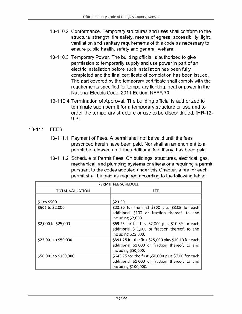
Official County Code of Douglas County, Kansas
Page 22
13-110.2 Conformance. Temporary structures and uses shall conform to the structural strength, fire safety, means of egress, accessibility, light, ventilation and sanitary requirements of this code as necessary to ensure public health, safety and general welfare.
13-110.3 Temporary Power. The building official is authorized to give permission to temporarily supply and use power in part of an electric installation before such installation has been fully completed and the final certificate of completion has been issued. The part covered by the temporary certificate shall comply with the requirements specified for temporary lighting, heat or power in the National Electric Code, 2011 Edition, NFPA 70.
13-110.4 Termination of Approval. The building official is authorized to terminate such permit for a temporary structure or use and to order the temporary structure or use to be discontinued. [HR-12-9-3]
13-111 FEES
13-111.1 Payment of Fees. A permit shall not be valid until the fees prescribed herein have been paid. Nor shall an amendment to a permit be released until the additional fee, if any, has been paid.
13-111.2 Schedule of Permit Fees. On buildings, structures, electrical, gas, mechanical, and plumbing systems or alterations requiring a permit pursuant to the codes adopted under this Chapter, a fee for each permit shall be paid as required according to the following table:
PERMIT FEE SCHEDULE TOTAL VALUATION FEE
$1 to $500 $23.50 $501 to $2,000 $23.50 for the first $500 plus $3.05 for each
additional $100 or fraction thereof, to and including $2,000.
$2,000 to $25,000 $69.25 for the first $2,000 plus $10.89 for each additional $ 1,000 or fraction thereof, to and including $25,000.
$25,001 to $50,000 $391.25 for the first $25,000 plus $10.10 for each additional $1,000 or fraction thereof, to and including $50,000.
$50,001 to $100,000 $643.75 for the first $50,000 plus $7.00 for each additional $1,000 or fraction thereof, to and including $100,000.

Official County Code of Douglas County, Kansas
Page 23
$100,001 to $500,000 $993.75 for the first $100,000 plus $5.60 for each additional $1,000 or fraction thereof, to and including $500,000.
$500,001 to $1,000,000 $3,233.75 for the first $500,000 plus $4.75 for each additional $1,000 or fraction thereof, to and including $1,000,000.
$1,000,001 to $5,000,000 $5,608.75 for the first $ 1,000,000 plus $3.15 for each additional $1,000 or fraction thereof, to and including $5,000,000.
$5,000,001 to $15,000,000 $17,980.92 for the first $5,000,000 plus $1.54 for each additional $ 1,000 or fraction thereof, to and including $15,000,000.
$15,000,001 and above $33,562.30 for the first $15,000,000 plus $1.02 for each additional $1,000 or fraction thereof.
Inspection and Other Fees:
Inspections outside of normal business hours (minimum charges - two hours)
$47.00 per hour.*
Re-inspection fees assessed under provisions of Section 108.8
$47.00 per hour.*
Inspections for which no fee is specifically indicated (minimum charge - one-half hour)
$47.00 per hour.*
Additional plan review required by changes, additions or revisions to approved plans (minimum charge - one-half hour) This cost shall include supervision, overhead, equipment, hourly wages and fringe benefits of the employees involved.
$47.00 per hour or the total hourly cost to Douglas County, whichever is the greatest.
Any person who commences any work before obtaining the necessary permits and paying the necessary permit fees
Additional fee equal to 100 percent of the permit fee set forth above, which is in addition to all other required permit fees.
The permit applicant shall pay costs of any third party plan review required by the size or complexity of the building project, as determined by the building official.
Solar photovoltaic (PV) systems (up to 13.44 kW) and solar thermal systems requiring no structural changes to the building.
$115.00.1 For every kW, measured in whole increments of 1 kW, over 13.44 kW the flat rate shall increase by $10 per kW.[HR- 14-1-1]
1 Flat fee covers plan review, inspection and one re-inspection. Submittal shall include structural details of the roof on which the system will be mounted. Structural Engineer’s

Official County Code of Douglas County, Kansas
Page 24
certification may be required. Installation shall be according to manufacturer’s recommended method and the 2011 NEC.
13-111.3 Building Permit Valuations. The applicant for a permit shall
provide an estimated permit value at time of application. Permit valuations shall include total value of work, including materials and labor, for which the permit is being issued, such as electrical, gas, mechanical, plumbing equipment and permanent systems. If, in the opinion of the building official, the valuation is underestimated on the application, the permit shall be denied, unless the applicant can show detailed estimates to meet the approval of the building official. Final building permit valuation shall be set by the building official.
13-111.4 Disposition of Fees. The building official shall keep, or cause to be kept, an accurate account of fees collected and received under the provisions of this Chapter and record the name of the person on whose account the same was paid, the date and the amount thereof together with the location of the proposed construction or installation to which the fees relate. The building official shall deposit the amount of the fees collected with the County Treasurer.
13-111.5 Work Commencing Before Permit Issuance. Any person who commences any work on a building, structure, electrical, gas, mechanical or plumbing system before obtaining the necessary permits shall be subject to an additional fee established by the permit fee schedule, which shall be in addition to all other required permit fees.
13-111.6 Related Fees. The payment of the fee for the construction, alteration, removal or demolition for work done in connection to or concurrently with the work authorized by a building permit shall not relieve the applicant or holder of the permit from the payment of other fees that are prescribed by law.
13-111.7 Fee Refund. The building official may authorize the refunding of fees as follows:
1) The full amount of any fee paid hereunder that was erroneously paid or collected.
2) Not more than 50% of the permit fee paid when no work has been done under a permit issued in accordance with this Chapter.
3) Not more than 50% of a plan review fee paid when an application for a permit for which a plan review fee has been paid is withdrawn or canceled before any plan review effort has been expended. [HR-12-9-3]

Official County Code of Douglas County, Kansas
Page 25
13-112 INSPECTIONS
13-112.1 General. Construction or work for which a permit is required shall be subject to inspection by the building official and such construction or work shall remain accessible and exposed for inspection purposes until approved. Approval as a result of an inspection shall not be construed to be an approval of a violation of the provisions of this Chapter or of resolutions of Douglas County. Inspections presuming to give authority to violate or cancel the provisions of this Chapter or of other resolutions of Douglas County shall not be valid. It shall be the duty of the permit applicant to cause the work to remain accessible and exposed for inspection purposes. The building official may order work exposed for inspections purposes and the permit applicant shall bear the cost thereof. If the permit applicant refuses to expose the work for inspection, the building official may expose the work, revoke the permit, or take other action as authorized by this Chapter or other applicable law. Neither the building official nor Douglas County shall be liable for expense entailed in the removal or replacement of any material required to allow inspection. [HR-12- 11-5]
13-112.2 Preliminary Inspection. Before issuing a permit, the building official is authorized to examine or cause to be examined buildings, structures and sites for which an application has been filed.
13-112.3 Required Inspections. The building official, upon notification, shall make the inspections set forth in this Article.
13-112.3.1 Footing and Foundation Inspection. Footing and foundation inspections shall be made after excavations for footings are complete and any required reinforcing steel is in place. For concrete foundations, any required forms shall be in place prior to inspection. Materials for the foundation shall be on the job, except where concrete is ready mixed in accordance with ASTM C 94, the concrete need not be on the job.
13-112.3.2 Concrete Slab and Under-Floor Inspection. Concrete slab and under- floor inspections shall be made after in-slab or under-floor reinforcing steel and building service equipment, conduit, piping accessories and other ancillary equipment items are in place, but before any concrete is placed or floor sheathing installed, including the subfloor.
13-112.3.3 Lowest Floor Elevation. In flood hazard areas, upon placement of the lowest floor, including the basement, and prior to further vertical construction, the documentation required in Section 1612.5 of the International Building Code, 2012 Edition or

Official County Code of Douglas County, Kansas
Page 26
Section R109.1.3 of the International Residential Code, 2012 Edition, as the case may be, shall be submitted to the building official.
13-112.3.4 Frame Inspection. Framing inspections shall be made after the roof deck or sheathing, all framing, fire- blocking and bracing are in place and pipes, chimneys and vents to be concealed are complete and the rough electrical, plumbing, heating wires, pipes and ducts are approved.
13-112.3.5 Lath and Gypsum Board Inspection. Lath and gypsum board inspections shall be made after lathing and gypsum board, interior and exterior, is in place, but before any plastering is applied or gypsum board joints and fasteners are taped and finished. Exception: Gypsum board that is not part of a fire-resistance-rated assembly or a shear assembly.
13-112.3.6 Fire and Smoke-Resistant Penetrations. Protection of joints and penetrations in fire-resistance- rated assemblies, smoke barriers and smoke partitions shall not be concealed from view until inspected and approved.
13-112.3.7 Energy Efficiency inspections. Inspections shall be made to determine compliance with energy efficiency requirements and shall include, but not be limited to, inspections for: envelope insulation R- and U-values, fenestration U-value, duct system R-value, and HVAC and water-heating equipment efficiency.
13-112.3.8 Special Inspections. For special inspections, see Chapter 17 of the International Building Code, 2012 Edition.
13-112.3.9 Final Inspection. The final inspection shall be made after all work required by the building permit is completed.
13-112.3.10 Flood Hazard Documentation (Elevation Certificate). If located in a flood hazard area, documentation of the elevations as required in Section 1612.5 of the International Building Code, 2012 Edition or Section R109.1.6.1 of the International Residential Code, 2012 Edition, as the case may be, shall be submitted to the building official prior to the final inspection.
13-112.3.11 Other Inspections. In addition to the inspections specified in Sections 13 -112.3.1 through 13-112.3.10, the building official is authorized to make or require other inspections of any construction work to ascertain compliance with the provisions of this code and other laws that are enforced by the department of building safety.

Official County Code of Douglas County, Kansas
Page 27
13-112.4 Inspection Agencies. The building official is authorized to accept reports of approved inspection agencies, provided such agencies satisfy the requirements as to qualifications and reliability.
13-112.5 Inspection Requests. It shall be the duty of the holder of the building permit or their duly authorized agent to notify the building official when work is ready for inspection. It shall be the duty of the permit holder to provide access to and means for inspections of such work that are required by this Chapter.
13-112.6 Approval Required. Work shall not be done beyond the point indicated in each successive inspection without first obtaining the approval of the building official. The building official, upon notification, shall make the requested inspections and shall either indicate the portion of the construction that is satisfactory as completed, or notify the permit holder or his or her agent wherein the same fails to comply with this code. Any portions that do not comply shall be corrected and such portion shall not be covered or concealed until authorized by the building official. [HR-12-9- 3]
13-113 CERTIFICATE OF OCCUPANCY
13-113.1 Use and Occupancy. No building or structure shall be used or occupied, and no change in the existing occupancy classification of a building or structure or portion thereof shall be made, until the building official has issued a certificate of occupancy therefore as provided herein. Issuance of a certificate of occupancy shall not be construed as an approval of a violation of the provisions of this code or of other resolutions of Douglas County. Exceptions:
1) Certificates of occupancy are not required for work exempt from permits under pursuant to this Article.
2) Accessory buildings or structures.
13-113.2 Certificate Issued. After the building official inspects the building or structure and finds no violations of the provisions of this code or other laws that are enforced by the department of building safety, the building official shall issue a certificate of occupancy that contains the following:
1) The building permit number.
2) The address of the structure.
3) The name and address of the owner.
4) A description of that portion of the structure for which the certificate is issued.

Official County Code of Douglas County, Kansas
Page 28
5) A statement that the described portion of the structure has been inspected for compliance with the requirements of this Chapter for the occupancy and division of occupancy and the use for which the proposed occupancy is classified.
6) The name of the building official.
7) The edition of the code under which the permit was issued.
8) The use and occupancy, in accordance with the provisions of the applicable code.
9) The type of construction as defined in the applicable code
10) The design occupant load.
11) I f an automatic sprinkler system is provided, whether the sprinkler system is required.
12) Any special stipulations and conditions of the building permit.
13-113.3 Temporary Occupancy. The building official is authorized to issue a temporary certificate of occupancy before the completion of the entire work covered by the permit, provided that such portion or portions shall be occupied safely. The building official shall set a time period during which the temporary certificate of occupancy is valid. [HR-12-9-3]
13-113.4 Revocation. The building official is authorized to, in writing, suspend or revoke a certificate of occupancy or completion issued under the provisions of this Chapter wherever the certificate is issued in error, or on the basis of incorrect information supplied, or where it is determined that the building or structure or portion thereof, or its use or occupancy, is in violation of any ordinance or regulation or any of the provisions of this Chapter. [HR-12-11-5]
13-114 SERVICE UTILITIES
13-114.1 Connection of Service Utilities. No person shall make connections from a utility, source of energy, fuel or power to any building or system that is regulated by this code for which a permit is required, until released by the building official.
13-114.2 Temporary Connection. The building official shall have the authority to authorize the temporary connection of the building or system to the utility source of energy, fuel or power.
13-114.3 Authority to Disconnect Service Utilities. The building official shall have the authority to authorize disconnection of utility service to the building, structure or system regulated by this Chapter and the
Official County Code of Douglas County, Kansas
Page 29
referenced and adopt e d codes and standards set forth therein in case of emergency where necessary to eliminate an immediate hazard to life or property or when such utility connection has been made without the required approval. The building official shall notify the serving utility, and wherever possible the owner and occupant of the building, structure or service system of the decision to disconnect prior to taking such action. If not notified prior to disconnecting, the owner or occupant of the building, structure or service system shall be notified in writing, as soon as practical thereafter. [HR-12-9-3]
13-115 BOARD OF CONSTRUCTION CODES APPEALS.
13-115.1 General. In order to determine the suitability of alternate materials and types of construction and in order to hear and decide appeals of orders, decisions or determinations made by the building official relative to the application and interpretation of the codes adopted pursuant to this Chapter, there shall be and is hereby created a Board of Construction Codes Appeals, consisting of 5 members who are qualified by experience and training to pass upon matters pertaining to building projects. The Board of Construction Codes Appeals shall consist of members who are qualified by experience and training to pass on matters pertaining to building construction and are not employees of Douglas County. Board of County Commissioners shall use reasonable efforts to appoint members to the Board of Construction Codes Appeals having one of the following qualifications: (1) a license professional engineer; (2) a licensed professional architect; (3) a building contractor or superintendent of building construction; or (4) a master plumber, electrician or other individual in the building trades. Each member of the Board of Construction Codes Appeals shall have had 10 years of experience, no less than 5 years of which shall have been in a position of responsible authority on building projects. No more than two members should be selected from the same profession, business, or trade, and at least one of the members should have professional registration and engineering experience as a structural, civil, or architectural engineer, or architect. Notwithstanding the foregoing, the failure of the members of the Board of Construction Codes Appeals to possess the foregoing qualifications shall not invalidate actions and determinations that the Board of Construction Codes Appeals makes. The building official shall be an ex-officio member and shall act as Secretary to the Board of Construction Codes Appeals. The Board of Construction Codes Appeals shall be appointed by the Board of

Official County Code of Douglas County, Kansas
Page 30
County Commissioners for terms of office of 4 years. Notwithstanding the foregoing, the members of the Board of Construction Codes Appeals appointed and serving pursuant to the construction codes in place on the effective date of this Section shall continue as members of the Board of Construction Codes Appeals hereby created for the remainder of their appointed terms, subject to removal or resignation. The Board of Construction Codes Appeals shall adopt reasonable rules and regulations for conducting its investigations and shall render all decisions and findings in writing to the building official with a duplicate copy to the appellant, and may recommend to the Board of County Commissioners such new legislation as is consistent therewith. The Board of Construction Codes Appeals shall annually elect or reelect a Chair and a Vice-Chair from its membership.
13-115.2 Authority. An application or appeal shall be based on a claim that the true intent of the applicable code or rules legally adopted thereunder have been incorrectly interpreted, the provisions of the applicable code do not fully apply, or an equally good or better form of construction is proposed. The Board of Construction Codes Appeals, however, shall not have the authority to waive requirements under the applicable code.
13-115.3 Rules, Meetings, and Records. The Board of Construction Codes Appeals shall adopt rules to govern its proceedings in accordance with the provisions of this subsection.
1) Meetings of the Board of Construction Codes Appeals shall be held at least once a month if there is business for the Board to consider. Additional meetings may be called at such other times as are determined by the Chair at any time or by the Board of Construction Codes Appeals at regular or special meeting.
2) The Board of Construction Codes Appeals shall keep minutes of its proceedings, showing the vote of each member upon every question, or if absent or filing to vote, indicted such facts.
3) The Board of Construction Codes Appeals shall keep records of hearings, examinations and other action. Such minutes and records shall be public records.
13-115.4 Appeals. Any person whose application for a building permit requesting the use of an alternate material or type of construction has been denied by the building official, or who disagrees with the application of the Residential Code, Building Code, Mechanical Code, Plumbing Code, Fuel Gas Code, or Electric Code or other determination of the building official, may appeal the action of the

Official County Code of Douglas County, Kansas
Page 31
building official to the Board of Construction Codes Appeals by serving written notice upon the building official and paying a $100 application fee. The notice shall state the action being appealed, the reasons for appeal, and that the applicant shall pay all costs and expenses of tests deemed necessary by Board of Construction Codes Appeals in determining the merits of the appeals. The building official shall at once transmit the notice to the members of the Board of Construction Codes Appeals and schedule a hearing on the matter.
13-115.5 Authority of the Board of Construction Codes Appeals. The Board of Construction Codes Appeals may reverse, affirm or modify the decision of the building official. All decisions of the Board of Construction Codes Appeals shall be by a majority of the members of the Board present and voting at which a quorum is present. Three members shall constitute a quorum for meeting purposes.
13-115.6 Disposition of Fee. In the event the Board of Construction Codes Appeals reverses or modifies the decision of the building official, the $100 application fee shall be refunded to the applicant. If the Board affirms the decision of the building official, the application fee shall be retained by Douglas County and deposited with the County Treasurer to the credit of the general fund. [HR-12-9- 3]
13-116 VIOLATIONS AND STOP WORK ORDERS.
13-116.1 Unlawful Acts. It shall be unlawful for any person, firm or corporation to erect, construct, alter, extend, repair, move, remove, demolish, use, or occupy any building, structure or equipment regulated by this Chapter, or cause the same to be done, in conflict with or in violation of any of the provisions thereof.
13-116.2 Notice of Violation. The building official is authorized to serve a notice of violation or order on the person responsible for the erection, construction, alteration, extension, repair, moving, removal, demolition, use, or occupancy of a building or structure in violation of the provisions of this chapter, or in violation of a detail statement or a plan approved thereunder, or in violation of a permit or certificate issued under the provisions of this Chapter. Such order shall direct the discontinuance of the illegal action or condition and the abatement of the violation.
13-116.3 Violation and Penalties. Any person who violates a provision of this Chapter or fails to comply with any of the requirements thereof or who erects, constructs, alters or repairs a building or structure in violation of the approved construction documents or directive of the

Official County Code of Douglas County, Kansas
Page 32
building official, or of a permit or certificate issued under the provisions of this Chapter, shall be guilty of a misdemeanor, punishable by a fine of not more than $500 or by imprisonment for not more than one month, or by both such fine and imprisonment. Each day that a violation continues after due notice has been served shall be deemed a separate offense. In addition to any other remedies provided by the code or other applicable law, the county or building official may bring civil suit to enjoin the violation of any provisions of the code. The availability or pendency of an appeal to the Board of Construction Code Appeals shall not preclude Douglas County or the building official from pursuing such civil or criminal actions, seeking any available remedy, including injunction, relating to any such violation, and the court need not delay or defer its adjudication of the case on the basis that such appeal may be available or pending before the Board of Construction Code Appeals.
13-116.4 Stop Work Orders. Upon notice from the building official or his designee that work on any building or structure is being performed contrary to the provisions of any codes adopted in this Chapter or in an unsafe and dangerous manner, such work shall be immediately stopped. The stop work order shall be in writing and shall be given to the owner of the property involved, or to the owner’s agent or to the person doing the work and shall state the conditions under which work will be permitted to resume. Where an emergency exists, the building official shall not be required to give a written notice prior to stopping work. Any person who shall continue any work in or about the structure after having been served with a stop work order, except such work as that person is directed to perform to remove a violation or unsafe condition, shall be liable to a fine of not more than $500 and such other penalties as prescribed by law.
13-116.5 Abatement and Injunction of Violation. The imposition of the penalties herein prescribed shall not preclude the building official or Douglas County from instituting appropriate action to prevent unlawful construction or restrain, correct or abate a violation, or to prevent illegal use or occupancy of a building, structure, or premises, or to stop an illegal act, conduct, business or utilization of a building or other construction on or about any premises. [HR-12-11-5]
13-117 UNSAFE STRUCTURES AND EQUIPMENT
13-117.1 Condemnation. All equipment, systems, devices and safeguards required by this Chapter, a previous statute or code applicable to
Official County Code of Douglas County, Kansas
Page 33
the structure, premises or equipment, or other applicable law shall be maintained in good working order and repair. It shall be unlawful for an owner, operator or occupant to cause or permit any equipment, systems, devices and safeguards, or any other service, facility, equipment or utility required by this Chapter, a previous statute or code applicable to the structure, premises, or equipment, or other applicable law, to be removed, shut off, or discontinued from any occupied structure, except for such temporary interruption as necessary while repairs or alterations made in accordance with applicable law are in progress. Structures (including agricultural buildings), real property, or existing equipment that are or hereafter become unsafe, unsanitary, deficient, or in violation of applicable law because of inadequate means of egress facilities, inadequate light and ventilation, inadequate safety features, or which constitute a fire hazard or life-safety hazard, or are otherwise detrimental to public health, safety, or welfare, or that involve illegal or improper use, occupancy or inadequate maintenance, shall be condemned pursuant to the provisions of this Chapter. Unsafe structures shall be taken down and removed or made safe, and real property shall be restored to a safe and compliant condition, as the building official deems necessary and as provided for in this Section. Structures, real property, or equipment may be condemned for any of the following reasons:
1) Unsafe Structure. An unsafe structure is a vacant structure that is not secured against entry or a structure that is found to be dangerous to life, health, property, or safety of the public or the occupants of the structure, including without limitation, by not providing minimum safeguards to protect or warn occupants in the event of fire, or because such structure contains unsafe or improperly installed equipment, or is so damaged, decayed, dilapidated, structurally unsafe, or of such faulty construction or unstable foundation, that partial or complete collapse is possible.
2) Unsafe Equipment. Unsafe equipment includes any boiler, heating equipment, elevator, moving stairway, electrical wiring or device, flammable liquid containers or other equipment on the premises or within the structure which is in such disrepair or condition or is improperly installed or maintained that such equipment is a hazard to life, health, property or safety of the public or occupants of the premises or structure.
3) Structure Unfit for Human Occupancy. A structure is unfit for human occupancy whenever the building official finds that such structure is unsafe, unlawful or, because of the degree to which the structure is
Official County Code of Douglas County, Kansas
Page 34
in disrepair or lacks maintenance, is structurally unsound or unsafe, unsanitary, vermin or rat infested, contains filth and contamination, or lacks ventilation, illumination, sanitary or heating facilities or other essential equipment, or because the location of the structure constitutes a hazard to the occupants of the structure or to the public.
4) Unlawful Structure. An unlawful structure is one occupied by more persons than permitted under this Chapter or other applicable law, or was erected, altered or otherwise occupied contrary to law.
5) Dangerous Structure or Premises. For the purpose of this Chapter, any structure or premises that has one or more of the following shall be considered dangerous and unsafe:
(a) The walking surface of any aisle, passageway, stairway, exit or other means of egress is so warped, worn loose, torn, or otherwise unsafe as to not provide safe and adequate means of egress.
(b) Any portion of a building, structure, or appurtenance that has been damaged by fire, earthquake, wind, flood, deterioration, neglect, abandonment, vandalism or by any other cause to such an extent that it is likely to partially or completely collapse, or to become detached or dislodged, or some portion of the foundation or underpinning of the building or structure is likely to fail or give way.
(c) The building or structure, or any portion thereof, is clearly unsafe for its use and occupancy, or is a threat to life or health.
(d) The building or structure is neglected, damaged, dilapidated, unsecured or abandoned so as to become an attractive nuisance to children who are unable to appreciate the risk the building or structure poses and might play in the building or structure to their danger, becomes a harbor for vagrants, criminals or immoral persons, or enables persons to resort to the building or structure for committing a nuisance or an unlawful act.
(e) Any building or structure, used or intended to be used for dwelling purposes, because of inadequate maintenance, dilapidation, decay, damage, faulty construction or arrangement, inadequate light, ventilation, or otherwise, is unsanitary, unfit for human habitation, or in such a condition that is likely to cause sickness, disease, or injury.

Official County Code of Douglas County, Kansas
Page 35
(f) Any portion of a building which remains on a site after the demolition or destruction of the building or structure; or whenever any building or structure is abandoned so as to constitute such building or portion thereof as an attractive nuisance or hazard to the public.
(g) Notwithstanding the foregoing, however, the provisions of this Section relating to condemning structures and ordering abatement of unsafe or dangerous structures shall not apply to any agricultural building (see Section 13-107.4.1 for definition) unless the agricultural building actually presents a public nuisance that endangers public health, safety, and welfare. [HR 13-3-2]
13-117.2 Record. The building official shall cause a report to be filed with the building official’s records on an unsafe condition. The report shall state the occupancy of the structure, if any, and the nature of the unsafe condition. [HR 13-3-2]
13-117.3 Notice. Whenever the building official has condemned a structure, real property, or equipment, the building official shall serve on the owner, agent or person in control of the premises, a written notice that describes the condition deemed unsafe, unlawful, or dangerous and specifies the required repairs or improvements to be made to abate the unsafe condition, and the time to complete such repairs or improvements, or that requires the unsafe structure to be demolished within a stipulated time. Such notice shall require the person thus notified to declare immediately to the building official acceptance or rejection of the terms of the order. If the owner, agent or person in charge rejects or fails to comply within the time allowed, the building official shall have the authority to accept the terms of the order or to complete the repairs or demolition or otherwise remove the structure, equipment, system, or device, and to restore any real property to a safe and compliant condition, as reasonably necessary to protect public health, safety and welfare. [HR 13-3-2]
13-117.4 Method of Service. Such notice shall be deemed properly served if a copy thereof is (a) delivered to the owner personally; (b) sent by certified or registered mail addressed to the owner at the last known address with the return receipt requested; (c) sent by certified or registered mail addressed to the owner at the address listed in the County tax records for the subject real property, with the return receipt requested; (d) posted conspicuously in or about the structure or real property affected by such notice, or (e)

Official County Code of Douglas County, Kansas
Page 36
delivered in any other manner as prescribed by local law or reasonably calculated to reach the intended recipient. If sent by mail, the notice shall be deemed effective and complete three calendar days after mailing. If the certified or registered letter is returned showing that the letter was not delivered, a copy thereof shall be posted in a conspicuous place in or about the structure affected by such notice. Service of such notice in the foregoing manner upon the owner's agent or upon the person occupying or responsible for the structure or real property shall constitute service of notice upon the owner. [HR 13-3-2]
13-117.5 Placarding. Upon failure of the owner or person responsible to comply with the notice provisions within the time given (if any time is given), the building official shall post on the premises or on defective equipment, system or device, a placard bearing the word "Condemned" and a statement of the penalties provided for occupying the premises, operating the equipment or removing the placard. [HR 13-3-2]
13-117.6 Prohibited Occupancy. Any structure, real property or equipment condemned and placarded by the building official shall be vacated as ordered by the building official, and shall not thereafter be occupied or used unless and until the building official authorizes. It shall be unlawful for any person to occupy a placarded premises or operate placarded equipment, and it shall be unlawful for any owner or any person responsible for the premises to permit anyone to occupy a placarded premises or operate placarded equipment. Any violator shall be subject to the civil and criminal penalties provided for violations of the provisions of this Chapter. [HR 13-3-2]
13-117.7 Removal of Placard. The building official shall remove the condemnation placard whenever the defect or defects upon which the condemnation and placarding action were based have been eliminated. Any person who defaces or removes a condemnation placard without the approval of the building official shall be deemed to have violated the provisions of this Chapter and shall be shall be subject to the civil and criminal penalties provided for violations of the provisions of this Chapter. [HR 13-3-2]
13-117.8 Authority to Disconnect Service Utilities. The building official shall have the authority to authorize disconnection of utility service to the building, structure, or system regulated by this Chapter and the referenced codes and standards in case of emergency where necessary to eliminate an immediate hazard to life or property or when such utility connection has been made without approval. The

Official County Code of Douglas County, Kansas
Page 37
building official shall notify the servicing utility and, whenever possible, the owner and occupant of the building, structures or service system of the decision to disconnect prior to taking such action. If not provided prior to disconnection, written notification shall be done as soon as practical thereafter. [HR 13-3-2]
13-117.9 Abatement. The owner, operator, or occupant of a structure, premises, or equipment, system, or device deemed unsafe or dangerous by the building official shall abate or cause to be abated or corrected such unsafe or dangerous conditions either by repair, rehabilitation, demolition or other approved corrective action in the manner and within the timeframe specified by the building official. To the extent that repairs, alterations or additions are made or a change of occupancy occurs during the restoration of the structure, such repairs, alterations, additions or change of occupancy shall comply with all applicable requirements of this Chapter, including the requirements of Section 113-107.4.7 and Chapter 34 of the International Building Code, 2012 Edition or Appendix J of the International Residential Code, 2012 Edition, as the case may be. [HR 13-3- 2]
13-117.10 Emergency Measures. When, in the opinion of the building official, there is imminent danger of failure or collapse of a building or structure which endangers life, or when any structure or part thereof has fallen and life is endangered by the occupation of the structure, or when there is actual or potential danger to the building occupants or those in the proximity of any structure because of explosives, explosive fumes, gases or vapors or the presence of toxic fumes, gases or materials, fire hazard, or operation of defective or dangerous equipment, or when any other emergency condition exists, the building official may, without notice or hearing, order and require the occupants to vacate the premises forthwith. It shall be unlawful for any person to enter such structure, except for the purpose of securing the structure, making the required repairs, removing the hazardous condition, or of demolishing the same. Notwithstanding other provisions of this Chapter, whenever, in the opinion of the building official, there is imminent danger due to an unsafe condition, the building official may order the owner to perform the necessary work to be done to secure the structure to safeguard from imminent danger, including the boarding up or locking of openings to render such structure temporarily secure, whether or not the legal procedure described has been instituted; and shall cause such other action to be taken as the code official deems necessary to meet such imminent condition. If the owner

Official County Code of Douglas County, Kansas
Page 38
fails to perform such work to secure the structure and safeguard from imminent danger, the building official may employ the necessary labor and materials to perform the required work as expeditiously as possible to secure the structure in an effort to provide the minimum safeguards from imminent danger. Costs incurred in the performance of emergency work shall be paid from the treasury of the jurisdiction on approval of the code official. The cost of such repairs shall be the responsibility of the owner and may be recovered in any civil or criminal action. [HR 13-3-2]
13-117.11 Appeals. Appeals under this Section 13-117 may be made as follows:
1) Section 13-117 shall have the right to appeal to the Board of Construction Codes Appeals, provided that a written application for appeal is filed with the Director of the Zoning & Codes Department within 15 days after the day the decision, notice, or order was served (with the exception of Section 13-117.9 – Emergency Measures specified below). The appeal shall be based on a claim that the true intent of this Chapter has been incorrectly interpreted or that the provisions of this Chapter do not apply. An application for appeal shall state the specific reason or reasons for the appeal, shall provide all facts in support of the appeal, and shall state, with particularity, the way in which the true intent of this Chapter has been incorrectly interpreted or applied. An appeal under this Section shall be heard according to the procedures set forth in Section 13-115. [HR 13-3- 2]
2) Emergency Measures. To provide a prompt appeal for emergency notices, any person directly affected by a decision of the building official issued under Section 13-117.9 – Emergency Measures, shall have the right to appeal to the County Administrator or the County Administrator’s designee, provided that a written application for appeal is filed within 3 days after the day the decision, notice, or order was served, but any appeal not perfected within 3 days may still be made to the Board of Construction Codes Appeals within the timeframe specified above. The appeal shall be based on a claim that the true intent of this Chapter has been incorrectly interpreted or that the provisions of this Chapter do not apply. An application for appeal shall state the specific reason or reasons for the appeal, shall provide all facts in support of the appeal, and shall state, with particularity, the way in which the true intent of this Chapter has been incorrectly interpreted or applied. The decision of the County Administrator may be appealed to the Board of Construction Codes Appeals, provided that a written application for appeal is filed with

Official County Code of Douglas County, Kansas
Page 39
the Director of the Zoning & Codes Department within 15 days after the day of the decision. [HR 13-3-2]
3) Appeal Fees. The appeal fees provided in Section 13-115 shall apply to appeals to the Board of Construction Codes Appeals and the County Administrator pursuant to this subsection. The fee must be paid within the timeframe for filing an appeal. [HR 13-3-2]
4) Stays of Enforcement. Except for Emergency Measures ordered pursuant to Section 13-117.9, appeals of notices, citations, and orders shall stay the enforcement of the notice, citation, or order until the appeal is heard by the appropriate board or official. Appeals of Emergency Measures ordered pursuant to Section 13-117.9 shall not stay the enforcement of the notice, citation, or order, but a decision of the County Administrator or the County Administrator’s designee overruling or invalidating a decision, notice or order of the building official on an appeal of Emergency Measurers shall stay the enforcement of the decision, notice or order pending the decision of the Board of Construction Codes Appeals. [HR 13-3-2]
13-118 QUALIFICATION AND LICENSURE
13-118.1 Licensure of Plumbers. All plumbers practicing their trade within the unincorporated area of Douglas County shall hold a valid license from some Kansas jurisdiction. This license shall be subject to the requirement of K.S.A. 12-1508 et seq. and any amendment thereto. Any property owner shall be allowed to do his or her own plumbing work; provided, however, after the second failure to pass a plumbing inspection, a licensed plumber will be required to finish the work.
13-118.2 Licensure of Electricians. All electricians practicing their trade within the unincorporated area of Douglas County shall hold a valid license from some Kansas jurisdiction. This license shall be subject to the requirement of K.S.A. 12-1525 et seq. and any amendment thereto. Any property owner shall be allowed to do his or her own electrical work; provided, however, after the second failure to pass an electrical inspection, a licensed electrician will be required to finish the work.
13-118.3 Licensure of Mechanical Mechanics. All mechanical heating, ventilation and air conditioning mechanics practicing their trade within the unincorporated area of Douglas County shall hold a valid license from some Kansas jurisdiction. This license shall be subject to the requirement of K.S.A. 12-1540 et seq. and any amendment

Official County Code of Douglas County, Kansas
Page 40
thereto. Any property owner shall be allowed to do his or her own mechanical work; provided, however, after the second failure to pass an electrical inspection, a licensed mechanical heating, ventilation and air conditioning mechanic will be required to finish the work. [HR-12-9-3]
ARTICLE 2. RESIDENTIAL CODE
13-201 ADOPTION OF INTERNATIONAL RESIDENTIAL CODE. The International Residential Code, 2012 Edition, including the following Appendix Chapters:
Appendix E Manufactured Housing Used as Dwellings
Appendix F Radon Control Methods
Appendix G Swimming Pools, Spas and Hot Tubs
Appendix J Existing Buildings and Structures
Appendix P Sizing of Water Piping Systems
as published by the International Code Council, is hereby adopted as the “Residential Code” of Douglas County, Kansas, for regulating and governing the construction, alteration, movement, enlargement, replacement, repair, equipment, location, removal and demolition of detached one- and two-family dwellings and multiple single-family dwellings (townhouses) not more than three stories in height with separate means of egress in the unincorporated areas of Douglas County, Kansas as herein provided; providing for the issuance of permits and collection of fees therefore; and each and all of the regulations, provisions, penalties, conditions, and said Residential Code are hereby referred to, adopted, and made a part hereof, as if fully set out herein, with the additions, insertions, deletions and changes hereinafter provided.
The regulations hereby adopted, as amended, shall be known as the Residential Code of Douglas County, Kansas, hereinafter interchangeably referred to as the “Code” or the “Residential Code.” [HR-12-9-3]
13-202 COPIES. Not less than one copy of the International Residential Code, 2012 Edition, marked and stamped in the manner provided by K.S.A. 12-3304, shall be filed with the County Clerk and shall be open to inspection and available to the public at reasonable business hours. Subsequent references to the “Residential Code” shall mean the International Residential Code, 2012 Edition, as adopted and amended herein. [HR-12-9-3]
13-203 AMENDMENTS TO RESIDENTIAL CODE. The International Residential Code, 2012 Edition is amended or supplemented as provided below.

Official County Code of Douglas County, Kansas
Page 41
13-203.1 Chapter 1 of the Residential Code is deleted and replaced with the provisions of Article 1 of this Chapter 13.
13-203.2 Table R301.2 (1). Climatic and Geographic Design Criteria. Table R301.2 (1) is completed and inserted to read as follows:
Table R301.2 (1)
CLIMATIC AND GEOGRAPHIC DESIGN CRITERIA
GROUND SNOW LOAD
WIND DESIGN SEISMIC DESIGN
CATEGORYf SUBJECT TO DAMAGE FROM WINTER
DESIGN TEMPe
ICE BARRIER UNDERLAYMENT
REQUIREDh FLOOD HAZARDSg
AIR FREEZING
INDEXi MEAN
ANNUAL TEMPj Speedd
(mph) Topographic effectsk Weatheringa Frost line
depthb Termitec 20 lbs psf
90 mph
No A Severe 30” Moderate to Heavy
4o F No See note g below
778 56o F
For SI: 1 pound per square foot = 0.0479 kPa, 1 mile per hour = 0.447 m/s.
a. Weathering may require a higher strength concrete or grade of masonry than necessary to satisfy the structural requirements of this code. The weathering column shall be filled in with the weathering index (i.e., "negligible," "moderate" or "severe") for concrete as determined from the Weathering Probability Map [Figure R301.2(3)]. The grade of masonry units shall be determined from ASTM C 34, C 55, C 62, C 73, C 90, C 129, C 145, C 216 or C 652.
b. The frost line depth may require deeper footings than indicated in Figure R403.1(!). The stated depth in the frost line depth column is the minimum depth of footing below finish grade.
c. This part of the table indicates the need for protection based upon a history of local subterranean termite damage.
d. This part of the table is the wind speed from the basic wind speed map [Figure R301.2(4)A]. Wind exposure category shall be determined on a site-specific basis in accordance with Section R301.2.1.4.
e. The outdoor design dry-bulb temperature shall be selected from the columns of 97 1/2 – percent values for winter from Appendix D of the International Plumbing Code, 2012 Edition. Deviations from Appendix D temperatures shall be permitted to reflect local climates or local weather experience as determined by the building official.
f. This part of the table is from the seismic design category determined from Section R301.2.2.1. g. (a) The date of Douglas County’s entry into the National Flood Insurance Program and date of
adoption of the first code or ordinance for management of flood hazard areas was 03/02/1981, (b) the Date of the Flood Insurance Study is 08/05/2010, and (c) the panel numbers and dates of all currently effective FIRMs and FBFMs or other flood hazard map adopted by Douglas County, as amended are: Panel numbers: 20,29,33,36,37,40,41,42,43,44,61,62,63,64,66,67,68,69,88,89,90,95,110,120,130,135,140,145,151,152,153,154,156,15 7,158,159,16,165,166,167,168,169,176,177,178,179,181,182,183,184,186,187,188,189,191,192,195,201,202,203,204,2 06,208,211,212,215,220,235,245,255,257,259,260,265,270,276,277,280,281,282,285,290,295,301,304,305,306,308,31 0,312,314,315,316,318,320,330,335,341,360,380,385,405,410,430,435,455.
h. In accordance with Sections R905.2.7.1, R905.4.3.1, R905.5.3.1, R905.6.3.1, R905.7.3.1 and R905.8.3.1, there has not been a history of local damage from the effects of ice damming.
i. This part of the table is the 100-year return period air freezing index (BF-days) from Figure R403.3(2) or from the 100-year (99 percent) value on the National Climatic Data Center data table "Air Freezing Index-USA Method (Base 32°F)" at www.ncdc.noaa.gov/fpsf.html.
j. This part of the table is the mean annual temperature from the National Climatic Data Center data table "Air Freezing Index- USA Method (Base 32°F)" at www.ncdc.noaa.gov/fpsf.html.
k. In accordance with Section R301.2.1.5, there is not local historical data documenting structural damage to buildings due to topographic wind speed-up effects.
13-203.3 Section R313.2 One- and Two-Family Dwellings Automatic Fire
Systems. First sentence is amended to read: An automatic residential fire sprinkler system may be installed in one-and two-family dwellings. [Changed from “shall be installed” to “may be installed”.]

Official County Code of Douglas County, Kansas
Page 42
13-203.4 Section R403.3. Frost Protected Shallow Foundations. Delete whole section and subsections, including figures R403.3 (1), R403.3 (3), and R403.3 (4), and Table R403.3 (1). [Frost Protected Shallow Foundations are not permitted.]
13-203.5 Table N1102.1.1 (R402.1.1). Insulation and Fenestration Requirements by Component. Table N1102.1.1 (R402.1.1) is amended to read as follows:
Table N1102.1.1 (R402.1.1) INSULATION AND FENESTRATION REQUIREMENTS BY COMPONENTa
CLIMATE ZONE
FENESTRATION U-FACTOR
SKYLIGHTb' U-FACTOR
GLAZED
FENESTRATION SHGC
CEILING R-VALUE
WOOD FRAME WALL
R-VALUE
MASS WALL
R-VALUEk
FLOOR R-VALUE
BASEMENTc
WALL R-VALUE
SLABd
R-VALUE AND DEPTH
CRAWL SPACEc
WALL R-VALUE
1 1.2 0.75 0.35i 30 13 3/4 13 0 0 0 2 0.65i 0.75 0.35j 30 13 4/6 13 0 0 0 3 0.50 0.65 0.35e,j 30 13 5/8 19 5/13f 0 5/13
4 except Marine 0.35 0.60
NR 38 13 5/10 19 10/13 10, 2ft 10/13
5 and Marine4
0.35 0.60
NR 38 20 or 13 + 5h 13/17 30f 10/13 10, 2ft 10/13
6 0.35 0.60 NR 49 20 or 13 + 5h 15/19 30g 10/13 10, 4 ft 10/13
7 and 8 0.35 0.60 NR 49 21 19/21 30g 10/13 10, 4 ft 10/13
a. R-values are minimums. U-factors and solar heat gain coefficient (SHGC) are maximums. R-19 batts compressed in to nominal 2 x 6 framing cavity such that the R-value is reduced by R-1 or more shall be marked with the compressed batt R-value in addition to the full thickness R-value. b. The fenestration U-factor column excludes skylights. The SHGC column applies to all glazed fenestration.
b. The first R-value applies to continuous insulation, the second to framing cavity insulation; either insulation meets the requirement. c. R-5 shall be added to the required slab edge R-values for heated slabs. Insulation depth shall be the depth of the footing or 2
feet, whichever is less, in zones 1 through 3 for heated slabs. Slab edge insulation may be eliminated for slab on grade floors when the building’s heating system efficiency rating is 90% or better.
d. There are no SHGC requirements in the Marine Zone. e. Basement wall insulation is not required in warm-humid locations as defined by Figure N1101.2 and Table N1101.2. g. Or insulation
sufficient to fill the framing cavity, R-19 minimum. f. "13+5" means R-13 cavity insulation plus R-5 insulated sheathing. If structural sheathing covers 25% or less of the exterior, R-5
sheathing is not required where structural sheathing is used. If structural sheathing covers more than 25% of exterior, structural sheathing shall be supplemented with insulated sheathing of at leastR-2.
g. For impact-rated fenestration complying with Section R301.2.1.2, the maximum U-factor shall be 0.75 in zone 2 and 0.65 in zone 3. h. For impact-resistant fenestration complying with Section R301.2.1.2 of the International Residential Code, 2012 Edition, the
maximum SHGC shall be 0.40. i. The second R-value applies when more than half the insulation is on the interior.
[Using the 2009 table rather than the 2012 table, which requires 49 R in ceilings and 20 R in walls.]
13-203.6 Section N1102.4.1.2 Testing. Delete section which requires a
blower door test. Building official will perform an insulation inspection but will not require a blower door test.

Official County Code of Douglas County, Kansas
Page 43
13-203.7 Section N1102.2.8. Building Thermal Envelope/ Basement Walls. Section N1102.2.8 is amended to read: Exterior walls associated with conditioned basements shall be insulated from the top of the basement wall down to 10 feet (3048 mm) below grade or to the basement floor, whichever is less. Walls associated with unconditioned basements shall meet this requirement unless the floor overhead is insulated in accordance with Sections N1102.1.1 and N1102.2.7. Exception: Basement walls that are otherwise exposed shall be insulated from the top of the basement wall down 3 feet (914mm) below grade or the basement floor, whichever is less. [The exception is added.]
13-203.8 Section G2406. Appliance location. The following is added: Appliances burning liquefied petroleum gas (LPG) or liquid fuel may be installed in a basement, a pit, an underfloor space, below grade or similar location; provided, however, that each area in which such appliances are located shall be equipped with a listed and approved liquefied petroleum gas or liquid fuel detection alarm (110-Volt with a battery backup, with all detectors in new construction being permanently wired into the electrical system if such permanently wired detectors are reasonably available at a comparable price in Douglas County). Detectors shall sound an alarm audible in all areas of the dwelling unit and be installed per the manufacturer’s installation instructions.
13-203.9 Section G2417.4.1 Fuel Gas Test Pressure. Amended to read: The test pressure to be used shall be not less than one and one-half time the proposed maximum working pressure, but not less than 10 psig (69 kPa gauge), irrespective of design pressure. Where the test pressure exceeds 125 psig (862 kPa gauge), the test pressure shall not exceed a value that produces a hoop stress in the piping greater than 50 percent of the specified minimum yield strength of the pipe. [Changed test pressure from 3 psig to 10 psig.]
13-203.10 Section P2503.5.1. Rough Plumbing. Amended to read: DWV systems shall be tested on completion of the rough piping installation by water or air with no evidence of leakage. Either test shall be applied to the drainage system in its entirety or in sections after rough piping has been installed, as follows:
1) Water test. Each section shall be filled with water to a point not less than 10 feet (3048mm) above the highest fitting connection in that section, or to the highest point in the completed system. Water shall be held in the section under test for a period of 15minutes. The system shall prove leak free by visual inspection.

Official County Code of Douglas County, Kansas
Page 44
2) Air test. The portion under test shall be maintained at a gauge pressure of 5 pounds per square inch (psi) (34kPa) or 10 inches of mercury column (34kPa). This pressure shall be held without introduction of additional air for a period of 15 minutes. [Changed to allow air test on plastic DWV.]
13-203.11 Section P2603.5.1. Sewer Depth. Amended to read: Building sewers that connect to private sewage disposal systems shall be not less than 12 inches (304 mm) below finished grade at the point of septic tank connection. Building sewers shall be not less than 12 inches (304 mm) below grade. [Inserted number of inches and millimeters in two locations.]
13-203.12 Section P3005.4.2. Building drain and sewer size and slope. Amended to read: Pipe sizes and slope shall be determined from Table P3005.4.2 on the basis of drainage load in fixture units (d.f.u.) computed from Table P3004.1; however no building sewer shall be less than four (4) inches in diameter. [Added minimum sewer size requirement of 4 inches.]
13-203.13 Section P3113.5 Total Size of Vents. New Section added read: The drainage piping of each building and each connection to a public sewer or a private sewage disposal system shall be vented by means of one or more vent pipes, the aggregate cross-sectional area of which shall not be less than that of the largest required building sewer. Exception: When connected to a common building sewer, the drainage piping of two buildings located on the same lot and under one ownership may be vented by means of piping sized in accordance with Table P3005.4.2, provided the aggregate cross-sectional area of all vents is not less than that of the largest required common building sewer.
13-203.14 Section P3114.2. Installation of Air Admittance Valves. Amended to read: The valves shall only be installed with prior approval from the Zoning & Codes Department, in accordance with the requirements of this section and the manufacturer’s installation instructions. Air admittance valves shall be installed after the DWV testing required by Section P2503.5.1 or P2503.5.2 has been performed. [Added requirement to get prior approval for air admittance valves.]
13-203.15 Section P3114.3. Air Admittance Valves, Where Permitted. Amended to read: Individual vents, branch vents, circuit vents and stack vents shall be permitted to terminate with a connection to a permitted air admittance valve. Individual and branch type air admittance valves shall vent only fixtures that are on the same floor
Official County Code of Douglas County, Kansas
Page 45
level and connect to a horizontal branch drain. [Added requirement to get prior approval for air admittance valves.]
13-203.16 Section P3114.8. Air Admittance Valves, Prohibited Installations. Amended to read: Air admittance valves without an engineered design shall not be used to vent sumps or tanks of any type and shall not be installed in new construction. Exception: Island fixtures in new construction may be vented by air admittance valves that comply with Section 3114. [Added prohibition to use of non- engineered air admittance valves in new construction and added exception.]
13-203.17 Section P3201.2. Trap Seals and trap seal protection. Amended to read: Traps shall have a liquid seal not less than 2 inches (51mm) and not more than 4 inches (102 mm). [Eliminated requirement of trap primers or deep seals on floor drains for residential (still required for commercial).]
13-203.18 Section E3601.6.2. Service disconnect location. Amended to read: The service disconnecting means shall be installed at a readily accessible location either outside of the building or structure or inside the building or structure at a point limited to a horizontal distance not to exceed three (3) feet from the point of penetration of the service entrance raceway into the structure. The service entrance conductors shall be protected by a raceway from the point of service to the termination at the service disconnecting means enclosure. Service disconnecting means shall not be installed in bathrooms. Each occupant shall have access to the disconnect servicing the dwelling unit in which they reside. [Added 3’ horizontal distance limitation.]
13-203.19 Section E3604.5 Service masts as supports. Amended to read: Where a service mast is used for the support of service-drop conductors, it shall be a galvanized rigid conduit with a minimum trade size diameter of two (2) inches and of adequate strength to withstand the strain imposed by the service drop. Where the service mast projects above the roof surface in excess of three (3) feet, the mast shall be supported by braces or guys to withstand safely the strain imposed. Where raceway-type service masts are used, all equipment shall be approved. Only power service drop conductors shall b permitted to be attached to a service mast. [Added minimum requirement of 2-inch rigid conduit.]
13-203.20 Section E3609.3 Bonding for Other Systems. Amended to read: An intersystem bonding termination for connecting intersystem bonding conductors required for other systems shall be

Official County Code of Douglas County, Kansas
Page 46
provided external to enclosures at the service or metering equipment enclosure and at the disconnecting means for any additional buildings or structures. The intersystem bonding termination shall comply with the following:
1) It shall be accessible for connection and inspection.
2) It shall consist of a set of terminals with the capacity for connection of not less than three intersystem bonding conductors.
3) It shall not interfere with opening the enclosure for a service, building or structure disconnecting means, or metering equipment.
4) Where located at the service equipment, it shall be securely mounted and electrically connected to an enclosure for the service equipment, or shall be mounted at one of these enclosures and connected to the enclosure or to the grounding electrode conductor with a minimum 6 AWG copper conductor.
5) Where located at the disconnection means for a building or structure, it shall be securely mounted and electrically connected to the metallic enclosure for the building or structure disconnecting means, or shall be mounted at the disconnecting means and connected to the metallic enclosure or to the grounding electrode conductor with a minimum 6 AWG copper conductor.
6) It shall be listed as grounding and bonding equipment. [Deleted allowance in #4 for intersystem bonding on meter or raceway.]
13-203.21 Section E3611.2. Accessibility. Amended to read: All mechanical elements used to terminate a grounding electrode conductor or bonding jumper to the grounding electrodes that are not buried or concrete encased shall be accessible. The location of the grounding electrode conductor connection to the grounding electrodes shall be permanently stated on a plaque or directory on the service disconnecting means. [Added requirement that the location of the GEC connection to the grounding electrodes shall be permanently stated on the disconnecting means.]
13-203.22 Section E3902.12. Arc-fault circuit-interrupter protection. Amended to read: All branch circuits that supply 120-volt, single-phase, 15- and 20-ampere outlets installed in bedrooms shall be protected by a listed arc-fault circuit interrupter installed to provide protection of the branch circuit. Exceptions:
1) Where a listed AFCI is installed at the first outlet to provide protection for the remaining portion of the branch circuit, the portion of the branch circuit between the branch-circuit over-current device
Official County Code of Douglas County, Kansas
Page 47
and such outlet shall be wired with metal outlet and junction boxes and RMC, IMC, EMT or steel armored cable, Type AC meeting the requirements of Section E3908.8.
2) AFCI protection is not required for a branch circuit supplying only a fire alarm system where the branch circuit is wired with metal outlet and junction boxes and RMC, IMC, EMT, or steel armored cable Type AC meeting the requirements of Section E3908.8.
3) [Not all circuits need be arc faulted, just the bedrooms.]
13-203.23 Section E4002.14. Tamper-resistant receptacles. Amended to read: In areas specified in Section E 3901.1, 125-volt, 15- and 20-ampere receptacles may be listed tamper-resistant receptacles. [Used “may” rather than “shall”.] [HR-12-9-3]
13-204 SEVERABILITY. If any section, subsection, sentence, clause or phrase in this Article or in the Residential Code is, for any reason, held to be unconstitutional or invalid, such decision shall not affect the validity of the remaining portions hereof. The Board declares that it would have passed this code, and each section, subsection, clause or phrase thereof, irrespective of the fact that any one or more sections, subsections, sentences, clauses and phrases be declared unconstitutional or invalid. [HR-12-9-3]
13-205 EXISTING RIGHTS OR VIOLATIONS. Nothing in this Article or in the Residential Code hereby adopted shall be construed to affect any suit or proceeding impending in any court, or any rights acquired, or liability incurred, or any cause or causes of action acquired or existing, under any act or resolution repealed in connection with the adoption of the Residential Code; nor shall any just or legal right or remedy of any character be lost, impaired or affected by this. [HR-12-9-3]
ARTICLE 3. BUILDING CODE
13-301 ADOPTION OF INTERNATIONAL BUILDING CODE. The International Building Code, 2012 Edition, including the following Appendix Chapters:
Appendix G Flood-Resistant Construction
as published by the International Code Council, be and is hereby adopted as the “Building Code” of the Douglas County, Kansas, for regulating and governing the conditions and maintenance of all property, buildings and structures; by providing the standards for supplied utilities and facilities and other physical things and conditions essential to ensure that structures are safe, sanitary and fit for occupation and use; and the condemnation of

Official County Code of Douglas County, Kansas
Page 48
buildings and structures unfit for human occupancy and use and the demolition of such structures in the unincorporated areas of Douglas County, Kansas as herein provided; providing for the issuance of permits and collection of fees therefore; and each and all of the regulations, provisions, penalties, conditions and terms of said Building Code are hereby referred to, adopted, and made a part hereof, as if fully set out herein, with the additions, insertions, deletions and changes hereinafter provided.
The regulations hereby adopted, as amended, shall be known as the Building Code of Douglas County, Kansas, hereinafter interchangeably referred to as the “Code” or the “Building Code.”
This Code shall not apply to the extent that the Residential Code adopted pursuant to Article 2 of this Chapter applies. [HR-12-9-3]
13-302 COPIES. Not less than one copy of the International Building Code, 2012 Edition, marked and stamped in the manner provided by K.S.A. 12-3304, shall be filed with the County Clerk and shall be open to inspection and available to the public at reasonable business hours. Subsequent references to the “Building Code” shall mean the International Building Code, 2012 Edition, as adopted and amended herein. [HR-12-9-3]
13-303 AMENDMENTS TO BUILDING CODE. The International Building Code, 2012 Edition is amended or supplemented as provided below.
13-303.1 Chapter 1 of the Building Code is deleted and replaced with the provisions of Article 1 of this Chapter 13.
13-303.2 Section 1612.3. Establishment of flood hazard areas. The title and date of the flood insurance study referred to and incorporated by reference in Section 1612.3 is The Flood Insurance Study for the Unincorporated Territory of Douglas County, Kansas, dated August 5, 2010.
13-303.3 Section 3412.2. Applicability. The applicability date in Section 3412.2 is January 1, 2013. [HR-12-9-3]
13-304 Section 4. SEVERABILITY. If any section, subsection, sentence, clause or phrase in this Article or in the Building Code is, for any reason, held to be unconstitutional or invalid, such decision shall not affect the validity of the remaining portions hereof. The Board declares that it would have passed this code, and each section, subsection, clause or phrase thereof, irrespective of the fact that any one or more sections, subsections, sentences, clauses and phrases be declared unconstitutional or invalid. [HR-12-9-3]

Official County Code of Douglas County, Kansas
Page 49
13-305 EXISTING RIGHTS OR VIOLATIONS. Nothing herein or in the Building Code hereby adopted shall be construed to affect any suit or proceeding impending in any court, or any rights acquired, or liability incurred, or any cause or causes of action acquired or existing, under any act or resolution repealed in connection with the adoption of the Building Code; nor shall any just or legal right or remedy of any character be lost, impaired or affected by this legislation. [HR-12-9-3]
ARTICLE 4. PLUMBING CODE
13-401 ADOPTION OF INTERNATIONAL PLUMBING CODE. The International Plumbing Code, 2012 Edition, including the following Appendix Chapters:
Appendix E Sizing of Water Piping System
Appendix F Structural Safety
as published by the International Code Council, be and is hereby adopted as the “Plumbing Code” of the Douglas County, Kansas, for regulating and governing the design, construction, quality of materials, erection, installation, alteration, repair, location, relocation, replacement, addition to, use or maintenance of plumbing systems in the unincorporated areas of Douglas County, Kansas as herein provided; providing for the issuance of permits and collection of fees therefore; and each and all of the regulations, provisions, penalties, conditions and terms of said Plumbing Code are hereby referred to, adopted, and made a part hereof, as if fully set out herein, with the additions, insertions, deletions and changes hereinafter provided.
The regulations hereby adopted, as amended, shall be known as the Plumbing Code of Douglas County, Kansas, hereinafter interchangeably referred to as the “Code” or the “Plumbing Code.”
This Code shall not apply to the extent that the Residential Code adopted pursuant to Article 2 of this Chapter applies. [HR-12-9-3]
13-402 COPIES. Not less than one copy of the International Plumbing Code, 2012 Edition, marked and stamped in the manner provided by K.S.A. 12-3304, shall be filed with the County Clerk and shall be open to inspection and available to the public at reasonable business hours. Subsequent references to the “Plumbing Code” shall mean the International Plumbing Code, 2012 Edition, as adopted and amended herein. [HR-12-9-3]

Official County Code of Douglas County, Kansas
Page 50
13-403 AMENDMENTS TO PLUMBING CODE. The International Plumbing Code, 2012 Edition is amended or supplemented as provided below. Chapter 1 of the Plumbing Code is deleted and replaced with the provisions of Article 1 of this Chapter 13.
13-403.1 Section 305.4.1. Sewer Depth. Amended to read: The minimum building sewer depth is inserted in Section 305.4.1 as (i) 12 inches (304 mm) below finished grade at the point of septic tank connection; and (ii) 12 inches (304 mm) below grade for other building sewers. [Inserted number of inches and millimeters in two locations.]
13-403.2 Section 312.3. Drainage and vent air test. The first sentence of Section 312.3, prohibiting use of air for testing plastic piping, is deleted. The remainder of the Section remains as written.
13-403.3 Section 312.5. Water supply system test. Amended to read: Upon completion of a section of or the entire water supply system, the system, or portion completed, shall be tested and proved tight under a water pressure not less than the working pressure of the system; or by an air test of not less than 50 psi (344 kPa). This pressure test shall be held for not less than 15 minutes. The water utilized for tests shall be obtained from a potable source of supply. The required tests shall be performed in accordance with this section and Section 107. [Added provision permitting testing of plastic water pipes with air.]
13-403.4 Section 710.1. Maximum fixture unit load. Amended to read: The maximum number of drainage fixture units connected to a given size of building sewer, building drain or horizontal branch of the building drain shall be determined using Table 710.1(1); however no building sewer shall be less than four (4) inches in diameter. The maximum number of drainage fixture units connected to a given size of horizontal branch or vertical soil or waste stack shall be determined using table 710.1(2). [Added minimum sewer size requirement of 4 inches.]
13-403.5 Section 903.1. Roof extension. The standard minimum vent pipe roof extension is inserted in Section 903.1 as six (6) inches (152mm) above the roof. [HR-12-9-3]
13-404 SEVERABILITY. If any section, subsection, sentence, clause or phrase in this Article or in the Plumbing Code is, for any reason, held to be unconstitutional or invalid, such decision shall not affect the validity of the remaining portions hereof. The Board declares that it would have passed this code, and each section, subsection, clause or phrase thereof, irrespective of the fact that any

Official County Code of Douglas County, Kansas
Page 51
one or more sections, subsections, sentences, clauses and phrases be declared unconstitutional or invalid. [HR-12-9-3]
13-405 EXISTING RIGHTS OR VIOLATIONS. Nothing herein or in the Plumbing Code hereby adopted shall be construed to affect any suit or proceeding impending in any court, or any rights acquired, or liability incurred, or any cause or causes of action acquired or existing, under any act or resolution repealed in connection with the adoption of the Plumbing Code; nor shall any just or legal right or remedy of any character be lost, impaired or affected by this legislation. [HR-12- 9-3]
ARTICLE 5. MECHANICAL CODE
13-501 ADOPTION OF INTERNATIONAL MECHANICAL CODE. The International Mechanical Code, 2012 Edition, as published by the International Code Council, be and is hereby adopted as the Mechanical Code of Douglas County, Kansas, regulating and governing the design, construction, quality of materials, erection, installation, alteration, repair, location, relocation, replacement, addition to, use or maintenance of mechanical systems in the unincorporated areas of Douglas County, Kansas as herein provided; providing for the issuance of permits and collection of fees therefore; and each and all of the regulations, provisions, penalties, conditions and terms of said Mechanical Code are hereby referred to, adopted, and made a part hereof, as if fully set out herein, with the additions, insertions, deletions and changes hereinafter provided.
The regulations hereby adopted, as amended, shall be known as the Mechanical Code of Douglas County, Kansas, hereinafter interchangeably referred to as the “Code” or the “Mechanical Code.”
This Code shall not apply to the extent that the Residential Code adopted pursuant to Article 2 of this Chapter applies. [HR-12-9-3]
13-502 COPIES. Not less than one copy of the International Mechanical Code, 2012 Edition, marked and stamped in the manner provided by K.S.A. 12-3304, shall be filed with the County Clerk and shall be open to inspection and available to the public at reasonable business hours. Subsequent references to the “Residential Code” shall mean the International Mechanical Code, 2012 Edition, as adopted and amended herein. [HR-12-9-3]
13-503 AMENDMENTS TO MECHANICAL CODE. The International Mechanical Code, 2012 Edition is amended or supplemented as provided below.

Official County Code of Douglas County, Kansas
Page 52
13-503.1 Chapter 1 of the Mechanical Code is deleted and replaced with the provisions of Article 1 of this Chapter 13. [HR-12-9-3]
13-504 SEVERABILITY. If any section, subsection, sentence, clause or phrase in this Article or in the Mechanical Code is, for any reason, held to be unconstitutional or invalid, such decision shall not affect the validity of the remaining portions hereof. The Board declares that it would have passed this code, and each section, subsection, clause or phrase thereof, irrespective of the fact that any one or more sections, subsections, sentences, clauses and phrases be declared unconstitutional or invalid. [HR-12-9-3]
13-505 EXISTING RIGHTS OR VIOLATIONS. Nothing herein or in the Mechanical Code hereby adopted shall be construed to affect any suit or proceeding impending in any court, or any rights acquired, or liability incurred, or any cause or causes of action acquired or existing, under any act or resolution repealed in connection with the adoption of the Mechanical Code; nor shall any just or legal right or remedy of any character be lost, impaired or affected by this legislation. [HR-12-9-3]
ARTICLE 6. FUEL GAS CODE
13-601 ADOPTION OF INTERNATIONAL FUEL GAS CODE. The International Fuel Gas Code, 2012 Edition, as published by the International Code Council, be and is hereby adopted as the Fuel Gas Code of Douglas County, Kansas, regulating and governing fuel gas systems and gas-fired appliances in the unincorporated areas of Douglas County, Kansas as herein provided; providing for the issuance of permits and collection of fees therefore; and each and all of the regulations, provisions, penalties, conditions and terms of said Fuel Gas Code are hereby referred to, adopted, and made a part hereof, as if fully set out herein, with the additions, insertions, deletions and changes hereinafter provided.
The regulations hereby adopted, as amended, shall be known as the Fuel Gas Code of Douglas County, Kansas, hereinafter interchangeably referred to as the “Code” or the “Fuel Gas Code.”
This Code shall not apply to the extent that the Residential Code adopted pursuant to Article 2 of this Chapter applies. [HR-12-9-3]
13-602 COPIES. Not less than one copy of the International Fuel Gas Code, 2012 Edition, marked and stamped in the manner provided by K.S.A. 12-3304, shall be filed with the County Clerk and shall be open to inspection and

Official County Code of Douglas County, Kansas
Page 53
available to the public at reasonable business hours. Subsequent references to the “Residential Code” shall mean the International Fuel Gas Code, 2012 Edition, as adopted and amended herein. [HR-12-9-3]
13-603 AMENDMENTS TO FUEL GAS CODE. The International Fuel Gas Code, 2012 Edition is amended or supplemented as provided below.
13-603.1 Chapter 1 of the Fuel Gas Code is deleted and replaced with the provisions of Article 1 of this Chapter 13.
13-603.2 Section 406.4.1. Fuel Gas Test Pressure. Section 406.4.1 is amended so that the minimum test pressure in is increased from 3 psig (20 kPa gauge) to 10 psig (69 kPa gauge). [HR-12-9-3]
13-604 SEVERABILITY. If any section, subsection, sentence, clause or phrase in this Article or in the Fuel Gas Code is, for any reason, held to be unconstitutional or invalid, such decision shall not affect the validity of the remaining portions hereof. The Board declares that it would have passed this code, and each section, subsection, clause or phrase thereof, irrespective of the fact that any one or more sections, subsections, sentences, clauses and phrases be declared unconstitutional or invalid. [HR-12-9-3]
13-605 EXISTING RIGHTS OR VIOLATIONS. Nothing herein or in the Fuel Gas Code hereby adopted shall be construed to affect any suit or proceeding impending in any court, or any rights acquired, or liability incurred, or any cause or causes of action acquired or existing, under any act or resolution repealed in connection with the adoption of the Fuel Gas Code; nor shall any just or legal right or remedy of any character be lost, impaired or affected by this legislation. [HR-12-9-3]
ARTICLE 7. ELECTRICAL CODE
13-701 ADOPTION OF NATIONAL ELECTRIC CODE. The National Electric Code, 2011 Edition, NFPA 70, including the following Appendix Chapters, as published by the National Fire Protection Association, be and is hereby adopted as the “Electric Code” of the Douglas County, Kansas, regulating and governing electrical systems and appliances in the unincorporated areas of Douglas County, Kansas as herein provided; providing for the issuance of permits and collection of fees therefore; and each and all of the regulations, provisions, penalties, conditions and terms of said Electric Code are hereby referred to, adopted, and made a part hereof, as if fully set out herein, with the additions, insertions, deletions and changes hereinafter provided.
Official County Code of Douglas County, Kansas
Page 54
The regulations hereby adopted, as amended, shall be known as the Electric Code of Douglas County, Kansas, hereinafter interchangeably referred to as the “Code” or the “Electric Code.”
This Code shall not apply to the extent that the Residential Code adopted pursuant to Article 2 of this Chapter applies. [HR-12-9-3]
13-702 COPIES. Not less than one copy of the National Electric Code, 2011 Edition, NFPA 70, marked and stamped in the manner provided by K.S.A. 12-3304, shall be filed with the County Clerk and shall be open to inspection and available to the public at reasonable business hours. Subsequent references to the “Electric Code” shall mean the National Electric Code, 2011 Edition, NFPA 70, as adopted and amended herein. [HR-12-9-3]
13-703 AMENDMENTS TO ELECTRIC CODE. The National Electric Code, 2011 Edition, NFPA 70 is amended or supplemented as provided below.
13-703.1 Section 230.28 Service Masts as Supports. Amended to read: Where a service mast is used for the support of service-drop conductors, it shall be a galvanized rigid conduit with a minimum trade size diameter of two (2) inches and of adequate strength to withstand the strain imposed by the service drop. Where the service mast projects above the roof surface in excess of three (3) feet, the mast shall be supported by braces or guys to withstand safely the strain imposed. Where raceway-type service masts are used, all equipment shall be approved. Only power service drop conductors shall b permitted to be attached to a service mast. [Added minimum requirement of 2-inch rigid conduit.]
13-703.2 Section 230.70(A) (1) Readily Accessible Location. Amended to read: The service disconnecting means shall be installed at a readily accessible location either outside of the building or structure or inside the building or structure at a point limited to a horizontal distance not to exceed three (3) feet from the point of penetration of the service entrance raceway into the structure. The service entrance conductors shall be protected by a raceway from the point of service to the termination at the service disconnecting means enclosure. [Added 3’ horizontal distance limitation.]
13-703.3 Section 250.94 Bonding for Other Systems. Amended to read: An intersystem bonding termination for connecting intersystem bonding conductors required for other systems shall be provided external to enclosures at the service or metering equipment enclosure and at the disconnecting means for any additional buildings or structures.

Official County Code of Douglas County, Kansas
Page 55
The intersystem bonding termination shall comply with the following:
1) Be accessible for connection and inspection.
2) Consist of a set of terminals with the capacity for connection of not less than three intersystem bonding conductors.
3) Not interfere with opening the enclosure for a service, building or structure disconnecting means, or metering equipment.
4) At the service equipment, be securely mounted and electrically connected to an enclosure for the service equipment, or be mounted at one of these enclosures and be connected to the enclosure or to the grounding electrode conductor with a minimum 6 AWG copper conductor.
5) At the disconnecting means for a building or structure, be securely mounted and electrically connected to the metallic enclosure for the building or structure disconnecting means, or be mounted at the disconnecting means or be connected to the metallic enclosure or to the grounding electrode conductor with a minimum 6 AWG copper conductor.
6) The terminals shall be listed as grounding and bonding equipment. [Deleted allowance in #4 for intersystem bonding on meter or raceway.] [HR-12-9-3]
13-704 Section 4. SEVERABILITY. If any section, subsection, sentence, clause or phrase in this Article or in the Electric Code is, for any reason, held to be unconstitutional or invalid, such decision shall not affect the validity of the remaining portions hereof. The Board declares that it would have passed this code, and each section, subsection, clause or phrase thereof, irrespective of the fact that any one or more sections, subsections, sentences, clauses and phrases be declared unconstitutional or invalid. [HR-12-9-3]
13-705 EXISTING RIGHTS OR VIOLATIONS. Nothing herein or in the Electric Code hereby adopted shall be construed to affect any suit or proceeding impending in any court, or any rights acquired, or liability incurred, or any cause or causes of action acquired or existing, under any act or resolution repealed in connection with the adoption of the Electric Code; nor shall any just or legal right or remedy of any character be lost, impaired or affected by this legislation. [HR-12-9-3]

Official County Code of Douglas County, Kansas
Page 1
CHAPTER 14. DOUGLAS COUNTY HERITAGE CONSERVATION PLAN
Article 1. GENERAL PROVISIONS ........................................................... 1 Article 2. HERITAGE CONSERVATION COUNCIL ................................. 11 Article 3. SURVEYS AND INVENTORY .................................................. 15 Article 4. LANDMARK AND HISTORIC DISTRICT REGULATIONS ....... 15 Article 5. RESERVED. ............................................................................. 21 Article 6. RESERVED. ............................................................................. 21 Article 7. PUBLIC HEARINGS ................................................................. 21 Article 8. PROPERTY OWNED BY PUBLIC AGENCIES ........................ 22 Article 9. HISTORIC RESOURCE ADMINISTRATOR ............................. 23 Article 10. INCENTIVES AND EASEMENTS ........................................... 24 Article 11. FEES ...................................................................................... 26 Article 12. MINIMUM MAINTENANCE REQUIREMENT ......................... 26 Article 13. CIVIL ACTION ........................................................................ 26
ARTICLE 1. GENERAL PROVISIONS
14-101 TITLE. This Chapter, as amended, shall be known as the Douglas County, Kansas Heritage Conservation Plan, and is referred to herein interchangeably as this “Heritage Conservation Plan” and this “Plan”. (HR-13-11-4)
14-102 ESTABLISHMENT OF HERITAGE CONSERVATION COUNCIL AND STATEMENT OF PURPOSE. Pursuant to Douglas County Resolution No. 11-19, the Douglas County Commission established and the County Commission hereby affirms the establishment of the Douglas County Heritage Conservation Council, hereinafter referred to as the Council, and the Douglas County Commission hereby modifies Resolution No. 11-19 to amend the Council’s authority and responsibilities as set forth herein. If any conflict exists between this Heritage Conservation Plan and Resolution No. 11-19, the provisions of this Plan shall prevail. The purposes of this Heritage Conservation Plan are to:
a) Ensure the conservation of the County’s natural and cultural resources.
b) Identify, conserve and promote the County's natural resources, prehistoric, historic and cultural heritage through an ongoing surveys and studies of natural and cultural heritage resources.
c) Implement the strategies and goals contained in Chapter 11 of Horizon 2020 (the County’s Comprehensive Plan) for the protection, development and utilization of historic resources.

Official County Code of Douglas County, Kansas
Page 2
d) Foster civic pride and promote tourism, particularly as related to the natural resources, pre-settlement history, settlement history, and the themes encompassed in Freedom’s Frontier National Heritage Area.
e) Work in concert with the State Historic Preservation Officer and observe the State Preservation Act, contained at K.S.A. 75-2701 et seq., as amended.
f) Support education programs to increase public awareness of and support for the County’s historic environment. [HR-13-11-4)
14-103 APPLICATION. The Heritage Conservation Plan is designed to be used in the unincorporated territory of Douglas County, Kansas and is to be used in conjunction with any existing zoning regulations. (HR-13-11-4)
14-104 DEFINITIONS. For the purpose of implementation of this Heritage Conservation Plan, certain words or terms are hereby defined. Unless specifically defined below, words or terms in this Plan shall be interpreted so as to give them the same meaning as they have in common usage and so as to give this Plan its most reasonable application. Words in the present tense include the future, words in the singular number include the plural, and words in the plural number include the singular. The word shall is mandatory and not directory. The following words or terms shall be used as defined below in the administration of this Heritage Conservation Plan. For further clarification of commonly used historic conservation terms, refer to the Kansas Historic Preservation Act (K.S.A. 75-2715 et seq.); Kansas Administrative Regulations 118-1-1 et seq.; Standards and Guidelines for Evaluating the Effect of Project on Environs (1998), Kansas State Historical Society; The National Historic Preservation Act of 1966 and amendments thereto; the National Register Bulletin #16: Guidelines for Completing National Register of Historic Places Forms, NPS; National Register Bulletin #24: Guidelines for Local Surveys: A Basis for Preservation Planning, NPS; Local Historic Resources Survey Manual, Kansas Historic Preservation Department; Harris, Cyril M., Dictionary of Architecture and Construction, McGraw-Hill, New York 1975.
a) Accessory Structure - A subordinate structure or portion of the main structure, located on the same property and the use of which is clearly incidental to that of the main structure or to the use of the property on which it is located. Customary accessory structures include, but are not limited to, garages, carports, garden houses, small storage sheds, and children's playhouses.
b) Adaptive Use

Official County Code of Douglas County, Kansas
Page 3
1) The process of changing the use of a structure or property to a use other than that for which the structure or property was originally designed.
2) A use for a structure or property other than the use for which it was originally designed. (Sometimes called adaptive reuse.)
c) Adjacent - A structure or parcel having a common parcel boundary with or located immediately next to a structure or parcel.
d) Administrator - The designated individual assigned by Douglas County to administer, interpret and enforce this Plan.
e) Archeological Site - (See Site).
f) Area - Properties, near to or adjacent to one another, capable of being described with such definiteness that their collective location may be established and boundaries definitely ascertained.
g) Building - A structure, such as a house, barn, church, hotel, courthouse, city hall, social hall, commercial structure, library, factory, mill, train depot, theater, school, store or similar construction, created to shelter any form of human activity. The term may also refer to a small group of buildings consisting of a main building and subsidiary buildings which constitute an historically and functionally related unit such as a courthouse and jail, house and barn, mansion and carriage house, church and rectory, and farmhouse and related outbuildings.
h) Certified Local Government (CLG) - A program of the National Park Service designed to promote the preservation of prehistoric and historic sites, structures, objects, buildings, and historic districts by establishing a partnership between the local government, the historic preservation department, a division of the Kansas State Historical Society, and the National Park Service. A certified local government carries out the purposes of the National Historic Preservation Act, as amended. Each certified local government is required to maintain a system of ongoing surveys compatible with the Kansas Historic Preservation Department process.
i) Conservation (See Historic Preservation).
j) Code Enforcement – the local regulation of building practices and enforcement of safety and housing code provisions, a principal tool to ensure neighborhood upkeep.
k) Community Development Block Grant (CDBG) – A federal funding program that provides annual funding to eligible local governments for housing and community revitalization and development programs and for social services, particularly in low- and moderate-income areas.
Official County Code of Douglas County, Kansas
Page 4
l) Comprehensive Plan – A document guiding the future growth and development of a specified geographic area and/or governmental entity. It provides a vision and direction for the governing body and a cohesive framework for decision-making.
m) Context - A conceptual framework for determining the significant patterns that individual properties represent consisting of components that surround a resource and determine its meaning more clearly.
n) Contributing (or Contributory) - A significant building, site, structure, or object which adds to the architectural qualities, historic association, or archeological values of an historic district because:
1) It was present during the pertinent historic time; or
2) It possesses integrity and reflects its significant historic character or is capable of yielding important information about the pertinent historic period.
o) County - The governmental unit named Douglas County, Kansas.
p) County Commission - The Governing Body of Douglas County, Kansas.
q) County Limits - The established governmental boundary of Douglas County, Kansas.
r) Council - The Douglas County Heritage Conservation Council.
s) Council Members - Members of the Heritage Conservation Council, unless otherwise indicated.
t) Demolition - Any act or process that destroys in part or in whole a landmark or a structure within an historic district.
u) Demolition by Neglect – The destruction of a building through abandonment or lack of maintenance or an act or process that threatens to destroy a building, structure, or object of a site by failure to maintain it in a condition of good repair and maintenance.
v) Design Guideline - A standard of appropriate activity that guides rehabilitation and new construction efforts that preserve and enhance this historic, architectural, scenic or aesthetic character of an area.
w) Designation – Official recognition of an historic landmark or historic district by the Council and the County Commission according to the procedures and provisions in this Heritage Conservation Plan.
x) Developer - Any person who:
1) Causes real property to be used for development;

Official County Code of Douglas County, Kansas
Page 5
2) Sells, leases or develops; offers to sell, lease, or develop; or advertises for sale, lease or development any lot, plot, parcel, site, unit of interest, or structure for development; or
3) Engages directly or through an agent in the business or occupation of selling, leasing, developing, or offering for sale, lease or development, any lot, plot, parcel, site, unit of interest, or structure for development.
y) Development - A subdivision; the construction or reconstruction of streets and utilities, the construction, expansion or remodeling of structures; a change in the use of a structure or parcel, or the clearing of land.
z) District - (See Historic District). [HR-13-11-4]
14-105 DEFINITIONS, CONTINUED.
a) Douglas County Register - The current Douglas County Register of Historic Places as prepared, approved and amended by the Heritage Conservation Council and authorized by resolution.
b) Easement – A less-than-fee interest in real property acquired through donation or purchase and carried as a deed restriction or covenant to protect important open spaces, building facades, and interiors.
c) Eminent Domain – The power of government to acquire private property for public benefit after payment of just compensation to the owners.
d) Endangered Resource - A resource under a known or anticipated threat of damage to the integrity or existence of the resource, such as:
1) Immediate threat which will result in loss of or collapse of structure;
2) Immediate threat or destruction by private action; and
3) Condemnation for code violations. (Sometimes referred to as threatened resource.)
e) Environs – Environment surrounding a historic landmark or within a district.
f) Exterior Architectural Appearance - The architectural character and general composition of the exterior of a structure, including but not limited to the kind, color, and texture of the building material and the type, design, and character of all windows, doors, light fixtures, signs, and appurtenant elements.
g) Fabric – The physical material of a building, structure, or community connoting an interweaving of component parts.

Official County Code of Douglas County, Kansas
Page 6
h) Facade - The exterior face of a building which is the architectural front, sometimes distinguished by elaboration or architectural or ornamental details.
i) Green Space – Land not available for construction and designated for conservation, preservation, recreation or landscaping.
j) Historic District - An area designated as an historic district by the Heritage Conservation Council, pursuant to procedures prescribed herein, and which may contain within definable geographic boundaries one or more significant sites, structures or objects and which may have within its boundaries other properties or structures that, while not of such historic and/or architectural significance to be designated as landmarks, nevertheless contribute to the overall visual characteristics of the significant sites, structures or objects located within the historic district.
k) Historic Preservation - The study, identification, protection, restoration and rehabilitation of natural resources, buildings, structures, objects, districts, areas and sites significant in the history, architecture, archeology or culture of the county, state or nation.
l) Historic Resources – Historic buildings, structures, objects, districts, areas, sites and archeological sites.
m) Historically or Architecturally Significant - Possessing that quality present in an area, site, structure, object or district because of:
1) Its character, interest, or value as part of the development, heritage or cultural characteristics of the community, county, state, or nation;
2) Its location as a site of a significant local, county, state, or national event;
3) Its identification with a person or persons who significantly contributed to the development of the community, county, state, or nation;
4) Its embodiment of distinguishing characteristics of an architectural style valuable for the study of a period, type, method of construction, or use of indigenous materials;
5) Its identification as a work of a master builder, designer, architect, or landscape architect whose individual work has influenced the development of the community, county, state or nation;
6) Its embodiment of elements of design, detailing, materials, or craftsmanship that render it architecturally significant;
7) Its embodiment of design elements that make it structurally or architecturally innovative;

Official County Code of Douglas County, Kansas
Page 7
8) Its unique location or singular physical characteristics that make it an established or familiar visual feature;
9) Its character as a particularly fine or unique example of a utilitarian structure; including, but not limited to farmhouses, gas stations, or other commercial structures, with a high level of integrity or architectural significance;
n) Kansas Register - The current Register of Historic Kansas Places as prepared, approved and amended by the Kansas Historic Sites Board of Review and authorized by K.S.A. 75-2715 et seq.
o) Key Contributing (Contributory) - A building, site, structure, or object of such an outstanding quality and state of conservation that it significantly adds to the architectural qualities, historic association, or archeological values of an historic district because:
1) It was present during the pertinent historic time;
2) It possesses integrity and reflects its significant historic character or is capable of yielding important information about the pertinent historic period; and,
3) It independently meets the standards and criteria of this Plan.
p) Land Surface - The solid part of the exterior of the earth.
q) Landmark - A site, structure or object designated as a landmark by the Heritage Conservation Council, pursuant to procedures prescribed herein, that is worthy of rehabilitation, restoration, and preservation because of its historic and/or architectural significance to the County.
r) Landscape – Natural or made-made features, including, but not limited to farmland, and natural resources changed for human purposes.
s) Landscape Feature - Any element or component of outdoor open space including, but not limited to, fences, walls, retaining walls, gates, wells, sidewalks, walkways, driveways, parking lots, patios, terraces, decks, ground cover, trees, plants, outdoor furniture, exterior light standards, fountains, statuary, detached signs and other such elements.
t) Marker - A sign used to label or identify a designated landmark or historic district as an architecturally significant property.
u) National Register - The current National Register of Historic Places established by passage of the National Historic Preservation Act of 1966, 80 Stat. 915, 16 U.S.C. 470 et seq., as amended.
v) Natural Resources – Prairies, woodlands, waterways, habitats, wildlife corridors, open spaces, riparian areas, forest and environmentally sensitive areas, i.e., those areas which contain overlapping natural

Official County Code of Douglas County, Kansas
Page 8
features such as steep slopes, woodlands, natural prairies, wetlands, hydric soils, lakes, streams and prominent ridgelines.
w) Noncontributing (or noncontributory) - A building, site, structure, or object that does not add to the architectural qualities, historic association, or archeological values of a landmark or historic district because:
1) It was not present during the pertinent time; or
2) Due to alterations, disturbances, additions, or other changes, it no longer possesses integrity nor reflects its significant historic character or is incapable of yielding important information about the pertinent historic period.
x) Normal Maintenance and Repair - Any improvement or work for which a building permit is not required by county resolution or city ordinance, designed to correct deterioration, decay or damage and restore, as may be practical, a structure or property to the condition that existed prior to the deterioration, decay or damage.
y) Nuisances - Physical conditions (affecting land, water, groundwater, the air, noise levels, or other elements of the environment) that endanger human health or safety, injure persons or property, or constitute a clear danger to property.
z) Object - Those physical items that have functional, aesthetic, cultural, historical or scientific value and are relatively small in scale and simply constructed. While an object may be, by nature or design, movable, it should be located in a specific setting or environment appropriate to its significant historic use, role or character. Objects include, but are not limited to, sculptures, monuments, street signs, fence posts, hitching posts, mileposts, boundary markers, statuary, and fountains. (HR-13-11-4)
14-106 DEFINITIONS, CONTINUED.
a) Owner(s) of Record - Those individuals, partnerships, firms, corporations, public agencies, or any other legal entity holding title to property but not including legal entities holding mere easements or leasehold interests. (May also be referred to as property owner(s).) Current owner(s) of record are those listed as owners on the records of the register of deeds.
b) Period - A chronological division identified in the analysis of the historical development to an area or region (i.e., Victorian, Modern).
c) Person - Any individual, firm, association, organization, partnership, business, trust, corporation, or company.

Official County Code of Douglas County, Kansas
Page 9
d) Preservation - (See Historic Preservation).
e) Preservation Easement - (See Easement).
f) Project - Activities involving the issuance of a lease, permit, license, certificate or other entitlements for use, to any party by the County.
g) Property - An area of land, undivided by any street, alley, railroad, stream, or similar physical feature, under common ownership or control, which is or will be occupied by one structure or land use, and any accessory structures and uses. A property could be made up of one or more lots of record, one or more portions of a lot or lots of record, or any combination thereof. The term shall include landscape features.
h) Protection - The application of measures to defend, guard, cover or shield a building, site, structure, or object from deterioration, loss, attack, danger, or injury. In the case of buildings, structures or objects such measures generally are of a temporary nature and usually precede preservation measures. In the case of archeological sites, the protective measures may be temporary or permanent.
i) Reconstruction/Reconstruct - The reproduction of the exact form and detail of a vanished building, site, structure or object or a part thereof, as it appeared at a pertinent time using both original and modern materials and based on precise historical documentation and physical evidence.
j) Register - (See Douglas County Register.)
k) Rehabilitation/Rehabilitate - The act of returning a building, site, structure or object to a useful state through its repair and/or alteration while retaining the characteristic features of the property which are significant to its historical and architectural value.
l) Remodeling - Modification and modernization of a structure or property without striving to return to or replicate the original historical and architectural character of the structure or property.
m) Removal - Any relocation of a structure in whole or in part on its site or to another site.
n) Repair - Any change to a structure or object that is not construction, removal or alteration.
o) Resource - Any building, site, structure, object or area that constitutes a source of present and future usefulness.
p) Restoration/Restore - The act of accurately recovering the form and details, based on precise historical documentation and physical evidence, of a building, site, structure or object as it appeared at a

Official County Code of Douglas County, Kansas
Page 10
pertinent time including the removal of improvements that are not appropriate and the replacement of missing or deteriorated features.
q) Right-of-Way - A strip of land occupied or intended to be occupied by a street, crosswalk, footpath, railroad, road, electric transmission line, oil or gas pipeline, water main, sanitary or storm sewer main, or for another special use.
r) Sign - Any surface, fabric, device or display designed to visually convey information to the general public.
s) Significant - (See Historically or Architecturally Significant).
t) Site - The location of a significant event, a prehistoric or historic occupation or activity, or a building or structure, whether standing, ruined or vanished, where the location itself possesses historic, cultural or archeological value regardless of the value of any existing structure. Examples of sites include habitation sites, burial sites, village sites, hunting and fishing sites, ceremonial sites, battlefields, ruins of historic buildings and structures, campsites, designed landscapes, natural features, springs, and landscapes having cultural significance.
u) Stabilization - Taking measures to return an unsafe or deteriorated building, site, structure or object to a safe and secure condition while maintaining the existing form and detail of the building, site, structure or object.
v) Street - A right-of-way, other than an alley, dedicated to the public use, which provides principal access to adjacent properties.
w) Structure - Anything constructed or erected, the use of which requires permanent or temporary location on or in the ground, including, but without limiting the generality of the foregoing: buildings, fences, gazebos, advertising signs, billboards, backstops for tennis courts, radio and television antennae, including supporting towers, and swimming pools.
x) Studies – In-depth efforts to understand the history of Douglas County through surveys of buildings and natural resources with additional research into the stories of residents and communities with the County.
y) Style - The specific identifying characteristics of a building both as it appears to the eye and as it is known to exist in design and structure.
z) Survey - An architectural and historical examination of historic resources to identify historic properties within an area. [HR-13-11-4)
14-107 DEFINITIONS, CONTINUED
a) Threatened Resource - (See Endangered Resource).

Official County Code of Douglas County, Kansas
Page 11
b) Use - The specific purpose for which a structure or property is utilized.
c) Utilitarian Structure - A category of structures intended primarily to serve a utilitarian or useful function rather than for beauty. Utilitarian structures may include, but are not limited to, structures used for agriculture, transportation and industry and certain moderate residential buildings. (HR-13-11-4)
ARTICLE 2. HERITAGE CONSERVATION COUNCIL
14-201 MEMBERSHIP. The Heritage Conservation Council shall consist of seven (7) members who are Douglas County residents, and who demonstrate an interest in historic preservation and conservation of the County’s natural and cultural heritage. Efforts should be made to balance the representation of all communities and unincorporated areas in the County. All members will be appointed and approved by the Douglas County Commission. Three (3) members shall be a diversity of preservation-related professionals, as defined by the National Park Service and recognized by the relevant standards of their respective profession, such as architect, architectural historian, archeologist, historian, landscape architect, and planner. The remaining four (4) members shall be a diversity of either professionals or lay persons with interest infields closely related to agriculture, tourism, unique and significant lands, ecology, geography, natural science, economic development, history or environment. At least one (1) preservation professional shall be on each subcommittee of the Council. The requirement of preservation-related professionals may be waived if Douglas County can provide acceptable written documentation to the Historic Preservation Office that it has made a reasonable effort to fill those positions. [HR-13-11-4)
14-202 TERMS OF OFFICE. Appointments to the Heritage Conservation Council shall be for three (3) years, excepting the first Council which shall consist of two (2) members serving for one (1) year, two (2) members serving for two (2) years, and three (3) members serving for three (3) years. A member may not serve more than two (2) full consecutive terms. The County Commission shall fill vacancies within sixty (60) days. Vacancies shall be filled for the unexpired term only. (HR-13-11-4)
14-203 OFFICERS. Officers shall consist of a Chair and Vice-Chair elected by the members of the Council who shall each serve a term of one year and shall be eligible for re-election; but no member shall serve as Chair for more than two consecutive years. The Chair shall preside over meetings. In the absence of

Official County Code of Douglas County, Kansas
Page 12
the Chair, the Vice-Chair shall perform the duties of the Chair. If both are absent, a Temporary Chair shall be elected by those present. [HR-13-11-4)
14-204 MEETINGS; QUORUM; VOTING; MINUTES.
a) A quorum shall consist of a majority of the members. Decisions or actions of the Council shall be made using the consensus decision making rule, or by a majority vote if consensus cannot be reached. Meetings shall be held at the discretion of the Council, with at least two of the meetings at the beginning of each calendar year; additional meetings shall be on the call of the Chair. No member of the Council shall vote on any matter that may materially or apparently affect the property, income, or business interest of that member. No member of the Council may vote by proxy. Final decisions regarding property will be made by the County Commission. The Chair, and in his or her absence the Acting Chair, may request the attendance of witnesses.
b) All meetings of the Heritage Conservation Council shall be open to the public. The Council shall keep records of its examinations and other official actions, all of which shall be filed in the office of the County Planning Department, and with the State Historic Preservation Office at the same time distributed to the members, and shall be a public record. (HR-13-11-4)
14-205 POWERS & DUTIES.
a) All of the powers and duties enumerated herein are subject to the approval, denial, or modification by the County Commission. All quasi-judicial decisions made by the County Commission are subject to appeal to the District Court, pursuant to K.S.A. 19-223. Further, all funds necessary to carry out the purpose of this Plan shall be approved and appropriated only by the County Commission.
b) In addition to other responsibilities, the Heritage Conservation Council shall:
1) Adopt its own bylaws and other procedural regulations, to be made available to the public, subject to the laws of the State of Kansas and Douglas County, which shall include attendance requirements and cover potential conflicts of interests;
2) Keep a register of all properties, lands, and structures that have been designated as landmarks or historic districts, including all information required for each designation;
3) Administer and preside over all aspects of the Natural & Cultural Heritage Grant Program. This includes evaluating and

Official County Code of Douglas County, Kansas
Page 13
recommending to the County Commission which projects shall receive funding;
(a) Final recommendations and decisions by the council are subject to an appeal process before the County Commission;
4) Work in concert with the State Historic Preservation Officer and observe the State Preservation Act, contained at K.S.A. 75-2701 et seq., as amended and comply with the provisions of the National Historic Preservation Act of 1966, including the provisions protecting access to sensitive areas contained at 16 U.S. C. 470w-3(b), and the corresponding state law provisions contained in the Open Records Act, K.S.A. 45-215, et seq., as amended;
5) Comply with all requirements of the State Historic Preservation Officer to maintain its status as a Certified Local Government;
6) Make recommendations regarding any National Register nominations upon request of the State Historic Preservation Officer;
7) Investigate and recommend to the County Commission the adoption of County resolutions designating sites, structures, land, and objects having special historical, natural, community, or architectural value as landmarks to the Douglas County Register of Historic Places;
8) Investigate and recommend to the County Commission the adoption of resolutions designating areas having special historic, community, agricultural, natural, or architectural value as historic districts to the Douglas County Register of Historic Places; and
9) Review this Heritage Conservation Plan at least every two (2) years and make a report containing the following:
(a) An assessment of progress in preserving the architecturally, historically, and naturally important resources of the County;
(b) An analysis of numbers, types, locations, and dispositions of applications for designation and certificates of appropriateness, appeals, and variances as provided for in this Plan;
(c) An assessment of the progress and performance in educating the citizenry about the value of heritage preservation; and
(d) An analysis of the validity of this Heritage Conservation Plan and recommendations for changes.
c) In addition to other responsibilities, the Heritage Conservation Council may:

Official County Code of Douglas County, Kansas
Page 14
1) Conduct ongoing studies of natural and cultural heritage resources, including but not limited to historically and architecturally significant properties and lands, structures, and areas that exemplify the cultural, social, economic, political, agricultural, environment, or architectural history of the nation, region, state, or county;
2) (2) recommendations for the design and implementation of specific markings of the streets and routes leading from one landmark or heritage district to another;
3) Advise and assist owners of properties or structures within the County on physical and financial aspects of preservation, renovation, rehabilitation, and reuse, and on procedures for inclusion on the Douglas County, Kansas and National Registers of Historic Places;
4) Review and comment on any Kansas and National Register nominations submitted to the Council upon request of the County Commission and/or the State Historic Preservation Officer;
5) Inform and educate the citizens of the County concerning the historic, natural, and architectural heritage of the County by producing maps, newsletters, brochures, pamphlets, books, and/or other appropriate materials, and hold public programs at least twice a year available, and free of charge, to the general public;
6) Review and comment upon proposed zoning amendments, applications for special use permits, applications for zoning variances, or subdivision applications that affect proposed or designated landmarks and heritage districts. The Director of Planning or the Director of Zoning & Codes, depending upon who is responsible for scheduling the hearing, shall cause copies of all applications for zoning amendments, subdivision approvals, and variances for sites designated as landmarks or within the area of a designated heritage district, to be sent to the Council no less than ten (10) days prior to the date of the hearing by the Lawrence-Douglas County Planning Commission or the Board of Zoning Appeals;
7) Administer on behalf of the County any full or partial property interest in real property, including easements, that the County may have or accept as a gift or otherwise, upon acceptance of the interest in real property and authorization and approval of such administration by the County Commission;
8) Seek, accept, and administer on behalf of the County such gifts, grants, and money as may be appropriate for the purposes of this

Official County Code of Douglas County, Kansas
Page 15
Plan. Such money may be expended for publishing maps and brochures or for hiring a staff person(s) or consultants or performing other appropriate functions for the purpose of carrying out the duties and powers of the Council;
9) Call upon available County staff members, citizens and other experts for technical advice;
10) Recommend retaining such specialists or consultants or recommend the appointment of such ad hoc citizen advisory committees as may be required or helpful from time to time;
11) Testify before all boards and commissions, including the Lawrence-Douglas County Planning Commission and Board of Zoning Appeals, on any matter affecting historic, natural, and architecturally significant property, structures, and areas;
12) Confer recognition upon the owners of landmarks, property or structures within heritage districts by means of certificates, plaques or markers;
13) Periodically review the County's Zoning Regulations and Subdivision Regulations and recommend to the Lawrence-Douglas County Planning Commission and the County Commission any amendments appropriate for the protection and continued use of landmarks or property and structures within heritage districts;
14) Attend a heritage preservation-related workshop each year with the aid of County funds, if available; and
15) Undertake any other action or activity necessary or appropriate to the implementation of its powers and duties or implementation of the purpose of the Heritage Conservation Council. [HR-13-11-4)
ARTICLE 3. SURVEYS AND INVENTORY
14-301 SURVEYS. The Council shall conduct ongoing County-wide surveys of natural and cultural heritage resources, including but not limited to historically and architecturally significant properties and lands, structures, sites and areas that exemplify the cultural, social, economic, political, agricultural, environmental, or architectural history of the nation, region, state or county. All properties surveyed shall be inventoried in a form compatible with the current Kansas Historic Resources Inventory Form and with the State comprehensive historic preservation planning process. All inventory material shall be available to the public and kept up-to-date. (HR-13-11-4)
ARTICLE 4. LANDMARK AND HISTORIC DISTRICT REGULATIONS

Official County Code of Douglas County, Kansas
Page 16
14-401 DOUGLAS COUNTY REGISTER OF HISTORIC PLACES.
a) There is hereby established a Douglas County Register of Historic Places, which shall include:
1) A description of all buildings, structures, sites, landscapes and objects designated as landmarks.
2) A description of the boundaries of each area designated as an historic district.
3) The boundaries of landmarks and historic districts shall be recorded on the zoning map of the County. A current copy of the Douglas County Register of Historic Places shall be kept on file in the office of the planning administrator.
b) Landmarks may include, but are not limited to, any:
1) Exterior of a structure;
2) Landscape feature or object.
c) Historic district may include, but are not limited to, two (2) or more structures and/or properties. Individual buildings, sites, structures and objects within designated historic districts shall be classified as key contributing, contributing or noncontributing.
d) The Register shall be maintained by the Council as an Appendix to this Plan as if fully set out herein.
e) Maps of each historic district shall be prepared by the applicants, and approved by the Council, identifying each building, site, structure and object with respective classification, and provided to property owners within the district, and filed with the Register of Deeds of Douglas County, Kansas.
f) Designation to the Douglas County Register of Historic Places will be made by the Douglas County Commission, on recommendation of the Council. [HR-13-11-4)
14-402 NOMINATION OF LANDMARKS AND HISTORIC DISTRICTS.
a) Nominations may be made only by application in the form approved by the Heritage Conservation Council. Application for nomination of a site, structure or object for designation as a landmark or of an area for designation as an historic district may be made by the consent of the owner(s) of record of the nominated property or structure; or in the case of an historic district, by the unanimous consent of the owners of record of property in a proposed historic district.
b) The application shall contain, at the least:

Official County Code of Douglas County, Kansas
Page 17
1) The legal description and addresses of the pertinent structures and/or properties and a description of the environs thereof; and
2) A statement of historic significance of the nominated property, using the criteria for designation, listed below. (HR-13-11-4)
14-403 CRITERIA FOR DESIGNATION.
a) The Heritage Conservation Council shall, upon such investigation as it deems necessary,, ,make a determination as to whether a nominated site, structure, object or area possesses significant historical, archeological and/or architectural qualities and thus qualifies for· designation pursuant to one (1) or more of the following criteria:
1) Its character, interest or value as part of the development, heritage or cultural characteristics of the community, county, state or nation;
2) Its location as a site of a significant local, county, state or national event;
3) Its identification with a person or persons who significantly contributed to the development of the community, county, state or nation;
4) Its embodiment of distinguishing characteristics of an architectural style valuable for the study of a period type, method of construction or use of indigenous materials;
5) Its identification as a work of a master builder, designer, architect or landscape architect whose individual work has influenced the development of the community, county, state or nation;
6) Its embodiment of elements of design, detailing, materials or craftsmanship that render it architecturally significant;
7) Its embodiment of design elements that make it structurally or architecturally innovative;
8) Its unique location or singular physical characteristics that make it an established or familiar visual feature;
9) Its character as a particularly fine or unique example of a utilitarian structure; including, but not limited to farmhouses, gas stations, or other commercial structures, with a high level of integrity or architectural significance;
10) Its significance as a site of prehistoric or historic occupation or activity possessing significant archeological value; and
11) Its character, interest, or value as a cultural or natural resource.
Official County Code of Douglas County, Kansas
Page 18
b) Any site, structure, object or area that meets one (1) or more of the above criteria shall also have sufficient integrity of location, design, materials, feeling, association and setting to make it worthy of preservation or restoration. [HR-13-11-4)
14-404 DESIGNATION OF LANDMARKS AND HISTORIC DISTRICTS.
14-404.1 Same; Procedures After Application Submission.
Upon receipt of an application nominating a site, structure or object for designation as a landmark, or nominating an area for designation as an historic district, the following procedures shall apply:
a) The Administrator shall set the date of a public hearing before the Council concerning the application. The hearing shall be held within sixty (60) days following receipt of a completed application. The hearing may be held during a regular meeting of the Council or during a special meeting of the Council called in part for that purpose, and may be continued for good cause shown.
b) The Administrator shall publish a notice of the public hearing in the official County newspaper, as required. The notice shall specify the time and place of the hearing, the subject matter of the hearing, and invite all interested persons to appear and be heard.
c) Within ten (10) days after publication of the public notice, the Administrator shall cause a copy of the public notice to be served as follows:
1) By first class mail to all record owners of property within an owner-nominated landmark or historic district;
2) By first class mail, hand delivery, or e-mail to the Lawrence-Douglas County Metropolitan Planning Commission and all organizations that have submitted a written request to the Administrator within the last year to receive such notices.
d) The Administrator shall prepare a staff report in conjunction with Lawrence-Douglas County Metropolitan Planning Commission (Planning Commission). The staff report shall be completed and available to the public at the office of the Planning Commission at least seven (7) days prior to the public hearing before the Council. The staff report shall contain a legal description of the proposed landmark or historic district, public hearing date and location, name(s) of the applicant and owner(s), requested action, history summary, architectural integrity summary, context description, planning and zoning considerations, positive or negative effects of the designation, fiscal comments, summary of

Official County Code of Douglas County, Kansas
Page 19
applicable designation criteria, and any other information deemed pertinent by the Administrator.
e) Prior to the hearing of the completed application before the Council, the Administrator shall notify the Council and the Planning Commission of the case and shall transmit to them copies of the application and staff report, proof of service of notice required by subsections (D) 1, and 2 above, copies of any associated correspondence, and such other reports and materials as are deemed pertinent by the Administrator. The application shall not be considered complete until each of the public notice requirements and time requirements have been met. (HR-13-11-4)
14-404.2 Same; Public Hearing Before Council.
a) The public hearing before the Council may be adjourned from time to time. The Administrator shall make what recommendations the Administrator deems appropriate. Comments shall also be received from the Lawrence-Douglas County Planning Commission, owners of affected property, and all other persons who have an interest in the proceedings.
b) Following the hearing, the Council shall adopt by resolution a recommendation to be submitted to the County Commission for either (a) designation as a landmark or historic district; (b) denial of designation as a landmark or historic district; or, (c) not to make a recommendation. The resolution shall be accompanied by a report to the County Commission containing the following information:
1) Explanation of the significance or lack of significance of the nominated landmark or historic district as it relates to the criteria for designation as set forth in Section 403;
2) Explanation of the integrity or lack of integrity of the nominated landmark or historic district;
3) In the case of a nominated landmark found to meet the criteria for designation, the Council shall identify the significant exterior architectural features of the nominated landmark that should be protected;
4) In the case of a nominated historic district found to meet the criteria for designation, the staff shall identify:
(a) The types of significant exterior architectural features of the structures within the nominated historic district that should be protected;

Official County Code of Douglas County, Kansas
Page 20
(b) A list of all key contributing, contributing and noncontributing sites, structures, objects and natural resources within the historic district;
5) The relationship of the nominated landmark or historic district to the ongoing effort of the Council to identity and nominate all potential areas and sites, structures, objects and natural resources that meet the criteria for designation; and
6) A map showing the location of the nominated landmark or the boundaries of the nominated historic district.
c) If the Council recommends denial of a nomination, the recommendation may be accompanied by a statement of the reasons for the denial. The Council may make recommendations to the applicant concerning changes, if any, in the proposed action that would cause the Council to reconsider its recommendation of denial and shall confer with the applicant and attempt to resolve as quickly as possible the differences between the owner and the Council.
1) The applicant may resubmit an amended nomination which addresses the reasons for the denial of the Council’s recommendation, or the applicant may appeal the recommendations for denial to the County Commission in accordance with the appeals procedures set out herein.
d) The Council may recommend and the County Commission may amend or rescind designation of a landmark or historic district in the same manner and procedure as is followed in a designation of a landmark or historic district. A designated landmark or historic district may only be considered for amendment or rescission in the event that the integrity of the designated landmark or historic district is substantially impaired or destroyed by accidental or natural causes. [HR-13-11-4)
14-404.3 Same; Public Hearing Before County Commission.
a) The County Commission shall consider the application at a public hearing. The public hearing may be during a regularly scheduled meeting. Prior to that hearing, the County Commission shall be provided with the record of the proceedings before the Council. The County Commission may approve a resolution designating a nominated site, structure or object as a landmark, or designating an area as an historic district in accordance with the findings of the Council. The County Commission may also recommend submittal of an application to nominate the proposed landmark or historic district for listing on the Kansas or National Registers of Historic Places. (HR-13-11-4)
14-404.4 Same; Notice of Designation.

Official County Code of Douglas County, Kansas
Page 21
a) Within seven (7) days after approval of the nomination by the County Commission, the Administrator shall notify in writing the owner of each structure or property designated as a landmark or included within an historic district. The notice shall outline the results of such designation. The Administrator, as soon as reasonably possible, shall notify the County Building Official and the County Director of Planning of the designation in the manner requested by the county officials.
b) The Administrator shall cause to be recorded in a timely manner at the Douglas County Register of Deeds a record of any designation of a landmark, historic district, amendment of such designation, or rescission of such a designation.
c) The designation of a landmark or historic district shall in no way alter the uses permitted by the existing zoning classification or district of the properties so designated. A desire to change permitted uses shall require the filing of an application requesting a zoning change as provided by the County Zoning Regulations. [HR-13-11-4)
14-405 RESERVED
14-406 RESERVED.
ARTICLE 5. RESERVED.
ARTICLE 6. RESERVED.
ARTICLE 7. PUBLIC HEARINGS
14-701 NOTICE. Whenever a public hearing is required by this Plan, and unless otherwise provided by this Plan, notice of the time, place and subject of such public hearing shall be given as provided in this Plan and, and as otherwise required by the rules and procedures of the Douglas County Commission:
a) By publication in the official County newspaper at least once prior to the date of such public hearing, as required.
b) If the hearing concerns an appeal, notice of such hearing shall also be given by mail to the person(s) filing such appeal or application. (HR-13-11-4)
14-702 BURDEN OF PROOF.
a) In all hearings the burden of establishing that the requirements and criteria are met for any action shall be upon the party requesting that such action be taken.

Official County Code of Douglas County, Kansas
Page 22
b) A matter on appeal to the County Commission shall be heard de novo. [HR-13-11-4)
14-703 CONDUCT OF HEARINGS.
a) Public hearings shall be conducted in a manner which allows all interested persons an opportunity to present relevant and non-repetitious information concerning the subject matter of the hearing. The body conducting the hearing may impose reasonable time limitation on comments by the general public.
b) Minutes shall be kept of such hearings and shall identify the subject matter of the hearing, the persons who testified at such hearing, and the determination made by the body conducting the hearing.
c) Applicants and appellants may be represented by counsel and shall be allowed a reasonable opportunity to rebut any information presented in opposition to their application or appeal. However, this shall not be construed to require that applicants or appellants be allowed to question opposing witnesses. (HR-13-11-4)
ARTICLE 8. PROPERTY OWNED BY PUBLIC AGENCIES
14-801 PROPERTY OWNED BY PUBLIC AGENCIES. Many of the historically and architecturally important buildings, sites, structures, and objects are owned by government entities. The preservation of buildings, sites, structures, objects, natural resources and districts significant in American history, architecture, archeology, engineering, and culture is established as national policy in the National Historic Preservation Act of 1966, as amended. The Kansas Historic Preservation Act, as amended, declares that the historical, architectural, archeological, and cultural heritage of Kansas is an important asset of the state and that its preservation and maintenance should be among the highest priorities of government. To accomplish the adopted policies of the federal and state governments and to accomplish the purposes of this Plan, the following regulations promote the preservation of publicly-owned historically and architecturally significant buildings, sites, structures, and objects, and natural resources.
a) For properties owned by the County and located in the unincorporated territory of the County, the Council may recommend, and the County Commission may authorize, the submittal of a proposed nomination of a building, site, structure, object, or district to the Douglas County Register of Historic Places, the Register of Historic Kansas Places, or the National Register of Historic Places.

Official County Code of Douglas County, Kansas
Page 23
b) To further the purposes of this Plan, the Council may enter into agreements with other units of government. The Council may recommend and the County Commission may authorize on behalf of the County, entering into such agreements. Such agreements may address:
1) Designation of landmarks and historic districts;
2) Administration of the use of preservation fund resources;
3) Improvements to landmarks, properties in historic districts, and properties adjacent to landmarks or historic districts;
4) Efforts to encourage the maintenance of landmarks and properties in historic districts;
5) Other mutually acceptable provisions. [HR-13-11-4)
ARTICLE 9. HISTORIC RESOURCE ADMINISTRATOR
14-901 DUTIES OF ADMINISTRATOR. The Administrator shall have the following responsibilities:
a) Develop application forms and establish procedures consistent with this Plan;
b) Be responsible for recording/taking minutes at each Council meeting;
c) Be responsible for publication and distribution of copies of the minutes, reports and decisions of the Council to the members of the Commission;
d) Give notice as provided in this Plan or by law for all public hearings conducted by the Council;
e) Advise the County Commission of vacancies on the Council and expiring terms of members;
f) Prepare and submit to the County Commission a complete record of the proceedings before the Council on any matter requiring County Commission consideration;
g) Receive, review, process, and refer to the Council and the County Commission applications for designation of landmarks and historic districts, preservation easements, and appeals provided for in this Plan;
h) Record and file approved landmark and historic district designations, preservation easements, and decisions on appeal;
i) Maintain an up-to-date copy of the map of landmarks and historic districts, as necessary;

Official County Code of Douglas County, Kansas
Page 24
j) Maintain agenda, minutes, and records of all meetings of the Council including voting records, attendance, resolutions, findings, determinations, and decisions; and
k) Educate, communicate and inform the residents of Douglas County pursuant to the purpose of this Plan. (HR-13-11-4)
ARTICLE 10. INCENTIVES AND EASEMENTS
14-1001 CONDITIONAL USE PERMIT. To make the preservation of historically significant structures more economically feasible, the Council may recommend to the Lawrence-Douglas County Planning Commission and the County Commission that a conditional use permit be granted for landmark or historic districts as an alternative zoning category to permit appropriate functions such as bed and breakfast accommodations, house museums, art galleries, and other appropriate specialty uses. [HR-13-11-4)
14-1002 PRESERVATION EASEMENTS. Conservation easements for land designated as landmarks or included in historic districts or preservation easements on the facades of buildings designated as landmarks or structures of merit may be acquired by the County or other appropriate groups of persons through purchase, donation or condemnation pursuant to the laws of the State of Kansas. A preservation easement would include any easement, restriction, covenant or condition running with the land designed to preserve or maintain the significant features of such landmarks or structures. (HR-13-11-4)
14-1003 RESERVED.
14-1004 PRESERVATION FUND.
a) There is hereby established a preservation fund. The fund shall be administered as directed by and according to any limitations and regulations imposed by the County Commission and according to state law. The County may apply for, receive, and place in the fund any federal, state, local, or private gifts, grants, fees, grants-in-aid or bequests. The County Commission may budget and incorporate County revenues into the fund. Fees and fines imposed according to this Plan shall be placed in the fund.
b) The Council may recommend, and the County Commission may approve, on a case by case basis, that the resources of the Douglas County preservation fund be used for:

Official County Code of Douglas County, Kansas
Page 25
1) The purchase of fee simple title to landmarks or properties located in an historic district;
2) The purchase of conservation or preservation easements regarding landmarks or properties located in an historic district;
3) The purchase of fee simple title to landmarks or properties located in an historic district with the eventual objective of property resale subject to a preservation easement;
4) Payment of installments and fees according to a contract to purchase fee simple title to landmarks or properties located in an historic district or a preservation easement regarding a landmark or properties located in an historic district;
5) Grants and/or loans to owners, developers, and organizations for preservation and/or rehabilitation of landmarks and properties in an historic district;
6) Grants and/or loans to organizations for programs and projects designed to achieve one or more of the purposes of this Plan;
7) The maintenance of landmarks and properties in historic districts or maintenance of preservation easements;
8) The costs of conducting and preparing surveys of historically and architecturally important buildings, sites, structures and objects;
9) The costs of preparing nominations of buildings, sites, structures or objects to the State Register or the National Register;
10) The costs of the preparation and preservation of reports, instructions, brochures, meetings, maps, press releases, conferences, and other measures designed to acquaint citizens, owners, and developers of the purposes and provisions of this Plan; and
11) Reasonable administrative, planning, architectural, engineering, financial, real estate, appraisal, and/or legal costs associated with the purchase of property, the purchase and enforcement of preservation easements, the sale of property, the negotiation of contracts, the preparation of a grant application, and legal actions.
c) The Council may recommend, and the County Commission may approve, criteria, standards, rules, limitations, and regulations for projects and programs established pursuant to the requirements of this section. [HR-13-11-4)
14-1005 HISTORIC CONSERVATION AWARD PROGRAM. Preservation-related activities may be reviewed and awards given at appropriate times and may be

Official County Code of Douglas County, Kansas
Page 26
given in some or all of the following categories as the Council deems appropriate:
a) Adaptive Use
b) Preservation Project
c) Restoration/Renovation
1) Residential
2) Commercial
d) Exterior Paint
e) Architectural Design
f) Contractor
g) Real Estate Sales Person
h) Significant Preservation Contributor
The Council may add other appropriate categories to the award program. Winners of the awards may receive plaques and/or certificates. (HR-13-11-4)
ARTICLE 11. FEES
14-1101 FEES.
a) There shall be a $50 fee to be paid by the persons nominating an historic district, and a $10 fee to be paid by persons nominating a landmark. These fees shall be paid at the time of filing the application for nomination. All fees received shall be placed in the preservation fund. Fees may be waived for good cause. [HR-13-11-4)
ARTICLE 12. MINIMUM MAINTENANCE REQUIREMENT
14-1201 MINIMUM MAINTENANCE REQUIREMENT. All real property, and any building, structure, or utility thereon designated as an historic landmark or contributory and key contributory properties located within an historic district, whether owned or controlled privately or by any public body, shall receive reasonable care, maintenance and upkeep appropriate or its protection, preservation, enhancement, perpetuation, or use in compliance with the terms of this Plan and the applicable resolutions and other regulations of the County. (HR-13-11-4)
ARTICLE 13. CIVIL ACTION

Official County Code of Douglas County, Kansas
Page 27
14-1301 CIVIL ACTION. Any person who willfully constructs, reconstructs, alters, restores, renovates, relocates, stabilizes, repairs or demolishes any building, object, site, or structure in violation of this Plan shall be required to return the building, object, site, or structure to its appearance and setting prior to the violation. Any action to enforce this provision shall be brought by the County. In the event that the cost of returning the building, object, site or structure to its appearance or setting prior to the violation exceeds fifty percent (50%) of the value of the building, object, site or structure, the offender shall make restitution in the form of either reconstructing the building, object, site or structure to its appearance and setting prior to the violation or paying to the preservation fund a dollar amount equivalent to the cost of reconstruction. This civil remedy shall be in addition to, and not in lieu of, any criminal prosecution and penalty otherwise authorized by state law or county resolution. [HR-13-11-4)


![[ppt] Powerpoint Template - Kansas Healthcare Collaborative](https://img.pdfslide.net/doc/110x75/63178f13c72bc2f2dd0584e1/ppt-powerpoint-template-kansas-healthcare-collaborative.jpg)
