Embed Size (px)
Citation preview

CITY OF STAR, IDAHO
CITY COUNCIL REGULAR MEETING AGENDA City Hall - 10769 W State Street, Star, Idaho
Tuesday, June 21, 2022 at 7:00 PM
Any person needing special accommodation to participate in the above noticed meeting should contact the City Clerk’s Office at 208-286-7247, at least 24 hours in advance of the meeting date.
PUBLIC NOTICE: THIS MEETING IS RECORDED AND PLACED IN AN ONLINE FORMAT. PERSONS MAY EITHER VIEW OR LISTEN TO VIDEO / AUDIO OF THIS MEETING UNTIL SUCH TIME THE RECORDING IS DESTROYED UNDER THE CITY'S RETENTION POLICY.
1. CALL TO ORDER – Welcome/Pledge of Allegiance
2. INVOCATION – Brian Howard – The Cause Church
3. ROLL CALL
4. PRESENTATIONS
A. Star Police Chief Report
B. Ada County Emergency Management & Community Resilience Update
5. CONSENT AGENDA (ACTION ITEM) *All matters listed within the Consent Agenda have been distributed to each member of the Star City Council for reading and study, they are considered to be routine and will be enacted by one motion of the Consent Agenda or placed on the Regular Agenda by request.
A. Approval of Minutes: March 1, 2022
B. Approval of Minutes: March 15, 2022
C. Final Plat Greiner Hope Springs Phase 5 (FP-22-10)
D. Final Plat Greiner Hope Springs Phase 6 (FP-22-11)
E. Final Plat Milestone Phase 3 (FP-22-13)
F. Final Plat Milestone Phase 4 (FP-22-13)
6. ACTION ITEMS:
A. 2022 Beer / Wine / Liquor Licenses - Approve of the 2022 B/W/L Annual Licenses
7. PUBLIC HEARINGS with ACTION ITEMS:
A. PUBLIC HEARING - Stardale Place Subdivision - The Applicant is seeking approval of an Annexation and Zoning (R-7), Rezone (R-4 to R-7), a Development Agreement, and Preliminary Plat for a proposed residential subdivision consisting of 26 residential lots and 3 common lots. The property is located at 331, 343 and 385 N. Center Street in Star, Idaho, and consists of 3.39 acres with a proposed density of 7.67 dwelling units per acre. The subject property is generally located on the southwest corner of N. Center Street and W. 3rd Street within Ada County. (PREVIOUSLY TABLED FROM JUNE 7, 2022) (ACTION ITEM)
B. PUBLIC HEARING: 10206 W State St Development Agreement Modification (DA-20-16) - The Applicant is requesting to modify the existing Development Agreement for the property located at 10206 W. State Street. The applicant seeks to increase the height of the proposed commercial buildings along State Street to a maximum of 45 feet and requests a waiver for a reduction of the required parking spaces for the commercial uses. The development consists of 4.76 acres. (ACTION ITEM)
C. PUBLIC HEARING: UDC AMENDMENTS - The following Sections of the Unified Development Code will be reviewed for amendment: CHAPTER 1 THROUGH CHAPTER 8: UPDATES TO INCLUDE BUT NOT LIMITED TO ADMINISTRATIVE AND REGULATORY PROCESSES, APPLICATION CRITERIA, IMPLEMENTATION, PURPOSES, DEFINITIONS, APPLICABILITY, ZONING DISTRICT STANDARDS AND REGULATIONS, SPECIFIC USE STANDARDS, SUBDIVISION REGULATIONS, PLANNED UNIT DEVELOPMENTS, DESIGN AND DEVELOPMENT STANDARDS FOR SIGNS, BICYCLE PARKING, LANDSCAPE AND BUFFER AREA STANDARDS, LIGHTING AND STREETLIGHT STANDARDS, SIDEWALK STANDARDS UPDATE; AND ESTABLISHMENT OF DESIGN REVIEW AND DEVELOPMENT STANDARDS; ESTABLISHMENT OF A HORIZONTAL APARTMENT/BUILD TO RENT ORDINANCE; ESTABLISHMENT OF AN AREA OF CITY IMPACT ORDINANCE. (ACTION ITEM)
D. Ordinance 370-2022 Repeal and Replace Unified Development Code: AN ORDINANCE OF THE CITY OF STAR, IDAHO REPEALING THE UNIFIED DEVELOPMENT CODE, ORDINANCE NO. 310; AND ADOPTING THE UNIFIED DEVLOPEMENT CODE FOR THE CITY OF STAR, IDAHO; PROVIDING FOR ADMINISTRATION, NONCONFORMING PROPERTY, USE OR STRUCTURE, ZONING DISTRICT STANDARDS, ADDITIONAL REGULATIONS APPLICABLE TO ALL DISTRICTS, SPECIFIC USE STANDARDS, SUBDIVISION REGULATIONS, PLANNED UNIT DEVELOPMENTS AND DESIGN AND DEVELOPMENT STANDARDS; PROVIDING FOR SEVERABILITY; AND PROVIDING AN EFFECTIVE DATE. (ACTION ITEM)
8. ADJOURNMENT
1

CITY OF STAR, IDAHO
CITY COUNCIL REGULAR MEETING AGENDA City Hall - 10769 W State Street, Star, Idaho
Tuesday, June 21, 2022 at 7:00 PM
Any person needing special accommodation to participate in the above noticed meeting should contact the City Clerk’s Office at 208-286-7247, at least 24 hours in advance of the meeting date.
The meeting can be viewed via a link posted to the City of Star website at staridaho.org. Information on how to participate in a public hearing remotely will be posted to staridaho.org under the meeting information. The public is always welcome to submit comments in writing.
If you wish to testify but cannot attend in person, request a ZOOM Meeting Link from [email protected]. Please provide your first & last name, and which public hearing you desire to testify on.
The public can watch City Council Meetings live at www.youtube.com/c/cityofstaridaho.
Land Use Public Hearing Process
Public signs up to speak at the public hearing
Mayor Opens the Public Hearing
Mayor asks council if there is any Ex Parte Contact
Applicant has up to 20 minutes to present their project
Council can ask the applicant questions and staff questions
Public Testimony (3 minutes per person)
Applicant rebuttal (10 minutes)
Council can ask the applicant and staff questions
Mayor closes the public hearing
Council deliberates
Motion is made to approve, approve with conditions, deny or table the application to a date certain in the future
Thank you for coming to the Star City Council meeting, public involvement is fantastic and helps in shaping our city for the future. As this is a public hearing, there will be no cheering, clapping, jeering or speaking out during the hearing. Only the person at the podium has the floor to speak during their allotted time. If someone does speak out, cheer, claps, etc. they will be asked to leave the hearing and or escorted out of the hearing. We want to keep these hearings civil so everyone can be heard.
Thank you for your participation.
Mayor Trevor Chadwick
2

56 6
9
3 1 3 5
Feb Mar Apr Apr
Total
DUI
Case Reports1
2022 Previous Years
May YTD Projected 2021 2020 2019
Crimes (#) 34 108 199 189 202 180
Person 14 49 89 79 63 56
Property 13 35 63 72 109 104
Society 7 24 47 38 30 20
Case Type/ Pop (#/1000 population)
14.9 14.1 17.0 16.4
Case Report Types• Person Crimes = murder, manslaughter,
rape/sodomy, assault, intimidation and kidnapping offenses
• Property Crimes = robbery, burglary, larceny/theft, arson, destruction of property, counterfeiting, fraud, embezzlement, blackmail and stolen property offenses
• Society Crimes = drugs/narcotics, gambling, pornography, prostitution and weapons law violations
912
5
14
6 75
13
3 3
7 7
Feb Mar Apr May Feb Mar Apr May Feb Mar Apr May
Person Property Society
Crime Types: Last 4 Months (Feb 2022 – May 2022)
1 4 2 10112233445
Feb Mar Apr May
May 2022 Police Report
(Released June 7, 2022)
No. of mental hold cases
mo avg = 7
mo avg = 2
1Case Reports are compiled from ITS (Pre-NIBRS). 2Police Call data reflects calls within the City of Star and all dispatched calls with a Star Deputy. 3Monthly averages are based on the identified 2022 months. 4Code 3 calls - Represents ALL incidents that are routed at Priority 3, where Priority 3 calls require an immediate emergency response. 5Location Checks include Construction Site, Property, and Security checks. 6Property Crime Calls include calls for theft, vandalism, burglary, and fraud.
No. of arrests
All Code 3 Response Time (min:sec)4
And Counts
Police Activity2 Monthly Average3 Feb-22 Mar-22 Apr-22 May-22 May-21
Citizen Calls for Service (CFS)
239 192 250 235 280 251
Proactive Policing 861 712 879 1,030 823 590
Selected Call types
Domestic Violence 5 4 8 6 3 5
Crisis/Mental Health/CIT 5 3 4 6 6 0
Juvenile Activity 15 14 14 18 14 12
School Checks 64 49 73 73 60 32
Traffic Stops 148 142 133 173 143 111
Location Checks5 326 260 396 392 255 186
Crash Response 21 23 19 17 25 28
Welfare Checks 19 17 18 15 26 12
Property Crime Calls6 18 16 20 16 19 14
3:34 4:14 3:05 3:17
Feb Mar Apr May
Avg Count = 11Time Avg = 3:14
11 11 9 11
3
Section 4, Item A.

Emergency Operations Plan (Draft)
City of Star
June 2022
4
Section 4, Item B.

This page is intentionally blank.
5
Section 4, Item B.

Emergency Operations Plan
City of Star, Idaho
Emergency Operations Plan – DRAFT Basic Plan | June, 2022 i
HOW TO NAVIGATE THIS DOCUMENT
Adobe Acrobat has two search options:
1. Right-click the mouse and select “Search”.
2. Type the keyword and touch “Enter”. All occurrences will be displayed.
3. If there are too many results (such as searching the word Ada), try using a phrase or begin
the search within a section of the document.
Option 2 (Applies to Adobe, Microsoft Word, and other programs)
4. An alternative is to hold the “Ctrl” key and touch the “F” key.
5. Type the keyword and touch “Enter”. You will be brought to the next occurrence of the
searched word or term. Pressing “Enter” again will bring display the next occurrence of
the term in the document.
Microsoft Word table of contents requires the following steps to jump to the desired section:
1. Proceed to the table of contents
2. Hover the mouse over the topic
3. Hold down the “Ctrl” key and left click with the mouse.
6
Section 4, Item B.

Emergency Operations Plan
City of Star, Idaho
Emergency Operations Plan – DRAFT Basic Plan | June, 2022 ii
This page is intentionally blank.
7
Section 4, Item B.
Emergency Operations Plan
City of Star, Idaho
Emergency Operations Plan – DRAFT Basic Plan | June, 2022 iii
CONTENTS
How to Navigate this document ...................................................... Error! Bookmark not defined.
About this Plan .............................................................................................................................. v
Promulgation ............................................................................................................................... vii
Certification of Review ................................................................................................................ ix
Record of Changes ....................................................................................................................... xi
Distribution List ......................................................................................................................... xiii
I. Introduction ....................................................................................................................... 1
II. Purpose............................................................................................................................... 1
III. Scope................................................................................................................................... 1
IV. Situation ............................................................................................................................. 1
V. Assumptions....................................................................................................................... 2
VI. Concept of Operations ...................................................................................................... 3
VII. Organization and Assignment of Responsibilities ......................................................... 7
VIII. Communications ............................................................................................................. 16
IX. Administration and Logistics ......................................................................................... 17
X. Continuity of Government ............................................................................................. 18
XI. Plan Requirements, Maintenance, and Distribution ................................................... 21
XII. Authorities ....................................................................................................................... 21
APPENDIX A – Acronyms
APPENDIX B – Glossary
APPENDIX C – Disaster Emergency Checklist and Disaster Declaration
APPENDIX D – Ada County Emergency Operations Center
8
Section 4, Item B.
Emergency Operations Plan
City of Star, Idaho
Emergency Operations Plan – DRAFT Basic Plan | June, 2022 iv
This page is intentionally blank.
9
Section 4, Item B.

Emergency Operations Plan
City of Star, Idaho
Emergency Operations Plan – DRAFT Basic Plan | June, 2022 v
ABOUT THIS PLAN
This Emergency Operations Plan (EOP) contains a set of guidelines developed to assist in
emergency response efforts to disasters occurring within the city. The plan was written in
accordance with the Federal Emergency Management Agency’s (FEMA) Comprehensive
Preparedness Guide 101: Developing and Maintaining Emergency Operations Plans Version 2.0
and is intended to integrate with EOPs written for all levels of government, including cities
within Ada County, the State of Idaho, and the National Response Framework (NRF). This
process used guidance from FEMA (including the National Incident Management System
[NIMS]), as well as lessons learned from disasters and emergencies that have threatened the City
and Ada County in the past.
This document is promulgated with the understanding that major emergencies and disasters are
unique events that have the potential to present the community and response personnel with
extraordinary problems and challenges that cannot be adequately addressed within the routine
operations of government. Because the size and scope of any imaginable disaster is impossible
to predict, this Plan focuses on a streamlined, all–hazards preparedness approach to contingency
planning rather than outlining highly detailed operational procedures.
Ada County is the most densely populated county in the State of Idaho. Even with its significant
capabilities for emergency response, primary responsibility for preparedness lies with following
entities, in order: (1) individuals; (2) families; (3) the City; (4) the county; and (5) the State of
Idaho. While it is the intent of the city to prepare for, respond to, and mitigate all types of
emergencies and disasters, the reality is that during a major disaster, individuals and families
should be prepared to care for themselves for at least the first 96 hours.
The Plan provides fundamental guidance for emergency responders from all agencies assigned
specific functional responsibilities within the response effort. It is based on the premise that
agencies will respond within their current capabilities. When those capabilities are exhausted,
additional capabilities will be requested through mutual aid organizations, state agencies, and
finally federal agencies.
The development of the EOP and appropriate standard operating procedures is an ongoing
process requiring annual review, training, and exercises. Implementation of the EOP will require
extensive cooperation, collaboration, and training with government and non-government entities
that are partners in disaster planning and response. Continued cooperation and assistance to
implement this EOP is essential to improve the City’s ability to protect its citizens.
10
Section 4, Item B.

Emergency Operations Plan
City of Star, Idaho
Emergency Operations Plan – DRAFT Basic Plan | June, 2022 vi
This page is intentionally blank.
11
Section 4, Item B.

Emergency Operations Plan
City of Star, Idaho
Emergency Operations Plan – DRAFT Basic Plan | June, 2022 vii
PROMULGATION
This plan was adopted by the Mayor and City Council, under resolution number __________ on
____________________ (date). It supersedes all previous plans. Approval of this plan remains
in effect until a change to this plan is presented to and approved by the Mayor and City Council.
Maintenance of this plan is also hereby assigned to the mayor or their designee.
For the purpose of efficiently maintaining this plan and its associated appendices, the approval of
the Mayor and City Council is required only for the basic plan, not associated plan appendices.
Any changes to the basic plan or appendices must be cooperatively developed with and
communicated to appropriate plan stakeholders.
City of Star Mayor
City Clerk
Star Joint Fire District Chair
12
Section 4, Item B.

Emergency Operations Plan
City of Star, Idaho
Emergency Operations Plan – DRAFT Basic Plan | June, 2022 viii
This page is intentionally blank.
13
Section 4, Item B.

Emergency Operations Plan
City of Star, Idaho
Emergency Operations Plan – DRAFT Basic Plan | June, 2022 ix
CERTIFICATION OF REVIEW
An annual review of this Emergency Operations Plan was conducted on the following dates and is
hereby certified by the mayor.
Date Signature
14
Section 4, Item B.

Emergency Operations Plan
City of Star, Idaho
Emergency Operations Plan – DRAFT Basic Plan | June, 2022 x
This page is intentionally blank.
15
Section 4, Item B.

Emergency Operations Plan
City of Star, Idaho
Emergency Operations Plan – DRAFT Basic Plan | June, 2022 xi
RECORD OF CHANGES
The plan will be re-promulgated whenever major changes in the plan indicate that re-promulgation
by the elected officials is necessary. Administrative changes do not require re-promulgation.
Change
Number Date of Change Date Entered
Change Made By
(Signature or initials)
16
Section 4, Item B.
Emergency Operations Plan
City of Star, Idaho
Emergency Operations Plan – DRAFT Basic Plan | June, 2022 xii
This page is intentionally blank.
17
Section 4, Item B.

Emergency Operations Plan
City of Star, Idaho
Emergency Operations Plan – DRAFT Basic Plan | June, 2022 xiii
DISTRIBUTION LIST
Upon initial approval of this plan and completion of any subsequent change, the mayor or designee
for the City of Star will transmit a copy of the plan to the following agencies:
Copy # Organization Individual Receiving Copy Date
18
Section 4, Item B.

Emergency Operations Plan
City of Star, Idaho
Emergency Operations Plan – DRAFT Basic Plan | June, 2022 xiv
This page is intentionally blank.
19
Section 4, Item B.

Emergency Operations Plan
City of Star, Idaho
Emergency Operations Plan – DRAFT Basic Plan | June, 2022 1
I. INTRODUCTION
Several natural and human-caused hazards pose unavoidable risk to public health and safety in and
around the City of Star. Preparedness for these threats and hazards of concern are high priority to
ensure life safety and preservation of property during day-to-day activities as well as
planed/special events and gatherings. One important role of the city is to anticipate hazards to
minimize and otherwise manage risk; mitigate vulnerability; and prepare for, respond to, and
recover from incidents as effectively and efficiently as possible. This emergency operations plan
serves as the primary guide for conducting emergency management within the city. This plan
integrates with the county, state, and federal plans.
II. PURPOSE
The purpose of this plan is to prescribe activities to be performed by the City and its officials to
protect the lives and property of the citizens in the event of a natural or human-caused emergency
or disaster. The Emergency Operations Plan (EOP) - Basic Plan is supported by other
jurisdictional plans that outline the threats and hazards specific to each jurisdiction. This plan
describes emergency operations for the City’s Emergency Coordination Team (which will
collaborate via an in-person or virtual city coordination center [CCC]) and a field response which
integrates of various city emergency and administrative activities into a response effort based on
the Incident Command System (ICS). The plan also describes the interface of the City of Star and
the on-scene incident command with the Ada County Emergency Operations Center (EOC).
III. SCOPE
The provisions of this plan are applicable to all disaster emergencies that require a Proclamation
of Disaster Emergency by the Mayor. This plan is applicable to all response organizations acting
on behalf of the government and/or residents of the city.
Consistent with the “Whole Community” approach to emergency management, this plan provides
a broad framework for coordination of any emergency management activity. Individuals,
businesses, community-based organizations, and government agencies are encouraged to
familiarize themselves with this plan and its use within the city. Incident- and/or hazard-specific
plans may augment this plan if necessary to address specific hazards.
IV. SITUATION
The following information specific to the City of Star should be considered when addressing an
emergency within the city:
A. The CCC is located at 10769 West State Street, Star, ID 83669. The Emergency Coordination
Team will convene in the City Council Chambers located at the fore mentioned address as the
City Coordination Center (CCC).
20
Section 4, Item B.

Emergency Operations Plan
City of Star, Idaho
Emergency Operations Plan – DRAFT Basic Plan | June, 2022 2
B. The City of Star along the Boise River and is approximately 15 miles west of the City of Boise.
The City of Star has a total area of 5.86 square miles and is part of the Boise City, Idaho
Metropolitan Statistical Area. As of April 2022, the population estimate is approximately
14,9501.
C. The city is governed by a mayor-city council form of government, with four-elected City
Council members and the mayor. The city consists of 6 departments, including: the Building
Department, City Clerk-Treasurer Department, the Maintenance Department, the Planning and
Zoning Department, the Recreation Department, and the City of Star Police Department.
Additionally, the following agencies, departments, or entities provide services to the city via
contract or other legal obligation: Ada County Sheriff’s Office and the Star Joint Fire District.
D. When a local disaster emergency has been proclaimed, the mayor may govern by proclamation,
and has the authority to impose all necessary regulations to preserve the peace and order of the
city.
E. The city is subject to a variety of hazards. The most likely and damaging hazards faced by the
city include flooding, severe weather and high winds, hazardous materials incidents, wildfires,
and earthquakes. The current Ada County All Hazard Mitigation Plan and Hazard
Vulnerability Assessment contain additional information.
V. ASSUMPTIONS
The following assumptions were made for the preparation of this plan:
A. "Disaster" means occurrence or imminent threat of widespread or severe damage, injury, or
loss of life or property resulting from any natural or man-made incident, including but not
limited to fire, flood, earthquake, windstorm, wave action, volcanic activity, explosion, riot, or
hostile military or paramilitary action, including acts of terrorism.
B. All jurisdictions, agencies, and personnel responding to an emergency will do so in a manner
consistent with National Incident Management System (NIMS) and the incident command
system (ICS).
C. Adjacent cities and other government entities will render assistance in accordance with the
provisions of written intergovernmental and mutual aid support agreements in place at the time
of the emergency.
D. When city resources are fully committed, and mutual aid from surrounding jurisdictions is
exhausted, Ada County Emergency Management and Community Resilience (EMCR) is
available to coordinate assistance and help satisfy unmet incident needs through the Ada
County Emergency Operations Center (EOC) – a facility maintained and operated by EMCR
and staffed by personnel from area emergency management partners throughout the County.
1 COMPASS Population Estimates by City Limit Boundaries (April 2022)
21
Section 4, Item B.

Emergency Operations Plan
City of Star, Idaho
Emergency Operations Plan – DRAFT Basic Plan | June, 2022 3
EMCR can call for mutual aid from adjacent counties or from the Idaho Office of Emergency
Management Office. Ultimately, the State can ask the federal government for assistance for
major disasters or emergencies.
E. Whenever warranted, the mayor may declare a disaster emergency for the City in accordance
with the provisions in Title 46, Chapter 10 of the State Disaster Preparedness Act. In the event
of any emergency requiring evacuation or sheltering, the mayor or designee will communicate
the information to the public by appropriate means, including the Emergency Alert System
(EAS), route alerting, or other technologies.
F. In the event of an evacuation of the City or any part thereof, evacuees will use their own
transportation resources, when available. Additionally, those with companion or service
animals will also provide transportation for their animals.
G. In the absence of personal transportation, the City will coordinate a means of evacuation from
the impacted area(s) to pre-determined shelters and/or safe zones in accordance with the City
of Star evacuation plan and in coordination with all relevant emergency support functions
(ESF) from the Ada County Emergency Operations Center (EOC)
H. Emergency shelters may be activated using pre-designated locations such as public schools,
churches, or other locations that have been established prior to the incident. Shelters will be
operated by Volunteer Organizations Active in Disasters (VOAD), such as the American Red
Cross. Shelter operators will provide basic necessities including food, clothing, lodging, and
basic medical care and supplies, and will maintain a registration of individuals housed in the
shelter.
I. Special facilities such as educational facilities or custodial care centers will be encouraged to
develop, coordinate, and furnish emergency plans to the emergency services organizations of
the City and the county, and other government agencies as applicable and required by codes,
laws, regulations, or requirements.
J. Facilities covered by the Emergency Planning and Community Right to Know Act (EPCRA)
must annually submit an emergency and hazardous chemical inventory form to the State
Emergency Response Committee (SERC), the Local Emergency Planning Committee (LEPC),
and the jurisdictional fire department. The inventory forms (TIER II Forms) require basic
facility identification information, employee contact information (both emergency and non-
emergency), and information about chemicals stored or used at the facility.
VI. CONCEPT OF OPERATIONS
The following factors make up the concept of operations for emergency management within the
city:
A. This plan embraces the “all-hazards” principle that most emergency response functions are
similar, regardless of the hazard.
22
Section 4, Item B.

Emergency Operations Plan
City of Star, Idaho
Emergency Operations Plan – DRAFT Basic Plan | June, 2022 4
B. The Mayor and the City Council are responsible for the protection of the lives and property of
the citizens. The mayor exercises primary supervision and control of emergency management
activities within the city.
C. The city will embrace and utilize NIMS and ICS to support response activities on-scene and in
the City Coordination Center (CCC).
D. The city will maintain an Emergency Coordination Team (ECT). Members of the ECT will
convene in the City Coordination Center to receive updates from field response Incident
Command and address legal, fiscal, and other matters of concern related to a present or
imminent threat or hazard. This Team may encompass the city attorney, police chief, fire chief,
city clerk, and other department heads/personnel deemed necessary by the mayor to address
the disaster emergency.
E. First response agencies (Fire, Law Enforcement, Emergency Medical etc.) may activate and
employ the Incident Command System in response to either a planned or emergency events.
Dependent on incident requirements, the ECT may activate to advise incident response, serve
as liaisons or operationalize based on their areas of expertise and responsibility.
F. A sample ICS response structure is presented in Figure 1. The city may activate positions as
necessary and as requested by incident command to work within the ICS organization and
respond to the incident.
23
Section 4, Item B.

Emergency Operations Plan
City of Star, Idaho
Emergency Operations Plan – DRAFT Basic Plan | June, 2022 5
FIGURE 1. CITY COORDINATION CENTER EXAMPLE
The Incident Commander (IC) and CCC staff will be trained according to NIMS requirements
and jurisdictional policies.
The ICS structure should have:
1. A manageable span of control for each position or organizational element in the
ICS structure (3 to 7 staff; optimum is 5)
2. Unity of Command (each person reports to only one person in the chain of
command)
Emergency Coordination Team (ECT) / City Coordination Center (CCC)
Incident Command (IC)
Operations Planning LogisticsFinance and
Administration
Public Information Officer
Safety
Liaison Officer
24
Section 4, Item B.

Emergency Operations Plan
City of Star, Idaho
Emergency Operations Plan – DRAFT Basic Plan | June, 2022 6
3. Positions are staffed only when needed. Responsibilities for any positions that are
not staffed remain with the next-higher filled position.
G. Emergency events may be managed solely by first responders using ICS from a Command
Post. Once city resources are required for the response, the Incident Commander may request
them from the ECT. If resources outside of those available to the ECT are required, the IC may
make requests to the County EOC.
H. The mayor may appoint a liaison or designee to provide coordination services to an Incident
Command structure operating out of a Command Post on behalf of the mayor and other city
officials.
I. The mayor, their designee, or IC will mobilize resources and personnel as required by the
emergency situation.
J. The appropriate officials will develop and maintain mutual aid agreements with adjacent cities,
districts, and the county for reciprocal emergency assistance as needed.
K. Emergency response personnel and equipment of a responding mutual aid organization remain
under the administrative and policy procedures and control of their respective organization,
including medical protocols, standard operating procedures, and other personnel policies.
Personnel of the responding organization shall maintain direct and overall control of vehicles
and equipment to ensure these items are used within the intended specifications.
L. The CCC functions as the meeting location of the ECT and can also house specific ICS
structures, sections, or elements, such as the finance and administration section, public
information officer (PIO), etc., as necessary to support the incident.
M. The mayor can establish a public information officer (PIO) to handle media inquiries and
releases of public information; the Mayor’s PIO will function as part of a Joint Information
System (JIS) with the incident PIO and other PIO’s assembled in collaboration with the County
EOC.
N. When the CCC is activated, the center and appropriate elements of the incident command
structure will communicate and coordinate their activities related to response and matters of
policy and/or authorities. The mayor or designee will assume the role of ECT Leader and
assign responsibilities for ECT participants in the CCC consistent with their training and
experience to meet the needs of IC and response priorities.
O. When the Ada County EOC is activated, the CCC will communicate and coordinate with the
County EOC. Note: Information about the Ada County EOC operation is located in Appendix
D.
25
Section 4, Item B.

Emergency Operations Plan
City of Star, Idaho
Emergency Operations Plan – DRAFT Basic Plan | June, 2022 7
P. Positions may be staffed as needed in both the incident command post and the CCC, depending
on the incident and the resource requirements necessary for the city officials to address the
emergency.
Q. After receiving notice of a potential emergency from the National Terrorism Advisory System,
the National Weather Service watches and warnings, or other reliable sources, consideration
should be given to increasing the readiness posture of the city by ensuring appropriate
personnel are monitoring the potential event or by activating the ECT in the CCC. Readiness
postures include:
1. Monitoring Status – Conditions exist where an event or emergency may threaten the
jurisdiction; however, the consequences of the event have not yet impacted the city. Key
emergency response personnel and the mayor are aware of a developing situation and
receiving situational reports from field elements (fire, police, public works, etc.) and/or
Incident Command as needed. An individual may be assigned to perform liaison duties
with the EMCR and brief other key city personnel.
2. Activation – The effects of the emergency are expanding, and all appropriate personnel are
present in the CCC as directed by the mayor or mayor’s designee per the demands of the
incident. Since the situation during each incident is different, staff will be activated as
necessary to address the demands of the response and recovery efforts.
R. Communication, Alert and Warning may be provided to the public through a variety of
methods, including National Weather Service NOAA Weather Wire System and NOAA
Weather Radio; The Emergency Alert System (EAS); Wireless Emergency Alerts (WEA);
local Broadcast Media; and Emergency Vehicles/Door-to-door. Newsletters, brochures, and
other publications will be used for less time-sensitive emergency preparedness messaging.
VII. ORGANIZATION AND ASSIGNMENT OF RESPONSIBILITIES
The Idaho State Disaster Preparedness Act, as amended by the Homeland Security Act of 2004,
requires that states and counties develop plans to prepare for disasters and emergencies from
natural or man-made causes, including enemy attack, acts of sabotage, or other hostile action
(Idaho Code §46-1001). General roles and responsibilities of state agencies are outlined in
Governor’s Executive Order 2010-09, “Assignment of All-Hazard Mitigation, Preparedness,
Response, and Recovery Functions to State Agencies in Support of Local and State Government
Relating to Emergencies and Disasters.”2 The responsibilities of federal, state, county, and local
government are provided in the sections below as they are described in the Idaho Emergency
Operations Plan, promulgated November 2012.
2 Idaho Emergency Operations Plan, p. 10, (December 2019)
26
Section 4, Item B.
Emergency Operations Plan
City of Star, Idaho
Emergency Operations Plan – DRAFT Basic Plan | June, 2022 8
A. Federal Government
When an incident occurs that exceeds or is anticipated to exceed local or state resources, or
when an incident is managed by federal departments or agencies acting under their own
authorities, the federal government uses the National Response Framework to involve all
necessary department and agency capabilities, organize the federal response, and ensure
coordination with response partners.3
B. State Government
Governor - “During the continuance of any state of disaster emergency the Governor is
commander-in-chief of the militia and may assume command of all other forces available for
emergency duty. To the greatest extent practicable, the Governor shall delegate or assign
command authority by prior arrangement embodied in appropriate executive orders or
regulations, but nothing herein restricts his authority to do so by orders issued at the time of
the disaster emergency.”4
Bureau of Homeland Security - (1) coordinates state and federal emergency response,
recovery, and mitigation operations during emergencies and disasters; (2) provides technical
support to local jurisdictions involved in local emergencies and disasters that do not require
state resources; (3) coordinates collaborative efforts with other state governments and federal
agencies; and (4) coordinates all requests from state and local governments for disaster
emergency assistance.5
C. Ada County
Each county shall maintain a disaster agency or participate in an intergovernmental disaster
agency, “which…has jurisdiction over and serves the entire county, or shall have a liaison
officer appointed by the county commissioners designated to facilitate the cooperation and
protection of that subdivision in the work of disaster prevention, preparedness, response, and
recovery.”6 “Each county and/or intergovernmental agency shall prepare and keep current a
local or intergovernmental disaster emergency plan for its area.”7
D. City of Star
“A local disaster emergency may be declared only by a mayor or chairman of the county
commissioners within their respective political subdivisions. It shall not be continued or
renewed for a period in excess of seven (7) days except by or with the consent of the governing
board of the political subdivision. Any order or proclamation declaring, continuing, or
terminating a local disaster emergency shall be given prompt and general publicity and shall
be filed promptly with the local county recorder.”8
3 Idaho Emergency Operations Plan, p. 10 (December 2019) 4 Idaho Emergency Operations Plan, p. 12 (December 2019) 5 Idaho Emergency Operations Plan, p. 13 (December 2019) 6 Idaho Title 46-1009(2) 7 Idaho Title 46-1009(4) 8 Idaho Title 46-1011(1)
27
Section 4, Item B.

Emergency Operations Plan
City of Star, Idaho
Emergency Operations Plan – DRAFT Basic Plan | June, 2022 9
“The effect of a declaration of a local disaster emergency is to activate the response and
recovery aspects of any and all applicable local or intergovernmental disaster emergency plans
and to authorize the furnishing of aid and assistance thereunder.”9
The city has three primary roles in a disaster:
Manage emergency response policy-level processes, including:
o Declaration of a disaster emergency
o Prioritization of limited resources
o Coordination of multi-agency integration
Share information with emergency organizations and the public
Perform emergency response activities
The CCC plays an important role in managing emergency policy. Assigning ICs, issuing
formal declarations of emergency, supporting evacuations, and determining priorities are all
activities that fall within the domain of the mayor and the policy group.
Emergency priorities and incident objectives, in decreasing order of importance, are typically
to:
Protect life safety, including first responders
Stabilize the incident
Protect property, especially critical infrastructure
Protect the environment
Individuals assigned to work in the CCC should receive ICS training to a minimum level that
includes ICS 100, 200, 700, and 800. Jurisdictional staff will complete additional ICS training
(such as ICS 300 and 400) consistent with the training programs developed by their respective
agency or department. The training of jurisdictional personnel should conform to the U.S.
Department of Homeland Security National Incident Management System guidelines.
The Ada County EOC may provide services if the city is unable to accomplish activities and
objectives due to the scope and magnitude of the incident.
The mayor, designee, or IC assigns individuals to positions according to operational need,
individual capability, and experience. Detailed descriptions and responsibilities for specific
positions and departments are presented in the sections below.
1. Mayor and the Mayor’s Policy Group
The Mayor of the City is responsible for establishing the policy for operations under their
authority. The mayor will also coordinate appropriate policy-level stakeholders during
disaster emergencies. The mayor will provide for continuity of operations and the
establishment of lines of succession for key positions. The mayor may convene the
Emergency Coordination Team (ECT) at the CCC where appropriate personnel will
9 Idaho Title 46-1011(2)
28
Section 4, Item B.

Emergency Operations Plan
City of Star, Idaho
Emergency Operations Plan – DRAFT Basic Plan | June, 2022 10
gather to address the emergency within the city. An emergency operations plan for the
City, that integrates with the Ada County EOP, will be updated and reviewed by the
mayor’s designee.
The Idaho Disaster Preparedness Act of 1975 stipulates that the mayor is responsible for
the declaration of a local disaster emergency. The mayor, his designee, or the IC may
recommend protective actions (such as evacuation or shelter in place) if the situation
warrants. This local disaster emergency shall expire within 7 days unless the City
Council expressly authorizes the continuance of such declaration.
The ECT is responsible for setting emergency response policy and providing guidance
and resources to ICs. The policy decisions and activities this group may have to
consider, and support include, but may not be limited to:
Deciding how to allocate limited physical, financial, and personnel resources to
support competing incident priorities.
Considering the legal and moral implications of initiating an activity or not
initiating any action.
Recalling city personnel to support activities of the incident command structure in
the field, the CCC or the Ada County EOC.
o Recalled employees may be assigned tasks outside of their normal, daily
activities according to the terms of union agreements.
o No employee may be assigned a task they have not been trained to
accomplish in a safe and competent manner.
Waiving the normal procurement process, as allowed under a disaster emergency,
and engaging in contracts outside of the formal bidding process.
o These activities must comply with any relevant state and federal guidance.
Deciding whether to issue of a Delegation of Authority.
o A Delegation of Authority is a statement provided to the Incident
Commander by the Mayor delegating authority and assigning
responsibility.
o A Delegation of Authority should contain objectives, priorities,
expectations, constraints, and other considerations as needed. It should be
prepared by senior agency personnel and signed by the mayor or designee.
o All Delegations of Authority should be reviewed by legal counsel.
Developing a plan to conduct preliminary damage assessment activities and report
the findings to the Ada County EOC.
o Information gathered will be passed along to the State EOC and used to
justify a request for a federal disaster declaration, as appropriate.
2. Incident Commander, Command Staff, and General Staff
In most situations, the Incident Command Staff will be in a Command Post located
separately from the CCC. The incident commander (IC) is responsible for all aspects of an
29
Section 4, Item B.

Emergency Operations Plan
City of Star, Idaho
Emergency Operations Plan – DRAFT Basic Plan | June, 2022 11
emergency response—including quickly developing incident objectives, managing all
incident operations, and applying resources—and is responsible for all persons involved.
The IC implements policy and decisions provided by the ECT. The IC provides
information and recommendations to the ECT for consideration.
The IC sets priorities, based on policy decisions received from the Mayor/ECT and defines
the organization of the incident response teams and the overall Incident Action Plan (IAP).
Senior or higher-qualified officers may assume the role of IC upon their arrival on scene,
or as the situation dictates. Even if subordinate positions are not assigned, the IC position
will always be designated or assumed. The IC may, at their own discretion, assign
individuals who may be from the same agency or from assisting agencies to subordinate or
assume specific positions for the duration of the emergency response. The IC is assisted
by the Command Staff and the General Staff.
3. Command Staff
The Command Staff is assigned to carry out staff functions needed to support the IC. These
functions include interagency liaison, incident safety, and public information. Command
Staff positions are established to assign responsibility for key activities not specifically
identified in the general staff functional elements. These positions (described below)
include the Public Information Officer (PIO), Safety Officer, and Liaison Officer, in
addition to various other positions as required and assigned by the IC.
a. Public Information Officer (PIO)
The PIO is a member of the Command Staff responsible for interfacing with the public
and media or with other agencies with incident-related information requirements. They
serve as the conduit for information to and from internal and external stakeholders,
including the media or other organizations seeking information directly from the
incident or event. The PIO is also responsible for ensuring that members of an incident's
Command Staff are kept apprised of information reported publicly about the incident.
b. Safety Officer
The Safety Officer is a member of the Command Staff responsible for monitoring and
assessing safety hazards or unsafe situations, and for developing measures for ensuring
personnel safety.
c. Liaison Officer
The Liaison Officer is a member of the Command Staff responsible for coordinating
with representatives from cooperating and assisting agencies. They serve as the
primary contact for agencies responding to the situation. Liaison Officers often provide
technical or subject-matter expertise of their parent organization.
4. General Staff Functions
Operations, planning, logistics, and financial/administrative section functions are
described below.
30
Section 4, Item B.

Emergency Operations Plan
City of Star, Idaho
Emergency Operations Plan – DRAFT Basic Plan | June, 2022 12
a. Operations Section
The Operations Section is responsible for managing all tactical operations at an
incident. The IAP provides the necessary guidance. The need to expand the Operations
Section is generally dictated by the number of tactical resources involved in the incident
response and is influenced by span-of-control considerations.
Assets from City departments and jurisdictional entities/authorities, such as police, fire,
Ada County Paramedics, public works, Ada County Highway District, performing field
emergency response operations typically answer to the operations section. Additional
functions may include shelters, reception centers, or points of distribution centers.
b. Planning Section
The Planning Section is responsible for providing planning services for the incident.
Under the direction of the Planning Section Chief, the Planning Section collects,
evaluates, and processes situation and resource status information for use in developing
action plans. Dissemination of information can be accomplished through the IAP, in
formal briefings, or through map and status board displays.
Planning functions and plan implementation may occur at several levels
simultaneously. It is critical that entities such as the CCC, the incident command post,
and the Ada County EOC communicate to ensure a common operating picture. The
Mayor and the ECT may have to consider the expenses related to long term operations.
c. Logistics Section
The Logistics Section provides all incident support needs, with the exception of
logistics support to air operations. The Logistics Section is responsible for providing:
Facilities
Transportation
Communications
Supplies
Equipment maintenance and fueling
Food services (for responders)
Medical services (for responders)
All off-incident resources
The need for logistics considerations and planning exists at multiple levels. The CCC
must account for emergency power, food, water, communications, and other needs of
operating the center. The on-scene incident command post must account for staffing
to ensure the rotation of personnel through safe rest/work cycles; shelter, feeding, and
restroom facilities for personnel; acquisition of proper equipment for performing
operations during the day and at night; etc. The coordination of resource requests must
be funneled through a singular process to eliminate duplicative asset requests and
account for payment of the resources requested.
31
Section 4, Item B.

Emergency Operations Plan
City of Star, Idaho
Emergency Operations Plan – DRAFT Basic Plan | June, 2022 13
d. Finance/Administration Section
The Finance/Administration Section is responsible for managing all financial aspects
of an incident. Not all incidents will require the activation of a Finance/Administration
Section during response operations; however, appropriate documentation and payment
to resource vendors will still be required. It is imperative that ICs and other city
personnel are familiar with the resource request process and follow the proper
procedures for requesting a resource that will require payment by the city.
5. City Departments and Allied Partners
The city departments and allied partners perform the daily functions to support operations.
In addition to city departments, several organizations provide services, either through
statutory authority, contract, or other form of agreement. During a disaster emergency,
these organizations may be called upon to perform duties at:
The scene of disaster emergency
An incident command post
The Emergency Coordination Team (ECT) and CCC
The Ada County EOC
a. The Building Department – responsible for reviewing the integrity of city
owned assets and facilities, including any city buildings or structures and
structures within the jurisdiction, etc.
b. City Clerk / Treasurer’s Office – responsible for tracking disaster related
expenses, including overtime, supplies, contractor expenses, etc.; maintaining
disaster declaration documents, developing emergency contracts; and
protection of vital records.
c. Star Fire Protection District – responsible for fire suppression, search and
rescue, provision of medical treatment (within their level of training and
authorization) and mitigation of other hazards.
d. Parks, Recreation, and Facilities Department – The Facilities Department is
responsible for the care and maintenance of all City parks and pathways,
buildings and facilities and other appropriate tasks as assigned by the mayor.
e. The Planning and Zoning Department is responsible for assisting in disaster
response activities, as directed by the mayor.
f. Police Department – responsible for law enforcement duties, including access
and traffic control around an incident, enforcement of any curfews, scene
security, investigation of criminal activities, and providing other assistance as
appropriate to the IC.
6. Emergency Coordination Team Roles and Responsibilities
The following table contains examples of the types of duties performed the Emergency
Coordination Team before, during and after an emergency event. Those listed and other
responsibilities may be assigned during an incident as part of the city’s response or in
support of an incident command structure responding to an emergency event.
32
Section 4, Item B.
Emergency Operations Plan
City of Star, Idaho
Emergency Operations Plan – DRAFT Basic Plan | June, 2022 14
Department/Office ECT Roles and Responsibilities
Office of the
Mayor Coordinate with appropriate policy-level stakeholders (both public and
private sector) during disaster emergencies to establish policies for
operations under their authority.
Serve as or designate a leader for the ECT that assigns city
departments as required to complete support and response activities
within the scope of departmental capabilities.
Work with the city PIO to develop and deliver consistent messaging in
coordination with other PIOs involved with the event.
As required, declare a Disaster Emergency for the City.
As required and consistent with policies established for the
incident, issue a Delegation of Authority to an Incident
Management Team that has been deployed to assist with
response operations of a major disaster event.
Attend and or facilitate public meetings as needed.
Review recommendations for short- and long-term recovery.
Implement as appropriate.
City Attorney Provide legal counsel as needed in support of proclamations and
response/recovery operations.
City Clerk/
Treasurer Manage the financial systems, procurement practices and contracts to
support the response to and recovery from an incident.
Procure resources required for response and support efforts being
managed by the city.
Administer all time keeping, compensation and claims for staff and
volunteers.
Maintain records of all event related expenditures and provide updates
to the mayor regarding these expenses.
In the case of a Presidential Declaration of Disaster within city limits,
maintain and provide all required financial documentation of expenses
that could result in potential reimbursement.
Assist with planning efforts for short and long-term recovery.
Building
Department Identify and document any historic structures within city limits.
Assess city owned buildings to ensure safety and functionality of
structures post-incident.
Lead community damage assessment efforts post-incident.
Establish re-entry standards for damaged structures, perform
inspections as required.
Assist with planning efforts for short and long-term recovery.
Public Works/
Building Facilities Conduct infrastructure protection/mitigation activities prior to the
onset of an event to minimize damages. Continue these efforts during
response as needed and as possible.
33
Section 4, Item B.
Emergency Operations Plan
City of Star, Idaho
Emergency Operations Plan – DRAFT Basic Plan | June, 2022 15
Provide engineering services.
Maintain/repair city facilities in order to provide essential services to
the public.
Conduct damage assessment of all city owned facilities including parks
and pathways.
Assist with debris removal operations.
Department/Office ECT Roles and Responsibilities
Star Sewer and
Water District Conduct infrastructure protection/mitigation activities prior to the
onset of an event to minimize damages. Continue these efforts during
response as needed and as possible.
Coordinate with PIO to provide accurate, timely information on the
status of the water system post-emergency event.
Restore damaged infrastructure after an emergency event.
Coordinate the procurement of emergency water supplies if the water
system is offline.
Pre-identify and facilitate as needed points of distribution for
emergency water supplies. This could include finding locations for
containerized units and providing power and security on-site.
Assist with planning efforts for short and long-term recovery.
Parks and
Recreation Facilitate the use of parks for public meetings or points of distribution
as required.
Assist with planning efforts for short and long-term recovery.
Economic
Development Participate in community-based recovery planning prior to an
emergency event.
Lead the city’s planning efforts for short and long-term recovery.
Coordinate with governmental and non-governmental organizations
that provide post-disaster programs for economic recovery.
Coordinate with PIO to get accurate and timely information regarding
post-disaster programs to the public.
Information
Technology Protect and restore as needed the city’s information technology
resources and telecommunications infrastructure.
Mitigate against natural, manmade and cyber-threats.
Provide IT support as required which could include the facilitation of
the City Coordination Center or a Command Post set-up to respond to
an incident within city limits.
Planning and
Zoning Coordinate with the Mayor and City Council to identify and employ
codes and ordinances that mitigate risks to the known hazards of
concern identified in the City of Star Annex of the Ada County Multi-
Hazard Mitigation Plan.
34
Section 4, Item B.

Emergency Operations Plan
City of Star, Idaho
Emergency Operations Plan – DRAFT Basic Plan | June, 2022 16
Provide GIS support to emergency event response and recovery efforts.
Facilitate the permitting and inspection processes as required for
mitigation, response and recovery efforts.
Assist with planning and facilitation of projects for short and long-term
recovery.
VIII. COMMUNICATIONS
Delivery of emergency information to responders and the public is important during a disaster
emergency. Communications between the CCC, on-scene incident command, the Ada County
EOC, and the Sheriff’s Communications Center may occur via different methods, depending on
the situation. Information may be transmitted to emergency responders via the following methods:
County-wide 700MHz radio system
Emergency public information is information provided to the general public. Information and
guidance released must describe the basic emergency situation and provide specific expected
actions for the public. These actions may include shelter-in-place, evacuation recommendations,
shelter locations, or other incident-specific information. Methods for delivering emergency public
information available to the city include:
Route alerting via police and fire apparatus
Local media outlets, including television and radio
Emergency Alert System (EAS)
Wireless Emergency Alerts (Ada County 911 Dispatch)
National Weather Service NOAA Weather Radio and Weather Wire Services
Text messages via the County Community Mass Notification software (Ada
County 911 Dispatch)
EMCR can accept notifications and requests for assistance through the Ada County Sheriff’s
Office 9-1-1 Emergency Communications Center. EMCR can interface with the Idaho Office of
Emergency Management Office of Emergency Management (IOEM) to request additional support
and resources for local emergencies.
Additional communications methods available to through the County include:
o County-wide 700MHz radio system
o Cellular phones
o Land-line telephone connection
35
Section 4, Item B.

Emergency Operations Plan
City of Star, Idaho
Emergency Operations Plan – DRAFT Basic Plan | June, 2022 17
o Satellite Telephone
o Facsimiles
o E-mail communication
o Auxiliary Communications Services (ACS)
Specific situations may require additional radio network operators and capability. Ada
County ACS, available through EMCR, may be activated to provide communication
capabilities between shelters, hospitals, or other facilities that require assistance for
emergency information flow.
IX. ADMINISTRATION AND LOGISTICS
The following administrative measures will be taken during disaster response activities:
A. During a disaster, appropriate city representatives will submit reports, requests for assistance,
and damage assessments to the Ada County EOC when requested.
B. The Ada County EOC will receive all requests for assistance via a standardized Ada Co. 213RR
form. Based on availability of resources, the EOC may forward reports and requests for
assistance to the Idaho Office of Emergency Management (IOEM).
C. The city and all other agencies/jurisdictions responding to an event within city limits will use
pre-established bookkeeping and accounting methods to track and maintain records of
expenditures and obligations.
D. The city will keep narrative and written log-type records of response actions. These records
will form the basis for status reports to be submitted to the EMCR and IOEM, when requested.
36
Section 4, Item B.

Emergency Operations Plan
City of Star, Idaho
Emergency Operations Plan – DRAFT Basic Plan | June, 2022 18
X. CONTINUITY OF GOVERNMENT
Disasters can have an adverse impact not only on the residential population, but also the local
government. This impact may disrupt the ability of the city government to carry out executive,
legislative, and other jurisdictional functions required to sustain operations. Continuity of
Government (COG) planning is essential to ensure that the city can support the functions required
throughout the response and recovery phases of a disaster. COG programs include, but are not
limited to:
Order of Succession
Identification of alternate facilities
Identification of critical tasks
Protection of vital records/information systems
Order of Succession Disasters can have an adverse impact not only on the residential population, but also the local
government. This impact may disrupt the ability of the city government to carry out executive,
legislative, and other jurisdictional functions required to sustain operations. Continuity of
Government (COG) planning is essential to ensure that the city can support the functions required
throughout the response and recovery phases of a disaster. COG programs include, but are not
limited to:
Order of Succession
Identification of alternate facilities
Identification of critical tasks
Protection of vital records/information systems
Order of Succession There may be instances when an individual who is designated as a leader may be unable to fill
their leadership role. When the role is essential to the City’s ability to complete its critical
missions, a successor must be named to assume the duties and responsibilities of that role. In the
event that any official of any political subdivision is unavailable, the powers of the position shall
be exercised, and duties shall be discharged by the designated emergency interim successors in the
order specified. The emergency interim successor shall exercise the powers and discharge the
duties of the office to which designated until such time as a vacancy which may exist shall be filled
in accordance with the constitution or statutes or until the official (or their deputy or a preceding
emergency interim successor) again becomes available to exercise the powers and discharge their
duties. Table 1 and 2 are the order of succession for specific positions in the city.
Table 1: The City of Star Elected Officials Order of Succession
37
Section 4, Item B.

Emergency Operations Plan
City of Star, Idaho
Emergency Operations Plan – DRAFT Basic Plan | June, 2022 19
Key Position Primary Successor Secondary Successor
Mayor Council President Council Vice President
Council President Council Vice President Council Member
Council Members Appointment by Governor
Table 2: The City of Star Appointed Officials Order of Succession
Key Position Primary Successor Secondary Successor
City Clerk-Treasurer Trevor Chadwick, Mayor
Recreation Department Trevor Chadwick, Mayor Jacob Qualls, City Clerk-
Treasurer
Human Resources Director Trevor Chadwick, Mayor Jacob Qualls, City Clerk-
Treasurer
Maintenance Supervisor Trevor Chadwick, Mayor Jacob Qualls, City Clerk-
Treasurer
Purchasing Director Trevor Chadwick, Mayor Jacob Qualls, City Clerk-
Treasurer
Zoning Administrator Trevor Chadwick, Mayor Jacob Qualls, City Clerk-
Treasurer
Identification of Alternate Facilities During a disaster, the normal place(s) where city operations occur may not be available. In this
event, city personnel and activities will be conducted at the pre-identified back up facility. The
city will conduct emergency and critical functions at the following alternate location(s):
Table 3: Alternate Facilities
Critical Facility Alternate Site
City Hall
10769 West State Street
Star, ID 83669
Star Elementary School
700 N. Star Road
Star, ID 83669
Identification of Critical Tasks Each city has critical tasks to complete daily. This may include collection of tax revenues,
generation of payroll, maintenance of facilities, or other required tasks. Identification of the most
critical tasks or processes in advance of a disaster will provide guidance to personnel in an
emergency.
The top 3 or 4 critical tasks necessary for the city to reconstitute during a disaster:
38
Section 4, Item B.

Emergency Operations Plan
City of Star, Idaho
Emergency Operations Plan – DRAFT Basic Plan | June, 2022 20
1. Maintain or restore communications and information technology infrastructure.
2. Ensure all employees and their families are provided with appropriate support, including
shelter, food, prophylaxis, and critical incident stress debriefing.
3. Restore functionality to critical city facilities, including City Hall and other critical
facilities.
4. Develop cost tracking for time and materials for employees, contractors, and materials.
Protection of Vital Records/Information Systems City leadership will require certain vital records during a disaster. Protection of, and access to,
these records requires planning. Vital Records are the documents required to continue the mission
of the city departments and agencies during and after a disaster. The records will assist in
providing services both to internal city departments and external customers, such as citizens,
contractors, other government entities. Example documents may include:
This EOP
Any other Continuity of Government / Continuity of Operations Plan
Computer system back-ups/servers
Order of Succession Ordnances or Resolutions
Plans, policies, and procedures for critical processes
Payroll information
Emergency contact lists
Contracts and leases
Legal and financial records
Insurance documents
Each city department’s functional responsibilities and business needs are different. Department
heads must document which records are vital and assign responsibilities for record preservation to
appropriate staff.
Vital Records Coordinator
The city has assigned the role of Vital Records coordination to the City Clerk. The coordinator
shall develop and deliver a brief report to the Mayor and City Council annually. The report should
list the Vital Records identified by department, the responsible individual within the department
charged with record preservation, and the method or plan for record availability in a disaster.
Role of Department Heads
Each department head shall create a list of Vital Records and develop an action plan to ensure
availability of records during a disaster. Records may be available via hard copy or electronic
media. Any electronic media containing personally identifiable information shall be encrypted
using current standards and policies.
39
Section 4, Item B.

Emergency Operations Plan
City of Star, Idaho
Emergency Operations Plan – DRAFT Basic Plan | June, 2022 21
XI. PLAN REQUIREMENTS, MAINTENANCE, AND DISTRIBUTION
The maintenance and implementation of the City of Star EOP is the responsibility of the mayor
(who may delegate authority to make changes, but not the responsibility to affect those changes).
The plan components will be reviewed and updated by the appropriate personnel annually or as
significant changes are noted within the city. Whenever portions of this plan are implemented in
an emergency event or exercise, a review will be conducted to determine necessary changes.
Changes to the hazards and vulnerabilities of the City shall also warrant a review of this plan.
Annual training will be provided to appropriate City staff expected to participate in an emergency
response. A record of this training will be retained by the city at the CCC. A just-in-time training
should be available to personnel that may be assigned to the CCC outside of the annual training
cycle.
This plan and its supporting materials are controlled documents. While distribution of the “Basic
Plan” is allowable, additional supporting documentation that has been developed (such as
notification lists, hazard-specific annexes, or personal information listings) are not considered to
be available to the public. Distribution is based on a regulatory or functional “need to know”.
Copies of this plan are distributed according to an approved control list. A record of distribution,
by copy number, is maintained on file by the mayor or the designee. Controlled copies of revisions
will be distributed to designated plan holders. Revisions or changes are documented by means of
the “Record of Changes” page near the front of this EOP. A receipt system will be used to verify
the update process.
XII. AUTHORITIES
The following state and federal laws authorize emergency management activity and form the legal
basis for activities described in this plan.
A. State of Idaho
Idaho Disaster Preparedness Act of 1975, amended by the Idaho Homeland Security
Act of 2004, Idaho Title 46-10
Post-Attack Resource Management Act, Idaho §67-55
Idaho Emergency Operations Plan, November 2019
Idaho Fire Code 2009, 104.11 and 104.11.1
Idaho Stream and Channel Protection Act, PL 92-500
Idaho Title 31 – 14, Fire Protection Districts
Idaho Title 31 – 20, County Officers In General
Idaho Title 31 – 22, Sheriff - Search and Rescue
Idaho Title 38 – 1, Forestry Act
Idaho Title 42 – 3808, Irrigation and Drainage - Emergencies
40
Section 4, Item B.

Emergency Operations Plan
City of Star, Idaho
Emergency Operations Plan – DRAFT Basic Plan | June, 2022 22
Idaho Title 46 – 1008, Evacuations
Idaho Title 59 – 14, Emergency Interim Executive and Judicial Succession Act
B. Federal
Robert T. Stafford Disaster Relief and Emergency Assistance Act of 1988, as amended
Flood Control and Coastal Emergency Act, PL 84-99
Emergency Management and Assistance, Code of Federal Regulations (CFR) 44
Post-Katrina Emergency Management Reform Act of 2006
Homeland Security Act of 2002
Federal Land Policy & Management Act of 1976, 43 USC 1701
Flood Disaster Protection Act of 1972, (as amended) PL 93 234
National Flood Insurance Act of 1968, PL 90-448, as amended
USA Patriot Act PL 107-56, USA Patriot Act, October 2001 (as amended)
Pandemic and All-Hazards Preparedness Reauthorization Act of 2013, PL 113–5
Pets Evacuation and Transportation Standards Act of 2006
Americans with Disabilities Act of 1990, as amended
National Dam Inspection Act of 1972, PL 92-367
Dam Safety Act of 2006, PL 109-460 (pending reauthorization)
41
Section 4, Item B.

Emergency Operations Plan
City of Star, Idaho
Emergency Operations Plan – DRAFT Basic Plan | June, 2022 23
This page is intentionally blank.
42
Section 4, Item B.

Emergency Operations Plan
City of Star, Idaho
Emergency Operations Plan – DRAFT Appendix A |June 2022 A-1
APPENDIX A: ACRONYMS
ACEMCR Ada County Emergency Management and Community Resilience
ACS Auxiliary Communications Services
CCC City Coordination Center
COG Continuity of Government
EAS Emergency Alert System
ECT Emergency Coordination Team
EOC Emergency Operations Center
EOP Emergency Operations Plan
ESF Emergency Support Function
FEMA Federal Emergency Management Agency
IAP Incident Action Plan
IC Incident Commander
ICS Incident Command System
IOEM Idaho Office of Emergency Management
NIMS National Incident Management System
PIO Public Information Officer
VOAD Volunteer Organization Active in Disasters
43
Section 4, Item B.

Emergency Operations Plan
City of Star, Idaho
Emergency Operations Plan – DRAFT Appendix A |June 2022 A-2
This page is intentionally blank.
44
Section 4, Item B.
Emergency Operations Plan
City of Star, Idaho
Emergency Operations Plan – DRAFT Appendix B | June 2022 B-1
APPENDIX B: GLOSSARY
COMMAND POST (CP) – The facility established at a safe distance from an incident site where
the IC and the Command and General Staff, and technical representatives can made response
decisions, deploy personnel and equipment, maintain contact with the media, and handle
communications.
EMERGENCY ALERT SYSTEM (EAS) – Consists of broadcast stations and interconnecting
services which have been authorized by the Federal Communications Commission to operate in a
controlled manner during war, state of public peril or disaster, or other national emergency.
EMERGENCY OPERATIONS CENTER (EOC) - A location from which centralized
emergency management can be performed, general by civil government officials (municipal,
county, state, and federal). The Ada County EOC is located in the basement at 7200 Barrister
Drive, Boise, ID.
GEOCAST – An emergency reverse telephone notification system that allows users to
geographically define notification areas and automatically call the homes and business in that area.
IDAHO STATE ALERT AND WARNING SYSTEM (ISAWS) – The Idaho State Alert and
Warning System is a modernization and integration of the nation’s alert and warning
infrastructure.
INCIDENT COMMANDER (IC) – The individual responsible for all incident activities,
including the development of strategies and tactics and the ordering of resources. The IC has
overall authority and responsibility for conducting incident operations and is responsible for the
management of all incident operations at the incident site. This IC must be appropriately trained
in the Incident Command System.
MITIGATION – Mitigation activities are those that eliminate or reduce the probability of disaster
occurrence. They also include those ling-term activities that lessen the undesirable effects of
unavoidable hazards.
NATIONAL INCIDENT MANAGEMENT SYSTEM (NIMS) – A system described in
Homeland Security Presidential Directive – 5 that provides a consistent nationwide approach for
federal, state, local, and tribal governments; the private sector, and non-governmental
organizations to work effectively and efficiently together to prepare for, respond to, and recover
from domestic incident regardless of cause, size, or complexity.
45
Section 4, Item B.
Emergency Operations Plan
City of Star, Idaho
Emergency Operations Plan – DRAFT Appendix B | June 2022 B-2
PUBLIC INFORMAITON OFFICER (PIO) – The person responsible for the transfer of
information to other agencies, the public, and/or the news media during the response phase of an
incident. The PIO may be the IC or their designee.
RESPONSE – The efforts to minimize the hazards created by an emergency by protecting the
people, the environment, and property and returning the scene to normal pre-emergency
conditions.
UNIFIED COMMAND (UC) – An incident command system composed of designated agency
officials, representing different legal authorities and functional areas of responsibility. UC uses a
collaborative process to jointly determine incident objectives, priorities, and a single Incident
Action Plan. One member of the UC is designated as spokesperson.
46
Section 4, Item B.

Emergency Operations Plan
City of Star, Idaho
Emergency Operations Plan – DRAFT Appendix C | June 2022 C-1
APPENDIX C: DISASTER EMERGENCY CHECKLIST AND
DISASTER DELCARATION
Elected Official Emergency Checklist
Contact/locate Command Post/Incident Commander
Assess the situation – size of affected area, property/infrastructure damage, number of
dead or injured, and incident status
Ensure staff & response force needs are met
Prepare for convergence of media and spontaneous volunteers
Ensure public is receiving accurate and timely information
Ensure log of actions & financial transactions are kept
Contact legal counsel, dept. heads, & ACDEM if necessary
Declare Disaster Emergency if required (see below for declaration process)
Request activation of Emergency Operation Center if necessary
Report to Emergency Operation Center when activated
Receive briefing for elected officials, agency/jurisdiction heads, and PIO
Provide strategic guidance – focus on broad situation
Set priorities between incidents and associated resource allocations
Authorize overtime & emergency expenditures as required
De-conflict agency policies
Delegate necessary authority to Incident Commander
Disaster/Emergency Declaration Guide
Idaho Statutes, Title 46, Chapter 10
Declaration must be signed by jurisdiction Chief Elected Official, and expires within 7
days unless renewed by governing body. Declaration template on following pages.
Must be given prompt and general publicity & filed with local county recorder
Provides limited immunity for emergency actions of public employees
Authorizes issuance of orders and regulations to protect life and property (e.g., establish
curfews, suspend public events, ration water, etc.)
Activates emergency plans
Eases purchasing and contracting restrictions, removes requirement to seek competitive
bids.
Allows jurisdiction to suspend non-emergency functions and fully commit resources and
personnel to the disaster
Allows critical equipment to be commandeered
Declaration is required for reimbursement of extraordinary emergency costs & funds to
repair damaged public facilities
47
Section 4, Item B.

Emergency Operations Plan
City of Star, Idaho
Emergency Operations Plan – DRAFT Appendix C | June 2022 C-2
This page is intentionally blank.
48
Section 4, Item B.

Emergency Operations Plan
City of Star, Idaho
Emergency Operations Plan – DRAFT Appendix C | June 2022 C-3
MAYOR’S LOCAL DISASTER EMERGENCY DECLARATION
OF IMMINENT THREAT
WHEREAS, Idaho Code § 46-1011 allows the mayor of a city to declare a local disaster
emergency; and
WHEREAS, Idaho Code § 46-1002(3) defines disaster as the “imminent threat of
widespread or severe damage, injury, or loss of life or property resulting from any natural or
manmade cause, including but not limited to fire, flood, earthquake, windstorm, wave action,
volcanic activity, explosion, riot, or hostile military or paramilitary action and including acts of
terrorism;” and
WHEREAS, the imminent threat of widespread and severe damage or loss of property in
the city as a result of a _____________________ constitutes a “disaster”; and
WHEREAS, a declaration activates the response and recovery aspects of applicable local
or intergovernmental disaster emergency plans for the furnishing of aid and assistance; and
WHEREAS, Idaho Code § 46-1002(4) provides that an “emergency” includes the
imminent threat of a “disaster” or condition threatening life or property which requires state
emergency assistance to supplement local efforts to protect property or avert or lessen the threat
of “disaster;” and
WHEREAS, an emergency exists because a ________________ disaster is imminent and
threatens life and property in the City of Star and requires state emergency assistance to
supplement local efforts to protect life and property; and
WHEREAS, Idaho Code § 67-2808 authorizes the Council of the City of Star to declare
an emergency and that the public interest and necessity demand the immediate expenditure of
public money without compliance with formal bidding procedures; and
WHEREAS, an emergency declaration must be filed with the county recorder’s office and
“given prompt and general publicity.”
NOW THEREFORE, the Mayor of the City of Star does hereby declare:
That a local disaster emergency exists and that all efforts will be made to protect the citizens
and property of the City of Star through activation of all local disaster emergency plans and state
emergency assistance; and
That this Local Disaster Emergency shall expire within seven (7) days unless the City
Council expressly authorizes the continuance of such Declaration; and
49
Section 4, Item B.

Emergency Operations Plan
City of Star, Idaho
Emergency Operations Plan – DRAFT Appendix C | June 2022 C-4
That this Declaration of Local Disaster Emergency Declaration of Imminent Threat
(“Declaration”) shall be promptly filed with the Ada County Recorder’s Office; and
That prompt and general publicity shall be given by a press release notifying the public of
this Declaration.
APPROVED AND ADOPTED this _____ day of ____________________, 20____.
(date) (month) (year)
________________________________
Mayor
ATTEST:
________________________________
City Clerk
50
Section 4, Item B.

Emergency Operations Plan
City of Star, Idaho
Emergency Operations Plan – DRAFT Appendix D | June 2022 D-1
APPENDIX D: ADA COUNTY EMERGENCY OPERATIONS
CENTER
Ada County Emergency Operations Center (EOC)
Ada County maintains an emergency operations center (EOC), located at 7200 Barrister Drive,
Boise. Ada County Department of Emergency Management (ACDEM) manages the EOC. The
facility is in the same building as the Ada County Sheriff’s Office. The EOC may be activated to
support a city response, an event that affects multiple jurisdictions, a county-wide event, or an
event that affects the region or state. Employees and volunteers from various local, county,
regional, and state entities are called upon to staff the County EOC.
The Ada County EOC supports emergency and disaster response preparation, response activities,
information coordination, and recovery actions. The EOC uses the emergency support functions
(ESF) format employed by the state and federal government to group common activities and tasks
in appropriate groups. The ESF format allows for easier integration into the state and federal
emergency response system.
Emergency Support Functions (ESF)
ACDEM uses the following ESFs for operations within the Ada County EOC. The information
below describes the ESF positions that may be used when the Ada County EOC expands to meet
the coordination needs of an incident. Until the time when an ESF is activated, the responsibility
of that position falls to the appropriate ICS Section Chief or the EOC Manager.
a. Transportation (ESF # 1A and 1B):
The ESF 1 Transportation positions provide coordination for all aspects of transportation-
related support as it relates to an incident. This includes support for evacuation, coordination,
and prioritization for transportation-related infrastructure; restoration and equipment support;
and coordination for the movement of large numbers of people from point to point.
b. Communications (ESF # 2):
The ESF 2 Communications position supports a variety of communications functions within
the jurisdiction. These functions may include radio systems, telephone, computer networks,
satellite communications, and critical data links.
c. Public Works and Engineering (ESF # 3):
The ESF 3 Public Works and Engineering position provides coordination for engineering and
public works support services. These tasks include (but are not limited to) engineering
evaluations for infrastructure, damage assessments, repair of essential services, planning, and
repair and restoration of sewer and water services.
d. Firefighting (ESF # 4):
51
Section 4, Item B.

Emergency Operations Plan
City of Star, Idaho
Emergency Operations Plan – DRAFT Appendix D | June 2022 D-2
The ESF 4 Firefighting position coordinates all firefighting activities within the jurisdiction in
response to an incident or event. Activities may include operational coordination of fire
department assets, route alerting, coordination with evacuation, and the tracking of incident-
specific equipment and needs.
e. Emergency Management (ESF # 5):
The ESF 5 Emergency Management position coordinates the collection, analysis, and
distribution of information pertaining to a potential or actual emergency or disaster to enhance
preparedness, response, and/or recovery. In addition, the role of the ESF 5 position is to
support and coordinate field response units prior to, during, and following an incident.
f. Mass Care, Housing, and Human Services (ESF # 6): The ESF 6 Mass Care, Housing, and Human Services position supports the delivery of
programs that provide sheltering, feeding, and emergency aid distribution following an
incident. The position supports both the residential population impacted by the disaster and
the first responders mobilized to support the disaster response.
g. Resource Support (ESF # 7):
The ESF 7 Resource Support position supports agencies in the coordination of logistical needs
including equipment, services, personnel, and facility needs. The position also provides
resource support prior to, during, and following an incident.
h. Health/Medical (ESF # 8A and 8B):
The ESF 8 Health/Medical positions support the health and medical assistance functions for
residents and responders within the jurisdiction. Assistance may include medical care, disease
prevention, and psychological support.
i. Urban Search and Rescue (ESF # 9):
The ESF 9 Urban Search and Rescue position supports the search and rescue functions in all
phases of emergency management in response to all hazards throughout a jurisdiction.
j. Oil and Hazardous Materials Response (ESF # 10):
The ESF 10 Oil and Hazardous Materials Response position provides coordination for the
management of any emergent hazardous materials spill and/or any other unanticipated release
of product.
k. Agriculture and Natural Resources (ESF # 11):
The ESF 11 Agriculture and Natural Resources position coordinates jurisdictional, regional,
state, and federal responses to incidents that impact or potentially impact animals, crops, and
(in specific instances) the water supply. Responsibilities include response coordination for
disease outbreaks within animal populations, plant disease outbreak response coordination, and
the safety and security of the commercial food and water supply.
l. Energy (ESF # 12):
52
Section 4, Item B.

Emergency Operations Plan
City of Star, Idaho
Emergency Operations Plan – DRAFT Appendix D | June 2022 D-3
The ESF 12 Energy position coordinates the effective and efficient use of available electrical,
telecommunications, gas, petroleum, Internet, and water resources to meet the needs of the first
responders, residents, and the businesses within a jurisdiction.
m. Public Safety and Security (ESF # 13):
The ESF 13 Public Safety and Security position provides coordination and support for law
enforcement, public safety, and security resources.
n. Long-Term Community Recovery and Mitigation (ESF # 14):
The ESF 14 Long-Term Community Recovery and Mitigation position coordinates a
community recovery process following adverse physical, economic, and/or environmental
impacts of a disaster. This recovery may be short- or long-term.
o. External Affairs (ESF #15)
The ESF 15 External Affairs position coordinates the release of public information to minimize
the loss of life and property before, during, and after an incident. This position coordinates
with the ESF 15 staff members at the EMCR EOC as well as public information officers in
surrounding cities, states, and private agencies.
53
Section 4, Item B.

Emergency Operations Plan
City of Star, Idaho
Emergency Operations Plan – DRAFT Appendix D | June 2022 D-4
54
Section 4, Item B.

Emergency Operations Plan
City of Star, Idaho
Emergency Operations Plan – DRAFT Appendix E | June 2022 E-1
APPENDIX E: COUNTY EOC 213RR – RESOURCE REQUEST FORM
Instructions for filling out the Ada County EOC 213RR Form
REQUESTOR fills in blocks 1 through 15, excluding 5f -5g.
Block # 1 Incident name is the same as the name stated on the ICS-201 Form and Incident
Action Plan (IAP).
Block # 2 Name of Jurisdiction/Agency initiating request.
Block # 3 The date (month/day/year) and the time (using the 24-hour clock) when
submitting the request.
Block #4 Jurisdiction or agency generated tracking number.
Block # 5a-c Items requested: Must include quantity; Include Kind and Type if applicable.
Block # 5d The detailed description of requirements. (Be as specific as possible).
Block # 5e Time resource is needed.
Block # 5f Estimated time of arrival (to be filled out by the Logistics Section).
Block # 5g Cost of resource (to be filled out by the Logistics Section).
Block # 6 List additional support needed; driver, fuels, etc.
Block # 7 How long do you need the resource (number of hours, days etc.).
Block # 8 Location: Where the requesting jurisdiction/agency wants the items delivered to
(a specific staging area, address, latitude & longitude, etc.).
Block # 9 Point of contact at the delivery location.
Block # 10
Enter information if known. A suggested source may be a known contract in
place or verbal (not written & signed) agreement with a local vendor.
55
Section 4, Item B.

Emergency Operations Plan
City of Star, Idaho
Emergency Operations Plan – DRAFT Appendix E | June 2022 E-2
Block # 11
Lifesaving- This includes rescuing endangered civilians, treatment of the
injured, and provisions for the safety, accountability and welfare of response
personnel.
Incident Stabilization-To keep the incident from escalating and bring it under
control to limit the negative consequences.
Property Preservation- Protection of property, infrastructure, evidence,
economy and the environment.
Block #12
Full = Requestor will pay the complete cost of the resource.
Cost Share = Requestor will pay the pre-determined share of the cost as
documented in the cost share agreement approved by the Elected Officials
/Agency Administrators.
None = Resource is either available through a mutual aid agreement at no cost or
Requestor does not have funding available for either full or cost share payment.
Block #13 For Cost Share, list Agreement Number. For None, specify reason.
Block # 14 Name and contact information of requestor.
Block #15 This must be approved by the appropriate Section Chief or Authorized spending
agent.
56
Section 4, Item B.
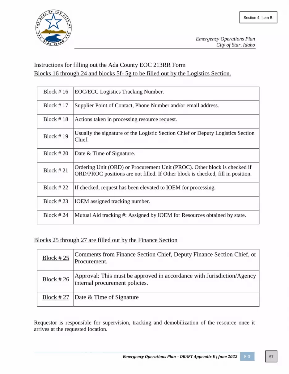
Emergency Operations Plan
City of Star, Idaho
Emergency Operations Plan – DRAFT Appendix E | June 2022 E-3
Instructions for filling out the Ada County EOC 213RR Form
Blocks 16 through 24 and blocks 5f- 5g to be filled out by the Logistics Section.
Block # 16 EOC/ECC Logistics Tracking Number.
Block # 17 Supplier Point of Contact, Phone Number and/or email address.
Block # 18 Actions taken in processing resource request.
Block # 19 Usually the signature of the Logistic Section Chief or Deputy Logistics Section
Chief.
Block # 20 Date & Time of Signature.
Block # 21 Ordering Unit (ORD) or Procurement Unit (PROC). Other block is checked if
ORD/PROC positions are not filled. If Other block is checked, fill in position.
Block # 22 If checked, request has been elevated to IOEM for processing.
Block # 23 IOEM assigned tracking number.
Block # 24 Mutual Aid tracking #: Assigned by IOEM for Resources obtained by state.
Blocks 25 through 27 are filled out by the Finance Section
Block # 25 Comments from Finance Section Chief, Deputy Finance Section Chief, or
Procurement.
Block # 26 Approval: This must be approved in accordance with Jurisdiction/Agency
internal procurement policies.
Block # 27 Date & Time of Signature
Requestor is responsible for supervision, tracking and demobilization of the resource once it
arrives at the requested location.
57
Section 4, Item B.

Emergency Operations Plan
City of Star, Idaho
Emergency Operations Plan – DRAFT Appendix E | June 2022 E-4
Requestor will provide resource tracking documentation to EOC Logistics when the resource is no
longer in use.
58
Section 4, Item B.

Emergency Operations Plan
City of Star, Idaho
Emergency Operations Plan – DRAFT Appendix E | June 2022 E-5
59
Section 4, Item B.

CITY OF STAR, IDAHO
CITY COUNCIL REGULAR MEETING MINUTES City Hall - 10769 W State Street, Star, Idaho
Tuesday, March 1, 2022 at 7:00 PM
DS/dlp Page 1 of 5
1. CALL TO ORDER – Welcome/Pledge of Allegiance
Mayor Chadwick opened the City Council Meeting at 7:00pm.
2. INVOCATION – Pastor Larry Osborn, Life Springs Church
Pastor Osborn offered the invocation.
3. ROLL CALL
Elected Officials: Council President David Hershey; Council Member Kevan Wheelock; Mayor Trevor
Chadwick; Council Member Jennifer Salmonsen. Council Member Nielsen was excused.
Staff: City Clerk Jacob Qualls; City Attorney Chris Yorgason; Star Police Chief Zach Hessing; Public Information
Officer Dana Partridge
4. PUBLIC INPUT
Jerry Arbiter – 351 South Crystal Springs Lane, Star, ID
Mr. Arbiter was there seeking information on city traffic issues and what steps were being taken to resolve
them.
Mayor Chadwick gave an overview:
Idaho Transportation Department (ITD) will begin widening Highway 44 from Linder Road to Highway 16 on
May 2, 2022. The construction will continue into summer with the result being a five-lane road. On April 20,
2020, the City of Star entered into a Proportionate Share Agreement with ITD, which requires developments
to pay a proportionate share for highway improvements within the city limits of Star. The widening of Star
Road to Can-Ada into a five-lane road is currently in the design phase and is expected to be constructed this
year and in 2023.
Additionally, ITD has the funding to widen Highway 16 to Star Road. Eventually there will be a five-lane road
from Can-Ada Road all the way into Boise, with the hope it will be completed by 2023 and alleviate the
traffic. There also plans with Ada County Highway District (ACHD) for part of the integrated five-year work
plans for bridges. The City has been trying to get them to move up the City of Star Road improvements
scheduled for 2035, which will require a new bridge section and will cause more traffic issues temporarily.
This year Highway 16 improvements will begin and go all the way to Interstate 84, with a goal for completion
by 2025. This will include four total overpasses, including one on Highway 16 going over Highway 44,
eliminating the intersection there. There is also funding for Highway 20-26 for widening from Middleton
Road to Interstate 84 into a five-lane road. This will widen it all the way from Caldwell to Boise.
60
Section 5, Item A.

CITY OF STAR, IDAHO
CITY COUNCIL REGULAR MEETING MINUTES City Hall - 10769 W State Street, Star, Idaho
Tuesday, March 1, 2022 at 7:00 PM
DS/dlp Page 2 of 5
Todd Lovell – 11371 West Hercules Drive, Star, ID
Mr. Lovell spoke on the Covenants, Conditions & Restrictions (CC&Rs) of subdivisions, expressing frustration
over the percentage of residents required at a meeting for there to be a quorum. He wanted it to be changed
to make it the same as any public entity so a majority of those in attendance would allow for things to be
passed.
City Attorney Chris Yorgason informed Mr. Lovell the city has no control over CC&Rs, as they are contracts
created by developers each neighbor agrees to when they buy a lot in the neighborhood. The city does not
review nor approve the CC&Rs at a city level, so each subdivision sets the level at whatever percentage they
want.
There was a brief discussion about how to get neighbors to attend meetings, with Mr. Lovell expressing
frustration due to his having tried those methods with no results. This has meant there can be no elections
for the Homeowners’ Association (HOA) and the same board gets re-elected. Additionally, he noted it is hard
to buy a home without an HOA unless you have a lot of money.
5. PRESENTATIONS
A. New Deputy Introductions – Chief Zach Hessing
Chief Hessing introduced Deputy Robert Denny, who will be filling the second position with the City of
Star Police Department. This will enable them to have two officers on shift for almost a full twenty-four
hours. Deputy Denny has nearly eleven years of experience working with law enforcement, with eight
and a half of those in Orange County, California where he had several special assignments. One of those
assignments was with the Mounted Enforcement Unit. In Idaho, Deputy Denny worked with the Boise
Police Department for almost two years, then made a lateral transfer to the Ada County Sheriff’s Office
in December before being assigned to Star.
B. Mayor’s Youth Council Scholarship Announcement – Mayor Chadwick
Mayor Chadwick spoke briefly on the Mayor’s Youth Council Scholarship. Any senior graduating in the
City of Star or nearby areas could apply for the Star Mayor’s Youth Scholarship, which was due March
15, 2022. Interested parties could apply via staridaho.org/myc. Those selected would earn up to $1,500
for a trade school or college.
6. CONSENT AGENDA (ACTION ITEM)
Council Member Salmonsen moved to approve the Consent Agenda consisting of 5A. Approval of Claims:
Provided and Previously Approved, and 5B. Findings of Fact & Conclusion of Law: Josh Kinney Annexation
/ Zoning / Planned Unit Development (AZ-21-19, DA-21-27 & PUD-21-002); Council President Hershey
seconded the motion. ROLL CALL VOTE: Hershey – aye; Wheelock – aye; Salmonsen – aye. Motion
carried.
61
Section 5, Item A.

CITY OF STAR, IDAHO
CITY COUNCIL REGULAR MEETING MINUTES City Hall - 10769 W State Street, Star, Idaho
Tuesday, March 1, 2022 at 7:00 PM
DS/dlp Page 3 of 5
7. ACTION ITEMS:
Item 5G Ordinance 347-2021: East Star River Ranch Rezone & Development Agreement (RZ-20-12 & DA-20-
28) was removed.
A. Stair Replacement Bid Award
Mayor Chadwick explained Bill’s Machine Stop will be replacing the current deteriorating concrete stairs
with ones with galvanized stair treads. This was not in the budget this year, so it will need to be added
in.
Council President Hershey moved to approve the Stair Replacement Bid Award; Council Member
Salmonsen seconded the motion. ROLL CALL VOTE: Hershey – aye; Wheelock – aye; Salmonsen – aye.
Motion carried.
B. Hunter’s Creek Park Playground Equipment Purchase
Mayor Chadwick explained this purchase of playground equipment was part of the City of Star’s Capital
Improvement Plan. City Attorney Chris Yorgason clarified this purchase was being made through an
organization called Source Well. Source Well is a cooperative purchasing agreement for the State of
Idaho under Idaho Code 67-2807 for City Councils to use instead of going through a formal bidding
process if the total does not exceed $50,000. Mayor Chadwick added this purchase was just for the
playground equipment and there will need to be another purchase for site work and concrete work. The
purchase was coming out of Park Impact Fees and would not be Taxpayer-Funded.
Council President Hershey moved to approve the Hunter’s Creek Park Playground Equipment Purchase
using the Cooperative Agreement through Source Well with any additional work need not exceed
$50,000; Council Member Salmonsen seconded the motion. ROLL CALL VOTE: Hershey – aye; Wheelock
– aye; Salmonsen – aye. Motion carried.
C. Riverbarn HVAC Bid
Mayor Chadwick explained this was to place an HVAC system in the Riverbarn as it has been utilized
often and without the HVAC system the units have been either very hot or very cold. This will come out
of Park Impact Fees as part of the Capital Expenditures on equipment for the facility. He suggested they
approve the bid from A-1 Heating and Air, as they were the only one to include electrical work.
Council President Hershey moved to approve the A-1 Heating and Air bid for a total of $13,842; Council
Member Wheelock seconded the motion. ROLL CALL VOTE: Hershey – aye; Wheelock – aye; Salmonsen
– aye. Motion carried.
62
Section 5, Item A.

CITY OF STAR, IDAHO
CITY COUNCIL REGULAR MEETING MINUTES City Hall - 10769 W State Street, Star, Idaho
Tuesday, March 1, 2022 at 7:00 PM
DS/dlp Page 4 of 5
D. Ordinance 366-2022: Architectural Overlay
Mayor Chadwick explained this would create a consistent look with any future developments within the
Central Business District.
Council Member Salmonsen moved to introduce Ordinance 366-2022: Architectural Overlay; Council
Member Wheelock seconded the motion. ROLL CALL VOTE: Hershey – aye; Wheelock – aye; Salmonsen
– aye. Motion carried.
Council Member Wheelock moved pursuant to Idaho Code Section 50-902 the rule requiring an
Ordinance be read on three different days, with one reading in full, be dispensed with and Ordinance
366-2022: Architectural Overlay be considered after reading once by title only; Council President
Hershey seconded the motion. ROLL CALL VOTE: Hershey – aye; Wheelock – aye; Salmonsen – aye.
Motion carried.
Council President Hershey moved to approve Ordinance 366-2022: Architectural Overlay and read the
title; Council Member Salmonsen seconded the motion. ROLL CALL VOTE: Hershey – aye; Wheelock –
aye; Salmonsen – aye. Motion carried.
E. Ordinance 345-2021: Grace Assisted Living Annexation & Development Agreement (AZ-21-13, DA-21-19
& CUP-21-04)
Mayor Chadwick explained this is for 90,000 square feet assisted living facility that will go in off Bent
Lane.
Council Member Salmonsen moved to introduce Ordinance 345-2021: Grace Assisted Living Annexation
and Development Agreement; Council President Hershey seconded the motion. ROLL CALL VOTE:
Hershey – aye; Wheelock – aye; Salmonsen – aye. Motion carried.
Council Member Wheelock moved pursuant to Idaho Code Section 50-902 the rule requiring an
Ordinance be read on three different days, with one reading in full, be dispensed with and Ordinance
345-2021: Grace Assisted Living Annexation and Development Agreement be considered after reading
once by title only; Council President Hershey seconded the motion. ROLL CALL VOTE: Hershey – aye;
Wheelock – aye; Salmonsen – aye. Motion carried.
Council President Hershey moved to approve Ordinance 345-2021: Grace Assisted Living Annexation and
Development Agreement and read the title; Council Member Wheelock seconded the motion. ROLL CALL
VOTE: Hershey – aye; Wheelock – aye; Salmonsen – aye. Motion carried.
63
Section 5, Item A.

CITY OF STAR, IDAHO
CITY COUNCIL REGULAR MEETING MINUTES City Hall - 10769 W State Street, Star, Idaho
Tuesday, March 1, 2022 at 7:00 PM
DS/dlp Page 5 of 5
F. Ordinance 361-2022: Union Street Development & Development Agreement (RZ-21-07, DA-21-25 &
ZC21-19)
Mayor Chadwick explained this is for the empty lot across the street from Bi-Mart where a new
commercial business is going in. It will be an eatery, and likely a sandwich shop.
Council Member Salmonsen moved to introduce Ordinance 361-2022: Union Street Development and
Development Agreement; Council President Hershey seconded the motion. ROLL CALL VOTE: Hershey
– aye; Wheelock – aye; Salmonsen – aye. Motion carried.
Council Member Wheelock moved pursuant to Idaho Code Section 50-902 the rule requiring an
Ordinance be read on three different days, with one reading in full, be dispensed with and introduce
Ordinance 361-2022: Union Street Development and Development Agreement be considered after
reading once by title only; Council President Hershey seconded the motion. ROLL CALL VOTE: Hershey –
aye; Wheelock – aye; Salmonsen – aye. Motion carried.
Council Member Salmonsen moved to approve introduce Ordinance 361-2022: Union Street
Development and Development Agreement and read the title; Council Member Wheelock seconded the
motion. ROLL CALL VOTE: Hershey – aye; Wheelock – aye; Salmonsen – aye. Motion carried.
G. Roseland Property Lease Memorandum of Understanding (City of Star & West Ada School District)
Mayor Chadwick explained this is the nine acres of land in front of Roseland’s initially dedicated as a
school on New Hope. There has since been a land swap and the school currently does not have plans for
developing it. This will allow the City of Star to build a park on the nine acres.
Council President Hershey moved to approve the Roseland Property Lease as stated with the conditions
in the Memorandum of Understanding and allow Mayor Chadwick to sign and move forward with the
lease; Council Member Salmonsen seconded the motion. ROLL CALL VOTE: Hershey – aye; Wheelock –
aye; Salmonsen – aye. Motion carried.
H. Executive Session 74-206(f)
Council Member Wheelock moved to go into Executive Session 74-206(f) to communicate with legal
counsel for public agency to discuss the legal ramifications and legal options for pending litigation or
controversies not yet being litigated but eminently likely to be litigated; Council Member Salmonsen
seconded the motion. ROLL CALL VOTE: Hershey – aye; Wheelock – aye; Salmonsen – aye. Motion
carried. Entered Executive Session 7:41pm and returned at approximately 8:00 pm with no decision
being made.
8. ADJOURNMENT
Mayor Chadwick adjourned the meeting at approximately 8:00 pm.
_____________________________ ATTEST: ______________________________ Trevor A Chadwick, Mayor Jacob M Qualls, City Clerk / Treasurer
64
Section 5, Item A.

CITY OF STAR, IDAHO
CITY COUNCIL REGULAR MEETING MINUTES City Hall - 10769 W State Street, Star, Idaho
Tuesday, March 15, 2022 at 7:00 PM
DS/dlp Page 1 of 10
1. CALL TO ORDER – Welcome/Pledge of Allegiance Mayor Chadwick opened the City Council Meeting at 7:00pm.
2. INVOCATION – Pastor Larry Osborn, Life Springs Church Pastor Osborn offered the invocation.
3. ROLL CALL Elected Officials: Council President David Hershey; Council Member Kevan Wheelock; Mayor Trevor Chadwick; Council Member Jennifer Salmonsen. Council Member Nielsen was excused. Staff: City Clerk Jacob Qualls; City Attorney Chris Yorgason; Star Police Chief Zach Hessing; PIO Dana Partridge
4. PRESENTATIONS & PROCLAMATIONS A. Vietnam Veteran Proclamation: Declaring March 29, 2022 as Vietnam Veteran’s Recognition Day
Public Information Officer Dana Partridge spoke on the proclamation, explaining the City of Star was approved as a program partner with the Department of Defense’s Vietnam War 50th Anniversary Commemoration. The City of Star was the first city in the Treasure Valley, and one of only three cities in the state of Idaho, to become a program partner. As a program partner, the City of Star pledged to host annual events to thank and honor Vietnam Veterans through 2025. The first event was the reading of the Vietnam Veteran Proclamation that night by Mayor Chadwick. The second event, the first Annual Veterans Day Potato Feed – where all Veterans would eat for free, would take place on November 11, 2022. Vietnam Veterans would also be receiving lapel pins, along with a certificate, issued by the Department of Defense and presented in a ceremony by Mayor Chadwick. Vietnam Veterans in the community could register at staridaho.org/veterans – this page would also become a home for resources for Veterans. Veterans, Gold Star Families, and Veteran supporters could also register to stay informed on this event and all future events. Local groups who had already committed to assisting with the potato feed were Southwest Idaho Business Alliance, the American Legion Middleton/Star Post 39, the American Legion Auxiliary Unit 39, and the Daughters of the American Revolution Eagle Chapter. Mayor Chadwick read the proclamation, thus having the City of Star join 56 U.S. States and Territories
in declaring March 29th as National Vietnam Veterans Recognition Day, which was a result of the
Vietnam War Veterans Recognition Act being signed on March 28, 2017.
Mayor Chadwick and Council President Hershey both spoke regarding being Veterans, their
appreciation for those who came before them, and the importance of National Vietnam Veterans
Recognition Day.
65
Section 5, Item B.

CITY OF STAR, IDAHO
CITY COUNCIL REGULAR MEETING MINUTES City Hall - 10769 W State Street, Star, Idaho
Tuesday, March 15, 2022 at 7:00 PM
DS/dlp Page 2 of 10
B. Owyhee Storm High School Men’s Basketball Proclamation: Declaring March 22, 2022 as The
Owyhee Storm Men’s Basketball Day
Mayor Chadwick spoke on the proclamation, explaining it would honor Owyhee High School and their
basketball team, Owyhee Storm, winning the 5A State Championship under Varsity Head Coach Andy
Harrington. He presented team members with certificates and City of Star pins, including some to give
to their teammates who were not in attendance.
C. Ada County Sheriff Matt Clifford: Presentation
Sheriff Clifford spoke on the Sheriff’s Office, giving a brief overview of the resources provided. Ada County Sheriff’s Office was the largest among local law enforcement agencies in Idaho, with the most diversity in the type of work they do. The agency had roughly 1,060 square miles of land, 3,000 miles of roadway, Ada County waterways, and unincorporated areas in Star, Eagle, and Kuna to patrol. Ada County Sheriff’s Office had five different bureaus: police, jail, court, administration, and communications. The City of Star had a contract for police services, including patrol deputies at community events, the largest K-9 unit in the State of Idaho, a metro SWAT unit combining Meridian and Garden City, a narcotics unit, deputies devoted to high-risk warrants and street crimes, a detectives crime lab, school resource officers, a dive team partnered with fire and rescue used for recovery of items such as cars and weapons, eleven drones, and community relations officers responsible for special events. The Sheriff’s Office also had charge of the largest jail in the State of Idaho. Maintaining safety and well-being for inmates was the biggest part of their budget, which helped provide meals, clothes, and medical services. Additionally, they provided community transition programs to get the right people out of the jail and to keep the right people in jail. These programs allowed eligible individuals to remaining working to assist with paying fines and reports costs, along with controlling overcrowding as the rising population in Ada County caused the population within the jail to also rise. If those within the program did not adhere to the specific conditions, they were required to return to jail. Other services provided through the court were misdemeanor probation by statute, civil services throughout the county such as garnishments or paper service evictions. The court also utilized an in-house training unit for certifications or refreshers on previous training, with many of those going through it being sworn officers. Additionally, rather than send officers to Idaho Post Academy, they ran their own academy teaching Idaho Post Academy approved criteria and topics for detention and patrol. Court Security also fell under the most important aspects of court services, including maintaining the safety of the facility, court hearings going as scheduled, the safety of judges and all elected officials inside the courthouse, transportation of inmates from jail to court, transportation of inmates from jail to doctor appointments or surgery, and deputies being with inmates during doctor appointments or surgery.
66
Section 5, Item B.

CITY OF STAR, IDAHO
CITY COUNCIL REGULAR MEETING MINUTES City Hall - 10769 W State Street, Star, Idaho
Tuesday, March 15, 2022 at 7:00 PM
DS/dlp Page 3 of 10
Finances for the Ada County Sheriff’s Office went through administrative services. By Statute, the Sheriff was responsible for any fiscal downfall occurring at the Sheriff’s Office. Budget proposals, record services, data analytics, human resources, managing storage and evidence, and driver’s license services were all handled through administrative services. Services provided through the Communications Bureau included running the dispatch center – police agencies, fire agencies, and paramedics – for all of Ada County and tech ops which maintained all high-tech gear. Additionally, they had a Dispatch Center other counties had come to so they could see how things are run to emulate them.
D. Star Police Reports: Law Enforcement Chief Zach Hessing gave the monthly Star Police Report for February with data pulled from ITS, a report database system. There was a total of eighteen crimes documented and committed, with nine person crimes, six property crimes, and three society crimes equaling 14.9 crimes per thousand people. The police were being more proactive than the month before, with 699 versus the previous 401. Code 3 calls had a six second increase making the average response time three minutes and thirty-four seconds. The police would continue to be proactive in coming months and would be increasing security checks on construction sites late at night. Council Member Salmonsen sought clarification on what exactly a Code 3 call was. Chief Hessing explained the different priorities: routine calls made when there was time, more urgent calls requiring immediate attention but at a normal pace, and extremely urgent calls requiring immediate response with lights and sirens to get there as quickly as possible. The last priority was a Code 3, where someone would be in imminent danger such as domestic calls or injury crashes. Salmonsen asked how many Code 3 calls Star Police get within a month. Chief Hessing stated, on average, there are three a month.
E. Star Building Department Reports: Building Permits (02/2022) Mayor Chadwick gave the Star Building Department Report, stating there were 70 building permits issued in February.
5. CONSENT AGENDA (ACTION ITEM)
Council Member Salmonsen moved to approve the Consent Agenda consisting 5A. Approval of Minute (June 15, 2021; October 12, 2021; December 21, 2021), 5B. Approval of Claims Provided and Previously Approved, 5C. Final Plat: Wildrye Subdivision Phase 3 and 4 (FP-21-33 and FP-21-34), 5D. Findings of Fact: Springtree Estates Subdivision (AZ-21-16 / DA-21-24 / PP-21-19), 5E. Findings of Fact: Kirshner-Dill Annexation (AZ-21-15 / DA-21-23), and 5F. Findings of Fact: Star River Meadows Subdivision Annexation (AZ-21-17); Council Member Wheelock seconded the motion. ROLL CALL VOTE: Hershey – aye; Wheelock – aye; Salmonsen – aye. Motion carried.
67
Section 5, Item B.

CITY OF STAR, IDAHO
CITY COUNCIL REGULAR MEETING MINUTES City Hall - 10769 W State Street, Star, Idaho
Tuesday, March 15, 2022 at 7:00 PM
DS/dlp Page 4 of 10
6. PUBLIC HEARINGS with ACTION ITEMS: A. PUBLIC HEARING: South of the River Plan
Ryan Field spoke on the South of the River Plan, explaining it was not intended to negatively impact any landowner but rather create a plan to potentially implement, should the land within the sub-area develop, to maximize property values and control the impact within the City of Star. He noted the framework of the plan was conceptual so any final platting of locations, road alignments, park sizes, or subdivisions would be dependent on proposals brought before City Council. As such, it would change based on applications received.
He stated he would be discussing the two main areas with the most changes. The first was the economic
development of the City of Star. He explained the subarea was developed and broken into four nodes:
the Riverfront Center and Main Street, the Star-Chinden Gateway, the Chinden Commercial Area, and
the Star-Joplin Neighborhood Services. Each of the areas would be able to provide 1.7 million square
feet of economic growth with commercial space and mixed-use space.
The Riverfront center, down Main Street by the river, would provide a unique development opportunity
such as the San Antonio Riverwalk. It would be walkable with businesses protected from an e-commerce
perspective. The Star-Joplin Neighborhood might not remain as busy an intersection in the future, but
due to the expansions of Highway 16 and the intersection itself, it would be a central piece of the plan
allowing for ‘going to work’ and ‘coming home’ economic development opportunities such as grocery
or financial institutions. The intersection of Star Road and Chinden Boulevard would remain very busy
and would become a gateway to introducing people to Star as a main entrance to the community in the
north. This area could be mixed-use with a variety of commercial and different economic opportunities
mixed with residential. On either side of the intersection, would be the Chinden Commercial Light
Industrial Flex to the east and west which would create opportunities for commercial growth along the
main corridor of Chinden Boulevard.
The second area with the most changes was housing, which developed based on input from key decision
makers in the community and landowners. Like before, the subarea was divided into four nodes: the
River Valley East, the River Valley West, the Chinden Boulevard East Overlook, and the Chinden
Boulevard West Overlook. These areas, equaling 1100 acres, could produce 3700 residences depending
on density.
Regarding open space, on the map there was not a lot of predetermined areas marked. The intent,
which was added to the text of the plan, was to have the overall open space be equal to twenty percent
and be divided amongst the individual residential developments or be something like a central park. All
residential developments would have public pathways connecting them to all recreation areas and the
river. All slopes along the benches would be retained as open space, limiting them to open space and
68
Section 5, Item B.

CITY OF STAR, IDAHO
CITY COUNCIL REGULAR MEETING MINUTES City Hall - 10769 W State Street, Star, Idaho
Tuesday, March 15, 2022 at 7:00 PM
DS/dlp Page 5 of 10
greenway areas which could be credited to required open space so long as they were usable. The goal
was to protect the unique features presented by the slope areas.
The map used Star Road as a divider for north and south, with Joplin Road as a divider for east and west.
These dividers created River Valley west, River Valley east, and the Chinden Overlooks. In River Valley
East, the open space along the eastern edge would have a buffer between the future development and
the Stonebriar development. In River Valley west, the lots would be Estate Residential with verbiage to
limit the density to no more than two dwelling units per acre in the hopes the larger lots will preserve
the rural feel. The larger lots would also create different development opportunities such as pasture
areas or large lawns. The Chinden east overlook had changes in verbiage for density along the benches
be managed in ways encouraging pedestrian access, open space, and protection of the geography of
the area. Some areas had density changed to high density residential and mixed-use at the requestion
of a property owner. For the West Overlook, there would be commercial along Can-Ada Road and
Chinden Boulevard, as well as neighborhood residential and estate lots. Again, the estate lots would be
limited to one to two dwelling units per acre and the density along the bench should be managed to
encourage pedestrian access, open space, and protection of the slope area.
There would be opportunity to have higher density residential or compact residential in the middle of
the four areas within the subarea, with density becoming less and less as the areas branched out. Most
of the commercial opportunities would be along the key travel corridors. Some possibilities were a
fishing pond with a commercial piece near it allowing for a deck or pier going into the pond for fishing
while also allowing public access and opportunities for shops or restaurants. There could be compact
residential, high density residential, and neighborhood residential nearby which would feed into the
area.
One area was preferred to be commercial rather than open space per a request by a landowner.
Approval was being sought for the change that evening. Another approval of change was being sought
for a high density residential and mixed-use area in the east Chinden overlook. It was using the term
multi-family and the change would have it become high density designation. Part of the approval would
include the aforementioned changes as an addendum in the Comprehensive Plan, after which Staff
would draft a resolution the City Council could approve at the next City Council Meeting. Then Staff
could draft an ordinance to amend the unified development code the City Council could approve
referencing the South of the River subarea and coincide with additional comprehensive plan changes
and UDC changes which would be brought before council at a future date.
Council President Hershey asked how many days of public input they got, how many comments they
received, and how many times the city sent out notifications asking for input. Ryan Field stated
landowners were solicited in the subarea three times with a letter asking for them to go the City of Star
website to review the plan and provide feedback. They received a lot of feedback from those
landowners which was built into the plan. In February of 2021 a stakeholder meeting was held where
69
Section 5, Item B.

CITY OF STAR, IDAHO
CITY COUNCIL REGULAR MEETING MINUTES City Hall - 10769 W State Street, Star, Idaho
Tuesday, March 15, 2022 at 7:00 PM
DS/dlp Page 6 of 10
people living in the area were invited to a roundtable type discussion where they were asked to look at
plans and give feedback on them. In April of 2021 four open houses were held at the Riverhouse which
were very well attended. Additionally, the city had made themselves available online, through
telephone communications, e-mails, and letters.
Mayor Chadwick prompted a discussion regarding open space, particularly when it came to the Phillips
family property. He suggested changing the designation to Neighborhood Residential with the intention
of having all the twenty percent open space there. Shawn Nickel noted a very similar intent was already
in place regarding the overlook area. Mayor Chadwick added there were several undevelopable areas
along the river, citing this as the reason they were being listed as open space.
Council Member Wheelock asked if the area by the river in the hundred-year flood plain was considered
part of the open space or if it was exempt. Ryan Field stated on page 3-3 there were an included 180
acres from the floodway in the land use categories. This included approximately 350 acres of parks,
open space, trails, etc. It was his understanding the floodway was included. Mayor Chadwick added the
buffer zone near Stonebriar being considered part of the open space requirement.
Council Member Wheelock sought clarification on it not being a mandatory plan, but an expected plan
based on understanding the landowners and taking them into consideration. Ryan Field confirmed it
was just one vision and possible future for the area, but until the applications regarding those parcels
actually came before them it would be impossible to know what would go where. He also read the text
at the top of the map: The illustrative vision plan highlights a visionary concept depicting the possible
distribution of land uses, connectivity between neighborhoods and to arterials, and the level of
amenities expected in regard to natural areas and open space pathways and parks. The vision plan is
illustrative in nature and defines only one possible development option.
Council Member Salmonsen sought clarification regarding several aspects of the map and proposed
plan. First, she noted there was an area below Joplin Road, on the east side of Star Road, labeled
Neighborhood Residential despite it being Rural Residential in the document’s recommended future
land use map on page 1-9. She wanted to know which was the correct designation. Ryan Field stated
they would take it into consideration and be sure the maps match.
Next, she referenced the new definition for Estate Residential, wondering whether the name should be
changed to prevent confusion as it would no longer match what was in the Comprehensive Plan. Shawn
Nickel explained they were going to keep the Estate Residential with further definitions for specific
areas within the sub-area plan stating parcels would only be allowed to develop at two units per acre
maximum. He noted there was a separate chapter in the Comprehensive Plan where that would tie in
and gave a reminder the future land use map would not look like the one presented. It would have one
designation, South of the River Plan, which would then have Comprehensive Plan text in the subarea
section which would have a bubble map like the one presented.
70
Section 5, Item B.

CITY OF STAR, IDAHO
CITY COUNCIL REGULAR MEETING MINUTES City Hall - 10769 W State Street, Star, Idaho
Tuesday, March 15, 2022 at 7:00 PM
DS/dlp Page 7 of 10
Council Member Wheelock then prompted a discussion on how many acres were within each of the
squares on the conceptual map if the designations were being altered inside the subarea. Mayor
Chadwick noted the text outlines how much acreage is desired and the map itself will act as a guideline
to let landowners know what the City of Star wants. Ryan Field confirmed while it is conceptual, they
have identified certain areas where there will be active commercial and where they will not want
residential. Ultimately it will be key to have good communication and collaboration with various
landowners and developers who come into the area. Mayor Chadwick added they were trying to create
a walkable, livable, and playable area while Ryan Field added having the areas designated and
delineated would also open up the value of the area to landowners. They have worked with consultants
for this plan, who have helped them determine the best locations around the commercial areas so they
can best utilize the infrastructure. Council Member Wheelock agreed it was best to help values and
longevity, noting if they were going to lose all the beautiful farmland, they should have something of
value to replace it.
For all that to happen, there would need to be successful transportation, sewer, and water
improvements. Although they were currently being worked on, the ultimate vision of the subarea would
be difficult with a two-lane Star Road. As such, roads needed to be extended and connected with major
traffic improvements. Mayor Chadwick stated he was already communication with ACHD trying to get
the improvements moved up from the projected 2035.
Council President Hershey sought clarification on annexation, wanting to be sure the areas had to
annexed. If this was the case, it would be good as it was purely legislative and not quasi-judicial. Mayor
Chadwick noted there would be no forced annexations. Hershey added there would be no entitled
rights, they would have to approve the annexations and would not if something about it did not feel
like the right fit for the vision or if the infrastructure wasn’t ready.
PUBLIC TESTIMONY
Michael Keyes – 338 South Long Bay Way, Star, ID
Mr. Keyes stated the City Council had done a great job in listening to landowner input, particularly the
concerns over parks and open space, which both were addressed. The only landowner he felt hadn’t
had their concerns addressed were the Beans, as the current iteration of the plan negated the
accommodations previously made. Their request, like many other landowners, was their property not
be used as open space. The current plan had open space directly over their existing residence. They had
also requested their pasture be in the plan for three to five dwelling units per acre. The previous plan
had the pasture listed as one to three, while the current plan had the area designated as Rural
Residential – one or less. He noted the Beans had drafted two separate letters and appeared at
workshops regarding these concerns.
71
Section 5, Item B.

CITY OF STAR, IDAHO
CITY COUNCIL REGULAR MEETING MINUTES City Hall - 10769 W State Street, Star, Idaho
Tuesday, March 15, 2022 at 7:00 PM
DS/dlp Page 8 of 10
Next, Mr. Keyes spoke on the South of the River Plan having been in existence since the fourth quarter
of 2020. This was not accurate, as the specific date given was when the City of Star began writing checks.
In actuality, the concept of the South of the River plan was introduced at the beginning of the
Comprehensive Plan updates and was adopted by the City of Star in the fourth quarter of 2018. He
encouraged them to adopt the changes Ryan Field proposed, but asked they consider the requests the
Beans have expressed.
There was a brief discussion regarding the location of the Bean property and why it was being designated as Rural Residential. Mayor Chadwick noted they could adopt the plan and figure out the designation later. Both Mr. Keyes and Council Member Wheelock added the Beans have done a great job at already defending their property as open space with their landscaping. Mayor Chadwick wanted to know why Rural Residential was placed there when it was the only use of the designation in the entire area. Ryan Field stated if they had gone back on the accommodations, they would investigate. They would not have wanted to. He also confirmed they could make the change to Neighborhood Residential. He felt they had chosen Rural Residential for two reasons: part of the area was in the wetlands, and the request had asked for no lower than R2. It was noted Estate Residential had been established not long after that. Mayor Chadwick listed the changes: the area in the upper east quadrant by Highway 16 being made commercial, Neighborhood Residential being used on the Phillip’s property, the park being made into neighborhood residential, the beans property becoming neighborhood residential, and verbiage changes. Council Member Wheelock asked what the verbiage changes would do. Ryan Field explained they were changing it from ‘multi-family dwellings’ to a high-density designation. Mayor Chadwick added the high-density designation allows for townhomes where the multi-family does not, so this change would allow another option of residential style. Ryan Field added other changes: redefining estate residential, making sure the high-density use is only able to be used as part of a Planned Unit Development (PUD), the open space barrier/buffer between the development and the Stonebriar subdivision, adding language regarding the bench density for it to be managed to encourage pedestrian access, open space, and protection of the geography of the area. The Public Hearing was closed at 8:39pm. CITY COUNCIL DELIBERATIONS Council President Hershey noted Council Member Salmonsen had brought up the change regarding the pocket of property.
Council President Hershey moved to approve the South of the River Plan with the changes mentioned. Council Member Salmonsen seconded the motion. ROLL CALL VOTE: Hershey – aye; Wheelock – aye; Salmonsen – aye. Motion carried.
72
Section 5, Item B.

CITY OF STAR, IDAHO
CITY COUNCIL REGULAR MEETING MINUTES City Hall - 10769 W State Street, Star, Idaho
Tuesday, March 15, 2022 at 7:00 PM
DS/dlp Page 9 of 10
7. ACTION ITEMS A. Ordinance 362-2022: Star River Meadows Subdivision Annexation
Council Member Salmonsen moved to introduce Ordinance 362-2022: Star River Meadows Subdivision Annexation; Council President Hershey seconded the motion. ROLL CALL VOTE: Hershey – aye; Wheelock – aye; Salmonsen – aye. Motion carried.
Council President Hershey moved pursuant to Idaho Code Section 50-902 the rule requiring an Ordinance be read on three different days, with one reading in full, be dispensed with and Ordinance 362-2022: Star River Meadows Subdivision Annexation be considered after reading once by title only; Council Member Wheelock seconded the motion. ROLL CALL VOTE: Hershey – aye; Wheelock – aye; Salmonsen – aye. Motion carried.
Council Member Salmonsen moved to approve Ordinance 362-2022: Star River Meadows Subdivision Annexation and read the title; Council President Hershey seconded the motion. ROLL CALL VOTE: Hershey – aye; Wheelock – aye; Salmonsen – aye. Motion carried.
B. City Hall Upgrade Neurilink Proposals: Approving Neurilink as a Sole Source for upgrading Audio / Visual needs for the Star City Council Chambers; approving Audio and Visual Proposals City Attorney Yorgason clarified this is not a ‘sole source’ but goes through a cooperative which allows the City of Star to use a company already chosen by a different city within the cooperative without having to go through a bidding process. Council President Hershey added going through the process essentially meant the company had already been vetted.
Council President Hershey moved to approve Neurilink for use in both the audio and visual proposals; Council Member Wheelock seconded the motion. ROLL CALL VOTE: Hershey – aye; Wheelock – aye; Salmonsen – aye. Motion carried.
C. Ordinance 347-2021: East Star River Ranch Rezone and Development Agreement (RZ-20-12 & DA-20-28)
Council Member Salmonsen moved to introduce Ordinance 347-2021: East Star River Ranch Rezone and Development Agreement; Council President Hershey seconded the motion. ROLL CALL VOTE: Hershey – aye; Wheelock – aye; Salmonsen – aye. Motion carried.
Council President Hershey moved pursuant to Idaho Code Section 50-902 the rule requiring an Ordinance be read on three different days, with one reading in full, be dispensed with and introduce Ordinance 347-2021: East Star River Ranch Rezone and Development Agreement be considered after reading once by title only; Council Member Wheelock seconded the motion. ROLL CALL VOTE: Hershey – aye; Wheelock – aye; Salmonsen – aye. Motion carried.
Council President Hershey moved to approve introduce Ordinance 347-2021: East Star River Ranch Rezone and Development Agreement and read the title; Council Member Wheelock seconded the motion. ROLL CALL VOTE: Hershey – aye; Wheelock – aye; Salmonsen – aye. Motion carried.
73
Section 5, Item B.

CITY OF STAR, IDAHO
CITY COUNCIL REGULAR MEETING MINUTES City Hall - 10769 W State Street, Star, Idaho
Tuesday, March 15, 2022 at 7:00 PM
DS/dlp Page 10 of 10
D. Executive Session 74-206(f): To communicate with legal counsel for the public agency to discuss the legal ramifications of and legal options for pending litigation, or controversies not yet being litigated but imminently likely to be litigated.
Council President Hershey moved to go into Executive Session; Council Member Salmonsen seconded the motion. ROLL CALL VOTE: Hershey – aye; Wheelock – aye; Salmonsen – aye. Motion carried.
The City Council entered Executive Session at 9:23pm and returned to regular session at 9:24pm. No actions taken.
8. ADJOURNMENT
Mayor Chadwick adjourned the meeting at 9:24 p.m.
_____________________________ ATTEST: ____________________________
Trevor A Chadwick, Mayor Jacob M Qualls, City Clerk /
Treasurer
74
Section 5, Item B.

FILE # FP-22-10 / FP-22-11 GREINERS HOPE SPRINGS
FINAL PLAT PHASE 5 & 6 1
CITY OF STAR
LAND USE STAFF REPORT
TO: Mayor & Council
FROM: City of Star, Idaho – Planning & Zoning Department
MEETING DATE: June 21, 2022
FILE #: FP-22-10 Final Plat, Greiner’s Hope Springs Subdivision Phase 5
FP-22-11 Final Plat, Greiner’s Hope Springs Subdivision Phase 6
REQUEST
The Applicant is seeking approval of a Final Plat for Greiner’s Hope Springs Subdivision Phase 5
consisting of 42 residential lots and 2 common lots on 10.05 acres and Greiner’s Hope Springs
Subdivision Phase 6 consisting of 53 residential lots and 3 common lots on 11.3 acres. The
subject property is generally located on the south side of W. New Hope Road, approximately
1,600 feet east of N. Munger Road in Star, Idaho. Ada County Parcel Number is R76268000015.
APPLICANT/OWNER/REPRESENTATIVE
Owner/Applicant:
Richland American Homes of Idaho, Inc.
Joe Austin
1804 N. Midland Blvd
Nampa, Idaho 83651
PROPERTY INFORMATION
Land Use Designation: Residential (R-4)
Phase 5 Phase 6
Acres: 10.05 Acres 11.30 Acres
Residential Lots: 42 53
Common Lots: 2 3
Commercial: 0 0
Total Residential Units 42 Units 53 Units
75
Section 5, Item C.

FILE # FP-22-10 / FP-22-11 GREINERS HOPE SPRINGS
FINAL PLAT PHASE 5 & 6 2
HISTORY
• On April 18, 2006, the City Council approved an annexation and zoning (AZ-06-06) for
parcel no. R7626790405 containing 11.17-acres with a zoning designation of R-3.
• On August 20, 2019, the City Council approved annexation and zoning, development
agreement and preliminary plat for Greiner’s Hope Springs Subdivision (AZ-19-05/DA-
19-06/PP-19-03).
• On June 2, 2020, the Council approved the Final Plat for Phase 1 of Greiner’s New Hope
Subdivision with 38 residential lots and 8 common lots on 11.41 acres.
• On October 6, 2020, the Council approved the Final Plat for Phase 2 of Greiner’s New
Hope Subdivision with 44 residential lots and 3 common lots on 9.79 acres. (FP-20-16)
• On July 6, 2021, the Council approved the Final Plat for Phase 3 of Greiner’s New Hope
Subdivision with 37 residential lots and 6 common lots on 10.27 acres. (FP-21-14)
• On January 11, 2022, the Council approved the Final Plat for Phase 4 of Greiner’s New
Hope Subdivision with 38 residential lots and 6 common lots on 9.88 acres. (FP-21-30)
GENERAL DISCUSSION
The Applicant is requesting approval of the Final Plats for Phases 5 & 6 of Greiner’s Hope
Springs Subdivision.
The approved Preliminary Plat consists of 252 single family residential lots and 18 common lots.
There are two existing dwellings that will remain and be platted as individual lots. The residential
lots range in size from 5,000 square feet to 29,345 square feet (existing dwelling lot), with an
average lots size of 6,885 square feet. The applicant has indicated that the development will
contain a total of 11.62 acres (18.5%) open space. Although the application was submitted prior
to the adoption of Ordinance 290 requiring a minimum of 15% open space, 10% usable, the
applicant has provided 13.5% (8.49 acres) more open space than the required 5% in the Code
that was relevant at the time of submittal of the application. Staff has interpreted and calculated
the total usable open space provided as 7.4 acres, or 11.8% usable. This amount excludes
drainage areas*, although the drainage areas are designed as grassed areas with minimal slope.
Staff calculations do include the planting strips along the roadways for the proposed detached
sidewalks. *Adding the drainage areas would increase the usable open space to 8.97 acres
(14.3%).
The Unified Development Code in affect at the time of approval required one site amenity for
each 20-acres of development area (total of 3 amenities required). Proposed amenities within
the development include the following:
• Quality of Life Amenities – Proposed pathway system, seasonal stream and ponds with
waterfalls, benches, community gardens, hanging flower baskets
• Clubhouse for gatherings and private events and with Parking Lot
76
Section 5, Item C.

FILE # FP-22-10 / FP-22-11 GREINERS HOPE SPRINGS
FINAL PLAT PHASE 5 & 6 3
• Additional Open Space in excess of 5% (as required by Code in affect at time of
submittal)
• Detached 5’ sidewalks with 8’ landscape strips
• Usable landscaped storm water detention areas
Irrigation to the property will be provided by the Middleton Mill Irrigation District. The applicant
has been working with the district.
The ingress/egress will be taken from W. New Hope Road. The design shows several future
street connections to adjacent properties, including connection to the currently developing
Sailing Hawks and Fallbrook Subdivisions.
The development received Specific Setbacks as Requested:
Greiner’s Hope Springs
Front Setbacks - 15’ for living area, 26’ to garage door (measured from property line)
Interior Side Setback – 5 feet (for one and two story)
Street Side Setback – 15 feet for dwelling
26 feet for garage
Locations for decorative streetlights are reflected on the submitted lighting plan. Streetlight
design has also been submitted and meets the intent of the City’s “Dark sky lighting” standards.
If a pump house is proposed, a location needs to be called out on the site plans and identified in
the “Notes”.
Fencing is being proposed to be solid cedar or vinyl fencing along the boundary and within the
subdivision with potential open fencing proposed between the residential lots and the central
open space/common lots containing the streams. Any fencing shall reflect the Clear Vision
Triangle regulations.
All internal roads are proposed as public streets and shall be 36’ from back of curb to back of
curb.
The Applicant received a waiver from Council for exceeding the 750’ block lengths for two
blocks within this subdivision. The blocks that would be affected would be Block 1 and Block 7.
The applicant indicated that the subdivision would develop in four to five phases. The applicant
has requested flexibility in phasing in order to adjust the number of lots and combination of lots
to reflect changing market conditions.
Landscaping as required by the Unified Development Code, Street Trees; the minimum density
of one (1) tree per thirty-five (35) linear feet is required. The landscaping plan does meet this
77
Section 5, Item C.

FILE # FP-22-10 / FP-22-11 GREINERS HOPE SPRINGS
FINAL PLAT PHASE 5 & 6 4
requirement as submitted. (Please see “Treasure Valley Tree Selection Guide”, as adopted by the
Unified Development Code.)
The submitted final plat meets the conditions of approval for the approved preliminary plat
application.
Staff analysis of Final Plat Submittal:
Lot Layout – The gross density of Phase 5 is 4.17 du/acre, and the gross density of Phase 6 is
4.69 du/acre. Both phases contain lots ranging in size consistent with the approved preliminary
plat. After phases 5 and 6 are complete, all 252 lots approved on the preliminary plat will
have been platted.
Setbacks – The development was approved with special setbacks.
Front Setbacks - 15’ for living area, 26’ to garage door (measured from property line)
Interior Side Setback – 5 feet (for one and two story)
Street Side Setback – 15 feet for dwelling
26 feet for garage
Common/Open Space and Amenities – Amenities have been installed in previous phases of the
development. The sidewalks will be detached with a landscape strip. The submitted landscape
plan meets the standards of the current zoning ordinance, including street trees. The applicant
shall use “Tree Selection Guide for Streets and Landscapes throughout Idaho”, as adopted by
the Unified Development Code.
Streetlights – Streetlight plan/design specifications have been submitted with the final plat
application. The streetlight design meets the dark sky standards consistent with the intent of the
city. Streetlights shall be consistent throughout the remaining phases of the subdivision.
Mailbox Cluster – Location has been approved for previous phases and will be the same location
for all phases. Letter of approval was included in the application packet.
Street Names - Applicant has provided documentation from Ada County that the
proposed street names have been approved. Correct street names are reflected on the
final plat.
Landscape – Landscaping as required by the Unified Development Code, Street Trees; the
minimum density of one (1) tree per thirty-five (35) linear feet is required. The
landscaping plan, as submitted appears to satisfy this requirement. Common Area
landscape requirements call for one deciduous shade tree per 4,000 square feet. The
plan as submitted meets these requirements.
78
Section 5, Item C.
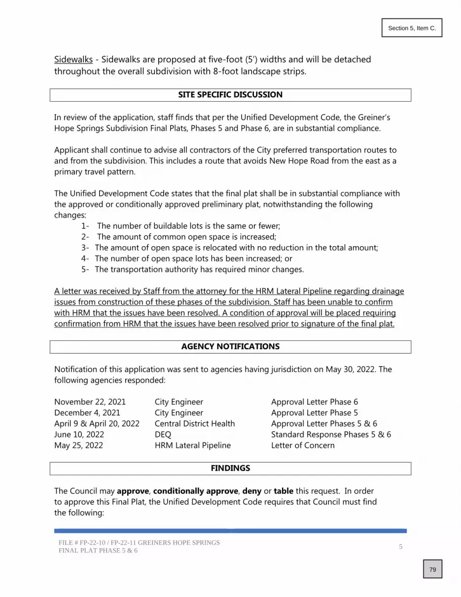
FILE # FP-22-10 / FP-22-11 GREINERS HOPE SPRINGS
FINAL PLAT PHASE 5 & 6 5
Sidewalks - Sidewalks are proposed at five-foot (5’) widths and will be detached
throughout the overall subdivision with 8-foot landscape strips.
SITE SPECIFIC DISCUSSION
In review of the application, staff finds that per the Unified Development Code, the Greiner’s
Hope Springs Subdivision Final Plats, Phases 5 and Phase 6, are in substantial compliance.
Applicant shall continue to advise all contractors of the City preferred transportation routes to
and from the subdivision. This includes a route that avoids New Hope Road from the east as a
primary travel pattern.
The Unified Development Code states that the final plat shall be in substantial compliance with
the approved or conditionally approved preliminary plat, notwithstanding the following
changes:
1- The number of buildable lots is the same or fewer;
2- The amount of common open space is increased;
3- The amount of open space is relocated with no reduction in the total amount;
4- The number of open space lots has been increased; or
5- The transportation authority has required minor changes.
A letter was received by Staff from the attorney for the HRM Lateral Pipeline regarding drainage
issues from construction of these phases of the subdivision. Staff has been unable to confirm
with HRM that the issues have been resolved. A condition of approval will be placed requiring
confirmation from HRM that the issues have been resolved prior to signature of the final plat.
AGENCY NOTIFICATIONS
Notification of this application was sent to agencies having jurisdiction on May 30, 2022. The
following agencies responded:
November 22, 2021 City Engineer Approval Letter Phase 6
December 4, 2021 City Engineer Approval Letter Phase 5
April 9 & April 20, 2022 Central District Health Approval Letter Phases 5 & 6
June 10, 2022 DEQ Standard Response Phases 5 & 6
May 25, 2022 HRM Lateral Pipeline Letter of Concern
FINDINGS
The Council may approve, conditionally approve, deny or table this request. In order
to approve this Final Plat, the Unified Development Code requires that Council must find
the following:
79
Section 5, Item C.

FILE # FP-22-10 / FP-22-11 GREINERS HOPE SPRINGS
FINAL PLAT PHASE 5 & 6 6
A. The Plat is in conformance with the Comprehensive Plan.
Staff finds that this subdivision upon Preliminary Plat approval was in conformance with
the Comprehensive Plan; no changes have been made to change this status.
B. Public services are available or can be made available and are adequate to accommodate the
proposed development.
Staff finds that all public services are available and able to accommodate this
development.
C. There is public financial capability of supporting services for the proposed development.
Staff has not received information from agencies having jurisdiction reflecting any financial
hardships that would prevent services from being provided.
D. The development will not be detrimental to the public health, safety or general welfare; and,
Staff has not received facts to support that this subdivision phase will be detrimental to the public health, safety or general welfare.
E. The development preserves significant natural, scenic or historic features.
Staff finds that existing conditions have not changed from the approved Preliminary Plat
of this subdivision.
CONDITIONS OF APPROVAL
1. The final plat for the Greiner’s Hope Springs Subdivision shall comply with all statutory
requirements of applicable agencies and districts having jurisdiction in the City of Star.
2. The Final Plat shall comply with all received comments from the City Engineer prior to
signature of the plat by the City.
3. Prior to signature of the final plat, the applicant shall provide documentation of
approval from the HRM Lateral Pipeline regarding drainage issues associated with
construction of the subdivision.
4. The property shall be satisfactorily weed abated at all times, including future phases,
preventing a public nuisance, per Star City Code Chapter 3, Section 3-1-1 through 3-1-7.
5. The property associated with this approved Final Plat, in addition to the property of all future
phases shall be properly maintained throughout the construction process to include trash
picked up and trash receptacles emptied with regular frequency, streets swept and cleaned
weekly, including any streets used to access the property and all debris shall be prevented
from accumulating on any adjacent property or public right of way and shall remove all
debris from public way at least daily.
6. Mylar’s/final plats must include the statement supporting the “Right to Farm Act” as per
Idaho Code Title 22, Chapter 45.
7. Development standards for single family residential units shall comply with effective building
and zoning requirements at time of building permit issuance, unless otherwise approved.
80
Section 5, Item C.

FILE # FP-22-10 / FP-22-11 GREINERS HOPE SPRINGS
FINAL PLAT PHASE 5 & 6 7
8. The Mylar of this final plat shall be signed by the owner, Surveyor, Central District Health,
ACHD and City Engineer, prior to being delivered to the City of Star for City Clerk’s signature.
9. All common area lots shall be owned and maintained by the Homeowner’s Association.
10. Streetlights shall comply with the Star City Code and shall be of the same design throughout
the entire subdivision. Streetlights shall be continuous throughout the subdivision and shall
be maintained by the Homeowners Association. Streetlights shall be installed and
energized prior to issuing of building permits. Design shall follow Code with
requirements for light trespass and “Dark Skies” lighting. Streetlights shall comply with the
Star City Code regarding light trespass and “Dark Sky” initiative.
11. The Applicant/Owner shall comply with the City of Star Unified Development Code regarding
landscaping, both internal buffers and frontages (See Section 8-4 B Landscaping
Requirements).
12. The applicant shall provide the City with a written Certificate of Completion that all
landscaping and amenities have been installed in substantial compliance with the City
approved landscape plan. The certification shall be prepared by the licensed landscape
architect responsible for the landscape plan. This certification shall be submitted prior to
issuance of first certificate of occupancy for this phase.
13. A letter from the US Postal Service shall be given to the City prior to final Mylar signature
stating the subdivision is in compliance with the Postal Service.
14. A form signed by the Star Sewer & Water District shall be submitted to the City prior to final
mylar signature stating that all conditions have been met.
15. A sign application shall be submitted to the City for any internal or subdivision signs.
16. The applicant shall maintain, during all construction (including home construction), the
installed construction sign, located at all construction entrances, indicating the rules for all
contractors that will be working on the property starting at grading and running through
home sales that addresses items including but not limited to dust, music, dogs,
starting/stopping hours for contractors (7a.m. start time).
17. Applicant shall provide the City with one (1) full size copy, one (1) 11”x17” copy and an
electronic pdf copy of the as-built irrigation plans, prior to any building permits being
issued.
18. Applicant shall provide the City with two (2) full size copies, one (1) 11”x17” copy and an
electronic pdf copy of the signed recorded final plat with all signatures, prior to any
building permits being issued.
19. Applicant shall provide the City with one (1) copy and an electronic pdf copy of the
recorded CC&R’s, prior to any building permits being issued.
20. Applicant shall provide the City with one (1) full size copy and an electronic pdf copy of the
final, approved construction drawings, prior to any building permits being issued.
21. Any additional Condition of Approval as required by Staff and City Council.
COUNCIL DECISION
81
Section 5, Item C.

FILE # FP-22-10 / FP-22-11 GREINERS HOPE SPRINGS
FINAL PLAT PHASE 5 & 6 8
The Star City Council _______________________ File # FP-22-10 Greiner’s Hope Springs Subdivision,
Final Plat Phase 5 and File # FP-22-11 Greiner’s Hope Springs Subdivision, Final Plat Phase 6 on
_________________ _______, 2022.
82
Section 5, Item C.

83
Section 5, Item C.

84
Section 5, Item C.

85
Section 5, Item C.

86
Section 5, Item C.

87
Section 5, Item C.

88
Section 5, Item C.

89
Section 5, Item C.
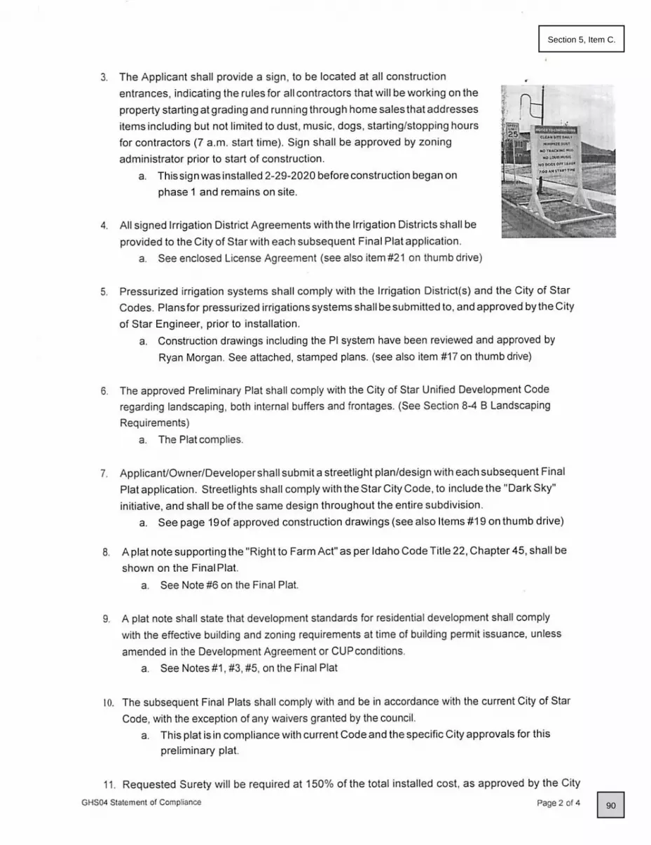
90
Section 5, Item C.

91
Section 5, Item C.

92
Section 5, Item C.

PI
P
I
PI
PI
P
I
P
I
P
I
P
I
P
I
PI
PI
P
I
PI
P
I
PI
PI
PI
PI
PI
PI
PI
PI
PI
PI
PI
P
I
PI
PI
P
I
PI
PI
P
I
P
I
PI
PI
P
I
P
I
P
I
P
I
P
I
PI
PI
PI
P
I
ROSELANDS
SUBDIVISION
FALLBROOK No 2
SAILING HAWKS
SUBDIVISION
SUBDIVISION
13
EG
EG
EG
EG
EG
EG
EG
E
G
EG
E
G
E
G
E
G
E
G
EG
EG
EG
EG
EG
E
G
E
G
E
G
E
G
E
G
E
G
EG
EG
EG
EG
E
G
E
G
E
G
EG
EG
E
G
E
G
EG
EG
E
G
E
G
EG
EG
EG
EG
EG
EG
EG
E
G
EP
EP
EP
EP
EP
EP
EP
FOOTHILL DITCH
●●
●●
●●
●●
●●
●●
●●
●●
●●
●●
●●
●
●
●
●
●
●
●
●
●
●
●
●
●
●
●
●
●
●
●
●
●
●
●
●
●
●
●
●
●
●
●●
●●
●●
●●
●●
●●
●●
●●
●●
●●
●●
●●
●●
●●
●●
●●
●●
●●
●●
●●
●●
●●
●●
●
●
●
●
●
●
●
●
●
●
●
●
●
●
●
●
●
●
●
●
●
●
●
●
●
●
●
●
●●
●●
●
●
●●
●●●
●●●
●●
●●
●●
●●
EP
EP
EP
EP
EP
EP
EP
EP
EP
EP
HOSE BIB
HOSE BIB
HOSE BIB
14
11
12
15
16
S
S
S
S
S
S
S
S
S
S
S
S
SD
S
S
S
S
S
S
S
W
W
W
S
S
S
S
S
S
S
S
S
S
S
S
S
W
W
W
W
W
W
W
W
W
W
S
S
W
W. SOARING HAWK ST
N. P
EN
NY
LA
KE
A
VE
.
W. TERATAL CT
N. C
HE
RR
Y
LA
UR
EL P
L.
W
W
W
W
W
WW
W
W
W
W
W
W
W
W
W
W
W
W
W
W
W
W
W
W
W
W
W
W
W W
W
W
W
W
W
W
W
W
W
W
W
W
W
W
W
W
W
W
W
W
W
W
W
W
W
W
W
W
W
W
.
H
E
L
IO
P
S
IS
D
R
.
N
. W
IL
D
W. AMSONIA DR
N. P
EN
NY
LA
KE
A
VE
.
C
L
O
V
E
R
A
V
E
.
N. W
AT
ER
SH
ED
A
VE
.
W. HELENIUM DR
W. SOARING HAWK ST
N. W
AT
ER
SH
ED
A
VE
.
W
.
T
R
I
L
O
B
A
D
R
N. W
ILLO
W G
LE
N A
VE
.
N. R
OS
ELA
ND
W
AY
W
.
S
A
I
L
I
N
G
H
A
W
K
D
R
SD
SD
W
.
T
R
I
L
O
B
A
D
R
N
.
P
E
N
N
Y
L
A
K
E
A
V
E
.
W. LILIUM ST
W. COREOPSIS DR
N. W
ILD
C
LO
VE
R A
VE
.
N. R
OS
ELA
ND
W
AY
W. NEW HOPE ROAD
W
.
C
A
M
P
A
N
U
L
A
D
R
.
W. CAMPANULA DR.
PR
ELIM
IN
AR
Y P
LA
T
GR
EIN
ER
S H
OP
E S
PR
IN
GS
S
UB
DIV
IS
IO
N
93
Section 5, Item C.
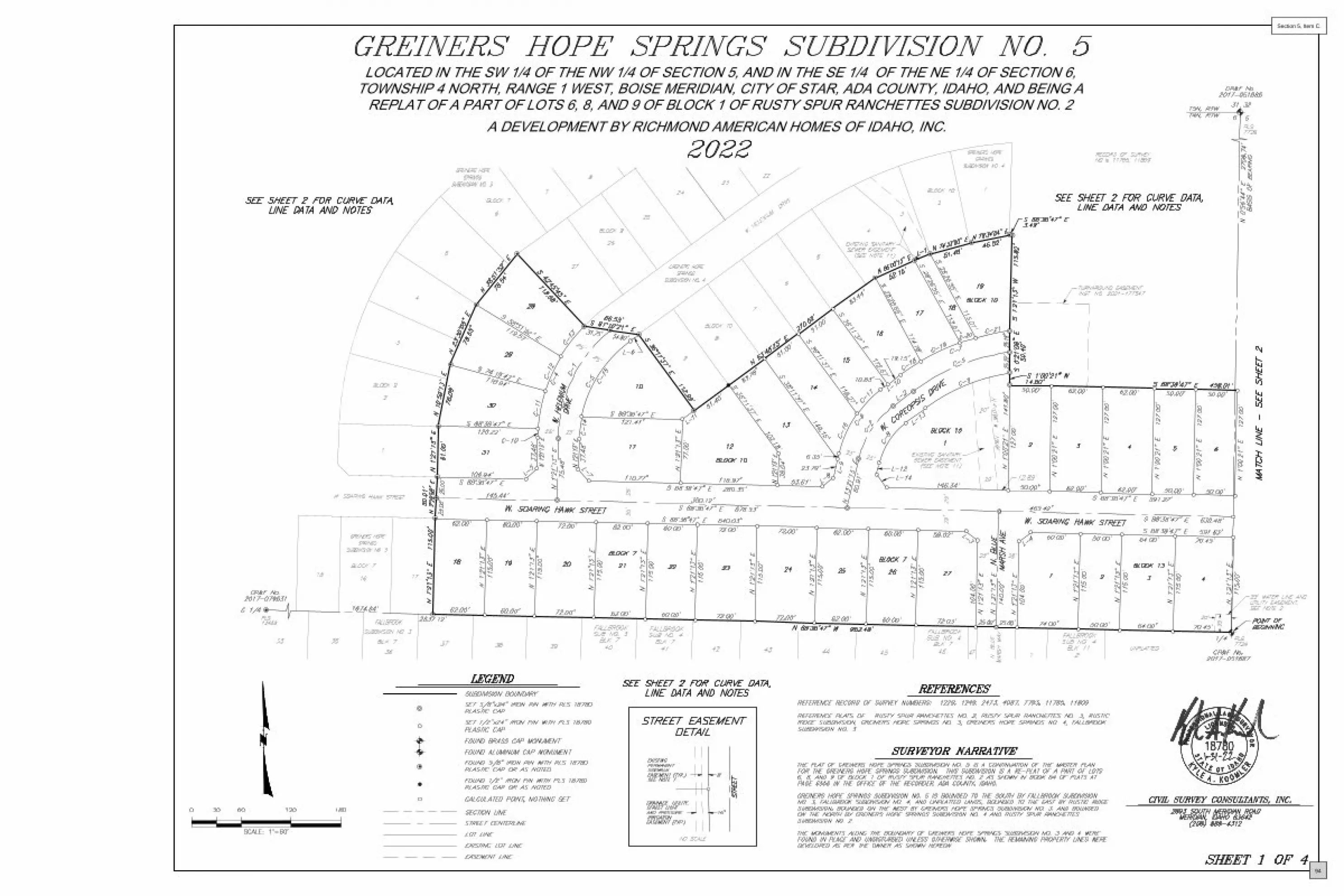
A DEVELOPMENT BY RICHMOND AMERICAN HOMES OF IDAHO, INC.
LOCATED IN THE SW 1/4 OF THE NW 1/4 OF SECTION 5, AND IN THE SE 1/4 OF THE NE 1/4 OF SECTION 6,TOWNSHIP 4 NORTH, RANGE 1 WEST, BOISE MERIDIAN, CITY OF STAR, ADA COUNTY, IDAHO, AND BEING A
REPLAT OF A PART OF LOTS 6, 8, AND 9 OF BLOCK 1 OF RUSTY SPUR RANCHETTES SUBDIVISION NO. 2
94
Section 5, Item C.
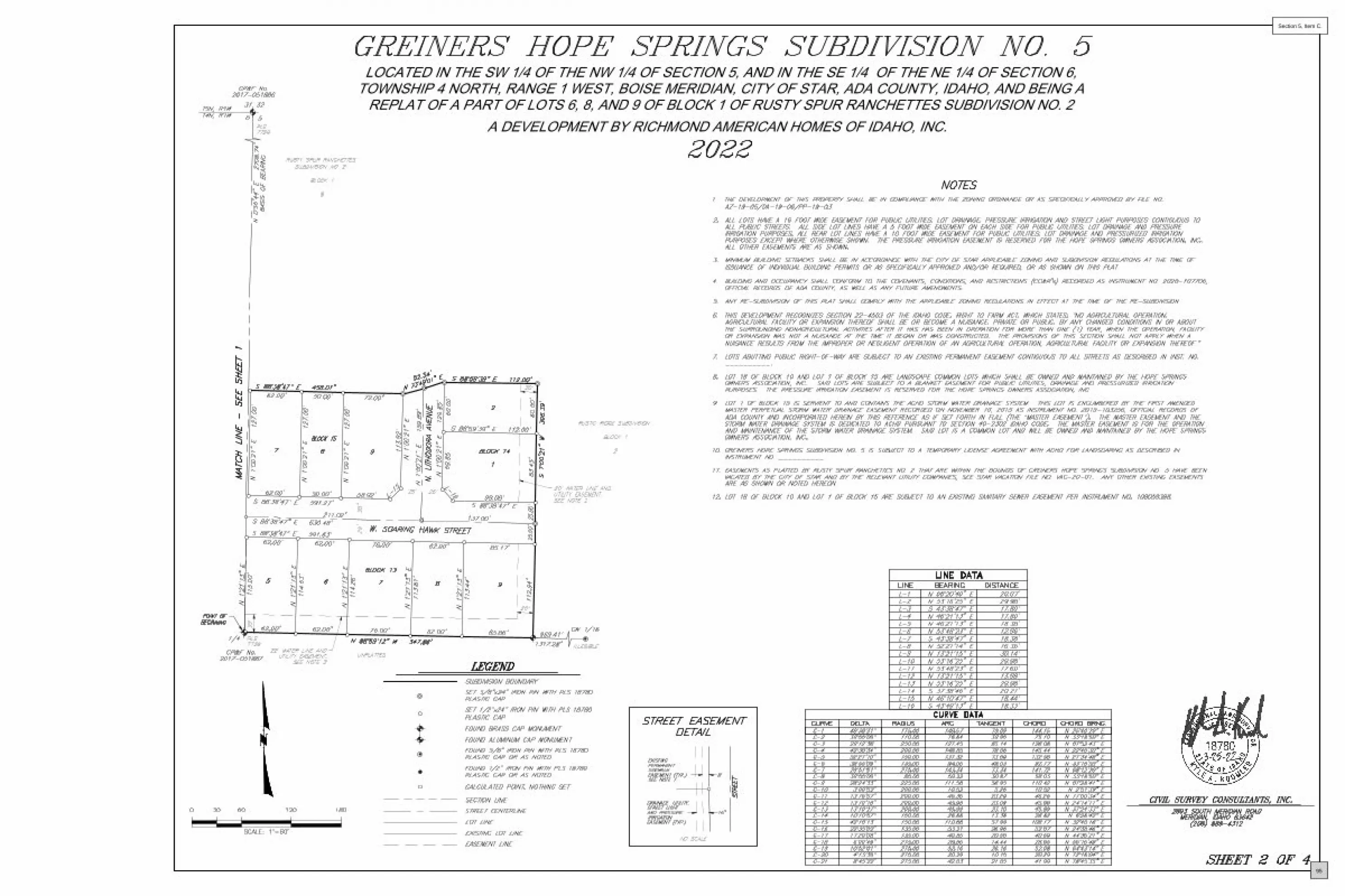
A DEVELOPMENT BY RICHMOND AMERICAN HOMES OF IDAHO, INC.
LOCATED IN THE SW 1/4 OF THE NW 1/4 OF SECTION 5, AND IN THE SE 1/4 OF THE NE 1/4 OF SECTION 6,TOWNSHIP 4 NORTH, RANGE 1 WEST, BOISE MERIDIAN, CITY OF STAR, ADA COUNTY, IDAHO, AND BEING A
REPLAT OF A PART OF LOTS 6, 8, AND 9 OF BLOCK 1 OF RUSTY SPUR RANCHETTES SUBDIVISION NO. 2
“ ”
95
Section 5, Item C.

–
’ ”
’ ” –
’ ”
’ ”
’ ”
’ ”
’ ”
’ ” –
’ ”
’ ”
’ ”
’ ”
’ ”
’ ”
’ ”
’ ”
’ ”
’ ”
’ ”
’ ”
’ ”
’ ”
’ ” –
’ ”
’ ”
96
Section 5, Item C.

97
Section 5, Item C.
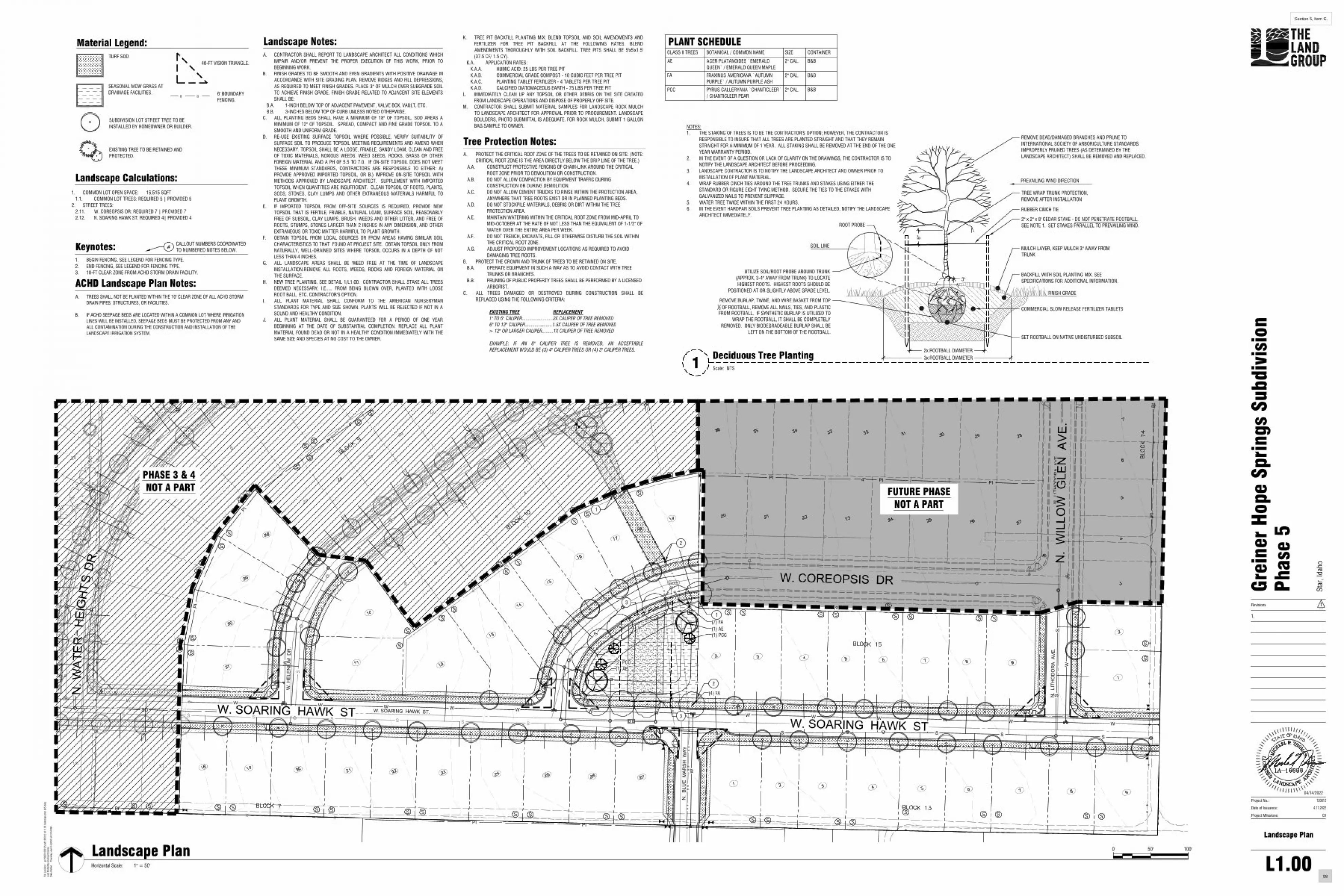
PI
PI
PI
PI PI PI
PI
PI
S
S S S S S S SS
S S S S S S
SD
S
SS
W
WW W W W W W W W W W W WW. SOARING HAWK ST.
N.
BLU
E M
ARSH
WAY
N.
LITH
OD
OR
A A
VE.
SD
W. COREOPSIS DR.
W
4"
4"
4"
W
S
S
S
S
S
W
PI
W. H
ELEN
IUM
DR
.
W. SOARING HAWK ST.
N.
LITH
OD
OR
A A
VE.
S
SD
W
S
S
PIPI
SS
X 01.5201.58 X
W
W
W
PI PI
[]
[]
[]
[]
[]
[]
[]
[]
AE (2)
EGEG
EGEG
Note
●●
●●
●●
●●
●●
●●
●●
●●
●●
●●
●●
●●
●●
●●
●●
●●
●●
●●
●●
●●
●●
●●
●●
●●
●●
●●
●●
●●
●●
●●
●●
●●
●●
●●
●●
●●
●●
●●
●●
●●
●●
●●
●●
●●
●●
●●
●●
●●
●●
●●
HOSE BIB
6"6"
12"
12"
EGEG
EGEG
XX
P
P P
XXXXXXX
(1) AE
(4) FA
W. COREOPSIS DR
W. SOARING HAWK ST
N. W
ATER
N.
WIL
LOW
GLE
N A
VE.
HEIG
HTS
DR.
W. SOARING HAWK ST
2
1
[]
[]
[]
[]
[]
[]
[]
[]
1
2
(7) FA(1) AE
[][]
[][]
[]
(2) PCC
(1) PCC
3
3
Landscape Calculations:
Material Legend:TURF SOD
1. COMMON LOT OPEN SPACE: 16,515 SQFT1.1. COMMON LOT TREES: REQUIRED 5 | PROVIDED 5
2. STREET TREES:2.11. W. COREOPSIS DR: REQUIRED 7 | PROVIDED 72.12. N. SOARING HAWK ST: REQUIRED 4| PROVIDED 4
40-FT VISION TRIANGLE.
[] []6' BOUNDARYFENCING.
Keynotes:1. BEGIN FENCING, SEE LEGEND FOR FENCING TYPE.2. END FENCING, SEE LEGEND FOR FENCING TYPE.3. 10-FT CLEAR ZONE FROM ACHD STORM DRAIN FACILITY.
CALLOUT NUMBERS COORDINATEDTO NUMBERED NOTES BELOW.
#
ACHD Landscape Plan Notes:A. TREES SHALL NOT BE PLANTED WITHIN THE 10' CLEAR ZONE OF ALL ACHD STORM
DRAIN PIPES, STRUCTURES, OR FACILITIES.
B. IF ACHD SEEPAGE BEDS ARE LOCATED WITHIN A COMMON LOT WHERE IRRIGATIONLINES WILL BE INSTALLED, SEEPAGE BEDS MUST BE PROTECTED FROM ANY ANDALL CONTAMINATION DURING THE CONSTRUCTION AND INSTALLATION OF THELANDSCAPE IRRIGATION SYSTEM.
SEASONAL MOW GRASS ATDRAINAGE FACILITIES.
SUBDIVISION LOT STREET TREE TO BEINSTALLED BY HOMEOWNER OR BUILDER.
EXISTING TREE TO BE RETAINED ANDPROTECTED.
CLASS II TREES BOTANICAL / COMMON NAME SIZE CONTAINER
AE ACER PLATANOIDES `EMERALDQUEEN` / EMERALD QUEEN MAPLE
2" CAL. B&B
FA FRAXINUS AMERICANA `AUTUMNPURPLE` / AUTUMN PURPLE ASH
2" CAL. B&B
PCC PYRUS CALLERYANA `CHANTICLEER`/ CHANTICLEER PEAR
2" CAL. B&B
PLANT SCHEDULEA. CONTRACTOR SHALL REPORT TO LANDSCAPE ARCHITECT ALL CONDITIONS WHICH
IMPAIR AND/OR PREVENT THE PROPER EXECUTION OF THIS WORK, PRIOR TOBEGINNING WORK.
B. FINISH GRADES TO BE SMOOTH AND EVEN GRADIENTS WITH POSITIVE DRAINAGE INACCORDANCE WITH SITE GRADING PLAN. REMOVE RIDGES AND FILL DEPRESSIONS,AS REQUIRED TO MEET FINISH GRADES. PLACE 3" OF MULCH OVER SUBGRADE SOILTO ACHIEVE FINISH GRADE. FINISH GRADE RELATED TO ADJACENT SITE ELEMENTSSHALL BE:
B.A. 1-INCH BELOW TOP OF ADJACENT PAVEMENT, VALVE BOX, VAULT, ETC.B.B. 3-INCHES BELOW TOP OF CURB UNLESS NOTED OTHERWISE.
C. ALL PLANTING BEDS SHALL HAVE A MINIMUM OF 18" OF TOPSOIL, SOD AREAS AMINIMUM OF 12" OF TOPSOIL. SPREAD, COMPACT AND FINE GRADE TOPSOIL TO ASMOOTH AND UNIFORM GRADE.
D. RE-USE EXISTING SURFACE TOPSOIL WHERE POSSIBLE. VERIFY SUITABILITY OFSURFACE SOIL TO PRODUCE TOPSOIL MEETING REQUIREMENTS AND AMEND WHENNECESSARY. TOPSOIL SHALL BE A LOOSE, FRIABLE, SANDY LOAM, CLEAN AND FREEOF TOXIC MATERIALS, NOXIOUS WEEDS, WEED SEEDS, ROCKS, GRASS OR OTHERFOREIGN MATERIAL AND A PH OF 5.5 TO 7.0. IF ON-SITE TOPSOIL DOES NOT MEETTHESE MINIMUM STANDARDS, CONTRACTORS ARE RESPONSIBLE TO EITHER: A)PROVIDE APPROVED IMPORTED TOPSOIL, OR B.) IMPROVE ON-SITE TOPSOIL WITHMETHODS APPROVED BY LANDSCAPE ARCHITECT. SUPPLEMENT WITH IMPORTEDTOPSOIL WHEN QUANTITIES ARE INSUFFICIENT. CLEAN TOPSOIL OF ROOTS, PLANTS,SODS, STONES, CLAY LUMPS AND OTHER EXTRANEOUS MATERIALS HARMFUL TOPLANT GROWTH.
E. IF IMPORTED TOPSOIL FROM OFF-SITE SOURCES IS REQUIRED, PROVIDE NEWTOPSOIL THAT IS FERTILE, FRIABLE, NATURAL LOAM, SURFACE SOIL, REASONABLYFREE OF SUBSOIL, CLAY LUMPS, BRUSH, WEEDS AND OTHER LITTER, AND FREE OFROOTS, STUMPS, STONES LARGER THAN 2 INCHES IN ANY DIMENSION, AND OTHEREXTRANEOUS OR TOXIC MATTER HARMFUL TO PLANT GROWTH.
F. OBTAIN TOPSOIL FROM LOCAL SOURCES OR FROM AREAS HAVING SIMILAR SOILCHARACTERISTICS TO THAT FOUND AT PROJECT SITE. OBTAIN TOPSOIL ONLY FROMNATURALLY, WELL-DRAINED SITES WHERE TOPSOIL OCCURS IN A DEPTH OF NOTLESS THAN 4 INCHES.
G. ALL LANDSCAPE AREAS SHALL BE WEED FREE AT THE TIME OF LANDSCAPEINSTALLATION.REMOVE ALL ROOTS, WEEDS, ROCKS AND FOREIGN MATERIAL ONTHE SURFACE.
H. NEW TREE PLANTING, SEE DETAIL 1/L1.00. CONTRACTOR SHALL STAKE ALL TREESDEEMED NECESSARY, I.E..... FROM BEING BLOWN OVER, PLANTED WITH LOOSEROOT BALL, ETC. CONTRACTOR'S OPTION.
I. ALL PLANT MATERIAL SHALL CONFORM TO THE AMERICAN NURSERYMANSTANDARDS FOR TYPE AND SIZE SHOWN. PLANTS WILL BE REJECTED IF NOT IN ASOUND AND HEALTHY CONDITION.
J. ALL PLANT MATERIAL SHALL BE GUARANTEED FOR A PERIOD OF ONE YEARBEGINNING AT THE DATE OF SUBSTANTIAL COMPLETION. REPLACE ALL PLANTMATERIAL FOUND DEAD OR NOT IN A HEALTHY CONDITION IMMEDIATELY WITH THESAME SIZE AND SPECIES AT NO COST TO THE OWNER.
Landscape Notes:SAME SIZE AND SPECIES AT NO COST TO THE OWNER.
K. TREE PIT BACKFILL PLANTING MIX: BLEND TOPSOIL AND SOIL AMENDMENTS ANDFERTILIZER FOR TREE PIT BACKFILL AT THE FOLLOWING RATES. BLENDAMENDMENTS THOROUGHLY WITH SOIL BACKFILL. TREE PITS SHALL BE 5'x5'x1.5'(37.5 CF/ 1.5 CY).
K.A. APPLICATION RATES:K.A.A. HUMIC ACID: 25 LBS PER TREE PITK.A.B. COMMERCIAL GRADE COMPOST - 10 CUBIC FEET PER TREE PITK.A.C. PLANTING TABLET FERTILIZER - 4 TABLETS PER TREE PITK.A.D. CALCIFIED DIATOMACEOUS EARTH - 75 LBS PER TREE PIT
L. IMMEDIATELY CLEAN UP ANY TOPSOIL OR OTHER DEBRIS ON THE SITE CREATEDFROM LANDSCAPE OPERATIONS AND DISPOSE OF PROPERLY OFF SITE.
M. CONTRACTOR SHALL SUBMIT MATERIAL SAMPLES FOR LANDSCAPE ROCK MULCHTO LANDSCAPE ARCHITECT FOR APPROVAL PRIOR TO PROCUREMENT. LANDSCAPEBOULDERS, PHOTO SUBMITTAL IS ADEQUATE. FOR ROCK MULCH, SUBMIT 1 GALLONBAG SAMPLE TO OWNER.
A. PROTECT THE CRITICAL ROOT ZONE OF THE TREES TO BE RETAINED ON SITE: (NOTE:CRITICAL ROOT ZONE IS THE AREA DIRECTLY BELOW THE DRIP LINE OF THE TREE.)
A.A. CONSTRUCT PROTECTIVE FENCING OF CHAIN-LINK AROUND THE CRITICALROOT ZONE PRIOR TO DEMOLITION OR CONSTRUCTION.
A.B. DO NOT ALLOW COMPACTION BY EQUIPMENT TRAFFIC DURINGCONSTRUCTION OR DURING DEMOLITION.
A.C. DO NOT ALLOW CEMENT TRUCKS TO RINSE WITHIN THE PROTECTION AREA,ANYWHERE THAT TREE ROOTS EXIST OR IN PLANNED PLANTING BEDS.
A.D. DO NOT STOCKPILE MATERIALS, DEBRIS OR DIRT WITHIN THE TREEPROTECTION AREA.
A.E. MAINTAIN WATERING WITHIN THE CRITICAL ROOT ZONE FROM MID-APRIL TOMID-OCTOBER AT THE RATE OF NOT LESS THAN THE EQUIVALENT OF 1-1/2" OFWATER OVER THE ENTIRE AREA PER WEEK.
A.F. DO NOT TRENCH, EXCAVATE, FILL OR OTHERWISE DISTURB THE SOIL WITHINTHE CRITICAL ROOT ZONE.
A.G. ADJUST PROPOSED IMPROVEMENT LOCATIONS AS REQUIRED TO AVOIDDAMAGING TREE ROOTS.
B. PROTECT THE CROWN AND TRUNK OF TREES TO BE RETAINED ON SITE:B.A. OPERATE EQUIPMENT IN SUCH A WAY AS TO AVOID CONTACT WITH TREE
TRUNKS OR BRANCHES.B.B. PRUNING OF PUBLIC PROPERTY TREES SHALL BE PERFORMED BY A LICENSED
ARBORIST.C. ALL TREES DAMAGED OR DESTROYED DURING CONSTRUCTION SHALL BE
REPLACED USING THE FOLLOWING CRITERIA:
EXISTING TREE REPLACEMENT1" TO 6" CALIPER.........................2X CALIPER OF TREE REMOVED6" TO 12" CALIPER......................1.5X CALIPER OF TREE REMOVED> 12" OR LARGER CALIPER.........1X CALIPER OF TREE REMOVED
EXAMPLE: IF AN 8" CALIPER TREE IS REMOVED, AN ACCEPTABLEREPLACEMENT WOULD BE (3) 4" CALIPER TREES OR (4) 3" CALIPER TREES.
Tree Protection Notes:
Horizontal Scale:
0 50' 100'
1" = 50'
Landscape Plan
File
Loc
atio
n:g:
\202
0\12
0012
\cad
\120
012
cd l1
.00
land
scap
e pl
an p
h5.d
wg
Last
Plo
tted
By:m
icha
el th
omas
Date
Plo
tted:
Thur
sday
, Apr
il 14
202
2 at
12:
04 P
M
CD
Star
, Ida
ho
Grei
ner
Hop
e Sp
ring
s Su
bdiv
isio
nPh
ase
5
4.11.2022
120012
L1.00
Landscape Plan
Revisions
1.
Date of Issuance:
Project No.:
Project Milestone:
----1
PHASE 3 & 4 NOT A PART FUTURE PHASE
NOT A PART
NOTES:1. THE STAKING OF TREES IS TO BE THE CONTRACTOR'S OPTION; HOWEVER, THE CONTRACTOR IS
RESPONSIBLE TO INSURE THAT ALL TREES ARE PLANTED STRAIGHT AND THAT THEY REMAINSTRAIGHT FOR A MINIMUM OF 1 YEAR. ALL STAKING SHALL BE REMOVED AT THE END OF THE ONEYEAR WARRANTY PERIOD.
2. IN THE EVENT OF A QUESTION OR LACK OF CLARITY ON THE DRAWINGS, THE CONTRACTOR IS TONOTIFY THE LANDSCAPE ARCHITECT BEFORE PROCEEDING.
3. LANDSCAPE CONTRACTOR IS TO NOTIFY THE LANDSCAPE ARCHITECT AND OWNER PRIOR TOINSTALLATION OF PLANT MATERIAL.
4. WRAP RUBBER CINCH TIES AROUND THE TREE TRUNKS AND STAKES USING EITHER THESTANDARD OR FIGURE EIGHT TYING METHOD. SECURE THE TIES TO THE STAKES WITHGALVANIZED NAILS TO PREVENT SLIPPAGE.
5. WATER TREE TWICE WITHIN THE FIRST 24 HOURS.6. IN THE EVENT HARDPAN SOILS PREVENT TREE PLANTING AS DETAILED, NOTIFY THE LANDSCAPE
ARCHITECT IMMEDIATELY.
PREVAILING WIND DIRECTION
REMOVE DEAD/DAMAGED BRANCHES AND PRUNE TOINTERNATIONAL SOCIETY OF ARBORICULTURE STANDARDS;IMPROPERLY PRUNED TREES (AS DETERMINED BY THELANDSCAPE ARCHITECT) SHALL BE REMOVED AND REPLACED.
SET ROOTBALL ON NATIVE UNDISTURBED SUBSOIL
COMMERCIAL SLOW RELEASE FERTILIZER TABLETS
BACKFILL WITH SOIL PLANTING MIX. SEESPECIFICATIONS FOR ADDITIONAL INFORMATION.
MULCH LAYER, KEEP MULCH 3" AWAY FROMTRUNK
2" x 2" x 8' CEDAR STAKE - DO NOT PENETRATE ROOTBALL.SEE NOTE 1. SET STAKES PARALLEL TO PREVAILING WIND.
RUBBER CINCH TIE
FINISH GRADE
ROOT PROBE
SOIL LINE
UTILIZE SOIL/ROOT PROBE AROUND TRUNK(APPROX. 3-4" AWAY FROM TRUNK) TO LOCATEHIGHEST ROOTS. HIGHEST ROOTS SHOULD BE
POSITIONED AT OR SLIGHTLY ABOVE GRADE LEVEL.
REMOVE BURLAP, TWINE, AND WIRE BASKET FROM TOP1
2 OF ROOTBALL, REMOVE ALL NAILS, TIES, AND PLASTICFROM ROOTBALL. IF SYNTHETIC BURLAP IS UTILIZED TO
WRAP THE ROOTBALL, IT SHALL BE COMPLETELYREMOVED. ONLY BIODEGRADEABLE BURLAP SHALL BE
LEFT ON THE BOTTOM OF THE ROOTBALL.
2x ROOTBALL DIAMETER3x ROOTBALL DIAMETER
6"
TREE WRAP TRUNK PROTECTION,REMOVE AFTER INSTALLATION
3"
1Deciduous Tree PlantingScale: NTS
04/14/2022
98
Section 5, Item C.

A DEVELOPMENT BY RICHMOND AMERICAN HOMES OF IDAHO, INC.
LOCATED IN THE SW 1/4 OF THE NW 1/4 OF SECTION 5, AND IN THE SE 1/4 OF THE NE 1/4 OF SECTION 6,TOWNSHIP 4 NORTH, RANGE 1 WEST, BOISE MERIDIAN, CITY OF STAR, ADA COUNTY, IDAHO, AND BEING AREPLAT OF A PART OF LOTS 5, 7, 8, AND 9 OF BLOCK 1 OF RUSTY SPUR RANCHETTES SUBDIVISION NO. 2
99
Section 5, Item C.
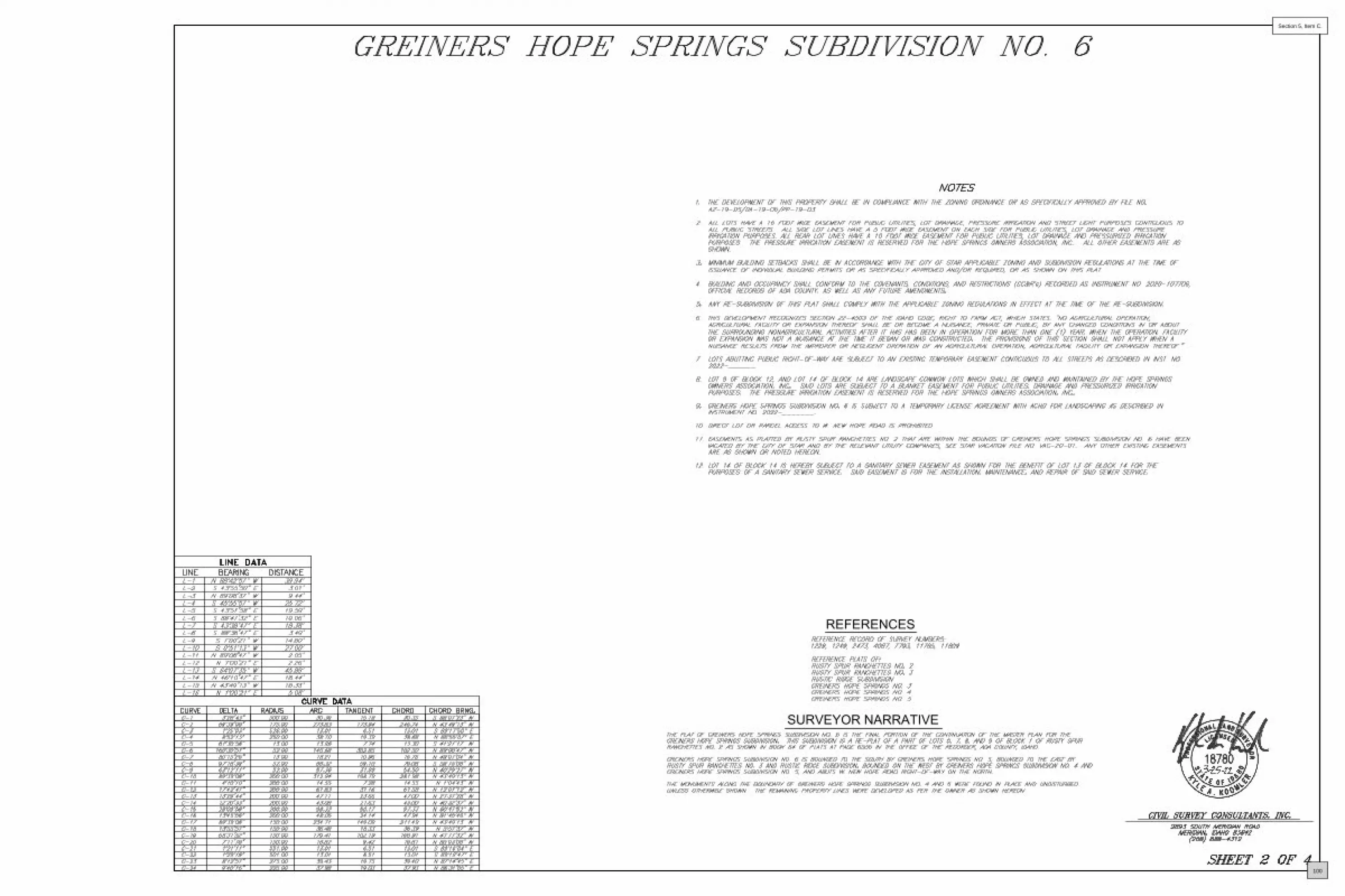
SURVEYOR NARRATIVE
REFERENCES
100
Section 5, Item C.

–
’ ”
’ ”
’ ” –
’ ”
’ ”
’ ”
’ ”
’ ”
’ ”
’ ”
’ ”
’ ”
’ ”
’ ”
’ ”
’ ”
’ ” ’ ” ’ ”
’ ”
–
’ ”
’ ”
’ ”
’ ”
’ ”
’ ”
’ ”
’ ”
’ ”
101
Section 5, Item C.

102
Section 5, Item C.
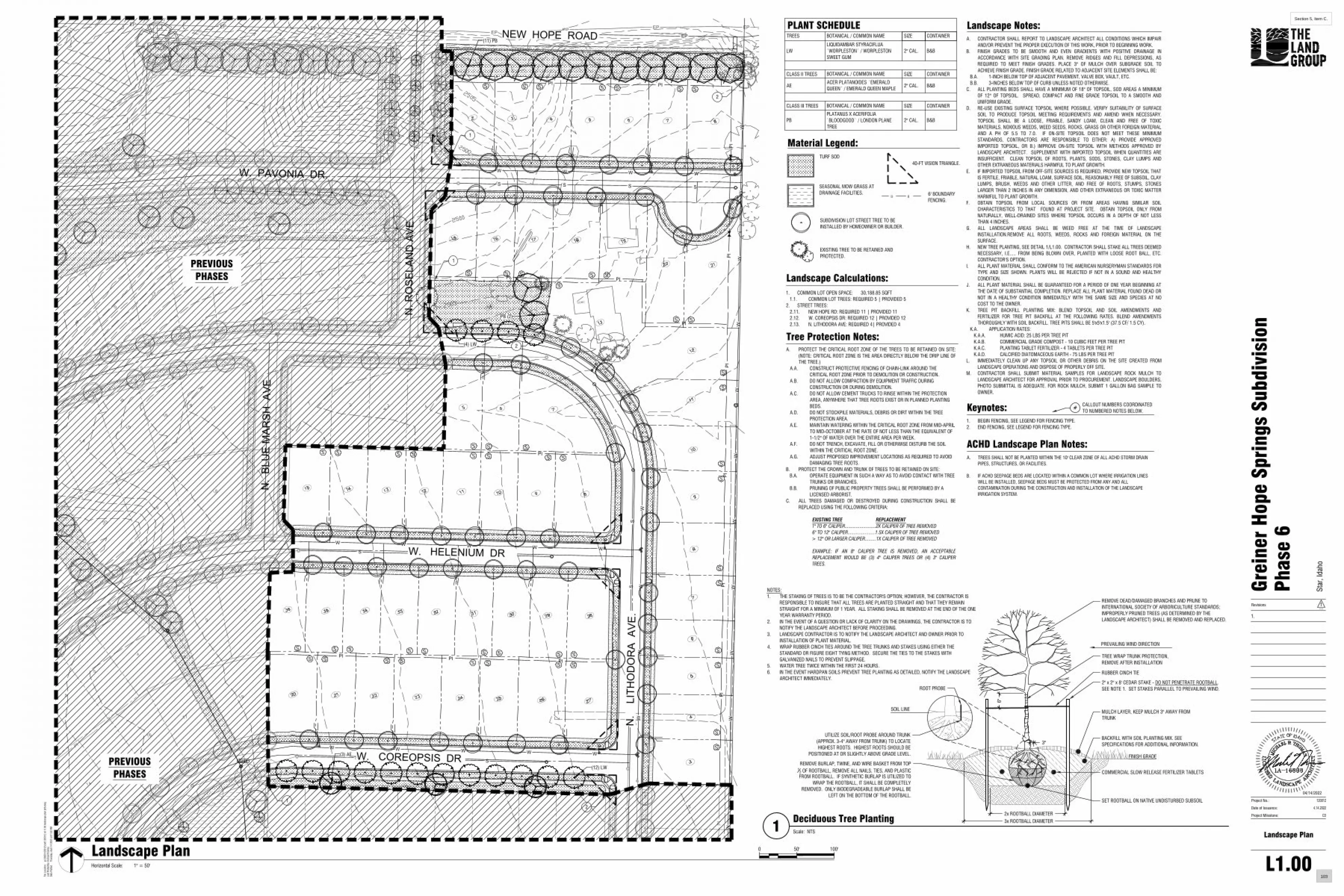
(1) PB
[]
[]
[]
[]
[]
[][]
[]
[] [] [] [] [] [] [] [] [] [] [] [] []
[][]
[][]
[]
[]
[]
[]
[]
[]
[]
[]
[]
[]
[]
[]
[]
[]
[]
[]
[]
[]
[]
[][]
[][]
[][] [] [] [] [] [] [] [] [] [] []
Note
EP EP EP EP EP EP EP EP
MW10
MW4
MW9
CONC
[]
[]
[]
[]
[]
[]
[]
[]
[][]
[]
PI
PIPI
PI PI PI
PI
PI
PI
PI PI PI
PI
PI PI
PI PI
S S S
S S S
S S S SS S SS
S
S S S S
WW
WW
W W W W
W W W W W
EP EP
S
S
S
W
W
W
W W
12"
S
S
S
S
WW
W
PI
WW
W W W
WW
WW
W
W
PI
PI
W W W W W
PI
PI PI
PI
PI PI
PIPI
PIPI
PIPI
SS
SS
S
S
S
S
WELL
WW
WW
WW
WW
WW
WW
[][]
[][]
[] [] [] [] [] [] [] [] [] [] [] [] [] [] [] [] []
[] [] [] [] [] []
[][]
1
2
2
1
[] [] [] [] [] [] [] [] [] [] [] [] [] [] [] [] [] [] [] []
12
(11) PB
PB (2)
(4) LW
(3) AE
(12) LW
W. PAVONIA DR.
N.
BLU
E M
ARSH
AVE
N. R
OSE
LAN
D A
VE
W. COREOPSIS DR
N.
LITH
OD
OR
A A
VE.
W. HELENIUM DR
NEW HOPE ROAD
Landscape Calculations:
Material Legend:TURF SOD
1. COMMON LOT OPEN SPACE: 30,188.85 SQFT1.1. COMMON LOT TREES: REQUIRED 5 | PROVIDED 5
2. STREET TREES:2.11. NEW HOPE RD: REQUIRED 11 | PROVIDED 112.12. W. COREOPSIS DR: REQUIRED 12 | PROVIDED 122.13. N. LITHODORA AVE: REQUIRED 4| PROVIDED 4
40-FT VISION TRIANGLE.
[] []6' BOUNDARYFENCING.
Keynotes:1. BEGIN FENCING, SEE LEGEND FOR FENCING TYPE.2. END FENCING, SEE LEGEND FOR FENCING TYPE.
CALLOUT NUMBERS COORDINATEDTO NUMBERED NOTES BELOW.
#
A. CONTRACTOR SHALL REPORT TO LANDSCAPE ARCHITECT ALL CONDITIONS WHICH IMPAIRAND/OR PREVENT THE PROPER EXECUTION OF THIS WORK, PRIOR TO BEGINNING WORK.
B. FINISH GRADES TO BE SMOOTH AND EVEN GRADIENTS WITH POSITIVE DRAINAGE INACCORDANCE WITH SITE GRADING PLAN. REMOVE RIDGES AND FILL DEPRESSIONS, ASREQUIRED TO MEET FINISH GRADES. PLACE 3" OF MULCH OVER SUBGRADE SOIL TOACHIEVE FINISH GRADE. FINISH GRADE RELATED TO ADJACENT SITE ELEMENTS SHALL BE:
B.A. 1-INCH BELOW TOP OF ADJACENT PAVEMENT, VALVE BOX, VAULT, ETC.B.B. 3-INCHES BELOW TOP OF CURB UNLESS NOTED OTHERWISE.
C. ALL PLANTING BEDS SHALL HAVE A MINIMUM OF 18" OF TOPSOIL, SOD AREAS A MINIMUMOF 12" OF TOPSOIL. SPREAD, COMPACT AND FINE GRADE TOPSOIL TO A SMOOTH ANDUNIFORM GRADE.
D. RE-USE EXISTING SURFACE TOPSOIL WHERE POSSIBLE. VERIFY SUITABILITY OF SURFACESOIL TO PRODUCE TOPSOIL MEETING REQUIREMENTS AND AMEND WHEN NECESSARY.TOPSOIL SHALL BE A LOOSE, FRIABLE, SANDY LOAM, CLEAN AND FREE OF TOXICMATERIALS, NOXIOUS WEEDS, WEED SEEDS, ROCKS, GRASS OR OTHER FOREIGN MATERIALAND A PH OF 5.5 TO 7.0. IF ON-SITE TOPSOIL DOES NOT MEET THESE MINIMUMSTANDARDS, CONTRACTORS ARE RESPONSIBLE TO EITHER: A) PROVIDE APPROVEDIMPORTED TOPSOIL, OR B.) IMPROVE ON-SITE TOPSOIL WITH METHODS APPROVED BYLANDSCAPE ARCHITECT. SUPPLEMENT WITH IMPORTED TOPSOIL WHEN QUANTITIES AREINSUFFICIENT. CLEAN TOPSOIL OF ROOTS, PLANTS, SODS, STONES, CLAY LUMPS ANDOTHER EXTRANEOUS MATERIALS HARMFUL TO PLANT GROWTH.
E. IF IMPORTED TOPSOIL FROM OFF-SITE SOURCES IS REQUIRED, PROVIDE NEW TOPSOIL THATIS FERTILE, FRIABLE, NATURAL LOAM, SURFACE SOIL, REASONABLY FREE OF SUBSOIL, CLAYLUMPS, BRUSH, WEEDS AND OTHER LITTER, AND FREE OF ROOTS, STUMPS, STONESLARGER THAN 2 INCHES IN ANY DIMENSION, AND OTHER EXTRANEOUS OR TOXIC MATTERHARMFUL TO PLANT GROWTH.
F. OBTAIN TOPSOIL FROM LOCAL SOURCES OR FROM AREAS HAVING SIMILAR SOILCHARACTERISTICS TO THAT FOUND AT PROJECT SITE. OBTAIN TOPSOIL ONLY FROMNATURALLY, WELL-DRAINED SITES WHERE TOPSOIL OCCURS IN A DEPTH OF NOT LESSTHAN 4 INCHES.
G. ALL LANDSCAPE AREAS SHALL BE WEED FREE AT THE TIME OF LANDSCAPEINSTALLATION.REMOVE ALL ROOTS, WEEDS, ROCKS AND FOREIGN MATERIAL ON THESURFACE.
H. NEW TREE PLANTING, SEE DETAIL 1/L1.00. CONTRACTOR SHALL STAKE ALL TREES DEEMEDNECESSARY, I.E..... FROM BEING BLOWN OVER, PLANTED WITH LOOSE ROOT BALL, ETC.CONTRACTOR'S OPTION.
I. ALL PLANT MATERIAL SHALL CONFORM TO THE AMERICAN NURSERYMAN STANDARDS FORTYPE AND SIZE SHOWN. PLANTS WILL BE REJECTED IF NOT IN A SOUND AND HEALTHYCONDITION.
J. ALL PLANT MATERIAL SHALL BE GUARANTEED FOR A PERIOD OF ONE YEAR BEGINNING ATTHE DATE OF SUBSTANTIAL COMPLETION. REPLACE ALL PLANT MATERIAL FOUND DEAD ORNOT IN A HEALTHY CONDITION IMMEDIATELY WITH THE SAME SIZE AND SPECIES AT NOCOST TO THE OWNER.
K. TREE PIT BACKFILL PLANTING MIX: BLEND TOPSOIL AND SOIL AMENDMENTS ANDFERTILIZER FOR TREE PIT BACKFILL AT THE FOLLOWING RATES. BLEND AMENDMENTSTHOROUGHLY WITH SOIL BACKFILL. TREE PITS SHALL BE 5'x5'x1.5' (37.5 CF/ 1.5 CY).
K.A. APPLICATION RATES:K.A.A. HUMIC ACID: 25 LBS PER TREE PITK.A.B. COMMERCIAL GRADE COMPOST - 10 CUBIC FEET PER TREE PITK.A.C. PLANTING TABLET FERTILIZER - 4 TABLETS PER TREE PITK.A.D. CALCIFIED DIATOMACEOUS EARTH - 75 LBS PER TREE PIT
L. IMMEDIATELY CLEAN UP ANY TOPSOIL OR OTHER DEBRIS ON THE SITE CREATED FROMLANDSCAPE OPERATIONS AND DISPOSE OF PROPERLY OFF SITE.
M. CONTRACTOR SHALL SUBMIT MATERIAL SAMPLES FOR LANDSCAPE ROCK MULCH TOLANDSCAPE ARCHITECT FOR APPROVAL PRIOR TO PROCUREMENT. LANDSCAPE BOULDERS,PHOTO SUBMITTAL IS ADEQUATE. FOR ROCK MULCH, SUBMIT 1 GALLON BAG SAMPLE TOOWNER.
Landscape Notes:
ACHD Landscape Plan Notes:A. TREES SHALL NOT BE PLANTED WITHIN THE 10' CLEAR ZONE OF ALL ACHD STORM DRAIN
PIPES, STRUCTURES, OR FACILITIES.
B. IF ACHD SEEPAGE BEDS ARE LOCATED WITHIN A COMMON LOT WHERE IRRIGATION LINESWILL BE INSTALLED, SEEPAGE BEDS MUST BE PROTECTED FROM ANY AND ALLCONTAMINATION DURING THE CONSTRUCTION AND INSTALLATION OF THE LANDSCAPEIRRIGATION SYSTEM.
SEASONAL MOW GRASS ATDRAINAGE FACILITIES.
SUBDIVISION LOT STREET TREE TO BEINSTALLED BY HOMEOWNER OR BUILDER.
A. PROTECT THE CRITICAL ROOT ZONE OF THE TREES TO BE RETAINED ON SITE:(NOTE: CRITICAL ROOT ZONE IS THE AREA DIRECTLY BELOW THE DRIP LINE OFTHE TREE.)
A.A. CONSTRUCT PROTECTIVE FENCING OF CHAIN-LINK AROUND THECRITICAL ROOT ZONE PRIOR TO DEMOLITION OR CONSTRUCTION.
A.B. DO NOT ALLOW COMPACTION BY EQUIPMENT TRAFFIC DURINGCONSTRUCTION OR DURING DEMOLITION.
A.C. DO NOT ALLOW CEMENT TRUCKS TO RINSE WITHIN THE PROTECTIONAREA, ANYWHERE THAT TREE ROOTS EXIST OR IN PLANNED PLANTINGBEDS.
A.D. DO NOT STOCKPILE MATERIALS, DEBRIS OR DIRT WITHIN THE TREEPROTECTION AREA.
A.E. MAINTAIN WATERING WITHIN THE CRITICAL ROOT ZONE FROM MID-APRILTO MID-OCTOBER AT THE RATE OF NOT LESS THAN THE EQUIVALENT OF1-1/2" OF WATER OVER THE ENTIRE AREA PER WEEK.
A.F. DO NOT TRENCH, EXCAVATE, FILL OR OTHERWISE DISTURB THE SOILWITHIN THE CRITICAL ROOT ZONE.
A.G. ADJUST PROPOSED IMPROVEMENT LOCATIONS AS REQUIRED TO AVOIDDAMAGING TREE ROOTS.
B. PROTECT THE CROWN AND TRUNK OF TREES TO BE RETAINED ON SITE:B.A. OPERATE EQUIPMENT IN SUCH A WAY AS TO AVOID CONTACT WITH TREE
TRUNKS OR BRANCHES.B.B. PRUNING OF PUBLIC PROPERTY TREES SHALL BE PERFORMED BY A
LICENSED ARBORIST.C. ALL TREES DAMAGED OR DESTROYED DURING CONSTRUCTION SHALL BE
REPLACED USING THE FOLLOWING CRITERIA:
EXISTING TREE REPLACEMENT1" TO 6" CALIPER.........................2X CALIPER OF TREE REMOVED6" TO 12" CALIPER......................1.5X CALIPER OF TREE REMOVED> 12" OR LARGER CALIPER.........1X CALIPER OF TREE REMOVED
EXAMPLE: IF AN 8" CALIPER TREE IS REMOVED, AN ACCEPTABLEREPLACEMENT WOULD BE (3) 4" CALIPER TREES OR (4) 3" CALIPERTREES.
Tree Protection Notes:
EXISTING TREE TO BE RETAINED ANDPROTECTED.
TREES BOTANICAL / COMMON NAME SIZE CONTAINER
LWLIQUIDAMBAR STYRACIFLUA`WORPLESTON` / WORPLESTONSWEET GUM
2" CAL. B&B
CLASS II TREES BOTANICAL / COMMON NAME SIZE CONTAINER
AEACER PLATANOIDES `EMERALDQUEEN` / EMERALD QUEEN MAPLE
2" CAL. B&B
CLASS III TREES BOTANICAL / COMMON NAME SIZE CONTAINER
PBPLATANUS X ACERIFOLIA`BLOODGOOD` / LONDON PLANETREE
2" CAL. B&B
PLANT SCHEDULE
Horizontal Scale:
0 50' 100'
1" = 50'
Landscape Plan
File
Loc
atio
n:g:
\202
0\12
0012
\cad
\120
012
cd l1
.00
land
scap
e pl
an p
h6.d
wg
Last
Plo
tted
By:m
icha
el th
omas
Date
Plo
tted:
Thur
sday
, Apr
il 14
202
2 at
01:
52 P
M
CD
Star
, Ida
ho
Grei
ner
Hop
e Sp
ring
s Su
bdiv
isio
nPh
ase
6
4.14.2022
120012
L1.00
Landscape Plan
Revisions
1.
Date of Issuance:
Project No.:
Project Milestone:
----1
PREVIOUSPHASES
PREVIOUSPHASES
NOTES:1. THE STAKING OF TREES IS TO BE THE CONTRACTOR'S OPTION; HOWEVER, THE CONTRACTOR IS
RESPONSIBLE TO INSURE THAT ALL TREES ARE PLANTED STRAIGHT AND THAT THEY REMAINSTRAIGHT FOR A MINIMUM OF 1 YEAR. ALL STAKING SHALL BE REMOVED AT THE END OF THE ONEYEAR WARRANTY PERIOD.
2. IN THE EVENT OF A QUESTION OR LACK OF CLARITY ON THE DRAWINGS, THE CONTRACTOR IS TONOTIFY THE LANDSCAPE ARCHITECT BEFORE PROCEEDING.
3. LANDSCAPE CONTRACTOR IS TO NOTIFY THE LANDSCAPE ARCHITECT AND OWNER PRIOR TOINSTALLATION OF PLANT MATERIAL.
4. WRAP RUBBER CINCH TIES AROUND THE TREE TRUNKS AND STAKES USING EITHER THESTANDARD OR FIGURE EIGHT TYING METHOD. SECURE THE TIES TO THE STAKES WITHGALVANIZED NAILS TO PREVENT SLIPPAGE.
5. WATER TREE TWICE WITHIN THE FIRST 24 HOURS.6. IN THE EVENT HARDPAN SOILS PREVENT TREE PLANTING AS DETAILED, NOTIFY THE LANDSCAPE
ARCHITECT IMMEDIATELY.
PREVAILING WIND DIRECTION
REMOVE DEAD/DAMAGED BRANCHES AND PRUNE TOINTERNATIONAL SOCIETY OF ARBORICULTURE STANDARDS;IMPROPERLY PRUNED TREES (AS DETERMINED BY THELANDSCAPE ARCHITECT) SHALL BE REMOVED AND REPLACED.
SET ROOTBALL ON NATIVE UNDISTURBED SUBSOIL
COMMERCIAL SLOW RELEASE FERTILIZER TABLETS
BACKFILL WITH SOIL PLANTING MIX. SEESPECIFICATIONS FOR ADDITIONAL INFORMATION.
MULCH LAYER, KEEP MULCH 3" AWAY FROMTRUNK
2" x 2" x 8' CEDAR STAKE - DO NOT PENETRATE ROOTBALL.SEE NOTE 1. SET STAKES PARALLEL TO PREVAILING WIND.
RUBBER CINCH TIE
FINISH GRADE
ROOT PROBE
SOIL LINE
UTILIZE SOIL/ROOT PROBE AROUND TRUNK(APPROX. 3-4" AWAY FROM TRUNK) TO LOCATEHIGHEST ROOTS. HIGHEST ROOTS SHOULD BE
POSITIONED AT OR SLIGHTLY ABOVE GRADE LEVEL.
REMOVE BURLAP, TWINE, AND WIRE BASKET FROM TOP1
2 OF ROOTBALL, REMOVE ALL NAILS, TIES, AND PLASTICFROM ROOTBALL. IF SYNTHETIC BURLAP IS UTILIZED TO
WRAP THE ROOTBALL, IT SHALL BE COMPLETELYREMOVED. ONLY BIODEGRADEABLE BURLAP SHALL BE
LEFT ON THE BOTTOM OF THE ROOTBALL.
2x ROOTBALL DIAMETER3x ROOTBALL DIAMETER
6"
TREE WRAP TRUNK PROTECTION,REMOVE AFTER INSTALLATION
3"
1Deciduous Tree PlantingScale: NTS
04/14/2022
103
Section 5, Item C.

GROWING POSSIBILITIES
100 E Bower Street, Suite 110Meridian, ID 83642
(208) 288-1992
P:\203010\Plan Review - Letters\Letterhead Templates\TMPLT - Final Plat Approval Letter.docx
December 4, 2021
Mayor Trevor ChadwickCity of StarP.O. Box 130Star, Idaho 83669
Re: Greiners Hope Springs Subdivision Phase 5 – Final Plat Application
Dear Mayor:
Keller Associates, Inc. has reviewed the Final Plat and Construction Drawings for the Greiners Hope Springs Subdivision Phase 5. We reviewed this package to check conformance with the City Subdivision Ordinance and coordinated our review with Shawn L. Nickel. There are a few outstanding items that need to be addressed prior to the City Engineer signing the final plat as indicated on the attached Final Plat and Construction Drawing Review Checklist.
We recommend that the construction drawings and final plat be APPROVED. The City Engineer’s signature on the final plat will be withheld until the requirements identified on the attached checklist are satisfactorily addressed. The attached checklist was reviewed with the applicant’s engineer and it was agreed that the additional items needed for approval would be addressed.
By stamping and signing the Final Plat and Construction Drawings, the Registered Professional Land Surveyor and Professional Engineer, respectively, are responsible to ensure that said plat and construction drawings conform to all City standards, ordinances, and policies (and State laws and statutes). Any variances or waivers to these standards, ordinances, or policies must be specifically and previously approved in writing by the City. Acceptance of the above referenced Final Plat and Construction Drawings does not relieve the Registered Professional Land Surveyor or the Registered Professional Engineer of those responsibilities.
If you have any questions, please do not hesitate to call Keller Associates at (208) 288-1992.
Sincerely, KELLER ASSOCIATES, INC.
Ryan V. Morgan, P.E.City Engineer
Enclosure(s)
cc: File
104
Section 5, Item C.

June 10, 2022 By e-mail: [email protected] City of Star P.O. Box 130 Star, Idaho 83669 Subject: Greiner’s Hope Springs Subdivision Final Plat Phase 5, FP-22-10 Dear Mr. Nickel:
Thank you for the opportunity to respond to your request for comment. While DEQ does not review projects on a project-specific basis, we attempt to provide the best review of the information provided. DEQ encourages agencies to review and utilize the Idaho Environmental Guide to assist in addressing project-specific conditions that may apply. This guide can be found at: https://www.deq.idaho.gov/public-information/assistance-and-resources/outreach-and-education/. The following information does not cover every aspect of this project; however, we have the following general comments to use as appropriate:
1. AIR QUALITY
• Please review IDAPA 58.01.01 for all rules on Air Quality, especially those regarding fugitive dust (58.01.01.651), trade waste burning (58.01.01.600-617), and odor control plans (58.01.01.776).
• All property owners, developers, and their contractor(s) must ensure that reasonable controls to prevent fugitive dust from becoming airborne are utilized during all phases of construction activities per IDAPA 58.01.01.651.
• DEQ recommends the city/county require the development and submittal of a dust prevention and control plan for all construction projects prior to final plat approval. Dust prevention and control plans incorporate appropriate best management practices to control fugitive dust that may be generated at sites.
• Citizen complaints received by DEQ regarding fugitive dust from development and construction activities approved by cities or counties will be referred to the city/county to address under their ordinances.
Brad Little, Governor Jess Byrne, Director
1445 N Orchard Street, Boise, ID 83706 (208) 373-0550
105
Section 5, Item C.

Response to Request for Comment June 10, 2022 Page 2
• Per IDAPA 58.01.01.600-617, the open burning of any construction waste is prohibited. The
property owner, developer, and their contractor(s) are responsible for ensuring no prohibited open burning occurs during construction.
• For questions, contact David Luft, Air Quality Manager, at (208) 373-0550.
2. WASTEWATER AND RECYCLED WATER
• DEQ recommends verifying that there is adequate sewer to serve this project prior to approval. Please contact the sewer provider for a capacity statement, declining balance report, and willingness to serve this project.
• IDAPA 58.01.16 and IDAPA 58.01.17 are the sections of Idaho rules regarding wastewater and recycled water. Please review these rules to determine whether this or future projects will require DEQ approval. IDAPA 58.01.03 is the section of Idaho rules regarding subsurface disposal of wastewater. Please review this rule to determine whether this or future projects will require permitting by the district health department.
• All projects for construction or modification of wastewater systems require preconstruction approval. Recycled water projects and subsurface disposal projects require separate permits as well.
• DEQ recommends that projects be served by existing approved wastewater collection systems or a centralized community wastewater system whenever possible. Please contact DEQ to discuss potential for development of a community treatment system along with best management practices for communities to protect ground water.
• DEQ recommends that cities and counties develop and use a comprehensive land use management plan, which includes the impacts of present and future wastewater management in this area. Please schedule a meeting with DEQ for further discussion and recommendations for plan development and implementation.
For questions, contact Valerie Greear, Water Quality Engineering Manager at (208) 373-0550.
3. DRINKING WATER
• DEQ recommends verifying that there is adequate water to serve this project prior to approval. Please contact the water provider for a capacity statement, declining balance report, and willingness to serve this project.
• IDAPA 58.01.08 is the section of Idaho rules regarding public drinking water systems. Please review these rules to determine whether this or future projects will require DEQ approval.
• All projects for construction or modification of public drinking water systems require preconstruction approval.
106
Section 5, Item C.

Response to Request for Comment June 10, 2022 Page 3
• DEQ recommends verifying if the current and/or proposed drinking water system is a regulated public drinking water system (refer to the DEQ website at: https://www.deq.idaho.gov/water-quality/drinking-water/. For non-regulated systems, DEQ recommends annual testing for total coliform bacteria, nitrate, and nitrite.
• If any private wells will be included in this project, we recommend that they be tested for total coliform bacteria, nitrate, and nitrite prior to use and retested annually thereafter.
• DEQ recommends using an existing drinking water system whenever possible or construction of a new community drinking water system. Please contact DEQ to discuss this project and to explore options to both best serve the future residents of this development and provide for protection of ground water resources.
• DEQ recommends cities and counties develop and use a comprehensive land use management plan which addresses the present and future needs of this area for adequate, safe, and sustainable drinking water. Please schedule a meeting with DEQ for further discussion and recommendations for plan development and implementation.
For questions, contact Valerie Greear, Water Quality Engineering Manager at (208) 373-0550.
4. SURFACE WATER
• Please contact DEQ to determine whether this project will require an Idaho Pollutant Discharge Elimination System (IPDES) Permit. A Construction General Permit from DEQ may be required if this project will disturb one or more acres of land, or will disturb less than one acre of land but are part of a common plan of development or sale that will ultimately disturb one or more acres of land.
• For questions, contact James Craft, IPDES Compliance Supervisor, at (208) 373-0144.
• If this project is near a source of surface water, DEQ requests that projects incorporate construction best management practices (BMPs) to assist in the protection of Idaho’s water resources. Additionally, please contact DEQ to identify BMP alternatives and to determine whether this project is in an area with Total Maximum Daily Load stormwater permit conditions.
• The Idaho Stream Channel Protection Act requires a permit for most stream channel alterations. Please contact the Idaho Department of Water Resources (IDWR), Western Regional Office, at 2735 Airport Way, Boise, or call (208) 334-2190 for more information. Information is also available on the IDWR website at: https://idwr.idaho.gov/streams/stream-channel-alteration-permits.html
• The Federal Clean Water Act requires a permit for filling or dredging in waters of the United States. Please contact the US Army Corps of Engineers, Boise Field Office, at 10095 Emerald Street, Boise, or call 208-345-2155 for more information regarding permits.
For questions, contact Lance Holloway, Surface Water Manager, at (208) 373-0550.
107
Section 5, Item C.

Response to Request for Comment June 10, 2022 Page 4
5. SOLID WASTE, HAZARDOUS WASTE AND GROUND WATER CONTAMINATION
• Solid Waste. No trash or other solid waste shall be buried, burned, or otherwise disposed of at the project site. These disposal methods are regulated by various state regulations including Idaho’s Solid Waste Management Regulations and Standards (IDAPA 58.01.06), Rules and Regulations for Hazardous Waste (IDAPA 58.01.05), and Rules and Regulations for the Prevention of Air Pollution (IDAPA 58.01.01). Inert and other approved materials are also defined in the Solid Waste Management Regulations and Standards
• Hazardous Waste. The types and number of requirements that must be complied with under the federal Resource Conservations and Recovery Act (RCRA) and the Idaho Rules and Standards for Hazardous Waste (IDAPA 58.01.05) are based on the quantity and type of waste generated. Every business in Idaho is required to track the volume of waste generated, determine whether each type of waste is hazardous, and ensure that all wastes are properly disposed of according to federal, state, and local requirements.
• Water Quality Standards. Site activities must comply with the Idaho Water Quality Standards (IDAPA 58.01.02) regarding hazardous and deleterious-materials storage, disposal, or accumulation adjacent to or in the immediate vicinity of state waters (IDAPA 58.01.02.800); and the cleanup and reporting of oil-filled electrical equipment (IDAPA 58.01.02.849); hazardous materials (IDAPA 58.01.02.850); and used-oil and petroleum releases (IDAPA 58.01.02.851 and 852). Petroleum releases must be reported to DEQ in accordance with IDAPA 58.01.02.851.01 and 04. Hazardous material releases to state waters, or to land such that there is likelihood that it will enter state waters, must be reported to DEQ in accordance with IDAPA 58.01.02.850.
• Ground Water Contamination. DEQ requests that this project comply with Idaho’s Ground Water Quality Rules (IDAPA 58.01.11), which states that “No person shall cause or allow the release, spilling, leaking, emission, discharge, escape, leaching, or disposal of a contaminant into the environment in a manner that causes a ground water quality standard to be exceeded, injures a beneficial use of ground water, or is not in accordance with a permit, consent order or applicable best management practice, best available method or best practical method.”
For questions, contact Rebecca Blankenau, Waste & Remediation Manager, at (208) 373-0550.
6. ADDITIONAL NOTES
• If an underground storage tank (UST) or an aboveground storage tank (AST) is identified at the site, the site should be evaluated to determine whether the UST is regulated by DEQ. EPA regulates ASTs. UST and AST sites should be assessed to determine whether there is potential soil and ground water contamination. Please call DEQ at (208) 373-0550, or visit the DEQ website https://www.deq.idaho.gov/waste-management-and-remediation/storage-tanks/leaking-underground-storage-tanks-in-idaho/ for assistance.
108
Section 5, Item C.

Response to Request for Comment June 10, 2022 Page 5
• If applicable to this project, DEQ recommends that BMPs be implemented for any of the following conditions: wash water from cleaning vehicles, fertilizers and pesticides, animal facilities, composted waste, and ponds. Please contact DEQ for more information on any of these conditions.
We look forward to working with you in a proactive manner to address potential environmental impacts that may be within our regulatory authority. If you have any questions, please contact me, or any of our technical staff at (208) 373-0550. Sincerely, Aaron Scheff Regional Administrator DEQ-Boise Regional Office EDMS#: 2022AEK124
109
Section 5, Item C.

110
Section 5, Item C.
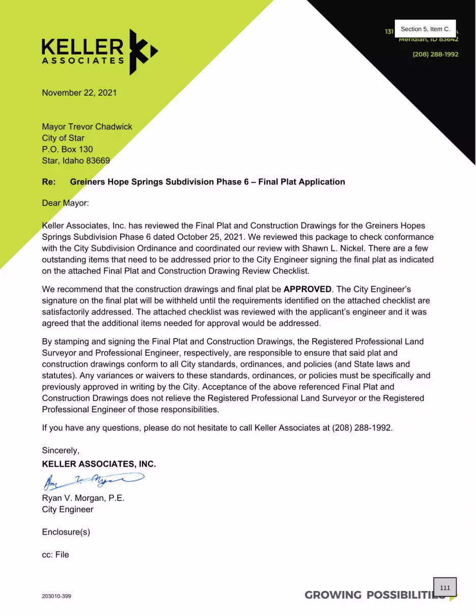
GROWING POSSIBILITIES
131 SW 5th Ave, Suite AMeridian, ID 83642
(208) 288-1992
203010-399
November 22, 2021
Mayor Trevor ChadwickCity of StarP.O. Box 130Star, Idaho 83669
Re: Greiners Hope Springs Subdivision Phase 6 – Final Plat Application
Dear Mayor:
Keller Associates, Inc. has reviewed the Final Plat and Construction Drawings for the Greiners Hopes Springs Subdivision Phase 6 dated October 25, 2021. We reviewed this package to check conformance with the City Subdivision Ordinance and coordinated our review with Shawn L. Nickel. There are a few outstanding items that need to be addressed prior to the City Engineer signing the final plat as indicated on the attached Final Plat and Construction Drawing Review Checklist.
We recommend that the construction drawings and final plat be APPROVED. The City Engineer’s signature on the final plat will be withheld until the requirements identified on the attached checklist are satisfactorily addressed. The attached checklist was reviewed with the applicant’s engineer and it was agreed that the additional items needed for approval would be addressed.
By stamping and signing the Final Plat and Construction Drawings, the Registered Professional Land Surveyor and Professional Engineer, respectively, are responsible to ensure that said plat and construction drawings conform to all City standards, ordinances, and policies (and State laws and statutes). Any variances or waivers to these standards, ordinances, or policies must be specifically and previously approved in writing by the City. Acceptance of the above referenced Final Plat and Construction Drawings does not relieve the Registered Professional Land Surveyor or the Registered Professional Engineer of those responsibilities.
If you have any questions, please do not hesitate to call Keller Associates at (208) 288-1992.
Sincerely, KELLER ASSOCIATES, INC.
Ryan V. Morgan, P.E.City Engineer
Enclosure(s)
cc: File
111
Section 5, Item C.

June 10, 2022 By e-mail: [email protected] City of Star P.O. Box 130 Star, Idaho 83669 Subject: Greiner’s Hope Springs Subdivision Final Plat Phase 6, FP-22-11 Dear Mr. Nickel:
Thank you for the opportunity to respond to your request for comment. While DEQ does not review projects on a project-specific basis, we attempt to provide the best review of the information provided. DEQ encourages agencies to review and utilize the Idaho Environmental Guide to assist in addressing project-specific conditions that may apply. This guide can be found at: https://www.deq.idaho.gov/public-information/assistance-and-resources/outreach-and-education/. The following information does not cover every aspect of this project; however, we have the following general comments to use as appropriate:
1. AIR QUALITY
• Please review IDAPA 58.01.01 for all rules on Air Quality, especially those regarding fugitive dust (58.01.01.651), trade waste burning (58.01.01.600-617), and odor control plans (58.01.01.776).
• All property owners, developers, and their contractor(s) must ensure that reasonable controls to prevent fugitive dust from becoming airborne are utilized during all phases of construction activities per IDAPA 58.01.01.651.
• DEQ recommends the city/county require the development and submittal of a dust prevention and control plan for all construction projects prior to final plat approval. Dust prevention and control plans incorporate appropriate best management practices to control fugitive dust that may be generated at sites.
• Citizen complaints received by DEQ regarding fugitive dust from development and construction activities approved by cities or counties will be referred to the city/county to address under their ordinances.
Brad Little, Governor Jess Byrne, Director
1445 N Orchard Street, Boise, ID 83706 (208) 373-0550
112
Section 5, Item C.

Response to Request for Comment June 10, 2022 Page 2
• Per IDAPA 58.01.01.600-617, the open burning of any construction waste is prohibited. The
property owner, developer, and their contractor(s) are responsible for ensuring no prohibited open burning occurs during construction.
• For questions, contact David Luft, Air Quality Manager, at (208) 373-0550.
2. WASTEWATER AND RECYCLED WATER
• DEQ recommends verifying that there is adequate sewer to serve this project prior to approval. Please contact the sewer provider for a capacity statement, declining balance report, and willingness to serve this project.
• IDAPA 58.01.16 and IDAPA 58.01.17 are the sections of Idaho rules regarding wastewater and recycled water. Please review these rules to determine whether this or future projects will require DEQ approval. IDAPA 58.01.03 is the section of Idaho rules regarding subsurface disposal of wastewater. Please review this rule to determine whether this or future projects will require permitting by the district health department.
• All projects for construction or modification of wastewater systems require preconstruction approval. Recycled water projects and subsurface disposal projects require separate permits as well.
• DEQ recommends that projects be served by existing approved wastewater collection systems or a centralized community wastewater system whenever possible. Please contact DEQ to discuss potential for development of a community treatment system along with best management practices for communities to protect ground water.
• DEQ recommends that cities and counties develop and use a comprehensive land use management plan, which includes the impacts of present and future wastewater management in this area. Please schedule a meeting with DEQ for further discussion and recommendations for plan development and implementation.
For questions, contact Valerie Greear, Water Quality Engineering Manager at (208) 373-0550.
3. DRINKING WATER
• DEQ recommends verifying that there is adequate water to serve this project prior to approval. Please contact the water provider for a capacity statement, declining balance report, and willingness to serve this project.
• IDAPA 58.01.08 is the section of Idaho rules regarding public drinking water systems. Please review these rules to determine whether this or future projects will require DEQ approval.
• All projects for construction or modification of public drinking water systems require preconstruction approval.
113
Section 5, Item C.

Response to Request for Comment June 10, 2022 Page 3
• DEQ recommends verifying if the current and/or proposed drinking water system is a regulated public drinking water system (refer to the DEQ website at: https://www.deq.idaho.gov/water-quality/drinking-water/. For non-regulated systems, DEQ recommends annual testing for total coliform bacteria, nitrate, and nitrite.
• If any private wells will be included in this project, we recommend that they be tested for total coliform bacteria, nitrate, and nitrite prior to use and retested annually thereafter.
• DEQ recommends using an existing drinking water system whenever possible or construction of a new community drinking water system. Please contact DEQ to discuss this project and to explore options to both best serve the future residents of this development and provide for protection of ground water resources.
• DEQ recommends cities and counties develop and use a comprehensive land use management plan which addresses the present and future needs of this area for adequate, safe, and sustainable drinking water. Please schedule a meeting with DEQ for further discussion and recommendations for plan development and implementation.
For questions, contact Valerie Greear, Water Quality Engineering Manager at (208) 373-0550.
4. SURFACE WATER
• Please contact DEQ to determine whether this project will require an Idaho Pollutant Discharge Elimination System (IPDES) Permit. A Construction General Permit from DEQ may be required if this project will disturb one or more acres of land, or will disturb less than one acre of land but are part of a common plan of development or sale that will ultimately disturb one or more acres of land.
• For questions, contact James Craft, IPDES Compliance Supervisor, at (208) 373-0144.
• If this project is near a source of surface water, DEQ requests that projects incorporate construction best management practices (BMPs) to assist in the protection of Idaho’s water resources. Additionally, please contact DEQ to identify BMP alternatives and to determine whether this project is in an area with Total Maximum Daily Load stormwater permit conditions.
• The Idaho Stream Channel Protection Act requires a permit for most stream channel alterations. Please contact the Idaho Department of Water Resources (IDWR), Western Regional Office, at 2735 Airport Way, Boise, or call (208) 334-2190 for more information. Information is also available on the IDWR website at: https://idwr.idaho.gov/streams/stream-channel-alteration-permits.html
• The Federal Clean Water Act requires a permit for filling or dredging in waters of the United States. Please contact the US Army Corps of Engineers, Boise Field Office, at 10095 Emerald Street, Boise, or call 208-345-2155 for more information regarding permits.
For questions, contact Lance Holloway, Surface Water Manager, at (208) 373-0550.
114
Section 5, Item C.

Response to Request for Comment June 10, 2022 Page 4
5. SOLID WASTE, HAZARDOUS WASTE AND GROUND WATER CONTAMINATION
• Solid Waste. No trash or other solid waste shall be buried, burned, or otherwise disposed of at the project site. These disposal methods are regulated by various state regulations including Idaho’s Solid Waste Management Regulations and Standards (IDAPA 58.01.06), Rules and Regulations for Hazardous Waste (IDAPA 58.01.05), and Rules and Regulations for the Prevention of Air Pollution (IDAPA 58.01.01). Inert and other approved materials are also defined in the Solid Waste Management Regulations and Standards
• Hazardous Waste. The types and number of requirements that must be complied with under the federal Resource Conservations and Recovery Act (RCRA) and the Idaho Rules and Standards for Hazardous Waste (IDAPA 58.01.05) are based on the quantity and type of waste generated. Every business in Idaho is required to track the volume of waste generated, determine whether each type of waste is hazardous, and ensure that all wastes are properly disposed of according to federal, state, and local requirements.
• Water Quality Standards. Site activities must comply with the Idaho Water Quality Standards (IDAPA 58.01.02) regarding hazardous and deleterious-materials storage, disposal, or accumulation adjacent to or in the immediate vicinity of state waters (IDAPA 58.01.02.800); and the cleanup and reporting of oil-filled electrical equipment (IDAPA 58.01.02.849); hazardous materials (IDAPA 58.01.02.850); and used-oil and petroleum releases (IDAPA 58.01.02.851 and 852). Petroleum releases must be reported to DEQ in accordance with IDAPA 58.01.02.851.01 and 04. Hazardous material releases to state waters, or to land such that there is likelihood that it will enter state waters, must be reported to DEQ in accordance with IDAPA 58.01.02.850.
• Ground Water Contamination. DEQ requests that this project comply with Idaho’s Ground Water Quality Rules (IDAPA 58.01.11), which states that “No person shall cause or allow the release, spilling, leaking, emission, discharge, escape, leaching, or disposal of a contaminant into the environment in a manner that causes a ground water quality standard to be exceeded, injures a beneficial use of ground water, or is not in accordance with a permit, consent order or applicable best management practice, best available method or best practical method.”
For questions, contact Rebecca Blankenau, Waste & Remediation Manager, at (208) 373-0550.
6. ADDITIONAL NOTES
• If an underground storage tank (UST) or an aboveground storage tank (AST) is identified at the site, the site should be evaluated to determine whether the UST is regulated by DEQ. EPA regulates ASTs. UST and AST sites should be assessed to determine whether there is potential soil and ground water contamination. Please call DEQ at (208) 373-0550, or visit the DEQ website https://www.deq.idaho.gov/waste-management-and-remediation/storage-tanks/leaking-underground-storage-tanks-in-idaho/ for assistance.
115
Section 5, Item C.

Response to Request for Comment June 10, 2022 Page 5
• If applicable to this project, DEQ recommends that BMPs be implemented for any of the following conditions: wash water from cleaning vehicles, fertilizers and pesticides, animal facilities, composted waste, and ponds. Please contact DEQ for more information on any of these conditions.
We look forward to working with you in a proactive manner to address potential environmental impacts that may be within our regulatory authority. If you have any questions, please contact me, or any of our technical staff at (208) 373-0550. Sincerely, Aaron Scheff Regional Administrator DEQ-Boise Regional Office EDMS#: 2022AEK125
116
Section 5, Item C.

117
Section 5, Item C.

118
Section 5, Item C.
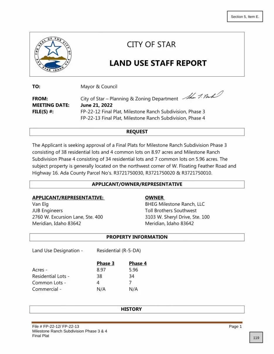
File # FP-22-12/ FP-22-13 Page 1 Milestone Ranch Subdivision Phase 3 & 4 Final Plat
CITY OF STAR
LAND USE STAFF REPORT
TO: Mayor & Council
FROM: City of Star – Planning & Zoning Department
MEETING DATE: June 21, 2022
FILE(S) #: FP-22-12 Final Plat, Milestone Ranch Subdivision, Phase 3
FP-22-13 Final Plat, Milestone Ranch Subdivision, Phase 4
REQUEST
The Applicant is seeking approval of a Final Plats for Milestone Ranch Subdivision Phase 3
consisting of 38 residential lots and 4 common lots on 8.97 acres and Milestone Ranch
Subdivision Phase 4 consisting of 34 residential lots and 7 common lots on 5.96 acres. The
subject property is generally located on the northwest corner of W. Floating Feather Road and
Highway 16. Ada County Parcel No’s. R3721750030, R3721750020 & R3721750010.
APPLICANT/OWNER/REPRESENTATIVE
APPLICANT/REPRESENTATIVE: OWNER
Van Elg BHEG Milestone Ranch, LLC
JUB Engineers Toll Brothers Southwest
2760 W. Excursion Lane, Ste. 400 3103 W. Sheryl Drive, Ste. 100
Meridian, Idaho 83642 Meridian, Idaho 83642
PROPERTY INFORMATION
Land Use Designation - Residential (R-5-DA)
Phase 3 Phase 4
Acres - 8.97 5.96
Residential Lots - 38 34
Common Lots - 4 7
Commercial - N/A N/A
HISTORY
119
Section 5, Item E.

File # FP-22-12/ FP-22-13 Page 2 Milestone Ranch Subdivision Phase 3 & 4 Final Plat
This property was previously platted in Ada County as Lots 1, 2 and 3, Block 1 of Hoot Nanney
Farms Subdivision. On June 19, 2018, Lots 1 & 2 were annexed into the City of Star as Dixon
Sunrise Subdivision with an M-U zoning designation. The approval did not include any
development plans but it was for commercial and residential according to the file records.
October 12, 2021 Council approved applications for Annexation and Zoning (AZ-21-
20), Rezone (RZ-21-06), Development Agreement (DA-21-15) and
Preliminary Plat (PP-21-14) for Milestone Ranch Subdivision. The
preliminary plat was approved for 284 residential lots and 33
common lots on 70.52 acres.
May 3, 2022 Council approved the Final Plat for Milestone Ranch Subdivision,
Phase 1 consisting of 57 residential lots and 15 common lots on
18.66 acres.
June 7, 2022 Council approved the Final Plat for Milestone Ranch Subdivision,
Phase 2 consisting of 42 residential lots and 7 common lots on
8.69 acres.
GENERAL DISCUSSION
The Applicant is seeking approval of a Final Plat for Milestone Ranch Subdivision Phase 3,
consisting of 38 residential lots and 4 common lots on 8.97 acres and Milestone Ranch
Subdivision Phase 4, consisting of 34 residential lots and 7 common lots on 5.69 acres.
The Final Plat generally complies with the approved Preliminary Plat.
This subdivision is located in FEMA Zone X; outside the 500-year floodplain. No special permits
are required.
Staff Reviewed Comments from the Preliminary Plat Approval/Findings of Fact:
The Preliminary Plat submitted contains 240 single family detached residential lots, 44 single
family attached townhome lots and 33 common area lots on 67.0 acres. This equates to 4.24
dwelling units per acre. The lots will have access and frontage from public streets. The
development has a variety of lot widths, including 40, 45, and 55 feet with depths of 110 feet.
Single family detached lots will range in size from 4,738 square feet to 11,431 square feet with
the average buildable lot being 5,498 square feet. The Townhome lots will range in size from
3,906 square feet to 9,172 square feet. The submitted preliminary plat is showing all local roads
with a 50-foot wide right of way with paved streets measuring 36 feet from back of curb to back
of curb. Sidewalks are proposed to be detached with a 5-foot, concrete sidewalk and 8-foot side
landscape strip. The applicant is proposing 10.75 acres (16.04%) of open space, not including
5.93 acres set aside for future State Highway 16 right-of-way. The applicant is proposing 10.63
acres (15.87%) of usable open space, not including the 8-foot-wide landscape strip along the
120
Section 5, Item E.

File # FP-22-12/ FP-22-13 Page 3 Milestone Ranch Subdivision Phase 3 & 4 Final Plat
local streets. These percentages satisfy the Unified Development Code requirement of 15% open
space with 10% useable.
The Unified Development Code, Section 8-4E-2 requires a development of this size to have a
minimum of seven (7) site amenities. The applicant is proposing a 2.44-acre central park with a
club house, pool, a plaza with picnic tables, two (2) pocket parks with sitting areas, four (4)
pickleball courts, a cart path with connection to the golf course and multiple pathways and
micro pathways that connect the development to the common areas and amenities. These
amenities satisfy the code requirement for development amenities.
Discussions with ACHD indicate that this section of W. Floating Feather Road may be
downgraded from a minor arterial to a collector and the applicant may be required to
disconnect W. Floating Feather Road from Hwy 16 and construct a cul-de-sac turn around.
Timing of this is being coordinated between ACHD and ITD. The applicant will be required to
dedicate an additional five (5) feet of right of way and install curb, gutter and a detached 5-foot
sidewalk along their W. Floating Feather Road frontage.
Staff analysis of Final Plat Submittal:
The preliminary plat was approved with 284 residential lots (240 single family and 44
townhomes). Phase 1 final plat included 57 residential lots. Phase 2 had 42 residential lots
platted. Phase 3 is 38 lots and Phase 4 is 34 lots, for a total of 171 platted lots in the first 4
phases. That leaves 113 residential lots for future phases.
Common/Open Space and Amenities – Approved open space includes the large Central
Park, clubhouse, pool, picnic tables, 2 pocket parks/sitting areas four pickleball courts, cart
path/golf course connection, multiple pathways, micro paths for connectivity to common areas
and mailbox turn out.
Landscaping - As required by the Unified Development Code, Chapter 4, Section B-7-C-3 Street
Trees; the minimum density of one (1) tree per thirty-five (35) linear feet is required. The
landscaping plan as submitted appears to satisfy this requirement. The applicant shall use “Tree
Selection Guide for Streets and Landscapes throughout Idaho”, as adopted by the Unified
Development Code. The included landscape plan appears to satisfy these requirements.
Streetlights – Streetlight design shall be uniform throughout the development and follow the
approved style and model from the previous phases. Staff is supportive of the location of the
streetlights in both phases. Applicant has previously submitted an approved streetlight cut
sheet.
Setbacks – Council approved a 10-foot rear setback during the public hearing on the
preliminary plat versus the 15-foot rear setback that code calls for.
121
Section 5, Item E.

File # FP-22-12/ FP-22-13 Page 4 Milestone Ranch Subdivision Phase 3 & 4 Final Plat
Subdivision Name – Applicant has provided documentation that the proposed subdivision
name has been accepted and reserved by Ada County.
Street Names – Applicant has provided documentation that the proposed street names have
been reviewed and approved by Ada County and are reflected correctly on the final plat.
Mail Cluster – Applicant has provided approval from Star Postmaster for the location of the
mail clusters. It will be on Lot 1, Block 3 in the provided vehicle pull out of phase 1.
PUBLIC/DEPARTMENTAL NOTIFICATIONS
Notifications of this application were sent to agencies and City Departments having jurisdiction
on May 30, 2022.
June 10, 2022 DEQ Standard Letter
Star City Engineer Pending
FINDINGS
The Council may approve, conditionally approve, deny or table this request. In order
to approve this Final Plat, the Unified Development Code requires that Council must find
the following:
A. The Plat is in conformance with the Comprehensive Plan.
Staff finds that this subdivision upon Preliminary Plat approval was in conformance with the
Comprehensive Plan; no changes have been made to change this status.
B. Public services are available or can be made available and are adequate to accommodate the
proposed development.
Staff finds that all public services are available and able to accommodate this development.
C. There is public financial capability of supporting services for the proposed development.
Staff knows of no financial hardship that would prevent services from being provided.
D. The development will not be detrimental to the public health, safety or general welfare; and,
Staff finds no facts to support that this subdivision phase will be detrimental to the public
health, safety or general welfare.
E. The development preserves significant natural, scenic or historic features.
Staff finds that existing conditions have not substantially changed from the approved
Preliminary Plat of this subdivision.
122
Section 5, Item E.

File # FP-22-12/ FP-22-13 Page 5 Milestone Ranch Subdivision Phase 3 & 4 Final Plat
CONDITIONS OF APPROVAL
1. The final plat for the Milestone Ranch Subdivision shall comply with all statutory
requirements of applicable agencies and districts having jurisdiction in the City of Star.
2. Applicant shall provide a 7-foot sidewalk along W. Floating Feather Road. Condition
added by Council upon approval of the preliminary plat.
3. The north sub street may be public in the future. Condition added by Council upon
approval of the preliminary plat.
4. The Final Plat shall comply with all received comments from the City Engineer prior to
signature of the plat by the City.
5. The applicant shall enter into a Development Agreement with the City, agreeing to
proportionate share assessment by ITD regarding impacts to the State Highway
System. ITD has calculated the fees to be $39,222. These fees will be collected by the
City of Star, by phase, prior to final plat signature. The development agreement shall be
signed and recorded as part of the ordinance for annexation and zoning and shall contain
the details of the fees to be collected.
6. The property shall be satisfactorily weed abated at all times, including future phases,
preventing a public nuisance, per Star City Code Chapter 3, Section 3-1-1 through 3-1-7.
7. The property associated with this approved Final Plat, in addition to the property of all future
phases shall be properly maintained throughout the construction process to include trash
picked up and trash receptacles emptied with regular frequency, streets swept and cleaned
weekly, including any streets used to access the property and all debris shall be prevented
from accumulating on any adjacent property or public right of way and shall remove all
debris from public way at least daily.
8. Mylar’s/final plats must include the statement supporting the “Right to Farm Act” as per
Idaho Code Title 22, Chapter 45.
9. Development standards for single family residential units shall comply with effective building
and zoning requirements at time of building permit issuance.
10. The Mylar of this final plat shall be signed by the owner, Surveyor, Central District Health,
ACHD and City Engineer, prior to being delivered to the City of Star for City Clerk’s signature.
11. All common areas shall be maintained by the Homeowner’s Association.
12. Streetlights shall comply with the Star City Code and shall be of the same design
throughout the entire subdivision. Streetlights shall be continuous throughout the
subdivision and shall be maintained by the Homeowners Association. Streetlights
shall be installed and energized prior to issuing of building permits. Design shall
follow Code with requirements for light trespass and “Dark Skies” lighting.
Streetlights shall comply with the Star City Code regarding light trespass and “Dark
Sky” initiative. 13. The Applicant/Owner shall comply with the City of Star Unified Development Code regarding
landscaping, both internal buffers and frontages. Street trees shall be installed per Chapter 4,
Section B-7-C-3 Street Trees as indicated on the approved landscape plan.
14. The applicant shall provide the City with a written Certificate of Completion that all
landscaping and amenities have been installed in substantial compliance with the City
approved landscape plan. The certification shall be prepared by the licensed landscape
123
Section 5, Item E.

File # FP-22-12/ FP-22-13 Page 6 Milestone Ranch Subdivision Phase 3 & 4 Final Plat
architect responsible for the landscape plan. This shall be completed prior to final plat
signature.
15. A letter from the US Postal Service shall be given to the City prior to final Mylar signature
stating the subdivision is in compliance with the Postal Service.
16. A form signed by the Star Sewer & Water District shall be submitted to the City prior to final
mylar signature stating that all conditions have been met.
17. A sign application shall be submitted to the City for any subdivision signs.
18. The applicant shall provide a sign, to be located at all construction entrances, indicating the
rules for all contractors that will be working on the property starting at grading and running
through home sales that addresses items including but not limited to dust, music, dogs,
starting/stopping hours for contractors (7a.m. start time). Sign shall be approved by the
City prior to start of any construction.
19. Applicant shall provide the City with one (1) full size copy, one (1) 11”x17” copy and an
electronic pdf copy of the as-built irrigation plans, prior to any building permits being
issued.
20. Applicant shall provide the City with two (2) full size copies, one (1) 11”x17” copy and an
electronic pdf copy of the signed recorded final plat with all signatures, prior to any
building permits being issued.
21. Applicant shall provide the City with one (1) copy and an electronic pdf copy of the
recorded CC&R’s, prior to any building permits being issued.
22. Applicant shall provide the City with one (1) full size copy and an electronic pdf copy of the
final, approved construction drawings, prior to any building permits being issued.
23. All common areas shall be maintained by the Homeowners Association.
24. Any additional Condition of Approval as required by Staff and City Council.
25. Owner/Developer agrees to install a 2’ (High Density Polyethylene) HDPR SDR-11 roll
pipe in the shared utility trench to be used for future fiber optic/high speed data
cables.
COUNCIL DECISION
The Star City Council ____________________ File # FP-22-12 Milestone Ranch Subdivision, Phase 3
and File # FP-22-13, Milestone Ranch Subdivision, Phase 4, Final Plat, on _________________ ______,
2022.
124
Section 5, Item E.

Milestone Ranch No 3Vicinity Map
43°42'31.52" N 116°26'56.04" W
Scale: 1 inch approx 600 feetMar 10, 2022 - landproDATA.com The materials available at this website are for informational
purposes only and do not constitute a legal document.Powered by TCPDF (www.tcpdf.org)
125
Section 5, Item E.

2760 West Excursion Lane, Suite 400, Meridian, ID 83642 W www.jub.com P 208.376.7330
April 19, 2022
Star City Hall Planning and Zoning 10769 W State St Star, ID 83669
RE: Milestone Ranch Subdivision Phase 3, Final Plat
Dear Mr. Nickel,
On behalf of BHEG Milestone Ranch, LLC, please accept this request for Final Plat approval of the
Milestone Ranch Subdivision, Phase 3.
The project is located west of State Highway 16 (Emmett Highway) and to the north of W Floating Feather Road. It is further identified as portions of Lots 1 and 2, Block 1, Hoot Nanney Farms Subdivision, Section 4, T4N, R1W, BM, City of Star, Ada County, Idaho. See also Parcels R3721750030, R3721750020, R3721750010.
• The proposed development includes 38 residential lots and 4 common lots (42 total lots) on 8.97 gross acres. This Phase has a total gross residential density of 4.24 DU/Acre.
• Residential lots in this phase range from 4816 – 9366 SqFt
• The average lot size is 5492.87 SqFt.
• Approved open space for the phases of Milestone Ranch subdivision includes the large Central park, clubhouse, pool, picnic tables, two pocket parks/sitting areas, four pickleball courts, cart path/golf course connection, multiple pathways, micro paths for connectivity to common areas and mailbox turn out.
• There is approximately .51 ac (5.6%) of amenity open space in this phase (excluding all perimeter commons and future Highway 16 ROW). For information purposes only, there is a total of 2.74 acres (36.3%) of common area, including the 50’ landscape buffer to the west of future ROW dedication for Highway 16 (but not the future ROW).
• Rear setbacks are shown at 10’—as approved by Council. In summary, the enclosed application and designs conform with the Conditions of Approval and the City of Star Municipal Code and Comprehensive Plan requirements. Please contact me if you need additional clarification, etc.
Sincerely,
Van Elg
Project Manager
J-U-B ENGINEERS, Inc.
126
Section 5, Item E.

2760 West Excursion Lane, Suite 400, Meridian, ID 83642 W www.jub.com P 208.376.7330
May 4, 2022
Star City Hall Planning and Zoning 10769 W State St Star, ID 83669
RE: Milestone Ranch Subdivision Phase 4, Final Plat
Dear Mr. Nickel,
On behalf of BHEG Milestone Ranch, LLC, please accept this request for Final Plat approval of the
Milestone Ranch Subdivision, Phase 4.
The project is located west of State Highway 16 (Emmett Highway) and to the north of W Floating Feather Road. It is further identified as portions of Lots 1 and 2, Block 1, Hoot Nanney Farms Subdivision, Section 4, T4N, R1W, BM, City of Star, Ada County, Idaho. See also Parcels R3721750030, R3721750020, R3721750010.
• The proposed development includes 32 residential lots and 7 common lots (39 total lots) on 5.96 gross acres. This Phase has a total gross residential density of 5.37 DU/Acre.
• Residential lots in this phase range from 4900 – 6490 SqFt
• The average lot size is 5455.97 SqFt.
• Approved open space for the phases of Milestone Ranch subdivision includes the large Central park, clubhouse, pool, picnic tables, two pocket parks/sitting areas, four pickleball courts, cart path/golf course connection, multiple pathways, micro paths for connectivity to common areas and mailbox turn out.
• There is approximately .63 acres (10.6.%) of open space in this phase
• Rear setbacks are shown at 10’—as approved by Council. In summary, the enclosed application and designs conform with the Conditions of Approval and the City of Star Municipal Code and Comprehensive Plan requirements. Please contact me if you need additional clarification, etc.
Sincerely,
Van Elg
Project Manager
J-U-B ENGINEERS, Inc.
127
Section 5, Item E.

128
Section 5, Item E.

MILESTONE RANCH SUBDIVISION NO. 3
LEGEND
NOTES
A PORTION OF LOT 2, BLOCK 1, HOOT NANNEY FARMS SUBDIVISIONLOCATED IN THE NW 1/4 OF THE SE 1/4 AND THE SW 1/4 OF THE NE 1/4 OF SECTION 4,
T.4N., R.1W., B.M., CITY OF STAR, ADA COUNTY, IDAHO2022
PLASTIC CAPSET 5/8" REBAR WITH PLS 11118
FOUND ALUMINUM CAP MONUMENT SECTION LINE
PLASTIC CAPSET 1/2" REBAR WITH PLS 11118
CALCULATED POINT, NOT SET
CENTER LINE
OTHER EASEMENT LINE AS NOTED
PLASTIC CAP, OR AS NOTEDFOUND 1/2" REBAR WITH PLS 11118
PLASTIC CAP, OR AS NOTEDFOUND 5/8" REBAR WITH PLS 11118
SUBDIVISION BOUNDARY LINELOT LINE
LOT NUMBER
ADJACENT PROPERTY LINE
ADA COUNTY HIGHWAY DISTRICTSTORM DRAINAGE EASEMENT LINE
ADA COUNTY HIGHWAY DISTRICTPERMANENT EASEMENT, INSTRUMENT NO. ___________________
FOUND BRASS CAP MONUMENT
SURVEYOR'S NARRATIVETHE BOUNDARY FOR THIS SUBDIVISION WAS DEVELOPED FROM SURVEYED TIES TO CONTROLLING SECTION CORNERMONUMENTATION, THE PLATTED SUBDIVISION BOUNDARIES OF HOOT NANNEY FARMS SUBDIVISION, WORSLEY'S FOLLYSUBDIVISION, THE TRELLIS SUBDIVISION, MILESTONE RANCH SUBDIVISION NO. 1, MILESTONE RANCH SUBDIVISION NO. 2,INFORMATION FROM RECORD OF SURVEY NUMBERS 1205, 4931, 5321, 5716, 6981, 12518, AND CURRENT DEEDS OF RECORD. THESURVEYED MONUMENTATION AND CONTROLLING BOUNDARIES FIT THE RECORDS WELL AND WERE ACCEPTED TO ESTABLISHTHE BOUNDARY FOR THIS SUBDIVISION SHOWN HEREON.
40' 160'80'0'
SCALE: 1" = 80'
Land Surveying and Consulting
BOOK ____ , PAGE _______
231 E. 5TH STREET, MERIDIAN ID 83642(208) 288-2040 www.landsolutions.biz
SHEET 1 OF 3
1. ALL LOT LINES COMMON TO PUBLIC STREETS ARE HEREBY DESIGNATED TO HAVE A SIXTEEN (16) FOOT PERMANENT EASEMENT FOR PUBLIC UTILITIES, PRESSUREIRRIGATION AND LOT DRAINAGE, UNLESS OTHERWISE SHOWN. THIS EASEMENT SHALL NOT PRECLUDE THE CONSTRUCTION OF PROPER HARD-SURFACED DRIVEWAYS ANDWALKWAYS FOR ACCESS TO EACH INDIVIDUAL LOT.
2. ALL LOTS ARE HEREBY DESIGNATED AS HAVING A FIVE (5) FOOT PERMANENT EASEMENT ON EACH SIDE OF THE INTERIOR SIDE LOT LINES, AND TEN (10) FOOT PERMANENTEASEMENT CONTIGUOUS TO ALL REAR LOT LINES AND SUBDIVISION BOUNDARY, FOR PUBLIC UTILITIES, PRESSURE IRRIGATION, AND LOT DRAINAGE, UNLESS OTHERWISESHOWN. ALL OTHER EASEMENTS ARE AS SHOWN.
3. MINIMUM BUILDING SETBACKS SHALL BE IN ACCORDANCE WITH THE CITY OF STAR APPLICABLE ZONING AND SUBDIVISION REGULATIONS AT THE TIME OF ISSUANCE OFINDIVIDUAL BUILDING PERMITS OR AS SPECIFICALLY APPROVED AND/OR REQUIRED, OR AS SHOWN ON THIS PLAT.
4. ANY RE-SUBDIVISION OF THIS PLAT SHALL COMPLY WITH THE APPLICABLE ZONING REGULATIONS IN EFFECT AT THE TIME OF THE RESUBDIVISION.
5. IRRIGATION WATER HAS BEEN PROVIDED BY THE FARMERS UNION DITCH COMPANY IN COMPLIANCE WITH IDAHO CODE SECTION 31-3805(1)(b). LOTS WITHIN THESUBDIVISION SHALL BE ENTITLED TO IRRIGATION WATER FROM THESE IRRIGATION ENTITIES, TO BE DELIVERED TO LOTS THROUGH A PRESSURIZED IRRIGATION SYSTEMOWNED AND MAINTAINED BY THE HOMEOWNER ASSOCIATION. THE HOMEOWNER ASSOCIATION WILL BE SUBJECT TO ASSESSMENTS BY SAID IRRIGATION ENTITY.
6. MAINTENANCE OF ANY IRRIGATION OR DRAINAGE PIPE OR DITCH CROSSING A LOT SHALL BE THE RESPONSIBILITY OF THE LOT OWNER UNLESS SUCH RESPONSIBILITY ISASSUMED BY AN IRRIGATION/DRAINAGE ENTITY OR THE HOMEOWNER ASSOCIATION.
7. LOTS 9, 14 AND 26, BLOCK 3 AND LOT 9, BLOCK 5 ARE DESIGNATED AS COMMON LOTS AND SHALL BE OWNED AND MAINTAINED BY THE MILESTONE RANCH SUBDIVISIONHOMEOWNER'S ASSOCIATION, OR ITS ASSIGNS. SAID LOTS ARE COVERED BY BLANKET EASEMENTS FOR PUBLIC UTILITIES, IRRIGATION AND LOT DRAINAGE.
8. THIS DEVELOPMENT RECOGNIZES IDAHO CODE SECTION 22-4503, RIGHT TO FARM ACT, WHICH STATES "NO AGRICULTURAL OPERATION, AGRICULTURAL FACILITY OREXPANSION THEREOF SHALL BE OR BECOME A NUISANCE, PRIVATE OR PUBLIC, BY ANY CHANGED CONDITIONS IN OR ABOUT THE SURROUNDING NONAGRICULTURALACTIVITIES AFTER IT HAS BEEN IN OPERATION FOR MORE THAN ONE (1) YEAR, WHEN THE OPERATION, FACILITY OR EXPANSION WAS NOT A NUISANCE AT THE TIME IT BEGANOR WAS CONSTRUCTED. THE PROVISIONS OF THIS SECTION SHALL NOT APPLY WHEN A NUISANCE RESULTS FROM THE IMPROPER OR NEGLIGENT OPERATION OF ANAGRICULTURAL OPERATION, AGRICULTURAL FACILITY OR EXPANSION THEREOF."
9. THIS SUBDIVISION IS SUBJECT TO THE TERMS OF A DEVELOPMENT AGREEMENT RECORDED AS INSTRUMENT NO. ____-______, RECORDS OF ADA COUNTY, IDAHO.
10. A PORTION OF LOT 14, BLOCK 3 AS SHOWN HEREON IS SERVIENT TO AND CONTAINS THE ADA COUNTY HIGHWAY DISTRICT STORM WATER DRAINAGE SYSTEM. THIS LOT ISENCUMBERED BY THAT CERTAIN MASTER PERPETUAL STORM WATER DRAINAGE EASEMENT RECORDED ON NOVEMBER 10, 2015 AS INSTRUMENT NO. 2015-103256, OFFICIALRECORDS OF ADA COUNTY, AND INCORPORATED HEREIN BY THIS REFERENCE AS IF SET FORTH IN FULL (THE "MASTER EASEMENT"). THE MASTER EASEMENT AND THESTORM WATER DRAINAGE SYSTEM ARE DEDICATED TO ADA COUNTY HIGHWAY DISTRICT PURSUANT TO SECTION 40-2302, IDAHO CODE THE MASTER EASEMENT IS FOR THEOPERATION AND MAINTENANCE OF THE STORM WATER DRAINAGE SYSTEM.
11. THIS SUBDIVISION IS SUBJECT TO THE TERMS OF AN ADA COUNTY HIGHWAY DISTRICT TEMPORARY LICENSE AGREEMENT RECORDED AS INSTRUMENT NO. ____-______,RECORDS OF ADA COUNTY, IDAHO.
12. DIRECT LOT OR PARCEL ACCESS TO N. MILESTONE WAY AND STATE HIGHWAY 16 IS PROHIBITED.
RECORD DATA
SEE NOTE 10
PUBLIC UTILITY, PRESSURE IRRIGATION& LOT DRAINAGE EASEMENT LINE -SEE NOTES 1 & 2
129
Section 5, Item E.

CERTIFICATE OF SURVEYOR
CERTIFICATE OF OWNERS
CLINTON W. HANSENPLS 11118
I, CLINTON W. HANSEN, DO HEREBY CERTIFY THAT I AM A LICENSED PROFESSIONAL LAND SURVEYOR IN THE STATE OF IDAHO, AND THATTHIS PLAT AS DESCRIBED IN THE "CERTIFICATE OF OWNERS" WAS DRAWN FROM THE FIELD NOTES OF A SURVEY MADE ON THE GROUNDUNDER MY DIRECT SUPERVISION AND ACCURATELY REPRESENTS THE POINTS PLATTED THEREON, AND IS IN CONFORMITY WITH THESTATE OF IDAHO CODE RELATING TO PLATS AND SURVEYS.
KNOW ALL MEN BY THESE PRESENTS: THAT WE, THE UNDERSIGNED, ARE THE OWNERS OF THE REAL PROPERTY DESCRIBED BELOW INADA COUNTY, IDAHO, AND THAT WE INTEND TO INCLUDE THE FOLLOWING DESCRIBED PROPERTY IN THIS PLAT OF MILESTONE RANCHSUBDIVISION NO. 3;
A PORTION OF LOT 2, BLOCK 1 OF HOOT NANNEY FARMS SUBDIVISION AS SHOWN IN BOOK 103 OF PLATS ON PAGES 13839 THROUGH13841, RECORDS OF ADA COUNTY, IDAHO, BEING LOCATED IN THE NW ¼ OF THE SE ¼ AND THE SW ¼ OF THE NE ¼ OF SECTION 4,TOWNSHIP 4 NORTH, RANGE 1 WEST, BOISE MERIDIAN, CITY OF STAR, ADA COUNTY, IDAHO, AND MORE PARTICULARLY DESCRIBED ASFOLLOWS:
COMMENCING AT A BRASS CAP MONUMENT MARKING THE SOUTHWEST CORNER OF SAID NW ¼ OF THE SE ¼ (CS 1/16 CORNER), FROMWHICH AN ALUMINUM CAP MONUMENT MARKING THE NORTHWEST CORNER OF SAID NW ¼ OF THE SE ¼ (C ¼ CORNER) BEARS N 0°48'29” EA DISTANCE OF 1329.13 FEET;
THENCE ALONG THE SOUTHERLY BOUNDARY OF SAID NW ¼ OF THE SE ¼ S 89°27'07” E A DISTANCE OF 1278.39 FEET (FORMERLY S89°59'16” E, 1278.23 FEET) TO THE SOUTHEASTERLY CORNER OF SAID HOOT NANNEY FARMS SUBDIVISION;
THENCE LEAVING SAID SOUTHERLY BOUNDARY N 0°55'29” E (FORMERLY N 0°23'02” E) ALONG THE EASTERLY BOUNDARY OF SAID HOOTNANNEY FARMS SUBDIVISION, ALSO BEING THE EASTERLY BOUNDARY OF MILESTONE RANCH SUBDIVISION NO. 2, AS SHOWN IN BOOK ___OF PLATS ON PAGES ______ THROUGH ______, RECORDS OF ADA COUNTY, IDAHO, A DISTANCE OF 729.72 FEET TO A POINT ON THEEASTERLY BOUNDARY OF LOT 2, BOCK 1 OF SAID HOOT NANNEY FARMS SUBDIVISION BEING THE NORTHEASTERLY CORNER OF SAIDMILESTONE RANCH SUBDIVISION NO. 2, AND THE POINT OF BEGINNING;
THENCE ALONG THE NORTHERLY BOUNDARY OF SAID MILESTONE RANCH SUBDIVISION NO. 2 N 89°04'31” W A DISTANCE OF 494.16 FEET TOA POINT ON THE EASTERLY BOUNDARY OF MILESTONE RANCH SUBDIVISION NO. 1, AS SHOWN IN BOOK ___ OF PLATS ON PAGES ______THROUGH ______, RECORDS OF ADA COUNTY, IDAHO;
THENCE ALONG SAID EASTERLY BOUNDARY THE FOLLOWING COURSES AND DISTANCES:
THENCE N 0°55'29” E A DISTANCE OF 230.00 FEET TO A POINT;
THENCE N 89°04'31” W A DISTANCE OF 140.84 FEET TO A POINT;
THENCE N 44°04'31” W A DISTANCE OF 14.14 FEET TO A POINT;
THENCE N 0°55'29” E A DISTANCE OF 150.00 FEET TO A POINT;
THENCE N 89°04'31” W A DISTANCE OF 20.00 FEET TO A POINT;
THENCE N 0°55'29” E A DISTANCE OF 110.00 FEET TO A POINT;
THENCE S 89°04'31” E A DISTANCE OF 145.00 FEET TO A POINT;
THENCE N 0°55'29” E A DISTANCE OF 180.00 FEET TO A POINT;
THENCE N 89°04'31” W A DISTANCE OF 20.00 FEET TO A POINT;
THENCE N 0°55'29” E A DISTANCE OF 110.00 FEET TO A POINT;
THENCE LEAVING SAID BOUNDARY S 89°04'31” E A DISTANCE OF 235.00 FEET TO A POINT;
THENCE S 0°55'29” W A DISTANCE OF 121.68 FEET TO A POINT ON A CURVE;
THENCE A DISTANCE OF 77.53 FEET ALONG THE ARC OF A 88.75 FOOT RADIUS NON-TANGENT CURVE RIGHT, SAID CURVE HAVING ACENTRAL ANGLE OF 50°03'07” AND A LONG CHORD BEARING S 29°45'34” E A DISTANCE OF 75.09 FEET TO A POINT;
THENCE S 89°04'31” E A DISTANCE OF 266.68 FEET TO A POINT ON THE WESTERLY RIGHT-OF-WAY OF STATE HIGHWAY 16 AND EASTERLYBOUNDARY OF LOT 2, BLOCK 1 OF SAID HOOT NANNEY FARMS SUBDIVISION;
THENCE ALONG THE EASTERLY BOUNDARY SAID LOT 2 AND SAID WESTERLY RIGHT-OF-WAY S 0°55'29” W (FORMERLY S 0°23'02” W) ADISTANCE OF 603.75 FEET TO THE POINT OF BEGINNING.
THIS PARCEL CONTAINS 8.90 ACRES.
ALL THE LOTS IN THIS SUBDIVISION WILL BE ELIGIBLE TO RECEIVE WATER AND SEWER SERVICE FROM THE STAR SEWER AND WATERDISTRICT. THE STAR SEWER AND WATER DISTRICT HAS AGREED IN WRITING TO SERVE ALL THE LOTS IN THIS SUBDIVISION.
THE PUBLIC STREETS SHOWN ON THIS PLAT ARE HEREBY DEDICATED TO THE PUBLIC. PUBLIC UTILITY, IRRIGATION AND DRAINAGEEASEMENTS ON THIS PLAT ARE NOT DEDICATED TO THE PUBLIC, BUT THE RIGHT OF ACCESS TO, AND USE OF, THESE EASEMENTS ISHEREBY RESERVED FOR PUBLIC UTILITIES, DRAINAGE AND FOR ANY OTHER USES AS MAY BE DESIGNATED HEREON AND NO PERMANENTSTRUCTURES OTHER THAN FOR SAID USES ARE TO BE ERECTED WITHIN THE LIMITS OF SAID EASEMENTS.
IN WITNESS WHEREOF WE HAVE HEREUNTO SET OUR HAND THIS ____ DAY OF _________________________ , 20___.
BHEG MILESTONE RANCH LLC, A DELAWARE LIMITED LIABILITY COMPANY
____________________________________________________________BY BRIAN JACKSON, VICE PRESIDENT
BOOK ____ , PAGE _______MILESTONE RANCH SUBDIVISION NO. 3
ACKNOWLEDGMENT
STATE OF _______________COUNTY OF _____________ S.S.
NOTARY PUBLIC FOR THE STATE OF IDAHO
MY COMMISSION EXPIRES
RESIDING AT
ON THIS ____ DAY OF ____________ , 20___, BEFORE ME, THE UNDERSIGNED, A NOTARY PUBLIC IN AND FOR SAID STATE PERSONALLYAPPEARED BRIAN JACKSON, KNOWN OR IDENTIFIED TO ME TO BE THE VICE PRESIDENT OF BHEG MILESTONE RANCH LLC, A DELAWARELIMITED LIABILITY COMPANY, WHO SUBSCRIBED SAID LIMITED LIABILITY COMPANY'S NAME TO THE FOREGOING INSTRUMENT, ANDACKNOWLEDGED TO ME THAT HE EXECUTED THE SAME IN SAID LIABILITY COMPANY'S NAME.
IN WITNESS WHEREOF, I HAVE HEREUNTO SET MY HAND AND AFFIXED MY OFFICIAL SEAL THE DAY AND YEAR IN THIS CERTIFICATE FIRSTABOVE WRITTEN.
Land Surveying and Consulting231 E. 5TH STREET, MERIDIAN ID 83642(208) 288-2040 www.landsolutions.biz
SHEET 2 OF 3130
Section 5, Item E.

APPROVAL OF ADA COUNTY HIGHWAY DISTRICT
PRESIDENT, ADA COUNTY HIGHWAY DISTRICT
CERTIFICATE OF THE COUNTY TREASURER
CERTIFICATE OF THE COUNTY SURVEYOR
ADA COUNTY SURVEYOR
DATE: ______________________ ______________________________________________COUNTY TREASURER
CERTIFICATE OF COUNTY RECORDER
STATE OF IDAHOCOUNTY OF ADA
S.S.
I HEREBY CERTIFY THAT THIS INSTRUMENT WAS FILED FOR RECORD AT THE REQUEST OF
LAND SOLUTIONS, P.C., AT ____ MINUTES PAST ___ O'CLOCK __ .M. ON
DEPUTY EX-OFFICIO RECORDER
THIS ____ DAY OF __________________ , 20___, IN BOOK ____ OF PLATS AT PAGES _______________.
INSTRUMENT NO. ______________________
APPROVAL OF CITY COUNCIL
CITY CLERK
I, THE UNDERSIGNED, CITY ENGINEER IN AND FOR THE CITY OF STAR, ADA COUNTY, IDAHO, HEREBYAPPROVE THIS PLAT.
CITY ENGINEER ~ STAR, IDAHO
APPROVAL OF THE CITY ENGINEER
HEALTH CERTIFICATE
CENTRAL DISTRICT HEALTH, EHS DATE
SANITARY RESTRICTIONS AS REQUIRED BY IDAHO CODE, TITLE 50, CHAPTER 13, HAVE BEEN SATISFIEDACCORDING TO THE LETTER TO BE READ ON FILE WITH THE COUNTY RECORDER OR HIS AGENT LISTING THECONDITIONS OF APPROVAL. SANITARY RESTRICTIONS MAY BE RE-IMPOSED, IN ACCORDANCE WITHSECTION 50-1326, IDAHO CODE, BY THE ISSUANCE OF A CERTIFICATE OF DISAPPROVAL.
FEE: ______________________
I, THE UNDERSIGNED, CITY CLERK IN AND FOR THE CITY OF STAR, ADA COUNTY ,IDAHO, DO HEREBYCERTIFY THAT AT A REGULAR MEETING OF THE CITY COUNCIL HELD ON THE ____ DAY OF ____________ ,20___, THIS PLAT WAS DULY ACCEPTED AND APPROVED.
THE FOREGOING PLAT WAS ACCEPTED AND APPROVED BY THE BOARD OF ADA COUNTY HIGHWAYDISTRICT COMMISSIONERS ON THE ____ DAY OF ___________ , 20___.
I, THE UNDERSIGNED, PROFESSIONAL LAND SURVEYOR FOR ADA COUNTY, IDAHO, HEREBY CERTIFY THAT IHAVE CHECKED THIS PLAT AND FIND THAT IT COMPLIES WITH THE STATE OF IDAHO CODE RELATING TOPLATS AND SURVEYS.
I, THE UNDERSIGNED, COUNTY TREASURER IN AND FOR THE COUNTY OF ADA, STATE OF IDAHO, PER THEREQUIREMENTS OF I.C. 50-1308, DO HEREBY CERTIFY THAT ANY AND ALL CURRENT AND OR DELINQUENTCOUNTY PROPERTY TAXES FOR THE PROPERTY INCLUDED IN THIS SUBDIVISION HAVE BEEN PAID IN FULL.THIS CERTIFICATION IS VALID FOR THE NEXT THIRTY (30) DAYS ONLY.
CLINTON W. HANSENPLS 11118
BOOK ____ , PAGE _______MILESTONE RANCH SUBDIVISION NO. 3
Land Surveying and Consulting231 E. 5TH STREET, MERIDIAN ID 83642(208) 288-2040 www.landsolutions.biz
SHEET 3 OF 3131
Section 5, Item E.

MILESTONE RANCH SUBDIVISION NO. 4LEGEND
NOTES
A PORTION OF LOT 2, BLOCK 1, HOOT NANNEY FARMS SUBDIVISIONLOCATED IN THE NW 1/4 OF THE SE 1/4 AND THE SW 1/4 OF THE NE 1/4 OF SECTION 4,
T.4N., R.1W., B.M., CITY OF STAR, ADA COUNTY, IDAHO2022
PLASTIC CAPSET 5/8" REBAR WITH PLS 11118
FOUND ALUMINUM CAP MONUMENT SECTION LINE
PLASTIC CAPSET 1/2" REBAR WITH PLS 11118
CALCULATED POINT, NOT SET
CENTER LINE
OTHER EASEMENT LINE AS NOTED
PLASTIC CAP, OR AS NOTEDFOUND 1/2" REBAR WITH PLS 11118
PLASTIC CAP, OR AS NOTEDFOUND 5/8" REBAR WITH PLS 11118
SUBDIVISION BOUNDARY LINELOT LINE
LOT NUMBER
SURVEY TIE LINE ADJACENT PROPERTY LINE
ADA COUNTY HIGHWAY DISTRICTSTORM DRAINAGE EASEMENT LINE
ADA COUNTY HIGHWAY DISTRICTPERMANENT EASEMENT, INSTRUMENT NO. ___________________
FOUND BRASS CAP MONUMENT
SURVEYOR'S NARRATIVETHE BOUNDARY FOR THIS SUBDIVISION WAS DEVELOPED FROMSURVEYED TIES TO CONTROLLING SECTION CORNER MONUMENTATION,THE PLATTED SUBDIVISION BOUNDARIES OF HOOT NANNEY FARMSSUBDIVISION, WORSLEY'S FOLLY SUBDIVISION, MILESTONE RANCHSUBDIVISION NO. 1, INFORMATION FROM RECORD OF SURVEY NUMBERS1205, 4931, 5321, 5716, 6981, 12518, AND CURRENT DEEDS OF RECORD.THE SURVEYED MONUMENTATION AND CONTROLLING BOUNDARIES FITTHE RECORDS WELL AND WERE ACCEPTED TO ESTABLISH THEBOUNDARY FOR THIS SUBDIVISION SHOWN HEREON.
40' 160'80'0'
SCALE: 1" = 80'
Land Surveying and Consulting
BOOK ____ , PAGE _______
231 E. 5TH STREET, MERIDIAN ID 83642(208) 288-2040 www.landsolutions.biz
SHEET 1 OF 3
1. ALL LOT LINES COMMON TO PUBLIC STREETS ARE HEREBY DESIGNATED TO HAVE A SIXTEEN (16) FOOT PERMANENT EASEMENT FOR PUBLIC UTILITIES, PRESSUREIRRIGATION AND LOT DRAINAGE, UNLESS OTHERWISE SHOWN. THIS EASEMENT SHALL NOT PRECLUDE THE CONSTRUCTION OF PROPER HARD-SURFACEDDRIVEWAYS AND WALKWAYS FOR ACCESS TO EACH INDIVIDUAL LOT.
2. ALL LOTS ARE HEREBY DESIGNATED AS HAVING A FIVE (5) FOOT PERMANENT EASEMENT ON EACH SIDE OF THE INTERIOR SIDE LOT LINES, AND TEN (10) FOOTPERMANENT EASEMENT CONTIGUOUS TO ALL REAR LOT LINES AND SUBDIVISION BOUNDARY, FOR PUBLIC UTILITIES, PRESSURE IRRIGATION, AND LOT DRAINAGE,UNLESS OTHERWISE SHOWN. ALL OTHER EASEMENTS ARE AS SHOWN.
3. MINIMUM BUILDING SETBACKS SHALL BE IN ACCORDANCE WITH THE CITY OF STAR APPLICABLE ZONING AND SUBDIVISION REGULATIONS AT THE TIME OFISSUANCE OF INDIVIDUAL BUILDING PERMITS OR AS SPECIFICALLY APPROVED AND/OR REQUIRED, OR AS SHOWN ON THIS PLAT.
4. ANY RE-SUBDIVISION OF THIS PLAT SHALL COMPLY WITH THE APPLICABLE ZONING REGULATIONS IN EFFECT AT THE TIME OF THE RESUBDIVISION.
5. IRRIGATION WATER HAS BEEN PROVIDED BY THE FARMERS UNION DITCH COMPANY IN COMPLIANCE WITH IDAHO CODE SECTION 31-3805(1)(b). LOTS WITHIN THESUBDIVISION SHALL BE ENTITLED TO IRRIGATION WATER FROM THESE IRRIGATION ENTITIES, TO BE DELIVERED TO LOTS THROUGH A PRESSURIZED IRRIGATIONSYSTEM OWNED AND MAINTAINED BY THE HOMEOWNER ASSOCIATION. THE HOMEOWNER ASSOCIATION WILL BE SUBJECT TO ASSESSMENTS BY SAID IRRIGATIONENTITY.
6. MAINTENANCE OF ANY IRRIGATION OR DRAINAGE PIPE OR DITCH CROSSING A LOT SHALL BE THE RESPONSIBILITY OF THE LOT OWNER UNLESS SUCHRESPONSIBILITY IS ASSUMED BY AN IRRIGATION/DRAINAGE ENTITY OR THE HOMEOWNER ASSOCIATION.
7. LOT 24, BLOCK 4; LOT 16, BLOCK 7; LOT 7, BLOCK 11; LOT 6, BLOCK 12 AND LOT 1, BLOCK 16 ARE DESIGNATED AS COMMON LOTS AND SHALL BE OWNED ANDMAINTAINED BY THE MILESTONE RANCH SUBDIVISION HOMEOWNER'S ASSOCIATION, OR ITS ASSIGNS. SAID LOTS ARE COVERED BY BLANKET EASEMENTS FORPUBLIC UTILITIES, IRRIGATION AND LOT DRAINAGE.
8. THIS DEVELOPMENT RECOGNIZES IDAHO CODE SECTION 22-4503, RIGHT TO FARM ACT, WHICH STATES "NO AGRICULTURAL OPERATION, AGRICULTURAL FACILITYOR EXPANSION THEREOF SHALL BE OR BECOME A NUISANCE, PRIVATE OR PUBLIC, BY ANY CHANGED CONDITIONS IN OR ABOUT THE SURROUNDINGNONAGRICULTURAL ACTIVITIES AFTER IT HAS BEEN IN OPERATION FOR MORE THAN ONE (1) YEAR, WHEN THE OPERATION, FACILITY OR EXPANSION WAS NOT ANUISANCE AT THE TIME IT BEGAN OR WAS CONSTRUCTED. THE PROVISIONS OF THIS SECTION SHALL NOT APPLY WHEN A NUISANCE RESULTS FROM THEIMPROPER OR NEGLIGENT OPERATION OF AN AGRICULTURAL OPERATION, AGRICULTURAL FACILITY OR EXPANSION THEREOF."
9. THIS SUBDIVISION IS SUBJECT TO THE TERMS OF A DEVELOPMENT AGREEMENT RECORDED AS INSTRUMENT NO. 2022-014198, RECORDS OF ADA COUNTY, IDAHO.
10. LOT 6, BLOCK 12 AND PORTIONS OF LOTS 5, 7 AND 8, BLOCK 12 AS SHOWN HEREON ARE SERVIENT TO AND CONTAIN THE ADA COUNTY HIGHWAY DISTRICT STORMWATER DRAINAGE SYSTEM. THESE LOTS ARE ENCUMBERED BY THAT CERTAIN MASTER PERPETUAL STORM WATER DRAINAGE EASEMENT RECORDED ONNOVEMBER 10, 2015 AS INSTRUMENT NO. 2015-103256, OFFICIAL RECORDS OF ADA COUNTY, AND INCORPORATED HEREIN BY THIS REFERENCE AS IF SET FORTH INFULL (THE "MASTER EASEMENT"). THE MASTER EASEMENT AND THE STORM WATER DRAINAGE SYSTEM ARE DEDICATED TO ADA COUNTY HIGHWAY DISTRICTPURSUANT TO SECTION 40-2302, IDAHO CODE THE MASTER EASEMENT IS FOR THE OPERATION AND MAINTENANCE OF THE STORM WATER DRAINAGE SYSTEM.
11. THIS SUBDIVISION IS SUBJECT TO THE TERMS OF AN ADA COUNTY HIGHWAY DISTRICT TEMPORARY LICENSE AGREEMENT RECORDED AS INSTRUMENT NO.____-______, RECORDS OF ADA COUNTY, IDAHO.
RECORD DATA
SEE NOTE 10
PUBLIC UTILITY, PRESSURE IRRIGATION& LOT DRAINAGE EASEMENT LINE -SEE NOTES 1 & 2
132
Section 5, Item E.

CERTIFICATE OF SURVEYOR
CERTIFICATE OF OWNERS
CLINTON W. HANSENPLS 11118
I, CLINTON W. HANSEN, DO HEREBY CERTIFY THAT I AM A LICENSED PROFESSIONAL LAND SURVEYOR IN THE STATE OF IDAHO, AND THATTHIS PLAT AS DESCRIBED IN THE "CERTIFICATE OF OWNERS" WAS DRAWN FROM THE FIELD NOTES OF A SURVEY MADE ON THE GROUNDUNDER MY DIRECT SUPERVISION AND ACCURATELY REPRESENTS THE POINTS PLATTED THEREON, AND IS IN CONFORMITY WITH THESTATE OF IDAHO CODE RELATING TO PLATS AND SURVEYS.
KNOW ALL MEN BY THESE PRESENTS: THAT WE, THE UNDERSIGNED, ARE THE OWNERS OF THE REAL PROPERTY DESCRIBED BELOW INADA COUNTY, IDAHO, AND THAT WE INTEND TO INCLUDE THE FOLLOWING DESCRIBED PROPERTY IN THIS PLAT OF MILESTONE RANCHSUBDIVISION NO. 4;
A PORTION OF LOT 2 OF BLOCK 1 OF HOOT NANNEY FARMS SUBDIVISION AS SHOWN IN BOOK 103 OF PLATS ON PAGES 13839 THROUGH13841, RECORDS OF ADA COUNTY, IDAHO, BEING LOCATED IN THE NW ¼ OF THE SE ¼ AND THE SW ¼ OF THE NE ¼ OF SECTION 4,TOWNSHIP 4 NORTH, RANGE 1 WEST, BOISE MERIDIAN, CITY OF STAR, ADA COUNTY, IDAHO, AND MORE PARTICULARLY DESCRIBED ASFOLLOWS:
COMMENCING AT A BRASS CAP MONUMENT MARKING THE SOUTHWEST CORNER OF SAID NW ¼ OF THE SE ¼ (CS 1/16 CORNER), FROMWHICH AN ALUMINUM CAP MONUMENT MARKING THE NORTHWEST CORNER OF SAID NW ¼ OF THE SE ¼ (C ¼ CORNER) BEARS N 0°48'29” E ADISTANCE OF 1329.13 FEET;
THENCE ALONG THE WESTERLY BOUNDARY OF SAID NW ¼ OF THE SE ¼ N 0°48'29” E A DISTANCE OF 1256.13 FEET TO AN ANGLE POINT ONTHE WESTERLY BOUNDARY OF MILESTONE RANCH SUBDIVISION NO. 1, AS SHOWN IN BOOK ___ OF PLATS ON PAGES _____-_____, RECORDSOF ADA COUNTY, SAID POINT ALSO BEING ON THE WESTERLY BOUNDARY OF SAID LOT 2, AND THE POINT OF BEGINNING;
THENCE CONTINUING ALONG THE WESTERLY BOUNDARY OF SAID NW ¼ OF THE SE ¼ AND OF SAID LOT 2 N 0°48'29” E (FORMERLY N 0°16'08”E) A DISTANCE OF 73.00 FEET TO AN ALUMINUM CAP MONUMENT MARKING THE NORTHWEST CORNER OF SAID NW ¼ OF THE SE ¼ (CENTER¼ CORNER);
THENCE ALONG THE WESTERLY BOUNDARY OF THE SW ¼ OF THE NE ¼ OF SAID SECTION 4 AND OF SAID LOT 2 N 0°48'31” E (FORMERLY N0°16'22” E) A DISTANCE OF 614.00 FEET TO A POINT;
THENCE LEAVING SAID BOUNDARY S 89°04'31” E A DISTANCE OF 123.30 FEET TO A POINT ON A CURVE;
THENCE A DISTANCE OF 25.47 FEET ALONG THE ARC OF A 46.00 FOOT RADIUS NON-TANGENT CURVE LEFT, SAID CURVE HAVING A CENTRALANGLE OF 31°43'13” AND A LONG CHORD BEARING N 11°35'49” W A DISTANCE OF 25.14 FEET TO A POINT;
THENCE N 23°23'14” E A DISTANCE OF 37.87 FEET TO A POINT ON A CURVE;
THENCE A DISTANCE OF 36.93 FEET ALONG THE ARC OF A 30.00 FOOT RADIUS NON-TANGENT CURVE LEFT, SAID CURVE HAVING A CENTRALANGLE OF 70°31'43” AND A LONG CHORD BEARING S 34°20'20” E A DISTANCE OF 34.64 FEET TO A POINT;
THENCE N 0°55'29” E A DISTANCE OF 113.74 FEET TO A POINT;
THENCE S 89°04'31” E A DISTANCE OF 55.00 FEET TO THE NORTHWESTERLY CORNER OF SAID MILESTONE RANCH SUBDIVISION NO. 1;
THENCE ALONG THE WESTERLY BOUNDARY OF SAID MILESTONE RANCH SUBDIVISION NO. 1 THE FOLLOWING COURSES AND DISTANCES:
THENCE S 0°55'29” W A DISTANCE OF 160.00 FEET TO A POINT;
THENCE S 89°04'31” E A DISTANCE OF 20.00 FEET TO A POINT;
THENCE S 0°55'29” W A DISTANCE OF 130.00 FEET TO A POINT;
THENCE S 89°04'31” E A DISTANCE OF 165.00 FEET TO A POINT;
THENCE S 0°55'29” W A DISTANCE OF 380.00 FEET TO A POINT;
THENCE N 89°04'31” W A DISTANCE OF 3.00 FEET TO A POINT;
THENCE S 0°55'29” W A DISTANCE OF 50.00 FEET TO A POINT;
THENCE S 89°04'31” E A DISTANCE OF 28.00 FEET TO A POINT;
THENCE S 0°55'29” W A DISTANCE OF 110.00 FEET TO A POINT;
THENCE N 89°04'31” W A DISTANCE OF 305.00 FEET TO A POINT;
THENCE S 0°55'29” W A DISTANCE OF 2.00 FEET TO A POINT;
THENCE N 89°04'31” W A DISTANCE OF 110.92 FEET TO THE POINT OF BEGINNING.
THIS PARCEL CONTAINS 5.88 ACRES.
ALL THE LOTS IN THIS SUBDIVISION WILL BE ELIGIBLE TO RECEIVE WATER AND SEWER SERVICE FROM THE STAR SEWER AND WATERDISTRICT. THE STAR SEWER AND WATER DISTRICT HAS AGREED IN WRITING TO SERVE ALL THE LOTS IN THIS SUBDIVISION.
THE PUBLIC STREETS SHOWN ON THIS PLAT ARE HEREBY DEDICATED TO THE PUBLIC. PUBLIC UTILITY, IRRIGATION AND DRAINAGEEASEMENTS ON THIS PLAT ARE NOT DEDICATED TO THE PUBLIC, BUT THE RIGHT OF ACCESS TO, AND USE OF, THESE EASEMENTS ISHEREBY RESERVED FOR PUBLIC UTILITIES, DRAINAGE AND FOR ANY OTHER USES AS MAY BE DESIGNATED HEREON AND NO PERMANENTSTRUCTURES OTHER THAN FOR SAID USES ARE TO BE ERECTED WITHIN THE LIMITS OF SAID EASEMENTS.
IN WITNESS WHEREOF WE HAVE HEREUNTO SET OUR HAND THIS ____ DAY OF _________________________ , 20___.
BHEG MILESTONE RANCH LLC, A DELAWARE LIMITED LIABILITY COMPANY
____________________________________________________________BY BRIAN JACKSON, VICE PRESIDENT
BOOK ____ , PAGE _______MILESTONE RANCH SUBDIVISION NO. 4
ACKNOWLEDGMENT
STATE OF _______________COUNTY OF _____________ S.S.
NOTARY PUBLIC FOR THE STATE OF IDAHO
MY COMMISSION EXPIRES
RESIDING AT
ON THIS ____ DAY OF ____________ , 20___, BEFORE ME, THE UNDERSIGNED, A NOTARY PUBLIC IN AND FOR SAID STATE PERSONALLYAPPEARED BRIAN JACKSON, KNOWN OR IDENTIFIED TO ME TO BE THE VICE PRESIDENT OF BHEG MILESTONE RANCH LLC, A DELAWARELIMITED LIABILITY COMPANY, WHO SUBSCRIBED SAID LIMITED LIABILITY COMPANY'S NAME TO THE FOREGOING INSTRUMENT, ANDACKNOWLEDGED TO ME THAT HE EXECUTED THE SAME IN SAID LIABILITY COMPANY'S NAME.
IN WITNESS WHEREOF, I HAVE HEREUNTO SET MY HAND AND AFFIXED MY OFFICIAL SEAL THE DAY AND YEAR IN THIS CERTIFICATE FIRSTABOVE WRITTEN.
Land Surveying and Consulting231 E. 5TH STREET, MERIDIAN ID 83642(208) 288-2040 www.landsolutions.biz
SHEET 2 OF 3133
Section 5, Item E.

APPROVAL OF ADA COUNTY HIGHWAY DISTRICT
PRESIDENT, ADA COUNTY HIGHWAY DISTRICT
CERTIFICATE OF THE COUNTY TREASURER
CERTIFICATE OF THE COUNTY SURVEYOR
ADA COUNTY SURVEYOR
DATE: ______________________ ______________________________________________COUNTY TREASURER
CERTIFICATE OF COUNTY RECORDER
STATE OF IDAHOCOUNTY OF ADA
S.S.
I HEREBY CERTIFY THAT THIS INSTRUMENT WAS FILED FOR RECORD AT THE REQUEST OF
LAND SOLUTIONS, P.C., AT ____ MINUTES PAST ___ O'CLOCK __ .M. ON
DEPUTY EX-OFFICIO RECORDER
THIS ____ DAY OF __________________ , 20___, IN BOOK ____ OF PLATS AT PAGES _______________.
INSTRUMENT NO. ______________________
APPROVAL OF CITY COUNCIL
CITY CLERK
I, THE UNDERSIGNED, CITY ENGINEER IN AND FOR THE CITY OF STAR, ADA COUNTY, IDAHO, HEREBYAPPROVE THIS PLAT.
CITY ENGINEER ~ STAR, IDAHO
APPROVAL OF THE CITY ENGINEER
HEALTH CERTIFICATE
CENTRAL DISTRICT HEALTH, EHS DATE
SANITARY RESTRICTIONS AS REQUIRED BY IDAHO CODE, TITLE 50, CHAPTER 13, HAVE BEEN SATISFIEDACCORDING TO THE LETTER TO BE READ ON FILE WITH THE COUNTY RECORDER OR HIS AGENT LISTING THECONDITIONS OF APPROVAL. SANITARY RESTRICTIONS MAY BE RE-IMPOSED, IN ACCORDANCE WITHSECTION 50-1326, IDAHO CODE, BY THE ISSUANCE OF A CERTIFICATE OF DISAPPROVAL.
FEE: ______________________
I, THE UNDERSIGNED, CITY CLERK IN AND FOR THE CITY OF STAR, ADA COUNTY ,IDAHO, DO HEREBYCERTIFY THAT AT A REGULAR MEETING OF THE CITY COUNCIL HELD ON THE ____ DAY OF ____________ ,20___, THIS PLAT WAS DULY ACCEPTED AND APPROVED.
THE FOREGOING PLAT WAS ACCEPTED AND APPROVED BY THE BOARD OF ADA COUNTY HIGHWAYDISTRICT COMMISSIONERS ON THE ____ DAY OF ___________ , 20___.
I, THE UNDERSIGNED, PROFESSIONAL LAND SURVEYOR FOR ADA COUNTY, IDAHO, HEREBY CERTIFY THAT IHAVE CHECKED THIS PLAT AND FIND THAT IT COMPLIES WITH THE STATE OF IDAHO CODE RELATING TOPLATS AND SURVEYS.
I, THE UNDERSIGNED, COUNTY TREASURER IN AND FOR THE COUNTY OF ADA, STATE OF IDAHO, PER THEREQUIREMENTS OF I.C. 50-1308, DO HEREBY CERTIFY THAT ANY AND ALL CURRENT AND OR DELINQUENTCOUNTY PROPERTY TAXES FOR THE PROPERTY INCLUDED IN THIS SUBDIVISION HAVE BEEN PAID IN FULL.THIS CERTIFICATION IS VALID FOR THE NEXT THIRTY (30) DAYS ONLY.
CLINTON W. HANSENPLS 11118
BOOK ____ , PAGE _______MILESTONE RANCH SUBDIVISION NO. 4
Land Surveying and Consulting231 E. 5TH STREET, MERIDIAN ID 83642(208) 288-2040 www.landsolutions.biz
SHEET 3 OF 3134
Section 5, Item E.

ON
LY
0' 100' 200' 300'
SCALE 1" = 100'
NORTH
135
Section 5, Item E.

0' 30' 60' 90'
136
Section 5, Item E.

137
Section 5, Item E.
PART 2 - PRODUCTS
2.1 TOPSOIL
A. If deemed usable, native topsoil shall be stockpiled for re-use in landscape work. Topsoil
shall be fertile, friable, natural loam, surface soil, reasonable free of subsoil, clay lumps,
brush, weeds, roots, stumps, stones larger than 1 inch in any dimension, and other
extraneous or toxic matter harmful to plant growth.
1. Contractor shall send a minimum of three (3) representative topsoil samples for testing.
See testing requirements below. Contractor is responsible for whatever soil additives are
recommended by the tests. Submit to Architect for approval. Compost will be added to
other additives and added regardless of test results.
B. If quantity of stockpiled topsoil is insufficient, contractor to provide imported topsoil that is
fertile, friable, natural loam, surface soil, reasonably free of subsoil, clay lumps, brush,
weeds and other litter, and free of roots, stumps, stones larger than 1 inches in any
dimension, and other extraneous or toxic matter harmful to plant growth.
1. Obtain topsoil from local sources or areas with similar soil characteristics to that of project
site. Obtain topsoil only from naturally well-drained sites where topsoil occurs in a depth
of not less than 4 inches. Do not obtain from bogs or marshes.
2. Composition: Topsoil shall contain from 1 to 20% organic matter as determined by the
Organic Carbon, 6A, Chemical Analysis Method described in USDA Soil Survey
Investigation Report No. 1. Maximum particle size, 3/4-inch, with maximum 3% retained
on 1/4-inch screen.
Other components shall conform to the following limits:
pH 6.5 to 7.5
Soluble Salts 600 ppm maximum
Silt 25-50%
Clay 10-30%
Sand 20-50%
3. Contractor shall submit representative soil report on imported topsoil proposed for use for
approval. Report shall meet standards below. Contractor is responsible for whatever
soil additives are recommended by the test. Compost will be in addition to other
additives and added regardless of test results.
C. Soil Testing
1. Soil tests are required for this project (see above for requirements). Test shall be provided
as follows:
a. Provide certified analysis at time of sample submitted (three samples imported
topsoil). Amend soils per chemist's recommendations and as herein specified unless
otherwise approved by Architect.
2. Test shall include, but not limited to recommendations on chemical distributions, organic
contents, pH factors, and sieve analysis as necessary. Test #1T by Western
Laboratories (1-800-658-3858) is required.
3. Contractor is responsible for whatever soil additives are recommended by the soil testing
laboratory.
4. Contractor shall coordinate, obtain and pay for all soil tests.
5. If regenerative noxious weeds are present in the soil, remove all resultant growth
including roots throughout one-year period after acceptance of work, at no cost to Owner.
2.2 pH ADJUSTERS
A. When pH does not comply with this specification, commercial grade aluminum sulfate shall
be used to adjust soil pH.
2.3 SOIL AMENDMENTS
A. Compost: Compost: “Cascade Compost” from Cloverdale Nursery (208) 375-5262 and
NuSoil Compost (208) 629-6912 or approved equal in equal amounts by volume.
B. Commercial Fertilizer: Fertilizer shall be complete, standard commercial brand fertilizer. It
shall be free-flowing and packaged in new waterproof, non-overlaid bags clearly labeled as
to weight, manufacturer, and content. Protect materials from deterioration during delivery
and while stored at site.
1. Commercial fertilizer "A" for trees and shrubs during planting; slow release Agriform
Planting 5-gram tablets 20-10-5 type or equal.
2. Commercial fertilizer "B" for lawn areas, applied to bed prior to seeding or sodding, to be
16-16-17 applied at the rate of ten pounds per acre.
3. Commercial fertilizer "C" for lawn areas three to four weeks after planting (sod) or after
first mowing (seed). Organic Fertilizer Milorganite (6-0-2) type or equal.
C. Herbicide: Pre-emergent for topical application in planting beds. Oxiadiazon 2G brand or
pre-approved equal. Use in accordance with manufacturer's recommendation on all planting
beds.
2.4 PLANT MATERIALS
A. Quality: Provide trees, shrubs, and other plants of size, genus, species, and variety shown
for landscape work and complying with recommendations and requirements of ANSI Z60.1
"American Standard for Nursery Stock".
B. Deciduous Trees: Provide trees of height and caliper scheduled or shown with branching
configuration recommended by ANSI Z60.1 for type and species required. Single stem trees
except where special forms are shown or listed.
C. Deciduous Shrubs: Provide shrubs of the height shown or listed, not less than minimum
number of canes required by ANSI Z60.1 for type and height of shrub.
D. Coniferous and Broadleafed Evergreens: Provide evergreens of sizes shown or listed.
Dimensions indicate minimum spread for spreading and semi-spreading type evergreens
and height for other types, such as globe, dwarf, cone, pyramidal, broad upright, and
columnar. Provide normal quality evergreens with well balanced form complying with
requirements for other size relationships to the primary dimension shown.
2.5 GRASS MATERIALS
A. Lawn sod: Provide strongly rooted sod, not less than 1 growing season oLJ, and free of
weeds and undesirable native grasses. Provide only sod capable of growth and
development when planted (viable, not dormant).
1. Provide sod of uniform pad sizes with maximum 5% deviation in either length or width.
Broken pads or pads with uneven ends will not be acceptable. Sod pads incapable of
supporting their own weight when suspended vertically with a firm grasp on upper 10%
of pad will be rejected.
B. Provide sod composed of: Rhizomatous Tall Fescue (RTF) from the The Turf
Company, Meridian, ID (208) 888-3760 or approved equal.
2.6 MISCELLANEOUS LANDSCAPE MATERIALS
A. Anti-Desiccant: Emulsion type, film-forming agent designed to permit transpiration, but retard
excessive loss of moisture from plants. Deliver in manufacturer's fully identified containers
and mix in accordance with manufacturer's instructions.
B. Mulch: Rock mulch for planting beds to be: Crushed Stone Perma Bark - dark color. 1/2"
max size. 3" thick in all areas. Provide samples of rock mulch for approval by architect and
ownership group prior to installation. Rock mulch to be placed over woven weed barrier
fabric installed per manufacturer's instructions.
C. Stakes and Guys: Provide stakes and deadmen of sound new hardwood, treated softwood,
or redwood, free of knot holes and other defects. Provide wire ties and guys of 2-strand,
twisted, pliable galvanized iron wire, not lighter than 12 ga. with zinc-coated turnbuckles.
Provide not less than 2 inch diameter rubber or plastic hose, cut to required lengths and of
uniform color, material, and size to protect tree trunks from damage by wires.
SECTION 32 90 00 - LANDSCAPE WORK
PART 1 - GENERAL
1.1 RELATED DOCUMENTS
A. Drawings and general provisions of Contract, including General and Supplementary
Conditions and Division 1 Specification Sections.
1.2 SUMMARY
A. This Section includes provisions for the following items:
1. Trees.
2. Shrubs; Ground cover.
3. Lawns.
4. Topsoil and Soil Amendments.
5. Miscellaneous Landscape Elements.
6. Initial maintenance of landscape materials.
B. Related Sections: The following sections contain requirements.
1. Underground sprinkler system is specified in Section 32 84 00 - Irrigation
1.3 QUALITY ASSURANCE
A. Subcontract landscape work to a single firm specializing in landscape work.
B. Source Quality Control:
1. General: Ship landscape materials with certificates of inspection required by governing
authorities. Comply with regulations applicable to landscape materials.
2. Do not make substitutions. If specified landscape material is not obtainable, submit proof
of non-availability to Architect, with proposal for use of equivalent material.
3. Analysis and Standards: Package standard products with manufacturer's certified
analysis. For other materials, provide analysis by recognized laboratory made in
accordance with methods established by the Association of Official Agriculture Chemists,
wherever applicable.
4. Trees, Shrubs and Groundcovers: Provide trees, shrubs, and groundcovers of quantity,
size, genus, species, and variety shown and scheduled for work complying with
recommendations and requirements of ANSI Z60.1 "American Standard for Nursery
Stock". Provide healthy, vigorous stock, grown in recognized nursery in accordance with
good horticultural practice and free of disease, insects, eggs, larvae, and defects such as
knots, sun-scaLJ, injuries, abrasions, or disfigurement.
5. Label at least one tree and one shrub of each variety with attached waterproof tag with
legible designation of botanical and common name.
a. Where formal arrangements or consecutive order of trees or shrubs are shown, select
stock for uniform height and spread.
6. Inspection: The Architect may inspect trees and shrubs either at place of growth or at site
before planting, for compliance with requirements for genus, species, variety, size, and
quality. Architect retains right to further inspect trees and shrubs for size and condition of
balls and root systems, insects, injuries and latent defects, and to reject unsatisfactory or
defective material at any time during progress of work. Remove rejected trees or shrubs
immediately from project site.
1.4 SUBMITTALS
A. General: Submit the following in accordance with Conditions of Contract and Division 1
Specification Sections.
B. Plant and Material Certifications:
1. Certificates of inspection as required by governmental authorities.
2. Manufacturer's or vendor's certified analysis for soil amendments and fertilizer materials.
3. Label data substantiating that plants, trees, shrubs and planting materials comply
specified requirements.
C. Mulch: Submit 1 gal bag of mulch sample for approval.
1.5 DELIVERY, STORAGE AND HANDLING
A. Sod: Time delivery so that sod will be placed within 24 hours after stripping. Protect sod
against drying and breaking of rolled strips.
B. Trees and Shrubs: Provide freshly dug trees and shrubs. Do not prune prior to delivery
unless otherwise approved by Architect. Do not bend or bind-tie trees or shrubs in such
manner as to damage bark, break branches, or destroy natural shape. Provide protective
covering during delivery. Do not drop balled and burlapped stock during delivery.
C. Deliver trees and shrubs after preparations for planting have been completed and plant
immediately. If planting is delayed more than 6 hours after delivery, set trees and shrubs in
shade, protect from weather and mechanical damage, and keep roots moist by covering with
mulch, burlap or other acceptable means of retaining moisture.
D. Do not remove container-grown stock from containers until planting time.
E. Do not drop or dump materials from vehicles during delivery or handling. Avoid any damage
to rootballs during deliver, storage and handling.
1.6 JOB CONDITIONS
A. Utilities: Determine location of underground utilities and work in a manner which will avoid
possible damage. Hand excavate, as required. Maintain grade stakes until removal is
mutually agreed upon by parties concerned.
B. Excavation: When conditions detrimental to plant growth are encountered, such rubble fill,
adverse drainage conditions, or obstructions, notify Architect before planting.
C. Adjacent Landscape: Protect planted areas adjacent to construction area. Replace or
recondition to prior conditions at project completion.
1.7 SEQUENCING AND SCHEDULING
A. Planting Time: Proceed with, and complete landscape work as rapidly as portions of site
become available, working within seasonal limitations for each kind of landscape work
required.
1. Plant or install all plant materials during normal planting seasons from 15 March to
15 November.
2. Correlate planting with specified maintenance periods to provide maintenance from
date of substantial completion.
B. Coordination with Lawns: Plant trees and shrubs after final grades are established and prior
to planting of lawns, unless otherwise acceptable to Architect. If planting of trees and shrubs
occurs after lawn work, protect lawn areas and promptly repair damage to lawns resulting
from planting operations.
1.8 SPECIAL PROJECT WARRANTY
A. Warranty lawns through specified lawn maintenance period, until Final Project Acceptance.
B. Warranty trees and shrubs, for a period of one year after date of substantial completion,
against defects including death and unsatisfactory growth, except for defects resulting from
neglect by Owner, abuse or damage by others, or unusual phenomena or incidents beyond
Landscape Installer's control.
C. Remove and replace trees, shrubs, or other plants dead or in unhealthy condition during
warranty period. Make replacements during growth season following end of warranty period.
Replace trees and shrubs which are in doubtful condition at end of warranty period; unless,
in opinion of Architect, it is advisable to extend warranty period for a full growing season.
PART 3 - EXECUTION
3.1 PREPARATION - GENERAL
A. General Contractor shall be responsible for excavating planting areas to appropriate depths
for placement of topsoil as specified herein.
B. Lay out individual tree and shrub locations and areas for multiple plantings. Stake locations
and outline areas and secure Architect's acceptance before start of planting work. Make
minor adjustments as may be required.
3.2 PREPARATION OF PLANTING SOIL
A. Before mixing, clean topsoil of roots, plants, sod, stones, clay lumps, and other extraneous
materials harmful or toxic to plant growth.
B. Mix specified compost and fertilizers with topsoil at rates specified. Delay mixing fertilizer if
planting will not follow placing of planting soil in a few days.
Compost: Lawn Areas: 1/4 compost, : 3/4 topsoil.
Shrub Areas: 1/3 compost, 2/3 topsoil.
Fertilizer: Per soil test and manufacture's recommendations.
C. For shrub and lawn area, mix planting soil either prior to planting or apply on surface of
topsoil and mix thoroughly before planting.
3.3 PREPARATION FOR PLANTING LAWNS
A. After excavating and removing surface material to proper depth, loosen subgrade of lawn
areas to a minimum depth of 4 inches. Remove stones measuring over 1-1/2 inches in any
dimension. Remove sticks, roots, rubbish, and other extraneous matter. Limit preparation to
areas which will be planted promptly after preparation.
1. Spread topsoil mix to minimum depth of 4 inches for sodded lawns as required to meet
lines, grades, and elevations shown, after light rolling, addition of amendments, and
natural settlement. Place approximately 1/2 of total amount of topsoil required. Work
into top of loosened subgrade to create a transition layer and then place remainder of
planting soil. Add specified soil amendments as required and mix thoroughly into upper 4
inches of topsoil.
3.4 PREPARATION OF PLANTING BEDS
A. Loosen subgrade of planting areas to a minimum depth of 6 inches using a culti-mulcher or
similar equipment. Remove stones measuring over 1 1/2 inches in any dimension. Remove
stocks, stones, rubbish, and other extraneous matter.
B. Spread planting soil mixture to minimum 12 inch depth required to meet lines, grades, and
elevations shown, after light rolling and natural settlement. Add 1 1/2 inches of specified
compost over entire planting area and mix thoroughly into upper 6 inches of topsoil. Place
approximately 1/2 of total amount of planting soil required. Work into top of loosened
subgrade to create a transition layer, then place remainder of the planting soil.
C. Apply Pre-Emergent per manufacturer's recommendation.
3.5 PLANTING TREES AND SHRUBS
A. Set balled and burlapped (B&B) stock on layer of compacted planting soil mixture, plumb and
in center of pit or trench with top of ball at same elevation as adjacent finished landscape
grades. Remove burlap from sides of balls; retain on bottoms. When set, place additional
backfill around base and sides of ball, and work each layer to settle backfill and eliminate
voids and air pockets. Place fertilizer tablets in excavated area per manufacture's written
instructions. When excavation is approximately 2/3 full, water roughly before placing
remainder of backfill. Repeat watering until no more is absorbed. Water again after placing
final layer of backfill. Remove all ties from around base of trunk.
B. Set container grown stock, as specified, for balled burlapped stock, except cut cans on 2
sides with an approved can cutter and remove can; remove bottoms of wooden boxes after
partial backfilling so as not to damage root balls.
C. Trees planted in turf area: Remove turf 3' dia around tree trunk. Dish top of backfill to allow
for mulching.
D. Mulch pits, and planted areas. Provide not less than following thickness of mulch, and work
into top of backfill and finish level with adjacent finish grades.
1. Provide 3 inches thickness of mulch.
E. If season and weather conditions dictate, apply anti-desiccant, using power spray, to provide
an adequate film over trunks, branches, stems, twigs and foliage.
F. Prune, thin out, and shape trees and shrubs in accordance with standard horticultural
practice. Prune trees to retain required height and spread. Unless otherwise directed by
Architect, do not cut tree leaders, and remove only injured or dead branches from flowering
trees, if any. Prune shrubs to retain natural character.
G. Remove and replace excessively pruned or misformed stock resulting from improper pruning.
H. Guy and stake trees immediately after planting, as indicated.
I. Apply approved herbicide to all shrub bed areas at manufacture specified rate. Re-apply as
necessary for elimination of weeds.
3.6 SODDING NEW LAWNS
A. General: Install lawn sod in all areas designated on the drawings.
B. Soil Preparation
1. Any sod lawn areas that may have become compacted prior to sodding must be scarified
to a depth of eight (8) inches by approved means, then finish graded as hereinbefore
described.
C. Lay sod within 24 hours from time of stripping. Do not plant dormant sod or if ground is
frozen.
D. Sod Placement
1. Sod will be brought onto lawn areas by wheeled means with proper protection of sod
beds. Sod layers shall be experienced, or if inexperienced, shall be constantly
supervised by an experienced foreman. The Contractor shall insure that the base
immediately ahead of sod layer is moist. Sod shall be laid tight with not gaps. Allowance
shall be made for shrinkage. Lay sod with long edges perpendicular to primary slope.
2. Lay to form a solid mass with tightly fitted joints. Butt ends and sides of strips; do not
overlap. Stagger strips to offset joints in adjacent courses. Work on boards to avoid
damage to subgrade or sod. Tamp or roll lightly to ensure contact with subgrade. Work
sifted soil into minor cracks between pieces; remove excess to avoid smothering of
adjacent grass.
3. Sod shall be rolled with a two hundred (200) pound roller after installation to insure
proper contact between soil and sod. Final rolling must provide a uniform surface. After
final rolling, the sod lawn shall be mowed and watered. Approval of sod lawns shall be
based on uniform, healthy and vigorous growth with no dry or dead spots.
4. Add fertilizer "B" at the manufacturer's recommended application rate.
E. Water sod thoroughly with a fine spray immediately after planting.
F. Sodded Lawn Establishment
1. The Contractor shall be responsible for first mowing, subsequent mowings and fertilizing
of sod lawn areas until Final Acceptance of the project.
2. Mowing shall be done by an approved "reel" type mower. Mower blades shall be set at
two (2) inches high for all mowings.
3. Subsequent fertilizing shall occur three to four weeks after installation. Apply fertilizer as
per the Manufacturer's recommended application rate. Verify all methods of application.
Contractor shall notify the Architect in writing that the fertilizer applications have occurred
and on what dates.
3.7 MAINTENANCE
A. Begin landscape maintenance immediately after planting. Maintenance shall continue until
Project Final Acceptance.
B. Maintain trees, shrubs, and other plants by pruning, cultivating, and weeding as required for
healthy growth. Restore planting saucers. Tighten and repair stake and guy supports and
reset trees and shrubs to proper grades or vertical position as required. Restore or replace
damaged wrappings. Spray as required to keep trees and shrubs free of insects and disease.
C. Maintain lawns by watering, fertilizing, weeding, mowing, trimming, and other operations
such as tolling, regrading and replanting as required to establish a smooth, acceptable lawn,
free of eroded or bare areas.
D. Maintain lawns for no less than period stated above, or longer as required to establish
acceptable lawn.
3.8 CLEANUP AND PROTECTION
A. During landscape work, keep pavements clean and work area in an orderly condition.
B. Protect landscape work and materials from damage due to landscape operations, operations
by other contractors and trades, and trespassers. Maintain protection during installation and
maintenance periods. Treat, repair, or replace damaged landscape work as directed.
3.9 INSPECTION AND ACCEPTANCE
A. When landscape work is completed, including maintenance, Architect will, upon request,
make an inspection to determine acceptability.
B. When inspected landscape work does not comply with requirements, replace rejected work
and continue specified maintenance until reinspected by Architect and found to be acceptable.
Remove rejected plants and materials promptly from project site.
END OF SECTION
E. Pressure Regulator: Netafim Model PRV075HF35, 3/4", one per zones.
F. Flushing Valve: Netafim Model TLFV-1, two per zone (each end).
G. Filter: Netafim Model DF075-120, 3/4" filter; one per drip zone.
H. Air Relief Valve: Netafim Model TLAVRV,
2.5 MISCELLANEOUS
A. Chemicals: primer and solvent glue as required by pipe manufacturer.
B. Valve box - high impact plastic, green in color.
C. Valve cover and frame - compatible with valve box with provision for locking.
D. Drainage backfill - clean gravel or crushed stone, graded from 3" maximum to
3/4" minimum.
PART 3 - EXECUTION
3.1 GENERAL
A. Install system to provide for adequate protection against freeze damage.
B. Install system in accordance with approved Contractor design drawings. All
deviations from the plans must be approved, and clearly recorded on record drawing.
C. Install system and components in strict accordance with manufacturer's
recommendations.
D. Install quick coupler(s) on main supply line, approximately equal spacing, at
valve box locations or intervals of approximately 200 feet, whichever is greater.
Locate adjacent to paved surfaces, at valve boxes where practical.
3.2 SURFACE CONDITIONS
A. Examine the areas and conditions under which work will be performed. Notify
Contractor of conditions detrimental to timely and proper completion of Section
work. Do not proceed until unsatisfactory conditions are corrected.
B. Locate all underground utilities and structures and notify Architect of any
conflict with Section work. Protect structures and utilities. Repair or
replace said structures or utilities damaged by this work at no cost to the Owner.
3.3 SLEEVING
A. Sleeving installed by others. Coordinate with other trades.
3.4 TRENCHING AND BACKFILLING
A. Trenching and backfilling shall be per applicable ISPWC Section.
B. Cut trenches straight and without abrupt grade changes to allow the following
minimum cover:
1. Main Lines and Sleeving: 18 inches.
2. PVC Laterals: 12 inches.
C. Surround lines with 2 inches of clean rock-free material on all sides.
3.5 MISCELLANEOUS VALVES
A. Install manual drain valves up stream. Install devise at mainline tap in accordance
with manufacturer requirements for complete operation. Install backflow provision
and connect to controller.
3.6 CIRCUIT VALVES
A. Install in valve box, arranged for easy adjustment and removal.
1. Provide union on downstream side.
2. Adjust automatic control valves to provide flow rate of rated operating
pressure required for each sprinkler circuit.
3.7 PIPE INSTALLATION
A. Lay PVC pipe in accordance with standard and acceptable practice. Thrust
blocks to be used at points of intersection and change of direction in main line
pipe as per manufacturer's recommended specifications. Install manual drains.
B. PVC pipe joints, solvent welded except as indicated. Cut pipe square, deburr,
wipe from surface all saw chips, dust, dirt, moisture and any foreign matter
which may contaminate the cemented joint. Apply cleaner/primer and solvent
cement, make joints in accordance with manufacturer's recommendations. Use
Teflon thread sealant (tape) at all threaded joints.
C.Contractor shall size pipe according to schedule provided. Flow velocities shall
not exceed 5 feet/second in all cases. Lateral lines shall be laid out and installed
per zone to balance the pressure loss and provide minimum fluctuation in system
operating pressures.
Pipe Size Pipe Section Pipe Size Pipe Section
3/4" 0-9 GPM 1 1/2" 26-34 GPM
1" 10-17 GPM 2" 35-50 GPM
1 1/4" 18-25 GPM 2 1/2" 51-80 GPM
D. Techline Drip Line: Place in shallow furrow at 1"-2" below finish topsoil grade, below layer
of specified mulch. Lay in uniform grid pattern in groundcover/shrub areas (rows 18"-24"
apart max). Coil 20 linear feet at each balled and burlapped tree around base and to allow
for tree removal if required. Staple drip line every 36" max. Flush all lines with full head
of water prior to installation of flush valves at end of circuit runs.
E. Flush Valves: Install flush valve at end of each drip line run.
3.8 SPRINKLER HEADS
A. Flush circuit lines with full head of water prior to head installation.
1. Install heads at level with mulch
2. Locate part-circle shrubbery heads to maintain a minimum distance of six
inches (6") from walls and four inches (4") from other boundaries unless
otherwise indicated. Keep overspray to a minimum.
3.9 CONTROL WIRE INSTALLATION
A. Bury wires beside or below main line pipe in same trench.
B. Bundle multiple wires together with tape at ten feet (10') maximum intervals.
C. Provide 36 inch loop in wires at each valve where controls are connected and
at 100' maximum intervals between.
D. Make all electrical joints (splices) in boxes only. Make electrical joints
waterproof. Scotch-Lock connectors, or approved.
3.10 AUTOMATIC CONTROLLER
A. Install on site as approved. Verify location with Owner Representative.
B. Install typewritten legend inside controller door.
3.11 TESTING
A. Do not allow or cause any work of this Section to be covered up or enclosed
until it has been inspected and tested.
B. Pressure testing:
1. Make necessary provision for thoroughly bleeding the line of air and debris.
2. Before testing, cap all risers, and install all valves.
3. Fill all main supply lines with water. Pressurize to 100 psi. Close air supply
and test for leakage. Test shall be approved if no greater than 5 psi loss
occurs in 15 minutes.
4. Fill all zone lines with water to static pressure. Hold for 15 minutes.
Inspect for leakage.
5. Contractor shall provide all required testing equipment and personnel. Test
shall be performed in presence of Architect. Contractor shall make notice
of test (48) hours in advance.
6. Provide required testing equipment and personnel.
7. Repair leaks, and retest until acceptance by the Architect.
C. Coverage inspection: upon completion of all systems, perform a coverage test
to determine if coverage of water afforded all areas is complete, adequate and
uniform. Change heads, nozzles, orifices and/or adjustment as directed to
provide uniform coverage.
D. Final inspection:
1. Clean, adjust, and balance all systems. Verify that:
a. Remote control valves are properly balanced;
b. Heads are properly adjusted for radius and arc of coverage;
c. The installed system is workable, clean and efficient.
E. Winterization: Winterize system at the end of first season of system operation.
Review procedures with Owner Representative.
END OF SECTION
SECTION 32 84 00 - IRRIGATION (PERFORMANCE)
PART 1 - GENERAL
1.1 CONDITIONS AND REQUIREMENTS:
A. General and Supplementary Conditions, and Division 1 General Requirements.
1.2 SUMMARY
A. Work included:
1. Provide and install a complete and operating automatic irrigation system for
all lawn and planting areas.
2. Connect to main water supply at existing site stubout as provided.
3. Sleeving under paved areas (by others)
4. Obtain and pay for all permits and fees for the work of this section.
5. Perform work on a design/construct basis, subject to the requirements of
the Contract Documents, applicable codes, and good design practice.
6. Winterization of system.
1.3 SUBMITTALS
A. Within 30 days after Contractor's receipt of Owner's Notice to Proceed, submit:
1. Manufacturer's printed product information and catalog cut sheets for all
system components; five copies.
B. Shop Drawings: Submit shop drawings for underground irrigation system including
plan layout and details illustrating location and type of head, type and size
of valve, piping circuits, circuit GPM, pipe size, controls, and accessories.
C. Record Drawings: At completion of this work, submit to the Contractor:
1. Record Drawings; reproducible and five prints.
2. Operations and Maintenance information (2 copies), including:
a. Information including descriptive details, parts list, specifications,
maintenance schedules and procedures for system components.
b. Operation, adjustment of system and components instructions.
c. Winterization procedures.
d. Schedule indicating required open valve time to produce given precipitation
amounts and seasonal adjustments.
e. Warranties and guarantees.
f. Submit five copies.
1.4 GUARANTEE
A. Guarantee in writing all materials, equipment and workmanship furnished to be
free of all defects of workmanship and materials. Within one year after date of
Substantial Completion repair or replace all defective parts or workmanship that
may be found at no additional cost to Owner.
B. Fill and repair all depressions and replace all necessary lawn and planting which
result from the settlement of irrigation trenches for one year after date of
Substantial Completion.
C. Supply all manufacturer's printed guarantees.
1.5 QUALITY ASSURANCE
A. Contractor shall be licensed in the State in which this work is being performed.
B. Contractor shall have at least two years prior experience in projects of equal
or larger scope. Provide minimum of three references and list of similar
projects with owners' names, addresses, and phone numbers, when requested by
Owner.
C. Contractor shall employ on site at all times a foreman who is thoroughly
experienced and competent in all phases of the work of this Section.
1.6 SYSTEM DESCRIPTION
A. Design requirements:
1. Minimum water coverage: Planting areas - 85%, Lawn areas - 100%
2. Layout system to obtain optimum coverage using manufacturer's standard
heads. Spray on walks, walls or paved areas is not acceptable.
3. Zoning shall be designed for optimum use of available pressure and efficient
distribution for types of plantings and shapes of planting areas.
4. Design pressures: Install pressure regulating equipment as necessary.
5. Provide/install approved fixed tee or coupling device for air blow winterization.
Location shall be on main supply line downstream from main shut off valve.
6. Install approved backflow prevention device in conformance with local or
prevailing codes, and in approved site location. Provide for drainage
without erosive damage.
1.7 EXTRA EQUIPMENT
A. In addition to installed system, furnish owner with the following:
1. Valve operating key and marker key.
2. Wrench for each sprinkler head cover type.
3. Two (2) sprinkler head bodies of each size and type.
4. Two (2) nozzles for each size and type used.
B. Store above items safely until Substantial Completion.
C. Deliver above items at Substantial Completion.
PART 2 - PRODUCTS
2.1 PIPE AND FITTINGS
A. PVC 1120, ASTM D-1784, permanently marked with manufacturer's name,
schedule rating, size, type. Solvent-weld type:
1. Pipe:
a. Pressure lines: Schedule 40 solvent weld.
b. Lateral lines: Class 200 pvc.
c. Sleeving: Class 200 pvc.
2. Fittings: Schedule 40 PVC, solvent-weld type. Install threaded joints where
required at valves, risers, etc.
3. Risers: Lawn and shrub heads - flexible and damage-resistant plastic
"polypipe" riser.
4. Solvent: NSF approved solvent for Type I & II PVC.
B. Polyethylene Pipe
1. Pipe: Class 100, 3/4" lateral line, for use on drip irrigation zone(s) where
drip tubing is not otherwise used.
2. Fittings: Schedule 80 PVC.
3. Clamps: Stainless Steel.
C. Drip Line: Netafim Techline Dripperline, with .6 GPH drippers at 18" spacing.
2.2 SPRINKLER HEADS
A. Description: Appropriate for application in throw, pressure and discharge. Each
type of head shall be of a single manufacturer.
1. Lawn heads: pop-up type.
B. Manufacturer: Rainbird, Hunter, Weathermatic Irrigation Company.
2.3 AUTOMATIC CONTROL SYSTEM
A. General; Furnish low voltage system manufactured expressly for control of
automatic circuit valves of underground irrigation systems. Provide unit of
capacity to suit number of circuits as indicated.
B. Control Enclosure: Manufacturer's standard wall mount with locking cover,
complying with NFPA 70.
C. Circuit Control: each circuit variable from approximately 5 to 60 minutes.
Including switch for manual or automatic operation of each circuit.
D. Timing Device: Adjustable 24-hour and 7 or 14 day clocks to operate any time
of day and skip any day in a 7 or 14 day period.
E. Wiring: Solid or stranded direct-burial type as recommended by manufacturer
of control unit; type AWG-UF, UL approved.
2.4 VALVING
A. Manual valves: brass or bronze for direct burial, gate valves, 150 pound class,
threaded connection with cross type handle designed to receive operating key.
B. Automatic circuit valves: high impact plastic with corrosion-resistant internal
parts. Low power solenoid control, normally closed, with manual flow
adjustment; same manufacturer as control unit.
1. Standard sprinkler valve shall be Rainbird PEB-PRS-B. Use scrubber
valve if not connected to potable water.
2. Drip Control Zone Kit: Hunter PCZ-101.
C. Quick coupler valve: brass or bronze construction with hinged top. One per zone
or valve grouping.
D. Manual drain valves:
1. Bronze construction, straight type, 150 pound class, threaded connections,
with cross type operating handle designed to receive operating key. Calco,
Champion 100, or approved equal.
2. Size: 3/4 inch.
138
Section 5, Item E.

ON
LY
0' 100' 200' 300'
SCALE 1" = 100'
NORTH
139
Section 5, Item E.

0' 30' 60' 90'
140
Section 5, Item E.

141
Section 5, Item E.

PART 2 - PRODUCTS
2.1 TOPSOIL
A. If deemed usable, native topsoil shall be stockpiled for re-use in landscape work. Topsoil
shall be fertile, friable, natural loam, surface soil, reasonable free of subsoil, clay lumps,
brush, weeds, roots, stumps, stones larger than 1 inch in any dimension, and other
extraneous or toxic matter harmful to plant growth.
1. Contractor shall send a minimum of three (3) representative topsoil samples for testing.
See testing requirements below. Contractor is responsible for whatever soil additives are
recommended by the tests. Submit to Architect for approval. Compost will be added to
other additives and added regardless of test results.
B. If quantity of stockpiled topsoil is insufficient, contractor to provide imported topsoil that is
fertile, friable, natural loam, surface soil, reasonably free of subsoil, clay lumps, brush,
weeds and other litter, and free of roots, stumps, stones larger than 1 inches in any
dimension, and other extraneous or toxic matter harmful to plant growth.
1. Obtain topsoil from local sources or areas with similar soil characteristics to that of project
site. Obtain topsoil only from naturally well-drained sites where topsoil occurs in a depth
of not less than 4 inches. Do not obtain from bogs or marshes.
2. Composition: Topsoil shall contain from 1 to 20% organic matter as determined by the
Organic Carbon, 6A, Chemical Analysis Method described in USDA Soil Survey
Investigation Report No. 1. Maximum particle size, 3/4-inch, with maximum 3% retained
on 1/4-inch screen.
Other components shall conform to the following limits:
pH 6.5 to 7.5
Soluble Salts 600 ppm maximum
Silt 25-50%
Clay 10-30%
Sand 20-50%
3. Contractor shall submit representative soil report on imported topsoil proposed for use for
approval. Report shall meet standards below. Contractor is responsible for whatever
soil additives are recommended by the test. Compost will be in addition to other
additives and added regardless of test results.
C. Soil Testing
1. Soil tests are required for this project (see above for requirements). Test shall be provided
as follows:
a. Provide certified analysis at time of sample submitted (three samples imported
topsoil). Amend soils per chemist's recommendations and as herein specified unless
otherwise approved by Architect.
2. Test shall include, but not limited to recommendations on chemical distributions, organic
contents, pH factors, and sieve analysis as necessary. Test #1T by Western
Laboratories (1-800-658-3858) is required.
3. Contractor is responsible for whatever soil additives are recommended by the soil testing
laboratory.
4. Contractor shall coordinate, obtain and pay for all soil tests.
5. If regenerative noxious weeds are present in the soil, remove all resultant growth
including roots throughout one-year period after acceptance of work, at no cost to Owner.
2.2 pH ADJUSTERS
A. When pH does not comply with this specification, commercial grade aluminum sulfate shall
be used to adjust soil pH.
2.3 SOIL AMENDMENTS
A. Compost: Compost: “Cascade Compost” from Cloverdale Nursery (208) 375-5262 and
NuSoil Compost (208) 629-6912 or approved equal in equal amounts by volume.
B. Commercial Fertilizer: Fertilizer shall be complete, standard commercial brand fertilizer. It
shall be free-flowing and packaged in new waterproof, non-overlaid bags clearly labeled as
to weight, manufacturer, and content. Protect materials from deterioration during delivery
and while stored at site.
1. Commercial fertilizer "A" for trees and shrubs during planting; slow release Agriform
Planting 5-gram tablets 20-10-5 type or equal.
2. Commercial fertilizer "B" for lawn areas, applied to bed prior to seeding or sodding, to be
16-16-17 applied at the rate of ten pounds per acre.
3. Commercial fertilizer "C" for lawn areas three to four weeks after planting (sod) or after
first mowing (seed). Organic Fertilizer Milorganite (6-0-2) type or equal.
C. Herbicide: Pre-emergent for topical application in planting beds. Oxiadiazon 2G brand or
pre-approved equal. Use in accordance with manufacturer's recommendation on all planting
beds.
2.4 PLANT MATERIALS
A. Quality: Provide trees, shrubs, and other plants of size, genus, species, and variety shown
for landscape work and complying with recommendations and requirements of ANSI Z60.1
"American Standard for Nursery Stock".
B. Deciduous Trees: Provide trees of height and caliper scheduled or shown with branching
configuration recommended by ANSI Z60.1 for type and species required. Single stem trees
except where special forms are shown or listed.
C. Deciduous Shrubs: Provide shrubs of the height shown or listed, not less than minimum
number of canes required by ANSI Z60.1 for type and height of shrub.
D. Coniferous and Broadleafed Evergreens: Provide evergreens of sizes shown or listed.
Dimensions indicate minimum spread for spreading and semi-spreading type evergreens
and height for other types, such as globe, dwarf, cone, pyramidal, broad upright, and
columnar. Provide normal quality evergreens with well balanced form complying with
requirements for other size relationships to the primary dimension shown.
2.5 GRASS MATERIALS
A. Lawn sod: Provide strongly rooted sod, not less than 1 growing season oLJ, and free of
weeds and undesirable native grasses. Provide only sod capable of growth and
development when planted (viable, not dormant).
1. Provide sod of uniform pad sizes with maximum 5% deviation in either length or width.
Broken pads or pads with uneven ends will not be acceptable. Sod pads incapable of
supporting their own weight when suspended vertically with a firm grasp on upper 10%
of pad will be rejected.
B. Provide sod composed of: Rhizomatous Tall Fescue (RTF) from the The Turf
Company, Meridian, ID (208) 888-3760 or approved equal.
2.6 MISCELLANEOUS LANDSCAPE MATERIALS
A. Anti-Desiccant: Emulsion type, film-forming agent designed to permit transpiration, but retard
excessive loss of moisture from plants. Deliver in manufacturer's fully identified containers
and mix in accordance with manufacturer's instructions.
B. Mulch: Rock mulch for planting beds to be: Crushed Stone Perma Bark - dark color. 1/2"
max size. 3" thick in all areas. Provide samples of rock mulch for approval by architect and
ownership group prior to installation. Rock mulch to be placed over woven weed barrier
fabric installed per manufacturer's instructions.
C. Stakes and Guys: Provide stakes and deadmen of sound new hardwood, treated softwood,
or redwood, free of knot holes and other defects. Provide wire ties and guys of 2-strand,
twisted, pliable galvanized iron wire, not lighter than 12 ga. with zinc-coated turnbuckles.
Provide not less than 2 inch diameter rubber or plastic hose, cut to required lengths and of
uniform color, material, and size to protect tree trunks from damage by wires.
SECTION 32 90 00 - LANDSCAPE WORK
PART 1 - GENERAL
1.1 RELATED DOCUMENTS
A. Drawings and general provisions of Contract, including General and Supplementary
Conditions and Division 1 Specification Sections.
1.2 SUMMARY
A. This Section includes provisions for the following items:
1. Trees.
2. Shrubs; Ground cover.
3. Lawns.
4. Topsoil and Soil Amendments.
5. Miscellaneous Landscape Elements.
6. Initial maintenance of landscape materials.
B. Related Sections: The following sections contain requirements.
1. Underground sprinkler system is specified in Section 32 84 00 - Irrigation
1.3 QUALITY ASSURANCE
A. Subcontract landscape work to a single firm specializing in landscape work.
B. Source Quality Control:
1. General: Ship landscape materials with certificates of inspection required by governing
authorities. Comply with regulations applicable to landscape materials.
2. Do not make substitutions. If specified landscape material is not obtainable, submit proof
of non-availability to Architect, with proposal for use of equivalent material.
3. Analysis and Standards: Package standard products with manufacturer's certified
analysis. For other materials, provide analysis by recognized laboratory made in
accordance with methods established by the Association of Official Agriculture Chemists,
wherever applicable.
4. Trees, Shrubs and Groundcovers: Provide trees, shrubs, and groundcovers of quantity,
size, genus, species, and variety shown and scheduled for work complying with
recommendations and requirements of ANSI Z60.1 "American Standard for Nursery
Stock". Provide healthy, vigorous stock, grown in recognized nursery in accordance with
good horticultural practice and free of disease, insects, eggs, larvae, and defects such as
knots, sun-scaLJ, injuries, abrasions, or disfigurement.
5. Label at least one tree and one shrub of each variety with attached waterproof tag with
legible designation of botanical and common name.
a. Where formal arrangements or consecutive order of trees or shrubs are shown, select
stock for uniform height and spread.
6. Inspection: The Architect may inspect trees and shrubs either at place of growth or at site
before planting, for compliance with requirements for genus, species, variety, size, and
quality. Architect retains right to further inspect trees and shrubs for size and condition of
balls and root systems, insects, injuries and latent defects, and to reject unsatisfactory or
defective material at any time during progress of work. Remove rejected trees or shrubs
immediately from project site.
1.4 SUBMITTALS
A. General: Submit the following in accordance with Conditions of Contract and Division 1
Specification Sections.
B. Plant and Material Certifications:
1. Certificates of inspection as required by governmental authorities.
2. Manufacturer's or vendor's certified analysis for soil amendments and fertilizer materials.
3. Label data substantiating that plants, trees, shrubs and planting materials comply
specified requirements.
C. Mulch: Submit 1 gal bag of mulch sample for approval.
1.5 DELIVERY, STORAGE AND HANDLING
A. Sod: Time delivery so that sod will be placed within 24 hours after stripping. Protect sod
against drying and breaking of rolled strips.
B. Trees and Shrubs: Provide freshly dug trees and shrubs. Do not prune prior to delivery
unless otherwise approved by Architect. Do not bend or bind-tie trees or shrubs in such
manner as to damage bark, break branches, or destroy natural shape. Provide protective
covering during delivery. Do not drop balled and burlapped stock during delivery.
C. Deliver trees and shrubs after preparations for planting have been completed and plant
immediately. If planting is delayed more than 6 hours after delivery, set trees and shrubs in
shade, protect from weather and mechanical damage, and keep roots moist by covering with
mulch, burlap or other acceptable means of retaining moisture.
D. Do not remove container-grown stock from containers until planting time.
E. Do not drop or dump materials from vehicles during delivery or handling. Avoid any damage
to rootballs during deliver, storage and handling.
1.6 JOB CONDITIONS
A. Utilities: Determine location of underground utilities and work in a manner which will avoid
possible damage. Hand excavate, as required. Maintain grade stakes until removal is
mutually agreed upon by parties concerned.
B. Excavation: When conditions detrimental to plant growth are encountered, such rubble fill,
adverse drainage conditions, or obstructions, notify Architect before planting.
C. Adjacent Landscape: Protect planted areas adjacent to construction area. Replace or
recondition to prior conditions at project completion.
1.7 SEQUENCING AND SCHEDULING
A. Planting Time: Proceed with, and complete landscape work as rapidly as portions of site
become available, working within seasonal limitations for each kind of landscape work
required.
1. Plant or install all plant materials during normal planting seasons from 15 March to
15 November.
2. Correlate planting with specified maintenance periods to provide maintenance from
date of substantial completion.
B. Coordination with Lawns: Plant trees and shrubs after final grades are established and prior
to planting of lawns, unless otherwise acceptable to Architect. If planting of trees and shrubs
occurs after lawn work, protect lawn areas and promptly repair damage to lawns resulting
from planting operations.
1.8 SPECIAL PROJECT WARRANTY
A. Warranty lawns through specified lawn maintenance period, until Final Project Acceptance.
B. Warranty trees and shrubs, for a period of one year after date of substantial completion,
against defects including death and unsatisfactory growth, except for defects resulting from
neglect by Owner, abuse or damage by others, or unusual phenomena or incidents beyond
Landscape Installer's control.
C. Remove and replace trees, shrubs, or other plants dead or in unhealthy condition during
warranty period. Make replacements during growth season following end of warranty period.
Replace trees and shrubs which are in doubtful condition at end of warranty period; unless,
in opinion of Architect, it is advisable to extend warranty period for a full growing season.
PART 3 - EXECUTION
3.1 PREPARATION - GENERAL
A. General Contractor shall be responsible for excavating planting areas to appropriate depths
for placement of topsoil as specified herein.
B. Lay out individual tree and shrub locations and areas for multiple plantings. Stake locations
and outline areas and secure Architect's acceptance before start of planting work. Make
minor adjustments as may be required.
3.2 PREPARATION OF PLANTING SOIL
A. Before mixing, clean topsoil of roots, plants, sod, stones, clay lumps, and other extraneous
materials harmful or toxic to plant growth.
B. Mix specified compost and fertilizers with topsoil at rates specified. Delay mixing fertilizer if
planting will not follow placing of planting soil in a few days.
Compost: Lawn Areas: 1/4 compost, : 3/4 topsoil.
Shrub Areas: 1/3 compost, 2/3 topsoil.
Fertilizer: Per soil test and manufacture's recommendations.
C. For shrub and lawn area, mix planting soil either prior to planting or apply on surface of
topsoil and mix thoroughly before planting.
3.3 PREPARATION FOR PLANTING LAWNS
A. After excavating and removing surface material to proper depth, loosen subgrade of lawn
areas to a minimum depth of 4 inches. Remove stones measuring over 1-1/2 inches in any
dimension. Remove sticks, roots, rubbish, and other extraneous matter. Limit preparation to
areas which will be planted promptly after preparation.
1. Spread topsoil mix to minimum depth of 4 inches for sodded lawns as required to meet
lines, grades, and elevations shown, after light rolling, addition of amendments, and
natural settlement. Place approximately 1/2 of total amount of topsoil required. Work
into top of loosened subgrade to create a transition layer and then place remainder of
planting soil. Add specified soil amendments as required and mix thoroughly into upper 4
inches of topsoil.
3.4 PREPARATION OF PLANTING BEDS
A. Loosen subgrade of planting areas to a minimum depth of 6 inches using a culti-mulcher or
similar equipment. Remove stones measuring over 1 1/2 inches in any dimension. Remove
stocks, stones, rubbish, and other extraneous matter.
B. Spread planting soil mixture to minimum 12 inch depth required to meet lines, grades, and
elevations shown, after light rolling and natural settlement. Add 1 1/2 inches of specified
compost over entire planting area and mix thoroughly into upper 6 inches of topsoil. Place
approximately 1/2 of total amount of planting soil required. Work into top of loosened
subgrade to create a transition layer, then place remainder of the planting soil.
C. Apply Pre-Emergent per manufacturer's recommendation.
3.5 PLANTING TREES AND SHRUBS
A. Set balled and burlapped (B&B) stock on layer of compacted planting soil mixture, plumb and
in center of pit or trench with top of ball at same elevation as adjacent finished landscape
grades. Remove burlap from sides of balls; retain on bottoms. When set, place additional
backfill around base and sides of ball, and work each layer to settle backfill and eliminate
voids and air pockets. Place fertilizer tablets in excavated area per manufacture's written
instructions. When excavation is approximately 2/3 full, water roughly before placing
remainder of backfill. Repeat watering until no more is absorbed. Water again after placing
final layer of backfill. Remove all ties from around base of trunk.
B. Set container grown stock, as specified, for balled burlapped stock, except cut cans on 2
sides with an approved can cutter and remove can; remove bottoms of wooden boxes after
partial backfilling so as not to damage root balls.
C. Trees planted in turf area: Remove turf 3' dia around tree trunk. Dish top of backfill to allow
for mulching.
D. Mulch pits, and planted areas. Provide not less than following thickness of mulch, and work
into top of backfill and finish level with adjacent finish grades.
1. Provide 3 inches thickness of mulch.
E. If season and weather conditions dictate, apply anti-desiccant, using power spray, to provide
an adequate film over trunks, branches, stems, twigs and foliage.
F. Prune, thin out, and shape trees and shrubs in accordance with standard horticultural
practice. Prune trees to retain required height and spread. Unless otherwise directed by
Architect, do not cut tree leaders, and remove only injured or dead branches from flowering
trees, if any. Prune shrubs to retain natural character.
G. Remove and replace excessively pruned or misformed stock resulting from improper pruning.
H. Guy and stake trees immediately after planting, as indicated.
I. Apply approved herbicide to all shrub bed areas at manufacture specified rate. Re-apply as
necessary for elimination of weeds.
3.6 SODDING NEW LAWNS
A. General: Install lawn sod in all areas designated on the drawings.
B. Soil Preparation
1. Any sod lawn areas that may have become compacted prior to sodding must be scarified
to a depth of eight (8) inches by approved means, then finish graded as hereinbefore
described.
C. Lay sod within 24 hours from time of stripping. Do not plant dormant sod or if ground is
frozen.
D. Sod Placement
1. Sod will be brought onto lawn areas by wheeled means with proper protection of sod
beds. Sod layers shall be experienced, or if inexperienced, shall be constantly
supervised by an experienced foreman. The Contractor shall insure that the base
immediately ahead of sod layer is moist. Sod shall be laid tight with not gaps. Allowance
shall be made for shrinkage. Lay sod with long edges perpendicular to primary slope.
2. Lay to form a solid mass with tightly fitted joints. Butt ends and sides of strips; do not
overlap. Stagger strips to offset joints in adjacent courses. Work on boards to avoid
damage to subgrade or sod. Tamp or roll lightly to ensure contact with subgrade. Work
sifted soil into minor cracks between pieces; remove excess to avoid smothering of
adjacent grass.
3. Sod shall be rolled with a two hundred (200) pound roller after installation to insure
proper contact between soil and sod. Final rolling must provide a uniform surface. After
final rolling, the sod lawn shall be mowed and watered. Approval of sod lawns shall be
based on uniform, healthy and vigorous growth with no dry or dead spots.
4. Add fertilizer "B" at the manufacturer's recommended application rate.
E. Water sod thoroughly with a fine spray immediately after planting.
F. Sodded Lawn Establishment
1. The Contractor shall be responsible for first mowing, subsequent mowings and fertilizing
of sod lawn areas until Final Acceptance of the project.
2. Mowing shall be done by an approved "reel" type mower. Mower blades shall be set at
two (2) inches high for all mowings.
3. Subsequent fertilizing shall occur three to four weeks after installation. Apply fertilizer as
per the Manufacturer's recommended application rate. Verify all methods of application.
Contractor shall notify the Architect in writing that the fertilizer applications have occurred
and on what dates.
3.7 MAINTENANCE
A. Begin landscape maintenance immediately after planting. Maintenance shall continue until
Project Final Acceptance.
B. Maintain trees, shrubs, and other plants by pruning, cultivating, and weeding as required for
healthy growth. Restore planting saucers. Tighten and repair stake and guy supports and
reset trees and shrubs to proper grades or vertical position as required. Restore or replace
damaged wrappings. Spray as required to keep trees and shrubs free of insects and disease.
C. Maintain lawns by watering, fertilizing, weeding, mowing, trimming, and other operations
such as tolling, regrading and replanting as required to establish a smooth, acceptable lawn,
free of eroded or bare areas.
D. Maintain lawns for no less than period stated above, or longer as required to establish
acceptable lawn.
3.8 CLEANUP AND PROTECTION
A. During landscape work, keep pavements clean and work area in an orderly condition.
B. Protect landscape work and materials from damage due to landscape operations, operations
by other contractors and trades, and trespassers. Maintain protection during installation and
maintenance periods. Treat, repair, or replace damaged landscape work as directed.
3.9 INSPECTION AND ACCEPTANCE
A. When landscape work is completed, including maintenance, Architect will, upon request,
make an inspection to determine acceptability.
B. When inspected landscape work does not comply with requirements, replace rejected work
and continue specified maintenance until reinspected by Architect and found to be acceptable.
Remove rejected plants and materials promptly from project site.
END OF SECTION
E. Pressure Regulator: Netafim Model PRV075HF35, 3/4", one per zones.
F. Flushing Valve: Netafim Model TLFV-1, two per zone (each end).
G. Filter: Netafim Model DF075-120, 3/4" filter; one per drip zone.
H. Air Relief Valve: Netafim Model TLAVRV,
2.5 MISCELLANEOUS
A. Chemicals: primer and solvent glue as required by pipe manufacturer.
B. Valve box - high impact plastic, green in color.
C. Valve cover and frame - compatible with valve box with provision for locking.
D. Drainage backfill - clean gravel or crushed stone, graded from 3" maximum to
3/4" minimum.
PART 3 - EXECUTION
3.1 GENERAL
A. Install system to provide for adequate protection against freeze damage.
B. Install system in accordance with approved Contractor design drawings. All
deviations from the plans must be approved, and clearly recorded on record drawing.
C. Install system and components in strict accordance with manufacturer's
recommendations.
D. Install quick coupler(s) on main supply line, approximately equal spacing, at
valve box locations or intervals of approximately 200 feet, whichever is greater.
Locate adjacent to paved surfaces, at valve boxes where practical.
3.2 SURFACE CONDITIONS
A. Examine the areas and conditions under which work will be performed. Notify
Contractor of conditions detrimental to timely and proper completion of Section
work. Do not proceed until unsatisfactory conditions are corrected.
B. Locate all underground utilities and structures and notify Architect of any
conflict with Section work. Protect structures and utilities. Repair or
replace said structures or utilities damaged by this work at no cost to the Owner.
3.3 SLEEVING
A. Sleeving installed by others. Coordinate with other trades.
3.4 TRENCHING AND BACKFILLING
A. Trenching and backfilling shall be per applicable ISPWC Section.
B. Cut trenches straight and without abrupt grade changes to allow the following
minimum cover:
1. Main Lines and Sleeving: 18 inches.
2. PVC Laterals: 12 inches.
C. Surround lines with 2 inches of clean rock-free material on all sides.
3.5 MISCELLANEOUS VALVES
A. Install manual drain valves up stream. Install devise at mainline tap in accordance
with manufacturer requirements for complete operation. Install backflow provision
and connect to controller.
3.6 CIRCUIT VALVES
A. Install in valve box, arranged for easy adjustment and removal.
1. Provide union on downstream side.
2. Adjust automatic control valves to provide flow rate of rated operating
pressure required for each sprinkler circuit.
3.7 PIPE INSTALLATION
A. Lay PVC pipe in accordance with standard and acceptable practice. Thrust
blocks to be used at points of intersection and change of direction in main line
pipe as per manufacturer's recommended specifications. Install manual drains.
B. PVC pipe joints, solvent welded except as indicated. Cut pipe square, deburr,
wipe from surface all saw chips, dust, dirt, moisture and any foreign matter
which may contaminate the cemented joint. Apply cleaner/primer and solvent
cement, make joints in accordance with manufacturer's recommendations. Use
Teflon thread sealant (tape) at all threaded joints.
C.Contractor shall size pipe according to schedule provided. Flow velocities shall
not exceed 5 feet/second in all cases. Lateral lines shall be laid out and installed
per zone to balance the pressure loss and provide minimum fluctuation in system
operating pressures.
Pipe Size Pipe Section Pipe Size Pipe Section
3/4" 0-9 GPM 1 1/2" 26-34 GPM
1" 10-17 GPM 2" 35-50 GPM
1 1/4" 18-25 GPM 2 1/2" 51-80 GPM
D. Techline Drip Line: Place in shallow furrow at 1"-2" below finish topsoil grade, below layer
of specified mulch. Lay in uniform grid pattern in groundcover/shrub areas (rows 18"-24"
apart max). Coil 20 linear feet at each balled and burlapped tree around base and to allow
for tree removal if required. Staple drip line every 36" max. Flush all lines with full head
of water prior to installation of flush valves at end of circuit runs.
E. Flush Valves: Install flush valve at end of each drip line run.
3.8 SPRINKLER HEADS
A. Flush circuit lines with full head of water prior to head installation.
1. Install heads at level with mulch
2. Locate part-circle shrubbery heads to maintain a minimum distance of six
inches (6") from walls and four inches (4") from other boundaries unless
otherwise indicated. Keep overspray to a minimum.
3.9 CONTROL WIRE INSTALLATION
A. Bury wires beside or below main line pipe in same trench.
B. Bundle multiple wires together with tape at ten feet (10') maximum intervals.
C. Provide 36 inch loop in wires at each valve where controls are connected and
at 100' maximum intervals between.
D. Make all electrical joints (splices) in boxes only. Make electrical joints
waterproof. Scotch-Lock connectors, or approved.
3.10 AUTOMATIC CONTROLLER
A. Install on site as approved. Verify location with Owner Representative.
B. Install typewritten legend inside controller door.
3.11 TESTING
A. Do not allow or cause any work of this Section to be covered up or enclosed
until it has been inspected and tested.
B. Pressure testing:
1. Make necessary provision for thoroughly bleeding the line of air and debris.
2. Before testing, cap all risers, and install all valves.
3. Fill all main supply lines with water. Pressurize to 100 psi. Close air supply
and test for leakage. Test shall be approved if no greater than 5 psi loss
occurs in 15 minutes.
4. Fill all zone lines with water to static pressure. Hold for 15 minutes.
Inspect for leakage.
5. Contractor shall provide all required testing equipment and personnel. Test
shall be performed in presence of Architect. Contractor shall make notice
of test (48) hours in advance.
6. Provide required testing equipment and personnel.
7. Repair leaks, and retest until acceptance by the Architect.
C. Coverage inspection: upon completion of all systems, perform a coverage test
to determine if coverage of water afforded all areas is complete, adequate and
uniform. Change heads, nozzles, orifices and/or adjustment as directed to
provide uniform coverage.
D. Final inspection:
1. Clean, adjust, and balance all systems. Verify that:
a. Remote control valves are properly balanced;
b. Heads are properly adjusted for radius and arc of coverage;
c. The installed system is workable, clean and efficient.
E. Winterization: Winterize system at the end of first season of system operation.
Review procedures with Owner Representative.
END OF SECTION
SECTION 32 84 00 - IRRIGATION (PERFORMANCE)
PART 1 - GENERAL
1.1 CONDITIONS AND REQUIREMENTS:
A. General and Supplementary Conditions, and Division 1 General Requirements.
1.2 SUMMARY
A. Work included:
1. Provide and install a complete and operating automatic irrigation system for
all lawn and planting areas.
2. Connect to main water supply at existing site stubout as provided.
3. Sleeving under paved areas (by others)
4. Obtain and pay for all permits and fees for the work of this section.
5. Perform work on a design/construct basis, subject to the requirements of
the Contract Documents, applicable codes, and good design practice.
6. Winterization of system.
1.3 SUBMITTALS
A. Within 30 days after Contractor's receipt of Owner's Notice to Proceed, submit:
1. Manufacturer's printed product information and catalog cut sheets for all
system components; five copies.
B. Shop Drawings: Submit shop drawings for underground irrigation system including
plan layout and details illustrating location and type of head, type and size
of valve, piping circuits, circuit GPM, pipe size, controls, and accessories.
C. Record Drawings: At completion of this work, submit to the Contractor:
1. Record Drawings; reproducible and five prints.
2. Operations and Maintenance information (2 copies), including:
a. Information including descriptive details, parts list, specifications,
maintenance schedules and procedures for system components.
b. Operation, adjustment of system and components instructions.
c. Winterization procedures.
d. Schedule indicating required open valve time to produce given precipitation
amounts and seasonal adjustments.
e. Warranties and guarantees.
f. Submit five copies.
1.4 GUARANTEE
A. Guarantee in writing all materials, equipment and workmanship furnished to be
free of all defects of workmanship and materials. Within one year after date of
Substantial Completion repair or replace all defective parts or workmanship that
may be found at no additional cost to Owner.
B. Fill and repair all depressions and replace all necessary lawn and planting which
result from the settlement of irrigation trenches for one year after date of
Substantial Completion.
C. Supply all manufacturer's printed guarantees.
1.5 QUALITY ASSURANCE
A. Contractor shall be licensed in the State in which this work is being performed.
B. Contractor shall have at least two years prior experience in projects of equal
or larger scope. Provide minimum of three references and list of similar
projects with owners' names, addresses, and phone numbers, when requested by
Owner.
C. Contractor shall employ on site at all times a foreman who is thoroughly
experienced and competent in all phases of the work of this Section.
1.6 SYSTEM DESCRIPTION
A. Design requirements:
1. Minimum water coverage: Planting areas - 85%, Lawn areas - 100%
2. Layout system to obtain optimum coverage using manufacturer's standard
heads. Spray on walks, walls or paved areas is not acceptable.
3. Zoning shall be designed for optimum use of available pressure and efficient
distribution for types of plantings and shapes of planting areas.
4. Design pressures: Install pressure regulating equipment as necessary.
5. Provide/install approved fixed tee or coupling device for air blow winterization.
Location shall be on main supply line downstream from main shut off valve.
6. Install approved backflow prevention device in conformance with local or
prevailing codes, and in approved site location. Provide for drainage
without erosive damage.
1.7 EXTRA EQUIPMENT
A. In addition to installed system, furnish owner with the following:
1. Valve operating key and marker key.
2. Wrench for each sprinkler head cover type.
3. Two (2) sprinkler head bodies of each size and type.
4. Two (2) nozzles for each size and type used.
B. Store above items safely until Substantial Completion.
C. Deliver above items at Substantial Completion.
PART 2 - PRODUCTS
2.1 PIPE AND FITTINGS
A. PVC 1120, ASTM D-1784, permanently marked with manufacturer's name,
schedule rating, size, type. Solvent-weld type:
1. Pipe:
a. Pressure lines: Schedule 40 solvent weld.
b. Lateral lines: Class 200 pvc.
c. Sleeving: Class 200 pvc.
2. Fittings: Schedule 40 PVC, solvent-weld type. Install threaded joints where
required at valves, risers, etc.
3. Risers: Lawn and shrub heads - flexible and damage-resistant plastic
"polypipe" riser.
4. Solvent: NSF approved solvent for Type I & II PVC.
B. Polyethylene Pipe
1. Pipe: Class 100, 3/4" lateral line, for use on drip irrigation zone(s) where
drip tubing is not otherwise used.
2. Fittings: Schedule 80 PVC.
3. Clamps: Stainless Steel.
C. Drip Line: Netafim Techline Dripperline, with .6 GPH drippers at 18" spacing.
2.2 SPRINKLER HEADS
A. Description: Appropriate for application in throw, pressure and discharge. Each
type of head shall be of a single manufacturer.
1. Lawn heads: pop-up type.
B. Manufacturer: Rainbird, Hunter, Weathermatic Irrigation Company.
2.3 AUTOMATIC CONTROL SYSTEM
A. General; Furnish low voltage system manufactured expressly for control of
automatic circuit valves of underground irrigation systems. Provide unit of
capacity to suit number of circuits as indicated.
B. Control Enclosure: Manufacturer's standard wall mount with locking cover,
complying with NFPA 70.
C. Circuit Control: each circuit variable from approximately 5 to 60 minutes.
Including switch for manual or automatic operation of each circuit.
D. Timing Device: Adjustable 24-hour and 7 or 14 day clocks to operate any time
of day and skip any day in a 7 or 14 day period.
E. Wiring: Solid or stranded direct-burial type as recommended by manufacturer
of control unit; type AWG-UF, UL approved.
2.4 VALVING
A. Manual valves: brass or bronze for direct burial, gate valves, 150 pound class,
threaded connection with cross type handle designed to receive operating key.
B. Automatic circuit valves: high impact plastic with corrosion-resistant internal
parts. Low power solenoid control, normally closed, with manual flow
adjustment; same manufacturer as control unit.
1. Standard sprinkler valve shall be Rainbird PEB-PRS-B. Use scrubber
valve if not connected to potable water.
2. Drip Control Zone Kit: Hunter PCZ-101.
C. Quick coupler valve: brass or bronze construction with hinged top. One per zone
or valve grouping.
D. Manual drain valves:
1. Bronze construction, straight type, 150 pound class, threaded connections,
with cross type operating handle designed to receive operating key. Calco,
Champion 100, or approved equal.
2. Size: 3/4 inch.
142
Section 5, Item E.

June 10, 2022 By e-mail: [email protected] City of Star P.O. Box 130 Star, Idaho 83669 Subject: Milestone Ranch Subdivision Final Plat Phase 3, FP-22-12 Dear Mr. Nickel: Thank you for the opportunity to respond to your request for comment. While DEQ does not review projects on a project-specific basis, we attempt to provide the best review of the information provided. DEQ encourages agencies to review and utilize the Idaho Environmental Guide to assist in addressing project-specific conditions that may apply. This guide can be found at: https://www.deq.idaho.gov/public-information/assistance-and-resources/outreach-and-education/. The following information does not cover every aspect of this project; however, we have the following general comments to use as appropriate:
1. AIR QUALITY
• Please review IDAPA 58.01.01 for all rules on Air Quality, especially those regarding fugitive dust (58.01.01.651), trade waste burning (58.01.01.600-617), and odor control plans (58.01.01.776).
• All property owners, developers, and their contractor(s) must ensure that reasonable controls to prevent fugitive dust from becoming airborne are utilized during all phases of construction activities per IDAPA 58.01.01.651.
• DEQ recommends the city/county require the development and submittal of a dust prevention and control plan for all construction projects prior to final plat approval. Dust prevention and control plans incorporate appropriate best management practices to control fugitive dust that may be generated at sites.
• Citizen complaints received by DEQ regarding fugitive dust from development and construction activities approved by cities or counties will be referred to the city/county to address under their ordinances.
Brad Little, Governor Jess Byrne, Director
1445 N Orchard Street, Boise, ID 83706 (208) 373-0550
143
Section 5, Item E.

Response to Request for Comment June 10, 2022 Page 2
• Per IDAPA 58.01.01.600-617, the open burning of any construction waste is prohibited. The
property owner, developer, and their contractor(s) are responsible for ensuring no prohibited open burning occurs during construction.
• For questions, contact David Luft, Air Quality Manager, at (208) 373-0550.
2. WASTEWATER AND RECYCLED WATER
• DEQ recommends verifying that there is adequate sewer to serve this project prior to approval. Please contact the sewer provider for a capacity statement, declining balance report, and willingness to serve this project.
• IDAPA 58.01.16 and IDAPA 58.01.17 are the sections of Idaho rules regarding wastewater and recycled water. Please review these rules to determine whether this or future projects will require DEQ approval. IDAPA 58.01.03 is the section of Idaho rules regarding subsurface disposal of wastewater. Please review this rule to determine whether this or future projects will require permitting by the district health department.
• All projects for construction or modification of wastewater systems require preconstruction approval. Recycled water projects and subsurface disposal projects require separate permits as well.
• DEQ recommends that projects be served by existing approved wastewater collection systems or a centralized community wastewater system whenever possible. Please contact DEQ to discuss potential for development of a community treatment system along with best management practices for communities to protect ground water.
• DEQ recommends that cities and counties develop and use a comprehensive land use management plan, which includes the impacts of present and future wastewater management in this area. Please schedule a meeting with DEQ for further discussion and recommendations for plan development and implementation.
For questions, contact Valerie Greear, Water Quality Engineering Manager at (208) 373-0550.
3. DRINKING WATER
• DEQ recommends verifying that there is adequate water to serve this project prior to approval. Please contact the water provider for a capacity statement, declining balance report, and willingness to serve this project.
• IDAPA 58.01.08 is the section of Idaho rules regarding public drinking water systems. Please review these rules to determine whether this or future projects will require DEQ approval.
• All projects for construction or modification of public drinking water systems require preconstruction approval.
144
Section 5, Item E.

Response to Request for Comment June 10, 2022 Page 3
• DEQ recommends verifying if the current and/or proposed drinking water system is a regulated public drinking water system (refer to the DEQ website at: https://www.deq.idaho.gov/water-quality/drinking-water/. For non-regulated systems, DEQ recommends annual testing for total coliform bacteria, nitrate, and nitrite.
• If any private wells will be included in this project, we recommend that they be tested for total coliform bacteria, nitrate, and nitrite prior to use and retested annually thereafter.
• DEQ recommends using an existing drinking water system whenever possible or construction of a new community drinking water system. Please contact DEQ to discuss this project and to explore options to both best serve the future residents of this development and provide for protection of ground water resources.
• DEQ recommends cities and counties develop and use a comprehensive land use management plan which addresses the present and future needs of this area for adequate, safe, and sustainable drinking water. Please schedule a meeting with DEQ for further discussion and recommendations for plan development and implementation.
For questions, contact Valerie Greear, Water Quality Engineering Manager at (208) 373-0550.
4. SURFACE WATER
• Please contact DEQ to determine whether this project will require an Idaho Pollutant Discharge Elimination System (IPDES) Permit. A Construction General Permit from DEQ may be required if this project will disturb one or more acres of land, or will disturb less than one acre of land but are part of a common plan of development or sale that will ultimately disturb one or more acres of land.
• For questions, contact James Craft, IPDES Compliance Supervisor, at (208) 373-0144.
• If this project is near a source of surface water, DEQ requests that projects incorporate construction best management practices (BMPs) to assist in the protection of Idaho’s water resources. Additionally, please contact DEQ to identify BMP alternatives and to determine whether this project is in an area with Total Maximum Daily Load stormwater permit conditions.
• The Idaho Stream Channel Protection Act requires a permit for most stream channel alterations. Please contact the Idaho Department of Water Resources (IDWR), Western Regional Office, at 2735 Airport Way, Boise, or call (208) 334-2190 for more information. Information is also available on the IDWR website at: https://idwr.idaho.gov/streams/stream-channel-alteration-permits.html
• The Federal Clean Water Act requires a permit for filling or dredging in waters of the United States. Please contact the US Army Corps of Engineers, Boise Field Office, at 10095 Emerald Street, Boise, or call 208-345-2155 for more information regarding permits.
For questions, contact Lance Holloway, Surface Water Manager, at (208) 373-0550.
145
Section 5, Item E.

Response to Request for Comment June 10, 2022 Page 4
5. SOLID WASTE, HAZARDOUS WASTE AND GROUND WATER CONTAMINATION
• Solid Waste. No trash or other solid waste shall be buried, burned, or otherwise disposed of at the project site. These disposal methods are regulated by various state regulations including Idaho’s Solid Waste Management Regulations and Standards (IDAPA 58.01.06), Rules and Regulations for Hazardous Waste (IDAPA 58.01.05), and Rules and Regulations for the Prevention of Air Pollution (IDAPA 58.01.01). Inert and other approved materials are also defined in the Solid Waste Management Regulations and Standards
• Hazardous Waste. The types and number of requirements that must be complied with under the federal Resource Conservations and Recovery Act (RCRA) and the Idaho Rules and Standards for Hazardous Waste (IDAPA 58.01.05) are based on the quantity and type of waste generated. Every business in Idaho is required to track the volume of waste generated, determine whether each type of waste is hazardous, and ensure that all wastes are properly disposed of according to federal, state, and local requirements.
• Water Quality Standards. Site activities must comply with the Idaho Water Quality Standards (IDAPA 58.01.02) regarding hazardous and deleterious-materials storage, disposal, or accumulation adjacent to or in the immediate vicinity of state waters (IDAPA 58.01.02.800); and the cleanup and reporting of oil-filled electrical equipment (IDAPA 58.01.02.849); hazardous materials (IDAPA 58.01.02.850); and used-oil and petroleum releases (IDAPA 58.01.02.851 and 852). Petroleum releases must be reported to DEQ in accordance with IDAPA 58.01.02.851.01 and 04. Hazardous material releases to state waters, or to land such that there is likelihood that it will enter state waters, must be reported to DEQ in accordance with IDAPA 58.01.02.850.
• Ground Water Contamination. DEQ requests that this project comply with Idaho’s Ground Water Quality Rules (IDAPA 58.01.11), which states that “No person shall cause or allow the release, spilling, leaking, emission, discharge, escape, leaching, or disposal of a contaminant into the environment in a manner that causes a ground water quality standard to be exceeded, injures a beneficial use of ground water, or is not in accordance with a permit, consent order or applicable best management practice, best available method or best practical method.”
For questions, contact Rebecca Blankenau, Waste & Remediation Manager, at (208) 373-0550.
6. ADDITIONAL NOTES
• If an underground storage tank (UST) or an aboveground storage tank (AST) is identified at the site, the site should be evaluated to determine whether the UST is regulated by DEQ. EPA regulates ASTs. UST and AST sites should be assessed to determine whether there is potential soil and ground water contamination. Please call DEQ at (208) 373-0550, or visit the DEQ website https://www.deq.idaho.gov/waste-management-and-remediation/storage-tanks/leaking-underground-storage-tanks-in-idaho/ for assistance.
146
Section 5, Item E.

Response to Request for Comment June 10, 2022 Page 5
• If applicable to this project, DEQ recommends that BMPs be implemented for any of the following conditions: wash water from cleaning vehicles, fertilizers and pesticides, animal facilities, composted waste, and ponds. Please contact DEQ for more information on any of these conditions.
We look forward to working with you in a proactive manner to address potential environmental impacts that may be within our regulatory authority. If you have any questions, please contact me, or any of our technical staff at (208) 373-0550. Sincerely, Aaron Scheff Regional Administrator DEQ-Boise Regional Office EDMS#: 2022AEK128
147
Section 5, Item E.

June 10, 2022 By e-mail: [email protected] City of Star P.O. Box 130 Star, Idaho 83669 Subject: Milestone Ranch Subdivision Final Plat Phase 4, FP-22-13 Dear Mr. Nickel:
Thank you for the opportunity to respond to your request for comment. While DEQ does not review projects on a project-specific basis, we attempt to provide the best review of the information provided. DEQ encourages agencies to review and utilize the Idaho Environmental Guide to assist in addressing project-specific conditions that may apply. This guide can be found at: https://www.deq.idaho.gov/public-information/assistance-and-resources/outreach-and-education/. The following information does not cover every aspect of this project; however, we have the following general comments to use as appropriate:
1. AIR QUALITY
• Please review IDAPA 58.01.01 for all rules on Air Quality, especially those regarding fugitive dust (58.01.01.651), trade waste burning (58.01.01.600-617), and odor control plans (58.01.01.776).
• All property owners, developers, and their contractor(s) must ensure that reasonable controls to prevent fugitive dust from becoming airborne are utilized during all phases of construction activities per IDAPA 58.01.01.651.
• DEQ recommends the city/county require the development and submittal of a dust prevention and control plan for all construction projects prior to final plat approval. Dust prevention and control plans incorporate appropriate best management practices to control fugitive dust that may be generated at sites.
• Citizen complaints received by DEQ regarding fugitive dust from development and construction activities approved by cities or counties will be referred to the city/county to address under their ordinances.
Brad Little, Governor Jess Byrne, Director
1445 N Orchard Street, Boise, ID 83706 (208) 373-0550
148
Section 5, Item E.
Response to Request for Comment June 10, 2022 Page 2
• Per IDAPA 58.01.01.600-617, the open burning of any construction waste is prohibited. The
property owner, developer, and their contractor(s) are responsible for ensuring no prohibited open burning occurs during construction.
• For questions, contact David Luft, Air Quality Manager, at (208) 373-0550.
2. WASTEWATER AND RECYCLED WATER
• DEQ recommends verifying that there is adequate sewer to serve this project prior to approval. Please contact the sewer provider for a capacity statement, declining balance report, and willingness to serve this project.
• IDAPA 58.01.16 and IDAPA 58.01.17 are the sections of Idaho rules regarding wastewater and recycled water. Please review these rules to determine whether this or future projects will require DEQ approval. IDAPA 58.01.03 is the section of Idaho rules regarding subsurface disposal of wastewater. Please review this rule to determine whether this or future projects will require permitting by the district health department.
• All projects for construction or modification of wastewater systems require preconstruction approval. Recycled water projects and subsurface disposal projects require separate permits as well.
• DEQ recommends that projects be served by existing approved wastewater collection systems or a centralized community wastewater system whenever possible. Please contact DEQ to discuss potential for development of a community treatment system along with best management practices for communities to protect ground water.
• DEQ recommends that cities and counties develop and use a comprehensive land use management plan, which includes the impacts of present and future wastewater management in this area. Please schedule a meeting with DEQ for further discussion and recommendations for plan development and implementation.
For questions, contact Valerie Greear, Water Quality Engineering Manager at (208) 373-0550.
3. DRINKING WATER
• DEQ recommends verifying that there is adequate water to serve this project prior to approval. Please contact the water provider for a capacity statement, declining balance report, and willingness to serve this project.
• IDAPA 58.01.08 is the section of Idaho rules regarding public drinking water systems. Please review these rules to determine whether this or future projects will require DEQ approval.
• All projects for construction or modification of public drinking water systems require preconstruction approval.
149
Section 5, Item E.

Response to Request for Comment June 10, 2022 Page 3
• DEQ recommends verifying if the current and/or proposed drinking water system is a regulated public drinking water system (refer to the DEQ website at: https://www.deq.idaho.gov/water-quality/drinking-water/. For non-regulated systems, DEQ recommends annual testing for total coliform bacteria, nitrate, and nitrite.
• If any private wells will be included in this project, we recommend that they be tested for total coliform bacteria, nitrate, and nitrite prior to use and retested annually thereafter.
• DEQ recommends using an existing drinking water system whenever possible or construction of a new community drinking water system. Please contact DEQ to discuss this project and to explore options to both best serve the future residents of this development and provide for protection of ground water resources.
• DEQ recommends cities and counties develop and use a comprehensive land use management plan which addresses the present and future needs of this area for adequate, safe, and sustainable drinking water. Please schedule a meeting with DEQ for further discussion and recommendations for plan development and implementation.
For questions, contact Valerie Greear, Water Quality Engineering Manager at (208) 373-0550.
4. SURFACE WATER
• Please contact DEQ to determine whether this project will require an Idaho Pollutant Discharge Elimination System (IPDES) Permit. A Construction General Permit from DEQ may be required if this project will disturb one or more acres of land, or will disturb less than one acre of land but are part of a common plan of development or sale that will ultimately disturb one or more acres of land.
• For questions, contact James Craft, IPDES Compliance Supervisor, at (208) 373-0144.
• If this project is near a source of surface water, DEQ requests that projects incorporate construction best management practices (BMPs) to assist in the protection of Idaho’s water resources. Additionally, please contact DEQ to identify BMP alternatives and to determine whether this project is in an area with Total Maximum Daily Load stormwater permit conditions.
• The Idaho Stream Channel Protection Act requires a permit for most stream channel alterations. Please contact the Idaho Department of Water Resources (IDWR), Western Regional Office, at 2735 Airport Way, Boise, or call (208) 334-2190 for more information. Information is also available on the IDWR website at: https://idwr.idaho.gov/streams/stream-channel-alteration-permits.html
• The Federal Clean Water Act requires a permit for filling or dredging in waters of the United States. Please contact the US Army Corps of Engineers, Boise Field Office, at 10095 Emerald Street, Boise, or call 208-345-2155 for more information regarding permits.
For questions, contact Lance Holloway, Surface Water Manager, at (208) 373-0550.
150
Section 5, Item E.
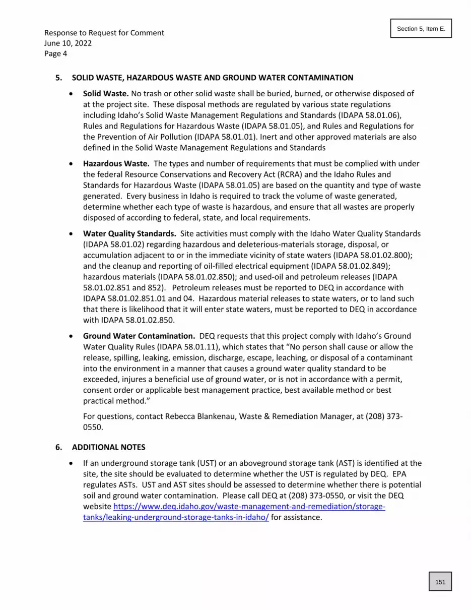
Response to Request for Comment June 10, 2022 Page 4
5. SOLID WASTE, HAZARDOUS WASTE AND GROUND WATER CONTAMINATION
• Solid Waste. No trash or other solid waste shall be buried, burned, or otherwise disposed of at the project site. These disposal methods are regulated by various state regulations including Idaho’s Solid Waste Management Regulations and Standards (IDAPA 58.01.06), Rules and Regulations for Hazardous Waste (IDAPA 58.01.05), and Rules and Regulations for the Prevention of Air Pollution (IDAPA 58.01.01). Inert and other approved materials are also defined in the Solid Waste Management Regulations and Standards
• Hazardous Waste. The types and number of requirements that must be complied with under the federal Resource Conservations and Recovery Act (RCRA) and the Idaho Rules and Standards for Hazardous Waste (IDAPA 58.01.05) are based on the quantity and type of waste generated. Every business in Idaho is required to track the volume of waste generated, determine whether each type of waste is hazardous, and ensure that all wastes are properly disposed of according to federal, state, and local requirements.
• Water Quality Standards. Site activities must comply with the Idaho Water Quality Standards (IDAPA 58.01.02) regarding hazardous and deleterious-materials storage, disposal, or accumulation adjacent to or in the immediate vicinity of state waters (IDAPA 58.01.02.800); and the cleanup and reporting of oil-filled electrical equipment (IDAPA 58.01.02.849); hazardous materials (IDAPA 58.01.02.850); and used-oil and petroleum releases (IDAPA 58.01.02.851 and 852). Petroleum releases must be reported to DEQ in accordance with IDAPA 58.01.02.851.01 and 04. Hazardous material releases to state waters, or to land such that there is likelihood that it will enter state waters, must be reported to DEQ in accordance with IDAPA 58.01.02.850.
• Ground Water Contamination. DEQ requests that this project comply with Idaho’s Ground Water Quality Rules (IDAPA 58.01.11), which states that “No person shall cause or allow the release, spilling, leaking, emission, discharge, escape, leaching, or disposal of a contaminant into the environment in a manner that causes a ground water quality standard to be exceeded, injures a beneficial use of ground water, or is not in accordance with a permit, consent order or applicable best management practice, best available method or best practical method.”
For questions, contact Rebecca Blankenau, Waste & Remediation Manager, at (208) 373-0550.
6. ADDITIONAL NOTES
• If an underground storage tank (UST) or an aboveground storage tank (AST) is identified at the site, the site should be evaluated to determine whether the UST is regulated by DEQ. EPA regulates ASTs. UST and AST sites should be assessed to determine whether there is potential soil and ground water contamination. Please call DEQ at (208) 373-0550, or visit the DEQ website https://www.deq.idaho.gov/waste-management-and-remediation/storage-tanks/leaking-underground-storage-tanks-in-idaho/ for assistance.
151
Section 5, Item E.

Response to Request for Comment June 10, 2022 Page 5
• If applicable to this project, DEQ recommends that BMPs be implemented for any of the following conditions: wash water from cleaning vehicles, fertilizers and pesticides, animal facilities, composted waste, and ponds. Please contact DEQ for more information on any of these conditions.
We look forward to working with you in a proactive manner to address potential environmental impacts that may be within our regulatory authority. If you have any questions, please contact me, or any of our technical staff at (208) 373-0550. Sincerely, Aaron Scheff Regional Administrator DEQ-Boise Regional Office EDMS#: 2022AEK126
152
Section 5, Item E.

Alcoholic Beverage Licenses – 2022 - 2023
I recommend approval of the following Beer, Wine and Liquor Licenses for the License year beginning July 1, 2022
and ending June 30, 2023 or as noted:
Albertsons –
Renewal or NEW Beer On Premise Consumption Retail Beer Off Premise Consumption Wine On Premise Consumption Retail Wine Off Premise Consumption Liquor by the Drink – On Premise Consumption Fire Inspection Floor Plan
FEES PAID $100.00 Recommendation: I recommend Council allow me to ADMINISTRATIVELY APPROVE the license once the Fire Inspection has been completed.
Beer Guys Saloon Renewal or NEW Beer On Premise Consumption Retail Beer Off Premise Consumption Wine On Premise Consumption Retail Wine Off Premise Consumption Liquor by the Drink – On Premise Consumption Fire Inspection Floor Plan
FEES PAID $1,062.50 Recommendation: Approve
Bi-Mart Corp Renewal or NEW Beer On Premise Consumption Retail Beer Off Premise Consumption Wine On Premise Consumption Retail Wine Off Premise Consumption Liquor by the Drink – On Premise Consumption Fire Inspection Floor Plan
FEES PAID $100.00 Recommendation: Approve
153
Section 6, Item A.

Alcoholic Beverage Licenses – 2022 - 2023
Blue Heron LLC Renewal or NEW Beer On Premise Consumption Retail Beer Off Premise Consumption Wine On Premise Consumption Retail Wine Off Premise Consumption Liquor by the Drink – On Premise Consumption Fire Inspection Floor Plan
FEES PAID $400.00 Recommendation: Approve
El Mariachi Loco Renewal or NEW Beer On Premise Consumption Retail Beer Off Premise Consumption Wine On Premise Consumption Retail Wine Off Premise Consumption Liquor by the Drink – On Premise Consumption Fire Inspection Floor Plan
FEES PAID $1,062.50 Recommendation: Approve
Helina Marries Renewal or NEW Beer On Premise Consumption Retail Beer Off Premise Consumption Wine On Premise Consumption Retail Wine Off Premise Consumption Liquor by the Drink – On Premise Consumption Fire Inspection Floor Plan
FEES PAID $1,062.50 Recommendation: Approve - Will need a transfer if location changes
Maverick Renewal or NEW Beer On Premise Consumption Retail Beer Off Premise Consumption Wine On Premise Consumption Retail Wine Off Premise Consumption Liquor by the Drink – On Premise Consumption Fire Inspection Floor Plan
FEES PAID $100.00 Recommendation: Approval
154
Section 6, Item A.
Alcoholic Beverage Licenses – 2022 - 2023
Ridley’s Renewal or NEW Beer On Premise Consumption Retail Beer Off Premise Consumption Wine On Premise Consumption Retail Wine Off Premise Consumption Liquor by the Drink – On Premise Consumption Fire Inspection Floor Plan
FEES PAID $100.00 Recommendation: Approval
River Birch Golf Course Renewal or NEW Beer On Premise Consumption Retail Beer Off Premise Consumption Wine On Premise Consumption Retail Wine Off Premise Consumption Liquor by the Drink – On Premise Consumption Fire Inspection Floor Plan
FEES PAID $400.00 Recommendation: Approval
Rustic Table Renewal or NEW Beer On Premise Consumption Retail Beer Off Premise Consumption Wine On Premise Consumption Retail Wine Off Premise Consumption Liquor by the Drink – On Premise Consumption Fire Inspection Floor Plan
FEES PAID $1,062.50 Recommendation: Approve with Conditions….a new premise map is required to serve in their new area which is to be approved by the State of Idaho. NO SERVING IN THEIR NEW SECTION. I HAVE EXPLAINED TO THE MANAGER THAT IF ISP WALKS INTO THEIR PREMISE AND THEY ARE SERVING BEER, WINE OR LIQOUR OUTSIDE OF THEIR APPROVED AREA, ISP MAY PULL THEIR LICENSE WHICH WOULD CASCADE OF REVOKATION OF ALL BEER, WINE AND LIQUOUR LICENSES. - JMAC
155
Section 6, Item A.
Alcoholic Beverage Licenses – 2022 - 2023
Star Mercantile Renewal or NEW Beer On Premise Consumption Retail Beer Off Premise Consumption Wine On Premise Consumption Retail Wine Off Premise Consumption Liquor by the Drink – On Premise Consumption Fire Inspection Floor Plan
FEES PAID $100.00 Recommendation: Approve. State Liquor Laws prohibit a Contract Liquor Store from allowing consumption on premise.
Sully’s Pub & Grill Renewal or NEW Beer On Premise Consumption Retail Beer Off Premise Consumption Wine On Premise Consumption Retail Wine Off Premise Consumption Liquor by the Drink – On Premise Consumption Fire Inspection Floor Plan
FEES PAID $962.50 Recommendation: Approve
Westside Pizza Renewal or NEW Beer On Premise Consumption Retail Beer Off Premise Consumption Wine On Premise Consumption Retail Wine Off Premise Consumption Liquor by the Drink – On Premise Consumption Fire Inspection Floor Plan
FEES PAID $400.00 Recommendation: Approve
156
Section 6, Item A.

LEGAL NOTICE
PUBLIC HEARING
Notice is hereby given that the Star City Council will hold a Public Hearing on June 7, 2022 at
the Star City Hall, 10769 W. State Street, Star, Idaho at 7:00 pm, or as soon thereafter as the
matter may be heard. COVID-19 UPDATE: Please see City Website www.staridaho.org for
Public Hearing instructions for Virtual Public Hearings if necessary.
Application: Stardale Place Subdivision
Files #’s AZ-22-02 Annexation-Zoning
RZ-21-04 Rezone
DA-22-02 Development Agreement
PP-22-03 Preliminary Plat
Applicant/Owner: Bruce Hessing/Piedmont Project, LLC, 2338 W. Boulder Bar Dr., Meridian, ID
83646
Action: The Applicant is seeking approval of an Annexation and Zoning (R-7), Rezone (R-4 to R-
7), a Development Agreement, and Preliminary Plat for a proposed residential subdivision
consisting of 26 residential lots and 3 common lots. The property is located at 331, 343 and 385
N. Center Street in Star, Idaho, and consists of 3.39 acres with a proposed density of 7.67
dwelling units per acre.
Property Location: The subject property is generally located on the southwest corner of N.
Center Street and W. 3rd Street. Ada County Parcel No’s. R8108001065, R8108001125,
R8108001183, R8108001185, R8108001240 and R8108001240.
Information/Comments: A complete copy of the applications are available at City Hall for
public review. The City invites all interested parties to attend the meeting and provide public
testimony. Written comments will be accepted by the City up to 2 days prior to the date of the
public hearing.
Services for persons with disabilities may be made available if notice is received in advance of
the meeting by calling Star City Hall at (208) 286-7247.
Shawn L. Nickel
Planning Director and Zoning Administrator
157
Section 7, Item A.

A
STARDALE PLACE SUBDIVISION ANNEXATION/ZONING, REZONE, DEVELOPMENT AGREEMENT, PRELIMINARY PLAT FILE # AZ-22-02/RZ-21-04/DA-22-02/PP-22-03
1
CITY OF STAR
LAND USE STAFF REPORT
TO: Mayor & Council
FROM: City of Star Planning Department
MEETING DATE: June 7, 2022 – PUBLIC HEARING (Tabled from May 3, 2022)
FILE(S) #: AZ-22-04 Annexation and Zoning
RZ-21-04 Rezone
DA-22-02 Development Agreement
PP-22-03 Preliminary Plat for Stardale Place Subdivision
OWNER/APPLICANT/REPRESENTATIVE
Applicant/Owner: Representative:
Bruce Hessing Antonio Conti
Piedmont Project, LLC Ackerman-Estvold
2338 W. Boulder Bar Dr. 7661 W. Riverside Dr., Ste. 102
Meridian, Idaho 83646 Garden City, Idaho 83714
REQUEST
Request: The Applicant is seeking approval of Annexation and Zoning (R-7-DA), Rezone (R-4 to
R-7), a Development Agreement, and Preliminary Plat for a proposed residential subdivision
consisting of 26 residential lots and 3 common lots. The property is located at 331, 343 and 385
N. Center Street in Star, Idaho and consists of 3.39 acres with a proposed density of 7.67
dwelling units per acre.
PROPERTY INFORMATION
Property Location: The subject property is generally located on the southwest corner of N.
Center Street and W. 3rd Street. Ada County Parcel No’s. R8108001065,
R8108001125, R8108001183, R8108001185, and R8108001240.
158
Section 7, Item A.

A
STARDALE PLACE SUBDIVISION ANNEXATION/ZONING, REZONE, DEVELOPMENT AGREEMENT, PRELIMINARY PLAT FILE # AZ-22-02/RZ-21-04/DA-22-02/PP-22-03
2
Surrounding Land Use/Designations:
Zoning Designation Comp Plan Designation Land Use
Existing Residential (R-4) and
RUT (County)
Compact Residential Single Family Residential
Proposed (Residential) R-7-DA Compact Residential Single Family Residential
North of site Residential (R-3) Neighborhood Residential Saddlebrook Subdivision
South of site Residential (R-7) Compact Residential Proposed Addington
Subdivision
East of site Residential (R-4) Central Business District Single Family Residential
West of site Residential (R-7) Compact Residential Endsley Court Subdivision
Existing Site Characteristics: The property is currently vacant with several outbuildings, an old
home and mobile home.
Irrigation/Drainage District(s): Middleton Irrigation Assn. Inc.
Middleton Mill Ditch Company
P.O. Box 848
Middleton, Idaho 83644
Flood Zone: This property is not currently located in a Flood Hazzard Area.
FEMA FIRM Panel Number: 16001C0130J
Effective Date: 6/19/2020
Special On-Site Features:
Areas of Critical Environmental Concern – No known areas.
Evidence of Erosion – No evidence.
Fish Habitat – No.
Floodplain – No.
Mature Trees – None.
Riparian Vegetation – No.
Steep Slopes – None.
Stream/Creek – None.
Unique Animal Life – No unique animal life has been identified.
Unique Plant Life – No unique plant life has been identified.
Unstable Soils – No known issues.
Historical Assets – No historical assets have been observed.
Wildlife Habitat – No known sensitive wildlife habitat observed.
159
Section 7, Item A.

A
STARDALE PLACE SUBDIVISION ANNEXATION/ZONING, REZONE, DEVELOPMENT AGREEMENT, PRELIMINARY PLAT FILE # AZ-22-02/RZ-21-04/DA-22-02/PP-22-03
3
APPLICATION REQUIREMENTS
Pre-Application Meeting Held February 1, 2022
Neighborhood Meeting Held May 17, 2022
Application Submitted & Fees Paid March 1, 2022
Application Accepted March 24, 2022
Residents within 300’ Notified April 13, 2022
Agencies Notified March 24, 2022
Legal Notice Published May 3, 2022
Property Posted April 21, 2022
HISTORY
Three of the parcels involved in this application were originally annexed into the City with an R-4
zone. Staff does not have documents of that annexation.
CODE DEFINITIONS / COMPREHENSIVE PLAN
UNIFIED DEVELOPMENT CODE:
8-1B-1: ANNEXATION AND ZONING; REZONE:
B. Standards:
1. The subject property shall meet the minimum dimensional standards of the proper district.
2. The city may require a development agreement in conjunction with the annexation and
zoning, or rezone, pursuant to Idaho Code section 67-6511A, which may include a concept plan.
In addition to other processes permitted by city and state code, exceptions or waivers of
standards, other than use, may be permitted through execution of a development
agreement. A development agreement and concept plan shall be required for any rezone to
a mixed-use zone, high density zone or land which includes steep slope ( land over 25%) or
floodway.
3. The termination of a development agreement shall result in the reversal of the official zoning
map amendment approval and applicable development approval for any undeveloped portion
of property subject to the development agreement. The undeveloped property subject to the
development agreement shall be rezoned to the district classification as designated by the
development agreement. When no designation is provided, the property shall revert to its
original zoning or, if the original designation no longer exists, to the closest current equivalent
zoning as determined by the current Comprehensive Plan Land Use Map designation.
4. An amendment or termination of a previously recorded development agreement shall be
recorded in the office of the county recorder by the clerk.
160
Section 7, Item A.

A
STARDALE PLACE SUBDIVISION ANNEXATION/ZONING, REZONE, DEVELOPMENT AGREEMENT, PRELIMINARY PLAT FILE # AZ-22-02/RZ-21-04/DA-22-02/PP-22-03
4
5. An approved development agreement must be executed within ninety (90) days of the
meeting at which the development agreement is approved by the city council. A one-time
administrative extension of maximum thirty (30) days may be granted by the zoning
administrator. Additional extensions may be approved by majority vote of the city council.
Failure to execute the development agreement within the required timeframe will result in the
denial of all related applications.
C. Required Findings: The council shall review the application at the public hearing. In order to
grant an annexation and zoning or rezone, the council shall make the following findings:
1. The map amendment complies with the applicable provisions of the comprehensive plan;
2. The map amendment complies with the regulations outlined for the proposed district;
3. The map amendment shall not be materially detrimental to the public health, safety, and
welfare; and
4. The map amendment shall not result in an adverse impact upon the delivery of services by
any political subdivision providing public services within the city.
5. The annexation (as applicable) is in the best interest of city.
8-3A-1: ZONING DISTRICTS AND PURPOSE ESTABLISHED:
R RESIDENTIAL DISTRICT: To provide regulations and districts for various residential
neighborhoods. Gross density in a Residential (R) district shall be determined according to the
numeral following the R. The numeral designates the maximum number of dwelling units per
acre. In zoning designations of R-1, R-2, R-3, R-4 and R-5, housing shall be single family
detached unless approved with a PUD or development agreement. Connection to municipal
water and sewer facilities are required for all subdivision and lot split applications submitted
after the effective date hereof in all districts exceeding one dwelling unit per acre. Wells and
septic systems may be permitted for larger lots in this land use designation that are not adjacent
to municipal services, as determined by the Sewer District, and if approved by the applicable
Health Department. Private streets may be approved in this district for access to newly
subdivided or split property. This district does allow for some non-residential uses as specified in
8-3A-3.
DA DEVELOPMENT AGREEMENT: This designation, following any zoning designation noted on
the official zoning map of the city (i.e., C-2-DA), indicates that the zoning was approved by the
city with a development agreement, with specific conditions of zoning.
8-3A-3: USES WITHIN ZONING DISTRICTS
The following table lists principal permitted (P), accessory uses (A), conditional (C), or prohibited
(N) uses.
161
Section 7, Item A.

A
STARDALE PLACE SUBDIVISION ANNEXATION/ZONING, REZONE, DEVELOPMENT AGREEMENT, PRELIMINARY PLAT FILE # AZ-22-02/RZ-21-04/DA-22-02/PP-22-03
5
8-3A-4: ZONING DISTRICT DIMENSIONAL STANDARDS:
R-6 to R-11
Detached
Housing
35 feet 15 ft to living
area, 20 ft to
garage, 10 ft
if alley load
15 ft, 4 ft if
alley load
3 feet 20 feet
Notes:
1. Interior side yard setbacks for lots with 50’ or less of lot width shall be allowed 5’ interior
side yard setbacks for one and two-story structures.
2. Front yard setback shall be measured from the face of the garage to the face of the sidewalk,
allowing for 20’ of parking on the driveway without overhang onto the sidewalk.
8-4E-2: COMMON OPEN SPACE AND SITE AMENITY REQUIREMENTS - STANDARDS:
A. Open Space and Site Amenity Requirement (see also Chapter 8 “Architectural Review”):
1. The total land area of all common open space shall equal or exceed fifteen percent (15%) of
the gross land area of the development. Ten percent (10%) of that area shall be usable open
space.
2. Each development is required to have at least one site amenity.
ZONING DISTRICT USES
A R-R R
Accessory structure A A A
Dwelling:
Multi-family 1 N N C
Secondary 1 A A A
Single-family attached N N C
Single-family detached P P P
Two-family duplex N N P
162
Section 7, Item A.

A
STARDALE PLACE SUBDIVISION ANNEXATION/ZONING, REZONE, DEVELOPMENT AGREEMENT, PRELIMINARY PLAT FILE # AZ-22-02/RZ-21-04/DA-22-02/PP-22-03
6
3. One additional site amenity shall be required for each additional twenty (20) acres of
development area, plus one additional amenity per 75 residential units.
4. Developments with a density of less than 1 dwelling units per acre may request a reduction in
total required open space and amenities to the Council. Developments with a density of less
than 2 dwelling units per acre may request a 50% reduction in total required open space to the
Council.
5. For multi-family developments, see Section 8-5-20 for additional standards.
B. Qualified Open Space: The following may qualify to meet the common open space
requirements:
1. Any open space that is active or passive in its intended use, and accessible or visible by all
residents of the development, including, but not limited to:
a. Open grassy area of at least fifty feet by one hundred feet (50' x 100') in area;
b. Qualified natural areas;
c. Ponds or water features where active fishing, paddle boarding or other activities are provided
(50% qualifies towards total required open space, must be accessible by all residents to qualify.)
ponds must be aerated;
d. A plaza.
2. Additions to a public park or other public open space area.
3. The buffer area along collector and arterial streets may be included in required overall
common open space for residential subdivisions.
4. Parkways along local residential streets with detached sidewalks that meet all the following
standards may count toward the common open space requirement:
a. The parkway is a minimum of eight feet (8') in width from street curb to edge of sidewalk and
includes street trees as specified otherwise herein.
b. Except for alley accessed dwelling units, the area for curb cuts to each residential lot or
common driveway shall be excluded from the open space calculation. For purposes of this
calculation, the curb cut area shall be a minimum area of twenty-six feet (26') by the width of the
parkway.
c. Stormwater detention facilities do not qualify to meet the common area open space
requirements, unless all of the following is met:
1. Must be at least fifty feet by one hundred feet (50' x 100') in area;
2. Specifically designed as a dual use facility, as determined by the administrator, to include
minimal slopes, grass throughout, and guarantee of water percolation within 24 hours of
storm event.
163
Section 7, Item A.

A
STARDALE PLACE SUBDIVISION ANNEXATION/ZONING, REZONE, DEVELOPMENT AGREEMENT, PRELIMINARY PLAT FILE # AZ-22-02/RZ-21-04/DA-22-02/PP-22-03
7
3. Is located in a development that has a second usable open space area that contains a
qualified site amenity as herein defined.
5. Visual natural space, including open ditches, wetlands, slopes or other areas that may not be
readily accessible to residents, and is provided with open style fencing, may qualify for up to
20% of the required open space total.
C. Qualified Site Amenities: Qualified site amenities shall include, but not be limited to, the
following:
1. Clubhouse;
2. Fitness facilities, indoors or outdoors;
3. Public art;
4. Picnic area; or
5. Recreation amenities:
a. Swimming pool.
b. Children's play structures.
c. Sports courts.
d. Additional open space in excess of 5% usable space.
e. RV parking for the use of the residents within the development.
f. School and/or Fire station sites if accepted by the district.
g. Pedestrian or bicycle circulation system amenities meeting the following requirements:
(1) The system is not required for sidewalks adjacent to public right of way;
(2) The system connects to existing or planned pedestrian or bicycle routes outside the
development; and
(3) The system is designed and constructed in accord with standards set forth by the city of Star;
D. Location: The common open space and site amenities shall be located on a common lot or
an area with a common maintenance agreement.
COMPREHENSIVE PLAN:
8.2.3 Land Use Map Designations:
Compact Residential
164
Section 7, Item A.

A
STARDALE PLACE SUBDIVISION ANNEXATION/ZONING, REZONE, DEVELOPMENT AGREEMENT, PRELIMINARY PLAT FILE # AZ-22-02/RZ-21-04/DA-22-02/PP-22-03
8
Suitable primarily for residential use allowing a mix of housing types such as single
family, two family, and multifamily. Densities range from 5.01 units per acre to 10 units
per acre.
8.3 Goal:
Encourage the development of a diverse community that provides a mix of land uses,
housing types, and a variety of employment options, social and recreational
opportunities, and where possible, an assortment of amenities within walking distance of
residential development.
8.4 Objectives:
• Implement the Land Use Map and associated policies as the official guide for
development.
• Manage urban sprawl in order to minimize costs of urban services and to protect
rural areas.
• Encourage land uses that are in harmony with existing resources, scenic areas,
natural wildlife areas, and surrounding land uses.
8.5.3 Policies Related Mostly to the Urban Residential Planning Areas:
A. The Neighborhood Residential Land Use is to encourage urban style development
densities to limit urban sprawl.
B. Low densities within the Neighborhood Residential Land Use are to be designed
within the floodplain, ridgeline developable areas, hillside developable areas and
where new residential lots are proposed adjacent to existing residential lots of one
acre and larger where those existing larger lots are not likely to be subdivide in the
future.
8.5.9 Additional Land Use Component Policies:
• Encourage flexibility in site design and innovative land uses.
• Work with Ada County Highway District (ACHD), Canyon Highway District #4
(CHD4), and Idaho Department of Transportation (ITD) for better coordination of
roadway and access needs.
• Support well-planned, pedestrian-friendly developments.
• Dark sky provision should be adopted within the code to assure down style
lighting in all developments and Star should consider joining the International
Dark Sky Association.
18.4 Implementation Policies:
165
Section 7, Item A.

A
STARDALE PLACE SUBDIVISION ANNEXATION/ZONING, REZONE, DEVELOPMENT AGREEMENT, PRELIMINARY PLAT FILE # AZ-22-02/RZ-21-04/DA-22-02/PP-22-03
9
F. Development Agreements allow the city to enter into a contract with a developer
upon rezoning. The Development Agreement may provide the city and the
developer with certain assurances regarding the proposed development upon
rezoning.
PROJECT OVERVIEW
ANNEXATION & REZONE:
The applicant is requesting approval of an annexation and zoning (R-7), with a rezone
application of Residential (R-4 to R-7) on 3.39 acres. This zoning district would allow for a
maximum residential density of 10 dwelling unit per acre. The Comprehensive Plan Future Land
Use Map indicates that these properties are within the Compact Residential designation. The
property is located in an area that will be serviceable with central sewer and water provided by
Star Sewer and Water District. The property will be accessed by a public road and all roads in the
development will be public. The rezone request includes a development agreement that will
address future density and development standards.
PRELIMINARY PLAT:
The Preliminary Plat submitted contains 26 single family residential lots and 3 common area lots
on 3.39 acres with a proposed density of 7.67 dwelling units per acre. The lots will have access
and frontage from public streets. Lots will range in size from 3,434 square feet to 6,687 square
feet with the average buildable lot being 3,979 square feet. The submitted preliminary plat is
showing a local road with a 50-foot wide right of way with paved streets measuring 36 feet from
back of curb to back of curb. Primary access for the development will be from N. Center Street.
Sidewalks are proposed to be attached with a 5-foot, concrete sidewalk. Street names must be
obtained by the Ada County Street Naming Committee prior to signature of the final plat. The
applicant is proposing 0.51 acres (15%) of usable open space which satisfies the Unified
Development Code.
The Unified Development Code, Section 8-4E-2 requires a development of this size to have a
minimum of 1 site amenity. The applicant is proposing a walking path with connections to the
north and south, enhancing community connectivity.
ADDITIONAL DEVELOPMENT FEATURES:
• Sidewalks
Internal sidewalks are proposed at five-foot (5’) widths and will be attached
throughout the development.
• Lighting
166
Section 7, Item A.

A
STARDALE PLACE SUBDIVISION ANNEXATION/ZONING, REZONE, DEVELOPMENT AGREEMENT, PRELIMINARY PLAT FILE # AZ-22-02/RZ-21-04/DA-22-02/PP-22-03
10
Streetlights shall reflect the “Dark Sky” criteria with all lighting. The same streetlight
design shall continue throughout the entire development. The applicant has
submitted a proposed streetlight plan. All proposed light locations satisfy City code.
Applicant has not provided a streetlight design/cut sheet for City approval.
Applicant will be required to work with Staff and submit a cut sheet and design
before signature of the final plat.
• Street Names
Applicant has not provided documentation from Ada County that the street
name is acceptable and have been approved. This will be required at final plat
• Subdivision Name
Applicant has provided a letter from Ada County that the subdivision name has
been approved and reserved for this development.
• Landscaping - As required by the Unified Development Code, Chapter 8, Section 8-8C-2-
M (2) Street Trees; A minimum of one street tree shall be planted for every thirty-five (35)
linear feet of street frontage. The applicant shall use “Treasure Valley Tree Selection
Guide”, as adopted by the Unified Development Code. Section 8-8C-2, J5 states that a
minimum of one deciduous shade tree per four thousand (4,000) square feet of common
area shall be provided. The submitted landscape plan appears to satisfy these
requirements for the open areas. Streets in the development do not show the
appropriate number of trees. These will need to be added once driveways are
designed to receive occupancy permits.
• Setbacks – The applicant is not requesting any setback waivers.
• Block lengths – All blocks meet the 750’ block length requirement.
• Mailbox Cluster – Applicant has provided documentation from the Star Postmaster
depicting the approved location for the mailbox cluster. This documentation was
included in the application packet.
• Phasing – The development is proposing to be built out in a single phase.
DEVELOPMENT AGREEMENT
Through the Development Agreement process, the applicant is proposing to work with the City
to provide further insurances that the development will be built as presented and/or modified
by the Council through the review process. Items that should be considered by the applicant
and Council include the following:
167
Section 7, Item A.

A
STARDALE PLACE SUBDIVISION ANNEXATION/ZONING, REZONE, DEVELOPMENT AGREEMENT, PRELIMINARY PLAT FILE # AZ-22-02/RZ-21-04/DA-22-02/PP-22-03
11
• Density;
• ITD Proportionate Share Fees;
• Emergency Access
• Future Development
AGENCY RESPONSES
DEQ April 1, 2022
ACHD April 18, 2022
Central District Health April 6, 2022
PUBLIC RESPONSES
No public comments have been received.
STAFF RECOMMENDATION
Based upon the information provided to staff in the applications and agency comments received
to date, the proposed annexation and zoning request and associated applications including the
preliminary plat meets the requirements, standards and intent for development as they relate to
the Comprehensive Plan and Unified Development Code. The proposed density of 7.67 dwelling
unit per acre is within the range of 6-10 dwelling units per acre allowed in the Compact
Residential Comprehensive Plan Future Land Use Map. Staff is supportive of proposed diversity
in lot sizes, housing sizes and density that the (R-7) zoning designation will provide.
The Council should consider the entire record and testimony presented at their scheduled public
hearing prior to rendering its decision on the matter. Should the Council vote to approve the
applications, either as presented or with added or revised conditions of approval, Council shall
direct staff to draft findings of fact and conclusions of law for the Council to consider at a future
date. A development agreement will also be brought back to the Council for review of proposed
Conditions of Approval for the rezone.
FINDINGS
The Council may approve, conditionally approve, deny or table this request. In order to
approve these applications, the Unified Development Code requires that Council must find the
following:
ANNEXATION/REZONE FINDINGS:
1. The map amendment complies with the applicable provisions of the Comprehensive Plan.
168
Section 7, Item A.

A
STARDALE PLACE SUBDIVISION ANNEXATION/ZONING, REZONE, DEVELOPMENT AGREEMENT, PRELIMINARY PLAT FILE # AZ-22-02/RZ-21-04/DA-22-02/PP-22-03
12
The purpose of the Star Comprehensive Plan is to promote the health, safety, and
general welfare of the people of the City of Star and its Impact Area. Some of the prime
objectives of the Comprehensive Plan include:
✓ Protection of property rights.
✓ Adequate public facilities and services are provided to the people at reasonable cost.
✓ Ensure the local economy is protected.
✓ Encourage urban and urban-type development and overcrowding of land.
✓ Ensure development is commensurate with the physical characteristics of the
land.
The goal of the Comprehensive Plan for Land Use is to encourage the development of a
diverse community that provides a mixture of land uses, housing types, and a variety of
employment options, social and recreational opportunities, and where possible provides
an assortment of amenities within walking distance of a residential development. The
Council must find compliance with the Comprehensive Plan.
2. The map amendment complies with the regulations outlined for the proposed district,
specifically, the purposes statement.
The Council must find that the proposal complies with the proposed district and purpose
statement. The purpose of the residential districts is to provide regulations and districts
for various residential neighborhoods with gross densities in compliance with the intent
of the Comprehensive Plan designation. Housing shall be single family detached unless
approved with a PUD or development agreement. Connection to municipal water and
sewer facilities are required for all subdivision and lot split applications in all districts
exceeding one dwelling unit per acre. Private streets may be approved in this district for
access to newly subdivided or split property.
3. The map amendment shall not be materially detrimental to the public health, safety, and
welfare; and
The Council must find that there is no indication from the material submitted by any
political agency stating that this annexation and zoning of this property will be materially
detrimental to the public health, safety or welfare.
4. The map amendment shall not result in an adverse impact upon the delivery of services by
any political subdivision providing public services within the city including, but not limited to,
school districts.
The Council must find that it has not been presented with any information from agencies
having jurisdiction that public services will be adversely impacted other than traffic, which will continue to be impacted as the City grows.
5. The annexation is in the best interest of the city.
The Council must find that this annexation is reasonably necessary for the orderly
development of the City.
169
Section 7, Item A.

A
STARDALE PLACE SUBDIVISION ANNEXATION/ZONING, REZONE, DEVELOPMENT AGREEMENT, PRELIMINARY PLAT FILE # AZ-22-02/RZ-21-04/DA-22-02/PP-22-03
13
PRELIMINARY PLAT FINDINGS:
1. The plat is in compliance with the Comprehensive Plan.
The City must find that this Plat follows designations, spirit and intent of the Comprehensive Plan regarding residential development and meets several of the
objectives of the Comprehensive Plan such as:
1. Designing development projects that minimize impacts on existing adjacent
properties, and
2. Managing urban sprawl to protect outlying rural areas.
2. Public Services are available or can be made available and are adequate to accommodate
the proposed development.
The City must find that Agencies having jurisdiction on this parcel were notified of this
action, and that it has not received notice that public services are not available or cannot
be made available for this development. 3. There is public financial capability of supporting services for the proposed development;
The City must find that they have not been notified of any deficiencies in public financial
capabilities to support this development.
4. The development will not be detrimental to the public health, safety or general welfare;
The City must find that it has not been presented with any facts stating this Preliminary
Plat will be materially detrimental to the public health, safety and welfare. Residential
uses are a permitted use.
5. The development preserves significant natural, scenic or historic features;
The City must find that there are no known natural, scenic, or historic features that have been identified within this Preliminary Plat.
Upon granting approval or denial of the application, the Council shall specify:
1. The Ordinance and standards used in evaluating the application;
2. The reasons for recommending approval or denial; and
3. The actions, if any, that the applicant could take to obtain approval.
CONDITIONS OF APPROVAL
1. The approved Preliminary Plat for the Stardale Place Subdivision shall comply with all
statutory requirements of applicable agencies and districts having jurisdiction in the City of
Star.
2. The applicant shall enter into a Development Agreement with the City, agreeing to
proportionate share assessment by ITD regarding impacts to the State Highway
System. ITD has calculated the fees to be $1,000.00 per buildable lot. These fees will be
170
Section 7, Item A.

A
STARDALE PLACE SUBDIVISION ANNEXATION/ZONING, REZONE, DEVELOPMENT AGREEMENT, PRELIMINARY PLAT FILE # AZ-22-02/RZ-21-04/DA-22-02/PP-22-03
14
collected by the City of Star, by phase, prior to final plat signature. The development
agreement shall be signed and recorded as part of the ordinance for annexation and
zoning and shall contain the details of the fees to be collected.
3. Streetlights shall comply with the Star City Code and shall be of the same design throughout
the entire subdivision. Streetlights shall be continuous throughout the subdivision and shall
be maintained by the Homeowners Association. Streetlights shall be installed and
energized prior to issuing of building permits. Design shall follow Code with
requirements for light trespass and “Dark Skies” lighting. Applicant/Owner shall work with
staff and submit a streetlight design that meets city standards prior to Final Plat
approval. Streetlights shall comply with the Star City Code regarding light trespass
and “Dark Sky” initiative.
4. The property with the approved Preliminary Plat shall be satisfactorily weed abated,
preventing a public nuisance, per Star City Code.
5. The property associated with this approved Final Plat, in addition to the property of all future
phases shall be properly maintained throughout the construction process to include trash
picked up and trash receptacles emptied with regular frequency, streets swept and cleaned
weekly, including any streets used to access the property and all debris shall be prevented
from accumulating on any adjacent property or public right of way and shall remove all
debris from public way at least daily.
6. All signed Irrigation District Agreements with the Irrigation Districts shall be provided to the
City of Star with each subsequent Final Plat application.
7. Street trees shall be installed per Chapter 8, Section 8-8C-2-M(2) Street Trees.
Applicant shall provide locations for the local street trees at the time of final plat. If
driveway locations will not be determined until sale of the lot, Applicant agrees to not
receive the Certificate of Occupancy until street trees are confirmed in place.
8. Pressurized irrigation systems shall comply with the Irrigation District(s) and the City of Star
Codes. Plans for pressurized irrigation systems shall be submitted to, and approved by the
City of Star Engineer, prior to installation.
9. A plat note supporting the “Right to Farm Act” as per Idaho Code Title 22, Chapter 45, shall
be shown on the Final Plat.
10. A copy of the CC&R’s shall be submitted to the City of Star at Final Plat.
11. A form signed by the Star Sewer & Water District shall be submitted to the City prior to the
signature of the Final Plat stating that all conditions of the District have been met, including
annexation into the District.
12. Prior to signing the final plat, Applicant shall provide approval from Ada County for all
street names and they should be accurately reflected on the plat.
13. A plat note shall state that development standards for residential development shall comply
with the effective building and zoning requirements at time of building permit issuance,
unless amended in the Development Agreement or CUP conditions.
14. Development standards for single family residential units shall comply with effective building
and zoning requirements at time of building permit issuance, or as approved through the
Development Agreement or as stated herein.
15. All common areas shall be owned and maintained by the Homeowners Association.
171
Section 7, Item A.

A
STARDALE PLACE SUBDIVISION ANNEXATION/ZONING, REZONE, DEVELOPMENT AGREEMENT, PRELIMINARY PLAT FILE # AZ-22-02/RZ-21-04/DA-22-02/PP-22-03
15
16. The applicant shall provide a sign, to be located at all construction entrances, indicating the
rules for all contractors that will be working on the property starting at grading and running
through home sales that addresses items including but not limited to dust, music, dogs,
starting/stopping hours for contractors (7a.m. start time). Sign shall be approved by the
City prior to start of construction.
17. A sign application is required for any subdivision signs.
18. Owner/Developer will agree to install a 2” (High Density Polyethylene) HDPE SDR-11
roll pipe in the shared utility trench to be used for future fiber optic and/or copper
telecommunication cables.
19. Any additional Condition of Approval as required by Staff and City Council.
COUNCIL DECISION
The Star City Council __________________ File Number AZ-22-02/RZ-21-04/DA-22-02/PP-22-03 for
Stardale Place Subdivision on __________________ ________, 2022.
172
Section 7, Item A.

STARDALE PLACEA PORTION OF THE SOUTHWEST 1/4 OF THE SOUTHEAST 1/4 OF SECTION 7, T.4N., R.1W., CITY OF STAR, ADA COUNTY,
IDAHO.
JANUARY 2022 SCALE: 1" = 1000' SHEET 1 OF 1
VICINITY MAP FOR
SUBDIVISION
W 3RD ST
STAR
PROJECT LOCATION
N C
ENTE
R S
T
W GAMBRELL ST
ID 44
N S
TAR
RO
AD
STATE STREET
N0 1/2 Full1/41/2
Graphic Scale:
Attention is Drawn to the Fact That Drawing Scales May be Altered DuringReproduction Processes. Scales Shown Hereon are Based on a Full Scale
Sheet Size of 8.5" x 11".
Scale: 1" = 1000'
THIS DOCUMENT, TOGETHER WITH THE CONCEPTS AND DESIGNS DEPICTED HEREIN, IS INTENDED ONLY FOR THE SPECIFIC PURPOSE AND CLIENT FOR WHICH IT WAS PREPARED. REUSE OF AND IMPROPER RELIANCEON THIS DOCUMENT WITHOUT WRITTEN AUTHORIZATION AND ADAPTATION BY ACKERMAN-ESTVOLD SHALL BE WITHOUT LIABILITY TO ACKERMAN-ESTVOLD.
DR
AWIN
G N
AME
SCAL
E (H
):SC
ALE
(V):
DR
AWN
BY:
DES
IGN
ED B
Y:C
HEC
KED
BY:
DAT
E:O
F
NO
.R
EVIS
ION
SD
ATE
BYAP
PR.
DR
AWIN
G_N
AME
PRO
JEC
T N
O.
R21
227
11
1/18
/22
AMC
ALA
ALAN/A
1"=1
000'
173
Section 7, Item A.
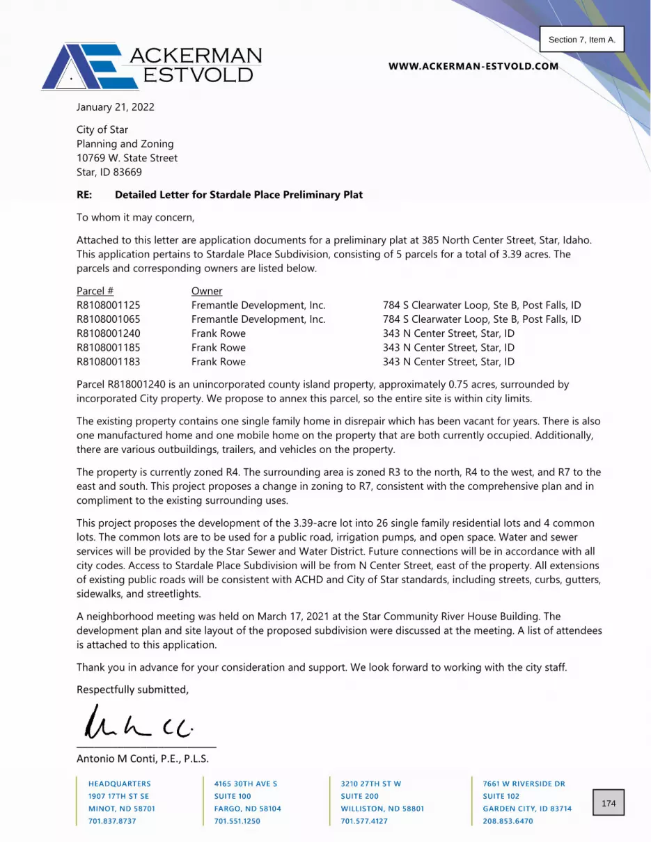
January 21, 2022
City of Star
Planning and Zoning
10769 W. State Street
Star, ID 83669
RE: Detailed Letter for Stardale Place Preliminary Plat
To whom it may concern,
Attached to this letter are application documents for a preliminary plat at 385 North Center Street, Star, Idaho.
This application pertains to Stardale Place Subdivision, consisting of 5 parcels for a total of 3.39 acres. The
parcels and corresponding owners are listed below.
Parcel # Owner
R8108001125 Fremantle Development, Inc. 784 S Clearwater Loop, Ste B, Post Falls, ID
R8108001065 Fremantle Development, Inc. 784 S Clearwater Loop, Ste B, Post Falls, ID
R8108001240 Frank Rowe 343 N Center Street, Star, ID
R8108001185 Frank Rowe 343 N Center Street, Star, ID
R8108001183 Frank Rowe 343 N Center Street, Star, ID
Parcel R818001240 is an unincorporated county island property, approximately 0.75 acres, surrounded by
incorporated City property. We propose to annex this parcel, so the entire site is within city limits.
The existing property contains one single family home in disrepair which has been vacant for years. There is also
one manufactured home and one mobile home on the property that are both currently occupied. Additionally,
there are various outbuildings, trailers, and vehicles on the property.
The property is currently zoned R4. The surrounding area is zoned R3 to the north, R4 to the west, and R7 to the
east and south. This project proposes a change in zoning to R7, consistent with the comprehensive plan and in
compliment to the existing surrounding uses.
This project proposes the development of the 3.39-acre lot into 26 single family residential lots and 4 common
lots. The common lots are to be used for a public road, irrigation pumps, and open space. Water and sewer
services will be provided by the Star Sewer and Water District. Future connections will be in accordance with all
city codes. Access to Stardale Place Subdivision will be from N Center Street, east of the property. All extensions
of existing public roads will be consistent with ACHD and City of Star standards, including streets, curbs, gutters,
sidewalks, and streetlights.
A neighborhood meeting was held on March 17, 2021 at the Star Community River House Building. The
development plan and site layout of the proposed subdivision were discussed at the meeting. A list of attendees
is attached to this application.
Thank you in advance for your consideration and support. We look forward to working with the city staff.
Respectfully submitted,
________________________
Antonio M Conti, P.E., P.L.S.
174
Section 7, Item A.

City of Star P.O. Box 130
Star, Idaho 83669
P: 208-286-7247
Preliminary Plat Application Form #520
Rev 2-2021
Page 1 of 13
***All information must be filled out to be processed.
Applicant Information:
PRIMARY CONTACT IS: Applicant ___ Owner ___ Representative ___ Applicant Name: __________________________________________________________ Applicant Address: ______________________________________ Zip: ______________ Phone: _______________ Email: ________________________ Owner Name: ____________________________________________________________ Owner Address: _________________________________________ Zip: _____________ Phone: ________________ Email: ________________________ Representative (e.g., architect, engineer, developer): Contact: ___________________________ Firm Name: ___________________________ Address: ________________________________________________ Zip: ____________ Phone: ________________ Email: ________________________ Property Information:
Subdivision Name: ________________________________________________________ Site Location: ____________________________________________________________ Approved Zoning Designation of Site: _________________________________________ Parcel Number(s): _________________________________________________________ Zoning Designations:
Zoning Designation Comp Plan Designation Land Use
Existing
Proposed
North of site
South of site
East of site
West of site
PRELIMINARY PLAT APPLICATION
FILE NO.: __________________________ Date Application Received: ____________ Fee Paid: ___________
Processed by: City: _________________________
Antonio Conti7661 W Riverside Drive, Ste. 102, Garden City, ID 83714
208.853.6470 [email protected]
Stardale Place385 and 331 N Center Street, Star, ID
ResidentialR8108001240, R810800183, R8108001185, R8108001065, R8108001125
Frank Rowe343 N Center Street, Star, ID
R-4
R-7R-3R-7R-4R-7
Compact ResidentialCompact ResidentialNeighborhood ResidentialCBDCBDCompact Residential
SFRSingle Family DetachedSingle Family DetachedVacant R-7/CommercialSingle Family DetachedSingle Family Detached
83669
Ackerman-Estvold
Bruce Hessing2338 W Boulder Bar Dr., Meridian, ID
208.831.7111 [email protected]
Piedmont Place, LLC2338 W Boulder Bar Dr., Meridian, ID 83646
175
Section 7, Item A.

Preliminary Plat Application Form #520
Rev 2-2021
Page 2 of 13
SITE DATA:
FLOOD ZONE DATA: (This Info Must Be Filled Out Completely Prior to Acceptance):
Total Acreage of Site in Special Flood Hazard Area - ____________________________
a. A note must be provided on the final plat documenting the current flood zone in
which the property or properties are located. The boundary line must be drawn on
the plat in situations where two or more flood zones intersect over the property or
properties being surveyed.
b. FEMA FIRM panel(s): #160xxxxxxC, 160xxxxxxE, etc.: ______________________
FIRM effective date(s): mm/dd/year _____________________________________
Flood Zone(s): Zone X, Zone A, Zone AE, Zone AH, etc.: ____________________
Base Flood Elevation(s): AE____.0 ft., etc.: _______________________________
c. Flood Zones are subject to change by FEMA and all land within a floodplain is
regulated by Chapter 10 of the Star City Code.
Public Streets - ___________________ Private Streets - _____________________
Describe Pedestrian Walkways (location, width, material) - ________________________ _______________________________________________________________________
Describe Bike Paths (location, width, material) - _________________________________ _______________________________________________________________________
Total Acreage of Site - _____________________________ Breakdown of Acreage of Land in Contiguous Ownership - ________________________ Total Acreage of Site in Special Flood Hazard Area - _____________________________ Dwelling Units per Gross Acre - __________________
Minimum Lot Size - ________________________________
Minimum Lot Width - _______________________________
Total Number of Lots - ____________ Residential - ___________________
Commercial - __________________ Industrial - ____________________ Common - ____________________
Total Number of Units - _____________
Single-family - __________________
Duplex - _______________________
Multi-family - ____________________
Percent of Site and Total Acreage of Common Area - _________% / __________acres Percent of Common Space to be used for drainage - ______________ Describe Common Space Areas (amenities, landscaping, structures, etc.) - ___________ ______________________________________________________________________________________________________________________________________________
Proposed Dedicated Lots & Acreage (school, parks, etc): _________________________
3.39 Acres2.38 Acres
0.0 Acres7.67 Dwellings per Acre
2380 SF20.2 Feet
29 2626
00
260
03
0.5115.0
NA, 0 Acres
36'
0.0% Grass
None proposed Detached concretesidewalk on both sides of roadway, 5' wide
NA
0.0 Acres
16001C0130J06/19/2020
X2465
176
Section 7, Item A.

Preliminary Plat Application Form #520
Rev 2-2021
Page 3 of 13
d. Please see link for help with FEMA information https://msc.fema.gov/portal/search.
e. All maps will delineate flood plain lines.
PUBLIC SERVICES (Describe what services are available and agency providing service): Potable Water - _____________________________________________________ Irrigation Water- _____________________________________________________ Sanitary Sewer- _____________________________________________________ Fire Protection - _____________________________________________________ Schools - __________________________________________________________ Roads - ____________________________________________________________
SPECIAL ON-SITE FEATURES (Yes or No – If yes explain in your narrative):
Areas of Critical Environmental Concern - ____________ Floodplain - ______________
Evidence of Erosion - ____________________________ Fish Habitat - _____________
Historical Assets - _______________________________ Mature Trees - ____________
Riparian Vegetation - ____________________________ Steep Slopes - ____________
Stream/Creek - _________________________________ Unstable Soils - ___________
Unique Animal Life - _____________________________ Unique Plant Life - _________
Application Requirements: (Applications are required to contain one copy of the following unless otherwise noted. When combining with other applications (Annexation, CUP, etc.) please include one paper copy for all applications)
Applicant (√) Description
Staff (√)
Pre-application meeting with Planning Department required prior to neighborhood meeting.
Copy of neighborhood meeting notice sent to property owners within 300 feet and meeting sign-in sheet. (Please contact the City for addresses & labels) (Applicants are required to hold a neighborhood meeting to provide an opportunity for public review of the proposed project prior to the submittal of an application.)
Completed and signed Preliminary Plat Application
Fee: Please contact the City for current fee. Fees may be paid in person with check or electronically with credit card. Please call City for electronic payment. Additional service fee will apply to all electronic payments.
Narrative explaining the project. (must be signed by applicant)
Legal description of the property (word.doc and pdf version with engineer’s seal)
Recorded warranty deed for the subject property
If the signature on this application is not the owner of the property, an original notarized statement (affidavit of legal interest) from the owner stating the applicant is authorized to submit this application.
Approval of the proposed subdivision name from Ada County Surveyor’s office.
One (1) 8½” X 11” copy and electronic copy in pdf. format of vicinity map showing the location of the subject property
One (1) full-size copy and one (1) 11” X 17” copy of the Preliminary Plat
Electronic copy in pdf. format of Preliminary Plat
One (1) full-size copy and one (1) 11” X 17” copy of the landscape plan
Electronic copy in pdf. format of landscape plan
Electronic copy in pdf. format of preliminary site grading & drainage plans
Phasing plan shall be included in the application if the project is to be phased.
NoNo
No
NoNo
No
NoNo
No
NoNo
No
Star Sewer and Water District
Star Sewer and Water DistrictStar Fire Protection District
Middleton Irrigation Association Inc.
Meridian School DistrictAda County Highway District
177
Section 7, Item A.

Preliminary Plat Application Form #520
Rev 2-2021
Page 4 of 13
Letter of authorization from the local Post Office approving mailbox delivery to subdivision including location(s) of mailbox clusters. Locations shall be indicated on Preliminary Plat.
List of name(s) and addresses of all canal or irrigation ditches within or contiguous to the proposed development.
One (1) copy of names and addresses printed on address labels, of property owners within three hundred feet (300’) of the external boundaries of the property being considered as shown on record in the County Assessor’s office. Please contact the City to request addresses and labels.
Site report of the highest seasonal groundwater elevation prepared by a registered soils scientist. (If requested by City Engineer)
Special Flood Information – Must be included on Preliminary Plat and Application form.
One (1) 8½” X 11” copy and electronic copy in pdf format of streetlight design and location information. Streetlights shall meet all City “Dark Sky” requirements.
Written confirmation that a traffic impact study is not required and/or has been submitted for review to Ada County Highway District/Canyon Highway District No. 4/Idaho Transportation Department (if applicable).
One (1) copy of the Electronic versions of submitted application including neighborhood meeting information, signed application, narrative, legal description, warranty deed, vicinity map, preliminary plat, landscape plan, preliminary site grading & drainage plans, irrigation district information, streetlight design & location, confirmation of a traffic impact study shall be submitted in original pdf format (no scans for preliminary plat, landscape plans or grading and drainage plans) on a thumb drive only (no discs) with the files named with project name and plan type. We encourage you to also submit a colored version of the preliminary plat and/or landscape plan for presentation purposes prior to City Council.
Signed Certification of Posting with pictures. (see attached posting requirements and certification form) – To be completed by application after acceptance of application. Staff will notify applicant of hearing and posting date.
Property shall be annexed into Star Sewer and Water District prior to Final Plat approval. Please contact SSWD for details.
FEE REQUIREMENT:
** I have read and understand the above requirements. I further understand fees will be collected at the time of filing an application. I understand that there may be other fees associated with this application incurred by the City in obtaining reviews or referrals by architect, engineering, or other professionals necessary to enable the City to expedite this application. I understand that I, as the applicant, am responsible for all payments to the City of Star. ___________________________________________________ ___________________ Applicant/Representative Signature Date
N/A
178
Section 7, Item A.

lot 126687 SF
lot 23640 SF
lot 13636 SF
lot 33614 SF
lot 43602 SF
lot 53591 SF
lot 63576 SF
lot 73585 SF
lot 83574 SF
lot 93555 SF
lot 103434 SF
lot 113978 SF
lot 135342 SF
lot 145273 SF
lot 156644 SF
lot 163588 SF
lot 173648 SF
lot 183562 SF
lot 193577 SF
lot 203588 SF
lot 213599 SF
lot 223615 SF
lot 233626 SF
lot 243637 SF
lot 253648 SF
lot 263660 SF
Road22012 SF
Block 1147735 SF
Lot 2717458 SF
Lot 282395 SF
Lot 292380 SF
71.82'
36.1
8'99
.16'
99.6
1'31
.69'
80.33' 57.37' 47.73' 36.02' 36.02' 36.02' 36.02' 15.00'
69.91' 45.08' 35.96' 35.96' 35.96' 35.76' 35.76' 35.76' 35.76' 35.91' 35.76' 20.16'
35.76'35.91'
101.
55'
101.
24'
100.
92'
100.
57'
100.
30'
35.76'35.76'35.76'
100.
17'
35.77'
99.8
6'
35.97'35.97'33.11'
99.2
4'
99.5
5'95.1
5'73.1
0'89.12'
109.40'
76.26'
108.32'
83.6
8'
72.7
4' 95.8
6'
99.2
1'
99.5
2'
99.8
3'
100.
14'
100.
26'
100.
57'
100.
88'
101.
19'
101.
50'
119.
82'
114.
07'
112.
18'
S87° 59' 29.34"E - 325.39'
N87° 59' 29.34"W - 327.45'
119.
86'
33.62' 36.01' 36.01' 36.01' 36.01' 36.01' 36.01' 36.01' 36.01'
36.02' 36.02' 36.02' 36.02' 36.02' 20.18'
L=35.52
R=62.00 L=47.93R=62.00
L=4.77R=62.00
L=27
6.40
R=5
4.00
L=25.70R=26.00
L=25.70R=26.00
L=35.54
R=62.00
L=31
.93
R=6
2.00
L=31
.89
R=6
2.00
L=33.36
R=62.00
L=38.37
R=62.00L=49.63R=62.00
L=3.81R=62.00
L=6.06R=21.00
L=8.51R=26.00
L=14.47R=26.00
L=14.47R=26.00
Stardale Place
N C
ente
r St
W 3rd St
49.7
9'S0
0° 2
7' 1
8.88
"W -
276.
04'
N87° 29' 59.34"W - 544.82'
N00
° 27'
38.
66"E
- 26
6.64
'
S88° 29' 18.34"E - 544.54'
2464246424
65
2466
2466
2466
2466
2466
2465
2465
2467
EVANFISHER
NANCYELIZABETHFROST
KEN OUGH
KEVIN HWOODLING THOMAS EDWARDS
MIRIAM M KIRSE THERESA M TOPMILLER SADDLEBROOK HOA
JAMES ANDANNE EAGANTRUST
JOSHUAP WRIGHT
MARY ANNEKENDALL
STC DEVELOPMENT LLC
#DATE
Project No.R21077
DATE: 01/17/2022
REVISIONS
--/--/------/--/----
##
STA
RDA
LE P
LAC
E SU
BDIV
ISIO
N38
5 A
ND
331
N C
ENTE
R ST
REET
STA
R, ID
AHO
CHECKED BY: AMCDRAWN BY: CDJ
--/--/----
1.0
PRELIMINARYLAYOUT
N
0 1/2 Full1/41/2
Graphic Scale:
Attention is Drawn to the Fact That Drawing Scales May beAltered During Reproduction Processes. Scales Shown
Hereon are Based on a Full Scale Sheet Size of 11" x 17".
Scale: 1" = 50'
LEGEND:
SET 5/8" REBAR WITH PLASTIC CAP MARKEDLS 18350
FOUND MONUMENT AS NOTED
CALCULATED POINT - NOTHING FOUND OR SET
B.O.B. BASIS OF BEARING
CP&F CORNER PERPETUATION AND FILING RECORD
SUBJECT PARCEL
PROPERTY LINE
REFERENCE BOUNDARIES
STARDALE PLACE SUBDIVISIONA PORTION OF THE SOUTHWEST 1/4 OF THESOUTHEAST 1/4 OF SECTION 7, T.4N., R.1W.,
CITY OF STAR, ADA COUNTY, IDAHO.
JANUARY 2022 SCALE: 1" = 30' SHEET 1 OF 1
PRELIMINARY PLAT FOR
EASEMENT
OWNER OF RECORDFRANK ROWE343 N CENTER STREETSTAR, ID 83669
FREMANTLE DEVELOPMENT784 S CLEARWATER LOOP STE BPOST FALLS, ID 83854
DEVELOPERBRUCE HESSING2338 W BOULDER BAR DRMERIDIAN, ID 83646
ENGINEERANTONIO CONTI7661 WEST RIVERSIDE DR., STE 102GARDEN CITY, ID 83714
NOTES
1. SANITARY SEWER AND DOMESTIC WATER SERVICES TO BE PROVIDED BY EXTENSION OFSTAR SEWER & WATER DISTRICT
2. SUBJECT PROPERTY DOES NOT FALL WITHIN ANY FEMA FLOOD HAZARD ZONE - SEE FIRMPANEL 16001C0130J DATED 06/19/2020.
3. ALL LOTS ARE HEREBY DESIGNATED AS HAVING A PERMANENT EASEMENT FOR PUBLICUTILITIES, IRRIGATION, AND LOT DRAINAGE OVER THE TEN (10) FEET ADJACENT TO ANYPUBLIC STREET. THIS EASEMENT SHALL NOT PRECLUDE THE CONSTRUCTION OFHARD-SURFACED DRIVEWAYS AND WALKWAYS TO EACH LOT.
4. UNLESS OTHERWISE SHOWN AND DIMENSIONED, ALL LOTS ARE HEREBY DESIGNATED ASHAVING A PERMANENT EASEMENT FOR PUBLIC UTILITIES, IRRIGATION, AND LOTDRAINAGE OVER THE FIVE (5) FEET ADJACENT TO ANY INTERIOR SIDE LOT LINE, ANDOVER THE TEN (10) FEET ADJACENT TO ANY REAR LOT LINE OR SUBDIVISION BOUNDARY.
5. THIS SUBDIVISION WILL BE SUBJECT TO THE TERMS OF A DEVELOPMENT AGREEMENTWITH THE CITY OF STAR.
6. IRRIGATION WATER SHALL BE PROVIDED BY THE MIDDLETON IRRIGATION ASSOCIATION INCOMPLIANCE WITH IDAHO CODE 31-3805(B). LOTS WITHIN THE SUBDIVISION WILL BEENTITLED TO IRRIGATION WATER RIGHTS, AND THE INDIVIDUAL LOTS WILL BE SUBJECTTO IRRIGATION WATER ASSESSMENTS.
7. BUILDING SETBACKS AND DIMENSIONAL STANDARDS IN THIS SUBDIVISION SHALL BE INCOMPLIANCE WITH THE APPLICABLE ZONING REGULATIONS OF THE CITY OF STAR OR ASOTHERWISE APPROVED IN THE DEVELOPMENT AGREEMENT.
8. LOTS 27, 28, AND 29 ARE COMMON/OPEN SPACE LOTS TO BE OWNED AND MAINTAINED BYSTARDALE PLACE HOME ASSOCIATION OR ITS ASSIGNS.
9. LOT 27 WILL CONTAIN UNDERGROUND SEEPAGE BEDS FOR DRAINAGE OF THESUBDIVISION.
PRELIMINARY PLAT DATA
TOTAL SITE AREA 3.39 ACRESSINGLE-FAMILY RESIDENTIAL (70.20%) 2.38 ACRESRIGHT-OF-WAY (14.75%) 0.50 ACRESCOMMON AREA (15.05%) 0.51 ACRESEXISTING ZONING R-4PROPOSED ZONING R-7SINGLE-FAMILY RESIDENTIAL LOTS 26OPEN SPACE/COMMON LOTS 3PUBLIC ROAD 1TOTAL LOTS 30GROSS RESIDENTIAL DENSITY 7.67 DU/ACRENET RESIDENTIAL DENSITY 10.92 DU/ACRE(EXCLUDES PUBLIC STREET & OPEN SPACE)
AMENITIES1. WALKING PATHWAYS
179
Section 7, Item A.

3.0
0'
6.0
0'
8.00' 4"x4" PT Post
Rough Sawn Spruce Stained w/ "Sandstone" Solid Wood Stain By Cloverdale Paints.
1' Dia Conc. Base
Fence Boards To Be Close Nailed. Space Dia. Of one Nail 1"x6" Sas Spruce.
Note:1. All wood to be stained with "Sandstone" solid wood stain both sides prior to installation.2. All hardware to be galvanized.3. All stain to be applied to manufacturer's specifications.5. Nail to be 3 1/2" coated for stringers to posts and 2" ardox for boards.7. All planed materials #2 and better.
0.1
7'
Property line0.5
0'
1"x6" Rough Sawn4"x4" PT. Spruce Post
2"x4" Top and Bottom
Planting Ledgen
TURF OVER APPROVED TOPSOIL PROVIDE SEED AT ALL DRAINAGE SWALES AND SOD AT ALL OOTHER LOCATIONS
NATIVE SOIL
CONCREATE CURB GUTTER AND SIDEWALK
Black Brown Moulch (Rock)
Permeable Asphalt
Sensation Maple 'Sensation'
Emerald Gaiety 'Wintercreeper'
Ornamental Grass 'Fescue'
Street Lighting1. All street light construction shall be don in accordance with the current version of
the ISPWC, the Meridian Supplemental Specifications to the ISPWC, and the National Electric Code.
2. A street lighting electrical permit shall be openend prior to starting work. Use the online Citizen portal at HTTP://citizenportal.meridiancity.org/CitizenAccess/ to open a permit and request inspections.
3. Installation will require inspections for the concrete bases and below ground wiring.
4. Street lift bases shall be located 10' minum from tree, 5' minimum from fire hydrants and 2' minimums from water meters.
5. Keep accurate asbuilts of all conduit, Junction boxes, and submit an electronic copy of the red line as-build with the approved permit to the city of Meridian at compleation of project.
6. Coordinat with the City transportation and Utillity Coordinator @ (208) 898-5500 for questions regarding Utility conflicts, or access locked meter pedestals.
1
1
1
1
1
1
1
1
1
1
1
Fire Hydrant
Fire HydrantFire Hydrant
light pole
light pole
light pole
light pole
2" settled layer of mulch
Tilled Or Broken up Soil min 12" Deep
rootball
2x Width of
Wide Nylon Webbing
Down to Finish Grade or 1-2" Above Grade
2"x2" Wood Stake at or Below Grade
Finish Grade
120.00°
Tree Trunk
Guy Wire
Stake
Plan View
1/3
of
Tre
e H
igth
NOTES: TREE PLANTING (>2"CAL.)
1. ALL PLANT MATERIALS SHALL BE IN ACCORDANCE WITH THE AMERICAN STANDARDS FOR NURSERY STOCK (ANSI Z60.1-2004). PLANT ACCORDING TO ANSI A300 PART 6.
2. DIG THE PLANTING HOLE A MINIMUM OF 2x WIDTH OF ROOTBALL FOR AT LEAST THE FIRST 12 INCHES OF DEPTH. BELOW 12 INCHES, DIG HOLE WIDE ENOUGH TO PERMIT ADJUSTING. DO NOT DIG THE HOLE DEEPER THAN ROOT BALL DEPTH.
3. SCARIFY THE SUBGRADE AND SIDES OF THE PLANTING HOLE WHEN PLANTING IN CLAY SOILS (MORE THAN 15% CLAY).
4. LIFT AND SET THE TREE BY ROOT BALL ONLY. DO NOT LIFT USING THE TREE TRUNK AND DO NOT USE TREE TRUNK AS A LEVER.
5. SET THE TOP OF THE ROOT BALL LEVEL WITH THE SOIL SURFACE OR SLIGHTLY HIGHER IF THE SOIL IS PRONE TO SETTLING.
6. AFTER THE TREE IS SET IN PLACE, REMOVE BURLAP, WIRE AND STRAPS FROM AT LEAST THE UPPER 1/3 OF THE ROOTBALL.
7. BACKFILL WITH EXISTING SOIL THAT HAS BEEN WELL-TILLED OR BROKEN UP. DO NOT ADD AMENDMENTS TO THE BACKFILL SOIL. AMEND THE SURFACE WITH MULCH.
8. USE THREE 2" X 2" WOOD STAKES DRIVEN INTO UNDISTURBED SOIL A MINIMUM OF 16 INCHES. SPACE STAKES EQUALLY AROUND THE TREE.
9. ATTACH 3/4" NYLON WEBBING TO CONNECT THE TREE TO STAKES. ATTACH WEBBING AT 1/3 THE TREE HEIGHT.
10. APPLY A 2-3" (SETTLED) DEPTH OF PINE STRAW OR BARK MULCH TO THE PLANTING SURFACE. LEAVE A 2" SPACE AROUND THE TRUNK FOR AIR CIRCULATION.
11. PRUNING SHALL BE LIMITED TO DEAD, DISEASED, OR BROKEN LIMBS ONLY AND SHALL BE IN ACCORDANCE WITH ANSI A300 SPECIFICATIONS.
12. REMOVE ANY TRUNK WRAP REMAINING AT TIME OF PLANTING. NO WRAPS SHALL BE PLACED ON TRUNK.
Root Crown to be at Finish Grade or 1-2" Above Grade
Finish Grade
2" Settled Layer of Mulch
Tilled or Broken Up Soil Min 12" Deep
Rootball
2x Width of
NOTES: TYPICAL SHRUB PLANTING, INDIVIDUAL PLANTING HOLE
1. DIG PLANTING HOLE AT LEAST 2X THE WIDTH OF THE ROOT BALL OR CONTAINER.
2. SCARIFY SUBGRADE AND SIDES OF PLANTING HOLE WHEN PLANTING IN CLAY SOIL.
3. SET THE TOP OF THE ROOT BALL LEVEL WITH THE SOIL SURFACE, OR 1-2" ABOVE IF THE SOIL ISPRONE TO SETTLING.
4. IF CONTAINER GROWN PLANT, GENTLY SLIDE PLANT OUT OF CONTAINER. DISTURB THE ROOTS.
5. IF B&B PLANT, REMOVE BURLAP FROM AT LEAST THE TOP 12 INCHES OF THE ROOTBALL, WITHOUT DISTURBING THE ROOTBALL. REMOVE ALL CORDFROM THE TRUNK. REMOVE BURLAP AND WIRE BASKET (IF PRESENT) FROM THE ROOT BALL.
6. BACK FILL THE PLANTING HOLE WITH EXCAVATED NATIVE SOIL, BROKEN UP OR TILLED. WATER TO REMOVE AIR POCKETS. DO NOT ADD AMENDMENTS.
7. PLACE PINE STRAW OR BARK MULCH ON THE SURFACE TO A (SETTLED) DEPTH OF 1 TO 3 INCHES.
1710 E. Summerridge Meridian Idaho 83646
Scale
Project number
Date
Drawn by
Checked by
Hesscomm Corp. 2338 w. Boulder Bar Drive
Meridian, Idaho 83646ph. 208-789-4064
As indicated
1/2
5/2
02
2 4
:08
:16
AM
L1
Landscape Plan
BH-21-02
Stardale Sub
Hesscomm Corp.
8-3-21
Author
Checker
331 N Center St
No. Description Date
1/4" = 1'-0"5
Fence Detail
Keynote Legend
Tage Keynote Text
1 6'-0" Ceeder fencing, see detail 5/L1
1" = 1'-0"4
LIGHTING NOTE
1" = 30'-0"1
Land Scape plan
1/4" = 1'-0"6
2" and larger tree detail
1/8" = 1'-0"3
Shrub Planting
180
Section 7, Item A.

181
Section 7, Item A.
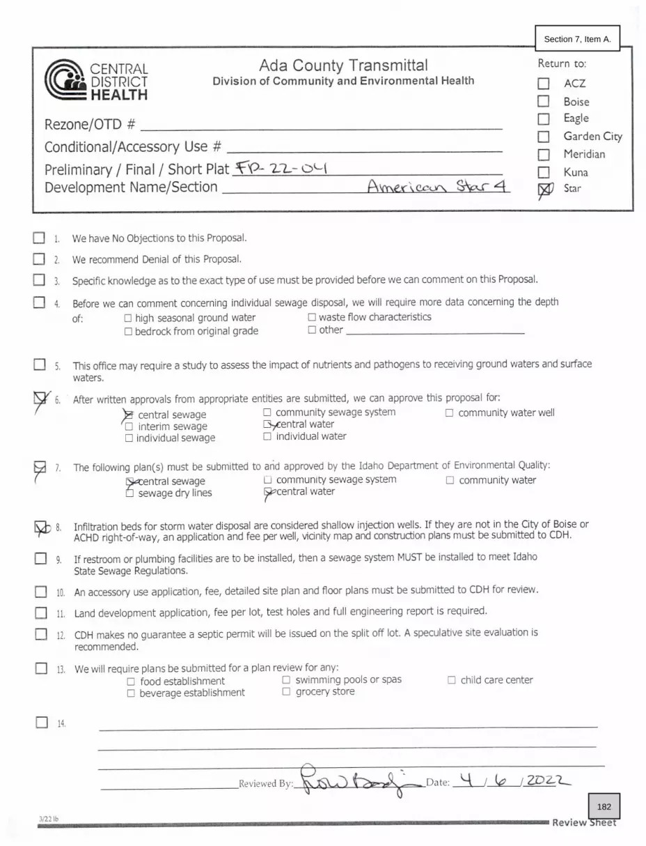
182
Section 7, Item A.

183
Section 7, Item A.

184
Section 7, Item A.

_____________________________________________________________________________________________________________ Ada County Highway District • 3775 Adams Street • Garden City, ID • 83714 • PH 208-387-6100 • FX 345-7650 • www.achdidaho.org
Mary May, President
Alexis Pickering, Vice-President
Jim D. Hansen, 2nd Vice President
Kent Goldthorpe, Commissioner
Dave McKinney, Commissioner April 18th, 2022
To: Bruce Hessing 2338 W Boulder Bar Drive Meridian, ID 83646
Subject: SPP22-0005/ AZ-22-02/ RZ-22-04/ DA-22-02/ PP-22-03 385 N Center Street
Stardale Place
The applicant is requesting annexation and rezone of 3.39 acres into the City of Star with R-7 zoning. The applicant is also requesting preliminary plat approval for 26 residential lots and 3 common lots.
A. Findings of Fact 1. Center Street
a. Existing Conditions: Center is improved with 2-travel lanes, 24-feet of pavement and no curb, gutter, or sidewalk abutting the site. There is 51-feet of right-of-way for Center Street (26-feet from centerline).
b. Policy: Local Roadway Policy: District Policy 7207.2.1 states that the developer is responsible for improving all local street frontages adjacent to the site regardless of whether or not access is taken to all of the adjacent streets.
Street Section and Right-of-Way Policy: District Policy 7207.5 states that right-of-way widths for all local streets shall generally not be less than 47-feet wide and that the standard street section shall be 33-feet (back-of-curb to back-of-curb).
Standard Urban Local Street—33-foot Street Section and Right-of-way Policy: District Policy 7207.5.2 states that the standard street section shall be 33-feet (back-of-curb to back-of-curb) for developments with any buildable lot that is less than 1 acre in size. This street section shall include curb, gutter, and minimum 5-foot wide concrete sidewalks on both sides and shall typically be constructed within 47-feet of right-of-way.
For the City of Kuna and City of Star: Unless otherwise approved by Kuna or Star, the standard street section shall be 36-feet (back-of-curb to back-of-curb) for developments with any buildable lot that is less than 1 acre in size. This street section shall include curb, gutter, and minimum 5-foot wide concrete sidewalks on both sides and shall typically be constructed within 50-feet of right-of-way.
Sidewalk Policy: District Policy 7207.5.7 states that five-foot wide concrete sidewalk is required on both sides of all local street, except those in rural developments with net densities of one dwelling unit per 1.0 acre or less, or in hillside conditions where there is no direct lot frontage, in which case a sidewalk shall be constructed along one side of the street. Some local jurisdictions may require wider sidewalks.
185
Section 7, Item A.
_____________________________________________________________________________________________________________ Ada County Highway District • 3775 Adams Street • Garden City, ID • 83714 • PH 208-387-6100 • FX 345-7650 • www.achdidaho.org
The sidewalk may be placed next to the back-of-curb. Where feasible, a parkway strip at least 8-feet wide between the back-of-curb and the street edge of the sidewalk is recommended to provide increased safety and protection of pedestrians and to allow for the planting of trees in accordance with the District’s Tree Planting Policy. If no trees are to be planted in the parkway strip, the applicant may submit a request to the District, with justification, to reduce the width of the parkway strip.
Detached sidewalks are encouraged and should be parallel to the adjacent roadway. Meandering sidewalks are discouraged.
A permanent right-of-way easement shall be provided if public sidewalks are placed outside of the dedicated right-of-way. The easement shall encompass the entire area between the right-of-way line and 2-feet behind the back edge of the sidewalk. Sidewalks shall either be located wholly within the public right-of-way or wholly within an easement.
c. Applicant’s Proposal: The applicant has not proposed any improvements to Center Street abutting the site.
d. Staff Comments/Recommendations: The applicant should be required to construct Center Street as ½ of a 36-foot street section with curb, gutter, and 5-foot wide concrete sidewalk.
For detached sidewalk located outside of the right-of-way, the applicant may provide a permanent right-of-way easement that extends from the right-of-way line to 2-feet behind the back of sidewalk. The sidewalk should be wholly located in the right-of-way or wholly located within an easement.
If street trees are desired, an 8-foot wide planter strip is required.
2. 3rd Street a. Existing Conditions: 3rd Street is improved with 2-travel lanes, curb, gutter, and
5-foot wide attached concrete sidewalk abutting the site. There is 50-feet of right-of-way for 3rd Street (25-feet from centerline).
b. Policy: Local Roadway Policy: District Policy 7207.2.1 states that the developer is responsible for improving all local street frontages adjacent to the site regardless of whether or not access is taken to all of the adjacent streets.
Street Section and Right-of-Way Policy: District Policy 7207.5 states that right-of-way widths for all local streets shall generally not be less than 47-feet wide and that the standard street section shall be 33-feet (back-of-curb to back-of-curb).
Standard Urban Local Street—33-foot Street Section and Right-of-way Policy: District Policy 7207.5.2 states that the standard street section shall be 33-feet (back-of-curb to back-of-curb) for developments with any buildable lot that is less than 1 acre in size. This street section shall include curb, gutter, and minimum 5-foot wide concrete sidewalks on both sides and shall typically be constructed within 47-feet of right-of-way.
For the City of Kuna and City of Star: Unless otherwise approved by Kuna or Star, the standard street section shall be 36-feet (back-of-curb to back-of-curb) for developments with any buildable lot that is less than 1 acre in size. This street section shall include curb, gutter, and minimum 5-foot wide concrete sidewalks on both sides and shall typically be constructed within 50-feet of right-of-way.
Sidewalk Policy: District Policy 7207.5.7 states that five-foot wide concrete sidewalk is required on both sides of all local street, except those in rural developments with net
186
Section 7, Item A.

_____________________________________________________________________________________________________________ Ada County Highway District • 3775 Adams Street • Garden City, ID • 83714 • PH 208-387-6100 • FX 345-7650 • www.achdidaho.org
densities of one dwelling unit per 1.0 acre or less, or in hillside conditions where there is no direct lot frontage, in which case a sidewalk shall be constructed along one side of the street. Some local jurisdictions may require wider sidewalks.
The sidewalk may be placed next to the back-of-curb. Where feasible, a parkway strip at least 8-feet wide between the back-of-curb and the street edge of the sidewalk is recommended to provide increased safety and protection of pedestrians and to allow for the planting of trees in accordance with the District’s Tree Planting Policy. If no trees are to be planted in the parkway strip, the applicant may submit a request to the District, with justification, to reduce the width of the parkway strip.
Detached sidewalks are encouraged and should be parallel to the adjacent roadway. Meandering sidewalks are discouraged.
A permanent right-of-way easement shall be provided if public sidewalks are placed outside of the dedicated right-of-way. The easement shall encompass the entire area between the right-of-way line and 2-feet behind the back edge of the sidewalk. Sidewalks shall either be located wholly within the public right-of-way or wholly within an easement.
Minor Improvements Policy: District Policy 7203.3 states that minor improvements to existing streets adjacent to a proposed development may be required. These improvements are to correct deficiencies or replace deteriorated facilities. Included are sidewalk construction or replacement; curb and gutter construction or replacement; replacement of unused driveways with curb, gutter and sidewalk; installation or reconstruction of pedestrian ramps; pavement repairs; signs; traffic control devices; and other similar items.
c. Applicant’s Proposal: The applicant has not proposed any improvements to 3rd Street abutting the site.
d. Staff Comments/Recommendations: 3rd Street abutting the site is fully improved, therefore no additional street improvements or right-of-way dedication is required with this development.
Consistent with the District’s Minor Improvements Policy, the applicant should be required to replace any broken or deteriorated segments of curb, gutter, or sidewalk on 3rd Street abutting the site.
3. Internal Local Street
a. Existing Conditions: There are no roadways within the site.
b. Policy: Local Roadway Policy: District Policy 7207.2.1 states that the developer is responsible for improving all local street frontages adjacent to the site regardless of whether or not access is taken to all of the adjacent streets.
Street Section and Right-of-Way Policy: District Policy 7207.5 states that right-of-way widths for all local streets shall generally not be less than 47-feet wide and that the standard street section shall be 33-feet (back-of-curb to back-of-curb).
Standard Urban Local Street—33-foot Street Section and Right-of-way Policy: District Policy 7207.5.2 states that the standard street section shall be 33-feet (back-of-curb to back-of-curb) for developments with any buildable lot that is less than 1 acre in size. This street section shall include curb, gutter, and minimum 5-foot wide concrete sidewalks on both sides and shall typically be constructed within 47-feet of right-of-way.
187
Section 7, Item A.
_____________________________________________________________________________________________________________ Ada County Highway District • 3775 Adams Street • Garden City, ID • 83714 • PH 208-387-6100 • FX 345-7650 • www.achdidaho.org
For the City of Kuna and City of Star: Unless otherwise approved by Kuna or Star, the standard street section shall be 36-feet (back-of-curb to back-of-curb) for developments with any buildable lot that is less than 1 acre in size. This street section shall include curb, gutter, and minimum 5-foot wide concrete sidewalks on both sides and shall typically be constructed within 50-feet of right-of-way.
Continuation of Streets Policy: District Policy 7207.2.4 states that an existing street, or a street in an approved preliminary plat, which ends at a boundary of a proposed development shall be extended in that development. The extension shall include provisions for continuation of storm drainage facilities. Benefits of connectivity include but are not limited to the following:
• Reduces vehicle miles traveled.
• Increases pedestrian and bicycle connectivity.
• Increases access for emergency services.
• Reduces need for additional access points to the arterial street system.
• Promotes the efficient delivery of services including trash, mail and deliveries.
• Promotes appropriate intra-neighborhood traffic circulation to schools, parks, neighborhood commercial centers, transit stops, etc.
• Promotes orderly development.
Sidewalk Policy: District Policy 7207.5.7 states that five-foot wide concrete sidewalk is required on both sides of all local street, except those in rural developments with net densities of one dwelling unit per 1.0 acre or less, or in hillside conditions where there is no direct lot frontage, in which case a sidewalk shall be constructed along one side of the street. Some local jurisdictions may require wider sidewalks.
The sidewalk may be placed next to the back-of-curb. Where feasible, a parkway strip at least 8-feet wide between the back-of-curb and the street edge of the sidewalk is recommended to provide increased safety and protection of pedestrians and to allow for the planting of trees in accordance with the District’s Tree Planting Policy. If no trees are to be planted in the parkway strip, the applicant may submit a request to the District, with justification, to reduce the width of the parkway strip.
Detached sidewalks are encouraged and should be parallel to the adjacent roadway. Meandering sidewalks are discouraged.
A permanent right-of-way easement shall be provided if public sidewalks are placed outside of the dedicated right-of-way. The easement shall encompass the entire area between the right-of-way line and 2-feet behind the back edge of the sidewalk. Sidewalks shall either be located wholly within the public right-of-way or wholly within an easement.
Cul-de-sac Streets Policy: District policy 7207.5.8 requires cul-de-sacs to be constructed to provide a minimum turning radius of 50-feet; in rural areas or for temporary cul-de-sacs the emergency service providers may require a greater radius. Landscape and parking islands may be constructed in turnarounds if a minimum 29-foot street section is constructed around the island. The pavement width shall be sufficient to allow the turning around of a standard AASHTO SU design vehicle without backing. The developer shall provide written approval from the appropriate fire department for this design element.
The District will consider alternatives to the standard cul-de-sac turnaround on a case-by-case basis. This will be based on turning area, drainage, maintenance
188
Section 7, Item A.

_____________________________________________________________________________________________________________ Ada County Highway District • 3775 Adams Street • Garden City, ID • 83714 • PH 208-387-6100 • FX 345-7650 • www.achdidaho.org
considerations and the written approval of the agency providing emergency fire service for the area where the development is located.
c. Applicant’s Proposal: The applicant has proposed to construct a 36-foot wide local public road to serve the site. The road is proposed to be located 150-feet south of 3rd Street and to terminate in a cul-de-sac turnaround.
d. Staff Comments/Recommendations: The applicant’s proposal meets District policy and should be approved as proposed. The cul-de-sac turnaround should be constructed with a minimum radius of 50-feet.
Although the applicant’s proposal meets District policy, the applicant may consider constructing the internal road as a private street, as there are no stub streets to provide connectivity to the site, and the surrounding parcels are built-out and are accessed by a mix of public and private streets. If a private street is approved by the City of Star, then street name and stop signs are should be required for the private road. The signs may be ordered through the District. Verification of the correct, approved name of the road is required.
4. Private Roads
e. Private Road Policy: District policy 7212.1 states that the lead land use agencies in Ada County establish the requirements for private streets. The District retains authority and will review the proposed intersection of a private and public street for compliance with District intersection policies and standards. The private road should have the following requirements:
• Designed to discourage through traffic between two public streets,
• Graded to drain away from the public street intersection, and
• If a private road is gated, the gate or keypad (if applicable) shall be located a minimum of 50-feet from the near edge of the intersection and a turnaround shall be provided.
f. Staff Comments/Recommendations: If the City of Star approves the private road, the applicant shall be required to pave the private roadway a minimum of 20 to 24-feet wide and at least 30-feet into the site beyond the edge of pavement of all public streets and install pavement tapers with 15-foot curb radii abutting the existing roadway edge. If private roads are not approved by the City of Star, the applicant will be required to revise and resubmit the preliminary plat to provide public standard local streets in these locations.
Street name and stop signs are required for the private road. The signs may be ordered through the District. Verification of the correct, approved name of the road is required.
ACHD does not make any assurances that the private road, which is a part of this application, will be accepted as a public road if such a request is made in the future. Substantial redesign and reconstruction costs may be necessary in order to qualify this road for public ownership and maintenance.
The following requirements must be met if the applicant wishes to dedicate the roadway to ACHD:
• Dedicate a minimum of 50-feet of right-of-way for the road.
• Construct the roadway to the minimum ACHD requirements.
• Construct a stub street to the surrounding parcels.
189
Section 7, Item A.

_____________________________________________________________________________________________________________ Ada County Highway District • 3775 Adams Street • Garden City, ID • 83714 • PH 208-387-6100 • FX 345-7650 • www.achdidaho.org
B. Site Specific Conditions of Approval 1. Improve Center Street as ½ of a 36-foot street section with curb, gutter, and 5-foot wide
concrete sidewalk. Provide a permanent right-of-way easement for detached sidewalk located outside of the dedicated right-of-way. If street trees are desired, an 8-foot wide planer strip is required.
2. Relace any broken or deteriorated segments of curb, gutter, or sidewalk on 3rd Street abutting the site consistent with the District’s Minor Improvements policy.
3. Construct one 36-foot wide local street to intersect Center Street located 150-feet south of 3rd Street, as proposed. Construct the roadway as a 36-foot wide local street with curb, gutter, and 5-foot wide attached concrete sidewalk within 50-feet of right-of-way. Construct a cul-de-sac turnaround with a minimum radius of 50-feet at the terminus of the roadway. OR
4. Construct a 20 to 24-foot wide private road to intersect Center Street located 150-feet south of 3rd Steet. Street name and stop signs are required for the private road. The signs may be ordered through the District. Verification of the correct, approved name of the road is required.
5. A Traffic Impact Fee will be assessed by ACHD and will be due prior to issuance of a building permit. Please contact the ACHD Planner (see below) for information regarding impact fees.
6. Submit civil plans to ACHD Development Services for review and approval. The impact fee assessment will not be released until the civil plans are approved by ACHD.
7. Comply with the Standard Conditions of Approval as noted below.
C. Traffic Information Trip Generation This development is estimated to generate 245 vehicle trips per day and 26 vehicle trips per hour in the PM peak hour, based on the Institute of Transportation Engineers Trip Generation Manual, 11th edition.
Condition of Area Roadways: Traffic Count is based on Vehicles per hour (VPH)
Roadway Frontage Functional
Classification PM Peak Hour Traffic Count
PM Peak Hour Level of Service
Center Street 275-feet Local 26 N/A
3rd Street 130-feet Local 62 N/A
Average Daily Traffic Count (VDT): Average daily traffic counts are based on ACHD’s most current
traffic counts
• The average daily traffic count for Center Street north of 1st Street was 590 on 06/27/18.
• The average daily traffic count for 3rd Street west of Evelyn Way was 1,350 on 11/18/21.
D. Attachments
1. Vicinity Map 2. Site Plan 3. Standard Conditions of Approval 4. Appeal Guidelines
190
Section 7, Item A.

_____________________________________________________________________________________________________________ Ada County Highway District • 3775 Adams Street • Garden City, ID • 83714 • PH 208-387-6100 • FX 345-7650 • www.achdidaho.org
If you have any questions, please feel free to contact me at (208) 387-6132. Sincerely,
Kelly Bruner Planner Development Services cc: City of Star (Shawn Nickel, via email)
Antonio Conti, via email
191
Section 7, Item A.

_____________________________________________________________________________________________________________ Ada County Highway District • 3775 Adams Street • Garden City, ID • 83714 • PH 208-387-6100 • FX 345-7650 • www.achdidaho.org
VICINITY MAP
192
Section 7, Item A.
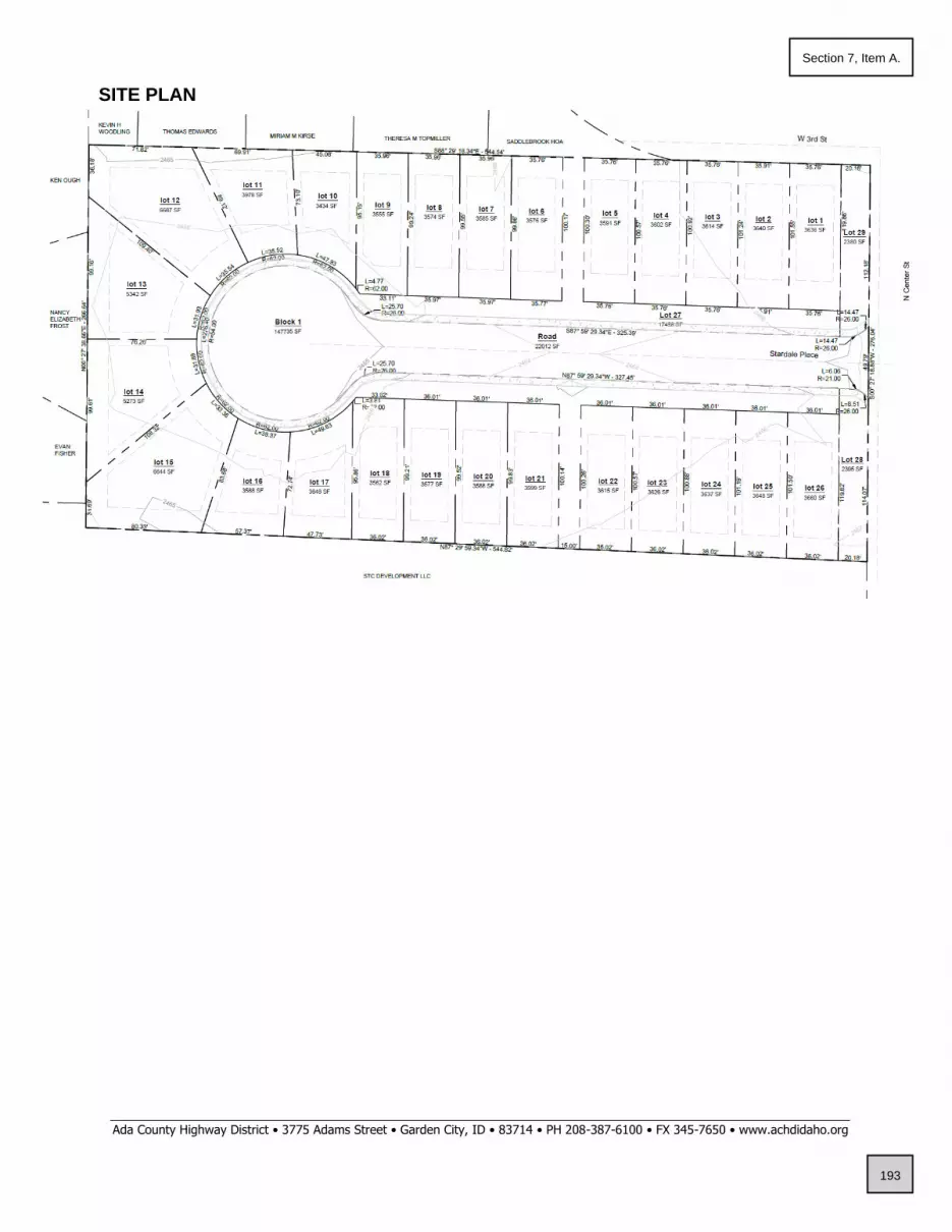
_____________________________________________________________________________________________________________ Ada County Highway District • 3775 Adams Street • Garden City, ID • 83714 • PH 208-387-6100 • FX 345-7650 • www.achdidaho.org
SITE PLAN
193
Section 7, Item A.

_____________________________________________________________________________________________________________ Ada County Highway District • 3775 Adams Street • Garden City, ID • 83714 • PH 208-387-6100 • FX 345-7650 • www.achdidaho.org
Standard Conditions of Approval
1. All proposed irrigation facilities shall be located outside of the ACHD right-of-way (including all easements). Any existing irrigation facilities shall be relocated outside of the ACHD right-of-way (including all easements).
2. Private Utilities including sewer or water systems are prohibited from being located within the ACHD right-of-way.
3. In accordance with District policy, 7203.6, the applicant may be required to update any existing non-compliant pedestrian improvements abutting the site to meet current Americans with Disabilities Act (ADA) requirements. The applicant’s engineer should provide documentation of ADA compliance to District Development Review staff for review.
4. Replace any existing damaged curb, gutter and sidewalk and any that may be damaged during the construction of the proposed development. Contact Construction Services at 387-6280 (with file number) for details.
5. A license agreement and compliance with the District’s Tree Planter policy is required for all landscaping proposed within ACHD right-of-way or easement areas.
6. All utility relocation costs associated with improving street frontages abutting the site shall be borne by the developer.
7. It is the responsibility of the applicant to verify all existing utilities within the right-of-way. The applicant at no cost to ACHD shall repair existing utilities damaged by the applicant. The applicant shall be required to call DIGLINE (1-811-342-1585) at least two full business days prior to breaking ground within ACHD right-of-way. The applicant shall contact ACHD Traffic Operations 387-6190 in the event any ACHD conduits (spare or filled) are compromised during any phase of construction.
8. Utility street cuts in pavement less than five years old are not allowed unless approved in writing by the District. Contact the District’s Utility Coordinator at 387-6258 (with file numbers) for details.
9. All design and construction shall be in accordance with the ACHD Policy Manual, ISPWC Standards and approved supplements, Construction Services procedures and all applicable ACHD Standards unless specifically waived herein. An engineer registered in the State of Idaho shall prepare and certify all improvement plans.
10. Construction, use and property development shall be in conformance with all applicable requirements of ACHD prior to District approval for occupancy.
11. No change in the terms and conditions of this approval shall be valid unless they are in writing and signed by the applicant or the applicant’s authorized representative and an authorized representative of ACHD. The burden shall be upon the applicant to obtain written confirmation of any change from ACHD.
12. If the site plan or use should change in the future, ACHD Planning Review will review the site plan and may require additional improvements to the transportation system at that time. Any change in the planned use of the property which is the subject of this application, shall require the applicant to comply with ACHD Policy and Standard Conditions of Approval in place at that time unless a waiver/variance of the requirements or other legal relief is granted by the ACHD Commission.
194
Section 7, Item A.

_____________________________________________________________________________________________________________ Ada County Highway District • 3775 Adams Street • Garden City, ID • 83714 • PH 208-387-6100 • FX 345-7650 • www.achdidaho.org
Request for Appeal of Staff Decision
1. Appeal of Staff Decision: The Commission shall hear and decide appeals by an applicant of the final decision made by the Development Services Manager when it is alleged that the Development Services Manager did not properly apply this section 7101.6, did not consider all of the relevant facts presented, made an error of fact or law, abused discretion or acted arbitrarily and capriciously in the interpretation or enforcement of the ACHD Policy Manual.
a. Filing Fee: The Commission may, from time to time, set reasonable
fees to be charged the applicant for the processing of appeals, to cover administrative costs.
b. Initiation: An appeal is initiated by the filing of a written notice of
appeal with the Secretary and Clerk of the District, which must be filed within ten (10) working days from the date of the decision that is the subject of the appeal. The notice of appeal shall refer to the decision being appealed, identify the appellant by name, address and telephone number and state the grounds for the appeal. The grounds shall include a written summary of the provisions of the policy relevant to the appeal and/or the facts and law relied upon and shall include a written argument in support of the appeal. The Commission shall not consider a notice of appeal that does not comply with the provisions of this subsection.
c. Time to Reply: The Development Services Manager shall have ten
(10) working days from the date of the filing of the notice of appeal to reply to the notice of the appeal, and may during such time meet with the appellant to discuss the matter, and may also consider and/or modify the decision that is being appealed. A copy of the reply and any modifications to the decision being appealed will be provided to the appellant prior to the Commission hearing on the appeal.
d. Notice of Hearing: Unless otherwise agreed to by the appellant, the
hearing of the appeal will be noticed and scheduled on the Commission agenda at a regular meeting to be held within thirty (30) days following the delivery to the appellant of the Development Services Manager’s reply to the notice of appeal. A copy of the decision being appealed, the notice of appeal and the reply shall be delivered to the Commission at least one (1) week prior to the hearing.
e. Action by Commission: Following the hearing, the Commission shall
either affirm or reverse, in whole or part, or otherwise modify, amend or supplement the decision being appealed, as such action is adequately supported by the law and evidence presented at the hearing.
195
Section 7, Item A.

April 1, 2022 By e-mail: [email protected] City of Star P.O. Box 130 Star, Idaho 83669 Subject: Stardale Place Subdivision, AZ-22-02/RZ-21-04/DA-22-02/PP-22-03 Dear Mr. Nickel:
Thank you for the opportunity to respond to your request for comment. While DEQ does not review projects on a project-specific basis, we attempt to provide the best review of the information provided. DEQ encourages agencies to review and utilize the Idaho Environmental Guide to assist in addressing project-specific conditions that may apply. This guide can be found at: https://www.deq.idaho.gov/public-information/assistance-and-resources/outreach-and-education/. The following information does not cover every aspect of this project; however, we have the following general comments to use as appropriate:
1. AIR QUALITY
• Please review IDAPA 58.01.01 for all rules on Air Quality, especially those regarding fugitive dust (58.01.01.651), trade waste burning (58.01.01.600-617), and odor control plans (58.01.01.776).
• All property owners, developers, and their contractor(s) must ensure that reasonable controls to prevent fugitive dust from becoming airborne are utilized during all phases of construction activities per IDAPA 58.01.01.651.
• DEQ recommends the city/county require the development and submittal of a dust prevention and control plan for all construction projects prior to final plat approval. Dust prevention and control plans incorporate appropriate best management practices to control fugitive dust that may be generated at sites.
• Citizen complaints received by DEQ regarding fugitive dust from development and construction activities approved by cities or counties will be referred to the city/county to address under their ordinances.
Brad Little, Governor Jess Byrne, Director
1445 N Orchard Street, Boise, ID 83706 (208) 373-0550
196
Section 7, Item A.

Response to Request for Comment April 1, 2022 Page 2
• Per IDAPA 58.01.01.600-617, the open burning of any construction waste is prohibited. The
property owner, developer, and their contractor(s) are responsible for ensuring no prohibited open burning occurs during construction.
• For questions, contact David Luft, Air Quality Manager, at (208) 373-0550.
2. WASTEWATER AND RECYCLED WATER
• DEQ recommends verifying that there is adequate sewer to serve this project prior to approval. Please contact the sewer provider for a capacity statement, declining balance report, and willingness to serve this project.
• IDAPA 58.01.16 and IDAPA 58.01.17 are the sections of Idaho rules regarding wastewater and recycled water. Please review these rules to determine whether this or future projects will require DEQ approval. IDAPA 58.01.03 is the section of Idaho rules regarding subsurface disposal of wastewater. Please review this rule to determine whether this or future projects will require permitting by the district health department.
• All projects for construction or modification of wastewater systems require preconstruction approval. Recycled water projects and subsurface disposal projects require separate permits as well.
• DEQ recommends that projects be served by existing approved wastewater collection systems or a centralized community wastewater system whenever possible. Please contact DEQ to discuss potential for development of a community treatment system along with best management practices for communities to protect ground water.
• DEQ recommends that cities and counties develop and use a comprehensive land use management plan, which includes the impacts of present and future wastewater management in this area. Please schedule a meeting with DEQ for further discussion and recommendations for plan development and implementation.
For questions, contact Valerie Greear, Water Quality Engineering Manager at (208) 373-0550.
3. DRINKING WATER
• DEQ recommends verifying that there is adequate water to serve this project prior to approval. Please contact the water provider for a capacity statement, declining balance report, and willingness to serve this project.
• IDAPA 58.01.08 is the section of Idaho rules regarding public drinking water systems. Please review these rules to determine whether this or future projects will require DEQ approval.
• All projects for construction or modification of public drinking water systems require preconstruction approval.
197
Section 7, Item A.

Response to Request for Comment April 1, 2022 Page 3
• DEQ recommends verifying if the current and/or proposed drinking water system is a regulated public drinking water system (refer to the DEQ website at: https://www.deq.idaho.gov/water-quality/drinking-water/. For non-regulated systems, DEQ recommends annual testing for total coliform bacteria, nitrate, and nitrite.
• If any private wells will be included in this project, we recommend that they be tested for total coliform bacteria, nitrate, and nitrite prior to use and retested annually thereafter.
• DEQ recommends using an existing drinking water system whenever possible or construction of a new community drinking water system. Please contact DEQ to discuss this project and to explore options to both best serve the future residents of this development and provide for protection of ground water resources.
• DEQ recommends cities and counties develop and use a comprehensive land use management plan which addresses the present and future needs of this area for adequate, safe, and sustainable drinking water. Please schedule a meeting with DEQ for further discussion and recommendations for plan development and implementation.
For questions, contact Valerie Greear, Water Quality Engineering Manager at (208) 373-0550.
4. SURFACE WATER
• Please contact DEQ to determine whether this project will require an Idaho Pollutant Discharge Elimination System (IPDES) Permit. A Construction General Permit from DEQ may be required if this project will disturb one or more acres of land, or will disturb less than one acre of land but are part of a common plan of development or sale that will ultimately disturb one or more acres of land.
• For questions, contact James Craft, IPDES Compliance Supervisor, at (208) 373-0144.
• If this project is near a source of surface water, DEQ requests that projects incorporate construction best management practices (BMPs) to assist in the protection of Idaho’s water resources. Additionally, please contact DEQ to identify BMP alternatives and to determine whether this project is in an area with Total Maximum Daily Load stormwater permit conditions.
• The Idaho Stream Channel Protection Act requires a permit for most stream channel alterations. Please contact the Idaho Department of Water Resources (IDWR), Western Regional Office, at 2735 Airport Way, Boise, or call (208) 334-2190 for more information. Information is also available on the IDWR website at: https://idwr.idaho.gov/streams/stream-channel-alteration-permits.html
• The Federal Clean Water Act requires a permit for filling or dredging in waters of the United States. Please contact the US Army Corps of Engineers, Boise Field Office, at 10095 Emerald Street, Boise, or call 208-345-2155 for more information regarding permits.
For questions, contact Lance Holloway, Surface Water Manager, at (208) 373-0550.
198
Section 7, Item A.

Response to Request for Comment April 1, 2022 Page 4
5. SOLID WASTE, HAZARDOUS WASTE AND GROUND WATER CONTAMINATION
• Solid Waste. No trash or other solid waste shall be buried, burned, or otherwise disposed of at the project site. These disposal methods are regulated by various state regulations including Idaho’s Solid Waste Management Regulations and Standards (IDAPA 58.01.06), Rules and Regulations for Hazardous Waste (IDAPA 58.01.05), and Rules and Regulations for the Prevention of Air Pollution (IDAPA 58.01.01). Inert and other approved materials are also defined in the Solid Waste Management Regulations and Standards
• Hazardous Waste. The types and number of requirements that must be complied with under the federal Resource Conservations and Recovery Act (RCRA) and the Idaho Rules and Standards for Hazardous Waste (IDAPA 58.01.05) are based on the quantity and type of waste generated. Every business in Idaho is required to track the volume of waste generated, determine whether each type of waste is hazardous, and ensure that all wastes are properly disposed of according to federal, state, and local requirements.
• Water Quality Standards. Site activities must comply with the Idaho Water Quality Standards (IDAPA 58.01.02) regarding hazardous and deleterious-materials storage, disposal, or accumulation adjacent to or in the immediate vicinity of state waters (IDAPA 58.01.02.800); and the cleanup and reporting of oil-filled electrical equipment (IDAPA 58.01.02.849); hazardous materials (IDAPA 58.01.02.850); and used-oil and petroleum releases (IDAPA 58.01.02.851 and 852). Petroleum releases must be reported to DEQ in accordance with IDAPA 58.01.02.851.01 and 04. Hazardous material releases to state waters, or to land such that there is likelihood that it will enter state waters, must be reported to DEQ in accordance with IDAPA 58.01.02.850.
• Ground Water Contamination. DEQ requests that this project comply with Idaho’s Ground Water Quality Rules (IDAPA 58.01.11), which states that “No person shall cause or allow the release, spilling, leaking, emission, discharge, escape, leaching, or disposal of a contaminant into the environment in a manner that causes a ground water quality standard to be exceeded, injures a beneficial use of ground water, or is not in accordance with a permit, consent order or applicable best management practice, best available method or best practical method.”
For questions, contact Rebecca Blankenau, Waste & Remediation Manager, at (208) 373-0550.
6. ADDITIONAL NOTES
• If an underground storage tank (UST) or an aboveground storage tank (AST) is identified at the site, the site should be evaluated to determine whether the UST is regulated by DEQ. EPA regulates ASTs. UST and AST sites should be assessed to determine whether there is potential soil and ground water contamination. Please call DEQ at (208) 373-0550, or visit the DEQ website https://www.deq.idaho.gov/waste-management-and-remediation/storage-tanks/leaking-underground-storage-tanks-in-idaho/ for assistance.
199
Section 7, Item A.
Response to Request for Comment April 1, 2022 Page 5
• If applicable to this project, DEQ recommends that BMPs be implemented for any of the following conditions: wash water from cleaning vehicles, fertilizers and pesticides, animal facilities, composted waste, and ponds. Please contact DEQ for more information on any of these conditions.
We look forward to working with you in a proactive manner to address potential environmental impacts that may be within our regulatory authority. If you have any questions, please contact me, or any of our technical staff at (208) 373-0550. Sincerely, Aaron Scheff Regional Administrator DEQ-Boise Regional Office EDMS#: 2022AEK66
200
Section 7, Item A.

A
STARDALE PLACE SUBDIVISION
CITY OF STAR
LAND USE STAFF MEMO
TO: Mayor & Council
FROM: City of Star Planning Department
MEETING DATE: June 21, 2022 PUBLIC HEARING – Tabled from June 7, 2022
FILE(S) #: AZ-22-04 Annexation and Zoning
RZ-21-04 Rezone
DA-22-02 Development Agreement
PP-22-03 Preliminary Plat for Stardale Place Subdivision
OWNER/APPLICANT/REPRESENTATIVE
Applicant/Owner: Representative:
Bruce Hessing Antonio Conti
Piedmont Project, LLC Ackerman-Estvold
2338 W. Boulder Bar Dr. 7661 W. Riverside Dr., Ste. 102
Meridian, Idaho 83646 Garden City, Idaho 83714
REQUEST
Request: The Applicant is seeking approval of Annexation and Zoning (R-7-DA), Rezone (R-4 to
R-7), a Development Agreement, and Preliminary Plat for a proposed residential subdivision
consisting of 26 residential lots and 3 common lots. The property is located at 331, 343 and 385
N. Center Street in Star, Idaho and consists of 3.39 acres with a proposed density of 7.67
dwelling units per acre.
UPDATE
The Council tabled this application from their June 7, 2022 public hearing and requested
that applicant to revise the preliminary plat application to lower the density, remove lots
on the north and align lot lines to existing subdivision, and remove a southern lot to
create larger open space. Council also requested the removal of the northern pathway.
The applicant has resubmitted a revised preliminary plat and landscape plan showing the
removal of 3 lots, with a reduced density of 6.78 dwelling units per acre, and an updated
landscape plan with open space and pathway.
201
Section 7, Item A.
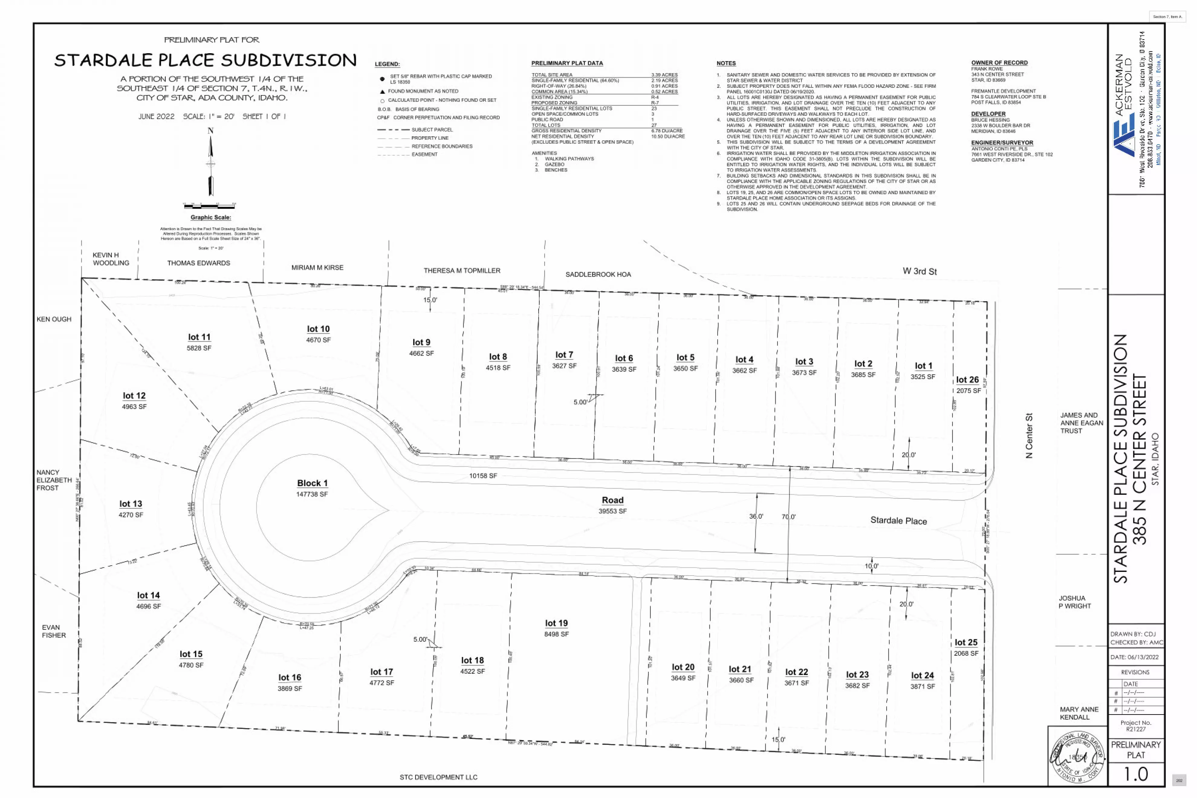
lot 104670 SF
lot 23685 SF
lot 13525 SF
lot 33673 SF
lot 43662 SF
lot 53650 SF
lot 63639 SF
lot 73627 SF
lot 84518 SF
lot 115828 SF
lot 124963 SF
lot 134270 SF
lot 144696 SF
lot 154780 SF
lot 163869 SF
lot 174772 SF
lot 184522 SF
lot 198498 SF
lot 203649 SF
lot 213660 SF
lot 223671 SF
lot 233682 SF
lot 243871 SF
Road39553 SF
Block 1147738 SF
lot 252068 SF
lot 262075 SF
69.2
0'
100.24'
97.1
0'81
.02'
73.22'
88.5
2'
71.98'
10.34'
45.52'
L=29.42
R=71.00
100.
19'
36.00' 36.00' 36.00' 36.00' 36.00' 32.94'
35.73'35.99'
102.
52'
102.
20'
101.
88'
101.
56'
101.
24'
36.00'36.00'36.00'36.00'
100.
91'
75.0
9'
L=7.65R=9.00
L=42.77R=72.16
124.10'
72.90'
72.0
9'
66.8
7'
101.
20'
101.
51'
101.
82'
102.
13'
102.
44'
102.
81'
102.
98'
102.
85'
44.66'84.14'
36.00' 36.00' 36.00' 36.00' 36.41'
36.00' 36.00' 36.00' 36.00'39.06' 20.18'
5.00'
5.00'
15.0'
15.0'
70.0'
20.0'
20.0'
L=27
.04
R=72
.17
L=43
.45
R=7
0.93
L=47.25R=70.59
L=48.13R=71.00
Stardale Place
N C
ente
r St
W 3rd St
S00°
27'
18.
88"W
- 27
6.04
'
N87° 29' 59.34"W - 544.82'
N00
° 27'
38.
66"E
- 26
6.64
'
S88° 29' 18.34"E - 544.54'
24642464
2465
2466
2466
2466
2466
2466
2465
2465
2467
EVANFISHER
NANCYELIZABETHFROST
KEN OUGH
KEVIN HWOODLING THOMAS EDWARDS
MIRIAM M KIRSE THERESA M TOPMILLER SADDLEBROOK HOA
JAMES ANDANNE EAGANTRUST
JOSHUAP WRIGHT
MARY ANNEKENDALL
STC DEVELOPMENT LLC
10158 SF
45.52'
36.00'
100.
59'
20.16'
36.0'
97.5
9'70
.00'
10.0'
lot 94662 SF
20.17'
36.00'45.00'
50.00' 45.01'
L=63.01R=71.00
80.26'
L=28.14
R=70.84
118.5
8'
84.61'
L=33.74
R=70.39
55.33'
100.
09'
100.
48'
L=10.33
R=9.20
84.14'
20.03'
#DATE
Project No.R21227
DATE: 06/13/2022
REVISIONS
--/--/------/--/----
##
STA
RDA
LE P
LAC
E SU
BDIV
ISIO
N38
5 N
CEN
TER
STRE
ETST
AR,
IDA
HO
CHECKED BY: AMCDRAWN BY: CDJ
--/--/----
1.0
PRELIMINARYPLAT
N
0 1/2 Full1/41/2
Graphic Scale:
Attention is Drawn to the Fact That Drawing Scales May beAltered During Reproduction Processes. Scales Shown
Hereon are Based on a Full Scale Sheet Size of 24" x 36".
Scale: 1" = 20'
NOTES
1. SANITARY SEWER AND DOMESTIC WATER SERVICES TO BE PROVIDED BY EXTENSION OFSTAR SEWER & WATER DISTRICT
2. SUBJECT PROPERTY DOES NOT FALL WITHIN ANY FEMA FLOOD HAZARD ZONE - SEE FIRMPANEL 16001C0130J DATED 06/19/2020.
3. ALL LOTS ARE HEREBY DESIGNATED AS HAVING A PERMANENT EASEMENT FOR PUBLICUTILITIES, IRRIGATION, AND LOT DRAINAGE OVER THE TEN (10) FEET ADJACENT TO ANYPUBLIC STREET. THIS EASEMENT SHALL NOT PRECLUDE THE CONSTRUCTION OFHARD-SURFACED DRIVEWAYS AND WALKWAYS TO EACH LOT.
4. UNLESS OTHERWISE SHOWN AND DIMENSIONED, ALL LOTS ARE HEREBY DESIGNATED ASHAVING A PERMANENT EASEMENT FOR PUBLIC UTILITIES, IRRIGATION, AND LOTDRAINAGE OVER THE FIVE (5) FEET ADJACENT TO ANY INTERIOR SIDE LOT LINE, ANDOVER THE TEN (10) FEET ADJACENT TO ANY REAR LOT LINE OR SUBDIVISION BOUNDARY.
5. THIS SUBDIVISION WILL BE SUBJECT TO THE TERMS OF A DEVELOPMENT AGREEMENTWITH THE CITY OF STAR.
6. IRRIGATION WATER SHALL BE PROVIDED BY THE MIDDLETON IRRIGATION ASSOCIATION INCOMPLIANCE WITH IDAHO CODE 31-3805(B). LOTS WITHIN THE SUBDIVISION WILL BEENTITLED TO IRRIGATION WATER RIGHTS, AND THE INDIVIDUAL LOTS WILL BE SUBJECTTO IRRIGATION WATER ASSESSMENTS.
7. BUILDING SETBACKS AND DIMENSIONAL STANDARDS IN THIS SUBDIVISION SHALL BE INCOMPLIANCE WITH THE APPLICABLE ZONING REGULATIONS OF THE CITY OF STAR OR ASOTHERWISE APPROVED IN THE DEVELOPMENT AGREEMENT.
8. LOTS 19, 25, AND 26 ARE COMMON/OPEN SPACE LOTS TO BE OWNED AND MAINTAINED BYSTARDALE PLACE HOME ASSOCIATION OR ITS ASSIGNS.
9. LOTS 25 AND 26 WILL CONTAIN UNDERGROUND SEEPAGE BEDS FOR DRAINAGE OF THESUBDIVISION.
LEGEND:
SET 5/8" REBAR WITH PLASTIC CAP MARKEDLS 18350
FOUND MONUMENT AS NOTED
CALCULATED POINT - NOTHING FOUND OR SET
B.O.B. BASIS OF BEARING
CP&F CORNER PERPETUATION AND FILING RECORD
SUBJECT PARCEL
PROPERTY LINE
REFERENCE BOUNDARIES
STARDALE PLACE SUBDIVISIONA PORTION OF THE SOUTHWEST 1/4 OF THESOUTHEAST 1/4 OF SECTION 7, T.4N., R.1W.,
CITY OF STAR, ADA COUNTY, IDAHO.
JUNE 2022 SCALE: 1" = 20' SHEET 1 OF 1
PRELIMINARY PLAT FOR
EASEMENT
PRELIMINARY PLAT DATA
TOTAL SITE AREA 3.39 ACRESSINGLE-FAMILY RESIDENTIAL (64.60%) 2.19 ACRESRIGHT-OF-WAY (26.84%) 0.91 ACRESCOMMON AREA (15.34%) 0.52 ACRESEXISTING ZONING R-4PROPOSED ZONING R-7SINGLE-FAMILY RESIDENTIAL LOTS 23OPEN SPACE/COMMON LOTS 3PUBLIC ROAD 1TOTAL LOTS 27GROSS RESIDENTIAL DENSITY 6.78 DU/ACRENET RESIDENTIAL DENSITY 10.50 DU/ACRE(EXCLUDES PUBLIC STREET & OPEN SPACE)
AMENITIES1. WALKING PATHWAYS2. GAZEBO3. BENCHES
OWNER OF RECORDFRANK ROWE343 N CENTER STREETSTAR, ID 83669
FREMANTLE DEVELOPMENT784 S CLEARWATER LOOP STE BPOST FALLS, ID 83854
DEVELOPERBRUCE HESSING2338 W BOULDER BAR DRMERIDIAN, ID 83646
ENGINEER/SURVEYORANTONIO CONTI PE, PLS7661 WEST RIVERSIDE DR., STE 102GARDEN CITY, ID 83714
202
Section 7, Item A.
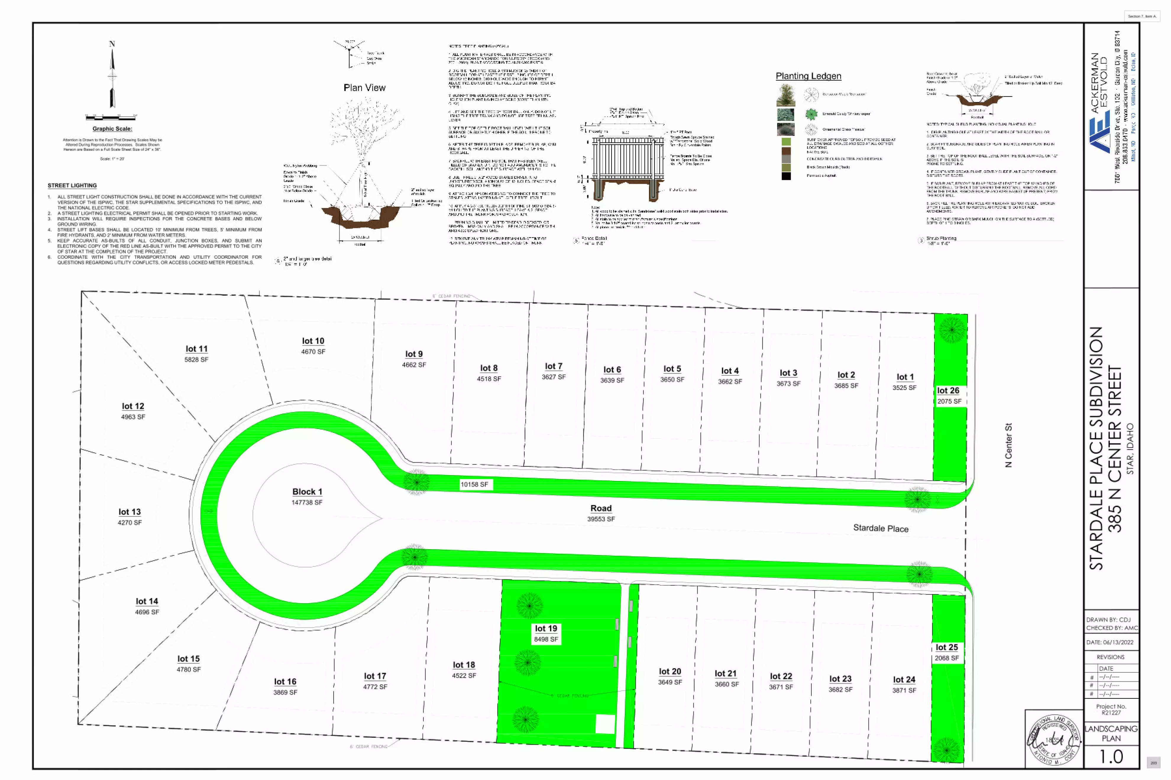
lot 104670 SF
lot 23685 SF
lot 13525 SF
lot 33673 SF
lot 43662 SF
lot 53650 SF
lot 63639 SF
lot 73627 SF
lot 84518 SF
lot 115828 SF
lot 124963 SF
lot 134270 SF
lot 144696 SF
lot 154780 SF
lot 163869 SF
lot 174772 SF
lot 184522 SF
lot 198498 SF
lot 203649 SF
lot 213660 SF
lot 223671 SF
lot 233682 SF
lot 243871 SF
Road39553 SF
Block 1147738 SF
lot 252068 SF
lot 262075 SF
Stardale Place
N C
ente
r St
ELIZABETH
SADDLEBROOK HOA
10158 SF
lot 94662 SF
#DATE
Project No.R21227
DATE: 06/13/2022
REVISIONS
--/--/------/--/----
##
STA
RDA
LE P
LAC
E SU
BDIV
ISIO
N38
5 N
CEN
TER
STRE
ETST
AR,
IDA
HO
CHECKED BY: AMCDRAWN BY: CDJ
--/--/----
1.0LANDSCAPING
PLAN
N
0 1/2 Full1/41/2
Graphic Scale:
Attention is Drawn to the Fact That Drawing Scales May beAltered During Reproduction Processes. Scales Shown
Hereon are Based on a Full Scale Sheet Size of 24" x 36".
Scale: 1" = 20'
STREET LIGHTING
1. ALL STREET LIGHT CONSTRUCTION SHALL BE DONE IN ACCORDANCE WITH THE CURRENTVERSION OF THE ISPWC, THE STAR SUPPLEMENTAL SPECIFICATIONS TO THE ISPWC, ANDTHE NATIONAL ELECTRIC CODE.
2. A STREET LIGHTING ELECTRICAL PERMIT SHALL BE OPENED PRIOR TO STARTING WORK.3. INSTALLATION WILL REQUIRE INSPECTIONS FOR THE CONCRETE BASES AND BELOW
GROUND WIRING.4. STREET LIFT BASES SHALL BE LOCATED 10' MINIMUM FROM TREES, 5' MINIMUM FROM
FIRE HYDRANTS, AND 2' MINIMUM FROM WATER METERS.5. KEEP ACCURATE AS-BUILTS OF ALL CONDUIT, JUNCTION BOXES, AND SUBMIT AN
ELECTRONIC COPY OF THE RED LINE AS-BUILT WITH THE APPROVED PERMIT TO THE CITYOF STAR AT THE COMPLETION OF THE PROJECT.
6. COORDINATE WITH THE CITY TRANSPORTATION AND UTILITY COORDINATOR FORQUESTIONS REGARDING UTILITY CONFLICTS, OR ACCESS LOCKED METER PEDESTALS.
203
Section 7, Item A.

LEGAL NOTICE
PUBLIC HEARING
Notice is hereby given that the Star City Council will hold a Public Hearing on June 21, 2022 at
the Star City Hall, 10769 W. State Street, Star, Idaho at 7:00 pm, or as soon thereafter as the
matter may be heard.
Application: 10206 W. State Street Development Agreement Modification
Files #’s DA-20-16
Owner: Evan Mclaughlin, 10206 W. State Street, LLC, 2001 N. 20th Street, Boise, ID 83702
Representative: Jeff Likes, ALC Architecture, 1119 E. State Street Suite 120, Eagle, ID 83616
Action: The Applicant is requesting to modify the existing Development Agreement for the
property located at 10206 W. State Street. The applicant seeks to increase the height of the
proposed commercial buildings along State Street to a maximum of 45 feet and requests a waiver
for a reduction of the required parking spaces for the commercial uses. The consists of 4.76
acres.
Property Location: The subject property is generally located on the north side of W. State
Street, east of N. Taurus Way in Star, Idaho. Ada County Parcel No. S0408438600.
Information/Comments: A complete copy of the applications are available at City Hall for
public review. The City invites all interested parties to attend the meeting and provide public
testimony. Written comments will be accepted by the City up to noon, the day before the date of
the public hearing.
Services for persons with disabilities may be made available if notice is received in advance of
the meeting by calling Star City Hall at (208) 286-7247.
Shawn L. Nickel
Planning Director and Zoning Administrator
204
Section 7, Item B.

A
WHITENER 10206 W STATE STREEET – FILE # DEVELOPMENT AGREEMENT MODIFICATION
1
CITY OF STAR
LAND USE STAFF MEMO
TO: Mayor & Council
FROM: Shawn L. Nickel, City Planner
MEETING DATE: June 21, 2022 – PUBLIC HEARING
FILE(S) #: DA-20-16-MOD Development Agreement Modification
Whitener 10206 W. State Street
OWNER/APPLICANT/REPRESENTATIVE
Property Owner:
10206 West State Street LLC
Evan McLaughlin
2001 N. 20th Street
Boise, ID 83702
Applicant/Representative:
Jeff Likes
ALC Architecture
1119 E. State Street Suite 120
Eagle, Idaho 83616
REQUEST
Request: The Applicant is requesting to review the modified Development Agreement with
Council that was acted upon by them on April 19, 2022. Specifically, the applicant would like to
discuss the parking conditions that were placed on the development by Council requiring
shared parking with adjacent properties.
Property Location: The subject property is at 10206 W. State Street and is generally located on
the north side of W. State Street, east of N. Taurus Way in Star, Idaho. Ada County Parcel No.
S0408438600.
205
Section 7, Item B.

FIRST AMENDMENT TO AMENDED AND RESTATED DEVELOPMENT
AGREEMENT
WHITENER REZONE- PLANNED UNIT DEVELOPMENT
This First Amendment to the Amended and Restated Development Agreement (this "First
Amendment") is entered into as of the date set forth below by and between the City of Star, a
municipal corporation in the State of Idaho, hereinafter referred to as "City", and 10206 West
State Street, LLC, hereinafter referred to as "Owner” and “Developer”.
WHEREAS, the City and Owner/Developer previously entered into that certain Amended
and Restated Development Agreement dated effective November 24, 2021 (the “Amended
Development Agreement”) relating to the development of certain real property located in Ada
County, Idaho, recorded on November 24, 2021 as Instrument No. 2021-168045 as more
particularly described in the Development Agreement (the “Property”); and
WHEREAS, Owner/Developer desires to modify the Amended and Restated Development
Agreement, in connection with City of Star File Number DA-20-16-MOD, to include additional
terms and conditions of the Amended and Restated Development Agreement and this First
Amendment; and
WHEREAS, on July 28, 2020, the Property was rezoned CBD-PUD-DA and made
subject to that certain Development Agreement, dated February 9, 2020 between City and Philip
D. Whitener and Mary Jo Prather, husband and wife, recorded with Ordinance No. 328 on
February 10, 2020 as Instrument No. 2021-022614 in the office of the Ada County Recorder
(“Original Development Agreement”);
WHEREAS, the City, pursuant to Section 67-6511A, Idaho Code, and Star City Code at
Title 8, Chapter 1, has the authority to enter into a development agreement for the purpose of
allowing, by agreement, a specific development to proceed in a specific area and for a specific
purpose or use which is appropriate in the area, and for a specific purpose or use and with specific
approved design and dimensional standards;
WHEREAS, the City has the ability to modify the Development Agreement pursuant to
the provisions of Idaho Code Section 67-6509, as required by the Star City Ordinances, Title 8,
Chapter 1; and
WHEREAS, it is the intent and desire of the parties hereto to proceed with development
of the Property in accordance with this Agreement, which the parties agree will the Amended
and Restated Development Agreement;
WHEREAS, the intent of this Agreement is to protect the rights of Owner’s and
Developer’s use and enjoyment of the Property while at the same time mitigating any adverse
impacts of the development upon neighboring properties and the existing community and
ensuring the Property is developed in a manner consistent with City Ordinances;
THEREFORE, for and in consideration of the mutual covenants, duties and obligations
herein set forth, the parties hereby agree as follows:
1. Setbacks and Dimensional Standards. The development shall comply with the
following approved setbacks and dimensional standards:
206
Section 7, Item B.

• Commercial Uses – Current CBD Zoning Standards
• Minimum Residential Lot Frontage: 30 feet
• Front Setbacks (Measured from the back of sidewalk or property line): 20 feet for
garage; 10’ Living Area
• Rear Setbacks: 20 feet or 5’ maximum for alley loaded garages;
• Interior Setbacks: 5’ side for detached, 0’ feet (for zero-lot lines)
• Local Street Side Setbacks: 20 feet
• Maximum Building Height: 45-feet maximum for commercial structures.
• Parking is approved for 3-commercial buildings with 118 total parking spaces
until a time that a shared parking agreement is obtained from properties to the
east and/or west with a minimum of 20 additional spaces, at which time the forth
building can be built and the parking requirements may be reduced.
• The applicant shall use the Architectural Design Guidelines for all commercial
structures in this development.
2. Notices. Any notice which a party may desire to give to another party must be in
writing and may be given by personal delivery, by mailing the same by registered or certified
mail, return receipt requested postage prepaid, or by Federal Express or other reputable overnight
delivery service, to the party to whom the notice is directed at the address of such party set forth
below.
Star: City of Star
Attn: City Clerk
P.O. Box 130
Star, ID 83669
Owner/Developer: 10206 West State Street LLC
Evan McLaughlin
2001 N. 20th Street
Boise, Idaho 83702
3. First Amendment Controls. All terms set forth in the Amended and Restated
Development Agreement shall remain unchanged and in full force and effect, except as
amended by this First Amendment; and in the event of any conflict between the terms and
conditions of this First Amendment and the Amended and Restated Development Agreement,
this First Amendment shall control.
4. Effective Date. This Agreement shall be effective after delivery to each of the
parties hereto of a fully executed copy of this Agreement.
[end of text; signatures and exhibits follow]
207
Section 7, Item B.

IN WITNESS WHEREOF, the parties have hereunto caused this Agreement to be
executed on the day and year set forth below.
Dated this _____ day _____________________, 2022.
CITY OF STAR
By: ______________________________
Trevor A. Chadwick, Mayor
ATTEST:
____________________________________
Jacob M. Qualls, City Clerk
208
Section 7, Item B.

OWNER:
10206 West State Street LLC
Evan McLaughlin, Member
STATE OF IDAHO )
) ss.
County of Ada )
On this ____ day of __________________, 2022, before me the undersigned, a Notary
Public in and for said state, personally appeared _____________________, known or identified
to me to be the persons who subscribed their name to the foregoing instrument, and
acknowledged to me that they executed the same.
IN WITNESS WHEREOF, I have hereunto set my hand and seal, the day and year in this
certificate first above written.
____________________________________
Notary Public for Idaho
Residing at: _________________________
My Commission Expires: ______________
209
Section 7, Item B.

AeccDbGeneralLabel (AeccLand130)
AeccDbGeneralLabel (AeccLand130)
AeccDbGeneralLabel (AeccLand130)
AeccDbGeneralLabel (AeccLand130)
GI
GI
GI
GI
GI GI GI GI
GI
GI
GI
GI
GI
GI
GI
GI
GIGIGIGIGIGIGIGIGI
GI
GI
GI
GI
GI GI GI GI
GI
GI
GI
GIGIGIGI
GI
GI
GI
GIGIGIGI
GI
GI
GI
GI
GI
GI
GI
GI
GI GI GI GI GI
GIGIGIGI
WW
W
W
W
W
WW
W
W
TRA
SH
BIN
STR
AS
HB
INS
TRA
SH
BIN
STR
AS
HB
INS
TRA
SH
BIN
S
TRA
SH
BIN
S
WH
WH
WH
PO
WD
ER
UP
CO
ATS
PO
WD
ER
BO
OK
S&
A/V
FIR
EP
LAC
EC
OS
MO
42
CO
ATS
UP
PO
WD
ER
BO
OK
S&
A/V
FIR
EP
LAC
EC
OS
MO
42
CO
ATS
UP
BO
OK
S&
A/V
FIR
EP
LAC
EC
OS
MO
42
LIV
ING
RO
OM
LIV
ING
RO
OM
LIV
ING
RO
OM
DW
DW
DW
36"x
60"
TAB
LE36
"x60
"TA
BLE
DE
SK
AR
EA
DE
SK
AR
EA
DE
SK
AR
EA
36"x
60"
TAB
LE
BE
NC
HB
EN
CH
CO
VE
RE
DD
N
DN
FRO
NT
PO
RC
HD
N
DN
CO
VE
RE
DFR
ON
T P
OR
CH
DN
DN
BE
NC
H
CO
VE
RE
DFR
ON
T P
OR
CH
PANTRYCABSFRIDGE
33"
PANTRYCABSFRIDGE
33"
PANTRYCABSFRIDGE
33"
WORKBENCH& CABS
6' MEDIA STANDW/ 60" TV
WORKBENCH& CABS
6' MEDIA STANDW/ 60" TV
WORKBENCH& CABS
6' MEDIA STANDW/ 60" TV
TRA
SH
BIN
STR
AS
HB
INS
TRA
SH
BIN
STR
AS
HB
INS
TRA
SH
BIN
S
TRA
SH
BIN
S
WH
WH
WH
PO
WD
ER
UP
CO
ATS
PO
WD
ER
BO
OK
S&
A/V
FIR
EP
LAC
EC
OS
MO
42
CO
ATS
UP
PO
WD
ER
BO
OK
S&
A/V
FIR
EP
LAC
EC
OS
MO
42
CO
ATS
UP
BO
OK
S&
A/V
FIR
EP
LAC
EC
OS
MO
42
LIV
ING
RO
OM
LIV
ING
RO
OM
LIV
ING
RO
OM
DW
DW
DW
36"x
60"
TAB
LE36
"x60
"TA
BLE
DE
SK
AR
EA
DE
SK
AR
EA
DE
SK
AR
EA
36"x
60"
TAB
LE
BE
NC
HB
EN
CH
CO
VE
RE
DD
N
DN
FRO
NT
PO
RC
HD
N
DN
CO
VE
RE
DFR
ON
T P
OR
CH
DN
DN
BE
NC
H
CO
VE
RE
DFR
ON
T P
OR
CH
PANTRYCABSFRIDGE
33"
PANTRYCABSFRIDGE
33"
PANTRYCABSFRIDGE
33"
WORKBENCH& CABS
6' MEDIA STANDW/ 60" TV
WORKBENCH& CABS
6' MEDIA STANDW/ 60" TV
WORKBENCH& CABS
6' MEDIA STANDW/ 60" TV
TRA
SH
BIN
S
TRA
SH
BIN
S
WH
PO
WD
ER
CO
ATS
UP
BO
OK
S&
A/V
FIR
EP
LAC
EC
OS
MO
42
LIV
ING
RO
OM
DW
DE
SK
AR
EA
36"x
60"
TAB
LE
DN
DN
BE
NC
H
CO
VE
RE
DFR
ON
T P
OR
CH
PANTRYCABSFRIDGE
33"
WORKBENCH& CABS
6' MEDIA STANDW/ 60" TV
TRA
SH
BIN
S
TRA
SH
BIN
S
WH
PO
WD
ER
CO
ATS
UP
BO
OK
S&
A/V
FIR
EP
LAC
EC
OS
MO
42
LIV
ING
RO
OM
DW
DE
SK
AR
EA
36"x
60"
TAB
LE
DN
DN
BE
NC
H
CO
VE
RE
DFR
ON
T P
OR
CH
PANTRYCABSFRIDGE
33"
WORKBENCH& CABS
6' MEDIA STANDW/ 60" TV
TRA
SH
BIN
STR
AS
HB
INS
TRA
SH
BIN
STR
AS
HB
INS
TRA
SH
BIN
S
TRA
SH
BIN
S
WH
WH
WH
PO
WD
ER
UP
CO
ATS
PO
WD
ER
BO
OK
S&
A/V
FIR
EP
LAC
EC
OS
MO
42
CO
ATS
UP
PO
WD
ER
BO
OK
S&
A/V
FIR
EP
LAC
EC
OS
MO
42
CO
ATS
UP
BO
OK
S&
A/V
FIR
EP
LAC
EC
OS
MO
42
LIV
ING
RO
OM
LIV
ING
RO
OM
LIV
ING
RO
OM
DW
DW
DW
36"x
60"
TAB
LE36
"x60
"TA
BLE
DE
SK
AR
EA
DE
SK
AR
EA
DE
SK
AR
EA
36"x
60"
TAB
LE
BE
NC
HB
EN
CH
CO
VE
RE
D
DN
DN
FRO
NT
PO
RC
HD
N
DN
CO
VE
RE
DFR
ON
T P
OR
CH
DN
DN
BE
NC
H
CO
VE
RE
DFR
ON
T P
OR
CH
PANTRYCABS FRIDGE
33"
PANTRYCABS FRIDGE
33"
PANTRYCABS FRIDGE
33"
WORKBENCH& CABS
6' MEDIA STANDW/ 60" TV
WORKBENCH& CABS
6' MEDIA STANDW/ 60" TV
WORKBENCH& CABS
6' MEDIA STANDW/ 60" TV
TRA
SH
BIN
STR
AS
HB
INS
TRA
SH
BIN
STR
AS
HB
INS
TRA
SH
BIN
S
TRA
SH
BIN
S
WH
WH
WH
PO
WD
ER
UP
CO
ATS
PO
WD
ER
BO
OK
S&
A/V
FIR
EP
LAC
EC
OS
MO
42
CO
ATS
UP
PO
WD
ER
BO
OK
S&
A/V
FIR
EP
LAC
EC
OS
MO
42
CO
ATS
UP
BO
OK
S&
A/V
FIR
EP
LAC
EC
OS
MO
42
LIV
ING
RO
OM
LIV
ING
RO
OM
LIV
ING
RO
OM
DW
DW
DW
36"x
60"
TAB
LE36
"x60
"TA
BLE
DE
SK
AR
EA
DE
SK
AR
EA
DE
SK
AR
EA
36"x
60"
TAB
LE
BE
NC
HB
EN
CH
CO
VE
RE
D
DN
DN
FRO
NT
PO
RC
HD
N
DN
CO
VE
RE
DFR
ON
T P
OR
CH
DN
DN B
EN
CH
CO
VE
RE
DFR
ON
T P
OR
CH
PANTRYCABS FRIDGE
33"
PANTRYCABS FRIDGE
33"
PANTRYCABS FRIDGE
33"
WORKBENCH& CABS
6' MEDIA STANDW/ 60" TV
WORKBENCH& CABS
6' MEDIA STANDW/ 60" TV
WORKBENCH& CABS
6' MEDIA STANDW/ 60" TV
TRA
SH
BIN
S
TRA
SH
BIN
S
WH
PO
WD
ER
CO
ATS
UP
BO
OK
S&
A/V
FIR
EP
LAC
EC
OS
MO
42
LIV
ING
RO
OM
DW
DE
SK
AR
EA
36"x
60"
TAB
LE
DN
DN B
EN
CH
CO
VE
RE
DFR
ON
T P
OR
CH
PANTRYCABS FRIDGE
33"
WORKBENCH& CABS
6' MEDIA STANDW/ 60" TV
TRA
SH
BIN
S
TRA
SH
BIN
S
WH
PO
WD
ER
CO
ATS
UP
BO
OK
S&
A/V
FIR
EP
LAC
EC
OS
MO
42
LIV
ING
RO
OM
DW
DE
SK
AR
EA
36"x
60"
TAB
LE
DN
DN B
EN
CH
CO
VE
RE
DFR
ON
T P
OR
CH
PANTRYCABS FRIDGE
33"
WORKBENCH& CABS
6' MEDIA STANDW/ 60" TV
TRA
SH
BIN
STR
AS
HB
INS
TRA
SH
BIN
STR
AS
HB
INS
WH
WH
PO
WD
ER
UP
CO
ATS
PO
WD
ER
BO
OK
S&
A/V
FIR
EP
LAC
EC
OS
MO
42
CO
ATS
UP
BO
OK
S&
A/V
FIR
EP
LAC
EC
OS
MO
42
LIV
ING
RO
OM
LIV
ING
RO
OM
DW
DW
36"x
60"
TAB
LE36
"x60
"TA
BLE
DE
SK
AR
EA
DE
SK
AR
EA
BE
NC
HB
EN
CH
CO
VE
RE
DD
N
DN
FRO
NT
PO
RC
HD
N
DN
CO
VE
RE
DFR
ON
T P
OR
CH
PANTRYCABSFRIDGE
33"
PANTRYCABSFRIDGE
33"
WORKBENCH& CABS
6' MEDIA STANDW/ 60" TV
WORKBENCH& CABS
6' MEDIA STANDW/ 60" TV
TRA
SH
BIN
STR
AS
HB
INS
TRA
SH
BIN
STR
AS
HB
INS
WH
WH
PO
WD
ER
UP
CO
ATS
PO
WD
ER
BO
OK
S&
A/V
FIR
EP
LAC
EC
OS
MO
42
CO
ATS
UP
BO
OK
S&
A/V
FIR
EP
LAC
EC
OS
MO
42
LIV
ING
RO
OM
LIV
ING
RO
OM
DW
DW
36"x
60"
TAB
LE36
"x60
"TA
BLE
DE
SK
AR
EA
DE
SK
AR
EA
BE
NC
HB
EN
CH
CO
VE
RE
DD
N
DN
FRO
NT
PO
RC
HD
N
DN
CO
VE
RE
DFR
ON
T P
OR
CH
PANTRYCABS FRIDGE
33"
PANTRYCABS FRIDGE
33"
WORKBENCH& CABS
6' MEDIA STANDW/ 60" TV
WORKBENCH& CABS
6' MEDIA STANDW/ 60" TV
TRA
SH
BIN
STR
AS
HB
INS
TRA
SH
BIN
STR
AS
HB
INS
TRA
SH
BIN
S
TRA
SH
BIN
S
WH
WH
WH
PO
WD
ER
UP
CO
ATS
PO
WD
ER
BO
OK
S&
A/V
FIR
EP
LAC
EC
OS
MO
42
CO
ATS
UP
PO
WD
ER
BO
OK
S&
A/V
FIR
EP
LAC
EC
OS
MO
42
CO
ATS
UP
BO
OK
S&
A/V
FIR
EP
LAC
EC
OS
MO
42
LIV
ING
RO
OM
LIV
ING
RO
OM
LIV
ING
RO
OM
DW
DW
DW
36"x
60"
TAB
LE36
"x60
"TA
BLE
DE
SK
AR
EA
DE
SK
AR
EA
DE
SK
AR
EA
36"x
60"
TAB
LE
BE
NC
HB
EN
CH
CO
VE
RE
DD
N
DN
FRO
NT
PO
RC
HD
N
DN
CO
VE
RE
DFR
ON
T P
OR
CH
DN
DN
BE
NC
H
CO
VE
RE
DFR
ON
T P
OR
CH
PANTRYCABSFRIDGE
33"
PANTRYCABSFRIDGE
33"
PANTRYCABSFRIDGE
33"
WORKBENCH& CABS
6' MEDIA STANDW/ 60" TV
WORKBENCH& CABS
6' MEDIA STANDW/ 60" TV
WORKBENCH& CABS
6' MEDIA STANDW/ 60" TV
TRA
SH
BIN
STR
AS
HB
INS
TRA
SH
BIN
STR
AS
HB
INS
TRA
SH
BIN
S
TRA
SH
BIN
S
WH
WH
WH
PO
WD
ER
UP
CO
ATS
PO
WD
ER
BO
OK
S&
A/V
FIR
EP
LAC
EC
OS
MO
42
CO
ATS
UP
PO
WD
ER
BO
OK
S&
A/V
FIR
EP
LAC
EC
OS
MO
42
CO
ATS
UP
BO
OK
S&
A/V
FIR
EP
LAC
EC
OS
MO
42
LIV
ING
RO
OM
LIV
ING
RO
OM
LIV
ING
RO
OM
DW
DW
DW
36"x
60"
TAB
LE36
"x60
"TA
BLE
DE
SK
AR
EA
DE
SK
AR
EA
DE
SK
AR
EA
36"x
60"
TAB
LE
BE
NC
HB
EN
CH
CO
VE
RE
DD
N
DN
FRO
NT
PO
RC
HD
N
DN
CO
VE
RE
DFR
ON
T P
OR
CH
DN
DN
BE
NC
H
CO
VE
RE
DFR
ON
T P
OR
CH
PANTRYCABSFRIDGE
33"
PANTRYCABSFRIDGE
33"
PANTRYCABSFRIDGE
33"
WORKBENCH& CABS
6' MEDIA STANDW/ 60" TV
WORKBENCH& CABS
6' MEDIA STANDW/ 60" TV
WORKBENCH& CABS
6' MEDIA STANDW/ 60" TV
TRA
SH
BIN
S
TRA
SH
BIN
S
WH
PO
WD
ER
CO
ATS
UP
BO
OK
S&
A/V
FIR
EP
LAC
EC
OS
MO
42
LIV
ING
RO
OM
DW
DE
SK
AR
EA
36"x
60"
TAB
LE
DN
DN
BE
NC
H
CO
VE
RE
DFR
ON
T P
OR
CH
PANTRYCABSFRIDGE
33"
WORKBENCH& CABS
6' MEDIA STANDW/ 60" TV
TRA
SH
BIN
S
TRA
SH
BIN
S
WH
PO
WD
ER
CO
ATS
UP
BO
OK
S&
A/V
FIR
EP
LAC
EC
OS
MO
42
LIV
ING
RO
OM
DW
DE
SK
AR
EA
36"x
60"
TAB
LE
DN
DN
BE
NC
H
CO
VE
RE
DFR
ON
T P
OR
CH
PANTRYCABSFRIDGE
33"
WORKBENCH& CABS
6' MEDIA STANDW/ 60" TV
TRA
SH
BIN
STR
AS
HB
INS
TRA
SH
BIN
STR
AS
HB
INS
WH
WH
PO
WD
ER
UP
CO
ATS
PO
WD
ER
BO
OK
S&
A/V
FIR
EP
LAC
EC
OS
MO
42
CO
ATS
UP
BO
OK
S&
A/V
FIR
EP
LAC
EC
OS
MO
42
LIV
ING
RO
OM
LIV
ING
RO
OM
DW
DW
36"x
60"
TAB
LE36
"x60
"TA
BLE
DE
SK
AR
EA
DE
SK
AR
EA
BE
NC
HB
EN
CH
CO
VE
RE
DD
N
DN
FRO
NT
PO
RC
HD
N
DN
CO
VE
RE
DFR
ON
T P
OR
CH
PANTRYCABSFRIDGE
33"
PANTRYCABSFRIDGE
33"
WORKBENCH& CABS
6' MEDIA STANDW/ 60" TV
WORKBENCH& CABS
6' MEDIA STANDW/ 60" TV
8 y
d
SITE PLANSCALE: 1"=30'-0"
THIS DRAWING CONTAINS INFORMATION WHICH IS THE PROPRIETARY PROPERTY OF ALCARCHITECTURE. NO UNAUTHORIZED REUSE OR DUPLICATION OF THESE PLANS OR ANYINFORMATION CONTAINED HEREIN, WITHOUT THE EXPRESS WRITTEN CONSENT OF ALCCOPYRIGHT © ALC ARCHITECTURE
1119 E. State Street, Suite 120 - Eagle, Idaho 83616p. 208.514.2713 www.alcarchitecture.com
CONCEPTUAL SITE LAYOUT
21107alc -
10206 W STATE
JULY 15,2021
SITE PLAN
STATE STREET
FUTURE 1ST STREET
FUTURERETAIL
FUTUREOFFICE
RETAIL12,000 SF
RETAIL12,000 SF(9
) SP
ACES
@ 9
'-0"=
81'-0
"33
'-9"
(8)
SPAC
ES @
9'-0
"=72
'-0"
15'-0
"
5'-0" 20'-0" 30'-0" 27'-712" (12) SPACES @ 9'-0"=108'-0" 14'-1"
14'-312"(4) SPACES
@ 9'-0"=36'-0"
9'-0"9'-0"10'-7"24'-0"9'-0"(6) SPACES @ 9'-0"=63'-0"9'-0"9'-0"9'-0"
24'-0" 79'-9"
5'-0" 24'-0" 50'-0" 54'-4" 50'-0" 6'-0" 24'-0" 20'-0"6'-0" 50'-0" 34'-6"
24'-5
"24
'-0"
5'-0
"28
0'-0
"14
'-7"
36'-0
"30'-0"25'-0"
(6) SPACES @ 9'-0"=54'-0"20'-0"
24'-0
"15
'-0"
(8)
SPAC
ES @
9'-0
"=72
'-0"
SITE DATA
ADDRESS:10206 W STATE ST
APN:R0408438600
JURISDICTION:CITY OF STAR
ZONE:CBDPUD/DA
LOT AREA:4.760 ACRES (207,345 S.F.)
BUILDING SIZE:RETAIL: 22,700 S.F.RESIDENTIAL: 77,250 S.F.
SITE PERCENTAGE FOR EACH USE:RETAIL: 98,170 SF (47%)RESIDENTIAL: 109,500 SF (53%)
RETAIL PARKING PROVIDED:STANDARD SPACES: 73HANDICAP SPACES: 4TOTAL SPACES: 77
RESIDENTIAL PARKING PROVIDED:GARAGE SPACES: 60
RESIDENTIAL BUILDING SIZE:MAIN LEVEL LIVING: 722 SFSECOND LEVEL LIVING: 1,209 SFTOTAL LIVING 1,931 SF
GARAGE 644 SF
BICYCLE PARKING:9 SPACES RACK
KEYNOTES
1. CONCRETE DECK/WALK SLAB OVER COMPACTED SANDAND GRAVEL BASE WITH CONTROL JOINTS AT 6'-0" O.C.AND EXPANSION JOINTS AT 20'-0" O.C. MAX. WITHLIGHT BROOM FINISH, SLOPE FOR POSITIVE DRAINAWAY FROM BUILDING.
2. CONCRETE CURB.3. PROPERTY LINE.4. TYPICAL HANDICAP SPACE W. SYMBOL, RAMP AND SIGN5. TYPICAL STANDARD PARKING SPACE, 9'-0" X 20'-0"6. BICYCLE RACK.7. PEDESTRIAN RAMP, 1:12 SLOPE W. SCORING AT 6" O.C.8. TYPICAL PARKING STRIPING WITH (2) COATAS 4" WIDE
REFLECTIVE TRAFFIC WHITE PAINT.9. ADA ACCESS LANE WITH 4" WIDE DIAGONAL PAINTED
STRIPING AT 24" O.C.10. LANDSCAPE. SEE LANDSCAPE PLANS.11. ASPHALT PAVING.12. CROSS WALK13. GUEST PARKING14. CONCRETE DRIVEWAY15. TRASH ENCLOSURE16. TOT LOT- PLAYGROUND17. LARGE OPEN SPACE- AMENITY18. PROPOSED FULL ACCESS
1
1
1
11
11
2
2
2
2
3
3
3
3
4
5
5
5
6
7
8
8
8
9
10
10
10
10
10
10
12
1414
11
11
11
15
16
17
17
18
14
17
PRIVATE DRIVE
4
(11)
SPA
CES
@ 9
'-0"=
99'-0
"
9'-0"3239'-1078"3239'-107
8"(9) SPACES @ 9'-0"=81'-0"
FUTURETOWN HOMES
164'-0"
3239'-1078"
6'-6
"89
96'-1
11 8"4'
-6"
210
Section 7, Item B.
LEGAL NOTICE
PUBLIC HEARING
Notice is hereby given that the Star City council will hold a Public Hearing on June 21, 2022 at
Star City Hall, 10769 W. State Street, at 7:00 pm, or as soon thereafter as the matter may be
heard. Please see City Website www.staridaho.org for Virtual Public Hearing Instructions.
Application: Unified Development Code Text Amendment
Applicant: City of Star
Action: The following Sections of the Unified Development Code will be reviewed for
amendment:
CHAPTER 1 THROUGH CHAPTER 8: UPDATES TO INCLUDE BUT NOT LIMITED TO
ADMINISTRATIVE AND REGULATORY PROCESSES, APPLICATION CRITERIA,
IMPLEMENTATION, PURPOSES, DEFINITIONS, APPLICABILITY, ZONING DISTRICT
STANDARDS AND REGULATIONS, SPECIFIC USE STANDARDS, SUBDIVISION
REGULATIONS, PLANNED UNIT DEVELOPMENTS, DESIGN AND DEVELOPMENT
STANDARDS FOR SIGNS, BICYCLE PARKING, LANDSCAPE AND BUFFER AREA
STANDARDS, LIGHTING AND STREETLIGHT STANDARDS, SIDEWALK STANDARDS
UPDATE; AND ESTABLISHMENT OF DESIGN REVIEW AND DEVELOPMENT
STANDARDS; ESTABLISHMENT OF A HORIZONTAL APARTMENT/BUILD TO RENT
ORDINANCE; ESTABLISHMENT OF AN AREA OF CITY IMPACT ORDINANCE.
Information/Comments: A complete copy of the Ordinance is available at City Hall for public
review. The City invites all interested parties to attend the meeting and provide public
testimony. Written comments will be accepted by the City up to 2:00 pm on June 20th, 2022.
Services for persons with disabilities may be made available if notice is received in advance of
the meeting by calling Star City hall at (208) 286-7247.
Jacob M. Qualls
City Clerk
211
Section 7, Item C.

Page 1 of 2
ORDINANCE NO. 370-2022 (UDC REPEAL & REPLACE)
ORDINANCE NO. 370-2022 (REPEALING AND ADOPTING THE UNIFIED DEVELOPMENT CODE AS AMENDED)
AN ORDINANCE OF THE CITY OF STAR, IDAHO REPEALING THE UNIFIED
DEVELOPMENT CODE, ORDINANCE NO. 310; AND ADOPTING THE UNIFIED
DEVLOPEMENT CODE FOR THE CITY OF STAR, IDAHO; PROVIDING FOR
ADMINISTRATION, NONCONFORMING PROPERTY, USE OR STRUCTURE,
ZONING DISTRICT STANDARDS, ADDITIONAL REGULATIONS APPLICABLE TO
ALL DISTRICTS, SPECIFIC USE STANDARDS, SUBDIVISION REGULATIONS,
PLANNED UNIT DEVELOPMENTS AND DESIGN AND DEVELOPMENT
STANDARDS; PROVIDING FOR SEVERABILITY; AND PROVIDING AN EFFECTIVE
DATE.
WHEREAS, the Mayor and Council of the City of Star, Idaho, following notice and
hearing as provided by law, duly adopted the Unified Development Code Ordinance No. 310 on
May 19, 2020, shall hereby be repealed and that the attached Unified Development Code for the
City of Star be adopted; and
WHEREAS, the Mayor and Council held a duly noticed public hearing on June 21, 2022,
at which the City considered a new Unified Development Code for the City of Star; and
WHEREAS, pursuant to Chapter 65, Title 67, Idaho Code, the City of Star has the
authority to adopt, establish and amend the Zoning and Subdivision Ordinances; and
NOW, THERFORE, BE IT ORDAINED BY THE MAYOR AND CITY COUNCIL
OF THE CITY OF STAR, IDAHO as follows:
SECTION 1: Repeals the Unified Development Code, Ordinance 310.
SECTION 2: Enacts the Unified Development Code of the City of Star (attached) which contains
eight (8) chapters summarized as follows:
Chapter 1 – Administration, covering Application Processing, Application Criteria, Surety
Agreements, Implementation Provisions, and Definitions
Chapter 2 – Nonconforming Property, Use or Structure, covering property that does not
fall within the guidelines of the newly adopted Unified Development Code and providing
an effective date
Chapter 3 – Zoning District Standards, covering zoning descriptions and permitted uses in
specific districts and development standards within districts,
212
Section 7, Item C.

Page 2 of 2
ORDINANCE NO. 370-2022 (UDC REPEAL & REPLACE)
Chapter 4 – Additional Regulations Applicable to all Districts, covering Performance
Standards, Off-Street Parking and Loading Requirements, Temporary Use Requirements,
Private Street Requirements and Common Open Space and Site Amenity Requirements
Chapter 5 – Specific Use Standards, requiring enhanced requirements for Specific
Uses
Chapter 6 – Subdivision Regulations, covering General Provisions, Subdivision
Process and Subdivision Design and Improvements
Chapter 7 – Planned Unit Developments, providing opportunities for exemplary site
Development
Chapter 8 – Design and Development Standards, covering Sign Standards and General
Provisions for all signs in the City of Star
SECTION 3: Designates the Star City land use map on file with the Star City Clerk as the Official
Zoning Map of the City of Star.
SECTION 4: This ordinance is hereby declared to be severable. Should any portion of this
ordinance be declared invalid by a court of competent jurisdiction the remaining provisions shall
continue in full force and effect and shall be rad to carry out the purpose(s) of the ordinance before
the declaration of partial invalid.
SECTION 4: This Ordinance shall take effect and be in force from and after its passage, approval,
and publication as required by law. In lieu of publication of the entire Ordinance, a summary
thereof in compliance with Section 50-901A, Idaho Code, may be published.
DATED this ______ day of ______________, 2022.
CITY OF STAR, IDAHO
Ada and Canyon Counties
______________________________
ATTEST: Trevor Chadwick, Mayor
___________________________
Jacob M. Qualls, City Clerk
213
Section 7, Item C.

A
CITY OF STAR UNIFIED DEVELOPMENT CODE TEXT AMENDMENT 1
CITY OF STAR
LAND USE STAFF MEMO
TO: Mayor & Council
FROM: City of Star Planning Department
MEETING DATE: June 21, 2022 PUBLIC HEARING
RE: Unified Development Code Text Amendment
APPLICANT
City of Star
REQUEST-PUBLIC NOTICE
The following Sections of the Unified Development Code will be reviewed for amendment:
CHAPTER 1 THROUGH CHAPTER 8: UPDATES TO INCLUDE BUT NOT LIMITED TO
ADMINISTRATIVE AND REGULATORY PROCESSES, APPLICATION CRITERIA, IMPLEMENTATION,
PURPOSES, DEFINITIONS, APPLICABILITY, ZONING DISTRICT STANDARDS AND REGULATIONS,
SPECIFIC USE STANDARDS, SUBDIVISION REGULATIONS, PLANNED UNIT DEVELOPMENTS,
DESIGN AND DEVELOPMENT STANDARDS FOR SIGNS, BICYCLE PARKING, LANDSCAPE AND
BUFFER AREA STANDARDS, LIGHTING AND STREETLIGHT STANDARDS, SIDEWALK STANDARDS
UPDATE; AND ESTABLISHMENT OF DESIGN REVIEW AND DEVELOPMENT STANDARDS;
ESTABLISHMENT OF A HORIZONTAL APARTMENT/BUILD TO RENT ORDINANCE;
ESTABLISHMENT OF AN AREA OF CITY IMPACT ORDINANCE.
UNIFIED DEVELOPMENT CODE UPDATE SUMMARY
Staff added revisions to these Chapters highlighted by:
Chapter 1: Administration
• Updates to the Public Hearing Process Pg 4-9
214
Section 7, Item C.

A
CITY OF STAR UNIFIED DEVELOPMENT CODE TEXT AMENDMENT 2
Application Criteria
• Requirements for building elevations, traffic studies submitted with Annexation/Rezone
Pg 12
• Updates to include potential additional development funding for public services; limits
on building permits Pg 13
• Addition of Administrative Design Review Process Pages 19-21
Surety Agreements
• Updated Processes Pg 22
Definitions
• Added Definition for Build-to-Rent Developments Pg 34
• Added Definition for Management Company Pg 45
• Updated Multi-Family Definitions Pg 46
Chapter 3: Zoning District Standards
Districts Established
• Updated Districts Pages 58-61
• Added Riverfront Center District
• Added RC District Designation to Zoning District Uses Pages 63-67
• Added Single-Family Build-To-Rent Zoning Use Pg 64
• Updated Zoning District Dimensional Standards to include 7.5’ side yard setbacks within
the R-3 to R-12 for Single-Family Detached
Additional Residential District Standards
• Added Transitional Lots regulations Pg 72
Additional Commercial/CBD/Light Industrial/Mixed-Use District Standards
• Added Architectural Overlay Design Guidelines to all Commercial, CBD, Industrial and
Mixed-Use Districts Pages 73-76
• Added Commercial Site Improvement Application requirements to all Commercial
Districts Pages 73-76
215
Section 7, Item C.

A
CITY OF STAR UNIFIED DEVELOPMENT CODE TEXT AMENDMENT 3
Article F, Additional Riverfront Center District Standards
• Newly added Article for new District Pg 77
Article G, Architectural Overlay District
• Newly added Article for new Architectural guidelines Pg 78
Chapter 4 Additional Regulations Applicable to All Districts
Performance Standards
• Updated Drainage and Stormwater Management Pg 83
• Updated Fencing requirements Pg 84
• Updated Grading requirements Pages 86-87
• Added Hillside Development requirements Pages 87-89
• Updated Pathways section Pg 89
• Updated Sidewalks and Parkways requirements Pages 93-95
• Added Mailbox requirements Pg 95
Off Street Parking and Loading Requirements
• Added In-Lieu-of parking (reductions) allowances Pages 103-105
Private Street Requirements
• Updates to the Section including construction standards Pages 112-113
Common Open Space and Site Amenity Requirements
• Updates to the Section including fixing the percentage of usable open space Pg 115
• Added requirement for swimming pool for all new residential developments of 200
lots or more Pg 116
Chapter 5 Specific Use Standards
• Added requirements related to Build-To-Rent Single-Family Dwelling Developments
Pages 120-122
• Added requirements for Duplexes Pg 127
• Added approval requirement from Idaho Dept of Water Resources for all ponds 134
• Added requirement for pool facility for Multi-family developments over 75 units Pg 135
• Added signage requirements for Multi-family developments Pages 136-137
216
Section 7, Item C.

A
CITY OF STAR UNIFIED DEVELOPMENT CODE TEXT AMENDMENT 4
• Added requirements for Portable Classrooms, to include approval as Zoning Certificate
Pg 138
• Updated Secondary Dwelling Unit Standards Pg 139
Chapter 6 Subdivision Regulations
Subdivision Purpose and Process
• Added requirement for traffic study submittal prior to acceptance of application Pg
151
• Added requirement for site grading statement for application submittals Pg 152
• Added requirement for building elevations for application submittals Pg 152
• Added statement that building permits are not guaranteed with approval of
preliminary plat and final plat applications Pages 153-154
• Added requirements for drainage, grading and irrigation plans at final plat
application Pg 153
• Added CC&R submittal requirements Pg 153
• Updated Short Plat Process Pg 155
• Added new Minor Land Division process Pages 156-159
Subdivision Design and Improvement Standards
• Updated Developer’s Responsibilities Section Pages 163-164
Chapter 7 Planned Unit Developments
• Added Density Bonus allowance for PUD’s Pg 167
Chapter 8 Design and Development Standards
Landscape and Buffer Area Standards
• Update to the Section including fixing the percentage of usable open space Pg 205
217
Section 7, Item C.

1
CHAPTER 1
ADMINISTRATION
ARTICLE A. APPLICATION PROCESSING
8-1A-1: PURPOSE:
8-1A-2: DUTIES AND AUTHORITY:
8-1A-3: APPLICATION PROCESS:
8-1A-4: ADMINISTRATIVE PROCESS:
8-1A-5: PROCEDURES FOR HEARINGS ON ADMINISTRATIVE DECISIONS:
8-1A-6: PUBLIC HEARING PROCESS:
8-1A-7: TIME COMPUTATION:
8-1A-8: INDEFINITE DEFERRAL PROCESS:
8-1A-9: REQUEST FOR RECONSIDERATION:
8-1A-10: APPEAL; FORM AND CONTENT:
8-1A-11: FEES:
8-1A-1: PURPOSE:
The purpose of this chapter is to set forth the roles, responsibilities, and processes in the
administration of permits as authorized by this title consistent with Idaho Code section 67-6502
et seq., as amended.
8-1A-2: DUTIES AND AUTHORITY:
A. Planning Administrator: The administrator shall be appointed by the mayor and confirmed by
a majority of the city council as the administrative official for this unified development code. For
the purpose of this Title, Planning Administrator shall also refer to their authorized planning
staff. The administrator or his or her authorized staff shall administer and enforce this title and
fulfill all the duties imposed by law including, but not limited to:
1. The administrator shall make interpretations in the enforcement and administration of this title
including, but not limited to, those in this article and the following:
a. Conduct investigations of structures and use of property, as are necessary, to determine
compliance with the regulations of this title;
b. Order the abatement of violations of this title and aid in prosecuting such violations;
c. Withhold any zoning compliance certificates, building permits and/or certificates of
occupancy on any property where structures or uses are in violation of this unified development
code; and
d. Enforce penalties for violations in accord with this title.
2. The administrator shall provide information to the public on planning and zoning matters.
3. The administrator shall receive and examine all applications including, but not limited to, with
the consent of the owner, enter upon any property to make examinations and surveys; maintain
records of all materials and correspondence related to land use applications; transmit to outside
agencies and provide written notice to surrounding property owners on all council hearings;
maintain land use records of the council hearings and actions thereon. By signing the required
218
Section 7, Item C.

2
application(s), the owner provides consent for the administrator to enter their property for
inspection.
4. The administrator shall transmit to the council all required applications related to this title.
8-1A-3: APPLICATION PROCESS:
A. Application Requirements:
1. General requirements: Applications shall be on forms provided by the city and be
accompanied by a fee as established by the city council.
B. Determination of Completeness:
1. An application shall contain all information deemed necessary by the administrator and as
required by this code.
2. Upon receipt of a complete application, the administrator will issue a notice of application
acceptance and completion. Incomplete applications will not be accepted by the City.
3. The administrator shall begin processing the application once the application is deemed
complete.
4. Except for applications requiring administrative review, once the application is complete, the
City will notify the applicant in writing of the scheduled public hearing date. Scheduling of
applications for public hearing shall be at the sole discretion of the administrator.
5. Pre-application meetings are required for all zoning applications.
C. Request for City Council Review: An applicant, an affected person or a city council member
may ask the city council to review any decision of the administrator by following the provisions
set forth in section 8-1A-5.
8-1A-4: ADMINISTRATIVE PROCESS:
A. The administrator and/or city council may recommend/require conditions of approval that are
deemed necessary to protect the public health, safety, and welfare and prevent undue adverse
impacts on surrounding properties.
B. Where notice is required, the administrator shall notify all property owners of record (as listed
in the current records of the county assessor) of time and place, and a summary of the
application, within a minimum of three hundred feet (300') of the external boundaries of subject
property. The administrator may determine, or other applications provided for in this title may
require, that notice be sent to property owners of record whose properties are farther than the
required minimum radius.
1. The following uses shall also require notice within one thousand feet (1,000’) of the
property being considered:
• Adult business/adult entertainment
• Airport/aircraft landing field (public or private)
• Asphalt plant
219
Section 7, Item C.

3
• Bar/tavern/lounge/drinking establishment
• Chemical manufacturing plant
• Concrete batch plant
• Feedlot
• Flammable substance storage
• Junkyard
• Manufacturing plant
• Meatpacking plant
• Mine, pit or quarry including accessory pit, requiring administrative or
conditional use approval
• Power Plant
• Processing plant
• RV Park
• Salvage yard
• Shooting range (outdoor)
• Vehicle wrecking yard
• Wireless communications facility
C. Where notice is required, the administrator shall notify all pertinent agencies.
D. The administrator shall provide the applicant written findings of fact and conclusions of law
(written decision) in accord with Idaho Code section 67-6519 stating the reasons for the decision
reached. All conditions of approval shall be attached to the written decision.
E. Written notice of the administrator's decision shall be sent to the applicant. Any affected
person(s) aggrieved by the administrator's decision may submit a written request for city council
review in accord with section 8-1A-5. The administrator's decision is not final until the end of
the fifteen (15) day appeal period.
F. Affected Persons. An affected person is a person having a bona fide interest in real property
which may be adversely affected by the approval, denial or failure to act upon an application for
a subdivision, variance, special use permit and such other applications required or authorized by
this Code. See Idaho Code Section 67-6521.
8-1A-5: PROCEDURES FOR HEARINGS ON ADMINISTRATIVE DECISIONS:
A. Request for an Interpretation of an Ordinance: In the administration of this title, an
interpretation of an ordinance may be made by the administrator.
B. Requests for City Council Review of a Decision of the Administrator: All requests for review
shall be filed in writing with the city clerk within fifteen (15) days after the written decision is
issued. The request shall include the following information:
1. The decision being requested for review;
2. The name and address of the person requesting the review and their interest in the matter; and
3. The specific grounds upon which the request is made.
220
Section 7, Item C.
4
C. Hearing Scheduled: The city clerk shall schedule the hearing before the city council at the
next public hearing date, following the notice requirements provided by subsection 8-1A-6E.
D. City Council: The city council, by majority vote, in reviewing the administrator's decision,
may uphold, deny, amend or modify the decision by imposing additional or different conditions
and limitations.
1. If the decision of the administrator is upheld, the city council shall issue a written decision
stating the decision and the reasons for the decision.
2. If the decision of the administrator is overruled, amended or modified, the council shall issue a
written decision and send the matter back to the administrator for action consistent with the
council’s decision.
E. Notification: Within ten (10) days, after a decision has been rendered by the city council, the
administrator shall send a copy of the written decision to the individual requesting the city
council review and the applicant, as may be applicable.
8-1A-6: PUBLIC HEARING PROCESS:
A. The following applications require public hearings: Annexation and zoning, comprehensive
plan text amendments, comprehensive plan map amendments, conditional use permits,
floodplain text amendments, planned unit developments, preliminary plats, unified development
code text amendments, vacations, variances, and zoning map amendments (rezones).
B. Preapplication Meeting: Applications requiring a public hearing require a preapplication
meeting with the administrator prior to holding a neighborhood meeting. The applicant shall
provide a concept plan to the administrator detailing the proposed development at the time of
scheduling the preapplication meeting.
C. Neighborhood Meetings:
1. Required: For If a public hearings is required involving annexations, rezones, variances,
conditional use permits, preliminary plats, Unified Development Code amendments and property
owner initiated comprehensive plan map amendments, applicants are required to hold a
neighborhood meeting to present the proposed project to the neighbors, answer questions and
receive comments prior to the submittal of an application.
2. Notice: It shall be the sole duty of the applicant to provide written notice of the neighborhood
meeting to all property owners of record (to be obtained from the County Assessor’s office)
within the radius required in subsection 8-1A-4B of this article. The City will provide the radius
labels to the applicant, by request, for a fee.
3. Advance Notice and Timing of Meeting: Notice of the meeting shall be provided at least seven
(7) days prior to the meeting. The meeting shall be held not more than three (3) months nor less
than two (2) business days prior to the submittal of an application.
4. Hours Stipulated for Holding Meeting: Neighborhood meetings shall start on Saturday
between ten o'clock (10:00) A.M. and seven o'clock (7:00) P.M., or on a weekday between six
o'clock (6:00) P.M. and eight o'clock (8:00) P.M. The meeting shall not be on a Sunday, a
holiday, a holiday weekend, or on the day before a holiday or holiday weekend.
221
Section 7, Item C.

5
5. Location: Neighborhood meetings shall be held at one of the following locations: on the
subject property; at the nearest available public meeting place including, but not limited to, a fire
station, library, school, church or community center; or at an office space with suitable meeting
facilities, if the facilities are within the corporate limits of the City of Star.
6. Written Verification: The application materials shall include a copy of the provided
neighborhood meeting notice, a copy of the neighborhood radius list and map, and written
verification of the neighborhood meeting, which shall include an attendance roster.
D. Posting of Public Hearing Notice by Applicants:
1. All applicants shall post the subject property, except that posting is not required for a unified
development code text amendment, vacations, and/or comprehensive plan text amendment, or
city initiated comprehensive plan future land use map amendment.
2. Time: Not less than ten (10) days prior to the hearing, the applicant shall post a copy of the
public hearing notice of the application on the property under consideration and provide an
affidavit of posting, with dated photos, to the administrator.
3. Notice:
a. Sign Material: The sign(s) shall consist of four foot by four-foot (4' x 4') plywood or other
hard surface mounted on two (2) four inch by four inch (4" x 4") posts, or attached to another
administrator approved support in such a manner that it is perpendicular to the roadway along
which the sign is posted and the bottom of the sign is at least three feet (3') above the ground.
b. Purpose and Contents of Sign: Centered at the top of the four-foot by four-foot (4' x 4')
signboard(s) in six-inch (6") letters shall be the words "City of Star Public Hearing Notice". In
addition, each sign will inform the public of the nature of the hearing, the date, time and address
of the hearing location, detailed information of the proposal to be considered, a city contact
number, the location of the development and the name of the applicant, and if applicable, the
proposed development. Each sign shall be painted white, and the letters shall be painted black
and shall appear on both sides. An example of this sign is set forth below:
FIGURE 8-1A-6(a)
PUBLIC HEARING NOTICE SIGN EXAMPLE
222
Section 7, Item C.

6
c. Sign Placement: The signs shall be posted on the land being considered along each roadway
that is adjacent to the subject property boundaries. The sign(s) shall be located on the property,
outside of the public right of way. If the sign cannot be placed on the property and still be clearly
visible, the sign may be placed within the right of way if the applicant can obtain the consent of
the owner of the right of way (ITD/ACHD/CHD4).
d. Proof of Posting: The applicant shall submit a notarized statement and a photograph of the
posting to the city no later than seven (7) days prior to the public hearing attesting to where and
when the sign(s) were posted. Unless the certificate is received by such date, the public hearing
will be canceled.
e. Sign Removal: The signs shall be removed no later than three seven (7) (3) days after the
public hearing for which the sign had been posted. A fine may be initiated for failure to remove
sign. Fine amount to be determined by Council.
f. Failure to post the property properly or within the required timeframe will result in cancelation
postponement of the public hearing and an any additional posting and re-noticing fees which will
be paid for by the applicant.
E. Mailing and Publishing of The Public Hearing Notice:
1. Legal Notice: At least fifteen (15) days prior to the public hearing, the city shall publish a
notice of the time and place and a summary of the application in the official newspaper of the
city or as required by law.
2. Radius:
a. Time Of Notice: At least fifteen (15) days prior to the public hearing, the city shall send a
notice by first class mail of the time and place, and a summary of the application to all property
owners of record (to be obtained from the County Assessor’s office) within the radius required in
subsection 8-1A-4B of this article.
b. Notice to Other Jurisdictions: The administrator shall send notice of the application to other
jurisdictions with interest and/or authority over the application, allowing a minimum thirty (30)
days to respond, including, but not limited to, the following:
(1) Other jurisdictions with joint jurisdiction;
(2) Appropriate utility companies, irrigation companies or districts and drainage districts;
(3) Health and transportation authorities; and
(4) School districts.
(5) See Idaho Code 67-6511(2)(b) for statutory alternate forms of notice
(6) Staff reports will be available to the public at least five (5) days prior to the public hearing.
(7) Letters from the public are required to be received by noon one week prior to the public
hearing in order to be included in the Council review packets, or on the previous working day
prior to the public hearing in order to be considered part of the record.
(8) Letters from agencies having jurisdiction are required to be received a minimum of seven (7)
days prior to the public hearing.
F. Public Hearing:
1. Procedures for Legislative public hearings: Public hearings in legislative matters brought
pursuant to requirements established by the Local Land Use Planning Act should take place after
the City has provided notice as required by law. Prior to publishing notice of a legislative public
hearing, a draft of the legislative proposal (Ordinance, Comprehensive Plan Amendment or
223
Section 7, Item C.

7
Unified Development Code Amendment) should be prepared and be available for public
inspection no later than the day the notice of public hearing is published.
2. Procedures For Quasi-Judicial Public Hearings: Quasi-judicial hearings involve site-specific
decisions (such as rezoning specific property) as opposed to legislative hearings which
require decisions that have a broad application (such as a change in the text of a
comprehensive plan or zoning ordinance, which does not necessarily affect one (1) specific
parcel of land). Quasi-judicial public hearings should follow the order of events set forth
below.
a. Mayor/Council President or designee announces the item for Council consideration and
opens the public hearing. The Council shall not begin deliberations until all testimony
and evidence has been presented. No person shall be permitted to speak at a public
hearing until such person has been recognized by the Mayor/Council President. If there is
a question of "conflict of interest", as defined by Idaho Code section 67-6506, for any
Councilmember, it shall be disclosed at the beginning of the hearing and, if the Council
finds a conflict of interest exists, the disclosing Councilmember shall step away from the
Council and not participate in deliberations or decisions for that item, and shall rejoin the
Council after action on that item is concluded. Any information received by a
Councilmember other than during the public hearing shall be disclosed at the beginning
of the hearing. Any late-arriving reports or public input may cause a delay in the
proceedings while council reviews the new information.
b. Applicant describes the application and reasons it complies or does not comply with
plans, ordinances and standards.
c. The planning and zoning official administrator, or designee reports why the application
complies or does not comply with plans, ordinances and standards. They may
introduce additional information, including but not limited to agency reports and
reviews, or additional staff recommended conditions of approval.
d. Individuals/spokespersons testify why an application complies or does not comply with
plans, ordinances and standards. Speakers shall not be interrupted by the audience.
Questions from the decision makers should be asked of the person testifying before
that person leaves the podium whenever possible. Public officials, when recognized,
shall be allowed to question the speaker and the speaker shall be limited to answer
questions asked. The question and answer period shall not be included in the speaker's
time limit. Any person not conforming to these procedures may be prohibited from
speaking during a public meeting. Should any person refuse to comply with such
prohibition, he or she may be removed from the room by order of the Hearing Officer.
Testimony should be in the following order:
i. Those testifying the application complies,
ii. Those identifying subjects not discussed in the application, applicant's testimony or
planning and zoning official report,
224
Section 7, Item C.
8
iii. Those testifying the application does not comply,
iii. The Chairperson/Mayor or Decision-makers may ask questions to the administrator
and/or other City Staff relating to any previously discussed questions from the
record.
iv. Rebuttal testimony from the applicant. Decision-makers should ask any final
questions. Only information from the record can be rebutted. If the applicant testifies
about new facts, then others testifying must be given an opportunity to respond to
the new facts.
e. The Chairperson/Mayor closes the public comment portion of the hearing by
declaration or Commission/Council motion.
f. Council deliberates toward a decision. Council may ask the planning and zoning
official or designee any additional questions during this time.
g. The Council continues the matter for additional information or makes a verbal decision
by majority vote, followed by a signed written decision that is legally considered a
"final decision" that can be appealed by an affected person. The final decision should
include a reasoned statement that explains the criteria and standards considered
relevant, the relevant contested facts relied on, the rationale for the decision based on
the applicable criteria and provisions of plans, ordinances or standards, pertinent
constitutional principles and factual information contained in the record.
h. The Council shall decide, an application is approved, approved with conditions, or
denied. If denied, the Council shall identify what the applicant can modify in the
application in order to be approved.
i. The administrator shall provide the applicant written findings of fact and conclusions
of law in accord with Idaho Code sections 67-6519 and 67-6535 stating the reasons for
the decision reached. Conditions of approval shall be attached to the written decision.
ij When a final decision has been made, as a result of the approved findings of
fact/conclusions of law, the City shall send a copy of the final decision promptly by
electronic mail, or first-class postage prepaid U.S. mail, to the applicant and to an
affected property owner who has requested notice of the final decision.
jk. Applicants, or an affected property owner as defined in Idaho Code 67-6521, shall
have fourteen (14) days after a final decision to request reconsideration by the final-
decision maker, and must identify specific deficiencies in a final decision. Failure to
request reconsideration may invalidate a subsequent judicial appeal. After considering
the identified deficiencies, the final decision about the reconsidered request shall be
issued and distributed to the applicant and to an affected property owner who has
requested notice of the final decision.
225
Section 7, Item C.

9
3. If the council finds that it does not have sufficient information to make a decision, it may
continue the public hearing. The council may also choose to conduct a study session with all
parties of record to address questions and issues related to the application.
4. The council may require or recommend conditions of approval that it deems necessary to
protect the public health, safety, and welfare and/or to prevent undue adverse impacts on
surrounding properties.
5. After the public hearing is conducted, the council may approve, approve with conditions,
deny, table to a date certain, or remand to the administrator, the application request.
6. The council action shall be made within seventy (70) days after receiving all information to
make a decision or seventy (70) days from the last meeting where the application is considered if
additional information is not needed.
7. The administrator shall provide the applicant written findings of fact and conclusions of law in
accord with Idaho Code sections 67-6519 and 67-6535 stating the reasons for the decision
reached. Conditions of approval shall be attached to the written decision.
8-1A-7: TIME COMPUTATION:
In computing any period of time prescribed or allowed by this title, the City shall count calendar
days. The written decision date shall be the date of the hearing at which written findings are
adopted by the city council. If no hearing is held on the matter, the written decision date shall be
the date written notice of such decision is mailed to the applicant.
8-1A-8: INDEFINITE DEFERRAL PROCESS:
When action on an application has been deferred indefinitely at the applicants' request, the
applicant shall pay an additional fee to cover the cost of re-advertising before the application is
scheduled for a public hearing.
8-1A-9: REQUEST FOR RECONSIDERATION:
A. Unified Development Code: Any applicant or affected person seeking judicial review of
compliance with the provisions of this section must first seek reconsideration of the final
decision within fourteen (14) days, as required by Idaho Code 67-6535.
To request reconsideration, an applicant or affected person must meet the following criteria:
1. The requesting party must have been a party in the underlying action in one of the following:
the city; the property owner of the subject property; the applicant for the project; or other
affected party; and
2. The request must be in writing, accompanied by the appropriate fee, and presented to the City
no more than fourteen (14) calendar days after the council action and final decision (findings of
fact, conclusions of law) have been rendered; and
3. The request must state a basis for the request and a brief statement of issues and decision that
the requesting party is asking to be reconsidered; and
4. The request must include but is not limited to: the party requesting reconsideration has
relevant information; and the relevant information was not previously presented and is in
response to something brought up at the previous hearing; and the information was not
226
Section 7, Item C.

10
previously available.
B. Consideration: The council will consider the request and provide a written decision to the
requesting party within sixty (60) days of receipt of the request for reconsideration.
D. If the City Council Approves the Request: The requesting party must pay the fee for a new
public hearing within ten (10) calendar days of council's reconsideration. If the payment is not
made to the city clerk within the specified time frame, the city council shall be notified at their
next regularly scheduled meeting and the request for reconsideration shall be rescinded.
E. All Noticing Shall Be Done in The Same Manner As All Public Hearings: If the applicant for
reconsideration is not the property owner, they may post the notice of hearing sign that is
required by ordinance in the right of way, if they have permission of the appropriate authority.
The city council may waive this requirement, excepting publication costs. The city council shall
consider all relevant facts regarding the reasons the property has not been properly posted and
may direct any reasonable measures it wants to assure that the public has appropriate notice. The
new hearing shall be conducted in the same manner as all public hearings.
F. Public Hearing: The administrator will schedule a new public hearing for the application as
allowed by this code and all noticing requirements shall be mandatory. The public hearing shall
be limited to a discussion of the new information and the ultimate decision shall be a final action
of the city council. No request for reconsideration may be accepted by the administrator on the
decision of the city council from this hearing.
G. Number of Requests: One request for reconsideration by any party as stated in subsection A1
of this section, may be sought on any project.
8-1A-10: APPEAL; FORM AND CONTENT:
Any city council decision may be appealed to a court of appropriate jurisdiction in accordance
with the procedures established in Idaho Code.
8-1A-11: FEES:
In the application of fees for the review of permit applications, the following rules shall apply:
A. Basis for Calculation: For any application involving more than one classification of a petition
or application, the filing fee shall be the sum of the total fee(s) of each individual application(s).
B. Fees Nonrefundable: Once an application has been deemed complete by the administrator and
noticing has occurred, fees to be charged for the various procedures stated above are not
refundable.
C. Land Use Application Fees: Land use application fees shall be set and adopted by resolution
of the city council.
227
Section 7, Item C.

11
D. The applicant shall be responsible for all other additional review fees associated with the
review of the application(s). This includes but is not limited to City engineer, legal and agencies
having jurisdiction. The applicant shall also be responsible for any outside agency review fees.
E. Applicant shall be responsible for all costs associated with re-noticing of public hearings
when applicants actions result in the meetings is being postponed, i.e. failure to properly notice
the site or applicants request for postponement of public hearing.
228
Section 7, Item C.

12
ARTICLE B
APPLICATION CRITERIA
8-1B-1: ANNEXATION AND ZONING; REZONE:
8-1B-2: CERTIFICATE OF ZONING COMPLIANCE:
8-1B-3: COMPREHENSIVE PLAN AMENDMENTS:
8-1B-4: CONDITIONAL USES:
8-1B-5: UNIFIED DEVELOPMENT CODE TEXT AMENDMENTS:
8-1B-6: VARIANCE:
8-1B-7: ADMINISTRATIVE DESIGN REVIEW:
8-1B-1: ANNEXATION AND ZONING; REZONE:
A. Process:
Annexation and Zoning or Rezone Initiated By Property Owner: The applicant shall complete a
pre-application conference with the administrator prior to submittal of an application for an
annexation and zoning and/or rezone. An application and fees shall be submitted to the
administrator on forms provided by the city.
B. Standards:
1. The subject property shall meet the minimum dimensional standards of the proper district.
2. The city may require a development agreement in conjunction with the annexation and zoning,
or rezone, pursuant to Idaho Code section 67-6511A, which may include a concept plan. In
addition to other processes permitted by city and state code, exceptions or waivers of
standards, other than use, may be permitted through execution of a development agreement.
A development agreement, building elevations and concept plan shall be required for any
annexation or rezone to a mixed-use zone, high density residential zone or use. or land which
includes steep slope (land over 25%) or floodway. An application for annexation shall not be
accepted until a traffic study is approved by the transportation authority, if applicable.
3. The termination of a development agreement shall result in the reversal of the official zoning
map amendment approval and applicable development approval for any undeveloped portion of
property subject to the development agreement. The undeveloped property subject to the
development agreement shall be rezoned to the district classification as designated by the
development agreement. When no designation is provided, the property shall revert to its original
zoning or, if the original designation no longer exists, to the closest current equivalent zoning as
determined by the current Comprehensive Plan Land Use Map designation.
4. An amendment or termination of a previously recorded development agreement shall be
recorded in the office of the county recorder by the clerk.
5. An approved development agreement must be executed within ninety (90) days of the meeting
at which the development agreement is approved by the city council. A one-time administrative
extension of maximum thirty (30) days may be granted by the zoning administrator. Additional
extensions may be approved by majority vote of the city council. Failure to execute the
development agreement within the required timeframe will result in the denial of all related
applications.
6. Applicant may be responsible to participate in reimbursement costs associated with traffic
229
Section 7, Item C.

13
studies, in proportionate share contributions that may be established with transportation
authorities, relative to traffic signals, access, and/or construction improvements associates with
State Highways 16, 20/26 & 44, or with funding of schools, police or fire protection as it relates
to residential growth impacts.
7. The approval of an annexation or rezone does not guarantee a building permit will be issued
for a specific lot or parcel if the Council requires limits on the number of permits issued yearly
due to availability of public and/or emergency services.
C. Required Findings: The council shall review the application at the public hearing. In order to
grant an annexation and zoning or rezone, the council shall make the following findings:
1. The map amendment complies with the applicable provisions of the comprehensive plan;
2. The map amendment complies with the regulations outlined for the proposed district;
3. The map amendment shall not be materially detrimental to the public health, safety, and
welfare; and
4. The map amendment shall not result in an adverse impact upon the delivery of services by any
political subdivision providing public services within the city.
5. The annexation (as applicable) is in the best interest of city.
8-1B-2: CERTIFICATE OF ZONING COMPLIANCE:
A. Purpose: The purpose of the certificate of zoning compliance (CZC) is to ensure that all
construction, alterations and/or the establishment of a new use complies with all of the
provisions of this title, and any applicable conditions of approval, before any work on the
structure is started and/or the use is established.
B. Applicability: These provisions apply to all requests for permits that involve construction,
interior/exterior alterations and/or the change in or establishment of a new use.
C. Process: A certificate of zoning compliance shall be issued by the administrator when there is
a demonstration that the development complies with all provisions of this title, and any
applicable conditions of approval.
1. No certificate of zoning compliance shall be issued for any use on a property in violation of
this title or on a property that contains structures or uses in violation of this title.
2. The certificate of zoning compliance shall be invalid:
a. If the certificate was secured in violation of a state or federal law;
b. Upon violation of any regulations of this title on the subject property; or
c. If the conditions of the certificate of zoning compliance have been violated. All further work
shall cease on a project until the violation has been remedied.
3. Certificate of zoning compliances issued in conjunction with a proposed use shall expire if
said use has not commenced within one year of the date of issuance of the certificate of zoning
compliance.
a. Certificate of zoning compliances issued in conjunction with construction or alteration of a
structure shall expire if said construction or alteration has not commenced within one year of the
date of issuance of the certificate of zoning compliance.
b. The certificate of zoning compliance may require inspections and approvals specified in the
approval of the application.
230
Section 7, Item C.

14
D. Zoning Certificate Not Required: No zoning certificate shall be required for any of the
following specified uses and structures when such uses are permitted in the district:
1. Lawful accessory uses, not requiring any other permit or license;
2. Lawful signs of a type for which no building permit and/or no sign permit are required.
3. Application is for a Conditional Use Permit.
E. Temporary Uses: A zoning certificate shall be required for temporary buildings, temporary
display and retail sale of merchandise, model homes, and construction project trailers, activities,
and/or uses incidental to the construction of a building or group of buildings on the same or
adjacent premises. A zoning certificate shall also be required for seasonal uses (e.g., fireworks
stands, Christmas tree lots, fruit and vegetable stands marketing locally grown produce). Other
uses which clearly are not associated with a holiday, the growing season, or a construction
project may be considered for approval by the administrator. The timeframe for approval shall be
determined by the administrator based on the specific use, not to exceed one (1) year.
F. Zoning Certificate Prohibited: No zoning certificate shall be issued, granted or approved for
single-family residential use, multi-family residential use, build-to rent neighborhoods, childcare
facility, school, manufactured home community or mobile home park unless all irrigation
ditches, laterals and canals crossing, intersecting and lying adjacent, or contiguous to, such uses
are covered or fenced. Upon application, the council may waive this restriction in whole or in
part if it is found that covering or fencing will not serve the public purpose in an individual case.
1. The proposed use shall not allow for placement of any structure, vehicle, sign, etc., within a
vision triangle, required setback, required parking stall (except as permitted for temporary,
outdoor display sale of merchandise), service drive area, dedicated trash dumpster location,
sidewalk, or any other position on a lot which may interfere with vehicular or pedestrian
circulation, or the normal functions of other uses on the property, or be potentially hazardous to
the public.
2. The proposed use must be in conformance with the zoning district which it is proposed to be
located in (e.g., retail sales in a commercial zone).
3. The approval shall contain language stating that the certificate does not exempt the applicant
from having to comply with regulations administered and enforced by other city, state, and
federal agencies.
4. Uses which may not be considered for temporary approval.
5. No permit, except in the case of seasonal uses or uses incidental to construction, shall be
issued for structures or uses which are intended to be placed upon unimproved property.
6. Seasonal uses shall:
a. Obtain from the property owner a signed and notarized affidavit acknowledging that the
applicant has the authority to use the property.
b. Require that the property owner will be accountable for any debris or refuse left on the
property more than three (3) days after the applicant leaves the premises with the business and
shall be responsible to pay any additional cleanup costs to the city.
c. Moreover, an applicant who fails to clean the lot when the operation concludes shall be guilty
of a misdemeanor as defined by Idaho Code section 18-113 (as amended).
d. Revocation: Upon violation of any of the conditions or terms of the zoning certificates issued
pursuant to this chapter, the administrator may cause the certification to be revoked. The
231
Section 7, Item C.

15
administrator shall be authorized to revoke any zoning certificates issued by the city.
e. Zoning Certificate, Lapse: A zoning certificate shall lapse and become void whenever the
building permit or license either lapses or is revoked, or whenever the use of occupancy specified
has ceased to exist or has been suspended for one hundred eighty (180) calendar days or longer.
f. Time Extension: The administrator may grant a one-time extension not to exceed sixty (60)
days.
8-1B-3: COMPREHENSIVE PLAN AMENDMENTS:
A. Process:
1. Comprehensive Plan Amendment Initiated by The City: The city council may propose
amendments to the comprehensive plan following notice and public hearing procedures in
section 67-6509 of the Idaho Code.
2. Comprehensive Plan Amendment Initiated by A Property Owner: The applicant shall
complete a preapplication conference with the administrator prior to submittal of an application
for a comprehensive plan amendment. An application and fees shall be submitted to the
administrator on application forms provided by the city.
3. Public Hearing: The city council shall conduct at least one public hearing in accordance with
this chapter and in accordance with the procedures in section 67-6509 of the Idaho Code.
B. Required Findings: The council shall review the application at the public hearing. In order to
adopt a new comprehensive plan or grant an amendment to the existing comprehensive plan, the
council shall make the following findings:
1. The proposed amendment is consistent with the other elements of the comprehensive plan.
2. The proposed amendment provides an improved guide to future growth and development of
the city.
3. The proposed amendment is internally consistent with the goals, objectives and policies of the
comprehensive plan and the comprehensive plan future land use map.
4. The proposed amendment is consistent with this unified development code.
5. The proposed amendment is in the best interest of the city of Star.
6. The proposed amendment includes a justification letter for the amendment addressing the
following criteria and the Council finds that the amendment is in compliance with the stated
criteria:
a. A specific description of the change being requested.
b. Specific information on any property(s) involved.
c. A description of the condition or situation which warrants a change being made in the
plan.
e. A detailed list of all applicable comprehensive plan goals, policies, and objectives that
the proposed change would help implement or policies that must also be amended as part of the
proposed change.
f. A proposed development plan for any land involved.
h. An analysis showing the estimated impact that the proposed change is expected to have
on existing and planned infrastructure.
i. If the amendment will impact more individuals than the applicant submitting the
application a detailed description of the efforts made to inform other parties potentially impacted
by the change of the application is to be provided.
232
Section 7, Item C.

16
j. Any other data and information required by the city for their evaluation of the request.
8-1B-4: CONDITIONAL USES:
A. Purpose: The purpose of this section is to establish procedures that allow for a particular use
on a specific property subject to specific terms and conditions of approval.
B. Applicability: The provisions of this section apply to all uses identified as conditional use within
this title. In addition to other processes permitted by city and state code, exceptions or waivers
of standards, other than use, may be permitted through issuance of a conditional use permit,
development agreement or PUD.
C. Process:
1. The applicant shall complete a pre-application conference with the administrator prior to
submittal of an application for a conditional use.
2. A neighborhood meeting shall be held by the applicant pursuant to Section 8-1A-6C of this
title.
3. An application and appropriate application fees shall be submitted to the City on forms
provided by the city.
4. Prior to issuing the conditional use permit, the administrator may require additional
information, including studies, concerning the social, economic, fiscal or environmental effects
of the proposed conditional use.
D. Standards: In approving any conditional use, the city council may prescribe appropriate
conditions, bonds and safeguards in conformity with this title that:
1. Minimize adverse impact of the use on other property.
2. Control the sequence and timing of the use.
3. Control the duration of the use.
4. Assure that the use and the property in which the use is located is maintained properly.
5. Designate the location and nature of the use and the property development.
6. Require the provision for on site or off-site public facilities or services.
7. Require more restrictive standards than those generally required in this title.
8. Require mitigation of adverse impacts of the proposed development upon service delivery by
any political subdivision, including school districts, that provides services within the city.
E. Findings: The council shall base its determination on the conditional use permit request upon
the following:
1. That the site is large enough to accommodate the proposed use and meet all the dimensional
and development regulations in the district in which the use is located.
2. That the proposed use shall meet the intent of the Star comprehensive plan and be in
compliance with the requirements of this title.
3. That the design, construction, operation and maintenance will be compatible with other uses in
the general neighborhood and with the existing or intended character of the general vicinity.
4. That the proposed use, if it complies with all conditions of the approval imposed, will not
adversely affect other property in the vicinity.
5. That the proposed use will be served adequately by essential public facilities and services such
233
Section 7, Item C.
17
as highways, streets, schools, parks, police and fire protection, drainage structures, refuse
disposal, water, and sewer.
6. That the proposed use will not create excessive additional costs for public facilities and
services and will not be detrimental to the economic welfare of the community.
7. That the proposed use will not involve activities or processes, materials, equipment and
conditions of operation that will be detrimental to any persons, property or the general welfare by
reason of excessive production of traffic, noise, smoke, fumes, glare or odors.
8. That the proposed use will not result in the destruction, loss or damage of a natural, scenic or
historic feature considered to be of major importance as determined by the City.
F. Time Limitations and Extensions:
1. A conditional use permit, upon council approval, shall be valid for a maximum period of
twenty-four (24) months unless otherwise approved by the City Council. During this time, the
applicant shall commence the use as permitted in accord with the conditions of approval, satisfy
the requirements set forth in the conditions of approval, and acquire building permits and
commence construction of permanent footings or structures on or in the ground. Once all
requirements are satisfied, permits are acquired and the use is commenced, the conditional use
permit will become permanent unless otherwise revoked by the city council.
2. A conditional use permit that also requires platting: The final plat must be recorded within this
twenty-four (24) month period.
a. For projects with multiple phases, the twenty-four (24) month deadline shall apply to the first
phase. In the event that the development is made in successive contiguous segments or multiple
phases, such phases shall be constructed within successive intervals of one year from the original
date of approval. If the successive phases are not submitted within the one-year interval, the
conditional use approval of the future phases shall be null and void.
3. Time Extension. Upon written request and filed by the applicant prior to the termination of the
period in accord with this subsection F, the administrator may authorize a single, administrative
time extension to commence the use not to exceed one (1), twelve (12) month period. The
administrator may require the conditional use comply with the current provisions of this chapter.
Additional requests must be approved by the council.
a. Council approval of requests for time extension for an approved conditional use shall be
determined by the city council at a public hearing and will not be granted if any of the following
conditions exist:
(1) Significant amendments to the comprehensive plan or this unified development code have
been adopted that change the basis under which the conditional use permit was granted.
(2) Significant changes in land use have occurred in the area that will impact or be impacted by
the project.
(3) Hazardous conditions have developed or have been discovered that will impact the project.
4. Community facilities and/or services are no longer adequate to serve the project.
a. The city council may place additional requirements, modify the previous approval or deny the
request for time extension.
b. No more than one-time extension may be granted to a single conditional use.
G. Transfers and Modifications:
1. Conditional use permits are an entitlement to the specific property on which the approval was
granted and upon property sale the entitlement transfers to the new owner(s) without further
234
Section 7, Item C.

18
application or approval, provided, however, the new owner(s) shall be bound by the same
conditions of approval as the original permit holder(s). This is for a specific use and may not be
used for other applications.
2. A conditional use permit is not transferable from one property to another.
3. All requested modifications to an approved conditional use shall be considered by the city
council at a public hearing. The city council may modify the conditions, limitations and/or scope
of the permit.
H. Revocation:
1. A conditional use permit may be revoked or modified by the city council, upon notice and
public hearing, for breach or violation of any condition of approval or limitation of the permit.
2. If the city council decides to revoke a conditional use permit, either on its own action or upon
complaint to the city council, the administrator shall notify the permit holder of its intention to
revoke the conditional use permit and provide the permit holder with the opportunity to contest
the revocation.
3. Fifteen (15) days' prior notice of the hearing shall be given to the permit holder and all
property owners of record (to be obtained from the County Assessor’s office) within the radius
required in subsection 8-1A-4B of this article.
4. The council shall make findings of fact and conclusions of law supporting its decision to
revoke the conditional use permit. If the council decides not to revoke the conditional use permit,
no findings of fact and conclusions of law shall be made.
5. An affected person may appeal the decision of the city council under the administrative
procedure act of the state of Idaho, Idaho Code title 67, chapter 52.
8-1B-5: UNIFIED DEVELOPMENT CODE TEXT AMENDMENTS:
A. Unified Development Code Amendment Initiated by A Property Owner: The applicant shall
complete a pre-application conference with the administrator prior to submittal of an application
for a unified development code text amendment. An application and fees shall be submitted to
the administrator on forms provided by the city.
B. Unified Development Code Amendment Initiated by the City: The city may initiate a code
amendment with public notice as required herein.
C. Required Findings: In order to grant a text amendment to this unified development code, the
council shall review the proposed text amendment at a public hearing and make the following
findings:
1. The text amendment complies with the applicable provisions of the comprehensive plan;
2. The text amendment shall not be materially detrimental to the public health, safety, and
welfare; and
3. The text amendment shall not result in an adverse impact upon the delivery of services by any
political subdivision providing public services within the city including.
8-1B-6: VARIANCE:
A. Authority to Grant Variances: The council may authorize, in specific cases, such variance
235
Section 7, Item C.

19
from the terms of this title as will not be contrary to the public interest where, owing to special
conditions, a literal enforcement of the provisions of this title would result in unnecessary
hardship. No nonconforming use of neighboring lands, structures or buildings in the same district
and no permitted or nonconforming use of lands, structures or buildings in other districts shall be
considered grounds for issuance of a variance. Variances shall not be granted on the grounds of
convenience or profit, but only where strict application of the provisions of this title would result
in unnecessary, non-financial hardship.
B. Process:
1. The applicant shall complete a pre-application conference with the administrator prior to
submittal of an application for a variance.
2. A neighborhood meeting shall be held by the applicant pursuant to Section 8-1A-6C of this
title.
3. An application and fees shall be submitted to the administrator on forms provided by the city.
C. Standards: The variance shall comply with Idaho Code section 67-6516. A variance may be
considered as a waiver of development standards when associated with a conditional use permit,
development agreement or planned unit development.
D. Required Findings: In order to grant a variance, the council shall review the application at a
public hearing and use its discretion to make the following findings:
1. The variance does not grant a right or special privilege that is not otherwise allowed in the
district;
2. The variance relieves an undue hardship because of characteristics of the site, which must be
other than financial in nature; and
3. The variance is not detrimental to the public health, safety, and welfare.
8-1B-7: ADMINISTRATIVE DESIGN REVIEW:
A. Purpose.
1. To produce attractive developments with unique character and quality architectural
design.
2. To minimize the impact of the scale, bulk and color of large structures on
surrounding properties.
3. To encourage high quality building design that employs the use of good design
principles and features quality, durable materials.
4. To protect the safety and convenience of pedestrian access within developments and
to build attractive pedestrian amenities.
5. To provide greater attention to the design and location of structures in relationship to
the surrounding street.
6. To locate noise generating activities away from any adjacent residential uses.
236
Section 7, Item C.

20
7. To create attractive and quality designed structures reflecting the unique character of
Star along the city's entryway corridors.
8. To promote quality growth patterns that support economic development and the
efficient use of resources.
9. To guide the design of structures, not control the type, intensity or density of the use.
B. Applicability.
1. Administrative design review shall be required for all new commercial, industrial,
institutional, public or quasi-public development subject to conditional use, certificate
of zoning compliance and/or building permit approval, except development meeting
one (1) or more of the following standards shall be exempt:
a. The structure and/or addition is fully screened from view from all abutting property
lines;
b. The structure and/or addition is less than one hundred twenty (120) square feet in
area and is not visible from a public street, private street, or abutting residence; and/or
c. No exterior improvements are proposed, including changes in use.
2. Administrative design review shall be required for all new attached residential
structures containing two (2) or more dwelling units, multi-family dwellings and build-
to-rent developments. Administrative design review shall not apply to the construction,
addition, removal, or modification of detached single-family homes and/or secondary
dwellings unless required as part of a development agreement.
3. Unless otherwise waived by the Administrator, administrative design review shall be
required for all exterior building alterations, including, but not limited to: the addition,
removal, or modification of architectural elements, such as doors, windows, awnings,
and arcades; building remodels where all or a portion of a structure is modified,
including entrances, facades, rooflines, and building expansions; a change in exterior
materials and/or color scheme; or any other alteration that modifies the exterior
appearance of the building, approved conditions, and/or the requirements in this title
and/or the " Architectural Overlay District Guidelines ".
4. Administrative design review shall be required for all site alterations, including, but
not limited to. the addition, removal, or modification of site improvements and/or
features, such as access, parking, and landscaping, or any other alteration that modifies
the site, approved conditions, and/or the requirements in this title and/or the
"Architectural Overlay District Guidelines".
5. Administrative design review shall not apply to interior tenant improvements.
237
Section 7, Item C.

21
C. Process.
1.For projects requiring only certificate of zoning compliance approval, as determined
by the administrator and/or further defined in this Title, a design review application
shall not be required.
2. An application and fees, in accord with article A, "General Provisions", of this
chapter, shall be submitted to the administrator on forms provided by the Planning
Department.
3. The administrator shall apply the standards listed in this title and the guidelines as set
forth in the " Architectural Overlay District Guidelines " to review the administrative
design review request.
4. The administrative design review approval shall be exercised with the approval
period of the underlying permit or the approval shall expire. For example, if the
underlying permit is a conditional use permit, the design review approval will expire
two (2) years after approval.
D. Required findings. In order to grant approval for an administrative design review,
the administrator shall determine that the proposed structural and/or site designs
conform to the standards and meet or exceed the intent of the " Architectural Overlay
District Guidelines ".
E. The administrator shall meet with one (1) member of the City Council and the Mayor
to review the application and present proposed findings and conditions prior to issuing
approval of the application.
F. The applicant may appeal the decision of the administrator to the City Council per
Section 8-1A-5 of this title.
238
Section 7, Item C.
22
ARTICLE C. SURETY AGREEMENTS
8-1C-1: PROCESS:
8-1C-2: PENALTY FOR FAILURE TO COMPLETE CONSTRUCTION:
8-1C-1: PROCESS:
A. The city may withhold building, electrical or plumbing permits, or certificates of occupancy
on the lots or land being developed or subdivided, or the structures constructed thereon, if the
improvements required under this title have not been constructed or installed, or if such
improvements are not functioning properly.
B. All improvements related to public life, safety and health shall be completed prior to
occupancy of the structures. Those improvements include water, sewer, power facilities,
streetlights, parking lot paving and striping.
C. In the event that an applicant and/or owner cannot complete the nonlife, non-safety and non-
health improvements, such as landscaping, pressurized irrigation, street lights, fencing, and other
site amenities, within the time specified in the final plat approval or prior to occupancy, a surety
agreement may be approved in accord with the procedures set forth in this chapter.
a. Landscaping and pressurized irrigation must be installed as soon as allowed by
weather or other relevant conditions.
b. Streetlights must be installed and energized before any occupancy building permit is
issued for the development.
c. For fencing or other site amenities, the applicant shall provide the City with copies of
paid receipts indicating purchase and order of said amenities, along with a schedule
date for delivery and installation.
d. For all requests, a detailed schedule of work to be completed shall be provided. All
work shall be completed and surety release requested within 180 days of acceptance
by the City. A one-time administrative extension of maximum thirty (30) days may be
granted by the zoning administrator.
D. The amount of surety called for shall be equal to not less than one hundred fifty percent
(150%) of the cost of completing the required improvements. The estimated cost for all items
shall be provided by the applicant and reviewed and approved by the city engineer.
E. The surety shall be in the form of an irrevocable letter of credit or a cash deposit. In all cases
the surety shall be drawn solely in favor of, and payable to, the order of the city of Star, in accord
with the regulations contained in the surety agreement by and between the guarantor and the city
of Star.
F. Where a surety is accepted by the city and deposited as provided by this article, the city may
release temporary occupancy of a structure or structures. The term of the temporary occupancy
shall be determined by the city engineer and/or administrator. The term shall not exceed ninety
(90) days in length. A one-time administrative extension of maximum thirty (30) days may be
239
Section 7, Item C.

23
granted by the zoning administrator. Additional extensions may be approved by majority vote of
the city council.
G. Where a surety is accepted by the city and deposited as provided by this article, the surety
shall be released subject to the following regulations:
1. The owner shall submit a written request to the city to return the surety. The request shall
include the following documents:
a. A statement from the owner that the required improvements are complete.
b. Two (2) complete sets of full-size prints of the as built plans and specifications for all
improvements.
2. The city engineer and/or administrator shall verify and certify that the required improvements,
as detailed in the surety agreement, have been installed. The as built plans shall be reviewed and
approved by the city engineer.
3. Upon certification of the city engineer and the administrator, the city shall release the sureties
heretofore deposited in the manner and to the extent as provided for in the surety agreement in
accord with the regulations of this article.
8-1C-3: PENALTY FOR FAILURE TO COMPLETE CONSTRUCTION:
In the event an applicant and/or owner shall, in any case, fail to complete the public
improvements in the time period required, the city council may proceed to have such work
completed and recover the city's costs by any legal means available, including pursuing the
remedies provided by the financial guarantees.
240
Section 7, Item C.

24
ARTICLE D
IMPLEMENTATION PROVISIONS
8-1D-1: PURPOSE:
8-1D-2: APPLICABILITY:
8-1D-3: INTERPRETATION:
8-1D-4: ERRORS IN LEGAL DESCRIPTIONS OF PROPERTY:
8-1D-5: REFERENCES:
8-1D-6: PRESERVATION OF PRIVATE PROPERTY RIGHTS:
8-1D-7: SAVING CLAUSE:
8-1D-8: VIOLATIONS:
8-1D-9: CODE ENFORCEMENT:
8-1D-10: CITY ABATEMENT OPTION AND ASSOCIATED CHARGES:
8-1D-11: PENALTIES:
8-1D-1: PURPOSE:
A. Carry out the policies of the comprehensive plan by classifying and regulating the uses of
property and structures within the incorporated areas of the city of Star;
B. Establish districts within the city of Star in accord with the adopted comprehensive plan in
conformance with Idaho Code section 67-6511;
C. Provide standards for the orderly growth and development of the city of Star. As required by
Idaho Code section 67-6511, such standards include, but are not limited to, those regulating:
1. The height, number of stories, size, design, construction, reconstruction, alteration, repair or
location of structures.
2. Size, minimum lot dimensions, landscape buffers, size of required yards, and density of
residential properties.
3. The use of structures and property;
D. Ensure the most appropriate use of properties;
E. Protect property rights and enhance property values;
F. Provide a method of administration and prescribe penalties for the violations of regulations
hereafter described as authorized by the constitution and laws of the state of Idaho; and
G. Protect and promote health, safety and the general welfare of the public.
8-1D-2: APPLICABILITY:
A. No person, company, or public agency shall construct, alter, move, or change the use of a
structure or undertake any development unless:
1. The proposed use, structure, or division of property complies with this title.
241
Section 7, Item C.

25
2. Any required approval is first obtained as provided by chapter 1, "Administration", of this
title, and any applicable conditions of approval are met.
B. Nothing in this title shall eliminate the need for obtaining any other required permits,
including, but not limited to, building permits, plumbing, electrical, or mechanical permits,
grading permits, or any permit, approval, or entitlement required by other titles of this code,
other political subdivisions of the state of Idaho, agencies of the state of Idaho, or federal
agencies.
C. All properties in the Star city corporate limits shall comply with the regulations of this title
unless otherwise preempted by federal, state or municipal law.
D. The prosecution of violations that occurred under previous land use regulations and that
remain a violation under this title shall continue until resolved.
8-1D-3: INTERPRETATION:
A. Language:
1. Terminology: When used in this title, all words used in the present tense shall include the
future; words used in the singular number shall include the plural number and the plural the
singular, unless the natural construction of the sentence indicates otherwise. The word "shall" is
mandatory, and the word "may" is permissive.
2. Number Of Days: See section 8-1A-7 of this title.
3. Minimum Requirements: When interpreting and applying the regulations of this title, all
regulations shall be considered to be minimum requirements, unless stated otherwise. Proposed
uses shall comply with all applicable regulations and standards unless specifically exempt
elsewhere in this title.
4. Defined Terms: Terms defined within this title shall have their defined meaning when used
elsewhere in this title. For the purpose of readability and clarity, such terms are not shown in
initial caps.
5. Section Headings: Section headings or captions are for reference purposes only and shall not
be used in the interpretation of this title.
6. References: All references to state or federal laws and/or regulations shall refer to such laws
and/or regulations as they may be amended over time.
B. Measurements:
1. Structure height shall be measured in accord with the Star city building code as set forth in
title 7 of this code.
2. Linear distance shall be measured in a horizontal line; it shall not be measured along an
inclined surface or line. For uses that have a separation standard, the distance shall be measured
from the nearest customer entrance of the proposed use to the nearest property line of the
specified use. The measurement is to be conducted in a radial fashion by the specified number of
feet (e.g., 300 feet, 1,000 feet).
C. District Boundaries: Where uncertainty exists about the location of any district boundary
shown on the official zoning map, the following rules shall be used to resolve the uncertainty:
242
Section 7, Item C.

26
1. Where a district boundary approximately follows a property line, such property line shall be
construed as the district boundary.
2. Where a district boundary approximately follows a street, alley, or railroad line, such street,
alley, centerline, or the extension of such line shall be construed as the district boundary.
3. Where a district boundary approximately follows a watercourse, the centerline of the
watercourse shall be construed to be such boundary. In the event of a change in the watercourse
shoreline, the boundary shall be construed as moving with the actual shoreline.
4. Where a district boundary does not obviously coincide with any of the above lines (property;
street, alley, or railroad line; watercourse), or where it is not designated by dimensions, it shall be
deemed to be located along the nearest section, quarter section, or sixteenth section line.
D. Conflicting Regulations:
1. In case of conflict between the text and the maps of this title, the text shall prevail.
2. If conflicts occur between different regulations of this title, or between this title and other
regulations of this code, the most restrictive regulation shall apply.
3. It is not intended that this title interfere with, abrogate, or annul any easements, covenants, or
other agreements between parties; however, where this title imposes a greater restriction upon
the use of structures or premises or upon the height of structures, or requires larger space than is
imposed or required by ordinances, rules or regulations, or by easements, covenants, or
agreements, the regulations of this title shall govern.
E. Undesignated Uses: If a proposed use of property is not specifically listed in chapter 3,
"District Regulations", of this title the use shall be prohibited, except as follows: the
administrator may determine that a proposed use not listed in chapter 3, "District Regulations",
of this title is equivalent to a principal permitted or conditional use. In making the determination,
the administrator shall consider the following:
1. The impacts on public services and activities associated with the proposed use are
substantially similar to those of one or more of the uses listed in the applicable base districts as
allowed;
2. The proposed use shall not involve a higher level of activity or density than one or more of the
uses listed in the applicable base districts as allowed;
3. The proposed use is consistent with the purpose of the district in which the use is proposed to
be located; and
4. The proposed use is in substantial conformance with goals and objectives of the
comprehensive plan.
8-1D-4: ERRORS IN LEGAL DESCRIPTIONS OF PROPERTY:
Where a property has not been zoned because of an error in a legal description, the following
shall apply:
A. If the error is caused by the city, the error shall be corrected and duly processed by the city as
soon as the error is discovered.
B. If the error is caused by the applicant and/or owner, the applicant shall provide a new legal
description and will be responsible for all additional costs resulting from the error.
243
Section 7, Item C.

27
8-1D-5: REFERENCES:
References in this title to other ordinances or codes of the city of Star and statutes of the state of
Idaho are provided solely for the coordination of this title with such other ordinances and
statutes. Any amendments to cited codes that are adopted subsequent to the adoption of this title
shall be applicable to this title.
8-1D-6: PRESERVATION OF PRIVATE PROPERTY RIGHTS:
A. This title shall be interpreted to equally protect citizens from the undue encroachment on their
private property by their neighbors' use of their private property and equally protect each
citizen's right to use of their property without creating undue burden upon their neighbors.
B. In the administration of this title, every person shall be secure in their premises, and no
employee of the city shall enter upon, investigate, or search any of the premises of any citizen
without the consent of such citizen or order issued by a court of proper jurisdiction. For consent
of an applicant with an active application with the City, please refer to Section 8-1A-2A (3).
C. Every citizen of Star city shall have the right to appear in person or be represented by their
agent before the council in the proper order of business to appeal a decision pursuant to the
procedures contained in chapter 1, "Administration", of this title.
D. In the enforcement of this title, it shall be deemed to apply equally to each citizen and each
property in similar circumstances and shall not be enforced to discriminate between one
individual and/or another individual or other group as compared to all others.
8-1D-7: SAVING CLAUSE:
Should any section, clause, or regulation of this title be declared by a court of competent
jurisdiction to be invalid, the same shall not affect the validity of this title as a whole, or any part
thereof, other than the part so declared to be invalid, each section, clause, or regulation hereof
being declared severable.
8-1D-8: VIOLATIONS:
A. It is a violation of this unified development code for any person to initiate or maintain or
cause to be initiated or maintained the use of any structure, land or real property within the city
of Star without first obtaining proper permits or authorizations required for the use by this title.
B. It is a violation of this unified development code for any person to use, construct, locate,
demolish or cause to be used, constructed, located, or demolished any structure, land or property
within the city of Star in any manner that is not permitted by the terms of any permit or
authorization issued pursuant to this title or previous codes.
C. It is a violation of this unified development code for any person to not comply with specific
conditions of approval within any city adopted Findings of Fact and Conclusions of Law as
244
Section 7, Item C.

28
stated in, but not limited to, a conditional use permit, final plat, or planned development, or
within an approved administrative approval including, but not limited to certificate of zoning
compliance, temporary use, design review, sign permit or home occupation, as set forth in this
title.
D. It is a violation of this unified development code to misrepresent any material fact in any
application, plans or other information submitted to obtain any land use authorization as set forth
in this title.
E. It is a violation of this unified development code for anyone to fail to comply with the
requirements of the development code, as set out in the specific sections of this title.
F. It shall be unlawful and a violation of this unified development code for any person to use,
construct, locate, initiate, alter or maintain any structure, land or real property, or cause any
structure, land or real property to be used, constructed, located, initiated, altered or maintained in
any manner which violates, omits, or fails to conform to any applicable procedure, standard, or
requirement established by this title for the zoning district in which such structure, land, or real
property is located.
G. See 8-1D-11 Penalties.
8-1D-9: CODE ENFORCEMENT:
A. Duty to Enforce: It shall be the duty of the administrator to interpret this title.
1. It shall be the duty of the administrator and/or designee to enforce the regulations of this title.
The administrator or designee may call upon the services of the police, fire, parks or other
appropriate city or other regulatory agencies or service provider including Idaho Transportation
Department (ITD), Ada County Highway District (ACHD), Canyon Highway District #4
(CHD4) irrigation districts or sewer and water districts, Central District Health Department,
Department of Environmental Quality (DEQ), etc., to assist in enforcement.
2. It is the intent of this title to place the obligation of complying with its requirements upon the
owner, occupier or other person responsible for the condition of the land and buildings within the
scope of this title.
B. Investigation:
1. The administrator or designee shall investigate any structure or use which he or she reasonably
believes does not comply with the standards and requirements of this title.
2. If, after investigation, it is determined that the standards or requirements of this title have been
violated, the administrator or designee shall serve a notice of violation upon the owner, tenant or
other person responsible for the condition. The notice of violation shall state separately each
standard or requirement violated; shall state what corrective action, if any, is necessary to
comply with the standards or requirements; and shall set a reasonable time for compliance. The
notice shall state that any further violation may result in criminal prosecution and/or civil
penalties.
3. The notice shall be served upon the owner, tenant or other person responsible for the condition
245
Section 7, Item C.

29
by personal service, registered mail, or certified mail with return receipt requested addressed to
the last known address of such person. If, after a time and effort is made to serve or mail notice
without success, then notice may be made by publication in the newspaper of record for the city
of Star. The administrator or designee will record all efforts made to effect service in person or
by mail as part of their investigative report.
C. Extension of Compliance Date:
1. The administrator or designee may grant a reasonable extension of time for compliance with
any notice or order, whether pending or final, upon finding that substantial progress toward
compliance has been made and that the public will not be adversely affected by the extension.
Such extension of time shall not exceed ninety (90) days.
2. An extension of time may be revoked by the administrator if it is shown that any of the
following are true:
a. The conditions at the time the extension was granted have changed.
b. The administrator or designee determines that a party is not performing corrective actions as
agreed.
8-1D-10: CITY ABATEMENT OPTION AND ASSOCIATED CHARGES:
Nuisances which remain unabated after notice, may, at the option of the city, be removed, abated
or destroyed by the city or its agents, after the following steps have been taken:
A. Second Notice: If after fifteen (15) calendar days from the date a written notice is personally
delivered to the property owner, or mailed to the property owner's address as shown in current
official county assessor records, no abatement of the nuisance has occurred, the administrator or
designee shall provide a second fifteen (15) day notice to be delivered to the property owner by
certified mail or personal service, which shall indicate the following:
1. That if the property owner fails to abate the nuisance, the city shall take steps to abate the
same.
2. That if the city abates the nuisance, all costs and expenses of abatement shall be billed and
assessed against the property owner, and if unpaid, shall become collectable as a special
assessment with property taxes.
3. That the property owner has a right to appear before the city council to show cause as to why
he or she should not be forced to abate or pay for abatement of the nuisance; furthermore, that if
the property owner desires such a hearing, a request for hearing, in writing, shall be given to the
city administrator or designee prior to expiration of the fifteen (15) day notice, and that
abatement by the city will proceed if the property owner has not exercised this option to request
a hearing.
4. If said certified notice is returned as undeliverable, or is unclaimed by the property owner,
nothing shall preclude the city from exercising its abatement option as specified herein.
B. Authorization to Remove: When the fifteen (15) day notice has expired without a request for
hearing, the administrator or designee is authorized to remove, abate or destroy the nuisance. The
administrator is authorized to utilize city personnel to abate the nuisance or to contact the mayor
in regard to contracting for an outside party to abate the nuisance.
246
Section 7, Item C.

30
C. Statement of Charges Mailed: If the city abates any nuisance under the provisions of this
section, a statement of charges billed to the property owner shall be mailed or personally
delivered to the property owner.
D. Authority to Employ Labor: The mayor, with approval of the city council, is hereby given the
power and authority to employ such labor as is necessary to carry out the provisions of this
chapter.
E. Special Assessment: If payment is not received from the property owner within thirty (30)
days, the amount billed shall, in accordance with state law, be assessed as a special assessment
collectible against the subject property as other state, county and municipal taxes.
F. Hearing: If the property owner requests a hearing to show cause before the city council, the
hearing shall, if feasible, be placed on the agenda of the next regularly scheduled city council
meeting. The decision of the city council shall be final. A ten (10) day period shall be given to
the property owner after the council decision so that the property owner shall have an additional
opportunity to abate the nuisance or to pursue any legal remedies or defenses at the district court
level.
8-1D-11: PENALTIES:
Any person owning or occupying any lots, lands or premises within such incorporated limits of
the city who shall fail, refuse or neglect to continuously keep abated, cut down, obliterated or
destroyed all such harmful, unsightly and injurious weeds and noxious weeds, grasses and
growth above named in the manner prescribed, and according to the provisions of this section of
this chapter shall be deemed guilty of a misdemeanor. Each and every day any such person shall
fail, refuse or neglect to comply with the provisions of this chapter it shall be deemed a separate
and distinct offense against the provisions of this chapter and each such separate offenses shall
be punishable as provided in this code.
A. A violation of the provisions of this title is declared a misdemeanor. Any person violating or
failing to comply with any of the provisions of this title shall be subject to criminal prosecution
and upon conviction shall be fined as defined in section 1-4-1, "General Penalty", of this code.
Each day of noncompliance with any of the provisions of this title shall constitute a separate
offense.
B. Notwithstanding the provisions of subsection A of this section, the city may civilly prosecute
any violation of this code and seek all available remedies that may include, but are not limited to,
abatement of the noncompliant conditions, revocation of existing permits for noncompliance,
civil damages for enforcement, or any other remedy as allowed by law.
C. The city may file a lien upon any real property owned by convicted person if they fail to
comply with the penalty as set forth in this section.
247
Section 7, Item C.

31
ARTICLE E
DEFINITIONS
8-1E-1: TERMS DEFINED:
8-1E-2: FIGURES – SETBACKS, REQUIRED YARDS AND PROPERTY TYPE:
8-1E-1: TERMS DEFINED:
As used in this title, each of the terms defined shall have the meaning given in this section unless
a different meaning is clearly required by the content. Where terms are not defined, they shall
have their ordinary accepted meanings within the context with which they are used. The most
current version of the "Merriam-Webster's Unabridged Dictionary of The English Language"
shall be considered as providing accepted meanings.
ABANDONED: To cease or discontinue a use or activity for twelve (12) months without
apparent intent to resume.
ACCESSORY STRUCTURE: A detached structure that is incidental and subordinate to the
principal structure and is located upon the same property. The structure shall not receive a
building permit prior to the primary structure being built and will not be permitted without a
primary structure. The term accessory structure shall include, but not be limited to, the
following: private garage, storage structure, workshop, pool house, and/or greenhouse. New
accessory structures are not allowed in the CBD district. A maximum of two (2) accessory
structures shall be allowed on any residential parcel or lot.
ACCESSORY USE: A use that is incidental and subordinate to the principal use and is
conducted upon the same property.
ADMINISTRATOR: The administrator of the Star city planning and zoning department or an
authorized representative, including their staff. Also referred to as the zoning administrator.
ADULT BUSINESS/ADULT ENTERTAINMENT: Modeling, posing, exhibition, display or
exposure of any type whether through book, pictures, electronic media, film, displays, live
performance, dance or modeling that has as its dominant theme, or is distinguished or
characterized by an emphasis on any one or more of the following: a) any actual or simulated
specified sexual activities; b) exposure of male or female anatomical areas; c) the removal of
articles of clothing; d) appearing nude or seminude; and/or e) the use of the terms "X", "XX",
"XXX" or any series of the letter "X", "erotic", "adult entertainment", "sex" or "nude".
AGRICULTURE, FORESTRY, FISHING: Tilling of soil, aquaculture, raising crops, livestock,
farming, dairying and animal husbandry including all uses customarily accessory and incidental
thereto; but excluding animal slaughterhouses, fertilizer works, bone yards and commercial
feedlots. Establishments primarily engaged in growing crops, raising animals, harvesting timber,
and harvesting fish and other animals from a farm, ranch, or their natural habitats.
ALTERATIONS, STRUCTURAL: Any change, other than incidental repairs, which would
248
Section 7, Item C.

32
prolong the life of the supporting members of a building or structures, such as bearing walls,
columns, beams, and girders.
ALTERNATIVE COMPLIANCE: An administrative determination that a specific application
achieves or exceeds specific requirements as set forth in this title. Consideration of alternative
compliance is limited in circumstances as identified in this title.
ANIMAL CARE FACILITY: Any parcel of land or lot, structure, or portion thereof, that is
designed or used for the boarding, care, grooming, diagnosis or treatment of animals, including,
but not limited to, sick, ailing, infirm or injured animals, and those that are in need of medical or
surgical attention. The term animal care shall include, but not be limited to, an animal clinic,
animal hospital, or veterinary office or kennel.
ANTENNA: A transmitting or receiving device used in telecommunication that radiates or
captures radio or other signals, including omnidirectional or whip, directional or panel, parabolic
or dish, and ancillary antennas.
APARTMENT: A room, or suite of rooms, in a multiple-family structure or dwelling unit,
providing living, sleeping, eating, cooking and sanitation to a single family, for rent, lease, let or
hire to be used as a single dwelling.
ARTERIAL: See definition of Street, Arterial.
ARTIST STUDIO: The use of the site for small scale, craftsman operated production of
materials, assembly of parts, or the blending of materials, including metal and/or plastics, for the
purpose of creating art. This would include frame shops as an accessory use.
ARTS, ENTERTAINMENT AND RECREATION FACILITIES: The use of a site or facility for
entertainment, spectator sports or recreational activities. The use includes, but is not limited to
amusement parks, motion picture and performing arts theaters, racetracks, sports fields, golf
courses, fitness clubs, museums, zoos, marinas, bowling, video and other games and
amusements. For wedding and corporate events see events center.
ASPHALT PLANT: An establishment where asphalt, tar, gravel and other materials are
combined to produce pavement and other related products.
AUCTION FACILITY: An establishment primarily engaged in retailing a general line of new
and used merchandise on an auction basis.
AUTOMATED TELLER MACHINE (ATM): A pedestrian oriented banking device operated by
a financial institution for use by its customers for conducting transactions. The machines may be
located at or within the financial institutions, or in other locations. ATMs for use by customers in
vehicles are included in the definition of "drive-through establishment/drive-up window service".
AUTOMOTIVE HOBBY: A use involving the restoration, maintenance and/or preservation of
motor vehicles for personal enjoyment of owner or occupant.
249
Section 7, Item C.

33
AUTOMOTIVE MECHANICAL AND ELECTRICAL REPAIR AND MAINTENANCE:
Establishments primarily engaged in providing mechanical or electrical repair and maintenance
services for automotive vehicles, such as passenger cars, trucks and vans, and all trailers. These
establishments may specialize in a single service or may provide a wide range of these services.
AWNING: A projecting cover extending over a door, window or wall section with support
attached to the structures and used as cover, protection, or as decoration.
BAKERY: Establishments primarily engaged in making and preparing bakery products.
BAR/TAVERN/LOUNGE/DRINKING ESTABLISHMENT: The use of a site primarily for the
sale or dispensing of alcohol by the drink or glass. The use includes, but is not limited to, lounge,
nightclub, and tavern.
BARBERSHOP/STYLING SALON: An establishment where the following services are allowed
by licensed professionals: haircutting, shampooing, shaves, perms, hair coloring, manicuring,
tanning booths, including cosmetology of hair and makeup.
BARRIER: A vertical element including, but not limited to, a fence, wall, structure, or a
combination thereof, that completely surrounds an area and controls access to such area.
BASEMENT: The bottom floor of a dwelling unit, all or partly underground, having at least one-
half (1/2) of its height below the average level of the adjoining grade.
BED AND BREAKFAST: A professionally run facility providing up to six (6) rooms for
temporary overnight accommodations, and where the owner/innkeeper is resident on the
property. A bed and breakfast provides breakfast for overnight guests but does not provide a
restaurant and/or bar. For accommodations similar but not limited to an Airbnb or VRBO, see
short-term rental.
BERM: An earthen mound designed to provide visual interest, screen undesirable views, and/or
decrease noise.
BEVERAGE BOTTLING PLANT: An establishment that produces consumable liquids
(alcoholic or nonalcoholic) in bottles and/or cans.
BLOCK: Land containing a lot or lots in a subdivision completely surrounded by public rights of
way or boundaries of the subdivision.
BOARDING HOUSE: An establishment other than a hotel, motel or short-term rental, where
meals and/or lodging are provided with or without compensation, to more than two (2) but less
than twelve (12) unrelated persons. A boarding house shall include, but not be limited to, a
rooming house, shelter, convent, monastery, dormitory, fraternity, sorority, etc. A boarding
house does not provide a restaurant or a bar.
BREWERY: The use of a site that brews/manufactures/distributes such beverages as beer, ale
250
Section 7, Item C.

34
and cider. The use may include the ancillary sale or dispensing of said beverages by the drink,
glass or growler.
BREWPUB: An establishment, restaurant or bar that usually serves food and brews and sells
beer or similar alcoholic drink that is made on the premises. Typically, they do not bottle and sell
other than in very small take home quantities. They do not distribute their beer.
BUILD-TO-RENT DEVELOPMENT (BTR): A community of single-family residences offered
for rental only in a professionally managed community, including single-family attached and/or
detached homes, patio or townhouses, and held in single ownership. The dwellings shall be
located on individually platted lots.
BUILDABLE AREA: The space remaining on a lot after the minimum open space requirements
have been complied with.
BUILDING HEIGHT: The vertical distance measured from the average elevation of the
proposed finished grade at the front of the building to the highest point of the roof for flat roofs,
to the deck line of mansard roofs, and the midpoint between the top of the peak and the facia line
for gable, hip and gambrel roofs.
BUILDING ENVELOPE: The area on a property exclusive of the required yards, setbacks,
buffers, and unbuildable areas.
BUILDING MATERIAL, GARDEN EQUIPMENT, AND SUPPLIES: The use of a site for the
retail sale and service of merchandise used in home and garden improvements. The use includes
home and garden centers; hardware stores; lawn and garden equipment supply stores; paint and
wallpaper stores; lumberyards; nursery, garden and farm supply stores. See also nursery, garden
center and farm supplies.
BUILDING OFFICIAL: The officer or other designated authority charged with the
administration and enforcement of the building code as established by title 7 of this code or the
building official's duly authorized representative.
CALIPER: A measurement of the diameter of the trunk of a deciduous tree. The caliper of the
trunk shall be measured six inches (6") above the ground for all trees up to and including four-
inch (4") caliper size, and twelve inches (12") above the ground for larger sizes.
CAMPGROUND: An area or ground on which tents/yurts, buildings, cabins or spaces, RVs,
campers, are provided for temporary shelter, lodging or accommodation.
CANOPY: A roof-like structure projecting from the exterior surface of a building, may be
attached to the building or freestanding, constructed of a supporting framework and covered with
nonrigid materials.
251
Section 7, Item C.

35
CARETAKER UNIT: A dwelling unit for a person or persons hired to look after or take charge
of goods, property or a person; or, a recreational vehicle or motor vehicle equipped as living
quarters parked at a construction site, on a non-permanent basis, for the purpose of providing
security during nonworking hours. This definition shall not include tents/yurts.
CEMENT OR CLAY PRODUCTS MANUFACTURING: An establishment where pottery,
decorative shapes or other similar products are made.
CEMETERY: The use of a site for the interment of human and/or animal remains or cremated
remains. The use includes burial parks, mausoleum for vault or crypt interments, columbarium
for cinerary interments or a combination thereof.
CERTIFICATE OF OCCUPANCY (CO): Official certification that a building and site conform
to the provisions of building and city codes.
CERTIFICATE OF ZONING COMPLIANCE (CZC): An approval issued by the administrator
that certifies that a structure or use, including accessory uses, meets the requirements of this title.
CHEMICAL MANUFACTURING PLANT: A factory where chemicals are produced and/or
stored.
CHILD CARE FACILITY: Any structure or place where nonmedical care, protection or
supervision is regularly provided to children under twelve (12) years of age, for periods of less
than twenty-four (24) hours per day, while the parents or guardians are not on the premises. For
the purpose of persons with disabilities of any age, this section shall also apply. There are four
(4) types of childcare facilities distinguished by the number of individuals served:
A. Child Care center: More than twelve (12).
B. Child Care, group: More than six (6) but no greater than twelve (12).
C. Child Care, family: Six (6) or fewer.
D. Preschool/Early Learning – Maximum of twenty-five (25) children.
CHURCH OR PLACE OF RELIGIOUS WORSHIP: An establishment that by design and
construction is primarily intended for conducting organized religious services, meetings, and
associated activities and that is recognized as a religious corporation or society of the state of
Idaho with a state tax exempt status in accord with Idaho Code section 63-602B.
CIVIC, SOCIAL AND FRATERNAL ORGANIZATIONS: A facility owned or operated by an
organized association of persons for a social, literary, political, educational or recreational
purpose primarily for the exclusive use of members and their guests; and not primarily operated
for profit nor to render a service that is customarily carried on as a business.
COLD STORAGE: An establishment that provides storage of perishable foods, furs, and like
252
Section 7, Item C.

36
items in a frozen or refrigerated state.
COLLOCATION: The use of a single tower to support more than one wireless
telecommunication service provider's equipment, or the mounting of an antenna to a preexisting
structure.
COMMERCIAL USE: An occupancy of a building, structure or other property which involves
any retail sale, wholesale distribution, office, entertainment service, recreational area, restaurant,
room for rent, manufacturing, hybrid production facility or other nonresidential use. However,
this definition shall not include home occupations, churches, public schools, hospitals, public
civic centers or public recreation facilities, or other facilities owned by, or operated strictly for
the benefit of the public.
COMMON DRIVE: An access shared by adjacent property owners that is privately owned and
maintained.
CONCRETE BATCH PLANT: An establishment that combines cement, sand and gravel to
produce concrete.
CONDITIONAL USE: A use that, owing to some special characteristics attendant to its
operation or installation (for example, potential danger, hours of operation, or noise), is allowed
in a district subject to approval by the council and subject to special requirements in
conformance with this title and as enabled by Idaho Code section 67-6512.
CONDOMINIUM: An apartment house, office building or other multiple-unit complex, the units
of which are individually owned, each owner receiving a recordable deed to the individual unit
purchased, including the right to sell, mortgage, etc., that unit and sharing in joint ownership of
any common grounds, passageways, etc.
CONFERENCE/CONVENTION CENTER: A facility that is designed, constructed, and devoted
to hosting conferences, exhibitions, large meetings, seminars, and training sessions.
CONTRACTOR'S YARD: Any area of land used by a contractor for storage, maintenance, or
processing incidental to the business of building, hauling, excavation, demolition, or similar
activity and including any area of land used for minor preinstallation work or repair of
machinery used for any of the above listed activities.
CONVENIENCE STORE: Establishments known as convenience stores or food marts primarily
engaged in retailing a limited line of goods that generally includes milk, bread, beverages, and
snacks. The establishment may include fuel pumps.
DAIRY FARM: An operation whose principal function is the production of milk.
DEDICATION: The setting apart of land or interests in land for public use, charitable, religious,
or educational purposes.
253
Section 7, Item C.

37
DENSITY, GROSS: The ratio of the total number of dwelling units within a development
divided by the total area, including streets; alleys; easements; waterways; and common spaces.
DENSITY, NET: The ratio of the total number of dwelling units within a development divided
by the total area, excluding streets; alleys; easements; waterways; and common spaces, and any
other area not devoted to the residential use.
DEVELOPMENT: Any construction or installation of a structure, or any change in use of a
structure, or any subdivision of property, or any change in the use of the land that creates
additional demand and/or need for public facilities.
DEVELOPMENT AGREEMENT: A written agreement as a condition of annexation or rezone
between the council and an owner or applicant concerning the use or development of a property
in accord with Idaho Code section 67-6511A and chapter 1, "Administration", of this title.
DISTILLERY: The use of a site that distills/manufactures distilled beverages. The use may
include the ancillary sale or dispensing of liquor by the drink or glass.
DISTRICT OR ZONE: The zoning district classification, listed in chapter 3 of this title, in effect
on any given property.
DRIVE-THROUGH ESTABLISHMENT/DRIVE-UP WINDOW SERVICE: The use of a
portion of a structure where business is transacted, or is capable of being transacted, directly with
customers located in a motor vehicle. The term drive-through establishment shall include, but not
be limited to, providing food or beverage service, bank services, and/or prescription processing.
The term drive-through establishment shall not include fuel sales facility or "vehicle washing
facility" as herein defined.
DUSTLESS MATERIALS: Hard surfaces used for driveways, loading and parking including,
but not limited to, concrete, asphalt, grasscrete, pavers, grass, specifically treated gravel, and
bricks. Treated gravel shall include an acceptable application treatment as determined by the
administrator.
DWELLING, MULTI-FAMILY: A structure, or portion thereof, that contains three (3) or more
dwelling units or apartments, where all such units are located on the same property. For the
purposes of this title, a multi-family dwelling shall be deemed multi-family development.
DWELLING OR DWELLING UNIT: Any structure, or portion thereof, providing independent
living facilities for one "family" as herein defined, including provisions for living, sleeping,
eating, cooking, and sanitation.
DWELLING, SECONDARY: A habitable dwelling unit established in conjunction with and
subordinate to a single-family dwelling unit. The term shall include guesthouse and granny flat.
See also guesthouse/granny flat/mother-in-law quarters.
DWELLING, SINGLE-FAMILY ATTACHED: A structure containing two (2) or more dwelling
units attached by a common wall or walls, where each dwelling unit is located on a separate
254
Section 7, Item C.

38
property. May be referred as townhomes.
DWELLING, SINGLE-FAMILY DETACHED: A detached structure that accommodates a
single dwelling.
DWELLING, TWO-FAMILY DUPLEX: A structure containing two (2) dwelling units attached
by a common wall, where both dwelling units are located on the same property.
EDUCATION INSTITUTION, PRIVATE: The use of a site for education purposes not
financially supported by the state of Idaho. The use includes, but is not limited to, elementary
and secondary schools; institutions of higher learning; professional, technical and trade schools;
driving schools; fine arts schools and studios. For pre-elementary schools, see childcare facility.
EDUCATION INSTITUTION, PUBLIC: The use of a site for education financially supported
by the state of Idaho. The use includes, but is not limited to, elementary and secondary schools;
institutions of higher learning; and vocational schools.
EQUIPMENT SALES, RENTAL AND SERVICES: The use of a site for the sale, rental or
servicing of tools, trucks, tractors, construction equipment, agricultural implements, or similar
industrial equipment.
EVENTS CENTER. PUBLIC & PRIVATE, INDOOR OR OUTDOOR: A use of a property
and/or structure for public or private gatherings to include wedding receptions, corporate events
or other organized events where food service is provided, amplified music is present and area for
a large amount of parking is required.
FABRICATION SHOP: An establishment in which welding work, machining to size,
assembling of materials and converting one form of metal or other materials such as plastic, into
another to produce products and structures. See also definition of Manufacturing Plant.
FACADE: The front or face of a building or structure.
FAMILY: A. A person living alone or two (2) or more persons related by blood or marriage;
B. Eight (8) or fewer unrelated mentally and/or physically handicapped or elderly persons
residing in a dwelling under staff supervision, provided that no more than two (2) staff members
reside in the dwelling at any one time.
FARM: Buildings and premises used for the raising and processing of agricultural products.
FARMERS' MARKET: Typically found outdoors, where multiple vendors sell directly to the
consumer. Vendors may sell a variety of items not limited to fruits and vegetables; plants and
trees; handmade items including crafts, jewelry, baked goods, etc. The sale of animals is not a
part of this definition. Also referred to as a Saturday or outdoor market. All vendors are subject
to city permits. See Temporary Uses.
255
Section 7, Item C.

39
FEEDLOT: A concentrated animal feeding operation (CAFO).
FENCE: An enclosure or barrier constructed of wood, masonry, stone, wire, metal or other
materials manufactured specifically to be used to enclose, screen or separate areas. Walls,
latticework, and screens are considered fences. Items such as wooden pallets, firewood logs, or
manufactured items such as skis, are not considered fencing material.
FINANCIAL INSTITUTION: The use of a site for lending, exchanging and handling money or
currency for customers. The use includes, but is not limited to, credit unions, savings and loan,
commercial banks, cash machines, insurance agents, and loan establishments.
FIREWORKS STAND: A temporary structure used for retail business of selling fireworks. (See
also definition of Temporary Use.)
FLAG: Any fabric or bunting containing distinctive colors, patterns, or emblems used as a
symbol of a government, political subdivision, or other such entity. Any fabric or bunting
containing distinctive colors, patterns, or symbols used to communicate business identification
and/or attract, distract, hold, direct or focus public attention.
FLAGPOLE: A pole, usually made of metal, on which a flag is hoisted and displayed. See sign
ordinance for regulations related to flag poles.
FLAMMABLE SUBSTANCE STORAGE: An establishment, or portion thereof, wherein
combustible substances (as defined by the fire code) are stored.
FLEX SPACE: Allows for uses that generally require substantial amounts of storage and
working area as well as office and/or showroom space. This use is not intended to permit
warehousing or manufacturing that has high levels of truck activity. Loading docks shall be at
the rear of the structure, shall be screened from view from street and neighboring uses, and
loading ramps shall be a maximum of two feet (2') high to discourage tractor trailer use.
Examples of uses include, but are not limited to, lighting/plumbing fixture showrooms, small
merchandise assembly, and low intensity sales and distribution facilities. Gross floor area of each
building used as "flex space" shall be a maximum of thirty thousand (30,000) square feet. Hours
of operation shall be based on specific districts.
FLOODPLAIN: The relatively flat area or low land adjoining the channel of a river, stream, lake
or other body of water which has been, or may be, covered by water of a flood of one percent
(1%) chance in any given year. The floodplain includes the channel, floodway or floodway
fringes, as established by Federal Emergency Management Agency (FEMA).pursuant to
engineering practices of the U.S. army corps of engineers. Refer to Flood Control Code Chapter
10, Title 1.
FLOOR AREA, GROSS: The measure of total square footage of habitable space of a structure.
FOOD PRODUCTS, PROCESSING: The use of a site for producing, manufacturing, processing
or storage of food products. The use includes, but is not limited to, bakery, beverages, coffee
256
Section 7, Item C.

40
roasting, ice, snacks, fruits, vegetables, spices, confectionery, and dairy products. Excluded uses
are animal products, seafood, milling and refining.
FOOD STAND: A temporary, immobile structure, booth, stall, counter or the like operated by a
vendor standing on or within the frame of the structure, booth, stall, counter or the like. Goods
sold from a stand may include, but are not limited to, perishable and nonperishable food items,
merchandise, and sundries. (See also definition of Temporary Use.)
FOOTPRINT: Area of the ground covered by a structure, including the foundation and all areas
enclosed by exterior walls and/or footings.
FULL CUTOFF SHIELD: In its installed position, a light fixture with a full cutoff shield will not
allow any direct light above a horizontal plane and no more than five percent (5%) of the total
light output may come from the zone from fifteen degrees (15°) below the horizontal to the
horizontal plane.
GARAGE: An enclosed accessory building designed for private storage or parking of
noncommercial vehicles. A private garage attached to, or part of, the main building is considered
to be part of the main use but may not be built prior to the primary structure.
GASOLINE, FUELING AND CHARGING STATION: An establishment known as a gasoline
or fueling station primarily engaged in one of the following: a) retailing automotive fuels (e.g.,
diesel fuel, gasohol, gasoline) b) electric charging stations; or c) retailing these fuels in
combination with activities, such as providing repair services. May also include convenience
stores.
GLARE: Light emitted from a fixture with intensity great enough to cause visual discomfort, eye
fatigue, reduction in a viewer's ability to see, and in extreme cases, momentary blindness.
GOLF COURSE: An area of land laid out for the game of golf with a series of nine (9) or
eighteen (18) holes, each including tee, fairway and putting green, and often one or more natural
or artificial hazards, and which may include a driving range and clubhouse with restaurant and
bar.
GOVERNMENT OFFICE: An enterprise or office authorized by a federal, state, local or foreign
government to conduct public business and assistance as provided in applicable federal, state, or
local code or constitution. (See definition of Public Or Quasi-Public Use.)
GRADE: The elevation of the natural or finished surface of the ground adjacent to the midpoint
of any exterior wall of a building or structure.
GRAND OPENING: A promotional activity used by newly established businesses, within two
(2) months after occupancy, to inform the public of their location and service available to the
community. Grand opening does not mean an annual or occasional promotion of retail sales by a
business.
257
Section 7, Item C.

41
GREENHOUSE: A building whose roof and sides are made largely of transparent or translucent
materials and in which the temperature and humidity can be regulated for the cultivation of
plants. This use is accessory to a residential or principally permitted use.
GREENHOUSE, COMMERCIAL: Any greenhouse used for the purpose of growing goods for
wholesale or retail sales.
GROSS LAND AREA: The total area of the land being developed, exclusive of required street
buffers and buffers between incompatible land uses. The calculation for required open space in
residential subdivisions and multi-family residential development is based on the gross land area
of the land being developed.
GUESTHOUSE/GRANNY FLAT/MOTHER-IN-LAW QUARTERS: An additional site built
house on a lot or parcel of land that: is owned by the owner of the lot or parcel containing the
owner's residence; does not have its own separate house number (address); has inhabitable space
not greater than 50% of the footprint of the primary dwelling; and is located within or attached to
the primary dwelling, as a detached structure, or above a detached structure, such as a garage.
(See Secondary Dwelling Unit Specific Standards).
HARDSHIP: An unusual situation on an individual property that will not permit the property
owner to enjoy the full utilization of their property as is enjoyed by others in the same district. A
hardship can exist only when it is not self-created and is not financially based. Examples of
hardship include unusual shape of the property, natural features, or other exceptional physical
conditions on the property.
HEALTHCARE AND SOCIAL SERVICES: The use of a site for ambulatory healthcare
services. Included in this use are offices of dentists; physicians; chiropractors; optometrists;
mental health practitioners; physical, occupational and speech therapists; audiologists; outpatient
care centers; family planning centers, medical and diagnostic laboratories, imaging centers,
kidney dialysis centers; blood and organ banks.
HEIGHT: The vertical distance measured from finished grade to the top of the pole, structure, or
tower, including the antenna. See also Building Height.
HELIPORT: A publicly or privately-owned area of land that is used or intended for the landing
and takeoff of helicopters, including the necessary accessory structures of facilities for storing
and maintenance of helicopters.
HILLSIDE DEVELOPMENT: Parcel, lot, tract, or other defined area of land that has a ground
slope of ten percent (10%) or more.
HISTORIC PRESERVATION: The research, documentation, protection, restoration and
rehabilitation of buildings, structures, objects, districts, areas and site significance in the history,
architecture, archaeology or culture of this community, the state or the nation.
HISTORIC PROPERTY: Any building, structure, area or site that is significant in the history,
architecture, archaeology or culture of this community, the state or the nation.
258
Section 7, Item C.

42
HOME OCCUPATION: An occupation, profession, activity, or use that is clearly an incidental
and secondary use of a residential dwelling unit and that does not alter the exterior of the
property or affect the residential character of the neighborhood. Must be approved by the HOA
if applicable.
HOSPITAL: A medical institution licensed by the state that is devoted to the maintenance and
operation of facilities for the medical or surgical care of patients twenty-four (24) hours a day
and may include air transport facilities. The term hospital does not include healthcare and social
services, nursing and residential care facility, or establishments that forcibly confine patients.
HOTEL/MOTEL: An establishment that provides lodging to the public for a fee as defined by
Idaho Code 67-4711, excluding boarding houses, bed and breakfast establishments or short-term
rentals as herein defined. This classification may include incidental eating or drinking services.
IMPACT AREA: The land established and adopted by ordinance by the city council, within the
unincorporated area of the county, shown on the comprehensive plan future land use map and as
defined in Idaho state code section 67-6509.
IMPERVIOUS SURFACE: A surface that has been compacted or covered with a layer of
material so that it is highly resistant to infiltration or absorption by water. It includes surfaces
such as compacted sand or clay as well as most conventionally surfaced streets, roofs, sidewalks
and parking lots.
INDUSTRIAL UNIT: Any structure or land use which is used for the manufacture, processing,
fabrication and testing of goods and materials and includes the production of power. It does not
refer to the growing of agricultural products or the raising of livestock.
INDUSTRY, HEAVY: A. A use engaged in the basic processing and manufacturing of materials
or products, predominately from extracted or raw materials;
B. A use engaged in storage or manufacturing processes using flammable or explosive materials;
C. Storage or manufacturing processes that potentially involve hazardous or commonly
recognized offensive conditions.
INDUSTRY, INFORMATION: The use of a site for processing data. The use includes, but is not
limited to, publishing industries such as newspapers, books, music, internet and software;
recording and broadcasting studios; data processing centers, call centers, internet providers and
other information systems.
INDUSTRY, LIGHT: A use engaged in the manufacture, processing, fabrication, assembly,
treatment, and/or packaging of finished products or parts, predominantly from previously
prepared materials.
INSTITUTION: An establishment which aids individuals in need of mental, therapeutic,
259
Section 7, Item C.

43
rehabilitative counseling or other correctional services.
JUNK: Discarded, used, or secondhand materials, including, but not limited to, used machinery,
scrap copper, brass, iron, steel, other ferrous and nonferrous metals, tools, appliances,
implements, vehicles or portions thereof, furniture, beds and bedding, rags, glass, plastic,
cordage, rubber, building materials (excluding lumber), or other waste that has been abandoned
from its original use and may be used again in its present or in a new form.
JUNKYARD: See definition of Vehicle Wrecking Yard/Junkyard.
KENNEL: Any lot or premises or portion, indoors or outdoors, on which more than four (4) dogs
or cats are maintained, harbored, possessed, boarded, bred or cared for or kept for sale. See
specific uses.
LABORATORY: A place for scientific research: Where research and testing is carried out.
LABORATORY, MEDICAL: An establishment where medical, dental, and optical equipment
and supplies, or drugs and related chemicals are manufactured.
LAGOON: An open structure or containment area designed to treat liquid manure or sewage
through biodegradation by bacteria.
LANDSCAPE MAINTENANCE: Watering, weeding, pruning, mowing, litter removal, pest
control, and removal/repair of vandalism as needed to maintain a neat and orderly appearance.
LAUNDROMAT: A. An establishment that provides washing, drying, and/or ironing machines
for hire;
B. An establishment that provides washing, drying and/or ironing services to walk-in retail
customers.
LAUNDRY AND DRY CLEANING: An establishment that washes large quantities of laundry
or dry cleaning for patrons, may also be combined with a laundromat.
LIGHT INDUSTRY: See definition of Industry, Light.
LIGHTING, DIRECT: Lighting, the source of which is visible to a viewer and/or which is
reflected from the surface of a sign or building. This definition shall include exposed neon lights
and tubing.
LIGHTING, INDIRECT OR INTERNAL: Lighting for which the source of light is located in
such a manner that the light must travel through a translucent material other than the bulb or tube
necessary to enclose the light source, which material has the effect of dispersing the light before
it strikes the eye of the viewer.
LIVE/WORK UNIT: A unit or units consisting of both commercial/office and residential
components and constructed as separate units under a condominium regime or as a single unit.
260
Section 7, Item C.

44
The “work” component is restricted to specific uses within the CBD and MU zoning district.
The “live” component may be located on the street level (on the side or behind the work
component) or any other level of the building.
LIVING AREA: The area of a residential dwelling as measured in square feet, excluding the
garage.
LOADING SPACE: Space, logically and conveniently located for pick-ups and deliveries,
scaled to delivery vehicles expected to be used and accessible to such vehicles. Required off
street loading space is not to be included as required off street parking space. All off street
loading spaces shall be located totally outside of any street or alley right of way. Lighting
associated with the use shall be directed away from any residential use or district.
LOT: A parcel of land and/or a portion of a subdivision, of sufficient size to meet minimum
zoning requirements for use, coverage and area, and to provide such yards and other open spaces
as are herein required. Such lot shall have frontage on an improved public street or on an
approved private street and may consist of:
A. A single lot of record;
B. A portion of a recorded subdivision or a property intended as a unit for transfer of ownership
or for development.
LOT, COMMON: A lot held in common ownership among all owners of the subdivision and
separate from individual building lots.
LOT, CORNER: A lot located at the intersection of two (2) or more streets.
LOT FRONTAGE: The front of the property, measured along the street from side property line
to side property line. On corner lots and through lots, all sides of a lot adjacent to streets shall be
considered frontage.
LOT, INTERIOR: A lot which abuts only one street.
LOT, FLAG: A property in the shape of a flag on a pole where access to the street is from a
narrow right of way. Flag lots may only be permitted upon approval from the Fire District.
LOT LINE, FRONT: The line separating the lot or parcel from the street on which it takes
access, excluding alleys.
LOT LINE, REAR: The property line opposite and most distant from the front property line.
Where the lot or parcel is irregular and the property lines converge, the rear property line shall be
deemed to be a line at a point where the side property lines are not less than twenty feet (20')
apart.
LOT LINE, SIDE: Any property line other than a front or rear property line. A property line
261
Section 7, Item C.

45
adjoining a street is called a street side property line. A property line adjoining another property
is called an interior side property line.
LOT, NONCONFORMING: A parcel of land which was created prior to the provisions of the
city of Star's Unified Development Code but was in compliance with the zoning and subdivision
ordinance(s) that were in effect at the time such parcel was created.
LOT-LINE OR PARCEL BOUNDARY ADJUSTMENT: The adjustment of the boundary
between properties where: a) the dimensions of the properties are not reduced below the
minimum dimensional standards for the applicable district; b) there is no increase in the original
number of properties; and c) no easements, public streets, private roads or publicly dedicated
areas are affected.
MANAGEMENT COMPANY: A company conducting the operation, control, maintenance, and
oversight of a residential or commercial development or subdivision, apartment or condominium
community, or a build-to-rent community.
MANUFACTURED HOME: A. A dwelling constructed according to HUD/FHA construction
and safety standards and as defined by Idaho Code section 39-4105.
B. A rehabilitated dwelling certified by the state of Idaho department of labor and industry,
building safety division.
MANUFACTURED HOME PARK: A multi-family residential development developed
exclusively for siting manufactured homes on individual spaces that are rented or leased.
MANUFACTURING PLANT: Shall include the processing, packaging, or assembly of products,
and incidental storage, sales, and distribution of such products, but excluding those uses as
defined in heavy industry.
MEATPACKING PLANT: An establishment maintained for canning, curing, smoking, salting,
packing, freezing, storing or other similar uses in which meat products are processed for
commercial sale.
MEDICAL CLINIC: A building used for the care, diagnosis, and treatment of persons who seek
medical/surgical attention. This does not include medical care facilities which provide board,
room or regular hospital services.
MINING, Pit or Quarry and Accessory Pits: Establishments that extract naturally occurring
mineral solids, such as coal, gravel and ores; liquid minerals, such as crude petroleum; and gases,
such as natural gas. The term mining is used in the broad sense to include quarrying, well
operations, beneficiating (e.g., crushing, screening, washing, and flotation), and other preparation
customarily performed at the mine site, or as a part of mining activity. Water amenities, such as
ponds, created as a part of an approved subdivision, shall be reviewed as an accessory pit, but
shall not be considered mining, unless materials are removed from the project site.
262
Section 7, Item C.

46
MIXED USE DEVELOPMENT: The development of a tract of land or building or structure
which includes uses from two (2) or more of the land use categories such as residential,
commercial, office, light industrial, public space or agricultural.
MOBILE HOME: A transportable structure suitable for year-round single-family occupancy and
having water, electrical and sewage connections similar to those of conventional dwellings. This
definition applies only to units constructed prior to June 15, 1976.
MONOPOLE: A cylindrical shaped pole, usually made of steel, that has no visible break in
shape or appearance, other than tapering, which is secured to the ground in a manner to stand
vertically upright.
MORTUARY: An establishment in which deceased human bodies are kept and prepared for
burial or cremation.
MOTEL: See definition of Hotel/Motel.
MULTI-FAMILY DEVELOPMENT: Development where there are three (3) or more dwelling
units or apartments located on the same property and held in single ownership. A multi-family
dwelling may or may not be present on the property.
MULTI-FAMILY DWELLING: See definition of Dwelling, Multi-Family. A freestanding
building composed of three or more separate living units, with each unit having its own
bedroom, kitchen and bathroom facilities.
NEIGHBORING PROPERTIES: Abutting properties and any properties separated from the
subject property solely by a roadway or dedicated easement. (See Transitional Lot.)
NONCONFORMING PROPERTY: A property that lawfully existed prior to the effective date of
this title, but that does not now conform to the standards for the district in which it is located.
NONCONFORMING STRUCTURE: A structure that was lawfully constructed and/or existing
prior to the effective date of this title but that does not conform to the standards for the district in
which it is located.
NONCONFORMING USE: A use that lawfully existed prior to the effective date of this title but
that does not now conform to the allowed uses for the district in which it is located. For the
purposes of this title, nonconforming parking lot design and landscaping shall be deemed a
nonconforming use.
NURSERY, GARDEN CENTER AND FARM SUPPLY: An establishment that primarily
engages in retailing nursery and garden products, such as trees, shrubs, plants, seeds, bulbs, and
sod Also included are establishments primarily engaged in retailing farm supplies, such as
animal feed. See also Building Materials.
NURSING AND RESIDENTIAL CARE FACILITY: The use of a site for providing assistance
to individuals needed to perform the routines of daily life. The use includes, but is not limited to,
children's treatment facility, assisted care, skilled nursing facility, residential care facility, and
263
Section 7, Item C.

47
drug and alcohol treatment facility. The number of rooms within such a facility are not to be
calculated as residential density.
OFFICE SECURITY FACILITY: An establishment utilized by security personnel in the
fulfillment of their job to protect local properties, businesses, individuals, and/or the community
at large.
OPEN SPACE, DEVELOPED: An area of open land used for recreational opportunities and that
provides either active or passive recreational facilities. The term shall not include streets, parking
areas, unusable drainage areas as determined by the administrator, or structures for habitation.
OPEN SPACE, NATURAL: An area of open land, with little or no land disturbance, preserved,
enhanced and/or restored in order to maintain the natural, scenic, ecological, cultural,
hydrological, geological, or agricultural values of the land. Natural open space may include trails
and park bench style seating; interpretive signage and kiosks for educational purposes; and
agricultural activities.
OPEN SPACE, USABLE AREA: Among other useable open space areas as may be determined
by the Council, the following areas shall be included into the calculation for “Usable Area of
Open Space”: Active recreational facilities, trails, pathways, park bench style seating,
interpretive signage and kiosks for educational purposes, picnic areas, community gardens,
courses or courts, children's play areas, dog play areas. Landscape buffer areas, not required
pursuant to other sections of this title, may be considered, in part, as useable open space provided
a pathway or other usable amenity is located within and incorporated into the buffer area.
This shall include detached sidewalk buffers. Up to fifty percent (50%) of the total area of water
bodies (i.e., ponds) within a development may be considered usable area provided only if there is
a finding that the ponds employ active recreation capabilities such as fishing, rafting, canoeing,
and the like and is available to all residents of the subdivision. All ponds shall be aerated.
Irrigation ditches, drainage ditches and the like, shall not be considered water bodies and therefor
shall not be a part of the usable open space area calculations, unless left as natural open space, as
herein defined, and provided with either open style fencing, pathways, or both.
PARKING LOT/PARKING GARAGE: A site/building for parking vehicles for a fee.
PARKING SPACE, OFF STREET: An area adequate for parking an automobile with
dimensions conforming to the requirements of this title.
PARKS, PUBLIC AND PRIVATE: A public or private open space that is primarily used for
active recreation.
PAWNSHOP: An enclosed building where all business is conducted for the loaning of money,
purchase, sale or exchange of used items. (See Specific Use Standards)
PENNANT: Any lightweight plastic, fabric, or other material, whether or not containing a
message of any kind, suspended from a rope, wire, or string, usually in series, designed to move
in the wind. The display of a single pennant, unattached to another, may be regarded as a type of
264
Section 7, Item C.

48
decorative flag.
PERSONAL AND PROFESSIONAL SERVICES: The use of a site for the provision of
individualized services generally related to personal needs. Personal service uses include, but are
not limited to, beauty and healthcare services such as salons, hair, nail and skin care, spa, and
barbers; locksmiths; and repairs such as footwear and leather goods, and watches. Professional
service uses include, but are not limited to architects, landscape architects and other design
services; computer designers; consultants; accountants; lawyers; media advisors; photography
studios; realtors and title companies.
PHARMACY: An establishment where medical prescriptions are filled and sold. An
establishment where medical supplies, over the counter drugs, and a variety of other merchandise
is sold.
PHOTOGRAPHIC STUDIO: An establishment or building utilized for the creation and/or
production of pictures on photographic, reproduction or electronic media.
PLANNED UNIT DEVELOPMENT (PUD): Property planned as a unit that demonstrates
innovation and creativity in site design to protect natural features, preserve open space and create
public amenities. A well-designed urban type development characterized by a wide mix of uses,
on site amenities, trip capture, and connectivity within the community; conservation of open
space and preservation of environmental attributes; an emphasis on community character and
forming a sense of community. A PUD may contain a specific use exception for uses not allowed
in the zoning district and may allow for a density bonus.
PORTABLE CLASSROOMS/MODULAR BUILDING: A building or building component,
other than a manufactured home, which is constructed according to standards contained in the
international building code, as adopted, which is of closed construction and is either entirely or
substantially prefabricated or assembled at a place other than the building site, used for
private/public education facilities.
POWER PLANT: An electricity generating facility regulated by the federal energy regulatory
commission including, but not limited to, fossil fuel, geothermal, hydroelectric, biomass, solar
and wind energy conversion facilities.
PRINCIPAL USE: The use of land or a structure allowed outright in a specific district as
distinguished from an accessory or conditional use. Principal uses shall be subject to review
through the CZC process.
PROCESSING PLANT: A building where the act of converting material from one form to
another occurs.
PROFESSIONAL OFFICES: Offices and related spaces maintained and used as a place of
business, such as doctors, dentists, engineers, attorneys, architects, accountants and other persons
providing professional services.
265
Section 7, Item C.
49
PUBLIC INFRASTRUCTURE: The use of a site for a public infrastructure including, but not
limited to a) power substation, electric substation, grid switching site, electric transmission line;
b) public well and/or water reservoir; and c) municipal wastewater and treatment facility.
PUBLIC UTILITY YARD: A yard where facilities such as utility shops, garages, or storage
areas are located that are owned and operated by a public utility.
RECREATIONAL VEHICLE: A portable structure primarily designed as temporary living
accommodation for recreational, camping, and travel use and as defined in Idaho Code section
49-119.
RECREATIONAL VEHICLE PARK: A premises upon which two (2) or more parking sites are
located, established, or maintained for occupancy by recreational vehicles for temporary use for
recreation or vacation purposes. Density allowances of the specific zoning district shall not be
used to calculate the number of parking sites for the park.
RECYCLING CENTER: An establishment that is not a junkyard and in which recoverable
resource materials, such as paper products, glassware, and metal cans, are collected, sorted,
flattened, crushed, or bundled within a completely enclosed structure prior to shipment to others
who use such resource materials to manufacture new products.
RESEARCH ACTIVITIES: A use that has facilities or laboratories for scientific research,
investigation, testing, or experimentation, but not facilities for the manufacture or sale of
products, except as incidental to the main purpose of the facility.
RESTAURANT: A. The use of a site for the primary purpose of food preparation, having
kitchen and cooking facilities, and where meals are regularly served to the public for
compensation.
B. Establishments with a liquor and/or beer and wine license that includes a restaurant certificate
and that meet the definition of restaurant as set forth in Idaho administrative code.
RETAIL STORE/RETAIL SALES AND SERVICES: The use of a site that offers merchandise
to the public for monetary compensation. The use includes, but is not limited to, convenience
stores; food stores; apparel and accessories stores; book, computer, and music stores; electronics
and appliances; florists; furniture and home furnishings; general merchandise stores; health and
personal care stores; hobby, office supplies, stationery and gift stores; specialty stores; sporting
goods; and used merchandise stores.
RETIREMENT HOME: A residential establishment shared by eight (8) or more persons, fifty-
five (55) years or older, or their immediate family, where care and supervision are not provided.
SAND AND/OR GRAVEL YARD: A commercial establishment where sand and gravel, soil
and soil blends, decorative rock and aggregate are produced, and/or washed and/or sold. See also
Mining.
SELF-SERVICE USES: Any commercial use in which there is not an attendant on the site
266
Section 7, Item C.

50
during all hours of operation, including, but not limited to, automated teller machines,
laundromats, vehicle washing, fuel sales facilities, and storage facilities.
SETBACK LINE: The minimum required distance between the property line and the nearest
structure. See figure 8-1E-2.
SHOOTING RANGE: Any facility designed and operated for the safe practice of shooting rifles,
shotguns, pistols, black powder devices, archery or any other similar device, which may include
any accessory uses and structures normally associated with this activity.
SHOPPING CENTER: A group of three (3) or more retail sale or service commercial
establishments, attached or detached that are planned, developed, owned and/or managed as units
related in location, size and type of shops to the trade area the unit serves.
SHORT-TERM RENTAL: A short-term rental refers to the rental of part or all of any legally
permitted dwelling unit for fewer than 30 consecutive days. Also referred to as an Airbnb,
VRBO or a hostel.
SITE PLAN: A plan, to scale, showing existing and proposed uses, structures and improvements
proposed for a property as required by the regulations involved. Such plans include property
lines, streets, driveways, parking, building sites, landscaping, open space, and utility easements.
SOIL STABILIZATION: The state of having sufficient vegetation and gradual slopes to prevent
soil erosion and sedimentation onto adjacent features such as streets, sidewalks, driveways,
parking areas, lawns, or water bodies.
SOLID WASTE TRANSFER STATION: The use of a site for the collection and temporary
storage of solid waste for subsequent transport to a permanent disposal location.
STABLE: An equine boarding facility in which horses, and sometimes other large types of
livestock, are kept. The facility may include, but is not limited to, a barn, riding arena(s) and/or
pasture facilities.
STORAGE FACILITIES, OUTDOOR: The commercial use of a site where equipment,
registered vehicles, inventory, supplies, or other similar items are stored, including a building
with a roof but without walls completely enclosing the building.
STORAGE FACILITY, SELF-SERVICE: A structure or group of structures with a controlled
access and fenced compound that contains individual, compartmentalized, or controlled units
that are leased or sold to store material (including, but not limited to, goods, wares, merchandise,
or vehicles) and may include an area of outdoor storage for vehicles and equipment. As a part of
this use, a dwelling unitor caretaker’s unit, which may include an office, shall be permitted for a
person or persons hired to manage the property.
STREET FRONTAGE: The distance measured along the property line, which fronts upon a
street or alley or other principal thoroughfare that provides vehicular access to a property.
267
Section 7, Item C.

51
STROBE LIGHT: An attention getting device that emits a repetitive light; independent of, or as
part of a sign. For the purposes of this code, strobe light shall not be considered an animated
sign.
SUBDIVISION: A. The division of a lot or parcel of land, into two (2) or more lots for the
purpose of conveyance of ownership or for building development; and the recorded plat thereof;
or
B. The platting of one lot or parcel for the purposes of remedying a prior illegal division of
property or as deemed appropriate by the administrator and/or city engineer.
SWIMMING POOL COMMERCIAL/PUBLIC: An artificial pool of water intended for
recreation by human beings, including all pertinent equipment. This includes a public or private
facility that charges a fee to use the pool and the pool meets all health requirements.
TELEVISION STATION: A facility that broadcasts audio and video over the airwaves, which is
properly licensed. This does not include the transmission tower.
TEMPORARY LIVING QUARTERS: A "manufactured home" as herein defined, permitted as a
temporary dwelling for a member of the immediate family on the same property as the principal
permitted use. May also be considered as a temporary living use in an existing dwelling while a
new dwelling is being constructed on the same property, provided that once a new dwelling is
completed and prior to an occupancy permit, the temporary livings quarters is removed.
TEMPORARY USE: The use of a site on a seasonal basis and for a short period of time. The use
includes, but is not limited to, Christmas tree lots, construction buildings, firework stands, food
service vehicles, model homes, produce stands, snow cone stands, and pumpkin stands.
TERMINAL, FREIGHT OR TRUCK: The use of a site where freight brought by truck or rail is
transferred. The use may include the storage or repair of trucks or railcars. The use excludes the
long term or permanent storage of freight.
TRANSITIONAL LOT OR PROPERTY: The size of a new residential lot when being proposed
adjacent to an established residential use. The ratio for lots adjacent to properties shall be
determined on a case by case basis, when considering the size of the development potential for
the existing use. This shall not be required if separated by an existing roadway or large canal
where the distance between new structures and existing structures equal or exceed 100 feet.
TOWER, LATTICE: A tower made of an open metal framework consisting of strips of metal
overlapped in a pattern to achieve strength and height.
TRAILER: A vehicle without motor power designed for carrying persons or property on its own
structure and to be drawn by a vehicle with motor power. The term "trailer" shall include coach,
boat trailer, semitrailer, travel trailer, or utility trailer.
TREES, CLASS I, II, III: The classes of trees are defined for the purposes of this title by the
268
Section 7, Item C.

52
“Tree Guide” as provided by Boise City and the 2018 Treasure Valley Tree Selection Guide (or
most recent version). In general, class I trees are smaller ornamental trees, class II trees are
medium/large trees appropriate for street tree planting, and class III trees are very large trees.
TRUCK: A motor vehicle exceeding eight thousand (8,000) pounds' gross weight designed, used
or maintained primarily for the transportation of commercial property.
TRUCK STOP: An establishment that sells and supplies motor fuel, lubricating oils, tires, and/or
grease to on premises trade, primarily to trucking industry. This use may also include accessory
vehicle repair shops, vehicle washing facilities, convenience store and/or restaurant.
TURF FARM: A property for agricultural use that is five (5) acres in size or greater and is used
for the purpose of growing turf.
UPLIGHTING: Lighting that is directed in such a manner as to shine light rays onto a solid
surface, including a building or sign
USE, CHANGE OF: A change of use shall include, but not be limited to, an expansion,
alteration, or change in occupancy.
UTILITY: Electrical, natural gas, water, wastewater, sewer, telephone, satellite and cable
services and facilities.
VARIANCE: A relief from development standards as allowed by this title and as enabled by
Idaho Code section 67-6516.
VEHICLE: Shall include, but not limited to, automobile, truck, motorcycle, recreational vehicle,
or as otherwise defined in Idaho Code section 49-123 which includes every device in, upon, or
by which any person or property is or may be transported or drawn (e.g., travel trailers) upon a
public highway, excepting devices moved by human power or used exclusively upon stationary
rails or tracks. This shall include electric scooters.
VEHICLE, COMMERCIAL: Any currently licensed and operable motor vehicle, as defined by
Idaho Code section 49-123.
VEHICLE EMISSION TESTING: A mobile or stationary area where vehicle emissions testing is
performed as required by the state of Idaho (see also definition of Temporary Use).
VEHICLE IMPOUND YARD: The use of a site for the temporary storage of vehicles to be
claimed by the owners. Shall not be used as a vehicle repair or wrecking yard.
VEHICLE, INOPERABLE: A vehicle that cannot move under its own power or does not meet
the minimum legal requirements necessary for the motor vehicle to be operated in a safe and
lawful manner upon the roadways and highways in the state of Idaho, as set forth in Idaho Code
title 49.
269
Section 7, Item C.

53
VEHICLE REPAIR, MAJOR: The use of a site for major vehicle rebuilding or reconditioning.
The use includes engine rebuilding; major reconditioning of worn or damaged motor vehicles;
and collision service, including body, frame, or fender straightening or repair.
VEHICLE REPAIR, MINOR: The use of a site for minor vehicle maintenance and repair. The
use includes vehicle repair garages, muffler shops, tire sales and installations, transmission
shops, and wheel and brake shops.
VEHICLE SALES OR RENTAL AND SERVICE: The sale, trade, or lease of new or used
vehicles in operating condition and any repair work or minor service. Repair work or minor
service shall include, but not be limited to, replacement of parts (e.g., tires, shocks, brakes,
mufflers, windshields, radiators, upholstery), oil change, minor engine repair, tune up, and
accessory sales of replacement parts. Any operation specified under the definition of "vehicle
repair, major" is excluded.
VEHICLE WASHING FACILITY: The use of a site where a vehicle may be washed, waxed,
detailed, or vacuumed by the owner of the vehicle or employees on the site.
VEHICLE WRECKING YARD/JUNKYARD/SALVAGE YARD: Any area, lot, land, or parcel
where two (2) or more vehicles without current registration or two (2) or more inoperable or
dismantled vehicles that are not in operating condition (or parts thereof) are stored, dumped,
dismantled, partially dismantled or wrecked; or as defined by Idaho Code section 40-111, the use
of a site that is maintained, operated, or used for storing, keeping, buying, or selling junk, or for
the maintenance or operation of an automobile graveyard, garbage dumps and sanitary fills. The
following uses are excluded from this definition: agricultural equipment on a "farm" as herein
defined and vehicles stored or dismantled within a completely enclosed structure.
Property whereupon junk, waste, vehicles, discarded or salvaged materials/parts are primarily
stripped of parts in preparation for future storage, destruction, or rebuilding. This connotates that
vehicles within such areas are inoperable either physically and/or legally (i.e., licensed and
registered). While, expectedly, storage of items will occur by nature of this kind of use, this use
classification/definition does not expect that such will become the primary activity conducted
from the site. Specific examples of such uses include, but are not limited to, the following:
automobile wrecking yards.
VETERINARY OFFICE: See definition of Animal Care Facility.
VICINITY MAP: A drawing which sets forth by dimensions or other means the relationship of
the proposed developments to other nearby developments or landmarks and community facilities
and services within the general area in order to better locate and orient the subject property.
VINEYARD: A property in agriculture that is five (5) acres in size or greater, used for the
purpose of growing and cultivating grapevines. See also wineries.
VISION TRIANGLE: The boundaries of an area at the intersection of: a) two (2) public streets;
b) the intersection of a public street and driveway; c) the intersection of a public street and alley;
270
Section 7, Item C.

54
or d) at the crossing of a railroad over a street, where visual observations are limited and
specified by this title for the purpose of protecting public health and safety. This shall be defined
by the highway authority having jurisdiction.
WALKWAY: A public way for nonvehicular use only, whether or not along the side of a road.
WALL AREA: The total square footage of an exterior wall and determined by multiplying the
total linear elevation of the building (or the leased portion thereof) by the distance from the
roofline to pedestrian grade.
WAREHOUSE AND STORAGE: A structure used primarily for storing materials and/or freight,
including, but not limited to, goods, wares, merchandise, or vehicles.
WATER AMENITY: Any body of water either natural or manmade, which either exists or is
proposed to be improved as a part of the development, in which its banks in all places adjacent to
and located on said development are no steeper than one foot (1') vertical per every four feet (4')
horizontally (1:4) and which has a depth and velocity in all places adjacent to and located on said
development such that the product of the maximum depth (feet) multiplied by the peak velocity
(feet per second) does not exceed four (4).
WHOLESALE SALES: The use of a site for selling, distributing, or brokering merchandise to
retailers, business users, or other wholesalers. This use can include incidental retail sales to the
general public.
WINERY: The use of a site that manufactures alcoholic beverages from the fermented juice of
grapes, fruits or other liquid bearing plants. The use may include the ancillary sale or dispensing
of beverages by the drink or glass and including retail sales to the general public. See also
vineyard.
WIRELESS COMMUNICATION FACILITY: A steel monopole, guywire tower, lattice tower
or other similar structure designed to support directional antennas, parabolic dishes or antennas,
microwave dishes, in addition to associated ground equipment and other similar equipment used
in the wireless communications industry.
WOODWORKING SHOP: An establishment where wood is modified into finished product to be
sold.
YARD, FRONT: A yard extending between the side lot lines across the front of a lot and from
the front lot line to the front of the principal building.
YARD, REAR: An area extending across the full width of the property and lying between the
rear property line and the nearest line of the principal structure. See figure 8-1E-2.
YARD, REQUIRED: An area that extends along a property line to a depth or width specified in
the setback regulations for the district in which the property is located. See figure 8-1E-2.
271
Section 7, Item C.

55
YARD, SIDE: An area extending from the front yard to the rear yard between the side property
line and the nearest line of the principal structure. See figure 8-1E-2.
YARD, STREET: An area extending across the full width of the property and lying between the
front property line and the nearest line of a principal structure. See figure 8-1E-2.
YARD SALE: The sale of household or personal articles (as furniture, tools, or clothing) held on
the seller's own premises. Yard sales are limited to one sale per month, lasting no longer than
three (3) days. Yard sales are not commercial activities.
8-1E-2: FIGURE - SETBACKS, REQUIRED YARDS AND PROPERTY TYPE
272
Section 7, Item C.

56
CHAPTER 2
NONCONFORMING PROPERTY, USE OR STRUCTURE
8-2-1: PURPOSE:
8-2-2: APPLICABILITY:
8-2-3: NONCONFORMING PROPERTY:
8-2-4: NONCONFORMING USE:
8-2-5: NONCONFORMING STRUCTURE:
8-2-6: VIOLATIONS:
8-2-1: PURPOSE:
The purpose of this article is to allow any nonconforming property, use, or structure that lawfully
existed prior to the effective date ( ) to continue until they are removed, but not to
encourage their continuation. It is further the intent of this article that nonconforming uses or
structures shall not expand or extend the nonconforming aspect of the property, use, or structure,
unless approved subject to a conditional use permit as set forth in this title.
8-2-2: APPLICABILITY:
These regulations shall apply to any lawfully existing nonconforming property, use, or structure
in any district, except: in the event that a property, use, or structure that was deemed
nonconforming under past regulations now complies with the standards of this title, such
property, use, or structure shall be deemed conforming.
8-2-3: NONCONFORMING PROPERTY:
A. The nonconforming property shall not be diminished in size.
B. Any property reduced by governmental action that reduces an existing conforming parcel
below the required property size shall be deemed as a conforming property for the purpose of
development. To be deemed a conforming property, the owner or applicant shall submit
documents to the administrator proving the following:
1. The property was in compliance with the minimum property size requirement of the applicable
district prior to the decrease in property size; and
2. The decrease in property was caused by acquisition through prescription, purchase, or other
means by the transportation authority, a utility company or corporation under the jurisdiction of
the Idaho public utilities commission, or other local, state, or federal agency.
8-2-4: NONCONFORMING USE:
A. The nonconforming use may continue as long as the use remains lawful and is not expanded
or extended, subject to the following provisions:
1. Alteration: No existing structure containing a nonconforming use may be enlarged, extended,
constructed, reconstructed, moved or structurally altered except: a) through the approval of a
273
Section 7, Item C.

57
conditional use permit in accord with the procedures set forth in this title; or b) where the use of
the structure is changed to a conforming use.
2. Extension: A nonconforming use may be extended to occupy additional land area only through
the approval of a conditional use permit in accord with the procedures set forth in this title.
B. If a nonconforming use has ceased for twelve (12) consecutive months or has been replaced
with a conforming use, the nonconforming use shall be deemed abandoned and shall not be
reestablished.
C. A nonconforming use or structure housing a nonconforming use that is damaged more than
fifty percent (50%) of its current assessed taxable value by fire, flood, explosion, wind,
earthquake, war, riot, calamity, or other catastrophic event, shall comply with this title upon
reconstruction. If the damage to the nonconforming use or structure housing the nonconforming
use is fifty percent (50%) or less of its current assessed taxable value, the nonconforming use
may continue, provided that the nonconforming use commences within twelve (12) months of
the event.
8-2-5: NONCONFORMING STRUCTURE:
A. Nonconforming structures may be enlarged, repaired or modified, with approval of a
conditional use permit, provided that the additions or modifications to the structure conform to
the requirements of this title.
B. A nonconforming structure that is damaged more than fifty percent (50%) of its current
assessed taxable value by fire, flood, explosion, wind, earthquake, war, riot, calamity, or other
catastrophic event, shall comply with this title upon restoration or reconstruction. If the damage
to the nonconforming structure is fifty percent (50%) or less of its current assessed taxable value,
the structure may be restored or reconstructed, provided that restoration or reconstruction
commences within twelve (12) months of the event.
C. Structures listed on the national register of historic places shall be exempt from the
regulations of this section.
8-2-6: VIOLATIONS:
Properties, uses, or structures that were in violation of previous land use regulations and that
remain a violation under this title shall be considered continuing violations.
274
Section 7, Item C.

58
CHAPTER 3
ZONING DISTRICT STANDARDS
ARTICLE A
DISTRICTS ESTABLISHED
8-3A-1: ZONING DISTRICTS AND PURPOSES ESTABLISHED:
8-3A-2: OFFICIAL ZONING MAP:
8-3A-3: USES WITHIN ZONING DISTRICTS:
8-3A-4: ZONING DISTRICT DIMENSIONAL STANDARDS:
8-3A-1: ZONING DISTRICTS AND PURPOSE ESTABLISHED:
The following zoning districts are hereby established. For the interpretation of this title, the
zoning districts have been formulated to realize the general purposes as set forth in this title. In
addition, the specific purpose of each zoning district shall be as follows:
(A) AGRICULTURAL DISTRICT: To provide for agricultural use with parcels that are 5 acres
or larger in size. May include active agriculture, viticulture, equestrian, and residential. Uses
include native open space and active farmland. The agricultural land use is not amenity based
(sewer, water, schools) and will usually be located away from goods and services. These areas
encourage the keeping and raising of crops and/or animals and do not necessarily include
manicured yards, sidewalks, bike paths, streetlights or planned park and recreation facilities.
Density may be limited due to the limited availability of infrastructure. Wells and septic systems
should be permitted for lots in this land use designation if approved by the applicable Health
Department. Easements of at least 20-feet in width shall be provided where determined necessary
for the future extension of water and sewer mains. Modified street sections and a reduction in
light pollution (by reducing or eliminating lighting standards) may be offered for a more rural
feel. Private streets may be permitted in this district for access to newly subdivided or split
property. This district does allow for some commercial uses as specified in 8-3A-3.
(RR) RURAL-RESIDENTIAL DISTRICT: To provide for rural single-family residential use
adjacent to agricultural uses, adjacent to other Rural Residential type uses, and adjacent to BLM
land areas. Parcels are to be two acres minimum. It is the intent of this land use designation to
help to preserve Star’s rural feel. Huge manicured “Rural Residential” lots are discouraged and
therefore manicured home site areas on these properties should not exceed 1/2 acre. Uses may
include active agriculture, viticulture, equestrian, and residential. Uses include native open space
and small-scale active farmland. The Rural Residential land use is not amenity based (sewer,
water, schools) and will usually be located away from goods and services. These areas encourage
the keeping and raising of small-scale crops and/or animals and do not necessarily include
manicured yards, sidewalks, bike paths, streetlights or planned park and recreation facilities.
Density may be further limited due to the limited availability of infrastructure. Modified street
275
Section 7, Item C.

59
sections and a reduction in light pollution (by reducing or eliminating lighting standards) may be
offered for a more rural feel. Private streets may be permitted in this district for access to newly
subdivided or split property. This land use designation is to be located such that it does not block
extension of urban services at reasonable costs. Wells and septic systems should be permitted
for lots in this land use designation if approved by the applicable Health Department. Easements
of at least 20-feet in width shall be provided where determined necessary for the future extension
of water and sewer mains. This district does allow for some commercial uses as specified in 8-
3A-3.
(R) RESIDENTIAL DISTRICT: To provide regulations and districts for various residential
neighborhoods. Gross density in a Residential (R) district shall be determined according to the
numeral following the R. The numeral designates the maximum number of dwelling units per
acre. In zoning designations of R-1, R-2, R-3, R-4 and R-5, housing shall be single family
detached unless approved with a PUD or development agreement. Connection to municipal
water and sewer facilities are required for all subdivision and lot split applications submitted
after the effective date hereof in all districts exceeding one dwelling unit per acre. Wells and
septic systems may be permitted for larger lots in this land use designation that are not adjacent
to municipal services, as determined by the Sewer District, and if approved by the applicable
Health Department. Private streets may be approved in this district for access to newly
subdivided or split property. This district does allow for some non-residential uses as specified in
8-3A-3.
(RC) RIVERFRONT CENTER: To provide for a mixture of uses which may, at the sole
discretion of the Council, include office, small-scale retail, restaurants, offices, entertainment,
and high-density residential within the comprehensive plan area designated as Riverfront Center.
The Riverfront Center is planned to be a vibrant mixed-use center for the community that builds
off River access and connection north to Main Street, the Riverwalk Park, and the River House.
High density housing is encouraged on the upper floors of buildings and at the fringes of the land
use designation. The focus of the Riverfront Center is a large-scale community civic space and
gathering area at the Boise River edge. Development within this zone is to proceed through the
PUD process unless a development agreement has already been executed for the particular
property. This zone may allow the development community to be more innovative in design and
placement of structures subject to Council review and approval. Rezoning within this land use
designation is to be strictly monitored by the city to assure that the Riverfront Center is not being
used simply to justify high density residential use. High-density residential uses should be part of
the Riverfront Center though may not exceed thirty percent (30%) of the overall size of the
development.
(CBD) CENTRAL BUSINESS DISTRICT: To provide for commercial, retail, civic, office, and
entertainment uses. High density housing is encouraged on the upper floors of mixed-use
buildings and may also be allowed at the fringes of the land use designation shown on the
comprehensive plan. Live/work designed development is also encouraged in this district.
Developments in this district are to place an emphasis on pedestrian and bicycle access and
compatibility. Special emphasis shall be placed on development in the central downtown area to
encourage and create a vibrant, walkable downtown community that incorporates the Boise
River as an active amenity.
276
Section 7, Item C.

60
(C-1) NEIGHBORHOOD BUSINESS DISTRICT: To provide for the establishment of
convenience business uses which tend to meet the daily needs of the residents of an immediate
neighborhood while establishing development standards that prevent adverse effects on
residential uses adjoining a C-1 district. Such districts are typically appropriate for small
shopping clusters or integrated shopping centers located within residential neighborhoods, where
compatible.
(C-2) GENERAL BUSINESS DISTRICT: To provide for the establishment of areas for
commercial uses allowed in other commercial zones and commercial uses which are more
intensive than those permitted in other commercial zones, and typically located adjacent to
arterial roadways and not immediately adjacent to residential, including the establishment of
areas for travel related services such as hotels, motels, service stations, drive-in restaurants,
offices, limited warehousing, commercial services and retail sales.
(LO) LIMITED OFFICE DISTRICT: To provide for the establishment of groupings of
professional, research, executive, administrative, accounting, clerical, limited commercial and
similar uses. Development shall not be traffic intensive and research facilities shall not involve
heavy testing operations of any kind. The L-O district is designed to act as a buffer between
other more intense nonresidential uses and residential uses and is thus a transitional use.
(LI) LIGHT INDUSTRIAL DISTRICT: To provide for manufacturing, warehousing, mini‐
storage and open storage, multi‐tenant industrial park, contractors yards, and similar uses.
Limited office and commercial uses may be permitted as ancillary uses. All development within
this land use shall be free of hazardous or objectionable elements such as excessive noise, odor,
dust, smoke, or glare.
(PS) PUBLIC/SEMIPUBLIC: To provide for the development of such uses as golf courses,
parks, recreation facilities, greenways, schools, cemeteries, and public service facilities such as
government offices and utilities. All development within this land use is encouraged to be
designed to accommodate the different needs, interests, and age levels of residents in matters
concerning both recreation and civil activities.
(MU) MIXED USE DISTRICT: To provide for a mixture of uses which may, at the sole
discretion of the Council, include office, commercial, and/or residential depending upon the
specific comprehensive plan area designated as Mixed Use. Development within this zone is to
proceed through the PUD process unless a development agreement has already been executed for
the particular property. Identifying areas for mixed-use development has two objectives. The first
objective is to give the city a better tool to manage the type of developments through the planned
unit development and/or the Development Agreement process. The second objective is that this
zone may allow the development community to be more innovative in design and placement of
structures subject to Council review and approval. Rezoning within this land use designation is
to be strictly monitored by the city to assure that the Mixed-Use areas are not being used simply
to justify high density residential use. Residential uses may be part of an overall mixed-use
development that includes a non-residential component and may not exceed 30% of the overall
size of the development.
277
Section 7, Item C.

61
P(PUD) PLANNED UNIT DEVELOPMENT: This designation, following any zoning
designation noted on the official zoning map of the city (i.e., R-4-P), indicates that the
development was approved by the city as a planned unit development, with specific allowances
and design approved by Council.
(DA) DEVELOPMENT AGREEMENT: This designation, following any zoning designation
noted on the official zoning map of the city (i.e., C-2-DA), indicates that the zoning was
approved by the city with a development agreement, with specific conditions of zoning.
8-3A-2: OFFICIAL ZONING MAP:
The boundaries of the districts are shown on the official zoning map of the city of Star. The
official zoning map is made a part of this title, as well as such other map or maps that are duly
adopted. Said official zoning maps properly attested, shall be placed and remain on file in the
office of the Star city clerk.
8-3A-3: USES WITHIN ZONING DISTRICTS
The following table lists principal permitted (P), accessory uses (A), conditional (C), or
prohibited (N) uses.
A. Permitted uses and accessory uses shall be reviewed in accord with this title. It shall be
unlawful and a violation of this title for any person to conduct any permitted use in any district,
unless such person first obtains each applicable permit from the city.
B. Uses that are listed as C shall be subject to a conditional use permit approval through the
public hearing process. Conditional uses shall be approved in accord with the procedures and
regulations for conditional uses set forth in this title. It shall be unlawful and a violation of this
title for any person to conduct any conditional use in any district, unless such person shall first
obtain a conditional use permit approval through the public hearing process from the city.
C. The administrator shall interpret the appropriate district for land uses not specifically
mentioned by determining the district in which similar uses are permitted. If the administrator
determines that a proposed use is not specifically mentioned and is not similar to any specifically
mentioned use the administrator shall determine that the use is prohibited.
D. When submitting a CUP, PUD or development agreement for a mixed-use zone, or for
multiple conditional uses on one site, all uses that are contemplated for the development shall be
identified with the application and shall be reviewed by the council to determine which may be
permitted, which should remain as conditional uses and which should be prohibited. A
development agreement may be used in lieu of a conditional use permit application or a PUD
application if the council makes the findings as otherwise required.
E. In zoning designations of R-1, R-2, R-3, R-4 and R-5, housing shall be single family detached
278
Section 7, Item C.

62
unless approved with a PUD or development agreement in lieu of a PUD.
F. As of the adoption of this ordinance the Rural transitional district zone (RT) has been
eliminated for new zoning. Properties with a Rural transitional zoning designation (RT) on the
effective date of this ordinance shall be considered nonconforming use properties subject to the
nonconforming use regulations herein, and shall automatically revert to Rural Residential (RR)
for the purpose of zoning until a time that they are rezoned to a district that meets the adopted
Comprehensive Plan Land Use Map.
279
Section 7, Item C.
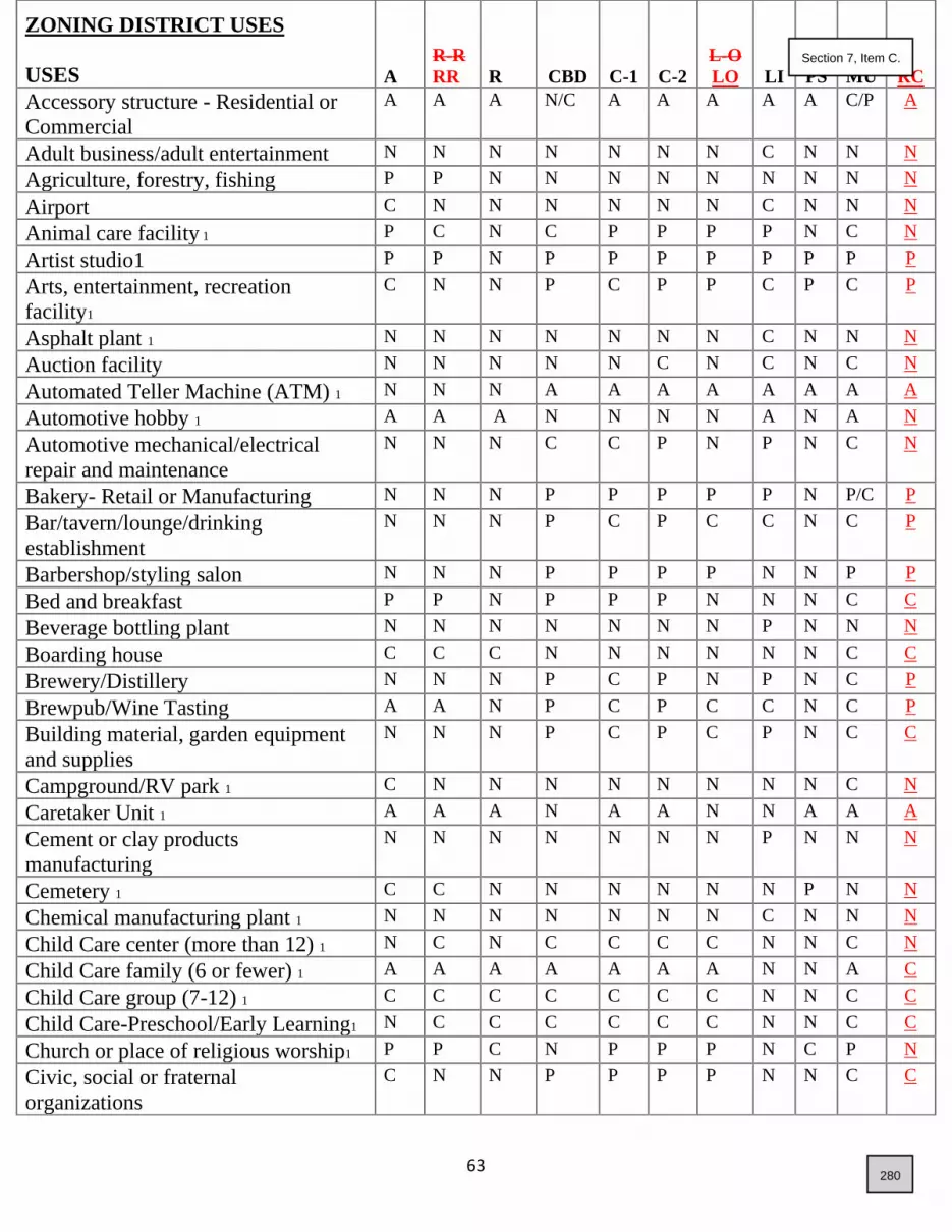
63
ZONING DISTRICT USES
USES
A
R-R
RR R CBD C-1 C-2
L-O
LO LI
PS
MU
RC
Accessory structure - Residential or
Commercial
A A A N/C A A A A A C/P A
Adult business/adult entertainment N N N N N N N C N N N
Agriculture, forestry, fishing P P N N N N N N N N N
Airport C N N N N N N C N N N
Animal care facility 1 P C N C P P P P N C N
Artist studio1 P P N P P P P P P P P
Arts, entertainment, recreation
facility1
C N N P C P P C P C P
Asphalt plant 1 N N N N N N N C N N N
Auction facility N N N N N C N C N C N
Automated Teller Machine (ATM) 1 N N N A A A A A A A A
Automotive hobby 1 A A A N N N N A N A N
Automotive mechanical/electrical
repair and maintenance
N N N C C P N P N C N
Bakery- Retail or Manufacturing N N N P P P P P N P/C P
Bar/tavern/lounge/drinking
establishment
N N N P C P C C N C P
Barbershop/styling salon N N N P P P P N N P P
Bed and breakfast P P N P P P N N N C C
Beverage bottling plant N N N N N N N P N N N
Boarding house C C C N N N N N N C C
Brewery/Distillery N N N P C P N P N C P
Brewpub/Wine Tasting A A N P C P C C N C P
Building material, garden equipment
and supplies
N N N P C P C P N C C
Campground/RV park 1 C N N N N N N N N C N
Caretaker Unit 1 A A A N A A N N A A A
Cement or clay products
manufacturing
N N N N N N N P N N N
Cemetery 1 C C N N N N N N P N N
Chemical manufacturing plant 1 N N N N N N N C N N N
Child Care center (more than 12) 1 N C N C C C C N N C N
Child Care family (6 or fewer) 1 A A A A A A A N N A C
Child Care group (7-12) 1 C C C C C C C N N C C
Child Care-Preschool/Early Learning1 N C C C C C C N N C C
Church or place of religious worship1 P P C N P P P N C P N
Civic, social or fraternal
organizations
C N N P P P P N N C C
280
Section 7, Item C.

64
A RR R CBD C-1 C-2 LO LI PS MU RC
Concrete batch plant 1 N N N N N N N C N N N
Conference/convention center N N N P P P P C C C C
Contractor's yard or shop 1 C C N N N N N C N N N
Convenience store N N N P C P P P N C C
Dairy farm C N N N N N N N N N N
Drive-through establishment/drive-up
service window 1
N N N P C P C P C C C N C N
Dwelling:
Multi-family 1 N N C N N N N N N C C
Secondary 1 A A A N N N N N N C C
Single-family attached N N P N N N N N N C N
Single-family detached P P P N N N N N N C N
Two-family duplex 1 N N P N N N N N N C N
Live/Work Multi-Use 1 N N N C N N N N N C C
Single-family Build-to-Rent 1 N N C N N N N N N C C
Educational institution, private C C C C C C C N N C C
Educational institution, public C C C C C C C N C C C
Equipment rental, sales, and services N N N C C P N P N C N
Events Center, public or private
(indoor/outdoor)
C C N C C C N C C C C
Fabrication shop N N N N N P N P N N N
Farm P P N N N N N N N N N
Farmers' or Saturday market C C N C C C C C C C P
Feedlot N N N N N N N N N N N
Financial institution N N N P P P P P N C C
Fireworks Stands N N N P P P P P N P N
Flammable substance storage N N N N N N N C N N N
Flex Space N N N N C P C P N C N
Food products processing C N N N C C N P N N N
Fracking N N N N N N N N N N N
Gasoline, Fueling & Charging station
with or without convenience store 1
N N N C C P C P N C N
Golf course/Driving Range C C C N C C C C C C N
Government office N N N P P P P P P C P
Greenhouse, private A A A N N N N N N A N
Greenhouse, commercial P C N N C P N P N C N
Guesthouse/granny flat P P C N N N N N N C C
281
Section 7, Item C.

65
A RR R CBD C-1 C-2 LO LI PS MU RC
RR RR R CBD C-1 C-2 LO LI PS MU RC
R RR R CBD C-1 C-2 LO LI PS MU RC
CBD RR R CBD C-1 C-2 LO LI PS MU RC
C-1 RR R CBD C-1 C-2 LO LI PS MU RC
C-2 RR R CBD C-1 C-2 LO LI PS MU RC
LO RR R CBD C-1 C-2 LO LI PS MU RC
LI RR R CBD C-1 C-2 LO LI PS MU RC
PS RR R CBD C-1 C-2 LO LI PS MU RC
MU RR R CBD C-1 C-2 LO LI PS MU RC
RC RR R CBD C-1 C-2 LO LI PS MU RC
Healthcare and social services N N N P P P P P N C C
Heliport C N N N N N N C N N N
Home occupation 1 A A A A N N N N N A P
Hospital N N N P C P P C N C N
Hotel/motel N N N C C P N C N C C
Ice manufacturing plant N N N N N N N P N N N
Industry, information N N N P P P P P N C N
Institution N N N C C P N N C C C
Junkyard N N N N N N N C N N N
Kennel C C N N N C N C N C N
Laboratory N N N P P P P P N C N
Laboratory, medical N N N P P P P P N C N
Lagoon N N N N N N N C C N N
Laundromat N N N P P P P P N P C
Laundry and dry cleaning N N N P P P P P N C C
Library N N N P P P P N P N C
Manufactured home 1 P P P N N N N N N C N
Manufactured home park 1 N N C N N N N N N N N
Manufacturing plant N N N N N C N C N N N
Meatpacking plant C N N N N N N C N N N
Medical clinic N N N P P P P N N P P
Mining, Pit or Quarry (excluding
accessory pit) 1
C N N N N N N C N N N
Mining, Pit or Quarry (for accessory
pit) 1
A A A A A A A A A A N
Mortuary N N N N C P N P N C N
Museum C N N P P P P N P P P
Nursery, garden center and farm
supply
N N N C P P P P N C N
Nursing or residential care facility 1 N N C C P P P N N C C
Office security facility N N N P P P P P N C N
Parking lot/parking garage
(commercial)
N N N C C C C C C C P
Parks, public and private P P P P P P P P P P P
Pawnshop N N N P P P P P N P N
Personal and professional services N N N P P P P P N P P
Pharmacy N N N P P P P P N P P
282
Section 7, Item C.

66
A RR R CBD C-1 C-2 LO LI PS MU RC
Photographic studio N N N P P P P P N P P
Portable classroom/modular building
(for private & public Educational
Institutions) 1
C P C P C P C P C P C P C P N CP C P N
Power plant N N N N N N N C N N N
Processing plant C N N N N N N C N N N
Professional offices N N N P P P P P N C P
Public infrastructure; Public utility
major, minor and yard 1
C C C C C C C C C C N
Public utility yard C N N N C C N P C N N
Recreational vehicle dump station N N N N C C N C N A N
Recycling center N N N N C C N P N N N
Research activities A N N P P P P P N C C
Restaurant N N N P C P P C N C P
Retail store/retail services N N N P C P P P N C P
Retirement home N N C C C N C N N C C
Riding Arena or Stable, Private/
Commercial
P/C P/C C/N N N N N N N N N
Salvage yard N N N N N N N C N N N
Sand and gravel yard C N N N N N N P N N N
Service building C N N P P P N P N C N
Shooting range (Indoor/Outdoor) C N N C/N C/N C/N N C N C/N N
Shopping center N N N P C P N N N C N
Short Term Rentals 1 A A A A N N N N N A A
Solid waste transfer station N N N N N N N C N N N
Storage facility, outdoor
(commercial)1
C N N N C P C N P
C
N C N
Storage facility, self-service
(commercial)1
C N N N C P C N P
C
N C N
Swimming pool, commercial/public N N N P P P P P P P C
Television station N N N N N C N C N C C
Temporary living quarters 1 P P C N N N N N N N N
Terminal, freight or truck 1 N N N N N C N P N N N
Truck stop N N N N N C N P N C N
Turf farm P P N N N N N N C N N
Vehicle emission testing 1 N N N P P P P P N C N
Vehicle impound yard 1 N N N N N N N P N N N
283
Section 7, Item C.
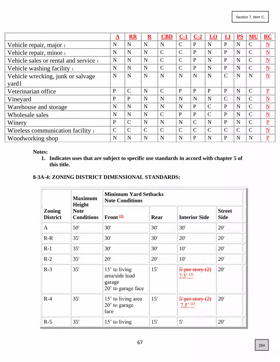
67
Notes:
1. Indicates uses that are subject to specific use standards in accord with chapter 5 of
this title.
8-3A-4: ZONING DISTRICT DIMENSIONAL STANDARDS:
Zoning
District
Maximum
Height
Note
Conditions
Minimum Yard Setbacks
Note Conditions
Front (1) Rear Interior Side
Street
Side
A 50' 30' 30' 30' 20'
R-R 35' 30' 30' 20' 20'
R-1 35' 30' 30' 10' 20'
R-2 35' 20' 20' 10' 20'
R-3 35' 15’ to living
area/side load
garage
20’ to garage face
15' 5' per story (2)
7.5’ (2)
20'
R-4 35' 15’ to living area
20’ to garage
face
15' 5' per story (2)
7.5’ (2)
20'
R-5 35' 15’ to living 15' 5' 20'
A RR R CBD C-1 C-2 LO LI PS MU RC
Vehicle repair, major 1 N N N N C P N P N C N
Vehicle repair, minor 1 N N N C C P N P N C N
Vehicle sales or rental and service 1 N N N C C P N P N C N
Vehicle washing facility 1 N N N C C P N P N C N
Vehicle wrecking, junk or salvage
yard1
N N N N N N N C N N N
Veterinarian office P C N C P P P P N C P
Vineyard P P N N N N N C N C N
Warehouse and storage N N N N N P C P N C N
Wholesale sales N N N C P P C P N C N
Winery P C N N N C N P N C P
Wireless communication facility 1 C C C C C C C C C C N
Woodworking shop N N N N N P N P N N P
284
Section 7, Item C.

68
area/side load
garage
20’ to garage
face
7.5’ (2)
R-6 to R-
11
detached housing
35’ 15’ to living area
20’ to garage
10’ if alley load
15’
4’ if alley
load
3’
7.5’(2)
20’
R-6 to R-
11
attached
housing
35’ 15’ to living area
20’ to garage
10’ if alley load
15’
4’ if alley
load
0’ for common
walls
5 7.5’ at end of
building
20’
R-12 and
higher
35’ 15’ to living area
20’ to garage
15’
4’ if alley
load
5 7.5’ for
single story
10’feet for
multi-story
20’
CBD 35' 0' 0' 0' 4 0'
C-1 35' 20' 5' 0' 4 20'
C-2 35' 20' 5' 0' 4 20'
LO 35’ 20’ 10’ 0’ 4 20’
IL 35’ 20’ 5’ 0’ 4 20’
PS 35’ 20’ 10’ 0’ 4 20’
RC 35’ 0’ 0’ 0’ 4 0’
MU 35' For MU and CBD - Unless otherwise approved by the
Council as a part of a PUD or development agreement, all
residential buildings shall follow the residential setbacks
shown in this table based upon the project density and all
other buildings shall follow setbacks for the C-2 zone (3).
Notes:
1. Front yard setback shall be measured from the face of the garage to the face of the sidewalk,
allowing for 20’ of parking on the driveway without overhang onto the sidewalk.
2. Interior side yard setbacks for lots with 50’ or less of lot width shall be allowed 5’ interior
side yard setbacks for one and two-story structures. Zero-Lot-Line and reduced front and rear
setback waivers may be requested through the Development Agreement process. All other
side yard setback requests for detached structures shall not be granted waivers, unless as part
of a Planned Unit Development.
3. All setbacks in the CBD, C-1. C-2, LO, IL, PS, RC and M-U zone shall be maintain a
285
Section 7, Item C.

69
minimum 15’ when adjacent to a residential use or zone.
4. As approved by the Fire District.
Note Conditions:
A. Minimum Property Size:
1. Each property shall be of sufficient size to meet the minimum setbacks as established in this
section.
2. Minimum property size shall be determined exclusive of land that is used for the conveyance
of irrigation water, drainage, creek or river flows unless: a) the water is conveyed through pipe or
tile; and b) included as part of a utility easement that generally runs along the property lines.
3. When two (2) or more parcels of land, each of which is of inadequate area and dimension to
qualify for a permitted use under the requirements of the district in which the parcels are
located, are held in one ownership, they shall be used as one property for such use.
B. Minimum Street Frontage:
1. Properties with street frontages on cul-de-sacs or at approximately a ninety-degree (90°) angle
shall be a minimum of twenty feet (20') measured as a chord measurement.
2. Street knuckles shall be separated from through traffic by a landscape island. Properties with
frontages on such knuckles shall be a minimum of twenty feet (20') measured as a chord
measurement.
3. All other properties with street frontage shall have a minimum of thirty feet (35’).
C. Additional Setback Criteria:
1. Building eves, and C chimneys, pop out windows, direct vent gas fireplaces, entertainment
centers, window seats and other projections which do not increase the usable floor area and do
not exceed eight feet (8') in width may project up to two feet (2') into any required setback,
provided that projections that are at finished grade, including, but not limited to, chimneys and
fireplaces, do not encroach within a side yard utility easement.
2. One detached accessory building that is less than two hundred (200) square feet in area and
nine feet (9') or less in height shall be allowed in the required rear yard. In no case shall an
accessory building be allowed in the street yard or the required side yard.
3. Accessory structures, such as decks and patios, which are one foot (1') or less in height, as
measured from the property's finished grade, may occupy any yard area.
4. In all residential zones garages and carports opening onto a side street must have a minimum
distance between the opening of such garage or carport and the side street lot line of not less than
twenty feet (20').
5. Front yard setback from arterial and collector streets (as identified on the highway district
functional classification map) is 30 feet in all residential zoning districts.
6. Street side setback on arterial and collector streets (as identified on the highway district
functional classification map) is 20 feet in all residential zoning districts.
7. Setback areas are subject to drainage compliance or otherwise specified within this title.
8. If a conditional use, PUD or development agreement in lieu of a PUD is utilized, waivers to
setbacks shall be permitted if determined by the council to be appropriate for the said
development and that such waivers will be compatible with the area and that the overall density
286
Section 7, Item C.
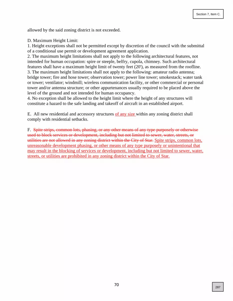
70
allowed by the said zoning district is not exceeded.
D. Maximum Height Limit:
1. Height exceptions shall not be permitted except by discretion of the council with the submittal
of a conditional use permit or development agreement application.
2. The maximum height limitations shall not apply to the following architectural features, not
intended for human occupation: spire or steeple, belfry, cupola, chimney. Such architectural
features shall have a maximum height limit of twenty feet (20'), as measured from the roofline.
3. The maximum height limitations shall not apply to the following: amateur radio antenna;
bridge tower; fire and hose tower; observation tower; power line tower; smokestack; water tank
or tower; ventilator; windmill; wireless communication facility, or other commercial or personal
tower and/or antenna structure; or other appurtenances usually required to be placed above the
level of the ground and not intended for human occupancy.
4. No exception shall be allowed to the height limit where the height of any structures will
constitute a hazard to the safe landing and takeoff of aircraft in an established airport.
E. All new residential and accessory structures of any size within any zoning district shall
comply with residential setbacks.
F. Spite strips, common lots, phasing, or any other means of any type purposely or otherwise
used to block services or development, including but not limited to sewer, water, streets, or
utilities are not allowed in any zoning district within the City of Star. Spite strips, common lots,
unreasonable development phasing, or other means of any type purposely or unintentional that
may result in the blocking of services or development, including but not limited to sewer, water,
streets, or utilities are prohibited in any zoning district within the City of Star.
287
Section 7, Item C.

71
ARTICLE B
ADDITIONAL RESIDENTIAL DISTRICT STANDARDS
8-3B-1: ALL AGRICULTURAL AND RESIDENTIAL DISTRICTS:
8-3B-2: RURAL RESIDENTIAL DISTRICT:
8-3B-3: RESIDENTIAL DISTRICTS:
8-3B-1: ALL AGRICULTURAL AND RESIDENTIAL DISTRICTS:
A. Comply with Section 8-3A-1: ZONING DISTRICTS AND PURPOSE ESTABLISHED.
B. Lighting shall comply with dark sky lighting requirements.
8-3B-2: RURAL RESIDENTIAL DISTRICT:
A. Comply with Section 8-3A-1: ZONING DISTRICTS AND PURPOSE
ESTABLISHED.
B. Manicured homesite areas shall be minimal and subordinate to open rural ground for
pastures, farming, and other rural uses.
C. Rural style street sections shall be provided if approved by the applicable roadway
authority.
D. Rural Residential developments are to be located so that they do not block extension
of urban services at reasonable costs and will require utility easements where
necessary to assure urban service extensions.
8-3B-3: RESIDENTIAL DISTRICTS:
A. Comply with Section 8-3A-1: ZONING DISTRICTS AND PURPOSE
ESTABLISHED.
B. When development is planned with lots that directly abut existing lots within a Rural
Residential area, or “Special Transition Overlay Area” as shown on the
Comprehensive Plan Land Use map, an appropriate transition shall be provided for
the two abutting residential lot types. A transition shall take into consideration site
constraints that may exist and may include clustering of the urban lots in order to
provide an open space area avoiding urban lots directly abutting rural residential lots,
or may include the provision of a buffer strip avoiding urban lots directly abutting
rural residential lots, or may include setbacks within the urban lots similar to the rural
residential lots directly abutting, or may include the provision of one half to one acre
size lots directly abutting the rural residential lots.
C. Urban style development, as guided by provisions within the compressive plan and
this Title, is required to limit urban sprawl, however, densities of no more than 1 to 2
dwelling units per acre are to be designed within the floodplain, ridgeline developable
areas and hillside developable areas (both as defined within the comprehensive plan).
D. Housing developments with densities of R-11 and higher shall be designed to limit
height, increase setbacks and/or provide additional landscaping along the perimeter of
288
Section 7, Item C.

72
the development, if determined by the council, where abutting areas are planned for
lower densities.
E. Rezoning to R-11 and higher shall not be allowed unless adequate ingress/egress to
major transportation corridors is assured.
F. All new residential, accessory uses or additions/remodels within the residential zones
shall pave all unpaved driveways to the home.
G. Spite strips, common lots, unreasonable development phasing, or other means of any
type purposely or unintentional that may result in the blocking of services or
development, including but not limited to sewer, water, streets, or utilities are
prohibited in any zoning district within the City of Star.
H. In any development that requires a traffic signal as part of the approval process, the
developer shall be responsible for providing an Emergency Opticom System to the
intersection.
I. Transitional Lots. For proposed residential developments located adjacent to a
Special Transition Area, as determined on the current Comprehensive Plan Land Use
Map, transitional standards listed below shall be required if reasonable evidence is
presented that adjacent properties will not be further subdivided in the future. This
shall be through a legal encumbrance that prevents the adjacent land from being
further subdivided. These encumbrances shall include:
a. Property with a Future Comprehensive Plan Land Use Map designation that does
not allow future redevelopment to densities lower than one dwelling unit per acre.
b. Subdivision CC&R’s preventing further redevelopment;
c. Easements granted to municipal or other political entities, voluntary development
easements granted to conservation land trusts, or other, legal ecumbrances
conserving the property in perpetuity, such as deed restrictions.
This specifically excludes statements from landowners regarding future intent without
proof of legal encumbrance.
The allowed Transitional Density for new development adjacent to Special Transition
Areas shall be as follows:
Existing Transitional Lot
Sizes
Allowed Immediately
Adjacent Minimum Lot Size
Allowed Immediately
Across the Road from
Transitional Lot
Lots larger than 1.1-acre 1 acre lots ½ acre lots
Lots of 1 to 1.1-acre ½ acre lots 1/3 acre lots
Lots smaller than 1-acre 1/3 acre lots R-3 density Maximum
289
Section 7, Item C.

73
ARTICLE C
ADDITIONAL COMMERCIAL DISTRICT STANDARDS
8-3C-1: ALL COMMERCIAL DISTRICTS:
8-3C-2: CBD CENTRAL BUSINESS DISTRICT:
8-3C-1: ALL COMMERCIAL DISTRICTS:
A. Comply with Section 8-3A-1: ZONING DISTRICTS AND PURPOSE ESTABLISHED.
B. New commercial developments shall incorporate site and architectural design
recommendations from the Architectural Overlay Design Guidelines for the Central
Business District and Riverfront Center.
C. Site Improvements:
1) Prior to any ground disturbance for any commercial, industrial or other non-
residential buildings, a Commercial Site Improvements application shall be
submitted to the City for approval by the City Engineer. This shall include any
new site development initiated prior to a City Building permit.
2) In any development that requires a traffic signal as part of the approval process,
the applicant shall be responsible for providing an Emergency Opticom System
to the intersection.
3) One (1) full-size copy of the construction drawings, drawn in accordance with
the requirements hereinafter stated. The construction Drawings shall be
submitted on good quality paper, be professionally drafted, shall have the
dimensions of not less than twenty-four inches by thirty-six inches (24” x 36”),
and shall be drawn to a scale of not less than one inch to one hundred feet
(1”=100’) and contain a drafting date and north arrow.
a. Application shall include compliance with Section 8-4A-8 and 8-
4A-11 of this ordinance.
b. Construction drawings shall include both above ground and below
ground improvements, including the proposed building envelope of
proposed improvements. Said improvements must include
proposed finished grades of all impervious surfaces, and shall be in
conformance with all Federal, State, and local regulations.
c. Electronic file of all application materials in original .pdf format
shall be submitted with the application on a thumb drive.
8-3C-2: ADDITIONAL CENTRAL BUSINESS DISTRICT STANDARDS:
A. Comply with Section 8-3A-1: ZONING DISTRICTS AND PURPOSE
ESTABLISHED.
B. High density residential may be permitted within the CBD in mixed use buildings
with commercial or office type uses on the first floor and high density residential on
upper floors.
C. New development on Main Street and Star Road, generally south of State Street, shall
include transition consisting of a compatible mix of lower intensity commercial, retail
290
Section 7, Item C.

74
and office type uses mixed with live/work type residential. Existing Single-Family
uses are encouraged to convert to or redevelop as non-residential uses.
D. Big Box commercial, generally a single-story single use building over 50,000 square
feet, shall not be permitted and any single-story single use building which is large in
scale, such as approaching the 50,000 square foot size, shall be located to front on
Highway 44 or Star Road.
E. The Council may place requirements on a mixed-use development, including a ratio
of uses and/or timing of phases, to ensure that the overall development maintains its
commercial intent.
F. New development shall incorporate site and architectural design recommendations
from the Architectural Overlay Design Guidelines for the Central Business District and
Riverfront Center.
G. Any new development shall comply with Section 8-3C-1C of this title regarding site
improvements.
291
Section 7, Item C.

75
ARTICLE D
ADDITIONAL LIGHT INDUSTRIAL DISTRICT STANDARDS
8-3D-1: LI LIGHT INDUSTRIAL DISTRICT:
A. Comply with Section 8-3A-1: ZONING DISTRICTS AND PURPOSE ESTABLISHED
B. Specific Standards for Light Industry:
1. All mechanical equipment emissions; shipping and/or delivery; or other outdoor activity areas
shall be located a minimum of three hundred feet (300') from any abutting residential districts, or
the use is subject to a conditional use permit.
2. The application shall identify how the proposed use will address the impacts of noise and
other emissions on adjoining residential districts. More specifically, the following adverse effects
shall be mitigated through setbacks, buffers, sound attenuation and/or hours of operation:
a. Noise, odor, or vibrations; or direct or reflected glare detectable by the human senses without
the aid of instruments.
b. Radioactivity and electric or electromagnetic disturbances that unduly interfere with the
normal operation of equipment, instruments, or appliances on abutting properties.
c. Any other emission or radiation that endangers human health, results in damages to vegetation
or property or which exceeds health and safety standards.
d. In the event that the administrator determines that the applicant cannot adequately address
such impacts, the use shall be subject to conditional use approval.
C. New development shall incorporate site and architectural design recommendations from the
Architectural Overlay Design Guidelines for the Central Business District and Riverfront Center.
D. Any new development shall comply with Section 8-3C-1C of this title regarding site
improvements.
292
Section 7, Item C.

76
ARTICLE E
ADDITIONAL MIXED-USE DISTRICT STANDARDS
8-3E-1: MU MIXED USE DISTRICT:
A. Comply with Section 8-3A-1: ZONING DISTRICTS AND PURPOSE
ESTABLISHED
B. All development applications within a mixed-use district shall be accompanied by a
conditional use permit, planned unit development, or development agreement
application, which shall include a concept plan of the development.
C. The administrator shall make a recommendation to the applicant regarding what mix
of uses are appropriate for any mixed-use development and shall then make a
recommendation to the Council.
D. The development shall include uses from two (2) or more of the land use categories
such as residential, commercial, office, light industrial, public space or agricultural.
E. Mixed-use areas along state highways, where adequate access can be provided for
commercial use, shall be predominantly commercial with a very minor component of
residential unless the residential is placed on upper floors as part of a mixed-use
building.
F. For any mixed-use development which includes a residential component, a minimum
of two (2) housing types, including but not limited to, single-family detached
dwellings, single family attached dwellings and multi-family dwellings, shall be
required. This excludes multi-family that is proposed to be placed solely on upper
floors as part of a mixed-use building.
G. The Council may place requirements on a mixed-use development, including a ratio
of uses and/or timing of phases, to ensure that the overall development maintains its
mixed-use intent.
H. New development shall incorporate site and architectural design recommendations
from the Architectural Overlay Design Guidelines for the Central Business District and
Riverfront Center.
I. Any new development shall comply with Section 8-3C-1C of this title regarding site
improvements.
293
Section 7, Item C.

77
ARTICLE F
ADDITIONAL RIVERFRONT CENTER DISTRICT STANDARDS:
8-3F-1: RC RIVERFRONT CENTER DISTRICT:
A. Comply with Section 8-3A-1: Zoning Districts And Purpose Established.
B. All development applications within the Riverfront Center shall be accompanied by a
conditional use permit, planned unit development, or development agreement application,
which shall include a concept plan of the development.
C. The administrator shall make a recommendation to the applicant regarding what mix of
uses are appropriate for the Riverfront Center and shall then make a recommendation to
the Council.
D. The Riverfront Center shall include uses from two (2) or more of the land use categories
such as residential, commercial, office, or public space.
E. The Riverfront Center shall include outdoor gathering space as a central focus along the
Boise Riverfront and accommodate connections to the Boise Greenbelt system from the
mixed-use area.
F. Single-family detached dwellings, and single family attached dwellings are prohibited
within the Riverfront Center. A range of multi-family dwellings are encouraged are
encouraged, though not required to be accommodated on upper floors as part of a
vertical, mixed-use building.
G. The Council may place requirements on development within the Riverfront Center,
including a ratio of uses and/or timing of phases, to ensure that the overall development
maintains its mixed-use intent. (Ord. 303, 2-11-2020; amd. Ord. 310, 7-21-2020)
H. New development shall incorporate site and architectural design recommendations from
the Architectural Overlay Design Guidelines for the Central Business District and
Riverfront Center.
I. Any new development shall comply with Section 8-3C-1C of this title regarding site
improvements.
294
Section 7, Item C.

78
ARTICLE G
ARCHITECTURAL OVERLAY DISTRICT:
8-3G-1:
A. An Architectural Overlay District boundary is all of the existing CBD north of the Boise
River, and approximately 750’ on either side of SH-44 from city limit to city limit,
including future annexations. This shall also include all other non-residential zoned uses
and properties throughout the City. Single-family dwellings that are part of an approved
PUD or Conditional Use Permit shall comply with this section.
B. Architectural Overlay District includes the entirety of the South of the River Area Plan.
C. The “STAR DESIGN GUIDELINES, CENTRAL BUSINESS DISTRICT AND
RIVERFRONT CENTER” (the Guidelines), is adopted through this ordinance. It may be
amended from time to time by a Resolution of the Star City Council and shall be used
within the Architectural Overlay District.
D. If the Architectural Overlay District Guidelines conflict with other parts of the City of
Star code, the Architectural Overlay District Guidelines shall be used.
295
Section 7, Item C.

79
CHAPTER 4
ADDITIONAL REGULATIONS APPLICABLE TO ALL DISTRICTS
ARTICLE A. PERFORMANCE STANDARDS
8-4A-1: PURPOSE:
8-4A-2: APPLICABILITY:
8-4A-3: ACCESSORY STRUCTURES:
8-4A-4: ADDRESS NUMBERING:
8-4A-5: BIKEWAYS:
8-4A-6: CLEAR VISION TRIANGLE:
8-4A-7: OBJECTIONAL CONDITIONS:
8-4A-8: DRAINAGE AND STORMWATER MANAGEMENT:
8-4A-9: ENCLOSED TRASH AREA:
8-4A-10: FENCES:
8-4A-11: GRADING:
8-4A-12: PATHWAYS:
8-4A-13: OUTDOOR LIGHTING:
8-4A-14: OUTDOOR SERVICE AND EQUIPMENT AREAS:
8-4A-15: PRESSURIZED IRRIGATION SYSTEM:
8-4A-16: SELF-SERVICE USES:
8-4A-17: SIDEWALKS AND PARKWAYS:
8-4A-18 : WATER AND SEWER SUPPLY, PUBLIC:
8-4A-19: MAILBOXES:
8-4A-1: PURPOSE:
This article provides standard regulations for the location, design, and development of new land
uses and the alteration of existing land uses. This article supplements the regulations for
development as otherwise stated within this title.
8-4A-2: APPLICABILITY:
This article shall apply to the development of all principal permitted, accessory and conditional
uses. The following regulations are the minimum standards of development. Additional
standards may be applied in accord with specific use standards, or other regulations of this title.
8-4A-3: ACCESSORY STRUCTURES:
A. No detached accessory building or structure shall occupy any area in front of the main
building, unless approved as a conditional use or with a development agreement.
B. Regardless of their size, detached accessory buildings shall not encroach into required street
side or front yard areas.
296
Section 7, Item C.

80
C. A principal permitted structure with a valid building permit and being at least fifty percent
(50%) constructed shall be present on the subject property.
D. The accessory structure shall not be used as an additional dwelling. See secondary dwelling
for allowance as a dwelling.
E. The accessory structure shall not be used for commercial or industrial purposes.
F. The accessory structure shall not be used to store commercial vehicles.
G. An accessory structure shall not be located in any required yard or on any publicly dedicated
easement.
H. An accessory structure located in the rear yard shall not exceed a height of twenty-four feet
(24').
I. An accessory structure located in the side yard, or portion thereof, shall be similar in
appearance and color to the principal permitted dwelling.
J. Accessory structures shall not be allowed in the central business district.
8-4A-4: ADDRESS NUMBERING: All residential, commercial and industrial buildings within
the City shall be numbered with an address assigned by the City. Numbers on residential
buildings shall be a minimum of four inches (4") in height. Numbers on commercial, industrial
and apartment buildings shall be a minimum of twelve inches (12") in height. Numbers shall be a
minimum of ½ inch in width. Number colors should contrast with the building color so that they
are plainly visible. Where possible, address numbers should be illuminated. All addressing shall
be in compliance with the International Fire Code 505.1.
8-4A-5: BIKEWAYS:
A. Bikeways shall be encouraged within all developments, within the public right of way or
separate easement, consistent with the city's comprehensive plan.
B. The roadways to bikeways plan as adopted by the county highway district, shall be considered
when reviewing bikeway designs.
C. Standards: For bicycle and parking standards, see Chapter 8, Design Review.
D. New bikeways shall provide adequate easements to the City to provide connectivity.
8-4A-6: CLEAR VISION TRIANGLE:
A. Measurement of the Clear Vision Triangle:
1. For two (2) public streets, the area is defined by measuring from the intersection of the edge of
the travel lane (excluding parking and sidewalk) a distance of forty feet (40') along each road.
297
Section 7, Item C.

81
(See figure 8-4A-7(a) of this section.)
2. For a public street and driveway or alley, the area is defined by measuring from the
intersection of the edge of travel lane and the corner of the driveway or alley twenty feet (20')
along the roadway and ten feet (10') along the driveway or alley. See figure 8-4A-7(a) of this
section.
FIGURE 8-4A-7(a)
CLEAR VISION TRIANGLE DRAWING
B. Standards, Both at Controlled and Uncontrolled Intersections:
1. Planting and Development Standards:
a. Any class I or class II trees planted within a clear vision triangle shall be pruned to a
298
Section 7, Item C.

82
minimum height of eight feet (8') above the adjacent ground (less the height of berm, if
applicable) or sidewalk surface and fourteen feet (14') above the adjacent street surface. See
figure 8-4A-7(a) of this section.
b. No evergreen trees shall be planted within any clear vision triangle.
c. No class III trees shall be planted within any clear vision triangle.
d. The maximum height of any berm or vegetative ground cover at maturity within the clear
vision triangle shall be three feet (3') from the lowest adjacent street grade.
e. No fences higher than three feet (3') from the lowest adjacent street grade are permitted
within four feet (4') from the corner of a lot that abuts two (2) streets to provide a safe clear
vision triangle for vehicular traffic.
f. No signs taller than three feet (3') are permitted in the clear vision triangle, except for
street/stop signs approved by the transportation authority.
g. Street signs must be visible and clear of vegetation of any kind.
2. Other Agency Standards: In all cases, the transportation authority standards shall apply in
addition to city of Star standards.
8-4A-7: OBJECTIONAL CONDITIONS RESTRICTED:
A. Performance Requirements: No land or building in any district shall be used or occupied in
any manner creating dangerous, injurious, noxious or otherwise objectionable conditions which
could adversely affect the surrounding areas or adjoining premises; except, that any use
permitted by this title may be undertaken and maintained if acceptable measures and safeguards
to reduce dangerous and objectionable conditions to acceptable limits as established by the
following performance requirements:
1. Fire Hazards: Any activity involving the use or storage of flammable or explosive materials
shall be protected by adequate firefighting and fire prevention equipment and by such safety
devices as are normally used in the handling of any such material. Such hazards shall be
removed from adjacent activities to a distance which is compatible with the potential danger
involved as specified in the uniform fire code.
2. Radioactivity Or Electrical Disturbances: No activity shall emit harmful radioactivity at any
point, or electrical disturbance adversely affecting the operation of any equipment at any point
other than that of the creator of such disturbance.
3. Noise: Objectionable noise which is due to the volume, frequency or beat shall be muffled or
otherwise controlled.
4. Vibration: No vibration shall be permitted which is discernible without instruments on any
adjoining lot or property.
5. Air Pollution: Air pollution shall be subject to the requirements and regulations established by
the Idaho division of environmental quality.
6. Glare: No direct or reflected glare shall be permitted which is visible from any property
outside a manufacturing district or from any street.
7. Erosion: No erosion by person, wind or water shall be permitted which carries objectionable
substances onto neighboring properties.
8. Water Pollution: Water pollution shall be subject to the requirements and regulations
established by the health authority.
9. Service, Storage and Loading Areas: Service, storage and loading areas located at the rear or
299
Section 7, Item C.

83
side of structures.
10. Landscaping and Signage: Landscaping and signage must meet the criteria outlined in this
title.
B. Enforcement: The administrator may require the submission of statements and plans
indicating the manner in which dangerous and objectionable elements involved in processing and
in equipment operations are to be eliminated or reduced to acceptable limits and tolerances.
8-4A-8: DRAINAGE AND STORMWATER MANAGEMENT:
A. Storm Drainage from Right of Way Under The Jurisdiction Of Local Highway District
(Public): An adequate storm drainage system shall be required in all developments in
accordance with the local highway district standards, specifications, and ordinances.
Drainage plans and storm water calculations shall be submitted to the City for review and
approval. City will review based on Local Highway District adopted codes and ordinances,
along with other State regulations.
B. The City of Star reviews and approves stormwater management plans and erosion and
sediment control plans not covered under item 8-4A-8-A above. The City has adopted in
general the standards and requirements of Section 8000, Drainage and Stormwater
Management and section 8200 of the most recent addition of the Ada County Highway
District Development Manual; and the most recent addition of the Catalog of Stormwater
Best Management Practices as prepared by the State of Idaho Department of Environmental
Quality. Development shall comply with the above referenced standards and requirements.
Additionally:
1. All drainage, irrigation and stormwater from private property shall retained on said
private property unless otherwise approved in writing by the administrator and/or city
engineer and the jurisdiction receiving the stormwater.
2. Storm water from Public Right of Way shall not be disposed of or conveyed across
private property without written agreement and easement between property owner and
owner of Public Right of Way.
3. All private above-ground infiltration facilities shall have a percolation/infiltration test
completed that demonstrates facility performs in accordance with approved design
criteria. Passing test results shall be approved by administrator and/or city engineer prior
to issuance of a certificate of occupancy.
4. A plan for operation, maintenance and repair of stormwater facilities owned by private
property shall be prepared and submitted to the administrator and/or city engineer for
review and approval. The approved plan shall be provided to the parties responsible for
maintenance and operation of the facility. Engineer of Record may certify that results
meet or exceed infiltration rates used in the approved stormwater calculations.
5. Privately owned stormwater facilities shall be designed to allow access for maintenance
and operation. This includes heavy equipment access, if required. Maintenance access
roads must be a minimum of twelve feet (12') in width, must have an HS-25 load capacity
and a minimum turning radius of thirty feet (30').
300
Section 7, Item C.

84
6. Safety ledges in accordance with Idaho BMP’s shall be constructed on the side slopes of
all wet detention basins having a permanent pool of water and deeper than five feet (5').
7. Discharge of stormwater to irrigation and/or drainage facilities is prohibited without
written permission from irrigation and/or drainage facility owner.
8-4A-9: ENCLOSED TRASH AREA:
All trash and/or garbage and recycle collection areas for commercial, industrial and multi-family
residential uses shall be enclosed on at least three (3) sides by a solid wall or site obscuring fence
of at least six feet (6') in height or within an enclosed building or structure. Adequate vehicular
access to and from such area or areas for collection of trash and/or garbage, as determined by the
administrator, shall be provided.
8-4A-10: FENCES:
The following regulations shall govern the type, location, and construction of all fences:
A. General Standards:
1. Fences Taller Than Six Feet: All fences taller than six feet (6') require a Certificate of Zoning
Compliance and building permit in the city of Star.
2. Barbwire Fencing: Barbwire fencing shall be prohibited, except through a conditional use
permit in the A, RR, MU, C-1, C-2, LI. district, when: a) used as the top section for security
fencing; and b) located a minimum of six feet (6') above grade to the bottom wire. Barbwire
fencing may be used in the Agricultural district for livestock only.
3. Unsightly Materials: The use of boxes, sheet metal, old or decayed wood, broken masonry
blocks, pallets or other like unsightly materials for fencing shall be prohibited.
4. Obstruction: No fence shall obstruct access to public utility boxes, meters or other
infrastructure.
5. Maintenance: Fences shall be kept free from advertising and graffiti and maintained in good
repair. Wood fences along collectors and arterials that are within an approved subdivision shall
be required to be stained/painted and kept in good condition at all times. The administrator may
issue a letter of violation to the HOA when any fencing falls into disrepair.
6. Front Yard Fences: Front yard fences shall not exceed three feet (3') height for closed vision
and four feet (4') open vision within any front yard setback, as indicated in Figure 1. At no point
shall a fence be any closer than 5’ from a sidewalk.
7. Side Yard Fences on Corner Lots: Side yard fences on corner lots less than or equal to ten
(10) feet from the street shall not exceed three feet (3’) height for closed vision and four feet
(4’0) for open vision, as indicated in Figure 2. At no point shall a fence be any closer than 5’
from a sidewalk. Fences greater than 4’ in height must be minimum of 10’ from a sidewalk.
8. Compliance with Clear Vision Triangle Requirements: All fences shall comply with the clear
vision triangle requirements as stated within this article.
9. Fencing provided by a developer in any subdivision, or by any future resident, shall not have a
gap along the bottom of the fence exceeding 2-inches to finished grade. This shall be included
within the approved CC&R’s for all new fencing.
10. A fencing plan shall be submitted and approved with all subdivision applications.
301
Section 7, Item C.

85
FIGURE 8-4A-14
Figure 1 - Fence Regulations
Figure 2 - Fence Regulations on Corner Properties
302
Section 7, Item C.

86
8-4A-11: GRADING:
A. Prior to any ground disturbance on any property, including grading, filling, clearing or
excavation of any kind excluding activities associated with agricultural use, a grading application
shall be submitted to the City for approval by the City Engineer. This shall include any newly
approved commercial or residential development, or property where disturbance and/or fill is in
excess of 1,000 yards prior to any. This shall not apply when grading is done in association with
approval of construction drawings.
B. Grading shall give consideration to desirable land use planning including impacts on adjacent
properties and future land uses. Grading plans shall consider natural terrain and special land
hazards, including but not limited to hillside and floodplain development.
1. Grading permit applications shall include hillside and/or Special Hazard Area
Development applications if said properties are located with areas impacted by those
applications.
2. Grading activities shall meet the requirements of other federal, state and local
jurisdictions, including FEMA, the Army Corps of Engineers, the Idaho Department of
Lands, The Idaho Department of Water Resources, The Idaho Department of
Environmental Quality (including ground water discharge rules) and the local highway
district.
C. Grading Permit Application shall include a preliminary stormwater analysis for all earthwork
activities.
D. Grading plans shall include existing and proposed contours as 1-foot intervals. If existing
slopes exceed 10 percent contours intervals may be reduced with approval from the City
Engineer. Where applicable Base Flood Elevations shall be shown on the grading plans.
E. Grading permit applications shall include erosion and sediment control plans prepared by a
certified plan designer. Certification must be in by the City of Boise or another comparable
program.
A F. Final grading of any type of development to be used for construction of any structure shall
conform to the requirements of IBC section 1805.
B G. Provisions to control drainage runoff shall be constructed as part of final grading of any
development. Drainage runoff control provisions shall be adequate to prevent any surface or
subsurface drainage water from flowing or being conveyed onto an adjacent lot or parcel.
C H. Any subdivision lot or parcel in the city to be used for construction of any building shall be
graded in such a manner that the finish grade within three feet (3') of any lot line, subdivision
boundary and parcel boundary comply with the following requirements:
1. Match the grade of the ground of the adjacent lot or parcel at the lot line or parcel boundary;
and
303
Section 7, Item C.

87
2. Finished grade of the ground sloped no steeper than two horizontal to one vertical (2:1); or
3. Construct a permanent retaining wall so the ground within three feet (3') of the lot line,
subdivision boundary and parcel boundary comply with subsections C1 and C2 of this section.
D I. Permit requirements for retaining walls shall comply with IBC section 105. A building
permit for retaining walls four feet in height and greater will be required prior to approval of the
grading permit.
J. Hillside Development:
A. Hillside Development Evaluation:
1. All hillside development proposals shall give consideration to desirable land
use planning, soil mechanics, engineering geology, hydrology, and civil
engineering. The evaluation includes, but is not limited to:
(A) Planning of development to fit the topography, soils, geology,
hydrology and other conditions existing on the proposed site;
(B) Orienting development to the site so that grading and other site
preparation is kept to a minimum; i.e., use of building or road envelopes,
and no build areas;
(C) Shaping of essential grading to complement the natural landforms and
to minimize padding and terracing of building sites;
(D) Division of land tracts into smaller workable units on which
construction can be completed within one construction season so that large
areas are not left bare and exposed during the winter- spring runoff period;
and
(E) Completion of paving as rapidly as possible after grading.
2. Areas having soil, geology or hydrology hazards shall not be developed
unless it is shown that their limitations can be overcome; that hazard to life or
property will not exist; and that the safety, use or stability of a public way or
drainage channel is not jeopardized.
B. Required Data: The developer shall retain professional expertise to obtain the
following information which is required by the commission:
1. Soil Reports: For any proposed hillside development, a soils report shall be
submitted with the preliminary plat. This report shall include data regarding the
nature, distribution and strength of existing soils, conclusions and
recommendations for grading procedures, design criteria for corrective measures,
and opinions and recommendations covering the adequacy of sites to be
developed.
2. Hydrology Report:
(A) For any proposed hillside development, a hydrology report shall be
submitted with the preliminary plat. This report shall include an adequate
description of the hydrology, conclusions and recommendations regarding
the effect of hydrologic conditions on the proposed development and
opinions and recommendations covering the adequacy of sites to be
developed. Hydrology Report shall include preliminary stormwater
calculations and must include the intent for the entire project, including all
residential lot areas.
304
Section 7, Item C.

88
(B) Flood frequency information shall be provided for the area proposed
for the development, if applicable.
C. Grading And Drainage Plan:
1. A preliminary grading and drainage plan shall be submitted with
each hillside preliminary plat proposal and shall include the following
information:
(A) Approximate limiting dimensions, elevations or finish contours to be
achieved by the grading, including all cut and fill slopes, proposed
drainage channels and related construction;
(B) Preliminary plans and approximate locations of all surface and
subsurface drainage devices, walls, dams, sediment basins, storage
reservoirs and other protective devices to be constructed; and
2. A final grading plan shall be submitted with each final plat and include the
following information:
(A) Limiting dimensions, elevations or finish contours to be achieved by
the grading, including all proposed cut and fill slopes and proposed
drainage channels and related construction. Final grading plan shall not
deviate significantly from the preliminary grading plan. Significant
deviations include cut or fills greater than 4 feet in difference, road
alignment changes greater than 50 feet from preliminary plat, or overall
changes in overall earthwork greater than 10% (Cut or Fill);
(B) Detailed plans and locations of all surface and subsurface drainage
devices, walls, dams, sediment basins, storage reservoirs and other
protective devices to be constructed; and
D. Development Standards:
1. Soils:
(A) Fill areas shall be prepared by removing organic material, such as
vegetation and rubbish and any other material which is determined by the
soils engineer to be detrimental to proper compaction or otherwise not
conducive to stability.
(B) Cuts and fills shall be designed to provide safety, stability and
adequate setback from property lines in accordance with City standards,
including building codes,
2. Roadways:
(A) Road alignments shall reasonably follow natural terrain and no
unnecessary cuts or fills shall be allowed.
(B) The width of the graded section shall extend 2 feet beyond the outside
edge of the sidewalk. If sidewalks are not installed the grading shall be
extended to 3 feet beyond the curb on both the cut and fill sides of the
roadway.
(C) If sidewalks are not proposed for the development a pedestrian
walkway plan will be required.
E. Vegetation And Revegetation:
305
Section 7, Item C.

89
1. The developer shall submit a slope stabilization and revegetation plan as part
of the landscape plan which shall include a complete description of the existing
vegetation, including the vegetation to be removed, the vegetation to be planted,
and slope stabilization measures to be installed. The plan shall include an analysis
of the environmental effects of such operations, including the effects it may have
on slope stability, soil erosion, water quality and fish and wildlife.
2. Vegetation sufficient to stabilize the soils shall be established on all disturbed
areas as each stage of grading is completed. Areas not contained within lot
boundaries shall be protected with perennial vegetal cover after all construction is
completed. Efforts shall be made to plant those species that tend to recover from
fire damage and do not contribute to a rapid rate of fire spread.
3. The developer shall be fully responsible for any destruction of native
vegetation proposed and approved for retention. He shall carry the responsibility
both for his own employees and for all subcontractors from the first day of
construction until the notice of completion is filed. The developer shall be
responsible for replacing such destroyed vegetation in kind or its equivalent.
4. Site left unattended for more than 14 days shall be temporally stabilized with
landscape or other measures.
F. Maintenance: The owner of any private property on which grading or other work has
been performed, pursuant to a grading plan approved or a building permit granted under
the provisions of this chapter, shall continuously maintain and repair all graded surfaces
and erosion prevention devices, retaining walls, drainage structures or means, and other
protective devices, plantings and ground cover installed or completed.
8-4A-12: PATHWAYS:
A. Pathways are required consistent with the city of Star comprehensive plan and adopted
pathway plan within all new residential and commercial developments as part of the public right
of way or as separate easements dedicated to the City so that an alternate transportation system
(which is distinct and separate from the automobiles) can be provided.
B. Pathways in the middle of long blocks may be required where necessary to obtain convenient
pedestrian circulation to schools, parks, other residential areas, and/or shopping areas.
C. Pathways within subdivision shall have a walking surface of at least five feet (5') in width.
The pathway surface shall either be in pavement or concrete, unless an alternative surface is
approved by Council.
D. Pathway easements shall be open to the public. All new pathways shall dedicate an easement
to the City for public use.
E. Pathway easements, dedicated to the City, shall be required along the Boise river as shown
within the comprehensive plan and shall be open to the public. Pathway widths along the Boise
river shall be determined by the Council.
306
Section 7, Item C.

90
8-4A-13: OUTDOOR LIGHTING:
A. The following types of lighting are exempt from the regulations of this section:
1. Light fixtures that have a maximum output of less than twenty (20) watts.
2. All outdoor lighting produced by the direct combustion of natural gas or other fossil fuels such
as kerosene lanterns or gas lamps.
3. Temporary holiday lighting used for seventy-five (75) days or less per year.
4. Vehicular lights and all temporary emergency lighting needed for fire protection, police
protection, and/or other emergency services.
5. All hazard warning lights required by federal or state regulatory agencies.
B. The installation of any of the following types of lighting is prohibited:
1. Mercury vapor lamp fixture and/or lamp.
2. Laser source light or any similar high intensity light when projected above the horizontal.
3. Changing colors, strobe or moving lights, or searchlights (for advertising purposes) are
prohibited in all districts.
4. Lighting, including holiday lighting, on commercial or private tower structures that exceed the
district height limit is prohibited, except as required by regulations of the federal aviation
administration (FAA).
C. Standards:
1. Light fixtures that have a maximum output of two hundred sixty (260) lumens twenty (20)
watts or more shall have an opaque top and side to prevent upward and outward lighting.
2. Light fixtures that have a maximum output of one thousand (1,000) lumens or more per fixture
shall have an opaque top to prevent up lighting, and the bulb shall not be visible.
3. Light fixtures that have a maximum output of one thousand eight hundred (1,800) lumens or
more shall have an opaque top to prevent up lighting; the bulb shall not be visible and shall have
a full cutoff shield. See figure 8-4A-18, figure 2 of this section.
4. Light fixtures with a maximum output of one thousand eight hundred (1,800) lumens or more
shall be placed such that the effective zone of light (as documented by the photometric test
report) shall not trespass on abutting residential properties. See figure 8-4A-18, figure 2 of this
section.
5. Down style lighting shall be required to preserve dark sky objectives, except where
impractical as may be determined by the administrator and Council.
6. See Chapter 8 for additional streetlight and dark sky lighting standards.
7. Floodlight fixtures shall be located in such a manner as to prevent direct glare into a street and
to minimize impact on abutting properties.
a. Floodlight fixtures shall be installed so that they do not tilt up more than forty-five degrees
(45°) down from vertical.
8. Up lighting shall only be allowed in cases where the fixture and any light it emits are shielded
from the sky by a roof overhang or similar structural shield.
9. In residential districts, the height of a freestanding light fixture on private property shall not
exceed six feet (6'). Streetlamps are exempt from this height restriction.
10. Light fixtures mounted on a wall may extend to the full height of the structure, but no farther.
11. Electrical feeds to outdoor light fixtures shall be underground, not overhead.
12. Lighting used to illuminate off street parking areas shall be downward facing and shielded
307
Section 7, Item C.

91
from neighboring properties.
FIGURE 8-4A-18
Figure 1 - Examples of Full Cutoff Shields
Figure 2 - Light Trespass
8-4A-14: OUTDOOR SERVICE AND EQUIPMENT AREAS:
A. Outdoor mechanical equipment in commercial developments (including, but not limited to,
heaters and fans) shall not be located within fifty feet (50') of any abutting residential districts.
To reduce noise, permanently mounted mechanical equipment shall be enclosed to the maximum
extent possible.
308
Section 7, Item C.

92
B. Outdoor utility meters, HVAC equipment, trash dumpsters, trash compaction and other
service functions shall be incorporated into the overall design of commercial buildings and
landscaping so that the visual and acoustic impacts of these functions are fully contained and out
of view from adjacent properties and public streets.
8-4A-15: PRESSURIZED IRRIGATION SYSTEM:
A. System Installation Required: In each development, the applicant shall provide underground,
pressurized irrigation water. For subdivisions, each and every lot within the subdivision shall
have underground pressurized irrigation water in compliance with this chapter. The pressurized
irrigation system shall be constructed and installed at the same time as the domestic water lines,
but it shall not necessarily be in the same trenches.
B. Irrigation System Requirements:
1. The system shall not be connected to potable water, unless a waiver by Star Sewer and Water
District is granted per the standards of this title;
2. The system shall be designed by a registered professional engineer licensed in the state of
Idaho;
3. The system shall be a piped delivery, operating at a minimum pressure of forty-five (45)
pounds per square inch (psi);
4. The system shall deliver to each destination point a minimum fifteen (15) gallons per minute
(gpm) at forty-five (45) psi;
5. Main line distribution piping diameter shall be a minimum of three inches (3");
6. All irrigation bibs shall be clearly labeled with the words "Non-Potable Water - For Irrigation
Only";
7. Provisions shall be made for diversion and flow measurement from irrigation water source;
8. Water rights shall be transferred to the association managing entity;
9. Applicant shall secure written approval from all pertinent irrigation entities for each phase of
development;
10. If pressurized irrigation will not be available to each lot at all times, applicant shall provide a
rotation schedule for irrigation system usage identifying times and days that pressure irrigation
will be available to each lot. This schedule shall be included in the CC&R’s for the subdivision.
11. Power filters should be installed to minimize harmonic distortion.
12. All main lines should have appropriate thrust blocks.
C. Irrigation System Maintenance and Operation: Irrigation system maintenance and operation
shall be provided by the irrigation district or canal company in which the subdivision lies, a
municipal irrigation district, or by the formation of another entity capable of operating and
maintaining a pressurized irrigation system. Developer shall provide written assurance that
provisions have been made for ownership, operation, and maintenance of the irrigation system
prior to approval by the city council.
D. Conditions for Waiver Of Irrigation System Requirement: The requirement for installation of
a pressurized irrigation system may be waived by the city council when the Developer has
established that any of the following situations exist:
1. A sufficient surface irrigation water right does not exist for the property: This must be
309
Section 7, Item C.

93
documented in writing by the appropriate irrigation district or canal company and the Idaho
department of water resources and shall be submitted with the preliminary plat. The waiver shall
be granted only for that portion of the subdivision which cannot be served.
2. Existing surface water rights cannot be delivered to the property by the irrigation district or
canal company due to delivery capacity or scheduling. The administrator may require the
installation of the pressurized irrigation system if water rights may be available within two (2)
years. This must be documented in writing by the appropriate irrigation district or canal
company.
3. The requirement to provide a pressurized irrigation system may be waived if the city council
finds that, due to the specific circumstances, the cost of obtaining water rights, reestablishing
water rights or developing the system would impose an undue economic hardship on the
developer. For purposes of this section, an undue economic hardship shall consist of showing
that the cost per lot to develop the system would be twenty five percent (25%) higher than the
cost per lot for providing a system to subdivisions of similar size and density constructed in the
city within the previous two (2) years, or that the cost per lot of the system would exceed five
percent (5%) of the expected per lot market value of the development.
4. If waiver is granted by the city council, pursuant to subsections 1, 2, and 3, above, compliance
with Idaho Code section 31-3805 (regulations requiring delivery of irrigation water rights in
subdivisions) is still required.
8-4A-16: SELF-SERVICE USES:
Any unattended, self-service uses, including, but not limited to, laundromats, automatic teller
machines (ATMs), vehicle washing facilities, fuel sales facilities, and storage facilities, shall
comply with the following requirements. The Star police designee may approve alternative
standards where it is determined that a similar or greater level of security is provided:
A. Entrance or view of the self-service facility shall be open to the public street or to adjoining
businesses and shall have low impact security lighting.
B. Financial transaction areas shall be oriented to and visible from an area that receives a high
volume of traffic, such as a collector or arterial street.
C. Landscape shrubbery shall be limited to no more than three feet (3') in height between
entrances and financial transaction areas and the public street.
8-4A-17: SIDEWALKS AND PARKWAYS:
A. All sidewalks shall adhere to the standards shown in the table below.
ROADWAY
CLASSIFICATION
MINIMUM SIDEWALK AND
PARKWAY PLANTER WIDTHSI NOTES
Arterial
7 Foot (7’) Detached Sidewalk with
8 Foot (8’) Parkway Planter Strip
Both Sides of Roadway
310
Section 7, Item C.

94
Collector
7 Foot (7’) Detached Sidewalk with
8 Foot (8’) Parkway Planter Strip
Both Sides of Roadway
Local
5 Foot (5’) Detached Sidewalk with
minimum 6 Foot (6’) Parkway
Planter Strip
Both Sides of Roadway
All roadways not
designated as an arterial,
collector, or highway, in
any form, on ACHD’s
Major Street Map or
Canyon Highway District
#4’s map, shall be
considered Local.
Highway 44
&
Highway 20/26
Arterial
8 Foot (8’) Detached Sidewalk with
8 Foot (8’) Parkway Planter Strip
Both Sides of Roadway
Private Streets
See 8-4D for requirements
B. All mailboxes, utility boxes and other impediments shall be located in the Parkway Planter
Strip to the extent possible. In situations where impediments must be in the sidewalk, such
as at corners or crosswalks, there shall be clearance around the impediment in the path of
travel equivalent to the designated sidewalk width. Tapers on each side of impediments
shall be at least 10 feet (10’) in each direction. Sidewalk paving shall be done around
impediments. The Administrator may waive taper requirements if site conditions warrant.
C. In agricultural, rural residential and R-1 districts, or in areas of a rural nature as determined
by the Council to be appropriate by development agreement, sidewalks may not be
required.
D. When existing sidewalk is located adjacent to a property, a 10-foot (10’) sidewalk
transition shall be provided from the existing sidewalk to the proposed sidewalk. The
proposed sidewalk shall meet the standards of this title.
E. In certain instances where property is located along W. State Street in the CBD, and when
the Idaho Transportation Department is planning future roadway improvements, the
applicant may be required to bond for sidewalk improvements.
F. Trees shall be planted in parkway planter strips in accordance with City Code Chapter 8,
Article D: Landscape and Buffer Area Standards.
G. The first 180 feet (180’) of a subdivision entry shall have an 8 foot (8’) parkway planter
strip between the sidewalk and curb.
H. Temporary obstructions including but not limited to vehicles, trash receptacles, or trailers
shall not block the sidewalk.
I. Or larger as required by the transportation agency.
A. All sidewalks (in all zoning designations except the CBD district) shall be a minimum of five
feet (5'). Sidewalks in the CBD district shall be a minimum of six feet (6’) in width. On State
311
Section 7, Item C.
95
Street, sidewalks in the CBD shall be a minimum of eight feet (8’) in width.
B. Sidewalks shall be designed to flare around mailboxes, utility boxes and other impediments to
pedestrian circulation to maintain a minimum five feet (5') of travel width.
C. Detached sidewalks shall be required along all arterial and collector streets. The requirement
for detached sidewalks can be waived by the administrator if the detached sidewalks are
incompatible with existing and/or future uses of neighboring properties.
D. In agricultural, rural residential and R-1 districts, or in areas of a rural nature as determined by
the Council to be appropriate by development agreement, sidewalks may not be required.
E. When existing sidewalk is located adjacent to a property, the sidewalk shall be extended the
length of the subject property with a minimum width to meet the standards of this title.
F. In certain instances where property is located along W. State Street in the CBD, and when the
Idaho Transportation Department is planning future roadway improvements, the applicant may
be required to bond for sidewalk improvements.
(Ord. 303, 2-11-2020; amd. Ord. 310, 7-21-2020)
8-4A-18: TRAVELING SLEEPING QUARTERS:
Recreation vehicles and equipment, including, but not limited to, travel trailers, fifth wheels,
recreational vehicles, motor coaches, and tents, shall not be used anywhere in the City as living
quarters for longer than two (2) weeks unless within an approved campground or recreational
vehicle park, or as allowed in the temporary use section.
8-4A-19: WATER AND SEWER SUPPLY, PUBLIC:
The owner of any building, whether occupied or not which is within three hundred feet (300’) of
the Star Sewer and Water District services shall install water and sewer services and connect to
the Star Sewer and Water District system, at the time of annexation and/or development,
including remodels.
8-4A-20: MAILBOXES:
All mailboxes and clusters shall be approved by the postmaster prior to installation. All clusters
shall be covered with an architecturally designed cover, to be approved by the Administrator
prior to final plat signature. All covers shall be stained/painted and kept in good condition at all
times. The administrator may issue a letter of violation to the HOA when any mailbox cluster or
cover falls into disrepair.
312
Section 7, Item C.

96
ARTICLE B. OFF STREET PARKING AND LOADING REQUIREMENTS
8-4B-1: PROCESS:
8-4B-2: PARKING STANDARDS:
8-4B-3: REQUIRED NUMBER OF OFF-STREET PARKING SPACES:
8-4B-4: STANDARDS FOR ALTERNATIVES TO ON SITE PARKING:
8-4B-5: OFF STREET LOADING SPACE REQUIREMENTS:
8-4B-6: PARKING IN LIEU PAYMENTS:
8-4B-1: PROCESS:
An off-street parking and loading plan shall be required as a component of any applicable permit.
Such plan shall also be reviewed by the Star joint fire protection district. Such plan shall show
the following:
A. The off-street parking and loading plan shall contain the location, size, and type of all
proposed off-street parking and loading facilities.
B. If the proposed development project shall be completed in phases, such phases shall be noted
on the plan.
8-4B-2: PARKING STANDARDS:
A. Design of Parking Areas:
1. All parking areas shall be designed and constructed to provide the type and number of off-
street parking spaces required by this article and designed as required by this section.
2. Location of parking spaces relative to structure(s).
3. Parking spaces for all detached residential dwelling units shall be located on the same lot as
the use that they are intended to serve.
4. Parking for attached residential dwelling units shall be located not more than three hundred
feet (300') from the structure(s), except as provided by section 8-4B-7 of this article.
5. Parking spaces for nonresidential uses shall be located not more than five hundred feet (500')
from structure(s), except as provided by section 8-4B-7 of this article.
6. Off street parking spaces shall not be located in any landscape buffer as required by this title.
7. Parking stalls and driving aisles shall be designed in accord with the standards in table 8-4C-
5(a) of this section and figure 8-4B-5(b) of this section shows the parking design dimensions.
8. All required parking as determined in section 8-4B-6 of this article shall be designed for
standard vehicles.
a. All parking areas shall provide on-site turnarounds in accord with the Star fire department
standards for all off-street parking spaces and loading facilities.
b. The design of off-street parking areas shall not require moving any car to gain access to a
required parking space.
c. It is the responsibility of the applicant to ensure that the parking lot design and sidewalk and/or
access provisions meet all Americans with disabilities act (ADA) requirements.
313
Section 7, Item C.

97
TABLE 8-4B-2(a)
REQUIRED STALL WIDTH AND LENGTH BY PARKING ANGLE
Parking
Angle
Stall
Width
Curb
Length
Stall
Depth
One-Way Driving
Aisle
Two-Way
Driving Aisle
0° 9'0" 23'0" 9'0" 12'0" 25'0"
30° 9'0" 18'0" 17'8" 12'0" 25'0"
45° 9'0" 12'9" 20'5" 13'0" 25'0"
60° 9'0" 10'5" 21'10" 16'0" 25'0"
90° 9'0" 9'0" 20'0" 22'0" 25'0"
FIGURE 8-4B-2(b)
PARKING SPACE AND DRIVE AISLE DESIGN
Legend:
A. Parking angle D. One-way drive aisle
B. Stall width E. Two-way drive aisle
C. Stall depth
B. Improvements:
1. All off street parking areas, including driveways and parking lots shall be improved with
asphalt, concrete, pavers, or bricks, unless otherwise approved as allowed through this title.
2. All parking and loading areas shall provide proper drainage of surface water to prevent the
drainage of such water onto adjacent properties or walkways.
3. Except as otherwise provided in this section, all off street parking areas shall be provided with
a substantial wheel restraint to prevent cars from encroaching upon abutting private and public
property or overhanging beyond the designated parking stall dimensions. This standard shall not
apply to temporary uses.
4. Parking spaces shall be marked, including handicapped symbols and signs.
314
Section 7, Item C.

98
5. All lighting provided to illuminate a parking area shall comply with the lighting standards
provided in this chapter.
6. All landscaping improvements shall comply with this chapter.
C. Bicycle Parking Facilities: Bicycle parking facilities shall meet the following location and
design standards:
1. Bicycle parking facilities shall be located as close as possible to the building entrance(s).
2. Bicycle parking facilities shall not obstruct pedestrian walkways, public sidewalks, or
building.
3. It is the responsibility of the applicant to ensure that the bicycle parking facilities meet all
Americans with Disabilities Act (ADA) requirements.
8-4B-3: REQUIRED NUMBER OF OFF-STREET PARKING SPACES:
A. Parking spaces for other permitted or conditional uses not listed herein shall be
determined by the administrator. Among the factors for determining the number of spaces
to be required for a use not listed herein, the administrator shall compare the proposed
use with a use which has similar traffic generating characteristics as outlined in the most
recent version of the institute of transportation engineers trip generation manual.
B. Minimum Number of Off-Street Parking Spaces: The minimum number of required off
street vehicle parking spaces for residential uses shall be:
Type Of Use Off-Street Parking Spaces Required
RESIDENTIAL
Apartments or multi-family
dwellings
For each unit with 2 or more bedrooms - 2 including
1 covered; for each 1 bedroom or studio unit - 1.5
including 1 covered. Guest parking shall be provided
at a ratio of .25 spaces per unit.
Boarding houses, lodging
houses,
dormitories and fraternity
houses
which have sleeping rooms
1 for each sleeping room or 1 for each occupant,
whichever number is greater
Mobile home court (RV) 1 for each trailer/RV space
Mobile home or manufactured
home park
For each unit with 2 or more bedrooms - 2 including
1 covered; for each 1-bedroom unit - 1 covered.
Single-family dwelling 2 including 1 covered
Two-family dwelling For each unit - 2 including 1 covered
COMMERCIAL
315
Section 7, Item C.

99
Ambulance services 1 per 500 square feet of gross floor area; plus 2
enclosed ambulance storage spaces
Artist studios 1 per 1,000 square feet of gross floor area
Auction facility As required with conditional use permit
Automobile washing facility 1 per 200 square feet of gross floor area of sales,
office, or lounge area; plus, queue for 3 cars per
washing station
Automotive gas station/service
shop or fuel islands
1 for each 2 gasoline pumps and 2 for each service
bay (spaces in front of bays or pumps shall not be
counted)
Automotive, mobile home,
travel
trailer, and/or farm implement
sales
1 per 400 square feet of gross floor area; plus 1 per
500 square feet outdoor display
Automotive repair shop, body
shop,
or tire shop
1 per 225 square feet of gross floor area
Automotive storage 1 per 500 square feet of gross floor area of office
space; plus 1 per 1,000 square feet of gross storage
area
Banks/financial institutions 1 for each 200 square feet of gross floor area; plus,
queue for 4 cars per drive up window
Catering service 1 per 400 square feet of gross floor area
Childcare - family 1
Childcare - group 2
Childcare - daycare center 3 for each classroom but not less than 9 for the
building
Pre-school/Learning Center 3 for each classroom but not less than 9 for the
building
Churches and other places of
religious assembly
1 for each 5 seats
Clinic 1 per 200 square feet of gross floor area
Club or lodge 1 per 100 square feet of gross floor area
Commercial entertainment
316
Section 7, Item C.
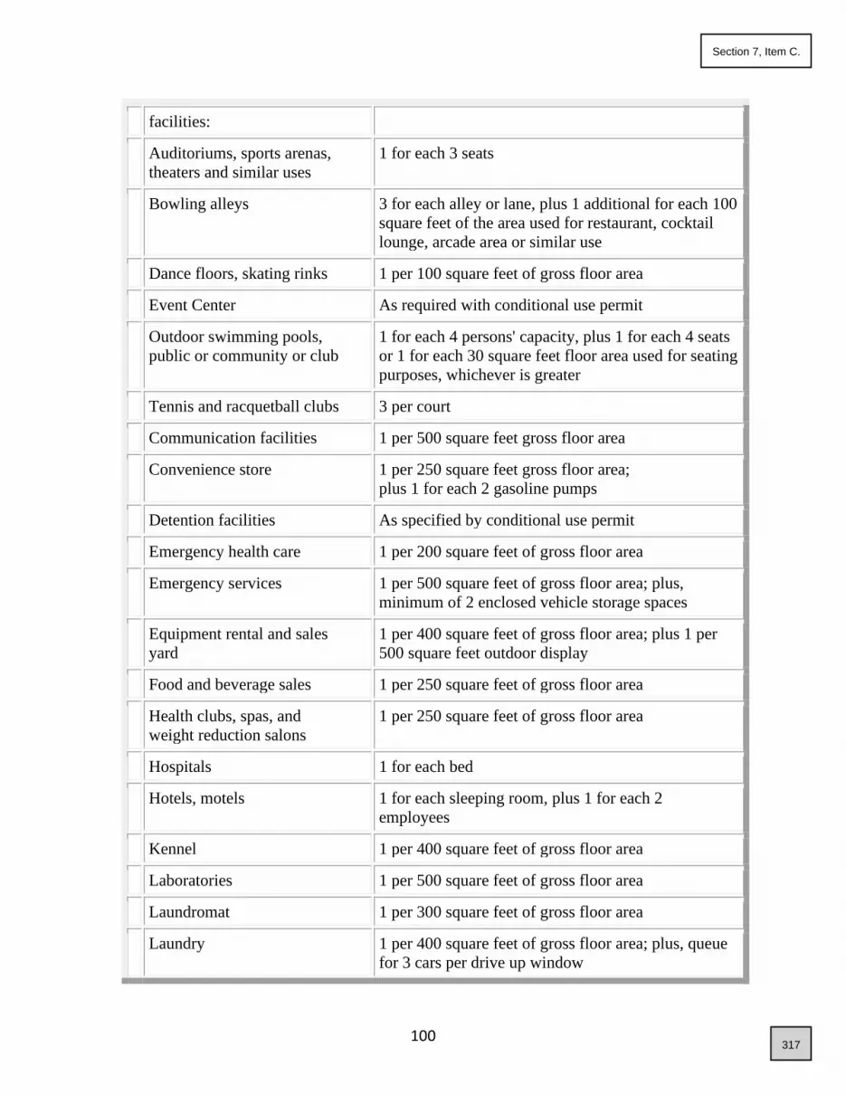
100
facilities:
Auditoriums, sports arenas,
theaters and similar uses
1 for each 3 seats
Bowling alleys 3 for each alley or lane, plus 1 additional for each 100
square feet of the area used for restaurant, cocktail
lounge, arcade area or similar use
Dance floors, skating rinks 1 per 100 square feet of gross floor area
Event Center As required with conditional use permit
Outdoor swimming pools,
public or community or club
1 for each 4 persons' capacity, plus 1 for each 4 seats
or 1 for each 30 square feet floor area used for seating
purposes, whichever is greater
Tennis and racquetball clubs 3 per court
Communication facilities 1 per 500 square feet gross floor area
Convenience store 1 per 250 square feet gross floor area;
plus 1 for each 2 gasoline pumps
Detention facilities As specified by conditional use permit
Emergency health care 1 per 200 square feet of gross floor area
Emergency services 1 per 500 square feet of gross floor area; plus,
minimum of 2 enclosed vehicle storage spaces
Equipment rental and sales
yard
1 per 400 square feet of gross floor area; plus 1 per
500 square feet outdoor display
Food and beverage sales 1 per 250 square feet of gross floor area
Health clubs, spas, and
weight reduction salons
1 per 250 square feet of gross floor area
Hospitals 1 for each bed
Hotels, motels 1 for each sleeping room, plus 1 for each 2
employees
Kennel 1 per 400 square feet of gross floor area
Laboratories 1 per 500 square feet of gross floor area
Laundromat 1 per 300 square feet of gross floor area
Laundry 1 per 400 square feet of gross floor area; plus, queue
for 3 cars per drive up window
317
Section 7, Item C.

101
Maintenance and repair
services
1 per 400 square feet of gross floor area; plus 1 per
500 square feet of outdoor storage area
Mortuaries, funeral parlors, and
similar type uses
1 per 4 seats
Nursery, plant materials 1 per 500 square feet of outside display/ lathe
house/greenhouse area, plus 1 per 250 square feet
gross floor area
Nursing/convalescent homes,
sanitariums, children's homes,
asylums and similar uses
1 for each 2 beds
Offices, business and
professional
1 per 250 square feet of gross floor area
Offices, medical and dental 1 per 200 square feet of gross floor area
Pawn shops 1 per 250 square feet of gross floor area
Personal improvement 1 per 250 square feet of gross floor area
Personal services 1 per 250 square feet of gross floor area
Printing and/or blueprinting 1 per 400 square feet of gross floor area
Restaurant with drive-through 1 per 200 square feet of gross floor area; plus, queue
space for 5 cars for drive up service
Restaurants, dining rooms,
taverns, nightclubs, etc.
1 per 150 square feet of gross floor area; plus 1 per 35
square feet dance floor
Retail sales of large items such
as furniture and appliances
1 per 500 square feet of gross floor area;
Retail sales not listed under
another use classification
1 per 250 square feet of gross floor area;
Riding academies/stables 1 per 4 stalls
Shop, contractors (and/or yard) 1 per 400 square feet gross floor area of shop; plus 1
per 1,000 square feet of gross storage area (indoor
and outdoor)
Storage (enclosed building
and/or fenced area)
1 per 1,000 square feet of gross storage area
Travel services 1 per 250 square feet of gross floor area
Vet clinic (animal hospital) 1 per 400 square feet of gross floor area
318
Section 7, Item C.

102
INDUSTRIAL
Automotive wrecking yard or
salvage
1 per 1,000 square feet gross storage area; plus 1 per
300 square feet office or sales area
Industry (custom) 1 per 1,000 square feet gross area used for industrial
purposes; plus 1 per 300 square feet office or sales
area
Industry (limited) 1 per 750 square feet of gross floor area used for
industrial purposes; plus 1 per 300 square feet office
or sales area
Industry (research and
development)
1 per 500 square feet
Manufacturing facilities and
processing plants
1 per 500 square feet gross area used for
manufacturing/processing; plus 1 per 300 square feet
office or sales area
Warehousing, wholesaling,
distribution and storage
1 per 1,000 square feet gross area up to 20,000 square
feet plus 1 per 2,000 square feet gross area over
20,000 square feet
PUBLIC/SEMI-PUBLIC
Business, technical and trade
schools
1 for each 2 students
Colleges, universities 1 for each 4 students
Cultural facilities 1 per 300 square feet gross floor area; plus 1 per 90
square feet for area for assembly purposes
Elementary and junior high
schools
2 for each classroom and 1 for every 5 seats in the
auditoriums or assembly halls
Government offices 1 per 250 square feet gross floor area
High schools As required with conditional use permit
Kindergartens, childcare
centers,
nursery schools and similar
uses
3 for each classroom, but not less than 9 for the
building
Libraries, museums and art
galleries
1 for each 400 square feet floor area
319
Section 7, Item C.

103
Notes:
1. The size of the garage required for dwelling units shall be measured by exterior dimensions
and shall be at least 10 feet by 20 feet for a 1 space garage and 20 feet by 20 feet for a 2-space
garage. Driveway widths may be tapered at the street for garages with more than three spaces.
2. The parking pad shall be measured from garage face to edge of sidewalk or edge of paved
travel lane (public street, private street, or alley).
3. Within the CBD zoning district, minimum required parking may shall be reduced by Council
by for up to 50% for of all non-residential uses. except for residential uses. Adjacent on-street
parking may also be included in the minimum parking requirement. Council may also require a
parking in-lieu-of payment for a portion of the reduced parking.
4. To encourage rehabilitation of structures within the CBD zoning district, or a structure within
a district proposed to be changed to CBD, existing structures may be upgraded and the use
changed if no expansion of the structure is planned and if approved by the building official and
Flood Plain Administrator, and no additional parking shall be required except for ADA required
spaces.
C. Public Safety: In circumstances where there would appear to be a public safety issue, the
administrator may request additional information from the applicant to determine if there is
sufficient parking. When, in the determination of the administrator, there is insufficient parking,
the applicant shall provide alternatives to on-site parking as set forth in section 8-4B-4 of this
article. The determination by the administrator shall be based on the following criteria:
1. The specific use(s) proposed and/or on the property;
2. Uses in the vicinity of the property;
3. A traffic study, if prepared, forecasting the expected traffic and parking needs expected from
the use(s);
4. The availability of on street, shared, and/or public parking within the vicinity of the use;
and/or
5. The availability of public transit, vanpooling or other alternative transportation to serve the
use.
D. Parking Spaces; Change of Use: Upon any change of use, the number of vehicle parking
spaces to be provided shall be calculated according to the requirements of this article for the new
use.
E. ADA Requirements: It is the responsibility of the applicant to ensure that the size and number
of handicap accessible spaces meets all Americans with Disabilities Act (ADA) requirements.
F. Spaces Continuously Maintained: The vehicle parking spaces shall be continuously
maintained.
G. Elimination/Reduction of Spaces: No required parking area or space provided, as required by
this article, shall later be eliminated, reduced, or converted in any manner unless other equivalent
facilities approved by the administrator are provided.
H. Bicycle Parking Spaces: One bicycle parking space shall be provided for every twenty-five
(25) vehicle parking spaces, except for single-family residences, two-family duplex, and
320
Section 7, Item C.

104
townhouses.
8-4B-4: STANDARDS FOR ALTERNATIVES TO ON SITE PARKING:
Alternatives to providing on-site parking as set forth in this section are encouraged in all
developments. When required to meet minimum parking standards of section8-4B-3, alternatives
may include, but are not limited to, shared use facilities.
A. Conditions: Conditions favorable to providing alternatives to on-site parking are as follows:
1. Shared use:
a. There are convenient pedestrian connections between separate properties;
b. The properties and/or uses are within one thousand feet (1,000') of each other;
c. The principal operating hours of the uses are not in substantial conflict with one another; and
d. Directional signs provide notice of the availability of parking.
B. Agreement:
1. All parties involved with the shared use parking area shall submit a written agreement to the
administrator, signed by the applicable parties involved. The agreement shall specify the
following:
a. Party or parties responsible for construction; and
b. Party or parties responsible for maintenance.
2. The applicant or owner shall record such agreement with the county recorder prior to issuance
of any permits.
3. The shared use parking agreement may be terminated by the parties only if off street parking is
provided in conformance with this article and approved by the administrator prior to the
termination.
4. In-lieu-of fees for required parking spaces may be allowed in the Central Business District
with a parking space fee being determined solely by the Council. Collected fees shall go towards
the purchase and or construction of public parking in the district.
5. Parking garages shall be designed to accommodate future public parking needs.
8-4B-5: OFF STREET LOADING SPACE REQUIREMENTS:
A. Off street loading spaces for commercial and industrial uses shall be provided in accord with
table 8-4B-5(a) of this section.
TABLE 8-4B-5(a)
ADD NUMBERS: REQUIRED LOADING SPACES
BY GROSS FLOOR AREA
Gross Floor Area
In Square Feet
Required Type And
Number Of Spaces
0 to 36,000 1 type B
36,001 to 100,000 1 type A and 1 type B
Each additional 75,000 or fraction thereof 1 additional type A
321
Section 7, Item C.

105
B. Type A spaces shall be not less than twelve feet (12') in width and thirty-five feet (35') in
length. Type B spaces shall be not less than fifteen feet (15') in width and sixty-five feet (65') in
length. All spaces shall have fourteen feet (14') of vertical clearance.
C. Parking and loading areas shall be designed so vehicles shall not back out into the street.
D. No off street loading space shall be located closer than fifty feet (50') to an abutting rural or
residential district unless entirely enclosed within a sound attenuating structure, such as masonry
block. No off-street loading space shall face an abutting residential district.
E. Any off-street loading space located within fifty feet (50') of a residential district shall not
operate between the hours of ten o'clock (10:00) P.M. and seven o'clock (7:00) A.M.
8-4B-6: PARKING IN LIEU PAYMENTS:
Within the central business district, as defined by the city of Star comprehensive plan, the
required number of parking spaces may be met by a cash in lieu payment to the city prior to
issuance of a building/zoning permit or certificate of occupancy, whichever occurs first. The fee
shall be for the city to provide public off-street parking in the vicinity of the use, the maximum
distance of which shall be determined by Council. The fee shall be six thousand dollars
($6,000.00) per space, or such sum as may be adopted by resolution of the city
council. In addition to the above fee the owner may be required to pay an annual per space
maintenance fee as shall be determined by resolution of the city council.
When considering in lieu payments the city may set limitations on the number of spaces for
which an in-lieu-of fee may be tendered.
All in lieu funds received for reduction of parking spaces under this section shall be placed into a
special and separate parking improvement and acquisition account to be used solely for the
purchase and improvement of municipal parking lots and structures to be located within the
central business district, as defined by the city of Star comprehensive plan, and may be for use
by the general public.
322
Section 7, Item C.

106
ARTICLE C
TEMPORARY USE REQUIREMENTS
8-4C-1: APPLICABILITY:
8-4C-2: GENERAL STANDARDS:
8-4C-3: STANDARDS FOR RETAIL FIREWORKS STANDS:
8-4C-4: STANDARDS FOR CONSTRUCTION SITES:
8-4C-5: STANDARDS FOR SEASONAL SALE OF AGRICULTURAL AND FOOD
PRODUCTS:
8-4C-6: STANDARDS FOR ARTS, ENTERTAINMENT OR RECREATION EVENTS:
8-4C-7: STANDARDS FOR VENDORS NOT ASSOCIATED WITH AN ARTS,
ENTERTAINMENT OR RECREATION EVENT:
8-4C-8: STANDARDS FOR PROMOTIONAL ACTIVITIES IN THE
NONRESIDENTIAL DISTRICTS INVOLVING THE SALE OF GOODS AND
MERCHANDISE WHERE IT IS ACCESSORY TO THE PRINCIPALLY PERMITTED
USE:
8-4C-9: STANDARDS FOR FOOD TRUCKS, TRAILERS AND STANDS (TEMPORARY
FOOD OPERATION):
8-4C-1 APPLICABILITY:
The regulations of this article shall apply to all temporary uses in all districts with the exception
that special events and seasonal activities that are conducted as part of an education facility shall
be deemed accessory uses. Temporary uses shall be processed in conjunction with a Certificate
of Zoning Compliance.
8-4C-2: GENERAL STANDARDS:
A. Time Period:
1. Except as otherwise defined in this section, a temporary use is allowed for a specified period
not to exceed six (6) months.
2. For seasonal stands or events, the certificate of zoning compliance shall specify a beginning
and end date.
B. Location:
1. Structures and/or the display of merchandise shall comply with the setback requirements of
the district within which it is located.
2. Temporary structures, signs and merchandise shall be displayed so as not to interfere with the
vision triangle. In no case shall items be displayed, or business conducted within the public right
of way, unless otherwise authorized by the transportation authority.
C. Structures: A maximum of one structure shall be allowed and may cover a maximum of five
hundred (500) square feet, unless otherwise permitted within the regulations of this title, or as
approved by the administrator.
1. The use shall not result in the construction of any permanent structures that would not
323
Section 7, Item C.

107
otherwise be permitted subject to the regulations of this title.
2. Any temporary structures shall be portable and completely removed at the end of the allowed
time period.
3. The applicant shall obtain any necessary building permits.
D. Caretaker Unit:
1. One caretaker unit in a trailer or recreational vehicle may be allowed on the site only for the
purposes of security and maintenance of the site.
2. The unit shall be completely removed at the end of the allowed time period.
E. Parking and Access:
1. Adequate off-street parking shall be provided to serve the use.
2. The use shall not displace the required off street parking spaces or loading areas of the
principal permitted uses on the site.
3. The entrance and exit drives shall be designed to prevent traffic hazards and nuisances and
shall be approved by the Transportation Authority.
4. All surfaces used for parking shall be constructed with paving, vegetative cover or of dustless
material, unless otherwise required subject to the regulations of this title.
F. Signs: All signs erected in association with the use shall be in compliance with the regulations
of this title.
G. Noise: Compressors, fans, pumps, and other motorized equipment shall be located or shielded
to reduce noise levels to adjoining properties and shall not operate between the hours of 8 pm to
7 am. If electricity is reasonably available to the site, the applicant shall be required to connect to
the electric source.
H. Site Conditions:
1. Returned to Clean Condition: The site shall be returned to a clean condition after the
termination of the use, including free of debris and garbage.
2. Disposal: Unsold food products, trees, greens, or debris generated by the use shall be properly
disposed of off the site.
3. Unobstructed Sidewalk: If a sidewalk or walkway in front of the building is used for the
temporary use, a minimum width of four feet (4') shall remain unobstructed for pedestrian use.
I. Conditions: The administrator may require additional conditions to mitigate adverse effects on
surrounding properties, particularly regarding traffic generated, compressor and pump noise,
odor, light and glare, dust, and hours of operation. The conditions may include, but not be
limited to, any or all of the following:
1. Standards related to the emission of noise, vibration, and other potentially objectionable
impacts.
2. Limits on time of day for the conduct of the specified use, including deliveries and
maintenance.
3. Other standards necessary to protect the public health, safety, and welfare and mitigate
adverse effects on surrounding property.
324
Section 7, Item C.

108
J. Compliance with Guidelines: The use shall comply with any guidelines, regulations and
permitting process required by any authorizing public agencies, including, but not limited to, the
Central District Health Department, transportation authority, and the Star city departments.
K. Failure to comply with general standards will result in the revocation of the temporary use
permit by the administrator.
8-4C-3: STANDARDS FOR RETAIL FIREWORKS STANDS:
A. Retail fireworks stands shall be prohibited in residential districts.
B. Firework stands shall comply with General Standards in 8-4C-2 of this title.
C. The applicant or owner shall obtain written approval of the Star Joint Fire Protection District
prior to issuance of certificate of occupancy.
D. Dates of fireworks sales shall comply with Idaho Code section 39-2606. Nonaerial common
fireworks may be sold at retail and used beginning at twelve o'clock (12:00) midnight June 23
and ending at twelve o'clock (12:00) midnight July 5 and beginning at twelve o'clock (12:00)
midnight December 26 and ending at twelve o'clock (12:00) midnight January 1. Fireworks may
be sold and used at any time in compliance with permits issued under the provisions of section
39-2605, Idaho Code.
E. Applicant shall comply with the standards for access as determined by the transportation
authority. Entrance and exit drives shall be designed to prevent traffic hazards and nuisances.
F. A site plan is required showing ingress and egress. Proper turn-around and site circulation
shall be provided at all times, including signage indicating parking, entrances and exits.
G. Parking areas shall be paved, in vegetative cover, or improved with a dustless material.
H. Conditions: The administrator may require additional conditions to mitigate adverse effects
on the current and surrounding properties, particularly regarding traffic, access, light and glare,
dust, and hours of operation.
I. Applicant(s) shall apply for any required building and vendor permits.
J. Aerial fireworks shall not be possessed or sold at any time.
8-4C-4: STANDARDS FOR CONSTRUCTION SITES:
A. New development shall contain construction debris on site and prevent windblown debris
from entering neighboring properties.
B. Temporary buildings, construction trailers, equipment and materials may be permitted in any
district during the period construction work is in progress. Such temporary facilities or
325
Section 7, Item C.

109
equipment shall be removed within sixty (60) thirty (30) days of completion of the construction
work.
8-4C-5: STANDARDS FOR SEASONAL SALE OF AGRICULTURAL AND FOOD
PRODUCTS:
A. The provisions of this title shall apply to Christmas tree lot, snow cone shack, pumpkin sale
stand, produce stand, and similar uses as determined by the administrator. Lemonade stands or
other similar food sales within neighborhoods conducted by children are exempt from these
regulations so long as the activity remains only on local streets and is not conducted on
collectors, arterials or highways.
B. Such sales are limited to a period of time not to exceed two (2) consecutive months for
pumpkin and Christmas tree sales, and four (4) consecutive months per calendar year for other
uses. Christmas tree lots shall be removed by January 1.
C. Applicant shall comply with the standards for access as determined by the transportation
authority.
D. Parking areas shall be paved, in vegetative cover, or improved with a dustless material.
E. Applicant shall obtain all appropriate city permits.
8-4C-6: STANDARDS FOR ARTS, ENTERTAINMENT OR RECREATION EVENTS:
A. Events, such as festivals, carnivals, circuses, fairs, and amusement rides may be allowed in
any nonresidential district for a period not to exceed two (2) weeks within any ninety (90) day
period.
B. Special, one (1) day events, including, but not limited to farmers markets, charity events, fun
runs, may be allowed in residential districts, including City parks, subject to approval by the
City. Food trucks and other temporary food operations may be permitted for these events.
C. The Star city police department shall review the location and access for any use in this
category.
D. Vendors shall obtain a city of Star vendor permit.
8-4C-7: STANDARDS FOR VENDORS NOT ASSOCIATED WITH AN ARTS,
ENTERTAINMENT OR RECREATION EVENT:
A. The applicant shall provide notarized consent of the property owner.
B. The use shall be prohibited in certain residential districts.
C. Vendor shall obtain city of Star vendor permit.
326
Section 7, Item C.

110
D. No caretaker unit shall be allowed.
E. Signs shall only be allowed on the vending units and shall not exceed sixteen (16) square feet
in area.
F. No direct sales to customers in vehicles shall be allowed. The design and placement of the
units shall prohibit such sales. Vendors with drive-up windows must be in a structure and shall
be processed as a conditional use in accord with chapter 1, "Administration", of this title.
G. The twelve (12) month approval period shall be evaluated at the time of the annual license
renewal.
1. If the administrator, city clerk and/or Star city police have unresolved, compelling complaints
regarding the vendor, a new temporary use shall be required. Otherwise the twelve (12) month
approval period shall be extended.
2. As complaints are received, it will be determined if the complaint represents a compelling
health and/or safety issue. Any compelling complaints will be forwarded to the Star city police
for resolution in accord with the enforcement provisions of section 8-2A-11 of this title.
8-4C-8: STANDARDS FOR PROMOTIONAL ACTIVITIES IN THE
NONRESIDENTIAL DISTRICTS INVOLVING THE SALE OF GOODS AND
MERCHANDISE WHERE IT IS ACCESSORY TO THE PRINCIPALLY PERMITTED
USE:
A. The applicant shall provide notarized consent of the property owner.
B. Activities may be conducted outside for a period of not more than two (2) weeks.
C. Applicant shall obtain a city of Star vendor permit.
D. Applicant may request renewal twice during any calendar year, for a maximum of six (6)
weeks per calendar year.
8-4C-9: STANDARDS FOR FOOD TRUCKS, TRAILERS AND STANDS (TEMPORARY
FOOD OPERATIONS):
A. Temporary food operations shall only be located on a parcel or lot in a non-residential zoning
district, unless otherwise be permitted subject to the regulations of this title.
B. The temporary food operation shall be located on a parcel or lot that has a paved driveway
and parking lot capable of providing parking during the busiest hours of operation while
maintaining safe access to and from the operation, unless an alternative is approved by the
administrator.
C. The temporary food operation shall further comply with General Standards in 8-4C-2 of this
title.
327
Section 7, Item C.

111
D. The number of temporary food operations allowed within City Limits shall be determined by
current population. One (1) temporary food operation per 3,000 citizens shall be allowed
within City Limits.
E. Temporary food operations shall be approved for one (1) year, with yearly Zoning
Compliance Reverification application required for continued use. The applicant shall renew
their vendors permit annually.
F. Temporary food operations shall be located no closer than 300’ from an existing, established
restaurant or business serving food during that establishments normal business hours, unless
written approval from the owner of that establishment is provided at the time of application.
G. A portable restroom, or arrangements for restroom access from an adjacent business shall be
required for employees of a temporary food operation that is in operation longer than two (2)
hours.
H. A table and chairs or picnic table shall be provided for all temporary food operations. Any
additional items, including but not limited to umbrellas, canopies/covers, signs and displays
are subject to review and approval at the time of application.
I. Food trucks shall be removed from the site daily once service is completed. Trailers and
stands may stay on the property so long as it does not create a visual nuisance to the
community.
328
Section 7, Item C.

112
ARTICLE D. PRIVATE STREET REQUIREMENTS
8-4D-1: PURPOSE:
8-4D-2: APPLICABILITY:
8-4D-3: STANDARDS:
8-4D-4: REQUIRED FINDINGS:
8-4D-1: PURPOSE:
The purpose of this article is to provide better circulation and safety within commercial,
industrial, mixed use, multi-family and certain low-density residential (R-1 or lower)
developments by allowing private streets to provide frontage and access to properties that do not
have internal public streets, when clear emergency vehicle travel lanes and name addressing for
the properties are established. It is not the intent to approve private streets for single-family,
duplex and/or townhouse developments in higher density residential developments (R-2 or
higher, M-U) unless they are part of a planned unit development or development agreement,
where creative design elements including, but not limited to, mixed uses, common area mews,
live/work concepts and/or distinctive open spaces are designed within the development. The
applicability may be extended where the administrator finds it necessary to provide private
streets, and Star Fire District determines that private streets will maintain or enhance the safety
of a development. All private streets within a new subdivision shall be approved by the Star Fire
District and City Council. Private streets within a minor land division or parcel division may be
approved by the Administrator, with Fire District approval. Any private street necessary to
provide access and/or frontage in association with a public utility or infrastructure facility and
does not provide access to any dwellings shall be exempt from Council approval but is still
subject to fire approval.
8-4D-2: APPLICABILITY:
The provisions of this section shall apply to any eligible property that does not have frontage on
a public street or where frontage is not required. A private street shall not deny the ability to
provide access or connectivity to adjacent properties, as determined by the Administrator,
emergency services and/or Transportation Agencies.
8-4D-3: STANDARDS:
All private streets shall be designed and constructed to the following standards:
A. Design Standards:
1. Easement: The private street shall be constructed on a perpetual ingress/egress easement or a
single platted lot (with access easement) that provides access to all applicable properties.
2. Connection Point: Where the point of connection of the private street is to a public street, the
private street shall be approved by the transportation authority.
3. Emergency Vehicle: The private street shall provide sufficient maneuvering area for
emergency vehicles as determined and approved by the Star Fire District.
4. Gates: Private G gates or other obstacles shall not be allowed, unless approved by Council and
329
Section 7, Item C.

113
the Fire District.
B. Construction Standards:
1. Obtain approval from the county street naming committee and/or City for a private street
name(s);
2. Contact the transportation authority to install an approved street name sign that complies with
the regulations of the county street naming ordinance;
3. Roadway and Storm Drainage: The private street shall be constructed in accord with the
roadway and storm drainage standards of the transportation authority or as approved by the city
of Star based on plans submitted by a certified engineer.
4. Street Width and Construction: The private street shall may be constructed within the an
easement for low density developments of R-1 or less with a Fire District approved base and
width of no less than 28’. All other residential developments and shall be constructed within a
common lot and shall have a 36’ width have a travel lane that meets ACHD/CHD4 width
construction standards, unless otherwise for the City of Star , or as determined by the Council
and Star Fire District.
5. Sidewalks: A minimum five foot (5') attached or detached sidewalk shall be provided on at
least one side of the street in commercial districts. This requirement may be waived if the
applicant can demonstrate that an alternative pedestrian path exists. Residential private streets in
some lower density developments may request a modification or waiver of sidewalks to be
approved by Council. All other residential developments shall have a minimum 5’ detached
sidewalks on both sides of the street and shall further meet the requirements of 8-4A-17 of this
title.
6. All private streets shall be paved unless a waiver is obtained by Council. Waivers for paving
shall only be considered in low density developments of R-1 or less. Any unpaved streets shall
be required to meet all Highway District standards for paving the approaches onto public streets.
67. Fire Lanes: All drive aisles as determined by the Star Fire District to be fire lanes, shall be
posted as fire lanes with no parking allowed. In addition, if a curb exists next to the drive aisle, it
shall be painted red.
78. A final plat shall not be signed, and/or Nno building permits shall be issued for any structure
using a private street for access to a public street until the private street has been approved and
inspected by the City Engineer and Fire District, and the transportation authority has signed off
on all permits associated with access to a public street.
C. The applicant or owner shall establish an on-going maintenance fund through the Owner’s
association with annual maintenance dues to ensure that funds are available for future repair and
maintenance of all private streets. This shall be a requirement in a development agreement and/or
as part of a planned unit development. A reserve account condition shall be included in the
recorded CC&R’s and shall be provided to the City for review. The condition of approval shall
include the following:
1. Private Street Reserve Study Requirements.
a. At least once every three years, the board shall cause to be conducted a
reasonably competent and diligent visual inspection of the private street
components that the association is obligated to repair, replace, restore, or
maintain as part of a study of the reserve account requirements of the common
330
Section 7, Item C.
114
interest development, if the current replacement value of the major
components is equal to or greater than one-half of the gross budget of the
association, excluding the association’s reserve account for that period. The
board shall review this study, or cause it to be reviewed, annually and shall
consider and implement necessary adjustments to the board’s analysis of the
reserve account requirements as a result of that review.
b. The study required by this section shall at a minimum include:
i. Identification of the private street components that the association is
obligated to repair, replace, restore, or maintain.
ii. Identification of the probable remaining useful life of the components
identified in paragraph (1) as of the date of the study.
iii. An estimate of the cost of repair, replacement, restoration, or
maintenance of the components identified in paragraph (1).
iv. An estimate of the total annual contribution necessary to defray the
cost to repair, replace, restore, or maintain the components identified
in paragraph (1) during and at the end of their useful life, after
subtracting total reserve funds as of the date of the study.
v. A reserve funding plan that indicates how the association plans to fund
the contribution identified in paragraph (4) to meet the association’s
obligation for the repair and replacement of all private street
components.
c. A copy of all studies and updates shall be provided to the City, to be included
in the development application record.
8-4D-4: REQUIRED FINDINGS:
In order to approve the application, the administrator and/or Council shall find the following:
A. The design of the private street meets the requirements of this article;
B. Granting approval of the private street would not cause damage, hazard, or nuisance, or other
detriment to persons, property, or uses in the vicinity; and
C. The use and location of the private street shall not conflict with the comprehensive plan
and/or the regional transportation plan.
331
Section 7, Item C.

115
ARTICLE E. COMMON OPEN SPACE AND SITE AMENITY REQUIREMENTS
8-4E-1: APPLICABILITY:
8-4E-2: STANDARDS:
8-4E-1: APPLICABILITY:
The standards for common open space and site amenities shall apply to all residential
developments with a density exceeding one dwelling unit per acre.
8-4E-2: STANDARDS:
A. Open Space and Site Amenity Requirement (see also Chapter 8 “Architectural Review”):
1. The total land area of all common open space shall equal or exceed fifteen percent (15%) of
the total gross acreage of land area of the development. A minimum of 10% of the total gross
acreage of the development shall be for useable open space. Ten percent (10%) of that area shall
be usable open space. Open space shall be designated as a total of 15% for residential
developments in all zones with densities greater than R-1.
2. Each development is required to have at least one site amenity.
3. One additional site amenity shall be required for each additional twenty (20) acres of
development area, plus one additional amenity per 75 residential units.
4. Developments with a density of less than 1 dwelling units per acre may request a reduction
waiver in total required of open space and amenities to the Council. Developments with a density
of less than 2 dwelling units per acre may request a 50% reduction in total required open space
and amenities to the Council.
5. For multi-family developments, see Section 8-5-20 for additional standards.
B. Qualified Open Space: The following may qualify to meet the common open space
requirements:
1. Any open space that is active or passive in its intended use, and accessible or visible by all
residents of the development, including, but not limited to:
a. Open grassy area of at least fifty feet by one hundred feet (50' x 100') in area;
b. Qualified natural areas, as determined by the Administrator;
c. Ponds or water features where active fishing, paddle boarding or other activities are provided
(50% qualifies towards total required open space, must be accessible by all residents to qualify.)
ponds must be aerated;
d. A plaza.
2. Additions to a public park or other public open space area.
3. The buffer area along collector and arterial streets may be included in required overall
common open space for residential subdivisions.
4. Parkways along local residential streets with detached sidewalks that meet all the following
standards may count toward the common open space requirement:
a. The parkway is a minimum of eight feet (8') in width from street curb to edge of sidewalk and
includes street trees as specified otherwise herein.
b. Except for alley accessed dwelling units, the area for curb cuts to each residential lot or
common driveway shall be excluded from the open space calculation. For purposes of this
calculation, the curb cut area shall be a minimum area of twenty-six feet (26') by the width of the
332
Section 7, Item C.

116
parkway.
c. Stormwater detention facilities do not qualify to meet the common area open space
requirements, unless all of the following is met:
1. Must be at least fifty feet by one hundred feet (50' x 100') in area;
2. Specifically designed as a dual use facility, as determined by the administrator, to include
minimal slopes, grass throughout, and guarantee of water percolation within 24 hours of
storm event.
3. Is located in a development that has a second usable open space area that contains a
qualified site amenity as herein defined.
5. Visual natural space, including open ditches, wetlands, slopes or other areas that may not be
readily accessible to residents, and is provided with open style fencing, may qualify for up to
20% of the required open space total, as determined by the Administrator.
C. Qualified Site Amenities: Qualified site amenities shall include, but not be limited to, the
following:
1. Clubhouse;
2. Fitness facilities, indoors or outdoors;
3. Public art;
4. Picnic area; or
5. Recreation amenities:
a. Swimming pool with a changing and restroom facility.
b. Children's play structures.
c. Sports courts.
d. Additional open space in excess of 5% 10% usable space.
e. RV parking for the use of the residents within the development.
f. School and/or Fire station sites if accepted by the district.
g. Pedestrian or bicycle circulation system amenities meeting the following requirements:
(1) The system is not required for sidewalks adjacent to public right of way;
(2) The system connects to existing or planned pedestrian or bicycle routes outside the
development; and
(3) The system is designed and constructed in accord with standards set forth by the city of Star;
D. A swimming pool, with a changing and restroom facility shall be required for any single-
family residential development of 200 or more dwellings. The minimum pool size shall be equal
to 80’x 40’.
E D. Location: The common open space and site amenities shall be located on a common lot or
an area with a common maintenance agreement.
FE. Maintenance:
1. All common open space and site amenities shall be owned by, and be the responsibility of an
owners' association for the purpose of maintaining the common area and improvements thereon.
333
Section 7, Item C.

117
Chapter 5
SPECIFIC USE STANDARDS
8-5-1: ANIMAL CARE FACILITY:
8-5-2: ARTIST STUDIO:
8-5-3: ARTS, ENTERTAINMENT OR RECREATION FACILITY, INDOOR AND
OUTDOOR:
8-5-4: ASPHALT OR CONCRETE PLANT:
8-5-5: AUTOMATED TELLER MACHINE:
8-5-6: AUTOMOTIVE, HOBBY:
8-5-7: BUILD-TO-RENT, SINGLE-FAMILY DWELLING DEVELOPMENTS:
8-5-7: CAMPGROUND/RV PARK:
8-5-8: CARETAKER UNIT
8-5-9: CEMETERY:
8-5-10: CHILD CARE FACILITY:
8-5-11: CHURCH OR PLACE OF RELIGIOUS WORSHIP:
8-5-12: CONTRACTORS YARD OR SHOP:
8-5-13: DRIVE-THROUGH ESTABLISHMENT:
8-5-13: DWELLING, TWO-FAMILY DUPLEX:
8-5-14: GASOLINE STATION/GASOLINE STATION WITH CONVENIENCE STORE,
AND TRUCK STOP:
8-5-15: HOME OCCUPATION:
8-5-16: LIVE/WORK UNIT:
8-5-17: MANUFACTURED/MOBILE HOME GUIDELINES:
8-5-18: MANUFACTURED/MOBILE HOME PARKS:
8-5-19: MINING, PIT OR QUARRY AND ACCESSORY PITS:
8-5-20: MULTI-FAMILY DWELLING/DEVELOPMENT:
8-5-21: NURSING OR RESIDENTIAL CARE FACILITIES:
8-5-22: PORTABLE CLASSROOM/MODULAR BUILDING:
8-5-22: PUBLIC INFRASTRUCTURE; PUBLIC UTILITY MAJOR, MINOR AND
YARD:
8-5-23: RECYCLING CENTER:
8-5-24: RIDING ARENA OR STABLE, COMMERCIAL:
8-5-25: SECONDARY DWELLING UNIT:
8-5-26: SHORT-TERM RENTAL:
8-5-27: STORAGE FACILITY, OUTSIDE:
8-5-28: STORAGE FACILITY, SELF-SERVICE:
8-5-29: TEMPORARY LIVING QUARTERS:
8-5-30: TERMINAL, FREIGHT OR TRUCK:
8-5-31: VEHICLE EMISSIONS TESTING:
8-5-32: VEHICLE IMPOUND YARD:
8-5-33: VEHICLE REPAIR, MAJOR AND MINOR:
8-5-34: VEHICLE SALES OR RENTAL:
8-5-35: VEHICLE WASHING FACILITY:
8-5-36: VEHICLE WRECKING OR JUNK YARD:
334
Section 7, Item C.

118
8-5-37: WIRELESS COMMUNICATION FACILITY:
8-5-1: ANIMAL CARE FACILITY:
A. Such use shall be located at least two hundred fifty feet (250') from any residence, including
motels and hotels, except for an owner's residence. The administrator may modify these
requirements if the animals are completely housed in soundproof structures that completely
screen them from view of the abutting residential property.
B. Fencing shall be required for any outdoor use for animals. The fencing shall be a six-foot (6')
fence to secure animals and to buffer adjacent land uses.
C. Outside runs shall be operated only between the hours of seven o'clock (7:00) A.M. and nine
o'clock (9:00) P.M., with an attendant present on the premises at all times.
D. The facility owner and/or operator shall comply with all state and regulations relative to such
a facility and shall maintain housekeeping practices designed to prevent the creation of a
nuisance and to reduce noise and odor to a minimum.
8-5-2: ARTIST STUDIO:
A. All production, fabrication and assembly of materials shall be conducted within a completely
enclosed structure if adjoining a residence or a residential district.
B. If in an industrial district, accessory retail sales shall be limited to a floor area not exceeding
twenty five percent (25%) of the total enclosed area of the use. Goods sold shall be only those
produced on the site or complementary products.
8-5-3: ARTS, ENTERTAINMENT OR RECREATION FACILITY, INDOOR AND
OUTDOOR:
A. General standards:
1. All structures or outdoor recreation areas shall maintain a minimum setback of one hundred
feet (100') from any abutting residential districts.
2. No outdoor event or activity center shall be located within one hundred feet (100') of any
residential property line and shall operate outdoor uses only between the hours of seven o'clock
(7:00) A.M. and ten o'clock (10:00) P.M.
3. Accessory uses include, but are not limited to: retail, equipment rental, restaurant and drinking
establishments may be allowed if designed to serve patrons of the use only.
4. Outdoor speaker systems shall be subject to the provisions of title 3, chapter 2, "Noise
Control", of this code.
5. May require a Vendor’s Permit, at the discretion of the administrator.
B. Additional standards for swimming pool: Any outdoor swimming pool shall be completely
enclosed within a six foot (6') non-scalable fence that meets the requirements of the city of Star
building regulations in accord with title 7 of this code.
C. Additional standards for outdoor stage or musical venue: Any use with a capacity of one
335
Section 7, Item C.

119
hundred (100) seats or more or within one thousand feet (1,000') of a residence or a residential
district shall be subject to approval of a conditional use permit.
8-5-4: ASPHALT OR CONCRETE PLANT:
A. Asphalt mixing and concrete batching may only be allowed as accessory uses to a pit, mine,
or quarry in an industrial zone.
B. Any structure or equipment shall be a minimum of one thousand feet (1,000') from any
dwelling other than the dwelling of the owner or caretaker of the subject property.
C. The operation shall meet all federal, state and local standards relating to health and safety.
D. A plant may not be used in conjunction with an accessory pit as described within this chapter.
8-5-5: AUTOMATED TELLER MACHINE:
The administrator or designee may approve alternative standards where it is determined that a
similar or greater level of security is provided.
A. A five foot (5') deep space shall be provided in front of the ATM;
B. A lighting plan will be required with the intent to ensure that adequate lighting is provided;
C. A trash receptacle not impeding access shall be immediately accessible to the ATM; and
D. At the time the ATM is removed, the structure's facade shall have a finished appearance
consistent with the existing structure. See also "Self-Service Uses", of this title.
E. This use is accessory to an approved bank or other financial institution.
8-5-6: AUTOMOTIVE, HOBBY:
A. Use prohibited from retail or wholesale sales of vehicles, automotive parts or supplies.
B. No commercial restoration, repair, storage or maintenance of motor vehicles. This use shall
not be allowed as a Home Occupation.
C. Site for hobby shall be maintained in an orderly manner, with no more than two (2)
inoperable, dismantled, or unregistered motor vehicles on site unless stored in an enclosed
structure.
D. Vehicles must be stored in the rear or side yard behind a sight obscuring fence or within a
completely enclosed structure.
336
Section 7, Item C.

120
8-5-7: BUILD-TO-RENT, SINGLE-FAMILY DWELLING DEVELOPMENTS:
The intent of this type of development is to mirror that of a typical, single-family detached
subdivision neighborhood in all manners. Therefore, the following criteria shall be required for
all such developments:
1) Before any Build-to-Rent development is initiated, either through the submission of
construction plans or annexation, rezoning, preliminary or final plat applications, the
development entity shall:
a) Provide a Declaration to the City of Star Zoning Administrator that provides the
following project information:
(1) Statement regarding the intent to operate a Build-to-Rent development.
(2) The number of units (and percentage) of the development that will be
permanently managed by a management company.
(3) What infrastructure will be privately maintained.
(4) Name of the local Registered Agent individual or company to which legal notices
would be directed.
(5) Description of the property management process to be used, including the
management company and local property manager.
(6) Declaration that the development shall consist of individual residential lots each
with its own street address, water meter and sewer tap.
(7) Description of Covenants to be enforced by the management entity.
(8) The overarching applicant development organization shall be identified,
describing the unity of control and management of the development.
(9) Architectural drawings of the proposed units.
2) This Section is applicable to the Residential District (R), the Mixed-Use District (MU), or
any proposed Planned Unit Developments, and shall be reviewed and approved through the
Conditional Use Permit process.
3) This section shall apply to the development of Build-to-Rent residences within the same
development, and may include one parcel or individually platted lots.
4) Any application that does not comply with this Section or converts to a Build-to-Rent
development at any time during the preliminary plat, final plat or upon completion of a
development shall have a Condition of Approval added that requires Council approval of a
Conditional Use Permit prior to final plat approval and/or certificate of occupancy.
337
Section 7, Item C.

121
5) Dwelling unit design styles shall be spread throughout the entire development (including all
contiguously owned and phased properties). Nowhere within the development shall any
fewer than 5 different housing styles be located adjacent to each other. The number of
different dwelling styles shall be as follows:
(a) 1 to 50 units = minimum of 5 architectural types (b) 51 to 100 units = minimum of 7 architectural types (c) 101 to 200 units = minimum of 10 architectural types (d) Over 200 units = minimum of 15 architectural type
6) Design standards. Single-Family Build to Rent dwellings developments shall comply with
the following standards:
a) All other standards found elsewhere in this Title relating to single-family
dwelling developments and subdivisions shall apply to any build-to-rent
development, including minimum open space, amenity and subdivision
requirements.
b) Building elevations for all residential uses shall be submitted with the
application and will be included as part of any development agreement
and/or condition of approval.
c) Exterior finishes shall be primarily horizontal/vertical wood or wood
product siding, brick, stucco, stone or other decorative masonry product.
d) Facades and floorplans of each unit shall not replicate the façade,
rooflines or floorplan of the adjacent 5 units. Facades abutting a collector
or arterial (either front or rear) shall provide additional relief including
but not limited to additional architectural features, colors and landscaping
to prevent aesthetically unpleasant areas. Units shall utilize at least two of
the following design features on the front and rear facades:
1. Gables;
2. Recessed entries;
3. Covered front porches and/or balconies;
4. Pillars posts, or columns;
5. Bay window with a minimum of 24-inch projection, Clerestory
windows; or Dormers;
6. Walls which face a street other than an alley shall contain at least 20
percent of the wall space in windows and/or doors.
e) There shall be a mixture of two (2) story and one (1) story structures.
f) No facade or floorplan shall be used for more than 15% of the project.
338
Section 7, Item C.

122
g) Roofing style is not included in the facade.
h) All proposed build-to-rent developments are required to have a local
management company at all times. An on-site property manager shall be
required in any development with twenty (20) or more dwelling units. A
local management company may be utilized if approved by Council.
Rentals shall be managed specifically through the management company,
with no rental signs allowed anywhere within the development, including
in front of individual dwellings.
i) Maintenance and Ownership Responsibilities: All build-to-rent
developments shall record legally binding documents that state the
maintenance and ownership responsibilities for the management of the
development, including, but not limited to, structures, parking, common
areas, yard landscaping, amenities and other development features. This
also includes painting of dwellings and other common structures a
minimum of at least every 10 years and updated roofing a minimum of
every 20 years. All common landscaping shall be maintained weekly.
This shall include but not be limited to mowing, weeding, watering,
drainage facilities and replacement of dead trees and shrubs.
j) Architectural renderings shall be submitted showing all dwelling proposal
styles, as required in Section 8-5-16-5. A development plan showing the
placement of each dwelling proposal style on each lot shall be submitted
for approval with the application.
k) Storage of Recreational Vehicles: No recreational vehicles, snowmobiles,
boats or other personal recreation vehicles shall be stored, or parked for
longer than 48 hours on any dwelling lot or within the public or private
right of way, but may be provided for in a separate, designated and
screened area, and approved as part of the development.
l) To prevent a platted subdivision that is developed as a build-to-rent
development from being sold on the open market to individual owners at
one time, a condition of approval shall be included allowing no greater
than one-quarter of the development from being sold to individual owners
within a two-year period.
8-5-7: CAMPGROUND/RV PARK:
A. Access:
1. Campground/RV park shall abut and shall have direct access from a collector or arterial road.
Plans will show roadways and driveways, including the width and type of surface.
2. Access shall be approved by the Transportation authority.
B. Design: The design shall include:
339
Section 7, Item C.

123
1. Specific locations of sites or units for RVs (recreational vehicles), motor homes, travel trailers
or tents.
2. Location of all structures.
3. Method of trash disposal.
4. Utility plan (water/electrical/sewer).
C. Site Development:
1. Lighting: The campground/RV park shall be adequately lighted and follow the requirements of
outdoor lighting as provided for within this title.
2. Outdoor Speaker Systems: Outdoor speaker systems shall be subject to the provisions of title
3, chapter 2, "Noise Control", of this code.
3. Drainage: Drainage shall comply with drainage requirements of this title.
4. Water, Sewer and Electrical Outlets: Each space shall be provided with water, sewer and
electrical outlets and shall comply with all city/state codes.
5. Spaces: Each space shall contain a minimum of one thousand (1,000) square feet, shall be at
least twenty feet (20') wide and space boundaries shall be clearly defined. There shall be a
minimum of fifteen feet (15') of space between RVs/motor homes/trailers and setbacks as
established by the city.
6. Parking: Each space shall provide for off street parking and shall be graveled, paved or
provide other means for a dust free surface.
7. Number of Spaces: No greater number of RVs, motor homes or trailers shall be allowed in any
campground/RV park than the number of spaces permitted.
8. Landscaped Setback with Screening: A fifty foot (50') landscaped setback with protective
screening or fencing shall be required on property boundaries adjacent to a public right of way.
Property boundaries adjoining private property shall have a landscaped setback of twenty-five
feet (25') with protective fencing.
D. Accessory Uses and Accommodations:
1. Buildings and accessory buildings, including, but not limited to, management headquarters,
staff housing, recreational structures, laundry facilities, toilets, showers, and other sanitary
services, may be allowed subject to the following restrictions:
a. Such uses shall be restricted to the occupants of the campground/park.
b. Each campground/RV park shall provide restroom facilities that shall include both male and
female facilities with no less than two (2) bath or shower accommodations provided for each
facility. The restrooms shall provide no less than two (2) toilets to each male and female facility.
c. The structures enclosing such uses shall not be located closer than fifty feet (50') to any public
street and shall not be directly accessible from any public street.
d. Each service building floor shall be of concrete, tile or similar material, impervious to water,
and pitched to a floor drain. The structure shall be a permanent structure and meet requirements
of the current building code. All structures shall provide proper lighting within the structure
twenty-four (24) hours a day. Each building shall provide exterior lighting after dusk and before
dawn.
e. Each campground/RV park shall provide trash disposal areas for each twenty (20) spaces.
Disposal areas shall be fenced with a site obscuring fence, the height of which shall be a
minimum four feet (4') and shall be located one hundred fifty feet (150') from any space.
f. All campgrounds/parks with fifteen (15) spaces or more shall provide an open space area and
340
Section 7, Item C.
124
amenity constructed in a manner to provide a recreational area for occupants of the
campground/park. An additional amenity shall be provided for every additional 40-unit spaces.
E. Restrictions: It shall be unlawful for any tent, RV, motor home or travel trailer to be used as
permanent living quarters. Maximum stay shall be thirty (30) calendar days for any guest. Once
a four-week stay ends, a guest must wait thirty (30) calendar days before returning.
8-5-8: CARETAKER UNIT:
A. Use as a caretaker for a construction site. One accessory caretaker unit in a trailer or
recreational vehicle may be allowed on the construction site only for the purposes of security and
maintenance of the site.
B. Use as a caretaker unit and office with an approved conditional use permit for a storage
facility.
C. Use as an accessory use for an active farm that is 10-acres or greater in size for the purpose of
providing living quarters for a hired, seasonal worker to temporarily work the property to harvest
crops only.
D. The unit shall be completely removed at the end of the allowed time period.
8-5-9: CEMETERY:
Graves and monuments shall not be located within fifteen feet (15') from any property line.
8-5-10: CHILD CARE FACILITY:
A. General standards for all child care and adult care uses, including the classifications of child
care center; child care, family; child care, group; and child care pre-school/early learning:
1. In determining the type of child care facility, the total number of children cared for (excluding
the owner/operator's children) during the day and not the number of children at the facility at one
time, is the determining factor.
2. On site vehicle pick up, parking and turnaround areas shall be provided to ensure safe
discharge and pick up of clients.
3. The city council shall specify the maximum number of allowable clients and hours of
operation as conditions of approval.
4. The applicant or owner shall secure and maintain a basic child care license from the state of
Idaho department of health and welfare family and children's services division.
5. In residential districts or uses adjoining an adjacent residence, the hours of operation shall be
between seven o'clock (7:00) A.M. to nine o'clock (9:00) P.M. This standard may be modified
through approval of a conditional use permit.
B. Additional standards for child care facilities that serve children:
1. All outdoor play areas shall be completely enclosed by minimum six foot (6') non-scalable
fence to secure against exit/entry by small children and to screen abutting properties. The fencing
material shall meet the swimming pool fence requirements of the building regulations in accord
341
Section 7, Item C.

125
with title 7 of this code.
2. Outdoor play equipment over six feet (6') high shall not be located in a front or side yard.
3. Outdoor play areas in residential districts adjacent to an existing residence shall not be used
after dusk.
4. If within a subdivision the number of children shall be further approved by the HOA.
8-5-11: CHURCH OR PLACE OF RELIGIOUS WORSHIP:
Uses that are accessory to churches or other places of religious worship, such as schools, child
daycare services, meeting facilities for clubs and organizations, and other similar uses not
operated primarily for the purpose of religious instruction, worship, government of the church, or
the fellowship of its congregation may be permitted to the extent the activity is otherwise
permitted in the district.
Churches conducting activities outside the normal church events are required to complete a
temporary use permit stating when and where the activity will take place and who will be in
charge of the activity.
8-5-12: CONTRACTORS YARD OR SHOP:
A. General Standards:
1. If the property is located in a residential or rural base district, all structures or outdoor storage
areas shall be located a minimum of one hundred feet (100') from any property line abutting
another property. The one hundred-foot (100') buffer from the property line shall have a
vegetative ground cover and shall be regularly maintained to prevent weed growth. All structures
and outdoor storage areas shall be depicted on the master site plan.
2. Outdoor storage areas shall be screened year-round and comply with Chapter 8 of this title.
3. The site shall not be used as an “impound yard”, or "wrecking, junk or salvage yard" as herein
defined.
4. For the purposes of this title, a contractor's yard or shop is not a home occupation.
5. The property shall have approved access from an improved public roadway for the use.
6. Maintenance of vehicles or machinery shall be incidental to the contractor's yard or shop and
the incidental use shall only include minor repair.
7. Accessory office space shall comply with this title and shall be identified on the approved site
plan.
8. Parking area improvements shall comply with the standards found in Chapter 4 of this title and
shall be delineated on the site plan or parking plan. No on street parking of vehicles or equipment
associated with the use is allowed.
342
Section 7, Item C.

126
9. Use of the property shall comply with Chapter 1, "Noise", of this title.
10. Hours of operation shall be limited between the hours of seven o'clock (7:00) A.M. and ten
o'clock (10:00) P.M. unless otherwise approved or restricted with a conditional use permit.
11. No retail sales associated with a contractor's yard or shop may occur on the property unless
retail sales are approved with a different use that allows retail sales.
12. A building permit may be required for the change in use or occupancy of any existing
structure, or portion thereof, used in association with a contractor's yard or shop.
13. For the duration of the approval, the use shall be subject to zoning inspection upon advanced
notice and request by the City. If a permit holder refuses to allow inspection of the premises by
the City, the approved conditional use permit may be revoked.
B. Additional Standards: Additional standards for a contractor's yard or shop permitted as a
conditional use:
1. The following shall be considered as part of the review of an application for a conditional use
permit for a contractor's yard or shop:
a. The proximity of existing dwellings;
b. The number of employees;
c. The hours and days of operation;
d. Dust;
e. Noise;
f. Outdoor loading;
g. Traffic;
h. Landscaping and screening;
i. Other.
2. The duration of a conditional use permit for a contractor's yard or shop shall be limited. For
uses in the agricultural or rural residential zoning districts, the conditional use permit shall expire
five (5) years following the approval date. Upon expiration of the conditional use permit, all
equipment and materials stored outdoors shall be removed within thirty (30) days from the
subject property. A new conditional use permit may be applied for to continue the use, subject to
current zoning standards. For uses in the industrial zoning district, there shall be no expiration
date.
343
Section 7, Item C.

127
8-5-13: DRIVE-THROUGH ESTABLISHMENT:
A. A drive-through establishment shall be an accessory use where the drive-through portion of
the facility (including stacking lanes, speaker and/or order area, pick up windows, and exit lanes)
is not immediately adjacent to the drive-through portion of another facility, or immediately
adjacent to a residential district or an existing residence, unless approved through a planned unit
development.
B. All establishments providing drive-through service shall identify the stacking lane, menu and
speaker location (if applicable), and window location on applicable permit applications.
C. A site plan shall be submitted that demonstrates safe pedestrian and vehicular access and
circulation on the site and between adjacent properties. At a minimum the plan shall demonstrate
compliance with the following standards:
1. Stacking lanes shall have sufficient capacity to prevent obstruction of the public right of way
by patrons;
2. The stacking lane shall be a separate lane from the circulation lanes needed for access and
parking;
3. The stacking lane shall not be located within ten feet (10') of any residential district or existing
residence;
4. Any stacking lane greater than one hundred feet (100') in length shall provide for an escape
lane;
5. A letter from the transportation authority indicating the site plan is in compliance with the
authority's standards and policies shall be required.
D. The applicant shall provide a six-foot (6') sight obscuring fence where a stacking lane or
window location adjoins a residential district or an existing residence.
E. Menu boards are considered as signs.
F. Approval from the Fire District is required for the location and access of the drive-thru
facility.
8-5-14: DWELLING, TWO-FAMILY DUPLEX:
A. General Standards:
1. Duplexes shall require approval of a Certificate of Zoning Compliance.
2. Required parking shall be located on-site, with no parking allowed within the public right-of-
way.
3. Approval from an active Home-Owners Association shall be required if located within a
neighborhood with current CC&R’s.
8-5-14: GASOLINE STATION/GASOLINE STATION WITH CONVENIENCE STORE,
AND TRUCK STOP:
344
Section 7, Item C.

128
A. General standards:
1. When allowed as an accessory use, gasoline or diesel fuel sale facilities shall not occupy more
than twenty five percent (25%) of the subject property.
2. The total height of any overhead canopy or weather protection device shall not exceed twenty
feet (20').
3. Vehicle stacking lanes shall be available on the property but outside the fueling areas.
Stacking lanes shall have sufficient capacity to prevent obstruction of the public right of way by
patrons. Such stacking lanes shall be separate from areas required for access and parking. The
stacking lanes shall not be located within ten feet (10') of any abutting residential districts.
B. Additional standards for fuel sales facility, truck stop:
1. The use shall be located on a principal arterial, collector or near an interstate interchange.
2. The use shall be located a minimum of six hundred feet (600') from any residential district and
a minimum of one thousand feet (1,000') from any hospital, unless located within the central
business district, in which case a minimum buffer of one hundred feet (100’) shall be required
from the existing residential lot line to the property line of the use.
8-5-15: HOME OCCUPATION:
The following standards apply to all home occupation uses:
A. Persons Involved: No more than three (3) people other than members of the family residing
on the premises shall be engaged in such occupation.
B. Subordinate Use: The use of the dwelling unit for the home occupation shall be clearly
incidental and subordinate to its use for residential purposes by its occupants, and no more than
twenty five percent (25%) of the floor area of the dwelling shall be used in the conduct of the
home occupation.
C. Outside Appearance of Premises: There shall be no change in the outside appearance of the
building or premises, or other visible evidence of the conduct of such home occupation.
D. Traffic: No significant traffic shall be generated by such home occupation, and any need for
parking generated by the conduct of such home occupation shall meet the off-street parking
requirements as specified within this title and shall not be located in a required front yard.
E. Performance Standards: No equipment or process shall be used in such home occupation
which creates noise, vibration, glare, fumes, odors, or electrical interference detectable to the
normal senses off the lot, if the occupation is conducted in a single-family residence, or outside
the dwelling unit if conducted in other than a single-family residence. In the case of electrical
interference, no equipment or process shall be used which creates visual or audible interference
in any radio or television receivers off the premises or causes fluctuations in line voltage off the
premises.
F. Storage of Materials Outdoors: No storage of materials or supplies outdoors or in any
accessory detached storage structure shall be allowed.
345
Section 7, Item C.

129
G. Signs: It shall not involve the use of signs and/or structures other than those permitted in the
district of which it is a part.
H. Parking of Commercial Vehicle: A home occupation shall not involve the use and parking of
a commercial vehicle.
I. Off Street Parking: Off street parking shall be provided as specified, in addition to the required
off street parking for the dwelling. One paved, off street parking space shall be provided for the
nonresident employee, plus a space for any potential clients, if applicable, and shall be improved
as per the standards of this title. No overnight parking of client or employee vehicles shall be
allowed on site or on-street.
J. Hours of Visits: All visits by clients, customers, and/or employees shall occur between the
hours of eight o'clock (8:00) A.M. and nine o'clock (9:00) P.M.
K. Additional Standards for All Home Occupations:
1 HOA Approval: The applicant shall receive prior approval from the homeowner’s
association, if one exists.
2 The following occupations are prohibited as home occupations: service, repair or
painting of any vehicle; commercial kennel; adult entertainment; commercial
composting; sales, repackaging or use of hazardous materials; or any other uses not
consistent with the applicable base district purpose statement.
3 For the duration of an approved home occupation permit, the use shall be subject to
zoning inspection upon advanced notice and request by the City. If a permit holder
refuses to allow inspection of the premises by the City, the home occupation permit may
be revoked.
4 The home occupation shall not receive more than two (2) pick-ups or deliveries per day.
E. Maintenance and Ownership Responsibilities: All multi-family developments shall record
legally binding documents that state the maintenance and ownership responsibilities for the
management of the development, including, but not limited to, structures, parking, common
areas, and other development features.
F. Architectural standards in Chapter 8 shall be applied to all multi-family developments.
8-5-16: LIVE/WORK UNIT:
General Standards:
1. Live/Work units are allowed in the Mixed Use (MU) and Central Business District (CBD)
zoning districts.
2. The commercial component of live/work is intended for use by the following occupations:
accountants, architects, artists and artisans, attorneys, computer software and multimedia
related professions, consultants, engineers, fashion, florist and greens, designers, hair stylists
346
Section 7, Item C.

130
and barbers, insurance, real estate, one-on-one instructors, or similar uses. The Council may
authorize other similar uses using reasonable discretion, as long as such other uses are
allowed within the base zone and not otherwise precluded by law.
3. Live/work units must be attached. Residential areas are permitted above the commercial
component, to the side or in the rear of the business component.
4. The commercial component shall be primarily operated within the unit, but may be also
conducted in the yard, provided it meets all further requirements of this title.
5. The external access for the commercial component shall be oriented to the street and should
have at least one external entrance/exit separate from the living space. The entrance to the
business component shall be located on the ground level. Access to the commercial
component of each live/work unit shall be clearly separate from the common walkways or
entrances to the other residential units within the development, or other residential units in
adjacent developments;
6. The commercial use shall not generate external noise, odor, glare, vibration or electrical
interference detectable to the normal sensory perception by adjacent neighbors;
7. No explosive, toxic, combustible or flammable materials in excess of what would be allowed
incidental to normal residential use shall be stored or used on the premises.
8. The commercial component as designated on the floor plan approved through the conditional
use permit shall remain commercial and cannot be converted to residential use. The
residential component may be converted to a commercial use in the CBD zoning district
upon approval of a new application.
8-5-17: MANUFACTURED/MOBILE HOME GUIDELINES:
A. Application: Application shall be made with the city on a prescribed form. The application
shall include all information necessary to determine conformity with required development
standards including: exterior dimensions, siding material, foundation fascia material, roofing
material, eaves overhang and any other applicable information. The applicant shall also attach to
the application:
1. A copy of the manufacturer's instructions for installation of the home on permanent footings.
2. A plot plan showing existing conditions and the proposed location for the home and other
improvements at a scale of at least one-inch equals twenty feet (1" = 20').
B. Certificates and Inspection:
1. The applicant shall sign the completed application certifying that the mobile or manufactured
home meets the required development standards, and that site development shall be in
accordance with said standards, and the plot plan submitted stating that once the mobile or
manufactured home is permanently affixed, the applicant shall comply with the requirement for
the home to be declared as real property for taxation purposes. These certifications shall be made
prior to the moving of the home to the building site.
2. Following application and plot plan approval by the building official, the official may issue a
building permit for the footings and foundation. Upon satisfactory inspection of the footings and
foundation for the attachment of the mobile or manufactured home, the building official shall
verify, in writing, that all development standards have been met as certified by the applicant. The
home may then be attached to the foundation in accordance with the manufacturer's instruction,
city ordinances for permanent utility connections, and other building requirements.
347
Section 7, Item C.

131
3. Prior to occupancy, a final inspection shall be made to assure proper attachment of the home
to the foundation and placement of a proper foundation fascia.
C. Development Standards:
1. Requirements: The use of a manufactured or mobile home as a permanent residential dwelling
on an individual lot shall be permitted in any zoning district under this title which permits
installation of a single-family site-built dwelling, provided the following standards are met. The
home or home site:
a. Is multi-section and at least twenty feet (20') wide.
b. Has a minimum floor area of one thousand (1,000) square feet.
c. Has roofing materials which are generally acceptable for site-built housing. Any roofing
material may be used, provided such material has the appearance of a nonmetallic shingle, shake
or tile roof. Roofs shall also have a minimum slope of twenty five percent (25%) (3:12) and
overhanging eaves.
d. Has siding materials which are generally acceptable for site-built housing. Any siding material
may be used, provided such material has the appearance of wood, masonry or horizontal metal
siding. Reflection from horizontal metal siding shall be no greater than that from siding coated
with white, gloss enamel.
e. Has a foundation of concrete or other material allowed by the international building code for
site-built homes which is aesthetically compatible with the manufactured home and having the
appearance of site-built construction. This means the fascia shall be an extension of the siding or
be of materials having the appearance of site-built foundations such as brick, concrete or
concrete block.
f. Is permanently affixed per manufacturer's instructions. Footings shall be of poured masonry
extending twenty-four inches (24") below grade.
g. Has a crawl space with the following minimum measurements:
(1) Eighteen inches (18") of clearance;
(2) Twelve inches (12") of clearance under beams; and
(3) An eighteen inch by twenty-four-inch (18" x 24") door.
h. Complies with all applicable lot size, setback, and other requirements of the zoning district in
which it is to be located.
i. Provided two (2) off street parking spaces and shall be improved with such material to provide
a durable and dust free surface.
j. Has a single car garage, or a carport with an attached enclosed storage room.
k. Provides right of way improvements in the same manner as site-built construction, in
accordance with city policy.
D. Rehabilitation Standards: All mobile homes must meet the rehabilitation standards as set forth
in Idaho Code title 44.
E. Accessory Structures: Accessory structures to mobile or manufactured housing shall be
constructed in compliance with the standards specified by the international building code, and
the department of housing and urban development standards. Structures shall be aesthetically
compatible with the home to which they are associated.
F. Nonconforming Manufactured Homes: A manufactured or mobile home which has legally
348
Section 7, Item C.
132
been placed and maintained upon an individual lot prior to the effective date hereof shall be a
legal nonconforming use. Such manufactured or mobile homes shall not be relocated within the
city without conforming to all applicable provisions contained herein.
G. Shall comply with all floodplain requirements, if applicable.
8-5-18: MANUFACTURED/MOBILE HOME PARKS:
A. Standards:
1. Placement of Homes or Buildings, Distance: Manufactured or mobile homes shall not be
placed any closer than fifteen feet (15') to another manufactured or mobile home or building.
2. Accessory Structures, Distance: All accessory structures shall not be located any closer than
fifteen feet (15') to another manufactured or mobile home or building which shall include, but
not be limited to, structures attached to or located adjacent to a manufactured or mobile home
such as awnings, carports, garages, porches or steps.
3. Adjoining Residential District; Yard: Where the manufactured or mobile home park
boundaries adjoin a residential district without an intervening street, alley or other permanent
open space at least twenty feet (20') in width, a yard of at least twenty feet (20') in minimum
dimension shall be provided. Such yard may be used for open space but shall not contain parking
areas, carports, recreational shelters, storage structures, or any other buildings.
4. Screening Along Park Borders: A screening wall or vegetation screening along the borders of
the manufactured or mobile home park shall be provided.
5. Yard Size: An outdoor living or yard area shall be provided for each manufactured or mobile
home. Such areas shall be at least ten percent (10%) of the individual lot but in no case shall such
area be less than three hundred (300) square feet.
6. Compliance with Zoning And Floodplain Regulations: All manufactured or mobile home
parks shall comply with all other applicable requirements of the zoning district and the
requirements of the flood area regulations.
7. Street Standards: Manufactured or mobile home parks shall comply with the standards set by
the local transportation authority.
8. Exterior Lighting: The park shall provide lighting at the entrance and other locations as may
be determined by the administrator, necessary for public safety and welfare. Lights are to be
installed that shall not obstruct the visibility of any oncoming traffic or trespass onto other
properties. Lighting shall meet all requirements of this title relating to dark skies.
9. Drainage: Shall comply with ordinances of the city.
10. Common or Open Areas: All parks shall provide an open area at a ratio of 200 square feet per
unit space for recreational purposes. Such areas shall provide playground equipment and other
amenities for the youth residing in the park.
11. Recreational Buildings: All parks shall provide one recreational building per fifty (50) units
to provide an area for family gatherings.
12. Recreational Vehicle Parking: All parks with fifteen (15) spaces or more shall provide one or
more parking areas for recreational vehicles for the occupants of the park. No such parking area
shall be used or occupied for commercial purpose or by those not residing in the park. Such
parking area shall meet the criteria outlined within this title.
13. Manufactured homes shall meet the minimum residential design standards as set forth in
Chapter 8 of this title.
349
Section 7, Item C.

133
8-5-19: MINING, PIT OR QUARRY AND ACCESSORY PITS:
A mine, pit or quarry that meets the standards of subsection C of this section shall be considered
an accessory pit and shall be reviewed as a temporary use. Any other pit, mine, or quarry shall be
reviewed as a conditional use.
A. General Use Standards:
1. All operations shall be subject to accepted safety conditions for the type of excavation being
performed.
2. Asphalt mixing and concrete batching may only be allowed as accessory uses to a mine, pit, or
quarry in an industrial area.
3. Extraction, movement, or stockpiling within the required yards shall be prohibited. The tops
and toes of cut and fill slopes shall remain outside the required yards.
4. Areas where equipment is stored shall be deemed outdoor storage areas and shall meet all
standards of this title. Such storage areas shall be constructed and maintained to prevent
chemicals from discharging into surface or ground waters. Such chemicals shall include, but not
be limited to, petroleum products, antifreeze, and lubricants.
5. The extraction area shall be watered daily to reduce dust impacts to surrounding properties.
Haul roads shall have a durable and dust free surface and shall be graded to drain all surface
water from the haul roads.
6. The mine, pit, or quarry shall comply with the regulations of flood hazards of this title, if
applicable.
7. For any mine, pit, or quarry requiring a conditional use approval, the applicant shall provide
addresses for all property owners within one thousand feet (1,000') of any property boundary of
the proposed site and any additional area that may be substantially impacted by the use, as
determined by the administrator.
8. The storage and/or disposal of solid waste on the proposed site shall be prohibited.
9. Upon reclamation of the final phase, all temporary structures shall be removed from the
property, except for property line fences or walls. Any contaminated soils shall be properly
recycled or disposed.
10. Truck routes and hauling times may be limited by Council to accommodate bus routes and
school hours.
B. General Design and Reclamation Standards:
1. The applicant shall provide documentation (from the appropriate agency) that the proposed
mine, pit, or quarry operation and reclamation plans comply with federal and state regulations in
regard to air and water quality and site reclamation.
2. For a mine, pit, or quarry where the excavation area results in a pond, the following standards
shall apply:
a. The extraction areas shall be designed to create a meandering edge.
b. The applicant shall provide written documentation from Idaho fish and game that the proposed
pond is designed to create viable fish and/or wildlife habitat.
c. The applicant shall provide documentation from Central District Health department that the
proposed pond shall not cause septic leach fields on abutting properties to fail.
d. For the purposes of this section, a "pond" shall be defined as any mine, pit, or quarry area
350
Section 7, Item C.

134
where the rehabilitation plan results in an area that contains water to within six feet (6') of the
surface year-round, based on the base elevation.
3. Any riparian vegetation disturbed as part of the operation shall be replaced at a ratio of two to
one (2:1). Replacement vegetation shall be native plant materials and shall meet all appropriate
requirements of this title.
4. The applicant or owner shall comply with all requirements of "Best Management Practices For
Mining In Idaho", published by the Idaho department of lands.
5. The pond shall be aeriated.
6. Approval from Idaho Department of Lands and Idaho Department of Water Resources shall be
required for all ponds.
C. Standards For Accessory Pit Approval: The purpose of this use is to allow for gravel
extraction and removal on a limited basis for the sole purpose of creating a water feature: 1)
during the construction of an approved subdivision or development, or 2) a onetime creation of
water feature(s) on certain, larger acreage parcels. The use shall be processed as a temporary use
and shall meet the following:
1. The property has not received previous approval for a mine, pit, or quarry as a temporary use.
2. The maximum area of the extraction site for a water feature in a new subdivision or
development shall be determined during the approval process for the development after taking
into consideration issues including, but not limited to, no net loss mitigation. All other parcels
shall have a maximum pond area no greater than ten percent (10%) for parcels ten (10) acres or
less, and no greater than twenty percent (20%) for parcels over ten (10) acres of the gross area of
the property.
3. The minimum parcel size for all properties other than new subdivisions and developments,
shall be one (1) acres.
4. The proposed extraction activities for a subdivision or development shall be completed within
two (2) years from commencement, unless additional time is granted by council. All other
proposed extraction activities shall be completed within two (2) years from commencement.
5. The mine, pit, or quarry shall meet the standards in subsections A and B of this section.
6. Stockpiles shall be a maximum of fifteen feet (15') in height.
7. All operations shall take place between seven o'clock (7:00) A.M. and dusk or six o'clock
(6:00) P.M. (whichever is earlier) Monday through Friday.
8. Asphalt and/or cement plants shall be prohibited on site, unless approved by Council as a
conditional use permit.
9. Rock crushing shall be allowed as part of an accessory pit only as a separate conditional use
permit approved by Council.
10. The pond shall be aerated.
D. Additional Standards for Conditional Use Approval:
1. The pit, mine, or quarry shall meet the standards in subsections A and B of this section.
2. The approved site plan shall include adequate parking and loading areas to accommodate the
peak number of vehicles. Such areas shall not be within the required yards.
3. Rock crushing and/or asphalt mixing, and concrete batching may be allowed as an accessory
use only through this conditional use approval process.
4. The applicant shall show the extraction and reclamation phasing plan on the approved site
plan.
351
Section 7, Item C.
135
5. The reclamation plan for each phase shall be implemented as soon as the subject area is
depleted of resources or when the allowed time has ended (whichever occurs first).
6. The conditional use approval shall consider and/or establish a time frame for the extraction of
material. For any proposal where the applicant requests an extraction period greater than two (2)
years, the council shall review the status of the mine, pit, or quarry after 1.5 years and consider
amendments or additions to the approval.
8-5-20: MULTI-FAMILY DWELLING/DEVELOPMENT:
Multi-family developments with multiple properties shall be considered as one property for the
purpose of implementing the standards set forth in this section.
A. Storage of Recreational Vehicles: No recreational vehicles, snowmobiles, boats or other
personal recreation vehicles shall be stored on the site unless provided for in a separate,
designated and screened area, and approved as part of the development.
B. Developments with Twenty Units Or More: Developments with twenty (20) units or more
shall provide the following:
1. A property management office.
2. A maintenance storage area.
3. A map of the development at an entrance or convenient location for those entering the
development.
C. Open Space Requirement (see also Chapter 8 “Architectural Review”).
1. The total land area of all common open space shall equal or exceed fifteen percent (15%) of
the gross land area of the development. Ten percent (10%) of that area shall be usable open
space.
2. Private Open Space: In addition to the common open space and site amenity requirements of
this title, a minimum of eighty (80) square feet of additional, private, usable open space shall be
provided for each residential unit not planned as single-family detached. This requirement can be
satisfied through porches, patios, decks, and enclosed yards. Landscaping, entryway and other
accessways do not count toward this requirement.
D. Amenities
1. The number of amenities shall depend on the size of multi-family development as follows:
a. A multi-family development with less than twenty (20) units, two (2) amenities shall be
provided from two (2) separate amenity categories.
b. A multi-family development between twenty (20) and seventy-five (75) units, three (3)
amenities shall be provided, with one from each amenity category.
c. A multi-family development with seventy-five (75) units or more, four (4) amenities shall be
provided, with at least one from each amenity category.
d. A multi-family development with more than one hundred (100) units, the Council shall require
additional amenities commensurate to the size of the proposed development.
e. All multi-family developments greater than 75 units shall be required to provide a swimming
pool, with a changing and restroom facilities. The minimum pool size shall be equal to 80’x 40’.
2. Amenity Categories. The council may consider other amenities in addition to those listed
352
Section 7, Item C.

136
below.
a. Clubhouse.
b. Fitness facilities -Indoor/Outdoor.
c. Enclosed bike storage.
d. Public art.
e. Covered bus stops as approved by the School District or Regional Transportation Authority.
f. Ponds or water features.
g. Plaza.
h. Recreation areas.
i. Pool.
j. Walking trails and/or bike paths.
k. Children's play structures.
l. Sports courts.
m. Natural Areas (as approved by Council).
n. RV parking for the use of the residents within the development.
o. Additional open space in excess of 5% usable space.
p. School and/or Fire station sites if accepted by the district.
q. Pedestrian or bicycle circulation system amenities meeting the following requirements:
(1) The system is not required for sidewalks adjacent to public right of way;
(2) The system connects to existing or planned pedestrian or bicycle routes outside the
development; and
(3) The system is designed and constructed in accord with standards set forth by the city of Star
E. Maintenance and Ownership Responsibilities: All multi-family developments shall record
legally binding documents that state the maintenance and ownership responsibilities for the
management of the development, including, but not limited to, structures, parking, common
areas, and other development features.
F. Architectural standards in Chapter 8 shall be applied to all multi-family developments.
G. Signs:
(1) Addressing Signage. The following shall apply to all multi-family developments:
A. Approval from Fire District and Addressing Authority.
B. The sign(s) shall be front or back lit from dusk to dawn.
C. Sign materials shall be of wood, plastic or metal.
D. Minimum size of the plan view diagram portion of the sign shall be 3’x3’ or presented
at a larger size to be easily readable and visible from the distance of the intended viewer.
E. Text on the map shall be of a contrasting color to the background of the sign.
F. Maps can be produced as a digital print on a variety of substrates such as vinyl, paper,
or a laminated graphic. The method of production needs to be compatible with the
environmental conditions as well as with the structure that the map is to be integrated
with.
G. Isometric or Three-Dimensional Signs are allowed if approved by the addressing
agent.
H. Orientation: Vehicle oriented maps should always be positioned in the direction that a
353
Section 7, Item C.

137
vehicle is facing.
I. The sign(s) shall be inspected annually by the owner/property manager for damage,
visibility and legibility and appearance issues.
J. Nearby vegetation should be kept back from the sign(s) and low plantings used as to
not block the sign when fully grown.
FIGURE 8-5-20
ADDRESSING SIGN STYLE
8-5-21: NURSING OR RESIDENTIAL CARE FACILITIES:
A. General standards: If the use results in more than ten (10) persons occupying a dwelling at
any one time, the applicant or owner shall concurrently apply for a change of occupancy as
required by the building code in accord with title 7 of this code.
1. The owner and/or operator of the facility shall secure and maintain a license from the state of
Idaho department of health and welfare facility standards division.
B. Additional standards for uses providing care to children and juveniles under the age of
eighteen (18) years:
1. All outdoor play areas shall be completely enclosed by a minimum six foot (6') non-scalable
fence to secure against exit/entry by small children and to screen abutting properties. The fencing
material shall meet the swimming pool fence requirements of the building code in accord with
this code.
2. Outdoor play equipment over six feet (6') high shall not be located in a front yard or within
any required yard.
3. Outdoor play areas in residential districts or uses adjacent to an existing residence shall not be
used after dusk.
C. Additional standards for uses providing care to patients who suffer from Alzheimer's disease,
dementia or other similar disability that may cause disorientation: A barrier with a minimum
height of six feet (6'), along the perimeter of any portion of the site that is accessible to these
patients shall be provided. The fencing material shall meet the swimming pool fence
requirements of the building code in accordance with this code.
354
Section 7, Item C.

138
8-5-22: PORTABLE CLASSROOM/MODULAR BUILDING:
A. General standards:
1. A Certificate of Zoning Compliance shall be required for each new structure requested.
Multiple structures may be included under one application at the time of submittal.
2. All structures shall meet all requirements of the Building Department and Fire District prior to
issuance of Certificate of Occupancy.
2. Structures that will be located for more than 2-years shall be painted to match the colors of the
primary building.
3. Each approved structure is subject to a new Reverification of Certificate of Zoning
Compliance every 5-years.
8-5-22: PUBLIC INFRASTRUCTURE; PUBLIC UTILITY MAJOR, MINOR AND
YARD:
A. Accessory uses directly related to the maintenance and fueling of vehicles (including, but not
limited to, truck and trailer washing, fuel pumps, garages for minor repair) may be allowed.
B. Installation of underground fuel tanks shall require written approval from the Idaho division
of environmental quality, Idaho department of water resources, and Star joint fire protection
district.
C. No portion of the outside storage areas and/or outside activity areas may be visible from any
highway, interstate, gateway corridor, principal arterial, or minor arterial as herein defined.
D. All driveways into and through the facility and any open area with a driving surface shall be
surfaced with a dustless material including, but not limited to, asphalt, concrete, pavers or bricks.
E. For any use requiring the storage of fuel or hazardous material, the use shall be located a
minimum of one thousand feet (1,000') from a hospital or school.
8-5-23: RECYCLING CENTER:
A. The site shall be screened from the street(s) by a screen composed of a masonry or concrete
wall planted on the exterior side with a vegetative screen. The screen shall be of sufficient height
so that no storage containers shall be visible above the required screening. This shall include
recycling program drop-off areas and facilities.
8-5-24: RIDING ARENA OR STABLE, COMMERCIAL:
A. Any establishment that meets one or more of the following criteria shall be deemed a
commercial use and shall require conditional use approval:
1. The riding arena is open to the general public, a homeowners' association or a club.
2. The riding arena is for private use but is enclosed within a structure that exceeds twenty-four
355
Section 7, Item C.

139
feet (24') in height and/or the total area of the structure exceeds two thousand (2,000) square feet.
3. The riding arena can be rented by an individual or group.
4. Spectator seating for more than fifty (50) people is provided at the arena.
5. Retail sales accessory to the stable or riding arena are conducted on site.
6. Group lessons are provided to the general public for a fee.
B. All commercial riding arenas and commercial stables shall provide sufficient parking and
turnaround areas for horse trailers. Such areas shall be designed to preclude vehicles from
backing out into a roadway.
C. The minimum property size for commercial stables or commercial riding arenas shall be five
(5) acres.
D. Only off-site catering is permitted and must be approved by the Central District Health
Department.
8-5-25: SECONDARY DWELLING UNIT:
A. One Secondary Dwelling Unit Permitted: One secondary dwelling unit is permitted on the
same property in conjunction with and clearly subordinate to a single-family dwelling. The
secondary dwelling unit may either be attached to the primary dwelling or detached. A secondary
dwelling unit shall not be allowed in any zoning district of R-4 or higher. The A detached
secondary dwelling unit shall count towards the maximum allowance of accessory structures on
a lot or parcel as further defined in 8-1E-1 of this title.
B. Owner Occupancy: To create and maintain a secondary dwelling unit, the property owner
shall reside on the property for more than six (6) months in any twelve (12) month period. The
applicant for a secondary dwelling unit shall demonstrate that either the single-family dwelling
or the secondary unit is occupied by the owner of the property. Owner occupancy is
demonstrated by proof of homeowners exemption, title records, vehicle registration, voter
registration or other similar means. The applicant or owner shall provide a written statement
annually (12 months from date of approval) stating that the use of the secondary dwelling is
continuing in compliance with this requirement. Secondary dwelling units shall not be split or
otherwise segregated in ownership from the single-family dwelling unit, unless approved as part
of a new subdivision, where setback, access and density standards are applied.
C. Maximum Size: Secondary dwelling units shall be limited to a maximum size of 50% of the
footprint (including any attached garage) of the primary dwelling.
D. Location: The secondary dwelling unit may be located within or attached to the primary
dwelling; as a detached structure; or above a detached structure, such as a garage. Detached
secondary dwelling units shall be located to the side or rear of a primary dwelling. No portion of
the secondary dwelling unit shall be located in front of the primary dwelling unit and must meet
all setback requirements as stated in this unified development code. The administrator may grant
a waiver to the location of the secondary dwelling unit in specific situations provided all other
regulations of this title are met.
356
Section 7, Item C.

140
E. Parking: At least one parking space shall be provided on site for the accessory dwelling unit in
addition to the required parking for the existing residential unit. The conversion of a covered
parking area (garage/carport) into a secondary dwelling unit is not allowed unless the required
covered parking can be provided elsewhere on site.
F. Property size: The subject property must be a minimum of ten thousand (10,000) square feet
in size.
G. Design: The secondary unit shall be consistent in design with the single-family dwelling,
including roof pitch, siding, color, materials, and window treatments.
H. Prohibitions: Manufactured homes, mobile homes, and recreation vehicles shall be prohibited
for use as a secondary dwelling unit.
I. Number of Occupants: The total number of occupants in the secondary dwelling unit shall not
exceed two persons.
J. Street Address: The secondary dwelling shall not have its own street address, unless required
by the Fire Department for emergency response purposes, and as approved by the administrator
and postmaster.
K. Additional Standards:
An existing detached accessory structure may be converted to a secondary dwelling, provided
that the structure meets all applicable requirements of the Star building code, including any
applicable plumbing or electrical code requirements. A required detached garage shall not be
converted into a secondary dwelling unit.
8-5-26: SHORT-TERM RENTAL:
A. The property where a short-term rental exists shall provide a minimum of one (1) additional,
paved, off-street parking space in addition to the required spaces for the principal use. On-
street parking shall be prohibited.
B. Short-term rentals shall not modify the look or character of the principal permitted use in any
way.
C. Short-term rentals may be subject to HOA and CC&R requirements.
8-5-27: STORAGE FACILITY, OUTDOOR:
A. Materials: Materials shall not be stored within the required yards. Stored items shall not block
sidewalks or parking areas and may not impede vehicular or pedestrian traffic.
B. Site: The site shall not be used as vehicle wrecking or junk yard as herein defined.
C. Additional Standards for Outside Storage As An Accessory Use: Accessory outside storage
shall be allowed for approved uses subject to the following standards:
357
Section 7, Item C.

141
1. Outside storage of materials for commercial or industrial uses shall be limited to those items
owned or used by the business.
2. Outside storage of materials for a residential development or recreational vehicle parking shall
be only for recreational vehicles or personal recreation items of the owners and/or tenants. The
storage area shall not be rented, subletted or leased to outside parties.
a. Subdivision Storage Areas: Outdoor storage areas that are designed as part of a new
subdivision shall be reviewed as part of the preliminary plat or planned unit development
application and shall meet the requirements of this article.
3. Outside storage of materials for individual residential properties shall be screened with a six-
foot (6') site obscuring fence.
D. Storage Of Fuel Or Hazardous Material: For any use requiring the storage of fuel or
hazardous material, the use shall be located a minimum of one thousand feet (1,000') from a
hospital or school and shall not be stored in any residential district.
E. The use shall comply with the flood hazard overlay district as set forth in this title.
F. Storage space areas shall not be further rented, leased, let, or otherwise used as a commercial
business.
G. Screening: Outdoor storage areas shall be screened according to the regulations of Chapter 8
of this title.
8-5-28: STORAGE FACILITY, SELF-SERVICE:
A. Storage units and/or storage areas shall not be used as dwellings or as a commercial or
industrial place of business. The manufacture or sale of any item by a tenant from or at a self-
service storage facility is specifically prohibited.
B. On site auctions of unclaimed items by the storage facility owners shall be allowed.
C. The distance between structures shall be a minimum of twenty-five feet (25').
D. The storage facility shall be completely fenced, walled, or enclosed. Where abutting a
residential district or public road, chain-link shall not be allowed as fencing material.
E. If abutting a residential district, the facility hours of public operation shall be limited to seven
o'clock (7:00) A.M. to ten o'clock (10:00) P.M.
F. No structure, facility, drive lane, parking area, nor loading area, shall be located adjacent to a
residential district without a sound attenuation wall or other sound buffering measures.
G. If the applicant provides a sound attenuation wall, landscaping buffers may be reduced to ten
feet (10').
H. The facility shall have at least one additional point of access, for emergency purposes, as
determined by the Star Fire District.
358
Section 7, Item C.

142
I. All outdoor storage of material shall be maintained in an orderly manner so as not to create a
public nuisance. Materials shall not be stored within the required yards. Stored items shall not
block sidewalks or parking areas and may not impede vehicular or pedestrian traffic.
J. The site shall not be used as vehicle wrecking or junk yard as herein defined.
K. For any use requiring the storage of fuel or hazardous material, the use shall be located a
minimum of one thousand feet (1,000') from a hospital or school.
L. The use shall comply with the flood hazard overlay district as set forth in this title.
8-5-29: TEMPORARY LIVING QUARTERS:
A. Housing of Family Member: Temporary living quarters are permitted if needed to house a
member of the owner's immediate family. The need for temporary living quarters for a family
member shall be justified for reasons of health, employment, or upkeep on the property.
B. Temporary use during construction: Temporary living quarters may be permitted for
temporary living by the owner of an existing dwelling while a new dwelling is being constructed
on the same property, subject to compliance with all building and safety requirements. The
temporary living quarters shall be removed prior to occupancy permit for the new dwelling.
B. Connection to Water and Wastewater Facilities: The temporary living quarters shall be
connected to city services provided by the sewer and water district. Applicant shall provide the
city with a letter from the sewer and water district of an estimated date when the services will be
available and the agreement by applicant to pay for services. Until services are available, a letter
from Central district health will be required for temporary hookup to individual water and sewer
services.
C. Recreational vehicles shall not be used as a temporary living quarters.
D. One Living Quarters Permitted: No more than one temporary living quarters shall be
permitted on a property.
E. Termination of Use; Removal: Temporary living quarters and any attached structures shall be
removed from the property within thirty (30) days of termination of the authorized use or
expiration of the approval period.
F. Term Of Approval: Temporary living quarters may be approved for a period not exceeding
two (2) years. The applicant or owner may reapply biennially, not to exceed a total of six (6)
years (either consecutive or nonconsecutive) after the initial approval.
8-5-30: TERMINAL, FREIGHT OR TRUCK:
A. The use shall be located with direct access on a principal arterial or near an interstate
359
Section 7, Item C.

143
interchange, and with no access through residential streets.
B. No outdoor activity area shall be located within three hundred feet (300') from any residential
district.
C. The use shall be located a minimum of one thousand feet (1,000') from any hospital or school.
D. Accessory uses directly related to the maintenance and fueling of vehicles (including, but not
limited to, truck and trailer washing, fuel pumps, tire shop, garages for minor repair) may be
allowed.
E. Installation of underground fuel tanks shall require written approval from the Idaho division
of environmental quality, Idaho department of water resources, and the Star joint fire protection
district.
8-5-31: VEHICLE EMISSIONS TESTING:
A. Applicant shall provide a notarized consent of the property owner.
B. Parking and access areas shall be paved.
C. Applicant shall apply for a certificate of zoning compliance (CZC), any required building
department and vendor permits.
D. Signs shall be allowed on the structure and shall not exceed sixteen (16) square feet in area
and must be approved with a sign permit application. Additional signs may be allowed within an
existing development only if approved under a separate sign permit application by the
development owner.
E. Compressors, fans, pumps and other motorized equipment shall be located or shielded to
reduce noise levels to adjoining properties.
F. Adequate off-street parking shall be provided to serve the use. The use shall not remove any
existing required parking for other uses on the property.
G. Hours of operation shall be between seven o'clock (7:00) A.M. and ten o'clock (10:00) P.M.
H. If operations occur after dark, all lighting requirements per this title shall be required.
I. Site shall remain clean and clear of trash and refuse at all times. A trash receptacle shall be
present at the site of operations.
J. Vehicle emissions testing shall be limited to a structure. Vans or other vehicles shall not be
allowed. The structure shall be constructed of wood with a pitched roof, painted, and kept in
good condition at all times.
360
Section 7, Item C.

144
K. The use may be approved for up to a five (5) year period, at which time the structure and all
associated items related to the use shall be removed from the property, unless a new application
is submitted prior to the expiration of the use.
8-5-32: VEHICLE IMPOUND YARD:
A. Outside storage and outside activity areas shall comply with this title. The closed vision fence
or wall and screening materials shall be a minimum of ten feet (10') in height.
B. No portion of the vehicle impound yard, outside storage areas and/or outside activity areas
may be visible from any highway, interstate, gateway corridor, principal arterial, or minor
arterial as herein defined.
C. All materials or parts shall be stored and located within the closed vision fence or walled area.
No vehicles or materials shall be stored so they exceed the height of the fence or wall.
D. The use shall not constitute a junkyard as herein defined.
E. The use shall be located a minimum of one thousand feet (1,000') from any residential use or
district.
8-5-33: VEHICLE REPAIR, MAJOR AND MINOR:
A. Where adjoining a residential property or district, all repair activities (including, but not
limited to, open pits and lifts) shall occur within an enclosed structure.
B. Inoperable or dismantled motor vehicles shall be stored behind a closed vision fence, wall, or
screen or within an enclosed structure and shall not be visible from street.
8-5-34: VEHICLE SALES OR RENTAL AND SERVICE:
A. Vehicle repair may be allowed as an accessory use, subject to the standards for vehicle repair,
major and minor in the district where the use is located.
B. Inoperable or dismantled motor vehicles shall be stored behind a closed vision fence, wall, or
screen or within an enclosed structure and shall not be visible from any street.
8-5-35: VEHICLE WASHING FACILITY:
A. A site plan shall be submitted that demonstrates safe pedestrian and vehicular access and
circulation on the site and between adjacent properties. At a minimum, the plan shall
demonstrate compliance with the following standards:
1. Stacking lanes shall have sufficient capacity to prevent obstruction of the public right of way
by patrons. The stacking lane shall be a separate lane from the circulation lanes needed for
access and parking.
2. The stacking lane shall not be located within ten feet (10') of any residential district or existing
361
Section 7, Item C.

145
residence.
3. A letter from the transportation authority indicating the site plan is in compliance with the
highway district standards and policies shall be required.
B. Within the industrial districts, a vehicle washing facility shall be allowed only as an accessory
use to a gasoline or diesel fuel sales facility for use by non-passenger vehicles. The vehicle
washing facility shall be limited in capacity to a single vehicle. The intent is to discourage
facilities that cater to passenger vehicles, in this district.
C. Any use shall be located a minimum one hundred feet (100'), or as otherwise approved, from
any abutting residential use or district, and shall be limited in operating hours from six o'clock
(6:00) A.M. to ten o'clock (10:00) P.M.
8-5-36: VEHICLE WRECKING YARD, JUNK YARD, OR SALVAGE YARD:
A. Outside storage and outside activity areas shall comply with this title. The fence or wall and
screening materials shall be a minimum of ten feet (10') in height.
B. No portion of the vehicle impound yard, outside storage areas and/or outside activity areas
may be visible from any highway, interstate, principal arterial, or minor arterial.
C. All materials or parts shall be stored and located within a closed vision fence or walled area.
No vehicles or materials shall be stored so they exceed the height of the fence or wall.
D. All structures or outside activity areas shall be located a minimum of three hundred feet (300')
from any property line. The use shall be located a minimum of one thousand feet (1,000') from
any residential use or district.
E. An area for processing vehicles as they are brought to the site shall be designated on a site
plan. The processing area shall be an impermeable surface that has a means to collect and
properly dispose of oils and fluids in the vehicles.
F. The applicant shall obtain all necessary permits for the storage of materials on the site,
including, but not limited to, oil, hazardous waste, and tires.
G. No person shall establish, operate, or maintain a vehicle wrecking yard, any portion of which
is within one thousand feet (1,000') of the nearest edge of the right of way and visible from any
highway, interstate, principal arterial, or minor arterial as herein defined. See Idaho Code section
40-313.
8-5-37: WIRELESS COMMUNICATION FACILITY:
A. Purpose: The purpose of this section is to accommodate the communications needs of its
residents and businesses while at the same time protecting the safety, aesthetic appeal and
general welfare of the community. Furthermore, it is the purpose of this section to regulate the
impact of communications towers within the city limits and to provide for the needs of the public
362
Section 7, Item C.

146
and businesses for wireless communications. The intent of this section is to:
1. Facilitate the provision of wireless telecommunication services to the residents and businesses
of the City of Star;
2. Minimize the adverse visual effects of communications towers and other similar structures
through careful design standards;
3. Avoid potential damage to adjacent properties from the structural failure of towers and other
such structures through structural standards and setback requirements; and
4. Require the collocation of new wireless communication equipment, when possible, in order to
reduce the number of towers required to serve the city.
B. Applicability: The following provisions shall apply to any construction, installation, addition
to or increase in the height of any wireless communications tower.
C. Process:
1. Amateur radio antennas that meet the standards as set forth in subsection E of this section shall
require administrative approval.
2. Collocation of new equipment on an existing tower shall require a certificate of zoning
compliance prior to installation.
3. Stealth towers and/or new antennas that meet the standards as set forth in this chapter shall
require a certificate of zoning compliance prior to installation.
4. Wireless communication facilities shall require a conditional use permit in all districts with the
exception of an industrial zone, which will require a certificate of zoning compliance, prior to
installation.
D. Required Documentation: The applicant shall provide the following documentation with the
request for approval of a wireless communication facility:
1. Documentation from a qualified and licensed engineer showing that the proposed facility will
be in compliance with the FCC standards regarding radio frequency (RF) emissions.
2. A report from a qualified and licensed structural engineer that describes the tower height and
design. The report shall include the following: a cross section of the tower, elevations that
document the height above grade for all potential mounting positions for collocated antennas,
and the minimum separation distances between antennas. The report must also include a
description of the tower's capacity regarding the number and type of antennas that it can
accommodate and what precautions the applicant will take to avoid interference with established
public safety telecommunications. This report must be stamped by the structural engineer and
include other information necessary to evaluate the request.
3. For all wireless communication facilities, a letter of intent committing the tower owner and
his, her or its successors to allow the shared use of the tower, as required by this section, if an
additional user agrees in writing to meet reasonable terms and conditions for shared use.
4. A statement regarding compliance with regulations administered and enforced by the federal
aviation administration (FAA).
5. Propagation charts showing existing and proposed transmission coverage at the subject site
and within an area large enough to provide an understanding of why the facility needs to be in
the chosen location.
6. A written analysis demonstrating that the proposed site is the most appropriate site within the
immediate area. The analysis shall include, but is not limited to, the following:
363
Section 7, Item C.

147
a. Description of the surrounding area, including topography;
b. Natural and manmade impediments, if any, that would obstruct adequate wireless telephone
transmissions;
c. Physical site constraints, if any, that would preclude construction of a wireless
communications facility on any other site;
d. Technical limitations of the system that limit siting options.
E. Amateur Radio Antenna Standards: Pursuant to the FCC's preemptive ruling PRB 1, towers
supporting amateur radio antennas (i.e., ham radio antennas) of less than thirty-five feet (35') in
height are permitted; antennas with a height in excess of thirty-five feet (35') shall require a
conditional use permit. No towers or antennas shall be placed within the front, side or street side
yard.
F. Stealth Tower Standards:
1. The facility shall be hidden or camouflaged.
2. The facility shall not exceed the height limitation of the district in which it is located.
G. Design Standards: All new communications towers shall meet the following minimum design
standards:
1. Towers and antennas shall be required to blend into the surrounding environment by paint or
other camouflaging architectural treatment, except in instances where the color is dictated by
federal or state authorities such as the federal aviation administration. All metal shall be
corrosive resistant or treated to prevent corrosion.
2. All new communication towers shall be of monopole design, unless the decision-making body
determines that an alternative design (i.e., lattice, guywire, etc.) would be appropriate because of
location or necessity.
3. No part of any antenna, disk, array or other such item attached to a communications tower
shall be permitted to overhang any part of the right of way or property line.
4. The base of all towers and the facility shall be surrounded by a sight obscuring security fence,
in accord with the underlying zone.
5. All tower facilities shall include a landscape buffer. The buffer shall consist of a landscape
strip of at least five feet (5') wide outside the perimeter of the compound. A minimum of fifty
percent (50%) of the plant material shall be of an evergreen variety. In locations of where the
visual impact of the tower is minimal, the administrator may waive this requirement through the
alternative compliance procedure in accord with chapter 1, "Administration", of this title.
6. All climbing pegs within the bottom twenty feet (20') of the tower shall be removed except
when the tower is being serviced.
7. All lighting on the tower, other than may be required by the FAA, shall be prohibited.
8. No tower shall have constructed thereon, or attached thereto, in any way, any platform,
catwalk, crow's nest, or like structure, except during periods of construction or repair. No signs
or banners shall be attached to any portion of a wireless communications tower.
H. Setback Standards: If the tower does not exceed the maximum building height allowed for the
zoning of the land upon which it is to be placed, the tower shall meet the setback requirement for
that zone, with the following exceptions:
1. If the property is located next to a residential district, the setback requirements shall be one
364
Section 7, Item C.

148
hundred twenty five percent (125%) of the height of the tower.
2. If the tower exceeds the maximum height allowance for the district, the setback requirements
shall be one foot (1') for every ten feet (10') of tower height, in addition to the district's setback
requirements.
3. If the tower is not constructed to meet the standards set forth by the Telecommunications
Industry Association Electronic Industries Association (TIA/EIA) 222 revision F standards
entitled "Structural Standards For Steel Antenna Supporting Structures" the setback requirement
shall be one foot (1') for every foot in height of the tower. This shall be measured from all
property lines and shall be referred to as the "fall zone". Only the accessory equipment building
shall be permitted to be located within the fall zone.
4. Communication towers must be set back from all public owned right of way by a minimum of
two (2) times the height of the tower to be installed. If this setback requirement is in conflict with
any other setback requirement, the setback shall be the greater distance.
5. All communication towers shall be set back at least three (3) times the height of the tower
from all principal arterial streets.
I. Collocation Standards:
1. A proposal for a new commercial communication tower shall not be approved unless the city
finds that the telecommunications equipment planned for the proposed tower cannot be
accommodated on an existing or approved tower.
2. It shall be the burden of the applicant to demonstrate that the proposed tower or antenna
cannot be accommodated on an existing or approved tower or structure. One or more following
pieces of documentation shall be provided as proof that the new tower is necessary:
a. Unwillingness of other tower or facility owners to entertain shared use.
b. The proposed collocation of an existing tower or facility would be in violation of any state or
federal law.
c. The planned equipment would exceed the structural capacity of existing towers, as
documented by a qualified and licensed structural engineer.
3. The planned equipment would cause interference, materially impacting the usability of other
existing or planned equipment on the tower as documented by a qualified and licensed engineer.
4. Existing or approved towers cannot accommodate the planned equipment at a height necessary
to function reasonably as documented by a qualified and licensed engineer.
5. All proposed communication towers shall be designed (structurally, electrically, and in all
respects) to accommodate both the applicant's antennas and comparable antennas for at least two
(2) additional users if the tower is over one hundred ten feet (110') in height and for at least one
additional user if the tower is over fifty feet (50') in height.
J. Abandoned or Unused Towers Or Portions Of Towers: All abandoned or unused towers and
associated facilities shall be required to be removed within sixty (60) days of cessation of use as
a wireless communication facility, unless a time extension is granted by the city council. A copy
of the relevant portions of a signed lease, which requires the applicant to remove the tower and
associated facilities upon cessation of the use as a wireless communication facility, shall be
submitted at the time of application and resubmitted upon renewal or termination. In the event
that the tower and associated facilities are not removed within the sixty (60) days, the tower and
associated facilities may be removed by the city and the costs of removal assessed against the
real property.
365
Section 7, Item C.
149
CHAPTER 6
SUBDIVISION REGULATIONS
ARTICLE A. SUBDIVISON PURPOSE AND PROCESS
8-6A-1: PURPOSE:
8-6A-2: APPLICATIONS:
8-6A-3: PRELIMINARY PLAT PROCESS:
8-6A-4: FINAL PLAT PROCESS:
8-6A-5: COMBINED PRELIMINARY AND FINAL PLAT PROCESS:
8-6A-6: SHORT PLAT
8-6A-7: REQUIRED FINDINGS:
8-6A-8: TERM OF APPROVALS:
8-6A-9: MINOR LAND DIVISION
8-6A-9 10: PROPERTY BOUNDARY ADJUSTMENT OR DIVISION:
8-6A-1: PURPOSE:
The purpose of this chapter shall be to implement a general rule for the subdivision of the land in
the Star city limits and the area of city impact. This chapter shall be based on the officially
adopted comprehensive plan of the city and is enacted in order to promote and protect the public
health, safety, comfort, convenience, prosperity, and general welfare and to achieve the
following objectives:
A. To promote the achievement of the proposals of the Star comprehensive plan;
B. To advance the city as a self-sufficient employment and economic center;
C. To encourage excellence and creativity in the design of all future developments and to
preserve the natural beauty of Star;
D. To encourage orderly growth and development, to avoid scattered development of land that
results in:
1. Lack of water supply, sewer service, drainage, transportation facilities, or otherwise essential
public services; or
2. Excessive expenditure of public funds for the supply of such services;
E. To provide for desirable and appropriately located living areas and a variety of dwelling types
and densities with adequate provision for sunlight, fresh air, and usable open space;
F. To provide for the manner and form of making and filing of plats;
G. To specify the requirements as to the extent and the manner in which:
1. Roads and streets shall be created and improved;
2. Water and sewer and other utility mains, piping connections, or other facilities shall be
366
Section 7, Item C.

150
installed;
3. Pedestrian pathways consistent with the comprehensive plan are to be located and designed;
and
4. Opportunities for future transit routes and stations are created;
H. To protect existing surface waters throughout the city limits; and
I. To specify the administration of the regulations of this chapter by defining the powers and
duties of approval authorities.
8-6A-2: APPLICATIONS:
Applicants shall submit to the administrator an appropriate city application and required
information listed on the application and specified within this title.
8-6A-3: PRELIMINARY PLAT PROCESS:
A. Preapplication Conference: The applicant shall complete a preapplication conference with the
administrator or designee prior to submittal of an application for a preliminary plat. The purpose
of this meeting is to discuss early and informally the purpose and effect of this title and the
criteria and standards contained herein.
B. Neighborhood Meeting: Applicants are required to hold a neighborhood meeting, in
conformance with Section 8-1A-6C to provide an opportunity for public review of the proposed
project prior to the submittal of an application. The applicant shall provide a summary of the
meeting, including questions and concerns of the neighbors and how the submitted application
addresses those issues.
C. Application Requirements: A complete subdivision application form and preliminary plat data
as required in this title, together with fees shall be submitted to the administrator. At the
discretion of the administrator or city engineer, appropriate supplementary information may also
be required to sufficiently detail the proposed development within any special development area,
including, but not limited to, hillside, planned unit development, floodplain, cemetery,
manufactured home parks, and/or hazardous or unique areas of development. Any unresolved
access or traffic generation issues related to ACHD/CHD4 or ITD regulated roadways shall be
resolved by the applicant prior to acceptance of any application. A letter from the appropriate
transportation agency or servient property owner shall be submitted with the application.
D. Required Information and Data: The contents of the preliminary plat and related information
shall be in such a form as stipulated by the City Council, however, additional plans, maps or data
deemed necessary by the administrator may also be required. This includes, but is not limited to
a preliminary grading plan showing future pad elevations. The applicant shall submit to the
administrator at least the following:
1. Two One (21) copies full-size copy of the preliminary plat of the proposed subdivision,
drawn in accordance with the requirements hereinafter stated. Each copy of the The
367
Section 7, Item C.

151
preliminary plat shall be submitted on good quality paper, be professionally drafted, shall
have the dimensions of not less than twenty-four inches by thirty-six inches (24” x 36”),
and shall be drawn to a scale of not less than one inch to one hundred feet (1”=100’) and
contain a drafting date and north arrow.
2. For hillside developments, one (1) bound copy of the preliminary engineering plans (not
meant to be cross sections or detailed designs) showing streets, water, sewers, sidewalks,
and other required public improvements, together with preliminary site grading, drainage
and irrigation plans of the proposed subdivision. Such engineering plans shall contain
sufficient information and detail to make a determination as to conformance of the
proposed improvements to applicable regulations, ordinances and standards.
3. Any required traffic study from the transportation authorities shall be submitted to, and
approved, by the authorities prior to the submittal acceptance of preliminary plat
application. Verification from the authorities shall be included in the application
submittal.
4. Two One (21) copies full-size copy of a landscape plan showing all open space, common
areas, amenities, street trees and development signage;
5. Additional information on the preliminary plat and separately submitted information to
include the following:
a. The name of the proposed subdivision, as approved in advance by the Ada County
Engineering Surveyors office;
b. The name, address, telephone and email of the applicant, developer, engineer and
surveyor or drafter who prepared the preliminary plat;
c. The names and addresses of all adjoining property owners and recorded plats
within three hundred feet (300’) of the external boundaries of the land being
considered for subdivision.
d. The land use and existing and proposed zoning of the proposed subdivision and
the adjacent land;
e. Streets, street names, rights of ways and roadway widths, including adjoining
streets or roadways;
f. Lot lines and blocks showing the dimensions and numbers of each, together with
area of each lot in acres and square feet;
g. Contour lines, shown at five-foot (5’) intervals where the land slope is greater
than ten percent (10%) and at two-foot (2’) intervals where land slope is ten
percent (10%) or less, referenced to an established benchmark, including location
and elevation;
h. Any proposed or existing utilities, including, but not limited to, power poles,
storm and sanitary sewers, irrigation laterals, ditches, bridges, culverts, water
mains and fire hydrants;
i. Any flood zone information including FEMA FIRM panels;
j. The legal description of the boundary of the property being subdivided with the
seal of the surveyor of record;
368
Section 7, Item C.

152
k. Phasing plan showing all proposed phases of the development;
l. Preliminary irrigation analysis showing availability of water rights and
distribution of irrigation to the lots within the proposed subdivision, or waiver
request;
m. One (1) copy of a site report of the highest seasonal groundwater elevation
prepared by a licensed engineer;
n. A statement on the intent of the development regarding future site grading
elevations, including estimated differences between the existing and finished
grades, and how many feet a site may be raised relative to the adjacent land uses;
o. A narrative, signed by the applicant, fully describing the proposed subdivision,
including such information as number and type of uses on the lots (residential
single, two or multi-family, commercial, etc.), common lots and the proposed uses
of those lots (open space, parks, playgrounds, landscaping, or other uses) and any
other information deemed necessary to explain the intent of the development
including how it relates to other concurrently submitted applications (annexations,
rezones, PUD’s, CUP’s, etc.);
p. Neighborhood meeting information including sign-in sheet, copy of meeting
letter, copy of mailing labels, and detailed summary of neighbor questions and
concerns and how the development has been designed to address those concerns;
q. A vicinity map showing the relationship of the proposed plat to the surrounding
area (1/2-mile radius);
r. Deeds, affidavit of legal interest, address labels, postal service location approval,
ACHD/CHD4/ITD traffic study review status, electronic copies, or any other
required information deemed necessary by the administrator to allow for proper
review of the application;
s. A conceptual site plan shall be submitted for any non-residential developments
showing building locations, parking and loading areas, traffic access drives and
traffic circulation and trash enclosure locations;
t. Any additional required information for special area of developments including,
but not limited to hillsides, wetlands or as further specified in this Title.
u. Building elevations for all residential uses shall be submitted with the application
and will be included as part of any development agreement and/or condition of
approval.
v. Electronic file of all application materials in original .pdf format shall be
submitted with the application on a thumb drive.
6. Additional information in the application as determined by the administrator may include
the following:
a. Building elevations, including multi-family uses, non-residential uses,
clubhouses, well houses, or other elevations deemed necessary to assist the
Council in their decision regarding a development;
b. Colored site plan and renderings of a subdivision detailing residential lot
locations, open space and common areas, buffers, roadways, waterways and
irrigation ditches, fencing, signs and landscaping.
E. Acceptance: Upon receipt of the preliminary plat, payment of all associated application fees,
369
Section 7, Item C.

153
and compliance with all other requirements as provided for herein, the administrator shall certify
the application as complete and shall affix the date of acceptance.
F. Decision: A decision on a preliminary plat for a parcel of land is made by the City Council
after receiving a recommendation from the administrator and a public hearing is held. The
approval of a preliminary plat does not guarantee that future building permits will be issued for a
specific lot if the Council requires limits on the number of permits issued yearly due to
availability of public and/or emergency services.
8-6A-4: FINAL PLAT PROCESS:
A. Application Requirements: After the approval or conditional approval of the preliminary plat,
the applicant may cause the total parcel, or any part thereof, to be surveyed and a final plat
prepared in accord with the approved preliminary plat. An application and fees shall be
submitted to the administrator on forms provided by the City.
B. Contents of Final Plat: The final plat shall include and be in compliance with all items
required under Idaho Code section 50-1301 et seq. The final plat submittal shall include at least:
1. A written application for approval of such final plat as stipulated by the council;
2. Proof of current ownership of the real property included in the proposed final plat and consent
of recorded owners of the plat;
3. Such other information as the administrator or designee and/or city engineer may deem
necessary to establish whether or not all proper parties have signed and/or approved said final
plat;
4. Conformance with the approved preliminary plat and meeting all requirements or conditions
thereof;
5. Conformance with all requirements and provisions of this title; and
6. Conformance with acceptable engineering, architectural and surveying practices and local
standards including those set forth in Section 8-4A-11. and
7. Proposed drainage and stormwater, grading, and irrigation plans and associated reports shall
be submitted with the final plat application. No site improvements of any kind shall commence
until City Engineer approval of civil plans.
8. The final plat application shall provide draft CC&R’s that include, but not be limited to,
information relating to setbacks, fencing, private street maintenance information, and any other
information required by the City through an approved Development Agreement and/or
conditions of approval of the preliminary and final plat. A statement of where the specific
information is within the draft document shall be provided at the time of application.
C. Administrator Review:
1. Acceptance: Upon receipt of the final plat, and compliance with all other requirements as
provided for herein, the administrator shall certify the application as complete and shall affix the
date of acceptance.
2. Substantial Compliance:
a. The administrator or designee shall review the final plat for substantial compliance with the
approved or conditionally approved preliminary plat. The final plat shall be determined in
substantial compliance with the preliminary plat, notwithstanding the following changes:
370
Section 7, Item C.

154
(1) The number of buildable lots is the same or fewer;
(2) The amount of common open space has been increased or is the same;
(3) The amount of open space is relocated with no reduction in the total amount;
(4) The number of open space lots has been increased or is the same; or
(5) The transportation authority has required minor changes, including updated street and/or
sidewalk widths or standards.
3.Not in Substantial Compliance: If the administrator determines that there is substantial
difference in the final plat than that which was approved as part of the original a preliminary plat
process, the intent of the development, or conditions that have not been met, the administrator
may require that a new preliminary plat be submitted to the city.
D. Decision on Final Plat: Decision on the final plat is made by the City Council. The approval
of a final plat does not guarantee future building permits will be issued for a specific lot if the
Council requires limits on the number of permits issued yearly due to availability of public
and/or emergency services.
E. Recording of The Final Plat: Upon approval or approval with conditions by the council and
signature of the city clerk and city engineer, the applicant may submit the final plat to the county
recorder for recording. The final plat shall contain the certifications required under Idaho Code
section 50-1301 et seq., as well as those required by the city of Star.
8-6A-5: COMBINED PRELIMINARY AND FINAL PLAT PROCESS:
A. Applicability: A subdivision application may be processed as both a preliminary and final plat
if all of the following exist:
1. The proposed subdivision does not exceed five (5) lots (excluding common and/or landscaping
lots); or a previous plat was approved on the subject property; and
2. No new street dedication, excluding widening of an existing street, is required; and
3. No major special development considerations are involved, such as development in a
floodplain or hillside development.
B. Preapplication Conference: The applicant shall complete a preapplication conference with the
administrator prior to submittal of an application for a combined preliminary and final plat. The
purpose of this meeting is to discuss early and informally the purpose and effect of this title and
the criteria and standards contained herein.
C. Neighborhood Meeting: Applicants are required to hold a neighborhood meeting, in
conformance with Section 8-1A-6C, to provide an opportunity for public review of the proposed
project prior to the submittal of an application. The applicant shall provide a summary of the
meeting, including questions and concerns of the neighbors and how the submitted application
addresses those issues.
D. Application Requirements: Applications and fees, in accord with subsection 8-6A-3 of this
article shall be submitted.
E. Contents of Final Plat: The final plat shall include all items required in subsection 8-6A-4B of
371
Section 7, Item C.

155
this article or any additional items required by the Administrator.
F. Decision: A decision on a combined preliminary and final plat is made by the city council.
8-6A-6: SHORT PLAT PROCESS:
A. Applicability: A subdivision application for a short plat may be processed if provided that it
meets all of the following conditions:
1. The property is an original lot in a recorded subdivision;
2. The property is not the result of a previous short plat of a lot and/or the property is not the
result of an approved parcel division by Ada or Canyon County Development Services;
3. The proposed subdivision does not exceed a total of two (2) lots on a previously platted
property or parcel of land, or is the creation of a condominium plat;
4. No new public street dedication, or new proposed private street, excluding widening of
an existing street, is involved;
5. There are no impacts on the health, safety or general welfare of the city, and the
subdivision is in the best interest of the city.
B. Preapplication Conference: The applicant shall complete a preapplication conference with the
administrator prior to submittal of an application for a combined preliminary and final plat. The
purpose of this meeting is to discuss early and informally the purpose and effect of this title and
the criteria and standards contained herein.
C. Application Requirements: Applications and fees, in accord with subsection 8-6A-3C, 8-6A-
3D and 8-6A-4 of this article shall be submitted.
D. Final Approval Notice: Upon determination by the administrator that the short plat is in
conformance with this article, a final approval letter shall be issued.
E. Time Limit and Completion of Tasks: Upon tentative approval of the application by the
administrator, subject to any applicable conditions of approval and the regulations of this title,
the applicant or owner shall have one year to complete the following tasks:
a. Cause the property to be surveyed and a record of survey recorded;
b. Execute and record the necessary deeds to accomplish the property boundary
adjustments as approved;
c. Obtain new tax parcel numbers and street addresses from the county assessor; and
d. Provide copies of the recorded record of survey, recorded deeds, and the new tax
parcel numbers to the administrator.
F. A condominium plat application for any number of lots for property in any district shall be
processed as a short plat where all buildings are constructed or have received building permits
for construction. A condominium plat amendment for interior alterations or modifications shall
be exempt from further review.
372
Section 7, Item C.

156
8-6A-7: REQUIRED FINDINGS:
In consideration of a preliminary plat or combined preliminary and final plat, the decision-
making body shall make the following findings:
A. The plat is in conformance with the comprehensive plan;
B. Public services are available or can be made available and are adequate to accommodate the
proposed development;
C. There is public financial capability of supporting services for the proposed development;
D. The development will not be detrimental to the public health, safety or general welfare; and
E. The development preserves significant natural, scenic or historic features.
8-6A-8: TERM OF APPROVALS:
A. Failure to Submit Final Plat: Approval of a preliminary plat or combined preliminary and
final plat or short plat shall become null and void if the applicant fails to record a final plat
within two (2) years of the approval of the preliminary plat or one year of the combined
preliminary and final plat or short plat.
B. Phased Development: In the event that the development of the preliminary plat is made in
successive phases in an orderly and reasonable manner, and conforms substantially to the
approved preliminary plat, such segments, if submitted within successive intervals of eighteen
(18) months, may be considered for final approval without resubmission for preliminary plat
approval.
C. Authorize Extension: Upon written request and filed by the applicant prior to the termination
of the period in accord with subsection A of this section, the administrator may authorize a single
extension of time to record the final plat not to exceed twelve (12) months. Additional time
extensions up to twelve (12) months as determined and approved by the city council may be
granted. With all time extensions, the administrator or city council may require the preliminary
plat, combined preliminary and final plat or short plat to comply with the current provisions of
this title.
D. Failure to Meet Timetable: If the above timetable is not met and the applicant does not receive
a time extension, the property may be required to go through the platting procedure again.
8-6A-9: MINOR LAND DIVISION PROCESS:
A. Purpose: The purpose of the minor land division process is to allow the creation of up to
four buildable parcels without being subject to the procedural provisions of the
Preliminary and Final Plat regulations of this title. A Record of Survey, application and
the appropriate fees are required for a minor land division of a lot, tract or parcel of land.
373
Section 7, Item C.

157
B. Applicability: A minor land division must meet the following conditions:
1. These regulations apply to all existing lots and parcels in Star city limits of record, as
it exists in its original configuration in the City of Star after December 12, 1997, or a
lot as it exists in an approved subdivision after December 12, 1997. It shall be the
responsibility of the applicant to provide proper proof to the administrator showing
eligibility for this property division.
2. The existing zoning designation of the property allows for the proposed density
associated with the minor land division. A residential property that needs a rezone or
annexation does not qualify. Properties annexed into the City or rezoned without a
preliminary plat shall not qualify for a future minor land division.
3. No minor land division shall create more than 4 new parcels;
4. No property involved in a minor land division shall be involved in a subsequent
minor land division;
5. Wet line sewer and central water lines must be currently located adjacent to or within
the public right-of-way that abuts the parcel to be divided. This shall not apply to
proposed parcels greater than one-acre in size that utilize an individual septic system,
provided that appropriate Health District and Star Sewer and Water District approvals
are provided or conditioned as part of the approval;
6. No new public street dedication, excluding widening of an existing street, is involved.
Private streets meeting the standards of subsection 8-4D-3, and common/shared
driveways with Fire District approval may be permitted;
7. No new public utility lines shall be extended within the public right-of-way to the
property involved in the minor land division;
8. All resulting parcels must conform to the minimum requirements of all existing land
use regulations including the adopted Unified Development Code;
9. If any of the following conditions are present, a subdivision application and/or rezone
application shall be required.
A. Dividing a lot in an existing subdivision that has already maximized the
density of the existing zoning designation, violates a Development Agreement
condition for maximum number of lots, or removes required open space
and/or amenities;
B. The possibility for public or private streets that would provide greater
connectivity to the area, as determined by the Administrator;
C. Creating lots that will have incompatible setbacks to surrounding parcels, as
determined by the Administrator (i.e. side yards adjacent to rear yards);
D. The creation of multiple driveway access points on a collector or arterial
roadway when a public or private street could avoid the situation;
E. Creating a larger remnant parcel that could otherwise be included in an overall
subdivision; and
F. New property lines configured in a way that could create future setback or
access issues.
10. All existing buildings to remain shall meet applicable zoning requirements regarding
allowed uses and parking shall comply with all requirements of the existing zone.
Additionally, the following shall apply:
374
Section 7, Item C.

158
A. Any setback that was legally non-conforming prior to the minor land division
may remain as a legal non-conforming setback, provided that the legal non-
conforming setback is not altered by the minor land division, and that all new
buildings and additions meet the current zoning setback requirements;
B. Any building not meeting the required setback that is to be partially or
completely demolished or moved shall either be demolished or moved prior to
the final approval of the minor land division;
C. Special setbacks, as allowed for in Section 8-3A-4 of this Title, shall be
clearly illustrated on the recorded record of survey;
D. Any existing structures shall connect to public water and sewer lines prior to
final approval of the minor land division, unless otherwise allowed in this
section;
E. If required parking is provided by means of a permanent shared-parking
agreement, a note on the face of the survey must list the total required and
provided parking for all parcels to which the shared parking provisions of the
shared-parking agreement applies;
F. When a utility crosses land being divided, a utility easement shall be provided
and indicated on the Record of Survey. If an easement is located in a proposed
permanent structure construction area, the easement shall be vacated prior to
the Administrators final approval of the minor land division; and
G. All new parcels that abut the public right-of-way shall be improved with
sidewalk, curb and gutter per the Transportation Authority requirements, and,
if applicable, a paved driveway apron that extends to the edge of street
pavement will be required. All right-of-way improvements, license
agreements, and/or bonding shall be completed prior to the Administrators
final approval of the minor land division.
C. Process:
a. Application: An application and fees shall be submitted to the administrator on
forms provided by the planning department.
b. Preapplication Conference: The applicant shall complete a preapplication
conference with the administrator prior to submittal of an application for a minor
land division. The purpose of this meeting is to discuss early and informally the
purpose and effect of this title and the criteria and standards contained herein.
c. Final Approval Notice: Upon determination by the administrator that the minor
land division is in conformance with this article, a final approval letter shall be
issued.
d. Time Limit and Completion of Tasks: Upon tentative approval of the application
by the administrator, subject to any applicable conditions of approval and the
regulations of this title, the applicant or owner shall have one year to complete the
following tasks:
i. Cause the property to be surveyed and a record of survey recorded;
ii. Execute and record the necessary deeds to accomplish the property
boundary adjustments as approved;
iii. Obtain new tax parcel numbers and street addresses from the county
375
Section 7, Item C.

159
assessor; and
iv. Provide copies of the recorded record of survey, recorded deeds, and the
new tax parcel numbers to the administrator.
8-6A-9 10: PROPERTY BOUNDARY ADJUSTMENT OR DIVISION:
A. Purpose: The purpose of these regulations is to allow for the adjustment of property lines
between existing properties, to allow for the reduction in the number of buildable lots, or to
allow the creation of an additional parcel from an original parcel of record for the transfer of
ownership or development.
B. Applicability: These regulations apply to all existing lots and parcels in Star city limits. For
a property division, any original parcel, or lot of record, as it exists in its original
configuration in the City of Star after December 12, 1997, or a County parcel of record that is
being annexed into the City of Star, and is not the result of a previous property division in the
County, may be eligible for one (1) administrative property division provided that both new
parcels meet the current zoning and dimensional standards of this title. It shall be the
responsibility of the applicant to provide proper proof to the administrator showing eligibility
for this property division.
C. Process:
1. Application: An application and fees shall be submitted to the administrator on forms provided
by the planning department.
2. Time Limit on Completion of Tasks: Upon tentative approval of the application by the
administrator, subject to any applicable conditions of approval and the regulations of this title,
the applicant or owner shall have one year to complete the following tasks:
a. Cause the property to be surveyed and a record of survey recorded;
b. Execute and record the necessary deeds to accomplish the property boundary adjustments as
approved;
c. Obtain new tax parcel numbers and street addresses from the county assessor; and
d. Provide copies of the recorded record of survey, recorded deeds, and the new tax parcel
numbers to the administrator.
3. Final Approval Notice: Upon determination by the administrator that the final property
boundary adjustment or division is in conformance with this article, a final acceptance letter shall
be issued.
B D. Standards:
1. A property boundary adjustment or division shall not reduce the property sizes below the
minimum dimensional standards prescribed by this title; or if one or more of the properties is
nonconforming as to the minimum dimensional standards prescribed by this title, the property
boundary adjustment shall not increase the nonconformity.
a. A property boundary adjustment shall not increase the original number of properties but may
decrease the original number of properties.
b. A property boundary adjustment or division shall not change or move any public streets or
publicly dedicated areas in any manner.
c. A property boundary adjustment or division does not vacate the platted lot lines or easements
of a recorded subdivision. Any private or public easement may be vacated in accord with the
376
Section 7, Item C.

160
requirements of this title.
d. If a new lot or parcel is created as part of a property division, both lots or parcels shall be
subject to the requirement of connection to municipal services, if available, and shall be subject
to additional improvements as determined by the administrator and subject to this title, including
but not limited to sidewalks and paved driveways.
377
Section 7, Item C.
161
ARTICLE B. SUBDIVISION DESIGN AND IMPROVEMENT STANDARDS
8-6B-1: APPLICABILITY:
8-6B-2: IMPROVEMENT STANDARDS:
8-6B-3: DEVELOPER'S RESPONSIBILITY:
8-6B-1: APPLICABILITY:
A. All plats submitted in accord with the provisions of this chapter, and all subdivisions,
improvements and facilities done, constructed or made in accord with said provisions shall
comply with the minimum design standards set forth in this article provided, however, that any
higher standards adopted by any transportation or health authority shall otherwise prevail.
B. It shall be the responsibility and liability of every applicant, and the owner of the land being
subdivided, to construct and install every improvement shown on the plat of the subdivision,
represented to be included in the subdivision at any presentation before the city council, and all
improvements required by the ordinances of the city specifically including the requirements of
this article, and this responsibility and liability shall be personal to the developer and the owner
and shall also run with the land, and this responsibility and liability shall be shown on the plat of
the subdivision.
8-6B-2: IMPROVEMENT STANDARDS:
A. Compliance with all Applicable Requirements: The plat shall comply with all applicable
requirements as set forth in this title.
B. Streets:
1. Dedication: Within a proposed subdivision, arterial and collector streets as shown on the
comprehensive plan shall be dedicated to the public in all cases; in general, all other streets shall
also be dedicated to public use.
2. Street Specifications: The design, location, and widths of all street and street intersections
shall comply with the requirements of the transportation authority and Fire District, unless
alternative standards are adopted by the city of Star. Public and private street widths shall be a
minimum of thirty-six feet (36’) unless specifically approved by Council.
3. Street Names: The naming of streets shall conform to the requirements of the county street
naming committee, with the following exceptions:
a. The street name shall generally comply with this subsection.
b. Street names shall not duplicate any existing street name within the county, except where a
new street is a continuation of an existing street.
c. Street names that may be spelled differently but sound the same as existing streets shall not be
used.
d. All new streets shall be named as follows: streets having predominantly north-south direction
shall be named "Avenue" or "Road"; streets having a predominantly east-west direction shall be
named "Street" or "Way"; meandering streets shall be named "Drive", "Terrace", "Path", or
"Trail"; and cul-de-sacs shall be named "Circle", "Court", and "Place". Private streets shall be
named “Lane”.
378
Section 7, Item C.

162
e. For streets that provide primary access to a subdivision or neighborhood and that align with an
existing or planned street across an intersection that is not part of the same subdivision or
neighborhood, the street name shall not duplicate the name of the subdivision or neighborhood.
f. Proposed streets which are a continuation of an existing street shall be given the same name as
the existing street.
g. Street name signs shall be installed in the appropriate locations at each street intersection.
4. Cul-De-Sacs: No street that ends in a cul-de-sac or a dead end shall be longer than seven
hundred fifty feet (750').
5. Alleys: All alleys shall be approved by the Fire District and shall have a minimum of twenty-
foot (20') right of way and shall be paved, unless otherwise required.
6. Coving: Coving, or meandering design of roadways shall be encouraged, where reasonable, to
provide a unique feel to a neighborhood versus a standard grid roadway system. The grid system
may also be utilized where appropriate to provide for a variety of street designs within the
overall project.
C. Driveways: All driveway openings in curbs shall comply with the requirements of the
authorized transportation authority.
D. Common Driveways:
1. Maximum Dwelling Units Served: Common driveways shall serve a maximum of two (2)
dwelling units and shall be approved by the Fire District.
2. For commercial or other non-residential uses, common driveways serving multiple structures
and/or properties shall meet the requirements of the Fire District.
3. Width Standards: Common driveways shall be a minimum of twenty-eight feet (28') in width.
4. Maximum Length: Common driveways shall be a maximum of one hundred fifty feet (150') in
length or less, unless otherwise approved by the fire district.
5. Improvement Standards: Common driveways shall be paved with a surface capable of
supporting emergency services vehicles and equipment.
6. Abutting Properties: Unless limited by significant geographical features, all properties that
abut a common driveway shall take access from the driveway.
7. Turning Radius: Common driveways shall be straight or provide a twenty-eight foot (28')
inside and fifty foot (50') outside turning radius.
8. Depictions: For any plats using a common driveway, the setbacks, building envelope, and
orientation of the lots and structures shall be shown on the preliminary and/or final plat.
9. Easement: A perpetual ingress/egress easement shall be filed with the county recorder, which
shall include a requirement for maintenance of a paved surface capable of supporting fire
vehicles and equipment.
E. Easements:
1. Utility easements shall be provided along front lot lines, rear lot lines and side lot lines when
deemed necessary by the city engineer or designee.
2. Total easement width shall not be less than ten feet (10').
F. Blocks: In the residential districts, no block shall be more than seven hundred fifty feet (750')
in length without an intersecting street, alley, or other City and ACHD/CHD4 approved remedy.
379
Section 7, Item C.

163
G. Reserve Strips: Privately held reserve strips or “spite strips” controlling access from adjacent
lands to public streets shall be prohibited.
H. Flag Lots: Flag lots are prohibited, unless approved by the Fire District.
I. Pathway easements shall be open to the public.
J. Pathway easements shall be required along the Boise river as shown within the comprehensive
plan and shall be open to the public.
8-6B-3: DEVELOPER'S RESPONSIBILITY:
The developer has the responsibility of maintaining the subdivision property until such time that
the subdivision is turned over to a homeowner or business owner association. The following are
requirements of the developer:
A. Keep property weed abated at all times. At no time shall weeds exceed a height of 6” in
height.
B. Mitigate dust throughout all development stages of the subdivision. Water trucks shall be on-
site and in operation at all times during site earthwork activities.
C. Maintain the site for debris daily and prevent wind-blown debris.
C. Clean up of any mud and/or dirt that is deposited from construction onto streets daily.
D. All trash receptacles and construction site garbage bins shall be emptied on a regular basis
and not left over-flowing.
E. Clean up of any mud and/or dirt that is deposited from construction onto streets daily.
F. Streets within the development shall be swept and cleaned weekly.
EG. Coordinate with the United States Postal Service for the best location of mail receptacles.
The mail receptacle shall not be placed in the vision triangle.
FH. Provide the city with GIS locations of all streetlights and irrigation facilities.
GI. Provide a construction sign, to be located at all entrances to a development, indicating the
rules for all sub-contractors to follow from the first day of grading of the site through to sale of
homes. This sign should include, but not be limited to, dust, music, dogs, site debris, mud, and
starting/stopping hours for contractors (7 a.m. starting time). Sign is subject to approval by the
administrator prior to installation.
HJ. Homeowners Associations. The developer is required to establish a homeowner association
in any development that has common maintenance or ownership of utilities, recreation areas,
380
Section 7, Item C.

164
landscaping, etc. The Covenants, Conditions and Restrictions established for the homeowner
association shall include a provision allowing the homeowner association to amend the
controlling documents (CC&Rs, architectural control guidelines and bylaws) by simple majority
vote of the members of the association after all lots in the subdivision have been sold by the
developer.
1. This one-time amendment may occur at the first annual meeting following the
sale of the last building lot owned by the developer.
2. The new document shall be recorded in the county records and shall be distributed
to every owner in the association.
3. CC&Rs and bylaws amended using this reduced majority, shall not be used to:
a. Introduce or alter a system of fines for homeowner non-compliance,
unless to remove an existing system of fines.
b. Attempt to control parking on public roads or property that is not wholly
owned by the HOA.
c. Permanently reduce the supermajority required for changing the CC&Rs
and bylaws below sixty percent (60%).
d. Restrict the use of private property beyond the restrictions contained in the
Star City Code of or in the original CC&Rs, including all forms of renting and leasing.
e. Remove or otherwise alter plans or conditions approved by the City,
including but not limited to landscaping, required open space, amenities, setbacks and other
design and dimensional standards as approved by Council.
e f. Any of the above may be accomplished using the supermajority as
described in the original bylaws.
381
Section 7, Item C.

165
Chapter 7
PLANNED UNIT DEVELOPMENTS
8-7-1: PURPOSE:
8-7-2: APPLICABILITY:
8-7-3: PROCESS:
8-7-4: STANDARDS:
8-7-5: REQUIRED FINDINGS:
8-7-6: TIME LIMITATIONS:
8-7-7: MODIFICATIONS:
8-7-1: PURPOSE:
A. The purpose of the planned unit development (PUD) requirements is to provide an
opportunity for exemplary site development that meets the following objectives:
1. Preserves natural, scenic and historic features of major importance;
2. Allows for innovative design that creates visually pleasing and cohesive patterns of
development; and
3. Creates functionally integrated development that allows for a more efficient and cost-effective
provision of public services.
4. Master planning of large acreages that include of variety of residential and commercial uses
within one development.
B. It is not the intent that the PUD process be used solely for the purposes of deviation from the
dimensional standards in the district, however deviations from dimensional and other standards
within this title, may be approved for portions of the development by the council if the PUD
incorporates design features that add to the overall design and quality of the proposed
development. By allowing dimensional standard deviations in portions of the development,
exceptions in land uses allowed and pre-approvals of specific uses as conditions of approval
within the PUD application process, the City expects in return a unique development that
provides upgraded open space and amenities, mixed uses, multiple residential styles and superior
site design.
8-7-2: APPLICABILITY:
A planned unit development can be developed in any district.
8-7-3: PROCESS:
A. Preapplication Meeting: The applicant shall complete a preapplication conference with the
administrator or designee prior to submittal of an application for a planned unit development.
The meeting should be held well in advance of the preparation of the planned unit development
application, and before a neighborhood meeting is scheduled. A draft site plan and preliminary
plat map (if required) shall be provided to staff at the meeting.
382
Section 7, Item C.

166
B. Application Requirements: An application, map requirements, and fees, shall be submitted to
the administrator.
1. At the discretion of the administrator, designee or city engineer, appropriate supplementary
information may also be required to sufficiently detail the proposed development within any
special development area, including, but not limited to, hillside, floodplain, cemetery,
manufactured home parks, or hazardous or unique areas of development. Phasing plans shall be
included in the application if the project is to be phased.
2. A site amenity plan shall be provided with the planned unit development application.
C. Concurrent Review: Concurrent review of other applications may be required as determined
by the administrator. In cases where subdivision platting would be necessary, concurrent review
of preliminary plat is required.
D. Public Hearing Requirements: All planned unit development applications shall comply with
the public notice and hearing procedures contained within this title.
E. A development agreement, when associated with an annexation and/or rezone, may be used in
lieu of a Planned Unit Development application for deviations to dimensional standards with the
requirement that all findings required for a PUD are addressed with the council action in the
development agreement.
8-7-4: STANDARDS:
The council may approve planned unit developments, in accord with the following standards:
A. General Use Standards:
1. Deviations from Underlying District Requirements: Deviations from dimensional and other
standards within this title, may be approved by the council if the PUD incorporates design
features that add to the overall design and quality of the proposed development. The exception is
that along the periphery of the planned development, the applicable setbacks as established by
the district shall not be reduced.
2. Allowed Uses: Applicant may request that specific conditional use(s) be allowed in the district
as principal permitted use(s) and up to twenty-five percent (25%) of non-permitted uses be
allowed as permitted uses if the council finds that compatibility within the PUD, compatibility
with adjacent planned uses and compliance with the intent of the comprehensive plan is
provided. It is at the sole discretion of the Council to approve non-permitted uses within the
development, including the maximum amount of those non-permitted uses.
3. Private Streets and Service Drives: The uses within the planned unit development are
interconnected through a system of roadways and/or pathways as appropriate. Private streets and
service drives may be permitted, if designed and constructed to the transportation authority
standards and in accord with this title. The approval of private streets shall not prevent access
and/or interconnectivity to adjacent properties or otherwise create unreasonable development
opportunities.
4. Buildings Clustered: Buildings shall be clustered where practical to preserve scenic or
environmentally sensitive areas in the natural state, or to consolidate small open spaces into
larger, more usable areas for common use and enjoyment.
383
Section 7, Item C.
167
5. Density Bonus: A residential density bonus may be given for dedications of land for public
use such as school, park, fire station or recreational facility provided to the public entity by
donation or at a cost less than, or equal to, the applicant's predevelopment cost for that land.
The bonus shall be proportional to the amount of land being dedicated. For example, if ten (10)
percent of the total property is being donated, the density bonus shall be ten (10) percent.
However, in no case shall the bonus exceed twenty-five (25) percent of the units permitted by
the district.
B. Private Open Space: In addition to the common open space and site amenity requirements of
this title, a minimum of eighty (80) square feet of additional, private, usable open space shall be
provided for each residential unit not planned as single-family detached. This requirement can be
satisfied through porches, patios, decks, and enclosed yards. Landscaping, entryway and other
accessways do not count toward this requirement.
C. Residential Use Standards:
1. Housing Types: A variety of housing types may be included within a single planned
development, such as attached units (townhouses, duplexes), detached units (patio homes),
single-family and multi-family units, regardless of the district classification of the site, provided
that the overall density limit of the district is maintained. A minimum of two (2) housing types
shall be provided for all PUD’s.
D. Infill Planned Developments: Properties of five (5) acres or less within the city of Star, that
are located in areas already substantially developed (at least 80 percent of the land area within
300 feet of the boundaries of the parcel) and where water, sewer, streets, schools and fire
protection have already been developed and are provided. Upon recommendation of the
administrator, the council may approve exceptions to other sections of this title as an incentive
for infill development, including, but not limited to the following:
1. The council may allow up to a twenty five percent (25%) increase in the density permitted for
the district in which the site is located. It is at the sole discretion of the Council to approve the
maximum density bonus requested. Density bonuses shall not be allowed in the CBD.
2. The council may also waive or modify open space and amenity requirements set forth in this
section depending on the size and scale of the planned development and proximity to public open
space, pathways or greenbelts.
E. Conditions, Bonds and Safeguards: In approving the planned unit development, the council
may prescribe appropriate conditions, additional conditions, bonds, and safeguards in conformity
with this title that:
1. Minimize adverse impact of the use on other property.
2. Control the sequence and timing, or phasing, of the uses.
3. Control the duration of the use. Assure that the use and the property in which the use is located
is maintained properly.
4. Designate the exact location and nature of the use and the property development.
5. Require the provision for on site or off-site public facilities or services.
6. Require more restrictive standards than those generally required in this title.
7. Require mitigation of adverse impacts of the proposed development upon service delivery by
any political subdivision, including school districts, which provides services within the city.
384
Section 7, Item C.

168
8-7-5: REQUIRED FINDINGS:
Upon recommendation from the administrator, the council shall make a full investigation and
shall, at the public hearing, review the application. In order to grant a planned development
request, the council shall make the following findings:
A. The planned unit development demonstrates exceptional high quality in site design through
the provision of cohesive, continuous, visually related and functionally linked patterns of
development, street and pathway layout, and building design.
B. The planned unit development preserves the significant natural, scenic and/or historic
features.
C. The arrangement of uses and/or structures in the development does not cause damage, hazard,
or nuisance to persons or property in the vicinity.
D. The internal street, bike and pedestrian circulation system is designed or the efficient and safe
flow of vehicles, bicyclists and pedestrians without having a disruptive influence upon the
activities and functions contained within the development, nor place an undue burden upon
existing transportation and other public services in the surrounding area.
E. Community facilities, such as a park, recreational, and dedicated open space areas are
functionally related and accessible to all dwelling units via pedestrian and/or bicycle pathways.
F. The proposal complies with the density and use standards requirements in accord with his
title.
G. The amenities provided are appropriate in number and scale to the proposed development.
H. The planned unit development is in conformance with the comprehensive plan.
8-7-6: TIME LIMITATIONS:
The time limitations and extensions as set forth for conditional uses within this title shall also
apply to planned unit developments.
8-7-7: MODIFICATIONS:
The modification provisions as set forth for conditional uses within this title shall also apply to
planned unit developments.
385
Section 7, Item C.

169
CHAPTER 8
DESIGN AND DEVELOPMENT STANDARDS
ARTICLE A. SIGN STANDARDS
8-8A-1: PURPOSE:
8-8A-2: APPLICABILITY:
8-8A-3: CONFLICT WITH ORDINANCES, LAWS, RULES AND REGULATIONS:
8-8A-4: ADMINISTRATION AND INTERPRETATION:
8-8A-5: DEFINITIONS:
8-8A-6: GENERAL SIGN REQUIREMENTS:
8-8A-7: SIGNS EXEMPT FROM THIS CHAPTER:
8-8A-8: SIGNS NOT REQUIRING PERMITS:
8-8A-9: SIGNS WITHIN THE HISTORIC OVERLAY CBD ZONING DISTRICT:
8-8A-10: VISUAL ELEMENTS PROHIBITED:
8-8A-11: SIGNS REQUIRING PERMITS:
8-8A-12: PERMIT PROCESS AND PROCEDURES:
8-8A-13: NONCONFORMING SIGNS:
8-8A-14: VIOLATIONS, ENFORCEMENT, PENALTIES:
8-8A-1: PURPOSE:
The purposes of this chapter are:
A. To encourage the effective use of signs as a means of communication in the city of Star,
Idaho;
B. To maintain and enhance the aesthetic environment and the city's ability to attract sources of
economic development and growth;
C. To improve pedestrian and traffic safety;
D. To minimize the possible adverse effect of signs on nearby public and private property; and
E. To enable the fair and consistent enforcement of these sign regulations.
8-8A-2: APPLICABILITY:
A sign may be erected, placed, established, painted, created, or maintained in the city only in
conformance with the standards, procedures, exemptions and other requirements of this chapter.
The effect of this chapter as more specifically set forth herein is:
A. To establish a permit system to allow a variety of types of signs in commercial and industrial
areas and a limited variety of signs in residential areas, subject to the standards and the
permit procedures of this chapter;
386
Section 7, Item C.

170
B. To allow certain types of signs which include: small, unobtrusive and incidental to the
principal use of the respective lots on which they are located, subject to the substantive
requirements of this chapter, without the requirements of a permit;
C. To prohibit all signs not expressly permitted by this chapter;
D. To establish a reasonable permit fee; and
E. To provide for the enforcement of the provisions of this chapter.
8-8A-3: CONFLICT WITH ORDINANCES, LAWS, RULES AND REGULATIONS:
In their interpretation and application, the provisions of this chapter shall be held to be the
minimum requirements adopted for the promotion of the public health, safety, and general
welfare. In case of conflict between this chapter or any part thereof, and the whole or part of any
existing or future local, state, or federal ordinance, law, regulation, or rule, or the whole or part
of any existing or future private covenant or deeds, the most restrictive requirement shall apply.
8-8A-4: ADMINISTRATION AND INTERPRETATION:
A. Administration: The administrator or designee for the city of Star is charged with the
implementation, administration, and enforcement of this chapter interpretation.
B. Interpretation: The decision of the administrator shall be valid in areas of interpretation and
vagueness. Appeal of decisions of the administrator shall be made to the Star city council.
8-8A-5: DEFINITIONS:
Certain terms are defined for the purposes of this chapter. All other words and phrases shall be
given their common, ordinary meaning unless the context clearly requires otherwise.
ADDRESS: The numeric reference of a use or building to a street name.
ANIMATED SIGN: Any sign which is designated and constructed to give its message through a
sequence or progressive changes or parts or lights or degree of lighting, such as an electronic
reader board. Animated signs are allowed only for municipalities and public school for the
purpose of announcements to the community. All other animated signs are prohibited in all
zoning districts.
AREA OF SIGN: See definition of Sign Area.
ATTACHED SIGN: See definition of Building Sign.
387
Section 7, Item C.

171
ILLUSTRATION 8-8A-5(a)
ATTACHED SIGN
AWNING: A shelter projecting from and supported by the exterior wall of a building.
AWNING SIGN: A sign painted on, printed on, or attached flat against the surface of an awning.
ILLUSTRATION 8-8A-5(b)
AWNING SIGN
388
Section 7, Item C.

172
BANNER: A temporary sign made of cloth, plastic, or other soft material.
ILLUSTRATION 8-8A-5(c)
BANNER SIGN
BENCH SIGN: A sign painted on, attached to, or affixed to any portion of a bench or seating
area at bus stops or other such pedestrian areas.
BILLBOARD SIGNS: Any off site sign, available for rent, on a permanent structure on which
the copy is periodically changed and which is not located on the premises to which such
advertising copy pertains.
BUILDING CANOPY: A rigid multisided structure covered with fabric, metal or other material,
supported by a building at one or more points and by columns or posts at the other points, and
either internally or externally illuminated.
BUILDING SIGN: A permanent sign which is connected to, painted on, attached to, or
otherwise affixed to a building and includes, but is not limited to, a wall, facade, building
canopy, projecting, attached, or awning signs.
389
Section 7, Item C.

173
ILLUSTRATION 8-8A-5(d)
BUILDING SIGN
CANOPY, BUILDING: See definition of Building Canopy.
CANOPY, FREESTANDING: See definition of Freestanding Canopy.
CANOPY SIGN: A sign painted on, printed on, or attached flat against the surface of a canopy.
ILLUSTRATION 8-8A-5(e)
CANOPY SIGN
390
Section 7, Item C.

174
CHANGEABLE COPY SIGN: A sign or portion thereof with characters, letters, or illustrations
that can be manually changed or rearranged without altering the face or the surface of the sign. A
sign on which the only copy that changes is an electronic or mechanical indication of time or
temperature shall be considered a time and temperature portion of a sign and not a changeable
copy sign for purposes of this chapter. A changeable copy sign is also known as reader board,
bulletin board, or message center. A changeable copy sign shall not be animated in any way.
Animated signs are prohibited in all zoning districts, unless otherwise permitted within this title.
DEVELOPMENT: A principal building or use or combination of principal buildings and uses,
under a common plan with a common or shared identity as indicated by commonality of design
and appearance and/or by a commonality of function and use.
DIRECTIONAL SIGN: On site permanent sign used only to direct pedestrians or vehicular
traffic. Directional signage shall include, but not be limited to, signs for entrances, exits, parking
areas, and drive-through establishments. See also definition of Incidental Sign.
ILLUSTRATION 8-8A-5(f)
DIRECTIONAL SIGNS
ELEVATION: A geometrical projection of a building on a vertical plane.
FACADE SIGN: See definition of Building Sign.
FREESTANDING CANOPY: A rigid multisided structure covered with fabric, metal or other
material and supported by columns or posts and either illuminated internally or externally.
391
Section 7, Item C.

175
FREESTANDING SIGN: A permanent sign that is set firmly in or upon the ground surface, is
not attached to any building or other structure. Freestanding signs include, but are not limited to,
ground mounted, monument, or pole signs.
ILLUSTRATION 8-8A-5(g)
FREESTANDING SIGNS
GRADE: The average level of the finished surface of the ground adjacent to a sign or to the
exterior wall of the building to which a sign is affixed.
GROUND MOUNTED SIGN: A freestanding sign with a solid base.
ILLUSTRATION 8-8A-5(h)
GROUND MOUNTED SIGN
HEIGHT OF SIGN: See definition of Sign Height.
ILLEGAL SIGN: A sign which was not in compliance with this, or the applicable ordinance
under which it was erected, installed, altered or displayed.
392
Section 7, Item C.

176
ILLUMINATED SIGN: A sign with an artificial light source incorporated internally or
externally for the purpose of lighting the sign.
INCIDENTAL SIGN: A sign that has a purpose secondary to the use of the lot on which it is
located and is intended merely to provide directions or information. Incidental signs include, but
are not limited to, no parking, entrance, loading only, telephone, and other similar directives. See
also definition of Directional Sign.
LANDMARK SIGN: A permanent sign or visual element that is designated by the Star city
council as having historic and/or architectural significance. A landmark sign shall be at least
twenty (20) years old unless the Star city council makes a finding that a newer sign with historic
and/or architectural significance should be designated to protect it.
MENU BOARD: A drive-thru menu board with or without speakers, as used by restaurants shall
be considered a sign and shall meet the provisions for commercial signs listed in this chapter.
MONUMENT SIGN: A permanent freestanding sign mounted on the ground and designed with
a continuous structural element of approximately the same dimension from the ground to the top
of the sign. See also definitions of Grade and Freestanding Sign.
MURALS: Any piece of artwork painted or applied directly on a wall or other permanent
surface.
NONCONFORMING SIGN: A sign that was erected, installed, or displayed in compliance with
previous sign regulations but which is not in compliance with this chapter and which has not
been reconstructed, altered, or otherwise modified since the adoption of this chapter, except to
bring the sign into compliance with the provisions of this chapter.
OFF- PREMISES SIGN: A permanent sign used to identify, display, advertise, or otherwise
direct attention to a location other than the premises on which the sign is located. An off-premise
sign is also referred to as "off- site sign".
ON SITE SIGN: A permanent building sign located at or on the site and/or a product, good, or
service offered on or available at the same lot where the sign is displayed. On site signs shall
include, but are not limited to, attached sign, building sign, window sign, freestanding sign,
projecting sign, and awning sign. An on-site sign is also referred to as "on premises sign".
PERMANENT SIGN: A non-temporary sign designed and intended for long term use.
POLE SIGN: A permanent freestanding sign mounted on the ground, where the structural
element is significantly narrower than the sign.
393
Section 7, Item C.
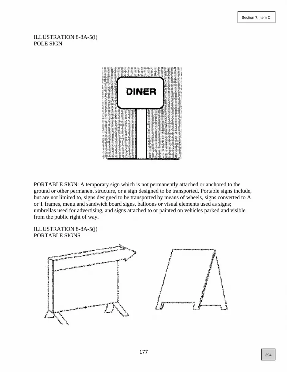
177
ILLUSTRATION 8-8A-5(i)
POLE SIGN
PORTABLE SIGN: A temporary sign which is not permanently attached or anchored to the
ground or other permanent structure, or a sign designed to be transported. Portable signs include,
but are not limited to, signs designed to be transported by means of wheels, signs converted to A
or T frames, menu and sandwich board signs, balloons or visual elements used as signs;
umbrellas used for advertising, and signs attached to or painted on vehicles parked and visible
from the public right of way.
ILLUSTRATION 8-8A-5(j)
PORTABLE SIGNS
394
Section 7, Item C.

178
PROJECTING SIGN: A permanent building sign which is mounted, erected, or otherwise
affixed on a building wall or structure, projecting generally perpendicular to the wall, and
extending beyond the building wall more than twelve inches (12"). Projecting signs also include
suspended signs.
ILLUSTRATION 8-8A-5(k)
PROJECTING SIGN
READER BOARD: See definition of Changeable Copy Sign.
ROOF INTEGRAL SIGN: Any building sign erected or constructed as an integral or essentially
integral part of a normal roof structure of any design, so that no part of the sign extends
vertically above the highest portion of the roof and so that no part of the sign is separated from
the rest of the roof by a space of more than six inches (6"). For purposes of this chapter, any
portion of a building above or behind the fascia or parapet of a building shall be considered part
of the roof. See also definition of Building Sign.
ILLUSTRATION 8-8A-5(l)
ROOF INTEGRAL SIGN
395
Section 7, Item C.

179
ROOF SIGN: A sign erected and constructed wholly or in part upon, against, or above the roof
of a building. For purposes of this chapter, any portion of a building above or behind the fascia
or parapet of a building shall be considered part of the roof.
ILLUSTRATION 8-8A-5(m)
ROOF SIGNS
SIGN: Any device, structure, fixture, display, emblem, picture, placard, visual element, or any
parts or combinations thereof using graphics, symbols, and/or written copy for the primary
purpose of identifying, providing directions to, drawing attention to, or advertising any activity,
place, business, office, institution, facility, organization, profession, trade, occupation, product,
good, or service.
SIGN AREA: The total area of the sign face which is used to display a message, not including its
supporting poles or structures.
SIGN HEIGHT: The distance from the base of the sign at normal grade to the top of the highest
attached component of the sign.
SIGN PLAN: A coordinated plan for developing signs for an individual building or a group of
buildings.
SUBDIVISION IDENTIFICATION SIGN: A sign used to identify a residential subdivision on
site.
TEMPORARY SIGN: A sign that is made of paper, cardboard, cloth, plastic, fabric, vinyl, wood
or other materials, which is used for a limited period of time, as set forth in this chapter, and
which is not permanently mounted. Temporary signs include, but are not limited to, A-frame,
banner, wind sign, special event sign, mechanically operated portable sign (fan blown, battery
operated mechanisms), etc.
396
Section 7, Item C.

180
TIME AND/OR TEMPERATURE SIGN: A sign or portion thereof on which the only copy that
changes is an electronic or mechanical indication of time or temperature.
VISUAL ELEMENT: A substitute for additional signs consisting of temporary and/or permanent
device intended to attract attention to any activity, place, business, office, institution, facility,
organization, profession, trade, occupation, product, good, or service or to convey message
concerning any activity, place, business, office, institution, facility, organization, profession,
trade, occupation, product, good, or service.
WALL SIGN: Any permanent building sign attached parallel to, but within two feet (2') of a
wall, painted on the wall surface of, or erected and confined within the limits of any outside wall
of any building, which is supported by such wall or building, and which displays only one sign
surface. Also see definition of Building Sign.
WINDOW SIGN, EXTERIOR: A sign which is mounted, placed, applied, painted, attached or
otherwise affixed on the exterior or outside of a window or to a windowpane or glass and is
visible from the exterior of the window. Exterior window signs are considered permanent
building signs. Window signs shall not have moving text or mechanics.
ILLUSTRATION 8-8A-5(n)
WINDOW SIGNS
397
Section 7, Item C.

181
WINDOW SIGN, INTERIOR: A sign which is mounted, placed, applied, painted, attached or
otherwise affixed inside a window or to the interior of a windowpane or glass and is visible from
the exterior of the window. Interior window signs are not considered building signs.
8-8A-6: GENERAL SIGN REQUIREMENTS:
The information contained within this section is intended to be used as criteria in all sections of
this chapter; however, there may be areas that require more detail or explanation. In those cases,
the information in those sections shall be used.
A. General Sign Requirements: All signs shall comply with the following general sign
requirements:
1. No sign shall be placed in a manner visible from any public street, alley, right of way, sidewalk,
or other public easement, except as provided herein, nor shall any sign be placed in or extend
over street, right of way, roadway, sidewalk, public or private utility or access or other easement,
or alley, except as provided herein and with the approval of the appropriate agency or utility.
Any sign installed or placed on or over public property or right of way after adoption of this
chapter, except in conformance with these requirements, shall be forfeited to the public and
subject to confiscation. In addition to other remedies hereunder, the city shall have the right to
recover from the owner or person placing such a sign the full cost of removal and disposal of the
sign.
2. All signs allowed hereunder shall be constructed and placed so as not to obstruct the vision of the
public at any street, alley, or driveway. Signs otherwise permitted by this chapter may be located
within the sight distance triangle, as shown below, provided that no part of such sign is placed
between the height of three feet (3’) and twelve feet (12') above the average grade of each street,
alley, or driveway. See illustrations for visual clearance and sight distance triangle.
398
Section 7, Item C.

182
ILLUSTRATION 8-8A-6(a)
VISUAL CLEARANCE
ILLUSTRATION 8-8A-6(b)
SIGHT DISTANCE TRIANGLE
3. No sign shall be allowed to be illuminated, except as expressly provided herein. Signs which are
otherwise allowed to be illuminated are not allowed if the administrator finds that the lighting
adversely affects adjoining residential uses or causes glare or otherwise interferes with the vision
of persons operating motor vehicles. All illuminated signs shall not be flashing or pulsating and
shall be constant in intensity and color, unless otherwise allowed herein. Sign lighting shall be
directed away from all traffic and from all adjoining residential properties, and the lighting
intensity shall not exceed fifteen (15) foot-candles at any point on the sign face. No sign shall be
399
Section 7, Item C.

183
illuminated if lighting is already provided to the area where the sign is to be located. All lighting
associated with signage shall meet any requirements of this title regarding dark sky standards.
4. No sign shall be allowed to revolve, rotate, or move.
5. No sign shall be allowed if the administrator finds that the sign is constructed or designed in a
manner which may cause the sign to be confused with a traffic sign or other traffic control
device.
B. Sign Area and Height Computations: The following principles shall control the computations
of sign area and sign height:
1. Computation Of Area Of Individual Signs: The area of a sign face (which is also the sign area of
a wall sign or other sign with only 1 face), shall be computed by means of the smallest square,
circle, rectangle, triangle, or combination thereof that will encompass the extreme limits of the
writing, representation, emblem, or other display, together with any material or color forming an
integral part of the background of the display or used to differentiate the sign from the backdrop
or structure against which it is placed, but not including any supporting framework, bracing or
decorative fence or wall when such fence or wall is clearly incidental to the display itself.
ILLUSTRATIONS 8-8A-6(c)
SIGN AREA COMPUTATIONS
ILLUSTRATION 8-8A-6(d)
SIGN AREA COMPUTATION FOR PERMANENT BUILDING SIGN
400
Section 7, Item C.

184
With No Defined Sign Background (e.g., Channel Letters)
2. Computation Of Area Of Multifaced Signs: The sign area for a sign with more than one face
shall be computed by adding together the area of all sign faces visible from any one point. When
two (2) identical sign faces are placed back to back so that both faces cannot be viewed from any
point at the same time, and when such sign faces are part of the same sign structure and are not
more than forty-two inches (42") apart, the sign area shall be computed by the measurement of
one of the faces.
3. Computation Of Height: The height of a sign shall be computed as the distance from the base of
the sign at normal grade to the top of the highest attached component of the sign. Normal grade
shall be construed to be the lower of: a) existing grade prior to construction, or b) the newly
established grade after construction, exclusive of any filling, berming, mounding, or excavating
solely for the purpose of locating the sign. In cases in which the normal grade cannot reasonably
be determined, sign height shall be computed on the assumption that the elevation of the normal
grade at the base of the sign is equal to the elevation of the nearest point of the crown of a public
street or the grade of the land at the principal entrance to the principal building on the lot,
whichever is lower. When sign is within the building setback, the calculation for the sign may
use either the base elevation or the elevation of the roadway. The computation of sign height
shall include the permitted sign and any attached changeable copy sign or reader board and the
sign structure.
401
Section 7, Item C.

185
ILLUSTRATION 8-8A-6(e)
SIGN HEIGHT COMPUTATION
ILLUSTRATION 8-8A-6(f)
SIGN HEIGHT COMPUTATION
In Cases Where the Normal Grade Cannot Reasonably Be Determined
402
Section 7, Item C.

186
4. Construction Standards: All permitted signs shall be constructed and maintained in compliance
with the applicable provisions of the city of Star building code and other provisions of the city of
Star ordinances. All illuminated signs shall be installed in accordance with the applicable
provisions of the national electric code, and all detached signs shall be so illuminated by an
underground electrical source.
5. Construction Materials: All signs shall be constructed with durable materials including but not
limited to metal, aluminum, wood, hard plastics and vinyl, rock or aggregate, or other materials
manufactured for durability and longevity. Materials such as thin vinyl used for banners, paper or
cardboard is not considered as a permanent material and shall be prohibited for permanent
signage.
6. Maintenance Standards: All permitted signs shall be maintained in good structural and aesthetic
condition. Deficiencies, such as chipped paint, broken plastic, missing letters, and exposed light
bulbs, shall be evidence of lack of maintenance.
8-8A-7: SIGNS EXEMPT FROM THIS CHAPTER:
Provided that the following signs or visual elements comply with the general sign regulations set
forth in section 8-8A-8 of this article, these signs shall be exempt from all other provisions of
this chapter:
A. Traffic signs, public notices or danger warnings required by a valid and applicable federal,
state, or local law, regulation, and/or ordinance;
B. Holiday lights and decorations on residential lots;
C. Traffic control signs on private property, such as stop, yield, and similar signs;
D. Organizational event signs within a public right of way, provided:
1. Temporary signs must be removed within forty-eight (48) hours of end of event;
2. Signs within the transportation authority rights of way, written permission shall be obtained from
the transportation authority and presented to the city;
3. Transportation authority permitted ROW signs shall be removed promptly upon the conclusion
of the event;
E. Public or semipublic athletic field signs which indicate sponsorship of the teams or announce
or relate to activities that occur therein, provided:
1. Such signs shall be affixed, placed, or installed on the athletic field fencing and facing the field,
and
2. Such signs shall not be affixed to scoreboards, buildings, or structures;
403
Section 7, Item C.

187
8-8A-8: SIGNS NOT REQUIRING PERMITS:
The followings signs are allowed on private property without permits, provided that the signs
contain no commercial message, logo, or symbol and comply with the general sign regulations
set forth in this chapter:
A. Building identification signs, such as address and building marker, provided:
1. One sign, not exceeding four (4) square feet in area, shall be permitted; and
2. Such signs shall be attached to the referenced building.
A. National, state, local and corporation flags, provided:
1. The United States Of America flag, state of Idaho flag, or flags of any other national or political
subdivision shall be flown and displayed in a manner so that the flags are not construed as an
attraction gaining device for the advertising of a product or use, or in a manner to otherwise draw
the attention of the traveling public to an establishment;
2. One corporation flag may be flown in conjunction with the United States or state of Idaho flag
and as part of the display;
3. Such displays shall not exceed twenty-five (25) square feet in area in any residential area or sixty
(60) square feet in any commercial or industrial area;
4. Such displays shall not be flown from a pole the tip of which is more than twenty-five feet (25')
in height;
5. Such displays shall conform to the criteria established in the ninety-fourth session of congress
(94-344; SJ resolution 49); and
6. Only one flag display shall be permitted for each establishment, and the display shall be located
at the principal building of the facility.
A. Incidental signs that are informational and have a purpose secondary to the use of the lot on
which it is located, such as no parking, entrance, loading only, telephone, and other similar
directives.
8-8A-9: SIGNS WITHIN THE HISTORIC OVERLAY CBD ZONING DISTRICT:
The number, size, height, appearance and location of signage within a historic overlay zoning
district shall comply with adopted design guidelines for the central business district and the city
of Star zoning regulations. Any sign not previously approved by the Star city council as a
landmark sign will be considered nonconforming as of the enactment of this chapter until found
to be appropriate by subsequent action of the administrator and/or Star city council.
All nonconforming signs will be subject to section 8-8A-13 of this article.
404
Section 7, Item C.

188
All nonconforming signs within the CBD district will be subject to sections 8-8A-1 through 5,
and 8-8A-12 through 8-8A-14 of this article.
8-8A-10: VISUAL ELEMENTS PROHIBITED:
Visual elements, as defined in section 8-8A-5 of this article, are prohibited in all circumstances
whether added to a sign or simply displayed on a property, unless otherwise allowed in this
chapter. Visual elements include, but are not limited to:
A. Pennants, banners or streamers, feathers, flags, wind or fan blown devices and mechanisms
intended to otherwise attract attention;
B. Large or small balloons, unless otherwise provided in this chapter;
C. Flashing lights, flashing arrows, or other pulsating fixtures or items;
D. Large inflatable displays, fixed or portable;
E. Large displays of permanent construction, fixed or portable, that are larger than the maximum
cube dimensions of six feet (6') in height, four feet (4') in depth, and four feet (4') in width, as
set forth in subsection 8-8A-11C2b(4)(B) of this article; and
F. Wording, message, or any symbol, or depiction on the exterior of a building, or any structural
element thereof, any independent structure or any other article or item on the property
including automobiles or other vehicles.
8-8A-11: SIGNS REQUIRING PERMITS:
The following signs shall not be erected, placed, established, painted, installed, or created until
an approved sign permit has been issued by the administrator and shall comply with the general
sign regulations set forth in this chapter and as set forth below:
A. Residential or Miscellaneous Signs:
1. Subdivision identification signs identifying the subdivision or development name, provided:
a. One sign per each subdivision entrance and one additional sign for each individual subarea of a
subdivision shall be permitted;
b. Such signs shall be indirectly illuminated;
c. Such signs shall not exceed twenty (20) square feet in area; and
d. The entire sign structure shall not exceed twenty-five feet (25') in length and eight feet (8') in
height.
405
Section 7, Item C.

189
e. The sign shall be located within a common area lot, shall be maintained by an HOA, and shall be
located outside of the clear vision triangle.
2. Building identification signs identifying the name of the owner or occupant of the building,
provided:
a. One sign shall be permitted and shall not exceed one square foot in area;
b. Such signs shall be attached to the building; and
c. Such signs shall not be illuminated.
3. Multi-family residential development identification signs, provided:
a. One sign shall be permitted and may be wall or ground mounted;
b. Such signs shall not exceed twenty (20) square feet in area;
c. If ground mounted, the sign shall be set back at least ten feet (10') from the right of way line or
property line; and
d. Such signs shall not exceed eight feet (8') in height.
4. Directional signs, provided:
a. A multi-family residential development shall be permitted one directional sign per each public
road/street frontage;
b. Such signs shall be illuminated by indirect or diffused lighting;
c. Such signs shall not exceed three (3) square feet in area; and
d. Such signs shall be wall mounted, or if ground mounted, shall be set back at least five feet (5')
from the right of way line or property line.
B. Public or Quasi-Public Signs: Public or quasi-public signs, provided:
1. One sign, not exceeding twenty-five (25) square feet in area and seven feet (7') in height, shall be
permitted;
2. Such signs may be indirectly or interiorly illuminated; and
3. Such signs may also have one reader board, provided that such reader board shall be attached to
the principal sign and shall not exceed fifteen (15) square feet in area.
C. Commercial, Professional Office and Industrial Signs:
406
Section 7, Item C.

190
1. Temporary signs, provided:
a. One sign, not exceeding forty (40) square feet and seven feet (7') in height, and small balloons,
not exceeding twelve inches (12") in diameter, shall be permitted;
b. Such signs must be securely installed or displayed and shall be constructed or designed in a
manner which shall not cause the sign to be confused or interfere with a traffic sign or other
traffic control device;
c. Such signs may be ground mounted or building mounted, and if building mounted, the signage
shall not extend above the peak, or highest point of the roof;
d. Where a single building or complex of buildings contains two (2) or more principal uses with
their own separate exterior customer entrances, each principal use located therein shall be
permitted temporary signage as set forth above; and
e. Each principal use shall be allowed up to four (4) temporary sign permits per calendar year, and
each permit is granted for one 7-day period.
2. Permanent signs, provided:
a. Maximum Number of Permanent Signs:
(1) Individual Principal Use: An individual principal use located on an individual lot shall be
allowed a maximum total of four (4) signs, unless otherwise allowed in this chapter.
(2) Multi-Tenant and Multiuse Buildings: Multi-tenant and multiuse building with two (2) or more
principal uses without their own separate exterior building entrances and exits and sharing a
common hallway.
(A) The building shall be allowed a maximum total of four (4) permanent signs, unless otherwise
allowed in this chapter.
(3) Multi-Tenant and Multiuse Buildings and Developments: Multi-tenant and multiuse buildings
and developments where a single building or complex of buildings contains two (2) or more
individual principal uses with their own separate exterior building entrances and exits.
(A) Building Signs: Unless otherwise allowed in this chapter, the number and size of permanent
building signs for each principal use located within the development shall be based on the
portion of the building elevation occupied by the use.
(B) Freestanding Signs: The number and size of freestanding signs for a multi-tenant and multiuse
building and development shall be based on the total building size and public street frontage of
the entire development. Individual buildings and uses within the development shall not be
permitted individual freestanding signs.
ILLUSTRATION 8-8A-11(a)
407
Section 7, Item C.

191
MULTIUSE BUILDING SIGN TYPES
b. Permanent Sign Types:
(1) Freestanding Signs:
(A) Developments consisting of less than five thousand (5,000) square feet gross floor space:
(i) Maximum Number of Freestanding Signs: One freestanding sign.
(ii) Maximum Sign Area and Height:
(a) For freestanding signs with a maximum height of seven feet (7'), the maximum sign area
shall not exceed fifty (50) square feet.
(b) For freestanding signs with a maximum height of twenty feet (20'), the maximum sign area
shall not exceed thirty (30) square feet.
(c) When a freestanding sign is located more than sixty-five feet (65') from the driving lane of a
public road/street with forty-five (45) mile per hour (mph) or greater speed limit, the maximum
sign area shall not exceed seventy (70) square feet, and the maximum sign height shall not
exceed ten feet (10').
408
Section 7, Item C.

192
(iii) Minimum Setbacks: The minimum setback for freestanding signs shall be ten feet (10') from
rear and side property lines and off of the right of way of any public road/street, unless otherwise
stated in this chapter.
(B) Developments with gross floor space more than five thousand (5,000) square feet:
(i) Maximum Number of Freestanding Signs: Two (2) freestanding signs.
(ii) Maximum Sign Area And Height:
(a) For freestanding signs with a maximum height of seven feet (7'), the maximum sign area
shall not exceed fifty (50) square feet.
(b) For freestanding signs with a maximum height of twenty feet (20'), the maximum sign area
shall not exceed thirty (30) square feet.
(c) When a freestanding sign is located more than sixty-five feet (65') from the driving lane of a
public road/street with forty-five (45) mile per hour (mph) or greater speed limit, the maximum
sign area shall not exceed seventy (70) square feet, and the maximum sign height shall not
exceed ten feet (10').
(iii) Minimum Setbacks: The minimum setback for freestanding signs shall be ten feet (10') from
rear and side property lines and off of the right of way of any public road/street, unless otherwise
stated in this chapter.
(iv) Minimum Sign Separation: The minimum separation between two (2) freestanding signs on a
lot or tract shall be one hundred fifty feet (150').
(2) Building Signs:
(A) Maximum Number of Signs:
(i) Individual Principal Use: Each individual principal use located on an individual lot is allowed
maximum four (4) building signs, unless otherwise allowed herein.
(ii) Multi-Tenant And Multiuse Building: Multi-tenant and multiuse building with two (2) or more
principal uses without their own separate exterior building entrances and exits and sharing a
common hallway: The building shall be permitted three (3) building signs, and the sign sizes
shall be based on the size of elevation as set herein, unless otherwise allowed.
(iii) Buildings Containing Two Or More Principal Uses: Multi-tenant and multiuse buildings and
where a single building or complex of buildings contains two (2) or more individual principal
uses with their own separate exterior building entrances and exits: Unless otherwise allowed in
this chapter, the number and size of building signs for each individual principal use located
within the development shall be based on the portion of the building elevation occupied by the
individual principal use, as set forth below, as though they were individual and independent
buildings.
409
Section 7, Item C.

193
(B) Total Allowable Building Sign Area Per Elevation:
(i) If the principal use has no freestanding signs, then the total allowable sign area for building
signs shall be as follows:
(a) If the business has a total of three (3) building mounted signs, each sign may be up to seven
percent (7%) of the elevation;
(b) If the business has a total of two (2) building mounted signs, up to nine percent (9%) of the
elevation; or
(c) If the business has one building mounted sign, the sign may be up to eleven percent (11%) of
the elevation.
(ii) If the principal use has one freestanding sign, the total allowable sign area for building signs
shall be as follows:
(a) If the principal use has a total of three (3) building signs, each sign may be up to five percent
(5%) of the building elevation or thirty (30) square feet, whichever is larger;
(b) If the principal use has a total of two (2) building signs, each sign may be up to seven
percent (7%) of the elevation; or
(c) If the business has only one building sign, each sign may be up to nine percent (9%) of the
elevation.
(iii) If the principal use has two (2) freestanding signs, then the total allowable building sign area is:
(a) If the principal use has a total of two (2) building signs, each sign may be up to seven percent
(7%) of the elevation; or
(b) If the business has only one building sign, each sign may be up to nine percent (9%).
(C) Building Mounted Signs: Building mounted signs shall not extend above the peak, or highest
point of the roof.
(D) Projecting Signs:
(i) A projecting sign shall be a substitute for, or in lieu of, one permanent sign for the principal use;
(ii) The sign shall have nine feet (9') of clearance above sidewalk;
(iii) The sign shall not project more than ten feet (10') from building nor be any closer than
eighteen inches (18") from curb or driving lane;
(iv) The sign shall not extend above the peak of the roof; and
(v) A two (2) or more story building shall not have projecting signs.
410
Section 7, Item C.

194
(3) Off Premises Signs: Off premises (off-site) signs a prohibited in all zones and may only be
allowed as part of an overall sign program for properties that are part of a contiguous
development or subdivision and as approved by the administrator, provided:
(A) The permitted off-premise sign shall not exceed the size, height, and setbacks requirement of
the freestanding sign of the lot on which it is located;
(B) The off-premise sign may not be located within fifty feet (50') of any other freestanding sign;
(C) Written evidence of property owner consent must be submitted with the permit application;
(D) Off-premise “Welcome to Star” signs are exempt from this prohibition.
(4) Visual Elements:
ILLUSTRATION 8-8A-11(b)
VISUAL ELEMENT
411
Section 7, Item C.

195
(A) One permanent and ground mounted visual element per individual principal use shall be
permitted as a substitute for, or in lieu of, one permanent sign allowed for the use;
(B) The maximum size of the visual element shall be computed by means of the smallest cube that
will encompass the extreme limits of the visual element and with maximum cube dimensions of
six feet (6') in height, four feet (4') in depth, and four (4) in width;
(C) Parts of the visual element may not extend more than twenty percent (20%) beyond the limits
of the allowable area set forth in subsection C2b(4)(B) of this section;
(D) Visual elements shall have no parts that move or give the appearance of movement and shall
have no apparent motion caused by, but not limited to, the illusion of moving objects, moving
patterns or boards of lights, expanding, contracting, or rotating shapes, scrolling, or running
messages or other similar animation effects;
(E) Visual elements must be securely installed or displayed and shall be constructed or designed in
a manner which shall cause the sign to be confused or interfere with a traffic sign or other traffic
control device; and
(F) Commercial messages, logos, or symbols shall be limited to two (2) sides of the visual elements
and shall not exceed ten (10) square feet.
(5) Landmark Signs:
(A) Such signs shall be exempt from size, height, and setback regulations, but shall comply with all
other regulations set forth in this chapter, and
(B) Such signs shall not encroach into a public right of way, unless otherwise allowed by an
approved entrance permit by the appropriate governing authority.
(6) Accessory Building Signs:
(A) One building sign on an accessory building shall be permitted in addition to the building signs
allowed for the individual principal use;
(B) The maximum sign area shall not exceed one square foot per linear foot of the building length
of and on the elevation on which the sign is located and facing the public street or private
accessway if the lot has no public street frontage; and
(C) Additional accessory building signs may be allowed but shall be in lieu of, the permitted
building signs for the individual principal use and shall comply with the maximum number and
size of building signs allowed for the individual principal use.
(7) Freestanding Canopy Signs:
(A) One sign on each canopy elevation (fascia) shall be permitted;
(B) Such signs shall not exceed eight (8) square feet; and
412
Section 7, Item C.

196
(C) Such signs shall be permitted in addition to the building signs allowed for the individual
principal use.
(8) LI Signs: Light industrial commercial park (LI) identification signs, provided:
(A) One sign per public street entrance shall be permitted;
(B) Such signs shall not exceed forty (40) square feet in area;
(C) A listing of individual businesses and industries shall be allowed as part of the identification
sign; and
(D) Written evidence of property owner consent must be submitted with the permit application.
D. Murals: The following conditions shall be met for an allowed mural:
1. Remain unaltered for a minimum of two (2) years and be maintained thereafter to its original
quality.
2. Shall not exceed height and width of structure.
3. Shall not extend more than six inches (6") from the building facade.
4. Shall not include electrical moving components.
5. Murals are not permitted in residential districts or on residential buildings.
6. Murals and public art installation must comply with city light standards.
7. Digitally printed image murals are allowed for restoration purposes only.
8. Fees for all murals shall be set by resolution.
9. Mural must be of a nature relevant to Star.
10. All murals must be approved by council at a normally scheduled council meeting (no public
hearing is required).
8-8A-12: PERMIT PROCESS AND PROCEDURES:
A. Permit Required: Except as otherwise provided in this chapter, it shall be unlawful for any
person to erect, construct, install, mount, place, apply, paint, attach, affix, expand, enlarge,
move, modify, or replace any sign or cause the same to be done, without first obtaining a sign
permit.
B. Application and Permit Issuance:
413
Section 7, Item C.
197
1. If a sign requiring a permit under the provision of this chapter is to be erected, constructed,
installed, mounted, placed, applied, painted, attached, affixed, expanded, enlarged, moved,
modified, or replaced on a property, the property owner shall secure a sign permit prior to the
construction, placement, erection, or modification of the sign.
2. No sign permit of any kind shall be issued for an existing or proposed sign unless the sign is
consistent with the requirements of this chapter (including those protecting existing signs) in
every respect and with the sign plan in effect for that property.
3. The following procedures shall govern the application for, and issuance of all sign permits under
this chapter and the submission and review of sign plans:
a. Sign Plan Required: No permit shall be issued for an individual sign requiring a permit until a
sign plan for the property on which the sign will be installed has been submitted to and approved
by the administrator as conforming with this section.
b. Sign Plan Contents: For any property on which the owner proposes to erect one or more signs
requiring a permit, the owner shall submit to the administrator a sign plan containing the
following:
(1) An accurate plot plan of the property, at such a scale as the administrator may reasonably
require with a current legal description in metes and bounds;
(2) Location of existing and proposed buildings, structures, parking lots, driveways, and landscaped
areas of the property;
(3) Computations of the maximum total sign area, the maximum area for individual signs, the
height of signs and the number of building and freestanding signs allowed on the property
included in the plan under this chapter;
(4) An accurate indication on the plot plan of the proposed location of each present and future sign
of any type whether requiring a permit or not.
C. Fees:
1. Permit Fees: No sign permit shall be issued until all applicable fees have been paid. The fees for
sign permits, as adoption by resolution of the city council, may be adjusted by the city as
necessary, periodically.
2. Late Fees: In addition to the sign permit fees, the administrator shall also assess a late fee, as
adopted by resolution, to any applicant who erects, places, establishes, paints, installs, creates, or
in any other way initiates a sign prior to receiving the property permit or approval from the
administrator. This fee is in addition to, and not in lieu of, any penalties for violations of the
regulations. Payment of this late fee will in no way exonerate or excuse the applicant from
applying in an appropriate manner and complying with the normal requirements and standard
permit fees for the permission or applicable permit which is needed.
414
Section 7, Item C.

198
D. Review: The administrator shall review the application for completeness. If the application is
complete, the administrator shall process the application. If the application is incomplete, the
administrator shall notify the applicant of the deficiencies and reference the appropriate
sections of this chapter. Upon correcting the deficiencies, the administrator will process the
application.
E. Issuance Of Permits: All sign permit applications shall be reviewed by the administrator or
designee allowing submission and/or official acceptance of a complete application, for
compliance with these regulations. Once a determination regarding the sign permit
application has been made the administrator will:
1. Issue a letter of compliance to the applicant, with conditions if any, if the sign that is the subject
of the application conforms in every respect with the requirements of this chapter and the
applicable sign plan; or
2. Deny the sign permit and issue a written statement to the applicant, if the sign that is the subject
of the application fails in any way to conform with the requirements of this chapter and of the
applicable sign plan. In case of a rejection, the administrator shall specify in the rejection the
section or sections of this chapter or applicable plan with which the sign is inconsistent.
F. Appeals: All appeals and variances from the requirements of these regulations shall be
scheduled for public hearing.
8-8A-13: NONCONFORMING SIGNS:
A. For the purpose of this section, a "nonconforming sign" shall be defined as a sign existing at
the effective date hereof which could not be built under the terms of this chapter or under the
terms of other applicable local ordinances. The following requirements apply to the
continued use of and/or replacement of nonconforming signs:
1. Continued Use: A nonconforming sign may continue to be used by the establishment occupying
the structure on the site for which the sign was originally erected, as long as no major structural
support element (frame, pole, bracing, etc.) is replaced. If a major structural support element is to
be replaced, due to voluntary action by the owner, or due to an act of God or unforeseen
circumstance, then the new sign to be erected must be in compliance with this chapter.
2. Replacement: The sign face of a nonconforming sign may be replaced as long as no major
structural element of the sign is replaced. As stated above, if a major structural element is to be
replaced, then the new sign to be erected must be in compliance with this chapter.
3. Change in Use: Where a change in land use, occupancy, or ownership occurs which necessitates
the altering of a sign in any manner, then the altered or changed sign shall be brought into
conformance with the requirements of this chapter.
415
Section 7, Item C.

199
4. Existence of Nonconforming Building Sign: Existence of a nonconforming building sign on the
premises will prohibit issuance of further building sign permits while the nonconforming sign
exists.
5. Existence of Nonconforming Freestanding Sign: Existence of a nonconforming freestanding sign
on the premises will prohibit the issuance of further freestanding sign permits while the
nonconforming sign exists.
6. Limitations And Removal Of Nonconforming Signs: In the event a use or establishment ceases
operation for a period of thirty (30) days, the sign owner, lessee, or property owner shall
immediately remove any nonconforming signs identifying or advertising the business or any
product. This requirement shall not apply where, under the provisions of this chapter, an existing,
conforming sign may be altered to advertise a new principal use, business, establishment, or
product, and there is evidence that a new establishment will be in operation on the premises within
thirty (30) days. Where no such evidence exists, the sign face shall be removed, or the message
shall be painted over in such a manner as to completely cover up or hide from sight the message.
Upon failure of the sign owner, lessee, or property owner to comply with this section, the
administrator shall issue a written notice to the owner. The notice shall state that the sign shall be
removed within fifteen (15) days. If the owner fails to comply with the written notice to remove the
sign, the administrator is hereby authorized to cause removal of the sign. Any expense incidental to
the removal of the sign shall be charged to the owner and shall constitute a lien upon the property.
For the purpose of dealing with nonconforming signs in this section, the word "remove" shall
mean:
a. The sign face, along with posts, columns, or supports of freestanding signs, shall be taken down
and removed from the property;
b. The sign face and supporting structures of projection, roof or wall signs shall be taken down and
removed from the property;
c. The sign face of painted wall signs shall be removed by painting over the wall sign in such a
manner as to completely cover up and hide from sight the sign in question.
7. Nonconforming animated signs - The property owner of a nonconforming animated sign shall
continue to abide by the original standards for approval of the sign including the following: 1. Such
sign shall not flash, scroll, chase, rotate, blink or pulsate or have any similar effects of movement;
2. Such sign shall not include any animated images and images which move or give the appearance
of movement and shall not have visual messages with apparent motion caused by, but not limited
to, the illusion of moving objects, moving patterns or boards of lights, expanding, contracting, or
rotating shapes, scrolling or running messages, or other similar animation effects;
3. Such sign shall be programmed so that the text changes no more than every minute, and such
changes of text shall be substantially instantaneous as seen by the human eye and shall not use
fading, rolling, window shading, dissolving, or similar effects as part of the change;
4.Such signs shall use automated light sensing devices to reduce light levels at night and under
cloudy or other darkened conditions, in accordance with the following standards:
a. Such electronic signs shall have installed automated light sensing devices (e.g., photocell
416
Section 7, Item C.

200
technology) and shall, at all times, allow such monitors to automatically adjust the brightness level
based on ambient light conditions; and
b. Maximum brightness levels for such electronic signs shall not exceed five hundred (500) nits,
when measured from the sign face at its maximum brightness, during night and under cloudy or
other darkened conditions;
5. The maximum resolution of such signs shall be forty-six-millimeter (46 mm) (1.8 inch) pixel
pitch.
6. Any electronic sign which malfunctions, fails, or ceases to operate in its usual or normal
programmed manner causing therein motion, movement, flashing, or any other similar effects, shall
be repaired or disconnected within forty-eight (48) hours by the owner or operator of such sign.
8-8A-14: VIOLATIONS, ENFORCEMENT, PENALTIES:
A. Signs Forfeited: Any sign installed or placed on or over public property or right of way after
adoption of this chapter, except in conformance with these requirements, shall be forfeited to
the public and subject to confiscation. In addition to other remedies hereunder, the city shall
have the right to recover from the owner or person placing such a sign the full cost of
removal and disposal of the sign.
B. Violations:
1. Any of the following shall be a violation of this chapter and shall be subject to the enforcement
remedies and penalties provided by this chapter and by Idaho state code:
a. To install, create, erect, or maintain any sign in a way that is inconsistent with any plan or permit
governing such sign or the lot on which the sign is located.
b. To install, create, erect or maintain any sign requiring a permit without such a permit.
c. To fail to remove any sign that is installed, created, erected, or maintained in violation of this
chapter, or for which the sign permit has lapsed.
2. Each day of a continued violation shall be considered a separate violation when applying the
penalty portions of this chapter.
C. Enforcement:
1. The city shall have the authority to issue citations for violations of this chapter but shall not have
powers of peace officers to make arrests or carry deadly weapons. A person receiving a citation
shall appear within a designated time pursuant to the citation.
2. Any violation or attempted violation of this chapter or of any condition or requirement adopted
pursuant hereto may be restrained, corrected, or abated, as the case may be, by injunction or
other appropriate proceedings pursuant to state law. The remedies of the city shall include, but
are not limited to, the following:
417
Section 7, Item C.

201
a. Issuing a stop work order for any and all work on any signs on the same lot;
b. Seeking an injunction or other order of restraint or abatement that requires the removal of the
sign(s) or the correction of the nonconformity; and
c. In the case of a sign that poses an immediate danger to the public health or safety; take such
measures as are available to the city under the applicable building codes or other ordinances.
d. All the remedies provided herein shall be cumulative. To the extent that state law may limit the
availability of a particular remedy set forth herein for a certain violation or a part hereof, the
remedy shall remain available for other violations or other parts of the same violation.
418
Section 7, Item C.

202
ARTICLE B. DESIGN REVIEW AND DEVELOPMENT STANDARDS
THIS SECTION RESERVED FOR FUTURE REVIEW AND ADOPTION
419
Section 7, Item C.

203
ARTICLE C. BICYCLE PARKING REQUIREMENTS FOR NEW DEVELOPMENTS
AND MAJOR RENOVATIONS
THIS SECTION RESERVED FOR FUTURE REVIEW AND ADOPTION
420
Section 7, Item C.

204
ARTICLE D. LANDSCAPE AND BUFFER AREA STANDARDS
8-8D-1: PURPOSE: 8-8D-2: APPLICABILITY:
8-8C-1: PURPOSE:
A. The regulations of this article are intended to promote landscaping in the city of Star that will
improve the community livability, preserve the quality of life, and enhance the aesthetic
quality, economic viability, and environmental health of the city.
B. The city of Star recognizes that landscaping can be a significant expense to business people
and residents. At the same time, landscaping improves the livability of residential
neighborhoods, enhances the appearance and customer attraction of commercial areas,
increases property values, improves the compatibility of adjacent uses, screens undesirable
views, and can reduce air and noise pollution.
C. The intent of these regulations is to achieve a balance between the right of individuals to
develop and maintain their property in a manner they prefer and the rights of residents to
live, work, shop, and recreate in pleasant, healthy, and attractive surroundings.
D. These regulations are intended to promote the use of native and other low water use plant
materials and to discourage landscaping that requires high water use for maintenance, such as
large expanses of lawn.
8-8C-2: APPLICABILITY:
A. A landscape plan shall be required for all development applications requiring an architectural
review, including, but not limited to, new residential subdivisions, all non-residential
development, redevelopment, additions, and/or site modifications as required by the
administrator.
The landscape plan shall be drawn to scale (no smaller than 1-inch equals 30 feet) and shall
indicate the following:1. Boundaries, property lines, and dimensions.
2. Existing trees identified by species and size.
3. The location and design of areas to be landscaped.
4. The location and labels for all proposed plants.
5. Plant lists or schedules with the botanical and common name, quantity, and spacing and size
of all proposed landscape material at the time of planting.
6. Location and description of other landscape improvements, such as earth berms, walls, fences,
screens, sculptures, fountains, street furniture, lights, and courts or paved areas.
7. Planting and installation details as necessary to ensure conformance with all required
standards.
B. Plan Preparation: Preparing a landscape plan requires special skills. Landscaping involves
more than a simple arrangement of plants with irrigation; plants are not haphazardly placed in a
421
Section 7, Item C.

205
way that fills up leftover space. Landscape plans should reflect a theme so that site elements are
artfully and technically organized in a way that conveys meaning, coherence, and spatial
organization. Landscaping should enhance the physical environment as well as the project's
aesthetic character. Therefore, landscape plans to be submitted for approval shall be prepared by
or under the responsible control of a licensed landscape architect with said plans to be duly
stamped to clearly identify the preparer.
C. Landscape As Percent Of Site:
1. Open space shall be designated as a total of 15% of the total gross acreage of the development
for residential developments in all zones with densities greater than R-1. A minimum of 10% of
the 15% the total gross acreage of the development shall be for useable open space. Planter
strips on internal streets where detached sidewalks are provided may be counted towards the total
open space. Planter strips must meet all requirements of the City and ACHD/CHD4. Uniquely
designed subdivision entrances may be considered as a required open space amenity.
2. Hardscape areas, such as plazas, decorative concrete/paver patios that are integrated into the
design of the useable landscaped area, may be included in the landscape coverage requirement.
3. All landscape improvements required in this section shall count toward fulfillment of the
above minimum percentages.
D. Prohibited Materials And Landscaping:
1. No required landscape areas shall include artificial trees, plants, or any carpeting designed as a
vegetative substitute, unless otherwise approved by the Administrator and Council.
2. Clear vision triangle shall be complied with in regard to all vegetation.
3. When the city determines that a sight obstruction exists, it shall notify the owner of the
property upon which the obstruction is located and order that the obstruction be removed within
fifteen (15) days. The failure of the owner to remove the obstruction shall be punishable as
provided for in this title.
E. Installation And Minimum Standards:
1. Applicants are required to use the Treasure Valley Tree Selection Guide (most recent version);
2. sidewalks along arterial roadways shall be detached and be at least 60 inches in width, unless
otherwise approved by council.
3. Accepted nursery standards (American Standard for Nursery Stock – ASNS) and practices
shall be followed in the planting and maintenance of landscaped areas.
4 Soil and slope stabilization must result after landscape installation. Any disturbed areas within
project must have landscaping.
5. Root barriers shall be installed for all new trees planted adjacent to existing or proposed public
or private sidewalks and paving (under 8 feet in width for parkways, or as determined by the
Transportation Authority).
6. The minimum acceptable size for deciduous trees shall be two-inch (2") caliper, balled and bur
lapped, per ASNS standard detail.
7. The minimum acceptable size for evergreen trees shall be six feet (6'), balled and bur lapped,
per ASNS standard detail.
8. Planting selection shall adhere to USDA and/or climate zone requirements.
9. It is the responsibility of the developer to insure proper installation of all trees, including the
422
Section 7, Item C.

206
removal of twine and wire, and the rollback of bur lap, prior to Certificate of Completion.
10. a. Certification Of Completion: Upon the completion of the landscape installation, or other
improvements subject to architectural review approval, a written certification of completion shall
be prepared by the licensed landscape architect responsible for the landscape plan. The
certification of completion shall state that the installation of all landscape improvements, and site
amenities, if applicable, is in substantial compliance with the city approved landscape plan. This
certification shall be submitted prior to the issuance of a certificate of occupancy, signature of a
final plat, or release of bond, and is required as a part of, and not in lieu of, the inspections
performed, and certificates issued by the city.
b. Report Of Deficiencies: In the event that deficiencies are present after the landscape
installation, or other improvements subject to design review approval, the licensed landscape
architect shall prepare and file with the city a report noting the deficiencies in the improvements.
The city will not accept a certification of completion, or issue a certificate of occupancy, until the
licensed landscape architect has verified that the deficiencies have been corrected.
c. Landscape Architect Designee: The licensed landscape architect may, at his or her discretion,
appoint an authorized designee to certify the project provided that the designee is a licensed
landscape architect.
F. Tree Species Mix:
1. When more than ten (10) trees are to be planted to meet the requirements of these guidelines, a
mix of species shall be provided. The number of species to be planted shall vary according to the
overall number of trees required to be planted. Species shall be planted in proportion to the
required mix. See the table below:
Required Number Of Trees Minimum Number Of Species
11 - 20 2
21 - 30 3
31 - 40 4
41 plus 5
G. Maintenance:
1. All required landscaping shall be permanently maintained in a healthy growing condition by
the property owner or the property owner's representative. This includes the maintenance of
street trees and/or other landscape materials within or abutting the public right of way adjacent to
the subject property. The property owner shall remove, and if required to meet the standards of
these requirements, shall replace any unhealthy or dead plant material immediately or as the
planting season permits. In all cases, maintenance and planting within public rights of way shall
be with approval from the public and/or private entities owning the property. At no time shall
required landscaping be removed from an approved development and not replaced with a similar
plant type.
H. Completion Time:
423
Section 7, Item C.

207
1. The administrator may authorize a delay in the completion of planting due to inclement
weather conditions or other extenuating circumstances, if a surety for one hundred fifty percent
(150%) of the cost of incomplete improvements is provided to the city.
I. Irrigation Required: An underground automatic irrigation system is required for all
development requiring landscaping.
1. All required landscaped areas must be provided with an automatic underground irrigation
system.
2. The system shall be equipped with a reduced pressure backflow prevention device.
3. The system shall be designed and constructed to provide one hundred percent (100%) spray
coverage.
4. Wherever feasible, sprinkler heads irrigating lawn or other high-water demand landscape areas
shall be circuited so that they are on a separate zone or zones from those irrigating trees,
shrubbery or other reduced water demand areas.
5. Sprinkler heads shall be placed as required to reduce direct overthrow onto non-pervious areas
(walks, drives, etc.). Drip irrigation is recommended for shrubs and trees.
6. The use of low trajectory spray nozzles is encouraged in order to reduce the effect of wind
velocity on the spray system.
7. Use of non-potable water for use in the irrigation of lawn and plant material is required when
determined to be available.
8. All non-potable water access points shall be clearly and permanently labeled with markers
indicating that the water is not safe for human consumption.
9. Maintain all irrigation systems to ensure proper operation and water conservation.
10. Irrigation drainage run-off from one lot or property shall not encroach onto another lot.
J. Buffer Areas/Common Lots:
1. Definition: Development or buffer area consists of horizontal space (land) and vertical
elements (plants, berms, fences, or walls). The purpose of such buffer space is to physically
separate and visually screen adjacent land uses which are not fully compatible due to differing
facilities, activities, or different intensities of use, such as townhouses and a convenience store,
or a high-volume roadway and residential dwellings.
2. Minimum Requirements:
a. When a commercial or industrial use abuts a residential use, a ten foot (10') wide by six foot
(6') high landscaped buffer is required except in the CBD.
b. When a parking lot abuts a residential activity, a five foot (5') wide by six foot (6') high
landscaped buffer is required except in the CBD.
c. To conceal outdoor storage areas, trash receptacles, exposed equipment associated with any
commercial or industrial activity, and off-street loading when adjacent to or in view from a
residential activity or public street right of way, a three foot (3') wide by six foot (6') high
landscaped buffer is required.
3. Materials:
a. All buffer areas shall be comprised of, but not limited to, a mix of evergreen and deciduous
trees, shrubs, and ground cover.
b. Height requirements shall be accomplished with plant material, with a fence or decorative
wall, or a combination thereof.
c. The required buffer area shall result in an effective barrier within three (3) years and be
424
Section 7, Item C.

208
maintained such that sixty percent (60%) or more of the vertical surface is closed and prevents
the passage of vision through it.
4. Major Roadways: New residential developments, including, but not limited to, subdivisions
and multi-family developments, shall be buffered from streets classified as collectors, arterials,
freeways, or expressways, to protect residential communities from noisy, potentially dangerous,
high speed roads. The "buffer area" shall be defined as a common lot located between the
residential lots within the subdivision and the right of way line of the adjacent roadway. This
buffer is required as part of the common area open space owned and maintained by a
homeowners' association. All developments are encouraged to work with the appropriate
transportation agency to landscape unused right of way. Any landscaping proposed to be within
the public right of way shall not be calculated in the overall open space requirements and shall
not be included as a part of the buffer area required below. The height for berming/fencing, as
noted below, shall be measured from the elevation of the final grade of the adjacent roadway
(measured at the centerline) to the top of the proposed berming/fencing. The required buffer area
width, plantings, and fencing are as follows:
a. Any road designated as a collector on the applicable highway district function class map:
A minimum of twenty feet (20') wide buffer area (not including right of way) shall be
provided with the following plants per one hundred (100) linear feet of right of way: two
(2) shade trees, two (2) evergreen trees. Each required shade tree may be substituted with
two (2) flowering/ornamental trees, provided that not more than fifty percent (50%) of
the shade trees are substituted.
A minimum five foot (5') high buffer consisting of a berm, wall, fence, or combination
thereof shall be provided within the buffer area. The maximum slope for any berm shall
be three feet (3') horizontal distance to one foot (1') vertical distance. Unsightly fencing
shall not be permitted.
b. Any road designated as a minor arterial on the applicable highway district function class map:
A minimum of thirty (30') wide buffer area (not including right of way) shall be provided
with the following plants per one hundred (100) linear feet of right of way: three (3)
shade trees, three (3) evergreen trees, eight (8) shrubs. Each required shade tree may be
substituted with two (2) flowering/ornamental trees, provided that not more than fifty
percent (50%) of the shade trees are substituted.
A minimum five foot (5') high buffer consisting of a berm, wall, fence, or combination
thereof shall be provided within the buffer area. The maximum slope for any berm shall
be three feet (3') horizontal distance to one foot (1') vertical distance. Unsightly fencing
shall not be permitted.
c. Any road designated as a principal arterial on the applicable highway district function class map:
A minimum of forty feet (40') wide buffer area (not including right of way) shall be
provided with the following plants per one hundred (100) linear feet of right of way: four
425
Section 7, Item C.

209
(4) shade trees, three (3) evergreen trees, two (2) flowering/ornamental trees, and twelve
(12) shrubs. Each required shade tree may be substituted with two (2)
flowering/ornamental trees, provided that not more than fifty percent (50%) of the shade
trees are substituted.
A minimum seven foot (7') high buffer consisting of a berm, wall, fence, or combination
thereof shall be provided within the buffer area. The maximum slope for any berm shall
be three feet (3') horizontal distance to one foot (1') vertical distance. Unsightly fencing
shall not be permitted.
5. Common Area Landscapes: New residential subdivision common area landscapes shall be
comprised of the following:
a. Lawn, either seed or sod.
b. A minimum of one deciduous shade tree per four thousand (4,000) square feet.
6. Design Considerations For Residential Developments:
a. For design flexibility, half of the required shade trees may be substituted on a two to one (2:1)
basis with ornamental and evergreen trees.
b. Buffer areas should include a variety of species, arranged to create varied and attractive views.
Open fences, decorative walls, and berms may be used. Height changes, offset angles, different
materials, and other design techniques are required so as to create variety.
K. Parking Lot Landscaping:
1. Visual Impact: Landscaping shall be provided to minimize the visual impact of off-street
parking:
Parking should be located to the side and rear of buildings, when possible, and shall be enhanced
with landscaping so that it does not dominate the streetscape. Fences, hedges, berms, and
landscaping may be used to limit view of parking areas (chain link fencing shall not be
permitted). In the design of large parking areas, arrange bays of parking spaces to be separated
by landscaping. When parking lots occur on sloping terrain, step the parking lots to follow the
terrain rather than allowing the lot surface to extend above natural grade.
2. Parking Lot Landscape Strip: A landscape strip shall be provided when a parking lot is located
adjacent to a public right of way. The landscaped strip shall serve to limit views of parked cars to
passing motorists and pedestrians, and to establish coordination among architecturally diverse
buildings, which creates a pleasing, harmonious appearance along the roadway.
Three (3) options are provided for fulfilling this requirement:
a. Provide an eight-foot (8’) wide landscaped strip between the right of way and the parking lot,
and plant with a minimum of one shade tree and eight (8) shrubs per thirty-five (35) linear feet of
frontage, excluding driveway openings.
b. Provide an earth berm of thirty inches (30") minimum height (do not exceed 3:1 slope) within
a fifteen foot (15’) wide landscaped strip between the right of way and the parking lot, and plant
with a minimum of one shade tree per thirty-five (35) linear feet of frontage, excluding driveway
openings.
c. Provide a three foot (3’) high fence of wood, brick, stone, or decorative block or concrete
along with a four foot (4') wide landscaped strip between the right of way and the parking lot,
426
Section 7, Item C.

210
and plant a minimum of one shade tree and three (3) shrubs per thirty five (35) linear feet of
frontage, excluding driveway openings.
(1) The administrator may waive the requirement for a wood, brick, stone, decorative block or
concrete fence if the board finds the following:
(A) The property is within the CBD; or
(B) Any such proposed design alternative is compatible with the overall site design of the entire
project and is compatible with the surrounding area.
3. Parking Lot Perimeter Landscaping: Perimeter landscaping requirements define parking areas
and prevent two (2) adjacent lots from becoming one large expanse of paving. This requirement
does not hinder the ability to provide vehicular access between lots.
a. Provide a minimum five foot (5') wide perimeter landscaped strip between the property lines
and the parking lot, and plant with a minimum of one shade tree per thirty-five (35) linear feet of
perimeter, unless the adjacent project has required trees planted, as determined by the
administrator.
4. Parking Lot Interior Landscaping:
a. Calculated Amount: Interior parking lot landscaping shall be required on any parking lot with
ten (10) spaces and above. The required amount of landscaping is based on a sliding scale, as
follows:
Total Number
Of Spaces
Percent Of Total Area Of
A Lot That Must Be An
Interior Landscaped Area
10 - 20 3 percent
21 - 50 5 percent
51+ 8 percent
b. Additional Requirements:
(1) No interior planter shall be less than five feet (5') average dimension.
(2) There shall be a landscaped parking island every ten (10) spaces.
(3) Parking islands are to be as evenly spaced as feasible throughout the lot to consistently
reduce the visual impact of long rows of parked cars.
(4) Deciduous shade trees and ground covers or low shrubs are recommended as primary
plantings in interior landscaped areas. Deciduous shade trees are to be clear branched to a height
of six feet (6').
(5) A terminal island for a single row of parking spaces shall be landscaped with at least one tree
and shrubs, ground cover, or grass. A terminal island for a double row of parking spaces shall
contain not less than two (2) trees and shrubs, ground cover, or grass.
L. Landscaped Commercial Strips:
427
Section 7, Item C.

211
1. Except in the CBD, landscaped strips shall be provided between all building development and
public rights of way to lend continuity among different architectural styles, screen unsightly
views, establish a pleasing view for motorists, and create a safe and pleasant corridor for
pedestrians.
a. The landscaped strip shall be five feet (5') wide minimum and planted with one shade tree and
five (5) shrubs for every thirty-five feet (35') of street frontage. Two (2) ornamental or two (2)
evergreen trees may be substituted for one shade tree.
M. Parkway Strips, Separated Sidewalks, And Street Trees:
1. Along arterials and collectors designated on the highway district functional class map and for
subdivision entry roads for the first 180 feet, sidewalks shall be separated from the curb. An
eight-foot (8') wide minimum parkway planter strip planted with shade class (class II) trees shall
be required between the sidewalk and curb.
2. A minimum of one street tree shall be planted for every thirty-five (35) linear feet of street
frontage.
3. In all cases, any planting within public rights of way shall be with approval from the public
and/or private entities owning the property.
4. Local streets are encouraged to have detached sidewalks.
N. Alternative Methods Of Compliance:
1. Project Conditions: It is not the intent of these landscape requirements to inhibit creative
solutions to land use problems. Under certain site conditions, a strict interpretation of
requirements may be either physically impossible or impractical. Alternative compliance is a
procedure that allows certain modifications to existing regulations within this section. Requests
for use of alternative landscaping schemes are justified only when one or more of the following
conditions apply:
a. The sites involve space limitations or unusually shaped parcels;
b. Topography, soil, vegetation, or other site conditions are such that full compliance is
impossible or impractical;
c. Due to a change of use of an existing site, the required buffer yard is larger than can be
provided; and
d. Safety considerations are involved.
e. Requirements from outside agencies or jurisdictions (i.e. Transportation Authority,
Irrigation/Drainage Districts, Fire Districts and Utility Companies).
2. Request For Alternative Method Of Compliance: The applicant must provide the city with a
written request if an alternative method of compliance is proposed. The request shall state which
requirement as set forth within this section is to be modified, what project conditions of this
section justify using the proposed alternative, and how the proposed alternative equals or exceeds
said requirement.
O. Approved Tree List: Applicants are required to use the Treasure Valley Tree Selection Guide.
428
Section 7, Item C.

212
ARTICLE E. LIGHTING AND STREETLIGHT STANDARDS/ DARK SKY
ORDINANCE
THIS SECTION RESERVED FOR FUTURE REVIEW AND ADOPTION
429
Section 7, Item C.

Page 1 of 2
ORDINANCE NO. 370-2022 (UDC REPEAL & REPLACE)
ORDINANCE NO. 370-2022 (REPEALING AND ADOPTING THE UNIFIED DEVELOPMENT CODE AS AMENDED)
AN ORDINANCE OF THE CITY OF STAR, IDAHO REPEALING THE UNIFIED
DEVELOPMENT CODE, ORDINANCE NO. 310; AND ADOPTING THE UNIFIED
DEVLOPEMENT CODE FOR THE CITY OF STAR, IDAHO; PROVIDING FOR
ADMINISTRATION, NONCONFORMING PROPERTY, USE OR STRUCTURE,
ZONING DISTRICT STANDARDS, ADDITIONAL REGULATIONS APPLICABLE TO
ALL DISTRICTS, SPECIFIC USE STANDARDS, SUBDIVISION REGULATIONS,
PLANNED UNIT DEVELOPMENTS AND DESIGN AND DEVELOPMENT
STANDARDS; PROVIDING FOR SEVERABILITY; AND PROVIDING AN EFFECTIVE
DATE.
WHEREAS, the Mayor and Council of the City of Star, Idaho, following notice and
hearing as provided by law, duly adopted the Unified Development Code Ordinance No. 310 on
May 19, 2020, shall hereby be repealed and that the attached Unified Development Code for the
City of Star be adopted; and
WHEREAS, the Mayor and Council held a duly noticed public hearing on June 21, 2022,
at which the City considered a new Unified Development Code for the City of Star; and
WHEREAS, pursuant to Chapter 65, Title 67, Idaho Code, the City of Star has the
authority to adopt, establish and amend the Zoning and Subdivision Ordinances; and
NOW, THERFORE, BE IT ORDAINED BY THE MAYOR AND CITY COUNCIL
OF THE CITY OF STAR, IDAHO as follows:
SECTION 1: Repeals the Unified Development Code, Ordinance 310.
SECTION 2: Enacts the Unified Development Code of the City of Star (attached) which contains
eight (8) chapters summarized as follows:
Chapter 1 – Administration, covering Application Processing, Application Criteria, Surety
Agreements, Implementation Provisions, and Definitions
Chapter 2 – Nonconforming Property, Use or Structure, covering property that does not
fall within the guidelines of the newly adopted Unified Development Code and providing
an effective date
Chapter 3 – Zoning District Standards, covering zoning descriptions and permitted uses in
specific districts and development standards within districts,
430
Section 7, Item D.

Page 2 of 2
ORDINANCE NO. 370-2022 (UDC REPEAL & REPLACE)
Chapter 4 – Additional Regulations Applicable to all Districts, covering Performance
Standards, Off-Street Parking and Loading Requirements, Temporary Use Requirements,
Private Street Requirements and Common Open Space and Site Amenity Requirements
Chapter 5 – Specific Use Standards, requiring enhanced requirements for Specific
Uses
Chapter 6 – Subdivision Regulations, covering General Provisions, Subdivision
Process and Subdivision Design and Improvements
Chapter 7 – Planned Unit Developments, providing opportunities for exemplary site
Development
Chapter 8 – Design and Development Standards, covering Sign Standards and General
Provisions for all signs in the City of Star
SECTION 3: Designates the Star City land use map on file with the Star City Clerk as the Official
Zoning Map of the City of Star.
SECTION 4: This ordinance is hereby declared to be severable. Should any portion of this
ordinance be declared invalid by a court of competent jurisdiction the remaining provisions shall
continue in full force and effect and shall be rad to carry out the purpose(s) of the ordinance before
the declaration of partial invalid.
SECTION 4: This Ordinance shall take effect and be in force from and after its passage, approval,
and publication as required by law. In lieu of publication of the entire Ordinance, a summary
thereof in compliance with Section 50-901A, Idaho Code, may be published.
DATED this ______ day of ______________, 2022.
CITY OF STAR, IDAHO
Ada and Canyon Counties
______________________________
ATTEST: Trevor Chadwick, Mayor
___________________________
Jacob M. Qualls, City Clerk
431
Section 7, Item D.


