Embed Size (px)
Citation preview

Clustered animal burrows yield higher spatial heterogeneity
Y. Yoshihara Æ T. Okuro Æ B. Buuveibaatar ÆJ. Undarmaa Æ K. Takeuchi
Received: 17 February 2009 / Accepted: 2 July 2009
� Springer Science+Business Media B.V. 2009
Abstract An understanding of the relationships
between spatial heterogeneity and disturbance regime
is important for establishing the mechanisms neces-
sary to maintain biodiversity. Our objective was to
examine how the configuration of disturbance by
burrowing rodents (Siberian marmot) affected the
spatial heterogeneity of vegetation and soil nutrient
properties. We established three 2500-m2
(50 m 9 50 m) isolated-burrows plots and three
2500-m2 clustered-burrows plots in a Mongolian
grassland. Each plot was subdivided into 4-m2
quadrats, and the plant species richness, percent
coverage, and soil nutrient properties in the quadrats
were surveyed. Spatial heterogeneity was calculated
for vegetation using the mean dissimilarity of species
composition among sample quadrats, and geostatis-
tical analysis was used to calculate soil properties.
Heterogeneous patches of plants such as Achnathe-
rum splendens and higher nutrient concentrations
were found only near the clustered burrows. As a
result, spatial heterogeneities of vegetation and soil
nutrient properties were higher in the clustered
colony than those in the isolated colony. The
configuration of disturbance patches affected the
spatial heterogeneity at the landscape level through
the spatial pattern of disturbance frequency.
Keywords Patch configuration �Disturbance regime � Mongolia � Siberian marmot �Soil nutrition � Plant composition
Introduction
Understanding the patterns, causes, and consequences
of spatial heterogeneity is a research frontier in the
landscape ecology, population ecology, and ecosys-
tem ecology (Hanski and Simberloff 1997; Turner
et al. 2001; Wu 2004). Spatial heterogeneity has been
recognized as a key focus in biodiversity from the
individual to the species, community, and ecosystem
levels (Huston 1994; Tilman 1999; Tews et al. 2004;
Dufour et al. 2006; North and Ovaskainen 2007)
through its effects on survival rate (Corlett 2000),
competition (Fransen et al. 2001; Day et al. 2003),
dispersal success (Rees et al. 2000), lateral flux of
matter or energy (Reiners and Driese 2001), and
ecosystem functions (Lovett et al. 2005).
Disturbance is the one of main factors generating
spatial heterogeneity (Levin 1992; White and Jensch
2001). Species respond differently to disturbance
Y. Yoshihara (&) � T. Okuro � K. Takeuchi
School of Agriculture and Life sciences, The University
of Tokyo, Yayoi 1-1-1, Bunkyo-ku, Tokyo, Japan
e-mail: [email protected]
B. Buuveibaatar
Mammalian Ecology Laboratory, Mongolian Academy
of Sciences, Ulaanbaatar 210651, Mongolia
J. Undarmaa
Center for Ecosystem Study, Mongolian State University
of Agriculture, Ulaanbaatar, Mongolia
123
Plant Ecol
DOI 10.1007/s11258-009-9636-x
according to their various abilities to tolerate or thrive
under disturbed conditions. These various responses
are related to species’ life-history traits; for instance,
generally annual plants do better in disturbed areas
than do perennials; plants propagated clonally regen-
erate better in disturbed areas than do those propa-
gated by seed (Halpern 1988; 1989; Turner et al.
1997; White and Harrod 1997; Dorrough et al. 2004).
If we consider nonspatial components of disturbance
at the patch scale, different types of patches (succes-
sion stage) will form according to the disturbance
magnitude gradient. Recent studies have examined
the importance of the spatial and temporal compo-
nents of individual disturbances (e.g., Halpern 1989;
Moloney and Levin 1996; Platt and Connell 2003). In
the context of communities at the landscape scale,
because the disturbance regime (e.g., size, frequency,
and proportion of disturbed area; temporal variation)
controls the proportion of the landscape at each
succession stage (Wu and Levin 1994; Moloney and
Levin 1996; White and Harrod 1997; Platt and
Connell 2003), it is essential to consider the distur-
bance regime when examining the dynamics of
spatial heterogeneity.
Romme et al. (1998) suggested that some unusu-
ally frequent or intense disturbances produce quali-
tatively different responses as compared with similar
disturbances of lesser magnitude; such events cause
dramatic changes in impact at some point along the
disturbance intensity or frequency gradient (threshold
responses). Similarly, compounded disturbances
within the normative recovery time of a community
appear to cause that community to enter new domains
or produce alternative stable states that are ecolog-
ically surprising (Paine et al. 1998). For example, in
Jamaican coral reefs, three sequential disturbances
failed to allow coral recovery, which would have
developed, had the disturbance events occurred
individually (Hughes 1994; Andres and Witman
1995). These findings indicate that the effects of
compounded disturbances on a community are not
simply additive but multiplicative. If such emergent
patches are generated within a spatial extent, spatial
heterogeneity at the landscape scale will be affected.
In a tallgrass prairie ecosystem, frequent fires mod-
ified the species composition of vegetation to a
greater extent than did a single fire (Collins 2000)
and, consequently, affected spatial heterogeneity
(Knapp et al. 1999, Collins and Smith 2006).
The configuration of disturbance patches should
affect spatial heterogeneity by changing the spatial
pattern of the disturbance frequency. Assuming that
each disturbance patch is spatially concentrated, these
patches may overlap in some areas. Different com-
munities will be created in these frequently disturbed
overlapping patches, resulting in an increase of
spatial heterogeneity at the landscape scale. Simula-
tion models have evaluated the effects of disturbance
configuration (spatial autocorrelation among individ-
ual disturbances) on the distribution and abundance
of species at the landscape scale (Green 1989;
Moloney and Levin 1996); however, empirical work
designed to characterize the effects at the landscape
scale has not been conducted.
Herbivores affect the spatial patterns of vegetation
and soil nutrition through defoliation, trampling,
excavating, and excretion. For instance, prairie dogs,
rabbits, and voles in grasslands increase the spatial
heterogeneity of biomass at the landscape scale
(Bangert and Slobodchikoff 2000; Questad and Foster
2007; Olofsson et al. 2008). Urination by cattle creates
nitrogen-enriched patches on the order of 80 cm in
diameter (Stillwell et al. 1983), resulting in an
increased late-succession species such as C4 plants
and increased b diversity (Steinauer and Collins 1995).
These influences are mitigated by grazing, however.
Since such high nutrient patches attract grazers, urine
appears to impact spatial heterogeneity of vegetation to
a larger scale via defoliation by grazers than do by urine
alone (Steinauer and Collins 2001).
In Mongolian grasslands, Siberian marmots (Mar-
mota sibirica; ‘‘tarbagan’’ in Mongolian) modify
plant communities and soil physical and chemical
properties through activities such as burrowing,
herbivore, and urinating (Adiya 2000; Van Staaldu-
inen and Werger 2007). In order to minimize their
predation risk (Holmes 1984), marmots return fre-
quently to their burrows. Because their burrows serve
as focal points for their activities (Behrends et al.
1985; Branch 1993), the relative frequency of mar-
mot activity decreases with increasing distance from
their shelters (Karels et al. 2004). Therefore, the
compositional heterogeneity of vegetation increases
in areas closer to marmot burrows (English and
Bowers 1994; Yoshihara et al. 2009).
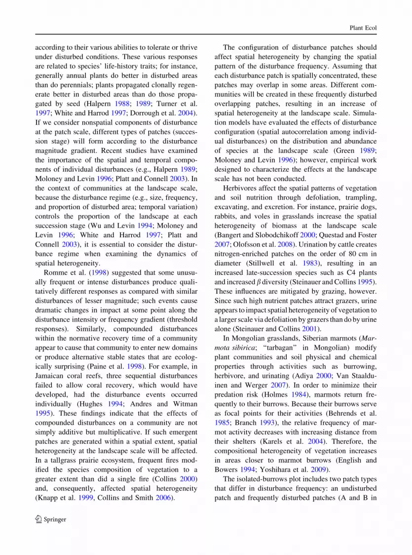
The isolated-burrows plot includes two patch types
that differ in disturbance frequency: an undisturbed
patch and frequently disturbed patches (A and B in
Plant Ecol
123

Fig. 1). The clustered-burrows plot includes three
types of patches: an undisturbed patch, frequently
disturbed patches, and an extremely frequently dis-
turbed patch near the center of the cluster (C in
Fig. 1). In this grassland, we predict that the distur-
bance-free patches (A) would be dominated by
perennial graminoids, the disturbed patches (B)
would be dominated by annual forbs, and unexpected
communities would be established in the extremely
frequently disturbed patch (C), which should con-
tribute to a greater degree of landscape level heter-
ogeneity in the clustered-burrows plot. The aim of
this study was to investigate the effects of the spatial
configuration of disturbance patches on spatial het-
erogeneity at the landscape level by comparing areas
with isolated marmot burrows versus those with
clustered burrows. At the colony scale (contain
multiple burrows), we expected that the spatial
heterogeneities of vegetation and soil nutrients in
the clustered-burrows plot would be higher than that
in the isolated-burrows plot (Fig. 1).
Materials and methods
Study areas
We selected study sites in Hustai National Park (HNP),
which is located 100 km west of Ulaanbaatar, Mon-
golia (47�500N, 106�000E, elevation 1100–1840 m).
HNP occupies *600 km2 of the forest steppe region
of Mongolia and receives an average annual precip-
itation of 232 mm. The annual average temperature is
0.2�C and average monthly temperatures vary between
–23�C (in January) and ?20�C (in July). About 88% of
the area of HNP is covered by grassland and shrubland
steppe and about 5% is covered by birch-dominated
forest (Wallis de Vries et al. 1996).
The types of vegetation that grow on the mounds
created by Siberian marmots (M. sibirica) can differ
greatly from those on the surrounding, comparatively
homogeneous, grasslands, which are dominated by a
few graminoids (Van Staalduinen and Werger 2007).
When this study was conducted, livestock had been
excluded from the HNP’s core areas for 15 years.
HNP is thus a suitable site for detecting the effect of
marmots on landscape heterogeneity in grasslands.
Sampling design
Because dung density is considered a good indicator
of marmot disturbance (Karels et al. 2004), we
located and noted the position of marmot burrows and
dung within a 25-ha area (500 m 9 500 m) using a
global positioning system receiver (Garmin Inc.,
Taiwan). Based on these data, we identified an area
with clustered burrows and an area with isolated
burrows.
Our field surveys were conducted in July and
August in 2006 and 2007. According to Addicott et al.
(1987), the spatial extent that encompasses most of an
organism’s activity relevant to some process (and over
a relevant amount of time) is the appropriate scale for
investigating this process. Thus, the effect of grazing
by marmots at the colony scale was investigated by
comparing the 2500-m2 plots. We established three
2500-m2 (50 m 9 50 m) plots including some iso-
lated marmot burrows (isolated colony, ISO) and
three 2500-m2 plots including the same number of
clustered burrows (clustered colony, CLU). Each plot
was subdivided into 625 adjacent 4-m2 (2 m 9 2 m)
quadrats (total = 3750 quadrats), because the 4-m2
quadrat size is a suitable grain size to reflect marmot
disturbances (Yoshihara et al. 2009).
The plots were separated by *300 m within the
same landscape (valley foot slope); all plots had the
same soil type (Haplic Kastanozems) according to the
soil-type layer in the GIS database produced by the
HNP and were dominated by Stipa krylovii.
configuration of burrows
disturbance distribution
A A
B B C
Fig. 1 Conceptual framework of our hypothesis. Black dotsindicate burrows. Space is divided in relation to disturbance
frequency: A absence of disturbance; B disturbed by an
individual animal (infrequent); C disturbed by multiple animals
(frequent). Clustered burrows create a frequently disturbed
patch (C), which is expected to increase spatial heterogeneity
in the area
Plant Ecol
123

In 2006, we recorded the absence/presence of each
plant species in each quadrat of plots ISO1 and
CLU1. In many studies on heterogeneity, the com-
parative analysis of multiple types of measurements
most likely yields accurate outcome (Tews et al.
2004). We therefore recorded the area of ground
covered by each species in each quadrat of ISO2 and
CLU2 in 2007, and ISO3 and CLU3 in 2008, using a
modified Daubenmire percent cover scale (Dauben-
mire 1959; Collins and Smith 2006): 0, absent; 1,
\1%; 2, 2–5%; 3, 6–25%; 4, 26–50%; 5, 51–75%; 6,
76–95%; and 7, [95%.
In order to investigate soil properties, we extracted
soil core samples (10-cm diameter 9 15-cm depth)
from 40 m 9 40 m areas situated at the centers of
plots ISO2 and CLU2, with 5-m spacing between
points (64 points). At each point, we extracted three
replications (three-point method) and the samples
were homogenized. In addition, we extracted an extra
eight random samples at the center of the 64 points, at
a 2.5-m spacing. For comparison, we performed the
same soil sampling in an area without marmot
burrows (off-colony plot). This nested design was
well suited for quantifying heterogeneity across as
broad a range of spatial scales as possible (Gross
et al. 1995; Augustine and Frank 2001).
In the laboratory of the Department of Ecosystem
Studies of the Mongolian State University of Agri-
culture, soil samples were dried in an oven at 70�C
for 48 h and weighed. Dry combustion with decal-
cified soil samples (Matejovic 1993) was used to
measure total nitrogen (TN), digestion with a mixture
of salicylic acid was used to determine nitrate
nitrogen (NO3–N), and Colwell methods were used
to measure potassium (K).
Data analysis
On a map of the plots generated in ArcMAP 9.2
(ESRI 2007), we radiated out 11.6-m buffers from
each burrow, where the 11.6 m equals the normal
activity range (X) based on a study of hoary marmots
(Marmota caligata) by Karels et al. (2004). With the
aid of spatial analysis, we divided the 25-ha area into
three patch types: outside the buffers (analogous to A
in Fig. 1), within single buffer (B in Fig. 1), and
within overlapped buffers (C in Fig. 1). Dung density
was calculated in each patch type. We performed the
same methods with changing buffer size (i.e., activity
range), radiated out 5.8-m (1/2X) and 23.2-m (2X)
buffers from each burrow.
In order to compare plant species composition
between the isolated-burrows plots and the clustered-
burrows plots, we calculated the species richness for
each quadrat. Spatial heterogeneity for each plot was
calculated as the mean dissimilarity in community
species composition among sample points in space
(Collins and Smith 2006). We used a 1-Sorensen’s
quotient of similarity (1-Sorensen’s QS) index for the
absence/presence measurements of vegetation heter-
ogeneity and a Euclidian distance index for quanti-
tative measurement of vegetation heterogeneity: a
greater value of each index indicates higher spatial
heterogeneity. We calculated the heterogeneity over
all possible pairs of quadrats within a plot. We used
Euclidian distance because it is less affected by
species richness and therefore more accurately mea-
sures community heterogeneity (Collins 2000).
In order to statistically compare the vegetation
heterogeneity between in the clustered-burrows plots
and in the isolated-burrows plots, we used the three
values of 1-Sorensen’s QS index in each plots with a t
test. If the P value was smaller than 0.05, we
concluded that the dissimilarity index between the
plots was significantly different.
We input all the soil data (ISO2 and CLU2) and
used kriging in ArcGIS to predict values of unsam-
pled locations. In a first step, to predict an unknown
value for a specific location, the kriging technique
requires the values of the measured sample points
around the prediction location and the spatial data
configuration. We input all soil data and related
locations using the geostatistical analysis extension of
ArcGIS. Then, we examined changes in the amount
of variance among sampling points separated by a
given distance (h, spatial lag) at increasing distances
to quantify the spatial structure of the data (exper-
imental variogram).
Second, we fit several models for each variogram
to construct a theoretical variogram. Then we com-
pared the root mean squared errors (RMSEs) of
practical models: spherical, exponential, Gaussian,
and J-Bessel (Ella et al. 2001; Sarangi et al. 2006).
We then selected the model with the lowest RMSE as
the best-fit model (Pastor et al. 1998; Augustine and
Frank 2001). Parameters derived from the best-fit
model were used to quantify the spatial pattern of
patchiness in a variate’s distribution. Parameter C0,
Plant Ecol
123

the y intercept of the best-fit model in a variogram, is
called the ‘‘nugget’’ and indicates local random
effects or measurement error at a short distance.
Parameter (C ? C0), where the fitted model reaches
an asymptote, is called the ‘‘sill’’ or semivariance and
indicates the intensity of the spatial pattern (Robert-
son and Gross 1994). The proportion of sample
variance explained by patchiness was calculated as
1 - [C0/(C ? C0)]. The ‘‘spatial range’’ was mea-
sured as the distance separating sampling points at
which semivariance reaches an asymptote (Robertson
and Gross 1994), which indicates the maximum
distance at which the variable is spatially
autocorrelated.
Finally, maps of soil TN, NO3–N, and K in each
plot (off-colony plot, ISO2, CLU2) were constructed
for the 40 m 9 40 m sample areas using the best-fit
models. Based on these maps, soil properties were
compared among the off-colony, isolated-burrows,
and clustered-burrows plots.
Results
Marmot disturbances
Marmot dung density in the clustered-burrows plots
was *2.3, 1.8, and 3.2 times greater than in the
isolated-burrows plots when 5.8-, 11.6-, and 23.2-m
buffers were radiated out from each burrow, respec-
tively (Fig. 2). This indicated that the clustered-
burrows plot was extremely frequently disturbed by
marmots.
Plant communities and spatial heterogeneity
In plots ISO1, ISO2, and ISO3, a total of 52, 40, and
49 plant species were recorded, and in plots CLU1,
CLU2, and CLU3, 48, 49, and 51 species were
recorded.
Spatial heterogeneity was significantly higher in
the clustered burrows than in the isolated-burrows
plots (Fig. 3, t = -3.59, df = 4, P \ 0.05). The
mean Euclidian distances were 3.47 in the isolated-
burrows plots and 3.71 in the clustered-burrows plots.
At the clustered-burrows plots, the positions of the
highly heterogeneous patches roughly overlapped
those of the marmot burrows (Figs. 4, 5, 6). Large,
highly heterogeneous patches were apparent in the
clustered-burrows plots. Achnatherum splendens
(Compositae) was found among the clustered bur-
rows but not in the isolated-burrows plots (Figs. 4, 5,
6). Artemisia adamsii also showed the same ten-
dency, although these plants were distributed more
widely than A. splendens (Fig. 5). Potentilla spp.
were found on isolated burrows or a little distance
away from the clustered burrows (Figs. 4, 5, 6).
Spatial heterogeneity of soil properties
Total nitrogen (F = 50.12, df = 1, P \ 0.001),
NO3–N (F = 3.93, df = 1, P \ 0.001), and K
0
0.005
0.01
0.015
0.02
Outside Single Overlapped
5.8 m11.6 m23.2 m
Dun
g de
nsity
per
m2
Fig. 2 Dung density of outside of the buffers (off-colony),
within the single buffers (isolated-burrows plot), and the
overlapped buffers (clustered-burrows plot) patches. Distur-
bance ranges radiated out 5.8 (1/2X), 11.6 (X), and 23.2 (2X) m
from each burrow, where 11.6 (X) m indicates the normal
activity range of marmots
hete
roge
neity
1-So
rens
ens’
QS
0
0.1
0.2
0.3
0.4
0.5
ISO CLUOFF
Fig. 3 Spatial heterogeneity of vegetation in each type. OFFoff-colony plot; ISO isolated-burrows plots; CLU clustered-
burrows plots. Heterogeneities were calculated over all
possible pairs of quadrats within a plot and then averaged
(N = 195000). We then presented the average for all three
plots of the same type with the variation between plots. Bars
show the standard error
Plant Ecol
123

(F = 21.62, df = 1, P \ 0.001) exhibited significant
differences between ISO2 and CLU2 (Table 1). The
coefficients of variance showed a greater degree of
variance for TN and NO3–N among plots. For all soil
nutrients, the mean and coefficients of variance were
largest in CLU2.
Overall, semivariance at every lag size and sill
values for semivariogram models were higher in
50m
Heterogeneity
0.20.40.60.8 1.0
(1-Sorensens’QS)
0m
Urtica anguistifolia
Artemisia adamsii
Achnatherum splendens
Potentilla spp.
Stipa krylovii
0m 50m
absencepresence
50m 50m
absencepresence
absencepresence
absencepresence
absencepresence
50m
Heterogeneity
0.20.40.60.8 1.0
(1-Sorensens’QS)
ISO1 CLU1
0m
Urtica anguistifolia
Artemisia adamsii
Achnatherum splendens
Potentilla spp.
Stipa krylovii
0m 50m
absencepresenceabsencepresence
50m 50m
absencepresenceabsencepresence
absencepresenceabsencepresence
absencepresenceabsencepresence
absencepresenceabsencepresence
Fig. 4 Spatial
heterogeneity of vegetation
and spatial distribution of
five representative species
differing in tolerance to
disturbance in an isolated-
burrows plot (ISO1) and a
clustered-burrows plot
(CLU1). Heterogeneity in
each quadrat (grid) was
calculated relative to that in
other quadrats within each
plot and is represented as
mean values (N = 624). In
the plot illustrations, darkercolor indicates a higher
value of heterogeneity and
each circle represents the
position of a mound
Plant Ecol
123

CLU2 than in the off-colony or ISO2 (Fig. 7). The
off-colony plot showed neither a spatial pattern nor
patchiness. For all soil nutrients, the nugget values
were largest in CLU2 (Table 2). For soil TN,
exponential models best fit the data in all plots
(Table 2). For soil NO3–N, ISO2 showed no spatial
50m
0m 50m
CLU 2ISO 2
Heterogeneity
2.93.64.35.0 5.7
50m
50m
(Euclidian distance)
Artemisia frigida
Artemisia adamsii
Achnatherum splendens
Potentilla spp.
Stipa krylovii
0m
01234
01234
01234
01234
01234
(Cover index)
(Cover index)
(Cover index)
(Cover index)
(Cover index)
Fig. 5 Spatial
heterogeneity of vegetation
and spatial distribution and
cover index value of five
representative species
differing in tolerance to
disturbance in an isolated-
burrows plot (ISO2) and
clustered-burrows plot
(CLU2). Heterogeneity in
each quadrat was calculated
relative to that in other
quadrats within each plot
and is represented as mean
values (N = 624). In the
plot illustrations, darkercolor indicates a higher
value and each circlerepresents the position of a
mound
Plant Ecol
123

pattern, while CLU2 showed an oscillating spatial
pattern (Fig. 7). In addition, the proportion of vari-
ance explained by small-scale patchiness was greater
and the range of autocorrelation was lower in CLU2
(Table 2), indicating that CLU2 had greatly increased
fine-grain variability and that patches of NO3–N
50m
0m 50m
CLU 3ISO 3
Heterogeneity
2.83.64.45.2 6.0
(Euclidian distance)
Artemisia frigida
Artemisia adamsii
Achnatherum splendens
Potentilla spp.
Stipa krylovii
0123 4
0123 4
0123 4
0123 4
0123 4
(Cover index)
(Cover index)
(Cover index)
(Cover index)
(Cover index)
50m
50m
0m
Fig. 6 Spatial
heterogeneity of vegetation
and spatial distribution and
cover index value of five
representative species
differing in tolerance to
disturbance in an isolated-
burrows plot (ISO3) and
clustered-burrows plot
(CLU3). Heterogeneity in
each quadrat was calculated
relative to that in other
quadrats within each plot
and is represented as mean
values (N = 624). In the
plot illustrations, darkercolor indicates a higher
value and each circlerepresents the position of a
mound
Plant Ecol
123

show a repetitive pattern across the plot. For soil K,
ISO2 showed oscillation in the spatial pattern,
although the magnitude of semivariance was low
(Fig. 7).
Based on the kriged map, each soil property
exhibited highly heterogeneous patches in the CLU2,
which corresponded to the positions of the clustered
burrows (Fig. 8). In contrast, we could find no
relationship between the heterogeneous patches and
burrow positions in the ISO2.
Discussion
Researchers have long debated whether the effects of
disturbance on spatial heterogeneity depend on the
size or intensity of the disturbance (Moloney and
Levin 1996; Su et al. 2006). Our results demonstrated
that the configuration of disturbance patches affected
spatial heterogeneity by modifying the spatial pattern
of disturbance frequency and had stronger effects on
heterogeneity than the presence or absence of
disturbance (Figs. 3, 8). The highly heterogeneous
landscape in the clustered-burrows plots was attrib-
uted to the emergence of communities that do not
Table 1 Statistical characteristics of soil nutrition at each plot
Treatment Total N (%) NO3 (mg/g) K (mg/g)
Mean CV Mean CV Mean CV
Off-burrow (OFF) 0.20 0.13 0.62 0.58 12.52 0.15
Isolated burrows (ISO2) 0.16 0.19 0.62 0.61 21.38 0.43
Clustered burrows (CLU2) 0.22 0.33 0.87 1.17 31.78 0.52
0.075
Lag, h (m)
0
0.5
1.0
1.5
2.0
sem
ivar
ianc
e
.
0.025
0.050
0
sem
ivar
ianc
e
0 5.0 15.0 20.0
10
20
30
40
50
sem
ivar
ianc
e
NO3
TN
K
10.0
Fig. 7 Best-fit semivariograms for each soil nutrient property
in the off-colony plot (white circles), isolated-burrows plot
(ISO2, gray circles), and the clustered-burrows plot (CLU2,
black circles)
Table 2 Results of spatial structure of soil nutritional properties and root mean square error based on the best-fit model for
semivariance at each plot
Soil properties Treatment Model Nugget (C0) Sill (C ? C0) Proportion
1 - (C0/C ? C0)
Range RMSE
Total N Off-burrow (OFF) Exponential 0.006 0.007 0.15 19.63 0.03
Isolated burrows (ISO2) Exponential 0.007 0.008 0.13 25.38 0.03
Clustered burrows (CLU2) Exponential 0.03 0.04 0.28 24.54 0.05
NO3 Off-burrow Spherical 0.09 0.15 0.38 19.59 0.36
Isolated burrows Gaussian 0.14 0.15 0.04 14.16 0.37
Clustered burrows J-Bessel 0.40 0.94 0.58 5.34 0.93
K Off-burrows Gaussian 2.13 4.37 0.51 38.39 0.52
Isolated burrows J-Bessel 3.91 7.97 0.51 5.13 8.45
Clustered burrows J-Bessel 15.81 25.58 0.38 27.07 9.55
Plant Ecol
123

occur until multiple disturbance patches overlap
within the landscape (Figs. 4, 5, 6). In a simulated
landscape, Moloney and Levin (1996) noted that the
configuration of disturbance patches had a minor
effect on the number of species present. This
conclusion most likely arose because they ignored
the emergent property when individual disturbance
patches are overlapped; that is, they only considered
the presence or absence of disturbance.
In accordance with our prediction, clustered bur-
rows increased the spatial heterogeneity of vegetation
by permitting the coexistence of several communities
with various disturbance-tolerance levels. Various
disturbance regimes divided areas into several floris-
tic communities, corresponding with the disturbance
magnitude (Figs. 4, 5, 6). For example, areas that
experienced infrequent disturbance (A in Fig. 1) were
dominated by S. krylovii, considered to be the
Mongolian grassland species with the weakest toler-
ance of disturbance (Van Staalduinen and Werger
2007; Van Staalduinen et al. 2007). Those areas that
experienced frequent disturbance (B in Fig. 1) were
covered by Potentilla acaulis and Potentilla bifurca
(Rosaceae). Previous studies indicated that Potentilla
coverage increases with moderate grazing due to the
plants’ prostrate growth form in semiarid grasslands
of eastern Asia (Hilbig 1995; Liu et al. 2007). Finally,
the most frequently disturbed areas (C in Fig. 1) were
covered by A. splendens or Urtica angustifolia,
which contributed to greater spatial heterogeneity in
plots with clustered marmot burrows.
An A. splendens community was emergent among
the clustered burrows but not on the isolated burrows,
indicating that this species can adapt to frequent
disturbance (Figs. 4, 5, 6). Unlike other species,
A. splendens could adapt to fluctuating ground water
levels under the clustered burrows. Clustered burrows
can capture run-off from the upper mountain areas,
resulting in temporal floods below the burrows, as
tunnels connect the burrows underground. In arid
environments, dense burrows dug by small mammals
lead more water to deeper positions of the soil profile
(Laundre 1993; Boeken et al. 1998). Achnathe-
rum splendens tussocks grow on terraces in valleys
and on the sides of banks and ridges along high-
elevation streams and rivers, all of which experience
such fluctuating ground water levels (Van Staaldui-
nen 2005). Another reason that A. splendens was able
to become established on the clustered burrows is due
to the species’ high resistance to grazing. Because of
its hard leaves, A. splendens is unpalatable to grazers
most of the year, except to horses, and thus would be
CLU2ISO2OFF
TN
K
40m0m
40m
0.000-0.125
0.150-0.175
0.200-0.225
0.300-
0.125-0.150
0.175-0.200
0.250-0.300
0-15
20-25
40-
15-20
25-30
35-4030-35
0.0-0.50.5-1.0 1.0-1.5 1.5-2.0 2.0-2.5 2.5-3.03.0-
(mg/100g)
(mg/100g)
NO3NO3
CLU2ISO2OFF
TN
K
40m0m
40m
0.000-0.125
0.150-0.175
0.200-0.225
0.300-
0.125-0.150
0.175-0.200
0.250-0.300
0-15
20-25
40-
15-20
25-30
35-4030-35
0.0-0.50.5-1.0 1.0-1.5 1.5-2.0 2.0-2.5 2.5-3.03.0-
(mg/100g)
(%)
(mg/100g)
Fig. 8 Spatial distribution
of soil nutrient properties
across the off-colony plot,
the isolated-burrows plot,
and the clustered-burrows
plot based on interpolation
with the best-fit
semivariograms. Circlesindicate the positions of
mounds
Plant Ecol
123

expected to increase in relative cover on heavily
grazed sites (Fernandez-Gimenez and Allen-Diaz
2001). Further, this grass roots can reach depths of
1.6–2.0 m and can thus access deep water, including
phreatic water. Hence, this might help A. splendens
avoid the unfavorable condition of local salt accu-
mulation derived from the sediments left after
evaporation of urine in the topsoil (Pasturage and
Veterinary Department of Agricultural Ministry of
China 1996). Urtica angustifolia was also found only
in the frequently disturbed area among the clustered
burrows (Fig. 4). In a study of Urtica dioica, Tec-
kelmann (1987) noted that its growth, development,
and distribution are mainly dependent on high
nutrient availability, such as is found in floodplains.
This species also prefers elevated places on depres-
sions where flooded conditions commonly prevail but
no long-term flooding occurs (Srutek 1993, 1997).
Although there were no differences in soil nutrient
properties between the off-colony and isolated-bur-
rows plots, a marked difference was found between
the isolated-burrows and clustered-burrows plots
(Table 1, Fig. 8). Thus, isolated marmot burrows do
not provide a degree of disturbance significant enough
to affect soil properties, and the small amount of
nutrients left in soils may have been absorbed by
plants. In contrast, large patches of bare ground
occurred near the clustered burrows due to frequent
disturbance by marmots. Therefore, when marmots
excrete dung or urine on these bare patches, high
nutrient concentrations would remain in soils without
significant absorption by plants. In other grassland
systems, the spatial heterogeneity of soil nutrients is
primarily associated with the presence or absence of
bunchgrass (Gibson 1988; Canals et al. 2003).
Figure 7 indicates that there is spatial dependence at
smaller spatial scales than what can be detected with
this sampling design and at larger spatial scales than
what can be detected with the total plot size used.
In the clustered-burrows plot, the spatial patterns
differed among the three soil nutrients measured in
this study (Fig. 8), which can be attributed to
differences in uptake rates by plants (Bachand and
Horne 2000; Reilly et al. 2000) or diffusion rates in
soil. Highly heterogeneous, large patches of TN and
K likely reflect the places where these substances
were excreted by marmots (Van Staalduinen and
Werger 2007). In contrast, the complex mosaic of
NO3–N patches likely reflects the spatial distribution
of patches of bare ground and vegetation. Indeed,
those patches with lower levels of NO3–N near the
clustered burrows had relatively abundant plant
coverage above them. Previous studies indicated that
prairie dog colony sites exhibited greater net miner-
alization rates than sites away from the colony,
leading to enhanced inorganic nitrogen (Holland and
Detling 1990; Fahnestock and Detling 2002). How-
ever, the higher inorganic nitrogen concentration
(e.g., NO3–N) in soil is absorbed by plants, resulting
in lower concentrations in soil. Alternatively, soluble
NO3–N moves more rapidly than TN in soil (leach-
ing) because it has no significant attachment to soil
solids. The coarser particles and related large mac-
ropores in the mound soil as a result of burrowing
may have accelerated vertical motion of NO3–N
(Bundy et al. 1994; Sherrod and Seastedt 2001).
Overhunting has caused a sharp decline of Sibe-
rian marmot populations in Mongolia (Adiya 2000;
Wingard and Zahler 2006), resulting in greater
isolation of their burrows. Although it was unknown
what process causes their burrows to be either
clustered or isolated on the landscape, the clustered
burrows were often observed in highly populated
areas. In unprotected areas outside the HNP, the
fraction of clustered burrows was lower than inside
the park (38% inside, 17% outside). Numerous
studies have shown that, in general, spatial heteroge-
neity is positively correlated with biodiversity (Hu-
ston 1994; Tews et al. 2004). Thus, through their
direct and indirect effects on spatial heterogeneity of
plant communities, marmot colonies are affecting
biodiversity numerically (Yoshihara et al. 2009) or
spatially (Fig. 3). Of the novel plant communities,
A. splendens can make a strong contribution to
biodiversity, especially due to its complex physical
structure. Therefore, we caution that the isolation of
marmot burrows that results from continued over-
hunting will deteriorate this animal’s positive eco-
logical roles in the grasslands of Mongolia.
Acknowledgments We thank S. Takatsuki, University of
Asabu, the project members, and the staff at Hustai National
Park for their kindness in helping with the field survey and
other aspects of the study. We also thank T. Okayasu,
University of Tokyo, for providing comments on an earlier
version of this manuscript. This work was supported financially
by the Global Environmental Research Fund of Japan’s
Ministry of the Environment (G-071). The field works
performed complies with the current laws of Mongolia.
Plant Ecol
123

References
Addicott JF, Aho JM, Antolin MF et al (1987) Ecological
neighborhoods—scaling environmental patterns. Oikos
49:340–346
Adiya Y (2000) Mongolian marmots: biology, ecology, con-
servation and use (in Mongolian). Mammalian Ecology
Laboratory, Institute of Biological Sciences, Mongolian
Academy of Sciences, Mongolia
Andres NG, Witman JD (1995) Trends in community structure
on a Jamaican reef. Mar Ecol Prog Ser 118:305–310
Augustine DJ, Frank DA (2001) Effects of migratory grazers
on spatial heterogeneity of soil nitrogen properties in a
grassland ecosystem. Ecology 82:3149–3162
Bachand PAM, Horne AJ (2000) Denitrification in constructed
free-water surface wetlands. I. Very high nitrate removal
rates in a macrocosm study. Ecol Eng 14:9–15
Bangert RK, Slobodchikoff CN (2000) The Gunnison’s prairie
dog structures a high desert grassland landscape as a
keystone engineer. J Arid Environ 46:357–369
Behrends P, Daly M, Wilson M (1985) Range use patterns and
spatial relationships of Merriams’s kangaroo rats (Dip-odomys merriami). Behavior 96:187–209
Boeken B, Lipchin C, Gutterman Y et al (1998) Annual plant
community responses to density of small-scale soil dis-
turbances in the Negev Desert of Israel. Oecologia
114:106–117
Branch LC (1993) Intergroup and intragroup spacing in the
plains vizcacha, Lagostomus maximus. J Mammal
74:890–900
Bundy LG, Knobeloch L, Webendorfer B et al (1994) Nitrate
in Wisconsin groundwater: sources and concerns. Coop-
erative Extension Service, Madison
Canals RM, Herman DJ, Firestone MK (2003) How distur-
bance by fossorial mammals alters N cycling in a Cali-
fornia annual grassland. Ecology 84:875–881
Collins SL (2000) Disturbance frequency and community
stability in native tallgrass prairie. Am Nat 155:311–
325
Collins SL, Smith MD (2006) Scale-dependent interaction of
fire and grazing on community heterogeneity in tallgrass
prairie. Ecology 87:2058–2067
Corlett RT (2000) Environmental heterogeneity and species
survival in degraded tropical landscapes. In: Hutchings
MJ, John EA, Stewart A (eds) The ecological conse-
quences of environmental heterogeneity. Blackwell Sci-
ence, Oxford, pp 333–355
Daubenmire R (1959) A canopy-coverage method of vegeta-
tional analysis. Northwest Sci 33:43–66
Day KJ, John EA, Hutchings MJ (2003) The effects of spatially
heterogeneous nutrient supply on yield, intensity of
competition and root placement patterns in Briza mediaand Festuca ovina. Funct Ecol 17:454–463
Dorrough J, Ash J, McIntyre S (2004) Plant responses to
livestock grazing frequency in an Australian temperate
grassland. Ecography 27:798–810
Dufour A, Gadallah F, Wagner HH et al (2006) Plant species
richness and environmental heterogeneity in a mountain
landscape: effects of variability and spatial configuration.
Ecography 29:573–584
Ella VB, Melvin SW, Kanwar RS (2001) Spatial analysis of
NO3–N concentration in glacial till. Trans ASAE 44:317–
327
English EI, Bowers MA (1994) Vegetational gradients and
proximity to woodchuck (Marmota monax) burrows in an
old field. J Mammal 75:775–780
Fahnestock JT, Detling JK (2002) Bison-prairie dog–plant
interactions in a North American mixed-grass prairie.
Oecologia 132:86–95
Fernandez-Gimenez M, Allen-Diaz B (2001) Vegetation
change along gradients from water sources in three grazed
Mongolian ecosystems. Plant Ecol 157:101–118
Fransen B, de Kroon H, Berendse F (2001) Soil nutrient het-
erogeneity alters competition between two perennial grass
species. Ecology 82:2534–2546
Gibson DJ (1988) The relationship of sheep grazing and soil
heterogeneity to plant spatial patterns in dune grassland. J
Ecol 76:233–252
Green DG (1989) Simulated effects of fire, dispersal and spa-
tial pattern on competition within forest mosaics. Vege-
tatio 82:139–153
Gross KL, Pregitzer KS, Burton AJ (1995) Spatial variation in
nitrogen availability in 3 successional plant communities.
J Ecol 83:357–367
Halpern CB (1988) Early successional pathways and the
resistance and resilience of forest communities. Ecology
69:1703–1715
Halpern CB (1989) Early successional patterns of forest spe-
cies: interactions of life-history traits and disturbance.
Ecology 70:704–720
Hanski I, Simberloff D (1997) The metapopulation approach:
its history, conceptual domain, and application to con-
servation. In: Hanski IA, Gilpin ME (eds) Metapopulation
biology. Academic Press, San Diego, pp 5–25
Hilbig W (1995) The vegetation of Mongolia. SPB Academic
Publishing, Amsterdam
Holland EA, Detling JK (1990) Plant-response to herbivory
and belowground nitrogen cycling. Ecology 71:1040–
1049
Holmes WG (1984) Predation risk and foraging behavior of the
hoary marmot in Alaska. Behav Ecol Sociobiol 15:293–
301
Hughes TP (1994) Catastrophes, phase-shifts, and large-scale
degradation of a Caribbean coral-reef. Science 265:1547–
1551
Huston MA (1994) Biological diversity: the coexistence of
species on changing. Cambridge University Press,
Cambridge
Karels TJ, Koppel L, Hik DS (2004) Fecal pellet counts as a
technique for monitoring an alpine-dwelling social rodent,
the hoary marmot (Marmota caligata). Arct Antarct Alp
Res 36:490–494
Knapp AK, Blair JM, Briggs JM et al (1999) The keystone role
of bison in north American tallgrass prairie: bison
increase habitat heterogeneity and alter a broad array of
plant, community, and ecosystem processes. Bioscience
49:39–50
Laundre JW (1993) Effects of small mammal burrows on water
infiltration in a cool desert environment. Oecologia
94:43–48
Plant Ecol
123

Levin SA (1992) The problem of pattern and scale in ecology.
Ecology 73:1943–1967
Liu ZG, Li ZQ, Dong M et al (2007) Small-scale spatial
associations between Artemisia frigida and Poten-tilla acaulis at different intensities of sheep grazing. Appl
Veg Sci 10:139–148
Lovett GM, Jones CG, Turner MG et al (2005) Ecosystem
function in heterogeneous landscapes. Springer, New
York
Matejovic I (1993) Determination of carbon, hydrogen, and
nitrogen in soils by automated elemental analysis (dry
combustion method). Commun Soil Sci Plant Anal
24:2213–2222
Moloney KA, Levin SA (1996) The effects of disturbance
architecture on landscape-level population dynamics.
Ecology 77:375–394
North A, Ovaskainen O (2007) Interactions between dispersal,
competition, and landscape heterogeneity. Oikos
116:1106–1119
Olofsson J, de Mazancourt C, Crawley MJ (2008) Spatial
heterogeneity and plant species richness at different spa-
tial scales under rabbit grazing. Oecologia 156:825–834
Paine RT, Tegner MJ, Johnson EA (1998) Compounded per-
turbations yield ecological surprises. Ecosystems 1:535–
545
Pastor J, Dewey B, Moen R et al (1998) Spatial patterns in the
moose-forest-soil ecosystem on Isle Royale, Michigan,
USA. Ecol Appl 8:411–424
Pasturage and Veterinary Department of Agricultural Ministry
of China (1996) General Station of National Pastuage and
Veterinary, Meadow Resources of China. Agricultural
Science and Technology Press, Beijing
Platt WJ, Connell JH (2003) Natural disturbances and
directional replacement of species. Ecol Monogr
73:507–522
Questad EJ, Foster BL (2007) Vole disturbances and plant
diversity in a grassland metacommunity. Oecologia
153:341–345
Rees M, Mangel M, Turnbull L (2000) The effects of hetero-
geneity on dispersal and colonization in plants. In:
Hutchings MJ, John EA, Stewart AJA et al (eds) The
ecological consequences of environmental heterogeneity.
Blackwell Science, Oxford, pp 237–265
Reilly JF, Horne AJ, Miller CD (2000) Nitrogen removal from
a drinking water supply with a large-scale free-surface
constructed wetlands prior to groundwater recharge. Ecol
Eng 14:33–47
Reiners WA, Driese KL (2001) The propagation of ecological
influences through heterogeneous environmental space.
Bioscience 51:939–950
Robertson GP, Gross KL (1994) Assessing the heterogeneity
of belowground resources: quantifying scale. In: Cald-
well MM, Pearcy RW (eds) Exploitation of environ-
mental heterogeneity by plants. Academic Press, New
York, USA
Romme WH, Everham EH, Frelich LE et al (1998) Are large,
infrequent disturbances qualitatively different from small,
frequent disturbances? Ecosystems 1:524–534
Sarangi A, Madramootoo CA, Enright P (2006) Comparison of
spatial variability techniques for runoff estimation from a
Canadian watershed. Biosyst Eng 95:295–308
Sherrod SK, Seastedt TR (2001) Effects of the northern pocket
gopher Thomomys talpoides on alpine soil characteristics,
Niwot Ridge, CO. Biogeochemistry 552:195–218
Srutek M (1993) Distribution of the stands with Urtica dioicaL. along the Luznice River floodplain on the border
between Austria and Czechoslovakia and land manage-
ment. Vegetatio 106:73–87
Srutek M (1997) Growth responses of Urtica dioica L. to
different water table depth. Plant Ecol 130:163–169
Steinauer EM, Collins SL (1995) Effects of urine deposition on
small-scale patch structure in prairie vegetation. Ecology
76:1195–1205
Steinauer EM, Collins SL (2001) Feedback loops in ecological
hierarchies following urine deposition in tallgrass prairie.
Ecology 82:1319–1329
Stillwell MA, Senft R, Rittenhouse LR (1983) Total urine
collection from free-grazing heifers. J Range Manag
36:798–799
Su YZ, Li YL, Zhao HL (2006) Soil properties and their spatial
pattern in a degraded sandy grassland under post-grazing
restoration, Inner Mongolia, northern China. Biogeo-
chemistry 79:297–314
Teckelmann M (1987) Kohlenstoff-, Wasser- und Stickstoff-
haushalt von Urtica dioica L. an naturlichen Standorten.
PhD Thesis, Bayreuth University
Tews J, Brose U, Grimm V et al (2004) Animal species
diversity driven by habitat heterogeneity/diversity: the
importance of keystone structures. J Biogeogr 31:79–92
Tilman D (1999) The ecological consequences of changes in
biodiversity: a search for general principles. Ecology
80:1455–1474
Turner MG, Romme WH, Gardner RH et al (1997) Effects of
fire size and pattern on early succession in Yellowstone
National Park. Ecol Monogr 67:411–433
Turner MG, Gardner RH, O’Neill RV (2001) Landscape
ecology in theory and practice: pattern and process.
Springer, New York
Van Staalduinen MA (2005) The impact of herbivores in a
Mongolian forest steppe. PhD Thesis, Utrecht University
Van Staalduinen MA, Werger MJA (2007) Marmot distur-
bances in a Mongolian steppe vegetation. J Arid Environ
69:344–355
Van Staalduinen MA, During H, Werger MJA (2007) Impact
of grazing regime on a Mongolian forest steppe. Appl Veg
Sci 10:299–306
Wallis de Vries MF, Manibazar N, Dugerlham S (1996) The
vegetation of the forest-steppe region of Hustain Nuruu,
Mongolia. Vegetatio 122:111–127
White PS, Harrod J (1997) Disturbance and diversity in a
landscape context. In: Bissonette JA (ed) Wildlife and
landscape ecology effects and pattern of scale. Springer,
New York, pp 128–159
White PS, Jensch A (2001) The search for generality in studies
of disturbance and ecosystem dynamics. Prog Bot 62:399–
449
Wingard JR, Zahler P (2006) Silent steppe: the illegal wildlife
trade crisis in Mongolia: Mongolia Discussion Papers,
East Asia and Pacific Environment and Social Develop-
ment Department. World Bank, USA
Wu JG (2004) Effects of changing scale on landscape pattern
analysis: scaling relations. Landsc Ecol 19:125–138
Plant Ecol
123

Wu JG, Levin SA (1994) A spatial patch dynamic modeling
approach to pattern and process in an annual grassland.
Ecol Monogr 64:447–464
Yoshihara Y, Ohkuro T, Buuveibaatar B et al (2009) Effects of
disturbance by Siberian marmots (Marmota sibirica) on
spatial heterogeneity of vegetation at multiple spatial
scales. Grassl Sci 55:89–95
Plant Ecol
123


