Embed Size (px)
Citation preview
Coal Investigations in South-Central Alaska, 1944-46By F. F. BARNES, CLYDE WAHRHAFTIG, C. A. HICKCOX, JACOB FREEDMAN, and D. M. HOPKINS
With a section on CLAY DEPOSITS ON HEALY CREEK by'E'. H, COBS'
GEOLOGICAL SURVEY BULLETIN 963 - E
Mineral Resources of Alaska, 1945-46 (Pages 137-213)
UNITED STATES GOVERNMENT PRINTING OFFICE, WASHINGTON : 1951
UNITED STATES DEPARTMENT OF THE INTERIOR
Oscar L. Chapman, Secretary
GEOLOGICAL SURVEY
W. E. Wrather, Director
For sale by the Superintendent of Documents, U. S. Government Printing Office Washington 25, D. C. - Price $1.50 (paper cover)
CONTENTS
Page General introduction, by F. F. Barnes___________-_------__--_------- 137Coal .deposits on Healy and Lignite Creeks, Nenana coal field, Alaska, by
"Clyde Wahrhaftig, C. A. Hickcox, aiid Jacob Freedman...._.__..__.. 141Introduction. ___________________-_-__________--_--_-----_---__ 141-
Location of area____.____________________-_--_-_----__---_- 141-Previous surveys_._______ _____-___-__--___-_-_----_------- 141-Present investigations._________-_-_____________--_--_---__- 141-Acknowledgnients ___________---.__-_______-__----__-____-_ 14S
Geography. _ ________________________________________________ 143Topography and drainage__-_--_-------_---------------__-_ 143Climate. __________________________.___ ______--..--___... 144Vegetation.__-_.-_-----_---__----_---__.---------_-_-_-_-_ 144:Population. _______-_______________--------------_-____-_-_ 144:Routes of traveL-----_--_--_----_-__-_-_---------_-------- 145
Geology._____-__-__-_--_-_______-____--__---_-_-----_----__-_ 145> Stratigraphy._____________________________________________ 146
Birch Creek schist (pre-Cambrian)_________..._____!_ _^__. 146Coal-bearing formation (Tertiary)_______________________ 147
Healy Creek........_.._._____._._.__..__._.._._._. 147Lignite Creek_______.__.___._________--___-_-.____ 150
Nenana gravel (Tertiary)...__-____.-__._---_--.---____. 152Healy Creek..._______....._._._......._..__..._.. 152Lignite Creek___.__._._________._._______.____._,.. 153
Quaternary terrace gravels__._-___-_-__.__-___-_-_--____ 153Healy Creek.._..__...._.____.._....._._.__....._. 153Lignite Creek..._.._______________....._.__...._.._ 154
Structure. _____-___-_-________-_-______-___.__..-_-_______ 154Healy Creek......_.........._........._..._._.._..._. 154Lignite Creek..._____._____.________.___..._.__.___.__ 155
Coal deposits___-__.__-_-.___.-...._____.___-.-.-.-__.____-.._ 156Character of the coal.____-_____-___-_..--_-..-_-_-_-_---__- 156
Healy Creek....._._._______._.._..._........._...__ 156Lignite Greek...________._______._..__.___._._______._ 160
Burning of coal beds_______________________________________ 162Coal reserves________________-___-___-_-_-_-_-_-_-______.. 162
Healy Creek..______________________________________ 162Lignite Creek_____________________________.__________. 163
Coal production._____________________________J_______.______ 164Clay deposits on Healy Creek, by E. H. Cobb__-______-___.._____ 165
Geology and coal deposits.of the .western part of the Nenana coal field,Alaska, by Clyde Wahrhaftig_________________________________ 169
Introduction._________________________________________________ 169-» Location and accessibility._--__--_-____-_-_-_-_-___-_-_-___ 169
Previous investigations._____________________________________ 169-Field work and acknowledgments------_-----____-~__--______ 1701
in
IV CONTENTS
Geology and coal deposits of the western part of the Nenana coal field, Page Alaska, by Clyde Wahrhaftig Continued
Geography_________ ___________________________________________ 170Topography and drainage. _ _________________:_______________ 170Climate -----_-_--___________.__________________________-_ 171Vegetation. .__ ____________________________________ _____'__._ 171Human settlement---________r_-_-___-_. ___________________ 172
Stratigraphy. ______________________________ _________._________. 172Pre-Cambrian rocks--_______________________________._______ 172
Birch Creek schist. _____________________________________ 172Paleozoic rocks_ ___________________________________________ 173
Totatlanika schist. ____________________________________ 173Tertiary rocks_____ _ _______________________________________ 173
Coal-bearing formation________ _________________________ 173Nenana gravel _________________________________________ 176
Quaternary deposits. _ ___________---_---__------_-_------__ 179Terrace gravels___-___-____----------._--------_-------- 179Solifluction deposits __ ____'___.___-________-______._____ 180
Structure____------__--.---_-______- ------------------- ---_-- 180Pre-Tertiary rocks__ _ ___________-_-__-__--_-------_---_-_-_ 180Tertiary rocks. ________-____________._-_-_-_-----.--_------__ 180
General features. ____________--__--_----_-----__----___ 180Unconformity between the coal-bearing formation and the
Nenana gravel____-_____-___---_-----_-------------- 182Coal deposits... _----_-_-_--.------_---------- ---------------- 183
Location ______________________.____-._-_-_-_-----._---_---- 183. Number and thickness of beds__-___-_--------^---.---------- 184
Quality of the coal __ ____________-__-^-___---------------- 184Reserves ________________._._.__._...'.._..._--.->_._.___-_ 185
Lignite deposits near Broad Pass station, Alaska, by D. M. Hopkins_____ 187Introduction. _'______'________________________________-___.--____ 187History and development__----______-_--_.-_-------------------- 187GeQlogy _ __________________-______-_-------------------------- 188Coal deposits ___________________________________.___---_------_ 189
General features. _ _ ------------------------------------- - 189Reserves. _ _______________________-_-_-____-_-----.-------- 191
Mining and exploration in 1945 in the Wishbone Hill coal district, Mata-nuska Valley, Alaska, by F. F. Barnes_ _____________-_------------- 193
Introduction____________________ ________-_-----_-------------- 193Mining activities in 1945_____---___-_-----__------------------- 194Exploration in 1O-15___- ______-_____-_-----_-------------------- 1O4
Drill hole 13-___-_ ___-.____ _-----'-_ --------------Drill hole 14_____________-______-----__-------------------Drill hole 15_ _______________________-_-_-_-_-------------- 198Interpretation of drill holes 14 and 15_ _______--_------------- 19^
Conclusions.... _____________________._.....-.---- -- --- ^Preliminary report on coal deposits near Homer, Alaska, by F. F. Barnes... 203
Introduction __________________________________-_----'---------- 2O3General description of area. ______________-___-_---------------- 2O4
"-"--" 206__________-______. _._______.________---.-_--..-. ' 206
.Character and distribution of coal_____--_--_____ -------------- 207Conclusions. _ _________________________________________________ 208
Index. ___ _____ _ _ ________ ____ _________________----__.___-- 209
CONTENTS
ILLUSTRATIONS
Page PLATE 17. A, Coal-bearing formation at Suntrana, on Healy Creek;
B, Type section of coal-bearing formation on Lignite Creek. 14618. Geologic map and sections of part of valley of Healy
Creek._______________-_____-__-----__i----_---_- In pocket19. Stratigraphic coal sections in coal-bearing formation, Healy
Creek __________________________________________ In pocket20. Geologic map and sections, valley of Lignite Creek_____ In pocket21. Stratigraphic coal sections in coal-bearing formation, valley
of Lignite Creek___-___________--___--_--_----_ In pocket22. Correlation of type Stratigraphic sections on Healy and
Lignite Creeks_______-____________.:__----____-..-- In pocket23. Structure-contour map of part of valley of Healy Creek..., In pocket24. Preliminary geologic map of western part of Nenana coal
field..--__--_-----------_--------------_-------- In pocket25. Stratigraphic coal sections in coal-bearing formation, western
part of Nenana coal field._________________________ In pocket26. Detailed map of coal deposits near Broad Pass'station__ In pocket27. Geologic map of Eska-Jonesville area of Wishbone Hill coal
district_---_-___----_----___-___________________. In pocket28. Logs of diamond-drill holes on Eska reserve, Wishbone Hill
coal district_-_----------__--_-_________________ In pocket29. Geologic sections through diamond-drill holes on Eska
reserve, Wishbone Hill coal district___________._____ In pocket30. A, Homer Coal Corp. mine \% miles west of Homer; B, Coal-
bearing Kenai formation in beach bluffs west of Homer. __ 202 FIGURE 33. Index map of south-central Alaska showing location of
areas described in this report.___.______-___.__.____._ 13934. Sketch map showing general relations of Healy Creek and
- Lignite Creek areas.__!____ ___________________________ 14235. Diagrammatic cross sections of syncline on Savage River, _ _ _ 18336. Broad Pass lignite area________________________________ 18837. Sections of coal beds in Eska-Jonesville area-..____________ 19538. Sketch map of Homer area showing coal outcrops examined
. in 1946_-______--_-__--__________--____-____-.__..__- 205

COAL INVESTIGATIONS IN SOUTH-CENTRAL ALASKA194446
GENERAL INTRODUCTION
By F. F. BAKNES
Coal, in deposits of economic size and quality, is probably as widely distributed in Alaska as any other mineral commodity. No major geographic division is without at least small areas of coal-bearing rocks. Coal has been found as far north as the Arctic coast near Point Barrow, as far southwest as Herendeen Bay on the Aleutian Penin sula, and as far southeast as Admiralty Island near Juneau, in de-. posits ranging in age from Carboniferous to Tertiary and in rank from lignite to anthracite. The rank of the coal appears to bear a closer relation to degree of deformation than to age. Although most of the lower rank coal is Tertiary and the Cretaceous and Carbonif erous coals are generally bituminous or higher in rank, coal deposits of Tertiary age range in rank from lignite to anthracite, and the higher-rank coal is invariably found in the more intensely deformed rocks.
Most of the coal deposits of Alaska are little known, as interest in the past has centered largely on deposits near centers of population and principal lines of transportation. Although the more remote de posits constitute one of the most important resources of the Territory and ultimately will receive the attention they deserve, the Geological Survey in recent years has concentrated its activities on deposits in or near the Alaska Railroad belt. This policy was dictated in large part by the need, during World War II, for determining where the largest amount of coal could be developed in the shortest possible time for use of the Army, the Alaska Railroad, and other agencies vitally concerned with the war effort.
The principal coal fields in the railroad belt are the Nenana field, on the north flank of the Alaska Range, and the Matanuska field, at the he&d of Cook Inlet. These two fields contain the only commercial coal mines now operating in Alaska and have been the most intensively studied to date.
137
138 MINERAL RESOURCES OF ALASKA, 1945-46
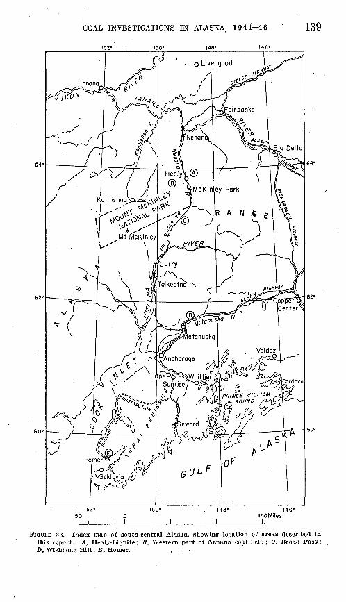
Of the five areas described in the following reports, two are in the Nenana field, one is in "the Matanuska field, one is in Broad Pass, through which the railroad crosses the Alaska Range, and the fifth is near Homer, on the east side of lower Cook Inlet several miles west of the railroad belt proper. (See fig. 33.) Field work in the Nenana coal field is still in progress; consequently, the papers on the Healy- Lignite area and the western part of the field are progress reports, which present the principal results of work to date. A final com prehensive report on the entire Nenana coal field will be prepared on completion of the field work.
The report on the Wishbone Hill area is the result of a special in-. vestigation, made jointly by the Bureau of Mines and the Geological Survey, to prove additional reserves for the Government-owned Eska mine. This work also was part of a larger investigation, begun in 1943, involving a detailed study of the entire Wishbone Hill coal dis trict. A comprehensive report on the district is in preparation.
The Broad Pass report covers a small area containing deposits of rather low-grade lignite. No further field work in this area is planned at the present time.
The report on the Homer area is based on a brief preliminary exam ination, made to determine the desirability of a detailed investigation of the coal deposits of the Kenai Peninsula. As a result of this exam ination plans were made for a detailed study of the geology and coal resources of the entire Kenai lowland, an area whose natural resources, agricultural as well as mineral, may play. an. important part in the future development of Alaska.
COAL INVESTIGATIONS IN ALASKA, 1944-46
152° 150° 148" 146°
139
l50Miles J.
146°
FIGURE 33. Index map of south-central Alaska, showing location of areas described in this report. A., Healy-Lignite; B, Western part of Nenana coal field; C, Broad Pass; D, Wishbone Hill; E, Homer. ,

COAL DEPOSITS ON HEALY AND LIGNITE CREEKS, NENANA COAL FIELD, ALASKA
BY CLYDE WAHRHAFTIG, C. A. HICKCOX, and JACOB FREEDMAK
With a section on
CLAY DEPOSITS ON HEALY CREEK
BY E. H. COBB
The areas covered in this report lie in the foothill belt on the north side of the Alaska Range, in the valleys of Healy and Lignite Creeks, between latitudes 63°51' and 63°57' N. and longitudes 148°35' and 149°00' W. (See figs. 33 and 34.) They comprise parts of Tps. 11 and 12 S., Rs. 5, 6, 7, and 8 W., Fairbanks meridian. The areas lie just east of the Nenana River, opposite Healy station on the Alaska Railroad. Healy is 112 miles by rail south of Fairbanks and 244 miles north of Anchorage.
PREVIOUS SURVEYS
Coal has been known in this area since 1898.1 Brooks and Prindle 2 made a brief examination of the area and described some of the coal beds in 1902. Capps 3 made further reconnaissance investigations in 1910. In 1918, Martin 4 carried out a rather detailed examination of the -Lignite Creek area and measured many sections.
During the summer of 1944 a Geological Survey party studied and mapped the coal deposits in the valley of Healy Creek. An area ex tending for 7 miles along the creek, eastward from the Suntrana mine (pi. 18^4), and a quarter of a mile to 2 miles wide, was surveyed by
1 Collier, A. J., The coal resources of the Yukon, Alaska: U. S. Geol. Survey Bull. 218, p. 46, 1903.
2 Brooks, A. H., and Prindle, L. M., The Mount McKinley region, Alaska: U. S. Geol. Survey Prof. Paper 70, pp. 188-192,1911.
8 Capps, S. R., The Bonnifleld region, Alaska: U. S. Geol. Survey Bull. 501, 1912. * Martin, G. C., The Nenana coal field, Alaska: U. S. Geol. Survey Bull. 664, 1919.
141
142 MINERAL RESOURCES OF ALASKA, 1945-46
R. 8 W. 149°00' R. 7 W.148*40'
R. 5 W.
148*40'
10 Miles
.FIGURE 34, Sketch map showing general relations of Healy Creek and Lignite Creek areas.
"plane table and alidade. Detailed sections were measured at all large exposures Of COal-bearing rocks. The field work was done between July 1 and October 31 by Clyde Wahrhaftig and Jacob Freedman, geologists, assisted by D. M. Hopkins, C. K. Currey, and Milton Morsing, and was under the general supervision of G. O. Gates.
During the summer of 1945 a Geological Survey party studied and
mapped the coal deposits in the valley of Lignite Creek from its mouthat the Nenana River to a point near its head, a distance of about 15miles, or an area of 45 to 50 square miles. The mapping was done in
part on aerial photographs where they were available, and in part ontopographic maps prepared by the General Land Office. Detailed sec- tiong WerB measured On all large exposures of coal-bearing rocks.
Many of the measurements were supplemented by plane-table surveys,
COAL INVESTIGATIONS IN ALASKA, 1944-46 143
The field work was done between June 1" and October 3 by Clyde Wahrhaftig and C. A. Hickcox, geologists, assisted by J. V. Adkins and P. W. Gates, Jr.
A field party of the Bureau of Mines spent several weeks in the valley of Healy Creek in 1943 and 1944, trenching the coal beds. In formation gained from these trenches has been incorporated in this report.
ACKNOWLEDGMENTS
The authors wish to acknowledge the many courtesies and the co operation of residents of the area in particular, A. E. Lathrop,, president, James Newlan, superintendent, C. E. Garrett, mine engi neer, and Howard Kuhnes, storekeeper, all of the Healy River Coal Corp., and T. E. Sanford, Emil Usibelli, Joe Gagnon, John Fern, and Mr. and Mrs. Andro Dragitch.
TOPOGRAPHY AND DRAINAGE
The Nenana coal field is on the north flank of the Alaska Range, in the northern part of a foothill belt of roughly parallel eastward- trending ridges. The foothills in places reach an altitude of more than 6,000 feet, but the part of the field described in this report con sists of rather well dissected low hills generally less than 3,000 feet in altitude. The ridge between Healy and Lignite Creeks has a steep south slope and a rather gentle north slope; the hills north of Lignite Creek also have rather steep south slopes except along the lower 1% miles of the creek. The average relief of the area is about 1,500 feet.
Immediately north of the mapped area, and within 4 miles of Lignite Creek, are two prominent domelike hills. Jumbo Dome, on the east, is 4,505 feet in altitude and, according to Capps,5 is composed of intrusive hornblende andesite. The other hill, known locally as Walker Dome, is about 5 miles west of Jumbo Dome and is the highest part of a rather extensive northward-sloping erosion surface cut on the Nenana gravel. It is 3,900 feet in altitude.
Excepting the Nenana River, Healy Creek is the largest stream in the area of this report. It is about 25 miles long and flows westward to enter the Nenana River at Healy. It has several fairly large tribu taries entering from the south, the largest of which is Moody Creek.
Lignite Creek, 3 to 5 miles 'north of Healy Creek, also flows west ward and enters the Nenana River about a mile south of the station of Lignite on the Alaska Railroad. The only noteworthy tributary is
8 Capps, S. E., op. cit, p. 42.
144 MINERAL RESOURCES OF ALASKA, 1945-46
Sanderson Creek, which enters Lignite Creek from the southeast about 11 miles above the mouth.
CLIMATE
The average annual precipitation in this area is less than 20 inches. Snowfall ranges from moderate to fairly heavy in the valleys. Most of the rain falls in short, sudden, and often heavy showers during the summer. These heavy showers usually cause floods on the main creeks and also result in very rapid erosion in the gullies cut into the coal- hearing formation and the gravels.
The summer showers are generally of very local extent. It was noted in 1944 and 1945 that many local showers moved down the Nenana River from the Broad Pass area while no sign of rain appeared elsewhere in the area.
During the field season of 1945 which, however, was abnormally wet rain fell in noticeable quantities on 75 of the 100 days of record.
The summers are cool, the mean temperature in June, July, and August being about 55° F. The mean temperature of the coldest winter months is generally between 0° and 5° F. Field work may be carried on in this area from the latter part of May until at least the first of October, and in some years until the middle of October. After the first of September frosty nights and light snows may be expected. Ice begins to form on the main streams about the middle of October.
VEGETATION
Timber line is at an altitude of about 2,500 feet, but in the areas mapped there is little timber of value. Spruce as much as 18 inchesin diameter may be found along the valleys of the main creeks and some of the tributaries; birch and poplar also are present. Some
of the spruce along Healy Creek and on the gravel terraces east ofthe Nenana River between Healy and Lignite Creeks has been used for mine timbers.
Evidence of a former spruce cover exists on slopes north of Lignite Creek, which apparently have been burned over fairly recently.
Moss, willows, and grass are abundant, the grass in particular grow ing luxuriantly on the well-drained gravel surfaces,
POPULATION
The normal population of the Healy-Lignite area is about 1S5,
mostly centered around the coal mine at Suntrana. Three prospectors live at the mouth of Gagnon Creek, 4 miles east of Suntrana. There are a few unoccupied cabins in the valley of Healy Creek.
There were no permanent inhabitants in the valley of Lignite Creek in 1945, .although a good cabin about 6 miles east of the mouth of the
COAL INVESTIGATIONS IN ALASKA, 1944-46 - 145
creek, at the mouth of a small stream known locally as Popovitch Creek, is used occasionally by trappers, hunters, and prospectors.
At Healy, on the west bank of the Nenana River opposite the mouth of Healy Creek, the Alaska Railroad maintains a division point. Several families of railroad employees live there. A post office is maintained, and several new railroad buildings, including a hotel, were completed in 1946.
The station of Lignite, 4 miles north of Healy and consisting of a small roadhouse and a few scattered cabins, has a population of less than 10.
ROUTES OF TRAVEL
The only easy access to Healy and Lignite Creeks, except in winter, is by way of Healy on the Alaska Railroad, from which place a spur line extends 4 miles up Healy Creek to the coal mine at Suntrana. From Suntrana a truck road has been completed to the strip-mine areas about 2 miles farther up Healy Creek. Much of this road was con structed along a high bank on the north side of the creek, but parts of it follow the creek bars and are washed out periodically and have to be relocated as the stream shifts its course. The part of the road on the high bank is frequently blocked by slides, washouts, and deposi tion of alluvial material. To reach this road from Suntrana trucks must ford Healy Creek twice, which cannot be done during periods of high water.
The upper part of Healy Creek is accessible by team and wagon or tractor by way of river bars, except during high water. Extension of the railroad up Healy Creek from Suntrana would be difficult and expensive, because of the narrow, tortuous gorge just above the mine.
Lignite Creek is practically inaccessible except by pack horse or on foot. The head of the creek may be reached with relative ease from Healy Creek by crossing a low saddle about a mile northeast of the mouth of Gagnon Creek. This is part of a trail leading into the Bonnifield gold district, several miles to the northeast.
On foot one can go up any one of several gullies on the north side of Healy Creek, cross the divide and drop down into Lignite Creek, but most of these routes are too steep for horses.
In winter, when the Nenana River is frozen over, tractors and sleds can cross at the mouth of Lignite Creek and traverse the length of Lignite Creek valley.
GEOLOGY
The rock units recognized in the valleys of Healy and Lignite Creeks include the Birch Creek schist of pre-Cambrian age, the coal- bearing formation and the Nenana gravel, both of Tertiary age, and Quaternary terrace gravels. The general character and relations of
146 MINERAL RESOURCES OF ALASKA, 1945-46
these formations are summarized in the accompanying table. The Tertiary rocks lie in two eastward-trending synclines separated by ari uplifted belt of Birch Creek schist. The schist belt is bounded on the south by a fault with a displacement of more than 5,000 feet. Smaller transverse faults and minor folds locally complicate the structure.
Generalized stratigraphy of Nenana coal field
Age
Quaternary
Tertiary
Pre-Cambrian
Formation
Terrace gravels
Nenana gravel
Coal-bearing formation
Unconformity ' Birch Creek
schist
Description
Conglomerate, with boulders of Birch Creek schist.
Conglomerate, reddish-brown, with boulders of green ophitic diorite, granite, graywacke, and older conglomerate, and thin shale beds.
Conglomerate, brown, with boulders of gray wacke, conglomerate, green ophitic diorite, granite, graywacke, and conglomerate.
Conglomerate, brown, with boulders of gray wacke, conglomerate, green ophitic diorite, and dacite.
Conglomerate, brown, with boulders Of gray wacke, conglomerate, and dacite.
Upper member: Sandstone, siltstone, claystone, and shale,
with a few thin coal beds. Characterized by abundance of granite, volcanics, green ophitic diorite in pebble zones.
Middle member: Sandstone, siltstone, claystone, numerous
thick coal beds. Characterized by abun dance of quartz, quartzite,. chert, andargil- lite, and scarcity of granite, volcanics, and green ophitic diorite in pebble zones.
Lower member: Sandstone, claystone, siltstone, and con
glomerate, with numerous thick coal beds. Persistent brown- weathering claystone at top.
Quartz-mica schist.
Thickness (feet)
0-200
200+
2,100
1,000
900
500- 945
450- 1-, 000
50- 1,500
?
STRATIGRAPHY
BIRCH CREEK SCHIST (PRE-CAMBRIAN)
The oldest formation exposed in the Healy-Lignite area is the Birch Creek schist, of pre-Cambrian age.6 Two belts of the schist in this area converge eastward, ana join at tiie eastern end of thecoo.1 rti-ea. in. tke valley of Ilealy Creek (S&e pis. 18jL and %A.}
With minor exceptions, including a small area just above Sun-trana, the Schist along Healy Creek is restricted to the south side within the coal-bearing area. On the nortn side of the Healy-
Lignite divide another belt of schist is exposed, There the schist
' Capps, S. R., Geology of the Alaska Railroad region: U. S. Geol. Survey Bull. 907, p. 97, 1940.
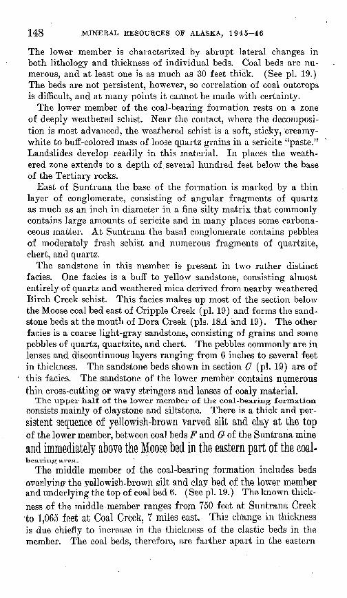
GEOLOGICAL STJBVEY BULLETIN 963 PLATE 17
A. COAL-BEARING FORMATION AT SliNTRANA, ON HEALY CREEK.
B. TYPE SECTION OF COAL-BEARING FORMATION ON LIGNITE CREEK.
COAL INVESTIGATIONS IN ALASKA, 1944-46 147
has been upthrown and is exposed along the north side of a steeply dipping reverse fault that has a stratigraphic displacement of about 5,000 feet.
The schist consists of highly contorted quartz-mica and quartz- chlorite schist, cut by numerous veins of milky quartz. Where the rock is fresh it appears rather massive, and the prevailing color is green. On weathering, the schist becomes fissile and breaks into thin slabs along cleavage planes. The weathered schist ranges from light gray through various shades of gray and green to black. The black schist, which can be mistaken for coal when seen from a distance, is particularly abundant north of Gagnon Creek and north of the east end of the coal-bearing area on Healy Creek.
COAL-BEARING FORMATION (TERTIARY)
The coal-bearing formation consists of sandstone, conglomerate, siltstone, clay stone, shale, and coal. (See pi. 17.) The clastic sedi ments in the coal-bearing formation are poorly to moderately con solidated. The coal along Healy Creek is subbituminous, whereas that along Lignite Creek is lignitic to subbituminous.
On the evidence of plant fossils, stratigraphic relations to over lying and underlying formations, and by correlation with other beds of similar lithology, the age of this formation has for years been ac cepted as Eocene. However, in 1936, Schlaikjer 7 found the remains of fresh-water fish in the formation on the south side of Healy Creek, about 3 miles east of Suntrana, and on the evidence of these fossil fish Schlaikjer believed the age of the formation to be probably Miocene. At present, in the absence of more detailed information, it can be assigned a no more definite age than Tertiary.
For purposes of discussion the coal-bearing formation is divided into three members, which were recognized on both Healy and Lignite Creeks and which will be considered under the locality headings. The basis for the division is discussed after the detailed description of the members.
HEALY CREEK
The lower member of the coal-bearing formation includes all the strata below the top of a thick bed of yellowish-brown varved silt and clay lying between coal beds F and G of the Suntrana mine. This member ranges in thickness from 50 feet at French Gulch (pi. ISA ) to 1,500 feet at the east end of the field. This remarkable range in thickness is largely a reflection of the fact that the lower member was deposited on a very uneven erosion surface cut in the Birch Creek schist, hills of which extend almost to the top of the member.
7 Schlaikjer, E. M., New fishes from the continental Tertiary of Alaska: Am. Mus. Nat. History Bull., vol. 74, pp. 1-23, 1937.
888800 51 2
148 MINERAL RESOURCES OF ALASKA, 1945-46
The lower member is characterized by abrupt lateral changes in both lithology and thickness of individual beds. Coal beds are nu merous, and at least one is as much as 30 feet thick. (See pi. 19.) The beds are not persistent, however, so correlation of coal outcrops is difficult, and at many points it cannot be made with certainty.
The lower member of the coal-bearing formation rests on a zone of deeply weathered schist. Near the contact, where the decomposi tion is most advanced, the weathered schist is a soft, sticky, 'creamy- white to buff-colored mass of loose quartz grains in a sericite "paste." Landslides develop readily in this material. In places the weath ered zone extends to a depth of several hundred feet below the base of the Tertiary rocks.
East of Suntrana the base of the formation is marked by a thin layer of conglomerate, consisting of angular fragments of quartz as much as an inch in diameter in a fine silty matrix that commonly contains large amounts of sericite and in many places some carbona ceous matter. At Suntrana the basal conglomerate contains pebbles of moderately fresh schist and numerous fragments of quartzite, chert, and quartz.
The sandstone in this member is present in two rather distinct facies. One facies is a buff to yellow sandstone, consisting almost entirely of quartz and weathered mica derived from nearby weathered Birch Creek schist. This facies makes up most of the section below the Moose coal bed east of Cripple Creek (pi. 19) and forms the sand stone beds at the mouth of Dora Creek (pis. 18A and 19). The other facies is a coarse light-gray sandstone, consisting of grains and some pebbles of quartz, quartzite, and chert. The pebbles commonly are in lenses and discontinuous layers ranging from 6 inches to several feet in thickness. The sandstone beds shown in section 0 (pi. 19) are of this facies. The sandstone of the lower member contains numerous thin cross-cutting or wavy stringers and lenses of coaly material.
The upper half of the lower member of the coal-bearing formationconsists mainly of claystone and siltstone. There is a thick and per-sistent sequence of yellowish-brown varved silt and clay at the topof the lower member, between coal beds F and G- of the Suntrana mineand immediately above the Moose bed in the eastern part of the coal-bearing area.
The middle member of the coal-bearing formation includes bedsoverlying the yellowish-brown silt and clay bed of the lower member and underlying the top of coal bed 6. (See pi. 19.) The known thick ness .of the middle member ranges from Y50 feet at Suntrana Creek to 1,065 feet at Coal Creek, 7 miles east. This change in thickness is due chiefly to increase in the thickness of the clastic beds in the member. The coal beds, therefore, are farther apart in the eastern
COAL INVESTIGATIONS IN ALASKA, 1944-46 149
part of the field than in the western part. This spreading of the coal beds is reflected in the divergence of gangways on beds 4 and 6 in the Suntrana mine. (See pi. ISA. ) The thicker coal beds in this mem ber are continuous for at least 8 miles along the strike. Coal,bed 6 has been traced for 12 miles along the strike.
The deposition of the middle member was cyclic, parts of seven cycles being represented at Suntrana. Each cycle is represented by a bed of coarse cross-bedded sandstone at the base, containing pebble layers and scattered pebbles, overlain by silt and clay, which in turn are overlain by coal. The coarse sandstone, composed of quartz and black chert, has a "salt-and-pepper" aspect at close range but appears white from a distance. At most places a zone of interbedded and cross- bedded fine sandstone and siltstone overlies the coarse sandstone with a gradational contact. The siltstone and fine sandstone grade upward into gray and green locally shaly claystone. In some places the zone of interbedded siltstone and sandstone is absent, and the clay rests directly on the coarse sandstone. The clay is micaceous and silty in places and contains numerous scattered carbonized rootlets. The clay grades sharply through carbonaceous claystone and bone to coal above. The clay beds are commonly less than 10 feet thick, although in places .as much as 40 feet of clay underlies the coal.
The upper member of the coal-bearing formation, including the.strata between the top of coal bed 6 and the base of the Nenana gravel, ranges in thickness from 515 feet 3 miles west of Suntrana to 945 feet at Coal Creek. It contains no coal beds of present economic im portance. Like the middle member, it shows cyclic deposition. Each cycle is represented by coarse, cross-bedded pebbly sandstone at the
"base, overlain by and transitional with interbedded greenish silt and clay, commonly containing two or three thin coal beds. The coal, unlike that in the middle member, is bony and woody and occurs in thin and discontinuous layers. Flattened coalified twigs can be picked out of the upper parts of most of the coal beds. The sandstone of the upper member is buff-colored and is composed of grains of quartz and chert, with variously colored grains of other rocks and minerals.
The top of the coal-bearing formation, immediately beneath its contact with the Nenana gravel, is marked by a persistent bed of green
- to gray claystone and shale containing some thin sandstone layers in: its upper part.
The middle and upper members of the formation were distinguished largely on the basis of the relative proportions of different types of rocks represented by pebbles in the lower parts of the sandstone beds. Pebble counts were made at many localities throughout the area, and the results are indicated on plates 19 and 21 by "star" diagrams op posite the points in each stratigraphic section where samples were
. studied.
150 MINERAL RESOURCES OF ALASKA, 1945-46
From a study of these diagrams it will be seen that the pebbles in the sandstone of the middle member, and also in the sandstone and conglomerate beds of the lower member, are composed largely of quartz, quartzite, chert, argillite, and minor amounts of schist and greenstone. Pebbles of all other types are rare or absent. Above coal bed 5, pebbles of granite, .volcanic rocks, and a few other types occur in small though significant amounts. Above coal bed 6 pebbles of granite, graywacke, volcanic rocks, and dark-green ophitic diorite
. are very abundant. Pebbles of ophitic diorite are diagnostic of cer tain zones both in the coal-bearing formation and in the Nenana gravel. The diorite is green, commonly rusty on the surface, and is coarse-grained. It consists of euhedral crystals of andesine in a mass of dark-green minerals. A black metallic mineral, probably ilmenite, can usually be recognized in hand specimens. Under the microscope the 'andesine is seen to be almost completely altered to epidote and chlorite. Pyroxene is the common ferromagnesian min eral present. Interstitial quartz constitutes as much as 15 percent of the rock.
Below coal bed 5, generally at least 70 percent of the pebbles, and in most places more than 80 percent, are composed of quartz, quartzite, chert, and argillite. Between coal beds 5 and 6, 70 to 90 percent of the pebbles commonly are composed of these materials. Above coal bed 6, near the base of the sandstone beds, less than 70 percent of the pebbles, and in most places less than 60 percent, are composed of these materials.
Considerable care must be taken in making the pebble counts; samples should include at least 100 pebbles taken as close as possible to the base of the containing sandstone .bed. It has been found that pebble counts of small or scattered pebbles in the upper parts of thesandstone beds in the upper member are relatively high in quartz, quartzite, and chert. Pebble counts should be used in conjunction
with other criteria, such as the color of the sandstone and the pres ence or absence of thick coal beds, for distinguishing the members of the coal-bearing formation.
LIGNITE CREEK
The coal-bearing formation on Lignite Creek is best exposed on the
north side of the creek, in the SWi4 sec. 25 and the NW*4 sec. 367
T, 11 &, B. 7 W. (See pis. \1B and 201.) Tkls opoam Ishereafter referred to as the type section for Lignite Creek.
The lower member- includes all tKe formation below the top Of a
bed of rather distinctive brown shale that was traced continuouslyfrom a point in sec. 35, T. 11 S., R. 7 W. (pi. 20.4), eastward to the edge of the mapped area, where it is, about 250 feet thick. This bed
COAL INVESTIGATIONS IN ALASKA, 1944-46 151
is believed to be the stratigraphic equivalent of the yellowish-brown silt and clay bed that marks the top of the lower member on Healy Creek. (See pi. 22.) The position of the contact between the lower and middle members is not known west of section 35, because the brown shale is apparently absent. The lower member, which was deposited on an uneven erosion surface on the Birch Creek schist, is about 500 feet thick on Sander.son Creek, near the east end of the mapped area.
At least six coal beds, including one more than 43 feet thick, are present in the member (pi. 21), but the beds do not seem to be per sistent. Because of this fact and the scarcity of good exposures, correlation of coal outcrops is difficult.
" In the eastern part of the Lignite Creek area the sandstone of the lower member of the coal-bearing formation can be divided into two facies that appear to be identical with those in the lower member on Healy Creek.
The middle member of the formation includes beds between the top of the brown shale and the top of coal bed Hf which is equivalent to bed 6 in the valley of Healy Creek (pi. 22). This member ranges in thickness from less than 400 feet on lower Lignite Creek to about 1,000 feet on upper Lignite Creek. At the type section it is about 820 feet thick. The thicker coal beds in this member crop out throughout most of the length of Lignite Creek.
On lower Lignite Creek there are six coal beds in the middle mem ber, each more than 4 feet thick, which total 74 feet in thickness. On upper Lignite Creek 10 beds, each more than 4 feet thick, total 160 feet in thickness.
The cyclic character of deposition of the middle member is also apparent on Lignite Creek, nine cycles being represented in the type section. The individual cycles are comparable in every way with those noted on Healy Creek. Probable correlations between the type sections of the coal-bearing formation on Healy and Lignite Creeks are shown in plate 22.
Eastward from the type section the middle member thickens some what, but the thickness of most of the coal beds remains fairly uni form. East of stratigraphic section 11 (pis. 20A and 21) there is some thinning of this member.
The upper member of the coal-bearing formation includes the part between the top of coal bed H and the base of the Nenana gravel. At the type section, the only place in which this member could be meas ured in its entirety, it is 680 feet thick. It contains no coal beds of present economic importance.' Only three coal beds more than 4 feet
8 The letter designations of coal beds on Lignite Creek are those originally used by Martin, G. C., The Nenana coal field, Alaska: U. S. Geol. Survey Bull. 664, p..40, 1919.
152 MINERAL RESOURCES OF ALASKA, 1945-46
thick were measured in this section, though in places as many as nine coal beds are present that total less than 20 feet. Like the middle member, the upper member on Lignite Creek shows cyclic deposition, each cycle being represented by a succession of sandstone, siltstone, shale, clay stone, and coal beds. The coal beds, however, are thin, woody, and rather discontinuous.
The upper and middle members of the coal-bearing formation on Lignite Creek were distinguished in the same way as on Healy Creek, on the basis of the relative proportions of pebbles of different com position as determined by pebble counts.
NENANA GRAVEL (TERTIARY)
The thick, poorly consolidated conglomerate overlying the coal- bearing formation has been named the Nenana gravel by Capps,9 from the thick exposures along the east side of the Nenana River between Healy and Lignite Creeks. The pebbles in this conglomerate are com posed of schist, quartzite, graywacke, granite, and other intrusive rocks, all abundant in the Alaska Range, from which, no doubt, this material was derived. The deposition of this gravel is believed to have started soon after the beginning of the pronounced uplift of the Alaska Range that followed the deposition of the coal-bearing formation, and the gravel is the product of erosion by vigorous, re juvenated streams that drained the recently elevated highlands.10
Everywhere in the area mapped, with one exception, the Nenana gravel lies conformably on the coal-bearing formation and therefore dips parallel to the underlying beds. At the top of the type sectionof the.coal-bearing formation on Lignite Creek, a small exposure shows several channels, about 3 feet deep, that are filled with Nenana gravel.
HEALT CREEK
On the ridge north of Healy Creek at least 4,000 feet of Nenana gravel is exposed. The best exposures are on Alaska and Suntrana Creeks (see pi. ISA). The most common rock types represented by pebbles in the gravel are graywacke and conglomerate, The lower 900 feet of the gravel is characterized by an abundance of pebbles of
light-blue dacite with prominent phenocrysts of quartz and feldspar,and by the absence of pebbles of green ophitic diorite. Between 900and 1,900 feet above the base the gravel contains pebbles of both dacite and green Ophitic diorite. Above 1)900 feet the dacite is absent, and the green ophitic diorite is very abundant. The lower Z,TOO feet of the gravel is brown and contains numerous lenses of cross-bedded
9 Capps, S. R., The Bonnifield region, Alaska: U. S. Geol. Survey Bull. 501, p. 30, 1912.10 Capps, S. R., Geology of the Alaska Railroad region : U. S. Geol. Survey Bull. 907,
p. 123, 1940.
COAL INVESTIGATIONS IN ALASKA, 1944-46 153
sandstone. Above 2,700 feet the Nenana gravel is generally reddish brown and contains numerous evenly spaced thin beds of purplish clay that are commonly overlain by a thin layer of fine white gravel.
LIGNITE CREEK
In the Lignite Creek area the Nenana gravel is best exposed on the south slope of the hill known locally as Walker Dome, where it has a thickness of at least 3,200 feet. Nenana gravel was not found in the valley of Lignite Creek east of sec. 20, T. 11 S., R. 6 W.
The lower 1,350 feet of the gravel is characterized by an abundance of ̂ bbles of light-blue dacite and by the absence of pebbles of green ophitic diorite. Above 1,350 feet dacite is absent and the green ophitic diorite is abundant. Between 1,350 and 2,100 feet above the base of the gravel diorite is abundant, though constituting less than 15 per cent of the total, and above 2,100 feet the diorite makes up 30-50 percent of the pebbles.
The lower 1,900 feet of the Nenana gravel, which is brown, con tains numerous lenses of cross-bedded sandstone. From 1,900 feet above the base of the formation to the top of the exposure the gravel is generally reddish brown and contains some thin beds of purplish clay. About 2,700 feet above the base is a zone, about 175 feet thick, of interbedded white and reddish-brown gravel. The white gravel is composed mainly of pebbles of schist and quartz, probably derived from the belt of Birch Creek schist south of Healy Creek.
QUATERNARY TERRACE GRAVELS
HEALY CREEK
Healy Creek and its tributaries have cut several terraces across the tilted beds of the coal-bearing formation, Nenana gravel, and Birch Creek schist. These terraces are covered for the most part with a layer of coarse, poorly sorted stream-deposited gravel. On the lower terraces, 10 to 40 feet above the creek, the gravel cover generally is 5 to 10 feet thick. On the intermediate terraces, about 100 feet above Healy and Coal Creeks, and including the 60-foot terrace on Cripple Creek, the gravel averages 20 feet in thickness. The thickness of the gravel on the extensive terraces about 200 feet above the creeks ranges from 20 to 130 feet. The greater thickness includes a remnant of a large alluvial fan-that was built by Coal Creek on the 200-foot terrace. This remnant lies on the east side of t?oal Creek near its mouth.
The gravel on the terraces on the north side of Healy Creek east of Gagnon Creek, and on all the terraces south of Healy Creek, is composed of very coarse, subangular boulders of schist and quartz. On the north side of Healy Creek west of Gagnon Creek, gravel mantles a series of terraces that slope toward the main creek from
154 MINERAL RESOURCES OF ALASKA, 1945-46
the hills of Nenana gravel. The gravel on these terraces was derived from the Nenana gravel and resembles it closely. Its lack of deforma tion and the fact that it caps terraces distinguish it from the Nenana gravel.
In many places the terrace gravel is overlain by a layer of brown wind-blown sand and silt as much as 20 feet thick.
LIGNITE CREEK
Terraces are fewer along Lignite Creek than along Healy Creek, and for the most part they are smaller. The terraces on the nm-th side of Lignite Creek west of Jumbo Dome are largely cut onthe slopes of Nenana gravel. The gravel on these terraces was derived from the Nenana gravel, which it resembles closely. The thickest deposit of this type was measured on the east bank of the Nenana River, about 2 miles north of the mouth of Lignite Creek, where it is at least 210 feet thick.
The terraces on the south side of Lignite Creek, and on the north side east of Jumbo Dome, are composed of coarse, subangular boulders of schist and quartz. A thickness of 113 feet was measured in gravel capping the high terrace forming the divide between Lignite and Thistle Creeks. The gravel capping the high terrace on the divide between upper Lignite Creek and Sanderson Creek is about 250 feet thick.
As on Healy Creek, the terrace gravels on Lignite Creek are in many places overlain by as much as 20 feet of brown wind-blown sand and silt.
STRUCTURE
HEALY CREEK
The Tertiary rocks in the valley of Healy Creek have been tilted approximately 35° to the north. The area of Tertiary rocks along Healy Creek is limited on the north by a fault with a stratigraphic displacement of about 5,000 feet. This fault trends N. 75°-80° W. and dips 65°-75° N. The north side was upthrown, bringing Birch Creek schist into contact with Nenana gravel. (See pis. ISA and 204.)
The axis of a large syncline in the Tertiary sediments parallels thefault at a distance of 1,500 to 2,000 feet to the south in the eastern part of the Healy Creek area (pis. ISA and 23). The beds on the south side of the fold strike N. 65° E. to due E, and dip 25°-40° N. The beds of the north limb, between the axis and the fault, strike N. 65°-TO° W, and dip 05° S. to vertical. Locally the beds are over turned. The syncline is a typical chevron fold, with limbs that remain remarkably constant in strike and dip to within a very short
COAL INVESTIGATIONS IN ALASKA, 19 4 4-4 6 155
distance of the.axis, where they meet in a sharp, angular fold. The axis plunges 20° to the west. Structure contours drawn on the base of coal bed 1 show the configuration of the coal beds in the syncline. (See pi. 23.) Structure sections across the syncline are shown in plate ISB. ,
'. In places the coal beds are involved in minor drag folds and faults. Two minor folds were observed in the bluffs on the south side of Healy Creek: one involves beds near the base of the coal-bearing formation in the SE% sec. 12, T. 12 S., R. 6 W., and the other involves the Moose beg in the SW% sec. 12, T. 12 S., R. 6 W. (See pi. ISA.) The thickness of the Moose bed in the fold appears to have been increased by thrusting. Both folds lie on the north limb of the syncline. The small coal beds between beds 5 and 6 are lacking in section L (pi. 19), exposed on the north side of Healy Creek. They apparently have been cut out by faults that lie at a small angle to the bedding.
The calculated thickness of the coal-bearing formation in the valley of Gold Run, a northern tributary of Healy Creek, is much less than the measured thickness on Coal and Cripple Creeks, on the opposite side of the syncline. Strike faults probably have cut out part of the section on Gold Run, but exposures are not good enough to reveal the position of the faults.
Several faults of small displacement cut coal beds in the new Hill crosscut tunnel of the Suntrana mine, about 850 feet east of the portal of the main tunnel. (See pi. 18^1.) When a gangway was driven on bed F in the summer of 1944, this bed was found to be disturbed by numerous minor faults and rolls. These structures do not extend into the overlying coal beds.
LIGNITE CREEK
The section of Tertiary rocks in the valley of Lignite Creek is a repetition of that exposed on Healy Creek, the Lignite Creek block having been uplifted along the large fault that forms the northern limit of the Tertiary rocks on Healy Creek. The structure .of the coal-bearing formation in Tps. 11 and 12 S., Rs. 7 and 8 W., is com paratively simple. (See pi. 205.) The beds in general strike N. 70° E. and dip 10°-15° NW. Near the mouth of Lignite Creek the beds bend around the nose of an anticline that plunges to the west beneath the Nenana River near the mouth of Lignite Creek. The core of this anticline is Birch Creek schist. Several minor flexures are superposed on this structure, the most important of which is a dome exposed on the east bank of the Nenana River in sec. 25, T. 11 S., R. 8 W., about 2 miles north of the mouth of Lignite Creek. An eastward-plunging syncline, in sees. 8, 9,10, 11, and 12, T. 12 S., R. 7 W., is prohably the western continuation of the large syncline noted on Healy Creek.
156 MINERAL RESOURCES OF ALASKA, 1945-46
The axis of the syncline may be cut off in sec. 7, T. 12 S., E. 6 W., by the big fault.
The coal beds exposed along Lignite Creek in T. 11 S., Es. 5 and 6 W., also have a general northerly dip. They appear to lie on the south flank of a syncline, the axis of which passes through sees. 20, 21, 22, and 23, T. 11 S;, E. 6 W. They are broken by three zones of transverse hinge faults in the southeast part of T. 11 S., E. 6 W. An unusual feature of the structure of this area is a narrow, steep-sided anticline that follows the course of Lignite Creek in sees. 24 and 25, T. 11 S., E. 6 W. This anticline is flanked by beds that are nearly flat or that dip gently to the north.
COAL DEPOSITS
The total.thick.iiess.of coal in.the valley of Healy Creek ranges from 185 feet at French Gulch to 375'feet at the east end of the coal- bearing area. The number of coal beds ranges from 30 to 32, and the beds range in thickness from less than a foot to more than 55 feet.
The total thickness of coal in the valley of Lignite Creek ranges from 94 feet at a point about a mile east of the Nenana Eiver to 261 feet on upper Lignite Creek. At the type section, about 6 miles up Lignite Creek, 181 feet of coal is exposed in at least 30 beds ranging in thickness from less than a foot to at least 43 feet. Considering only beds of minable thickness (assumed to be 4 feet or more), the total thickness ranges from 77 feet in 7 beds near the mouth of Lignite Creek to 240 feet in 16 beds near the eastern end of the area.
CHARACTER OF THE COAL
HEALY CREEK
On the basis of proximate analyses given in the accompanying table, the coal in the valley of Healy Creek is classified as subbituminous B and C.11 The coal is black and has a dark-brown streak. It is gen erally dull in luster, except for the coal on the north flank of the big syncline, which has a luster ranging from dull to bright. A layer of coal that has the appearance of a mat of flattened twigs commonly forms the upper few feet of the thick coal beds abOY6 bed 1 Nearly
all the coal beds in the upper member of the coal-bearing formation are composed of the matted type of coal.
11 Cooper, H. M., and others, Analyses of mine, tipple, and delivered samples, in Analyses of Alaska coals : U. S. Bur. Mines Tech. Paper 682, pp. 20-22, 1946.
COAL INVESTIGATIONS IN ALASKA, 1944-46 157
Analyses of coal from the valley of Healy Creek, Alaska
[Condition of sample: A, as received; B, air-dried; C, moisture-free; D, moisture-free and ash-free]
Collector 'and date
(sgqoui ptre?88J) atdUlBS UIreoo jo ss9U3[3iq j,
CJe)
3uui95jos-qsv
an^lTL
U93AXO
03
p
anjpig
uoq
taa jo Btn£
9Jn!JSIOJ\[
UOJ^IplIOQ
sso[ 3ui^Cjp-jiy
Location
73
"So, « Q
OS-
Ib2 s
« | «" ^ | d |dl|S aaj § -33; CD ° £ §1 0 §1 | - | a >> « -d >> "S ® «
(M f-g 4^> IM ^^ <**» *O ^
5l g ^ ° 9 °. "« ^ *« & « fe- c-s . ° . 'c-g & e e^.ci -S- H-| ^.s^ 5 Is 3So -- ;-- go .-' -. .3 H,-&: 0 £ H,- W K-
"*< CO OS 00 CS ^ »Ot-H CO »-H CS
5>r oc
! |
O "O V
CN 10 CC
i
i
!
iCNtNCNcc
o
CNCOCO
CO'S'CO
o: CN
0
V
TKOSOS
COWfl
0000-H
5^5
O>O 1 OSCN \
ITsa
i i Iooo 00*0^C\( TP T' CO C* t^ f
OS rHIM OSO ICN]'-IT'
b- ^< Oi CO CO CSoo en o Is* oo cjs
^HCOCSOi COCOOCC
i-HCOOSOO kOCXlCOt^
l>OOO5i-H COOQOt^-
oi cs ci cd os' co t^ cs
tO CS 1 1 CO i-H 1
i i
lilS 1ISPos"cf-H'cNr aTcTcrcs
CNNCOCO rHi1r-ie<l
co-^ico cq IMOS>o to t> o CM' CN
t^" 00 r-l Til CN CN) CO CO
CV5C?^5 S?§T?T?
OOOCOCO- OS^«5TH
^H^rHlO* tO*COCDC<
1C O i i t- O t
i i i
txTo^HCs
CNCNCOCT
-I U5CN
t^ooos
CO CO CO CO
oco OS cr
l^ iO ^O t"
OSl^i-icO CO Tjl »O 1C
OS t~ 1CNt^ 1 CN i
ev T- os i-^OOOOCNI
« rtrt CN
1-1 ooot-^ooos
b-^^HTH
8833os oo TH co
co ^ ̂ 5
COCO t i
<-«o Q ^ofl....^on ^ofi ^ofl -<«OQ ««o«
Til
j
£a
«
Tf - to CO CD IO ^
t-C 00 00 "O CO OS
e
% - 1
0 C
CN
c
tf ( pe
S S jw 1 .2. ^ S-S>» Jf 52£ 5 ofe & «;:M'3 HO J4 fjfl-2 rt a "3 '(S >- cS 5 S
^a " ^W& _. oT co «*-,*.-. cuS 0 q g oo aIS 1: s || ICfl-W ^"rt 2 05 "S 03
c8 «2 rt43 3 ^S ca i3 0 i3 w 13 St2 >3
gs §« § s« §W CQ CO T(I W
j i -w M j
.,& d dcu'Si-id fci fr !? !? !?
T V V °f 7 iP3 P5 PH PH PH PH
An
aly
ses
of
coal
fro
m t
he v
alle
y of
Hea
ly C
reek
, A
laska
Conti
nued
[C
ondi
tion
of s
ampl
e: A
, as r
ecei
ved;
B, a
ir-d
ried
; C
, m
oist
ure-
free
; D
, moi
stur
e-fr
ee a
nd a
sh-f
ree]
00
Lab
ora
to
ry i
AR
R-1
1013
..-
US
BM
-B-
8061
0.
US
BM
-B-
8060
9.
US
BM
-C-
3089
5.
US
BM
-C-
3089
2.
US
BM
-B-
6758
7.
AR
R-3
974_
__
Bed
sa
mpl
ed
No.
3 _
N"o.
3, lo
w
er p
art.
No.
3,
up
per
part
.
No.
3,
up
per
part
.
No.
3, lo
w
er p
art.
l\7o.
4.....
3fo.
5 ...
Loc
atio
n
Su
ntr
an
a m
ine,
fac
e of
ch
ute
27
at
counte
r 50
fee
t ab
ove
gan
gw
ay
.
Suntx
ana m
ine,
fac
e ea
st g
ang
w
ay
ap
prox
imat
ely
chu
te
40.
Su
ntr
an
a m
ine,
fa
ce c
ounte
r b
etw
een
ro
oms
37 a
nd
38,
55 f
eet
abov
e ga
ngw
ay.
Wes
t ba
nk o
f C
ripp
le C
reek
...
- -d
o. .
Suix
tran
a m
ine,
roo
m 1
08,
50
feet
abov
e co
unte
r.
Air-dry
tog
loss 9.7
8.5
8.3
17.6
17.0
11.4
17.2
Condition A
B
C
D A
B
C
D A
B
C
D A
B
C
D A
B
C
D A
B
C
D A
B
C
D
Pro
xim
ate
1
1 23.9
15
.7
25.1
18
.2
25.4
18
.7
25.6
9.
7
24.6
9
2
24.2
14
.4
22.6
6.
5
t->
1|
s a
> 39.5
43
.8
56.1
36.2
39
.6
48.4
50
.8
36.5
39
.8
48.9
51
.9
36.3
44
.1
48.8
51
.6
37.9
39
.6
43.6
46
.4
33.8
38
.2
44.6
52
.5
37.0
44
.7
47,8
54.8
S a a
<D
OH
^ f* 30
.9
34.2
40
.643
.9
35.2
38
.4
46.9
49
.2
33.8
36
.8
45.4
48
.1-
34.0
41
.245
.7
48.4
32.8
39
.6
43.6
46
.4
30.6
34
.5
40.4
47
.5
30.5
36
.9o
n
A
45.2
Ulti
mat
e
5
<'
5. 6. 7
7 3 5
3.5
3.8
4.7
4.3
4.7
5.7
4.1
5.0
5.5
4.7
5.6
6.2
11.4
12
.9
15.0 9.9
11.9
3 "3 O3
0.1
.1
1
.1
.1
.1
.1 .2
.2
.3
.3 .1
.1
.1
.2 .1
.2
.2
.2 .2
.3
.3
.4 .1
.1
.1 ?
a tao
g o >> W 6.6
6.2
5.1
5.4
6.6
6.2
5.1
5.4
6.4
5.3
4.7
5.0
6.5
5.6
5.0
5.4
6.2
5.6
4.6
5.4
a o X! s O 50.7
55
.5
67.8
71
.1
49.7
54
.2
66.6
70
.7
49.1
59
.7
66.0
69
.9
49.8
60
.0
66.1
70
.5
45.7
51
.5
60.2
70
.9
a <o
to 0 t-, ! 0.6 .6
.8
.8 .6
.7
.9
.9 .7
.8
.9
1.0 .7
.8
.9
1.0 .7
.8
.9
1.0
O g X O 38.5
33
.8
21.5
22
.6
38.6
34
.0
21.4
22
.7
39.6
29
.1
22.8
23
.9
38.2
27
.8
21.6
22
.9
35.8
28
.9
19.0
22
.3
Heating
value (B
. t.
u.)
8,64
0 9,
570
11,3
5012
, 270
8, 5
80
9,38
0 11
,460
12
, 020
8,44
0 9,
210
11,3
30
12, 0
20
8,33
0 10
, 110
11
, 190
11
, 840
8,63
0 10
, 400
11
, 450
12
, 200
7,78
0 8,
770
10, 2
50
12, 0
60
8,26
59,
985
10,6
8012
, 245
Ash-softening temperatu
re (°F.)
2,61
0
2,42
0
2,56
0
......
2,47
0
2,36
0
Thickness
of
coal in
samp
le (fee
t and
inches)
24
14
4
10
6
6 6
5 10
6 3
7
Col
lect
or a
nd d
ate
Wm
. P
ritc
har
d a
nd C
. R
G
arre
tt,
Jun
e 19
44.
M.
L.
Sha
rp a
nd H
. F
ied-
le
r, J
une
1942
.
Do.
C. W
ahrh
afti
g, M
. Hor
sing
, an
d J.
F
reed
man
, A
u
gust
194
4. .
Do.
M.
L.
Sha
rp,
Nov
embe
r 19
41.
M.
L.
Sha
rp,
Apr
il 1
930.
COAL INVESTIGATIONS IN ALASKA, 1944-46 159
io
2 o O
CN 1-,'CN
' O
\ MO O O < 1C C
Oii-HiN OOO-
N.0>0>
QOOTH
Tji »d »-J »o eo-b*.
CO COO
CO IO *o
CSWW ^Hi-H r
tO O i i < 10 f
l>00 i t^OOC
l^ OCS CO Is- C
COOCO OOTti tco -^ TP w co c
OrHrH Ot-C
CO i-H CO IN O C"tfl tO *O Tt< IO I
00 1 ! IH.-H
FH 1 1 <N
C. Wahrhaftig, M. Morsing and J. Freedman, Au
gust 1944.
H. Marstrander, October
1943.Do.
CN O O
! g i i ! i i
! CN" ' ! 1 ' ' '
DO oooo « ir toco o?CO CNCOOOi-l W CN t~CN t-
-1 CN CO C» O~CN O'l-Trt'co' Ol
OS CO "^f O5 1
CO CN CN CN '
COOOOOO 1
COCOCN i-H !
lOCOi-lf- I
CO to to to 1
ao>
i i~>̂.2
o o o o oR R P. P 0
1-91-9'
- §;oCO O O i i O
! |
181OrtCO
!
I
I
-t CN CN CN CO CO COCOCO 1^ CO CO CO ^
-* to CO CN I Ol f- CN O5 C
3r- o-4-i-eo co««t- OOOOCT^- C 00 CO CO «-H CO d »-f c£ CO Ol i OC
3> CO CO CO i-H b- 00 rH CO CO CH iO CO r-
! o>t- 1 »t~ ! ^^ !! ?5°° 1 2* \ S 10 j
IO
KOS
M M M ! M||g |S§S ||S| |S2|Oi-HCO O ICNCO O5-MCNCO 00 O i-l CN
!
i
i!
',
i
ji
CO CO ^ ̂ Cq (N CN CO O^ W W CO CS CN CO CC
»O CO CO CO OO «-H CO W 10 ^ O <
rH rH ? f *H rH
COWt^CO CO CO CO ^ iO O5 O O O i-l N CC
g§?3^ SS33 Sc?^^ SSc??
OO(NiO--i C^OONTj C^COC^w: OJcdoiN
CT>O5 I I OOS I COCO t OW I
S"3 i i 2° i 2^ j cN100 :
ccc
IN. tO ^1'
S tO 00 *o
O CN CO
CNCNCNCO
OCNCO
i-lCN lOt^
CO 00 CO t£
O3 T}H t^ CO
CNtdi-i-a
OCN I
t^CN I
wop ««op <i«op <i«op ««op ««op ^wop ««op «wop «wop
CO
t^
Suntrana mine, gangway face
on west side.
CD
dM
00
$ 11 «
^
(^ CO CN
West bank of Cripple Creek _ South bank Healy Creek in
sec. 12, T. 12 S., R. 6 W.
An
i t) -cit -: -dfe S .
S5 W ' S
CO O IO O tO
C7i CO CO to id
c c
« -c t> a
0 S ^
T:cv
4.1 1coco W W!= <j . <
c c
0>
Is iC9X. C
^s
c c
a cc£
s
"3 .CUCN
S8&: -cO WCO
. O C
* fc
i T T T 1*rt K P! rt wPH PS Pi ft W
160 MINERAL RESOURCES OF ALASKA, 1945-46
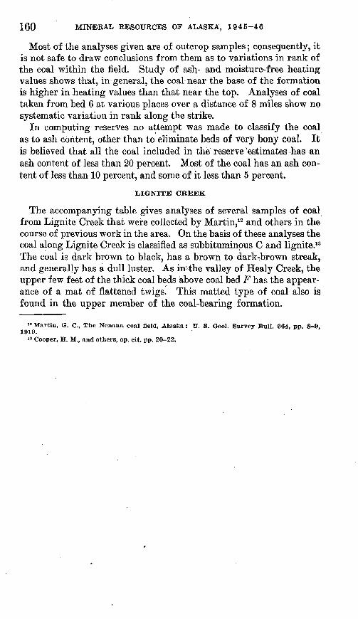
Most of the analyses given are of outcrop samples; consequently, it is not safe to draw conclusions from them as to variations in rank of the coal within the field. Study of ash- and moisture-free heating values shows that, in general, the coal near the base of the formation is higher in heating values than that near the top. Analyses of coal taken from bed 6 at various places over a distance of 8 miles show no systematic variation in rank along the strike.
In computing reserves no attempt was made to classify the coal as to ash content, other than to eliminate beds of very bony coal. It is believed that all the coal included in the reserve 'estimates has an ash content of less than 20 percent. Most of the coal has an ash con tent of less than 10 percent, and some of it less than 5 percent.
LIGNITE CREEK
The accompanying table gives analyses of several samples of coal from Lignite Creek that were collected by Martin,12 and others in the course of previous work in the area. On the basis of these analyses the coal along Lignite Creek is classified as subbituminous C and lignite.13 The coal is dark brown to black, has a brown to dark-brown streak, and generally has a dull luster. As in! the valley of Healy Creek, the upper few feet of the thick coal beds above coal bed F has the appear ance of a mat of flattened twigs. This matted type of coal also is found in the upper member of the coal-bearing formation.
"Martin, G. C., The Nenana coal field, Alaska: U. S. Geol. Survey Bull. 664, pp. 8-9, 1919.
13 Cooper, H. M., and others, op. cit. pp. 20-22.
Analy
ses
of
coal
fro
m t
he v
all
ey o
f L
ignit
e C
reek
, A
lask
a l
[A
naly
ses
by U
. S.
Bur
eau
of M
ines
. C
ondi
tion
of s
ampl
e: A
, as
rece
ived
; B
, air
-dri
ed;
C, r
nois
ture
-fre
e: D
, moi
stur
e-fr
ee a
nd a
sh-f
ree]
Lab
ora
to
ry
.No.
26362
26
36
3
26E
64
2636
5 _
26
3C
6
2636
7
26369
2658
8
2658
9
23042
Bed
sa
mpl
ed
B
H H
F
Loc
atio
n
Clif
f no
rth
bank
Lig
nite
Cre
ek.
SE
JiS
E^S
WK
sec
. 30
, T
. 11
S.
, R
. 6
W.
Upp
er t
hick
bed
in
faul
t gu
lch,
se
c. 2
6, T
. 11
S.,
R.
6 W
.
Gul
ch t
ribu
tary
fro
m n
orth
, J4
m
ile
nort
heas
t of
so
uthw
est
corn
er s
ec. 2
6, T
. 11
S.,
R. 6
W.
0.15
mile
nor
th o
f sou
thea
st c
orne
r se
c. 2
6, T
. 11
S.,
R. 6
W.
NW
}iSE
}iN
WJi
sec.
27,
T. 1
1 S.
, R
. 6. W
.
Blu
ff 1
mile
abo
ve m
outh
cre
ek,
NE
KN
WK
se
c.
5,
T.
12
S.,
R. 7
W.
NW
MN
WM
sec
. 35
, T
. 11
S.,
R.
7W.
Bed
No.
5, w
eath
ered
out
crop
__
Bed
No.
1, 4
5-50
feet
wea
ther
ed..
Wes
t ba
nk
Nen
ana
Riv
er,
1.5
mile
nor
th
of m
outh
L
igni
te
Cre
ek.
Air-
dr
ying
lo
ss 10.4
19.8
12.2
10.7
15.6
16.1
14.6
23.5
18.7
19.2
Con
di
tion A
B
C
D
A
B
C
D
A
B
C
D
A
B
C
D
A
B
C
D
A
B
C
D
A
B
C
D
A
B
C
D
A
B
C
D
A
B
C
D
Prox
imat
e U
ltim
ate
Moi
s
ture
20.6
2 11
.45
28.7
1 11
.13
22.1
5 11
.35
, 23
.24
14. 0
8
24.3
2 10
.35
25.3
0 10
.93
23.8
3 10
.83
32.5
1 11
.83
27.9
2 11
.33
28.1
6 11
.04
Vol
a
tile
mat
ter
38.8
0 43
.28
48. 8
8 56
.38
35.9
1 44
.77
50.3
7 54
.27
35.3
9 40
.30
45.4
6 54
. 39
37.5
9 42
.07
48.9
7 51
.83
37.9
5 44
.95
50.1
5 56
.39
36.0
8 43
.02
48.3
0 52
.51
35. 5
5 41
.62
46.6
7 55
.19
33.6
2
43.9
2 49
.81
55.3
0 35
. 82
44.0
7 49
.69
55.0
6 34
.52
42.7
4 48
.05
50. 6
2
Fix
ed
carb
on
30.0
2 33
.49
37.8
2 43
.62
30.2
6 37
.72
42.4
5 45
.73
29.6
8 33
.80
38.1
2 45
.61
34.9
3 39
.10
45.5
1 48
.17
29. 3
5 34
.77
38.7
8 43
.61
32.6
4 38
.92
43.6
9 47
.49
28.8
7 33
.80
37.9
0 44
.81
27.1
7 35
.50
40.2
6 44
.70
29.2
3 35
.95
40.5
6 44
.94
33.6
8 41
. 71
46.8
8 49
.38
Ash
10.5
6 11
.78
13. 3
0
5.12
6.
38
7.18
12..7
8 14
. 55
16. 4
?
4.24
4.
75
5. 5
2
8.38
9.
93
11.0
7
5.98
7.
13
8.01
11. -7
5 13
.75
15.4
3
6.70
8.
75
9.93
7.03
8.
65
9.75
3.64
4.
51
5.07
Sul
fu
r
0.19
.2
1 .2
4 .2
8 .1
6 .2
0 .2
2 .2
4 .2
0 .2
3 .2
6 .3
1 .1
4 .1
6 .1
8 .1
9 .1
9 .2
3 .2
5 .2
8 .2
6 .3
1 .3
5 .3
8 .4
1 .4
8 .5
4 .6
4 .1
4 .1
8 .2
1 .2
3 .1
1 .1
4 .1
5 .1
7 .1
5 .1
9 .2
1 .2
2
Hyd
ro
gen
5.87
5.
26
4.51
5.
20
6.67
5.
57
4.88
5.
26
5.91
5.
19
4.43
5.
30
6.25
5.
67
4.78
5.
06
6.33
5.
45
4.80
5.
40
6.39
5.
49
4.79
5.
21
5.58
4.
64
3.85
4.
55
6.31
4.
83
4.00
4.
44
6.51
5.
45
4.73
5.
24
Car
bo
n
47.4
5 52
. 93
59.7
8 68
.95
45. 8
1 57
.11
64.2
6-
69.2
3 45
.12
51.3
8 57
.96
69.3
5 51
.33
57.6
8 67
.13
71.0
5 46
.84
55.4
8 61
.89
69.6
0 47
.55
56.6
9 63
.66
69.2
0 42
.67
49.9
5 56
.02
66.2
4 39
.86
52.0
7 59
.06
65.5
7 44
.99
55.3
4 62
.41
69.1
5
Nitr
o
gen
0.66
.7
4 .8
3 .9
6 .5
9 .7
4 .8
3 .8
9 .5
9 .6
7 .7
6 .9
1 .5
7 .6
4 .7
4 .7
8 .6
1 .7
2 .8
1 .9
1 .5
9 .7
0 .7
9 .8
6 .6
6 .7
7 .8
7 1.
03
.60
.78
.89
.99.
.5
0 .6
2 .6
S .7
6
Oxy
ge
n
35.2
7 29
.08
21.3
4 24
. 61
41. 6
5 30
.00
22.6
3 24
.38
35.4
0 27
.98
20.1
7 24
.13
37.2
7 31
.10
21.6
5 22
.92
37.6
5 28
.19
21.1
8 23
.81
39.2
3 29
.68
22. 4
0 24
.35
38.9
3 30
.41
23.2
9.
27.5
4 46
.39
33.3
9 25
. 91'
28.7
7 40
.86
29.8
0 22
.27.
24
.68
Hea
t
ing
valu
e (B
.t.u.
)
8,06
4 8.
996
10, 1
59
11, 7
18
7,76
0 9,
673
10
, 885
11
,727
7,
690
8,75
7 9,
877
11,8
17
8,88
3 9,
943
11, 5
72
12 2
47
8,02
1 9,
500
10, 5
98
11, 9
18
8,13
6 9,
700
10, 8
92
11,8
40
7,00
7 8,
204
9,20
0 10
, 879
6,
637
8.66
9 9,
833
10. 9
17
7', 9
87
9,82
4 11
, 079
12
. 2TC
8,
077
10,0
01
11, 2
43
11,8
44
Col
lect
or a
nd d
ate
G.
C.
Mar
tin
, 19
16.
Do.
Do.
Do.
Do.
Do.
Do.
G.
W.
Ev
ans,
191
5.
Do.
Tho
mas
Rig
gs,
Jr.,
191
6
O B
» Fro
m M
artin
, Q
. C
., T
he N
enan
a co
al fi
eld,
Ala
ska:
U.
S. G
eol.
Surv
ey B
ull.
664,
pp
8-9,
1919
.
162 MINERAL RESOURCES OF ALASKA, 1945-46
BURNING OF COAL BEDS |
:In the summer of 1945 several fires were burning in the coal beds of the Healy-Lignite area. With one exception, these fires were in the valley of Lignite Creek. (See pis. 18A and 204.) The exception was a fire on Suntrana Creek. During the summer of 1945 all the fires were very active, one of them actually burning a block of coal at the surface with a strong flame. The fire on Suntrana Creek was giv ing trouble in the Suntrana mine during the winter of 1945^46.
: A large but indeterminate amount of coal along Lignite Creek has been lost by burning; few large outcrops fail to show at least one be|d that has been burned out at the surface. This fact must be con sidered in evaluating estimates of coal reserves in this area. The de|pth to which the coal has burned is unknown. The burning of the co'al has baked the immediately overlying beds, especially the clay and shaly material, and at many points has given rise to slumping.
jit is noteworthy that pieces of baked shale were found in the Nenana gravel.
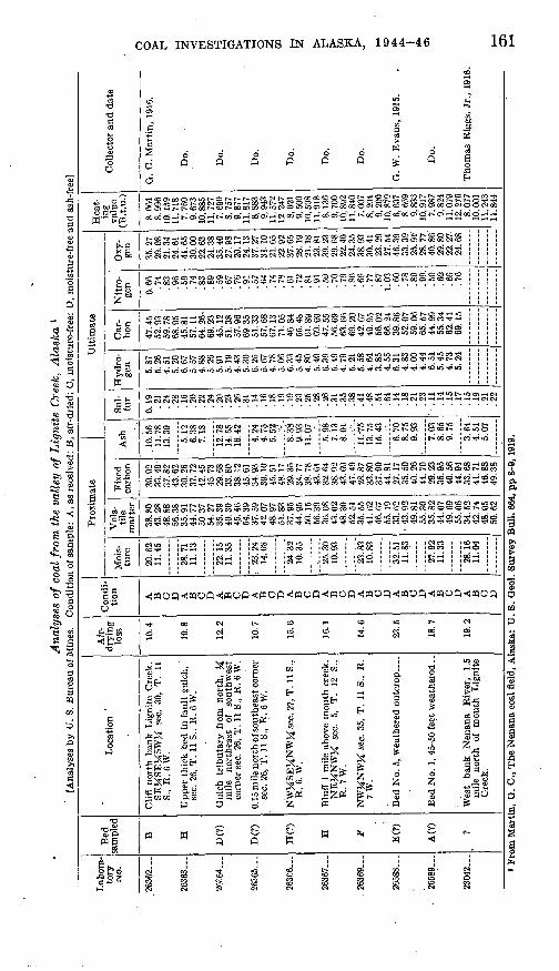
i COAL BESERVESii HEALY CREEK
. (The beds of minable coal in the valley of Healy Creek, with one ex ception, are within the two lower members of the coal-bearing forma tion. The beds in the middle member were correlated with ease, arid the names given to these beds in the mine at Suntrana have been us|ed throughout the valley. The beds in the lower member were correlated with considerable difficulty; in fact, some could not be sat isfactorily correlated.
;Coal beds averaging less than 4 feet in thickness were not included in the reserve calculations. It was assumed that the thickness of the coal beds changes uniformly between outcrops, Where Only one ex-
posure of a bed was known, as is true for some of the beds near thebase of the formation, the probable extent and thickness of the bed were inferred from the geologic map and. correlation chart. (See pis. 18A and 19.) The volume of a ton of coal in place was assumed to Be 25 cubic feet. In computing reserves it was assumed that the coal becls would be minable down to a level 3,000 feet vertically below the levelof Healy Creek at the mouth of French Gulch.
The total estimated reserves of coal in the Healy Creek area is about1,065,000,000 tons. Of this amount, about 96,000,000 tons lies above the level of the mouth of French Gulch and so could be developed by a
tunnel in that vicinity, About 460,000 tOM in thft area east of French
(lUlck probably is minable by stripping. Development of the remain der of the coal reserves on Healy Creek would require the sinking of slopes with a maximum length of about 6,000 feet.
COAL 'INVESTIGATIONS IN 'ALASKA,. 1944-46
Because of insufficient data, no attempt was made to calculate the amount of coal above drainage level in the area west of French Gulch, but it is known that the reserves there are comparatively small and are being rapidly depleted by present mining operations.
Coal reserves in the valley of Healy Creek above level of mouth of French Gulch
Coal bed No.
South limb of syncline: 1. ...... __ .--.. __ ... ____ . ..
, 2... _ - __ . _ . __ . _ . __ . _ - - - :3-. ~
5... . _ __ .... . - - -
6. __ - ___ - ___ - __ . _____ - __ ___ - _
TVifal
Average thick ness (feet)
50291312105
18
Estimated reserves
(short tons)
25,000,00011, 600, 000
4, 900, 0003, 500, 0002,200,000
600, .0003,000,000
300, 00027, 700, 00017 nfifi nnn
95, 800, 000
Reserves of stripping coal in the valley of Healy Creek
Bed and location (all in T. 12 S., R. 6 W.)
Four unnamed beds on middle fork of Gold Run, in SE J^NE J^ sec. 10. Bed 1 (Mammoth), north side Healy Creek in EKSEJ^ sec. 11 and
WJ^SWJi sec. 12 _ . ____________________ . __ .. ....Second bed below No. 1 on north side Healy Creek in WJ^SW^
Bed 1, south side Healy Creek in SW^SW^ sec. 12. ____ . .......
First bed below No. 1, south side Healy Creek in SW^SVf^ sec. 12. Moose bed, south side Healy Creek in SEJiSWJi sec. 12 .............Basal bed, south side Healy Creek in SEJ^SEJ^ sec. 12...... .....Second bed above basal bed, south side Healy Creek in SHSEJi
Third bed above basal bed, south side Healy Creek in SJ^ sec. 12 ....Bed 4, south side Healy Creek in SEJ^SEJi sec. 12 ___ .........Bed 5, south side Healy Creek east of Coal Creek, in SJ3 sec. 11 and
N^NWM sec. 14
Bed 1, west side Coal Creek in NWjJ sec. 14 (2 blocks) _______Bed 2, west side Coal Creek in NWJ£ sec. 14 .... ___________
Bed 6, south side Healy Creek west of Coal Creek, in NEJ£NEJ£
Bed 1, west side Cripple Creek in SW^SW^ sec. 15 _________Bed 2, west side Cripple Creek in WJ^SWJ^ sec. 15 _________
Total. ____ . _ . __ -.. ....-._..... . ..............
Measured reserves
Quantity (short tons)
11,000
3,000
10, 000 17,000
9,000
50, 000
Overbur den (cubic
yards)
3,000
3,400
9,000 4,000
900
20,300
Estimated reserves
(short tons)
16, 000
2,000 25,000 14, 000 8,000
48,000 25,000
4, 000 2 000
120, 000 30, 000 60,000
45,000. 12,000
- '2, 000
413, 000
LIGNITE CREEK
Minable coal in the valley of Lignite Creek, with the exception of bed Z, is confined to the lower and middle members of the coal-bearing formation. The beds of the middle member were correlated with ease, but difficulty was encountered in correlating those of the lower mem ber, largely because of the scarcity of exposures.
888890 51 3
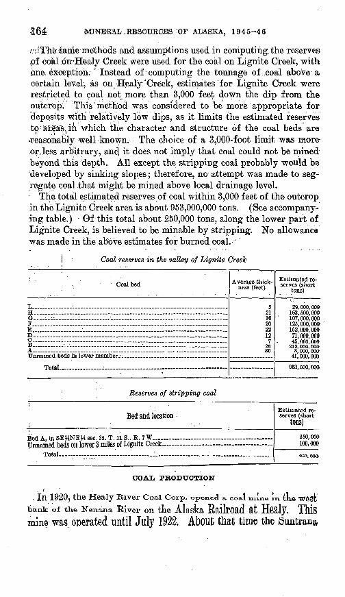
3:64 MINERAL .RESOUECES 'OF ALASKA, .1945-46
orfThe same methods and assumptions used in computing the reserves pf coal .on^Healy Creek were used for the coal on Lignite Creek, with one, exception. ' Instead of computing the tonnage of .coal above a certain level, as on Healy "Creek, estimates for Lignite Creek were restricted to coal not more than 3,000 feet down the dip from the outcrop. This'method was considered to be more appropriate for deposits with relatively low dips, as it limits the estimated reserves to areas,, in which the character and structure of the coal beds are reasonably well known. The choice of a 3,000-foot limit was more- ror,less arbitrary, and; it does not imply that coal could not be mined jbeyond this depth. All except the stripping coal probably would be developed by sinking slopes; therefore, no attempt was made to seg regate coal .that might be mined above local drainage level.
The tota!l estimated reserves of coal within 3,000 feet of the outcrop in the Ligiiite Creek area is about 953,000,000 tons. (See accompany ing table.) Of this total about 250,000 tons, along the lower part of Lignite Creek, is believed to be minable by stripping. No allowance was made in the above estimates for burned coal.
| Coal reserves in the valley of Lignite Creek
( . " . " Coal bed
L-...1 . - H.. - -G._.__._. .. _..._ . ,.. ..F....... -E__.. _. .-._ - _- .-._ ................ ...D. ._ ................... _ .................. ____ .........C-._ -.; -.__...__..__ _...._ ______.______ B ____ -- . _ _ .. _ _. ____ __
Total. - - - - -
Average thick ness (feet)
591
16202219.7.
Estimated re serves (short
tons)
90 Ann tvw163, 500, 000107, 000, 000125, 000, 000'152,000,00071,000,00045, 000, 000
41, 000, 000
953,500,000
: Reserves of stripping coal
Bed and location
Bed A, in SEJ4NEH sec. 35, T.Unnamed beds on lower 3 miles
Total....
11 Q "D T W
of Lignite Creek.-
Estimated re serves (short
tons)150,000 100,000
2SO.OOO
COAL PRODUCTION
. Ill 1920? the Healy River Coal Corp. opened a coal mine in 4kft
tank of the Nenana River on the Alaska RailrOad at
mine was ocerated until July 1922. About that time the
MVE'S«GA$IONS .'IN ALASKA/ i 9a-4B 16:5
mine was opened by the same company and, since the completion of 'a spiir iine; from the railroad in October 1922, has been in continuous ^production. ', . , . . In 1923, R, F. Roth acquired a lease on 2,080 acres of land at the east end of the coal deposits on Healy Creek. He mapped and prospected ^the deposits and collected samples. "No coal was produced from this-ground, and'the lease has now lapsed. .',,",/ .. ' ; .:"' , In.the spring of 1944, T. E. Sanford and Emil Usibelli contracted, .under a United States Army license, to produce coal by strip mining .from land on Healy Creek 2 miles east of the Suntrana mine. In the .summer .of 1945, Sanford sold his interest in the contract to Usibelli, cwho was continuing and enlarging this operation in 1946. K
The total production of coal from the valley of Healy Greek, to the end of 1945, was about 1,800,000 short tons. There has been «no sig nificant production from the valley of Lignite Creek,
.CLAY DEPOSITS ON HEALY CREEK
By E. H. COB'B '
Numerous clay and claystone beds occur in the Tertiary coal-bear ing formation of the Nenana coal field, and their use as a source of industrial clay and of raw material for the manufacture of portland cement has been suggested. Most of the clay and claystone is.green, brown/or buff. Where coal beds beneath the clay have burned, as in the bluff above the Suntrana mine, the clay is, baked bright red or ochre.
According to Wahrhaftig, two persistent thick beds of clay and claystone are known in the Tertiary coal-bearing formation. One, in which the clay is varved, gritty, and brown, lies at the top of the lower member of the formation. The other, near the top of the upper member, is green, shaly in part, and has numerous layers of silt and sand in its upper part. The upper bed contains nodules of vivianite, a bright-blue hydrous iron phosphate.
Waring 14 reports that samples of clay shale were collected at Sun trana in 1923 and sent to the Ceramic Experiment Station of the United States Bureau of Mines at Columbus, Ohio. The following data are quoted by Waring from the report of tests made there by E. E. Pressler:
Clay from the upper 85 feet of the deposit proves to be the best. The lower part is too sandy to dry and burn satisfactorily. The clay works well in dies, and the drying behavior is satisfactory. It burns to a good body in the cus-
" Waring, G. A., Nonmetalliferous deposits in the Alaska Railroad belt: U. S. Geol. Survey Circ. 18, p. 9, 1947.
166 MINERAL RESOURCES OF ALASKA, 1945-4.6
'ternary range of firing temperature for heavy clay wares. The total,shrinkage, .in less than usual in a surface clay and only slightly-above the average for shale. The clay is nearly free of lime, organic matter, and sulfur, which are objection able in clays for heavy ware. The color of the ware when fired to high tempera ture is good. Some clays that burn to a less pleasing color are used in the manufacture of face brick.
On July 8 and 9,1947, the writer, accompanied by G. M. Flint, Jr., geologist, and O. L. Smith, Jr., recorder, visited the Healy Creek valley for the purpose of collecting representative samples of the
"clays and claystones most readily accessible to transportation facili ties. Fifteen samples from seven localities where stratigraphic sec tions had been measured by Wahrhaftig were collected and sub mitted toJLedoux & Co., New York, N. Y., for chemical analysis. ' The analyses are given in the table below. Samples 39A to 39E were collected from a claystone bed exposed near the head of a steep, narrow gully in sec. 22, T. 12 S., R. 7 W., and shown near the top of stratigraphic section A (pi. 19). The relative position and thickness of each sample are as follows:
ThicknessSample No. (feet)
39A (top)____________ 10 39B________________ 12 39C________________ 12
Sample No. 39D______39E______
Thickness(feet)
___ 17 ._ 8
Sample 40 is from the same gully as samples 39A-E. It represents 'a section across a 3-foot clay bed beneath a 12-inch coal bed approxi- _mately 210 feet below, the top of stratigraphic section A. (See pi. 19.)
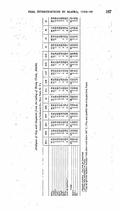
COAL INVESTIGATIONS IN ALASKA, 1944-46 167
*
,2 ^"to -w-8 I
<3 3
9
51
%
IN *
H f
fl »ji
O5
9 *
3 *
§
w§
Q §§
O o
CO
n S
<J8
.oSSSSSSS.g.CO t^o6i-i«N W3 rH
5SSS3OCOSOrHr- CO tH
§2SSEoi c4co *CD i-i
i-HCN . 05
OOOO01--
CN 00
asg'ss'!- "
SSSS^SSSSr-» rH
CN CO
8£oSctSS!§8SJ-HIOI-, »-CO i-H
co oo
gSScSgc^ggct
Wi-l "
§S??8SOS CC h* tH r- lOp^l
CO 05
£$S8CO O5
OSCOCOOSCD^OOOCOOi iO t-* t-lOr-t
CO 00
CDOiCOCMrHCOO^i - >O (O O 00 Is* *C OO 00 O
S2^ " tN OS
KS§5:g?g§i5§COl-H ^ ^'
ssss&ssssgcoco^ ^ *
SSSSSS2SSlO.rH
SSSSSSSKSS I>I CO rH CS i-t Ci 0
t-( f-H
^sggasggst^ r-^ t-i ci CN i-< CN odX5-H
ggsS53S£;SS!« -<
(fOOcC
1I g
,gOo| I^WE-1 !-!
cor»coci
S cocoo
rHtCtN IO 00 rH 00 00
O5^|itNT(< O3
co ^^ ^ »o r>os t~o
S CO--ITH
8Ss cc
OJ CO COX5
oico
gassgco-o
ssssI"" 1000 00 »O CO OS t^- O5 i-H
OSOOrH iOo>
S§S3o ""*
cooocof^H CO OS O5
o """
ssssgCNCNcO
2SJSSg^-co^
ss^sgcoco»o
rH CO O r-
g^coco
^S28g^coo
SSE^SgCOCN.0
5"c
ow
oW(S
3-9
ill 111to a a
168; MINERAL RESOURCES QP ALASKA,. 1T945-46,
Samples 41A to 41E are fr6m claystone aiid siltstone exposed along the road up Suntrana Creek, above coal bed F in the SE^ sec. 23, T. 12 S., R. 7 W. (See stratigraphic sec. B, pi. 19.) The relative position and thickness of each sample are as follows:
ThicknessSample No. (feet)
41A (top)_______'__"__'__ 12 41B _____________'__ 8 410 ________________ 12
ThicknessSample No. (feet) 41D _______________ _ 14 41E _________________ 10
The interval between the bottom of the sampled beds and the top of coal bed F was concealed by the road and slumped material.
Sample 42 is clay from the bank of Healy Creek between sees. 10 and 15, T. 12 S., R. 6 W., shown at the top of stratigraphic section J (pi. 19). Exposures were poor because of slumping of the overlying gravel. This is the most easterly exposure sampled, more because of the shortage of time available than because of any evidence that equally good clay or claystone1 might not be found farther east.
Sample 43 is from a bed of white plastic clay at least 4 feet thick beneath coal bed 1 on Cripple .Creek in the SW^4 sec. 15, T. 12 S., R. 6 W., shown in the lower part of stratigraphic section / (pi. 19).
Sample 44 was taken from a 12-foot claystone bed directly beneath the 5-foot coal bed that lies 95 feet above coal bed 6 on Cripple Creek in the NE% sec. 16, T. 12 S., R. 6 W. (See stratigraphic section #,pl-19.) , .'.-"..
Sample 45 is from the highest clay bed shown in stratigraphic sec tion H (pi. 19) on Cripple Creek near its mouth, in the NW.% sec. 16, T. 12 S., R. 6 W.
Comparison of analyses of clay and claystone from the Healy Creek valley with published analyses of the argillaceous.material used in the manufacture of portland cement 15 indicated that at least some of the clayey material in the Tertiary coal-bearing formation is suitable foruse in the portland cement industry, proyided a suitable source of lime stone can be found. Analyses ol limestone occurring near "Windy sta tion 16 on the Alaska Railroad about 35 miles south of Healy, indicatethat a suitable mixture for portlancl cement migki be obtained by USifl£ approximately 3.2 parts of the limestone from Windy to one part of clay material from Suntrana.
Although no estimates of reserves of clay and claystone in the HealyCreek valley have been made, available data indicate that sufficient Clay material of suitable quality is present to support a portland cement industry adequate for the foreseeable needs of the Alaska Railroad belt.
u Ries, Helnrlch, Clays; their occurrence, properties, and uses; 3d ed., p. 362, New York, John Wiley and Sons, 1927. Maynard, G. W., Limestone and cement materials of north Georgia : Georgia Geol. Survey Bull. 27,1912.
19 Waring, G. A., Nonmetalliferrous deposits in the Alaska Railroad belt; U. S. Geol. Survey Circ. 18, p. 8, 1947. .
GEOLOGY AND COAL DEPOSITS OF THE WESTERN PART OF THE NENANA COAL FIELD, ALASKA
By CLYDE WAHRHAFTIG
INTRODUCTION
LOCATION AND ACCESSIBILITY i
The western part of the Nenana coal field, as defined in this report, lies between 149°15' and 149°48' W. longitude, and 63°46' and 63°50' N. latitude: (See fig. 33.) It is 14 miles wide, from north to south; .and 18 miles long, from east to west. The north boundary of Mount McKinley National Park passes through the southern part of the arear The southern limit of the area is 2 to 6 miles north of the McKinley Park highway, and the eastern boundary is about 10 miles west of the Alaska Railroad at Healy. The only access to the area from the park highway is by a pack trail through the gorge of the Savage Kiver where it crosses the intervening high ridge. A tractor trail from Lignite on the Alaska Railroad to mining camps in the Kantishna Hills extends across the northern part of the area but is passable only during winter.; A foot trail from the Alaska Railroad at Healy follows up Dry Creek and crosses the low divide between Dry Creek and the Savage River5 basin at the park boundary.
PREVIOUS INVESTIGATIONS .
Brooks and Prindle, in their memorable expedition of 1902,17 first mapped the geology of the north side of part of the Alaska Range. They did-not, however, enter the area of this report, but passed along, the south side of the ridge that bounds it on the south. In 1916,. Capps 18 made a reconnaissance geologic map of the region lying north of the Brooks survey, between the Nenana River and the Kantishna Hills. He was the first to describe the coal beds in this area and to indicate in a general way their distribution. From that time no fur ther geologic work was done until the present investigation was undertaken.
17 Brooks, A. H., The Mount McKinley region, Alaska: U. S. Geol. Survey Prof. Paper 70, 1911.
18 Capps, S. R., The Kantishna region, Alaska: U. S. Geol. Survey Bull. 687, 19/9.
' 169
170 * MINERAL RESOURCES OF ALASKA, 1945-46
FIELD WORK AND ACKNOWLEDGMENTS
Field work was carried on from July 7 to September 14, 1946, by a party in the charge of the writer and including A. C. Spreng and J. F. Harvey, field assistants, and H. E. Smith, cook. C. A. Hickcox, geologist, joined the party for 3 weeks in the middle of the season. F. F. Barnes, geologist, under whose general supervision the investi gation was made, spent 2 weeks in the field with the writer. T. R. Jolley, of the Federal Bureau of Mines, accompanied Mr. Barnes on one of his trips into the area and collected several samples from out crops of the coal beds.
Contacts of formations and locations of outcrops were plotted on trimetrogon vertical and oblique photographs obtained from the United States Army Air Corps. The scale of the vertical photographs was approximately 1:40,000. Survey markers on the national park boundary were carefully located on the photographs and used as con trol points. A preliminary geologic map on a planimetric base (pi. 24) was prepared from the photographs at the end of the season, by reconnaissance photogrammetric methods developed by the Alaskan Branch of the Geological Survey. Detailed sections of the coal-bear ing formation were measured at several points with the aid of tape- and-compass and plane-table surveys.
The writer wishes to acknowledge the, kindness and cooperation of the staff of Mount McKinley National Park, headed by Grant Pear- son, acting park superintendent; of the staff of the McKinley Park Hotel, headed by H. M. Pederson, manager; and of Carl Anderson, Joe Vonah, and Paul Omlin, of Lignite.
GEOGRAPHY
TOPOGRAPHY AND DRAINAGE
The western part of the Nenana coal fields lies in the foothill belt on the north side of the Alaska Range and consists of a series of east ward- to northeastward-trending ridges and valleys crossed by four northward-flowing streams, the Savage, Sanctuary, Teklanika, and Sushana Kivers. The Savage and Sanctuary both join the Teklanika, which flows into the Nenana River a short distance above the confluenceof the Nan ana River and th© Taruxiaa. The waters Of the SUShana
River reach the Tanana by way of the Toklat and Kantishna Rivers.The Savage and Sushana are easily fordable; the Sushana was dry
for a distance of 4 to 5 miles along its course during part of the sum mer of 1846. The Sanctuary and Teklanika Rivers can be forded on foot with difficulty and only at a few places. None of the streams are navigable.
Altitudes of the land surface within the area range from. 1,500 feet at the junction of the Savage and Teklanika Rivers to 5,000 feet on
COAL' INVESTIGATIONS IN ALASKA,. 1944^-46 171
the ridge bounding the area on the south. An eastward-northeast ward-trending gravel-floored plain, 5 miles wide and about 2,000 feet in altitude, extends, across the northern part of the area. Several lakes, the largest of which is a mile in diameter, are on the plain. On the north the plain is bounded by a range of hills that rise to 3,800 feeib above sea level. These hills appear smooth and rolling from a dis tance, but are scored by deep V-shaped canyons. The central area of the hills is occupied by schist, and the flanks by Nenana gravel.
South of the plain is a range of hills with smooth, gentle north slopes and steep, broken south slopes; the hills constitute a cuesta formed on northward-dipping beds of poorly consolidated Nenana gravel. The hills range in altitude from 3,200 to 4,000 feet.
An eastward-northeastward-trending belt of flats, terraces, and low saddles 2 miles in maximum width and about 2,800 feet in altitude, lies between the cuesta and the ridge marking the south limit of the area. This belt of flats marks the outcrop area of the coal-bearing formation. A prominent ridge of Birch Creek schist lies south of this belt and ranges in altitude from 7,000 feet at Mount Healy, 10 miles east of the area, to a little over 4,000 feet between the Teklanika and Sanctuary Rivers. This high and rugged ridge, although only 2 to 4 miles wide and breached by four rivers, forms an effective barrier to travel; only one trail crosses it into the area of this report. Farther east, the canyon through which the Nenana River crosses this ridge presented some of the greatest engineering difficulties encountered in the construction of the Alaska Railroad.
CLIMATE
The western part of the Nenana coal field has a climate characteristic of sub-Arctic continental interior regions, with severe winters and short moderate summers. Precipitation is light, averaging about 15 inches per year. Most of the precipitation takes place in the sum mer. Weather records at McKinley Park station show a mean an nual temperature of 28° F. and monthly means ranging from 2.5° F. in January to 54.6° F. in July. The only months with mean .tem peratures above 50° F. are June, July, and August.19
VEGETATION
About four-fifths of the area shown 011 plate 24 is barren of timber, being covered only by low bushes and other tundra-type vegetation. Although most of the country is-below timber line, which is about 2,800 feet above sea level in this area, most of the flatter land below timber line is devoid of trees, apparently because they do not flourish
19 Climatological data, Alaska section, U. S. Weather Bureau, 1944.
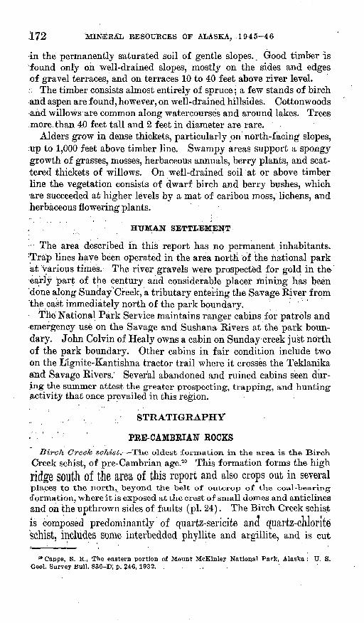
172 MINERAL RESOURCES OF ALASKA, 1945-46
in the permanently saturated soil of gentle slopes.. Good timber is found only on well-drained slopes, mostly on the sides and edges of gravel terraces, and on terraces 10 to 40 feet above river level.
: The timber consists almost entirely of spruce; a few stands of birch and aspen are found, however, on well-drained hillsides. Cottonwoods and willows are common along watercourses and around lakes. Trees .more than 40 feet tall and 2 feet in diameter are rare.
Alders grow in dense thickets, particularly on north-facing slopes, up to 1,000 feet above timber line. Swampy areas support a spongy growth of grasses, mosses, herbaceous annuals, berry plants, and scat tered thickets of willows. On well-drained soilat or above timber line the vegetation consists of dwarf birch and berry bushes, which are succeeded at higher levels by a mat of caribou moss, lichens, and herbaceous flowering plants.
The area described in this report has no permanent inhabitants. 'Trap lines have been operated in the area north of the national park at various times. The river gravels were prospected for gold in the early ^part of the century and considerable placer mining has been 'done along Sunday Creek, a tributary entering the Savage River from 'the east immediately north of the park boundary. ' ' ' '
The National Park Service maintains ranger cabins for patrols and emergency use on the Savage and Sushana Rivers at the park boun dary. John Colvin of Healy owns a cabin on Sunday creek just north of the park boundary. Other cabins in fair condition include two on the Lignite-Kantishna tractor trail where it crosses the Teklanika and Savage Rivers. Several abandoned and ruined cabins seen dur ing the summer attest the greater prospecting, trapping, and hunting activity that once prevailed in this region.
STRATIGRAPHY
PRE-CAMBRIAN ROCKSBirch Creek schist. The oldest formation in the area is the Birch
Creek schist, of pre-Cambrian age.20 This formation forms the high
ridge SOUth Of the area of this report and also crops out in severalplaces to the north, beyond the belt of outcrop of the coal-bearing (formation, where it is exposed at the crest of small domes and anticlines and on the upthrown sides of faults (pi. 24). The Birch Creek schist
is composed predominantly of quartz-sericite ana quartz-cnlonte Schist, includes some interbedded phyllite and argillite, and is cut
20 Capps, S. R., The eastern portion of Mount McKinley National Park, Alaska: U. S. Geol. Survey Bull. 836-D, p. 246, 1932.
COAL INVESTIGATIONS IN ALASKA, 1944-46 173
by abundant small quartz veins. The color of the fresh schist ranges from gray and green to black. A highly weathered zone that is .locally present at the top of the schist formation is described in connection with the overlying coal-bearing formation. .
It is impossible to estimate the thickness of the Birch Gre.ek schist, because drag folds indicate that it has been highly contorted and isoclinally folded;' however, it is certainly several thousand feet thick.
. 7 PALEOZOIC ROCKS .'.." ,' J
: ^'T6tatlanika 'schist. The' belt of schist exposed in the hills along We northern border of the area under discussion was mapped by Gapps 1*1 as Totatlanika schist, which he considered to be :Lower DQ- voniun'or Silurian in age. At the present time it is considered to be pre-Devonian. This formation consists of gray' to black quartz*- muscovite and graphitic schist, and interbedded argillite and meta morphosed volcanic rocks. In several places thick layers of stretched 'conglomerate were seerij in which the pebbles had been: drawn out into thin lenses is much as 15 times as long as they are thick. Numerous -quartz veins, some of which are as much as 3 feet" thick and several hundred yards long*'cut: the schist. Several intensely iron-stained patches were observed:-on the north wall of a canyon that-joins the Teklanika RivefValley from the east; they appear to be caused by mineral springs, several of which are'known in this area. Pebbles of bright red schist, extremely rich in hematite, have been found in gravels derived from this range of hills. ; ' ;
, TEBTIABT BOCKS - --..- :
, Coal-Marino formation. The coal-bearing formation crops out in~-. f ,.. r, ,.,/-.. -,1 fi ,,.jf»ff »7 -'-/t- * -.. - " - . . CJ -,,.,., **. »
'tlie sVuihei'"nVpart of the mapped area, in a narrow belt about 16 miles .long, and^^.,milesi in maximum width (pi. 2.4). "Kocks, near the mouth of the Savage,.River that were mapped by .Capps 22 as coal-bear ing formation are believed to be part of the. overly ing Henana gravel. Only the lower member of the coal-bearing formation as exposed on Healy and Lignite Creeks (pp.. 147-152) is present in the western part of the Nenana coal field. The middle and upper members apparently were not deposited .that far west. . .
The coal-bearing .formation rests unconformably on the Birch Creek schist in which, in several localities, a zone of weathering, at least 100 feet thick, was found immediately beneath the coal-bearing formar tion. Withering has reduced the upper few feet of the schist to a
21 Capps, S. R., The Kantishna region, Alaska: U. S. Geol. Survey Bull. 687, p. 34, 1919. M Capps, S. R., The Kantishna region, Alaska: U. S. Geol. Survey Bull. 687, p. 47 and
pi. 2, 1919.
174 MINERAL RESOURCES 'OF ALASKA, 1945-46
micaceous clay. The weathered zone is thickest and most prominently 'developed where the lower part of the coal-bearing formation consists
' of siltstone, claystone, and coal, and is thin or absent where thick de posits of conglomerate immediately overlie the schist. .
The coal-bearing formation in this area shows wide variations in thickness and lithology within short distances. Apparently it was deposited in a valley or depression in the Birch Creek schist. The most nearly complete sections of the coal-bearing formation are ex posed along a stream that enters the Teklanika Kiver from the west about 3 miles south of the national park boundary, and in the east bank of the Teklanika opposite the mouth of the tributary. In these .exposures about 300 feet of quartz conglomerate at the base of the .formation forms brilliant white outcrops. Quartz constitutes 80 to 90 percent of the pebbles in the conglomerate, and is accompanied by subordinate amounts of dark gray to black chert, schist, and white rhyolite with prominent quartz phenocrysts. The pebbles average 1^ inches in diameter, but boulders as much as a foot in diameter occur near the base of the conglomerate. The interstices are filled with white micaceous silt. Coal beds are rare in the conglomerate, and * where present they are thin and discontinuous. Coalified tree trunks, branches, and roots are abundant, however, and have been converted into extremely lightweight, lustrous coal, resembling vitrain, in which the growth rings are clearly preserved. The conglomerate
; forms castellated bluffs along the streams. The cement quickly dis integrates, however, and outcrops not subject to active stream erosion form subdued hills, covered by a layer of loose pebbles. Many pebblesin the conglomerate are strained and cracked, possibly as a result of the deformation undergone by the coal-bearing formation. .
, The basal quartz conglomerate of the coal-bearing formation is not present everywhere, It was traced along the south contact of the coal-bearing formation from the Savage River westward to a point about a mile west of the divide between1 the Teklanika and Sushana Rivers. Farther west, higher beds of the coal-bearing formation restdirectly on the schist. East ot the Savage River the conglomerateappears to interfinger with a series of coal and claystone beds. This lateral change is clearly evident on the Savage Kiver at Ewe Creek,where a series of bedg of coal and claystone on the east side of theriver, resting on schist, strikes directly into a thick section of con glomerate west of the river, also resting on schist. Inasmuch as the basal contact of the coal-bearing formation is not displaced, the bedscould not have been brought into their present relative positions byfaulting. The conglomerate, therefore, must interfinger with the coal
: and claystone to the east. :
COAL INVESTIGATIONS IN ALASKA, .1944-46 175
The quartz conglomerate is -absent from the base of the coal-bearing formation to the east and north of the head of Ewe Creek, and along the north side of the coal-bearing area as far west as the Sanctuary River, beyond which the contact of the coal-bearing formation with the underlying Birch Creek schist is buried beneath Nenana gravel. .The absence of the conglomerate around the north and east margins of the coal basin is believed to be due in part to lateral gradation into coal, sandstone, and claystone, but probably in greater part to the thinning out of the conglomerate away from its source.
Between the Savage River and the head of Pinto Creek the quartz conglomerate may be as much as 500 feet thick. Elsewhere it averages 200 to 300 feet thick. Claystone and cqal are present locally at the base of the conglomerate, but none of the coal is of workable thickness.
Overlying the quartz conglomerate is a sequence of interbedded sandstone, claystone, some siltstone, and coal, averaging 150 feet thick, which contains all the economically valuable coal of this area. The sandstone, which predominates in the lower half of the sequence, is composed of quartz, sericite, and subordinate grains of black chert. It is cemented locally by limonite into discontinuous resistant orange- colored beds. A very coarse variety of sandstone, consisting largely of angular fragments of Birch Creek schist, occurs at a few localities. The claystone, which predominates in the upper part of the sequence, generally is slightly silty, green to gray in fresh exposures, and weathers to orange or brown along cracks. Immediately beneath the coal beds the claystone is carbonaceous and dark-brownish gray.
The sequence of interbedded sandstone, claystone, siltstone, and coal of the coal-bearing formation is exposed in two patches that are separated by an area from which the sequence has been eroded. The western patch extends from a point about a half a mile east of the Sanctuary.River to a point just west of the Sushana River. The sec ond patch is in the basin of the Savage River.
The lower and upper limits of the interbedded sequence are in definite; the horizon below which coal and claystone constitute less than 30 percent of the coal-bearing formation was considered to be the lower limit. The upper limit was placed at the highest coal bed in the section, but it is not certain that the same bed was used through out. The interbedded sequence is at least 150 feet thick on the Sanc tuary River 250 feet thick, if a coal bed 100 feet below the base of section F (pi. 25) is included and maintains its thickness as far west as the easternmost headwater of the Sushana River. Beyond this fork, it rests directly on schist and thins gradually westward, disappearing a short distance west of the Sushana River. Judging from sections measured with tape and compass on poorly exposed outcrops in stream
176 MINERAL RESOURCES OF ALASKA, 1945-46
beds, the coal beds decrease in number and increase in thickness to the west.
Coal beds are exposed in the banks of the Savage River and along Pinto, Sunday, and Ewe Creeks in the Savage River basin. A plane- table traverse was made of the most nearly complete section of the interbedded sequence, which is exposed along the west bank of the. Savage River for a quarter of a mile below the mouth of Sunday Creek. The most reasonable interpretation of the structure indicates that the section is 240 feet thick and contains six coal beds 4 feet or more in thickness. Some beds may be duplicated by faulting, although no faults were observed. The coal beds in this section could not be cor related with certainty either with beds exposed on Sunday or Ewe Creeks or with those on the Sanctuary River.
The sequence, of interbedded sandstone, clay stone, siltstone, and coal of the coal-bearing formation is overlain by a bed of distinctive greenish-gray shale and varved claystone that weathers to brown or yellow. This claystone resembles closely the brown shale that marks the top of the lower member of the coal-bearing formation on Healy and Lignite Creeks, and is probably correlative with it. In this area, however, it is directly overlain'by the Nenana gravel. . The brown-weathering shale bed extends from a point about, a mile east of the Sanctuary River westward along the northern contact of the coal-bearing formation to a point three-fourths of a mile west of the main fork of the Sushana River, where it is overlapped by Nenana gravel. At the western end of its exposure the shale rests directly on Birch Creek schist and contains angular fragments of quartz. Brown shale was observed about 4 miles west of the Sushana River at the baseof-the Nenana gravel and may be correlative -with that to the east. The brown-weathering shale has not been recognized with certainty in the Savage River basin, where it may have been removed by erosion,
Nenana gravel. The Nenana gravel, a coarse, poorly consolidated conglomerate, overlies the coal-bearing formation, If the correlationof ike coal-bearing formation in this area with the lower part of the coal-bearing formation in the type section on Healy Creek is correct, Cessation of deposition of the formation in this area1 and the initiationof deposition of the Nenana gravelwere separated1 by a considerable interval of time, during which the entire thickness of'the middle andupper members Of the coal-bearing formation were deposited in the vicinity of Healy Creek, The structural relations between the Zenanagravel and the coal-bearing formation are discussed on pages 182-183.
; The thickness Of the Nenana gravel in this area is at least 4,OOO feet
and is probably more than 5,500 feet. Certain physiographic evidence indicates, tnan an additional "thickness of at least 1,500 feet has been eroded from the top of the Nenana gravel. Although the Nenana
COAL'-INVESTIGATIONS IN ALASKA, 1944-46 177
gravel probably underlies the center of the area'discussed in this re port, it is best exposed in two belts in which the upturned edges of the formation crop out on opposite limbs of a large eastward-trending syncline. The southern belt lies just north of the outcrop area of the coal-bearing formation, and the northern belt borders the hills of Totatlanika schist to the north.
The lower part of the Nenana gravel consists predominantly of coarse sandstone containing interbedded claystone and pebble lenses. It ranges in thickness from 700 feet at the Sushana River to 1,200 or 1,500 feet on the Savage Eiver. In the southern belt of Nenana gravel, the sandstone of the lower part is cross-bedded and contains scattered discontinuous claystone beds and pebble lenses that constitute 10 to 15 percent of the section. The pebbles in the lenses average half an inch in diameter, although some are 1% inches in diameter. More than half of the pebbles generally consist of volcanic rocks and granite, the volcanic rocks predominating. Quartz, chert, quartzite, and gray- wacke make up most of the remainder of the pebbles. Where hills of schist appear to have projected into the gravel, as on the banks of the Sanctuary River at its junction with the Teklanika, angular fragments of schist as much as a foot in diameter are present near the base of the formation.
Along the northern belt of Nenana gravel the sandstone of the lower part contains no more than 5 percent of pebble beds, and the pebbles are generally less than an inch and average a quarter of an inch in diameter. Claystone beds as much as 20 feet thick make up 10 to 15 percent of the section. Beds of woody coal, generally.less than, 6 inches thick, also are found in this part of the Nenana gravel. So striking is the resemblance of the lower part of the Nenana gravel along the north side of the syncline to beds in the coal-bearing forma tion that it was mapped as coal-bearing formation in earlier investi gations.23 Because of the .economic importance of knowing whether or not these beds were p»art of the coal-bearing formation, considerable effort was made to find criteria for their proper correlation. It is the opinion of the writer that this section of sandstone and claystone, including coaly plant material, is definitely the lower part of the Nenana gravel. This opinion is based on the following evidence:
1. This section is immediately overlain by coarse red diorite-bearing gravel; identical with that which o.verlies the sandy lower part of the Nenana gravel on the south limb of the syncline.
2. The sandstone of this section is commonly dark green, resembling gray wacke. Such sandstone has been observed in lenses in the Nenana gravel, but.has not been seen in the coal-bearing formation.
23 Capps, S. R., The Kantishna region, Alaska : U. S. Geol. Survey 'Bull'. 687, p. 45, 1919.
178 MINERAL RESOURCES OF ALASKA, 1945-46
3. The plant remains in this section are so little coalified that they are still flexible. Similar material has been observed elsewhere in the Nenana gravel. Coalified plant remains in the coal-bearing forma tion are brittle.
4. Studies of pebbles in the sandstone show that a large proportion of these pebbles consist of graywacke, rhyolite, and granite, which are characteristic of the Nenana gravel but not of the coal-bearing formation.
5. Fragments of pink baked shale, such as are found above burned coal beds in the coal-bearing formation, were discovered in the sand stone.
Above the lower sandstone zone 80 to 90 percent of the Nenana gravel consists of poorly consolidated conglomerate, composed of well- rounded- pebbles averaging 1 to 3 inches in diameter and some bould ers as much as a foot in diameter. Interstitial material consists of dark orange-colored sand. Beds of similar orange-colored sand make up the remaining 10 to 20 percent of the formation.
The composition of the Nenana gravel was studied by determining the number of pebbles of various types of rock in samples of 50 to 200 pebbles, taken both from outcrops and from the loose pebbles lit tering subdued slopes and judged to be close to their outcrop. In all, 115 pebble counts were made in the Nenana gravel during the field season of 1946. From these counts it has been possible, by determining the relative abundance of certain pebble types, to divide the Nenana gravel into a series of lenticular zones. The zones recognized in the Savage River basin appear to be correlative with zones previously recognized in the type section east of the Nenana River, but they also seem to interfinger with other zones characterized by different pebbletypes farther west.
Three zones were recognized .on! the Siavage Kiver: The lower sandstone zone already described; a middle reddish zone, approxi
mately 2,000 feet thick and characterized by an abundance of pebblesand boulders of green ophitic diorite; and an upper white zone char acterized by abundant pebbles of quartz and Birch Creek schist.
A section exposed where the Sushana Kiver crosses the southern beltof Nenana gravel consists of four zones. At the base is a sandstone zone about 500 feet thick, similar to that on the Savage River, which IS Overlain by 200 feet of white to pale-yellow conglomerate, charac
terized by abundant pebbles of granite and white rhyolite. This light- colored conglomerate zone, reaches its maximum thickness about 2miles east of the Sushana-Toklat divide and was not found east of the Sushana-Teklanika divide, apparently interfingering eastward with the overlying zone.
COAL INVESTIGATIONS- IN ALASKA, 194 4^-4 6 179
The third zone on the Sushana Kiver consists of two f acies: a dark- gray facies containing aboundant pebbles of graywacke, dull-gray, argillite, and spotted phyllite; also, a light-red facies containing gray- 4 wacke and abundant subangular pebbles of bright-red rhyolite. The dark-gray facies makes up most of the lower part of the zone, and the rhyolite-bearing facies is commonest in the upper part of the zone, where it intern"ngers with higher zones. The graywacke zone is about 1,400 feet thick on the Sushana River, but it thins eastward to only 200.feet on the divide between the Sanctuary and Savage Rivers. It is not known whether this third zone is present where the Savage River crosses the southern belt of-Nenana gravel, because the part of the formation in which it was to be expected was not exposed. Good exposures showed that this zone is -absent where the Savage River crosses the northern belt of Nenana gravel.
Overlying the third, or graywacke zone on the Sushana River is a fourth zone characterized by pebbles of ophitic diorite, corresponding to the middle zone on the Savage River. Pebbles of quartz and schist are abundant within 200 feet of the base of the ophitic-diorite zone, which is probably very thin, on the Sushana River.
Rocks of the same composition as some of the pebbles in theNenana gravel are exposed near the crest of the Alaska Range, several miles to the south, which suggests that that area may have been the source of the gravel. This conclusion is supported by the coarsening of certain zones of .the gravel southward, and by the evidence of internal struc tures such as cross bedding and pebble imbrication. ' The upper part of the gravel was derived in part from an area of Birch Creek schist that does not extend more than 5 miles south of the southernmost outcrop of Nenana gravel in the area of this report. Patches of Nenana gravel have been reported south of the schist area.24
QUATERNARY DEPOSITS
Terrace gravels. Quaternary gravels mantle extensive stream terraces in the area of this report and are also widely distributed over low, flat-lying interstream areas. These deposits are shown on the accompanying map (pi. 24) only where they obscure relationships between underlying formations. They have a much greater distri bution than is shown on the map, covering most of the area mapped as coal-bearing formation and much of the area mapped as Nenana gravel.
Gravel deposits that cover stream terraces 'were deposited when the entire Alaska Range was lower than at present. They may be
24 Capps, S. R., The eastern portion of Mount McKinley National Park: U. S. Geol. Survey Bull. 836-D, pi. 4, 1932.
888890 51 -4
180 . MINERAL RESOURCES OF ALASKA, 1945-46
as much as 70 feet thick but are generally less -than 20 feet. Terrace gravels along the rivers consist of coarse, poorly sorted deposits of subangular pebbles and boulders of schist, quartz, diorite, graywacke, and argillite, derived in part from the higher parts of the Alaska Eange to the south, and in part from nearby areas of Nenana gravel. Terrace gravels along tributary streams contain pebbles derived from Birch Creek schist, Nenana gravel, or the coal-bearing formation, de pending on which formation underlies the drainage basin. Boulders in the present stream channels average 2 to 4 inches in diameter, but many are as much as 4 feet. The terrace gravels probably are com posed of boulders of corresponding size. In many places they are overlain by wind-blown deposits of sand, loess, and clay that locally are as much as 4 feet in thickness.
Solifbuction deposits. In many places a thick mantle of superficial material has been moved down slopes with inclinations as low as 2° to 5° by a process of solifluction, involving intense frost action. The effect of the solifluction process has been to subdue the profiles of many hills and to distribute over adjacent lowlands a mantle of fresh angular rock fragments derived from the adjacent slopes. Where solifluction has carried masses of schist detritus over adjacent country, underlain by the coal-bearing formation, it results in a surface layer that resembles soil produced from outcrops of schist. Great care must be taken to recognize this material to avoid errors in, mapping contacts.
STRUCTURE
PRE-TERTIARY BOCKS
The Birch Creek schist is intensely deformed and bedding has been obliterated in most places. In many outcrops the schist is tightly folded and crumpled, with numerous drag folds. The foliation of the Birch Creek schist in the ridge south'of the coal field strikes in general to the east and northeast and dips gently to the south. In the small patches of schist north of the belt of coal-bearing formation the folia tion dips much more steeply, from 45° S. to vertical. This north ward steepening of dip apparently was caused by deformation thatfollowed the deposition of the coal-bearing formation, as the angular relation of the foliation in the schist to the bedding of the coal-bearing formation is very nearly constant.
The Totatlanika schist is less strongly deformed, on the whole, than the Birch Creek schist.
TERTIARY BOCKS
GENERAL FEATURES
The north flank of the Alaska Eange is characterized by a series of broad eastward-trending folds, formed in middle Tertiary time, that
COAL INVESTIGATIONS IN ALASKA, 1944-46 181
are broken in places by both lio'rmal ;and reverse faults. The Tertiary rocks, including the Nenana gravel and the coal-bearing formation, are found in the troughs of the synclines, whereas schists and intrusive rocks older than the coal-bearing formation crop out in the cores of the anticlines. Through the center of the area under discussion passes a major syncline (see pi. 24), which is bordered on the north by an - anticline and on the south by a tilted fault block that forms the foot hill range just south of the mapped area.25 The syncline, which is 10 to 15 miles wide at the Savage River, probably extends from the Mystic Creek coal basin on the east to the Toklat River on the west, a distance of 80 miles. It is marked by a series of basins that include some of the most economically important parts of the Nenana coal field. The western part of the syncline pitches 3° E. In the area of this report the center of the syncline is characterized by very gentle dips, the beds in a belt 3 miles wide dipping less than 5°. Along the north flank of the syncline, dips in.the Nenana gravel are locally as high as 50° but average between 30° and 45°. The belt of steeply dipping beds on the north limb of the syncline is less than 2% miles wide. The anti cline to the north, like the syncline, is characterized by an axial belt 3 to 4 miles wide in which the beds are almost horizontal.
Along the south flank of the major syncline, dips in the Nenana gravel range from 10° at the Sushana River to 35° at the Savage River. The structure in the Nenana gravel along the south flank is compli cated by faults and minor folds. Steeply dipping strike faults repeat the contact between the Nenana gravel and Birch Creek schist just west of the Savage River (pi. 24). Minor domes and anticlines, at the centers of which Birch Creek schist is exposed, were found near the mouth of the Sanctuary River and east of the Savage River.
Beds of the lower sandy zone of the Nenana gravel crop out on the east bank of the Teklanika River about 1% miles south of the mouth of the Savage River, which is nearly a half a mile south of their expected position. These beds are flat lying or dip gently northward. They appear to have been brought to their present position along the north flank of the syncline in a domed uplift.
Because of the economic importance of the coal-bearing formation, and because it shows structural features not found in the Nenana gravel, the following discussion of its structure is added.
The coal-bearing formation is exposed only on the south limb of the major syncline, between .belts of Nenana gravel and Birch Creek sqhist. West of the Sanctuary River the coal-bearing formation dips 10°-20° N. and strikes N. 60°-80° E.; its attitude parallels that of the oy.erlying Nenana gravel. A small reverse fault cuts a coal bed ex posed in a tributary of the Sushana River (pi. 25, sec. #), doubling
25 Gates, G. O., and Hopklns, D. M., Oral communication.
182 MINERAL RESOURCES OF.,ALASKA, 1945-4.6
its thickness in -the outcrop. Dips as high as 55° N. were recorded, at outcrops on the east bank of the Sanctuary River.
Throughout the greater part of the area of coal-bearing rocks in the Savage River basinj the dip of the beds is less than 15'°. The prominent bed of basal conglomerate exposed along the .south side of the area dips 20°-25° N., but the dip in overlying beds flattens rapidly northward. Along the north side of the basin the beds dip 5°-30° S.; vertical and overturned beds were observed at one outcrop on Sunday Creek.
UNCONFORMITY BETWEEN THE COAL-BEARING FORMATION AND THE
NENANA GRAVEL
The suggestion has already been made that a considerable hiatus exists in this area between the coal-bearing formation and the Nenana gravel. During a period of nondeposition in the western part of the Nenana coal field, areas east of the Nenana River accumulated as much as 1,500 feet of coal-bearing sediments, which seemingly would require nearly 1,500 feet of subsidence in those areas. This raises the question whether there was any deformation of the coal-bearing formation in the western part of the field while the country east of the Nenana River was sinking 1,500 feet ? West of the Sanctuary River the two Tertiary formations everywhere strike and dip parallel to their common con tact, and the brown shale at the top of the coal-bearing formation maintains a uniform thickness. This suggests strongly that west of the Sanctuary River there was no deformation during the period of subsidence to the east.
In the Salvage River basin the evidence is less clear, but a period of deformation between the deposition of the coal-bearing formation and the deposition of the Nenana gravel is suggested. At no point are the two formations in contact, as their outcrop areas are separated by a narrow belt of Birch Creek schist (pi. 24 and fig. 35). The Nenana gravel rests on the schist with a depositional contact and clips io°-30°N. TKe coa.l-bea.ring forma/felon to the south, also rests on the Schist With.
a depositional contact and dips 5°-10° S. The belt of schist between the two Tertiary formations ranges in width from 200 feet to a mile,but at most points is less than 2,000 feet wide, If the Nenana gravelis conformable -with, tlxe coo.l-bea.ring formation, it should be present
in the central part of the syncline that crosses the Savage River justsouth of the Park boundary (fig. 35-4.). However, inasmuch as a
coal-bearing formation was found all the way across the syncline, itis necessary to assume that an angular unconformity exists between
the Nenana gravel and the coal-bearing formation in the Savage Eiver
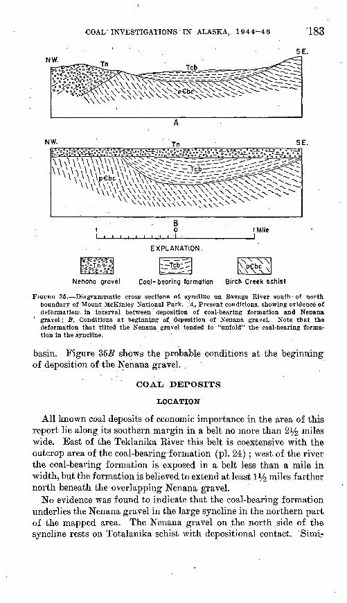
COAI/ INVESTIGATIONS IN ALASKA, 19 4 4-46 183
SE.NW.
NW.
(Mile I
EXPLANATION
Nenana gravel Coal-bearing formation Birch Creek schist
. FIGDRB 35. Diagrammatic cross sections of. syncline on Savage River south of north boundary of Mount McKinley National Park. 'A, Present conditions, showing evidence of deformation', in interval between deposition of coal-bearing formation and Nenana gravel; B, Conditions at beginning of, deposition of Nenana gravel. Note that the deformation that tilted the Nenana gravel tended to "unfold" the coal-bearing forma tion in the syncline. .
basin. Figure 355 shows the probable conditions at the beginning of deposition of the Nenana graveL
COAL DEPOSITS
LOCATION
All known coal deposits of economic importance in the area of this report lie along its southern margin in a belt no more than 2% miles wide. East of the Teklanika River this belt is coextensive with the outcrop area of the coal-bearing formation (pi. 24;) ; west of the river the coal-bearing formation is exposed in a belt less than a mile in width, but the formation is believed to extend at least iy2 miles farther north beneath the overlapping Nenana gravel.
No evidence was found to indicate that the coal-bearing formation underlies the Nenana gravel in the large syncline in the northern part of the mapped area. The Nenana gravel on the north side of the syncline rests on Totalanika schist with depositional contact. Simi-
184 MINERAL. RESOURCES OF ALASKA, 1945-46
larly, on the south side of the syncline, from the Tetlanika River east ward to and beyond the east boundary of the mapped area, the Nenana gravel rests on Birch Creek schist.- There is; thus, no'.reason to as sume that coal lies beneath the Nenana gravel in the intervening area. Furthermore, any coal deposits in this area-would be overlain by so great a thickness of Nenana gravel that they would be of no economic significance at this time. ,
Stratigraphic sections of major outcrops of coal beds are shown in plate 25. Most of the minable coal is in the middle p'art of the coal- bearing formation. Commonly no more than two beds, 4 ,f eet or more in thickness are exposed at a given locality, and ,'th'e total thickness of coal generally ranges from 15 to 25 feet. An'outcrop on the Savage River contains five beds each more than 4 feet thick,-one at least 1$ feet thick. The total thickness of coal in this section is 50 feet. No other section shows as much coal, however, and many of the beds in this section could not be correlated with outcrops elsewhere. Conse quently, the total number of coal becls in the area studied is not known.
: QUALITY OP THE COAL' ' ;
During the summer of 1946 T; R Jolley, of the^UnliecJ^tates Bureau of Mines, assisted by members of the 'Geological Survey party, col lected samples from coal outcrdjps in this area. The,atialy;s$s.of these samples are given in the following table. Localities and ;beds<.from which the samples were, collected are shown in plates. 24 and.,25.
The coal is dull black in fresh exposures and ha6 a ^a;rk-br6^n streak. In weathered exposures it is dark gray. The an'alyses^show it to be lignitic to subbituminous in-rank and to be fairly high in ash.
'COAL INVESTIGATIONS IN ALASKA, 1944-46 185
Analyses of coal from the western part of the Nenana coal field, Alaska, Analyses by H. M. Cooper, .U. S. Bureau of Mines. Condition of sample: A, as received; B, air-dried;
C, moisture-free; D, moisture-free and ash-free]
Location of sample
Second bed from top, sec. P (pi.
Upper bed, sec. D. _______
Lowest bed, sec. F..-.J ____ _
Upper bed, sec. B.... _____
Upper bed, sec. O: _ .. ___ '
Upper part of second bed below top of sec. Q.
Lower part of second bed below top of sec. G.
L'abora1 tory No.
C-64415
C-64416
C-64417
C-64418
C-64419
C-64420
C-64421
C-64422
C-64423
C-64424
C-64425
Con- di-' tion
A B C.D
AB0D
AB0D
AB 0D
A
B CD
AB C D
A B CD
A B C
. D
AB CD
B CD
B 0D
Mois ture
28.7. 11.6
27.811.2
28.610.5
30.911.0
32.711.3
28.411.4
27.9, 9.8
'31.5 10.8
28.99.4
31.511.4
26.39.6
Vola tile
mat ter
36.0 44.7 50.558.4
39.849.0 55.160.0
35.544.549.761.0
32.441.7 46.958.0
37.9 50.0 56.361.3
33.341.3 46.6 '57.9
34.4 . 43. 1
47.759.6
35.9 46.7 52.458.4
311 239.7 43.856.4
36.447.0 53.156.5
43.0 47.658.3
Fixed 'carbon
25.6 31.7 36.041.6
26.6'.32.7 36.940.0
99 7
28.5.31.839.0
23.530.3 34.042.0
OO Q
31.4 35.,538.7
24.329.9 33.8 42.1
23.3 29.1 32.340.4
25.6 33.4 37.441.6
24.030.7, 33.943.6
. 28.036.3 41.043.5
25.130.8 34.041.7
Ash
9.7 12.0 13.5
. 5:87.1 .8.0
i^ 916.518.5
' 13.217.0 19.1
5.57.3 8.2
14.017.4 19.6
i4.4 18.0' 20.0
7.0 9.1
10.2
15.920.2 22.3
4..15.25.9
13.516.6 18.4'
Sul fur
0.3.4 .4.5
.2
.2 ..3.3
.3
.4
.5
.3
.3
.4
.6
.2
.3
.3
.3
.3
.3
.4
.4
.3
.3
.4
.4
.2
.2
.3
.3
.5
.5
.7
.1
.2
.2
.2
.4
.5
.6
.7
Heat ing
value (B.t.
u.)
7,150 8,870
10, 02011,600
7,6309,380
10, 57011, 490 .
6.8108.5309. 530
11, 690
6.5608,450 9,500
11, 740
7,0909,340
.10,520-11,460-
6,7408, 340 9, 410
11, 700
6, 820 8, 530
9,46011,820
7,070 9,200
10, 32011,490
6.3208.050 8,890
.11,430
. 7, 530' 9, 730 10,99011, 680
7,2608,910 9,850
12,060
Thick ness of coal .in sample
(feet and
inches)
7 0
8 0
4 10
4 9
8 8
4 5
6 0
8. -8
13 6
13 '1
7 10
RESERVES
Coal reserves were calculated for two separate areas, one lying be tween the Sanctuary Eiver and the west end of the field, and the other in the basin of the Savage River. In the area west of the Sanctuary it was assumed that the coal beds extend at least 3,000 feet down the dip, to a depth below the surface ranging from 200 to 1,000 feet, and that they maintain their average thickness for that distance. The
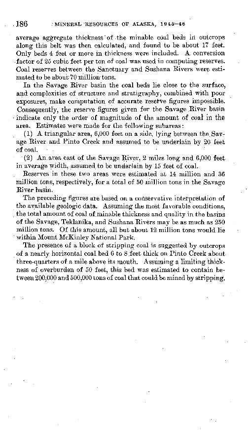
186 ; MINERAL 'RESOURCES OF ALASKA, 1945^-46
average aggregate thickness of the minable coal beds in outcrops along this belt was then calculated, and found to be about 17 feet. Only beds 4 feet or more in thickness were included. A conversion factor of 25 cubic feet per ton of coal was used in computing reserves. Coal reserves between the Sanctuary and Sushana Rivers were esti mated to be about 70 million tons.
In the Savage River basin the coal beds lie close to the surface, and complexities of structure and stratigraphy, combined with poor exposures, make computation of accurate reserve figures impossible. Consequently, the reserve figures given for the Savage River basin indicate only the order of magnitude of the amount of coal in the area. Estimates were made for the following subareas:
(1) A triangular area, 6,000 feet on a side, lying between the.Sav.- age River and Pinto Creek and assumed to be underlain by 20 feet of coal.
(2) An area east of the Savage River, ,2 miles long and 6,000 feet in average width, assumed to be underlain by 15 feet of coal.
Reserves in these two areas were estimated at 14 million and 36 million tons, respectively, for a total of 50 million tons in the Savage River basin.
The preceding figures are based on a conservative interpretation of the available geologic data. Assuming the most favorable conditions, the total amount of coal of minable thickness and quality in the basins of the Savage, Teklanika, and Sushana Rivers may be as much as 250 million tons. Of this amount, all but about 12 million tons would lie within Mount McKinley National Park.
The presence of a block of stripping coal is suggested by outcrops of a nearly horizontal coal bed 6 to 8 feet thick on Pinto Creek about three-quarters of a mile above its mouth. Assuming a limiting thick ness of overburden of 50 feet, this bed was estimated to contain be tween 200,000 and 500,000 tons of coal that could be mined by stripping.
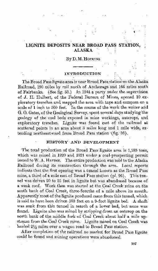
LIGNITE DEPOSITS NEAR BROAD PASS STATION,ALASKA ;
By D. M. HOPKINS
The Broad Pass lignite area is near Broad, Passxstatiori-pn the Alaska Railroad, 190 miles by rail north of Anchorage and 166 miles south of Fairbanks. (See fig. 33.) In 1944 a party under the supervision of J. H. Hulbert, of the Federal Bureau of Mines, opened 10 ex ploratory trenches and mapped the area with tape and compass on a scale of 1 inch to 500 feet. In the course of the work the writer and G. 0. Gates, of the Geological Survey, .spent several days studying the geology of the coal beds exposed in mine workings, outcrops, and exploratory trenches. Lignite was found east of the railroad at scattered points in an area about 3 miles long and 1 mile wide, ex tending northeastward from Broad Pass station '(fig. 36);
HISTORY AND DEVELOPMENT
The total production of the Broad Pass lignite area is 1,185 tons, which was mined in 1920 and 1921 under _a coal-prospecting permit issued to W. A. Havner. The entire production was sold to the Alaska Eailroad during its construction through the area. Local reports indicate that the first opening was a tunnel known as the Broad Pass mine, a third of a mile east of Broad Pass station (pi. 26). This tun nel was driven 20 to 25 feet in lignite but was abandoned because of a weak roof. Work then was started at the Coal Creek mine on the south bank of Coal Creek, three-fourths of a mile above its mouth. Apparently most of the lignite produced came from this tunnel, which is said to have been driven 500 feet on a 9-foot lignite bed. A shaft was sunk from this tunnel in search of a lower bed, but none was found. Lignite also was mined by stripping -from an outcrop on the north bank of the middle fork of Coal Creek about half a mile up stream from the Coal Creek mine. Lignite mined on Coal Creek was hauled 2i/£ miles over a wagon road to Broad Pass station.
After completion of the railroad no market for Broad Pass lignite could be found and mining operations were abandoned.
187
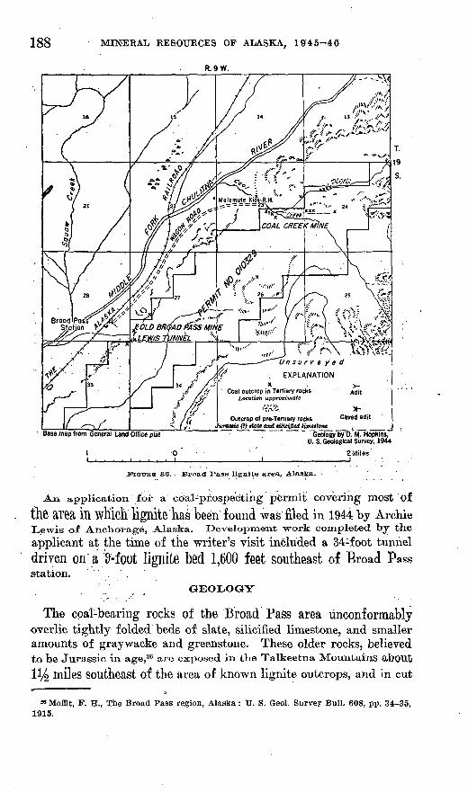
188 MINERAL RESOURCES OF ALASKA, 1945-46
R. 9 W.
Base map from General Land Office plat
*" . I Outcrop of pre-Tertiary rocks Caved adit |j/uroMtc (?> tiaU and rilie(fied, limestone _ , _ ___ _J
~ "Geolog/b/D.'M. Hopkint, U. S. Geological Survey, 1944
2 Miles
PIGTTRB 36. Broad Pass lignite area, Alaska.
An application for a c6al-pr.qspecting permit covering most of the area in which lignite has been found was filed in 1944 by ArchieLewis of Anchorage, Alaska. Development work completed by the
applicant at the time of the writer's visit included a 34:foot tunneldriven on a Hoot lignite bed 1,600 feet southeast of Broad Passstation.
GEOLOGY
The coal-bearing rocks of the Broad Pass area unconformably overlie tightly folded beds of slate, silicified limestone, and smaller amounts of graywacke and greenstone. These older rocks, believedto be Jurassic in age,26 are exposed in the Talkeetna Mountains about
ll/^ miles southeast of the area of known lignite outcrops, and in cut
39 Moffit, F. H., The Broad Pass region, Alaska : U. S. Geol. Survey Bull. 608, pp. 34-35, 1915.
QOAL INVESTIGATIONS IN ALASKA, 1944-46 189
banks along the north fork of Coal Creek about 1^4 miles above its junction with the south fork. (See fig. .36.)
The coal-bearing formation consists largely of well-sorted light- gray to yellow pebble conglomerate and pebbly sandstone but includes smaller quantities of brown 'micaceous silty clay stone, carbonaceous claystone, and lignite. The sandstone contains many coalified branches and twigs. In most exposures the coal-bearing rocks are virtually unconsolidated and are not easily distinguished from the overlying fluvioglacial deposits. Because of their lithological simi larity to Tertiary coal-bearing rocks in the Costello Creek 27 and Healy Creek areas the coal-bearing rocks at Broad Pass are believed to be Tertiary in age.
Wherever the attitude could be determined, the Tertiary beds have a general southerly dip of 2° to 9°. Poor exposures prevented the accurate determination of attitudes; the best exposures were in the. exploratory trenches, and even there the attitude of the beds obviously toad been affected by soil creep.
COAL DEPOSITS
.'; .-. GENERAL FEATURES
The lignite in the Broad Pass area is dark brown on both fresh and weathered surfaces. Fresh surfaces are characterized by alternat ing lustrous a,nd dull earthy laminae. The lignite breaks with a shaly fracture or irregularly along shrinkage cracks. Analyses x>f the lignite from the Broad Pass area were given in the accompanying table.
87 Wahrhaftlg, Clyde, Coal deposits in the Costello Creek basin: U. S. weoi. Survey, mimeographed report, 1944.
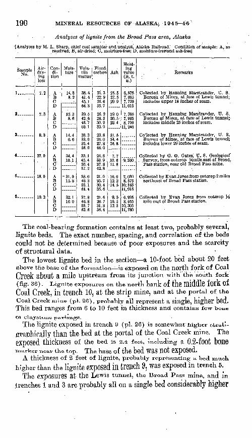
190 MINERAL RESOURCES OF-ALASKA}' 1945^4<6
; Analyses of lignite from the Broad Pass area, Alaska
[Analyses by M. L. Sharp, chief coal sampler and analyst, Alaska Railroad.' Condition of sample: A, as- received; B, air-dried; C, moisture-free; D, moistures-freehand ash-free]
Sample No.
1... -
2........
3.. ......
4........
5.......
6........
Air- dry ing loss
7.2
7.3
8.3
97 ft
1 Q ft
1Q 9
Con di
tion
AB CD
ABCD
j^BCD
j^BCD
A
B CD
AB CD
Mois ture "
14.88.2
15.38.6
14 46.6
34.4.10. .1 .
O1 (\
15.8
on 1
16.0
Vola tile
matter
38.441.4 45.164.3
39.542.6 46.760.1on q
33.035.456.0qo 1
45.4 SOU57.2
qo (\
46.3 55.164.4
07 Q
46.8 55.763.6
Fixed-, carbon
21.3-22.9 25.035.7
26.228.3 30.939.9oq o
26.027.844.0
24.833.9 37.842.8
21.025.7 30.435.6
26.7 31.836.4
Ash
25.527.5 29.9
ion20.5- 22.4
31 534.436.8
7.710.6 11.8
10.012.2
14.5
8 -c
10.5 12.5
Heat ing
value (B, t. u.)
6, .5757,085 7,720
11,015
7,3857,965 8,720
11, 240
9,330,
7,030 8,575
10,- 185'11.-915
6, 9958,655
10, 30511.780
Remarks
Collected by Henning Marstrander, U. S.Bureau of Mines, at .face of Lewis tunnel; includes upper 18 inches of seam.
Collected by Henning Marstrander, U. S.Bureau of Mines, at face of Lewis tunnel;' includes middle 25 inches of seam.
Bureau of Mines, at face of Lewis tunnel;includes lower 29 inches of seam.
Suryey, from outcrop Hmile.east of Broad Pass station, near old Broad Pass mine.
northeast of Broad Pass station.
mile east of Broad Pass station.
The coal-bearing formation contains at least two, probably several, lignite beds. The exact number, spacing, and correlation of the beds could not be determined because of poor exposures and the scarcity of structural data.
The lowest lignite bed in the section a 10-foot bed about 20 feet above the base of the formation is exposed on the north fork of Coal Creek RbOUt a mile upstream from its junction with the south fork (fig. 36). Lignite exposures on the north bank of tn6 middle f Oik OfCoal Creek, in trench 10, at the strip mine, and at the portal of theCoal Creek mine ( Pl. 26), probably all represent a single, higher bed. This bed ranges from 6 to 10 feet in thickness and contains few boneor claystorie partinge.
The lignite exposed in trench 9 (pi. 26) is somewhat higher str»U- grftphically than the bed at the portal of the Coal Creek mine. Theexposed thickness of the bed is 2.4 feet, including a 0.2-foot bonemarker near the top. The base of the bed WRS nOt GXpOSCd,
A thickness of 2 feet of lignite, probably representing a bed muck
higher than the lignite GXpOSed ill trCBCh 9, Was exposed in trench 5.
The eXpOSUreS at tjie Lewis tunnel, the Broad Pass mine, and in
trenches 1 and 3 are probably all on a single bed considerably higher
COAL INVESTIGATIONS IN ALASKA, 1944-46 191
in the section than the bed exposed"in trench 5. The higher bed ranges from 7 to 9 feet in thickness and contains several clay partings and layers of bone. Analyses 1 to 3 show that air-dried lignite from this bed contains 20.5 to 34.4 percent of ash.
RESERVES
Because of the uncertainty of correlations and the lack of informa tion on the continuity and total number of beds, reliable estimates cannot be made of the total lignite reserves in the Broad Pass area. The coal-bearing rocks are known to underlie an area of at least 1% square miles. If this area is assumed to be underlain by one lignite bed 8 feet thick, the total reserves would be approximately IS1/^ mil lion tons. Much greater reserves probably exist, however, for only on the north and east sides have the limits of the coal-bearing forma tion been mapped. Coal-bearing rocks may extend a considerable dis tance south and west of the area of known outcrops. Moreover, unless the observed coal beds are extremely lenticular, and therefore of lim ited extent, much of the known area of coal-bearing rocks probably is underlain by more than one bed.
The lignite bed at the Broad Pass mine is exposed in trenches 1 and 3, indicating an outcrop length of at least 800 feet. It seems reasonable to expect that this bed extends at least 400 feet northeast of trench 3, 400 feet southwest of trench 1, and 400 feet into the hill. If the block thus denned is assumed to average 8 feet in thickness, it is estimated to contain 200,000 tons of low-grade lignite. (See pi. 26, reserve block I.)
The bed exposed on the north side of the south fork of Coal Creek is estimated to contain about 100,000 tons of lignite that is minable by stripping. (See pi. 26, reserve block II.) At the outcrop this bed has an average thickness of 8 feet and is overlain by about 10 feet of overburden. The overburden probably does not increase greatly in thickness away from the outcrop, because the bed dips about 3° south west, approximately parallel to the surface of the terrace it underlies. This bed probably is cut off at the preglacial erosion surface about 250 feet back from the outcrop.

MINING AND EXPLORATION IN 1945 IN THE WISHBONE HILL COAL DISTRICT, MATANUSKA VALLEY, ALASKA
By F. F. BAKXES
INTRODUCTION
The Wishbone Hill coal district is in the lower, Matanuska Valley of south-central Alaska, about 45 miles northeast of Anchorage on a branch line of the Alaska Railroad. (See fig. 33.) It lies on the north side of the valley, between Eska and Moose Creeks, in an area of Tertiary sediments of nonmarine origin. The Tertiary rocks in clude two formations: (1) the Chickaloon formation, which rests on the marine Cretaceous rocks that form the floor of a large part of the Matanuska Valley and consists of at least 5,000 feet of clay- stone, siltstone, and feldspathic sandstone, including several groups of coal beds in its upper part; and (2) the Eska conglomerate, which overlies the Chickaloon formation in the central part of the coal district and is at least 1,700 feet thick, consisting mainly of pebbles, cobbles, and boulders of various crystalline rocks in a sandy m'atrix. The Eska also includes numerous beds and lenses of sandstone, rang ing from a few inches to more than 40 feet in thickness.
- Structurally the Wishbone Hill coal district is a syncline with moderately dipping limbs that have been modified by several major transverse faults, many minor faults and shear zones, and, locally, along the northwest side, by small complex folds.
The chief developments in this district in 1945 were the discovery of promising,, new coal beds in the Evan Jones mine and the drilling of three exploratory diamond-drill holes at the Government-oper ated Eska mine. The writer visited the area at frequent intervals between June 7 and October 17 to collect additional field data and to furnish geological guidance for the diamond-drilling project of the Federal Bureau of Mines. The cooperation of officials of the Alaska Railroad, the Bureau of Mines, and the managements of the Eska and Evan Jones mines is acknowledged.
This report deals with mining activities and exploratory work in the eastern part of the Wishbone Hill coal district in 1945. A com prehensive report on the entire district, based on field work in 1943, .1944, and 1945, is in preparation.
193
194 MINERAL RESOURCES OF ALASKA, 1945-46
The Eska and Evan Jones mines, in the eastern part of the dis trict, were active throughout the year, although production at Eska was interrupted on three occasions by labor difficulties, which led to the closing of the mine on June 30, 1946. The Buffalo mine on Moose Creek ceased full-scale operations early in the year because of financial difficulties, but. maintenance and repair work and some small-scale development were continued until near the end of the year, when the mine was closed. There was no activity at other mines in the area.
An important event at the Evan Jones mine was the successful completion of an exploratory tunnel to open up coal beds overlying those that had been mined on the north limb of the Wishbone Hill syncline in preceding years. The new coal is reported to be of much better quality than that mined heretofore and is estimated to add at least 5 million tons to the available reserves in the mine. The new tunnel, which was driven from the main crosscut tunnel westward through the Jonesville fault (pi. 27), intersected the coal on the projected dip of beds mapped and measured at the surface by the Geological Survey in 1944. The coal in the tunnel consists of an upper-4-foot bed of clean coal, separated by about 5 feet of clay- stone from a lower 12-foot bed that includes several thin claystone partings. (See fig. 37.) A drill hole in the footwall of the 12-foot bed is reported to have encountered at least 4 feet of additional coal beneath a few feet of rock. These beds are believed to be the same as beds 2 and 3 in the old south-limb workings. If so, bed 4, the uppermost bed of the Jonesville group, should be found at tunnel level a short distance south of the point at which the new tunnelcrosses the Jonesville fault.
Considerable difficulty was experienced in driving the tunnel
through the Jonesville fault, because of many inrushes of water,'mud, and rock. It was necessary to abandon a short section of tun nel, bypass the caved area, and drive through the fault at another point, which was done without further difficulty. A similar pro cedure was necessary in driving a smaller ventilation tunnel throughthe faulted zone.
The term "Maitland coal group" was originally applied to theMaitlarid, David, and Emery beds, because these were the only beds developed during the early operations of the Eska mine, but in the present report the term is used to include also the closely overlying Chapin bed.
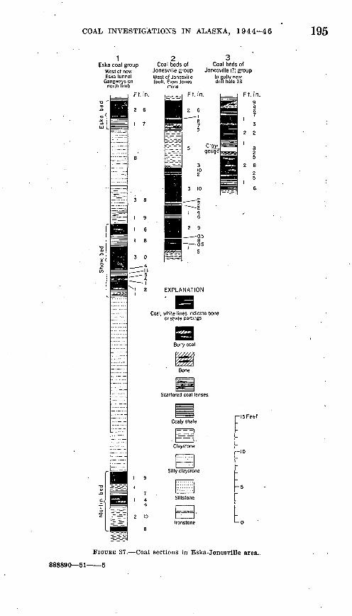
COAL INVESTIGATIONS IN ALASKA, 1944-46 195
1Eska coal group
West of newEska tunnel
Gangways onnorth limb
2 3Coal beds of Coal beds of
Jonesville group Jonesville (?) group West of Jonesville In gully near fault, Evan Jones drill hole 13
mine
Ft. in.
2 6__ I
CloyJ gouge
^ Z1 4
6
2 9
0.5
EXPLANATION
Coal, white lines indicate bone or shale partings
Bony coal
Scattered coal lenses
br^r-I 2 10
r-l5Feef
FIGURE 37. Coal sections in Eska-Jonesville area..
888890 51-
196 MINERAL RESOURCES OF ALASKA, 1945-46
In the' northwest part of section 16 of the Eska coal reserve, two trenches were opened to expose the Maitland group of coal beds, and several auger holes and test pits were dug at intermediate points. This work, done jointly by the Geological Survey and personnel of the Eska mine staff, revealed the character and thickness of the coal and .substantiated the mapping and correlation of the coal beds, based on a few auger holes, by the Geological Survey in 1944. In the same gen eral area three diamond-drill holes, ranging from 493 to 805 feet in depth, were bored in the block west of the Eska fault zone to test the coal beds at depth in advance of the north-limb workings of the Eska mine (pi. 27). The drilling was done by the Federal Bureau of Mines as part of a program of proving additional coal reserves to stimulate coal production in Alaska. All three holes were drilled perpendicular to the bedding of the north limb of the Wishbone Hill syncline.
In this report, drill holes are designated by project numbers as signed by the Bureau of Mines. The purpose of drill hole 13 was to check the succession of coal beds in the area as determined in 1944 from surface exposures, to test the Eska coal group down the dip from the present mine workings, and to check the character and position of the Maitland group and overlying coal beds, particularly with respect to the northwest boundary of the Eska fault zone. The succession of coal beds penetrated by hole 13 corresponds closely to the one deter mined from surface exposures. (See pis. 28 and 29.) All beds mapped at the surface, from bed 5 to the Martin bed, inclusive, were identi fied in the drill hole, and only one bed in the drill hole had not been found at the surface. This bed, consisting of 4 feet of bony coal, lies 18 feet above the coal bed identified as the Chapin. It may correspond to the bed shown by Tuck 28 as lying 20 feet above bed 7 equivalent to the Chapin in the Evan Jones crosscut tunnel.
Bed 5, which was reached at a depth of 167 feet, has a total thick ness of about 21 feet, of which probably only the upper 10 feet would be mined, as the lower part includes much bone and coaly shale. Bed £, at a. depth of Q15 feet, contains 6 feet of coal in three benches, of which only the upper 4-foot bench, including some bony coal, prob ably would be considered minable, The Chapin bed, at 300 feet, con tains 4 feet of coal of which a small part is bony. The Maitland bed, at325 feet, includes two benches of partly bony coal about Q feet thick separated by 3 to 4 feet of coaly shale and bone. This bed, regarded
as the most desirable coal in the old Eska workings to the east, prob-
28 Tuck, Ralph, The Eska Creek coal deposits, Matanuska Valley, Alaska : U. S. Geol. Sur vey Bull. 880-D, pi. 13, sec. 34, 1937.
COAL INVESTIGATIONS IN ALASKA, 1944-46 197
ably would not be mined at this locality. The David bed, at 355 feet, contains only about 2 feet of coal in two thin benches and so is not minable. The Emery bed, at 405 feet, has a total thickness of 5 feet, of which nearly 4 feet is clean coal. Bed 9, at 545 feet, consists of two 1-foot seams separated by 2 feet of coaly shale.
The beds of the Eska coal group were reached by the drill between depths of 680 and 740 feet. The lowest, or Martin, bed was reached ;at a point about 350 feet down the dip from the present mine workings. (See pi. 29.) The sections of these beds in the drill hole differ con siderably from those exposed in the north-limb gangways (pi. 28 and fig. 37). The Eska bed apparently thickens down the dip, essentially by the addition of about 2 feet of bony material at the base. The Shaw bed increases in over-all thickness by about 4 feet, but, although it has the same three benches in the drill hole as in the gangway, the upper and lower benches are both thicker and dirtier, and the middle bench appears to have thinned from 3 feet to 1 foot of clean coal.
The Martin bed has about the same over-all thickness in the drill hole as in the mine, but the claystone partings that divide the bed into three benches at the gangway apparently pinch out or grade into bone down the dip, for the drill revealed a single bed 8^/2 feet thick, of which the upper iy2 feet and the lower 3% feet are largely bone, and the remaining 3% feet is relatively clean coal.
Judging from the drill records, minable coal in the Eska group 350 feet down the dip from the present workings includes about 2^ feet in the Eska bed and 3% feet in the Martin bed. The Shaw bed apparently is too dirty to mine at that depth, at least in the immediate vicinity of drill hole 13.
At the time of the drilling, plans for the future underground devel opment at Eska included a crosscut tunnel to be driven from the Eska gangway on the north limb across the strata to overlying beds just west of the Eska fault zone. One purpose of the drilling was to obtain advance information on the position of the fault-zone bound ary before starting the tunnel. Hole 13, therefore, was directed toward the approximate point at which the proposed tunnel would intersect the Emery bed, the -lowest member of the Maitland group. The drill passed through relatively undisturbed ground and reached the Emery bed about 40 feet above the projected tunnel level, showing that the proposed tunnel would reach the Emery bed west of the fault zone and about 550 feet from the Eska gangway. However, if the strong fault that is exposed at the northwest end of the new Eska tun nel (pi. 27) extends south westward with unchanged strike, it would cut off from the proposed tunnel most if not all of the beds above the Emery. By driving southwestward from the Emery bed, parallel to the fault, however, the overlying beds could be reached.
198 MINERAL RESOURCES OF ALASKA, 1945-46
DRILL HOLE 14
The purpose of drill hole 14 was to explore the strata of the Chick- aloon formation that overlie beds 5 and 6, which were penetrated by hole 13, and also to determine the position of the Jonesville coal group beds 1 to 4 of the Evan Jones mine on the north limb with respect to the working level of the Eska mine. Coal beds with abnor mally steep dips crop out in a gully just west of hole 13 (fig. 37, sec tion 3), and they are thought to lie near the northwest boundary of the Eska fault zone. These beds and others exposed in a deep gully 400 feet to the southeast very probably represent the Jonesville coal group. It was considered that if these beds crossed the axis of the syncline below the level of the mine workings, a considerable block of coal, possibly containing as much as 1 million tons, could be developed by driving a tunnel, either from an extension of the present north- limb workings, or from a point on the surface to the southeast. Hole14 was located with the idea of placing it just west of the Eska fault zone and close to the synclinal axis, so that the coal beds would be intersected at as low an elevation as possible.
Available data indicated that the Jonesville coal group should be reached 150 to 200 feet below the collar of the drill hole; consequently, when drilling to a depth of nearly 500 feet disclosed only a few thin traces of coal it was concluded that the hole was within the Eska fault zone. This belief was supported by numerous sheared and crushed zones in the drill core. Accordingly, the hole was stopped and a new site chosen farther west.
DRILL HOLE 15
The purpose of drill hole 15 was the same as that of hole 14, with the additional objective of testing for the Maitland coal group. Hole15 was started at a point judged to be several hundred feet west of the Eska fault zone and slightly higher stratigraphically than the collar of hole 14. The Jonesville group was expected at a depth of 200 to 250 feet, but the first coal of appreciable thickness was found at a depth of nearly 600 feet, at about the predicted position of the Mait
land group. The coal at this depth included two beds of exception ally clean coal, 6 and 14 feet thick, respectively. Some additional coal was found at about 700 feet, but as none of the beds were readily identifiable, drilling was continued in the hope of reaching the Eska group. Although no additional coal had been found the hole wasstopped at a depth of 805 feet on October 22, because of severe winterweather.
Although considerable shear faulting was noted in hole 15, the fact that the bedding, except for local cross bedding, remained uniformly
COAL INVESTIGATIONS IN ALASKA, 1944-46 199
perpendicular to the drill hole throughout its length argues against any part of the hole being within the highly sheared, distorted, and irregularly folded strata of the Eska fault zone, which is probably several hundred feet wide opposite the drill hole. The presence of three beds of distinctive sandstone and arkose at corresponding posi tions in holes 14 and 15 (pi. 28) shows that the two holes cannot be on opposite sides of a major fault and consequently that hole 14, as well as hole 15, is west of the Eska fault zone.
INTERPRETATION OF DRILL HOLES 14 AND 15
Several problems were raised by the data from drill holes 14 and 15., Chief among these are the'identity of the coal beds in the lower part of hole 15, and the absence of beds 5 and 6 and the entire Jonesville .group at their expected positions in both drill holes.
Considering only its position, the coal in hole 15 seems readily correlated with the Maitland coal group, lying as it does on the pro jected dip of the surf ace exposures of these beds. (See pi. 29.) Op posed to this correlation, however, are the lack of coal in the over lying strata in the proper relative positions for beds 5 and 6 and the Jonesville coal group, and the marked difference between the coal- TDearing section in hole 15 and the Maitland group in hole 13. (See pi. 28.)
A possible correlation of the coal in hole 15 with the Jonesville group, which includes the highest known coal beds in the area, is .suggested by the absence of coal at higher positions in the drill hole, which starts within 40 feet of the base of the overlying Eska conglom erate. It is impossible, however, to reconcile such correlation with the known structure. The coal in hole 14 is at least 400 feet vertically below the theoretical position of the Jonesville group as determined either with reference.to the Maitland beds in drill hole 13 and in out crops to the north, or by projecting the Jonesville beds themselves northward across the synclinal axis from the south-limb workings of the Evan Jones mine. (See pi. 29.)
The possibility that the coal beds between depths of 585 and 645 feet in hole 15 are equivalent to beds 5 and 6 is suggested by the fact that in hole 13 bed 5 is the only coal of comparable thickness. Such corre lation is opposed by disparity in over-all sections and. structural
v relations, and it also fails to account for the absence of the overlying Jonesville coal beds.
A study of all available evidence leads to the conclusion that the coal in drill hole 15 most probably represents the Maitland group. The discrepancies in the number, spacing, and thickness of the coal beds may be due largely to lateral gradation of the strata. Shearing
200 MINERAL RESOURCES OF ALASKA, 1945-46
at small angles to the bedding, of which there is abundant evidence in the drill cores, has doubtless intensified these differences. Poor core recovery in crushed coaly beds may also account for much of the difference in the drill records. These factors probably also account for the absence of beds 5 and 6 and the Jonesville group in drill holes 14 and 15. This interpretation is supported by the abundance of thin coaly streaks, as well as sheared and crushed zones that include many coaly fragments, in the two drill holes near the inferred positions of the missing coal beds. (See pi. 28.)
The information of greatest economic significance gained from drill holes 14 and 15 is that there is no minable coal at the inferred position of the Jonesville group on the north limb of the syncline on the Eska property. Consequently, any attempt to develop these beds from the Eska mine is unwarranted.
With regard to the Maitland group, the significance of the drilling results is dependent on the identity of the coal in hole 15. If, as seems probable, this coal represents the Maitland group, its position on the projected strike of the Maitland coal beds in hole 13 shows that there has been no major displacement between the two drill holes. On the other hand, comparison of sections of the two drill holes in dicates that as the beds are mined westward from the vicinity of hole 13 they may be expected to change considerably in character and thick ness and to be disturbed by shear faulting. The possibility of faulting has been emphasized by conditions revealed by mining operations in 1946 on the underlying Shaw bed, where, in an area directly across the strike from the drill holes, numerous faults of small displacement and probably related flattening of the beds are .reported by mine officials to have so increased the difficulty of mining that work was abandoned.
Although beds 5 and 6 appear to be of minable quality and thickness at drill hole 13, their absence in drill holes 14 and 15 indicates thatthey are not of minable extent west of the Eska fault zone.
CONCLUSIONS
Field mapping and exploratory drilling in the northwest part ofthe Eska coal, reserve has shown the presence of at least 11 coal beds,.of which the 3 composing the Eska group have been developed in theEska mine, and at least 2 more, the Emery and Chapin beds, areprobably of minable character and extent. The beds of the Eska coalgroup are known to thin, westward and to be so disturbed by faulting
'that further mining is impracticable. Conclusive evidence of the westward minable extent of the Emery and Chapin beds was not ob tained by drilling, because the individual beds could not be positively
COAL INVESTIGATIONS IN ALASKA, 1944-46 201
identified in drill hole 15. The lowest bed in the drill hole probably is the the'Emery bed. The Chapin bed in hole 13 possibly is con tinuous with one of the thick beds in hole 15. The Maitland bed, which is scarcely minable at hole 13, possibly is also continuous with one of the thick beds in hole 15 and thus would be minable for part of the distance between the two drill holes.
Assuming that the above suggested correlations are correct, the amount of coal of minable thickness west of the Eska fault zone and above the present mine level, largely in the Emery and Chapin beds, is estimated to be at least 700,000 tons. Probably an even greater amount lies below the present mine level. The total amount of coal in this area that is-sufficiently undisturbed by faulting to be mined probably could be more satisfactorily determined by under ground prospecting extended from the present mine workings than by further drilling from the surface.

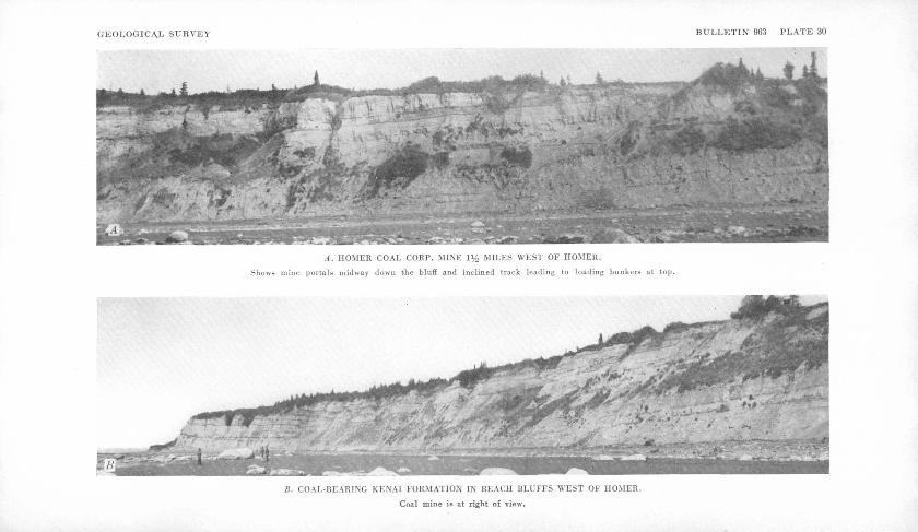
GEOLOGICAL SURVEY BULLETIN 963 PLATE 30
A. HOMER COAL CORP. MINE 1% MILKS WEST OF HOMER.
Shows mine portals midway down the bluff and inclined track leading to loading bunkers at top.
B. COAL-BEARING KENAI FORMATION IN BEACH BLUFFS WEST OF HOMER.
Coal mine is at right of view.
PRELIMINARY REPORT ON COAL DEPOSITS NEAR HOMER, ALASKA
BY F. F. BARNES
INTRODUCTION
The presence of coal in the Kenai formation (Tertiary) of the west--ern part of the Kenai Peninsula (fig. 33) has been known for many years, chiefly from exposures in the beach cliffs along the north shore of Kachemak Bay and the adjoining eastern shore of Cook Inlet.29
' Several attempts were made to develop a commercial mine in this area in the period 1888-1902,30 but none of the operations progressed beyond the prospecting stage, and little coal was produced. In 1915, mining of coal was started at the Bluff Point .mine, V/2 miles west of Homer. Available records indicate that this mine produced between 20,000 and 25,000 tons of coal before closing in 1924. No further attempt at systematic mining was made until 1946, when the Homer Coal Corp. began the development of a mine near the site of the old Bluff Point mine. At the time of the writer's visit in August 1946, the new com pany was erecting loading bunkers and living quarters, and had driven a tunnel a short distance in from the face of the beach bluff on a 6% foot coal bed. Coal from this tunnel is hoisted up an inclined track to the bunkers at the top of the bluff. (See pi. 30-4.)
In 1946 the Geological Survey decided to make detailed studies of the coal deposits of the western part of the Kenai Peninsula. This decision was prompted by the general increased interest in this part of Alaska,: based largely on its agricultural possibilities and recently stimulated by the start of construction of a highway to connect Homer "with the Alaska Railroad. Any substantial increase in the population of this area would create a critical problem of fuel supply, the most logical solution of which would seem to be the development of the local coal deposits.
M Ball, W. H., Report on coal and lignite of Alaska: U. S. Geol. Survey 17th Ann. Rept, ;pt. 1, pp. 763-906, 1896. Stone, R. W., Coal fields of the Kachemak Bay region : U. S. 'Geol. Survey Bull. 277, 1906. Atwood, W. W., Mineral resources of southwestern Alaska: ,U. S. Geol. Survey Bull. 379, 1909. Martin, G. C., Johnson, B. L., and Grant, U. S., Geology and mineral resources of Kenai Peninsula, Alaska: U. S. Geol. Survey Bull. 587, pp. 67-89, 1915.
30 Stone, R. W., op. cit., pp. 54-56.
203
204 MINERAL RESOURCES OF ALASKA, 1945-46
As a preliminary step to a detailed investigation the writer, accom panied by T. R. Jolley of the Federal Bureau of Mines, spent 8 days-- in August 1946 in an area of about 14 square miles extending north ward and northeastward from Homer. The object of the field work was to examine briefly the area inland from Kachemak Bay in order to get a broader impression of the character and structure of the coal- bearing Kenai formation than is given by the .reports of earlier geologists, whose observations were confined largely to the bluffs along the beach. Coal exposures were examined at about 40 localities and plotted on aerial photographs. The accompanying sketch map (fig. 38) was prepared from the photographs by the radial-line method', of planimetry.
The writer is indebted to Evan Jones, superintendent of develop ment work for the Homer Coal Corp., for many courtesies and much, information on past and present mining activities, and to Bert Hanson and William Lawrence of Homer for directing him to several isolated, coal exposures.
GENERAL DESCRIPTION OF AREAi
Along the north shore of Kachemak Bay in the Homer area, steep to- vertical bluffs carved in light-colored sandstone and shale of the Kenai formation rise 50 to 200 feet above the beach. (See pi. 30.) From; the top of the bluffs a sloping bench, ranging from half a mile to a mile and a half in width, rises gradually northward to a general alti tude of about 300 feet at the base of a prominent escarpment that probably represents a line of older and much higher sea cliffs. The escarpment, which rises steeply from the lower bench to an altitude of about 1,000 feet, is scored by many short steep-walled gullies and embayed by a few larger canyons. From the top of the escarpment a rolling upland extends northward to the boundary of the mapped area,, attaining on the highest rounded summits altitudes of as much as 1,300' feet. The upland is drained by several westward-flowing streams,, which follow tortuously meandering courses through shallow, open valleys, some of which head within a few hundred feet of the brink of the escarpment. (See fig-. 38.) .
The village of Homer is on the lower bench, near the base of the 5-mile-long Homer Spit, which extends half way across the mouth of Kachemak Bay. Good roads extend from Homer westward 2 miles to Coal Creek known locally as Bidarki Creek northeastward 8 miles along the lower bench to Fritz Creek, southeastward 6 miles to the dock at the tip of Homer Spit, and northward over the escarpment to the upland, where several branch roads lead to scattered homesteads. The new highway, which was under, construction in 1946, will extend west ward from Homer to Anchor Point, and thence northward and east-
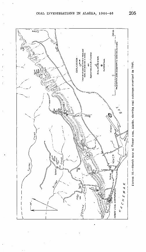
COAL INVESTIGATIONS IN ALASKA, 1944-46 205
206 MINERAL RESOURCES OF ALASKA, 1945-46 '
ward to connect with the Alaska Railroad by way of Ninilchik, Kenai, and Kenai Lake.
STRATIGRAPHY
The coal-bearing Kenai formation, of Tertiary age, is believed to underlie the entire Kenai lowland, of which the Homer area is the southern extremity. According to Martin,31 the formation has a total thickness of at least 1,800 feet and consists of about equal volumes of partly indurated sand and clay in beds generally not more than 30 feet thick, interbedded with a few thin lenses of conglomerate and many beds of lignite. The rocks are sufficiently indurated to stand in almost vertical cliffs several hundred feet high, yet they may be easily cut with a pick or knife. The argillaceous beds are generally gray or blue, and the sandy beds light buff.
STRUCTURE
Martin 32 described the structure as follows:
The structure of the Kenai lowland is very simple. Broad, gentle folds, in which the dips are in general from 1° to 5°, are characteristic structural features. A few small normal faults were observed, * * * but there is no reason to believe that faulting is an important element of the structure. The restriction of the exposures to the shore line makes it impossible to outline the broader struc tural features with certainty. The dip on the north shore of Kachemak Bay is northward, the strike being in general east, but varying considerably and, becaus'e of the low dip, being difficult to read with accuracy.
Observations made in 1946 bear out the preceding general descrip tion of the structure. All dips measured have a north component and at most places are to the northwest, although a few northeast dips were recorded. (See fig. 38). The amount of dip generally is less than 5°, although a few dips of 9° and one of 12° were read. In many outcrops the beds are horizontal. In most of the area the changes in dip and strike seem to be irregular, unrelated to major structural axes. It seems probable that a gentle northwestward dip, modified locally by
minor warping, is characteristic of the regional structure. Many 01 the observed erratic dips were obviously the result of surface creep or slumping of the soft sediments on steep slopes. On the beach abouta mile west of Coal Creek a series of claystone, sandstone, and coal bedshas been compressed and tilted into several Small folds that plunge 30° N. Farther west the series grades into massive claystone con taining many scattered angular fragments of sandstone, conglomerate,
« Martin, G. C., Johnson, B. L., and Grant, U. S., Geology and mineral resources of Kenai Peninsula, Alaska : U. S. Geol. Survey Bull. 587, pp. 67-68,1915.
33 Martin, G. C., Johnson, B. L., and Grant, U. S., op. tit, pp. 102-104.
COAL INVESTIGATIONS IN ALASKA, 1944-46 207
and coal. This section of beach is separated from the main bluffs to the north by an extensive area characterized by typical landslide topog raphy, including several small lakes. The complex structure noted on the beach and in adjacent low bluffs is obviously the result of de formation in the toe of a large landslide mass.
A single major fold was noted in the area examined. A shallow northward-trending syncline, the axis of which lies just west of the mouth of Coal Creek, is exposed in the beach bluffs west of Homer. The limbs of the fold dip less than 5°, and the axis plunges gently northward. The new coal mine is on the east limb of this fold.
No evidence of faulting, other than superficial movements connected with slumping on steep slopes, was seen by the writer in 1946. Sub sequent field work in 1947, however, revealed the presence of at least two faults in the Homer area, one of which, about a mile northeast of the Homer post office, has a vertical displacement of 50 feet.
CHARACTER AND DISTRIBUTION OF COAL
The coal of the Homer area commonly has been considered to be lignite, but the analyses given in the accompanying table indicate that it is of subbituminous rank, according to present standards of classi fication.33 In fresh exposures the coal is generally dull black, but includes many bright lustrous bands and has a dark-brown streak. Generally it has no well-developed fracture, or cleat, but locally it exhibits both a prominent cleat and a poorer one, at right angles to each other and to the bedding. Where erosion is rapid, as in the beach cliffs and at the bottoms of gullies, the coal breaks off in large slabs parallel to the bedding. In weathered exposures it is dark gray and its woody texture is emphasized, resulting in a platy fracture parallel to the bedding.
The coal beds range in thickness from a few inches to 6 feet or more. They may change in thickness considerably within a short distance, as is illustrated by the uppermost bed of five exposed in the sea cliff west of the coal mine. This bed is 7% feet thick at the mine but only 4 feet thick at Coal Creek, 1,800 feet to the west.
The location and thickness of coal beds examined in 1946 are shown i on figure 38. The total number of beds represented by the outcrops examined is not known, because of insufficient structural and strati- graphic data to correlate beds in widely separated exposures. The thickest and most continuous section of the Kenai formation seen by the writer is exposed in and near Bear Canyon, about 3 miles east of Homer. Three coal beds between 3 and 5 feet thick are exposed on the beach about a mile southeast of the mouth of the canyon. In Bear
83 Cooper, H. M., and others, Analyses of mine, tipple, and delivered samples, in Analyses of Alaska coals : U. S. Bur. Mines Tech. Paper 682, pp. 20-22, 1946.
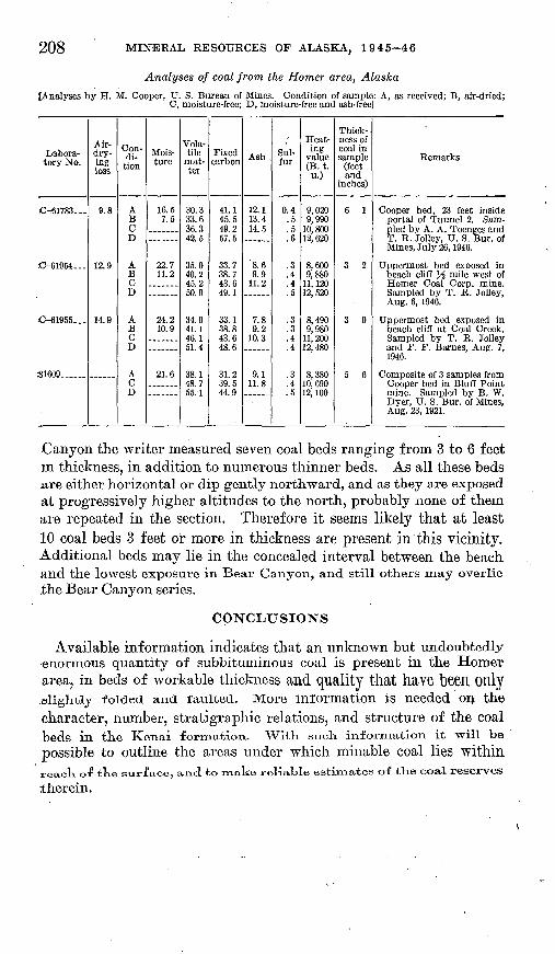
208 MINERAL RESOURCES OF ALASKA, 1945-46
[Analyses by H. M. Cooper, U. S. Bureau of Mines. Condition of sample: A, as received; B, air-dried; C, moisture-free; D, moisture-free and ash-free]
Labora tory No.
-.61783...
-61954.-
-61955..-
S1609 ......
Air- dry ing loss
9.8
12.9
14.9
Con di
tion
ABCD
ABCD
ABCD
ACD
Mois ture
16.57.5
22.711.2
.......
24.210.9
21.6
Vola tile
mat ter
30.333.636.342.5
35.040.245.250.9
34.941.146.151.4
38.148.755.1
Fixed carbon
41.145.549.257.5
33.738.743.649.1
33.138.843.648.6
31.239.544.9
Ash
12.113.414.5
8.69.9
11.2
7.89.2
10.3
9.111.8
Sul fur
0.4.5.5.6
.3
.4
.4
.5
.3
.3
.4
.4
.3
.4
.5
Heat ing
value (Bt. u.)
9,0209,990
10, 80012, 620
8,6009,880
11, 12012, 520
8,4909,980
H OAfl, £i\J\)
12, 480
8,38010, 69019 inn1^, J.UU
Thickness of coal in sample
(feet and
inches)
6 1
3 2
3 9
5 6
Remarks
Cooper bed, 23 feet insideportal of Tunnel 2. Sampled by A. A. Toenges andT. R. Jolley, U. S. Bur. ofMines, July 26, 1946.
Uppermost bed exposed inbeach cliff % mile west ofHomer Coal Corp. mine.Sampled by T. R. Jolley,Aug. 6, 1946.
Uppermost bed exposed inbeach cliff at Coal Creek.Sampled by T. R. Jolleyand F. F. Barnes, Aug. 7,1946.
Composite of 3 samples fromCooper bed in Bluff Pointmine. Sampled by B. W.Dyer, U. S. Bur. of Mines,Aug. 23, 1921.
Canyon the writer measured seven coal beds ranging from 3 to 6 feet m thickness, in addition to numerous thinner beds. As all these beds are either horizontal or dip gently northward, and as they are exposed at progressively higher altitudes to the north, probably none of them are repeated in the section. Therefore it seems likely that at least 10 coal beds 3 feet or more in thickness are present in this vicinity. Additional beds may lie in the concealed interval between the beachand the lowest exposure in Bear Canyon, and still others may overlie the Bear Canyon series.
CONCLUSIONS
Available information indicates that an unknown but undoubtedly -enormous quantity of subbituminous coal is present in the Homer area? in beds of workable thickness and quality that have been Only .elightly folded and faulted. More information is needed on the character, number, stratigraphic relations, and structure of the coalbeds in the Kenai formation. With such information it will be
possible to outline the areas under which minable coal lies withinreack of the surface, and to make reliable estimates of the coal reserves
therein.
INDEX
A PageAccess routes. See routes of travel. Acknowledgments 143,170,193,204Alluvial fan, Coal Creek.. .. 153Analyses, of clay... - . 167
of coal, Broad Pass lignite.......... 189,190,191Healy Creek valley...---------- 157-159,160Homer area.___---------- _... 208Lignite Creek valley. - . 161 western Nenana coal field.--------- 184,185
.Andesite, intrusive. - .-.. 143 Anticlines. 155,156,172,181
BBirch Creek schist, inHealy-Lignite area... 146-147,
148,154,155; pis. 18, 2QAin western Nenana area__.- ------- 171,
172-173,175,178,179,180,181,182,184 uneven erosion surface on..___ 147,151,174
Chickaloon formation, in Matanuska Valley. 193,198 Clay deposits, Healy Creek..... 147,148,149,165-168
Lignite Creek . . Pis. 21,22 western Nenana area, clay stone .. 176
Cleavage planes, in Birch Creek schist__... 147 Climate, Healy-Lignite area ___ 144
western Nenana field__.__-.-..___ 171'Coal-bearing areas, Broad Pass area. 187-191; pi. 26
Homer area 203-208Nenana coal field, Healy-Lignite
area..--..--.-------.--..--- 141-164,205Mystic Creek basin... ________ 181
Summary statement and index map._ 138,139 western Nenana coal field.....---.----- 169-185Wishbone Hill, Matanuska Valley..... 193-200'
Coal-bearing formation, Broad Pass area.... 189,191description of_--.-....___..____ 146,
147-152; pis. 17B, ISA, 19,20/1,21,22 fossils in......_____...-__ ___ 147Matanuska area, formations in.. 193,203,204,206 Nenana coal field, cyclic deposition in_. 149,
151,152Healy-Lignite area___.______ 146,
147-152; pis. 17,19, 20, 21, 22lower member, Healy Creek.___ 147-148,
162,165; pis. 18^4,19Lignite Creek.-.---.-.-.... 150-151,163western part __..______ 173,176
middle member, Healy Creek.__. 148-149,150; pis. ISA, 19
Lignite Creek.............. 151,152,163upper member, Healy Creek. - _.. 149,150
Lignite Creek.----... 151-152,160upper and middle members absent
west of Nenana River...-_..-.. 173 position of __._____.....___... ... 146
PageCoal beds, Broad Pass lignite area_____ 189-191
Healy Creek area, beds F and Q_____ 147,148,155,160, 168
beds 1, 4, 5, 6...............__ 149,150,155Moose bed-.__._________ 148,155
Lignite Creek area, beds H and L___ 151,163 Matanuska area, beds at Evan Jones mine. 194,
198beds 1-6.. .. 196,197,198,200 Chapin bed........ 194,196,200,201David bed....._...........___.. 197Emery bed______________ 197,200 Jonesville coal group....____ 194,198,199Maitlandbed-_____________ 194Maitland coal group_______- 194,
196,198,199, 200, 201Martin bed ...................:.. 196,197Shaw bed--....- ................ 197,200
Coal deposits, burning, adjacent clays andshales baked by. -________ 162
burning, effect on reserve estimates. ___ 164recent fires from.---....__..._... 162
character of, at Wishbone Hill-..-.. 194,197,198in Broad Pass area- _________ 189,190in Healy-Lignite area______..--- 147,
149, 152, 156-161, 184; pis. ISA, 19, 20, 21in Homer area.____________ 207-208in western Nenana coal field- _ 175,184-185
cyclic depositions in Healy-Lignite area.. 149,151, 152
Matanuska area, drill holes 13-15___ 196-197,198-199
new tunnel in Evan Jones mine.. 195; pis.28,29
Nenana coal field, difference in variousmembers...__________ 146
local occurrence in basal conglomerate. 175 members on Healy Creek_ 148, 149; pi. 19 members on Lignite Creek_ 151-152; pi. 21 number and thickness of beds.. ___ 184 rarity of coal in basal conglomerate... 174 spreading of beds on Healy Creek.. 148-149 variation in total thickness, Healy-
Lignite area...___.'____.. 156 woody coal in Nenana gravel._-'...- 177 150-ft. section above conglomerate.... 175
size of areas, at Healy Creek_______ 141at Lignite Creek.___________ 142in western Nenana field.._____-. 169
Coal production, at Healy___.___.... 164at Roth lease..__..__.___..__.. 165 at Suntrana..._....____....___.. 165in Broad Pass area. ____________ 187 in Homer area...._._____..____ 203
209
210 INDEX
Page Coal reserves, assumed volume of a ton of coal
in place- -------------------- 162,186at Wishbone Hill........... 193,194,198,200,201in Broad Pass area... ... 191 in Healy Creek area.._ -_-_- __-_-.---__ 162-163 in Homer area____ '. ___ -. - 208 in Lignite Creek area....._______. 163-164in western Nenana field.-.-__------- 185-186minable depth assumed in calculation.. 162,185
Cretaceous rocks, in Matanuska Valley..---- 193
DDiamond drilling, Wishbone Hill -.-.-.... 193,
196-200; pis. 28, 29Domes, structure.____________ 155,172,181
topographic.--..._--------- .. 143Drainage, in Healy-Lignitearea..__....'. 143-144
in western Nenana field....______ 170-171
EEocene rocks, Healy-Lignite area_______ 147 Erosion surfaces, on Nenana gravel__.--.. 143
preglacial, in Broad Pass area_______ 191 Eska mine. See under Mines.
Faults, at Wishbone Hill, Matanuska area,coal disturbed by..__.__.__ 201
at Wishbone Hill, Matanuska area, Eskacoal group.__.__.___.--... 200
Eska fault zone.... ....... 198,199,200in Shaw bed_______________ 200 Jones ville fault.____________ 194 low-angle strike shears___-------- 199-200sheared and crushed zones in drill
holes-. 198,200transverse faults -------- .-' - 193
in Healy-Lignite area, major fault.. 146, 147,154,155; pis. 19, 20
minor faults in coal.______ - 155- questionable strike faulting-..._ 155 relation to syncline. __________ .156 "tilting of Tertiary rocks on Healy
Creek....-.-.--.-.--.---..------- 154transverse faults.....--.. 146,155,156; pi. 19uplifted Birch Creek schist block... 146,155
in Homer area............. . 206in western Nenana field, duplication of
beds and contacts by strike fault ing..... ........................ 176,181
in Nenana gravel..------------------- 181on north flanks Alaska Range.-- .. 181on tributary of Sushana River........ 181tilted fault block...._----------- 181
Folds and folding, in Healy-Lignite area,
chevron fold. . 154in Healy-Lignite area, minor drag folds- 146.155
relation to faulting -- 156synclines........... 146,154,155,156; pi. 184
In Homor area, in Kenai lowland.-- --- 2OOmajor syncline west of Coal Creek.... 207 small (olds on beach.................. 206
Folds and folding Continued Pagein western Nenana field, contorted schists. 17$
foliation inschists . ._____.... 18ftin Nenana gravel___._______ 181in north flank Alaska Range____ 180-181isoclinal folds in schist_....___ 17Smajor syncline_.._...__.....__ 181minor domes with schist core___ 172,181
overturned beds on Sunday Creek._ 182structure in pre-Tertiary rocks___. ISO1
' ' syncline involving Nenana gravel_1. 177syncline on Savage River_____ 182,183
Wishbone Hill syncline- 193,194,196,198,199,200See also Anticlines and domes.
Fossils, at Broad Pass.___._________ 189carbonized rootlets... ____1 ____ 149coalified or coaly plant material...____ 147,
149,156,160,174,177,178freshwater fish.....___._________ 147
O Gold prospecting on Sunday Creek______ 172'
Havner, W. A. See Permits.History:
Broad Pass coal area....___ _____. 1ST Coal in western Nenana field.______ 169' Coal production in Healy area..____ 164-165 Geological investigation in Healy-Lignite
area.,__..___________ 141 Homer coal area._..__....____... 20$
Intrusive rock...__.....__.__._...... 143'Investigations, at Broad Pass, 1944______ 187"
at Wishbone Hill, 1944-45.---. ------ 193,196-in Homer area, 1946. ....-_........ 203-204in progress at Nenana..._____ 138-in western Nenana field, 1946..._ 170"on Healy Creek, geological, 1944. ___ 141-142'
trenching, 1943-44. .......... 14?-on Lignite Creek, 1945__________ 142-143'-
Jurassic rocks, Broad Pass area____ ... 188-
Lakes, at Homer............................. 203-'
in western Nenana field............_.. 171near road through Anchor Point _ _.- 206
Landslides (see alxo Slumping)--,..__ 148,206,207"Leases. See Permits.Lewis, Archie. See Permits.Lignitic coal. See Rooks. Limestone. See Rocks. Localities:
Alaska R. R..._ 137, 145, 165, 171, 187, 193, 2O4, 2O6-
Alaska Range............ ............ 137,
138,139,141,143,152,170,179.180>Anchor Point, In Homer area, road to.... 204
Bear Canyon, in Homer area, Kenai for mation coals..- 207-208^
INDEX 211
Localities ContinuedBidarki Creek. See Coal (Bidarki) Creek. Bluff Point, in Homer area, mining..__ 203 Bonnifleld gold district, trail to.___._ 145 Broad Pass station coal area______. 138,
139, 187-191; pi. 26 Broad Pass storm track........_....... 144Coal Creek, in Broad Pass area...____ 187,
188-189,190,191in Healy area............... 148,149,153,155
Coal (Bidarki) Creek, in Homer area. __ 204,205,206, 207
Cook Inlet....... .. _._. 137,138,139,203CostelloCreek....___-._ ---...--_ __ 189Cripple Creek, in Healy area... 148,153,155,168 Dora Creek, in Healy area...._____... 148Dry Creek, in Healy area....__........ 169Eska Creek, in Matanuska area.......... 193Eska-Jonesville area._..... 195; pis. 27, 28, 29Ewe Creek......................... 174,175,176French Gulch, in Healy area... 147,156,162,163 Fritz Creek, in Homer area............... 204Gagnon Creek, in Healy area... 144,156,162,163 Gold Run, in Healy area......_........ 155Healy........._....... .... 139,141,142,145Healy Creek......-....-.--...--.-.-.-..-. 141,
143, 144, 145, 146, 147-150, 152, 153,154-155, 156-160, 162 163, 165-168,18U; pi. 18.
Healy-Lignite area...-.......-....-.-.- 141-168Homer.------....------..------- 138,139,203-208Homer Spit, in Kachemak Bay_._..__. 204 Jumbo Dome..--..---.--.....-.... 142,143,154Kachemak Bay, on Cook Inlet......... 203,204Kantishna area...--_--.----_----.--- 139,169Kantishna River, drainage relation....... 170Kenai lowland....____......._._.. 206Kenai Peninsula........................ 138,139Lignite Creek............................ 14],
142, 143, 144, 145, 150-152, 153, 154,155-156, 160-161, 162, 163-164, 105
Lignite station........._....-.-.. 141, ]42,143McKinleyPark. . ..... 169,170,172,174,182,186Matanuska..___._..._____..._ 139 Matanuska coal field............... 137,138,139Matanuska River.............----...... 139,193Moody Creek, in Healy area. ___._ 142,143 Moose Creek, in Matanuska._-..--.. 193,194 Mount Healy, in western Nenana field... 171 Mystic Creek..........--..-..-.-....-... 181Nenana...............-.-.-.--.-..---.--. 139Nenana coal field.--.--l--.. 137,133,139,141-186 Neana River.................. 139,142,143,144,
145,152,154,155,156,164,169, 170, 171 Pinto Creek........................ 175,176,186Popovitch Creek, in Healy area, cabin on. 145 Sanctuary River.--------------------..-170,171
175,176,177,179,181,182,185,186 Sanderson Creek, tributary of Lignite
Creek...................... 144,151,154Savage River...___._________ _ __ 169,
170, 172, 173, 174, 175, 176, 177, 178,179,181,182,183,185,186.
Localities ContinuedSunday Creek, tributary of Savage River. 172,
176,182Suntrana...___,_____ 144,145,149; pi. 17/4 Suntrana Creek. ___.............. 148,162Sushana River....... 170,172,174,175,176,177,
178,179,180,181,185-186; pi. 25, sec. B Talfceetna Mountain, Jurassic rocks in... 188 Tanana River..___.___.__.._ 139 Teklanika River.............:......... 170,171,
172,173,174,177, ] 78,181,183,186 Thistle Creek............................ 154Toklat River....................... 170,178,181Walker Dome................._........ 143Wishbone Hill, Matanuska area..__.. 138,193
MMineral springs, Teklanika Valley......_.. 173Minerals:
Andesinephenocrysts....__..__..... 150Chlorite.-..... __ _.-.. 147,150,172,176Epidote..------..-..-.--....-............ 150Hematite_----------_................ 173Ilmenite..-.--___.........1._....... 150Limonite.-------.-....-._._.__..... 175Pyroxene...__.-.-...__....___... 150Quartz,'-....--..-. _-_.-. _-..._..____ 150Sericite................................. 148,175Vivianite-.-.-.--- .. _____.__ 165
Mines, prospect and development:Bluff Point mine, in Homer area......... 203Broad Pass mine...-.-..-.___.. 187,190,191 Buffalo mine, Matanuska................ 193Coal Creek mine, Broad Pass area..__ 187,190 Diamond drilling at Matanuska.......... 193,
196-200; )ils. 28, 29 Eska mine, Matanuska..... 138,193,194,196,198Evan Jones mine, Matanuska...... 193,194,198Healy River Coal Corp..--...-..... 143,164-165Hill crosscut, Suntrana mine..----------- 155
. Homer Coal Corp. mine. 203, 204,207,208; pi. 30.A Lewis tunnel, Broad Pass area.._..... 188,190Mining west of French Gulch:....___. 163Sanford-Usibelli------.--------------- 161Suntrana mine..... 141,142,149,155,162,164-165Trenching.............................. 143,196
Miocene age of Healy Creek coal............. 147
N Nenana gravel, at mouth of Savage River.... 173
baked shale fragments in.._...___. 162,17S character of................. 152-153,176-179,181distinguished from terrace gravels.------- 154in hills in western Nenana field_........ 171ophilicdioritc pebbles in................. 1501present in terrace gravels...--------------- 180relation, to contact of Birch Creek schist
and coal-bearing formation........ 175to synclines-...-.-.-..-....--....-.-.. 181
stratigraphic relation to coal formation.. 146,149 thickness.-------------------------------- 146unconformity with coal-bearing forma
tion.---.-..-....-....----...--- 182-183
888890 51-
212 INDEX
p PagePebble counts. ---------- 149, 150, 152, 178; pis. 19, 21Pebbles in sandstones and conglomerates:
Argillite.---. -.-------.- ---- 146,150,162,179,180Chert... ....... 146,148,149,150,174,175,176,177Dacite.... ...-.---.--..-.---...----- 146,152,153Diorite, green ophitic. _ ---......-. ___ 146,
150,152,153,178-179,180 Granite...... ............ 146,150,152,177-178Graywacke..... ............ 146,152,177,179,180Greenstone..------.-. . _ ...-. _ .. __ .. 150Older conglomerate... ________ ... 146,152 Phyllite.... .............................. 179Quartz .. 146,148,150,153,
154, 174, 176, 177, 178, 179, 180 Quartzite....... 146, 148, 150, 152, 154, 175, 176, 177Rhyolite, white and red.. .......... 174,178,179Schist.. ... 146, 148, 152, 153,
154,174,175,177,178,179,180Permits and leases to mine:
Archie Lewis permit, Broad Pass area. .... 188E ska coal reserve..-- _ .... _ ___ 196R. F. Roth lease, Healy Creek............. 165Sanford and Usibelli, contract under U. S.
Army license. .. _____ . ___ 165 W. A. Havner permit, Broad Pass area __ 187
Population, inHealy-Lignitearea..-.. _ _ 144-145 in western Nenana field.-. _________ 172
Production. See Coal production
QQuaternary solifluction deposits.. ______ 180 Quaternary terrace gravels, in Healy-Lignite
area..---.---....-....-..--. 146, 153-154 in western Nenana field. _ -... _ _ ... 1 79-180 thickness ______________ . ____ 146
R
Reserves. See Coal reserves.Roads. See Routes.Rocks and unconsolidated deposits:
Argillite...-------- .......... 172, 173, 180Arkose, Matanuska.... ..--.- .. . - 199Clay. .. 147, 148, 149, 150, 153, 162, 165-168, 174, 204Claystone... --. 146,147,148,149,
165, 174, 175, 176, 177, 189, 190, 193, 206Conglomerate, features of... .............. 146,
147, 148, 152, 174, 175, 178, 206 quartz....- . ............. 174, 175stretched. ________________ 173 See also under Pebbles.
graywacke. .................. 177, 178, 179, 188greenstone, exposure of. -..- .-----..-.--.. 188
See also under Pebbles.gravel, red and white......--.....-.-..-.. 153intrusive andesite. --- _- - ------ - 143iron-stained Totatlanika schist ........... 1 73limestone.. ______ . ___ . __ ----- 168, 188
. ......... 172, 179sand................ .................... 178,206sandstone... ..-.---.------- 146, 147, 148, 149, 152,
153,175,176,177,189,193,204 schist........ ------ 147, 148, 172, 173, 176, 178shale... ----------- 146, 147, 149, 150,
151,162,171,176,178,182,204
Rocks and unconsolidated deposits Con. Page- silt--.. .-. 147,148,149,150,151,165 siltstone_______.___ 146,147,148,175,193- slate...-----.......-..-...-.__..._ 187vein quartz. .... ..... .. 147,173-volcanic rocks.._..._.._.____ 173 weathered zone at top of Birch Creek
schist......____________ 173:wind-blown deposits...-__....___ 154,180'See also under Pebbles.
Roth lease. See Permits. Routes of travel or access:
Alaska R. R. and spurs to Suntrana andWishbone Hill..... 141,142,145,171,187
road, Homer to Alaska R. R_. ______ 204 truck, from Suntrana up Healy Creek. 145
trail, foot, via Dry Creek to Savage Ri ver..... . . 169,171
pack, Healy Creek to Lignite Greet toBonnifield gold district_____ 145 through gorge of Savage River__ 145
wagon, Coal Creek to Broad Pass. _ 187 wagon or tractor, on bars, upper Healy
Creek..--.. ............... 145winter sled, Lignite to Kantishna..._ 169,172
up Lignite Creek valley....-.-.-.__ 145
Sanford. See Permits.Sections. 146,195; pis. 17,18,19,20,21, 22,25,29Shearing. See Faults.Slumping, as a result of burning coal beds.... 162
See also Landslides.Solifluction materials------------------------- 180Springs. See Mineral springs.Stratigraphy. See under names of geologic
time divisions and names of forma tions.
Stripping coals, at Broad Pass_ __- 187,190,191on Healy Creek .. 145,162,163,165 on Lignite Creek. _____.._ '.-....... 164possibilities on Pinto Creek..-. .- .- 186
Structure, of Kenai lowland.-.---..---. 206-207 of pre-Tertiary rocks.--... ... .. 180of Tertiary rocks. . . 154-
156,180-183, 206-207; pis. 18/1,19, 20, 23, 24, 25 See also Faults and folds. ®
Subbituminous coals..----------- 156,160,184, 207
Terrace gravels. See Quaternary terracegravels.
Tertiary rocks.- 143, 145, 147, 165, 172, 173, 193, 203 Timber line, altitude of, in Nenana field. _ 144,171 Topography:
Alluvial fan remnant, Coal Creek.__.. 153Beach bluffs at Homer...----- 203, 204, 206, 207
Canyon of Nenana River.............. .171Castellated conglomerate WufisTeklanika. , 174Dry Creek and Savage River, low divide
between--..-...---------- 169Foothill belt, north side Alaska Range.. 141,
143, 170-171, 173 Gorge of Savage River..._..._.___ 169
INDEX 213
Topography Continued Page Healy Creek, Nenana gravel on ridge to
north..________.______ 152 route on bank of.----.-----._----- 145
Hills of Totatlanika schist.------------ 173,177Jumbo dome.-.._....______._.. 153Lakes in western' Nenana area...__.... 171Landslide topography at Homer._..... 207Plain, gravel-covered, in western Nenana
area...-.___.._....__.... 171Terraces across tilted coal formation. 153,154,179 Walker Dome.-------------------.-....,- 153
Totatlanika schist, age of.______-..-._ 173 character of_---.--.-'-______---._ 173 contact with Nenana gravel...--_..-_ 183 deformation of...--.____________ 180 outcrops___.______________ 173,177 pebbles in......._...................... 173
Townships.. - 141, 150, 155, 156, 168, 196Trapping.................... _ _ .. 172Trails. See Routes.Trenching. See Mines.
U Page
Unconformity, below coal-bearing formationat Broad Pass.. 188
between Birch Creek schist and coal-bear ing formation_---------__ . 180
between coal-bearing formation andNenana gravel. -------------- 182-183
in western Nenana coal field___ 182-183; pi. 24 on Lignite Creek-..--------------__... 152
Unconsolidated deposits. See Rocks. Usibelli. See Sanford and Usibelli under
Permits.
Vegetation...... .................... 144,171,172Vivianite nodules. See Minerals.
WWater inflow, Jonesville fault, Matanuska
Valley.. 194
o


