Embed Size (px)
Citation preview
Coastal communities in earlier prehistoric Ireland:ploughzone survey and the Tawin/Maree stoneaxes, Galway Bay
KILLIAN DRISCOLL*Departament de Prehistoria, Historia Antiga i Arqueologia, Universityof Barcelona
[Accepted 25 January 2012. Published 6 January 2013.]
Abstract The first systematic ploughzone survey undertaken in County Galway wasinstigated in order to place in context a high density of stone axes found inthe Tawin/Maree area in the parish of Ballynacourty, Inner Galway Bay.In the early twentieth century the first finds of axes from this area were reportedto the National Museum, eventually resulting in 139 axes being recorded from asmall area with a complementary concentration of Neolithic and Bronze Agemonuments*this area formed part of Mahr’s (1937) thesis on the RiverfordCulture. However, while numerous stone axes were noted, no other prehistoricmaterial culture was apparent. This paper presents the systematic ploughzonesurvey which resulted in the collection of a chert-dominated assemblage of 800lithics. This assemblage, dating primarily to the Neolithic and Bronze Age butwith evidence for Later Mesolithic activity as well, contributes to ourunderstandings of the prehistoric coastal communities in the mid-west ofIreland, highlighting the importance of chert and the bipolar technique in theIrish lithic technological traditions, and reaffirming the pivotal role the coastand its environs played in prehistory.
Introduction The Tawin/Maree area in the parish of Ballynacourty lies on the eastern edge of
Inner Galway Bay, and its rolling hills form the western extent of the Irish
central lowlands. From the 1930s a large number of stone axes were recovered
from the parish, primarily from tillage which at the time was widespread in the
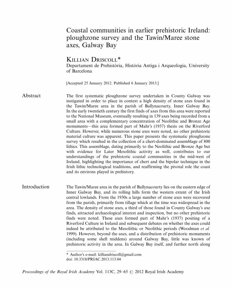
area. The density of stone axes, a third of those found in County Galway’s axe
finds, attracted archaeological interest and inspection, but no other prehistoric
finds were noted. These axes formed part of Mahr’s (1937) positing of a
Riverford Culture in Ireland and subsequent debates on whether the axes could
indeed be attributed to the Mesolithic or Neolithic periods (Woodman et al.
1999). However, beyond the axes, and a distribution of prehistoric monuments
(including some shell middens) around Galway Bay, little was known of
prehistoric activity in the area. In Galway Bay itself, and further north along
* Author’s e-mail: [email protected]
doi: 10.3318/PRIAC.2013.113.04
Proceedings of the Royal Irish Academy Vol. 113C, 29�65 # 2012 Royal Irish Academy
the coast, Neolithic farming activity had been identified through palynologicalevidence on Inis Oırr and at Lough Sheeauns, Co. Galway (O’Connell andMolloy 2001) and through palynological and archaeological evidence on thenorth coast of County Mayo (Caulfield et al. 1998). Closer to Galway Bay itselfbut inland, the large concentration of monuments in the Burren testify to anintensity of prehistoric inhabitation, with evidence for prehistoric field systemsand farmsteads interspersed with megalithic monuments (Jones et al. 2011)reminiscent of the evidence from County Mayo (Caulfield et al. 1998).
The large concentration of stone axes collected from a coastal settingwith a variety of prehistoric monuments, but with little further evidence tocontextualise them, appeared anomalous and thus presented the question: whywere only stone axes found in this locality and what further artefactual evidencecould be garnered? To answer this, a programme of fieldwalking was instigatedin 2005, initially aimed at the coastal cliff faces, but it then expanded tothe ploughzone. This systematic ploughzone survey at Ballynacourty representsthe first undertaken in the west of Ireland, and was at the time of collection thelargest lithic assemblage from both excavated and non-excavated contexts inCounty Galway. The collection of 800 almost exclusively chert artefactshighlights two main points*first, the considerable biases in the archaeologicalrecord as it has been built over the years in terms of identifying and collectingnon-flint flaked stone tools, and the lack in many areas of systematic ploughzonesurveys; and second, it demonstrates the utility of ploughzone surveys.
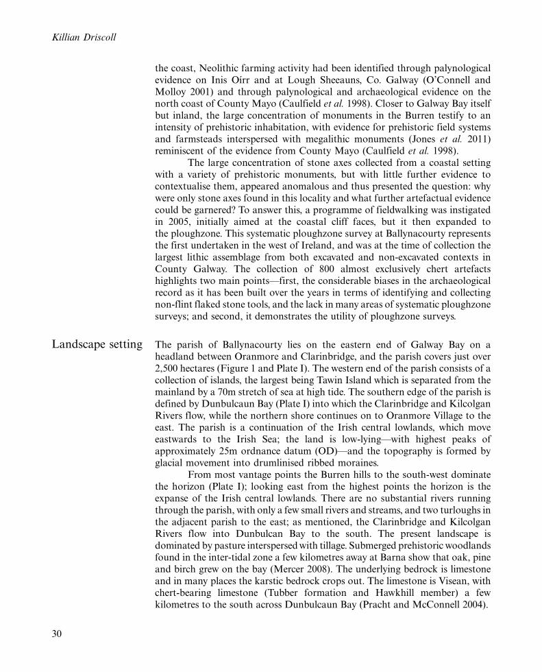
Landscape setting The parish of Ballynacourty lies on the eastern end of Galway Bay on aheadland between Oranmore and Clarinbridge, and the parish covers just over2,500 hectares (Figure 1 and Plate I). The western end of the parish consists of acollection of islands, the largest being Tawin Island which is separated from themainland by a 70m stretch of sea at high tide. The southern edge of the parish isdefined by Dunbulcaun Bay (Plate I) into which the Clarinbridge and KilcolganRivers flow, while the northern shore continues on to Oranmore Village to theeast. The parish is a continuation of the Irish central lowlands, which moveeastwards to the Irish Sea; the land is low-lying*with highest peaks ofapproximately 25m ordnance datum (OD)*and the topography is formed byglacial movement into drumlinised ribbed moraines.
From most vantage points the Burren hills to the south-west dominatethe horizon (Plate I); looking east from the highest points the horizon is theexpanse of the Irish central lowlands. There are no substantial rivers runningthrough the parish, with only a few small rivers and streams, and two turloughs inthe adjacent parish to the east; as mentioned, the Clarinbridge and KilcolganRivers flow into Dunbulcan Bay to the south. The present landscape isdominated by pasture interspersed with tillage. Submerged prehistoric woodlandsfound in the inter-tidal zone a few kilometres away at Barna show that oak, pineand birch grew on the bay (Mercer 2008). The underlying bedrock is limestoneand in many places the karstic bedrock crops out. The limestone is Visean, withchert-bearing limestone (Tubber formation and Hawkhill member) a fewkilometres to the south across Dunbulcaun Bay (Pracht and McConnell 2004).
Killian Driscoll
30
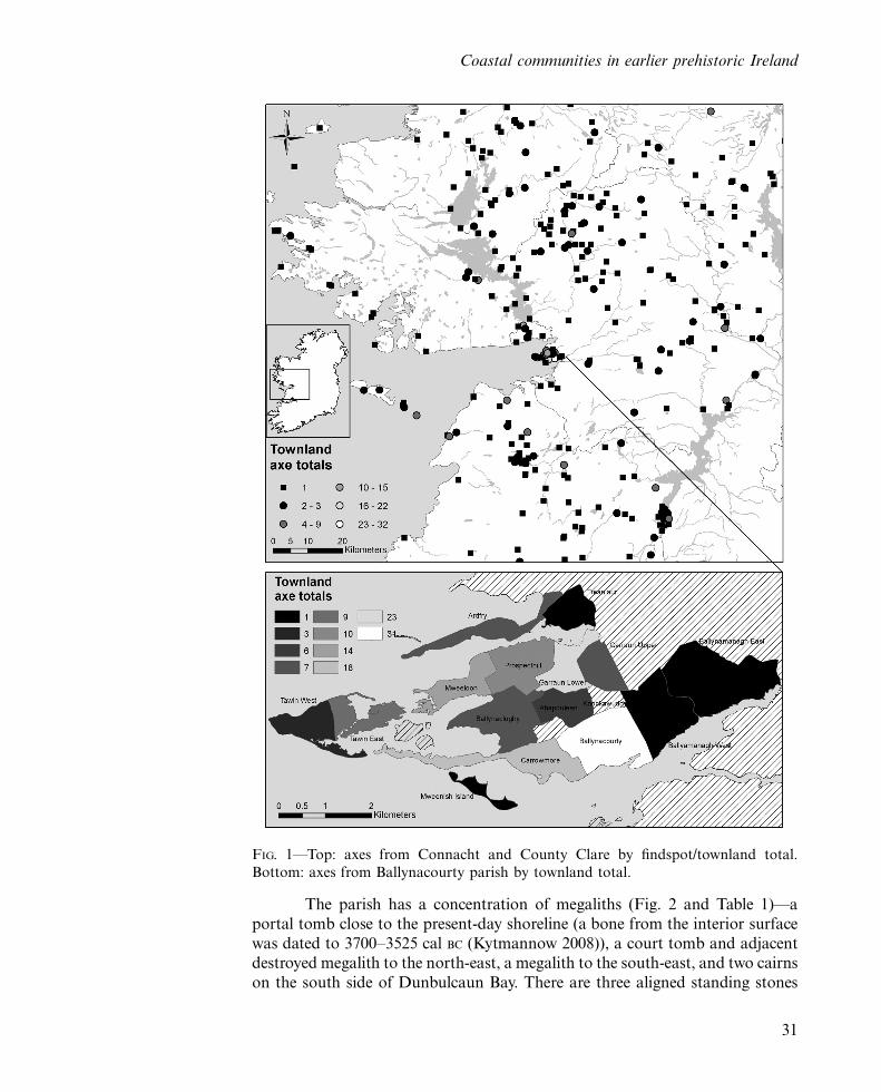
The parish has a concentration of megaliths (Fig. 2 and Table 1)*a
portal tomb close to the present-day shoreline (a bone from the interior surface
was dated to 3700�3525 cal BC (Kytmannow 2008)), a court tomb and adjacent
destroyed megalith to the north-east, a megalith to the south-east, and two cairns
on the south side of Dunbulcaun Bay. There are three aligned standing stones
FIG. 1*Top: axes from Connacht and County Clare by findspot/townland total.
Bottom: axes from Ballynacourty parish by townland total.
Coastal communities in earlier prehistoric Ireland
31
crossing the parish and a stone circle on Tawin Island, a mound barrow close tothe portal tomb, and two ring barrows across Dunbulcaun Bay. There are also tenfulacht fias (burnt mounds), the majority on the southern edge of the parish.
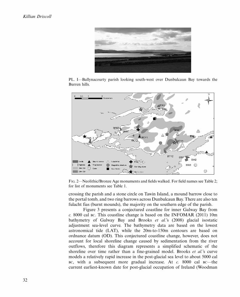
Figure 3 presents a conjectured coastline for inner Galway Bay fromc. 8000 cal BC. This coastline change is based on the INFOMAR (2011) 10mbathymetry of Galway Bay and Brooks et al.’s (2008) glacial isostaticadjustment sea-level curve. The bathymetry data are based on the lowestastronomical tide (LAT), while the 20m-to-150m contours are based onordnance datum (OD). This conjectured coastline change, however, does notaccount for local shoreline change caused by sedimentation from the riveroutflows, therefore this diagram represents a simplified schematic of theshoreline over time rather than a fine-grained model. Brooks et al.’s curvemodels a relatively rapid increase in the post-glacial sea level to about 5000 calBC, with a subsequent more gradual increase. At c. 8000 cal BC*thecurrent earliest-known date for post-glacial occupation of Ireland (Woodman
PL. I*Ballynacourty parish looking south-west over Dunbulcaun Bay towards the
Burren hills.
FIG. 2*Neolithic/Bronze Age monuments and fields walked. For field names see Table 2;
for list of monuments see Table 1.
Killian Driscoll
32
2003)*almost the entirety of the inner bay was land, with the shoreline close to
Blackhead (at the south-west corner of the maps). At c. 4500 cal BC, the islands
of Ballynacourty parish were part of the mainland; the present Dunbulcaun
Bay would have been the river channel of the Clarinbridge and Kilcolgan
Rivers; and to the north, the River Corrib (where there is Mesolithic artefactual
evidence, see Driscoll 2006) would have been directly accessible. During the
Neolithic period Tawin Island became separated from the mainland and
Dunbulcaun Bay would have begun to form.This model highlights the extent to which the Early and Later
Mesolithic landscapes are drowned, and at the time of the construction of
the portal tomb at Ballynacloghy during the Neolithic period (Fig. 2), the
portal tomb would have been a couple of kilometres from the shoreline. Dating
of submerged woodlands in the upper inter-tidal zone across the bay near Barna
(6km to the north-west), provided dates of 5516 to 5379 cal BC for pine, 4335 to
4180 cal BC for oak, and �161 to 3 cal AD for birch (Woods, pers. comm.); a
Neolithic oak dugout canoe was also found in the inter-tidal zone near these
dated trees, with Mercer (2008) citing an unpublished date of c. ‘5000BP’, i.e. c.
3800 cal BC. Close to the dated trees at Barna, a midden, comprised mainly of
oyster shells, returned a date of 1052�415 cal BC (Gosling 1993).
Researchbackground*biases in theTawin/Mareeassemblage
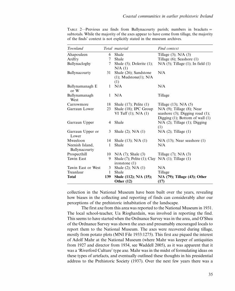
Starting from the 1930s, 139 predominantly shale axes were reported to the
National Museum from Ballynacourty, which accounts for about 33 per cent of
the axes for County Galway from an area that is only a tiny fraction of the
county’s land mass (Table 2 and Fig. 1). However, no other lithics were recorded
from the area. What follows is an extended discussion of the history of the
reporting of the axes, as this highlights perspicuously how parts of the
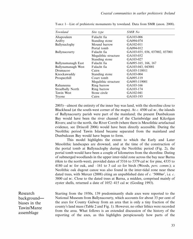
TABLE 1*List of prehistoric monuments by townland. Data from SMR (anon. 2008).
Townland Site type SMR No
Ahapouleen Fulacht fia GA103-006Ardfry Standing stone GA094-074Ballynacloghy Mound barrow GA102-011
Portal tomb GA094-012Ballynacourty Fulacht fia GA103-035, 036, 037002, 037001
Megalithic structure GA103-032Standing stone GA103-027
Ballynamanagh East Fulacht fia GA095-165, 166, 167Ballynamanagh West Fulacht fia GA103-043, 043001Drumacoo Cairn GA103-118011Knockawuddy Standing stone GA103-004Prospecthill Court tomb GA095-119
Megalithic structure GA095-119001Rahaneena Ring barrow GA103-166Stradbally North Ring barrow GA103-174Tawin West Stone circle GA102-041Tryone Cairn GA103-193
Coastal communities in earlier prehistoric Ireland
33

FIG. 3*Conjectured coastline change for inner Galway Bay. Model based on Brookset al.’s (2008) glacial isostatic adjustment sea level curve and the INFOMAR (2011)
10m bathymetry of Galway Bay. Coastline presented is the lowest astronomical tide
(LAT) with 20m�150m contours based on ordnance datum (OD). The white is the
modelled shoreline at 0m LAT for each time period.
Killian Driscoll
34
collection in the National Museum have been built over the years, revealing
how biases in the collecting and reporting of finds can considerably alter our
perceptions of the prehistoric inhabitation of the landscape.The first axe from this area was reported to the National Museum in 1931.
The local school-teacher, Ua Rıoghardaın, was involved in reporting the find.
This seems to have started when the Ordnance Survey was in the area, and O’Shea
of the Ordnance Survey was shown the axes and presumably encouraged locals to
report them to the National Museum. The axes were recovered during tillage,
mostly from potato plots (MNI File 1933:1275). This first axe piqued the interest
of Adolf Mahr at the National Museum (where Mahr was keeper of antiquities
from 1927 and director from 1934, see Waddell 2005), as it was apparent that it
was a ‘Riverford Culture’ type axe. Mahr was in the midst of formulating ideas on
these types of artefacts, and eventually outlined these thoughts in his presidential
address to the Prehistoric Society (1937). Over the next few years there was a
TABLE 2*Previous axe finds from Ballynacourty parish; numbers in brackets �subtotals. While the majority of the axes appear to have come from tillage, the majority
of the finds’ context is not explicitly stated in the museum archives.
Townland Total material Find context
Ahapouleen 6 Shale Tillage (3); N/A (3)Ardfry 7 Shale Tillage (6); Seashore (1)Ballynacloghy 7 Shale (5); Dolerite (1);
N/A (1)N/A (5); Tillage (1); In field (1)
Ballynacourty 31 Shale (26); Sandstone(1); Mudstone(1); N/A(1)
N/A
Ballynamanagh Eor W
1 N/A N/A
BallynamanaghWest
1 N/A Tillage
Carrowmore 18 Shale (17); Pelite (1) Tillage (13); N/A (5)Garraun Lower 23 Shale (18); IPC Group
VI Tuff (1); N/A (1)N/A (9); Tillage (8); Nearseashore (3); Digging road (1);Digging (1); Bottom of wall (1)
Garraun Upper 4 Shale N/A (2); Tillage (1); Digging(1)
Garraun Upper orLower
3 Shale (2); N/A (1) N/A (2); Tillage (1)
Mweeloon 14 Shale (13); N/A (1) N/A (13); Near seashore (1)Neenish Island,
Ballynacourty1 Shale N/A
Prospecthill 10 N/A (7); Shale (3) Tillage (7); N/A (3)Tawin East 9 Shale (7); Pelite (1); Clay
ironstone (1)N/A (1); Tillage (1)
Tawin East or West 3 Shale (2); N/A (1) N/ATreanlaur 1 Shale TillageTotal 139 Shale (112); N/A (15);
Other (12)N/A (79); Tillage (43); Other(17)
Coastal communities in earlier prehistoric Ireland
35
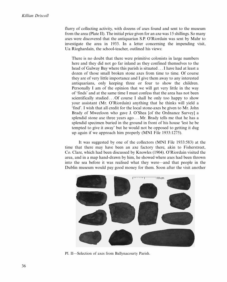
flurry of collecting activity, with dozens of axes found and sent to the museum
from the area (Plate II). The initial price given for an axe was 15 shillings. So many
axes were discovered that the antiquarian S.P. O’Riordain was sent by Mahr to
investigate the area in 1933. In a letter concerning the impending visit,
Ua Rıoghardaın, the school-teacher, outlined his views:
There is no doubt that there were primitive colonists in large numbershere and they did not go far inland as they confined themselves to thehead of Galway Bay where this parish is situated . . . I have had at least adozen of those small broken stone axes from time to time. Of coursethey are of very little importance and I give them away to any interestedantiquarians, only keeping three or four to show the children.Personally I am of the opinion that we will get very little in the wayof ‘finds’ and at the same time I must confess that the area has not beenscientifically studied . . . Of course I shall be only too happy to showyour assistant (Mr. O’Riordain) anything that he thinks will yield a‘find’. I wish that all credit for the local stone-axes be given to Mr. JohnBrady of Mweeloon who gave J. O’Shea [of the Ordnance Survey] asplendid stone axe three years ago . . . Mr. Brady tells me that he has asplendid specimen buried in the ground in front of his house ‘lest he betempted to give it away’ but he would not be opposed to getting it dugup again if we approach him properly (MNI File 1933:1275).
It was suggested by one of the collectors (MNI File 1933:583) at the
time that there may have been an axe factory there, akin to Fisherstreet,
Co. Clare, which had been discussed by Knowles (1904). O’Riordain visited the
area, and in a map hand-drawn by him, he showed where axes had been thrown
into the sea before it was realised what they were*and that people in the
Dublin museum would pay good money for them. Soon after the visit another
Pl. II*Selection of axes from Ballynacourty Parish.
Killian Driscoll
36
letter arrived to Mahr from Ua Rıoghardaın on behalf of a finder. Here he
commented that the finder ‘would have dumped it into the sea with the other
stones but had heard that the school-master was sending them away and getting
money for them’ (MNI File 1933:1275).After a few years, however, the axes had begun to lose their initial
appeal and the price dropped to 5 shillings. Mahr received the following letter
from a collector, clearly outraged by this decline in value and in interest:
Dear Dr. Mahr, I was shocked to receive the stone axe back andaccording to your letter you abuse it very badly. There can be no doubtit is not [sic] an axe as I have the decision of experts on the matter. I amafraid my interest is beginning to fade away (MNI File 1936:1972).
By 1939 the museum had grown weary of the Tawin axes and a local collector
received the following reply from Mahr:
Dear Mr. Holland, As you are probably aware, I have practically givenup collecting these stone axes from your district which repeatthemselves with such monotony and have long ago ceased to be ofany scientific or archaeological interest except that, naturally, theycontinue to be of some purely local interest’ (MNI File 1939:158).
In another correspondence Mahr chides the diggers for sending mere stones,
and tells them to stop wasting their money and his time sending stones unless
they are absolutely sure they are axes; he mentions that there is a big pile of
stones somewhere in Dublin onto which all the dubious finds were dumped
(MNI File 1939: 158). Not surprisingly, the flow of axes going to Dublin dried
up after this. So we can see that the museum actively discouraged further axes
being sent, and the true number of axes is under-recorded.Therefore, a third of County Galway’s axes come from this parish*a
considerable concentration given the size of the area. As mentioned, nothing
else was recovered from the area, except for a clay pipe and a grindstone. A
strong possibility why nothing else was found has to do with visibility: the
glacial till in the area is abundant in chert, a lot of it high-quality, dark-blue to
black chert. With this backdrop of chert it is not surprising that worked pieces
were over-looked, if indeed they were actively looked for in the first place. There
was no mention in the correspondence at the time of looking for material other
than axes. While researchers like Knowles (1889) had noted that non-flint
artefacts such as chert should be focused on during collecting, most researchers
maintained a bias for flint when it came to their interest in flaked stone tools
(see discussion in Driscoll 2009b). Moreover, when the axes were found it was
during the process of clearing stones, and therefore the only stones they were
picking up were the larger ones they had to clear. The axes*with a distinctive
shape and larger in size*are more easily identifiable when walking the
ploughed fields, and smaller items, such as scrapers and flakes, were ignored,
especially if one was not actively looking for chert artefacts. Therefore, the
Coastal communities in earlier prehistoric Ireland
37
material was there but there was no clear direction given by the NationalMuseum in the 1930s towards walking the fields, when so much was undertillage. From this we can see patently some of the biases at play in thedistribution of material. When local collectors were encouraged to identify andreport material to the museum, greater concentrations of material were foundthere: conversely, when the museum actively discouraged the reporting offurther material, less and less artefacts were recorded.
Methodology The fieldwork was undertaken in 2005 in order to investigate whether othermaterial culture besides stone axes was apparent in an area with a high densityof stone axes and a complementary concentration of prehistoric monuments.The initial phase of fieldwalking involved an intensive, systematic inspection ofthe eroding cliff faces and erosion scars in adjoining fields. Once the availabilityof plough fields was identified, the second phase involved a systematicploughzone survey of selected fields, with an intensive survey of a small sampleof fields in order to determine the degree of lithic visibility in the area.
The utility of ploughzone surveys has been well documented (e.g.Lewarch and O’Brien 1981; Schofield 1991; Zvelebil et al. 1992; Bintliff et al.
2000). Regional surveys such as the Bally Lough Project (Zvelebil et al. 1992)and the Lough Swilly Survey (Kimball 2000) have covered large areas, with thelatter sampling an area of 300km2 and walking 430ha; Brady’s (2007) localsurvey of the Newgrange environs covered a small area but surveyed a largeproportion of the available tilled fields (for an extended discussion on Irishploughzone surveys see Brady 2007). The Bally Lough Project states that they‘as a rule’ (Zvelebil et al. 1992, 201) walked during 5m intervals, and‘approximately’ 5m intervals (Zvelebil et al. 1992, 208), suggesting a coveragerate of 40 per cent for each field walked. However, this was not explicitly stated.The Lough Swilly Survey*designed to compare results with the Bally LoughProject*states clearly that a coverage of 20 per cent was maintained, using thetraverse and stint method, implying that they invariably covered more than 20per cent when a possible sizable scatter was found (Kimball 2000, 15). For bothsurveys, one of the reasons for the regional scale was to look at differinggeomorphological locations, and to sample these for comparative purposes.
However, aims of the systematic ploughzone survey were different*themain aim was to ascertain whether the axes that had been found over the yearswere the sole type of find in the area, or whether a more varied range of typeswas overlooked; a second aim was to ascertain whether a Mesolithic and anEarly Neolithic presence could be detected. As I was the sole surveyor involved,by necessity the area covered was comparatively small. Ballynacourty Parish isa little less than 23km2, with a small proportion of the land under tillage.Tillage had previously played a greater role in farming life there, but it hasbecome all but uneconomical in the last generation. It was decided to survey thefields to a greater degree than the previously mentioned surveys had*mostfields were walked at a coverage of 66.6 per cent, with three walked at 100 percent coverage as a sample. Arguably, a lesser coverage could have been chosen,and more fields walked, but it was decided to look at a smaller area more
Killian Driscoll
38

carefully as the main issue was lithic visibility as opposed to deducing socio-
economic-ecologic positioning in the landscape.The choice of fields to walk was determined by a number of
considerations. Firstly, townlands with previous axe finds were targeted, and
two townlands (Knockawuddy and Stradbally West) with no previous axe finds
were also chosen as a comparison. Secondly, fields from a range of
topographical locations were chosen, such as hilltops, lowlands and fields
that were directly coastal and estuarine (Figure 2). Finally, the decision was
ultimately dictated by the land under tillage at the time of the survey. In total,
seventeen fields were walked in ten townlands covering about 25ha. Table 3
provides the codes allocated to each field, the field size and average finds per
hectare, and the names of the townlands.The lithics were analysed macroscopically, using a standard technolo-
gical descriptive system (Inizan et al. 1999), an Irish typological system
(Woodman et al. 2006) and a quartz analytical system (Driscoll 2010b); the
axes were recorded using the Irish Stone Axe Project system (Cooney and
TABLE 3*Summary of fields walked. Average finds per hectare in brackets is the
adjusted rate to 66 per cent for fields walked at 100 per cent. Some fields do not have
average finds per hectare: artefacts from SW3 were originally collected by Carleton
Jones; TW1 was originally walked during the assessment stage and its finds are markedas TW1(1); TW2 was also walked during the assessment stage.
Townland Field # Scraper Retouched OtherTotalfinds
Averagefindsper ha
Fieldsize ha
Ballynacloghy BCY1 3 4 � 22 29.3 0.75BCY2 6 3 � 33 33 1
Ballynacourty BTY1 6 7 � 35 17.5 2BTY2 14 9 1 axe 60 24 2.5
BallynamanaghWest
BW 2 3 � 16 16 1
Knockawuddy KW 1 2 � 28 14 2Mweeloon MW1 10 12 � 91 91 1
MW2 30 11 � 84 76.4 1.1Prospecthill PL 31 11 2 axe 175 76.1 (50.7) 2.3Stradbally West SW1 1 2 � 37 26.4 1.4
SW2 6 6 1 axe 39 13 3SW3 3 � � 39 N/A �
Tawin East Erosionscar
� � � 6 � �
Tawin West TW1 6 4 � 28 23.3 (15.5) 1.2TW1(1) 1 1 � 18 N/A 1.2TW2 � 4 � 20 N/A 0.5TW3 1 5 � 38 76 (50.6) 0.5
Treanlaur TR1 2 1 � 14 11.6 1.2TR2 10 5 1
arrowhead49 24.5 2
Total 133 90 5 800 32.9 (av.)
Coastal communities in earlier prehistoric Ireland
39
Mandal 1998). Given that the lithics were collected from the ploughzone,caution was used in the identification of retouched artefacts. All dimensions arerounded to the nearest millimetre. The finds were recorded in an Accesssoftware database for integration with Geographical Information System (GIS)data from Ordnance Survey Ireland (OSI) and the Sites and MonumentsRecord (SMR) digitised dataset. The radiocarbon dates cited have beencalibrated to cal BC using the Oxcal 4.1 and the Intcal09 curve (Bronk Ramsey2009).
Lithic analysis Raw materials and condition
The 800 lithics collected were almost exclusively chert. The only other materialswere one flint scraper, one vein quartz core and four shale axes. Almost two-thirds of the chert is black, with 30 per cent dark-blue, and a minor proportionof grey to dark-grey to dark-blue/grey. Only eight lithics (six cores and twoflakes) show signs of use of chert beach cobbles, suggesting the quarrying ofchert or use of glacially moved sources; as noted above, limestone bearing chertis available to the south of the parish, and numerous field walls in the parishcontain large beds of chert. While Cretaceous flint cobbles have been identifiedthrough dredging off the Irish west coast (see McCartan et al. 2004) the nearlack of flint suggests that little flint was imported into the area. The source ofshale for the axes is unclear, with lower limestone shale found about 20km tothe south-east (Pracht and McConnell 2004). Knowles (1904) suggested thatthe coastal site at Fisherstreet, Co. Clare, about 50km to the south-west mayhave been a source of shale, and Cooney and Mandall (1998) commented thatshale also outcrops close to Killaloe (where hundreds of shale axes have beenrecovered), about 70km to the south-east of the present study area. Cooneyet al. (2011b), in a review of the Irish Stone Axe Project, note that shale as aresource is significantly greater than was indicated in the project’s 1998monograph, and that the majority of shale appears to be formed on waterrolled cobbles, rather than quarried from primary sources.
Almost all of the lithics are in an abraded condition and most exhibitedge damage, highlighting the ploughzone provenance. Only a few of the lithicsare weathered to a great extent, but many of the pieces have small holes,evidence of the weathering out of fossil inclusions in the chert. Over half of thelithics are broken. While many of these breaks relate to accidents duringmanufacture or use, many are probably due to taphonomic processes*63 percent of the non-modified flakes are broken, while 53 per cent of the modifiedpieces are broken.
Technology
Cores
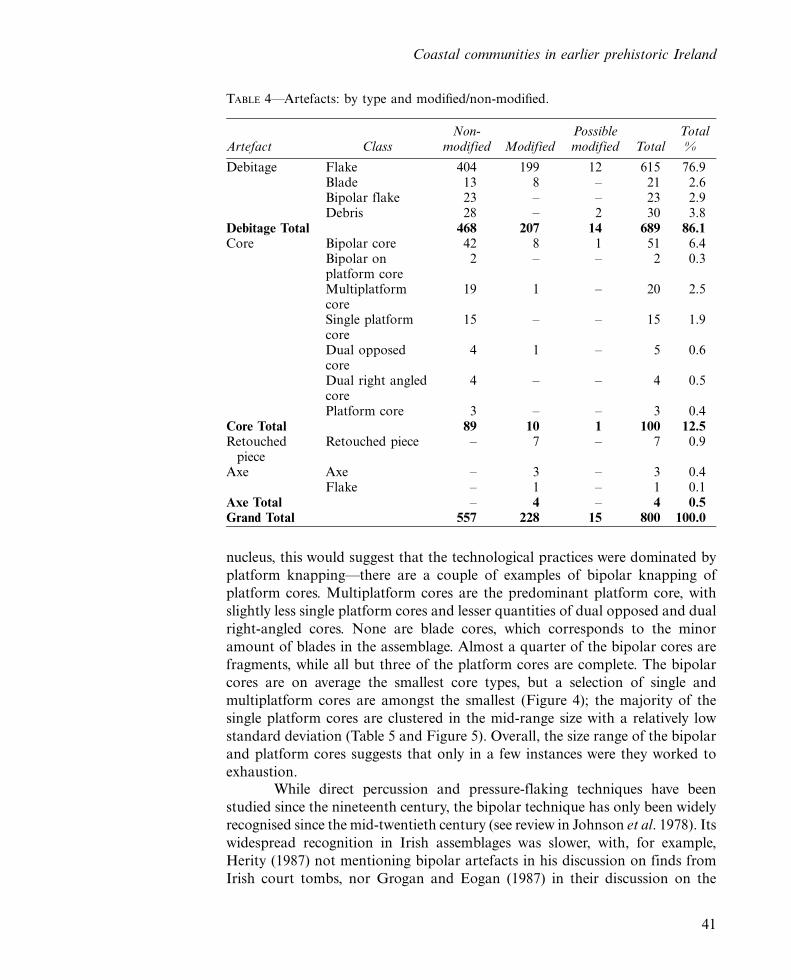
The flaked-stone component comprises the bulk of the assemblage (Table 4 andFigure 4). Bipolar cores slightly outnumber platform cores, but given thatbipolar knapping will produce multiple bipolar cores from each original
Killian Driscoll
40
nucleus, this would suggest that the technological practices were dominated by
platform knapping*there are a couple of examples of bipolar knapping of
platform cores. Multiplatform cores are the predominant platform core, with
slightly less single platform cores and lesser quantities of dual opposed and dual
right-angled cores. None are blade cores, which corresponds to the minor
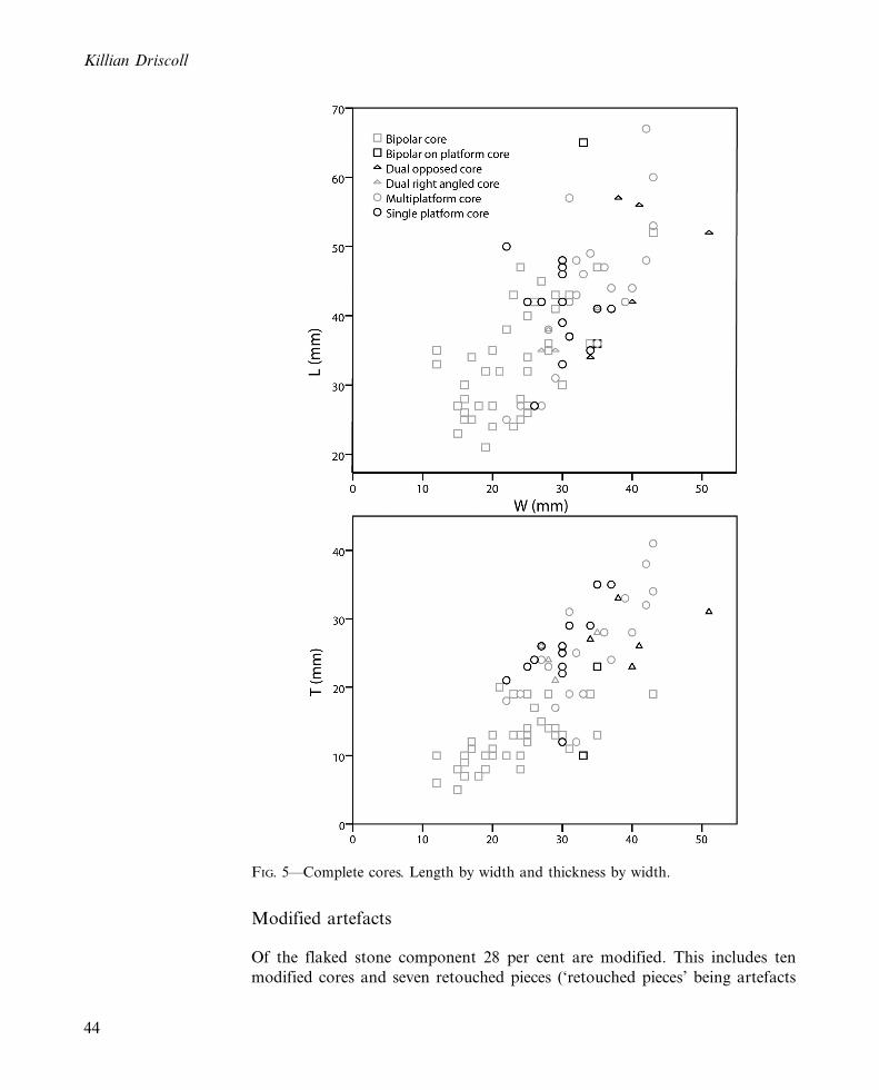
amount of blades in the assemblage. Almost a quarter of the bipolar cores are
fragments, while all but three of the platform cores are complete. The bipolar
cores are on average the smallest core types, but a selection of single and
multiplatform cores are amongst the smallest (Figure 4); the majority of the
single platform cores are clustered in the mid-range size with a relatively low
standard deviation (Table 5 and Figure 5). Overall, the size range of the bipolar
and platform cores suggests that only in a few instances were they worked to
exhaustion.While direct percussion and pressure-flaking techniques have been
studied since the nineteenth century, the bipolar technique has only been widely
recognised since the mid-twentieth century (see review in Johnson et al. 1978). Its
widespread recognition in Irish assemblages was slower, with, for example,
Herity (1987) not mentioning bipolar artefacts in his discussion on finds from
Irish court tombs, nor Grogan and Eogan (1987) in their discussion on the
TABLE 4*Artefacts: by type and modified/non-modified.
Artefact ClassNon-
modified ModifiedPossiblemodified Total
Total%
Debitage Flake 404 199 12 615 76.9Blade 13 8 � 21 2.6Bipolar flake 23 � � 23 2.9Debris 28 � 2 30 3.8
Debitage Total 468 207 14 689 86.1Core Bipolar core 42 8 1 51 6.4
Bipolar onplatform core
2 � � 2 0.3
Multiplatformcore
19 1 � 20 2.5
Single platformcore
15 � � 15 1.9
Dual opposedcore
4 1 � 5 0.6
Dual right angledcore
4 � � 4 0.5
Platform core 3 � � 3 0.4Core Total 89 10 1 100 12.5Retouched
pieceRetouched piece � 7 � 7 0.9
Axe Axe � 3 � 3 0.4Flake � 1 � 1 0.1
Axe Total � 4 � 4 0.5Grand Total 557 228 15 800 100.0
Coastal communities in earlier prehistoric Ireland
41
Neolithic and Bronze Age lithics from Lough Gur. O’Hare (2005, 306, 316) has
argued that bipolar knapping ‘is a temporal marker for the whole of the Bronze
Age in Ireland’ and the Bronze Age was ‘fully’ bipolar, with this shift tied to the
Helka 4 event of 2345 BC. However, bipolar knapping was an integral part of the
lithic technology from the beginning of the Neolithic, as seen at the excavations
of Early Neolithic structures such as at Corbally (Brady 2001; Purcell 2002),
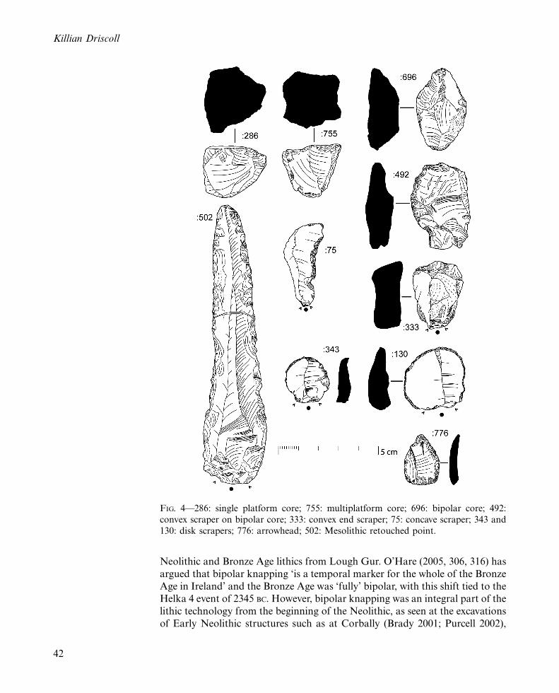
FIG. 4*286: single platform core; 755: multiplatform core; 696: bipolar core; 492:
convex scraper on bipolar core; 333: convex end scraper; 75: concave scraper; 343 and
130: disk scrapers; 776: arrowhead; 502: Mesolithic retouched point.
Killian Driscoll
42
Newport (Milliken Forthcoming), Thornhill (Nelis 2004; Driscoll 2010b),
Cloghers and Tankardstown (Woodman et al. 2006). Bipolar reduction has
often been viewed as an inefficient, expedient, ad hoc technology needing a low
level of skill to use (e.g. Ahler 1989; Peterson 1990), some going as far as to
describe it as unconventional (e.g. O’Hare 2005). However, bipolar knapping is
not necessarily just a ‘smash-it-and-see’ technique (see O’Hare 2005, 305).
Rather, experimental research has shown that bipolar knapping can be a
controlled, considered strategy for producing stone tools (e.g. Flenniken 1981;
Knutsson 1988; Low 1997; Driscoll 2010b); Callahan (1987) has argued that
while the technique can be seen as simple, it shouldn’t be seen as simplistic.
Moreover, while the use of a bipolar technique is often discussed in terms of
material constraints, or in terms of a degradation in knapping skills, others have
suggested a more complicated picture in which social motives were also involved,
with some cultures abandoning the bipolar technique (see Lindgren 2003).
Non-modified debitage
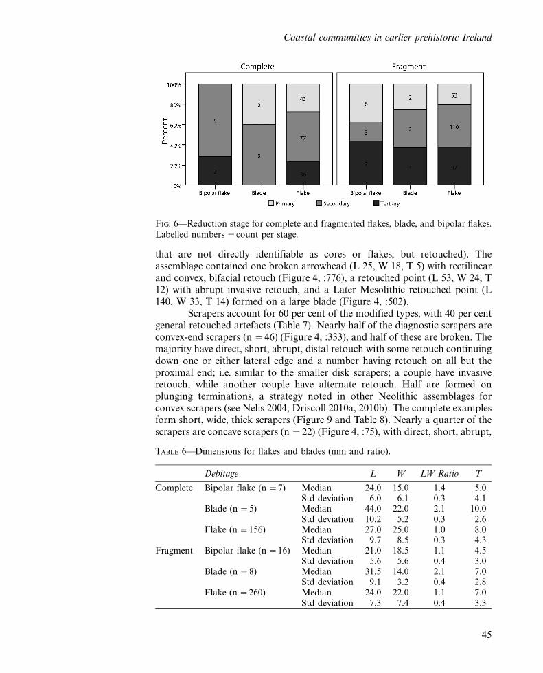
The non-modified debitage is dominated by platform flakes, with few platform
blades and few bipolar flakes (Table 4). Overall, the non-modified debitage is
dominated by primary- and secondary-stage flakes, suggesting that the
assemblage represents in situ knapping rather than the importation of blanks,
as does the high quantity of cores; for the three debitage types, a greater
proportion of the tertiary subset are fragments, and this may suggest a greater
degree of breakage during use rather than knapping breaks (Fig. 6). The
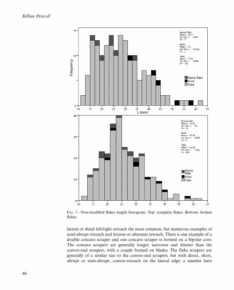
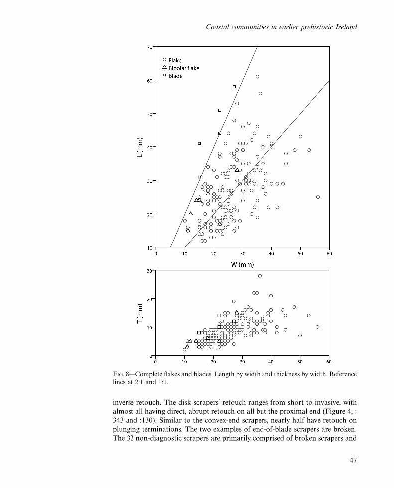
debitage is dominated by broken flakes and blades, and the debitage*especially the blades*range greatly in size (Table 6 and Figures 7 and 8).
The complete flakes range from 12mm to 61mm in length with a median
length of 27mm, while the complete blades range from 31mm to 58mm with a
median length of 44mm; the complete bipolar flakes range from 15mm to
33mm with a median length of 24mm. Figure 8 highlights that the complete
flakes generally fall around a length:width ratio of 1:1 with only a small
proportion close to a 2:1 (i.e blade) ratio, while the bipolar flakes are relatively
narrower and thinner.
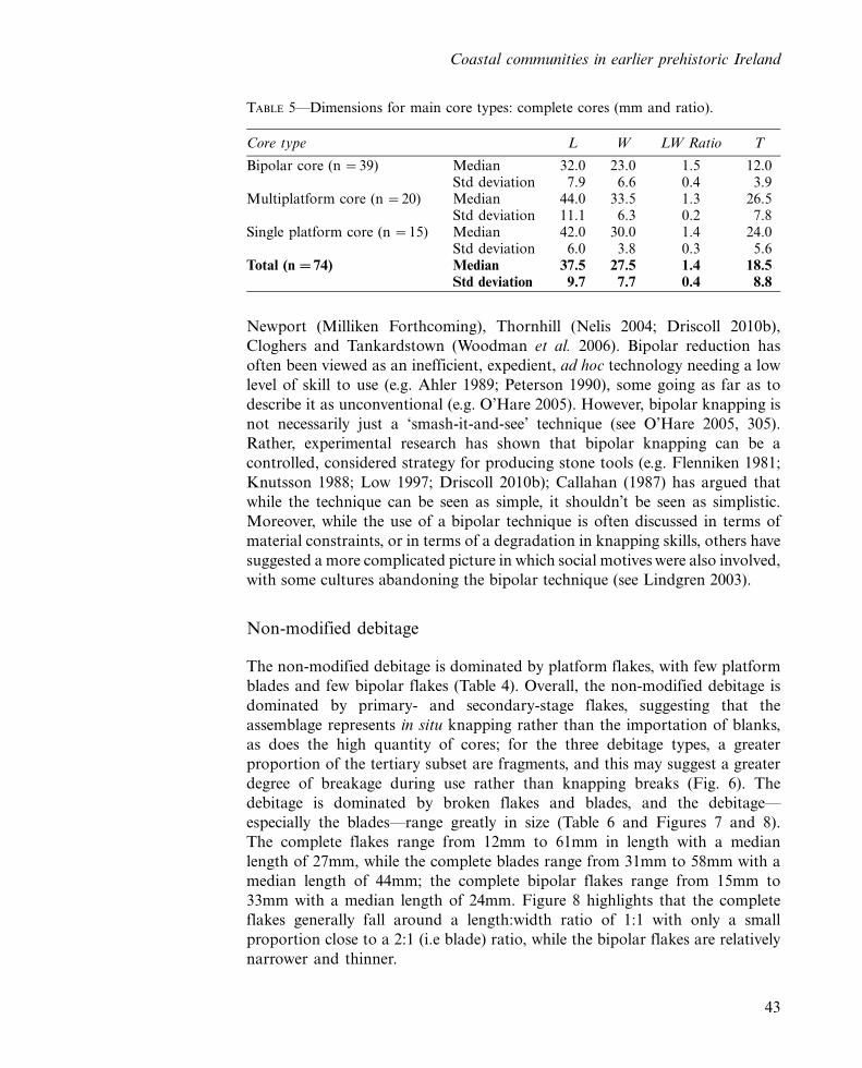
TABLE 5*Dimensions for main core types: complete cores (mm and ratio).
Core type L W LW Ratio T
Bipolar core (n �39) Median 32.0 23.0 1.5 12.0Std deviation 7.9 6.6 0.4 3.9
Multiplatform core (n �20) Median 44.0 33.5 1.3 26.5Std deviation 11.1 6.3 0.2 7.8
Single platform core (n �15) Median 42.0 30.0 1.4 24.0Std deviation 6.0 3.8 0.3 5.6
Total (n �74) Median 37.5 27.5 1.4 18.5Std deviation 9.7 7.7 0.4 8.8
Coastal communities in earlier prehistoric Ireland
43
Modified artefacts
Of the flaked stone component 28 per cent are modified. This includes ten
modified cores and seven retouched pieces (‘retouched pieces’ being artefacts
FIG. 5*Complete cores. Length by width and thickness by width.
Killian Driscoll
44
that are not directly identifiable as cores or flakes, but retouched). Theassemblage contained one broken arrowhead (L 25, W 18, T 5) with rectilinearand convex, bifacial retouch (Figure 4, :776), a retouched point (L 53, W 24, T12) with abrupt invasive retouch, and a Later Mesolithic retouched point (L140, W 33, T 14) formed on a large blade (Figure 4, :502).
Scrapers account for 60 per cent of the modified types, with 40 per centgeneral retouched artefacts (Table 7). Nearly half of the diagnostic scrapers areconvex-end scrapers (n �46) (Figure 4, :333), and half of these are broken. Themajority have direct, short, abrupt, distal retouch with some retouch continuingdown one or either lateral edge and a number having retouch on all but theproximal end; i.e. similar to the smaller disk scrapers; a couple have invasiveretouch, while another couple have alternate retouch. Half are formed onplunging terminations, a strategy noted in other Neolithic assemblages forconvex scrapers (see Nelis 2004; Driscoll 2010a, 2010b). The complete examplesform short, wide, thick scrapers (Figure 9 and Table 8). Nearly a quarter of thescrapers are concave scrapers (n �22) (Figure 4, :75), with direct, short, abrupt,
TABLE 6*Dimensions for flakes and blades (mm and ratio).
Debitage L W LW Ratio T
Complete Bipolar flake (n �7) Median 24.0 15.0 1.4 5.0Std deviation 6.0 6.1 0.3 4.1
Blade (n �5) Median 44.0 22.0 2.1 10.0Std deviation 10.2 5.2 0.3 2.6
Flake (n �156) Median 27.0 25.0 1.0 8.0Std deviation 9.7 8.5 0.3 4.3
Fragment Bipolar flake (n �16) Median 21.0 18.5 1.1 4.5Std deviation 5.6 5.6 0.4 3.0
Blade (n �8) Median 31.5 14.0 2.1 7.0Std deviation 9.1 3.2 0.4 2.8
Flake (n �260) Median 24.0 22.0 1.1 7.0Std deviation 7.3 7.4 0.4 3.3
FIG. 6*Reduction stage for complete and fragmented flakes, blade, and bipolar flakes.Labelled numbers �count per stage.
Coastal communities in earlier prehistoric Ireland
45
lateral or distal left/right retouch the most common, but numerous examples of
semi-abrupt retouch and inverse or alternate retouch. There is one example of a
double concave scraper and one concave scraper is formed on a bipolar core.
The concave scrapers are generally longer, narrower and thinner than the
convex-end scrapers, with a couple formed on blades. The flake scrapers are
generally of a similar size to the convex-end scrapers, but with direct, short,
abrupt or semi-abrupt, convex-retouch on the lateral edge; a number have
FIG. 7*Non-modified flakes length histogram. Top: complete flakes. Bottom: broken
flakes.
Killian Driscoll
46
inverse retouch. The disk scrapers’ retouch ranges from short to invasive, with
almost all having direct, abrupt retouch on all but the proximal end (Figure 4, :
343 and :130). Similar to the convex-end scrapers, nearly half have retouch on
plunging terminations. The two examples of end-of-blade scrapers are broken.
The 32 non-diagnostic scrapers are primarily comprised of broken scrapers and
FIG. 8*Complete flakes and blades. Length by width and thickness by width. Reference
lines at 2:1 and 1:1.
Coastal communities in earlier prehistoric Ireland
47
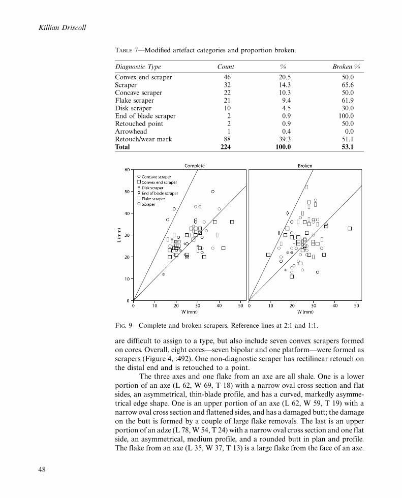
are difficult to assign to a type, but also include seven convex scrapers formed
on cores. Overall, eight cores*seven bipolar and one platform*were formed as
scrapers (Figure 4, :492). One non-diagnostic scraper has rectilinear retouch on
the distal end and is retouched to a point.The three axes and one flake from an axe are all shale. One is a lower
portion of an axe (L 62, W 69, T 18) with a narrow oval cross section and flat
sides, an asymmetrical, thin-blade profile, and has a curved, markedly asymme-
trical edge shape. One is an upper portion of an axe (L 62, W 59, T 19) with a
narrow oval cross section and flattened sides, and has a damaged butt; the damage
on the butt is formed by a couple of large flake removals. The last is an upper
portion of an adze (L 78, W 54, T 24) with a narrow oval cross section and one flat
side, an asymmetrical, medium profile, and a rounded butt in plan and profile.
The flake from an axe (L 35, W 37, T 13) is a large flake from the face of an axe.
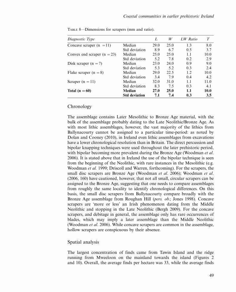
TABLE 7*Modified artefact categories and proportion broken.
Diagnostic Type Count % Broken %
Convex end scraper 46 20.5 50.0Scraper 32 14.3 65.6Concave scraper 22 10.3 50.0Flake scraper 21 9.4 61.9Disk scraper 10 4.5 30.0End of blade scraper 2 0.9 100.0Retouched point 2 0.9 50.0Arrowhead 1 0.4 0.0Retouch/wear mark 88 39.3 51.1Total 224 100.0 53.1
FIG. 9*Complete and broken scrapers. Reference lines at 2:1 and 1:1.
Killian Driscoll
48
Chronology
The assemblage contains Later Mesolithic to Bronze Age material, with thebulk of the assemblage probably dating to the Late Neolithic/Bronze Age. Aswith most lithic assemblages, however, the vast majority of the lithics fromBallynacourty cannot be assigned to a particular time-period: as noted byDolan and Cooney (2010), in Ireland even lithic assemblages from excavationshave a lower chronological resolution than in Britain. The direct percussion andbipolar knapping techniques were used throughout the later prehistoric period,with bipolar becoming more prevalent during the Bronze Age (Woodman et al.2006). It is stated above that in Ireland the use of the bipolar technique is seenfrom the beginning of the Neolithic, with rare instances in the Mesolithic (e.g.Woodman et al. 1999; Driscoll and Warren, forthcoming). For the scrapers, thesmall disc scrapers are Bronze Age (Woodman et al. 2006); Woodman et al.(2006, 160) have cautioned, however, that not all small, circular scrapers can beassigned to the Bronze Age, suggesting that one needs to compare assemblagesfrom roughly the same locality to identify chronological differences. On thisbasis, the small disc scrapers from Ballynacourty compare broadly with theBronze Age assemblage from Roughan Hill (pers. ob.; Jones 1998). Concavescrapers are ‘more or less’ an Irish phenomenon dating from the MiddleNeolithic and stopping in the Late Neolithic (Bergh 2009). For the concavescrapers, and debitage in general, the assemblage only has rare occurrences ofblades, which may imply a later assemblage than the Middle Neolithic(Woodman et al. 2006). While concave scrapers are common in the assemblage,hollow scrapers are conspicuous by their absence.
Spatial analysis
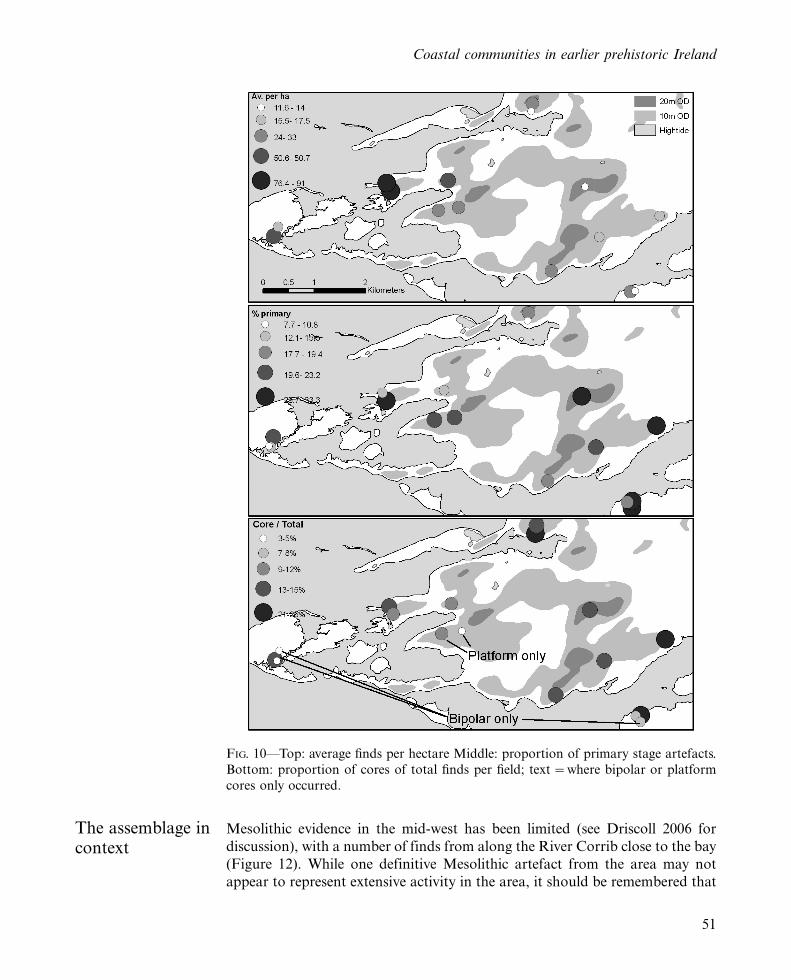
The largest concentration of finds came from Tawin Island and the ridgerunning from Mweeloon on the mainland towards the island (Figures 2and 10). Overall, the average finds per hectare was 33, while the average finds
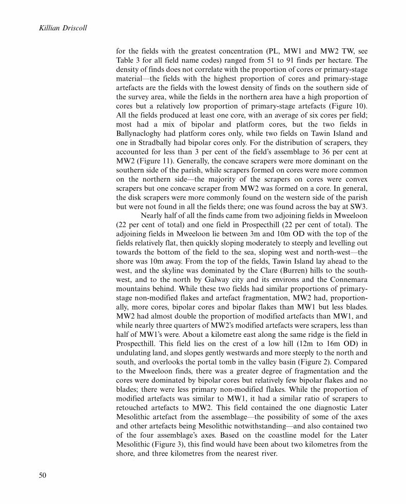
TABLE 8*Dimensions for scrapers (mm and ratio).
Diagnostic Type L W LW Ratio T
Concave scraper (n �11) Median 29.0 25.0 1.3 8.0Std deviation 8.9 6.7 0.5 3.7
Convex end scraper (n �23) Median 25.0 25.0 1.1 10.0Std deviation 5.2 7.8 0.2 2.9
Disk scraper (n �7) Median 23.0 24.0 0.9 9.0Std deviation 5.3 5.2 0.3 2.4
Flake scraper (n �8) Median 29.0 22.5 1.2 10.0Std deviation 3.4 7.9 0.4 4.2
Scraper (n �11) Median 32.0 31.0 1.1 11.0Std deviation 8.3 7.5 0.3 4.1
Total (n �60) Median 27.0 25.0 1.1 10.0Std deviation 7.1 7.4 0.3 3.5
Coastal communities in earlier prehistoric Ireland
49
for the fields with the greatest concentration (PL, MW1 and MW2 TW, see
Table 3 for all field name codes) ranged from 51 to 91 finds per hectare. The
density of finds does not correlate with the proportion of cores or primary-stage
material*the fields with the highest proportion of cores and primary-stage
artefacts are the fields with the lowest density of finds on the southern side of
the survey area, while the fields in the northern area have a high proportion of
cores but a relatively low proportion of primary-stage artefacts (Figure 10).
All the fields produced at least one core, with an average of six cores per field;
most had a mix of bipolar and platform cores, but the two fields in
Ballynacloghy had platform cores only, while two fields on Tawin Island and
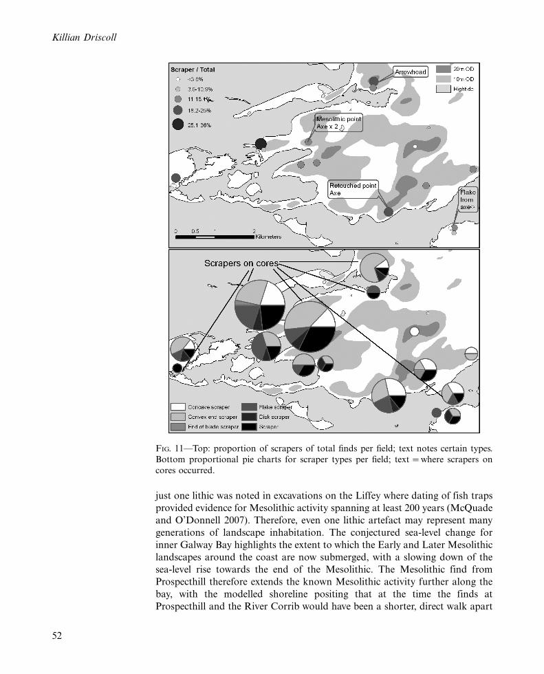
one in Stradbally had bipolar cores only. For the distribution of scrapers, they
accounted for less than 3 per cent of the field’s assemblage to 36 per cent at
MW2 (Figure 11). Generally, the concave scrapers were more dominant on the
southern side of the parish, while scrapers formed on cores were more common
on the northern side*the majority of the scrapers on cores were convex
scrapers but one concave scraper from MW2 was formed on a core. In general,
the disk scrapers were more commonly found on the western side of the parish
but were not found in all the fields there; one was found across the bay at SW3.Nearly half of all the finds came from two adjoining fields in Mweeloon
(22 per cent of total) and one field in Prospecthill (22 per cent of total). The
adjoining fields in Mweeloon lie between 3m and 10m OD with the top of the
fields relatively flat, then quickly sloping moderately to steeply and levelling out
towards the bottom of the field to the sea, sloping west and north-west*the
shore was 10m away. From the top of the fields, Tawin Island lay ahead to the
west, and the skyline was dominated by the Clare (Burren) hills to the south-
west, and to the north by Galway city and its environs and the Connemara
mountains behind. While these two fields had similar proportions of primary-
stage non-modified flakes and artefact fragmentation, MW2 had, proportion-
ally, more cores, bipolar cores and bipolar flakes than MW1 but less blades.
MW2 had almost double the proportion of modified artefacts than MW1, and
while nearly three quarters of MW2’s modified artefacts were scrapers, less than
half of MW1’s were. About a kilometre east along the same ridge is the field in
Prospecthill. This field lies on the crest of a low hill (12m to 16m OD) in
undulating land, and slopes gently westwards and more steeply to the north and
south, and overlooks the portal tomb in the valley basin (Figure 2). Compared
to the Mweeloon finds, there was a greater degree of fragmentation and the
cores were dominated by bipolar cores but relatively few bipolar flakes and no
blades; there were less primary non-modified flakes. While the proportion of
modified artefacts was similar to MW1, it had a similar ratio of scrapers to
retouched artefacts to MW2. This field contained the one diagnostic Later
Mesolithic artefact from the assemblage*the possibility of some of the axes
and other artefacts being Mesolithic notwithstanding*and also contained two
of the four assemblage’s axes. Based on the coastline model for the Later
Mesolithic (Figure 3), this find would have been about two kilometres from the
shore, and three kilometres from the nearest river.
Killian Driscoll
50
The assemblage incontext
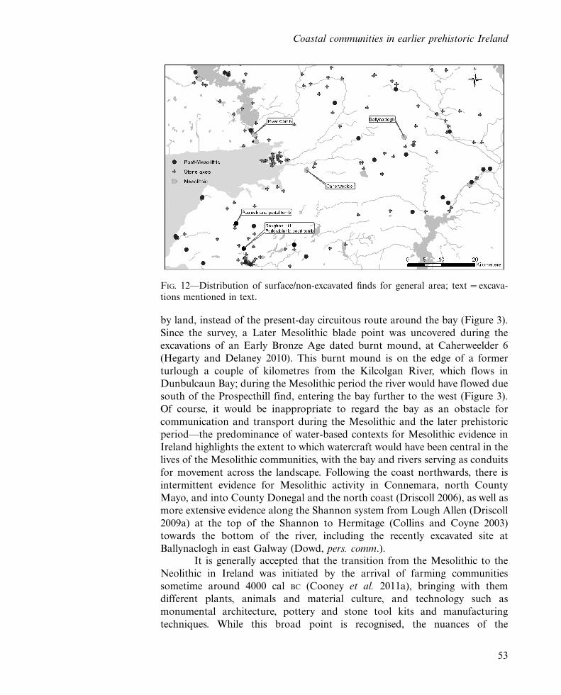
Mesolithic evidence in the mid-west has been limited (see Driscoll 2006 for
discussion), with a number of finds from along the River Corrib close to the bay
(Figure 12). While one definitive Mesolithic artefact from the area may not
appear to represent extensive activity in the area, it should be remembered that
FIG. 10*Top: average finds per hectare Middle: proportion of primary stage artefacts.
Bottom: proportion of cores of total finds per field; text �where bipolar or platform
cores only occurred.
Coastal communities in earlier prehistoric Ireland
51
just one lithic was noted in excavations on the Liffey where dating of fish traps
provided evidence for Mesolithic activity spanning at least 200 years (McQuade
and O’Donnell 2007). Therefore, even one lithic artefact may represent many
generations of landscape inhabitation. The conjectured sea-level change for
inner Galway Bay highlights the extent to which the Early and Later Mesolithic
landscapes around the coast are now submerged, with a slowing down of the
sea-level rise towards the end of the Mesolithic. The Mesolithic find from
Prospecthill therefore extends the known Mesolithic activity further along the
bay, with the modelled shoreline positing that at the time the finds at
Prospecthill and the River Corrib would have been a shorter, direct walk apart
FIG. 11*Top: proportion of scrapers of total finds per field; text notes certain types.
Bottom proportional pie charts for scraper types per field; text �where scrapers on
cores occurred.
Killian Driscoll
52
by land, instead of the present-day circuitous route around the bay (Figure 3).
Since the survey, a Later Mesolithic blade point was uncovered during the
excavations of an Early Bronze Age dated burnt mound, at Caherweelder 6
(Hegarty and Delaney 2010). This burnt mound is on the edge of a former
turlough a couple of kilometres from the Kilcolgan River, which flows in
Dunbulcaun Bay; during the Mesolithic period the river would have flowed due
south of the Prospecthill find, entering the bay further to the west (Figure 3).
Of course, it would be inappropriate to regard the bay as an obstacle for
communication and transport during the Mesolithic and the later prehistoric
period*the predominance of water-based contexts for Mesolithic evidence in
Ireland highlights the extent to which watercraft would have been central in the
lives of the Mesolithic communities, with the bay and rivers serving as conduits
for movement across the landscape. Following the coast northwards, there is
intermittent evidence for Mesolithic activity in Connemara, north County
Mayo, and into County Donegal and the north coast (Driscoll 2006), as well as
more extensive evidence along the Shannon system from Lough Allen (Driscoll
2009a) at the top of the Shannon to Hermitage (Collins and Coyne 2003)
towards the bottom of the river, including the recently excavated site at
Ballynaclogh in east Galway (Dowd, pers. comm.).It is generally accepted that the transition from the Mesolithic to the
Neolithic in Ireland was initiated by the arrival of farming communities
sometime around 4000 cal BC (Cooney et al. 2011a), bringing with them
different plants, animals and material culture, and technology such as
monumental architecture, pottery and stone tool kits and manufacturing
techniques. While this broad point is recognised, the nuances of the
FIG. 12*Distribution of surface/non-excavated finds for general area; text �excava-
tions mentioned in text.
Coastal communities in earlier prehistoric Ireland
53
transition*e.g. how large scale was the population arrival, over what time
period did communities migrate, what were the interactions between the new
arrivals and the communities already present*are debated (e.g. Whittle 1996;
Cooney 2007; Cooney et al. 2011a). Cooney (2007) has argued that the new
technologies and resources brought to Ireland can be viewed as transported
landscapes rather than individual entities. What is important to bear in mind is
that these transported landscapes modified already existing Mesolithic physical
and cultural lived-in landscapes (see Driscoll 2009a) in areas such as
Ballynacourty.Given that Ireland is a small island with a large coastline, it is
unsurprising that so much Neolithic monument building, settlement and
activity took place close to the coast, and unsurprising that much has been
written about the roles the Atlantic Ocean and Irish Sea played in prehistory
(e.g. Herity and Eogan 1977, O Nuallain 1983, Burenhult 1984, Waddell 1991,
Cunliffe 2001, Sheridan 2003, Fowler and Cummings 2004, Cooney 2007,
O’Sullivan and Breen 2007). In terms of megalithic structures, O Nuallain
(1983) noted that almost half of portal tombs are within 8km of the coast, while
in Donegal 78 per cent of all megalithic tombs are within 3km of the coast and
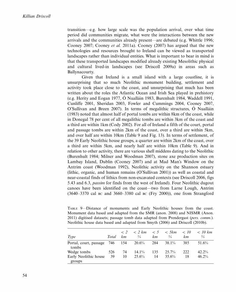
a third are within 1km (Cody 2002). For all of Ireland a fifth of the court, portal
and passage tombs are within 2km of the coast, over a third are within 5km,
and over half are within 10km (Table 9 and Fig. 13). In terms of settlement, of
the 39 Early Neolithic house groups, a quarter are within 2km of the coast, over
a third are within 5km, and nearly half are within 10km (Table 9). And in
relation to other activity, there are various shell middens dating to the Neolithic
(Burenhult 1984; Milner and Woodman 2007), stone axe production sites on
Lambay Island, Dublin (Cooney 2007) and at Mad Man’s Window on the
Antrim coast (Woodman 1992), Neolithic activity on the Shannon estuary
(lithic, organic, and human remains (O’Sullivan 2001)) as well as coastal and
near-coastal finds of lithics from non-excavated contexts (see Driscoll 2006, figs
5.43 and 6.3, passim for finds from the west of Ireland). Four Neolithic dugout
canoes have been identified on the coast*two from Larne Lough, Antrim
(3640�3370 cal BC and 3660�3380 cal BC (Fry 2000)), one from Strangford
TABLE 9*Distance of monuments and Early Neolithic houses from the coast.
Monument data based and adapted from the SMR (anon. 2008) and NISMR (Anon.
2011) digitised datasets; passage tomb data adapted from Prendergast (pers. comm.).
Neolithic house data based and adapted from Smyth (2006) and Driscoll (2010b).
Type TotalB 2km
B 2 km%
B 5km
B 5km%
B 10km
B 10 km%
Portal, court, passagetombs
746 154 20.6% 284 38.1% 385 51.6%
Wedge tombs 526 74 14.1% 135 25.7% 222 42.2%Early Neolithic house
groups39 10 25.6% 14 35.6% 18 46.2%
Killian Driscoll
54
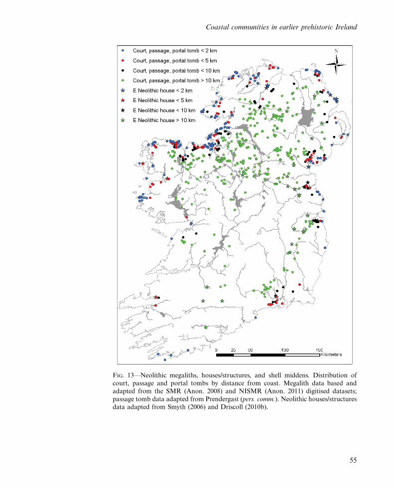
FIG. 13*Neolithic megaliths, houses/structures, and shell middens. Distribution of
court, passage and portal tombs by distance from coast. Megalith data based and
adapted from the SMR (Anon. 2008) and NISMR (Anon. 2011) digitised datasets;
passage tomb data adapted from Prendergast (pers. comm.). Neolithic houses/structuresdata adapted from Smyth (2006) and Driscoll (2010b).
Coastal communities in earlier prehistoric Ireland
55
Lough, Down (3500�302 cal BC (Forsythe and Gregory 2007)), and one fromGalway Bay, mentioned above (c. 3800 cal BC). For the Bronze Age, however, arecent synthesis concludes that it is difficult to make statements concerningcoastal exploitation (Murray 2007, 127). In terms of megaliths, there is a cleardiminution in the coastal setting for wedge tombs in the Bronze Age (Table 9),and the evidence for settlement also shows a greater distancing from the coast(Cleary 2003; Cleary 2007; Doody 2000). Nevertheless, Caulfield et al. (2009)comment that in terms of ‘architectural sophistication and settlement complex-ity’ the most impressive of the Bronze Age settlements*with the authors citingSlievemore and Belderg Beg, Co. Mayo; Cappagh Beg, Corrstown, Knockdhuand Ballyprior Beg, Co. Antrim (see Ginn and Rathbone 2011)*are all locatedwithin 4km of the coast. As well as in the Neolithic, there is a continuedformation of shell middens from the Bronze Age (Milner and Woodman 2007),and evidence for the use of estuarine locales (O’Sullivan 2001; O’Sullivan andBreen 2007).
The coastal setting of the Neolithic and Bronze Age farming commu-nities at Ballynacourty is paralleled on the west coast in north County Mayo(Caulfield 1983; Caulfield et al. 1998); Valencia Island, Co. Kerry (Mitchell1989; Cooney et al. 2011a); and InishBofin, Inis Oırr, and Lough Sheeauns inCounty Galway (O’Connell and Molloy 2001). At both the Early Neolithiccoastal farming sites in north Mayo and the Beaker/Bronze Age inland farmingsites of the Burren such as Roughan Hill (Jones et al. 2011; see also theParknabinnia court tomb (Jones 2003) and Poulnabrone portal tomb (Lynchand O Donnabhain 1994) in the Burren for dates highlighting earlieroccupation) there is evidence for the construction of megalithic monumentsand field systems. At Ballynacourty, while portal and court tombs survive, othermegalithic monuments have been destroyed and no evidence of prehistoric fieldsystems has been found. While it can be conjectured that a similar settlementpattern of field systems existed at the time at Ballynacourty, O’Connell andMolloy (2001) note that no evidence for field systems was forthcoming for theNeolithic farming activity sealed by bog around Lough Sheeauns in Con-nemara. Therefore, while no direct evidence is available in Ballynacourty for theuse of extensive field systems in the Neolithic and Bronze Age, the concentra-tion of Neolithic and Bronze Age monuments and sites such as the fulacht fia,added to the significant evidence from the stone axes and lithic scatters,nevertheless point to an extensive settlement in the area.
Dolan and Cooney (2010) have commented that the proportion ofmodified to non-modified artefacts in coastal and inland surface collections ishighly variable, mainly with coastal collections having a greater proportion ofnon-modified artefacts*with a range of between 3 per cent and 44 per cent anda median of 10 per cent. The present assemblage’s proportion of modifiedartefacts at 28 per cent is therefore in the upper range, nearly three times themedian and four times the median for coastal collections. However, it must beborne in mind that Dolan and Cooney’s comments relate to flint assemblages,and it is unclear if a direct comparison with chert assemblages is applicable. Themost common modified type in the Ballynacourty assemblage is the scraper,
Killian Driscoll
56
dominated by convex end scrapers and concave scrapers. Elsewhere, use wearanalysis has suggested that larger convex scrapers were used on hide whilesmaller convex scrapers were used on wood; when reduced in size fromresharpening, convex scrapers shifted from use as hide scrapers to woodscrapers, but there was no evidence for a shift from wood-working to hide-working as they were reduced in size (Bamforth and Woodman 2004). Hollowscrapers were used on wood and were often put to this use before a formalhollow was flaked into them; some of the hollow scrapers also had evidence forcutting of softer material (hide or plant) (Bamforth and Woodman 2004). Thatthe hollow scrapers were used before the formal hollow was flaked into puts thenon-diagnostic edge-retouched flakes in perspective*some of these mayrepresent scrapers that, for whatever reason, were abandoned before attaininga formalised, identifiable retouch. More recently, use-wear analysis on concavescrapers has identified its usage as dry wood (Bergh pers. comm.), possiblyrelated to arrow shaft production (Bergh 2009).
Commenting on this use-wear analysis in relation to a large assemblageof concave scrapers from Knocknarea, Bergh (2009, 110�1) has suggested thatthe functional attributions of this scraper type do not explain the emergenceand subsequent disappearance of the concave form in the Neolithic: for itsdisappearance ‘the role and function of these rather specific tools may havebeen linked to a certain ideology or ritual behaviour, which ceased to be part ofthe habitual practices at this time . . . it is possible that the concave scraper had arole linked to the passage tombs’ ideology’ which also ceased at that time.Bergh’s interpretation highlights that it is difficult to draw a line between asacred and mundane use of a given implement. An implement as ubiquitous asa scraper, found in seemingly ‘non-ritual’ places such as the fields ofBallynacourty Parish, is nevertheless intimately intertwined in the totality of‘‘the stone tool users’ society.’’
This ‘sociality of technology’ (see Pfaffenberger 1988; Lemonnier 1993;Reynolds 1993; Dobres 2000; Ingold 2000) is of course not limited to adistinctive type such as the concave scraper, but rather involves the gamut oftechnological practices, of which the scraper was just one part, and includesnon-modified flakes. Even though the assemblage contains a high proportion ofmodified artefacts compared to other large surface collections, the assemblagenevertheless contains hundreds of non-modified flakes. The lack of modificationdoes not mean that all these flakes were necessarily ‘waste products’.A large corpus of ethnographic and use wear research has shown that non-modified lithics were in fact tools (see Man 1883; White and Thomas 1972;Hayden 1979; Flenniken 1981; Symens 1986; Knutsson 1988; Odell 1994; Banks1996; Kozlowski et al. 1996; Read and Russell 1996; Finlayson and McCartney1998; Briels 2004; Hardy 2004; Setzer 2004; Shott and Sillitoe 2005; Akerman2006; Hardy et al. 2008). Without a programme of use-wear analysis, however, itis impossible to quantify the extent of this non-modified flake use. While someresearchers use a category of ‘utilised’ piece (e.g. Brady 2001; O’Hare 2005) tomacroscopically identify use-wear, Young and Bamforth (1990, 408) havedemonstrated that the macroscopic identification of use-wear*the ‘utilised’
Coastal communities in earlier prehistoric Ireland
57
piece*has a very low success rate and they warn that macroscopic identificationof use-wear should be carried out with ‘extreme caution if it must be carried outat all’. Moreover, attempts to qualify and quantify the use of non-modifiedartefacts as tools based on morphology*i.e. if it looks like it could have been atool it probably was one (e.g. O’Hare 2005)*are tenuous. This means that manypossible ‘tools’ in this and other assemblages remain unidentified, with themodified artefacts only representing one facet of the prehistoric tool kit.
The stone axe component of the prehistoric tool kit was the tool typethat stimulated the present research, with the high density of stone axes in thisarea having attracted the attention of scholars in the early twentieth century.Mahr (1937) cited the area in his formulation on the Riverford Culture, andlater, Woodman et al. (1999) also considered the possibility that some of theBallynacourty axes may be Mesolithic. While Woodman et al. (1999) haveargued*citing the Ballynacourty Parish axes as examples*that Mesolithicaxes used the natural cobble shape with minimal alteration, the Neolithic andBronze Age assemblage from Lough Gur contains numerous examples of suchminimally altered axes (O’Keeffe, pers. com.), therefore this characteristic is notuseful as a chronological marker (Cooney et al. 2011b). The Early Mesolithiccremation at Hermitage on the Shannon, which contained a large, polishedshale axe (Collins and Coyne 2003; ISAP 2006), highlights that finely craftedpolished axes were a part of technological and ritual practices of the Mesolithiccommunities. Given the breadth of Neolithic and Bronze Age flaked stoneartefacts in Ballynacourty Parish, it would seem likely that the majority of theaxes are of a similar chronology; nevertheless, it is difficult to discerntypological and technological differences between Mesolithic and post-Meso-lithic axes. Some of the axes, however, are distinctive. The Group VI tuff axefrom the area (Garraun Lower) is part of a corpus of such Neolithic axes foundthroughout Ireland, with Cooney and Mandall (1998, 118�19) noting that theraw material for these may originate in Britain, suggesting long-distance tradeand relations during the Neolithic.
Conclusion The systematic ploughzone survey at Ballynacourty represents the first of itskind undertaken in the west of Ireland, and was at the time of collection thelargest lithic assemblage from both excavated and non-excavated contexts inCounty Galway. One of the initial research questions posed was what furtherevidence for prehistoric settlement could be discerned in an area that containeda significant concentration of stone axes and a range of Neolithic and BronzeAge monuments. The collection of 800 almost exclusively chert artefacts in anarea that had witnessed keen archaeological interest and inspection during thetwentieth century, but resulted in no chert artefacts being collected, highlightsthe significant biases in the archaeological record as it has been built over theyears. The considerable proportion of bipolar artefacts in the assemblagereaffirms the integrity of this stone-working technique in prehistoric lithictraditions. Just as chert has previously been viewed by researchers as a second-rate material, the bipolar technique has often been seen as the poor cousin todirect percussion. However, the bipolar technique should not be seen as
Killian Driscoll
58
unconventional or an ad hoc strategy in the prehistoric manufacturingrepertoire*while the bipolar technique may be simple that does not meanthe technology was simplistic (Callahan 1987), and bipolar knapping should beviewed as a valid manufacturing technique in its own right. The predominanceof chert, and almost entire lack of flint, in a ploughzone assemblage in Ireland isvery unusual (see Brady 2007), but this pattern does match assemblages fromexcavated contexts from the west of Ireland such as Roughan Hill, Co. Clare(Jones 1998), Knocknarea, Co. Sligo (Bergh 2009), and the Ceide Fields, Co.Mayo (Driscoll 2010a), highlighting the important role that this material playedin prehistory, and not simply as an alternative to flint. While the extent of thepresent survey is of a much smaller scale than other ploughzone surveys on theeast coast or in the south such as the Boyne Valley survey or the Bally Loughsurvey, the results of the targeted research question*why only stone axes fromthis area contribute to the picture drawn of prehistoric communities along thewest coast, from the Mesolithic to the Bronze Age.
Acknowledgements The fieldwork was undertaken as part of an M Litt thesis funded by a NationalUniversity of Ireland, Galway, Arts Faculty Fellowship for M Litt Research.Thank you to Stefan Bergh for supervising the M Litt. Thank you to GraemeWarren and Carleton Jones for commenting on the initial draft of the paper,and to the anonymous reviewers for their critiques. This paper was finalisedwhile Killian Driscoll held a Spanish Ministry of Education PostdoctoralFellowship for Foreign Researchers, part funded by HAR2011-26193 researchprojects of the MICINN and the Quality Research Group of the Generalitat deCatalunya SGR2009-1145 based at SERP (Seminari d’Estudis i RecerquesPrehistoriques), University of Barcelona.
References Anon. 2008 Sites and Monuments Database. Available at: http://www.archae-ology.ie/ArchaeologicalSurveyofIreland/ (retrieved 4 February 2008).
Anon. 2011 Northern Ireland Sites and Monuments Database. Available at:http://www.doeni.gov.uk/niea/other-index/content-databases/content-databases-ambit.htm (retrieved 20 July 2011).
Ahler, S.A. 1989 Experimental knapping with KRF and midcontinent cherts:overview and applications. In D.S. Amick and R.P. Mauldin (eds),Experiments in lithic technology, 199�233. British Archaeological Reports(International Series) 528. Oxford. British Archaeological Reports.
Akerman, K. 2006 High tech-low tech: lithic technology in the KimberlyRegion of Western Australia. In J. Apel and K. Knutsson (eds), Skilled
production and social reproduction, 323�46. Uppsala. Societas ArchaeologicaUppsaliensis Stone Studies 2.
Bamforth, D.B. and Woodman, P.C. 2004 Tool hoards and Neolithic use of thelandscape in north-eastern Ireland. Oxford Journal of Archaeology 23(1), 21�44.
Banks, W.E. 1996 Toolkit structure and site use: results of a high-power use-wear analysis of lithic assemblages from Solutre (Saone-et-Loire), France.Unpublished PhD thesis, University of Kansas.
Coastal communities in earlier prehistoric Ireland
59
Bergh, S. 2009 Black is the colour: chert, concave scrapers and passage tombs.
In G. Cooney, B. O’Connor and J. Chapman (eds), Materialitas: working
stone, carving identity. Oxford, Prehistoric Society Research Papers 3.Bintliff, J., Kuna, M. and Venclova, N. (eds) 2000 The future of surface artefact
survey in Europe. Sheffield. Sheffield Academic Press.Brady, C. 2001 Report on the lithic assemblage from excavations at Corbally
and Brownstown, Co. Kildare (97E449 and 98E0094). Unpublished Report.Brady, C. 2007 A landscape survey of the Newgrange environs: earlier
prehistoric settlement at Bru Na Boinne, Co. Meath. Unpublished PhD
thesis, University College Dublin.Briels, I. 2004 Use-wear analysis on the archaic flint assemblage of Plum Piece,
Saba: a pilot study. Unpublished PhD thesis, Leiden University.Bronk Ramsey, C. 2009 Bayesian analysis of radiocarbon dates. Radiocarbon
51(1), 337�60.Brooks, A.J., Bradley, S.L., Edwards, R.J., Milne, G.A., Horton, B. and
Shennan, I. 2008 Postglacial relative sea-level observations from Ireland
and their role in glacial rebound modelling. Journal of Quaternary Science
23(2), 175�92.Burenhult, G. 1984 The archaeology of Carrowmore; environmental erchaeology
and the Megalithic tradition at Carrowmore, Co. Sligo, Ireland. Stockholm.
Stockholm University Theses and Papers in North-European Archaeology
14.Callahan, E. 1987 An evaluation of the lithic technology in Middle Sweden
during the Mesolithic and Neolithic. Uppsala. Societas ArchaeologicaUppsaliensis, AUN 8.
Caulfield, S. 1983 The Neolithic settlement of North Connaught. In T. Reeves-Smyth and F. Hamond (eds), Landscape archaeology in Ireland, 195�216.
British Archaeological Reports (British Series) 116. Oxford. British Archae-ological Reports.
Caulfield, S., Byrne, G., Downes, M., Dunne, G., Warren, G., McIlreavy, D.,
Rathbone, S. and Walsh, P. 2009 Neolithic and Bronze Age landscapes ofnorth Mayo. 2009 Summary Report.
Caulfield, S., O’Donnell, R.G. and Mitchell, P.I. 1998 14C dating of a Neolithicfield system at Ceide fields, County Mayo, Ireland. Radiocarbon 40, 629�40.
Clark, J.D. and Schofield, A.J. 1991 By experiment and calibration: anintegrated approach to archaeology of the ploughsoil. In A.J. Schofield (ed.),
Interpreting artefact scatters: contribution to ploughzone archaeology, 95�105.Oxford. Oxbow monograph, 4.
Cleary, K. 2007 Irish Bronze Age settlements: spatial organisation and the
deposition of material culture. Unpublished PhD thesis, University College
Cork.Cleary, R. 2003 Enclosed Late Bronze Age habitation site and boundary wall
at Lough Gur, Co. Limerick. Proceedings of the Royal Irish Academy, Section
C 103, 97�189.Cody, E. 2002 Survey of the megalithic tombs of Ireland. Vol. 6 County Donegal.
Dublin. Stationary Office.
Killian Driscoll
60

Collins, T. and Coyne, F. 2003 Fire and water . . . Early Mesolithic cremations
at Castleconnell, Co. Limerick. Archaeology Ireland 17(2), 24�7.Cooney, G. 2007 Parallel worlds or multi-stranded identities? Considering the
process of ‘going over’ in Ireland and the Irish Sea zone. Proceedings of the
British Academy 144, 543�66.Cooney, G. and Mandal, S. 1998 The Irish stone axe project: Monograph I.
Bray. Wordwell.Cooney, G., Bayliss, A., Healy, F., Whittle, A., Danaher, E., Cagney, L.,
Mallory, J., Smyth, J., Kador, T., O’Sullivan, M. 2011a Ireland. In A. Whittle,
F. Healy and A. Bayliss (eds), Gathering time: dating the Early
Neolithic enclosures of southern Britain and Ireland, 562�669. Oxford. Oxbow
Books.Cooney, G., Mandal, S. and O’Keefe, E. 2011b The Irish stone axe project:
reviewing progress, future prospects. In V. Davis and M. Edmonds (eds),
Stone axe studies III, 427�41. Oxford. Oxbow Books.Cunliffe, B. 2001 Facing the ocean: the Atlantic and its peoples 8000 BC � AD
1500. Oxford. Oxford University Press.Dobres, M.-A. 2000 Technology and social agency. Oxford. Blackwell.Dolan, B. and Cooney, G. 2010 Lambay lithics: the analysis of two surface
collections from Lambay, Co. Dublin. Proceedings of the Royal Irish
Academy 110C, 1�33.Doody, M. 2000 Bronze Age Houses in Ireland. In A. Desmond, G. Johnson,
M. McCarthy, J. Sheenan and E. Shee Twohig (eds), New agendas in Irish
prehistory, 135�59. Bray. Wordwell.Driscoll, K. 2006 The early prehistory in the west of Ireland: investigations into
the social archaeology of the Mesolithic, west of the Shannon, Ireland.
Unpublished MLitt thesis, National University of Ireland, Galway.Driscoll, K. 2009a Constructing Later Mesolithic Landscapes. In N. Finlay, S.
McCartan, N. Milner and C. Wickham-Jones (eds), From Bann Flakes to
Bushmills: papers in honour of Professor Peter Woodman, 97�108. Oxford.
Prehistoric Society Research Papers 1, Oxbow.Driscoll, K. 2009b ‘They wrought almost any material that came in their way’:
Mesolithic Flint Alternatives in the west of Ireland. Internet Archaeology
26, see: http://intarch.ac.uk/journal/issue26/driscolla_index.html (accessed
13 November 2012).Driscoll, K. 2010a Lithics report for ‘‘Glenulra scatter’’ excavations (92E140),
Glenulra, Co. Mayo. Galway. Lithics Ireland Consultancy.Driscoll, K. 2010b Understanding quartz technology in early prehistoric
Ireland. Unpublished PhD thesis, University College Dublin.Driscoll, K. and Warren, G.M. forthcoming Macrolithic quartz technology in
Mesolithic western Ireland: a quartz scatter from Belderrig, Co. Mayo.Finlayson, W. and McCartney, C. 1998 The chipped stone report.
In E. Peltenburg (ed.), Lemba Archaeological Project, Cyprus Volume
II.1B. Excavations at Kissonerga-Mosphilia, 1979�1992, 249�93. Edinburgh.
University of Edinburgh.
Coastal communities in earlier prehistoric Ireland
61
Flenniken, J.F. 1981 Replicative systems analysis: a model applied to the vein
quartz artifacts from the Hoko River site. Washington State University
Laboratory of Anthropology Reports of Investigations No. 59. Pullman.Forsythe, W. and Gregory, N. 2007 A Neolithic logboat from Greyabbey Bay,
Co. Down. Ulster Journal of Archaeology 66, 6�13.Fowler, C. and Cummings, V. (eds) 2004 The Neolithic of the Irish Sea:
materiality and traditions of practice. Oxford. Oxbow Books.Fry, M. 2000 Coitı: logboats from Northern Ireland. Belfast. Environment and
Heritage Service, Department of the Environment.Ginn, V. and Rathbone, S. (eds) 2011 Corrstown: a coastal community.
Excavations of a Bronze Age village in Northern Ireland. Oxford. Oxbow Books.Gosling, P. 1993 Archaeological Inventory of County Galway, Vol. I, West
Galway. Dublin. The Stationary Office.Grogan, E. and Eogan, G. 1987 Lough Gur excavations by Sean P. O
Rıordain: further Neolithic and Beaker habitations on Knockadoon.
Proceedings of the Royal Irish Academy, Section C 87, 299�506.Hardy, B.L., Bolus, M. and Conard, N.J. 2008 Hammer or crescent wrench?
Stone-tool form and function in the Aurignacian of southwest Germany.
Journal of Human Evolution 54(5), 648�62.Hardy, K. 2004 Microwear analysis of a sample of flaked stone tools. In C.R.
Wickham-Jones and K. Hardy, Camas Daraich: a Mesolithic site at the Point of
Sleat, Skye. Scottish Archaeological Internet Report (SAIR) 12. Available at:
http://www.sair.org.uk/sair12/sair12-contents.pdf (retrieved 1 October 2007).Hayden, B. 1979 Palaeolithic reflections: lithic technology of the Western Desert
Aborigines. New Jersey. Humanities Press.Hegarty, L. and Delaney, F. 2010 Final Archaeological Excavation Report.
Caherweelder 6, Co. Galway. Burnt Mound. Cork. Eachtra Archaeological
Projects.Herity, M. 1987 The finds from Irish court tombs. Proceedings of the Royal
Irish Academy, Section C 87, 103�281.Herity, M. and Eogan, G. 1977 Ireland in prehistory. London. Routledge &
Kegan Paul.INFOMAR 2011 Galway Bay Survey. Available at: http://www.infomar.ie/
surveying/Bays/Galwayv1.php (retrieved 2 March 2011).Ingold, T. 2000 The perception of the environment: essays in livelihood, dwelling
and skill. London. Routledge.Inizan, M.-L., Reduron-Ballinger, M., Roche, H. and Tixier, J. 1999 Technology
and terminology of knapped stone. Nanterre. Cercle de Recherches et
d’Etudes Prehistoriques.ISAP 2006 Irish stone axe project. [CD-ROM]. (For details of the project see
http://www.ucd.ie/archaeology/research/researcha-z/isap/ (accessed 29 No-
vember 2012).Johnson, L.L., Behm, J.A., Bordes, F., Cahen, D., Crabtree, D.E., Dincauze,
D.F., Hay, C.A., Hayden, B., Hester, T.R., Katz, P.R., Knudson, R.,
McManamon, F.P., Malik, S.C., Muller-Beck, H., Newcomer, M.H.,
Paddayya, K., Price-Beggerly, P., Ranere, A.J., Sankalia, H.D. and Sheets,
Killian Driscoll
62
P.D. 1978 A history of flint-knapping experimentation, 1838�1976 [and
Comments and Reply]. Current Anthropology 19(2), 337�72.Jones, C. 1998 The discovery and dating of the prehistoric landscape of
Roughan Hill in Co. Clare. The Journal of Irish Archaeology 9, 27�44.Jones, C. 2003 Neolithic beginnings on Roughan Hill and the Burren. In A.
Armit, E. Murphy, E.L. Nelis and D.D.A. Simpson (eds), Neolithic
settlement in Ireland and western Britain, 188�94. Oxford. Oxbow Books.Jones, C., Carey, O. and Hennigar, C. 2011 Domestic production and the
political economy in prehistory: evidence from the Burren, Co. Clare.
Proceedings of the Royal Irish Academy, Section C 111, 33�58.Kimball, M. J. 2000 Human ecology and the Neolithic transition in Eastern
County Donegal, Ireland: the Lough Swilly Archaeological Survey. British
Archaeological Reports (British Series) 300. Oxford. British ArchaeologicalReports.
Knowles, M.C. 1904 Kitchen middens: County Clare. Journal of the Limerick
Field Club 2, 35�42.Knutsson, K. 1988 Making and using stone tools: the analysis of the lithic
assemblages from Middle Neolithic sites with flint in Vastebotten, Northern
Sweden. Uppsala. Societas Archaeologica Uppsaliensis.Kozlowski, J.K., Kaczanowska, M. and Pawlikowski, M. 1996 Chipped-stone
industries from Neolithic levels at Lerna. Hesperia 65(3), 295�372.Kytmannow, T. 2008 Portal tombs in the landscape: the chronology, morphology
and landscape setting of the portal tombs of Ireland, Wales and Cornwall.
British Archaeological Reports (British Series) 455. Oxford, British Archae-ological Reports.
Lemonnier, P. (ed.) 1993 Technological choices: transformation in material
cultures since the Neolithic. London. Routledge.Lewarch, D.E. and O’Brien, M.J. 1981 The expanding role of surface
assemblages in archaeological research. Advances in Archaeological Method
and Theory 4, 297�342.Lindgren, C. 2003 My way or your way: on the social dimension of technology
as seen in the lithic strategies in easternmiddle Sweden during the
Mesolithic. In L. Larsson, H. Kindgren, K. Knutsson, D. Loeffler and A.Akerlund (eds), Mesolithic on the move: papers presented at the Sixth
International Conference on the Mesolithic in Europe, Stockholm 2000, 177�83. Oxford. Oxbow Books.
Low, B. D. 1997 Bipolar technology and pebble stone artifacts: experimentationin stone tool manufacture. Unpublished MA thesis, University of Saskatch-
ewan.Lynch, A. and O Donnabhain, B. 1994 Poulnabrone portal tomb. The Other
Clare 18, 5�7.Mahr, K.A. 1937 New aspects and problems in Irish prehistory. Proceedings of
the Prehistoric Society 3, 261�437.Man, E.H. 1883 On the Aboriginal inhabitants of the Andaman Islands. (Part
III). Journal of the Anthropological Institute of Great Britain and Ireland 12,
327�434.
Coastal communities in earlier prehistoric Ireland
63
McCartan, S., with contributions by Manning, P. and Simms, M. 2004 Stone
artefacts. In E. FitzPatrick, M. O’Brien and P. Walsh (eds), Archaeological
investigations in Galway City, 1987�1998, 530�40. Bray. Wordwell.McQuade, M. and O’Donnell, L. 2007 Late Mesolithic fish traps from the
Liffey estuary, Dublin, Ireland. Antiquity 81(313), 569�84.Mercer, B. 2008 Investigations and palaeoenvironmental reconstruction of an
ancient landscape on the shores of Galway Bay. Unpublished Bsc disserta-
tion, National University of Ireland, Galway.Milliken, S. forthcoming Appendix 4. Lithics report. In R. Gillespie. Archae-
ological excavations on the Westport main drainage and waste water disposal
scheme (2000�2004). Castlebar. Mayo County Council.Milner, N. and Woodman, P. 2007 Deconstructing the myths of Irish shell
middens. In N. Milner, O.E. Craig and G.N. Bailey (eds), Shell middens in
Atlantic Europe, 101�10. Oxford. Oxbow.Mitchell, G.F. 1989 Man and environment in Valencia Island. Dublin. Royal
Irish Academy.Murray, E. 2007 Molluscs and middens: the archaeology of ‘‘Ireland’s early
savage race’’? In E. Murphy and N. Whitehouse (eds), Environmental
archaeology in Ireland, 119�35. Oxford. Oxbow Books.Nelis, E.L. 2004. Lithics of the northern Irish Neolithic. Unpublished PhD
thesis, Queen’s University.O’Connell, M. and Molloy, K. 2001 Farming and woodland dynamics in
Ireland during the Neolithic. Proceedings of the Royal Irish Academy, Section
B 101(1�2), 99�128.Odell, G.H. 1994 The role of stone bladelets in Middle Woodland society.
American Antiquity 59(1), 102�20.O’Hare, M.B. 2005 The Bronze Age lithics of Ireland. Unpublished PhD thesis,
Queen’s University Belfast. 4 vols. Vol. 1.O Nuallain, S. 1983 Irish portal tombs: topography, siting and distribution.
Journal of the Royal Society of Antiquaries of Ireland 113, 75�105.O’Sullivan, A. 2001 Foragers, farmers and fishers in a coastal landscape: an
intertidal archaeological survey of the Shannon estuary. Dublin. Discovery
Programme Monograph No. 4.O’Sullivan, A. and Breen, C. 2007 Maritime Ireland: an archaeology of coastal
communities. Stroud. Tempus.Peterson, J.D. 1990 From foraging to food production in south-east Ireland:
some lithic evidence. Proceedings of the Prehistoric Society 56, 89�99.Pfaffenberger, B. 1988 Fetishised objects and humanised nature: towards an
anthropology of technology. Man 23(2), 236�52.Pracht, M. and McConnell, B. 2004 Geology of Galway Bay: a geological
description to accompany the bedrock geology 1:100,000 map series, sheet 14,
Galway Bay. Dublin. Geological Survey of Ireland.Purcell, A. 2002 Excavation of three Neolithic houses at Corbally, Kilcullen,
Co. Kildare. Journal of Irish Archaeology XI, 31�76.Read, D.W. and Russell, G. 1996 A method for taxonomic typology construc-
tion and an example: utilized flakes. American Antiquity 61(4), 663�84.
Killian Driscoll
64

Reynolds, P.C. 1993 The complementation theory of language and tool use. InK.R. Gibson and T. Ingold (eds), Tools, language and cognition in humanevolution, 407�28. Cambridge. Cambridge University Press.
Schofield, A.J. (ed.) 1991 Interpreting artefact scatters: contributions to
ploughzone archaeology. Oxbow Monograph 4. Oxford. Oxbow Books.Setzer, T.J. 2004 Use-wear experiments with Sardinian obsidian: determining its
function in the Neolithic. Unpublished MA thesis, University of SouthFlorida.
Sheridan, J.A. 2003 Ireland’s earliest ‘passage’ tombs: a French connection. InG. Burenhult (ed.), Stones and bones: formal disposal of the dead in Atlantic
Europe during the Mesolithic-Neolithic interface 6000�3000 bc. Archaeologi-cal conference in honour of the late professor Michael J. O’Kelly, 9�25.Oxford. BAR International Series 1201.
Shott, M.J. and Sillitoe, P. 2005 Use life and curation in New Guineaexperimental used flakes. Journal of Archaeological Science 32(5), 653�63.
Smyth, J. 2006 Neolithic settlement in Ireland: new theories and approaches.Unpublished PhD thesis, University College Dublin.
Symens, N. 1986 A functional analysis of selected stone artefacts from theMagdalenian Site at Verberie, France. Journal of Field Archaeology 13(2),213�222.
Waddell, J. 1991 The Irish Sea in prehistory. Journal of Irish Archaeology 6,29�40.
Waddell, J. 2005 Foundation myths: the beginnings of Irish archaeology. Bray.Wordwell.
White, J.P. and Thomas, D.H. 1972 What mean these stones? Ethno-taxonomic models and archaeological interpretations in the New GuineaHighlands. In D.L. Clarke (ed.), Models in Archaeology, 275�308. London.Methuen.
Whittle, A. 1996 Europe in the Neolithic: the creation of new worlds. Cambridge.Cambridge University Press.
Woodman, P.C. 1992 Excavations at Mad Man’s Window, Co. Antrim:problems of flint exploitation in east Antrim. Proceedings of the Prehistoric
Society 58, 77�106.Woodman, P.C. 2003 Pushing back the boundaries. Dublin. Royal Dublin
Society. Occasional papers in Irish science and technology 27.Woodman, P.C., Anderson, E. and Finlay, N. 1999 Excavations at Ferriter’s Cove,
1983�95: last foragers, first farmers in the Dingle Peninsula. Bray. Wordwell.Woodman, P.C., Finlay, N. and Anderson, E. 2006 The archaeology of a
collection: the Keiller-Knowles collection of the National Museum of Ireland.Bray. Wordwell.
Young, D. and Bamforth, D.B. 1990 On the macroscopic identification of usedflakes. American Antiquity 55(2), 403�9.
Zvelebil, M., Green, S.W. and Macklin, M.G. 1992 Archaeological landscapes,lithic scatters, and human behaviour. In J. Rossignol and L. Wandsnider(eds), Space, time, and archaeological landscapes, 193�226. New York.Plenum Press.
Coastal communities in earlier prehistoric Ireland
65


