Embed Size (px)
Citation preview
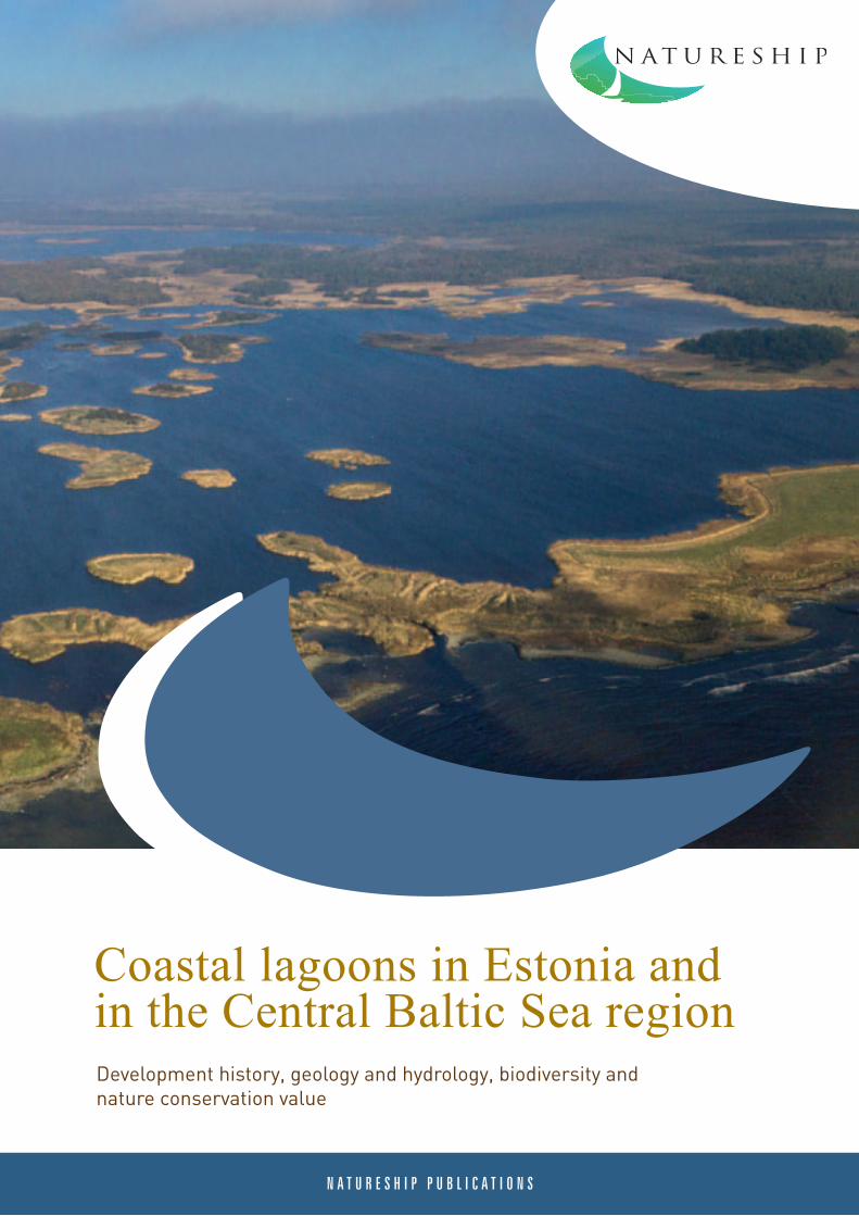
Coastal lagoons in Estonia and in the Central Baltic Sea regionDevelopment history, geology and hydrology, biodiversity and nature conservation value
Editor: Mati Kose
Editing panel: Mati Kose Kaja Lotman Ingmar Ott Monika Übner
Designer: Lea Tammik
Printing house: Folger Art
Authors of photos: Hans Hästbacka lk 131, 132, 133, 136, 137Katrit Karus lk 52Anu Kisand lk 96Mati Kose lk 6, 8, 13, 14, 16, 18, 19, 29, 30, 32, 34, 36, 37, 38, 39, 40, 41, 42, 45, 46, 47, 50, 52, 56, 58, 60, 62, 63, 67, 69, 70, 73, 75, 77, 78, 80, 81, 83, 85, 89, 92, 94, 97, 98, 100, 102, 116, 118, 123, 124, 125, 143Ilona Lepik lk 130Kaja Lotman lk 129, 130Helle Mäemets lk 53Ingmar Ott lk 22, 23, 24, 54,55Henn Timm lk 51
©University of Tartu Pärnu College, Environmental Board, Estonian University of Life Sciences Institute of Agricultural and Environmental Sciences Centre for Limnology, 2012
This publication was made possible under the Natureship project supported by the EU Central Baltic INTERREG IV A Programme and is a part of this project’s “Nature management library” series.
More information on the Natureship project and its electronic publications available at: www.ymparisto.fi/natureship
ISBN 978-9985-9396-3-5 (publication)ISBN 978-9985-9396-4-2 (pdf)
3
Introduction of the NATURESHIP project
This publication has been prepared under the NATURESHIP programme. The coordinator of the project was Southwest Finland’s Centre for Economic Development, Transport and the Environment (Varsinais-Suomen elinkeino-, liikenne- ja ympäristö-keskus (ELY). The project lasted from October 2009 to January 2013. Eleven partners were involved in the project activities: Southwest Finland’s Centre for Economic Development, Transport and the Environment, Department of Geography and Geology of the University of Turku, Metsahällitus (Finnish national forest management centre), the city governments of Hamina, Raisio and Salo, and Vihti local govern-ment in Finland, Norrtälje Nature Conservation Foundation, Gotland’s county government in Sweden, and the En-vironmental Board and the University of Tartu Pärnu College from Estonia. Natureship project was funded from the EU Central Baltic Interreg IV A Programme.
The general aim of the project was to promote cooperation in the fields of management of environment, nature and water conservation in Finland, Sweden, and Estonia. The purpose of the project was to develop plans for use of the coastal areas in concordance with the principles of sustainable development. For that, the best and most cost-efficient ways were sought for solving the issues regarding water protection and preservation of natural diversity, involving all partners. In the course of the project, Finnish, Estonian and Swedish partners tested the different coastal area planning methods, combining the modern geo-informatical (GIS) data with the historic ma-terials gathered and digitalised during the project. Innovative methods for management of habitats of value in terms of nature conservation were tested and management recommendations based on the achieved outcomes were given. Traditional semi-natural communities and the related key species were studied. In addition to the abovementioned, the services of coastal area ecosystems were assessed during the project — that is, the mate-rial and non-material values and amenities that are provided to people by natural ecosystems.
The main output of the project is a so-called “Nature management library” that assembles the six publications reflecting the most important results of the project into a uniform thematic whole. All of the publications are available and can be downloaded from the project webpage: www.ymparisto.fi/natureship
Mika Orjala, Annastina Sarlin and Anna HaapaniemiNatureship project coordinators
4
TABLE OF CONTENTSIntroduction of the NATURESHIP project INTRODUCTION
I COASTAL LAGOONS AS HABITATS OF HIGH NATURAL VALUE1.1 Coastal lagoons as endangered habitats Kaja Lotman, Mati Kose 1.2 An overview of the distribution and conservation status of the EU Nature Directive’s habitat (1150*), coastal lagoons in Estonia | Kaja Lotman, Mati Kose, Kadri Paomees
II GENERAL CHARACTERISATION, DEVELOPMENT AND GEOLOGY OF COASTAL LAGOONS2.1 Formation, development and typology of coastal lagoons Ingmar Ott, Ruta Tamre2.2 Hydrology and nutrient loads of coastal lagoons Ingmar Ott2.3 Sediments of coastal lagoons and their biochemical characterisation Anu Kisand, Monika Übner
III BIOTA OF COASTAL LAGOONS3.1 Mammals Mati Kose3.2 The bird fauna in coastal lagoons Mati Kose, Tarvo Valker 3.2.1 The features of breeding bird fauna in coastal lagoons 3.2.2 Changes and trends in the breeding bird fauna of coastal lagoons3.3 Amphibians and reptiles Ilona Lepik, Kaja Lotman3.4 Fish of coastal lagoons Teet Krause, Anu Palm3.5 Large invertebrates in coastal lagoons Henn Timm, Tiina Talvi 3.6 Macrophytes of coastal lagoons Katrit Karus, Tõnu Feldmann3.7 Microalgae in coastal lagoons Kairi Maileht, Ingmar Ott3.8 Animal plankton (zooplankton) Ingmar Ott, Kaidi Kübar
IV RESULTS OF STUDIES OF COASTAL LAGOONS Ingmar Ott, Kairi Maileht, Teet Krause, Anu Palm, Katrit Karus, Tõnu Feldmann, Anu Kisand, Aimar Rakko, Henn Timm, Kaidi Kübar, Kristine Palm, Mati Kose 4.1 Coastal lakes of Saaremaa 4.1.1 Aenga bay 4.1.2 Laidevahe 4.1.3 Linnulaht 4.1.4 Mullutu bay 4.1.5 Oessaare bay 4.1.6 Poka bay 4.1.7 Põldealuse bay 4.1.8 Suurlaht 4.1.9 Vägara
36
99
10
1515
22
28
3333
35
354445
48
51
52
54
55
57
58586063677073747578
5
4.2 Coastal lakes of West Estonia (Lääne County, Pärnu County) 4.2.1 Kahvatu 4.2.2 Kasselaht 4.2.3 Kiissalaht 4.2.4 Kudani bay 4.2.5 Käomardi bay 4.2.6 Prästvike bay 4.2.7 Vööla meri4.3 Comparison of sediments from Estonian and Gotland coastal lagoons Monika Übner
VPROTECTION AND MANAGEMENT OF COASTAL LAGOONS5.1 Determination of watersheds and characterisation of the catchment basin with support of maps Ruta Tamre 5.1.1 Definition of catchment basin and watershed 5.1.2 Determining the catchment basin size and borders 5.1.3 Existing published data regarding the catchment basins 5.1.4 Map layer of the catchment areas 5.1.5 Base map of Estonia 5.1.6 Height contour lines on base maps 5.1.7 Characterisation of a catchment area based on maps 5.1.8 Holdings on the main map of Estonia 5.1.9 CORINE Land Cover types 5.1.10 Soil maps 5.1.11 Human activity impacts on catchment areas 5.1.12 Summary5.2 Organisation of management and protection of coastal lagoons Ingmar Ott, Kaja Lotman, Mati Kose 5.2.1 Legal framework 5.2.2 Determination of the ecological condition of coastal lagoons 5.2.3 Recommendations for making practical decisions 5.2.4 Recommendations for management of the lakes studied under the Natureship programme
VI SUCCESS STORIES OF COASTAL LAGOON MANAGEMENT 6.1 On restoration of wetland complex of coastal lagoons and meadows in Võiste, Luitemaa nature nature reserve Mati Kose, Aivo Klein6.2 Restoration of lake Teorehe and coastal meadows in Matsalu National Park Kaja Lotman6.3 Lagoons, coastal lakes and streams – ecological importance and maintenance in the Kvarken Archipelago in the Gulf of Bothnia Hans Hästbacka
ANNEXES
REFERENCES
818183858889929498
103103
103104104104105106108108108109109111112
112113115117
119119
128
131
138
141
6
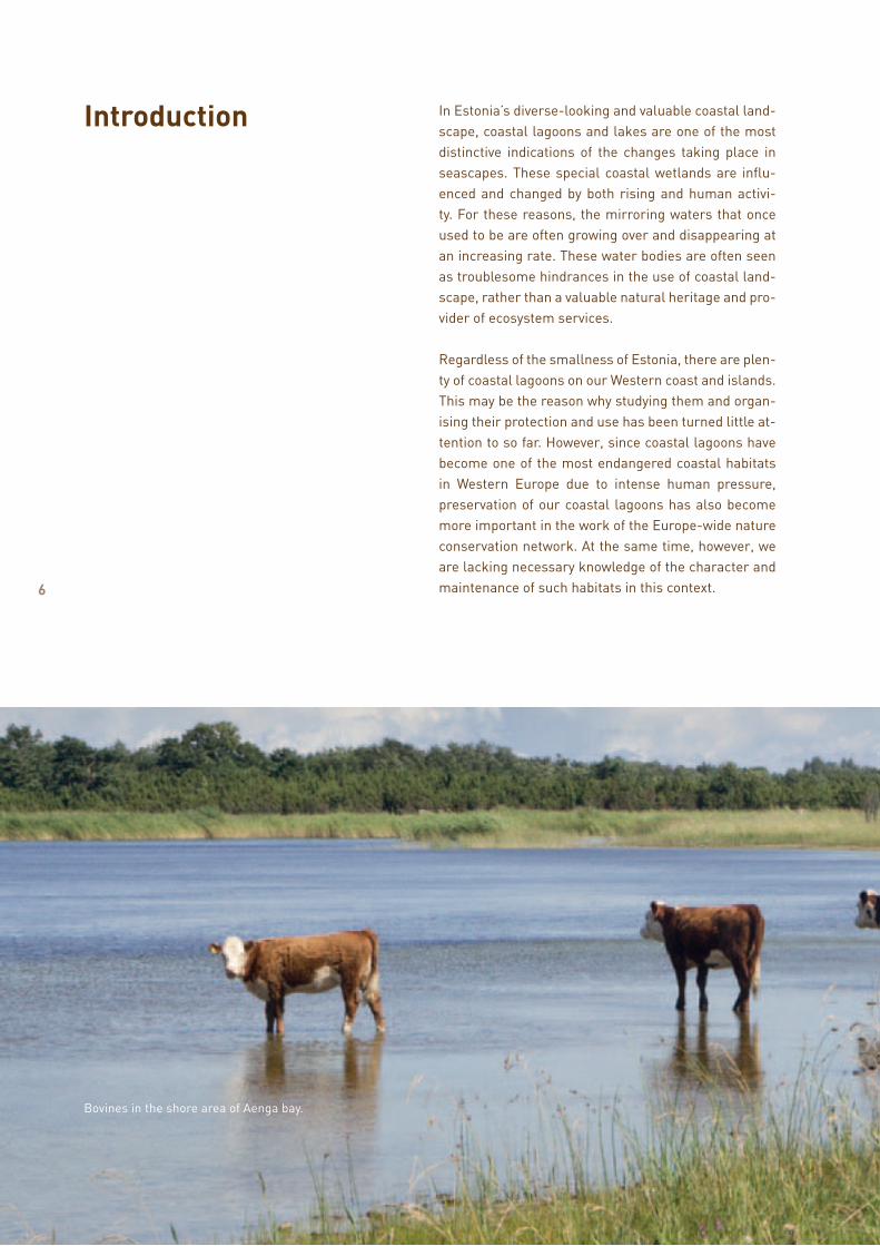
In Estonia’s diverse-looking and valuable coastal land-scape, coastal lagoons and lakes are one of the most distinctive indications of the changes taking place in seascapes. These special coastal wetlands are influ-enced and changed by both rising and human activi-ty. For these reasons, the mirroring waters that once used to be are often growing over and disappearing at an increasing rate. These water bodies are often seen as troublesome hindrances in the use of coastal land-scape, rather than a valuable natural heritage and pro-vider of ecosystem services.
Regardless of the smallness of Estonia, there are plen-ty of coastal lagoons on our Western coast and islands. This may be the reason why studying them and organ-ising their protection and use has been turned little at-tention to so far. However, since coastal lagoons have become one of the most endangered coastal habitats in Western Europe due to intense human pressure, preservation of our coastal lagoons has also become more important in the work of the Europe-wide nature conservation network. At the same time, however, we are lacking necessary knowledge of the character and maintenance of such habitats in this context.
Bovines in the shore area of Aenga bay.
Introduction
7
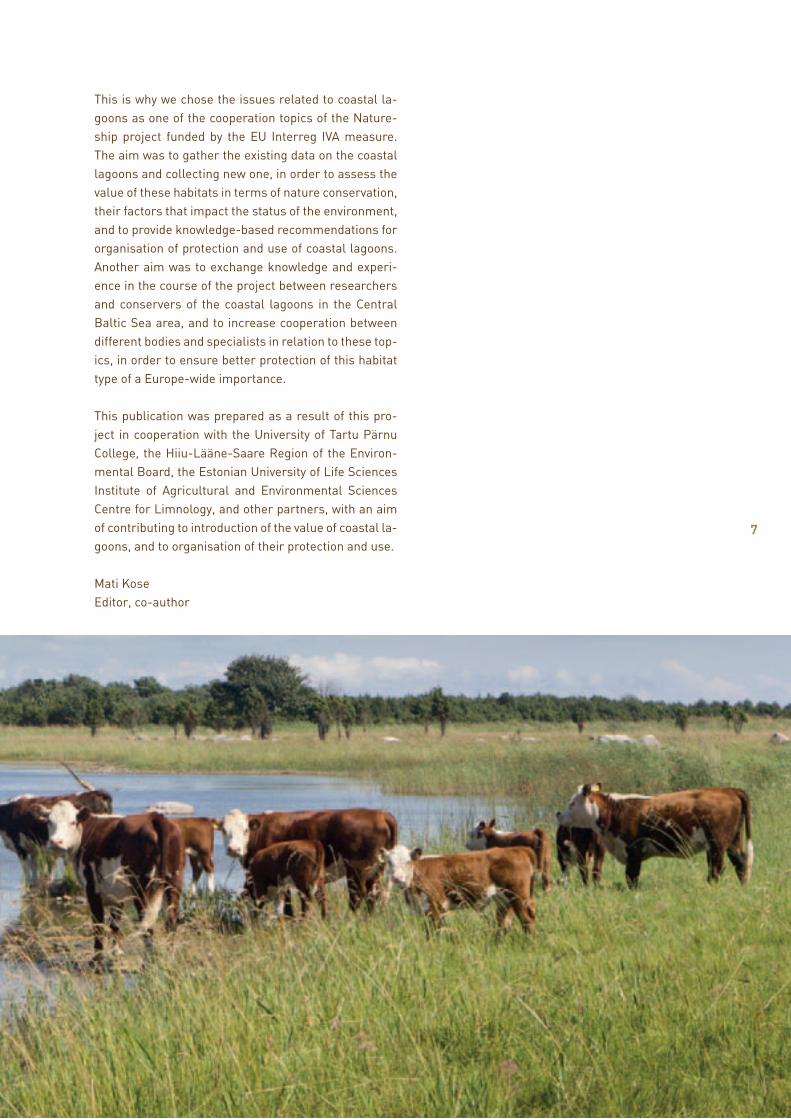
This is why we chose the issues related to coastal la-goons as one of the cooperation topics of the Nature-ship project funded by the EU Interreg IVA measure. The aim was to gather the existing data on the coastal lagoons and collecting new one, in order to assess the value of these habitats in terms of nature conservation, their factors that impact the status of the environment, and to provide knowledge-based recommendations for organisation of protection and use of coastal lagoons. Another aim was to exchange knowledge and experi-ence in the course of the project between researchers and conservers of the coastal lagoons in the Central Baltic Sea area, and to increase cooperation between different bodies and specialists in relation to these top-ics, in order to ensure better protection of this habitat type of a Europe-wide importance.
This publication was prepared as a result of this pro-ject in cooperation with the University of Tartu Pärnu College, the Hiiu-Lääne-Saare Region of the Environ-mental Board, the Estonian University of Life Sciences Institute of Agricultural and Environmental Sciences Centre for Limnology, and other partners, with an aim of contributing to introduction of the value of coastal la-goons, and to organisation of their protection and use.
Mati KoseEditor, co-author
8
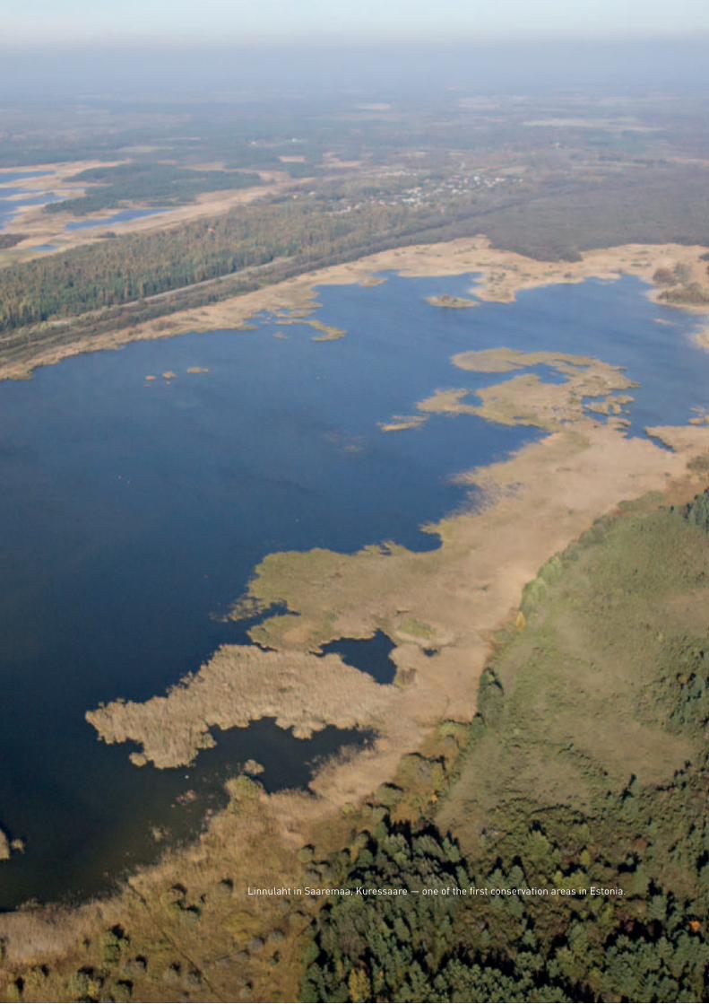
Linnulaht in Saaremaa, Kuressaare — one of the first conservation areas in Estonia.

9
I Coastal lagoons as habitats of high natural value
1.1. Coastal lagoons as endangered habitats
Kaja Lotman, Mati Kose
Coastal lagoons are shallow lake-like water bodies that have separated from the sea but have preserved an either constant of temporary (high water) connection with it, or lost that connection recently. Occurrence of coastal lagoons is usually related to areas with active coastal processes in which parts of the sea, especially bays and coves, are separated from the sea as a result of, for example, tectonic rising or active movement of sediments. Marine origin and closeness to waterfront also means a brackish water environment. Salinity and amount of water is constantly changing, depend-ing on precipitation, evaporation, addition of sea-water during storms, being flooded by melting water during winter and spring periods, as well as the tides.
Coastal lagoons and lakes are present in almost all biogeographic regions. This is why there are names for it in many languages – Rannikon laguunit/fladat, kluuvijärvet and laguuninomaiset lahdet/Laguner, rannikulõukad. In Estonian, when talking about water bodies that have been separated from the sea quite recently, the affixes referring to sea, like “bay“ and “sea” are used. In Pärnu County, a folk expres-sion “sonn” is also in use. Coastal lagoons and lakes make up almost 13% of the world’s coastal areas and vary considerably in size: from waterholes with a size of less than a hectare to water bodies of even up to 10,000 square kilometres (Lagoa dos Patos in Brazil). Coastal lagoons are highly influenced by external fac-tors due to their position between land and the sea, and their shallowness. Most of them are characterised by rapidly alternating or changing ecologic condi-tions and high biological reproductive capability.
The condition of coastal lagoons is related to both the amount and chemical composition of the water arriving from a catchment area and the direct impact of the sea, and on the other hand, the influence of weather and climatic changes. Due to different eco-logical conditions, output of coastal lagoons is very different; however, generally these water bodies have a naturally high primary productivity. The basis for primary productivity is the amount of phytoplankton and taller aquatic plants. Their amount and composi-tion is the indicator of a water body’s food chain. As a result of high initial productivity, the biomass of fish
COASTAL LAGOONS AS HABITATS OF HIGH NATURAL VALUE
10
in these water bodies may be very large. Water bodies with very high productivity may end up in a crisis when, in the conditions of abundance of nutrients, such an amount of organic matter is produced that there is not enough oxygen in water to decompose it. Lack of oxygen causes degradation of water quality and is bad for fauna of the water body (including fish). Addition of nutritive salt (nutrients) is called eutrophication; its extreme version is hyper-eutroph-ication (usually due to human impact) that brings about harmful phenomena in a water body.
Coastal lagoons are often seen as an inconvenient obstacle to the coastal landscape desired by people, and not so much as an important treasure. In many countries, they have been destroyed and damaged ex-tensively by different developments, including drain-age and filling for ports, industry, residential construc-tion and transportation; they have been used as places for ditching wastewater and garbage, for aquaculture that damages biota, for recreation, etc. In addition to chemical or microbiological polluting of a water body, human activity may also damage the entire ecological balance of water with intensive fishing, introduction of non-native species, disturbance, etc. When this list of endangering factors is complemented with different
increasingly visible impacts due to climate changes, coastal lagoons can be considered one of the most endangered water habitats of the world.
When one is to think of evolution of coastal lakes in a longer run, in most of these habitats the outcome of natural development is isolation from the sea, gradual overgrowing and swamping. It brings about changes in communities, losing the habitats of some species and creating the new ones for the others. In a perfect case, emergence of new lagoons (for example, due to rising that is characteristic of western and north-western Estonia) and their disappearance because of land uplifting and overgrowing are in balance. At the same time, it can be said that eutrophication has shifted this balance and thus, halting of overgrowing is justified for reasons of nature conservation, includ-ing preservation of species with rare, isolated habitats, and limited spreading ability. However, making such choices requires an individual approach to each case, and thorough knowledge and experience. In addition to that, the condition of the habitats in close prox-imity to the water body must always be taken into consideration, for example, coastal meadows that, together with lagoons, often form a uniform complex for several biota groups (e.g., birds, amphibians, etc.).
1.2. An overview of the spread and conservation status of the EU Nature Directive’s habitat (1150*), coastal lagoons in Estonia
Kaja Lotman, Mati Kose, Kadri Paomees
The European Union has drafted two special directives to stop diminishing of biodiversity and implement the corresponding nature conservation policy: the Birds Directive and the Habitats Directive. The experts that compiled the latter have classified coastal lagoons (code 1150*) among the prioritised or paramount, that is, highly endangered habitat types. Therefore, it is especially important to ensure conservation of the existing coastal lagoons in the European Union area, and to maintain or improve their ecological condi-tion. In order to fulfil this objective, 664 more repre-sentable coastal lagoons with a total area of 504,000 km2 have been selected to the Europe-wide nature conservation network Natura 2000 (EIONET, 2006).
Another document that contributes to ensuring good condition of coastal lagoons as water bodies is the EU Water Framework Directive, according to which the Member States shall ensure good ecological con-dition and water quality of water bodies (including coastal lagoons). It is important that as a result of the combined effect of different directives, a synergy would form in ensuring coastal lagoon conservation, each element of legislation providing a necessary con-tribution to achieving the final outcome.
Since it is a pan-European agreed habitat type, the water bodies classified under this type vary consider-ably in different areas and environments. Therefore, characteristics and biota of each habitat type have been described in the relevant guidance documents. An adjusted version was used in registering and describing habitats in Estonia, taking into considera-tion the Baltic Sea and Estonian context in regard to the habitat type (see the textbox).
COASTAL LAGOONS AS HABITATS OF HIGH NATURAL VALUE
11
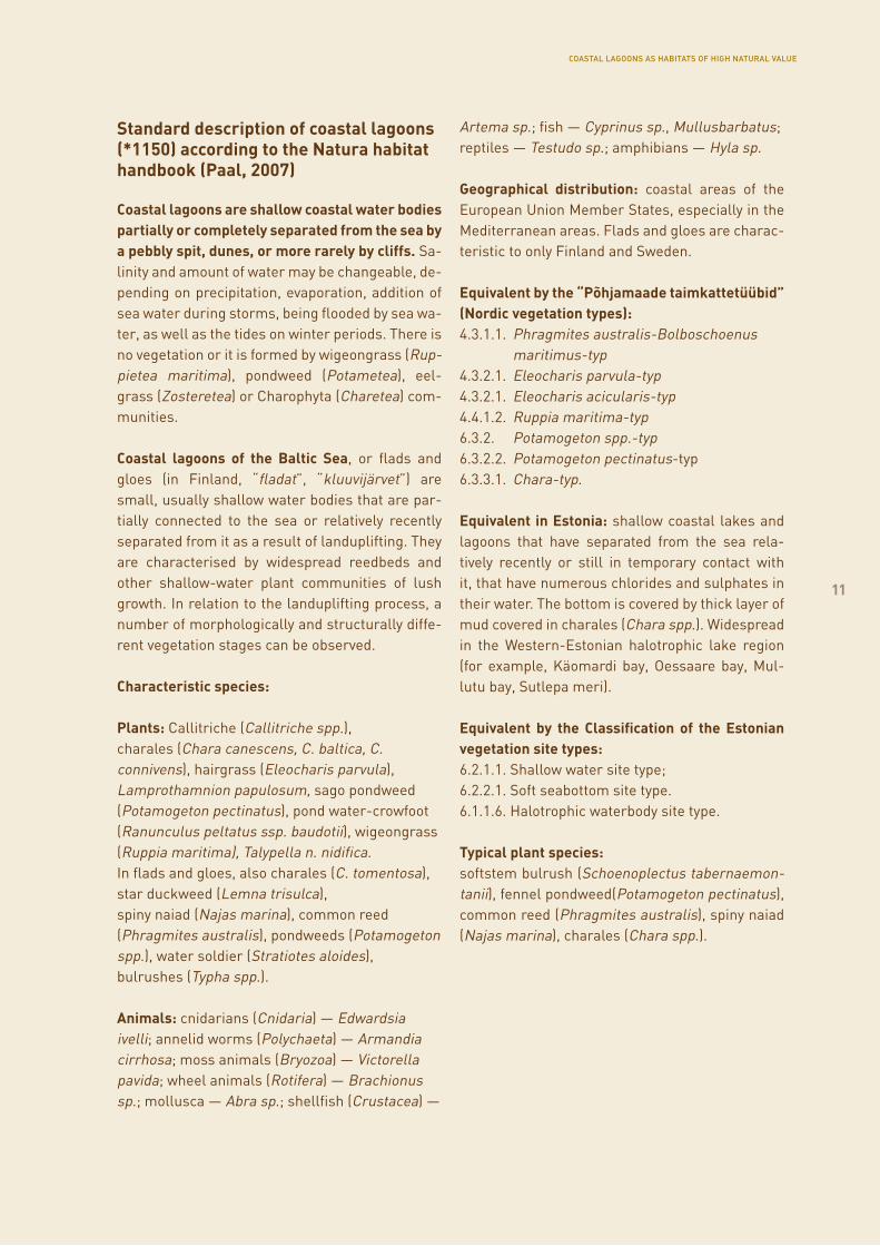
Standard description of coastal lagoons (*1150) according to the Natura habitat handbook (Paal, 2007)
Coastal lagoons are shallow coastal water bodies partially or completely separated from the sea by a pebbly spit, dunes, or more rarely by cliffs. Sa-linity and amount of water may be changeable, de-pending on precipitation, evaporation, addition of sea water during storms, being flooded by sea wa-ter, as well as the tides on winter periods. There is no vegetation or it is formed by wigeongrass (Rup-pietea maritima), pondweed (Potametea), eel-grass (Zosteretea) or Charophyta (Charetea) com-munities.
Coastal lagoons of the Baltic Sea, or flads and gloes (in Finland, “fladat”, “kluuvijärvet”) are small, usually shallow water bodies that are par-tially connected to the sea or relatively recently separated from it as a result of landuplifting. They are characterised by widespread reedbeds and other shallow-water plant communities of lush growth. In relation to the landuplifting process, a number of morphologically and structurally diffe-rent vegetation stages can be observed.
Characteristic species:
Plants: Callitriche (Callitriche spp.), charales (Chara canescens, C. baltica, C. connivens), hairgrass (Eleocharis parvula), Lamprothamnion papulosum, sago pondweed (Potamogeton pectinatus), pond water-crowfoot (Ranunculus peltatus ssp. baudotii), wigeongrass (Ruppia maritima), Talypella n. nidifica.In flads and gloes, also charales (C. tomentosa), star duckweed (Lemna trisulca), spiny naiad (Najas marina), common reed (Phragmites australis), pondweeds (Potamogeton spp.), water soldier (Stratiotes aloides), bulrushes (Typha spp.).
Animals: cnidarians (Cnidaria) — Edwardsia ivelli; annelid worms (Polychaeta) — Armandia cirrhosa; moss animals (Bryozoa) — Victorella pavida; wheel animals (Rotifera) — Brachionus sp.; mollusca — Abra sp.; shellfish (Crustacea) —
Artema sp.; fish — Cyprinus sp., Mullusbarbatus; reptiles — Testudo sp.; amphibians — Hyla sp.
Geographical distribution: coastal areas of the European Union Member States, especially in the Mediterranean areas. Flads and gloes are charac-teristic to only Finland and Sweden.
Equivalent by the “Põhjamaade taimkattetüübid” (Nordic vegetation types):4.3.1.1. Phragmites australis-Bolboschoenus maritimus-typ4.3.2.1. Eleocharis parvula-typ4.3.2.1. Eleocharis acicularis-typ4.4.1.2. Ruppia maritima-typ6.3.2. Potamogeton spp.-typ6.3.2.2. Potamogeton pectinatus-typ6.3.3.1. Chara-typ.
Equivalent in Estonia: shallow coastal lakes and lagoons that have separated from the sea rela-tively recently or still in temporary contact with it, that have numerous chlorides and sulphates in their water. The bottom is covered by thick layer of mud covered in charales (Chara spp.). Widespread in the Western-Estonian halotrophic lake region (for example, Käomardi bay, Oessaare bay, Mul-lutu bay, Sutlepa meri).
Equivalent by the Classification of the Estonian vegetation site types:6.2.1.1. Shallow water site type;6.2.2.1. Soft seabottom site type. 6.1.1.6. Halotrophic waterbody site type.
Typical plant species:softstem bulrush (Schoenoplectus tabernaemon-tanii), fennel pondweed(Potamogeton pectinatus), common reed (Phragmites australis), spiny naiad (Najas marina), charales (Chara spp.).
COASTAL LAGOONS AS HABITATS OF HIGH NATURAL VALUE
11
12
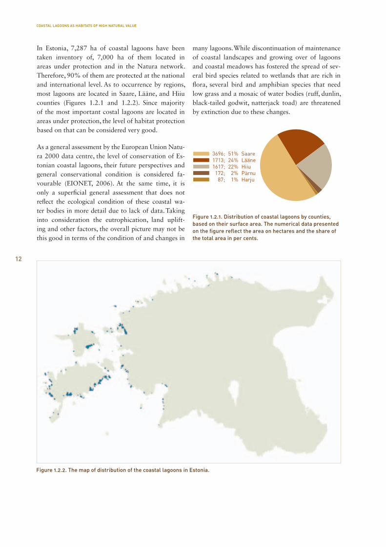
In Estonia, 7,287 ha of coastal lagoons have been taken inventory of, 7,000 ha of them located in areas under protection and in the Natura network. Therefore, 90% of them are protected at the national and international level. As to occurrence by regions, most lagoons are located in Saare, Lääne, and Hiiu counties (Figures 1.2.1 and 1.2.2). Since majority of the most important costal lagoons are located in areas under protection, the level of habitat protection based on that can be considered very good.
As a general assessment by the European Union Natu-ra 2000 data centre, the level of conservation of Es-tonian coastal lagoons, their future perspectives and general conservational condition is considered fa-vourable (EIONET, 2006). At the same time, it is only a superficial general assessment that does not reflect the ecological condition of these coastal wa-ter bodies in more detail due to lack of data. Taking into consideration the eutrophication, land uplift-ing and other factors, the overall picture may not be this good in terms of the condition of and changes in
many lagoons. While discontinuation of maintenance of coastal landscapes and growing over of lagoons and coastal meadows has fostered the spread of sev-eral bird species related to wetlands that are rich in flora, several bird and amphibian species that need low grass and a mosaic of water bodies (ruff, dunlin, black-tailed godwit, natterjack toad) are threatened by extinction due to these changes.
Figure 1.2.2. The map of distribution of the coastal lagoons in Estonia.
COASTAL LAGOONS AS HABITATS OF HIGH NATURAL VALUE
Figure 1.2.1. Distribution of coastal lagoons by counties, based on their surface area. The numerical data presented on the figure reflect the area on hectares and the share of the total area in per cents.
13
COASTAL LAGOONS AS HABITATS OF HIGH NATURAL VALUE
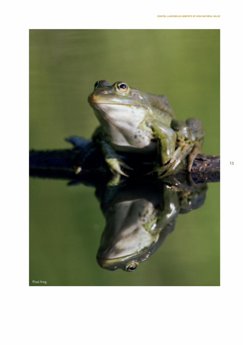
Pool frog.
14
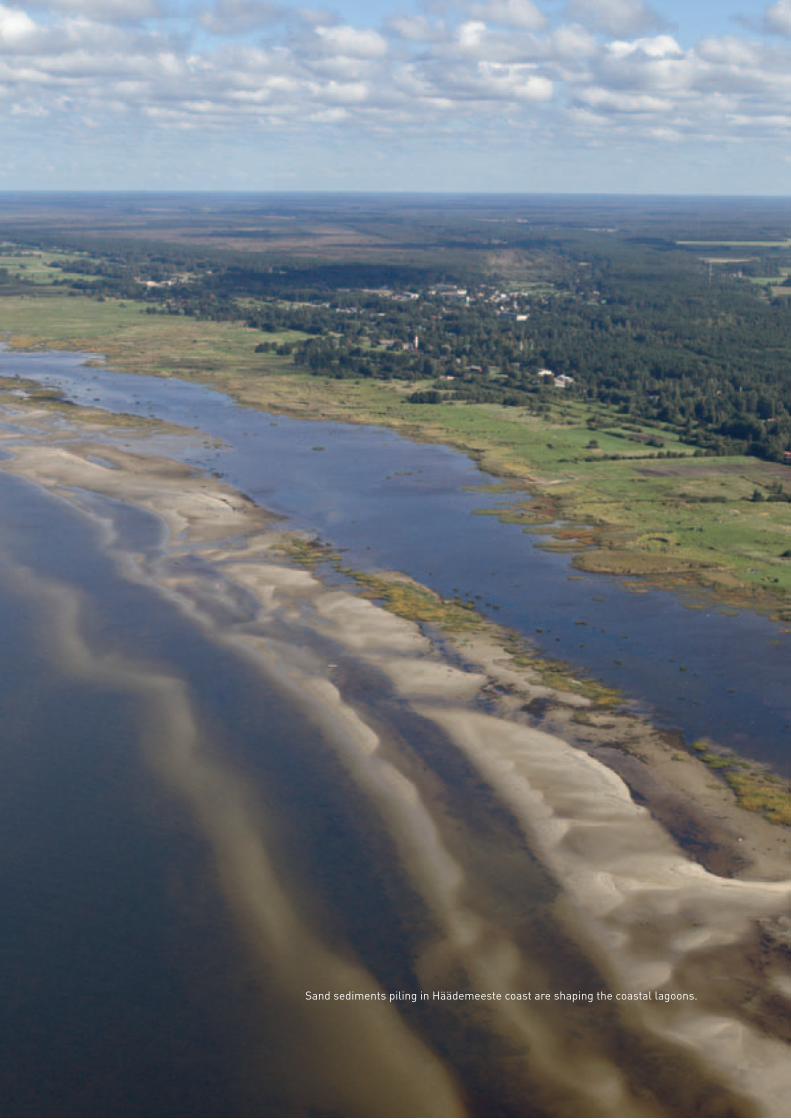
Sand sediments piling in Häädemeeste coast are shaping the coastal lagoons.
15
II Generalcharacterisation,developmentand geologyof coastallagoons
2.1. Formation, development and typology of coastal lagoons
Ingmar Ott, Ruta Tamre
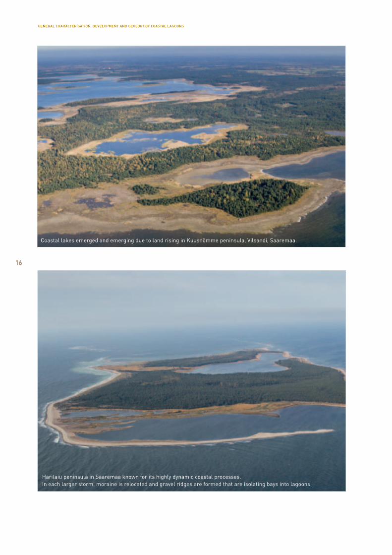
In the Baltic Sea countries, the formation of coastal lagoons is usually related to tectonic rising after the Ice Age. In addition, the accumulating activity of ooze and flowing water is distinguished in the formation process of coastal lagoons. In the southern countries of the Baltic Sea, coastal lagoons that have been sepa-rated by sediment accumulations prevail, whereas in the northern countries, most of the coastal lagoons have separated from the sea due to rising. There is also a third type of origin – combined formation in which both sediment accumulation and rising play a part.
Helgi Kessel (1968) describes formation of Estonian coastal lagoons in four stages: a) initial sea lagoon, b) lagoon, c) lagoon lake (immediate, no visible connec-tion to the sea), d) coastal lagoon (no water exchange with the sea). There are a lot of inconsistencies in the names; water bodies differentiated by the time of their formation and the names used in local lan-guage are mixed up. The following words are used for the water bodies: sea, bay, cove, lagoon, lagoon lake, coastal lagoon, shore lake, coastal lake, relict lake, puddle, hole, water hole, meadow, sedge lake, end, passage. Any attempt to establish order in this myr-iad of names is probably fruitless. In case of a need, the official terms can be used, explained in the regu-lation of the Minister of the Environment (Pinnavee-kogumite..., 2009) and in the Habitat type handbook (Paal, 2007). The first definition of these is as follows: standing water bodies ≤5 km from the sea, of medium depth (≤1 m), light-watered (yellow substance ≤7 mg/l, chloride content >25 mg/l) (Pinnaveekogumite..., 2009). The other definition is: shallow coastal lakes and lagoons quite recently separated from the sea or still in a temporary connection with it; the water con-tains numerous chlorides and sulphates and the bot-tom is covered in a thick layer of mud covered with charophytes (Chara spp.) (Paal, 2007). It should be said that in such cases, we recommend to prefer the first one, because in some of Estonian coastal lakes, the amounts of sulphates are not higher than usual and connection to the sea may be lost.
GENERAL CHARACTERISATION, DEVELOPMENT AND GEOLOGY OF COASTAL LAGOONS
16
Coastal lakes emerged and emerging due to land rising in Kuusnõmme peninsula, Vilsandi, Saaremaa.
Harilaiu peninsula in Saaremaa known for its highly dynamic coastal processes. In each larger storm, moraine is relocated and gravel ridges are formed that are isolating bays into lagoons.
GENERAL CHARACTERISATION, DEVELOPMENT AND GEOLOGY OF COASTAL LAGOONS
17
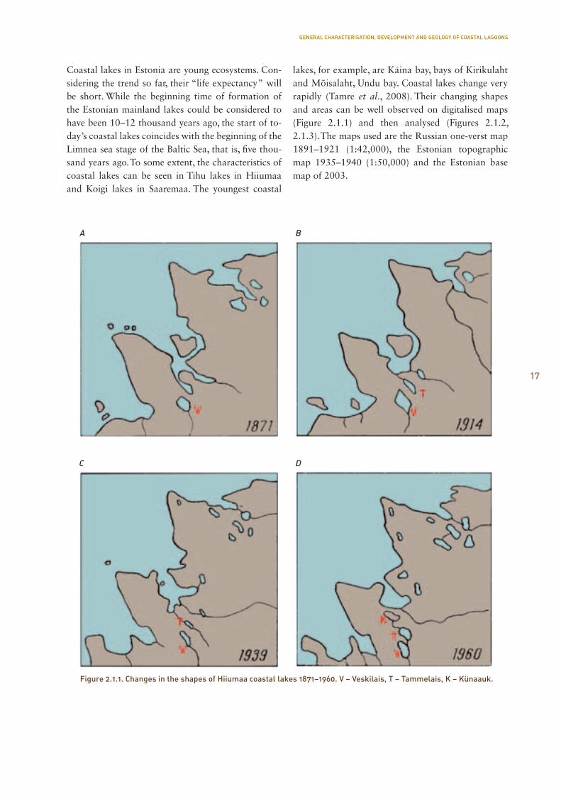
Coastal lakes in Estonia are young ecosystems. Con-sidering the trend so far, their “life expectancy” will be short. While the beginning time of formation of the Estonian mainland lakes could be considered to have been 10–12 thousand years ago, the start of to-day’s coastal lakes coincides with the beginning of the Limnea sea stage of the Baltic Sea, that is, five thou-sand years ago. To some extent, the characteristics of coastal lakes can be seen in Tihu lakes in Hiiumaa and Koigi lakes in Saaremaa. The youngest coastal
lakes, for example, are Käina bay, bays of Kirikulaht and Mõisalaht, Undu bay. Coastal lakes change very rapidly (Tamre et al., 2008). Their changing shapes and areas can be well observed on digitalised maps (Figure 2.1.1) and then analysed (Figures 2.1.2, 2.1.3). The maps used are the Russian one-verst map 1891–1921 (1:42,000), the Estonian topographic map 1935–1940 (1:50,000) and the Estonian base map of 2003.
Figure 2.1.1. Changes in the shapes of Hiiumaa coastal lakes 1871–1960. V – Veskilais, T – Tammelais, K – Künaauk.
A
C
B
D
GENERAL CHARACTERISATION, DEVELOPMENT AND GEOLOGY OF COASTAL LAGOONS
18
Nõva Allikajärv
Laialepa
Suurlaht
Pikane
Sarapiku
Lepaauk
Kiljatu
Käomardi bay
Linnulaht
Sutlepa meri
Vööla meri
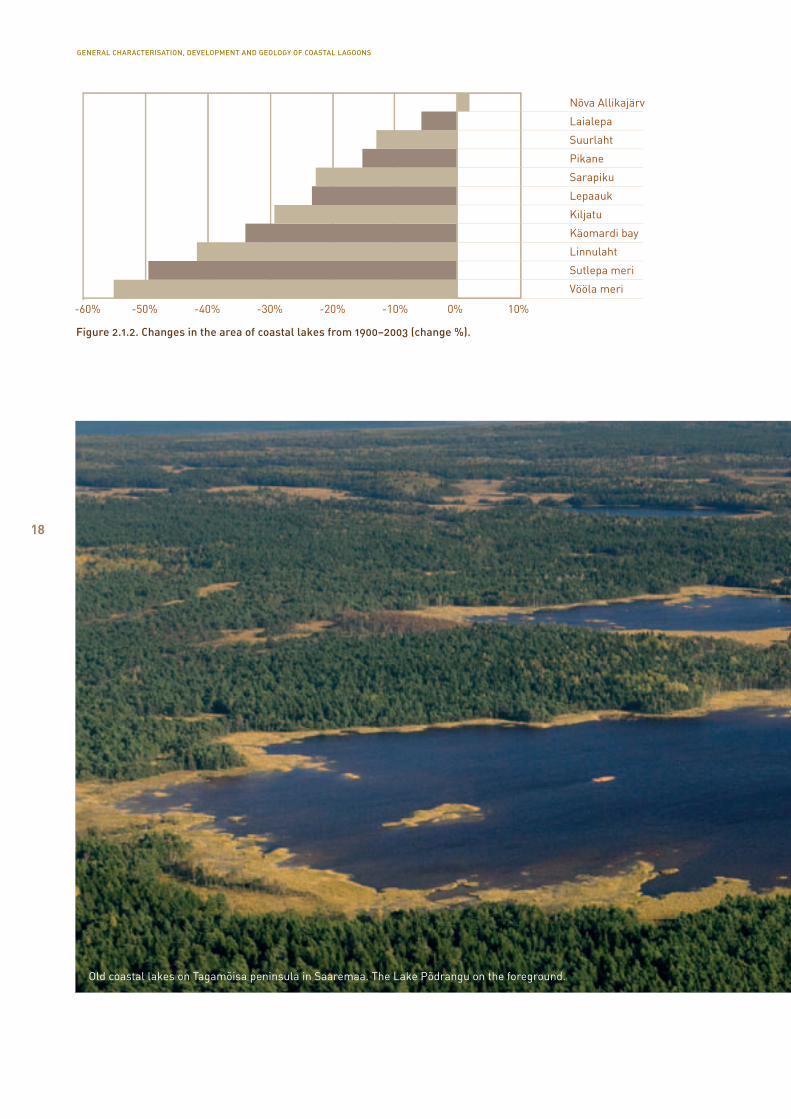
Figure 2.1.2. Changes in the area of coastal lakes from 1900–2003 (change %).
Old coastal lakes on Tagamõisa peninsula in Saaremaa. The Lake Põdrangu on the foreground.
GENERAL CHARACTERISATION, DEVELOPMENT AND GEOLOGY OF COASTAL LAGOONS

19
Figure 2.1.3. Changes in the area of coastal lakes in 1900–2003 (area ha).
GENERAL CHARACTERISATION, DEVELOPMENT AND GEOLOGY OF COASTAL LAGOONS
20
The same trend will continue in case of rising, eut-rop hication and filling of standing water bodies with sediments. However, if the level of seawater should rise, it will either balance out the land uplifting or even increase the volume of water bodies. Estimations have been made on different parts of the Baltic Sea up to the turn of the next century. On a global scale, for example, different models estimate an overall rise in sea level by maximum of approximately 80 cm (Climate change and the European..., 2005; Climate change in the Baltic..., 2007). Taking into account the rising taking place at the same time (approx. 30 cm), increasing of the water level should prevail. Often, the estimations are based on the North-Atlantic Oscillation Index (NAO Index), the values of which have had positive trend over two centuries so far. However, it is unknown whether this trend will con-tinue or is it, for example, a part of some kind of a longer cycle yet to be discovered.
Although coastal lakes are of the same type accord-ing to typologies of different Estonian lakes and their modifications (Mäemets, 1974; Mäemets, 1976;
Ott, Kõiv, 1999; Pinnaveekogumite..., 2009), they have quite significant differences when viewed more thoroughly. The important factors are the intensity of water exchange with the sea, the structure and thick-ness of sediments, the morphometrics. Considering the typology of mainland lakes, the other factors that should be included are the amount of organic substance in the water, the colour of the water, and its hardness. In coastal lakes, these characteristics are not important or are determined by other factors. So, for example, connection to the sea largely determines the chemical characteristics of water.
Although no subtypes have been determined so far among coastal lakes, connections between the type parameters and biota indicators have nevertheless been explained. The less organic sediments with mainly stony or sandy bottoms of water bodies, the larger and deeper the lake and the better connec-tion to the sea, the poorer the biota and less plants. Connection between the plants and composition of a lake’s sediments is also indicated on Figure 2.1.4. To analyse the connections, the indicators of the
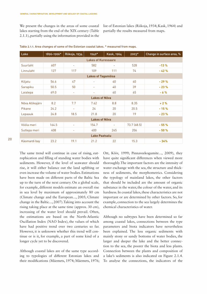
Table 2.1.1. Area changes of some of the Estonian coastal lakes. * measured from maps.
Lake 1896-1906* Riikoja, 1934 1940* Kask, 1964 2003* Change in surface area, %
Lakes of Kuressaare
Suurlaht 607 - 582 - 528 -13 %
Linnulaht 127 117 109 111 74 - 42 %
Lakes of Tagamõisa
Kiljatu 56.6 47 - 40 40 - 29 %
Sarapiku 50.5 50 - 40 39 - 23 %
Laialepa 69.0 - - 60 65 - 6 %
Lakes of Nõva
Nõva Allikajärv 8.2 7.7 7.62 8.8 8.35 + 2 %
Pikane 24.2 - 24 20 20.5 - 15 %
Lepaauk 24.8 18.5 21.8 20 19 - 23 %
Lakes of Nõva
Vööla meri 164.5 - 154.7 - 73.7 (68.5) - 55 %
Sutlepa meri 408 - 400 245 206 - 50 %
Lake Paatsalu
Käomardi bay 23.2 19.1 21.2 22 15.3 - 34%
We present the changes in the areas of some coastal lakes starting from the end of the XIX century (Table 2.1.1), partially using the information provided in the
list of Estonian lakes (Riikoja, 1934; Kask, 1964) and partially the results measured from maps.
GENERAL CHARACTERISATION, DEVELOPMENT AND GEOLOGY OF COASTAL LAGOONS
21
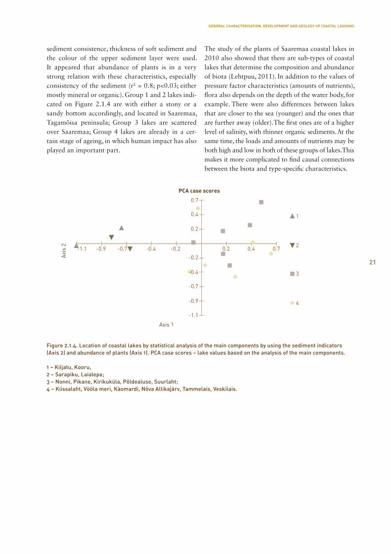
sediment consistence, thickness of soft sediment and the colour of the upper sediment layer were used. It appeared that abundance of plants is in a very strong relation with these characteristics, especially consistency of the sediment (r2 = 0.8; p<0.03; either mostly mineral or organic). Group 1 and 2 lakes indi-cated on Figure 2.1.4 are with either a stony or a sandy bottom accordingly, and located in Saaremaa, Tagamõisa peninsula; Group 3 lakes are scattered over Saaremaa; Group 4 lakes are already in a cer-tain stage of ageing, in which human impact has also played an important part.
The study of the plants of Saaremaa coastal lakes in 2010 also showed that there are sub-types of coastal lakes that determine the composition and abundance of biota (Lehtpuu, 2011). In addition to the values of pressure factor characteristics (amounts of nutrients), flora also depends on the depth of the water body, for example. There were also differences between lakes that are closer to the sea (younger) and the ones that are further away (older). The first ones are of a higher level of salinity, with thinner organic sediments. At the same time, the loads and amounts of nutrients may be both high and low in both of these groups of lakes. This makes it more complicated to find causal connections between the biota and type-specific characteristics.
PCA case scores
Axi
s 2
Axis 1
1
2
3
4
0.7
0.4
0.2
-0.2-0.2 0.2 0.4 0.7-0.4-0.7-0.9-1.1
-0.4
-0.7
-0.9
-1.1
Figure 2.1.4. Location of coastal lakes by statistical analysis of the main components by using the sediment indicators (Axis 2) and abundance of plants (Axis 1). PCA case scores – lake values based on the analysis of the main components.
1 – Kiljatu, Kooru,2 – Sarapiku, Laialepa;3 – Nonni, Pikane, Kirikuküla, Põldealuse, Suurlaht;4 – Kiissalaht, Vööla meri, Käomardi, Nõva Allikajärv, Tammelais, Veskilais.
GENERAL CHARACTERISATION, DEVELOPMENT AND GEOLOGY OF COASTAL LAGOONS
22
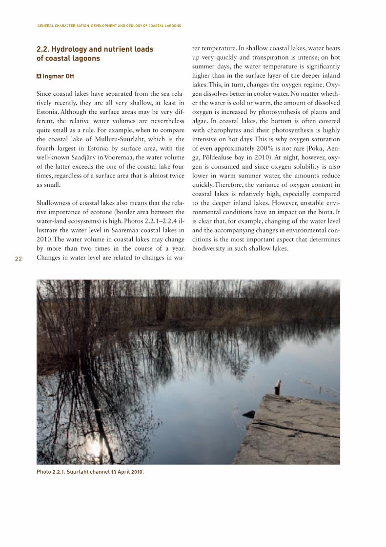
Photo 2.2.1. Suurlaht channel 13 April 2010.
2.2. Hydrology and nutrient loads of coastal lagoons
Ingmar Ott
Since coastal lakes have separated from the sea rela-tively recently, they are all very shallow, at least in Es tonia. Although the surface areas may be very dif-ferent, the relative water volumes are nevertheless quite small as a rule. For example, when to compare the coastal lake of Mullutu-Suurlaht, which is the fourth largest in Estonia by surface area, with the well-known Saadjärv in Vooremaa, the water volume of the latter exceeds the one of the coastal lake four times, regardless of a surface area that is almost twice as small.
Shallowness of coastal lakes also means that the rela-tive importance of ecotone (border area between the water-land ecosystems) is high. Photos 2.2.1–2.2.4 il-lustrate the water level in Saaremaa coastal lakes in 2010. The water volume in coastal lakes may change by more than two times in the course of a year. Changes in water level are related to changes in wa-
ter temperature. In shallow coastal lakes, water heats up very quickly and transpiration is intense; on hot summer days, the water temperature is significantly higher than in the surface layer of the deeper inland lakes. This, in turn, changes the oxygen regime. Oxy-gen dissolves better in cooler water. No matter wheth-er the water is cold or warm, the amount of dissolved oxygen is increased by photosynthesis of plants and algae. In coastal lakes, the bottom is often covered with charophytes and their photosynthesis is highly intensive on hot days. This is why oxygen saturation of even approximately 200% is not rare (Poka, Aen-ga, Põldealuse bay in 2010). At night, however, oxy-gen is consumed and since oxygen solubility is also lower in warm summer water, the amounts reduce quickly. Therefore, the variance of oxygen content in coastal lakes is relatively high, especially compared to the deeper inland lakes. However, unstable envi-ronmental conditions have an impact on the biota. It is clear that, for example, changing of the water level and the accompanying changes in environmental con-ditions is the most important aspect that determines bio diversity in such shallow lakes.
GENERAL CHARACTERISATION, DEVELOPMENT AND GEOLOGY OF COASTAL LAGOONS
23
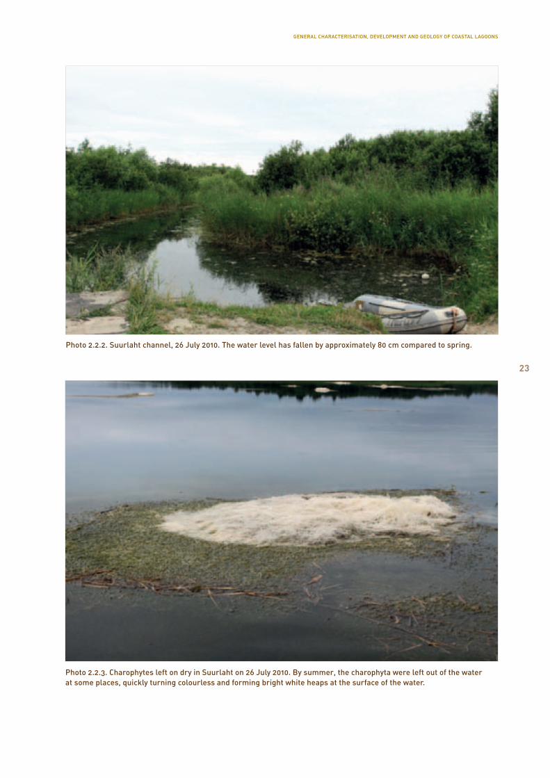
Photo 2.2.3. Charophytes left on dry in Suurlaht on 26 July 2010. By summer, the charophyta were left out of the water at some places, quickly turning colourless and forming bright white heaps at the surface of the water.
Photo 2.2.2. Suurlaht channel, 26 July 2010. The water level has fallen by approximately 80 cm compared to spring.
GENERAL CHARACTERISATION, DEVELOPMENT AND GEOLOGY OF COASTAL LAGOONS
24 Another important hydrological indicator is water exchange. It is relatively difficult to assess and measure, because the closer the coastal lake is to the sea, the higher the possibility of seawater forcing into the lakes. At times, water flows from coastal lakes to the sea, and at times, from the sea to the coastal lakes. For example, in Nasva river that connects the sea and Mullutu bay, the direction of the water flow may change in a matter of hours. Measuring and assessing the water exchange is also prevented by the lack of overview of the inflows. At some lake, however, some of the ditches are very small and prone to drying out at summer. They are difficult to find when the coast is covered in a wide and thick reed-belt. Our obser-vations revealed that springs also sometimes have an important role in water balance. It seemed especially so in Prästvike lake on the island of Vormsi. As a rule, however, water exchange in coastal lakes is very inten-sive. In several cases, it is comparable to our inland water reservoirs.
A waterbody’s regime resembles more of the one of a lentic waterbody when its annual water exchange is less than a 30-time amount of the waterbody’s water volume, and has a lotic character when the annual water exchange is higher than the 30-times volume.
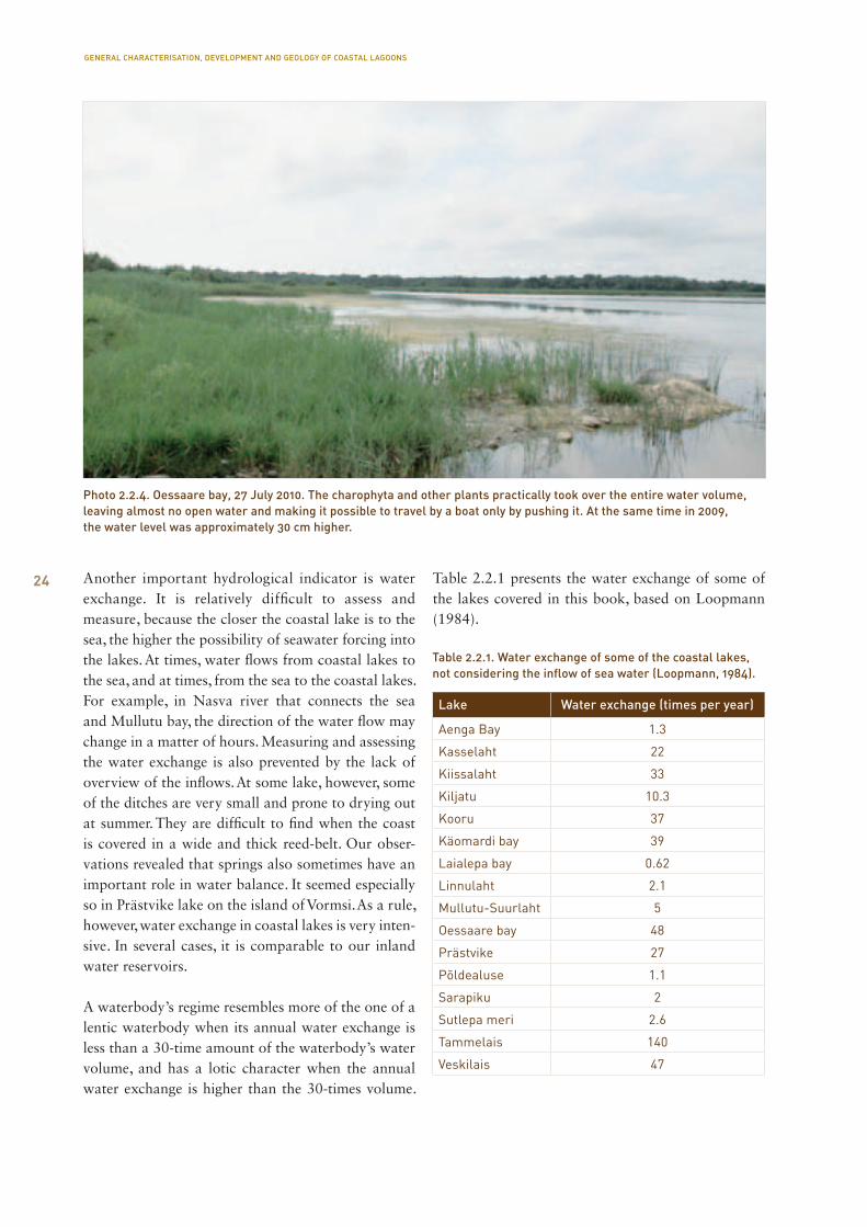
Table 2.2.1 presents the water exchange of some of the lakes covered in this book, based on Loopmann (1984).
Table 2.2.1. Water exchange of some of the coastal lakes, not considering the inflow of sea water (Loopmann, 1984).
Lake Water exchange (times per year)
Aenga Bay 1.3
Kasselaht 22
Kiissalaht 33
Kiljatu 10.3
Kooru 37
Käomardi bay 39
Laialepa bay 0.62
Linnulaht 2.1
Mullutu-Suurlaht 5
Oessaare bay 48
Prästvike 27
Põldealuse 1.1
Sarapiku 2
Sutlepa meri 2.6
Tammelais 140
Veskilais 47
Photo 2.2.4. Oessaare bay, 27 July 2010. The charophyta and other plants practically took over the entire water volume, leaving almost no open water and making it possible to travel by a boat only by pushing it. At the same time in 2009, the water level was approximately 30 cm higher.
GENERAL CHARACTERISATION, DEVELOPMENT AND GEOLOGY OF COASTAL LAGOONS
25
When the average water exchange of Estonian lakes is approximately 4 times per year, the average of the waterbodies presented in this table is 26 times. At that, irregular sea water inflow, especially important in places like Aenga, Laialepa and Mullutu bay, has not been taken into account. As to the functioning of water bodies, high level of water exchange promotes the migration and spread of species on the one hand, as well as changes the water characteristics and refreshes water bodies with new water. On the other hand, it is also important that larger water exchange brings about larger nutrient load and entry of sedi-ments from the catchment area. As a rule, such water bodies have a very strong positive balance of matter, that is, sediments are carried to the water body much more than out of it.
What are the nutrient loads to coastal lakes, how durable are they and how strong is their capability to self-regulate? Water ecosystem is made strong by its large dimensions, large water volume, harder water and higher level of salinity, more intensive water exchange, and higher amount of dissolved organic matter (humic matter). As a rule, among other things, larger and deeper water bodies are more stable, due to the principles of thermodynamics. Different versions of surface area/depth also provide different precondi-tions for development of an ecologic status. In low and large water bodies, water mass is aerated well, while in small and deep ones, stability is ensured by large water volume. The water volume is directly related to morphometric characteristics. There is a rule that the largest the water volume and more intense the water exchange, the better the ecological status. Larger water volume ensures stability of processes, a larger living space, and more diverse environmental condi-tions. More intense water exchange ensures a better gas regime, inflow of nutrients, removes the accumu-lated organic matter, enables movement and exchange of biota, etc. The general rule is that the harder the water, the more balanced the status. The main mecha-nism that ensures it functions through a calcareous buffer system in internal water bodies. Harder water also ensures better supply of mineral carbon for the primary producers. Organic matter in water bodies may be of a highly different composition and origin. In the first approach, we can divide it into two: chemi-cally and biologically easily soluble organic matter. The first includes mainly humic matter, and the second,
organic matter from point source pollution. Humic matter functions similarly to carbonates as a kind of a buffer system, absorbing especially phosphates. The lack of the latter is the main factor that restricts the development of plants in internal water bodies. Humic matter significantly impacts the light regime of a water body, strongly dispersing and absorbing light. That is why it can be said that the more humic matter, the more stable the ecosystem. Easily biode-gradable organic matter, however, plays almost the same part as nutrient compounds. The general rule is that the more easily biodegradable organic matter in a water body is, the more unstable the water body is. In general, the surface areas of coastal lakes are very different, water volume relatively low, water hard and rich in minerals, water exchange intensive, very low amounts of dissolved organic matter. From these values of indicators, some are extreme in one and some in another direction. In conclusion, however, coastal lakes are very sensitive to influences.
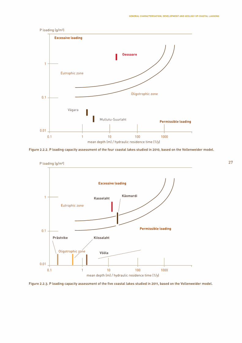
The load tolerance of coastal lakes is assessed by phosphorus (P) load, the average depth of the lake and the residence time of the water. According to the methodology of the Vollenweider (1975) model, an annual load should be used in calculations. We can only do it on a shorter period of the time we were studying coastal lakes in 2010 and 2011. Regardless of a shorter time period, it still enables to provide some kind of assessment. Large amount of P flows from the Lõve river to Oessaare bay (Figure 2.2.1). According to the 2011 national monitoring, the ecological condition of Lõve river is poor, which refers to pollution. The residence time of the water in Oessaare bay is only 8 days, according to Loopmann (1984). Based on the Vollenweider model, the load capacity of Oessaare bay is 0.3–0.4 g/m2 per year. It is estimated that during that period, the flow amounts make up 70–80% of the annual amount. Considering certain incompleteness of the data, the results on Figure 2.2.2 have been presented as a longer line, not as a point. Such a model cannot be created on all lakes – Laidevahe coastal lagoon is directly connected to the sea, as well as the Aenga lake that has no direct clear inflow; as to Põldealuse, the inflow is difficult to determine. Oessaare bay and Poka bay stand out quite distinctively, the latter suffering from pollu-tion. The situation in Mullutu, Suurlaht and Vägara, however, is much better. Aenga bay is most influenced
GENERAL CHARACTERISATION, DEVELOPMENT AND GEOLOGY OF COASTAL LAGOONS
26
by horses and bovines that use this water body as a source of drinking water, as well as the catch-ment area as a pasture. Although the chemical prop-erties of the water are not good, the indicators of biota display better results. On a narrow area at the shore of Aenga, there is pollution near an economic building, but it is only very localised. The shore of Lake Põldealuse is completely natural and there seems to be no sources of pollution. Although there is the same herd of horses as in Aenga in Laidevahe, the load from these animals is marginal. Laidevahe is influenced by the Laidevahe ditch from Sandla, but it has quite a modest load. In addition to the general
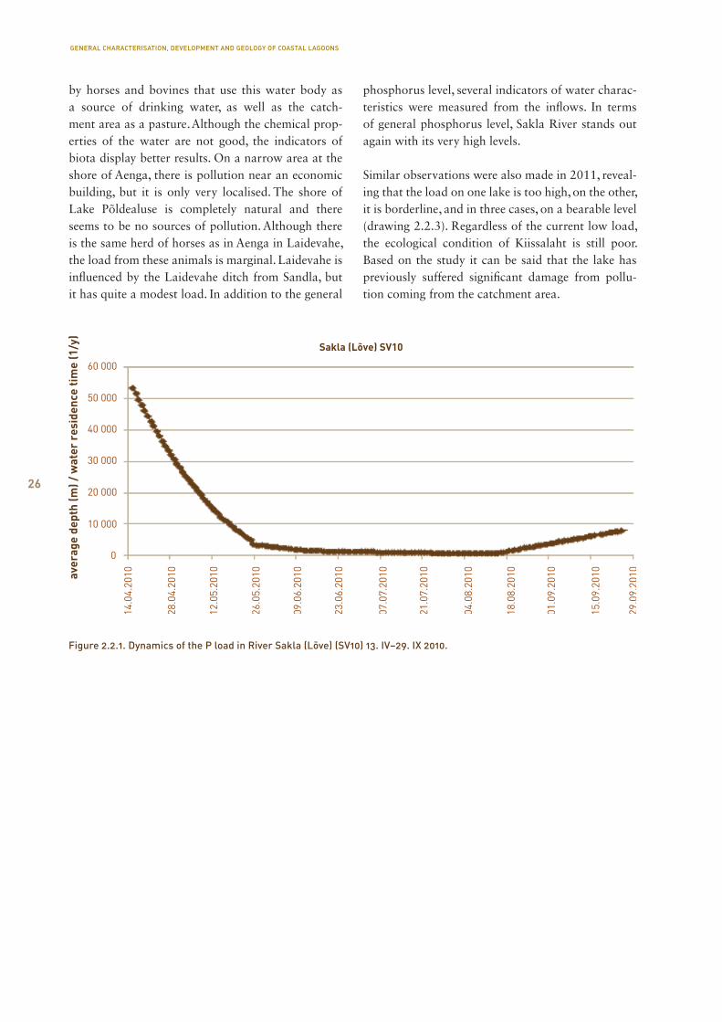
phosphorus level, several indicators of water charac-teristics were measured from the inflows. In terms of general phosphorus level, Sakla River stands out again with its very high levels.
Similar observations were also made in 2011, reveal-ing that the load on one lake is too high, on the other, it is borderline, and in three cases, on a bearable level (drawing 2.2.3). Regardless of the current low load, the ecological condition of Kiissalaht is still poor. Based on the study it can be said that the lake has previously suffered significant damage from pollu-tion coming from the catchment area.
Figure 2.2.1. Dynamics of the P load in River Sakla (Lõve) (SV10) 13. IV–29. IX 2010.
GENERAL CHARACTERISATION, DEVELOPMENT AND GEOLOGY OF COASTAL LAGOONS
27
Figure 2.2.2. P loading capacity assessment of the four coastal lakes studied in 2010, based on the Vollenweider model.
Figure 2.2.3. P loading capacity assessment of the five coastal lakes studied in 2011, based on the Vollenweider model.
GENERAL CHARACTERISATION, DEVELOPMENT AND GEOLOGY OF COASTAL LAGOONS
28
2.3. Sediments of coastal lagoons and their biochemical characterisation
Anu Kisand, Monika Übner
There are not much sediments in coastal lakes, which are relatively young water bodies of neotectonic origin, compared to many other small Estonian lakes (Caapce, 1994); they are mostly located on livid clay sediment. On sediment surface, often located between large plants, there is a thin layer of lake mud, mostly as little as 5–20 cm. Between lake mud and clay, there is silt, which is often muddy on the upper layer and thicker below: clayey or sandy.
Many coastal lakes are characterised by uneven dis-tribution of different types of sediments in the bot-tom of the lake in different areas. In one side of the bottom of the lake the light mud layer may practically be absent, and the lake bottom is sandy or gravelly, sometimes rocky, in the other side there is a layer of blue-gray clay under a few centimetres of mud. In the quiet and sheltered part of the lake a relatively thick (a few tens of centimetres) layer of mud may be found on the sediment surface. Significant examples of such lakes are the Laidevahe, Põldealuse and Aenga bay. In the lake of Linnulaht the differences in the thickness of the mud layer are particularly big: if in the north-eastern part of the lake there is only about a 10-cm mud layer on the top of the sandy gravel, then in the south-western part the mud layer is 1.5 m thick. In Pärnu County, the mud in Häädemeeste and Võiste coastal lagoons is placed unevenly ranging in shel-tered areas up to 20 cm. Mud is sandy and sometimes contains gravel. In the lagoons opened to the sea, the mud can be mixed with sand and gravel accrued after the storm. Under the layer of mud there is sand, gravel, or blue-gray clay. In some sample points a layer of pink clay was found.
Studies of the composition of the sediment reveal that coastal lake sediments have a relatively low content of organic matter: in the upper layers of lake mud, it makes up approximately 10% of the dry weight of the sediments, in deeper layers, less. The content of organic matter in the upper, 10 cm thick layer of sedi-ments of Pärnu County coastal lakes was mainly up to 5%, reaching 10% in some places. The sediments of Mullutu and Suurlaht in Saaremaa contained even
less organic matter, only up to 3% of the dry weight. The largest content of organic matter was found in the sediments of Linnulaht, in the upper, 2 cm layer of which the result was exceptionally almost 50%. However, the content of calcium carbonate in the coastal lake sediments is relatively high, remaining mainly between 20–40%; in Oessaare bay, it even made up more than 60% of the dry weight of the sediments on some instances. Solid part of the sedi-ment remaining from the organic and calcareous material (the so-called terrigenous material) is more prevailing in the deeper sediment layers, making up as much as approximately 90% of the dry weight in the clay sediment.
Sediments can also be characterised on the basis of one of the most important nutrient of plants – phosphorus – content. Since phosphorus promotes production of lake vegetation, it is interesting to see how much of it has been deposited in the sediments and which part of that phosphorus may return to the lake water again. It has been determined that phosphorus that has been dissolved in pore water between sediment particles and lightly absorbed to the surface of these particles may diffuse back to the water from the sediment the easiest (the so-called mobile or unstable phosphorus fraction). Potentially mobile are also phosphorus fractions bound to metal oxides and the organic matter, when the phosphorus in their composition dissolves into the pore water of sediments in the course of organic matter decom-position or reducing of metals (Hieltjes, Lijklema, 1980). However, phosphorus bonded with calcium is considered to be a relatively stable fraction. The sum of these fractions provides an approximate assess-ment of the general phosphorus content of the sedi-ment, nevertheless being a bit lower in reality.
Conclusions on the phosphorus content of coastal lakes can be made based on studies of four coastal lakes (Linnulaht and Oessaare bay on Saaremaa and Kiissalaht and Käomardi bay in Läänemaa). In the 20 cm thick upper layer, the phosphorus content is main-ly 250–350 μg P per one gram of the dry weight of the sediment (DW) (it may be higher only in the upmost 5 cm thick sediment layer, for example, in Kiissalaht in Läänemaa, approximately 500 μg P/g DW). These phosphorus content values are low compared to the content of many other Estonian lakes. For example,
GENERAL CHARACTERISATION, DEVELOPMENT AND GEOLOGY OF COASTAL LAGOONS
29
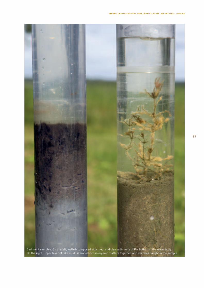
Sediment samples. On the left, well-decomposed silty mud, and clay sediments of the bottom of the water body. On the right, upper layer of lake mud (sapropel) rich in organic matters together with charales caught in the sample.
GENERAL CHARACTERISATION, DEVELOPMENT AND GEOLOGY OF COASTAL LAGOONS
30
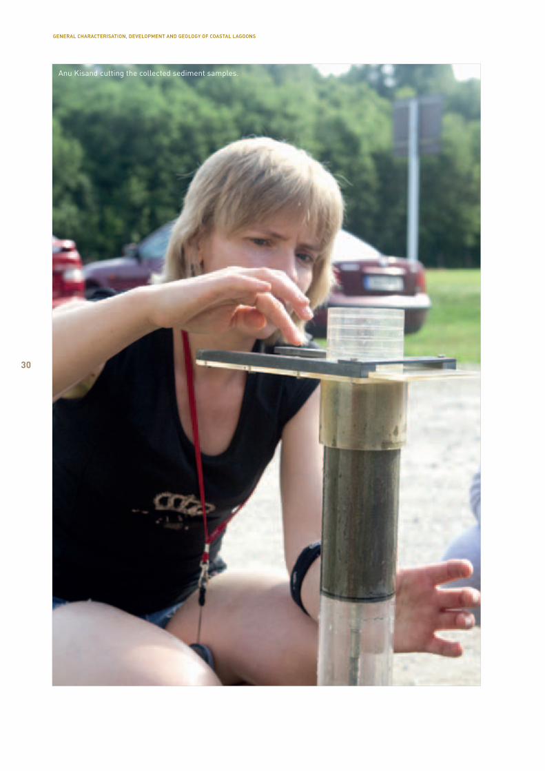
Anu Kisand cutting the collected sediment samples.
GENERAL CHARACTERISATION, DEVELOPMENT AND GEOLOGY OF COASTAL LAGOONS

31
the sum of phosphorus fractions in 1–2 cm thick up-per layer of sediment in Lake Võrtsjärv is 702 μg P/g DW, in Saadjärv 1,000 μg P/g DW, in Lake Viljandi 1,270 μg P/g DW, in Lake Harku 2,300 μg P/g DW, in Ruusmäe lake 5,200 μg P/g DW (Kisand, 2008). An exception among coastal lakes is Linnulaht, the sedi-ment of which contains large amount of phosphorus bonded with organic matter. The sum of phosphorus fractions in the upper sediment layer amounted to 2,500 μg P/g DW. As the thickness of the sediment layer increases, the amount of phosphorus decreases, but it was nevertheless approximately 400 μg P/g DW in the depth of even 35 cm. In the coastal lakes of Läänemaa (Kiissalaht and Käomardi bay), phosphorus was mainly bound with calcium – in different layers of depth, this fraction made up mainly half to two thirds of the sum of all phosphorus fractions. The sediment of Oessaare bay was characterised by a relatively high share of labile phosphorus fraction. This is partially the reason why more phosphorus was released from the laboratory test of the Oessaare bay sediment in 16 weeks (2 μg P/cm2) than from the one of Linnulaht sediment (approx. 0.05 μg P/cm2). In Läänemaa coast-al lakes, the release of phosphorus during the same period was significantly higher (in Kiissalaht that has a relatively high content of labile phosphorus fraction, approximately 23 μg P/cm2, in Käomardi bay 6.5 μg P/cm2). In these sediments, release of the phosphorus accumulated in the sediment pore water into the wa-ter column was promoted by intensive formation of gases in the sediment – when rising to the surface, gas bubbles mix through the sediment surface and the phosphorus-rich pore water of the sediment mixes with lake water without any obstacles.
Natural sediments contain different inorganic and organic matter, the impact of which to human organ-isms is not yet clear even today (Klöcking, Helbig, 2005). Sediments can be used in assessing the envi-ronmental quality, since the pollutants contained in them reflect the condition of the water body (Calace et al., 2006).
Of natural organic matter, the sediments contain biologically active humic substances which are, for example, an important part of soils. These complex compounds are formed on decomposition of plants and the organisms that fed on them. Their chemical composition and content is different and related to the geographical location of the sediment (Esteves,
Duarte, 2000). In characterisation of natural humic substances, only the content of these two fractions is usually determined: humic acids – only dissolve in alkali, and fulvic acids – dissolve in water on all pH levels. Humic substances are everywhere in nature, including sediments. Due to their complex structure they are capable of binding different toxic elements and compounds, as well as harmful organic compounds, thus making the latter hard soluble (Орлов, 1997).
Earlier studies have revealed that the content of dif-ferent fractions in humic substances depends on the origin of the sediment (Übner et al., 2004). It has also been found that humic and fulvic acids correlate with the content of organic matter and total phosphorus (Calace et al., 2006). The content of humic acids in coastal lakes of Saaremaa and coastal lagoons in Pärnu County the upper, 10 cm layer, is mainly 1% of the dry weight of the sediment. Sediments from Põldealuse and Linnulaht have a higher content, reaching above 3%. The content of fulvic acids is usu-ally up to 0.5% of the dry weight of sediment, and the highest level was found, again, in Linnulaht sediment.In addition to humic substances, more attention has been turned recently to lipids and determination of their different representatives. This is a class of fat-like non-water-soluble compounds. Lipids are consid-ered to be one of the indicators of eutrophication. (Pinturier-Geiss et al., 2002) The content of lipids in Saaremaa coastal lakes and Pärnu County’s coastal lagoons in the upper, 10 cm layer, was up to 0.5% of the dry weight of the sediment. In Linnulaht, this indicator was 1.2%.
One of the activities to ensure a good condition of coastal lagoons is removal of sediments. Before that, it needs to be assessed whether the sediments could contain harmful substances. Depending on the nature of pollutants and the characteristics of the environ-ment, the substances stored on sediment may release in water again during digging, changing the chemical and biochemical composition of the water and impacting the water organisms (Guerra et al., 2009). At the same time, ecologically clean sediments can be used as a healing mud. Currently, out of the coastal lakes studied, mud from Mullutu-Suurlaht has been awarded a healing mud certificate. Sediments from Poka and Oessaare bays are also added to the list of sources for healing mud.
GENERAL CHARACTERISATION, DEVELOPMENT AND GEOLOGY OF COASTAL LAGOONS
32
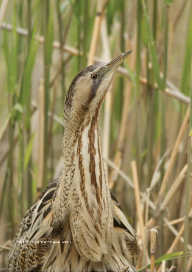
Old bittern in the reeds of a coastal lagoon.
33
3.1. Mammals
Mati Kose
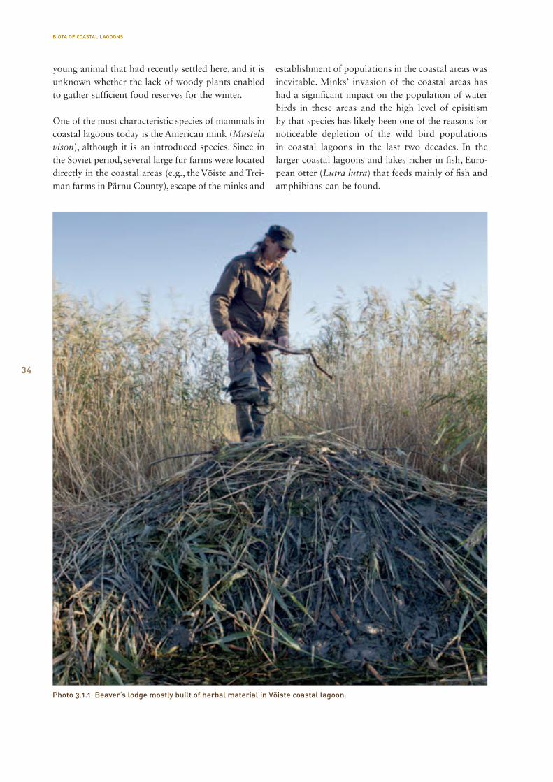
The fauna of coastal lagoon mammals is not very rich in species and is made up of mainly semi-aqueous species. Of entomophagous species, a Eurasian water shrew (Neomys fodiens) can be seen in the shore areas of coastal lagoons, but there is not much informa-tion of the number and spread of this species in these habitats. Of Cheiroptera or bats, Daubenton’s bats and pond bats (Myotis daubentonii, Myotis dasyc-neme) specialised on feeding from bugs flying above water can be considered as regular users of coastal water bodies, including lagoons. These species can be seen more often around coastal lagoons in late sum-mer and autumn, during the scattering and migration period. Especially in the southwest Estonia’s coastal areas that form a leading line for migration of Chei-roptera. The most common rodent in the reeds and high grass of the coastal lagoons is the harvest mouse (Micromys minutus) that builds its round herbal nest up to 1 m from the ground between straws. Of semi-aqueous rodents, coastal lagoons also include a water vole (Arvicola terrestris), but their number varies heavily. An introduced species from the earlier times, the muskrat (Ondatra zibethicus) was quite common in the 1970–1980s and their cone nests and feeding platforms floating on water were a regular sight in the coastal lakes of Pärnu County, for example. Now-adays, this introduced species has withdrawn on nat-ural reasons. Out of indigenous species, the growth of the beaver’s (Castro fiber) (Photo 3.1.1) population has brought about expansion of this specie’s habi-tat, including settling down in some of the coastal lagoons. The author knows a beaver’s lodge built out of branches in Pärnu County, at Reiu shore, near a drainage canal from a forest to a lagoon. However, it was somewhat more unexpected to find traces of bea-ver activity and their lodge in Võiste coastal lagoon at the Luitemaa ecological reserve in the autumn of 2010 in the course of collecting sediment samples in relation to the Natureship project. They had selected an overgrowing section of a lake as a habitat, with no inflow and isolated from the rest of the lagoon com-plex by a thick cover of reed and bulrush. Since there were no woody plants in this coastal area nearby, the lodge had been built of entirely herbaceous material, which is unusual for a beaver. It is likely that it was a
BIOTA OF COASTAL LAGOONS
IIIBiota of coastal lagoons
34
young animal that had recently settled here, and it is unknown whether the lack of woody plants enabled to gather sufficient food reserves for the winter.
One of the most characteristic species of mammals in coastal lagoons today is the American mink (Mustela vison), although it is an introduced species. Since in the Soviet period, several large fur farms were located directly in the coastal areas (e.g., the Võiste and Trei-man farms in Pärnu County), escape of the minks and
establishment of populations in the coastal areas was inevitable. Minks’ invasion of the coastal areas has had a significant impact on the population of water birds in these areas and the high level of episitism by that species has likely been one of the reasons for noticeable depletion of the wild bird populations in coastal lagoons in the last two decades. In the larger coastal lagoons and lakes richer in fish, Euro-pean otter (Lutra lutra) that feeds mainly of fish and amphibians can be found.
BIOTA OF COASTAL LAGOONS
Photo 3.1.1. Beaver’s lodge mostly built of herbal material in Võiste coastal lagoon.
35
3.2. The bird fauna in coastal lagoons
Mati Kose, Tarvo Valker
3.2.1. The features of breeding bird fauna in coastal lagoons
Coastal lagoons – water bodies more or less hidden from the floodwater and waves from the sea in coastal areas – are usually valuable nesting and staging areas for birds. Below, we will provide a more detailed over-view of the main features of the breeding bird fauna of these wetlands, based on different development stages of coastal lagoons, and depending on several ecologic factors. Although several coastal lakes are important for birds also as places for migration stopover, feed-ing, moulting and resting, the limited room in this
publication, as well as uneven data on this matter prevent us from covering these aspects. In spatial dis-crimination of the breeding fauna of coastal lagoons, this overview considers the water area of lagoons as well as the wet shore areas around the water bodies as a uniform ecological-landscape unit.
Since the bird fauna of coastal lagoons, incl. especially breeding species population, largely varies both by composition of species and density of population, it would be purposeful to treat the avian fauna in con-nection with the development of the coastal lakes. In a manner of generalisation, each development stage (starting from vegetation-free lagoons recently sepa-rated from the sea, and ending with eutrophic swamped lagoons at the final stage of their development) has its own characteristic bird fauna (Table 3.2.1).
Table 3.2.1. Developmental phases of coastal lagoons and characterisation of the related habitats important for birds, the key breeding species, the general richness of species and value in terms of nature conservation. After the name of the species, its Nature Conservation Act’s protection category (I–III) has been stated, as well as belonging to the list of protected species under the EU Bird’s Directive, Annex I (BD).
Development phase of lagoons
recently sepa-rated from the sea
final stage, swamped lagoons
Level of vegetation
limestone, sand, gravelunvegetated
low-growth shores, no high vegetation in water
high-growth shores, some sets of club-rush and reed
club-rush on the shores, reedbed has expanded, sets of bulrush, 25-50% of the water surface covered in vegetation
riparian zone com p letely covered in reed, strong overgrowth, the plant sets occupy considerably more than 50% of the initial water area
Characteristic species
common shel-duck-IIIoystercatcherlittle ringed plover-IIIcommon ringed plover-IIIArctic tern-III, BD little tern-III, BD
Northern lapwingdunlin-I, BDruff-I, BDblack-tailed godwit-II, BDredshank-IIIcommon tern-III, BDEurasian skylark blue-headed wagtail-III
garganeyNorthern shovelercommon sniperedshankblack-headed gull Eurasian skylark blue-headed wagtail meadow pipitwhinchat
mute swangreylag goose tufted duckcommon pochard great crested grebe red-necked grebe-IIIlittle gull –BDblack tern-III, BDgreat bittern-II, BDwestern marsh-harrier-III, BD spotted crake-III, BDEurasian cootsedge warblerEurasian reed warbler reat reed warbler reed bunting
greylag goose black tern-III, BD water rail-III, BD common crane-III, BD savi’s warbler reed warblergreat reed warblerbearded parrotbill reed bunting
General bird diversity
low medium high high-medium medium-low
Average value in terms of bird protection
medium high high medium medium-low
BIOTA OF COASTAL LAGOONS

36
In the initial stage of formation of coastal lagoons, their shores are often bare and there is no or little vegetation in the water area. Such gravelly, sandy or pebbly beaches are a preferred nesting place for a number of specialised species of waders and terns: Eurasian oystercatcher (Haematopus ostralegus), little ringed plover (Charadrius dubius), common ringed plover (Charadrius hiaticula), Arctic tern (Sterna paradisaea) (Photo 3.2.1.1), little tern (Sterna albifrons). Shallow lagoons poor in vegetation and close to the coast are also suitable for common shel-duck (Tadorna tadorna) for raising their broods. The breeding bird species of coastal lagoons in the earliest stage of development is very similar to the one of our coastal shores that is poor in vegetation. For water birds, the vegetation of these lakes is not yet suitable for nesting and they can only be seen in migration. In the next stage of development, the shores of coastal lagoons are covered with the first sparse vegetation. The vegetation remains low-growth for a longer period of time, in case sufficient grazing load is ensured on the managed shores. The activity of cattle also additionally changes the surface of the shore areas, trampling open sandy and muddy patches of surface, restricting the spread of water and shore plants. The above-mentioned habitat characteristics and animal excrements create a good food base for the related bird population. In this development stage
of coastal lagoons, their breeding species population is the most similar to the one of well-maintained coastal meadows, in which mainly species of waders that are important in the aspect of conservation management start to dominate. The most character-istic breeding bird species of this development stage are the Northern lapwing (Vanellus vanellus) (Photo 3.2.1.2), Baltic dunlin (Calidris alpina schinzii), ruff (Philomachus pugnax), black-tailed godwit (Limosa limosa), redshank (Tringa totanus), common tern (Sterna hirundo), and from passerines, Eurasian skylark (Alauda arvensis) and blue-headed wagtail (Motacilla flava) (Photo 3.2.1.3).
As a result of a low herding load, nutrient inflow and land uplifting processes, the low-growth shore vegeta-tion of coastal lagoons may be replaced by tall herb communities, and the first club-rush bushes and reed patches emerge both in the shore and the water area. Such changes are the main reasons for retreat of the typical species that nest in coastal meadows (mainly waders). This development phase is the best charac-terised by a sudden drop in the population of coastal meadow waders (dunlin, black-tailed godwit, ruff), or their disappearance, and a fast increase in the number of several open landscape passerines. The vegetation thriving in the water area of the lakes enables for the first dubbing ducks and gulls to start nesting.
Photo 3.2.1.1. Arctic terns.
BIOTA OF COASTAL LAGOONS
37
Photo 3.2.1.2. Northern lapwing with a nestling.
BIOTA OF COASTAL LAGOONS
38
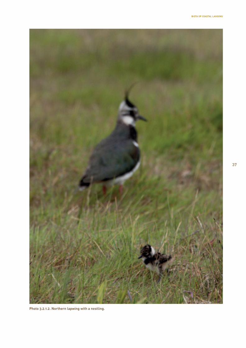
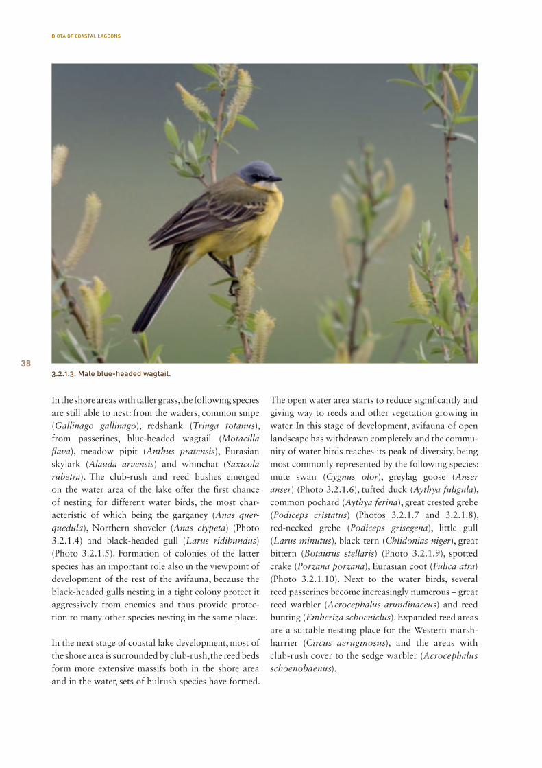
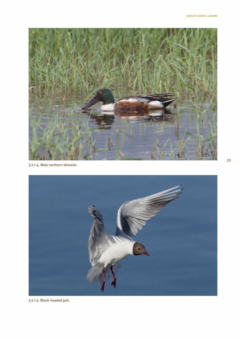
In the shore areas with taller grass, the following species are still able to nest: from the waders, common snipe (Gallinago gallinago), redshank (Tringa totanus), from passerines, blue-headed wagtail (Motacilla flava), meadow pipit (Anthus pratensis), Eurasian skylark (Alauda arvensis) and whinchat (Saxicola rubetra). The club-rush and reed bushes emerged on the water area of the lake offer the first chance of nesting for different water birds, the most char-acteristic of which being the garganey (Anas quer-quedula), Northern shoveler (Anas clypeta) (Photo 3.2.1.4) and black-headed gull (Larus ridibundus) (Photo 3.2.1.5). Formation of colonies of the latter species has an important role also in the viewpoint of development of the rest of the avifauna, because the black-headed gulls nesting in a tight colony protect it aggressively from enemies and thus provide protec-tion to many other species nesting in the same place.
In the next stage of coastal lake development, most of the shore area is surrounded by club-rush, the reed beds form more extensive massifs both in the shore area and in the water, sets of bulrush species have formed.
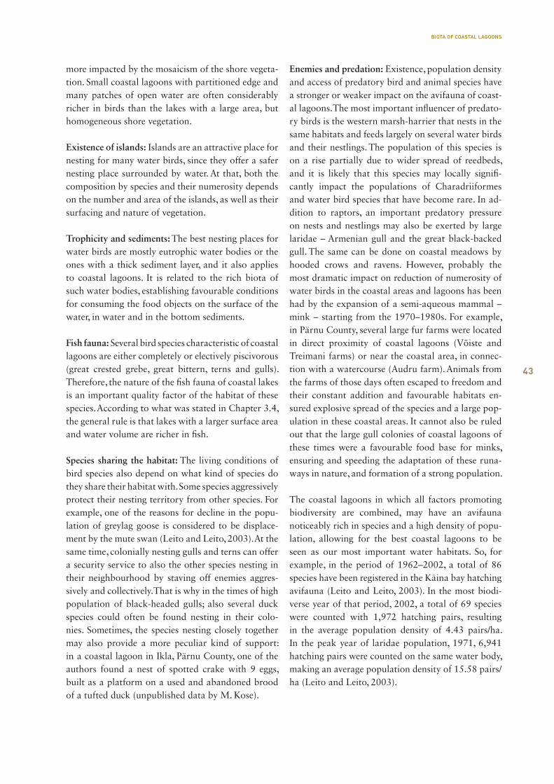
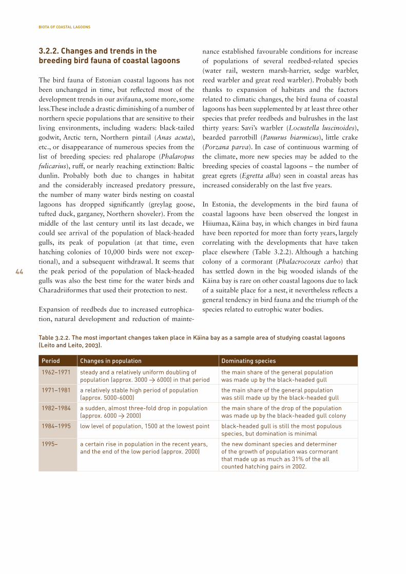
The open water area starts to reduce significantly and giving way to reeds and other vegetation growing in water. In this stage of development, avifauna of open landscape has withdrawn completely and the commu-nity of water birds reaches its peak of diversity, being most commonly represented by the following species: mute swan (Cygnus olor), greylag goose (Anser anser) (Photo 3.2.1.6), tufted duck (Aythya fuligula), common pochard (Aythya ferina), great crested grebe (Podiceps cristatus) (Photos 3.2.1.7 and 3.2.1.8), red-necked grebe (Podiceps grisegena), little gull (Larus minutus), black tern (Chlidonias niger), great bittern (Botaurus stellaris) (Photo 3.2.1.9), spotted crake (Porzana porzana), Eurasian coot (Fulica atra) (Photo 3.2.1.10). Next to the water birds, several reed passerines become increasingly numerous – great reed warbler (Acrocephalus arundinaceus) and reed bunting (Emberiza schoeniclus). Expanded reed areas are a suitable nesting place for the Western marsh-harrier (Circus aeruginosus), and the areas with club-rush cover to the sedge warbler (Acrocephalus schoenobaenus).
3.2.1.3. Male blue-headed wagtail.
BIOTA OF COASTAL LAGOONS
393.2.1.4. Male northern shoveler.
3.2.1.5. Black-headed gull.
BIOTA OF COASTAL LAGOONS
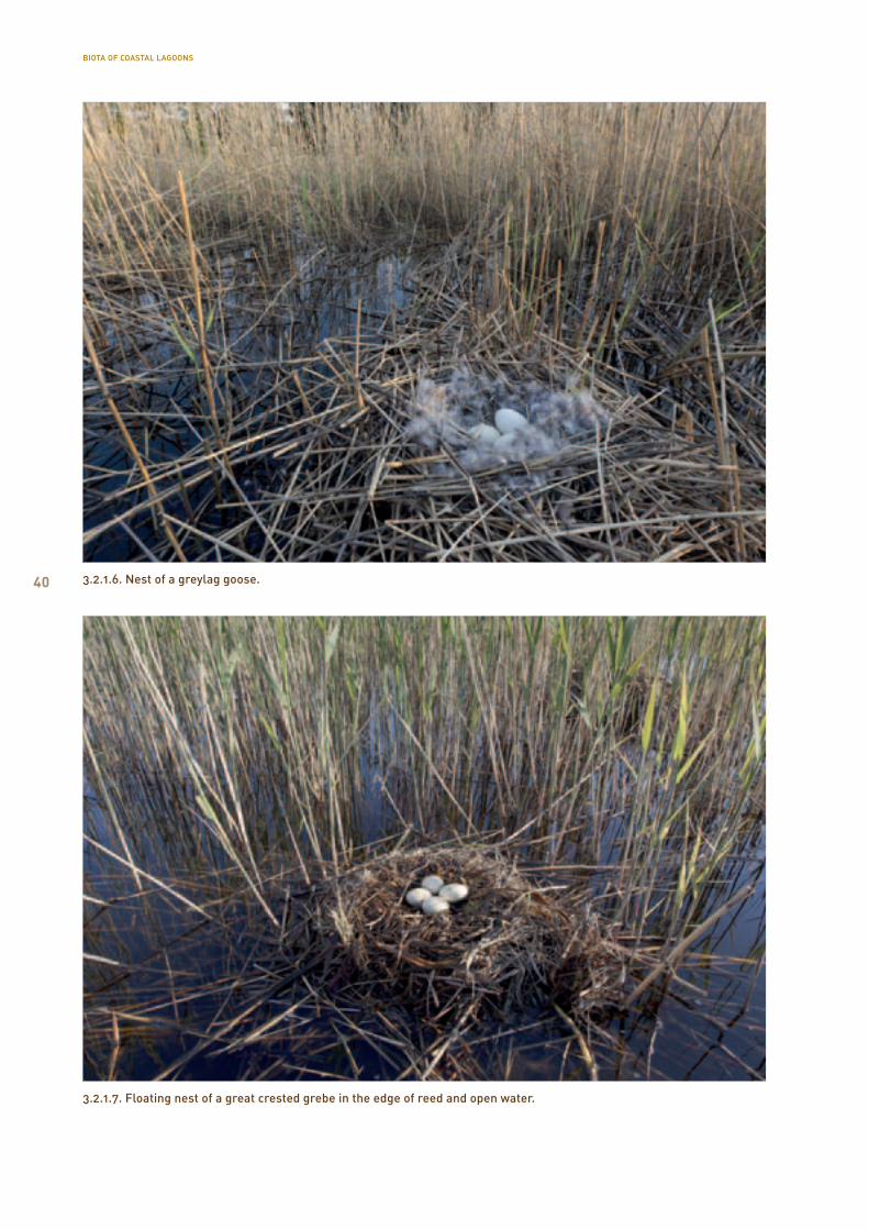
40 3.2.1.6. Nest of a greylag goose.
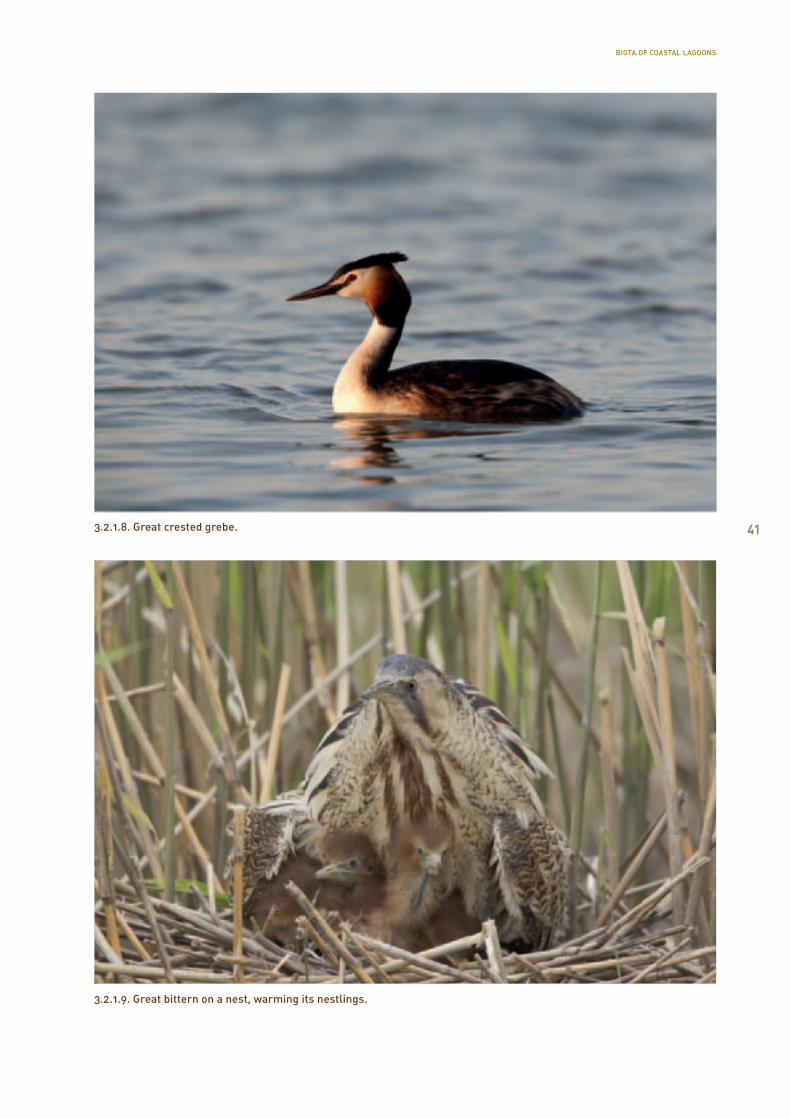
3.2.1.7. Floating nest of a great crested grebe in the edge of reed and open water.
BIOTA OF COASTAL LAGOONS
413.2.1.8. Great crested grebe.
3.2.1.9. Great bittern on a nest, warming its nestlings.
BIOTA OF COASTAL LAGOONS

42
3.2.1.10. Nest of a coot with a newly-hatched nestling.
In eutrophic conditions of the next phase of lagoon development, the speed of growing over increases un-til vegetation takes over everything but the deepest areas and the inflows and outflows. In a longer run, even the last patches of open water may grow over and be replaced by a shallow quaking bog that marks the end of the coastal lagoon habitat. In this stage of development, the share of waterbirds decreases significantly and the species related to reedbeds and mire communities start to spread more extensively, the most characteristic of them being: greylag goose (Anser anser), black tern (Chlidonias nigra), water rail (Rallus aquaticus), common crane (Grus grus), savi’s warbler (Locustella luscinoides), reed warbler (Acrocephalus scirpaceus), great reed warbler (Ac-rocephalus arundinaceus), bearded parrotbill (Panu-rus biarmicus), reed bunting (Emberiza schoeniclus). Biodiversity has reduced in the last phase of coastal lagoons and the value in terms of avifauna conserva-tion has dropped significantly.
Therefore it can be generalised that in conformity with succession of coastal lagoons, also in ornito-fauna, a development takes place from the open land-scape species that prefer pebbles and low-growth
vegetation to a growth in the share of species that prefer the communities of vegetation and open water. In the last stage of coastal lake development, the share of avifauna related to reedbed and swamp habitats increases rapidly.
However, the line of development of avifauna and occurrence of the typical species stated above is a strong generalisation and the composition of every coastal lagoon’s specific avifauna depends on many other factors in addition to the development stage of the biotic community, the most important of which include the following:
Size and patchiness of the water body: The size of coastal lagoons varies to great extent, starting from the Mullutu-Suurlaht (528 ha) that is fourth in size among the Estonian lakes, to small water bodies of even less than 0.1 ha. Due to that, the number and capacity of their potential habitats also varies signifi-cantly. While as to colonial hatchers, even relatively small coastal lakes may have a large number and density of pairs, for the other species, the surface area of the lake and size of population of birds is in a posi-tive correlation. However, the number of birds is even
BIOTA OF COASTAL LAGOONS
43
more impacted by the mosaicism of the shore vegeta-tion. Small coastal lagoons with partitioned edge and many patches of open water are often considerably richer in birds than the lakes with a large area, but homogeneous shore vegetation.
Existence of islands: Islands are an attractive place for nesting for many water birds, since they offer a safer nesting place surrounded by water. At that, both the composition by species and their numerosity depends on the number and area of the islands, as well as their surfacing and nature of vegetation.
Trophicity and sediments: The best nesting places for water birds are mostly eutrophic water bodies or the ones with a thick sediment layer, and it also applies to coastal lagoons. It is related to the rich biota of such water bodies, establishing favourable conditions for consuming the food objects on the surface of the water, in water and in the bottom sediments.
Fish fauna: Several bird species characteristic of coastal lagoons are either completely or electively piscivorous (great crested grebe, great bittern, terns and gulls). Therefore, the nature of the fish fauna of coastal lakes is an important quality factor of the habitat of these species. According to what was stated in Chapter 3.4, the general rule is that lakes with a larger surface area and water volume are richer in fish.
Species sharing the habitat: The living conditions of bird species also depend on what kind of species do they share their habitat with. Some species aggressively protect their nesting territory from other species. For example, one of the reasons for decline in the popu-lation of greylag goose is considered to be displace-ment by the mute swan (Leito and Leito, 2003). At the same time, colonially nesting gulls and terns can offer a security service to also the other species nesting in their neighbourhood by staving off enemies aggres-sively and collectively. That is why in the times of high population of black-headed gulls; also several duck species could often be found nesting in their colo-nies. Sometimes, the species nesting closely together may also provide a more peculiar kind of support: in a coastal lagoon in Ikla, Pärnu County, one of the aut hors found a nest of spotted crake with 9 eggs, built as a platform on a used and abandoned brood of a tufted duck (unpublished data by M. Kose).
Enemies and predation: Existence, population density and access of predatory bird and animal species have a stronger or weaker impact on the avifauna of coast-al lagoons. The most important influencer of predato-ry birds is the western marsh-harrier that nests in the same habitats and feeds largely on several water birds and their nestlings. The population of this species is on a rise partially due to wider spread of reedbeds, and it is likely that this species may locally signifi-cantly impact the populations of Charadriiformes and water bird species that have become rare. In ad-dition to raptors, an important predatory pressure on nests and nestlings may also be exerted by large laridae – Armenian gull and the great black-backed gull. The same can be done on coastal meadows by hooded crows and ravens. However, probably the most dramatic impact on reduction of numerosity of water birds in the coastal areas and lagoons has been had by the expansion of a semi-aqueous mammal – mink – starting from the 1970–1980s. For example, in Pärnu County, several large fur farms were located in direct proximity of coastal lagoons (Võiste and Treimani farms) or near the coastal area, in connec-tion with a watercourse (Audru farm). Animals from the farms of those days often escaped to freedom and their constant addition and favourable habitats en-sured explosive spread of the species and a large pop-ulation in these coastal areas. It cannot also be ruled out that the large gull colonies of coastal lagoons of these times were a favourable food base for minks, ensuring and speeding the adaptation of these runa-ways in nature, and formation of a strong population.
The coastal lagoons in which all factors promoting biodiversity are combined, may have an avifauna noticeably rich in species and a high density of popu-lation, allowing for the best coastal lagoons to be seen as our most important water habitats. So, for example, in the period of 1962–2002, a total of 86 species have been registered in the Käina bay hatching avifauna (Leito and Leito, 2003). In the most biodi-verse year of that period, 2002, a total of 69 species were counted with 1,972 hatching pairs, resulting in the average population density of 4.43 pairs/ha. In the peak year of laridae population, 1971, 6,941 hatching pairs were counted on the same water body, making an average population density of 15.58 pairs/ha (Leito and Leito, 2003).
BIOTA OF COASTAL LAGOONS
44
3.2.2. Changes and trends in the breeding bird fauna of coastal lagoons
The bird fauna of Estonian coastal lagoons has not been unchanged in time, but reflected most of the development trends in our avifauna, some more, some less. These include a drastic diminishing of a number of northern specie populations that are sensitive to their living environments, including waders: black-tailed godwit, Arctic tern, Northern pintail (Anas acuta), etc., or disappearance of numerous species from the list of breeding species: red phalarope (Phalaropus fulicarius), ruff, or nearly reaching extinction: Baltic dunlin. Probably both due to changes in habitat and the considerably increased predatory pressure, the number of many water birds nesting on coastal lagoons has dropped significantly (greylag goose, tufted duck, garganey, Northern shoveler). From the middle of the last century until its last decade, we could see arrival of the population of black-headed gulls, its peak of population (at that time, even hatching colonies of 10,000 birds were not excep-tional), and a subsequent withdrawal. It seems that the peak period of the population of black-headed gulls was also the best time for the water birds and Charadriiformes that used their protection to nest.
Expansion of reedbeds due to increased eutrophica-tion, natural development and reduction of mainte-
nance established favourable conditions for increase of populations of several reedbed-related species (water rail, western marsh-harrier, sedge warbler, reed warbler and great reed warbler). Probably both thanks to expansion of habitats and the factors related to climatic changes, the bird fauna of coastal lagoons has been supplemented by at least three other species that prefer reedbeds and bulrushes in the last thirty years: Savi’s warbler (Locustella luscinoides), bearded parrotbill (Panurus biarmicus), little crake (Porzana parva). In case of continuous warming of the climate, more new species may be added to the breeding species of coastal lagoons – the number of great egrets (Egretta alba) seen in coastal areas has increased considerably on the last five years.
In Estonia, the developments in the bird fauna of coastal lagoons have been observed the longest in Hiiumaa, Käina bay, in which changes in bird fauna have been reported for more than forty years, largely correlating with the developments that have taken place elsewhere (Table 3.2.2). Although a hatching colony of a cormorant (Phalacrocorax carbo) that has settled down in the big wooded islands of the Käina bay is rare on other coastal lagoons due to lack of a suitable place for a nest, it nevertheless reflects a general tendency in bird fauna and the triumph of the species related to eutrophic water bodies.
Period Changes in population Dominating species
1962–1971 steady and a relatively uniform doubling of population (approx. 3000 → 6000) in that period
the main share of the general population was made up by the black-headed gull
1971–1981 a relatively stable high period of population (approx. 5000-6000)
the main share of the general population was still made up by the black-headed gull
1982–1984 a sudden, almost three-fold drop in population (approx. 6000 → 2000)
the main share of the drop of the population was made up by the black-headed gull colony
1984–1995 low level of population, 1500 at the lowest point black-headed gull is still the most populous species, but domination is minimal
1995– a certain rise in population in the recent years, and the end of the low period (approx. 2000)
the new dominant species and determiner of the growth of population was cormorant that made up as much as 31% of the all counted hatching pairs in 2002.
Table 3.2.2. The most important changes taken place in Käina bay as a sample area of studying coastal lagoons (Leito and Leito, 2003).
BIOTA OF COASTAL LAGOONS
45
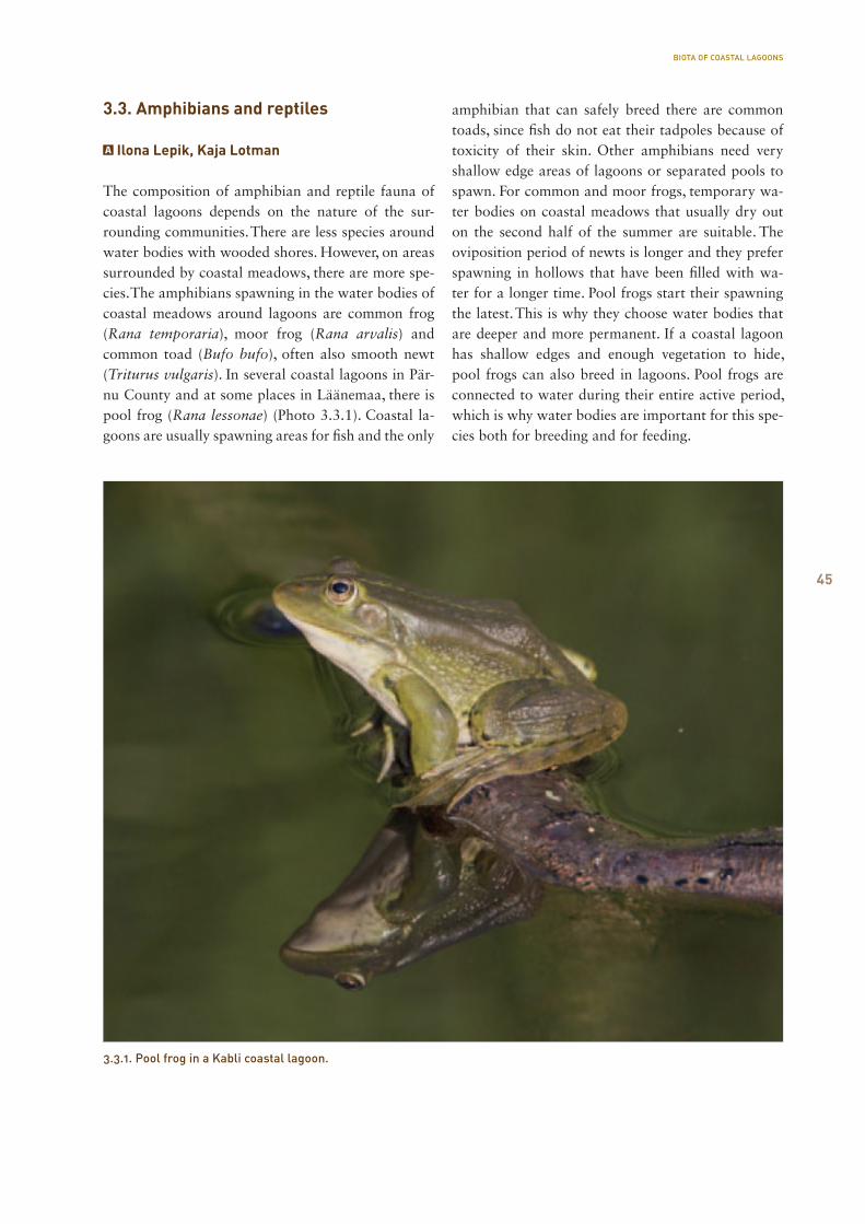
3.3. Amphibians and reptiles
Ilona Lepik, Kaja Lotman
The composition of amphibian and reptile fauna of coastal lagoons depends on the nature of the sur-rounding communities. There are less species around water bodies with wooded shores. However, on areas surrounded by coastal meadows, there are more spe-cies. The amphibians spawning in the water bodies of coastal meadows around lagoons are common frog (Rana temporaria), moor frog (Rana arvalis) and common toad (Bufo bufo), often also smooth newt (Triturus vulgaris). In several coastal lagoons in Pär-nu County and at some places in Läänemaa, there is pool frog (Rana lessonae) (Photo 3.3.1). Coastal la-goons are usually spawning areas for fish and the only
amphibian that can safely breed there are common toads, since fish do not eat their tadpoles because of toxicity of their skin. Other amphibians need very shallow edge areas of lagoons or separated pools to spawn. For common and moor frogs, temporary wa-ter bodies on coastal meadows that usually dry out on the second half of the summer are suitable. The oviposition period of newts is longer and they prefer spawning in hollows that have been filled with wa-ter for a longer time. Pool frogs start their spawning the latest. This is why they choose water bodies that are deeper and more permanent. If a coastal lagoon has shallow edges and enough vegetation to hide, pool frogs can also breed in lagoons. Pool frogs are connected to water during their entire active period, which is why water bodies are important for this spe-cies both for breeding and for feeding.
3.3.1. Pool frog in a Kabli coastal lagoon.
BIOTA OF COASTAL LAGOONS
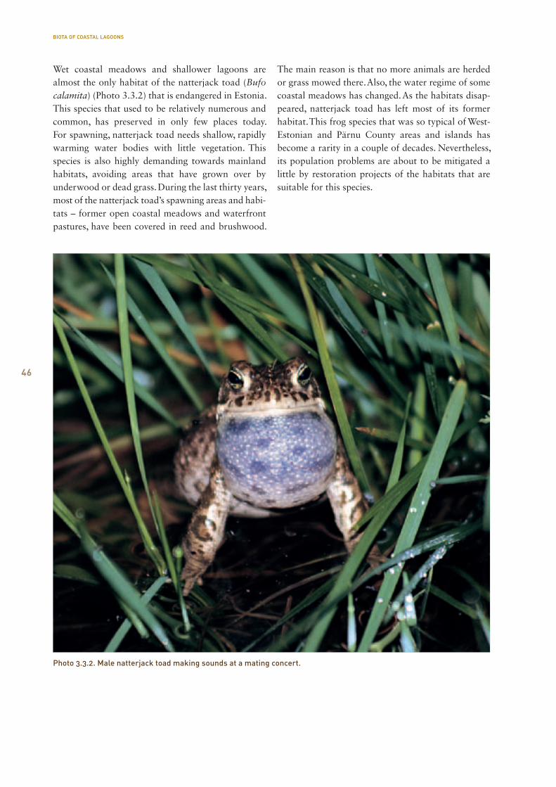
46
Wet coastal meadows and shallower lagoons are almost the only habitat of the natterjack toad (Bufo calamita) (Photo 3.3.2) that is endangered in Estonia. This species that used to be relatively numerous and common, has preserved in only few places today. For spawning, natterjack toad needs shallow, rapidly warming water bodies with little vegetation. This species is also highly demanding towards mainland habitats, avoiding areas that have grown over by underwood or dead grass. During the last thirty years, most of the natterjack toad’s spawning areas and habi-tats – former open coastal meadows and waterfront pastures, have been covered in reed and brushwood.
The main reason is that no more animals are herded or grass mowed there. Also, the water regime of some coastal meadows has changed. As the habitats disap-peared, natterjack toad has left most of its former habitat. This frog species that was so typical of West-Estonian and Pärnu County areas and islands has become a rarity in a couple of decades. Nevertheless, its population problems are about to be mitigated a little by restoration projects of the habitats that are suitable for this species.
Photo 3.3.2. Male natterjack toad making sounds at a mating concert.
BIOTA OF COASTAL LAGOONS
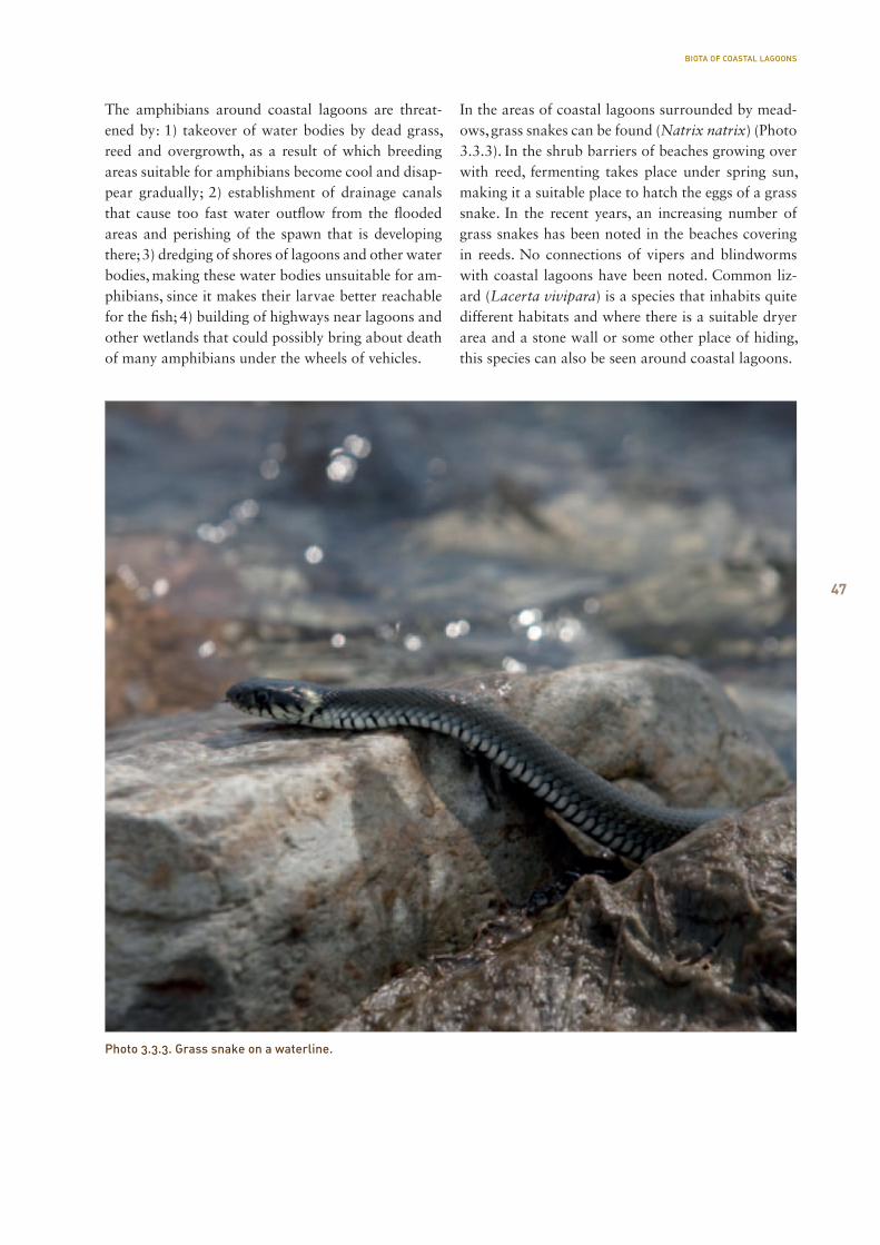
47
The amphibians around coastal lagoons are threat-ened by: 1) takeover of water bodies by dead grass, reed and overgrowth, as a result of which breeding areas suitable for amphibians become cool and disap-pear gradually; 2) establishment of drainage canals that cause too fast water outflow from the flooded areas and perishing of the spawn that is developing there; 3) dredging of shores of lagoons and other water bodies, making these water bodies unsuitable for am-phibians, since it makes their larvae better reachable for the fish; 4) building of highways near lagoons and other wetlands that could possibly bring about death of many amphibians under the wheels of vehicles.
In the areas of coastal lagoons surrounded by mead-ows, grass snakes can be found (Natrix natrix) (Photo 3.3.3). In the shrub barriers of beaches growing over with reed, fermenting takes place under spring sun, making it a suitable place to hatch the eggs of a grass snake. In the recent years, an increasing number of grass snakes has been noted in the beaches covering in reeds. No connections of vipers and blindworms with coastal lagoons have been noted. Common liz-ard (Lacerta vivipara) is a species that inhabits quite different habitats and where there is a suitable dryer area and a stone wall or some other place of hiding, this species can also be seen around coastal lagoons.
Photo 3.3.3. Grass snake on a waterline.
BIOTA OF COASTAL LAGOONS

48
3.4. Fish of coastal lagoons
Teet Krause, Anu Palm
The diversity of fish is determined by the size of a water body and depth of the water. Our best fishing lakes are usually at least 70 ha in size, up to 6 m deep, and eutrophic. The larger small lakes of mainland
Estonia usually have between six and 12 species of fish, the most common of them being pike, perch, and roach. Coastal lakes are not the best habitats for fish, mainly due to their shallow water (0.5–2 m). Out of approximately 35 fish species of our lentic waters, we observed 15 species while studying coastal lagoons (Table 3.4.1).
Coastal lagoons lack relatively important game fish species of mainland Estonia – bream, pike-perch, and coregonids. In more diverse, larger coastal lakes we caught 9–11 species of fish, while in the smaller ones, the number remained between 4–6 species. Fish diver-sity of lagoon fish fauna is increased by high waters, floods and storms, but the species that have ended up in coastal lagoons in such a manner may not find a suitable habitat here.
From predatory fish, almost all coastal lakes con-tained pike and perch, but they were absent in the Oessaare and Aenga bays. Perch that is common in
inland waters and coastal sea, dominated in four lakes. The numbers of omnivorous fish is mainly re-duced by pike in coastal lagoons. Its impact is visible in Kudani lake, where the only food not suitable to it are crucian and gibel carp because of their high back. Pike’s impact to coastal lagoon fish fauna is maybe the most visible after opening of flyways and sea con-nections. Reconstruction of the Vööla meri culvert and improvement of access to the species between the Hara bay and Vööla meri could be seen in a significant increase of pike catch in a late autumn sample fishing, compared to the one of summer (Figure 3.4.2).
Bleak
Alburnus alburnus
Dace
Leuciscus leuciscus
Roach
Rutilus rutilus
Rudd
Scardinius erythrophthalmus
Three-spined stickleback G
asterosteus aculeatus
White bream
B
licca bjoerkna
SunbleakLeucaspius delineatus
Nine-spined stickleback
Pungitius pungitius
TenchTinca tinca
Ruffe
Gym
nocephalus cernuus
Crucian carp C
arassius carassius
Gibel carp
Carassius gibelio
Spined loach C
obitis taenia
Pike
Esox lucius
Perch
Perca fluviatilis
SPEC
IES
Lake
Laidevahe
Linnulaht
Mullutu
Vägara
Suurlaht
Oessaare
Põldealuse
Aenga
Kahvatu
Kasselaht
Kiissa
Kudani
Käomardi
Prästvike
Vööla meri
11 x x x x x x x x x x x
11 x x x x x x x x x x x
10 x x x x x x x x x x
9 x x x x x x x x x
9 x x x x x x x x x
6 x x x x x x
6 x x x x x x
5 x x x x x
8 x x x x x x x x
8 x x x x x x x x
11 x x x x x x x x x x x
4 x x x x
7 x x x x x x x
4 x x x x
11 x x x x x x x x x x x
Table 3.4.1. List of fish species caught from coastal lagoons.
BIOTA OF COASTAL LAGOONS
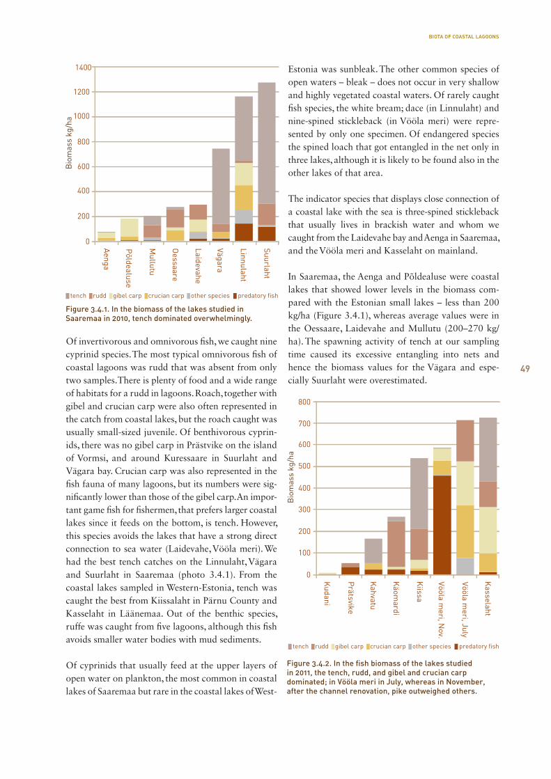
49
Of invertivorous and omnivorous fish, we caught nine cyprinid species. The most typical omnivorous fish of coastal lagoons was rudd that was absent from only two samples. There is plenty of food and a wide range of habitats for a rudd in lagoons. Roach, together with gibel and crucian carp were also often represented in the catch from coastal lakes, but the roach caught was usually small-sized juvenile. Of benthivorous cyprin-ids, there was no gibel carp in Prästvike on the island of Vormsi, and around Kuressaare in Suurlaht and Vägara bay. Crucian carp was also represented in the fish fauna of many lagoons, but its numbers were sig-nificantly lower than those of the gibel carp. An impor-tant game fish for fishermen, that prefers larger coastal lakes since it feeds on the bottom, is tench. However, this species avoids the lakes that have a strong direct connection to sea water (Laidevahe, Vööla meri). We had the best tench catches on the Linnulaht, Vägara and Suurlaht in Saaremaa (photo 3.4.1). From the coastal lakes sampled in Western-Estonia, tench was caught the best from Kiissalaht in Pärnu County and Kasselaht in Läänemaa. Out of the benthic species, ruffe was caught from five lagoons, although this fish avoids smaller water bodies with mud sediments.
Of cyprinids that usually feed at the upper layers of open water on plankton, the most common in coastal lakes of Saaremaa but rare in the coastal lakes of West-
Estonia was sunbleak. The other common species of open waters – bleak – does not occur in very shallow and highly vegetated coastal waters. Of rarely caught fish species, the white bream; dace (in Linnulaht) and nine-spined stickleback (in Vööla meri) were repre-sented by only one specimen. Of endangered species the spined loach that got entangled in the net only in three lakes, although it is likely to be found also in the other lakes of that area.
The indicator species that displays close connection of a coastal lake with the sea is three-spined stickleback that usually lives in brackish water and whom we caught from the Laidevahe bay and Aenga in Saaremaa, and the Vööla meri and Kasselaht on mainland.
In Saaremaa, the Aenga and Põldealuse were coastal lakes that showed lower levels in the biomass com-pared with the Estonian small lakes – less than 200 kg/ha (Figure 3.4.1), whereas average values were in the Oessaare, Laidevahe and Mullutu (200–270 kg/ha). The spawning activity of tench at our sampling time caused its excessive entangling into nets and hence the biomass values for the Vägara and espe-cially Suurlaht were overestimated.
Figure 3.4.1. In the biomass of the lakes studied in Saaremaa in 2010, tench dominated overwhelmingly.
Figure 3.4.2. In the fish biomass of the lakes studied in 2011, the tench, rudd, and gibel and crucian carp dominated; in Vööla meri in July, whereas in November, after the channel renovation, pike outweighed others.
BIOTA OF COASTAL LAGOONS
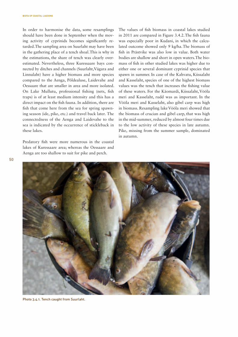
50
In order to harmonise the data, some resamplings should have been done in September when the mov-ing activity of cyprinids becomes significantly re-tarded. The sampling area on Suurlaht may have been in the gathering place of a tench shoal. This is why in the estimations, the share of tench was clearly over-estimated. Nevertheless, three Kuressaare bays con-nected by ditches and channels (Suurlaht, Vägara and Linnulaht) have a higher biomass and more species compared to the Aenga, Põldealuse, Laidevahe and Oessaare that are smaller in area and more isolated. On Lake Mullutu, professional fishing (nets, fish traps) is of at least medium intensity and this has a direct impact on the fish fauna. In addition, there are fish that come here from the sea for spring spawn-ing season (ide, pike, etc.) and travel back later. The connectedness of the Aenga and Laidevahe to the sea is indicated by the occurrence of stickleback in these lakes.
Predatory fish were more numerous in the coastal lakes of Kuressaare area; whereas the Oessaare and Aenga are too shallow to suit for pike and perch.
The values of fish biomass in coastal lakes studied in 2011 are compared in Figure 3.4.2. The fish fauna was especially poor in Kudani, in which the calcu-lated outcome showed only 9 kg/ha. The biomass of fish in Prästvike was also low in value. Both water bodies are shallow and short in open waters. The bio-mass of fish in other studied lakes was higher due to either one or several dominant cyprinid species that spawn in summer. In case of the Kahvatu, Kiissalaht and Kasselaht, species of one of the highest biomass values was the tench that increases the fishing value of these waters. For the Käomardi, Kiissalaht, Vööla meri and Kasselaht, rudd was as important. In the Vööla meri and Kasselaht, also gibel carp was high in biomass. Resampling lake Vööla meri showed that the biomass of crucian and gibel carp, that was high in the mid-summer, reduced by almost four times due to the low activity of these species in late autumn. Pike, missing from the summer sample, dominated in autumn.
Photo 3.4.1. Tench caught from Suurlaht.
BIOTA OF COASTAL LAGOONS

51
3.5. Large invertebrates in coastal lagoons
Henn Timm, Tiina Talvi Macroinvertebrates are animals that are visible to the naked eye, usually with a diameter of more than 0.5 mm. They include the mainly benthic beings in water bodies: insects, arachnids, crustaceans, molluscs, nem-atodes, flatworms, annelids, sponges and bryozoans.The studies carried out on the shores of coastal lakes on whorl snails (Vertigo) showed that the most di-verse habitats are marsh forests surrounded by coast-al lagoons. Whorl snails (gen. Vertigo) are small land snails with a limited habitat and a stenotopic habitat preference. In the species living in Estonia, the maxi-mum height of shell is between 1.7–2.7 mm. In total, 38 species of land snails were found (25 in Saaremaa, 31 in Läänemaa); special attention was paid to whorl snails. There were several rarities among the latter, including Vertigo antivertigo (BD Annex II, NC 3 cat.) that has a high importance in terms of nature conservation. Landscape mosaicism that is created by open swamps and smaller broadleaved woods in between them is a prerequisite for biodiversity.
Coastal lakes often suffer from strong natural pres-sure factors (changes in water level, mudding, inflow of sea water) that have a significant impact on the
fauna of their macroinvertebrates. Coastal lakes in-clude more or less the same species of invertebrates than other Estonian lakes, but compared to the other lake types, to a medium or small extent, depending on the ever-changing situation. The species are not very sensitive, which is not surprising due to their natural environment. Most species live in lakes to which salty water no longer flows and that have de-veloped a quaking bog. The average sensitivity of the taxon in coastal lakes is similar to the one of normal hardwater lakes, but is less than the one of soft-water lakes. There are relatively few representatives of insect orders of high environmental sensitivity (mayflies and caddisflies). On the other hand, there are often plenty of snail, beetle and bug species, for instance, in ponds and ditches. From species under protection, medici-nal leeches (Hirudo medicinalis) can sometimes be found. Some of the species have been shown on pho-tos 3.5.1–3.5.2.
Photo 3.5.2. Planorbis planorbis.
Photo 3.5.1. Cercyon sp.
BIOTA OF COASTAL LAGOONS
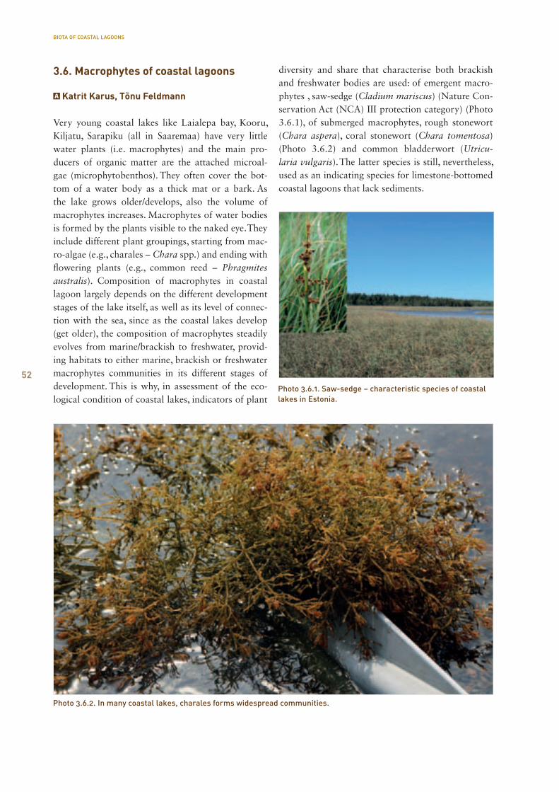
52
3.6. Macrophytes of coastal lagoons
Katrit Karus, Tõnu Feldmann
Very young coastal lakes like Laialepa bay, Kooru, Kiljatu, Sarapiku (all in Saaremaa) have very little water plants (i.e. macrophytes) and the main pro-ducers of organic matter are the attached microal-gae (microphytobenthos). They often cover the bot-tom of a water body as a thick mat or a bark. As the lake grows older/develops, also the volume of macrophytes increases. Macrophytes of water bodies is formed by the plants visible to the naked eye. They include different plant groupings, starting from mac-ro-algae (e.g., charales – Chara spp.) and ending with flowering plants (e.g., common reed – Phragmites australis). Composition of macrophytes in coastal lagoon largely depends on the different development stages of the lake itself, as well as its level of connec-tion with the sea, since as the coastal lakes develop (get older), the composition of macrophytes steadily evolves from marine/brackish to freshwater, provid-ing habitats to either marine, brackish or freshwater macrophytes communities in its different stages of development. This is why, in assessment of the eco-logical condition of coastal lakes, indicators of plant
diversity and share that characterise both brackish and freshwater bodies are used: of emergent macro-phytes , saw-sedge (Cladium mariscus) (Nature Con-servation Act (NCA) III protection category) (Photo 3.6.1), of submerged macrophytes, rough stonewort (Chara aspera), coral stonewort (Chara tomentosa) (Photo 3.6.2) and common bladderwort (Utricu-laria vulgaris). The latter species is still, nevertheless, used as an indicating species for limestone-bottomed coastal lagoons that lack sediments.
Photo 3.6.1. Saw-sedge – characteristic species of coastal lakes in Estonia.
Photo 3.6.2. In many coastal lakes, charales forms widespread communities.
BIOTA OF COASTAL LAGOONS
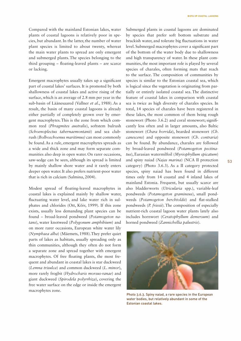
53
Compared with the mainland Estonian lakes, water plants of coastal lagoons is relatively poor in spe-cies, but abundant. In the latter, the number of water plant species is limited to about twenty, whereat the main water plants to spread are only emergent and submerged plants. The species belonging to the third grouping – floating-leaved plants – are scarce or lacking.
Emergent macrophytes usually takes up a significant part of coastal lakes’ surfaces. It is promoted by both shallowness of coastal lakes and active rising of the surface, which is an average of 2.8 mm per year in the sub-basin of Läänesaared (Vallner et al., 1988). As a result, the basin of many coastal lagoons is already either partially of completely grown over by emer-gent macrophytes. This is the zone from which com-mon reed (Phragmites australis), softstem bulrush (Schoenoplectus tabernaemontanii) and sea club-rush (Bolboschoenus maritimus) can most commonly be found. As a rule, emergent macrophytes spreads as a wide and thick zone and may form separate com-munities also deep in open water. On rarer occasions, saw-sedge can be seen, although its spread is limited by mainly shallow shore water and it rarely enters deeper open water. It also prefers nutrient-poor water that is rich in calcium (Salmina, 2004).
Modest spread of floating-leaved macrophytes in coastal lakes is explained mainly by shallow water, fluctuating water level, and lake water rich in sul-phates and chlorides (Ott, Kõiv, 1999). If this zone exists, usually less demanding plant species can be found – broad-leaved pondweed (Potamogeton na-tans), water knotweed (Polygonum amphibium) and on more rarer occasions, European white water lily (Nymphaea alba) (Mäemets, 1988). They prefer quiet parts of lakes as habitats, usually spreading only as thin communities, although they often do not form a separate zone and spread together with emergent macrophytes. Of free floating plants, the most fre-quent and abundant in coastal lakes is star duckweed (Lemna trisulca) and common duckweed (L. minor), more rarely frogbit (Hydrocharis morsus-ranae) and giant duckweed (Spirodela polyrrhiza), covering the free water surface on the edge or inside the emergent macrophytes zone.
Submerged plants in coastal lagoons are dominated by species that prefer soft bottom substrate and brackish water, and tolerate big fluctuations in water level. Submerged macrophytes cover a significant part of the bottom of the water body due to shallowness and high transparency of water. In these plant com-munities, the most important role is played by several species of charales, often forming mats that reach to the surface. The composition of communities by species is similar to the Estonian coastal sea, which is logical since the vegetation is originating from par-tially or entirely isolated coastal sea. The distinctive feature of coastal lakes in comparison with coastal sea is twice as high diversity of charales species. In total, 14 species of charales have been registered in these lakes, the most common of them being rough stonewort (Photo 3.6.2) and coral stonewort; signifi-cantly less often and in larger amounts, also Baltic stonewort (Chara horrida), bearded stonewort (Ch. canescens) and opposite stonewort (Ch. contraria) can be found. By abundance, charales are followed by broad-leaved pondweed (Potamogeton pectina-tus), Eurasian watermilfoil (Myriophyllum spicatum) and spiny naiad (Najas marina) (NCA II protection category) (Photo 3.6.3). As a II category protected species, spiny naiad has been found in different times only from 14 coastal and 4 inland lakes of mainland Estonia. Frequent, but usually scarce are also bladderworts (Utricularia spp.), variable-leaf pondweeds (Potamogeton gramineus), small pond-weeds (Potamogeton berchtoldii) and flat-stalked pondweeds (P. friesii). The composition of especially nutrient-rich coastal lagoon water plants lately also includes hornwort (Ceratophyllum demersum) and horned pondweed (Zannichellia palustris).
Photo 3.6.3. Spiny naiad, a rare species in the European water bodies, but relatively abundant in some of the Estonian coastal lakes.
BIOTA OF COASTAL LAGOONS
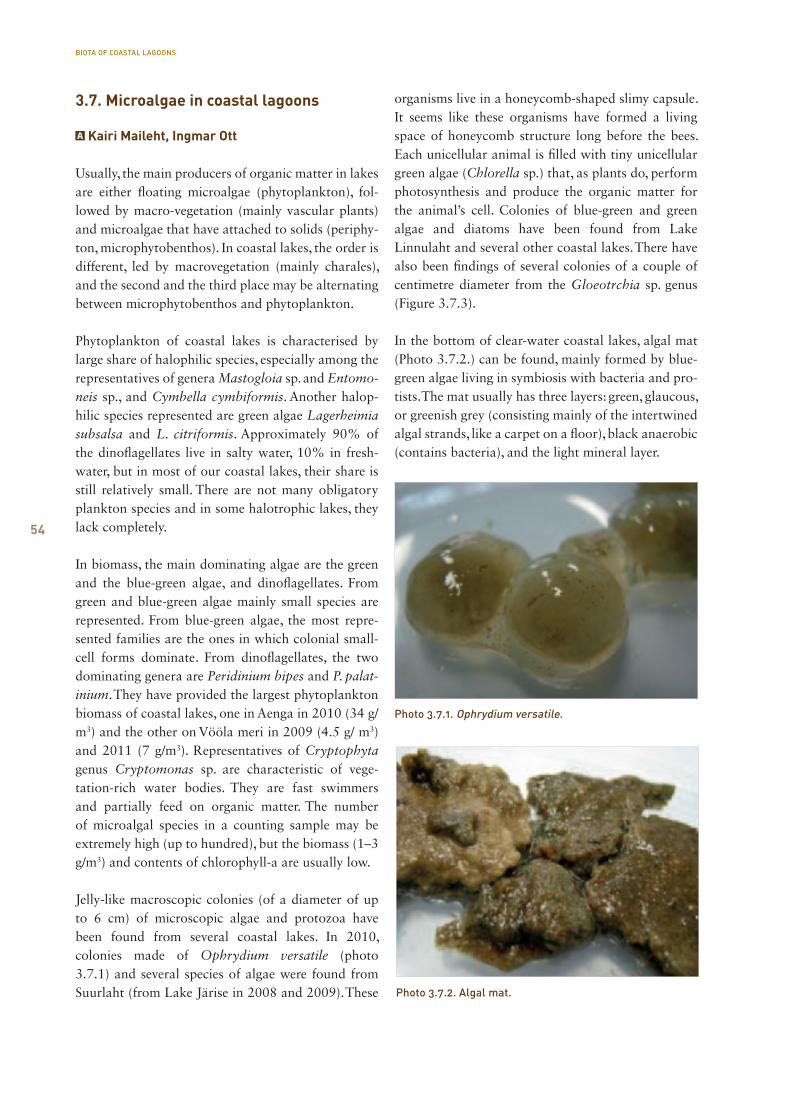
54
3.7. Microalgae in coastal lagoons
Kairi Maileht, Ingmar Ott
Usually, the main producers of organic matter in lakes are either floating microalgae (phytoplankton), fol-lowed by macro-vegetation (mainly vascular plants) and microalgae that have attached to solids (periphy-ton, microphytobenthos). In coastal lakes, the order is different, led by macrovegetation (mainly charales), and the second and the third place may be alternating between microphytobenthos and phytoplankton.
Phytoplankton of coastal lakes is characterised by large share of halophilic species, especially among the representatives of genera Mastogloia sp. and Entomo-neis sp., and Cymbella cymbiformis. Another halop-hilic species represented are green algae Lagerheimia subsalsa and L. citriformis. Approximately 90% of the dinoflagellates live in salty water, 10% in fresh-water, but in most of our coastal lakes, their share is still relatively small. There are not many obligatory plankton species and in some halotrophic lakes, they lack completely.
In biomass, the main dominating algae are the green and the blue-green algae, and dinoflagellates. From green and blue-green algae mainly small species are represented. From blue-green algae, the most repre-sented families are the ones in which colonial small-cell forms dominate. From dinoflagellates, the two dominating genera are Peridinium bipes and P. palat-inium. They have provided the largest phytoplankton biomass of coastal lakes, one in Aenga in 2010 (34 g/m3) and the other on Vööla meri in 2009 (4.5 g/ m3) and 2011 (7 g/m3). Representatives of Cryptophyta genus Cryptomonas sp. are characteristic of vege-tation-rich water bodies. They are fast swimmers and partially feed on organic matter. The number of microalgal species in a counting sample may be extremely high (up to hundred), but the biomass (1–3 g/m3) and contents of chlorophyll-a are usually low.
Jelly-like macroscopic colonies (of a diameter of up to 6 cm) of microscopic algae and protozoa have been found from several coastal lakes. In 2010, colonies made of Ophrydium versatile (photo 3.7.1) and several species of algae were found from Suurlaht (from Lake Järise in 2008 and 2009). These
organisms live in a honeycomb-shaped slimy capsule. It seems like these organisms have formed a living space of honeycomb structure long before the bees. Each unicellular animal is filled with tiny unicellular green algae (Chlorella sp.) that, as plants do, perform photosynthesis and produce the organic matter for the animal’s cell. Colonies of blue-green and green algae and diatoms have been found from Lake Linnulaht and several other coastal lakes. There have also been findings of several colonies of a couple of centimetre diameter from the Gloeotrchia sp. genus (Figure 3.7.3).
In the bottom of clear-water coastal lakes, algal mat (Photo 3.7.2.) can be found, mainly formed by blue-green algae living in symbiosis with bacteria and pro-tists. The mat usually has three layers: green, glaucous, or greenish grey (consisting mainly of the intertwined algal strands, like a carpet on a floor), black anaerobic (contains bacteria), and the light mineral layer.
Photo 3.7.1. Ophrydium versatile.
Photo 3.7.2. Algal mat.
BIOTA OF COASTAL LAGOONS
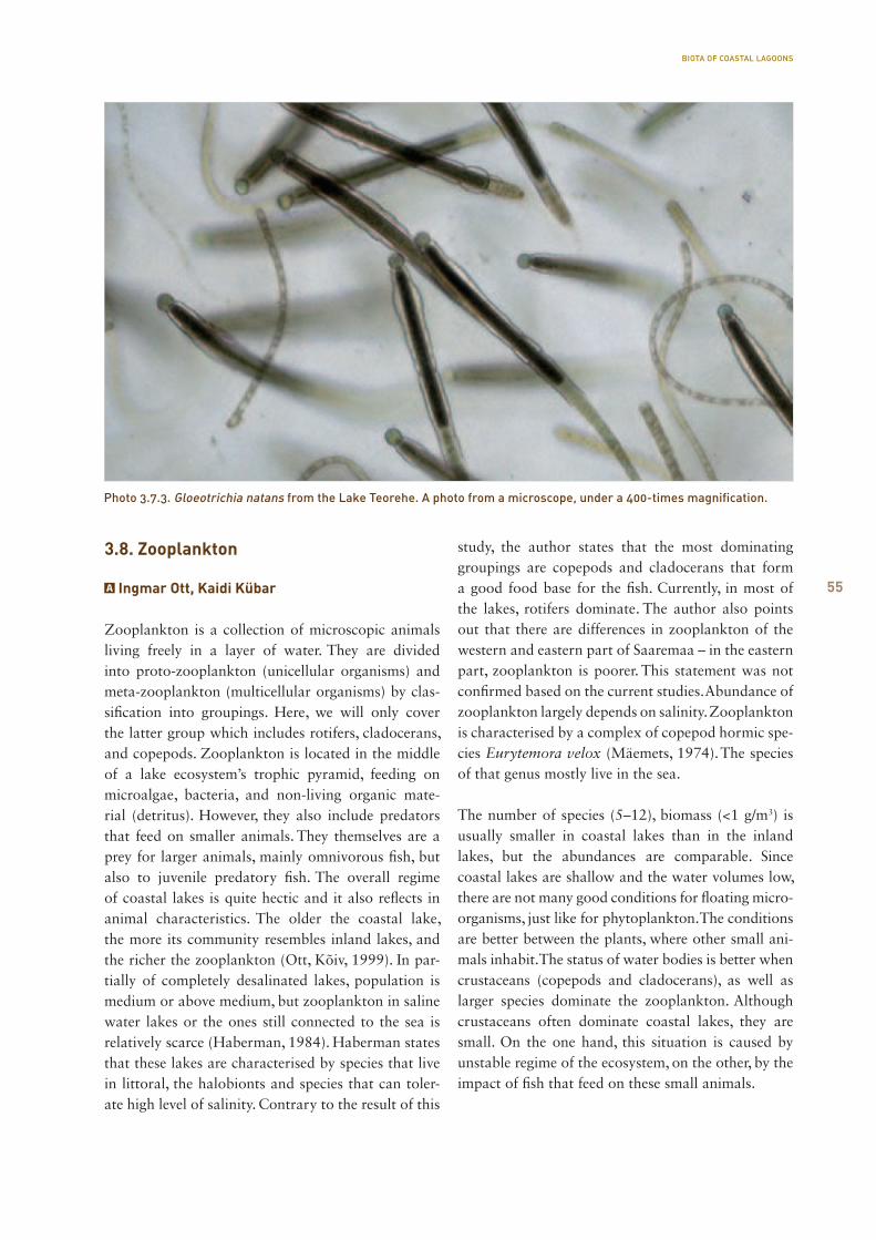
55
3.8. Zooplankton
Ingmar Ott, Kaidi Kübar
Zooplankton is a collection of microscopic animals living freely in a layer of water. They are divided into proto-zooplankton (unicellular organisms) and meta-zooplankton (multicellular organisms) by clas-sification into groupings. Here, we will only cover the latter group which includes rotifers, cladocerans, and copepods. Zooplankton is located in the middle of a lake ecosystem’s trophic pyramid, feeding on microalgae, bacteria, and non-living organic mate-rial (detritus). However, they also include predators that feed on smaller animals. They themselves are a prey for larger animals, mainly omnivorous fish, but also to juvenile predatory fish. The overall regime of coastal lakes is quite hectic and it also reflects in animal characteristics. The older the coastal lake, the more its community resembles inland lakes, and the richer the zooplankton (Ott, Kõiv, 1999). In par-tially of completely desalinated lakes, population is medium or above medium, but zooplankton in saline water lakes or the ones still connected to the sea is relatively scarce (Haberman, 1984). Haberman states that these lakes are characterised by species that live in littoral, the halobionts and species that can toler-ate high level of salinity. Contrary to the result of this
study, the author states that the most dominating groupings are copepods and cladocerans that form a good food base for the fish. Currently, in most of the lakes, rotifers dominate. The author also points out that there are differences in zooplankton of the western and eastern part of Saaremaa – in the eastern part, zooplankton is poorer. This statement was not confirmed based on the current studies. Abundance of zooplankton largely depends on salinity. Zooplankton is characterised by a complex of copepod hormic spe-cies Eurytemora velox (Mäemets, 1974). The species of that genus mostly live in the sea.
The number of species (5–12), biomass (<1 g/m3) is usually smaller in coastal lakes than in the inland lakes, but the abundances are comparable. Since coastal lakes are shallow and the water volumes low, there are not many good conditions for floating micro-organisms, just like for phytoplankton. The conditions are better between the plants, where other small ani-mals inhabit. The status of water bodies is better when crustaceans (copepods and cladocerans), as well as larger species dominate the zooplankton. Although crustaceans often dominate coastal lakes, they are small. On the one hand, this situation is caused by unstable regime of the ecosystem, on the other, by the impact of fish that feed on these small animals.
Photo 3.7.3. Gloeotrichia natans from the Lake Teorehe. A photo from a microscope, under a 400-times magnification.
BIOTA OF COASTAL LAGOONS
5656
Taking sediment samples on Linnulaht.
57
Under the project Natureship – Integrated Planning and Management in the Baltic Sea Region, nine lakes were studied in Saaremaa (Linnulaht, Mullutu bay, Suurlaht, Vägara bay, Poka bay, Põldealuse bay, Laidevahe bay, Oessaare bay, Aenga bay) and eight lakes in Läänemaa and Pärnu County (Kahvatu bay, Kasselaht, Kiissalaht, Kudani bay, Käomardi bay, Prästvike lake, Vööla meri, lake Laomäe Allikajärv). Below, we will present a summary of the studies of these lakes, and the main characterising data (eco-logical condition, species of interest, sediments and their characteristics, etc.). As to an overview of the protected species of coastal lagoons under the Nature Conservation Act, the earlier information was taken from the environmental register and the EELIS, and supplemented by newer data gathered in the course of different monitoring and study activities.
IVResults of studies of coastal lagoons
Ingmar OttKairi MailehtTeet KrauseAnu PalmKatrit KarusTõnu FeldmannAnu KisandAimar RakkoHenn TimmKaidi KübarKristine PalmMati Kose
RESULTS OF STUDIES OF COASTAL LAGOONS

58
The surface area is 16.7 ha (Tamre, 2006), the largest depth in 2010, 0.5 m. For the ecosystem of Aenga bay, it is important to have a connection to the sea, small water volume and very low depth. The composition of the biota, as well as the number of individuals, and ecological status are quite unstable. The water body is highly sensitive to impacts.
Water characteristics. The colour of the water is greenish yellow, the water was transparent to the bot-tom, 0.5 m. Amounts of dissolved organic matter are low. The water was alkaline and the pH level unusu-ally high (10.7). Very high pH level is caused by inten-sive photosynthesis. During a vegetation period, the pH regime of the water is affected by charophytes and gas exchange with sediments and the atmosphere. The water was rich in oxygen and with a high oversatu-ration (O2 16.6 mg/l; saturation 210%). The total N
concentration was high (1.9 mg N/l), being mainly composed of organic compounds; the amount of min-eral compounds was low. The total P concentration was also high (0.062 mg P/l).
The conductivity of the water was extremely high (6,560 μS/ cm) due to high concentration of dissolved substances (4.150 mg/l). The latter were dominated by chlorides (1.725 mg Cl/l). The level of sulphate ions found was also high (300 mg/l). Lake Aenga is connected to the sea and the water has marine charac-teristics rather than the ones of a lake. According to the requirements of the Water Policy Framework Directive (2002), the quality class of Aenga bay water is bad due to high concentration of total P. Poor water quality is also indicated by the high pH level and large oversaturation with oxygen.
RESULTS OF STUDIES OF COASTAL LAGOONS
4.1. Coastal lakes of Saaremaa
4.1.1. Aenga bay
Aenga bay (on the foreground) and Põldealuse bay (back left).
58
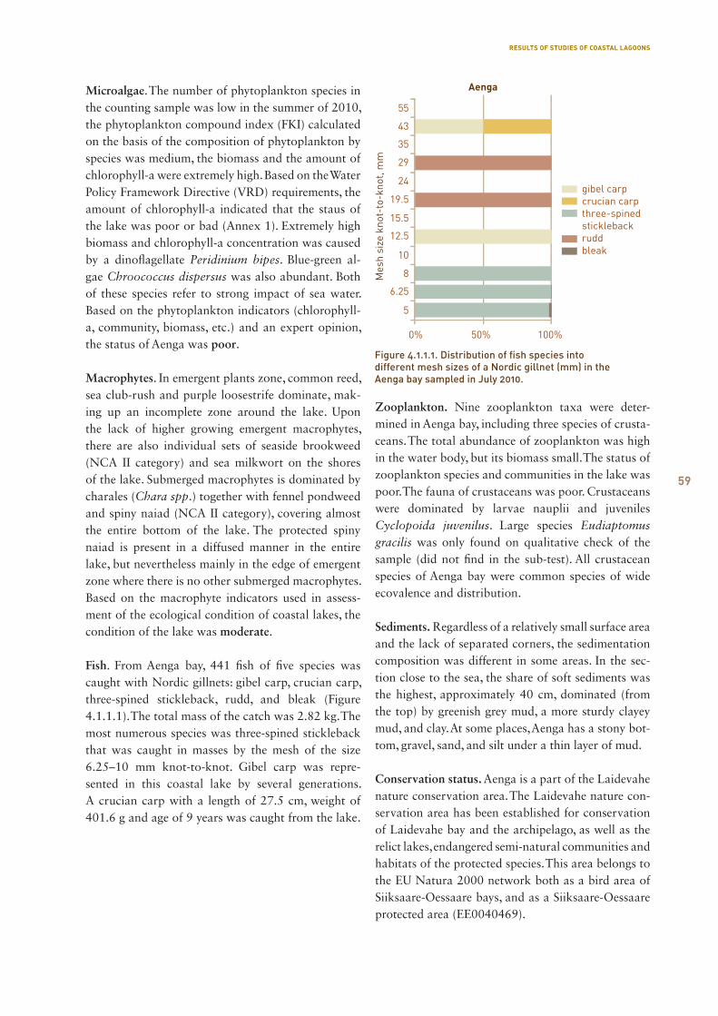
59
Microalgae. The number of phytoplankton species in the counting sample was low in the summer of 2010, the phytoplankton compound index (FKI) calculated on the basis of the composition of phytoplankton by species was medium, the biomass and the amount of chlorophyll-a were extremely high. Based on the Water Policy Framework Directive (VRD) requirements, the amount of chlorophyll-a indicated that the staus of the lake was poor or bad (Annex 1). Extremely high biomass and chlorophyll-a concentration was caused by a dinoflagellate Peridinium bipes. Blue-green al-gae Chroococcus dispersus was also abundant. Both of these species refer to strong impact of sea water. Based on the phytoplankton indicators (chlorophyll-a, community, biomass, etc.) and an expert opinion, the status of Aenga was poor.
Macrophytes. In emergent plants zone, common reed, sea club-rush and purple loosestrife dominate, mak-ing up an incomplete zone around the lake. Upon the lack of higher growing emergent macrophytes, there are also individual sets of seaside brookweed (NCA II category) and sea milkwort on the shores of the lake. Submerged macrophytes is dominated by charales (Chara spp.) together with fennel pondweed and spiny naiad (NCA II category), covering almost the entire bottom of the lake. The protected spiny naiad is present in a diffused manner in the entire lake, but nevertheless mainly in the edge of emergent zone where there is no other submerged macrophytes. Based on the macrophyte indicators used in assess-ment of the ecological condition of coastal lakes, the condition of the lake was moderate.
Fish. From Aenga bay, 441 fish of five species was caught with Nordic gillnets: gibel carp, crucian carp, three-spined stickleback, rudd, and bleak (Figure 4.1.1.1). The total mass of the catch was 2.82 kg. The most numerous species was three-spined stickleback that was caught in masses by the mesh of the size 6.25–10 mm knot-to-knot. Gibel carp was repre-sented in this coastal lake by several generations. A crucian carp with a length of 27.5 cm, weight of 401.6 g and age of 9 years was caught from the lake.
Zooplankton. Nine zooplankton taxa were deter-mined in Aenga bay, including three species of crusta-ceans. The total abundance of zooplankton was high in the water body, but its biomass small. The status of zooplankton species and communities in the lake was poor. The fauna of crustaceans was poor. Crustaceans were dominated by larvae nauplii and juveniles Cyclopoida juvenilus. Large species Eudiaptomus gracilis was only found on qualitative check of the sample (did not find in the sub-test). All crustacean species of Aenga bay were common species of wide ecovalence and distribution.
Sediments. Regardless of a relatively small surface area and the lack of separated corners, the sedimentation composition was different in some areas. In the sec-tion close to the sea, the share of soft sediments was the highest, approximately 40 cm, dominated (from the top) by greenish grey mud, a more sturdy clayey mud, and clay. At some places, Aenga has a stony bot-tom, gravel, sand, and silt under a thin layer of mud.
Conservation status. Aenga is a part of the Laidevahe nature conservation area. The Laidevahe nature con-servation area has been established for conservation of Laidevahe bay and the archipelago, as well as the relict lakes, endangered semi-natural communities and habitats of the protected species. This area belongs to the EU Natura 2000 network both as a bird area of Siiksaare-Oessaare bays, and as a Siiksaare-Oessaare protected area (EE0040469).
Figure 4.1.1.1. Distribution of fish species into different mesh sizes of a Nordic gillnet (mm) in the Aenga bay sampled in July 2010.
RESULTS OF STUDIES OF COASTAL LAGOONS
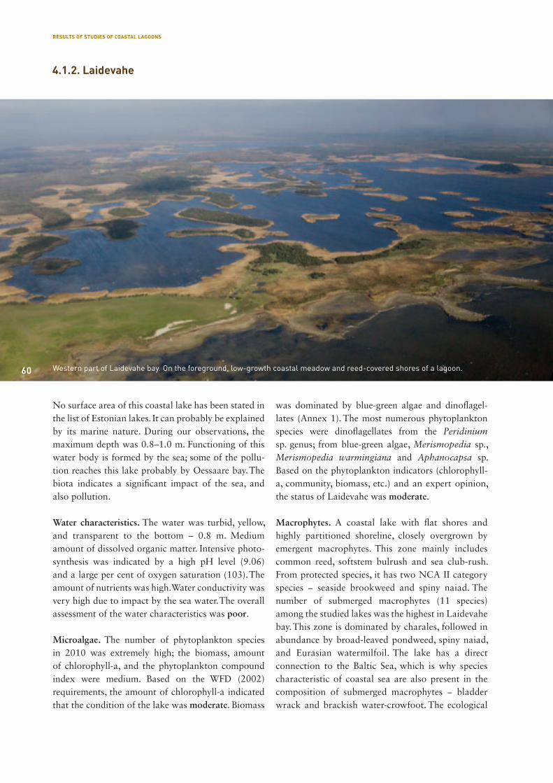
60
No surface area of this coastal lake has been stated in the list of Estonian lakes. It can probably be explained by its marine nature. During our observations, the maximum depth was 0.8–1.0 m. Functioning of this water body is formed by the sea; some of the pollu-tion reaches this lake probably by Oessaare bay. The biota indicates a significant impact of the sea, and also pollution.
Water characteristics. The water was turbid, yellow, and transparent to the bottom – 0.8 m. Medium amount of dissolved organic matter. Intensive photo-synthesis was indicated by a high pH level (9.06) and a large per cent of oxygen saturation (103). The amount of nutrients was high. Water conductivity was very high due to impact by the sea water. The overall assessment of the water characteristics was poor.
Microalgae. The number of phytoplankton species in 2010 was extremely high; the biomass, amount of chlorophyll-a, and the phytoplankton compound index were medium. Based on the WFD (2002) requirements, the amount of chlorophyll-a indicated that the condition of the lake was moderate. Biomass
was dominated by blue-green algae and dinoflagel-lates (Annex 1). The most numerous phytoplankton species were dinoflagellates from the Peridinium sp. genus; from blue-green algae, Merismopedia sp., Merismopedia warmingiana and Aphanocapsa sp. Based on the phytoplankton indicators (chlorophyll-a, community, biomass, etc.) and an expert opinion, the status of Laidevahe was moderate.
Macrophytes. A coastal lake with flat shores and highly partitioned shoreline, closely overgrown by emergent macrophytes. This zone mainly includes common reed, softstem bulrush and sea club-rush. From protected species, it has two NCA II category species − seaside brookweed and spiny naiad. The number of submerged macrophytes (11 species) among the studied lakes was the highest in Laidevahe bay. This zone is dominated by charales, followed in abundance by broad-leaved pondweed, spiny naiad, and Eurasian watermilfoil. The lake has a direct connection to the Baltic Sea, which is why species characteristic of coastal sea are also present in the composition of submerged macrophytes − bladder wrack and brackish water-crowfoot. The ecological
Western part of Laidevahe bay. On the foreground, low-growth coastal meadow and reed-covered shores of a lagoon.
4.1.2. Laidevahe
60
RESULTS OF STUDIES OF COASTAL LAGOONS

61
condition of the lake was assessed as moderate at the moment (Annex 1).
Fish. Two lines of nets were used in Laidevahe bay (12 Nordic gillnets), and 11 fish species were caught (Figure 4.1.2.1) The total catch was 19.8 kg, in total 2,580 specimen. The most numerous species was three-spined stickleback with 2,044 specimen (most of them caught by the mesh size of 10 mm knot-to knot). Almost all sections of the net captured rudd (mesh panels of 6.25–43 mm knot-to-knot). Rudds were mainly 10–17 cm in lenth. Bleak was also a numer-ous species, caught by mesh of 6.25–12.5 mm knot-to-knot, as usual. Four summers-of-age gibel carp was the most copious in Laidevahe. Of endangered species, spined loach was represented only in Laidevahe (seven specimen), not captured in any of the other studied lakes. Of predatory fish, pike was caught.
Zooplankton. 11 zooplankton taxa were identified in Laidevahe bay, including 5 species of crustaceans. The total abundance of zooplankton was high in the water body, but its biomass small. The status of zoo-plankton species and communities in the lake was poor. The average weight of zooplankter in the lake was only 0.5 mg. The low average weight is caused by abundant presence of small species. Although crustaceans included large species Diaphanosoma brachyurum and Polyphemus pediculus, their num-ber was very low. It shows that at the moment of
taking the samples, the conditions in Laidevahe bay were unsuitable for crustaceans. Copepods were also strongly dominated by larvae nauplii and juveniles Cyclopoida juvenilus.
Sediments. Laidevahe bay is cornered and rich in lit-tle islands. Due to that, the bottom sediments vary quite a lot in different areas of the lake. On the south-ern side of this coastal lagoon, sedimentation condi-tions are influenced by waves and connection to a bay; there is no soft muddy sedimentation here, or it only by a few centimetres. The bottom of the lake is mostly covered by coarse-grained sand or even gravel. Near the eastern shore of the lake, sand is covered by already 5–10 cm of mud, which is soft, of gritty structure in the south-east corner of the lake, but of a uniform structure, watery, greenish grey in the north-east section. The lake’s southwest corner is also simi-lar. Here as well, sand is covered by a relatively thin layer of mud (up to 10 cm of relatively fluid mud); only in the southwest section of the lake, in a corner safe from winds, a layer of up to 50 cm of greenish grey mud can be found, turning into a silt and clay sediment below.
In the northern and north-western section of the lake, the layer of mud is approximately 50 cm thick (up to 20 cm of a soft greenish grey mud of a gritty structure, and below that, approximately 30 cm of a thicker mud). The sediment smells of hydrogen sul-phide; in the deeper layers, the sediment becomes increasingly more clayey. In the middle of the lake, on a sediment surface, there is liquid greenish grey mud (approximately 10 cm), and below that, 50 cm of increasingly thickening and silting mud, followed by silty sand and livid clay in the depth of 100 cm.
Conservation status and the protected species. Laide-vahe bay is a part of the Laidevahe nature conserva-tion area. The Laidevahe nature conservation area has been established for conservation of Laidevahe bay and the archipelago, as well as the relict lakes, endan-gered semi-natural communities and habitats of the protected species. This area belongs to the EU Natura 2000 network both as a bird area of Siiksaare-Oes-saare bays, and as a Siiksaare-Oessaare protected area (EE0040469). The area is a habitat for the protected species listed in tables 4.1.2.1 and 4.1.2.2.
Figure 4.1.2.1 Distribution of fish species into different mesh sizes of a Nordic gillnet (mm) in the Laidevahe bay sampled in July 2010.
RESULTS OF STUDIES OF COASTAL LAGOONS

62
No. Name in Estonian Name in English Name in Latin Category Sources
1 liht-randpung seaside brookweed Samolus valerandi II Laidevahe inventory
2 emaputk marsh angelica Angelica palustris III Laidevahe inventory
3 lääne-mõõkrohi saw-sedge Cladium mariscus III Laidevahe inventory
Table 4.1.2.1. Protected plant species in the area of Laidevahe bay
Table 4.1.2.2. Protected animal species in the area of Laidevahe bay
No. Name in Estonian Name in English Name in Latin Category Sources
4 punajalg-tilder redshank Tringa totanus III EELIS
5 randtiir arctic tern Sterna paradisaea III EELIS
6 jõgitiir common tern Sterna hirundo III EELIS
7 sarvikpütt horned grebe Podiceps auritus II EELIS
8 väikekajakas little gull Larus minutus II EELIS
9 tõmmuvaeras white-winged scoter Melanitta fusca III EELIS
10 vööt-põõsaslind barred warbler Sylvia nisoria III EELIS
11 hallpõsk pütt red-necked grebe Podiceps grisegena III EELIS
12 liivatüll common ringed plover Charadrius hiaticula III EELIS
13 soopart Northern pintail Anas acula II EELIS
14 ristpart common shelduck Tadorna tadorna III EELIS
15 niidurüdi Dunlin Calidris alpina schinzii I EELIS
16 mustsaba-vigle black-tailed godwit Limosa limosa II EELIS
17 väiketiir little tern Sterna albifrons III EELIS
18 suurkoovitaja Eurasian curlew Numenius arquata III EELIS
19 punaselg-õgija red-backed shrike Lanius collurio III EELIS
The little gull is feeding.
RESULTS OF STUDIES OF COASTAL LAGOONS
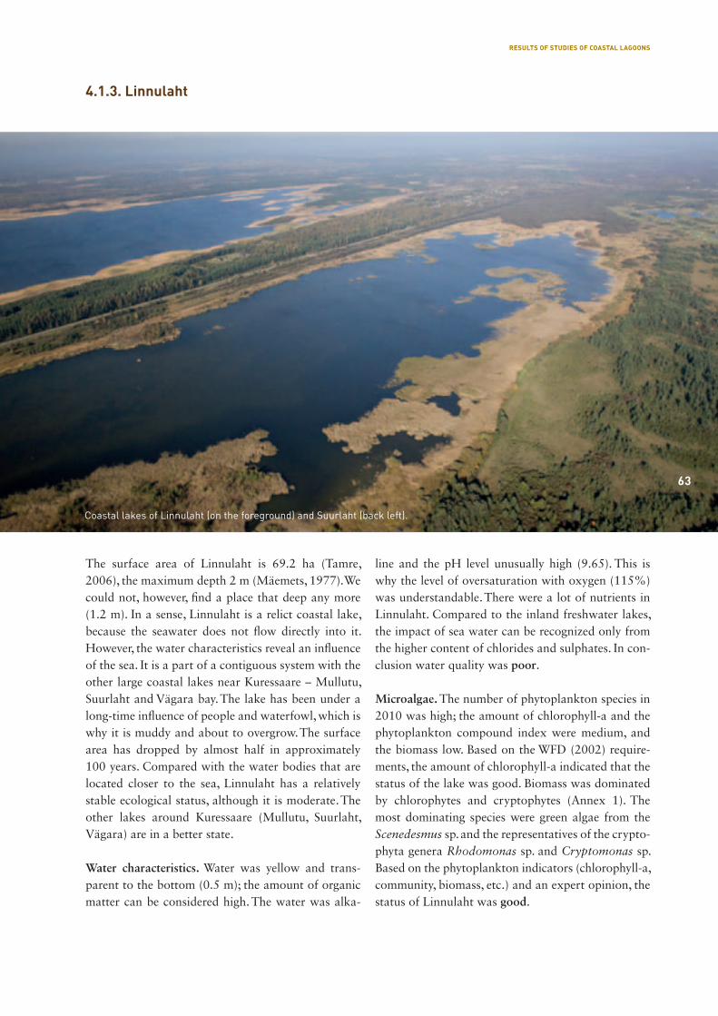
63
The surface area of Linnulaht is 69.2 ha (Tamre, 2006), the maximum depth 2 m (Mäemets, 1977). We could not, however, find a place that deep any more (1.2 m). In a sense, Linnulaht is a relict coastal lake, because the seawater does not flow directly into it. However, the water characteristics reveal an influence of the sea. It is a part of a contiguous system with the other large coastal lakes near Kuressaare – Mullutu, Suurlaht and Vägara bay. The lake has been under a long-time influence of people and waterfowl, which is why it is muddy and about to overgrow. The surface area has dropped by almost half in approximately 100 years. Compared with the water bodies that are located closer to the sea, Linnulaht has a relatively stable ecological status, although it is moderate. The other lakes around Kuressaare (Mullutu, Suurlaht, Vägara) are in a better state.
Water characteristics. Water was yellow and trans-parent to the bottom (0.5 m); the amount of organic matter can be considered high. The water was alka-
line and the pH level unusually high (9.65). This is why the level of oversaturation with oxygen (115%) was understandable. There were a lot of nutrients in Linnulaht. Compared to the inland freshwater lakes, the impact of sea water can be recognized only from the higher content of chlorides and sulphates. In con-clusion water quality was poor.
Microalgae. The number of phytoplankton species in 2010 was high; the amount of chlorophyll-a and the phytoplankton compound index were medium, and the biomass low. Based on the WFD (2002) require-ments, the amount of chlorophyll-a indicated that the status of the lake was good. Biomass was dominated by chlorophytes and cryptophytes (Annex 1). The most dominating species were green algae from the Scenedesmus sp. and the representatives of the crypto-phyta genera Rhodomonas sp. and Cryptomonas sp. Based on the phytoplankton indicators (chlorophyll-a, community, biomass, etc.) and an expert opinion, the status of Linnulaht was good.
4.1.3. Linnulaht
Coastal lakes of Linnulaht (on the foreground) and Suurlaht (back left).
63
RESULTS OF STUDIES OF COASTAL LAGOONS
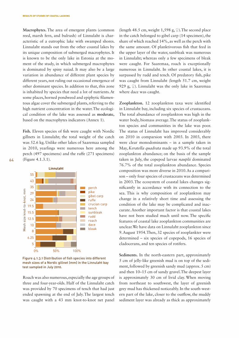
64
Macrophytes. The area of emergent plants (common reed, marsh fern, and bulrush) of Linnulaht is char-acteristic of a eutrophic lake with swamped shores. Linnulaht stands out from the other coastal lakes by its unique composition of submerged macrophytes. It is known to be the only lake in Estonia at the mo-ment of the study, in which submerged macrophytes is dominated by spiny naiad. It may also be a large variation in abundance of different plant species by different years, not ruling out occasional emergence of other dominant species. In addition to that, this zone is inhabited by species that need a lot of nutrients. At some places, horned pondweed and epiphytic filamen-tous algae cover the submerged plants, referring to the high nutrient concentration in the water. The ecologi-cal condition of the lake was assessed as moderate, based on the macrophytes indicators (Annex 1).
Fish. Eleven species of fish were caught with Nordic gillnets in Linnulaht; the total weight of the catch was 52.6 kg. Unlike other lakes of Saaremaa sampled in 2010, yearlings were numerous here among the perch (497 specimens) and the ruffe (271 specimens) (Figure 4.1.3.1).
Roach was also numerous, especially the age groups of three and four-year-olds. Half of the Linnulaht catch was provided by 70 specimens of tench that had just ended spawning at the end of July. The largest tench was caught with a 43 mm knot-to-knot net panel
(length 48.5 cm, weight 1,598 g, ♀). The second place in the catch belonged to gibel carp (14 specimen), the share of which reached 14%, as well as the perch with the same amount. Of planktivorous fish that feed in the upper layer of the water, sunbleak was numerous in Linnulaht; whereas only a few specimens of bleak were caught. For Saaremaa, roach is exceptionally numerous in Linnulaht. In other coastal lakes, it is surpassed by rudd and tench. Of predatory fish, pike was caught from Linnulaht (length 51.7 cm, weight 929 g, ♀). Linnulaht was the only lake in Saaremaa where dace was caught.
Zooplankton. 12 zooplankton taxa were identified in Linnulaht bay, including six species of crustaceans. The total abundance of zooplankton was high in the water body, biomass average. The status of zooplank-ton species and communities in the lake was poor. The status of Linnulaht has improved considerably on 2010 in comparsion with 2003. In 2003, there were clear monodominants – in a sample taken in May, Keratella quadrata made up 93.9% of the total zooplankton abundance; on the basis of the sample taken in July, the copepod larvae nauplii dominated 76.7% of the total zooplankton abundance. Species composition was more diverse in 2010. As a compari-son – only four species of crustaceans was determined in 2003. The ecosystem of coastal lakes changes sig-nificantly in accordance with its connection to the sea. This is why composition of zooplankton may change in a relatively short time and assessing the condition of the lake may be complicated and inac-curate. Another important factor is that coastal lakes have not been studied much until now. The specific features of coastal lake zooplankton communities are unclear. We have data on Linnulaht zooplankton since 9. August 1954. Then, 32 species of zooplankter were determined – six species of copepods, 16 species of cladocerans, and ten species of rotifers.
Sediments. In the north-eastern part, approximately 5 cm of jelly-like greenish mud is on top of the sedi-ment, followed by greenish sandy mud (approx. 5 cm) and then 10–15 cm of sandy gravel. The deepest layer is approximately 30 cm of livid clay. When moving from northeast to southwest, the layer of greenish grey mud has thickened noticeably. In the south-west-ern part of the lake, closer to the outflow, the muddy sediment layer was already as thick as approximately
Figure 4.1.3.1 Distribution of fish species into different mesh sizes of a Nordic gillnet (mm) in the Linnulaht bay test sampled in July 2010.
RESULTS OF STUDIES OF COASTAL LAGOONS

65
1.5 m; the mud in the lower, about 25 cm layer, was thicker, more silty.
The sediment of Linnulaht has high water content: in its surface layer, there was only 3.43% of dry mat-ter, further 35 cm deeper, it was 19.2%. Deeper sedi-ment layers were considerably more clayey and thick, containing 36–41% of dry matter (Figure 4.1.3.2). Sediment dry matter divides into organic, calcare-ous, and terrigenic component. It is characteristic to Linnulaht to have a high content of organic matter in the upper sediment layers (Figure 4.1.3.3).
It is highly important to be aware of the possible self-contaminating sediment of a lake — can the nutri-ents in it move back to the water, feeding plants and algae. This can be assessed by the main nutrient salt, phosphorus. The amounts of phosphorus were rela-tively high in Linnulaht sediment. The main reason is the high share of phosphorus bound with organic matter, which is related to the high organic matter content of the sediment (up to 50%, Figure 4.1.3.4).
The most labile of phosphorus fractions is considered to be a mobile phosphorus fraction. Phosphorus tends to be released from the Fe/Al P composition in case of a drop in the redox potential or a rise in the pH level. Phosphorus fractions bound to an organic mat-ter are also considered a potential source of phospho-rus, while a phosphorus fraction bound to calcium is relatively inert and does not contribute to separa-tion of phosphorus from the sediment. However, the sediment tests carried out revealed that the Linnulaht sediment extracts less phosphorus than, for example, Oessaare bay sediment that actually has lower abso-lute amounts of P.
Conservation status and the protected species. Lin-nulaht is a part of the Linnulaht protected area. It is a protected area of unrenewed protection proce dure, on which a 1937 decision by President-Regent K. Päts, Minister of Agriculture A. Tupits, and Undersecretary of State K. Terras on establishment of a protected area still applies. Kuressaare local government took the
Figure 4.1.3.4. Distribution of phosphorus fractions in the Linnulaht sediment.
Figure 4.1.3.2. Dry matter content of Linnulaht sediment.
Figure 4.1.3.3. Dry matter composition of Linnulaht sediment.
RESULTS OF STUDIES OF COASTAL LAGOONS
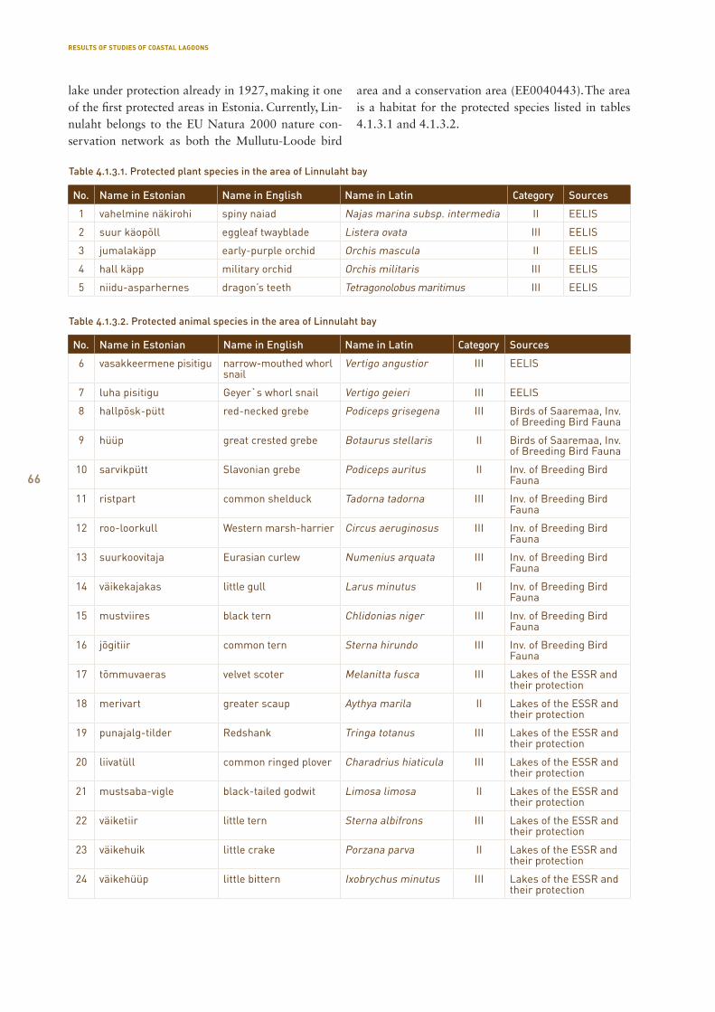
66
No. Name in Estonian Name in English Name in Latin Category Sources
1 vahelmine näkirohi spiny naiad Najas marina subsp. intermedia II EELIS
2 suur käopõll eggleaf twayblade Listera ovata III EELIS
3 jumalakäpp early-purple orchid Orchis mascula II EELIS
4 hall käpp military orchid Orchis militaris III EELIS
5 niidu-asparhernes dragon’s teeth Tetragonolobus maritimus III EELIS
Table 4.1.3.1. Protected plant species in the area of Linnulaht bay
Table 4.1.3.2. Protected animal species in the area of Linnulaht bay
No. Name in Estonian Name in English Name in Latin Category Sources
6 vasakkeermene pisitigu narrow-mouthed whorl snail
Vertigo angustior III EELIS
7 luha pisitigu Geyer`s whorl snail Vertigo geieri III EELIS
8 hallpõsk-pütt red-necked grebe Podiceps grisegena III Birds of Saaremaa, Inv. of Breeding Bird Fauna
9 hüüp great crested grebe Botaurus stellaris II Birds of Saaremaa, Inv. of Breeding Bird Fauna
10 sarvikpütt Slavonian grebe Podiceps auritus II Inv. of Breeding Bird Fauna
11 ristpart common shelduck Tadorna tadorna III Inv. of Breeding Bird Fauna
12 roo-loorkull Western marsh-harrier Circus aeruginosus III Inv. of Breeding Bird Fauna
13 suurkoovitaja Eurasian curlew Numenius arquata III Inv. of Breeding Bird Fauna
14 väikekajakas little gull Larus minutus II Inv. of Breeding Bird Fauna
15 mustviires black tern Chlidonias niger III Inv. of Breeding Bird Fauna
16 jõgitiir common tern Sterna hirundo III Inv. of Breeding Bird Fauna
17 tõmmuvaeras velvet scoter Melanitta fusca III Lakes of the ESSR and their protection
18 merivart greater scaup Aythya marila II Lakes of the ESSR and their protection
19 punajalg-tilder Redshank Tringa totanus III Lakes of the ESSR and their protection
20 liivatüll common ringed plover Charadrius hiaticula III Lakes of the ESSR and their protection
21 mustsaba-vigle black-tailed godwit Limosa limosa II Lakes of the ESSR and their protection
22 väiketiir little tern Sterna albifrons III Lakes of the ESSR and their protection
23 väikehuik little crake Porzana parva II Lakes of the ESSR and their protection
24 väikehüüp little bittern Ixobrychus minutus III Lakes of the ESSR and their protection
lake under protection already in 1927, making it one of the first protected areas in Estonia. Currently, Lin-nulaht belongs to the EU Natura 2000 nature con-servation network as both the Mullutu-Loode bird
area and a conservation area (EE0040443). The area is a habitat for the protected species listed in tables 4.1.3.1 and 4.1.3.2.
RESULTS OF STUDIES OF COASTAL LAGOONS
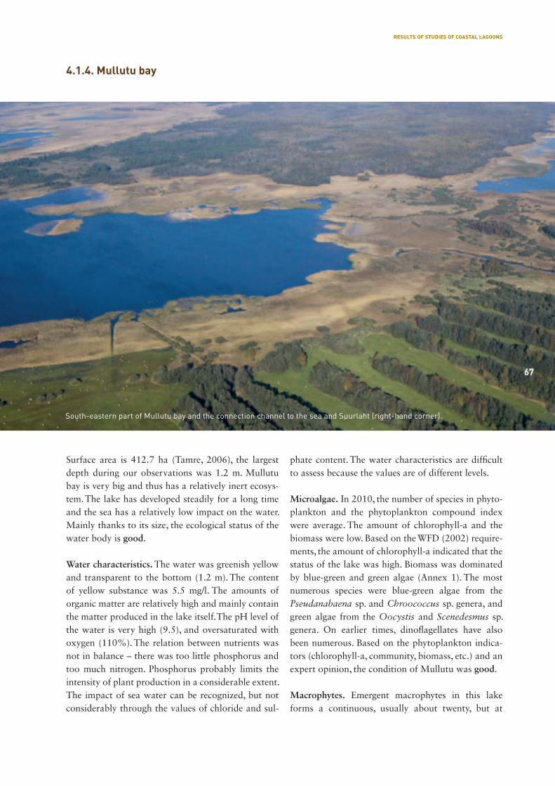
67
Surface area is 412.7 ha (Tamre, 2006), the largest depth during our observations was 1.2 m. Mullutu bay is very big and thus has a relatively inert ecosys-tem. The lake has developed steadily for a long time and the sea has a relatively low impact on the water. Mainly thanks to its size, the ecological status of the water body is good.
Water characteristics. The water was greenish yellow and transparent to the bottom (1.2 m). The content of yellow substance was 5.5 mg/l. The amounts of organic matter are relatively high and mainly contain the matter produced in the lake itself. The pH level of the water is very high (9.5), and oversaturated with oxygen (110%). The relation between nutrients was not in balance – there was too little phosphorus and too much nitrogen. Phosphorus probably limits the intensity of plant production in a considerable extent. The impact of sea water can be recognized, but not considerably through the values of chloride and sul-
phate content. The water characteristics are difficult to assess because the values are of different levels.
Microalgae. In 2010, the number of species in phyto-plankton and the phytoplankton compound index were average. The amount of chlorophyll-a and the biomass were low. Based on the WFD (2002) require-ments, the amount of chlorophyll-a indicated that the status of the lake was high. Biomass was dominated by blue-green and green algae (Annex 1). The most numerous species were blue-green algae from the Pseudanabaena sp. and Chroococcus sp. genera, and green algae from the Oocystis and Scenedesmus sp. genera. On earlier times, dinoflagellates have also been numerous. Based on the phytoplankton indica-tors (chlorophyll-a, community, biomass, etc.) and an expert opinion, the condition of Mullutu was good.
Macrophytes. Emergent macrophytes in this lake forms a continuous, usually about twenty, but at
4.1.4. Mullutu bay
South-eastern part of Mullutu bay and the connection channel to the sea and Suurlaht (right-hand corner).
67
RESULTS OF STUDIES OF COASTAL LAGOONS
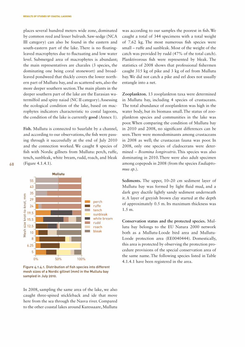
68
places several hundred meters wide zone, dominated by common reed and lesser bulrush. Saw-sedge (NCA III category) can also be found in the eastern and south-eastern part of the lake. There is no floating-leaved macrophytes due to fluctuating and low water level. Submerged area of macrophytes is abundant; the main representatives are charales (3 species, the dominating one being coral stonewort) and broad-leaved pondweed that thickly covers the lower north-ern part of Mullutu bay, and as scattered sets, also the more deeper southern section. The main plants in the deeper southern part of the lake are the Eurasian wa-termilfoil and spiny naiad (NC II category). Assessing the ecological condition of the lake, based on mac-rophytes indicators characteristic to costal lagoons, the condition of the lake is currently good (Annex 1).
Fish. Mullutu is connected to Suurlaht by a channel, and according to our observations, the fish were pass-ing through it successfully at the end of July 2010 and the connection worked. We caught 8 species of fish with Nordic gillnets from Mullutu: perch, ruffe, tench, sunbleak, white bream, rudd, roach, and bleak (Figure 4.1.4.1).
In 2008, sampling the same area of the lake, we also caught three-spined stickleback and ide that move here from the sea through the Nasva river. Compared to the other coastal lakes around Kuressaare, Mullutu
was according to our samples the poorest in fish. We caught a total of 344 specimens with a total weight of 7.62 kg. The most numerous fish species were small – ruffe and sunbleak. Most of the weight of the catch was provided by rudd (47% of the total catch). Planktivorous fish were represented by bleak. The statistics of 2008 shows that professional fishermen caught 315 kg of pike and 3 kg of eel from Mullutu bay. We did not catch a pike and eel does not usually entangle into a net.
Zooplankton. 13 zooplankton taxa were determined in Mullutu bay, including 4 species of crustaceans. The total abundance of zooplankton was high in the water body, but its biomass small. The status of zoo-plankton species and communities in the lake was poor. When comparing the condition of Mullutu bay in 2010 and 2008, no significant differences can be seen. There were monodominants among crustaceans in 2008 as well; the crustacean fauna was poor. In 2008, only one species of cladocerans were deter-mined – Bosmina longirostris. This species was also dominating in 2010. There were also adult specimen among copepods in 2008 (from the species Eudiapto-mus sp.).
Sediments. The upper, 10–20 cm sediment layer of Mullutu bay was formed by light fluid mud, and a dark grey ductile lightly sandy sediment underneath it. A layer of greyish brown clay started at the depth of approximately 0.5 m. Its maximum thickness was 1.5 m.
Conservation status and the protected species. Mul-lutu bay belongs to the EU Natura 2000 network both as a Mullutu-Loode bird area and Mullutu-Loode protection area (EE0040444). Domestically, this area is protected by observing the protection pro-cedure provisions of the special conservation area of the same name. The following species listed in Table 4.1.4.1 have been registered in the area.
Figure 4.1.4.1. Distribution of fish species into different mesh sizes of a Nordic gillnet (mm) in the Mullutu bay sampled in July 2010.
RESULTS OF STUDIES OF COASTAL LAGOONS

69
Table 4.1.4.1. Protected animal species in the area of Mullutu bay
No. Name in Estonian Name in English Name in Latin Category Sources
1 hüüp great bitten Botaurus stellaris II EELIS, Inv. of Breeding Bird
Fauna
2 mustviires black tern Chlidonias niger III Birds of Saaremaa, Inv. of
Breeding Bird Fauna
3 hallpõsk-pütt red-necked grebe Podiceps grisegena III Birds of Saaremaa
4 roo-loorkull western marsh-harrier Circus aeruginosus III Inv. of Breeding Bird Fauna
5 sookurg common crane Grus grus III Inv. of Breeding Bird Fauna
6 rooruik water rail Rallus aquaticus III Inv. of Breeding Bird Fauna
7 liivatüll common ringed plover Charadrius hiaticula III Inv. of Breeding Bird Fauna
8 heletilder common greenshank Tringa nebularia III Inv. of Breeding Bird Fauna
9 punajalg-tilder redshank Tringa totanus II Inv. of Breeding Bird Fauna
10 mustsaba vigle black-tailed godwit Limosa limosa II Inv. of Breeding Bird Fauna
11 tutkas ruff Philomachus pugnax I Inv. of Breeding Bird Fauna
12 väikekajakas little gull Larus minutus II Inv. of Breeding Bird Fauna
13 räusktiir Caspian tern Sterna caspia III Inv. of Breeding Bird Fauna
14 jõgitiir common tern Sterna hirundo III Inv. of Breeding Bird Fauna
15 randtiir Arctic tern Sterna paradisaea III Inv. of Breeding Bird Fauna
16 laululuik whooper swan Cygnus cygnus II Inv. of Breeding Bird Fauna
17 väiketiir little tern Sterna albifrons III Lakes of the ESSR and their
protection
View on Mullutu bay from the southern shore.
RESULTS OF STUDIES OF COASTAL LAGOONS
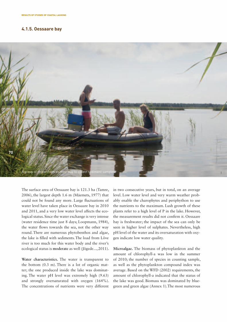
70
The surface area of Oessaare bay is 121.3 ha (Tamre, 2006), the largest depth 1.6 m (Mäemets, 1977) that could not be found any more. Large fluctuations of water level have taken place in Oessaare bay in 2010 and 2011, and a very low water level affects the eco-logical status. Since the water exchange is very intense (water residence time just 8 days; Loopmann, 1984), the water flows towards the sea, not the other way round. There are numerous phytobenthos and algae, the lake is filled with sediments. The load from Lõve river is too much for this water body and the river’s ecological status is moderate as well (Jõgede..., 2011).
Water characteristics. The water is transparent to the bottom (0.3 m). There is a lot of organic mat-ter; the one produced inside the lake was dominat-ing. The water pH level was extremely high (9.63) and strongly oversaturated with oxygen (164%). The concentrations of nutrients were very different
in two consecutive years, but in total, on an average level. Low water level and very warm weather prob-ably enable the charophytes and periphython to use the nutrients to the maximum. Lush growth of these plants refer to a high level of P in the lake. However, the measurement results did not confirm it. Oessaare bay is freshwater; the impact of the sea can only be seen in higher level of sulphates. Nevertheless, high pH level of the water and its oversaturation with oxy-gen indicate low water quality.
Microalgae. The biomass of phytoplankton and the amount of chlorophyll-a was low in the summer of 2010; the number of species in counting sample, as well as the phytoplankton compound index was average. Based on the WFD (2002) requirements, the amount of chlorophyll-a indicated that the status of the lake was good. Biomass was dominated by blue-green and green algae (Annex 1). The most numerous
4.1.5. Oessaare bay
A group of researchers on their way to collect sediment samples.
70
RESULTS OF STUDIES OF COASTAL LAGOONS
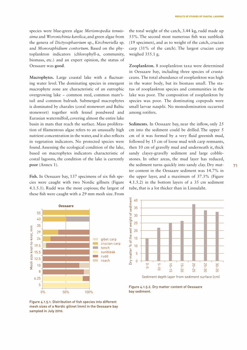
71
species were blue-green algae Merismopedia tenuis-sima and Woronichinia karelica, and green algae from the genera of Dictyosphaerium sp., Kirchneriella sp. and Monoraphidium contortum. Based on the phy-toplankton indicators (chlorophyll-a, community, biomass, etc.) and an expert opinion, the status of Oessaare was good.
Macrophytes. Large coastal lake with a fluctuat-ing water level. The dominating species in emergent macrophyte zone are characteristic of an eutrophic overgrowing lake − common reed, common mare’s-tail and common bulrush. Submerged macrophytes is dominated by charales (coral stonewort and Baltic stonewort) together with fennel pondweed and Eurasian watermilfoil, covering almost the entire lake basin in mats that reach the surface. Mass prolifera-tion of filamentous algae refers to an unusually high nutrient concentration in the water, and it also reflects in vegetation indicators. No protected species were found. Assessing the ecological condition of the lake, based on macrophytes indicators characteristic of costal lagoons, the condition of the lake is currently poor (Annex 1).
Fish. In Oessaare bay, 137 specimens of six fish spe-cies were caught with two Nordic gillnets (Figure 4.1.5.1). Rudd was the most copious; the largest of these fish were caught with a 29 mm mesh size. From
the total weight of the catch, 3.44 kg, rudd made up 53%. The second most numerous fish was sunbleak (19 specimen), and as to weight of the catch, crucian carp (31% of the catch). The largest crucian carp weighed 355.1 g.
Zooplankton. 8 zooplankton taxa were determined in Oessaare bay, including three species of crusta-ceans. The total abundance of zooplankton was high in the water body, but its biomass small. The sta-tus of zooplankton species and communities in the lake was poor. The composition of zooplankton by species was poor. The dominating copepods were small larvae nauplii. No monodomination occurred among rotifers.
Sediments. In Oessaare bay, near the inflow, only 25 cm into the sediment could be drilled. The upper 5 cm of it was formed by a very fluid greenish mud, followed by 15 cm of loose mud with carp remnants, then 10 cm of gravelly mud and underneath it, thick sandy clayey-gravelly sediment and large cobble-stones. In other areas, the mud layer has reduced, the sediment turns quickly into sandy clay. Dry mat-ter content in the Oessaare sediment was 14.7% in the upper layer, and a maximum of 37.3% (Figure 4.1.5.2) in the bottom layers of a 35 cm sediment tube, that is a lot thicker than in Linnulaht.
Oessaare
100%
gibel carpcrucian carptenchsunbleakruddroach
Mes
h si
ze k
not-
to-k
not,
mm
5
0% 50%
6.25
8
10
12.5
15.5
19.5
24
29
35
43
55
Figure 4.1.5.1. Distribution of fish species into different mesh sizes of a Nordic gillnet (mm) in the Oessaare bay sampled in July 2010.
Figure 4.1.5.2. Dry matter content of Oessaare bay sediment.
RESULTS OF STUDIES OF COASTAL LAGOONS
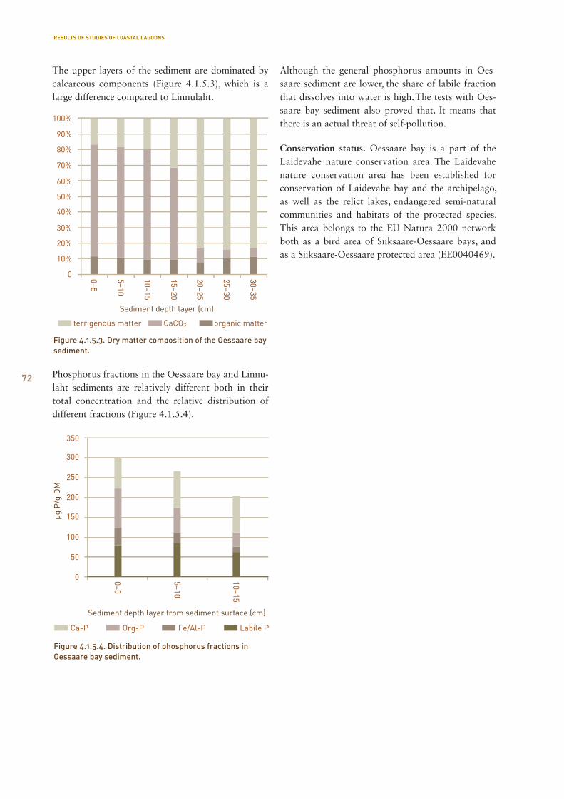
72
The upper layers of the sediment are dominated by calcareous components (Figure 4.1.5.3), which is a large difference compared to Linnulaht.
Phosphorus fractions in the Oessaare bay and Linnu-laht sediments are relatively different both in their total concentration and the relative distribution of different fractions (Figure 4.1.5.4).
Although the general phosphorus amounts in Oes-saare sediment are lower, the share of labile fraction that dissolves into water is high. The tests with Oes-saare bay sediment also proved that. It means that there is an actual threat of self-pollution.
Conservation status. Oessaare bay is a part of the Laide vahe nature conservation area. The Laidevahe nature conservation area has been established for conservation of Laidevahe bay and the archipelago, as well as the relict lakes, endangered semi-natural communities and habitats of the protected species. This area belongs to the EU Natura 2000 network both as a bird area of Siiksaare-Oessaare bays, and as a Siiksaare-Oessaare protected area (EE0040469).
Figure 4.1.5.3. Dry matter composition of the Oessaare bay sediment.
Figure 4.1.5.4. Distribution of phosphorus fractions in Oessaare bay sediment.
RESULTS OF STUDIES OF COASTAL LAGOONS
73
4.1.6. Poka bay
Poka bay is actually a creek of Oessaare bay. This is why the characteristics of these water bodies are simi-lar. There are small dissimilarities in characteristics of the water and sediment distribution.
Water characteristics. The water was transparent to the bottom. The amounts of dissolved organic matter were high and the matter produced in the water body dominated. PH of the water, as well as oversaturation with oxygen were exceptionally high (9.63 and 204% accordingly). The nutrients, phosphorus and nitrogen, were present in medium and large amount respective-ly. Increased contents of chlorides and sulphates in Poka bay refer to the impact of the sea. In Oessaare bay, the values of these indicators were lower. This situation can be explained by high level of water ex-change in Oessaare bay, in which freshwater is flushed through the water body, leaving one corner of it un-touched by its impact. Although a ditch enters into Poka bay from the catchment area, its flow amounts are significantly smaller compared to Oessaare and Lõve river that flows into Poka bay. In total, the water characteristics border between moderate and poor.
Microalgae. The biomass of phytoplankton in 2010 was low; the concentration of chlorophyll-a, the number of species in the counting sample, as well as the phytoplankton compound index were average. Based on the WFD (2002) requirements, the amount of chlorophyll-a indicated that the status of the lake was good. Biomass was dominated by dinoflagellates and chrysophytes (Annex 1). The most numerous spe-cies were dinoflagellates from the Peridinium sp. and Peridinopsis sp. genera; and chrysophytes from the Mallomonas sp. and Uroglena sp. genera. Blue-green algae from the Merismopedia sp. genus were also nu-merous, but they did not give significant biomass due to their small dimensions. Based on the phytoplank-ton indicators (chlorophyll-a, community, biomass, etc.) and an expert opinion, the status of Poka bay was good.
Macrophytes. The lake basin is very low and mud-died, therefore submerged macrophytes cover the en-tire lake bottom. No protected species that inhabit coastal lagoons were found. Submerged macrophytes is characterised by community of fennel pondweed
dominated by charales (three species). Unlike Oes-saare bay, Poka bay also has some species of blad-derworts. The ecological condition of the lake was assessed as moderate at the moment, based on the macrophytes indicators (Annex 1).
Sediments. Poka bay is a small corner of Oessaare bay, but their sediments have quite a different thickness. In the southern testing point, there was approximately 5 cm of liquid greenish grey sediment, below that, 5 cm of jelly-like mud, followed by 20 cm of clayey-like sediment, and then 20 cm of greenish grey clay. In the north-western part, the thickness of a softer and more viscous sediment was 50 cm, covering stones. In the middle part of the bay, approximately 45 cm of sedi-ment was formed by a semi-liquid and greenish grey sediment of approximately 15 cm of thickness on the top, then a 20 cm layer of clayey-structured and then 10 cm of even more coarse-grained structured sedi-ment, followed by clay.
Conservation status. Poka bay is a part of the Laide-vahe nature conservation area. The Laidevahe nature conservation area has been established for conserva-tion of Laidevahe bay and the archipelago, as well as the relict lakes, endangered semi-natural communities and habitats of the protected species. This area be-longs to the EU Natura 2000 network both as a bird area of Siiksaare-Oessaare bays, and as a Siiksaare-Oessaare protected area (EE0040469).
Ichthyologists at field work on fish fauna observation.
RESULTS OF STUDIES OF COASTAL LAGOONS
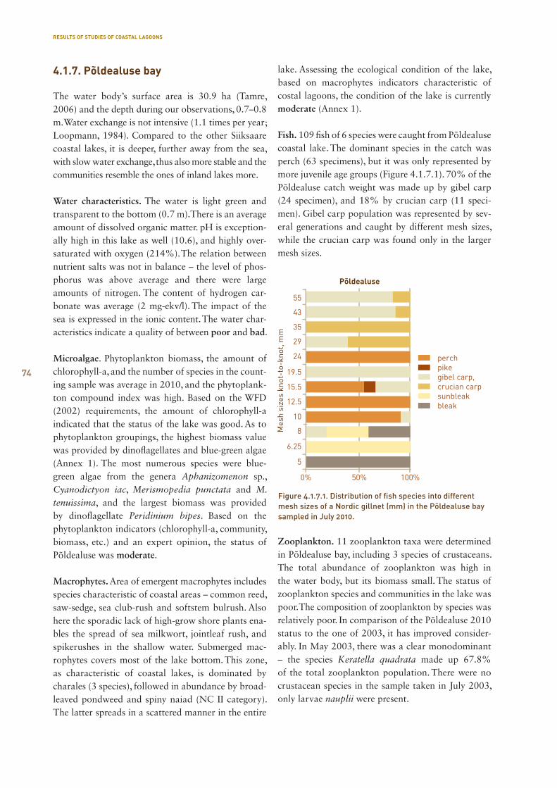
74
The water body’s surface area is 30.9 ha (Tamre, 2006) and the depth during our observations, 0.7–0.8 m. Water exchange is not intensive (1.1 times per year; Loopmann, 1984). Compared to the other Siiksaare coastal lakes, it is deeper, further away from the sea, with slow water exchange, thus also more stable and the communities resemble the ones of inland lakes more.
Water characteristics. The water is light green and transparent to the bottom (0.7 m). There is an average amount of dissolved organic matter. pH is exception-ally high in this lake as well (10.6), and highly over-saturated with oxygen (214%). The relation between nutrient salts was not in balance – the level of phos-phorus was above average and there were large amounts of nitrogen. The content of hydrogen car-bonate was average (2 mg-ekv/l). The impact of the sea is expressed in the ionic content. The water char-acteristics indicate a quality of between poor and bad.
Microalgae. Phytoplankton biomass, the amount of chlorophyll-a, and the number of species in the count-ing sample was average in 2010, and the phytoplank-ton compound index was high. Based on the WFD (2002) requirements, the amount of chlorophyll-a indicated that the status of the lake was good. As to phytoplankton groupings, the highest biomass value was provided by dinoflagellates and blue-green algae (Annex 1). The most numerous species were blue-green algae from the genera Aphanizomenon sp., Cyanodictyon iac, Merismopedia punctata and M. tenuissima, and the largest biomass was provided by dinoflagellate Peridinium bipes. Based on the phytoplankton indicators (chlorophyll-a, community, biomass, etc.) and an expert opinion, the status of Põldealuse was moderate.
Macrophytes. Area of emergent macrophytes includes species characteristic of coastal areas – common reed, saw-sedge, sea club-rush and softstem bulrush. Also here the sporadic lack of high-grow shore plants ena-bles the spread of sea milkwort, jointleaf rush, and spikerushes in the shallow water. Submerged mac-rophytes covers most of the lake bottom. This zone, as characteristic of coastal lakes, is dominated by charales (3 species), followed in abundance by broad-leaved pondweed and spiny naiad (NC II category). The latter spreads in a scattered manner in the entire
lake. Assessing the ecological condition of the lake, based on macrophytes indicators characteristic of costal lagoons, the condition of the lake is currently moderate (Annex 1).
Fish. 109 fish of 6 species were caught from Põldealuse coastal lake. The dominant species in the catch was perch (63 specimens), but it was only represented by more juvenile age groups (Figure 4.1.7.1). 70% of the Põldealuse catch weight was made up by gibel carp (24 specimen), and 18% by crucian carp (11 speci-men). Gibel carp population was represented by sev-eral generations and caught by different mesh sizes, while the crucian carp was found only in the larger mesh sizes.
Zooplankton. 11 zooplankton taxa were determined in Põldealuse bay, including 3 species of crustaceans. The total abundance of zooplankton was high in the water body, but its biomass small. The status of zooplankton species and communities in the lake was poor. The composition of zooplankton by species was relatively poor. In comparison of the Põldealuse 2010 status to the one of 2003, it has improved consider-ably. In May 2003, there was a clear monodominant – the species Keratella quadrata made up 67.8% of the total zooplankton population. There were no crustacean species in the sample taken in July 2003, only larvae nauplii were present.
Figure 4.1.7.1. Distribution of fish species into different mesh sizes of a Nordic gillnet (mm) in the Põldealuse bay sampled in July 2010.
4.1.7. Põldealuse bay
RESULTS OF STUDIES OF COASTAL LAGOONS
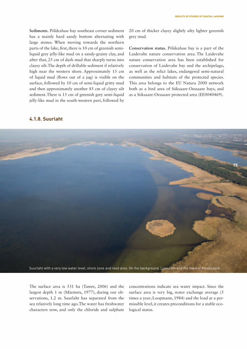
75
Sediments. Põldealuse bay southeast corner sediment has a mainly hard sandy bottom alternating with large stones. When moving towards the northern parts of the lake, first, there is 10 cm of greenish semi-liquid grey jelly-like mud on a sandy-grainy clay, and after that, 25 cm of dark mud that sharply turns into clayey silt. The depth of drillable sediment if relatively high near the western shore. Approximately 15 cm of liquid mud (flows out of a jug) is visible on the surface, followed by 10 cm of semi-liquid gritty mud and then approximately another 85 cm of clayey silt sediment. There is 15 cm of greenish grey semi-liquid jelly-like mud in the south-western part, followed by
20 cm of thicker clayey slightly silty lighter greenish grey mud.
Conservation status. Põldealuse bay is a part of the Laidevahe nature conservation area. The Laidevahe nature conservation area has been established for conservation of Laidevahe bay and the archipelago, as well as the relict lakes, endangered semi-natural communities and habitats of the protected species. This area belongs to the EU Natura 2000 network both as a bird area of Siiksaare-Oessaare bays, and as a Siiksaare-Oessaare protected area (EE0040469).
The surface area is 531 ha (Tamre, 2006) and the largest depth 1 m (Mäemets, 1977), during our ob-servations, 1.2 m. Suurlaht has separated from the sea relatively long time ago. The water has freshwater characters now, and only the chloride and sulphate
con centrations indicate sea water impact. Since the surface area is very big, water exchange average (5 times a year; Loopmann, 1984) and the load at a per-missible level, it creates preconditions for a stable eco-logical status.
4.1.8. Suurlaht
Suurlaht with a very low water level, shore zone and reed area. On the background, Linnulaht and the town of Kuressaare.
75
RESULTS OF STUDIES OF COASTAL LAGOONS
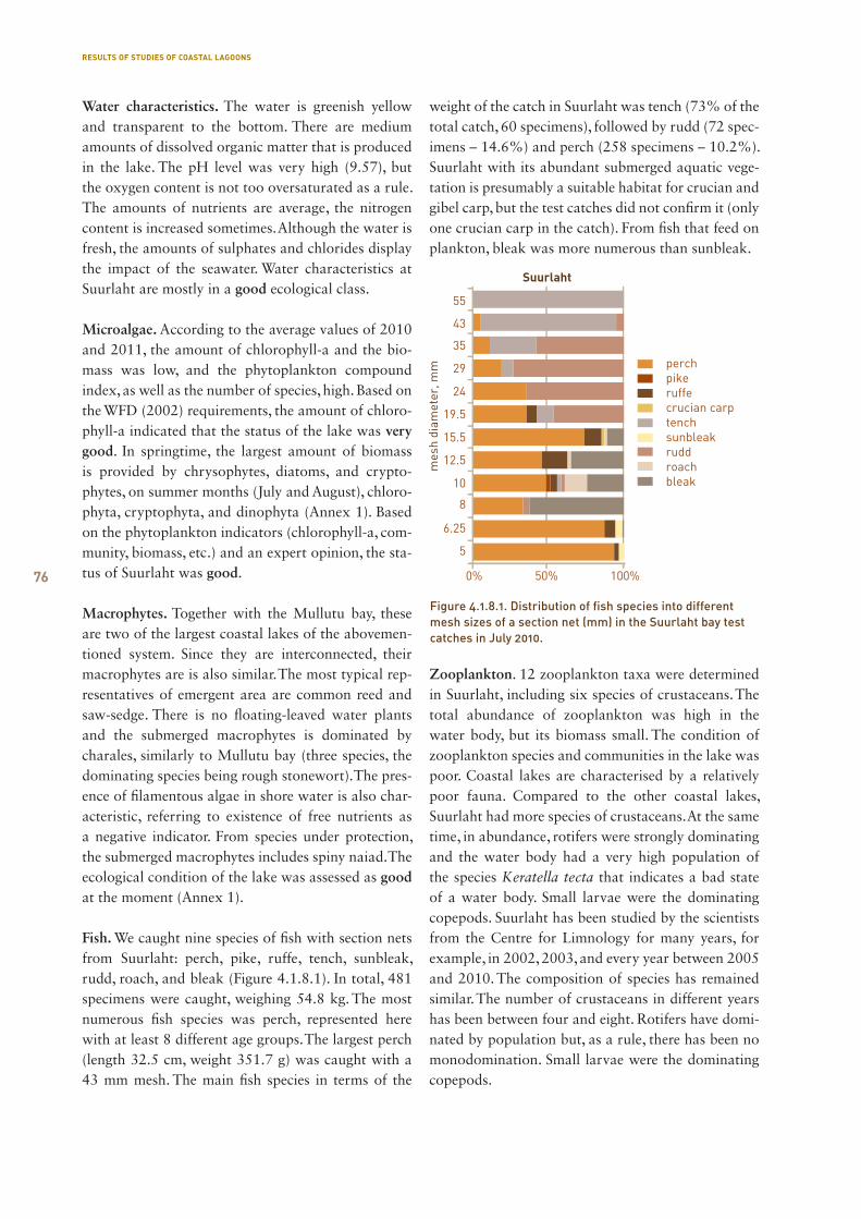
76
Water characteristics. The water is greenish yellow and transparent to the bottom. There are medium amounts of dissolved organic matter that is produced in the lake. The pH level was very high (9.57), but the oxygen content is not too oversaturated as a rule. The amounts of nutrients are average, the nitrogen content is increased sometimes. Although the water is fresh, the amounts of sulphates and chlorides display the impact of the seawater. Water characteristics at Suurlaht are mostly in a good ecological class.
Microalgae. According to the average values of 2010 and 2011, the amount of chlorophyll-a and the bio-mass was low, and the phytoplankton compound index, as well as the number of species, high. Based on the WFD (2002) requirements, the amount of chloro-phyll-a indicated that the status of the lake was very good. In springtime, the largest amount of biomass is provided by chrysophytes, diatoms, and crypto-phytes, on summer months (July and August), chloro-phyta, cryptophyta, and dinophyta (Annex 1). Based on the phytoplankton indicators (chlorophyll-a, com-munity, biomass, etc.) and an expert opinion, the sta-tus of Suurlaht was good.
Macrophytes. Together with the Mullutu bay, these are two of the largest coastal lakes of the abovemen-tioned system. Since they are interconnected, their macrophytes are is also similar. The most typical rep-resentatives of emergent area are common reed and saw-sedge. There is no floating-leaved water plants and the submerged macrophytes is dominated by charales, similarly to Mullutu bay (three species, the dominating species being rough stonewort). The pres-ence of filamentous algae in shore water is also char-acteristic, referring to existence of free nutrients as a negative indicator. From species under protection, the submerged macrophytes includes spiny naiad. The ecological condition of the lake was assessed as good at the moment (Annex 1).
Fish. We caught nine species of fish with section nets from Suurlaht: perch, pike, ruffe, tench, sunbleak, rudd, roach, and bleak (Figure 4.1.8.1). In total, 481 specimens were caught, weighing 54.8 kg. The most numerous fish species was perch, represented here with at least 8 different age groups. The largest perch (length 32.5 cm, weight 351.7 g) was caught with a 43 mm mesh. The main fish species in terms of the
weight of the catch in Suurlaht was tench (73% of the total catch, 60 specimens), followed by rudd (72 spec-imens – 14.6%) and perch (258 specimens – 10.2%). Suurlaht with its abundant submerged aquatic vege-tation is presumably a suitable habitat for crucian and gibel carp, but the test catches did not confirm it (only one crucian carp in the catch). From fish that feed on plankton, bleak was more numerous than sunbleak.
Zooplankton. 12 zooplankton taxa were determined in Suurlaht, including six species of crustaceans. The total abundance of zooplankton was high in the water body, but its biomass small. The condition of zooplankton species and communities in the lake was poor. Coastal lakes are characterised by a relatively poor fauna. Compared to the other coastal lakes, Suurlaht had more species of crustaceans. At the same time, in abundance, rotifers were strongly dominating and the water body had a very high population of the species Keratella tecta that indicates a bad state of a water body. Small larvae were the dominating copepods. Suurlaht has been studied by the scientists from the Centre for Limnology for many years, for example, in 2002, 2003, and every year between 2005 and 2010. The composition of species has remained similar. The number of crustaceans in different years has been between four and eight. Rotifers have domi-nated by population but, as a rule, there has been no monodomination. Small larvae were the dominating copepods.
Figure 4.1.8.1. Distribution of fish species into different mesh sizes of a section net (mm) in the Suurlaht bay test catches in July 2010.
RESULTS OF STUDIES OF COASTAL LAGOONS
77
Sediments. In the north-eastern section of the oval, stretched-shape Suurlaht, there is only a couple of centimetres of greenish flaky mud, and underneath it, a thick sandy sediment. Accumulation of lake sed-iments has been more intense in the south-western part of the lake: there is a 10 cm layer of brownish grey ductile lake mud, and underneath it, 10 cm of sandy silt.
Conservation status and the protected species. Suur-laht belongs to the EU Natura 2000 network both as a Mullutu-Loode bird area and Mullutu-Loode pro-tection area (EE0040444). Domestically, this area is protected by observing the protection procedure pro-visions of the special conservation area of the same name. The following species listed in Tables 4.1.8.1 and 4.1.8.2 have been registered in the area.
No. Name in Estonian Name in English Name in Latin Category Sources
1 vahelmine
näkirohi
spiny naiad Najas marina subsp.
intermedia
II EELIS
Table 4.1.8.1. Protected plant species in the area of Suurlaht
Table 4.1.8.2. Protected animal species in the area of Suurlaht
No. Name in Estonian Name in English Name in Latin Category Sources
2 hallpõsk-pütt red-necked grebe Podiceps grisegena III Birds of Saaremaa
3 hüüp great bitten Botaurus stellaris II Birds of Saaremaa, Inv. of
Breeding Bird Fauna
4 randtiir Arctic tern Sterna paradisaea III Birds of Saaremaa
5 vasakkeermene
pisitigu
narrow-mouthed
whorl snail
Vertigo angustior III Natura assessment:
Põduste golf course
6 luha pisitigu Geyer’s whorl snail Vertigo geieri III Natura assessment:
Põduste golf course
7 roo-loorkull western marsh-harrier Circus aeruginosus III Inv. of Breeding Bird Fauna
8 väikekajakas little gull Larus minutus II Inv. of Breeding Bird Fauna
9 punajalg tilder redshank Tringa totanus III Inv. of Breeding Bird Fauna
10 rooruik water rail Rallus aquaticus III Inv. of Breeding Bird Fauna
11 sookurg common crane Grus grus III Inv. of Breeding Bird Fauna
Common cranes with fledglings.
RESULTS OF STUDIES OF COASTAL LAGOONS
78
The surface area of Vägara bay is 84.1 ha (Tamre, 2006) and the largest depth during our measurements 0.7 m. It is further from the sea than the other lakes in Kuressaare, and therefore quite fresh. Mainly due to its large area, the lake is stable. Load from the catchment area is tolerable. Since the lake is located amidst forests and swamps, the water contains many organic, mainly humic matter, adding capacity to tol-erate impact from different resources.
Water characteristics. The water is dark yellow and transparent to the bottom (0.7 m). There is a large amount of dissolved organic matter. Although the amount of humic matter in it is quite high, the mat-ter produced in the lake prevails. The pH level of the water is very high (9.53), and oversaturated with oxy-
gen (128%). The relation between the main nutrients is shifted towards nitrogen that is present in large amounts. The amounts of phosphorus are low. The water is fresh, impact of the sea water is low. Based on the water characteristics, the ecological condition is good, but the high pH level and oversaturation refer to certain instability.
Microalgae. The phytoplankton compound index and the number of species in the counting sample in 2010 were average, the biomass and the amount of chlorophyll-a, low. Based on the WFD (2002) re-quirements, the amount of chlorophyll-a indicated that the status of the lake was high. From the large taxonomical groups, the highest biomass value was provided by cryptophytes and green algae (Annex 1).
4.1.9. Vägara
Vägara bay and the surrounding mowed and unmowed wet reed areas.
78
RESULTS OF STUDIES OF COASTAL LAGOONS
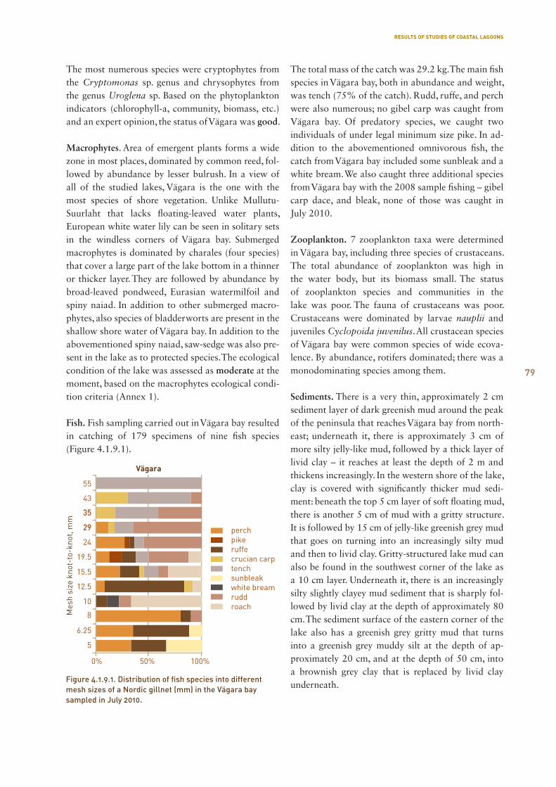
79
The most numerous species were cryptophytes from the Cryptomonas sp. genus and chrysophytes from the genus Uroglena sp. Based on the phytoplankton indicators (chlorophyll-a, community, biomass, etc.) and an expert opinion, the status of Vägara was good.
Macrophytes. Area of emergent plants forms a wide zone in most places, dominated by common reed, fol-lowed by abundance by lesser bulrush. In a view of all of the studied lakes, Vägara is the one with the most species of shore vegetation. Unlike Mullutu-Suurlaht that lacks floating-leaved water plants, European white water lily can be seen in solitary sets in the windless corners of Vägara bay. Submerged macrophytes is dominated by charales (four species) that cover a large part of the lake bottom in a thinner or thicker layer. They are followed by abundance by broad-leaved pondweed, Eurasian watermilfoil and spiny naiad. In addition to other submerged macro-phytes, also species of bladderworts are present in the shallow shore water of Vägara bay. In addition to the abovementioned spiny naiad, saw-sedge was also pre-sent in the lake as to protected species. The ecological condition of the lake was assessed as moderate at the moment, based on the macrophytes ecological condi-tion criteria (Annex 1).
Fish. Fish sampling carried out in Vägara bay resulted in catching of 179 specimens of nine fish species (Figure 4.1.9.1).
The total mass of the catch was 29.2 kg. The main fish species in Vägara bay, both in abundance and weight, was tench (75% of the catch). Rudd, ruffe, and perch were also numerous; no gibel carp was caught from Vägara bay. Of predatory species, we caught two individuals of under legal minimum size pike. In ad-dition to the abovementioned omnivorous fish, the catch from Vägara bay included some sunbleak and a white bream. We also caught three additional species from Vägara bay with the 2008 sample fishing – gibel carp dace, and bleak, none of those was caught in July 2010.
Zooplankton. 7 zooplankton taxa were determined in Vägara bay, including three species of crustaceans. The total abundance of zooplankton was high in the water body, but its biomass small. The status of zooplankton species and communities in the lake was poor. The fauna of crustaceans was poor. Crustaceans were dominated by larvae nauplii and juveniles Cyclopoida juvenilus. All crustacean species of Vägara bay were common species of wide ecova-lence. By abundance, rotifers dominated; there was a monodominating species among them.
Sediments. There is a very thin, approximately 2 cm sediment layer of dark greenish mud around the peak of the peninsula that reaches Vägara bay from north-east; underneath it, there is approximately 3 cm of more silty jelly-like mud, followed by a thick layer of livid clay – it reaches at least the depth of 2 m and thickens increasingly. In the western shore of the lake, clay is covered with significantly thicker mud sedi-ment: beneath the top 5 cm layer of soft floating mud, there is another 5 cm of mud with a gritty structure. It is followed by 15 cm of jelly-like greenish grey mud that goes on turning into an increasingly silty mud and then to livid clay. Gritty-structured lake mud can also be found in the southwest corner of the lake as a 10 cm layer. Underneath it, there is an increasingly silty slightly clayey mud sediment that is sharply fol-lowed by livid clay at the depth of approximately 80 cm. The sediment surface of the eastern corner of the lake also has a greenish grey gritty mud that turns into a greenish grey muddy silt at the depth of ap-proximately 20 cm, and at the depth of 50 cm, into a brownish grey clay that is replaced by livid clay underneath.
Figure 4.1.9.1. Distribution of fish species into different mesh sizes of a Nordic gillnet (mm) in the Vägara bay sampled in July 2010.
RESULTS OF STUDIES OF COASTAL LAGOONS
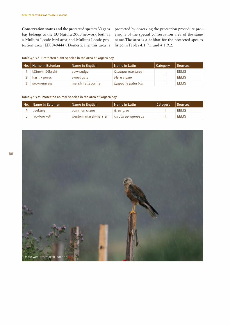
80
No. Name in Estonian Name in English Name in Latin Category Sources
1 lääne-mõõkrohi saw-sedge Cladium mariscus III EELIS
2 harilik porss sweet gale Myrica gale III EELIS
3 soo-neiuvaip marsh helleborine Epipactis palustris III EELIS
Table 4.1.9.1. Protected plant species in the area of Vägara bay
Table 4.1.9.2. Protected animal species in the area of Vägara bay
No. Name in Estonian Name in English Name in Latin Category Sources
4 sookurg common crane Grus grus III EELIS
5 roo-loorkull western marsh-harrier Circus aeruginosus III EELIS
Male western marsh-harrier.
Conservation status and the protected species. Vägara bay belongs to the EU Natura 2000 network both as a Mullutu-Loode bird area and Mullutu-Loode pro-tection area (EE0040444). Domestically, this area is
protected by observing the protection procedure pro-visions of the special conservation area of the same name. The area is a habitat for the protected species listed in Tables 4.1.9.1 and 4.1.9.2.
RESULTS OF STUDIES OF COASTAL LAGOONS
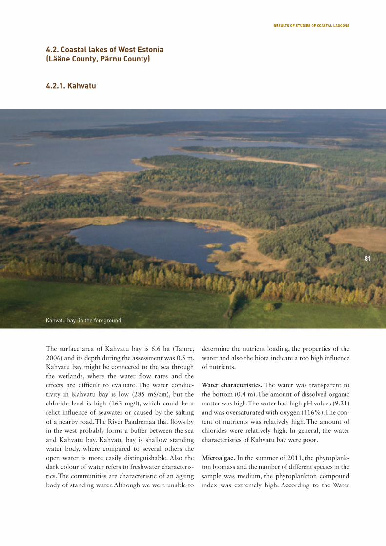
81
The surface area of Kahvatu bay is 6.6 ha (Tamre, 2006) and its depth during the assessment was 0.5 m. Kahvatu bay might be connected to the sea through the wetlands, where the water flow rates and the effects are difficult to evaluate. The water conduc-tivity in Kahvatu bay is low (285 mS/cm), but the chloride level is high (163 mg/l), which could be a relict influence of seawater or caused by the salting of a nearby road. The River Paadremaa that flows by in the west probably forms a buffer between the sea and Kahvatu bay. Kahvatu bay is shallow standing water body, where compared to several others the open water is more easily distinguishable. Also the dark colour of water refers to freshwater characteris-tics. The communities are characteristic of an ageing body of standing water. Although we were unable to
determine the nutrient loading, the properties of the water and also the biota indicate a too high influence of nutrients.
Water characteristics. The water was transparent to the bottom (0.4 m). The amount of dissolved organic matter was high. The water had high pH values (9.21) and was oversaturated with oxygen (116%). The con-tent of nutrients was relatively high. The amount of chlorides were relatively high. In general, the water characteristics of Kahvatu bay were poor.
Microalgae. In the summer of 2011, the phytoplank-ton biomass and the number of different species in the sample was medium, the phytoplankton compound index was extremely high. According to the Water
4.2. Coastal lakes of West Estonia (Lääne County, Pärnu County)
4.2.1. Kahvatu
Kahvatu bay (in the foreground).
81
RESULTS OF STUDIES OF COASTAL LAGOONS
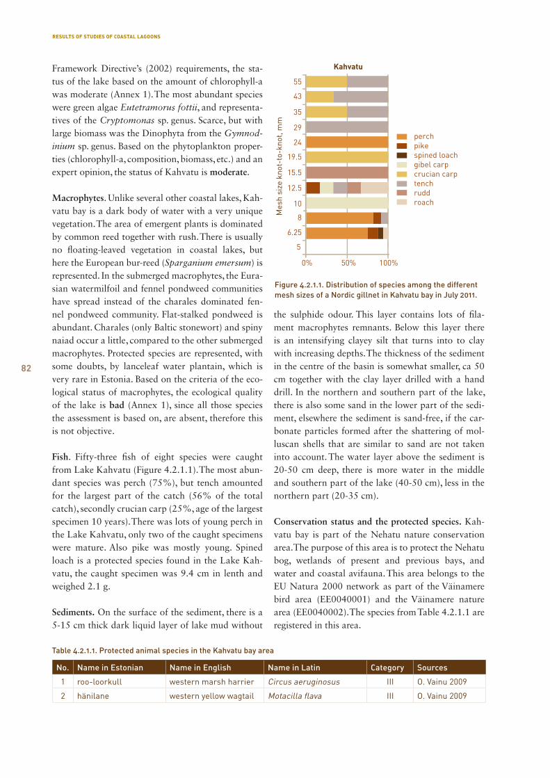
82
Framework Directive’s (2002) requirements, the sta-tus of the lake based on the amount of chlorophyll-a was moderate (Annex 1). The most abundant species were green algae Eutetramorus fottii, and representa-tives of the Cryptomonas sp. genus. Scarce, but with large biomass was the Dinophyta from the Gymnod-inium sp. genus. Based on the phytoplankton proper-ties (chlorophyll-a, composition, biomass, etc.) and an expert opinion, the status of Kahvatu is moderate.
Macrophytes. Unlike several other coastal lakes, Kah-vatu bay is a dark body of water with a very unique vegetation. The area of emergent plants is dominated by common reed together with rush. There is usually no floating-leaved vegetation in coastal lakes, but here the European bur-reed (Sparganium emersum) is represented. In the submerged macrophytes, the Eura-sian watermilfoil and fennel pondweed communities have spread instead of the charales dominated fen-nel pondweed community. Flat-stalked pondweed is abundant. Charales (only Baltic stonewort) and spiny naiad occur a little, compared to the other submerged macrophytes. Protected species are represented, with some doubts, by lanceleaf water plantain, which is very rare in Estonia. Based on the criteria of the eco-logical status of macrophytes, the ecological quality of the lake is bad (Annex 1), since all those species the assessment is based on, are absent, therefore this is not objective.
Fish. Fifty-three fish of eight species were caught from Lake Kahvatu (Figure 4.2.1.1). The most abun-dant species was perch (75%), but tench amounted for the largest part of the catch (56% of the total catch), secondly crucian carp (25%, age of the largest specimen 10 years). There was lots of young perch in the Lake Kahvatu, only two of the caught specimens were mature. Also pike was mostly young. Spined loach is a protected species found in the Lake Kah-vatu, the caught specimen was 9.4 cm in lenth and weighed 2.1 g.
Sediments. On the surface of the sediment, there is a 5-15 cm thick dark liquid layer of lake mud without
the sulphide odour. This layer contains lots of fila-ment macrophytes remnants. Below this layer there is an intensifying clayey silt that turns into to clay with increasing depths. The thickness of the sediment in the centre of the basin is somewhat smaller, ca 50 cm together with the clay layer drilled with a hand drill. In the northern and southern part of the lake, there is also some sand in the lower part of the sedi-ment, elsewhere the sediment is sand-free, if the car-bonate particles formed after the shattering of mol-luscan shells that are similar to sand are not taken into account. The water layer above the sediment is 20-50 cm deep, there is more water in the middle and southern part of the lake (40-50 cm), less in the northern part (20-35 cm).
Conservation status and the protected species. Kah-vatu bay is part of the Nehatu nature conservation area. The purpose of this area is to protect the Nehatu bog, wetlands of present and previous bays, and water and coastal avifauna. This area belongs to the EU Natura 2000 network as part of the Väinamere bird area (EE0040001) and the Väinamere nature area (EE0040002). The species from Table 4.2.1.1 are registered in this area.
Figure 4.2.1.1. Distribution of species among the different mesh sizes of a Nordic gillnet in Kahvatu bay in July 2011.
No. Name in Estonian Name in English Name in Latin Category Sources
1 roo-loorkull western marsh harrier Circus aeruginosus III O. Vainu 2009
2 hänilane western yellow wagtail Motacilla flava III O. Vainu 2009
Table 4.2.1.1. Protected animal species in the Kahvatu bay area
RESULTS OF STUDIES OF COASTAL LAGOONS
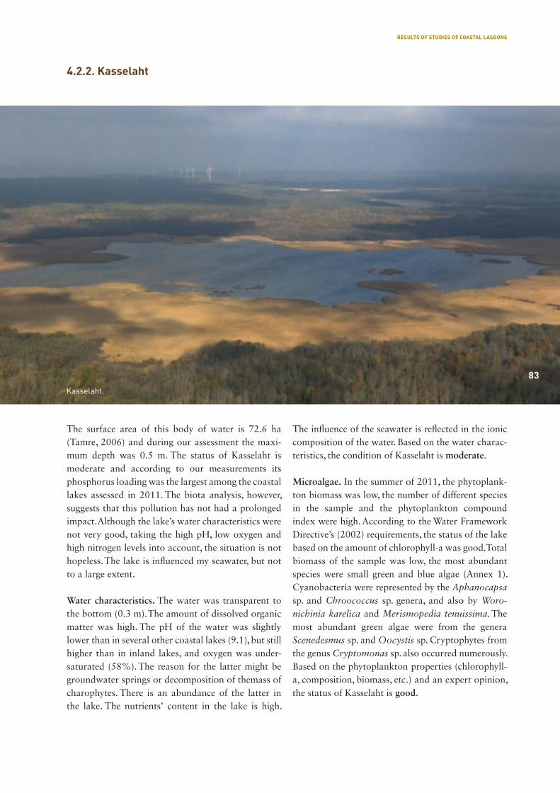
83
The surface area of this body of water is 72.6 ha (Tamre, 2006) and during our assessment the maxi-mum depth was 0.5 m. The status of Kasselaht is moderate and according to our measurements its phosphorus loading was the largest among the coastal lakes assessed in 2011. The biota analysis, however, suggests that this pollution has not had a prolonged impact. Although the lake’s water characteristics were not very good, taking the high pH, low oxygen and high nitrogen levels into account, the situation is not hopeless. The lake is influenced my seawater, but not to a large extent.
Water characteristics. The water was transparent to the bottom (0.3 m). The amount of dissolved organic matter was high. The pH of the water was slightly lower than in several other coastal lakes (9.1), but still higher than in inland lakes, and oxygen was under-saturated (58%). The reason for the latter might be groundwater springs or decomposition of themass of charophytes. There is an abundance of the latter in the lake. The nutrients’ content in the lake is high.
The influence of the seawater is reflected in the ionic composition of the water. Based on the water charac-teristics, the condition of Kasselaht is moderate.
Microalgae. In the summer of 2011, the phytoplank-ton biomass was low, the number of different species in the sample and the phytoplankton compound index were high. According to the Water Framework Directive’s (2002) requirements, the status of the lake based on the amount of chlorophyll-a was good. Total biomass of the sample was low, the most abundant species were small green and blue algae (Annex 1). Cyanobacteria were represented by the Aphanocapsa sp. and Chroococcus sp. genera, and also by Woro-nichinia karelica and Merismopedia tenuissima. The most abundant green algae were from the genera Scenedesmus sp. and Oocystis sp. Cryptophytes from the genus Cryptomonas sp. also occurred numerously. Based on the phytoplankton properties (chlorophyll-a, composition, biomass, etc.) and an expert opinion, the status of Kasselaht is good.
Kasselaht.
83
4.2.2. Kasselaht
RESULTS OF STUDIES OF COASTAL LAGOONS
84
Macrophytes. The water level is low at the shores of the lake, and the lake is heavily overgrown, this makes reaching it very difficult. In addition to the emergent plants, also submerged plants, such as whorled mil-foil, hornwort and bladderwort, and floating leaf plants like star duckweed and common duckweed are present in the reed belt. The aforementioned species are not present in the open water part of the lake. The submerged area of macrophytes consists of cha-rales (three species) and fennel pondweed, this cov-ers almost the whole lake bed with mats reaching to the water surface in places. In the north-western part of the lake, the protected spiny naiad can be found. The composition of macrophytes species, especially the aquatic vegetation (floating plants, hornwort, fila-mentous algae) is characteristic of a lake with plenty of nutrients. Based on the water plants characteristics typical for coastal lakes, the ecological state of the lake is good (Annex 1).
Fish. The sample fished in Kasselaht consisted of 395 fish of seven species (Figure 4.2.2.1). The most abund ant was rudd (68%) as also in several other coastal lakes, tench (37%) and gibel carp (28%) contributed to the major share of the catch. The largest crucian carp was aged as eight and the gibel carp eleven years old, respectively. Of predatory spieces we found in a sample only a yearling perch.
Sediments. The thickness of sediments varies signifi-cantly – from 35 to 100 cm. In the upper layers, the liquid floating mud is prevailing, i.e., liquid carbonate mud, soft silt. In the deeper layers there is silt mud,
clayey silt, sand and clay. The organic matter-rich mud forms about the 10 cm thick top layer.
Conservation status and the protected species. Kas-selaht is part of the Puhtu-Laelatu nature reserve. The aim of this reserve is to protect natural and semi-nat-ural habitats and water and coastal avifauna. Accord-ing to the Convention on Wetlands of International Importance especially as Waterfowl Habitat Article 2 (1), the Puhutu-Laelatu nature reserve is a wetland of international importance (Ramsari area). This area belongs to the EU Natura 2000 network as part of the Väinamere bird area (EE0040001) and the Väina-mere nature area (EE0040002). The species from Table 4.2.2.1 are registered in this area.
No. Name in Estonian Name in English Name in Latin Category Sources
1 hüüp Eurasian bittern or great bittern Botaurus stellaris II EELIS
2 luha pisitigu Vertigo geyeri Vertigo geyeri III EELIS
3 väike pisitigu Vertigo genesii Vertigo genesii III EELIS
4 vasakkeermene pisitigu Vertigo angustior Vertigo angustior III EELIS
5 luha-sinirind bluethroat Luscinia svecica cyanecula II EELIS
6 sookurg common crane Grus grus II EELIS
7 välja-loorkull hen harrier Circus cyaneus III EELIS
8 rooruik water rail Rallus aquaticus III EELIS
9 rabakonn moor frog Rana arvalis III EELIS
10 harilik kärnkonn common toad Bufo bufo III EELIS
Table 4.2.2.1. Protected animal species registered in the Kasselaht area
Figure 4.2.2.1. Distribution of species among the different mesh sizes of a Nordic gillnet in Kasselaht in July 2011.
RESULTS OF STUDIES OF COASTAL LAGOONS
85
The surface area of the lake is 26.9 ha (Tamre, 2006) and the maximum depth during our assessment was 0.5 m. The ecological status of Kiissalaht is moderate, the level of P-loading is acceptable. The proper-ties of water indicate seawater impact, the levels of nutrients are not too high, the pH and oxygen saturation levels, however, are very high. Since the phytoplankton amount is moderate, the reason for the high percentage of oxygen saturation is the very lush vegetation. Based on the data from Kiissalaht, it can be deduced that the lake has previously been significantly affected by the pollution from the catch-ment basin. So far it seems to have ended. The impact of seawater also seems to improve the situation. The condition of Kiissalaht hopefully improves thanks to the already acting effects of nature.
Water characteristics. The water is transparent to the bottom (0.4 m). The amount of dissolved organic mat ter was high. The pH level of the water is very high(9.48), and so is the oxygen oversaturation level (139%). The nutrients’ content in Kiissalaht is high. The influence of the seawater on the ionic composition is significant. Based on the water characteristics, the condition of Kiissalaht is between moderate and poor.
Microalgae. In the summer of 2011, the phytoplank-ton biomass was low, the number of different spe-cies in the sample and the phytoplankton compound index were average. According to the Water Frame-work Directive’s (2002) requirements, the status of the lake based on the amount of chlorophyll-a was good. The green algae, Chrysophyta and Cryptophyta gave most of the biomass (Annex 1). Chrysophyta
4.2.3. Kiissalaht
85
Kiissalaht.
RESULTS OF STUDIES OF COASTAL LAGOONS

86
were represented numerously by the Mallomonas sp. genus, and Cryptophyta by the Cryptomonas sp. genus. It is difficult to point out certain dominants because the total biomass of the sample was very low. Based on the phytoplankton properties (chlorophyll-a, composition, biomass, etc.) and an expert opinion, the condition of Kiissalaht was good.
Macrophytes. The emergent macrophytes lines the whole shoreline in extensive collections, dominated species are again common reed, narrowleaf cattail and softstem bulrush. The submerged macrophytes characterised by almost a full spread in the open wa-ter part of the lake. This belt is dominated by the cha-rales (four species), followed by fennel pondweed and hornwort. The protected spiny naiad species is spread along the shore vegetation belt, other kind of sub-merged macrophytes is absent or is limited. Floating-leaved water plants and filamentous algae are also present in the open waters of the lake, this indicates a high concentration of nutrients in the water. Based on the criteria of the ecological status of macrophytes, the quality of the lake is good (Annex 1).
Fish. Kiissalaht is a lake rich in different species (Fig-ure 4.2.3.1), the catch of our monitoring net was 195 fish of eleven different species. The most abundant species was rudd (142 fish, the oldest was eight years of age). The largest weight contribution, however, was made by tench (57% of the total catch). The larg-
est gibel carp caught in Kiissalaht was 13 years of age and the largest rudd ten years of age. The pro-tected spined loach was found in the lake (the caught spined loach was 6.6 cm in lenth and weighed 1.6 g). Although we caught only one specimen, the presence of the three-spined stickleback indicated that the bay was connected to the sea. In terms of predatory fish, we caught perch at four- to six-years-of age and male pike at five-years of age.
Sediments. In this typically shallow coastal lake (wa-ter depth 25-50 cm), there are 15-50 cm of lake sedi-ments; the sediment layer is thicker in the middle and on the west coast. In the northern part of the lake the sediment is mostly silt that contains fine sand. In the middle part of the lake the silt is more clayey and thickens as the depth increases, there is not much or no sand. Above the whole silt bottom there is a 3-5 cm thick liquid lake mud layer that smells of hydrogen sulphide. There are many remains of mollusc shells among the Kiissalaht sediments. The dry matter con-tent of the sediments from Kiissalaht (Figure 4.2.3.2) was more uniform, unlike the sediments from the Käomardi bay (Figure 4.2.5.2). The sediment dry mat-ter compositions were quite similar (Figures 4.2.3.3 and 4.2.5.3), terrigenous material was predominant in both. This also indicates that the pollution in these bodies of water has not been long-term.
Figure 4.2.3.1. Distribution of species among the different mesh sizes of a Nordic gillnet in Kiissalaht in July 2011.
Figure 4.2.3.2. Dry matter content in the Kiissalaht sediments.
RESULTS OF STUDIES OF COASTAL LAGOONS
87
No. Name in Estonian Name in English Name in Latin Category Sources
1 vahelmine näkirohi spiny naiad Najas marina subsp. intermedia
II EELIS
Table 4.2.3.1. Protected plant species registered in Kiissalaht
Table 4.2.3.2. Protected animal species registered in Kiissalaht
No. Name in Estonian Name in English Name in Latin Category Sources
2 laululuik whooper swan Cygnus cygnus II EELIS, O. Vainu 2007
3 sookurg common crane Grus grus II O. Vainu 2009
Figure 4.2.3.3. Dry matter composition in the Kiissalaht sediments.
The amount and fractions of phosphorus are the most important in determining the sediment-based self-pollution of the lake. The phosphorus concen-tration per unit of sediment dry matter in the upper layers of the sediment is rather high in Kiissalaht (Figure 4.2.3.4) compared to the lower layers. Testing the amount of phosphorus released to water from the sediment also gives information on the self-pollution risk. It became evident that during 16 weeks more phosphorus was released to the water above the sedi-ments in Kiissalaht (22.9 μg P/cm2) than for example from the sediments of the Käomardi bay (6.5 μg P/cm2). In the sediments of both of the lakes (extremely intensively in the sediments of Kiissalaht) gases are formed as a result of the life of micro-organisms. The movement of these through the sediment layer and up through the water column promotes mixing of the phosphorus-rich water from the sediment pores with the water from the lake.
Conservation status and the protected species. Kiissa-laht is part of the Nehatu nature conservation area. The purpose of this area is to protect the Nehatu bog, wetlands of present and previous bays, and water and coastal avifauna. This area belongs to the EU Natura 2000 network as part of the Väinamere bird area (EE0040001) and the Väinamere nature area (EE0040002). The species from Table 4.2.3.2 are regis tered in this area.
Figure 4.2.3.4. Depth distribution of phosphorus fractions in 5 cm sediment layers of Kiissalaht sediments per 1 m2 area.
0–2
2–5
5–10
10–15
15–20
0
10%
20%
30%
40%
70%
80%
100%
90%
60%
50%
Kiissalahe sette kuivaine koostis
RESULTS OF STUDIES OF COASTAL LAGOONS
88
4.2.4. Kudani bay
The surface area of Kudani bay is 12.4 ha (Tamre, 2006). During our assessment there was only 0.3 m of water. Based on an assessment from the 2011, Lake Kudani is the only lake with a good ecologi-cal status according to the EU Water Framework Directive requirements. The load on the lake was not assessed due to the lack of applicable inflow. Most of the water characteristics were good in 2011. Large amount of dissolved organic matter is characteristic to overgrowing lakes. The ageing of Kudani lake takes place at a natural speed and is balanced. The water level is very low and it had overgrown with plants.
Water characteristics. The water is transparent to the bottom (0.3 m). The amount of dissolved organic matter is high, and characteristically of a closed lake, it originates from the lake. The pH was 7.9, which is lower than in the most of the other coastal lakes, the oxygen saturation was normal. Concerning the levels of nutrients, the ones of phosphorus were low and the ones of nitrogen high. According to the ionic composition, it is an entirely freshwater lake, there is no influence of the sea to be detected. Based on the water characteristics, the condition is good.
Microalgae. In the summer of 2011, the phytoplank-ton biomass was low, the number of different species in the sample average, and the phytoplankton com-pound index high. According to the Water Frame-work Directive’s (2002) requirements, the status of the lake based on the amount of chlorophyll-a was high. The green algae and Cryptophyta gave most of the biomass (Annex 1). The most abundant green algae were the Eutetramorus fottii and several species from the genus Scenedesmus sp.. Cryptophyta were represented numerously by representatives of the gen-era Cryptomonas sp. and Rhodomonas sp.. In gen-eral, the biomass in the sample was very small, mainly small-scale algae were represented. Based on the phy-toplankton parameters (chlorophyll-a, composition, biomass, etc.) and an expert opinion, the condition of Kudani was good.
Macrophytes. The lake basin is largely overgrown with emergent macrophytes, and rather similar to a wetland with a small water hole. The area of emergent plants is characterised with common reed, and the protected sawtooth sedge. The latter mostly
spreads on the pebble substrate in the shallow shore waters. The submerged macrophytes is poor in spe-cies, dominated by charales (3 species), followed by bladderwort and fennel pondweed. There were some doubts regarding the finding of Baltic stonewort, because that is more characteristic of the stonewort community of the Baltic Sea. Based on the criteria of the ecological status of macrophytes, the quality of the lake at the moment is good (Annex 1).
Fish. Four different fish species were caught in the Kudani lake that is connected to the Vööla meri by a deepened stream (Figure 4.2.4.1). The catch was very poor, five yearlings of pike were caught, this indicates a successful pike reproduction during the high water spring of 2011.
Sediments. Lake Kudani is largely overgrown, the free water in the north-western part of the lake represents a half of the previous lake area. There is only 20-40 cm of water in the lake, on the lake bottom there is a grey silt sediment, that is clayey in the north-east-ern parts that are not overgrown (becoming silt clay with the depth increasing, reaching at least 1.5 m in depth), in the north-western part the sediments are sandy. In the north-western part, there is also a liquid 5 cm layer with a strong hydrogen sulphide odour above the silt layer
Conservation status and the protected species. Kudani bay is part of the Silma nature reserve. The aim of this reserve is to protect the relict lakes and wetlands
Figure 4.2.4.1. Distribution of species among the different mesh sizes of a Nordic gillnet in Kudani bay.
RESULTS OF STUDIES OF COASTAL LAGOONS
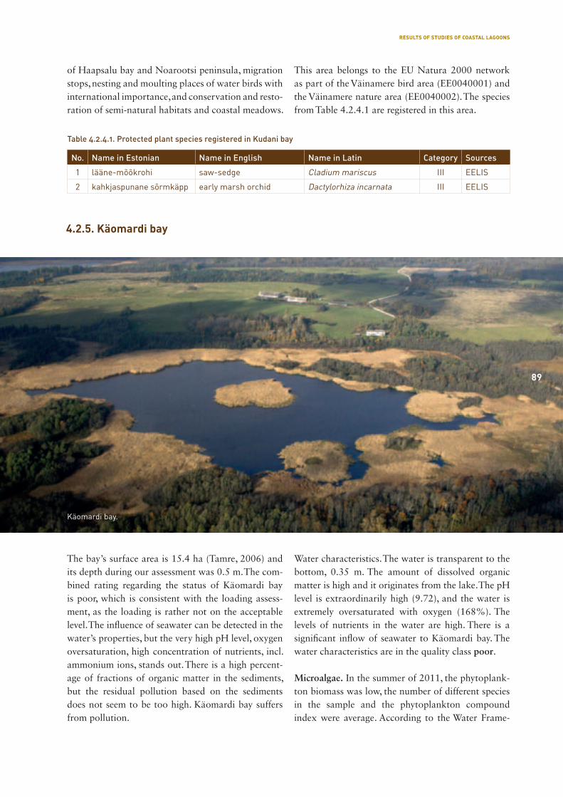
89
of Haapsalu bay and Noarootsi peninsula, migration stops, nesting and moulting places of water birds with international importance, and conservation and resto-ration of semi-natural habitats and coastal meadows.
This area belongs to the EU Natura 2000 network as part of the Väinamere bird area (EE0040001) and the Väinamere nature area (EE0040002). The species from Table 4.2.4.1 are registered in this area.
No. Name in Estonian Name in English Name in Latin Category Sources
1 lääne-mõõkrohi saw-sedge Cladium mariscus III EELIS
2 kahkjaspunane sõrmkäpp early marsh orchid Dactylorhiza incarnata III EELIS
Table 4.2.4.1. Protected plant species registered in Kudani bay
The bay’s surface area is 15.4 ha (Tamre, 2006) and its depth during our assessment was 0.5 m. The com-bined rating regarding the status of Käomardi bay is poor, which is consistent with the loading assess-ment, as the loading is rather not on the acceptable level. The influence of seawater can be detected in the water’s properties, but the very high pH level, oxygen oversaturation, high concentration of nutrients, incl. ammonium ions, stands out. There is a high percent-age of fractions of organic matter in the sediments, but the residual pollution based on the sediments does not seem to be too high. Käomardi bay suffers from pollution.
Water characteristics. The water is transparent to the bottom, 0.35 m. The amount of dissolved organic matter is high and it originates from the lake. The pH level is extraordinarily high (9.72), and the water is extremely oversaturated with oxygen (168%). The levels of nutrients in the water are high. There is a significant inflow of seawater to Käomardi bay. The water characteristics are in the quality class poor.
Microalgae. In the summer of 2011, the phytoplank-ton biomass was low, the number of different species in the sample and the phytoplankton compound index were average. According to the Water Frame-
4.2.5. Käomardi bay
89
Käomardi bay.
RESULTS OF STUDIES OF COASTAL LAGOONS
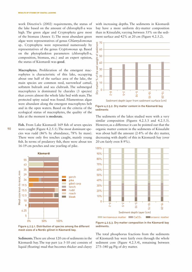
90
work Directive’s (2002) requirements, the status of the lake based on the amount of chlorophyll-a was high. The green algae and Cryptophyta gave most of the biomass (Annex 1). The most abundant green algae were representatives of genus Chlamydomonas sp.. Cryptophyta were represented numerously by representatives of the genus Cryptomonas sp. Based on the phytoplankton parameters (chlorophyll-a, composition, biomass, etc.) and an expert opinion, the status of Käomardi was good.
Macrophytes. Proliferation of the emergent mac-rophytes is characteristic of this lake, occupying about one half of the surface area of the lake, the main species are common reed, narrowleaf cattail, softstem bulrush and sea clubrush. The submerged macrophytes is dominated by charales (3 species) that covers almost the whole lake bed with mats. The protected spiny naiad was found. Filamentous algae were abundant along the emergent macrophytes belt and in the open waters. Based on the criteria of the ecological status of macrophytes, the quality of the lake at the moment is moderate.
Fish. From Lake Käomardi 169 fish of seven species were caught (Figure 4.2.5.1). The most dominant spe-cies was rudd (86% by abundance, 78% by mass). There were only five tenches caught, mainly young fish. In terms of predatory fish, there were about ten 16-19 cm perches and one yearling of pike.
Sediments. There are about 120 cm of sediments in the Käomardi bay. The top part (ca 5-10 cm) consists of liquid (floating) mud that becomes thicker and clayey
with increasing depths. The sediments in Käomardi bay have a more uniform dry-matter composition than in Kiissalaht, varying between 33% on the sedi-ment surface and 42% at 20 cm (Figure 4.2.5.2).
The sediments of the lakes studied were with a very similar composition (Figures 4.2.3.3 and 4.2.5.3). However, as a difference it can be pointed out that the organic matter content in the sediments of Kiissalaht was about half the amount (2-8% of the dry matter, decreasing with depth) of this in Käomardi bay (over 20 cm fairly even 8-9%).
The total phosphorus fractions from the sediments of Käomardi bay were fairly even through the whole sediment core (Figure 4.2.5.4), remaining between 275–340 μg P/g of dry matter.
Figure 4.2.5.1. Distribution of species among the different mesh sizes of a Nordic gillnet in Käomardi bay.
Figure 4.2.5.2. Dry matter content in the Käomardi bay sediments
0–2
2–5
5–10
10–15
15–20
0
10%
20%
30%
40%
70%
80%
100%
90%
60%
50%
Käomardi lahe sette kuivaine koostis
Figure 4.2.5.3. Dry matter composition in the Käomardi bay sediments.
RESULTS OF STUDIES OF COASTAL LAGOONS
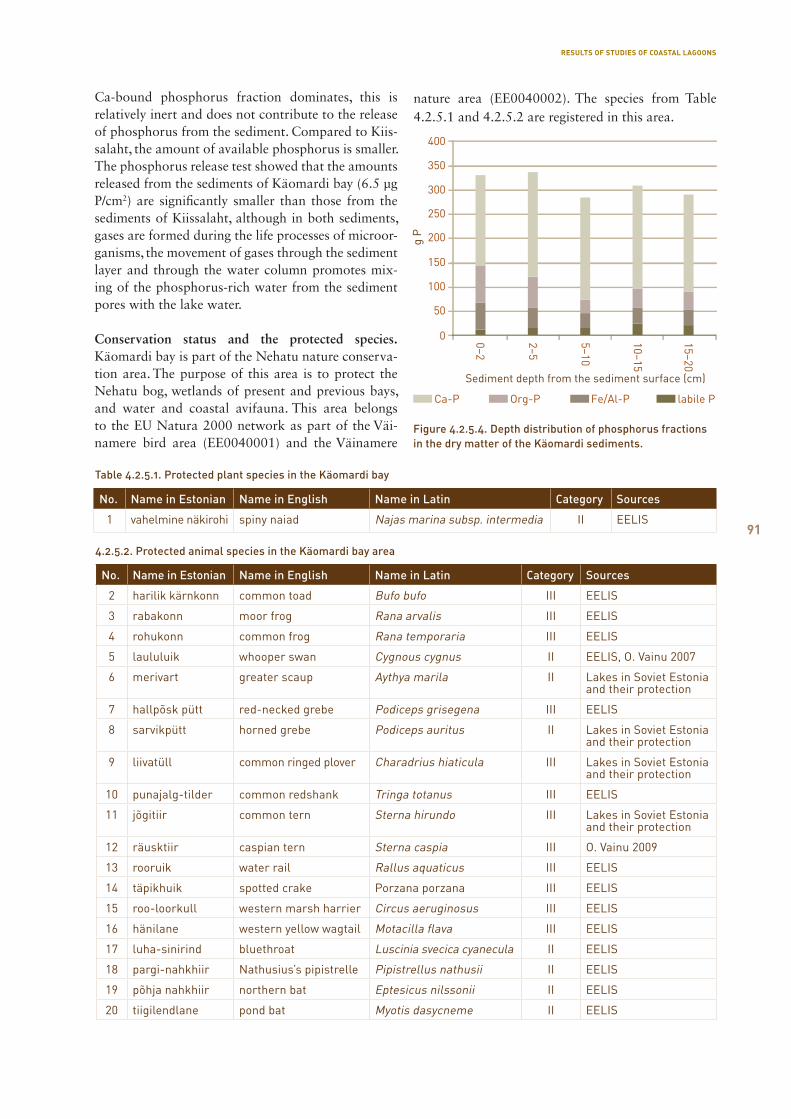
91
Ca-bound phosphorus fraction dominates, this is relatively inert and does not contribute to the release of phosphorus from the sediment. Compared to Kiis-salaht, the amount of available phosphorus is smaller. The phosphorus release test showed that the amounts released from the sediments of Käomardi bay (6.5 μg P/cm2) are significantly smaller than those from the sediments of Kiissalaht, although in both sediments, gases are formed during the life processes of microor-ganisms, the movement of gases through the sediment layer and through the water column promotes mix-ing of the phosphorus-rich water from the sediment pores with the lake water.
Conservation status and the protected species. Käomardi bay is part of the Nehatu nature conserva-tion area. The purpose of this area is to protect the Nehatu bog, wetlands of present and previous bays, and water and coastal avifauna. This area belongs to the EU Natura 2000 network as part of the Väi-namere bird area (EE0040001) and the Väinamere
nature area (EE0040002). The species from Table 4.2.5.1 and 4.2.5.2 are registered in this area.
No. Name in Estonian Name in English Name in Latin Category Sources
1 vahelmine näkirohi spiny naiad Najas marina subsp. intermedia II EELIS
Table 4.2.5.1. Protected plant species in the Käomardi bay
4.2.5.2. Protected animal species in the Käomardi bay area
No. Name in Estonian Name in English Name in Latin Category Sources
2 harilik kärnkonn common toad Bufo bufo III EELIS
3 rabakonn moor frog Rana arvalis III EELIS
4 rohukonn common frog Rana temporaria III EELIS
5 laululuik whooper swan Cygnous cygnus II EELIS, O. Vainu 2007
6 merivart greater scaup Aythya marila II Lakes in Soviet Estonia and their protection
7 hallpõsk pütt red-necked grebe Podiceps grisegena III EELIS
8 sarvikpütt horned grebe Podiceps auritus II Lakes in Soviet Estonia and their protection
9 liivatüll common ringed plover Charadrius hiaticula III Lakes in Soviet Estonia and their protection
10 punajalg-tilder common redshank Tringa totanus III EELIS
11 jõgitiir common tern Sterna hirundo III Lakes in Soviet Estonia and their protection
12 räusktiir caspian tern Sterna caspia III O. Vainu 2009
13 rooruik water rail Rallus aquaticus III EELIS
14 täpikhuik spotted crake Porzana porzana III EELIS
15 roo-loorkull western marsh harrier Circus aeruginosus III EELIS
16 hänilane western yellow wagtail Motacilla flava III EELIS
17 luha-sinirind bluethroat Luscinia svecica cyanecula II EELIS
18 pargi-nahkhiir Nathusius’s pipistrelle Pipistrellus nathusii II EELIS
19 põhja nahkhiir northern bat Eptesicus nilssonii II EELIS
20 tiigilendlane pond bat Myotis dasycneme II EELIS
Figure 4.2.5.4. Depth distribution of phosphorus fractions in the dry matter of the Käomardi sediments.
RESULTS OF STUDIES OF COASTAL LAGOONS
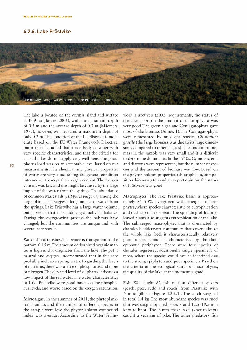
92
The lake is located on the Vormsi island and surface is 37.9 ha (Tamre, 2006), with the maximum depth of 0.5 m and the average depth of 0.3 m (Mäemets, 1977), however, we measured a maximum depth of only 0.2 m. The condition of the L. Prästvike is mod-erate based on the EU Water Framework Directive, but it must be noted that it is a body of water with very specific characteristics, and that the criteria for coastal lakes do not apply very well here. The phos-phorus load was on an acceptable level based on our measurements. The chemical and physical properties of water are very good taking the general condition into account, except the oxygen content. The oxygen content was low and this might be caused by the large impact of the water from the springs. The abundance of common Marestails (Hippuris vulgaris) among the large plants also suggests large impact of water from the springs. Lake Prästvike has a large water volume, but it seems that it is fading gradually in balance. During the overgrowing process the habitats have changed, but the communities are unique and with several rare species.
Water characteristics. The water is transparent to the bottom, 0.15 m. The amount of dissolved organic mat-ter is high and it originates from the lake. The pH is neutral and oxygen undersaturated that in this case probably indicates spring water. Regarding the levels of nutrients, there was a little of phosphorus and more of nitrogen. The elevated level of sulphates indicates a low impact of the sea water. The water characteristics of Lake Prästvike were good based on the phospho-rus levels, and worse based on the oxygen saturation.
Microalgae. In the summer of 2011, the phytoplank-ton biomass and the number of different species in the sample were low, the phytoplankton compound index was average. According to the Water Frame-
work Directive’s (2002) requirements, the status of the lake based on the amount of chlorophyll-a was very good. The green algae and Conjugatophyta gave most of the biomass (Annex 1). The Conjugatophyta were represented by only one species Closterium gracile (the large biomass was due to its large dimen-sions compared to other species). The amount of bio-mass in the sample was very small and it is difficult to determine dominants. In the 1950s, Cyanobacteria and diatoms were represented, but the number of spe-cies and the amount of biomass was low. Based on the phytoplankton properties (chlorophyll-a, compo-sition, biomass, etc.) and an expert opinion, the status of Prästvike was good
Macrophytes. The lake Prästvike basin is approxi-mately 85−90% overgrown with emergent macro-phytes, where species characteristic of eutrophication and occlusion have spread. The spreading of foating-leaved plants also suggests eutrophication of the lake. The submerged macrophytes that is dominated by charales-bladderwort community that covers almost the whole lake bed, is characteristically relatively poor in species and has characterised by abundant epiphytic periphyton. There were four species of charales registered, additionally single specimens of moss, where the species could not be identified due to the strong epiphyton and poor specimen. Based on the criteria of the ecological status of macrophytes, the quality of the lake at the moment is good.
Fish. We caught 82 fish of four different species (perch, pike, rudd and roach) from Prästvike with Nordic gillnets (Figure 4.2.6.1). The catch weighed in total 1.4 kg. The most abundant species was rudd that was caught by mesh sizes 8 and 12.5–19.5 mm knot-to-knot. The 8-mm mesh size (knot-to-knot) caught a yearling of pike. The other predatory fish
4.2.6. Lake Prästvike
The heavily overgrown with reeds Lake Prästvike on Vormsi.
RESULTS OF STUDIES OF COASTAL LAGOONS

93
species − perch − was represented in the catch with a 6- and an 8-year-old specimen.
Sediments. It was only possible to collect sediment cores in the free north-western corner, where it was possible to hand-drill through a 25–55 cm sediment layer under the 25–30 cm water layer. In general, there is a 5−10 cm thick dark liquid lake mud layer above the sediment between the macrophytes, under this a light silt layer that turns more clayey with increasing depths, and below 35 cm is already greenish grey silt clay.
Macroinvertebrates. The sample was taken from the southeast shore along the reed belt, there was liquid mud with Charophyta in the bottom. Larvae of two Natura dragonfly species were found from Prästvike lake − large white-faced darter and dark whitefacer. According to the NCA, they both belong to the third category in Estonia. The large white-faced darter is also in the Estonian Red Book (2008). It is probably a rare natural habitat on a relatively small island.
Conservation status and the protected species. Lake Prästvike is part of the Vormsi landscape protection area. The purpose of this area is the complex pro-tection of Vormsi’s rare and unique landscapes and
easily disturbed natural landscapes, cultural herit-age landscapes and habitats of rare species. This area belongs to the EU Natura 2000 network as part of the Väinamere bird area (EE0040001) and the Väi-namere nature area (EE0040002). The species from Table 4.2.6.1 and 4.2.6.2 are registered in this area.
Table 4.2.6.1. Protected plant species in the Lake Prästvike area
Table 4.2.6.2. Protected animal species in the Lake Prästvike area
No. Name in Estonian Name in English Name in Latin Category Sources
1 soohiilakas yellow widelip orchid Liparis loeselii II EELIS
2 harilik muguljuur musk orchid Herminium monorchis II KMH, Elle Puurmann
3 kärbesõis fly orchid Ophrys insectiferav II KMH, Elle Puurmann
4 soo-neiuvaip marsh helleborine Epipactis palustris III EELIS
5 harilik käoraamat fragrant orchid Gymnadenia conopsea III EELIS
6 koldjas selaginell club spikemoss Selaginella selaginoides II EELIS
7 kahkjaspunane sõrmkäpp early marsh orchid Ophrys insectiferav III KMH, Elle Puurmann
8 lodukannike bog violet Viola uliginosa III KMH
No. Name in Estonian Name in English Name in Latin Category Sources
9 rooruik water rail Rallus aquaticus III EELIS
10 hüüp Eurasian bittern or great
bittern
Botaurus stellaris II EELIS
11 roo- loorkull western marsh harrier Circus aeruginosus III EELIS
12 saarmas European otter Lutra lutra III KMH
13 sookurg common crane Grus grus II KMH
14 täpikhuik spotted crake Porzana porzana III Vormsi MKA KKK
15 rabakonn moor frog Rana arvalis III Elle Puurmann
16 suur rabakiil large white-faced darter Leuconrhinia pectoralis III Elle Puurmann
17 väike kirjurähn lesser spotted woodpecker Dendrocopos minor III EELIS
Figure 4.2.6.1. Distribution of species among the different mesh sizes of a Nordic gillnet in Lake Prästvike
RESULTS OF STUDIES OF COASTAL LAGOONS
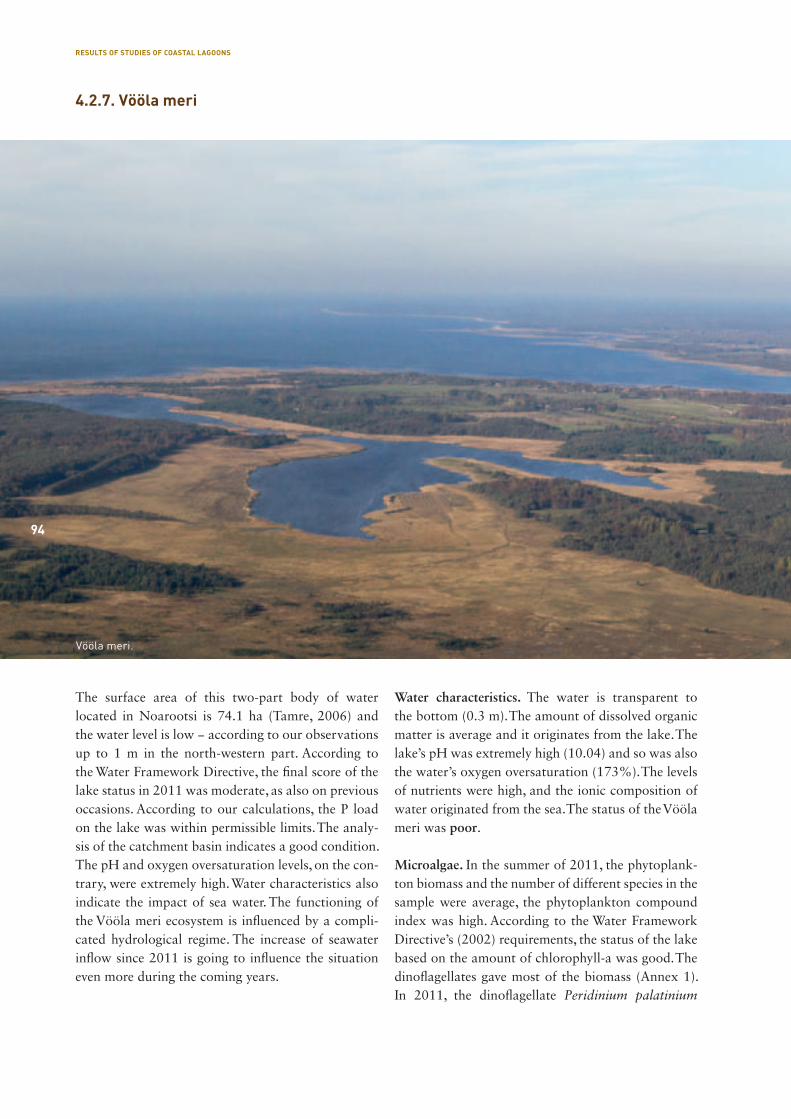
94
The surface area of this two-part body of water located in Noarootsi is 74.1 ha (Tamre, 2006) and the water level is low − according to our observations up to 1 m in the north-western part. According to the Water Framework Directive, the final score of the lake status in 2011 was moderate, as also on previous occasions. According to our calculations, the P load on the lake was within permissible limits. The analy-sis of the catchment basin indicates a good condition. The pH and oxygen oversaturation levels, on the con-trary, were extremely high. Water characteristics also indicate the impact of sea water. The functioning of the Vööla meri ecosystem is influenced by a compli-cated hydrological regime. The increase of seawater inflow since 2011 is going to influence the situation even more during the coming years.
Water characteristics. The water is transparent to the bottom (0.3 m). The amount of dissolved organic matter is average and it originates from the lake. The lake’s pH was extremely high (10.04) and so was also the water’s oxygen oversaturation (173%). The levels of nutrients were high, and the ionic composition of water originated from the sea. The status of the Vööla meri was poor.
Microalgae. In the summer of 2011, the phytoplank-ton biomass and the number of different species in the sample were average, the phytoplankton compound index was high. According to the Water Framework Directive’s (2002) requirements, the status of the lake based on the amount of chlorophyll-a was good. The dinoflagellates gave most of the biomass (Annex 1). In 2011, the dinoflagellate Peridinium palatinium
4.2.7. Vööla meri
Vööla meri.
94
RESULTS OF STUDIES OF COASTAL LAGOONS
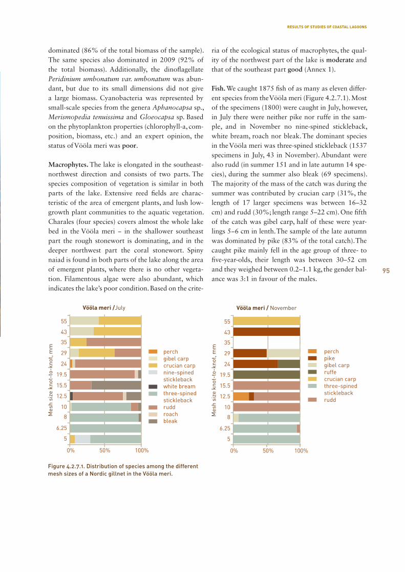
95
dominated (86% of the total biomass of the sample). The same species also dominated in 2009 (92% of the total biomass). Additionally, the dinoflagellate Peridinium umbonatum var. umbonatum was abun-dant, but due to its small dimensions did not give a large biomass. Cyanobacteria was represented by small-scale species from the genera Aphanocapsa sp., Merismopedia tenuissima and Gloeocapsa sp. Based on the phytoplankton properties (chlorophyll-a, com-position, biomass, etc.) and an expert opinion, the status of Vööla meri was poor.
Macrophytes. The lake is elongated in the southeast-northwest direction and consists of two parts. The species composition of vegetation is similar in both parts of the lake. Extensive reed fields are charac-teristic of the area of emergent plants, and lush low-growth plant communities to the aquatic vegetation. Charales (four species) covers almost the whole lake bed in the Vööla meri − in the shallower southeast part the rough stonewort is dominating, and in the deeper northwest part the coral stonewort. Spiny naiad is found in both parts of the lake along the area of emergent plants, where there is no other vegeta-tion. Filamentous algae were also abundant, which indicates the lake’s poor condition. Based on the crite-
ria of the ecological status of macrophytes, the qual-ity of the northwest part of the lake is moderate and that of the southeast part good (Annex 1).
Fish. We caught 1875 fish of as many as eleven differ-ent species from the Vööla meri (Figure 4.2.7.1). Most of the specimens (1800) were caught in July, however, in July there were neither pike nor ruffe in the sam-ple, and in November no nine-spined stickleback, white bream, roach nor bleak. The dominant species in the Vööla meri was three-spined stickleback (1537 specimens in July, 43 in November). Abundant were also rudd (in summer 151 and in late autumn 14 spe-cies), during the summer also bleak (69 specimens). The majority of the mass of the catch was during the summer was contributed by crucian carp (31%, the length of 17 larger specimens was between 16–32 cm) and rudd (30%; length range 5–22 cm). One fifth of the catch was gibel carp, half of these were year-lings 5−6 cm in lenth. The sample of the late autumn was dominated by pike (83% of the total catch). The caught pike mainly fell in the age group of three- to five-year-olds, their length was between 30–52 cm and they weighed between 0.2–1.1 kg, the gender bal-ance was 3:1 in favour of the males.
Figure 4.2.7.1. Distribution of species among the different mesh sizes of a Nordic gillnet in the Vööla meri.
RESULTS OF STUDIES OF COASTAL LAGOONS
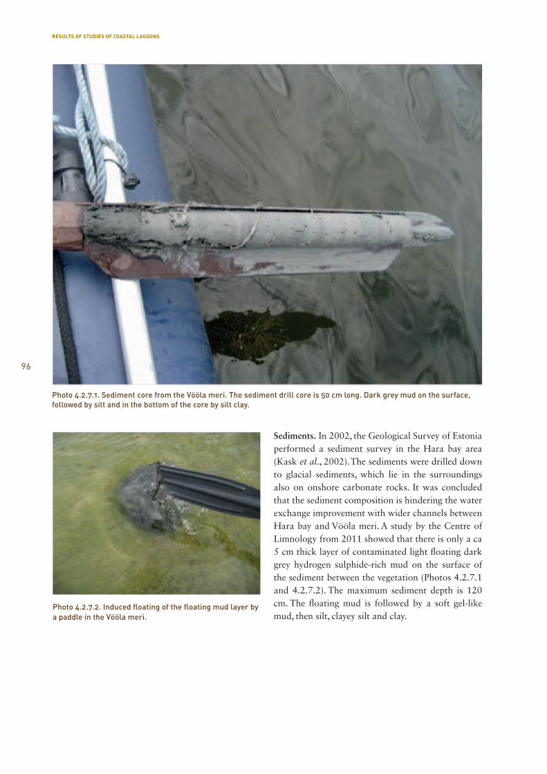
96
Photo 4.2.7.2. Induced floating of the floating mud layer by a paddle in the Vööla meri.
Sediments. In 2002, the Geological Survey of Estonia performed a sediment survey in the Hara bay area (Kask et al., 2002). The sediments were drilled down to glacial sediments, which lie in the surroundings also on onshore carbonate rocks. It was concluded that the sediment composition is hindering the water exchange improvement with wider channels between Hara bay and Vööla meri. A study by the Centre of Limnology from 2011 showed that there is only a ca 5 cm thick layer of contaminated light floating dark grey hydrogen sulphide-rich mud on the surface of the sediment between the vegetation (Photos 4.2.7.1 and 4.2.7.2). The maximum sediment depth is 120 cm. The floating mud is followed by a soft gel-like mud, then silt, clayey silt and clay.
Photo 4.2.7.1. Sediment core from the Vööla meri. The sediment drill core is 50 cm long. Dark grey mud on the surface, followed by silt and in the bottom of the core by silt clay.
RESULTS OF STUDIES OF COASTAL LAGOONS
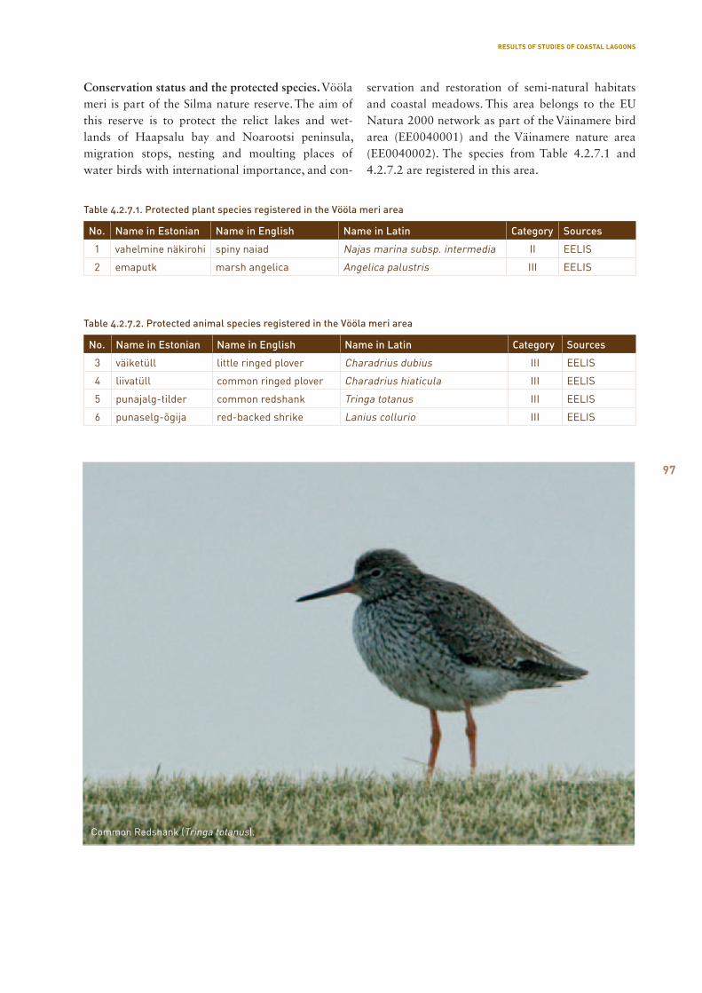
97
Table 4.2.7.1. Protected plant species registered in the Vööla meri area
Table 4.2.7.2. Protected animal species registered in the Vööla meri area
No. Name in Estonian Name in English Name in Latin Category Sources
1 vahelmine näkirohi spiny naiad Najas marina subsp. intermedia II EELIS
2 emaputk marsh angelica Angelica palustris III EELIS
No. Name in Estonian Name in English Name in Latin Category Sources
3 väiketüll little ringed plover Charadrius dubius III EELIS
4 liivatüll common ringed plover Charadrius hiaticula III EELIS
5 punajalg-tilder common redshank Tringa totanus III EELIS
6 punaselg-õgija red-backed shrike Lanius collurio III EELIS
Conservation status and the protected species. Vööla meri is part of the Silma nature reserve. The aim of this reserve is to protect the relict lakes and wet-lands of Haapsalu bay and Noarootsi peninsula, migration stops, nesting and moulting places of water birds with international importance, and con-
servation and restoration of semi-natural habitats and coastal meadows. This area belongs to the EU Natura 2000 network as part of the Väinamere bird area (EE0040001) and the Väinamere nature area (EE0040002). The species from Table 4.2.7.1 and 4.2.7.2 are registered in this area.
Common Redshank (Tringa totanus).
RESULTS OF STUDIES OF COASTAL LAGOONS
98
4.3. Comparison of sediments from Estonian and Gotland coastal lagoons
Monika Übner
The sample dry weight, the content of organic matter, lipids and humic substances from two fractions from different depths were measured to biochemically characterise the sediments from Saaremaa, Hääde-meeste and Võiste areas in the Pärnu County, and from Gotland. Since the mud layer depth in Gotland was mostly up to 10 cm, the properties of top layers in all sampling points were compared. The aforemen-tioned properties were chosen for the preliminary assessment on the suitability of the sediments as ther-apeutic mud.
It was known previously that mud from several coastal lakes on Saaremaa (Oessaare, Poka, Suurlaht) is on the therapeutic mud list, but only the last deposit is used actively. Saaremaa coastal lakes’ sample points are presented in Annex 2.
The studied coastal lagoons in the Pärnu county (Annex 3) were located on the Luitemaa nature reserve’s territory, where the coastal meadows have been maintained for years. In the course of this, some lagoons have been deepened (Photo 4.3.1). During the excavation, excessive sediment was raised to the shore, and as a result the bed of the body of water is now uneven. In the sediment samples from these bod-ies of water the layers are generally mixed and do not give accurate information about the sediment devel-opment. Since the lagoons are small, they do not have names. Cattle is used to maintain the coastal mead-ows, they occasionally go into the lagoons. Some lagoons are directly connected to the sea, some not, but tidewater associated with storms brings some
new sea water. The mud on the surface layers is light. In places, the mud has the hydrogen sulphide odour. The thickness of the sandy mud layer varies, reach-ing 20 cm in places, followed by sand or gravel and clay, or immediately clay. The mud colour varies from greenish brown to black.
The sampling points on Gotland (Annex 4) were spread over the island. There is often a limestone pla-teau on the bottom of the bodies of water and the mud layer covering it is therefore very thin. During low water, the lagoons are a little or not at all connect-ed to the sea. The thickness of eastern coast sediments in shaded areas was up to 20 cm. The sandy sediment was blackish and with the hydrogen sulphide odour. The eastern coast samples were taken from a coastal lake boat harbour with a strong anthropogenic in-fluence. The thickness of the black flexible mud layer was over 1.5 m. There was a dark grey sandy sediment in the coastal lagoon on the southern coast, the sedi-ment was odourless in general, but in one point the hydrogen sulphide odour was present. The sediment thickness was up to 10 cm, and in shaded areas up to 19 cm. The sandy lagoon sediments from the Fårö islands in the north were white and contained small dark particles. The sediment thickness was up to 10 cm. The sampling sites on the western coast was done on the territory of the Paviken nature reserve that is managed with cattle. A stream from the bog flows in the coastal lake, bringing along humic-rich sediments and water. The sediments are fluffy and 20 cm deep, followed by a sandy layer. Above it there is dark grey mud and under it yellowish slightly lighter sandy mud. Hydrogen sulphide odour can be detected.
The water content in the sediments from the Saaremaa coastal lagoons is generally high (Figure 4.3.1). Only sediments from Mullutu and Suurlaht contain less water, with a mean dry weight of 63% and 41% of the sediment wet weight accordingly. The high-est water content is in the sediments from Linnulaht, with dry weight on the surface layer being 5%. The water content in the sediments from the lagoons in Pärnu County is not high. The dry matter content is between 19−60% from the wet weight. The water con-tent is higher in some of the Võiste deepened lagoons, where the dry matter weight was around 20%. The samples from Gotland contained less water and their dry matter weight was between 30−70%, a sample taken from the harbour of Bogevik coastal lake was an exception, its water content was the highest.
Photo 4.3.1. Amphibious vehicle Avanger was necessary to reach the coastal lagoons and go through the wetlands. Võiste coastal lagoon in Luitemaa.
RESULTS OF STUDIES OF COASTAL LAGOONS
99
The three sampling regions are different based on the organic matter content (Figure 4.3.2). Saaremaa coastal lakes are characterised by a higher organic matter content that is in the top layers generally over 10%. The values were higher in the sediments from Linnulaht, Laidevahe and Aenga. The fact that Linnulaht is considered to be one of the most nutri-ent-rich bodies of water is also reflected in the higher organic matter content of the sediments. The coastal lagoons in Pärnu county contain less organic matter, reaching over 10% in some sampling points. The sed-iments from Gotland contained less organic matter, mostly less than 5% of the dry weight, but in the har-bour area of Bogevik coastal lake the number was several times higher, reaching 26%
If we take the generally high water content into account and calculate the organic matter content based on the wet weight of natural sediments, then the organic matter content in all samples is below 4%. Higher levels were measured in the Saaremaa
Laidevahe coastal lake and in the Pärnu County Võiste area sampling points. The levels were lower in some of the Gotland’s and Saaremaa’s sandier sedi-ment samples.
The lipid class includes a number of different com-pounds, mostly hydrocarbons and phospholipids. The levels of the latter are related to the biomass, and their concentration is decreased with increasing depth. Therefore, the lipid content shows the presence of fresh organic matter (Pinturier Geiss et al., 2002). Most of the samples from Gotland and samples from Mullutu and Suurlaht on Saaremaa indicated the lowest levels of substances from this class according to the lipid content (Figure 4.3.3).
The highest lipid concentration is in the top layers of the sediment. The most lipids were detected in the Linnulaht sediments from Saaremaa − 1.2% of the sediment dry matter. One sampling point in Võiste (Pärnu County) differed with a level of 0.55%. The lipid level of the sample taken from the Bogevik boat harbour on Gotland reached 0.7% of sediment dry matter. According to the literature, it can be said that among the three sampled area coastal lake sediments, the following coastal lakes on Saaremaa − Linnulaht, Laidevahe and Aenga contain the largest amount of fresh organic matter.
There is a linear correlation between the organic mat ter and lipid content (R2 = 0.8365). In some of the Pärnu County’s coastal lagoon sediments, lipids formed 10% of the organic matter content. In other areas this was in general under 5%. The abundance of lipids in the sediments of some of the coastal lagoons in the Pärnu County may be due to the transport of
Figure 4.3.3. Lipid content in the sediment samples.
Figure 4.3.1. Dry weight of the sediment samples.
Figure 4.3.2. Sediment sample organic matter content.
RESULTS OF STUDIES OF COASTAL LAGOONS
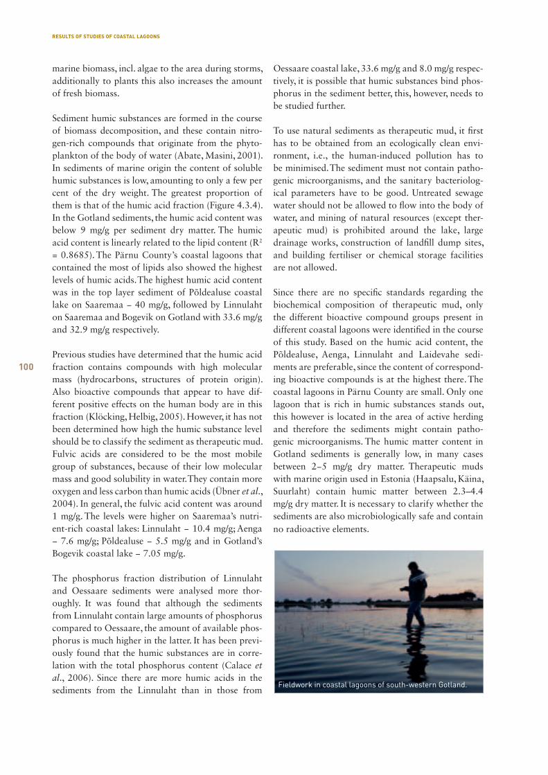
100
marine biomass, incl. algae to the area during storms, additionally to plants this also increases the amount of fresh biomass.
Sediment humic substances are formed in the course of biomass decomposition, and these contain nitro-gen-rich compounds that originate from the phyto-plankton of the body of water (Abate, Masini, 2001). In sediments of marine origin the content of soluble humic substances is low, amounting to only a few per cent of the dry weight. The greatest proportion of them is that of the humic acid fraction (Figure 4.3.4). In the Gotland sediments, the humic acid content was below 9 mg/g per sediment dry matter. The humic acid content is linearly related to the lipid content (R2 = 0.8685). The Pärnu County’s coastal lagoons that contained the most of lipids also showed the highest levels of humic acids. The highest humic acid content was in the top layer sediment of Põldealuse coastal lake on Saaremaa − 40 mg/g, followed by Linnulaht on Saaremaa and Bogevik on Gotland with 33.6 mg/g and 32.9 mg/g respectively.
Previous studies have determined that the humic acid fraction contains compounds with high molecular mass (hydrocarbons, structures of protein origin). Also bioactive compounds that appear to have dif-ferent positive effects on the human body are in this fraction (Klöcking, Helbig, 2005). However, it has not been determined how high the humic substance level should be to classify the sediment as therapeutic mud. Fulvic acids are considered to be the most mobile group of substances, because of their low molecular mass and good solubility in water. They contain more oxygen and less carbon than humic acids (Übner et al., 2004). In general, the fulvic acid content was around 1 mg/g. The levels were higher on Saaremaa’s nutri-ent-rich coastal lakes: Linnulaht − 10.4 mg/g; Aenga − 7.6 mg/g; Põldealuse − 5.5 mg/g and in Gotland’s Bogevik coastal lake − 7.05 mg/g.
The phosphorus fraction distribution of Linnulaht and Oessaare sediments were analysed more thor-oughly. It was found that although the sediments from Linnulaht contain large amounts of phosphorus compared to Oessaare, the amount of available phos-phorus is much higher in the latter. It has been previ-ously found that the humic substances are in corre-lation with the total phosphorus content (Calace et al., 2006). Since there are more humic acids in the sediments from the Linnulaht than in those from
Oessaare coastal lake, 33.6 mg/g and 8.0 mg/g respec-tively, it is possible that humic substances bind phos-phorus in the sediment better, this, however, needs to be studied further.
To use natural sediments as therapeutic mud, it first has to be obtained from an ecologically clean envi-ronment, i.e., the human-induced pollution has to be minimised. The sediment must not contain patho-genic microorganisms, and the sanitary bacteriolog-ical parameters have to be good. Untreated sewage water should not be allowed to flow into the body of water, and mining of natural resources (except ther-apeutic mud) is prohibited around the lake, large drainage works, construction of landfill dump sites, and building fertiliser or chemical storage facilities are not allowed.
Since there are no specific standards regarding the biochemical composition of therapeutic mud, only the different bioactive compound groups present in different coastal lagoons were identified in the course of this study. Based on the humic acid content, the Põldealuse, Aenga, Linnulaht and Laidevahe sedi-ments are preferable, since the content of correspond-ing bioactive compounds is at the highest there. The coastal lagoons in Pärnu County are small. Only one lagoon that is rich in humic substances stands out, this however is located in the area of active herding and therefore the sediments might contain patho-genic microorganisms. The humic matter content in Gotland sediments is generally low, in many cases between 2−5 mg/g dry matter. Therapeutic muds with marine origin used in Estonia (Haapsalu, Käina, Suurlaht) contain humic matter between 2.3–4.4 mg/g dry matter. It is necessary to clarify whether the sediments are also microbiologically safe and contain no radioactive elements.
Fieldwork in coastal lagoons of south-western Gotland.
RESULTS OF STUDIES OF COASTAL LAGOONS
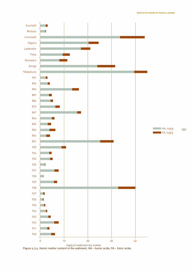
101
Figure 4.3.4. Humic matter content in the sediment. HA − humic acids, FA − fulvic acids.
RESULTS OF STUDIES OF COASTAL LAGOONS
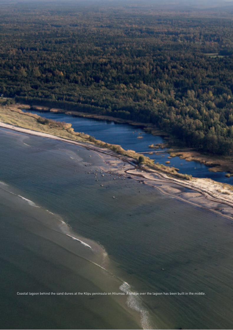
102
Coastal lagoon behind the sand dunes at the Kõpu peninsula on Hiiumaa. A bridge over the lagoon has been built in the middle.
103
VProtection and management of coastal lagoons
5.1. Determination of watersheds and characterisation of the catchment basin with support of maps
Ruta Tamre
The aim of this article is to give guidelines on how to determine the catchment basin and factors influenc-ing it using mainly maps. This material also gives an overview of map data available in Estonia that help to characterise the influence of catchment basins and related processes on lakes.
To simplify the explanations, the processes described in this guide are based on several lakes (Kiissalaht, Suurlaht, Lake Nüpli).
GIS software MapInfo Professional 8.5 was used in the preparation of this material and in processing the map data. The list of used maps and a list of references regarding authors and origins is included at the end of this material.
5.1.1. Definition of catchment basin and watershed
Catchment basin (catchment) is an area where the body of water (river, lake and also sea) gets its water. If the lake is a watercourse, the catchment basins of its conduits are also considered as parts of the catch-ment basin of the lake. The lake’s surface is also considered a part of the catchment basin. Although coastal lakes may be connected to the sea depending on the season, the surface area of the sea is not con-sidered to be part of the catchment basin.
The catchment basins are divided into above the ground (surface water catchment) and underground catchments (groundwater catchment), their bounda-ries do not necessarily coincide with each other. In areas where the ground is level and the bedrock near the ground, the surface and groundwater catchments coincide. This work will address surface water basins. The catchment basins are separated by each other with watersheds or inter-catchment boundaries that determine the line where the water start to flow in the opposite direction. Usually watersheds are higher parts of the ground (mountain tops, uplands), while in the course of land development etc. the natural
PROTECTION AND MANAGEMENT OF COASTAL LAGOONS
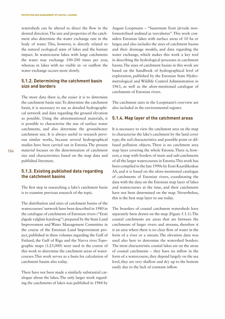
104
PROTECTION AND MANAGEMENT OF COASTAL LAGOONS
watersheds can be altered to direct the flow in the desired direction. The size and properties of the catch-ment also determine the water exchange rate in the body of water. This, however, is directly related to the natural ecological state of lakes and the human impact. In watercourse lakes with large catchments the water may exchange 100-200 times per year, whereas in lakes with no visible in- or outflow the water exchange occurs more slowly.
5.1.2. Determining the catchment basin size and borders
The more data there is, the easier it is to determine the catchment basin size. To determine the catchment basin, it is necessary to use as detailed hydrographi-cal network and data regarding the ground elevation as possible. Using the aforementioned materials, it is possible to characterise the size of surface water catchments, and also determine the groundwater catchment size. It is always useful to research previ-ous similar works, because several hydrographical studies have been carried out in Estonia. The present material focuses on the determination of catchment size and characteristics based on the map data and published literature.
5.1.3. Existing published data regarding the catchment basins
The first step in researching a lake’s catchment basin is to examine previous research of the topic.
The distribution and sizes of catchment basins of the watercourses’ network have been described in 1980 in the catalogue of catchments of Estonian rivers (“Eesti jõgede valglate kataloog”) prepared by the State Land Improvement and Water Management Committee in the course of the Estonian Land Improvement pro-ject, published in three volumes regarding the Gulf of Finland, the Gulf of Riga and the Narva river. Topo-graphic maps (1:25,000) were used in the course of this work to determine the catchment areas of water-courses. This work serves as a basis for calculation of catchment basins also today.
There have not been made a similarly substantial cat-alogue about the lakes. The only larger work regard-ing the catchments of lakes was published in 1984 by
August Loopmann − “Suuremate Eesti järvede mor-fomeetrilised andmed ja veevahetus”. This work con-siders Estonian lakes with surface areas of 10 ha or larger, and also includes the sizes of catchment basins and their drainage models, and data regarding the water exchange, which makes this work a key tool in describing the hydrological processes in catchment basins. The sizes of catchment basins in this work are based on the handbook of hydrographical level of exploration, published by the Estonian State Hydro-metrological and Wildlife Control Administration in 1963, as well as the afore-mentioned catalogue of catchments of Estonian rivers.
The catchment sizes in the Loopmann’s overview are also included in the environmental register.
5.1.4. Map layer of the catchment areas
It is necessary to view the catchment area on the map to characterise the lake’s catchment by the land cover type, the soil characteristics and possible point or dif-fused pollution objects. There is no catchment area map layer covering the whole Estonia. There is, how-ever, a map with borders of main and sub-catchments of all the larger watercourses in Estonia. This work has been compiled in the late 1990s by Eesti Kaardikeskus AS, and it is based on the afore-mentioned catalogue of catchments of Estonian rivers, coordinating the data with the data on the Estonian map layer of lakes and watercourses at the time, and their catchments have not been determined on the map. Nevertheless, this is the best map layer to use today.
The boarders of coastal catchment watersheds have separately been drawn on the map (Figure 5.1.1). The coastal catchments are areas that are between the catchments of larger rivers and streams, therefore it is an area where there is no clear flow of water in the form of a river or a stream. The elevation data was used also here to determine the watershed borders. The most characteristic coastal lakes are on the areas of coastal catchments − they have no inflow in the form of a watercourse, they depend largely on the sea level, they are very shallow and dry up to the bottom easily due to the lack of constant inflow.
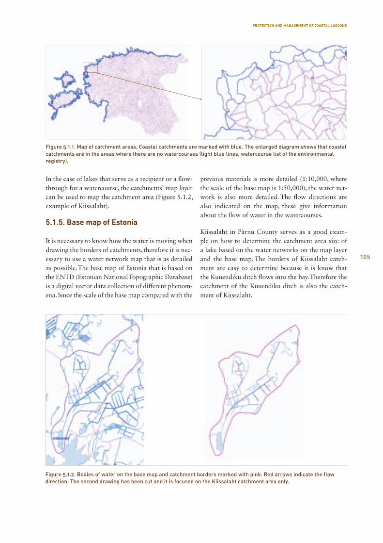
105
PROTECTION AND MANAGEMENT OF COASTAL LAGOONS
In the case of lakes that serve as a recipient or a flow-through for a watercourse, the catchments’ map layer can be used to map the catchment area (Figure 5.1.2, example of Kiissalaht).
5.1.5. Base map of Estonia
It is necessary to know how the water is moving when drawing the borders of catchments, therefore it is nec-essary to use a water network map that is as detailed as possible. The base map of Estonia that is based on the ENTD (Estonian National Topographic Database) is a digital vector data collection of different phenom-ena. Since the scale of the base map compared with the
previous materials is more detailed (1:10,000, where the scale of the base map is 1:50,000), the water net-work is also more detailed. The flow directions are also indicated on the map, these give information about the flow of water in the watercourses.
Kiissalaht in Pärnu County serves as a good exam-ple on how to determine the catchment area size of a lake based on the water networks on the map layer and the base map. The borders of Kiissalaht catch-ment are easy to determine because it is know that the Kuuendiku ditch flows into the bay. Therefore the catchment of the Kuuendiku ditch is also the catch-ment of Kiissalaht.
Figure 5.1.1. Map of catchment areas. Coastal catchments are marked with blue. The enlarged diagram shows that coastal catchments are in the areas where there are no watercourses (light blue lines, watercourse list of the environmental registry).
Figure 5.1.2. Bodies of water on the base map and catchment borders marked with pink. Red arrows indicate the flow direction. The second drawing has been cut and it is focused on the Kiissalaht catchment area only.
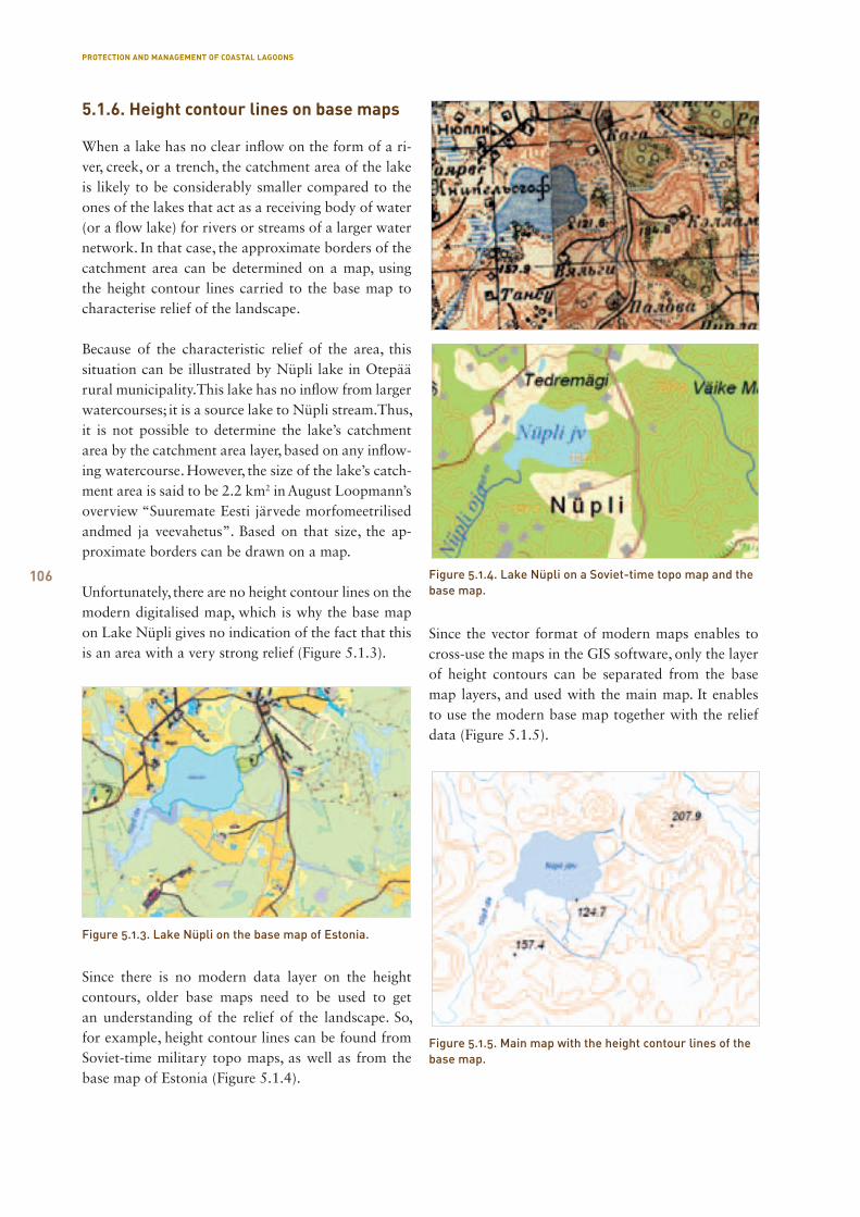
106
5.1.6. Height contour lines on base maps
When a lake has no clear inflow on the form of a ri-ver, creek, or a trench, the catchment area of the lake is likely to be considerably smaller compared to the ones of the lakes that act as a receiving body of water (or a flow lake) for rivers or streams of a larger water network. In that case, the approximate borders of the catchment area can be determined on a map, using the height contour lines carried to the base map to characterise relief of the landscape.
Because of the characteristic relief of the area, this situation can be illustrated by Nüpli lake in Otepää rural municipality. This lake has no inflow from larger watercourses; it is a source lake to Nüpli stream. Thus, it is not possible to determine the lake’s catchment area by the catchment area layer, based on any inflow-ing watercourse. However, the size of the lake’s catch-ment area is said to be 2.2 km2 in August Loopmann’s overview “Suuremate Eesti järvede morfomeetrilised andmed ja veevahetus”. Based on that size, the ap-proximate borders can be drawn on a map.
Unfortunately, there are no height contour lines on the modern digitalised map, which is why the base map on Lake Nüpli gives no indication of the fact that this is an area with a very strong relief (Figure 5.1.3).
Since there is no modern data layer on the height contours, older base maps need to be used to get an understanding of the relief of the landscape. So, for example, height contour lines can be found from Soviet-time military topo maps, as well as from the base map of Estonia (Figure 5.1.4).
Since the vector format of modern maps enables to cross-use the maps in the GIS software, only the layer of height contours can be separated from the base map layers, and used with the main map. It enables to use the modern base map together with the relief data (Figure 5.1.5).
Figure 5.1.4. Lake Nüpli on a Soviet-time topo map and the base map.
Figure 5.1.3. Lake Nüpli on the base map of Estonia.
Figure 5.1.5. Main map with the height contour lines of the base map.
PROTECTION AND MANAGEMENT OF COASTAL LAGOONS
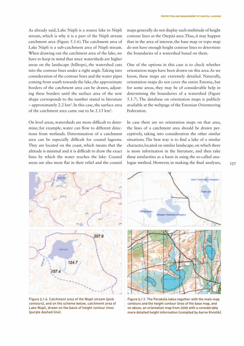
107
As already said, Lake Nüpli is a source lake to Nüpli stream, which is why it is a part of the Nüpli stream catchment area (Figure 5.1.6). The catchment area of Lake Nüpli is a sub-catchment area of Nüpli stream. When drawing out the catchment area of the lake, we have to keep in mind that since watersheds are higher areas on the landscape (hilltops), the watershed cuts into the contour lines under a right angle. Taking into consideration of the contour lines and the water pipes coming from south towards the lake, the approximate borders of the catchment area can be drawn, adjust-ing these borders until the surface area of the new shape corresponds to the number stated in literature – approximately 2.2 km2. In this case, the surface area of the catchment area came out to be 2.13 km2.
On level areas, watersheds are more difficult to deter-mine; for example, water can flow to different direc-tions from wetlands. Determination of a catchment area can be especially difficult for coastal lagoons. They are located on the coast, which means that the altitude is minimal and it is difficult to draw the exact lines by which the water reaches the lake. Coastal areas are also more flat in their relief and the coastal
maps generally do not display such multitude of height contour lines as the Otepää area. Thus, it may happen that in the area of interest, the base map or topo map do not have enough height contour lines to determine the boundaries of a watershed based on them.
One of the options in this case is to check whether orientation maps have been drawn on this area. As we know, these maps are extremely detailed. Naturally, orientation maps do not cover the entire Estonia, but for some areas, they may be of considerable help in determining the boundaries of a watershed (Figure 5.1.7). The database on orientation maps is publicly available at the webpage of the Estonian Orienteering Federation.
In case there are no orientation maps on that area, the lines of a catchment area should be drawn per-ceptively, taking into consideration the other similar situations. The best way is to find a lake of a similar character, located on similar landscape, on which there is more information in the literature, and then take these similarities as a basis in using the so-called ana-logue method. However, in making the final analyses,
Figure 5.1.6. Catchment area of the Nüpli stream (pink contours), and on the scheme below, catchment area of Lake Nüpli, drawn on the basis of height contour lines (purple dashed line).
Figure 5.1.7. The Peraküla lakes together with the main map contours and the height contour lines of the base map, and on above, an orientation map from 2009 with a considerably more detailed height information (compiled by Aarne Kivistik).
PROTECTION AND MANAGEMENT OF COASTAL LAGOONS
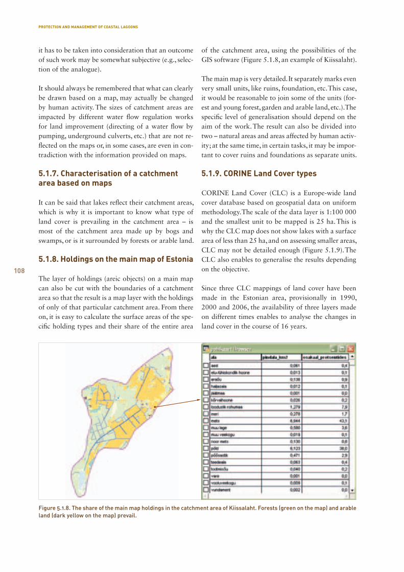
108
it has to be taken into consideration that an outcome of such work may be somewhat subjective (e.g., selec-tion of the analogue).
It should always be remembered that what can clearly be drawn based on a map, may actually be changed by human activity. The sizes of catchment areas are impacted by different water flow regulation works for land improvement (directing of a water flow by pumping, underground culverts, etc.) that are not re-flected on the maps or, in some cases, are even in con-tradiction with the information provided on maps.
5.1.7. Characterisation of a catchment area based on maps
It can be said that lakes reflect their catchment areas, which is why it is important to know what type of land cover is prevailing in the catchment area – is most of the catchment area made up by bogs and swamps, or is it surrounded by forests or arable land.
5.1.8. Holdings on the main map of Estonia
The layer of holdings (areic objects) on a main map can also be cut with the boundaries of a catchment area so that the result is a map layer with the holdings of only of that particular catchment area. From there on, it is easy to calculate the surface areas of the spe-cific holding types and their share of the entire area
of the catchment area, using the possibilities of the GIS software (Figure 5.1.8, an example of Kiissalaht).
The main map is very detailed. It separately marks even very small units, like ruins, foundation, etc. This case, it would be reasonable to join some of the units (for-est and young forest, garden and arable land, etc.). The specific level of generalisation should depend on the aim of the work. The result can also be divided into two – natural areas and areas affected by human activ-ity; at the same time, in certain tasks, it may be impor-tant to cover ruins and foundations as separate units.
5.1.9. CORINE Land Cover types
CORINE Land Cover (CLC) is a Europe-wide land cover database based on geospatial data on uniform methodology. The scale of the data layer is 1:100 000 and the smallest unit to be mapped is 25 ha. This is why the CLC map does not show lakes with a surface area of less than 25 ha, and on assessing smaller areas, CLC may not be detailed enough (Figure 5.1.9). The CLC also enables to generalise the results depending on the objective.
Since three CLC mappings of land cover have been made in the Estonian area, provisionally in 1990, 2000 and 2006, the availability of three layers made on different times enables to analyse the changes in land cover in the course of 16 years.
Figure 5.1.8. The share of the main map holdings in the catchment area of Kiissalaht. Forests (green on the map) and arable land (dark yellow on the map) prevail.
PROTECTION AND MANAGEMENT OF COASTAL LAGOONS
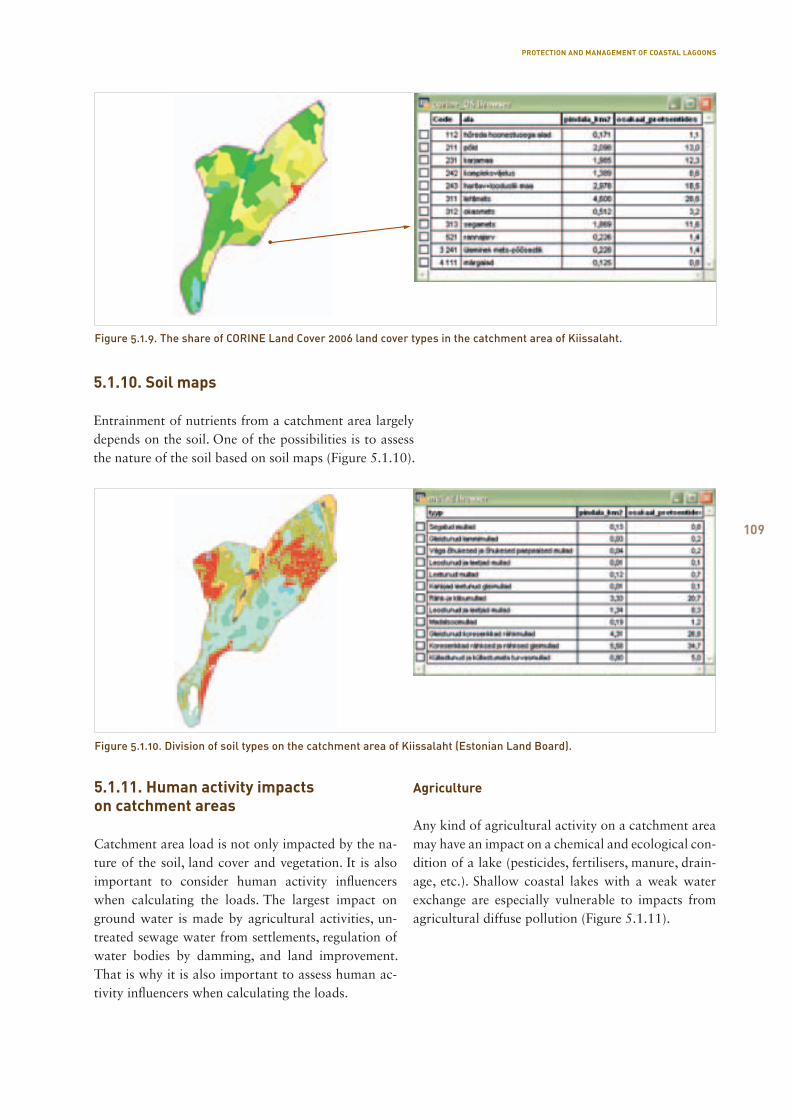
109
5.1.11. Human activity impacts on catchment areas
Catchment area load is not only impacted by the na-ture of the soil, land cover and vegetation. It is also important to consider human activity influencers when calculating the loads. The largest impact on ground water is made by agricultural activities, un-treated sewage water from settlements, regulation of water bodies by damming, and land improvement. That is why it is also important to assess human ac-tivity influencers when calculating the loads.
Agriculture
Any kind of agricultural activity on a catchment area may have an impact on a chemical and ecological con-dition of a lake (pesticides, fertilisers, manure, drain-age, etc.). Shallow coastal lakes with a weak water exchange are especially vulnerable to impacts from agricultural diffuse pollution (Figure 5.1.11).
Figure 5.1.9. The share of CORINE Land Cover 2006 land cover types in the catchment area of Kiissalaht.
Figure 5.1.10. Division of soil types on the catchment area of Kiissalaht (Estonian Land Board).
5.1.10. Soil maps
Entrainment of nutrients from a catchment area largely depends on the soil. One of the possibilities is to assess the nature of the soil based on soil maps (Figure 5.1.10).
PROTECTION AND MANAGEMENT OF COASTAL LAGOONS
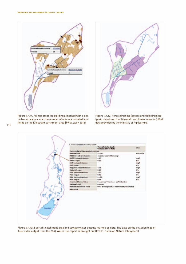
110
Figure 5.1.12. Forest draining (green) and field draining (pink) objects on the Kiissalaht catchment area (in 2006), data provided by the Ministry of Agriculture.
Figure 5.1.13. Suurlaht catchment area and sewage water outputs marked as dots. The data on the pollution load of Aste water output from the 2009 Water use report is brought out (EELIS: Estonian Nature Infosystem).
Figure 5.1.11. Animal breeding buildings (marked with a dot; on two occasions, also the number of animals is stated) and fields on the Kiissalaht catchment area (PRIA, 2007 data).
PROTECTION AND MANAGEMENT OF COASTAL LAGOONS

111
Land improvement
Land improvement regulates the amount of water in soil, changing and directing the flow of water. New ditches are built, water pipes are directed to piping systems, water bodies are dredged, etc. The aim is to make excessively damp areas suitable for growing plants. In addition to fields, also forests are drained. Such regulation of the natural flow of water has a strong impact on the catchment area and thus, also the water body. In order to assess the extent of these impacts, it is important to take into consideration the extent of land improvement systems on a specific catchment area when describing that catchment area (Figure 5.1.12).
Waste water
Waste water causes a pollution load on water bodies. Although pollution load has constantly decreased in the recent years, (reduction of production and agri-cultural activities, increased pollution charges), it is always possible to check whether there are any waste-water outlets on the catchment area, and to deter-mine the pollution load by years. Wastewater can be directed to both the soil and directly to the water body (Figure 5.1.13).
5.1.12. Summary
The ecological condition of lakes is directly influ-enced by the characteristics of the catchment area, its vegetation, water network, the potential point source and diffuse pollution objects, etc. This is why impacts of a catchment area cannot be ignored when stud-ying water characteristics of lakes and making con-clusions. The databases that manage environmen-tal data are increasingly connected with geoinfo and map materials; many information systems offer open map applications. GIS software enables to view the map data of these different databases as a whole and to analyse the data. The aim of this work was to pro-vide short instructions for describing catchment areas based on maps, and to bring examples of the possi-ble maps that could be used. This work provides no specific instructions on how to interpret the material.
Recommended map materials
Base maps
Main map of Estonia (vector map, scale 1:10,000),
Land Board
Base map of Estonia (vector map, 1:50,000)
Topographic map (raster map, 1:25,000)
Thematic data layers
Water bodies (lakes, water courses, the room shapes
of ETAK have been used), the Estonian Environment
Information Centre (hereinafter EEIC)
Catchment areas, EEIC
Waste water outlets, the Estonian Environment
Information Centre, Soil maps, Land Board
CORINE LandCover, European Agency and EEIC
Public databases and map applications
Environmental register (http://register.keskkonnainfo.ee,
environmental data), the Estonian Environment
Information Centre
XGis Geoportal (http://xgis.maaamet.ee/xGIS/XGis,
including historic base maps, a soil map, land
improvement systems), Land Board
PRIA map application
(https://kls.eesti.ee/pria public map/)
Orientation map database
(http://www.orienteerumine.ee/kaart/kaardid.php),
Estonian Orienteering Federation
PROTECTION AND MANAGEMENT OF COASTAL LAGOONS
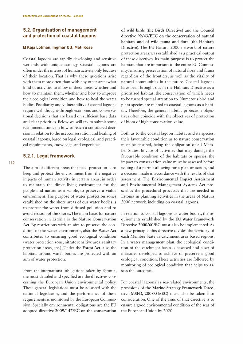
112
5.2. Organisation of management and protection of coastal lagoons
Kaja Lotman, Ingmar Ott, Mati Kose
Coastal lagoons are rapidly developing and sensitive wetlands with unique ecology. Coastal lagoons are often under the interest of human activity only because of their location. That is why these questions arise with them more often than with any other area: what kind of activities to allow in these areas, whether and how to maintain them, whether and how to improve their ecological condition and how to heal the water bodies. Peculiarity and vulnerability of coastal lagoons require well thought-through economic and conserva-tional decisions that are based on sufficient base data and clear priorities. Below we will try to submit some recommendations on how to reach a considered deci-sion in relation to the use, conservation and healing of coastal lagoons, based on legal, ecological, and practi-cal requirements, knowledge, and experience.
5.2.1. Legal framework
The aim of different areas that need protection is to keep and protect the environment from the negative impacts of human activity in certain areas, in order to maintain the direct living environment for the people and nature as a whole, to preserve a viable environment. The purpose of water protection zones established on the shore areas of our water bodies is to protect the water from diffused pollution and to avoid erosion of the shores. The main basis for nature conservation in Estonia is the Nature Conservation Act. By restrictions with an aim to preserve the con-dition of the water environment, also the Water Act contributes to ensuring good ecological condition (water protection zone, nitrate sensitive area, sanitary protection areas, etc.). Under the Forest Act, also the habitats around water bodies are protected with an aim of water protection.
From the international obligations taken by Estonia, the most detailed and specified are the directives con-cerning the European Union environmental policy. These general legislations must be adjusted with the national legislation, and the performance of these requirements is monitored by the European Commis-sion. Specially environmental obligations are the EU adopted directive 2009/147/EC on the conservation
of wild birds (the Birds Directive) and the Council directive 92/43/EEC on the conservation of natural habitats and of wild fauna and flora (the Habitats Directive). The EU Natura 2000 network of nature protection areas was established as a practical output of these directives. Its main purpose is to protect the habitats that are important to the entire EU Commu-nity, ensuring preservation of natural flora and fauna regardless of the frontiers, as well as the vitality of natural communities in the future. Coastal lagoons have been brought out in the Habitats Directive as a prioritised habitat, the conservation of which needs to be turned special attention to. Numerous bird and plant species are related to coastal lagoons as a habi-tat. Therefore, the general habitat protection objec-tives often coincide with the objectives of protection of biota of high conservation value.
Both as to the coastal lagoon habitat and its species, their favourable condition as to nature conservation must be ensured, being the obligation of all Mem-ber States. In case of activities that may damage the favourable condition of the habitats or species, the impact to conservation value must be assessed before issuing of a permit allowing for a plan or action, and a decision made in accordance with the results of that assessment. The Environmental Impact Assessment and Environmental Management Systems Act pre-scribes the procedural processes that are needed in Estonia in planning activities in the areas of Natura 2000 network, including on coastal lagoons.
In relation to coastal lagoons as water bodies, the re-quirements established by the EU Water Framework Directive 2000/60/EC must also be implemented. As a new principle, this directive divides the territory of each Member State as catchment area based regions. In a water management plan, the ecological condi-tion of the catchment basin is assessed and a set of measures developed to achieve or preserve a good ecological condition. These activities are followed by monitoring of ecological condition that helps to as-sess the outcomes.
For coastal lagoons as sea-related environments, the provisions of the Marine Strategy Framework Direc-tive (MSFD, 2008/56/EC) must also be taken into consideration. One of the aims of that directive is to ensure a good environmental condition of the seas of the European Union by 2020.
PROTECTION AND MANAGEMENT OF COASTAL LAGOONS
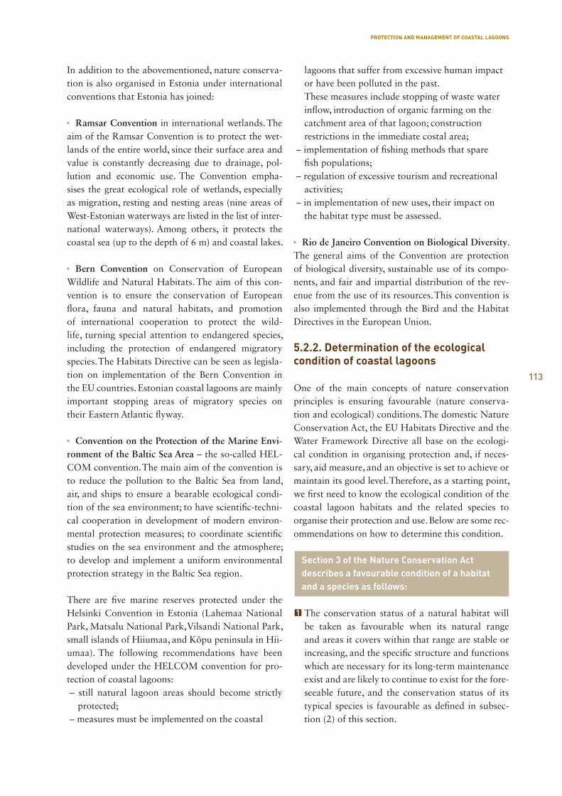
113
In addition to the abovementioned, nature conserva-tion is also organised in Estonia under international conventions that Estonia has joined:
Ramsar Convention in international wetlands. The aim of the Ramsar Convention is to protect the wet-lands of the entire world, since their surface area and value is constantly decreasing due to drainage, pol-lution and economic use. The Convention empha-sises the great ecological role of wetlands, especially as migration, resting and nesting areas (nine areas of West-Estonian waterways are listed in the list of inter-national waterways). Among others, it protects the coastal sea (up to the depth of 6 m) and coastal lakes.
Bern Convention on Conservation of European Wildlife and Natural Habitats. The aim of this con-vention is to ensure the conservation of European flora, fauna and natural habitats, and promotion of international cooperation to protect the wild-life, turning special attention to endangered species, including the protection of endangered migratory species. The Habitats Directive can be seen as legisla-tion on implementation of the Bern Convention in the EU countries. Estonian coastal lagoons are mainly important stopping areas of migratory species on their Eastern Atlantic flyway.
Convention on the Protection of the Marine Envi-ronment of the Baltic Sea Area – the so-called HEL-COM convention. The main aim of the convention is to reduce the pollution to the Baltic Sea from land, air, and ships to ensure a bearable ecological condi-tion of the sea environment; to have scientific-techni-cal cooperation in development of modern environ-mental protection measures; to coordinate scientific studies on the sea environment and the atmosphere; to develop and implement a uniform environmental protection strategy in the Baltic Sea region.
There are five marine reserves protected under the Helsinki Convention in Estonia (Lahemaa National Park, Matsalu National Park, Vilsandi National Park, small islands of Hiiumaa, and Kõpu peninsula in Hii-umaa). The following recommendations have been developed under the HELCOM convention for pro-tection of coastal lagoons:– still natural lagoon areas should become strictly
protected;– measures must be implemented on the coastal
lagoons that suffer from excessive human impact or have been polluted in the past. These measures include stopping of waste water inflow, introduction of organic farming on the catchment area of that lagoon; construction restrictions in the immediate costal area;
– implementation of fishing methods that spare fish populations;
– regulation of excessive tourism and recreational activities;
– in implementation of new uses, their impact on the habitat type must be assessed.
Rio de Janeiro Convention on Biological Diversity. The general aims of the Convention are protection of biological diversity, sustainable use of its compo-nents, and fair and impartial distribution of the rev-enue from the use of its resources. This convention is also implemented through the Bird and the Habitat Directives in the European Union.
5.2.2. Determination of the ecological condition of coastal lagoons
One of the main concepts of nature conservation principles is ensuring favourable (nature conserva-tion and ecological) conditions. The domestic Nature Conservation Act, the EU Habitats Directive and the Water Framework Directive all base on the ecologi-cal condition in organising protection and, if neces-sary, aid measure, and an objective is set to achieve or maintain its good level. Therefore, as a starting point, we first need to know the ecological condition of the coastal lagoon habitats and the related species to organise their protection and use. Below are some rec-ommendations on how to determine this condition.
Section 3 of the Nature Conservation Act describes a favourable condition of a habitat and a species as follows:
The conservation status of a natural habitat will be taken as favourable when its natural range and areas it covers within that range are stable or increasing, and the specific structure and functions which are necessary for its long-term maintenance exist and are likely to continue to exist for the fore-seeable future, and the conservation status of its typical species is favourable as defined in subsec-tion (2) of this section.
PROTECTION AND MANAGEMENT OF COASTAL LAGOONS
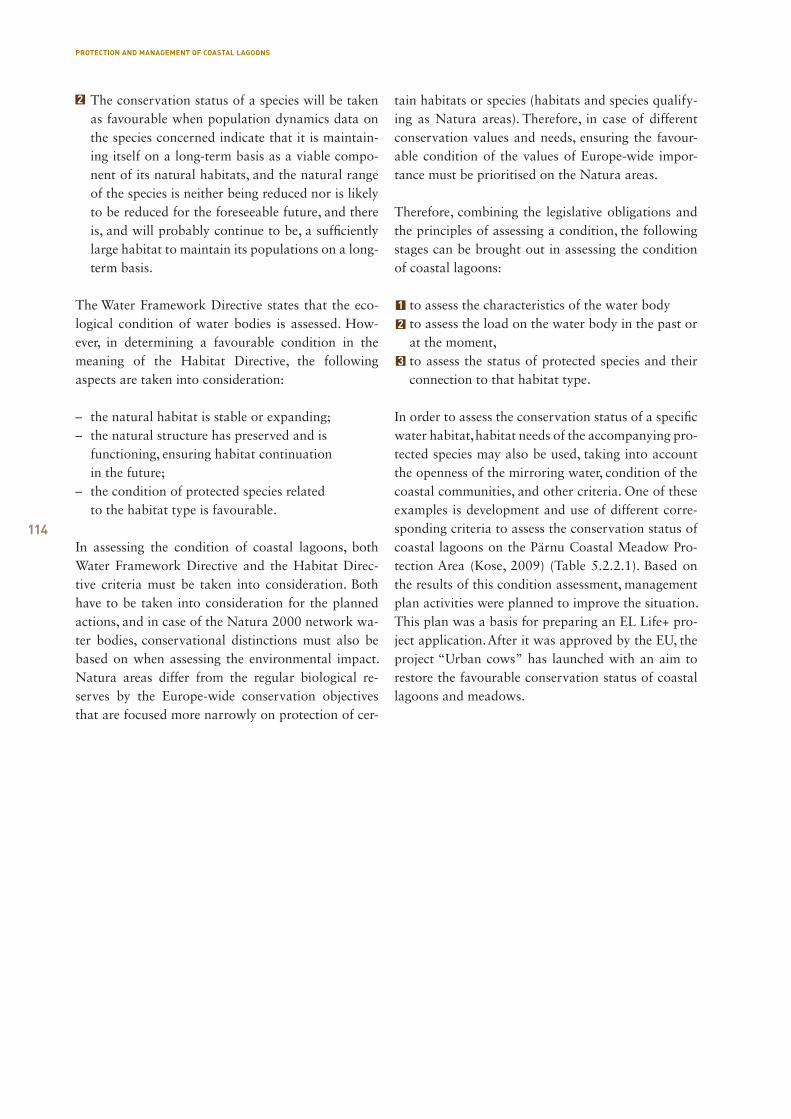
114
The conservation status of a species will be taken as favourable when population dynamics data on the species concerned indicate that it is maintain-ing itself on a long-term basis as a viable compo-nent of its natural habitats, and the natural range of the species is neither being reduced nor is likely to be reduced for the foreseeable future, and there is, and will probably continue to be, a sufficiently large habitat to maintain its populations on a long-term basis.
The Water Framework Directive states that the eco-logical condition of water bodies is assessed. How-ever, in determining a favourable condition in the meaning of the Habitat Directive, the following aspects are taken into consideration:
– the natural habitat is stable or expanding; – the natural structure has preserved and is functioning, ensuring habitat continuation in the future; – the condition of protected species related to the habitat type is favourable.
In assessing the condition of coastal lagoons, both Water Framework Directive and the Habitat Direc-tive criteria must be taken into consideration. Both have to be taken into consideration for the planned actions, and in case of the Natura 2000 network wa-ter bodies, conservational distinctions must also be based on when assessing the environmental impact. Natura areas differ from the regular biological re-serves by the Europe-wide conservation objectives that are focused more narrowly on protection of cer-
tain habitats or species (habitats and species qualify-ing as Natura areas). Therefore, in case of different conservation values and needs, ensuring the favour-able condition of the values of Europe-wide impor-tance must be prioritised on the Natura areas.
Therefore, combining the legislative obligations and the principles of assessing a condition, the following stages can be brought out in assessing the condition of coastal lagoons:
to assess the characteristics of the water bodyto assess the load on the water body in the past or at the moment,to assess the status of protected species and their connection to that habitat type.
In order to assess the conservation status of a specific water habitat, habitat needs of the accompanying pro-tected species may also be used, taking into account the openness of the mirroring water, condition of the coastal communities, and other criteria. One of these examples is development and use of different corre-sponding criteria to assess the conservation status of coastal lagoons on the Pärnu Coastal Meadow Pro-tection Area (Kose, 2009) (Table 5.2.2.1). Based on the results of this condition assessment, management plan activities were planned to improve the situation. This plan was a basis for preparing an EL Life+ pro-ject application. After it was approved by the EU, the project “Urban cows” has launched with an aim to restore the favourable conservation status of coastal lagoons and meadows.
PROTECTION AND MANAGEMENT OF COASTAL LAGOONS
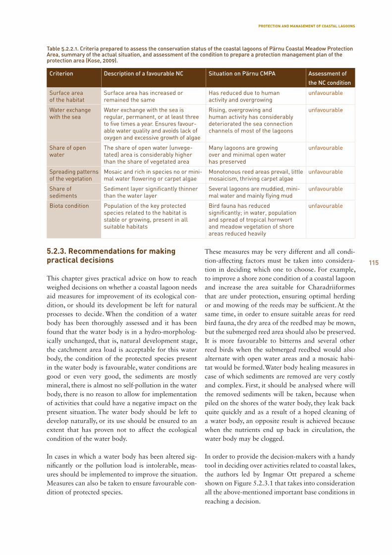
115
5.2.3. Recommendations for making practical decisions
This chapter gives practical advice on how to reach weighed decisions on whether a coastal lagoon needs aid measures for improvement of its ecological con-dition, or should its development be left for natural processes to decide. When the condition of a water body has been thoroughly assessed and it has been found that the water body is in a hydro-morpholog-ically unchanged, that is, natural development stage, the catchment area load is acceptable for this water body, the condition of the protected species present in the water body is favourable, water conditions are good or even very good, the sediments are mostly mineral, there is almost no self-pollution in the water body, there is no reason to allow for implementation of activities that could have a negative impact on the present situation. The water body should be left to develop naturally, or its use should be ensured to an extent that has proven not to affect the ecological condition of the water body.
In cases in which a water body has been altered sig-nificantly or the pollution load is intolerable, meas-ures should be implemented to improve the situation. Measures can also be taken to ensure favourable con-dition of protected species.
These measures may be very different and all condi-tion-affecting factors must be taken into considera-tion in deciding which one to choose. For example, to improve a shore zone condition of a coastal lagoon and increase the area suitable for Charadriiformes that are under protection, ensuring optimal herding or and mowing of the reeds may be sufficient. At the same time, in order to ensure suitable areas for reed bird fauna, the dry area of the reedbed may be mown, but the submerged reed area should also be preserved. It is more favourable to bitterns and several other reed birds when the submerged reedbed would also alternate with open water areas and a mosaic habi-tat would be formed. Water body healing measures in case of which sediments are removed are very costly and complex. First, it should be analysed where will the removed sediments will be taken, because when piled on the shores of the water body, they leak back quite quickly and as a result of a hoped cleaning of a water body, an opposite result is achieved because when the nutrients end up back in circulation, the water body may be clogged.
In order to provide the decision-makers with a handy tool in deciding over activities related to coastal lakes, the authors led by Ingmar Ott prepared a scheme shown on Figure 5.2.3.1 that takes into consideration all the above-mentioned important base conditions in reaching a decision.
Criterion Description of a favourable NC Situation on Pärnu CMPA Assessment of
the NC condition
Surface area of the habitat
Surface area has increased or remained the same
Has reduced due to human activity and overgrowing
unfavourable
Water exchange with the sea
Water exchange with the sea is regular, permanent, or at least three to five times a year. Ensures favour -able water quality and avoids lack of oxygen and excessive growth of algae
Rising, overgrowing and human activity has considerably deteriorated the sea connection channels of most of the lagoons
unfavourable
Share of open water
The share of open water (unvege- tated) area is considerably higher than the share of vegetated area
Many lagoons are growing over and minimal open water has preserved
unfavourable
Spreading patterns of the vegetation
Mosaic and rich in species no or mini-mal water flowering or carpet algae
Monotonous reed areas prevail, little mosaicism, thriving carpet algae
unfavourable
Share of sediments
Sedi ment layer significantly thinner than the water layer
Several lagoons are muddied, mini-mal water and mainly flying mud
unfavourable
Biota condition Population of the key protected species related to the habitat is stable or growing, present in all suitable habitats
Bird fauna has reduced significantly; in water, population and spread of tropical hornwort and meadow vegetation of shore areas reduced heavily
unfavourable
Table 5.2.2.1. Criteria prepared to assess the conservation status of the coastal lagoons of Pärnu Coastal Meadow Protection Area, summary of the actual situation, and assessment of the condition to prepare a protection management plan of the protection area (Kose, 2009).
PROTECTION AND MANAGEMENT OF COASTAL LAGOONS
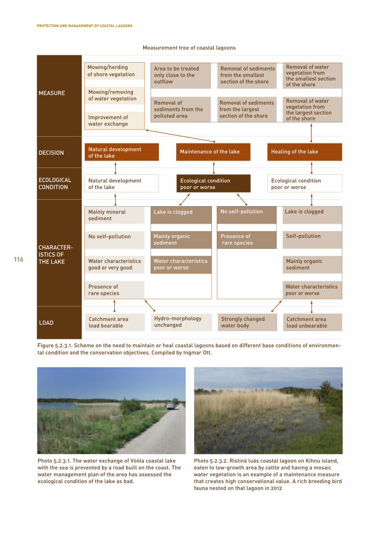
116
Mowing/herding of shore vegetation
Area to be treated only close to the outflow
Removal of sediments from the smallest section of the shore
Removal of water vegetation from the smallest section of the shore
Removal of water vegetation from the largest section of the shore
Removal of sediments from the largest section of the shore
Removal of sediments from the polluted area
MEASURE
DECISION
ECOLOGICAL CONDITION
CHARACTER-ISTICS OF THE LAKE
LOAD
Mowing/removing of water vegetation
Improvement of water exchange
Natural development of the lake
Maintenance of the lake Healing of the lake
Mainly mineral sediment
Lake is clogged Lake is clogged
Mainly organic sediment
No self-pollution
Self-pollutionPresence of rare species
Water characteristics poor or worse
Catchment area load bearable
Strongly changed water body
Catchment area load unbearable
Hydro-morphology unchanged
Presence of rare species
No self-pollution
Water characteristics good or very good
Natural development of the lake
Ecological condition poor or worse
Ecological condition poor or worse
Mainly organic sediment
Water characteristics poor or worse
Measurement tree of coastal lagoons
Figure 5.2.3.1. Scheme on the need to maintain or heal coastal lagoons based on different base conditions of environmen-tal condition and the conservation objectives. Compiled by Ingmar Ott.
Photo 5.2.3.1. The water exchange of Vööla coastal lake with the sea is prevented by a road built on the coast. The water management plan of the area has assessed the ecological condition of the lake as bad.
Photo 5.2.3.2. Ristinä luäs coastal lagoon on Kihnu island, eaten to low-growth area by cattle and having a mosaic water vegetation is an example of a maintenance measure that creates high conservational value. A rich breeding bird fauna nested on that lagoon in 2012
PROTECTION AND MANAGEMENT OF COASTAL LAGOONS
117
5.2.4. Recommendations for management of the lakes studied under the Natureship programme
Since under the Natureship project, many lagoons se-lected for studies were under an higher public interest as to their management and maintenance for several reasons, the aim of the studies was to develop the initial management recommendations on these areas. We will present them grouped into areas to ensure better comprehensibility.
Coastal lakes of SaaremaaMullutu bay. The outflow and connection to the Suur-laht should be cleaned. In cleaning of the outflow, maintenance of the water level should be kept in mind. The outflow may be cleaned of organic sediments. It should not be done between the two lakes. Chop-ping on the shore area is not recommended; the plants should be mowed and removed. Reed may be mowed in the length of 1/10 of the shore, as close to the out-flow as possible, and near the connections with Vägara and Suurlaht. At the connection on the side of Vägara, care should be taken not to reduce its water level.
Suurlaht. The channel between Linnulaht and Suur-laht should be brought into order, especially the wall in the open water section of Suurlaht, without lower-ing the water levels. Chopping on the shore area is not recommended; the plants should be mowed and removed. Reed should be mowed at the length of 1/10 of the shoreline, as close to the watercourses as pos-sible, without reducing the water level.
Vägara bay. The outflow and connection to the Suur-laht should be cleaned. In cleaning of the outflow, maintenance of the water level should be kept in mind. The outflow may be cleaned of organic sedi-ments. It should not be done between the two lakes. Chopping on the shore area is not recommended; the plants should be mowed and removed. Reed should be restrained on a limited area of approximately 1/15 of the length of the shoreline.
Linnulaht. Connection with Suurlaht should be cleaned of vegetation and, if necessary, sediments without lowering the water level. Chopping on the shore area is not recommended; the plants should be mowed and removed. Reed should be mowed at the length of 1/8 of the shoreline. Remove organic sedi-ments on the same areas.
Aenga bay. Connection to the sea should be cleaned without lowering the water level. Chopping on the
shore area is not recommended; the plants should be mowed and removed. External pollution should be reduced and if the connection to the sea is improved, nothing more needs to be done.
Oessaare bay. Watercourses in the immediate proximi-ty of Oessaare should be cleaned without lowering the water level. Chopping on the shore area is not recom-mended; the plants should be mowed and removed. Almost the entire water body needs to be healed by removal of organic sediments and vegetation.
Põldealuse bay. Watercourses should be cleaned from vegetation without lowering the water level. Chop-ping on the shore area is not recommended; the plants should be mowed and removed. Only the watercours-es need to be maintained.
Laidevahe bay. Clean the connection to the sea. Con-nection to Oessaare should be cleaned without low-ering the water level. Mowing and chopping on the shore area is permitted if there are little remains. Con-nections to the sea and watercourses need to be main-tained. The lake itself needs no healing.
Poka bay. Clean the connection to Oessaare. Chop-ping on the shore area is not recommended; the plants should be mowed and removed. Almost the entire wa-ter body needs to be healed by removal of organic sediments and vegetation.
Coastal lakes of LäänemaaKasselaht. Find and stop the pollution from inflows, and restrict the water level on the side of Mõisalaht without reducing the reed.
Vööla meri. In healing, Silma nature reserve’s man-agement plan should be taken as a basis, consult the experts before healing of the water body, and to pre-pare a specific plan for healing of the water body.
Prästvike lake. The reasons for high phosphorus load must be found. The lake should be protected by envi-ronmental use of the catchment area.
Kudani lake. It is a balanced naturally rapidly ageing lake that needs no intervention for healing.
Coastal lakes of Pärnu County.Kahvatu bay. Reed can be mowed in an extent of 1/8 of the length of the shore line. However, lowering of the water level in the lake, as well as leaving the mowed vegetation on the shores needs to be avoided.
PROTECTION AND MANAGEMENT OF COASTAL LAGOONS
118
Estonian native horses.
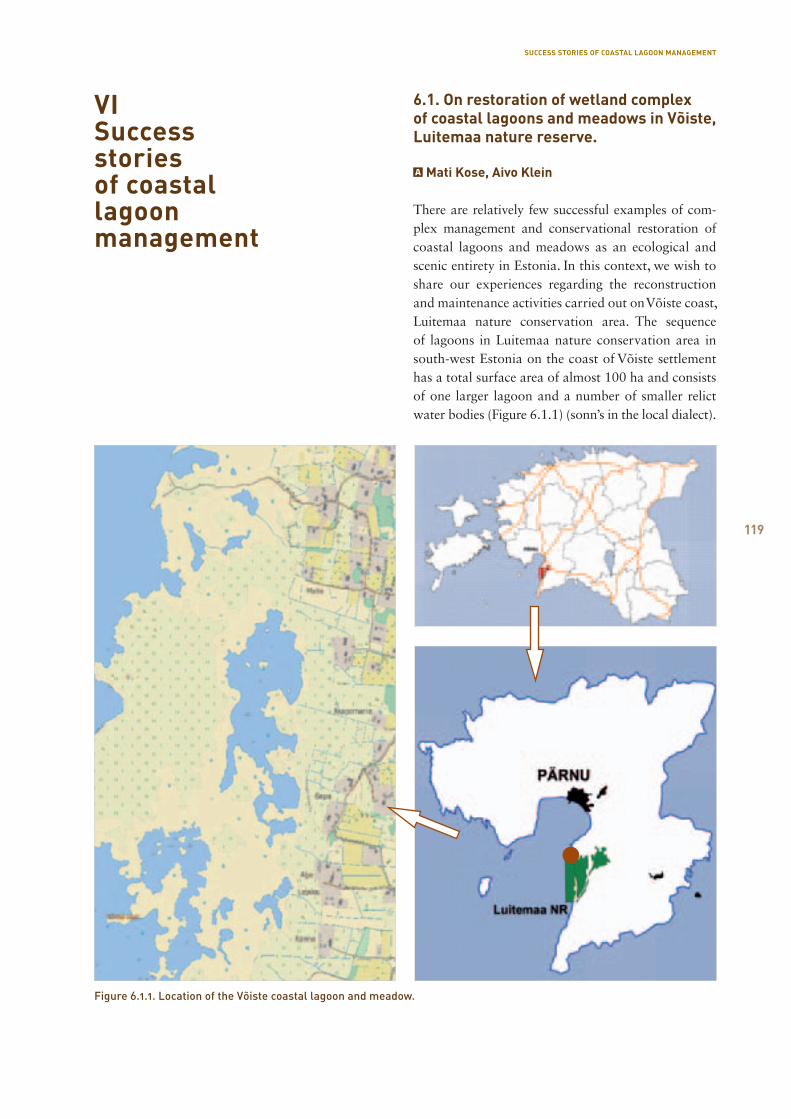
119
VISuccess stories of coastal lagoon management
6.1. On restoration of wetland complex of coastal lagoons and meadows in Võiste, Luitemaa nature reserve.
Mati Kose, Aivo Klein
There are relatively few successful examples of com-plex management and conservational restoration of coastal lagoons and meadows as an ecological and scenic entirety in Estonia. In this context, we wish to share our experiences regarding the reconstruction and maintenance activities carried out on Võiste coast, Luitemaa nature conservation area. The sequence of lagoons in Luitemaa nature conservation area in south-west Estonia on the coast of Võiste settlement has a total surface area of almost 100 ha and consists of one larger lagoon and a number of smaller relict water bodies (Figure 6.1.1) (sonn’s in the local dialect).
SUCCESS STORIES OF COASTAL LAGOON MANAGEMENT
Figure 6.1.1. Location of the Võiste coastal lagoon and meadow.
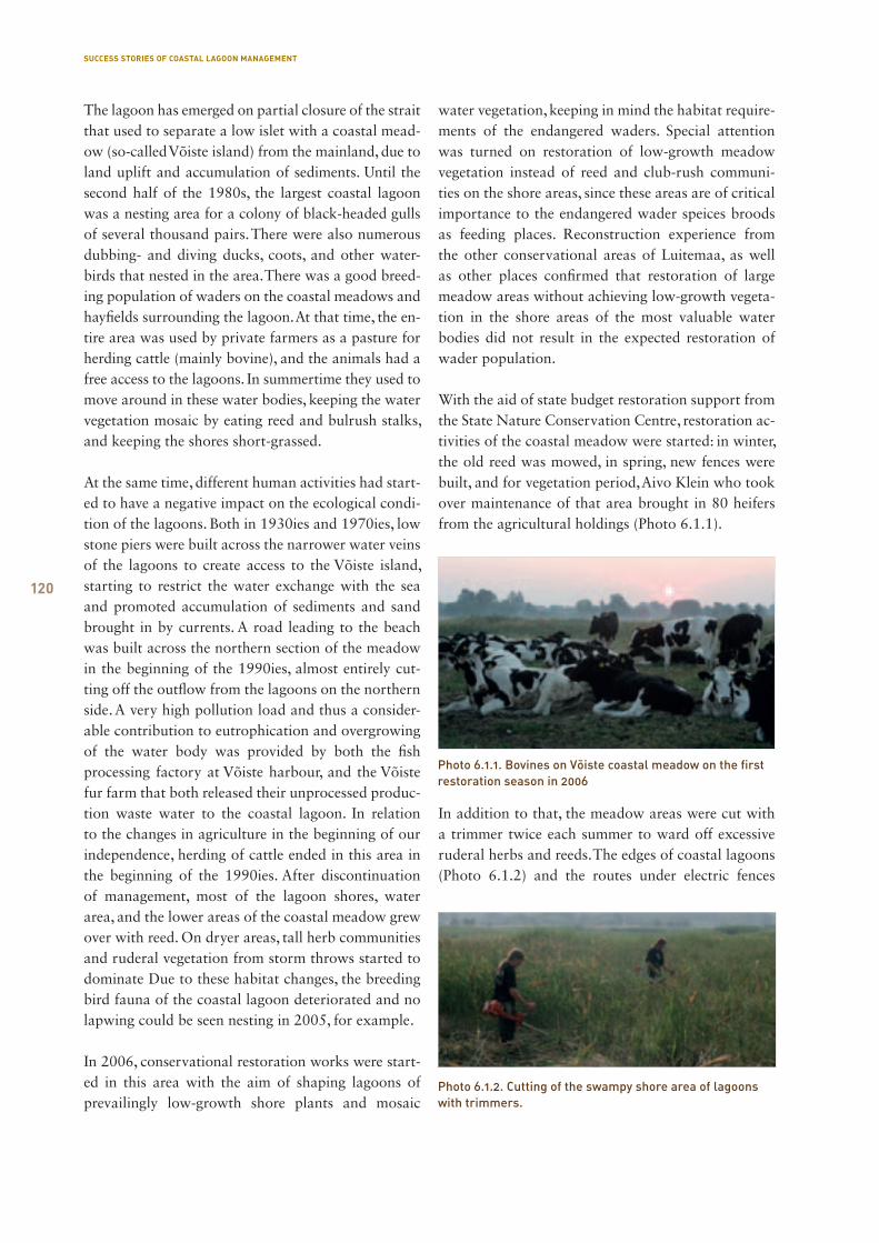
120
The lagoon has emerged on partial closure of the strait that used to separate a low islet with a coastal mead-ow (so-called Võiste island) from the mainland, due to land uplift and accumulation of sediments. Until the second half of the 1980s, the largest coastal lagoon was a nesting area for a colony of black-headed gulls of several thousand pairs. There were also numerous dubbing- and diving ducks, coots, and other water-birds that nested in the area. There was a good breed-ing population of waders on the coastal meadows and hayfields surrounding the lagoon. At that time, the en-tire area was used by private farmers as a pasture for herding cattle (mainly bovine), and the animals had a free access to the lagoons. In summertime they used to move around in these water bodies, keeping the water vegetation mosaic by eating reed and bulrush stalks, and keeping the shores short-grassed.
At the same time, different human activities had start-ed to have a negative impact on the ecological condi-tion of the lagoons. Both in 1930ies and 1970ies, low stone piers were built across the narrower water veins of the lagoons to create access to the Võiste island, starting to restrict the water exchange with the sea and promoted accumulation of sediments and sand brought in by currents. A road leading to the beach was built across the northern section of the meadow in the beginning of the 1990ies, almost entirely cut-ting off the outflow from the lagoons on the northern side. A very high pollution load and thus a consider-able contribution to eutrophication and overgrowing of the water body was provided by both the fish processing factory at Võiste harbour, and the Võiste fur farm that both released their unprocessed produc-tion waste water to the coastal lagoon. In relation to the changes in agriculture in the beginning of our independence, herding of cattle ended in this area in the beginning of the 1990ies. After discontinuation of management, most of the lagoon shores, water area, and the lower areas of the coastal meadow grew over with reed. On dryer areas, tall herb communities and ruderal vegetation from storm throws started to dominate Due to these habitat changes, the breeding bird fauna of the coastal lagoon deteriorated and no lapwing could be seen nesting in 2005, for example.
In 2006, conservational restoration works were start-ed in this area with the aim of shaping lagoons of prevailingly low-growth shore plants and mosaic
water vegetation, keeping in mind the habitat require-ments of the endangered waders. Special attention was turned on restoration of low-growth meadow vegetation instead of reed and club-rush communi-ties on the shore areas, since these areas are of critical importance to the endangered wader speices broods as feeding places. Reconstruction experience from the other conservational areas of Luitemaa, as well as other places confirmed that restoration of large meadow areas without achieving low-growth vegeta-tion in the shore areas of the most valuable water bodies did not result in the expected restoration of wader population.
With the aid of state budget restoration support from the State Nature Conservation Centre, restoration ac-tivities of the coastal meadow were started: in winter, the old reed was mowed, in spring, new fences were built, and for vegetation period, Aivo Klein who took over maintenance of that area brought in 80 heifers from the agricultural holdings (Photo 6.1.1).
In addition to that, the meadow areas were cut with a trimmer twice each summer to ward off excessive ruderal herbs and reeds. The edges of coastal lagoons (Photo 6.1.2) and the routes under electric fences
Photo 6.1.1. Bovines on Võiste coastal meadow on the first restoration season in 2006
Photo 6.1.2. Cutting of the swampy shore area of lagoons with trimmers.
SUCCESS STORIES OF COASTAL LAGOON MANAGEMENT
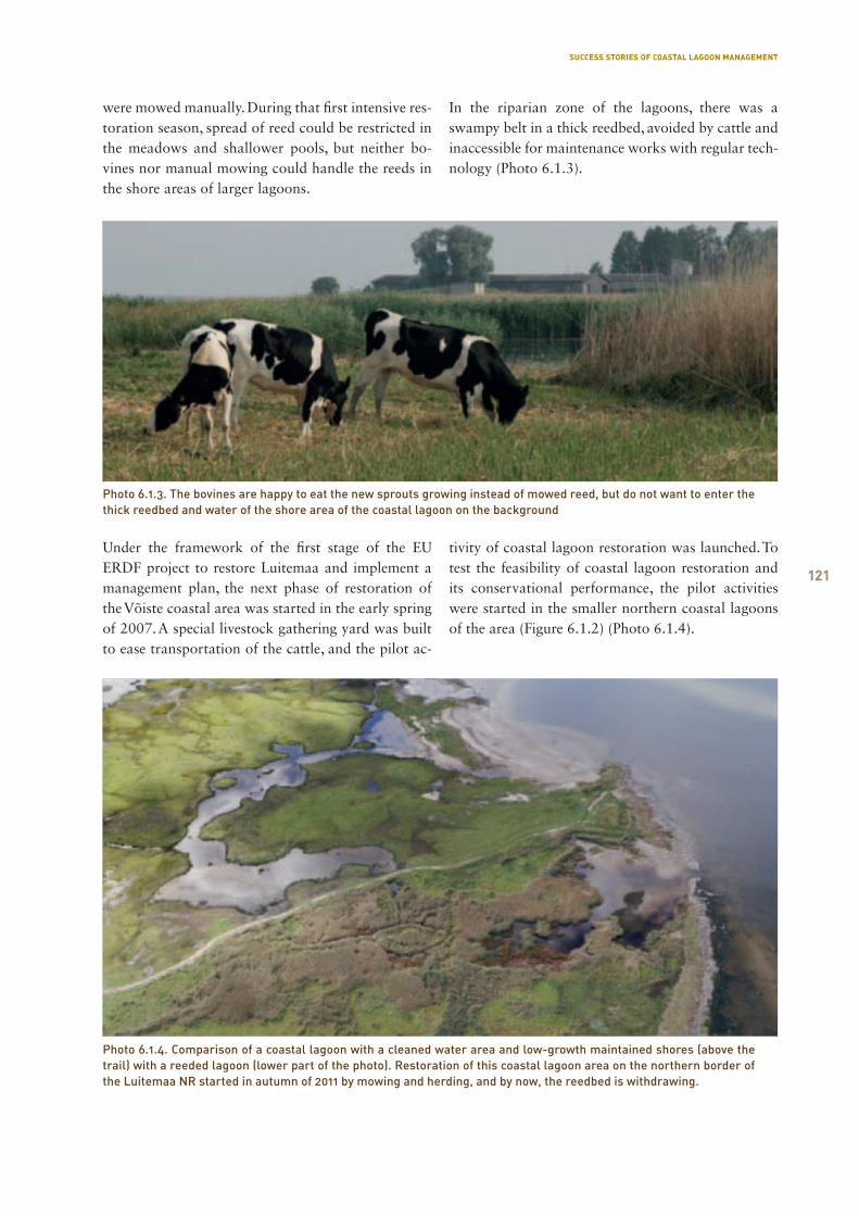
121
were mowed manually. During that first intensive res-toration season, spread of reed could be restricted in the meadows and shallower pools, but neither bo-vines nor manual mowing could handle the reeds in the shore areas of larger lagoons.
In the riparian zone of the lagoons, there was a swampy belt in a thick reedbed, avoided by cattle and inaccessible for maintenance works with regular tech-nology (Photo 6.1.3).
Under the framework of the first stage of the EU ERDF project to restore Luitemaa and implement a management plan, the next phase of restoration of the Võiste coastal area was started in the early spring of 2007. A special livestock gathering yard was built to ease transportation of the cattle, and the pilot ac-
tivity of coastal lagoon restoration was launched. To test the feasibility of coastal lagoon restoration and its conservational performance, the pilot activities were started in the smaller northern coastal lagoons of the area (Figure 6.1.2) (Photo 6.1.4).
Photo 6.1.3. The bovines are happy to eat the new sprouts growing instead of mowed reed, but do not want to enter the thick reedbed and water of the shore area of the coastal lagoon on the background
Photo 6.1.4. Comparison of a coastal lagoon with a cleaned water area and low-growth maintained shores (above the trail) with a reeded lagoon (lower part of the photo). Restoration of this coastal lagoon area on the northern border of the Luitemaa NR started in autumn of 2011 by mowing and herding, and by now, the reedbed is withdrawing.
SUCCESS STORIES OF COASTAL LAGOON MANAGEMENT
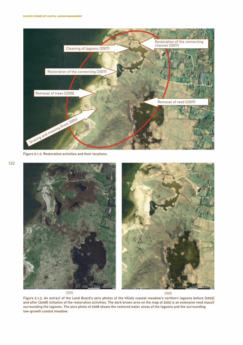
122
Figure 6.1.2. Restoration activities and their locations.
Cleaning of lagoons (2007)
Removal of trees (2008)
Restoration of the connecting channel (2007)
Removal of reed (2009)
Grazing and mowing (from 2006)
Restoration of the connecting (2007)
Figure 6.1.3. An extract of the Land Board’s aero photos of the Võiste coastal meadow’s northern lagoons before (2005) and after (2008) initiation of the restoration activities. The dark brown area on the map of 2005 is an extensive reed massif surrounding the lagoons. The aero photo of 2008 shows the restored water areas of the lagoons and the surrounding low-growth coastal meadow.
2005 2008
SUCCESS STORIES OF COASTAL LAGOON MANAGEMENT
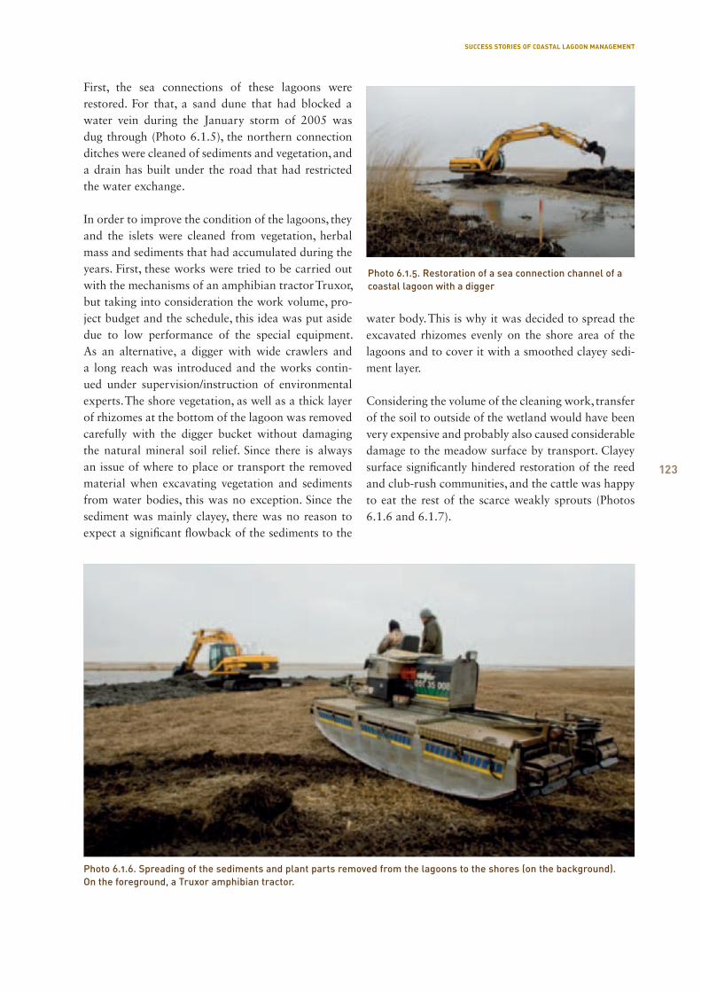
123
First, the sea connections of these lagoons were restored. For that, a sand dune that had blocked a water vein during the January storm of 2005 was dug through (Photo 6.1.5), the northern connection ditches were cleaned of sediments and vegetation, and a drain has built under the road that had restricted the water exchange.
In order to improve the condition of the lagoons, they and the islets were cleaned from vegetation, herbal mass and sediments that had accumulated during the years. First, these works were tried to be carried out with the mechanisms of an amphibian tractor Truxor, but taking into consideration the work volume, pro-ject budget and the schedule, this idea was put aside due to low performance of the special equipment. As an alternative, a digger with wide crawlers and a long reach was introduced and the works contin-ued under supervision/instruction of environmental experts. The shore vegetation, as well as a thick layer of rhizomes at the bottom of the lagoon was removed carefully with the digger bucket without damaging the natural mineral soil relief. Since there is always an issue of where to place or transport the removed material when excavating vegetation and sediments from water bodies, this was no exception. Since the sediment was mainly clayey, there was no reason to expect a significant flowback of the sediments to the
water body. This is why it was decided to spread the excavated rhizomes evenly on the shore area of the lagoons and to cover it with a smoothed clayey sedi-ment layer.
Considering the volume of the cleaning work, transfer of the soil to outside of the wetland would have been very expensive and probably also caused considerable damage to the meadow surface by transport. Clayey surface significantly hindered restoration of the reed and club-rush communities, and the cattle was happy to eat the rest of the scarce weakly sprouts (Photos 6.1.6 and 6.1.7).
Photo 6.1.5. Restoration of a sea connection channel of a coastal lagoon with a digger
Photo 6.1.6. Spreading of the sediments and plant parts removed from the lagoons to the shores (on the background). On the foreground, a Truxor amphibian tractor.
SUCCESS STORIES OF COASTAL LAGOON MANAGEMENT
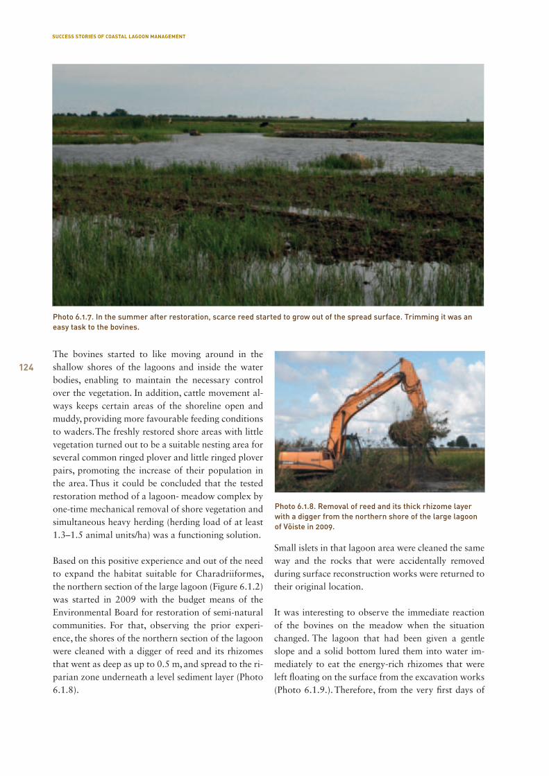
124The bovines started to like moving around in the shallow shores of the lagoons and inside the water bodies, enabling to maintain the necessary control over the vegetation. In addition, cattle movement al-ways keeps certain areas of the shoreline open and muddy, providing more favourable feeding conditions to waders. The freshly restored shore areas with little vegetation turned out to be a suitable nesting area for several common ringed plover and little ringed plover pairs, promoting the increase of their population in the area. Thus it could be concluded that the tested restoration method of a lagoon- meadow complex by one-time mechanical removal of shore vegetation and simultaneous heavy herding (herding load of at least 1.3–1.5 animal units/ha) was a functioning solution.
Based on this positive experience and out of the need to expand the habitat suitable for Charadriiformes, the northern section of the large lagoon (Figure 6.1.2) was started in 2009 with the budget means of the Environmental Board for restoration of semi-natural communities. For that, observing the prior experi-ence, the shores of the northern section of the lagoon were cleaned with a digger of reed and its rhizomes that went as deep as up to 0.5 m, and spread to the ri-parian zone underneath a level sediment layer (Photo 6.1.8).
Small islets in that lagoon area were cleaned the same way and the rocks that were accidentally removed during surface reconstruction works were returned to their original location.
It was interesting to observe the immediate reaction of the bovines on the meadow when the situation changed. The lagoon that had been given a gentle slope and a solid bottom lured them into water im-mediately to eat the energy-rich rhizomes that were left floating on the surface from the excavation works (Photo 6.1.9.). Therefore, from the very first days of
Photo 6.1.7. In the summer after restoration, scarce reed started to grow out of the spread surface. Trimming it was an easy task to the bovines.
Photo 6.1.8. Removal of reed and its thick rhizome layer with a digger from the northern shore of the large lagoon of Võiste in 2009.
SUCCESS STORIES OF COASTAL LAGOON MANAGEMENT
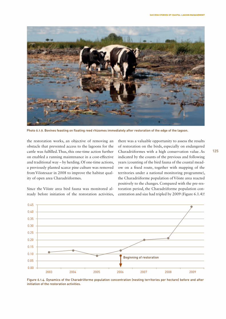
125
the restoration works, an objective of removing an obstacle that prevented access to the lagoons for the cattle was fulfilled. Thus, this one-time action further on enabled a running maintenance in a cost-effective and traditional way – by herding. Of one-time actions, a previously planted scarce pine culture was removed from Võistesaar in 2008 to improve the habitat qual-ity of open area Charadriiformes.
Since the Võiste area bird fauna was monitored al-ready before initiation of the restoration activities,
there was a valuable opportunity to assess the results of restoration on the birds, especially on endangered Charadriiformes with a high conservation value. As indicated by the counts of the previous and following years (counting of the bird fauna of the coastal mead-ow on a fixed route, together with mapping of the territories under a national monitoring programme), the Charadriiforme population of Võiste area reacted positively to the changes. Compared with the pre-res-toration period, the Charadriiforme population con-centration and size had tripled by 2009 (Figure 6.1.4)!
Photo 6.1.9. Bovines feasting on floating reed rhizomes immediately after restoration of the edge of the lagoon.
Figure 6.1.4. Dynamics of the Charadriiforme population concentration (nesting territories per hectare) before and after initiation of the restoration activities.
Beginning of restoration
SUCCESS STORIES OF COASTAL LAGOON MANAGEMENT
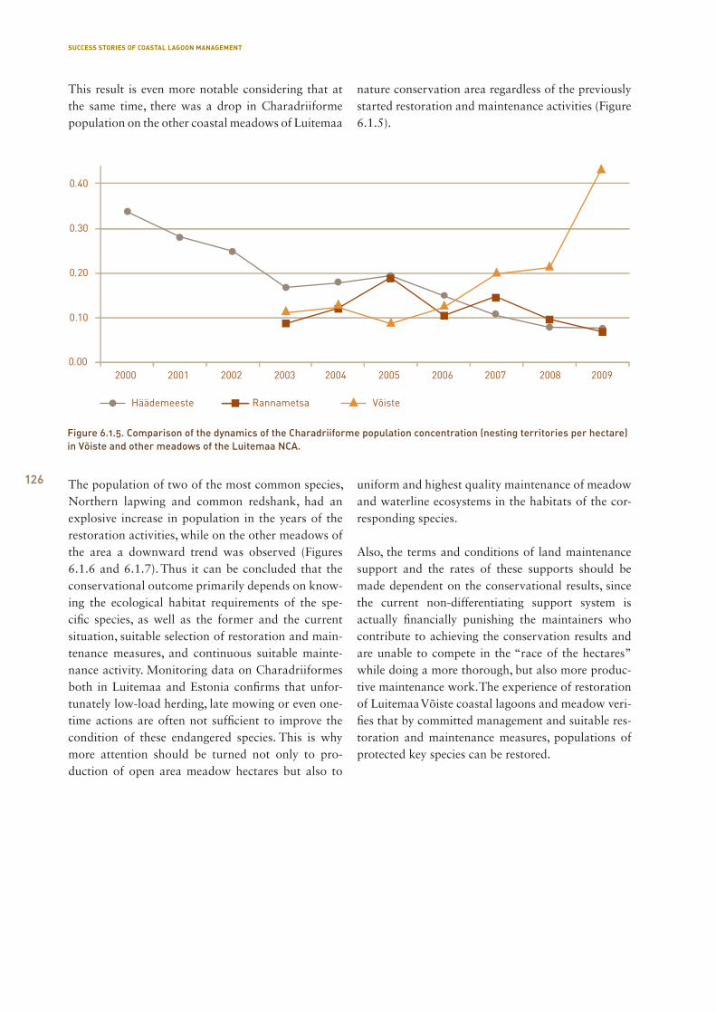
126
Figure 6.1.5. Comparison of the dynamics of the Charadriiforme population concentration (nesting territories per hectare) in Võiste and other meadows of the Luitemaa NCA.
This result is even more notable considering that at the same time, there was a drop in Charadriiforme population on the other coastal meadows of Luitemaa
nature conservation area regardless of the previously started restoration and maintenance activities (Figure 6.1.5).
The population of two of the most common species, Northern lapwing and common redshank, had an explosive increase in population in the years of the restoration activities, while on the other meadows of the area a downward trend was observed (Figures 6.1.6 and 6.1.7). Thus it can be concluded that the conservational outcome primarily depends on know-ing the ecological habitat requirements of the spe-cific species, as well as the former and the current situation, suitable selection of restoration and main-tenance measures, and continuous suitable mainte-nance activity. Monitoring data on Charadriiformes both in Luitemaa and Estonia confirms that unfor-tunately low-load herding, late mowing or even one-time actions are often not sufficient to improve the condition of these endangered species. This is why more attention should be turned not only to pro-duction of open area meadow hectares but also to
uniform and highest quality maintenance of meadow and waterline ecosystems in the habitats of the cor-responding species.
Also, the terms and conditions of land maintenance support and the rates of these supports should be made dependent on the conservational results, since the current non-differentiating support system is actually financially punishing the maintainers who contribute to achieving the conservation results and are unable to compete in the “race of the hectares” while doing a more thorough, but also more produc-tive maintenance work. The experience of restoration of Luitemaa Võiste coastal lagoons and meadow veri-fies that by committed management and suitable res-toration and maintenance measures, populations of protected key species can be restored.
SUCCESS STORIES OF COASTAL LAGOON MANAGEMENT
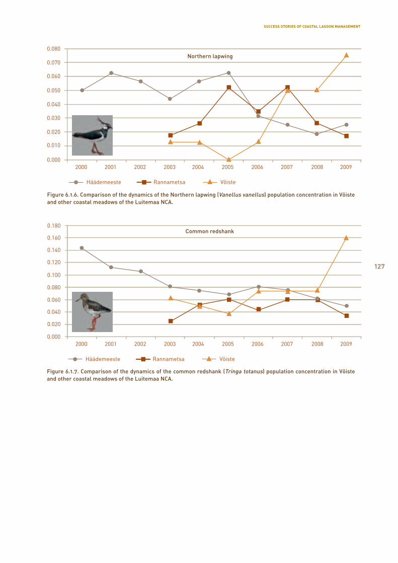
127
Figure 6.1.7. Comparison of the dynamics of the common redshank (Tringa totanus) population concentration in Võiste and other coastal meadows of the Luitemaa NCA.
Common redshank
Figure 6.1.6. Comparison of the dynamics of the Northern lapwing (Vanellus vanellus) population concentration in Võiste and other coastal meadows of the Luitemaa NCA.
Northern lapwing
SUCCESS STORIES OF COASTAL LAGOON MANAGEMENT

128
6.2. Restoration of lake Teorehe and coastal meadows in Matsalu National Park
Kaja Lotman
Lake Teorehe or Saastna is a coastal lake in Lääne County, Lihula rural municipality, Saastna village, and also extends to the Ullaste village territory in Hanila rural municipality. The lake is in the area of Saastna special management zone of Matsalu National Park. The shore line of the lake is 2,412 m and the surface area 6.9 ha. The lake has been connected to Topi bay and a freshwater inflow takes place from the Män-niku stream through Lake Sauemere. If the level of the sea is higher, also a sea water inflow takes place, but there is a historical cobblestone causeway between the sea and the lake.
Based on the studies carried out in 2009 (Ott et al., 2009), the lake is in an intermediary ecosystem state, turning from a lake to a land entity. It is character-ised by an unstable water regime, a very low water level for most of the year, a low chloride level for a coastal lake, as well as low oxygen level, overgrowing, untypical communities for a water body, reduction of the diversity and amount of hydrobionts, and their replacement with shore species. These changes are not accompanied by addition of rare species and habi-tats. Rather, it is a matter of depletion. In addition, an onslaught of brushwood from the shores and expan-sion of the reedbed need to be noted. Lake Teorehe is losing its value as a water body. The study concluded that it would probably be reasonable in the future to view Lake Teorehe as a damp coastal meadow that is an important habitat of amphibians, reptiles, coastal birds, and mammals. As a result of the studies, emp-tying of the lake of sediments is not recommended, since the lake is very shallow and would quickly start to grow over again.
Regular mowing of or herding on the adjacent area, removal of brushwood, mowing of shore vegetation, etc. was recommended as optimal activities to main-tain the biota of the lake. Improvement of the connec-tion to the sea was recommended.
A large value of lake Teorehe are extensive damp coastal meadows.
The Matsalu wetland management plan (Matsalu, 1994) reveals that regular herding ended on these meadows in 1993. After that, openness of the mead-ows was tried to be preserved by irregular herding of horses and removal of low alder brush.
Under the project LIFE05NAT/D/000152 BALT-COAST, regular herding with a sufficient load was planned to be restored, brushwood cut extensively, Teorehe water mirror opened by removal of reed and bulrush, and water exchange with the sea improved by installing culverts to the causeways, as well as establishing spawning water bodies for natterjacks.
Restoration of herdingIn the 1994 management plan, regular herding by 20 bovines and 20 sheep was planned. At that time, herd-ing was not planned on the other meadows of lake Teorehe or by Sauemere. Under the project, two farms were found that were interested in management and wanted to extend their herding to the coastal mead-ows of Teorehe. One of the farmers wanted to grow beef animals – limousins and the highland cattle, and the other farmer that was living closer by had a dairy farm and was looking for a suitable herding area for his heifers. By today, the meadows around lake Teor-ehe have a suitable low-growth vegetation as a result of herding. Removal of the submerged aquatic plants enabled to make the shores of the lake attractive to animals and the results of a couple of mowings have preserved for 2 years without any additional mow-ing. Suitable herding load with beef animals has also preserved the good condition of the spawning water bodies of natterjacks (Photo 6.2.1).
Removal of the brushwoodUnder the project, approximately 3 ha of low-grow-ing brushwood was mechanically crushed. Grey alder was cleared from the bordering areas to prevent its further spread, juniper population was thinned and coppices of black alder trimmed. Thinned black alder coppices became gathering places for the bovines and such trampling enabled to avoid formation of a low alder brush that usually occurs after cutting. Brush-wood should be continued to be removed after the end of the project, since the bovines are yet unable to trim the brush effectively enough.
SUCCESS STORIES OF COASTAL LAGOON MANAGEMENT
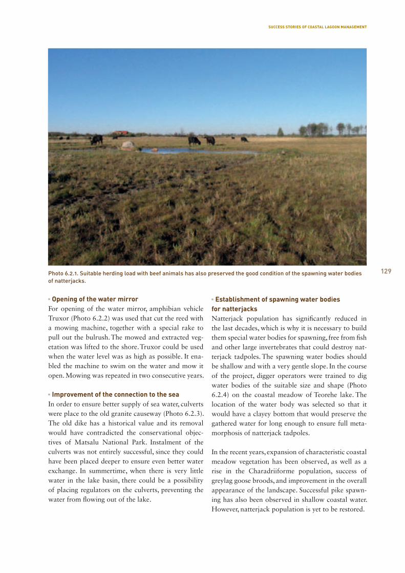
129
Opening of the water mirrorFor opening of the water mirror, amphibian vehicle Truxor (Photo 6.2.2) was used that cut the reed with a mowing machine, together with a special rake to pull out the bulrush. The mowed and extracted veg-etation was lifted to the shore. Truxor could be used when the water level was as high as possible. It ena-bled the machine to swim on the water and mow it open. Mowing was repeated in two consecutive years. Improvement of the connection to the seaIn order to ensure better supply of sea water, culverts were place to the old granite causeway (Photo 6.2.3). The old dike has a historical value and its removal would have contradicted the conservational objec-tives of Matsalu National Park. Instalment of the culverts was not entirely successful, since they could have been placed deeper to ensure even better water exchange. In summertime, when there is very little water in the lake basin, there could be a possibility of placing regulators on the culverts, preventing the water from flowing out of the lake.
Establishment of spawning water bodies for natterjacksNatterjack population has significantly reduced in the last decades, which is why it is necessary to build them special water bodies for spawning, free from fish and other large invertebrates that could destroy nat-terjack tadpoles. The spawning water bodies should be shallow and with a very gentle slope. In the course of the project, digger operators were trained to dig water bodies of the suitable size and shape (Photo 6.2.4) on the coastal meadow of Teorehe lake. The location of the water body was selected so that it would have a clayey bottom that would preserve the gathered water for long enough to ensure full meta-morphosis of natterjack tadpoles.
In the recent years, expansion of characteristic coastal meadow vegetation has been observed, as well as a rise in the Charadriiforme population, success of greylag goose broods, and improvement in the overall appearance of the landscape. Successful pike spawn-ing has also been observed in shallow coastal water. However, natterjack population is yet to be restored.
Photo 6.2.1. Suitable herding load with beef animals has also preserved the good condition of the spawning water bodies of natterjacks.
SUCCESS STORIES OF COASTAL LAGOON MANAGEMENT
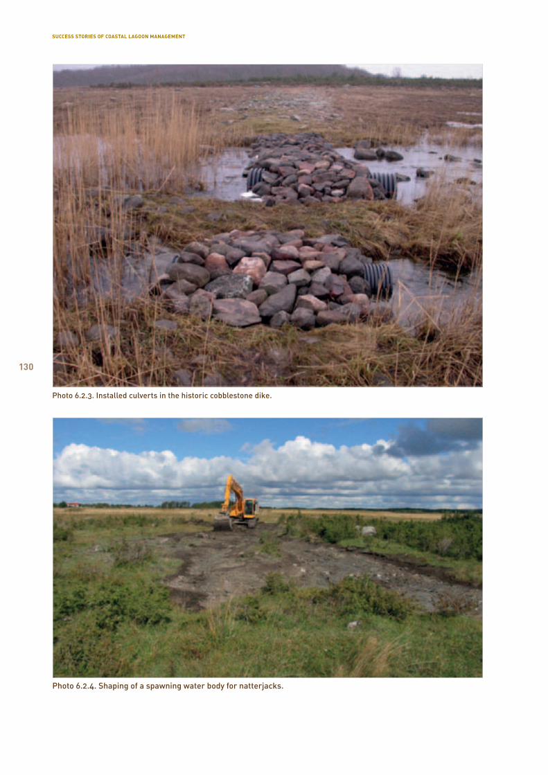
130
Photo 6.2.3. Installed culverts in the historic cobblestone dike.
Photo 6.2.4. Shaping of a spawning water body for natterjacks.
SUCCESS STORIES OF COASTAL LAGOON MANAGEMENT
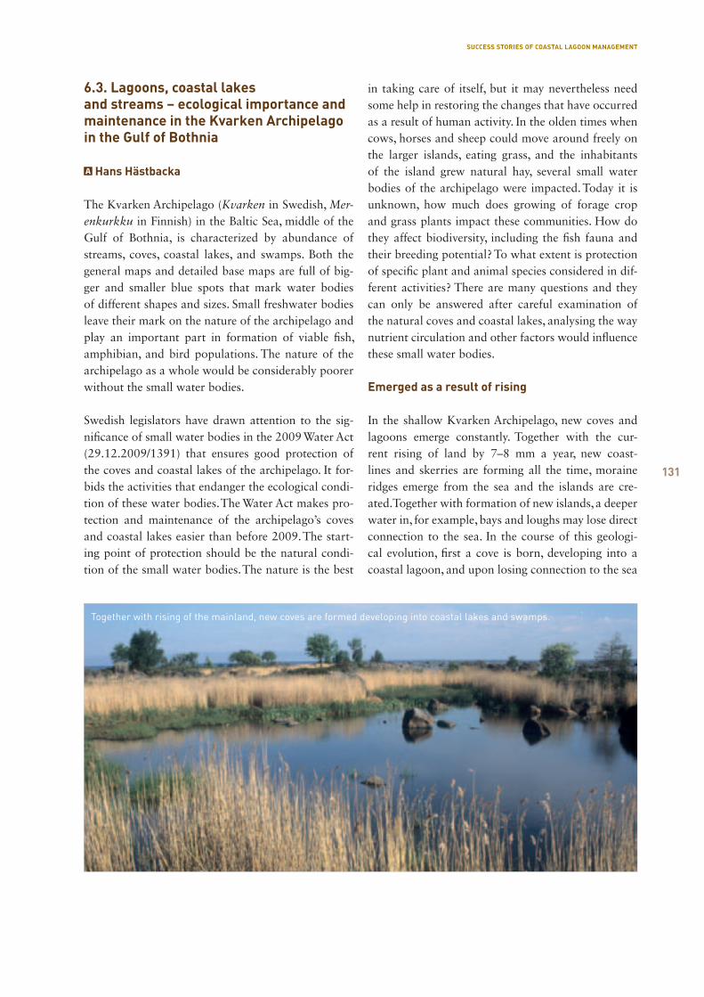
131
6.3. Lagoons, coastal lakes and streams – ecological importance and maintenance in the Kvarken Archipelago in the Gulf of Bothnia
Hans Hästbacka
The Kvarken Archipelago (Kvarken in Swedish, Mer-enkurkku in Finnish) in the Baltic Sea, middle of the Gulf of Bothnia, is characterized by abundance of streams, coves, coastal lakes, and swamps. Both the general maps and detailed base maps are full of big-ger and smaller blue spots that mark water bodies of different shapes and sizes. Small freshwater bodies leave their mark on the nature of the archipelago and play an important part in formation of viable fish, amphibian, and bird populations. The nature of the archipelago as a whole would be considerably poorer without the small water bodies.
Swedish legislators have drawn attention to the sig-nificance of small water bodies in the 2009 Water Act (29.12.2009/1391) that ensures good protection of the coves and coastal lakes of the archipelago. It for-bids the activities that endanger the ecological condi-tion of these water bodies. The Water Act makes pro-tection and maintenance of the archipelago’s coves and coastal lakes easier than before 2009. The start-ing point of protection should be the natural condi-tion of the small water bodies. The nature is the best
in taking care of itself, but it may nevertheless need some help in restoring the changes that have occurred as a result of human activity. In the olden times when cows, horses and sheep could move around freely on the larger islands, eating grass, and the inhabitants of the island grew natural hay, several small water bodies of the archipelago were impacted. Today it is unknown, how much does growing of forage crop and grass plants impact these communities. How do they affect biodiversity, including the fish fauna and their breeding potential? To what extent is protection of specific plant and animal species considered in dif-ferent activities? There are many questions and they can only be answered after careful examination of the natural coves and coastal lakes, analysing the way nutrient circulation and other factors would influence these small water bodies.
Emerged as a result of rising
In the shallow Kvarken Archipelago, new coves and lagoons emerge constantly. Together with the cur-rent rising of land by 7–8 mm a year, new coast-lines and skerries are forming all the time, moraine ridges emerge from the sea and the islands are cre-ated. Together with formation of new islands, a deeper water in, for example, bays and loughs may lose direct connection to the sea. In the course of this geologi-cal evolution, first a cove is born, developing into a coastal lagoon, and upon losing connection to the sea
Together with rising of the mainland, new coves are formed developing into coastal lakes and swamps.
SUCCESS STORIES OF COASTAL LAGOON MANAGEMENT
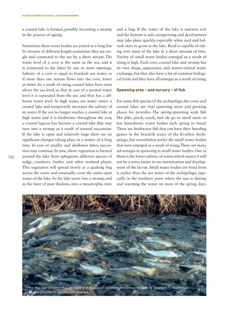
132
a coastal lake is formed, possibly becoming a swamp in the process of ageing.
Sometimes these water bodies are joined as a long line by streams of different length; sometimes they are sin-gle and connected to the sea by a short stream. The water level of a cove is the same as the sea, and it is connected to the latter by one or more openings. Salinity of a cove is equal to brackish sea water, or if more than one stream flows into the cove, lower at times. As a result of rising, coastal lakes have risen above the sea level, so that in case of a normal water level it is separated from the sea and thus has a dif-ferent water level. At high water, sea water enters a coastal lake and temporarily increases the salinity of its water. If the sea no longer reaches a coastal lake at high water and it is freshwater throughout the year, a coastal lagoon has become a coastal lake that may turn into a swamp as a result of natural succession. If the lake is open and relatively large there are no significant changes taking place in a matter of a long time. In case of smaller and shallower lakes, succes-sion may continue. In time, shore vegetation is formed around the lake from sphagnum, different species of sedge, cranberry bushes and other wetland plants. This vegetation will spread slowly as a quaking bog across the water and eventually cover the entire open water of the lake. So the lake turns into a swamp, and as the layer of peat thickens, into a mesotrophic mire
and a bog. If the water of the lake is nutrient rich and the bottom is soft, overgrowing and development may take place quickly, especially when reed and bul-rush start to grow in the lake. Reed is capable of tak-ing over most of the lake in a short amount of time. Variety of small water bodies emerged as a result of rising is high. Each cove, coastal lake and swamp has its own shape, appearance and season-related water exchange, but they also have a lot of common biologi-cal traits and they have all emerges as a result of rising.
Spawning area – and nursery – of fish
For some fish species of the archipelago, the coves and coastal lakes are vital spawning areas and growing places for juveniles. The spring-spawning scale fish like pike, perch, roach, and ide go to small more or less limnobiotic water bodies each spring to breed. These are freshwater fish that can have their breeding games in the brackish water of the Kvarken Archi-pelago, but nevertheless prefer the small water bodies that have emerged as a result of rising. There are many advantages in spawning in small water bodies. One of them is the lower salinity of water, which means it will not be a stress factor in roe insemination and develop-ment of the larvae. Small water bodies are freed from is earlier than the sea water of the archipelago, espe-cially in the northern parts where the sun is shining and warming the water on most of the spring days.
SUCCESS STORIES OF COASTAL LAGOON MANAGEMENT
In the May, the streams shall be filled with thousands of common roaches, struggling upstream to reach their spawning grounds in lagoons and swamps.
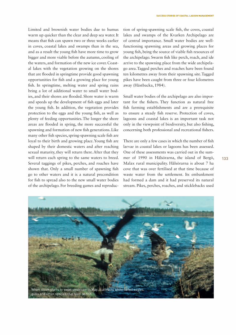
133
Limited and brownish water bodies due to humus warm up quicker than the clear and deep sea water. It means that fish can spawn two or three weeks earlier in coves, coastal lakes and swamps than in the sea, and as a result the young fish have more time to grow bigger and more viable before the autumn, cooling of the waters, and formation of the new ice cover. Coast-al lakes with the vegetation growing on the shores that are flooded in springtime provide good spawning opportunities for fish and a growing place for young fish. In springtime, melting water and spring rains bring a lot of additional water to small water bod-ies, and their shores are flooded. Shore water is warm and speeds up the development of fish eggs and later the young fish. In addition, the vegetation provides protection to the eggs and the young fish, as well as plenty of feeding opportunities. The longer the shore areas are flooded in spring, the more successful the spawning and formation of new fish generations. Like many other fish species, spring-spawning scale fish are loyal to their birth and growing place. Young fish are shaped by their domestic waters and after reaching sexual maturity, they will return there. After that they will return each spring to the same waters to breed. Several taggings of pikes, perches, and roaches have shown that. Only a small number of spawning fish go to other waters and it is a natural precondition for fish to spread also to the new small water bodies of the archipelago. For breeding games and reproduc-
tion of spring-spawning scale fish, the coves, coastal lakes and swamps of the Kvarken Archipelago are of central importance. Small water bodies are well-functioning spawning areas and growing places for young fish, being the source of viable fish resources of the archipelago. Swarm fish like perch, roach, and ide arrive to the spawning place from the wide archipela-go area. Tagged perches and roaches have been found ten kilometres away from their spawning site. Tagged pikes have been caught from three or four kilometres away (Hästbacka, 1984).
Small water bodies of the archipelago are also impor-tant for the fishers. They function as natural free fish farming establishments and are a prerequisite to ensure a steady fish reserve. Protection of coves, lagoons and coastal lakes is an important task not only in the viewpoint of biodiversity, but also fishing, concerning both professional and recreational fishers.
There are only a few cases in which the number of fish larvae in coastal lakes or lagoons has been assessed. One of these assessments was carried out in the sum-mer of 1990 in Hålsörarna, the island of Bergö, Malax rural municipality. Hålsörarna is about 7 ha cove that was over fertilised at that time because of waste water from the settlement. Its embankment had formed a dam and it had preserved its natural stream. Pikes, perches, roaches, and sticklebacks used
When roach starts to swim upstream in May, it attracts white-tailed eagles, gulls and other species that feed on fish.
SUCCESS STORIES OF COASTAL LAGOON MANAGEMENT

134
this stream to come to the cove for spawning. Later, also ides have come to spawn there. After the breeding games the stream was closed and an artificial outlet in the middle of the cove was opened in the middle of July to empty the cove from water and let the fish larvae into the protective waters of the archipelago. During the 55 hours of the study, 1,100 pike larvae, 220,000 perch larvae, 54,000 roach larvae, and 5,400 stickleback larvae travelled away from the cove. An unknown amount of larvae was left to the cove after the study was finished, since a water hole of a size of one hectare was left to the bottom of the cove (Eklöv and Andersen, 1990).
Local fish resources is a part of biodiversity of small water bodies. These water bodies are as important spawning areas for the amphibians of the archipelago as they are for fish. There are also numerous insects in coves, coastal lakes and swamps, for example odo-nates and mosquitoes, to name two. Several bird spe-cies nest near small water bodies; from large birds, for example, whooper swans and common cranes.
Streams – arteries of life
Connection of the sea and small water bodies by var-ying streams of coastal lakes and swamps functions like an artery that connects remote sea water and the spawning areas of fish. Fish use the streams to swim to spawning areas and return to the more remote and food-rich areas of the sea after spawning. The young fish of the same summer move away from the small water bodies when the rains of late summer and early spring begin and fill the streams with overflowing water after the summer dryness. Young fish will travel to the sea at least by the time when the small water bodies start to freeze over and free oxygen exchange between the air and water stops, drastically dropping the oxygen level of small water bodies.
Streams usually have two flooding periods in a year. The first is in the spring and summer, then the melt-ing water from the surrounding forests and the rain-water flow into small water bodies and from there, to streams. The other period is in autumn when the rain-fall increases the amount of water in streams. These two flooding periods are sufficient for the fish spawn-ing migration and young fish leaving. The fact that the streams are dry in summers and frozen in winters does not interfere with fish migration. It is nothing but
a natural rhythm of life related to seasons. The spring-time spawning migration usually starts in the middle of April in streams when the first pikes start to swim upstream. They are followed by perches and ides, and the last ones to go on that journey are roaches. Dif-ferent fish species need different water temperature for spawning – pikes do it in the coldest spring water and roaches in the warmest. Spawning migration lasts until June in streams in which water is sufficient and plentiful, and all fish species are represented.
The spring migration of fish is an impressive time in nature. With a bit of patience it is possible to see fish up close in their natural environment and condi-tion in shallow streams of a width from 30 cm to one meter. All fishing is forbidden in migration streams, but the fish can also be “caught” with eyes and a cam-era. That kind of fishing offers fascinating and unfor-gettable moments in spring days. Migration streams are inviting destinations for those who are interested in spawning migration of fish and the animals it attracts. There are some easily accessible fish migra-tion streams in the Kvarken Archipelago that have become popular and frequently visited nature obser-vation destinations, especially in springtime.
On earlier times, fish was caught by small weirs from the streams to have food on the table and some money in the pocket. However, stream fishing turned out to be too efficient and drained the local fish resources. Fish on their way to or from spawning were caught from many streams. The local fish reserves could be destroyed only in couple of years. Today, fish can travel peacefully in streams thanks to the fishing ban, and thus ensure good reproduction of the fish fauna of the entire archipelago.
Protection and maintenance of small water bodies
In the earlier times when the fish migration streams were exploited by spring fishing the fish was assessed based on one’s personal or economic interests, hav-ing no regard to the broader perspective and perma-nence of the fish reserves. This is why intensive fish-ing sometimes had destructive consequences for the local fish species. Taking streams and spawning areas under protection was an unavoidably important deci-sion that still proves its effectiveness.
A couple of decades ago the importance of small
SUCCESS STORIES OF COASTAL LAGOON MANAGEMENT
135
water bodies of the archipelago was not valued much, mainly because of lack of knowledge that did not enable to acknowledge the ecological significance of small water bodies to the nature of the archipelago – their central role for the local fish species, as well as for the local fishery. When roads were started to be constructed, forests clean-cut, drainage systems built and in relation to that, water level of the lakes low-ered, the natural balance of several streams, coastal lakes and swamps was disturbed.
We are more aware today – many of the archipelago’s small water bodies have been restored and retrieved their biological function and meaning. These have been pleasant developments. Nowadays we have more knowledge and skills to protect and maintain this ecological whole formed by streams, coves, coastal lakes and swamps, reaching far into the sea from each mouth of a stream in that archipelago.
Naturally functioning streams and small water bodies need no other measure than active protection by the people to ensure that their water level would not drop and they will not acidify because of forest draining or road building that impair the stream functions. How-ever, the following suggestions could be made to pre-serve and improve the condition of these water bodies:
The only maintenance that a stream regularly needs is annual cleaning of the fallen tree trunks and branches that cover a stream and interfere with fish migration. A winding riverbed with abysses, stones and small headlands that create peaceful areas of escape water may not be deepened or straightened.
Natural riverbed enables the fish on their breeding migration to rest for a little and supply their bodies with oxygen.
The tree and bush communities on the river shores may not be cut. They protect the fish, provide shade and form a natural part of a stream community.
At the upper and lower mouth of a stream, reed thickets and bulrushes may be removed from time to time with a spade and a hoe, if these plants have blocked the mouth and interfere with fish migration. It can be done both in spring and in autumn. Clear-ing is especially important in autumn since it eases the emigration of young fish from a coastal lake or
a swamp. In normal circumstances, streams are capa-ble of taking care of themselves and gradually shape their winding bed.
Outputs of some coastal lakes and lagoons have been dredged and thus the water flow is faster. How-ever, a faster flow reduces the spring and early sum-mer flooding period. In that case it may be suitable to build a low and simple stone dam near the exit, slow-ing the flow and lengthening the flooding period. It promotes fish spawning and survival of young fish.
If a simple stone dam is not sufficient, a low dam can be built of poles or planks and attached to the riverbed, thus restoring the normal water level of a coastal lagoon or a swamp. This should only be done after consultation with the land owners to avoid pos-sible conflicts over the water level.
When constructing an embankment of bridges that cross a stream, the tunnel underneath the road must be of the same level with the stream to enable it to flow naturally. The tunnel must be of the same width as the stream and high enough to enable the stream to flow through it freely, with a little bit of room left on the above. The tunnel may not be made of plastic, fibre glass or tiles, but of cement, preferably with a gravelly or stony bottom to ease passing of the tunnel for the fish. A better alternative than a tunnel would be a little bridge that would not narrow the natural riverbed or prevent the water flow of the stream.
Building of forest roads accompanied by clear cut-ting often brings about drying of the forest surface. In case of lagoons and coastal lakes, draining causes acidification of the water, since natural soil-related acidification begins when water level is lowered. In relation to that, nutrients are flushed out and solids in to a small water body. Avoiding forest draining is the best way of protecting coastal lakes and lagoons from acidification and over fertilisation.
When forest draining cannot be avoided the drain-age areas and ditches must be whitewashed to neu-tralize the acidic output. The main ditch that empties the accumulated water to a small water body may not be directly guided to the water body, but has to be stopped a little before the shore to enable the water to flow across soil and thus screen out the solids from the water (Hästbacka, 1984).
SUCCESS STORIES OF COASTAL LAGOON MANAGEMENT
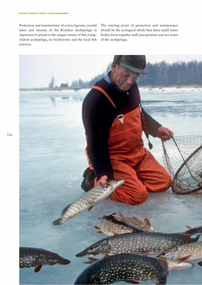
136
Protection and maintenance of coves, lagoons, coastal lakes and streams of the Kvarken Archipelago is important to preserve the unique nature of this rising-related archipelago, its biodiversity and the local fish reserves.
The starting point of protection and maintenance should be the ecological whole that these small water bodies form together with precipitation and sea water of the archipelago.
SUCCESS STORIES OF COASTAL LAGOON MANAGEMENT
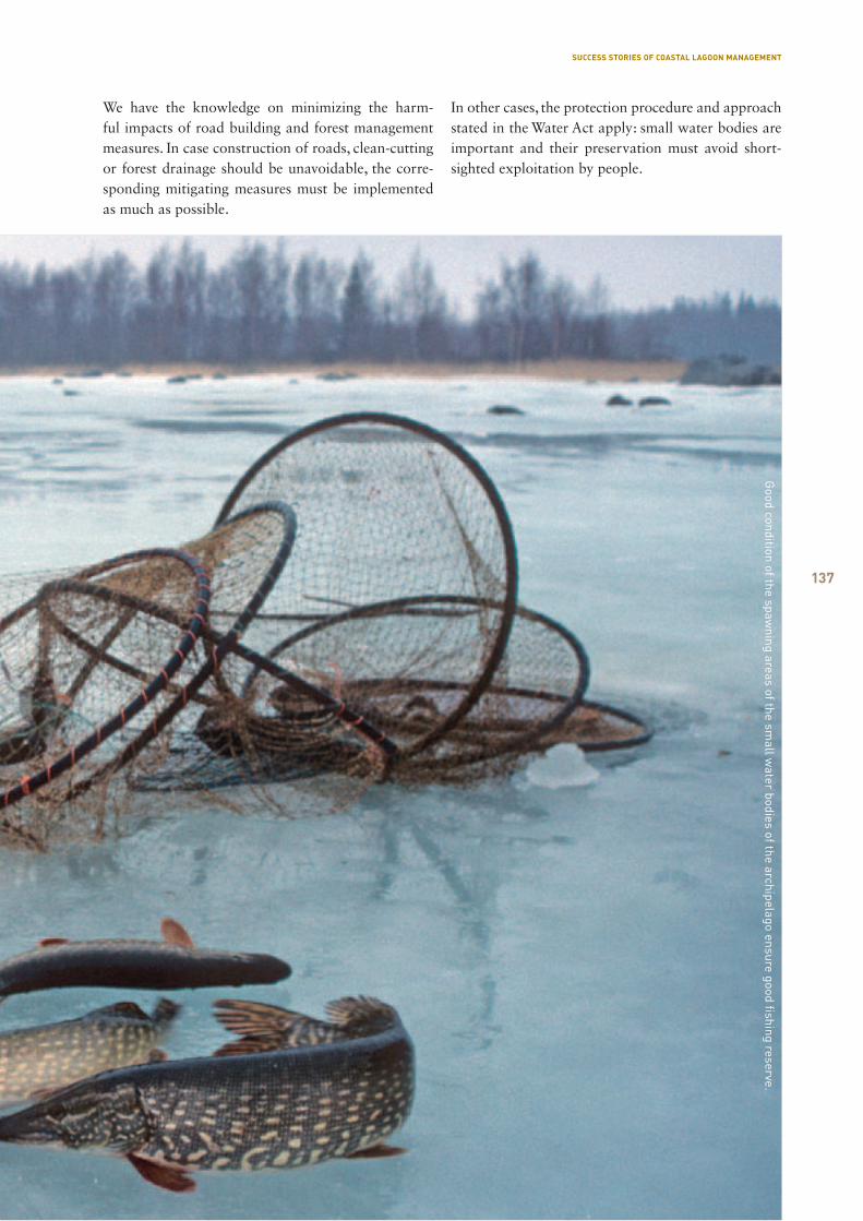
137
We have the knowledge on minimizing the harm-ful impacts of road building and forest management measures. In case construction of roads, clean-cutting or forest drainage should be unavoidable, the corre-sponding mitigating measures must be implemented as much as possible.
In other cases, the protection procedure and approach stated in the Water Act apply: small water bodies are important and their preservation must avoid short-sighted exploitation by people.
Good condition of the spaw
ning areas of the small w
ater bodies of the archipelago ensure good fishing reserve.
SUCCESS STORIES OF COASTAL LAGOON MANAGEMENT
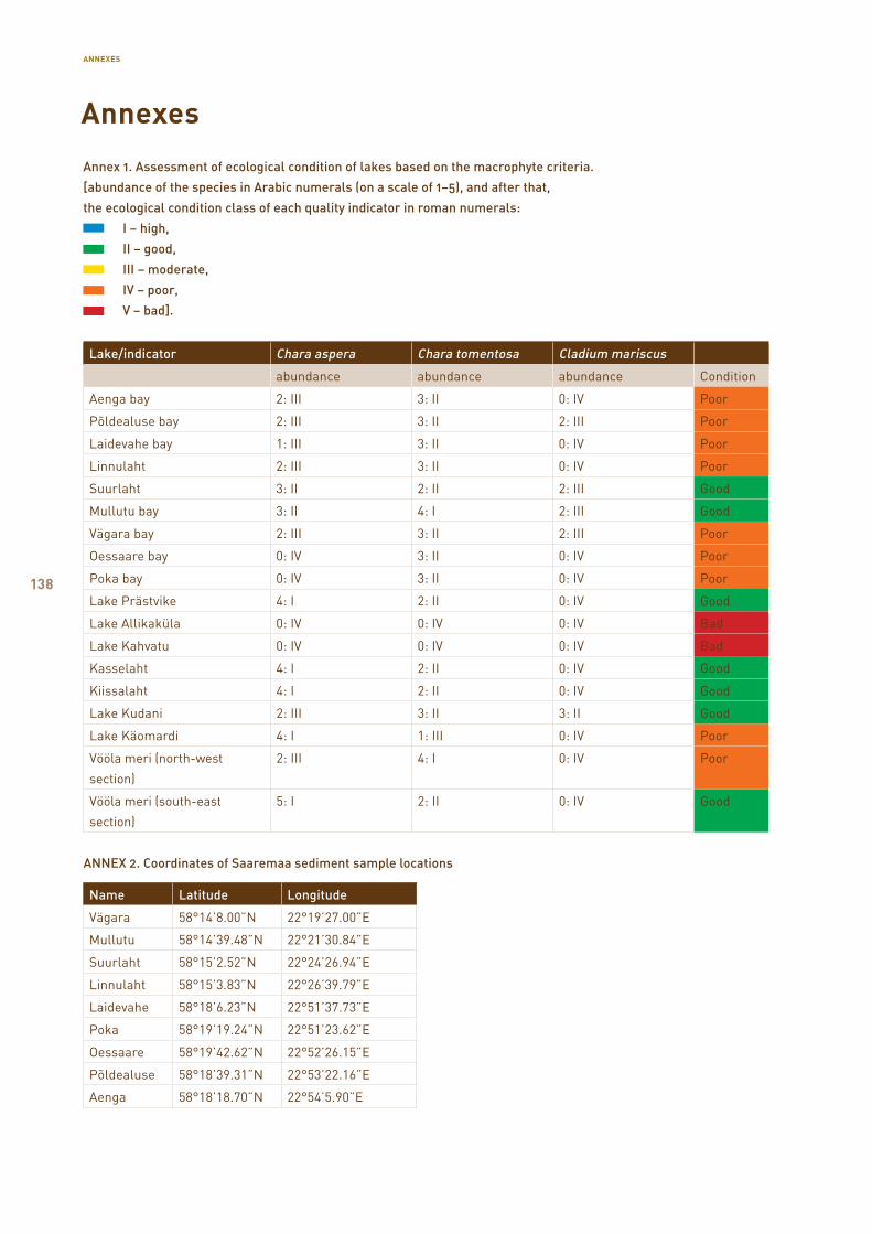
138
Annex 1. Assessment of ecological condition of lakes based on the macrophyte criteria.
[abundance of the species in Arabic numerals (on a scale of 1–5), and after that,
the ecological condition class of each quality indicator in roman numerals:
I – high,
II – good,
III – moderate,
IV – poor,
V – bad].
Lake/indicator Chara aspera Chara tomentosa Cladium mariscus
abundance abundance abundance Condition
Aenga bay 2: III 3: II 0: IV Poor
Põldealuse bay 2: III 3: II 2: III Poor
Laidevahe bay 1: III 3: II 0: IV Poor
Linnulaht 2: III 3: II 0: IV Poor
Suurlaht 3: II 2: II 2: III Good
Mullutu bay 3: II 4: I 2: III Good
Vägara bay 2: III 3: II 2: III Poor
Oessaare bay 0: IV 3: II 0: IV Poor
Poka bay 0: IV 3: II 0: IV Poor
Lake Prästvike 4: I 2: II 0: IV Good
Lake Allikaküla 0: IV 0: IV 0: IV Bad
Lake Kahvatu 0: IV 0: IV 0: IV Bad
Kasselaht 4: I 2: II 0: IV Good
Kiissalaht 4: I 2: II 0: IV Good
Lake Kudani 2: III 3: II 3: II Good
Lake Käomardi 4: I 1: III 0: IV Poor
Vööla meri (north-west
section)
2: III 4: I 0: IV Poor
Vööla meri (south-east
section)
5: I 2: II 0: IV Good
ANNEX 2. Coordinates of Saaremaa sediment sample locations
Name Latitude Longitude
Vägara 58°14’8.00”N 22°19’27.00”E
Mullutu 58°14’39.48”N 22°21’30.84”E
Suurlaht 58°15’2.52”N 22°24’26.94”E
Linnulaht 58°15’3.83”N 22°26’39.79”E
Laidevahe 58°18’6.23”N 22°51’37.73”E
Poka 58°19’19.24”N 22°51’23.62”E
Oessaare 58°19’42.62”N 22°52’26.15”E
Põldealuse 58°18’39.31”N 22°53’22.16”E
Aenga 58°18’18.70”N 22°54’5.90”E
Annexes
ANNEXES
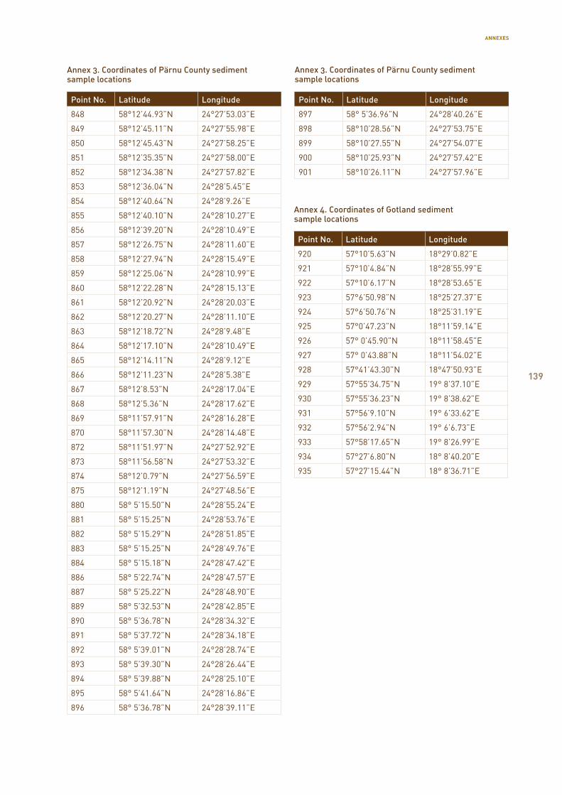
139
Annex 3. Coordinates of Pärnu County sediment sample locations
Point No. Latitude Longitude
848 58°12’44.93”N 24°27’53.03”E
849 58°12’45.11”N 24°27’55.98”E
850 58°12’45.43”N 24°27’58.25”E
851 58°12’35.35”N 24°27’58.00”E
852 58°12’34.38”N 24°27’57.82”E
853 58°12’36.04”N 24°28’5.45”E
854 58°12’40.64”N 24°28’9.26”E
855 58°12’40.10”N 24°28’10.27”E
856 58°12’39.20”N 24°28’10.49”E
857 58°12’26.75”N 24°28’11.60”E
858 58°12’27.94”N 24°28’15.49”E
859 58°12’25.06”N 24°28’10.99”E
860 58°12’22.28”N 24°28’15.13”E
861 58°12’20.92”N 24°28’20.03”E
862 58°12’20.27”N 24°28’11.10”E
863 58°12’18.72”N 24°28’9.48”E
864 58°12’17.10”N 24°28’10.49”E
865 58°12’14.11”N 24°28’9.12”E
866 58°12’11.23”N 24°28’5.38”E
867 58°12’8.53”N 24°28’17.04”E
868 58°12’5.36”N 24°28’17.62”E
869 58°11’57.91”N 24°28’16.28”E
870 58°11’57.30”N 24°28’14.48”E
872 58°11’51.97”N 24°27’52.92”E
873 58°11’56.58”N 24°27’53.32”E
874 58°12’0.79”N 24°27’56.59”E
875 58°12’1.19”N 24°27’48.56”E
880 58° 5’15.50”N 24°28’55.24”E
881 58° 5’15.25”N 24°28’53.76”E
882 58° 5’15.29”N 24°28’51.85”E
883 58° 5’15.25”N 24°28’49.76”E
884 58° 5’15.18”N 24°28’47.42”E
886 58° 5’22.74”N 24°28’47.57”E
887 58° 5’25.22”N 24°28’48.90”E
889 58° 5’32.53”N 24°28’42.85”E
890 58° 5’36.78”N 24°28’34.32”E
891 58° 5’37.72”N 24°28’34.18”E
892 58° 5’39.01”N 24°28’28.74”E
893 58° 5’39.30”N 24°28’26.44”E
894 58° 5’39.88”N 24°28’25.10”E
895 58° 5’41.64”N 24°28’16.86”E
896 58° 5’36.78”N 24°28’39.11”E
Annex 3. Coordinates of Pärnu County sediment sample locations
Point No. Latitude Longitude
897 58° 5’36.96”N 24°28’40.26”E
898 58°10’28.56”N 24°27’53.75”E
899 58°10’27.55”N 24°27’54.07”E
900 58°10’25.93”N 24°27’57.42”E
901 58°10’26.11”N 24°27’57.96”E
Annex 4. Coordinates of Gotland sediment sample locations
Point No. Latitude Longitude
920 57°10’5.63”N 18°29’0.82”E
921 57°10’4.84”N 18°28’55.99”E
922 57°10’6.17”N 18°28’53.65”E
923 57°6’50.98”N 18°25’27.37”E
924 57°6’50.76”N 18°25’31.19”E
925 57°0’47.23”N 18°11’59.14”E
926 57° 0’45.90”N 18°11’58.45”E
927 57° 0’43.88”N 18°11’54.02”E
928 57°41’43.30”N 18°47’50.93”E
929 57°55’34.75”N 19° 8’37.10”E
930 57°55’36.23”N 19° 8’38.62”E
931 57°56’9.10”N 19° 6’33.62”E
932 57°56’2.94”N 19° 6’6.73”E
933 57°58’17.65”N 19° 8’26.99”E
934 57°27’6.80”N 18° 8’40.20”E
935 57°27’15.44”N 18° 8’36.71”E
ANNEXES
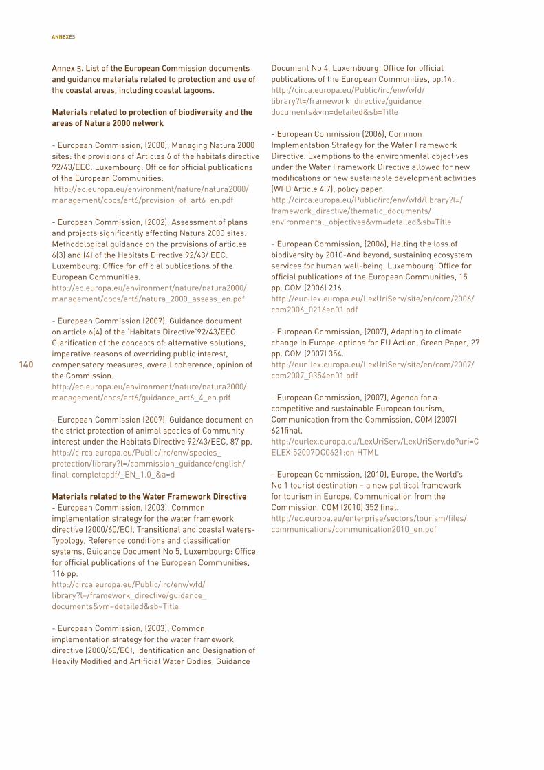
140
Annex 5. List of the European Commission documents and guidance materials related to protection and use of the coastal areas, including coastal lagoons.
Materials related to protection of biodiversity and the areas of Natura 2000 network
- European Commission, (2000), Managing Natura 2000 sites: the provisions of Articles 6 of the habitats directive 92/43/EEC. Luxembourg: Office for official publications of the European Communities. http://ec.europa.eu/environment/nature/natura2000/ management/docs/art6/provision_of_art6_en.pdf
- European Commission, (2002), Assessment of plans and projects significantly affecting Natura 2000 sites. Methodological guidance on the provisions of articles 6(3) and (4) of the Habitats Directive 92/43/ EEC. Luxembourg: Office for official publications of the European Communities. http://ec.europa.eu/environment/nature/natura2000/ management/docs/art6/natura_2000_assess_en.pdf
- European Commission (2007), Guidance document on article 6(4) of the ‘Habitats Directive’92/43/EEC. Clarification of the concepts of: alternative solutions, imperative reasons of overriding public interest, compensatory measures, overall coherence, opinion of the Commission. http://ec.europa.eu/environment/nature/natura2000/ management/docs/art6/guidance_art6_4_en.pdf
- European Commission (2007), Guidance document on the strict protection of animal species of Community interest under the Habitats Directive 92/43/EEC, 87 pp. http://circa.europa.eu/Public/irc/env/species_ protection/library?l=/commission_guidance/english/ final-completepdf/_EN_1.0_&a=d
Materials related to the Water Framework Directive- European Commission, (2003), Common implementation strategy for the water framework directive (2000/60/EC), Transitional and coastal waters-Typology, Reference conditions and classification systems, Guidance Document No 5, Luxembourg: Office for official publications of the European Communities, 116 pp. http://circa.europa.eu/Public/irc/env/wfd/ library?l=/framework_directive/guidance_ documents&vm=detailed&sb=Title
- European Commission, (2003), Common implementation strategy for the water framework directive (2000/60/EC), Identification and Designation of Heavily Modified and Artificial Water Bodies, Guidance
Document No 4, Luxembourg: Office for official publications of the European Communities, pp.14.http://circa.europa.eu/Public/irc/env/wfd/library?l=/framework_directive/guidance_documents&vm=detailed&sb=Title
- European Commission (2006), Common Implementation Strategy for the Water Framework Directive. Exemptions to the environmental objectives under the Water Framework Directive allowed for new modifications or new sustainable development activities (WFD Article 4.7), policy paper.http://circa.europa.eu/Public/irc/env/wfd/library?l=/framework_directive/thematic_documents/environmental_objectives&vm=detailed&sb=Title
- European Commission, (2006), Halting the loss of biodiversity by 2010-And beyond, sustaining ecosystem services for human well-being, Luxembourg: Office for official publications of the European Communities, 15 pp. COM (2006) 216.http://eur-lex.europa.eu/LexUriServ/site/en/com/2006/com2006_0216en01.pdf
- European Commission, (2007), Adapting to climate change in Europe-options for EU Action, Green Paper, 27 pp. COM (2007) 354.http://eur-lex.europa.eu/LexUriServ/site/en/com/2007/com2007_0354en01.pdf
- European Commission, (2007), Agenda for a competitive and sustainable European tourism, Communication from the Commission, COM (2007) 621final.http://eurlex.europa.eu/LexUriServ/LexUriServ.do?uri=CELEX:52007DC0621:en:HTML
- European Commission, (2010), Europe, the World’s No 1 tourist destination – a new political framework for tourism in Europe, Communication from the Commission, COM (2010) 352 final.http://ec.europa.eu/enterprise/sectors/tourism/files/communications/communication2010_en.pdf
ANNEXES
141
Abate, M., Masini, J. C., 2001. Acid-basic and complexation properties of a sedimentary humic acid.
A study on the Barra Bonita Reservoir of Tietê River, São Paulo State, Brazil. – J. Braz. Chem. Soc. 12, 109–116.
Calace, N., Cardellicchio, N., Petronio, B. M., Pietrantonio, M., Pietroletti, M., 2006. Sedimentary humic substances in the northern Adriatic sea (Mediterranean sea). – Mar. Environ. Res. 61, 40–58.
Climate Change and the European Water Dimension. 2005. A Report to the European Water Directors.
Steven J. Eisenreich (Editor and coordinating author). European Commission – Joint Research Centre. 253 pp.
Climate Change in the Baltic Sea Area. 2007. Baltic Sea Environment Proceedings No. 111. HELCOM Thematic Assessment in 2007. Helsinki Commission Baltic Marine Environment Protection Commission. 54 pp.
EIONET – European Topic Centre on Biological Diversity. 2006. [http://bd.eionet.europa.eu/article17/habitatsreport /?group=Y29hc3RhbCBoYWJpdGF0cw%3D%3D&country=EE®ion=BOR].
Eklöv, S., Andersen, J., 1990. Fiskyngelproduktionen i Hålsörarna. Vasa Fiskeridistrikt, Vasa. 13 s, in Swedish
Esteves, V. I., Duarte, A. C., 2000. Differences between humic substances from riverine, estuarine, and marine environments observed by fluorescence spectroscopy. – Acta Hydrochim. Hydrobiol. 28, 359–363.
Guerra, R., Pasteris, A., Ponti, M., 2009. Impacts of maintenance channel dredging in a northern Adriatic coastal lagoon. I: Effects on sediment properties, contamination and toxicity. – Estuar. Coast. Shelf Sci. 85, 134–142.
Hieltjes, A. H. M., Lijklema, L., 1980. Fractionation of inorganic phosphates in calcareous sediments. – J. Envir. Qual. 9, 405–407.
Hästbacka, H., 1984. Fladorna – havets barnkamrar. Österbottens Fiskarförbund r.f., Vasa. 22 s., in Swedish.
Hästbacka, H., 1995. Vård och restaurering av fiskförande småvatten – eksempel från Österbottens kust och skärgård. I: Bevarande och resraurering av reproduktionsmiljöer för fisk i vattendrag. Kustrapport 1995:2, 47–61, in Swedish.
Jõgede hüdrobioloogiline seire 2011. Eesti Riiklik Keskkonnaseire programm. Alamprogrammi vastutav täitja P. Pall. [http://seire.keskkonnainfo.ee/seireveeb/aruanded/13294_aru11_4.1.2jogedehydrobiol2011.doc], in Estonian.
Kask, I., 1964. Eesti NSV järvede nimestik. Tallinn: Eesti Riiklik Kirjastus. 222 pp, in Estonian.
Kask, J., Talpas, A., Kask, A. 2002. Vööla mere geoloogiline uuring. Eesti Geoloogiakeskuse Geoloogiafond, No. 7426, in Estonian.
Kessel, H.,1968. Формирование озер на поднимающемся побрежъе Эстонии (Järvede teke Eestis). Eesti NSV Teaduste Akadeemia Toimetised. 17. Keemia-Geoloogia No. 1. 59–66, in Russian.
Kisand, A., 2008. Sediment phosphorus forms and their role in lake ecosystems Sediment phosphorus forms and their role in lake ecosystems.. Estonian University of Life Sciences, thesis, 52 pp. http://digar.nlib.ee/digar/show/?id=47404
Klöcking, R., Helbig, B., 2005. Medical aspects and applications of humic substances. In: Steibüchel, A., Marshessault, R. H., eds. Biopolymers for Medical and Pharmaceutical Applications. Wiley-VCH Verlag., p. 3–16.
Kose, M. 2009. Soovitused Pärnu rannaniidu looduskaitseala kaitsekorralduseks. Häädemeeste, 96 pp, in Estonian.
REFERENCES
References
142
Lehtpuu, M., 2011. Saaremaa rannajärvede veesisest taimestikku mõjutavad tegurid. Rakendushüdrobioloogia bakalaureusetöö. Eesti Maaülikooli Põllumajandus- ja Keskkonnainstituudi Limnoloogiakeskus. 36 pp. http:// pk.emu.ee/userfiles/LT2011/Maili_Lehtpuu_2011.pdf, in Estonian.
Loopmann, A., 1984. Suuremate Eesti järvede morfomeetrilised andmed ja veevahetus. Tallinn: Eesti NSV Teaduste Akadeemia. 152 pp, in Estonian.
Mäemets, A., 1974. On Estonian Lake Types and Main Trends of Their Evolution. Estonian Wetlands and Their Life. Tallinn, p. 29–62.
Mäemets, A., 1976. Lake types as basis for the limnological division on the Estonian S.S.R. In: Estonia. Regional Studies. Tallinn, p. 63–71.
Mäemets, A., 1977. Eesti NSV järved ja nende kaitse. Tallinn: Valgus. 264 pp., in Estonian.
Mäemets, A., 1988. Saare- ja Hiiumaa järvede suurtaimestikust. – Eesti Loodusuurijate Seltsi Aastaraamat 72, 71–83, in Estonian.
Ott, I., Kõiv,T., 1999. Eesti väikejärvede eripära ja muutused. Keskkonnaministeeriumi Info- ja Tehnokeskus. Tallinn: Tallinna Raamatutrükikoda. 127 pp., in Estonian.
Paal, J., 2007. Loodusdirektiivi elupaigatüüpide käsiraamat. Eesti Natura 2000. Teine, parandatud ja täiendatud trükk. Tallinn: Auratrükk. 308 pp., in Estonian.
Pinnaveekogumite moodustamise kord ja nende pinnaveekogumite nimestik, mille seisundiklass tuleb määrata, pinnaveekogumite seisundiklassid ja seisundiklassidele vastavad kvaliteedinäitajate väärtused ning seisundiklasside määramise kord. 2009. Keskkonnaministri 28. juuli 2009. a. määrus nr 44. – RTL 2009, 64, 941. [https://www.riigiteataja.ee/akt/125112010015], in Estonian.
Pinturier-Geiss, L., Me´janelle, L., Dale, B., Karlsen, D.A., 2002. Lipids as indicators of eutrophication in marine coastal sediments. – J. Microbiol. Methods 48, 239–257.
Riikoja, H., 1934. Eesti järvede nimestik. Ann. Soc. Reb. Nat. Invest. Univ. Tartuensi Constitutae, 41(1–2), 192 pp., in Estonian.
Salmina, L., 2004. Factors influencing distribution of Cladium mariscus in Latvia. – Ann. Bot. Fennici. 41, 367–371.
Tamre, R., 2006 Eesti järvede nimestik. Looduslikud järved, tehisjärved. Keskkonnaministeeriumi Info- ja Tehnokeskus. Tallinn. 168 pp., in Estonian.
Tamre, R., Kõiv, T., Ott, I., 2008. Young and quickly vanishing coastal lakes in Estonia. In: Structure and function of world shallow lakes. Strusture and function of world shallow lakes. Néstor Mazzeo, Mariana Meerhoff (eds.). Punta del Este, Uruguay. Facultad de Ciencias, Universidad de la Republica. Montevideo. Uruguay. p.110.
Vallner, L., Sildvee, H., Torim, A., 1988. Recent crustal movements in Estonia. – J. Geodyn. 9, 215–223. Veepoliitika raamdirektiiv, 2002. Euroopa Parlamendi ja Euroopa Liidu Nõukogu direktiiv 2000/60/EU. Keskkonnaministeerium, 63 pp.
Vollenweider, R. A., 1975. Input – output models with special reference to the phosphorus loading concept in limnology. – Scweizerische Zeitschrift für Hydrobiologie 37, 53–84.
Übner, M., Treuman, M., Viitak, A., Lopp, M., 2004. Properties of humic substances from the Baltic Sea and Lake Ermistu mud. – J. Soils Sediments 4, 24–29.
Хаберман, Х., 1984. О зоопланктоне прибрежных водоемов острова Сааремаа. – В кн.: Биологические особенности малых озер Эстонии. Сост. К.Кангур. Таллин, с. 23–40., in Russian.
Орлов, С., 1997. Гуминовые вещества в биосфере. – Соросовский Образовательный Журнал 2, 56–63. [http://www.pereplet.ru/nauka/Soros/pdf/9702_056.pdf], in Russian.
Саарсе, Л., 1994. Донные отложения малых озер Эстонии. Таллинн: Академия наук, in Russian.
REFERENCES
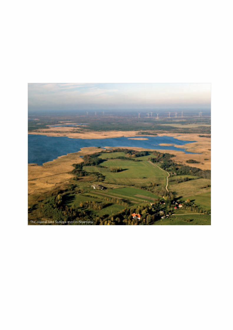
The coastal lake Sutlepa meri in Noarootsi.
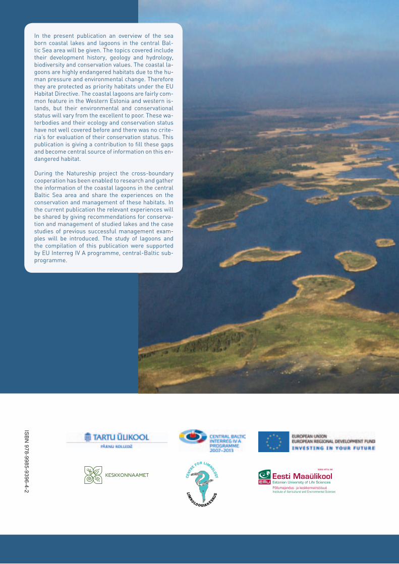
ISB
N 978-9985-9396-4-2


