Embed Size (px)
Citation preview
Code of Ordinances
City of Alliance, Ohio
Part Eleven - Planning and Zoning Code
FINAL
March 2013 Adopted by Council on March 4, 2013
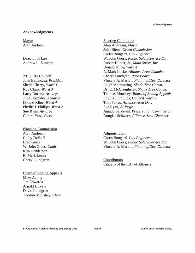
Acknowledgments
FINAL City of Alliance Planning and Zoning Code Page i March 2013 (Adopted 3/4/13)
Acknowledgments Mayor Alan Andreani Director of Law Andrew L. Zumbar 2013 City Council John Benincasa, President Sheila Cherry, Ward 1 Roy Clunk, Ward 3 Larry Dordea, At-large Julie Jakmides, At-large Donald Kline, Ward 4 Phyllis J. Phillips, Ward 2 Sue Ryan, At-large Gerard Yost, Clerk Planning Commission Alan Andreani Colby DeHoff Brad Goris W. John Gross, Chair Kim Henderson R. Mark Locke Cheryl Lundgren Board of Zoning Appeals Mike Aeling Jim Edwards Arnold Hirvela David Lundgren Thomas Moushey, Chair
Steering Committee Alan Andreani, Mayor John Bienz, Green Commission Curtis Bungard, City Engineer W. John Gross, Public Safety/Service Dir. Robert Hunter, Jr., Main Street, Inc. Donald Kline, Ward 4 R. Mark Locke, Alliance Area Chamber Cheryl Lundgren, Park Board Vincent A. Marion, Planning/Dev. Director Leigh Mainwaring, Shade Tree Comm. Dr. C. McClaugherty, Shade Tree Comm. Thomas Moushey, Board of Zoning Appeals Phyllis J. Phillips, Council Ward 2 Tom Pukys, Alliance Area Dev. Sue Ryan, At-large Amado Sandoval, Preservation Commission Douglas Schwarz, Alliance Area Chamber Administration Curtis Bungard, City Engineer W. John Gross, Public Safety/Service Dir. Vincent A. Marion, Planning/Dev. Director Contributors Citizens of the City of Alliance
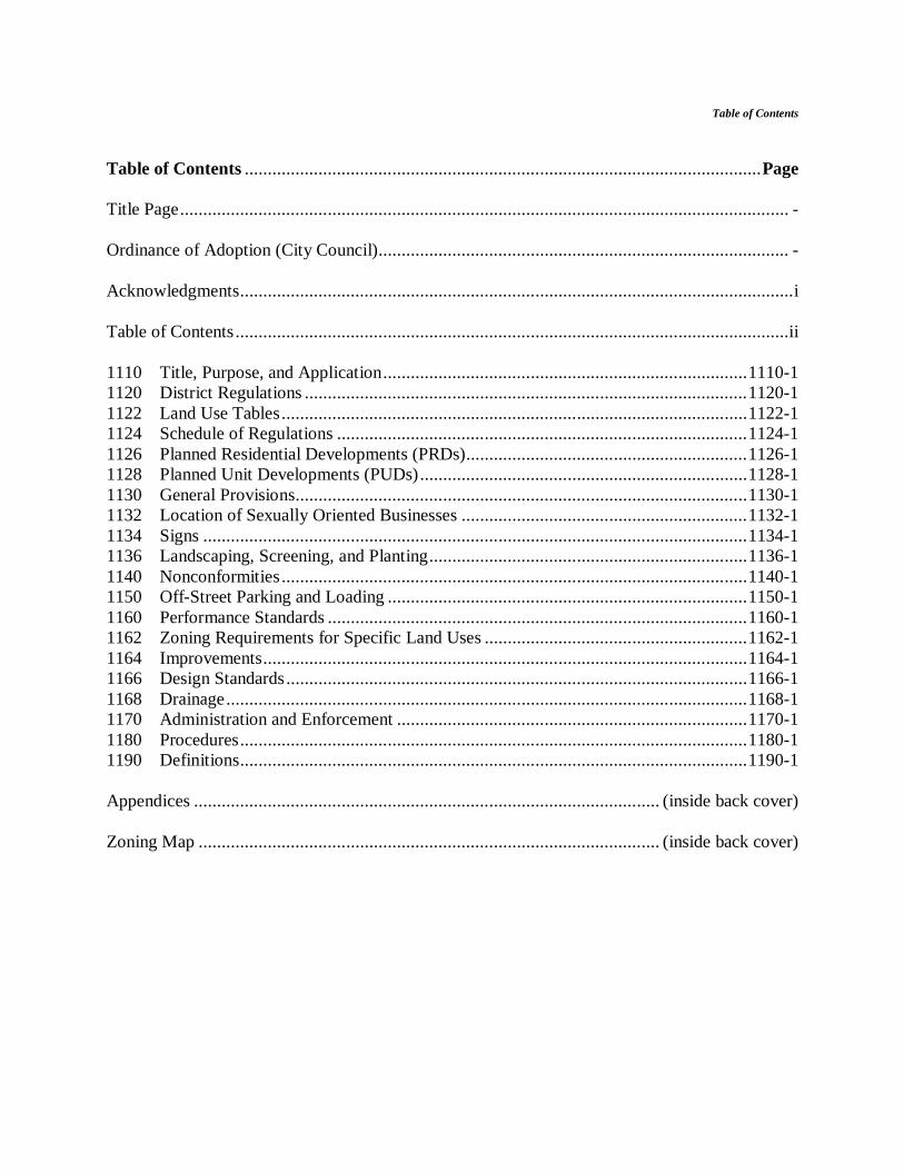
Table of Contents
Table of Contents ................................................................................................................Page Title Page.................................................................................................................................... - Ordinance of Adoption (City Council)......................................................................................... - Acknowledgments........................................................................................................................i Table of Contents ........................................................................................................................ii 1110 Title, Purpose, and Application...............................................................................1110-1 1120 District Regulations ................................................................................................1120-1 1122 Land Use Tables.....................................................................................................1122-1 1124 Schedule of Regulations .........................................................................................1124-1 1126 Planned Residential Developments (PRDs).............................................................1126-1 1128 Planned Unit Developments (PUDs).......................................................................1128-1 1130 General Provisions..................................................................................................1130-1 1132 Location of Sexually Oriented Businesses ..............................................................1132-1 1134 Signs ......................................................................................................................1134-1 1136 Landscaping, Screening, and Planting.....................................................................1136-1 1140 Nonconformities.....................................................................................................1140-1 1150 Off-Street Parking and Loading ..............................................................................1150-1 1160 Performance Standards ...........................................................................................1160-1 1162 Zoning Requirements for Specific Land Uses .........................................................1162-1 1164 Improvements.........................................................................................................1164-1 1166 Design Standards....................................................................................................1166-1 1168 Drainage.................................................................................................................1168-1 1170 Administration and Enforcement ............................................................................1170-1 1180 Procedures..............................................................................................................1180-1 1190 Definitions..............................................................................................................1190-1 Appendices ..................................................................................................... (inside back cover) Zoning Map .................................................................................................... (inside back cover)
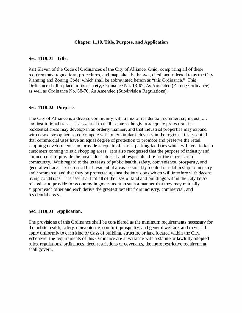
Chapter 1110, Title, Purpose, and Application
Sec. 1110.01 Title. Part Eleven of the Code of Ordinances of the City of Alliance, Ohio, comprising all of these requirements, regulations, procedures, and map, shall be known, cited, and referred to as the City Planning and Zoning Code, which shall be abbreviated herein as “this Ordinance.” This Ordinance shall replace, in its entirety, Ordinance No. 13-67, As Amended (Zoning Ordinance), as well as Ordinance No. 68-70, As Amended (Subdivision Regulations). Sec. 1110.02 Purpose. The City of Alliance is a diverse community with a mix of residential, commercial, industrial, and institutional uses. It is essential that all use areas be given adequate protection, that residential areas may develop in an orderly manner, and that industrial properties may expand with new developments and compete with other similar industries in the region. It is essential that commercial uses have an equal degree of protection to promote and preserve the retail shopping developments and provide adequate off-street parking facilities which will tend to keep customers coming to said shopping areas. It is also recognized that the purpose of industry and commerce is to provide the means for a decent and respectable life for the citizens of a community. With regard to the interests of public health, safety, convenience, prosperity, and general welfare, it is essential that residential areas be suitably located in relationship to industry and commerce, and that they be protected against the intrusions which will interfere with decent living conditions. It is essential that all of the uses of land and buildings within the City be so related as to provide for economy in government in such a manner that they may mutually support each other and each derive the greatest benefit from industry, commercial, and residential areas. Sec. 1110.03 Application. The provisions of this Ordinance shall be considered as the minimum requirements necessary for the public health, safety, convenience, comfort, prosperity, and general welfare, and they shall apply uniformly to each kind or class of building, structure or land located within the City. Whenever the requirements of this Ordinance are at variance with a statute or lawfully adopted rules, regulations, ordinances, deed restrictions or covenants, the more restrictive requirement shall govern.

[THIS PAGE HAS BEEN LEFT BLANK INTENTIONALLY.]
Chapter 1120, District Regulations Sec. 1120.01 Zoning Districts. For the purpose of this Ordinance, the City is hereby divided into districts and overlays to be known as the following:
Symbol Name
R-1 Single Family Residential District R-2 Multiple Family Residential District B-1 Downtown Commercial District B-2 Thoroughfare Commercial District B-3 Mixed Commercial District B-4 Office Service District I-1 Light Industrial I-2 Heavy Industrial OS Open Space PRD Planned Residential Development Overlay PUD Planned Unit Development Overlay
Sec. 1120.02 Zoning Map. The City is hereby divided into districts, with the district areas and boundaries as shown on the Official Zoning Map, along with all proper notations, references and explanatory matter. The Official Zoning Map shall be adopted by reference and declared to be a part of this Ordinance. This Map shall be identified by the signature of the Clerk of Council, and bearing the seal of the City under the following words: “This is to certify that this is the Official Zoning Map adopted by the City of Alliance Council on March 19th, 2007.” If in accordance with the provisions of this Ordinance, changes are made in district boundaries or other matter portrayed on the Official Zoning Map, such changes shall be entered on the Map promptly after the amendment has been approved by the Council. No changes of any nature shall be made on the Official Zoning Map, except in conformity with the amendment procedures set forth in this Ordinance or in conformity with the procedures set forth in the Revised Code for adoption of a new Official Zoning Map. The Official Zoning Map shall be kept in the office of the Clerk of Council, and shall be the final authority as to the current zoning status of land and water areas and structures in the City.

Sec. 1120.03 R-1, Single Family Residential District. The purpose of the R-1, Single Family Residential District is to provide a range of choices of single family living environments, encouraging the development and maintenance of suitable neighborhoods for families and children, prohibiting uses of land that would adversely impact residential neighborhoods, and discouraging uses that would generate traffic on local streets in excess of normal traffic generated by the neighborhood. The intent of the district is to provide for an environment of predominantly single-family dwellings, along with other associated uses and facilities that serve the residents in the district, including but not limited to educational, cultural, and religious institutions, parks and playgrounds, and municipal facilities. The R-1 District also recognizes those portions of the Mount Union College (College) campus that are located in the R-1 District and provides the opportunity for the College to continue to operate and grow within the context of this Ordinance in consideration of surrounding residential neighborhoods. Sec. 1120.04 R-2, Multiple Family Residential District. The purpose of the R-2, Multiple Family Residential District is to promote a harmonious mixture of housing options and related educational, cultural, and religious land uses in a primarily residential environment. Various types and sizes of medium and high density residential units shall be provided at planned locations in the community to meet the needs of the different age and family groups. This district shall generally be located along major streets and shall be served by public water and sewerage systems and other appropriate urban facilities and services. Uses in this district shall be subject to appropriate design, density, and development standards (including, but not limited to density, bulk, setback and separation, adequate light and air, privacy and recreation areas) that are intended to prevent congestion on public streets, reduce hazards to life and property, and provide adequate recreation areas and basic amenities. There is no intent to promote by these regulations a district of lower quality or desirability than any other residential district, although a higher density of population and a greater variety of dwelling types are permitted herein.
Sec. 1120.05 B-1, Downtown Commercial District. The purpose of the B-1, Downtown Commercial District is to promote the following objectives in the downtown area of the City of Alliance: (1) to encourage a mix of commercial, office, limited light industrial, and mixed residential uses, developed in a manner consistent with the City’s Comprehensive Land Use Plan; (2) to permit multi-story buildings and structures with reduced setbacks from the street that preserve and promote ground-floor retail uses with office and residential uses above along with shared accessory parking both on-street and to the rear of the buildings and structures; (3) to enhance pedestrian activity; and (4) to create harmonious transitions between nonresidential and the residential areas. Sec. 1120.06 B-2, Thoroughfare Commercial District. The purpose of the B-2, Thoroughfare Commercial District is to accommodate a mix of primarily auto-oriented commercial uses serving both short and long term needs in convenient locations, with some accessory office and other uses where appropriate and developed in a manner consistent with the City’s Comprehensive Land Use Plan. This district encourages development and redevelopment design layouts that preserve and enhance existing natural feature amenities, over developments that disturb, remove, and/or mitigate these areas. Sec. 1120.07 B-3, Mixed Commercial District. The purpose of the B-3, Mixed Commercial District is to promote the following objectives: (1) to encourage a mix of commercial, office, institutional, and mixed residential uses, developed in a manner consistent with the recommendations identified for the Institutional Service Future Land Use Area in the City’s Comprehensive Land Use Plan; (2) to permit multi-story buildings and structures with reduced setbacks from the street that preserve and promote ground-floor retail uses with office and residential uses above along with shared accessory parking both on-street and to the rear of the buildings and structures, as well as in multi-level parking structures; (3) to enhance pedestrian activity; and (4) to create harmonious transitions between all uses in this district and surrounding residential areas.
Sec. 1120.08 B-4, Office Service District. The purpose of the B-4, Office Service District is to provide limited areas within the City along specific major thoroughfares and at certain major intersections to promote the following objectives: (1) to encourage a mix of office, service, and residential uses; (2) to acknowledge areas where such uses may already exist; (3) to enhance pedestrian activity; and (4) to create harmonious transitions between all uses in this district and surrounding residential areas. Sec. 1120.09 I-1 Light Industrial District. The purpose of the I-1, Light Industrial District is to accommodate industrial, wholesale, warehouse, and storage activities, and industrial operations whose external physical effects are restricted to eliminate potentially negative impacts on the surrounding districts. This district is structured to permit the manufacturing, compounding, procession, packaging, assembly, and/or treatment of finished or semi-finished products from previously prepared material, subject to performance standards identified in this Ordinance. The processing of raw material for shipment in bulk form, for use in an industrial operation at another location is not permitted. Sec. 1120.10 I-2 Heavy Industrial District. The purpose of the I-2, Heavy Industrial District is to accommodate industrial, wholesale, warehouse, and storage activities, and industrial operations whose external physical effects are less restricted and require greater separation from surrounding districts to eliminate potentially negative impacts. This district is structured to permit the manufacturing, compounding, procession, packaging, assembly, and/or treatment of raw material for shipment in bulk form, for use in an industrial operation at another location, subject to performance standards identified in this Ordinance.
Sec. 1120.11 OS, Open Space District. The purpose of the OS, Open Space District is to protect and preserve open space land as a limited and valuable resource; to permit and facilitate the reasonable use of open space land, while simultaneously preserving and protecting the inherent characteristics of the open space to ensure the continued availability for scenic, recreational, conservation, and educational purposes; for the containment of urban sprawl and the structuring of urban development; and for the retention of land in its natural or near-natural state; and to implement the open space element of the City’s Comprehensive Land Use Plan. Sec. 1120.12 PRD, Planned Residential Development Overlay. The purpose of the PRD, Planned Residential Development Overlay is to permit the use of flexible land use and design regulations that encourage innovative site design, allow for a mixture of residential dwelling types, and encourage the preservation of the community’s natural features and open spaces. PRDs are subject to design standards and requirements outlined in this Ordinance. Sec. 1120.13 PUD, Planned Unit Development Overlay. The purpose of the PUD, Planned Unit Development Overlay is to provide a degree of flexibility in regard to the use, area, height, bulk, and placement regulations for developments which qualify as planned developments. These may include, but are not limited to, residential, commercial, industrial, and mixed use developments. Certain large developments may be of such size and configuration as to justify a controlled degree of flexibility, and to permit a mix of land uses that may not normally be permitted in the zoning district, but would, under specific circumstances, increase convenience, be compatible with the overall character of the district, and not be injurious to adjoining properties. This designation shall not be allowed where it is sought primarily to avoid the imposition of standards and requirements of the underlying zoning classification(s) or other City requirements rather than to achieve the purposes stated above. PUDs are subject to design standards and regulations outlined in this Ordinance.
Sec. 1120.14 Permitted Uses and Conditional Uses. In all districts, no structure or land shall be used or occupied, except in conformance with this Ordinance. Conditional uses may be permitted in accordance with this Ordinance, subject to a public hearing and approval by the Commission in accordance with the procedures and conditions defined in this Ordinance. Where there is a pre-existing nonconforming use which has been discontinued for a period of one year or more, and it is unreasonable to believe that the existing structure will be used for its currently zoned purpose within a reasonable length of time, thereby creating an extreme hardship to the property owner, the Commission may consider the proposed use of the structure under a conditional use application as an exception to the Land Use Tables in Section 1122.03. Sec. 1120.15 Prohibited Uses. Uses that are not specifically listed as a permitted or conditional use permitted by this Ordinance in a zoning district, or otherwise determined to be similar to a listed and permitted use in accordance with the provisions of this Ordinance, shall be prohibited in the district. Sec. 1120.16 Design and Development Requirements. All permitted and conditional uses shall comply with any applicable requirements of this Ordinance and all other applicable City requirements. No structure shall be erected, reconstructed, altered or enlarged, nor shall permits or certificates of occupancy be issued, except in conformance with this Ordinance and all other applicable City requirements. Sec. 1120.17 District Boundaries. The boundaries of zoning districts, as shown on the map accompanying and made a part of this Ordinance, unless otherwise shown, are lot or tract lines or the center lines of streets, roads or alleys, or the extension thereof, railroad right-of-way lines and the corporate limits of the City.
Sec. 1120.18 Street, Alley, and Railroad Rights-of-Way. All streets, alleys, and railroad rights-of-way, if not otherwise specifically designated, shall be deemed to be in the same zone as the property immediately abutting upon such streets, alleys, or railroad rights-of-way. Where the centerline of a street or alley serves as a district boundary, the zoning of such street or alley, unless otherwise specifically designated, shall be deemed to be the same as that of the abutting property up to such centerline.

[THIS PAGE HAS BEEN LEFT BLANK INTENTIONALLY.]
Chapter 1122, Land Use Tables Sec. 1122.01 Key to Designations in Land Use Tables. The following symbols are used to designate uses permitted in various districts:
Symbol Meaning
P Permitted Use C Conditional Use A Accessory Use - Prohibited Use
Sec. 1122.02 Table of Permitted Uses by District. The uses of land in the following table have been organized, for ease of use and convenience, into use groups, based upon certain characteristics that the grouped uses may share. These use groups are described below:
Agricultural Uses. These uses primarily involve uses deriving from or related to agriculture, as defined in the Revised Code.
Residential Uses. These uses primarily involve housing of various types and densities, and associated uses typically found in a residential neighborhood.
Office and Service Uses. These are generally various types of offices as well as service and support uses that may or may not be retail commercial in nature.
Community Uses. These uses are generally public-owned or operated uses, or uses of a not-for-profit nature, that primarily involve benefits or services generally provided to a significant portion of the population, or are uses that serve as focal or gathering points for members of the community.
Commercial Uses. These are generally private-owned or operated uses, or uses of a for-profit nature, that include personal service establishments, financial, executive, administrative, medical and professional offices, retail sales, food service, entertainment, repair services, workshops and studios, and similar associated uses. Industrial Uses. These are uses that are generally of a manufacturing, research, warehousing, or wholesaling character, or that involve compounding, processing, packaging, assembly, storage, or treatment of products or materials.
Temporary Uses. These are uses that are generally of a temporary nature, including but not limited to uses sponsored by the City or other public or private organizations, and which may or may not involve the construction or occupation of new or existing buildings.
Other Uses. These are uses that, because of unusual character, intensity or nuisance factors, do not fit well into the preceding use groups.
Accessory Uses. These uses are permitted as an accessory to any permitted or conditional uses.
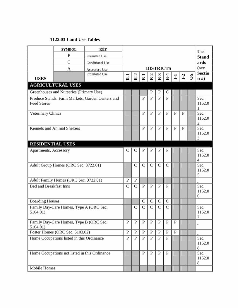
1122.03 Land Use Tables
SYMBOL KEY
P Permitted Use
C Conditional Use
A Accessory Use DISTRICTS
USES Prohibited Use
R-1
R-2
B-1
B-2
B-3
B-4
I-1
I-2
OS
Use Standards (see Section #)
AGRICULTURAL USES Greenhouses and Nurseries (Primary Use) P P C Produce Stands, Farm Markets, Garden Centers and Feed Stores
P P P P Sec. 1162.01
Veterinary Clinics P P P P P P Sec. 1162.02
Kennels and Animal Shelters P P P P P P Sec. 1162.03
RESIDENTIAL USES Apartments, Accessory C C P P P P Sec.
1162.04
Adult Group Homes (ORC Sec. 3722.01) C C C C C Sec. 1162.05
Adult Family Homes (ORC Sec. 3722.01) P P Bed and Breakfast Inns C C P P P P Sec.
1162.06
Boarding Houses C C C C Family Day-Care Homes, Type A (ORC Sec. 5104.01)
C C C C C Sec. 1162.07
Family Day-Care Homes, Type B (ORC Sec. 5104.01)
P P P P P P P
Foster Homes (ORC Sec. 5103.02) P P P P P P P Home Occupations listed in this Ordinance P P P P P P Sec.
1162.08
Home Occupations not listed in this Ordinance P P P P Sec. 1162.08
Mobile Homes
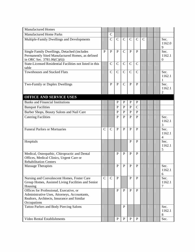
Manufactured Homes Manufactured Home Parks C Multiple-Family Dwellings and Developments C C C C C C Sec.
1162.09
Single Family Dwellings, Detached (includes Permanently Sited Manufactured Homes, as defined in ORC Sec. 3781.06(C)(6))
P P P C P P Sec. 1162.10
State-Licensed Residential Facilities not listed in this table
C C C C C
Townhouses and Stacked Flats C C C C C Sec. 1162.11
Two-Family or Duplex Dwellings P P C P P Sec. 1162.12
OFFICE AND SERVICE USES Banks and Financial Institutions P P P P Banquet Facilities P P P C Barber Shops, Beauty Salons and Nail Care P P P P Catering Facilities P P P P Sec.
1162.13
Funeral Parlors or Mortuaries C C P P P P Sec. 1162.14
Hospitals P P Sec. 1162.15
Medical, Osteopathic, Chiropractic and Dental Offices, Medical Clinics, Urgent Care or Rehabilitation Centers
P P P P
Massage Therapists P P P P Sec. 1162.16
Nursing and Convalescent Homes, Foster Care Group Homes, Assisted Living Facilities and Senior Housing
C C P P P Sec. 1162.17
Offices for Professional, Executive, or Administrative Uses, Attorneys, Accountants, Realtors, Architects, Insurance and Similar Occupations
P P P P
Tattoo Parlors and Body Piercing Salons P Sec. 1162.18
Video Rental Establishments P P P P Sec.
1162.19
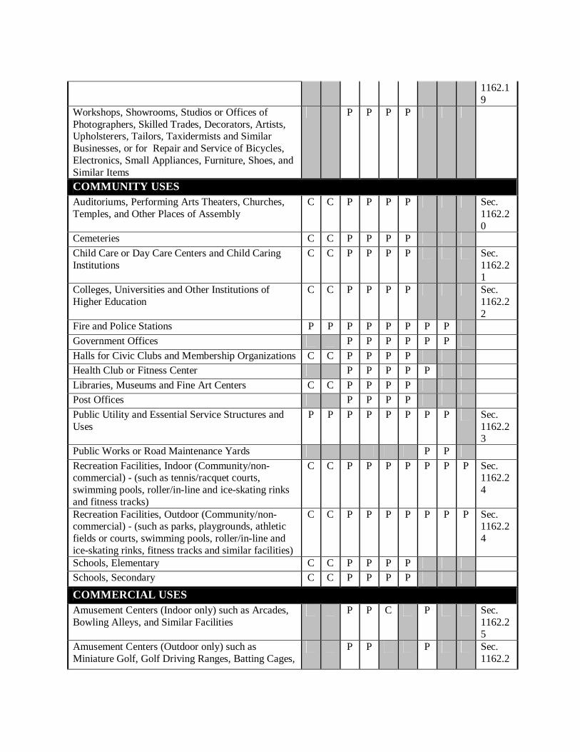
Workshops, Showrooms, Studios or Offices of Photographers, Skilled Trades, Decorators, Artists, Upholsterers, Tailors, Taxidermists and Similar Businesses, or for Repair and Service of Bicycles, Electronics, Small Appliances, Furniture, Shoes, and Similar Items
P P P P
COMMUNITY USES Auditoriums, Performing Arts Theaters, Churches, Temples, and Other Places of Assembly
C C P P P P Sec. 1162.20
Cemeteries C C P P P P Child Care or Day Care Centers and Child Caring Institutions
C C P P P P Sec. 1162.21
Colleges, Universities and Other Institutions of Higher Education
C C P P P P Sec. 1162.22
Fire and Police Stations P P P P P P P P Government Offices P P P P P P Halls for Civic Clubs and Membership Organizations C C P P P P Health Club or Fitness Center P P P P P Libraries, Museums and Fine Art Centers C C P P P P Post Offices P P P P Public Utility and Essential Service Structures and Uses
P P P P P P P P Sec. 1162.23
Public Works or Road Maintenance Yards P P Recreation Facilities, Indoor (Community/non-commercial) - (such as tennis/racquet courts, swimming pools, roller/in-line and ice-skating rinks and fitness tracks)
C C P P P P P P P Sec. 1162.24
Recreation Facilities, Outdoor (Community/non-commercial) - (such as parks, playgrounds, athletic fields or courts, swimming pools, roller/in-line and ice-skating rinks, fitness tracks and similar facilities)
C C P P P P P P P Sec. 1162.24
Schools, Elementary C C P P P P Schools, Secondary C C P P P P
COMMERCIAL USES Amusement Centers (Indoor only) such as Arcades, Bowling Alleys, and Similar Facilities
P P C P Sec. 1162.25
Amusement Centers (Outdoor only) such as Miniature Golf, Golf Driving Ranges, Batting Cages,
P P P Sec. 1162.2
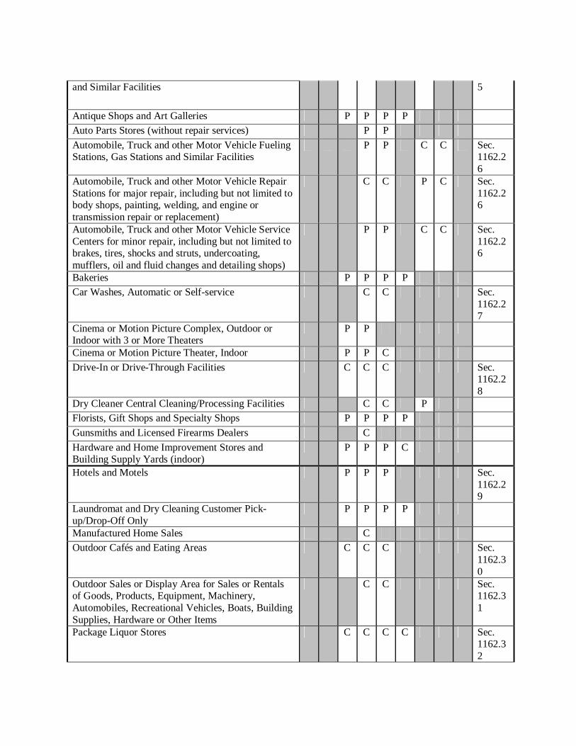
and Similar Facilities 5
Antique Shops and Art Galleries P P P P Auto Parts Stores (without repair services) P P Automobile, Truck and other Motor Vehicle Fueling Stations, Gas Stations and Similar Facilities
P P C C Sec. 1162.26
Automobile, Truck and other Motor Vehicle Repair Stations for major repair, including but not limited to body shops, painting, welding, and engine or transmission repair or replacement)
C C P C Sec. 1162.26
Automobile, Truck and other Motor Vehicle Service Centers for minor repair, including but not limited to brakes, tires, shocks and struts, undercoating, mufflers, oil and fluid changes and detailing shops)
P P C C Sec. 1162.26
Bakeries P P P P Car Washes, Automatic or Self-service C C Sec.
1162.27
Cinema or Motion Picture Complex, Outdoor or Indoor with 3 or More Theaters
P P
Cinema or Motion Picture Theater, Indoor P P C Drive-In or Drive-Through Facilities C C C Sec.
1162.28
Dry Cleaner Central Cleaning/Processing Facilities C C P Florists, Gift Shops and Specialty Shops P P P P
Gunsmiths and Licensed Firearms Dealers C
Hardware and Home Improvement Stores and Building Supply Yards (indoor)
P P P C
Hotels and Motels P P P Sec. 1162.29
Laundromat and Dry Cleaning Customer Pick-up/Drop-Off Only
P P P P
Manufactured Home Sales C Outdoor Cafés and Eating Areas C C C Sec.
1162.30
Outdoor Sales or Display Area for Sales or Rentals of Goods, Products, Equipment, Machinery, Automobiles, Recreational Vehicles, Boats, Building Supplies, Hardware or Other Items
C C Sec. 1162.31
Package Liquor Stores C C C C Sec. 1162.32
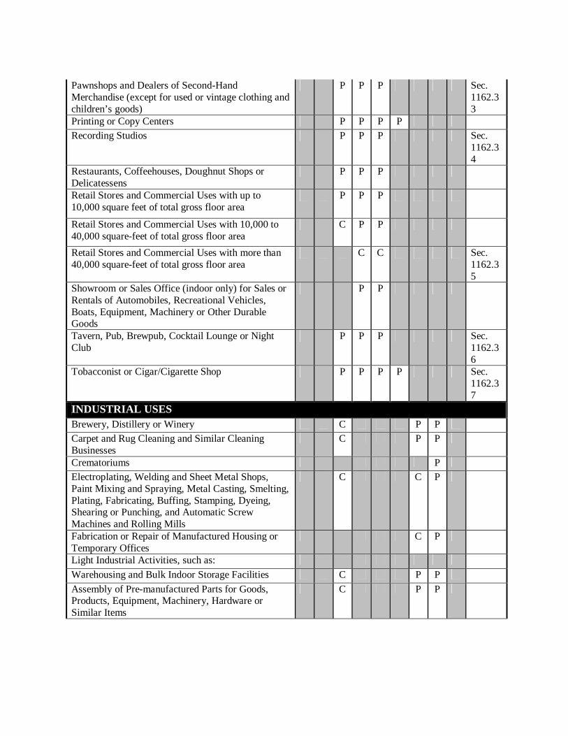
Pawnshops and Dealers of Second-Hand Merchandise (except for used or vintage clothing and children’s goods)
P P P Sec. 1162.33
Printing or Copy Centers P P P P Recording Studios P P P Sec.
1162.34
Restaurants, Coffeehouses, Doughnut Shops or Delicatessens
P P P
Retail Stores and Commercial Uses with up to 10,000 square feet of total gross floor area
P P P
Retail Stores and Commercial Uses with 10,000 to 40,000 square-feet of total gross floor area
C P P
Retail Stores and Commercial Uses with more than 40,000 square-feet of total gross floor area
C C Sec. 1162.35
Showroom or Sales Office (indoor only) for Sales or Rentals of Automobiles, Recreational Vehicles, Boats, Equipment, Machinery or Other Durable Goods
P P
Tavern, Pub, Brewpub, Cocktail Lounge or Night Club
P P P Sec. 1162.36
Tobacconist or Cigar/Cigarette Shop P P P P Sec. 1162.37
INDUSTRIAL USES Brewery, Distillery or Winery C P P Carpet and Rug Cleaning and Similar Cleaning Businesses
C P P
Crematoriums P Electroplating, Welding and Sheet Metal Shops, Paint Mixing and Spraying, Metal Casting, Smelting, Plating, Fabricating, Buffing, Stamping, Dyeing, Shearing or Punching, and Automatic Screw Machines and Rolling Mills
C C P
Fabrication or Repair of Manufactured Housing or Temporary Offices
C P
Light Industrial Activities, such as: Warehousing and Bulk Indoor Storage Facilities C P P Assembly of Pre-manufactured Parts for Goods, Products, Equipment, Machinery, Hardware or Similar Items
C P P
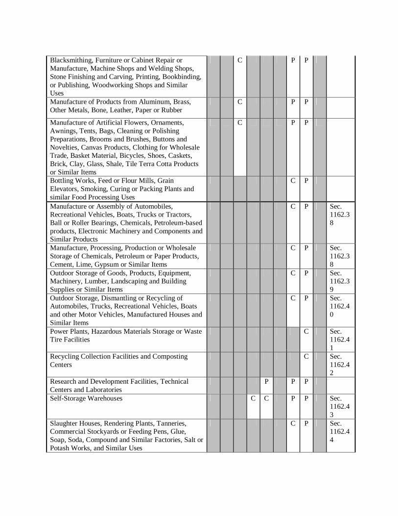
Blacksmithing, Furniture or Cabinet Repair or Manufacture, Machine Shops and Welding Shops, Stone Finishing and Carving, Printing, Bookbinding, or Publishing, Woodworking Shops and Similar Uses
C P P
Manufacture of Products from Aluminum, Brass, Other Metals, Bone, Leather, Paper or Rubber
C P P
Manufacture of Artificial Flowers, Ornaments, Awnings, Tents, Bags, Cleaning or Polishing Preparations, Brooms and Brushes, Buttons and Novelties, Canvas Products, Clothing for Wholesale Trade, Basket Material, Bicycles, Shoes, Caskets, Brick, Clay, Glass, Shale, Tile Terra Cotta Products or Similar Items
C P P
Bottling Works, Feed or Flour Mills, Grain Elevators, Smoking, Curing or Packing Plants and similar Food Processing Uses
C P
Manufacture or Assembly of Automobiles, Recreational Vehicles, Boats, Trucks or Tractors, Ball or Roller Bearings, Chemicals, Petroleum-based products, Electronic Machinery and Components and Similar Products
C P Sec. 1162.38
Manufacture, Processing, Production or Wholesale Storage of Chemicals, Petroleum or Paper Products, Cement, Lime, Gypsum or Similar Items
C P Sec. 1162.38
Outdoor Storage of Goods, Products, Equipment, Machinery, Lumber, Landscaping and Building Supplies or Similar Items
C P Sec. 1162.39
Outdoor Storage, Dismantling or Recycling of Automobiles, Trucks, Recreational Vehicles, Boats and other Motor Vehicles, Manufactured Houses and Similar Items
C P Sec. 1162.40
Power Plants, Hazardous Materials Storage or Waste Tire Facilities
C Sec. 1162.41
Recycling Collection Facilities and Composting Centers
C Sec. 1162.42
Research and Development Facilities, Technical Centers and Laboratories
P P P
Self-Storage Warehouses C C P P Sec. 1162.43
Slaughter Houses, Rendering Plants, Tanneries, Commercial Stockyards or Feeding Pens, Glue, Soap, Soda, Compound and Similar Factories, Salt or Potash Works, and Similar Uses
C P Sec. 1162.44
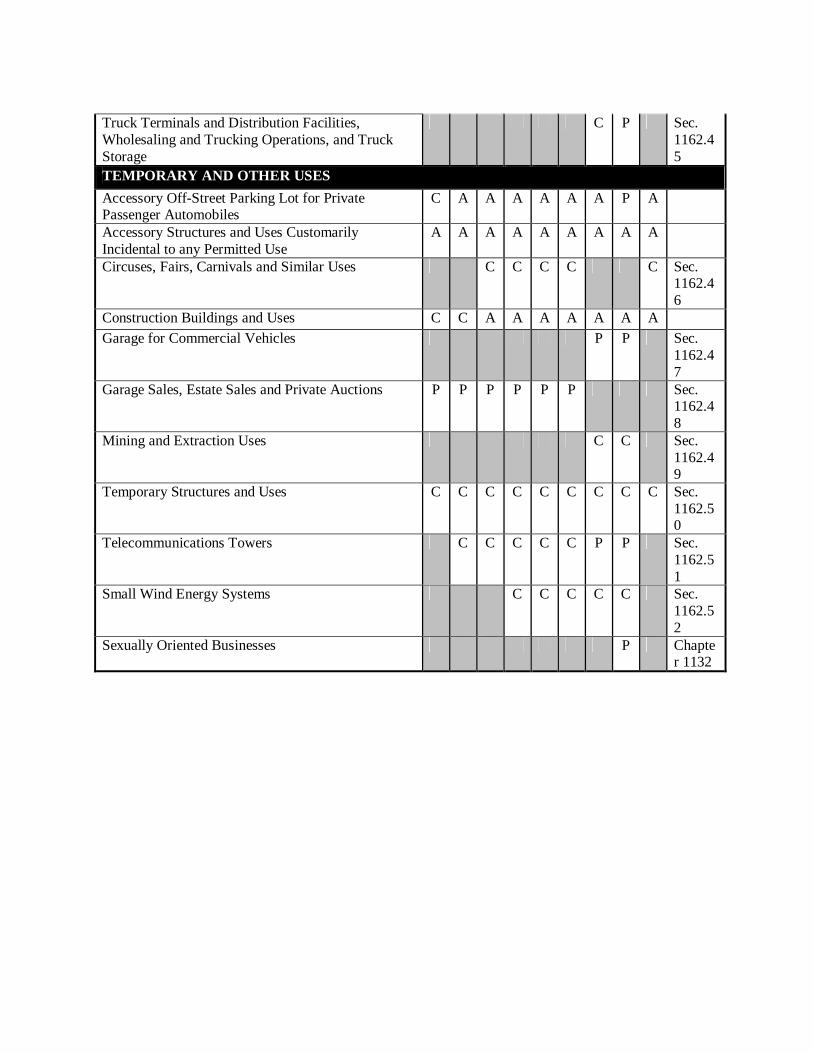
Truck Terminals and Distribution Facilities, Wholesaling and Trucking Operations, and Truck Storage
C P Sec. 1162.45
TEMPORARY AND OTHER USES Accessory Off-Street Parking Lot for Private Passenger Automobiles
C A A A A A A P A
Accessory Structures and Uses Customarily Incidental to any Permitted Use
A A A A A A A A A
Circuses, Fairs, Carnivals and Similar Uses C C C C C Sec. 1162.46
Construction Buildings and Uses C C A A A A A A A Garage for Commercial Vehicles P P Sec.
1162.47
Garage Sales, Estate Sales and Private Auctions P P P P P P Sec. 1162.48
Mining and Extraction Uses C C Sec. 1162.49
Temporary Structures and Uses C C C C C C C C C Sec. 1162.50
Telecommunications Towers C C C C C P P Sec. 1162.51
Small Wind Energy Systems C C C C C Sec. 1162.52
Sexually Oriented Businesses P Chapter 1132
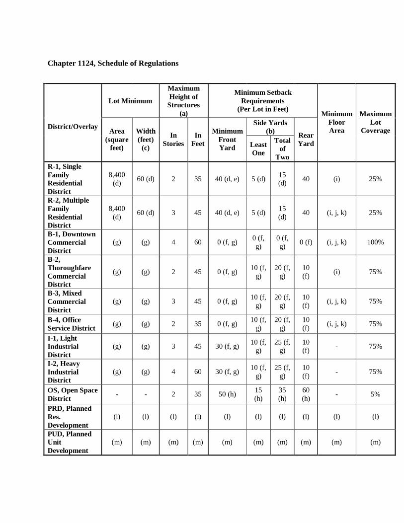
Chapter 1124, Schedule of Regulations
Lot Minimum
Maximum Height of
Structures (a)
Minimum Setback Requirements
(Per Lot in Feet)
Side Yards (b)
District/Overlay Area
(square feet)
Width (feet)
(c)
In Stories
In Feet
Minimum Front Yard Least
One
Total of
Two
Rear Yard
Minimum Floor Area
Maximum Lot
Coverage
R-1, Single Family Residential District
8,400 (d) 60 (d) 2 35 40 (d, e) 5 (d) 15
(d) 40 (i) 25%
R-2, Multiple Family Residential District
8,400 (d) 60 (d) 3 45 40 (d, e) 5 (d) 15
(d) 40 (i, j, k) 25%
B-1, Downtown Commercial District
(g) (g) 4 60 0 (f, g) 0 (f, g)
0 (f, g) 0 (f) (i, j, k) 100%
B-2, Thoroughfare Commercial District
(g) (g) 2 45 0 (f, g) 10 (f, g)
20 (f, g)
10 (f) (i) 75%
B-3, Mixed Commercial District
(g) (g) 3 45 0 (f, g) 10 (f, g)
20 (f, g)
10 (f) (i, j, k) 75%
B-4, Office Service District (g) (g) 2 35 0 (f, g) 10 (f,
g) 20 (f,
g) 10 (f) (i, j, k) 75%
I-1, Light Industrial District
(g) (g) 3 45 30 (f, g) 10 (f, g)
25 (f, g)
10 (f) - 75%
I-2, Heavy Industrial District
(g) (g) 4 60 30 (f, g) 10 (f, g)
25 (f, g)
10 (f) - 75%
OS, Open Space District - - 2 35 50 (h) 15
(h) 35 (h)
60 (h) - 5%
PRD, Planned Res. Development
(l) (l) (l) (l) (l) (l) (l) (l) (l) (l)
PUD, Planned Unit Development
(m) (m) (m) (m) (m) (m) (m) (m) (m) (m)
FOOTNOTES TO SCHEDULE OF REGULATIONS (a) Additional building height may be permitted in all districts except R-1 and OS with
Commission approval, in accordance with the provisions outlined in this Ordinance.
(b) In all districts, on a corner lot, the side yard abutting the secondary street shall be 20 feet. (c) In all districts, in addition to meeting minimum lot width requirements, each lot shall also
provide lot frontage, per Sec. 1130.05, conforming to the provisions of this Ordinance.
(d) For a nonresidential use in an R-1 or R-2 District, lot minimum (area and width) and minimum front and side yard requirements shall be determined by the ability of a proposed use to meet all other requirements of this Ordinance.
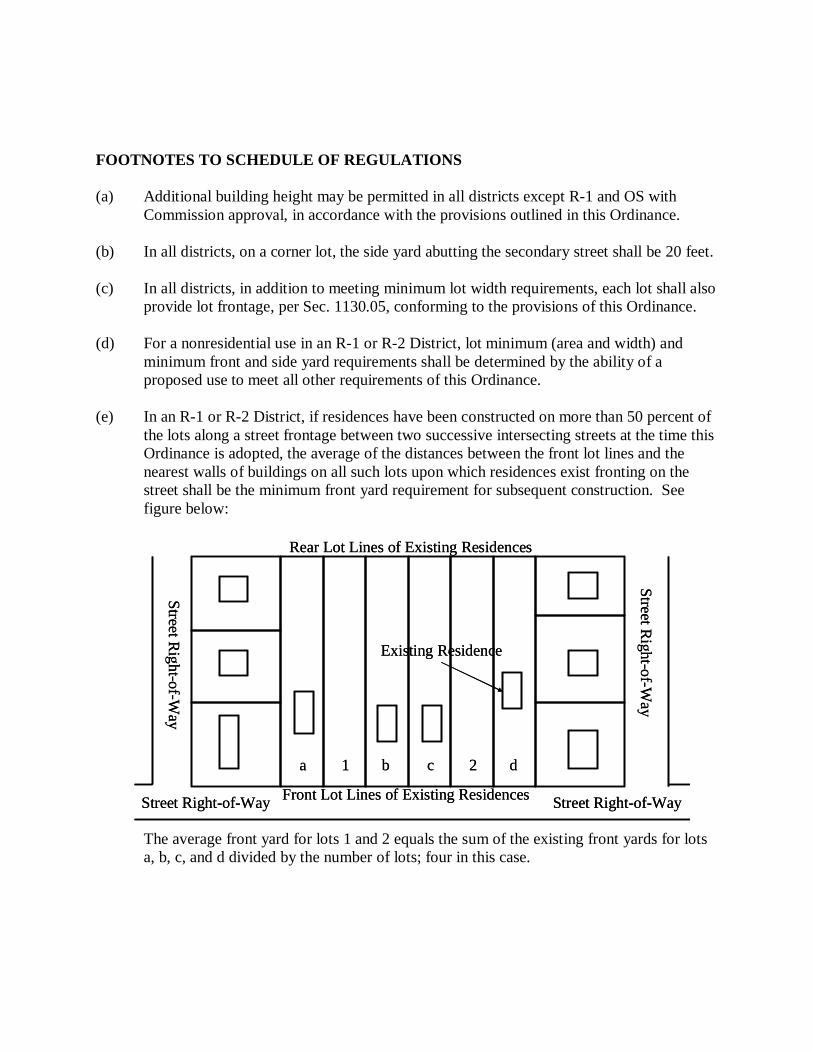
(e) In an R-1 or R-2 District, if residences have been constructed on more than 50 percent of
the lots along a street frontage between two successive intersecting streets at the time this Ordinance is adopted, the average of the distances between the front lot lines and the nearest walls of buildings on all such lots upon which residences exist fronting on the street shall be the minimum front yard requirement for subsequent construction. See figure below:
The average front yard for lots 1 and 2 equals the sum of the existing front yards for lots a, b, c, and d divided by the number of lots; four in this case.
Rear Lot Lines of Existing Residences
Street Right-of-W
ay
Front Lot Lines of Existing Residences
Street Right-of-W
ay
a 1 b c 2 d
Existing Residence
Street Right-of-WayStreet Right-of-Way
Rear Lot Lines of Existing Residences
Street Right-of-W
ay
Front Lot Lines of Existing Residences
Street Right-of-W
ay
a 1 b c 2 d
Existing Residence
Street Right-of-WayStreet Right-of-Way
(f) In a B-1, B-2, B-3, B-4, I-1 or I-2 District, where a lot abuts land in an R-1 or R-2
District, any yard abutting such land shall be increased to 20 feet. (g) In a B-1, B-2, B-3, B-4, I-1 or I-2 District, lot minimum (area and width) and minimum
front and side yard requirements shall be determined by the ability of a proposed use to meet all other requirements of this Ordinance
(h) In an OS District, there shall be no setback requirements for any lot line that abuts
another lot in an OS District. (i) Single-family dwellings shall comply with the following minimum floor area
requirements: Dwellings with or without basement ............................................................... 1,000 sq. ft.
(j) Two family dwellings shall comply with the following minimum floor area requirements
per unit:
Dwellings with or without basement .................................................................. 800 sq. ft. (k) Multiple family dwellings shall comply with the following minimum floor area
requirements per unit:
Unit with one bedroom ...................................................................................... 400 sq. ft. Unit with two bedrooms .................................................................................... 550 sq. ft. Unit with three or more bedrooms ..................................................................... 700 sq. ft.
(l) A PRD shall meet all requirements outlined in Chapter 1126. (m) A PUD shall meet all requirements outlined in Chapter 1128.

[THIS PAGE HAS BEEN LEFT BLANK INTENTIONALLY.]
Chapter 1126, PRD, Planned Residential Development District Sec. 1126.01 Purpose. The purpose of the Planned Residential Development (PRD) District is to encourage the use of land in accordance with its character and adaptability; conserve natural resources, natural features, and energy; encourage innovation in land use planning; provide enhanced housing, traffic circulation, and recreational opportunities for the people of the City; ensure compatibility of design and use between neighboring properties; encourage development that is consistent with the Comprehensive Land Use Plan; and promote open space development that preserves the City’s character and encourages the preservation of environmentally sensitive lands. Sec. 1126.02 Qualification Requirements. PRDs shall be considered an optional means of development, and thus shall only be permitted when mutually agreeable to the developer, the Commission, and the Council. PRDs shall be in compliance with the following: (a) Site Conditions. The proposed PRD site shall be in compliance with the following
conditions:
(i) Area. The proposed development site shall be at least 10 acres in area, except where the Council, upon recommendation from the Commission, may permit a PRD on a smaller site that offers unique benefits for the City, or where the site has unique characteristics that significantly impact development, such as an unusual shape or proportion, unusual topography, or potentially incompatible land uses on surrounding properties.
(ii) Ownership. The site shall be under a single ownership or control, and able to be planned and developed as an integrated unit.
(iii) Location. PRD sites shall be limited to locations that have one or more of the following characteristics: (1) Sites where flexibility is necessary because of site constraints, including
but not limited to incompatible adjoining land uses, traffic conditions that affect ease of access or irregular parcel boundaries.
(2) Sites where the flexibility of the PRD regulations is necessary to achieve a reasonable and desirable transition between land uses, without affecting the overall City land use pattern, intensity of development or objectives of the Comprehensive Land Use Plan or any sub-area or corridor plans.
(3) Sites where the large scale of a proposed development justifies permitting certain incidental uses not normally permitted in the zoning district.
(4) Sites where the public health, safety, and welfare is better served through creation of a planned development, because of the density of population, adequacy of schools, parks, or other public facilities, traffic volumes, or circulation, neighborhood compatibility, adequate provision of light or air, or accessibility for fire and police protection.
(5) Sites where the proposed development is compatible with the objectives of the Comprehensive Land Use Plan or any sub-area or corridor plans.
(iv) Concept. The overall design and all uses proposed in connection with a PRD shall be consistent with and promote the intent of the PRD concept, as well as with specific PRD design standards set forth in this Chapter. To this end, the applicant must prepare, submit, and present a concept plan showing the general characteristics of the proposed PRD, including overall size, layout, number of lots and/or units, vehicular and pedestrian circulation system, amount of open space, types of amenities, and any other unique attributes.
(b) Uses. The proposed PRD may contain any one or a combination of residential uses listed
in this Ordinance, provided that all proposed uses satisfy the following criteria:
(i) Compatible with the Comprehensive Land Use Plan. Proposed uses shall be consistent or compatible with the types and intensities of uses specified for the site in this Ordinance, the Comprehensive Land Use Plan or any sub-area or corridor plans.
(ii) Harmonious Relationship. There shall be a reasonably harmonious relationship between the location of buildings and uses on the site relative to buildings and uses on lands in the surrounding area.
(c) Other Conditions. The proposed PRD shall not:
(i) Be used for the sole purpose of increasing the density or intensity of development, or avoiding the requirements for dimensional variances;
(ii) Be used in situations where the same land use objectives can be accomplished by the application of conventional zoning provisions or standards; and/or
(iii) Materially add public service or facility loads beyond those contemplated in the Comprehensive Land Use Plan or other adopted policies or plans, except where the applicant provides a means of securing public improvements needed to serve the development, and demonstrates to the satisfaction of the Council that such added loads will be accommodated or mitigated by the PRD.
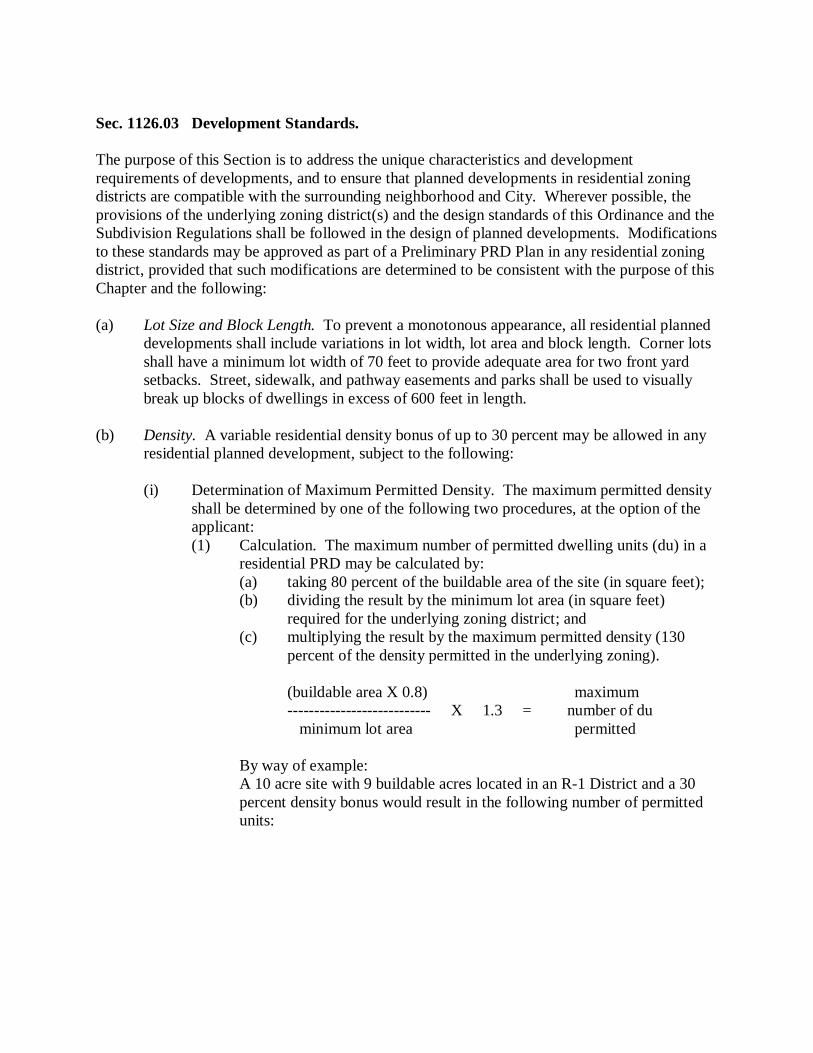
Sec. 1126.03 Development Standards. The purpose of this Section is to address the unique characteristics and development requirements of developments, and to ensure that planned developments in residential zoning districts are compatible with the surrounding neighborhood and City. Wherever possible, the provisions of the underlying zoning district(s) and the design standards of this Ordinance and the Subdivision Regulations shall be followed in the design of planned developments. Modifications to these standards may be approved as part of a Preliminary PRD Plan in any residential zoning district, provided that such modifications are determined to be consistent with the purpose of this Chapter and the following: (a) Lot Size and Block Length. To prevent a monotonous appearance, all residential planned
developments shall include variations in lot width, lot area and block length. Corner lots shall have a minimum lot width of 70 feet to provide adequate area for two front yard setbacks. Street, sidewalk, and pathway easements and parks shall be used to visually break up blocks of dwellings in excess of 600 feet in length.
(b) Density. A variable residential density bonus of up to 30 percent may be allowed in any
residential planned development, subject to the following:
(i) Determination of Maximum Permitted Density. The maximum permitted density shall be determined by one of the following two procedures, at the option of the applicant: (1) Calculation. The maximum number of permitted dwelling units (du) in a
residential PRD may be calculated by: (a) taking 80 percent of the buildable area of the site (in square feet); (b) dividing the result by the minimum lot area (in square feet)
required for the underlying zoning district; and (c) multiplying the result by the maximum permitted density (130
percent of the density permitted in the underlying zoning).
(buildable area X 0.8) maximum --------------------------- X 1.3 = number of du minimum lot area permitted
By way of example: A 10 acre site with 9 buildable acres located in an R-1 District and a 30 percent density bonus would result in the following number of permitted units:
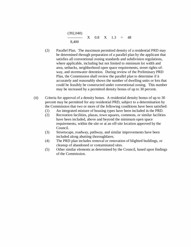
(392,040) ------------ X 0.8 X 1.3 = 48 8,400
(2) Parallel Plan. The maximum permitted density of a residential PRD may
be determined through preparation of a parallel plan by the applicant that satisfies all conventional zoning standards and subdivision regulations, where applicable, including but not limited to minimum lot width and area, setbacks, neighborhood open space requirements, street rights-of-way, and stormwater detention. During review of the Preliminary PRD Plan, the Commission shall review the parallel plan to determine if it accurately and reasonably shows the number of dwelling units or lots that could be feasibly be constructed under conventional zoning. This number may be increased by a permitted density bonus of up to 30 percent.
(ii) Criteria for approval of a density bonus. A residential density bonus of up to 30
percent may be permitted for any residential PRD, subject to a determination by the Commission that two or more of the following conditions have been satisfied: (1) An integrated mixture of housing types have been included in the PRD. (2) Recreation facilities, plazas, town squares, commons, or similar facilities
have been included, above and beyond the minimum open space requirements, within the site or at an off-site location approved by the Council.
(3) Streetscape, roadway, pathway, and similar improvements have been included along abutting thoroughfares.
(4) The PRD plan includes removal or renovation of blighted buildings, or cleanup of abandoned or contaminated sites.
(5) Other similar elements as determined by the Council, based upon findings of the Commission.
(c) Open Space. Planned developments that include a residential component shall provide
centrally-located, usable open space that is accessible to all residents of the PRD:
(i) Character and Arrangement. The arrangement and characteristics of such open space shall reflect good planning and design principles, and shall take into account the following considerations: (1) The types and arrangement of uses on the site. (2) The proposed uses of the open space and types of improvements proposed
within the open space. (3) The extent to which the leisure and recreation needs of all segments of the
population residing in the development would be accommodated. (4) The manner in which the open space is integrated into the overall design
of the development. (ii) Amount and Quality of Open Space. Residential planned developments shall
maintain a minimum of 30 percent of the gross area as dedicated open space, regardless of whether or not the PRD includes a request for a density increase and/or a lot size reduction. A minimum of 50 percent of the dedicated open space shall be upland area that is accessible to all residents of the PRD. The active recreational area shall be well drained, graded, seeded or sodded and barrier-free accessible Open Space. A PRD shall provide and maintain usable open space, accessible to all residents of the PRD, subject to the following requirements: (1) Minimum Required. A minimum of 30 percent of the gross area of a PRD
shall be set aside for common open space, regardless of whether or not the PRD includes a request for a density increase and/or a lot size reduction.
(2) Location. Open space in a PRD shall meet one or more of the following objectives: (a) Preservation of distinctive natural features and rural characteristics. (b) Minimization of impact from development on wetlands, rivers, and
other environmentally sensitive areas. (c) Maintenance of rural open space character along major
thoroughfares. (3) Limitation. Any pervious land area that is available for the common use
of all residents of a PRD may be included as part of required open space, except as follows: (a) Required open space in a PRD shall not include the area of any
public or private road, the area of any easement providing access to the PRD, or the area of any required setbacks, except for major thoroughfare setbacks.
(b) Not more than 50 percent of required open space in a PRD shall include the area of water bodies or regulated wetlands.
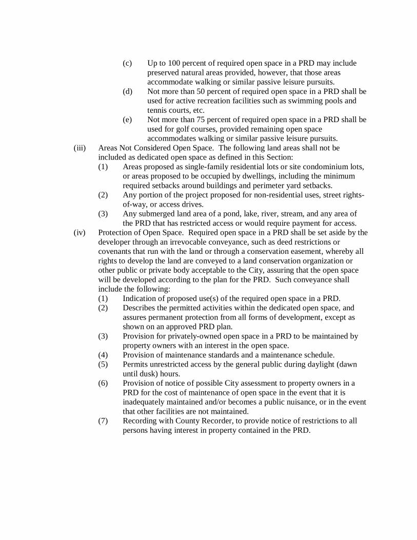
(c) Up to 100 percent of required open space in a PRD may include preserved natural areas provided, however, that those areas accommodate walking or similar passive leisure pursuits.
(d) Not more than 50 percent of required open space in a PRD shall be used for active recreation facilities such as swimming pools and tennis courts, etc.
(e) Not more than 75 percent of required open space in a PRD shall be used for golf courses, provided remaining open space accommodates walking or similar passive leisure pursuits.
(iii) Areas Not Considered Open Space. The following land areas shall not be included as dedicated open space as defined in this Section: (1) Areas proposed as single-family residential lots or site condominium lots,
or areas proposed to be occupied by dwellings, including the minimum required setbacks around buildings and perimeter yard setbacks.
(2) Any portion of the project proposed for non-residential uses, street rights-of-way, or access drives.
(3) Any submerged land area of a pond, lake, river, stream, and any area of the PRD that has restricted access or would require payment for access.
(iv) Protection of Open Space. Required open space in a PRD shall be set aside by the developer through an irrevocable conveyance, such as deed restrictions or covenants that run with the land or through a conservation easement, whereby all rights to develop the land are conveyed to a land conservation organization or other public or private body acceptable to the City, assuring that the open space will be developed according to the plan for the PRD. Such conveyance shall include the following: (1) Indication of proposed use(s) of the required open space in a PRD. (2) Describes the permitted activities within the dedicated open space, and
assures permanent protection from all forms of development, except as shown on an approved PRD plan.
(3) Provision for privately-owned open space in a PRD to be maintained by property owners with an interest in the open space.
(4) Provision of maintenance standards and a maintenance schedule. (5) Permits unrestricted access by the general public during daylight (dawn
until dusk) hours. (6) Provision of notice of possible City assessment to property owners in a
PRD for the cost of maintenance of open space in the event that it is inadequately maintained and/or becomes a public nuisance, or in the event that other facilities are not maintained.
(7) Recording with County Recorder, to provide notice of restrictions to all persons having interest in property contained in the PRD.
Sec. 1126.05 Coordination with Subdivision Plat or Site Condominium Review. Where a PRD includes a subdivision plat, the regulations, procedures and design standards of the Subdivision Regulations shall apply concurrently with the review procedures of this Chapter. The Preliminary PRD Plan shall include the Conceptual Subdivision Plan, the Final PRD Plan shall include the Preliminary Subdivision Plan, and the Planned Development Agreement shall include the Final Subdivision Plat. Where a PRD includes a site condominium development, applicable City regulations shall apply concurrently with the provisions of this Chapter. Sec. 1126.06 Informal Review of Conceptual PRD Plans. Applicants are encouraged to meet with the Commission for informal review of conceptual PRD plans. The purpose of this informal review is to discuss applicable standards and technical issues, comment on the project’s compliance with the standards of this Ordinance, and determine the appropriate type of review process. The applicant or Commission may also request input from the Administrative Official, City Engineer, and other City staff or consultants. Conceptual PRD plans should, at minimum, include the proposed use, building footprint, existing conditions, general site layout and conceptual grading. Conceptual review comments are non-binding, and should be considered by the applicant to be suggestions and recommendations only. A review fee may be required for conceptual plan review, as determined by Council resolution.

Sec. 1126.07 Preliminary PRD Plan Review Procedure. Any person or entity owning or controlling land may submit a Preliminary PRD Plan, with supporting documentation and a request for a determination whether the proposal qualifies for approval under the PRD regulations. (a) Submittal. Submittal of a Preliminary PRD Plan for consideration shall include the
following, where appropriate:
(i) PRD Description. A detailed description of the proposed uses, building and site improvements, phasing plans and open spaces. The written statement shall describe how the proposed project qualifies for consideration as a PRD, state why a PRD is preferred over conventional zoning at this site, review possible impacts on public facilities and services, identify benefits to the City and provide details and reasons for any proposed modifications from provisions of this Ordinance.
(ii) Preliminary PRD Plan. A Preliminary PRD Plan shall be provided that includes scaled drawings showing property boundaries, existing site conditions, significant site features (woodlands, landmark trees, wetlands, water bodies, historic structures, archeological sites, etc.), current zoning and land uses, adjacent zoning and land uses, general development plans, phasing and building layouts, the location, type and intensity of each proposed use, relationships to adjoining parcels, vehicular and pedestrian circulation patterns, and the general arrangement of any open spaces or landscape areas.
(iii) An impact assessment, if required by the Commission or Council, in compliance with applicable provisions of this Ordinance.
(iv) Additional maps, plans or documents necessary to adequately describe the proposed project.
(b) Technical Review. Prior to Commission consideration, the Preliminary PRD Plan and
documentation shall be distributed to appropriate City officials and staff for review and comment. If deemed necessary by the Commission, the plans shall also be submitted to applicable outside agencies and designated City consultants for review.
(c) Public Hearing. A public hearing shall be held by the Commission for all Preliminary
PRD Plans in accordance with the procedures set forth in this Ordinance.
(d) Commission Consideration of the Preliminary PRD Plan. Subsequent to the hearing, the
Commission shall review the proposed PRD, together with any reports and recommendations from staff, consultants, other reviewing agencies and any public comments. The Commission shall address whether the project meets the qualification requirements for a PRD, and whether the Preliminary PRD Plan is consistent with the purpose and provisions of this Chapter. The Commission shall then report its findings and recommendations to the Council.
(e) Council Action on the Preliminary PRD Plan. Upon receipt of the report and
recommendation from the Commission, the Council shall review all findings and take action to approve, approve with conditions or deny the Preliminary PRD plan, and shall set forth the reasons for their action. A determination that a proposal qualifies for PRD approval shall be accompanied by a description of the minimum conditions under which the proposal will be considered for Final PRD Plan approval. In describing such conditions, the Council may identify specific requirements or standards in this Ordinance which could be waived or modified upon approval of the Final PRD Plan.
(f) Effect of City Council Action on the Preliminary PRD Plan. Preliminary PRD Plan
approval is intended to provide direction for preparation of the Final PRD Plan, but shall not assure approval of the Final PRD Plan. Preliminary PRD plan approval shall expire two years after the date of approval, unless the Final PRD plan for the project has been submitted to the Commission for review. Upon written request received by the City prior to the expiration date, the Council may grant an extension of up to one year, upon determining that site conditions have not changed in a way that would affect the character, design or use of the site, and that the approved Preliminary PRD plan remains in conformance with the purpose and provisions of this Chapter and the goals and objectives of the Comprehensive Land Use Plan. If the Council denies the Preliminary PRD Plan, the applicant may pursue development or use of the site under conventional zoning standards, or may submit a new Preliminary PRD Plan for further consideration.
Sec. 1126.08 Outside Agency Permits or Approvals. The applicant shall be responsible for obtaining all necessary permits or approvals from applicable outside agencies. Sec. 1126.09 Final PRD Plan Review Procedure. Following approval of a Preliminary PRD Plan by the Council, approval of the Final PRD Plan may be sought by the applicant, in accordance with the following: (a) Final PRD Plan Submittal. The Final PRD Plan shall contain all of the information
required for site plans in this Ordinance and the Subdivision Regulations, as applicable. The Final PRD Plan shall include a detailed use statement listing and describing the proposed uses in the PRD, and comprehensively illustrating the PRD site design, phasing, locations of all structures and site improvements, roads, utilities, sidewalks, and other infrastructure, parks and open spaces, enhancements to public services, and other features of the proposed PRD Development in their intended final form. The Final PRD Plan shall also include all documentation necessary to demonstrate that the Final PRD Plan is consistent with the approved Preliminary PRD Plan and any conditions of approval.
(b) Technical Review. Prior to Commission consideration, the Final PRD Plan and
documentation shall be distributed to appropriate City officials and staff for review and comment. If deemed necessary by the Commission, the plans shall also be submitted to applicable outside agencies and designated City consultants for review.
(c) Public Hearing. A public hearing shall be held by the Commission for all Final PRD
Plans in accordance with the procedures and notice requirements set forth in this Ordinance.
(d) Commission Consideration of the Final PRD Plan. Subsequent to the hearing, the
Commission shall review the Final PRD plan, together with any reports and recommendations from staff, consultants, other reviewing agencies and any public comments. The Commission shall address whether the Final PRD Plan conforms to the following objectives and requirements, and shall then report its findings and recommendations to the Council:
(i) The Final PRD Plan is consistent with the approved Preliminary PRD Plan, any
conditions of approval, and the land use goals and objectives of the Comprehensive Land Use Plan.
(ii) All conditions of Preliminary PRD Plan approval have been addressed; and (iii) All applicable engineering requirements have been satisfied, and the applicant has
obtained all necessary outside agency permits or approvals. (e) Council Action on the Final PRD Plan. Upon receipt of the report and recommendation
from the Commission, the Council shall review all findings and take action to approve, approve with conditions, or deny the Final PRD plan, and shall set forth the reasons for their action. Approval of the Final PRD Plan shall be contingent upon approval of a PRD Agreement in accordance with the provisions of this Ordinance.
(f) Effect of Council Action on the Final PRD Plan and PRD Agreement. Approval of the
Final PRD Plan by the Council shall allow the Administrative Official to review construction and building plans for the project. Approval of the PRD Agreement by the Council shall allow the Administrative Official to issue building permits for the project. All construction and building plans and permits shall conform to the approved Final PRD Plan, and no development may take place on the site, nor may any use thereof be made, except in accordance with the approved Final PRD Plan.
(g) Expiration of the Final PRD Plan. An approved Final PRD Plan shall expire 365 days
after the date of final approval, unless building permits have been issued or construction has commenced. If such construction has commenced, Final PRD Plan approval shall continue for a period of 5 years from the date thereof. If such construction lapses for more than 180 continuous days, said approval shall immediately expire. Upon written request received by the City prior to the expiration date, the Council may grant an extension of up to 180 days, provided that site conditions have not changed in a way that would affect the character, design, or use of the site, and that the approved Final PRD Plan remains in conformance with the purpose and provisions of this Chapter and the goals and objectives of the Comprehensive Land Use Plan.
Sec. 1126.10 Planned Residential Development Agreement. Upon approval of the Final PRD Plan, the City Law Director shall prepare a PRD Agreement setting forth the conditions upon which such approval is based, which Agreement, after approval by resolution of the Council, shall be executed by the City and the applicant. Approval of the Final PRD Plan shall become effective upon recording of the Agreement in the Office of the County Recorder, which shall be done at the expense of the applicant. The Agreement shall, at minimum, include the following elements: (a) Identification of the plans and documents that are a part of the approval, the terms and
conditions under which the approval was granted, the procedures to be followed for review and approval of amendments to the approved plans, and the terms or conditions regarding the expiration or revocation of approval.
(b) Identification of the entity that is responsible for constructing each element of the project,
including the public facilities and infrastructure, and identification of the entities that will own and be responsible for maintenance of public open space, common areas, and facilities, and the method of financing such maintenance work.
(c) A listing and specification of all uses permitted as part of the approved PRD. (d) Project details and dimensions that are mandatory, and that are subject to refinement or
alterations, along with the permissible degree of change. (e) An agreement providing for adequate maintenance of common elements, public areas,
and any stormwater retention or detention facility, including removal of soils from any detention or retention basin and rework of drainage facilities so that they are in compliance with the approved engineering plans and specifications. The agreement shall state that if such maintenance is not adequately performed, the City may perform the maintenance and charge the cost thereof to the condominium association. The City may require a performance guarantee, in conformance with the requirements of this Ordinance, to guarantee maintenance of the common elements for a two year period after completion.
Sec. 1126.11 Phased Developments. A PRD project may be proposed for construction in phases, in which case the project shall be designed so that each phase, when completed, is capable of standing on its own in terms of public or common services, facilities, and utilities and open space. Each phase shall contain the necessary components to insure protection of natural resources and the health, safety, and welfare of the users of the project and the residents of the surrounding area. Sec. 1126.12 Amendments. Proposed amendments to an approved Final PRD Plan that would alter the approved site design, uses, intent, or conditions of Final PRD Plan approval shall be submitted for review as a revised Final PRD Plan following the procedure outlined in this Chapter. Minor changes that would not alter the approved site design, uses, intent, or conditions of Final PRD Plan approval may be reviewed following the procedures for administrative site plan review outlined in this Ordinance. Sec. 1126.13 Appeals. The Board shall have no authority in matters covered by this Chapter. Sec. 1126.14 Violations. Any violation of the approved Final PRD Plan or PRD Agreement shall be considered a violation of this Ordinance, which shall be subject to enforcement action and penalties as described in this Ordinance. Approval of a PRD may be rescinded by the Council upon determination that the PRD Agreement has been violated, or that the site has not been improved, constructed, or maintained in compliance with approved permits, the Final PRD Plan, or conditions of PRD approval. Such action shall be subject to the following: (a) Public Hearing. Such action may be taken only after a public hearing has been held by
the Council in accordance with the procedures set forth in this Ordinance, at which time the owner of an interest in land for which Final PRD Plan approval was sought, or the owner’s designated agent, shall be given an opportunity to present evidence in opposition to rescission.
(b) Determination. Subsequent to the hearing, the decision of the Council with regard to the
rescission shall be made and written notification provided to said owner or designated agent.

[THIS PAGE HAS BEEN LEFT BLANK INTENTIONALLY.]
Chapter 1128, PUD, Planned Unit Development District Sec. 1128.01 Purpose. The purpose of the Planned Unit Development (PUD) District is to provide a degree of flexibility in regard to the use, area, height, bulk, and placement regulations for large-scale developments which qualify as planned unit developments. These may include, but are not limited to residential developments, shopping centers, industrial, office, and business park developments, and medical or educational campuses. Certain large developments may be of such size and configuration as to justify a controlled degree of flexibility, and to permit a mix of land uses that may not normally be permitted in the zoning district, but would, under specific circumstances, increase convenience, be compatible with the overall character of the district, and not be injurious to adjoining properties. The further purpose of this Chapter is to: (a) Provide a consistent and uniform method for review of planned development applications
that encourages thoughtful and creative planning and design, and high quality development practices.
(b) Allow reasonable regulatory flexibility that result in a substantially higher quality of
development, in accordance with the principles, goals and objectives of the Comprehensive Land Use Plan and any sub-area plans.
(c) Preserve natural resources and site features, and encourage economy and efficiency in the
use of land, natural resources, energy, and in the provision of public services and utilities. (d) Create usable open space particularly suited to the proposed uses within a planned
development and the natural character of the land where it is located. (e) Develop sites in such a way that proposed uses, buildings and site improvements are
compatible with each other and with adjoining uses, and to prevent adverse impacts on neighboring properties and districts.
(f) Re-use or re-develop existing sites where an orderly change of use is determined to be
desirable, especially where re-use of the site is restricted because of existing nonconformities or the strict application of conventional zoning standards.
Sec. 1128.02 Qualification Requirements. PUDs shall be considered an optional means of development and thus shall only be permitted when mutually agreeable to the developer, the Commission, and the Council. PUDs shall be in compliance with the following: (a) Site Conditions. The proposed PUD site shall be in compliance with the following
conditions:
(i) Area. The proposed development site shall be at least 10 acres in area, except where the Council, upon recommendation from the Commission, may permit a PUD on a smaller site that offers unique benefits for the City, or where the site has unique characteristics that significantly impact development, such as an unusual shape or proportion, unusual topography, or potentially incompatible land uses on surrounding properties.
(ii) Ownership. The site shall be under a single ownership or control, and able to be planned and developed as an integrated unit.
(iii) Location. PUD sites shall be limited to locations that have one or more of the following characteristics: (1) Sites determined to be appropriate for redevelopment, including sites with
buildings that are functionally obsolete, and sites where achieving economically sound development under a conventional zoning approach would be extremely difficult.
(2) Sites where flexibility is necessary because of site constraints, including but not limited to incompatible adjoining land uses, traffic conditions that affect ease of access or irregular parcel boundaries.
(3) Sites where the flexibility of the PUD regulations is necessary to achieve a reasonable and desirable transition between land uses, without affecting the overall City land use pattern, intensity of development or objectives of the Comprehensive Land Use Plan or any sub-area or corridor plans.
(4) Sites where the large scale of a proposed development justifies permitting certain incidental uses not normally permitted in the zoning district.
(5) Sites where the public health, safety and welfare is better served through creation of a planned development, because of the density of population, adequacy of schools, parks, or other public facilities, traffic volumes or circulation, neighborhood compatibility, adequate provision of light or air, or accessibility for fire and police protection.
(6) Sites where the proposed development is compatible with the objectives of the Comprehensive Land Use Plan or any sub-area or corridor plans.
(b) Uses. The proposed PUD may contain any use or a combination of uses listed in this
Ordinance, provided that all proposed uses satisfy the following criteria: (i) Compatible with the Comprehensive Land Use Plan. Proposed uses shall be
consistent or compatible with the types and intensities of uses specified for the site in this Ordinance, the Comprehensive Land Use Plan or any sub-area or corridor plans.
(ii) Harmonious Relationship. There shall be a reasonably harmonious relationship between the location of buildings and uses on the site relative to buildings and uses on lands in the surrounding area.
(iii) Combination of Residential and Non-residential Uses. Residential and non-residential uses may be permitted together in a PUD, provided that such uses are carefully integrated in a manner that creates a high quality living environment, and are consistent with good site design and sound planning principles. Where the Comprehensive Land Use Plan designation is residential, non-residential uses shall be primarily for the use of the residents of the development, and shall be limited to three percent of the gross area of the residential land and three percent of the gross floor area of any building occupied by residential uses.
(c) Other Conditions. The proposed PUD shall not:
(i) Be used for the sole purpose of increasing the density or intensity of development, or avoiding the requirements for dimensional variances.
(ii) Be used in situations where the same land use objectives can be accomplished by the application of conventional zoning provisions or standards.
(iii) Materially add public service or facility loads beyond those contemplated in the Comprehensive Land Use Plan or other adopted policies or plans, except where the applicant provides a means of securing public improvements needed to serve the development, and demonstrates to the satisfaction of the Council that such added loads will be accommodated or mitigated by the PUD.
Sec. 1128.03 Development Standards. The purpose of this Section is to ensure that planned developments in all zoning districts are compatible with the surrounding neighborhood and City. Wherever possible, the provisions of the underlying zoning district(s) and the design standards of this Ordinance shall be followed in the design of planned developments. Modifications to these standards may be approved as part of a Preliminary PUD Plan in any zoning district, provided that such modifications are determined to be consistent with the purpose of this Chapter and the following: (a) Setbacks. Minimum setbacks within the development shall be based on good planning
and design principles, taking into account the degree of compatibility between adjoining uses, and streets, sensitivity to the characteristics of the site, the need for free access for emergency vehicles, and the need for adequate amounts of light and air between buildings. Reduced or increased setbacks or build-to lines may be required upon review of the Preliminary PUD Plan in the interest of establishing a consistent relationship of buildings to the street and sidewalk, to form a visually continuous and pedestrian-oriented street-front, or to ensure adequate buffering between the PUD and adjacent uses or districts.
(b) Maximum Height. Buildings in PUDs shall not exceed 40 feet in height, except where
taller buildings proposed on the Preliminary PUD Plan comply with the following conditions:
(i) Light and Shadow. Buildings or structures greater than 40 feet in height shall be
designed so as to not have an unreasonable adverse impact on adjacent property as a result of the shadows or glare created from reflected or artificial light.
(ii) Privacy. Buildings or structures greater than 40 feet in height shall be designed to avoid infringing on the privacy of adjacent properties, particularly adjacent residential uses or districts.
(iii) Scale of Development. Buildings or structures greater than 40 feet in height shall be compatible with the scale of the neighborhood in which they are situated in terms of relative height mass, and scale.
(c) Circulation System. The vehicular and pedestrian circulation system within each
development shall accommodate, where appropriate, the movement of vehicles, bicycles and pedestrians throughout the proposed development and to and from surrounding areas, safely and conveniently. Sidewalks and streets shall be connected into the overall City network, and shall be extended to adjacent undeveloped properties to provide future connections.
(d) Utility Infrastructure. Utilities shall be located underground wherever possible, and shall
meet or exceed the standards otherwise applicable in connection with each of the respective types of uses served.
(e) Additional Considerations. In their review of a proposed PUD, the Commission and
Council may review other considerations that are found to be relevant to a particular project, including but not limited to road capacity, utility systems, signage, lighting, building materials, noise reduction and visual screening.
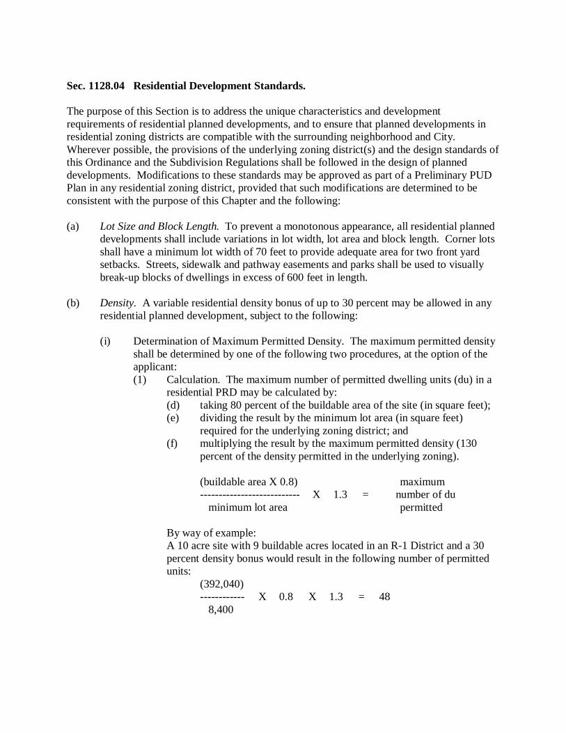
Sec. 1128.04 Residential Development Standards. The purpose of this Section is to address the unique characteristics and development requirements of residential planned developments, and to ensure that planned developments in residential zoning districts are compatible with the surrounding neighborhood and City. Wherever possible, the provisions of the underlying zoning district(s) and the design standards of this Ordinance and the Subdivision Regulations shall be followed in the design of planned developments. Modifications to these standards may be approved as part of a Preliminary PUD Plan in any residential zoning district, provided that such modifications are determined to be consistent with the purpose of this Chapter and the following: (a) Lot Size and Block Length. To prevent a monotonous appearance, all residential planned
developments shall include variations in lot width, lot area and block length. Corner lots shall have a minimum lot width of 70 feet to provide adequate area for two front yard setbacks. Streets, sidewalk and pathway easements and parks shall be used to visually break-up blocks of dwellings in excess of 600 feet in length.
(b) Density. A variable residential density bonus of up to 30 percent may be allowed in any
residential planned development, subject to the following:
(i) Determination of Maximum Permitted Density. The maximum permitted density shall be determined by one of the following two procedures, at the option of the applicant: (1) Calculation. The maximum number of permitted dwelling units (du) in a
residential PRD may be calculated by: (d) taking 80 percent of the buildable area of the site (in square feet); (e) dividing the result by the minimum lot area (in square feet)
required for the underlying zoning district; and (f) multiplying the result by the maximum permitted density (130
percent of the density permitted in the underlying zoning).
(buildable area X 0.8) maximum --------------------------- X 1.3 = number of du minimum lot area permitted
By way of example: A 10 acre site with 9 buildable acres located in an R-1 District and a 30 percent density bonus would result in the following number of permitted units:
(392,040) ------------ X 0.8 X 1.3 = 48 8,400
(2) Parallel Plan. The maximum permitted density of a residential PUD may
be determined through preparation of a parallel plan by the applicant that satisfies all conventional zoning standards and subdivision regulations, where applicable, including but not limited to minimum lot width and area, setbacks, neighborhood open space requirements, street rights-of-way and stormwater detention. During review of the Preliminary PUD Plan, the Commission shall review the parallel plan to determine if it accurately and reasonably shows the number of dwelling units or lots that could be feasibly be constructed under conventional zoning. This number may be increased by a permitted density bonus of up to 30 percent.
(ii) Criteria for Approval of a Density Bonus. A residential density bonus of up to 30 percent may be permitted for any residential PUD, subject to a determination by the Commission that two or more of the following conditions have been satisfied: (1) An integrated mixture of housing types have been included in the PUD. (2) Recreation facilities, plazas, town squares, commons or similar facilities
have been included, above and beyond the minimum open space requirements, within the site or at an off-site location approved by the Council.
(3) Streetscape, roadway, pathway and similar improvements have been included along abutting thoroughfares.
(4) The PUD plan includes removal or renovation of blighted buildings, or cleanup of abandoned or contaminated sites.
(5) Other similar elements as determined by the Council, based upon findings of the Commission.
(c) Open Space. Planned developments that include a residential component shall provide
centrally-located, usable open space that is accessible to all residents of the PUD:
(i) Character and Arrangement. The arrangement and characteristics of such open space shall reflect good planning and design principles, and shall take into account the following considerations: (1) The types and arrangement of uses on the site. (2) The proposed uses of the open space and types of improvements proposed
within the open space. (3) The extent to which the leisure and recreation needs of all segments of the
population residing in the development would be accommodated. (4) The manner in which the open space is integrated into the overall design
of the development. (ii) Amount and Quality of Open Space. Residential PUDs shall maintain a minimum
of 30 percent of the gross area as dedicated open space. A minimum of 50 percent of the dedicated open space shall be upland area that is accessible to all residents of the PUD. An active recreational area with appropriate equipment or amenities shall be provided within the dedicated open space, equal in size to a minimum of 1,500 square feet per dwelling in the residential component of the PUD. The active recreational area shall be well drained, graded, seeded or sodded and barrier-free accessible. (1) Minimum Required. A minimum of 30 percent of the gross area of a PUD
shall be set aside for common open space, regardless of whether or not the PUD includes a request for a density increase and/or a lot size reduction.
(2) Location. Open space in a PUD shall meet one or more of the following objectives: (a) Preservation of distinctive natural features and rural characteristics. (b) Minimization of impact from development on wetlands, rivers, and
other environmentally sensitive areas. (c) Maintenance of rural open space character along major
thoroughfares.
(3) Limitation. Any pervious land area that is available for the common use of all residents of a PUD may be included as part of required open space, except as follows: (a) Required open space in a PUD shall not include the area of any
public or private road, the area of any easement providing access to the PUD, or the area of any required setbacks, except for major thoroughfare setbacks.
(b) Not more than 50 percent of required open space in a PUD shall include the area of water bodies or regulated wetlands.
(c) Up to 100 percent of required open space in a PUD may include preserved natural areas provided, however, that those areas accommodate walking or similar passive leisure pursuits.
(d) Not more than 50 percent of required open space in a PUD shall be used for active recreation facilities such as swimming pools and tennis courts, etc.
(e) Not more than 75 percent of required open space in a PUD shall be used for golf courses, provided remaining open space accommodates walking or similar passive leisure pursuits.
(iii) Areas Not Considered Open Space. The following land areas shall not be included as dedicated open space as defined in this Section: (1) Areas proposed as single-family residential lots, or areas proposed to be
occupied by dwellings, including the minimum required setbacks around buildings and perimeter yard setbacks.
(2) Any portion of the project proposed for nonresidential uses, street rights-of-way or access drives.
(3) Any submerged land area of a pond, lake, river or stream, and any area of the PUD that has restricted access or would require payment for access.
(iv) Protection of Open Space. Required open space in a PUD shall be set aside by the developer through an irrevocable conveyance, such as deed restrictions or covenants that run with the land or through a conservation easement, whereby all rights to develop the land are conveyed to a land conservation organization or other public or private body acceptable to the City, assuring that the open space will be developed according to the plan for the PUD. Such conveyance shall include the following:
(1) Indication of proposed use(s) of the required open space in a PUD. (2) Describes the permitted activities within the dedicated open space, and
assures permanent protection from all forms of development, except as shown on an approved PUD plan.
(3) Provision for privately-owned open space in a PUD to be maintained by property owners with an interest in the open space.
(4) Provision of maintenance standards and a maintenance schedule. (5) Permits unrestricted access by the general public during daylight (dawn
until dusk) hours. (6) Provision of notice of possible City assessment to property owners in a
PUD for the cost of maintenance of open space in the event that it is inadequately maintained and/or becomes a public nuisance, or in the event that other facilities are not maintained.
(7) Recording with County Recorder, to provide notice of restrictions to all persons having interest in property contained in the PUD.
Sec. 1128.05 Coordination with Subdivision Plat or Site Condominium Review. Where a PUD includes a subdivision plat, the regulations, procedures and design standards of the Subdivision Regulations shall apply concurrently with the review procedures of this Chapter. The Preliminary PUD Plan shall include the Conceptual Subdivision Plan, the Final PUD Plan shall include the Preliminary Subdivision Plan, and the Planned Development Agreement shall include the Final Subdivision Plat. Where a PUD includes a site condominium development, applicable City regulations shall apply concurrently with the provisions of this Chapter. Sec. 1128.06 Informal Review of Conceptual PUD Plans. Applicants are encouraged to meet with the Commission for informal review of conceptual PUD plans. The purpose of this informal review is to discuss applicable standards and technical issues, comment on the project’s compliance with the standards of this Ordinance, and determine the appropriate type of review process. The applicant or Commission may also request input from the Administrative Official, City Engineer, and other City staff or consultants. Conceptual PUD plans should, at minimum, include the proposed use, building footprint, existing conditions, general site layout and conceptual grading. Conceptual review comments are non-binding, and should be considered by the applicant to be suggestions and recommendations only. A review fee may be required for conceptual plan review, as determined by Council resolution.
Sec. 1128.07 Preliminary PUD Plan Review Procedure. Any person or entity owning or controlling land may submit a Preliminary PUD Plan, with supporting documentation and a request for a determination whether the proposal qualifies for approval under the PUD regulations. (a) Submittal. Submittal of a Preliminary PUD Plan for consideration shall include the
following, where appropriate: (i) PUD Description. A detailed description of the proposed uses, building and site
improvements, phasing plans and open spaces. The written statement shall describe how the proposed project qualifies for consideration as a PUD, state why a PUD is preferred over conventional zoning at this site, review possible impacts on public facilities and services, identify benefits to the City, and provide details and reasons for any proposed modifications from provisions of this Ordinance.
(ii) Preliminary PUD Plan. A Preliminary PUD Plan shall be provided that includes scaled drawings showing property boundaries, existing site conditions, significant site features (woodlands, landmark trees, wetlands, water bodies, historic structures, archeological sites, etc.), current zoning and land uses, adjacent zoning and land uses, general development plans, phasing and building layouts, the location, type and intensity of each proposed use, relationships to adjoining parcels, vehicular and pedestrian circulation patterns, and the general arrangement of any open spaces or landscape areas.
(iii) An impact assessment, if required by the Commission or Council, in compliance with applicable provisions of this Ordinance.
(iv) Additional maps, plans or documents necessary to adequately describe the proposed project.
(b) Technical Review. Prior to Commission consideration, the Preliminary PUD Plan and
documentation shall be distributed to appropriate City officials and staff for review and comment. If deemed necessary by the Commission, the plans shall also be submitted to applicable outside agencies and designated City consultants for review.
(c) Public Hearing. A public hearing shall be held by the Commission for all Preliminary
PUD Plans in accordance with the procedures set forth in this Ordinance.
(d) Commission Consideration of the Preliminary PUD Plan. Subsequent to the hearing, the
Commission shall review the proposed PUD, together with any reports and recommendations from staff, consultants, other reviewing agencies and any public comments. The Commission shall address whether the project meets the qualification requirements for a PUD, and whether the Preliminary PUD Plan is consistent with the purpose and provisions of this Chapter. The Commission shall then report its findings and recommendations to the Council.
(e) Council Action on the Preliminary PUD Plan. Upon receipt of the report and
recommendation from the Commission, the Council shall review all findings and take action to approve, approve with conditions or deny the Preliminary PUD plan, and shall set forth the reasons for their action. A determination that a proposal qualifies for PUD approval shall be accompanied by a description of the minimum conditions under which the proposal will be considered for Final PUD Plan approval. In describing such conditions, the Council may identify specific requirements or standards in this Ordinance which could be waived or modified upon approval of the Final PUD Plan.
(f) Effect of City Council Action on the Preliminary PUD Plan. Preliminary PUD Plan
approval is intended to provide direction for preparation of the Final PUD Plan, but shall not assure approval of the Final PUD Plan. Preliminary PUD plan approval shall expire two years after the date of approval, unless the Final PUD plan for the project has been submitted to the Commission for review. Upon written request received by the City prior to the expiration date, the Council may grant an extension of up to one year, upon determining that site conditions have not changed in a way that would affect the character, design or use of the site, and that the approved Preliminary PUD plan remains in conformance with the purpose and provisions of this Chapter and the goals and objectives of the Comprehensive Land Use Plan. If the Council denies the Preliminary PUD Plan, the applicant may pursue development or use of the site under conventional zoning standards, or may submit a new Preliminary PUD Plan for further consideration.
Sec. 1128.08 Outside Agency Permits or Approvals. The applicant shall be responsible for obtaining all necessary permits or approvals from applicable outside agencies. Sec. 1128.09 Final PUD Plan Review Procedure. Following approval of a Preliminary PUD Plan by the Council, approval of the Final PUD Plan may be sought by the applicant, in accordance with the following: (a) Final PUD Plan Submittal. The Final PUD Plan shall contain all of the information
required for site plans in this Ordinance and the City Subdivision Regulations, as applicable. The Final PUD Plan shall include a detailed use statement listing and describing the proposed uses in the PUD, and comprehensively illustrating the PUD site design, phasing, locations of all structures and site improvements, roads, utilities, sidewalks and other infrastructure, parks and open spaces, enhancements to public services and other features of the proposed PUD Development in their intended final form. The Final PUD Plan shall also include all documentation necessary to demonstrate that the Final PUD Plan is consistent with the approved Preliminary PUD Plan and any conditions of approval.
(b) Technical Review. Prior to Commission consideration, the Final PUD Plan and
documentation shall be distributed to appropriate City officials and staff for review and comment. If deemed necessary by the Commission, the plans shall also be submitted to applicable outside agencies and designated City consultants for review.
(c) Public Hearing. A public hearing shall be held by the Commission for all Final PUD
Plans in accordance with the procedures and notice requirements set forth in this Ordinance.
(d) Commission Consideration of the Final PUD Plan. Subsequent to the hearing, the
Commission shall review the Final PUD plan, together with any reports and recommendations from staff, consultants, other reviewing agencies and any public comments. The Commission shall address whether the Final PUD Plan conform to the following objectives and requirements, and shall then report its findings and recommendations to the Council:
(i) The Final PUD Plan is consistent with the approved Preliminary PUD Plan, any
conditions of approval, and the land use goals and objectives of the Comprehensive Land Use Plan.
(ii) All conditions of Preliminary Final PUD Plan approval have been addressed. (iii) All applicable engineering requirements have been satisfied, and the applicant has
obtained all necessary outside agency permits or approvals. (e) Council Action on the Final PUD Plan. Upon receipt of the report and recommendation
from the Commission, the Council shall review all findings and take action to approve, approve with conditions or deny the Final PUD plan, and shall set forth the reasons for their action. Approval of the Final PUD Plan shall be contingent upon approval of a PUD Agreement in accordance with the provisions of this Ordinance.
(f) Effect of Council Action on the Final PUD Plan and PUD Agreement. Approval of the
Final PUD Plan by the Council shall allow the Administrative Official to review construction and building plans for the project. Approval of the PUD Agreement by the Council shall allow the Administrative Official to issue building permits for the project. All construction and building plans and permits shall conform to the approved Final PUD Plan, and no development may take place on the site, nor may any use thereof be made, except in accordance with the approved Final PUD Plan.
(g) Expiration of the Final PUD Plan. An approved Final PUD Plan shall expire 365 days
after the date of final approval, unless building permits have been issued or construction has commenced. If such construction has commenced, Final PUD Plan approval shall continue for a period of five years from the date thereof. If such construction lapses for more than 180 continuous days, said approval shall immediately expire. Upon written request received by the City prior to the expiration date, the Council may grant an extension of up to 180 days, provided that site conditions have not changed in a way that would affect the character, design or use of the site, and that the approved Final PUD Plan remains in conformance with the purpose and provisions of this Chapter and the goals and objectives of the Comprehensive Land Use Plan.
Sec. 1128.10 Planned Unit Development Agreement. Upon approval of the Final PUD Plan, the City Law Director shall prepare a PUD Agreement setting forth the conditions upon which such approval is based, which Agreement, after approval by resolution of the Council, shall be executed by the City and the applicant. Approval of the Final PUD Plan shall become effective upon recording of the Agreement in the Office of the County Recorder, which shall be done at the expense of the applicant. The Agreement shall, at minimum, include the following elements: (a) Identification of the plans and documents that are a part of the approval, the terms and
conditions under which the approval was granted, the procedures to be followed for review and approval of amendments to the approved plans, and the terms or conditions regarding the expiration or revocation of approval.
(b) Identification of the entity that is responsible for constructing each element of the project,
including the public facilities and infrastructure, and identification of the entities that will own and be responsible for maintenance of public open space, common areas, and facilities, and the method of financing such maintenance work.
(c) A listing and specification of all uses permitted as part of the approved PUD. (d) Project details and dimensions that are mandatory, and that are subject to refinement or
alterations, along with the permissible degree of change. (e) An agreement providing for adequate maintenance of common elements, public areas and
any stormwater retention or detention facility, including removal of soils from any detention or retention basin and rework of drainage facilities so that they are in compliance with the approved engineering plans and specifications. The agreement shall state that if such maintenance is not adequately performed, the City may perform the maintenance and charge the cost thereof to the condominium association. The City may require a performance guarantee, in conformance with the requirements of this Ordinance, to guarantee maintenance of the common elements for a two-year period after completion.

Sec. 1128.11 Phased Developments. A PUD project may be proposed for construction in phases, in which case the project shall be designed so that each phase, when completed, is capable of standing on its own in terms of public or common services, facilities, and utilities and open space. Each phase shall contain the necessary components to insure protection of natural resources and the health, safety and welfare of the users of the project and the residents of the surrounding area. Sec. 1128.12 Amendments. Proposed amendments to an approved Final PUD Plan that would alter the approved site design, uses or intent and conditions of Final PUD Plan approval shall be submitted for review as a revised Final PUD Plan following the procedure in this Chapter. Minor changes that would not alter the approved site design, uses or intent and conditions of Final PUD Plan approval may be reviewed following the procedures for administrative site plan review in this Ordinance. Sec. 1128.13 Appeals. The Board shall have no authority in matters covered by this Chapter. Sec. 1128.14 Violations. Any violation of the approved Final PUD Plan or PUD Agreement shall be considered a violation of the Zoning Ordinance, which shall be subject to enforcement action and penalties as described in this Ordinance. Approval of a planned development may be rescinded by the Council upon determination that the PUD Agreement has been violated, or that the site has not been improved, constructed or maintained in compliance with approved permits, the Final PUD Plan, or conditions of PUD approval. Such action shall be subject to the following: (a) Public Hearing. Such action may be taken only after a public hearing has been held by
the Council in accordance with the procedures set forth in this Ordinance, at which time the owner of an interest in land for which Final PUD Plan approval was sought, or the owner’s designated agent, shall be given an opportunity to present evidence in opposition to rescission.
(b) Determination. Subsequent to the hearing, the decision of the Council with regard to the
rescission shall be made and written notification provided to said owner or designated agent.
[THIS PAGE HAS BEEN LEFT BLANK INTENTIONALLY.]
Chapter 1130, General Provisions Sec. 1130.01 Conformance Required. All land, buildings, structures, or parts thereof, shall hereafter be erected, constructed, reconstructed, altered, maintained, used, or occupied in conformity with the provisions of this Ordinance. Sec. 1130.02 Buildings under Construction. Nothing in this Ordinance shall be deemed to require any change in the plans, construction, or designated use of any building upon which actual construction was lawfully begun prior to the adoption of this Ordinance, and upon which building actual construction has been diligently carried on, and provided, further, that such building was completed within two years from the date of passage and publication of this Ordinance. Sec. 1130.03 Building Grades. Any building requiring yard space shall be located at such an elevation that a sloping grade shall be maintained to cause the flow of surface water to run away from the walls of the building. A sloping grade, beginning at the sidewalk level, shall be maintained and established from the center of the front lot line to the finished grade line at the front of the building, and from the rear wall of the building to the rear lot line; however, this shall not prevent the grading of a yard space to provide sunken or terraced areas, provided proper means are constructed and maintained to prevent the unreasonable runoff of surface water to flow onto the adjoining properties. When a new building is constructed on a vacant lot between the existing buildings or adjacent to an existing building, the existing established grade shall be considered in determining the grade around the new building, and the yard around the new building shall be graded in such a manner as to meet existing grades and not to permit unreasonable runoff of surface water to flow onto the adjacent properties. Grades shall be approved by the Administrative Official.
Sec. 1130.04 Building to Be Moved. Any building or structure, which has been wholly or partially erected on any premises, shall not be moved to and be placed upon any other premises in this City until a permit to use such building or structure, after being moved, shall have been secured under this Ordinance. Any such building or structure shall fully conform to all the provisions of this Ordinance, in the same manner as a new building or structure. Before a permit may be issued for moving a building or structure, the Administrative Official shall inspect same and shall determine if it is in a safe condition to be moved, whether it may be reconditioned to comply with the building code and other City requirements for the use and occupancy for which it is to be used and whether it will be of similar character with the buildings in the area where it is to be moved. Providing these conditions can be complied with, a permit shall be issued for the moving of said building or structure. Sec. 1130.05 Location of Buildings. Except where otherwise provided for in this Ordinance, every dwelling shall be located on a lot abutting upon a street or permanent easement of access to a street, other than an alley. No dwelling shall be built upon a lot having a frontage of less than 40 feet upon a street or a permanent easement of access to a street. Such easement of access shall have a width throughout of not less than 40 feet. Sec. 1130.06 Garage, Basement, or Other Accessory Dwellings. Garages, basements, or other areas which could accommodate accessory dwellings shall not be occupied for dwelling purposes unless they comply with all the provisions of this Ordinance. Sec. 1130.07 Construction Business and Dwelling Building. When a dwelling occupies a space above a business use, such dwelling unit shall provide a minimum floor area of not less than 720 square feet and a useable lot area of not less than 7,200 square feet. The business use shall provide an additional lot area for the commercial building and the loading space and off-street parking as required by this Ordinance.
Sec. 1130.08 Accessory Buildings and Uses in Residence Districts. (a) An accessory building on a lot, including a carport attached to a principal building, shall
be made structurally a part thereof, and shall comply in all respects with the requirements of this Ordinance applicable to the principal building. Breezeways, for the purpose of this Ordinance, as an attachment between the garage or carport and the main building, shall be considered as part of the main building, but breezeways shall not be considered as constituting livable floor area.
(b) An accessory building and garage unless attached and made a part of the principal
building on a lot as above provided shall not be nearer than 10 feet to the principal building.
(c) A detached accessory building or structure shall not exceed one story or 15 feet in height,
shall be located behind the rear line of the principal building, shall not occupy more than 30 percent of the area of any rear yard, shall not be nearer than five feet to any lot line, provided that where the side yard abuts upon a side street, such accessory building shall not extend nearer to the side street lot line than the main portion of the principal building, and in no case shall the entrance door to a garage be less than 20 feet from any street lot line.
(d) No accessory building or structure shall be erected before the erection of the principal
building or structure on any residential lot. (e) Private swimming pools shall conform to the following requirements:
(i) All above ground swimming pools three feet in height or greater and all in ground swimming pools require a permit and shall comply with all setback requirements. The square footage of a swimming pool shall not be counted when calculating the total square footage of accessory structures.
(ii) Construction, plumbing and electrical requirements, inspection, and other safety facilities shall be regulated by the adopted building codes.
(iii) All swimming pools, which are considered structures, or the entire property upon which they are located shall be enclosed by a wall or fence having a minimum height of four feet and be equipped with suitable locking devices to prevent uncontrolled access from adjacent properties.
All above ground pools with a wall height of four feet or greater measured from the surrounding grade shall not require fencing; however, the pool shall be secured to prevent uncontrolled access from adjacent properties.
(f) Outdoor wood burning furnaces shall conform to the following requirements:
(i) All outdoor wood burning furnaces shall require a permit. (ii) No more than one outdoor wood burning furnace shall be installed on a single
parcel. (iii) Outdoor wood burning furnaces shall only be permitted on parcels of five acres or
more. (iv) All outdoor wood furnaces shall be located in the rear yard only. (v) All outdoor wood burning furnaces shall be set back not less not less than 200 feet
from any property line. (vi) No outdoor wood burning furnace shall be utilized as a waste incinerator. (vii) Fuel for outdoor wood burning furnaces shall be limited to seasoned hardwood,
corncobs or wood chips. (viii) All outdoor wood burning furnaces shall comply with Alliance City Building
Department regulations (building, mechanical, electrical, heating) and Ohio EPA Air Pollution Control Division regulations.
(ix) All outdoor wood burning furnaces shall have a permanent stack extending five feet higher than the peak of any roof structure located within 150 feet of said furnace.
(x) Outdoor wood burning furnaces shall not be operated during the months of May, June, July or August.
(xi) The Fire Department shall approve the location of all outdoor wood burning furnaces.
Sec. 1130.09 Accessory Uses and Buildings in Nonresidential Districts. (a) In nonresidential districts, accessory buildings and uses, if not for dwelling purposes,
may occupy any of the ground area which the principal building is permitted to cover. Accessory buildings, such as buildings for parking attendants, guard shelters, gate houses and transformer buildings, may be located in the front or side yard.
(b) Outdoor wood burning furnaces shall conform to the following requirements:
(i) All outdoor wood burning furnaces shall require a permit. (ii) No more than one outdoor wood burning furnace shall be installed on a single
parcel. (iii) Outdoor wood burning furnaces shall only be permitted on parcels of five acres or
more. (iv) All outdoor wood furnaces shall be located in the rear yard only. (v) All outdoor wood burning furnaces shall be set back not less not less than 200 feet
from any property line. (vi) No outdoor wood burning furnace shall be utilized as a waste incinerator. (vii) Fuel for outdoor wood burning furnaces shall be limited to seasoned hardwood,
corncobs or wood chips. (viii) All outdoor wood burning furnaces shall comply with Alliance City Building
Department regulations (building, mechanical, electrical, heating) and Ohio EPA Air Pollution Control Division regulations.
(ix) All outdoor wood burning furnaces shall have a permanent stack extending five feet higher than the peak of any roof structure located within 150 feet of said furnace.
(x) Outdoor wood burning furnaces shall not be operated during the months of May, June, July or August.
(xi) The Fire Department shall approve the location of all outdoor wood burning furnaces.
Sec. 1130.10 Yard Area for a Building Cannot Be Used for Another Building. No space which for the purpose of a building has been counted or calculated as part of a side yard, rear yard, front yard, or other open space required by this Ordinance may, by reason of change in ownership or otherwise, be counted or calculated to satisfy or comply with a yard or other open space requirement of or for any other building. The minimum yards or other open spaces, including lot area per family or percentage of lot coverage required by this Ordinance for each and every building existing at the time of passage of this Ordinance or for any building hereafter erected, shall not be encroached upon or considered as yard or open space requirements for any other building.
Sec. 1130.11 Fences Hedges or Walls. (a) In any residential district, no fence, hedge or wall or portion thereof shall exist within two
feet of the front or any street lot line. (b) In any residential district, no fence shall be erected upon a vacant lot which unreasonably
obstructs the front yard sight line or is otherwise hazardous. (c) Fences in residential districts shall not be more than four feet in height in the required
front yard and not more than six feet in height in all other areas unless otherwise permitted.
(d) All fences in nonresidential districts shall not be more than seven feet in height unless
otherwise permitted. (e) Fences or walls required to surround and/or enclose public utility installations shall not
be limited as to height in any district. Sec. 1130.12 Front Yard Exception. When a majority of the buildings in any particular block have been built at the time of the adoption of this Ordinance, no building thereafter erected or altered shall project beyond the minimum building line thus established, provided that no residential building shall be required by this Ordinance to be set back more than 100 feet, and provided further that this regulation shall not be interpreted to reduce the buildable width of a corner lot facing an intersecting street.
Sec. 1130.13 Yard Encroachments. Outside stairways, fire escapes, fire towers, decks, porches, platforms, balconies, boiler flues and other similar projections shall be considered as part of the building and shall not encroach into the required space for yards or courts or occupied space. However, there shall be permitted certain exceptions to this requirement as limited and restricted hereinafter: (a) Permitted exceptions for such projections shall be:
(i) One chimney or one fireplace, limited to not more than eight feet in length and projecting not more than 12 inches into the allowable side yard space.
(ii) Cornices, limited to not more than 16 inches in width, including the gutter. (iii) Platforms, terraces, steps below the first floor level. (iv) Decks, unenclosed porches or other ground-level, unenclosed projections not over
one story in height.
(b) Limitations governing the projections, as so permitted, shall be: (i) In a residential district, such excepted projections shall not extend more than 10
feet beyond the established front building line, shall not extend more than 15 feet into the minimum required rear yard, and shall not extend nearer than five feet to an interior side lot line or nearer than 30 feet to a side lot line abutting upon a street.
(ii) In a nonresidential district, such excepted projections shall not extend beyond the established front building line or into any required side or rear yard.
Sec. 1130.14 Front Yard Uses. Any portion of a residential lot located in front of a building line (including driveways), or between a front street lot line and the adjacent building line, shall be used only for landscaping or ornamental purposes, and no permanent structures or recreational vehicles or trailers shall be placed or erected thereon. Sec. 1130.15 Double Frontage Lots. On double street frontage lots, a front yard, as prescribed for the district, as herein established, shall be provided on both streets.
Sec. 1130.16 Lot Limitations. No residential structure shall be erected upon the rear of a lot or a lot with another dwelling, except where permitted as part of a two-family or multi-family development. Sec. 1130.17 Exceptions to Height Limitations. Height limitations of this Ordinance shall not apply to chimneys, church spires, clocks or bell towers or other similar architectural design elements, public monuments, or wireless transmission towers, provided that such structures do not exceed 20 feet above the maximum height in the district in which they are located. Architectural features which include building and roof line elements which are intended to add architectural interest and not for the purpose of adding signage to the building may be allowed to exceed the maximum height of the district by not more than 20 feet with Commission approval. The footprint of that portion of the structure which is encompassed by the proposed building and/or roof line element shall not exceed 25 percent of the footprint of the total structure. The Commission may specify a lower height limit for any structure that requires approval as a Conditional Use. In determining the appropriate height, the Commission shall consider the character of the surrounding uses, the height of surrounding structures, the potential to obscure light or view to or from existing buildings and surrounding properties, and potential detriment to the use or value of surrounding properties. Sec. 1130.18 Excavations or Holes. The construction, maintenance, or existence within the City of any unprotected, unbarricaded, open, or dangerous excavations, holes, pits, or wells, or of any excavations, holes, or pits which constitute or are reasonably likely to constitute a danger or menace to the public health, safety or welfare, are hereby prohibited. This section shall not, however, prevent construction of excavations under a permit issued pursuant to this Ordinance or the Building Code of the City, where such excavations are properly protected and warning signs are posted in such manner as may be approved by the Administrative Official. This section shall also not apply to lakes, streams, or other natural bodies of water, or to ditches, streams, reservoirs, or other major bodies of water created or existing by authority of the State, County, City, or any other governmental agency.
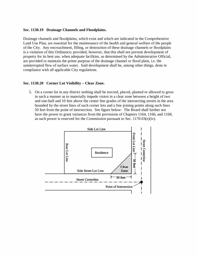
Sec. 1130.19 Drainage Channels and Floodplains. Drainage channels and floodplains, which exist and which are indicated in the Comprehensive Land Use Plan, are essential for the maintenance of the health and general welfare of the people of the City. Any encroachment, filling, or destruction of these drainage channels or floodplains is a violation of this Ordinance; provided, however, that this shall not prevent development of property for its best use, when adequate facilities, as determined by the Administrative Official, are provided to maintain the prime purpose of the drainage channel or flood plain, i.e. the uninterrupted flow of surface water. Said development shall be, among other things, done in compliance with all applicable City regulations. Sec. 1130.20 Corner Lot Visibility – Clear Zone.
5. On a corner lot in any district nothing shall be erected, placed, planted or allowed to grow in such a manner as to materially impede vision in a clear zone between a height of two and one-half and 10 feet above the center line grades of the intersecting streets in the area bounded by the street lines of such corner lots and a line joining points along such lines 50 feet from the point of intersection. See figure below: The Board shall further not have the power to grant variances from the provisions of Chapters 1164, 1166, and 1168, as such power is reserved for the Commission pursuant to Sec. 1170.03(e)(iv).
Residence
Side Lot LineR
ear Lot Line
Street Centerline
Clear Zone
Street Centerline
Point of Intersection
Front Lot Line
Side Street Lot Line
50 feet
50 feet
Residence
Side Lot LineR
ear Lot Line
Street Centerline
Clear Zone
Street Centerline
Point of Intersection
Front Lot Line
Side Street Lot Line
50 feet50 feet
50 feet50 feet

Sec. 1130.21 Sidewalk Steps and Hand Rails. Where private access walks to residences or commercial buildings include steps, such steps shall conform to the Ohio Department of Transportation Standard Drawing No. RM-2.1 and include a handrail on at least one side of steps in cases where three risers or more are necessary or required. Nonconforming steps that do not pose an immediate safety threat due to unevenness, heaving, cracks, etc. may be retrofitted with a handrail that conforms to the above requirement.
Chapter 1132, Location of Sexually Oriented Businesses Sec. 1132.01 Purpose and Findings. (a) Purpose. It is the purpose of this Chapter to regulate Sexually Oriented Businesses in
order to promote the health, safety, morals, and general welfare of the citizens of the City, and to establish reasonable and uniform regulations to prevent the deleterious location and concentration of Sexually Oriented Businesses within the City. The provisions of this Chapter do not have the purpose or effect of imposing a limitation or restriction on the content of any communicative materials, including sexually oriented materials. Further, it is not the intent of this Chapter to restrict or deny access by adults to sexually oriented materials protected by the First Amendment, or to deny access by the distributors and exhibitors of sexually oriented entertainment to their intended market. Neither is it the intent nor effect of this Chapter to condone or legitimize the distribution of obscene material.
(b) Findings. The Council has received substantial evidence concerning the adverse
secondary effects of adult uses on the community in findings incorporated in the cases of City of Renton v. Playtime Theaters, Inc., 475 U.S. 41 (1986), Young v. American Mini Theaters, 426 U.S. 50 1976), and Barnes v. Glen Theatre, Inc., 501 U.S. 560 (1991), and on studies in other communities including, but not limited to, Phoenix, Arizona; Tuscon, Arizona; Garden Grove, California; Los Angeles, California; Whittier, California; Indianapolis, Indiana; Minneapolis, Minnesota; St. Paul, Minnesota; New York, New York; Cleveland, Ohio; Oklahoma City, Oklahoma; Amarillo, Texas; Austin, Texas; Beaumont, Texas; Houston, Texas; and Seattle, Washington.
Sec. 1132.02 Definitions. (a) Adult Arcade. Any place to which the public is permitted or invited where either or both
(i) motion picture machines, projectors, video or laser disc players, or (ii) other video or image-producing devices are available, run via coin, token or any form of consideration, to show images to five or fewer persons at one time; and where the images shown and/or live entertainment presented are characterized by the depiction or description of specified sexual activities or specified anatomical areas.
(b) Adult Bookstore, Adult Novelty Store, or Adult video Store. A commercial establishment
which, as one of its principal business purposes, offers for sale or rental for any form of consideration one or more of the following: (i) Books, magazines, periodicals or other printed matter, or photographs, films,
motion pictures, video cassettes or video reproductions, slides, or other visual representations that are characterized by the depiction or description of “specified sexual activities” or “specified anatomical areas”; or
(ii) Instruments, devices, or paraphernalia, other than prophylactics, that are designed for use in connection with specified sexual activities.
A commercial establishment may have other principal business purposes that do not involve the offering for sale or rental of material depicting or describing “specified sexual activities” or “specified anatomical areas” and still be categorized as “adult bookstore, adult novelty store, or adult video store” so long as one of its principal business purposes is the offering for sale or rental for consideration the specified materials which are characterized by the depiction or description of “specified sexual activities” or “specified anatomical areas”.
(c) Adult Cabaret. A nightclub, bar, restaurant, or similar commercial establishment that
regularly features:
(i) Persons who appear in a state of semi-nudity; (ii) Live entertainment characterized by the depiction or description of specified
anatomical areas or specified sexual activities; (iii) Live entertainment of an erotic nature including exotic dancers, strippers, male or
female impersonators, or similar entertainment; or (iv) Films, motion pictures, video cassettes, slides or other photographic reproductions
that are characterized by the depiction or description of specified sexual activities or specified anatomical areas.
(d) Adult Motion Picture Theater. A commercial establishment where, for any form of
consideration, films, motion pictures, video cassettes, slides, or similar photographic reproductions are regularly shown which are characterized by the depiction or description of “specified sexual activities” or “specified anatomical areas”.
(e) Adult Theater. A theater, concert hall, auditorium, or similar commercial establishment
that regularly features persons who appear in a state of semi-nudity, live performances which are characterized by the depiction or description of specified anatomical areas, specified sexual activities, or live entertainment of an erotic nature including exotic dancers, strippers, male or female impersonators, or similar entertainment.
(f) Covering. Any clothing or wearing apparel, including pasties, but does not include any
substance that can be washed off the skin, such as paint or make-up, or any substance designed to simulate the appearance of the anatomic area beneath it.
(g) Nude Model Studio. Any place where a person who appears semi-nude or who displays
specified anatomical areas is provided to be observed, sketched, drawn, painted, sculptured, photographed, or similarly depicted by other persons who pay money or any form of consideration. Nude Model Studio shall not include:
(i) A proprietary school licensed by the State of Ohio, or a college, junior college or
university supported entirely or in part by public taxation. (ii) A private college or university that offers educational programs in which credits
are transferable to a college, junior college, or university supported entirely or partly by taxation; or
(iii) An establishment holding classes in a structure that has no sign visible from the exterior of the structure and no other advertising that indicates a semi-nude person is available for viewing; where in order to participate in a class a student must enroll at least three days in advance of the class; and where no more than one semi-nude model is on the premises at any one time.
(h) Nudity or State of Nudity or Nude. Exposing to view the genitals, pubic area, vulva
perineum, anus, anal cleft or cleavage, or pubic hair with less than a fully opaque covering; exposing to view any portion of the areola of the female breast with less than a fully opaque covering; exposing to view male genitals in a discernibly turgid state, even if entirely covered by an opaque covering; or exposing to view any device, costume, or covering that gives the appearance of or stimulates any of these anatomical areas.
(i) Person. An individual, proprietorship, partnership, firm, association, joint stock
company, corporation or combination of individuals whatever form or character. (j) Principal Business Purpose. 25 percent or more of the stock in trade of the business
offered for sale or rental for consideration measured as a percentage of either the total linear feet of merchandise for sale or rental for consideration on display or the gross receipts of merchandise for sale or rental for consideration, whichever is greater.
(k) Semi-Nudity or Semi-Nude Condition or Semi-Nude. Exposing to view, with less than a
fully opaque covering, any portion of the female breast below the top of the areola or any portion of the buttocks. This definition shall include the entire lower portion of the female breast exhibited by a dress, blouse, shirt, leotard, bathing suit, or other clothing, provided that the areola is not exposed in whole or in part.
(l) Sexual Encounter Center. A business or commercial enterprise that, as one of its
principal business purposes, offers for any form of consideration:
(i) Physical contact in the form of wrestling or tumbling between persons of the opposite sex; or
(ii) Activities between male and female persons and/or persons of the same sex when one or more of the persons is semi-nude.
(m) Sexually Oriented Business. An adult arcade, adult bookstore, adult novelty store, adult
video store, adult cabaret, adult motion picture theater, adult theater, nude model studio, or sexual encounter center.
(n) Specified Anatomical Areas.
(i) The human male genitals in a discernibly turgid state, even if completely and opaquely covered; or
(ii) Less than completely and opaquely covered human genitals, pubic region, buttocks or female breast below a point immediately above the top of the areola.
(o) Specified Sexual Activities. Any of the following:
(i) The fondling or other erotic touching of human genitals, pubic region, buttocks, anus, or female breasts;
(ii) Sex acts, normal or perverted, actual or simulated, including intercourse, oral copulation, masturbation, or sodomy; or
(iii) Excretory functions as part of or in connection with any of the activities set forth in (i) and (ii) above.
Sec. 1132.03 Classifications. Sexually Oriented Businesses are classified as follows: (a) Adult arcades; (b) Adult bookstores, adult novelty stores or adult video stores; (c) Adult cabarets; (d) Adult motion picture theaters; (e) Adult theaters; (f) Nude model studios; and (g) Sexual encounter centers. Sec. 1132.04 Location of Sexually Oriented Businesses. (a) Sexually Oriented Businesses may be located only in accordance with the restrictions
contained in subsections (b) through (h) hereof. (b) Sexually Oriented Businesses may be located only in the I-2 District. (c) No Sexually Oriented Business may be established on a lot which borders on or touches
Broadway (East), Ely Street (East and West), Freedom Avenue (North), Freshley Avenue (all), Mahoning Avenue (all), Main Street (excluding Main Street Extension), Patterson Street (East), Summit Street (East), or Waugh Street (East).
(d) No Sexually Oriented Business may be established as follows:
(i) Within 1,000 feet of a church, synagogue, mosque, temple or building which is used primarily for religious worship and related religious activities;
(ii) Within 1,000 feet of a public or private educational facility including but not limited to child day care facilities, nursery schools, preschools, kindergartens, elementary schools, private schools, intermediate schools, junior high schools, middle schools, high schools, vocational schools, secondary schools, continuation schools, special education schools, junior colleges and universities; schools includes the school grounds, but does not include facilities used primarily for another purpose and only incidentally as a school;
(iii) Within 1,000 feet of a licensed premises, licensed pursuant to the alcoholic beverage control regulations of the State;
(iv) Within 1,000 feet of a public park or recreation area which has been designated for park or recreational activities including but not limited to a park, playground, nature trails, swimming pool, reservoir, athletic field, basketball or tennis courts, pedestrian/bicycle paths, wilderness areas or other similar public land within the City which is under the control, operation or management of the City or any other entity, public or private; or
(v) Within 1,000 feet of the property line of a lot devoted to a residential use as defined in this Ordinance.
(e) No Sexually Oriented Business may be established, operated or enlarged within 1,000
feet of another Sexually Oriented Business. (f) Not more than one Sexually Oriented Business shall be established or operated in the
same building, structure or portion thereof, and the floor area of any Sexually Oriented Business in any building, structure or portion thereof containing another Sexually Oriented Business may not be increased.
(g) For the purpose of subsection (d) hereof, measurement shall be made in a straight line,
without regard to intervening structures or objects, from the nearest portion of the building or structure used as the part of the premises where a Sexually Oriented Business is conducted, to the nearest property line of the premises of a use listed in subsection (d) hereof.
(h) For the purpose of subsection (e) hereof, the distance between any two Sexually Oriented
Businesses shall be measured in a straight line, without regard to intervening structures or objects, from the closest exterior wall of the structure in which each business is conducted.
Sec. 1132.05 Additional Regulations Concerning Lot, Yard, Height, Parking, Building, and Site Design Standards, and Site Plan Requirements.
(a) Lot, yard, height, parking, and building and site design standards for a Sexually Oriented
Business shall conform to those requirements applicable to all uses in the district in which the Sexually Oriented Business is proposed to be located.
(b) The site plan for a Sexually Oriented Businesses shall be submitted to the Commission
for site plan review and approval in accordance with the procedures for all uses to which site plan review is applicable under this Ordinance.
(c) Review and approval procedures for a site plan for a Sexually Oriented Business shall
also be in accordance with any procedures duly adopted by the Council as may be applicable to the licensing and operation of Sexually Oriented Businesses.
Sec. 1132.06 Sign Regulations for Sexually Oriented Businesses. (a) All signs shall be “wall signs” as defined in this Ordinance, with a maximum allowable
sign area of 50 square feet as measured in accordance with the standards specified in this Ordinance, and shall comply with the location standards specified in this Ordinance, and the illumination standards specified in this Ordinance.
(b) Review and approval for a sign permit for a Sexually Oriented Business shall also be in
accordance with any procedures duly adopted by the Council as may be applicable to the licensing and operation of Sexually Oriented Businesses.
(c) All signs shall be maintained in accordance with the provisions of this Ordinance and
may be ordered to be removed in accordance with the provisions of this Ordinance. (d) No merchandise or pictures of the products or entertainment on the premises shall be
displayed in the window areas or any area where they can be viewed from the sidewalk or street in front of the building.
(e) Window areas shall not be covered or made opaque in any way. No signs shall be placed
in any window. A one-square foot sign may be placed on the door to state hours of operation and admittance to adults only.

Sec. 1132.07 Severability. If any section, subsection or clause of this Chapter shall be deemed to be unconstitutional or otherwise invalid, the validity of the remaining sections, subsections, and clauses shall not be affected.
Chapter 1134, Signs Sec. 1134.01 Purpose. The purpose of this Chapter is to promote the public health, safety and general welfare through the provision of standards for existing and proposed signs of all types. More specifically, this Chapter is intended to: (a) Enhance and protect the physical appearance of the community. (b) Promote and maintain visually attractive residential, retail, commercial, and mixed use
districts. (c) Ensure that signs are located and designed to reduce sign distraction and confusion that
may be contributing factors in traffic congestion and accidents, and maintain safe and orderly pedestrian and vehicular environments.
(d) Provide review procedures that enable the City to evaluate the appropriateness of a sign
to the site, building and surroundings.
Sec. 1134.02 Scope of Requirements. It shall be unlawful for any person, firm, or corporation to erect, construct, or alter any sign in the City except in conformance with the provisions of this Ordinance, subject to issuance of a permit, unless specifically exempted below. All temporary ground signs and banner signs except ideological signs shall be registered with the Administrative Official. Furthermore the following signs and displays shall be specifically exempted from and not regulated by this Ordinance: (a) Official traffic signs, government, school or utility signs; or flags of any nation,
government or noncommercial organization. (b) Signs not intended to be viewed from the public right-of-way or scoreboards on athletic
fields. (c) Cornerstone inscriptions, commemorative plaques or other signs that are part of masonry
facades. (d) Gravestones, religious symbols or monuments in cemeteries or monument sales lots. (e) Signs of less than one square foot in sign area such as street numbers on buildings,
security system signs or stickers, identification of store hours, emblems of credit cards accepted, seals indicating membership in business or trade associations, and the like.
(f) Signs accessory to juvenile activities, such as a child’s lemonade stand or temporary
play-related sidewalk markings. (g) Temporary signs used for charity or nonprofit fundraising and not for private gain, or
civic or community affairs of a public or semipublic nature. (h) Holiday or other temporary decorations. (i) Other signs similar in nature in the judgment of the Administrative Official to the above
signs.
Sec. 1134.03 Enforcement. (a) Plans, Specifications, and Permits.
(i) Permits. It shall be unlawful for any person to erect, alter, relocate, or structurally change a sign or other advertising structure, unless specifically exempted by this Ordinance, without first obtaining a permit in accordance with the provisions set forth herein. A permit shall require payment of a fee, as noted on a fee schedule as may be established, adopted, and amended from time to time by the Council.
(ii) Applications. Application for a sign permit shall be made upon forms provided by the Administrative Official. The following information shall be required:
(1) Name, address, and telephone number of the applicant. (2) Location of the building, structure, or lot on which the sign is to be
attached or erected. (3) Position of the sign in relation to nearby buildings, structures, and
property lines. The Administrative Official may require information to be provided for on a certified survey or drawing sealed by a registered engineer.
(4) Plans showing the dimensions, materials, method of construction, and attachment to the building or in the ground.
(5) Copies of stress sheets and calculations, if deemed necessary, showing the structure as designed for dead load and wind pressure.
(6) Name and address of the person, firm, or corporation owning, erecting, and maintaining the sign.
(7) Information concerning required electrical connections. (8) Insurance policy or bond, as required in this Ordinance. (9) Written consent of the owner or lessee of the premises upon which the
sign is to be erected. (10) Other information as required by the Administrative Official to make the
determination that the sign is in compliance with all applicable laws and regulations.
(iii) Review of Application. (1) Commission Review. Sign permit applications submitted in conjunction
with the proposed construction of a new building or addition to an existing building shall be reviewed by the Commission as a part of the required site plan review. Proposed sign locations and dimensions must be shown on the site plan.
(2) Issuance of a Permit. Following review and approval of a sign application by the Commission and Administrative Official, as appropriate, the Administrative Official shall have the authority to issue a sign permit.
(iv) Exceptions. A sign shall not be enlarged or relocated except in conformity with the provisions set forth herein for new signs, nor until a proper permit has been secured. However, a new permit shall not be required for ordinary servicing or repainting of an existing sign, cleaning of a sign, or changing of the message on the sign where the sign is designed for such changes (such as lettering on a marquee or numbers on a gasoline price sign). Furthermore, a permit shall not be required for ideological signs, signplates for residential uses, temporary signs for residential uses and in residential districts, temporary ground signs in nonresidential districts advertising the sale or lease of the property on which they are located, and temporary window signs, provided that all applicable regulations of this Chapter are complied with.
(b) Inspection and Maintenance.
(i) Inspection of New Signs. All signs for which a permit has been issued shall be inspected by the Administrative Official when erected. Approval shall be granted only if the sign has been constructed in compliance with the approved plans and applicable Zoning Ordinance and Building Code standards. In cases where fastenings or anchorages are to be eventually bricked in or otherwise enclosed, the sign erector shall advise the Administrative Official when such fastenings are to be installed so that inspection may be completed before enclosure.
(ii) Inspection of Existing Signs. The Administrative Official shall have the authority to routinely enter onto property to inspect existing signs. In conducting such inspections, the Administrative Official shall determine whether the sign is adequately supported, painted to prevent corrosion, and so secured to the building or other support to safely bear the weight of the sign and pressure created by the wind.
(iii) Correction of Defects. If the Administrative Official finds that any sign is unsafe, insecure, improperly constructed, or poorly maintained, the sign erector, owner of the sign, or owner of the land shall make the sign safe and secure by completing any necessary reconstruction or repairs, or entirely remove the sign in accordance with the timetable established by the Administrative Official.
(c) Removal of Abandoned Signs. Whenever a sign is abandoned, as defined herein, the Administrative Official shall document the date of sign abandonment. An abandoned sign shall be removed at such time as the Administrative Official documents that both of the following circumstances exist: (1) a period of greater than 365 consecutive days has elapsed since the date of sign abandonment; and (2) no permit has been issued during such period for the building, building unit and/or use associated with the abandoned sign. However, where a conforming sign structure and frame are typically reused by a current occupant in a leased or rented building, the building owner shall not be required to remove the sign structure and frame in the interim periods when the building is not occupied, provided that the sign structure and frame are maintained in good condition, and that abandoned sign faces are replaced with blank sign faces in during said periods.
(d) Nonconforming Signs. No nonconforming sign shall be altered or reconstructed, unless
the alteration or reconstruction is in compliance with this Ordinance, except that nonconforming signs shall comply with the following regulations:
(i) Repairs and Maintenance. Normal maintenance shall be permitted, provided that
any nonconforming sign that is destroyed by any means to an extent greater than 50 percent of the sign’s replacement cost, exclusive of the foundation, shall not be reconstructed. Normal maintenance shall include painting of chipped or faded signs; replacement of sign face; or, repair or replacement of electrical wiring or electrical devices.
(ii) Nonconforming Changeable Copy Signs. The message on a nonconforming changeable copy sign or nonconforming bulletin board sign may be changed provided that the change does not create any greater nonconformity.
(iii) Substitution. No nonconforming sign shall be replaced with another nonconforming sign.
(iv) Modifications to the Principal Building. Beginning on January 1, 2015, whenever the principal building on a site on which a nonconforming sign is located is modified to the extent that site plan review and approval is required, the nonconforming sign shall be removed. In such case, however, the existing sign foundation and wiring may be used to the extent that they conform to all requirements of this Ordinance.
(e) Appeal to the Board. Any party who has been refused a sign permit for a proposed sign
may file an appeal with the Board, in accordance with the provisions of this Ordinance. In determining whether a variance is appropriate, the Board shall, in addition to other review criteria specified in this Ordinance, study the sign proposal, giving consideration to any extraordinary circumstances, such as those listed below, that would cause practical difficulty in complying with the sign standards. The presence of any of the circumstances listed may be sufficient to justify granting a variance; however, the Board may decline to grant a variance even if certain of the following circumstances are present:
(i) Permitted signage could not be easily seen by passing motorists due to the
configuration of existing buildings, trees, or other obstructions. (ii) Permitted signage could not be seen by passing motorists in sufficient time to
permit safe deceleration and exit. In determining whether such circumstances exist, the Board shall consider the width of the road, the number of moving lanes, the volume of traffic, and speed limits.
(iii) Existing signs on nearby parcels would substantially reduce the visibility or advertising impact of a conforming sign on the subject parcel.
(iv) Construction of a conforming sign would require removal or severe alteration to natural features on the parcel, such as but not limited to: removal of trees, alteration of the natural topography, filling of wetlands, or obstruction of a natural drainage course.
(v) Construction of a conforming sign would obstruct the vision of motorists or otherwise endanger the health or safety of passers-by.
(vi) Variances from certain sign regulations would be offset by increased building setback, increased landscaping, or other such enhancements, so that the net effect is an improvement in appearance of the parcel, compared to the result that would be otherwise achieved with construction of a conforming sign.
(vii) A sign which exceeds the permitted height or area standards of this Ordinance would be more appropriate in scale because of the large size or frontage of the parcel or building.
Sec. 1134.04 Computation and Measurements. The following regulations shall control the computation and measurement of sign area, sign height, window area and building frontage: (a) Determining Sign Area or Dimension.
(i) Sign area shall include the face of all the display area of the sign. Sign area shall not include the frame and structural support unless such structural support is determined to constitute an integral part of the sign design.
(ii) For a sign that is framed, outlined, painted or otherwise prepared and intended to provide a background for a sign display, the area of the sign shall be the area of one rectangular shape that encompasses the entire background or frame.
(iii) For a sign comprised of individual letters, figures, or elements on a wall or similar surface of a building or structure, or an irregular shaped ground sign, the area of the sign shall be the area of one rectangular shape that encompasses the perimeter of all the elements in the display. (1) When separate elements are organized to form a single sign, but the
elements are separated by open space, the area shall be the area of one rectangular shape that comprises all the display areas, including the space between the elements.
(2) One minor extension may be permitted to extend above or below the sign area when the area of the extension is less than 25 percent of the open space included in the sign area. For the purposes of this Chapter, only the open space within the sign area that is located above and below the majority of the letters shall be included in the calculation.
(3) For ground signs and projecting signs, the sign area shall be computed by the measurement of one of the faces when two identical display faces are joined, are parallel or within 30 degrees of being parallel to each other.
(4) Air under a ground sign between supporting posts, air between a projecting sign and the wall to which it is attached, and lighting fixtures and associated brackets shall not be included in the calculation of sign area.
(b) Determining Sign Height. The height of a sign shall be measured from the average grade
at the base of the sign or support structure to the tallest element of the calculated sign area or support structure. A ground sign on a man-made base, including a graded earth mound, shall be measured from the average site grade prior to the addition of the sign.
(c) Determining Building Frontage and Building Unit. For the purposes of these sign
regulations, the length of the building wall that faces a public street or that contains a public entrance to the uses therein shall be considered the building frontage.
(i) The building frontage shall be measured along such building wall between the
exterior faces of the exterior side walls. (ii) In the case of an irregular wall surface, a single straight line extended along such
wall surface shall be used to measure the length. (iii) A building shall have only one building frontage except as otherwise set forth
below. (iv) A building shall have two frontages whenever the lot fronts on two or more
streets, or the building has a public entrance on a wall other than the wall that faces the street. The property owner shall determine which wall shall be the primary building frontage and which wall shall be the secondary building frontage. Only one outside wall of any business shall be considered its primary frontage and only one additional wall considered its secondary frontage.
(v) For multi-occupant buildings, the portion of a building that is owned or leased by a single occupant shall be considered a building unit. The building frontage for a building unit shall be measured from the centerline of the party walls defining the building unit.
(d) Determining Window Area. The window area of a building shall be the total glass area of
windows on the building frontage. For the purposes of determining window area for ground floor occupants, the ground floor shall be considered to be no more than 15 feet in height above grade.
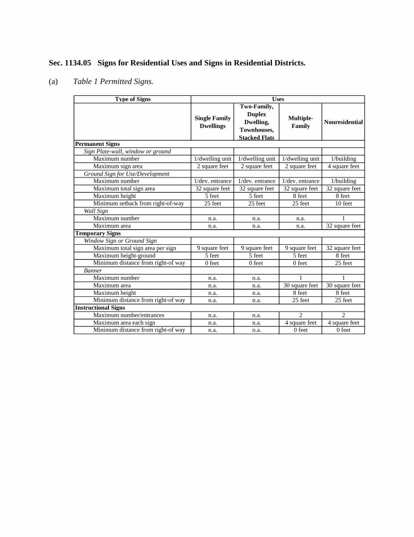
Sec. 1134.05 Signs for Residential Uses and Signs in Residential Districts. (a) Table 1 Permitted Signs.
Single Family Dwellings
Two-Family, Duplex
Dwelling, Townhouses, Stacked Flats
Multiple-Family Nonresidential
Permanent Signs Sign Plate-wall, window or ground
Maximum number 1/dwelling unit 1/dwelling unit 1/dwelling unit 1/buildingMaximum sign area 2 square feet 2 square feet 2 square feet 4 square feet
Ground Sign for Use/DevelopmentMaximum number 1/dev. entrance 1/dev. entrance 1/dev. entrance 1/buildingMaximum total sign area 32 square feet 32 square feet 32 square feet 32 square feetMaximum height 5 feet 5 feet 8 feet 8 feet Minimum setback from right-of-way 25 feet 25 feet 25 feet 10 feet
Wall SignMaximum number n.a. n.a. n.a. 1Maximum area n.a. n.a. n.a. 32 square feet
Temporary SignsWindow Sign or Ground Sign
Maximum total sign area per sign 9 square feet 9 square feet 9 square feet 32 square feetMaximum height-ground 5 feet 5 feet 5 feet 8 feet Minimum distance from right-of way 0 feet 0 feet 0 feet 25 feet
BannerMaximum number n.a. n.a. 1 1Maximum area n.a. n.a. 30 square feet 30 square feetMaximum height n.a. n.a. 8 feet 8 feet Minimum distance from right-of way n.a. n.a. 25 feet 25 feet
Instructional SignsMaximum number/entrances n.a. n.a. 2 2Maximum area each sign n.a. n.a. 4 square feet 4 square feetMinimum distance from right-of way n.a. n.a. 0 feet 0 feet
Type of Signs Uses
(b) Supplementary Regulations for Ground Signs.
(i) Ground signs that exceed four square feet in area shall be erected with a minimum of two supporting posts or on a solid base.
(ii) Ground signs shall be erected in a landscaped setting. (iii) No part of a ground sign, the wall or entry feature on which a sign is mounted, or
the landscaping shall obstruct the view of vehicles entering or exiting the property, nor in the case of a corner lot shall signs, landscaping or appurtenances obstruct the view of vehicles entering or exiting the intersecting streets.
(iv) For residential subdivisions, the ground sign shall have a maximum of two sign faces per entrance, and be either a double-faced ground sign or two single-sided sign faces attached to walls or entry features located one on each side of the street entrance.
(v) For nonresidential uses ground signs may have up to 75 percent of the permanent sign area, or 24 square feet, whichever is less, devoted to changeable copy or electronic message center features.
(vi) Nonresidential use ground signs shall contain the street address in numerals not exceeding seven inches in height, except for ground signs used by colleges, universities, and other institutions of higher education, in which case no street address shall be required.
(c) Supplementary Regulations for Temporary Signs.
(i) Temporary signs on property used for residential purposes may be erected for an unspecified time.
(ii) For property used for nonresidential purposes, one temporary ground sign shall be permitted for a maximum of 30 consecutive days, not more than 90 days per calendar year.
(iii) Vacant parcels in residential districts shall be permitted one temporary sign. The maximum permitted sign area shall be not more than four square feet for every 200 feet of lot frontage or fraction thereof, provided the sign shall not exceed 16 square feet.
(iv) Temporary signs that are erected in order to announce or advertise a specific event shall be removed within seven days after the close of such event.
(d) Illumination. Permanent signs may be illuminated as provided in Sec. 1134.08 of this
Chapter. (e) Instructional Signs. Instructional signs that are clearly intended for instructional
purposes shall be permitted as needed on a lot in a residential district when the lot is devoted to multi-family or non-residential use.
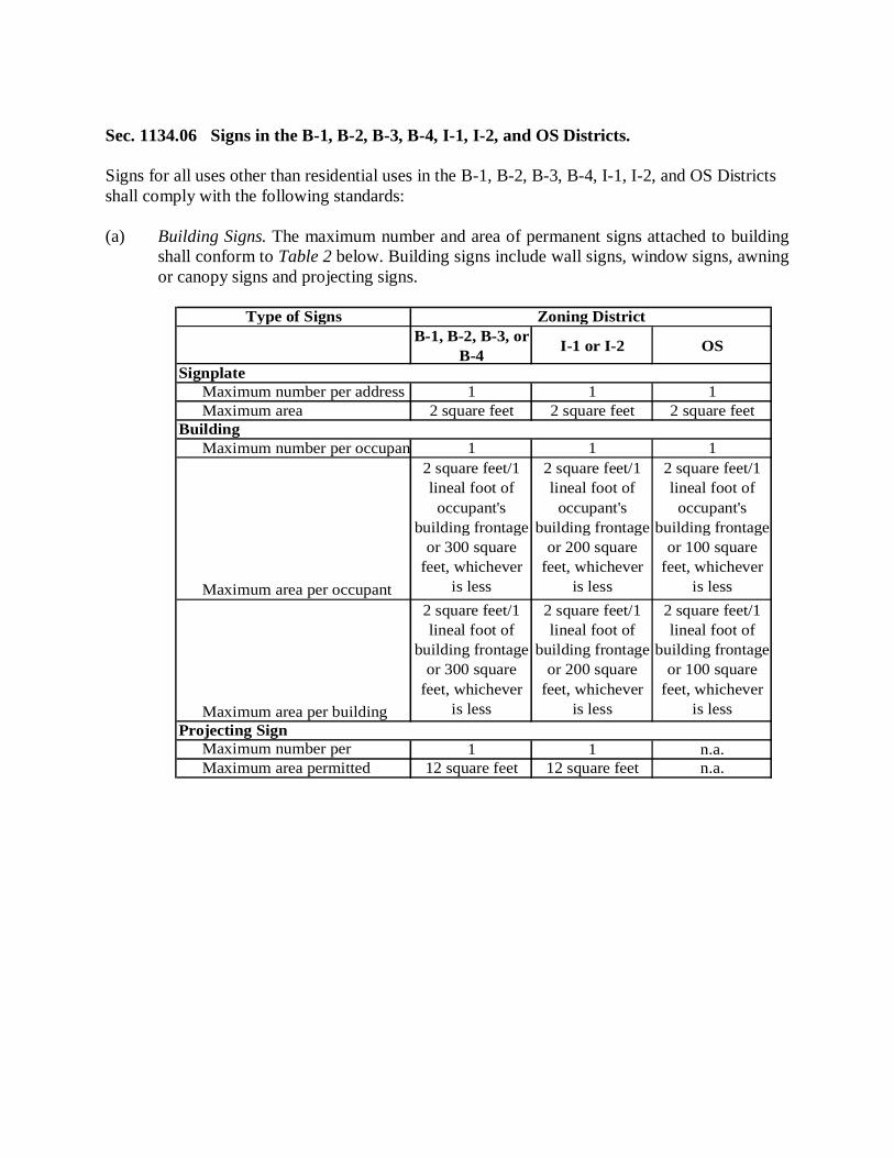
Sec. 1134.06 Signs in the B-1, B-2, B-3, B-4, I-1, I-2, and OS Districts. Signs for all uses other than residential uses in the B-1, B-2, B-3, B-4, I-1, I-2, and OS Districts shall comply with the following standards: (a) Building Signs. The maximum number and area of permanent signs attached to building
shall conform to Table 2 below. Building signs include wall signs, window signs, awning or canopy signs and projecting signs.
B-1, B-2, B-3, or B-4 I-1 or I-2 OS
Signplate Maximum number per address 1 1 1
Maximum area 2 square feet 2 square feet 2 square feetBuilding
Maximum number per occupant 1 1 1
Maximum area per occupant
2 square feet/1 lineal foot of occupant's
building frontage or 300 square
feet, whichever is less
2 square feet/1 lineal foot of
occupant's building frontage
or 200 square feet, whichever
is less
2 square feet/1 lineal foot of occupant's
building frontage or 100 square
feet, whichever is less
Maximum area per building
2 square feet/1 lineal foot of
building frontage or 300 square
feet, whichever is less
2 square feet/1 lineal foot of
building frontage or 200 square
feet, whichever is less
2 square feet/1 lineal foot of
building frontage or 100 square
feet, whichever is less
Projecting SignMaximum number per 1 1 n.a.Maximum area permitted 12 square feet 12 square feet n.a.
Type of Signs Zoning District
(b) Window Signs.
(i) Ground floor occupants. A window sign shall not exceed 50 percent of the total glass area at the ground floor window and shall comply with the Design Standards for signs.
(ii) Upper floor occupants. For a multi-story building, each occupant above the ground floor shall be permitted one permanent sign to be placed in a window of the occupant's space, not to exceed six square feet or 50 percent of the area of the window in which the sign is place, whichever is smaller. These signs shall be in addition to the maximum allowable area for the building signs provided in Table 2.
(c) Secondary Frontage or Access. If a building or occupant has frontage on a second street
or has access from a second public entrance such as a parking lot an additional sign area may be permitted on the secondary frontage not to exceed 40 percent of the sign area permitted for the primary frontage.
(d) Projecting Signs. Projecting signs shall be permitted only in the B-1 and B-3 Districts.
(i) Projecting signs shall be limited to occupants that have a minimum of 20 feet of occupant frontage. All projecting signs shall have a maximum height of 14 feet and a minimum clearance of seven feet from the ground to the bottom of the sign, except when the projecting sign is located above a landscaped area or other area that does not permit pedestrian traffic beneath the sign. A projecting sign shall not be permitted to extend into the street right-of-way.
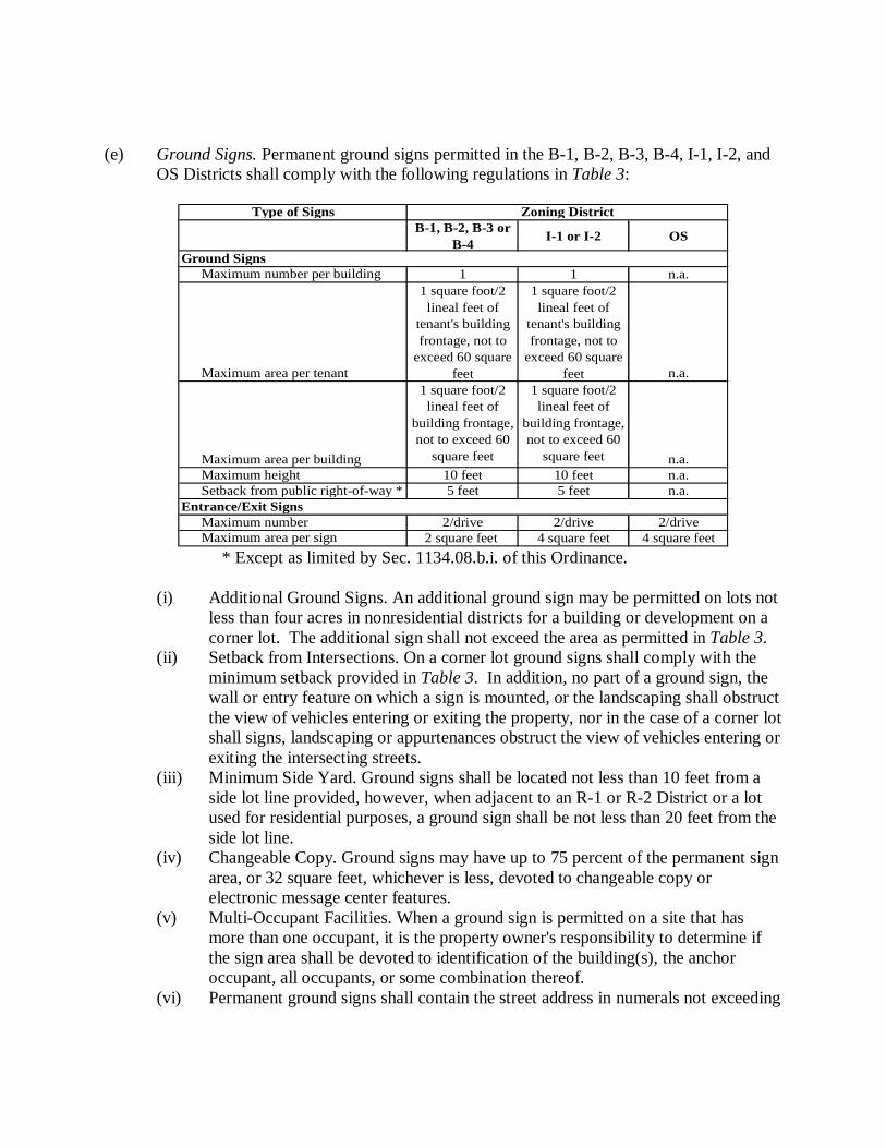
(e) Ground Signs. Permanent ground signs permitted in the B-1, B-2, B-3, B-4, I-1, I-2, and
OS Districts shall comply with the following regulations in Table 3:
B-1, B-2, B-3 or B-4 I-1 or I-2 OS
Ground Signs Maximum number per building 1 1 n.a.
Maximum area per tenant
1 square foot/2 lineal feet of
tenant's building frontage, not to
exceed 60 square feet
1 square foot/2 lineal feet of
tenant's building frontage, not to
exceed 60 square feet n.a.
Maximum area per building
1 square foot/2 lineal feet of
building frontage, not to exceed 60
square feet
1 square foot/2 lineal feet of
building frontage, not to exceed 60
square feet n.a.Maximum height 10 feet 10 feet n.a.Setback from public right-of-way * 5 feet 5 feet n.a.
Entrance/Exit SignsMaximum number 2/drive 2/drive 2/driveMaximum area per sign 2 square feet 4 square feet 4 square feet
Type of Signs Zoning District
* Except as limited by Sec. 1134.08.b.i. of this Ordinance.
(i) Additional Ground Signs. An additional ground sign may be permitted on lots not
less than four acres in nonresidential districts for a building or development on a corner lot. The additional sign shall not exceed the area as permitted in Table 3.
(ii) Setback from Intersections. On a corner lot ground signs shall comply with the minimum setback provided in Table 3. In addition, no part of a ground sign, the wall or entry feature on which a sign is mounted, or the landscaping shall obstruct the view of vehicles entering or exiting the property, nor in the case of a corner lot shall signs, landscaping or appurtenances obstruct the view of vehicles entering or exiting the intersecting streets.
(iii) Minimum Side Yard. Ground signs shall be located not less than 10 feet from a side lot line provided, however, when adjacent to an R-1 or R-2 District or a lot used for residential purposes, a ground sign shall be not less than 20 feet from the side lot line.
(iv) Changeable Copy. Ground signs may have up to 75 percent of the permanent sign area, or 32 square feet, whichever is less, devoted to changeable copy or electronic message center features.
(v) Multi-Occupant Facilities. When a ground sign is permitted on a site that has more than one occupant, it is the property owner's responsibility to determine if the sign area shall be devoted to identification of the building(s), the anchor occupant, all occupants, or some combination thereof.
(vi) Permanent ground signs shall contain the street address in numerals not exceeding
seven inches in height, except for ground signs used by colleges, universities, other institutions of higher education, and hospitals, in which case no street address shall be required
(vii) Ground signs shall be erected in a landscaped setting. (viii) The Administrative Official may approve the location of a ground sign less than
the required distance from a road right-of-way if it finds the sign will not interfere with traffic sign lines and that the required setback is unreasonable because of existing site condition; provided, however, no ground sign or part thereof shall be permitted in the right-of-way.
(f) Temporary Signs. Temporary signs in nonresidential districts may be permitted in
addition to the permanent signs as regulated in Sec. 1134.06(a) through (e) provided:
(i) Temporary signs may be ground signs, window signs or banner signs. (ii) The area of a temporary window sign shall not exceed 25 percent of the total
transparent glass area of the window in which the sign is placed. (iii) Temporary ground and temporary banner signs are permitted only in the B-1, B-2,
B-3, B-4, I-1, and I-2 Districts provided: (1) There shall be no more than two temporary ground or temporary banner
signs each not more than 30 square feet; and (2) Each sign shall have a maximum height of six feet above grade; and (3) Each sign shall not be less than 15 feet from a street right-of-way except
the Administrative Official may permit signs less than 15 feet from a street right-of-way in the B-1 District; and
(4) Signs shall be permitted for a maximum of 30 consecutive days, and not more than a total of 90 days each calendar year.
(iv) Temporary signs that are created in order to announce a specific event shall be removed within seven days after the close of such event.
(v) Temporary billboard signs are permitted only in the B-1, B-2, B-3, B-4, I-1, and I-2 Districts provided: (1) There shall be no more than one temporary billboard sign, not more than
six square feet, per parcel; and (2) Each sign shall have a maximum height of six feet above grade; and (3) Each sign shall be outside all street rights-of-way; and (4) Each sign shall have the consent of the owner of the property on which it
is located; and (5) Signs shall be permitted for a maximum of five consecutive days, and not
more than a total of 30 days each calendar year.
(g) Illumination. Permanent signs may be illuminated as provided in Sec. 1134.08. (h) Instructional Signs. Instructional signs that are clearly intended for instructional purposes
shall be permitted as needed and as approved by the Administrative Official. (i) Signs for Residential Uses. Signs for permitted or conditionally, permitted in the
residential districts shall conform to the sign regulations provided in Sec. 1134.05. Sec. 1134.07 Prohibited Signs. All signs not expressly permitted shall be prohibited in the City. Such signs include but are not limited to the following: (a) Abandoned signs. (b) Inflatable signs and tethered balloons capable of crossing the property line of the lot on
which they are located. (c) Billboard signs, except as expressly permitted as temporary billboard signs in Sec.
1134.06(f). (d) All other off-premises signs. This prohibition against off-premises signs shall not include
the following:
(i) Temporary signs for civic or community affairs of a public or semi-public nature, not for private gain; and
(ii) In the Downtown Development District, as defined by Section 177.04(h), signs that are expressly permitted by this Ordinance in combination with no more than one off-premises sign. “In combination with” means the permitted sign and off premises sign are physically attached or affixed together, including but not limited to physically attached or affixed to the same posts or base. For purposes of this paragraph (d)(ii), the off-premises sign must comply with all of the following: (1) The off-premises sign must otherwise be in conformance with the
provisions of this Ordinance, and (2) The off-premises sign must promote or identify a business that is located
in the Downtown Development District, and (3) The off-premises sign must be located in the Downtown Development
District.
(e) Portable, changeable copy signs. (f) Projecting signs except for theaters. (g) Rooftop signs except those signs that appear to be a continuation of the face of the
building or a mansard roof so long as the sign does not extend above the upper edge of the mansard roof line.
(h) Signs attached to fire escapes or any door or window giving access to any fire escape,
except required, legal signs to identify such escape. (i) Signs illuminated by or containing flashing, intermittent, rotating or moving lights, and
signs with interior illumination, except as expressly permitted in Sec. 1134.08(a). (j) Signs employing any parts which make use of animation or motion to attract attention or
in which the message copy is continuously, electronically changed at a rate exceeding once per 15 seconds.
(k) Signs displaying nudity or words or pictures of an obscene, pornographic, indecent or
immoral character. (l) Signs painted on sidewalks. (m) Signs attached to trees, utility poles, public benches including benches at bus stops,
streetlights, or placed on or over any public property or public right-of-way. (n) Signs imitating or resembling official traffic or government signs or signals. (o) No mobile signs shall be erected, constructed, displayed or maintained except those on
licensed commercial delivery and service vehicles. Such vehicles shall not be parked in any district closer to the street than the front line of the principal building, unless the principal building has a rear parking area; in which case, all such vehicles shall not be parked closer to the street than the rear line of said building.
(p) Window signs that occupy more than 50 percent of the window surface. (q) Temporary directional signs, except as expressly permitted as temporary billboard signs
in Sec. 1134.06(f). (r) Merchandise, equipment, products, vehicles or other items not themselves for sale and
placed for attention getting, identification or advertising purposes. (s) Permanent sign erected or attached to accessory structures.
(t) Outline lighting of the building or roof line. (u) Internal illumination of all or part of the roof. (v) Any sign not specifically authorized by this Ordinance. Sec. 1134.08 Illumination, Construction and Maintenance Standards. In addition to the design, size, type and location of signs, all signs shall meet the following standards: (a) Illumination. Signs shall be permitted to be illuminated as provided in the following:
(i) Source. Light sources to illuminate signs may be direct or indirect. Illuminated signs or lighting devices shall employ only a light of constant intensity.
(ii) Intensity. Illuminated signs or lighting devices shall employ only a light of constant intensity.
(iii) Location and Direction. In no event shall an illuminated sign or lighting device be placed, directed or beamed upon a public thoroughfare, highway, sidewalk or adjacent property so as to cause glare or reflection that may constitute a traffic hazard or nuisance.
(iv) No temporary sign shall be illuminated or have the potential to be illuminated.
(b) Location of Signs and Construction Standards. (i) No sign shall be placed in such a manner as to obstruct free and clear vision of
any traffic on public or private property. Such determination will be made by the Director of Public Safety and Services.
(ii) No sign shall be attached to a utility pole, tree, trash receptacle, bench, or any other structure not intended or approved as a sign support.
(iii) No sign shall be erected so as to project over and obstruct any window, door, fire escape, balcony, platform stairway, ladder, vent or other means of ingress into a building.
(iv) The construction, erection, safety and maintenance of signs shall comply with the Building Code.
(v) Signs shall be structurally sound and located so as to pose no threat to pedestrian or vehicular traffic.
(vi) Permanent signs shall be constructed and erected to withstand wind pressures of at least 30 pounds per square foot of surface, and shall be fastened, suspended or supported so that they will not be a menace to person or property.
(vii) Permanent signs shall be fabricated on and of materials that are of good quality and good durability.
(viii) Temporary signs shall be durable and weather-resistant and fastened or anchored sufficiently, whether attached to the building or positioned in the ground.
(c) Maintenance. All signs shall be maintained as follows:
(i) The property owner, occupant, or other person responsible for the sign shall maintain the sign in a condition fit for the intended use and he or she shall have a continuing obligation to comply with all building code requirements.
(ii) If the Administrative Official finds that any sign is unsafe, insecure, or a menace to the public, notice shall be given in writing by the Administrative Official to the owner. The owner of the business shall, within 48 hours of such notification, correct such unsafe condition or remove the sign. In the event of an immediate threat to the public health, safety or general welfare, the Administrative Official may take whatever actions deemed necessary to effect the immediate removal of such sign.
(iii) Whenever any sign, either conforming or non-conforming to these regulations, is required to be removed for the purpose of repair, refurbishing, or repainting, the same may be done without a permit or any payment of fees provided that all of the following conditions are met: (1) There shall be no alteration or remodeling to the sign face, lettering
(except as otherwise permitted for changeable copy), sign base, sign support(s) of the mounting of the sign itself.
(2) There shall be no enlargement or increase in any of the dimensions of the sign or its structure.
(3) The sign shall be accessory to a legally permitted, conditional, or nonconforming use.
(iv) The Administrative Official may order any sign to be painted or refurbished whenever needed to keep the sign in a neat and safe condition.
Sec. 1134.09 Nonconforming Signs. (a) Maintenance of Nonconforming Signs. Nonconforming signs shall be maintained in good
condition and may continue until such sign is required to be removed as set forth in this Section.
(b) Alteration, Relocation or Replacement of the Nonconforming Signs. A nonconforming
sign shall not be structurally altered, relocated or replaced unless it is brought into compliance with the provisions of this Chapter.
(c) Reconstruction of Damaged Sign. If a sign face and/or its support are damaged to the
extent where the repair cost exceeds 50 percent of the replacement cost of the sign, the sign shall be removed or brought into compliance. If the repair costs do not exceed 50 percent of the replacement cost of the sign, the Administrative Official may authorize the sign to be repaired, provided all repair work is completed within 60 days of the date the damage was incurred.
(d) Termination. A nonconforming sign shall immediately lose its legal nonconforming
status, and shall be brought into conformance with this section or removed, when any of the following occurs:
(i) The size or shape of the sign in changed.
(ii) The sign face (except where otherwise permitted for changeable copy) or sign structure is altered, except where otherwise permitted for normal maintenance.
(iii) If the property upon which the sign is located ceases to be used for a period of two years or more.
Sec. 1134.10 Design Standards. All permanent signs shall comply with the following design standards: (a) Overall Designs of Signs.
(i) Elements of the sign shall create an overall cohesive design, reflect simplicity, avoid visual clutter and insure legibility.
(ii) The message shall be easy to read from the intended vantage point, public street, public sidewalk, or public parking lot but not be out of scale with the building, site, or streetscape. The ratio of the message to the background shall permit easy recognition of the message. Lettering size shall be the size needed to ensure the sign can be seen from the intended distance. For awning signs, the sign graphics shall be located on a portion of the awning fabric that hangs perpendicular to the horizontal plane of the ground, below the awning’s support structures.
(b) Relationship to Building Architecture.
(i) Variety in the design of signs among different storefronts shall be encouraged when the architecture of the building(s) suggests variety.
(ii) Storefront with common architectural elements shall have signs that share continuity of design so that the placement and design of individual signs contribute to the cohesive appearance created by the common architectural elements. For example, a series of storefronts that, because of their architecture and design, have the appearance of a single building shall have occupant signs that share common elements.
(c) Placement of Signs on Buildings. All signs shall be reviewed for their impact on the
overall building façade. The sign and associated lighting fixtures shall compliment the architecture of the building on which it is placed and shall be placed in an appropriate location on the building façade.
(d) Ground Signs. Ground signs shall be spaced or combined along the street frontage in a
manner that ensures that one ground sign does not obscure the view of another ground sign.
Chapter 1136, Landscaping, Screening, and Planting Sec. 1136.01 Purpose. These regulations are intended to: (a) Minimize the transmission from one land use to another of nuisances associated with
noise, dust, and glare. (b) Minimize visual pollution that may otherwise occur within an urbanized area. Minimal
screening provides an impression of separation of spaces, and more extensive screening can entirely shield the visual effects of an intense land use from a less intense land use.
(c) Establish a greater sense of privacy from visual or physical intrusion of intense land uses,
the degree of privacy varying with the intensity of the screening. (d) Safeguard the public health, safety, and welfare, and preserve the aesthetic qualities and
enhance the community character. Sec. 1136.02 Performance Standards. Every development shall provide sufficient screening so that: (a) Neighboring properties are shielded from adverse external effects of that development,
regardless of whether it is separated by a right-of-way. (b) It provides a transition zone between dissimilar land uses.
Sec. 1136.03 Scope. (a) Except where more stringent standards or procedures are specified in this Ordinance, the
standards and procedures in this Chapter shall apply to all required screening and buffering areas.
(b) For those zoning districts listed in the screening table in Sec. 1136.07 and those specific
districts listed in this Chapter, there shall be provided and maintained on the sides of the property abutting, adjacent to, or across the street from a residential district a screening/buffer zone as specified in this Chapter, unless otherwise waived or reduced by the Commission or official approving the site plan.
(c) For utility buildings, stations, and/or substations, screening shall be provided consisting
of a six-foot-high wall, berm, or fence, except when all equipment is contained within a building or structure which is comparable in appearance to residential buildings in the surrounding area.
Sec. 1136.04 Plan Submission Requirements. Whenever landscape, screening and/or a buffer zone are required in this chapter, a preliminary landscape/screening plan shall be submitted to the Administrative Official and a final plan approved by the Commission or other official approving the site plan. The plan shall be prepared and sealed by an architect, landscape architect or engineer, and shall contain the following: (a) All applicable information required by this Ordinance for site plan review. (b) All applicable information listed in this Chapter pertaining to plant materials. (c) The location, general size, and type of existing vegetation to be retained. (d) Existing and proposed grades. (e) A planting schedule and plan providing the following information:
(i) The botanical and common name of each plant used. (ii) The size of each plant to be used at the time of planting. (iii) The quantity of each plant to be used. (iv) Whether plants to be used are balled and burlapped, container grown or bare root. (v) The spacing and location of all proposed trees, shrubs and ground cover. Ground
cover is defined as low-growing woody shrubs, deciduous or evergreen plants, perennial plants and/or vines, such as cranberry, cotoneaster (Cotoneaster apiculata), blue rug juniper (Juniperus horizantaus "Wiltoni"), myrtle (Vinca minor), or Baltic ivy (Hedera helix "Baltica"). Grass, shredded bark, wood chips, other similar mulch or landscaping stones are also acceptable as ground cover for greenbelt areas.
(f) The percentage of landscaped area, excluding detention ponds, to be provided on site.
Sec. 1136.05 Standards. (a) The table in Sec. 1136.07 and explanation contained in this Chapter establish the
screening requirements which satisfy the general performance standards set forth in Sec. 1136.02, unless modifications as permitted under Sec. 1136.08 are applicable.
(b) The table in Sec. 1136.07 indicates the type of screening that is required between two
zoning districts. Where such screening is required, only one of the two adjoining zoning districts is responsible for installing the screening, as provided in subsection (c) of this section.
(c) To determine if the zoning district being developed is required to install the screening and
which type of screening is required, find the zoning district being developed and follow that column down the page to its intersection with the row which corresponds to the adjoining zoning district. If the intersecting square contains a letter, the zoning district being developed is responsible for installing that level of screening. If the intersecting square does not contain a letter, no screening improvement is required.
Sec. 1136.06 Screening Requirement. (a) Definitions. The following words, terms and phrases, when used in this section, shall
have the meanings ascribed to them in this subsection, except where the context clearly indicates a different meaning:
(i) Buffer means an area along and away from a property line within which no
structures, driveways, parking, signs or other such uses or structures may be located unless specifically permitted in this Chapter.
(ii) Intermittent visual obstruction means a screen having no completely unobscured openings within two years of planting more than 10 feet wide at a specified height. In other words, tree canopies shall have grown together within two years of planting to a point that the widest opening between such canopies at a specified height shall not exceed 10 feet. The screen may include deciduous plants and trees. Compliance of planted vegetative screens or natural vegetation will be judged on the basis of the average mature height and density of foliage of the subject species, or field observation of existing vegetation.
(iii) Opaque screen means an opaque screen excluding all visual contact between zoning districts and creating spatial separation. The opaque screen may be composed of a wall, fence or earthen berm, and shall be supplemented with planted and existing vegetation.
(b) Types of screening. The following types of screening are established and
are used as the basis for the table of screening requirements in Sec. 1136.07. Whenever screening is required, the screening along a street or alley shall be type C, with the provision that signs and access driveways are permitted in the buffer area, as permitted by this Ordinance. When an opaque screen is required and a fence is the choice method used, it shall be placed at a minimum 50% of the distance into the buffer area measured from the adjacent property:
(i) Type A.
(1) Opaque screen height: at least six feet; (2) Intermittent visual obstruction height: at least 20 feet, measured from the
ground; and (3) Buffer width: at least 50 feet.
(ii) Type B. (1) Opaque screen height: at least six feet; (2) Intermittent visual obstruction height: at least 20 feet, measured from the
ground; and (3) Buffer width: at least 25 feet.
(iii) Type C. (1) Opaque screen height: none; (2) Intermittent visual obstruction height: at least 20 feet, measured from the
ground; and
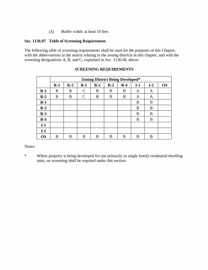
(3) Buffer width: at least 10 feet. Sec. 1136.07 Table of Screening Requirement. The following table of screening requirements shall be used for the purposes of this Chapter, with the abbreviations in the matrix relating to the zoning districts in this chapter, and with the screening designations A, B, and C, explained in Sec. 1136.06, above:
SCREENING REQUIREMENTS
Zoning District Being Developed*
R-1
R-2
B-1
B-2
B-3
B-4
I-1
I-2
OS
R-1
B
B
C
B
B
B
A
A
R-2
B
B
C
B
B
B
A
A
B-1
B
B
B-2
B
B
B-3
B
B
B-4
B
B
I-1
I-2
OS
B
B
B
B
B
B
B
B
Notes: * Where property is being developed for use primarily as single family residential dwelling
units, no screening shall be required under this section.
Sec. 1136.08 Modification of Screening and Buffer Zone Requirements. Because of the wide variety of land uses and the relationships between them and because of many different circumstances, the Commission may reduce or waive the screening and buffer zone requirements of this Chapter after a detailed review and evaluation of an alternative screening plan. Whenever the Commission modifies the screening requirement, it shall find that the following standards have been met: (a) The landscape/screening plan shall protect the character of new and existing residential
neighborhoods against negative impacts such as noise, glare, light, air pollution, trash and debris, and hazardous activities.
(b) The Commission shall determine the screening, width and type of buffer zone needed to
ensure compatibility based upon the following criteria:
(i) The development is compatible with and sensitive to the immediate environment of the site and neighborhood relative to architectural design, scale, bulk, building height, identified historical character, disposition and orientation of buildings on the lot and visual integrity.
(ii) The site has natural existing vegetation and/or topography, natural bodies of water or wetland areas or other existing conditions which offer screening consistent with the standards set forth in this chapter. The Commission shall require the retention of these natural features as a condition of site plan approval.
(iii) The arrangement, design and orientation of buildings on this site lends itself so as to maximize the opportunity for privacy and isolation from negative impacts of this project.
Sec. 1136.09 Materials. Fences required under this Chapter shall be constructed of redwood, cedar, or no. 1 pressure treated wood. Chain link fences shall not be permitted for screening or obscuring purposes. Suitable fencing materials may be substituted for wood with Commission approval.
Sec. 1136.10 Berms. (a) Earth berms required under this Chapter shall consist of raised earth with side slopes of
three-to-one or flatter with a four-foot-wide flat or slightly rounded crest contoured to the side slopes to facilitate maintenance.
(b) Berms shall be covered with grass or other ground cover to prevent erosion. Berms shall
also be landscaped with plant materials. A detailed landscape plan with a plant material list, including quantity, species, minimum size and spacing, shall be submitted with the site plan and approved by the Commission.
Sec. 1136.11 Location of Screening. Screening required under this chapter shall be located directly adjacent to the lot line except where underground utilities interfere. Upon approval of the Commission and when mutually agreeable to affected property owners, required screening may be located on the opposite side of an alley right-of-way when a nonresidential district abuts a residential district. The continuity of the required screening on a given block shall be a major consideration of the Commission in reviewing such request. Sec. 1136.12 Openings in Walls, Fences, and Berms; Construction Standards for Walls. Walls, fences, and berms required under this Chapter shall have no openings for vehicular traffic or other purposes, except such openings as may be approved by the Commission. All walls required in this Chapter shall be constructed of stone, brick or shall have brick veneer on the side facing the residential district. The height of the wall shall be measured from the prevailing grade of the land on the residential side of the wall or berm. Walls shall be erected on a concrete foundation which shall have a minimum depth of 42 inches below a grade approved by the Administrative Official and shall not be less than four inches wider than the wall to be erected. Other suitable wall materials may be substituted with Commission approval. Sec. 1136.13 Bumper Stops, Curbing or Wheel Chocks in Parking Spaces. Bumper stops, curbing or wheel chocks shall be provided in parking spaces adjacent to a wall, fence or berm required under this chapter to prevent a vehicle from encroaching on or damaging the screening improvement. Bumper stops, curbing or wheel chocks shall be placed four feet from the required screening improvement.
Sec. 1136.14 Corner Clearance Visibility. The Administrative Official may require a reduction in the height of a screening improvement where necessary to ensure adequate sight distance and/or corner clearance visibility for drive approaches and public streets in proximity to a screening improvement. In this case height may be reduced only for that portion of the screening improvement necessary to provide adequate sight distance and/or corner clearance necessary for traffic safety. Where it is necessary to reduce the height of a screening improvement, height shall be reduced gradually. Sec. 1136.15 Irrigation of Vegetation. Whenever vegetation is required by the Commission or approved by adoption of a site plan the vegetation must remain in place and be replaced if damaged or dies. Sec. 1136.16 Waiver of Requirements. The Commission may waive or reduce the requirements of this Chapter upon determining that the following would apply: (a) The purpose of this Chapter cannot be met; and (b) Compliance with the requirements would impose a practical difficulty on the applicant or
would create safety hazards to pedestrians or motorists.
Sec. 1136.17 Scope of Plant Material Requirements. Wherever in this Chapter screening, planting and/or material in conjunction with an obscuring fence is required, it shall be planted within six months from the date of issuance of a temporary certificate of occupancy and shall thereafter be reasonably maintained with permanent plant materials to provide a screen to abutting properties. Suitable materials equal in characteristics to the plant materials listed in this Chapter with the spacing as required in this Chapter shall be provided. Sec. 1136.18 Plant Material Spacing. Spacing of plant materials required under this Chapter shall be as follows: (a) Trees and large shrubs shall not be placed closer than four feet from the fence line or
property line. (b) Where plant materials are planted in two or more rows, planting shall be staggered in
rows. (c) Evergreen trees, as defined in Sec. 1136.20, shall be planted not more than 30 feet on
centers. (d) Narrow evergreens, as defined in Sec. 1136.20, shall be planted not more than three feet
on centers. (e) Deciduous trees shall be planted not more than 30 feet on centers. (f) Tree-like shrubs shall be planted not more than ten feet on centers. (g) Large deciduous shrubs shall be planted not more than four feet on centers.
Sec. 1136.19 Suggested Plant Materials. Suggested plant materials to be used pursuant to this Chapter shall be as follows: (a) Large deciduous shrubs (minimum 24 inches in height at planting, minimum mature
height of four feet):
(i) Gray Dogwood (Cornus racemosa). (ii) Red-osier Dogwood (Cornus stolonifera). (iii) Arrowwood Viburnum (Viburnum dentatum). (iv) Nannyberry Viburnum (Viburnum lentago). (v) Maple-leaved Viburnum (Viburnum acerifolium). (vi) Native Spicebush (Lindera benzoin). (vii) Winterberry Holly – females and males (Ilex verticillata). (viii) Witch Hazel (Hamamelis virginiana). (ix) Elderberry (Sambucus canadensis). (x) Summersweet (Clethra alnifolia). (xi) Serviceberry (Amelanchier arborea & A. laevis). (xii) Sargent Crabapple (Malus ‘Sargent’). (xiii) Lilac (Syringa spp.). (xiv) Spirea (Spiraea spp.). (xv) Winged Euonymous (Euonymous alatus).
(b) Evergreen trees (minimum five feet in height at planting):
(i) Norway Spruce (Picea avies). (ii) Blue Spruce (Picea pungens). (iii) White Spruce (Picea glauca). (iv) White Pine (Pinus strobes). (v) Austrian Pine (Pinus nigra). (vi) White Fir (Abies concolor).
(c) Narrow evergreens (minimum three feet in height at planting, minimum mature height of
six feet):
(i) Cap Yew (Taxus cuspidate ‘Capitata’). (ii) Hick's Yew (Taxus x media ‘Hicksii’). (iii) Hatfield Yew (Taxus x media ‘Hatfield’). (iv) Chinese Juniper (Juniperus chinensis). (v) Eastern Redcedar (Juniperus virginiana).
(d) Small trees (minimum 1 1/2-inch caliper at planting, maturing to less than 30 feet):
(i) Flowering Crab (Malus spp.). (ii) Chinese Dogwood (Cornus kousa). (iii) Serviceberry (Amelanchier canadensis). (iv) Hop Hornbeam (Ostrya virginiana). (v) Redbud (Cercis canadensis).
(e) Medium deciduous trees (minimum two-inch caliper at planting, minimum mature height
30 feet):
(i) Black gum (Nyssa sylvatica). (ii) Sweet gum (Liquidambar styraciflua). (iii) Sargent Cherry (Prunus sargentii). (iv) American Holly (Ilex opaca). (v) American Hornbeam (Caprinus caroliniana). (vi) Sassafras (Sassafras albidum).
(f) Large deciduous trees (minimum three-inch caliper at planting):
(i) Red Maple (Acer rubrum). (ii) Sugar Maple (Acer saccharum). (iii) River Birch (Betula nigra). (iv) Tuliptree (Liriodendron tulipifera). (v) Honey Locust (Gleditsia triancanthos). (vi) Ginkgo - male only (Ginkgo biloba). (vii) Linden (Tilia americana). (viii) American beech (Fagus grandifolia). (ix) Shingle Oak (Quercus imbricaria). (x) English Oak (Quercus robur). (xi) Red Oak (Quercus rubra).
Sec. 1136.20 Plant Materials Not Permitted. For the purposes of this Chapter, the following plant materials shall not be permitted: (a) Ailanthus (tree of heaven) (Ailanthus altissima). (b) Ash (Fraxinus spp.). (c) Asian bittersweet (Celastrus orbiculata). (d) Box elder(Acer negundo). (e) Buckthorn (Rhamnus spp.). (f) Elm (Ulmus spp.). (g) Hedge privet (Ligustrum). (h) Japanese knotweed (Polygonum cuspidatum). (i) Multiflora rose (Rosa multiflora). (j) Norway maple (Acer platanoides). (k) Honeysuckle (Lonicera spp.). (l) Olive - Autumn and Russian (Elaeagnus spp.). (m) Poplar (Populus spp.). (n) Silver maple (Acer saccharinum). (o) Purple loosestrife (Lythrum salicaria).
Sec. 1136.21 Installation and Maintenance. (a) Whenever a landscape planting screen or other plantings are required under this Chapter,
such plantings shall be installed according to accepted good planting procedures and in a sound workmanlike manner. All plant material shall meet current standards of the American Association of Nurserymen.
(b) Four-inch overall depth of shredded, non-colored hardwood Cedar or Cypress bark or
ground cover of low-growing woody shrubs, deciduous or evergreen plants, perennial plants and/or vines, such as cranberry cotoneaster (Cotoneaster apiculata), blue rug juniper (Juniperus horizantaus “Wiltoni”), myrtle (Vinca minor), or Baltic ivy (Hedera helix “Baltica”), shredded bark, wood chips, other similar mulch or landscaping stones shall be used in all planting beds. The minimum mulch radius shall be two feet surrounding a shrub and four feet surrounding a deciduous or evergreen tree. Deviations from this must be approved by the Administrative Official before installation.
(c) Maintenance of plantings shall be done to ensure a healthy and neat appearance, free of
disease and insect infestations as well as clear of weeds and debris. Unhealthy or dead plant material is to be replaced within one year from completion and inspection of plantings.
Chapter 1140, Nonconformities Sec. 1140.01 Nonconforming Lots of Record. In any district in which single-family dwellings are permitted, a single-family dwelling and customary accessory buildings may be erected on any single lot of record at the effective date of adoption or amendment of this Ordinance, notwithstanding limitations imposed by other provisions of this Ordinance. Such lot must be in separate ownership and not of continuous frontage with other lots in the same ownership. This provision shall apply even though such lot fails to meet the requirements for area or width, or both, that are generally applicable in the district, provided that yard dimensions and requirements other than those applying to area or width, or both, of the lot shall conform to the regulations for the district in which such lot is located. Variances from requirements listed in this Ordinance other than lot area or lot width shall be obtained only through action of the Board as provided in this Ordinance. Sec. 1140.02 Nonconforming Lots of Record in Combination. If two or more lots or a combination of lots and portions of lots with continuous frontage in single ownership are of record at the time of passage or amendment of this Ordinance, and if all or part of the lots with no buildings do not meet the requirements established for lot width and area, the lands involved shall be considered to be an undivided parcel for the purposes of this Ordinance, and no portion of said parcel shall be used or sold in a manner which diminishes compliance with lot width and area requirements established by this Ordinance, nor shall any division of any parcel be made which creates a lot with a width or area below the requirements stated in this Ordinance. Sec. 1140.03 Nonconforming Buildings. Any lawful nonconforming building or structure may be continued and maintained, provided there is no physical change than necessary maintenance and repair of such building or structure except as permitted hereinafter.
Sec. 1140.04 Nonconforming Uses. Any lawful nonconforming use of land may be continued, provided that such use of land shall not be expanded or extended either on the same or adjoining property. Sec. 1140.05 Restoration of Damaged Building. A nonconforming building or structure having been damaged or partially destroyed by fire or other calamity to an extent not exceeding 60 percent of the assessed valuation, exclusive of foundations, at that time, may be restored and its immediately previous occupancy or use, existing at the time of such partial destruction, may be continued or resumed; provided the work of restoration is commenced within one year of the date of such partial destruction and is diligently carried on to completion. Whenever a nonconforming building or structure is damaged in excess of 60 percent of its assessed valuation, exclusive of foundations, at that time, the repair or reconstruction of such building shall conform to all of the regulations of the district in which it is located and it shall be treated as a new building. Sec. 1140.06 Change of Use. Any part of a building, structure, or land occupied by a nonconforming use may be changed to a use of the same or a more restricted classification (subject to such permits as may be required for proposed use); but where the use of a nonconforming building, structure, or land is hereafter changed to a more restricted classification, it shall not thereafter be changed to a use of less restricted classification. Sec. 1140.07 Abandoned Nonconforming Uses. In the event that a nonconforming use of land or use of building is discontinued or abandoned, for a period of one year or more, the use of the same shall conform thereafter to the uses permitted in the district in which it is located. The Board shall have the authority to extend this period by not more than two years, for a total of three years, based upon a showing by the property owner of extraordinary circumstances, including but not limited to the pendency of any bankruptcy, foreclosure, other probate proceeding or other judicial proceeding directly relating to the property.
Sec. 1140.08 Change of Tenancy or Ownership. There may be a change of tenancy or ownership or management of an existing lawful nonconforming use, provided there is no change in the nature or character of such nonconforming use. Sec. 1140.09 Completion of Pending Construction. The adoption of this Ordinance shall not limit the construction of any building for which a valid site plan approval exists and/or for which a permit had been obtained and on which work had commenced and had been carried on continuously. Sec. 1140.10 Expansion Prohibited. A nonconforming use of a portion of a building or structure, which building or structure otherwise conforms to the provisions of this Ordinance, shall not be expanded or extended into any other portion of such conforming building or structure, nor changed except to a conforming use. If the nonconforming use or portion thereof is discontinued or changed to a conforming use, any future use of such building, structure or portion thereof shall be in conformity to the regulations of the district in which such building or structure is located. Sec. 1140.11 Removal of Nonconforming Use, Building or Structure. The Commission may, from time to time, recommend to the Council the acquisition of such private property as does not conform in use or structure to the regulations and restrictions of the various districts defined in this Ordinance and to recommend the removal of such use or structure in accordance with applicable laws and statutes. Sec. 1140.12 Nonconforming Uses Due to Reclassification. The foregoing provisions shall also apply to uses which hereafter become nonconforming due to any reclassification of districts or zones under this Ordinance.
Sec. 1140.13 Record of Nonconforming Uses. Immediately after the effective date of this Ordinance or any amendments thereto, the City should prepare a record of nonconforming uses and occupations of lands, buildings, and structures, including tents and trailer coaches, existing at the time of such Ordinance or amendment. Such record should contain the names and addresses of the owners of such nonconforming use and of any occupant, other than the owner, the legal description of the land and the nature and extent of use. This is not meant to be an exhaustive list of all nonconformities in the City, but only those of which the Commission is aware. The Commission should review the record and make such recommendations to the Council as it deems advisable with reference to these nonconforming uses. The record of nonconforming uses and recommendations of the Commission should be filed in the office of the Clerk of Council and record should constitute prima facie evidence of the number, character, and extent of the nonconformities at the time this Ordinance or any amendment thereto becomes effective. The record of nonconforming uses should be reviewed and revised annually as the Commission shall prescribe.
Chapter 1150, Schedule of Off-Street Parking and Loading
Sec. 1150.01 Intent. The intent of this Chapter is to provide for adequate private passenger vehicular and delivery truck storage space for different types of land uses within the City and to set standards for the construction and use of these off-street parking facilities. Within this Chapter, standards have been identified for: (a) The temporary storage of trucks with the primary intent of delivering goods for storage
and/or sale to the general public; (b) The temporary storage of private passenger vehicles as a use incidental to a principal use;
and (c) The temporary storage of private passenger vehicles as a principal use of the site to serve
an adjacent use district which has developed without adequate off-street parking. Sec. 1150.02 Off-Street Loading and Unloading Space. On the same premises with every building, structure, or part thereof, erected and occupied for manufacturing, storage, warehouse goods, display, department store, wholesale store, market, hotel, hospital, mortuary, laundry, dry cleaning, or other uses similarly involving the receipt or the distribution of vehicles or materials or merchandise, there shall be provided and maintained on the lot, adequate space for standing, loading, and unloading services in order to avoid undue interference with public use of the streets or alleys. Such space shall include a 10 foot by 55 foot loading space, with 14 foot height clearance for every 10,000 square feet, or fraction thereof, in excess of 2,000 square feet of building floor area for the above mentioned purposes. A 10 foot by 25 foot loading space with a 14 foot height clearance shall be required for any of the above mentioned uses for 2,000 or less square feet of building floor area.
Sec. 1150.03 Off-Street Parking Development Conditions. In all zoning districts, off-street parking facilities for the storage or parking of self-propelled motor vehicles hereafter erected, altered or extended after the effective date of this Ordinance shall be provided and maintained as herein prescribed: (a) The loading space as required in this Ordinance shall not be construed as supplying any
off-street parking space. (b) When units or measurements used in determining the number of required parking spaces
result in requirement of fractional space, any fraction up to and including one half shall be-disregarded and fractions over one-half shall require one space.
(c) Whenever a use requiring off-street parking is increased in floor area, and such use is
located in a building existing on or before the effective date of this Ordinance, additional parking space for additional floor area shall be provided and maintained in amounts hereafter specified for that use; provided, however, in the existing business districts where the City and various property owners have or may cooperatively develop parking facilities, and additional parking space as required for the increased floor space is not available within the required 300 feet as required in this Ordinance, the Commission may, through negotiations with the owner of such property, vary the location of such required parking spaces or agree to the owner’s participation in other authorized parking facilities which will furnish the same amount of space as required for his increased floor space within a distance of not more than 500 feet of the building.
(d) For the purpose of this Chapter, “floor area” in the case of offices, merchandising, or
service types of use, shall mean the gross floor area used or intended to be used for services to the public as customers, patrons, clients, or patients or as tenants, including areas occupied for fixtures and equipment used for display or sale of merchandise.
(e) Off-street parking facilities for one- and two-family dwellings shall be located on the
same lot or plot of ground as the building they are intended to serve. The location of required off-street parking facilities for other than one and two-family dwellings and all multiple dwellings shall be within 300 feet of the building they are intended to serve, measured from the nearest point of the off-street parking facilities to the nearest point of the building. This section shall not apply to colleges, universities, and other institutions of higher education that have a comprehensive master parking plan meeting all other requirements of these regulations.
(f) In the case of a use not specifically mentioned, the requirements for off-street parking
facilities for a use which is so mentioned and which such use is similar shall apply, as determined by the Commission.
(g) Nothing in this Chapter shall be construed to prevent collective provision of off-street
parking facilities for two or more buildings or uses, provided that, collectively, such facilities shall not be less than the sum of the requirements for the various individual uses computed separately in accordance with the table in this Chapter.
(h) Nothing in this section shall prevent the extension of or an addition to a building into an
existing parking area which is required for the original building when the same amount of space taken by the extension or addition to a building is provided by an enlargement of the existing parking lot or an additional area within 300 feet of such building.
(i) Such parking areas will be used solely for the parking of private passenger vehicles for
periods of less than 24 hours and shall not be used as off-street loading areas. (j) No commercial repair work or service of any kind, or sales or display activities, shall be
conducted in such parking areas. (k) Such parking lots shall be used only for parking automobiles, and no commercial
activities, such as washing or greasing, sale of merchandise or purveying of foodstuffs, repair work or servicing of any kind, shall be done thereon.
(l) No building or structure shall be hereafter built or permitted, except necessary buildings
for attendant of not more than 50 square feet each in area and not more than 15 feet in height.
(m) Plans for development of any such parking lot must be approved by the building
inspector before construction is started. No such land shall be used for parking until approved by the Administrative Official.
(n) Any area once designated as required off-street parking shall not be changed to any other
use unless and until equal facilities are provided elsewhere.
(o) No person shall construct a curb cut or drive apron without first obtaining a permit from the Engineering, Building, and Zoning Department. Curb cuts and drive aprons shall conform to the City‘s standard drawings. Individuals seeking to construct a curb cut or drive apron shall submit a sketch showing the location of the proposed driveway and its relationship to adjacent rights-of-way and intersections, adjacent buildings, adjacent driveways, changes in topography that may limit sight distance, and other obstructions including but not limited to poles, trees, hydrants, and signs. A drive apron or curb cut shall not be constructed in areas where it may create a safety hazard, traffic nuisance, or inadequate sight distance, as outlined in the Ohio Department of Transportation Location and Design Manual. The design speed used to determine sight distance shall be equal to 10 mile per hour greater than the legal or posted speed limit.
Sec. 1150.04 Table. (a) The amount of required off-street parking spaces for new uses or buildings, additions
thereto and additions to existing buildings, as specified above, shall be determined in accordance with the following table, and the space so required shall be stated in the application for a building permit and shall be irrevocably reserved for such use and/or shall comply with this Chapter.
(b) For those uses not specifically mentioned, the requirements for off-street parking facilities shall be accordance with a use which is similar in type.
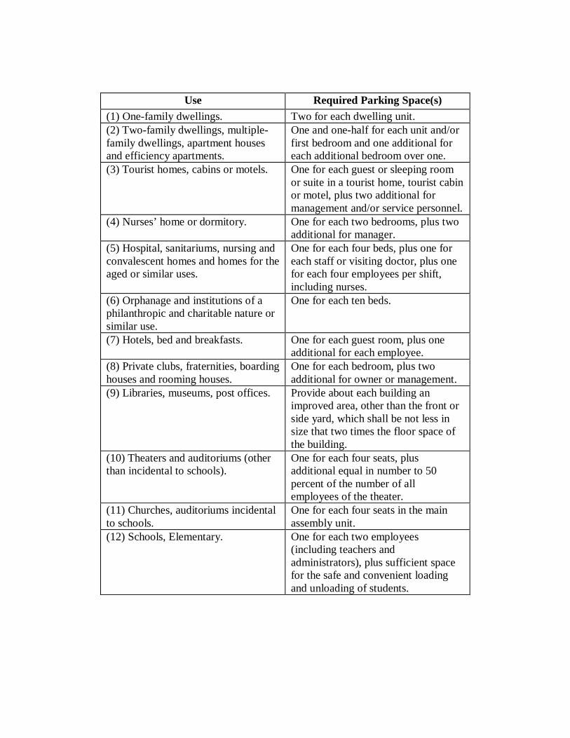
Use Required Parking Space(s)
(1) One-family dwellings. Two for each dwelling unit. (2) Two-family dwellings, multiple-family dwellings, apartment houses and efficiency apartments.
One and one-half for each unit and/or first bedroom and one additional for each additional bedroom over one.
(3) Tourist homes, cabins or motels. One for each guest or sleeping room or suite in a tourist home, tourist cabin or motel, plus two additional for management and/or service personnel.
(4) Nurses’ home or dormitory. One for each two bedrooms, plus two additional for manager.
(5) Hospital, sanitariums, nursing and convalescent homes and homes for the aged or similar uses.
One for each four beds, plus one for each staff or visiting doctor, plus one for each four employees per shift, including nurses.
(6) Orphanage and institutions of a philanthropic and charitable nature or similar use.
One for each ten beds.
(7) Hotels, bed and breakfasts. One for each guest room, plus one additional for each employee.
(8) Private clubs, fraternities, boarding houses and rooming houses.
One for each bedroom, plus two additional for owner or management.
(9) Libraries, museums, post offices. Provide about each building an improved area, other than the front or side yard, which shall be not less in size that two times the floor space of the building.
(10) Theaters and auditoriums (other than incidental to schools).
One for each four seats, plus additional equal in number to 50 percent of the number of all employees of the theater.
(11) Churches, auditoriums incidental to schools.
One for each four seats in the main assembly unit.
(12) Schools, Elementary. One for each two employees (including teachers and administrators), plus sufficient space for the safe and convenient loading and unloading of students.
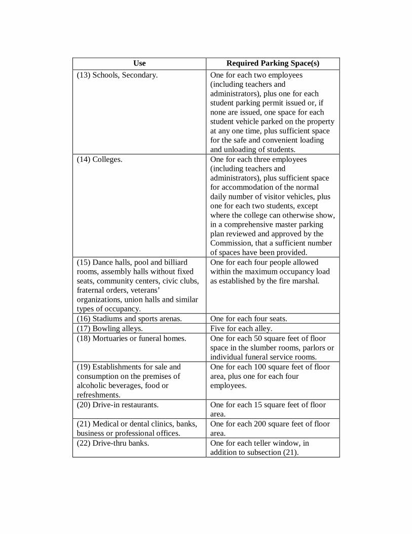
Use Required Parking Space(s) (13) Schools, Secondary. One for each two employees
(including teachers and administrators), plus one for each student parking permit issued or, if none are issued, one space for each student vehicle parked on the property at any one time, plus sufficient space for the safe and convenient loading and unloading of students.
(14) Colleges. One for each three employees (including teachers and administrators), plus sufficient space for accommodation of the normal daily number of visitor vehicles, plus one for each two students, except where the college can otherwise show, in a comprehensive master parking plan reviewed and approved by the Commission, that a sufficient number of spaces have been provided.
(15) Dance halls, pool and billiard rooms, assembly halls without fixed seats, community centers, civic clubs, fraternal orders, veterans’ organizations, union halls and similar types of occupancy.
One for each four people allowed within the maximum occupancy load as established by the fire marshal.
(16) Stadiums and sports arenas. One for each four seats. (17) Bowling alleys. Five for each alley. (18) Mortuaries or funeral homes. One for each 50 square feet of floor
space in the slumber rooms, parlors or individual funeral service rooms.
(19) Establishments for sale and consumption on the premises of alcoholic beverages, food or refreshments.
One for each 100 square feet of floor area, plus one for each four employees.
(20) Drive-in restaurants. One for each 15 square feet of floor area.
(21) Medical or dental clinics, banks, business or professional offices.
One for each 200 square feet of floor area.
(22) Drive-thru banks. One for each teller window, in addition to subsection (21).
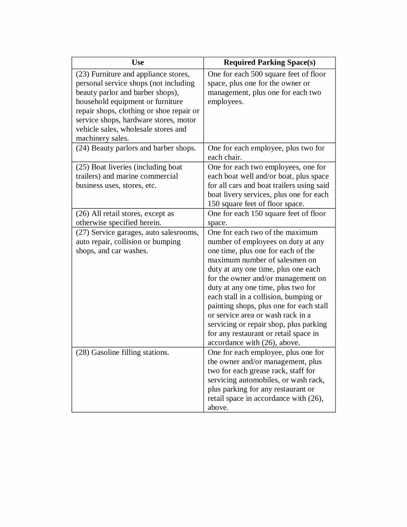
Use Required Parking Space(s) (23) Furniture and appliance stores, personal service shops (not including beauty parlor and barber shops), household equipment or furniture repair shops, clothing or shoe repair or service shops, hardware stores, motor vehicle sales, wholesale stores and machinery sales.
One for each 500 square feet of floor space, plus one for the owner or management, plus one for each two employees.
(24) Beauty parlors and barber shops. One for each employee, plus two for each chair.
(25) Boat liveries (including boat trailers) and marine commercial business uses, stores, etc.
One for each two employees, one for each boat well and/or boat, plus space for all cars and boat trailers using said boat livery services, plus one for each 150 square feet of floor space.
(26) All retail stores, except as otherwise specified herein.
One for each 150 square feet of floor space.
(27) Service garages, auto salesrooms, auto repair, collision or bumping shops, and car washes.
One for each two of the maximum number of employees on duty at any one time, plus one for each of the maximum number of salesmen on duty at any one time, plus one each for the owner and/or management on duty at any one time, plus two for each stall in a collision, bumping or painting shops, plus one for each stall or service area or wash rack in a servicing or repair shop, plus parking for any restaurant or retail space in accordance with (26), above.
(28) Gasoline filling stations. One for each employee, plus one for the owner and/or management, plus two for each grease rack, staff for servicing automobiles, or wash rack, plus parking for any restaurant or retail space in accordance with (26), above.
Use Required Parking Space(s) (29) Industrial establishments including manufacturing, research and testing laboratories, creameries, bottling works, printing and engraving shops, warehouses and storage buildings.
Provide about each industrial building, buildings or use an improved area, in addition to the front yard, which shall be sufficient in size to provide adequate facilities for the parking of automobiles and other motor vehicles used by the firm or employees or persons doing business therein. Such space shall not be less than one for each three employees computed on the basis of the greatest number of persons to be employed at any one period during the day or night.
(c) Where the Commission determines that a proposed use would be part of a college use per
Sec. 1162.20, the provisions of (14), above, shall apply to the proposed use as part of a college use.
Sec. 1150.05 Municipal Facilities. Wherever the Council shall establish off-street parking facilities by means of a special assessment district or by any other means, the Council may determine, upon completion and acceptance of such off-street parking facilities by the Council, all existing buildings and uses and all buildings erected or uses established thereafter within the special assessment district or districts shall be exempt from the requirements of this Chapter for privately supplied off-street parking facilities.
Sec. 1150.06 Regulations for the Development and Maintenance of Parking Lots. In all districts where off-street parking lots are the principal use of the site or are permitted as an adjunct to the lawful use of property therein, and such facilities provide parking privileges to owners, occupants, tenants, employees, patrons, customers, members, visitors, and invitees therein, such off-street parking lots shall be construed and maintained subject to the following regulations: (a) Application Requirements. An application for a permit to construct such a lot shall
include three sets of plans and shall be submitted to the City. After the Administrative Official has determined that the following mandatory provisions have been provided for, a permit shall be issued to the applicant. The application shall include a site plan along with all applicable construction details and elevations and shall include all items identified in this Section. All plans shall be prepared and sealed by a registered engineer.
(b) Ingress/Egress. Adequate ingress and egress shall be provided to meet the approval of
the Administrative Official. Backing directly onto a street shall be prohibited. (c) Construction Requirements. Such parking lots shall be constructed with a hard, smooth,
dustproof surface to meet the following minimum City standards:
(i) One inch asphaltic concrete wearing course over three inches of asphaltic base course over eight inches of aggregate base course; or
(ii) Six-inch-thick concrete pavement over four inches of aggregate base course. (iii) All driveways adjacent to an improved street (those streets which contain curbs)
shall install a concrete curb apron conforming to City standards. The concrete apron shall extend to the inside edge of the sidewalk (furthest from the curb) or, where no sidewalk exists such apron shall extend to the inside edge of the street right-of-way (furthest from the road centerline).
(iv) Industrial zones may utilize gravel parking for storage, loading, employee parking and other non-customer parking. A submittal of an approved design appropriate for the existing soils and proposed traffic usage is required with the site plan. In no case shall the design thickness be less than 18” on a compacted sub-grade without the use of geogrids. Design shall incorporate adequate slope and sub-grade drainage. A buffered green space shall be provided between gravel lots and any catch basins. Item (iii) above shall be required; and on unimproved roads, an asphalt or concrete apron is required to the back of right of way. Owner shall be responsible for dust control and prevent the tracking of mud onto City of Alliance streets.
The lots shall be graded and proper drainage facilities provided to dispose of all surface water to meet the approval of the City Engineer. If adequate stormwater discharge facilities are not available, detention or retention shall be provided so that the developed rate of runoff does not exceed the undeveloped rate. Such parking lots shall be
continuously maintained with a hard, smooth, dustproof surface at all times.
(d) Lighting. All lighting used to illuminate any off-street parking area shall be so installed as to be confined within and directed onto only the parking area and property which it serves. No lighting shall be so located or visible as to be a hazard to traffic safety. Minimum light levels at any one location within the lot shall be one footcandle. A lighting plan shall be submitted along the site plan identified above and shall include all light locations, photometric diagrams and light fixture details over one.
(e) Lots Located Opposite Residential Property. All street boundaries of such parking lots
where residential property is located on the opposite side of the street shall be treated the same as set forth in subsection (d) above, except such portions as are used for entrances and exits.
(f) Signs. No sign shall be erected upon such parking lots, except not more than one sign at
each entrance to indicate the operator, the purpose for which operated and the parking rates, when charge is permitted. Such signs shall not exceed 15 square feet in area and shall not extend more than 10 feet in height above the nearest curb and shall be entirely upon the parking lot.
(g) Drive Width. Entry driveways shall be at least 12 feet wide for one-way travel and at
least 24 feet wide for two-way travel. Maximum driveway width, as measured at the throat of the driveway, shall be 21 F for all uses in the R-1 and R-2 Districts, and 30 F for all uses in the B-1, B-2, B-3, and B-4 Districts.
(h) Layout Plan Requirements. Plans for the layout of off-street parking facilities shall be in
accordance with the following minimum requirements:
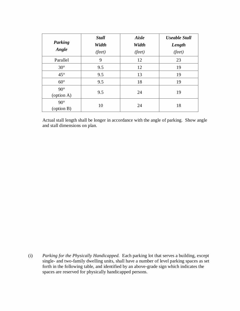
Parking Angle
Stall
Width (feet)
Aisle Width (feet)
Useable Stall
Length (feet)
Parallel
9
12
23
30°
9.5
12
19 45°
9.5
13
19
60°
9.5
18
19 90°
(option A)
9.5
24
19
90° (option B)
10
24
18
Actual stall length shall be longer in accordance with the angle of parking. Show angle and stall dimensions on plan.
(i) Parking for the Physically Handicapped. Each parking lot that serves a building, except single- and two-family dwelling units, shall have a number of level parking spaces as set forth in the following table, and identified by an above-grade sign which indicates the spaces are reserved for physically handicapped persons.
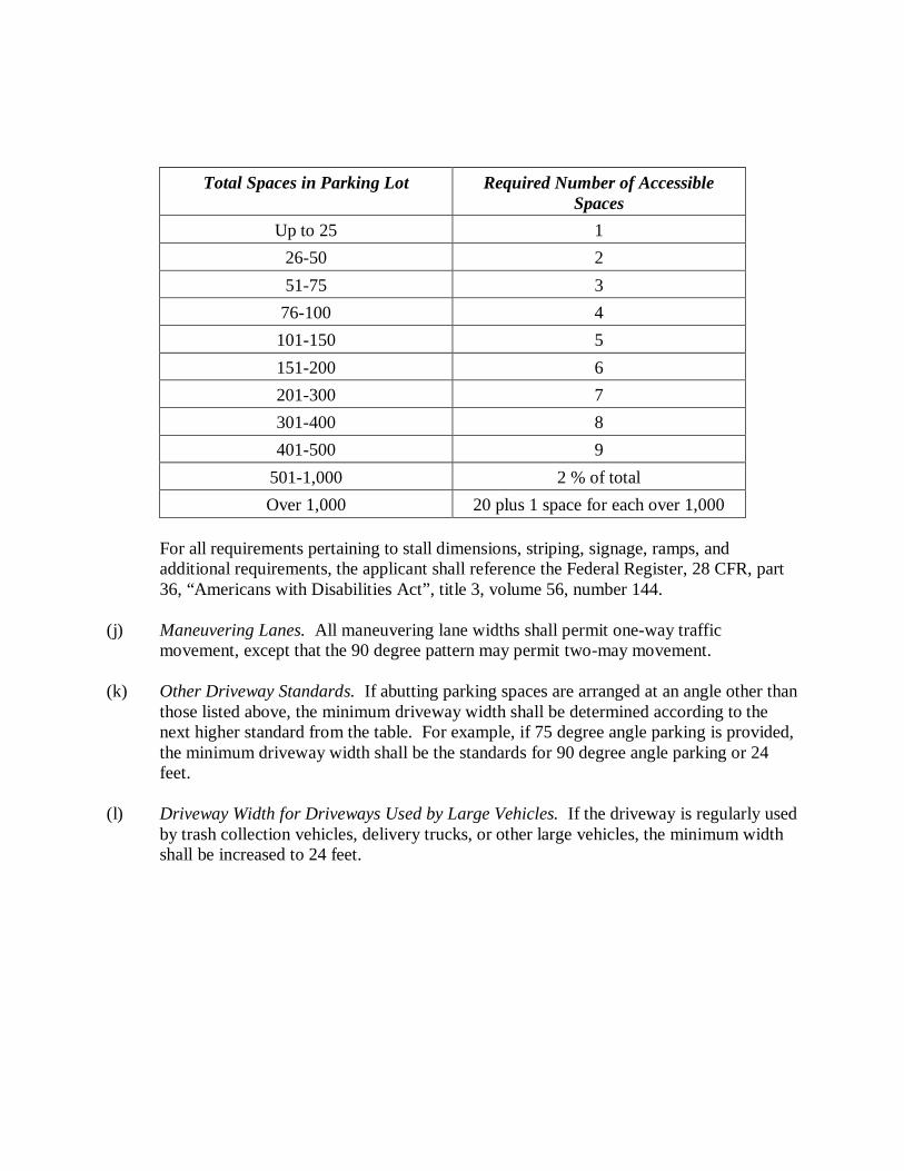
Total Spaces in Parking Lot
Required Number of Accessible Spaces
Up to 25
1 26-50
2
51-75
3 76-100
4
101-150
5 151-200
6
201-300
7 301-400
8
401-500
9 501-1,000
2 % of total
Over 1,000
20 plus 1 space for each over 1,000
For all requirements pertaining to stall dimensions, striping, signage, ramps, and additional requirements, the applicant shall reference the Federal Register, 28 CFR, part 36, “Americans with Disabilities Act”, title 3, volume 56, number 144.
(j) Maneuvering Lanes. All maneuvering lane widths shall permit one-way traffic
movement, except that the 90 degree pattern may permit two-may movement. (k) Other Driveway Standards. If abutting parking spaces are arranged at an angle other than
those listed above, the minimum driveway width shall be determined according to the next higher standard from the table. For example, if 75 degree angle parking is provided, the minimum driveway width shall be the standards for 90 degree angle parking or 24 feet.
(l) Driveway Width for Driveways Used by Large Vehicles. If the driveway is regularly used
by trash collection vehicles, delivery trucks, or other large vehicles, the minimum width shall be increased to 24 feet.
(m) Other Improvements. Except for single- and two-family dwellings on individual lots,
where three or more unenclosed parking spaces are provided, exclusive of driveways, the following additional improvements are required:
(i) Drainage. Parking areas shall be appropriately graded and equipped with
facilities to collect and store stormwater on-site and transmit it to the approved public facilities, as determined by the City Engineer.
(ii) Marking. All parking spaces shall be appropriately marked with painted lines. (n) Shared Parking and Access Facilities. In conjunction with multiple-family or
nonresidential uses, two or more adjoining properties may be developed with shared parking and access facilities when approved under a single unified site plan. In such cases, the setbacks, curbing and perimeter landscaping requirement of this section shall not apply along the common property line.
(o) Setback Requirements. Except where a screen is required pursuant to Chapter 1136, the
setbacks of all off-street parking lots shall be in accordance with the requirements identified below:
(i) Front Yard. No parking lot stalls of aisles shall be located closer than 10 feet to
the public road right-of-way. (ii) Side Yard on Interior Lot Lines. No parking lot stalls or aisles shall be located
closer than five feet to the adjoining parcel property line. (iii) Side Yard on Street Side of Corner Lots. No parking lot stalls or aisles shall be
located closer than 10 feet to the public right-of-way. (iv) Rear Yard. No parking lot stalls or aisles shall be located closer than 10 feet to
the rear property line of nonresidential uses. (v) Rear Yard Abutting a Street. No parking lot stall or aisle shall be located closer
than 10 feet to the public right-of-way. (p) Interior Landscaping Requirements. When required, parking spaces and parking areas
shall include certain amounts of interior landscaping to further reduce the visual impacts of the areas, to reduce their heat radiation effects, to improve oxygen generation, and to reduce air pollution. Landscape screening shall be installed and maintained as required in this Ordinance.
(q) Design Standards for Interior Landscaping.
(i) Loose groundcover or mulch materials shall be placed or effectively contained so they do not spill over into parking and access facilities or the public right-of-way.
(ii) All required landscape features within three feet of the edge of parking or access facilities shall be protected from vehicle encroachment by curbing, wheel stops or similar means.
(iii) Where 20 or more parking spaces are provided, there shall be at least 10 square feet of interior landscaped area per space provided within the overall perimeter of the parking area.
(iv) Interior landscaped areas shall be at least 125 square feet in an area with a minimum dimension of no less than eight feet.
(v) At least one shade tree of a minimum two-and-one-half inch caliper shall be planted in each interior landscaped area.
(vi) The application of the above standards may be adjusted, in part or in whole, to allow credit for healthy plant material to be retained on or adjacent to the site if such an adjustment is consistent with the intent of this Chapter.
(r) Maintenance. It shall be the responsibility of the owner and occupant of the property to
maintain all parking and access facilities in a safe and usable condition. This includes, among other things, patching, sealing, and replenishing paving; repainting space markings; repairing or replacing curbing or wheel stops and cleaning on-site drainage facilities. It shall also be the responsibility of the owner and occupant to maintain required landscape in neat, clean, orderly, and healthful condition. This includes, among other things, pruning, mowing, weeding, litter removal, replacement of dead or diseased plants, repair or replacement of broken or damaged walls, and the regular feeding and watering of plant materials.
(s) Driveway curb cuts for residential uses in the R-1 and R-2 Districts shall be limited to
one per lot when said lot contains less than 100 feet of frontage on a public street. (t) The edge of any curb opening for drives shall be set back a minimum of 50 feet from the
intersections of two street right-of-way lines. The City Engineer may grant a variance from this requirement in cases where the City Engineer determines that lot width or other factors render conformance to the requirement impractical. The proposed drives must conform to all other requirements set forth in this Chapter.

(u) Bumper stops, curbing or wheel chocks shall be provided in parking spaces adjacent to a
wall, sidewalk, or fence to ensure proper pedestrian access and avoid property damage or injury. Bumper stop, curbing or wheel chocks shall be placed a minimum of four feet from the element intended to be protected.
Chapter 1160, Performance Standards
Sec. 1160.01 Performance Requirements for All Uses. Uses in all districts of the City shall comply with the standards of performance set forth in this Chapter (generally accepted methods of collection and standard methods of chemical analysis shall be used in the application of those standards). (a) Air Contaminants. Air contaminants as measured not less than 100 feet and not more
than one-quarter mile from stack or source. Air contaminants less dark in shade than that designated as No.2 on the Ringelmann Chart, as published by the U.S. Bureau of Mines, are permitted except that No.2 is permitted for one four minute period in each one-half hour. Air contaminants of such opacity as to obscure observer's view to a degree equal to or greater than described above shall not be permitted except that essentially water vapor effluents in the range of white or cream may be excepted from this rule.
(b) Particulate Matter. Particulate matter and dust as measured at a convenient measuring
point nearest to stack outlet or source. Particulate matter or dust, as measured at and by any generally accepted manner, shall not be emitted in excess of three-tenths grain per cubic foot of flue gas at a stack temperature of 500 degrees Fahrenheit not exceeding 50 percent excess air, except for periods of four minutes in any one-half hour, when it can equal but not exceed five-tenths grains per cubic foot of flue gas at a temperature of 500 degrees Fahrenheit not exceeding 50 percent excess air.
(c) Odor. The emission of odors which are generally agreed to be obnoxious to any
considerable number of persons, at their place of residence, shall be prohibited. (d) Gases (as Measured at the Property Line). Sulfur dioxide gas shall not exceed an
average of three-tenths part per million over a 24 hour period, provided, however, a maximum concentration of five-tenths part per million will be allowed for a one hour period out of a 24 hour period; hydrogen sulfide shall not exceed one-tenth part per million; fluorine shall not exceed one-tenth part per million; nitrous fumes shall not exceed five parts per million; carbon monoxide shall not exceed 15 parts per million.
(e) Flammable Liquids. Storage, handling, and use of flammable liquids shall comply with
regulations as set forth in Bulletin No. 30-L of the National Fire Protective Association (NFPA); storage of other materials in yards or structures shall comply with other fire protective codes of the City, and all parts of such yards or structures shall be accessible to fire-fighting equipment.
(f) Liquid Waste. Liquid wastes or sewerage shall not be discharged into a reservoir, stream,
or other open body of water or into a storm sewer. The same may be discharged into a sanitary sewer, but only after it has been treated, so that the insoluble substances, oils, grease, acids, alkalines, and other chemicals in the wastes shall not exceed the amounts allowed by other applicable regulations.
(g) Solid Waste. Solid waste resulting from all uses shall be either disposed of, stored in
buildings, or completely enclosed within a wall or fence at least six feet in height. (h) Glare or Heat. Glare or heat from any process shall not adversely affect any adjacent
property; exterior lighting shall not produce a glare on rights-of-way or adjacent property. (i) Noise. Noise shall be muffled, so as to not be objectionable due to intermittence,
frequency, or shrillness. It shall be deemed objectionable if it exceeds the average intensity of street traffic noise at the nearest residential district line.
Sec. 1160.02 General Requirements. In addition to the above requirements, there shall not be discharged from any source whatsoever such quantities of air contaminants hazardous to persons or the public or which cause injury or damage to business or property. Sec. 1160.03 Radioactive Material. Radioactive materials shall not be emitted to exceed quantities established as safe by the United States Bureau of Standards or as amended from time to time. Sec. 1160.04 Screening. All industrial and manufacturing operations conducted adjacent to any residential district or any street, and all raw materials, fuel, machinery, and equipment, including motor vehicles used in such operations, shall be enclosed within a structure or screened by a substantial solid wall or fence at least six feet in height, so as to conceal such operations and materials therein from view from such residential district and from such street.
Chapter 1162, Zoning Requirements for Specific Land Uses Sec. 1162.01 Produce Stands and Farm Markets. (a) Where permitted, each lot shall be limited to a maximum of one seasonal produce stand
not larger than 20 feet by 20 feet. The stand shall be portable and shall be removed from its roadside location during seasons when it will not be in use.
(b) Signs used in connection with the use shall be temporary, and shall be removed when the
stand is not in use. All signs shall comply with the requirements of this Ordinance. (c) The applicant shall submit a sketch plan for approval by the Commission that illustrates
locations of all structures, parking areas, driveways, signs and other structures. Sec. 1162.02 Veterinary Clinics. (a) Setbacks. Structures shall be set back at least 20 feet from all side and rear property
lines, and at least 20 feet from abutting residential districts or uses, churches, schools or restaurants on the same side of the street.
(b) Landscaping and Screening. Outdoor enclosures or runs shall be enclosed by screening
in accordance with the screening requirements of this Ordinance, to buffer street rights-of-way and adjacent residential districts or uses.
(c) Operating Requirements. The clinic shall be operated by a licensed or registered
veterinarian. All boarding shall be limited to animals brought in for treatment or surgery, unless the site has also been approved for a kennel in accordance with the provisions of Sec. 1162.01, Kennels and Animal Shelters, of this Ordinance. All activities shall be conducted within an enclosed building.
(d) Performance Standards. All veterinary clinics shall comply with the following:
(i) Such buildings shall be constructed to ensure that noise and odors shall not be perceptible beyond the site’s property lines.
(ii) Outdoor exercising is allowed when the pet is accompanied by an employee, provided no animals shall be permitted outside of the buildings between 9:00 PM and 8:00 AM.
Sec. 1162.03 Kennels and Animal Shelters. (a) Minimum Site Size. Sites shall have a minimum lot area of one acre. (b) Screening. Structures where animals are kept, outdoor runs and exercise areas shall be
screened in accordance with the screening requirements of this Ordinance. (c) Performance Standards. The Commission may impose other conditions and limitations
deemed necessary to prevent or mitigate possible nuisances related to noise or odor. (d) Setbacks. Structures where animals are kept, outdoor runs and exercise areas shall not be
located in any required yard setback areas, and shall also be set back at least 50 feet from dwellings on adjacent lots.
(e) Other Standards. The following additional standards apply to commercial kennels:
(i) Commercial kennels shall comply with all permit and operational requirements established by county and state regulatory agencies.
(ii) Structures in which animals are kept, animal runs, and exercise areas shall not be located in any required yard setback area, and shall be set back at least 500 feet from any residential district or use.
(iii) All animal runs and exercise areas shall be enclosed on all sides by screening in compliance with the screening requirements of this Ordinance and shall have impervious surfaces and an approved system for runoff, waste collection and disposal.
(iv) Performance Standards. The Commission may impose other conditions and limitations deemed necessary to prevent or mitigate possible nuisances related to noise or odor.
Sec. 1162.04 Accessory Apartments. (a) Sketch Plan Review Required. The applicant shall provide a sketch plan and building
elevations for Commission review and approval. (b) Apartments Accessory to permitted Office and Services Uses or Commercial Uses.
Accessory apartments shall be contained entirely within the primary building, and shall occupy no more than 50 percent of the gross floor area of the building. Each accessory apartment shall have separate kitchen, bath and toilet facilities and a private entrance (where there is more than one accessory apartment in a building, such entrances may be provided from a common hallway).
Sec. 1162.05 Adult Group Homes.
(a) Compliance. Each group home, before admitting residents, shall have proof of compliance with all applicable local, state and federal standards.
(b) Statement. Before admitting any residents, the group home operator shall submit a statement of the nature of the group home. Such statement shall include the number and nature of the residents, the number and type of personnel that will be employed, and the qualifications of the agency operating the group home.
(c) Occupancy. A group home with no more than eight residents is a conditional use in the R-2 District, subject to review by the Commission. No permanent certificate of occupancy will be issued by the City for a group home until the person applying for the group home has submitted a valid license, or other appropriate authorization, or copy thereof, from a governmental agency having jurisdiction.
(d) Appearance. To the greatest extent practical, all group homes shall conform to the type and outward appearances of the residences in the neighborhood in which it is located. All group homes shall comply with all applicable provisions of the Building Code and National Fire Prevention Code.
(e) Separation. Minimum separation requirements between any other group home shall be 1,500 feet. A group home may be located without consideration to the minimum separation requirements if the group home is separated from other group homes within the area of the aforesaid minimum separation requirement by a substantial natural or man-made physical barrier, including, but not limited to, an arterial street, a state or federal highway, railroad tracks, river or commercial/business district.
(f) Abandonment. If active and continuous operations are not carried on in a group home which was approved pursuant to the provisions contained in this Section for a period of 12 consecutive months, the group home use shall be considered to have been abandoned. The group home use can be reinstated only after obtaining a new approval from the Commission.
Sec. 1162.06 Bed and Breakfast Inns. (a) Primary Residence. The dwelling shall be the primary and permanent residence of the
bed and breakfast inn operator. Meals or other services provided on the premises shall only be available to residents, employees and overnight guests of the establishment.
(b) Guests. There shall be a maximum of five rooms for lodging, with a maximum of 15
guests at any given time. Guests may stay no longer than 14 days in succession or a total of 60 days in any 12 month period. Off-street parking areas shall be provided for guests outside of any required front yard. Stacking of more than two vehicles in a driveway is prohibited.
(c) Landscaping. Screening shall be provided between adjacent residences and parking areas
or any outdoor eating area, in compliance with the screening requirements of this Ordinance.
(d) Outside Activities. Outside activities may be permitted, provided that the above
requirements and all other requirements of this Ordinance can be met. Sec. 1162.07 Family Day Care Homes, Type A. (a) Separation Requirements. No such day care home may be located less than 1,500 feet
from any other state licensed residential facility, as measured between the nearest points on the property lines of the lots in question. The Commission may permit a smaller separation between such facilities upon determining that such action will not result in an excessive concentration of such facilities in a single neighborhood, or in the City overall.
(b) Access. Adequate areas shall be provided for employee and resident parking, and pick-up
and drop-off of children, in a manner that allows maneuvers without affecting traffic flow on the public street.
(c) Play Area. All day care homes shall provide a fenced, contiguous outdoor play area in
the rear yard area of the day care home premises, with a minimum area of equal to 150 square feet per child at the maximum licensed capacity of the day care home.
(d) Hours of Operation. The day care home shall operate a maximum of 16 hours per day.
Sec. 1162.08 Home Occupations. (a) Intensity of Use. Home occupations must be conducted within a principal dwelling unit
and permitted accessory structures, and shall not occupy more than 25 percent of the gross floor area of the structures. The exterior of the dwelling shall not be altered from its residential appearance, and no additional signage shall be allowed.
(b) Parking and Loading. Home occupations shall be limited to the parking or storage of one
commercial vehicle on the premises not exceeding a 3/4 ton capacity, provided such vehicle is directly related the home occupation. Delivery vehicles used to deliver goods to a home occupation are limited to automobiles, passenger vehicles, mail carriers and express package carriers. Deliveries shall only be permitted between the hours of 8:00 AM and 8:00 PM.
(c) Performance Standards. The home occupation shall comply with the provisions of
Chapter 1160, Performance Standards, of this Ordinance, and the following:
(i) Customer or client visits to a home occupation are limited to between the hours of 8:00 AM to 8:00 PM. A home occupation shall not generate more than four customer or client visits per business day, and no more than two customers or clients may be present at any given time.
(ii) The home occupation shall have no non-resident employees on the premises at any time. The number of non-resident employees working exclusively at other locations is not limited.
(d) Permitted Uses. The following uses are permitted home occupations. Any home
occupation not specifically listed may be permitted as a conditional use, subject to the requirements outlined in this Ordinance.
(i) Home office for such professionals as architects, doctors, brokers, engineers,
insurance agents, lawyers, realtors, accountants, writers, salespersons and similar occupations.
(ii) Personal services, including barber shops, beauty parlors, manicure and pedicure shops, grooming, catering, and chauffeuring services.
(iii) Home office for a massage therapist, subject to the standards of Sec. 1162.15 of this Ordinance.
(iv) Music, dance, art and craft classes, tutoring, and studios for artists, sculptors, musicians and photographers.
(v) Workshop for tailors, dressmakers, milliners, and craft persons, including weaving, lapidary, jewelry making, cabinetry, and wood-working.
(vi) Repair services, limited to watches and clocks, small appliances, computers, electronic devices, and similar small devices.
(e) Prohibited Uses. The following uses are expressly prohibited as home occupations.
(i) Kennels.
(ii) Hospitals, medical and dental clinics and veterinary clinics. (iii) Any eating and/or drinking establishments. (iv) Automobile, truck, recreation vehicle, boat or small engine repair. (v) Undertaking and funeral homes. (vi) Retail sale of merchandise. (vii) Adult uses and sexually-oriented businesses.
Sec. 1162.09 Multiple-Family Dwellings and Developments. Multiple-family dwellings and developments shall comply with the following: (a) Density. The maximum density of a multiple-family development shall be 12 dwelling
units per acre of net lot area. (b) Street Design and Vehicle Circulation. Street connections shall be provided to adjacent
neighborhoods and parcels in residential districts. Ingress and egress from the public streets shall be designed to minimize congestion and interference with normal traffic flow. All interior roads, drives, and parking areas within a multi-family development shall be hard surfaced and provided with curbs and gutters. Roadway drainage shall be appropriately designed such that storm water from the roadway will not drain onto the adjacent lots. All access drives shall be 24 feet in width.
(c) Pedestrian Circulation. Minimum five foot wide concrete sidewalks shall be provided
from parking areas, public sidewalks and recreation areas to all building entrances. Public sidewalks shall be provided along collector roads and streets with a minimum width established by the City.
(d) Parking. The Commission may give credit towards parking requirements where abutting
on-street parking is available. All off-street parking spaces must be screened from view of any public road, pedestrian path, or adjacent residential use in compliance with this Ordinance.
(e) Recreation Areas. Passive or active recreation areas (including but not limited to seating
areas, playgrounds, swimming pools, walking paths and other recreational elements in accordance with the intended character of the neighborhood) shall be provided at a ratio of at least 15 percent of the gross area of the development. The minimum size of each area shall be not less than 5,000 square feet, and the length to width ratio of each area, as measured along the perimeter, shall not exceed four to one. Such areas shall be centrally and conveniently located to be physically and visibly accessible to residents, and shall not be located within any required yard setbacks or building separation area.
(f) Utilities. All multiple-family dwellings shall be connected to the public sewer and public
water system.
(g) Market Support. Given the number of existing multiple-family dwellings in the City, no multiple-family development shall be approved without the applicant first submitting for review by the Commission a market study, using accepted study methods, which demonstrates that there exists at the time of application a documented need within the City and the unincorporated areas of the four townships adjacent to the City for such development. Neither future population within the City, nor existing population outside the City, shall be considered as part of such study.
(h) Other Requirements. Adequate landscaping and screening shall be provided along all
property lines which abut a residential district or use, and along all street frontages. Parking or storage of recreational vehicles, boats, utility trailers or similar items shall be prohibited, except in areas designated on an approved final site plan.
Sec. 1162.10 Single-Family Dwelling, Detached. (a) Detached single-family dwellings, except manufactured houses located in approved and
licensed manufactured housing parks, shall comply with the following standards:
(i) All such dwellings shall have exterior materials similar to and aesthetically compatible with the dwelling units on adjacent properties or in the surrounding residential neighborhood. Such materials shall include siding, windows, porches, shingles and other roofing materials. New dwellings shall be constructed with a primary entrance on the front facade which shall be connected by a paved path to the public sidewalk, right-of-way or a driveway.
(ii) All such dwellings shall incorporate exterior building wall, foundation and roof configurations that are similar to the dwelling units on adjacent properties or in the surrounding residential neighborhood. The minimum width across any front, side, or rear elevation shall be 24 feet, and the average width-to-depth or depth-to-width ratio of the dwelling, as measured along the outside of the perimeter walls, shall not exceed 2.5 to one. The roof over-hang shall be a minimum of six inches on at least two sides.
(iii) All such dwellings shall be firmly attached to a permanent foundation. The foundation wall shall be constructed on the site in accordance with the building code adopted by the City, and shall have the same perimeter dimensions as the dwelling. All such dwellings shall be secured to the premises by an anchoring system or device that is in full compliance with all applicable codes and rules.
(iv) New dwellings shall be connected to the public sewer and water supply. (b) Determinations. This Section is not intended to prohibit innovative architectural design,
or site features. The compatibility of design and appearance shall be determined by the Administrative Official, subject to appeal by an aggrieved party to the Board. Any determination of compatibility shall be based upon these standards, with a comparison to the character, design, and appearance of five or more existing residential dwellings located in the City, outside of any manufactured housing parks.
Sec. 1162.11 Townhouses and Stacked Flats. Townhouses and stacked flats shall comply with the following: (a) Density. The maximum density of a townhouse or stacked flat development shall be
twelve dwelling units per acre, exclusive of any land area occupied by water bodies. (b) Building Layout and Architecture. The following architectural standards shall be met for
all structures:
(i) Orientation. Parking areas, garages and any other accessory structures and uses shall be located within the established rear yard, with access provided by an alley or access drive. A minimum of 75 percent of the main entrances to the individual dwellings shall be located on the front facade of the building, and all shall include a front porch or stoop that is at least six feet in width and depth, and 70 square feet in area.
(ii) Architectural Details. Walls visible from a street or other residential uses shall include windows and architectural features similar to the front facade of the building, including, but not limited to awnings, cornice work, edge detailing or other decorative finish materials. All buildings shall have pitched roofs, which may include functional dormer windows and varying lines customary with gable or hip style roofing.
(c) Circulation Design. Connections shall be provided to adjacent neighborhoods and
parcels in residential districts. Alleys shall be provided where necessary for access to rear yard garages. Such alleys shall have a minimum pavement width of 20 feet and shall be located within a minimum 30 foot wide private access easement. An alley shall be designed to provide only secondary frontage and access to dwellings.
(d) Pedestrian Circulation. Minimum five foot wide concrete sidewalks shall be provided
on both sides of all internal streets within a townhouse or stacked flat development, between the public sidewalk and all dwelling entrances, and within all open space areas. Sidewalks along collector roads and streets shall be at a width determined by the City.
(e) Recreation Area. Passive or active recreation areas (including but not limited to seating
areas, playgrounds, swimming pools, walking paths and other recreational elements in accordance with the intended character of the neighborhood) shall be provided at a ratio of at least 15 percent of the gross total area of the development. The minimum size of each area shall be not less than 5,000 square feet, and the length to width ratio of each area, as measured along the perimeter, shall not exceed four to one. Such areas shall be centrally and conveniently located to be physically and visibly accessible to residents, and shall not be located within any required yard setbacks or building separations.
(f) Utilities. All townhouse and stacked-flat dwellings shall be connected to the public
sewer and public water system. (g) Market Support. Given the number of existing multiple-family dwellings in the City, no
townhouse or stacked-flat development shall be approved without the applicant first submitting for review by the Commission a market study, using accepted study methods, which demonstrates that there exists at the time of application a documented need within the City for such development. Neither future population within the City, nor existing population outside the City, shall be considered as part of such study.
(h) Other Requirements. Parking or storage of recreational vehicles, boats, utility trailers or
similar items shall be prohibited, except in areas designated on an approved final site plan.
Sec. 1162.12 Two-Family Dwellings (Duplexes). The exterior of a two-family dwelling (or duplex) shall be designed, constructed and maintained in a manner that provides the appearance of a single-family dwelling as specified by Sec. 1162.07 (Single-Family Dwellings, Detached). The addition of a separate exterior door on the front facade is prohibited. The primary entrance for the second dwelling unit may be located on a side wall, or both units may share a common entrance on the front facade. Sec. 1162.13 Catering Facilities. In the B-1, B-2, or B-3 District, catering facilities shall only be permitted as an accessory use located entirely within the space occupied by a permitted restaurant use. Sec. 1162.14 Funeral Parlors or Mortuaries. (a) Minimum Lot Size. Sites in R-1 and R-2 Districts shall have a minimum lot area of 1
acre. (b) Parking and Circulation. An off-street assembly area shall be provided for funeral
processions and activities. This area may be incorporated into the required off-street parking and maneuvering areas. Streets and alleys shall not be used for maneuvering or parking of vehicles.
(c) Screening. The service and loading area shall be screened from adjacent residential uses
in accordance with this Ordinance. (d) Accessory Uses. A caretaker’s residence may be provided as an accessory use on the site.
Sec. 1162.15 Hospitals. (a) Setbacks and Screening. All structures shall be set back a minimum of 100 feet from
adjacent residential districts and uses. The Commission may reduce the setback requirements in exchange for enhanced screening. Ambulance and delivery areas shall be screened from view of all residential uses with a six foot high masonry wall.
(b) Access. All ingress and egress must be directly to an arterial or collector street. (c) Accessory Uses. Accessory uses, such as a pharmacy, gift shop, cafeteria, place of
worship, and similar uses shall be allowed within the principal building. Sec. 1162.16 Massage Therapists. Massage therapy clinics and uses shall be subject to the following conditions: (a) Hospitals, sanitariums, nursing homes, medical clinics or the offices of physicians,
surgeons, chiropractors, osteopaths, psychologists, clinical social workers or family counselors who are licensed to practice in the state shall be permitted to provide massage therapy services as an accessory use within the principal building.
(b) All massage therapists shall be licensed (where such licenses are available), and shall be
certified members of the American Massage and Therapy Association or International Myomassethics Federation. Proof of such licenses or certifications shall be provided to the Administrative Official.
(c) All activities that meet the definition of an adult use or sexually-oriented business shall
be prohibited.
Sec. 1162.17 Nursing and Convalescent Homes, Foster Care Group Homes, Assisted Living Facilities, and Senior Housing.
(a) Minimum Size. Sites must have a minimum lot area of two acres, and all dwelling rooms
shall have a minimum of 450 square feet per room. (b) Separation Requirements. No foster care group home shall be located closer than 1,500
feet to any other state-licensed residential facility, measured from the nearest wall of each such structure. The Commission may permit a smaller separation between such facilities upon determining that such action will not result in an excessive concentration of such facilities in a single neighborhood, or in the City overall.
(c) Access. All access shall be from an arterial or collector street. Walkways shall be
provided from the main building entrances to any sidewalks along the adjacent public streets. A sidewalk shall be placed along the entire road frontage of the facility per City standards.
(d) Allowable Density Modification. The allowable density of the underlying zoning district
may be increased by no more than 50 percent for all nursing care units licensed by the State, or 25 percent for non-licensed nursing care and supportive care units.
(e) Accessory Uses. Accessory retail, restaurant, food service, office and service uses may
be permitted within the principal residential building. No exterior signs of any type are permitted for these accessory uses.
Sec. 1162.18 Tattoo Parlors and Body Piercing Studios. Any such establishment must be located at least 1,000 feet from all other body piercing studios and tattoo parlors, and from all child care centers, schools, parks, hospitals, and adult uses or sexually-oriented businesses.
Sec. 1162.19 Video Rental Establishments. (a) The display of video tapes having as a dominant theme specified sexual activity or
specified anatomical areas shall be physically separated from all other video tapes and materials in a completely enclosed room subject to the following:
(i) The room shall have only one door for ingress and egress by patrons. (ii) A sign outside of the room shall indicate that adult videotapes are displayed and
shall state that no one under the age of 18 is permitted. (iii) In lieu of an enclosed room, a catalogue containing a list of all adult-oriented
videotapes for rental or sale may be used for over the counter purchases by patrons. This requires that all videotapes be stored behind the sales counter or in a separate, enclosed storage area until rented or purchased.
Sec. 1162.20 Auditoriums, Performing Arts Theaters, Churches, Temples, and Other
Places of Assembly. (a) Height. The maximum height of the principal building shall be permitted to exceed the
maximum height requirements of the district up to a maximum height of 45 feet, provided that the minimum required front, side, and rear yard setbacks shall be increased to equal the height of the building wall abutting each yard. The highest point of chimneys, spires, cupolas, domes and towers may be erected to a height not exceeding twice the height of the building, provided that no such structure shall occupy a total area greater than 20 percent of the roof area of the building.
(b) Screening. Screening shall be provided in accordance with this Ordinance where the site
abuts a residential district or use. (c) Accessory Facilities. Accessory facilities such as rental, fellowship or social halls,
gymnasiums or recreation facilities, and other similar uses incidental to the primary use shall be permitted, subject to the requirements of this Ordinance.
(d) Impact Assessment. The Commission may require an impact assessment for churches,
temples or other places of assembly that have a seating capacity of over 500 persons.
Sec. 1162.21 Child Care or Day Care Center and Child Caring Institutions The following regulations shall apply to child care or day care center and child caring institutions:
(a) Licensing. In accordance with applicable state laws, all child care facilities shall be registered with or licensed by the State of Ohio, and shall comply with the minimum standards outlined for such facilities.
(b) Outdoor Play Area. A minimum of 150 square feet of outdoor play area shall be provided, and maintained per child, provided that the overall area of the play area shall not be less than 5,000 square feet. The outdoor play area shall be suitably fenced and secured.
Outdoor play areas accessory to a child day care center, day nursery, nursery school or pre-school shall be screened from abutting residentially zoned or used land by a greenbelt, which shall be landscaped in accordance with Chapter 1136 (Landscaping, Screening, and Planting).
(c) Pick-up and Drop-off. Adequate areas shall be provided for employee and resident parking, and pick-up and drop-off of children or adults, in a manner that minimizes pedestrian-vehicle conflicts, and allows maneuvers without affecting traffic flow on the public street.
All day care centers, day nurseries, nursery schools, and pre-schools shall have frontage on, and direct vehicle access to a public street classified as a collector, arterial or thoroughfare by the City’s Comprehensive Plan, or county or state road authorities. Vehicle access from these uses to local streets shall be limited to secondary access where necessary for health and safety purposes.
(d) Separation Requirements. New child care or day care center and child caring institutions shall be located a minimum of 1,500 feet from any other state licensed residential facility, as measured between the nearest points on the property lines of the lots in question. The Commission may permit a smaller separation between such facilities upon determining that such action will not result in an excessive concentration of such facilities in a single neighborhood, or in the City overall.
(e) Hours of Operation. Child care or day care center and child caring institutions in residential districts or accessory to a residential use shall operate a maximum of 16 hours per day.
Sec. 1162.22 Colleges, Universities, and Other Institutions of Higher Education. (a) Use Area. For the purpose of this Section, the term “use area” shall refer to the total area
or campus that is a part of or is intended to be a part of a college, university, or other institution of higher education use.
(b) Existing Use Area. Any use area in an R-1 or R-2 District so identified on the Zoning
Map and owned or otherwise controlled by Mount Union College as of the date of adoption of this Ordinance shall constitute an existing use area for the purposes of this Ordinance.
(c) New Use Areas. Any use area in an R-1 or R-2 District not identified on the Zoning Map
as of the date of adoption of this Ordinance shall, if approved in accordance with the provisions of this Section, constitute a new use area for the purposes of this Ordinance.
(d) Additions to Use Areas. Any addition to a new or existing use area in an R-1 or R-2
District shall, if approved in accordance with the provisions of this Section, be considered part of said use area for the purposes of this Ordinance. Any addition to a use area shall be adjacent to or across the street from said use area, and shall meet all other requirements of this Ordinance.
(e) Permitted Uses. Permitted main buildings, structures, and uses within any use area shall
include but not limited to the following: (i) Academic building. (ii) Administrative building. (iii) Residence hall, sorority, fraternity. (iv) Library, art gallery, playhouse, music hall, campus center. (v) Religious building or other place of assembly. (vi) Physical education building. (vii) Recreation: open space, park, playground, stadium, athletic field. (viii) Faculty residence. (ix) All uses permitted in R-1 Districts. (x) Rooming or boarding houses, owned by a college, university or other institution
or higher education, and only for students and faculty thereof. (f) Permitted Accessory Uses. Permitted accessory buildings, structures, and uses within any
use area shall include but not limited to the following: (i) Maintenance, storage, and heating facilities. (ii) Off street parking and loading as required in supplemental regulations. (iii) Signs and lighting as regulated in the supplementary regulations.
(g) Minimum Area. In an R-1 or R-2 District, a minimum contiguous area of 50 acres shall
be necessary to establish a new use area. In an R-1 or R-2 District, no minimum contiguous area shall be required for any addition to a use area. In an R-1 or R-2 District, the minimum lot area requirement per Chapter 1124, Schedule of Regulations, of this Ordinance shall not apply to a use area, or to any individual lot in such use area.
(h) Minimum Dimensions. In an R-1 or R-2 District, a minimum dimension in any direction
of 1,000 feet shall be necessary to establish a new use area. In an R-1 or R-2 District, no minimum dimension in any direction shall be required for any addition to a use area. In an R-1 or R-2 District, the minimum lot width and minimum lot frontage requirements per Chapter 1124, Schedule of Regulations, of this Ordinance shall not apply to a use area, or to any individual lot in such use area.
(i) Maximum Height of Structures. In an R-1 or R-2 District, the maximum height of
structures in any use area shall not exceed three stories or 50 feet. In an R-1 or R-2 District, the maximum height of structures limitation per Chapter 1124, Schedule of Regulations, of this Ordinance shall not apply to structures in any use area.
(j) Setbacks and Yards. In an R-1 or R-2 District, the minimum front yard for individual lots
in any use area shall be 40 feet. In an R-1 or R-2 District, the minimum side and rear yard requirements per Chapter 1124, Schedule of Regulations, of this Ordinance shall not apply to individual lots in any use area.
(k) Maximum Lot Coverage. In an R-1 or R-2 District, the 25 percent lot coverage limitation
per Chapter 1124, Schedule of Regulations, of this Ordinance shall be measured over the entire use area.
(l) Separation. In an R-1 or R-2 District, off-street parking facilities inside any use area
shall be not closer than 50 feet to existing dwellings outside the use area. New nonresidential buildings inside any use area shall be not closer than 100 feet to existing dwellings outside the use area. New residential buildings inside any use area shall be not closer than 150 feet to existing dwellings outside the use area. All new buildings inside any use area shall be not closer than 20 feet to existing buildings inside the use area. The Commission may reduce these requirements in exchange for enhanced screening.
(m) Instructional Signs. In an R-1 or R-2 District, instructional signs in any use area shall be
limited to 24 square feet in area per sign. In an R-1 or R-2 District, the maximum area limitation per sign for instructional signs for nonresidential uses per Sec. 1134.05 of this Ordinance shall not apply in any use area.
(n) Parking and Access. In an R-1 or R-2 District, the 300 foot maximum distance between parking and structure per Sec. 1150.03, subsection c, of this Ordinance shall not apply in any use area, provided that a comprehensive master parking plan meeting all other requirements of this Ordinance is reviewed and approved by the Commission.
(o) Interior Landscaping. In an R-1 or R-2 District, the minimum interior landscaping
requirement for parking spaces and parking areas per Sec. 1150.06, subsections p and q , of this Ordinance shall not apply in any use area, provided that a comprehensive master parking plan meeting all other requirements of this Ordinance is reviewed and approved by the Commission.
(p) Screening. In an R-1 or R-2 District, any part of any use area abutting an R-1 District
and which involves regular or planned outdoor assembly, unreasonable and excessive lighting, taking into consideration the safety of those utilizing the use area, shall require either installation of landscaping and/or fencing which provides reasonable visible and – to the extend possible - audible separation between the use area and the abutting R-1 District.
(q) Single Conditional Use Approval Required. In an R-1 or R-2 District, when any new use
area, or addition to a use area is proposed, a conditional use approval by the Commission shall be required for such new use area or addition to a use area. Conditionally permitted uses within an approved new use area or addition to a use area shall not require additional conditional use approval, provided that such use conforms to all provisions of this Section.
(r) Site Plan Review. Notwithstanding exemption from subsequent conditional use approval,
specific improvements within any use area shall be required to conform to all provisions of this Section. Any specific improvements within any use area shall be subject to and require site plan review by the Commission.
(s) Identification on Zoning Map. For purposes of graphic notation, any use area in an R-1
or R-2 District shall be identified on the Zoning Map. Each time a use area is established, added to, deleted from, discontinued, or otherwise modified, the Zoning Map shall be modified to note such change. Such change shall be administrative and not constitute an amendment to the Zoning Map.
Sec. 1162.23 Public Utility and Essential Service Structures and Uses. (a) Need. Applicants must provide evidence of the necessity for the proposed location of all
public utility and essential service structures and uses. (b) Setbacks. Electric or gas regulator equipment and apparatus shall be set back a minimum
of 20 feet from all lot lines. (c) Screening. Screening requirements are subject to Commission approval based on
analysis of potential effect on surrounding properties. Any permitted storage yards shall be screened from adjacent residential districts or uses in accordance with this Ordinance.
(d) Use Requirements. Such structures and uses shall be subject to conditions or limitations
designed to minimize any adverse impacts from the use on surrounding properties. Structures shall be architecturally compatible with the surrounding neighborhood.
Sec. 1162.24 Recreation, Indoor and Outdoor (Excluding Public Parks and Colleges). (a) Permitted Uses. Permitted uses may include, but shall not be limited to recreational
fields, rinks or courts, including football, softball, soccer, tennis, basketball, ice or in-line skating, and similar activities, bowling alleys, swimming pools open to the general public or operated by a private non-profit organization, music concert pavilions, and band shells.
(b) Accessory Uses. Permitted accessory uses to the above permitted uses may include, but
shall not be limited to refreshment stands, retail shops selling items related to the above uses, maintenance buildings, offices for management functions, spectator seating and service areas, including locker rooms and rest rooms. Accessory retail or commercial facilities shall be designed to serve only the patrons of the recreation facility, unless otherwise listed as a permitted use in the district where the facility is located.
(c) Setback Requirements. No structure or spectator seating facility shall be located within
50 feet of a property line, nor within 200 feet of any residential district or use. Pools shall be at least 100 feet from any residential zoning district.
(d) Performance Standards.
(i) The location, layout, design, or operation of recreation facilities shall not impair the continued enjoyment, use, and future orderly development of adjacent and nearby properties.
(ii) A plan to control loitering and litter shall be provided. (iii) Recreation uses shall comply with Chapter 1160, Performance Standards, of this
Ordinance.
Sec. 1162.25 Amusement Centers (Indoor only) such as Arcades, Bowling Alleys, and Similar Facilities; and Amusement Centers (Outdoor only) such as Miniature Golf, Golf Driving Ranges, Batting Cages, and Similar Facilities.
(a) Setbacks. Parking lots shall be setback at least 30 feet from the street right-of-way, and
100 feet from any property line abutting a residential district or use. No structure shall be located less than 200 feet from the property line of any abutting residential district or use.
(b) Access. All traffic ingress and egress shall be from an arterial or collector street. (c) Screening. Any lot line abutting a residential zoning district shall provide a landscaped
buffer strip in accordance with this Ordinance. (d) Performance Standards. Site size shall be sufficient to retain errant balls within the site.
Netting is prohibited unless the Commission determines the netting would be compatible with surrounding uses. The Commission may restrict lighting and hours of operation for a driving range.
(e) Site Plan Requirements. The site plan shall illustrate expected trajectory or ball
dispersion patterns along fairways and for driving ranges where adjacent to residential uses, buildings, parking lots or public streets.
Sec. 1162.26 Automobile, Truck and other Motor Vehicle Service Centers (Minor Repair), Repair Stations (Major Repair) and Fueling (Gas) Stations. (a) Minimum Lot Size and Setbacks. The minimum lot area shall be 15,000 square feet, with
a minimum of 150 feet of frontage on an arterial or a collector street. Pump island canopies shall be setback a minimum of 20 feet from any right-of-way line. Fuel pumps shall be located a minimum of 30 feet from any right-of-way line.
(b) Access. Curb openings for drives shall not be permitted where the drive would create a
safety hazard or traffic nuisance for other ingress and egress drives, traffic generated by other buildings or uses, or adjacent pedestrian crossings. The edge of any access drives shall be set back a minimum of 50 feet from the intersections of two street right-of-way lines. No more than one access drive curb opening shall be permitted per street. The Board shall further not have the power to grant variances from the provisions of Chapters 1164, 1166, and 1168, as such power is reserved for the Commission pursuant to Sec. 1170.03(e)(iv).
(c) Overhead Doors. Overhead doors shall not face a residential district or use. The
Commission can modify this requirement upon a determination that there is no reasonable alternative, subject to additional screening being provided.
(d) Pump Island Canopy. The proposed clearance of any pump island canopy shall be noted
on the site plan. Any signs, logo or identifying paint scheme on the canopy shall be reviewed by the Commission. All lighting fixtures under the canopy shall be fully recessed into the canopy structure. The Commission may permit a maximum intensity of 20 footcandles for lighting under the canopy, provided that site lighting is otherwise in compliance with this Ordinance.
(e) Repair and Service Use Limitations. All equipment and service bays shall be entirely
within an enclosed building, and all repair work shall be conducted completely within an enclosed building. Repair stations shall not be permitted on sites immediately adjacent to any residential zoning district or use.
(f) Temporary Vehicle Storage. The storage, sale, rental or display of new or used cars,
trucks, trailers, and any other vehicles, vehicle components and parts, materials, commodities, supplies or equipment on the premises is prohibited except in conformance with the requirements of this Section and Ordinance. Inoperable vehicles shall not be stored or parked outside for a period exceeding 30 days for repair stations and 24 hours for service centers. Partially dismantled vehicles, damaged vehicles, new and used parts, and discarded parts shall be stored within a completely enclosed building.
(g) Noise and Odors. There shall be no external evidence of service and repair operations, in the form of dust, odors, or noise, beyond the interior of the service building. Buildings containing service and repair activities shall have appropriate filtering systems to prevent emission of paint odors. Building walls facing any residential districts or uses shall be of masonry construction with sound proofing.
(h) Screening. Screening shall be provided on those side and rear lot lines abutting a
residential district or use in accordance with this Ordinance. All wrecked or damaged vehicles shall be screened from public view, and shall not be parked or stored within any front yard area.
(i) Pollution Prevention. The applicant shall submit a pollution incidence protection plan
describing measures to prevent groundwater contamination caused by accidental gasoline spills or leakage, such as special check valves, drain back catch basins and automatic shut off valves.
Sec. 1162.27 Car Washes. (a) Lot Size and Frontage. A self-service car wash shall have a minimum lot area of 10,000
square feet, with a minimum of 100 feet of frontage along an arterial or collector street. An automatic car wash shall have a minimum lot area of 20,000 square feet, with a minimum of 150 feet of frontage along an arterial or collector street.
(b) Setbacks. All car washes shall have a minimum front yard setback of 30 feet. All
buildings shall maintain a 50 foot setback from any residential district or use. (c) Screening. Screening shall be provided on those side and rear lot lines abutting a
residential district or use in accordance with the screening requirements of this Ordinance.
(d) Access. Curb openings for drives shall not be permitted where the drive would create a
safety hazard or traffic nuisance for other ingress and egress drives, traffic generated by other buildings or uses, or adjacent or pedestrian crossings. The edge of any ingress and egress drives shall be set back a minimum of 50 feet from intersections of two street right-of-way lines. No more than one such drive or curb opening shall be permitted per street. All maneuvering areas and stacking lanes shall be located within the site.
Sec. 1162.28 Drive-in or Drive-thru Lanes, Facilities or Establishments. The following conditions shall apply to all accessory drive-in or drive-thru lanes, facilities or establishments, in addition to any required conditions for the primary use. (a) Location. Sites must abut an arterial or collector street, with all ingress and egress
directly to such street. (b) Minimum Lot Width. Sites shall have a minimum of 100 feet of frontage. (c) Access and Traffic. Curb openings for drives shall not be permitted where the drive
would create a safety hazard or traffic nuisance for other ingress and egress drives, traffic generated by other buildings or uses, or pedestrian crossings. The edge of any ingress and egress drives shall be set back a minimum of 50 feet from intersections of two street right-of-way lines. No more than one such drive or curb opening shall be permitted per street. All maneuvering areas and stacking lanes shall be located within the site. The Commission may require a traffic impact assessment. The Board shall further not have the power to grant variances from the provisions of Chapters 1164, 1166, and 1168, as such power is reserved for the Commission pursuant to Sec. 1170.03(e)(iv).
(d) Screening. Screening shall be provided on those side or rear lot lines abutting a
residential district or use in accordance with the screening requirements of this Ordinance.
(e) Performance Standards. Devices for the transmission of voices shall be so directed or
muffled as to prevent sound from being audible beyond the boundaries of the site. (f) Prohibited Uses. Sales of alcoholic beverages shall be prohibited through any drive-in or
drive-through service window or facility. (g) Menu Boards. Menu boards may be erected, subject to the following:
(i) Such signs shall be located on the interior of the lot and shall be shielded so that they are not visible from the street right-of-way or adjacent properties.
(ii) The location, size, content, coloring or manner of illumination of a menu board shall not constitute a traffic or pedestrian hazard, or impair vehicular or pedestrian traffic flow in any manner.
(iii) The total sign area of all permitted menu boards shall not exceed 48 square-feet.
Sec. 1162.29 Hotels and Motels. (a) Access. All ingress and egress shall be directly to an arterial or collector street, as
defined and identified in the Comprehensive Land Use Plan. Secondary building entrances and exterior room entrances shall not face a residential district or use.
(b) Minimum Unit Size. There shall be a minimum of 250 square feet of area per unit, and
each unit available for rental shall contain a bathroom of not less than 35 square feet, at least one bedroom with not less than 150 square feet and a closet of not less than eight square feet.
(c) Additional Requirements. The hotel or motel shall provide customary services, such as
maid service, linen service, telephone and/or desk service, and may provide an attached dining room with seating capacity for at least 20 occupants or an unattached restaurant with seating capacity for not less than 50 occupants located directly adjacent to the hotel or motel.
Sec. 1162.30 Outdoor Eating Areas and Sidewalk Cafes. All outdoor eating areas and sidewalk cafes shall be accessory to a permitted restaurant use, and shall be subject to the permit approval procedure and other City requirements.
Sec. 1162.31 Outdoor Sales or Display Area for Sales or Rentals of Goods, Products, Equipment, Machinery, Automobiles and Other Motor Vehicles, Recreational Vehicles, Boats, Building Supplies, Hardware and Other Items.
(a) Setback Requirements. Outdoor sales or display areas shall be set back a minimum of 10
feet from any parking area, driveway or access drive, and 20 feet from any street right-of-way. No outdoor sales area shall be located within 50 feet of any residential district or use.
(b) Sidewalk Standards. A minimum of five feet of sidewalk width to the entrance of the
establishment shall be maintained free for pedestrian circulation. (c) Performance Standards. Outdoor sales and display areas must be kept clean, litter-free,
and outdoor waste receptacles shall be provided. Written procedures for cleaning and waste containment and removal responsibilities shall be included with all applications and approved as part of site plan review. Vending machines and devices for the outdoor broadcasting of voice, telephone monitoring, music or any other amplified sound shall be prohibited.
(d) Signs. Additional signs shall not be permitted beyond those permitted for the primary
use. (e) Surface. Sales and display areas shall be provided with a permanent, durable, and
dustless surface, and shall be graded and drained so as to dispose of all surface water. All areas for display of automobiles, trucks, recreational vehicles, boats and similar items shall be paved.
(f) Landscaping and Screening. Such sales or display area shall be separated from the
parking area by landscaping, a decorative wall or other architectural feature in accordance with the screening requirements of this Ordinance. A six foot fence or wall, greenbelt or buffer strip may be required along the rear and sides of the lot, capable of keeping trash, paper, and other debris from blowing off the premises.
Sec. 1162.32 Package Liquor Stores. These regulations are intended to minimize potential adverse impacts from stores that sell packaged beer, wine, and liquor on adjacent uses and the quality of life and property values of abutting residential neighborhoods, where a concentration of such stores may disrupt business investment, increase crime or contribute to blight in the surrounding area. Stores that sell packaged beer, wine, and liquor shall be set back a minimum of 1,000 feet from any other store that sells packaged beer, wine, and liquor, all churches, temples and other places of worship, all child care facilities, schools, parks and hospitals, and all adult use or sexually-oriented businesses. The separation distance between uses shall be measured horizontally between the nearest point of each property line. Sec. 1162.33 Pawnshops and Dealers of Second Hand Merchandise (Except for Used or
Vintage Clothing and Children’s Goods). (a) Separation Requirements. Pawnshops and retail establishments that deal in second hand,
used, or damaged goods, wares or merchandise shall be located at least:
(i) 500 feet from any residential district or use; (ii) 500 feet from a site having a pawnshop or second hand dealer designation under
this Ordinance; and (iii) 500 feet from any elementary or secondary school.
(b) Displays. All windows and display areas shall be kept neat and orderly. No outside
display of goods, wares, or merchandise shall be permitted. (c) Loading. All loading or unloading shall be from the side or rear of the lot. Sec. 1162.34 Recording Studios. No internal noise or sounds shall be audible outside of the building or beyond the walls of the space occupied by the studio. External activities generating noise or sound shall be no greater than the existing background noise level of the surrounding area. Mass production, duplication or storage of recorded material for distribution, sale, or promotion is prohibited.
Sec. 1162.35 Retail Stores and Commercial Uses with 40,000 square feet or More of Gross Floor Area.
(a) Uses. Uses subject to the requirements of this Section shall include, but shall not be
limited to “Big-Box” Stores, Supermarkets, Wholesale Stores, Shopping Centers and Malls.
(b) Access and Circulation. A traffic impact study shall be required. Sites must abut an
arterial or a collector street, with all ingress and egress directly to such street. The design shall ensure that vehicular circulation patterns are appropriately designed to eliminate potential conflicts between traffic generated by the site, and traffic on adjacent streets and streets. The number and location of curb cuts shall be the minimum necessary to provide adequate access to the site.
(c) Outlots. The site design, circulation, parking layout and building architecture of all
outlots shall be complementary to and fully-integrated with the design of the overall site. Separate curb cuts for any outlots shall be prohibited, except where determined to be necessary by the Commission.
(d) Landscape and Screening. A greenbelt with a width of 20 feet shall be provided along all
street frontages and side or rear yards to screen the view of the property from street rights-of-way and adjacent residential districts or uses in accordance with the screening requirements of this Ordinance, along with adequate screening for all loading facilities, trash receptacles, and mechanical equipment.
(e) Loading and Unloading Areas. Outdoor storage, pickup, delivery, loading and unloading
of merchandise, equipment or other items, mechanical equipment, and trash disposal or compaction shall not occur within 50 feet of a residential district or use, nor shall such activities take place between the hours of 10:00 PM and 7:00 AM. No delivery vehicle within 50 feet of residential property shall have its engine, refrigeration unit or generator running between the hours of 10:00 PM and 7:00 AM. Trucks or trailers parked at a loading dock may be unloaded onto the loading dock between the hours of 10:00 PM and 7:00 AM provided that all activity occurs inside the truck or trailer or within the building.
(f) Pedestrian Walkway. A six foot wide concrete sidewalk shall be provided from the
public sidewalk to the main entrance in a manner that effectively separates pedestrians from vehicular traffic. Driveway crossings shall be clearly delineated with pavement striping. Sidewalks shall be placed along the entire road frontage subject to City standards.
Sec. 1162.36 Tavern, Pub, Brewpub, Cocktail Lounge, Night Club, or Billiard and Pool Hall.
Such establishments shall be located at least 1,000 feet from all child care centers, schools, parks, hospitals and adult uses or sexually-oriented businesses. Screening consisting of a six foot masonry wall and a buffer strip shall be required on all side and rear lot lines abutting a residential district or use. Sec. 1162.37 Tobacconists and Cigar/Cigarette Shops. Such establishments shall be located at least 1,000 feet from any childcare center, school, park or hospital. Sec. 1162.38 Intensive Industrial Operations (Including but Not Limited to Metal
Foundry or Fabrication, Casting, Plating, Buffing, Stamping, Dyeing, Shearing or Punching, and Similar Uses, Automatic Screw Machines and Other Machines).
(a) Setbacks and Screening. Sites shall not be located within 500 feet of any residential
district or use. Appropriate screening, shall be provided along all side or rear lot lines in accordance with the screening requirements of this Ordinance.
(b) Parking and Loading. All parking, loading and maneuvering space shall be contained
within the site. Special consideration shall be given to any potential loading and unloading nuisances on surrounding properties.
(c) Impact Assessment. The applicant shall submit an impact assessment describing the
expected impacts associated with the use and any mitigation measures to be employed. (d) Performance Standards. All such uses shall comply with the provisions of Chapter 1160,
Performance Standards, of this Ordinance.
Sec. 1162.39 Outdoor Storage of Goods, Products, Equipment, Machinery, Lumber, Landscaping and Building Supplies or Similar Items.
(a) General Requirements. All outdoor storage areas must comply with the following
requirements:
(i) Only materials intended for retail sale to the general public may be stored. (ii) No junk or junk vehicles, as defined in this Ordinance, or parts thereof shall be
stored. (iii) The storage of soil, fertilizer and similar loosely packaged materials shall be
contained and covered to prevent them from blowing into adjacent properties. (iv) Any outside storage area shall be paved or surfaced with hard surface material
and shall include a storm water drainage system. (b) Setbacks. Any storage area shall comply with the minimum setback requirements for the
district in which the facility is located, and no storage shall be permitted in the front yard. (c) Landscaping and Screening. Sites shall be visually screened from all adjoining
properties and street rights-of-way by a greenbelt or buffer strip and a solid decorative masonry wall or fence at least six feet and no more than eight feet in height, in accordance with the screening requirements of this Ordinance. No materials shall be stored above the height of the required wall or fence. No trailer, manufactured home or truck trailer shall be stored or used for storage.
Sec. 1162.40 Outdoor Storage, Dismantling or Recycling of Automobiles, Trucks, Recreational Vehicles, Boats and other Motor Vehicles, Manufactured Houses and Similar Items.
(a) Minimum Lot Size and Setbacks. Sites shall have a minimum lot area of 10 acres. Sites
shall have a minimum front yard setback of 150 feet, and rear and side yard setbacks of 20 feet.
(b) Location. Sites shall not be immediately adjacent to any residential district or use. (c) Landscaping and Screening. A 20 foot wide buffer strip and a masonry wall with a
height of eight feet shall be required along all property lines, in accordance with the screening requirements of this Ordinance.
(d) Performance Standards and Requirements. The applicant must demonstrate that the
activities of the salvage yard will comply with all state and federal regulations, the requirements of this Ordinance, and the following:
(i) Junk vehicles, as defined in this Ordinance, and scrap materials may not be
stacked higher than the height of the screening wall. (ii) Vehicles or vehicle bodies shall be stored in rows with a minimum 20 foot wide
continuous loop drive separating each row of vehicles. (iii) Vehicle parts shall not be stored, loaded, unloaded, or dismantled outside the wall
enclosing the salvage yard. (iv) All batteries shall be removed and all radiator and fuel tanks drained prior to
placing the vehicle in the storage yard. Salvaged batteries, oil and other such substances shall be removed by a licensed disposal company.
(v) No vehicle, vehicle bodies, or other materials shall be stored in a manner as to be visible from any residence, business, or street.
(vi) The crushing of vehicles or any part thereof shall be limited to between the hours of 8:00 AM and 6:00 PM, Monday through Saturday.
(vii) The use shall be subject to periodic inspection by the City to ensure continuing compliance with the above standards.
Sec. 1162.41 Hazardous Materials Storage. Such uses shall comply with the provisions of Chapter 1160, Performance Standards, of this Ordinance and shall conform to current standards established by federal, State, and County governments. The applicant must supply the following documentation with any plan submitted for review: (a) Description of any discharge of any type of wastewater to a storm sewer, drain, lake,
stream, wetland, other surface water body or into the groundwater. (b) Description of storage of any salt, oil or other potentially hazardous materials including
common name, name of chemical components, location, maximum quantity expected on hand at any time, type of storage containers or base material, and anticipated procedure for use and handling.
(c) Description of any transportation, on-site treatment, storage or disposal of hazardous
waste. (d) Description of any secondary containment measures, including design, construction
materials and specifications, and security measures. Sec. 1162.42 Recycling Collection Facilities and Composting Centers. (a) General Standards. Recycling facilities shall be limited to the collection of recyclable
materials for processing at another site. All storage of recycled materials shall be within appropriate containers that have adequate and convenient access, with lockable lids and doors. Access shall be provided solely on arterial or collector streets.
(b) Setbacks. Commercial composting operations shall be at least 500 feet from any
residential district or use. All composting operations shall be at least 200 feet from the boundary of any lake, stream, drain, wetland or other surface water body, and the applicant shall describe procedures for managing stormwater runoff and preventing pollution of surface water bodies or groundwater.
(c) Performance Standards. The applicant shall submit an impact assessment describing the
expected odors, aesthetics, environmental impacts, vehicular and truck traffic impacts associated with the use, and any mitigation measures to be employed.
(d) Screening and Landscaping. Screening and landscaping shall be provided in accordance
with the screening requirements of this Ordinance as deemed necessary by the Commission.
Sec. 1162.43 Self-Storage Warehouses. (a) Permitted Uses. The use shall be limited to storage of household and non-hazardous
commercial goods. An accessory caretaker’s residence shall be permitted for the person or persons responsible for the operation of the facility.
(b) Minimum Lot Size and Setbacks. The minimum lot area shall be two acres. The
minimum building and parking setback shall be 50 feet from any street right-of-way line, residential district or off-site residential use.
(c) Screening and Landscaping. Screening shall be provided on those side or rear lot lines
abutting a residential district or use in accordance with the screening requirements of this Ordinance.
(d) Parking and Loading. All parking, loading and maneuvering space shall be contained
within the site. Special consideration shall be given to any potential loading and unloading nuisances on surrounding properties.
(e) Storage. All storage shall be completely within enclosed structures.
Sec. 1162.44 Slaughter Houses, Rendering Plants, Tanneries, Stock Yards, Glue Factories, Soap Factories, Oil Refineries or Other Similar Factories.
(a) Separation Requirements. The above uses shall be located at least 1,000 feet from any
residential district or use, and 150 feet from any non-residential district boundary, except slaughtering, rendering and penning uses. All slaughtering, rendering and penning (only such animals are to be slaughtered on premises) shall be located at least 1,000 feet from any other zoning district boundary.
(b) Sanitation Requirements. The waste and by-products obtained from the slaughtering
operations conducted on the premises may be transported to some other location to be rendered. No rendering shall be permitted on products originating outside of the slaughter house, and only dry rendering processes shall be used. All sanitary facilities shall be approved by the City and the County, and all waste and manure shall be removed daily.
(c) Parking and Loading. All parking, loading and maneuvering space shall be contained
within the site. Special consideration shall be given to any potential loading and unloading nuisances on surrounding properties.
(d) Impact Assessment. The applicant shall submit an impact assessment describing the
expected odors, aesthetics, environmental impacts, vehicular and truck traffic impacts associated with the use, and any mitigation measures to be employed.
(e) Performance Standards. All such uses shall comply with the provisions of Chapter 1160,
Performance Standards, of this Ordinance.
Sec. 1162.45 Truck Terminals and Distribution Facilities, Wholesaling and Trucking Operations, and Truck Storage.
(a) Setbacks. Terminals shall be set back a minimum of 200 feet from any residential district
or use. (b) Traffic. A traffic impact study shall be required. (c) Parking and Loading. All parking, loading and maneuvering space shall be contained
within the site. Special consideration shall be given to any potential loading and unloading nuisances on surrounding properties.
(d) Landscaping and Screening. Screening shall be required on those side or rear lot lines
abutting a residential district or use in accordance with the screening requirements of this Ordinance.
Sec. 1162.46 Circuses, Fairs, Carnivals and Similar Uses. Such uses may be permitted for institutional uses and other organizations for the sole purpose of raising money for the financial support of such institutions. Such use and occupancy shall not be disturbing to the public peace and tranquility, and shall not create undue traffic hazard and congestion. Limitations on hours of operation may be established by the City, or any other measures deemed necessary to minimize negative impacts on nearby uses and traffic operations along public streets. (a) Permits and Approvals. Administrative approval shall be obtained from the
Administrative Official. When such uses are for more than seven calendar days during a year, approval is also required from the Commission. Appropriate permits shall be secured by the applicant from the City and other agencies with jurisdiction.
(b) Insurance. The applicant shall provide evidence of adequate public liability insurance
and property damage insurance to cover potential liability for death or Injury to persons, or damage to property, which may result from the conduct of the activity.
(c) Setbacks and Fencing. All buildings, structures and parking shall be at least 300 feet
from any dwelling. The City may require placement of temporary fencing around all or part of the site.
Sec. 1162.47 Garages for Commercial Vehicles. A structure for the storage of commercial vehicles used by a permitted use in a non-residential district, shall occupy not more than 25 percent of the lot area, and shall be located outside of any required yard areas. Sec. 1162.48 Garage Sales, Estate Sales and Private Auctions. A garage sale, estate sale or private auction may occur on any lot not more than two times, and for not more than four consecutive days per occurrence, during any calendar year. Signage shall conform to the requirements of this Ordinance.
Sec. 1162.49 Mining and Extraction Uses. The purpose of these requirements is to provide for the use of lands that have significant gravel, sand or other deposits for mining or extraction purposes in a manner that complies with the regulations of this Ordinance, would not constitute a hazard to the public health, safety and welfare, and would result in reclamation of the land in a suitable manner for other purposes. Such uses shall be subject to the following: (a) Area. The minimum site size shall be 20 acres. (b) Site Plan Information. The following additional information shall be provided on a site
plan:
(i) Name and address of the person, firm or corporation who or which will be conducting the actual operation.
(ii) Location of the processing plant or buildings, whether on-site or off-site. (iii) Type of materials or resources to be removed or to be brought to the site. (iv) Proposed method of removal or filling, or incineration, general haul route, and
whether blasting or other use of explosives will be required. (v) General description of equipment to be used. (vi) The estimated time to complete total operations. (vii) The total area (expressed in acres) proposed to be excavated or mined. (viii) A reuse plan, drawn to a scale of one inch equals 50 feet placed on a standard
sheet and containing the following information: (1) A proposed grading plan and landscape plan. (2) A description of the land use activities proposed to be located on the site
upon completion of mining or extraction operations. (3) A description and location of the street, drainage, water and sanitary sewer
facilities required to serve the uses. (c) Impact Assessment. The applicant shall submit an impact assessment.
(d) Setbacks. The following minimum setback standards shall apply:
(i) All structures and machinery shall be a minimum of 100 feet from all property lines and 200 feet from any residential districts or uses.
(ii) No mining, excavation, stockpiling of material or processing shall take place less than 100 feet from all property lines and 200 feet from any residential districts or uses. The Commission may approve a reduction in this setback requirement upon determining that proposed lateral support will adequately protect abutting property, and may require additional setback area upon determining that additional setback area is necessary to adequately protect adjacent property.
(iii) No mining, excavation, stockpiling of material or processing shall take place less than 100 feet from any street right-of-way, except where determined by the Commission to be necessary to reduce or raise the final elevation to the existing elevation of the street.
(e) Security. The site shall be enclosed with a six foot security fence with a locking access
gate. Such fences shall be placed no closer than 50 feet to the top or bottom of any slope. The owner or operator shall place appropriate "KEEP OUT" - "DANGER" signs around said premises not more than 200 feet apart.
(f) Reuse Plan. Reclamation and rehabilitation of mining and landfill areas in accordance
with the Reuse Plan shall be accomplished as soon as practicable following the mining or excavation of an area. Where possible, such rehabilitation and reclamation shall be accomplished concurrently with the mining or excavation operations. Substantial completion of reclamation and rehabilitation shall be effected within two years after termination of mining or excavation activity (inactivity for a 12 month consecutive period shall constitute termination of mining activity).
(g) State and Federal Requirements. Proof of all required outside agency approvals or
permits shall be provided to the City prior to the start of work on the site. (h) Access and Circulation. Truck routing shall be restricted to those streets designed to
accommodate truck traffic on a year-round basis. All roads used for the purpose of ingress and egress shall be kept dust free by hard-topping with cement, bituminous substance or chemical treatment.
(i) Performance Standards. Such uses shall comply with the provisions of Chapter 1160, Performance Standards, of this Ordinance and the following:
(i) Creation of a lake or pond shall only be permitted where the applicant can
demonstrate using engineering and hydrological studies that the water can be maintained in a non-polluted condition, and that the applicant meets any requirements of the State. In order to protect water wells and the water supply of the City, the pumping or drainage of water from such quarrying operations is absolutely prohibited.
(ii) No topsoil shall be removed from the site, and all topsoil shall be redistributed properly upon completion of the extractive activities, or phase thereof.
(iii) The slopes of the banks of the excavation shall in no event exceed seven feet horizontal to one foot vertical. Where ponded water results from the operation, this slope shall be maintained and extended into the water to a depth of 10 feet.
Sec. 1162.50 Temporary Structures and Uses. Temporary structures and uses may be permitted, including a temporary dwelling installed on a single-family residential lot while a permanent dwelling is under construction. Such structures and uses shall comply with all applicable City Codes and Ordinances, and shall be subject to the following: (a) Site and Use Standards. Temporary structures and uses shall comply with the following:
(i) The provisions of Chapter 1160, Performance Standards. (ii) The dimensional standards and use provisions of this Ordinance for the district
and type of structure or use. (iii) Provisions for emergency vehicle access, off-street parking and loading, drainage
and soil erosion. (iv) Other conditions necessary to protect the public health, safety and general
welfare. (b) Duration. In no event shall a temporary structure or use, other than temporary
construction buildings, be permitted on a site for longer than one year. The Commission or Building Inspector may impose a lesser time limit where deemed necessary.
(c) Temporary Construction Buildings. Temporary buildings associated with construction
shall not be erected in any district unless a site plan has been approved, and such buildings shall be removed from the site before a final certificate of occupancy is issued for the primary building.
(d) Performance Guarantee. To insure strict compliance with the conditions attached to the
issuance of the permit for a temporary structure or use, the applicant may be required to furnish a performance guarantee in an amount equal to the estimated cost of removing and disposing of the temporary structure or use ($500.00 minimum). The guarantee shall be returned after the temporary structure or use has been removed from the premises.
(e) Removal. Temporary structures or uses, other than temporary construction buildings,
shall be removed within ten days after expiration of the permit or approval, or the Administrative Official may use the performance guarantee for such removal.
Sec. 1162.51 Telecommunications Towers. (a) Purpose. These regulations governing telecommunications towers are established to
provide for the construction, erection, extension and removal of such towers in districts permitting residential uses in the City and are related to certain applications of technology and engineering in the field of telecommunications. The purpose of these regulations is to balance the competing interests created by the federal Telecommunications Act of 1996 (Public Law 104-104) and the interests of the City in regulating telecommunications towers and related facilities for the following reasons:
(i) To provide for orderly development within the City; (ii) To protect property values; (iii) To maintain the aesthetic appearance of the City, including, but not limited to, its
residential character, local business areas, and scenic views; (iv) To protect residential properties, parks, open spaces and the commercial and
institutional zoning districts from the adverse effects of towers and related facilities;
(v) To promote collocation of telecommunications towers in order to decrease the total number of towers in the City; and
(vi) To provide for and protect the health, safety and general welfare of the residents and visitors of the City.
(b) Applicability. No person shall locate, erect, construct, reconstruct, change, alter, remove
or enlarge a telecommunications tower in the City without compliance with the provisions of this Section.
(c) Use Regulations.
(i) A telecommunications tower shall only be permitted by right in the I-1 and I-2 Districts, and as a conditional use in the R-2, B-1, B-2, B-3, and B-4 Districts. A telecommunication tower is not permitted in any other zoning district in the City.
(ii) The installation of a telecommunication antenna(s), and the expansion of an existing equipment shelter to serve such antenna(s), may be permitted as a conditional use on an existing telecommunication tower in any district.
(iii) The installation of a telecommunications antenna where the construction or erection of a tower is not proposed by the applicant, shall be permitted as an accessory use on existing towers, buildings or structures. To the extent the remaining standards of this section are applicable to the situation involving the installation of a telecommunications antenna(s) on an existing tower, building or structure, such standards shall govern the installation.
(d) Collocation.
(i) All applicants for construction or erection of telecommunications towers shall be required to construct on a base tower structure and structure foundation that is designed to be buildable up to, but not including, 200 feet above grade. Such structure shall be designed to have sufficient structural loading capacity to accommodate at least four antenna platforms or antenna arrays of equal loading capacity for four separate providers of service to be located on the structure when constructed to the maximum allowable height. The telecommunications facility shall also be designed to show that the applicant has enough space on its site plan for an equipment shelter large enough to accommodate at least four separate users of the facility. If an equipment shelter is initially constructed to accommodate only one user, space shall be reserved on site for equipment shelter expansions to accommodate up to at least four separate users. Agreement to the provisions of this subsection must be included in the applicant's lease with the landowner, if different from the owner/user of the tower. Written documentation must be presented to the Commission evidencing that the landowner of the property on which the tower is to be located has agreed to the terms of this subsection. As an additional condition of issuing a conditional use permit, the owner/user shall respond in writing to any inquiries regarding collocation of another user of the facility within 30 days after receipt of a written inquiry. Copies of all written requests to collocate and all written responses shall be sent to the Commission.
(ii) The applicant requesting permission to install a new tower shall provide evidence that there is no technically suitable space for the applicant's antenna(s) and related facilities reasonably available on an existing tower, building or structure within the geographic area to be served. With its application, the applicant shall identify the location of every tower, building or structure that could support the proposed antenna(s) or area where it would be technically suitable to locate so as to allow it to serve its intended function. As part of its application, the applicant shall provide a scaled map of all of its existing, proposed or planned antenna locations within a five-mile radius of the site which is the subject of the application.
The applicant must demonstrate that a technically suitable location is not reasonably available on an existing tower, building or structure. If an existing tower, building or structure is technically suitable, the applicant must demonstrate that it has made written request to collocate on the existing tower, building or structure and the request was rejected by the owner of the tower, building or structure. In all circumstances, owners of existing towers shall promptly respond in writing to requests for collocation, but in no event shall they respond more than 30 days from the date of receipt of a written request for collocation. If another telecommunications tower is technically suitable, the applicant must further show that it has offered to allow the owner of that other tower to collocate an antenna(s) on another tower within the City which is owned or controlled by the applicant, if available, on commercially reasonable terms and the offer was not accepted.
(e) Spacing. There shall be a separation of a minimum of one-half mile between
telecommunications towers. (f) Height. Notwithstanding the height requirements of the underlying zoning district, the
maximum height of a free-standing telecommunications tower, including its antenna and all appurtenances, shall be less than 200 feet above grade. The height of any equipment shelter shall not exceed 18 feet from grade.
(g) Setbacks. The tower and related facilities shall comply with the required setbacks in the
zoning district in which they are located. In no event shall a telecommunications tower or facility be located in front of the principal building on the lot, if any.
(h) Design.
(i) All telecommunications towers should be monopole design, and shall be painted light gray in color unless otherwise required by state or federal law.
(ii) Where conditionally permitted, all telecommunications facilities shall be subject to review by the Commission for the purpose of enhancing the compatibility of the facilities with their surroundings.
(iii) The telecommunications antennas shall be of a panel design and mounted flush to the tower, building or structure which elevates the antennas, unless the applicant can demonstrate that it is not feasible from an engineering standpoint to use such antennas or to mount them in such a fashion.
(i) Landscaping. A landscaped buffer area of not less than 15 feet in depth shall be placed
between the telecommunications facilities and the public rights-of-way and any adjacent properties from which a direct view can be had of the facilities, other than the tower itself. The 15 foot landscaped buffer shall have a tight screen fence of hardy evergreen shrubbery not less than six feet in height at the time of planting. The landscaping shall be continuously maintained and promptly restored, if necessary.
(j) Engineering Report. A report shall be prepared and submitted by a qualified and licensed
professional engineer and shall provide proof of compliance with all applicable federal,
State, County, and City regulations. The report shall include a detailed description of the telecommunications tower, antenna(s), equipment shelter, and appurtenances, and shall certify that radio frequency (electromagnetic) emissions are in compliance with the regulations of the Federal Communications Commission (FCC).
(k) Maintenance.
(i) Upon the provision of a notice, the applicant shall submit a plan documenting how the telecommunications facility will be maintained on the site in an ongoing manner that meets industry standards.
(ii) On each biennial anniversary of the issuance of the zoning permit for a telecommunications facility, or not more than 90 days prior thereto, the owner/user shall submit to the Administrative Official a report prepared by a licensed professional engineer(s) which shall verify continued compliance of the facility with all governmental requirements including, but not limited to, the structural integrity and stability of any towers or antennas, electrical safety standards, and auxiliary power source safety standards.
(l) Lighting. Except as required by law, an antenna or a tower shall not be illuminated and
lighting fixtures or signs shall not be attached to the antenna or tower. If lighting is required by Federal Aviation Administration (FAA) regulations, the most visually unobtrusive "state-of-the-art" lighting available shall be used, unless otherwise required by the FAA.
(m) Security.
(i) A security fence, not less than eight feet in height, shall fully enclose those portions of the telecommunications facility which come in contact with the ground. Gates shall be locked at all times.
(ii) A permanent warning sign with a minimum size of two square feet and a maximum size of six square feet shall be posted on the site. In addition the sign shall specify an emergency telephone number of the owner/user of each set of antennas on the site. The owner/user shall also provide the Administrative Official and the Fire Chief with information on whom to contact, an address, and a telephone number in the event of an emergency.
(n) Advertising Prohibited. No advertising sign(s) or devices shall be permitted anywhere on
a telecommunications tower site.
(o) Outdoor Storage. There shall be no outdoor storage of equipment or other items on the telecommunications facility site except during the facility construction period and to supply emergency power to the facility only during a power outage.
(p) Access to Facility. The access driveway to the telecommunications facility shall,
whenever feasible, use circulation driveways of the existing use on the lot, if any. Where use of an existing driveway is not feasible, the driveway to the facility shall be a minimum of 18 feet in width with a minimum overhead clearance of 11 feet and shall be setback a minimum of 20 feet from the nearest side or rear lot line. This driveway shall meet the load limitations for fire equipment. If the access road to the facility is more than 1,500 feet from the public right-of-way, a turnaround shall be provided for emergency vehicles at the site and a by-pass, adequate for emergency vehicles, with an approachable access shall be provided for each additional 1,500 feet of the driveway. There shall be a maximum of one off-street parking space on the facility site.
(q) Accessory Equipment Shelter. The maximum cumulative total size of all equipment
shelters accessory to a telecommunications tower or antenna on a lot shall be 1,000 square feet, and their maximum height shall not exceed 18 feet from grade. Only one equipment shelter, or the configuration of more than one shelter appearing as one shelter, shall be permitted on a lot. Where it is technically feasible and reasonably practical, an existing building or structure on a lot shall be used to shelter the equipment associated with a telecommunications facility.
(r) Underground Utilities. All utility lines from the utility source to the telecommunications
facility shall be underground. (s) Time Limit for Commencement and Completion. After issuance of a zoning permit to
construct a telecommunications facility, the applicant shall commence construction within six months and shall complete construction within one year or the zoning permit shall expire.
(t) Abandonment and Removal of Facilities.
(i) If at any time the use of the telecommunications facility is discontinued for 180 consecutive days, said facility shall be deemed abandoned. The Administrative Official shall notify the owner/user in writing and advise that the facility must be reactivated within 90 days or it must be dismantled and removed from the site within that same ninety 90-day period at the cost of the owner/user. The owner/user of the telecommunications facility shall, on no less than an annual basis from the date of issuance of the zoning permit, file a declaration with the Administrative Official as to the continuing operation of each of its facilities within the City.
(ii) The applicant for the telecommunications facility shall be required as a condition of issuance of a zoning permit to post a cash or surety bond acceptable to the Law Director of not less than $100.00 per vertical foot from grade of the telecommunications facility, which bond shall insure that an abandoned, obsolete or destroyed telecommunications antenna or tower shall be removed within 90 days of cessation of use or abandonment. Any successor-in-interest or assignee of the applicant shall be required to additionally execute such bond, as principal, to insure that the bond will be in place during the period of time that the successor-in-interest or assignee occupies the facility.
(u) Exemption of Certain City Property. Regardless of the provisions of this Section, a
telecommunications facility may be permitted on any property owned or controlled by the City and used for public services and shall be constructed, erected, maintained, extended and removed under such conditions, standards and regulations as required by the Council.
Sec. 1162.52 Small Wind Energy Systems The purpose of this regulation to promote the safe, effective and efficient use of small wind energy systems installed to reduce the on-site consumption of utility supplied electricity. Small wind energy systems shall meet the following requirements: (a) Primary purpose shall be to provide power for the principal and accessory uses of the
property and not for the generation of power for commercial purposes. (b) Minimum lot size of five acres. (c) One small wind energy system tower per lot or parcel. (d) Small wind energy system shall be located only in the rear yard. (e) Maximum height shall be 150 feet, measured from the natural grade surrounding the
support pad to the tip of the blade in a vertical position measured along the vertical axis of the tower.
(f) Minimum setback from all property lines, structures, and above ground utility lines shall
be no less than 110 percent of the tower height. (g) Anchor points for guy wires for the tower shall be located no closer than 25 feet to the
property lines and not on or across any above ground electric transmission or distribution lines.
(h) Minimum height from the base of the tower to the lowest part of the blade tip or rotor
system shall be 12 feet. (i) Blade color shall be white or light gray. (j) Lighting of the tower for aircraft and helicopter shall conform with Federal Aviation
Administration standards for wattage and color, when applicable. (k) The tower shall have either:
(i) Tower climbing apparatus located no closer than 12 feet to the ground level at the base of the structure;
(ii) A locked anti-climb device installed on the tower; or (iii) Shall be completely enclosed with a locked fence at least six feet in height to
prevent uncontrolled access from unauthorized personnel. (l) A sign shall be posted at the base of the tower warning of electrical shock or high
voltage.
(m) An automatic braking, governing or feathering system shall be required to prevent
uncontrolled rotation. (n) All small wind energy systems must separately comply with Alliance City Building
Department regulations (building, mechanical, electrical, etc.). (o) All small wind energy systems shall be installed, operated and maintained per the
manufacturer's instructions, including compliance with Ohio EPA regulations regarding storage and disposition of batteries and other hazardous materials.
(p) No variance shall be issued for the placement of a small wind energy system so close to a
property line that it may result in any portion of the system to overhang, cross, or otherwise extend beyond the property line at any time, whether erect or in the event the system should fall or be toppled.
(q) Decommissioning and Restoration. Any small wind energy system which has reached the
end of its useful life or has been abandoned shall be removed. A small wind energy system shall be considered abandoned when it fails to operate for one year. The applicant shall include the following information regarding decommissioning of the project and restoring the site when submitting the application for a conditional use:
(i) The anticipated life of the project; (ii) The estimated decommissioning costs in current dollars; (iii) The method and schedule for updating the costs of decommissioning and
restoration; (iv) The method of ensuring funds will be available for decommissioning and
restoration; and (v) The anticipated manner in which the project will be decommissioned and the site
restored.
(r) Site Plan requirements shall include, but not be limited to:
(i) Property lines and physical dimensions of the site. (ii) Location of small wind energy system tower, guy wires, setbacks from property
lines, above- and under-ground utility lines, easements and any structures on the property. Also show location of sewage treatment system.
(iii) Location of signage. (iv) Elevation of the proposed small wind energy system tower. (v) Location of trees within a 100 foot radius of the proposed small wind energy
system. (vi) Manufacturer's specifications, including make, model, and picture. (vii) Scaled drawing no smaller than 1" = 100'.

[THIS PAGE HAS BEEN LEFT BLANK INTENTIONALLY.]
Chapter 1164, Improvements Sec. 1164.01 Physical Considerations. (a) Natural Land Use. Subdivisions should be planned to take advantage of the topography
of the land to economize in the construction of drainage facilities, to reduce the amount of grading, and to minimize destruction of trees and topsoil.
(b) Land Suitability. If the Commission finds that land proposed to be subdivided is
unsuitable for subdivision development due to flooding, inadequate drainage, soil and rock formations with severe limitations for development susceptibility to mud slides or earthslides, severe erosion potential, unfavorable topography, inadequate water supply or sewage disposal capabilities, or any other feature harmful to the health, safety or welfare of the future residents of the proposed subdivision or community, and if from investigations conducted by the public agencies concerned, it is determined that in the best interests of the public the land should not be developed for the purpose proposed, the Commission shall not approve the land for subdivision unless adequate methods are advanced by the subdivider for solving the problems that will be created by the development of the land.
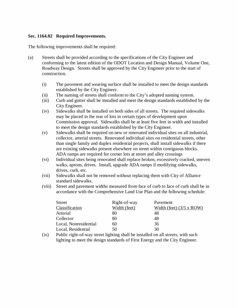
Sec. 1164.02 Required Improvements. The following improvements shall be required: (a) Streets shall be provided according to the specifications of the City Engineer and
conforming to the latest edition of the ODOT Location and Design Manual, Volume One, Roadway Design. Streets shall be approved by the City Engineer prior to the start of construction.
(i) The pavement and wearing surface shall be installed to meet the design standards
established by the City Engineer. (ii) The naming of streets shall conform to the City’s adopted naming system. (iii) Curb and gutter shall be installed and meet the design standards established by the
City Engineer. (iv) Sidewalks shall be installed on both sides of all streets. The required sidewalks
may be placed in the rear of lots in certain types of development upon Commission approval. Sidewalks shall be at least five feet in width and installed to meet the design standards established by the City Engineer.
(v) Sidewalks shall be required on new or renovated individual sites on all industrial, collector, arterial streets. Renovated individual sites on residential streets, other than single family and duplex residential projects, shall install sidewalks if there are existing sidewalks present elsewhere on street within contiguous blocks. ADA ramps are required for corner lots at street and alley crossings
(vi) Individual sites being renovated shall replace broken, excessively cracked, uneven walks, aprons, drives. Install, upgrade ADA ramps if modifying sidewalks, drives, curb, etc.
(vii) Sidewalks shall not be removed without replacing them with City of Alliance standard sidewalks.
(viii) Street and pavement widths measured from face of curb to face of curb shall be in accordance with the Comprehensive Land Use Plan and the following schedule:
Street Right-of-way Pavement Classification Width (feet) Width (feet) (3/5 x ROW)
Arterial 80 48 Collector 80 48 Local, Nonresidential 60 36 Local, Residential 50 30
(ix) Public right-of-way street lighting shall be installed on all streets, with such lighting to meet the design standards of First Energy and the City Engineer.
(b) Utility Improvements. All the following utility improvements shall be installed prior to
street construction and shall meet the following standards: (i) Proper and adequate disposal of storm water shall be provided. The type, extent,
location, and capacity of drainage facilities shall meet the design standards established by the City Engineer and conforming to the latest edition of the ODOT Location and Design Manual, Volume Two, Drainage Design. All surface drainage facilities shall connect to an adequate drainage course. Land that is subject to flooding from time to time shall be provided with such improvements as may be required to remove flooding hazards from proposed subdivision lots.
(ii) Stormwater retention or detention facilities shall be provided for flood control, and for water quality and erosion control measures. Retention or detention facilities shall meet the design standards established by the City Engineer and shall conform to the Stark Soil and Water Conservation District’s Erosion and Sediment Control Regulations.
(iii) Complete sanitary sewer system of an adequate size discharging into an approved outlet in accordance with the specifications established by the City Engineer conforming to the latest edition of the Great Lakes Upper Mississippi River Basin Design Standards for Sanitary Sewers and EPA standards shall be provided. If the subdivision is in an area where sanitary sewer mains are not accessible, the minimum lot area may be approved if adequate sewer system and group disposal facilities are constructed that will tie into future sewer line extensions or where pumping facilities are provided to an adequate sewer. Individual septic tanks shall not be permitted.
(iv) Adequate size water mains properly connected to the public water supply system to serve all lots for domestic use and fire protection shall be provided in accordance with the specifications established by the City Engineer and conforming to the latest edition of the Great Lakes Upper Mississippi River Basin Design Standards for Water and EPA standards.
(v) Gas, telephone, and electric service, as well as street lighting, shall be provided within each subdivision. Whenever such facilities are reasonably accessible and available, they are required to be installed within the area prior to the approval of the final plat. Gas, telephone, electric, and street lighting lines, wires, conduits, and cables shall be constructed underground except in cases where the City Engineer determines that topographic, bedrock or underground water conditions would result in excessive costs to the subdivider.
(vi) Overhead utility lines, where permitted, shall be located at the rear of all lots. The width of the easement per lot shall meet the private utility requirements, but shall be not less than six feet, and total easement width shall be not less than 12 feet.
(c) Open Space. Before Approval of a final plat by the Commission, whoever subdivides
shall submit an open space development plan if open space is required under this Ordinance. The open space development plan shall include the following:
(i) A site plan with project title, developer’s name, designer’s name, north arrow,
correct architectural or engineering dimensions and scale, zoning and development of adjacent properties, location and type of buildings on the site, location and type of yards, landscaping or fencing on the site, location and type of storm drainage, and existing and final contours and building elevations at one-foot intervals.
(ii) Such other information as may be needed in reviewing the plan to determine how best to maintain the open space for its intended use, protect the public safety, minimize adverse effects upon adjacent development, and preserve historic sites.
Sec. 1164.03 Construction, Improvement Plans, and Specifications. Drawings showing plans, cross sections, profiles, elevations, typical sections, construction details, and specifications for all required improvements shall be prepared by a professional engineer. The improvement plans shall be prepared in accordance with the standards set forth in Chapter 1166 and subject to the terms and conditions of regulations. If it becomes necessary to modify the improvements as approved due to unforeseen circumstances, the subdivider shall inform the City Engineer in writing of the conditions requiring the modifications. Written authorization from the Commission, upon approval by the City Engineer, to make the required modification, must be received before proceeding with the construction of the improvement. At completion of the construction, and before acceptance, the subdivider shall furnish the City Engineer a set of reproducible mylar drawings (excluding sepia) for permanent record, showing the locations, sizes, and elevations of improvements as constructed, and shall provide AutoCAD drawings of the entire project containing the as-built information as well. (a) Preconstruction Meeting and Work Schedules. Prior to the commencement of any
construction the subdivider shall notify, in writing, the Safety-Service Director, all utilities, the Stark Soil and Water Conservation District, and the City Engineer of the date of commencement of construction. A preconstruction meeting shall be required with regard to procedure, materials, and inspection of the project.
(b) Construction Inspections.
(i) Responsible Official. The City Engineer shall be responsible for the inspection of all street improvements including storm sewers, water lines, sanitary sewers, and sanitary treatment plants and appurtenances.
(ii) Authority and Duties of Inspectors. Inspectors employed by the City shall be authorized to inspect all work done and all materials furnished. Such inspection may extend to all or any part of the work and to the preparation, fabrication or manufacture of the materials to be used. The inspector shall not be authorized to revoke, alter or waive any requirements of the specifications or plans. The inspector shall be authorized to call the attention of the contractor to any failure of the work or materials to conform to the specifications and contract. The inspector shall have the authority to reject materials which do not meet specification requirements or suspend the portion of the work involved until any question at issue can be referred to and decided by the City Engineer.
(iii) Final Inspection. Upon completion of all the improvements, the subdivider shall request in writing a final inspection by the City. The City Engineer shall make a final inspection of all streets, storm sewers, water lines, and sanitary sewers. Inspections shall be made promptly after the request is made.
(iv) Before any roads developed as part of a subdivision become public, the City Engineer shall first inspect such roads and certify his approval.
(v) The developer should have his representative present at the time of all inspections.
(c) Construction Responsibilities.
(i) Cooperation of Subdivider and/or Contractor. The subdivider and/or contractor shall have available on the project, at all times, a clearly readable copy of all required plans and specifications. He shall cooperate with the inspector and with other contractors in every way possible. The subdivider and/or contractor shall have a competent representative or superintendent acting as his agent on the project. The superintendent shall be capable of reading and thoroughly understanding the plans and specifications, and he shall receive instructions from the inspector. The superintendent shall have full authority to execute the orders or directions of the inspector and to promptly supply such materials, tools, plans, equipment, and labor as may be required. The inspector’s orders should be executed without delay. A superintendent shall be furnished irrespective of the amount of work sublet.
(ii) Grade stakes. Pavement and pipe grade stakes shall be set at 25 foot intervals on horizontal and vertical curves and for all grades less than one percent. Tangent pavement grades and pipe grades over one percent may be set at a maximum interval of 50 feet. The inspector may ask for additional grade stakes if it is deemed necessary. Other means of line and grade may be used as approved by the City Engineer.
(iii) Repair of Damage. Any damage done to the improvements by construction traffic, local traffic, or by any other means shall be repaired or the damaged materials replaced in a satisfactory condition.
(iv) Erosion Control. The subdivider and/or contractor shall take necessary procedures to prevent soil erosion and downwash of grits and sediments onto adjoining properties or into existing drainage facilities. The City Engineer may request stoppage of work during construction if proper controls for soil erosion, siltation, and sedimentation are not being provided by the developer or contractor. The City Engineer may take the necessary steps to provide corrective measures, and the cost of such services will be charged to the developer. This does not relieve the developer or contractor of downstream liabilities. No project will be released from bond from failure to comply with this regulation and without cleanup and repair of damages. Final inspection requires all drainage facilities free from depositions of erosion, siltation, and construction debris.
(v) Final Cleaning Up. Upon completion of the work and before acceptance, the subdivider and/or contractor shall clean all ground occupied or affected in connection with the work. The entire area shall be left in a neat and presentable condition.

[THIS PAGE HAS BEEN LEFT BLANK INTENTIONALLY.]
Chapter 1166, Design Standards Sec. 1166.01 Streets. (a) The arrangement, location, extent, width, grade, and character of all streets shall conform
to the Comprehensive Land Use Plan and shall be appropriate to topography, to proposed uses of land abutting the streets, and to the pattern of surrounding streets and land use.
(b) The pavement design for street improvements shall be as outlined in the Ohio
Department of Transportation’s (ODOT’s) “Pavement Design Manual for Local Roads and Streets”, but shall not be less than the typical design sections of Table 1.
(c) The integrity of the pavement structure depends upon the structural stability of the
subgrade. All soil subgrade shall be prepared in accordance with ODOT’s Construction and Material Specifications Item 203.13.
(d) Existing or projected arterial and collector streets in adjoining areas shall be continued in
new subdivisions, and local residential streets shall be continued, to prevent dead-end streets.
(e) Continuous through streets, other than arterial or collector streets, extending from one
major street to another, should be avoided. (f) Collector streets are satisfactory where there are no continuous cross streets, and if they
exit onto only one arterial or collector street. (g) No street arrangement shall be approved that prevents future access to adjoining
undeveloped property. (h) Local residential streets shall be designed so as not to offer direct routes to through
traffic. (i) Streets shall intersect as nearly as possible at right angles, and no street shall intersect any
angle less than a 70 degree angle. No more than two streets should intersect at one point. (j) Street jogs shall have centerline offsets of at least 125 feet.
(k) The right-of-way lines of the intersecting streets shall be connected at all corners with a
curve having a radius of at least 50 feet for arterials, 40 feet for collectors, and 25 feet for local roads.
(l) When the line of a street changes direction a circular curve shall be provided. For local
residential streets this curve shall be at least 200 feet in radius, and for all other streets at least 500 feet in radius. For all streets these radii shall be measured along the center line.
(m) On all but local residential streets, reverse curves shall be connected by a tangent of at
least 100 feet. (n) Vertical curves shall provide the sight distance suited to their location, as determined by
the specifications of the City Engineer. (o) All proposed streets and driveways which intersect with public streets and highways shall
provide adequate sight distance meeting the requirements of the ODOT L&D Manual. (p) Permanent dead-end streets or cul-de-sacs shall be used only where a continuous street
cannot be developed.
(i) Dead-end streets designed to be so permanently shall be not longer than 600 feet and shall be provided at the closed end with a turn-around which shall have a minimum radius of 50 feet at the property line and a roadway radius of 38 feet.
(ii) T-shaped or Y-shaped turning areas in place of the circle may be permitted when the topography and shape of the lot makes such a design more desirable.
(iii) A temporary dead-end street may be permitted if it is part of a required street, a satisfactory turn-around is provided, and the total length is less than 200 feet.
(q) Half-streets shall be prohibited, except where essential to the reasonable development of
the subdivision in conformity with the other requirements of this Ordinance, and where the Commission finds it will be practicable to require the dedication of the other half when the adjoining property is subdivided.
(i) Whenever an existing half-street is adjacent to a tract to be subdivided, the other
half of the street shall be platted within such tract. (ii) Half-streets shall not be less than one-half the standard width for the appropriate
street classification.
(r) Any plat dedicating a temporary dead-end or a half-street shall include a plat restriction
prohibiting any easement or right of access to the temporary dead-end or half street from any abutting or adjoining property save from lots platted in conformity with this Ordinance.
(s) Street right-of-way widths shall be not less than 80 feet for arterial streets, 60 feet for
collector and local non-residential streets, and 50 feet for local residential streets. (t) Street grades shall be not less than 0.5 percent. Grades shall not exceed five percent on
local streets or eight percent on other streets, except in case of unusual topographic conditions. In no event shall any street grade exceed 10 percent.
(u) Profile grades shall be connected by vertical curves to provide adequate stopping sight
distance for the following design speeds: local street, 35 miles per hour (MPH) (235 feet) sign distance; collector street, 50 MPH (350 feet) sight distance; and arterial streets, 60 MPH (475 feet) sight distance.
(v) Street widths measured from face of curb to face of curb shall be not less than three fifths
the width of the required right-of-way.
Sec. 1166.02 Blocks. (a) Block lengths shall not exceed 1,400 feet nor be less than 500 feet. (b) In blocks longer than 900 feet, easements shall be provided for pedestrian walks, in order
to give substantially more direct access to a school, playground, public transportation, shopping center, church or other community facilities. Such easements shall be located in or near the center of the block or as extensions of sidewalks or walks in adjacent blocks. Crosswalk easements when provided shall be at least 10 feet wide and shall be dedicated as public right-of-way areas for sidewalk purposes.
(c) Blocks that abut an arterial or collector street shall be designed to:
(i) Align blocks with their greater dimension parallel to and adjoining the arterial or collector street, and
(ii) Provide property access or service streets parallel to and adjoining the arterial or collector street, or
(iii) Abut the arterial or collector street with lot lines across which vehicular access is prohibited by plat restriction.
(d) Irregular shaped blocks, indented by cul-de-sacs, containing interior public spaces, shall
be acceptable when adequately designed and fitted to the overall plan and when adequate provision for the maintenance of public areas is provided.
Sec. 1166.03 Lots. (a) Lots shall be arranged and designed to meet all zoning requirements of the district in
which they are located and which are appropriate to the location of the subdivision. (b) Side lot lines shall be at right angles or radial to street lines as nearly as practicable. (c) Double-frontage or reversed-frontage lots shall be prohibited, except where they are
deemed necessary by the Commission to provide separation of residential development from traffic arteries or to overcome unusual topographic conditions.
(d) The numbering of lots shall conform to the City’s adopted lot numbering system.
Sec. 1166.04 Easements. (a) Easements shall be provided on both sides of all drainage ditches, channels, creeks,
streams or open watercourses. The width of drainage easements shall be sufficient to provide for access to the drainage course. It shall be wide enough for its reasonable protection, widening, deepening, realignment or enclosure.
(b) Easements for required improvements may be located outside of the street right-of-way.
The location and size of these easements must take into consideration that these required improvements may have to be periodically maintained, repaired or replaced. The location and size of easement must also be evaluated in terms of the public health and general welfare.
Sec. 1166.05 Public Open Space. Whoever subdivides or develops land shall dedicate or reserve land for open space in all subdivisions or developments with a net area in the preliminary plan in excess of 10 acres. A minimum of five percent of the net area of the subdivision or development shall be dedicated for public parks, playgrounds or other public open space, or for the use of residents within the subdivision or development. For this section, area of the subdivision or development shall be defined as the area of the entire subdivision or development covered by the preliminary plan minus the area of all streets and all lands zoned commercial or industrial within such subdivision or development. The Commission shall not approve a site which is undesirable for the proposed open space use. Wetlands, as well as retention or detention areas, are not suitable as open space. The Commission may require financial guarantees or other assurances of performances if the open space is located on the preliminary plan in an area not to be included in a final plat.
Sec. 1166.06 Signs, Street Name Signs, and Street Naming. (a) Whoever subdivides or develops land shall install all required regulatory and warning
signs, such as stop signs, speed limit signs, parking restrictions, etc., according to City standards and conforming to the Ohio Manual of Uniform Traffic Control Devices.
(b) Street name signs, of a type in use throughout the City, shall be erected by the subdivider
at all intersections. (c) For the purposes of street naming, the following suffixes shall apply:
(i) Avenue shall be used only for streets that run in a generally north-south direction; (ii) Boulevard shall be used only for a large meandering type street containing a
landscaped median; (iii) Circle or Court shall be used only for cul-de-sac type streets that run in a
generally north-south direction; (iv) Drive shall be used only for streets that run in a diagonal manner in a northwest-
southeast direction; (v) Lane or Place shall be used only for cul-de-sac type streets that run in a generally
east-west direction; (vi) Road or Way shall be used only for streets that run in a diagonal manner, in a
northeast-southwest direction; (vii) Street shall be used only for thoroughfares that run in a generally east-west
direction; and (viii) The words north, south, east, and west should be avoided as part of a street name.
(d) Whenever a new street is constructed along the approximate alignment or extension of an
existing street, the name of the new street shall be the same as the name of the existing street.
(e) Whenever a street alignment changes direction more than 75 degrees without a return to
the original alignment within a distance of 500 feet, then the name of the street shall be changed at the point of curvature.
(f) Whenever a cul-de-sac street serves not more than three lots, the name of the intersecting
street shall apply to the cul-de-sac. (g) Street names shall not closely match other street names located in the City or Stark
County. Street names must conform to the requirements of the Stark County House Numbering/Street Naming System and the 911 dispatch system.
Sec. 1166.07 Planting Screens or Fences. The Commission may require planting screens or fences where double frontage lots abut an arterial street, provided that such planting screens or fences shall not constitute a safety hazard. A plan of proposed planting screens or fences shall be submitted for approval with the final plat. Sec. 1166.08 Sewage Disposal and Sanitary Sewer Improvements. Where an adequate public sanitary sewer system is reasonably accessible in the determination of the City Engineer, public sanitary sewer shall be installed to adequately serve all lots, connecting to the public system. Extensions shall meet the requirements of the Ohio Environmental Protection Agency, the Great Lakes Upper Mississippi River Basin Design Standards, and the City Sewer Ordinance. (a) Combination of sanitary sewer and storm sewers shall be prohibited. (b) High strength premium joint vitrified clay pipe and polyvinyl chloride SDR-35 pipe are
permitted. (c) All sewers within dedicated or proposed right-of-way or within a one-to-one slope of the
right-of-way shall use crushed stone or gravel, ODOT 703.11, Type 1 backfill that meets the gradation of ODOT 304 or other premium backfill approved by the City Engineer.
Sec. 1166.09 Where Public Sanitary Sewer System Not Available. Where a public sanitary sewer system is not reasonably accessible in the determination of the City Engineer, the subdivider shall provide the following: (a) A central treatment plant for the lots, provided that such central treatment plan shall be
installed in accordance with all Ohio Environmental Protection Agency and City requirements.
(b) Pumping stations may be provided, together with properly sized force mains, as
determined by the City Engineer, to pump sewage to an adequate existing sewer. Pump stations shall meet all Ohio Environmental Protection Agency and City requirements.
(c) Lots served by individual disposal systems shall not be permitted.
Sec. 1166.10 Water Mains. Adequate size water mains properly connected to the public water supply system to serve all lots for domestic use and fire protection shall be provided. Extensions shall meet the requirements of the Ohio Environmental Protection Agency, the Great Lakes Upper Mississippi River Basin Design Standards, and the City Water Ordinance. (a) Water lines shall be a minimum of eight inch diameter and shall be ductile iron pipe class
52. (b) All water lines within dedicated or proposed right-of-way or within a one-to-one slope of
the right-of-way shall use crushed stone or gravel, ODOT 703.11, Type 1 backfill that meets the gradation of ODOT 304 or other premium backfill approved by the City Engineer.
Sec. 1166.11 Monuments. Monuments of an approved type shall be set at all boundary corners or angles in property outline that are not identified by existing monuments. Monuments of an approved type shall also be set on the side lines of all streets to establish changes in alignment, such as angles in the side line or points of intersection of straight lines intersecting at an angle, point of curve (PC), and tangency (PT) or compound curvature (PCC).
Sec. 1166.12 Minimum Pavement Standards. The following table lists the City’s minimum pavement standards:
Table 1 - City of Alliance Minimum Pavement Standards ------------------- Roadway Classification -------------------
Local Local Material Arterial Collector Non-Res. Residential
203 subgrade compaction & proof rolling yes yes yes yes 609 curb & gutter required yes yes yes yes 605 4” underdrain required yes yes yes yes 608 sidewalk required yes yes yes yes 653, 659 topsoil, seed, & mulch yes yes yes yes Pavement thickness for concrete streets: 304 aggregate base 4” 4” 4” 4” 452 plain concrete 8” 8” 8” 7” Pavement thickness for asphalt streets: 304 aggregate base 6” 4” 4” 4” 408 prime coat yes yes yes yes 301 bituminous asphalt coat 8” 6” 6” 4” 448 asphalt intermed. course 1-1/2” 1-1/2” 1-1/2” 1-1/2” 407 tack coat yes yes yes yes 448 asphalt surface course 1” 1” 1” 1”

[THIS PAGE HAS BEEN LEFT BLANK INTENTIONALLY.]
Chapter 1168, Drainage Sec. 1168.01 Purpose. The intent of this policy is to establish consistent, technically feasible and operationally practical standards to achieve a level of storm water management, and erosion and sediment control that will minimize damage to public and private property and the degradation of water resources, and will promote and maintain the health, safety, and welfare of the residents of the City. Flooding and streambank erosion in the City are a significant threat to public health and safety and public and private property, and storm water quantity control slows runoff and reduces its erosive force, and flood damage. Therefore, these measures shall be taken to help assure that development site owners control the volume and rate of storm water runoff originating from their property so that surface water and ground water are protected, soil erosion is controlled, and flooding potential is not increased. Sec. 1168.02 Disclaimer of Liability. This policy outlines the basic requirements of Storm Water Management Plans. It is not intended as an all inclusive list of work required to prepare the plans, specifications, reports, and calculations for such projects. The Designer shall follow generally accepted standards for surveyors, architects, and/or engineers. Neither submission of a plan under the provisions herein, nor compliance with the provisions of these regulations, shall relieve any person or entity from responsibility for damage to any person or property that is otherwise imposed by law.
Sec. 1168.03 Storm Water Management Report Required. All new and redeveloped commercial sites, industrial sites, condominium developments, planned urban developments, and subdivisions are required to submit a Storm Water Management Report to the City Engineer. The Storm Water Management Report must be signed and stamped by a Registered Professional Engineer licensed to practice in the State. An owner of a development site that was created by demolishing an older existing structure can request, in writing, that the City Engineer exempt him or her from the storm water issues if the total soil surface area being made impermeable is the same or less than the total soil surface area that was impermeable prior to the structure(s) being torn down and removed. Sec. 1168.04 General Requirements. The policies contained herein outline the requirements for a Storm Water Management Report. Not all of the sections of this outline may apply to a proposed development. It will depend on the size of the proposed development, the existing site conditions, and the proposed land use of the development. These guidelines shall not limit the right of the City Engineer to impose at any time additional, more stringent requirements based on the site circumstances. Nor, shall these guidelines limit the right of the City Engineer to waive, in writing, individual requirements based on the site circumstances. The Storm Water Management Report should be submitted with the Site Plan for commercial and industrial sites. It should be submitted with the Construction Drawings for condominium developments, planned developments, and subdivisions. Questions regarding the Storm Water Management Report should be directed to the City Engineer. The Report should contain a description of the existing conditions on site, land usage, ground cover conditions, soil types, etc. The Report should explain the proposed improvements and the intent of the storm water management measures being proposed. The Report should be prepared in a neat and organized manner. The Report should provide maps and drawings, as necessary, to support the Report’s calculations. The Report should verify that the information contained on such maps and drawings corresponds to the information provided in the rest of the Report. As a minimum general requirement, the proposed storm water management measures shall be designed such that the runoff from the site shall not flood existing or proposed structures, cause the loss of property, endanger individuals, or cause the loss of life.

Upstream runoff from outside the development area should be conveyed through the site as closely as possible with the current runoff conditions. Existing drainage features such as swales, ditches, creeks, and ravines, conveying upstream runoff shall remain. Easements for drainage features shall be provided as outlined herein. Provide positive grading for runoff for all lots and groups of lots within condominium developments, planned developments, and subdivisions, as well as for the overall site. Runoff for all development sites and individual lots within a development shall be conveyed in an approved manner to an adequate and appropriate discharge point (except as provided for permanent retention areas). Wherever possible and practical, a developer is encouraged to use measures to slow the storm water runoff rate by increasing friction. Some examples are discharging roof water to vegetated areas on site, using grass and rock-lined drainage channels, and creating grass strips between areas of sheet flow runoff such as parking lots. Additionally, developers are encouraged to reduce the total runoff volume by means of infiltration. Some examples are infiltration basins, infiltration trenches, dry basins, and the use of retention basins instead of detention basins.
Sec. 1168.05 Storm Sewer Systems and Roadway Drainage. Storm Sewer Systems and Roadway Drainage including catch basins, pipes, culverts, swales, ditches, and other open channels shall be designed in accordance with the latest editions of the Ohio Department of Transportation’s Location and Design Manual, Volume Two - Drainage Design and Construction and Material Specifications. (a) Provide spreadsheet calculations for the storm sewer systems. All storm sewer systems
shall be designed to flow just full for a 10 year frequency storm except where more stringent requirements are noted in the Location and Design Manual. For roadway pipe design, check the hydraulic grade line does not exceed the grate elevations based on a 25 year frequency storm.
(b) Provide spreadsheet calculations for the inlet spacing and pavement spread. Allowable
pavement spread shall be six feet for a 10 year frequency storm. (c) Open channels such as swales, ditches, channels, and ravines which are used as part of
the Major Flood Path, as described in Sec. 1168.06, shall have more stringent design requirements.
(i) Provide channel linings and bank stabilization to prevent erosion in all open
channels. Adhere to minimum ditch slope standards and maximum velocity standards outlined in the Location and Design Manual.
(ii) Provide easements over open channels as described in Sec. 1168.08.
(d) Provide a Storm Sewer Systems and Roadway Drainage drawing. Perform field
surveying as necessary to insure that this drawing is an accurate representation of actual field conditions. The scale of this drawing must be sufficient to clearly present the following information:
(i) Existing and proposed elevation contours at an interval of two feet or less.
Contour lines shall be labeled frequently enough to be easily read and interpreted. (ii) All of the individual surface areas that drain to each intercepting structure of the
storm sewer system must be outlined. The areas must be numbered or labeled to match the computer spreadsheet.
(iii) The path used to calculate the time of concentration for each individual drainage area where the time of concentration is greater than 10 minutes. Indicate the types of flow and provide calculations.
(iv) Indicate various types of surface areas within each of the individual drainage areas that have different runoff coefficient values. Use different colors of shading or another method as long as the information can be easily understood and read. Show how the weighted runoff coefficient for each individual drainage area was calculated.
(e) An adequate downstream outlet must be provided for all proposed storm sewers, such as
an existing ditch, stream, river, storm sewer, pond or lake. The downstream outlet must be able to accommodate the flow of storm water from the proposed storm sewer system.
(f) Provide headwalls, energy dissipaters, riprap, erosion control mats, and other measures,
as necessary, at all outlets to prevent erosion.
(g) For all private or public storm sewers within the right-of-way and for all storm sewers
outside of the right-of-way that cross City-owned utilities or run parallel or nearly parallel to City-owned utilities within 10 feet, the following shall apply:
(i) Storm sewers less than or equal to 24 inch diameter shall be constructed using
high strength vitrified clay pipe, reinforced concrete pipe, PVC profile wall pipe, HDPE smooth lined pipe or PVC with bell and spigot joints.
(ii) Storm sewers greater that 24 inch diameter shall be constructed using high strength vitrified clay pipe, PVC profile wall pipe or reinforced concrete pipe only.
(iii) All sewers within dedicated (or proposed dedicated) right-of-way or within a one-to-one slope from the right-of-way shall use crushed stone or gravel, ODOT 703.11, Type 1 backfill that meets the gradation of ODOT 304, or other approved premium backfill, as approved by the City Engineer.
(iv) Use ODOT MH-3 with City standard castings. Alternatively, use City brick manhole standards with City standard castings.
(v) Use City of Alliance standard catch basins and castings. (vi) Storm sewer mains shall be designed to be in the center of one lane of pavement
where possible (for example: sanitary sewer down the middle of road, waterline in the lane on one side of the road, and storm sewer in the lane on the other side of the road). Any variance from this must be approved by the City Engineer.
(vii) If it is necessary, the City may approve sewers off road or through a yard. In such instances, an easement with a minimum width of 20 feet shall be required. (Wider easements may be required for large or deep sewers, or based on terrain and topography.) Provide a gravel access drive, or gravel base topped with topsoil, per City standards, for the length and width of the easement for maintenance vehicle access.
(viii) Where culverts are required under the roadway, they shall extend across the entire right-of-way of the street. The minimum pipe diameter of a culvert shall be 18 inches. Headwalls shall be required.
(ix) Driveway culverts shall have a minimum length of 20 feet, and a minimum diameter of 12 inches. The driveway culverts shall be laid so as to maintain the flow lines of the ditch or gutter. Headwalls may be required by the City Engineer.
(h) Roof Drains and Sump Pump Discharges.
(i) Roof drains may be discharged through the curb onto the street. They may tie directly into the storm system by an approved wye or tap connection, or by an approved core into a catch basin. Roof drains may be run to a designed dry well, infiltration basin, or infiltration ditch. They may discharge onto the ground using splash blocks. The downspouts must be run far enough away from the building to meet building codes and the ground must have positive grade away from the building. Roof drains are not permitted to discharge on the ground where the flow may cause flooding to adjacent properties, nor are they permitted to discharge across the back of any public sidewalk, street, or other public ground within the City.
(ii) Sump pumps may be discharged in the same manner as roof drains, except they are not permitted to discharge through the curb onto the street. Sump pump discharges tied directly to the storm sewer must be accounted for in the design of the storm sewer system.
Sec. 1168.06 Major Flood Path. (a) The intent of planning a major flood path is to ensure that the storm water runoff, which
exceeds the capacity of the storm sewer system, shall have a route to follow which will not cause the loss of property or life.
(b) The combination of the major flood path and sewer/ditch system shall have the capacity
to carry runoff from a 100-year frequency storm. Where the street is designated as the major drainage way, the depth of flow shall not exceed eight inches at the face of curb. When the major drainage way is located outside a street right-of-way, utility and floodway easements shall be provided and a grading plan is to be submitted with detailed elevations showing the flood being contained in this area.
(c) Minimum garage, first floor and minimum window opening elevations along all 100-year
flow routes are to be set by the design engineer. These elevations are to be a minimum of one foot above the 100-year water elevation. These elevations are to be clearly labeled on the plans and the subdivision plat.
(d) Since streets may be used as a routing path, the major system must be taken into account
in the initial design of the development. It shall be designed in such a manner as to direct the storm water into the detention or retention area. Calculations indicating the capacity of the Major Flood Path and the excess storm water runoff from the sewer/ditch system shall be provided.
Sec. 1168.07 Storm Water Runoff Control Standards.
(a) Storm Water Runoff from a developed site such shall be controlled to meet the following criteria:
(i) Runoff Rate: The peak runoff rate from the development area shall not be greater
after development than it was before development. The applicant shall provide calculations proving no increase in the runoff rates from the two, five, 10, 25, 50, and 100 year storms with a 24 hour duration.
(ii) Runoff Rate During Construction: The peak runoff rate from the development area shall not be greater during construction than it was before development. This includes time of clearing and grading the entire site and periods when lots are stripped for building construction. The applicant shall provide calculations proving no increase in the runoff rates during construction from the two, five, and 10 year storm with a 24 hour duration.
(iii) Runoff Volume: Where there is an inadequate receiving stream, when discharging into the City storm sewer system, or where there is sufficient potential for downstream flooding, as determined by the City Engineer, the site runoff rate may be restricted further based on the runoff volumes. Increases in the runoff volume shall be offset by further restricting runoff rates. Based on the increase in runoff volume, the applicant shall determine the critical storm for the development area. The runoff rate from the critical storm shall be restricted to the two year pre-development storm runoff rate. The critical storm shall be calculated as follows: (1) Determine the total volume of runoff from either the one-year or the two-
year frequency, 24-hour storm, occurring on the development area before and after development.
(2) From the volumes in paragraph (1) determine the percent of increase in volume of runoff due to development according to the equation ((Q after minus Q before) divided by Q before) x 100 and, using this percentage, select the critical storm from the following table:
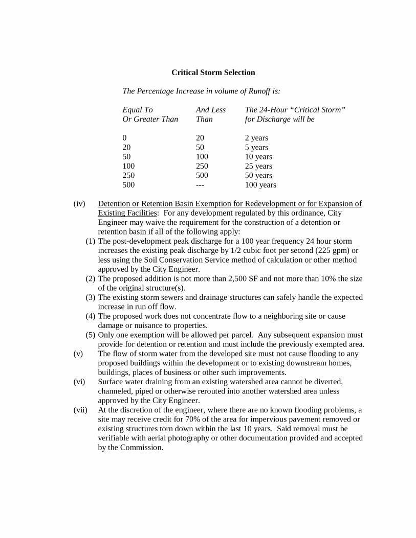
Critical Storm Selection
The Percentage Increase in volume of Runoff is: Equal To And Less The 24-Hour “Critical Storm” Or Greater Than Than for Discharge will be
0 20 2 years 20 50 5 years 50 100 10 years 100 250 25 years 250 500 50 years 500 --- 100 years
(iv) Detention or Retention Basin Exemption for Redevelopment or for Expansion of
Existing Facilities: For any development regulated by this ordinance, City Engineer may waive the requirement for the construction of a detention or retention basin if all of the following apply:
(1) The post-development peak discharge for a 100 year frequency 24 hour storm increases the existing peak discharge by 1/2 cubic foot per second (225 gpm) or less using the Soil Conservation Service method of calculation or other method approved by the City Engineer.
(2) The proposed addition is not more than 2,500 SF and not more than 10% the size of the original structure(s).
(3) The existing storm sewers and drainage structures can safely handle the expected increase in run off flow.
(4) The proposed work does not concentrate flow to a neighboring site or cause damage or nuisance to properties.
(5) Only one exemption will be allowed per parcel. Any subsequent expansion must provide for detention or retention and must include the previously exempted area.
(v) The flow of storm water from the developed site must not cause flooding to any proposed buildings within the development or to existing downstream homes, buildings, places of business or other such improvements.
(vi) Surface water draining from an existing watershed area cannot be diverted, channeled, piped or otherwise rerouted into another watershed area unless approved by the City Engineer.
(vii) At the discretion of the engineer, where there are no known flooding problems, a site may receive credit for 70% of the area for impervious pavement removed or existing structures torn down within the last 10 years. Said removal must be verifiable with aerial photography or other documentation provided and accepted by the Commission.
(b) Two methods for calculating storm water runoff volumes and control measures are
approved. They are the Modified Rational Method and the Soil Conservation Service Method. Either may be used for sites up to six acres in size. The Soil Conservation Method must be used for all sites six acres or larger.
(c) Provide a drainage area map (or maps) for the pre-developed and post-developed sites.
Perform field surveying as necessary to insure that this drawing is an accurate representation of actual field conditions. The scale of this drawing must be sufficient to clearly present the following information:
(i) Existing and proposed elevation contours at an interval of two feet or less.
Contour lines shall be labeled frequently enough to be easily read and interpreted. (ii) Hydrologic boundaries of watersheds, including areas outside the proposed
development that flow into the project area. (iii) Points of analysis, or the location where the drainage is being evaluated, for each
watershed. (iv) Path used to calculate the time of concentration for each watershed. Indicate
types of flow and provide calculations. (v) Delineate and label the types of land use, surface features, ground cover, soil
types, etc. used to determine the runoff coefficients or curve numbers for the project areas.
(vi) Show areas of existing ponds, springs, wetlands, streams, and hydrologically sensitive areas within 1,000 feet of the proposed development.
(vii) Show existing and proposed storm water features such as ditches, swales, inlets, pipes, roadways, etc. within 500 feet of the proposed development, unless the ultimate outfall system is a lesser distance.
(viii) Show the proposed development layout.
(d) Calculations.
(i) Provide routing calculations and their corresponding inflow and outflow hydrographs for the two-year storm up through the 100 year storm. Prepare a summary table of results of the routing calculations. The table shall include, at a minimum, peak inflow, peak outflow, water surface elevations, and storage volume requirements.
(ii) Provide pond volume vs. elevation summaries. (iii) Provide calculations for the inlet/outlet works including weirs, orifices, culverts,
spillways, grates, etc. Show their capacities and stage-discharge calculations, including tailwater assumptions.
(iv) Verify capacities of receiving drainage features such as ditches, storm sewers, pond, streams, etc. to verify sufficient capacity to accommodate the runoff of the development. The receiving drainage feature must be approved by the City. Check all storms with a return frequency of 100 years or less. Determine flooding potential for surrounding homes, commercial businesses and industries.
(v) Provide runoff coefficients or curve number calculations for each watershed or sub-area, including impervious calculations.
(vi) Provide time of concentration calculations for each watershed or sub-area. (vii) Calculate hydraulic grade line for outlet structures with pipes. (viii) Determine velocities of discharged waters and show details to control erosion. (ix) Provide calculations for water quality and erosion control measures as required
for the Storm Water Pollution Prevention Plan (SWP3) (See Sec. 1168.09). (x) Provide narratives, as needed, to describe the methods, assumptions, formulas,
and intent of the calculations.
(e) Detention Basins.
(i) The minimum length to width ratio of the basin shall be two-to-one. (ii) The grading of the detention basin shall be such that it reflects the surrounding
topography. The embankment slopes for the detention basin should be four feet horizontal to one foot vertical preferred or a maximum of two feet horizontal to one foot vertical.
(iii) The maximum water depth shall not exceed 10 feet. (iv) The minimum top width of the side embankments shall be five feet for non-
vehicular traffic and 12 feet for vehicular traffic. The embankment shall be set at an elevation at least 12 inches above the emergency spillway and at least 18 inches above the peak 100 year pond elevation.
(v) Outlet structures using weir type flow regulators are preferred to reduce the risk of clogging.
(vi) Principal outlet (or outlets in a multi-stage configuration) shall have the capacity to pass the 100 year design storm flow.
(vii) Outlet pipes shall have a minimum diameter of six inches. Orifice plates must be used for restrictions of smaller diameter. Consideration should be given to removable trash racks or other means to prevent clogging.
(viii) Access to entire outlet structure for maintenance and inspection shall be provided and shall follow current OSHA standards.
(ix) An emergency spillway shall be provided and set at an elevation equal to 6 inches above the peak 100 year pond elevation. The spillway length shall be 10 feet at its narrowest point (may be less for very small ponds, as approved by the City). The location of the emergency spillway shall be such that its overflow can be directed to an acceptable location. Permanent erosion control measures at the emergency spillway may be required by the City based on potential erosion at the site.
(x) Detention structures shall be graded to drain to the outlet structure. The minimum grade in the pond shall be two percent. No paved gutters shall be used as the low flow channel.
(xi) A permanent easement shall be provided a minimum of 20 feet beyond the detention basin’s outside perimeter. See Sec. 1168.08.
(xii) A 20 foot permanent easement shall be provided from the pond to the closest public street or alley. Provide a gravel access drive, or gravel base topped with topsoil, per City standards, for the length and width of the easement. See Sec. 1168.08.
(xiii) All pipes through the embankment shall have anti-seep collars. (xiv) Soils borings and testing shall be performed by an approved soils testing
laboratory. Submit a report certifying suitability of the soils on-site for embankment and basin construction. If soils are highly permeable, a six inch clay layer, or other measures may be required.
(xv) Where the detention basin outlet flows onto private property or onto property
owned by a government other than the City (such as the State of Ohio right-of-way), a discharge easement agreement (or Government permit) with that property owner must be prepared and executed. Proof of such easement shall be presented prior to the City’s approval of the drainage.
(xvi) Show dimensions of the detention basin on the plans that meet or exceed calculated pond values.
(f) Retention Basins. All of the criteria for the Detention Basins shall apply, with the
following additional requirements:
(i) The grading of the Retention Basin shall be such that it reflects the surrounding topography. The embankment slopes for the Retention Basin shall be four feet horizontal to one foot vertical leading to the pond. It shall terminate at an aquatic safety bench.
(ii) The aquatic safety bench shall be a minimum of 10 feet wide with a maximum slope of three percent. The aquatic safety bench shall have a maximum water depth of one foot. Side slopes beyond the aquatic safety bench shall not be steeper than two feet horizontal to one foot vertical under the water.
(iii) Additionally, the developer or designer may add a second dry safety bench meeting the same width and slope requirements. Having a dry safety bench does not eliminate the requirement of an aquatic safety bench.
(iv) Retention basins must have a minimum of 10 acres draining to pond, or as approved by the City.
(v) Provide aeration equipment of adequate size for the pond to prevent the water from becoming stagnant.
(vi) Provide piping and valves necessary to completely drain the pond periodically for maintenance.
(g) Bio-Retention basins may be required whenever the proposed detention/retention facility
discharges into an existing wetland, a creek or as required by the City. The design of the Bio-Retention basin is to follow the guidelines shown in Design of Stormwater Wetland Systems, prepared by Thomas R. Schueler. The manual can be obtained from the Metropolitan Washington Council of Governments. The allowable side slopes shall follow the Detention Basin requirements of these standards. The plant materials shall be suitable for the environment created.
(h) In certain applications, alternative detention facilities may be permitted and encouraged. These methods may be especially useful on small sites or where the increase in runoff is small. They may also be useful in conjunction with these methods described above. Requests for alternative detention facilities shall be submitted to the City within the appropriate design standards.
(i) Infiltration basin, dry wells, and infiltration ditches.
(1) Soils borings and testing shall be performed by an approved soils testing laboratory. Submit a report certifying the suitability of the soils on-site for infiltration.
(2) Infiltration measures must make provisions for overflow to a suitable area. (ii) Underground Detention Tanks or Pipes
(1) May be used for commercial or industrial sites only. (2) Must provide access for inspection and maintenance. (3) Must have sufficient load bearing capacity. (4) Must have a minimum bottom slope of 0.5 percent.
(iii) For very small sites (under two acres) detention in parking lots using catch basins. (1) A maximum water depth of eight inches in parking areas may be used.
Beyond such depth, an overflow or outlet must be provided. (2) Maximum water depth shall not exceed the finished floor elevations of
existing or proposed structures. (3) Slopes for parking lots used for this purpose shall be a minimum of one
percent and a maximum of 10 percent. (iv) If none of these practices are applicable, the City reserves the right to waive storm
water management requirements for developments under two acres. This may only be done after the designer has shown that all other options are not feasible.
(i) Maintenance of Storm Water Management Practices.
(i) An as-built survey must be completed by qualified registered engineer or surveyor and submitted to the City showing the location, detention volume (include depth and capacity) of all stormwater practices.
(ii) The City Engineer and/or Safety-Service Director shall approve an inspection and maintenance agreement binding on all subsequent owners of land served by the planned storm water management practices before the City accepts the final plat of the proposed project.
(iii) All inspection and maintenance agreements shall do the following: (1) Designate the party responsible for maintenance of structural and
nonstructural storm water management practices including mowing and ensuring outlet structures are clear and in good repair. Unless otherwise approved by the City, this shall be an entity of common ownership within the proposed subdivision (such as an Association) or the owner on an industrial or commercial site.
(2) Prohibit unauthorized alterations of structural and nonstructural storm water management practices.
(3) Provide access to storm water management practices for inspection by the City to document the condition of the practices. Authorize the City to make corrections to the facility, if deemed necessary, and assess the affected property owners. See Sec. 1168.07(j) below.
(iv) The location, dimensions, and bearing (including the depth and capacity) of all storm water management practices shall be incorporated on the final plat, prior to approval by the City, and reference thereon shall be made to the entity or individual(s) responsible for maintenance.
(j) Inspection of Storm Water Management Practices.
(i) The City may inspect storm water management practices periodically. (ii) Upon finding a malfunction or other need for maintenance, the City shall notify
the responsible party of the need for maintenance. (iii) Upon notification, the responsible party shall have 15 working days, or other time
stipulated by the City, to make repairs. (iv) Should repairs not be made within this time, or a plan approved by the City for
these repairs not be in place, the City may undertake necessary repairs and assess the responsible party.
Sec. 1168.08 Easements. (a) Future access to floodplains, flood control facilities, runoff drainage ditches and
channels, runoff storage facilities, storm sewers and other drainage ways and structures, as required by the City Engineer, shall be secured by means of easements.
(b) The easements shall be recorded in the name of the entity responsible for maintenance (in
single-family residential developments, the homeowners’ association.) (c) The easements shall be restricted against the planting within said easement of trees,
shrubbery or planting with woody growth characteristics, and against the construction therein of buildings, accessory buildings, fences, walls or any other obstructions to the free flow of storm water and the movement of inspectors and maintenance equipment. It shall also be restricted against the changing of final grade from that described by the grading plan.
(d) Easements shall not be less than 20 feet in width, with a minimum 10 foot width on either
side of the centerline. Easements over storm sewers or open channels wider than three feet shall be 20 feet in width plus the width of the drainage feature, rounded up to the nearest five foot increment.
(e) Easement shall provide access to the closest public street or alley. (f) Access easements and easements over storm sewers where it is reasonably expected that
maintenance vehicles will require access, shall provide a gravel access drive, or gravel base topped with topsoil, per City Standards, for the length and width of the easement.
(g) Provide discharge easements for public roadway runoff to enter into and through the
runoff storage system facilities.
Sec. 1168.09 Storm Water Pollution Prevention Plan (SWP3) and EPA Permit Required. (a) All development sites whose land disturbance is one acre or more require a Storm Water
Pollution Prevention Plan to be submitted to the Stark Soil and Water Conservation District, 2650 Richville Dr. SE, Ste. 103, Massillon OH 44646.
(i) Include an approved copy of the SWP3 plan with construction plans and/or with
the Storm Water Management Report to the City. The SWP3 plan must be approved prior to the start of any soil disturbing activities and before the Storm Water Management Report can be approved.
(ii) Calculations for the water quality and erosion control measures required for the SWP3 plan shall be included as a section in the Storm Water Management Report.
(iii) Soil erosion and sediment control practices used to satisfy these standards shall meet the standards and specifications in the current edition of the Ohio Rainwater and Land Development manual, NRCS Field Office Technical Guide for Stark County or the Ohio EPA, whichever is most stringent.
(b) A Notice of Intent (NOI) for requesting coverage under an Ohio EPA General Permit to
discharge construction site stormwater is required to be filed with the OEPA at least 45 days prior to the start of construction, per the Ohio Water Pollution Control Act - 33 U.S.C. 1251.
Sec. 1168.10 Compliance with Other Rules and Regulations (where applicable). (a) Ohio Dam Safety Laws: The provisions of the Ohio Dam Safety Laws shall be followed.
Proof of compliance with the Ohio Dam Safety Law administered by the ODNR Division of Water shall be, but is not limited to, a copy of the ODNR Division of Water permit number or a copy of the project approval letter from the ODNR Division of Water or a letter from the site owner explaining why the Ohio Dam Safety Law is not applicable. The written proof will be provided to the City Engineer before the Storm Water Management Report can be approved.
(b) NPDES Permits: The provisions of the National Pollutant Discharge Elimination System
(NPDES) Permits, issued by the Ohio EPA shall be followed. Proof of compliance shall be, but is not limited to, a copy of the Ohio EPA NPDES Permit number or a letter from the site owner explaining why the NPDES Permit is not applicable. The written proof will be provided to the City Engineer before the Storm Water Management Report can be approved.
(c) Federal and State Wetland Permits: The provisions of the U.S. Army Corps of Engineers
dredge and fill permits for federally-protected wetlands shall be followed. The provisions of Ohio EPA’s Isolated Wetlands Permits shall also be followed. Wetlands and other waters of the United States shall be delineated by protocols accepted by the US Army Corps of Engineer and the Ohio EPA at the time of the application of these regulations. Written proof of compliance with both permit programs will be provided to the City Engineer before the Storm Water Management Report can be approved. Proof of compliance shall be, but is not limited to, the following:
(i) A copy of the US Army Corps of Engineer Individual Permit, if required for the
project, showing project approval and any restrictions that apply to site activities; or
(ii) A site plan showing that any proposed fill of waters of the United States conforms to the general and specific conditions specified in the applicable Nationwide Permit; or
(iii) A letter from the site owner verifying that a qualified professional has surveyed the site and found no wetlands or other waters of the United States. Such a letter shall be noted on site plans submitted to the City.
(d) Designs shall conform to all applicable City codes, policies, regulations, and Ordinances.
Chapter 1170, Administration and Enforcement Sec. 1170.01 Overview The Mayor or a duly authorized representative as specified in this Chapter is hereby charged with the duty of enforcing the provisions of this Ordinance. Accordingly, the administration of this Ordinance is hereby vested in the following entities: (a) Council. (b) Commission. (c) Board. (d) Administrative Official, Clerk of Council, and City Planner. The purpose of this Chapter is to set forth the responsibilities and scope of authority of these entities.
Sec. 1170.02 Responsibilities and Authority of the Council. The Council shall have the following responsibilities and authority pursuant to this Ordinance: (a) Adoption of Zoning Ordinance and Amendments. In accordance with the intent and
purposes expressed in the Preamble to this Ordinance, and pursuant to the authority conferred by the Revised Code, the Council shall have the authority to adopt this Ordinance, as well as amendments previously considered by the Commission or at a hearing or as decreed by a court of competent jurisdiction.
(b) Review and Approval of Plans. Council review and approval shall be required for all
planned developments, in accordance with provisions outlined in this Ordinance. (c) Setting of Fees. The Council shall have the authority to set all fees for permits,
applications, and requests for action pursuant to the regulations set forth in this Ordinance. In the absence of specific action taken by the Council to set a fee for a specific permit or application, the Administrative Official shall assess the fee based on the estimated costs of processing and reviewing the permit or application.
(d) Approval of Commission Members. Four members of the Commission shall be appointed
by the Mayor with the approval of the Council. (e) Approval of Board Members. Five members of the Board shall be appointed by the
Mayor with the approval of the Council. (f) Adoption of a Comprehensive Land Use Plan. The Council shall be responsible for
adoption and updating of a Comprehensive Land Use Plan, prepared and recommended by the Commission, for the physical development of the City, in accordance with the Revised Code.
Sec. 1170.03 Responsibilities and Authority of the Commission. (a) Creation. The Commission is created pursuant to the Revised Code. (b) Membership and Operation. Members of the Commission include the Mayor, the
Director of Public Service, the Park Board Chair, and four additional members appointed by the Mayor with the approval of the Council. The qualifications of members, the term of each member, filling of vacancies, compensation of members, and operation of the Commission shall be in accordance with the Revised Code, provided that each member shall have been a citizen of the City for not less than one (1) year prior to appointment to the Commission and shall serve until his or her successor is appointed and sworn in as a member. The Commission by resolution shall determine the time and place of meetings. The Commission shall adopt rules for the transaction of business, and shall keep a public record of its resolutions, transactions, findings, and determinations. Nothing shall prevent a member from serving simultaneously on the Commission and the Board.
(c) Meetings. Meetings of the Commission shall be held in accordance with an adopted
schedule, or at the call of the Chair, or at such other times as the Commission may specify in its rules and procedures. The Commission shall state the grounds of each determination, and shall maintain a record of its proceedings, which shall be filed in the office of the Clerk of Council.
(d) Concurring Vote Required. Four members of the Commission shall constitute a quorum
required to conduct any meeting. The concurring vote of a majority of those Commission members present at any meeting shall be necessary to take any action.
(e) Jurisdiction. The Commission shall discharge the following duties pursuant to this Ordinance:
(i) Formulation of Zoning Ordinance and Amendments. The Commission shall be
responsible for formulation of this Ordinance, review of amendments to this Ordinance, holding hearings on this Ordinance or amendments, and reporting its findings and recommendations concerning this Ordinance or amendments to the Council.
(ii) Site Plan Review. The Commission shall be responsible for review of applications for site plan approval in accordance with provisions outlined in this Ordinance. As provided for in this Ordinance, the Commission shall be responsible for either making a determination to grant approval, approval subject to revisions, or denial of site plan approval.
(iii) Conditional Use Review. The Commission shall be responsible for holding hearings and review of all applications for conditional use approval in accordance with provisions outlined in this Ordinance, and granting approval, approval subject to revisions, or denial of approval.
(iv) Subdivision Variances. The Commission shall have the authority to grant variances from the provisions of Chapters 1136, 1150.06, 1164, 1166, and 1168, based upon a showing of “unusual or exceptional factors” and meeting all of the standards set forth in Sec. 1180.22(j)(iv) of this Ordinance.
(v) Planned Development Review. The Commission shall be responsible for holding hearings and review of all applications for planned developments in accordance with provisions outlined in this Ordinance. The Commission shall be responsible for making a recommendation to the Council to grant approval, approval with conditions, or denial of a planned development proposal.
(vi) Formulation of a Comprehensive Land Use Plan. The Commission shall be responsible for formulation, regular review, updating, as well as recommending to the Council the adoption of, a Comprehensive Land Use Plan for the physical development of the City, in accordance with the Revised Code.
(vii) Review of Matters Referred by the Council or Administrative Official. The Commission shall be responsible for review of plats or other matters relating to land development referred to it by the Council or Administrative Official. The Commission shall recommend appropriate regulations and action on such matters.
(viii) Report on Operation of the Zoning Ordinance. The Commission shall periodically prepare for the Council a report on the operations of this Ordinance, including recommendations as to the enactment of amendments or supplements to this Ordinance, as well as periodic review of Board decisions.
(ix) Off-Street Parking and Loading Variances. The Commission shall have the authority to grant area variances only from the provisions of Chapter 1150 only, based upon a showing of “practical difficulties” and a weighing of the factors set forth in Sec. 1180.22(j)(i) of this Ordinance.
(f) Decision Final. The decision of the Commission shall be final, but shall be subject to
appeal pursuant to the Revised Code, except in those instances where its decision is in the form of a recommendation to the Council.
Sec. 1170.04 Responsibilities and Authority of the Board. The Board shall have the following responsibilities and authority pursuant to this Ordinance: (a) Creation. The Board is created pursuant to the Revised Code and this Ordinance. (b) Membership and Operation. The Board shall include five members, all of whom shall be
appointed by the Mayor with the approval of the Council. Members shall serve for staggered terms of five years each. Each member shall have been a citizen of the City for not less than one (1) year prior to appointment to the Board and shall serve until his or her successor is appointed and sworn in as a member. The Board by resolution shall determine the time and place of meetings. The Board shall adopt rules for the transaction of business, and shall keep a public record of its resolutions, transactions, findings, and determinations. Nothing shall prevent a member from serving simultaneously on the Commission and the Board.
(c) Meetings. Meetings of the Board shall be held in accordance with an adopted schedule,
or at the call of the Chair, or at such other times as the Board may specify in its rules and procedures. The Board shall state the grounds of each determination, and shall maintain a record of its proceedings, which shall be filed in the office of the Clerk of Council.
(d) Concurring Vote Required. Three members of the Board shall constitute a quorum
required to conduct any meeting. The concurring vote of three members of the Board shall be necessary to reverse an order, requirement, decision, or determination of an administrative official or body; to decide in favor of an applicant on any matter upon which the Board is required to act; or, to effect any variation to this Ordinance.
(e) Jurisdiction. The Board shall discharge the following duties pursuant to this Ordinance:
(i) Interpretation of the Zoning Map. The Board shall act on all questions as they may arise in the administration of this Ordinance, including the interpretation of the zoning district map, and the interpretation of the exact location of a boundary line between zoning districts shown on the zoning district map.
(ii) Appeals. The Board shall also hear and decide appeals from and review any order, requirements, decision, or determination made by an administrative official or body charged with enforcement of this Ordinance.
(iii) Area Variances. The Board shall have the authority to grant area variances, based upon a showing of “practical difficulties” and a weighing of the factors set forth in Sec. 1180.22(j)(i) of this Ordinance.
(iv) Use Variances. The Board shall have the authority to grant use variances, based upon a showing of “unnecessary hardships” and meeting all of the standards set forth in Sec. 1180.22(j)(ii) of this Ordinance.
(v) Sign Variances. The Board shall have the authority to grant sign variances, based upon a showing of “particular hardships” and meeting all of the standards set forth in Sec. 1180.22(j)(iii) of this Ordinance.
(vi) Other Variances. The Board shall have the authority to grant variances made necessary by the advances of technology being put to use in new developments, but not anticipated by the provisions of this Ordinance.
(vi) Referred Matters. The Board shall also hear and decide matters referred to them or upon which they are required to pass under this Ordinance.
In carrying out its duties, the Board may reverse or affirm, wholly or partly, or may modify the order, requirement, decision, or determination as in its opinion ought to be made in the premises, and to that end shall have all the powers of the officer or body from whom the appeal is taken and may issue or direct the issuance of a permit. The Board shall in all instances comply with provisions outlined in this Ordinance.
The Board shall not have the power to alter or change the zoning district classification of any property, and shall also not have the power to consider an appeal of any decision concerning a planned development, conditional use, or site plan. Notwithstanding these requirements, the Board shall have the power to consider variances associated with a conditional use site plan which relate to setbacks and dimensional requirements.
The Board shall further not have the power to grant variances from the provisions of Chapters 1164, 1166, and 1168, as such power is reserved for the Commission pursuant to Sec. 1170.03(e)(iv), above.
(f) Decision Final. The decision of the Board shall be final, but shall be subject to appeal
pursuant to the Revised Code and this Ordinance.
Sec. 1170.05 Responsibilities of the Administrative Official, Clerk of Council, and City Planner.
(a) Overview. Certain actions necessary for the implementation of these regulations shall be
administered by the Administrative Official (with assistance from the Clerk of Council, City Planner, and other City staff and consultants). In carrying out designated duties, the Administrative Official shall be required to administer this Ordinance precisely as it is written. No Administrative Official shall make changes or vary the terms of this Ordinance.
(b) Responsibilities of the Administrative Official. In addition to specific responsibilities
outlined elsewhere in this Ordinance, the Administrative Official shall have the following responsibilities:
(i) Provide citizens and public officials with information relative to this Ordinance
and related matters. (ii) Assist applicants in completing appropriate forms and following procedures
related to site plan review, rezoning, and other zoning matters outlined in this Ordinance.
(iii) Review all applications for site plan review, conditional use review, and planned development, and take any action required under guidelines stated in this Ordinance.
(iv) Issue certificates of occupancy in accordance with this Ordinance when all provisions of this Ordinance and other applicable ordinances and codes are met.
(v) Forward to the Commission completed applications for site plan review, conditional use review, planned unit development proposals, petitions for amendments to this Ordinance, and other matters that must be reviewed by the Commission.
(vi) Forward to the Board all materials related to applications for appeals, variances, or other matters on which the Board is required to act.
(vii) Forward to the Council all recommendations of the Commission concerning matters on which action is either mandatory or discretionary on the part of the Council.
(viii) Periodically report to the Commission on the status of City’s zoning and planning administration.
(ix) Record or cause to be recorded and prepare the official minutes of all meetings of the Commission and Board.
(x) Maintain official records and file all official minutes and documents in an orderly fashion.
(xi) Maintain the current official Zoning Map of the City and an up-to-date Zoning Ordinance text by recording all adopted amendments.
(xii) Review and investigate permit applications to determine compliance with the provisions of this Ordinance.
(xiii) Issue permits when all provisions of this Ordinance and other applicable ordinances are met.
(xiv) Perform inspections of buildings, structures, and premises to insure that the land use or improvements to the land are and will remain in compliance with this Ordinance.
(xv) Initiate and perform investigations into alleged violations of this Ordinance and proceed with appropriate corrective measures as required, including issuance of violation notices, issuance of orders to stop work, and revocation of permits.
(xvi) Perform other related duties required to administer this Ordinance. (c) Responsibilities of the Clerk of Council. In addition to specific responsibilities outlined
elsewhere in this Ordinance, the Clerk of Council or duly authorized representatives shall have the following responsibilities:
(i) Publish all notices required by this Ordinance. (ii) Perform other related duties required to administer this Ordinance.
(d) Responsibilities of the City Planner. The City Planner may be a member of City staff or a firm or organization retained on a consulting basis, or the responsibilities may be shared by staff and a consultant. In addition to specific responsibilities outlined elsewhere in these regulations, upon request from the Council, the Commission, the Board, the Clerk of Council, the Administrative Official, an authorized department head, or other authorized City body or official, the City Planner shall fulfill the following responsibilities:
(i) Prepare and administer such plans and ordinances as are appropriate for the City
and its environs, within the scope of the applicable enabling laws. (ii) Advise and assist the Commission and be responsible for carrying out the
directives of the Commission. (iii) Advise and assist the Council and other authorized City bodies or officials and be
responsible for carrying out their directives. (iv) Provide citizens and public officials with information relative to this Ordinance
and related matters. (v) At request of the City, review applications for site plan review, conditional use
review, planned development proposals, and take any action required under the guidelines stated in this Ordinance.
(vi) At the request of the Commission or Council, draft amendments to this Ordinance and other ordinances to accomplish the planning objectives of the City.
(vii) Periodically report to the Commission on the status of City’s zoning and planning administration.
(viii) Perform other related duties required to administer these regulations.

[THIS PAGE HAS BEEN LEFT BLANK INTENTIONALLY.]
Chapter 1180, Procedures The following is an index of Sections within this Chapter. Sec. 1180.01 Purpose. Sec. 1180.02 Minor Subdivision Review Procedures. Sec. 1180.03 Minor Subdivision Application and Review Requirements. Sec. 1180.04 Minor Subdivision Approval Standards. Sec. 1180.05 Major Subdivision Preliminary Plat Review Procedures. Sec. 1180.06 Major Subdivision Preliminary Plat Application and Review Requirements. Sec. 1180.07 Major Subdivision Preliminary Plat Approval Standards. Sec. 1180.08 Major Subdivision Improvement Plans Review Procedures. Sec. 1180.09 Major Subdivision Improvement Plans Application and Review Requirements. Sec. 1180.10 Major Subdivision Improvement Plans Approval Standards. Sec. 1180.11 Major Subdivision Final Plat Review Procedures. Sec. 1180.12 Major Subdivision Final Plat Application and Review Requirements. Sec. 1180.13 Major Subdivision Final Plat Approval Standards. Sec. 1180.14 Major Subdivision Guarantees. Sec. 1180.15 Other General Plat Application and Review Procedures and Requirements. Sec. 1180.16 Site Plan Review Procedures. Sec. 1180.17 Minor Modifications to a Site Plan/Administrative Review. Sec. 1180.18 Site Plan Application and Review Requirements. Sec. 1180.19 Site Plan Approval Standards. Sec. 1180.20 Development and Maintenance in Accordance with an Approved Site Plan. Sec. 1180.21 Conditional Use Regulations. Sec. 1180.22 Variances and Appeals. Sec. 1180.23 Amendments. Sec. 1180.24 Permits and Certificates. Sec. 1180.25 Fees. Sec. 1180.26 Violations and Penalties. Sec. 1180.27 Records. Sec. 1180.01 Purpose. It is the purpose of this Chapter to provide procedures and related standards for the review and regulation of minor and major subdivisions, site plans, conditional uses, variances, appeals, amendments, permits, certificates, fees, violations, penalties, and records within the City.
Sec. 1180.02 Minor Subdivision Review Procedures. (a) Minor Subdivision Review Required. Whoever subdivides land, as defined in this
Ordinance, whether by instrument of conveyance or otherwise, for which no plat is required by reason of Sec. 711.001 and 711.131 of the Revised Code, shall submit such subdivision, together with a sketch identifying such subdivision, to the Commission for review and approval. The Commission may delegate its authority under this section to the Administrative Official or staff.
(b) Submission of Minor Subdivision for Review by Commission. In order to initiate formal
review by the Commission, the applicant is required to submit the following materials to the Administrative Official:
(i) One completed and signed copy of an application for Commission Review; (ii) 20 individually folded copies of the minor subdivision plan; (iii) Completed and signed checklist; (iv) One 8-1/2 by 11 inch size, or 11 by 17 inch size, reduced copy of the minor
subdivision plan; (v) Evidence that the plan has been submitted for review to affected and applicable
county, state, and federal agencies; and (vi) The required review fee.
These materials must be submitted to the Administrative Official in sufficient time to allow review by City staff and consultants prior to the Commission meeting at which the review will occur, if any. The plans and required documentation must be submitted to the City on the 20th day of the month prior to the next regularly scheduled meeting for consideration for review by the Commission. The Administrative Official has the authority to determine what is “sufficient time”, based on the scope and complexity of the proposal.
(c) Distribution of Plans. Upon submission of all required application materials and
following completion of all items required by the adopted minor subdivision review manual, the proposed minor subdivision shall be placed on the next open Commission agenda. The minor subdivision and application shall be distributed by the Administrative Official to appropriate City officials and the City Engineer and City Planner for review.
(d) Review and Action.
(i) Informal Review of Conceptual Plans by City Staff. Applicants are encouraged to meet with the City Staff, including but not limited to the Planning and Development Director, City Engineer, City Planner, and such other persons as determined by the Administrative Official, for informal review of conceptual minor subdivisions. The purpose of this informal review is to discuss applicable standards and technical issues, comment on the project’s compliance with the standards of this Ordinance, and determine the appropriate type of review process. The applicant or City Engineer or City Planner may also request input from other City staff or consultants. Conceptual plans should, at minimum, include the proposed lots, blocks, existing conditions, existing streets, general site layout, and conceptual grading. Conceptual minor subdivision review comments are non-binding, and should be considered by the applicant to be suggestions and recommendations only. A review fee may be required for conceptual minor subdivision review, as determined by City.
(ii) Informal Review by the Commission. The Commission may request an informal workshop and formal regular or special meetings on a proposed project. The meeting at which a minor subdivision proposal is considered shall be a workshop meeting of the Commission. The Commission shall review the reports of the appropriate City staff and consultants and discuss the findings and recommendations with the applicant. No formal action on a minor subdivision will occur at the workshop meeting.
(iii) Request for Revisions. Upon review of the minor subdivision proposal at a workshop, the Commission may require the applicant to revise the plans or supply additional information. The applicant shall submit any requested revised plans for review prior to formal action being taken. All review fees must be paid prior to any review. It shall be the applicant’s responsibility to consult with City staff and consultants during this revision process. Action on the minor subdivision shall remain tabled until the next regular Commission meeting following review of a substantially complete plan at a Commission workshop.
(iv) Public Hearing. A minor subdivision involving use(s) subject to conditional use approval, planned residential development, or planned unit developments, shall require a public hearing. After payment of appropriate fees, the Administrative Official may set the date of the public hearing for a regular or special meeting of the Commission. No hearing may held before the Commission has had an opportunity to review the plan at a workshop session.
(v) Final Action. The Commission shall review the minor subdivision, together with any reports and recommendations from staff, consultants and other reviewing agencies and any public comments. The Commission shall then make a determination based on the requirements and standards of this Ordinance. The Commission is authorized to table, approve, approve subject to conditions or deny the minor subdivision as follows: (1) Table. Upon determination by the Commission that a minor subdivision is
not sufficiently complete for approval or denial, or upon a request by the applicant, the Commission may table the item until a later meeting.
(2) Denial. Upon determination that a minor subdivision does not comply with the standards and regulations set forth in this Ordinance, or would require extensive revisions to comply with said standards and regulations, the minor subdivision shall be denied. If a minor subdivision is denied, a written record shall be provided to the applicant listing the reasons for such denial. Failure of the applicant or the applicant’s designated representative, to attend two or more scheduled meetings shall be grounds for the Commission to deny approval of the minor subdivision.
(3) Approval. Upon determination that a minor subdivision is in compliance with the requirements of this Ordinance and other applicable ordinances and laws, the minor subdivision shall be approved.
(4) Approval subject to conditions. The Commission may approve a minor subdivision, subject to one or more conditions necessary to address minor modifications to the minor subdivision, ensure that public services and facilities can accommodate the proposed use, protect significant natural features, ensure compatibility with adjacent land uses, or otherwise meet the intent and purpose of this Ordinance.
The Commission may require that the applicant re-submit the minor subdivision for final approval by the Commission after conditions have been met. The Commission may waive its right to review the revised plan, and delegate authority to the Administrative Official or staff to review and approve a revised minor subdivision on the Commission’s behalf after required conditions have been addressed. The Commission may require that the Administrative Official secure a favorable recommendation from the City Planner and/or City Engineer prior to final approval of the revised plan.
(e) Recording of Minor Subdivision Action. Commission action on the minor subdivision
shall be recorded in the Commission meeting minutes, stating the name and location of the project, the proposed use, the most recent plan revision date, and the conditions or grounds for the Commission’s action.
(f) Procedure after Minor Subdivision Approval.
(i) Approval Expiration. Minor subdivision approval becomes null and void if a minor subdivision has not been recorded within 180 days following the final approval of the minor subdivision by the Commission. In such a case, the applicant shall file a new application. Review by the Commission of the new application and minor subdivision shall be required.
(ii) Approval Extensions. Upon written request of the applicant, prior to the expiration of a previously granted approval, the Commission may review the circumstances surrounding a failure to meet the required deadlines. The Commission may grant an extension of up to 6 months to an approval, if it finds that the approved minor subdivision continues to adequately represent current conditions on and surrounding the site and that the minor subdivision conforms to the standards of this Ordinance in effect at the time of the applicant’s request for an extension.
(iii) Outside Agency Permits or Approvals. The applicant shall be responsible for obtaining all necessary permits or approvals from applicable outside agencies.
(iv) Revocation. An approved minor subdivision may be revoked by the Commission if construction on the site is not completed or is not progressing in a manner consistent with the approved minor subdivision. In such a case, the minor subdivision shall be placed on the agenda of a Commission meeting for a public hearing. The Administrative Official shall cause written notice to be provided to the applicant at least 10 days prior to the meeting and shall publish notice of said hearing no later than five days prior to the date and time. The notice shall reduce all alleged inconsistencies and violations to writing. The Administrative Official, the applicant, and other interested persons shall be allowed to present information and testimony to the Commission at the hearing. If the Commission finds that an inconsistency or violation of the approved minor subdivision exists at the time of the hearing, then, by a majority vote of attending members, the Commission may revoke the approval of the minor subdivision and order the site returned to its original condition by a date certain. Failure to comply with such an order shall be deemed a violation of this Ordinance and shall be subject to the penalties stated herein.
Sec. 1180.03 Minor Subdivision Application and Review Requirements. The following information shall be included with all applications for minor subdivision review under this Ordinance, except where the Commission determines that certain information is not necessary or applicable to the review: (a) Application Form. The application form shall be completed by the applicant and contain,
at minimum, the following information:
(i) Applicant’s name and address. (ii) Name and address of property owner, if different from applicant. (iii) Common description of property and complete legal description. (iv) Dimensions of land and total acreage. (v) Existing zoning.
(b) Minor Subdivision Descriptive and Identification Data. Minor subdivisions shall consist
of an overall plan for the entire development, drawn to a scale of not less than one inch equals 50 feet for property less than three acres, and one inch equals 100 feet for property three acres or more in size. Sheet size shall be as necessary to represent the minor subdivision. The following descriptive and identification information shall be included on all minor subdivisions:
(i) Applicant’s name, address, and telephone number.
(ii) Title block indicating the name of the development. (iii) Scale. (iv) Northpoint. (v) Dates of submission and revisions (month, day, year). (vi) Location map drawn to scale with northpoint. (vii) Legal and common description of property. (viii) The dimensions of all lots and property lines, showing the relationship of the site
to abutting properties. If the site is a part of a larger parcel, the plan should indicate the boundaries of total land holding.
(ix) Identification and seal of engineer or surveyor who prepared plan. The seal of a surveyor may be accepted if the minor subdivision involves no engineering.
(x) Written description of proposed land use. (xi) Zoning classification of petitioner’s parcel and all abutting parcels. (xii) Proximity to section corner and major thoroughfares. (xiii) Notation of any variances which have or must be secured. (xiv) Net acreage (minus rights-of-way) and total acreage, to the nearest 1/10 acre.
(c) Site Data.
(i) Existing lot lines, building lines, structures, parking areas, and other improvements on the site and within 100 feet of the site.
(ii) Front, side, and rear setback dimensions. (iii) Topography on the site and within 100 feet of the site at two foot contour
intervals, referenced to the City mapping system. (iv) Proposed minor subdivision features, including building locations, and parking
areas, if any. (v) Dimensions and centerlines of existing and proposed roads and road rights-of-
way. (vi) Proposed location of driveway entrances and on-site driveways. (vii) Location of existing drainage courses, floodplains, lakes and streams, with
elevations. (viii) Location of existing and proposed interior sidewalks and sidewalks in the right-
of-way. (ix) Exterior lighting locations and method of shielding lights from shining off the
site. (x) Trash receptacles locations and method of screening, if applicable. (xi) Transformer pad location and method of screening, if applicable. (xii) Layout of off-street parking areas and indication of total number of spaces and
typical dimensions of spaces, if applicable. (xiii) Method of surfacing driveways, parking areas, and other vehicle maneuvering
areas. (xiv) Information needed to calculate required parking in accordance with Zoning
Ordinance standards, if applicable. (xv) The location of lawns and landscaped areas, including required landscaped
greenbelts. (xvi) Cross-section of proposed berms. (xvii) Location and description of all easements for public rights-of-way, utilities,
access, shared access, and drainage. (xviii) Designation of fire lanes. (xix) Loading/unloading area. (xx) The location of any outdoor storage of materials and the manner by which it will
be screened.
(d) Information Concerning Utilities, Drainage, and Related Issues.
(i) Schematic layout of existing and proposed sanitary sewers and septic systems;
water mains, well sites, and water service leads; hydrants that would be used by public safety personnel to serve the site; storm sewers and drainage facilities, including the location of retention/detention facilities; and, the location of gas, electric, and telephone lines.
(ii) Indication of site grading and drainage patterns. (iii) Types of soils and location of floodplains and wetlands, if applicable. (iv) Soil erosion and sedimentation control measures. (v) Proposed finish grades on the site, including the finish grades of all buildings,
driveways, walkways, and parking lots. (vi) Assessment of potential impacts from the use, processing, or movement of
hazardous materials or chemicals, if applicable. (e) Non-Applicable Items. If any of the items listed are not applicable to a particular site, the
minor subdivision shall provide a list of each item considered not applicable, and the reason(s) why each listed item is not considered applicable.
(f) Other Required Data. Other data may be required if deemed necessary by administrative
officials or the Commission to determine compliance with the provisions in this Ordinance. Such information may include traffic studies, market analysis, environmental assessments, condominium documents, and evaluation of the demand on public facilities and services.
Sec. 1180.04 Minor Subdivision Approval Standards. The following criteria shall be used as a basis upon which minor subdivisions will be reviewed and approved, approved with conditions, or denied: (a) Adequacy of Information and Compliance with Ordinance Requirements. The minor
subdivision includes all required information in a complete and understandable form that provides an accurate description of the proposed uses, layout, and site improvements. The minor subdivision complies with all applicable Ordinance requirements, including but not limited to lot size, yard space and density.
(b) Site Design Characteristics. All elements of the site design are harmoniously and
efficiently organized in relation to topography, parcel configuration, adjacent properties, traffic operations, adjacent streets and driveways, pedestrian access, and the type and size of buildings. The site is designed in a manner that promotes the normal and orderly development of surrounding property for uses permitted by this Ordinance.
(c) Site Appearance and Coordination. Site elements are designed and located so that the
proposed development is aesthetically pleasing and harmonious with adjacent existing or future developments. All site features, including vehicle and pedestrian circulation, building orientation, landscaping, lighting, utilities, recreation facilities, and open space are harmonious and coordinated with adjacent properties.
(d) Preservation of Site Features. The site design preserves and conserves natural, cultural,
historical and architectural site features, including but not limited to architecturally or historically significant buildings, archeological sites, wetlands, topography, tree-rows and hedgerows, wooded areas and significant individual trees.
(e) Pedestrian Access and Circulation. The arrangement of public or common ways for
pedestrian circulation connects to existing or planned sidewalks or bicycle pathways in the area, and is insulated as completely as possible from the vehicular circulation system. The site design complies with applicable federal, state, and local laws and regulations regarding barrier-free access.
(f) Vehicular Access and Circulation. Drives, streets, parking, site access and other vehicle-
related elements are designed to minimize traffic conflicts on adjacent streets and promote safe and efficient traffic circulation within the site.

(g) Landscaping and Screening. Landscaping and screening are provided in a manner that
adequately buffers adjacent land uses and screens off-street parking, mechanical appurtenances, loading and unloading areas and storage areas from adjacent residential areas and public rights-of-way.
(h) Exterior Lighting. All exterior lighting fixtures are designed, arranged and shielded to
minimize glare and light trespass, prevent night blindness and vision impairments, and maximize security.
(i) Impact upon Public Services. The impact upon public services will not exceed the
existing or planned capacity of such services, and adequate public services (including but not limited to utilities (water, sanitary & storm sewers, county drains, natural gas, electricity and telephone), streets, police and fire protection, public schools and sidewalks/bicycle paths) are available or provided to the site, and are designed with sufficient capacity and durability to properly serve the development.
(j) Drainage and Soil Erosion. Drainage systems, stormwater facilities, and soil erosion,
sedimentation and dust control measures are arranged, located and designed to promote shared-use of common facilities by adjoining properties. Adjoining properties, public rights-of-way and the capacity of the public storm drainage system will not be adversely affected by stormwater runoff and sedimentation.
(k) Emergency Access and Vulnerability to Hazards. All sites and buildings are designed to
allow convenient and direct emergency access, and the level of vulnerability to injury or loss from incidents involving hazardous materials or processes will not exceed the City’s emergency response capabilities.
Sec. 1180.05 Major Subdivision Preliminary Plat Review Procedures. (a) Major Subdivision Preliminary Plat Review Required. Whoever subdivides land, as
defined in this Ordinance, whether by instrument of conveyance or otherwise, shall submit a preliminary plat to the Commission. After review the Commission may approve, conditionally approve or disapprove the preliminary plat.
(b) Submission of Major Subdivision Preliminary Plat for Review by Commission. In order
to initiate formal review by the Commission, the applicant is required to submit the following materials to the Administrative Official:
(i) One completed and signed copy of an application for Commission Review; (ii) 20 individually folded copies of the major subdivision preliminary plat; (iii) Completed and signed checklist; (iv) One 8-1/2 by 11 inch size, or 11 by 17 inch size, reduced copy of the major
subdivision preliminary plat; (v) Evidence that the plan has been submitted for review to affected and applicable
county, state, and federal agencies; and (vi) The required review fee.
These materials must be submitted to the Administrative Official in sufficient time to allow review by City staff and consultants prior to the Commission meeting at which the review will occur. The plans and required documentation must be submitted to the City on the 20th day of the month prior to the next regularly scheduled meeting for consideration for review by the Commission. The Administrative Official has the authority to determine what is “sufficient time”, based on the scope and complexity of the proposal.
(c) Distribution of Plans. Upon submission of all required application materials and
following completion of all items required herein, the proposed major subdivision preliminary plat shall be placed on the next open Commission agenda. The major subdivision preliminary plat and application shall be distributed by the Administrative Official to appropriate City officials and the City Engineer and City Planner for review.
(d) Review and Action.
(i) Informal Review of Conceptual Plans by City Staff. Applicants are encouraged to meet with the City Staff, including but not limited to the Planning and Development Director, City Engineer, City Planner, and such other persons as determined by the Administrative Official, for informal review of conceptual major subdivision preliminary plats. The purpose of this informal review is to discuss applicable standards and technical issues, comment on the project’s compliance with the standards of this Ordinance, and determine the appropriate type of review process. The applicant or City Engineer or City Planner may also request input from other City staff or consultants. Conceptual plans should, at minimum, include the proposed streets, lots, blocks, existing conditions, general site layout and conceptual grading. Conceptual major subdivision preliminary plat review comments are non-binding, and should be considered by the applicant to be suggestions and recommendations only. A review fee may be required for conceptual major subdivision preliminary plat review, as determined by City.
(ii) Informal Review by the Commission. The Commission may request an informal workshop and formal regular or special meetings on a proposed project. The meeting at which a major subdivision preliminary plat proposal is considered shall be a workshop meeting of the Commission. The Commission shall review the reports of the appropriate City staff and consultants and discuss the findings and recommendations with the applicant. No formal action on a major subdivision preliminary plat will occur at the workshop meeting.
(iii) Request for Revisions. Upon review of the major subdivision preliminary plat proposal at a workshop, the Commission may require the applicant to revise the plans or supply additional information. The applicant shall submit any requested revised plans for review prior to formal action being taken. All review fees must be paid prior to any review. It shall be the applicant’s responsibility to consult with City staff and consultants during this revision process. Action on the major subdivision preliminary plat shall remain tabled until the next regular Commission meeting following review of a substantially complete plan at a Commission workshop.
(iv) Public Hearing. A major subdivision preliminary plat involving use(s) subject to conditional use approval, planned residential development, or planned unit developments, shall require a public hearing. After payment of appropriate fees, the Administrative Official may set the date of the public hearing for a regular or special meeting of the Commission. No hearing may held before the Commission has had an opportunity to review the plan at a workshop session.
(v) Final Action. The Commission shall review the major subdivision preliminary plat, together with any reports and recommendations from staff, consultants and other reviewing agencies and any public comments. The Commission shall then make a determination based on the requirements and standards of this Ordinance. The Commission is authorized to table, approve, approve subject to conditions or deny the major subdivision preliminary plat as follows: (1) Table. Upon determination by the Commission that a major subdivision
preliminary plat is not sufficiently complete for approval or denial, or upon a request by the applicant, the Commission may table the item until a later meeting.
(2) Denial. Upon determination that a major subdivision preliminary plat does not comply with the standards and regulations set forth in this Ordinance, or would require extensive revisions to comply with said standards and regulations, the major subdivision preliminary plat shall be denied. If a major subdivision preliminary plat is denied, a written record shall be provided to the applicant listing the reasons for such denial. Failure of the applicant, or the applicant’s designated representative, to attend two or more scheduled meetings shall be grounds for the Commission to deny approval of the major subdivision preliminary plat.
(3) Approval. Upon determination that a major subdivision preliminary plat is in compliance with the requirements of this Ordinance and other applicable ordinances and laws, the major subdivision preliminary plat shall be approved.
(4) Approval subject to conditions. The Commission may approve a major subdivision preliminary plat, subject to one or more conditions necessary to address minor modifications to the major subdivision preliminary plat, ensure that public services and facilities can accommodate the proposed use, protect significant natural features, ensure compatibility with adjacent land uses, or otherwise meet the intent and purpose of this Ordinance.
The Commission may require that the applicant re-submit the major subdivision preliminary plat for final approval by the Commission after conditions have been met. The Commission may waive its right to review the revised plan, and delegate authority to the Administrative Official or staff to review and approve a revised major subdivision preliminary plat on the Commission’s behalf after required conditions have been addressed. The Commission may require that the Administrative Official secure a favorable recommendation from the City Planner and/or City Engineer prior to final approval of the revised plan.
(e) Recording of Major Subdivision Preliminary Plat Action. Commission action on the major subdivision preliminary plat shall be recorded in the Commission meeting minutes, stating the name and location of the project, the proposed use, the most recent plan revision date, and the conditions or grounds for the Commission’s action.
(f) Procedure after Major Subdivision Preliminary Plat Approval.
(i) Approval Expiration. Major subdivision preliminary plat approval becomes null and void if a major subdivision final plat has not been submitted within 24 months following the final approval of the major subdivision preliminary plat by the Commission, or if construction has not been completed within 12 months after it commenced following the approval of major subdivision improvement plans by the City Engineer. In such a case, the applicant shall file a new application. Review by the Commission of the new application and major subdivision preliminary plat shall be required.
(ii) Approval Extensions. Upon written request of the applicant, prior to the expiration of a previously granted approval, the Commission may review the circumstances surrounding a failure to meet the required deadlines. The Commission may grant an extension of up to 12 months to an approval, if it finds that the approved major subdivision preliminary plat continues to adequately represent current conditions on and surrounding the site and that the major subdivision preliminary plat conforms to the standards of this Ordinance in effect at the time of the applicant’s request for an extension.
(iii) Outside Agency Permits or Approvals. The applicant shall be responsible for obtaining all necessary permits or approvals from applicable outside agencies.
(iv) Revocation. An approved major subdivision preliminary plat may be revoked by the Commission if construction on the site is not completed or is not progressing in a manner consistent with the approved plans. In such a case, the major subdivision preliminary plat shall be placed on the agenda of a Commission meeting for a public hearing. The Administrative Official shall cause written notice to be provided to the applicant at least 10 days prior to the meeting and shall publish notice of said hearing no later than five days prior to the date and time. The notice shall reduce all alleged inconsistencies and violations to writing. The Administrative Official, the applicant, and other interested persons shall be allowed to present information and testimony to the Commission at the hearing. If the Commission finds that an inconsistency or violation of the approved major subdivision preliminary plat exists at the time of the hearing, then, by a majority vote of attending members, the Commission may revoke the approval of the major subdivision preliminary plat and order the site returned to its original condition by a date certain. Failure to comply with such an order shall be deemed a violation of this Ordinance and shall be subject to the penalties stated herein.
Sec. 1180.06 Major Subdivision Preliminary Plat Application and Review Requirements.
The following information shall be included with all applications for major subdivision preliminary plat review under this Ordinance, except where the Commission determines that certain information is not necessary or applicable to the review: (a) Application Form. The application form shall be completed by the applicant and contain,
at minimum, the following information:
(i) Applicant’s name and address. (ii) Name and address of property owner, if different from applicant. (iii) Common description of property and complete legal description. (iv) Dimensions of land and total acreage. (v) Existing zoning. (vi) Proposed use of land and name of proposed development, if applicable. (vii) Project value. (viii) Employment opportunities created, if applicable.
(b) Major Subdivision Preliminary Plat Descriptive and Identification Data. Major
subdivision preliminary plats shall consist of an overall plan for the entire development, drawn to a scale of not less than one inch equals 50 feet for property less than three acres, and one inch equals 100 feet for property three acres or more in size. Sheet size shall be at least 24 inches by 36 inches. The following descriptive and identification information shall be included on all major subdivision preliminary plats:
(i) Name, address, and telephone number of the owner, subdivider, professional
engineer and registered surveyor who prepared the plat. (ii) Title block indicating the name of the development, which shall not duplicate or
closely approximate the name of any other subdivision in the City. (iii) Scale. (iv) Northpoint. (v) Dates of submission and revisions (month, day, year). (vi) Location map drawn to scale with northpoint. (vii) Legal and common description of property; location by section, range, and
township. (viii) The dimensions of all lots and property lines, showing the relationship of the site
to abutting properties. If the site is a part of a larger parcel, the plan should indicate the boundaries of total land holding.
(ix) Identification and seal of engineer or surveyor who prepared plan. The seal of a surveyor may be accepted if the major subdivision preliminary plat involves no engineering.
(x) Written description of proposed land use. (xi) Zoning classification of petitioner’s parcel and all abutting parcels. (xii) Proximity to section corner and major thoroughfares. (xiii) Notation of any variances which have or must be secured. (xiv) Net acreage (minus rights-of-way) and total acreage, to the nearest 1/100 acre.
(xv) Original date and date of revisions. (xvi) Proposed phasing of construction, if applicable.
(c) Site Data.
(i) Existing lot lines, corporation lines, section lines, township lines, building lines, structures, parking areas, and other improvements on the site and within 100 feet of the site.
(ii) Front, side, and rear setback dimensions. (iii) Topography on the site and within 100 feet of the site at two foot contour
intervals, referenced to the City mapping system. (iv) Proposed major subdivision preliminary plat features, including building
locations, roadway widths and names, and parking areas, if any. (v) Dimensions and centerlines of existing and proposed roads and road rights-of-way
and existing railroad rights-of-way. (vi) Acceleration, deceleration, and passing lanes, where required. (vii) Proposed location of driveway entrances and on-site driveways. (viii) Cross-section of any proposed roads. (ix) Location of existing drainage courses, floodplains, lakes and streams, with
elevations. (x) Location of existing and proposed interior sidewalks and sidewalks in the right-
of-way. (xi) Exterior lighting locations and method of shielding lights from shining off the
site. (xii) Trash receptacles locations and method of screening, if applicable. (xiii) Transformer pad location and method of screening, if applicable. (xiv) Layout of off-street parking areas and indication of total number of spaces and
typical dimensions of spaces, if applicable. (xv) Method of surfacing driveways, parking areas, and other vehicle maneuvering
areas. (xvi) Information needed to calculate required parking in accordance with Zoning
Ordinance standards, if applicable. (xvii) The location of lawns and landscaped areas, including required landscaped
greenbelts. (xviii) Landscape plan, including location, spacing and types of shrubs, trees, and other
live plant material. (xix) Location, sizes, and types of existing trees five inches or greater in diameter,
measured at one foot off the ground, before and after proposed development. (xx) Tree replacement plan. (xxi) Cross-section of proposed berms. (xxii) Location and description of all easements for public rights-of-way, utilities,
access, shared access, and drainage. (xxiii) Designation of fire lanes. (xxiv) Loading/unloading area.
(xxv) The location of any outdoor storage of materials and the manner by which it will be screened.
(xxvi) Names of adjacent subdivisions, owners of adjacent parcels, outlots or lot numbers of adjacent parcels.
(d) Information Concerning Utilities, Drainage, and Related Issues.
(i) Schematic layout of existing and proposed sanitary sewers and septic systems;
water mains, well sites, and water service leads; hydrants that would be used by public safety personnel to serve the site; storm sewers and drainage facilities, including the location of retention/detention facilities; and, the location of gas, electric, and telephone lines.
(ii) Indication of site grading and drainage patterns. (iii) Types of soils and location of floodplains and wetlands, if applicable. (iv) Soil erosion and sedimentation control measures. (v) Proposed finish grades on the site, including the finish grades of all buildings,
driveways, walkways, and parking lots. (vi) Assessment of potential impacts from the use, processing, or movement of
hazardous materials or chemicals, if applicable. (e) Non-Applicable Items. If any of the items listed are not applicable to a particular site, the
major subdivision preliminary plat shall provide a list of each item considered not applicable, and the reason(s) why each listed item is not considered applicable.
(f) Other Required Data. Other data may be required if deemed necessary by administrative
officials or the Commission to determine compliance with the provisions in this Ordinance. Such information may include traffic studies, market analysis, environmental assessments, condominium documents, and evaluation of the demand on public facilities and services.

Sec. 1180.07 Major Subdivision Preliminary Plat Approval Standards. The following criteria shall be used as a basis upon which major subdivision preliminary plats will be reviewed and approved, approved with conditions, or denied: (a) Adequacy of Information and Compliance with Ordinance Requirements. The major
subdivision preliminary plat includes all required information in a complete and understandable form that provides an accurate description of the proposed uses, layout, and site improvements. The major subdivision preliminary plat complies with all applicable Ordinance requirements, including but not limited to lot size, yard space and density, as well as all improvements required in accordance with Chapter 1164 of this Ordinance.
(b) Site Design Characteristics. All elements of the site design are harmoniously and
efficiently organized in relation to topography, parcel configuration, adjacent properties, traffic operations, adjacent streets and driveways, pedestrian access, and the type and size of buildings. The site is designed in a manner that promotes the normal and orderly development of surrounding property for uses permitted by this Ordinance.
(c) Site Appearance and Coordination. Site elements are designed and located so that the
proposed development is aesthetically pleasing and harmonious with adjacent existing or future developments. All site features, including vehicle and pedestrian circulation, building orientation, landscaping, lighting, utilities, recreation facilities, and open space are harmonious and coordinated with adjacent properties.
(d) Preservation of Site Features. The site design preserves and conserves natural, cultural,
historical and architectural site features, including but not limited to architecturally or historically significant buildings, archeological sites, wetlands, topography, tree-rows and hedgerows, wooded areas and significant individual trees.
(e) Pedestrian Access and Circulation. The arrangement of public or common ways for
pedestrian circulation connects to existing or planned sidewalks or bicycle pathways in the area, and is insulated as completely as possible from the vehicular circulation system. The site design complies with applicable federal, state, and local laws and regulations regarding barrier-free access.
(f) Vehicular Access and Circulation. Drives, streets, parking, site access and other vehicle-
related elements are designed to minimize traffic conflicts on adjacent streets and promote safe and efficient traffic circulation within the site.
(g) Landscaping and Screening. Landscaping and screening are provided in a manner that
adequately buffers adjacent land uses and screens off-street parking, mechanical appurtenances, loading and unloading areas and storage areas from adjacent residential areas and public rights-of-way.
(h) Exterior Lighting. All exterior lighting fixtures are designed, arranged and shielded to
minimize glare and light trespass, prevent night blindness and vision impairments, and maximize security.
(i) Impact upon Public Services. The impact upon public services will not exceed the
existing or planned capacity of such services, and adequate public services (including but not limited to utilities (water, sanitary & storm sewers, county drains, natural gas, electricity and telephone), streets, police and fire protection, public schools and sidewalks/bicycle paths) are available or provided to the site, and are designed with sufficient capacity and durability to properly serve the development.
(j) Drainage and Soil Erosion. Drainage systems, stormwater facilities, and soil erosion,
sedimentation and dust control measures are arranged, located and designed to promote shared-use of common facilities by adjoining properties. Adjoining properties, public rights-of-way and the capacity of the public storm drainage system will not be adversely affected by stormwater runoff and sedimentation.
(k) Emergency Access and Vulnerability to Hazards. All sites and buildings are designed to
allow convenient and direct emergency access, and the level of vulnerability to injury or loss from incidents involving hazardous materials or processes will not exceed the City’s emergency response capabilities.
Sec. 1180.08 Major Subdivision Improvement Plans Review Procedures. (a) Major Subdivision Improvement Plans Review Required. Whoever subdivides land,
having received approval of the preliminary plat by the Commission, shall then prepare detailed drawings and submit the plans, profiles, typical sections, details, summaries, and cross-sections of streets and specifications for the required improvements as provided in this Ordinance to the City Engineer for approval in accordance with standards provided herein, as well as City construction specifications as approved by the City Engineer. After review the City Engineer may approve, conditionally approve or disapprove the major subdivision improvement plans.
(b) Submission of Major Subdivision Improvement Plans for Review by City Engineer. The
applicant is required to submit the following materials to the City Engineer:
(i) One completed and signed copy of an application for Major Subdivision Improvement Plans Review;
(ii) Four copies of the major subdivision improvement plans; (iii) Two sets of supporting documentation; (iv) Evidence that the improvement plans have been submitted for review to affected
and applicable county, state, and federal agencies; and (v) The required review fee.
(c) Distribution of Plans. Upon submission of all required application materials and
following completion of all items required by the Engineering Standards adopted by the Council and approved by the City Engineer, the major subdivision improvement plans and application shall be distributed by the City Engineer to appropriate City officials for review.
(d) Review and Action.
(i) Request for Revisions. Upon review of the major subdivision improvement plans, the City Engineer may require the applicant to revise the plans or supply additional information. The applicant shall submit any requested revised plans for review prior to formal action being taken. All review fees must be paid prior to any review. It shall be the applicant’s responsibility to consult with City Engineer during this revision process.
(ii) Final Action. The City Engineer shall review the major subdivision improvement plans, together with any reports and recommendations from staff, consultants and other reviewing agencies and any public comments. The City Engineer shall then make a determination based on the requirements and standards of this Ordinance. The City Engineer is authorized to approve, approve subject to conditions or deny the major subdivision improvement plans as follows: (1) Denial. Upon determination that major subdivision improvement plans do
not comply with the standards and regulations set forth in this Ordinance, or would require extensive revisions to comply with said standards and regulations, the major subdivision improvement plans shall be denied. If major subdivision improvement plans are denied, a written record shall be provided to the applicant listing the reasons for such denial.
(2) Approval. Upon determination that major subdivision improvement plans are in compliance with the requirements of this Ordinance and other applicable ordinances and laws, the major subdivision improvement plans shall be approved.
(3) Approval subject to conditions. The City Engineer may approve major subdivision improvement plans, subject to one or more conditions necessary to address minor modifications to the major subdivision improvement plans, ensure that public services and facilities can accommodate the proposed use, protect significant natural features, ensure compatibility with adjacent land uses, or otherwise meet the intent and purpose of this Ordinance.
The applicant shall re-submit the major subdivision improvement plans for final approval by the City Engineer after conditions have been met.
(e) Recording of Major Subdivision Improvement Plans Action. City Engineer action on the
major subdivision improvement plans shall be recorded on the plans and in the City Engineer’s file for the proposed major subdivision.
(f) Procedure after Major Subdivision Improvement Plans Approval.
(i) Approval Expiration. Major subdivision improvement plans approval becomes null and void if a major subdivision final plat has not been submitted within 24 months following the final approval of the major subdivision preliminary plat by the Commission, or if construction has not been completed within 12 months after it commenced following the approval of major subdivision improvement plans by the City Engineer. In such a case, the applicant shall file a new application. Review by the City Engineer of the new application and major subdivision improvement plans shall be required.
(ii) Approval Extensions. Upon written request of the applicant, prior to the expiration of a previously granted approval, the City Engineer may review the circumstances surrounding a failure to meet the required deadlines. The City Engineer may grant an extension of up to 12 months to an approval, if he or she finds that the approved major subdivision improvement plans continue to adequately represent current conditions on and surrounding the site and that the major subdivision improvement plans conform to the standards of this Ordinance in effect at the time of the applicant’s request for an extension.
(iii) Outside Agency Permits or Approvals. The applicant shall be responsible for obtaining all necessary permits or approvals from applicable outside agencies.
(iv) Revocation. An approved major subdivision improvement plans may be revoked by the City Engineer if construction on the site is not completed or is not progressing in a manner consistent with the approved plans. If the City Engineer finds that an inconsistency or violation of the approved major subdivision improvement plans exists, then the City Engineer may revoke the approval of the major subdivision improvement plans and order the site returned to its original condition by a date certain. Failure to comply with such an order shall be deemed a violation of this Ordinance and shall be subject to the penalties stated herein.
Sec. 1180.09 Major Subdivision Improvement Plans Application and Review Requirements.
In addition to meeting all City Engineer standards and conforming to all applicable provisions of this Ordinance, the following information shall be included with all applications for major subdivision improvement plans review under this Ordinance, except where the Commission determines that certain information is not necessary or applicable to the review: (a) Application Form. The application form shall be completed by the applicant and contain,
at minimum, the following information:
(i) Applicant’s name and address. (ii) Name and address of property owner, if different from applicant. (iii) Common description of property and complete legal description. (iv) Dimensions of land and total acreage. (v) Existing zoning. (vi) Proposed use of land and name of proposed development, if applicable. (vii) Project value. (viii) Employment opportunities created, if applicable.
(b) Major Subdivision Improvements Plans Descriptive and Identification Data. Major
subdivision improvement plans shall consist of detailed plans for construction and installation of all improvements required in accordance with Chapter 1164 of this Ordinance, drawn to a scale of not less than one inch equals 50 feet for property less than three acres, and one inch equals 100 feet for property three acres or more in size. Sheet size shall be 24 inches by 36 inches. The following descriptive and identification information shall be included on all major subdivision improvement plans:
(i) Applicant’s name, address, and telephone number.
(ii) Title block indicating the name of the development. (iii) Scale. (iv) Northpoint. (v) Dates of submission and revisions (month, day, year). (vi) Location map drawn to scale with northpoint. (vii) Legal and common description of property. (viii) The dimensions of all lots and property lines, showing the relationship of the site
to abutting properties. If the site is a part of a larger parcel, the plan should indicate the boundaries of total land holding.
(ix) Identification and seal of engineer who prepared plan. (x) Proximity to section corner and major thoroughfares. (xi) Net acreage (minus rights-of-way) and total acreage, to the nearest 1/10 acre.
(c) Site Data.
(i) Existing lot lines, building lines, structures, parking areas, and other improvements on the site and within 100 feet of the site.
(ii) Front, side, and rear setback dimensions. (iii) Topography on the site and within 100 feet of the site at two foot contour
intervals, referenced to the City mapping system. (iv) Proposed major subdivision preliminary plat features, including building
locations, roadway widths and names, and parking areas, if any. (v) Dimensions and centerlines of existing and proposed roads and road rights-of-
way. (vi) Acceleration, deceleration, and passing lanes, where required. (vii) Proposed location of driveway entrances and on-site driveways. (viii) Plans, profiles, and cross-sections of any proposed roads. (ix) Location of existing drainage courses, floodplains, lakes and streams, with
elevations. (x) Location of existing and proposed interior sidewalks and sidewalks in the right-
of-way. (xi) Exterior lighting locations and method of shielding lights from shining off site. (xii) Trash receptacles locations and method of screening, if applicable. (xiii) Transformer pad location and method of screening, if applicable. (xiv) Layout of off-street parking areas and indication of total number of spaces and
typical dimensions of spaces, if applicable. (xv) Method of surfacing driveways, parking areas, and other vehicle maneuvering
areas. (xvi) Information needed to calculate required parking in accordance with Zoning
Ordinance standards, if applicable. (xvii) The location of lawns and landscaped areas, including required landscaped
greenbelts. (xviii) Landscape plan, including location, spacing and types of shrubs, trees, and other
live plant material. (xix) Location, sizes, and types of existing trees five inches or greater in diameter,
measured at one foot off the ground, before and after proposed development. (xx) Tree replacement plan. (xxi) Cross-section of proposed berms. (xxii) Location and description of all easements for public rights-of-way, utilities,
access, shared access, and drainage. (xxiii) Designation of fire lanes. (xxiv) Loading/unloading area. (xxv) The location of any outdoor storage of materials and the manner by which it will
be screened.
(d) Information Concerning Utilities, Drainage, and Related Issues.
(i) Plans and design calculations for existing and proposed sanitary sewers and septic systems; water mains, well sites, and water service leads; hydrants that would be used by public safety personnel to serve the site; storm sewers and drainage facilities, including the location of retention/detention facilities; and, the location of gas, electric, and telephone lines.
(ii) Master grading plan, including design of site grading and drainage. (iii) Types of soils and location of floodplains and wetlands, if applicable. (iv) Soil erosion and sedimentation control measures. (v) Proposed finish grades on the site, including the finish grades of all buildings,
driveways, walkways, and parking lots. (vi) Assessment of potential impacts from the use, processing, or movement of
hazardous materials or chemicals, if applicable. (vii) Location of proposed monuments.
(e) Non-Applicable Items. If any of the items listed are not applicable to a particular site, the
major subdivision preliminary plat shall provide a list of each item considered not applicable, and the reason(s) why each listed item is not considered applicable.
(f) Other Required Data. Other data may be required if deemed necessary by administrative
officials or the Commission to determine compliance with the provisions in this Ordinance. Such information may include traffic studies, market analysis, environmental assessments, condominium documents, and evaluation of the demand on public facilities and services.
Sec. 1180.10 Major Subdivision Improvement Plans Approval Standards. The following criteria shall be used as a basis upon which major subdivision improvement plans will be reviewed and approved, approved with conditions, or denied: (a) Adequacy of Information and Compliance with Ordinance Requirements. The major
subdivision improvement plans include all required information in a complete and understandable form that provides an accurate description of the proposed uses, layout, and site improvements. The major subdivision improvement plans comply with all applicable Ordinance requirements, including but not limited to lot size, yard space and density, as well as all improvements required in accordance with Chapter 1164 of this Ordinance.
(b) Site Design Characteristics. All elements of the site design are harmoniously and
efficiently organized in relation to topography, parcel configuration, adjacent properties, traffic operations, adjacent streets and driveways, pedestrian access, and the type and size of buildings. The site is designed in a manner that promotes the normal and orderly development of surrounding property for uses permitted by this Ordinance.
(c) Site Appearance and Coordination. Site elements are designed and located so that the
proposed development is aesthetically pleasing and harmonious with adjacent existing or future developments. All site features, including vehicle and pedestrian circulation, building orientation, landscaping, lighting, utilities, recreation facilities, and open space are harmonious and coordinated with adjacent properties.
(d) Preservation of Site Features. The site design preserves and conserves natural, cultural,
historical and architectural site features, including but not limited to architecturally or historically significant buildings, archeological sites, wetlands, topography, tree-rows and hedgerows, wooded areas and significant individual trees.
(e) Pedestrian Access and Circulation. The arrangement of public or common ways for
pedestrian circulation connects to existing or planned sidewalks or bicycle pathways in the area, and is insulated as completely as possible from the vehicular circulation system. The site design complies with applicable federal, state, and local laws and regulations regarding barrier-free access.
(f) Vehicular Access and Circulation. Drives, streets, parking, site access and other vehicle-
related elements are designed to minimize traffic conflicts on adjacent streets and promote safe and efficient traffic circulation within the site.

(g) Landscaping and Screening. Landscaping and screening are provided in a manner that
adequately buffers adjacent land uses and screens off-street parking, mechanical appurtenances, loading and unloading areas and storage areas from adjacent residential areas and public rights-of-way.
(h) Exterior Lighting. All exterior lighting fixtures are designed, arranged and shielded to
minimize glare and light trespass, prevent night blindness and vision impairments, and maximize security.
(i) Impact upon Public Services. The impact upon public services will not exceed the
existing or planned capacity of such services, and adequate public services (including but not limited to utilities (water, sanitary & storm sewers, county drains, natural gas, electricity and telephone), streets, police and fire protection, public schools and sidewalks/bicycle paths) are available or provided to the site, and are designed with sufficient capacity and durability to properly serve the development.
(j) Drainage and Soil Erosion. Drainage systems, stormwater facilities, and soil erosion,
sedimentation and dust control measures are arranged, located and designed to promote shared-use of common facilities by adjoining properties. Adjoining properties, public rights-of-way and the capacity of the public storm drainage system will not be adversely affected by stormwater runoff and sedimentation.
(k) Emergency Access and Vulnerability to Hazards. All sites and buildings are designed to
allow convenient and direct emergency access, and the level of vulnerability to injury or loss from incidents involving hazardous materials or processes will not exceed the City’s emergency response capabilities.
Sec. 1180.11 Major Subdivision Final Plat Review Procedures. (a) Major Subdivision Final Plat Review Required. Whoever subdivides land, having
received approval of the improvement plans by the City Engineer, shall submit a final plat to the Commission. After review the Commission may approve, conditionally approve or disapprove the final plat. Whoever subdivides land, having received approval of the final plat by the Commission, shall offer all improvements and/or performance guarantees to the Council. After review the Council may approve, modify, or disapprove the improvements constructed and/or performance guarantees offered. Whoever subdivides land, having received approval of improvements and/or performance guarantees by the Council, shall file the plat with the City Engineer for recording as provided in this Ordinance, and after recording he or she may transfer title to the parcels shown on the final plat. Council shall by separate action accept all streets and required improvements for use and maintenance after all streets and required improvements have been installed by the developer and approved by the City Engineer.
(b) Submission of Major Subdivision Final Plat for Review by Commission. In order to
initiate formal review by the Commission, the applicant is required to submit the following materials to the Administrative Official:
(i) One completed and signed copy of an application for Commission Review; (ii) 20 individually folded copies of the major subdivision final plat; (iii) Completed and signed checklist; (iv) One 8-1/2 by 11 inch size, or 11 by 17 inch size, reduced copy of the major
subdivision final plat; (v) Evidence that the plan has been submitted for review to affected and applicable
county, state, and federal agencies; and (vi) The required review fee.
These materials must be submitted to the Administrative Official in sufficient time to allow review by City staff and consultants prior to the Commission meeting at which the review will occur. The plans and required documentation must be submitted to the City on the 20th day of the month prior to the next regularly scheduled meeting for consideration for review by the Commission. The Administrative Official has the authority to determine what is “sufficient time”, based on the scope and complexity of the proposal.
(c) Distribution of Plans. Upon submission of all required application materials and
following completion of all items required by the adopted major subdivision final plat review manual, the proposed major subdivision final plat shall be placed on the next open Commission agenda. The major subdivision final plat and application shall be distributed by the Administrative Official to appropriate City officials and the City Engineer and City Planner for review.
(d) Commission Review and Action.
(i) Request for Revisions. Upon review of the major subdivision final plat proposal at a workshop, the Commission may require the applicant to revise the plans or supply additional information. The applicant shall submit any requested revised plans for review prior to formal action being taken. All review fees must be paid prior to any review. It shall be the applicant’s responsibility to consult with City staff and consultants during this revision process. Action on the major subdivision final plat shall remain tabled until the next regular Commission meeting following review of a substantially complete plan at a Commission workshop.
(ii) Final Action. The Commission shall review the major subdivision final plat, together with any reports and recommendations from staff, consultants and other reviewing agencies and any public comments. The Commission shall then make a determination based on the requirements and standards of this Ordinance. The Commission is authorized to table, approve, approve subject to conditions or deny the major subdivision final plat as follows: (1) Table. Upon determination by the Commission that a major subdivision
final plat is not sufficiently complete for approval or denial, or upon a request by the applicant, the Commission may table the item until a later meeting.
(2) Denial. Upon determination that a major subdivision final plat does not comply with the standards and regulations set forth in this Ordinance, or would require extensive revisions to comply with said standards and regulations, the major subdivision final plat shall be denied. If a major subdivision final plat is denied, a written record shall be provided to the applicant listing the reasons for such denial. Failure of the applicant, or the applicant’s designated representative, to attend two or more scheduled meetings shall be grounds for the Commission to deny approval of the major subdivision final plat.
(3) Approval. Upon determination that a major subdivision final plat is in compliance with the requirements of this Ordinance and other applicable ordinances and laws, the major subdivision final plat shall be approved.
(4) Approval subject to conditions. The Commission may approve a major subdivision final plat, subject to one or more conditions necessary to address minor modifications to the major subdivision final plat, ensure that public services and facilities can accommodate the proposed use, protect significant natural features, ensure compatibility with adjacent land uses, or otherwise meet the intent and purpose of this Ordinance.
The Commission may require that the applicant re-submit the major subdivision final plat for final approval by the Commission after conditions have been met. The Commission may waive its right to review the revised plan, and delegate authority to the Administrative Official or staff to review and approve a revised major subdivision final plat on the Commission’s behalf after required conditions have been addressed. The Commission may require that the Administrative Official secure a favorable recommendation from the City Planner and/or City Engineer prior to final approval of the revised plat.
(e) Recording of Major Subdivision Final Plat Action. Commission action on the major
subdivision final plat shall be recorded in the Commission meeting minutes, stating the name and location of the project, the proposed use, the most recent plan revision date, and the conditions or grounds for the Commission’s action.
(f) Procedure after Major Subdivision Final Plat Approval.
(i) Approval Expiration. Major subdivision final plat approval becomes null and void if not recorded within 12 months following the final approval of the major subdivision final plat by the Commission. In such a case, the applicant shall file a new application. If the associated major subdivision preliminary plat has not expired, the major subdivision final plat may be resubmitted as a major subdivision final plat. If the associated major subdivision preliminary plat has expired, the major subdivision final plat must be resubmitted as a major subdivision preliminary plat.
(ii) Approval Extensions. Upon written request of the applicant, prior to the expiration of a previously granted approval, the Commission may review the circumstances surrounding a failure to meet the required deadlines. The Commission may grant an extension of up to 12 months to an approval, if it finds that the approved major subdivision final plat continues to adequately represent current conditions on and surrounding the site and that the major subdivision final plat conforms to the standards of this Ordinance in effect at the time of the applicant’s request for an extension.
(iii) Outside Agency Permits or Approvals. The applicant shall be responsible for obtaining all necessary permits or approvals from applicable outside agencies.
(iv) Revocation. An approved major subdivision final plat may be revoked by the Commission if construction on the site is not completed or is not progressing in a manner consistent with the approved plans. In such a case, the major subdivision final plat shall be placed on the agenda of a Commission meeting for a public hearing. The Administrative Official shall cause written notice to be provided to the applicant at least 10 days prior to the meeting and shall publish notice of said hearing no later than five days prior to the date and time. The notice shall reduce all alleged inconsistencies and violations to writing. The Administrative Official, the applicant, and other interested persons shall be allowed to present information and testimony to the Commission at the hearing. If the Commission finds that an inconsistency or violation of the approved major subdivision final plat exists at the time of the hearing, then, by a majority vote of attending members, the Commission may revoke the approval of the major subdivision final plat and order the site returned to its original condition by a date certain. Failure to comply with such an order shall be deemed a violation of this Ordinance and shall be subject to the penalties stated herein.
(g) Council Action. After approval of the major subdivision final plat by the Commission,
and when offered by whoever subdivides land, the Council shall act on each of the following:
(i) Council shall review the performance guarantees offered by whoever is
subdividing land, so that such performance guarantees are consistent with the requirements in this Ordinance. Council may approve, modify, or disapprove the performance guarantees offered. If all streets and required improvements have been properly installed as attested to by the City Engineer, then no performance guarantees shall be required.
(ii) Council shall review the streets and all other areas intended for public use offered by whoever is subdividing land, so that such items are consistent with the requirements in this Ordinance. Council may accept or reject the items offered upon recommendation of the City Engineer.
(h) Transfer and Recording. After approval of the major subdivision final plat by the
Commission and the required Council action, the major subdivision final plat shall be recorded in the office of the applicable County Recorder, by the subdivider or his agents, and at the expense of whoever subdivides. The original tracing of the major subdivision final plat, after it has been recorded, shall be returned to the City Engineer by the subdivider or his agents, where it will be filed and retained in the office of the City Engineer and shall become and remain the property of the City.
Sec. 1180.12 Major Subdivision Final Plat Application and Review Requirements. The following information shall be included with all applications for major subdivision final plat review under this Ordinance, except where the Commission determines that certain information is not necessary or applicable to the review: (a) Application Form. The application form shall be completed by the applicant and contain,
at minimum, the following information:
(i) Applicant’s name and address. (ii) Name and address of property owner, if different from applicant. (iii) Common description of property and complete legal description. (iv) Dimensions of land and total acreage. (v) Existing zoning. (vi) Proposed use of land and name of proposed development, if applicable.
(b) Major Subdivision Final Plat Descriptive and Identification Data. Major subdivision
final plats shall consist of an overall plan for the entire development, drawn to a scale of not less than one inch equals 50 feet for property less than three acres, and one inch equals 100 feet for property three acres or more in size. Sheet size shall be at least 24 inches by 36 inches. The following descriptive and identification information shall be included on all major subdivision preliminary plats:
(i) Applicant’s name, address, and telephone number.
(ii) Title block indicating the name of the development. (iii) Scale. (iv) Northpoint. (v) Dates of submission and revisions (month, day, year). (vi) Location map drawn to scale with northpoint. (vii) Legal and common description of property. (viii) The dimensions of all lots and property lines, showing the relationship of the site
to abutting properties. If the site is a part of a larger parcel, the plan should indicate the boundaries of total land holding.
(ix) Identification and seal of engineer or surveyor who prepared plan. The seal of a surveyor may be accepted if the major subdivision final plat involves no engineering.
(x) Proximity to section corner and major thoroughfares. (xi) Net acreage (minus rights-of-way) and total acreage, to the nearest 1/10 acre.
(c) Site Data.
(i) Existing lot lines, building lines, structures, parking areas, and other improvements on the site and within 100 feet of the site.
(ii) Front, side, and rear setback dimensions. (iii) Proposed major subdivision final plat features, including building locations,
roadway widths and names, and parking areas, if any. (iv) Dimensions and centerlines of existing and proposed roads and road rights-of-
way. (v) Acceleration, deceleration, and passing lanes, where required. (vi) Location and description of all easements for public rights-of-way, utilities,
access, shared access, and drainage. (d) Certificates.
(i) Legal description of property and total acreage of land platted, total acreage of
streets dedicated, and total acreage of lots platted. (ii) The certificate of a registered surveyor attesting to the accuracy of the survey and
the correct location of all monuments shown. (iii) The certificate of the owner or owners of the major subdivision final plat
acknowledging the proposed major subdivision final plat and all dedication of land for public use. This acknowledgment shall be before a notary public.
(iv) The certificate of the City Engineer certifying that the major subdivision plat meets all requirements for installed improvements.
(v) The certificate of the Commission Chair confirming the Commission’s approval of the major subdivision final plat.
(vi) The certificate of the Council President confirming the Council’s acceptance of the streets for public use.
(vii) Endorsement to be completed by the County Auditor of the County in which the lots are located upon transfer of record.
(viii) Endorsement to be completed by the County Recorder of the County in which the lots are located upon recording of the major subdivision final plat.
(e) Non-Applicable Items. If any of the items listed are not applicable to a particular site, the
major subdivision final plat shall provide a list of each item considered not applicable, and the reason(s) why each listed item is not considered applicable.
(f) Other Required Data. Other data may be required if deemed necessary by administrative
officials or the Commission to determine compliance with the provisions in this Ordinance. Such information may include traffic studies, market analysis, environmental assessments, condominium documents, and evaluation of the demand on public facilities and services.
Sec. 1180.13 Major Subdivision Final Plat Approval Standards. The following criteria shall be used as a basis upon which major subdivision final plat will be reviewed and approved, approved with conditions, or denied: (a) Adequacy of Information and Compliance with Ordinance Requirements. The major
subdivision final plat includes all required information in a complete and understandable form that provides an accurate description of the proposed uses, layout, and site improvements. The major subdivision final plat complies with all applicable Ordinance requirements, including but not limited to lot size, yard space and density, as well as all improvements required in accordance with Chapter 1164 of this Ordinance.
(b) Conformance to Approved Major Subdivision Preliminary Plat. The major subdivision
final plat conforms in all respects to the associated approved major subdivision preliminary plat and incorporates all recommended changes, modifications, and conditions attached to the associated approved major subdivision preliminary plat.
(c) Conformance to Approved Major Subdivision Improvement Plans. All required
improvements have been installed and approved by the City Engineer in accordance with the associated approved major subdivision improvement plans, or performance guarantees are intended to be offered to Council therefor.
Sec. 1180.14 Major Subdivision Guarantees. The developer may execute and file with the Clerk of Council financial guarantees in lieu of actual installation or completion of the required improvements. Such guarantees may be in the form of a performance or surety bond, a certified check, or any other type of surety approved by the Council, including but limited to a letter of credit, mortgage deed or escrow account. (a) Performance Guarantee Amount. The financial guarantee shall be in an amount equal to
the estimated cost of materials and labor required to install or construct the required improvements. Such costs shall be verified by the City Engineer. When any portion of an improvement has, upon inspection, been found satisfactorily completed, a reduction in the bonds, or partial withdrawal of funds equal to the estimated costs of such completed improvements may be authorized by the City Engineer.
(b) Performance Guarantee Term. The term of such guarantee shall be determined by the
Council, however, it shall not be set for a period of more than two years unless the Council, by resolution, extends the time.
(c) Non-performance by Subdivider; Completion of Improvements by City. In the event the
installation of required improvements, according to the terms of the agreement, is not completed, the City, upon proper notice, may complete the improvements and may take action to recover such portion of money or bonds posted for the faithful performance of such work.
(d) Performance Guarantee Release. The City Engineer shall make the inspection required
for the release of the performance guarantee upon the request of the subdivider or the developer; and if said improvements specified in these regulations have been completed, shall promptly certify and report to the Safety-Service Director as to the acceptance of said improvements and the release of said performance guarantee.
(e) Subdivider’s Guarantee. After construction of said improvements, the subdivider’s
engineer, or his successor in interest, shall file with the Safety-Service Director and the City Engineer an affidavit setting forth that all required improvements have been constructed in accordance with the plans and specifications approved under the provisions of this Ordinance, including such modifications or variances granted by the Board. The subdivider’s engineer shall provide the City Engineer one set of reproducible mylar drawings (excluding sepia) for permanent record, showing the locations, sights, and elevations of all improvements constructed. AutoCAD drawings of the entire project containing as-built information shall be provided as well.
(f) Maintenance Guarantee Generally. The subdivider shall be responsible for the
maintenance of the improvements installed and for providing the services necessary to guarantee access to all the occupied lots, excluding snow removal, for a period of one year after acceptance of the required improvements. Such approval by the Safety-Service Director shall be made upon the recommendation from the City Engineer. The subdivider shall provide a maintenance guarantee to the City providing for the care and maintenance of the physical improvements as specified herein, which shall be deposited and remain at all times with the Safety-Service Director. The subdivider shall also maintain the improvements prior to their acceptance by the Safety-Service Director and City Engineer.
(g) Maintenance Guarantee Type. As consideration for the approval of the final plat by the
Commission, the subdivider shall execute and file a financial guarantee with the City providing for the care and maintenance of the physical improvements provided for in this Ordinance for a period of one year from the date of the acceptance of the improvements by the Safety-Service Director and the City Engineer. Such guarantee shall be in the form of a cash, certified check, irrevocable letter of credit or collectible bond unless the Safety-Service Director shall approve another form of financial guarantee in a specific case.
(h) Maintenance Guarantee Amount. The financial guarantee for maintenance shall be in
addition to the performance guarantee for the completion of the required improvements as specified in this Ordinance and may be included with the performance guarantee.
(i) Maintenance Guarantee Term. The subdivider shall be responsible for routine
maintenance of all improvements and shall repair all failures due to faulty construction as soon as they become apparent. Said subdivider shall also make repairs due to erosion or abuse by utility companies installing utilities and shall repair all failures for all other reasons during the one year period. The subdivider shall restore the improvements at the end of the maintenance period.
(j) Maintenance Guarantee Release. The City Engineer shall promptly make the inspection
required for the release of the maintenance guarantee at the end of the one year period and shall certify his report to the Safety-Service Director for this action. The Safety-Service Director shall release the maintenance guarantee if said maintenance of the required improvements has been approved by the City Engineer.
Sec. 1180.15 Other General Plat Application and Review Procedures and Requirements. (a) Other General Plat Review Required. In addition to major and minor subdivisions, the
following types of plats shall be submitted to the Commission:
(i) Replats; (ii) Survey Plats; (iii) Annexation Plats; (iv) Alley/Street Dedications; (v) Alley/Street Vacations; and (vi) Combination Plats.
(b) Other General Plat Review Procedures. The requirements and procedures defined in
Sec.s 1180.11, 1180.12, and 1180.13(a) shall apply. (c) Additional Requirements. Additional requirements for Alley/Street Vacation Plats are as
follows:
(i) Signed petition from all property owners which bound or abut the street or alley to be vacated;
(ii) Copy of latest property tax bill for all properties which bound or abut the street or alley to be vacated;
(iii) A cover letter to the Council requesting the vacation and the reasons for the vacation; and
(iv) An amount of money, to be deposited with the City Auditor, and in an amount as determined by the City Engineer (and approved by the Council prior to approval of the vacation) to be sufficient to equal the tax value of the land which immediately abuts the vacated property on both sides.
(v) For any street vacation request a traffic count will be performed if no data is available. Any expense for performing the traffic count will be the responsibility of the applicant. This does not apply to the vacation of ally’s.
(vi) A written recommendation shall be made a part of the Planning Commission record from the Alliance City Safety Forces for any street vacation request.
Sec. 1180.16 Site Plan Review Procedures. (a) Site Plan Review Required. Except otherwise noted in this Ordinance, the development
of any new use, the construction of any new structures, any change of an existing use of land or structure that impacts any requirement of this Ordinance, and all other building or development activities shall require site plan approval prior to construction and/or occupancy pursuant to this Article. For example, site plan review is required for any of the following activities:
(i) Erection, moving, relocation, or conversion of a building or structure to create
additional floor space, other than a single or two-family dwelling (ii) Any development that would, if approved, provide for the establishment of more
than one principal use on a parcel, such as a single family site condominium or similar project where a single parcel is developed to include two or more sites for detached single family dwellings.
(iii) Development of non-single family residential uses in single family districts. (iv) Any change in land use or change in the use of a structure that potentially affects
compliance with the standards set forth within this Ordinance. (v) The development or construction of any accessory uses or structures, except for
uses or structures that are accessory to a single family dwelling. (vi) Any use or construction for which submission of a site plan is required by any
provision of these regulations. (vii) Establishment of any regulated use. (viii) A building that has been vacant for longer than 12 months. An administrative
waiver can be obtained to exempt the requirement of submitting a site plan for a site that has been vacant for 12 month or more.
(ix) Changes to parking facilities including the addition or subtraction of parking spaces, and/or adding, removing or relocating curb cuts.
(x) Changes to storm, sanitary or water utilities on site. (xi) Changes to the site that may increase storm water runoff or otherwise change
runoff conditions.
(b) Site Plan Not Required. Notwithstanding the preceding Section, site plan approval is not
required for the following activities.
(i) Construction, moving, relocating or structurally altering a single or two-family home, including any customarily incidental accessory structures.
(ii) Excavating, filling, or otherwise removing soil, provided that such activity is normally and customarily incidental to single family uses described in this subsection for which site plan approval is not required.
(iii) A change in the ownership of land or a structure. (iv) A change in the use of a structure to a similar use allowed by right in the zoning
district in which it is located, provided that no modification to the site is proposed or required by the standards of the regulations and that the site maintains full and continuing compliance with this Ordinance.
(c) Submission of Site Plan for Review by Commission. In order to initiate formal review by
the Commission, the applicant is required to submit the following materials to the Administrative Official:
(i) One completed and signed copies of an application for Commission Review; (ii) 20 individually folded copies of the site plan; (iii) One 8-1/2 by 11 inch size, or 11 by 17 inch size, reduced copy of the site plan; (iv) Two sets of supporting documentation; (v) Evidence that the plan has been submitted for review to affected and applicable
county, state, and federal agencies; and (vi) The required review fee.
These materials must be submitted to the Administrative Official in sufficient time to allow review by City staff and consultants prior to the Commission meeting at which the review will occur. The site plans and required documentation must be submitted to the City on the 20th day of the month prior to the next regularly scheduled meeting for consideration for review by the Commission. The Administrative Official has the authority to determine what is “sufficient time”, based on the scope and complexity of the proposal.
(d) Distribution of Plans. Upon submission of all required application materials and
following completion of all items required by the adopted site plan review manual, the proposed site plan shall be placed on the next open Commission agenda. The site plan and application shall be distributed by the Administrative Official to appropriate City officials and the City Planner for review. If deemed necessary by the Administrative Official, the plans may also be submitted to the City Engineer for review.
(e) Review and Action.
(i) Informal Review of Conceptual Plans by City Staff. Applicants are encouraged to
meet with the City Staff, including but not limited to the City Engineer, City Planner, and such other persons as determined by the Administrative Official, for informal review of conceptual site plans. The purpose of this informal review is to discuss applicable standards and technical issues, comment on the project’s compliance with the standards of this Ordinance, and determine the appropriate type of review process. The applicant or City Planner may also request input from other City staff or consultants. Conceptual plans should, at minimum, include the proposed use, building footprint, existing conditions, general site layout and conceptual grading. Conceptual plan review comments are non-binding, and should be considered by the applicant to be suggestions and recommendations only. A review fee may be required for conceptual plan review, as determined by City.
(ii) Informal Review by the Commission. The Commission may request an informal workshop and formal regular or special meetings on a proposed project. The meeting at which a site plan proposal is considered shall be a workshop meeting of the Commission. The Commission shall review the reports of the appropriate City staff and consultants and discuss the findings and recommendations with the applicant. No formal action on a site plan will occur at the workshop meeting.
(iii) Request for Revisions. Upon review of the site plan proposal at a workshop, the Commission may require the applicant to revise the plans or supply additional information. The applicant shall submit any requested revised plans for review prior to formal action being taken. All review fees must be paid prior to any review. It shall be the applicant’s responsibility to consult with City staff and consultants during this revision process. Action on the site plan shall remain tabled until the next regular Commission meeting following review of a substantially complete plan at a Commission workshop.
(iv) Public Hearing. A site plan involving use(s) subject to conditional use approval, planned residential development, or planned unit developments, shall require a public hearing. After payment of appropriate fees, the Administrative Official may set the date of the public hearing for a regular or special meeting of the Commission. No hearing may held before the Commission has had an opportunity to review the plan at a workshop session.
(v) Final Action. The Commission shall review the site plan, together with any reports and recommendations from staff, consultants and other reviewing agencies and any public comments. The Commission shall then make a determination based on the requirements and standards of this Ordinance. The Commission is authorized to table, approve, approve subject to conditions or deny the site plan as follows: (1) Table. Upon determination by the Commission that a site plan is not
sufficiently complete for approval or denial, or upon a request by the applicant, the Commission may table the item until a later meeting.
(2) Denial. Upon determination that a site plan does not comply with the standards and regulations set forth in this Ordinance, or would require extensive revisions to comply with said standards and regulations, the site plan shall be denied. If a site plan is denied, a written record shall be provided to the applicant listing the reasons for such denial. Failure of the applicant, or the applicant’s designated representative, to attend two or more scheduled meetings shall be grounds for the Commission to deny approval of the site plan.
(3) Approval. Upon determination that a site plan is in compliance with the requirements of this Ordinance and other applicable ordinances and laws, the site plan shall be approved.
(4) Approval subject to conditions. The Commission may approve a site plan, subject to one or more conditions necessary to address minor modifications to the site plan, ensure that public services and facilities can accommodate the proposed use, protect significant natural features, ensure compatibility with adjacent land uses, or otherwise meet the intent and purpose of this Ordinance.
The Commission may require that the applicant re-submit the site plan for final approval by the Commission after conditions have been met. The Commission may waive its right to review the revised plan, and delegate authority to the Administrative Official or staff to review and approve a revised site plan on the Commission’s behalf after required conditions have been addressed. The Commission may require that the Administrative Official secure a favorable recommendation from the City Planner and/or City Engineer prior to final approval of the revised plan.
(f) Recording of Site Plan Action. Commission action on the site plan shall be recorded in
the Commission meeting minutes, stating the name and location of the project, the proposed use, the most recent plan revision date, and the conditions or grounds for the Commission’s action.
(g) Procedure after Site Plan Approval.
(i) Approval Expiration. Site plan approval becomes null and void if substantial construction has not commenced within 365 days following the final approval of the site plan by the Commission, or if construction has not been completed within 12 months after it commenced following the issuance of a building permit. In such a case, the applicant shall file a new application. Review by the Commission of the new application and site plan shall be required.
(ii) Approval Extensions. Upon written request of the applicant, prior to the expiration of a previously granted approval, the Commission may review the circumstances surrounding a failure to meet the required deadlines. The Commission may grant an extension of up to 12 months to an approval, if it finds that the approved site plan continues to adequately represent current conditions on and surrounding the site and that the site plan conforms to the standards of this Ordinance in effect at the time of the applicant’s request for an extension.
(iii) Site Maintenance after Approval. It shall be the responsibility of the owner of a property for which site plan approval. Any property owner who fails to maintain an approved site plan in full compliance with approvals granted by the Commission according to the provisions of this Ordinance, shall be deemed in violation of the use provisions of this Ordinance and shall be subject to the penalties stated herein.
(iv) Outside Agency Permits or Approvals. The applicant shall be responsible for obtaining all necessary permits or approvals from applicable outside agencies.
(v) Revocation. An approved site plan may be revoked by the Commission if construction on the site is not completed or is not progressing in a manner consistent with the approved plans. In such a case, the site plan shall be placed on the agenda of a Commission meeting for a public hearing. The Administrative Official shall cause written notice to be provided to the applicant at least 10 days prior to the meeting and shall publish notice of said hearing no later than five days prior to the date and time. The notice shall reduce all alleged inconsistencies and violations to writing. The Administrative Official, the applicant, and other interested persons shall be allowed to present information and testimony to the Commission at the hearing. If the Commission finds that an inconsistency or violation of the approved site plan exists at the time of the hearing, then, by a majority vote of attending members, the Commission may revoke the approval of the site plan and order the site returned to its original condition by a date certain. Failure to comply with such an order shall be deemed a violation of the use provisions of this Ordinance and shall be subject to the penalties stated herein.
Sec. 1180.17 Minor Modifications to a Site Plan/Administrative Review. (a) If a minor modification to a site plan is made, an applicant may have an administrative
review and not be required to go before the Commission to amend the site plan. Variances, planned residential developments, planned unit developments, or the expansion of a nonconforming use are not eligible for an administrative review. Each action related to modification of a site plan shall be duly recorded in writing on a copy of the approved plan, and shall be kept on file in the office of the Administrative Official. The Administrative Official shall have the authority to require a new site plan for the purposes of clarity. The Commission shall be advised of all minor site plan modifications approved by the Administrative Official, and such modifications shall be noted on the site plan and in the minutes of the Commission. The following activities shall be eligible for administrative plan review in accordance with this Chapter:
(i) Minor changes during construction due to unanticipated site constraints, or
to improve safety, protect natural features, or comply with unanticipated requirements of outside agencies.
(ii) Landscape changes to similar species consistent with the standards of this
Ordinance that do not reduce the total amount of landscaping on the site. (iii) Changes to a structure or site required by the Administrative Official for
safety considerations. (iv) Establishment of home occupations specifically listed as a permitted use. (v) Bike path, pathway, or sidewalk construction or relocation. (vi) Grading, excavation, filling, soil removal, creation of ponds, or clearing of
trees within an area up to 100 square feet on a lot occupied by a residential dwelling.
(vii) Re-occupancy of a vacant building that has been unoccupied for less than
12 months.
(viii) Replacing an existing sign due to damage, theft, or other situation, which was approved by the Commission with an identical sign.
(b) An applicant may request an administrative waiver of a formal site improvement plan by
submitting an application on forms provided by the Building and Engineering Department and any applicable fees in accordance with Ordinance 125-05, to the Building and Engineering Department.
If during the review it is determined that additional information is required or if other
departments and agencies should review, a formal site improvement plan may be required in accordance with the Planning and Zoning Code for the City of Alliance, Ohio. An administrative waiver of formal site plan may be granted by staff if all of the following apply:
(i) The proposed addition shall not exceed ten percent (10%) of the square footage of
the existing structure (s), is a co-location of an existing telecommunications facility that has been previously reviewed as a site improvement plan, or is a second residential dwelling on the same tract of land; and
(ii) Will not impact storm water run-off; and
(iii) Will not create additional driveways onto existing streets; and
(iv) Will not involve any additional parking or paving; and
(v) The existing facility is already connected to sanitary sewer or has already
obtained Health Department/Ohio EPA approval for the expansion. (c) Administrative Approval
Administrative approval of a waiver of a formal site improvement plan will authorize development in accordance with the approved plan, after zoning and building permits have been secured, if applicable. Approval of an administrative waiver of a formal site improvement plan shall be effective for a period of twelve (12) months. Upon expiration of an administrative waiver of a formal site improvement plan, no approval shall be given until the site improvement plan has been resubmitted and approved.
Sec. 1180.18 Site Plan Application and Review Requirements. The following information shall be included with all applications for site plan review under this Ordinance, except where the Commission determines that certain information is not necessary or applicable to the review: (a) Application Form. The application form shall be completed by the applicant and contain,
at minimum, the following information:
(i) Applicant’s name and address. (ii) Name and address of property owner, if different from applicant. (iii) Common description of property and complete legal description. (iv) Dimensions of land and total acreage. (v) Existing zoning. (vi) Proposed use of land and name of proposed development, if applicable. (vii) Proposed buildings to be constructed, including square feet of gross floor area. (viii) Project value. (ix) Employment opportunities created, if applicable.
(b) Site Plan Descriptive and Identification Data. Site plans shall consist of an overall plan
for the entire development, drawn to a scale of not less than one inch equals 50 feet for property less than three acres, and one inch equals 100 feet for property three acres or more in size. Sheet size shall be at least 24 inches by 36 inches. The following descriptive and identification information shall be included on all site plans:
(i) Applicant’s name, address, and telephone number.
(ii) Title block indicating the name of the development. (iii) Scale and northpoint. (iv) Dates of submission and revisions (month, day, year). (v) Location map drawn to scale with northpoint. (vi) Legal and common description of property. (vii) The dimensions of all lots and property lines, showing the relationship of the site
to abutting properties. If the site is a part of a larger parcel, the plan should indicate the boundaries of total land holding.
(viii) Identification and seal of architect or engineer who prepared plan. The seal of a land surveyor may be accepted if the site plan involves no building or engineering. The seal of a landscape architect may be accepted on landscaping plans.
(ix) Written description of proposed land use. (x) Zoning classification of petitioner’s parcel and all abutting parcels. (xi) Proximity to section corner and major thoroughfares. (xii) Notation of any variances which have or must be secured. (xiii) Net acreage (minus rights-of-way) and total acreage, to the nearest 1/10 acre.
(c) Site Data.
(i) Existing lot lines, building lines, structures, parking areas, and other improvements on the site and within 100 feet of the site.
(ii) Front, side, and rear setback dimensions. (iii) Topography on the site and within 100 feet of the site at two foot contour
intervals, referenced to the City mapping system. (iv) Proposed site plan features, including buildings, roadway widths and names, and
parking areas. (v) Dimensions and centerlines of existing and proposed roads and road rights-of-
way. (vi) Acceleration, deceleration, and passing lanes, where required. (vii) Proposed location of driveway entrances and on-site driveways. (viii) Cross-section of any proposed roads. (ix) Location of existing drainage courses, floodplains, lakes and streams, with
elevations. (x) Location of existing and proposed interior sidewalks and sidewalks in the right-
of-way. (xi) Exterior lighting locations and method of shielding lights from shining off site. (xii) Trash receptacles locations and method of screening, if applicable. (xiii) Transformer pad location and method of screening, if applicable. (xiv) Layout of off-street parking areas and indication of total number of spaces and
typical dimensions of spaces. (xv) Method of surfacing driveways, parking areas, and other vehicle maneuvering
areas. (xvi) Information needed to calculate required parking in accordance with Zoning
Ordinance standards. (xvii) The location of lawns and landscaped areas, including required landscaped
greenbelts. (xviii) Landscape plan, including location, spacing and types of shrubs, trees, and other
live plant material. (xix) Location, sizes, and types of existing trees five inches or greater in diameter,
measured at one foot off the ground, before and after proposed development. (xx) Tree replacement plan. (xxi) Cross-section of proposed berms. (xxii) Location and description of all easements for public rights-of-way, utilities,
access, shared access, and drainage. (xxiii) Designation of fire lanes. (xxiv) Loading/unloading area. (xxv) The location of any outdoor storage of materials and the manner by which it will
be screened
(d) Building and Structure Details.
(i) Location, height, and outside dimensions of all proposed buildings or structures. (ii) Indication of the number of stores and number of commercial or office units
contained in the building. (iii) Building floor plans. (iv) Total floor area. (v) Location, size, height, and lighting of all proposed signs. (vi) Proposed fences and walls, including typical cross-section and height above the
ground on both sides. (vii) Building facade elevations, drawn to a scale of one inch equals four feet, or
another scale approved by the Administrative Official and adequate to determine compliance with the requirements of this Ordinance. Elevations of proposed buildings shall indicate type of building materials, roof design, projections, canopies, awnings and overhangs, screen walls and accessory buildings, and any outdoor or roof-located mechanical equipment, such as air conditioning units, heating units, and transformers.
(e) Information Concerning Utilities, Drainage, and Related Issues.
(i) Schematic layout of existing and proposed sanitary sewers and septic systems;
water mains, well sites, and water service leads; hydrants that would be used by public safety personnel to serve the site; storm sewers and drainage facilities, including the location of retention/detention facilities; and, the location of gas, electric, and telephone lines.
(ii) Indication of site grading and drainage patterns. (iii) Types of soils and location of floodplains and wetlands, if applicable. (iv) Soil erosion and sedimentation control measures. (v) Proposed finish grades on the site, including the finish grades of all buildings,
driveways, walkways, and parking lots. (vi) Assessment of potential impacts from the use, processing, or movement of
hazardous materials or chemicals, if applicable.
(f) Information Applicable to Multiple-Family Residential Development.
(i) The number and location of each type of residential unit (one bedroom units, two bedroom units, etc.).
(ii) Density calculations by type of residential unit (dwelling units per acre). (iii) Lot coverage calculations. (iv) Floor plans of typical buildings with square feet of floor area. (v) Garage and carport locations and details, if proposed. (vi) Pedestrian circulation system. (vii) Location and names of roads and internal drives. (viii) Community building location, dimensions, floor plans, and facade elevations, if
applicable. (ix) Swimming pool fencing detail, including height and type of fence, if applicable. (x) Location and size of recreation open areas. (xi) Indications of type of recreation facilities proposed for recreation area. (xii) Colored rendering of typical building.
(g) Information Applicable to Commercial and Industrial Development.
(i) Type of commercial or industrial use being proposed. (ii) Indication of the estimated number of employees.
(h) Non-Applicable Items. If any of the items listed are not applicable to a particular site, the
site plan shall provide a list of each item considered not applicable, and the reason(s) why each listed item is not considered applicable.
(i) Other Required Data. Other data may be required if deemed necessary by administrative
officials or the Commission to determine compliance with the provisions in this Ordinance. Such information may include traffic studies, market analysis, environmental assessments, condominium documents, and evaluation of the demand on public facilities and services.
Sec. 1180.19 Site Plan Approval Standards. The following criteria shall be used as a basis upon which site plans will be reviewed and approved, approved with conditions, or denied: (a) Adequacy of Information and Compliance with Ordinance Requirements. The site plan
includes all required information in a complete and understandable form that provides an accurate description of the proposed uses, structures and site improvements. The site plan complies with all applicable Ordinance requirements, including but not limited to minimum floor space, height of building, lot size, yard space and density.
(b) Site Design Characteristics. All elements of the site design are harmoniously and
efficiently organized in relation to topography, parcel configuration, adjacent properties, traffic operations, adjacent streets and driveways, pedestrian access, and the type and size of buildings. The site is designed in a manner that promotes the normal and orderly development of surrounding property for uses permitted by this Ordinance.
(c) Site Appearance and Coordination. Site elements are designed and located so that the
proposed development is aesthetically pleasing and harmonious with adjacent existing or future developments. All site features, including vehicle and pedestrian circulation, building orientation, landscaping, lighting, utilities, recreation facilities, and open space are harmonious and coordinated with adjacent properties.
(d) Preservation of Site Features. The site design preserves and conserves natural, cultural,
historical and architectural site features, including but not limited to architecturally or historically significant buildings, archeological sites, wetlands, topography, tree-rows and hedgerows, wooded areas and significant individual trees.
(e) Pedestrian Access and Circulation. The arrangement of public or common ways for
pedestrian circulation connects to existing or planned sidewalks or bicycle pathways in the area, and is insulated as completely as possible from the vehicular circulation system. The site design complies with applicable federal, state, and local laws and regulations regarding barrier-free access.
(f) Vehicular Access and Circulation. Drives, streets, parking, site access and other vehicle-
related elements are designed to minimize traffic conflicts on adjacent streets and promote safe and efficient traffic circulation within the site.
(g) Building Design and Architecture. Building design and architecture relate to and are
harmonious with the surrounding neighborhood with regard to texture, scale, mass, proportion, materials and color.
(h) Parking and Loading. Off-street parking lots and loading zones are arranged, located and
designed to accommodate the intensity of proposed uses, minimize conflicts with adjacent uses, enhance the character of the neighborhood, and promote shared-use of common facilities by adjoining properties.
(i) Landscaping and Screening. Landscaping and screening are provided in a manner that
adequately buffers adjacent land uses and screens off-street parking, mechanical appurtenances, loading and unloading areas and storage areas from adjacent residential areas and public rights-of-way.
(j) Exterior Lighting. All exterior lighting fixtures are designed, arranged and shielded to
minimize glare and light trespass, prevent night blindness and vision impairments, and maximize security.
(k) Impact upon Public Services. The impact upon public services will not exceed the
existing or planned capacity of such services, and adequate public services (including but not limited to utilities (water, sanitary & storm sewers, county drains, natural gas, electricity and telephone), streets, police and fire protection, public schools and sidewalks/bicycle paths) are available or provided to the site, and are designed with sufficient capacity and durability to properly serve the development.
(l) Drainage and Soil Erosion. Drainage systems, stormwater facilities, and soil erosion,
sedimentation and dust control measures are arranged, located and designed to promote shared-use of common facilities by adjoining properties. Adjoining properties, public rights-of-way and the capacity of the public storm drainage system will not be adversely affected by stormwater runoff and sedimentation.
(m) Emergency Access and Vulnerability to Hazards. All sites and buildings are designed to
allow convenient and direct emergency access, and the level of vulnerability to injury or loss from incidents involving hazardous materials or processes will not exceed the City’s emergency response capabilities.
Sec. 1180.20 Development and Maintenance in Accordance with an Approved Site Plan. It shall be the responsibility of the owner of the property for which site plan approval has been granted to develop, improve and maintain the site, including the use, buildings and all site elements in accordance with the approved site plan and all conditions of approval, until the property is razed or a new site plan is approved. Failure to comply with the provisions of this Section shall be a violation of this Ordinance and shall be subject to the same penalties appropriate for a use violation. The Administrative Official shall make periodic investigations of developments for which site plans have been approved. Noncompliance with the requirements and conditions of the approved site plan shall constitute grounds for the Commission to rescind site plan approval. Sec. 1180.21 Conditional Use Regulations. (a) Intent. The procedures and standards in this Section are intended to provide a consistent
and uniform method for review of conditional use proposals. Conditional uses are uses, either public or private, which possess unique characteristics and therefore cannot be properly classified as permitted uses in a particular zoning district. These review procedures and standards are intended to accomplish the following purposes:
(i) Ensure full compliance with the standards contained in this Ordinance and other
applicable local ordinances, and state and federal laws. (ii) Achieve efficient use of the land. (iii) Prevent adverse impact on adjoining or nearby properties. (iv) Protect natural resources. (v) Facilitate development in accordance with the City’s land use objectives.
(b) Procedures and Requirements. Conditional use applications shall be submitted in
accordance with the following procedures and requirements, which provide for review and action by the Commission. Although a site plan must be submitted with a conditional use application, approval of the conditional use is required prior to site plan approval.
(i) Applicant Eligibility. The application shall be submitted by the owner of an
interest in land for which conditional use approval is sought, or by the owner’s designated agent. The applicant or a designated representative should be present at all scheduled review meetings or consideration of the proposal may be tabled.
(ii) Application Forms and Documentation. The application for conditional use shall be made on the forms and according to the guidelines in this Ordinance, as provided by the Administrative Official.
(iii) Application Data Requirements. A site plan shall be submitted with the conditional use application. In addition, the applicant shall complete any forms and supply any other data that may be required by the Commission or City staff to make the determination required, herein. The applicant shall provide all necessary written or graphic materials to document compliance with the standards set forth in this Ordinance, and other regulatory guidelines specified for particular conditional uses elsewhere in this Ordinance.
(iv) Site Plan Preparation. The site plan shall consist of zoning class identification for all lots including lots adjacent and directly across the street, building location and dimensions, number of parking spaces, location of ingress and egress drives, proposed use changes, proposed building and site changes, location of the parcel with respect to two intersecting roadways, parcel numbers, owner, and other pertinent information. For existing buildings located on site without proposed modifications, an existing condition site plan is sufficient. Submittal and approval of a Conditional Use Site Plan does not preclude the need for a full site plan when the proposed modifications warrant it, but the two may be submitted simultaneously.
(v) Submission of a Completed Plan. The conditional use application materials, required fees, and 12 copies of the completed site plan shall be submitted to the Administrative Official for review.
(vi) Review by the City Officials. The Administrative Official and other appropriate City officials shall review the site plan and application materials, and prepare a written review, which shall specify any deficiencies in the site plan and application and make recommendations as appropriate.
(vii) Submission of a Revised Plan and Conditional Use Application. The applicant shall revise the site plan and application materials, based on the recommendations set forth in the Administrative Official’s review. The applicant shall then submit 12 copies of the revised plan for further review by staff and the Commission.
(viii) Commission Consideration. After all application materials have been received and review fees paid, the application shall be reviewed in accordance with following procedures: (1) Acceptance for Processing. The application shall be placed on the agenda
of the next available scheduled Commission meeting and a public hearing shall be scheduled.
(2) Public Hearing. Notice of the public hearing shall be published in a newspaper of general circulation in the City, and sent by mail or personal delivery to the owners of property for which conditional use approval is being considered, and to all owners of property adjacent to and directly across the street from the property in question.
(3) Commission Review. Following the public hearing, but not necessarily at the same meeting, the conditional use proposal and plan shall be reviewed by the Commission, based on the standards and regulations in this Section.
(4) Plan Revision. If the Commission determines that revisions are necessary to bring the conditional use proposal into compliance with applicable standards and regulations, the applicant shall be given the opportunity to submit a revised application and site plan. Following submission of revised application materials, the conditional use proposal shall be placed on the agenda of the next available scheduled meeting of the Commission for further review and possible action.
(ix) Commission Determination. The Commission shall review the application for conditional use, together with the public hearing findings and reports and recommendations from the Administrative Official, City Planner, City Engineer, public safety officials, and other reviewing agencies. The Commission shall then make a determination on the conditional use application, based on the requirements and standards of this Ordinance. The Commission may approve, approve with conditions, or deny a conditional use request as follows: (1) Approval. Upon determination by the Commission that the final plan for
conditional use is in compliance with the standards and requirements of this Ordinance and other applicable ordinances and laws, approval shall be granted.
(2) Approval with Conditions. The Commission may impose reasonable conditions with the approval of a conditional use proposal, to the extent authorized by law. Conditions imposed shall meet all of the following requirements: (a) Conditions shall be designed to protect natural resources, the
health, safety, and welfare and the social and economic well-being of those who will use the land use or activity under consideration, residents and landowners immediately adjacent to the proposed land use or activity, and the community as a whole.
(b) Conditions shall be related to the valid exercise of the police power and purposes which are affected by the proposed use or activity.
(c) Conditions shall be necessary to meet the intent and purpose of this Ordinance, related to the standards established in this Ordinance for the land use or activity under consideration, and necessary to insure compliance with those standards.
(3) Denial. Upon determination by the Commission that a conditional use proposal does not comply with the standards and regulations set forth in this Ordinance, or otherwise would be injurious to the public health, safety, welfare, and orderly development of the City, the conditional use proposal shall be denied.
(x) Recording of Commission Action. Each action taken with respect to a conditional use shall be duly recorded in the minutes of the Commission. The minutes shall record the findings of fact relative to each conditional use proposal, the grounds for the action taken, and any conditions imposed in conjunction with approval.
(xi) Effect of Approval. Upon approval, a conditional use shall be deemed a conforming use permitted in the district in which it is proposed, subject to any
conditions imposed and final approval of the site plan. Such approval shall affect only the lot or portion thereof on which the proposed use is located.
(xii) Board Authority. The Board shall not have the authority to consider an appeal of a decision by the Commission concerning a conditional use proposal.
(xiii) Application for a Building Permit. Prior to issuance of a building permit, the applicant shall submit proof of the following: (1) Final approval of the conditional use application. (2) Final approval of the site plan. (3) Final approval of the engineering plans. (4) Acquisition of all other applicable City, county, or state permits.
(xiv) Expiration of Conditional Use Approval. If construction has not commenced within 24 months of final approval, the approval becomes null and void and a new application for conditional use shall be required. Upon written request from the applicant, a 12 month extension may be granted by the Commission, if it finds that the approved conditional use application and site plan adequately represent current conditions on and surrounding the site. The written request for extension must be received prior to the site plan expiration date or a new application for conditional use review will be required.
(xv) Revocation of Conditional Use Approval. Approval of a conditional use proposal and site plan may be revoked by the Commission if construction is not in conformance with the approved plans. In such a case, the Administrative Official shall ask that the conditional use proposal be placed on the agenda of the Commission. Written notice shall be provided to the applicant at least five days prior to the meeting at which the case will be considered. The applicant shall be given the opportunity to present information and to answer questions. The Commission, as appropriate, may revoke approval if it finds that a violation exists and has not been remedied prior to the hearing.
(xvi) Performance Guarantee. The Commission may require that a performance guarantee be deposited with the City to ensure faithful completion of the improvements. Improvements that shall be covered by the performance guarantee include, but are not necessarily limited to: landscaping, open space improvements, streets, lighting, and sidewalks. The performance guarantee shall comply with the requirements outlined in this Ordinance.
(c) Standards for Granting Conditional Use Approval. Approval of a conditional use
proposal shall be based on the determination that the proposed use will comply with all applicable requirements of this Ordinance, including site plan review criteria set forth for applicable site development standards for specific uses set forth elsewhere in this Ordinance, and the following standards:
(i) Compatibility with Adjacent Uses. The proposed conditional use shall be
designed, constructed, operated and maintained to be compatible with uses on surrounding land. The site design shall minimize the impact of site activity on surrounding properties. In determining whether this requirement has been met,
consideration shall be given to: (1) The location and screening of vehicular circulation and parking areas in
relation to surrounding development. (2) The location and screening of outdoor storage, outdoor activity or work
areas, and mechanical equipment in relation to surrounding development. (3) The hours of operation of the proposed use. Approval of a conditional use
may be conditioned upon operation within specified hours considered appropriate to ensure minimal impact on surrounding uses.
(4) The bulk, placement, and materials of construction of the proposed use in relation to surrounding uses.
(ii) Compatibility with the Comprehensive Land Use Plan. The proposed conditional use shall be consistent with the general principles and objectives of the Comprehensive Land Use Plan.
(iii) Compliance with Applicable Regulations. The proposed conditional use shall be in compliance with all applicable federal, state, and local laws and ordinances.
(iv) Use of Adjacent Property. The proposed conditional use shall not interfere with the use and enjoyment of adjacent property.
(v) Public Services. The proposed conditional use shall not exceed the capacity of existing and available public services, including but not necessarily limited to utilities, public roads, police and fire protection services, and educational services, unless the project proposal contains an acceptable plan for providing necessary services or evidence that such services will be available by the time the conditional use is completed.
(vi) Impact of Traffic. The location of the proposed conditional use shall, within the zoning district, minimize the impact of traffic generated by the proposed use. In determining whether this requirement has been met, consideration shall be given to the following: (1) Proximity and access to major thoroughfares. (2) Estimated traffic generated by the proposed use. (3) Proximity and relation to intersections. (4) Adequacy of driver sight distances. (5) Location of and access to off-street parking. (6) Required vehicular turning movements. (7) Provision of pedestrian traffic.
(vii) Enhancement of Surrounding Environment. The proposed conditional use shall provide the maximum feasible enhancement of the surrounding environment, and shall not unreasonably interfere with or discourage the appropriate development and use of adjacent land and buildings or unreasonably affect their value. In determining whether this requirement has been met, consideration shall be given to: (1) The provision of landscaping and other site amenities. Provision of
additional landscaping over and above the specific requirements of this Ordinance may be required as a condition of approval of a conditional use.
(2) The bulk, placement, and materials of construction of proposed structures in relation to surrounding uses.
(viii) Impact on Public Health, Safety, and Welfare. The proposed conditional use shall not involve any activities, processes, materials, equipment, or conditions of operation, and shall not be located or designed in a manner that is detrimental to public health, safety, and welfare. In determining whether this requirement has been met, consideration shall be given to the production of traffic, noise, vibration, smoke, fumes, odors, dust, glare, and light.
(ix) Isolation of Existing Uses. The location of the proposed conditional use shall not result in a small residential area being substantially surrounded by non-residential development, and further, the location of the proposed conditional use shall not result in a small non-residential area being substantially surrounded by incompatible uses.
(x) Need for the Proposed Use. The Commission shall find that a need for the proposed use exists in the community at the time the proposal is considered.
Sec. 1180.22 Variances and Appeals. (a) Intent. The purpose of this Section is to provide guidelines and standards to be followed
by the Board, or the Commission where applicable, in considering requests for variances and appeals, where the jurisdiction of the Board, or the Commission where applicable, has been established by these regulations or by the Revised Code.
(b) Purpose of Variances and Appeals.
(i) Appeals. Generally, an appeal may be taken to the Board by a person, or by any office, department, board, or bureau aggrieved by a decision of any administrative or enforcement official or body charged with enforcement of this Ordinance. An appeal must be filed within 14 days of issuance of the applicable written decision, and such appeal shall be made on forms made available by the Administrative Official.
(ii) Variances. Where there are “practical difficulties” (for area variances), “unnecessary hardships” (for use variances), “particular hardships” (for sign variances) or “unusual or exceptional factors” (for subdivision variances) preventing a property owner from conforming with the strict letter of this Ordinance, the Board, or the Commission where applicable, shall have the power to authorize variances from the standards in this Ordinance, with such conditions and safeguards as it may determine to be necessary so that the spirit of this Ordinance is observed, public safety secured, and substantial justice done.
(c) Stay of Proceedings. An appeal to the Board, or the Commission where applicable, shall
stay enforcement proceedings in furtherance of the appealed action, unless the Administrative Official certifies to the Board, or the Commission where applicable, that by reason of the facts stated in the appeal, a stay would cause imminent peril to life or property, in which case proceedings shall not be stayed other than by an injunction granted by the Court of Common Pleas. A stay of proceedings shall not stay the City’s authority to issue a stop work order on a project that may be in progress and being performed in a manner that is not in conformance with applicable ordinances and regulations. Also, it shall not stay a project when the appeal is brought by a third-party contesting the issuance of a permit.
(d) Application to the Board, or the Commission where applicable. Variances and appeals
for which Board, or Commission where applicable, action is sought shall be commenced by a person filing an application to the Board, or the Commission where applicable, on forms as specified by the Administrative Official and accompanied by required fees. The application shall specify the grounds upon which the appeal is based and shall contain a notarized signature of the property owner or owner’s agent. Applications involving a request for a variance shall specify the section number(s) containing the standards from which a variance is sought and the nature and extent of such variance.
(e) Plot Plan Requirements. Applications involving a specific site shall be accompanied by a
plot plan drawn to scale that includes the following information, where applicable:
(i) Applicant’s name, address, and telephone number. (ii) Property tax identification number, scale, northpoint, and dates of submission and
revisions. (iii) Zoning classification of petitioner’s parcel and all abutting parcels. (iv) Existing lot lines, building lines, structures, parking areas, driveways, and other
improvements on the site and within 50 feet of the site. (v) For variances requested from any dimensional standard of this Ordinance, the plot
plan shall include verified measurements of existing conditions and the proposed dimensions or calculations regarding the specific standards from which the variance is sought.
(vi) Any additional information required by the Administrative Official or the Board to make the determination requested herein.
Where an application to the Board involves a variance sought in conjunction with a site plan review by the Commission, the application data requirements for site plan review as set forth in this Ordinance shall be followed.
(f) Review by the Board or Commission. The Administrative Official shall forward the
application, along with any supporting materials and plans to the Board. The Administrative Official or the Board, or the Commission where applicable, shall fix a reasonable time for the hearing of the appeal or variance. Notice of the public hearing shall be published in a newspaper of general circulation in the City, and sent by mail or personal delivery to the owners of property for which conditional use, appeal or variance approval is being considered, and to all owners of property adjacent to and directly across the street from the property in question. At the hearing, a party may appear in person or by agent or by attorney.
(g) Decision by the Board, or the Commission where applicable. The concurring vote of
three members of the Board shall be necessary to reverse an order, requirement, decision, or determination of the administrative official or body, or to decide in favor of the applicant any matter upon which they are required to pass under, or to effect any variation in an ordinance adopted pursuant to the Revised Code. The concurring vote of a majority of those Commission members present at any meeting shall be necessary to effect any variation in an ordinance adopted pursuant to the Revised Code. The Board, or the Commission where applicable, may reverse or affirm, wholly or partly, or may modify the order, requirement, decision, or determination, in accordance with the guidelines set forth herein. To that end, the Board, or the Commission where applicable, shall have all the powers of the officer or body from whom the appeal was taken and may issue or direct the issuance of a permit. With an affirmative decision, the Board, or the Commission where applicable, may impose conditions. The decision of the Board, or the Commission where applicable, shall be final, but the City with approval by the Council or any person having an interest affected by a decision of the Board, or the Commission where applicable, may appeal to the Court of Common Pleas, and to any Court of final jurisdiction.
(h) Record of Decision and Order. The Board, or the Commission where applicable, shall
prepare and retain a record of each appeal, and shall base its decision on this record. This record shall include:
(i) The relevant administrative records and the administrative orders issued thereon
relating to the appeal. (ii) The notice of the appeal. (iii) Such documents, exhibits, plans, photographs, or written reports as may be
submitted to the Board for its consideration.
The written findings of fact, the decisions, and the conditions imposed by the Board, or the Commission where applicable, in acting on the appeal shall be entered into the official record, after being signed by the Secretary of the Board, or the Commission where applicable.
(i) Approval Period. If construction has not commenced within 24 months after the Board
grants a variance to permit the erection or alteration of a building, then the variance becomes null and void. If construction has not commenced within 24 months after the Commission grants a variance to permit the construction of a subdivision, then the variance becomes null and void. The period of approval may be automatically extended by 12 months if the variance was sought in conjunction with a site plan or subdivision for which approval has been extended by the Commission.
(j) Standards for Variances and Appeals. Variances and appeals shall be granted only in
accordance with and based on the findings set forth in this Section. The burden of proof for variances and appeals shall be upon the applicant. The extent to which the following factors, standards, and criteria apply to a specific case shall be determined by the Board, or the Commission where applicable.
(i) Factors Applicable to Area Variances (“practical difficulties”). The applicant
shall show by a preponderance of the evidence that the variance is justified, as determined by the Board, or the Commission where applicable. The Board, or the Commission where applicable, shall weigh the following factors to determine whether an area variance should be granted: (1) Whether the property in question will yield a reasonable return or whether
there can be any beneficial use of the property without the variance; (2) Whether the variance is insubstantial; (3) Whether the essential character of the neighborhood would be
substantially altered or whether adjoining properties would suffer substantial detriment as a result of the variance;
(4) Whether the variance would adversely affect the delivery of governmental services (e.g., water, sewer, garbage);
(5) Whether the property owner purchased the property with knowledge of the zoning restrictions;
(6) Whether the property owner’s predicament feasibly can be obviated through some method other than a variance; and/or
(7) Whether the spirit and intent behind the zoning requirement would be observed and substantial justice done by granting a variance.
(ii) Standards Applicable to Use Variances (“unnecessary hardships”). The applicant shall demonstrate by clear and convincing evidence that all of the following standards have been met in order to justify the granting of a use variance, as determined by the Board: (1) The variance requested stems from a condition which is unique to the
property at issue and not ordinarily found in the same zone or district; (2) The hardship condition is not created by actions of the applicant; (3) The granting of the variance will not adversely affect the rights of adjacent
owners; (4) The granting of the variance will not adversely affect the public health,
safety or general welfare; (5) The variance will be consistent with the general spirit and intent of this
Ordinance; (6) The variance sought is the minimum which will afford relief to the
applicant; and
(7) There is no other economically viable use which is permitted in the zoning district.
(iii) Criteria Applicable to Sign Variances (“particular hardships”). The applicant shall demonstrate by clear and convincing evidence that all of the following standards have been met in order to justify the granting of a sign variance, as determined by the Board: (1) The granting of the requested variance would not be detrimental to the
property owners in the vicinity; (2) Hardship caused the sign user under a literal interpretation of this
Ordinance is due to conditions unique to the property and does not apply generally to the City. The hardship cannot be created by prior actions or inactions of the applicant;
(3) The granting of the variance would not be contrary to the general objectives of this Ordinance; and
(4) The granting of the variance shall be for the minimum required to offset the hardship.
(iv) Criteria Applicable to Subdivision Variances (“unusual or exceptional factors”). The applicant shall demonstrate by clear and convincing evidence that all of the following standards have been met in order to justify the granting of a subdivision variance (from Chapter 1136, 1164, 1166 or 1168), as determined by the Commission: (1) Unusual topographical or exceptional physical conditions exist; (2) Strict compliance with the requirement should create an extra hardship in
the face of the exceptional conditions; (3) The variance sought is the minimum which will remove the extraordinary
hardship; and (4) The variance will not be detrimental to the public interest or in conflict
with the intent and purposes of this Ordinance. (v) Criteria Applicable to Appeals. The Board shall reverse an order of a zoning
official only if it finds that the action or decision appealed: (1) was arbitrary or capricious; or (2) was based on an erroneous finding of a material fact; or (3) was based on erroneous interpretation of this Ordinance or zoning law; or (4) constituted an abuse of discretion.
Sec. 1180.23 Zoning Text and Map Amendments. (a) Initiation of Amendment. The Council may from time to time, at its own initiative or
upon recommendation from the Commission or on petition, amend, supplement, or change the district boundaries or the regulations herein, pursuant to the authority and procedures set forth in the Revised Code. Text amendments may be proposed by any governmental body or any interested person or organization. Changes in district boundaries may be proposed by any governmental body, any person having a freehold interest in the subject property, or by the designated agent of a person having a freehold interest in the property.
(b) Application for Amendment. A petition for an amendment to the text of this Ordinance or
an amendment to change the zoning classification of a particular property shall be commenced by filing a petition with the Administrative Official, on the forms and accompanied by the fees specified. The petition shall explicitly describe the proposed amendment and shall be signed by the applicant. Petitions for rezoning of a specific site shall be accompanied by a plot plan or survey. All applications shall contain the following information, where applicable:
(i) One completed and signed copy of an application for Commission Review; (ii) 20 individually folded copies of the plot plan; (iii) Completed and signed checklist; (iv) One 8-1/2 by 11 inch size, or 11 by 17 inch size, reduced copy of plot plan; (v) Applicant’s name, address, and telephone number; (vi) Scale, northpoint, and dates of submission and revisions; (vii) Zoning classification of petitioner’s parcel and all abutting parcels; (viii) Existing lot lines, building lines, structures, parking areas, driveways, and other
improvements on the site and within 100 feet of the site; (ix) Dimensions, centerlines, and right-of-way widths of all abutting streets and alleys; (x) Location of existing drainage courses, floodplains, lakes and streams, and
woodlots; (xi) All existing and proposed easements; (xii) Location of sanitary sewer systems, existing and proposed; (xiii) Location and size of water mains and building service leads, existing and
proposed; (xiv) Two sets of addressed, stamped envelopes for owners and occupants of each
parcel adjacent to and across all streets from the site; and (xv) The required review fee.
After the completed petition and all required supporting materials have been received and fees paid, the petition shall be reviewed in accordance with the following procedures.
(c) Commission Review. The petition shall be placed on the agenda of the next regularly
scheduled meeting of the Commission. The Commission shall review the petition for amendment in accordance with the procedures set forth in the Revised Code.
(d) Action by the Commission and Council. The Commission shall make written findings of
fact which it shall transmit together with comments received and its recommendations to the Council. The Council shall hold a public hearing in accordance with procedures set forth in the Revised Code. The Council may by majority vote of its membership:
(i) Adopt the proposed amendment. (ii) Reject the proposed amendment. (iii) Refer the proposed amendment back to the Commission for further
recommendation within a specified time period. Thereafter, the Council may either adopt (with or without recommended revisions), or reject the amendment.
(e) Reconsideration of a Proposed Amendment. No application for a map amendment which
has been denied by the Council shall be reconsidered unless there have been changes in the facts, evidence, and/or conditions in the case. Determination of whether there have been such changes shall be made by the Commission at the time the application is submitted for processing.
(f) Review Considerations. The Commission and Council shall, at minimum, consider the
following before taking action on any proposed amendment:
(i) Will the proposed amendment be in accordance with the basic intent and purpose of the Zoning Ordinance?
(ii) Will the proposed amendment further the long range planning goals of the City? (iii) Have conditions changed since the Zoning Ordinance was adopted, or was there a
mistake in the Zoning Ordinance, that justify the amendment? (iv) Will the amendment correct an inequitable situation created by the Zoning
Ordinance, rather than merely grant special privileges? (v) Will the amendment result in unlawful exclusionary zoning? (vi) Will the amendment set an inappropriate precedent, resulting in the need to
correct future planning mistakes? (vii) If a rezoning is requested, is the proposed zoning consistent with the zoning
classification of surrounding land? (viii) If a rezoning is requested, could all requirements in the proposed zoning
classification be complied with on the subject parcel?
(g) Record of Amendment Adoption. A record of all amendments approved by the Council
shall be maintained by the City. A master Zoning Map shall be maintained by the Administrative Official, which shall identify all map amendments by number and date.
Sec. 1180.24 Permits and Certificates. (a) Permit Required. A building permit or other appropriate permit shall be required as
follows:
(i) Prior to the erection, alteration, repair, renovation, demolition, or removal of any building or structure.
(ii) Prior to the installation, extension, or replacement of plumbing, electrical, drainage, or similar utility systems.
(iii) Prior to the establishment of a new use, whether the land is currently vacant or if a change in land use is proposed.
(iv) Prior to any change in use of an existing building or structure to a different class or type.
(b) Permit Application Requirements. No permit shall be issued for construction, alteration,
or remodeling of any building or structure until an application has been submitted, showing that the proposed improvements conform with the provisions of this Ordinance and with the Building Code. Applications for permits required by this Section shall be filed with the Administrative Official on forms prescribed by that Official. Each application shall be accompanied by a written explanation of the proposed improvements, and, if applicable, a plan of the site drawn to scale. Submitted plans shall be of sufficient detail for the Official to determine whether the proposed improvements conform with this Ordinance, the Building Code, and other applicable laws and ordinances. A site plan submitted and approved by the Commission in accordance with this Ordinance shall satisfy the requirements of this Section. At a minimum, the applicant must supply the following information:
(i) The location, dimensions and parcel tax identification number of the land parcel. (ii) Existing buildings or structures, plus the shape, size, and location of all buildings
or structures to be erected, altered, or moved. (iii) The existing and intended use of the parcel. (iv) On residential parcels, the number of dwelling units contained within each
building. (v) The name and address of all persons having an ownership interest in the premises
upon which the improvements are proposed, together with a written statement from all such persons indicating knowledge of and agreement with the proposal.
(vi) All information required by the Building Code. (vii) Such other information concerning the lot or adjoining lots as may be essential for
determining whether the provisions of these regulations will be complied with. (c) Conformity with Applicable Ordinances and Approved Plans. A building permit shall be
issued only if, after thorough inspection of the application materials and plans, the Administrative Official finds that the proposal conforms with this Ordinance, other applicable adopted City ordinances, and other applicable laws and ordinances, except where the Administrative Official receives written notice of a variance having been granted by the Board. A building permit issued on the basis of a site plan approved by the Commission shall incorporate full compliance with the approved site plan as a condition of the issuance of the permit. Modifications to an approved site plan shall be in compliance with these regulations. Use, layout, or construction at variance with approved plans or application materials shall be deemed in violation of these regulations, and subject to penalties in accordance with provisions outlined in this Ordinance.
(d) Expiration of Permits. A building permit issued pursuant to the provisions of this
Ordinance shall be consistent with the procedures stated within the Building Code. Expiration and notification requirements of the applicable code shall be followed.
(e) Inspection of Completed Work. The holder of any building permit issued pursuant to the
requirements in this Section shall notify the Administrative Official for a final inspection and request a certificate of occupancy upon completion of the work authorized by the permit and prior to occupancy.
(f) Certificates of Occupancy. A certificate of occupancy shall be required prior to
occupancy or re-occupancy of any use of land, building or structure. It shall be unlawful for any person, firm or corporation to hereafter occupy or re-occupy or for any owner or agent thereof to permit the occupation or re-occupation of any building or addition thereto, or part thereof, for residential purpose until a certificate of occupancy has been issued by the Administrative Official. The following guidelines shall apply to certificates of occupancy.
(g) Purpose of Certificates. The purpose of a certificate of occupancy is to permit the
occupancy or use of land, buildings, or structures. The certificate of occupancy can be issued only upon the determination by the Administrative Official that the site is in compliance with the provisions of this Ordinance, the Building Code, adopted City engineering standards, and that all outstanding City fees or other charges have been paid.
(h) Certificates for New and Existing Buildings. Certificates of occupancy shall be issued for
new or existing buildings or structures, or parts thereof, or for existing or new uses of land if, after inspection, the Administrative Official finds that any alterations, extensions, repairs, or new construction have been completed in conformity with the provisions of this Ordinance and other City regulations, and that provided further that the proposed use is fully in compliance with this Ordinance. Failure to obtain a certificate of occupancy prior to commencing the use of property shall constitute a violation of this Ordinance, subject to the penalties as outlined herein.
(i) Temporary Certificates. A temporary certificate of occupancy may be issued by the
Administrative Official, for a portion of a building or structure prior to occupancy of the entire building or structure, provided that such portion of the building, structure, or premises is in conformity with the provisions of this Ordinance and other applicable regulations of the City, and provided further that no threat to public safety exists. A performance guarantee may be required in accordance with provisions outlined in this Ordinance as a condition of obtaining a temporary certificate. No temporary certificate of occupancy shall be granted for a period in excess of six months. The date of expiration shall be indicated on the temporary certificate; failure to obtain a final certificate of occupancy within the specified time shall constitute a violation of this Ordinance, subject to the penalties as outlined herein.
(j) Certificates for Accessory Buildings to Dwellings. Buildings and structures that are
accessory to a dwelling shall not require a separate certificate of occupancy, but may be included in the certificate of occupancy for the principal use on the same parcel, provided the accessory buildings or uses are shown on the plot plan and are completed at the same time as the principal use.
(k) Period of Validity. A final certificate of occupancy shall remain in effect for the life of
the building or structure, or part thereof, as long as the specific operation conducted within the building or structure or use of the land continues. A certificate of occupancy shall be required of any new occupant upon a change in occupancy of the building, structure, or land.
(l) Records of Certificates. A record of all certificates of occupancy shall be kept in the
office of the Administrative Official. Copies of such certificates shall be furnished upon request to a person or persons having a propriety or tenancy interest in the property.
(m) Application Requirements. An application for a certificate of occupancy shall be made
on forms supplied by the Administrative Official and must be accompanied by the fees specified. A certificate of occupancy may be processed concurrently with an application for a building permit, if a building permit is required. The Administrative Official shall determine if a non-residential occupancy change requires site plan review and approval by the Commission pursuant to this Ordinance.
(n) Issuance of Certificate. The Administrative Official shall inspect a building or structure
within 15 working days after notification by an applicant of the completion of a building or structure or other improvements. The Administrative Official shall issue a certificate of occupancy upon finding that the building or structure, or part thereof, or the use of land conforms with an approved site plan and the provisions of this Ordinance. If the request for a certificate of occupancy is denied, the applicant shall be notified in writing of the denial and the reasons for denial.
Sec. 1180.25 Fees. Any application for an amendment to this Ordinance, site plan review, review of a conditional land use proposal, review of a planned development proposal, request for a variance, request for inspection, request for a building or zoning permit, request for a certificate of occupancy, or other request for other action pursuant to the regulations set forth in this Ordinance shall be subject to and accompanied by a fee as established by the Council. Applicants shall pay for all costs relating to review and processing of their applications, including but not limited to inspections, surveying, engineering, recording, and advertising costs for actions requiring public hearings, where applicable. Such fees shall be collected in advance of any reviews, inspections, or issuance of any permits or approvals. Upon notification of deficient payment of fees, the Administrative Official shall cause any permits to be suspended and reject applications for new permits directly associated with the project. The assessment and payment of application fees does not affect the requirements for a performance guarantee as specified in this Ordinance. There shall be no fee in the case of applications filed in the public interest by a municipal department or City official.
Sec. 1180.26 Violations and Penalties. (a) Public Nuisance. Buildings erected, altered, razed or converted (including tents, mobile
homes, and trailer coaches), or uses carried on in violation of any provision of these regulations are hereby declared to be a nuisance per se, and shall be subject to abatement or other action by a court of appropriate jurisdiction.
(b) Violation. Any person, firm, corporation, or agent, or any employee, contractor, or
subcontractor of same, who fails to comply with any of the provisions of this Ordinance or any of the regulations adopted in pursuance thereof, or who impedes or interferes with the enforcement of this Ordinance by an enforcement official shall be deemed in violation of this Ordinance.
(c) Penalties. Any violation of these regulations shall constitute a misdemeanor. Any
person who is convicted shall be subject to punishment by a fine not exceeding 500 dollars or by imprisonment not exceeding 90 days for each offense, or both, at the discretion of the Court. Each day a violation occurs or continues shall constitute a separate offense. Furthermore, the owner or tenant of any building, structure, premise, or part thereof, and any architect, engineer, builder, contractor, agent, or other person who commits, participates in, assists in, or maintains any violation of these regulations may each be found guilty of a separate offense and may be subject to the penalties provided herein. The cost of prosecution shall also be assessed against the violator. The imposition of any sentence shall not exempt the offense from meeting compliance with the requirements of this Ordinance.
(d) Authority to Pursue Court Action. The Administrative Official is hereby empowered to
commence and pursue any and all necessary and appropriate actions or proceedings in the Court of Common Pleas, or any other court having jurisdiction, to restrain or prevent any non-compliance with or violation of any of the provisions of this Ordinance, and to correct, remedy, or abate such noncompliance or violation. Any person aggrieved or adversely affected by such non-compliance or violation including the City may institute suit or join the City in such an action to abate the violation.
(e) Other Remedies. The rights and remedies set forth above shall not preclude the use of
other remedies provided by law, including any additional rights of the City to initiate proceedings in an appropriate court of law to restrain or prevent any non-compliance with any provisions of this Ordinance, or to correct, remedy, or abate such non-compliance.
(f) Rights and Remedies Preserved. Any failure or omission to enforce the provisions of this
Ordinance, and failure or omission to prosecute any violations of this Ordinance, shall not constitute a waiver of rights and remedies provided by this Ordinance or by law, and shall not constitute a waiver nor prevent further prosecution of violations of this Ordinance.
Sec. 1180.27 Records. Permanent and current records of this Ordinance, including but not necessarily limited to, all maps, amendments, variances, appeals, conditional land uses, certificates of occupancy, and related applications, shall be maintained in the office of the City official having jurisdiction. Every rule or regulation, decision, finding of fact, condition of approval, resolution, or other transaction of business of the Commission or Board shall be duly recorded and filed in the public records of the office of the Clerk of Council. A copy of any application, permit, certificate, transcript of a public meeting, or other item of the public record, may be obtained from the appropriate City office upon payment of copying costs.
Chapter 1190, Definitions Sec. 1190.01 General Terms. For the purpose of this chapter certain terms and words are herewith defined. When not inconsistent with the context, words used in the singular shall include the plural, the plural shall include the singular, and the present tense shall include the future. Sec. 1190.02 Specific Terms.
Accessory building. See “Building, Accessory”.
Accessory use. See “Use, Accessory”.
Administrative Official. The Mayor or a designee thereof.
Adult Family Homes. As defined in ORC Sec. 3722.01, as now existing or hereafter amended.
Adult Group Homes. As defined in ORC Sec. 3722.01, as now existing or hereafter amended.
Alley. A public thoroughfare or way, providing only a secondary means of access to abutting premises, generally located at the rear of the land.
Alteration (or Repair). Any changes in structural parts, stairway, type of construction, type, class or kind of occupancy, light or ventilation, means of ingress and egress, or other changes affecting or regulated by the Building Code, this Ordinance or other applicable regulations of the City, including but not limited to any change or rearrangement in the structural parts or in the existing facilities, or an enlargement, whether by extending on a side or by increasing in height; or in the moving from one location or position to another.
Basement. That portion of a building partly below grade, but so located that the vertical distance from grade to the floor is greater than the vertical distance from the grade to the ceiling; provided, however, that if the vertical distance from the grade to the ceiling is five feet or more, such basement shall be counted as a story.
Benefit, Recognizable and Substantial. A clear benefit, both to the ultimate users of the property in question and to the community development and use(s) including, without limitation: long-term protection and/or preservation of natural resources and natural features and/or historical and/or architectural features of a significant quantity and/or quality in need of protection or preservation on a local, state and/or national basis; and reducing to a significant extent the nonconformity of a nonconforming use or structure (i.e., modification of a nonconforming use or structure so that, to a significant extent, it is rendered more conforming, or less offensive, to the zoning district in which it is situated).
Bio-Retention Basin (Storm Water Wetland). A constructed system that is explicitly designed to mitigate the impacts of storm water quality and quantity that occur during the process of urbanization. It does so by temporarily storing storm water runoff in shallow pools that create growing conditions suitable for emergent and riparian wetland plants. The runoff storage, complex microtopography and emergent plants in the basin together form an ideal matrix for the removal of urban pollutants. Bio-Retention Basins usually fall into one of the five basic design, listed below:
Shallow Marsh Basin Pond/Wetland Basin Extended Detention Basin Pocket Wetland Basin Fringe Wetlands
Block. An area including the property having frontage on one side of a street and lying between the two nearest intersecting or intercepting streets, or nearest intersecting or intercepting street and railroad right-of-way. In case of a cul-de-sac street, a block shall include the property on one side of the street lying between the one intersecting street and the extension of the centerline of the cul-de-sac street through the property facing the turnaround at the closed end of the street.
Board. The Board of Zoning Appeals of the City.
Boarding or Rooming House. Any dwelling occupied in any such manner that certain rooms in excess of those used by members of the family and occupied as a home or family unit, are leased or rented to persons outside or the family, without any attempt to provide therein or therewith cooking or kitchen accommodations for individuals leasing or renting rooms.
Buildable Area. For a planned development, the gross lot area minus the areas occupied by all existing street rights-of-way, easements, wetlands, and water bodies.
Building. A structure, with or without a roof, supported by columns or walls for shelter, support or enclosure of persons, animals or chattels. When any portion thereof is completely separated from every other part thereof by division walls from the ground up, and without openings, each portion of such building shall be deemed a separate building.
Building, Accessory. A building on the same lot with the main building or part of the main building subordinate or accessory to and occupied by or devoted exclusively to an accessory or subordinate use to the principal building.
Building Code. The Building Code of the City.
Building Height. The vertical distance from the established grade of the center of the front of the building to the highest point of the roof surface of a flat roof, to the deck line for a mansard roof, and to the mean height level between the eaves and ridge for hip, gabled, and gambrel roofs.
Building Line. The front line of the principal building or legally established line which determines the location of the building with respect to the street line or lot line.
Carport. An accessory structure attached to a principal building, having a roof with one or more open sides and for the prime purpose of sheltering motor vehicles.
Child Day-Care Center. As defined in ORC Sec. 5104.01, as now existing or hereafter amended.
City. The City of Alliance, Ohio.
Clinic. A clinic, public or proprietary institution providing diagnostic, therapeutic or preventive treatment of ambulatory patients by a group of doctors acting conjointly and in the same building for the purpose aforesaid. Code, Building. See “Building Code”.
Code of Ordinances. The Code of Ordinances of the City.
Commission. The Planning Commission of the City.
Common Open Space. Real estate preserved for passive or, active purposes which is void of nonrecreational structures and is under common, ownership for the use and enjoyment of a community of individuals.
Community Impact Statement. An assessment of the developmental, ecological, social, economic, and physical impacts of a project on the natural environment and physical improvements on and surrounding the development site. Information required for compliance with other ordinances shall not be required to be duplicated in the community impact statement.
Comprehensive Land Use Plan. The Comprehensive Land Use Plan of the City.
Council. The Council of the City.
County. The Counties of Stark and Mahoning, Ohio.
Deck. A structure, either freestanding, attached to or abutting a building, with no roof or walls, except for visual partitions and railings, which is constructed on piers or a foundation above-grade.
Design Year. The frequency with which a storm of specific intensity and duration will be experienced over an infinite period of time. Therefore, it signifies the probability of a storm with a specific intensity occurring within one year.
Probability = 1/Design Year
Example: 1/25 year = 4 percent probability of occurring every year.
Typical design year events are the 1, 2, 5, 10, 25, 50 and 100-year storms.
Detention Basin. A storm water facility whose purpose is to detain storm water from a specific drainage area prior to discharging to a downstream channel. For the purpose of these requirements a detention basin will be considered to be “dry” prior to a rain event.
Domestic help. Those persons hired by the householder for the purpose of providing domestic services and maintenance of the household.
Drainage Outlet. Any location where storm water runoff leaves the proposed development site. The outlet typically is a ditch, stream, storm sewer or approved basin.
Dwelling. Any house or building or portion thereof which is occupied wholly as the home, residence or sleeping place of one or more human beings, either permanently or transiently. In case of mixed occupancy where a building is occupied in part as a dwelling, the part so occupied shall be deemed a dwelling for the purpose of this chapter and shall comply with the provisions thereof relative to dwellings. Garage space, whether in an attached or detached garage, shall not be deemed a part of a dwelling. Automobile trailers, similar portable dwellings, tourist cabins, and tents shall not be considered dwellings.
Dwelling, Apartment House. A dwelling for three or more families, living independently of each other and doing their cooking upon the premises. An efficiency apartment is a one-story building with all living units on the ground floor level and each living unit having its own outside entrance.
Dwelling, Efficiency Unit. A dwelling unit consisting of one room, exclusive of bathroom, kitchen, closets, and dining alcove directly off the principal room, providing not less than 350 square feet of floor area. Dwelling, Multiple-family. A building used or intended to be used as a dwelling by three or more families, or as an apartment house.
Dwelling, Single-family. A dwelling so designed and arranged to provide sleeping, cooking, and kitchen accommodations and toilet facilities for occupancy by one family only, together with such domestic help as are necessary to service and maintain the premises and their occupants.
Dwelling, Two-family. A dwelling designed and arranged to provide sleeping, cooking, and kitchen accommodations, and toilet facilities for occupancy of two families only, together with such domestic help as are necessary to service and maintain the premises and their occupants.
Essential Services. The erection, construction, alteration or maintenance by public utilities or municipal departments or commissions of underground or overhead gas, electrical, communication, steam, or water transmission or distribution systems, including poles, wires, mains, drains, sewers, pipes, conduits, cables, fire alarm boxes, police call boxes, traffic signals, hydrants, towers, and other similar equipment and accessories in connection therewith (but not including buildings) reasonably necessary for the furnishing of adequate service by such public utilities or municipal departments or commissions for the public health, safety, or general welfare.
Family. One or more persons related by blood, marriage or adoption to live together in one residence unit and maintain a common household; or not more than two persons not related by blood, marriage or adoption who live together in one dwelling unit and maintain a common household. For the purposes of the definition of “family”, the following persons shall not be considered to cause a violation of this Ordinance:
(a) Persons residing in a household who are the subject of pending adoption
proceedings.
(b) Persons residing in a household due to placement by federal, state or local agencies or regulations.
(c) Foreign exchange students temporarily residing in a household pursuant to a
recognized exchange program by the Alliance or Marlington Board of Education.
(d) A caregiver who is required to reside in a household for the primary purpose of providing medical or health related care to an occupant of the household.
Family Day-Care Home, Type A. As defined in ORC Sec. 5104.01, as now existing or hereafter amended.
Family Day-Care Home, Type B. As defined in ORC Sec. 5104.01, as now existing or hereafter amended.
Floodplain Regulations. The Floodplain Regulations of the City.
Floor, First. The floor of a building approximately at or at the first floor above the mean level of the established grade.
Floor Area.
(a) For single-family residential and two-family residential units, the sum of the horizontal areas of the one or more floors of a building measured from the exterior walls, exclusive of basements, unfinished rooms or attics, attached garages, breezeways, enclosed or unenclosed porches and utility rooms having three exterior walls.
(b) For multiple-family units, the area included between the outside face of the
exterior walls, excluding basements, utility, or accessory rooms, common hallways, and common stairways.
(c) For other than residential purposes, the area enclosed between the outside face of
the exterior walls of the building or structure, except as noted in Sec. 1150.03(d) for the purpose of calculating off-street parking requirements.
Floor Area, Liveable. The area of the first floor, the area of the floor next above and/or the area under a sloping roof having a minimum height of five feet when one-half of the area has a ceiling height of seven feet six inches.
Foster Homes. As defined in ORC Sec. 5103.02, as now existing or hereafter amended.
Garage, Community. A space or structure or series of structures for the storage of motor vehicles having no public shop or service therewith, for the use of two or more owners or occupants of property in the vicinity.
Garage, Private. A space or structure for the storage of not more than three motor vehicles, having no public shop or services in connection therewith for the use solely of the owner or occupant of the principal building on a lot for his family or domestic employees.
Garage, Public. A space or structure, other than a private or a community garage, for the storage, repair or refinishing of motor vehicles for a profit.
Gasoline Service Station. A building or structure designed or used for the retail sale or supply of fuels, lubricants, air, water, and other operating commodities for motor vehicles or boats and including the customary space and facilities for the installation of such commodities on or in such vehicles, and including space for facilities for storage, repair, or servicing thereof, but not including bumping, painting, or refinishing thereof.
Grade.
(a) For buildings having walls adjoining one street only, the elevation of the sidewalk at the center of all walks adjoining the street.
(b) For buildings having walls adjoining more than one street, the average of the
elevations of the sidewalk at the center of the walls adjoining the streets.
(c) For buildings having no walls adjoining the street, the average level of the finished surface of the ground adjacent to the exterior walls of the building.
Any wall approximately parallel to and not more than five feet from a street line is to be considered as adjoining the street.
Greenbelt.
(a) For an eight foot wide greenbelt, a planting strip composed of deciduous trees,
spaced not more than 40 feet apart, and not less than one row of shrubs spaced not more than five feet apart and which grow at least five feet or more in height after one full growing season, and which shall be planted and maintained in a healthy growing condition by the property owner or lessee.
(b) For a 20 foot greenbelt, a planting strip composed of two rows of deciduous
and/or evergreen trees, spaced alternately not more than 40 feet apart, and not less than three rows of shrubs spaced at not more than eight feet apart and which grow at least five feet or more in height after one full growing season, which shrubs will eventually grow to a height of not less than 12 feet at maturity, and which shall be planted and maintained in a healthy growing condition by the property owner or lessee.
Hazardous Uses. All uses which involve the storage, sale, manufacture or processing of materials which are risky and combustible and are likely to burn with moderate rapidity and with a considerable volume of smoke, but from which neither poisonous fumes nor explosions are to be anticipated in the event of fire, and as listed by the Building Code.
Home Occupation. An accessory use which is an activity, profession, occupation, service, craft, or revenue-enhancing hobby which is clearly incidental and subordinate to the use of the premises as a dwelling and is without any significant adverse effect upon the surrounding neighborhood. Activities such as teaching, tutoring, babysitting, tax consulting and the like shall involve not more than three receivers of such services at any one time, with the exception of certified or uncertified Type B Family Day-Care Homes, which constitute a residential use and not an accessory use.
Hospital. A building, structure, or institution in which sick or injured persons are given medical or surgical treatment and operating under license by the Health Department of the State.
Hotel. A building occupied as a more or less temporary abiding place for individuals who are lodged, with or without meals, in rooms occupied singly for hire, in which provision is not made for cooking on any individual plan and in which there are more than 10 sleeping rooms, a public dining room for the accommodation of at least 20 guests and a general kitchen.
Junk Vehicle. A vehicle meeting at least three of the following five requirements:
(a) Is three years old or older. (b) Is extensively damaged. Such damage includes but is not limited to any of the
following; a broken window or windshield, or missing wheels, tires, motor, or transmission, or any parts necessary for the operation of a motor vehicle.
(c) Is apparently inoperable.
(d) Is unlicensed.
(e) Having a fair market value of one thousand five hundred dollars or less. Kennel. Any lot or premises on which three or more dogs are kept, or either permanently or temporarily boarded.
Landscaping. Trees, shrubs, vines, fences, walls, or earth berms, or some combination thereof, together with groundcover, lawns, mulch, or bedding materials.
Law Director. The City Law Director.
Lot. A piece or parcel of land occupied or to be occupied by a building and its accessory building, or by any other activity permitted thereon and including the open spaces required under this Ordinance. A lot may or may not be a lot of existing record.
Lot, Corner. A lot of which at least two adjacent sides abut for their full length upon a street.
Lot, Double Frontage. An interior lot having a street line for both front lot line and rear lot line.
Lot, Interior. A lot other than a corner lot.
Lot Coverage. The part or percentage of the lot occupied by buildings or structures, including accessory buildings or structures.
Lot Frontage. The distance between the side lot lines of a lot, as measured at the front lot line.
Lot Line, Front.
(a) In the case of a lot abutting upon one street, the line separating such lot from such
street.
(b) In case of any other lot, one such line shall be elected to be the front lot line for the purpose of this Ordinance, provided it is so designated in the building plans filed for approval with the Administrative Official.
Lot Line, Rear. That boundary which is opposite and most distant from the front lot line. In the case of a lot pointed at the rear, the rear lot line shall be that assumed line parallel to the front lot line, not less than 10 feet long, lying most distant from the front lot line and wholly within the lot.
Lot Line, Side. Any lot boundary line not a front lot line or a rear lot line. A side lot line separating a lot from a street is a side street lot line. A side lot line separating a lot from another lot or lots is an interior lot line.
Lot of Record. A lot the dimensions of which are shown on a plat of record in the office of the register of deeds and which actually exists as so shown on the plat.
Lot Width. The distance between the side lot lines of a lot, as measured at the building line.
Major Flood Path. A system that conveys and temporarily stores runoff from rarer storms, such as the 25-through 100-year events. The major flood path is utilized whenever the capacity of the street gutters, storm sewers and inlets is exceeded. The major flood path components consist of the following:
Streets Swales Detention basins – multipurpose Manmade channels - open and closed Natural creeks, streams, and rivers
Mayor. The Mayor of the City.
Manufactured Home. A building unit or assembly of closed construction that is fabricated in an off-site facility and constructed after 1974 in conformance with the federal construction and safety standards established by the secretary of housing and urban development pursuant to the "Manufactured Housing Construction and Safety Standards Act of 1974," and that has a permanent label or tag affixed to it certifying compliance with all applicable federal construction and safety standards. Mobile Homes, Recreational Vehicles, and Trailers are not considered Manufactured Homes for the purpose of this Resolution. See Manufactured Home Park, Permanently Sited Manufactured Home, Mobile Home, and Recreational Vehicles (See ORC Sec. 3733.01).
Manufactured Home Park. Any tract of land upon which three or more Manufactured Homes used for habitation are parked, either free of charge or for revenue purposes, and includes any roadway, building, structure, vehicle, or enclosure used or intended for use as a part of the facilities of the park. Only Manufactured Homes, as defined in this Ordinance, are permitted in Manufactured Home Parks. Mobile Homes, Recreational Vehicles, and Trailers are not considered Manufactured Homes and are not permitted in Manufactured Home Parks. "Manufactured Home Park" does not include any of the following:
(a) A tract of land used solely for the storage or display for sale of manufactured or
mobile homes or solely as a temporary park-camp as defined in ORC Sec. 3729.01;
(b) A tract of land within an area that is subdivided and the individual lots are for sale
or sold for the purpose of installation of manufactured homes used for habitation and the roadways are dedicated to the local government authority; or
(c) A tract of land within an area that is subject to local zoning authority and
subdivision requirements and is subdivided, and the individual lots are for sale or sold for the purpose of installation of manufactured homes for habitation.
See Manufactured Home, Permanently Sited Manufactured Home, Mobile Home, and Recreational Vehicles (See ORC Sec. 3733.01),
Mobile Home. As defined by ORC Sec. 4501.01, means a building unit or assembly of closed construction that is fabricated in an off-site facility, is more than 35 body feet in length or, when erected on site, is 320 or more square feet, is built on a permanent chassis, is transportable in one or more sections, was constructed before 1974, and does not qualify as a manufactured home. See Manufactured Home; Manufactured Home Park; Permanently Sited Manufactured Home; and Recreational Vehicles and Trailers.
Motel or Motor Court. A building or a group of buildings in which overnight lodging is provided and offered to the public for compensation and catering primarily to the public traveling by motor vehicle.
Natural Features. Soils, wetlands, floodplains, water bodies, topography, vegetative cover and geologic formations.
Nonconforming Sign. See “Sign, Nonconforming”.
Nonconforming Use. See “Use, Nonconforming”.
Occupancy Load. The number of individuals normally occupying the building or part thereof or for which the existing facilities have been designed.
Outdoor Wood Burning Furnace. Any equipment, device or apparatus, or any part thereof, which is installed, affixed or situated outdoors for the primary purpose of combustion of fuel to produce heat or energy used as a component of a heating system providing heat for any interior space or water source.
Parking Lot, Off-street. A facility other than for single-family dwellings providing vehicular parking spaces along with adequate drives and aisles for maneuvering, so as to provide access for entrance and exit for the parking of more than three vehicles.
Parking Space. A paved surface at least nine feet wide by 18 feet long, which is accessible and can be used at all times for parking a motor vehicle. Except as otherwise provided in this Ordinance, parking spaces shall be defined exclusive of driveways, fire and sanitary lanes, and commercial loading areas.
Permanently Sited Manufactured Home. As defined by ORC Sec. 3781.06, means a manufactured home that meets all of the following criteria:
(a) The structure is affixed to a permanent foundation and is connected to appropriate
facilities;
(b) The structure, excluding any addition, has a width of at least 22 feet and one point, a length of at least 22 feet at one point, and a total living area, excluding garages, porches, or attachments, of at least 900 square feet;
(c) The structure has a minimum 3:12 residential roof pitch, conventional residential
siding, and a six inch minimum eave overhang, including appropriate guttering;
(d) The structure was manufactured after January 1, 1995; and
(e) The structure is not located in a manufactured home park as defined by section ORC Sec. 3733.01 (See definition of Manufactured Home Park).
Plan, Preliminary. A drawing for the purpose of study of a subdivision and, when approved, shall permit proceeding with preparation of a final plat.
Planned Development. Land area with a specified minimum acreage which is to be developed as a single entity according to a plan, consisting of one or more concentrations of structures.
Planned Unit Development. Land area including such concepts as cluster development, planned development, community unit plan, planned residential development, and other terminology denoting zoning requirements designed to accomplish the objectives of this Ordinance through a land development project review process, based on the application of site planning criteria, to achieve integration of the proposed land development project with the characteristics of the project area.
Plat, Final. A drawing of all or a portion of a subdivision and, when approved, shall be suitable for recording.
Public Utility. A public utility is any person, firm, corporation, municipal department or board duly authorized. to furnish and furnishing to the public, under federal, state, or municipal regulations, electricity, gas, steam, telephone, telegraph, or other communication, transportation or water.
Recreation Space. Real estate devoted to recreational purposes which contains City-approved site improvements, including, but not limited to, shelters, swimming pools, tennis courts and playground fixtures.
Recreational Vehicle or Trailer. A vehicle or portable structure designed and constructed to be used as a temporary dwelling for travel, recreational and vacation uses, or moving equipment and belongings. Includes but not limited to the terms listed below. Excludes manufactured homes, mobile homes, construction office trailers, and portable classrooms.
(a) Boats and Boat Trailers: includes boats, floats, rafts, and equipment to transport
it;
(b) Motorized Home, Motor Home: portable unit for sleeping, designed and constructed as an integral part of a self-propelled vehicle;
(c) Pick-up Camper: a structure designed primarily to be mounted on a pick-up or
truck chassis and with sufficient equipment to render it suitable for use as a temporary dwelling;
(d) Utility Trailer: A trailer drawn by passenger automobile and used for the
occasional transport of personal belongings; and
(e) Travel trailer: a vehicular portable structure built on a chassis as a non-self propelled vehicle, including tent-type fold-out trailer and designed to be used as a temporary.
Repair. See “Alteration”.
Residence Unit. A single unit providing complete, independent living facilities for one family including permanent provisions for living, sleeping, eating, cooking, and sanitation. Separation from other residence units shall be of a permanent nature and shall include a separate entrance directly into the unit. The term “Residence Unit” shall not apply to college-owned student housing, fraternities, and sororities.
Retention Basin. A storm water facility whose purpose is to detain storm water from a specific drainage area, prior to discharging to a downstream channel. For the purpose of these requirements a retention basin will be considered to contain water at all times.
Sign. Any visual communication display, object, device, graphic, structure or part, situated indoors or outdoors, or attached to, painted on or displayed from a building or structure, in order to direct or attract attention, or to announce or promote, an object, product, place, activity, person, institution, organization, or business or the like, by means of letters, words, model, banner, flag, pennant, insignia, device designs, colors, symbols, fixtures, images, illuminations or representation used as, or which is in the nature of an announcement, direction, or advertisement. For the purpose of this Ordinance, the word “sign” does not include flag, pennant, badge, or insignia of any government or governmental agency.
Sign, Abandoned. Any sign that identifies or advertises a business, lessor, service, product or owner that is no longer in operation or offered therein; an activity that has already occurred and/or for which no legal owner can be found.
Sign, Animated. Any sign that uses flashing lights or movement of the sign or some element thereof, to depict action or create a special effect or scene.
Sign, Awning or Canopy Sign. Any sign that is painted on, printed on or attached to an awning, canopy, or other fabric, plastic, or structural protective cover.
Sign, Back Lighted Letter. An illuminated reverse channel letter with an open or translucent back so that light from the letter is directed against the surface behind the letter producing a halo lighting effect around the letter; also referred to as a silhouette or halo-lighted.
Sign, Banner. A sign made of lightweight fabric or similar material with no enclosing framework that is secured to a building or other structure at one or more edges.
Sign, Billboard (synonymous with off-site advertising). A sign that directs attention to a business, commodity, service or entertainment conducted, sold, or offered elsewhere than upon the same lot.
Sign, Building. Any sign attached parallel to any part of a building and including wall signs, awning or canopy signs and window signs.
Sign, Cabinet. A sign structure consisting of the frame and face(s) not including the internal components, embellishments, or support structure.
Sign, Changeable Copy. A portion of a sign with letters, characters, or graphics that are not permanently affixed to the structure, framing, or background allowing the letters, characters or graphics to be modified manually or by electronic or mechanical devices from time to time as situations change, such as bulletin board or announcement board.
Sign, Channel Letter. A fabricated or formed three-dimensional letter that may
accommodate light source.
Sign, Electronic Message Center. A variable message sign that utilizes computer generated message or some other electronic means of changing copy.
Sign, Entrance or Exit. A sign located at the driveway entrance or exit and intended to provide for safe ingress and egress.
Sign, Exterior Illuminated. A sign that is illuminated by a light source that is directed towards and shines on the face of a sign; also called direct illumination.
Sign, Flag. A piece of flexible material having a distinctive size, color, and design, used as a symbol, standard, signal, or emblem.
Sign, Ground or Monument. A sign supported from the ground and not attached to any building.
Sign, Halo Lighted. See definition of back lighted letter.
Sign, Ideological. Any temporary sign announcing an idea, opinion or position on a social or political issue and containing no commercial message.
Sign, Illuminated. A sign with an artificial light source incorporated internally or externally for the purpose of illuminating the sign.
Sign, Instructional. A sign that has a purpose secondary to the use on the lot and that is intended to instruct employees, customers, or users as to matters of public safety or necessity such as specific parking requirements, the location or regulations pertaining to specific activities on the site or in the building, and including a sign erected by a public authority, utility, public service organization, or private industry that is intended to control traffic; direct, identify or inform the public; or provide needed public service as determined by the rules and regulations of governmental agencies or through public policy.
Sign, Internally Illuminated. A sign illuminated internally through its sign face by a light source contained inside the sign.
Sign, Marquee. A sign attached to a structure, other than an awning or canopy sign, projecting from a wall of a building above an entrance and extending over a street, sidewalk, or part thereof.
Sign, Mobile. A sign that is on wheels, runners, casters, or has a frame to which wheels, runners, or casters may be affixed, parked trailers, parked vehicles, or other mobile devices, including tethered and/or anchored balloons.
Sign, Pan Channel Letter. A dimensional letter that is constructed with sidewalls, a back, and a face making the letter a solid integral unity with the sidewalls and back having a pan shaped cross section.
Sign, Permanent. A sign that is not temporary.
Sign, Projecting. A sign that is attached to a building wall and extending 12 inches or more perpendicular to the face of the wall.
Sign, Reverse Channel Letter. A fabricated dimensional letter with opaque face and sidewalls.
Sign, Roof. A sign erected, constructed or maintained wholly or partially upon or over the roof or parapet wall of any building with the principal support on the roof structure.
Sign, Sign Face. The area or display surface used for the message.
Sign, Sign Plate. A wall sign not exceeding two square foot in area.
Sign, Temporary. A sign that is designed to be used only temporarily and is not intended to be permanently attached to a building, a structure or permanently installed in the ground.
Sign, Wall. A sign painted on, attached to, or erected against the wall of a building or structure with the exposed face of the sign in plane parallel to the plane of the wall and not extending more than 12 inches therefrom and which does not project above the roofline or beyond the corner of the building.
Sign, Window. A sign that is applied or attached to a window or door, or a sign located near a window within a building for the purpose of being visible to and read from the outside of the building except for signs that are not legible from a distance of more than three feet beyond the building in which such a sign is located.
Small Wind Energy System. A wind energy conversion system consisting of a wind turbine, a tower, and associated control or conversion electronics, which has a rated capacity of not more than 100 kW and which is intended to reduce on-site consumption of utility power.
(a) Nacelle. The enclosure located at the top of a wind turbine tower that houses the
gearbox, generator and other equipment.
(b) Power Center. Serves as the central connection point for the electrical components in the system and provides a number of necessary control functions.
(c) Rotor. The rotating part of a turbine, including the blades.
(d) Tower. The support structure, including guyed, monopole and lattice types, upon
which a wind turbine or other mechanical device is mounted.
(e) Tower Height. The height of the tower, measured from the natural grade surrounding the support pad to the tip of the blade in a vertical position along the vertical axis of the tower.
(f) Wind Turbine. A device that converts kinetic wind energy into rotational energy
that drives an electrical generator. A wind turbine typically consists of a tower, nacelle body, power center and a rotor with two or more blades.
Sound Level. The reading, as measured in decibels (dB), of a sound level meter and associated octave band filter, which conforms to the latest standards of the American Standards Association. The decibel reading shall be based on the 70 dB weighting network and shall be the average of five readings taken at intervals approximately five feet apart, at a height of five feet above the established grade.
State. The State of Ohio.
Story. That part of a building included between the surface of one floor and the surface of the next floor. A story thus defined shall not be counted as a story when more than 50 percent of the height is below the established grade.
Story, Half. A story situated within the sloping roof, the area of which, at a height of four feet above the floor, does not exceed two-thirds of the floor area in the story directly below it; and the height above, at least 200 square feet of floor space, is seven feet six inches.
Street. The entire width between boundary lines of every public or private way open to the use as a thoroughfare for the purpose of vehicular traffic.
Street Classifications. Street classification is the Comprehensive Land Use Plan’s designation of streets and highways into systems according to the function that they perform. The systems used for the street classifications are as follows:
(a) Expressway. A divided arterial highway for through traffic with future or partial
control of access, medians, at grade intersections, and some grade separation.
(b) Arterial. A general term denoting a highway primarily for through traffic usually on a continuous route. This facility provides for through traffic movement between areas, and to and from expressways. An arterial also provides access to abutting property, but parking and loading may be restricted to improve the capacity for moving traffic.
(c) Collector. A street providing for traffic movement between major arterials and
local streets, and direct access to abutting property. This facility provides for the internal traffic movement within an area of the City.
(d) Local, Nonresidential. A street or road whose present function is to provide
access to residence, business or other abutting property. A local nonresidential street moves a vehicle from an individual property to the nearest collector. A local nonresidential street differs from a local residential street in that it has multi-family residential, commercial, and/or industrial development, or that it has the potential to become a collector if future development occurs in adjacent areas.
(e) Local, Residential. A street or road whose function is to provide access to
residences or other abutting property. A local residential street moves a vehicle from an individual property to the nearest local nonresidential or collector street.
Subdivision. A subdivision as defined in ORC Sec. 711.001, as now existing or hereafter amended.
Subdivision, Major. A subdivision which is not a minor subdivision.
Subdivision, Minor. A subdivision for which no plat is required by reason of ORC Sec. 711.001 and 711.131, as now existing or hereafter amended.
Subdivision Regulations. The Subdivision Regulations of the City.
Tourist Home. A tourist home shall be construed to mean any dwelling occupied in such a manner that certain rooms in excess of those used by members of the family, as hereinbefore provided, and occupied as a home or family unit, are rented without cooking facilities, to the public for compensation and catering primarily to the public traveling by motor vehicle.
Trailer Park. A mobile home or trailer coach park refers to any site, lot, field, or tract of land upon which three or more occupied mobile homes or trailer coaches are harbored, either free of charge or for revenue purposes, and shall include any building, structure, tent, vehicle, or enclosure used or intended for use as a part of the equipment of such mobile home or trailer coach park.
Travel Trailer. A travel trailer is a vehicular portable structure built on a chassis, which can be towed by an automobile, and is designed to be used principally as a temporary vacation dwelling.
Underlying Zoning. The zoning classification and regulations applicable to the property immediately preceding the grant of an application to designate the property planned unit development.
Use. The purposes for which land or buildings are designed, arranged or intended to be occupied or used, or for which they are occupied or maintained.
Use, Accessory. A use of land or portion of the building customarily incidental to the actual principal use of the land or building and located on the same parcel of property with such principal use.
Use, Nonconforming.
(a) A use which is prohibited under the terms of this Ordinance, but which existed
lawfully on the date of enactment of this Ordinance, or amendment thereto; or
(b) A use which does not conform to the requirements of this Ordinance, but for which a variance has been granted.
Yard. An open space at grade line between a building and the adjoining lot lines, unoccupied and unobstructed from the ground upward, except for certain architectural features specified in this Ordinance. Yard measurements shall be the minimum horizontal distance between a lot line and the nearest line of the main building.
Yard, Front. A yard extending across the full width of the lot between the front street lot line and the nearest line of the main building.
Yard, Rear. A yard extending across the full width of the lot between the rear lot line and the nearest line of the main building.
Yard, Side. A yard extending from the front yard to the rear yard between the side lot line and the nearest line of the main building.
Zoning Ordinance (also “this Ordinance”). The Zoning Ordinance of the City.


