Embed Size (px)
Citation preview
Congestion Management
ProgramOctober 2015
Alameda County Transportation Commission1111 Broadway, Suite 800 • Oakland, CA 94607P | 510.208.7400 • www.AlamedaCTC.org

This page is intentionally left blank.
Table of Contents | Congestion Management Program
ALAMEDA CTC • CONGEST ION MANAGEMENT PROGRAM 2 015 | i
Table of Contents
Executive SummaryThe Transportation System. . . . . . . . . . . . . . . . . . . . . . . . 2
LOS Monitoring . . . . . . . . . . . . . . . . . . . . . . . . . . . . . . 5
Multimodal Performance Element . . . . . . . . . . . . . . . . . . . 6
Travel Demand Management Element . . . . . . . . . . . . . . . . 8
Land Use Analysis Program . . . . . . . . . . . . . . . . . . . . . . . 9
Database and Travel Demand Model . . . . . . . . . . . . . . . . . 10
Capital Improvement Program . . . . . . . . . . . . . . . . . . . . . 11
Program Conformance and Monitoring . . . . . . . . . . . . . . . . 12
Deficiency Plans . . . . . . . . . . . . . . . . . . . . . . . . . . . . . 13
Conclusions and Future Considerations . . . . . . . . . . . . . . . . 13
1 Program OverviewAlameda County's Congestion Management Agency . . . . . . . 15
Alameda County Congestion Management Program . . . . . . . . 17
2 Designated CMP Roadway NetworkRelationship to Regional Transportation Plan . . . . . . . . . . . . . 20
Designated CMP System . . . . . . . . . . . . . . . . . . . . . . . . 20
Criteria for Identifying the CMP Network . . . . . . . . . . . . . . . 20
Criteria Review . . . . . . . . . . . . . . . . . . . . . . . . . . . . . . 21
Adding Potential Roadways . . . . . . . . . . . . . . . . . . . . . . 22
Changes to the CMP Network Since 1991 . . . . . . . . . . . . . . . 22
CMP Network Update Schedule . . . . . . . . . . . . . . . . . . . . 23
CMP Network Tier 1 Roadways . . . . . . . . . . . . . . . . . . . . . 23
CMP Network Tier 2 Roadways . . . . . . . . . . . . . . . . . . . . . 28
CMP and MTS Roadway Networks and MTS Transit Corridors . . . . 30
Next Steps . . . . . . . . . . . . . . . . . . . . . . . . . . . . . . . . 38
3 Level of Service StandardsStandards and Approach for LOS Monitoring . . . . . . . . . . . . . 40
Traffic Monitoring Program . . . . . . . . . . . . . . . . . . . . . . . 43
Alameda CTC | Congestion Management Program
i i | ALAMEDA CTC • CONGEST ION MANAGEMENT PROGRAM 2 015
Local Government Responsibilities and Conformance . . . . . . . 50
Next Steps . . . . . . . . . . . . . . . . . . . . . . . . . . . . . . . . 50
4 Multimodal Performance ElementPrinciples for Selecting Performance Measures . . . . . . . . . . . . 52
Relationship of Performance-Based Planning Activities . . . . . . . 54
Performance Measures . . . . . . . . . . . . . . . . . . . . . . . . . 55
Legislatively Required Performance Measures . . . . . . . . . . . . 66
Transit Service Performance Measures . . . . . . . . . . . . . . . . . 66
Local Government and Transit Agency Responsibilities and Conformance . . . . . . . . . . . . . . . . . . . 68
Next Steps . . . . . . . . . . . . . . . . . . . . . . . . . . . . . . . . 69
5 Travel Demand Management ElementFramework . . . . . . . . . . . . . . . . . . . . . . . . . . . . . . . . 72
Required Program . . . . . . . . . . . . . . . . . . . . . . . . . . . . 76
Funding Approach. . . . . . . . . . . . . . . . . . . . . . . . . . . . 79
Local Government Responsibilities and Conformance . . . . . . . 80
Next Steps . . . . . . . . . . . . . . . . . . . . . . . . . . . . . . . . 80
6 Land Use Analysis ProgramReview of Land Use Actions. . . . . . . . . . . . . . . . . . . . . . . 84
Review of Land Use Actions and Projections. . . . . . . . . . . . . . 90
Fostering Transportation-Land Use Connections . . . . . . . . . . . 90
Strategic Monitoring of Transportation-Land Use Coordination . . . 98
Local Government Responsibilities and Conformance . . . . . . . 100
Next Steps . . . . . . . . . . . . . . . . . . . . . . . . . . . . . . . . 101
7 Database and Travel Demand Model2014 Updated Countywide Travel Demand Model Features . . . . 105
Land Use Database Development . . . . . . . . . . . . . . . . . . . 106
Model Development . . . . . . . . . . . . . . . . . . . . . . . . . . 107
Transportation System Network . . . . . . . . . . . . . . . . . . . . . 108
Model Results . . . . . . . . . . . . . . . . . . . . . . . . . . . . . . . 109
Model Adequacy . . . . . . . . . . . . . . . . . . . . . . . . . . . . 109
Table of Contents | Congestion Management Program
ALAMEDA CTC • CONGEST ION MANAGEMENT PROGRAM 2 015 | i i i
Local Government Responsibilities and Conformance . . . . . . . 109
Next Steps . . . . . . . . . . . . . . . . . . . . . . . . . . . . . . . . 110
8 Capital Improvement ProgramRelationship of CIP to Plans and Studies . . . . . . . . . . . . . . . . 112
A New Diversified Investment Strategy . . . . . . . . . . . . . . . . . 115
Funding Sources . . . . . . . . . . . . . . . . . . . . . . . . . . . . . 115
The CIP . . . . . . . . . . . . . . . . . . . . . . . . . . . . . . . . . . 118
Local Government Responsibilities and Conformance . . . . . . . 127
Next Steps . . . . . . . . . . . . . . . . . . . . . . . . . . . . . . . . 127
9 Program Conformance and MonitoringConformance . . . . . . . . . . . . . . . . . . . . . . . . . . . . . . 129
Monitoring . . . . . . . . . . . . . . . . . . . . . . . . . . . . . . . . 130
Consistency with the Regional Transportation Plan . . . . . . . . . . 133
Next Steps . . . . . . . . . . . . . . . . . . . . . . . . . . . . . . . . 133
10 Deficiency PlansRequirements . . . . . . . . . . . . . . . . . . . . . . . . . . . . . . . 135
Deficiency Plan Types . . . . . . . . . . . . . . . . . . . . . . . . . . 136
Conflict Resolution . . . . . . . . . . . . . . . . . . . . . . . . . . . . 136
Completed and In-Progress Deficiency Plans . . . . . . . . . . . . . 139
Future Defiency Plans . . . . . . . . . . . . . . . . . . . . . . . . . . 140
Local Government Responsibilities and Conformance . . . . . . . 140
Next Steps . . . . . . . . . . . . . . . . . . . . . . . . . . . . . . . . 140
11 Conclusions and Future ConsiderationsConclusions . . . . . . . . . . . . . . . . . . . . . . . . . . . . . . . . 141
Implementation Issues . . . . . . . . . . . . . . . . . . . . . . . . . . 144
Future Considerations . . . . . . . . . . . . . . . . . . . . . . . . . . 145
TablesES1 2013 CMP Update Actions/Recommendation and Policy Changes . . . . . . . . . . . . . . . . . . . . . . . . 3
ES2 Multimodal Performance Measures . . . . . . . . . . . . . . . . 7
Alameda CTC | Congestion Management Program
iv | ALAMEDA CTC • CONGEST ION MANAGEMENT PROGRAM 2 015
ES3 Alameda County Planning Areas . . . . . . . . . . . . . . . . . 11
1 Schedule for Updating the CMP-Designated System . . . . . . 23
2 CMP-Designated System, Tier 1 Roadway List . . . . . . . . . . 24
3 CMP-Designated System, Tier 2 Roadway List . . . . . . . . . . 28
4 Approach to LOS Monitoring . . . . . . . . . . . . . . . . . . . 41
5 Relationship Between Average Travel Speed and LOS . . . . . 43
6 LOS F Freeways for Alameda County CMP-Designated Roadway Network . . . . . 46
7 LOS F Freeway-to-Freeway Connectors, Alameda County CMP-Designated Roadway Network . . . . . 46
8 LOS F Arterial Segments, Alameda County CMP-Designated Roadway Network . . . . . 47
9 LOS Trends on the CMP Network (afternoon peak period) . . . 49
10 Alameda CTC Uses of Performance Measures . . . . . . . . . 53
11 Multimodal Accessibility and Transportation/LandUse Integeration Performance Measures . . . . . . . . . . . . . . . 56
12 Roadway Performance Measures . . . . . . . . . . . . . . . . . 57
13 Transit Performance Measures . . . . . . . . . . . . . . . . . . . 59
14 Bicycling Performance Measures . . . . . . . . . . . . . . . . . 61
15 Pedestrian/Walking Performance Measures . . . . . . . . . . . 62
16 Goods Movement Performance Measures . . . . . . . . . . . . 63
17 Environment, Equity, and Health Performance Measures . . . . 65
18 Performance Measures for Frequency of Transit Service (time of day) 67
19 Legilative and Regulatory Actions . . . . . . . . . . . . . . . . . 86
20 Exemption from CMP Land Use Analysis Project Review . . . . 87
21 FY2015-16 Initial Comprehensive Investment Plan . . . . . . . . 119
FiguresES1 CMP and Five Main Elements . . . . . . . . . . . . . . . . . . . 2
1 Designated Countywide System Map . . . . . . . . . . . . . . 31
2 Designated System Map: Alameda, Albany, Berkeley, Emeryville, Oakland, and Piedmont . . . . . . . . . . . . . . . . 32
3 Designated System Map: Castro Valley, Hayward, San Leandro, and San Lorenzo . . . . . . . . . . . . . . . . . . 33
4 Designated System Map: Fremont, Newark, and Union City . . 34
5 Designated System Map: Dublin, Livermore, and Pleasanton . 35
Table of Contents | Congestion Management Program
ALAMEDA CTC • CONGEST ION MANAGEMENT PROGRAM 2 015 | v
6 Metropolitan Transportation System, Transit Corridors of Alameda County . . . . . . . . . . . . . . . 36
7 Metropolitan Transportation System, Transit Corridors of Northern Alameda County . . . . . . . . . . 37
8 Congestion Management Program Roadway Network . . . . 48
9 Relationship of Performance-based Planning Activities . . . . . 54
10 CMP Land Use Analysis Program Project Review Process . . . . 89
11 Summary of CIP Investments by Fund Type . . . . . . . . . . . . 125
12 Summary of CIP Investments by Fund Source . . . . . . . . . . 125
13 Summary of CIP Investments by Transportation Mode . . . . . 126
14 Summary of CIP Investments by Phase . . . . . . . . . . . . . . 126
AppendicesA Congestion Management Program Legislation . . . . . . . . . A-1
B Assessment of HCM2010 and MMLOS . . . . . . . . . . . . . . . B-1
C Deficiency Plan Guidelines . . . . . . . . . . . . . . . . . . . . . C-1
D Alameda CTC Committees and Administration . . . . . . . . . D-1
E Levels of Service . . . . . . . . . . . . . . . . . . . . . . . . . . . E-1
F Menu of Travel Demand Management Measures . . . . . . . . F-1
G Travel Demand Management Checklist . . . . . . . . . . . . . G-1
H Federal and State Transportation Control Measures . . . . . . . H-1
I Subarea Travel Demand Model Guidelines . . . . . . . . . . . I-1
J CMP Transportation Impact Analysis Technical Guidelines . . . J-1
K Project Delivery and Timely Use of Funds Policy . . . . . . . . . K-1
L Glossary of Terms . . . . . . . . . . . . . . . . . . . . . . . . . . L-1
M Glossary of Acronyms . . . . . . . . . . . . . . . . . . . . . . . M-1

vi | ALAMEDA CTC • CONGEST ION MANAGEMENT PROGRAM 2 015
This page is intentionally left blank.
ALAMEDA CTC • CONGEST ION MANAGEMENT PROGRAM 2 015 | 1
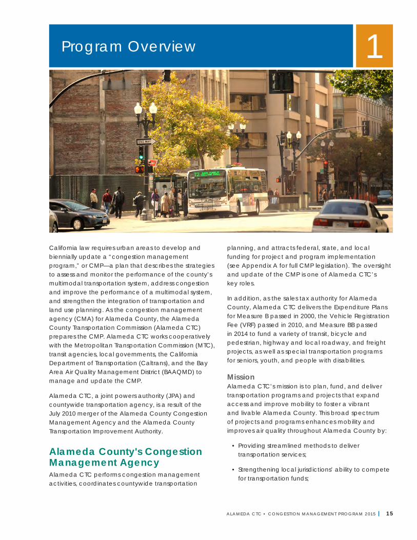
California law requires urban areas to develop and biennially update a “congestion management program,” or CMP—a plan that describes the strategies to assess and monitor the performance of the county’s multimodal transportation system, address congestion and improve the performance of a multimodal system, and strengthen the integration of transportation and land use planning. In Alameda County, the Alameda County Transportation Commission (Alameda CTC) as the Congestion Management Agency (CMA) for Alameda County prepares the CMP. Alameda CTC works cooperatively with the Metropolitan Transportation Commission (MTC), transit agencies, local governments, the California Department of Transportation (Caltrans), and the Bay Area Air Quality Management District (BAAQMD) to manage and update the CMP.
The CMP for Alameda County incorporates various strategies and measures to improve congestion management on the Alameda County multimodal transportation system. The CMP is required to incorporate five key elements: designated CMP roadway network, level of service monitoring, multimodal performance element, land use analysis program, and capital improvement program. The CMP also acts as a short-range plan to implement the long-range Countywide Transportation Plan.
The CMP law places considerable authority with the CMAs for the CMP. Appendix A contains the full text of the pertinent sections of state law. For example, these agencies are required to oversee how local governments meet the requirements of the CMP. The legislation also forges a new relationship between local governments and the California Department of Transportation (Caltrans) by requiring new highway projects in urban areas to be included in a CMP if they will be part of the State Transportation Improvement Program (STIP). This means that funding of highway projects is, in part, controlled by local government in the form of the CMAs. With this authority comes the responsibility to recognize federal and state funding limitations and to work with Caltrans and MTC to formulate cost-effective projects.
The CMP is designed to meet legal requirements and address the challenges in doing so. Furthermore, Alameda CTC has developed working relationships with all levels of government as well as the private sector and is prepared to demonstrate that local governmental agencies—working together—can solve regional transportation problems.
Since the CMP legislation was approved in 1991, and the CMAs came into existence, no substantive changes have been made to the legislative requirements of the
Executive Summary ES
Alameda CTC | Congestion Management Program
2 | ALAMEDA CTC • CONGEST ION MANAGEMENT PROGRAM 2 015
program to bring it in line with the changes occurring at every front–technological, behavioral, environmental, fiscal, etc. At least three legislative efforts are underway to address these changes. Senate Bill 743 and Assembly Bills 1098 and 779 are proposing to make modifications to either all or part of the Congestion Management Program.
SB 743 was signed into law in 2013, and will modify the metric used to measure the land development impacts on the transportation system in the California Environmental Quality Act (CEQA) process from a delay-based metric such as level of service to another metric such as vehicle miles traveled. Alameda CTC has been actively participating in this process by leading the Bay Area Working Group and by working with the governor’s Office of Planning and Research, which is tasked with identifying the alternative metric and updating the CEQA guidelines on transportation impact assessment.
AB 1098 and AB 779 are two-year bills that aim to fully revise the complete CMP legislation and, therefore, revamp the program scope to be more current and in line with protecting the environment, particularly greenhouse gas (GHG) reduction. In this regard, Alameda CTC is actively working with the other CMAs in the region and regional partners to be proactive and inform the development of the bills, so that the resulting CMP is more meaningful and supports environmental goals at all levels of government. Based on the outcome of the legislative changes, Alameda CTC’s CMP will be modified to align with the new legislative requirements while continuing to be a forward-looking program.
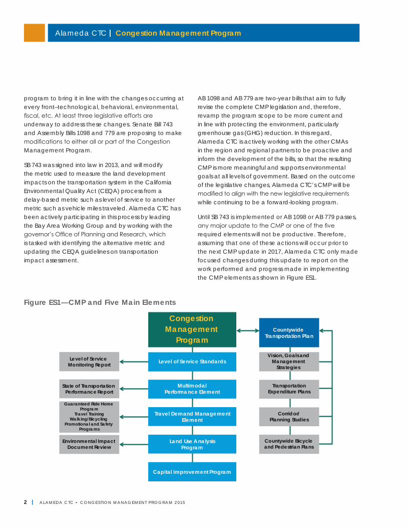
Until SB 743 is implemented or AB 1098 or AB 779 passes, any major update to the CMP or one of the five required elements will not be productive. Therefore, assuming that one of these actions will occur prior to the next CMP update in 2017, Alameda CTC only made focused changes during this update to report on the work performed and progress made in implementing the CMP elements as shown in Figure ES1.
Figure ES1—CMP and Five Main Elements
Congestion
Management
Program
Capital Improvement Program
Travel Demand ManagementElement
Land Use AnalysisProgram
Level of Service Standards
MultimodalPerformance Element
CountywideTransportation Plan
State of Transportation Performance Report
Level of Service Monitoring Report
Guaranteed Ride HomeProgram
Travel TrainingWalking/Bicycling
Promotional and SafetyPrograms
Environmental Impact
Document Review
Transportation
Expenditure Plans
Vision, Goals and Management
Strategies
Corridor/Planning Studies
Countywide Bicycle
and Pedestrian Plans
ALAMEDA CTC • CONGEST ION MANAGEMENT PROGRAM 2 015 | 3
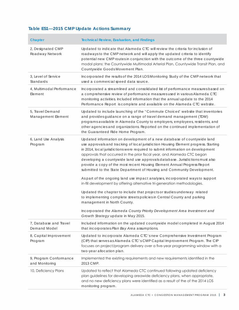
Table ES1—2015 CMP Update Actions Summary
Chapter Technical Review, Evaluation, and Findings
2, Designated CMP Roadway Network
Updated to indicate that Alameda CTC will review the criteria for inclusion of roadways to the CMP network and will apply the updated criteria to identify potential new CMP routes in conjunction with the outcome of the three countywide modal plans: the Countywide Multimodal Arterial Plan, Countywide Transit Plan, and Countywide Goods Movement Plan.
3, Level of Service Standards
Incorporated the results of the 2014 LOS Monitoring Study of the CMP network that used a commercial speed data source.
4, Multimodal Performance Element
Incorporated a streamlined and consolidated list of performance measures based on a comprehensive review of performance measures used in various Alameda CTC monitoring activities. Included information that the annual update to the 2014 Performance Report is complete and available on the Alameda CTC website.
5, Travel Demand Management Element
Updated to include launching of the “Commute Choices” website that inventories and provides guidance on a range of travel demand management (TDM) programs available in Alameda County to employers, employees, residents, and other agencies and organizations. Reported on the continued implementation of the Guaranteed Ride Home Program.
6, Land Use Analysis Program
Updated information on development of a new database of countywide land use approvals and tracking of local jurisdiction Housing Element progress. Starting in 2014, local jurisdictions were required to submit information on development approvals that occurred in the prior fiscal year, and Alameda CTC began developing a countywide land use approvals database. Jurisdictions must also provide a copy of the most recent Housing Element Annual Progress Report submitted to the State Department of Housing and Community Development.
As part of the ongoing land use impact analyses, incorporated ways to support in-fill development by offering alternative tri-generation methodologies.
Updated the chapter to include that projects or studies underway related to implementing complete streets policies in Central County and parking management in North County.
Incorporated the Alameda County Priority Development Area Investment and Growth Strategy update in May 2015.
7, Database and Travel Demand Model
Included information on the updated countywide model completed in August 2014 that incorporates Plan Bay Area assumptions.
8, Capital Improvement Program
Updated to incorporate Alameda CTC’s new Comprehensive Investment Program (CIP) that serves as Alameda CTC’s CMP Capital Improvement Program. The CIP focuses on project/program delivery over a five-year programming window with a two-year allocation plan.
9, Program Conformance and Monitoring
Implemented the existing requirements and new requirements identified in the 2013 CMP.
10, Deficiency Plans Updated to reflect that Alameda CTC continued following updated deficiency plan guidelines for developing areawide deficiency plans, when appropriate, and no new deficiency plans were identified as a result of the of the 2014 LOS monitoring program.
Alameda CTC | Congestion Management Program
4 | ALAMEDA CTC • CONGEST ION MANAGEMENT PROGRAM 2 015
The 2015 CMP update incorporates several actions identified as next steps in the 2013 CMP and closely aligns the CMP with the 2012 Countywide Transportation Plan (CTP) and the 2013 Regional Transportation Plan and Sustainable Communities Strategy (Plan Bay Area), which are currently being updated, and other related efforts and legislative requirements (e.g., Assembly Bill 32 and Senate Bill 375) to better integrate transportation and land use for achieving GHG reductions.
Following the adoption of the 2015 CMP by the Alameda CTC Commission, Alameda CTC will submit the CMP to MTC. As the regional transportation planning agency in the San Francisco Bay Area, MTC is required to evaluate the CMP’s consistency with MTC’s RTP and with the CMPs of the other counties in the Bay Area. If the Alameda County CMP is found to be consistent with the RTP, MTC will incorporate the projects listed in the CMP’s Capital Improvement Program into MTC’s Regional Transportation Improvement Program.
The Transportation SystemAlameda CTC must define and identify components of the transportation system that is being monitored and improved. For the purposes of the CMP, two different systems are used: the designated CMP roadway network (Chapter 2, “Designated CMP Roadway Network”) and the broader Metropolitan Transportation System (MTS). The CMP roadway network is a subset of the MTS. Alameda CTC monitors performance in the CMP roadway network in relation to established level of service standards. Alameda CTC also uses the MTS in the Land Use Analysis Program (Chapter 6).
Designated CMP Roadway NetworkThe designated CMP roadway network was developed in 1991 and includes state highways and principal arterials that meet all minimum criteria (carry 30,000 vehicles per day; have four or more lanes; are a major cross-town connector; and connect at both ends to another CMP route or major activity center). The system of roadways carries at least 70 percent of
the vehicle miles traveled countywide and contains 232 miles of roadways. Of this total, 134 miles (58 percent) are interstate freeways, 71 miles (31 percent) are state highways (conventional highways), and 27 miles (11 percent) are city/ county arterials.
Recognizing the need to expand the CMP network to reflect the changes in land use patterns over the years, the Alameda CTC Commission in 2011 adopted a two-tier approach for the CMP network in Alameda County. The first tier (Tier 1) is the existing CMP network, and the second tier (Tier 2) consists of an expanded number of roadways identified using a set of adopted criteria. This Tier 2 network forms a supplemental network monitored for informational purposes only and is not used in the conformity findings process. The identified Tier 2 network roadways have a total length of 90 miles. Details are included in Chapter 2, “Designated CMP Roadway Network.”
No new CMP roadways were proposed by the local jurisdictions during this 2015 update. For the 2017 CMP update, Alameda CTC will review and update the CMP roadway criteria including identifying ways to expand the CMP network to include key rural roadways that facilitate agricultural operations and tourism and support priority conservation area goals and objectives in Alameda County, in conjunction with the outcome of the three countywide modal plans: the Countywide Multimodal Arterial Plan, Countywide Transit Plan, and Countywide Goods Movement Plan. Alameda CTC will apply the updated criteria to identify potential new CMP routes in the 2017 update.
MTS SystemA regionally designated system, MTS includes the entire CMP network, as well as major arterials, transit services, rail, maritime ports, airports, and transfer hubs critical to the region’s movement of people and freight. MTS roadways were originally developed in 1991 and updated in 2005 and include roadways recognized as “regionally significant” and all interstate highways, state routes, and portions of the street
Chapter ES | Executive Summary
ALAMEDA CTC • CONGEST ION MANAGEMENT PROGRAM 2 015 | 5
and road system operated and maintained by local jurisdictions.
LOS MonitoringState law requires that level of service standards be established to monitor the CMP roadway network’s LOS as part of the CMP monitoring process. The legislation leaves the choice of LOS measurement methodology to the CMAs, but mandates that the LOS be measured by the most recent version of the Transportation Research Board’s Highway Capacity Manual (HCM) or a uniform methodology adopted by the CMA, in the case of Alameda CTC, that is consistent with the HCM. LOS definitions describe traffic conditions in terms of speed and travel time, volume and capacity, freedom to maneuver, traffic interruptions, comfort and convenience, and safety. LOS is represented by letter designations, ranging from A to F. LOS A represents the best operating conditions, and LOS F represents the worst.
The purpose of these standards is to provide a quantitative tool to analyze the effects of land use changes and to monitor congestion, which is a measure of system performance. Alameda CTC is required to determine how well local governments meet the standards in the CMP, including how well they meet LOS standards. The CMP legislation requires a standard of LOS E for all CMP Tier 1 roadways in Alameda County.
Alameda CTC uses LOS standards as defined in the 1985 Highway Capacity Manual (HCM1985), the nationally accepted guidelines published by the Transportation Research Board, and re-evaluated its applicability in 2005 for roadway LOS monitoring purposes and again in 2013 for roadway and alternative modes purposes. The review conducted in 2013 showed that using the 2000 and 2010 HCM versions for roadway LOS monitoring purposes would result in applying density-based rather than speed-based LOS methodology for freeways and changed speed classifications for arterials, which would hinder the ability to compare past performance
trends important for determining conformity with the CMP.
Based on this review, Alameda CTC continues to use the speed-based LOS methodology in the HCM1985 to monitor freeways and existing roadway classifications for arterials for the Tier 1 roadway network, which is subject to the conformity process. For the Tier 2 network, since it has been only monitored for informational purposes since 2012 and is not comparable to any previous performance data, LOS has been reported using the methodologies in both the HCM1985 and HCM2000 in the 2014 LOS Monitoring Study. Future use of appropriate HCM for Tier 2 purposes in the 2017 CMP update will be revaluated after completion of the countywide modal plans.
The evaluation of HCM2010 for the 2013 CMP update also reviewed its applicability for monitoring service level standards for alternative modes by using multi-modal level of service (MMLOS). It was found that using the 2010 HCM-based MMLOS is data and resource intensive and costly for large-scale applications such as monitoring countywide performance of the alternative modes; therefore, it is not well designed for annual LOS monitoring purposes. Alameda CTC will assess how to best include the performance measurement metrics for monitoring alternative modal performance in the 2017 CMP update, based on the outcomes of the countywide modal plans.
A summary of the evaluation and comparison of using 1985, 2000, and 2010 HCMs for LOS monitoring purposes, including a comparison of approaches adopted by various large CMAs in the Bay Area, is provided as Appendix B.
Alameda CTC conducts a LOS monitoring study every two years. The last study was conducted in spring 2014, and the next one will be in 2016. The 2015 CMP incorporates the results of 2014 LOS monitoring, which included the use of commercially available speed data.
Alameda CTC | Congestion Management Program
6 | ALAMEDA CTC • CONGEST ION MANAGEMENT PROGRAM 2 015
Multimodal Performance ElementThe CMP must contain performance measures that evaluate how highways and roads function, as well as the frequency, routing, and coordination of transit services. The performance measures should support mobility, air quality, land use, and economic objectives and be used in various components of the CMP. The legislation intends for the performance element to include multimodal performance measures, in addition to the required roadway and transit measures. However, only the roadway LOS standards will be used to trigger the need for a deficiency plan in Alameda County.
Combined with LOS standards, the multimodal performance element provides a basis for evaluating whether the transportation system is achieving the broad mobility and congestion management goals in the CMP. These include developing the Capital Improvement Program, analyzing land use impacts, and preparing deficiency plans to address problems. These performance measures help comprehensively evaluate the performance of the countywide multimodal transportation system and include the goals and performance measures adopted for the 2012 Countywide Transportation Plan. The measures are organized into the following categories (refer to Chapter 4, “Multimodal Performance Element” for a more comprehensive table listing the performance measures and related goals):
• Multimodal Accessibility and Transportation/ Land Use Integration
• Roadway
• Transit
• Bicycle
• Pedestrian
• Goods Movement
• Environment, Equity, and Health
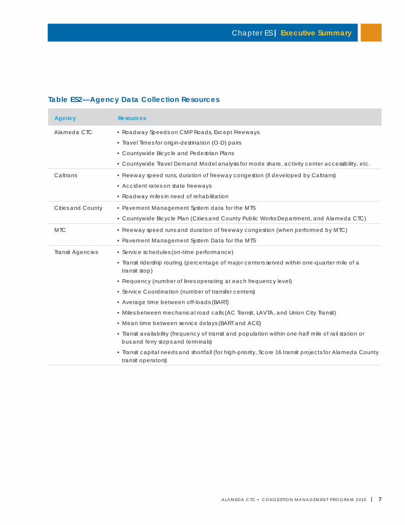
Using these measures, Alameda CTC prepares an annual transportation system Performance Report, which local agencies and transit operators review prior to publication. To minimize cost, Alameda CTC relies on established data-collection processes and regularly published reports for data. A list of established data collection resources, by agency, follows in Table ES2.
Local agencies are encouraged to provide data to MTC or to maintain their own database of maintenance needs on the MTS. However, there is no compliance requirement for local agencies or transit operators related to the multimodal performance element.
The most recent performance report, the 2014 Performance Report for fiscal year 2013-14, is available on the Alameda CTC website.
Based on the comprehensive review of the Performance Report and performance measures used in various monitoring activities, as part of the 2015 CMP update, Alameda CTC developed a consolidated list of performance measures and the respective documents where they are tracked. As part of the 2017 CMP update, Alameda CTC will identify multimodal performance measures that can be periodically monitored, particularly identifying the documents and timelines for reporting on those measures. The re-evaluation will ensure that the timeline for reporting on different measures realistically aligns with data availability and potential changes in the measures.
Chapter ES | Executive Summary
ALAMEDA CTC • CONGEST ION MANAGEMENT PROGRAM 2 015 | 7
Table ES2—Agency Data Collection Resources
Agency Resources
Alameda CTC • Roadway Speeds on CMP Roads, Except Freeways
• Travel Times for origin-destination (O-D) pairs
• Countywide Bicycle and Pedestrian Plans
• Countywide Travel Demand Model analysis for mode share, activity center accessibility, etc.
Caltrans • Freeway speed runs, duration of freeway congestion (if developed by Caltrans)
• Accident rates on state freeways
• Roadway miles in need of rehabilitation
Cities and County • Pavement Management System data for the MTS
• Countywide Bicycle Plan (Cities and County Public Works Department, and Alameda CTC)
MTC • Freeway speed runs and duration of freeway congestion (when performed by MTC)
• Pavement Management System Data for the MTS
Transit Agencies • Service schedules (on-time performance)
• Transit ridership routing (percentage of major centers served within one-quarter mile of a transit stop)
• Frequency (number of lines operating at each frequency level)
• Service Coordination (number of transfer centers)
• Average time between off-loads (BART)
• Miles between mechanical road calls (AC Transit, LAVTA, and Union City Transit)
• Mean time between service delays (BART and ACE)
• Transit availability (frequency of transit and population within one-half mile of rail station or bus and ferry stops and terminals)
• Transit capital needs and shortfall (for high-priority, Score 16 transit projects for Alameda County transit operators)
Alameda CTC | Congestion Management Program
8 | ALAMEDA CTC • CONGEST ION MANAGEMENT PROGRAM 2 015
Travel Demand Management ElementTravel demand management (TDM) measures seek to reduce pressure on existing roadway and parking capacity by using various strategies that include incentives and disincentives to influence travel choice. They reduce peak-period vehicle trips and total vehicle miles traveled. Related benefits include reducing congestion and carbon emissions, improving public health, and increasing transportation choice. The most effective TDM programs include some form of financial incentive, either through pricing parking or subsidizing transit and other non-drive alone modes. TDM strategies tend be cost-effective ways of meeting regional goals. By making the most efficient possible use of the available system capacity, they complement the region’s investments in transit systems and other alternatives to driving.
The Commission adopted a Countywide Comprehensive TDM Strategy in May 2013 that provides an inventory of the broad range of TDM programs and activities present in Alameda County and recommends a strategy for better integrating, supporting, and building on these existing efforts, including implementation of the regional commute benefit program and the Guaranteed Ride Home Program. These programs are designed to reduce the need for new highway facilities over the long term and to make the most efficient use of existing facilities. The TDM element also incorporates strategies to integrate air quality planning requirements with transportation planning and programming. Funding generally comes from the Transportation Fund for Clean Air (from motor vehicle registration fees) and from the federal Surface Transportation Program and Congestion Mitigation and Air Quality Program. Alameda County’s TDM element represents a fiscally realistic program that effectively complements the overall CMP.
A balanced TDM element requires actions that local jurisdictions, Alameda CTC, BAAQMD, Caltrans, MTC, and local transit agencies undertake. As required by state law, the Alameda County TDM program
promotes alternative transportation methods (e.g., carpools, vanpools, transit, bicycles, park-and-ride lots), promotes improvements in the jobs-housing balance and SMART Growth, considers parking cash-out programs (paying employees who do not use parking), and promotes other strategies such as flextime and telecommuting.
The county’s approach to TDM includes the following major actions:
• Regional actions: BAAQMD, Caltrans, and MTC take actions to support TDM throughout the San Francisco Bay Area. Alameda County’s efforts work within the context of these broader regional initiatives.
• Countywide actions: Alameda CTC takes actions to encourage, supplement, and support local governments in their TDM efforts, including allocating funds for multimodal transportation improvements, providing guidance and technical assistance to localities in developing their own TDM programs, and monitoring compliance with the Required Program in the CMP. Alameda CTC also manages certain key TDM programs, such as Guaranteed Ride Home, that work most effectively at the countywide level. In 2015, Alameda CTC launched the “Commute Choices” website that inventories and provides guidance for a full range of TDM programs available to employers, residents, employees, and other organizations.
• Local jurisdiction actions: Local governments have primary responsibility for implementing TDM programs and encouraging and incentivizing TDM by private organizations. The CMP requires local governments to undertake certain TDM actions, known as the Required Program. The CMP also encourages local governments to undertake TDM efforts above and beyond these requirements.
• Private TDM actions: Private employers, developers, homeowner associations, and nonprofit organizations can undertake TDM measures on a voluntary basis or as required by a city. Alameda CTC provides resources to support these actions,
Chapter ES | Executive Summary
ALAMEDA CTC • CONGEST ION MANAGEMENT PROGRAM 2 015 | 9
including guidance on best practices and other technical resources.
Chapter 5, “Travel Demand Management Element” includes a variety of tools available to local governments for facilitating TDM. To be found in conformance with this element of the CMP, local jurisdictions must adopt and implement the Required Program by September 1 of each year.
Land Use Analysis ProgramThe CMP incorporates a program to analyze the impacts of land use decisions made by local jurisdictions on the regional transportation systems (MTS), including estimating costs associated with mitigating those impacts. The intent of this legislatively required component of the CMP is to:
• Coordinate local land use and regional transportation facility decisions;
• Assess the impacts of development in one community on another community; and
• Promote information sharing between local governments when the decisions made by one jurisdiction will impact another.
While the Alameda CTC’s land use analysis program was initially developed as a program to meet the CMP legislative mandate, the growing focus at all levels of governments on improved coordination between land use and transportation planning has resulted in the program’s evolution. In this context, the Alameda CTC’s Land Use Analysis Program (Chapter 6) currently includes:
• Legislatively required review of:
○ Land use actions of local jurisdictions by Alameda CTC to ensure that impacts on the regional transportation system are disclosed and mitigation measures identified; and
○ Long-range land use projections by local jurisdictions for use in the countywide model database.
• Planning initiatives and programs that foster transportation and land use connections; and
• Strategic monitoring of transportation-land use coordination performance measures.
Although land use remains the purview of local governments, Alameda CTC can apply sanctions if local agencies do not conform to the requirements of the CMP. Local jurisdictions have the following responsibilities under the Alameda CTC Land Use Analysis Program element of the CMP:
• Throughout the year:
○ Forward to Alameda CTC all Notices of Preparation, Draft and Final Environmental Impact Reports and Environmental Impact Statements, and final dispositions of General Plan amendment and development requests.
○ Analyze large development projects according to the adopted guidelines, including the use of the Alameda Countywide Travel Demand Model or an approved subarea model and disclosure of impacts to the MTS, if Alameda CTC determines the project exceeds the threshold for which CMP review is required.
○ Work with Alameda CTC on the mitigation of development impacts on the regional transportation system.
• By October 1 of each year as part of the annual conformity process:
○ Demonstrate to Alameda CTC that the Land Use Analysis Program is being carried out.
○ Provide the Alameda CTC with 1) a list of land use development projects approved during the previous fiscal year; and 2) a copy of the most recent Housing Element Annual Progress Report submitted to the state Department of Housing and Community Development. Starting in 2014, Alameda CTC has used this information to develop a database of land use approvals for enhanced monitoring of transportation-land use coordination and planning.
Alameda CTC | Congestion Management Program
10 | ALAMEDA CTC • CONGEST ION MANAGEMENT PROGRAM 2 015
• During travel model updates:
○ Provide an update (prepared by the jurisdiction’s planning department) of the anticipated land use changes likely to occur using the most recent Association of Bay Area Government forecast for a near-term and long-term horizon year. This land use information should be provided in a format that is compatible with the countywide travel model.
The 2013 CMP update included expanded discussion of the Alameda CTC’s activities to fulfill the legislative requirements of Senate Bill 375 and Assembly Bill 32 to better integrate transportation and land use and to reduce greenhouse gas emissions by curtailing vehicle miles traveled. The following enhancements were made to the Land Use Analysis Program to meet these objectives:
• Incorporated the recommendations of the Alameda County Priority Development Investment and Growth Strategy as required by MTC and adopted by the Commission in March 2013 and in May 2015 as updated;
• Modified the agency’s guidelines for environmental review consistent with prior CMP action items.
○ HCM2010: Alameda CTC performed an assessment of the HCM2010 including its MMLOS methodologies for use in the Land Use Analysis Program similar to the evaluation effort for the LOS monitoring element. Based on this assessment, the following changes were made:
- Encouraged use of HCM2010 to study auto impacts on roadways but provide flexibility to conform to local requirements as needed.
- Encouraged study of multimodal trade-offs of mitigation measures proposed in environmental documents, including use of HCM2010 MMLOS to perform the analysis.
- Expanded and clarified language as to the types of impacts to transit, bicyclists, and pedestrians
that project sponsors should consider.
○ In-fill development trip generation: Alameda CTC performed an assessment of alternative project trip generation methodologies that more accurately account for the nature of trip generation in areas such as PDAs or infill sites; based on this assessment, Alameda CTC proposed three alternative methods for project sponsors to use for CMP land use analysis and developed guidelines for adjusting trip generation:
- EPA’s Mixed Use Development (MXD) model
- Caltrans/UC Davis Smart Growth Trip Generation rates
- MTC’s Station Area Residents Study (STARS) mode share adjustment method
Many action items identified in the 2013 CMP update for a further enhanced land use analysis program are still valid and continue to be carried forward, so that based on the resource availability and coordination with other efforts of Alameda CTC, they can be implemented. Several of these action items will depend on the implications of forthcoming CMP legislation updates. Alameda CTC will modify the Land Use Analysis Program when legislative actions are finalized.
Database and Travel Demand ModelAlameda CTC has developed a uniform land use database for use in the countywide travel model. The database and travel demand model bring to the congestion management decision-making process a uniform technical basis for analysis. This includes consideration of the benefits of transit service and TDM programs, as well as projects that improve congestion on the CMP network. The model is also intended to assist local agencies in assessing the impacts of new development on the transportation system.
Chapter ES | Executive Summary
ALAMEDA CTC • CONGEST ION MANAGEMENT PROGRAM 2 015 | 11
The most recent update to the model was completed in August 2014. It incorporates land use assumptions based on the Sustainable Communities Strategy and RTP, Plan Bay Area, adopted in 2013. Projections of socioeconomic variables were incorporated from these sources for the traffic analysis zones defined for Alameda County. By aggregating the projections made for each zone, Alameda CTC produced projections of socioeconomic characteristics for unincorporated areas of the county, the 14 cities, and for the four planning areas. The updated model also incorporated 2010 US Census data along with updates to the model base year from 2000 to 2010, to correspond with the 2010 US Census and to change the long-term forecast year from 2035 to 2040, along with updates to other related features of the model (see Chapter 7, “Database and Travel Demand Model” for details).
Capital Improvement ProgramThe Capital Improvement Program reflects Alameda CTC’s efforts to maintain or improve the performance of the multimodal transportation system for the movement of people and goods and to mitigate regional transportation impacts identified through the Land Use Analysis Program.
Per federal requirements, Alameda CTC considers various multimodal methods to improve the existing system, such as traffic operations systems, arterial signal timing, parking management, transit transfer coordination, and transit marketing programs.
Projects selected for the Capital Improvement Program also are consistent with the assumptions, goals, policies, actions, and projects identified in Plan Bay Area, MTC’s and ABAG's basic statement of Bay Area transportation and land use policy.
In 2013, Alameda CTC adopted a Strategic Planning and Programming Policy that consolidates existing planning and programming processes to improve the efficiency and effectiveness of future policy decisions on transportation investments. This policy resulted in the Comprehensive Investment Plan (CIP) that the Commission adopted in June 2015. The CIP translates long-range plans into a short-range investment strategy by establishing a list of near-term priority improvements to enhance and maintain Alameda County’s transportation system.
Alameda CTC's CIP serves three purposes:
• Translates long-range plans into short-range implementation by focusing on project/program delivery over a five-year programming window with a two-year allocation plan.
• Serves as Alameda CTC’s strategic plan for voter-approved transportation funding (such as the 1986 Measure B, the 2000 Measure B, 2010 Vehicle Registration Fee, and the 2014 Measure BB) as required by the respective legislation for each funding program.
• Establishes a comprehensive and consolidated programming and allocation plan that integrates all fund sources into one programming document
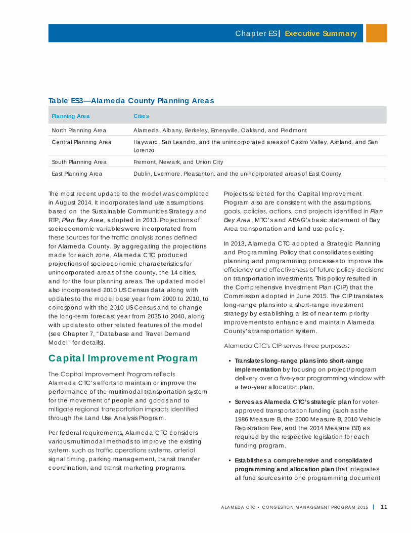
Table ES3—Alameda County Planning Areas
Planning Area Cities
North Planning Area Alameda, Albany, Berkeley, Emeryville, Oakland, and Piedmont
Central Planning Area Hayward, San Leandro, and the unincorporated areas of Castro Valley, Ashland, and San Lorenzo
South Planning Area Fremont, Newark, and Union City
East Planning Area Dublin, Livermore, Pleasanton, and the unincorporated areas of East County
Alameda CTC | Congestion Management Program
12 | ALAMEDA CTC • CONGEST ION MANAGEMENT PROGRAM 2 015
that ensures coordinated programming and allocation of funds to maximize the effectiveness of transportation investments.
Alameda CTC will update annually the expenditure and revenue assumptions included in the CIP, which will serve as the basis of Alameda CTC’s financial models and annual budget. The annual updates will also serve to satisfy any annual strategic plan requirements for the fund sources that Alameda CTC administers. The annual updates will afford Alameda CTC the opportunity to review the first year and confirm the allocations for the second year of the two-year allocation plan. The annual update process will include a status update on the first year and any recommended adjustments or amendments for the second year.
A full update of the CIP will occur every two years, including a comprehensive review of the remaining three years of the five-year CIP horizon and the addition of two new years of programming for a five-year programming window. The full update will involve notifying project sponsors of the enrollment period for adding new projects and programs to the CIP, and the subsequent review and approval of project and program submittals to be included in the updated CIP.
Alameda CTC will continue its coordination of long-range planning documents with short-range implementation via the CIP through the 2017 update. The first CIP (FY2015-16 through FY2019-20) was adopted by Alameda CTC in June 2015. In June 2017, the CIP will receive a full update that includes revenue projections and project/program allocations for FY2017-18 through FY2021-22.
Program Conformance and MonitoringAlameda CTC is responsible for ensuring local government conformance with the CMP and annually monitors the implementation of four elements: LOS standards on CMP network, travel demand
management including implementation of the Required Program, land use analysis program, and capital improvement program. Alameda CTC ensures local agencies are in conformance with CMP requirements for these elements.
To assist local jurisdictions, Alameda CTC provides LOS standards resources (Chapter 3, “Level of Service Standards”); travel demand management resources and countywide programs to facilitate implementation of the Required Program (Chapter 5, “Travel Demand Management Element”); and a database and Countywide Travel Demand Model (Chapter 7, “Database and Travel Demand Model”). Alameda CTC has also developed a Land Use Analysis Program for implementation by local agencies. This program analyzes the impacts and determines mitigation costs of land use decisions on the regional transportation system (see Chapter 6, “Land Use Analysis Program”). Local jurisdictions remain responsible for approving, disallowing, or altering projects and land use decisions. The program must be able to determine land development impacts on the MTS and formulate appropriate mitigation measures commensurate with the magnitude of the expected impacts.
In addition, Alameda CTC is required to prepare and biennially update a Capital Improvement Program (see Chapter 8, “Capital Improvement Program”) aimed at maintaining or improving transportation service levels. Each city, the county, transit operators, and Caltrans provide input to these biennial updates.
As part of Alameda CTC’s annual monitoring, if it finds a local jurisdiction in non-conformance with the CMP, it will notify the local jurisdiction, which then has 90 days to remedy the area(s) of non-conformance. If the local jurisdiction fails to provide a remedy within the stipulated time, it may lose local, state, and/or federal funding (see Chapter 9, “Program Conformance and Monitoring” for more information).
The 2017 CMP will incorporate any changes in conformity requirements based on the completion of the three countywide plans (Multimodal Arterial Plan,
Chapter ES | Executive Summary
ALAMEDA CTC • CONGEST ION MANAGEMENT PROGRAM 2 015 | 13
Transit Plan, and Goods Movement Plan) and any legislative actions/decisions that reform the CMP.
Deficiency PlansCMP legislation requires preparation of deficiency plans when a CMP roadway segment does not meet the adopted level of service standard, which is LOS E for Alameda County CMP roadways. Local jurisdictions must develop a deficiency plan to achieve the adopted LOS standards at the deficient segment or intersection, or to improve the LOS and contribute to significant air-quality improvements. The two types of deficiency plans include Localized Deficiency Plans and Areawide Deficiency Plans, which address transportation impacts to more than one CMP roadway and including alternative modes in a large geographic area. To provide support to local jurisdictions in terms of meeting any potential deficiency plan requirements, Alameda CTC updated the deficiency plan guidelines to include more details and procedures for developing Areawide Deficiency Plans (included as Appendix D) as part of the 2013 CMP update.
Responsibilities for Deficiency PlansLocal governments are responsible for preparing and adopting deficiency plans; however, they need to consult with Alameda CTC, BAAQMD, Caltrans, and local transit providers regarding the deficient roadway segment, and coordinate with more than one jurisdiction to develop multijurisdictional deficiency plans. Local public-interest groups and members of the private sector may also have an interest in developing deficiency plans.
During the process of developing a deficiency plan, a local agency needs to consider whether it is possible to make physical improvements to the deficient segment or if an areawide deficiency plan needs to be prepared. In developing the deficiency plan, the local agency must consider and describe both local and system alternatives. Local governments and Alameda CTC must consider the impact of the proposed deficiency plan on the CMP system. The local agency
must also provide an action plan to implement the chosen alternative. The selection of either alternative is subject to approval by Alameda CTC, which must find the action plan in the interest of the public’s health, safety, and welfare. In 2011, Alameda CTC adopted a policy to consider providing funding priority to projects that would improve the performance of deficient segments.
Conclusions and Future ConsiderationsThe CMP has several interrelated elements intended to foster better coordination among decisions about land development, transportation, and air quality. Several conclusions can be reached about the CMP relative to the requirements of law and its purpose and intent (Chapter 11, “Conclusions and Future Considerations”). As mentioned previously, legislative efforts underway will reform the CMP and realign it with the current trends in all fronts. While Alameda CTC will be an active participant to inform the process to the best extent possible, once legislation is acted on, Alameda CTC's CMP will be modified to align with the requirements and will continue to be a forward-looking program.
Currently, the updated CMP:
• Contributes to maintaining or improving multimodal transportation service levels;
• Conforms to MTC’s criteria for consistency with Plan Bay Area;
• Provides a travel model with specifications and output consistent with MTC’s regional model;
• Is consistent with BAAQMD’s Clean Air Plan Transportation Control Measures;
• Specifies a method for estimating roadway LOS that is consistent with state law and expanding options to assess LOS for alternative modes;
• Identifies candidate projects for the STIP and federal Transportation Improvement Program;
Alameda CTC | Congestion Management Program
14 | ALAMEDA CTC • CONGEST ION MANAGEMENT PROGRAM 2 015
• Has been developed in cooperation with the cities, the County of Alameda, transit operators, the BAAQMD, MTC, adjacent counties, Caltrans, and other interested parties;
• Provides a forward-looking approach to deal with the transportation impacts of local land use decisions; and
• Considers the benefit of greenhouse gas reductions in developing the CIP.
A few long-standing issues identified during prior CMP updates need further action by Alameda CTC and will be re-evaluated during the 2017 CMP update:
• Lack of funding to support the CMP, including adequate capital resources and Alameda CTC/local government funding;
• Limited ability of Alameda CTC to influence transportation investments when most transportation funding programs are beyond the purview of the CMP legislation; and
• Scope of the CMP network and lack of incentive to local jurisdictions to add new roadways.
ALAMEDA CTC • CONGEST ION MANAGEMENT PROGRAM 2 015 | 15
California law requires urban areas to develop and biennially update a “congestion management program,” or CMP—a plan that describes the strategies to assess and monitor the performance of the county’s multimodal transportation system, address congestion and improve the performance of a multimodal system, and strengthen the integration of transportation and land use planning. As the congestion management agency (CMA) for Alameda County, the Alameda County Transportation Commission (Alameda CTC) prepares the CMP. Alameda CTC works cooperatively with the Metropolitan Transportation Commission (MTC), transit agencies, local governments, the California Department of Transportation (Caltrans), and the Bay Area Air Quality Management District (BAAQMD) to manage and update the CMP.
Alameda CTC, a joint powers authority (JPA) and countywide transportation agency, is a result of the July 2010 merger of the Alameda County Congestion Management Agency and the Alameda County Transportation Improvement Authority.
Alameda County's Congestion Management AgencyAlameda CTC performs congestion management activities, coordinates countywide transportation
planning, and attracts federal, state, and local funding for project and program implementation (see Appendix A for full CMP legislation). The oversight and update of the CMP is one of Alameda CTC’s key roles.
In addition, as the sales tax authority for Alameda County, Alameda CTC delivers the Expenditure Plans for Measure B passed in 2000, the Vehicle Registration Fee (VRF) passed in 2010, and Measure BB passed in 2014 to fund a variety of transit, bicycle and pedestrian, highway and local roadway, and freight projects, as well as special transportation programs for seniors, youth, and people with disabilities.
MissionAlameda CTC’s mission is to plan, fund, and deliver transportation programs and projects that expand access and improve mobility to foster a vibrant and livable Alameda County. This broad spectrum of projects and programs enhances mobility and improves air quality throughout Alameda County by:
• Providing streamlined methods to deliver transportation services;
• Strengthening local jurisdictions’ ability to compete for transportation funds;
Program Overview 1
Alameda CTC | Congestion Management Program
16 | ALAMEDA CTC • CONGEST ION MANAGEMENT PROGRAM 2 015
• Giving Alameda County a stronger voice in state and regional transportation decisions;
• Coordinating planning and development across jurisdictional lines; and
• Generating and supporting legislation to coordinate local and regional policies on transportation investment.
Key ResponsibilitiesTo help guide and improve Alameda County’s transportation system, Alameda CTC’s activities and key responsibilities can be viewed in three parts:
• Developing plans that guide transportation development and funding decisions, including the Congestion Management Program;
• Programming funds to agencies for transportation improvements; and
• Delivering the projects, programs, legislative actions, and policy efforts set forth in the planning and programming documents.
As the congestion management agency, Alameda CTC also has the following functions and responsibilities to:
• Coordinate transportation planning and funding programs within Alameda County and with contiguous counties;
• Coordinate countywide input to the:
○ California Clean Air Act and Transportation Control Measures of MTC and the BAAQMD;
○ MTC’s Regional Transportation Improvement Program; and
○ California Transportation Commission State Transportation Improvement Program (STIP);
• Prepare, adopt, update, and administer federal funding programs for Alameda County including the Surface Transportation Program and the Congestion Mitigation and Air Quality Program;
• Levy and collect fees and charges, including administrative and operating costs; and
• Recommend projects for funding from the Alameda County share of the STIP, as specified in Senate Bill 45. The Commission also oversees project implementation to ensure that projects meet “timely use of funds” requirements and that no programmed funds are lost from Alameda County.
In addition, Alameda CTC acts as the program manager for the Transportation Fund for Clean Air (TFCA) in Alameda County. The TFCA program, which aims to reduce pollution by reducing the use of single-occupant vehicles, is funded through a $4 per-vehicle registration fee and is managed by the BAAQMD. The law requires BAAQMD to allocate 40 percent of the revenue to each county. Other functions could be added by amendments to the JPA or by actions of the state or federal government.
GovernanceUnder a joint powers agreement, elected officials from throughout Alameda County—representing each city in the county, the County of Alameda, AC Transit, and BART (San Francisco Bay Area Rapid Transit District)—govern Alameda CTC. The 22-member Commissionconsiders the interests of local constituents and helps to include all areas of the county in guiding how Alameda CTC plans, funds, and delivers projects and programs throughout Alameda County. The Commission’s leadership from throughout the county ensures all residents are represented.
Advisory CommitteesAlameda CTC relies on the guidance and direction of a number of advisory committees, including (see Appendix E for detail on the standing committees):
• Alameda County Technical Advisory Committee
• Bicycle and Pedestrian Advisory Committee
• Independent Watchdog Committee, formerly the Citizens Watchdog Committee
• Paratransit Advisory and Planning Committee
Chapter 1 | Program Overview
ALAMEDA CTC • CONGEST ION MANAGEMENT PROGRAM 2 015 | 17
Alameda County Congestion Managment ProgramThe Alameda County CMP is a short-range plan that includes a variety of congestion management strategies, programs, and projects that meet the legislative requirements and intend to further improve the countywide transportation system to better meet the needs of all users. It also supports the long-range Countywide Transportation Plan (CTP) as an implementation tool and helps to move the programs and projects included in the CTP closer to reality. The CTP is supported by the Alameda County Transportation Expenditure Plans for Measure B, Measure BB, and Vehicle Registration Fee funding. The CTP is informed by the adopted Countywide Bicycle and Pedestrian Plans and three major modal plans underway: the Countywide Goods Movement Plan, Countywide Multimodal Arterial Plan, and Countywide Transit Plan.
Countywide Transportation PlanAlameda CTC updated and adopted the Countywide Transportation Plan in June 2012, and is currently in the process of updating it. The updated CTP will be adopted in the summer of 2016. The plan is a long-range policy document that guides decisions and articulates the vision for the county’s transportation system over typically a 25-30-year planning horizon. Through its funding allocation program, the 2012 CTP seeks to ensure that transportation investments—over a 28-year planning period—are efficient and productive, and that maintenance and management of the system remain high priorities.
Specifically, the CTP:
• Documents existing and future transportation conditions;
• Documents a vision for land use that houses the region’s population across all income levels in accordance with the requirements of Senate Bill 375;
• Coordinates countywide input to MTC guidelines for county transportation plans pursuant to Government Code Section 66531;
• Coordinates countywide input to the Regional Transportation Plan and Sustainable Communities Strategy, known as Plan Bay Area;
• Addresses all modes of transportation from goods movement to bicycle and pedestrian priorities to transportation needs for seniors and people with disabilities;
• Provides a strategy to guide transportation improvements to address changes in the regulatory and financial environment;
• Lays the groundwork for an investment program tailored to the diverse needs of the county’s residents, visitors, and workers; and
• Identifies projects and programs for implementation over the next 28 or more years.
Transportation Expenditure PlansThe sales tax expenditure plans (Measure B and Measure BB) are key sources of funding for multimodal transportation projects and programs in Alameda County. Measure B was approved by the voters in 2000, and a previous measure was approved in 1986. Of the total collected funds under Measure B, 60 percent are dedicated to programs such as local streets and roads repair, bicycle and pedestrian safety, and transit and paratransit operators, and 40 percent of collected funds are dedicated to capital projects including transit and highway improvements.
Measure BB was approved by voters in 2014 and renewed and increased the existing Measure B half-cent county transaction and use tax for transportation by an additional half cent for 30 years. Measure BB will contribute nearly $8 billion to transportation improvements throughout the county. Alameda CTC will distribute approximately 65 percent of the net sales tax revenues to essential programs in Alameda County through direct local distribution
Alameda CTC | Congestion Management Program
18 | ALAMEDA CTC • CONGEST ION MANAGEMENT PROGRAM 2 015
funds and discretionary grant awards. The remaining transportation sales tax dollars (approximately 35 percent) are identified for specifically named projects as described in the 2014 Transportation Expenditure Plan (TEP) .
The TEP also serves as a mechanism to fund a portion of select projects and programs identified in the CTP. See Chapter 8 for detail on the percentage of funding for each direct local distribution program, for the discretionary programs, and fund distribution for capital projects, as well as information on the Comprehensive Investment Plan that brings long-range and countywide plans into the near term by focusing on investments over a five-year programming and allocation window.
Purpose of CMPThe primary purpose of the CMP is to set forth fundamental congestion management strategies for implementing the long-range CTP. The CMP addresses day-to-day congestion problems including:
• Setting level of service standards for roadways;
• Identifying multimodal performance measures to evaluate the performance of the countywide transportation system;
• Exploring ways to manage travel demand and identify TDM strategies for trip reduction and air quality improvement;
• Analyzing the impacts of land development on regional transportation system and implementing the Alameda County Priority Development Area Investment and Growth Strategy;
• Developing and maintaining a travel demand model to provide a technical basis for analysis and assess impact of local land development on the regional transportation system;
• Developing a Capital Improvement Program that helps improve and maintain the countywide multi-modal transportation system;
• Monitoring conformance of required CMP elements implementation by local agencies; and
• Identifying development of deficiency plans and monitoring their implementation by local governments to improve performance of non-conforming transportation systems.
While the CMP is designed to meet the requirements of the law, to ultimately reduce congestion and greenhouse gas emissions, and to improve the ability of people and goods to move on the countywide multimodal transportation system, it also serves as an opportunity for strategic thinking to better integrate land use and transportation through collaboration with various local, regional, and state agencies, and develop transportation strategies and plan for land development that efficiently uses the transportation system, while ensuring it meets the mobility and access needs of residents and workers in Alameda County.
OrganizationThe CMP is organized into twelve chapters, with supporting appendices:
• Executive Summary
• Chapter 1, Program Overview
• Chapter 2, Designated CMP Roadway Network
• Chapter 3, Level of Service Standards
• Chapter 4, Multimodal Performance Element
• Chapter 5, Travel Demand Management Element
• Chapter 6, Land Use Analysis Program
• Chapter 7, Database and Travel Demand Model
• Chapter 8, Capital Improvement Program
• Chapter 9, Program Conformance and Monitoring
• Chapter 10, “Deficiency Plans”
• Chapter 11, Conclusions and Future Considerations
Alameda CTC updates the CMP biennually, and the next update will occur in 2017.
ALAMEDA CTC • CONGEST ION MANAGEMENT PROGRAM 2 015 | 19
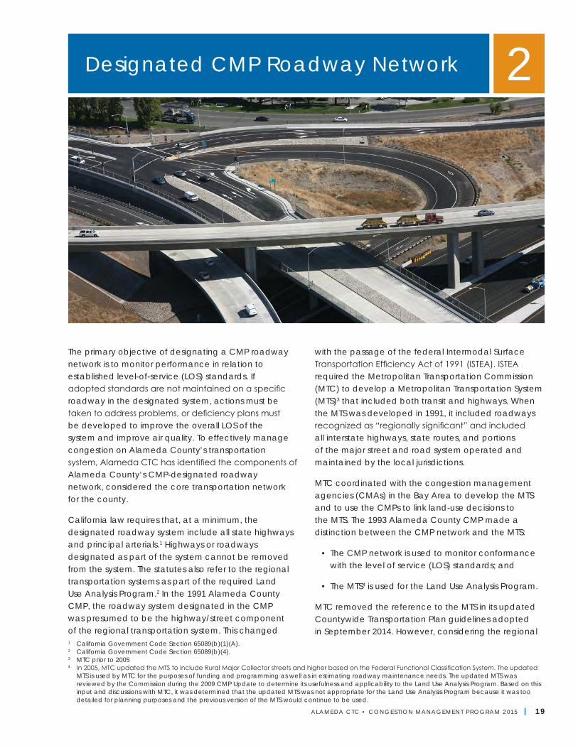
The primary objective of designating a CMP roadway network is to monitor performance in relation to established level-of-service (LOS) standards. If adopted standards are not maintained on a specific roadway in the designated system, actions must be taken to address problems, or deficiency plans must be developed to improve the overall LOS of the system and improve air quality. To effectively manage congestion on Alameda County’s transportation system, Alameda CTC has identified the components of Alameda County’s CMP-designated roadway network, considered the core transportation network for the county.
California law requires that, at a minimum, the designated roadway system include all state highways and principal arterials.1 Highways or roadways designated as part of the system cannot be removed from the system. The statutes also refer to the regional transportation systems as part of the required Land Use Analysis Program.2 In the 1991 Alameda County CMP, the roadway system designated in the CMP was presumed to be the highway/street component of the regional transportation system. This changed
with the passage of the federal Intermodal Surface Transportation Efficiency Act of 1991 (ISTEA). ISTEA required the Metropolitan Transportation Commission (MTC) to develop a Metropolitan Transportation System (MTS)3 that included both transit and highways. When the MTS was developed in 1991, it included roadways recognized as “regionally significant” and included all interstate highways, state routes, and portions of the major street and road system operated and maintained by the local jurisdictions.
MTC coordinated with the congestion management agencies (CMAs) in the Bay Area to develop the MTS and to use the CMPs to link land-use decisions to the MTS. The 1993 Alameda County CMP made a distinction between the CMP network and the MTS:
• The CMP network is used to monitor conformance with the level of service (LOS) standards; and
• The MTS4 is used for the Land Use Analysis Program.
MTC removed the reference to the MTS in its updated Countywide Transportation Plan guidelines adopted in September 2014. However, considering the regional
1 California Government Code Section 65089(b)(1)(A).2 California Government Code Section 65089(b)(4).3 MTC prior to 20054 In 2005, MTC updated the MTS to include Rural Major Collector streets and higher based on the Federal Functional Classification System. The updated
MTS is used by MTC for the purposes of funding and programming as well as in estimating roadway maintenance needs. The updated MTS was reviewed by the Commission during the 2009 CMP Update to determine its usefulness and applicability to the Land Use Analysis Program. Based on this input and discussions with MTC, it was determined that the updated MTS was not appropriate for the Land Use Analysis Program because it was too detailed for planning purposes and the previous version of the MTS would continue to be used.
Designated CMP Roadway Network 2
Alameda CTC | Congestion Management Program
20 | ALAMEDA CTC • CONGEST ION MANAGEMENT PROGRAM 2 015
significance of the MTS, its use traditionally for the CMP Land Use Analysis Program to assess impacts of developments on the transportation system, and the implementation of Senate Bill 743 (Steinberg), which is expected in the next two years, these all would soon affect the method of impact assessment. The next update of the CMP in 2017 will look into the appropriateness and necessity of updates, if any, to both the MTS and CMP networks.
Relationship to Regional Transportation PlanGiven the statutory requirement that MTC must find the CMP consistent with the Regional Transportation Plan (RTP), the designated CMP network has become a subset of the MTS. This helps to ensure regional consistency among the various CMP-designated systems, particularly for facilities that cross county borders. Alameda CTC’s long-range Countywide Transportation Plan is the primary vehicle for coordination with the MTS. Continued coordination will be necessary to ensure consistency between Alameda County’s CMP network and the MTS.
Designated CMP NetworkThe Alameda County CMP roadway network was initially adopted in 1991 by the local CMA, based on CMP legislation. Since the adoption of the CMP network, land use and transportation patterns across the county have changed significantly; however, until 2011, the CMP network had very limited expansion with only the addition of Hegenberger Road between I-880 and Doolittle Drive near Oakland Airport in 2007.
Recognizing the need to expand the CMP network to reflect land use changes, the Alameda CTC Commission discussed various options in 2011 and adopted an expanded two-tier CMP network. The first tier (Tier 1) is the original adopted CMP network, and the second tier (Tier 2) consists of principal and major local arterials of countywide significance. This second tier network forms a supplemental network that Alameda CTC monitors for informational purposes only and is not used in the conformity findings process.
The characteristics of the CMP-designated network are as follows:
Tier 1• When established in 1991, it carried 72 percent of
the countywide vehicle miles traveled (VMT); and
• It contains 232 miles of roadways, of which 134 miles (58 percent) are interstate freeways, 71 miles (31 percent) are state highwys, and 27 miles (11 percent) are city/county arterials.
Tier 2• All of the roadways are city/county arterials and of
local or countywide significance, and
• It contains 90 miles of roadways.
Criteria for Identifying the CMP NetworkThe roadway system must be detailed enough to identify significant impacts, yet be manageable for administration. The advantage of designating a relatively detailed CMP roadway system is that it may be easier to establish a link between proposed development projects and their impact on the CMP network. However, too large a CMP network could become difficult and expensive to monitor. The following criteria attempt to strike this balance. Alameda CTC will periodically review the effectiveness of these criteria and the CMP network to determine if changes are warranted.
ALAMEDA CTC • CONGEST ION MANAGEMENT PROGRAM 2 015 | 21
Chapter 2 | Designated CMP Roadway Network
Tier 1 network criteriaThe statutes require designation of all state highways and principal arterials as part of the CMP network but do not provide guidance for determining the principal arterials to include. After evaluating several possible methods, an approach was adopted in 1991 for the CMP that provided for the systematic selection of principal arterials to include in the CMP network. The selected approach, which met MTC’s expectations for a “reasonable” CMP network designation method, relies on a concept central to the CMP legislation—identifying a system that carries a majority of the vehicle trips countywide.
Using the countywide travel model, an average daily traffic volume was identified that would produce a system of roadways carrying at least 70 percent of the vehicle miles traveled countywide. This approach yielded an average daily traffic of roughly 30,000 vehicles per day as a minimum threshold. Additional criteria were included to refine the definition as described below.
All state highways:• Must have a minium threshold of 30,000 vehicles
per day.
• Will be evaluated according to the principal arterial criteria, if a route is relocated or removed from the State Highway System, to determine whether it should remain in the CMP network.
Principal arterials must meet all four criteria:
• Must carry 30,000 vehicles per day (average daily traffic) for at least one mile;
• Must be a roadway with four or more lanes;
• Must be a major cross-town connector, traversing from one side of town to the opposite side; and
• Must connect at both ends to another CMP route, unless the route terminates at a major activity center.
Tier 2 network criteriaIn 2011, the Commission added 90 miles of roadways
(arterials and major collectors) to the CMP network as Tier 2 roadways based on a set of qualitative criteria as follows.
Roadways must meet at least two of the following three criteria to be added to the Tier 2 network. Roadways must be:
• Major thoroughfares, not on the existing CMP network, whose primary function is to link districts within an Alameda County jurisdiction and to distribute traffic from and to the freeways;
• Routes of jurisdiction-wide significance not on the existing CMP network; and
• Streets that experience significant conflicts between auto traffic and transit/other modes.
Criteria ReviewIn the 1991 Alameda County CMP, the Countywide Travel Demand Model (Model) was used to identify an average daily traffic volume that would produce a system of roadways carrying at least 70 percent of the vehicle miles traveled countywide. This approach yielded the criteria used for the Tier 1 network.
During the 2011 CMP update, applying the aforementioned qualitative criteria resulted in the Tier 2 network. The Commission recommended that the criteria for adding roadways to the CMP network periodically be reviewed. Accordingly, Alameda CTC will review the criteria for adding roadways to Tiers 1 and 2 during every other CMP update year. In view of the anticipated legislative changes (SB 743) that would impact the CMP regarding the transportation impact analysis and the likely need to realign the monitoring element, the next criteria review will occur in 2017 rather than in 2015.
No new CMP roadways were proposed by the local jurisdictions during this 2015 update. For the 2017 CMP update, Alameda CTC will review and update the criteria for inclusion of roadways to the CMP network in conjunction with the outcome of the Countywide Multimodal Arterial Corridor Plan, the
Alameda CTC | Congestion Management Program
22 | ALAMEDA CTC • CONGEST ION MANAGEMENT PROGRAM 2 015
Countywide Transit Plan, and the Countywide Goods Movement Plan, to expand the CMP network to include significant rural roadways in the county.
Adding Potential RoadwaysTo identify potential roadways to add to the Tier 1 or Tier 2 networks, the jurisdictions review their roadway systems for roadways that may meet the Tier 1 and Tier 2 network criteria. This will be performed follow-ing the CMP update period when criteria for adding roadways are reviewed. There were no new roadways proposed to be added in 2015. The next review for adding roadways to the CMP network will occur in 2017. At this time, addition of roadways to the CMP net-work is voluntary for the local jurisdictions, particularly for the Tier 1 network in view of the conformity require-ments and related funding implications.
Regarding the Tier 1 network criteria, only the criteria for inclusion of principal arterials are applied for this purpose, as any changes or additions to the state highways or freeways are by default added to the Tier 1 network of the Designated Roadway System, as mandated by state law.
For potential roadways to be added to the Tier 1 network, each jurisdiction conducts 24-hour traffic counts from Tuesday through Thursday of a typical week. Traffic counts will be taken around the first week in April of the year when adding new roadways to the CMP network is reviewed. Based on the traffic counts, each jurisdiction must submit potential CMP-designated routes to Alameda CTC by end of June.
For potential roadways to be added to the Tier 2 network, interested jurisdictions or transit operators could propose a roadway if it meets the Tier 2 criteria. While the collected traffic counts will be used as one of the criteria for identifying Tier 1 network roadways, it is used only as supplemental information for Tier 2 network roadways.
Alameda CTC staff performs a review of the proposed roadway additions to the CMP network with reference to the adopted criteria for both Tiers 1 and 2 and
submits a recommendation to the Commission for final approval. In reviewing the proposed addition of new roadways that may meet the Tier 1 or Tier 2 criteria, the previously mentioned general approach to defining the CMP network is also considered (i.e., the roadway system must be detailed enough to identify significant impacts, yet be manageable for administration, as too large a network is difficult to manage and expensive to monitor).
Changes to the CMP Network Since 1991The following changes were made to the CMP network after its initial adoption in 1991.
Tier 1 network changes: In 2005 and 2007 the following network changes were made:
• In 2003, Caltrans realigned State Route 84 (SR 84) in Livermore from 1st Street to Isabel Avenue-Airway Boulevard. Consequently, the new alignment was added to the CMP network in 2005. The former SR 84 alignment along 1st Street in Livermore was evaluated to see whether it met the principal arterial criteria for retention on the CMP network. Based on the results of the analysis, the 2.2-mile segment between Inman Street and I-580 was retained on the CMP network.
• In 2007, the City of Oakland conducted 24-hour traffic counts on Hegenberger Road between I-880 and Doolittle Drive. The traffic counts collected and other characteristics of the roadway met all the principal arterial criteria for inclusion in the CMP network. Accordingly, a 1.7-mile segment of Hegenberger Road between I-880 and Doolittle Drive was added to the CMP network.
Addition of Tier 2 network: Based on the new criteria approved by the Commission in 2011 for the Tier 2 CMP network, 90 miles of roadways were added during the 2011 CMP update. Alameda CTC will monitor the Tier 2 network only for informational purposes, and it will not be subject to conformity requirements.
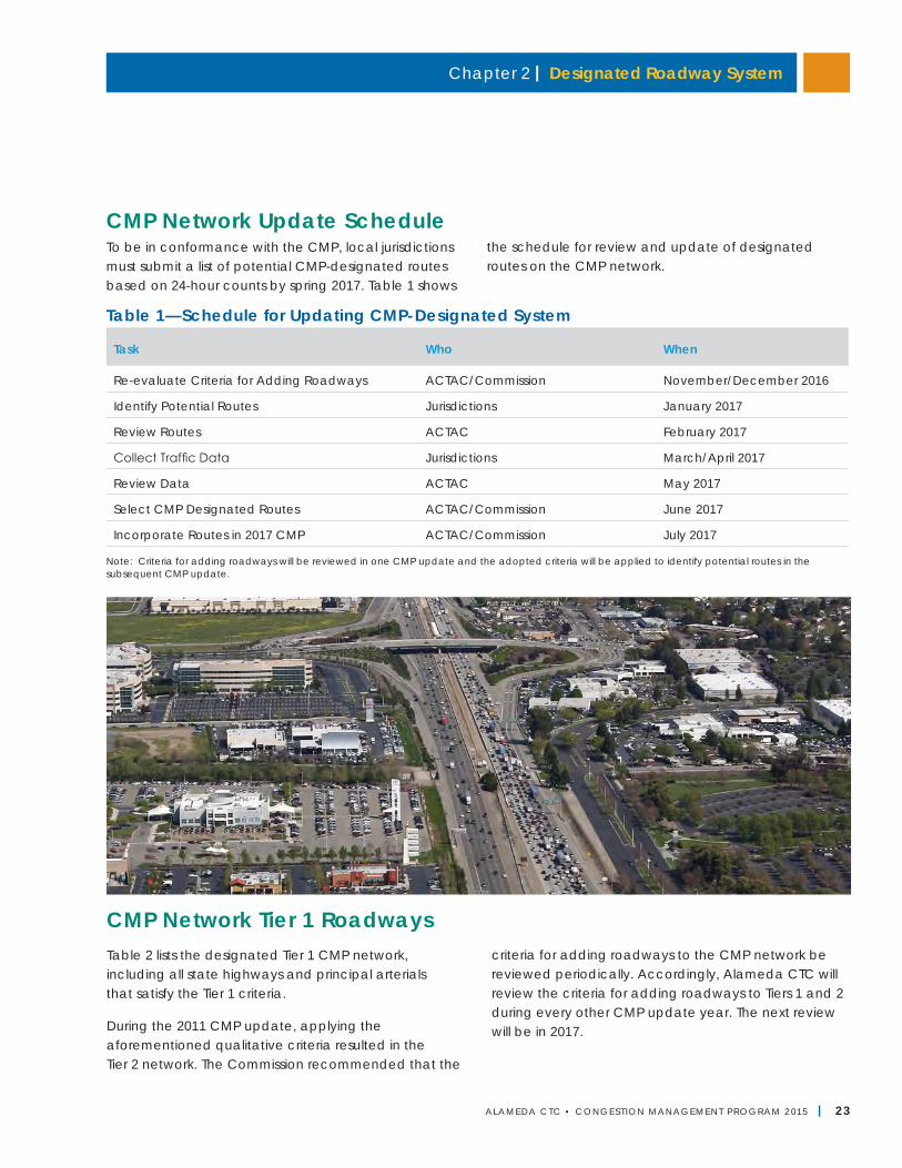
Chapter 2 | Designated Roadway System
ALAMEDA CTC • CONGEST ION MANAGEMENT PROGRAM 2 015 | 23
CMP Network Tier 1 RoadwaysTable 2 lists the designated Tier 1 CMP network, including all state highways and principal arterials that satisfy the Tier 1 criteria.
During the 2011 CMP update, applying the aforementioned qualitative criteria resulted in the Tier 2 network. The Commission recommended that the
criteria for adding roadways to the CMP network be reviewed periodically. Accordingly, Alameda CTC will review the criteria for adding roadways to Tiers 1 and 2 during every other CMP update year. The next review will be in 2017.
Note: Criteria for adding roadways will be reviewed in one CMP update and the adopted criteria will be applied to identify potential routes in the subsequent CMP update.
Table 1—Schedule for Updating CMP-Designated System
Task Who When
Re-evaluate Criteria for Adding Roadways ACTAC/Commission November/December 2016
Identify Potential Routes Jurisdictions January 2017
Review Routes ACTAC February 2017
Collect Traffic Data Jurisdictions March/April 2017
Review Data ACTAC May 2017
Select CMP Designated Routes ACTAC/Commission June 2017
Incorporate Routes in 2017 CMP ACTAC/Commission July 2017
CMP Network Update ScheduleTo be in conformance with the CMP, local jurisdictions must submit a list of potential CMP-designated routes based on 24-hour counts by spring 2017. Table 1 shows
the schedule for review and update of designated routes on the CMP network.
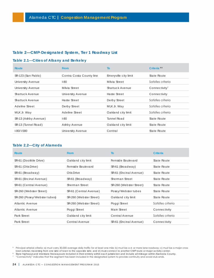
Alameda CTC | Congestion Management Program
24 | ALAMEDA CTC • CONGEST ION MANAGEMENT PROGRAM 2 015
Table 2.2—City of Alameda
Route From To Criteria
SR-61 (Doolittle Drive) Oakland city limit Fernside Boulevard State Route
SR-61 (Otis Drive) Fernside Boulevard SR-61 (Broadway) State Route
SR-61 (Broadway) Otis Drive SR-61 (Encinal Avenue) State Route
SR-61 (Encinal Avenue) SR-61 (Broadway) Sherman Street State Route
SR-61 (Central Avenue) Sherman Street SR-260 (Webster Street) State Route
SR-260 (Webster Street) SR-61 (Central Avenue) Posey/Webster tubes State Route
SR-260 (Posey/Webster tubes) SR-260 (Webster Street) Oakland city limit State Route
Atlantic Avenue SR-260 (Webster Street) Poggi Street Satisfies criteria
Atlantic Avenue Poggi Street Main Street Connectivity
Park Street Oakland city limit Central Avenue Satisfies criteria
Park Street Central Avenue SR-61 (Encinal Avenue) Connectivity
Table 2—CMP-Designated System, Tier 1 Roadway List
Table 2.1—Cities of Albany and Berkeley
Route From To Criteria 5 6
SR-123 (San Pablo) Contra Costa County line Emeryville city limit State Route
University Avenue I-80 Milvia Street Satisfies criteria
University Avenue Milvia Street Shattuck Avenue Connectivity7
Shattuck Avenue University Avenue Haste Street Connectivity
Shattuck Avenue Haste Street Derby Street Satisfies criteria
Adeline Street Derby Street MLK Jr. Way Satisfies criteria
MLK Jr. Way Adeline Street Oakland city limit Satisfies criteria
SR-13 (Ashby Avenue) I-80 Tunnel Road State Route
SR-13 (Tunnel Road) Ashby Avenue Oakland city limit State Route
I-80/I-580 University Avenue Central State Route
5 Principal arterial criteria: a) must carry 30,000 average daily traffic for at least one mile; b) must be a 4- or more lane roadway; c) must be a major cross town arterial, traversing from one side of town to the opposite side; and d) must connect to another CMP route or major activity center.
6 State highways and interstate freeways are included in their entirety within each jurisdiction and include all mileage within Alameda County.7 “Connectivity” indicates that the segment has been included in the designated system to provide continuity and avoid stub ends.
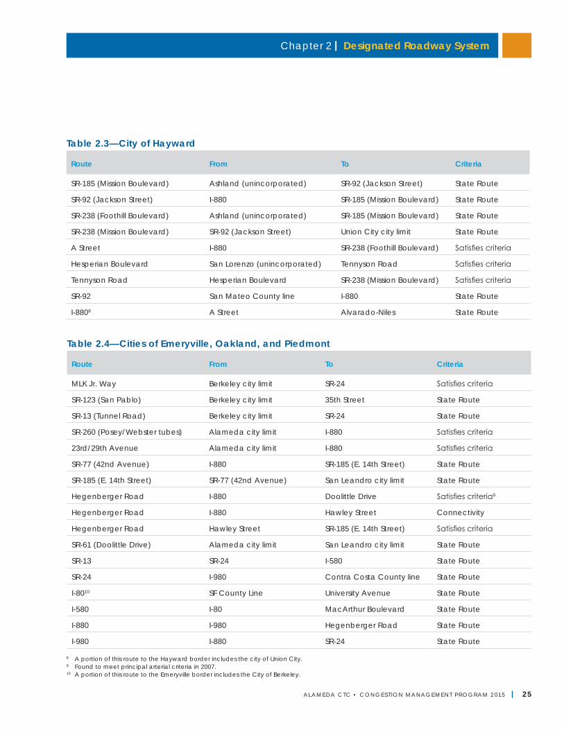
Chapter 2 | Designated Roadway System
ALAMEDA CTC • CONGEST ION MANAGEMENT PROGRAM 2 015 | 25
8 A portion of this route to the Hayward border includes the city of Union City.9 Found to meet principal arterial criteria in 2007.10 A portion of this route to the Emeryville border includes the City of Berkeley.
Table 2.3—City of Hayward
Route From To Criteria
SR-185 (Mission Boulevard) Ashland (unincorporated) SR-92 (Jackson Street) State Route
SR-92 (Jackson Street) I-880 SR-185 (Mission Boulevard) State Route
SR-238 (Foothill Boulevard) Ashland (unincorporated) SR-185 (Mission Boulevard) State Route
SR-238 (Mission Boulevard) SR-92 (Jackson Street) Union City city limit State Route
A Street I-880 SR-238 (Foothill Boulevard) Satisfies criteria
Hesperian Boulevard San Lorenzo (unincorporated) Tennyson Road Satisfies criteria
Tennyson Road Hesperian Boulevard SR-238 (Mission Boulevard) Satisfies criteria
SR-92 San Mateo County line I-880 State Route
I-8808 A Street Alvarado-Niles State Route
Table 2.4—Cities of Emeryville, Oakland, and Piedmont
Route From To Criteria
MLK Jr. Way Berkeley city limit SR-24 Satisfies criteria
SR-123 (San Pablo) Berkeley city limit 35th Street State Route
SR-13 (Tunnel Road) Berkeley city limit SR-24 State Route
SR-260 (Posey/Webster tubes) Alameda city limit I-880 Satisfies criteria
23rd/29th Avenue Alameda city limit I-880 Satisfies criteria
SR-77 (42nd Avenue) I-880 SR-185 (E. 14th Street) State Route
SR-185 (E. 14th Street) SR-77 (42nd Avenue) San Leandro city limit State Route
Hegenberger Road I-880 Doolittle Drive Satisfies criteria9
Hegenberger Road I-880 Hawley Street Connectivity
Hegenberger Road Hawley Street SR-185 (E. 14th Street) Satisfies criteria
SR-61 (Doolittle Drive) Alameda city limit San Leandro city limit State Route
SR-13 SR-24 I-580 State Route
SR-24 I-980 Contra Costa County line State Route
I-8010 SF County Line University Avenue State Route
I-580 I-80 MacArthur Boulevard State Route
I-880 I-980 Hegenberger Road State Route
I-980 I-880 SR-24 State Route
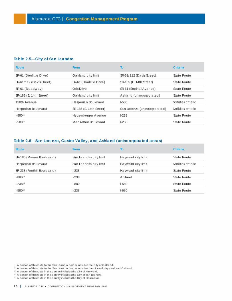
Alameda CTC | Congestion Management Program
26 | ALAMEDA CTC • CONGEST ION MANAGEMENT PROGRAM 2 015
11 A portion of this route to the San Leandro border includes the City of Oakland.12 A portion of this route to the San Leandro border includes the cities of Hayward and Oakland.13 A portion of this route in the county includes the City of Hayward.14 A portion of this route in the county includes the City of San Leandro.15 A portion of this route in the county includes the City of Pleasanton.
Table 2.6—San Lorenzo, Castro Valley, and Ashland (unincorporated areas)
Route From To Criteria
SR-185 (Mission Boulevard) San Leandro city limit Hayward city limit State Route
Hesperian Boulevard San Leandro city limit Hayward city limit Satisfies criteria
SR-238 (Foothill Boulevard) I-238 Hayward city limit State Route
I-88013 I-238 A Street State Route
I-23814 I-880 I-580 State Route
I-58015 I-238 I-680 State Route
Table 2.5—City of San Leandro
Route From To Criteria
SR-61 (Doolittle Drive) Oakland city limit SR-61/112 (Davis Street) State Route
SR-61/112 (Davis Street) SR-61 (Doolittle Drive) SR-185 (E. 14th Street) State Route
SR-61 (Broadway) Otis Drive SR-61 (Encinal Avenue) State Route
SR-185 (E. 14th Street) Oakland city limit Ashland (unincorporated) State Route
150th Avenue Hesperian Boulevard I-580 Satisfies criteria
Hesperian Boulevard SR-185 (E. 14th Street) San Lorenzo (unincorporated) Satisfies criteria
I-88011 Hegenberger Avenue I-238 State Route
I-58012 MacArthur Boulevard I-238 State Route
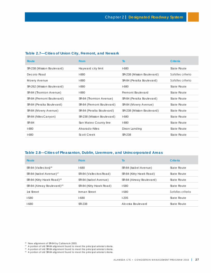
Chapter 2 | Designated Roadway System
ALAMEDA CTC • CONGEST ION MANAGEMENT PROGRAM 2 015 | 27
16 New alignment of SR-84 by Caltrans in 2003.17 A portion of old SR-84 alignment found to meet the principal arterial criteria.18 A portion of old SR-84 alignment found to meet the principal arterial criteria.19 A portion of old SR-84 alignment found to meet the principal arterial criteria.
Table 2.7—Cities of Union City, Fremont, and Newark
Route From To Criteria
SR-238 (Mission Boulevard) Hayward city limit I-680 State Route
Decoto Road I-880 SR-238 (Mission Boulevard) Satisfies criteria
Mowry Avenue I-880 SR-84 (Peralta Boulevard) Satisfies criteria
SR-262 (Mission Boulevard) I-880 I-680 State Route
SR-84 (Thornton Avenue) I-880 Fremont Boulevard State Route
SR-84 (Fremont Boulevard) SR-84 (Thornton Avenue) SR-84 (Peralta Boulevard) State Route
SR-84 (Peralta Boulevard) SR-84 (Fremont Boulevard) SR-84 (Mowry Avenue) State Route
SR-84 (Mowry Avenue) SR-84 (Peralta Boulevard) SR-238 (Mission Boulevard) State Route
SR-84 (Niles Canyon) SR-238 (Mission Boulevard) I-680 State Route
SR-84 San Mateo County line I-880 State Route
I-880 Alvarado-Niles Dixon Landing State Route
I-680 Scott Creek SR-238 State Route
Table 2.8—Cities of Pleasanton, Dublin, Livermore, and Unincorporated Areas
Route From To Criteria
SR-84 (Vallecitos)16 I-680 SR-84 (Isabel Avenue) State Route
SR-84 (Isabel Avenue)17 SR-84 (Vallecitos Road) SR-84 (Kitty Hawk Road) State Route
SR-84 (Kitty Hawk Road)18 SR-84 (Isabel Avenue) SR-84 (Airway Boulevard) State Route
SR-84 (Airway Boulevard)19 SR-84 (Kitty Hawk Road) I-580 State Route
1st Street Inman Street I-580 Satisfies criteria
I-580 I-680 I-205 State Route
I-680 SR-238 Alcosta Boulevard State Route
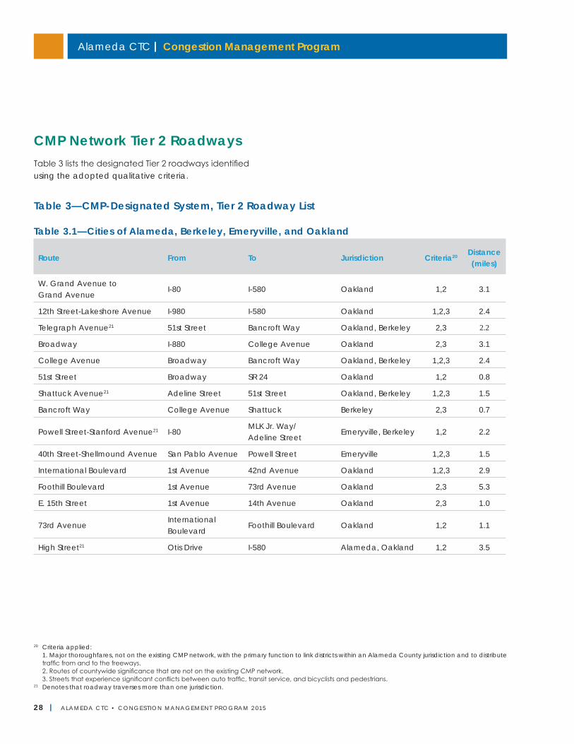
Alameda CTC | Congestion Management Program
28 | ALAMEDA CTC • CONGEST ION MANAGEMENT PROGRAM 2 015
Table 3—CMP-Designated System, Tier 2 Roadway List
20 Criteria applied: 1. Major thoroughfares, not on the existing CMP network, with the primary function to link districts within an Alameda County jurisdiction and to distribute
traffic from and to the freeways. 2. Routes of countywide significance that are not on the existing CMP network. 3. Streets that experience significant conflicts between auto traffic, transit service, and bicyclists and pedestrians.21 Denotes that roadway traverses more than one jurisdiction.
CMP Network Tier 2 RoadwaysTable 3 lists the designated Tier 2 roadways identified using the adopted qualitative criteria.
Table 3.1—Cities of Alameda, Berkeley, Emeryville, and Oakland
Route From To Jurisdiction Criteria20 Distance (miles)
W. Grand Avenue to Grand Avenue
I-80 I-580 Oakland 1,2 3.1
12th Street-Lakeshore Avenue I-980 I-580 Oakland 1,2,3 2.4
Telegraph Avenue21 51st Street Bancroft Way Oakland, Berkeley 2,3 2.2
Broadway I-880 College Avenue Oakland 2,3 3.1
College Avenue Broadway Bancroft Way Oakland, Berkeley 1,2,3 2.4
51st Street Broadway SR 24 Oakland 1,2 0.8
Shattuck Avenue21 Adeline Street 51st Street Oakland, Berkeley 1,2,3 1.5
Bancroft Way College Avenue Shattuck Berkeley 2,3 0.7
Powell Street-Stanford Avenue21 I-80MLK Jr. Way/ Adeline Street
Emeryville, Berkeley 1,2 2.2
40th Street-Shellmound Avenue San Pablo Avenue Powell Street Emeryville 1,2,3 1.5
International Boulevard 1st Avenue 42nd Avenue Oakland 1,2,3 2.9
Foothill Boulevard 1st Avenue 73rd Avenue Oakland 2,3 5.3
E. 15th Street 1st Avenue 14th Avenue Oakland 2,3 1.0
73rd AvenueInternational Boulevard
Foothill Boulevard Oakland 1,2 1.1
High Street21 Otis Drive I-580 Alameda, Oakland 1,2 3.5
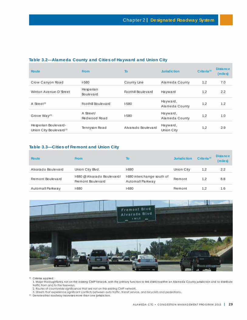
Chapter 2 | Designated Roadway System
ALAMEDA CTC • CONGEST ION MANAGEMENT PROGRAM 2 015 | 29
22 Criteria applied: 1. Major thoroughfares, not on the existing CMP network, with the primary function to link districts within an Alameda County jurisdiction and to distribute
traffic from and to the freeways. 2. Routes of countywide significance that are not on the existing CMP network. 3. Streets that experience significant conflicts between auto traffic, transit service, and bicyclists and pedestrians.23 Denotes that roadway traverses more than one jurisdiction.
Table 3.2—Alameda County and Cities of Hayward and Union City
Route From To Jurisdiction Criteria22 Distance (miles)
Crow Canyon Road I-580 County Line Alameda County 1,2 7.0
Winton Avenue-D StreetHesperian Boulevard
Foothill Boulevard Hayward 1,2 2.2
A Street23 Foothill Boulevard I-580Hayward, Alameda County
1,2 1.2
Grove Way23 A Street/ Redwood Road
I-580Hayward, Alameda County
1,2 1.0
Hesperian Boulevard- Union City Boulevard23 Tennyson Road Alvarado Boulevard
Hayward, Union City
1,2 2.9
Table 3.3—Cities of Fremont and Union City
Route From To Jurisdiction Criteria22 Distance (miles)
Alvarado Boulevard Union City Blvd. I-880 Union City 1,2 2.2
Fremont BoulevardI-880 @ Alvarado Boulevard/ Fremont Boulevard
I-880 interchange south of Automall Parkway
Fremont 1,2 8.8
Automall Parkway I-880 I-680 Fremont 1,2 1.6
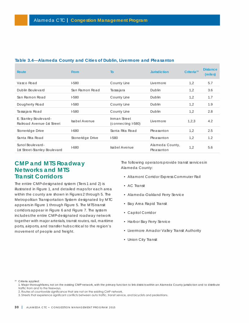
Alameda CTC | Congestion Management Program
30 | ALAMEDA CTC • CONGEST ION MANAGEMENT PROGRAM 2 015
CMP and MTS Roadway Networks and MTS Transit CorridorsThe entire CMP-designated system (Tiers 1 and 2) is illustrated in Figure 1, and detailed maps for each area within the county are shown in Figures 2 through 5. The Metropolitan Transportation System designated by MTC appears in Figure 1 through Figure 5. The MTS transit corridors appear in Figure 6 and Figure 7. The system includes the entire CMP-designated roadway network together with major arterials, transit routes, rail, maritime ports, airports, and transfer hubs critical to the region’s movement of people and freight.
The following operators provide transit services in Alameda County:
• Altamont Corridor Express Commuter Rail
• AC Transit
• Alameda-Oakland Ferry Service
• Bay Area Rapid Transit
• Capitol Corridor
• Harbor Bay Ferry Service
• Livermore Amador Valley Transit Authority
• Union City Transit
Table 3.4—Alameda County and Cities of Dublin, Livermore and Pleasanton
Route From To Jurisdiction Criteria24 Distance (miles)
Vasco Road I-580 County Line Livermore 1,2 5.7
Dublin Boulevard San Ramon Road Tassajara Dublin 1,2 3.6
San Ramon Road I-580 County Line Dublin 1,2 1.7
Dougherty Road I-580 County Line Dublin 1,2 1.9
Tassajara Road I-580 County Line Dublin 1,2 2.8
E. Stanley Boulevard- Railroad Avenue-1st Street
Isabel AvenueInman Street (connecting I-580)
Livermore 1,2,3 4.2
Stoneridge Drive I-680 Santa Rita Road Pleasanton 1,2 2.5
Santa Rita Road Stoneridge Drive I-580 Pleasanton 1,2 1.2
Sunol Boulevard- 1st Street-Stanley Boulevard
I-680 Isabel AvenueAlameda County, Pleasanton
1,2 5.6
24 Criteria applied: 1. Major thoroughfares, not on the existing CMP network, with the primary function to link districts within an Alameda County jurisdiction and to distribute
traffic from and to the freeways. 2. Routes of countywide significance that are not on the existing CMP network. 3. Streets that experience significant conflicts between auto traffic, transit service, and bicyclists and pedestrians.
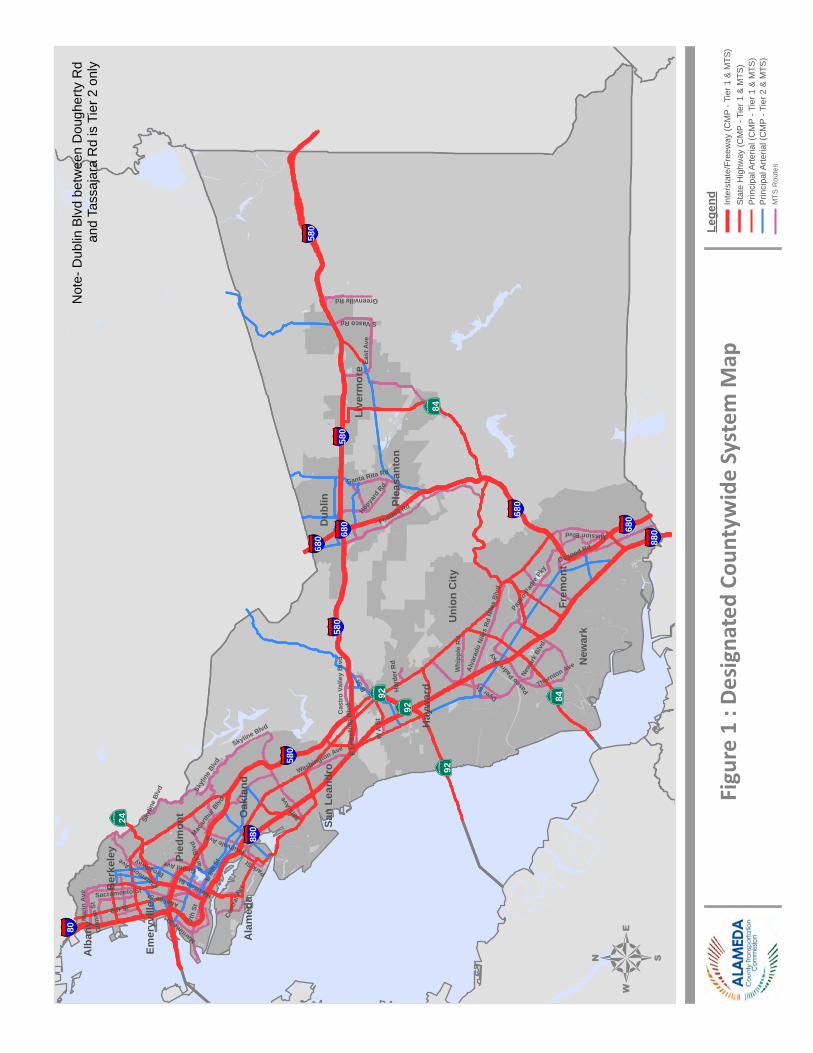
Foothill Rd
7th
St
Pase
o Pa
dre P
ky
Park
Blv
d
B St
Dyer St
Whi
pple
Rd
Adeline StClaremont A
ve
Alva
rado
Nile
s Rd
East
Ave
Osgood Rd
Nile
s Bl
vd
Fruitvale Ave
Greenville Rd
Harrison St
Washington Ave
Hopya
rd R
d
Skyline Blvd
Newa
rk B
lvd
Mission Blvd
Mar
in A
ve
Cas
tro
Valle
y B
lvd
Sacramento St
Grand Ave
Maritime St
E 8t
h St
98th
Ave
S Vasco Rd
Gilm
an S
t
Macar
thur
Blvd
W A
St
6th St
Broadway
Santa Rita Rd
Cent
ral A
ve
Thornton Ave
Har
der R
d
E Le
wel
ling
Blv
d
Park StSk
ylin
e Blvd
Paseo
Padre
Pky
Skyl
ine
Blvd
Frem
ont
Oak
land
Hay
war
d
Live
rmor
e
Dub
lin
New
ark
Uni
on C
ity
Plea
sant
on
Ber
kele
y
San
Lean
dro
Ala
med
a
Alb
any
Pied
mon
t
Emer
yvill
e
§̈ ¦580
§̈ ¦680
§̈ ¦880
§̈ ¦80
§̈ ¦680
§̈ ¦680
§̈ ¦580
§̈ ¦680
§̈ ¦580
§̈ ¦580
§̈ ¦880
∙}þ84∙}þ92
∙}þ24
∙}þ92
∙}þ84∙}þ92
Figu
re 1
: De
sign
ated
Cou
ntyw
ide
Syst
em M
ap
4Le
gend In
ters
tate
/Fre
eway
(CM
P - T
ier 1
& M
TS)
Sta
te H
ighw
ay (C
MP
- Tie
r 1 &
MTS
)P
rinci
pal A
rteria
l (C
MP
- Tie
r 1 &
MTS
)P
rinci
pal A
rteria
l (C
MP
- Tie
r 2 &
MTS
)M
TS R
oute
s
Not
e- D
ublin
Blv
d be
twee
n D
ough
erty
Rd
and
Tass
ajar
a R
d is
Tie
r 2 o
nly
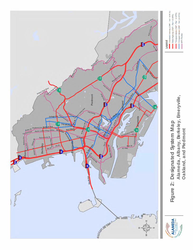
Alameda CTC | Congestion Management Program
32 | ALAMEDA CTC • CONGEST ION MANAGEMENT PROGRAM 2 015
Figu
re 2
: De
signa
ted
Syst
em M
ap
A
lam
eda,
Alb
any,
Ber
kele
y, E
mer
yvill
e,
O
akla
nd, a
nd P
iedm
ont
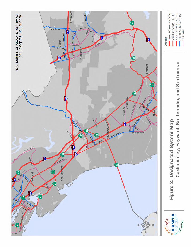
Chapter 2 | Designated Roadway System
ALAMEDA CTC • CONGEST ION MANAGEMENT PROGRAM 2 015 | 33
Figu
re 3
: De
signa
ted
Syst
em M
ap
C
astro
Val
ley,
Hay
war
d, S
an L
eand
ro, a
nd S
an L
oren
zo
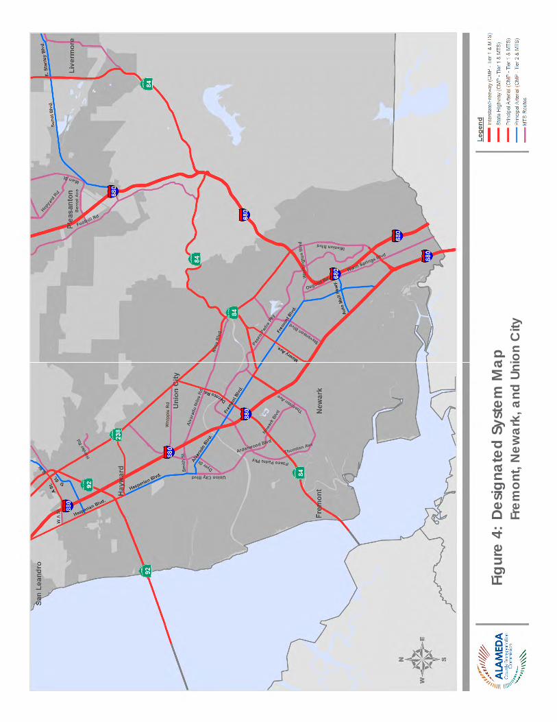
Alameda CTC | Congestion Management Program
34 | ALAMEDA CTC • CONGEST ION MANAGEMENT PROGRAM 2 015
Figu
re 4
: De
signa
ted
Syst
em M
ap
Fr
emon
t, N
ewar
k, a
nd U
nion
City
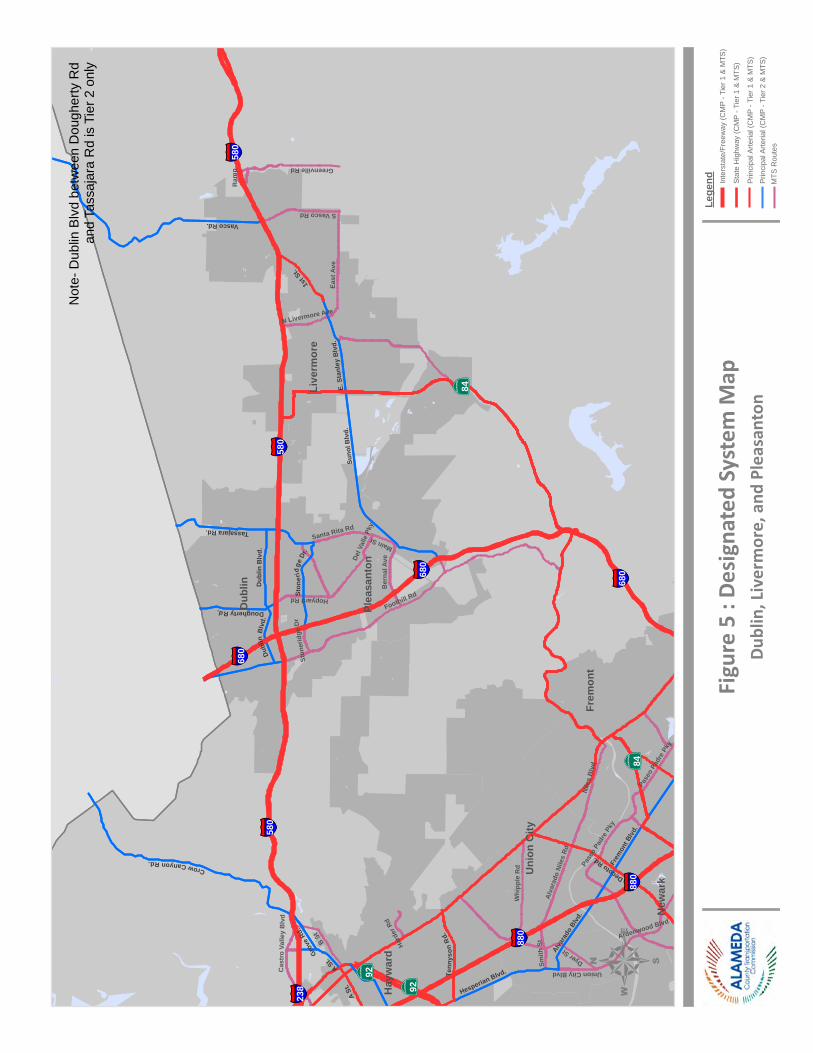
Foothill Rd
Pase
o Pa
dre
Pky
B St
Dyer St
Whi
pple
Rd
Alva
rado
Nile
s Rd
East
Ave
Nile
s B
lvd
Greenville Rd
Hopyard Rd
Union City BlvdCas
tro
Valle
y B
lvd
Ber
nal A
ve
Santa Rita Rd
S Vasco Rd
Hard
er R
d
N Livermore Ave
Ardenwood Blvd
Ston
erid
ge D
r
Ram
p
Smith
St
Del V
alle
Pky
Main St
Pase
o Pa
dre
Pky
Hay
war
d
Frem
ont
Live
rmor
e
Plea
sant
on
Dub
lin
Uni
on C
ity
New
ark
§̈ ¦580
§̈ ¦680
§̈ ¦880
§̈ ¦238
§̈ ¦680
§̈ ¦580
§̈ ¦880
§̈ ¦580
§̈ ¦680
∙}þ84
∙}þ92
∙}þ92
∙}þ84
Vasco Rd.
Suno
l Blv
d.
CrowCanyonRd.
1stS
t.
DecotoRd.
A St.
Tassajara Rd.
Tenn
yson
Rd.
Frem
ont B
lvd.
Dub
lin B
lvd.
S to n
erid
geDr
.
DoughertyRd.
Alva
rado
Blvd
.
Hesperian Blvd.
E. S
tanl
ey B
lvd.
Grov
e Rd
.
Dubl
inB
lvd.
A St
.
Figu
re 5
: De
sign
ated
Sys
tem
Map
4Du
blin
, Liv
erm
ore,
and
Ple
asan
ton
Lege
nd Inte
rsta
te/F
reew
ay (C
MP
- Tie
r 1 &
MTS
)
Stat
e H
ighw
ay (C
MP
- Tie
r 1 &
MTS
)
Prin
cipa
l Arte
rial (
CM
P - T
ier 1
& M
TS)
Prin
cipa
l Arte
rial (
CM
P - T
ier 2
& M
TS)
MTS
Rou
tes
Not
e- D
ublin
Blv
d be
twee
n D
ough
erty
Rd
and
Tass
ajar
a R
d is
Tie
r 2 o
nly
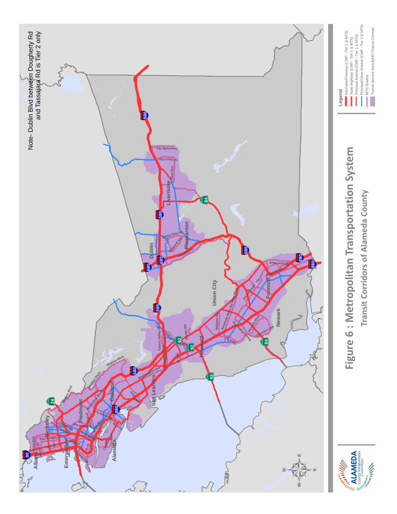
Foothill Rd
7th
St
Pase
o Pa
dre P
ky
Park
Blv
d
B St
Dyer St
Whi
pple
Rd
Adeline StClaremont A
ve
Alva
rado
Nile
s Rd
East
Ave
Osgood Rd
Nile
s Bl
vd
Fruitvale Ave
Greenville Rd
Harrison St
Washington Ave
Hopya
rd R
d
Skyline Blvd
Newa
rk B
lvd
Mission Blvd
Mar
in A
ve
Cas
tro
Valle
y B
lvd
Sacramento St
Grand Ave
Maritime St
E 8t
h St
98th
Ave
S Vasco Rd
Gilm
an S
t
Macar
thur
Blvd
W A
St
6th St
Broadway
Santa Rita Rd
Cent
ral A
ve
Thornton Ave
Har
der R
d
E Le
wel
ling
Blv
d
Park StSk
ylin
e Blvd
Paseo
Padre
Pky
Skyl
ine
Blvd
Frem
ont
Oak
land
Hay
war
d
Live
rmor
e
Dub
lin
New
ark
Uni
on C
ity
Plea
sant
on
Ber
kele
y
San
Lean
dro
Ala
med
a
Alb
any
Pied
mon
t
Emer
yvill
e
§̈ ¦580
§̈ ¦680
§̈ ¦880
§̈ ¦80
§̈ ¦680
§̈ ¦680
§̈ ¦580
§̈ ¦680
§̈ ¦580
§̈ ¦580
§̈ ¦880
∙}þ84∙}þ92
∙}þ24
∙}þ92
∙}þ84∙}þ92
Figu
re 6
: M
etro
polit
an T
rans
port
atio
n Sy
stem
4Tr
ansi
t Cor
ridor
s of A
lam
eda
Coun
ty
Lege
nd Inte
rsta
te/F
reew
ay (C
MP
- Tie
r 1 &
MTS
)S
tate
Hig
hway
(CM
P - T
ier 1
& M
TS)
Prin
cipa
l Arte
rial (
CM
P - T
ier 1
& M
TS)
Prin
cipa
l/Oth
er A
rteria
l (C
MP
- Tie
r 2 &
MTS
)
Tran
sit S
ervi
ce A
rea
BA
RT/
Tran
sit C
orrid
orM
TS R
oute
s
Not
e- D
ublin
Blv
d be
twee
n D
ough
erty
Rd
and
Tass
ajar
a R
d is
Tie
r 2 o
nly
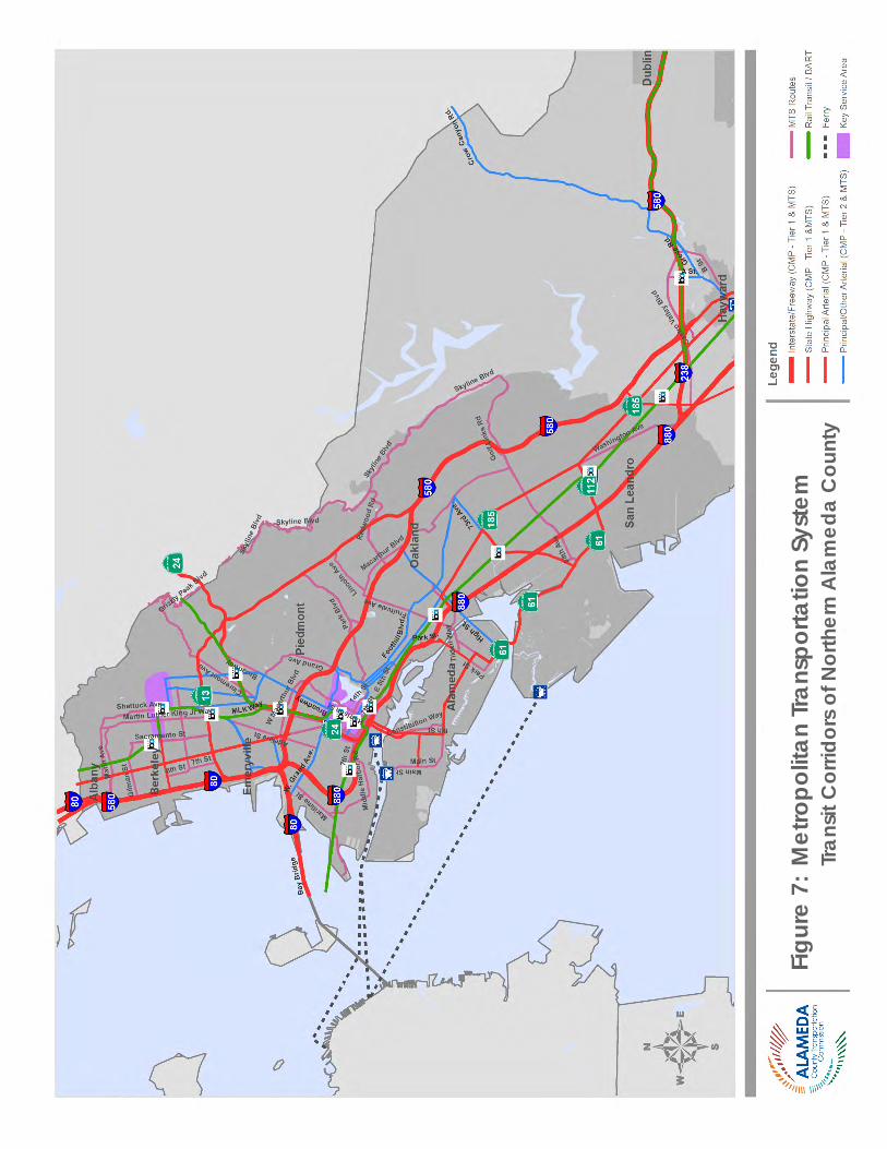
Chapter 2 | Designated Roadway System
ALAMEDA CTC • CONGEST ION MANAGEMENT PROGRAM 2 015 | 37
Figu
re 7
: M
etro
polit
an Tr
ansp
orta
tion
Syst
em
Tr
ansit
Cor
ridor
s of
Nor
ther
n A
lam
eda
Cou
nty
Alameda CTC | Congestion Management Program
38 | ALAMEDA CTC • CONGEST ION MANAGEMENT PROGRAM 2 015
Next StepsThe 2015 CMP update identified the following next steps for the update of the Designated CMP Network System:
• Review and update the CMP network criteria in the 2017 CMP update in conjunction with the outcome of the three countywide modal plans—the County-wide Multimodal Arterial Plan, Countywide Transit Plan, and Countywide Goods Movement Plan—to expand the CMP network to include significant rural roadways in the county.
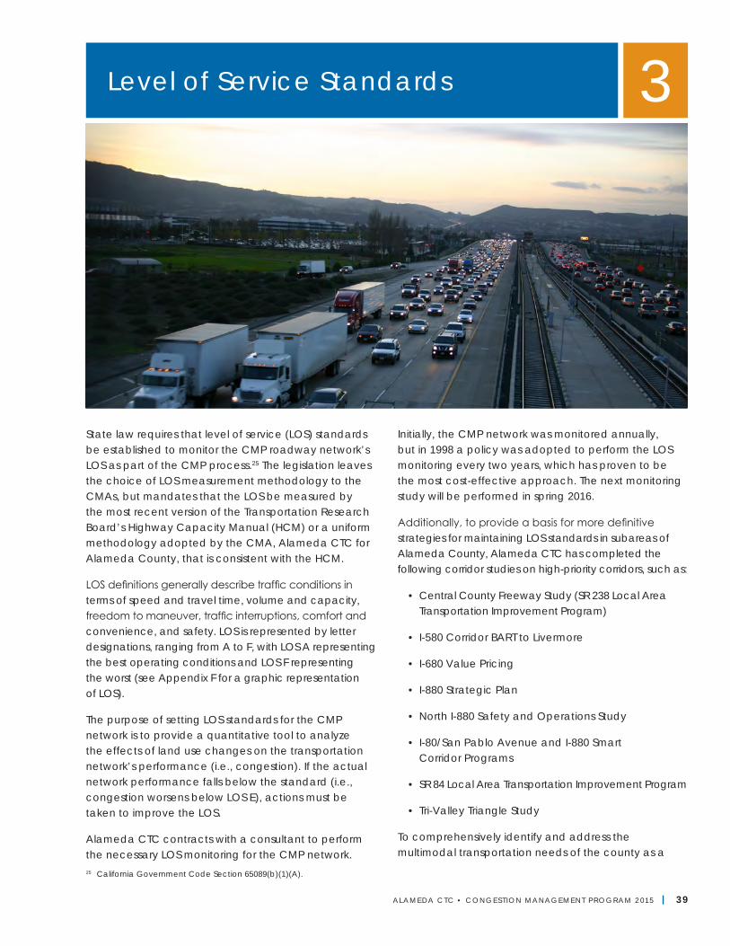
ALAMEDA CTC • CONGEST ION MANAGEMENT PROGRAM 2 015 | 39
State law requires that level of service (LOS) standards be established to monitor the CMP roadway network’s LOS as part of the CMP process.25 The legislation leaves the choice of LOS measurement methodology to the CMAs, but mandates that the LOS be measured by the most recent version of the Transportation Research Board’s Highway Capacity Manual (HCM) or a uniform methodology adopted by the CMA, Alameda CTC for Alameda County, that is consistent with the HCM.
LOS definitions generally describe traffic conditions in terms of speed and travel time, volume and capacity, freedom to maneuver, traffic interruptions, comfort and convenience, and safety. LOS is represented by letter designations, ranging from A to F, with LOS A representing the best operating conditions and LOS F representing the worst (see Appendix F for a graphic representation of LOS).
The purpose of setting LOS standards for the CMP network is to provide a quantitative tool to analyze the effects of land use changes on the transportation network’s performance (i.e., congestion). If the actual network performance falls below the standard (i.e., congestion worsens below LOS E), actions must be taken to improve the LOS.
Alameda CTC contracts with a consultant to perform the necessary LOS monitoring for the CMP network.
Initially, the CMP network was monitored annually, but in 1998 a policy was adopted to perform the LOS monitoring every two years, which has proven to be the most cost-effective approach. The next monitoring study will be performed in spring 2016.
Additionally, to provide a basis for more definitive strategies for maintaining LOS standards in subareas of Alameda County, Alameda CTC has completed the following corridor studies on high-priority corridors, such as:
• Central County Freeway Study (SR 238 Local Area Transportation Improvement Program)
• I-580 Corridor BART to Livermore
• I-680 Value Pricing
• I-880 Strategic Plan
• North I-880 Safety and Operations Study
• I-80/San Pablo Avenue and I-880 Smart Corridor Programs
• SR 84 Local Area Transportation Improvement Program
• Tri-Valley Triangle Study
To comprehensively identify and address the multimodal transportation needs of the county as a
Level of Service Standards 3
25 California Government Code Section 65089(b)(1)(A).
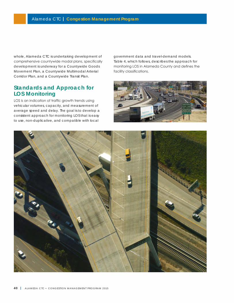
Alameda CTC | Congestion Management Program
40 | ALAMEDA CTC • CONGEST ION MANAGEMENT PROGRAM 2 015
whole, Alameda CTC is undertaking development of comprehensive countywide modal plans, specifically development is underway for a Countywide Goods Movement Plan, a Countywide Multimodal Arterial Corridor Plan, and a Countywide Transit Plan.
Standards and Approach for LOS MonitoringLOS is an indication of traffic growth trends using vehicular volumes, capacity, and measurement of average speed and delay. The goal is to develop a consistent approach for monitoring LOS that is easy to use, non-duplicative, and compatible with local
government data and travel-demand models. Table 4, which follows, describes the approach for monitoring LOS in Alameda County and defines the facility classifications.
Chapter 3 | Level of Service Standards
ALAMEDA CTC • CONGEST ION MANAGEMENT PROGRAM 2 015 | 41
Element Approach
Level of Service
As defined in the California Government Code Section 65089.3, the LOS standard is E, except where F was the LOS when originally measured, in which case the standard is F. The methods employed constitute a uniform methodology adopted that is consistent with the HCM1985 that includes speed-based LOS methodology. Methods described in HCM Chapter 8, "Two-Lane Highways" and Chapter 11, "Urban and Suburban Arterials" were the basis for establishing the LOS on the CMP network. LOS is assessed based on the average speed observed along a roadway segment (link speeds) or total volumes approaching an intersection (link volumes). These methods are not designed to replace the more detailed procedures that local agencies are likely to use for non-CMP purposes (such as local impact studies). Such procedures typically focus on an intersection’s ability to handle individual turning movements rather than average speed on a roadway segment.
Facility Classifications
The HCM provides methods for determining LOS on several types of facilities. These facilities are grouped into “interrupted-flow” and “uninterrupted-flow” facilities. Interrupted-flow facilities include city streets and surface highways (for example, State Route 123/San Pablo Avenue) that are part of the state highway system. Freeways are uninterrupted-flow facilities. For the purposes of LOS monitoring, the CMP network can be classified into three functional types of facilities: 1) freeways; 2) two-lane roadways; and 3) urban/suburban arterials.
1) Freeways Freeways are uninterrupted-flow facilities, since traffic never stops (except during the most congested periods or when incidents occur). The 1991 Alameda County CMP, in coordination with local jurisdictions, defined appropriate segments and performed the necessary “floating car” runs on the freeways to obtain travel speed data (refer to “Data Collection and Requirements” in this chapter for information on this data collection method). This allowed the establishment of a baseline LOS for the roadway network, including identification of segments operating at LOS F.
2) Two-Lane Roadways
Two-lane roadways are uninterrupted-flow facilities. The criteria for including principal arterials in the CMP network specify a minimum of four lanes; therefore, two-lane roadways are not included as principal arterials. However, since all state highways must be in the system, two-lane state highways located in the county are also included. These two-lane roads constitute a fairly small portion of the CMP network mileage. For two-lane roads without interruptions (signals or stop signs), the methodology in HCM Chapter 8 is used, based on average travel speed.
3) Urban and Suburban Arterials
Urban and suburban arterials are multilane streets that have traffic signals spaced no more than two miles apart on average. Urban and suburban arterials are characterized by platoon flows. Operational quality is controlled primarily by the efficiency of signal coordination and is affected by how individual signalized intersections operate along the arterial. LOS is primarily a function of travel speed along segments and is calculated from field data. Because the CMP legislation emphasizes systems-level planning, HCM Chapter 11 is used to estimate arterial LOS. Advantages include the need for relatively little input data, simple applied calculations, and the results of explicitly determined LOS (A, B, C, etc.).
Monitoring Alameda CTC conducts LOS monitoring. The state statute24 requires Caltrans to monitor LOS on the freeway network, unless Alameda CTC designates that responsibility to another entity. Monitoring is conducted biennially, recognizing that other surveys could be done for development impact studies (e.g., intersection turning movement counts). Alameda CTC uses two data collection methods for LOS monitoring: 1) commercial speed data based on aggregated traffic data from GPS-enabled vehicles and mobile devices, traditional road sensors, and other sources; and 2) the floating car technique of recording travel times between checkpoints based on actual travel time during the peak period. Refer to “Data Collection and Requirements” in this chapter for details on the two data collection methods.
Interregional Trips
As defined by the statute, “interregional travel means any trip that originates from outside” Alameda County. A trip means a one-direction vehicle movement. The origin of any trip is the starting point of that trip. In accordance with the Metropolitan Transportation Commission (MTC) guidelines, trips with no trip end in Alameda County (through trips) are not subtracted for monitoring reports.
Table 4—Approach to LOS Monitoring
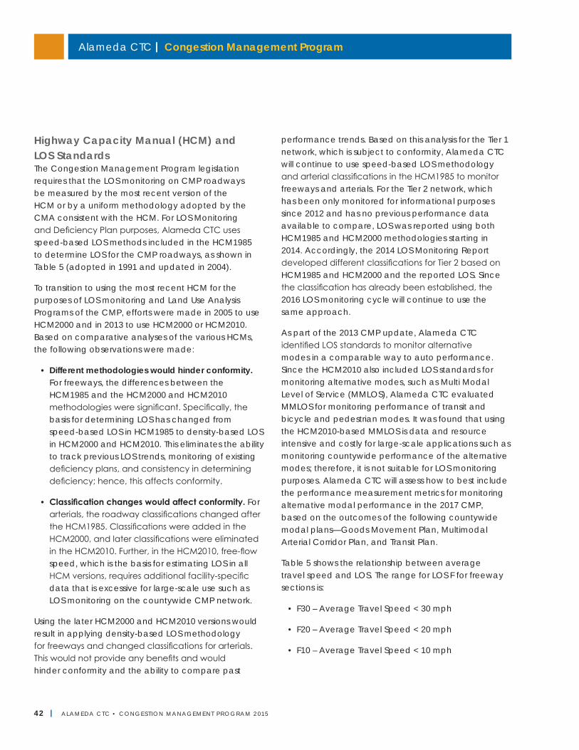
Alameda CTC | Congestion Management Program
42 | ALAMEDA CTC • CONGEST ION MANAGEMENT PROGRAM 2 015
Highway Capacity Manual (HCM) and LOS StandardsThe Congestion Management Program legislation requires that the LOS monitoring on CMP roadways be measured by the most recent version of the HCM or by a uniform methodology adopted by the CMA consistent with the HCM. For LOS Monitoring and Deficiency Plan purposes, Alameda CTC uses speed-based LOS methods included in the HCM1985 to determine LOS for the CMP roadways, as shown in Table 5 (adopted in 1991 and updated in 2004).
To transition to using the most recent HCM for the purposes of LOS monitoring and Land Use Analysis Programs of the CMP, efforts were made in 2005 to use HCM2000 and in 2013 to use HCM2000 or HCM2010. Based on comparative analyses of the various HCMs, the following observations were made:
• Different methodologies would hinder conformity. For freeways, the differences between the HCM1985 and the HCM2000 and HCM2010 methodologies were significant. Specifically, the basis for determining LOS has changed from speed-based LOS in HCM1985 to density-based LOS in HCM2000 and HCM2010. This eliminates the ability to track previous LOS trends, monitoring of existing deficiency plans, and consistency in determining deficiency; hence, this affects conformity.
• Classification changes would affect conformity. For arterials, the roadway classifications changed after the HCM1985. Classifications were added in the HCM2000, and later classifications were eliminated in the HCM2010. Further, in the HCM2010, free-flow speed, which is the basis for estimating LOS in all HCM versions, requires additional facility-specific data that is excessive for large-scale use such as LOS monitoring on the countywide CMP network.
Using the later HCM2000 and HCM2010 versions would result in applying density-based LOS methodology for freeways and changed classifications for arterials. This would not provide any benefits and would hinder conformity and the ability to compare past
performance trends. Based on this analysis for the Tier 1 network, which is subject to conformity, Alameda CTC will continue to use speed-based LOS methodology and arterial classifications in the HCM1985 to monitor freeways and arterials. For the Tier 2 network, which has been only monitored for informational purposes since 2012 and has no previous performance data available to compare, LOS was reported using both HCM1985 and HCM2000 methodologies starting in 2014. Accordingly, the 2014 LOS Monitoring Report developed different classifications for Tier 2 based on HCM1985 and HCM2000 and the reported LOS. Since the classification has already been established, the 2016 LOS monitoring cycle will continue to use the same approach.
As part of the 2013 CMP update, Alameda CTC identified LOS standards to monitor alternative modes in a comparable way to auto performance. Since the HCM2010 also included LOS standards for monitoring alternative modes, such as Multi Modal Level of Service (MMLOS), Alameda CTC evaluated MMLOS for monitoring performance of transit and bicycle and pedestrian modes. It was found that using the HCM2010-based MMLOS is data and resource intensive and costly for large-scale applications such as monitoring countywide performance of the alternative modes; therefore, it is not suitable for LOS monitoring purposes. Alameda CTC will assess how to best include the performance measurement metrics for monitoring alternative modal performance in the 2017 CMP, based on the outcomes of the following countywide modal plans—Goods Movement Plan, Multimodal Arterial Corridor Plan, and Transit Plan.
Table 5 shows the relationship between average travel speed and LOS. The range for LOS F for freeway sections is:
• F30 – Average Travel Speed < 30 mph
• F20 – Average Travel Speed < 20 mph
• F10 – Average Travel Speed < 10 mph
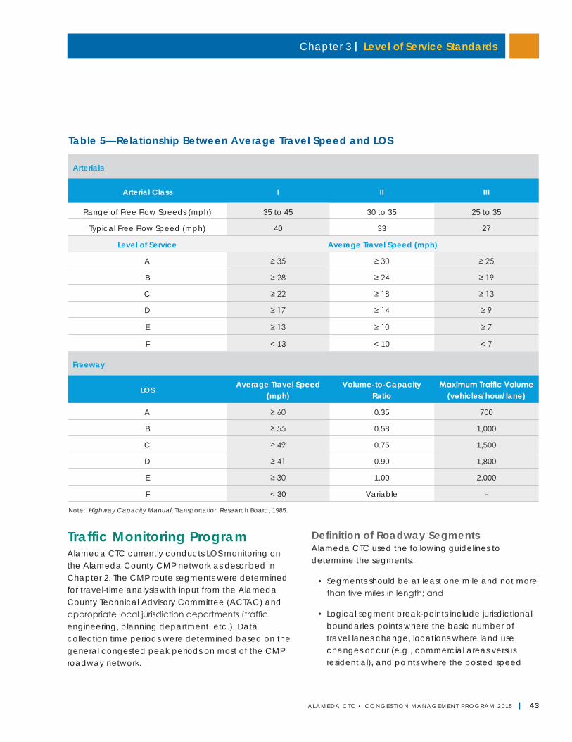
Chapter 3 | Level of Service Standards
ALAMEDA CTC • CONGEST ION MANAGEMENT PROGRAM 2 015 | 43
Traffic Monitoring ProgramAlameda CTC currently conducts LOS monitoring on the Alameda County CMP network as described in Chapter 2. The CMP route segments were determined for travel-time analysis with input from the Alameda County Technical Advisory Committee (ACTAC) and appropriate local jurisdiction departments (traffic engineering, planning department, etc.). Data collection time periods were determined based on the general congested peak periods on most of the CMP roadway network.
Definition of Roadway SegmentsAlameda CTC used the following guidelines to determine the segments:
• Segments should be at least one mile and not more than five miles in length; and
• Logical segment break-points include jurisdictional boundaries, points where the basic number of travel lanes change, locations where land use changes occur (e.g., commercial areas versus residential), and points where the posted speed
Note: Highway Capacity Manual, Transportation Research Board, 1985.
Table 5—Relationship Between Average Travel Speed and LOS
Arterials
Arterial Class I II III
Range of Free Flow Speeds (mph) 35 to 45 30 to 35 25 to 35
Typical Free Flow Speed (mph) 40 33 27
Level of Service Average Travel Speed (mph)
A ≥ 35 ≥ 30 ≥ 25
B ≥ 28 ≥ 24 ≥ 19
C ≥ 22 ≥ 18 ≥ 13
D ≥ 17 ≥ 14 ≥ 9
E ≥ 13 ≥ 10 ≥ 7
F < 13 < 10 < 7
Freeway
LOSAverage Travel Speed
(mph)Volume-to-Capacity
RatioMaximum Traffic Volume
(vehicles/hour/lane)
A ≥ 60 0.35 700
B ≥ 55 0.58 1,000
C ≥ 49 0.75 1,500
D ≥ 41 0.90 1,800
E ≥ 30 1.00 2,000
F < 30 Variable -
Alameda CTC | Congestion Management Program
44 | ALAMEDA CTC • CONGEST ION MANAGEMENT PROGRAM 2 015
limit changes or where the number of adjacent driveways is significantly different.
Since the adoption of the CMP roadway segments in 1991, the intensity and location of congestion throughout the county has changed. In 2007, the CMP roadway segment lengths and criteria for designating the CMP roadway segments to develop new segments were updated to better reflect existing land use and travel patterns.
Many long segments were found to be operating at better levels of service because speeds were averaged over the length of longer segments. Splitting these segments using the approved criteria revealed congestion hot spots and more accurately identified congested segments. Because the original checkpoints were retained, all new segments nest within the pre-2007 roadway segments. This approach was important, so that trends can be evaluated over time. Many of the shorter segments were located on I-580 in the Tri-Valley area. During the 2009 CMP Update, SR 84 in East County was divided into shorter segments based on the same criteria. From a field and operating perspective, the CMP roadway segmentation criteria are still appropriate; therefore, no changes are recommended for this update.
Data Collection and RequirementsThe traffic monitoring program requires information about average travel speed, which is the basis for measuring level of service on all facility types (i.e., freeways, two-lane highways, and urban/suburban arterials). For a given roadway segment, speed data must be collected and reported separately for each travel direction. Travel speed studies for this purpose are conducted using two methods—commercial speed data and floating car survey:
• Commercial speed data aggregates traffic data from GPS-enabled vehicles and mobile devices, traditional road sensors, and other sources. These data are reported using discrete roadway links known as Traffic Message Channels (TMCs). For the 2014 LOS monitoring, data at one-minute intervals
was accessed for the selected monitoring times across all the identified TMCs in Alameda County. Use of commercial speed data was approved by the Commission in 2013 based on a validation exercise carried out by Alameda CTC. As a part of that exercise, it was determined that commercial speed data could be used for freeways (Tier 1), ramps (Tier 1), and part of the arterials (Tier 2), where commercial speed data is available (65 miles out of 90 miles of Tier 2 arterials).
• Floating car surveys are used where the coverage of commercial speed data is not adequate or results are not expected to be reliable. Floating car surveys use GPS technology to determine the travel time between the start and end of each CMP segment. A test car is driven six times in each direction on each CMP segment. If congested segments (LOS F) are experienced in the afternoon, and the route is subject to conformity, then two additional runs are generally completed on the entire route. Floating car surveys are conducted for Tier 1 arterials and for 25 miles out of 90 miles of Tier 2 arterials.
The data collection process also identifies the days and time periods to perform CMP network monitoring. For the 2014 LOS monitoring, monitoring days were reviewed and identified separately for commercial speed data and floating car surveys:
• Commercial speed data collection and floating car surveys are generally conducted in the months of March, April, and May when schools are in session. When additional floating car surveys are required, some data collection efforts can be extended into the first week of June, but need to be complete before the schools close for the summer.
• Data are collected on a Tuesday, Wednesday, and/or Thursday, because these days are most indicative of average weekday conditions.
• Monitoring time periods are 4:00 p.m. to 6:00 p.m. during the p.m. peak hours and 7:00 a.m. to
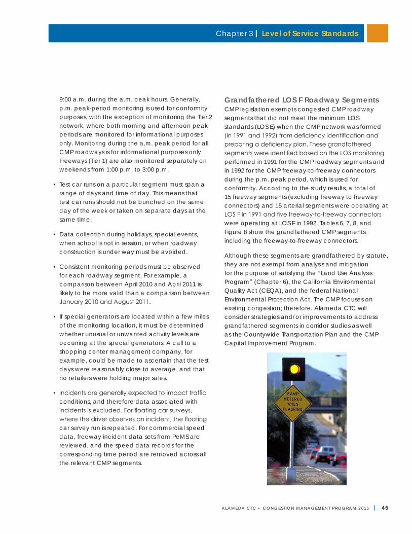
Chapter 3 | Level of Service Standards
ALAMEDA CTC • CONGEST ION MANAGEMENT PROGRAM 2 015 | 45
9:00 a.m. during the a.m. peak hours. Generally, p.m. peak-period monitoring is used for conformity purposes, with the exception of monitoring the Tier 2 network, where both morning and afternoon peak periods are monitored for informational purposes only. Monitoring during the a.m. peak period for all CMP roadways is for informational purposes only. Freeways (Tier 1) are also monitored separately on weekends from 1:00 p.m. to 3:00 p.m.
• Test car runs on a particular segment must span a range of days and time of day. This means that test car runs should not be bunched on the same day of the week or taken on separate days at the same time.
• Data collection during holidays, special events, when school is not in session, or when roadway construction is under way must be avoided.
• Consistent monitoring periods must be observed for each roadway segment. For example, a comparison between April 2010 and April 2011 is likely to be more valid than a comparison between January 2010 and August 2011.
• If special generators are located within a few miles of the monitoring location, it must be determined whether unusual or unwanted activity levels are occurring at the special generators. A call to a shopping center management company, for example, could be made to ascertain that the test days were reasonably close to average, and that no retailers were holding major sales.
• Incidents are generally expected to impact traffic conditions, and therefore data associated with incidents is excluded. For floating car surveys, where the driver observes an incident, the floating car survey run is repeated. For commercial speed data, freeway incident data sets from PeMS are reviewed, and the speed data records for the corresponding time period are removed across all the relevant CMP segments.
Grandfathered LOS F Roadway SegmentsCMP legislation exempts congested CMP roadway segments that did not meet the minimum LOS standards (LOS E) when the CMP network was formed (in 1991 and 1992) from deficiency identification and preparing a deficiency plan. These grandfathered segments were identified based on the LOS monitoring performed in 1991 for the CMP roadway segments and in 1992 for the CMP freeway-to-freeway connectors during the p.m. peak period, which is used for conformity. According to the study results, a total of 15 freeway segments (excluding freeway to freeway connectors) and 15 arterial segments were operating at LOS F in 1991 and five freeway-to-freeway connectors were operating at LOS F in 1992. Tables 6, 7, 8, and Figure 8 show the grandfathered CMP segments including the freeway-to-freeway connectors.
Although these segments are grandfathered by statute, they are not exempt from analysis and mitigation for the purpose of satisfying the “Land Use Analysis Program” (Chapter 6), the California Environmental Quality Act (CEQA), and the federal National Environmental Protection Act. The CMP focuses on existing congestion; therefore, Alameda CTC will consider strategies and/or improvements to address grandfathered segments in corridor studies as well as the Countywide Transportation Plan and the CMP Capital Improvement Program.
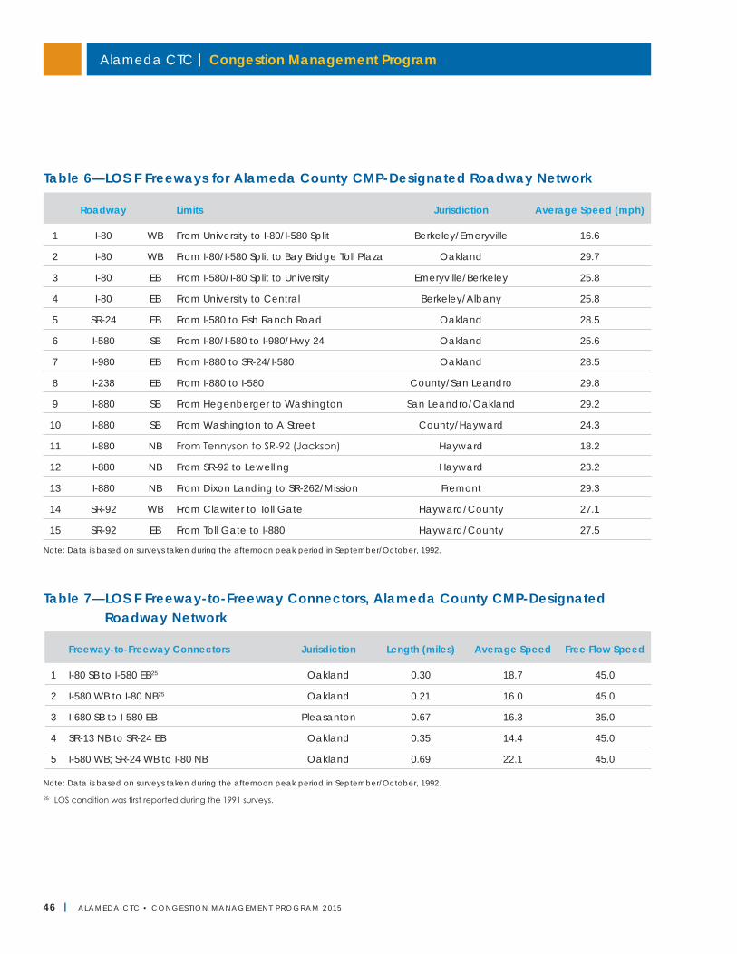
Alameda CTC | Congestion Management Program
46 | ALAMEDA CTC • CONGEST ION MANAGEMENT PROGRAM 2 015
25 LOS condition was first reported during the 1991 surveys.
Note: Data is based on surveys taken during the afternoon peak period in September/October, 1992.
Table 6—LOS F Freeways for Alameda County CMP-Designated Roadway Network
Roadway Limits Jurisdiction Average Speed (mph)
1 I-80 WB From University to I-80/I-580 Split Berkeley/Emeryville 16.6
2 I-80 WB From I-80/I-580 Split to Bay Bridge Toll Plaza Oakland 29.7
3 I-80 EB From I-580/I-80 Split to University Emeryville/Berkeley 25.8
4 I-80 EB From University to Central Berkeley/Albany 25.8
5 SR-24 EB From I-580 to Fish Ranch Road Oakland 28.5
6 I-580 SB From I-80/I-580 to I-980/Hwy 24 Oakland 25.6
7 I-980 EB From I-880 to SR-24/I-580 Oakland 28.5
8 I-238 EB From I-880 to I-580 County/San Leandro 29.8
9 I-880 SB From Hegenberger to Washington San Leandro/Oakland 29.2
10 I-880 SB From Washington to A Street County/Hayward 24.3
11 I-880 NB From Tennyson to SR-92 (Jackson) Hayward 18.2
12 I-880 NB From SR-92 to Lewelling Hayward 23.2
13 I-880 NB From Dixon Landing to SR-262/Mission Fremont 29.3
14 SR-92 WB From Clawiter to Toll Gate Hayward/County 27.1
15 SR-92 EB From Toll Gate to I-880 Hayward/County 27.5
Note: Data is based on surveys taken during the afternoon peak period in September/October, 1992.
Table 7—LOS F Freeway-to-Freeway Connectors, Alameda County CMP-Designated Roadway Network
Freeway-to-Freeway Connectors Jurisdiction Length (miles) Average Speed Free Flow Speed
1 I-80 SB to I-580 EB25 Oakland 0.30 18.7 45.0
2 I-580 WB to I-80 NB25 Oakland 0.21 16.0 45.0
3 I-680 SB to I-580 EB Pleasanton 0.67 16.3 35.0
4 SR-13 NB to SR-24 EB Oakland 0.35 14.4 45.0
5 I-580 WB; SR-24 WB to I-80 NB Oakland 0.69 22.1 45.0
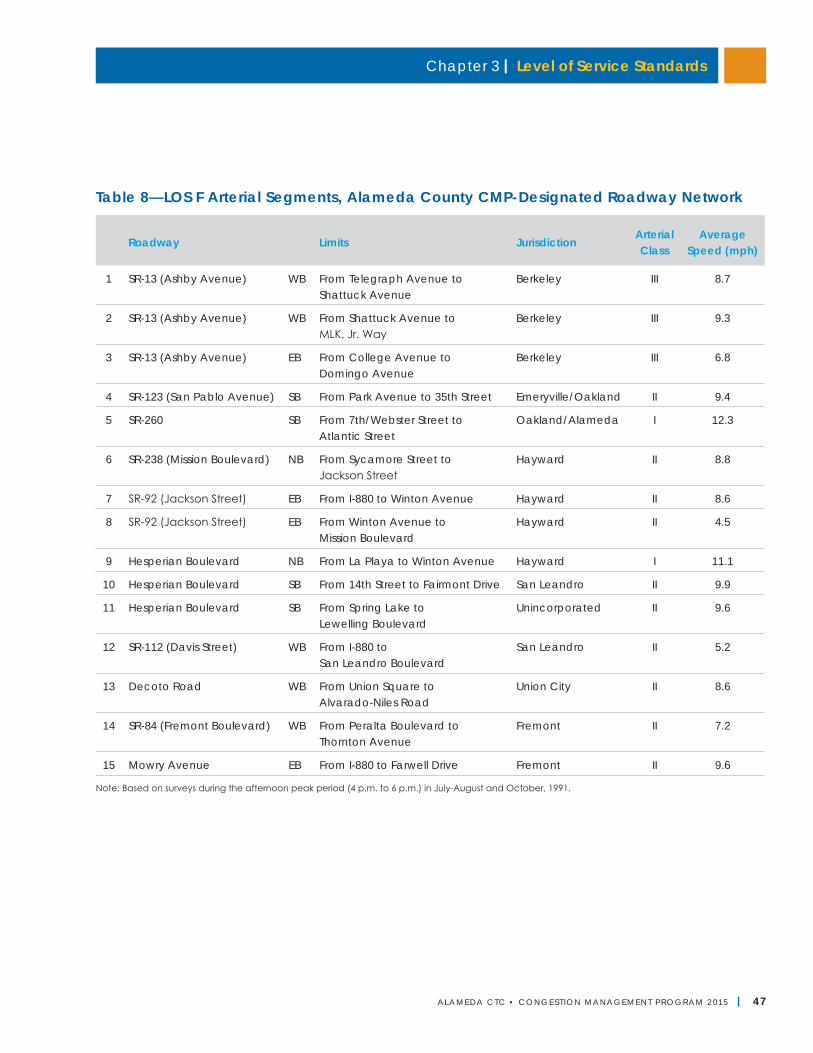
Chapter 3 | Level of Service Standards
ALAMEDA CTC • CONGEST ION MANAGEMENT PROGRAM 2 015 | 47
Note: Based on surveys during the afternoon peak period (4 p.m. to 6 p.m.) in July-August and October, 1991.
Table 8—LOS F Arterial Segments, Alameda County CMP-Designated Roadway Network
Roadway Limits JurisdictionArterial Class
Average Speed (mph)
1 SR-13 (Ashby Avenue) WB From Telegraph Avenue to Shattuck Avenue
Berkeley III 8.7
2 SR-13 (Ashby Avenue) WB From Shattuck Avenue to MLK, Jr. Way
Berkeley III 9.3
3 SR-13 (Ashby Avenue) EB From College Avenue to Domingo Avenue
Berkeley III 6.8
4 SR-123 (San Pablo Avenue) SB From Park Avenue to 35th Street Emeryville/Oakland II 9.4
5 SR-260 SB From 7th/Webster Street to Atlantic Street
Oakland/Alameda I 12.3
6 SR-238 (Mission Boulevard) NB From Sycamore Street to Jackson Street
Hayward II 8.8
7 SR-92 (Jackson Street) EB From I-880 to Winton Avenue Hayward II 8.6
8 SR-92 (Jackson Street) EB From Winton Avenue to Mission Boulevard
Hayward II 4.5
9 Hesperian Boulevard NB From La Playa to Winton Avenue Hayward I 11.1
10 Hesperian Boulevard SB From 14th Street to Fairmont Drive San Leandro II 9.9
11 Hesperian Boulevard SB From Spring Lake to Lewelling Boulevard
Unincorporated II 9.6
12 SR-112 (Davis Street) WB From I-880 to San Leandro Boulevard
San Leandro II 5.2
13 Decoto Road WB From Union Square to Alvarado-Niles Road
Union City II 8.6
14 SR-84 (Fremont Boulevard) WB From Peralta Boulevard to Thornton Avenue
Fremont II 7.2
15 Mowry Avenue EB From I-880 to Farwell Drive Fremont II 9.6
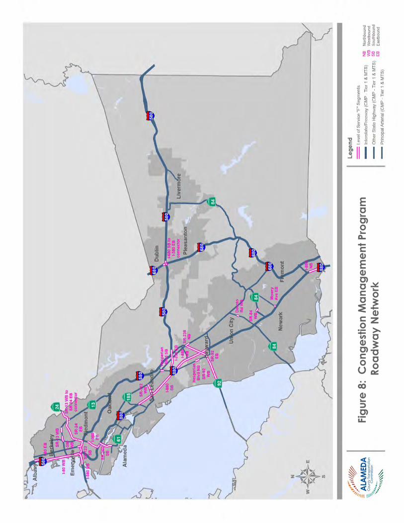
Alameda CTC | Congestion Management Program
48 | ALAMEDA CTC • CONGEST ION MANAGEMENT PROGRAM 2 015
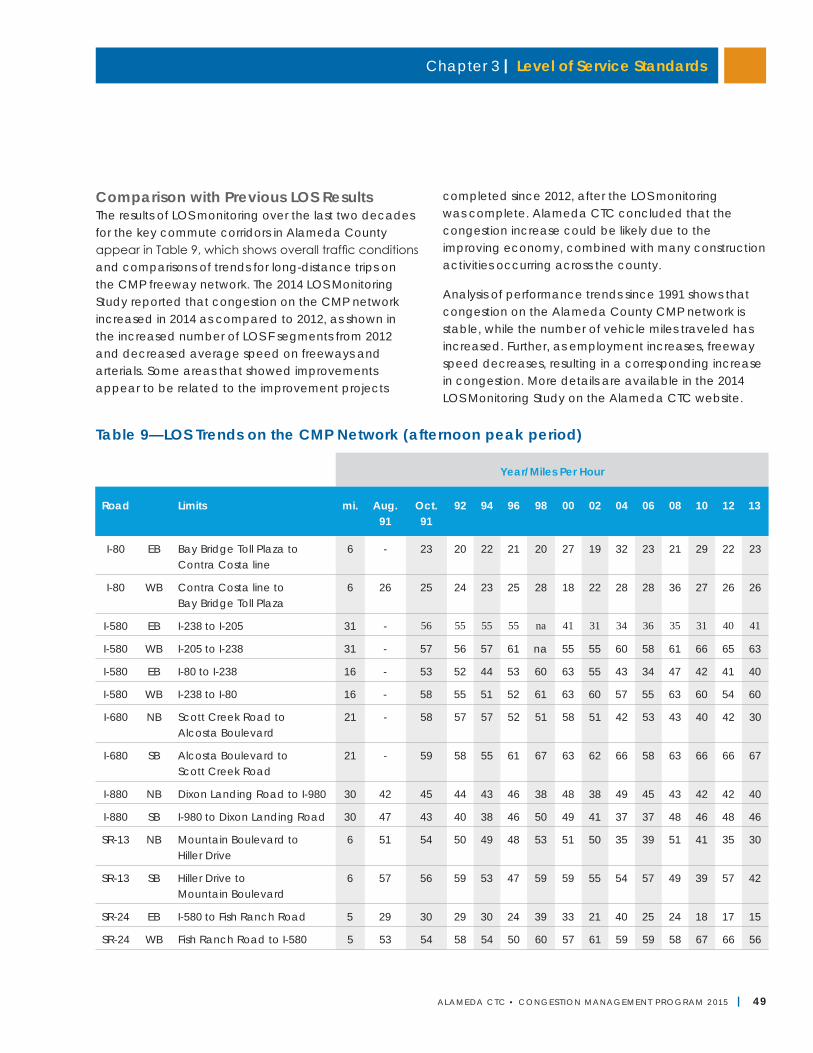
Chapter 3 | Level of Service Standards
ALAMEDA CTC • CONGEST ION MANAGEMENT PROGRAM 2 015 | 49
Comparison with Previous LOS ResultsThe results of LOS monitoring over the last two decades for the key commute corridors in Alameda County appear in Table 9, which shows overall traffic conditions and comparisons of trends for long-distance trips on the CMP freeway network. The 2014 LOS Monitoring Study reported that congestion on the CMP network increased in 2014 as compared to 2012, as shown in the increased number of LOS F segments from 2012 and decreased average speed on freeways and arterials. Some areas that showed improvements appear to be related to the improvement projects
completed since 2012, after the LOS monitoring was complete. Alameda CTC concluded that the congestion increase could be likely due to the improving economy, combined with many construction activities occurring across the county.
Analysis of performance trends since 1991 shows that congestion on the Alameda County CMP network is stable, while the number of vehicle miles traveled has increased. Further, as employment increases, freeway speed decreases, resulting in a corresponding increase in congestion. More details are available in the 2014 LOS Monitoring Study on the Alameda CTC website.
Table 9—LOS Trends on the CMP Network (afternoon peak period)
Year/Miles Per Hour
Road Limits mi. Aug. 91
Oct. 91
92 94 96 98 00 02 04 06 08 10 12 13
I-80 EB Bay Bridge Toll Plaza to Contra Costa line
6 - 23 20 22 21 20 27 19 32 23 21 29 22 23
I-80 WB Contra Costa line to Bay Bridge Toll Plaza
6 26 25 24 23 25 28 18 22 28 28 36 27 26 26
I-580 EB I-238 to I-205 31 - 56 55 55 55 na 41 31 34 36 35 31 40 41
I-580 WB I-205 to I-238 31 - 57 56 57 61 na 55 55 60 58 61 66 65 63
I-580 EB I-80 to I-238 16 - 53 52 44 53 60 63 55 43 34 47 42 41 40
I-580 WB I-238 to I-80 16 - 58 55 51 52 61 63 60 57 55 63 60 54 60
I-680 NB Scott Creek Road to Alcosta Boulevard
21 - 58 57 57 52 51 58 51 42 53 43 40 42 30
I-680 SB Alcosta Boulevard to Scott Creek Road
21 - 59 58 55 61 67 63 62 66 58 63 66 66 67
I-880 NB Dixon Landing Road to I-980 30 42 45 44 43 46 38 48 38 49 45 43 42 42 40
I-880 SB I-980 to Dixon Landing Road 30 47 43 40 38 46 50 49 41 37 37 48 46 48 46
SR-13 NB Mountain Boulevard to Hiller Drive
6 51 54 50 49 48 53 51 50 35 39 51 41 35 30
SR-13 SB Hiller Drive to Mountain Boulevard
6 57 56 59 53 47 59 59 55 54 57 49 39 57 42
SR-24 EB I-580 to Fish Ranch Road 5 29 30 29 30 24 39 33 21 40 25 24 18 17 15
SR-24 WB Fish Ranch Road to I-580 5 53 54 58 54 50 60 57 61 59 59 58 67 66 56
Alameda CTC | Congestion Management Program
50 | ALAMEDA CTC • CONGEST ION MANAGEMENT PROGRAM 2 015
Infill Opportunity ZonesSenate Bill 1636 (Figueroa), signed by the governor in 2002, established “infill opportunity zones” (IOZs) to encourage transit supportive and infill developments. The statute exempted infill opportunity zones from the requirements to maintain LOS E. None of the local jurisdictions within Alameda County established or adopted infill opportunity zones by the statute’s sunset period of December 2009. However, Senate Bill 743 (Steinberg) passed in September 2013, instituted key changes to the CMP statute that will support infill development, including lifting the sunset date on designating IOZs and directing the governor’s Office of Planning and Research to develop new metrics for assessment of transportation impacts to replace the LOS measure. Alameda CTC will continue to closely follow implementation of and provide input on this law. The 2017 CMP update will incorporate the outcome of implementation of SB 743 and how it impacts the CMP LOS monitoring element. Chapter 6, “Land Use Analysis Program,” provides more information on Alameda CTC’s efforts in supporting infill development.
Local Government Responsibilities and ConformanceAlameda CTC is responsible for monitoring conformance of local jurisdictions with the adopted CMP.26 Among the requirements, Alameda CTC must monitor compliance with the LOS standards. If a roadway segment does not conform to the LOS standards based on the biennial monitoring, Alameda CTC will notify the affected local jurisdiction that may elect to remedy the LOS problem or prepare a deficiency plan (see Chapter 10). If after 90 days the local jurisdiction is still in non-conformance, Alameda CTC is required to follow the conformance process as identified in Chapter 9, “Program Conformance and Monitoring.” When a deficiency plan is adopted, status reports on the implementation of the deficiency plan showing progress must be submitted to Alameda CTC annually as part of the
annual conformity process. The detailed process for finding of non-conformance and the resulting withholding of Proposition 111 funds is described in Chapter 9.
Next Steps• Continue to use speed-based HCM1985 for auto
LOS monitoring for the Tier 1 network. Apply both HCM2000 and HCM1985 to the Tier 2 network as appropriate and re-evaluate expanded HCM use in the 2017 CMP update after completion of the countywide modal studies.
• Use countywide modal studies to identify countywide facilities and metrics for monitoring alternative modes and incorporate these in the 2017 CMP for future LOS monitoring efforts.
• Closely follow and participate in the implementation of SB 743 including development of the replacement measure to assess the impact on the transportation system within and outside the infill development areas and identify the impact to the CMP LOS monitoring element and update it in the 2017 CMP.
26 California Government Code Section 65089.3.
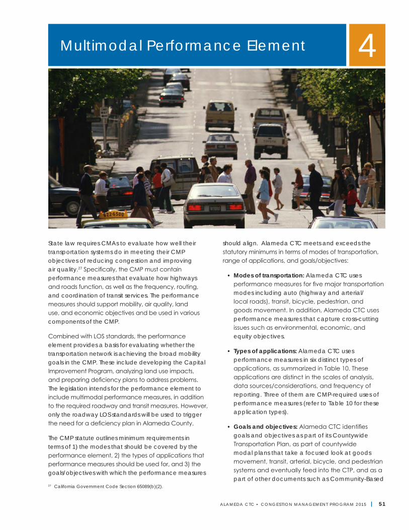
ALAMEDA CTC • CONGEST ION MANAGEMENT PROGRAM 2 015 | 51
State law requires CMAs to evaluate how well their transportation systems do in meeting their CMP objectives of reducing congestion and improving air quality.27 Specifically, the CMP must contain performance measures that evaluate how highways and roads function, as well as the frequency, routing, and coordination of transit services. The performance measures should support mobility, air quality, land use, and economic objectives and be used in various components of the CMP.
Combined with LOS standards, the performance element provides a basis for evaluating whether the transportation network is achieving the broad mobility goals in the CMP. These include developing the Capital Improvement Program, analyzing land use impacts, and preparing deficiency plans to address problems. The legislation intends for the performance element to include multimodal performance measures, in addition to the required roadway and transit measures. However, only the roadway LOS standards will be used to trigger the need for a deficiency plan in Alameda County.
The CMP statute outlines minimum requirements in terms of 1) the modes that should be covered by the performance element, 2) the types of applications that performance measures should be used for, and 3) the goals/objectives with which the performance measures
should align. Alameda CTC meets and exceeds the statutory minimums in terms of modes of transportation, range of applications, and goals/objectives:
• Modes of transportation: Alameda CTC uses performance measures for five major transportation modes including auto (highway and arterial/local roads), transit, bicycle, pedestrian, and goods movement. In addition, Alameda CTC uses performance measures that capture cross-cutting issues such as environmental, economic, and equity objectives.
• Types of applications: Alameda CTC uses performance measures in six distinct types of applications, as summarized in Table 10. These applications are distinct in the scales of analysis, data sources/considerations, and frequency of reporting. Three of them are CMP-required uses of performance measures (refer to Table 10 for these application types).
• Goals and objectives: Alameda CTC identifies goals and objectives as part of its Countywide Transportation Plan, as part of countywide modal plans that take a focused look at goods movement, transit, arterial, bicycle, and pedestrian systems and eventually feed into the CTP, and as a part of other documents such as Community-Based
Multimodal Performance Element 4
27 California Government Code Section 65089(b)(2).
52 | ALAMEDA CTC • CONGEST ION MANAGEMENT PROGRAM 2 015
Alameda CTC | Congestion Management Program
Transportation Plans. The goals and objectives of all Alameda CTC plans are designed to be aligned with the CTP; therefore, this performance element only identifies which CTP goals are measured by different Alameda CTC performance metrics. The CTP goals encompass all CMP statutory goals (as well as other countywide goals such as state of good repair, equity, health, and others).
Principles for Selecting Performance MeasuresAlameda CTC follows the principles below when identifying different performance measures for different applications:
• Aligned with goals and objectives: Performance measures should relate back to a goal from the CTP or CMP statute. The measures should also be based on MTC’s multimodal programming criteria as a philosophical framework;
• Presented in easy-to-understand and consumer/user-oriented terms: Performance measures should be readily understandable by a member of the public. Measures should also strive to capture important aspects of the user experience;
• Data availability, “dynamism” of measure, and level of effort to compute measure matched to reporting frequency: Performance measures that require household travel survey data, applying a travel model, or performing complex mapping analysis are not feasible for annual reporting. Similarly, measures that do not change greatly from year-to-year are better for less frequent reporting (as an example, the percent of households living within a 20-minute walk of an elementary school is a critical accessibility measure; however, it depends greatly on land-use patterns that change over long time horizons and is not appropriate for annual monitoring; a measure such as percent of new development within a half-mile of transit is more dynamic and more appropriate for annual monitoring);
• Scale of analysis matched to application type: For instance, a performance measure that relies on a travel model for computation will generally not be well-matched to a highly-localized application (such as evaluating a signal timing project or a bicycle lane project), as model accuracy declines with finer geographic scale. Similarly, a measure that requires field data collection is not suitable for countywide analysis; and
• Consideration of an array of measures: Since one performance measure will not serve all needs, Alameda CTC considers an array of measures.
Table 10 on the next page describes Alameda CTC's use of performance measures for different applications.
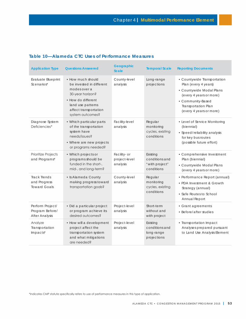
Chapter 4 | Multimodal Performance Element
ALAMEDA CTC • CONGEST ION MANAGEMENT PROGRAM 2 015 | 53
*Indicates CMP statute specifically refers to use of performance measures in this type of application.
Table 10—Alameda CTC Uses of Performance Measures
Application Type Questions AnsweredGeographic Scale
Temporal Scale Reporting Documents
Evaluate Blueprint Scenarios*
• How much should be invested in different modes over a 30-year horizon?
• How do different land use patterns affect transportation system outcomes?
County-level analysis
Long-range projections
• Countywide Transportation Plan (every 4 years)
• Countywide Modal Plans (every 4 years or more)
• Community-Based Transportation Plan (every 4 years or more)
Diagnose System Deficiencies*
• Which particular parts of the transportation system have needs/issues?
• Where are new projects or programs needed?
Facility-level analysis
Regular monitoring cycles, existing conditions
• Level of Service Monitoring (biennial)
• Speed/reliability analysis for key bus routes (possible future effort)
Prioritize Projects and Programs*
• Which projects or programs should be funded in the short-, mid-, and long-term?
Facility- or project-level analysis
Existing conditions and “with project” conditions
• Comprehensive Investment Plan (biennial)
• Countywide Modal Plans (every 4 years or more)
Track Trends and Progress Toward Goals
• Is Alameda County making progress toward transportation goals?
County-level analysis
Regular monitoring cycles, existing conditions
• Performance Report (annual)
• PDA Investment & Growth Strategy (annual)
• Safe Routes to School Annual Report
Perform Project/Program Before/After Analysis
• Did a particular project or program achieve its desired outcomes?
Project-level analysis
Short-term without and with project
• Grant agreements
• Before/after studies
Analyze Transportation Impacts*
• How will a development project affect the transportation system and what mitigations are needed?
Project-level analysis
Existing conditions and long-range projections
• Transportation Impact Analyses prepared pursuant to Land Use Analysis Element
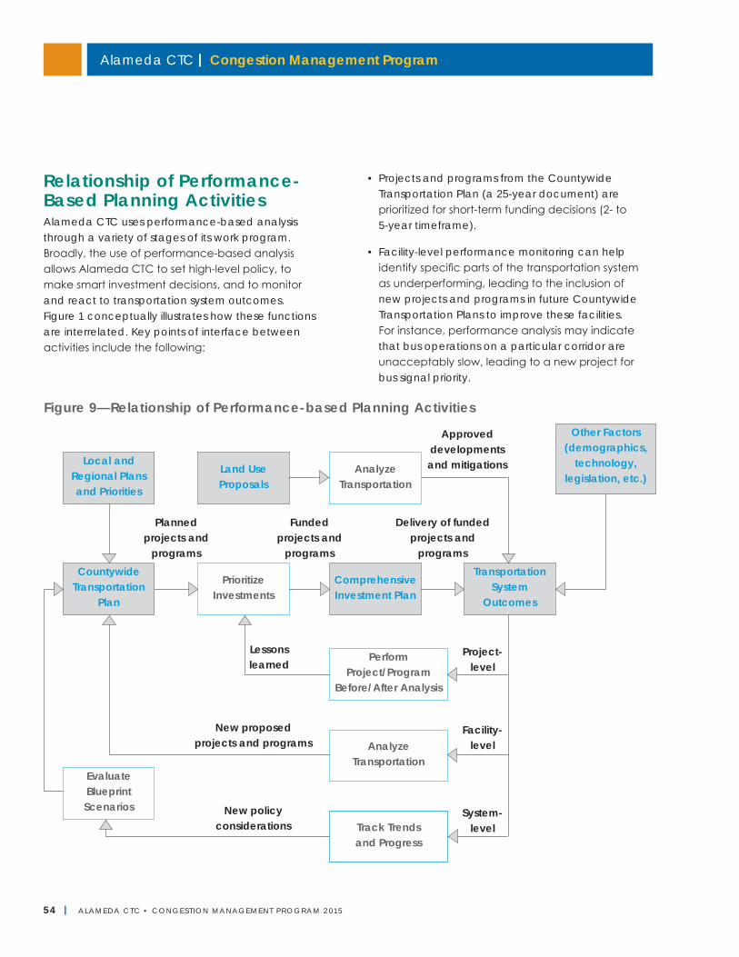
Alameda CTC | Congestion Management Program
54 | ALAMEDA CTC • CONGEST ION MANAGEMENT PROGRAM 2 015
Relationship of Performance-Based Planning ActivitiesAlameda CTC uses performance-based analysis through a variety of stages of its work program. Broadly, the use of performance-based analysis allows Alameda CTC to set high-level policy, to make smart investment decisions, and to monitor and react to transportation system outcomes. Figure 1 conceptually illustrates how these functions are interrelated. Key points of interface between activities include the following:
• Projects and programs from the Countywide Transportation Plan (a 25-year document) are prioritized for short-term funding decisions (2- to 5-year timeframe).
• Facility-level performance monitoring can help identify specific parts of the transportation system as underperforming, leading to the inclusion of new projects and programs in future Countywide Transportation Plans to improve these facilities. For instance, performance analysis may indicate that bus operations on a particular corridor are unacceptably slow, leading to a new project for bus signal priority.
Figure 9—Relationship of Performance-based Planning Activities
Local and Regional Plans and Priorities
Land Use Proposals
Analyze Transportation
Perform Project/Program
Before/After Analysis
Analyze Transportation
Track Trends and Progress
Evaluate Blueprint Scenarios
Approved developments and mitigations
Planned projects and
programs
Funded projects and
programs
Lessons learned
New proposed projects and programs
New policy considerations
Project- level
Facility- level
System- level
Delivery of funded projects and
programs
Other Factors (demographics,
technology, legislation, etc.)
Countywide Transportation
Plan
Prioritize Investments
Comprehensive Investment Plan
Transportation System
Outcomes
Chapter 4 | Multimodal Performance Element
ALAMEDA CTC • CONGEST ION MANAGEMENT PROGRAM 2 015 | 55
• Project-level before/after analysis can provide information as to the effectiveness of specific types of projects in specific contexts, which can help determine which projects should receive limited funding. For instance, counts taken before and after the installation of a bike lane may suggest that the bike lane led to an increase in levels of bicycling, which assists in the future evaluation of similar types of projects in similar contexts.
• Progress (or lack of progress) in achieving a goal, as illuminated through system-level trend analysis can give rise to new policy ideas for inclusion in future Countywide Transportation Plans. For instance, persistent congestion could lead to consideration of new demand management strategies as part of a future Countywide Transportation Plan.
Performance MeasuresThe performance measures listed in Tables 11 through 17 include the performance measures that Alameda CTC uses in various planning activities and reporting documents as described in Table 10. These measures, monitored over different timelines, are organized as follows:
• Multimodal Accessibility and Transportation/ Land Use Integration
• Roadway
• Transit
• Bicycle
• Pedestrian
• Goods Movement
• Environment, Equity, and Health
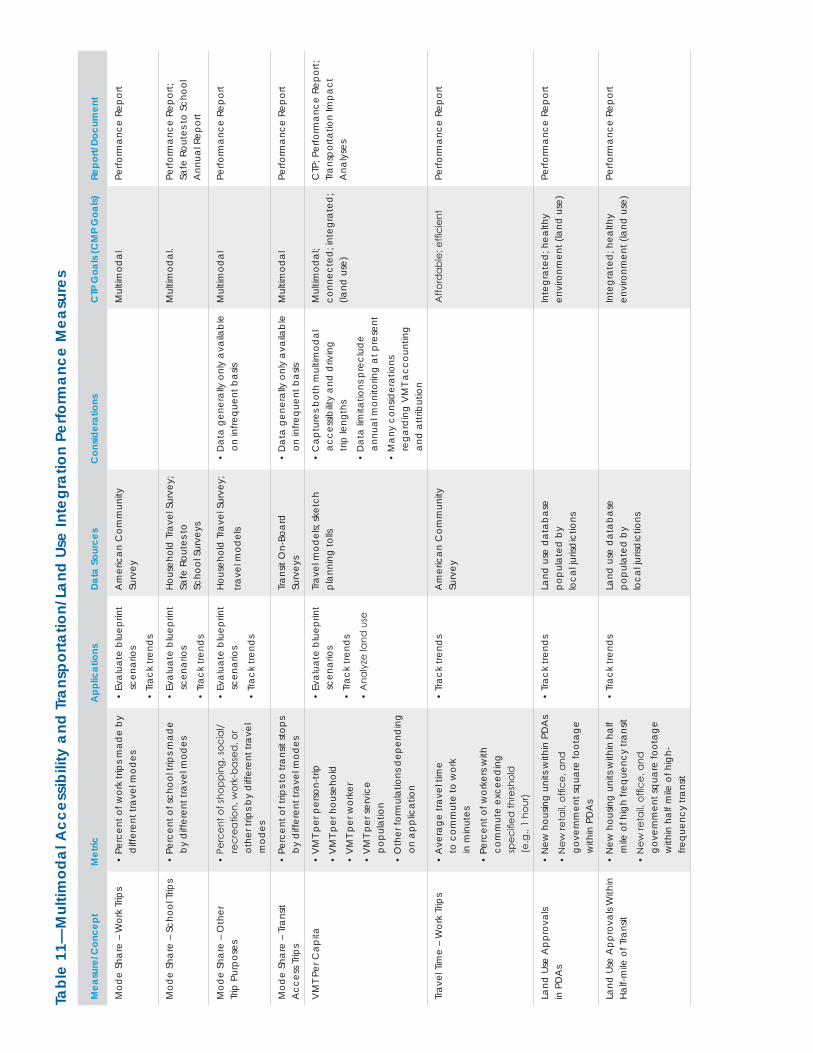
Tabl
e 11
—M
ultim
odal
Acc
essi
bilit
y an
d Tr
ansp
orta
tion/
Land
Use
Inte
grat
ion
Perfo
rman
ce M
easu
res
Mea
sure
/Con
cept
Met
ricA
pplic
atio
nsDa
ta S
ourc
esC
onsid
erat
ions
CTP
Goa
ls (C
MP
Goa
ls)Re
port/
Docu
men
t
Mod
e Sh
are
– W
ork
Trip
s•
Perc
ent o
f wor
k tri
ps m
ade
by
diff
eren
t tra
vel m
odes
• Ev
alua
te b
luep
rint
scen
ario
s
• Tr
ack
trend
s
Am
eric
an C
omm
unity
Su
rvey
Mul
timod
alPe
rform
ance
Rep
ort
Mod
e Sh
are
– Sc
hool
Trip
s•
Perc
ent o
f sch
ool t
rips m
ade
by d
iffer
ent t
rave
l mod
es•
Eval
uate
blu
eprin
t sc
enar
ios
• Tr
ack
trend
s
Hous
ehol
d T
rave
l Sur
vey;
Sa
fe R
oute
s to
Sc
hool
Sur
veys
Mul
timod
al.
Perfo
rman
ce R
epor
t;
Safe
Rou
tes t
o Sc
hool
A
nnua
l Rep
ort
Mod
e Sh
are
– O
ther
Tr
ip P
urpo
ses
• Pe
rcen
t of s
hopp
ing,
soci
al/
recr
eatio
n, w
ork-
base
d, o
r ot
her t
rips b
y d
iffer
ent t
rave
l m
odes
• Ev
alua
te b
luep
rint
scen
ario
s
• Tr
ack
trend
s
Hous
ehol
d T
rave
l Sur
vey;
trave
l mod
els
• D
ata
gene
rally
onl
y av
aila
ble
on in
frequ
ent b
asis
Mul
timod
alPe
rform
ance
Rep
ort
Mod
e Sh
are
– Tr
ansit
A
cces
s Trip
s•
Perc
ent o
f trip
s to
trans
it st
ops
by d
iffer
ent t
rave
l mod
esTr
ansit
On-
Boar
d
Surv
eys
• D
ata
gene
rally
onl
y av
aila
ble
on in
frequ
ent b
asis
Mul
timod
alPe
rform
ance
Rep
ort
VM
T Pe
r Cap
ita•
VM
T pe
r per
son-
trip
• V
MT
per h
ouse
hold
• V
MT
per w
orke
r
• V
MT
per s
ervi
ce
popu
latio
n
• O
ther
form
ulat
ions
dep
end
ing
on a
pplic
atio
n
• Ev
alua
te b
luep
rint
scen
ario
s
• Tr
ack
trend
s
• A
naly
ze la
nd u
se
Trav
el m
odel
s; sk
etch
pl
anni
ng to
lls•
Cap
ture
s bot
h m
ultim
odal
ac
cess
ibilit
y an
d d
rivin
g
trip
leng
ths
• D
ata
limita
tions
pre
clud
e an
nual
mon
itorin
g at
pre
sent
• M
any
cons
ider
atio
ns
rega
rdin
g V
MT
acco
untin
g an
d a
ttrib
utio
n
Mul
timod
al;
co
nnec
ted
; int
egra
ted
; (la
nd u
se)
CTP
; Per
form
ance
Rep
ort;
Tr
ansp
orta
tion
Impa
ct
Ana
lyse
s
Trav
el T
ime
– W
ork
Trip
s•
Ave
rage
trav
el ti
me
to
com
mut
e to
wor
k
in m
inut
es
• Pe
rcen
t of w
orke
rs w
ith
com
mut
e ex
ceed
ing
sp
ecifi
ed th
resh
old
(e
.g.,
1 ho
ur)
• Tr
ack
trend
sA
mer
ican
Com
mun
ity
Surv
eyA
fford
able
; effi
cien
tPe
rform
ance
Rep
ort
Land
Use
App
rova
ls
in P
DA
s•
New
hou
sing
units
with
in P
DA
s
• N
ew re
tail,
offic
e, a
nd
gove
rnm
ent s
quar
e fo
otag
e w
ithin
PD
As
• Tr
ack
trend
sLa
nd u
se d
atab
ase
popu
late
d b
y
loca
l juris
dic
tions
Inte
grat
ed; h
ealth
y en
viro
nmen
t (la
nd u
se)
Perfo
rman
ce R
epor
t
Land
Use
App
rova
ls W
ithin
Ha
lf-m
ile o
f Tra
nsit
• N
ew h
ousin
g un
its w
ithin
hal
f m
ile o
f hig
h fre
quen
cy tr
ansit
• N
ew re
tail,
offic
e, a
nd
gove
rnm
ent s
quar
e fo
otag
e w
ithin
hal
f mile
of h
igh-
frequ
ency
tran
sit
• Tr
ack
trend
sLa
nd u
se d
atab
ase
popu
late
d b
y
loca
l juris
dic
tions
Inte
grat
ed; h
ealth
y en
viro
nmen
t (la
nd u
se)
Perfo
rman
ce R
epor
t
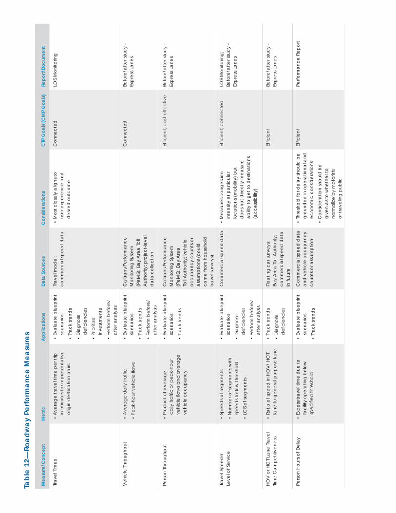
Tabl
e 12
—Ro
adw
ay P
erfo
rman
ce M
easu
res
Mea
sure
/Con
cept
Met
ricA
pplic
atio
nsDa
ta S
ourc
esC
onsid
erat
ions
CTP
Goa
ls (C
MP
Goa
ls)Re
port/
Docu
men
t
Trav
el T
imes
• A
vera
ge tr
avel
tim
e pe
r trip
in
min
utes
for r
epre
sent
ativ
e or
igin
-des
tinat
ion
pairs
• Ev
alua
te b
luep
rint
scen
ario
s
• Tr
ack
trend
s
• D
iagn
ose
d
efici
enci
es
• Pr
iorit
ize
inve
stm
ents
• Pe
rform
bef
ore/
afte
r ana
lysis
Trav
el m
odel
; co
mm
erci
al sp
eed
dat
a•
Mos
t clo
sely
alig
ns to
us
er e
xper
ienc
e an
d
des
ired
out
com
e
Con
nect
edLO
S M
onito
ring
Veh
icle
Thr
ough
put
• A
vera
ge d
aily
traf
fic
• Pe
ak-h
our v
ehic
le fl
ows
• Ev
alua
te b
luep
rint
scen
ario
s
• Tr
ack
trend
s
• Pe
rform
bef
ore/
afte
r ana
lysis
Cal
trans
Per
form
ance
M
onito
ring
Syst
em
(PeM
S); B
ay A
rea
Toll
Aut
horit
y; p
roje
ct-le
vel
dat
a co
llect
ion
Con
nect
edBe
fore
/afte
r stu
dy
- Ex
pres
s Lan
es
Pers
on T
hrou
ghpu
t•
Prod
uct o
f ave
rage
d
aily
traf
fic o
r pea
k-ho
ur
vehi
cle
flow
s and
ave
rage
ve
hicl
e oc
cupa
ncy
• Ev
alua
te b
luep
rint
scen
ario
s
• Tr
ack
trend
s
Cal
trans
Per
form
ance
M
onito
ring
Syst
em
(PeM
S); B
ay A
rea
Toll A
utho
rity;
veh
icle
oc
cupa
ncy
coun
ts o
r as
sum
ptio
ns (c
ould
co
me
from
hou
seho
ld
trave
l sur
veys
)
Effic
ient
; cos
t-effe
ctiv
eBe
fore
/afte
r stu
dy
- Ex
pres
s Lan
es
Trav
el S
peed
s/
Leve
l of S
ervi
ce•
Spee
ds o
f seg
men
ts
• N
umbe
r of s
egm
ents
with
sp
eed
s bel
ow th
resh
old
• LO
S of
segm
ents
• Ev
alua
te b
luep
rint
scen
ario
s
• D
iagn
ose
d
efici
enci
es
• Pe
rform
bef
ore/
afte
r ana
lysis
Com
mer
cial
spee
d d
ata
• M
easu
res c
onge
stio
n
inte
nsity
at p
artic
ular
lo
catio
ns (m
obilit
y) b
ut
doe
s not
dire
ctly
mea
sure
ab
ility
to g
et to
des
tinat
ions
(a
cces
sibilit
y)
Effic
ient
; con
nect
edLO
S M
onito
ring;
Be
fore
/afte
r stu
dy
- Ex
pres
s Lan
es
HOV
or H
OT
Lane
Tra
vel
Time
Com
petit
iven
ess
• Ra
tio o
f spe
ed in
HO
V/
HOT
lane
to g
ener
al p
urpo
se la
ne•
Trac
k tre
nds
• D
iagn
ose
d
efici
enci
es
Floa
ting
car s
urve
ys;
Bay
Are
a To
ll Aut
horit
y;
com
mer
cial
spee
d d
ata
in fu
ture
Effic
ient
Befo
re/a
fter s
tud
y -
Expr
ess L
anes
Pers
on H
ours
of D
elay
• Ex
cess
trav
el ti
me
due
to
faci
lity
oper
atin
g be
low
sp
ecifi
ed th
resh
old
• Ev
alua
te b
luep
rint
scen
ario
s
• Tr
ack
trend
s
Com
mer
cial
spee
d d
ata
and
veh
icle
occ
upan
cy
coun
ts o
r ass
umpt
ion
• Th
resh
old
for d
elay
shou
ld b
e gr
ound
ed in
ope
ratio
nal a
nd
econ
omic
con
sider
atio
ns
• C
onsid
erat
ion
shou
ld b
e gi
ven
as to
whe
ther
to
norm
alize
by
mot
orist
s or
trav
elin
g pu
blic
Effic
ient
Perfo
rman
ce R
epor
t
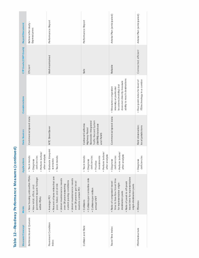
Tabl
e 12
—Ro
adw
ay P
erfo
rman
ce M
easu
res
(con
tinue
d)
Mea
sure
/Con
cept
Met
ricA
pplic
atio
nsDa
ta S
ourc
esC
onsid
erat
ions
CTP
Goa
ls (C
MP
Goa
ls)Re
port/
Docu
men
t
Bottl
enec
ks a
nd Q
ueue
s•
New
hou
sing
units
with
in P
DA
s
• N
ew re
tail,
offic
e, a
nd
gove
rnm
ent s
quar
e fo
otag
e w
ithin
PD
As
• Tr
ack
trend
s
• D
iagn
ose
d
efici
enci
es
• Pe
rform
bef
ore/
afte
r ana
lysis
Com
mer
cial
spee
d d
ata
Effic
ient
Befo
re/a
fter s
tud
y -
Expr
ess L
anes
Pave
men
t Con
diti
on
Ind
ex•
Ave
rage
PC
I
• Pe
rcen
t of l
ane-
mile
s tha
t are
po
or, f
aile
d, a
nd a
t-risk
• Un
met
mai
nten
ance
nee
ds
over
28
year
s ass
umin
g cu
rrent
pav
ing
cond
ition
s
• Un
met
mai
nten
ance
nee
ds
over
28
year
s to
get l
ocal
ro
ads t
o ce
rtain
PC
I
• Ev
alua
te b
luep
rint
scen
ario
s
• Tr
ack
trend
s
MTC
Stre
etSa
ver
Wel
l-mai
ntai
ned
Perfo
rman
ce R
epor
t
Col
lisio
n an
d R
ate
• C
ollis
ions
• C
ollis
ions
per
cen
terli
ne m
ile
• C
ollis
ions
per
milli
on
annu
al V
MT
• Tr
ack
trend
s
• D
iagn
ose
d
efici
enci
es
• Pr
iorit
ize
inve
stm
ents
• Pe
rform
bef
ore/
afte
r ana
lysis
Cal
trans
/Cal
iforn
ia
High
way
Pat
rol
Stat
ewid
e In
tegr
ated
Tr
affic
Rec
ord
Sys
tem
(S
WITR
S) d
atab
ase
an
d P
eMS
Safe
Perfo
rman
ce R
epor
t
Trav
el T
ime
Ind
ex•
Ratio
of c
onge
sted
trav
el
time
to fr
ee-fl
ow tr
avel
tim
e fo
r rep
rese
ntat
ive
orig
in-
des
tinat
ion
pairs
• Ra
tio o
f pea
k to
off-
peak
tra
vel t
ime
for r
epre
sent
ativ
e or
igin
-des
tinat
ion
pairs
• D
iagn
ose
d
efici
enci
es
• Pe
rform
bef
ore/
afte
r ana
lysis
Com
mer
cial
spee
d d
ata
• M
easu
res c
onge
stio
n
inte
nsity
at p
artic
ular
lo
catio
ns (m
obilit
y) b
ut
doe
s not
dire
ctly
mea
sure
ab
ility
to re
ach
des
tinat
ions
Relia
ble
Arte
rial P
lan
(ant
icip
ated
)
ITS In
frast
ruct
ure
• ITS
ind
ex•
Dia
gnos
e
defi
cien
cies
Fiel
d o
bser
vatio
n;
loca
l juris
dic
tions
• Fo
ur-p
oint
ind
ex fo
r lev
el o
f ITS
tech
nolo
gy in
a c
orrid
orC
onne
cted
; effi
cien
tA
rteria
l Pla
n (a
ntic
ipat
ed)
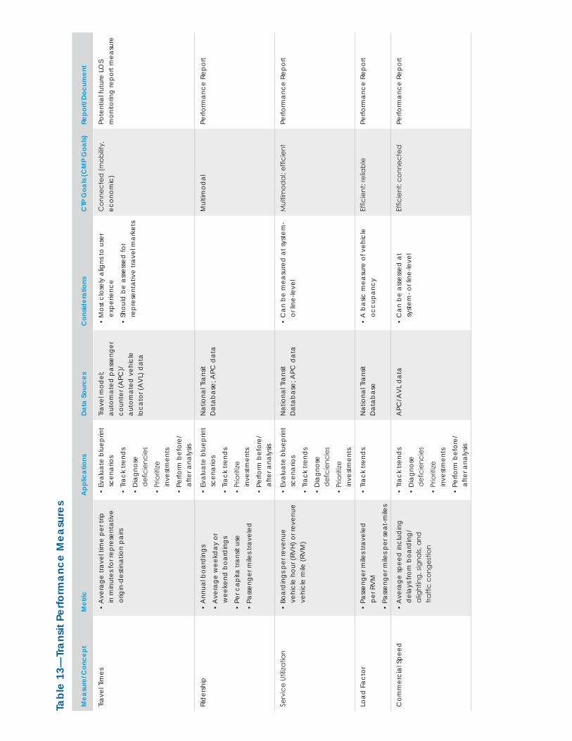
Tabl
e 13
—Tr
ansi
t Per
form
ance
Mea
sure
s
Mea
sure
/Con
cept
Met
ricA
pplic
atio
nsDa
ta S
ourc
esC
onsid
erat
ions
CTP
Goa
ls (C
MP
Goa
ls)Re
port/
Docu
men
t
Trav
el T
imes
• A
vera
ge tr
avel
tim
e pe
r trip
in
min
utes
for r
epre
sent
ativ
e or
igin
-des
tinat
ion
pairs
• Ev
alua
te b
luep
rint
scen
ario
s
• Tr
ack
trend
s
• D
iagn
ose
d
efici
enci
es
• Pr
iorit
ize
inve
stm
ents
• Pe
rform
bef
ore/
afte
r ana
lysis
Trav
el m
odel
; au
tom
ated
pas
seng
er
coun
ter (
APC
)/
auto
mat
ed v
ehic
le
loca
tor (
AV
L) d
ata
• M
ost c
lose
ly a
ligns
to u
ser
expe
rienc
e
• Sh
ould
be
asse
ssed
for
repr
esen
tativ
e tra
vel m
arke
ts
Con
nect
ed (m
obilit
y,
econ
omic
)Po
tent
ial f
utur
e LO
S
mon
itorin
g re
port
mea
sure
Rid
ersh
ip•
Ann
ual b
oard
ings
• A
vera
ge w
eekd
ay o
r w
eeke
nd b
oard
ings
• Pe
r cap
ita tr
ansit
use
• Pa
ssen
ger m
iles t
rave
led
• Ev
alua
te b
luep
rint
scen
ario
s
• Tr
ack
trend
s
• Pr
iorit
ize
inve
stm
ents
• Pe
rform
bef
ore/
afte
r ana
lysis
Nat
iona
l Tra
nsit
D
atab
ase;
APC
dat
aM
ultim
odal
Perfo
rman
ce R
epor
t
Serv
ice
Utiliz
atio
n•
Boar
din
gs p
er re
venu
e ve
hicl
e ho
ur (R
VH)
or r
even
ue
vehi
cle
mile
(RV
M)
• Ev
alua
te b
luep
rint
scen
ario
s
• Tr
ack
trend
s
• D
iagn
ose
d
efici
enci
es
• Pr
iorit
ize
inve
stm
ents
Nat
iona
l Tra
nsit
D
atab
ase;
APC
dat
a•
Can
be
mea
sure
d a
t sys
tem
- or
line-
leve
lM
ultim
odal
; effi
cien
tPe
rform
ance
Rep
ort
Load
Fac
tor
• Pa
ssen
ger m
iles t
rave
led
pe
r RV
M
• Pa
ssen
ger m
iles p
er se
at-m
iles
• Tr
ack
trend
sN
atio
nal T
rans
it
Dat
abas
e•
A b
asic
mea
sure
of v
ehic
le
occu
panc
yEf
ficie
nt; r
elia
ble
Perfo
rman
ce R
epor
t
Com
mer
cial
Spe
ed•
Ave
rage
spee
d in
clud
ing
del
ays f
rom
boa
rdin
g/
alig
htin
g, si
gnal
s, an
d
traffi
c co
nges
tion
• Tr
ack
trend
s
• D
iagn
ose
d
efici
enci
es
• Pr
iorit
ize
inve
stm
ents
• Pe
rform
bef
ore/
afte
r ana
lysis
APC
/AV
L d
ata
• C
an b
e as
sess
ed a
t sy
stem
- or l
ine-
leve
lEf
ficie
nt; c
onne
cted
Perfo
rman
ce R
epor
t
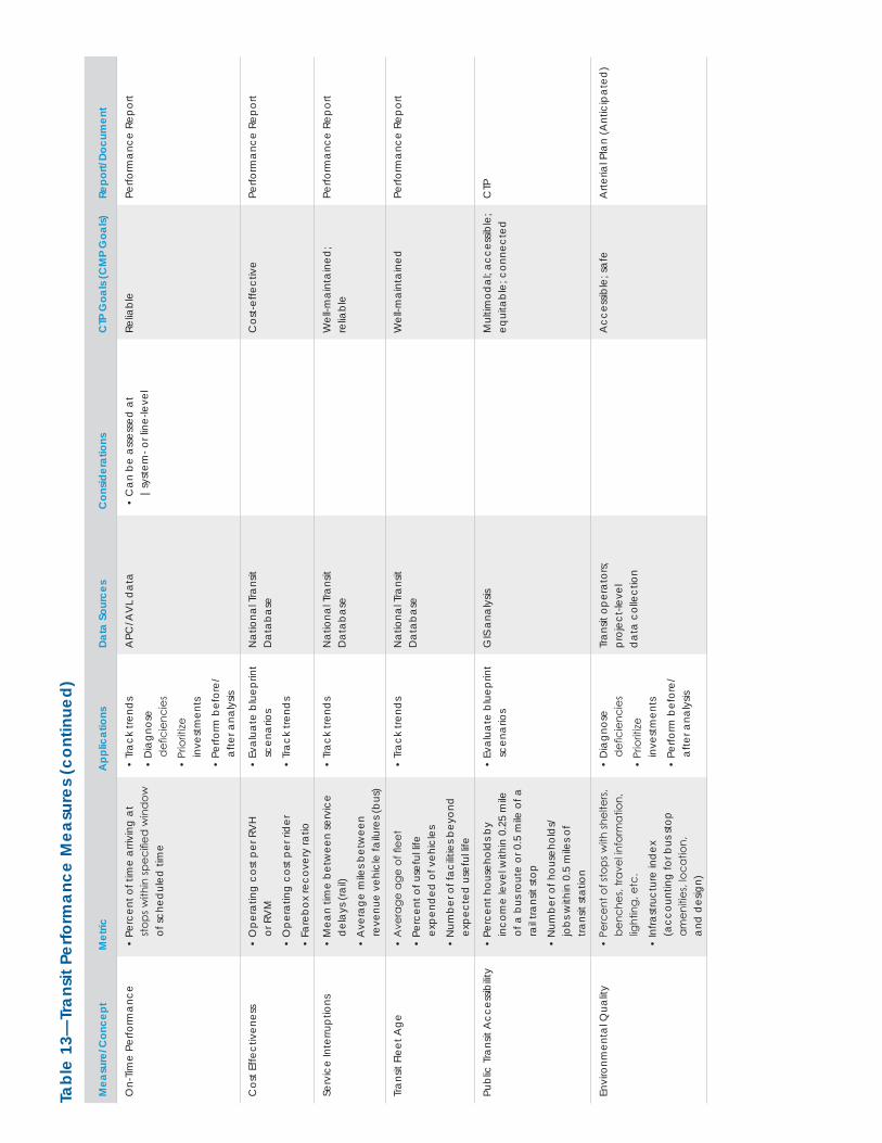
Tabl
e 13
—Tr
ansi
t Per
form
ance
Mea
sure
s (c
ontin
ued)
Mea
sure
/Con
cept
Met
ricA
pplic
atio
nsDa
ta S
ourc
esC
onsid
erat
ions
CTP
Goa
ls (C
MP
Goa
ls)Re
port/
Docu
men
t
On-
Time
Perfo
rman
ce•
Perc
ent o
f tim
e ar
rivin
g at
st
ops w
ithin
spec
ified
win
dow
of
sche
dul
ed ti
me
• Tr
ack
trend
s
• D
iagn
ose
d
efici
enci
es
• Pr
iorit
ize
inve
stm
ents
• Pe
rform
bef
ore/
afte
r ana
lysis
APC
/AV
L d
ata
• C
an b
e as
sess
ed a
t |s
yste
m- o
r lin
e-le
vel
Relia
ble
Perfo
rman
ce R
epor
t
Cos
t Effe
ctiv
enes
s•
Ope
ratin
g co
st p
er R
VH
or
RV
M
• O
pera
ting
cost
per
rid
er
• Fa
rebo
x re
cove
ry ra
tio
• Ev
alua
te b
luep
rint
scen
ario
s
• Tr
ack
trend
s
Nat
iona
l Tra
nsit
D
atab
ase
Cos
t-effe
ctiv
ePe
rform
ance
Rep
ort
Serv
ice
Inte
rrupt
ions
• M
ean
time
betw
een
serv
ice
del
ays (
rail)
• A
vera
ge m
iles b
etw
een
re
venu
e ve
hicl
e fa
ilure
s (bu
s)
• Tr
ack
trend
sN
atio
nal T
rans
it
Dat
abas
eW
ell-m
aint
aine
d;
relia
ble
Perfo
rman
ce R
epor
t
Tran
sit F
leet
Age
• A
vera
ge a
ge o
f flee
t
• Pe
rcen
t of u
sefu
l life
ex
pend
ed o
f veh
icle
s
• N
umbe
r of f
acilit
ies b
eyon
d
expe
cted
use
ful li
fe
• Tr
ack
trend
sN
atio
nal T
rans
it
Dat
abas
eW
ell-m
aint
aine
dPe
rform
ance
Rep
ort
Publ
ic T
rans
it A
cces
sibilit
y•
Perc
ent h
ouse
hold
s by
inco
me
leve
l with
in 0
.25
mile
of
a b
us ro
ute
or 0
.5 m
ile o
f a
rail t
rans
it st
op
• N
umbe
r of h
ouse
hold
s/
jobs
with
in 0
.5 m
iles o
f tra
nsit
stat
ion
• Ev
alua
te b
luep
rint
scen
ario
sG
IS a
naly
sisM
ultim
odal
; acc
essib
le;
equi
tabl
e; c
onne
cted
CTP
Envi
ronm
enta
l Qua
lity
• Pe
rcen
t of s
tops
with
shel
ters
, be
nche
s, tra
vel in
form
atio
n,
light
ing,
etc
.
• In
frast
ruct
ure
ind
ex
(acc
ount
ing
for b
us st
op
amen
ities
, loc
atio
n,
and
des
ign)
• D
iagn
ose
d
efici
enci
es
• Pr
iorit
ize
inve
stm
ents
• Pe
rform
bef
ore/
afte
r ana
lysis
Tran
sit o
pera
tors
; pr
ojec
t-lev
el
dat
a co
llect
ion
Acc
essib
le; s
afe
Arte
rial P
lan
(Ant
icip
ated
)
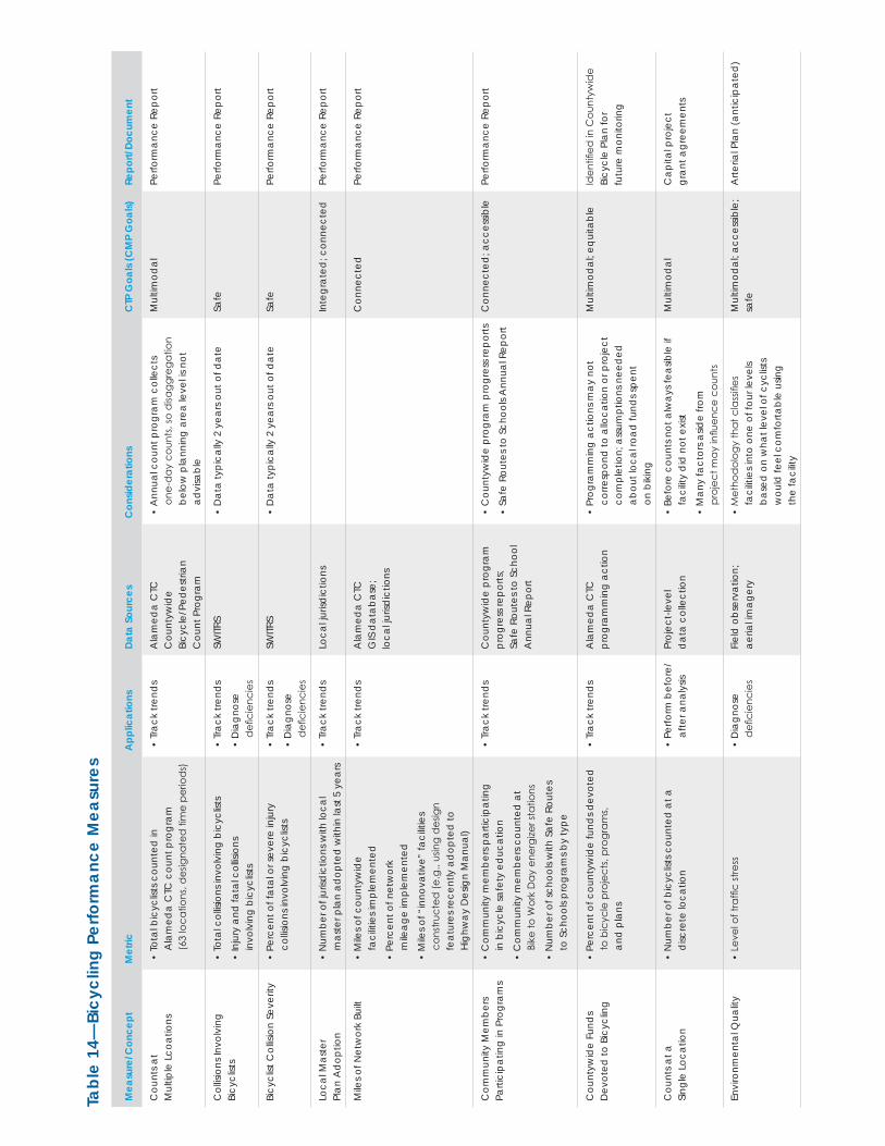
Tabl
e 14
—Bi
cycl
ing
Perfo
rman
ce M
easu
res
Mea
sure
/Con
cept
Met
ricA
pplic
atio
nsDa
ta S
ourc
esC
onsid
erat
ions
CTP
Goa
ls (C
MP
Goa
ls)Re
port/
Docu
men
t
Cou
nts a
t M
ultip
le L
coat
ions
• To
tal b
icyc
lists
cou
nted
in
Ala
med
a C
TC c
ount
pro
gram
(6
3 lo
catio
ns, d
esig
nate
d ti
me
perio
ds)
• Tr
ack
trend
sA
lam
eda
CTC
C
ount
ywid
e
Bicy
cle/
Ped
estri
an
Cou
nt P
rogr
am
• A
nnua
l cou
nt p
rogr
am c
olle
cts
one-
day
cou
nts,
so d
isagg
rega
tion
belo
w p
lann
ing
area
leve
l is n
ot
advi
sabl
e
Mul
timod
alPe
rform
ance
Rep
ort
Col
lisio
ns In
volv
ing
Bi
cycl
ists
• To
tal c
ollis
ions
invo
lvin
g bi
cycl
ists
• In
jury
and
fata
l col
lisio
ns
invo
lvin
g bi
cycl
ists
• Tr
ack
trend
s
• D
iagn
ose
d
efici
enci
es
SWITR
S•
Dat
a ty
pica
lly 2
yea
rs o
ut o
f dat
eSa
fePe
rform
ance
Rep
ort
Bicy
clist
Col
lisio
n Se
verit
y•
Perc
ent o
f fat
al o
r sev
ere
inju
ry
collis
ions
invo
lvin
g bi
cycl
ists
• Tr
ack
trend
s
• D
iagn
ose
d
efici
enci
es
SWITR
S•
Dat
a ty
pica
lly 2
yea
rs o
ut o
f dat
eSa
fePe
rform
ance
Rep
ort
Loca
l Mas
ter
Plan
Ad
optio
n•
Num
ber o
f jur
isdic
tions
with
loca
l m
aste
r pla
n ad
opte
d w
ithin
last
5 y
ears
• Tr
ack
trend
sLo
cal ju
risd
ictio
nsIn
tegr
ated
; con
nect
edPe
rform
ance
Rep
ort
Mile
s of N
etw
ork
Built
• M
iles o
f cou
ntyw
ide
fa
cilit
ies i
mpl
emen
ted
• Pe
rcen
t of n
etw
ork
m
ileag
e im
plem
ente
d
• M
iles o
f “in
nova
tive”
faci
litie
s co
nstru
cted
(e.g
., us
ing
des
ign
fe
atur
es re
cent
ly a
dop
ted
to
High
way
Des
ign
Man
ual)
• Tr
ack
trend
sA
lam
eda
CTC
G
IS d
atab
ase;
lo
cal ju
risd
ictio
ns
Con
nect
edPe
rform
ance
Rep
ort
Com
mun
ity M
embe
rs
Parti
cipa
ting
in P
rogr
ams
• C
omm
unity
mem
bers
par
ticip
atin
g
in b
icyc
le sa
fety
ed
ucat
ion
• C
omm
unity
mem
bers
cou
nted
at
Bike
to W
ork
Day
ene
rgize
r sta
tions
• N
umbe
r of s
choo
ls w
ith S
afe
Rout
es
to S
choo
ls pr
ogra
ms b
y ty
pe
• Tr
ack
trend
sC
ount
ywid
e pr
ogra
m
prog
ress
repo
rts;
Safe
Rou
tes t
o Sc
hool
A
nnua
l Rep
ort
• C
ount
ywid
e pr
ogra
m p
rogr
ess r
epor
ts
• Sa
fe R
oute
s to
Scho
ols A
nnua
l Rep
ort
Con
nect
ed; a
cces
sible
Perfo
rman
ce R
epor
t
Cou
ntyw
ide
Fund
s D
evot
ed to
Bic
yclin
g•
Perc
ent o
f cou
ntyw
ide
fund
s dev
oted
to
bic
ycle
pro
ject
s, pr
ogra
ms,
an
d p
lans
• Tr
ack
trend
sA
lam
eda
CTC
pr
ogra
mm
ing
actio
n•
Prog
ram
min
g ac
tions
may
not
co
rresp
ond
to a
lloca
tion
or p
roje
ct
com
plet
ion;
ass
umpt
ions
nee
ded
ab
out l
ocal
road
fund
s spe
nt
on b
ikin
g
Mul
timod
al; e
quita
ble
Iden
tified
in C
ount
ywid
e Bi
cycl
e Pl
an fo
r fu
ture
mon
itorin
g
Cou
nts a
t a
Sing
le L
ocat
ion
• N
umbe
r of b
icyc
lists
cou
nted
at a
d
iscre
te lo
catio
n•
Perfo
rm b
efor
e/af
ter a
naly
sisPr
ojec
t-lev
el
dat
a co
llect
ion
• Be
fore
cou
nts n
ot a
lway
s fea
sible
if
faci
lity
did
not
exis
t
• M
any
fact
ors a
side
from
pr
ojec
t may
influ
ence
cou
nts
Mul
timod
alC
apita
l pro
ject
gr
ant a
gree
men
ts
Envi
ronm
enta
l Qua
lity
• Le
vel o
f tra
ffic
stre
ss•
Dia
gnos
e
defi
cien
cies
Fi
eld
obs
erva
tion;
ae
rial im
ager
y•
Met
hod
olog
y th
at c
lass
ifies
fa
cilit
ies i
nto
one
of fo
ur le
vels
ba
sed
on
wha
t lev
el o
f cyc
lists
w
ould
feel
com
forta
ble
usin
g
the
faci
lity
Mul
timod
al; a
cces
sible
; sa
feA
rteria
l Pla
n (a
ntic
ipat
ed)
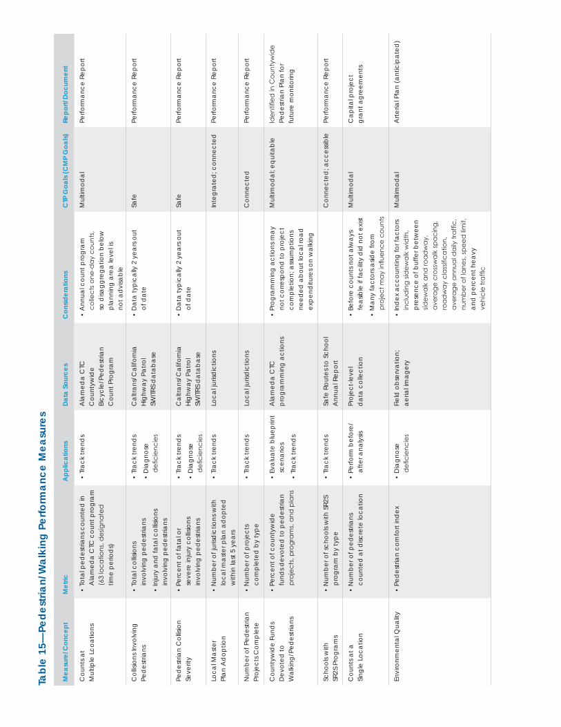
Tabl
e 15
—Pe
dest
rian/
Wal
king
Per
form
ance
Mea
sure
s
Mea
sure
/Con
cept
Met
ricA
pplic
atio
nsDa
ta S
ourc
esC
onsid
erat
ions
CTP
Goa
ls (C
MP
Goa
ls)Re
port/
Docu
men
t
Cou
nts a
t M
ultip
le L
coat
ions
• To
tal p
edes
trian
s cou
nted
in
Ala
med
a C
TC c
ount
pro
gram
(6
3 lo
catio
ns, d
esig
nate
d
time
perio
ds)
• Tr
ack
trend
sA
lam
eda
CTC
C
ount
ywid
e
Bicy
cle/
Ped
estri
an
Cou
nt P
rogr
am
• A
nnua
l cou
nt p
rogr
am
colle
cts o
ne-d
ay c
ount
s,
so d
isagg
rega
tion
belo
w
plan
ning
are
a le
vel is
no
t ad
visa
ble
Mul
timod
alPe
rform
ance
Rep
ort
Col
lisio
ns In
volv
ing
Pe
des
trian
s•
Tota
l col
lisio
ns
invo
lvin
g pe
des
trian
s
• In
jury
and
fata
l col
lisio
ns
invo
lvin
g pe
des
trian
s
• Tr
ack
trend
s
• D
iagn
ose
d
efici
enci
es
Cal
trans
/Cal
iforn
ia
High
way
Pat
rol
SWITR
S d
atab
ase
• D
ata
typi
cally
2 y
ears
out
of
dat
eSa
fePe
rform
ance
Rep
ort
Ped
estri
an C
ollis
ion
Se
verit
y•
Perc
ent o
f fat
al o
r se
vere
inju
ry c
ollis
ions
in
volv
ing
ped
estri
ans
• Tr
ack
trend
s
• D
iagn
ose
d
efici
enci
es
Cal
trans
/Cal
iforn
ia
High
way
Pat
rol
SWITR
S d
atab
ase
• D
ata
typi
cally
2 y
ears
out
of
dat
eSa
fePe
rform
ance
Rep
ort
Loca
l Mas
ter
Plan
Ad
optio
n•
Num
ber o
f jur
isdic
tions
with
lo
cal m
aste
r pla
n ad
opte
d
with
in la
st 5
yea
rs
• Tr
ack
trend
sLo
cal ju
risd
ictio
nsIn
tegr
ated
; con
nect
edPe
rform
ance
Rep
ort
Num
ber o
f Ped
estri
an
Proj
ects
Com
plet
e•
Num
ber o
f pro
ject
s co
mpl
eted
by
type
• Tr
ack
trend
sLo
cal ju
risd
ictio
nsC
onne
cted
Perfo
rman
ce R
epor
t
Cou
ntyw
ide
Fund
s D
evot
ed to
W
alki
ng/P
edes
trian
s
• Pe
rcen
t of c
ount
ywid
e fu
nds d
evot
ed to
ped
estri
an
proj
ects
, pro
gram
s, an
d p
lans
• Ev
alua
te b
luep
rint
scen
ario
s
• Tr
ack
trend
s
Ala
med
a C
TC
prog
ram
min
g ac
tions
• Pr
ogra
mm
ing
actio
ns m
ay
not c
orre
spon
d to
pro
ject
co
mpl
etio
n; a
ssum
ptio
ns
need
ed a
bout
loca
l roa
d
expe
nditu
res o
n w
alki
ng
Mul
timod
al; e
quita
ble
Iden
tified
in C
ount
ywid
e Pe
des
trian
Pla
n fo
r fu
ture
mon
itorin
g
Scho
ols w
ith
SR2S
Pro
gram
s•
Num
ber o
f sch
ools
with
SR2
S pr
ogra
m b
y ty
pe•
Trac
k tre
nds
Safe
Rou
tes t
o Sc
hool
A
nnua
l Rep
ort
Con
nect
ed; a
cces
sible
Perfo
rman
ce R
epor
t
Cou
nts a
t a
Sing
le L
ocat
ion
• N
umbe
r of p
edes
trian
s co
unte
d a
t disc
rete
loca
tion
• Pe
rform
bef
ore/
afte
r ana
lysis
Proj
ect-l
evel
d
ata
colle
ctio
n•
Befo
re c
ount
s not
alw
ays
feas
ible
if fa
cilit
y d
id n
ot e
xist
• M
any
fact
ors a
side
from
pr
ojec
t may
influ
ence
cou
nts
Mul
timod
alC
apita
l pro
ject
gr
ant a
gree
men
ts
Envi
ronm
enta
l Qua
lity
• Pe
des
trian
com
fort
ind
ex•
Dia
gnos
e
defi
cien
cies
Fi
eld
obs
erva
tion;
ae
rial im
ager
y•
Ind
ex a
ccou
ntin
g fo
r fac
tors
in
clud
ing
sidew
alk
wid
th,
pres
ence
of b
uffe
r bet
wee
n sid
ewal
k an
d ro
adw
ay,
aver
age
cros
swal
k sp
acin
g,
road
way
cla
ssifi
catio
n,
aver
age
annu
al d
aily
traf
fic,
num
ber o
f lan
es, s
peed
limit,
an
d p
erce
nt h
eavy
ve
hicl
e tra
ffic
Mul
timod
alA
rteria
l Pla
n (a
ntic
ipat
ed)
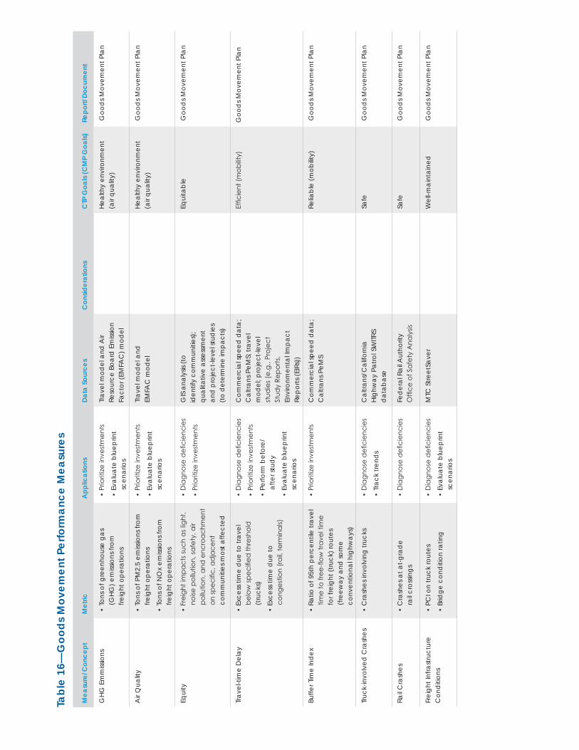
Tabl
e 16
—G
oods
Mov
emen
t Per
form
ance
Mea
sure
s
Mea
sure
/Con
cept
Met
ricA
pplic
atio
nsDa
ta S
ourc
esC
onsid
erat
ions
CTP
Goa
ls (C
MP
Goa
ls)Re
port/
Docu
men
t
GHG
Em
miss
ions
• To
ns o
f gre
enho
use
gas
(GHG
) em
issio
ns fr
om
freig
ht o
pera
tions
• Pr
iorit
ize in
vest
men
ts
• Ev
alua
te b
luep
rint
scen
ario
s
Trav
el m
odel
and
Air
Reso
urce
Boa
rd E
miss
ion
Fact
or (E
MFA
C) m
odel
Heal
thy
envi
ronm
ent
(air
qual
ity)
Goo
ds M
ovem
ent P
lan
Air
Qua
lity
• To
ns o
f PM
2.5
emiss
ions
from
fre
ight
ope
ratio
ns
• To
ns o
f NO
x em
issio
ns fr
om
freig
ht o
pera
tions
• Pr
iorit
ize in
vest
men
ts
• Ev
alua
te b
luep
rint
scen
ario
s
Trav
el m
odel
and
EM
FAC
mod
elHe
alth
y en
viro
nmen
t (a
ir qu
ality
) G
ood
s Mov
emen
t Pla
n
Equi
ty•
Frei
ght i
mpa
cts s
uch
as lig
ht,
noise
pol
lutio
n, sa
fety
, air
po
llutio
n, a
nd e
ncro
achm
ent
on sp
ecifi
c, a
dja
cent
co
mm
uniti
es m
ost a
ffect
ed
• D
iagn
ose
defi
cien
cies
• Pr
iorit
ize in
vest
men
ts
GIS
ana
lysis
(to
id
entif
y co
mm
uniti
es);
qual
itativ
e as
sess
men
t an
d pr
ojec
t-lev
el st
udie
s (t
o de
term
ine
impa
cts)
Equi
tabl
e G
ood
s Mov
emen
t Pla
n
Trav
el-ti
me
Del
ay•
Exce
ss ti
me
due
to tr
avel
be
low
spec
ified
thre
shol
d
(tru
cks)
• Ex
cess
tim
e d
ue to
co
nges
tion
(rail,
term
inal
s)
• D
iagn
ose
defi
cien
cies
• Pr
iorit
ize in
vest
men
ts
• Pe
rform
bef
ore/
af
ter s
tud
y
• Ev
alua
te b
luep
rint
scen
ario
s
Com
mer
cial
spee
d d
ata;
C
altra
ns P
eMS;
trav
el
mod
el; p
roje
ct-le
vel
stud
ies (
e.g.
, Pro
ject
St
udy
Repo
rts,
Envi
ronm
enta
l Im
pact
Re
ports
(EIR
s))
Effic
ient
(mob
ility)
Goo
ds M
ovem
ent P
lan
Buffe
r Tim
e In
dex
• Ra
tio o
f 95t
h pe
rcen
tile
trave
l tim
e to
free
-flow
trav
el ti
me
for f
reig
ht (t
ruck
) rou
tes
(free
way
and
som
e
conv
entio
nal h
ighw
ays)
• Pr
iorit
ize in
vest
men
tsC
omm
erci
al sp
eed
dat
a;
Cal
trans
PeM
SRe
liabl
e (m
obilit
y) G
ood
s Mov
emen
t Pla
n
Truc
k-in
volv
ed C
rash
es•
Cra
shes
invo
lvin
g tru
cks
• D
iagn
ose
defi
cien
cies
• Tr
ack
trend
s
Cal
trans
/Cal
iforn
ia
High
way
Pat
rol S
WITR
S d
atab
ase
Safe
Goo
ds M
ovem
ent P
lan
Rail C
rash
es•
Cra
shes
at a
t-gra
de
ra
il cro
ssin
gs•
Dia
gnos
e d
efici
enci
esFe
der
al R
ail A
utho
rity
Offi
ce o
f Saf
ety
Ana
lysis
Safe
Goo
ds M
ovem
ent P
lan
Frei
ght I
nfra
stru
ctur
e C
ond
ition
s•
PCI o
n tru
ck ro
utes
• Br
idge
con
diti
on ra
ting
• D
iagn
ose
defi
cien
cies
• Ev
alua
te b
luep
rint
scen
ario
s
MTC
Stre
etSa
ver
Wel
l-mai
ntai
ned
Goo
ds M
ovem
ent P
lan
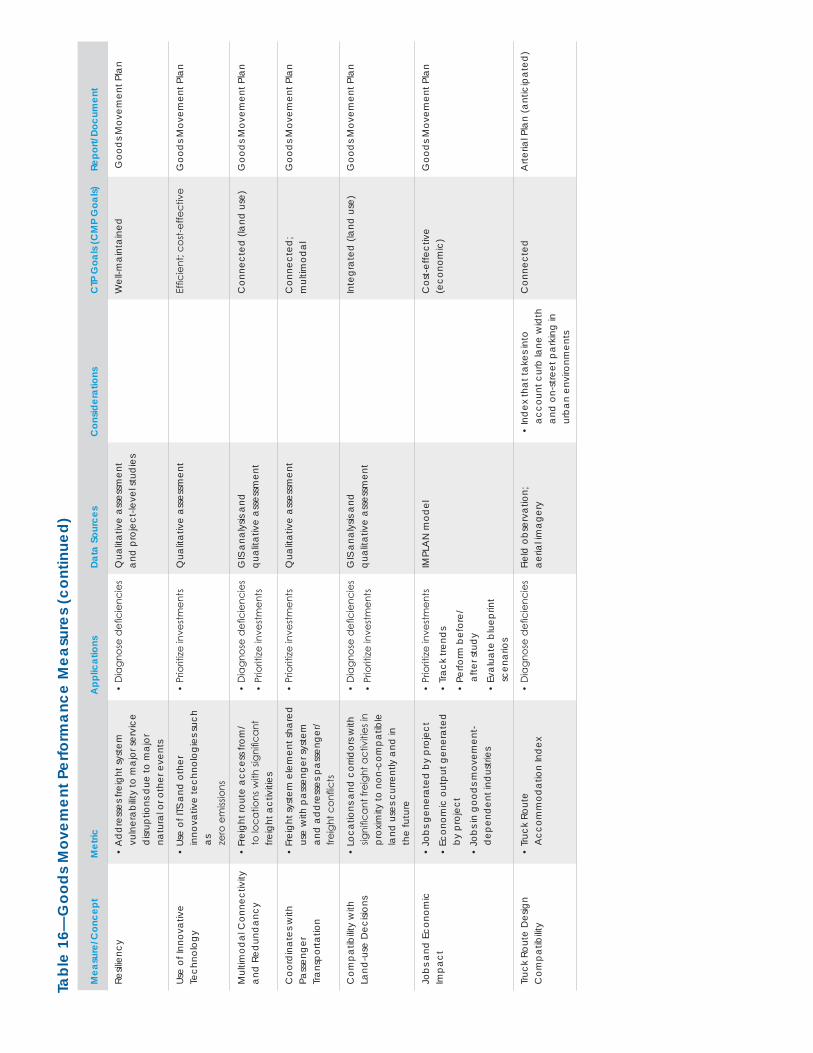
Tabl
e 16
—G
oods
Mov
emen
t Per
form
ance
Mea
sure
s (c
ontin
ued)
Mea
sure
/Con
cept
Met
ricA
pplic
atio
nsDa
ta S
ourc
esC
onsid
erat
ions
CTP
Goa
ls (C
MP
Goa
ls)Re
port/
Docu
men
t
Resil
ienc
y•
Ad
dre
sses
frei
ght s
yste
m
vuln
erab
ility
to m
ajor
serv
ice
disr
uptio
ns d
ue to
maj
or
natu
ral o
r oth
er e
vent
s
• D
iagn
ose
defi
cien
cies
Q
ualit
ativ
e as
sess
men
t an
d p
roje
ct-le
vel s
tud
ies
Wel
l-mai
ntai
ned
Goo
ds M
ovem
ent P
lan
Use
of In
nova
tive
Te
chno
logy
• Us
e of
ITS
and
oth
er
inno
vativ
e te
chno
logi
es su
ch
as
zero
em
issio
ns
• Pr
iorit
ize in
vest
men
tsQ
ualit
ativ
e as
sess
men
tEf
ficie
nt; c
ost-e
ffect
ive
Goo
ds M
ovem
ent P
lan
Mul
timod
al C
onne
ctiv
ity
and
Red
und
ancy
• Fr
eigh
t rou
te a
cces
s fro
m/
to lo
catio
ns w
ith si
gnifi
cant
fre
ight
act
iviti
es
• D
iagn
ose
defi
cien
cies
• Pr
iorit
ize in
vest
men
ts
GIS
ana
lysis
and
qu
alita
tive
asse
ssm
ent
Con
nect
ed (l
and
use
)G
ood
s Mov
emen
t Pla
n
Coo
rdin
ates
with
Pa
ssen
ger
Tran
spor
tatio
n
• Fr
eigh
t sys
tem
ele
men
t sha
red
us
e w
ith p
asse
nger
syst
em
and
ad
dre
sses
pas
seng
er/
freig
ht c
onfli
cts
• Pr
iorit
ize in
vest
men
tsQ
ualit
ativ
e as
sess
men
tC
onne
cted
; m
ultim
odal
Goo
ds M
ovem
ent P
lan
Com
patib
ility
with
La
nd-u
se D
ecisi
ons
• Lo
catio
ns a
nd c
orrid
ors w
ith
signi
fican
t fre
ight
act
iviti
es in
pr
oxim
ity to
non
-com
patib
le
land
use
s cur
rent
ly a
nd in
th
e fu
ture
• D
iagn
ose
defi
cien
cies
• Pr
iorit
ize in
vest
men
ts
GIS
ana
lysis
and
qu
alita
tive
asse
ssm
ent
Inte
grat
ed (l
and
use
)G
ood
s Mov
emen
t Pla
n
Jobs
and
Eco
nom
ic
Impa
ct•
Jobs
gen
erat
ed b
y pr
ojec
t
• Ec
onom
ic o
utpu
t gen
erat
ed
by p
roje
ct
• Jo
bs in
goo
ds m
ovem
ent-
dep
end
ent i
ndus
tries
• Pr
iorit
ize in
vest
men
ts
• Tr
ack
trend
s
• Pe
rform
bef
ore/
af
ter s
tud
y
• Ev
alua
te b
luep
rint
scen
ario
s
IMPL
AN
mod
elC
ost-e
ffect
ive
(e
cono
mic
)G
ood
s Mov
emen
t Pla
n
Truc
k Ro
ute
Des
ign
Com
patib
ility
• Tr
uck
Rout
e
Acc
omm
odat
ion
Ind
ex•
Dia
gnos
e d
efici
enci
esFi
eld
obs
erva
tion;
ae
rial im
ager
y•
Ind
ex th
at ta
kes i
nto
acco
unt c
urb
lane
wid
th
and
on-
stre
et p
arki
ng in
ur
ban
envi
ronm
ents
Con
nect
edA
rteria
l Pla
n (a
ntic
ipat
ed)
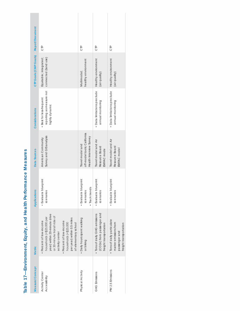
Tabl
e 17
—En
viro
nmen
t, Eq
uity
, and
Hea
lth P
erfo
rman
ce M
easu
res
Mea
sure
/Con
cept
Met
ricA
pplic
atio
nsDa
ta S
ourc
esC
onsid
erat
ions
CTP
Goa
ls (C
MP
Goa
ls)Re
port/
Docu
men
t
Act
ivity
Cen
ter
Acc
essib
ility
• Pe
rcen
t of l
ow-in
com
e ho
useh
old
s (<$
25,0
00 p
er
year
) with
in 2
0-m
inut
e d
rive
or 3
0-m
inut
e tra
nsit
ride
of
activ
ity c
ente
r
• Pe
rcen
t of l
ow-in
com
e
hous
ehol
ds (
<$25
,000
pe
r yea
r) w
ithin
0.5
mile
s of
ele
men
tary
scho
ol
• Ev
alua
te b
luep
rint
scen
ario
sA
mer
ican
Com
mun
ity
Surv
ey a
nd G
IS a
naly
sis•
Best
for l
ess-
frequ
ent
repo
rting
as m
easu
re n
ot
high
ly d
ynam
ic
Equi
tabl
e; in
tegr
ated
; co
nnec
ted
(lan
d u
se)
CTP
Phys
ical
Act
ivity
• D
aily
hou
rs sp
ent w
alki
ng
or b
ikin
g•
Eval
uate
blu
eprin
t sc
enar
ios
• Tr
ack
trend
s
Trav
el m
odel
and
of
f-mod
el to
ols;
Cal
iforn
ia
Heal
th In
terv
iew
Sur
vey
Mul
timod
al;
heal
thy
envi
ronm
ent
CTP
GHG
Em
issio
ns•
Tons
of d
aily
GHG
em
issio
ns
(CO
2e) f
rom
pas
seng
er a
nd
freig
ht tr
ansp
orta
tion
• Ev
alua
te b
luep
rint
scen
ario
sTr
avel
mod
el a
nd A
ir Re
sour
ce B
oard
EM
FAC
mod
e
• D
ata
limita
tions
pre
clud
e an
nual
mon
itorin
gHe
alth
y en
viro
nmen
t (a
ir qu
ality
)C
TP
PM 2
.5 E
miss
ions
• To
ns o
f dai
ly p
artic
ulat
e m
atte
r em
issio
ns fr
om
pass
enge
r and
fre
ight
tran
spor
tatio
n
• Ev
alua
te b
luep
rint
scen
ario
sTr
avel
mod
el a
nd A
ir Re
sour
ce B
oard
EM
FAC
mod
el
• D
ata
limita
tions
pre
clud
e an
nual
mon
itorin
gHe
alth
y en
viro
nmen
t (a
ir qu
ality
)C
TP
Alameda CTC | Congestion Management Program
66 | ALAMEDA CTC • CONGEST ION MANAGEMENT PROGRAM 2 015
Alameda CTC monitors these performance measures with data collection or by using the Countywide Travel Demand Model. The measures encompass all modes of transportation. Measurements of current conditions rely primarily on available data and established data collection processes. Peak and off-peak travel periods are considered for typical weekdays. Additional details for the legislatively required highway and roadway system and transit performance measures appear in a separate section of this chapter.
System Definition While the statute clearly requires designation of a CMP-network for purposes of LOS monitoring, it provides no guidance for selecting a system for the performance element. Alameda CTC will use the Metropolitan Transportation System (MTS) for the performance element. Alameda CTC also recognizes the MTS27 in the Land Use Analysis Program as the focus of transportation analyses.
Sources and Aceeptability of DataAlameda CTC uses a variety of data sources for its performance monitoring activities, as detailed in Tables 11 through 17. General rules regarding data sources used include:
• Alameda CTC uses data sources that have industry acceptability.
• New data sources are validated against established data sources when possible.
• Performance measures generated from travel demand models are not appropriate for annual or bi-annual monitoring (due to model’s horizon years) or for localized measures (due to accuracy issues with applying a countywide model at such scales).
• Data sources requiring original data collection (e.g., GPS floating car speed surveys, bicycle and pedestrian counts) are generally used for localized applications or on specifically defined networks due to cost of data collection.
Legislatively Required Performance MeasuresHighway and Roadway System PerformanceAlameda CTC reports on level of service on the Congestion Management Program network as required by the CMP statute in its biannual LOS monitoring reports. Alameda CTC also reports on other highway and roadway performance measures such as pavement condition index, travel times, vehicle hours of delay, collisions, and gateway traffic volumes in its annual Performance Report.
Transit Service Performance MeasuresThe following transit service performance measures are legislatively required measures, and detailed information for these measures are provided by the transit operators in the county based on their service standards as expressed in their short-range transit plans or other policy documents.
Table 18 shows performance measures for bus and rail transit in Alameda County. These measures apply to both existing services and future year (proposed) services.
For ferry services from Alameda and Oakland to San Francisco, the frequency measure is one vessel per hour during the a.m. and p.m. peak periods.
28 MTS prior to 2005.
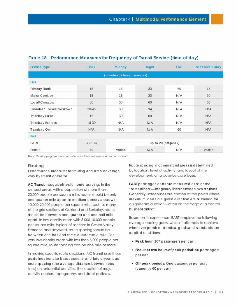
Chapter 4 | Multimodal Performance Element
ALAMEDA CTC • CONGEST ION MANAGEMENT PROGRAM 2 015 | 67
Table 18—Performance Measures for Frequency of Transit Service (time of day)
Note: Overlapping bus routes provide more frequent service on some corridors.
Service Type Peak Midday Night Owl Sat/Sun/Holiday
(minutes between services)
Bus
Primary Trunk 15 15 30 60 15
Major Corridor 15 15 30 N/A 30
Local/Crosstown 30 30 60 N/A 60
Suburban Local/Crosstown 30-45 30 NA N/A N/A
Transbay Basic 15 30 60 N/A N/A
Transbay Express 15-30 N/A N/A N/A N/A
Transbay Owl N/A N/A N/A 60 N/A
Rail
BART 3.75-15 up to 20 (off-peak)
Ferries 60 varies N/A N/A varies
RoutingPerformance measures for routing and area coverage vary by transit operator.
AC Transit has guidelines for route spacing. In the densest areas, with a population of more than 20,000 people per square mile, routes should be only one-quarter mile apart. In medium-density areas with 10,000-20,000 people per square mile, such as many of the grid sections of Oakland and Berkeley, routes should be between one-quarter and one-half mile apart. In low-density areas with 5,000-10,000 people per square mile, typical of sections in Castro Valley, Fremont, and Hayward, route spacing should be between one-half and three-quarters of a mile. For very low-density areas with less than 5,000 people per square mile, route spacing can be one mile or more.
In making specific route decisions, AC Transit uses these guidelines but also bases current- and future-year bus route spacing (the average distance between bus lines) on residential densities, the location of major activity centers, topography, and street patterns.
Route spacing in commercial areas is determined by location, level of activity, and layout of the development, on a case-by-case basis.
BART passenger loads are measured at selected “screenlines”—imaginary lines between two stations. Generally, screenlines are chosen at the points where maximum loads in a given direction are sustained for a significant duration—often on the edge of a central business district.
Based on its experience, BART employs the following average loading goals, which it attempts to achieve whenever possible. Identical goals and standards are applied to all lines.
• Peak hour: 107 passengers per car
• Shoulder two hours of peak period: 90 passengers per car
• Off-peak periods: One passenger per seat (currently 60 per car)
Alameda CTC | Congestion Management Program
68 | ALAMEDA CTC • CONGEST ION MANAGEMENT PROGRAM 2 015
BART aims for a maximum peak-hour average car load of 107 passengers per car at critical screenlines in the system such as through the Transbay Tube (West Oakland/Embarcadero). In future years, headways and train lengths will be adjusted in a manner that strives to equalize passenger loading levels across all of its lines, while staying under the 107 passengers per car standard.
LAVTA proposes the following performance measures for existing and future services:
• Expand routes and services to meet current and future demand for timely and reliable transit service;
• Provide service with a time span sufficient to effectively serve the primary target markets for each route:
○ 4:00 a.m.-1:00 a.m. or 24 hours in backbone corridor(s);
○ 5:00 a.m.-12:00 a.m. on primary feeder lines;
○ 6:00 a.m.-9:00 a.m. and 4:00 p.m.-7:00 p.m. on secondary feeder lines and regional routes; and
○ Bell time for supplemental school lines.
• Provide trip frequencies sufficient to effectively serve the primary target markets for each route:
○ 15-30 minutes on backbone lines, 10-minute peaks if demand warrants;
○ 30-60 minutes on other primary lines;
○ 60-minute peak service on neighborhood, local feeder, and regional express lines; and
○ Single daily roundtrips for supplemental school lines.
Union City Transit uses the following performance measures for existing and future service:
• 90 percent of all land with three or more dwelling units per acre within one-quarter mile of a transit route; and
• 90 percent of major activity centers within one-eighth mile of a transit route.
Transit Service CoordinationA number of measures are in place to ensure coordination among transit operators, including Senate Bill 602 (Service/Fare Coordination, 1989), Senate Bill 1474 (Transit Coordination, 1996), Senate Bill 916 (RM2, including Transit Connectivity, 2003), MTC Resolution No. 3055 (Inter-operator Transit Coordination Implementation Plan) and others. All transit operators in Alameda County will continue to implement the coordination projects required under these guidelines. Annually, the projects are agreed on among the operators and MTC. They relate to coordinating the following:
• Fare
• Schedule
• Service
• Public information
• Marketing
• Administration
Review ProcessAlameda CTC will prepare an annual transportation Performance Report that analyzes performance measures and documents Alameda County transportation network performance for review by local agencies and transit operators prior to publication. The report will include the most current available data from various agencies. (Alameda CTC will accept performance data that is up to two years old.) The Performance Report includes estimates of population growth during the preceding year, available from the State Department of Finance. As mentioned previously, the LOS Monitoring Report will document roadway performance for the CMP roadway network.
Local Government and Transit Agency Responsibilities and ConformanceTo minimize cost, Alameda CTC relies on established data collection processes and regularly published
Chapter 4 | Multimodal Performance Element
ALAMEDA CTC • CONGEST ION MANAGEMENT PROGRAM 2 015 | 69
reports for data. A list of established data collection efforts, by agency, is listed below. In 2011, the Alameda CTC Commission recommended that in odd-number years, depending on funding availability, efforts be made to augment the data collection for all modes, as needed, for improved analysis of performance of the countywide transportation system.
Cities and County• Pavement Management System data for the MTS
• Countywide Bicycle and Pedestrian Plans (Alameda County and cities’ public works departments)
Transit Agencies• Service schedules (on-time performance)
• Transit ridership routing (percentage of major centers served within one-quarter mile of a transit stop)
• Frequency (number of lines operating at each frequency level)
• Service coordination (number of transfer centers)
• Average time between off-loads (BART)
• Miles between mechanical road calls (AC Transit, LAVTA, and Union City Transit)
• Mean time between service delays (BART and ACE)
• Transit availability (frequency of transit and population within one-half mile of rail station or bus and ferry stops and terminals)
• Transit capital needs and shortfall (for high-priority, Score 16 transit projects for Alameda County transit operators)
MTC• Roadway maintenance needs
• Freeway congestion monitoring data (if developed by MTC)
Caltrans• Freeway speed runs, duration of freeway
congestion (if developed by Caltrans)
• Accident rates on state freeways
• Roadway miles in need of rehabilitation
Alameda CTC• Roadway speeds on CMP network
• Travel times for O-D pairs
• Countywide Bicycle and Pedestrian Plans
• Countywide Travel Demand Model analysis for mode share, activity center accessibility, etc.
Local agencies are encouraged to provide maintenance data to MTC or maintain their own database of maintenance needs on the MTS. However, there are no compliance requirements for local agencies or transit operators related to the multimodal performance element.
Next StepsThe performance measures identified in the multimodal performance element are based on measures established in a variety of plans and documents including the Countywide Transportation Plan, countywide modal plans (bicycle, pedestrian, arterial, transit, and goods movement) and the CMP document.
As part of the 2017 CMP update, Alameda CTC will reevaluate and identify multimodal performance measures that can be periodically monitored including documents and timelines for reporting those measures. The re-evaluation will ensure that the timeline for reporting on different measures is realistically aligned with data availability and potential changes in the measures. In addition, it will ensure that the various monitoring documents are complementary and non-duplicative. This will allow Alameda CTC to tailor its multimodal performance measures to project evaluation needs and inform programming decisions.
Alameda CTC | Congestion Management Program
70 | ALAMEDA CTC • CONGEST ION MANAGEMENT PROGRAM 2 013
This page is intentionally left blank.
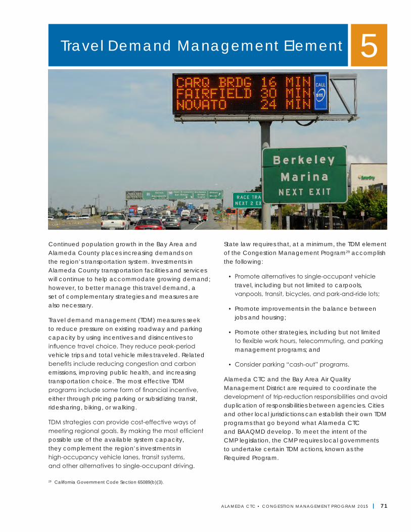
ALAMEDA CTC • CONGEST ION MANAGEMENT PROGRAM 2 015 | 71
Continued population growth in the Bay Area and Alameda County places increasing demands on the region’s transportation system. Investments in Alameda County transportation facilities and services will continue to help accommodate growing demand; however, to better manage this travel demand, a set of complementary strategies and measures are also necessary.
Travel demand management (TDM) measures seek to reduce pressure on existing roadway and parking capacity by using incentives and disincentives to influence travel choice. They reduce peak-period vehicle trips and total vehicle miles traveled. Related benefits include reducing congestion and carbon emissions, improving public health, and increasing transportation choice. The most effective TDM programs include some form of financial incentive, either through pricing parking or subsidizing transit, ridesharing, biking, or walking.
TDM strategies can provide cost-effective ways of meeting regional goals. By making the most efficient possible use of the available system capacity, they complement the region’s investments in high-occupancy vehicle lanes, transit systems, and other alternatives to single-occupant driving.
State law requires that, at a minimum, the TDM element of the Congestion Management Program29 accomplish the following:
• Promote alternatives to single-occupant vehicle travel, including but not limited to carpools, vanpools, transit, bicycles, and park-and-ride lots;
• Promote improvements in the balance between jobs and housing;
• Promote other strategies, including but not limited to flexible work hours, telecommuting, and parking management programs; and
• Consider parking “cash-out” programs.
Alameda CTC and the Bay Area Air Quality Management District are required to coordinate the development of trip-reduction responsibilities and avoid duplication of responsibilities between agencies. Cities and other local jurisdictions can establish their own TDM programs that go beyond what Alameda CTC and BAAQMD develop. To meet the intent of the CMP legislation, the CMP requires local governments to undertake certain TDM actions, known as the Required Program.
Travel Demand Management Element 5
29 California Government Code Section 65089(b)(3).
Alameda CTC | Congestion Management Program
72 | ALAMEDA CTC • CONGEST ION MANAGEMENT PROGRAM 2 015
Alameda CTC has developed a framework for implementing TDM in Alameda County that defines the roles and responsibilities of public and private organizations, summarizes the funding approach, and details how local jurisdictions must demonstrate compliance with the TDM program requirements. Appendix G provides a menu of various TDM measures and is intended as a resource for organizations developing TDM plans.
FrameworkTravel demand management in Alameda County is a collaborative and cooperative effort. Specific strategies are appropriate for the region as a whole, the county and local jurisdictions, and for individual employers or trip generators. Alameda CTC works to coordinate the activities of these types of organizations with the other elements of the CMP, so that capital investment, system management, and demand management work together to provide diverse transportation choices, contain congestion, and improve air quality. The county’s approach to TDM includes the following major elements:
Regional actions: BAAQMD, Caltrans, and MTC take actions to support TDM throughout the San Francisco Bay Area. Alameda County’s efforts work within the context of these broader regional initiatives.
Countywide actions: Alameda CTC takes actions to encourage, supplement, and support local governments in their TDM efforts, allocating funds for multimodal transportation improvements, providing guidance and technical assistance to localities in developing their own TDM programs, and monitoring compliance with the Required Program in the CMP. Alameda CTC also manages certain key TDM programs, such as Guaranteed Ride Home, that work most effectively at the countywide level.
Local jurisdiction actions: At the local level, local governments have primary responsibility for implementing TDM programs and encouraging and incentivizing TDM by private organizations. The CMP requires local governments to undertake certain TDM
actions, known as the Required Program. The CMP also encourages local governments to undertake TDM efforts above and beyond these requirements.
Private TDM actions: Private employers, developers, homeowner associations, and nonprofit organizations can undertake TDM measures on a voluntary basis or as required by a city. Alameda CTC provides resources to support these actions, including guidance on best practices and other technical resources.
Regional ActionsThe Regional TDM Program includes actions that MTC, BAAQMD, and Caltrans take to support TDM programs throughout the San Francisco Bay Area. While the primary role of these agencies is to provide the infrastructure and services that allow for transportation options, they also work to manage demand for those facilities. Key regional TDM efforts include:
• Bay Area Commuter Benefits Program: As of September 30, 2014, Bay Area employers with 50 or more full-time employees within the BAAQMD geographic boundaries are required to register and offer commuter benefits to their employees to comply with Air District Regulation 14, Rule 1. Employers must offer one of four commuter benefit options to their employees, each intended to reduce vehicle miles traveled and employee commute costs: 1) exclusion of employees’ transit or vanpool costs from taxable income, to the maximum amount, as allowed by federal law (currently $130 per month); 2) employer-provided transit subsidy (or transit pass) or vanpool subsidy up to $75 per month; 3) employer-provided free or low-cost bus, shuttle, or vanpool operated by or for the employer; or 4) an alternative employer-provided commuter benefit that is as effective in reducing single-occupant vehicles as options 1-3.
• 511 Regional Rideshare Program: MTC's 511 Regional Rideshare Program offers an online tool for commuters to find rideshare matches through its transportation information website, 511.org. MTC’s website is designed to expand the range of
Chapter 5 | Travel Demand Management Element
ALAMEDA CTC • CONGEST ION MANAGEMENT PROGRAM 2 015 | 73
potential carpoolers and facilitate coordination between people with similar commutes who would not otherwise be aware of each other. MTC encourages users of the site to log their commutes, offering an incentive program with prizes of up to $500 for keeping track of carpool trips. In addition to offering travelers assistance with carpool ride matching, MTC's rideshare program also includes information on a network of free park-and-ride lots where carpools can meet.
• 511 Regional Bicycling and Transit Trip Planners: The 511 program offers a bicycling trip planner with a regional bike mapper tool that provides turn-by-turn biking directions along the shortest and/or flattest route. The 511 Bicycling pages also provide information on safety, Bike to Work Day, taking bikes on transit, bicycle access on bridges, and bicycle parking options. The 511 program also offers a transit trip planner that provides point-to-point transit directions and real-time arrival information for all the Bay Area’s transit agencies. The 511 Transit pages provide resources, important transit alerts, and other critical information for transit riders.
• BAAQMD Spare the Air Resource Program: The Bay Area Air Quality Management District’s Spare the Air Resource Program engages the public through education and promotions to encourage changes in behavior that will reduce air pollution. BAAQMD provides “Air Alerts” when air quality is forecast to be unhealthy and to encourage people to alter their behavior on these days to prevent unhealthy air quality. The District works directly with employers by providing tools and resources to educate employees on reducing air pollution. As part of this program, BAAQMD has established local “resource teams” composed of local residents, civic groups, agencies, businesses, and environmental organizations that work together regularly to plan educational activities and programs that reduce air pollution in their communities. Two resource teams are located in Alameda County: the Southern Alameda Resource Team and the Tri-Valley Resource Team.
Countywide ActionsAlameda CTC's actions complement regionwide activities and support the efforts of local jurisdictions. Alameda CTC's activities include:
• Funding for multimodal transportation infrastructure and services: To shift trips away from single-occupant vehicles, travelers need other reliable transportation options. The 2012 Countywide Transportation Plan allocates approximately 40 percent of total project funding to transit projects and approximately 12 percent to bicycle and pedestrian projects. Similarly, the CTP allocates 53 percent of total programmatic funding to transit and 7 percent to bicycle and pedestrian programs. On November 4, 2014, more than 70 percent of Alameda County voters approved Measure BB, which increased the county’s half-cent sales tax for transportation to a full cent. The Transportation Expenditure Plan, which outlines the projects and programs funded by Measure BB revenues, allocates 48 percent of revenues to BART, bus, senior, and youth transit and 8 percent of total revenues to bicycle and pedestrian paths and safety. An additional 4.5 percent of revenues will support bicycle and pedestrian paths and safety improvements on local streets and roads.
• Planning for multimodal transportation infrastructure and services: Making transit, bicycling, and walking more convenient and safer in more places enables these modes to be viable alternatives for an increasing number of people in the county. In 2012, Alameda CTC updated the Alameda County Countywide Bicycle and Pedestrian Plans. Alameda CTC is also developing a Countywide Transit Plan and a Countywide Multimodal Arterial Corridor Plan that will help the agency optimize investments in the transit system and identify any other actions the agency can take to improve transit service as well as pedestrian and bicycle facilities throughout the county.
• Congestion pricing strategies: In 2002, the Alameda County CMA secured funding from MTC, Caltrans,
Alameda CTC | Congestion Management Program
74 | ALAMEDA CTC • CONGEST ION MANAGEMENT PROGRAM 2 015
and the Federal Highway Administration (FHWA) to conduct a feasibility study for a high-occupancy toll lane (now known as an express lane) in the I-680 corridor. The study evaluated a number of pricing options and analyzed key factors such as physical constraints, institutional opportunities and constraints, operational issues, and revenue potential. The study concluded in April 2003 and found that a smart carpool lane (express lane) would be operationally, physically, and financially feasible. Subsequently, Assembly Bill 2032 (Dutra, 2004) authorized implementation of the I-680 Express Lane. The project was completed and opened to traffic in September 2010. The legislation also approved a second express lane in the county. The CMA approved I-580 as a candidate corridor, and this project is currently under construction and will open in late 2015.
• Guaranteed Ride Home: The Alameda County GRH program, administered by Alameda CTC with funding from BAAQMD, gives commuters an “insurance policy” against being stranded at work if they need to make an unscheduled return trip home. By providing the assurance that commuters can get home in an emergency, GRH removes one of the greatest barriers to choosing an alternative to driving alone, addressing concerns such as, “What if I need to get home because my child is sick, or I have unscheduled overtime and miss my carpool ride home?” For employees, the availability of guaranteed rides home is an incentive to find an alternative to driving alone to work that avoids contributing to traffic congestion. The Alameda County GRH program has been in operation since April 1998. Over the last 15 years, the program has matured from a demonstration program with a handful of participating employers to a robust one with 2,275 registered employees and 472 registered employers throughout Alameda County as of January 2015.
• Technical support for new and existing Transportation Management Associations: Transportation Management Associations (TMAs)
are an effective mechanism to reduce traffic congestion and improve use of non-drive-alone modes by employees and sometimes residents. Depending on available resources, Alameda CTC will support creation of new TMAs in the county and strengthen existing TMAs through financial support and a technical resources “how to” handbook.
• Commute Choices website: In 2015, Alameda CTC launched the Commute Choices website (http://commutechoices.alamedactc.org/) which inventories the full range of TDM programs available in Alameda County and provides guidance to employers, individual residents and employees, and other agencies and organizations, so they can better understand the range of available transportation programs and options.
• Safe Routes to School: The Alameda County Safes Routes to School (SR2S) program began in 2007 and is intended to reduce traffic congestion and promote health by working with educators, parents, and students to increase walking, biking, and carpooling to school.30 Funded through a combination of Measure B and federal funds, the program is in place at over 100 schools and has held over 300 individual events in Alameda County. Activities supported by SR2S funds in Alameda County include walking school buses and bike trains, monthly Walk and Roll to School Day events, annual International Walk and Bike to School Day events, annual Bike to School Day events, family cycling workshops, safety courses, and educator guides on bike/pedestrian safety; school walk audit events to identify safety issues around schools; and carpool-to-school ride matching and promotional activities.
• Walking and biking promotional programs and campaigns: Alameda CTC funds and promotes active transportation modes through several related programs and advertising campaigns. The “I Walk!” and the “I Bike!” walking and bicycling campaigns promote and support active transportation in Alameda County. The I Walk! and “Step into Life
30 Alameda County Safe Routes to Schools websites: http://www.alamedacountysr2s.org/; http://www.alamedactc.org/app_pages/view/8070.
Chapter 5 | Travel Demand Management Element
ALAMEDA CTC • CONGEST ION MANAGEMENT PROGRAM 2 015 | 75
Challenge!” websites provide information on walking routes, organized walks, and other walking tools and tips. The I Bike! website provides links to a wide range of existing bicycling information on the websites of Alameda County cities, 511.org’s bicycle trip planner, and Bike East Bay. In addition to the I Bike! website, Alameda CTC has partnered with Bike East Bay since 2008 to run advertisements in advance of the annual Bike to Work Day events to promote bicycling as a lifestyle. These advertisements appear on buses, bus shelters, street poles, and in storefronts throughout Alameda County.
• Bike safety and education classes: Bike East Bay currently provides free bicycle safety classes in Alameda County with the financial support of Alameda CTC’s Bicycle and Pedestrian Grant Program. Specialized classes are available that focus on urban cycling, adults learning to ride, and families. By training cyclists to ride safely and comfortably, the program is intended to reduce vehicle trips in Alameda County and facilitate active transportation.
• Technical assistance: Through its Transit Oriented Development Technical Assistance Program (TOD TAP), Alameda CTC has funded parking and TDM studies to assist local jurisdictions in developing parking-management policies and programs that complement investments in public transit and TOD as well as walking and bicycling infrastructure. The agency has funded two parking studies: a shared parking study at MacArthur BART and a parking and stormwater study at the Coliseum/Oakland Airport BART. Alameda CTC will continue to provide financial and technical support through two primary forms:
1) Technical resources: Providing informational materials, case studies, and examples; model ordinance language; and other guidelines and information that can assist jurisdictions in implementing parking and TDM policies.
2) Planning grants: Providing funds to cities to conduct studies and other planning efforts to overcome local parking and TDM challenges and move forward on adoption of parking management and TDM programs and policies, potentially including formation of new TMAs. Alameda CTC has already expanded its TOD technical assistance program into a Sustainable Communities Technical Assistance Program (SC-TAP) to support a wide range of planning and project development activities in priority development areas.
Prior Countywide InitiativesFinancial incentives: A parking cash-out program is defined as an employer-funded program under which an employer offers to provide a cash allowance to an employee, equivalent to the parking subsidy that the employer would otherwise pay to provide the employee with a parking space. Parking cash-out programs apply to employers of 50 or more persons in air basins, areas that generally have similar meteo-rological and geographical conditions, designated as “non-attainment” areas. The parking subsidy is the difference between the out-of-pocket amount paid by an employer on a regular basis to secure an employee parking space not owned by the employer and the price, if any, charged to an employee for use of that space.
A demonstration financial incentives program for public agencies was implemented in Alameda County in 1997 for one year. The purpose of the demonstration program was to provide an opportunity for employees to choose alternative ways to get to work other than driving alone, to study the effectiveness of the program, and to find out whether increasing the incentives available made a difference in program participation. The ultimate goal was to reduce single-occupant vehicle use.
The results showed a potential for changing commute choices if the county could find continuous sources of revenues. The report on the 1997 Parking Cash-out Program is available on request from Alameda CTC.
Alameda CTC | Congestion Management Program
76 | ALAMEDA CTC • CONGEST ION MANAGEMENT PROGRAM 2 015
Dynamic ridesharing: An alternative to traditional ride-matching and carpool programs, dynamic ridesharing maximizes flexibility and accommodates last-minute requests for ride matches. Rather than commuters forming ongoing daily carpools, dynamic ridesharing participants request ride matches only on days when they want to share a ride. The major benefits are that ridesharing requires minimal advance planning and accommodates changing travel times; therefore, it reduces the barriers to carpooling.
In 2005 and 2006, the Alameda County Congestion Management Agency in collaboration with the Environmental Defense Fund/RideNow!, Inc., implemented the dynamic ridesharing pilot project, known as RideNow, at the Dublin/Pleasanton BART station. A grant from FHWA provided funding to implement, test, and evaluate a dynamic ridesharing pilot project designed by RideNow!, Inc.
RideNow was an automated system that enabled BART patrons to request carpool partners minutes before they left home in the morning or while returning home in the evening on the BART train. It provided both web and automated telephone (“interactive voice response”) access for users. RideNow matched riders within a short time frame, providing “instant matches.” The pilot project goals were to:
• Establish if dynamic ridesharing can provide a viable new travel option;
• Test the effectiveness of the program from a technical, administrative, marketing, cost, and operational perspective;
• Assess the level of interest and usage in the program and evaluate its benefits and limitations; and
• Determine the feasibility and applicability of expanding the program beyond the duration of the pilot project as well as to other locations within Alameda County or in the San Francisco Bay region.
Based on feedback from participants and the participating agencies, the program did have value for people who desire to carpool but have complex commutes that do not permit participation in more traditional carpool programs. However, more information is needed about how many people might be attracted to this type of flexible program compared to other ridesharing or TDM programs and whether or not the program would be cost effective.
In 2010, MTC approved a $1.5 million follow-up program currently underway for Contra Costa Transportation Authority, Solano County Transportation Authority, and Transportation Authority of Marin. Funded by MTC’s Climate Initiatives Program, this program explores opportunities for more carpooling through the use of smart-phone applications (“apps”) that can enable spontaneous ridesharing. As more ridesharing apps develop, Alameda CTC will work with MTC to identify opportunities for integrating these new services into the ridesharing program and assess future engagement.
Local Jurisdiction ActionsLocal governments have the primary responsibility for implementing TDM programs at the local level, and for encouraging and incentivizing TDM by private actors. The CMP requires local governments to undertake certain TDM actions, known as the Required Program. Alameda CTC also encourages local governments to undertake TDM efforts above and beyond these requirements.
Required ProgramThe Required Program includes those actions local jurisdictions must take to be in compliance with the CMP and consists of two basic elements: 1) adopting design guidelines or comparable policies that enhance transit and pedestrian and bicycle access; and 2) implementing capital improvements that contribute to congestion management and greenhouse gas reduction.
1) Adopt design guidelines or comparable policies: The CMP requires local jurisdictions to adopt and
Chapter 5 | Travel Demand Management Element
ALAMEDA CTC • CONGEST ION MANAGEMENT PROGRAM 2 015 | 77
implement guidelines for site design that enhance transit, pedestrian, and bicycle access. To meet this requirement, local jurisdictions must carry out one of the following actions:
• Adopt and implement design strategies that encourage alternatives to single- occupant automobile use through local development review;
• Adopt and implement design guidelines that meet the individual needs of the local jurisdiction and maintain the intent of the TDM element to reduce the dependence on single-occupant vehicles;
• Demonstrate that existing policies meet the intent of the TDM element to reduce the dependence on single-occupant vehicles.
2) Implement capital improvements: Local jurisdictions are also required to implement capital improvements that contribute to congestion management and emissions and greenhouse gas reduction. This requirement can be satisfied by participating in the regional Transportation Fund for Clean Air program, and the federal Surface Transportation Program and Congestion Mitigation and Air Quality Improvement Program.
Refer to “Local Government Responsibilities and Conformance” in this chapter for a description of the steps required to demonstrate compliance with the Required Program.
Voluntary local actionsAlameda CTC also encourages local jurisdictions to undertake TDM efforts above and beyond the Required Program. To support these efforts, Appendix G provides a listing of potential local TDM program elements and the context in which each program is likely to be most effective.
Cities across Alameda County have already adopted plans and programs to address TDM. Every city in Alameda County has adopted a Climate Action Plan, as has Alameda County for its government operations
and for unincorporated portions of the county. Nearly every city in Alameda County has some type of TDM program and/or has re-considered its parking management strategies at the city or neighborhood level.
Tools for developing a local TDM programA variety of tools are available to local governments for facilitating TDM. The most effective programs integrate several of these elements as a comprehensive package.
• Modify zoning codes: Local governments can implement TDM requirements through changes to their zoning code. For example, they can reduce or eliminate minimum parking requirements or grant reductions in minimum parking requirements on the condition that trip reduction programs are implemented. While local governments cannot require employers to implement an employee trip-reduction program unless the program is required by federal law, TDM requirements are often implemented as a condition of approval for new development, or a city’s zoning code can require certain measures to address traffic congestion and reduce greenhouse gas emissions.
• Partner to form a Transportation Management Association (TMA): Local governments often collaborate with business associations to facilitate creation of a TMA. Actions can include requiring TMA membership as a condition of development approval; or providing staff time, office space, or start-up funding to the TMA.
• Fund or manage programs directly: Some local governments directly fund or manage TDM programs. For example, the local government may fund universal transit passes or contract with a private organization to provide bike- sharing services.
• Implement capital projects: A variety of capital investments can support TDM. For example, local governments can invest in updated parking meters to facilitate smart parking management, wayfinding
Alameda CTC | Congestion Management Program
78 | ALAMEDA CTC • CONGEST ION MANAGEMENT PROGRAM 2 015
signage, or bicycle and pedestrian facility improvements.
• Offer a TDM program for local government employees: Local governments can offer trip reduction incentives directly to their employees. These steps can reduce peak period trips while serving as a model to other employers.
TDM program principlesWhatever the implementing mechanism, Alameda CTC encourages local jurisdictions implementing new or expanded TDM programs and requirements to adhere to the following principles:
• Outcome-based TDM, with specific performance targets: Utilize performance-based strategies with specific project-level, corridor-level, or citywide targets, because these types of programs have potential to be the most effective and the easiest to implement and administer.
• Effectiveness at achieving local and regional goals: Invest in strategies that research has proven to be effective and to provide a good return on investment.
• Well-balanced and thorough: Develop a comprehensive program. The most effective TDM programs have varied and mutually supportive demand-management measures. For example, a TDM program that includes subsidized transit passes and a guaranteed ride home program has the potential to reduce vehicle trips to a greater degree than one of those measures alone.
• Effective marketing and public outreach: Develop programs through open communication with all stakeholders and tailor the programs to their needs, since the manner in which TDM programs are introduced is crucial to their success. Perform marketing and public outreach to encourage participation.
• User friendly: Ensure TDM programs are easy for the public to understand and use. Policies
and objectives should be clearly articulated and supported with data. New technologies, such as parking meters, should be designed for straightforward public usage.
• Financially feasible and cost-effective: Strategies that are low cost or no cost should be prioritized and provide the biggest return on the investment.
• Easy and efficient to administer: Place a priority on programs that can be easily and efficiently administered, relying on data that is collected in the normal course of business for the city. Where possible, cities should seek to collaborate with neighboring cities to reduce administrative burdens for all.
Private Sector ActionsThe private sector also has an important role to play in managing travel demand. While the CMP does not require private organizations to undertake any specific TDM actions, private organizations can take a number of steps, either on a voluntary basis or in response to local jurisdiction requirements. A full menu of potential TDM actions appears in Appendix G.
Examples of existing private TDM efforts in Alameda County include:
• Emeryville Transportation Management Association is a nonprofit organization funded through Business Improvement District fees paid by all commercial and industrial property owners in the city. The Emeryville TMA funds the Emery Go-Round shuttle, a free service which runs from the MacArthur BART station along two routes that serve the Amtrak station, Bay Street, and major employers in Emeryville. The TMA also provides information and referral services, coordination with local and regional government and transit agencies, the Alameda CTC GRH program, and car-sharing spaces.
• Hacienda Business Park in Pleasanton provides a “Commute Solutions” program that offers a comprehensive suite of commute services to encourage commuting by non-drive-alone modes. For these efforts, the Hacienda Business Park is
Chapter 5 | Travel Demand Management Element
ALAMEDA CTC • CONGEST ION MANAGEMENT PROGRAM 2 015 | 79
recognized by the Best Workplaces for Commuters program.
• Berkeley Gateway TMA funds the West Berkeley shuttle that provides free service from the Ashby BART station to major employment centers in West Berkeley. The shuttle service is operated under a partnership with the Emeryville TMA.
• The Broadway “B Line” is a free shuttle that operates between Jack London Square and the Uptown/Lake Merritt districts of Oakland. It is funded through a public-private partnership between the City of Oakland, business associations throughout the areas it serves, and a BAAQMD grant, and has received Vehicle Registration Fee funding distributed by Alameda CTC. AC Transit operates the shuttle.
• Bishop Ranch Office Park, located in the San Ramon valley in Contra Costa County, provides nine free shuttle routes for employees, four of which serve Dublin/Pleasanton BART and the Pleasanton ACE station, along with a variety of other commute services for employees.
• Other free shuttles for employees are provided by the following employers and campuses in Alameda County: Alta Bates Summit Medical Center, CSU East Bay, Heald College, Kaiser Oakland Medical Center, Mills College, Lawrence Berkeley National Laboratory, and University of California Berkeley “Bear Transit.”
Menu of TDM measuresAppendix G provides a set of tables describing TDM activities that can reduce automobile trips in Alameda County. Table G-1 describes actions that public agencies, including local governments and transit agencies can carry out. Table G-2 describes complementary actions that local governments or private organizations such as employers or developers can carry out in response to local government requirements or on a voluntary basis.
Funding ApproachTDM programs are often extremely cost-effective ways to meet regional congestion management and mobility goals and offer incentives to maximize use of existing facilities. Even when TDM programs place requirements on the private sector, well-designed programs may be cost-neutral or even save money for private organizations. For example, by shifting commuters away from single-occupant vehicle travel, TDM programs can reduce an employer’s need to build or lease costly parking facilities, which partially or wholly offsets program costs.
Despite these advantages, many programs do require a public subsidy. Key funding sources for TDM programs and activities include:
• Transportation Fund for Clean Air (TFCA): The TFCA legislation permits BAAQMD to collect a fee (up to $4 per vehicle per year) for reducing air pollution from motor vehicles and for related planning and programs. It requires the BAAQMD to allocate 40 percent of the revenue to an overall program manager(s) in each county. Alameda CTC has been designated as the overall program manager in Alameda County and has developed a program that allocates the funds as follows:
○ A maximum of 5 percent of the funds goes toward program implementation and administration;
○ Approximately 70 percent of the remaining funds goes to cities/county based on population with a minimum of $10,000 to each jurisdiction; city/county population is updated annually based on State Department of Finance estimates.
○ Approximately 30 percent of the remaining funds are allocated to transit-related projects; all eligible applicants may apply for these funds for transit-related projects.
• Surface Transportation Program (STP): MTC and Alameda CTC both perform administrative functions for programming STP funds. For TDM purposes, the following projects are eligible for STP funds:
Alameda CTC | Congestion Management Program
80 | ALAMEDA CTC • CONGEST ION MANAGEMENT PROGRAM 2 015
highway projects including HOV lanes, signalization, transit projects, station area and transit-oriented development planning activities that result in the location of housing and/or jobs near high-frequency transit, and bicycle and pedestrian projects.
• Congestion Mitigation and Air Quality Program (CMAQ): MTC and Alameda CTC both perform administrative functions for programming CMAQ funds. For TDM purposes, eligible projects include those types of transportation projects that improve air quality, such as ridesharing and bicycle and pedestrian projects.
Local Government Responsibilities and ConformanceAlameda CTC is required to monitor local jurisdictions’ conformance with the adopted CMP. To meet this responsibility, Alameda CTC requires annual reporting to determine if each city and the county has adopted and implemented a trip-reduction and travel-demand ordinance. The following monitoring policies are in place.
Local Government ResponsibilitiesThe Required Program includes actions local jurisdictions must take to comply with the CMP. Local jurisdictions have until September 1 of each year to adopt and implement the Required Program.
To be found in conformance with the CMP, local jurisdictions must certify to Alameda CTC that they have adopted and implemented site design guidelines that enhance transit and pedestrian and bicycle access. To ensure consistency among all jurisdictions, Alameda CTC prepared and approved a TDM Checklist that identifies components to include in local design guidelines (Appendix H).
Local jurisdictions are also required to implement capital improvements that contribute to congestion management and reduce carbon emissions and greenhouse gases. This requirement can be satisfied by participating in the regional TFCA and the federal
STP and CMAQ Programs. Refer to Chapter 8, “Capital Improvement Program” (CIP) for more information on the CIP, which incorporates numerous project types and programs identified in the Transportation Control Measures (TCM) Plan (see Appendix I).
Procedures for Non-conformanceIf Alameda CTC finds a local jurisdiction has not adopted and implemented the Required Program, it may find the local jurisdiction in “non-conformance.” At the time of the finding, Alameda CTC will provide recommendations for corrective actions. If after 90 days the local jurisdiction is still in non-conformance, Alameda CTC is required to follow the conformance process as identified in Chapter 9, “Program Conformance and Monitoring.” This could impact the non-conforming jurisdiction’s ability to receive its increment of subventions from the fuel tax made available by Proposition 111, and the jurisdiction’s ability to receive funding for projects through the federal STP and CMAQ Program.
Next StepsFollowing are next steps for the CMP TDM element to increase the impact of existing TDM programs, incentivize expansion of TDM offerings throughout the county, and ultimately increase the likelihood that individuals throughout the county will utilize TDM programs and travel by non-drive alone modes.
• Encourage the formation of new Transportation Management Associations (TMAs) and strengthen existing TMAs by providing financial support (as possible) as well as technical resources such as a “how to” handbook.
• Provide technical assistance to support jurisdictions in implementing parking reforms and TDM policies and programs. Technical support for jurisdictions can take two primary forms:
1) Technical resources: Providing informational materials, case studies and examples, model ordinance language, and other guidelines
Chapter 5 | Travel Demand Management Element
ALAMEDA CTC • CONGEST ION MANAGEMENT PROGRAM 2 015 | 81
and information that can assist jurisdictions in implementing parking and TDM policies.
2) Planning grants: Providing funds to cities to conduct studies and other planning efforts to overcome local parking and TDM challenges and move forward on adoption of parking management and TDM programs and policies, potentially including formation of new TMAs. Alameda CTC has already expanded its TOD technical assistance program into a Sustainable Communities Technical Assistance Program to support a wide range of planning and project development activities in PDAs.
• Provide a robust Guaranteed Ride Home Program.
• Maintain and update the Commute Choices website (http://commutechoices.alamedactc.org/).
• Consider adopting future TDM/parking requirement policies as part of funding eligibility requirements for local jurisdictions.

Alameda CTC | Congestion Management Program
82 | ALAMEDA CTC • CONGEST ION MANAGEMENT PROGRAM 2 015
This page is intentionally left blank.
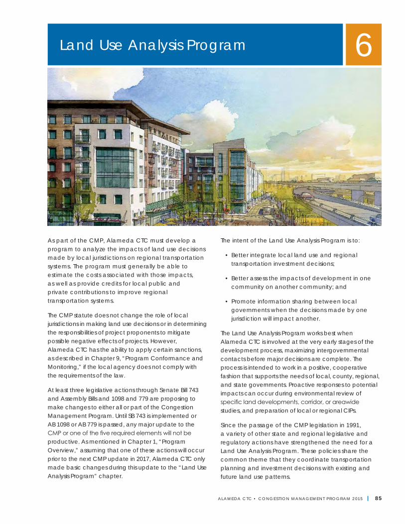
ALAMEDA CTC • CONGEST ION MANAGEMENT PROGRAM 2 015 | 85
As part of the CMP, Alameda CTC must develop a program to analyze the impacts of land use decisions made by local jurisdictions on regional transportation systems. The program must generally be able to estimate the costs associated with those impacts, as well as provide credits for local public and private contributions to improve regional transportation systems.
The CMP statute does not change the role of local jurisdictions in making land use decisions or in determining the responsibilities of project proponents to mitigate possible negative effects of projects. However, Alameda CTC has the ability to apply certain sanctions, as described in Chapter 9, “Program Conformance and Monitoring,” if the local agency does not comply with the requirements of the law.
At least three legislative actions through Senate Bill 743 and Assembly Bills and 1098 and 779 are proposing to make changes to either all or part of the Congestion Management Program. Until SB 743 is implemented or AB 1098 or AB 779 is passed, any major update to the CMP or one of the five required elements will not be productive. As mentioned in Chapter 1, “Program Overview,” assuming that one of these actions will occur prior to the next CMP update in 2017, Alameda CTC only made basic changes during this update to the “Land Use Analysis Program” chapter.
The intent of the Land Use Analysis Program is to:
• Better integrate local land use and regional transportation investment decisions;
• Better assess the impacts of development in one community on another community; and
• Promote information sharing between local governments when the decisions made by one jurisdiction will impact another.
The Land Use Analysis Program works best when Alameda CTC is involved at the very early stages of the development process, maximizing intergovernmental contacts before major decisions are complete. The process is intended to work in a positive, cooperative fashion that supports the needs of local, county, regional, and state governments. Proactive responses to potential impacts can occur during environmental review of specific land developments, corridor, or areawide studies, and preparation of local or regional CIPs.
Since the passage of the CMP legislation in 1991, a variety of other state and regional legislative and regulatory actions have strengthened the need for a Land Use Analysis Program. These policies share the common theme that they coordinate transportation planning and investment decisions with existing and future land use patterns.
Land Use Analysis Program 6
Alameda CTC | Congestion Management Program
86 | ALAMEDA CTC • CONGEST ION MANAGEMENT PROGRAM 2 015
While Alameda CTC’s Land Use Analysis Program was initially conceived as a program to meet a particular state legislative mandate, the growing interest in coordinating land use and transportation planning has resulted in the program’s evolution. The program now also serves as an opportunity for strategic thinking about how to plan for development that efficiently uses the transportation system, while ensuring that the mobility and access needs of residents and workers in Alameda County are fulfilled. Refer to Table 19 for legislative and regulatory actions. As such, the program includes:
• Legislatively required review of:
○ Land use actions of local jurisdictions by Alameda CTC; and
○ Land use projections for use in countywide model database by local jurisdictions;
• Planning initiatives and programs that foster transportation and land use connections; and
• Strategic monitoring of transportation-land use coordination performance measures.
Review of Land Use ActionsA major component of the Alameda CTC Land Use Analysis Program is the legislatively required review of land use development projects. The review of development projects allows Alameda CTC to assess impacts of individual development actions on the regional transportation system and ensures that significant impacts are appropriately mitigated.
Alameda CTC also plays a key interjurisdictional facilitation role, and when disputes arise between two agencies as a result of the potential impacts of a land use project, Alameda CTC may act as a mediator, if requested by one of the parties involved.
Table 19—Legislative and Regulatory Actions
Legislation/Regulatory Action Description
California Assembly Bill 32 (AB 32) The California Global Warming Solutions Act of 2006 requires the State of California to meet aggressive Greenhouse Gas emissions reduction targets.
California Senate Bill 375 (SB 375) Redesigning Communities to Reduce Greenhouse Gas of 2008 synchronizes long-range regional transportation and land use planning and requires regional preparation of a Sustainable Communities Strategy that details how a region will house its population.
Metropolitan Transportation Commission (MTC) Resolution 4035
This resolution establishes the One Bay Area Grant Program, which links federal transportation funding to location in or proximate access to locally designated Priority Development Areas.
MTC Resolution 3434 The Transit Oriented Development (TOD) Policy for Regional Transit Expansion Projects of 2005 links the expenditure of regional capital funding for transit expansion to the density of households allowed around future mass transit systems.
Bay Area Air Quality Management District (BAAQMD) California Environmental Quality Act (CEQA) Guidelines
These 2010 guidelines set low thresholds of significance for acceptable exposure to toxic air contaminants for residents and other users of new developments.
San Francisco Bay Conservation and Development Commission (BCDC) Sea Level Rise Estimates
These estimates identify many key development areas and transportation assets as being vulnerable to sea-level rise and needing adaption planning.
Chapter 6 | Land Use Analysis Program
ALAMEDA CTC • CONGEST ION MANAGEMENT PROGRAM 2 015 | 87
Scope of ReviewAlameda CTC reviews two types of land use actions.31
• Projects requiring General Plan Amendments: These projects require a change to the text or map of a city or unincorporated planning area’s general plan. General Plan Amendments (GPAs) can be performed in conjunction with a General Plan update, a specific plan, or an area plan. GPAs can also be adopted for an individual development project that is not consistent with current land use designations and therefore requires a GPA.
• Projects consistent with General Plan: These plans or projects do not require any modification of the general plan text or map.
Alameda CTC limits the scope of its review of land use actions to those with the potential to cause countywide or regional scale impacts. Projects are reviewed if they will cause a net increase of 100 p.m. peak-hour vehicle trips. The evening peak period is used, as this period generally experiences the highest travel demands. This threshold is applied differently, depending on whether a project requires a GPA or is consistent with existing general plan. Mitigated Negative Declarations (MNDs) are also considered differently, depending on whether a GPA is required or not. Table 20 summarizes the application of the 100 p.m. peak-hour trip threshold and consideration of MNDs.
Alameda CTC performs project trip generation calculations to determine whether CMP Land Use Analysis Program review is required. Project trip generation is computed using an approved trip generation methodology (see the following “Methodologies and Standards” section). The threshold for CMP review is based on net change in trips, meaning that trips from reclassified uses or existing redeveloped buildings are subtracted out of the total.
Alameda CTC reviews all large development projects and plans for which a city or the unincorporated county in Alameda County is the lead agency.32 Alameda CTC may also review large development projects from institutions, federal agencies, or neighboring counties if these are likely to impact the regional transportation system in Alameda County.
Review ProcessConsistent with the CMP statute, Alameda CTC’s review of plans and development projects through its Land Use Analysis Program is designed to occur alongside the CEQA review process to avoid duplication of effort. Alameda CTC strives to perform its review on the same timeline to offer early and proactive input that can aid in refining project design. A project is considered “complete” from a CMP review perspective once Alameda CTC notifies the project sponsor that the project is exempt or that CMP requirements have been met and that it has no further comments on the project.
31 Previous versions of Alameda CTC CMPs referred to Plans and Development Projects as Tier 1A and Tier 1B. The “Tier” nomenclature has been discontinued to avoid confusion with the Tiers of the CMP network arterials.
32 For purposes of compliance with the Land Use Analysis Program, the Port of Oakland is considered a governmental subdivision of the City of Oakland. Therefore, the Port is required to submit environmental documents to Alameda CTC for review and comment.
Table 20—Exemption from CMP Land Use Analysis Project ReviewProject Requiring General Plan Amendment Project Consistent with General Plan
100 P.M. Peak-hour Trip Threshold Assessed Relative to:
Existing General Plan land use designation(s)
Existing use(s) at project site
Mitigated Negative DeclarationsConsidered (if trip generation threshold
exceeded)Not considered
Alameda CTC | Congestion Management Program
88 | ALAMEDA CTC • CONGEST ION MANAGEMENT PROGRAM 2 015
Figure 10 illustrates the typical review process. Once Alameda CTC receives a GPA or Notice of Preparation (NOP) of a Draft Environmental Impact Report (DEIR), it issues a response within 30 days. This response either indicates that the project is exempt from CMP Land Use Analysis Program review (if it does not exceed the 100 p.m. peak-hour trip threshold) or provides comments on the scope of analysis to be performed in the DEIR to satisfy CMP requirements. If a project is not exempt, then once Alameda CTC receives a DEIR, it issues a response within 45 days. This response either indicates that the analysis contained within the DEIR adequately addresses CMP requirements or provides comments on changes or additional analysis needed to adequately address CMP requirements.
Use of the Alameda Countywide Travel Demand ModelThe CMP statute assigns responsibility to CMAs to develop a travel demand model “that will be used by local jurisdictions to determine the quantitative impacts of development on the circulation system.” The Alameda Countywide Travel Demand Model is typically used to determine traffic volumes, transit ridership, and other information for future years. Jurisdictions are required to use the most current version of the Countywide Travel Demand Model for the CMP Land Use Analysis Program. Alameda CTC amended the CMP requirements in 1998, so that local jurisdictions are responsible for applying the travel model. All local jurisdictions have signed Master Use Agreements with Alameda CTC that outline the procedure for requesting the model for a specific application.
Per the CMP statute, jurisdictions may also use an approved subarea travel demand model. Alameda CTC has responsibility for approving subarea models based on whether these models demonstrate adequate consistency with the countywide model.
Appendix J describes Alameda CTC’s policy on subarea models and required documentation for approval.
Methodologies and StandardsProject sponsors should use the following methodologies and standards when conducting Transportation Impact Analyses for the CMP Land Use Analysis Program. Guidance on methodologies and standards may also be given as part of Alameda CTC’s GPA or NOP response to the particular project.
During this 2015 CMP update, rulemaking was underway for revised CEQA guidelines pursuant to SB 743, which eliminates auto delay-based measures as a criteria for significance for transportation impacts within Transit Priority Areas (and potentially outside of Transit Priority Areas); Alameda CTC’s required and preferred methodologies for its Land Use Analysis Program will be revisited when revised CEQA guidelines are adopted.
Transportation networksThe CMP statute requires analysis of impacts of land use actions on regional transportation systems. For Alameda CTC’s CMP analyses, “regional transportation systems” is interpreted as follows:
• Autos: Study impacts to roadway segments on the 2002 Metropolitan Transportation System;33
• Transit: Study impacts to Metropolitan Transit System (MTS) transit operators (ACE, AC Transit, BART, Capitol Corridor, LAVTA, Union City Transit, and WETA);
• Bicycles: Study impacts to cyclists on the Countywide Bicycle Network; and
• Pedestrians: Study impacts to pedestrians within the Areas of Countywide Significance identified in the Alameda Countywide Pedestrian Plan.
33 With the passage of the federal Intermodal Surface Transportation Efficiency Act (ISTEA) of 1991, MTC was required to develop an MTS that included transit and highways. MTC contracted with the CMAs in the Bay Area to develop the MTS and to use the CMPS to link land use decisions to the MTS. Therefore, a distinction is made between the CMP network, which is used for monitoring conformance with LOS standards, and the MTS, which is used for the Land Use Analysis Program. In 2005, MTC updated the MTS to include Rural Major Collector classified streets and higher classifications based on the Federal Functional Classification System. MTC uses the updated MTS for the purposes of funding and programming as well as in estimating roadway maintenance needs. The Alameda County Technical Advisory Committee reviewed the updated MTS during the 2009 CMP update to determine its usefulness and applicability to the Land Use Analysis Program. Based on input from local jurisdictions and discussion with MTC, Alameda CTC deter-mined that the updated MTS was not appropriate for the Land Use Analysis Program, because it was too detailed for planning purposes, and the previous version of the MTS would continue to be used.
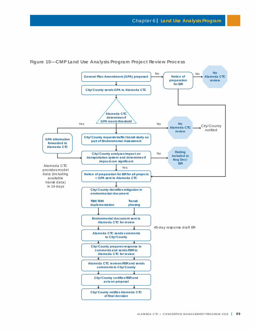
Chapter 6 | Land Use Analysis Program
ALAMEDA CTC • CONGEST ION MANAGEMENT PROGRAM 2 015 | 89
Figure 10—CMP Land Use Analysis Program Project Review Process
Findingincluded inNeg Dec/
EIR
NoYes
45-day response draft ER
Notice of preparation for EIR for all projects+ GPA sent to Alameda CTC
City/County sends GPA to Alameda CTC
No
Yes
NoAlameda CTC
review
No
NoAlameda CTC
review
Alameda CTC reviews FEIR and sendscomments to City/County
City/County notifies Alameda CTCof final decision
Environmental document sent toAlameda CTC for review
Alameda CTC sends commentsto City/County
City/County prepares response tocomments and sends FEIR to
Alameda CTC for review
City/County certifies FEIR andacts on proposal
City/County identifies mitigation inenvironmental document
TSM/TDMimplementation
Transitphasing
City/County requests traffic/transit study aspart of Environmental Assessment
Alameda CTCdetermines if
GPA meets threshold
GPA informationforwarded to
Alameda CTC
City/County analyzes impact ontransportation system and determines if
impacts are significant
General Plan Amendment (GPA) proposedNo
City/Countynotified
Alameda CTCprovides modeldata (including
availabletransit data)
in 14 days
Notice ofpreparation
for EIR
Alameda CTC | Congestion Management Program
90 | ALAMEDA CTC • CONGEST ION MANAGEMENT PROGRAM 2 015
Use of the MTS network for the Land Use Analysis Program ensures that impacts on the CMP network will continue to be identified, since it is a subset of the MTS. The broader definition of regional transportation systems encourages early identification of impacts on a larger system of roadways and explicitly includes transit, bicycle, and pedestrian system impacts.
Trip generation estimatesAlameda CTC conducts a trip-generation calculation to estimate how many new trips will be on the transportation network due to a development project or plan. Project trip generation is used to determine whether a project meets the threshold for CMP review and to assess impacts on the transportation system.
The Institute of Transportation Engineers Trip Generation Manual is an acceptable method for estimating project trip generation. This methodology, which works by relating a variable describing the size of the project (e.g., square feet, number of units, number of gas pumps, etc.) to trips generated, is an established methodology widely used for CMP and other purposes in the transportation industry.
In addition, three trip-generation methodologies designed to capture trip-making characteristics in dense or transit-rich areas such as infill development sites are acceptable to apply in Alameda County for CMP analyses. Project sponsors have the option of using one of the following adopted alternative trip generation methodologies (or others, if the EIR justifies why it is being used):
• EPA’s Mixed Use Development (MXD) model
• Caltrans/UC Davis Smart Growth Trip Generation rates
• MTC’s Station Area Residents Study (STARS) mode-share adjustment method (household travel survey-based adjustments)
Appendix K contains guidance on how to apply the rate adjustments.
Projects in areas with travel demand management (TDM) programs may also experience lower vehicle trip generation, as these programs provide information, incentives/disincentives, and other mechanisms to shift auto trips to other modes, times of day, or closer destinations. Project sponsors may adjust trip-generation estimates to reflect the presence of TDM programs. The TDM element of the Alameda CTC CMP contains a menu of TDM programs with research-based expected ranges of trip reduction benefits that project analysts may use to adjust trip-generation estimates. Assumptions should be clearly documented and justified.
Types of impacts and impact assessment methodologiesProject sponsors should consider impacts to all modes as described below. Appendix K provides full information on impact types and impact assessment methodologies.
• Autos: Vehicle delay using the HCM2000 methodology (or HCM2000 methodology, if required for consistency with local requirements) and consistency with adopted plans;
• Transit: Effects of vehicle traffic on mixed-flow transit operations, transit capacity, transit access/egress, need for future transit service, consistency with adopted plans, and Circulation Element needs;
• Bicycles: Effects of vehicle traffic on bicyclists conditions, site development, and roadway improvements, and consistency with adopted plans;
• Pedestrians: Effects of vehicle traffic on pedestrian conditions, site development, and roadway improvements, and consistency with adopted plans; and
• Other impacts and opportunities: Noise impacts for projects near state highway facilities and opportunities to clear access improvements for transit oriented development projects.
Chapter 6 | Land Use Analysis Program
ALAMEDA CTC • CONGEST ION MANAGEMENT PROGRAM 2 015 | 91
34 Note that the LOS E threshold used to determine deficiency as part of the LOS monitoring CMP element does not apply to the Land Use Analysis Program. This threshold is used for biennial monitoring, not to determine whether impacts will be caused over the long term by an individual land use action.
Thresholds of significanceAlameda CTC has not adopted thresholds of significance for CMP land use analysis purposes.34 Project sponsors should use professional judgment to 1) define a threshold that is appropriate for the project context; and 2) use this threshold to determine if segments are impacted.
Mitigation measuresAlameda CTC vs. local rolesThe CMP statute requires that a Land Use Analysis Program assess the costs of mitigating impacts to the regional transportation system from local land use decisions. This authority must be balanced with the responsibility that local governments hold in the development review process under CEQA. Local governments have lead agency responsibility for preparing EIRs including transportation impact analysis. In addition, the decision of whether to implement a mitigation measure or to adopt a statement of overriding considerations is a local decision.
Alameda CTC’s role is to provide comments through the EIR process on the adequacy of analysis. Alameda CTC has authority under the CMP statute to require disclosure of impacts and mitigation measures, and to require local agencies to establish a program for securing funding to mitigate transportation impacts of land use decisions. The CMP statute does not grant Alameda CTC authority to require implementation of a mitigation measure.
Adequacy of mitigation measuresInadequate and/or underfunded transportation mitigation measures may have significant implications for the regional transportation system. Either might result in failure to meet LOS standards, triggering potential non-conformance and the need for a deficiency plan. Furthermore, an environmental document may rely on state or federal funding of mitigation measures. Such funding may not be consistent with Alameda CTC’s project funding priorities.
Alameda CTC’s policy regarding mitigation measures is that to be considered adequate they must be:
• Adequate to sustain CMP roadway and transit service standards;
• Fully funded; and
• Consistent with project funding priorities established in the Capital Improvement Program of the CMP, the Countywide Transportation Plan, and the Regional Transportation Plan or the federal Transportation Improvement Program, if the agency relies on state or federal funds programmed by Alameda CTC.
Types of mitigationsA project can propose mitigation measures of several types to address CMP impacts, including but not limited to:
• Transportation network changes including changes to roadway geometry (e.g., adding lanes, adding turn pockets, adding mid-block crossings) and intersection control (e.g., adding stop control or signalizing an intersection).
• Transportation demand management measures and programs including amenities, information, incentives, and disincentives designed to influence demand for peak-hour auto trip making. The TDM element of the Alameda County CMP contains a menu of TDM programs (see Appendix G) with research-based expected ranges of trip reduction benefits that project analysts may use to estimate the effectiveness of TDM mitigation measures.
• In lieu mitigations including implementing a part of an Areawide Deficiency Plan or paying into a Transportation Impact Fee program.
In the case of smaller projects, local governments may wish to require project proponents to enter an agreement to provide a “fair share” portion for mitigating a cumulative impact. This addresses the
Alameda CTC | Congestion Management Program
92 | ALAMEDA CTC • CONGEST ION MANAGEMENT PROGRAM 2 015
legislative requirement that the CMP must be able to estimate costs associated with mitigating transportation impacts.
Multimodal tradeoffsIn certain settings, mitigation measures designed to resolve an impact to one mode may cause undesirable secondary impacts to other modes. These secondary impacts may be contrary to adopted policy objectives. A typical example is adding a turn pocket at an intersection, to address an auto circulation impact in a downtown or infill development area, which may increase crossing distances and exposure to vehicles for cyclists, pedestrians, and transit riders.
Jurisdictions are encouraged to discuss multimodal tradeoffs associated with mitigation measures that involve changes in roadway geometry, intersection control, or other changes of the transportation network. This analysis should identify whether the mitigation will result in an improvement, degradation, or no change in conditions for automobiles, transit, bicyclists, and pedestrians. The HCM2010 MMLOS methodology is encouraged as a tool to evaluate these tradeoffs, but project sponsors may use other methodologies as appropriate for particular contexts or types of mitigations.
Review of Land Use Projections35
Alameda CTC has responsibility for developing a database of housing and jobs projections utilized in the Alameda Countywide Travel Demand Model (more detail on the countywide model is available in Chapter 7). The CMP statute prescribes that this land use database must be consistent with the regional land use database and assumptions of the regional travel demand model. The Association of Bay Area Governments (ABAG) develops the regional land use database for the nine-county Bay Area. This database (formerly referred to as the Projections series) includes numbers of households and jobs by sector for existing and future planning horizon years. Alameda CTC works with local jurisdictions to develop the countywide
database by allocating ABAG’s housing and job projections to a refined-scale zone system for countywide model traffic analysis. For this reallocation to be deemed “consistent” in the sense of the CMP statute, the county-level totals from the two allocations must be within plus or minus 1 percent, per MTC’s established guidelines as described in Chapter 9.
Alameda CTC’s land use database development process typically happens as part of a Countywide Travel Demand Model update. During this process, local jurisdictions are required to review a draft allocation of ABAG totals to the Countywide Travel Demand Model transportation analysis zones (TAZs). Local jurisdictions then have 60 days to provide input on this draft allocation.
Alameda CTC completed work to incorporate ABAG projections adopted as part of Plan Bay Area, the region’s RTP and Sustainable Communities Strategy, into the Alameda Countywide Travel Demand Model in June 2014.
Fostering Transportation- Land Use ConnectionsAlameda CTC oversees a variety of programs and planning activities that strengthen connections between transportation and land use.
SB 375 and Sustainable Communities StrategyClimate change awareness and the urgency to reduce greenhouse gases has become a driving force in the transportation realm. Adopted in 2008, SB 375 mandates an integrated regional land use and transportation-planning approach to achieve targets for reducing greenhouse gas emissions from automobile/light trucks. The purpose of SB 375 is to define more concrete implementation requirements for the emission reductions expected from the land use sector in Assembly Bill 32. The focus of SB 375 is on reducing vehicle miles traveled (VMT) and reducing greenhouse emissions by 7 percent by 2020 and 15 percent by 2035.
35 The review of housing and job projections was referred to as Tier 2 review in previous versions of the Alameda CTC CMP. This nomenclature has been eliminated to avoid confusion with the tiers of the CMP arterial network.
Chapter 6 | Land Use Analysis Program
ALAMEDA CTC • CONGEST ION MANAGEMENT PROGRAM 2 015 | 93
To comply with SB 375, development of Plan Bay Area by MTC and ABAG was a joint planning process. The SCS component of Plan Bay Area is designed to:
• Lay out how development patterns and the transportation network can be integrated to help reduce greenhouse gas emissions;
• Identify how the region’s housing needs will be met;
• Improve modeling of land use and transportation; and
• Be congruent with local general plans, specific plans, and zoning.
Adopted in July 2013, Plan Bay Area is a 28-year plan, and the SCS component of Plan Bay Area focuses on promoting compact, mixed-use commercial and residential development that is walkable and bikable and close to mass transit, jobs, schools, shopping, parks, recreation, and other amenities. Through Plan Bay Area, for the first time the region has simultaneously addressed its long range transportation planning and strategy for meeting its Regional Housing Needs Allocation (RHNA), in anticipation that the synchronization of these planning tasks will result in better transportation-land use coordination.
A key feature of the SCS is the designation of Priority Development Areas (PDAs), which are locally-nominated areas near planned or existing transit designed to accommodate significant housing and job growth over the life of Plan Bay Area. PDAs represent 4 percent of the land mass of the Bay Area but are designed to take on 80 percent and 66 percent of housing and jobs, respectively. If successful, Plan Bay Area will give people more transportation choices, create more livable communities, and reduce the pollution that causes climate change.
Alameda CTC participated in the Plan Bay Area process through its 2012 CTP update process. Land use considerations played a more direct role in the CTP process than in past updates to this plan in two primary ways:
• The goals, objectives, and performance measures explicitly addressed land use.
• The demographic forecasts used in the evaluation process were based on the Alameda County Draft Land Use Scenario Concept developed locally through an extensive 18-month process coordinated by Alameda CTC and city planning directors. The local land use scenario was developed in coordination with ABAG and MTC’s efforts and helped to inform the SCS process. Ultimately, the land use scenario used for CMP analysis purposes is the same as the land use alternative adopted by ABAG and MTC in the final RTP/SCS.
The Plan Bay Area 2040 and Alameda Countywide Transportation Plan updates have commenced. The regional plan update is expected to have a “limited and focused” scope, while the CTP update will leverage work already completed through a Countywide Goods Movement Plan, Countywide Multimodal Arterial Plan, and Countywide Transit Plan. It is not anticipated that these long-range planning efforts will result in significant modifications to the adopted land use from existing regional and countywide transportation plans, as there is no new Regional Housing Needs Allocation being conducted with these updates. Alameda CTC will work to ensure that the land use scenarios in these plans balance state mandates, regional planning objectives, local preferences, and market realities.
Priority Development Area Investment and Growth StrategyPDAs are designated infill sites where greater housing and commercial density can be accommodated near transit stops. They were identified by local governments as part of the regional Focusing Our Vision (FOCUS) program, a regional development and conservation strategy led by ABAG and MTC in partnership with the BAAQMD and BCDC, that promoted a more compact land use pattern for the Bay Area. The FOCUS program subsequently became the basis for the region’s current SCS.
Alameda CTC | Congestion Management Program
94 | ALAMEDA CTC • CONGEST ION MANAGEMENT PROGRAM 2 015
Alameda CTC worked with local jurisdictions through the FOCUS process to designate 43 PDAs. These PDAs represent a wide range of place types and land use contexts. This process occurred in parallel to MTC/ABAG’s regional planning work to inform the regional SCS for Alameda County. The FOCUS process also identified Growth Opportunity Areas (GOAs), which are additional areas that can accommodate growth and may one day be able to transition to PDAs and Priority Conservation Areas (PCAs), which are environmentally sensitive areas needing protection.
MTC and ABAG adopted the One Bay Area Grant Program (OBAG) as Resolution 4035 on May 17, 2012. OBAG provides guidance for the allocation of the Cycle 2 Federal Surface Transportation Program (STP) and CMAQ funds for fiscal year 2012-2013 (FY2012-13) through FY2015-16. CMAs are responsible for distribution of these funds to local jurisdictions and other eligible project sponsors. OBAG includes specific policy objectives and implementation requirements that CMAs must meet as a condition of the receipt of OBAG funds.
With the OBAG funding cycle, MTC implemented a new approach that links the region’s federal transportation funding program with the Bay Area’s first SCS efforts. In large counties, such as Alameda County, 70 percent of OBAG funding must be programmed to transportation projects or programs that support PDAs.
To ensure that CMAs have a transportation project priority-setting process for OBAG funding that supports and encourages development in the region’s PDAs, MTC Resolution 4035 requires that Alameda CTC work with Alameda County jurisdictions to develop a Priority Development Area Investment and Growth Strategy. Alameda CTC’s Commission adopted the Alameda County PDA Investment and Growth Strategy in March 2013.
The Alameda County PDA Investment and Growth Strategy fulfills the regional requirement and will guide the agency in supporting PDA development including facilitating implementation of PCAs over a longer time horizon than the current four-year funding cycle. The
Alameda County PDA Investment and Growth Strategy describes existing conditions in the county’s PDAs (including current level of market activity), explains how PDAs and projects were prioritized for the first OBAG cycle, and sets up a framework for additional work that the agency will undertake in the future to improve the link between transportation and land use within its PDAs.
The PDA Investment and Growth Strategy is designed to align with the Alameda CTP. The most recent update of the CTP included a goal of better coordinating transportation investments with the county’s land use patterns. The PDA Investment and Growth Strategy will have the same time horizon as the current CTP, through 2040, and will be updated every four years.
The PDA Investment and Growth Strategy contains an inventory of Alameda County’s PCAs. Under the OBAG, MTC has also allocated $5 million between five counties for distribution through a competitive application process to fund projects that promote open space preservation and access, land conservation, and habitat protection in PCAs.
Based on the recommendations made during the 2013 CMP update, Alameda CTC will continue to work with MTC and ABAG to identify ways to support improvements to rural roadways that facilitate agricultural operations and agricultural tourism in East County and to develop more comprehensive approach to mitigating impacts from rural roadway improvements and efforts that support PCA goals and objectives.
In September 2014 and May 2015, Alameda CTC updated its PDA Investment and Growth Strategy, which incorporates the latest information on housing production across income levels and progress toward meeting RHNA targets.
Areawide Transportation Impact Mitigation FeesAn areawide transportation impact fee and/or revenue measure such as establishing an assessment district could generate funds necessary to plan and implement transportation mitigation measures related
Chapter 6 | Land Use Analysis Program
ALAMEDA CTC • CONGEST ION MANAGEMENT PROGRAM 2 015 | 95
to land development. Transportation impact fees are addressed in the CMP statute as a proactive method of addressing transportation needs arising from land development.
At present, Alameda CTC and most local jurisdictions in Alameda County review development projects and determine required mitigation measures on a project-by-project basis. If found to be feasible, a transportation impact fee could be designed to supplement current project-by-project review, in which case the fee would raise additional revenue to fund multi-jurisdictional mitigations. Another option is that a transportation impact fee could be designed to replace project-by-project review. In this case, the fee would be designed to generate revenues to fund both localized and multi-jurisdictional mitigations.
Alameda CTC conducted feasibility studies in 1997 and 2007 for a countywide traffic mitigation fee. These feasibility studies investigated a fee that would supplement the project review and mitigations required by local jurisdictions. These previous studies recommended that Alameda CTC not proceed with an areawide traffic impact fee due to concerns about discouraging development, particularly in urban areas where redevelopment projects already face higher costs than in suburban areas. The studies also recommended that Alameda CTC adopt the following policies:
• Support agreement among local jurisdictions to adopt an areawide fee within a planning area;
• Identify projects of countywide significance; and
• Consider integrating adoption of a countywide fee with a campaign for a sales tax extension or gas tax increase, so the development community and the voters see a benefit in sharing costs with each other.
As part of the 2011 CMP update, Alameda CTC considered pursuing an areawide traffic impact fee, similar to the Tri-Valley Transportation Council Fee, for the other three planning areas in the county.
Alameda CTC concluded that, given the weak local and national economic conditions at that time, an areawide traffic impact fee could adversely affect local development. As an alternative to a new areawide traffic impact fee, the 2011 CMP proposed exploring a fee based on automobile trip generation, such as San Francisco County is implementing. San Francisco’s Fee, the Transportation Sustainability Program (formerly referred to as the Automobile Trip Generated, or ATG, measure) is an areawide fee unique in that it is designed to replace the city’s current practice of reviewing individual development projects using auto LOS.
Rather than require individual project sponsors to study their impacts to intersection LOS and devise mitigations on a case-by-case basis, San Francisco has devised a countywide program of mitigations designed to accommodate all anticipated development over the next 20 years.
Developers will then pay for their portion of this full program of mitigations, according to a fee schedule based on motorized trips generated.36 San Francisco is currently preparing an EIR for the Transportation Sustainability Program and, once completed, individual development projects will no longer be required to conduct cumulative transportation studies, as payment of the fee will constitute mitigation for their cumulative effects on the transportation system.
36 The fee was initially based on Automobile Trips Generated. Nexus analysis revealed that the fee should also be extended to cover transit trips due to concerns with transit crowding in San Francisco. This finding resulted in the fee being restructured as the Transit Sustainability Fee, which is based on the projected generation of all types of motorized trips by development projects. Review of housing and job projections was referred to as Tier 2 review in previous versions of the Alameda CTC CMP. This nomenclature has been eliminated to avoid confusion with the tiers of the CMP arterial network.
Alameda CTC | Congestion Management Program
96 | ALAMEDA CTC • CONGEST ION MANAGEMENT PROGRAM 2 015
The 2011 CMP recommended that, pending availability of funding, Alameda CTC conduct a feasibility study for an areawide impact fee based on automobile trips generated. The study was postponed, while Alameda CTC sought passage of an extension and augmentation of its local transportation sales tax, but it will be carried forward as a next step for the 2017 CMP update.
The passage of Senate Bill 743 in September 2013 could heighten the importance of an areawide transportation impact fee feasibility study. This bill directs OPR to revise CEQA guidelines such that transportation impact analysis will no longer be based on automobile LOS. OPR is directed to develop alternative metrics for transportation impacts in transit priority areas, and the bill explicitly makes reference to metrics such as automobile trip generation and VMT per capita.
In addition to a feasibility study, an areawide transportation impact fee would likely require a nexus study in accordance with the Mitigation Fee Act as well as significant coordination and consensus building with the jurisdictions in Alameda County. In particular, a nexus study would be required to determine what share of transportation improvements are needed to correct issues associated with new development (as opposed to existing transportation system deficiencies) and to determine appropriate fee levels.
While it entails significant up-front study and coordination, an areawide transportation impact fee offers several key benefits:
• Consistency with multimodal planning focus: A variety of policy goals point to the need to respond to growing travel demand with mitigation measures such as improved transit service and non-motorized travel facilities. It is difficult for project sponsors to demonstrate how these improvements will fix a highly localized transportation system impact, which can lead to developers pursuing mitigations such as roadway capacity improvements that may be contrary to Alameda CTC’s multimodal planning focus.
• Adequately addresses regional impacts: Project-by-project review of developments often results in underfunding of multi-jurisdictional improvements because Alameda CTC has no authority to require cities or developers to actually implement a mitiga-tion measure, and local jurisdictions may not fully perceive the benefits of requiring a devel-oper to pay for a mitigation measure outside of their boundaries.
If an areawide transportation impact fee is designed to replace project-by-project review that uses intersection LOS to determine impacts, additional benefits could accrue:
• Simplicity, transparency, and predictability: Transportation impact analysis is typically one of the most costly and time-consuming parts of developing and reviewing environmental impact reports. Under an areawide transportation impact fee, all of this analysis is conducted up front. Furthermore, developers can easily predict how much they will be required to pay for transportation system improvements.
• Fixes “last-in pays” principle: One feature of the project-by-project, LOS-based method of assessing transportation impacts used by most jurisdictions is that only projects that actually cause an intersection or a roadway segment to fall below a specified LOS threshold are forced to pay for mitigations. This fact results in a single project sponsor bearing the entire burden of mitigating a cumulative impact to an intersection or segment, or the jurisdiction adopting a statement of overriding considerations.
The Tri-Valley Transportation Council has adopted an areawide traffic fee. The fee is applied to regional transportation improvements in the Tri-Valley Transportation Expenditure Plan. Many local jurisdictions have also adopted transportation mitigation fees, some of which partially fund multi-jurisdictional mitigations. If such an areawide transportation impact fee is adopted in the future at a countywide level,
Chapter 6 | Land Use Analysis Program
ALAMEDA CTC • CONGEST ION MANAGEMENT PROGRAM 2 015 | 97
it would include a system of credits, so that fees for developments paid once for regional improvements are not unfairly “double billed” for contributions to the same improvement. Credits for some local impact improvements may also be considered.
Community Design and Transportation ProgramThe Santa Clara Valley Transportation Authority (SCVTA) has adopted a Community Design and Transportation (CDT) program as part of its CTP to better integrate transportation and land use and augment its CMP Land Use Analysis Program. This program was developed in partnership with member agencies and communities and is endorsed by their elected bodies. The SCVTA Board promotes the CDT program as its policy tool and primary program to integrate transportation and land use. It includes a comprehensive toolkit for member agencies to use in all aspects of transportation and land use planning and for both public and private development projects. The CDT program also includes two grant-funded programs and an incentive program designed to encourage better coordination of transportation and land use planning. One of the objectives of the CDT program is to support concentrated development in selected locations of the county.
In the 2011 CMP, Alameda CTC recommended exploring a similar approach to better integrating land use and transportation in Alameda County. Before the next update of the CMP, Alameda CTC will identify the level of interest from local jurisdictions and transit operators for implementing a similar program in Alameda County. Alameda CTC will develop a scope of work and the steps involved including the cost of developing and implementing the program.
Complete Streets Policy Development and ImplementationComplete streets are streets designed to accommodate all modes and all users. Complete streets can look different, depending on the local context, but broadly speaking, creating complete streets entails planning, funding, designing, and maintaining and operating transportation facilities
and networks that drivers, transit users, pedestrians, bicyclists, and goods movement providers can use, regardless of age or ability.
The Complete Streets Act of 2008 (Assembly Bill 1358) stipulates that during the next major update of their General Plan’s Circulation Element, all jurisdictions in California are required to incorporate complete streets principles. Alameda CTC required jurisdictions to adopt complete streets policies by June 30, 2013 as part of the Master Program Funding Agreements signed in 2012. All jurisdictions have now met this requirement, either in the form of a city council or Board of Supervisors resolution or an update to the Circulation Element of their General Plan that incorporates complete streets principles. Alameda CTC provides technical assistance to its jurisdictions, including identifying best practice examples, strong language, and recommended components to meet the General Plan component of this legislative requirement.
Implementation of complete streets policies is a multi-year process requiring organizational culture shift, participation from numerous city departments and other external stakeholders, and new levels of collaboration. Alameda CTC held a workshop in June 2012 on complete streets policy development and a workshop in July 2013 in which it provided information to local jurisdictions on implementing complete streets and highlighted examples of best practices. Alameda CTC will continue this effort by developing a series of targeted resources around specific complete streets implementation challenges.
Alameda CTC also implements the Complete Streets Checklist from MTC. All projects that apply for federal funds programmed by Alameda CTC must complete this checklist, which provides information when Alameda CTC evaluates projects for funding.
All Alameda CTC jurisdictions are working to make sure that their circulation elements comply with AB 1358 by January 2016 to ensure eligibility for future One Bay Area Grant funding, and Alameda CTC has provided technical assistance in conducting these updates.
Alameda CTC | Congestion Management Program
98 | ALAMEDA CTC • CONGEST ION MANAGEMENT PROGRAM 2 015
In addition, Alameda CTC is leading a pilot project focused on implementing complete streets policies in Central Alameda County. This pilot project, which will include the cities of San Leandro and Hayward as well as the unincorporated areas of the county, will conduct activities such as those that will provide an understanding of constraints to implementing complete streets across city departments, update design guidelines, and develop checklists to guide project managers.
In addition, Master Programs Fund Agreements and project evaluation procedures for Alameda CTC’s Comprehensive Investment Plan may include complete streets considerations.
Corridor PlanningIn 1994, Alameda CTC adopted a corridor/areawide transportation management planning process described in the CTP. The process is based on cooperative planning and coordinated action by local governments, Caltrans, transit agencies, and MTC. Alameda CTC uses the corridor/areawide management planning process to identify needed mitigation measures and for linking its funding decisions to needed mitigations. In a corridor/areawide management planning effort, participants address strategies to:
• Reconcile the competing demands that local and long-distance traffic make on the capacity of the freeway system;
• Reconcile continuing population and employment growth with the finite capacity of the freeway system;
• Reconcile the movement of people and goods;
• Prevent pass-through traffic from using local streets;
• Reconcile high occupancy vehicle and express lanes with plans to meter freeway ramps;
• Pair ramp metering with geometric metering at gateways to the metropolitan area; and
• Coordinate the operation of freeways and parallel arterials and to specify when and where to rely on
transit as a corridor’s primary strategy of traffic management.
As defined in the Alameda CTP, the underlying principles for the planning process are based on the following:
• Alameda CTC should support, where appropriate, local plans to enhance the productivity of transit investment through such measures as supportive zoning, urban design/planning, and development approvals.
• Alameda CTC should give investment priority to those highway and transit operational improve-ments and major capital projects identified in the corridor/areawide management planning process.
• Alameda CTC recognizes that land use planning is solely the purview of local governments.
As part of the 2011 and 2013 CMP updates, Alameda CTC reviewed additional options for improving mobility and identifying and funding mitigation measures along travel corridors, specifically ones that cross county boundaries. The following approaches were recommended as next steps.
• For congested cross-county corridors, explore developing partnerships for sharing the costs of implementing mitigation measures in the corridor.
• For long-term corridor improvements, explore establishing cross county partnerships to identify mutually agreeable strategies for developing and implementing improvements. As a first step in this direction, a county line development study in partnership with either San Joaquin or Santa Clara counties could be considered.
• Explore developing corridor improvement strategies as part of Countywide Transit Plan and Countywide Arterial Mobility Plan.
Examples of corridor/areawide management planning efforts include:
Chapter 6 | Land Use Analysis Program
ALAMEDA CTC • CONGEST ION MANAGEMENT PROGRAM 2 015 | 99
• Central County Freeway Study (SR 238 Local Area Transportation Improvement Program)
• I-580 Corridor BART to Livermore
• I-680 Value Pricing
• I-880 Strategic Plan
• North I-880 Safety and Operations Study
• San Pablo and I-880 SMART Corridor Programs
• SR 84 Local Area Transportation Improvement Program
• Tri-Valley Triangle Study
Alameda CTC is also conducting three countywide modal plans including a goods movement plan, an arterial plan, and a transit plan. These long-range modal plans are intended to feed into the CTP and will identify projects, funding priorities, and future corridor planning priorities. The Countywide Multimodal Arterial Plan, in particular, is developing typologies for the arterial network within Alameda County that take into account its existing role in providing auto mobility, the adjacent land uses, and the multimodal role of facilities. These typologies will inform modal priorities, improvements needs for each mode, potential new cross-sections within the existing right of way, and management strategies for arterial corridors.
State-level CEQA Modernization AdvocacyPublic agencies have gained decades of experience in applying CEQA rules. As new issues (such as global warming) emerge that were unanticipated by the original legislation, a variety of actors show growing interest in modernizing CEQA. Ideas for modernizing CEQA focus on a number of aspects of how the law works including reducing the scope of which types of projects must conduct intensive analysis, eliminating duplication between CEQA and other environmental laws and standards, and containing litigation generated by CEQA. OPR has already issued regulations to implement Senate Bill 226, which seeks to streamline environmental review for eligible infill
development projects. SB 743 will also streamline and modernize transportation analysis, particularly for projects in transit priority areas.
Much can be done within the existing CEQA legislation to streamline the review of development projects and to reduce the greater likelihood of causing impacts from infill development projects. Strong specific plans and area plans with thorough program EIRs can reduce the analytic burden of future development projects that implement those plans, and Alameda CTC will support these specific plans through its Sustainable Communities Technical Assistance Program (SC-TAP). The recently adopted Plan Bay Area discusses the potential for projects in Transit Priority Project (TPP) eligible areas that meet certain other conditions to receive CEQA relief under SB 375, and Alameda CTC will assist jurisdictions in understanding this eligibility.37 As previously discussed, Alameda CTC has made some modifications to its review of EIRs through the Land Use Analysis Program that will benefit infill projects, and will continue to support local jurisdictions in revising their own CEQA thresholds as appropriate through information sharing and other technical assistance.
Even with the passage of SB 743, there are other aspects of the CEQA statute that may require modernization (e.g., limiting litigation, strengthening tiering provisions). These aspects of CEQA generally require legislative action. Alameda CTC will continue to monitor CEQA modernization-related bills and consider whether it is appropriate to take positions on these as part of its legislative platform.
Parking Standards and PoliciesParking for automobiles is a significant but underrecognized factor in the relationship between land use and transportation. It has been customary for local jurisdictions to require development projects to provide a minimum number of parking spaces. Moreover, most parking is underpriced. These two factors encourage driving, leading to inefficient land use and more congestion. With the support of local jurisdictions, Alameda CTC plans to explore and review parking policies and standards as a way to develop
37 Plan Bay Area, p. 58
Alameda CTC | Congestion Management Program
100 | ALAMEDA CTC • CONGEST ION MANAGEMENT PROGRAM 2 015
parking management strategies as a land use tool for local jurisdictions to promote alternative modes and reduce greenhouse gases.
Alameda CTC is currently funding parking management studies in the cities of Albany and San Leandro. Several other cities have locally funded parking management studies underway. In addition, several Alameda County jurisdictions have implemented flexible- and demand-based parking strategies (e.g., Berkeley’s GoBerkeley program and Oakland’s Montclair Parking District) which seek to raise or lower parking prices according to demand for the spaces, thereby achieving high utilization of a scarce asset.
Regional Transit Expansion ProgramThe Regional Transit Expansion Program, originally adopted by MTC in 2001 as Resolution 3434 and updated as part of Plan Bay Area, identifies the regional commitment to transit investments in the Bay Area. Resolution 3434 identified $18 billion in transit expansion investment projects. It includes a TOD policy to condition transit expansion projects funded under Resolution 3434 on supportive land use policies. There are three key elements of the regional TOD policy:
• Corridor-level thresholds to quantify appropriate minimum levels of development around transit stations along new corridors;
• Local station area plans that address future land use changes, station access needs, circulation improvements, pedestrian-friendly design, and other key features of TODs; and
• Corridor working groups that bring together CMAs, city and county planning staff, transit agencies, and other key stakeholders to define expectations, timelines, roles, and responsibilities for key stages of the transit project development process.
This policy is relevant within Alameda County for the following Resolution 3434 transit expansion projects:
• AC Transit Bus Rapid Transit in Berkeley/Oakland/San Leandro
• AC Transit Enhanced Bus/Bus Rapid Transit: Grand-MacArthur corridor
• BART Oakland Airport Connector
• BART Warm Springs Extension to San Jose
• Dumbarton Rail
• Ferry service expansions in Alameda and Berkeley
• Tri-Valley transit access improvements to/from BART
Alameda CTC is working with the local jurisdictions, transit providers, congestion management agencies in adjoining counties, ABAG, and MTC to address the policy in these corridors.
As part of Plan Bay Area, the region’s $660 million in federal new and small starts funding will be directed to Resolution 3434 projects that ranked highly in the RTP Project Performance Assessment. These include several Alameda County projects including BART Warm Springs Extension to San Jose, AC Transit Berkeley/Oakland/ San Leandro Bus Rapid Transit, and AC Transit Enhanced Bus: Grand-MacArthur corridor.
A companion resolution, Resolution 3357, articulates rail extension and improvement criteria and regional express bus and rapid bus program criteria. These criteria will be considered during the funding process for the identified transit projects.
Strategic Monitoring of Transportation-Land Use CoordinationA core part of Alameda CTC’s activities is monitoring trends in performance measures and transportation land use connections, and using this monitoring to inform planning and funding decisions.
Tracking New Development ActivityThe 2011 CMP revealed that several other large Bay Area CMAs have created a database of land use approvals, and recommended that Alameda CTC explore creating such a database. As part of the 2013
Chapter 6 | Land Use Analysis Program
ALAMEDA CTC • CONGEST ION MANAGEMENT PROGRAM 2 015 | 101
CMP update process, creating and implementing a database of land use approvals in Alameda County was included and continued in the 2015 update. Beginning with the 2014 Conformity Findings process, Alameda CTC required local jurisdictions to submit:
1) a list of land use development projects approved during the previous fiscal year; and
2) a copy of the most recent Housing Element Annual Progress Report submitted to the state Department of Housing and Community Development.
This information will be used to populate a database of development approvals in Alameda County. This development approvals database will prove invaluable for a variety of applications. It will provide:
• Enhanced monitoring of how well transportation investments are being coordinated with new developments and demands for mobility;
• The ability to compare land use projections with historic trends;
• The ability to comply with new requirements that CMAs assess local jurisdiction efforts at approving sufficient housing for all income levels from the OBAG Program (see PDA monitoring below); and
• A consistent database for multi-jurisdictional planning efforts.
Alameda CTC began collecting this information in 2014 and will report on development activity through the annual Performance Report.
Livable Communities Performance MeasuresThe 2012 Alameda CTP identified a series of performance measures related to transportation-land use connections. These measures were used to compare different long-range transportation investment scenarios during CTP analysis. The measures were also incorporated in the CMP multimodal performance element and reported on as part of the FY2011-12 Alameda County Performance Report in the “Livable Communities” chapter.
For the 2017 CMP update, Alameda CTC will perform a comprehensive review of its performance measures and consider opportunities to streamline measures and to strategically align reporting timelines with data availability. Some of the livable communities measures (e.g., activity center accessibility and public transit accessibility) are not based on annually published, longitudinal data. These measures are most suitable for comparing different long-range scenarios rather than annual monitoring. The comprehensive review of performance measures performed for the 2017 CMP will explore identifying shorter-term measures of transportation-land use coordination that could leverage the database of new development activity. For example, Alameda CTC could monitor performance measures such as what percent of new dwelling units or commercial square footage is within a half-mile of transit or within a walkable neighborhood.
Priority Development Area Performance MonitoringThe Alameda County PDA Investment and Growth Strategy outlines a preliminary PDA monitoring plan developed both to fulfill MTC and ABAG requirements and as a step toward implementing the land use and sustainability goals of the 2012 CTP. Collecting and assessing data on the county’s PDAs will help Alameda CTC gauge progress on meeting the objectives of the 2012 CTP and Plan Bay Area, identify what might need to be modified or improved, help gauge the impacts of policies and investments, and inform the agency’s future policy and investment decisions. A more robust information set will also help inform decisions about adjusting the boundaries of existing PDAs and designating new PDAs in the future.
Alameda CTC conducted an extensive PDA Inventory in 2012. Over the course of the next several years, the agency will build on this inventory to create a more robust baseline dataset that Alameda CTC can update over time. Some of the data will be updated annually or biennially as new data is generated by the jurisdictions and then compiled and released by ABAG or MTC. The frequency of updates to the data will also be determined by the pace of change in
Alameda CTC | Congestion Management Program
102 | ALAMEDA CTC • CONGEST ION MANAGEMENT PROGRAM 2 015
the county’s PDAs and MTC and ABAG requirements. Alameda CTC will work closely with ABAG and other regional agencies to ensure that the data provided is best suited to Alameda CTC’s monitoring needs. The agency’s goal is to minimize data collection work for Alameda CTC and the county’s jurisdictions and avoid duplicative data collection efforts.
Alameda CTC intends to analyze the following types of data for each PDA (or potential PDA) in Alameda County, though Alameda CTC may make some alterations to existing categories to include different data points.
• Current housing, jobs, and population data
• Growth projections for housing, jobs, and population
• RHNA allocations
• Market strength and development activity
• Transit orientation, urban form and bicycle/pedestrian connectivity
• Policies (land use, housing, parking, and TDM)
• Impact of OBAG investments
Local Government Responsibilities and ConformanceAlameda CTC is responsible for monitoring conformance of local jurisdictions with the adopted CMP.38 While Alameda CTC does not have the authority to approve or deny local land use projects, it may find the local jurisdiction in non-conformance. If it fails to comply with the requirements of the land use analysis program, a jurisdiction risks losing Proposition 111 funds. The detailed process for finding of non-conformance and resulting withholding of Proposition 111 funds is described in Chapter 9.
The following describes special circumstances related to conformance to the Land Use Analysis Program
requirements. If a proposed development was specified in a development agreement entered into prior to July 10, 1989, then it is not subject to any action taken to comply with the CMP, with the exception of those actions required for the trip-reduction and travel-demand element of the CMP.39
In some cases, Alameda CTC may find that additional mitigation measures are necessary to prevent certain segments of the CMP network from deteriorating below the established LOS standards, before a conformance finding is made. In such cases, Alameda CTC will require the local jurisdiction to determine whether the additional mitigation measures will be undertaken as a condition of project approval, or whether they will be implemented as part of a deficiency plan for the CMP network segments affected.
Local jurisdictions have the following specific responsibilities under the Alameda CTC Land Use Analysis Program.
Throughout the yearLocal jurisdictions are required to do the following to ensure conformity with the CMP Land Use Analysis Program requirements:
• Forward to Alameda CTC all notices of preparation, draft and final Environmental Impact Reports and Environmental Impact Statements, and final dispositions of General Plan amendment and development requests.
• Analyze large development projects according to the guidelines in this chapter, including the use of the Alameda Countywide Travel Demand Model or an approved subarea model and disclosure of impacts to the MTS, if Alameda CTC determines the project exceeds the threshold for which CMP review is required.
• Work with Alameda CTC on the mitigation of development impacts on the regional transportation system.
38 California Government Code Section 65089.3.39 California Government Code Section 65089.7.
Chapter 6 | Land Use Analysis Program
ALAMEDA CTC • CONGEST ION MANAGEMENT PROGRAM 2 015 | 103
During annual conformity findings processLocal jurisdictions are required to do the following to ensure conformity with the CMP Land Use Analysis Program requirements during the annual conformity findings process which occurs from September to November:
• Review the record of Alameda CTC responses to Environmental Impact Report documents for completeness and accuracy.
• Provide Alameda CTC with:
1) a list of land use development projects approved during the previous fiscal year; and
2) a copy of the most recent Housing Element Annual Progress Report submitted to the state Department of Housing and Community Development.
As needed according to Alameda Countywide Travel Demand Model development scheduleDuring travel model updates, provide an update (prepared by the jurisdiction’s planning department) of the anticipated land use changes likely to occur using ABAG’s most recent forecast for a near-term and far-term horizon year. This land use information should be provided in a format compatible with the Countywide Travel Demand Model.
Next StepsThe following are next-step items for the CMP Land Use Analysis Program to strengthen the connection between land use and transportation.
• Monitor potential updates to CMP legislation and revise the Land Use Analysis Program to align with the new requirements while still keeping it an effective tool to monitor the impact of land use development on the countywide multimodal transportation system.
• Monitor SB 743 rulemaking and revise transportation impact analysis methodology requirements and procedures to reflect new CEQA guidelines.
• In view of the significant implications of the above legislative actions on the CMP as a whole, particularly the Land Use Analysis Program, until the legislative actions finalized, the following next steps identified in prior updates of the CMP, which are still important, can be postponed, so they can be realigned with the potential legislative outcomes.
○ Develop a policy regarding tiering off of CMP analysis conducted as part of a Specific Plan or other Area Plan, if that analysis was conducted using a version of the Alameda Countywide Travel Demand Model that is no longer the most current version.
○ Pending availability of funding, conduct a Feasibility Study for implementing an ATG-based areawide transportation impact fee.
○ Continue to provide technical assistance to local jurisdictions on potential options to revise CEQA thresholds to reduce barriers to infill development approvals.
Additionally, the CMP will continue to pursue the following depending on available resources:
• Determine if there is interest from local jurisdictions and transit operators for a program similar to the SCVTA’s CDT program in Alameda County, and develop a scope of work, schedule, and budget for developing and implementing the program.
• Implement the Sustainable Communities Techni-cal Assistance Program including matching project applicants with technical assistance for planning efforts designed to advance the readiness of PDAs.
• Identify ways to address rural roadway improve-ment needs and efforts that support PCA goals.
• Consider establishing a means for projects that impact long travel corridors and traverse multiple jurisdictions within Alameda County to contribute their fair share of required mitigation measures throughout the corridor.
Alameda CTC | Congestion Management Program
104 | ALAMEDA CTC • CONGEST ION MANAGEMENT PROGRAM 2 015
• Explore development of partnerships for sharing the costs for implementing related mitigation measures for congested cross-county corridors.
• Explore establishing cross-county partnerships with adjacent counties to develop mutually agreeable strategies for cross-county-corridor improvements.
• Explore developing corridor improvement strategies as part of Countywide Transit Plan and Countywide Arterial Mobility Plan.
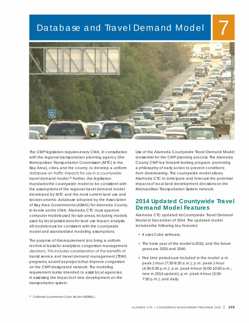
ALAMEDA CTC • CONGEST ION MANAGEMENT PROGRAM 2 015 | 105
The CMP legislation requires every CMA, in consultation with the regional transportation planning agency (the Metropolitan Transportation Commission (MTC) in the Bay Area), cities, and the county, to develop a uniform database on traffic impacts for use in a countywide travel demand model.36 Further, the legislation mandates the countywide model to be consistent with the assumptions of the regional travel demand model developed by MTC and the most current land use and socioeconomic database adopted by the Association of Bay Area Governments (ABAG) for Alameda County. In its role as the CMA, Alameda CTC must approve computer models used for sub-areas, including models used by local jurisdictions for land use impact analysis. All models must be consistent with the countywide model and standardized modeling assumptions.
The purpose of this requirement is to bring a uniform technical basis for analysis to congestion management decisions. This includes consideration of the benefits of transit service and travel demand management (TDM) programs, as well as projects that improve congestion on the CMP-designated network. The modeling requirement is also intended to assist local agencies in assessing the impacts of new development on the transportation system.
Use of the Alameda Countywide Travel Demand Model is essential for the CMP planning process. The Alameda County CMP is a forward-looking program, promoting a philosophy of early action to prevent conditions from deteriorating. The countywide model allows Alameda CTC to anticipate and forecast the potential impacts of local land development decisions on the Metropolitan Transportation System network.
2014 Updated Countywide Travel Demand Model FeaturesAlameda CTC updated its Countywide Travel Demand Model in December of 2014. The updated model includes the following key features:
• It uses Cube software.
• The base year of the model is 2010, and the future years are 2020 and 2040.
• Five time periods are included in the model: a.m. peak 1-hour (7:30-8:30 a.m.); p.m. peak 1-hour (4:30-5:30 p.m.); a.m. peak 4-hour (6:00-10:00 a.m.; new in 2014 update); p.m. peak 4-hour (3:00- 7:00 p.m.); and daily.
Database and Travel Demand Model 7
40 California Government Code Section 65089(c).
106 | ALAMEDA CTC • CONGEST ION MANAGEMENT PROGRAM 2 015
Alameda CTC | Congestion Management Program
• This updated model has 1,580 traffic analysis zones (TAZs) in Alameda County (175 new TAZs were added in the 2014 update), 1,256 TAZs outside of Alameda County, and 31 gateway zones. The model added 175 new TAZs based on five principles:
○ To maintain TAZ consistency with the US Census 2010 tract boundaries;
○ To create smaller zones near major rail stations, ferry stops, and bus stops;
○ To have MTC’s proposed micro analysis zones (MAZs) nest within the TAZs;
○ To add TAZs around transit park-and-ride lots to allow the model to assign park-and-ride vehicles to the roadway network; and
○ To create smaller TAZs caused by the definition of the CMP roadway network.
• The updated model maintains the use of MTC’s zone system in the remaining six Bay Area counties but enlarges the full model region and zones to include San Joaquin County. The model also created 85 smaller zones near rail stations and ferry terminals to better delineate walk access to transit markets.
• The Alameda CTC model was revised to produce an updated base year 2000 calibration and 2010 validation with selected model enhancements, including:
○ Calibration of the auto ownership models to American Community Survey (ACS) 2005-2009 county-level data;
○ Addition of bicycle network infrastructure (bike lanes and paths) in the network’s travel time skims, mode choice, and bicycle assignments;
○ Development of a toll-modeling procedure to esti-mate express lane vehicle volumes; and
○ Performance of a 2010 validation task including validating for screen-line volumes for the a.m. and
p.m. peak hours, peak periods, and daily; and to year 2010 observed transit boardings.
• The Alameda CTC model assumes all projects included in the 2040 Plan Bay Area. Further, the model roadway network includes additional detail in Alameda County and in adjacent parts of Santa Clara and Contra Costa counties. The model also includes stop, station, and route detail in the transit network for Alameda County and maintains the MTC roadway and transit networks in the remaining Bay Area counties.
• Alameda CTC socioeconomic data inputs are consistent at both the MTC zone level and the ABAG census tract level for the Plan Bay Area scenario for the year 2040. Data at the MTC zone level in Alameda was allocated to the smaller Alameda CTC model zones using local land use development patterns, working within the constraint of 1 percent deviation from the ABAG control totals for the county. Alameda CTC also incorporated the updated San Joaquin County land use dataset developed as a part of the San Joaquin Council of Governments Transportation Regional Plan 2011.
• The Alameda CTC model used US Census 2010 population and households for the model base year 2010.
Documentation of specific features and assumptions for various components of the updated 2014 model are available on the Alameda CTC website.
Land Use Database DevelopmentThe database included in the updated 2014 countywide travel model is based on three sets of inputs:
• The 2013 Sustainable Communities Strategies (SCS) employment, population, and household projections provided by ABAG at the census tract level for all model future years (2020 and 2040). ABAG and MTC converted these tract level projections to the regional TAZ (RTAZ) level.
Chapter 7 | Database and Travel Demand Model
ALAMEDA CTC • CONGEST ION MANAGEMENT PROGRAM 2 015 | 107
• The US Census 2010 dataset served as the source of the household and population data for the model base year 2010. Census blocks are typically smaller than the countywide TAZs; therefore, households in Census blocks can be aggregated to TAZs used in the Countywide Travel Demand Model.
• The distribution factor in the Projections 2009 dataset was used to distribute the SCS data for allocation of households and jobs from the larger MTC model RTAZs to the smaller Alameda CTC model TAZs.
The process of developing the land use and socioeconomic database for the countywide model allocated ABAG’s SCS land use and socioeconomic data from MTC’s regional TAZs to Alameda CTC’s countywide model TAZs review and redistribution by the Alameda County jurisdictions. The jurisdictions totals are requested to stay within a 1 percent variation from the ABAG totals, but they are permitted to redistribute them if appropriate. Countywide totals after redistribution will remain within plus or minus 1 percent of ABAG county totals, as required by MTC. By aggregating the projections made for each zone, Alameda CTC can produce projections of socioeconomic characteristics for unincorporated areas of the county, the 14 cities, and the four Alameda County planning areas.
For the 175 newly added TAZs to the countywide model TAZ system, all SCS land use data for all model years were further disaggregated to distribute the data to the newly added zones. The proportion of employment in each TAZ compared to the parent TAZ (from which it is split) is assumed to be equal to the proportion of the new TAZ’s size compared to the parent TAZ’s size.
Model DevelopmentThe framework established for the model encompasses the following components:
• Trip generation (number of trips forecast by traffic analysis zone);
• Trip distribution (distribution of forecast trips between each traffic analysis zone);
• Modal split of inter-zonal trips (distribution of trips by mode within each traffic analysis zone); and
• Assignment (forecast of trips originating or destined to external zones).
These are typical model components found in any model that produces simulations of travel demand, based on different assumptions about land use and demographic and transportation characteristics.
The countywide model was developed using Cube software developed by Citilabs, which is an interactive transportation planning program that produces numerical and graphic representations of travel supply and demand. The model is structured to provide forecasting detail that adequately addresses the evaluation needs of both countywide and corridor-specific transportation strategies. The countywide model has been developed and validated by:
• Defining a traffic analysis zone structure detailed enough to depict changes in land use and demographics that would affect travel demand on arterials and intra-county transit systems; and
• Establishing highway and transit networks detailed enough for those types of travel demand.
Development and validation of the model were based on the following concepts:
• Consistency with the assumptions and procedures established and used by MTC to produce regional travel demand forecasts. Specifically, the model maintains the same variables in the equations that comprise the trip-generation, trip-distribution, and mode-split components of MTC’s previous travel demand model framework based on the MTC BAYCAST-90 model.
• Where necessary to produce validated forecasts of travel on arterials or intra-county transit services, enhance the capacity of MTC’s models by
Alameda CTC | Congestion Management Program
108 | ALAMEDA CTC • CONGEST ION MANAGEMENT PROGRAM 2 015
incorporating the simulation of certain types of travel not modeled by MTC. Specifically, this includes the addition of new transit sub modes.
The 2014 model update validated the model to 2010 traffic and transit count data and includes the enhanced ability to forecast bicycle and pedestrian volumes by adding more detailed TAZs and more detailed roadway, transit, and non-motorized networks.
In addition, the currently active model incorporates land use and demographics of the nine-county Bay Area based on the ABAG’s SCS projections, US Census 2010, and the San Joaquin County Travel Model for San Joaquin County. This allows the model to produce travel demand forecasts that incorporate influences of regional travel demand on transportation facilities in Alameda County. Travel originating or terminating outside the nine-county Bay Area and San Joaquin County is also taken into account, based on the data from the Caltrans statewide model.
Planning AreasAlameda County has been subdivided into four areas of analysis, or planning areas. Planning areas are analogous to the five MTC super districts in Alameda County,41 as part of the traffic analysis zone structure MTC uses42 for its nine-county regional travel model. Traffic analysis zones are small geographical subdivisions of a region. Socioeconomic variables, such as households and employment data, are collected at the traffic analysis zone level for input into the travel demand models. Ultimately, the auto vehicle trips and number of individual trips on transit (“person trips”) are assigned from each traffic analysis zone onto the highway and transit networks.
The countywide model required disaggregating or splitting the MTC zones into more, smaller traffic analysis zones. Within Alameda County, MTC’s zone system was refined to better suit the more detailed highway and transit networks in the countywide model. The traffic analysis zones nest within the larger MTC
zones. This ensures accurate disaggregation of MTC’s person trip tables to the traffic zones, and allows direct comparisons between the Alameda countywide model outputs and those of the MTC model. As a result of this zone refinement effort, the model contains:
• 1,580 TAZs within Alameda County
• 159 TAZs in buffer areas (52 in West Contra Costa County, 48 in South Contra Costa County, 26 in San Joaquin County, and 33 in Santa Clara County)
• 1,097 TAZs in the remainder of the Bay Area same as the MTC’s RTAZs
• 31 gateway zones
Maps of the 1,580 TAZs within Alameda County, grouped by the four planning areas, are available on the Alameda CTC website.
Transportation System NetworkThe countywide model roadway network includes the following road types:
• Freeways
• Freeway ramps and metered ramps
• State routes
• Arterial streets
• Collector streets that carry traffic through neighborhoods to adjacent neighborhoods
• Streets likely to be analyzed in a local traffic study
The transit network in the countywide model was developed from the MTC model network with refinements to match the additional zonal detail within Alameda County. The 2014 model update added bicycle network infrastructure (bike lanes and paths) to support the model enhancements to estimate bicycle trips.
41 MTC superdistricts 18 and 19 comprise North County Planning Area, while superdistricts 17, 16 and 15 equate to Central County, South County and East County Planning Areas, respectively.
42 MTC is in the process of updating its zone system to expand the TAZs and to add a Micro Analysis Zone (MAZ) to better capture local bike and walk trips.
Chapter 7 | Database and Travel Demand Model
ALAMEDA CTC • CONGEST ION MANAGEMENT PROGRAM 2 015 | 109
Model ResultsThe model produces the following countywide travel information:
• Trip generation
• Trip distribution
• Modal split of inter-zonal trips for home-based work trips and total trips
• Forecast of trips originating or destined to external zones
• Peak-hour LOS and traffic-volume projections by segment (2010, 2020, and 2040)
• Directional miles of congestion by type of facility (arterial, freeway)
• Mean highway speed
• Transit accessibility
• VMT by facility and by LOS
• Travel times for selected origin-destination (O-D) pairs
• Greenhouse gas emission for primary pollutants
Model output traffic volumes for all roadway segments for all horizon years and all time periods by planning areas are posted on the Alameda CTC website.
Model AdequacyThe model has been tested and validated for 201043 conditions. The validation procedure compared the model outputs to observed traffic volumes and transit ridership data. During validation, adjustments were primarily made to model inputs, such as the road network and base-year land uses, rather than calibrated parameters such as trip-generation rates or distribution factors. Based on the model calibration, MTC consistency check, and the model validation, Alameda CTC made the following conclusions:
• The countywide model is generally consistent with the MTC model in terms of numbers and types of trips, distribution between the Bay Area counties, and travel modes;
• The model estimates reasonable numbers of vehicles and transit riders to and from Alameda County; and
• The countywide model estimates 2010 base year traffic on most screen lines and major regional facilities at a level of accuracy sufficient to support evaluation of peak-hour traffic patterns on the CMP network; for example, select link analysis.
Local Government Responsibilities and ConformanceAlameda CTC is responsible for monitoring conformance of local jurisdictions with the adopted CMP.44 Among those requirements, Alameda CTC must find compliance with the development of the land use and socioeconomic database in the Countywide Travel Demand Model, which must be consistent with the regional land use database and assumptions of the regional travel demand model. Alameda CTC works with local jurisdictions to develop the countywide database by allocating ABAG’s housing and job projections to a refined-scale zone system for countywide model traffic analysis. The county-level totals from the two allocations must be within plus or minus 1 percent, per MTC’s established guidelines as described in Chapter 9.
Alameda CTC’s land use database development process typically happens during the Countywide Travel Demand Model update. During this process, local jurisdictions are required to review a draft allocation of ABAG totals to the Countywide Travel Demand Model TAZs. Local jurisdictions then have 60 days to provide input on this draft allocation. The detailed process for finding of non-conformance and the resulting withholding of Proposition 111 funds is described in Chapter 9.
43 During the next model update, the model base year is anticipated to be updated to 2010 to be consistent with the most recent US Census.44 California Government Code Section 65089.3.
Alameda CTC | Congestion Management Program
110 | ALAMEDA CTC • CONGEST ION MANAGEMENT PROGRAM 2 015
Next StepsAlameda CTC will further refine the Alameda County Travel Demand Model as part of the requirements to update the database to the latest ABAG Projections database. Further, Alameda CTC will update the database using the land use information and network characteristics submitted periodically by local jurisdictions as part of the land development impact analysis process of the Alameda CTC. Updates to the countywide model will include:
• Coordinating with MTC and ABAG on its Plan Bay Area 2040 update and incorporating the land use and transportation assumptions into the next Alameda CTC Countywide Travel Demand Model update; and
• Ensuring improved consistency with the regional model requirements.
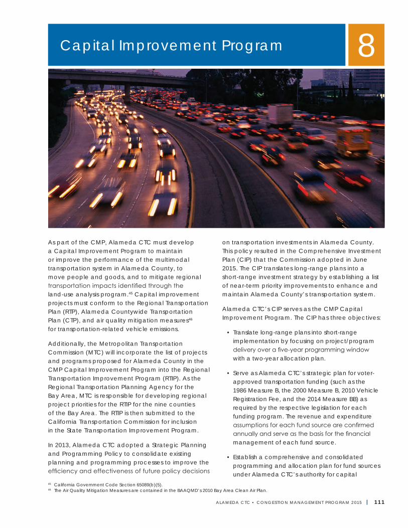
ALAMEDA CTC • CONGEST ION MANAGEMENT PROGRAM 2 015 | 111
As part of the CMP, Alameda CTC must develop a Capital Improvement Program to maintain or improve the performance of the multimodal transportation system in Alameda County, to move people and goods, and to mitigate regional transportation impacts identified through the land-use analysis program.45 Capital improvement projects must conform to the Regional Transportation Plan (RTP), Alameda Countywide Transportation Plan (CTP), and air quality mitigation measures46 for transportation-related vehicle emissions.
Additionally, the Metropolitan Transportation Commission (MTC) will incorporate the list of projects and programs proposed for Alameda County in the CMP Capital Improvement Program into the Regional Transportation Improvement Program (RTIP). As the Regional Transportation Planning Agency for the Bay Area, MTC is responsible for developing regional project priorities for the RTIP for the nine counties of the Bay Area. The RTIP is then submitted to the California Transportation Commission for inclusion in the State Transportation Improvement Program.
In 2013, Alameda CTC adopted a Strategic Planning and Programming Policy to consolidate existing planning and programming processes to improve the efficiency and effectiveness of future policy decisions
on transportation investments in Alameda County. This policy resulted in the Comprehensive Investment Plan (CIP) that the Commission adopted in June 2015. The CIP translates long-range plans into a short-range investment strategy by establishing a list of near-term priority improvements to enhance and maintain Alameda County’s transportation system.
Alameda CTC’s CIP serves as the CMP Capital Improvement Program. The CIP has three objectives:
• Translate long-range plans into short-range implementation by focusing on project/program delivery over a five-year programming window with a two-year allocation plan.
• Serve as Alameda CTC’s strategic plan for voter-approved transportation funding (such as the 1986 Measure B, the 2000 Measure B, 2010 Vehicle Registration Fee, and the 2014 Measure BB) as required by the respective legislation for each funding program. The revenue and expenditure assumptions for each fund source are confirmed annually and serve as the basis for the financial management of each fund source.
• Establish a comprehensive and consolidated programming and allocation plan for fund sources under Alameda CTC’s authority for capital
Capital Improvement Program 8
45 California Government Code Section 65089(b)(5).46 The Air Quality Mitigation Measures are contained in the BAAQMD’s 2010 Bay Area Clean Air Plan.
Alameda CTC | Congestion Management Program
112 | ALAMEDA CTC • CONGEST ION MANAGEMENT PROGRAM 2 015
improvements, operations and maintenance projects and programs. The CIP integrates all fund sources into one programming document that ensures coordinated programming and allocation of funds to maximize the effectiveness of transportation investments
Each year, Alameda CTC’s CIP financial assumptions are updated to include the latest revenue projections. New projects and programs are considered every two years as part of the full CIP update cycle.
Relationship of CIP to Plans and StudiesProjects included in the Capital Improvement Plan must be consistent with the RTP and the CTP. Since the RTP is required to be in conformance with the State Implementation Plan (SIP) for air quality, the CMP is also required to be in conformance with the SIP. To identify transportation needs and improvements to include in the CIP, Alameda CTC performs periodical monitoring and uses various areawide/corridor studies or plans.
Regional Transportation PlanSince the CMP ultimately will be incorporated into the RTP action element, projects selected for the Capital Improvement Program must be consistent with the assumptions, goals, policies, and actions identified in that plan. The RTP, prepared by the MTC, is the basic statement of the Bay Area transportation investment policy. Because of the interdependence of transportation planning and other regional planning, the regional plan strives to adopt policies that complement and support programs of federal, state, and regional agencies. The most recently adopted RTP, Plan Bay Area 2013, integrated land use and transportation by developing a Sustainable Communities Strategy to reduce greenhouse gas emissions from the transportation sector as required by Senate Bill 375.
MTC adopted an investment policy for Plan Bay Area47, which sets forth MTC’s approach to investment in the transportation system. This approach diverged from the prior approach and focused more on preserving and maintaining the existing transportation infrastructure, supporting priority development areas and priority conservation areas, and investing in transit. Specifically, the adopted investment strategies were:
1. maintain the existing transportation system;
2. support focused growth;
3. build next-generation transit;
4. boost freeway and transit efficiency;
5. county investment priorities; and
6. protecting Bay Area climate.
The most recently adopted Plan Bay Area included seven specific goals and related specific targets (see Chapter 9, “Program Conformance and Monitoring”). Out of the seven goals, two were legislatively required housing and climate protection with mandated targets.
MTC is currently in the process of updating its RTP by developing Plan Bay Area 2040. This plan is scheduled for adoption in 2017, and any updates relevant to the CIP will be incorporated into the 2017 CMP.
Countywide Transportation PlanAlameda CTC will continue to use its CMP as the primary vehicle for implementing the long-range CTP. The CMP Capital Improvement Plan guidelines and other funding policies adopted by Alameda CTC require projects seeking federal or state funding to be consistent with the CTP.
Each county within the jurisdiction of MTC can prepare a long-range transportation plan (countywide transportation plan) in cooperation with the respective cities, county, and transit operators.48 The CTP is the basis for the county’s component of the RTP.
47 MTC Resolution 4111.48 Assembly Bill 3705 (Eastin), Statutes of 1988.
Chapter 8 | Capital Improvement Program
ALAMEDA CTC • CONGEST ION MANAGEMENT PROGRAM 2 015 | 113
The Commission adopted the most recent CTP for Alameda County in June 2012 that resulted from a major comprehensive effort and coordination with various regional and local agencies. Alameda CTC coordinated development of the 2012 CTP with MTC’s development of Plan Bay Area and focused on identifying projects to meet the long-term transportation needs to better integrate land use and transportation to reduce greenhouse gas emissions in Alameda County. Performance-based planning was used for the first time to develop the 2012 CTP. This approach effectively identified projects and programs that meet the adopted vision and goals for the plan. Alameda CTC used a set of performance measures to provide an objective and technical means to measure how well projects and programs performed together to meet the goals.
The 2012 CTP’s vision and goals for Alameda County are as follows:
Alameda County will be served by a premier transportation system that supports a vibrant and livable Alameda County through a connected and integrated multimodal transportation system promoting sustainability, access, transit operations, public health and economic opportunities.
To achieve this vision, our transportation system will be:
• Multimodal
• Accessible, Affordable and Equitable for people of all ages, incomes, abilities and geographies
• Integrated with the land use patterns and local decision-making
• Connected across the county, within and across the network of streets, highways and transit, bicycle and pedestrian routes
• Reliable and Efficient
• Cost effective
• Well Maintained
• Safe
• Supportive of a Healthy and Clean Environment
Alameda CTC is currently developing its 2016 CTP update, which will serve as a performance-based, long range plan for Alameda County’s multimodal transportation network through 2040. As part of this plan development, Alameda CTC has readopted the 2012 CTP vision and goals for their continuing relevance and applicability. Alameda CTC is scheduled to adopt the CTP update in June 2016, and any updates relevant to the CIP will be incorporated in the 2017 CMP.
Air Quality Attainment PlansThe Capital Improvement Plan is closely related to federal and state air quality attainment plans. Because the Bay Area failed to attain national ambient air quality standards before the 1977 Federal Clean Air Act Amendments’ 1987 deadline, a revised State Implementation Plan was developed. The purpose of this plan is to show the measures to be taken to reduce air pollution and maintain compliance with federal requirements for annual emission reductions. The RTP is required by federal law to conform to the SIP. Because CMPs are required to be consistent with the RTP, CMPs must also conform to the programs and policies outlined in the SIP.
State air quality legislation, specifically the California Clean Air Act of 1988, requires the Bay Area Air Quality Management District (BAAQMD) to prepare a Clean Air Plan designed to bring the Bay region’s air basin into compliance with state air quality standards by the earliest practicable date. The Clean Air Plan must include transportation control measures as well as stationary (e.g., oil refinery) source controls to achieve and maintain the respective standards for ozone and carbon monoxide. Other legislation established a joint process between the MTC and BAAQMD for preparing the transportation control measures plan as part of the state Clean Air Plan.49 BAAQMD adopted the most recent Clean Air Plan in 2010.
49 Assembly Bill 3971 (Cortese).
Alameda CTC | Congestion Management Program
114 | ALAMEDA CTC • CONGEST ION MANAGEMENT PROGRAM 2 015
To respond to air quality and climate protection challenges in the years ahead with a comprehensive planning approach, BAAQMD developed the 2010 Clean Air Plan to be a dual plan—to include the required update to the Bay Area’s state ozone plan as well as to serve as a multi-pollutant action plan to protect public health and the climate. The 2010 Clean Air Plan Control Strategy component builds on a solid foundation established by the 2005 Ozone Strategy and previous ozone plans prepared in the 1991-2005 period. It includes revised, updated, and new measures in the three traditional control measure categories: Stationary Source Measures, Mobile Source Measures, and Transportation Control Measures. In addition, the Clean Air Plan identifies two new categories of control measures: Land Use and Local Impact Measures, and Energy and Climate Measures. Out of the total 55 control measures in the 2010 Clean Air Plan, 17 are transportation control measures.
The federal and state transportation control measures listed in the attainment plans have implications for county CMPs. MTC will give priority to proposed projects that support or help implement any of the transportation control measures outlined in this revised plan (see Appendix I for federal and state transportation control measures).
Areawide and Corridor StudiesAlameda CTC identified a need for areawide/corridor management multimodal planning in the 2012 CTP, re-emphasizing the prior policy on corridor/areawide transportation management planning, which is described in Chapter 6, “Land Use Analysis Program.” As part of the 2012 CTP, Alameda CTC developed a Briefing Book and many issue papers on key transportation issues. These collectively identified transportation issues to address, potential focused plans/studies to develop and strategies to explore as part of those plans, and studies to develop an accessible, reliable, and safe multimodal transportation system in Alameda County that is well connected and better integrated with land use.
As part of the next steps identified in the 2012 CTP, Alameda CTC developed a comprehensive TDM strategy that the Commission adopted and embarked on developing a Countywide Goods Movement Plan, Countywide Multimodal Plan, and Countywide Transit Plan, along with updates to the Community Based Transportation Plans. These modal plans are currently ongoing and anticipated to:
• Provide valuable information and performance measures to assess short-and long-term impacts to roadways, alternative modes, land use, and goods movement, as well as possible solutions;
• Identify comprehensive approaches to congestion management that can aid in the development of deficiency plans, particularly areawide deficiency plans that offer improvement options to a larger multimodal network, where level-of-service standards have been or are expected to be exceeded; and
• Provide support that allows each community within the corridor/area to demonstrate how the community’s share of cumulative/regional transportation impacts could be mitigated through cooperative planning and investment.
The three modal plans are scheduled for completion in 2016, and relevant information from these plans will be incorporated in the 2017 CMP.
Alameda CTC has also completed corridor studies for the following corridors:
• Central County Freeway Study (SR 238 Local Area Transportation Improvement Program)
• I-580 Corridor BART to Livermore
• I-680 Value Pricing
• I-880 Strategic Plan
• North I-880 Safety and Operations Study
• San Pablo and I-880 SMART Corridor Programs
Chapter 8 | Capital Improvement Program
ALAMEDA CTC • CONGEST ION MANAGEMENT PROGRAM 2 015 | 115
• SR 84 Local Area Transportation Improvement Program
• Tri-Valley Triangle Study
A New Diversified Investment StrategyThe 2012 CTP points to a new, integrated and diversified investment strategy for congestion management and environmental sustainability through connecting land use and transportation investment, and improving multimodal options. The following findings highlight this need for a strategy, which includes all reasonable options:
• The 2012 CTP includes $9.5 billion in projects, programs and planning studies.
• Even with this extensive investment, the countwide travel model forecasts congestion to become severe by 2035. Therefore, Alameda County cannot rely solely on investment in facilities as a way out of the congestion problem.
• The transportation needs in Alameda County outweigh the available revenues over the 28-year period.
• The Briefing Book and issue papers developed for the 2012 CTP make it apparent that all available diverse and multimodal options must be considered to sustain an acceptable level of mobility, improved connectivity, and environmental sustainability in Alameda County—these options include land use strategies, pricing strategies, managing the existing multimodal system better to stretch its capacity, better TDM options for trip reduction, carefully selected transportation investments, new and/or expanded revenue sources, and other approaches which may surface, including strategies to reduce vehicle miles traveled and reduce greenhouse gas emissions.
• Any single approach by itself is unlikely to be successful.
Through a performance-based evaluation in the development of the CTP, Alameda CTC has considered operational improvements intended to efficiently use existing facilities, improve transit investment and coordination, and support transit oriented developments (PDAs), intermodal freight facilities, non-motorized facilities, as well as other investment strategies to address all transportation issues. The CIP includes projects and programs that reinforce the diversified strategy identified in the CTP.
Funding SourcesVarious federal, state, and local funding sources fund the projects and programs identified in the CIP, which relate to the projects and programs identified in the CTP. To obtain funding from these sources, projects and programs must meet specific requirements.
Federal Surface Transportation ActAs Alameda County’s congestion management agency, Alameda CTC is responsible for soliciting and prioritizing projects in Alameda County for a portion of the federal Surface Transportation Program (STP). The STP provides funding from the reauthorization of federal funding for surface transportation, the legislation by which Alameda CTC receives federal monies. MTC currently allocates these funds through its One Bay Area Grant Program (OBAG).
Congestion Mitigation & Air Quality ProgramSimilar to STP funding, Alameda CTC is responsible for soliciting and prioritizing projects in Alameda County for a portion of the federal Congestion Mitigation & Air Quality Program (CMAQ). These funds are used on projects that will provide an air quality benefit. MTC currently allocates these funds through OBAG.
State Transportation Improvement Program Under state law, Alameda CTC works with project sponsors, including Caltrans, transit agencies, and local jurisdictions to solicit and prioritize projects that will be programmed through the Regional Transportation Improvement Program that makes up 75 percent of funds (county share) in the State
Alameda CTC | Congestion Management Program
116 | ALAMEDA CTC • CONGEST ION MANAGEMENT PROGRAM 2 015
Transportation Improvement Program. The remaining 25 percent of STIP funds are programmed at the state level and are part of the Interregional Transportation Improvement Program (ITIP). Therefore, STIP is made up of RTIP and ITIP. During each STIP cycle, the California Transportation Commission adopts a fund estimate that serves as the basis for financially constraining STIP proposals from counties and regions.
Transportation Fund for Clean Air ProgramState law permits the BAAQMD to collect a fee of $4 per vehicle per year to reduce air pollution from motor vehicles through its Transportation Fund for Clean Air (TFCA) Program. Of these funds, the BAAQMD directly programs 60 percent and annually allocates the remaining 40 percent to the designated overall program manager for each county, which for Alameda County is Alameda CTC. Projects and programs that receive funding under this program must result in vehicle emission reductions and meet BAAQMD requirements for project cost effectiveness.
Lifeline Transportation Program Alameda CTC is responsible for soliciting and prioritizing projects in Alameda County for the Lifeline Transportation Program (LTP). The LTP provides funds for transportation projects that serve low-income communities using a mixture of state and federal fund sources. Funding sources typically include State Transit Assistance (STA), Federal Job Access Reverse Commute (JARC), and state Proposition 1B funds.
Regional Measure 2 and Future Regional MeasuresIn 2004, voters passed Regional Measure 2 (RM2), raising the toll on the seven state-owned toll bridges in the San Francisco Bay Area by $1. This extra dollar funds various transportation projects within the region determined to reduce congestion or to make improvements to travel in the toll-bridge corridors, as identified in Senate Bill 916 (Chapter 715, Statutes of 2004). Another round of programming, commonly referred to as “RM3,” either from the existing bridge toll revenues or from a new bridge toll, is anticipated to be considered by MTC.
Measure B Program FundsIn 1986, Alameda County voters approved the Measure B half-cent transportation sales tax, which was reauthorized in November 2000. Approximately 60 percent of Measure B transportation sales tax dollars are allocated to 20 separate organizations via direct local distribution (DLD ) funds or discretionary grant programs.
The funds allocated to jurisdictions include:
• Local transportation, including local streets and roads projects (22.33 percent)
• Mass transit, including express bus service (21.92 percent)
• Special transportation (paratransit) for seniors and people with disabilities (10.5 percent)
• Bicycle and pedestrian safety (5 percent)
• Transit-oriented development (0.19 percent)
The remaining 40 percent of the transportation sales tax dollars are allocated to specific projects as described in the voter-approved 2000 Transportation Expenditure Plan (2000 TEP). Funds are allocated through an annual strategic planning process that identifies project readiness and funding requirements. Project-specific funding allocations are made via specific recommendations approved by the Commission.
Measure BB Program FundsIn November 2014, Alameda County voters approved the 2014 Transportation Expenditure Plan (2014 TEP). This plan distributes approximately 65 percent of the net sales tax revenues to essential programs in Alameda County through DLD funds and discretionary grant awards. The DLD funds are distributed as prescribed in the 2014 TEP as follows:
• Transit Operations, Maintenance, and Safety Program (21.55 percent)
• Local Streets Maintenance and Safety (20 percent)
Chapter 8 | Capital Improvement Program
ALAMEDA CTC • CONGEST ION MANAGEMENT PROGRAM 2 015 | 117
• Bicycle and Pedestrian Infrastructure and Safety (3 percent)
• Affordable Transit for Seniors and People with Disabilities (9 percent)
The discretionary programs are distributed based on the percentage or amounts specified in the 2014 TEP:
• Affordable Student Transit Pass Program ($15 million)
• Affordable Transit for Seniors and People with Disabilities/Coordination and Service Grants (1 percent)
• Bicycle and Pedestrian Program (2 percent)
• Community Investments That Improve Transit Connections to Jobs and Schools (4 percent)
• Congestion Relief, Local Bridge Seismic Safety ($639 million)
• Freight and Economic Development Program (1 percent)
• Technology, Innovation and Development Program (1 percent)
• Transit Innovation Program (2.24 percent)
The remaining transportation sales tax dollars (approximately 35 percent) are identified for specifically named projects as described in the 2014 TEP. Alameda CTC distributes sales tax funds for capital projects on a reimbursement basis in accordance with funding agreements between Alameda CTC and the recipient agency, or for eligible project costs incurred directly by Alameda CTC.
Vehicle Registration FeeThe Measure F Alameda County Vehicle Registration Fee (VRF) Program was approved by the voters on November 2, 2010. The $10 per year vehicle registration fee generates approximately $12 million in annual net revenue. Each year, Alameda CTC distributes 60 percent of these funds to the 14 cities and the county as DLD funds to support Local Road
Improvement and Repair Programs. The remaining 40 percent are used to support the following programs:
• Transit for Congestion Relief Discretionary Program (25 percent)
• Local Transportation Technology Program (10 percent)
• Pedestrian and Bicycle Access and Safety Discretionary Program (5 percent)
Proposition 1BAs approved by the voters in the November 2006 general elections, Proposition 1B enacted the Highway Safety, Traffic Reduction, Air Quality, and Port Security Bond Act of 2006, authorizing $19.9 billion of state general obligation bonds for specified purposes. Proposition 1B includes funding for multiple programs, including the Corridor Mobility Improvement Account (CMIA), the Trade Corridors Improvement Fund (TCIF), and the Traffic Light Synchronization Program (TLSP).
Alameda CTC has successfully secured approximately $420 million in Proposition 1B Bond funding to complete the $800 million Alameda CTC I-Bond construction program. The seven projects that use Proposition 1B funds are complete or under construction.
Project DeliveryIn light of the focus on project delivery, Alameda CTC has adopted a “Timely Use of Funds Policy” which applies to funds allocated by Alameda CTC. For delivery of projects with funding from multiple sources, Alameda CTC incorporates its Timely Use of Funds Policy with the timely use of funds requirements for other funding, including STIP, federal STP/CMAQ, and TFCA funding. In addition, projects are also subject to regional deadlines outlined in MTC Resolution 3606.
2016 STIPThe projects identified for STIP funding are consistent with the CTP and RTP. Compared to prior cycles, the statewide revenue estimate for the 2016 STIP is approximately $46 million. Based on the low statewide amount, the California Transportation Commission
Alameda CTC | Congestion Management Program
118 | ALAMEDA CTC • CONGEST ION MANAGEMENT PROGRAM 2 015
(CTC) has not calculated individual county shares. Once the CTC releases the estimate, if funding is available for the county, Alameda CTC will develop a list of proposed projects for approval by the Commission in fall of 2015. On approval by the Commission, Alameda CTC will forward the proposed projects, if any, to MTC and will update the CMP accordingly.
The CIPAlameda CTC is responsible for planning, programming, and allocating local, regional, state, and federal funding from a number of sources for transportation investments throughout Alameda County. The investments approved by Alameda CTC result in a wide range of transportation improvements and services that facilitate safe, efficient, and accessible travel for all types of transportation in all parts of Alameda County.
As mentioned previously, Alameda CTC updates the CTP every four years, which matches the 30-year horizon of the RTP and establishes the Alameda County vision and goals for transportation over the planning horizon. Alameda CTC also prepares short- and long-range plans to address needs and priorities for transit, highways, roads, goods movement, transportation for seniors and people with disabilities, bicycle and pedestrian facilities and programs, and community based transportation improvements that link transportation, housing, and jobs countywide.
The CIP brings the long-range and countywide plans into the near term by focusing on investments over a five-year programming and allocation window. The CIP identifies a list of short-range priority transportation improvements to enhance and maintain Alameda County’s transportation system in accordance with the objectives established in the CTP. The CIP identifies anticipated transportation funding over a five-year horizon and strategically matches the funding sources to targeted investments in Alameda County’s transportation system. The five-year horizon includes a two-year allocation plan (i.e., the first two years). Once funds are allocated, they become subject to
the Alameda CTC Timely Use of Funds Policy to ensure timely implementation of the intended improvements or services funded by the allocation.
Five-Year CIP and Two-Year Allocation PlanThe project and program selection process for the initial CIP, from FY (Fiscal Year) 2015-16 through FY2019-20, was abbreviated to allow for the development of policies related to Measure BB implementation. Projects and programs included in the CIP funded by fund sources aside from Measure BB were selected through the specific guidelines associated with those funding sources. The total revenue programmed over the five-year CIP horizon is $1,222,410 from a variety of sources at the federal, state, regional, and local levels. The two-year allocation plan total is over $478 million. Table 21 shows the projects identified for the initial CIP from FY 2015-16 through FY 2019-20.
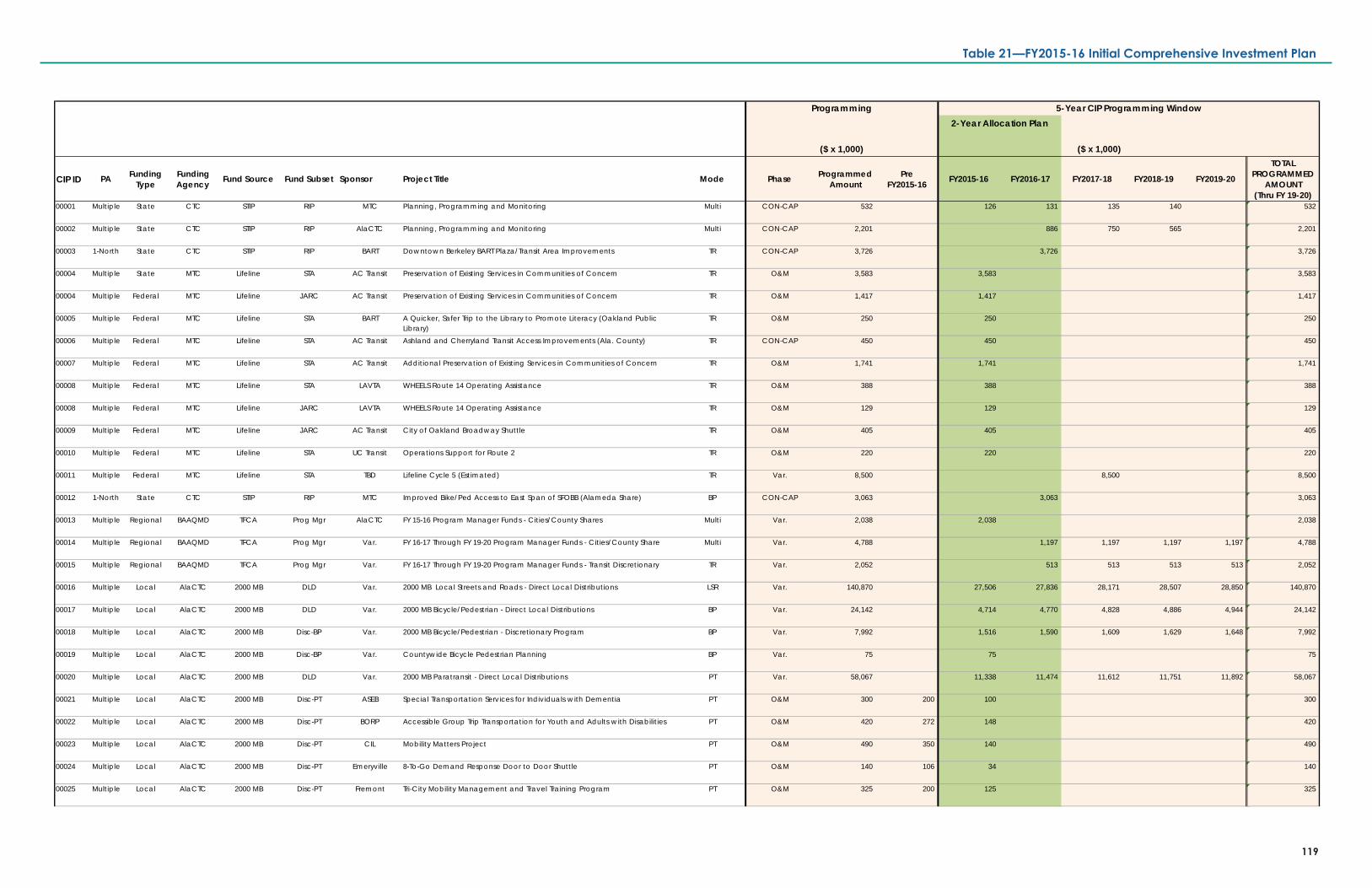
($ x 1,000)
CIP ID PA Funding Type
Funding Agency Fund Source Fund Subset Sponsor Project Title Mode Phase Programmed
AmountPre
FY2015-16 FY2015-16 FY2016-17 FY2017-18 FY2018-19 FY2019-20
TOTAL PROGRAMMED
AMOUNT(Thru FY 19-20)
00001 Multiple State CTC STIP RIP MTC Planning, Programming and Monitoring Multi CON-CAP 532 126 131 135 140 532
00002 Multiple State CTC STIP RIP AlaCTC Planning, Programming and Monitoring Multi CON-CAP 2,201 886 750 565 2,201
00003 1-North State CTC STIP RIP BART Downtown Berkeley BART Plaza/Transit Area Improvements TR CON-CAP 3,726 3,726 3,726
00004 Multiple State MTC Lifeline STA AC Transit Preservation of Existing Services in Communities of Concern TR O&M 3,583 3,583 3,583
00004 Multiple Federal MTC Lifeline JARC AC Transit Preservation of Existing Services in Communities of Concern TR O&M 1,417 1,417 1,417
00005 Multiple Federal MTC Lifeline STA BART A Quicker, Safer Trip to the Library to Promote Literacy (Oakland Public Library)
TR O&M 250 250 250
00006 Multiple Federal MTC Lifeline STA AC Transit Ashland and Cherryland Transit Access Improvements (Ala. County) TR CON-CAP 450 450 450
00007 Multiple Federal MTC Lifeline STA AC Transit Additional Preservation of Existing Services in Communities of Concern TR O&M 1,741 1,741 1,741
00008 Multiple Federal MTC Lifeline STA LAVTA WHEELS Route 14 Operating Assistance TR O&M 388 388 388
00008 Multiple Federal MTC Lifeline JARC LAVTA WHEELS Route 14 Operating Assistance TR O&M 129 129 129
00009 Multiple Federal MTC Lifeline JARC AC Transit City of Oakland Broadway Shuttle TR O&M 405 405 405
00010 Multiple Federal MTC Lifeline STA UC Transit Operations Support for Route 2 TR O&M 220 220 220
00011 Multiple Federal MTC Lifeline STA TBD Lifeline Cycle 5 (Estimated) TR Var. 8,500 8,500 8,500
00012 1-North State CTC STIP RIP MTC Improved Bike/Ped Access to East Span of SFOBB (Alameda Share) BP CON-CAP 3,063 3,063 3,063
00013 Multiple Regional BAAQMD TFCA Prog Mgr AlaCTC FY 15-16 Program Manager Funds - Cities/County Shares Multi Var. 2,038 2,038 2,038
00014 Multiple Regional BAAQMD TFCA Prog Mgr Var. FY 16-17 Through FY 19-20 Program Manager Funds - Cities/County Share Multi Var. 4,788 1,197 1,197 1,197 1,197 4,788
00015 Multiple Regional BAAQMD TFCA Prog Mgr Var. FY 16-17 Through FY 19-20 Program Manager Funds - Transit Discretionary TR Var. 2,052 513 513 513 513 2,052
00016 Multiple Local AlaCTC 2000 MB DLD Var. 2000 MB Local Streets and Roads - Direct Local Distributions LSR Var. 140,870 27,506 27,836 28,171 28,507 28,850 140,870
00017 Multiple Local AlaCTC 2000 MB DLD Var. 2000 MB Bicycle/Pedestrian - Direct Local Distributions BP Var. 24,142 4,714 4,770 4,828 4,886 4,944 24,142
00018 Multiple Local AlaCTC 2000 MB Disc-BP Var. 2000 MB Bicycle/Pedestrian - Discretionary Program BP Var. 7,992 1,516 1,590 1,609 1,629 1,648 7,992
00019 Multiple Local AlaCTC 2000 MB Disc-BP Var. Countywide Bicycle Pedestrian Planning BP Var. 75 75 75
00020 Multiple Local AlaCTC 2000 MB DLD Var. 2000 MB Paratransit - Direct Local Distributions PT Var. 58,067 11,338 11,474 11,612 11,751 11,892 58,067
00021 Multiple Local AlaCTC 2000 MB Disc-PT ASEB Special Transportation Services for Individuals with Dementia PT O&M 300 200 100 300
00022 Multiple Local AlaCTC 2000 MB Disc-PT BORP Accessible Group Trip Transportation for Youth and Adults with Disabilities PT O&M 420 272 148 420
00023 Multiple Local AlaCTC 2000 MB Disc-PT CIL Mobility Matters Project PT O&M 490 350 140 490
00024 Multiple Local AlaCTC 2000 MB Disc-PT Emeryville 8-To-Go Demand Response Door to Door Shuttle PT O&M 140 106 34 140
00025 Multiple Local AlaCTC 2000 MB Disc-PT Fremont Tri-City Mobility Management and Travel Training Program PT O&M 325 200 125 325
($ x 1,000)
5-Year CIP Programming WindowProgramming2-Year Allocation Plan
119
Table 21—FY2015-16 Initial Comprehensive Investment Plan
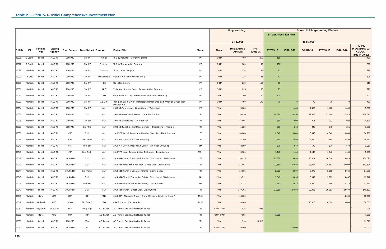
($ x 1,000)
CIP ID PA Funding Type
Funding Agency Fund Source Fund Subset Sponsor Project Title Mode Phase Programmed
AmountPre
FY2015-16 FY2015-16 FY2016-17 FY2017-18 FY2018-19 FY2019-20
TOTAL PROGRAMMED
AMOUNT(Thru FY 19-20)
00026 3-South Local AlaCTC 2000 MB Disc-PT Fremont Tri-City Volunteer Driver Programs PT O&M 400 250 150 400
00027 3-South Local AlaCTC 2000 MB Disc-PT Fremont Tri-City Taxi Voucher Program PT O&M 300 150 150 300
00028 Multiple Local AlaCTC 2000 MB Disc-PT Oakland Taxi-Up & Go Project PT O&M 278 185 93 278
00029 4-East Local AlaCTC 2000 MB Disc-PT Pleasanton Downtown Route Shuttle (DTR) PT O&M 128 86 42 128
00030 Multiple Local AlaCTC 2000 MB Disc-PT SHS Rides for Seniors PT O&M 210 150 60 210
00031 Multiple Local AlaCTC 2000 MB Disc-PT SSPTV Volunteer Assisted Senior Transportation Program PT O&M 225 150 75 225
00032 Multiple Local AlaCTC 2000 MB Disc-PT TBD Gap funds for Capital Purchases and Grant Matching PT Var. 200 100 100 200
00033 Multiple Local AlaCTC 2000 MB Disc-PT AlaCTC Transportation Services for Hospital Discharge and Wheelchair/Scooter Breakdown
PT O&M 490 140 70 70 70 70 70 490
00034 Multiple Local AlaCTC 2000 MB Disc-PT Var. 2000 MB Paratransit - Discretionary (Estimated) PT Var. 5,600 1,400 1,400 1,400 1,400 5,600
00035 Multiple Local AlaCTC 2000 MB DLD Var. 2000 MB Mass Transit - Direct Local Distributions TR Var. 136,610 26,674 26,994 27,318 27,646 27,978 136,610
00036 Multiple Local AlaCTC 2000 MB Disc-EB Var. 2000 MB Express Bus - Discretionary TR Var. 4,506 880 890 901 912 923 4,506
00037 Multiple Local AlaCTC 2000 MB Disc-TCD Var. 2000 MB Transit Center Development - Discretionary Program TR Var. 1,225 239 242 245 248 251 1,225
00038 Multiple Local AlaCTC VRF DLD Var. 2010 VRF Local Streets and Roads - Direct Local Distributions LSR Var. 34,200 6,840 6,840 6,840 6,840 6,840 34,200
00039 Multiple Local AlaCTC VRF Disc-Transit Var. 2010 VRF Mass Transit - Discretionary TR Var. 14,250 2,850 2,850 2,850 2,850 2,850 14,250
00040 Multiple Local AlaCTC VRF Disc-BP Var. 2010 VRF Bicycle/Pedestrian Safety - Discretionary Funds BP Var. 2,850 570 570 570 570 570 2,850
00041 Multiple Local AlaCTC VRF Disc-Tech Var. 2010 VRF Local Transportation Techology - Discretionary TECH Var. 5,700 1,140 1,140 1,140 1,140 1,140 5,700
00042 Multiple Local AlaCTC 2014 MBB DLD Var. 2014 MBB Local Streets and Roads - Direct Local Distributions LSR Var. 130,025 25,388 25,693 26,001 26,314 26,629 130,025
00043 Multiple Local AlaCTC 2014 MBB DLD Var. 2014 MBB Mass Transit Services - Direct Local Distributions TR Var. 141,604 27,650 27,980 28,317 28,657 29,000 141,604
00044 Multiple Local AlaCTC 2014 MBB Disc-Transit Var. 2014 MBB Transit Innovative Grants - Discretionary TR Var. 14,865 2,903 2,937 2,973 3,008 3,044 14,865
00045 Multiple Local AlaCTC 2014 MBB DLD Var. 2014 MBB Bicycle/Pedestrian Safety - Direct Local Distributions BP Var. 19,712 3,849 3,895 3,942 3,989 4,037 19,712
00046 Multiple Local AlaCTC 2014 MBB Disc-BP Var. 2014 MBB Bicycle/Pedestrian Safety - Discretionary BP Var. 13,273 2,592 2,623 2,654 2,686 2,718 13,273
00047 Multiple Local AlaCTC 2014 MBB DLD Var. 2014 MBB Transit - Direct Local Distributions TR Var. 140,101 27,356 27,683 28,016 28,353 28,693 140,101
00048 Multiple State CTC STIP RIP TBD 2016 STIP - Alameda County Share (Estimated)(50% for 1-Year) Multi Var. 13,000 13,000 13,000
00049 Multiple Federal MTC OBAG STP/CMAQ TBD OBAG Cycle 2 (Estimated) Multi Var. 38,000 10,000 14,000 14,000 38,000
00050 Multiple Regional BAAQMD TFCA Prog Mgr AC Transit AC Transit: East Bay Bus Rapid Transit TR CON-CAP 925 925 925
00050 Multiple State CTC STIP RIP AC Transit AC Transit: East Bay Bus Rapid Transit TR CON-CAP 7,995 7,995 7,995
00050 Multiple Local AlaCTC 2000 MB 07A AC Transit AC Transit: East Bay Bus Rapid Transit TR Var. 11,510 11,510 11,510
00050 Multiple Local AlaCTC 2014 MBB 13 AC Transit AC Transit: East Bay Bus Rapid Transit TR CON-CAP 10,000 10,000 10,000
($ x 1,000)
5-Year CIP Programming WindowProgramming2-Year Allocation Plan
120
Table 21—FY2015-16 Initial Comprehensive Investment Plan
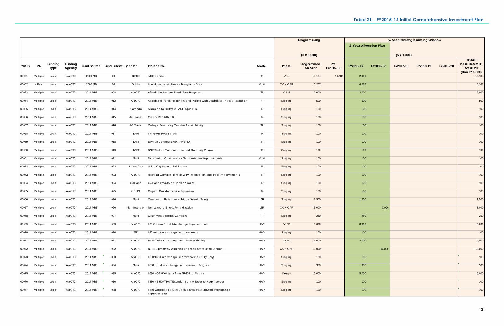
($ x 1,000)
CIP ID PA Funding Type
Funding Agency Fund Source Fund Subset Sponsor Project Title Mode Phase Programmed
AmountPre
FY2015-16 FY2015-16 FY2016-17 FY2017-18 FY2018-19 FY2019-20
TOTAL PROGRAMMED
AMOUNT(Thru FY 19-20)
00051 Multiple Local AlaCTC 2000 MB 01 SJRRC ACE Capital TR Var. 13,184 11,184 2,000 13,184
00052 4-East Local AlaCTC 2000 MB 09 Dublin Iron Horse transit Route - Dougherty Drive Multi CON-CAP 6,267 6,267 6,267
00053 Multiple Local AlaCTC 2014 MBB 008 AlaCTC Affordable Student Transit Pass Programs TR O&M 2,000 2,000 2,000
00054 Multiple Local AlaCTC 2014 MBB 012 AlaCTC Affordable Transit for Seniors and People with Disabilities - Needs Assessment PT Scoping 500 500 500
00055 Multiple Local AlaCTC 2014 MBB 014 Alameda Alameda to Fruitvale BART Rapid Bus TR Scoping 100 100 100
00056 Multiple Local AlaCTC 2014 MBB 015 AC Transit Grand/MacArthur BRT TR Scoping 100 100 100
00057 Multiple Local AlaCTC 2014 MBB 016 AC Transit College/Broadway Corridor Transit Priority TR Scoping 100 100 100
00058 Multiple Local AlaCTC 2014 MBB 017 BART Irvington BART Station TR Scoping 100 100 100
00059 Multiple Local AlaCTC 2014 MBB 018 BART Bay Fair Connector/BART METRO TR Scoping 100 100 100
00060 Multiple Local AlaCTC 2014 MBB 019 BART BART Station Modernization and Capacity Program TR Scoping 100 100 100
00061 Multiple Local AlaCTC 2014 MBB 021 Multi Dumbarton Corridor Area Transportation Improvements Multi Scoping 100 100 100
00062 Multiple Local AlaCTC 2014 MBB 022 Union City Union City Intermodal Station TR Scoping 100 100 100
00063 Multiple Local AlaCTC 2014 MBB 023 AlaCTC Railroad Corridor Right of Way Preservation and Track Improvements TR Scoping 100 100 100
00064 Multiple Local AlaCTC 2014 MBB 024 Oakland Oakland Broadway Corridor Transit TR Scoping 100 100 100
00065 Multiple Local AlaCTC 2014 MBB 025 CCJPA Capitol Corridor Service Expansion TR Scoping 100 100 100
00066 Multiple Local AlaCTC 2014 MBB 026 Multi Congestion Relief, Local Bridge Seismic Safety LSR Scoping 1,500 1,500 1,500
00067 Multiple Local AlaCTC 2014 MBB 026 San Leandro San Leandro Streets Rehabilitation LSR CON-CAP 3,000 3,000 3,000
00068 Multiple Local AlaCTC 2014 MBB 027 Multi Countywide Freight Corridors FR Scoping 250 250 250
00069 Multiple Local AlaCTC 2014 MBB 029 AlaCTC I-80 Gilman Street Interchange Improvements HWY PA-ED 3,000 3,000 3,000
00070 Multiple Local AlaCTC 2014 MBB 030 TBD I-80 Ashby Interchange Improvements HWY Scoping 100 100 100
00071 Multiple Local AlaCTC 2014 MBB 031 AlaCTC SR-84/I-680 Interchange and SR-84 Widening HWY PA-ED 4,000 4,000 4,000
00072 Multiple Local AlaCTC 2014 MBB 032 AlaCTC SR-84 Expressway Widening (Pigeon Pass to Jack London) HWY CON-CAP 10,000 10,000 10,000
00073 Multiple Local AlaCTC 2014 MBB 033 AlaCTC I-580/I-680 Interchange Improvements (Study Only) HWY Scoping 100 100 100
00074 Multiple Local AlaCTC 2014 MBB 034 Multi I-580 Local Interchange Improvement Program HWY Scoping 300 300 300
00075 Multiple Local AlaCTC 2014 MBB 035 AlaCTC I-680 HOT/HOV Lane from SR-237 to Alcosta HWY Design 5,000 5,000 5,000
00076 Multiple Local AlaCTC 2014 MBB 036 AlaCTC I-880 NB HOV/HOT Extension from A Street to Hegenberger HWY Scoping 100 100 100
00077 Multiple Local AlaCTC 2014 MBB 038 AlaCTC I-880 Whipple Road/Industrial Parkway Southwest Interchange Improvements
HWY Scoping 100 100 100
($ x 1,000)
5-Year CIP Programming WindowProgramming2-Year Allocation Plan
121
Table 21—FY2015-16 Initial Comprehensive Investment Plan
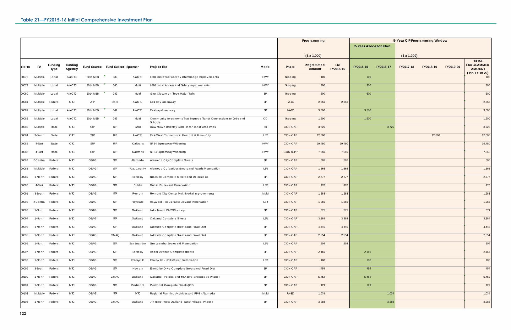
($ x 1,000)
CIP ID PA Funding Type
Funding Agency Fund Source Fund Subset Sponsor Project Title Mode Phase Programmed
AmountPre
FY2015-16 FY2015-16 FY2016-17 FY2017-18 FY2018-19 FY2019-20
TOTAL PROGRAMMED
AMOUNT(Thru FY 19-20)
00078 Multiple Local AlaCTC 2014 MBB 039 AlaCTC I-880 Industrial Parkway Interchange Improvements HWY Scoping 100 100 100
00079 Multiple Local AlaCTC 2014 MBB 040 Multi I-880 Local Access and Safety Improvements HWY Scoping 300 300 300
00080 Multiple Local AlaCTC 2014 MBB 042 Multi Gap Closure on Three Major Trails BP Scoping 600 600 600
00081 Multiple Federal CTC ATP State AlaCTC East Bay Greenway BP PA-ED 2,656 2,656 2,656
00081 Multiple Local AlaCTC 2014 MBB 042 AlaCTC Eastbay Greenway BP PA-ED 3,500 3,500 3,500
00082 Multiple Local AlaCTC 2014 MBB 045 Multi Community Investments That Improve Transit Connections to Jobs and Schools
CD Scoping 1,500 1,500 1,500
00083 Multiple State CTC STIP RIP BART Downtown Berkeley BART Plaza/Transit Area Imps. TR CON-CAP 3,726 3,726 3,726
00084 3-South State CTC STIP RIP AlaCTC East-West Connector in Fremont & Union City LSR CON-CAP 12,000 12,000 12,000
00085 4-East State CTC STIP RIP Caltrans SR 84 Expressway Widening HWY CON-CAP 39,480 39,480 39,480
00086 4-East State CTC STIP RIP Caltrans SR 84 Expressway Widening HWY CON-SUPP 7,550 7,550 7,550
00087 2-Central Federal MTC OBAG STP Alameda Alameda City Complete Streets BP CON-CAP 505 505 505
00088 Multiple Federal MTC OBAG STP Ala. County Alameda Co-Various Streets and Roads Preservation LSR CON-CAP 1,565 1,565 1,565
00089 1-North Federal MTC OBAG STP Berkeley Shattuck Complete Streets and De-couplet BP CON-CAP 2,777 2,777 2,777
00090 4-East Federal MTC OBAG STP Dublin Dublin Boulevard Preservation LSR CON-CAP 470 470 470
00091 3-South Federal MTC OBAG STP Fremont Fremont City Center Multi-Modal Improvements Multi CON-CAP 1,288 1,288 1,288
00092 2-Central Federal MTC OBAG STP Hayward Hayward - Industrial Boulevard Preservation LSR CON-CAP 1,265 1,265 1,265
00093 1-North Federal MTC OBAG STP Oakland Lake Merritt BART Bikeways BP CON-CAP 571 571 571
00094 1-North Federal MTC OBAG STP Oakland Oakland Complete Streets LSR CON-CAP 3,384 3,384 3,384
00095 1-North Federal MTC OBAG STP Oakland Lakeside Complete Streets and Road Diet BP CON-CAP 4,446 4,446 4,446
00095 1-North Federal MTC OBAG CMAQ Oakland Lakeside Complete Streets and Road Diet BP CON-CAP 2,554 2,554 2,554
00096 1-North Federal MTC OBAG STP San Leandro San Leandro Boulevard Preservation LSR CON-CAP 804 804 804
00097 1-North Federal MTC OBAG STP Berkeley Hearst Avenue Complete Streets BP CON-CAP 2,156 2,156 2,156
00098 1-North Federal MTC OBAG STP Emeryville Emeryville - Hollis Street Preservation LSR CON-CAP 100 100 100
00099 3-South Federal MTC OBAG STP Newark Enterprise Drive Complete Streets and Road Diet BP CON-CAP 454 454 454
00100 1-North Federal MTC OBAG CMAQ Oakland Oakland - Peralta and MLK Blvd Streetscape Phase I BP CON-CAP 5,452 5,452 5,452
00101 1-North Federal MTC OBAG STP Piedmont Piedmont Complete Streets (CS) BP CON-CAP 129 129 129
00102 Multiple Federal MTC OBAG STP MTC Regional Planning Activities and PPM - Alameda Multi PA-ED 1,034 1,034 1,034
00103 1-North Federal MTC OBAG CMAQ Oakland 7th Street West Oakland Transit Village, Phase II BP CON-CAP 3,288 3,288 3,288
($ x 1,000)
5-Year CIP Programming WindowProgramming2-Year Allocation Plan
122
Table 21—FY2015-16 Initial Comprehensive Investment Plan
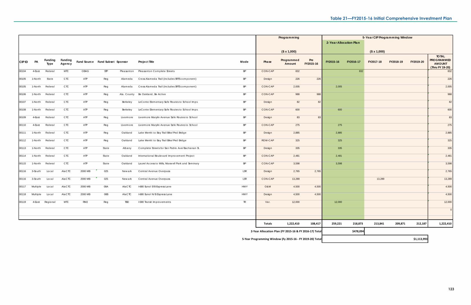
($ x 1,000)
CIP ID PA Funding Type
Funding Agency Fund Source Fund Subset Sponsor Project Title Mode Phase Programmed
AmountPre
FY2015-16 FY2015-16 FY2016-17 FY2017-18 FY2018-19 FY2019-20
TOTAL PROGRAMMED
AMOUNT(Thru FY 19-20)
00104 4-East Federal MTC OBAG STP Pleasanton Pleasanton Complete Streets BP CON-CAP 832 832 832
00105 1-North State CTC ATP Reg Alameda Cross Alameda Trail (includes SRTS component) BP Design 226 226 226
00105 1-North Federal CTC ATP Reg Alameda Cross Alameda Trail (includes SRTS component) BP CON-CAP 2,005 2,005 2,005
00106 1-North Federal CTC ATP Reg Ala. County Be Oakland, Be Active BP CON-CAP 988 988 988
00107 1-North Federal CTC ATP Reg Berkeley LeConte Elementary Safe Routes to School Imps BP Design 82 82 82
00108 1-North Federal CTC ATP Reg Berkeley LeConte Elementary Safe Routes to School Imps BP CON-CAP 600 600 600
00109 4-East Federal CTC ATP Reg Livermore Livermore Marylin Avenue Safe Routes to School BP Design 83 83 83
00110 4-East Federal CTC ATP Reg Livermore Livermore Marylin Avenue Safe Routes to School BP CON-CAP 275 275 275
00111 1-North Federal CTC ATP Reg Oakland Lake Merritt to Bay Trail Bike/Ped Bridge BP Design 2,885 2,885 2,885
00112 1-North Federal CTC ATP Reg Oakland Lake Merritt to Bay Trail Bike/Ped Bridge BP ROW-CAP 325 325 325
00113 1-North Federal CTC ATP State Albany Complete Streets for San Pablo Ave/Buchanan St. BP Design 335 335 335
00114 1-North Federal CTC ATP State Oakland International Boulevard Improvement Project BP CON-CAP 2,481 2,481 2,481
00115 1-North Federal CTC ATP State Oakland Laurel Access to Mills, Maxwell Park and Seminary BP CON-CAP 3,598 3,598 3,598
00116 3-South Local AlaCTC 2000 MB 025 Newark Central Avenue Overpass LSR Design 2,765 2,765 2,765
00116 3-South Local AlaCTC 2000 MB 025 Newark Central Avenue Overpass LSR CON-CAP 13,289 13,289 13,289
00117 Multiple Local AlaCTC 2000 MB 08A AlaCTC I-680 Sunol S/B Express Lane HWY O&M 4,500 4,500 4,500
00118 Multiple Local AlaCTC 2000 MB 08B AlaCTC I-680 Sunol N/B Express Lane HWY Design 4,500 4,500 4,500
00119 4-East Regional MTC RM2 Reg TBD I-580 Transit Improvements TR Var. 12,000 12,000 12,000
0
Totals 1,222,410 108,417 259,221 218,873 213,841 209,871 212,187 1,222,410
2-Year Allocation Plan (FY 2015-16 & FY 2016-17) Total $478,094
5-Year Programming Window (Fy 2015-16 - FY 2019-20) Total $1,113,993
($ x 1,000)
5-Year CIP Programming WindowProgramming2-Year Allocation Plan
123
Table 21—FY2015-16 Initial Comprehensive Investment Plan

124
This page is intentionally left blank.
Table 21—FY2015-16 Initial Comprehensive Investment Plan
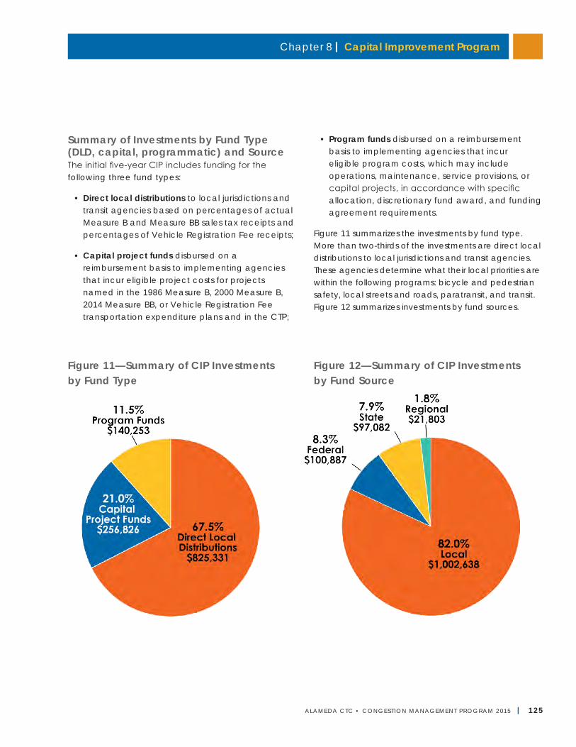
Chapter 8 | Capital Improvement Program
ALAMEDA CTC • CONGEST ION MANAGEMENT PROGRAM 2 015 | 125
Summary of Investments by Fund Type(DLD, capital, programmatic) and SourceThe initial five-year CIP includes funding for the following three fund types:
• Direct local distributions to local jurisdictions and transit agencies based on percentages of actual Measure B and Measure BB sales tax receipts and percentages of Vehicle Registration Fee receipts;
• Capital project funds disbursed on a reimbursement basis to implementing agencies that incur eligible project costs for projects named in the 1986 Measure B, 2000 Measure B, 2014 Measure BB, or Vehicle Registration Fee transportation expenditure plans and in the CTP;
• Program funds disbursed on a reimbursement basis to implementing agencies that incur eligible program costs, which may include operations, maintenance, service provisions, or capital projects, in accordance with specific allocation, discretionary fund award, and funding agreement requirements.
Figure 11 summarizes the investments by fund type. More than two-thirds of the investments are direct local distributions to local jurisdictions and transit agencies. These agencies determine what their local priorities are within the following programs: bicycle and pedestrian safety, local streets and roads, paratransit, and transit. Figure 12 summarizes investments by fund sources.
Figure 11—Summary of CIP Investments by Fund Type
Figure 12—Summary of CIP Investments by Fund Source
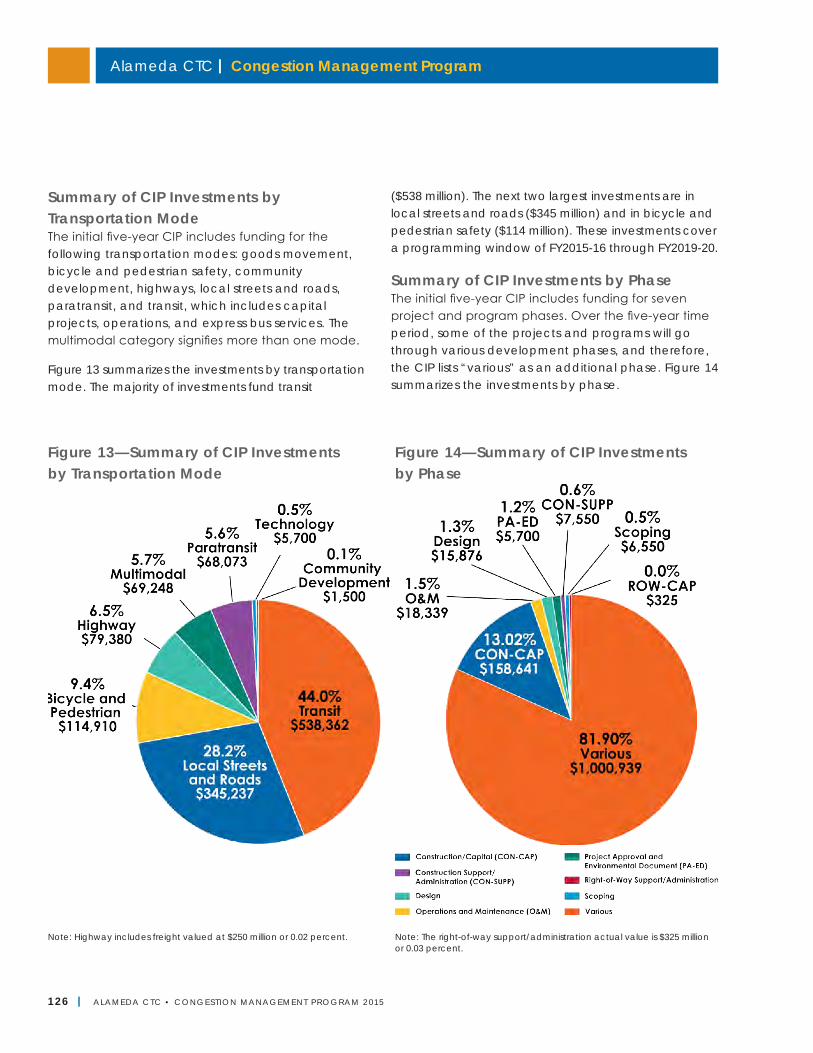
Alameda CTC | Congestion Management Program
126 | ALAMEDA CTC • CONGEST ION MANAGEMENT PROGRAM 2 015
Summary of CIP Investments by Transportation ModeThe initial five-year CIP includes funding for the following transportation modes: goods movement, bicycle and pedestrian safety, community development, highways, local streets and roads, paratransit, and transit, which includes capital projects, operations, and express bus services. The multimodal category signifies more than one mode.
Figure 13 summarizes the investments by transportation mode. The majority of investments fund transit
($538 million). The next two largest investments are in local streets and roads ($345 million) and in bicycle and pedestrian safety ($114 million). These investments cover a programming window of FY2015-16 through FY2019-20.
Summary of CIP Investments by PhaseThe initial five-year CIP includes funding for seven project and program phases. Over the five-year time period, some of the projects and programs will go through various development phases, and therefore, the CIP lists “various” as an additional phase. Figure 14 summarizes the investments by phase.
Figure 13—Summary of CIP Investments by Transportation Mode
Figure 14—Summary of CIP Investments by Phase
Note: Highway includes freight valued at $250 million or 0.02 percent. Note: The right-of-way support/administration actual value is $325 million or 0.03 percent.
Chapter 8 | Capital Improvement Program
ALAMEDA CTC • CONGEST ION MANAGEMENT PROGRAM 2 015 | 127
CIP Update ProcessAlameda CTC will update annually the expenditure and revenue assumptions included in the CIP, which will serve as the basis of the Alameda CTC financial models and annual budget. The annual updates will also serve to satisfy any annual strategic plan requirements for the fund sources that Alameda CTC administers. The annual updates will afford Alameda CTC the opportunity to review the first year and confirm the allocations for the second year of the two-year allocation plan. The annual update process will include a status update on the first year and any recommended adjustments or amendments for the second year.
A full update of the CIP will occur every two years, including a comprehensive review of the remaining three years of the five-year CIP horizon and the addition of two new years of programming for a five-year programming window. The full update will involve notifying project sponsors of the enrollment period for adding new projects and programs to the CIP, and the subsequent review and approval of project and program submittals to be included in the updated CIP.
Local Government Responsibilities and ConformanceAlameda CTC is responsible for monitoring conformance of local jurisdictions with the adopted CMP.50 Among the requirements, Alameda CTC must develop a Capital Improvement Program that includes projects and programs to improve or maintain the performance of the countywide multimodal transportation system. The Comprehensive Investment Plan that will be updated every two years in coordination with the local jurisdictions and transit agencies will serve as the Capital Improvement Program for the CMP. The CTP updated every four years will inform the CIP development process.
Next StepsThrough the next 2017 CMP update, Alameda CTC will continue its coordination of long-range planning documents with short-range implementation via the Alameda CTC CIP. The first CIP (FY2015-16 through FY2019-20) was adopted by Alameda CTC in June 2015 and incorporated herein in part for this CMP Capital Improvement Program chapter. In June 2017, the CIP will receive a full update, including new revenue projections and project/program allocations for FY2017-18 through FY2021-22. The 2017 CIP for the CMP will reflect a combination of near-term transportation investments to achieve the vision and goals of Alameda CTC’s modal plans (Countywide Goods Movement Plan, Countywide Multimodal Arterial Plan, and Countywide Transit Plan) and the 2016 CTP.
50 California Government Code Section 65089.3.

This page is intentionally left blank.
Alameda CTC | Congestion Management Program
128 | ALAMEDA CTC • CONGEST ION MANAGEMENT PROGRAM 2 015
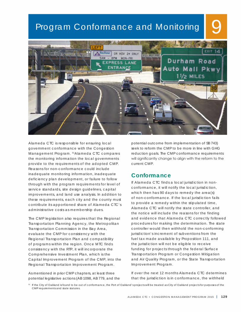
ALAMEDA CTC • CONGEST ION MANAGEMENT PROGRAM 2 015 | 129
Alameda CTC is responsible for ensuring local government conformance with the Congestion Management Program. 51Alameda CTC compares the monitoring information the local governments provide to the requirements of the adopted CMP. Reasons for non-conformance could include inadequate monitoring information, inadequate deficiency plan development, or failure to follow through with the program requirements for level of service standards, site design guidelines, capital improvements, and land use analysis. In addition to these requirements, each city and the county must contribute its apportioned share of Alameda CTC’s administrative costs as membership dues.
The CMP legislation also requires that the Regional Transportation Planning Agency, the Metropolitan Transportation Commission in the Bay Area, evaluate the CMP for consistency with the Regional Transportation Plan and compatibility of programs within the region. Once MTC finds consistency with the RTP, it will incorporate the Comprehensive Investment Plan, which is the Capital Improvement Program of the CMP, into the Regional Transportation Improvement Program.
As mentioned in prior CMP chapters, at least three potential legislative actions (AB 1098, AB 779, and the
potential outcome from implementation of SB 743) seek to reform the CMP to be more in line with GHG reduction goals. The CMP conformance requirements will significantly change to align with the reform to the current CMP.
ConformanceIf Alameda CTC finds a local jurisdiction in non-conformance, it will notify the local jurisdiction, which then has 90 days to remedy the area(s) of non-conformance. If the local jurisdiction fails to provide a remedy within the stipulated time, Alameda CTC will notify the state controller, and the notice will include the reasons for the finding and evidence that Alameda CTC correctly followed procedures for making the determination. The state controller would then withhold the non-conforming jurisdiction’s increment of subventions from the fuel tax made available by Proposition 111, and the jurisdiction will not be eligible to receive funding for projects through the federal Surface Transportation Program or Congestion Mitigation and Air Quality Program, or the State Transportation Improvement Program.
If over the next 12 months Alameda CTC determines that the jurisdiction is in conformance, the withheld
Program Conformance and Monitoring 9
51 If the City of Oakland is found to be out of conformance, the Port of Oakland’s projects will be treated as City of Oakland projects for purposes of the CMP requirements and state statutes.
Alameda CTC | Congestion Management Program
130 | ALAMEDA CTC • CONGEST ION MANAGEMENT PROGRAM 2 015
Proposition 111 funds will be released to the jurisdiction. If after the 12-month period the city or county has not conformed, the withheld Proposition 111 funds will be released to Alameda CTC for other projects of regional significance in Alameda County and included in the CMP or deficiency plans.
Alameda CTC is responsible for ensuring local government conformance with four elements of the CMP:
• LOS standards52
• Trip Reduction Program
• Land Use Analysis Program
• Payment of membership dues
Level of Service StandardsLocal governments are accountable for meeting LOS standards as described in Chapter 3, “Level of Service Monitoring.” If they do not meet the established LOS standards, they must develop a deficiency plan that describes how the jurisdiction will meet the adopted LOS standards at the deficient segment or intersection, and how it will achieve LOS and air quality improvements.53
Travel Demand Management ElementLocal jurisdictions must adopt site design guidelines as described in Chapter 5, “Travel Demand Management Element” to meet TDM requirements. The site design guidelines must enhance transit/pedestrian/bicycle access. Each jurisdiction must submit a complete Site Design Guidelines Checklist that meets the annual conformity timeline each year and specifies that they have adopted and are implementing such guidelines to encourage the use of alternative travel modes.
Further, they must undertake capital improvements that contribute to congestion management and emissions reduction. Each jurisdiction is required to participate in the Transportation Fund for Clean Air, Surface Transportation Program, Congestion Mitigation and Air Quality Program, and other funding programs and to submit projects that support bicycle, pedestrian, transit, or carpool use. Chapter 5 provides more detail. See Appendix H for the TDM Checklist.
Land Use Analysis ProgramAlameda CTC is required to develop a program that will analyze impacts and determine mitigation costs of land use decisions on the Regional Transportation System. Local governments are responsible for implementation of the program. The program approach is described in Chapter 6, “Land Use Analysis Program.”
Local jurisdictions are responsible for approving, denying, or altering projects and land-use decisions and are required to determine land-development impacts on the Metropolitan Transportation System and formulate appropriate mitigation measures commensurate with the magnitude of the expected impacts.
Capital Improvement ProgramAlameda CTC is required to prepare and biennially update a Capital Improvement Program (CIP) aimed at maintaining or improving transportation service levels as described in Chapter 8, “Capital Improvement Program.” Each city, the county, transit operators, and Caltrans provide input to these biennial updates.
MonitoringMonitoring provides feedback to determine whether the CMP’s objectives are being met. The CMP network performance and Priority Development Area (PDA) implementation data collected in the monitoring process can be used to verify and update either the CMP or the actions of the local governments to meet legislative requirements. Monitoring also provides information that can be used to:
• Update the countywide travel model and database;
• Develop and update land development approval database;
• Update the travel demand management measures, transit standards, and LOS standards;
• Determine whether a local government is required to develop a deficiency plan; and
52 California Government Code Section 65089.3.53 California Government Code Section 65089.3(d).
Chapter 9 | Program Conformance and Monitoring
ALAMEDA CTC • CONGEST ION MANAGEMENT PROGRAM 2 015 | 131
• Determine how well transportation investments are being coordinated with new developments and demands for access and mobility, and general congestion management.
Table 22 on the next page outlines the schedule and basic requirements for monitoring that each jurisdiction should undertake to document to Alameda CTC that the jurisdiction conforms to CMP requirements. Further action by Alameda CTC may be necessary to develop rules, procedures, and other data requirements for monitoring and conformance.
LOS StandardsAlameda CTC currently monitors LOS standards. If the cities, county, or Caltrans assume this responsibility, monitoring may be accomplished through a self-certification process involving the local jurisdictions and/or Caltrans and the Alameda CTC. In this event, the responsible agency will annually monitor the LOS on segments of the CMP network under its jurisdiction. Where a segment falls within two or more jurisdictions, the jurisdiction with the greatest segment mileage is responsible for monitoring the segment. Local jurisdic-tions that choose to conduct monitoring of LOS on CMP roadways must follow the process described below.
The jurisdiction must conduct p.m. peak period (4 p.m. to 6 p.m.) and a.m. peak period (7 a.m. to 9 a.m.) travel-speed sampling on a non-holiday Tuesday, Wednesday, or Thursday and analyze LOS based on that data consistent with the methods for determining LOS outlined in the Chapter 3, “Level of Service Standards.” Studies on the impact of proposed developments and commercially available data may supply some of the data (provided the sampling is done during the timeframes specified above), thereby reducing the need for data collection.
Performance Measures Although no statutory requirements regulate performance element monitoring, Alameda CTC prepares a transportation performance report annually. The report summarizes current performance data, highlights any significant changes in transportation
system performance, and provides broad analyses of the results and any implications for policy and investment decisions made by Alameda CTC.
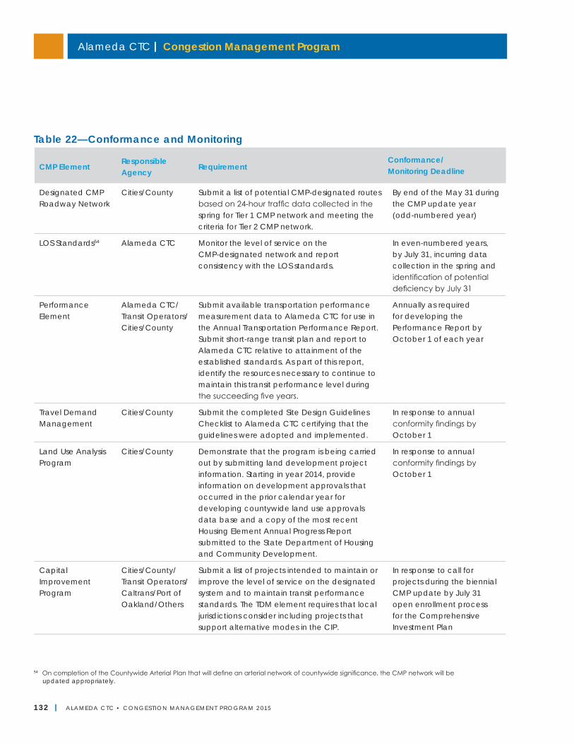
Alameda CTC | Congestion Management Program
132 | ALAMEDA CTC • CONGEST ION MANAGEMENT PROGRAM 2 015
54 On completion of the Countywide Arterial Plan that will define an arterial network of countywide significance, the CMP network will be updated appropriately.
Table 22—Conformance and Monitoring
CMP ElementResponsible Agency
RequirementConformance/ Monitoring Deadline
Designated CMP Roadway Network
Cities/County Submit a list of potential CMP-designated routes based on 24-hour traffic data collected in the spring for Tier 1 CMP network and meeting the criteria for Tier 2 CMP network.
By end of the May 31 during the CMP update year (odd-numbered year)
LOS Standards54 Alameda CTC Monitor the level of service on the CMP-designated network and report consistency with the LOS standards.
In even-numbered years, by July 31, incurring data collection in the spring and identification of potential deficiency by July 31
Performance Element
Alameda CTC/Transit Operators/Cities/County
Submit available transportation performance measurement data to Alameda CTC for use in the Annual Transportation Performance Report. Submit short-range transit plan and report to Alameda CTC relative to attainment of the established standards. As part of this report, identify the resources necessary to continue to maintain this transit performance level during the succeeding five years.
Annually as required for developing the Performance Report by October 1 of each year
Travel Demand Management
Cities/County Submit the completed Site Design Guidelines Checklist to Alameda CTC certifying that the guidelines were adopted and implemented.
In response to annual conformity findings by October 1
Land Use Analysis Program
Cities/County Demonstrate that the program is being carried out by submitting land development project information. Starting in year 2014, provide information on development approvals that occurred in the prior calendar year for developing countywide land use approvals data base and a copy of the most recent Housing Element Annual Progress Report submitted to the State Department of Housing and Community Development.
In response to annual conformity findings by October 1
Capital Improvement Program
Cities/County/Transit Operators/Caltrans/Port of Oakland/Others
Submit a list of projects intended to maintain or improve the level of service on the designated system and to maintain transit performance standards. The TDM element requires that local jurisdictions consider including projects that support alternative modes in the CIP.
In response to call for projects during the biennial CMP update by July 31 open enrollment process for the Comprehensive Investment Plan
Chapter 9 | Program Conformance and Monitoring
ALAMEDA CTC • CONGEST ION MANAGEMENT PROGRAM 2 015 | 133
Consistency with the Regional Transportation PlanSince both the MTC’s RTP and Alameda CTC’s CTP are currently being updated, the 2015 CMP was reviewed for consistency with the currently adopted plans, which are the Plan Bay Area adopted by MTC and ABAG in 2013 and the 2012 CTP adopted by Alameda CTC.
The CMP must be consistent with the RTP related to the following:
• Goals and objectives established in the RTP;
• System definition with adjoining counties;
• Federal and state air quality plans;
• MTC travel demand modeling database and methodologies; and
• RTP financial assumptions.
Plan Bay Area incorporates the land use and housing component, the Sustainable Communities Strategy, for the first time as required by SB 375. Plan Bay Area includes the following goals, of which “Climate Protection” and “Adequate Housing” are mandatory:
• Climate Protection
• Adequate Housing
• Healthy and Safe Communities
• Open Space and Agricultural Preservation
• Equitable Access
• Economic Vitality
• Transportation System Effectiveness
The 2012 Countywide Transportation Plan adopted by Alameda CTC was developed based on principles of Plan Bay Area with the intent to support the RTP by meeting the mandatory and voluntary goals.
Additional consistency requirements are identified in the appropriate chapters in the CMP:
• Chapter 2, “Designated CMP Roadway Network” demonstrates 2015 CMP conformance with the CMP/MTS network;
• Chapter 4, “Multimodal Performance Element” also addresses RTP goals with the increased number of multimodal performance measures;
• Chapter 5, “Travel Demand Management Element” identifies trip-reduction measures in the Air Quality Plan Transportation Control Measures;
• Chapter 6, “Land Use Analysis Program” acknowledges the Resolution 3434 Regional Transit Expansion Program and PDA Investment and Growth Strategy per OBAG requirements in Resolution 4035;
• Chapter 7, “Database and Travel Demand Model” discusses travel demand model consistency;
• Chapter 8, “Capital Improvement Program” identifies projects and programs in the BAAQMD's Air Quality Plans’ Transportation Control Measures as well as regional programming policies and principles; and
• Chapter 11, “Conclusions and Future Considerations” summarizes consistency requirements and the 2015 CMP’s compliance with them.
Next Steps• Based on the completion of the three countywide
plans (Multimodal Arterial Plan, Transit Plan, and Goods Movement Plan), any change in related conformance requirements will be updated in the 2017 CMP.
• Based on the legislative actions/decisions for the CMP reform, the conformity requirements will be modified for the 2017 CMP, as needed.
Alameda CTC | Congestion Management Program
134 | ALAMEDA CTC • CONGEST ION MANAGEMENT PROGRAM 2 015
Alameda CTC | Congestion Management Program
134 | ALAMEDA CTC • CONGEST ION MANAGEMENT PROGRAM 2 013
This page is intentionally left blank.
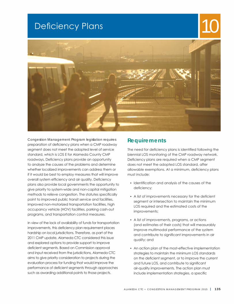
ALAMEDA CTC • CONGEST ION MANAGEMENT PROGRAM 2 015 | 135
Congestion Management Program legislation requires preparation of deficiency plans when a CMP roadway segment does not meet the adopted level of service standard, which is LOS E for Alameda County CMP roadways. Deficiency plans provide an opportunity to analyze the causes of the problems and determine whether localized improvements can address them or if it would be best to employ measures that will improve overall system efficiency and air quality. Deficiency plans also provide local governments the opportunity to give priority to system-wide and non-capital mitigation methods to relieve congestion. The statutes specifically point to improved public transit service and facilities, improved non-motorized transportation facilities, high occupancy vehicle (HOV) facilities, parking cash-out programs, and transportation control measures.
In view of the lack of availability of funds for transportation improvements, this deficiency plan requirement places hardship on local jurisdictions. Therefore, as part of the 2011 CMP update, Alameda CTC considered this issue and explored options to provide support to improve deficient segments. Based on Commission approval and input received from the jurisdictions, Alameda CTC aims to give priority consideration to projects during the evaluation process for funding that would improve the performance of deficient segments through approaches such as awarding additional points to those projects.
RequirementsThe need for deficiency plans is identified following the biennial LOS monitoring of the CMP roadway network. Deficiency plans are required when a CMP segment does not meet the adopted LOS standard, after allowable exemptions. At a minimum, deficiency plans must include:
• Identification and analysis of the causes of the deficiency;
• A list of improvements necessary for the deficient segment or intersection to maintain the minimum LOS required and the estimated costs of the improvements;
• A list of improvements, programs, or actions (and estimates of their costs) that will measurably improve multimodal performance of the system and contribute to significant improvements in air quality; and
• An action plan of the most-effective implementation strategies to maintain the minimum LOS standards on the deficient segment, or to improve the current and future LOS, and contribute to significant air-quality improvements. The action plan must include implementation strategies, a specific
Deficiency Plans 10
Alameda CTC | Congestion Management Program
136 | ALAMEDA CTC • CONGEST ION MANAGEMENT PROGRAM 2 015
implementation schedule, and a description of funding and implementation strategies. Special consideration for state or federal requirements must be taken into account when determining the feasibility of the action plan. Improvements funded through the CMP Capital Improvement Program, whether having local or system impact, must not degrade air quality.
Deficiency Plan TypesTwo types of deficiency plans can be developed, depending on the needs of the local jurisdiction(s) and how and whether the deficiency can be mitigated. If more than one local jurisdiction is responsible for causing a deficient segment, all responsible local jurisdictions must participate in development and approval of a multi-jurisdictional deficiency plan. Local jurisdictions outside Alameda County that contribute significantly to a deficiency plan will be invited to participate but cannot be compelled to do so.
Localized Deficiency PlanThis type of plan is appropriate for addressing transportation impacts to a single CMP segment or roadway identified as or anticipated to become deficient based on LOS monitoring. The Localized Deficiency Plan focuses on analyzing the cause of deficiency by including the immediate surrounding area as the project area and identifying the list of improvement or mitigation measures in the action plan.
Areawide Deficiency PlanThis type of plan is appropriate for addressing transportation impacts to more than one CMP roadway in a larger geographic area not able to be mitigated back to conformance within the CMP LOS standards if considered individually within a localized area. The Areawide Deficiency Plan focuses on offsetting the deficiency by including the broader surrounding area as the project area and identifying a list of improvements, programs, or actions to improve the performance of the larger multimodal network.
GuidelinesAs part of the 2013 CMP update, Alameda CTC updated the deficiency plan guidelines to include more details and procedures for developing Areawide Deficiency Plans. The guidelines, developed with input from the Alameda County Technical Advisory Committee, describe the approval process, timelines, and acceptable methodologies for jurisdictions to use in development and approval of deficiency plans. The updated guidelines are in Appendix D.
Conflict ResolutionCMP legislation requires each congestion management agency to establish a conflict-resolution process for addressing conflicts or disputes between local jurisdictions in meeting the multi-jurisdictional deficiency plan responsibilities.
The intent of Alameda CTC’s conflict-resolution process is to help local jurisdictions resolve conflicts that arise during multi-jurisdictional deficiency plan development or implementation that could impact the CMP conformance of one or more jurisdictions. The conflict resolution process is intended to be an effective and flexible process that responds to the issues and concerns of the respective jurisdictions.
Alameda CTC’s conflict resolution process is based on the following principles.
• First, consensus at the local level on the resolution of conflicts is encouraged through the Alameda County Technical Advisory Committee (ACTAC).
• Second, when the ACTAC is unable to reach consensus, Alameda CTC will look for evidence of “good faith” efforts among the parties involved when determining CMP conformance.
• Finally, any determination by Alameda CTC with respect to CMP conformance will not affect local agencies’ land use authority or require programs that conflict with a community’s fundamental socioeconomic or environmental character.
Chapter 10 | Deficiency Plans
ALAMEDA CTC • CONGEST ION MANAGEMENT PROGRAM 2 015 | 137
The conflict resolution process has the following four phases:
1. Process initiation: The lead jurisdiction requests Alameda CTC to initiate the conflict resolution process and outlines the issues needing resolution.
2. Assessment of issues: Alameda CTC staff meets with the parties involved to assess the issues in the dispute and its appropriateness for the conflict reso-lution process.
3. Settlement sessions and agreement: This phase involves holding/facilitating settlement sessions among the parties involved, facilitated by Alameda CTC staff (if appropriate), and the development of a settlement agreement, and obtaining all approvals that may be required from the governing bodies of the involved jurisdictions and/or Alameda CTC.
4. Implementation and monitoring: The final phase involves the implementation and monitoring of the agreement and Alameda CTC’s assessment of good faith effort by the parties involved.
The conflict-resolution process outlined here is a general process that can be adjusted to meet the respective needs of local jurisdictions and/or the specific situation including identifying another mutually agreed upon conflict resolution process. See Figure 15, which describes the multi-jurisdictional deficiency plan appeal process.
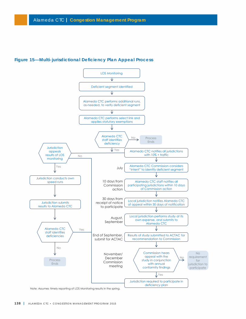
Alameda CTC | Congestion Management Program
138 | ALAMEDA CTC • CONGEST ION MANAGEMENT PROGRAM 2 015
Figure 15—Multi-jurisdictional Deficiency Plan Appeal Process
Chapter 10 | Deficiency Plans
ALAMEDA CTC • CONGEST ION MANAGEMENT PROGRAM 2 013 | 5
Figure 14—Multi-jurisdictional Deficiency Plan Appeal ProcessMultijurisdictional Deficiency Plan Appeal Process
Alameda CTC staff identifies
deficiency
Commission hears appeal with the
study in conjunction with annual
conformity findings
Alameda CTC staff identifies deficiencies
Note: Assumes timely reporting of LOS Monitoring results in the spring.
No
Yes
Process Ends
10 days from Commission
action
30 days from receipt of notice
to participate
August, September
End of September, submit for ACTAC
November/ December
Commission meeting
No
Yes
No requirement
for jurisdiction to participate
Jurisdiction appeals
results of LOS monitoring
Jurisdiction conducts own speed runs
Jurisdiction submits results to Alameda CTC
Alameda CTC notifies all jurisdictions with 10% + traffic
Alameda CTC Commission considers “intent” to identify deficient segment
Alameda CTC staff notifies all participating jurisdictions within 10 days
of Commission action
Local jurisdiction notifies Alameda CTC of appeal within 30 days of notification
Local jurisdiction performs study at its own expense, and submits to
Alameda CTC
Results of study submitted to ACTAC for recommendation to Commission
LOS Monitoring
Deficient segment identified
Alameda CTC performs additional runs, as-needed, to verify deficient segment
Alameda CTC performs select link and applies statutory exemptions
July
Jurisdiction required to participate in deficiency plan
No
Process Ends
Yes
No
Yes
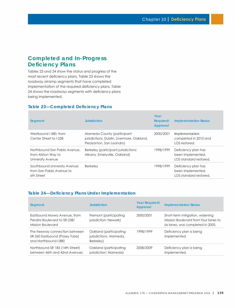
Chapter 10 | Deficiency Plans
ALAMEDA CTC • CONGEST ION MANAGEMENT PROGRAM 2 015 | 139
Completed and In-Progress Deficiency PlansTables 23 and 24 show the status and progress of the most recent deficiency plans. Table 23 shows the roadway orramp segments that have completed implementation of the required deficiency plans. Table 24 shows the roadways segments with deficiency plans being implemented.
Table 23—Completed Deficiency Plans
Segment JurisdictionYear Required/Approval
Implementation Status
Westbound I-580, from Center Street to I-238
Alameda County (participant jurisdictions: Dublin, Livermore, Oakland, Pleasanton, San Leandro)
2000/2001 Implementation completed in 2010 and LOS restored.
Northbound San Pablo Avenue, from Allston Way to University Avenue
Berkeley (participant jurisdictions: Albany, Emeryville, Oakland)
1998/1999 Deficiency plan has been implemented, LOS standard restored.
Southbound University Avenue, from San Pablo Avenue to 6th Street
Berkeley 1998/1999 Deficiency plan has been implemented, LOS standard restored.
Table 24—Deficiency Plans Under Implementation
Segment Jurisdiction Year Required/Approval Implementation Status
Eastbound Mowry Avenue, from Peralta Boulevard to SR-238/ Mission Boulevard
Fremont (participating jurisdiction: Newark)
2000/2001 Short-term mitigation, widening Mission Boulevard from four lanes to six lanes, was completed in 2005.
The freeway connection between SR-260 Eastbound (Posey Tube) and Northbound I-880
Oakland (participating jurisdictions: Alameda, Berkeley)
1998/1999 Deficiency plan is being implemented.
Northbound SR 185 (14th Street) between 46th and 42nd Avenues
Oakland (participating jurisdiction: Alameda)
2008/2009 Deficiency plan is being implemented.
Alameda CTC | Congestion Management Program
140 | ALAMEDA CTC • CONGEST ION MANAGEMENT PROGRAM 2 015
Future Deficiency PlansOther corridor plans or strategic plans developed by Alameda CTC can also inform future deficiency plans. When existing corridor or strategic plans are considered as a basis for developing a deficiency plan, appropri-ateness of the plan reflecting current conditions should be verified so that any improvement measure identified in the plan is still applicable. On completion of three modal plans (the Countywide Goods Movement Plan, Countywide Transit Plan, and Countywide Multimodal Arterial Plan), Alameda CTC may use them as a basis for future deficiency plans, including the San Pablo/ I-80 Corridor Plan described below.
San Pablo Avenue/I-80 Corridor PlanOn April 24, 1997, the San Pablo/I-80 Corridor Plan was recognized as a basis for future deficiency plans. It applies to the CMP network within the following sub-area of the San Pablo corridor study limits, including the freeway ramps and future University Avenue/I-80 HOV ramp: Alameda/Contra Costa County line (north); 14th Street to western boundary of Mandela Parkway, extending north to the eastern I-80 right-of-way (south); Martin Luther King Jr. Way/San Pablo Avenue, Marin, east side of San Pablo Avenue (east); and the eastern boundary of the I-80 right-of-way (west).
I-880 Strategic PlanOn January 20, 2000, the I-880 Strategic Plan was similarly recognized as a basis for a future deficiency plan. The plan applies to the CMP network within the study limits of the I-880 Cypress Freeway connection (north); SR-237 in Milpitas (south); I-580/SR-238 and I-680 (east); and the San Francisco Bay (west).
Local Government Responsibilities and ConformanceAlameda CTC is responsible for monitoring conformance of local jurisdictions with the adopted CMP55. Among these requirements, Alameda CTC must find compliance with the implementation of approved deficiency plans to maintain LOS standards on the CMP network. When a deficiency plan is adopted
and active, the lead jurisdiction must submit status reports on the implementation of the deficiency plan showing progress and concurrence from the participating jurisdictions to Alameda CTC annually as part of the annual conformity process. If after 90 days of the conformity timeline the local jurisdiction is still in non-conformance, Alameda CTC is required to follow the conformance process as identified in Chapter 9, “Program Conformance and Monitoring.” The detailed process for finding of non-conformance and the resulting withholding of Proposition 111 funds is described in Chapter 9.
Next Steps• Based on the legislative actions/decisions regarding
the CMP reform, the deficiency plan and related conformity requirements will be modified for the 2017 CMP, as appropriate.
• Alameda CTC will also explore recognizing the Countywide Goods Movement Plan, Countywide Transit Plan, and Countywide Multimodal Arterial Plan or components of those plans and any other plans once they are complete and adopted as a basis for potential future deficiency plans.
55 California Government Code Section 65089.3.
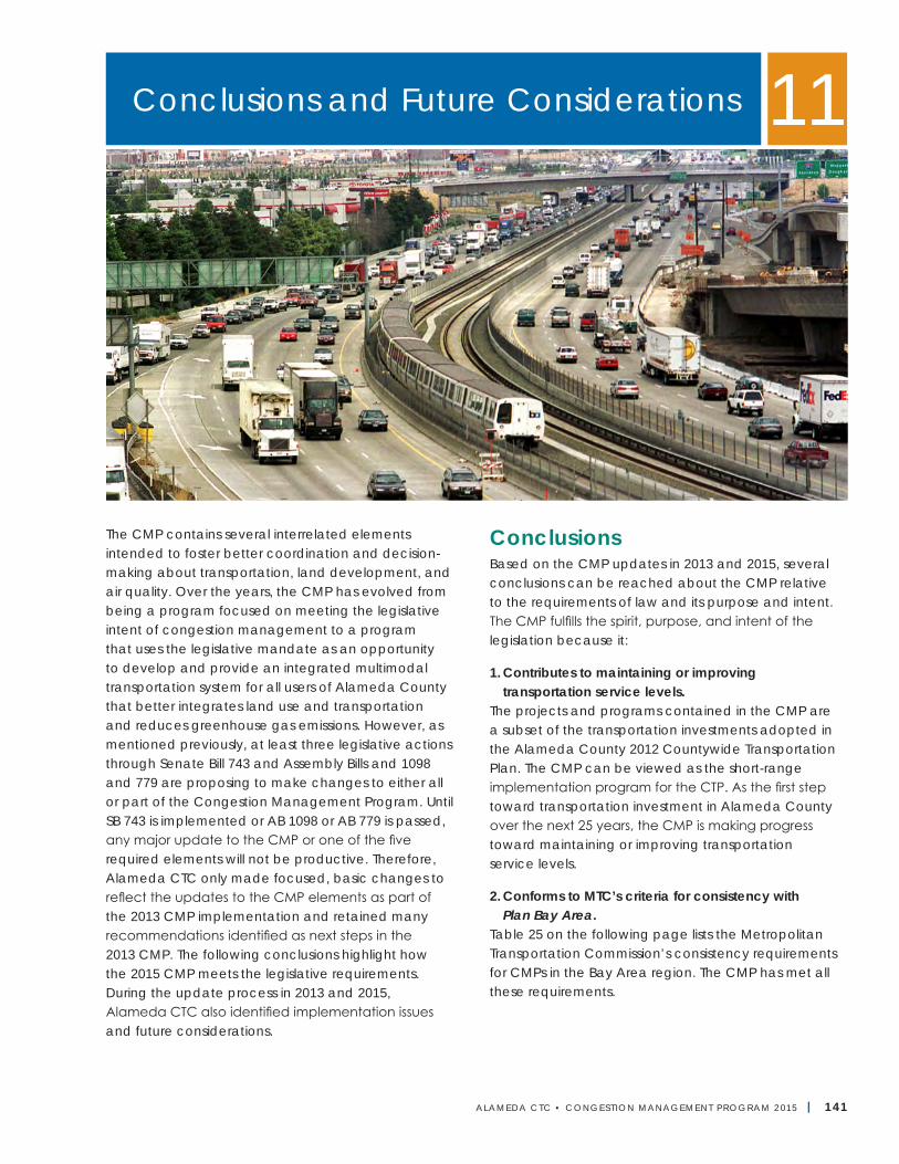
ALAMEDA CTC • CONGEST ION MANAGEMENT PROGRAM 2 015 | 141
The CMP contains several interrelated elements intended to foster better coordination and decision-making about transportation, land development, and air quality. Over the years, the CMP has evolved from being a program focused on meeting the legislative intent of congestion management to a program that uses the legislative mandate as an opportunity to develop and provide an integrated multimodal transportation system for all users of Alameda County that better integrates land use and transportation and reduces greenhouse gas emissions. However, as mentioned previously, at least three legislative actions through Senate Bill 743 and Assembly Bills and 1098 and 779 are proposing to make changes to either all or part of the Congestion Management Program. Until SB 743 is implemented or AB 1098 or AB 779 is passed, any major update to the CMP or one of the five required elements will not be productive. Therefore, Alameda CTC only made focused, basic changes to reflect the updates to the CMP elements as part of the 2013 CMP implementation and retained many recommendations identified as next steps in the 2013 CMP. The following conclusions highlight how the 2015 CMP meets the legislative requirements. During the update process in 2013 and 2015, Alameda CTC also identified implementation issues and future considerations.
ConclusionsBased on the CMP updates in 2013 and 2015, several conclusions can be reached about the CMP relative to the requirements of law and its purpose and intent. The CMP fulfills the spirit, purpose, and intent of the legislation because it:
1. Contributes to maintaining or improving transportation service levels.
The projects and programs contained in the CMP are a subset of the transportation investments adopted in the Alameda County 2012 Countywide Transportation Plan. The CMP can be viewed as the short-range implementation program for the CTP. As the first step toward transportation investment in Alameda County over the next 25 years, the CMP is making progress toward maintaining or improving transportation service levels.
2. Conforms to MTC’s criteria for consistency with Plan Bay Area.
Table 25 on the following page lists the Metropolitan Transportation Commission’s consistency requirements for CMPs in the Bay Area region. The CMP has met all these requirements.
Conclusions and Future Considerations 11
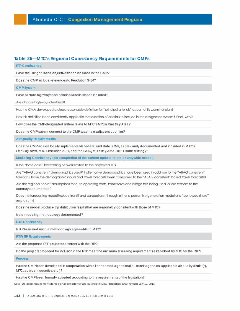
Alameda CTC | Congestion Management Program
142 | ALAMEDA CTC • CONGEST ION MANAGEMENT PROGRAM 2 015
Table 25—MTC's Regional Consistency Requirements for CMPsRTP Consistency
Have the RTP goals and objectives been included in the CMP?
Does the CMP include references to Resolution 3434?
CMP System
Have all state highways and principal arterials been included?
Are all state highways identified?
Has the CMA developed a clear, reasonable definition for “principal arterials” as part of its submittal plan?
Has this definition been consistently applied in the selection of arterials to include in the designated system? If not, why?
How does the CMP-designated system relate to MTC’s MTS in Plan Bay Area?
Does the CMP system connect to the CMP systems in adjacent counties?
Air Quality Requirements
Does the CMP include locally implementable federal and state TCMs, as previously documented and included in MTC’s Plan Bay Area, MTC Resolution 2131, and the BAAQMD’s Bay Area 2010 Ozone Strategy?
Modeling Consistency (on completion of the current update to the countywide model)
Is the “base case” forecasting network limited to the approved TIP?
Are “ABAG consistent” demographics used? If alternative demographics have been used in addition to the “ABAG consistent” forecasts, have the demographic inputs and travel forecasts been compared to the “ABAG consistent” based travel forecasts?
Are the regional “core” assumptions for auto operating costs, transit fares and bridge tolls being used, or are reasons to the contrary documented?
Does the forecasting model include transit and carpool use (through either a person trip generation model or a “borrowed share” approach)?
Does the model produce trip distribution results that are reasonably consistent with those of MTC?
Is the modeling methodology documented?
LOS Consistency
Is LOS assessed using a methodology agreeable to MTC?
RTIP/TIP Requirements
Are the proposed RTIP projects consistent with the RTP?
Do the projects proposed for inclusion in the RTIP meet the minimum screening requirements established by MTC for the RTIP?
Process
Has the CMP been developed in cooperation with all concerned agencies (i.e., transit agencies, applicable air quality district(s), MTC, adjacent counties, etc.)?
Has the CMP been formally adopted according to the requirements of the legislation?
Note: Detailed requirements for regional consistency are outlined in MTC Resolution 3000, revised July 12, 2013.
Chapter 11 | Conclusions and Future Considerations
ALAMEDA CTC • CONGEST ION MANAGEMENT PROGRAM 2 015 | 143
3. Provides a travel model consistent with MTC’s regional model.
The Alameda Countywide Travel Demand Model was updated to include the land uses and projects and programs in Plan Bay Area adopted by MTC in July 2013. This update ensures that the countywide model meets the MTC regional modeling consistency requirements. MTC approved the model conformance.
4. Is consistent with MTC’s adopted Transportation Control Measures.
The transportation control measures in the Regional Transportation Plan for the Bay Area based on the federal and state air quality plans are shown in Appendix I. The CMP includes many project types and programs identified in the plan. Alameda CTC will continue to work with the Bay Area Air Quality Management District and project sponsors to define appropriate responsibility and timely implementation of these measures.
5.Specifiesamethodforestimatingroadwaylevelofservice consistent with state law.
Two approaches are permitted by the law for assessing LOS. The Alameda County CMP specifies using the 1985 Highway Capacity Manual (HCM1985) for LOS monitoring and conformity purposes and the HCM2000 for the Land Use Analysis Program. As part of the 2013 CMP update, Alameda CTC performed a comparative analysis of use of HCM1985 and HCM2000 to use of the most recent HCM2010. Based on the evaluation, as reported in the “Level of Service Standards” and “Land Use Analysis Program” chapters, a speed-based LOS measure as used in the HCM1985 will continue to be applied for LOS monitoring and conformity purposes. This approach is recommended to avoid loss of ability to track trends and for deficiency plan implementation. Use of HCM2010 will be encouraged in the CMP Land Use Analysis Program transportation impact analyses as specified in the MTC CMP guidance, but flexibility to use HCM2000 will be permitted if deemed necessary by local jurisdictions or project sponsors.
6.IdentifiescandidateprojectsfortheRTIPandfederalTIP that meet MTC’s minimum requirements.
The Regional Transportation Improvement Program and federal Transportation Improvement Program candidates listed in the CMP’s Capital Improvement Program have been evaluated, and all candidate projects conform to MTC’s screening criteria for the respective projects and programs.
7.Wasdevelopedincooperationwithjurisdictionsandother interested parties.
The 2015 CMP update process included working with interested parties through meetings and regular mailings for the Alameda County Technical Advisory Committee; the Planning, Policy and Legislation Committee; and Alameda CTC Commission meetings, as well as notifications on the Alameda CTC website. The mailing lists included technical representatives of all cities in Alameda County, the County of Alameda, transit operators, the Port of Oakland, ABAG, BAAQMD, Caltrans, and MTC. In addition, any future additions to the designated CMP network will be coordinated with adjacent counties within the MTC region and are expected to be consistent with those CMPs.
8. Provides a forward-looking approach to the impactof local land use decisions on transportation.
The Land Use Analysis Program allows consultation with Alameda CTC early in the land development process. Early input will help ensure a better linkage between land use decisions and transportation investment. The 2015 CMP update retained the expanded discussion of Alameda CTC’s activities identified during the 2013 update to fulfill the legislative requirements of Senate Bill 375 and Assembly Bill 32 to better integrate transportation and land use and to reduce greenhouse gas emissions by curtailing VMT. Several enhancements were made to the Land Use Analysis Program in this context to meet these objectives including:
• Incorporated the recommendations of the Alameda County Priority Development Area Investment and Growth Strategy;
Alameda CTC | Congestion Management Program
144 | ALAMEDA CTC • CONGEST ION MANAGEMENT PROGRAM 2 015
• Established a development approvals database that will be populated using information provided by local jurisdictions as part of the annual conformity process starting in 2014;
• Modified the agency’s guidelines for environmental review by identifying standards to evaluate impacts on auto and alternative modes; and
• Identified an alternative trip generation methodology for use in transportation impact analyses to support in-fill development.
9.Considersthebenefitofgreenhousegasreductionsindeveloping the CIP.
The CMP considers the benefits of greenhouse gas reductions in the Land Use Analysis Program and in developing the CIP. The 2015 CMP continues to include the Alameda County Priority Development Area Investment and Growth Strategy recommendations and options for alternative trip-generation rates to promote infill development in the Land Use Analysis Program that will help support the reduction of VMT and greenhouse gas emissions. Similarly the most recent long-range plan, the 2012 CTP, with which the CIP projects and programs are consistent, was developed for the first time to meet the county’s share of greenhouse gas reduction targets for the region and better integrate transportation and land use through development of a closely coordinated land use component for the plan.
Implementation IssuesDuring the development and update of the 2015 CMP for Alameda County, several long-standing issues continue to need further action by Alameda CTC. Some of these issues may also require action by the legislature.
1. Cost exceeds fundingAlameda CTC has identified the cost of maintaining or improving transportation service levels over the 25-year period as part of the 2012 CTP to exceed $30 billion. This cost is large and well beyond existing and anticipated funding sources, which the 2012 CTP projects to be
$9.5 billion. Further statewide attention to transportation funding is necessary, if the CMP law is to achieve its intended goal.
With the passage of the federal Intermodal Surface Transportation Efficiency Act of 1991, the Transportation Efficiency Act in 1997, the Safe, Accountable, Flexible, Efficient Transportation Equity Act: A Legacy for Users in 2005; and Moving Ahead for Progress in the 21st Century Act, new requirements have been placed on MTC relative to congestion management. MTC is passing funds through to the CMAs in the San Francisco Bay Area region to assist in implementing the federal acts related to transportation funding. These funds, however, do not fully cover Alameda CTC’s congestion management administration costs.
2. Limited CMA authorityIt is difficult for Alameda CTC to fulfill the intent of the CMP legislation, because so many programs are beyond its authority. Funding programs, such as transit operating funds, most transit capital funding, the interregional road program, the highway rehabilitation program, and the toll-bridge program are outside the scope of the CMP. Caltrans administers the interregional road program and highway rehabilitation program.
3. LOS responsibilityCMP law indicates that Caltrans is responsible for monitoring LOS standards on the state highway system, if the CMA designates responsibility to Caltrans.56 As state-owned facilities, it is reasonable to assume that the state is responsible. However, Alameda CTC will continue to perform monitoring activities until Caltrans establishes a monitoring program that can provide data to ensure consistent LOS results on Alameda County state highways.
The CMP law also recognizes that responsibility for sustaining LOS standards on local roadways and the state highway system should be shared between the local governments where other local jurisdictions contribute a significant percentage of traffic to the roadway. This change in state law recognizes that other jurisdictions may be partially responsible for the
56 Katz, Statutes of 1995.
Chapter 11 | Conclusions and Future Considerations
ALAMEDA CTC • CONGEST ION MANAGEMENT PROGRAM 2 015 | 145
roadway exceeding the standards and that local government has little authority over the state highway system. Some exemptions, such as interregional trips, have been built into the current law, but these exemptions do not sufficiently address the problem. Corridor-level planning may offer a reasonable approach to this multi-jurisdictional problem and has been used successfully in the past to identify deficiencies and strategies to improve them. In this context, the 2015 CMP continues to recommend that corridor management strategies be explored as part of the Countywide Goods Movement Plan, Countywide Transit Plan, and Multimodal Arterial Corridor Plan, all of which are underway.
4. Scope of the CMP networkThe CMP network is reviewed every four years; the next review is scheduled for 2017. However, state law does not provide incentives to local jurisdictions to add roadways to the CMP network. In fact, there are significant disincentives to add roadways that may in the future deteriorate to LOS F. In these cases, jurisdictions would be required to prepare a deficiency plan or risk losing Proposition 111 gas tax funds. Alameda CTC addressed this issue by adding a network that will be monitored only for informational purposes and not for conformity. In 2011, 90 miles of arterial roadways across the county were added to the CMP network, which will be monitored for informational purposes.
5. Transportation revenue shortfallsState and federal transportation funding continues to be inadequate to address both capital and transit operating costs. The shortfalls may jeopardize the ability to maintain and improve transportation LOS. Worsening traffic congestion on the CMP network will trigger requirements for local jurisdictions to prepare and adopt deficiency plans or risk losing Proposition 111 gas tax funds for local projects. This will be compounded by the requirements to implement SB 375, Redesigning Communities to Reduce Greenhouse Gases, which is currently an unfunded mandate.
Future ConsiderationsThe 2015 CMP update provides recommendations for next steps in addressing issues related to new and existing legislative requirements, monitoring standards, and other efforts related to congestion management and better integrating transportation and land use. The following highlight key areas identified for follow-up (see individual chapters for detailed next steps):
1. Legislative efforts for CMP reformAs discussed earlier, three legislative efforts underway will impact the scope of the Congestion Management Program partly or fully. SB 743 was signed into law in 2013 and will modify the metric used to measure the land development impacts on transportation system in the CEQA process from a delay-based metric such as LOS to another metric such as VMT. Alameda CTC has been actively participating in this process by leading the Bay Area Working Group. More details on SB 743 are included as follows. AB 1098 and AB 779 are two-year bills that aim to fully revise CMP legislation and, therefore, revamp the program scope to be more current and in line with supporting the environment, particularly GHG reduction. In this regard, Alameda CTC is actively working with other CMAs in the region and regional partners to be proactive and inform the development of the bills, so that the resulting CMP is more meaningful while supporting environmental goals at all levels of government. Based on the legislative outcomes, Alameda CTC’s CMP will be modified to align with the new legislative requirements while continuing to be a forward-looking program.
2. CMP roadway network Tier 1 and Tier 2 additionsNo new roadways were proposed in the 2015 CMP update. The next update to the CMP network will occur in 2017. Jurisdictions will review their roadway systems for routes that may meet the criteria for inclusion as roadways in the Tier 1 and Tier 2 CMP network. For potential routes, each jurisdiction will conduct 24-hour traffic counts for a period including a Tuesday through Thursday of a typical week. Traffic counts should be taken around the first week of spring 2017. To be in compliance with the CMP, each jurisdiction must
Alameda CTC | Congestion Management Program
146 | ALAMEDA CTC • CONGEST ION MANAGEMENT PROGRAM 2 015
submit potential CMP-designated routes to the CMA by June 30, 2017. In addition, based on the final outcome of three countywide modal plans, Alameda CTC will identify potential new routes for the CMP network, likely for Tier 2, as part of the 2017 CMP update.
3. Congestion-pricing strategiesCongestion-pricing strategies are considered one of the tools to manage congestion along the most congested corridors. The revenue collected from congestion pricing is invested back into the corridor to improve transit. Alameda CTC implemented the first express lane in the Bay Area on southbound I-680, which opened to traffic in fall 2010. Express lane work on northbound I-680 is in the design stage. Legislation that approved the I-680 Express Lane also approved a second express lane along the I-580 corridor in East County. Both express lanes in the eastbound and westbound directions are currently under construction and are expected to be open to traffic in winter 2015/2016. Currently, MTC is implementing a Bay Area Express Lane network of 550 miles across the region, first converting the existing HOV lanes and later expanding lanes to close gaps in the carpool network. This will add about 90 additional miles to the express lane network in Alameda County along the I-80, I-680, and I-880 corridors and on the Bay Bridge, San Mateo Bridge, and Dumbarton Bridge. Phase 1, the conversion of existing carpool lanes into express lanes on the Regional Express Lane Network, is scheduled to be operational in 2017.
Other pricing strategies include:
• Off-peak transit fare discounts;
• Parking ticket surcharges by the Alameda County jurisdictions, with revenues devoted to transit; and
• Parking pricing in Berkeley.
4.SenateBill743(SB743),CEQAreform,andinfilldevelopment areas
SB 743, passed in September 2013, institutes key changes to the CMP statute that will support infill development, including lifting the sunset date on designating Infill Opportunity Zones and directing
the governor’s Office of Planning and Research (OPR) to develop new metrics for assessment of transportation impacts to replace vehicle delay-based measures such as LOS. SB 743 also directs OPR to revise California Environmental Quality Act guidelines to eliminate automobile LOS as a significant impact on the environment and to develop new criteria for determining the significance of transportation impacts in transit priority areas that use metrics such as automobile trips generated or VMT per capita. Alameda CTC has been actively working with OPR to inform the process for the last two years, in collaboration with the local jurisdictions and regional agencies, by leading the Bay Area Working Group. While the alternative metric has been identified as VMT, OPR is still in the process of developing the legislative language and finalizing the guidelines on how to apply the metric. An updated guidelines draft is anticipated in the winter of 2015 for public review, which will be followed by a rule-making process.
As part of the 2013 CMP update, Alameda CTC implemented several short- and long-term strategies to promote infill development, prior to the enactment of SB 743. They include approved alternative trip generation methodologies for traffic impact analysis to support infill developments, focused guidance on CMP impact assessment and monitoring for alternative modes, and adopting areawide deficiency plan procedures for developing a multimodal improvement plan over a larger area where localized improvements are not feasible (for more details, see Chapter 6, “Land Use Analysis Program”). Monitoring implementation of these measures will continue.
5. Improving the land use and transportation connection in Alameda County and implementing SB 375
Since the adoption of the 2011 CMP, Alameda CTC has completed several major planning efforts to better integrate transportation and land use and to implement SB 375 to achieve reduced VMT and greenhouse gas emission reductions. The 2012 CTP was one such major effort developed in close coordination with the regional and local agencies and included a land use
Chapter 11 | Conclusions and Future Considerations
ALAMEDA CTC • CONGEST ION MANAGEMENT PROGRAM 2 015 | 147
component for the first time to contribute to the county’s share of regional greenhouse gas reduction targets. The adopted Alameda County Priority Development Area Investment and Growth Strategy outlines a preliminary PDA monitoring plan developed both to fulfill MTC and ABAG requirements and is a step toward implementing the land use and sustainability goals of the 2012 CTP. In May 2015, Alameda CTC updated its PDA Investment and Growth Strategy, which incorporates the latest information on housing production across income levels and progress toward meeting RHNA targets.
Alameda CTC also has been providing enhanced information sharing/support for the local jurisdictions in implementing the complete streets policy.
The 2015 CMP update includes the outcome of the expanded review of Alameda CTC’s activities as part of the 2013 CMP update to fulfill the legislative requirements of SB 375 to better integrate transportation investment and land use, and made the following key enhancements to the Land Use Analysis Program to meet these objectives:
• Implement the Alameda County Priority Development Area Investment and Growth Strategy.
• Identify ways to address rural roadway improvement needs and efforts that support Priority Conservation Area goals.
• Develop a land use development database based on annual land development approvals data from the jurisdictions to track land development approvals from local jurisdictions for use in various planning efforts, and to analyze how and whether the land development and transportation investments are coordinated.
• Track local jurisdiction housing element progress by local jurisdictions providing Alameda CTC a copy of the most recent Housing Element Annual Program Report submitted to the State Department of Housing and Community Development.
• Develop a comprehensive program, similar to VTA’s Community Design and Transportation Program that promotes better integration of land
use development and transportation in Alameda County and is supported by financial incentives. Such a program could be developed in partnership with the member agencies and communities and endorsed by their elected bodies. As a next step, Alameda CTC will identify interest from local jurisdictions and transit operators for implementing a similar program in Alameda County and develop a scope of work that details the steps involved, including costs of developing and implementing the program.
• Explore and review parking policies and standards as a way to develop parking management strategies as a land use tool for local jurisdictions to promote alternative modes and reduce greenhouse gases. Parking for automobiles is a significant but under-recognized factor in the relationship between land use and transportation.
6. Mitigating impacts on cross-county corridors or long corridorstraversingjurisdictions
Currently, the CMP Land Use Analysis Program does not have a mechanism in place for “fair share” contributions for projects that would impact long travel or cross-county corridors that traverse several Alameda County jurisdictions. Since improvement measures to mitigate the cumulative impact will be too expensive for one agency or jurisdictions, Alameda CTC continues to carry forward the following recommendations.
• For congested cross-county corridors, explore developing partnerships for sharing the cost of implementing related mitigation measures. Also, for long-term corridor improvements in such corridors, explore establishing cross-county partnerships to develop mutually agreeable strategies for improvements. A first step in this direction is consideration of a county line development study.
• For projects that may impact long travel corridors that traverse multiple jurisdictions within the county, explore establishing a means for the project to contribute their fair share of required mitigation measures.
Alameda CTC | Congestion Management Program
148 | ALAMEDA CTC • CONGEST ION MANAGEMENT PROGRAM 2 015
7. LOS standards and HCM for assessing performance of auto and alternative modes
During the 2013 CMP update, Alameda CTC evaluated the application of HCM2010 to monitor LOS for auto and other modes, specifically transit, bicycling, and walking. Results for auto LOS monitoring showed that the HCM2010 methodology’s shift from measuring speed to measuring density to assign auto LOS would result in the loss of Alameda CTC’s ability to track network performance trends and conformity, particularly for the Tier 1 network that is subject to conformity. Therefore, speed-based HCM1985 will continue to be used for auto LOS monitoring for the Tier 1 network. For Tier 2 arterials not subject to conformity, both the HCM1985 and HCM2000 were applied in 2014, when the LOS monitoring was performed, and this will continue for future monitoring cycles.
Evaluation results for LOS monitoring of alternative modes showed that HCM2010 Multi Modal LOS (MMLOS) is not well-designed for annual monitoring application, as it is data-intensive and costly to implement. For assessing performance of alternative modes, countywide modal studies will be used to identify countywide facilities and metrics for monitoring alternative modes, and will be incorporated in the 2017 CMP for future LOS monitoring efforts.
For application of HCM2010 in the Land Use Analysis Program, using HCM2010 to perform the impact analysis for autos was found to be consistent with the current data requirements; therefore, use of HCM2010 is encouraged per regional direction, but flexibility to use HCM2000 is permitted where consistency is needed by local jurisdictions. Evaluation results for LOS monitoring of alternative modes showed that HCM2010 MMLOS is suitable to identify multimodal trade-offs in mitigation measures, and use of HCM2010 is encouraged.
8.Reviewofperformancemeasuresandidentificationof monitoring periods and related measures aligned with data availability
The performance measures identified in the multimodal
performance element are based on measures established in a variety of plans and documents including the Countywide Transportation Plan, Countywide Bicycle and Pedestrian Plans, and the CMP document. The Bicycle and Pedestrian Counts Report includes several additional measures, and “existing conditions” analyses were performed for the CTP.
Therefore, as part of the 2015 CMP update, Alameda CTC re-evaluated and consolidated the performance measures and monitoring reports. On completion of the three modal plans, which will produce additional performance measures, the 2017 CMP update will review and identify multimodal performance measures and timelines for reporting those measures. This comprehensive re-evaluation will ensure that the timeline for reporting on different measures is realistically aligned with data availability and potential changes in the measures. In addition, it will ensure that the various monitoring documents are complementary and non-duplicative. This will allow Alameda CTC to tailor its multimodal performance measures to project evaluation needs and inform programming decisions, as outlined in the Comprehensive Investment Plan.
9.FundingpriorityfordeficientsegmentsBased on the biennial LOS Monitoring Study, if any of the CMP roadway segment fails to meet the required minimum LOS standard of E and is declared deficient, a localized or areawide deficiency plan is required that identifies mitigation measures including funding to improve the performance of that segment or study area. Given the lack of availability of funds for transportation improvements, this requirement places a hardship on local jurisdictions. The 2011 CMP provided direction to develop a policy for giving funding priority to the CMP segments declared deficient based on LOS monitoring results.
The evaluation process for determining funding priority should consider projects and programs that would improve the performance of deficient segments/areas through approaches such as awarding additional
Chapter 11 | Conclusions and Future Considerations
ALAMEDA CTC • CONGEST ION MANAGEMENT PROGRAM 2 015 | 149
points to those projects. The ongoing development of the CIP for Alameda County is expected to address this issue and determine an approach to provide additional consideration to projects that would improve the performance of existing and future deficient segments/areas.
Alameda CTC | Congestion Management Program
150 | ALAMEDA CTC • CONGEST ION MANAGEMENT PROGRAM 2 015
This page is intentionally left blank.
ALAMEDA CTC • CONGEST ION MANAGEMENT PROGRAM 2 015 | A - 1
Appendix A
Government Code Section 65088─65089.1065088.The Legislature finds and declares all of the following:
(a) Although California's economy is critically dependent upon transportation, its current transporta-tion system relies primarily upon a street and highway system designed to accommodate far fewer vehicles than are currently using the system.
(b) California's transportation system is characterized by fragmented planning, both among jurisdictions involved and among the means of available transport.
(c) The lack of an integrated system and the increase in the number of vehicles are causing traffic congestion that each day results in 400,000 hours lost in traffic, 200 tons of pollutants released into the air we breathe, and three million one hundred thousand dollars ($3,100,000) added costs to the motoring public.
(d) To keep California moving, all methods and means of transport between major destinations must be coordinated to connect our vital economic and population centers.
(e) In order to develop the California economy to its full potential, it is intended that federal, state, and local agencies join with transit districts, business, private and environmental interests to develop and implement comprehensive strategies needed to develop appropriate responses to transportation needs.
(f) In addition to solving California's traffic congestion crisis, rebuilding California's cities and suburbs, particularly with affordable housing and more walkable neighborhoods, is an important part of accom-modating future increases in the state's population because homeownership is only now available to most Californians who are on the fringes of metropolitan areas and far from employment centers.
(g) The Legislature intends to do everything within its power to remove regulatory barriers around the development of infill housing, transit-oriented development, and mixed use commercial
development in order to reduce regional traffic congestion and provide more housing choices for all Californians.
(h) The removal of regulatory barriers to promote infill housing, transit-oriented development, or mixed use commercial development does not preclude a city or county from holding a public hearing nor finding that an individual infill project would be adversely impacted by the surrounding environment or transportation patterns.
65088.1.As used in this chapter the following terms have the following meanings:
(a) Unless the context requires otherwise, “regional agency” means the agency responsible for preparation of the regional transportation improvement program.
(b) Unless the context requires otherwise, “agency” means the agency responsible for the preparation and adoption of the congestion management program.
(c) “Commission” means the California Transportation Commission.
(d) “Department” means the Department of Transportation.
(e) “Local jurisdiction” means a city, a county, or a city and county.
(f) “Parking cash-out program” means an employer-funded program under which an employer offers to provide a cash allowance to an employee equivalent to the parking subsidy that the employer would otherwise pay to provide the employee with a parking space. “Parking subsidy” means the difference between the out-of-pocket amount paid by an employer on a regular basis in order to secure the availability of an employee parking space not owned by the employer and the price, if any, charged to an employee for use of that space.
A parking cash-out program may include a requirement that employee participants certify that
Congestion Management Program Legislation
A - 2 | ALAMEDA CTC • CONGEST ION MANAGEMENT PROGRAM 2 015
Alameda CTC | Congestion Management Program
they will comply with guidelines established by the employer designed to avoid neighborhood parking problems, with a provision that employees not complying with the guidelines will no longer be eligible for the parking cash-out program.
(g) “Infill opportunity zone” means a specific area designated by a city or county, pursuant to subdivision (c) of Section 65088.4, zoned for new compact residential or mixed use development within one-third mile of a site with an existing or future rail transit station, a ferry terminal served by either a bus or rail transit service, an intersection of at least two major bus routes, or within 300 feet of a bus rapid transit corridor, in counties with a population over 400,000. The mixed use development zoning shall consist of three or more land uses that facilitate significant human interaction in close proximity, with residential use as the primary land use supported by other land uses such as office, hotel, health care, hospital, entertainment, restaurant, retail, and service uses. The transit service shall have maximum scheduled headways of 15 minutes for at least 5 hours per day. A qualifying future rail station shall have broken ground on construction of the station and programmed operational funds to provide maximum scheduled headways of 15 minutes for at least 5 hours per day.
(h) “Interregional travel” means any trips that originate outside the boundary of the agency. A “trip” means a one-direction vehicle movement. The origin of any trip is the starting point of that trip. A roundtrip consists of two individual trips.
(i) “Level of service standard” is a threshold that defines a deficiency on the congestion management program highway and roadway system which requires the preparation of a deficiency plan. It is the intent of the Legislature that the agency shall use all elements of the program to implement strategies and actions that avoid the creation of deficiencies and to improve multimodal mobility.
(j) “Multimodal” means the utilization of all available modes of travel that enhance the movement
of people and goods, including, but not limited to, highway, transit, nonmotorized, and demand management strategies including, but not limited to, telecommuting. The availability and practicality of specific multimodal systems, projects, and strategies may vary by county and region in accordance with the size and complexity of different urbanized areas.
(k) “Performance measure” is an analytical planning tool that is used to quantitatively evaluate transporta-tion improvements and to assist in determining effective implementation actions, considering all modes and strategies. Use of a performance measure as part of the program does not trigger the requirement for the preparation of deficiency plans.
(l) “Urbanized area” has the same meaning as is defined in the 1990 federal census for urbanized areas of more than 50,000 population.
(m) “Bus rapid transit corridor” means a bus service that includes at least four of the following attributes:
(1) Coordination with land use planning.
(2) Exclusive right-of-way.
(3) Improved passenger boarding facilities.
(4) Limited stops.
(5) Passenger boarding at the same height as the bus.
(6) Prepaid fares.
(7) Real-time passenger information.
(8) Traffic priority at intersections.
(9) Signal priority.
(10) Unique vehicles.
65088.3.This chapter does not apply in a county in which a majority of local governments, collectively comprised of the city councils and the county board of supervisors, which in total also represent a
Appendix A | Congestion Management Program Legislation
ALAMEDA CTC • CONGEST ION MANAGEMENT PROGRAM 2 015 | A - 3
majority of the population in the county, each adopt resolutions electing to be exempt from the congestion management program.
65088.4. (a) It is the intent of the Legislature to balance the need for level of service standards for traffic with the need to build infill housing and mixed use commercial developments within walking distance of mass transit facilities, downtowns, and town centers and to provide greater flexibility to local governments to balance these sometimes competing needs.
(b) Notwithstanding any other provision of law, level of service standards described in Section 65089 shall not apply to the streets and highways within an infill opportunity zone. The city or county shall do either of the following:
(1) Include these streets and highways under an alternative areawide level of service standard or multimodal composite or personal level of service standard that takes into account both of the following:
(A) The broader benefits of regional traffic congestion reduction by siting new residential development within walking distance of, and no more than one-third mile from, mass transit stations, shops, and services, in a manner that reduces the need for long vehicle commutes and improves the jobs-housing balance.
(B) Increased use of alternative transportation modes, such as mass transit, bicycling, and walking.
(2) Approve a list of flexible level of service mitigation options that includes roadway expansion and investments in alternate modes of transportation that may include, but are not limited to, transit infrastructure, pedestrian infrastructure, and ridesharing, vanpool, or shuttle programs.
(c) The city or county may designate an infill opportunity zone by adopting a resolution after determining that the infill opportunity zone is consistent with the general plan and any applicable specific plan. A city or county may not designate an infill opportunity zone after December 31, 2009.
(d) The city or county in which the infill opportunity zone is located shall ensure that a development project shall be completed within the infill opportunity zone not more than four years after the date on which the city or county adopted its resolution pursuant to subdivision (c). If no development project is completed within an infill opportunity zone by the time limit imposed by this subdivision, the infill opportunity zone shall automati-cally terminate.
65088.5.Congestion management programs, if prepared by county transportation commissions and trans-portation authorities created pursuant to Division 12 (commencing with Section 130000) of the Public Utilities Code, shall be used by the regional transportation planning agency to meet federal requirements for a congestion management system, and shall be incorporated into the congestion management system.
65089. (a) A congestion management program shall be developed, adopted, and updated biennially, consistent with the schedule for adopting and updating the regional transportation improvement program, for every county that includes an urbanized area, and shall include every city and the county. The program shall be adopted at a noticed public hearing of the agency. The program shall be developed in consultation with, and with the cooperation of, the transportation planning agency, regional transporta-tion providers, local governments, the department, and the air pollution control district or the air quality management district, either by the county transporta-tion commission, or by another public agency, as designated by resolutions adopted by the county board of supervisors and the city councils of a majority of the cities representing a majority of the population in the incorporated area of the county.
(b) The program shall contain all of the following elements:
(1) (A) Traffic level of service standards established for a system of highways and roadways designated by the agency. The highway and roadway system shall
Alameda CTC | Congestion Management Program
A - 4 | ALAMEDA CTC • CONGEST ION MANAGEMENT PROGRAM 2 015
include at a minimum all state highways and principal arterials. No highway or roadway designated as a part of the system shall be removed from the system. All new state highways and principal arterials shall be designated as part of the system, except when it is within an infill opportunity zone. Level of service (LOS) shall be measured by Circular 212, by the most recent version of the Highway Capacity Manual, or by a uniform methodology adopted by the agency that is consistent with the Highway Capacity Manual. The determination as to whether an alternative method is consistent with the Highway Capacity Manual shall be made by the regional agency, except that the department instead shall make this determination if either (i) the regional agency is also the agency, as those terms are defined in Section 65088.1, or (ii) the department is responsible for preparing the regional transportation improvement plan for the county.
(B) In no case shall the LOS standards established be below the level of service E or the current level, whichever is farthest from level of service A except when the area is in an infill opportunity zone. When the level of service on a segment or at an intersection fails to attain the established level of service standard outside an infill opportunity zone, a deficiency plan shall be adopted pursuant to Section 65089.4.
(2) A performance element that includes performance measures to evaluate current and future multimodal system performance for the movement of people and goods. At a minimum, these performance measures shall incorporate highway and roadway system performance, and measures established for the frequency and routing of public transit, and for the coordination of transit service provided by separate operators. These performance measures shall support mobility, air quality, land use, and economic objectives, and shall be used in the development of the capital improvement program required pursuant to paragraph (5), deficiency plans required pursuant to Section 65089.4, and the land use analysis program required pursuant to paragraph (4).
(3) A travel demand element that promotes alternative transportation methods, including, but not limited to, carpools, vanpools, transit, bicycles, and park-and-ride lots; improvements in the balance between jobs and housing; and other strategies, including, but not limited to, flexible work hours, telecommuting, and parking management programs. The agency shall consider parking cash-out programs during the development and update of the travel demand element.
(4) A program to analyze the impacts of land use decisions made by local jurisdictions on regional transportation systems, including an estimate of the costs associated with mitigating those impacts. This program shall measure, to the extent possible, the impact to the transportation system using the performance measures described in paragraph (2). In no case shall the program include an estimate of the costs of mitigating the impacts of interregional travel. The program shall provide credit for local public and private contributions to improvements to regional transportation systems. However, in the case of toll road facilities, credit shall only be allowed for local public and private contributions which are unreimbursed from toll revenues or other state or federal sources. The agency shall calculate the amount of the credit to be provided. The program defined under this section may require implementation through the requirements and analysis of the California Environmental Quality Act, in order to avoid duplication.
(5) A seven-year capital improvement program, developed using the performance measures described in paragraph (2) to determine effective projects that maintain or improve the performance of the multimodal system for the movement of people and goods, to mitigate regional transportation impacts identified pursuant to paragraph (4). The program shall conform to transportation-related vehicle emission air quality mitigation measures, and include any project that will increase the capacity of the multimodal system. It is the intent of the Legislature that, when roadway projects are identified in the program,
Appendix A | Congestion Management Program Legislation
ALAMEDA CTC • CONGEST ION MANAGEMENT PROGRAM 2 015 | A - 5
consideration be given for maintaining bicycle access and safety at a level comparable to that which existed prior to the improvement or alteration. The capital improvement program may also include safety, maintenance, and rehabilitation projects that do not enhance the capacity of the system but are necessary to preserve the investment in existing facilities.
(c) The agency, in consultation with the regional agency, cities, and the county, shall develop a uniform data base on traffic impacts for use in a countywide transportation computer model and shall approve transportation computer models of specific areas within the county that will be used by local jurisdictions to determine the quantitative impacts of development on the circulation system that are based on the countywide model and standardized modeling assumptions and conventions. The computer models shall be consistent with the modeling methodology adopted by the regional planning agency. The data bases used in the models shall be consistent with the data bases used by the regional planning agency. Where the regional agency has jurisdiction over two or more counties, the data bases used by the agency shall be consistent with the data bases used by the regional agency.
(d) (1) The city or county in which a commercial development will implement a parking cash-out program that is included in a congestion management program pursuant to subdivision (b), or in a deficiency plan pursuant to Section 65089.4, shall grant to that development an appropriate reduction in the parking requirements otherwise in effect for new commercial development.
(2) At the request of an existing commercial development that has implemented a parking cash-out program, the city or county shall grant an appropriate reduction in the parking requirements otherwise applicable based on the demonstrated reduced need for parking, and the space no longer needed for parking purposes may be used for other appropriate purposes.
(e) Pursuant to the federal Intermodal Surface Transportation Efficiency Act of 1991 and regulations adopted pursuant to the act, the department shall submit a request to the Federal Highway Administration Division Administrator to accept the congestion management program in lieu of development of a new congestion management system otherwise required by the act.
65089.1. (a) For purposes of this section, “plan” means a trip reduction plan or a related or similar proposal submitted by an employer to a local public agency for adoption or approval that is designed to facilitate employee ridesharing, the use of public transit, and other means of travel that do not employ a single-occupant vehicle.
(b) An agency may require an employer to provide rideshare data bases; an emergency ride program; a preferential parking program; a transportation information program; a parking cash-out program, as defined in subdivision (f) of Section 65088.1; a public transit subsidy in an amount to be determined by the employer; bicycle parking areas; and other noncash value programs which encourage or facilitate the use of alternatives to driving alone. An employer may offer, but no agency shall require an employer to offer, cash, prizes, or items with cash value to employees to encourage participation in a trip reduction program as a condition of approving a plan.
(c) Employers shall provide employees reasonable notice of the content of a proposed plan and shall provide the employees an opportunity to comment prior to submittal of the plan to the agency for adoption.
(d) Each agency shall modify existing programs to conform to this section not later than June 30, 1995. Any plan adopted by an agency prior to January 1, 1994, shall remain in effect until adoption by the agency of a modified plan pursuant to this section.
Alameda CTC | Congestion Management Program
A - 6 | ALAMEDA CTC • CONGEST ION MANAGEMENT PROGRAM 2 015
(e) Employers may include disincentives in their plans that do not create a widespread and substantial disproportionate impact on ethnic or racial minorities, women, or low-income or disabled employees.
(f) This section shall not be interpreted to relieve any employer of the responsibility to prepare a plan that conforms with trip reduction goals specified in Division 26 (commencing with Section 39000) of the Health and Safety Code, or the Clean Air Act (42 U.S.C. Sec. 7401 et seq.).
(g) This section only applies to agencies and employers within the South Coast Air Quality Management District.
65089.2. (a) Congestion management programs shall be submitted to the regional agency. The regional agency shall evaluate the consistency between the program and the regional transportation plans required pursuant to Section 65080. In the case of a multicounty regional transportation planning agency, that agency shall evaluate the consistency and compatibility of the programs within the region.
(b) The regional agency, upon finding that the program is consistent, shall incorporate the program into the regional transportation improvement program as provided for in Section 65082. If the regional agency finds the program is inconsistent, it may exclude any project in the congestion management program from inclusion in the regional transportation improvement program.
(c) (1) The regional agency shall not program any surface transportation program funds and congestion mitigation and air quality funds pursuant to Section 182.6 and 182.7 of the Streets and Highways Code in a county unless a congestion management program has been adopted by December 31, 1992, as required pursuant to Section 65089. No surface transportation program funds or congestion mitigation and air quality funds shall be programmed for a project in a local jurisdiction that has been found to be in
nonconformance with a congestion management program pursuant to Section 65089.5 unless the agency finds that the project is of regional significance.
(2) Notwithstanding any other provision of law, upon the designation of an urbanized area, pursuant to the 1990 federal census or a subsequent federal census, within a county which previously did not include an urbanized area, a congestion management program as required pursuant to Section 65089 shall be adopted within a period of 18 months after designation by the Governor.
(d) (1) It is the intent of the Legislature that the regional agency, when its boundaries include areas in more than one county, should resolve inconsistencies and mediate disputes which arise between agencies related to congestion management programs adopted for those areas.
(2) It is the further intent of the Legislature that disputes which may arise between regional agencies, or agencies which are not within the boundaries of a multicounty regional transportation planning agency, should be mediated and resolved by the Secretary of Business, Housing and Transportation Agency, or an employee of that agency designated by the secretary, in consultation with the air pollution control district or air quality management district within whose boundaries the regional agency or agencies are located.
(e) At the request of the agency, a local jurisdiction that owns, or is responsible for operation of, a trip-generating facility in another county shall participate in the congestion management program of the county where the facility is located. If a dispute arises involving a local jurisdiction, the agency may request the regional agency to mediate the dispute through procedures pursuant to subdivision (d) of Section 65089.2. Failure to resolve the dispute does not invalidate the congestion management program.
65089.3.The agency shall monitor the implementation of all elements of the congestion management program.
Appendix A | Congestion Management Program Legislation
ALAMEDA CTC • CONGEST ION MANAGEMENT PROGRAM 2 015 | A - 7
The department is responsible for data collection and analysis on state highways, unless the agency designates that responsibility to another entity. The agency may also assign data collection and analysis responsibilities to other owners and operators of facilities or services if the responsibilities are specified in its adopted program. The agency shall consult with the department and other affected owners and operators in developing data collection and analysis procedures and schedules prior to program adoption. At least biennially, the agency shall determine if the county and cities are conforming to the congestion management program, including, but not limited to, all of the following:
(a) Consistency with levels of service standards, except as provided in Section 65089.4.
(b) Adoption and implementation of a program to analyze the impacts of land use decisions, including the estimate of the costs associated with mitigating these impacts.
(c) Adoption and implementation of a deficiency plan pursuant to Section 65089.4 when highway and roadway level of service standards are not maintained on portions of the designated system.
65089.4. (a) A local jurisdiction shall prepare a deficiency plan when highway or roadway level of service standards are not maintained on segments or intersections of the designated system. The deficiency plan shall be adopted by the city or county at a noticed public hearing.
(b) The agency shall calculate the impacts subject to exclusion pursuant to subdivision (f) of this section, after consultation with the regional agency, the department, and the local air quality management district or air pollution control district. If the calculated traffic level of service following exclusion of these impacts is consistent with the level of service standard, the agency shall make a finding at a publicly noticed meeting that no deficiency plan is required and so notify the affected local jurisdiction.
(c) The agency shall be responsible for preparing and adopting procedures for local deficiency plan development and implementation responsibilities, consistent with the requirements of this section. The deficiency plan shall include all of the following:
(1) An analysis of the cause of the deficiency. This analysis shall include the following:
(A) Identification of the cause of the deficiency.
(B) Identification of the impacts of those local jurisdictions within the jurisdiction of the agency that contribute to the deficiency. These impacts shall be identified only if the calculated traffic level of service following exclusion of impacts pursuant to subdivision (f) indicates that the level of service standard has not been maintained, and shall be limited to impacts not subject to exclusion.
(2) A list of improvements necessary for the deficient segment or intersection to maintain the minimum level of service otherwise required and the estimated costs of the improvements.
(3) A list of improvements, programs, or actions, and estimates of costs, that will (A) measurably improve multimodal performance, using measures defined in paragraphs (1) and (2) of subdivision (b) of Section 65089, and (B) contribute to significant improvements in air quality, such as improved public transit service and facilities, improved nonmotorized transportation facilities, high occupancy vehicle facilities, parking cash-out programs, and transportation control measures. The air quality management district or the air pollution control district shall establish and periodically revise a list of approved improvements, programs, and actions that meet the scope of this paragraph. If an improvement, program, or action on the approved list has not been fully implemented, it shall be deemed to contribute to significant improvements in air quality. If an improvement, program, or action is not on the approved list, it shall not be implemented unless approved by the local air quality management district or air pollution control district.
Alameda CTC | Congestion Management Program
A - 8 | ALAMEDA CTC • CONGEST ION MANAGEMENT PROGRAM 2 015
(4) An action plan, consistent with the provisions of Chapter 5 (commencing with Section 66000), that shall be implemented, consisting of improvements identified in paragraph (2), or improvements, programs, or actions identified in paragraph (3), that are found by the agency to be in the interest of the public health, safety, and welfare. The action plan shall include a specific implementation schedule. The action plan shall include implementation strategies for those jurisdictions that have contributed to the cause of the deficiency in accordance with the agency's deficiency plan procedures. The action plan need not mitigate the impacts of any exclusions identified in subdivision (f). Action plan strategies shall identify the most effective implementation strategies for improving current and future system performance.
(d) A local jurisdiction shall forward its adopted deficiency plan to the agency within 12 months of the identification of a deficiency. The agency shall hold a noticed public hearing within 60 days of receiving the deficiency plan. Following that hearing, the agency shall either accept or reject the deficiency plan in its entirety, but the agency may not modify the deficiency plan. If the agency rejects the plan, it shall notify the local jurisdiction of the reasons for that rejection, and the local jurisdiction shall submit a revised plan within 90 days addressing the agency's concerns. Failure of a local jurisdiction to comply with the schedule and requirements of this section shall be considered to be nonconformance for the purposes of Section 65089.5.
(e) The agency shall incorporate into its deficiency plan procedures, a methodology for determining if deficiency impacts are caused by more than one local jurisdiction within the boundaries of the agency.
(1) If, according to the agency's methodology, it is determined that more than one local jurisdiction is responsible for causing a deficient segment or intersection, all responsible local jurisdictions shall participate in the development of a deficiency plan to be adopted by all participating local jurisdictions.
(2) The local jurisdiction in which the deficiency occurs shall have lead responsibility for developing
the deficiency plan and for coordinating with other impacting local jurisdictions. If a local jurisdiction responsible for participating in a multi-jurisdictional deficiency plan does not adopt the deficiency plan in accordance with the schedule and requirements of paragraph (a) of this section, that jurisdiction shall be considered in nonconformance with the program for purposes of Section 65089.5.
(3) The agency shall establish a conflict resolution process for addressing conflicts or disputes between local jurisdictions in meeting the multi-jurisdictional deficiency plan responsibilities of this section.
(f) The analysis of the cause of the deficiency prepared pursuant to paragraph (1) of subdivision (c) shall exclude the following:
(1) Interregional travel.
(2) Construction, rehabilitation, or maintenance of facilities that impact the system.
(3) Freeway ramp metering.
(4) Traffic signal coordination by the state or multi-jurisdictional agencies.
(5) Traffic generated by the provision of low-income and very low income housing.
(6) (A) Traffic generated by high-density residential development located within one-fourth mile of a fixed rail passenger station, and
(B) Traffic generated by any mixed use development located within one-fourth mile of a fixed rail passenger station, if more than half of the land area, or floor area, of the mixed use development is used for high density residential housing, as determined by the agency.
(g) For the purposes of this section, the following terms have the following meanings:
(1) “High density” means residential density development which contains a minimum of 24 dwelling units per acre and a minimum density per acre which is equal to or greater than 120 percent of the maximum
Appendix A | Congestion Management Program Legislation
ALAMEDA CTC • CONGEST ION MANAGEMENT PROGRAM 2 015 | A - 9
residential density allowed under the local general plan and zoning ordinance. A project providing a minimum of 75 dwelling units per acre shall automatically be considered high density.
(2) “Mixed use development” means development which integrates compatible commercial or retail uses, or both, with residential uses, and which, due to the proximity of job locations, shopping opportunities, and residences, will discourage new trip generation.
65089.5. (a) If, pursuant to the monitoring provided for in Section 65089.3, the agency determines, following a noticed public hearing, that a city or county is not conforming with the requirements of the congestion management program, the agency shall notify the city or county in writing of the specific areas of nonconformance. If, within 90 days of the receipt of the written notice of nonconformance, the city or county has not come into conformance with the congestion management program, the governing body of the agency shall make a finding of nonconformance and shall submit the finding to the commission and to the Controller.
(b) (1) Upon receiving notice from the agency of nonconformance, the Controller shall withhold appor-tionments of funds required to be apportioned to that nonconforming city or county by Section 2105 of the Streets and Highways Code.
(2) If, within the 12-month period following the receipt of a notice of nonconformance, the Controller is notified by the agency that the city or county is in conformance, the Controller shall allocate the appor-tionments withheld pursuant to this section to the city or county.
(3) If the Controller is not notified by the agency that the city or county is in conformance pursuant to paragraph (2), the Controller shall allocate the apportionments withheld pursuant to this section to the agency.
(c) The agency shall use funds apportioned under this section for projects of regional significance which are included in the capital improvement program required by paragraph (5) of subdivision (b) of Section 65089, or in a deficiency plan which has been adopted by the agency. The agency shall not use these funds for administration or planning purposes.
65089.6.Failure to complete or implement a congestion management program shall not give rise to a cause of action against a city or county for failing to conform with its general plan, unless the city or county incorporates the congestion management program into the circulation element of its general plan.
65089.7.A proposed development specified in a development agreement entered into prior to July 10, 1989, shall not be subject to any action taken to comply with this chapter, except actions required to be taken with respect to the trip reduction and travel demand element of a congestion management program pursuant to paragraph (3) of subdivision (b) of Section 65089.
65089.9.The study steering committee established pursuant to Section 6 of Chapter 444 of the Statutes of 1992 may designate at least two congestion management agencies to participate in a demonstration study comparing multimodal performance standards to highway level of service standards. The department shall make available, from existing resources, fifty thousand dollars ($50,000) from the Transportation Planning and Development Account in the State Transportation Fund to fund each of the demonstration projects. The designated agencies shall submit a report to the Legislature not later than June 30, 1997, regarding the findings of each demonstration project.
65089.10.Any congestion management agency that is located in the Bay Area Air Quality Management District and receives funds pursuant to Section 44241 of the Health
Alameda CTC | Congestion Management Program
A - 10 | ALAMEDA CTC • CONGEST ION MANAGEMENT PROGRAM 2 015
and Safety Code for the purpose of implementing paragraph (3) of subdivision (b) of Section 65089 shall ensure that those funds are expended as part of an overall program for improving air quality and for the purposes of this chapter.
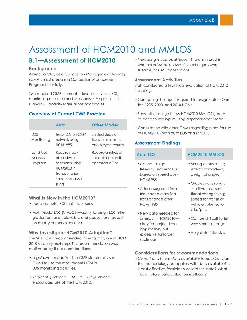
ALAMEDA CTC • CONGEST ION MANAGEMENT PROGRAM 2 015 | B - 1
B.1—Assessment of HCM2010BackgroundAlameda CTC, as a Congestion Management Agency (CMA), must prepare a Congestion Management Program biennially.
Two required CMP elements—level of service (LOS) monitoring and the Land Use Analysis Program—use Highway Capacity Manual methodologies.
Overview of Current CMP Practice
What Is New in the HCM2010?• Updated auto LOS methodologies
• Multi Modal LOS (MMLOS)—ability to assign LOS letter grades for transit, bicyclists, and pedestrians, based on quality of user experience.
Why Investigate HCM2010 Adoption?The 2011 CMP recommended investigating use of HCM 2010 as a key next step. This recommendation was motivated by three considerations:
• Legislative mandate—The CMP statute advises CMAs to use the most recent HCM in LOS monitoring activities.
• Regional guidance — MTC’s CMP guidance encourages use of the HCM 2010.
• Increasing multimodal focus—There is interest in whether HCM 2010’s MMLOS techniques were suitable for CMP applications.
Assessment ActivitiesStaff conducted a technical evaluation of HCM 2010 including:
• Comparing the inputs required to assign auto LOS in the 1985, 2000, and 2010 HCMs.
• Sensitivity testing of how HCM2010 MMLOS grades respond to key inputs using a spreadsheet model
• Consultation with other CMAs regarding plans for use of HCM2010 (both auto LOS and MMLOS)
Assessment Findings
Considerations for recommendations• Current and future data availability (auto LOS): Can
the methodology be applied with data available? Is it cost-effective/feasible to collect the data? What about future data collection methods?
Auto Other Modes
LOS Monitoring
Track LOS on CMP network using HCM1985
Limited study of transit travel times and bicycle counts
Land Use Analysis Program
Require study of roadway segments using HCM2000 in Transportation Impact Analyses (TIAs)
Require analysis of impacts on transit operators in TIAs
Auto LOS HCM2010 MMLOS
• Cannot assign freeway segment LOS based on speed post-HCM1985
• Arterial segment free flow speed classifica-tions change after HCM 1985
• New data needed for arterials in HCM2010—okay for project-level application, but excessive for larger scale use
• Strong at illustrating effects of roadway design changes
• Grades not strongly sensitive to opera-tional changes (e.g., speed for transit or vehicle volumes for bike/ped)
• Can be difficult to tell why scores change
• Very data-intensive
Assessment of HCM2010 and MMLOS
Appendix B
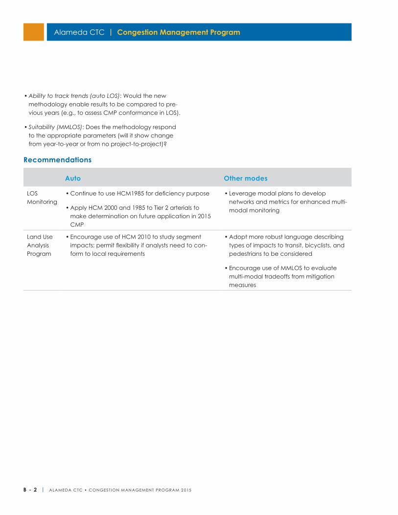
Alameda CTC | Congestion Management Program
B - 2 | ALAMEDA CTC • CONGEST ION MANAGEMENT PROGRAM 2 015
• Ability to track trends (auto LOS): Would the new methodology enable results to be compared to pre-vious years (e.g., to assess CMP conformance in LOS).
• Suitability (MMLOS): Does the methodology respond to the appropriate parameters (will it show change from year-to-year or from no project-to-project)?
Recommendations
Auto Other modes
LOS Monitoring
• Continue to use HCM1985 for deficiency purpose
• Apply HCM 2000 and 1985 to Tier 2 arterials to make determination on future application in 2015 CMP
• Leverage modal plans to develop networks and metrics for enhanced multi-modal monitoring
Land Use Analysis Program
• Encourage use of HCM 2010 to study segment impacts; permit flexibility if analysts need to con-form to local requirements
• Adopt more robust language describing types of impacts to transit, bicyclists, and pedestrians to be considered
• Encourage use of MMLOS to evaluate multi-modal tradeoffs from mitigation measures
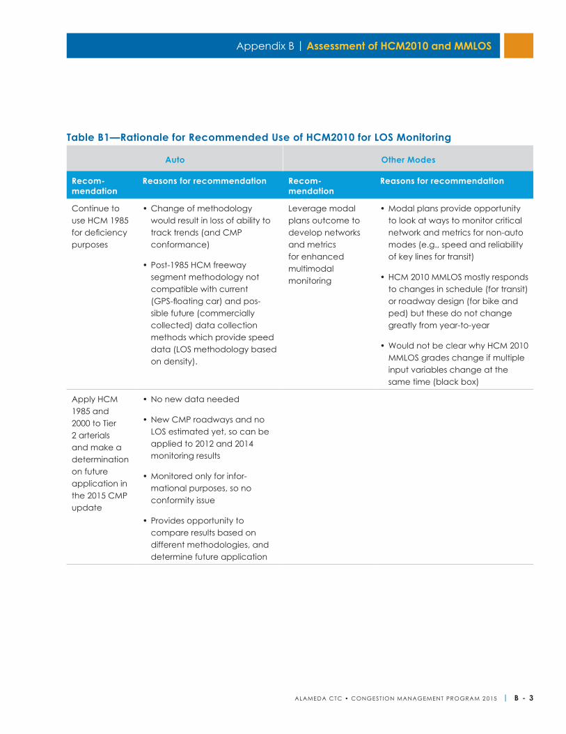
Appendix B | Assessment of HCM2010 and MMLOS
ALAMEDA CTC • CONGEST ION MANAGEMENT PROGRAM 2 015 | B - 3
Auto Other Modes
Recom- mendation
Reasons for recommendation Recom-mendation
Reasons for recommendation
Continue to use HCM 1985 for deficiency purposes
• Change of methodology would result in loss of ability to track trends (and CMP conformance)
• Post-1985 HCM freeway segment methodology not compatible with current (GPS-floating car) and pos-sible future (commercially collected) data collection methods which provide speed data (LOS methodology based on density).
Leverage modal plans outcome to develop networks and metrics for enhanced multimodal monitoring
• Modal plans provide opportunity to look at ways to monitor critical network and metrics for non-auto modes (e.g., speed and reliability of key lines for transit)
• HCM 2010 MMLOS mostly responds to changes in schedule (for transit) or roadway design (for bike and ped) but these do not change greatly from year-to-year
• Would not be clear why HCM 2010 MMLOS grades change if multiple input variables change at the same time (black box)
Apply HCM 1985 and 2000 to Tier 2 arterials and make a determination on future application in the 2015 CMP update
• No new data needed
• New CMP roadways and no LOS estimated yet, so can be applied to 2012 and 2014 monitoring results
• Monitored only for infor-mational purposes, so no conformity issue
• Provides opportunity to compare results based on different methodologies, and determine future application
Table B1—Rationale for Recommended Use of HCM2010 for LOS Monitoring
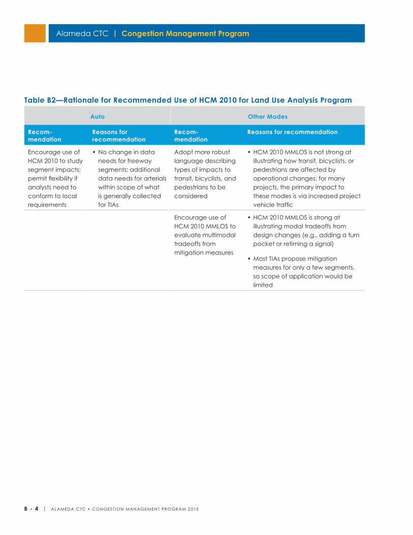
Alameda CTC | Congestion Management Program
B - 4 | ALAMEDA CTC • CONGEST ION MANAGEMENT PROGRAM 2 015
Auto Other Modes
Recom- mendation
Reasons for recommendation
Recom-mendation
Reasons for recommendation
Encourage use of HCM 2010 to study segment impacts; permit flexibility if analysts need to conform to local requirements
• No change in data needs for freeway segments; additional data needs for arterials within scope of what is generally collected for TIAs
Adopt more robust language describing types of impacts to transit, bicyclists, and pedestrians to be considered
• HCM 2010 MMLOS is not strong at illustrating how transit, bicyclists, or pedestrians are affected by operational changes; for many projects, the primary impact to these modes is via increased project vehicle traffic
Encourage use of HCM 2010 MMLOS to evaluate multimodal tradeoffs from mitigation measures
• HCM 2010 MMLOS is strong at illustrating modal tradeoffs from design changes (e.g., adding a turn pocket or retiming a signal)
• Most TIAs propose mitigation measures for only a few segments, so scope of application would be limited
Table B2—Rationale for Recommended Use of HCM 2010 for Land Use Analysis Program
Appendix B | Assessment of HCM2010 and MMLOS
ALAMEDA CTC • CONGEST ION MANAGEMENT PROGRAM 2 015 | B - 5
B.2—Approach to Use of HCM2010 and MMLOS at Other CMAsDetailed information follows on other comparable Bay Area CMAs’ (San Francisco County Transportation Authority, Valley Transportation Authority, and Contra Costa Transportation Authority) current and future plans for use of HCM methodologies in their CMPs. Specifically, information is provided on:
• Use of HCM 2010 for the auto based roadway LOS methodology
◦ As part of LOS monitoring activities, since adoption of HCM 2010 is related to current and future plans for data collection
◦ As a required methodology to study auto impacts in Transportation Impact Analyses reviewed for Land Use Analysis element
• Use of MMLOS methodologies
◦ To provide increased monitoring for alternative modes in the LOS monitoring
◦ As part of the guidelines for Transportation Impact Analyses reviewed for the land use analysis element
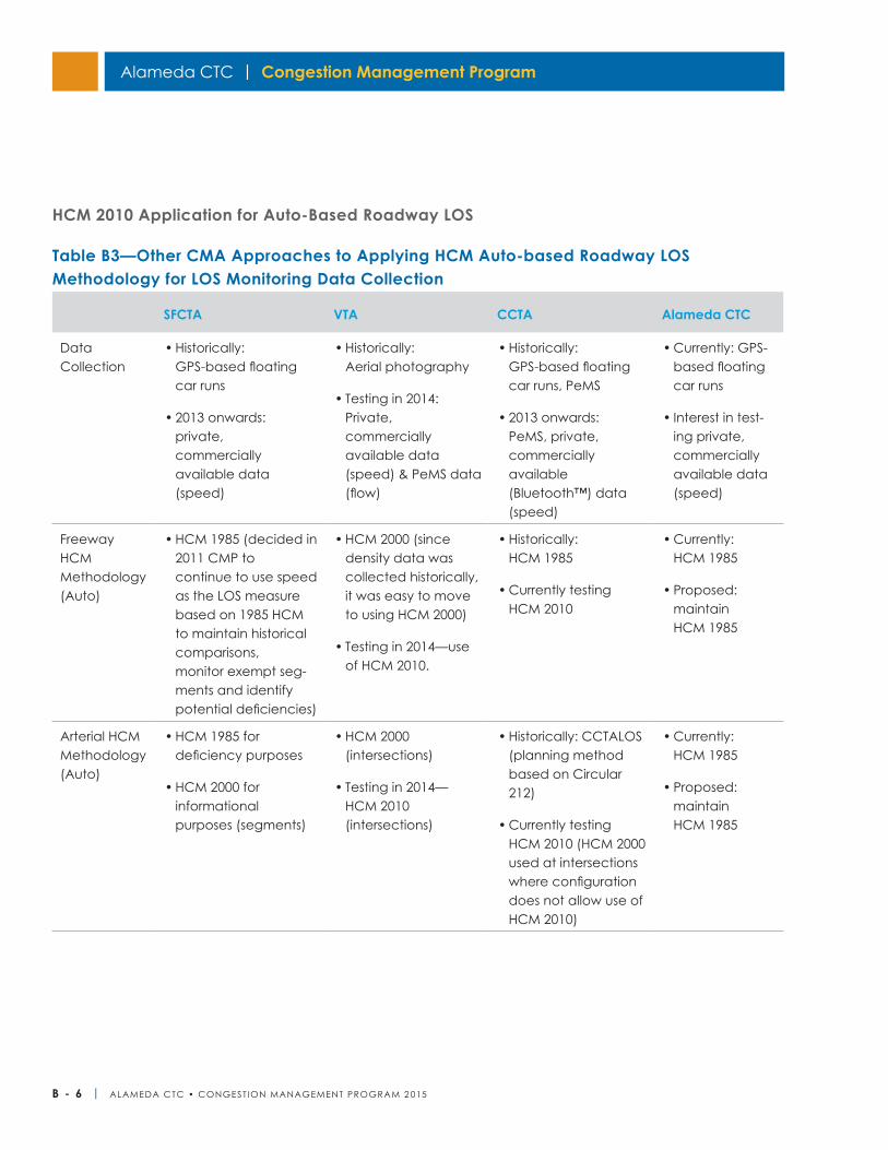
Alameda CTC | Congestion Management Program
B - 6 | ALAMEDA CTC • CONGEST ION MANAGEMENT PROGRAM 2 015
Table B3—Other CMA Approaches to Applying HCM Auto-based Roadway LOS Methodology for LOS Monitoring Data Collection
SFCTA VTA CCTA Alameda CTC
Data Collection
• Historically: GPS-based floating car runs
• 2013 onwards: private, commercially available data (speed)
• Historically: Aerial photography
• Testing in 2014: Private, commercially available data (speed) & PeMS data (flow)
• Historically: GPS-based floating car runs, PeMS
• 2013 onwards: PeMS, private, commercially available (Bluetooth™) data (speed)
• Currently: GPS-based floating car runs
• Interest in test-ing private, commercially available data (speed)
Freeway HCM Methodology (Auto)
• HCM 1985 (decided in 2011 CMP to continue to use speed as the LOS measure based on 1985 HCM to maintain historical comparisons, monitor exempt seg-ments and identify potential deficiencies)
• HCM 2000 (since density data was collected historically, it was easy to move to using HCM 2000)
• Testing in 2014—use of HCM 2010.
• Historically: HCM 1985
• Currently testing HCM 2010
• Currently: HCM 1985
• Proposed: maintain HCM 1985
Arterial HCM Methodology (Auto)
• HCM 1985 for deficiency purposes
• HCM 2000 for informational purposes (segments)
• HCM 2000 (intersections)
• Testing in 2014— HCM 2010 (intersections)
• Historically: CCTALOS (planning method based on Circular 212)
• Currently testing HCM 2010 (HCM 2000 used at intersections where configuration does not allow use of HCM 2010)
• Currently: HCM 1985
• Proposed: maintain HCM 1985
HCM 2010 Application for Auto-Based Roadway LOS
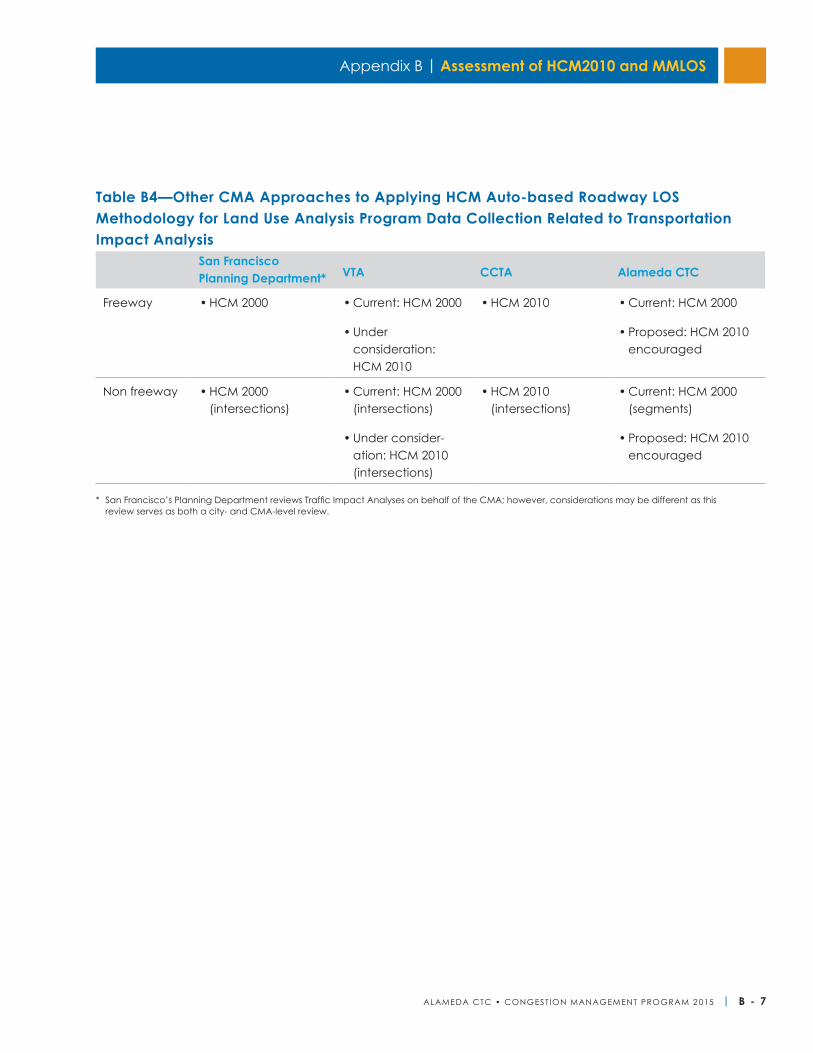
Appendix B | Assessment of HCM2010 and MMLOS
ALAMEDA CTC • CONGEST ION MANAGEMENT PROGRAM 2 015 | B - 7
Table B4—Other CMA Approaches to Applying HCM Auto-based Roadway LOS Methodology for Land Use Analysis Program Data Collection Related to Transportation Impact Analysis
San Francisco Planning Department* VTA CCTA Alameda CTC
Freeway • HCM 2000 • Current: HCM 2000
• Under consideration: HCM 2010
• HCM 2010 • Current: HCM 2000
• Proposed: HCM 2010 encouraged
Non freeway • HCM 2000 (intersections)
• Current: HCM 2000 (intersections)
• Under consider-ation: HCM 2010 (intersections)
• HCM 2010 (intersections)
• Current: HCM 2000 (segments)
• Proposed: HCM 2010 encouraged
* San Francisco’s Planning Department reviews Traffic Impact Analyses on behalf of the CMA; however, considerations may be different as this review serves as both a city- and CMA-level review.
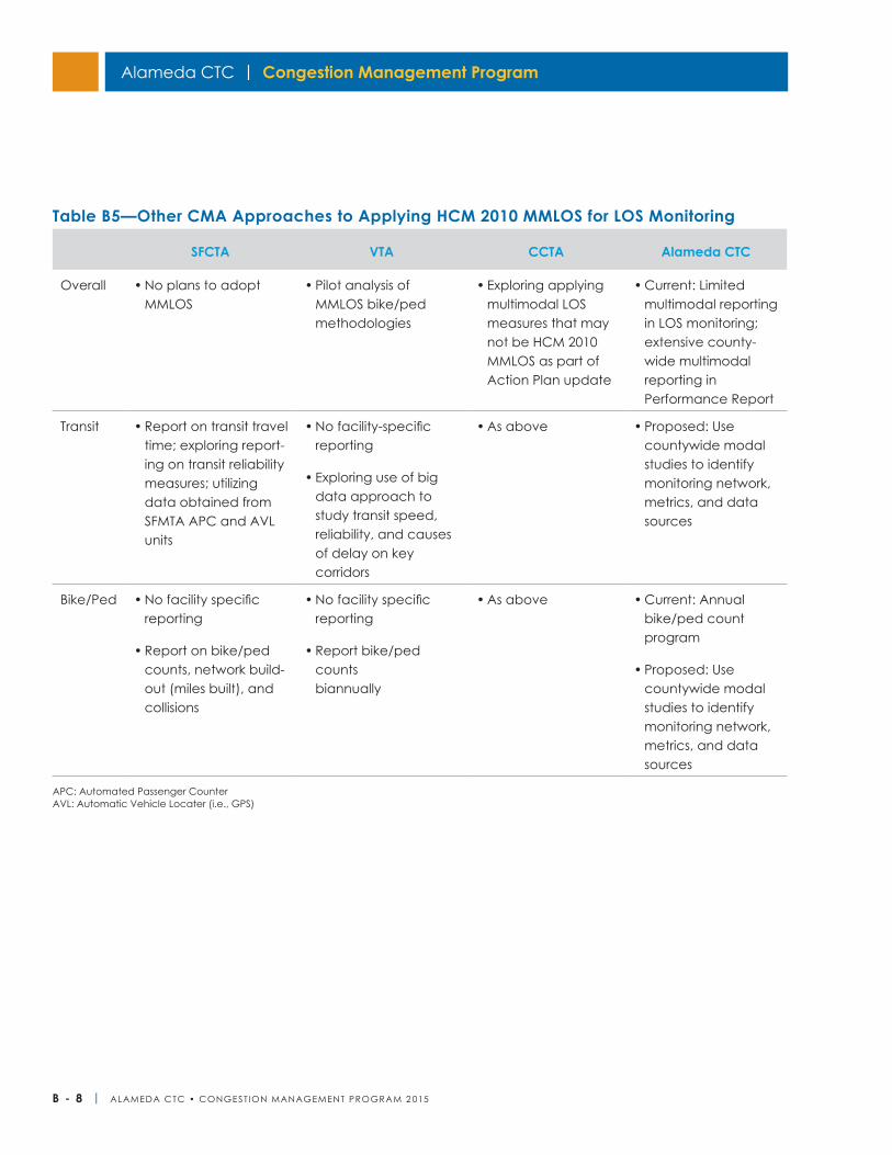
Alameda CTC | Congestion Management Program
B - 8 | ALAMEDA CTC • CONGEST ION MANAGEMENT PROGRAM 2 015
Table B5—Other CMA Approaches to Applying HCM 2010 MMLOS for LOS Monitoring
SFCTA VTA CCTA Alameda CTC
Overall • No plans to adopt MMLOS
• Pilot analysis of MMLOS bike/ped methodologies
• Exploring applying multimodal LOS measures that may not be HCM 2010 MMLOS as part of Action Plan update
• Current: Limited multimodal reporting in LOS monitoring; extensive county-wide multimodal reporting in Performance Report
Transit • Report on transit travel time; exploring report-ing on transit reliability measures; utilizing data obtained from SFMTA APC and AVL units
• No facility-specific reporting
• Exploring use of big data approach to study transit speed, reliability, and causes of delay on key corridors
• As above • Proposed: Use countywide modal studies to identify monitoring network, metrics, and data sources
Bike/Ped • No facility specific reporting
• Report on bike/ped counts, network build-out (miles built), and collisions
• No facility specific reporting
• Report bike/ped counts biannually
• As above • Current: Annual bike/ped count program
• Proposed: Use countywide modal studies to identify monitoring network, metrics, and data sources
APC: Automated Passenger CounterAVL: Automatic Vehicle Locater (i.e., GPS)
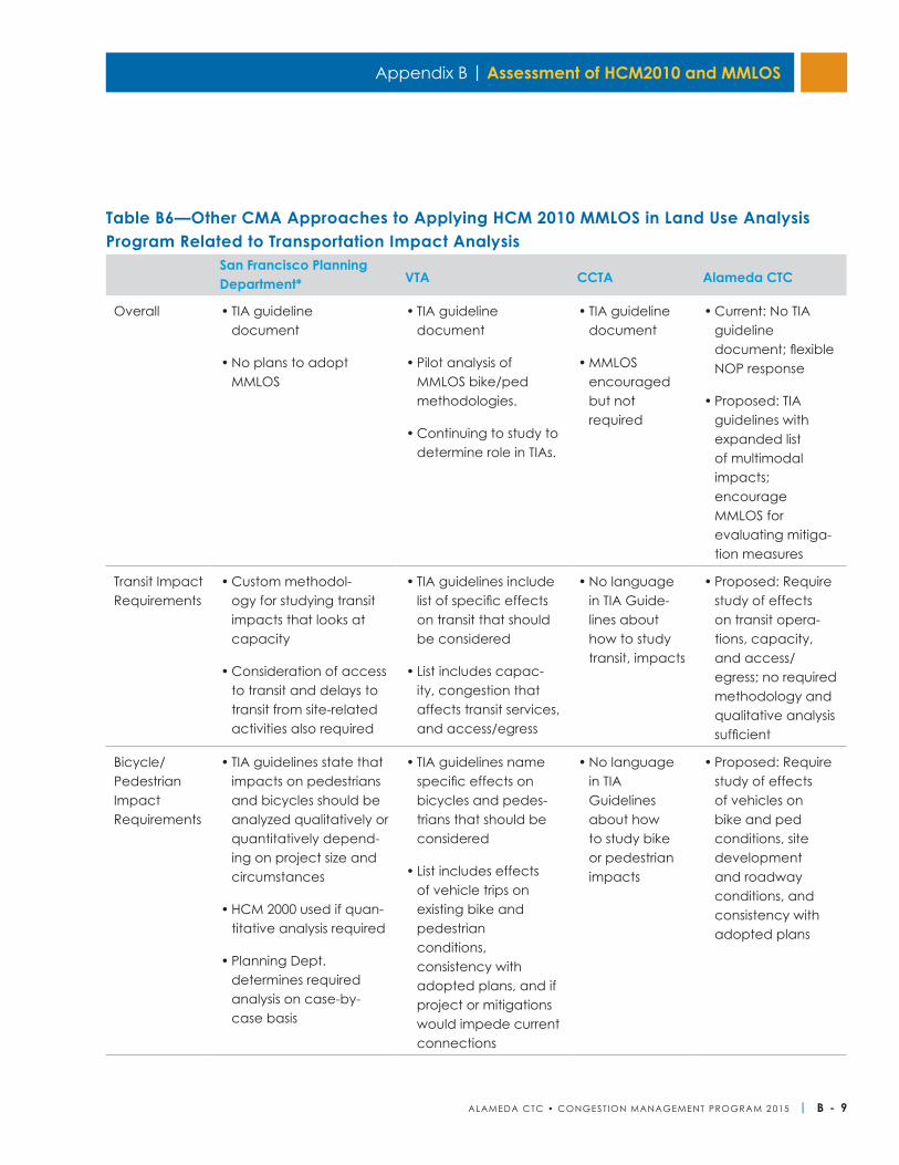
Appendix B | Assessment of HCM2010 and MMLOS
ALAMEDA CTC • CONGEST ION MANAGEMENT PROGRAM 2 015 | B - 9
Table B6—Other CMA Approaches to Applying HCM 2010 MMLOS in Land Use Analysis Program Related to Transportation Impact Analysis
San Francisco Planning Department* VTA CCTA Alameda CTC
Overall • TIA guideline document
• No plans to adopt MMLOS
• TIA guideline document
• Pilot analysis of MMLOS bike/ped methodologies.
• Continuing to study to determine role in TIAs.
• TIA guideline document
• MMLOS encouraged but not required
• Current: No TIA guideline document; flexible NOP response
• Proposed: TIA guidelines with expanded list of multimodal impacts; encourage MMLOS for evaluating mitiga-tion measures
Transit Impact Requirements
• Custom methodol-ogy for studying transit impacts that looks at capacity
• Consideration of access to transit and delays to transit from site-related activities also required
• TIA guidelines include list of specific effects on transit that should be considered
• List includes capac-ity, congestion that affects transit services, and access/egress
• No language in TIA Guide-lines about how to study transit, impacts
• Proposed: Require study of effects on transit opera-tions, capacity, and access/egress; no required methodology and qualitative analysis sufficient
Bicycle/ Pedestrian Impact Requirements
• TIA guidelines state that impacts on pedestrians and bicycles should be analyzed qualitatively or quantitatively depend-ing on project size and circumstances
• HCM 2000 used if quan-titative analysis required
• Planning Dept. determines required analysis on case-by-case basis
• TIA guidelines name specific effects on bicycles and pedes-trians that should be considered
• List includes effects of vehicle trips on existing bike and pedestrian conditions, consistency with adopted plans, and if project or mitigations would impede current connections
• No language in TIA Guidelines about how to study bike or pedestrian impacts
• Proposed: Require study of effects of vehicles on bike and ped conditions, site development and roadway conditions, and consistency with adopted plans
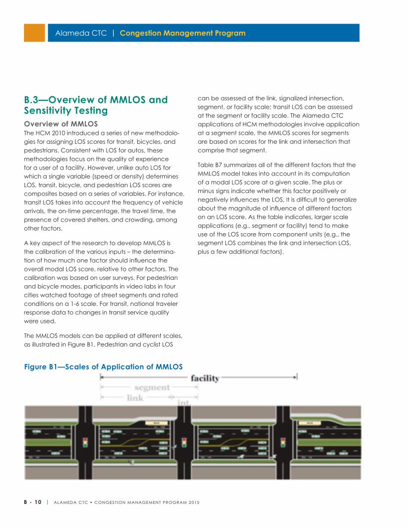
Alameda CTC | Congestion Management Program
B - 10 | ALAMEDA CTC • CONGEST ION MANAGEMENT PROGRAM 2 015
B.3—Overview of MMLOS and Sensitivity TestingOverview of MMLOSThe HCM 2010 introduced a series of new methodolo-gies for assigning LOS scores for transit, bicycles, and pedestrians. Consistent with LOS for autos, these methodologies focus on the quality of experience for a user of a facility. However, unlike auto LOS for which a single variable (speed or density) determines LOS, transit, bicycle, and pedestrian LOS scores are composites based on a series of variables. For instance, transit LOS takes into account the frequency of vehicle arrivals, the on-time percentage, the travel time, the presence of covered shelters, and crowding, among other factors.
A key aspect of the research to develop MMLOS is the calibration of the various inputs – the determina-tion of how much one factor should influence the overall modal LOS score, relative to other factors. The calibration was based on user surveys. For pedestrian and bicycle modes, participants in video labs in four cities watched footage of street segments and rated conditions on a 1-6 scale. For transit, national traveler response data to changes in transit service quality were used.
The MMLOS models can be applied at different scales, as illustrated in Figure B1. Pedestrian and cyclist LOS
can be assessed at the link, signalized intersection, segment, or facility scale; transit LOS can be assessed at the segment or facility scale. The Alameda CTC applications of HCM methodologies involve application at a segment scale, the MMLOS scores for segments are based on scores for the link and intersection that comprise that segment.
Table B7 summarizes all of the different factors that the MMLOS model takes into account in its computation of a modal LOS score at a given scale. The plus or minus signs indicate whether this factor positively or negatively influences the LOS. It is difficult to generalize about the magnitude of influence of different factors on an LOS score. As the table indicates, larger scale applications (e.g., segment or facility) tend to make use of the LOS score from component units (e.g., the segment LOS combines the link and intersection LOS, plus a few additional factors).
Figure B1—Scales of Application of MMLOS
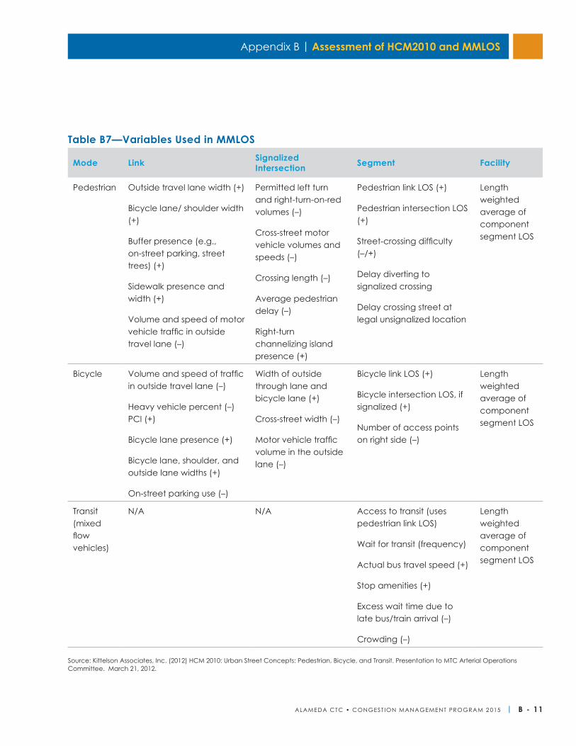
Appendix B | Assessment of HCM2010 and MMLOS
ALAMEDA CTC • CONGEST ION MANAGEMENT PROGRAM 2 015 | B - 11
Mode Link Signalized Intersection Segment Facility
Pedestrian Outside travel lane width (+)
Bicycle lane/ shoulder width (+)
Buffer presence (e.g., on-street parking, street trees) (+)
Sidewalk presence and width (+)
Volume and speed of motor vehicle traffic in outside travel lane (–)
Permitted left turn and right-turn-on-red volumes (–)
Cross-street motor vehicle volumes and speeds (–)
Crossing length (–)
Average pedestrian delay (–)
Right-turn channelizing island presence (+)
Pedestrian link LOS (+)
Pedestrian intersection LOS (+)
Street-crossing difficulty (–/+)
Delay diverting to signalized crossing
Delay crossing street at legal unsignalized location
Length weighted average of component segment LOS
Bicycle Volume and speed of traffic in outside travel lane (–)
Heavy vehicle percent (–)PCI (+)
Bicycle lane presence (+)
Bicycle lane, shoulder, and outside lane widths (+)
On-street parking use (–)
Width of outside through lane and bicycle lane (+)
Cross-street width (–)
Motor vehicle traffic volume in the outside lane (–)
Bicycle link LOS (+)
Bicycle intersection LOS, if signalized (+)
Number of access points on right side (–)
Length weighted average of component segment LOS
Transit (mixed flow vehicles)
N/A N/A Access to transit (uses pedestrian link LOS)
Wait for transit (frequency)
Actual bus travel speed (+)
Stop amenities (+)
Excess wait time due to late bus/train arrival (–)
Crowding (–)
Length weighted average of component segment LOS
Source: Kittelson Associates, Inc. (2012) HCM 2010: Urban Street Concepts: Pedestrian, Bicycle, and Transit. Presentation to MTC Arterial Operations Committee. March 21, 2012.
Table B7—Variables Used in MMLOS
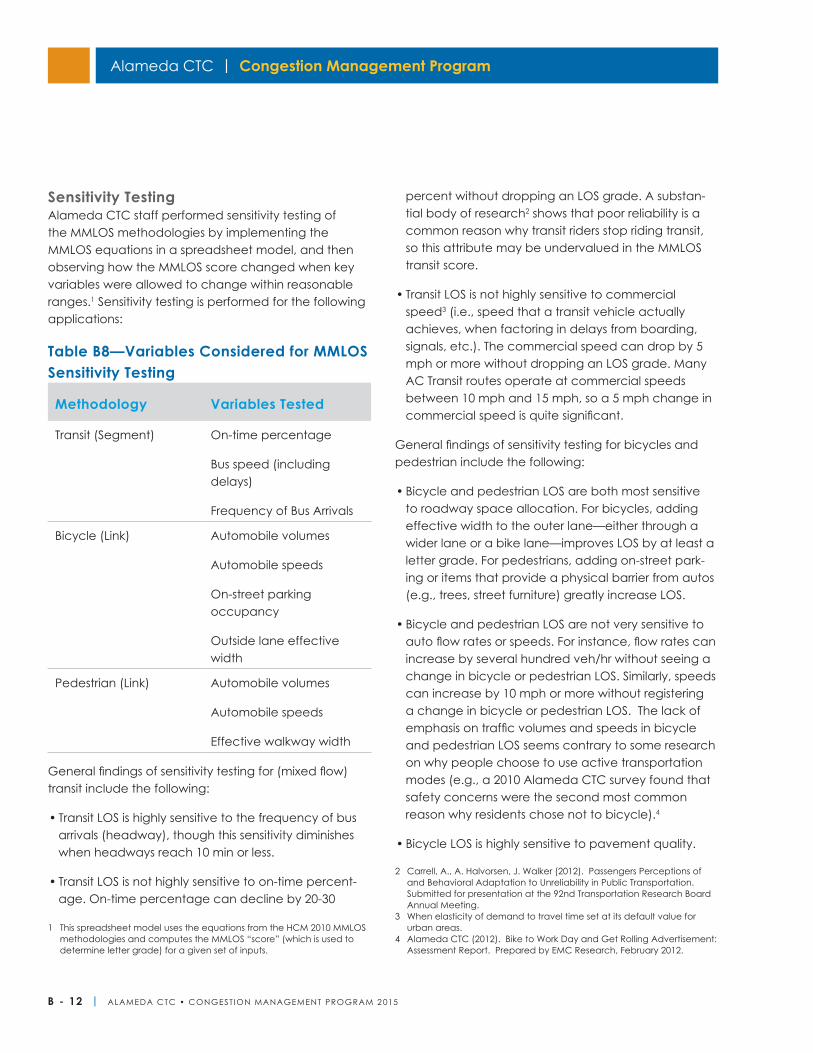
Alameda CTC | Congestion Management Program
B - 12 | ALAMEDA CTC • CONGEST ION MANAGEMENT PROGRAM 2 015
Sensitivity TestingAlameda CTC staff performed sensitivity testing of the MMLOS methodologies by implementing the MMLOS equations in a spreadsheet model, and then observing how the MMLOS score changed when key variables were allowed to change within reasonable ranges.1 Sensitivity testing is performed for the following applications:
Table B8—Variables Considered for MMLOS Sensitivity Testing
General findings of sensitivity testing for (mixed flow) transit include the following:
• Transit LOS is highly sensitive to the frequency of bus arrivals (headway), though this sensitivity diminishes when headways reach 10 min or less.
• Transit LOS is not highly sensitive to on-time percent-age. On-time percentage can decline by 20-30
1 This spreadsheet model uses the equations from the HCM 2010 MMLOS methodologies and computes the MMLOS “score” (which is used to determine letter grade) for a given set of inputs.
percent without dropping an LOS grade. A substan-tial body of research2 shows that poor reliability is a common reason why transit riders stop riding transit, so this attribute may be undervalued in the MMLOS transit score.
• Transit LOS is not highly sensitive to commercial speed3 (i.e., speed that a transit vehicle actually achieves, when factoring in delays from boarding, signals, etc.). The commercial speed can drop by 5 mph or more without dropping an LOS grade. Many AC Transit routes operate at commercial speeds between 10 mph and 15 mph, so a 5 mph change in commercial speed is quite significant.
General findings of sensitivity testing for bicycles and pedestrian include the following:
• Bicycle and pedestrian LOS are both most sensitive to roadway space allocation. For bicycles, adding effective width to the outer lane—either through a wider lane or a bike lane—improves LOS by at least a letter grade. For pedestrians, adding on-street park-ing or items that provide a physical barrier from autos (e.g., trees, street furniture) greatly increase LOS.
• Bicycle and pedestrian LOS are not very sensitive to auto flow rates or speeds. For instance, flow rates can increase by several hundred veh/hr without seeing a change in bicycle or pedestrian LOS. Similarly, speeds can increase by 10 mph or more without registering a change in bicycle or pedestrian LOS. The lack of emphasis on traffic volumes and speeds in bicycle and pedestrian LOS seems contrary to some research on why people choose to use active transportation modes (e.g., a 2010 Alameda CTC survey found that safety concerns were the second most common reason why residents chose not to bicycle).4
• Bicycle LOS is highly sensitive to pavement quality.
2 Carrell, A., A. Halvorsen, J. Walker (2012). Passengers Perceptions of and Behavioral Adaptation to Unreliability in Public Transportation. Submitted for presentation at the 92nd Transportation Research Board Annual Meeting.
3 When elasticity of demand to travel time set at its default value for urban areas.
4 Alameda CTC (2012). Bike to Work Day and Get Rolling Advertisement: Assessment Report. Prepared by EMC Research, February 2012.
Methodology Variables Tested
Transit (Segment) On-time percentage
Bus speed (including delays)
Frequency of Bus Arrivals
Bicycle (Link) Automobile volumes
Automobile speeds
On-street parking occupancy
Outside lane effective width
Pedestrian (Link) Automobile volumes
Automobile speeds
Effective walkway width
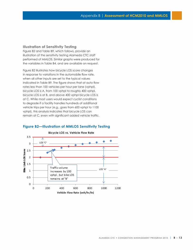
Appendix B | Assessment of HCM2010 and MMLOS
ALAMEDA CTC • CONGEST ION MANAGEMENT PROGRAM 2 015 | B - 13
Illustration of Sensitivity TestingFigure B2 and Table B9, which follows, provide an illustration of the sensitivity testing Alameda CTC staff performed of MMLOS. Similar graphs were produced for the variables in Table B4, and are available on request.
Figure B2 illustrates how bicycle LOS score changes in response to variations in the automobile flow rate, when all other inputs are set to the typical values indicated in Table B9. The figure shows that at auto flow rates less than 100 vehicles per hour per lane (vphpl), bicycle LOS is A, from 100 vphpl to roughly 400 vphpl, bicycle LOS is at B, and above 400 vphpl bicycle LOS is at C. While most users would expect cyclist conditions to degrade if a facility handles hundreds of additional vehicle trips per hour (e.g., goes from 600 vphpl to 1100 vphpl), this analysis indicates that bicycle LOS can remain at C, even with significant added vehicle traffic.
Bicycle LOS vs. Vehicle Flow Rate
Figure B2—Illustration of MMLOS Sensitivity Testing
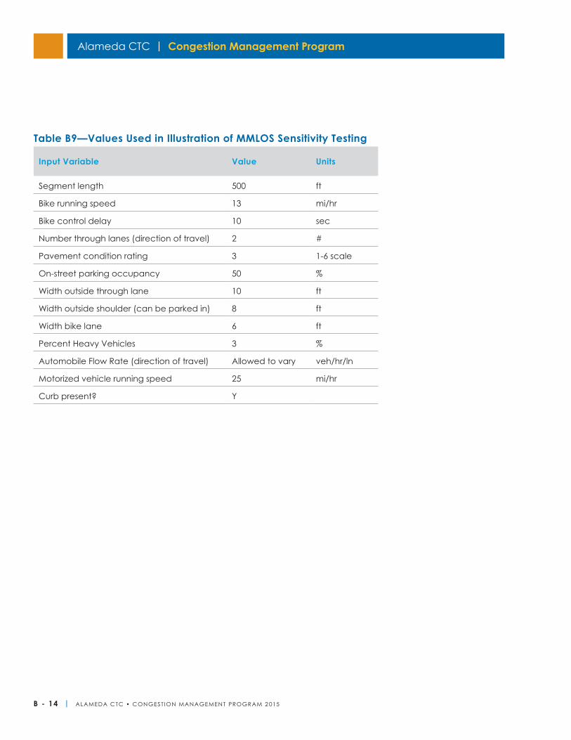
Alameda CTC | Congestion Management Program
B - 14 | ALAMEDA CTC • CONGEST ION MANAGEMENT PROGRAM 2 015
Input Variable Value Units
Segment length 500 ft
Bike running speed 13 mi/hr
Bike control delay 10 sec
Number through lanes (direction of travel) 2 #
Pavement condition rating 3 1-6 scale
On-street parking occupancy 50 %
Width outside through lane 10 ft
Width outside shoulder (can be parked in) 8 ft
Width bike lane 6 ft
Percent Heavy Vehicles 3 %
Automobile Flow Rate (direction of travel) Allowed to vary veh/hr/ln
Motorized vehicle running speed 25 mi/hr
Curb present? Y
Table B9—Values Used in Illustration of MMLOS Sensitivity Testing
ALAMEDA CTC • CONGEST ION MANAGEMENT PROGRAM 2 015 | C - 1
Appendix C
Background and PurposeDeficiency Plans include various measures to improve transportation conditions on a Congestion Management Program (CMP) roadway that does not meet the established CMP level of service standard set forth in the California Government Code Section 65089 (b)(1)(B). The state legislation requires:
In no case shall the LOS standards for roads established be below the LOS E or at the current level, whichever is further from LOS A. When the LOS on a segment or at an intersection fails to attain the established LOS standard, a Deficiency Plan shall be adopted pursuant to Section 65089.4.
Deficiency Plans are a way for jurisdictions to remain in compliance with the CMP. Deficiency Plans should be developed with consideration of the countywide transportation planning process, including forecasts of travel needs and planned capital improvements. Likewise, existing deficiencies should influence future countywide transportation planning and programming decisions. If the Deficiency Plan involves system-wide improvements, Alameda CTC staff, transit agencies, the Bay Area Air Quality Management District (BAAQMD), and the California Department of Transportation may also be involved.
Process OverviewWhen the LOS on a given CMP-network segment deteriorates below the established state standard, the responsible jurisdictions(s) must prepare a Deficiency Plan, or additional gasoline tax subventions (pursuant to Section 2105 of the Streets and Highways Code) will be withheld. During even number years, when the LOS Monitoring is performed, the Alameda CTC Commission determines whether a jurisdiction is required to prepare a Deficiency Plan based on the LOS Monitoring results. If any CMP segment is identified to be deficient, the respective jurisdiction(s) must prepare a Deficiency Plan within 12 months of the determination to prevent its forfeiting of additional gasoline tax subventions. Pages 5-8 herein include the relevant sections of the CMP legislation related to the Deficiency Plan requirements.
Deficiency IdentificationBiennially, the Alameda CTC identifies potentially deficient roadway segments based on LOS monitoring. Only trips originating inside Alameda County in the p.m. peak period are included in determining LOS conformity with the established LOS standard exempting many types of travel. After applying the required exemptions, if a CMP roadway segment is still found to operate at LOS F, it will be determined as deficient and the respective local jurisdiction(s) will be informed.
ExemptionsThe State statute requires several types of travel to be exempted from the deficiency determination, including:
• Interregional travel;
• Construction, rehabilitation, or maintenance of facilities that impact the system;
• Freeway ramp metering;
• Traffic signal coordination by the state or a multi-jurisdictional agency;
• Traffic generated by the provision of low and very low income housing;
• Traffic generated by high-density residential development within one-fourth mile of a fixed rail passenger station; and
• Traffic generated by any mixed use development located within one-fourth mile of a fixed rail passenger station; and if more than half of the land area or floor area of the mixed use development is used for high density residential housing.
Roadway Capacity StandardsFor the purposes of determining deficiency, the following standards for roadway capacity will be used unless a local jurisdiction can demonstrate an alternative capacity:
• Freeways: 2,000 vehicles per lane per hour
Deficiency Plan Guidelines
C - 2 | ALAMEDA CTC • CONGEST ION MANAGEMENT PROGRAM 2 015
Alameda CTC | Congestion Management Program
• Two-lane: 1,400 vehicles per lane per hour highways
• Arterials: 800 vehicles per lane per hour
Jurisdictional ParticipationIf a deficient CMP roadway segment is located entirely in one jurisdiction and all other jurisdictions contribute less than 10% traffic, then the deficiency should be addressed through a local single-jurisdiction deficiency plan. However, if a deficient CMP roadway segment crosses jurisdiction boundaries, borders two jurisdic-tions, or if the following conditions are met that are considered to be contributing to the deficiency or for effective planning purposes, then the deficiency should be addressed through a multi-jurisdictional deficiency plan.
• A jurisdiction shall participate in a deficiency plan if traffic to or from that jurisdiction, either an origin or destination at the deficient segment, represents ten percent (10 percent) of the capacity of the freeway/roadway, as estimated by the countywide travel demand model.
• In some cases, (in order to eliminate any gaps and to ensure continuity in the planning process) a jurisdiction that does not meet the 10 percent threshold shall be required to participate in the deficiency plan process if it is surrounded by jurisdictions which meet the threshold for participation.
Additional features of the multi-jurisdictional deficiency plan in terms of participation are:
• All owners/operators of a deficient segment of freeway or roadway along with transit operators shall be invited to participate in the deficiency plan process
• The percent contribution of traffic specifically does not imply a commensurate financial share of the Deficiency Plan actions identified.
• All participating jurisdictions shall adopt identical deficiency plan action plans. A local jurisdiction
shall have the right to appeal as depicted in the Multi-jurisdictional Deficiency Plan Appeal Process, (Figure D1) or to invoke the established Conflict Resolution Process to address conflicts or disputes that arise between the local jurisdictions in developing the multi-jurisdictional Deficiency Plan.
• If a local jurisdiction responsible for participating in a multi-jurisdictional deficiency plan does not adopt the deficiency plan in accordance with the schedule and requirements outlined above, that jurisdiction shall be considered in non-conformance with the CMP.
Types of Deficiency PlansThe Deficiency Plan process allows a local jurisdiction to choose one of two types of Deficiency Plans.
Localized Deficiency PlanThis type of plan is appropriate for addressing transportation impacts to a single CMP segment or roadway that has been identified as or is anticipated to become deficient based on the LOS Monitoring. This plan focuses on analyzing the cause of deficiency by including the immediate surrounding area as the project area and identifying the list of improvements or mitigation measures that are necessary to meet LOS standards, and estimates the costs and implementation schedule of the proposed improvements.
Areawide Deficiency PlanAn Areawide Deficiency Plan is appropriate when a CMP segment or roadway has been identified as or is anticipated to become deficient based on the LOS Monitoring and it cannot be improved to meet LOS standards and mitigated back to conformance if considered solely within a localized area. The jurisdiction must designate the segment as deficient, and develop and implement actions to measurably improve the performance of the larger network LOS in the study area and contribute to significant air quality improvements. Such actions may not necessarily directly pertain to or have a measurable impact on the deficient segment itself but must show system-wide improvement. This plan focuses on offsetting the deficiency by including the broader surrounding
Appendix C | Deficiency Plan Guidelines
ALAMEDA CTC • CONGEST ION MANAGEMENT PROGRAM 2 015 | C - 3
area as the project area and identifying a list of improvements, programs or actions to improve the performance of the larger multimodal network. The plan should contain an estimate of the costs and imple-mentation schedule of the proposed improvements, programs or actions.
The study area for an Areawide Deficiency Plan should generally be an area where improvements made to the multimodal network in one place of the study area provide improved overall performance of the larger network in that area. The study area should include or be served by one or more alternative transportation modes. The study area can be:
• An administrative jurisdiction such as a city/county or a part of a city/county
• An area comprising parts of multiple adjacent juris-dictions in which case it will be a multi-jurisdiction deficiency plan
Plan Development and ApprovalRequired ComponentsThe scope of a Deficiency Plan should match the severity of the problem. Extreme deficiencies will need more significant actions. Action plans must be incorporated into future CMP documents. State law requires a Deficiency Plan contain the following:
• an analysis of the deficiency
• a list of improvements and related costs to mitigate the deficiency in that facility itself;
• a list of possible actions and costs that would result in improvements to the CMP system’s LOS and be beneficial to air quality; and
• an action plan, including a schedule, to implement improvements from one of the two above lists.
In developing the deficiency plan addressing the required components, the following format should be used:
• Introduction and Setting. A short description of the facility, including a map showing its location.
• Deficiency Analysis. Analysis and assessment of deficiency in terms of likely causes and the magnitude.
• Screening of Actions. An array of suitable actions evaluated at a sketch-planning level for potential effects on system-wide traffic congestion and air quality (traffic operations analyses or model forecasts may be required). For this purpose, actions listed in the BAAQMD guidelines (described in more detail in the following section) and other actions identified and approved by the BAAQMD should be used.
• Evaluation of Suitable Actions. Selected actions from the screening process further evaluated to demonstrate how these actions when implemented contribute to improving the CMP network LOS conditions.
• Implementation. A detailed implementation plan should be developed, including description of the selected actions, anticipated costs, related funding sources and schedule.
Suitable Implementation ActionsImplementation actions fall into one of two categories:
• Mitigation of Deficiency. These types of improve-ments are designed to directly mitigate the specific deficiency such as highway, transit and other mode improvements, typically included in the localized deficiency plan.
• Overall System Performance and Air Quality Improvement. These actions are intended to provide overall measurable improvements to system performance and air quality, in cases where deficiencies cannot be mitigated directly. This will occur from implementing an areawide deficiency plan.
Areawide deficiency plans facilitate implementation of coordinated improvements to the multimodal trans-portation network and promote reduction of overall percentage of trips made by the single occupant vehicles while increasing the percentage of trips made
Alameda CTC | Congestion Management Program
C - 4 | ALAMEDA CTC • CONGEST ION MANAGEMENT PROGRAM 2 015
by transit, pedestrian and bicycle and resulting in improvements to air quality. For these types of plans, the legislation requires identifying an array of actions improving multimodal performance. In addition, the legislation requires the air quality management district, which is Bay Area Air Quality Management District (BAAQMD) for the Bay Area, to develop a list of improvements, programs and actions for this purpose as follows:
The deficiency plan shall include….a list of improvements, programs, or actions, and estimates of costs, that will (A) measurably improve multimodal performance, using measures defined in paragraphs (1) and (2) of subdivision (b) of Section 65089, and (B) contribute to significant improvements in air quality, such as improved public transit service and facilities, improved nonmotorized transporta-tion facilities, high occupancy vehicle facilities, parking cash-out programs, and transportation control measures. The air quality management district or the air pollution control district shall establish and periodically revise a list of approved improvements, programs, and actions that meet the scope of this paragraph. If an improvement, program, or action on the approved list has not been fully implemented, it shall be deemed to contribute to significant improvements in air quality. If an improvement, program, or action is not on the approved list, it shall not be implemented unless approved by the local air quality management district or air pollution control district.
The BAAQMD has developed a list of actions in Table D-1, which are considered beneficial for air quality and congestion management and includes measures to improve use of alternative modes, improved traffic flow and reducing trips. Jurisdictions may include actions other than those on this list, provided the BAAQMD reviews and approves the list prior to plan adoption. The most current BAAQMD list of actions should always be consulted.
In addition, the proposed improvement measures and actions for the Action Plan of the Deficiency Plan in Alameda County can be coordinated with the outcome of the upcoming countywide modal plans – (i.e., Countywide Goods Movement Plan, Countywide Transit Plan, and Countywide Multimodal Arterial Corridor Mobility Plan) and the adopted Comprehensive Countywide Travel Demand Management (TDM) Strategy to effectively improve the multimodal transportation network performance. This could support measures including but not limited to the potential improvement measures related to the priority transit routes, bicycle and pedestrian locations, priority roadways, and freight as identified in the modal plans. Alameda CTC will develop a list of multimodal improvement measures based on the outcome of these modal plans and work with the Air District to get their approval, so that more improvement options are readily available should an areawide deficiency plan be required.
Review and EvaluationAn acceptable Deficiency Plan will contain all of the required components listed above and will be evaluated on the following technical criteria:
• Completeness as required in California Government Code Section 65089.5;
• Appropriateness of the Deficiency Plan actions in relation to the magnitude of the deficiency;
• Reliability of the funding sources;
• Ability to implement the proposed actions (including jurisdictional control issues); and
• Reasonableness of the implementation plan schedule.
Alameda CTC staff and ACTAC members will review the draft Deficiency Plan and provide technical input to assist the respective local jurisdiction(s) in developing and finalizing the Deficiency Plan.
Appendix C | Deficiency Plan Guidelines
ALAMEDA CTC • CONGEST ION MANAGEMENT PROGRAM 2 015 | C - 5
AdoptionA final plan must be adopted by the affected local jurisdiction(s) at a noticed public hearing no later than 12 months following identification of Deficiency by Alameda CTC. The Alameda CTC Commission will approve or reject a Deficiency Plan within 60 days of receipt of the Deficiency Plan from the local jurisdiction(s). If the plan is rejected, Alameda CTC will notify the local jurisdiction(s) of the reasons for that rejection, and the local jurisdiction must submit a revised plan within 90 days. Once a plan is adopted, written notification of the conformance findings of the Alameda CTC Commission (presently scheduled to occur at the November/December Alameda CTC Commission meeting) is required annually.
UpdatesTo facilitate the implementation process, the Alameda CTC Commission will accept minor updates to Deficiency Plans. The affected jurisdictions(s) may submit a notice to the Alameda CTC stating the reason for and content of the update. The Alameda CTC Commission will approve or reject the request for the update. Should the Alameda CTC Commission reject the request, the existing Deficiency Plan will remain in place.
MonitoringAnnually, the Alameda CTC will monitor implementa-tion of the Deficiency Plans prior to the annual conformance determination, to establish whether:
• They are being executed according to the schedule detailed in the implementation plan; or
• Changes have occurred that require modifications of the original Deficiency Plan or schedule.
Jurisdictions that have prepared and are implementing a Deficiency Plan must prepare annual status report updates for the Annual Conformity Findings. Participating jurisdictions that did not prepare the Deficiency Plan must also review the annual status report updates and submit a letter to the Alameda CTC stating they are in concurrence with the annual update
from the lead jurisdiction. This information is required for the Commission to make a determination whether the jurisdictions are in conformance with the CMP.
ComplianceOnce the action plan identified in the Deficiency Plan is implemented, the local jurisdiction determines whether a measurable improvement in LOS has occurred or whether the plan needs to be further updated. Evaluation of the action plan may result in recommended changes to other elements of the CMP, such as the Capital Improvement Program or Travel Demand Management Element, if related improvement measures are included in these elements
A jurisdiction (lead or participating), which is either not implementing the actions or not adhering to the stated schedule in the approved Deficiency Plan may be found in non-conformance, if the deficiency still exists.
California Code Sections 65089.4 and 65089.5 Regarding the Congestion Management Program Deficiency Plan Process65089.4.(a) A local jurisdiction shall prepare a deficiency plan when highway or roadway level of service standards are not maintained on segments or intersections of the designated system. The deficiency plan shall be adopted by the city or county at a noticed public hearing.
(b) The agency shall calculate the impacts subject to exclusion pursuant to subdivision (f) of this section, after consultation with the regional agency, the department, and the local air quality management district or air pollution control district. If the calculated traffic level of service following exclusion of these impacts is consistent with the level of service standard, the agency shall make a finding at a publicly noticed meeting that no deficiency plan is required and so notify the affected local jurisdiction.
Alameda CTC | Congestion Management Program
C - 6 | ALAMEDA CTC • CONGEST ION MANAGEMENT PROGRAM 2 015
(c) The agency shall be responsible for preparing and adopting procedures for local deficiency plan development and implementation responsibilities, consistent with the requirements of this section. The deficiency plan shall include all of the following:
(1) An analysis of the cause of the deficiency. This analysis shall include the following:
(A) Identification of the cause of the deficiency.
(B) Identification of the impacts of those local jurisdictions within the jurisdiction of the agency that contribute to the deficiency. These impacts shall be identified only if the calculated traffic level of service following exclusion of impacts pursuant to subdivision (f) indicates that the level of service standard has not been maintained, and shall be limited to impacts not subject to exclusion.
(2) A list of improvements necessary for the deficient segment or intersection to maintain the minimum level of service otherwise required and the estimated costs of the improvements.
(3) A list of improvements, programs, or actions, and estimates of costs, that will (A) measurably improve multimodal performance, using measures defined in paragraphs (1) and (2) of subdivision (b) of Section 65089, and (B) contribute to significant improvements in air quality, such as improved public transit service and facilities, improved nonmotorized transportation facilities, high occupancy vehicle facilities, parking cash-out programs, and transportation control measures. The air quality management district or the air pollution control district shall establish and periodically revise a list of approved improvements, programs, and actions that meet the scope of this paragraph. If an improvement, program, or action on the approved list has not been fully implemented, it shall be deemed to contribute to significant improvements in air quality. If an improvement, program, or action is not on the approved list, it shall not be implemented unless
approved by the local air quality management district or air pollution control district.
(4) An action plan, consistent with the provisions of Chapter 5 (commencing with Section 66000), that shall be implemented, consisting of improvements identified in paragraph (2), or improvements, programs, or actions identified in paragraph (3), that are found by the agency to be in the interest of the public health, safety, and welfare. The action plan shall include a specific implementa-tion schedule. The action plan shall include implementation strategies for those jurisdictions that have contributed to the cause of the deficiency in accordance with the agency's deficiency plan procedures. The action plan need not mitigate the impacts of any exclusions identified in subdivision (f). Action plan strategies shall identify the most effective implementation strategies for improving current and future system performance.
(d) A local jurisdiction shall forward its adopted deficiency plan to the agency within 12 months of the identification of a deficiency. The agency shall hold a noticed public hearing within 60 days of receiving the deficiency plan. Following that hearing, the agency shall either accept or reject the deficiency plan in its entirety, but the agency may not modify the deficiency plan. If the agency rejects the plan, it shall notify the local jurisdiction of the reasons for that rejection, and the local jurisdiction shall submit a revised plan within 90 days addressing the agency's concerns. Failure of a local jurisdiction to comply with the schedule and requirements of this section shall be considered to be nonconformance for the purposes of Section 65089.5.
(e) The agency shall incorporate into its deficiency plan procedures, a methodology for determining if deficiency impacts are caused by more than one local jurisdiction within the boundaries of the agency.
(1) If, according to the agency's methodology, it is determined that more than one local jurisdiction is responsible for causing a deficient segment or intersection, all responsible local jurisdictions shall participate in the development of a deficiency
Appendix C | Deficiency Plan Guidelines
ALAMEDA CTC • CONGEST ION MANAGEMENT PROGRAM 2 015 | C - 7
plan to be adopted by all participating local jurisdictions.
(2) The local jurisdiction in which the deficiency occurs shall have lead responsibility for developing the deficiency plan and for coordinating with other impacting local jurisdictions. If a local jurisdiction responsible for participating in a multi-jurisdictional deficiency plan does not adopt the deficiency plan in accordance with the schedule and requirements of paragraph (a) of this section, that jurisdiction shall be considered in nonconformance with the program for purposes of Section 65089.5.
(3) The agency shall establish a conflict resolution process for addressing conflicts or disputes between local jurisdictions in meeting the multi-jurisdictional deficiency plan responsibilities of this section.
(f) The analysis of the cause of the deficiency prepared pursuant to paragraph (1) of subdivision (c) shall exclude the following:
(1) Interregional travel.
(2) Construction, rehabilitation, or maintenance of facilities that impact the system.
(3) Freeway ramp metering.
(4) Traffic signal coordination by the state or multi-jurisdictional agencies.
(5) Traffic generated by the provision of low-income and very low income housing.
(6)
(A) Traffic generated by high-density residential development located within one-fourth mile of a fixed rail passenger station.
(B) Traffic generated by any mixed use development located within one-fourth mile of a fixed rail passenger station, if more than half of the land area, or floor area, of the mixed use development is used for high density residential housing, as determined by the agency.
(g) For the purposes of this section, the following terms have the following meanings:
(1) “High density” means residential density development which contains a minimum of 24 dwelling units per acre and a minimum density per acre which is equal to or greater than 120 percent of the maximum residential density allowed under the local general plan and zoning ordinance. A project providing a minimum of 75 dwelling units per acre shall automatically be considered high density.
(2) “Mixed use development” means development which integrates compatible commercial or retail uses, or both, with residential uses, and which, due to the proximity of job locations, shopping opportunities, and residences, will discourage new trip generation.
65089.5.(a) If, pursuant to the monitoring provided for in Section 65089.3, the agency determines, following a noticed public hearing, that a city or county is not conforming with the requirements of the congestion management program, the agency shall notify the city or county in writing of the specific areas of nonconformance. If, within 90 days of the receipt of the written notice of nonconformance, the city or county has not come into conformance with the congestion management program, the governing body of the agency shall make a finding of nonconformance and shall submit the finding to the commission and to the Controller.
(b)
(1) Upon receiving notice from the agency of nonconformance, the Controller shall withhold apportionments of funds required to be apportioned to that nonconforming city or county by Section 2105 of the Streets and Highways Code.
(2) If, within the 12-month period following the receipt of a notice of nonconformance, the Controller is notified by the agency that the city or county is in conformance, the Controller shall

Alameda CTC | Congestion Management Program
C - 8 | ALAMEDA CTC • CONGEST ION MANAGEMENT PROGRAM 2 015
allocate the apportionments withheld pursuant to this section to the city or county.
(3) If the Controller is not notified by the agency that the city or county is in conformance pursuant to paragraph (2), the Controller shall allocate the apportionments withheld pursuant to this section to the agency.
(c) The agency shall use funds apportioned under this section for projects of regional significance which are included in the capital improvement program required by paragraph (5) of subdivision (b) of Section 65089, or in a deficiency plan which has been adopted by the agency. The agency shall not use these funds for administration or planning purposes.
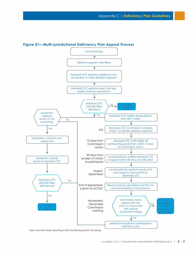
Appendix C | Deficiency Plan Guidelines
ALAMEDA CTC • CONGEST ION MANAGEMENT PROGRAM 2 015 | C - 9
Alameda CTCstaff identifies
deficiency
Commission hearsappeal with the
study in conjunction with annual
conformity findings
Alameda CTC staff identifies deficiencies
Note: Assumes timely reporting of LOS Monitoring results in the spring.
No
Yes
Process Ends
10 days fromCommission
action
30 days fromreceipt of notice
to participate
August,September
End of September,submit for ACTAC
November/December
Commissionmeeting
No
Yes
No requirement
for jurisdiction to participate
Jurisdiction appeals
results of LOS monitoring
Jurisdiction conducts own speed runs
Jurisdiction submits results to Alameda CTC
Alameda CTC notifies all jurisdictionswith 10% + traffic
Alameda CTC Commission considers “intent” to identify deficient segment
Alameda CTC staff notifies all participating jurisdictions within 10 days
of Commission action
Local jurisdiction notifies Alameda CTC of appeal within 30 days of notification
Local jurisdiction performs study at its own expense, and submits to
Alameda CTC
Results of study submitted to ACTAC forrecommendation to Commission
LOS Monitoring
Deficient segment identified
Alameda CTC performs additional runs,as-needed, to verify deficient segment
Alameda CTC performs select link andapplies statutory exemptions
July
Jurisdiction required to participate in deficiency plan
No
Process Ends
Yes
No
Yes
Figure D1—Multi-jurisdictional Deficiency Plan Appeal Process
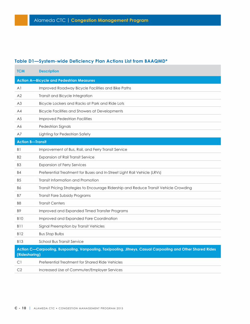
Alameda CTC | Congestion Management Program
C - 10 | ALAMEDA CTC • CONGEST ION MANAGEMENT PROGRAM 2 015
TCM Description
Action A—Bicycle and Pedestrian Measures
A1 Improved Roadway Bicycle Facilities and Bike Paths
A2 Transit and Bicycle Integration
A3 Bicycle Lockers and Racks at Park and Ride Lots
A4 Bicycle Facilities and Showers at Developments
A5 Improved Pedestrian Facilities
A6 Pedestrian Signals
A7 Lighting for Pedestrian Safety
Action B—Transit
B1 Improvement of Bus, Rail, and Ferry Transit Service
B2 Expansion of Rail Transit Service
B3 Expansion of Ferry Services
B4 Preferential Treatment for Buses and In-Street Light Rail Vehicle (LRVs)
B5 Transit Information and Promotion
B6 Transit Pricing Strategies to Encourage Ridership and Reduce Transit Vehicle Crowding
B7 Transit Fare Subsidy Programs
B8 Transit Centers
B9 Improved and Expanded Timed Transfer Programs
B10 Improved and Expanded Fare Coordination
B11 Signal Preemption by Transit Vehicles
B12 Bus Stop Bulbs
B13 School Bus Transit Service
Action C—Carpooling, Buspooling, Vanpooling, Taxipooling, Jitneys, Casual Carpooling and Other Shared Rides (Ridesharing)
C1 Preferential Treatment for Shared Ride Vehicles
C2 Increased Use of Commuter/Employer Services
Table D1—System-wide Deficiency Plan Actions List from BAAQMD*
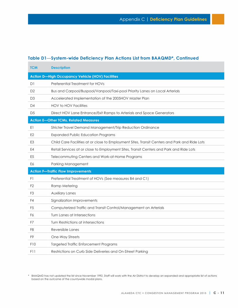
Appendix C | Deficiency Plan Guidelines
ALAMEDA CTC • CONGEST ION MANAGEMENT PROGRAM 2 015 | C - 11
TCM Description
Action D—High Occupancy Vehicle (HOV) Facilities
D1 Preferential Treatment for HOVs
D2 Bus and Carpool/Buspool/Vanpool/Taxi-pool Priority Lanes on Local Arterials
D3 Accelerated Implementation of the 2005HOV Master Plan
D4 HOV to HOV Facilities
D5 Direct HOV Lane Entrance/Exit Ramps to Arterials and Space Generators
Action E—Other TCMs, Related Measures
E1 Stricter Travel Demand Management/Trip Reduction Ordinance
E2 Expanded Public Education Programs
E3 Child Care Facilities at or close to Employment Sites, Transit Centers and Park and Ride Lots
E4 Retail Services at or close to Employment Sites, Transit Centers and Park and Ride Lots
E5 Telecommuting Centers and Work-at-Home Programs
E6 Parking Management
Action F—Traffic Flow Improvements
F1 Preferential Treatment of HOVs (See measures B4 and C1)
F2 Ramp Metering
F3 Auxiliary Lanes
F4 Signalization Improvements
F5 Computerized Traffic and Transit Control/Management on Arterials
F6 Turn Lanes at Intersections
F7 Turn Restrictions at intersections
F8 Reversible Lanes
F9 One-Way Streets
F10 Targeted Traffic Enforcement Programs
F11 Restrictions on Curb Side Deliveries and On-Street Parking
Table D1—System-wide Deficiency Plan Actions List from BAAQMD*, Continued
* BAAQMD has not updated the list since November 1992. Staff will work with the Air District to develop an expanded and appropriate list of actions based on the outcome of the countywide modal plans.

Alameda CTC | Congestion Management Program
C - 12 | ALAMEDA CTC • CONGEST ION MANAGEMENT PROGRAM 2 015
This page is intentionally left blank.
ALAMEDA CTC • CONGEST ION MANAGEMENT PROGRAM 2 015 | D - 1
Appendix D
CommitteesThe Alameda CTC Board has three standing committees: the Finance and Administration Committee (FAC), the Programs and Projects Committee (PPC), and the Planning, Policy and Legislation Committee (PPLC). Alameda CTC is also advised by the Alameda County Technical Advisory Committee (ACTAC).
Finance and Administration CommitteeThe functions and authority of the FAC are agency operations and performance; human resources and personnel policies and procedures; administrative code; salary and benefits; procurement policies and procedures; procurement of administrative contracts; contract preference programs for entities such as local business enterprises, small business enterprises and disabled business enterprises; bid protests and complaints related to administrative contract procurement; annual budget and financial reports; investment policy and reports; audit reports, financial reporting, internal controls and risk management; and the annual work program.
Programs and Projects CommitteeThe functions and authority of the PPC are local, state, CMA Transportation Improvement Program, Transportation Fund for Clean Air, Vehicle Registration Fee (VRF) programs and Expenditure Plan programs and projects; local, state and federally funded projects and funding programs; the annual strategic plan for programs and projects; funding requests from project sponsors and other eligible recipients; paratransit services programs and projects; bicycle and pedestrian projects and programs; funding allocations to various transportation programs and projects; eminent domain proceedings; environmental evaluations; contract procurement; good faith efforts policies and procedures; and bid protests and complaints regarding engineering and construction contract procurement.
Planning, Policy, and Legislation CommitteeThe functions and authority of the PPLC are the CMP; Countywide Transportation Plan; federal, state, regional, and local transportation and land-use planning policies and studies; amendments to the 1986 Expenditure Plan or the 2000 Expenditure Plans; amendments to the VRF Expenditure Plan; transit-oriented development and priority development area projects and programs; the annual legislative program; state and federal legislative matters; general and targeted outreach programs; and advisory committee performance and effectiveness.
Technical Advisory CommitteeACTAC functions as the technical advisory committee to the Alameda CTC. ACTAC is comprised of one staff representative, preferably from a planning or public works department, from each of the following: Alameda CTC, each city, the county, BART, AC Transit, the Livermore Amador Valley Transit Agency, the Port of Oakland, the Metropolitan Transportation Commission, and Caltrans. Alameda CTC’s executive director is the chairperson of ACTAC.
Alameda CTC Committees and Administration
Alameda CTC | Congestion Management Program
D - 2 | ALAMEDA CTC • CONGEST ION MANAGEMENT PROGRAM 2 015
Administrative CostsAlameda CTC’s administrative costs regarding adminis-tration of the CMP-related activities are paid from levies on each city and the county in proportion to the fuel tax subventions under Proposition 111. The levies are based on the annual congestion management agency budget, which is adopted by April 1 of each year. MTC has entered into contracts with the Bay Area CMAs to assist in meeting the requirements of Moving Ahead for Progress in the 21st Century (MAP-21). These revenues have reduced the levy to the cities and county for support of congestion management activities. Alameda CTC will continue to advocate legislative measures that provide funding for these administrative costs so that fuel tax subventions to local government can be fully employed to address local transportation needs.
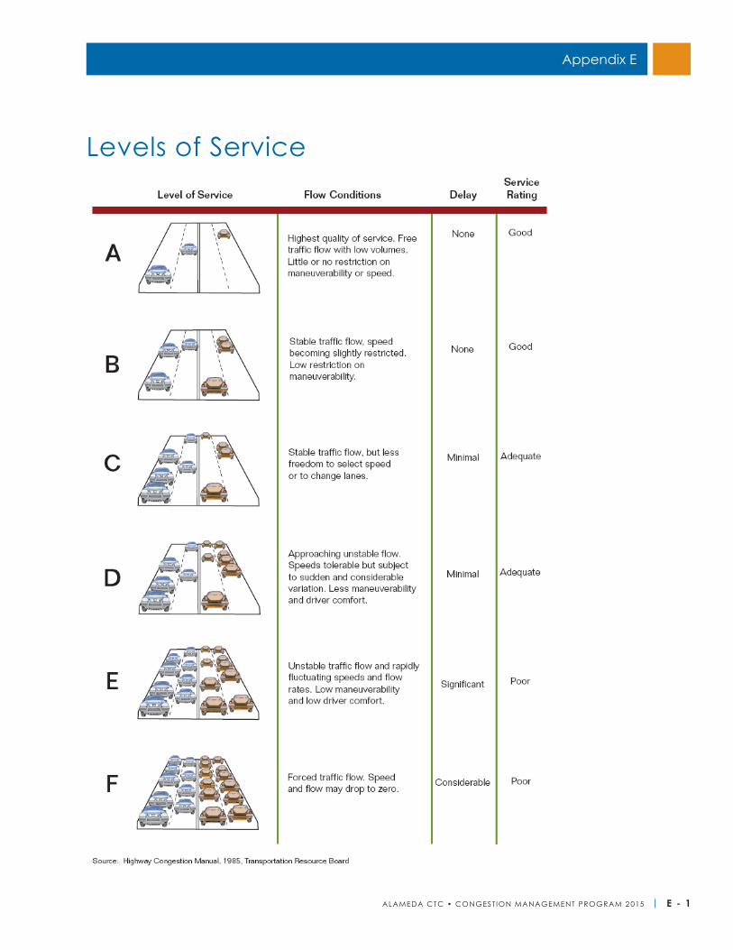
ALAMEDA CTC • CONGEST ION MANAGEMENT PROGRAM 2 015 | E - 1
Appendix E
Levels of Service
Alameda CTC | Congestion Management Program
E - 2 | ALAMEDA CTC • CONGEST ION MANAGEMENT PROGRAM 2 015
This page is intentionally left blank.
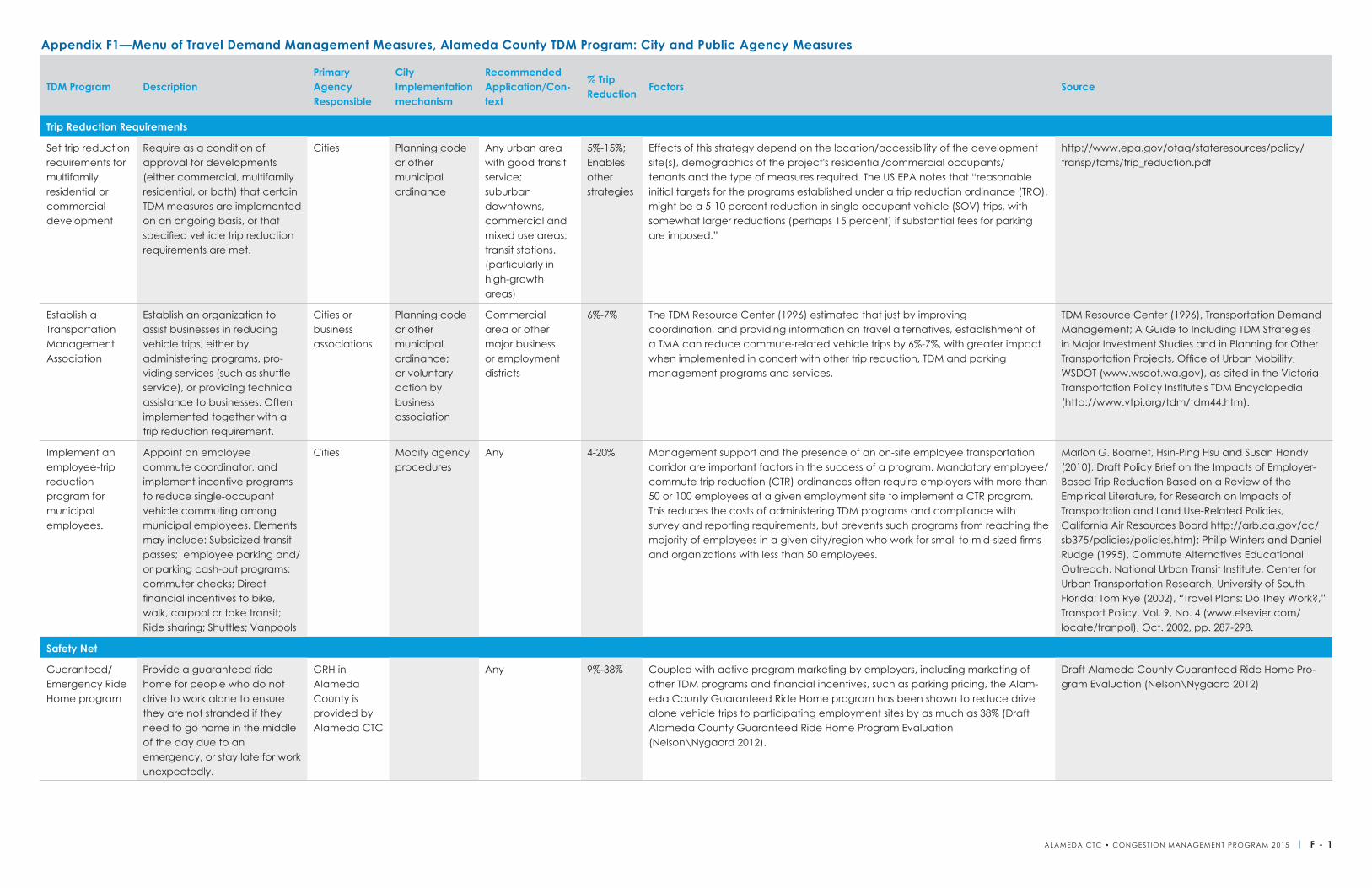
TDM Program DescriptionPrimary Agency Responsible
City Implementation mechanism
Recommended Application/Con-text
% Trip Reduction
Factors Source
Trip Reduction Requirements
Set trip reduction requirements for multifamily residential or commercial development
Require as a condition of approval for developments (either commercial, multifamily residential, or both) that certain TDM measures are implemented on an ongoing basis, or that specified vehicle trip reduction requirements are met.
Cities Planning code or other municipal ordinance
Any urban area with good transit service; suburban downtowns, commercial and mixed use areas; transit stations. (particularly in high-growth areas)
5%-15%; Enables other strategies
Effects of this strategy depend on the location/accessibility of the development site(s), demographics of the project's residential/commercial occupants/ tenants and the type of measures required. The US EPA notes that “reasonable initial targets for the programs established under a trip reduction ordinance (TRO), might be a 5-10 percent reduction in single occupant vehicle (SOV) trips, with somewhat larger reductions (perhaps 15 percent) if substantial fees for parking are imposed.”
http://www.epa.gov/otaq/stateresources/policy/transp/tcms/trip_reduction.pdf
Establish a Transportation Management Association
Establish an organization to assist businesses in reducing vehicle trips, either by administering programs, pro-viding services (such as shuttle service), or providing technical assistance to businesses. Often implemented together with a trip reduction requirement.
Cities or business associations
Planning code or other municipal ordinance; or voluntary action by business association
Commercial area or other major business or employment districts
6%-7% The TDM Resource Center (1996) estimated that just by improving coordination, and providing information on travel alternatives, establishment of a TMA can reduce commute-related vehicle trips by 6%-7%, with greater impact when implemented in concert with other trip reduction, TDM and parking management programs and services.
TDM Resource Center (1996), Transportation Demand Management; A Guide to Including TDM Strategies in Major Investment Studies and in Planning for Other Transportation Projects, Office of Urban Mobility, WSDOT (www.wsdot.wa.gov), as cited in the Victoria Transportation Policy Institute's TDM Encyclopedia (http://www.vtpi.org/tdm/tdm44.htm).
Implement an employee-trip reduction program for municipal employees.
Appoint an employee commute coordinator, and implement incentive programs to reduce single-occupant vehicle commuting among municipal employees. Elements may include: Subsidized transit passes; employee parking and/or parking cash-out programs; commuter checks; Direct financial incentives to bike, walk, carpool or take transit; Ride sharing; Shuttles; Vanpools
Cities Modify agency procedures
Any 4-20% Management support and the presence of an on-site employee transportation corridor are important factors in the success of a program. Mandatory employee/commute trip reduction (CTR) ordinances often require employers with more than 50 or 100 employees at a given employment site to implement a CTR program. This reduces the costs of administering TDM programs and compliance with survey and reporting requirements, but prevents such programs from reaching the majority of employees in a given city/region who work for small to mid-sized firms and organizations with less than 50 employees.
Marlon G. Boarnet, Hsin-Ping Hsu and Susan Handy (2010), Draft Policy Brief on the Impacts of Employer-Based Trip Reduction Based on a Review of the Empirical Literature, for Research on Impacts of Transportation and Land Use-Related Policies, California Air Resources Board http://arb.ca.gov/cc/sb375/policies/policies.htm); Philip Winters and Daniel Rudge (1995), Commute Alternatives Educational Outreach, National Urban Transit Institute, Center for Urban Transportation Research, University of South Florida; Tom Rye (2002), “Travel Plans: Do They Work?,” Transport Policy, Vol. 9, No. 4 (www.elsevier.com/locate/tranpol), Oct. 2002, pp. 287-298.
Safety Net
Guaranteed/Emergency Ride Home program
Provide a guaranteed ride home for people who do not drive to work alone to ensure they are not stranded if they need to go home in the middle of the day due to an emergency, or stay late for work unexpectedly.
GRH in Alameda County is provided by Alameda CTC
Any 9%-38% Coupled with active program marketing by employers, including marketing of other TDM programs and financial incentives, such as parking pricing, the Alam-eda County Guaranteed Ride Home program has been shown to reduce drive alone vehicle trips to participating employment sites by as much as 38% (Draft Alameda County Guaranteed Ride Home Program Evaluation (Nelson\Nygaard 2012).
Draft Alameda County Guaranteed Ride Home Pro-gram Evaluation (Nelson\Nygaard 2012)
Appendix F1—Menu of Travel Demand Management Measures, Alameda County TDM Program: City and Public Agency Measures
ALAMEDA CTC • CONGEST ION MANAGEMENT PROGRAM 2 015 | F - 1
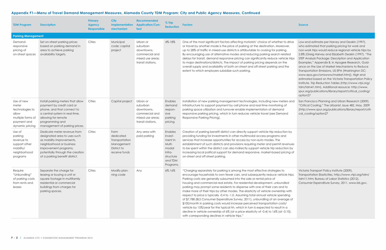
TDM Program DescriptionPrimary Agency Responsible
City Implementation mechanism
Recommended Application/Con-text
% Trip Reduction
Factors Source
Parking Management
Demand- responsive pricing of on-street spaces
Set on-street parking prices based on parking demand in area to achieve parking availability targets.
Cities Municipal code; capital project
Urban or suburban downtowns, commercial and mixed use areas; transit stations.
4%-18% One of the most significant factors affecting motorists’ choice of whether to drive or travel by another mode is the price of parking at the destination. Moreover, up to 28% of traffic in mixed-use districts is attributable to cruising for parking. By encouraging use of alternative modes and reducing parking search related delays for transit, demand responsive pricing can significantly reduce vehicle trips to major destinations/districts. The impact of parking pricing depends on the overall supply and availability of both on-street and off-street parking and the extent to which employers subsidize such parking.
Low-end estimate per Harvey and Deakin (1997), who estimated that parking pricing for work and non-work trips would reduce regional vehicle trips by 2.8% (Greig Harvey and Elizabeth Deakin (1997), “The STEP Analysis Package: Description and Application Examples,” Appendix B, in Apogee Research, Guid-ance on the Use of Market Mechanisms to Reduce Transportation Emissions, US EPA (Washington DC; www.epa.gov/omswww/market.htm)). High end estimated based on the Victoria Transportation Policy Institute, Trip Reduction Tables (http://www.vtpi.org/tdm/tdm41.htm). Additional resource: http://www.spur.org/publications/library/report/critical_cooling/option27
Use of new meter technologies to allow multiple forms of payment and dynamic pricing
Install parking meters that allow payment by credit card or phone, and that connect to a central system in real-time, allowing for remote programming and management of parking prices.
Cities Capital project Urban or suburban downtowns, commercial and mixed use areas; transit stations.
Enables demand respon-sive parking pricing
Installation of new parking management technologies, including new meters and infrastructure to support payment by cell phone and real-time monitoring of parking space utilization and turnover enable implementation of demand responsive parking pricing, which in turn reduces vehicle travel (see Demand Responsive Parking Pricing).
San Francisco Planning and Urban Research (2009). “Critical Cooling,” The Urbanist, Issue 482, May, 2009 (http://www.spur.org/publications/library/report/criti-cal_cooling/option27
Use of parking revenue to support other mobility/neighborhood programs
Dedicate meter revenue from designated area to uses such as mobility improvements, neighborhood or business improvement programs, potentially through the creation of a parking benefit district.
Cities Form dedicated Transportation Management District to receive funds
Any area with paid parking
Enables invest-ment in Multi-modal Infra-structure and TDM Programs.
Creation of parking benefit district can directly support vehicle trip reduction by providing funding for investments in other multimodal access programs and services that increase opportunities for access by non-auto modes. The establishment of such districts and provisions requiring meter and permit revenues to be spent within the district can also indirectly support vehicle trip reduction by increasing local political support for demand responsive, market-based pricing of on-street and off-street parking.
Require “Unbundling” of parking costs from rents and leases
Separate the charge for leasing or buying a unit or square footage in multifamily residential or commercial buildings from charges for parking spaces.
Cities Modify plan-ning code
Any 6%-16% “Charging separately for parking is among the most effective strategies to encourage households to own fewer cars, and subsequently reduce vehicle trips. Parking costs are generally subsumed into the sale or rental price of housing and commercial real estate. For residential development, unbundled parking may prompt some residents to dispense with one of their cars and to make more of their trips by other modes. The elasticity of vehicle ownership with respect to price is typically -0.4 to -1.0. Assuming total annual vehicle spending of $7,788 (BLS Consumer Expenditure Survey, 2011), unbundling of an average of $100/month in parking costs would increase perceived transportation costs/ vehicle by 15%/year for the typical hh, which in turn is expected to result in a decline in vehicle ownership of 6% (at a price elasticity of -0.4) to 16% (at -0.10), with corresponding declines in vehicle trips.”
Victoria Transport Policy Institute (2009), Transportation Elasticities, http://www.vtpi.org/tdm/tdm11.htm; Bureau of Labor Statistics (2012), Consumer Expenditure Survey, 2011, www.bls.gov.
Appendix F1—Menu of Travel Demand Management Measures, Alameda County TDM Program: City and Public Agency Measures, Continued
F - 2 | ALAMEDA CTC • CONGEST ION MANAGEMENT PROGRAM 2 015
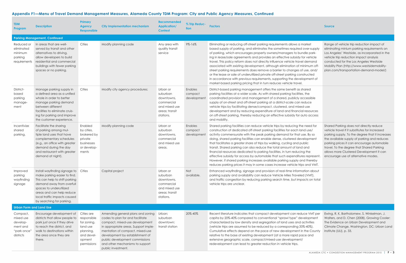
TDM Program
DescriptionPrimary Agency Responsible
City Implementation mechanismRecommended Application/Context
% Trip Reduc-tion
Factors Source
Parking Management, Continued
Reduced or eliminated minimum parking requirements
In areas that are well-served by transit and other alternatives to driving, allow developers to build residential and commercial buildings with fewer parking spaces or no parking.
Cities Modify planning code Any area with quality transit service
9%-16% Eliminating or reducing off-street parking requirements allows a market based supply of parking, and eliminates the sometimes required over-supply of parking, which encourages property owners/managers to bundle park-ing in lease/sale agreements and provides an effective subsidy for vehicle travel. This policy reform does not directly influence vehicle travel demand associated with existing development, although elimination of minimum off-street parking requirements does remove a barrier to changes of use, and/or the lease or sale of underutilized private off-street parking constructed in accordance with previous requirements, supporting the development of market-based parking pricing that in turn reduces vehicle travel.
Range of vehicle trip reduction impact of eliminating minium parking requirements on Los Angeles’ Westside, as incorporated in the vehicle trip reduction impact analysis conducted for the Los Angeles Westside Mobility Plan (http://www.westsidemobility-plan.com/transportation-demand-model/)
District-based parking manage-ment
Manage parking supply in a defined area as a unified whole in order to better manage parking demand between different facilities to eliminate cruis-ing for parking and improve the customer experience.
Cities Modify city agency procedures; Urban or suburban downtowns, commercial and mixed use areas; transit stations.
Enables compact development
District-based parking management offers the same benefit as shared parking facilities at a wider scale. As with shared parking facilities, the coordinated provision and management of a shared, publicly accessible supply of on-street and off-street parking at a district-scale can reduce vehicle trips by facilitating dense/compact, clustered, and mixed-use development and by reducing expenditure of land and financial resources on off-street parking, thereby reducing an effective subsidy for auto access and mobility.
Incentivize shared parking.
Facilitate the sharing of parking among mul-tiple land uses that have complementary schedules (e.g., an office with greater demand during the day and restaurant with greater demand at night).
Enabled by cities, brokered by private businesses or develop-ments
Modify planning code Urban or suburban downtowns, commercial and mixed use areas.
Enables compact development
Shared parking facilities can reduce vehicle trips by reducing the need for construction of dedicated off-street parking facilities for each land use/activity commensurate with the peak parking demand for that use. By so doing, shared parking facilities can enable dense, clustered development that facilitates a greater share of trips by walking, cycling and public transit. Shared parking can also reduce the total amount of land and financial resources dedicated to parking facilities, in turn reducing the effective subsidy for access by automobile that such expenditures represent. However, if shared parking increases available parking supply and thereby reduces parking prices it may in some cases increase vehicle trips and VMT.
Shared Parking does not directly reduce vehicle travel if it substitutes for increased parking supply. To the degree that it increases the available supply of parking and reduces parking prices it can encourage automobile travel. To the degree that Shared Parking allows more Clustered Development it can encourage use of alternative modes.
Improved parking wayfinding signage
Install wayfinding signage to make parking easier to find. This can help to shift parking demand away from overfull spaces to underutilized areas and can help reduce local traffic impacts caused by searching for parking.
Cities Capital project Urban or suburban downtowns, commercial and mixed use areas; transit stations.
Not available.
Enhanced wayfinding, signage and provision of real-time information about parking supply and availability can reduce Vehicle Miles Traveled (VMT), and traffic congestion by reducing parking search time, but impacts on total vehicle trips are unclear.
Urban Form and Land Use
Compact, mixed use develop-ment and “park once” districts
Encourage development of districts that allow people to park just once if they drive to reach the district, and walk to destinations within the area once they are there.
Cities are responsible for zoning, land use planning, and devel-opment permissions
Amending general plans and zoning codes to plan for and facilitate compact, mixed-use development in appropriate areas. Support imple-mentation of compact, mixed-use development by establishment of public development commissions and other mechanisms to support public investment.
Urban; suburban downtown; transit station
20%-40% Recent literature indicates that compact development can reduce VMT per capita by 20%-40% compared to conventional “sprawl type” development characterized by low density and segregation of land uses and activities (vehicle trips are assumed to be reduced by a corresponding 20%-40%). Cumulative effects depend on the pace of new development in the County relative to the base of existing development (at a more rapid pace and extensive geographic scale, compact/mixed-use development/ redevelopment can lead to greater reduction in vehicle trips.
Ewing, R. K. Bartholomew, S. Winkelman, J. Walters, and D. Chen (2008). Growing Cooler: The Evidence on Urban Development and Climate Change. Washington, DC: Urban Land Institute (ULI), p. 33.
Appendix F1—Menu of Travel Demand Management Measures, Alameda County TDM Program: City and Public Agency Measures, Continued
ALAMEDA CTC • CONGEST ION MANAGEMENT PROGRAM 2 015 | F - 3
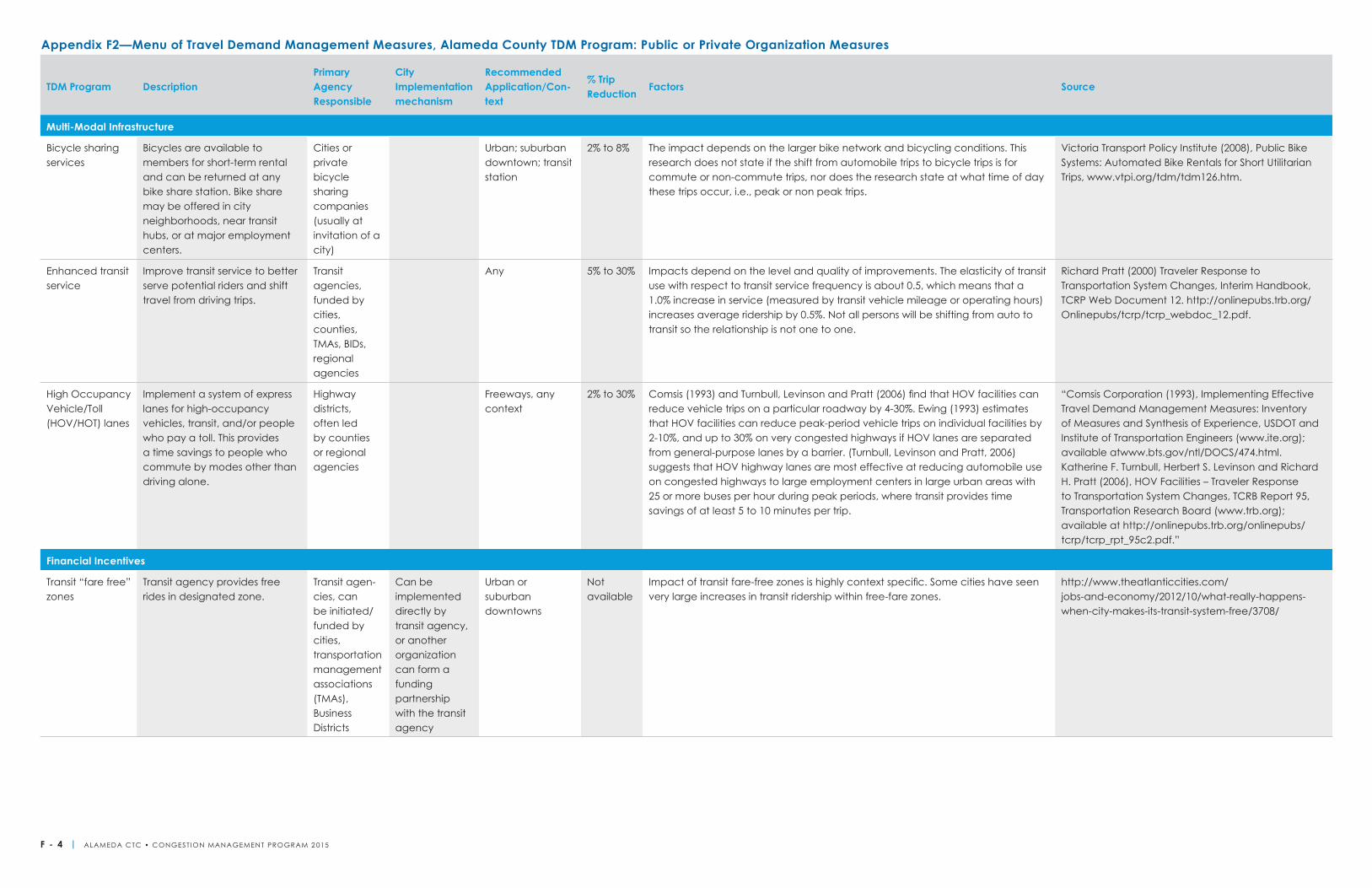
TDM Program DescriptionPrimary Agency Responsible
City Implementation mechanism
Recommended Application/Con-text
% Trip Reduction
Factors Source
Multi-Modal Infrastructure
Bicycle sharing services
Bicycles are available to members for short-term rental and can be returned at any bike share station. Bike share may be offered in city neighborhoods, near transit hubs, or at major employment centers.
Cities or private bicycle sharing companies (usually at invitation of a city)
Urban; suburban downtown; transit station
2% to 8% The impact depends on the larger bike network and bicycling conditions. This research does not state if the shift from automobile trips to bicycle trips is for commute or non-commute trips, nor does the research state at what time of day these trips occur, i.e., peak or non peak trips.
Victoria Transport Policy Institute (2008), Public Bike Systems: Automated Bike Rentals for Short Utilitarian Trips, www.vtpi.org/tdm/tdm126.htm.
Enhanced transit service
Improve transit service to better serve potential riders and shift travel from driving trips.
Transit agencies, funded by cities, counties, TMAs, BIDs, regional agencies
Any 5% to 30% Impacts depend on the level and quality of improvements. The elasticity of transit use with respect to transit service frequency is about 0.5, which means that a 1.0% increase in service (measured by transit vehicle mileage or operating hours) increases average ridership by 0.5%. Not all persons will be shifting from auto to transit so the relationship is not one to one.
Richard Pratt (2000) Traveler Response to Transportation System Changes, Interim Handbook, TCRP Web Document 12. http://onlinepubs.trb.org/Onlinepubs/tcrp/tcrp_webdoc_12.pdf.
High Occupancy Vehicle/Toll (HOV/HOT) lanes
Implement a system of express lanes for high-occupancy vehicles, transit, and/or people who pay a toll. This provides a time savings to people who commute by modes other than driving alone.
Highway districts, often led by counties or regional agencies
Freeways, any context
2% to 30% Comsis (1993) and Turnbull, Levinson and Pratt (2006) find that HOV facilities can reduce vehicle trips on a particular roadway by 4-30%. Ewing (1993) estimates that HOV facilities can reduce peak-period vehicle trips on individual facilities by 2-10%, and up to 30% on very congested highways if HOV lanes are separated from general-purpose lanes by a barrier. (Turnbull, Levinson and Pratt, 2006) suggests that HOV highway lanes are most effective at reducing automobile use on congested highways to large employment centers in large urban areas with 25 or more buses per hour during peak periods, where transit provides time savings of at least 5 to 10 minutes per trip.
“Comsis Corporation (1993), Implementing Effective Travel Demand Management Measures: Inventory of Measures and Synthesis of Experience, USDOT and Institute of Transportation Engineers (www.ite.org); available atwww.bts.gov/ntl/DOCS/474.html. Katherine F. Turnbull, Herbert S. Levinson and Richard H. Pratt (2006), HOV Facilities – Traveler Response to Transportation System Changes, TCRB Report 95, Transportation Research Board (www.trb.org); available at http://onlinepubs.trb.org/onlinepubs/tcrp/tcrp_rpt_95c2.pdf.”
Financial Incentives
Transit “fare free” zones
Transit agency provides free rides in designated zone.
Transit agen-cies, can be initiated/funded by cities, transportation management associations (TMAs), Business Districts
Can be implemented directly by transit agency, or another organization can form a funding partnership with the transit agency
Urban or suburban downtowns
Not available
Impact of transit fare-free zones is highly context specific. Some cities have seen very large increases in transit ridership within free-fare zones.
http://www.theatlanticcities.com/jobs-and-economy/2012/10/what-really-happens-when-city-makes-its-transit-system-free/3708/
Appendix F2—Menu of Travel Demand Management Measures, Alameda County TDM Program: Public or Private Organization Measures
F - 4 | ALAMEDA CTC • CONGEST ION MANAGEMENT PROGRAM 2 015
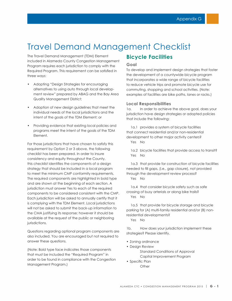
ALAMEDA CTC • CONGEST ION MANAGEMENT PROGRAM 2 015 | G - 1
Appendix G
The Travel Demand Management (TDM) Element included in Alameda County Congestion Management Program requires each jurisdiction to comply with the Required Program. This requirement can be satisfied in three ways:
• Adopting “Design Strategies for encouraging alternatives to using auto through local develop-ment review” prepared by ABAG and the Bay Area Quality Management District;
• Adoption of new design guidelines that meet the individual needs of the local jurisdictions and the intent of the goals of the TDM Element; or
• Providing evidence that existing local policies and programs meet the intent of the goals of the TDM Element.
For those jurisdictions that have chosen to satisfy this requirement by Option 2 or 3 above, the following checklist has been prepared. In order to insure consistency and equity throughout the County, this checklist identifies the components of a design strategy that should be included in a local program to meet the minimum CMP conformity requirements. The required components are highlighted in bold type and are shown at the beginning of each section. A jurisdiction must answer Yes to each of the required components to be considered consistent with the CMP. Each jurisdiction will be asked to annually certify that it is complying with the TDM Element. Local jurisdictions will not be asked to submit the back-up information to the CMA justifying its response; however it should be available at the request of the public or neighboring jurisdictions.
Questions regarding optional program components are also included. You are encouraged but not required to answer these questions.
(Note: Bold type face indicates those components that must be included the “Required Program” in order to be found in compliance with the Congestion Management Program.)
Bicycle FacilitiesGoalTo develop and implement design strategies that foster the development of a countywide bicycle program that incorporates a wide range of bicycle facilities to reduce vehicle trips and promote bicycle use for commuting, shopping and school activities. (Note: examples of facilities are bike paths, lanes or racks.)
Local Responsibilities1a. In order to achieve the above goal, does your jurisdiction have design strategies or adopted policies that include the following:
1a.1 provides a system of bicycle facilities that connect residential and/or non-residential development to other major activity centers? Yes No
1a.2 bicycle facilities that provide access to transit? Yes No
1a.3 that provide for construction of bicycle facilities needed to fill gaps, (i.e., gap closure), not provided through the development review process? Yes No
1a.4 that consider bicycle safety such as safe crossing of busy arterials or along bike trails? Yes No
1a.5 that provide for bicycle storage and bicycle parking for (A) multi-family residential and/or (B) non-residential developments? Yes No
1b. How does your jurisdiction implement these strategies? Please identify.
• Zoning ordinance • Design Review
Standard Conditions of Approval Capital Improvement Program
• Specific Plan Other
Travel Demand Management Checklist
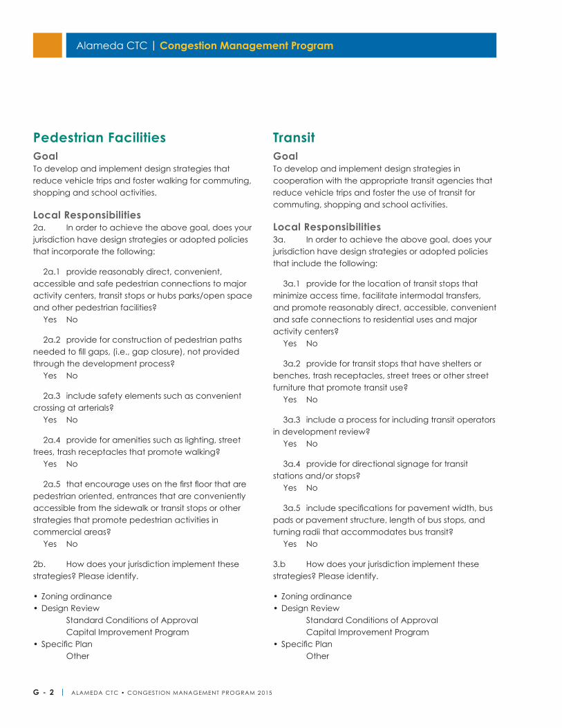
Alameda CTC | Congestion Management Program
G - 2 | ALAMEDA CTC • CONGEST ION MANAGEMENT PROGRAM 2 015
Pedestrian FacilitiesGoalTo develop and implement design strategies that reduce vehicle trips and foster walking for commuting, shopping and school activities.
Local Responsibilities2a. In order to achieve the above goal, does your jurisdiction have design strategies or adopted policies that incorporate the following:
2a.1 provide reasonably direct, convenient, accessible and safe pedestrian connections to major activity centers, transit stops or hubs parks/open space and other pedestrian facilities? Yes No
2a.2 provide for construction of pedestrian paths needed to fill gaps, (i.e., gap closure), not provided through the development process? Yes No
2a.3 include safety elements such as convenient crossing at arterials? Yes No
2a.4 provide for amenities such as lighting, street trees, trash receptacles that promote walking? Yes No
2a.5 that encourage uses on the first floor that are pedestrian oriented, entrances that are conveniently accessible from the sidewalk or transit stops or other strategies that promote pedestrian activities in commercial areas? Yes No
2b. How does your jurisdiction implement these strategies? Please identify.
• Zoning ordinance • Design Review
Standard Conditions of Approval Capital Improvement Program
• Specific Plan Other
TransitGoalTo develop and implement design strategies in cooperation with the appropriate transit agencies that reduce vehicle trips and foster the use of transit for commuting, shopping and school activities.
Local Responsibilities3a. In order to achieve the above goal, does your jurisdiction have design strategies or adopted policies that include the following:
3a.1 provide for the location of transit stops that minimize access time, facilitate intermodal transfers, and promote reasonably direct, accessible, convenient and safe connections to residential uses and major activity centers? Yes No
3a.2 provide for transit stops that have shelters or benches, trash receptacles, street trees or other street furniture that promote transit use? Yes No
3a.3 include a process for including transit operators in development review? Yes No
3a.4 provide for directional signage for transit stations and/or stops? Yes No
3a.5 include specifications for pavement width, bus pads or pavement structure, length of bus stops, and turning radii that accommodates bus transit? Yes No
3.b How does your jurisdiction implement these strategies? Please identify.
• Zoning ordinance • Design Review
Standard Conditions of Approval Capital Improvement Program
• Specific Plan Other
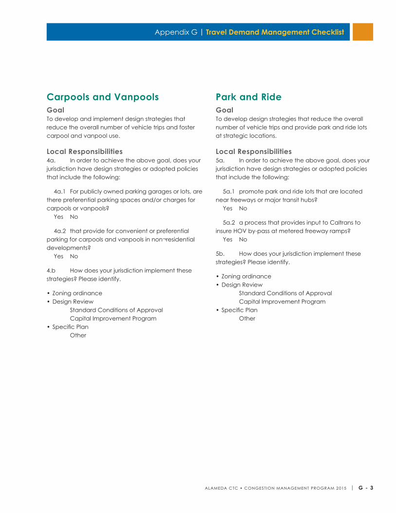
Appendix G | Travel Demand Management Checklist
ALAMEDA CTC • CONGEST ION MANAGEMENT PROGRAM 2 015 | G - 3
Carpools and VanpoolsGoalTo develop and implement design strategies that reduce the overall number of vehicle trips and foster carpool and vanpool use.
Local Responsibilities4a. In order to achieve the above goal, does your jurisdiction have design strategies or adopted policies that include the following:
4a.1 For publicly owned parking garages or lots, are there preferential parking spaces and/or charges for carpools or vanpools? Yes No
4a.2 that provide for convenient or preferential parking for carpools and vanpools in non¬residential developments? Yes No
4.b How does your jurisdiction implement these strategies? Please identify.
• Zoning ordinance • Design Review
Standard Conditions of Approval Capital Improvement Program
• Specific Plan Other
Park and RideGoalTo develop design strategies that reduce the overall number of vehicle trips and provide park and ride lots at strategic locations.
Local Responsibilities5a. In order to achieve the above goal, does your jurisdiction have design strategies or adopted policies that include the following:
5a.1 promote park and ride lots that are located near freeways or major transit hubs? Yes No
5a.2 a process that provides input to Caltrans to insure HOV by-pass at metered freeway ramps? Yes No
5b. How does your jurisdiction implement these strategies? Please identify.
• Zoning ordinance• Design Review
Standard Conditions of Approval Capital Improvement Program
• Specific Plan Other

Alameda CTC | Congestion Management Program
G - 4 | ALAMEDA CTC • CONGEST ION MANAGEMENT PROGRAM 2 015
This page is intentionally left blank.
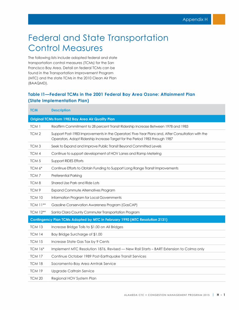
ALAMEDA CTC • CONGEST ION MANAGEMENT PROGRAM 2 015 | H - 1
Appendix H
The following lists include adopted federal and state transportation control measures (TCMs) for the San Francisco Bay Area. Detail on federal TCMs can be found in the Transportation Improvement Program (MTC) and the state TCMs in the 2010 Clean Air Plan (BAAQMD).
Federal and State Transportation Control Measures
TCM Description
Original TCMs from 1982 Bay Area Air Quality Plan
TCM 1 Reaffirm Commitment to 28 percent Transit Ridership Increase Between 1978 and 1983
TCM 2 Support Post-1983 Improvements in the Operators' Five-Year Plans and, After Consultation with the Operators, Adopt Ridership Increase Target for the Period 1983 through 1987
TCM 3 Seek to Expand and Improve Public Transit Beyond Committed Levels
TCM 4 Continue to support development of HOV Lanes and Ramp Metering
TCM 5 Support RIDES Efforts
TCM 6* Continue Efforts to Obtain Funding to Support Long Range Transit Improvements
TCM 7 Preferential Parking
TCM 8 Shared Use Park and Ride Lots
TCM 9 Expand Commute Alternatives Program
TCM 10 Information Program for Local Governments
TCM 11** Gasoline Conservation Awareness Program (GasCAP)
TCM 12** Santa Clara County Commuter Transportation Program
Contingency Plan TCMs Adopted by MTC in February 1990 (MTC Resolution 2131)
TCM 13 Increase Bridge Tolls to $1.00 on All Bridges
TCM 14 Bay Bridge Surcharge of $1.00
TCM 15 Increase State Gas Tax by 9 Cents
TCM 16* Implement MTC Resolution 1876, Revised — New Rail Starts – BART Extension to Colma only
TCM 17 Continue October 1989 Post-Earthquake Transit Services
TCM 18 Sacramento-Bay Area Amtrak Service
TCM 19 Upgrade Caltrain Service
TCM 20 Regional HOV System Plan
Table I1—Federal TCMs in the 2001 Federal Bay Area Ozone: Attainment Plan (State Implementation Plan)
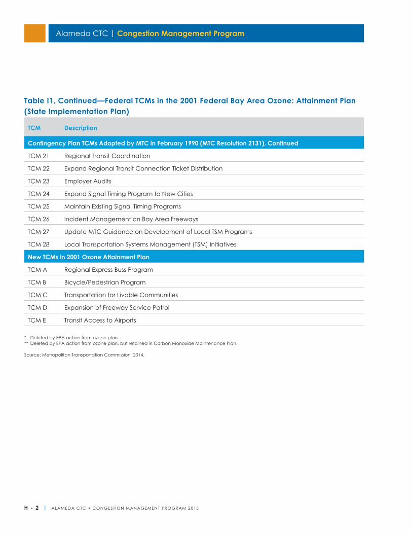
Alameda CTC | Congestion Management Program
H - 2 | ALAMEDA CTC • CONGEST ION MANAGEMENT PROGRAM 2 015
TCM Description
Contingency Plan TCMs Adopted by MTC in February 1990 (MTC Resolution 2131), Continued
TCM 21 Regional Transit Coordination
TCM 22 Expand Regional Transit Connection Ticket Distribution
TCM 23 Employer Audits
TCM 24 Expand Signal Timing Program to New Cities
TCM 25 Maintain Existing Signal Timing Programs
TCM 26 Incident Management on Bay Area Freeways
TCM 27 Update MTC Guidance on Development of Local TSM Programs
TCM 28 Local Transportation Systems Management (TSM) Initiatives
New TCMs in 2001 Ozone Attainment Plan
TCM A Regional Express Buss Program
TCM B Bicycle/Pedestrian Program
TCM C Transportation for Livable Communities
TCM D Expansion of Freeway Service Patrol
TCM E Transit Access to Airports
Table I1, Continued—Federal TCMs in the 2001 Federal Bay Area Ozone: Attainment Plan (State Implementation Plan)
* Deleted by EPA action from ozone plan.** Deleted by EPA action from ozone plan, but retained in Carbon Monoxide Maintenance Plan.
Source: Metropolitan Transportation Commission, 2014.
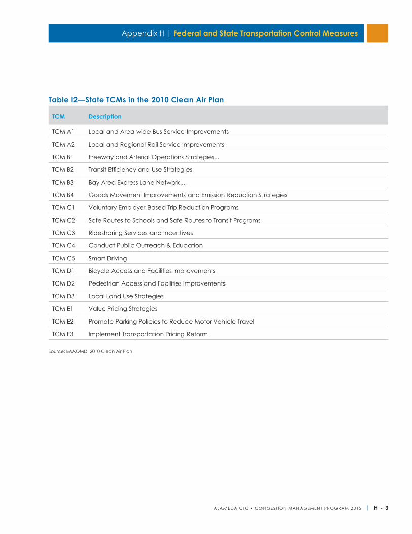
Appendix H | Federal and State Transportation Control Measures
ALAMEDA CTC • CONGEST ION MANAGEMENT PROGRAM 2 015 | H - 3
TCM Description
TCM A1 Local and Area-wide Bus Service Improvements
TCM A2 Local and Regional Rail Service Improvements
TCM B1 Freeway and Arterial Operations Strategies...
TCM B2 Transit Efficiency and Use Strategies
TCM B3 Bay Area Express Lane Network....
TCM B4 Goods Movement Improvements and Emission Reduction Strategies
TCM C1 Voluntary Employer-Based Trip Reduction Programs
TCM C2 Safe Routes to Schools and Safe Routes to Transit Programs
TCM C3 Ridesharing Services and Incentives
TCM C4 Conduct Public Outreach & Education
TCM C5 Smart Driving
TCM D1 Bicycle Access and Facilities Improvements
TCM D2 Pedestrian Access and Facilities Improvements
TCM D3 Local Land Use Strategies
TCM E1 Value Pricing Strategies
TCM E2 Promote Parking Policies to Reduce Motor Vehicle Travel
TCM E3 Implement Transportation Pricing Reform
Table I2—State TCMs in the 2010 Clean Air Plan
Source: BAAQMD, 2010 Clean Air Plan

Alameda CTC | Congestion Management Program
H - 4 | ALAMEDA CTC • CONGEST ION MANAGEMENT PROGRAM 2 015
This page is intentionally left blank.
ALAMEDA CTC • CONGEST ION MANAGEMENT PROGRAM 2 015 | I - 1
Appendix I
General Policy StatementThe Alameda CTC maintains a Countywide Travel Demand Model (Countywide Model) which is in conformance with MTC’s Regional Travel Demand Model and land use database and can therefore be used to satisfy Congestion Management Program (CMP) requirements in Alameda County. The Master Transportation Demand Model Agreements made between the Alameda County Congestion Management Agency and local jurisdictions detail the process through which local jurisdictions can have access to the Countywide Model and use its results for CMP conformance purposes.
An alternative to use of the Countywide Model which local jurisdictions or groups of local jurisdictions may wish to pursue is the development of subarea travel demand models (subarea models) for the purpose of satisfying CMP requirements. Subarea models may be more effective than the Countywide Model for the evaluation of certain local conditions or CMP applications.
Local jurisdictions may use a subarea model for CMP purposes so long as the subarea model demonstrates consistency with the Countywide Model. Results from subarea models which are not consistent with the Countywide Model will not be accepted by the Alameda CTC for CMP purposes.
Consistency GuidelinesA two-step process has been established to determine consistency of a subarea model with the Countywide Model. The two-step process includes an initial evaluation of subarea model compatibility by the Alameda CTC (step one) and, if required, additional data and information to be submitted to the Alameda CTC to verify consistency (step two).
Step One:A. Local jurisdictions apply to the Alameda CTC for a
consistency finding. The application shall consist of the following:
i. A written communication to the Alameda CTC requesting a model consistency finding.
ii. A completed model consistency checklist.
B. In the case of new/proposed subarea models, Alameda CTC staff must be part of the Local Technical Advisory/Oversight Committee/Taskforce for model development.
Step Two:C. If additional information is required to determine
consistency, Alameda CTC staff will review modeling procedures and land use database issues with local modeling staff.
Acceptable CMP Related Uses of a Consistent Subarea ModelA subarea model that has been found to be consistent with the Countywide Model may be used for the following CMP related uses:
1. Forecasting of operating conditions on roadway segments.
2. Development impact analysis performed for the CMP Land Use Analysis Program.
3. Testing of mitigation measures or deficiency plan recommendations to address degradation of Level of Service (LOS) on CMP roadway segments operating below LOS E.
Annual RecertificationAnnual recertification of subarea models is required by the Alameda CTC. Recertification requires a written request. The request must clearly explain why the subarea model should be recertified on the basis of one of the following two conditions:
Subarea Travel Demand Model Guidelines
I - 2 | ALAMEDA CTC • CONGEST ION MANAGEMENT PROGRAM 2 015
Alameda CTC | Congestion Management Program
1. All changes to the model specifications of the land use database (1) were reported to the Alameda CTC previously or (2) are changes done in coordination with the land use database update process of the Countywide Model.
OR
2. Recertification request must include a completed consistency checklist.
Development and Operation of Subarea ModelsIt is assumed that subarea models will be developed by local jurisdictions who will have responsibility for their operation, maintenance, and the costs associated with them. As a condition for delegation of Alameda CTC modeling responsibilities, it is assumed that local jurisdictions will commit to providing adequate ongoing technical support for all model applications in support of a CMP requirement (e.g. land use analysis or deficiency analysis). It is assumed that consultant assistance would normally be required for model development and maintenance.
Dispute ResolutionDisputes regarding consistency or appropriate use of a subarea model shall be brought to the Alameda County Technical Advisory Committee.
Alameda CTC Checklist for Modeling Consistency for Local JurisdictionsThis checklist guides local jurisdictions wishing to develop a subarea model through their model development and consistency review process by providing an inventory of specific products to be developed and submitted to the Alameda CTC, and by describing standard practices and assumptions.
A. General approach:Discuss the general approach to travel demand modeling by the local jurisdiction and the subarea
model's relationship to the Alameda Countywide Travel Demand Model.
PRODUCT:1) Description of the subarea model’s general
approach.
B. Demographic/economic/land use forecasts:Both base and forecast year demographic/economic/land use (“land use”) inputs must be consistent—though not identical—to the census tract-level data provided to the Alameda CTC by ABAG. Specifically, if local jurisdictions wish to reallocate land use within their own jurisdiction, they must consult with the Alameda CTC. Further, the resulting deviation in the subject jurisdiction (or jurisdictions) should be no greater than plus or minus one percent from the jurisdiction-level totals in the Alameda CTC land use database for the following variables: population, households, jobs, and employed residents.
Outside the subject jurisdiction (or jurisdictions) and within Alameda County, the land use variables in the travel analysis zones used by the jurisdiction’s model must match the Alameda CTC model or another adopted subarea model (e.g. the City of Hayward could adopt the land use from within the City of Dublin if the City of Dublin’s model for use in the TAZs within the City of Dublin had an approved subarea model).
Outside of Alameda County, the land use variables in the travel analysis zones used by the jurisdiction’s model must match the Alameda CTC model exactly.
PRODUCTS:2) A statement establishing that the differences
between key Alameda CTC land use variables and those of the sub area model do not differ by more than one percent at the jurisdiction level for the subject jurisdiction. A statement establishing that no differences exist at the census-tract-level outside the jurisdiction between the Alameda CTC forecast or the forecast contained within an adopted subarea model.
Appendix I | Subarea Travel Demand Model Guidelines
ALAMEDA CTC • CONGEST ION MANAGEMENT PROGRAM 2 015 | I - 3
3) A table comparing the Alameda CTC land use estimates with the subarea model land use estimates by jurisdiction for population, households, jobs, and employed residents for both the base year and the horizon year.
4) If land use estimates within the jurisdiction are modified from the Alameda CTC model’s projections, agendas, discussion summaries, and action items from each meeting held with the Alameda CTC at which the redistribution was discussed, as well as before/after census-tract-level data summaries and maps.
C. Pricing assumptions:Use Alameda CTC’s automobile operating costs, transit fares, and bridge tolls or provide an explanation for the reason such values are not used.
PRODUCT:5) Table comparing the assumed automobile
operating cost, key transit fares, and bridge tolls to Alameda CTC’s values for the horizon year.
D. Network Assumptions:Use Alameda CTC’s regional highway and transit network assumptions for the other Bay Area counties and other jurisdictions within Alameda County. Local jurisdictions should include more detailed network definition relevant to their own jurisdiction in addition to the regional highway and transit networks. For the CMP horizon year, to be compared with the TIP interim year, regionally significant network changes in the base case scenario shall be limited to the current Transportation Improvement Program (TIP) for projects subject to inclusion in the TIP.
PRODUCT:6) Statement establishing satisfaction of the above.
E. Automobile ownership:Use Alameda Countywide Travel Demand Model automobile ownership models or forecasts or submit alternative models to Alameda CTC for review and comment.
PRODUCT:7) Planning Area-level table comparing estimates of
households by automobile ownership level (zero, one, two or more automobiles) to Alameda CTC’s estimates for the horizon year.
F. Trip generation:Use Alameda Countywide Travel Demand Model trip generation models or submit alternative models to Alameda CTC for review and comment.
PRODUCT:8) County-level tables comparing estimates of
trip and/or tour frequency by purpose to MTC's estimates for the horizon year.
G. Trip distribution:Use Alameda Countywide Travel Demand Model trip distribution models or submit alternative models to Alameda CTC for review and comment.
PRODUCTS:9) County-level tables comparing estimates of
average trip distance by tour/trip purpose to Alameda CTC’s estimates for the horizon year.
10) Planning area-to-planning area comparison of journey-to-work or home-based work flow estimates to MTC's estimates for the horizon year.
H. Travel mode choice:Use Alameda Countywide Travel Demand Model mode choice models or submit alternative models to Alameda CTC for review and comment.
PRODUCT:11) County-level tables comparing travel mode share
estimates by tour/trip purpose to Alameda CTC’s estimates for the horizon year.
I. Traffic assignment:Use Alameda Countywide Travel Demand Model models, or submit alternative models to Alameda CTC for review and comment.
Alameda CTC | Congestion Management Program
I - 4 | ALAMEDA CTC • CONGEST ION MANAGEMENT PROGRAM 2 015
PRODUCTS:12) County-level, time-period-specific comparison of
vehicle miles traveled and vehicle hours traveled estimates by facility type to Alameda CTC’s estimates for the horizon year.
13) County-level, time-period-specific comparison of estimated average speed on freeways and all other facilities, separately, to Alameda CTC’s estimates for the horizon year.
ALAMEDA CTC • CONGEST ION MANAGEMENT PROGRAM 2 015 | J - 1
Appendix J
Project Trip Generation MethodologiesThe ITE trip generation handbook should be used to determine project trip generation.
Projects near transit or in infill development areas may apply one of the following methodologies to adjust project vehicle trip generation to reflect project context. Other alternative trip generation methodologies will be considered on a case-by- case basis.
EPA’s Trip Generation Tool for Mixed Use Development (MXD model):A description of this method can be found online at:
http://www.epa.gov/smartgrowth/mxd_tripgeneration.html
Caltrans/UC Davis Smart Growth Trip Generation Adjustment Method
A description of this method can be found online at:
http://ultrans.its.ucdavis.edu/projects/smart-growth-trip-generation
MTC’s Station Area Residents (STARS) Mode Split Based Adjustment MethodThis method uses household travel survey data to determine how mode share varies by land use characteristics and then use this information to reduce ITE trip generation rates. The key assumption is that ITE rates produce a reasonably accurate estimate of person-trips, but that in a more dense, transit accessible setting, many of these person-trips may use modes other than driving, so the vehicle-trip rate will be lower.
In the Bay Area, MTC conducted extensive analysis of the 2000 Bay Area Travel Survey (BATS 2000), the most recent household travel survey, as part of its Station Area Residents Study (STARS). This analysis looked at how mode shares differ as a function of proximity to transit and land use density. The findings of this study are well-suited to producing urban trip generation rate estimates.
Table J1 below reproduces a table from the STARS analysis. This table illustrates how the mode shares of residents living in Alameda County differ based on the location of their residence. For instance, the driving mode share of residents living within a half-mile of transit is only 48.2 percent, while for residents living more than a mile from transit, in a lower density area, this share is 87.0 percent.
This information can be used to adjust ITE trip generation rates. For instance, for a development located more than a mile from transit in a high-suburban density area, an adjusted ITE rate could be computed as:
Adjusted Rate = ITE Rate X 0.82
Note that the STARS analysis examined mode share for specific trip purposes (e.g., school trips, shopping trips, social/recreation trips) and depending on the type of development project, an analyst may wish to use this information instead of the mode share for all trips to adjust ITE rates.
Types of Impacts and Impact Assessment MethodologiesAutosProjects should consider auto impacts on MTS roadway segments including:
• Vehicle delay: the analysis should assess impacts to vehicle delay on MTS roadway segments. The Highway Capacity Manual 2010 (HCM 2010) freeway and urban streets methodologies are the preferred methodologies to study vehicle delay impacts. However, project sponsors may use the HCM 2000 if conformance with local requirements is required.
• Consistency with adopted plans: the analysis should disclose whether the project is consistent with plans including future Alameda Countywide Arterial Corridors Plan, and should consider opportunities to implement the plan in the project vicinity.
CMP Transportation Impact Analysis Technical Guidelines
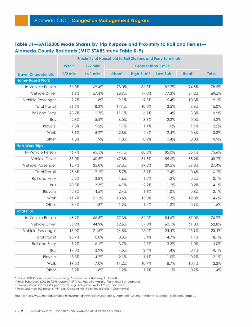
J - 2 | ALAMEDA CTC • CONGEST ION MANAGEMENT PROGRAM 2 015
Alameda CTC | Congestion Management Program
Travel Characteristic
Proximity of Household to Rail Stations and Ferry Terminals
Within 1/2 mile Greater than 1 mile
1/2 mile to 1 mile Urban* High-Sub** Low-Sub ‡ Rural † TotalHome-Based Work
In-Vehicle Person 56.3% 69.4% 78.0% 86.3% 82.7% 94.5% 78.5%
Vehicle Driver 46.6% 57.6% 68.9% 77.0% 77.3% 84.2% 69.5%
Vehicle Passenger 9.7% 11.8% 9.1% 9.3% 5.4% 10.3% 9.1%
Total Transit 26.5% 18.3% 17.1% 10.0% 13.5% 3.8% 15.0%
Rail and Ferry 23.7% 12.7% 11.1% 6.7% 11.4% 3.8% 10.9%
Bus 2.8% 5.6% 6.0% 3.3% 2.2% 0.0% 4.2%
Bicycle 7.3% 5.2% 1.1% 1.1% 1.0% 1.1% 2.2%
Walk 8.1% 5.2% 2.8% 2.4% 2.4% 0.6% 3.3%
Other 1.8% 1.9% 1.0% 0.2% 0.4% 0.0% 0.9%
Non-Work TripsIn-Vehicle Person 46.7% 65.5% 77.1% 80.8% 85.0% 85.1% 75.6%
Vehicle Driver 33.0% 40.5% 47.8% 51.5% 55.6% 55.2% 48.2%
Vehicle Passenger 13.7% 25.0% 29.3% 29.3% 29.5% 29.8% 27.4%
Total Transit 25.6% 7.1% 5.7% 3.7% 2.4% 0.4% 6.2%
Rail and Ferry 5.3% 3.8% 1.6% 1.5% 1.2% 0.3% 2.1%
Bus 20.3% 3.3% 4.1% 2.2% 1.2% 0.2% 4.1%
Bicycle 2.6% 4.5% 2.4% 1.1% 1.0% 0.8% 2.1%
Walk 21.7% 21.1% 13.6% 13.0% 10.3% 12.8% 14.6%
Other 3.4% 1.8% 1.2% 1.4% 1.3% 0.9% 1.5%
Total TripsIn-Vehicle Person 48.2% 66.5% 77.3% 82.0% 84.6% 87.0% 76.2%
Vehicle Driver 35.2% 44.9% 52.6% 57.0% 60.1% 61.0% 52.8%
Vehicle Passenger 13.0% 21.6% 24.8% 25.0% 24.4% 25.9% 23.4%
Total Transit 25.7% 10.0% 8.3% 5.1% 4.7% 1.1% 8.1%
Rail and Ferry 8.2% 6.1% 3.7% 2.7% 3.3% 1.0% 4.0%
Bus 17.5% 3.9% 4.5% 2.4% 1.4% 0.1% 4.1%
Bicycle 3.3% 4.7% 2.1% 1.1% 1.0% 0.9% 2.1%
Walk 19.5% 17.0% 11.2% 10.7% 8.7% 10.4% 12.2%
Other 3.2% 1.8% 1.2% 1.2% 1.1% 0.7% 1.4%
Table J1—BATS2000 Mode Shares by Trip Purpose and Proximity to Rail and Ferries—Alameda County Residents (MTC STARS study Table K-9)
Source: http://www.mtc.ca.gov/planning/smart_growth/stars/Appendix_K_Alameda_County_Residents_Walkable_Buffer.pdf, Page K-7
* Urban: 10,000 or more persons/mi2 (e.g., San Francisco, Berkeley, Oakland)** High-Suburban: 6,000 to 9,999 persons/mi2 (e.g., Palo Alto, Vallejo, Richmond, San Leandro)‡ Low-Suburban: 500 to 5,999 persons/mi2 (e.g., Lafayette, Walnut Creek, Sausalito)† Rural: Less than 500 persons/mi2 (e.g., Oakland Hills, Point Reyes Station, Guerneville)
ALAMEDA CTC • CONGEST ION MANAGEMENT PROGRAM 2 015 | J - 3
Appendix J | CMP Transportation Impact Analysis Technical Guidelines
TransitProjects should consider impacts to MTS transit operators and riders, including:
• Effects of vehicle traffic on mixed flow transit operations: the analysis should evaluate if vehicle trips generated by the project will cause congestion that degrades transit vehicle operations. Analysis may be qualitative and may be based on auto traffic circulation analysis, but should consider that transit vehicles may have unique considerations compared to autos (e.g., pulling into and out of stops, longer gaps needed for left turns). For instance, the analysis may use information about delay on a key segment or intersection with transit service to determine that impacts to transit operations will exist. It should not be assumed that transit operational impacts will not exist if a roadway operates at better than automobile LOS F. Furthermore, the mitigations required to address transit operations impacts may not be the same as those to address vehicle delay.
• Transit capacity: the analysis should evaluate if transit trips generated by the project will cause ridership to exceed existing transit capacity. Both vehicle and station circulation should be considered, as appropriate. Transit operators should be consulted to see if any routes or stations in the project area require capacity analysis. If a project will cause transit capacity impacts such that additional service will be required, funding for transit operations cannot be assumed and appropriate mitigations considered. If such analysis is required, it should consider volume to capacity ratios. The Alameda CTC can assist in providing ridership data by line or route if needed.
• Transit access/egress: the analysis should assess whether pedestrian connections between the project site and transit stops are adequate to support any project trip generation assumed to be served by transit. The site plan should provide good access between buildings and from buildings to transit stops and stations. Sidewalks
should be provided on both sides of all streets to provide access to bus stops. Sidewalks and curb cuts at intersections should be designed for ADA accessibility. Designs should avoid requiring pedestrians to walk through parking lots to access transit service. The assessment should include consideration of the safety of crossing opportunities, as needed. Qualitative analysis is sufficient to assess this impact type.
• Future transit service: developments in areas without current transit service should seek to avoid designs which preclude future transit service. Trip generation estimates should assess the potential for new transit service, and if warranted by demand, the environmental review should address a funding mechanism to support service. Transit operators should be consulted to ensure that project design and surrounding roadway networks can accommodate transit vehicles (e.g., grades, turning radii, lane widths are appropriate). Where a project proposes private shuttle services, a cost analysis of providing this service versus subsidizing existing transit service should be included. Qualitative analysis is sufficient to assess this impact type.
• Consistency with adopted plans: the analysis should disclose whether the project is consistent with plans including transit operators Short Range Transit Plan and Long Range Transit Plan and the future Alameda Countywide Transit Plan, and should consider opportunities to implement the plan in the project vicinity.
• Circulation Element: for projects involving major update to a General Plan Circulation Element, local jurisdictions are encouraged to develop and maintain a transit component of their Circulation Element.
BicyclesProjects should consider impacts including:
• Effects of vehicle traffic on bicyclist conditions: the analysis should evaluate if vehicle trips generated by the project will present barriers to bicyclists
Alameda CTC | Congestion Management Program
J - 4 | ALAMEDA CTC • CONGEST ION MANAGEMENT PROGRAM 2 015
safely crossing roadways or executing turning movements as well as whether project traffic volumes necessitate greater separation between bicyclists and vehicles. This analysis may be qualitative and may be based on auto traffic circulation analysis.
• Site development and roadway improvements: the analysis should evaluate if the project or its mitigations will reduce or sever existing bicycle access or circulation in the area as well as whether the project could produce conflicting movements between bicyclists and vehicle turning into and out of project driveways. Qualitative analysis is sufficient to assess this impact type.
• Consistency with adopted plans: the analysis should disclose whether the project is consistent with the Alameda Countywide Bicycle Plan, and should consider opportunities to implement the plan in the project vicinity, either in conjunction with other roadway improvements required by the project or as a mitigation measure for air quality or traffic circulation impacts. Qualitative analysis is sufficient to assess this impact type.
PedestriansProjects should consider impacts including:
• Effects of vehicle traffic on pedestrian conditions: the analysis should evaluate if vehicle trips generated by the project will present barriers to pedestrians safely crossing roadways at intersections and mid-block crossings. This analysis may be qualitative and may be based on auto traffic circulation analysis.
• Site development and roadway improvements: the analysis should evaluate if the project or its mitigations will reduce or sever existing pedestrian access or circulation in the area as well as whether the project could produce conflicting movements between pedestrian and vehicle turning into and out of project driveways. The need for new crossing opportunities or circulation given project pedestrian access points and likely access/egress routes should
be considered. Qualitative analysis is sufficient to assess this impact type.
• Consistency with adopted plans: the analysis should disclose whether the project is consistent with the most recent Alameda Countywide Pedestrian Plan, and should consider opportunities to implement the plan in the project vicinity, either in conjunction with other roadway improvements required by the project or as a mitigation measure for air quality or traffic circulation impacts. Qualitative analysis is sufficient to assess this impact type.
Other Impacts and OpportunitiesProjects should consider impacts including:
• Noise impacts: for projects adjacent to state roadway facilities, the analysis should address noise impacts of the project. If the analysis finds an impact, then mitigation measures (i.e., soundwalls) should be incorporated as part of the conditions of approval of the proposed project. It should not be assumed that federal or state funding is available.
• Transit Oriented Development access: local jurisdictions are encouraged to adopt a comprehensive Transit Oriented Development (TOD) program, including environmentally clearing all access improvements necessary to support TOD as part of environmental documentation.
ALAMEDA CTC • CONGEST ION MANAGEMENT PROGRAM 2 015 | K - 1
Project Delivery AssistanceThe Alameda CTC will provide consultant services to assist in monitoring the implementation of projects programmed to receive state, federal or TFCA funds programmed by the Alameda CTC. This service will include ongoing collection of project monitoring information and development of a quarterly status report on the delivery status of projects programmed to receive state, federal funds or TFCA funds programmed by the Alameda CTC. The Consultant will also meet with Caltrans local assistance as needed to review the status of the Caltrans review of Alameda County projects.
The Alameda CTC will provide consultant services to project sponsors to assist in the delivery of state, federal or TFCA funded projects programmed through the Alameda CTC. This assistance could include services such as project delivery workshops for sponsors and development and management of a project delivery website. Due to budget limitations in the Alameda CTC’s project oversight contract, one on one on call assistance will likely be limited to the review of documents and answering questions relative to a specific funding program. Sponsors that require assistance beyond this level, such as completing documents that are required for project delivery, can contract with the Alameda CTC’s oversight consultant directly or request the Alameda CTC expand the current scope of work on a task order basis to provide the necessary support. Any additional task order work completed through the Alameda CTC contract will be reimbursed to the Alameda CTC from the local agency receiving the support. Billing rates for any additional support work will be based on the rates in the current Alameda CTC contract with the oversight consultant.
Agencies receiving funding through the Alameda CTC will, as part of the application process, submit to the Alameda CTC a baseline schedule for project delivery. The Alameda CTC’s project monitoring consultant will provide assistance to sponsors in the development of the baseline schedule to insure that all required state and federal approvals are accounted for in the
schedule. Agencies agree to provide the Alameda CTC with quarterly updates on project delivery status and to notify and seek the Alameda CTC’s concurrence on any significant changes to the project delivery schedule, scope or cost. The baseline schedule will identify major milestones for each project that are critical for timely delivery of the project. These milestones will likely include start and end dates for: environmental clearance, development of PS&E, acquisition of right of way and construction of the project. Deadlines associated with any timely use of funds provisions such as Caltrans or California Transportation Commission authorizations and/or approvals will also be identified.
The Alameda CTC may host a workshop on project delivery after the adoption of a state/federal/TFCA program by the Alameda Board. The workshop would review the project delivery requirements of the particular funding program(s) adopted by the Alameda CTC and provide an opportunity for project sponsors to have questions related to the specific program answered by both Alameda CTC staff and staff from other agencies that may have project approval authority (i.e., Caltrans, the Air District, MTC). Attendance at this workshop may be mandatory for all project sponsors.
Extension and Reprogramming RequestsThe Alameda CTC will consider the following prior to endorsing an extension or reprogramming request: Are the circumstances causing the delay truly “extraordinary,” or an oversight during project planning?
Although the circumstances may be unforeseen, baseline project schedules should incorporate risk factors related to unknowns. Are these circumstances “beyond the control” of the implementing agency. Sponsors requesting extensions or reprogramming will be required to provide justification why the circumstances causing the delay are “extraordinary and beyond their control.”
Project Delivery and Timely Use of Funds Policy
Appendix K
Alameda CTC | Congestion Management Program
K - 2 | ALAMEDA CTC • CONGEST ION MANAGEMENT PROGRAM 2 015
Has the project sponsor exercised due diligence in the delivery of the project and is such diligence documented? Have previous milestones in the project delivery scheduled been met and has the Alameda CTC been notified of and concurred with any changes to the schedule? The Alameda CTC should be notified when a delay situation, or potential delay situation, arises in order to be prepared to review the request and to take whatever action may be required to assure no loss of funding to Alameda County. Sponsors requesting extensions or reprogramming must demonstrate that previous milestones identified in the baseline schedule as critical to the delivery of the project have been met, or that the Alameda CTC was notified and concurred with any potential delays to the project schedule.
If the Alameda CTC were to grant an extension or reprogramming, how prepared is the sponsor to meet future delivery deadlines? For example, failure to meet the initial STIP project delivery deadline—project allocation approval—will result in the funds being deprogrammed from the project but returned to the county share. However, once the initial allocation has been received, failure to meet any future SB 45 deadlines will result in a loss of funds to both the project and the county. Sponsors requesting extensions or reprogramming requests must provide the Alameda CTC with a revised schedule for project delivery and a strategy for resolution of the problem that is causing the delay in project delivery. This revised schedule will also provide detail relating to the impact this delay and modified schedule may have on other projects sponsored by the respective agency. The Alameda CTC will consider the circumstances causing the project delivery delay and the impact on other projects being implemented by the sponsor and may deny the extension or reprogramming request until the sponsor can demonstrate an acceptable resolution to the problem causing the delay.
Timely Use of Funds PolicyAny project sponsor that fails to meet a timely use of funds deadline that results in a loss of programmed
funds to Alameda County will be penalized in a future state or federal funding cycle an amount equal to the funds that were lost to Alameda County.
This policy will apply to all funding programs administered by the Alameda CTC. Projects programmed to receive TFCA funds will be subject to additional delivery requirements included in the Alameda CTC’s adopted TFCA Timely Use of Funds Policy.
ALAMEDA CTC • CONGEST ION MANAGEMENT PROGRAM 2 015 | L - 1
Air Quality Attainment Plan. The plan for attainment of state air quality standards, as required by the California Clean Air Act of 1988. It is adopted by air quality districts and subject to approval by the State Air Resources Board.
Assembly Bill 32 (AB 32). The California Global Warming Solutions Act passed in 2006, requires the California Air Resources Board (CARB) to develop regulations and other measures to achieve the maximum technologically feasible and cost-effective reductions in greenhouse gas emissions to 1990 levels by 2020, representing a 25% reduction statewide.
Assembly Bill 84 (AB 84). The original bill number for the legislation that required Project Study Reports (PSRs) and the development of Future Project Development lists by the counties.
Assembly Bill 210 (Wieckowski) (AB 210). Adopted in August 2013, AB 210 extends the authority of the County of Alameda and authorizes the County of Contra Costa to impose the transactions and use tax of no more than 0.5 percent for countywide transportation programs until December 31, 2020, conditioned upon prior voter approval.
Assembly Bill 779 (Garcia) (AB 779). This proposed legislation relates to the California Environmental Quality Act that requires a lead agency to prepare, or cause to be prepared, an environmental impact report on a project that it proposes to carry out or approve that may or may not have a significant effect on the environment. AB 779 provides that the transportation impact related to greenhouse gas emissions of a project located within a priority area is not a significant impact on the environment. The bill provides that a described automobile delay impact is also not a significant impact.
Assembly Bill 1098 (Bloom) (AB 1098). This proposed legislation deletes traffic level of service standards as an element of a congestion management program and deletes related requirements, including a requirement that a city or county prepare a plan when highway or roadway level of service standards are not maintained.
AB 1098 requires performance measures to include vehicle miles traveled, air emissions, and bicycle, transit, and pedestrian mode share. The bill requires an evaluation of how a congestion management program contributes to achieving a greenhouse gas reduction target.
Assembly Bill 1358 (Leno) (AB 1358). The Complete Streets Act of 2008 stipulates that during the next major update of their General Plan’s Circulation Element, all jurisdictions in California are required to incorporate complete streets principles. Alameda CTC required jurisdictions to adopt complete streets policies by June 30, 2013 as part of the Master Program Funding Agreements signed in 2012. All jurisdictions have met this requirement.
Assembly Bill 1963 (Katz) (AB 1963). This legislation amended the Congestion Management Program in 1994 to define the performance element of the CMP as in Government Code Section 65089(b)(2) and to meet Federal Transportation Act requirements. Since that time, the California Department of Transportation Highway Capacity Manual 2010 and the California Environmental Quality Act transportation checklist have also emphasized the importance of multimodal transportation system performance measures. (See Chapter 4 for the Alameda County CMP multimodal performance measures.)
Assembly Bill 2032 (Dutra) (AB 2032). Adopted in 2004, this legislation authorized implementation of the Interstate 680 Express Lane. The project was completed and opened to traffic in September 2010. The legislation also approved a second express lane in the county. The CMA approved Interstate 580 (I-580) as a candidate corridor, and this project is currently in the design phase. As a first step, the eastbound I-580 high occupancy vehicle lane opened in November 2010.
Association of Bay Area Governments (ABAG). The regional agency that is responsible for regional planning other than for transportation. ABAG publishes forecasts of projected growth for the region.
Glossary of Terms
Appendix L
Alameda CTC | Congestion Management Program
L - 2 | ALAMEDA CTC • CONGEST ION MANAGEMENT PROGRAM 2 015
Average Daily Traffic (ADT). The average number of vehicles passing a specified point during a 24-hour period.
Bay Area Air Quality Management District (BAAQMD). The regional agency created by the state legislature for the Bay Area air basin (Alameda, Contra Costa, western Solano, southern Sonoma, Marin, Napa, San Francisco, San Mateo, Santa Clara counties) that develops, in conjunction with MTC and ABAG, the state and federal air quality plans for the region. BAAQMD has an active role in approving the TCM (see definition below) plan for the region, as well as in controlling stationary and indirect sources of air pollution.
Bid targets. Based on the county minimum formula, each county is limited in the amount of funds that can be requested from the state in a given STIP cycle. This limit is called the bid target. In a multi-county region such as MTC, bid targets can be pooled to give additional flexibility at the regional level. MTC also uses bid targets for the federal Surface Transportation Program.
California Transportation Commission (CTC). A body appointed by the Governor and confirmed by the legislature that considers Regional Transportation Improvement Programs (RTIPs) and the PSTIP (see definitions below) and then includes transportation projects from these programs into the State Transportation Improvement Program (STIP). This qualifies the projects for state funding. The CTC also has financial oversight over the major programs authorized by Propositions 111 and 108.
Caltrans—The California State Department of Transportation. Responsible, as the owner/operator of the state highway system, for its safe operation and maintenance. Proposes projects for Intercity Rail, Interregional Roads, and soundwalls in the PSTIP (see definition below). Also responsible for the HSOPP (see definition below), Toll Bridge, and Aeronautics programs. The TSM and State/Local Partnership Programs are administered by Caltrans. Caltrans is the implementing agency for most state highway projects, regardless of program, and for the Intercity Rail program.
Capital Improvement Program (CIP). As used in this document: A seven-year program of projects to maintain or improve the traffic level of service and performance measures developed by the CMP, and to mitigate regional transportation impacts identified by the CMP Land Use Analysis Program, which conforms to transportation-related vehicle emissions air quality mitigation measures.
Capital Outlay. “All money allocated by the CTC from the State Highway, Account, and the net revenues from the passenger rail transportation Bond Fund for streets, highways, guideways, and rail, but not including allocations or expenditures for projects for maintenance, traffic system management, intercity rail, and the state-local partnership program, which are expended for construction, including the acquisition of rights-of-way, reconstruction, and construction engineering.” (Streets and Highways Code 188.)
Capital Priorities. A process used by MTC to evaluate and prioritize transit projects in the region. All sources of transit funding, including FTA grants, state programs, and other sources are considered. This process involves all of the transit operators in the region, including bus, rail, and ferries.
Congestion Management Agency (CMA). The agency responsible for developing the Congestion Management Program and coordinating and monitoring its implementation.
Congestion Management Program (CMP). A multi-jurisdictional program to reduce traffic congestion. Required of every county in California with an urbanized area as defined by the Census Bureau (at least 50,000 people).
Council of Governments. A voluntary consortium of local government representatives, from contiguous communities, meeting on a regular basis, and formed to cooperate on common planning and solve common development problems of their area. COGs can function as the RTPAs and MPOs in urbanized areas.
County Minimums. Instituted in 1983 by SB 215 (Foran), the county minimum represents the minimum share
Appendix L | Glossary of Terms
ALAMEDA CTC • CONGEST ION MANAGEMENT PROGRAM 2 015 | L - 3
of programming each county should receive. Under this statute (Section 188.8 of the Streets and Highways Code), 70 percent of the capital outlay (defined above) funds must be expended in each county according to a formula based 75 percent on county population and 25 percent on state highway miles in the county. The county minimum calculated over a fixed five year period called a quinquennium.
Database. 1) A collection of data from which information is derived and from which decisions can be made; and 2) A non-redundant collection of data items that can be processed by one or more computer applications.
Federal Highway Administration (FHWA). A division of the U.S. Department of Transportation, established to ensure development of an effective national road and highway transportation system. It assists states in constructing highways and roads, and provides financial aid at the local level.
Federal Transit Administration (FTA). A division of the U.S. Department of Transportation, delegated by the Secretary of Transportation to administer the federal transit program under the Urban Mass Transportation Act of 1964, as amended, and various other statutes.
FTA Section 3 Funds. Discretionary transit capital fund provided by the federal government through FTA. New Rail Starts and Extensions are funded through this program, which operates through earmarking at the Congressional level. The Section 3 program is updated approximately every four years. The minimum local match is 20 percent, although larger local shares are encouraged.
FTA Section 8 Funds. Transit operating funds provided by the federal government through UMTA. Made available through Section 8 of the Urban Mass Transportation Act of 1972, Section 8 funds are available for planning components of the operating budget, only, such as development of Short Range Transit Plan.
FTA Section 9 Capital Funds. Capital funds provided by the Federal government through FTA. Section 9 capital
funds are available to support capital purchases only. They must be matched with local capital funds on an 80 percent federal. 20 percent local basis.
FTA Section 9 Operating Funds. Operating funds provided by the Federal government through FTA. Available only to support annual operating budgets. Capital purchases must be supported with other funds. The total amount of Section 9 operating funds is determined by Congress each year and is then divided among regions and operators within regions on a formula basis.
FTA Section 16 (b) 2 Funds. Funds provided by the federal government through FTA to private non-profit providers of transportation for the elderly and handicapped. Program is administered annually in the Bay Area by MTC.
FTA Section 18 Funds. Transit funds provided by the federal government through FTA by formula to rural areas. Administered by Caltrans in California, these funds can be used for either capital or operating expenses. Capital projects require a 20 percent local match. Operating projects require a 50 percent local match.
Flexible Congestion Relief (FCR). One of the state's funding programs for local or regional transportation projects that will reduce congestion. State highway projects, local roads, and rail guideway projects are all eligible.
Fund Estimate. The STIP cycle begins with the development of the Fund Estimate, which compares existing commitments against total estimated revenue expected from state and federal sources. Caltrans estimates state and federal funds “reasonably expected” in annual increments for 7 years (the STIP period). The calculation of existing capital program commitments is based on Caltrans' Project Delivery Report (see definition below), while non capital expenditures of operation and administration costs are estimated based on current spending and projected needs. This comparison of revenues to commitments results in an estimate of total uncommitted funds
Alameda CTC | Congestion Management Program
L - 4 | ALAMEDA CTC • CONGEST ION MANAGEMENT PROGRAM 2 015
that are available for programming and which are then prorated to each program category. The Fund Estimate is required by law to be submitted by 7/15 of odd-numbered years and to be adopted by the CTC by 8/15 of odd numbered years. CTC adopts a policy, known as the “Fund Estimate Methodology” that guides Caltrans in formulating the Fund Estimate.
High Occupancy Vehicle Lane (HOV). A lane of freeway reserved for the use of vehicles with more than a preset number of occupants; such vehicles often include buses, taxis and carpools.
Indirect Source Control Measure. The Federal Clean Air Act defines indirect source as “...a facility, building, structure, installation, real property, road or highway which attracts, or may attract, mobile sources of pollution.” An indirect source control measure is a rule or ordinance established to reduce the mobile source emissions associated with specific activity centers such as those noted above.
Interregional Road System (IRRS). On February 1, 1990, Caltrans submitted a plan to the state legislature that identified a set of projects that “will provide the most adequate interregional road system to all economic centers in the State.” Statute defines eligible routes that were included, and specified that these be located outside the boundaries of urbanized areas of over 50,000 population, “except as necessary to provide connection for continuation of the routes within urban areas.” From this plan, Caltrans includes projects, consistent with the Fund estimate, in its PSTIP to the CTC for programming in the STIP.
Level of Service (LOS). A qualitative measure describing operational conditions within a traffic stream; generally described in terms of such factors as speed and travel time, freedom to maneuver, traffic interruptions, comfort and convenience, and safety.
Metropolitan Transportation Commission (MTC). Created by the state legislature in 1970 to prepare a Regional Transportation Plan for the nine counties of the Bay Area. Other important responsibilities include: approving transportation projects that receive state or
federal funding, allocating several sources of funds for transit operations, evaluating the performance of the transportation system and the provision of transportation service, promoting and setting guidelines for transit systems coordination, and advocating adequate transportation funding. MTC consists of 16 voting members, including one member from ABAG, and one member from the Bay Conservation and Development Commission. MTC also includes 2 non-voting members, from the state and federal transportation agencies.
Metropolitan Transportation System. A regional, multi-modal transportation system defined as part of MTC's RTP (see definition below). Emphasizes a balanced strategy of highway, arterial, and transit capital investments and operational improvements to manage congestion projected over the next 20 years.
Model: Gravity. A mathematical trip distribution model that is based on the premise that the amount of travel between two zones in proportional to the amount of activity in each of the two zones and inversely proportional to the impedance to travel between the two zones. In other words, trips produced in any given area will distribute themselves in accordance with the accessibility of other areas and the opportunities.
Model: Land Use. A model used to predict the future spatial allocation of urban activities (land use), given total regional growth, the future transportation system, and other factors.
Model: Mode Choice. A model used to forecast the proportion of total person trips on each of the available transportation modes.
Model: Regional Growth. A model used to estimate land uses in a region.
Model: Travel Demand. A mathematical equation or graphic technique used to simulate traffic movements, particularly those in urban areas or on a freeway.
MTC Resolution No. 3434. The Regional Transit Expansion Program adopted by MTC in 2001 as Resolution 3434 identifies the regional commitment to transit investments
Appendix L | Glossary of Terms
ALAMEDA CTC • CONGEST ION MANAGEMENT PROGRAM 2 015 | L - 5
in the Bay Area. It has been amended many times. The most recent September 2008 amendment identifies a nearly $18 billion investment in new rail and bus projects that will improve mobility and enhance connectivity for residents in Alameda County and the Bay Area. For Alameda County, Resolution 3434 includes the following transit expansion projects:
• AC Transit Bus Rapid Transit in Berkeley/Oakland/ San Leandro
• AC Transit Enhanced Bus/Bus Rapid Transit: Grand-MacArthur corridor
• BART Warm Springs Extension to San Jose
• Dumbarton Rail
• Ferry service expansions in Alameda and Berkeley
MTC Resolution No. 3866. Adopted in February 2010, the Transit Coordination Implementation Plan, which includes a regional Transit Connectivity Plan and Implementation Requirements, coordinates public transportation services between public transit operators, including coordination of fares and schedules for all public transit systems within MTC’s jurisdiction, and details a cohesive strategy for easing passengers’ movement from one transit system to another.
MTC Resolution No. 4035. Adopted in May 2012, Resolution 4035 sets forth project selection policies and programming for the federal Surface Transportation Program (STP)/Congestion Mitigation and Air Quality (CMAQ) funding available to MTC for its programming discretion as part of the federal Transportation Improvement Program. Resolution 4035 established the One Bay Area Grant Program, which integrates the region’s federal transportation program with California’s climate law (Senate Bill 375) Sustainable Communities Strategy for the Bay Area by promoting transportation investments in Priority Development Areas.
North/South Split. State law (Section 188 of the Streets and Highway Code) requires that programming be balanced so that 60 percent of the capital outlay (see
definition above) is spent in the 11 Southern counties, and 40 percent is spent in the North (45 counties). This balance must occur for the period July 1, 1989 to June 30, 1993, and for each subsequent five year period. This rule has a serious impact on the type of projects programmed in the North or the South. Rehabilitation and safety funds have historically tended to be spent roughly 60 percent in the north, and only 40 percent in the South, due to worse weather conditions and more mountainous roads in the North. In addition, engineering costs are relatively higher in the North than in the South. Furthermore, Caltrans' project support for locally funded projects, of which the North has a disproportionate share, is also included. Thus, funds for capacity increasing projects have historically been weighted towards the South, so that the overall balance remains 60 percent/40 percent.
Obligation. An action by an administrative agency approving the spending of money for a specific purpose to a specific grant recipient.
Pavement Management System (PMS). Required by Section 2108.1 of the Streets and Highways Code, any jurisdiction that wishes to qualify for funding under the STIP must have a PMS that is in conformance with the criteria adopted by the Joint City/County/State Cooperation Committee. At a minimum, the PMS must contain:
• An inventory of the arterial and collector routes in the jurisdiction that is reviewed and updated at least biennially;
• An assessment of pavement condition for all routes in the system, updated biennially;
• Identification of all sections of pavement needing rehabilitation or replacement; and
• Determination of budget needs for rehabilitation or replacement of deficient sections of pavement for the current biennial period, and for the following biennial period.
Alameda CTC | Congestion Management Program
L - 6 | ALAMEDA CTC • CONGEST ION MANAGEMENT PROGRAM 2 015
Certification is done by implementing jurisdiction and submittal to MTC. MTC then makes a finding of agreement with the certification and transmits the certification to the CTC with the RTIP.
Peak (Peak Period, Rush Hours). 1) The period during which the maximum amount of travel occurs. It may be specified as the morning (A.M.) or afternoon or evening (P.M.). 2) The period when demand for transportation service is the heaviest.
Principal Arterial. The functional classification system at the federal level defines principal arterials for rural areas, urbanized areas, and small urban areas. (Note: other definitions of principal arterials exist). In urbanized areas, the principal arterial system can be identified as unusually significant to the area in which it lies in terms of the nature and composition of travel. Principal arterials derive their importance from service to rural oriented traffic, but equally or even more importantly, from service for major movements within the urbanized area. The principal arterial system should carry the major portion of trips entering and leaving the urban area, as well as the majority of through movements desiring to bypass the central city. In addition, significant intra-area travel, such as between major business districts and outlying residential areas, between major inner city communities, or between major suburban centers should be served by this system. Frequently, the principal arterial system will carry important intra-urban as well as intercity bus routes. Finally, this system in small urban and urbanized areas should provide continuity for all rural arterials which intercept the urban boundary. Because of the nature of the travel served by the principal arterial system, almost all fully and partially controlled access facilities will be part of this functional system. However, this system is not restricted to controlled access routes. The spacing of urban principal arterials will be closely related to the trip-end density charac-teristics of particular portions of the urban areas. The US Department of Transportation provides the guidance than 50-65 percent of the VMT should be accounted for on the principal arterial system.
Project Delivery Report. Government Code Section 14525.5 requires Caltrans to submit to the legislature by
November 15 of each year a report on the delivery of all state highway projects in the adopted STIP which cost $1M or more and for which the department is the responsible agency for project development work (including some, but not all locally funded projects). The report must identify milestone dates by month and year for these projects, and must summarize the number of projects which met milestones and identify those that failed to meet one or more milestones. For those that failed, the report must explain the reasons for the delay and present a plan to resolve any problems and a new schedule for delivery. The Plan must also include an estimate of Caltrans' capital outlay project development staffing needs for the next fiscal year in order to delivery the adopted STIP. The Report must also include a determination of the portion of project development work that will be performed by Caltrans and the portion that will be “contracted out.” This Plan is then assessed by the Legislative Analyst in its annual analysis of the Governor's proposed budget.
Project Study Report (PSR). Chapter 878 of Statutes 1987 requires that any capacity increasing project on the state highway system, prior to programming the STIP, have a completed PSR. The PSR must include a detailed description of the project scope and estimated costs. The intent of this legislation was to improve the accuracy of the schedule and costs shown in the STIP, and thus improve the overall accuracy of the estimates of STIP delivery and costs.
Proposed State Transportation Improvement Program (PSTIP). This seven-year program is based on the adopted STIP and the most recent Project Delivery Report. It may include additional schedule changes and/or cost changes, plus new projects that Caltrans proposed for the interregional road system, retrofit soundwalls, and toll bridge and aeronautics programs, as well as the intercity rail program. Caltrans may also propose, under specified conditions, alternative FCR projects to those proposed in the RTIPs; this is the only overlap with the RTIPs. The PSTIP is due to the CTC on 12/1 of odd numbered years.
Proposition 116. Passed by voters in June of 1990, this initiative sponsored by the Planning and Conservation
Appendix L | Glossary of Terms
ALAMEDA CTC • CONGEST ION MANAGEMENT PROGRAM 2 015 | L - 7
League provides $1.99B in rail bonds, primarily to projects specified in the legislation. Guidelines for the implementation of the program were available in the Fall of 1990.
Public Transit (Mass Transit). Passenger transportation service, usually local in scope, that is available to any person who pays a prescribed fare. Operated on established schedules along designated routes or lines with specific stops and is designed to move relatively large numbers of people at one time. Examples include bus, ferry, light rail and rapid transit.
Public Transportation. Transportation service to the public on a regular basis using vehicles that transport more than one person for compensation, usually but not exclusively over a set route or routes from one fixed point to another. Routes and schedules may be determined through a cooperative arrangement. Subcategories include public transit service, and paratransit service that are available to the general public.
Regional Transportation Improvement Program (RTIP). A list of proposed transportation projects submitted to the CTC by the regional transportation planning agency (for the Bay Area. MTC), as a request for state funding. The individual projects are first proposed by the CMAs, then evaluated and prioritized by the regional agency for submission to the CTC. The RTIP has a seven year planning horizon, and is updated every two years. MTC may only include projects in its RTIP that are first included in a CMP.
Regional Transportation Plan (RTP). A comprehensive 20-year plan for the region, updated every two years by the regional transportation planning agency (for the Bay Area, MTC). The RTP includes goals, objectives and policies, and recommends specific transportation improvements.
Ridesharing. Two or more persons traveling by any mode, including but not limited to, carpooling, vanpooling, taxipooling, jitney and public transit.
Regional Traffic Signalization and Operations Program (RTSOP). Administered by MTC, this program was
created to fund traffic signalization projects that implement cost effective traffic control measures. The types of eligible projects include signal re-timing; upgrades of existing controllers to comply with AB 3418 and NTCIP; repair, replacement, installation, and improvement of hard-wire interconnect systems; and upgrade and improvements to traffic signal systems.
Senate Bill 45 (Kopp) (SB 45). In 1997, this legislation had a significant impact on the regional transportation planning and programming process, by amending the State Transportation Improvement Program (STIP) process. The statute delegated major planning decisions to the regional transportation planning agencies (RTPAs), requiring them to take a more active role in selecting and programming transportation projects and encouraged more decision-making through partnerships among stakeholders. It divided STIP into two sub-programs and designated 75 percent of funding to the region for the Regional Transportation Improvement Program (RTIP) and 25 percent of funding to the California Department of Transportation for the Interregional Transportation Improvement Program (ITIP). SB 45 changed the transportation funding structure; modified the transportation programming cycle, program components, and expenditure priorities; and required the development and implementation of transportation system performance measures.
Senate Bill 226 (Simitian) (SB 226). In 2011, the Office of Planning Research issued regulations to implement SB 226, which seeks to streamline environmental review for eligible infill development projects. These Infill Streamlining updates to the California Environment Quality Act Guidelines also contain the performance standards used to determine an infill project’s eligibility for a streamlined review.
Senate Bill 375 (Steinberg) (SB 375). Adopted in October 2008, SB 375 requires California’s MPOs to prepare a “sustainable communities strategy (SCS)” that demonstrates how the region will meet its greenhouse gas reduction target through integrated land use, housing and transportation planning.
Alameda CTC | Congestion Management Program
L - 8 | ALAMEDA CTC • CONGEST ION MANAGEMENT PROGRAM 2 015
Senate Bill 743 (Steinberg) (SB 743). Adopted in September 2013, SB 743 includes a series of amendments to the California Environmental Quality Act that streamline the environmental review process, encourage infill development, overhaul traditional impact analysis metrics, and exempt certain projects in transit priority areas. For the Congestion Management Program, it removed the sunset date for establishing the infill opportunity zones including related alternative level of service standard requirements.
Senate Bill 916 (Perata) (SB 916). As amended in June 2003, this bill required the supervisors of the counties of San Francisco, Alameda, Contra Costa, Marin, San Mateo, Santa Clara, and Solano to call a special election in March 2004 on Regional Measure 2 (RM2) authorizing a comprehensive Regional Traffic Relief Plan (RTRP). The voters in those counties passed the measure, which authorized a $1 toll surcharge to fund specified transportation projects and programs. In addition, the bill required the Metropolitan Transportation Commission to adopt a regional transit connectivity plan. The latest plan highlights connectivity improvements at 21 regional transit hubs around the Bay Area.
Senate Bill 1474 (Kopp) (SB 1474). Passed in 1996, this bill requires the Metropolitan Transportation Commission (MTC) to adopt, in coordination with a regional transit coordinating council, rules and regulations to promote the coordination of fares and schedules for all public transit systems within its jurisdiction. See MTC Resolution No. 3866 regarding the Transit Coordination Implementation Plan.
Senate Bill 1636 (Figueroa) (SB 1636). Signed by the governor in 2002, this bill established “infill opportunity zones” (IOZs) to encourage transit supportive and infill developments. The statute exempted infill opportunity zones from the requirements to maintain level of service E. None of the local jurisdictions within Alameda County established or adopted infill opportunity zones by the statute’s sunset period of December 2009. Senate Bill 743 instituted key changes to the CMP statute that support infill development, including lifting the sunset date on
designating IOZs and directing the governor’s Office of Planning and Research to develop new metrics for assessment of transportation impacts to replace the level of service measure.
Short Range Transit Plans (SRTP). A seven-year comprehensive plan required by federal and regional transportation funding agencies of all transit operators. The plans must define the operator's mission, analyze its past and current performance, and plan specific operational and capital improvements to realize its short-term objectives.
State Highway Operations and Protection Program (SHOPP) [Formerly called the Highway System Operations and Protection Plan (HSOPP)]. A program created by state legislation that includes state highway safety and rehabilitation projects, seismic retrofit projects, land and buildings projects, landscaping, some operational improvements, bridge replacement, and the minor program. SHOPP is a four year program of projects, adopted separately from the STIP cycle. The June 1990 gas tax increase partially funds the program, but it is primarily funded through the “old” 9 cent gas tax and federal funds. For the purposes of the Fund Estimate, a formula based on a pavement index and safety concerns is used to estimate an additional 3 years of the SHOPP program.
State Implementation Plan (SIP). State plan required by the Federal Clean Air Act of 1990 to attain and maintain national ambient air quality standards. It is adopted by local air quality districts and the State Air Resources Board.
State/Local Partnership. Originally created by SB 140, and subsequently funded by the passage of Proposition 111 by the voters in June of 1990, the State/Local Partnership provides state matching funds for locally funded and constructed highway and exclusive public mass transit guideway projects. $2 billion over ten years have been designated for this program. Eligible projects are defined by the legislation and clarified by guidelines published by the Caltrans Division of Local Streets and Roads. Applications are annually submitted to Caltrans (by June 30 for the following fiscal
Appendix L | Glossary of Terms
ALAMEDA CTC • CONGEST ION MANAGEMENT PROGRAM 2 015 | L - 9
year), which administers the program. The amount of state match available in a given year is dependent upon the number of eligible applicants and the size of the appropriation to the program by the legislature during the budget process. The state match can not exceed 50 percent.
State Transit Assistance (STA). This program provides funding for transit and transportation planning. Fifty percent of the revenues transferred to the TP&D Account (see definition below) are appropriated to STA. STA apportionments to regional transportation planning agencies (MTC in the Bay Area) are determined by two formulas. 50 percent by populations and 50 percent by the amount of operator revenues (fares, sales tax, etc.) for the prior year. The Bay Area usually receives about 38 percent of the amount available for STA state-wide. STA funds may be used for transit capital or operating expenditures. Passage of Proposition 117 disallows use of STA funds for streets and roads in the non-urban counties.
State Transportation Improvement Program (STIP). A list of transportation projects, proposed in RTIPs and the PSTIP, which are approved for funding by the CTC.
Sustainable Communities Strategy (SCS). Mandated by Senate Bill 375, it is an Integrated Transportation, Land Use and Housing Plan required to be developed by the 18 Metropolitan Planning Organizations in California to reduce greenhouse gas emissions. The SCS will be adopted as an element of the Regional Transportation Plan.
Traffic Systems Management (TSM) Program. A state-funded program that funds those projects which “increase the number of person trips on the highway system in a peak period, without significantly increasing the design capacity of the system, measured by vehicle trips, and without increasing the number of through traffic lanes”. This program is funded outside of the STIP process, through direct application to Caltrans. The CTC programs the projects from a prioritized list submitted by Caltrans. Statute requires that priority be given to projects from counties with adopted CMPs.
Transit Capital Improvement Program (TCI). A state program, currently funded primarily from the TP&D account (see definition below) for transit capital projects and the STA program (see definition above). An annual program, all state funds must be matched 50 percent by local funds.
Transit Operators Coordinating Council (TOCC). A statutorily created committee of MTC that consists of the General Managers of the major transit operators in the region. It meets monthly to discuss matters of mutual concern and to advise MTC.
Transportation Control Measures (TCMs). A measure intended to reduce pollutant emissions from motor vehicles. Examples of TCMs include programs to encourage ridesharing or public transit usage, city or county trip reduction ordinances, and the use of cleaner burning fuels in motor vehicles. MTC has adopted specific TCMs, in compliance with the Federal and State Clean Air Acts that can be found in MTC Resolution No. 3758 and the Transportation Control Measure Plan for the State Clean Air Plan prepared by MTC in January 2006.
Transportation Demand Management (TDM). “Demand-based” techniques for reducing traffic congestion, such as ridesharing programs and flexible work schedules enabling employees to commute to and from work outside of the peak hours.
Transportation Improvement Program (TIP). A federally required document produced by the regional transportation planning agency (MTC in the Bay Area) that states the investment priorities for transit and transit-related improvements, mass transit guideways, general aviation and highways. The TIP is the MTC's principal means of implementing long-term planning objectives through specific projects.
Transportation Management Association (TMA). A consortium of business and industry (private sector) interests formed to help solve mutual transportation problems. A TMA is not in any form a publicly sponsored or coordinated agency or group.
Alameda CTC | Congestion Management Program
L - 10 | ALAMEDA CTC • CONGEST ION MANAGEMENT PROGRAM 2 015
Transportation Planning and Development Account (TP&D). A state account, funded by the sales tax on the new 9 cent gas tax and the diesel sales tax, that is the primary funding source for the TCI (see definition above) program.
Transportation System Management (TSM). A set of relatively low-cost techniques to relieve congestion without adding vehicle capacity to the transportation system. TSM techniques are numerous. Some are “demand-based” techniques such as ridesharing programs and flexible work schedules enabling employees to commute to and from work outside of the peak hours. (Sometimes the demand-based strategies are referred to as TDM). Other TSM measures are engineering-oriented, such as timing traffic signals to smooth the flow of traffic, and ramp metering, which regulates the entrance of vehicles onto a freeway, increasing the efficiency of the freeway.
Urban and Commuter Rail. A state funding program financed by the sales and bonds authorized by Proposition 108. Two additional bond measures to fund this program were rejected by voters in 1992 and 1994. All projects must be matched 50 percent by local funds. Projects are proposed through the CMP process to regional agencies, which then may include them in their RTIPs.
Urbanized Area. As defined by the Bureau of the Census, a population concentration of at least 50,000 inhabitants, generally consisting of a central city and the surrounding, closely settled, contiguous territory (suburbs). The boundary is based primarily on a population density of 1,000 people/mile, but also includes some less densely settled areas, as well as such areas as industrial parks and railroad yards, if they are within areas of dense urban development. The boundaries of urbanized areas, the specific criteria used to determine urbanized areas, or both, may change in subsequent censuses.
Vehicle Miles Traveled (VMT). Travel demand forecasting (modeling) is used to generate the average trip lengths for a region. The average trip length measure can then be used in estimating vehicle miles of
travel, which in turn is used in estimating gasoline usage or mobile source emissions of air pollutants.
Vehicle Occupancy. The number of people aboard a vehicle at a given time; also known as auto or automobile occupancy when the reference is to automobile travel only.
Vehicle Trip. A one-way movement of a vehicle between two points.
ALAMEDA CTC • CONGEST ION MANAGEMENT PROGRAM 2 015 | M - 1
ABAG Association of Bay Area Governments
AC Transit Alameda-Contra Costa Transit District
ACCMA Alameda County Congestion Management Agency
ACE Altamont Commuter Express
ACTA Alameda County Transportation Authority (1986 Measure B authority)
ACTAC Alameda County Technical Advisory Committee
ACTIA Alameda County Transportation Improvement Authority
ADA Americans with Disabilities Act
ATG Automobile Trip Generated
BAAQMD Bay Area Air Quality Management District
BART Bay Area Rapid Transit District
Caltrans California Department of Transportation
CARB California Air Resources Board
CBTP Community Based Transportation Plan
CDT Community Design Transportation
CEQA California Environmental Quality Act
CIP Capital Investment Program
CMAQ Congestion Mitigation and Air Quality
CMP Congestion Management Program
CTC California Transportation Commission
CWTP Countywide Transportation Plan
EIR Environmental Impact Report
FWHA Federal Highway Administration
GOA Growth Opportunity Areas
GPA General Plan Amendment
GRH Guaranteed Ride Home Program
HCM Highway Capacity Manual
HOT High Occupancy Toll
HOV High Occupancy Vehicle
GOA Growth Opportunity Areas
JPA Joint Powers Agreement
LAVTA Livermore-Amador Valley Transportation Authority
LOS Level of Service
MTC Metropolitan Transportation Commission
MTS Metropolitan Transportation System
NEPA National Environmental Protection Agency
NOP Notice of Preparation
O/D Origin/Designation
PCI Pavement Condition Index
PDA Priority Development Areas
RTP Regional Transportation Plan
RTIP Regional Transportation Improvement Program
SCS Sustainable Communities Strategy
SCTVA Santa Clara Transportation Valley Authority
SFCTA San Francisco County Transportation Authority
SIP State Implementation Plan
STA State Transit Assistance
Glossary of Acronyms
Appendix M
Alameda CTC | Congestion Management Program
M - 2 | ALAMEDA CTC • CONGEST ION MANAGEMENT PROGRAM 2 015
STIP State Transportation Improvement Program
STP Surface Transportation Program
SWITRS StatewideIntegratedTrafficRecord System
TASAS TrafficAccidentSurveillanceandAnalysis System
TAZ TrafficAnalysisZones
TCM Transportation Control Measures
TCRP Transportation Congestion Relief Program
TDM Travel Demand Management
TEP Transportation Expenditure Plan
TFCA Transportation Fund for Clean Air
TIP Transportation Improvement Program
TLC Transportation for Livable Communities
TMS Transportation Management System
TOD Transit Oriented Development
TOS Transportation Operations System
V/C Volume/Capacity
VMT Vehicle miles traveled

This page is intentionally left blank.

Alameda County Transportation Commission1111 Broadway, Suite 800 • Oakland, CA 94607P | 510.208.7400 • www.AlamedaCTC.org


