Embed Size (px)
Citation preview
Construction Localized Significance Thresholds - IBC
SRA No. AcresSource Receptor
Distance (meters)
Source Receptor
Distance (Feet)
17 5.00 25 82
Source Receptor Central Orange County
Distance (meters) 25
NOx 183
CO 1323
PM10 13
PM2.5 7
Acres 25 50 100 200 500
NOx 5 183 167 180 202 246
5 183 167 180 202 246
183 167 180 202 246
CO 5 1323 1830 2498 4018 9336
5 1323 1830 2498 4018 9336
1323 1830 2498 4018 9336
PM10 5 13 39 55 88 188
5 13 39 55 88 188
13 39 55 88 188
PM2.5 5 7 9 15 32 109
5 7 9 15 32 109
7 9 15 32 109
Central Orange County
5.00 Acres
25 50 100 200 500
NOx 183 167 180 202 246
CO 1323 1830 2498 4018 9336
PM10 13 39 55 88 188
PM2.5 7 9 15 32 109
Acre Below Acre Above
SRA No. Acres SRA No. Acres
17 5 17 5
Distance Increment Below
25
Distance Increment Above
25
Operation Localized Significance Thresholds - IBC
SRA No. AcresSource Receptor
Distance (meters)
Source Receptor
Distance (Feet)
17 5.00 25 82
Source Receptor Central Orange County
Distance (meters) 25
NOx 183
CO 1323
PM10 3
PM2.5 2
Acres 25 50 100 200 500
NOx 5 183 167 180 202 246
5 183 167 180 202 246
183 167 180 202 246
CO 5 1323 1830 2498 4018 9336
5 1323 1830 2498 4018 9336
1323 1830 2498 4018 9336
PM10 5 3 10 14 22 45
5 3 10 14 22 45
3 10 14 22 45
PM2.5 5 2 3 4 8 27
5 2 3 4 8 27
2 3 4 8 27
Central Orange County
5.00 Acres
25 50 100 200 500
NOx 183 167 180 202 246
CO 1323 1830 2498 4018 9336
PM10 3 10 14 22 45
PM2.5 2 3 4 8 27
Acre Below Acre Above
SRA No. Acres SRA No. Acres
17 5 17 5
Distance Increment Below
25
Distance Increment Above
25
TRAFFIC LAND USE TABLEPENDING Project Only
Land Use Unit No Project
Converted to
match
Project
Description No Project With Project
Project - Existing
(without Density
Bonus) No Project
Total
Inventory
Converted to
match Project
Description
Condominiums DU 1,230 1,230 5,320 8,352 3,032 5,320 12,448 12,448 7,128
Apartments DU 3,294 3,339 4,126 3,681 -445 4,126 3,743 3,743 -383
RESIDENTIAL TOTAL DU 4,524 4,569 9,446 12,033 2,587 11,667 9,446 16,191 16,191 6,745
HOTEL/Extended-Stay Hotel ROOM 2,496 2,496 3,456 3,293 -163 342 3,456 3,490 2,954 34
Commercial (EQ) TSF 1,217.843 1,277.146 1,508.134 1,330.141 -177.993 377.699 1,508.134 1,648.932 1,794.480 141
Office TSF 26,168.093 27,442.357 29,248.302 30,274.324 1,026.022 7,498.168 29,248.302 33,311.104 36,251.410 4,063
Manufacturing TSF 14,395.144 15,096.120 13,865.388 13,672.740 -192.648 -2,657.136 13,865.388 11,439.961 12,449.744 -2,425
Warehouse TSF 376.326 394.651 399.430 415.186 15.756 -2.500 399.430 371.033 403.783 -28
Mini-Warehouse TSF 293.878 308.188 293.878 293.878 0.000 -293.878 293.878 -294
Restaurant TSF 37.387 37.387 -37
Fast Food Restaurant TSF 13.631 13.631 -14
Church/Synagogue TSF 19.701 19.701 -20
NONRESIDENTIAL TOTAL TSF 42,451.284 44,518.463 45,385.851 45,986.269 671.137 4,922.353 45,385.851 46,771.030 50,899.418 1,385
Park ACRE 0 14 14.0 14
Source: Parson Brinkerhoff
Post-2030 PendingExisting 2013 Pending
PA-36: IRVINE BUSINESS CENTER
EXISTING CUMULATIVE BASELINE E+CB PENDING P+E+CB
FULL BUILDOUT
(2030) POTENTIAL INCREASE
Existing (1)
(2008)
Under
Construction
(2)
Approved (3) Total 2 and 3 Total (2013)sub- Total
(2013)
Pending+
Potential+
Existing+
Cumulative
Baseline
Increase
(2030)
Potential +
Pending (2030)
Residential Base Units 4,524 2,111 2,766 4,877 9,401 2,522 11,923 15,000 3,077 5,599
Density Bonus 45 0 45 65 110 1,191 1,081 1,191
Total 4,569 2,111 2,766 9,446 2,587 12,033 16,191 4,158 6,745
Non-Residential 44,518,463 0 0 44,518,463 0 50,899,418 6,380,955 6,380,955
Hotels 2496 0 0 2496 458 2,954
Without
Density Bonus
With Density
Bonus SQFT
Increase from 1. 11,667 11,622 6,380,955
Increase from 1+2 9,556 9,511 6,380,955
Increase from 2 + 3 11,314 11,314 0
Increase from 1 + 2 + 3 6,790 6,745 6,380,955
SCENARIOS FOR AIR QUALITY MODELINGScenario Name Notes Units
Existing Approved No ProjectDoesn't include 45 Density Bonus Units, Under Construction or Approved Units 4,524
Existing (1) + Con (2) + App (3) 2030 Pending No Project 9,446
Pending 2013 Pending With Project - 2013 Pending No Project 2,587
Project 2030 Pending With Project - 2030 Pending No Project 6,745
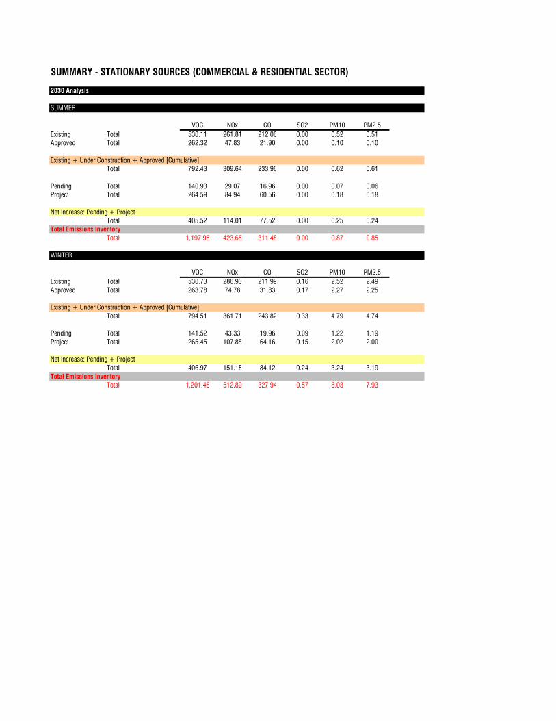
SUMMARY - STATIONARY SOURCES (COMMERCIAL & RESIDENTIAL SECTOR)
2030 Analysis
SUMMER
VOC NOx CO SO2 PM10 PM2.5
Existing Total 530.11 261.81 212.06 0.00 0.52 0.51
Approved Total 262.32 47.83 21.90 0.00 0.10 0.10
Existing + Under Construction + Approved [Cumulative]
Total 792.43 309.64 233.96 0.00 0.62 0.61
Pending Total 140.93 29.07 16.96 0.00 0.07 0.06
Project Total 264.59 84.94 60.56 0.00 0.18 0.18
Net Increase: Pending + Project
Total 405.52 114.01 77.52 0.00 0.25 0.24
Total Emissions Inventory
Total 1,197.95 423.65 311.48 0.00 0.87 0.85
WINTER
VOC NOx CO SO2 PM10 PM2.5
Existing Total 530.73 286.93 211.99 0.16 2.52 2.49
Approved Total 263.78 74.78 31.83 0.17 2.27 2.25
Existing + Under Construction + Approved [Cumulative]
Total 794.51 361.71 243.82 0.33 4.79 4.74
Pending Total 141.52 43.33 19.96 0.09 1.22 1.19
Project Total 265.45 107.85 64.16 0.15 2.02 2.00
Net Increase: Pending + Project
Total 406.97 151.18 84.12 0.24 3.24 3.19
Total Emissions Inventory
Total 1,201.48 512.89 327.94 0.57 8.03 7.93
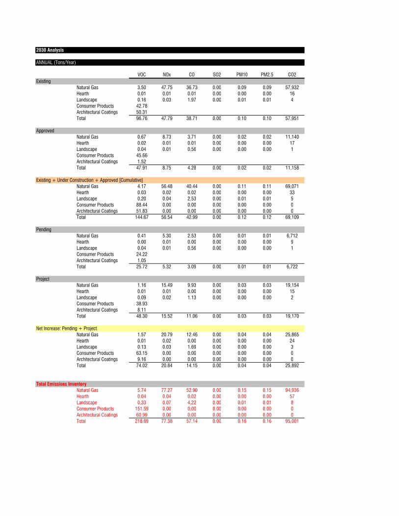
2030 Analysis
ANNUAL (Tons/Year)
VOC NOx CO SO2 PM10 PM2.5 CO2
Existing
Natural Gas 3.50 47.75 36.73 0.00 0.09 0.09 57,932
Hearth 0.01 0.01 0.01 0.00 0.00 0.00 16
Landscape 0.16 0.03 1.97 0.00 0.01 0.01 4
Consumer Products 42.78
Architectural Coatings 50.31
Total 96.76 47.79 38.71 0.00 0.10 0.10 57,951
Approved
Natural Gas 0.67 8.73 3.71 0.00 0.02 0.02 11,140
Hearth 0.02 0.01 0.01 0.00 0.00 0.00 17
Landscape 0.04 0.01 0.56 0.00 0.00 0.00 1
Consumer Products 45.66
Architectural Coatings 1.52
Total 47.91 8.75 4.28 0.00 0.02 0.02 11,158
Existing + Under Construction + Approved [Cumulative]
Natural Gas 4.17 56.48 40.44 0.00 0.11 0.11 69,071
Hearth 0.03 0.02 0.02 0.00 0.00 0.00 33
Landscape 0.20 0.04 2.53 0.00 0.01 0.01 5
Consumer Products 88.44 0.00 0.00 0.00 0.00 0.00 0
Architectural Coatings 51.83 0.00 0.00 0.00 0.00 0.00 0
Total 144.67 56.54 42.99 0.00 0.12 0.12 69,109
Pending
Natural Gas 0.41 5.30 2.53 0.00 0.01 0.01 6,712
Hearth 0.00 0.01 0.00 0.00 0.00 0.00 9
Landscape 0.04 0.01 0.56 0.00 0.00 0.00 1
Consumer Products 24.22
Architectural Coatings 1.05
Total 25.72 5.32 3.09 0.00 0.01 0.01 6,722
Project
Natural Gas 1.16 15.49 9.93 0.00 0.03 0.03 19,154
Hearth 0.01 0.01 0.00 0.00 0.00 0.00 15
Landscape 0.09 0.02 1.13 0.00 0.00 0.00 2
Consumer Products 38.93
Architectural Coatings 8.11
Total 48.30 15.52 11.06 0.00 0.03 0.03 19,170
Net Increase: Pending + Project
Natural Gas 1.57 20.79 12.46 0.00 0.04 0.04 25,865
Hearth 0.01 0.02 0.00 0.00 0.00 0.00 24
Landscape 0.13 0.03 1.69 0.00 0.00 0.00 3
Consumer Products 63.15 0.00 0.00 0.00 0.00 0.00 0
Architectural Coatings 9.16 0.00 0.00 0.00 0.00 0.00 0
Total 74.02 20.84 14.15 0.00 0.04 0.04 25,892
Total Emissions Inventory
Natural Gas 5.74 77.27 52.90 0.00 0.15 0.15 94,936
Hearth 0.04 0.04 0.02 0.00 0.00 0.00 57
Landscape 0.33 0.07 4.22 0.00 0.01 0.01 8
Consumer Products 151.59 0.00 0.00 0.00 0.00 0.00 0
Architectural Coatings 60.99 0.00 0.00 0.00 0.00 0.00 0
Total 218.69 77.38 57.14 0.00 0.16 0.16 95,001

2008 Analysis
SUMMER
VOC NOx CO SO2 PM10 PM2.5
Existing Total 530.22 261.80 212.87 0.00 0.51 0.50
Existing + Under Construction + Approved [Cumulative]
Total 530.22 261.80 212.87 0.00 0.51 0.50
Pending Total
Project Total
Net Increase: Pending + Project
Total 0.00 0.00 0.00 0.00 0.00 0.00
Total Emissions Inventory
Total 530.22 261.80 212.87 0.00 0.51 0.50
WINTER
VOC NOx CO SO2 PM10 PM2.5
Existing Total 530.73 286.93 211.99 0.16 2.52 2.49
Approved Total
Existing + Under Construction + Approved [Cumulative]
Total 530.73 286.93 211.99 0.16 2.52 2.49
Pending Total
Project Total
Net Increase: Pending + Project
Total 0.00 0.00 0.00 0.00 0.00 0.00
Total Emissions Inventory
Total 530.73 286.93 211.99 0.16 2.52 2.49
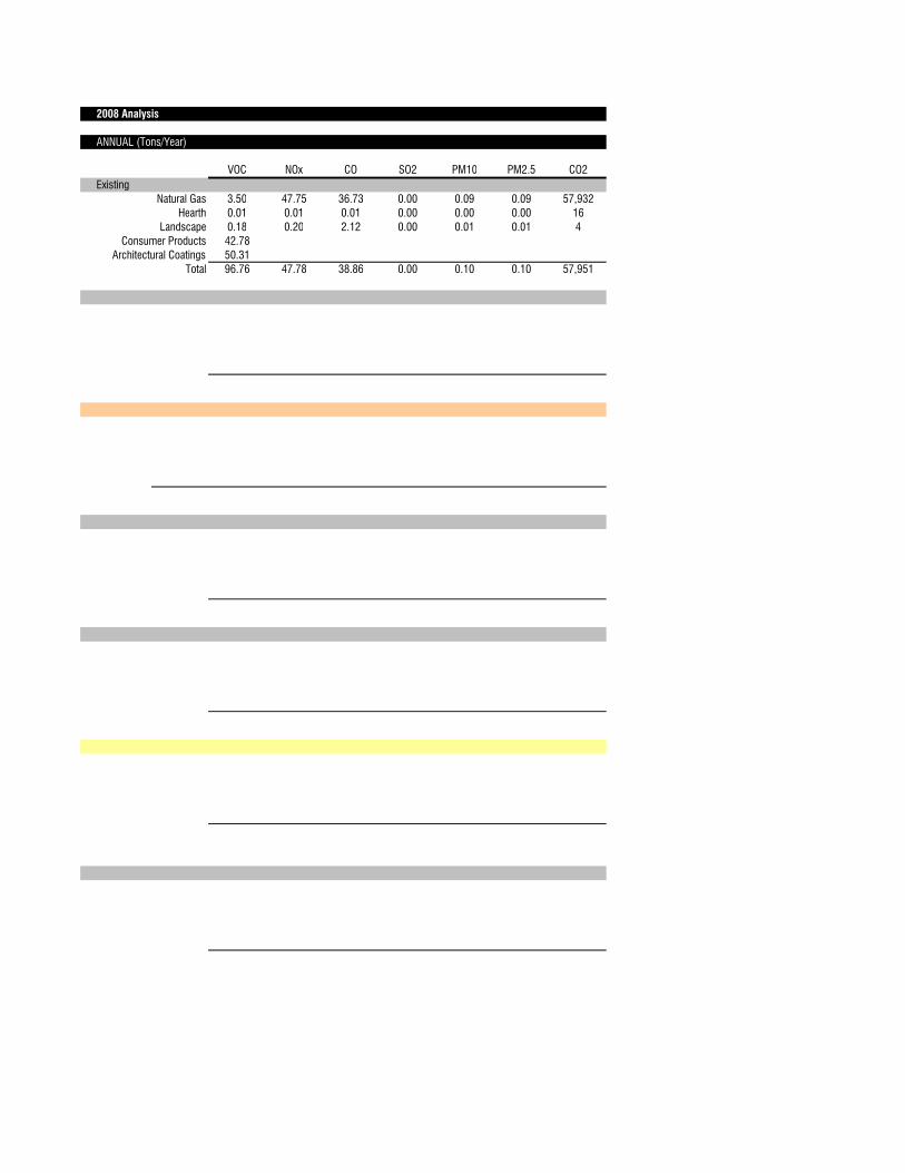
2008 Analysis
ANNUAL (Tons/Year)
VOC NOx CO SO2 PM10 PM2.5 CO2
Existing
Natural Gas 3.50 47.75 36.73 0.00 0.09 0.09 57,932
Hearth 0.01 0.01 0.01 0.00 0.00 0.00 16
Landscape 0.18 0.20 2.12 0.00 0.01 0.01 4
Consumer Products 42.78
Architectural Coatings 50.31
Total 96.76 47.78 38.86 0.00 0.10 0.10 57,951
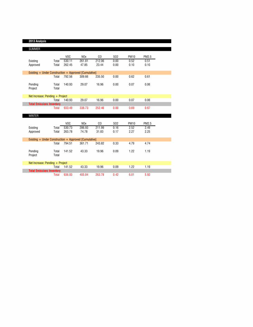
2013 Analysis
SUMMER
VOC NOx CO SO2 PM10 PM2.5
Existing Total 530.11 261.81 212.06 0.00 0.52 0.51
Approved Total 262.45 47.85 23.44 0.00 0.10 0.10
Existing + Under Construction + Approved [Cumulative]
Total 792.56 309.66 235.50 0.00 0.62 0.61
Pending Total 140.93 29.07 16.96 0.00 0.07 0.06
Project Total
Net Increase: Pending + Project
Total 140.93 29.07 16.96 0.00 0.07 0.06
Total Emissions Inventory
Total 933.49 338.73 252.46 0.00 0.69 0.67
WINTER
VOC NOx CO SO2 PM10 PM2.5
Existing Total 530.73 286.93 211.99 0.16 2.52 2.49
Approved Total 263.78 74.78 31.83 0.17 2.27 2.25
Existing + Under Construction + Approved [Cumulative]
Total 794.51 361.71 243.82 0.33 4.79 4.74
Pending Total 141.52 43.33 19.96 0.09 1.22 1.19
Project Total
Net Increase: Pending + Project
Total 141.52 43.33 19.96 0.09 1.22 1.19
Total Emissions Inventory
Total 936.03 405.04 263.78 0.42 6.01 5.93
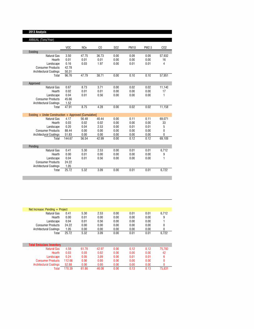
2013 Analysis
ANNUAL (Tons/Year)
VOC NOx CO SO2 PM10 PM2.5 CO2
Existing
Natural Gas 3.50 47.75 36.73 0.00 0.09 0.09 57,932
Hearth 0.01 0.01 0.01 0.00 0.00 0.00 16
Landscape 0.16 0.03 1.97 0.00 0.01 0.01 4
Consumer Products 42.78
Architectural Coatings 50.31
Total 96.76 47.79 38.71 0.00 0.10 0.10 57,951
Approved
Natural Gas 0.67 8.73 3.71 0.00 0.02 0.02 11,140
Hearth 0.02 0.01 0.01 0.00 0.00 0.00 17
Landscape 0.04 0.01 0.56 0.00 0.00 0.00 1
Consumer Products 45.66
Architectural Coatings 1.52
Total 47.91 8.75 4.28 0.00 0.02 0.02 11,158
Existing + Under Construction + Approved [Cumulative]
Natural Gas 4.17 56.48 40.44 0.00 0.11 0.11 69,071
Hearth 0.03 0.02 0.02 0.00 0.00 0.00 33
Landscape 0.20 0.04 2.53 0.00 0.01 0.01 5
Consumer Products 88.44 0.00 0.00 0.00 0.00 0.00 0
Architectural Coatings 51.83 0.00 0.00 0.00 0.00 0.00 0
Total 144.67 56.54 42.99 0.00 0.12 0.12 69,109
Pending
Natural Gas 0.41 5.30 2.53 0.00 0.01 0.01 6,712
Hearth 0.00 0.01 0.00 0.00 0.00 0.00 9
Landscape 0.04 0.01 0.56 0.00 0.00 0.00 1
Consumer Products 24.22
Architectural Coatings 1.05
Total 25.72 5.32 3.09 0.00 0.01 0.01 6,722
Net Increase: Pending + Project
Natural Gas 0.41 5.30 2.53 0.00 0.01 0.01 6,712
Hearth 0.00 0.01 0.00 0.00 0.00 0.00 9
Landscape 0.04 0.01 0.56 0.00 0.00 0.00 1
Consumer Products 24.22 0.00 0.00 0.00 0.00 0.00 0
Architectural Coatings 1.05 0.00 0.00 0.00 0.00 0.00 0
Total 25.72 5.32 3.09 0.00 0.01 0.01 6,722
Total Emissions Inventory
Natural Gas 4.58 61.78 42.97 0.00 0.12 0.12 75,783
Hearth 0.03 0.03 0.02 0.00 0.00 0.00 42
Landscape 0.24 0.05 3.09 0.00 0.01 0.01 6
Consumer Products 112.66 0.00 0.00 0.00 0.00 0.00 0
Architectural Coatings 52.88 0.00 0.00 0.00 0.00 0.00 0
Total 170.39 61.86 46.08 0.00 0.13 0.13 75,831
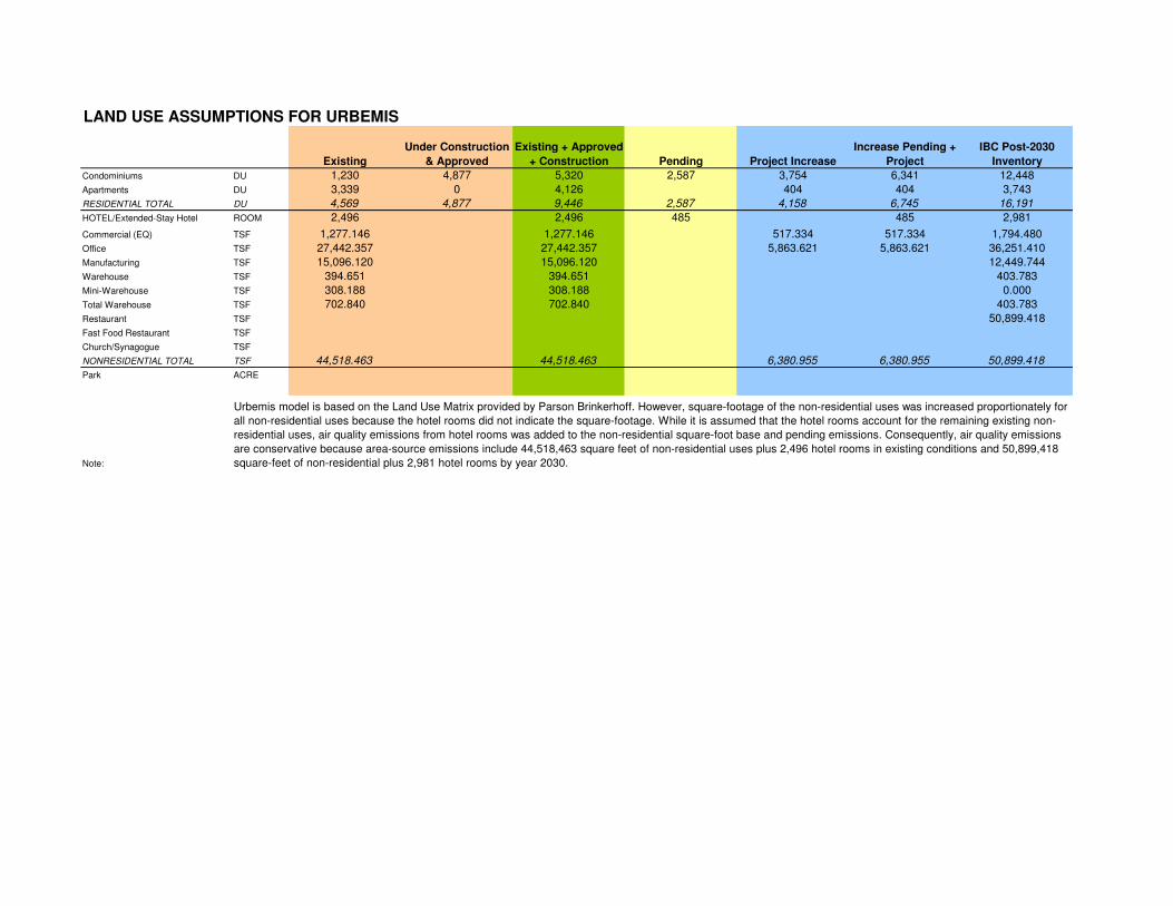
LAND USE ASSUMPTIONS FOR URBEMIS
Existing
Under Construction
& Approved
Existing + Approved
+ Construction Pending Project Increase
Increase Pending +
Project
IBC Post-2030
Inventory
Condominiums DU 1,230 4,877 5,320 2,587 3,754 6,341 12,448
Apartments DU 3,339 0 4,126 404 404 3,743
RESIDENTIAL TOTAL DU 4,569 4,877 9,446 2,587 4,158 6,745 16,191
HOTEL/Extended-Stay Hotel ROOM 2,496 2,496 485 485 2,981
Commercial (EQ) TSF 1,277.146 1,277.146 517.334 517.334 1,794.480
Office TSF 27,442.357 27,442.357 5,863.621 5,863.621 36,251.410
Manufacturing TSF 15,096.120 15,096.120 12,449.744
Warehouse TSF 394.651 394.651 403.783
Mini-Warehouse TSF 308.188 308.188 0.000
Total Warehouse TSF 702.840 702.840 403.783
Restaurant TSF 50,899.418
Fast Food Restaurant TSF
Church/Synagogue TSF
NONRESIDENTIAL TOTAL TSF 44,518.463 44,518.463 6,380.955 6,380.955 50,899.418
Park ACRE
Note:
Urbemis model is based on the Land Use Matrix provided by Parson Brinkerhoff. However, square-footage of the non-residential uses was increased proportionately for
all non-residential uses because the hotel rooms did not indicate the square-footage. While it is assumed that the hotel rooms account for the remaining existing non-
residential uses, air quality emissions from hotel rooms was added to the non-residential square-foot base and pending emissions. Consequently, air quality emissions
are conservative because area-source emissions include 44,518,463 square feet of non-residential uses plus 2,496 hotel rooms in existing conditions and 50,899,418
square-feet of non-residential plus 2,981 hotel rooms by year 2030.
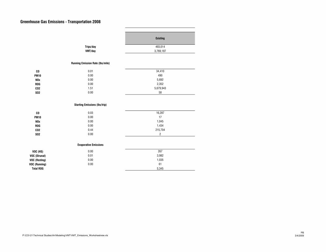
Greenhouse Gas Emissions - Transportation 2008
Existing
Trips/day 493,014
VMT/day 3,769,187
Running Emission Rate (lbs/mile)
CO 0.01 34,410
PM10 0.00 490
NOx 0.00 5,692
ROG 0.00 2,352
CO2 1.51 5,679,943
SO2 0.00 58
Starting Emissions (lbs/trip)
CO 0.03 16,287
PM10 0.00 17
NOx 0.00 1,045
ROG 0.00 1,434
CO2 0.44 215,704
SO2 0.00 2
Evaporative Emissions
VOC (HS) 0.00 267
VOC (Dirunal) 0.01 3,982
VOC (Resting) 0.00 1,035
VOC (Running) 0.00 61
Total ROG 5,345
P:\COI-21\Technical Studies\Air\Modeling\VMT\VMT_Emissions_Worksheetnew.xlsPB
3/4/2009
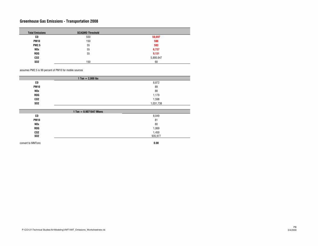
Greenhouse Gas Emissions - Transportation 2008
Total Emissions SCAQMD Threshold
CO 550 50,697
PM10 150 508
PM2.5 55 503
NOx 55 6,737
ROG 55 9,131
CO2 5,895,647
SO2 150 60
assumes PM2.5 is 99 percent of PM10 for mobile sources
1 Ton = 2,000 lbs
CO 8,872
PM10 89
NOx 88
ROG 1,179
CO2 1,598
SO2 1,031,738
1 Ton = 0.9071847 Mtons
CO 8,049
PM10 81
NOx 80
ROG 1,069
CO2 1,450
SO2 935,977
convert to MMTons 0.00
P:\COI-21\Technical Studies\Air\Modeling\VMT\VMT_Emissions_Worksheetnew.xlsPB
3/4/2009
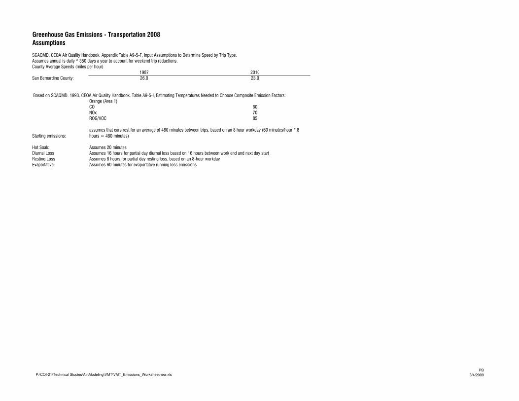
Greenhouse Gas Emissions - Transportation 2008
Assumptions
SCAQMD. CEQA Air Quality Handbook. Appendix Table A9-5-F, Input Assumptions to Determine Speed by Trip Type.
Assumes annual is daily * 350 days a year to account for weekend trip reductions.
County Average Speeds (miles per hour)
1987 2010
San Bernardino County: 26.0 23.0
Orange (Area 1)
CO 60
NOx 70
ROG/VOC 85
Starting emissions:
Hot Soak: Assumes 20 minutes
Diurnal Loss Assumes 16 hours for partial day diurnal loss based on 16 hours between work end and next day start
Resting Loss Assumes 8 hours for partial day resting loss, based on an 8-hour workday
Evaportative Assumes 60 minutes for evaportative running loss emissions
Based on SCAQMD. 1993. CEQA Air Quality Handbook. Table A9-5-I, Estimating Temperatures Needed to Choose Composite Emission Factors:
assumes that cars rest for an average of 480 minutes between trips, based on an 8 hour workday (60 minutes/hour * 8
hours = 480 minutes)
P:\COI-21\Technical Studies\Air\Modeling\VMT\VMT_Emissions_Worksheetnew.xlsPB
3/4/2009
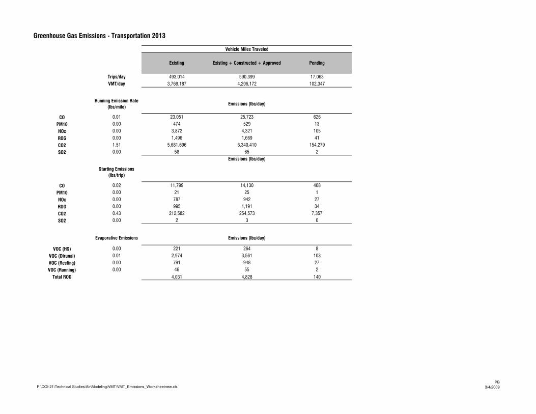
Greenhouse Gas Emissions - Transportation 2013
Vehicle Miles Traveled
Existing Existing + Constructed + Approved Pending
Trips/day 493,014 590,399 17,063
VMT/day 3,769,187 4,206,172 102,347
Running Emission Rate
(lbs/mile)Emissions (lbs/day)
CO 0.01 23,051 25,723 626
PM10 0.00 474 529 13
NOx 0.00 3,872 4,321 105
ROG 0.00 1,496 1,669 41
CO2 1.51 5,681,696 6,340,410 154,279
SO2 0.00 58 65 2
Emissions (lbs/day)
Starting Emissions
(lbs/trip)
CO 0.02 11,799 14,130 408
PM10 0.00 21 25 1
NOx 0.00 787 942 27
ROG 0.00 995 1,191 34
CO2 0.43 212,582 254,573 7,357
SO2 0.00 2 3 0
Evaporative Emissions Emissions (lbs/day)
VOC (HS) 0.00 221 264 8
VOC (Dirunal) 0.01 2,974 3,561 103
VOC (Resting) 0.00 791 948 27
VOC (Running) 0.00 46 55 2
Total ROG 4,031 4,828 140
P:\COI-21\Technical Studies\Air\Modeling\VMT\VMT_Emissions_Worksheetnew.xlsPB
3/4/2009
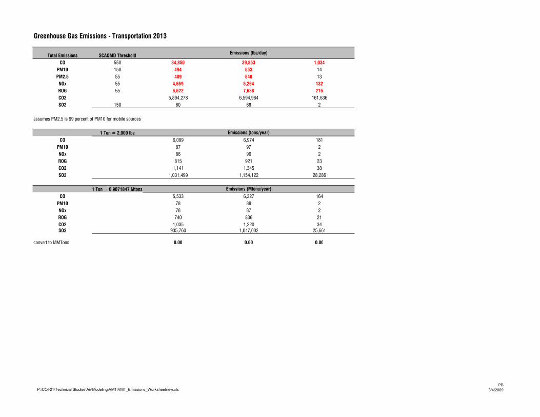
Greenhouse Gas Emissions - Transportation 2013
Total Emissions SCAQMD ThresholdEmissions (lbs/day)
CO 550 34,850 39,853 1,034
PM10 150 494 553 14
PM2.5 55 489 548 13
NOx 55 4,659 5,264 132
ROG 55 6,522 7,688 215
CO2 5,894,278 6,594,984 161,636
SO2 150 60 68 2
assumes PM2.5 is 99 percent of PM10 for mobile sources
1 Ton = 2,000 lbs Emissions (tons/year)
CO 6,099 6,974 181
PM10 87 97 2
NOx 86 96 2
ROG 815 921 23
CO2 1,141 1,345 38
SO2 1,031,499 1,154,122 28,286
1 Ton = 0.9071847 Mtons Emissions (Mtons/year)
CO 5,533 6,327 164
PM10 78 88 2
NOx 78 87 2
ROG 740 836 21
CO2 1,035 1,220 34
SO2 935,760 1,047,002 25,661
convert to MMTons 0.00 0.00 0.00
P:\COI-21\Technical Studies\Air\Modeling\VMT\VMT_Emissions_Worksheetnew.xlsPB
3/4/2009
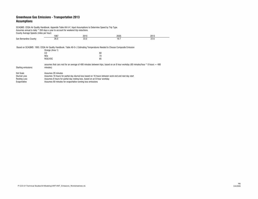
Greenhouse Gas Emissions - Transportation 2013
Assumptions
SCAQMD. CEQA Air Quality Handbook. Appendix Table A9-5-F, Input Assumptions to Determine Speed by Trip Type.
Assumes annual is daily * 350 days a year to account for weekend trip reductions.
County Average Speeds (miles per hour)
1987 2010 2035 2013
San Bernardino County: 26.0 23.0 19.7 22.6
Orange (Area 1)
CO 60
NOx 70
ROG/VOC 85
Starting emissions:
Hot Soak: Assumes 20 minutes
Diurnal Loss Assumes 16 hours for partial day diurnal loss based on 16 hours between work end and next day start
Resting Loss Assumes 8 hours for partial day resting loss, based on an 8-hour workday
Evaportative Assumes 60 minutes for evaportative running loss emissions
Based on SCAQMD. 1993. CEQA Air Quality Handbook. Table A9-5-I, Estimating Temperatures Needed to Choose Composite Emission
assumes that cars rest for an average of 480 minutes between trips, based on an 8 hour workday (60 minutes/hour * 8 hours = 480
minutes)
P:\COI-21\Technical Studies\Air\Modeling\VMT\VMT_Emissions_Worksheetnew.xlsPB
3/4/2009
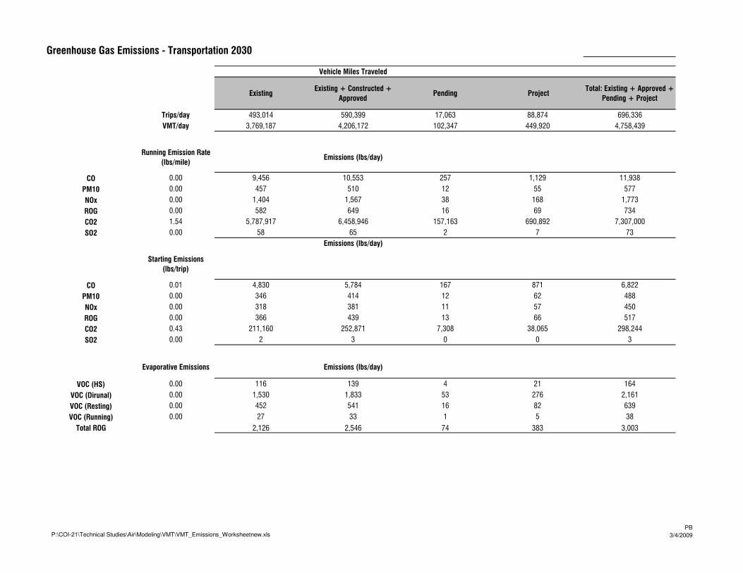
Greenhouse Gas Emissions - Transportation 2030
Vehicle Miles Traveled
ExistingExisting + Constructed +
ApprovedPending Project
Total: Existing + Approved +
Pending + Project
Trips/day 493,014 590,399 17,063 88,874 696,336
VMT/day 3,769,187 4,206,172 102,347 449,920 4,758,439
Running Emission Rate
(lbs/mile)Emissions (lbs/day)
CO 0.00 9,456 10,553 257 1,129 11,938
PM10 0.00 457 510 12 55 577
NOx 0.00 1,404 1,567 38 168 1,773
ROG 0.00 582 649 16 69 734
CO2 1.54 5,787,917 6,458,946 157,163 690,892 7,307,000
SO2 0.00 58 65 2 7 73
Emissions (lbs/day)
Starting Emissions
(lbs/trip)
CO 0.01 4,830 5,784 167 871 6,822
PM10 0.00 346 414 12 62 488
NOx 0.00 318 381 11 57 450
ROG 0.00 366 439 13 66 517
CO2 0.43 211,160 252,871 7,308 38,065 298,244
SO2 0.00 2 3 0 0 3
Evaporative Emissions Emissions (lbs/day)
VOC (HS) 0.00 116 139 4 21 164
VOC (Dirunal) 0.00 1,530 1,833 53 276 2,161
VOC (Resting) 0.00 452 541 16 82 639
VOC (Running) 0.00 27 33 1 5 38
Total ROG 2,126 2,546 74 383 3,003
P:\COI-21\Technical Studies\Air\Modeling\VMT\VMT_Emissions_Worksheetnew.xlsPB
3/4/2009
Greenhouse Gas Emissions - Transportation 2030
Total Emissions SCAQMD ThresholdEmissions (lbs/day)
CO 550 14,286 16,337 424 1,999 18,760
PM10 150 803 924 24 117 1,065
PM2.5 55 795 915 24 116 1,054
NOx 55 1,723 1,948 49 225 2,223
ROG 55 3,074 3,634 102 519 4,254
CO2 5,999,078 6,711,817 164,471 728,957 7,605,245
SO2 150 60 68 2 7 77
assumes PM2.5 is 99 percent of PM10 for mobile sources
1 Ton = 2,000 lbs Emissions (tons/year)
CO 2,500 2,859 74 350 3,283
PM10 140 162 4 20 186
NOx 139 160 4 20 185
ROG 301 341 9 39 389
CO2 538 636 18 91 745
SO2 1,049,839 1,174,568 28,782 127,567 1,330,918
1 Ton = 0.9071847 Mtons Emissions (Mtons/year)
CO 2,268 2,594 67 317 2,978
PM10 127 147 4 19 169
NOx 126 145 4 18 167
ROG 274 309 8 36 353
CO2 488 577 16 82 675
SO2 952,397 1,065,550 26,111 115,727 1,207,388
convert to MMTons 0.00 0.00 0.00 0.00 0.00
P:\COI-21\Technical Studies\Air\Modeling\VMT\VMT_Emissions_Worksheetnew.xlsPB
3/4/2009
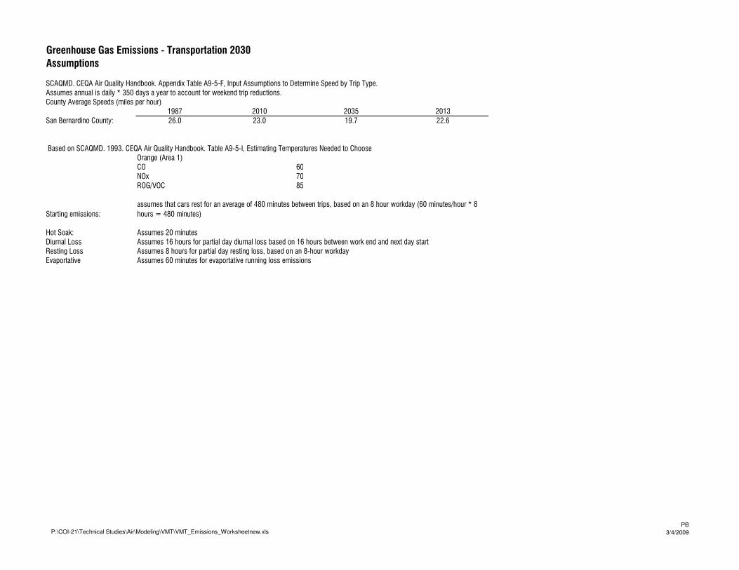
Greenhouse Gas Emissions - Transportation 2030
Assumptions
SCAQMD. CEQA Air Quality Handbook. Appendix Table A9-5-F, Input Assumptions to Determine Speed by Trip Type.
Assumes annual is daily * 350 days a year to account for weekend trip reductions.
County Average Speeds (miles per hour)
1987 2010 2035 2013
San Bernardino County: 26.0 23.0 19.7 22.6
Orange (Area 1)
CO 60
NOx 70
ROG/VOC 85
Starting emissions:
Hot Soak: Assumes 20 minutes
Diurnal Loss Assumes 16 hours for partial day diurnal loss based on 16 hours between work end and next day start
Resting Loss Assumes 8 hours for partial day resting loss, based on an 8-hour workday
Evaportative Assumes 60 minutes for evaportative running loss emissions
Based on SCAQMD. 1993. CEQA Air Quality Handbook. Table A9-5-I, Estimating Temperatures Needed to Choose
assumes that cars rest for an average of 480 minutes between trips, based on an 8 hour workday (60 minutes/hour * 8
hours = 480 minutes)
P:\COI-21\Technical Studies\Air\Modeling\VMT\VMT_Emissions_Worksheetnew.xlsPB
3/4/2009

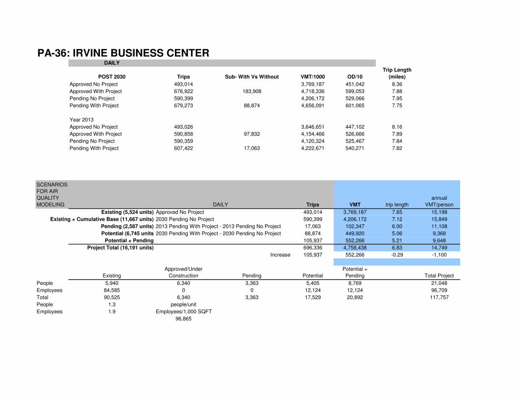
PA-36: IRVINE BUSINESS CENTERDAILY
POST 2030 Trips Sub- With Vs Without VMT/1000 OD/10
Trip Length
(miles)
Approved No Project 493,014 3,769,187 451,042 8.36
Approved With Project 676,922 183,908 4,718,336 599,053 7.88
Pending No Project 590,399 4,206,172 529,066 7.95
Pending With Project 679,273 88,874 4,656,091 601,065 7.75
Year 2013
Approved No Project 493,026 3,646,651 447,102 8.16
Approved With Project 590,858 97,832 4,154,466 526,666 7.89
Pending No Project 590,359 4,120,324 525,467 7.84
Pending With Project 607,422 17,063 4,222,671 540,271 7.82
SCENARIOS
FOR AIR
QUALITY
MODELING DAILY Trips VMT trip length
annual
VMT/person
Existing (5,524 units) Approved No Project 493,014 3,769,187 7.65 15,198
Existing + Cumulative Base (11,667 units) 2030 Pending No Project 590,399 4,206,172 7.12 15,849
Pending (2,587 units) 2013 Pending With Project - 2013 Pending No Project 17,063 102,347 6.00 11,108
Potential (6,745 units 2030 Pending With Project - 2030 Pending No Project 88,874 449,920 5.06 9,368
Potential + Pending 105,937 552,266 5.21 9,648
Project Total (16,191 units) 696,336 4,758,438 6.83 14,749
Increase 105,937 552,266 -0.29 -1,100
Existing
Approved/Under
Construction Pending Potential
Potential +
Pending Total Project
People 5,940 6,340 3,363 5,405 8,769 21,048
Employees 84,585 0 0 12,124 12,124 96,709
Total 90,525 6,340 3,363 17,529 20,892 117,757
People 1.3 people/unit
Employees 1.9 Employees/1,000 SQFT
96,865
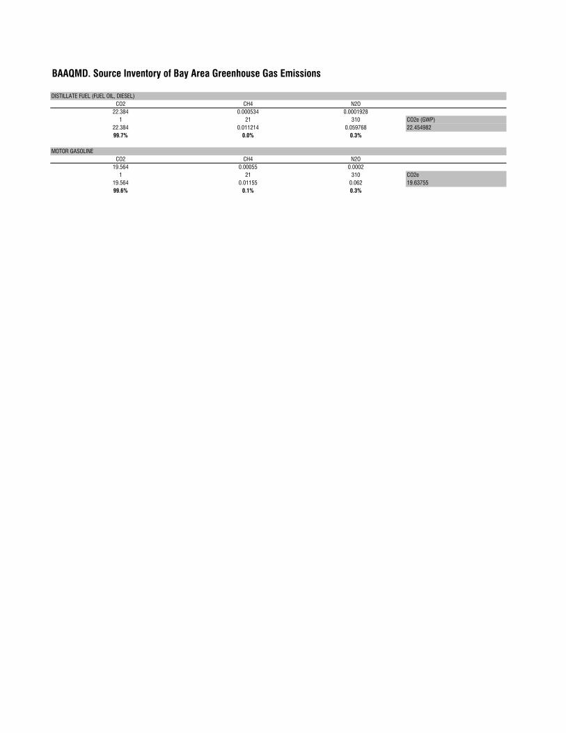
BAAQMD. Source Inventory of Bay Area Greenhouse Gas Emissions
DISTILLATE FUEL (FUEL OIL, DIESEL)
CO2 CH4 N2O
22.384 0.000534 0.0001928
1 21 310 CO2e (GWP)
22.384 0.011214 0.059768 22.454982
99.7% 0.0% 0.3%
MOTOR GASOLINE
CO2 CH4 N2O
19.564 0.00055 0.0002
1 21 310 CO2e
19.564 0.01155 0.062 19.63755
99.6% 0.1% 0.3%
Title: Orange County-2008
Version: Emfac2007 V2.3 Nov, 1 2006
Run Date: 2/19/2009 14:02:59
Scen Year: 2008- All Model years in the range 1965 to 2008 selected
Season: Annual
Area: Orange County
Running Emissions (grams/mile)
Pollutant Name: Carbon Monoxide (CO) Temperature: 60F Relative Humidity: 70%
Speed
MPH LDA LDT MDT HDT UBUS MCY ALL
0 0 0 20.418 42.354 0 0 4.257
15 4.017 4.394 5.202 12.598 16.185 28.383 4.744
20 3.571 3.911 4.447 9.461 11.891 25.832 4.141
23 3.352 3.672 4.102 8.254 10.155 25.002 3.862
25 3.222 3.53 3.907 7.593 9.244 24.707 3.7
Pollutant Name: PM10 Temperature: 60F Relative Humidity: 70%
Speed
MPH LDA LDT MDT HDT UBUS MCY ALL
0 0 0 0.039 1.131 0 0 0.039
15 0.023 0.043 0.043 0.657 0.404 0.04 0.052
20 0.017 0.031 0.032 0.484 0.314 0.034 0.038
23 0.014 0.026 0.027 0.434 0.275 0.032 0.033
25 0.013 0.024 0.025 0.405 0.253 0.031 0.03
Pollutant Name: PM10 (Tire Wear) Temperature: 60F Relative Humidity: 70%
Speed
MPH LDA LDT MDT HDT UBUS MCY ALL
0 0 0 0 0 0 0 0
15 0.008 0.008 0.009 0.02 0.009 0.004 0.008
20 0.008 0.008 0.009 0.02 0.009 0.004 0.008
23 0.008 0.008 0.009 0.02 0.009 0.004 0.008
25 0.008 0.008 0.009 0.02 0.009 0.004 0.008
Pollutant Name: PM10 (Break Wear) Temperature: 60F Relative Humidity: 70%
Speed
MPH LDA LDT MDT HDT UBUS MCY ALL
0 0 0 0 0 0 0 0
15 0.013 0.013 0.013 0.018 0.013 0.006 0.013
20 0.013 0.013 0.013 0.018 0.013 0.006 0.013
23 0.013 0.013 0.013 0.018 0.013 0.006 0.013
25 0.013 0.013 0.013 0.018 0.013 0.006 0.013
Pollutant Name: Oxides of Nitrogen (NOx) Temperature: 70F Relative Humidity: 70%
Speed
MPH LDA LDT MDT HDT UBUS MCY ALL
0 0 0 3.65 68.926 0 0 2.57
15 0.285 0.433 0.791 11.407 17.122 0.94 0.766
20 0.259 0.39 0.723 10.034 14.692 0.971 0.685
23 0.247 0.37 0.693 9.721 13.72 0.99 0.658
25 0.24 0.359 0.677 9.552 13.233 1.004 0.643
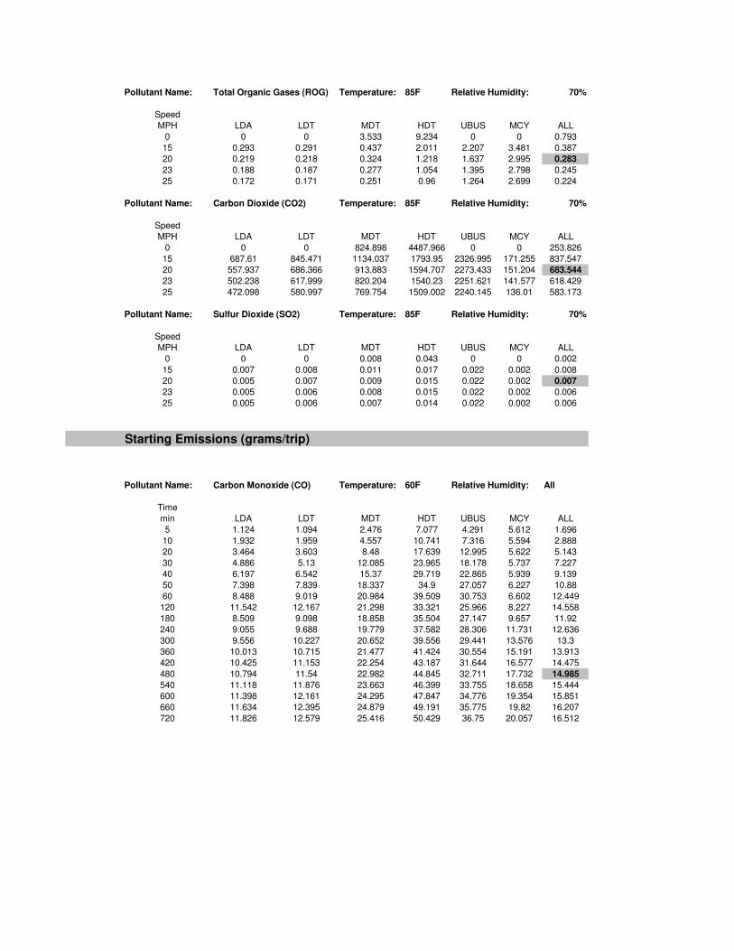
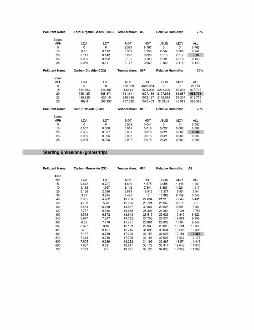
Pollutant Name: Total Organic Gases (ROG) Temperature: 85F Relative Humidity: 70%
Speed
MPH LDA LDT MDT HDT UBUS MCY ALL
0 0 0 3.533 9.234 0 0 0.793
15 0.293 0.291 0.437 2.011 2.207 3.481 0.387
20 0.219 0.218 0.324 1.218 1.637 2.995 0.283
23 0.188 0.187 0.277 1.054 1.395 2.798 0.245
25 0.172 0.171 0.251 0.96 1.264 2.699 0.224
Pollutant Name: Carbon Dioxide (CO2) Temperature: 85F Relative Humidity: 70%
Speed
MPH LDA LDT MDT HDT UBUS MCY ALL
0 0 0 824.898 4487.966 0 0 253.826
15 687.61 845.471 1134.037 1793.95 2326.995 171.255 837.547
20 557.937 686.366 913.883 1594.707 2273.433 151.204 683.544
23 502.238 617.999 820.204 1540.23 2251.621 141.577 618.429
25 472.098 580.997 769.754 1509.002 2240.145 136.01 583.173
Pollutant Name: Sulfur Dioxide (SO2) Temperature: 85F Relative Humidity: 70%
Speed
MPH LDA LDT MDT HDT UBUS MCY ALL
0 0 0 0.008 0.043 0 0 0.002
15 0.007 0.008 0.011 0.017 0.022 0.002 0.008
20 0.005 0.007 0.009 0.015 0.022 0.002 0.007
23 0.005 0.006 0.008 0.015 0.022 0.002 0.006
25 0.005 0.006 0.007 0.014 0.022 0.002 0.006
Starting Emissions (grams/trip)
Pollutant Name: Carbon Monoxide (CO) Temperature: 60F Relative Humidity: All
Time
min LDA LDT MDT HDT UBUS MCY ALL
5 1.124 1.094 2.476 7.077 4.291 5.612 1.696
10 1.932 1.959 4.557 10.741 7.316 5.594 2.888
20 3.464 3.603 8.48 17.639 12.995 5.622 5.143
30 4.886 5.13 12.085 23.965 18.178 5.737 7.227
40 6.197 6.542 15.37 29.719 22.865 5.939 9.139
50 7.398 7.839 18.337 34.9 27.057 6.227 10.88
60 8.488 9.019 20.984 39.509 30.753 6.602 12.449
120 11.542 12.167 21.298 33.321 25.966 8.227 14.558
180 8.509 9.098 18.858 35.504 27.147 9.657 11.92
240 9.055 9.688 19.779 37.582 28.306 11.731 12.636
300 9.556 10.227 20.652 39.556 29.441 13.576 13.3
360 10.013 10.715 21.477 41.424 30.554 15.191 13.913
420 10.425 11.153 22.254 43.187 31.644 16.577 14.475
480 10.794 11.54 22.982 44.845 32.711 17.732 14.985
540 11.118 11.876 23.663 46.399 33.755 18.658 15.444
600 11.398 12.161 24.295 47.847 34.776 19.354 15.851
660 11.634 12.395 24.879 49.191 35.775 19.82 16.207
720 11.826 12.579 25.416 50.429 36.75 20.057 16.512
Pollutant Name: PM10 Temperature: 60F Relative Humidity: All
Time
min LDA LDT MDT HDT UBUS MCY ALL
5 0.001 0.001 0.001 0.001 0 0.015 0.001
10 0.001 0.002 0.002 0.001 0.001 0.014 0.002
20 0.002 0.004 0.004 0.002 0.001 0.011 0.003
30 0.004 0.006 0.006 0.002 0.001 0.008 0.005
40 0.004 0.008 0.007 0.003 0.002 0.006 0.006
50 0.005 0.01 0.009 0.003 0.002 0.005 0.007
60 0.006 0.011 0.01 0.004 0.002 0.004 0.008
120 0.009 0.016 0.014 0.005 0.003 0.01 0.012
180 0.01 0.018 0.015 0.006 0.003 0.016 0.013
240 0.01 0.019 0.016 0.006 0.004 0.021 0.014
300 0.011 0.02 0.017 0.006 0.004 0.025 0.014
360 0.011 0.021 0.017 0.007 0.004 0.029 0.015
420 0.012 0.021 0.018 0.007 0.004 0.033 0.016
480 0.012 0.022 0.019 0.007 0.004 0.035 0.016
540 0.012 0.023 0.019 0.007 0.004 0.037 0.017
600 0.013 0.023 0.02 0.008 0.004 0.039 0.017
660 0.013 0.024 0.02 0.008 0.004 0.04 0.017
720 0.013 0.024 0.02 0.008 0.005 0.04 0.018
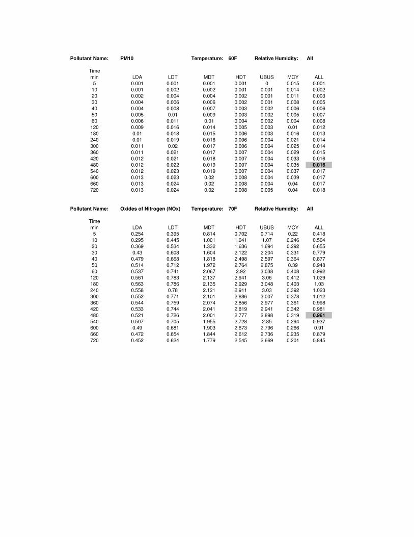
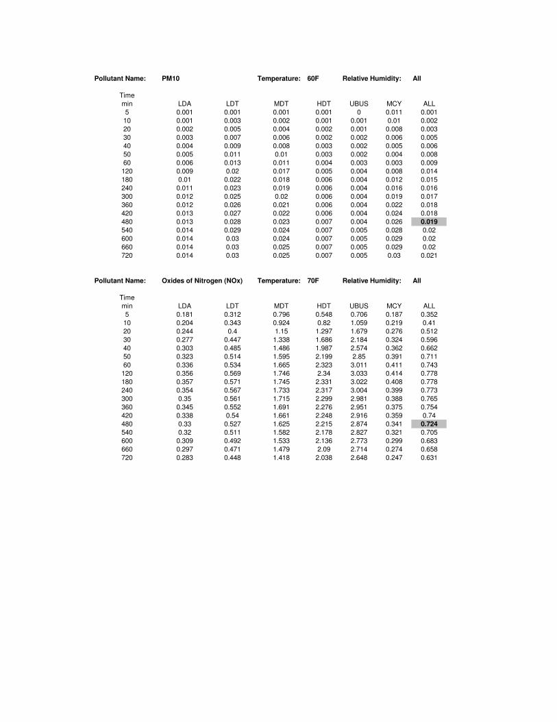
Pollutant Name: Oxides of Nitrogen (NOx) Temperature: 70F Relative Humidity: All
Time
min LDA LDT MDT HDT UBUS MCY ALL
5 0.254 0.395 0.814 0.702 0.714 0.22 0.418
10 0.295 0.445 1.001 1.041 1.07 0.246 0.504
20 0.369 0.534 1.332 1.636 1.694 0.292 0.655
30 0.43 0.608 1.604 2.122 2.204 0.331 0.779
40 0.479 0.668 1.818 2.498 2.597 0.364 0.877
50 0.514 0.712 1.972 2.764 2.875 0.39 0.948
60 0.537 0.741 2.067 2.92 3.038 0.408 0.992
120 0.561 0.783 2.137 2.941 3.06 0.412 1.029
180 0.563 0.786 2.135 2.929 3.048 0.403 1.03
240 0.558 0.78 2.121 2.911 3.03 0.392 1.023
300 0.552 0.771 2.101 2.886 3.007 0.378 1.012
360 0.544 0.759 2.074 2.856 2.977 0.361 0.998
420 0.533 0.744 2.041 2.819 2.941 0.342 0.981
480 0.521 0.726 2.001 2.777 2.898 0.319 0.961
540 0.507 0.705 1.955 2.728 2.85 0.294 0.937
600 0.49 0.681 1.903 2.673 2.796 0.266 0.91
660 0.472 0.654 1.844 2.612 2.736 0.235 0.879
720 0.452 0.624 1.779 2.545 2.669 0.201 0.845
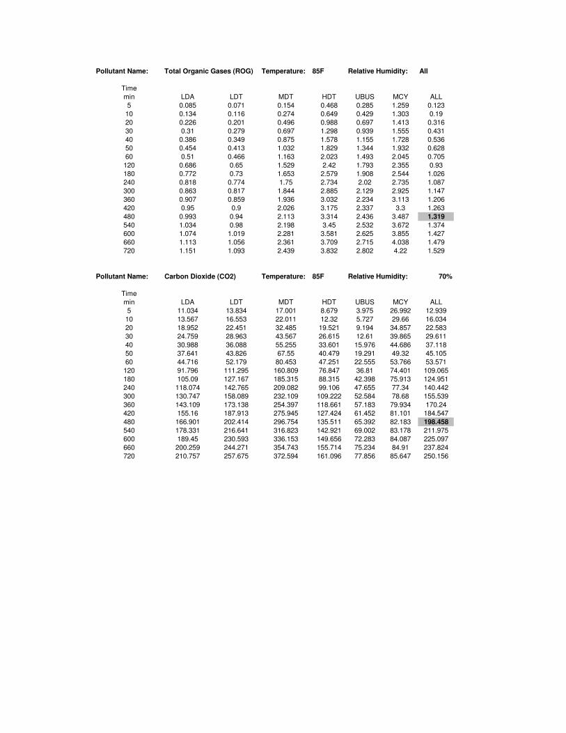
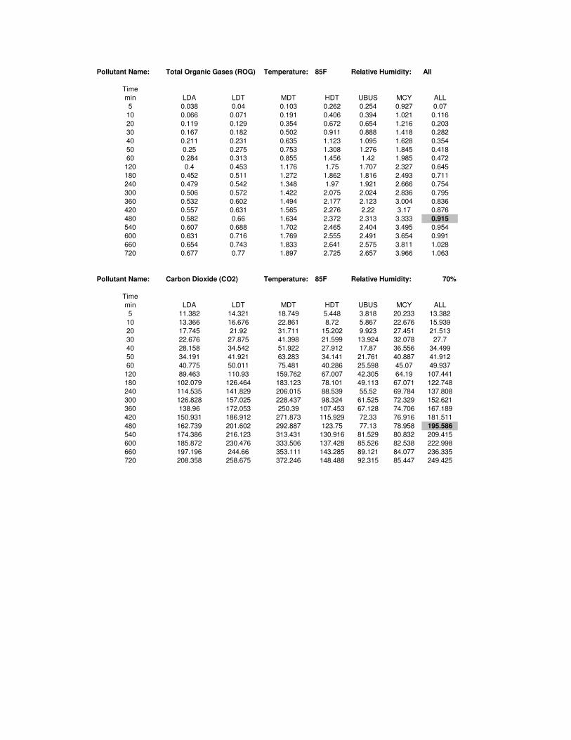
Pollutant Name: Total Organic Gases (ROG) Temperature: 85F Relative Humidity: All
Time
min LDA LDT MDT HDT UBUS MCY ALL
5 0.085 0.071 0.154 0.468 0.285 1.259 0.123
10 0.134 0.116 0.274 0.649 0.429 1.303 0.19
20 0.226 0.201 0.496 0.988 0.697 1.413 0.316
30 0.31 0.279 0.697 1.298 0.939 1.555 0.431
40 0.386 0.349 0.875 1.578 1.155 1.728 0.536
50 0.454 0.413 1.032 1.829 1.344 1.932 0.628
60 0.51 0.466 1.163 2.023 1.493 2.045 0.705
120 0.686 0.65 1.529 2.42 1.793 2.355 0.93
180 0.772 0.73 1.653 2.579 1.908 2.544 1.026
240 0.818 0.774 1.75 2.734 2.02 2.735 1.087
300 0.863 0.817 1.844 2.885 2.129 2.925 1.147
360 0.907 0.859 1.936 3.032 2.234 3.113 1.206
420 0.95 0.9 2.026 3.175 2.337 3.3 1.263
480 0.993 0.94 2.113 3.314 2.436 3.487 1.319
540 1.034 0.98 2.198 3.45 2.532 3.672 1.374
600 1.074 1.019 2.281 3.581 2.625 3.855 1.427
660 1.113 1.056 2.361 3.709 2.715 4.038 1.479
720 1.151 1.093 2.439 3.832 2.802 4.22 1.529
Pollutant Name: Carbon Dioxide (CO2) Temperature: 85F Relative Humidity: 70%
Time
min LDA LDT MDT HDT UBUS MCY ALL
5 11.034 13.834 17.001 8.679 3.975 26.992 12.939
10 13.567 16.553 22.011 12.32 5.727 29.66 16.034
20 18.952 22.451 32.485 19.521 9.194 34.857 22.583
30 24.759 28.963 43.567 26.615 12.61 39.865 29.611
40 30.988 36.088 55.255 33.601 15.976 44.686 37.118
50 37.641 43.826 67.55 40.479 19.291 49.32 45.105
60 44.716 52.179 80.453 47.251 22.555 53.766 53.571
120 91.796 111.295 160.809 76.847 36.81 74.401 109.065
180 105.09 127.167 185.315 88.315 42.398 75.913 124.951
240 118.074 142.765 209.082 99.106 47.655 77.34 140.442
300 130.747 158.089 232.109 109.222 52.584 78.68 155.539
360 143.109 173.138 254.397 118.661 57.183 79.934 170.24
420 155.16 187.913 275.945 127.424 61.452 81.101 184.547
480 166.901 202.414 296.754 135.511 65.392 82.183 198.458
540 178.331 216.641 316.823 142.921 69.002 83.178 211.975
600 189.45 230.593 336.153 149.656 72.283 84.087 225.097
660 200.259 244.271 354.743 155.714 75.234 84.91 237.824
720 210.757 257.675 372.594 161.096 77.856 85.647 250.156

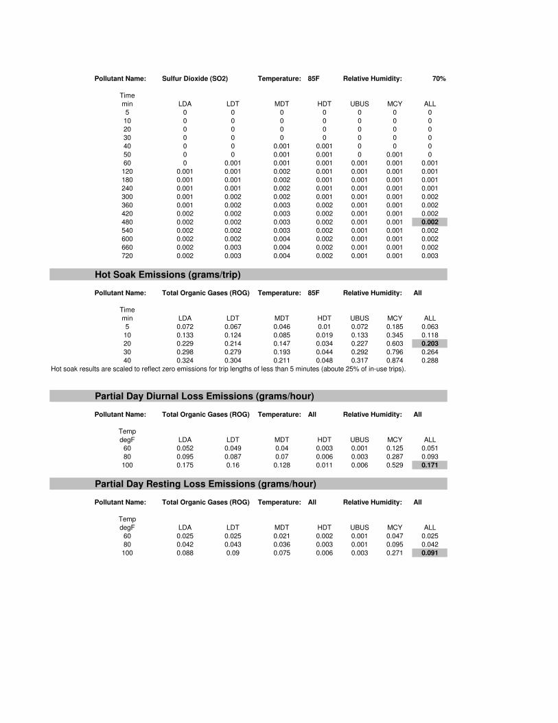
Pollutant Name: Sulfur Dioxide (SO2) Temperature: 85F Relative Humidity: 70%
Time
min LDA LDT MDT HDT UBUS MCY ALL
5 0 0 0 0 0 0 0
10 0 0 0 0 0 0 0
20 0 0 0 0 0 0 0
30 0 0 0.001 0.001 0 0 0
40 0 0 0.001 0.001 0 0.001 0
50 0 0 0.001 0.001 0 0.001 0.001
60 0.001 0.001 0.001 0.001 0.001 0.001 0.001
120 0.001 0.001 0.002 0.001 0.001 0.001 0.001
180 0.001 0.001 0.002 0.001 0.001 0.001 0.001
240 0.001 0.002 0.002 0.002 0.001 0.001 0.002
300 0.001 0.002 0.003 0.002 0.001 0.001 0.002
360 0.002 0.002 0.003 0.002 0.001 0.001 0.002
420 0.002 0.002 0.003 0.002 0.001 0.001 0.002
480 0.002 0.002 0.003 0.002 0.001 0.001 0.002
540 0.002 0.002 0.003 0.002 0.001 0.001 0.002
600 0.002 0.002 0.004 0.002 0.001 0.001 0.002
660 0.002 0.003 0.004 0.002 0.001 0.001 0.003
720 0.002 0.003 0.004 0.002 0.001 0.001 0.003
Hot Soak Emissions (grams/trip)
Pollutant Name: Total Organic Gases (ROG) Temperature: 85F Relative Humidity: All
Time
min LDA LDT MDT HDT UBUS MCY ALL
5 0.094 0.07 0.048 0.017 0.086 0.234 0.076
10 0.175 0.129 0.089 0.032 0.159 0.436 0.142
20 0.303 0.225 0.156 0.056 0.272 0.759 0.246
30 0.396 0.295 0.207 0.073 0.35 0.999 0.322
40 0.432 0.323 0.227 0.079 0.379 1.094 0.352
Hot soak results are scaled to reflect zero emissions for trip lengths of less than 5 minutes (aboute 25% of in-use trips).
Partial Day Diurnal Loss Emissions (grams/hour)
Pollutant Name: Total Organic Gases (ROG) Temperature: All Relative Humidity: All
Temp
degF LDA LDT MDT HDT UBUS MCY ALL
60 0.07 0.053 0.041 0.004 0.002 0.13 0.061
80 0.139 0.103 0.077 0.009 0.004 0.306 0.122
100 0.261 0.193 0.144 0.017 0.007 0.568 0.229
Partial Day Resting Loss Emissions (grams/hour)
Pollutant Name: Total Organic Gases (ROG) Temperature: All Relative Humidity: All
Temp
degF LDA LDT MDT HDT UBUS MCY ALL
60 0.03 0.023 0.018 0.002 0.001 0.052 0.026
80 0.054 0.043 0.033 0.004 0.002 0.105 0.049
100 0.132 0.105 0.081 0.009 0.003 0.281 0.119
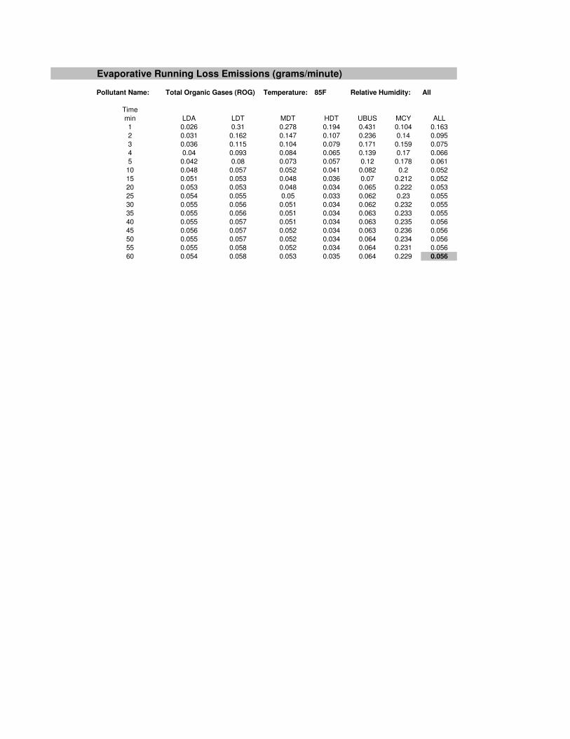
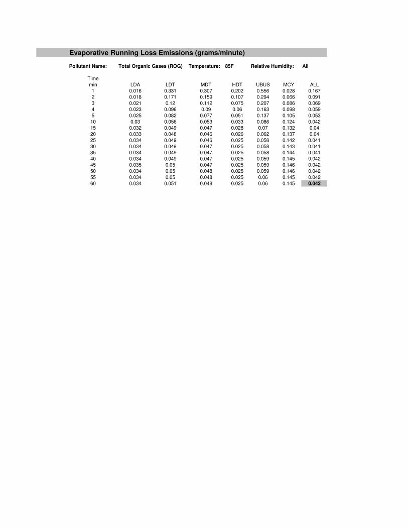
Evaporative Running Loss Emissions (grams/minute)
Pollutant Name: Total Organic Gases (ROG) Temperature: 85F Relative Humidity: All
Time
min LDA LDT MDT HDT UBUS MCY ALL
1 0.026 0.31 0.278 0.194 0.431 0.104 0.163
2 0.031 0.162 0.147 0.107 0.236 0.14 0.095
3 0.036 0.115 0.104 0.079 0.171 0.159 0.075
4 0.04 0.093 0.084 0.065 0.139 0.17 0.066
5 0.042 0.08 0.073 0.057 0.12 0.178 0.061
10 0.048 0.057 0.052 0.041 0.082 0.2 0.052
15 0.051 0.053 0.048 0.036 0.07 0.212 0.052
20 0.053 0.053 0.048 0.034 0.065 0.222 0.053
25 0.054 0.055 0.05 0.033 0.062 0.23 0.055
30 0.055 0.056 0.051 0.034 0.062 0.232 0.055
35 0.055 0.056 0.051 0.034 0.063 0.233 0.055
40 0.055 0.057 0.051 0.034 0.063 0.235 0.056
45 0.056 0.057 0.052 0.034 0.063 0.236 0.056
50 0.055 0.057 0.052 0.034 0.064 0.234 0.056
55 0.055 0.058 0.052 0.034 0.064 0.231 0.056
60 0.054 0.058 0.053 0.035 0.064 0.229 0.056

Summary of Emission Rates
Running Emissions
(lbs/mile)
Starting Emissions
(lbs/trip)
Hot Soak Emissions
(lbs/trip)
Partial Day Diurnal
Loss Emissions
(lbs/hour)
Partial Day Resting
Loss Emissions
(lbs/hour)
Evaporative Resting
Loss Emissions
(lbs/minute)
Carbon Monoxide (CO) 0.009 0.033
Particulate Matter (PM10) 0.000 0.000
Oxides of Nitrogen (NOx) 0.002 0.002
Reactive Organic Gases (ROG) 0.001 0.003 0.001 0.008 0.002 0.000
Carbon Dioxide (CO2) 1.507 0.438
Sulfur Oxide (SO2) 0.000 0.000
Hot Soak: Assumes 20 minutes
Diurnal Loss Assumes 16 hours for partial day diurnal loss based on 16 hours between work end and next day start
Resting Loss Assumes 8 hours for partial day resting loss, based on an 8-hour workday
Evaportative Assumes 60 minutes for evaportative running loss emissions
1 gram = 0.0022046 lbs
0.0022046

Title: Orange County-2013.
Version: Emfac2007 V2.3 Nov, 1 2006
Run Date: 2/19/2009 14:02:39
Scen Year: 2013- All Model years in the range 1969 to 2013 selected
Season: Annual
Area: Orange County
Running Emissions (grams/mile)
Pollutant Name: Carbon Monoxide (CO) Temperature: 60F Relative Humidity: 70%
Speed
MPH LDA LDT MDT HDT UBUS MCY ALL
0 0 0 20.58 40.855 0 0 4.256
15 2.365 3.15 3.828 7.695 14.438 21.899 3.146
20 2.131 2.832 3.319 5.73 10.604 19.974 2.774
23 2.011 2.669 3.082 5.021 9.054 19.288 2.599
25 1.938 2.571 2.944 4.634 8.241 19.005 2.496
Pollutant Name: PM10 Temperature: 60F Relative Humidity: 70%
Speed
MPH LDA LDT MDT HDT UBUS MCY ALL
0 0 0 0.038 0.839 0 0 0.032
15 0.023 0.05 0.052 0.417 0.369 0.027 0.049
20 0.017 0.036 0.038 0.314 0.287 0.024 0.036
23 0.014 0.031 0.032 0.283 0.251 0.022 0.031
25 0.013 0.028 0.029 0.265 0.231 0.021 0.028
Pollutant Name: PM10 (Tire Wear) Temperature: 60F Relative Humidity: 70%
Speed
MPH LDA LDT MDT HDT UBUS MCY ALL
0 0 0 0 0 0 0 0
15 0.008 0.008 0.009 0.021 0.009 0.004 0.008
20 0.008 0.008 0.009 0.021 0.009 0.004 0.008
23 0.008 0.008 0.009 0.021 0.009 0.004 0.008
25 0.008 0.008 0.009 0.021 0.009 0.004 0.008
Pollutant Name: PM10 (Break Wear) Temperature: 60F Relative Humidity: 70%
Speed
MPH LDA LDT MDT HDT UBUS MCY ALL
0 0 0 0 0 0 0 0
15 0.013 0.013 0.013 0.018 0.013 0.006 0.013
20 0.013 0.013 0.013 0.018 0.013 0.006 0.013
23 0.013 0.013 0.013 0.018 0.013 0.006 0.013
25 0.013 0.013 0.013 0.018 0.013 0.006 0.013
Pollutant Name: Oxides of Nitrogen (NOx) Temperature: 70F Relative Humidity: 70%
Speed
MPH LDA LDT MDT HDT UBUS MCY ALL
0 0 0 3.734 74.3 0 0 2.846
15 0.163 0.292 0.561 7.653 15.561 0.934 0.524
20 0.147 0.263 0.511 6.666 13.358 0.936 0.466
23 0.14 0.249 0.49 6.42 12.477 0.941 0.445
25 0.136 0.241 0.478 6.283 12.037 0.945 0.434
Pollutant Name: Total Organic Gases (ROG) Temperature: 85F Relative Humidity: 70%
Speed
MPH LDA LDT MDT HDT UBUS MCY ALL
0 0 0 3.524 8.197 0 0 0.766
15 0.15 0.192 0.309 1.353 2.044 3.208 0.247
20 0.111 0.142 0.228 0.829 1.515 2.717 0.18
23 0.095 0.122 0.195 0.723 1.291 2.518 0.155
25 0.086 0.111 0.177 0.662 1.169 2.416 0.142
Pollutant Name: Carbon Dioxide (CO2) Temperature: 85F Relative Humidity: 70%
Speed
MPH LDA LDT MDT HDT UBUS MCY ALL
0 0 0 862.969 4616.954 0 0 268.51
15 684.683 848.807 1132.141 1833.929 2261.329 183.224 837.793
20 555.425 688.871 911.841 1627.189 2197.863 161.987 683.755
23 499.925 620.15 818.136 1572.197 2172.018 152.304 618.775
25 469.9 582.957 767.682 1540.453 2158.42 146.929 583.588
Pollutant Name: Sulfur Dioxide (SO2) Temperature: 85F Relative Humidity: 70%
Speed
MPH LDA LDT MDT HDT UBUS MCY ALL
0 0 0 0.009 0.044 0 0 0.003
15 0.007 0.008 0.011 0.018 0.022 0.002 0.008
20 0.005 0.007 0.009 0.016 0.021 0.002 0.007
23 0.005 0.006 0.008 0.015 0.021 0.002 0.006
25 0.005 0.006 0.007 0.015 0.021 0.002 0.006
Starting Emissions (grams/trip)
Pollutant Name: Carbon Monoxide (CO) Temperature: 60F Relative Humidity: All
Time
min LDA LDT MDT HDT UBUS MCY ALL
5 0.612 0.727 1.649 4.375 3.955 4.448 1.061
10 1.138 1.367 3.112 7.341 6.883 4.921 1.917
20 2.138 2.586 5.879 12.913 12.377 5.85 3.54
30 3.07 3.724 8.437 18 17.388 6.759 5.045
40 3.935 4.782 10.786 22.604 21.916 7.646 6.431
50 4.733 5.76 12.926 26.724 25.962 8.511 7.7
60 5.464 6.658 14.857 30.361 29.525 9.355 8.85
120 7.737 9.366 16.618 25.303 24.864 12.101 10.787
180 5.598 6.872 13.943 26.519 25.926 10.845 8.622
240 5.977 7.347 14.732 27.705 26.974 12.421 9.156
300 6.32 7.776 15.461 28.861 28.008 13.84 9.646
360 6.627 8.16 16.133 29.988 29.028 15.101 10.093
420 6.9 8.497 16.745 31.085 30.034 16.205 10.496
480 7.137 8.789 17.299 32.153 31.026 17.151 10.856
540 7.339 9.036 17.795 33.191 32.003 17.939 11.173
600 7.505 9.236 18.232 34.199 32.967 18.57 11.446
660 7.637 9.391 18.611 35.178 33.917 19.043 11.676
720 7.733 9.5 18.931 36.128 34.853 19.359 11.863
Pollutant Name: PM10 Temperature: 60F Relative Humidity: All
Time
min LDA LDT MDT HDT UBUS MCY ALL
5 0.001 0.001 0.001 0.001 0 0.011 0.001
10 0.001 0.003 0.002 0.001 0.001 0.01 0.002
20 0.002 0.005 0.004 0.002 0.001 0.008 0.003
30 0.003 0.007 0.006 0.002 0.002 0.006 0.005
40 0.004 0.009 0.008 0.003 0.002 0.005 0.006
50 0.005 0.011 0.01 0.003 0.002 0.004 0.008
60 0.006 0.013 0.011 0.004 0.003 0.003 0.009
120 0.009 0.02 0.017 0.005 0.004 0.008 0.014
180 0.01 0.022 0.018 0.006 0.004 0.012 0.015
240 0.011 0.023 0.019 0.006 0.004 0.016 0.016
300 0.012 0.025 0.02 0.006 0.004 0.019 0.017
360 0.012 0.026 0.021 0.006 0.004 0.022 0.018
420 0.013 0.027 0.022 0.006 0.004 0.024 0.018
480 0.013 0.028 0.023 0.007 0.004 0.026 0.019
540 0.014 0.029 0.024 0.007 0.005 0.028 0.02
600 0.014 0.03 0.024 0.007 0.005 0.029 0.02
660 0.014 0.03 0.025 0.007 0.005 0.029 0.02
720 0.014 0.03 0.025 0.007 0.005 0.03 0.021
Pollutant Name: Oxides of Nitrogen (NOx) Temperature: 70F Relative Humidity: All
Time
min LDA LDT MDT HDT UBUS MCY ALL
5 0.181 0.312 0.796 0.548 0.706 0.187 0.352
10 0.204 0.343 0.924 0.82 1.059 0.219 0.41
20 0.244 0.4 1.15 1.297 1.679 0.276 0.512
30 0.277 0.447 1.338 1.686 2.184 0.324 0.596
40 0.303 0.485 1.486 1.987 2.574 0.362 0.662
50 0.323 0.514 1.595 2.199 2.85 0.391 0.711
60 0.336 0.534 1.665 2.323 3.011 0.411 0.743
120 0.356 0.569 1.746 2.34 3.033 0.414 0.778
180 0.357 0.571 1.745 2.331 3.022 0.408 0.778
240 0.354 0.567 1.733 2.317 3.004 0.399 0.773
300 0.35 0.561 1.715 2.299 2.981 0.388 0.765
360 0.345 0.552 1.691 2.276 2.951 0.375 0.754
420 0.338 0.54 1.661 2.248 2.916 0.359 0.74
480 0.33 0.527 1.625 2.215 2.874 0.341 0.724
540 0.32 0.511 1.582 2.178 2.827 0.321 0.705
600 0.309 0.492 1.533 2.136 2.773 0.299 0.683
660 0.297 0.471 1.479 2.09 2.714 0.274 0.658
720 0.283 0.448 1.418 2.038 2.648 0.247 0.631
Pollutant Name: Total Organic Gases (ROG) Temperature: 85F Relative Humidity: All
Time
min LDA LDT MDT HDT UBUS MCY ALL
5 0.038 0.04 0.103 0.262 0.254 0.927 0.07
10 0.066 0.071 0.191 0.406 0.394 1.021 0.116
20 0.119 0.129 0.354 0.672 0.654 1.216 0.203
30 0.167 0.182 0.502 0.911 0.888 1.418 0.282
40 0.211 0.231 0.635 1.123 1.095 1.628 0.354
50 0.25 0.275 0.753 1.308 1.276 1.845 0.418
60 0.284 0.313 0.855 1.456 1.42 1.985 0.472
120 0.4 0.453 1.176 1.75 1.707 2.327 0.645
180 0.452 0.511 1.272 1.862 1.816 2.493 0.711
240 0.479 0.542 1.348 1.97 1.921 2.666 0.754
300 0.506 0.572 1.422 2.075 2.024 2.836 0.795
360 0.532 0.602 1.494 2.177 2.123 3.004 0.836
420 0.557 0.631 1.565 2.276 2.22 3.17 0.876
480 0.582 0.66 1.634 2.372 2.313 3.333 0.915
540 0.607 0.688 1.702 2.465 2.404 3.495 0.954
600 0.631 0.716 1.769 2.555 2.491 3.654 0.991
660 0.654 0.743 1.833 2.641 2.575 3.811 1.028
720 0.677 0.77 1.897 2.725 2.657 3.966 1.063
Pollutant Name: Carbon Dioxide (CO2) Temperature: 85F Relative Humidity: 70%
Time
min LDA LDT MDT HDT UBUS MCY ALL
5 11.382 14.321 18.749 5.448 3.818 20.233 13.382
10 13.366 16.676 22.861 8.72 5.867 22.676 15.939
20 17.745 21.92 31.711 15.202 9.923 27.451 21.513
30 22.676 27.875 41.398 21.599 13.924 32.078 27.7
40 28.158 34.542 51.922 27.912 17.87 36.556 34.499
50 34.191 41.921 63.283 34.141 21.761 40.887 41.912
60 40.775 50.011 75.481 40.286 25.598 45.07 49.937
120 89.463 110.93 159.762 67.007 42.305 64.19 107.441
180 102.079 126.464 183.123 78.101 49.113 67.071 122.748
240 114.535 141.829 206.015 88.539 55.52 69.784 137.808
300 126.828 157.025 228.437 98.324 61.525 72.329 152.621
360 138.96 172.053 250.39 107.453 67.128 74.706 167.189
420 150.931 186.912 271.873 115.929 72.33 76.916 181.511
480 162.739 201.602 292.887 123.75 77.13 78.958 195.586
540 174.386 216.123 313.431 130.916 81.529 80.832 209.415
600 185.872 230.476 333.506 137.428 85.526 82.538 222.998
660 197.196 244.66 353.111 143.285 89.121 84.077 236.335
720 208.358 258.675 372.246 148.488 92.315 85.447 249.425
Pollutant Name: Sulfur Dioxide (SO2) Temperature: 85F Relative Humidity: 70%
Time
min LDA LDT MDT HDT UBUS MCY ALL
5 0 0 0 0 0 0 0
10 0 0 0 0 0 0 0
20 0 0 0 0 0 0 0
30 0 0 0 0 0 0 0
40 0 0 0.001 0.001 0 0 0
50 0 0 0.001 0.001 0 0.001 0
60 0 0.001 0.001 0.001 0.001 0.001 0.001
120 0.001 0.001 0.002 0.001 0.001 0.001 0.001
180 0.001 0.001 0.002 0.001 0.001 0.001 0.001
240 0.001 0.001 0.002 0.001 0.001 0.001 0.001
300 0.001 0.002 0.002 0.001 0.001 0.001 0.002
360 0.001 0.002 0.003 0.002 0.001 0.001 0.002
420 0.002 0.002 0.003 0.002 0.001 0.001 0.002
480 0.002 0.002 0.003 0.002 0.001 0.001 0.002
540 0.002 0.002 0.003 0.002 0.001 0.001 0.002
600 0.002 0.002 0.004 0.002 0.001 0.001 0.002
660 0.002 0.003 0.004 0.002 0.001 0.001 0.002
720 0.002 0.003 0.004 0.002 0.001 0.001 0.003
Hot Soak Emissions (grams/trip)
Pollutant Name: Total Organic Gases (ROG) Temperature: 85F Relative Humidity: All
Time
min LDA LDT MDT HDT UBUS MCY ALL
5 0.072 0.067 0.046 0.01 0.072 0.185 0.063
10 0.133 0.124 0.085 0.019 0.133 0.345 0.118
20 0.229 0.214 0.147 0.034 0.227 0.603 0.203
30 0.298 0.279 0.193 0.044 0.292 0.796 0.264
40 0.324 0.304 0.211 0.048 0.317 0.874 0.288
Hot soak results are scaled to reflect zero emissions for trip lengths of less than 5 minutes (aboute 25% of in-use trips).
Partial Day Diurnal Loss Emissions (grams/hour)
Pollutant Name: Total Organic Gases (ROG) Temperature: All Relative Humidity: All
Temp
degF LDA LDT MDT HDT UBUS MCY ALL
60 0.052 0.049 0.04 0.003 0.001 0.125 0.051
80 0.095 0.087 0.07 0.006 0.003 0.287 0.093
100 0.175 0.16 0.128 0.011 0.006 0.529 0.171
Partial Day Resting Loss Emissions (grams/hour)
Pollutant Name: Total Organic Gases (ROG) Temperature: All Relative Humidity: All
Temp
degF LDA LDT MDT HDT UBUS MCY ALL
60 0.025 0.025 0.021 0.002 0.001 0.047 0.025
80 0.042 0.043 0.036 0.003 0.001 0.095 0.042
100 0.088 0.09 0.075 0.006 0.003 0.271 0.091
Evaporative Running Loss Emissions (grams/minute)
Pollutant Name: Total Organic Gases (ROG) Temperature: 85F Relative Humidity: All
Time
min LDA LDT MDT HDT UBUS MCY ALL
1 0.016 0.331 0.307 0.202 0.556 0.028 0.167
2 0.018 0.171 0.159 0.107 0.294 0.066 0.091
3 0.021 0.12 0.112 0.075 0.207 0.086 0.069
4 0.023 0.096 0.09 0.06 0.163 0.098 0.059
5 0.025 0.082 0.077 0.051 0.137 0.105 0.053
10 0.03 0.056 0.053 0.033 0.086 0.124 0.042
15 0.032 0.049 0.047 0.028 0.07 0.132 0.04
20 0.033 0.048 0.046 0.026 0.062 0.137 0.04
25 0.034 0.049 0.046 0.025 0.058 0.142 0.041
30 0.034 0.049 0.047 0.025 0.058 0.143 0.041
35 0.034 0.049 0.047 0.025 0.058 0.144 0.041
40 0.034 0.049 0.047 0.025 0.059 0.145 0.042
45 0.035 0.05 0.047 0.025 0.059 0.146 0.042
50 0.034 0.05 0.048 0.025 0.059 0.146 0.042
55 0.034 0.05 0.048 0.025 0.06 0.145 0.042
60 0.034 0.051 0.048 0.025 0.06 0.145 0.042

Summary of Emission Rates
Running Emissions
(lbs/mile)
Starting Emissions
(lbs/trip)
Hot Soak Emissions
(lbs/trip)
Partial Day Diurnal
Loss Emissions
(lbs/hour)
Partial Day Resting
Loss Emissions
(lbs/hour)
Evaporative Resting
Loss Emissions
(lbs/minute)
Carbon Monoxide (CO) 0.006 0.024
Particulate Matter (PM10) 0.000 0.000
Oxides of Nitrogen (NOx) 0.001 0.002
Reactive Organic Gases (ROG) 0.000 0.002 0.000 0.006 0.002 0.000
Carbon Dioxide (CO2) 1.507 0.431
Sulfur Oxide (SO2) 0.000 0.000
Hot Soak: Assumes 20 minutes
Diurnal Loss Assumes 16 hours for partial day diurnal loss based on 16 hours between work end and next day start
Resting Loss Assumes 8 hours for partial day resting loss, based on an 8-hour workday
Evaportative Assumes 60 minutes for evaportative running loss emissions
1 gram = 0.0022046 lbs
0.0022046

Title: Orange County-2030.
Version: Emfac2007 V2.3 Nov, 1 2006
Run Date: 2/12/2009 9:30:28
Scen Year: 2030- All Model years in the range 1986 to 2030 selected
Season: Annual
Area: Orange County
Running Emissions (grams/mile)
Pollutant Name: Carbon Monoxide (CO) Temperature: 60F Relative Humidity: 70%
Speed
MPH LDA LDT MDT HDT UBUS MCY ALL
0 0 0 20.041 38.233 0 0 4.459
15 0.794 1.343 1.675 2.222 8.741 17.903 1.268
20 0.727 1.228 1.506 1.629 6.416 16.365 1.138
23 0.69 1.165 1.419 1.456 5.476 15.766 1.076
25 0.667 1.126 1.367 1.364 4.983 15.485 1.038
Pollutant Name: PM10 Temperature: 60F Relative Humidity: 70%
Speed
MPH LDA LDT MDT HDT UBUS MCY ALL
0 0 0 0.037 0.382 0 0 0.02
15 0.025 0.056 0.06 0.135 0.254 0.019 0.045
20 0.018 0.04 0.043 0.113 0.197 0.017 0.033
23 0.015 0.034 0.037 0.104 0.172 0.016 0.028
25 0.013 0.031 0.033 0.099 0.158 0.015 0.026
Pollutant Name: PM10 (Tire Wear) Temperature: 60F Relative Humidity: 70%
Speed
MPH LDA LDT MDT HDT UBUS MCY ALL
0 0 0 0 0 0 0 0
15 0.008 0.008 0.009 0.022 0.009 0.004 0.009
20 0.008 0.008 0.009 0.022 0.009 0.004 0.009
23 0.008 0.008 0.009 0.022 0.009 0.004 0.009
25 0.008 0.008 0.009 0.022 0.009 0.004 0.009
Pollutant Name: PM10 (Break Wear) Temperature: 60F Relative Humidity: 70%
Speed
MPH LDA LDT MDT HDT UBUS MCY ALL
0 0 0 0 0 0 0 0
15 0.013 0.013 0.013 0.019 0.013 0.006 0.013
20 0.013 0.013 0.013 0.019 0.013 0.006 0.013
23 0.013 0.013 0.013 0.019 0.013 0.006 0.013
25 0.013 0.013 0.013 0.019 0.013 0.006 0.013
Pollutant Name: Oxides of Nitrogen (NOx) Temperature: 70F Relative Humidity: 70%
Speed
MPH LDA LDT MDT HDT UBUS MCY ALL
0 0 0 3.714 81.514 0 0 3.582
15 0.048 0.094 0.18 2.419 9.975 0.939 0.193
20 0.044 0.085 0.164 2.046 8.618 0.921 0.169
23 0.041 0.081 0.157 1.932 8.078 0.915 0.16
25 0.04 0.078 0.153 1.866 7.809 0.914 0.155
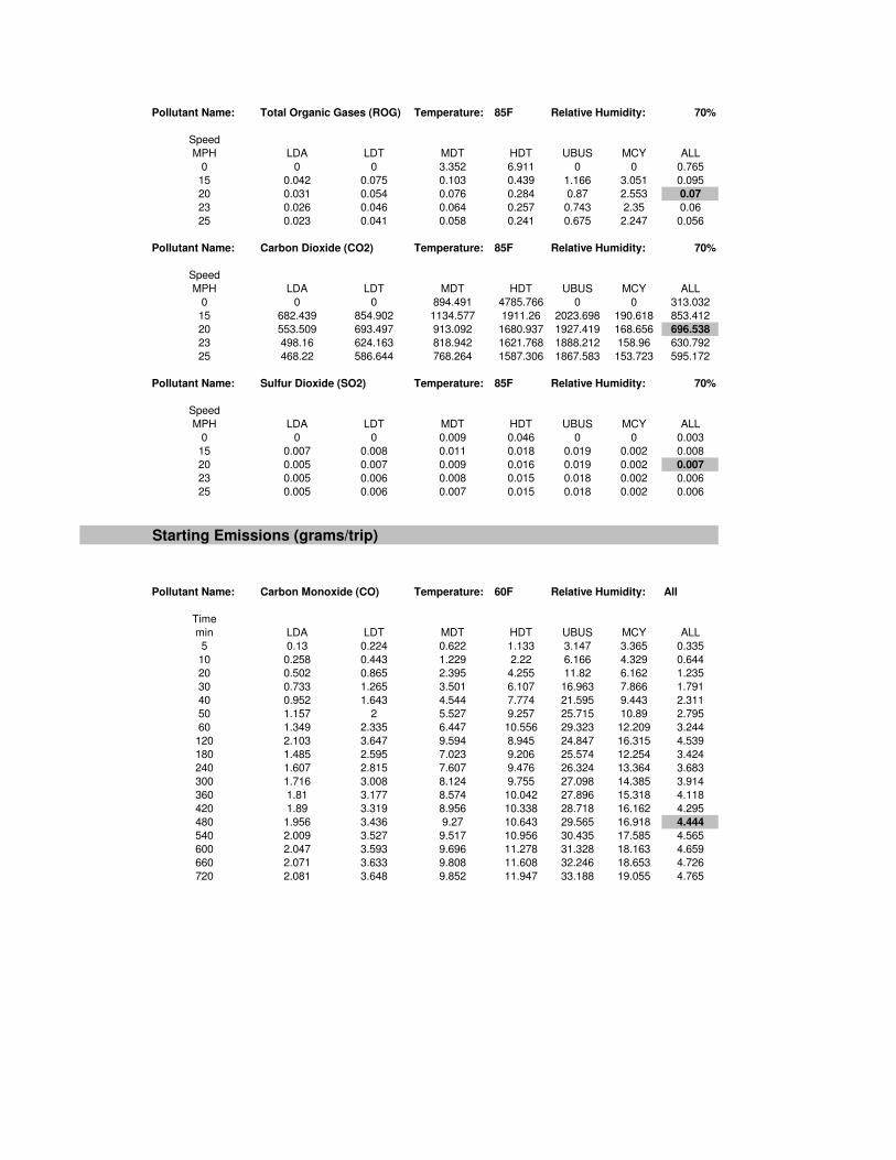
Pollutant Name: Total Organic Gases (ROG) Temperature: 85F Relative Humidity: 70%
Speed
MPH LDA LDT MDT HDT UBUS MCY ALL
0 0 0 3.352 6.911 0 0 0.765
15 0.042 0.075 0.103 0.439 1.166 3.051 0.095
20 0.031 0.054 0.076 0.284 0.87 2.553 0.07
23 0.026 0.046 0.064 0.257 0.743 2.35 0.06
25 0.023 0.041 0.058 0.241 0.675 2.247 0.056
Pollutant Name: Carbon Dioxide (CO2) Temperature: 85F Relative Humidity: 70%
Speed
MPH LDA LDT MDT HDT UBUS MCY ALL
0 0 0 894.491 4785.766 0 0 313.032
15 682.439 854.902 1134.577 1911.26 2023.698 190.618 853.412
20 553.509 693.497 913.092 1680.937 1927.419 168.656 696.538
23 498.16 624.163 818.942 1621.768 1888.212 158.96 630.792
25 468.22 586.644 768.264 1587.306 1867.583 153.723 595.172
Pollutant Name: Sulfur Dioxide (SO2) Temperature: 85F Relative Humidity: 70%
Speed
MPH LDA LDT MDT HDT UBUS MCY ALL
0 0 0 0.009 0.046 0 0 0.003
15 0.007 0.008 0.011 0.018 0.019 0.002 0.008
20 0.005 0.007 0.009 0.016 0.019 0.002 0.007
23 0.005 0.006 0.008 0.015 0.018 0.002 0.006
25 0.005 0.006 0.007 0.015 0.018 0.002 0.006
Starting Emissions (grams/trip)
Pollutant Name: Carbon Monoxide (CO) Temperature: 60F Relative Humidity: All
Time
min LDA LDT MDT HDT UBUS MCY ALL
5 0.13 0.224 0.622 1.133 3.147 3.365 0.335
10 0.258 0.443 1.229 2.22 6.166 4.329 0.644
20 0.502 0.865 2.395 4.255 11.82 6.162 1.235
30 0.733 1.265 3.501 6.107 16.963 7.866 1.791
40 0.952 1.643 4.544 7.774 21.595 9.443 2.311
50 1.157 2 5.527 9.257 25.715 10.89 2.795
60 1.349 2.335 6.447 10.556 29.323 12.209 3.244
120 2.103 3.647 9.594 8.945 24.847 16.315 4.539
180 1.485 2.595 7.023 9.206 25.574 12.254 3.424
240 1.607 2.815 7.607 9.476 26.324 13.364 3.683
300 1.716 3.008 8.124 9.755 27.098 14.385 3.914
360 1.81 3.177 8.574 10.042 27.896 15.318 4.118
420 1.89 3.319 8.956 10.338 28.718 16.162 4.295
480 1.956 3.436 9.27 10.643 29.565 16.918 4.444
540 2.009 3.527 9.517 10.956 30.435 17.585 4.565
600 2.047 3.593 9.696 11.278 31.328 18.163 4.659
660 2.071 3.633 9.808 11.608 32.246 18.653 4.726
720 2.081 3.648 9.852 11.947 33.188 19.055 4.765

Pollutant Name: PM10 Temperature: 60F Relative Humidity: All
Time
min LDA LDT MDT HDT UBUS MCY ALL
5 0.046 0.107 0.635 0.218 0.886 0.165 0.193
10 0.049 0.113 0.674 0.328 1.335 0.207 0.21
20 0.055 0.124 0.745 0.522 2.123 0.281 0.242
30 0.06 0.134 0.805 0.68 2.765 0.342 0.268
40 0.064 0.142 0.855 0.802 3.262 0.39 0.289
50 0.067 0.149 0.895 0.888 3.612 0.425 0.306
60 0.07 0.154 0.925 0.939 3.817 0.448 0.317
120 0.075 0.167 1.005 0.953 3.874 0.453 0.34
180 0.078 0.173 1.014 0.949 3.859 0.451 0.345
240 0.077 0.172 1.007 0.944 3.838 0.444 0.343
300 0.076 0.17 0.994 0.937 3.808 0.435 0.339
360 0.075 0.167 0.977 0.927 3.772 0.424 0.333
420 0.074 0.163 0.955 0.917 3.727 0.412 0.326
480 0.072 0.158 0.928 0.904 3.676 0.397 0.318
540 0.069 0.153 0.896 0.889 3.616 0.381 0.308
600 0.067 0.147 0.86 0.873 3.549 0.362 0.296
660 0.063 0.139 0.819 0.855 3.475 0.342 0.284
720 0.06 0.132 0.773 0.834 3.393 0.32 0.269
Pollutant Name: Oxides of Nitrogen (NOx) Temperature: 70F Relative Humidity: All
Time
min LDA LDT MDT HDT UBUS MCY ALL
5 0.042 0.099 0.597 0.205 0.835 0.154 0.181
10 0.045 0.105 0.634 0.309 1.258 0.193 0.197
20 0.051 0.115 0.7 0.492 2.001 0.263 0.226
30 0.056 0.124 0.757 0.641 2.606 0.32 0.251
40 0.059 0.132 0.804 0.756 3.074 0.365 0.271
50 0.062 0.138 0.842 0.837 3.404 0.398 0.287
60 0.065 0.142 0.87 0.884 3.597 0.419 0.297
120 0.07 0.154 0.943 0.891 3.623 0.422 0.318
180 0.07 0.155 0.943 0.888 3.609 0.418 0.319
240 0.069 0.154 0.936 0.883 3.589 0.411 0.316
300 0.069 0.152 0.925 0.876 3.562 0.403 0.313
360 0.067 0.149 0.909 0.867 3.527 0.393 0.307
420 0.066 0.146 0.888 0.857 3.486 0.382 0.301
480 0.064 0.142 0.863 0.845 3.437 0.368 0.293
540 0.062 0.137 0.834 0.832 3.382 0.353 0.284
600 0.06 0.131 0.8 0.816 3.319 0.337 0.274
660 0.057 0.125 0.762 0.799 3.25 0.318 0.262
720 0.054 0.118 0.719 0.78 3.173 0.298 0.248
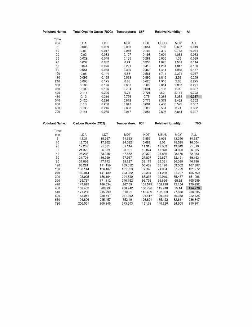
Pollutant Name: Total Organic Gases (ROG) Temperature: 85F Relative Humidity: All
Time
min LDA LDT MDT HDT UBUS MCY ALL
5 0.005 0.009 0.033 0.054 0.163 0.637 0.019
10 0.01 0.017 0.065 0.104 0.319 0.783 0.034
20 0.02 0.033 0.127 0.198 0.604 1.064 0.063
30 0.029 0.048 0.185 0.281 0.856 1.33 0.089
40 0.037 0.062 0.24 0.353 1.075 1.581 0.114
50 0.044 0.076 0.291 0.413 1.261 1.817 0.136
60 0.051 0.088 0.339 0.463 1.414 1.988 0.157
120 0.08 0.144 0.55 0.561 1.711 2.371 0.237
180 0.092 0.165 0.593 0.595 1.815 2.52 0.259
240 0.098 0.175 0.63 0.628 1.916 2.68 0.275
300 0.103 0.186 0.667 0.66 2.014 2.837 0.291
360 0.109 0.196 0.704 0.691 2.108 2.99 0.307
420 0.114 0.206 0.74 0.721 2.2 3.141 0.322
480 0.12 0.216 0.776 0.75 2.288 3.288 0.337
540 0.125 0.226 0.812 0.778 2.372 3.432 0.352
600 0.13 0.236 0.847 0.804 2.453 3.572 0.367
660 0.136 0.246 0.883 0.83 2.531 3.71 0.382
720 0.141 0.255 0.917 0.854 2.606 3.844 0.397
Pollutant Name: Carbon Dioxide (CO2) Temperature: 85F Relative Humidity: 70%
Time
min LDA LDT MDT HDT UBUS MCY ALL
5 12.21 15.367 21.663 2.852 3.038 13.326 14.537
10 13.709 17.262 24.532 5.688 6.06 15.525 16.504
20 17.207 21.681 31.144 11.312 12.053 19.843 21.019
30 21.372 26.939 38.921 16.874 17.978 24.053 26.305
40 26.203 33.035 47.862 22.372 23.836 28.156 32.363
50 31.701 39.969 57.967 27.807 29.627 32.151 39.193
60 37.866 47.742 69.237 33.179 35.351 36.039 46.796
120 88.224 111.159 159.552 56.432 60.126 53.502 107.307
180 100.144 126.187 181.329 66.67 71.034 57.729 121.972
240 112.044 141.189 203.022 76.304 81.298 61.707 136.569
300 123.925 156.164 224.629 85.333 90.919 65.437 151.098
360 135.787 171.112 246.152 93.758 99.896 68.92 165.559
420 147.629 186.034 267.59 101.579 108.228 72.154 179.952
480 159.452 200.93 288.942 108.796 115.918 75.14 194.278
540 171.256 215.799 310.21 115.409 122.963 77.878 208.535
600 183.041 230.641 331.392 121.417 129.364 80.368 222.725
660 194.806 245.457 352.49 126.821 135.122 82.611 236.847
720 206.551 260.246 373.503 131.62 140.236 84.605 250.901

Pollutant Name: Sulfur Dioxide (SO2) Temperature: 85F Relative Humidity: 70%
Time
min LDA LDT MDT HDT UBUS MCY ALL
5 0 0 0 0 0 0 0
10 0 0 0 0 0 0 0
20 0 0 0 0 0 0 0
30 0 0 0 0 0 0 0
40 0 0 0.001 0 0 0 0
50 0 0 0.001 0 0.001 0 0
60 0 0 0.001 0 0.001 0.001 0
120 0.001 0.001 0.002 0.001 0.001 0.001 0.001
180 0.001 0.001 0.002 0.001 0.001 0.001 0.001
240 0.001 0.001 0.002 0.001 0.001 0.001 0.001
300 0.001 0.002 0.002 0.001 0.001 0.001 0.002
360 0.001 0.002 0.003 0.001 0.001 0.001 0.002
420 0.001 0.002 0.003 0.001 0.002 0.001 0.002
480 0.002 0.002 0.003 0.001 0.002 0.001 0.002
540 0.002 0.002 0.003 0.001 0.002 0.001 0.002
600 0.002 0.002 0.003 0.001 0.002 0.001 0.002
660 0.002 0.002 0.004 0.001 0.002 0.001 0.002
720 0.002 0.003 0.004 0.001 0.002 0.001 0.002
Hot Soak Emissions (grams/trip)
Pollutant Name: Total Organic Gases (ROG) Temperature: 85F Relative Humidity: All
Time
min LDA LDT MDT HDT UBUS MCY ALL
5 0.026 0.046 0.035 0.004 0.044 0.185 0.034
10 0.048 0.085 0.066 0.007 0.081 0.345 0.062
20 0.083 0.147 0.113 0.012 0.138 0.602 0.107
30 0.106 0.19 0.147 0.015 0.178 0.792 0.139
40 0.115 0.206 0.159 0.017 0.193 0.868 0.151
Hot soak results are scaled to reflect zero emissions for trip lengths of less than 5 minutes (aboute 25% of in-use trips).
Partial Day Diurnal Loss Emissions (grams/hour)
Pollutant Name: Total Organic Gases (ROG) Temperature: All Relative Humidity: All
Temp
degF LDA LDT MDT HDT UBUS MCY ALL
60 0.02 0.039 0.038 0.001 0.001 0.138 0.031
80 0.031 0.059 0.057 0.002 0.002 0.306 0.049
100 0.056 0.103 0.1 0.003 0.004 0.563 0.088
Partial Day Resting Loss Emissions (grams/hour)
Pollutant Name: Total Organic Gases (ROG) Temperature: All Relative Humidity: All
Temp
degF LDA LDT MDT HDT UBUS MCY ALL
60 0.012 0.026 0.026 0.001 0.001 0.054 0.019
80 0.014 0.04 0.041 0.001 0.001 0.104 0.028
100 0.025 0.069 0.071 0.002 0.002 0.3 0.052

Evaporative Running Loss Emissions (grams/minute)
Pollutant Name: Total Organic Gases (ROG) Temperature: 85F Relative Humidity: All
Time
min LDA LDT MDT HDT UBUS MCY ALL
1 0.009 0.23 0.253 0.071 0.753 0.005 0.123
2 0.007 0.118 0.13 0.036 0.385 0.038 0.064
3 0.008 0.083 0.092 0.025 0.263 0.055 0.047
4 0.009 0.067 0.074 0.02 0.203 0.066 0.039
5 0.01 0.058 0.063 0.017 0.167 0.073 0.035
10 0.012 0.04 0.043 0.011 0.095 0.088 0.027
15 0.013 0.035 0.038 0.01 0.073 0.093 0.025
20 0.013 0.034 0.036 0.009 0.063 0.097 0.024
25 0.014 0.033 0.036 0.009 0.057 0.099 0.024
30 0.014 0.033 0.036 0.009 0.058 0.1 0.024
35 0.014 0.033 0.036 0.009 0.058 0.101 0.024
40 0.014 0.034 0.036 0.009 0.058 0.101 0.024
45 0.014 0.034 0.036 0.009 0.059 0.102 0.024
50 0.014 0.034 0.037 0.009 0.059 0.103 0.024
55 0.014 0.034 0.037 0.009 0.059 0.103 0.025
60 0.014 0.034 0.037 0.009 0.06 0.104 0.025
Summary of Emission Rates
Running Emissions
(lbs/mile)
Starting Emissions
(lbs/trip)
Hot Soak Emissions
(lbs/trip)
Partial Day Diurnal
Loss Emissions
(lbs/hour)
Partial Day Resting
Loss Emissions
(lbs/hour)
Evaporative Resting
Loss Emissions
(lbs/minute)
Carbon Monoxide (CO) 0.003 0.010
Particulate Matter (PM10) 0.000 0.001
Oxides of Nitrogen (NOx) 0.000 0.001
Reactive Organic Gases (ROG) 0.000 0.001 0.000 0.003 0.001 0.000
Carbon Dioxide (CO2) 1.536 0.428
Sulfur Oxide (SO2) 0.000 0.000
Hot Soak: Assumes 20 minutes
Diurnal Loss Assumes 16 hours for partial day diurnal loss based on 16 hours between work end and next day start
Resting Loss Assumes 8 hours for partial day resting loss, based on an 8-hour workday
Evaportative Assumes 60 minutes for evaportative running loss emissions
1 gram = 0.0022046 lbs
0.0022046
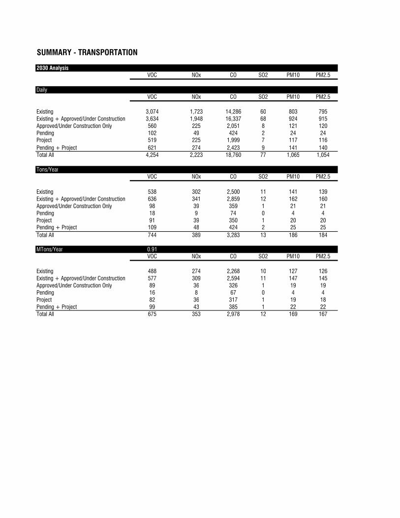
SUMMARY - TRANSPORTATION
2030 Analysis
VOC NOx CO SO2 PM10 PM2.5
Daily
VOC NOx CO SO2 PM10 PM2.5
Existing 3,074 1,723 14,286 60 803 795
Existing + Approved/Under Construction 3,634 1,948 16,337 68 924 915
Approved/Under Construction Only 560 225 2,051 8 121 120
Pending 102 49 424 2 24 24
Project 519 225 1,999 7 117 116
Pending + Project 621 274 2,423 9 141 140
Total All 4,254 2,223 18,760 77 1,065 1,054
Tons/Year
VOC NOx CO SO2 PM10 PM2.5
Existing 538 302 2,500 11 141 139
Existing + Approved/Under Construction 636 341 2,859 12 162 160
Approved/Under Construction Only 98 39 359 1 21 21
Pending 18 9 74 0 4 4
Project 91 39 350 1 20 20
Pending + Project 109 48 424 2 25 25
Total All 744 389 3,283 13 186 184
MTons/Year 0.91
VOC NOx CO SO2 PM10 PM2.5
Existing 488 274 2,268 10 127 126
Existing + Approved/Under Construction 577 309 2,594 11 147 145
Approved/Under Construction Only 89 36 326 1 19 19
Pending 16 8 67 0 4 4
Project 82 36 317 1 19 18
Pending + Project 99 43 385 1 22 22
Total All 675 353 2,978 12 169 167
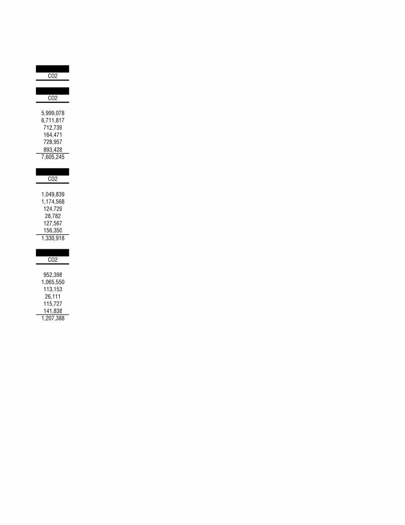
CO2
CO2
5,999,078
6,711,817
712,739
164,471
728,957
893,428
7,605,245
CO2
1,049,839
1,174,568
124,729
28,782
127,567
156,350
1,330,918
CO2
952,398
1,065,550
113,153
26,111
115,727
141,838
1,207,388
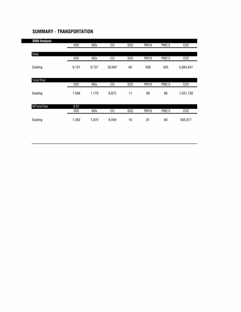
SUMMARY - TRANSPORTATION
2008 Analysis
VOC NOx CO SO2 PM10 PM2.5 CO2
Daily
VOC NOx CO SO2 PM10 PM2.5 CO2
Existing 9,131 6,737 50,697 60 508 503 5,895,647
Tons/Year
VOC NOx CO SO2 PM10 PM2.5 CO2
Existing 1,598 1,179 8,872 11 89 88 1,031,738
MTons/Year 0.91
VOC NOx CO SO2 PM10 PM2.5 CO2
Existing 1,450 1,070 8,049 10 81 80 935,977
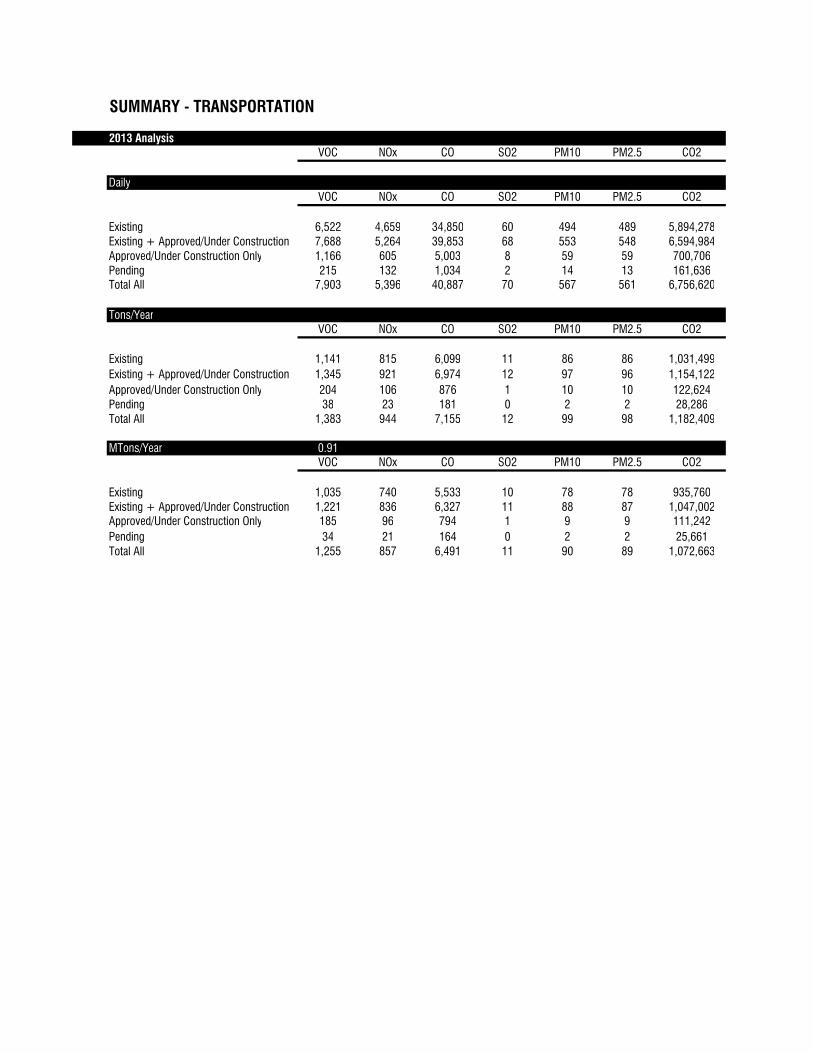
SUMMARY - TRANSPORTATION
2013 Analysis
VOC NOx CO SO2 PM10 PM2.5 CO2
Daily
VOC NOx CO SO2 PM10 PM2.5 CO2
Existing 6,522 4,659 34,850 60 494 489 5,894,278
Existing + Approved/Under Construction 7,688 5,264 39,853 68 553 548 6,594,984
Approved/Under Construction Only 1,166 605 5,003 8 59 59 700,706
Pending 215 132 1,034 2 14 13 161,636
Total All 7,903 5,396 40,887 70 567 561 6,756,620
Tons/Year
VOC NOx CO SO2 PM10 PM2.5 CO2
Existing 1,141 815 6,099 11 86 86 1,031,499
Existing + Approved/Under Construction 1,345 921 6,974 12 97 96 1,154,122
Approved/Under Construction Only 204 106 876 1 10 10 122,624
Pending 38 23 181 0 2 2 28,286
Total All 1,383 944 7,155 12 99 98 1,182,409
MTons/Year 0.91
VOC NOx CO SO2 PM10 PM2.5 CO2
Existing 1,035 740 5,533 10 78 78 935,760
Existing + Approved/Under Construction 1,221 836 6,327 11 88 87 1,047,002
Approved/Under Construction Only 185 96 794 1 9 9 111,242
Pending 34 21 164 0 2 2 25,661
Total All 1,255 857 6,491 11 90 89 1,072,663
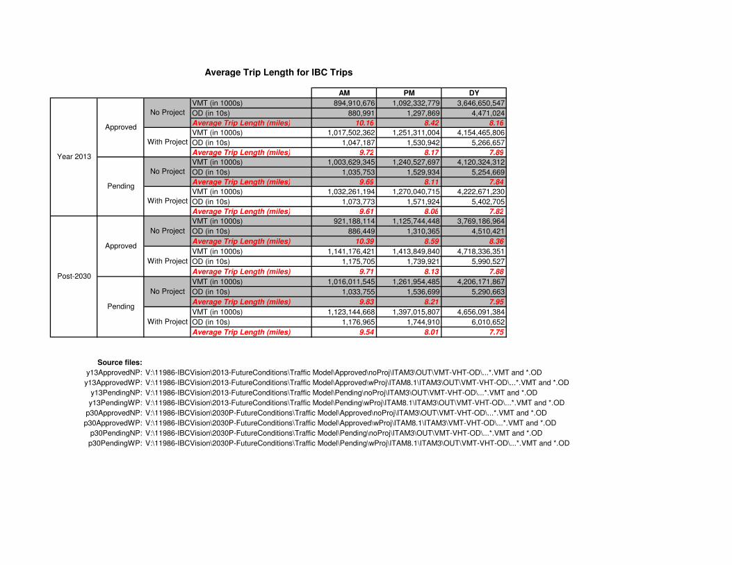
Average Trip Length for IBC Trips
AM PM DY
VMT (in 1000s) 894,910,676 1,092,332,779 3,646,650,547
OD (in 10s) 880,991 1,297,869 4,471,024
Average Trip Length (miles) 10.16 8.42 8.16
VMT (in 1000s) 1,017,502,362 1,251,311,004 4,154,465,806
OD (in 10s) 1,047,187 1,530,942 5,266,657
Average Trip Length (miles) 9.72 8.17 7.89
VMT (in 1000s) 1,003,629,345 1,240,527,697 4,120,324,312
OD (in 10s) 1,035,753 1,529,934 5,254,669
Average Trip Length (miles) 9.69 8.11 7.84
VMT (in 1000s) 1,032,261,194 1,270,040,715 4,222,671,230
OD (in 10s) 1,073,773 1,571,924 5,402,705
Average Trip Length (miles) 9.61 8.08 7.82
VMT (in 1000s) 921,188,114 1,125,744,448 3,769,186,964
OD (in 10s) 886,449 1,310,365 4,510,421
Average Trip Length (miles) 10.39 8.59 8.36
VMT (in 1000s) 1,141,176,421 1,413,849,840 4,718,336,351
OD (in 10s) 1,175,705 1,739,921 5,990,527
Average Trip Length (miles) 9.71 8.13 7.88
VMT (in 1000s) 1,016,011,545 1,261,954,485 4,206,171,867
OD (in 10s) 1,033,755 1,536,699 5,290,663
Average Trip Length (miles) 9.83 8.21 7.95
VMT (in 1000s) 1,123,144,668 1,397,015,807 4,656,091,384
OD (in 10s) 1,176,965 1,744,910 6,010,652
Average Trip Length (miles) 9.54 8.01 7.75
Source files:
y13ApprovedNP: V:\11986-IBCVision\2013-FutureConditions\Traffic Model\Approved\noProj\ITAM3\OUT\VMT-VHT-OD\...*.VMT and *.OD
y13ApprovedWP: V:\11986-IBCVision\2013-FutureConditions\Traffic Model\Approved\wProj\ITAM8.1\ITAM3\OUT\VMT-VHT-OD\...*.VMT and *.OD
y13PendingNP: V:\11986-IBCVision\2013-FutureConditions\Traffic Model\Pending\noProj\ITAM3\OUT\VMT-VHT-OD\...*.VMT and *.OD
y13PendingWP: V:\11986-IBCVision\2013-FutureConditions\Traffic Model\Pending\wProj\ITAM8.1\ITAM3\OUT\VMT-VHT-OD\...*.VMT and *.OD
p30ApprovedNP: V:\11986-IBCVision\2030P-FutureConditions\Traffic Model\Approved\noProj\ITAM3\OUT\VMT-VHT-OD\...*.VMT and *.OD
p30ApprovedWP: V:\11986-IBCVision\2030P-FutureConditions\Traffic Model\Approved\wProj\ITAM8.1\ITAM3\VMT-VHT-OD\...*.VMT and *.OD
p30PendingNP: V:\11986-IBCVision\2030P-FutureConditions\Traffic Model\Pending\noProj\ITAM3\OUT\VMT-VHT-OD\...*.VMT and *.OD
p30PendingWP: V:\11986-IBCVision\2030P-FutureConditions\Traffic Model\Pending\wProj\ITAM8.1\ITAM3\OUT\VMT-VHT-OD\...*.VMT and *.OD
No Project
With Project
No Project
With Project
No Project
With Project
No Project
With Project
Approved
Pending
Year 2013
Post-2030
Approved
Pending

Page: 12/19/2009 02:41:57 PM
ROG
3.50
0.01
0.18
42.78
50.31
96.78
Urbemis 2007 Version 9.2.4
Combined Annual Emissions Reports (Tons/Year)
File Name: P:\COI-21\Technical Studies\Air\Modeling\Stationary-URBEMIS\2008_Existing Baseline\Irvine Business Center- Existing.urb924
Project Name: Irvine Busines Center
Project Location: Orange County
On-Road Vehicle Emissions Based on: Version : Emfac2007 V2.3 Nov 1 2006
Off-Road Vehicle Emissions Based on: OFFROAD2007
Summary Report:
AREA SOURCE EMISSION ESTIMATES
ROG NOx CO SO2 PM10 PM2.5 CO2
TOTALS (tons/year, unmitigated) 96.78 47.78 38.86 0.00 0.10 0.10 57,951.23
SUM OF AREA SOURCE AND OPERATIONAL EMISSION ESTIMATES
ROG NOx CO SO2 PM10 PM2.5 CO2
TOTALS (tons/year, unmitigated) 96.78 47.78 38.86 0.00 0.10 0.10 57,951.23
Area Source Unmitigated Detail Report:
AREA SOURCE EMISSION ESTIMATES Annual Tons Per Year, Unmitigated
Source NOx CO SO2 PM10 PM2.5 CO2
Natural Gas 47.75 36.73 0.00 0.09 0.09 57,931.59
Hearth 0.01 0.01 0.00 0.00 0.00 16.13
Landscape 0.02 2.12 0.00 0.01 0.01 3.51
Consumer Products
Architectural Coatings
0.00
Percentage of residences with wood stoves changed from 10% to 0%
Percentage of residences with wood fireplaces changed from 5% to 0%
Percentage of residences with natural gas fireplaces changed from 85% to 100%
0.10 0.10 57,951.23
Area Source Changes to Defaults
TOTALS (tons/year, unmitigated) 47.78 38.86
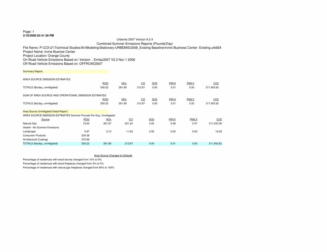
Page: 12/19/2009 02:41:39 PM
ROG
19.20
0.97
234.39
275.66
530.22
Urbemis 2007 Version 9.2.4
Combined Summer Emissions Reports (Pounds/Day)
File Name: P:\COI-21\Technical Studies\Air\Modeling\Stationary-URBEMIS\2008_Existing Baseline\Irvine Business Center- Existing.urb924
Project Name: Irvine Busines Center
Project Location: Orange County
On-Road Vehicle Emissions Based on: Version : Emfac2007 V2.3 Nov 1 2006
Off-Road Vehicle Emissions Based on: OFFROAD2007
Summary Report:
AREA SOURCE EMISSION ESTIMATES
ROG NOx CO SO2 PM10 PM2.5 CO2
TOTALS (lbs/day, unmitigated) 530.22 261.80 212.87 0.00 0.51 0.50 317,452.62
SUM OF AREA SOURCE AND OPERATIONAL EMISSION ESTIMATES
ROG NOx CO SO2 PM10 PM2.5 CO2
TOTALS (lbs/day, unmitigated) 530.22 261.80 212.87 0.00 0.51 0.50 317,452.62
Area Source Unmitigated Detail Report:
AREA SOURCE EMISSION ESTIMATES Summer Pounds Per Day, Unmitigated
Source NOx CO SO2 PM10 PM2.5 CO2
Natural Gas 261.67 201.24 0.00 0.48 0.47 317,433.36
Hearth - No Summer Emissions
Landscape 0.13 11.63 0.00 0.03 0.03 19.26
Consumer Products
Architectural Coatings
0.00
Percentage of residences with wood stoves changed from 10% to 0%
Percentage of residences with wood fireplaces changed from 5% to 0%
Percentage of residences with natural gas fireplaces changed from 85% to 100%
0.51 0.50 317,452.62
Area Source Changes to Defaults
TOTALS (lbs/day, unmitigated) 261.80 212.87
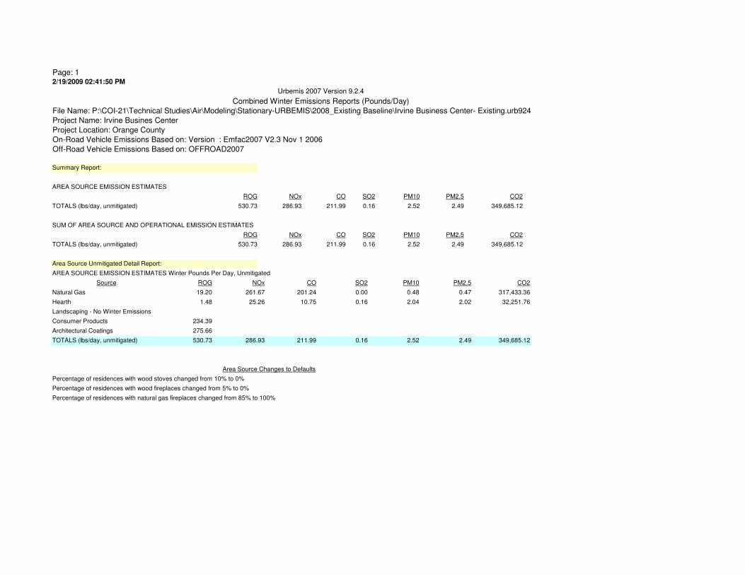
Page: 12/19/2009 02:41:50 PM
ROG
19.20
1.48
234.39
275.66
530.73
Urbemis 2007 Version 9.2.4
Combined Winter Emissions Reports (Pounds/Day)
File Name: P:\COI-21\Technical Studies\Air\Modeling\Stationary-URBEMIS\2008_Existing Baseline\Irvine Business Center- Existing.urb924
Project Name: Irvine Busines Center
Project Location: Orange County
On-Road Vehicle Emissions Based on: Version : Emfac2007 V2.3 Nov 1 2006
Off-Road Vehicle Emissions Based on: OFFROAD2007
Summary Report:
AREA SOURCE EMISSION ESTIMATES
ROG NOx CO SO2 PM10 PM2.5 CO2
TOTALS (lbs/day, unmitigated) 530.73 286.93 211.99 0.16 2.52 2.49 349,685.12
SUM OF AREA SOURCE AND OPERATIONAL EMISSION ESTIMATES
ROG NOx CO SO2 PM10 PM2.5 CO2
TOTALS (lbs/day, unmitigated) 530.73 286.93 211.99 0.16 2.52 2.49 349,685.12
Area Source Unmitigated Detail Report:
AREA SOURCE EMISSION ESTIMATES Winter Pounds Per Day, Unmitigated
Source NOx CO SO2 PM10 PM2.5 CO2
Natural Gas 261.67 201.24 0.00 0.48 0.47 317,433.36
Hearth 25.26 10.75 0.16 2.04 2.02 32,251.76
Landscaping - No Winter Emissions
Consumer Products
Architectural Coatings
0.16
Percentage of residences with wood stoves changed from 10% to 0%
Percentage of residences with wood fireplaces changed from 5% to 0%
Percentage of residences with natural gas fireplaces changed from 85% to 100%
2.52 2.49 349,685.12
Area Source Changes to Defaults
TOTALS (lbs/day, unmitigated) 286.93 211.99
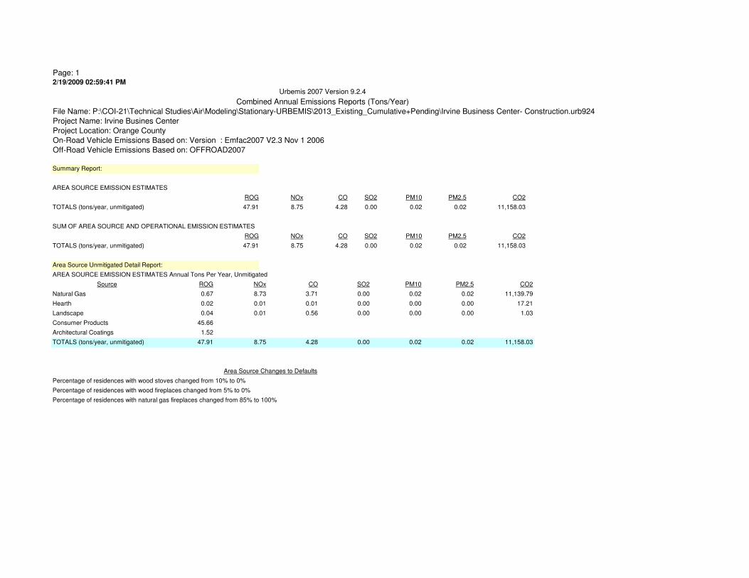
Page: 12/19/2009 02:59:41 PM
ROG
0.67
0.02
0.04
45.66
1.52
47.91
Urbemis 2007 Version 9.2.4
Combined Annual Emissions Reports (Tons/Year)
File Name: P:\COI-21\Technical Studies\Air\Modeling\Stationary-URBEMIS\2013_Existing_Cumulative+Pending\Irvine Business Center- Construction.urb924
Project Name: Irvine Busines Center
Project Location: Orange County
On-Road Vehicle Emissions Based on: Version : Emfac2007 V2.3 Nov 1 2006
Off-Road Vehicle Emissions Based on: OFFROAD2007
Summary Report:
AREA SOURCE EMISSION ESTIMATES
ROG NOx CO SO2 PM10 PM2.5 CO2
TOTALS (tons/year, unmitigated) 47.91 8.75 4.28 0.00 0.02 0.02 11,158.03
SUM OF AREA SOURCE AND OPERATIONAL EMISSION ESTIMATES
ROG NOx CO SO2 PM10 PM2.5 CO2
TOTALS (tons/year, unmitigated) 47.91 8.75 4.28 0.00 0.02 0.02 11,158.03
Area Source Unmitigated Detail Report:
AREA SOURCE EMISSION ESTIMATES Annual Tons Per Year, Unmitigated
Source NOx CO SO2 PM10 PM2.5 CO2
Natural Gas 8.73 3.71 0.00 0.02 0.02 11,139.79
Hearth 0.01 0.01 0.00 0.00 0.00 17.21
Landscape 0.01 0.56 0.00 0.00 0.00 1.03
Consumer Products
Architectural Coatings
0.00
Percentage of residences with wood stoves changed from 10% to 0%
Percentage of residences with wood fireplaces changed from 5% to 0%
Percentage of residences with natural gas fireplaces changed from 85% to 100%
0.02 0.02 11,158.03
Area Source Changes to Defaults
TOTALS (tons/year, unmitigated) 8.75 4.28

Page: 12/19/2009 02:59:15 PM
ROG
3.69
0.25
250.19
8.32
262.45
Urbemis 2007 Version 9.2.4
Combined Summer Emissions Reports (Pounds/Day)
File Name: P:\COI-21\Technical Studies\Air\Modeling\Stationary-URBEMIS\2013_Existing_Cumulative+Pending\Irvine Business Center- Construction.urb924
Project Name: Irvine Busines Center
Project Location: Orange County
On-Road Vehicle Emissions Based on: Version : Emfac2007 V2.3 Nov 1 2006
Off-Road Vehicle Emissions Based on: OFFROAD2007
Summary Report:
AREA SOURCE EMISSION ESTIMATES
ROG NOx CO SO2 PM10 PM2.5 CO2
TOTALS (lbs/day, unmitigated) 262.45 47.85 23.44 0.00 0.10 0.10 61,045.56
SUM OF AREA SOURCE AND OPERATIONAL EMISSION ESTIMATES
ROG NOx CO SO2 PM10 PM2.5 CO2
TOTALS (lbs/day, unmitigated) 262.45 47.85 23.44 0.00 0.10 0.10 61,045.56
Area Source Unmitigated Detail Report:
AREA SOURCE EMISSION ESTIMATES Summer Pounds Per Day, Unmitigated
Source NOx CO SO2 PM10 PM2.5 CO2
Natural Gas 47.81 20.35 0.00 0.09 0.09 61,039.94
Hearth - No Summer Emissions
Landscape 0.04 3.09 0.00 0.01 0.01 5.62
Consumer Products
Architectural Coatings
0.00
Percentage of residences with wood stoves changed from 10% to 0%
Percentage of residences with wood fireplaces changed from 5% to 0%
Percentage of residences with natural gas fireplaces changed from 85% to 100%
0.10 0.10 61,045.56
Area Source Changes to Defaults
TOTALS (lbs/day, unmitigated) 47.85 23.44
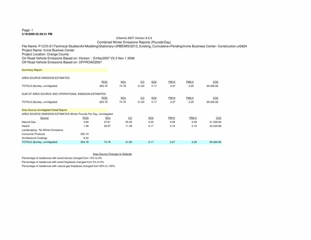
Page: 12/19/2009 02:59:31 PM
ROG
3.69
1.58
250.19
8.32
263.78
Urbemis 2007 Version 9.2.4
Combined Winter Emissions Reports (Pounds/Day)
File Name: P:\COI-21\Technical Studies\Air\Modeling\Stationary-URBEMIS\2013_Existing_Cumulative+Pending\Irvine Business Center- Construction.urb924
Project Name: Irvine Busines Center
Project Location: Orange County
On-Road Vehicle Emissions Based on: Version : Emfac2007 V2.3 Nov 1 2006
Off-Road Vehicle Emissions Based on: OFFROAD2007
Summary Report:
AREA SOURCE EMISSION ESTIMATES
ROG NOx CO SO2 PM10 PM2.5 CO2
TOTALS (lbs/day, unmitigated) 263.78 74.78 31.83 0.17 2.27 2.25 95,465.82
SUM OF AREA SOURCE AND OPERATIONAL EMISSION ESTIMATES
ROG NOx CO SO2 PM10 PM2.5 CO2
TOTALS (lbs/day, unmitigated) 263.78 74.78 31.83 0.17 2.27 2.25 95,465.82
Area Source Unmitigated Detail Report:
AREA SOURCE EMISSION ESTIMATES Winter Pounds Per Day, Unmitigated
Source NOx CO SO2 PM10 PM2.5 CO2
Natural Gas 47.81 20.35 0.00 0.09 0.09 61,039.94
Hearth 26.97 11.48 0.17 2.18 2.16 34,425.88
Landscaping - No Winter Emissions
Consumer Products
Architectural Coatings
0.17
Percentage of residences with wood stoves changed from 10% to 0%
Percentage of residences with wood fireplaces changed from 5% to 0%
Percentage of residences with natural gas fireplaces changed from 85% to 100%
2.27 2.25 95,465.82
Area Source Changes to Defaults
TOTALS (lbs/day, unmitigated) 74.78 31.83

Page: 12/19/2009 02:58:41 PM
ROG
3.50
0.01
0.16
42.78
50.31
96.76
Urbemis 2007 Version 9.2.4
Combined Annual Emissions Reports (Tons/Year)
File Name: P:\COI-21\Technical Studies\Air\Modeling\Stationary-URBEMIS\2013_Existing_Cumulative+Pending\Irvine Business Center- Existing.urb924
Project Name: Irvine Busines Center
Project Location: Orange County
On-Road Vehicle Emissions Based on: Version : Emfac2007 V2.3 Nov 1 2006
Off-Road Vehicle Emissions Based on: OFFROAD2007
Summary Report:
AREA SOURCE EMISSION ESTIMATES
ROG NOx CO SO2 PM10 PM2.5 CO2
TOTALS (tons/year, unmitigated) 96.76 47.79 38.71 0.00 0.10 0.10 57,951.31
SUM OF AREA SOURCE AND OPERATIONAL EMISSION ESTIMATES
ROG NOx CO SO2 PM10 PM2.5 CO2
TOTALS (tons/year, unmitigated) 96.76 47.79 38.71 0.00 0.10 0.10 57,951.31
Area Source Unmitigated Detail Report:
AREA SOURCE EMISSION ESTIMATES Annual Tons Per Year, Unmitigated
Source NOx CO SO2 PM10 PM2.5 CO2
Natural Gas 47.75 36.73 0.00 0.09 0.09 57,931.59
Hearth 0.01 0.01 0.00 0.00 0.00 16.13
Landscape 0.03 1.97 0.00 0.01 0.01 3.59
Consumer Products
Architectural Coatings
0.00
Percentage of residences with wood stoves changed from 10% to 0%
Percentage of residences with wood fireplaces changed from 5% to 0%
Percentage of residences with natural gas fireplaces changed from 85% to 100%
0.10 0.10 57,951.31
Area Source Changes to Defaults
TOTALS (tons/year, unmitigated) 47.79 38.71

Page: 12/19/2009 02:58:20 PM
ROG
19.20
0.86
234.39
275.66
530.11
Urbemis 2007 Version 9.2.4
Combined Summer Emissions Reports (Pounds/Day)
File Name: P:\COI-21\Technical Studies\Air\Modeling\Stationary-URBEMIS\2013_Existing_Cumulative+Pending\Irvine Business Center- Existing.urb924
Project Name: Irvine Busines Center
Project Location: Orange County
On-Road Vehicle Emissions Based on: Version : Emfac2007 V2.3 Nov 1 2006
Off-Road Vehicle Emissions Based on: OFFROAD2007
Summary Report:
AREA SOURCE EMISSION ESTIMATES
ROG NOx CO SO2 PM10 PM2.5 CO2
TOTALS (lbs/day, unmitigated) 530.11 261.81 212.06 0.00 0.52 0.51 317,453.02
SUM OF AREA SOURCE AND OPERATIONAL EMISSION ESTIMATES
ROG NOx CO SO2 PM10 PM2.5 CO2
TOTALS (lbs/day, unmitigated) 530.11 261.81 212.06 0.00 0.52 0.51 317,453.02
Area Source Unmitigated Detail Report:
AREA SOURCE EMISSION ESTIMATES Summer Pounds Per Day, Unmitigated
Source NOx CO SO2 PM10 PM2.5 CO2
Natural Gas 261.67 201.24 0.00 0.48 0.47 317,433.36
Hearth - No Summer Emissions
Landscape 0.14 10.82 0.00 0.04 0.04 19.66
Consumer Products
Architectural Coatings
0.00
Percentage of residences with wood stoves changed from 10% to 0%
Percentage of residences with wood fireplaces changed from 5% to 0%
Percentage of residences with natural gas fireplaces changed from 85% to 100%
0.52 0.51 317,453.02
Area Source Changes to Defaults
TOTALS (lbs/day, unmitigated) 261.81 212.06

Page: 12/19/2009 02:58:32 PM
ROG
19.20
1.48
234.39
275.66
530.73
Urbemis 2007 Version 9.2.4
Combined Winter Emissions Reports (Pounds/Day)
File Name: P:\COI-21\Technical Studies\Air\Modeling\Stationary-URBEMIS\2013_Existing_Cumulative+Pending\Irvine Business Center- Existing.urb924
Project Name: Irvine Busines Center
Project Location: Orange County
On-Road Vehicle Emissions Based on: Version : Emfac2007 V2.3 Nov 1 2006
Off-Road Vehicle Emissions Based on: OFFROAD2007
Summary Report:
AREA SOURCE EMISSION ESTIMATES
ROG NOx CO SO2 PM10 PM2.5 CO2
TOTALS (lbs/day, unmitigated) 530.73 286.93 211.99 0.16 2.52 2.49 349,685.12
SUM OF AREA SOURCE AND OPERATIONAL EMISSION ESTIMATES
ROG NOx CO SO2 PM10 PM2.5 CO2
TOTALS (lbs/day, unmitigated) 530.73 286.93 211.99 0.16 2.52 2.49 349,685.12
Area Source Unmitigated Detail Report:
AREA SOURCE EMISSION ESTIMATES Winter Pounds Per Day, Unmitigated
Source NOx CO SO2 PM10 PM2.5 CO2
Natural Gas 261.67 201.24 0.00 0.48 0.47 317,433.36
Hearth 25.26 10.75 0.16 2.04 2.02 32,251.76
Landscaping - No Winter Emissions
Consumer Products
Architectural Coatings
0.16
Percentage of residences with wood stoves changed from 10% to 0%
Percentage of residences with wood fireplaces changed from 5% to 0%
Percentage of residences with natural gas fireplaces changed from 85% to 100%
2.52 2.49 349,685.12
Area Source Changes to Defaults
TOTALS (lbs/day, unmitigated) 286.93 211.99
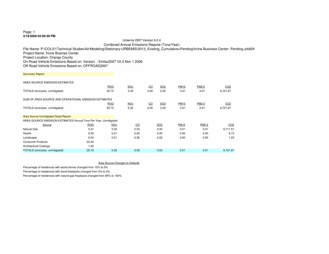
Page: 12/19/2009 03:00:59 PM
ROG
0.41
0.00
0.04
24.22
1.05
25.72
Urbemis 2007 Version 9.2.4
Combined Annual Emissions Reports (Tons/Year)
File Name: P:\COI-21\Technical Studies\Air\Modeling\Stationary-URBEMIS\2013_Existing_Cumulative+Pending\Irvine Business Center- Pending.urb924
Project Name: Irvine Busines Center
Project Location: Orange County
On-Road Vehicle Emissions Based on: Version : Emfac2007 V2.3 Nov 1 2006
Off-Road Vehicle Emissions Based on: OFFROAD2007
Summary Report:
AREA SOURCE EMISSION ESTIMATES
ROG NOx CO SO2 PM10 PM2.5 CO2
TOTALS (tons/year, unmitigated) 25.72 5.32 3.09 0.00 0.01 0.01 6,721.67
SUM OF AREA SOURCE AND OPERATIONAL EMISSION ESTIMATES
ROG NOx CO SO2 PM10 PM2.5 CO2
TOTALS (tons/year, unmitigated) 25.72 5.32 3.09 0.00 0.01 0.01 6,721.67
Area Source Unmitigated Detail Report:
AREA SOURCE EMISSION ESTIMATES Annual Tons Per Year, Unmitigated
Source NOx CO SO2 PM10 PM2.5 CO2
Natural Gas 5.30 2.53 0.00 0.01 0.01 6,711.51
Hearth 0.01 0.00 0.00 0.00 0.00 9.13
Landscape 0.01 0.56 0.00 0.00 0.00 1.03
Consumer Products
Architectural Coatings
0.00
Percentage of residences with wood stoves changed from 10% to 0%
Percentage of residences with wood fireplaces changed from 5% to 0%
Percentage of residences with natural gas fireplaces changed from 85% to 100%
0.01 0.01 6,721.67
Area Source Changes to Defaults
TOTALS (tons/year, unmitigated) 5.32 3.09

Page: 12/19/2009 03:00:34 PM
ROG
2.22
0.25
132.71
5.75
140.93
Urbemis 2007 Version 9.2.4
Combined Summer Emissions Reports (Pounds/Day)
File Name: P:\COI-21\Technical Studies\Air\Modeling\Stationary-URBEMIS\2013_Existing_Cumulative+Pending\Irvine Business Center- Pending.urb924
Project Name: Irvine Busines Center
Project Location: Orange County
On-Road Vehicle Emissions Based on: Version : Emfac2007 V2.3 Nov 1 2006
Off-Road Vehicle Emissions Based on: OFFROAD2007
Summary Report:
AREA SOURCE EMISSION ESTIMATES
ROG NOx CO SO2 PM10 PM2.5 CO2
TOTALS (lbs/day, unmitigated) 140.93 29.07 16.96 0.00 0.07 0.06 36,781.00
SUM OF AREA SOURCE AND OPERATIONAL EMISSION ESTIMATES
ROG NOx CO SO2 PM10 PM2.5 CO2
TOTALS (lbs/day, unmitigated) 140.93 29.07 16.96 0.00 0.07 0.06 36,781.00
Area Source Unmitigated Detail Report:
AREA SOURCE EMISSION ESTIMATES Summer Pounds Per Day, Unmitigated
Source NOx CO SO2 PM10 PM2.5 CO2
Natural Gas 29.03 13.87 0.00 0.06 0.05 36,775.38
Hearth - No Summer Emissions
Landscape 0.04 3.09 0.00 0.01 0.01 5.62
Consumer Products
Architectural Coatings
0.00
Percentage of residences with wood stoves changed from 10% to 0%
Percentage of residences with wood fireplaces changed from 5% to 0%
Percentage of residences with natural gas fireplaces changed from 85% to 100%
0.07 0.06 36,781.00
Area Source Changes to Defaults
TOTALS (lbs/day, unmitigated) 29.07 16.96

Page: 12/19/2009 03:00:46 PM
ROG
2.22
0.84
132.71
5.75
141.52
Urbemis 2007 Version 9.2.4
Combined Winter Emissions Reports (Pounds/Day)
File Name: P:\COI-21\Technical Studies\Air\Modeling\Stationary-URBEMIS\2013_Existing_Cumulative+Pending\Irvine Business Center- Pending.urb924
Project Name: Irvine Busines Center
Project Location: Orange County
On-Road Vehicle Emissions Based on: Version : Emfac2007 V2.3 Nov 1 2006
Off-Road Vehicle Emissions Based on: OFFROAD2007
Summary Report:
AREA SOURCE EMISSION ESTIMATES
ROG NOx CO SO2 PM10 PM2.5 CO2
TOTALS (lbs/day, unmitigated) 141.52 43.33 19.96 0.09 1.22 1.19 55,036.56
SUM OF AREA SOURCE AND OPERATIONAL EMISSION ESTIMATES
ROG NOx CO SO2 PM10 PM2.5 CO2
TOTALS (lbs/day, unmitigated) 141.52 43.33 19.96 0.09 1.22 1.19 55,036.56
Area Source Unmitigated Detail Report:
AREA SOURCE EMISSION ESTIMATES Winter Pounds Per Day, Unmitigated
Source NOx CO SO2 PM10 PM2.5 CO2
Natural Gas 29.03 13.87 0.00 0.06 0.05 36,775.38
Hearth 14.30 6.09 0.09 1.16 1.14 18,261.18
Landscaping - No Winter Emissions
Consumer Products
Architectural Coatings
0.09
Percentage of residences with wood stoves changed from 10% to 0%
Percentage of residences with wood fireplaces changed from 5% to 0%
Percentage of residences with natural gas fireplaces changed from 85% to 100%
1.22 1.19 55,036.56
Area Source Changes to Defaults
TOTALS (lbs/day, unmitigated) 43.33 19.96
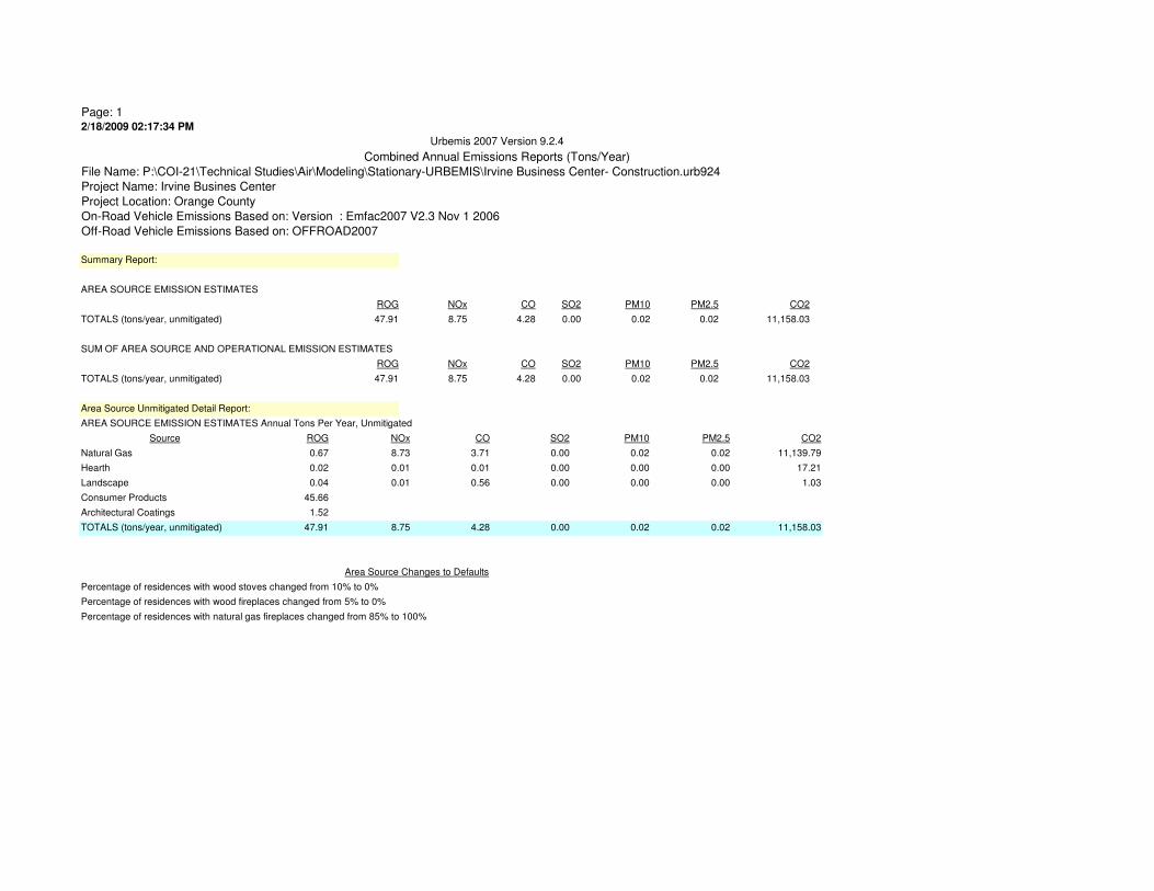
Page: 12/18/2009 02:17:34 PM
ROG
0.67
0.02
0.04
45.66
1.52
47.91
Urbemis 2007 Version 9.2.4
Combined Annual Emissions Reports (Tons/Year)
File Name: P:\COI-21\Technical Studies\Air\Modeling\Stationary-URBEMIS\Irvine Business Center- Construction.urb924
Project Name: Irvine Busines Center
Project Location: Orange County
On-Road Vehicle Emissions Based on: Version : Emfac2007 V2.3 Nov 1 2006
Off-Road Vehicle Emissions Based on: OFFROAD2007
Summary Report:
AREA SOURCE EMISSION ESTIMATES
ROG NOx CO SO2 PM10 PM2.5 CO2
TOTALS (tons/year, unmitigated) 47.91 8.75 4.28 0.00 0.02 0.02 11,158.03
SUM OF AREA SOURCE AND OPERATIONAL EMISSION ESTIMATES
ROG NOx CO SO2 PM10 PM2.5 CO2
TOTALS (tons/year, unmitigated) 47.91 8.75 4.28 0.00 0.02 0.02 11,158.03
Area Source Unmitigated Detail Report:
AREA SOURCE EMISSION ESTIMATES Annual Tons Per Year, Unmitigated
Source NOx CO SO2 PM10 PM2.5 CO2
Natural Gas 8.73 3.71 0.00 0.02 0.02 11,139.79
Hearth 0.01 0.01 0.00 0.00 0.00 17.21
Landscape 0.01 0.56 0.00 0.00 0.00 1.03
Consumer Products
Architectural Coatings
0.00
Percentage of residences with wood stoves changed from 10% to 0%
Percentage of residences with wood fireplaces changed from 5% to 0%
Percentage of residences with natural gas fireplaces changed from 85% to 100%
0.02 0.02 11,158.03
Area Source Changes to Defaults
TOTALS (tons/year, unmitigated) 8.75 4.28

Page: 12/18/2009 10:38:00 AM
ROG
3.69
0.12
250.19
8.32
262.32
Urbemis 2007 Version 9.2.4
Combined Summer Emissions Reports (Pounds/Day)
File Name: P:\COI-21\Technical Studies\Air\Modeling\Stationary-URBEMIS\Irvine Business Center- Pending.urb924
Project Name: Irvine Busines Center
Project Location: Orange County
On-Road Vehicle Emissions Based on: Version : Emfac2007 V2.3 Nov 1 2006
Off-Road Vehicle Emissions Based on: OFFROAD2007
Summary Report:
AREA SOURCE EMISSION ESTIMATES
ROG NOx CO SO2 PM10 PM2.5 CO2
TOTALS (lbs/day, unmitigated) 262.32 47.83 21.90 0.00 0.10 0.10 61,042.75
SUM OF AREA SOURCE AND OPERATIONAL EMISSION ESTIMATES
ROG NOx CO SO2 PM10 PM2.5 CO2
TOTALS (lbs/day, unmitigated) 262.32 47.83 21.90 0.00 0.10 0.10 61,042.75
Area Source Unmitigated Detail Report:
AREA SOURCE EMISSION ESTIMATES Summer Pounds Per Day, Unmitigated
Source NOx CO SO2 PM10 PM2.5 CO2
Natural Gas 47.81 20.35 0.00 0.09 0.09 61,039.94
Hearth - No Summer Emissions
Landscape 0.02 1.55 0.00 0.01 0.01 2.81
Consumer Products
Architectural Coatings
0.10 0.10 61,042.75
Area Source Changes to Defaults
TOTALS (lbs/day, unmitigated) 47.83 21.90 0.00

Page: 12/18/2009 02:17:26 PM
ROG
3.69
1.58
250.19
8.32
263.78
Urbemis 2007 Version 9.2.4
Combined Winter Emissions Reports (Pounds/Day)
File Name: P:\COI-21\Technical Studies\Air\Modeling\Stationary-URBEMIS\Irvine Business Center- Construction.urb924
Project Name: Irvine Busines Center
Project Location: Orange County
On-Road Vehicle Emissions Based on: Version : Emfac2007 V2.3 Nov 1 2006
Off-Road Vehicle Emissions Based on: OFFROAD2007
Summary Report:
AREA SOURCE EMISSION ESTIMATES
ROG NOx CO SO2 PM10 PM2.5 CO2
TOTALS (lbs/day, unmitigated) 263.78 74.78 31.83 0.17 2.27 2.25 95,465.82
SUM OF AREA SOURCE AND OPERATIONAL EMISSION ESTIMATES
ROG NOx CO SO2 PM10 PM2.5 CO2
TOTALS (lbs/day, unmitigated) 263.78 74.78 31.83 0.17 2.27 2.25 95,465.82
Area Source Unmitigated Detail Report:
AREA SOURCE EMISSION ESTIMATES Winter Pounds Per Day, Unmitigated
Source NOx CO SO2 PM10 PM2.5 CO2
Natural Gas 47.81 20.35 0.00 0.09 0.09 61,039.94
Hearth 26.97 11.48 0.17 2.18 2.16 34,425.88
Landscaping - No Winter Emissions
Consumer Products
Architectural Coatings
0.17
Percentage of residences with wood stoves changed from 10% to 0%
Percentage of residences with wood fireplaces changed from 5% to 0%
Percentage of residences with natural gas fireplaces changed from 85% to 100%
2.27 2.25 95,465.82
Area Source Changes to Defaults
TOTALS (lbs/day, unmitigated) 74.78 31.83
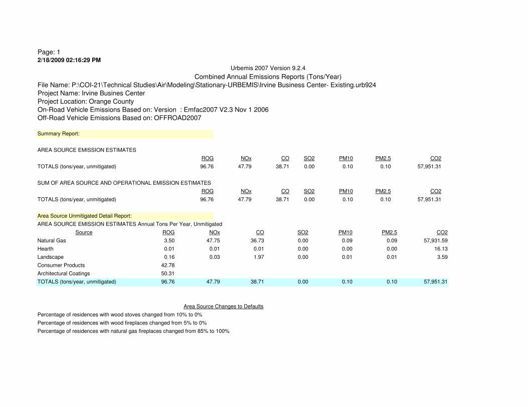
Page: 12/18/2009 02:16:29 PM
ROG
3.50
0.01
0.16
42.78
50.31
96.76
Urbemis 2007 Version 9.2.4
Combined Annual Emissions Reports (Tons/Year)
File Name: P:\COI-21\Technical Studies\Air\Modeling\Stationary-URBEMIS\Irvine Business Center- Existing.urb924
Project Name: Irvine Busines Center
Project Location: Orange County
On-Road Vehicle Emissions Based on: Version : Emfac2007 V2.3 Nov 1 2006
Off-Road Vehicle Emissions Based on: OFFROAD2007
Summary Report:
AREA SOURCE EMISSION ESTIMATES
ROG NOx CO SO2 PM10 PM2.5 CO2
TOTALS (tons/year, unmitigated) 96.76 47.79 38.71 0.00 0.10 0.10 57,951.31
SUM OF AREA SOURCE AND OPERATIONAL EMISSION ESTIMATES
ROG NOx CO SO2 PM10 PM2.5 CO2
TOTALS (tons/year, unmitigated) 96.76 47.79 38.71 0.00 0.10 0.10 57,951.31
Area Source Unmitigated Detail Report:
AREA SOURCE EMISSION ESTIMATES Annual Tons Per Year, Unmitigated
Source NOx CO SO2 PM10 PM2.5 CO2
Natural Gas 47.75 36.73 0.00 0.09 0.09 57,931.59
Hearth 0.01 0.01 0.00 0.00 0.00 16.13
Landscape 0.03 1.97 0.00 0.01 0.01 3.59
Consumer Products
Architectural Coatings
0.00
Percentage of residences with wood stoves changed from 10% to 0%
Percentage of residences with wood fireplaces changed from 5% to 0%
Percentage of residences with natural gas fireplaces changed from 85% to 100%
0.10 0.10 57,951.31
Area Source Changes to Defaults
TOTALS (tons/year, unmitigated) 47.79 38.71

Page: 12/18/2009 10:23:02 AM
ROG
19.20
0.86
234.39
275.66
530.11
Urbemis 2007 Version 9.2.4
Combined Summer Emissions Reports (Pounds/Day)
File Name: P:\COI-21\Technical Studies\Air\Modeling\Stationary-URBEMIS\Irvine Business Center- Existing.urb924
Project Name: Irvine Busines Center
Project Location: Orange County
On-Road Vehicle Emissions Based on: Version : Emfac2007 V2.3 Nov 1 2006
Off-Road Vehicle Emissions Based on: OFFROAD2007
Summary Report:
AREA SOURCE EMISSION ESTIMATES
ROG NOx CO SO2 PM10 PM2.5 CO2
TOTALS (lbs/day, unmitigated) 530.11 261.81 212.06 0.00 0.52 0.51 317,453.02
SUM OF AREA SOURCE AND OPERATIONAL EMISSION ESTIMATES
ROG NOx CO SO2 PM10 PM2.5 CO2
TOTALS (lbs/day, unmitigated) 530.11 261.81 212.06 0.00 0.52 0.51 317,453.02
Area Source Unmitigated Detail Report:
AREA SOURCE EMISSION ESTIMATES Summer Pounds Per Day, Unmitigated
Source NOx CO SO2 PM10 PM2.5 CO2
Natural Gas 261.67 201.24 0.00 0.48 0.47 317,433.36
Hearth - No Summer Emissions
Landscape 0.14 10.82 0.00 0.04 0.04 19.66
Consumer Products
Architectural Coatings
0.52 0.51 317,453.02
Area Source Changes to Defaults
TOTALS (lbs/day, unmitigated) 261.81 212.06 0.00

Page: 12/18/2009 02:16:20 PM
ROG
19.20
1.48
234.39
275.66
530.73
Urbemis 2007 Version 9.2.4
Combined Winter Emissions Reports (Pounds/Day)
File Name: P:\COI-21\Technical Studies\Air\Modeling\Stationary-URBEMIS\Irvine Business Center- Existing.urb924
Project Name: Irvine Busines Center
Project Location: Orange County
On-Road Vehicle Emissions Based on: Version : Emfac2007 V2.3 Nov 1 2006
Off-Road Vehicle Emissions Based on: OFFROAD2007
Summary Report:
AREA SOURCE EMISSION ESTIMATES
ROG NOx CO SO2 PM10 PM2.5 CO2
TOTALS (lbs/day, unmitigated) 530.73 286.93 211.99 0.16 2.52 2.49 349,685.12
SUM OF AREA SOURCE AND OPERATIONAL EMISSION ESTIMATES
ROG NOx CO SO2 PM10 PM2.5 CO2
TOTALS (lbs/day, unmitigated) 530.73 286.93 211.99 0.16 2.52 2.49 349,685.12
Area Source Unmitigated Detail Report:
AREA SOURCE EMISSION ESTIMATES Winter Pounds Per Day, Unmitigated
Source NOx CO SO2 PM10 PM2.5 CO2
Natural Gas 261.67 201.24 0.00 0.48 0.47 317,433.36
Hearth 25.26 10.75 0.16 2.04 2.02 32,251.76
Landscaping - No Winter Emissions
Consumer Products
Architectural Coatings
0.16
Percentage of residences with wood stoves changed from 10% to 0%
Percentage of residences with wood fireplaces changed from 5% to 0%
Percentage of residences with natural gas fireplaces changed from 85% to 100%
2.52 2.49 349,685.12
Area Source Changes to Defaults
TOTALS (lbs/day, unmitigated) 286.93 211.99

Page: 12/18/2009 02:18:24 PM
ROG
0.41
0.00
0.04
24.22
1.05
25.72
Urbemis 2007 Version 9.2.4
Combined Annual Emissions Reports (Tons/Year)
File Name: P:\COI-21\Technical Studies\Air\Modeling\Stationary-URBEMIS\Irvine Business Center- Pending.urb924
Project Name: Irvine Busines Center
Project Location: Orange County
On-Road Vehicle Emissions Based on: Version : Emfac2007 V2.3 Nov 1 2006
Off-Road Vehicle Emissions Based on: OFFROAD2007
Summary Report:
AREA SOURCE EMISSION ESTIMATES
ROG NOx CO SO2 PM10 PM2.5 CO2
TOTALS (tons/year, unmitigated) 25.72 5.32 3.09 0.00 0.01 0.01 6,721.67
SUM OF AREA SOURCE AND OPERATIONAL EMISSION ESTIMATES
ROG NOx CO SO2 PM10 PM2.5 CO2
TOTALS (tons/year, unmitigated) 25.72 5.32 3.09 0.00 0.01 0.01 6,721.67
Area Source Unmitigated Detail Report:
AREA SOURCE EMISSION ESTIMATES Annual Tons Per Year, Unmitigated
Source NOx CO SO2 PM10 PM2.5 CO2
Natural Gas 5.30 2.53 0.00 0.01 0.01 6,711.51
Hearth 0.01 0.00 0.00 0.00 0.00 9.13
Landscape 0.01 0.56 0.00 0.00 0.00 1.03
Consumer Products
Architectural Coatings
0.00
Percentage of residences with wood stoves changed from 10% to 0%
Percentage of residences with wood fireplaces changed from 5% to 0%
Percentage of residences with natural gas fireplaces changed from 85% to 100%
0.01 0.01 6,721.67
Area Source Changes to Defaults
TOTALS (tons/year, unmitigated) 5.32 3.09
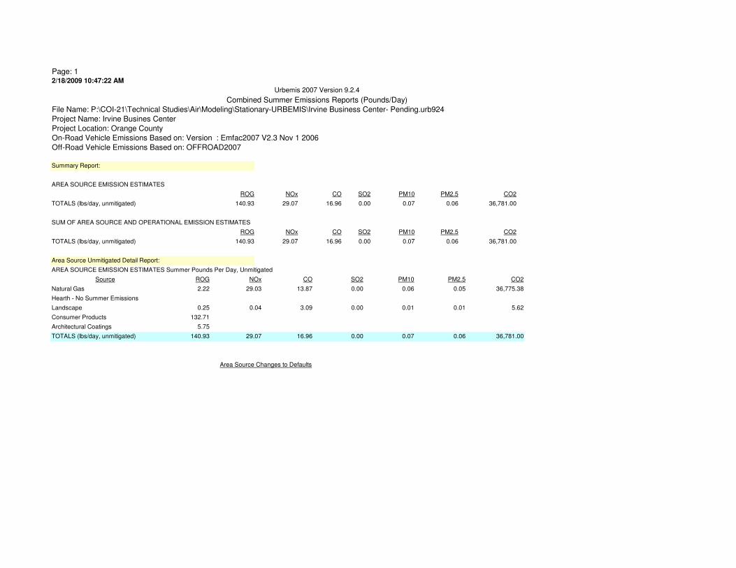
Page: 12/18/2009 10:47:22 AM
ROG
2.22
0.25
132.71
5.75
140.93
Urbemis 2007 Version 9.2.4
Combined Summer Emissions Reports (Pounds/Day)
File Name: P:\COI-21\Technical Studies\Air\Modeling\Stationary-URBEMIS\Irvine Business Center- Pending.urb924
Project Name: Irvine Busines Center
Project Location: Orange County
On-Road Vehicle Emissions Based on: Version : Emfac2007 V2.3 Nov 1 2006
Off-Road Vehicle Emissions Based on: OFFROAD2007
Summary Report:
AREA SOURCE EMISSION ESTIMATES
ROG NOx CO SO2 PM10 PM2.5 CO2
TOTALS (lbs/day, unmitigated) 140.93 29.07 16.96 0.00 0.07 0.06 36,781.00
SUM OF AREA SOURCE AND OPERATIONAL EMISSION ESTIMATES
ROG NOx CO SO2 PM10 PM2.5 CO2
TOTALS (lbs/day, unmitigated) 140.93 29.07 16.96 0.00 0.07 0.06 36,781.00
Area Source Unmitigated Detail Report:
AREA SOURCE EMISSION ESTIMATES Summer Pounds Per Day, Unmitigated
Source NOx CO SO2 PM10 PM2.5 CO2
Natural Gas 29.03 13.87 0.00 0.06 0.05 36,775.38
Hearth - No Summer Emissions
Landscape 0.04 3.09 0.00 0.01 0.01 5.62
Consumer Products
Architectural Coatings
0.07 0.06 36,781.00
Area Source Changes to Defaults
TOTALS (lbs/day, unmitigated) 29.07 16.96 0.00

Page: 12/18/2009 02:18:13 PM
ROG
2.22
0.84
132.71
5.75
141.52
Urbemis 2007 Version 9.2.4
Combined Winter Emissions Reports (Pounds/Day)
File Name: P:\COI-21\Technical Studies\Air\Modeling\Stationary-URBEMIS\Irvine Business Center- Pending.urb924
Project Name: Irvine Busines Center
Project Location: Orange County
On-Road Vehicle Emissions Based on: Version : Emfac2007 V2.3 Nov 1 2006
Off-Road Vehicle Emissions Based on: OFFROAD2007
Summary Report:
AREA SOURCE EMISSION ESTIMATES
ROG NOx CO SO2 PM10 PM2.5 CO2
TOTALS (lbs/day, unmitigated) 141.52 43.33 19.96 0.09 1.22 1.19 55,036.56
SUM OF AREA SOURCE AND OPERATIONAL EMISSION ESTIMATES
ROG NOx CO SO2 PM10 PM2.5 CO2
TOTALS (lbs/day, unmitigated) 141.52 43.33 19.96 0.09 1.22 1.19 55,036.56
Area Source Unmitigated Detail Report:
AREA SOURCE EMISSION ESTIMATES Winter Pounds Per Day, Unmitigated
Source NOx CO SO2 PM10 PM2.5 CO2
Natural Gas 29.03 13.87 0.00 0.06 0.05 36,775.38
Hearth 14.30 6.09 0.09 1.16 1.14 18,261.18
Landscaping - No Winter Emissions
Consumer Products
Architectural Coatings
0.09
Percentage of residences with wood stoves changed from 10% to 0%
Percentage of residences with wood fireplaces changed from 5% to 0%
Percentage of residences with natural gas fireplaces changed from 85% to 100%
1.22 1.19 55,036.56
Area Source Changes to Defaults
TOTALS (lbs/day, unmitigated) 43.33 19.96

Page: 12/18/2009 02:19:25 PM
ROG
1.16
0.01
0.09
38.93
8.11
48.30
Urbemis 2007 Version 9.2.4
Combined Annual Emissions Reports (Tons/Year)
File Name: P:\COI-21\Technical Studies\Air\Modeling\Stationary-URBEMIS\Irvine Business Center- Project.urb924
Project Name: Irvine Busines Center
Project Location: Orange County
On-Road Vehicle Emissions Based on: Version : Emfac2007 V2.3 Nov 1 2006
Off-Road Vehicle Emissions Based on: OFFROAD2007
Summary Report:
AREA SOURCE EMISSION ESTIMATES
ROG NOx CO SO2 PM10 PM2.5 CO2
TOTALS (tons/year, unmitigated) 48.30 15.52 11.06 0.00 0.03 0.03 19,170.29
SUM OF AREA SOURCE AND OPERATIONAL EMISSION ESTIMATES
ROG NOx CO SO2 PM10 PM2.5 CO2
TOTALS (tons/year, unmitigated) 48.30 15.52 11.06 0.00 0.03 0.03 19,170.29
Area Source Unmitigated Detail Report:
AREA SOURCE EMISSION ESTIMATES Annual Tons Per Year, Unmitigated
Source NOx CO SO2 PM10 PM2.5 CO2
Natural Gas 15.49 9.93 0.00 0.03 0.03 19,153.56
Hearth 0.01 0.00 0.00 0.00 0.00 14.68
Landscape 0.02 1.13 0.00 0.00 0.00 2.05
Consumer Products
Architectural Coatings
0.00
Percentage of residences with wood stoves changed from 10% to 0%
Percentage of residences with wood fireplaces changed from 5% to 0%
Percentage of residences with natural gas fireplaces changed from 85% to 100%
0.03 0.03 19,170.29
Area Source Changes to Defaults
TOTALS (tons/year, unmitigated) 15.52 11.06
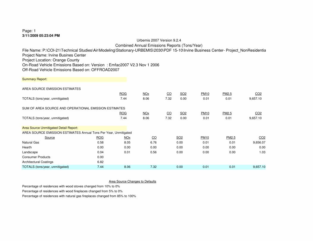
Page: 13/11/2009 05:23:04 PM
ROG
0.58
0.00
0.04
0.00
6.82
7.44
Urbemis 2007 Version 9.2.4
Combined Annual Emissions Reports (Tons/Year)
File Name: P:\COI-21\Technical Studies\Air\Modeling\Stationary-URBEMIS\2030\PDF 15-10\Irvine Business Center- Project_NonResidential
Project Name: Irvine Busines Center
Project Location: Orange County
On-Road Vehicle Emissions Based on: Version : Emfac2007 V2.3 Nov 1 2006
Off-Road Vehicle Emissions Based on: OFFROAD2007
Summary Report:
AREA SOURCE EMISSION ESTIMATES
ROG NOx CO SO2 PM10 PM2.5 CO2
TOTALS (tons/year, unmitigated) 7.44 8.06 7.32 0.00 0.01 0.01 9,657.10
SUM OF AREA SOURCE AND OPERATIONAL EMISSION ESTIMATES
ROG NOx CO SO2 PM10 PM2.5 CO2
TOTALS (tons/year, unmitigated) 7.44 8.06 7.32 0.00 0.01 0.01 9,657.10
Area Source Unmitigated Detail Report:
AREA SOURCE EMISSION ESTIMATES Annual Tons Per Year, Unmitigated
Source NOx CO SO2 PM10 PM2.5 CO2
Natural Gas 8.05 6.76 0.00 0.01 0.01 9,656.07
Hearth 0.00 0.00 0.00 0.00 0.00 0.00
Landscape 0.01 0.56 0.00 0.00 0.00 1.03
Consumer Products
Architectural Coatings
0.00
Percentage of residences with wood stoves changed from 10% to 0%
Percentage of residences with wood fireplaces changed from 5% to 0%
Percentage of residences with natural gas fireplaces changed from 85% to 100%
0.01 0.01 9,657.10
Area Source Changes to Defaults
TOTALS (tons/year, unmitigated) 8.06 7.32

Page: 13/11/2009 05:23:58 PM
ROG
0.57
0.01
0.04
38.93
1.29
40.84
Urbemis 2007 Version 9.2.4
Combined Annual Emissions Reports (Tons/Year)
File Name: P:\COI-21\Technical Studies\Air\Modeling\Stationary-URBEMIS\2030\PDF 15-10\Irvine Business Center- Project.urb924
Project Name: Irvine Busines Center
Project Location: Orange County
On-Road Vehicle Emissions Based on: Version : Emfac2007 V2.3 Nov 1 2006
Off-Road Vehicle Emissions Based on: OFFROAD2007
Summary Report:
AREA SOURCE EMISSION ESTIMATES
ROG NOx CO SO2 PM10 PM2.5 CO2
TOTALS (tons/year, unmitigated) 40.84 7.46 3.73 0.00 0.01 0.01 9,513.20
SUM OF AREA SOURCE AND OPERATIONAL EMISSION ESTIMATES
ROG NOx CO SO2 PM10 PM2.5 CO2
TOTALS (tons/year, unmitigated) 40.84 7.46 3.73 0.00 0.01 0.01 9,513.20
Area Source Unmitigated Detail Report:
AREA SOURCE EMISSION ESTIMATES Annual Tons Per Year, Unmitigated
Source NOx CO SO2 PM10 PM2.5 CO2
Natural Gas 7.44 3.17 0.00 0.01 0.01 9,497.49
Hearth 0.01 0.00 0.00 0.00 0.00 14.68
Landscape 0.01 0.56 0.00 0.00 0.00 1.03
Consumer Products
Architectural Coatings
0.00
Percentage of residences with wood stoves changed from 10% to 0%
Percentage of residences with wood fireplaces changed from 5% to 0%
Percentage of residences with natural gas fireplaces changed from 85% to 100%
0.01 0.01 9,513.20
Area Source Changes to Defaults
TOTALS (tons/year, unmitigated) 7.46 3.73

Page: 12/18/2009 02:07:00 PM
ROG
6.35
0.49
213.31
44.44
264.59
Urbemis 2007 Version 9.2.4
Combined Summer Emissions Reports (Pounds/Day)
File Name: P:\COI-21\Technical Studies\Air\Modeling\Stationary-URBEMIS\Irvine Business Center- Project.urb924
Project Name: Irvine Busines Center
Project Location: Orange County
On-Road Vehicle Emissions Based on: Version : Emfac2007 V2.3 Nov 1 2006
Off-Road Vehicle Emissions Based on: OFFROAD2007
Summary Report:
AREA SOURCE EMISSION ESTIMATES
ROG NOx CO SO2 PM10 PM2.5 CO2
TOTALS (lbs/day, unmitigated) 264.59 84.94 60.56 0.00 0.18 0.18 104,962.26
SUM OF AREA SOURCE AND OPERATIONAL EMISSION ESTIMATES
ROG NOx CO SO2 PM10 PM2.5 CO2
TOTALS (lbs/day, unmitigated) 264.59 84.94 60.56 0.00 0.18 0.18 104,962.26
Area Source Unmitigated Detail Report:
AREA SOURCE EMISSION ESTIMATES Summer Pounds Per Day, Unmitigated
Source NOx CO SO2 PM10 PM2.5 CO2
Natural Gas 84.86 54.38 0.00 0.16 0.16 104,951.02
Hearth - No Summer Emissions
Landscape 0.08 6.18 0.00 0.02 0.02 11.24
Consumer Products
Architectural Coatings
0.18 0.18 104,962.26
Area Source Changes to Defaults
TOTALS (lbs/day, unmitigated) 84.94 60.56 0.00
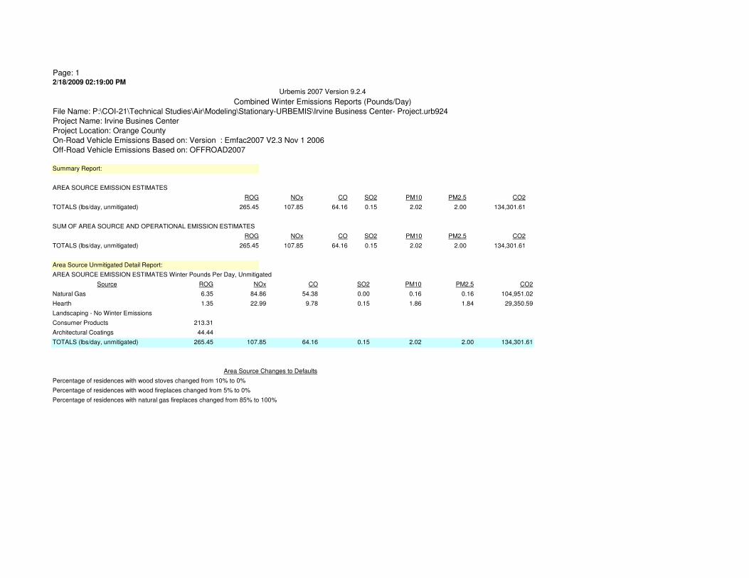
Page: 12/18/2009 02:19:00 PM
ROG
6.35
1.35
213.31
44.44
265.45
Urbemis 2007 Version 9.2.4
Combined Winter Emissions Reports (Pounds/Day)
File Name: P:\COI-21\Technical Studies\Air\Modeling\Stationary-URBEMIS\Irvine Business Center- Project.urb924
Project Name: Irvine Busines Center
Project Location: Orange County
On-Road Vehicle Emissions Based on: Version : Emfac2007 V2.3 Nov 1 2006
Off-Road Vehicle Emissions Based on: OFFROAD2007
Summary Report:
AREA SOURCE EMISSION ESTIMATES
ROG NOx CO SO2 PM10 PM2.5 CO2
TOTALS (lbs/day, unmitigated) 265.45 107.85 64.16 0.15 2.02 2.00 134,301.61
SUM OF AREA SOURCE AND OPERATIONAL EMISSION ESTIMATES
ROG NOx CO SO2 PM10 PM2.5 CO2
TOTALS (lbs/day, unmitigated) 265.45 107.85 64.16 0.15 2.02 2.00 134,301.61
Area Source Unmitigated Detail Report:
AREA SOURCE EMISSION ESTIMATES Winter Pounds Per Day, Unmitigated
Source NOx CO SO2 PM10 PM2.5 CO2
Natural Gas 84.86 54.38 0.00 0.16 0.16 104,951.02
Hearth 22.99 9.78 0.15 1.86 1.84 29,350.59
Landscaping - No Winter Emissions
Consumer Products
Architectural Coatings
0.15
Percentage of residences with wood stoves changed from 10% to 0%
Percentage of residences with wood fireplaces changed from 5% to 0%
Percentage of residences with natural gas fireplaces changed from 85% to 100%
2.02 2.00 134,301.61
Area Source Changes to Defaults
TOTALS (lbs/day, unmitigated) 107.85 64.16
Appendices
IBC Vision Plan and Mixed Use Overlay Zoning Code Recirculated DEIR City of Irvine
Appendix H Biological Resources Study

Appendices
The Planning Center December 2009
This page intentionally left blank.
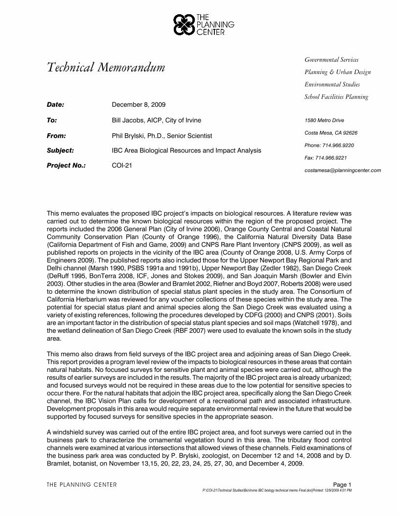
Governmental Services
Planning & Urban Design
Environmental Studies
Technical Memorandum
Date: December 8, 2009
To: Bill Jacobs, AICP, City of Irvine
From: Phil Brylski, Ph.D., Senior Scientist
Subject: IBC Area Biological Resources and Impact Analysis
Project No.: COI-21
School Facilities Planning
1580 Metro Drive
Costa Mesa, CA 92626
Phone: 714.966.9220
Fax: 714.966.9221
This memo evaluates the proposed IBC project’s impacts on biological resources. A literature review was
carried out to determine the known biological resources within the region of the proposed project. The
reports included the 2006 General Plan (City of Irvine 2006), Orange County Central and Coastal Natural
Community Conservation Plan (County of Orange 1996), the California Natural Diversity Data Base (California Department of Fish and Game, 2009) and CNPS Rare Plant Inventory (CNPS 2009), as well as
published reports on projects in the vicinity of the IBC area (County of Orange 2008, U.S. Army Corps of
Engineers 2009). The published reports also included those for the Upper Newport Bay Regional Park and
Delhi channel (Marsh 1990, PSBS 1991a and 1991b), Upper Newport Bay (Zedler 1982), San Diego Creek
(DeRuff 1995, BonTerra 2008, ICF, Jones and Stokes 2009), and San Joaquin Marsh (Bowler and Elvin 2003). Other studies in the area (Bowler and Bramlet 2002, Riefner and Boyd 2007, Roberts 2008) were used
to determine the known distribution of special status plant species in the study area. The Consortium of
California Herbarium was reviewed for any voucher collections of these species within the study area. The
potential for special status plant and animal species along the San Diego Creek was evaluated using a
variety of existing references, following the procedures developed by CDFG (2000) and CNPS (2001). Soils are an important factor in the distribution of special status plant species and soil maps (Watchell 1978), and
the wetland delineation of San Diego Creek (RBF 2007) were used to evaluate the known soils in the study
area.
This memo also draws from field surveys of the IBC project area and adjoining areas of San Diego Creek. This report provides a program level review of the impacts to biological resources in these areas that contain
natural habitats. No focused surveys for sensitive plant and animal species were carried out, although the
results of earlier surveys are included in the results. The majority of the IBC project area is already urbanized;
and focused surveys would not be required in these areas due to the low potential for sensitive species to
occur there. For the natural habitats that adjoin the IBC project area, specifically along the San Diego Creek channel, the IBC Vision Plan calls for development of a recreational path and associated infrastructure.
Development proposals in this area would require separate environmental review in the future that would be
supported by focused surveys for sensitive species in the appropriate season.
A windshield survey was carried out of the entire IBC project area, and foot surveys were carried out in the
business park to characterize the ornamental vegetation found in this area. The tributary flood control channels were examined at various intersections that allowed views of these channels. Field examinations of
the business park area was conducted by P. Brylski, zoologist, on December 12 and 14, 2008 and by D.
Bramlet, botanist, on November 13,15, 20, 22, 23, 24, 25, 27, 30, and December 4, 2009.
THE PLANNING CENTER Page 1 P:\COI-21\Technical Studies\Bio\Irvine IBC biology technical memo Final.doc|Printed: 12/9/2009 4:01 PM
Field surveys of the San Diego Creek channel consisted of walking the existing trail alongside the channel
and, for the plant community description, walking into the channel. Surveys of the creek were conducted by
Phil Brylski, zoologist, on December 12 and 14, 2008, and by Dave Bramlet, botanist, on November 13, 20, 23, 24, 27, and 30, 2009 and December 4. 2009 to field map the vegetation along the channel, describe the
plant communities and note any plant species.
The taxonomy of the ornamental species observed in the study area follows Brenzel (2007) and Roberts
(2008) is used for the nomenclature of the native plant species. Classification of plant communities follows
the Orange County Habitat Classification System (Dames and Moore and Bramlet 1992, Jones and Stokes 1993).
1.0 REGULATORY SETTING
Federal, state, regional, and local laws, regulations, plans, or guidelines that are potentially applicable to the
proposed project are summarized below.
Federal and State Regulations
Federal Endangered Species Act
FESA, as amended, was promulgated to protect and conserve any species of plant or animal that is endangered or threatened with extinction and the habitats in which these species are found. Section 4(a) of
the FESA requires that critical habitat be designated by the US Fish and Wildlife Service (USFWS) “to the
maximum extent prudent and determinable, at the time a species is determined to be endangered or
threatened.” Critical habitat is formally designated by USFWS to provide guidance for planners/managers
and biologists with an indication of where suitable habitat may occur and where high priority of preservation for a particular species should be given. “Take” of endangered species is prohibited under Section 9 of the
FESA. Take, as defined under the FESA, means to “harass, harm, pursue, hunt, wound, kill, trap, capture,
collect, or attempt to engage in any such conduct.” Section 7 of the FESA requires federal agencies to
consult with the USFWS on proposed federal actions that may affect any endangered, threatened or proposed (for listing) species or critical habitat that may support the species. Section 10 of the FESA
provides the regulatory mechanism that allows the incidental take of a listed species by private interests and
nonfederal government agencies during lawful activities. Habitat conservation plans (HCPs) for the impacted
species must be developed in support of incidental take permits for nonfederal projects to minimize impacts
to the species and develop viable mitigation measures to offset the unavoidable impacts.
Migratory Bird Treaty Act
The Migratory Bird Treaty Act (MBTA) of 1918 is the domestic law that affirms or implements the United
States’ commitment to four international conventions with Canada, Japan, Mexico, and Russia for the
protection of shared migratory bird resources. It governs the taking, killing, possession, transportation, and
importation of migratory birds, their eggs, parts, and nests. It prohibits the take, possession, import, export, transport, sale, purchase, barter, or offering of these activities, except under a valid permit or as permitted in
the implementing regulations. As with the FESA, the act also authorizes the Secretary of the Interior to issue
permits for take. The procedures for securing such permits are found in Title 50 of the Code of Federal
Regulations, together with a list of the migratory birds covered by the act. This law is generally protective of
migratory birds but does not specify the type of protection required. USFWS administers permits to take migratory birds in accordance with the regulations promulgated by the MBTA. Nesting raptors, such as red-
tailed hawks and burrowing owls, are protected under the MBTA. In common practice, USFWS places
restrictions on disturbances allowed near active raptor nests.
THE PLANNING CENTER Page 2 P:\COI-21\Technical Studies\Bio\Irvine IBC biology technical memo Final.doc|Printed: 12/9/2009 4:01 PM
Clean Water Act, Section 404
The United States Army Corps of Engineers (Corps) regulates discharges of dredged or fill material into
“waters of the U.S.”1 Pursuant to Section 404 of the federal Clean Water Act (CWA), a permit is required for any filling or dredging within waters of the U.S. The permit review process entails an assessment of potential
adverse impacts to Corps wetlands and jurisdictional waters, wherein the Corps may require mitigation
measures. Where a federally listed species may be affected, a Section 7 consultation with USFWS may be
required. If there is potential for cultural resources to be present, Section 106 review may be required. Also,
where a Section 404 permit is required, a Section 401 Water Quality Certification would also be required from the Regional Water Quality Control Board (RWQCB).
Clean Water Act, Section 401 and 402
Section 401(a)(1) of the CWA specifies that any applicant for a federal license or permit to conduct any
activity that may result in any discharge into navigable waters shall provide the federal permitting agency a certification, issued by the state in which the discharge originates, that any such discharge will comply with
the applicable provisions of the CWA. In California, the applicable RWQCB must certify that the project will
comply with water quality standards. Permits requiring Section 401 certification include Corps Section 404
permits and National Pollutant Discharge Elimination System (NPDES) permits issued by the Environmental
Protection Agency (EPA) under Section 402 of the CWA. NPDES permits are issued by the applicable RWQCB. The City of Irvine is within the jurisdiction of the Santa Ana RWQCB (Region 8).
California Fish and Game Code, Section 1600
Section 1600 series of the California Fish and Game Code requires that a project proponent notify the
California Department of Fish and Game (CDFG) of any proposed alteration of streambeds, rivers, and lakes.
The intent is to protect habitats that are important to fish and wildlife. CDFG may review a project and place conditions on the project as part of a Streambed Alteration Agreement. The conditions are intended to
address potentially significant adverse impacts within CDFG’s jurisdictional limits.
California Endangered Species Act
The California Endangered Species Act (CESA) generally parallels the main provisions of the FESA and is administered by the CDFG. Its intent is to prohibit take and protect state-listed endangered and threatened
species of fish, wildlife, and plants. Unlike its federal counterpart, CESA also applies the take prohibitions to
species petitioned for listing (state candidates). At the discretion of the Fish and Game Commission,
candidate species may be afforded temporary protection as though they were already listed as threatened or
endangered. Unlike the FESA, CESA does not include listing provisions for invertebrate species. Under certain conditions, CESA has provisions for take through a 2081 permit or Memorandum of Understanding
(MOU). In addition, some sensitive mammals and birds are protected by the state as Fully Protected
Species. California Species of Special Concern are species designated as vulnerable to extinction due to
declining population levels, limited ranges, and/or continuing threats. This list is primarily a working
document for the CDFG’s California Natural Diversity Database (CNDDB) project, which maintains a database of known and recorded occurrences of sensitive species. Informally listed taxa are not protected
per se, but warrant consideration in the preparation of biological resources assessments.
1 “Waters of the United States,” as it applies to the jurisdictional limits of the authority of the Corps of Engineers under the Clean
Water Act, includes: all waters which are currently used, or were used in the past, or may be susceptible to use in interstate or
foreign commerce, including all waters which are subject to the ebb and flow of the tide; all interstate waters including interstate
wetlands; all other waters such as intrastate lakes, rivers, streams (including intermittent streams), mudflats, sandflats, wetlands,
sloughs, prairie potholes, wet meadows, playa lakes, or natural ponds, the use, degradation or destruction of which could affect
interstate or foreign commerce; water impoundments; tributaries of waters; territorial seas; wetlands adjacent to waters. The terminology used by Section 404 of the Clean Water Act includes “navigable waters,” which is defined at Section 502(7) of the Act
as “waters of the United States including the territorial seas.”
THE PLANNING CENTER Page 3 P:\COI-21\Technical Studies\Bio\Irvine IBC biology technical memo Final.doc|Printed: 12/9/2009 4:01 PM
California Coastal Act
Chapter 3 of the California Coastal Act contains policies to protect water quality and the biological
productivity of coastal waters; avoid and minimize dredging, diking, and filling sediments; and mitigate wetland impacts. Under the California Coastal Act, environmentally sensitive area means any area in which
plant or animal life or their habitats are either rare or especially valuable because of their special nature or
role in an ecosystem and which could be easily disturbed or degraded by human activities and
developments. Implementation of Coastal Act policies is accomplished primarily through the preparation of a
Local Coastal Program (LCP). The LCP is typically prepared and adopted by a municipality or county, and then it is reviewed and approved by the Coastal Commission. A LCP typically consists of a land use plan and
an implementation plan. The land use plan indicates the kinds, location, and intensity of land uses, the
applicable resource protection and development policies, and, where necessary, a listing of implementing
actions. The implementation plan consists of the zoning ordinances, zoning district maps, and other legal instruments necessary to implement the land use plan.
A 40-acre parcel in the southern part of the IBC area is within the coastal zone. One of the areas is the
developed area bounded by Jamboree Road, MacArthur Boulevard, and Fairchild Road, for which a Local
Coastal Plan was prepared by the City of Irvine. Two other areas in the coastal zone, outside of the project
area, are open space areas owned and managed by UC Irvine: the San Joaquin Marsh area located below Campus Drive together with the area of upland habitat located between the marsh, the San Diego Creek
channel, MacArthur Boulevard, and Fairchild Road. UC Irvine's 2007 Long Range Development Plan (LRDP)
identifies this area as open space.
Regional
Orange County Central and Coastal Subregion Natural Community Conservation Plan/Habitat
Conservation Plan.
The City of Irvine is a signatory of the Central and Coastal Orange County Natural Communities Conservation
Plan/Habitat Conservation Plan (NCCP/HCP), which was designed to create a multispecies, multi-habitat
reserve system and to implement a long-term management program (County of Orange 1996). It was
developed to satisfy the requirements for both the FESA and CESA. The NCCP/HCP focuses on the
conservation of a number of species and habitats in a regional context. The 3 main target species are the coastal California gnatcatcher, cactus wren, and orange-throated whiptail. There are 26 other species that
are also identified and afforded management protection under the NCCP/HCP. An additional 10 species of
plants and animals that are either federally listed or treated as if they were listed according to FESA Section
10(a) are addressed within the NCCP/HCP.
The measures incorporated in the NCCP/HCP are intended to address the federal, state, and local project-specific mitigation requirements for the species and habitats addressed in the NCCP/HCP under FESA,
CESA, CEQA, NEPA, and the MBTA. The NCCP/HCP is intended to streamline review of individual projects
with respect to the species and habitats addressed in the NCCP/HCP, and to provide for an overall Habitat
Reserve System. The Orange County Central and Coastal Conservation Plan serves as an HCP pursuant to Section 10(a)(1)(B) of the FESA of 1973, as well as a Natural Communities Conservation Plan (NCCP) under
the NCCP Act of 2001. The NCCP allows the participating jurisdictions to authorize “take” of plant and wildlife
species identified within the plan area. The USFWS and CDFG have authority to regulate the take of
threatened, endangered, and rare species. Under the NCCP/HCP, the wildlife agencies have granted “take
authorization” for otherwise lawful actions—such as public and private development that may incidentally take or harm individual species or their habitat outside of the NCCP/HCP conservation area—in exchange for
the assembly and management of a coordinated NCCP/HCP conservation area.
THE PLANNING CENTER Page 4 P:\COI-21\Technical Studies\Bio\Irvine IBC biology technical memo Final.doc|Printed: 12/9/2009 4:01 PM
San Diego Creek Watershed Special Area Management Plan
A Special Area Management Plan (SAMP) was prepared for the San Diego Creek watershed by the Army Corps in collaboration with CDFG, and in consultation with various jurisdictions at the federal, state, and local levels (including the City of Irvine). The objectives of the SAMP are to (1) develop and implement a watershed-wide aquatic resource management plan and implementation program, which will include preservation, enhancement, and restoration of aquatic resources while allowing reasonable and responsible economic development and activities within the watershed, and (2) develop a Strategic Mitigation Plan to support long term conservation of aquatic resources, especially riparian ecosystems.
The SAMP for the San Diego Creek watershed identifies San Diego Creek as an Aquatic Resource Integrity Area (ARIA), which has “aquatic resources identified for their higher values related to ecological; integrity, wildlife corridor values, sensitive special habitat, and other factors, as well as the adjacent upland areas of influence that drain into aquatic resources.”
The SAMP has not yet been approved. When it is approved, it will provide a coordinated system for the issuance of permits under the Federal 404 Clean Water Act, CDFG’s Streambed Alteration (1600) Program, and the Regional Water Quality Control Board.
Local
City of Irvine General Plan
The Irvine General Plan includes policies related to the preservation of significant natural resources and open space areas. The General Plan has four broad objectives related to open space:
‚ Develop conservation and open space areas so that they form large contiguous areas that may be integrated into local and regional conservation and open space areas. The General Plan identifies the San Joaquin Marsh and San Joaquin Hills as important large blocks of land to be integrated into local and regional conservation and open space areas.
‚ Link conservation and open space areas together through a continuous linear system (open space spines) such as major drainage channels, public utility easements, and other linear features.
‚ Develop conservation and open space areas which result in the preservation of natural and man-made resources. This part of the General Plan recognizes the importance of preserving the San Diego Creek riparian community and the San Joaquin Marsh wetlands for their valuable biotic resources.
‚ Designate conservation and open space areas that will minimize the impacts from natural and man-made hazards on development patterns. This policy is intended as a program to compensate development opportunities by consolidating development in appropriate areas, away from conservation and open space areas.
City of Irvine Municipal Code
The City of Irvine's Urban Forestry Ordinance is intended to protect and enhance the existing urban forest resources in the City. Permits are required to remove any significant tree on public or private land. Trees on nonresidential properties are subject to replacement criteria at a one-to-one ratio on-site or off-site, as prescribed in the City’s Urban Forestry Ordinance, based on the determination of the City Arborist.
The City's Noise Ordinance sets guidelines for noise compatibility with wildlife habitat, in recognition of the importance of minimizing noise impacts on sensitive biological resources. This ordinance identifies 70 dBA CNEL as “clearly compatible” for wildlife reserves, up to 75 dBA CNEL as “normally compatible,” and over 75 dBA as “normally incompatible.”
THE PLANNING CENTER Page 5 P:\COI-21\Technical Studies\Bio\Irvine IBC biology technical memo Final.doc|Printed: 12/9/2009 4:01 PM
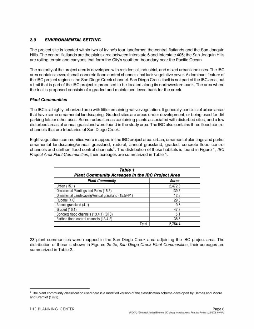
2.0 ENVIRONMENTAL SETTING
The project site is located within two of Irvine's four landforms: the central flatlands and the San Joaquin
Hills. The central flatlands are the plains area between Interstate 5 and Interstate 405; the San Joaquin Hills
are rolling terrain and canyons that form the City's southern boundary near the Pacific Ocean.
The majority of the project area is developed with residential, industrial, and mixed urban land uses. The IBC
area contains several small concrete flood control channels that lack vegetative cover. A dominant feature of
the IBC project region is the San Diego Creek channel. San Diego Creek itself is not part of the IBC area, but
a trail that is part of the IBC project is proposed to be located along its northwestern bank. The area where
the trial is proposed consists of a graded and maintained levee bank for the creek.
Plant Communities
The IBC is a highly urbanized area with little remaining native vegetation. It generally consists of urban areas
that have some ornamental landscaping. Graded sites are areas under development, or being used for dirt
parking lots or other uses. Some ruderal areas containing plants associated with disturbed sites, and a few
disturbed areas of annual grassland were found in the study area. The IBC also contains three flood control
channels that are tributaries of San Diego Creek.
Eight vegetation communities were mapped in the IBC project area: urban, ornamental plantings and parks,
ornamental landscaping/annual grassland, ruderal, annual grassland, graded, concrete flood control
channels and earthen flood control channels2. The distribution of these habitats is found in Figure 1, IBC
Project Area Plant Communities; their acreages are summarized in Table 1.
Table 1
Plant Community Acreages in the IBC Project Area
Plant Community Acres
Urban (15.1) 2,472.3
Ornamental Plantings and Parks (15.5) 139.5
Ornamental Landscaping/Annual grassland (15.5/4/1) 12.8
Ruderal (4.6) 29.3
Annual grassland (4.1) 9.6
Graded (16.1) 47.3
Concrete flood channels (13.4.1) (CFC) 5.1
Earthen flood control channels (13.4.2) 38.5
Total 2,754.4
23 plant communities were mapped in the San Diego Creek area adjoining the IBC project area. The
distribution of these is shown in Figures 2a-2c, San Diego Creek Plant Communities; their acreages are
summarized in Table 2.
2 The plant community classification used here is a modified version of the classification scheme developed by Dames and Moore
and Bramlet (1992).
THE PLANNING CENTER Page 6 P:\COI-21\Technical Studies\Bio\Irvine IBC biology technical memo Final.doc|Printed: 12/9/2009 4:01 PM
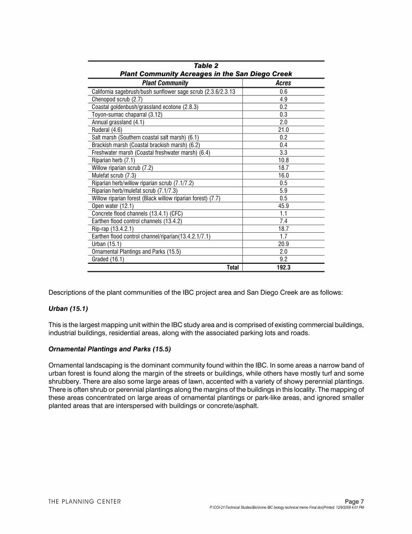
Table 2
Plant Community Acreages in the San Diego Creek
Plant Community Acres
California sagebrush/bush sunflower sage scrub (2.3.6/2.3.13 0.6
Chenopod scrub (2.7) 4.9
Coastal goldenbush/grassland ecotone (2.8.3) 0.2
Toyon-sumac chaparral (3.12) 0.3
Annual grassland (4.1) 2.0
Ruderal (4.6) 21.0
Salt marsh (Southern coastal salt marsh) (6.1) 0.2
Brackish marsh (Coastal brackish marsh) (6.2) 0.4
Freshwater marsh (Coastal freshwater marsh) (6.4) 3.3
Riparian herb (7.1) 10.8
Willow riparian scrub (7.2) 18.7
Mulefat scrub (7.3) 16.0
Riparian herb/willow riparian scrub (7.1/7.2) 0.5
Riparian herb/mulefat scrub (7.1/7.3) 5.9
Willow riparian forest (Black willow riparian forest) (7.7) 0.5
Open water (12.1) 45.9
Concrete flood channels (13.4.1) (CFC) 1.1
Earthen flood control channels (13.4.2) 7.4
Rip-rap (13.4.2.1) 18.7
Earthen flood control channel/riparian(13.4.2.1/7.1) 1.7
Urban (15.1) 20.9
Ornamental Plantings and Parks (15.5) 2.0
Graded (16.1) 9.2
Total 192.3
Descriptions of the plant communities of the IBC project area and San Diego Creek are as follows:
Urban (15.1)
This is the largest mapping unit within the IBC study area and is comprised of existing commercial buildings, industrial buildings, residential areas, along with the associated parking lots and roads.
Ornamental Plantings and Parks (15.5)
Ornamental landscaping is the dominant community found within the IBC. In some areas a narrow band of
urban forest is found along the margin of the streets or buildings, while others have mostly turf and some
shrubbery. There are also some large areas of lawn, accented with a variety of showy perennial plantings.
There is often shrub or perennial plantings along the margins of the buildings in this locality. The mapping of these areas concentrated on large areas of ornamental plantings or park-like areas, and ignored smaller
planted areas that are interspersed with buildings or concrete/asphalt.
THE PLANNING CENTER Page 7 P:\COI-21\Technical Studies\Bio\Irvine IBC biology technical memo Final.doc|Printed: 12/9/2009 4:01 PM
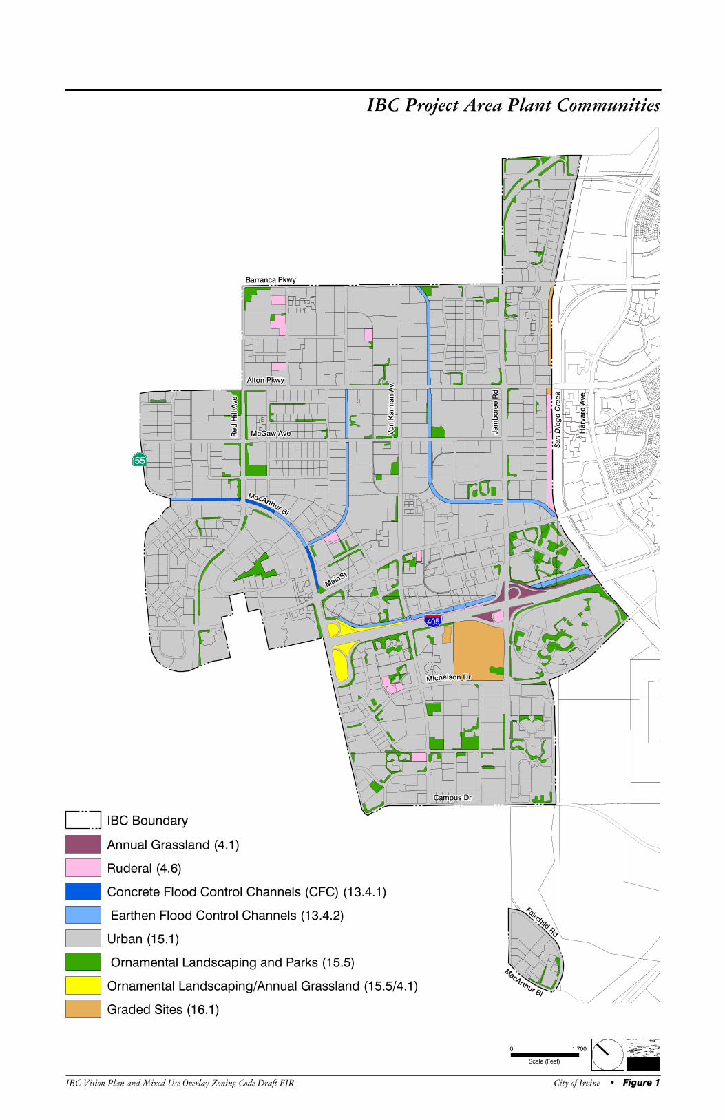
Barranca Pkwy
Alton Pkwy
McGaw Ave
MacArthur Bl
MainSt
Michelson Dr
Campus Dr
MacArthur Bl
Fairchild Rd
Jam
bo
ree R
d
Vo
n K
arm
an
Av
Red
Hill A
ve
San
Di e
go
Cre
ek
Har v
ar d
Ave
%&l(
?sE
IBC Project Area Plant Communities
IBC Vision Plan and Mixed Use Overlay Zoning Code Draft EIR • Figure 1City of Irvine
IBC Boundary
Scale (Feet)
0 1,700
Ruderal (4.6)
Annual Grassland (4.1)
Graded Sites (16.1)
Ornamental Landscaping/Annual Grassland (15.5/4.1)
Ornamental Landscaping and Parks (15.5)
Urban (15.1)
Earthen Flood Control Channels (13.4.2)
Concrete Flood Control Channels (CFC) (13.4.1)
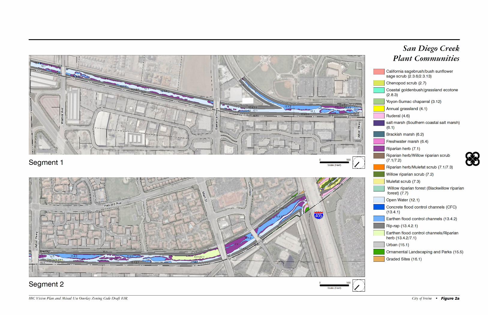
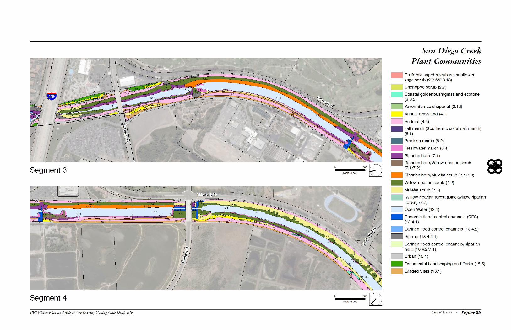
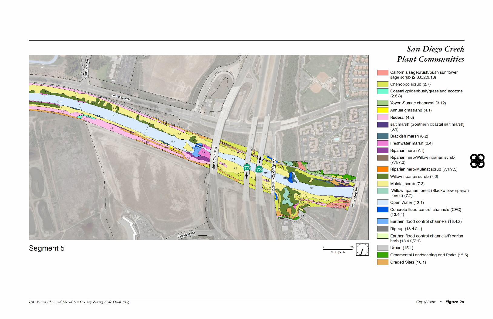
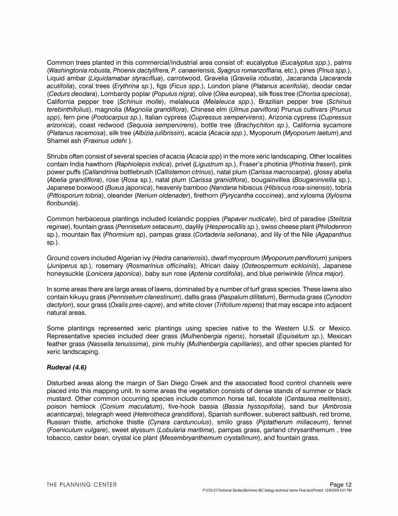
Common trees planted in this commercial/industrial area consist of: eucalyptus (Eucalyptus spp.), palms
(Washingtonia robusta, Phoenix dactylifrera, P. canaeriensis, Syagrus romanzoffiana, etc.), pines (Pinus spp.),
Liquid ambar (Liquidamabar styraciflua), carrotwood, Gravelia (Gravelia robusta), Jacaranda (Jacaranda
acutifolia), coral trees (Erythrina sp.), figs (Ficus spp.), London plane (Platanus acerifolia), deodar cedar
(Cedurs deodara), Lombardy poplar (Populus nigra), olive (Olea europea), silk floss tree (Chorisa speciosa),
California pepper tree (Schinus molle), melaleuca (Melaleuca spp.), Brazilian pepper tree (Schinus
terebinthifolius), magnolia (Magnolia grandiflora), Chinese elm (Ulmus parviflora) Prunus cultivars (Prunus
spp), fern pine (Podocarpus sp.), Italian cypress (Cupressus sempervirens), Arizonia cypress (Cupressus
arizonica), coast redwood (Sequoia sempervirens), bottle tree (Brachychiton sp.), California sycamore
(Platanus racemosa), silk tree (Albizia julibrissin), acacia (Acacia spp.), Myoporum (Myoporum laetum),and
Shamel ash (Fraxinus udehi ).
Shrubs often consist of several species of acacia (Acacia spp) in the more xeric landscaping. Other localities contain India hawthorn (Raphiolepis indica), privet (Ligustrum sp.), Fraser’s photinia (Photinia fraseri), pink
power puffs (Callandrinia bottlebrush (Callistemon ctrinus), natal plum (Carissa macrocarpa), glossy abelia
(Abelia grandiflora), rose (Rosa sp.), natal plum (Carissa granidlfora), bougainvillea (Bouganinvellia sp.),
Japanese boxwood (Buxus japonica), heavenly bamboo (Nandana hibiscus (Hibiscus rosa-sinensis), tobria
(Pittosporum tobria), oleander (Nerium oldenader), firethorn (Pyrycantha coccinea), and xylosma (Xylosma
floribunda).
Common herbaceous plantings included Icelandic poppies (Papaver nudicale), bird of paradise (Stelitzia
reginae), fountain grass (Pennisetum setaceum), daylily (Hesperocallis sp.), swiss cheese plant (Philodenron
sp.), mountain flax (Phormium sp), pampas grass (Cortaderia sellonana), and lily of the Nile (Agapanthus
sp.).
Ground covers included Algerian ivy (Hedra canariensis), dwarf myoproum (Myoporum parvflorum) junipers
(Juniperus sp.), rosemary (Rosmarinius officinalis), African daisy (Osteospermum eckloinis), Japanese
honeysuckle (Lonicera japonica), baby sun rose (Aptenia cordifolia), and blue periwinkle (Vinca major).
In some areas there are large areas of lawns, dominated by a number of turf grass species. These lawns also contain kikuyu grass (Pennisetum clanestinum), dallis grass (Paspalum dilitatum), Bermuda grass (Cynodon
dactylon), sour grass (Oxalis pres-capre), and white clover (Trifolium repens) that may escape into adjacent
natural areas.
Some plantings represented xeric plantings using species native to the Western U.S. or Mexico.
Representative species included deer grass (Mulhenbergia rigens), horsetail (Equisetum sp.), Mexican feather grass (Nassella tenuissima), pink muhly (Mulhenbergia capillaries), and other species planted for
xeric landscaping.
Ruderal (4.6)
Disturbed areas along the margin of San Diego Creek and the associated flood control channels were
placed into this mapping unit. In some areas the vegetation consists of dense stands of summer or black
mustard. Other common occurring species include common horse tail, tocalote (Centaurea melitensis), poison hemlock (Conium maculatum), five-hook bassia (Bassia hyssopifolia), sand bur (Ambrosia
acanticarpa), telegraph weed (Heterotheca grandiflora), Spanish sunflower, suberect saltbush, red brome,
Russian thistle, artichoke thistle (Cynara cardunculus), smilo grass (Piptatherum miliaceum), fennel
(Foeniculum vulgare), sweet alyssum (Lobularia maritima), pampas grass, garland chrysanthemum , tree
tobacco, castor bean, crystal ice plant (Mesembryanthemum crystallinum), and fountain grass.
THE PLANNING CENTER Page 12 P:\COI-21\Technical Studies\Bio\Irvine IBC biology technical memo Final.doc|Printed: 12/9/2009 4:01 PM
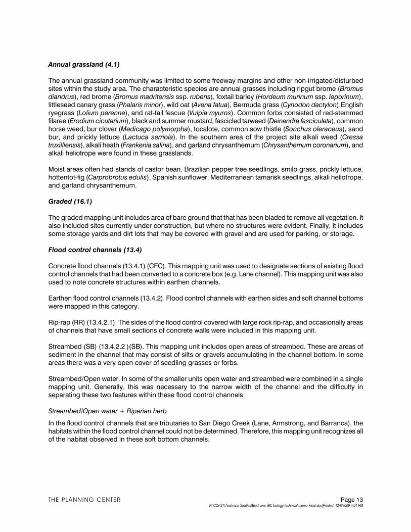
Annual grassland (4.1)
The annual grassland community was limited to some freeway margins and other non-irrigated/disturbed
sites within the study area. The characteristic species are annual grasses including ripgut brome (Bromus
diandrus), red brome (Bromus madritensis ssp. rubens), foxtail barley (Hordeum murinum ssp. leporinum), littleseed canary grass (Phalaris minor), wild oat (Avena fatua), Bermuda grass (Cynodon dactylon).English
ryegrass (Lolium perenne), and rat-tail fescue (Vulpia myuros). Common forbs consisted of red-stemmed
filaree (Erodium cicutarium), black and summer mustard, fascicled tarweed (Deinandra fasciculata), common
horse weed, bur clover (Medicago polymorpha), tocalote, common sow thistle (Sonchus oleraceus), sand
bur, and prickly lettuce (Lactuca serriola). In the southern area of the project site alkali weed (Cressa
truxilliensis), alkali heath (Frankenia salina), and garland chrysanthemum (Chrysanthemum coronarium), and
alkali heliotrope were found in these grasslands.
Moist areas often had stands of castor bean, Brazilian pepper tree seedlings, smilo grass, prickly lettuce,
hottentot-fig (Carprobrotus edulis), Spanish sunflower, Mediterranean tamarisk seedlings, alkali heliotrope,
and garland chrysanthemum.
Graded (16.1)
The graded mapping unit includes area of bare ground that that has been bladed to remove all vegetation. It
also included sites currently under construction, but where no structures were evident. Finally, it includes
some storage yards and dirt lots that may be covered with gravel and are used for parking, or storage.
Flood control channels (13.4)
Concrete flood channels (13.4.1) (CFC). This mapping unit was used to designate sections of existing flood
control channels that had been converted to a concrete box (e.g. Lane channel). This mapping unit was also
used to note concrete structures within earthen channels.
Earthen flood control channels (13.4.2). Flood control channels with earthen sides and soft channel bottoms
were mapped in this category.
Rip-rap (RR) (13.4.2.1). The sides of the flood control covered with large rock rip-rap, and occasionally areas
of channels that have small sections of concrete walls were included in this mapping unit.
Streambed (SB) (13.4.2.2 )(SB). This mapping unit includes open areas of streambed. These are areas of
sediment in the channel that may consist of silts or gravels accumulating in the channel bottom. In some
areas there was a very open cover of seedling grasses or forbs.
Streambed/Open water. In some of the smaller units open water and streambed were combined in a single
mapping unit. Generally, this was necessary to the narrow width of the channel and the difficulty in separating these two features within these flood control channels.
Streambed/Open water + Riparian herb
In the flood control channels that are tributaries to San Diego Creek (Lane, Armstrong, and Barranca), the
habitats within the flood control channel could not be determined. Therefore, this mapping unit recognizes all
of the habitat observed in these soft bottom channels.
THE PLANNING CENTER Page 13 P:\COI-21\Technical Studies\Bio\Irvine IBC biology technical memo Final.doc|Printed: 12/9/2009 4:01 PM
San Diego Creek
The following section describes the riparian and other habitats found along San Diego Creek. Some
communities, such as ruderal, annual grassland, along with the mapping units for the channel areas are
described in the section addressing the IBC study area.
Open water (12.1)
This consists of areas of open water within the channels. The San Diego Creek channel has a series of weirs that impound areas of the flowing water and creating several “basins” within reaches of the creek channel. In
other localities much smaller areas were placed in this mapping unit, since the areas of flowing water form an
important habitat for a number of species.
Riparian (7.0)
Riparian herb (7.1)
This is the most common community found in the streambed of San Diego Creek above the San Diego freeway (northern reach), and found filling in the areas of removed riparian scrub and along open portions of
the streambed in the area south of the San Diego freeway to Upper Newport Bay (southern reach).
In the northern reach the most common species include dense-flowered sprangle top (Leptochloa uninervia),
rabbit’s foot grass (Polypogon monspeliensis), jungle rice grass (Echinochola colona), water bent (Agrostis
exarata), barnyard grass (Echinochola crus-galli), Bermuda grass (Cynodon dactylon), and dallis grass (Paspalum dilatatum). In some areas giant wild rye (Elymus condenstatus) was noted in this community.
Common forbs consisted of white sweet clover (Melilotus albus), black mustard (Brassica nigra), common
horse weed (Conyza canadensis), lamb’s quarters (Chenopodium album) prickly sow thistle (Sonchus asper),
bristly ox tongue (Picris echioides), common heliotrope (Heliotropium curassaicum), Mexican tea
(Chenopodium ambrosoides), common celery (Apium graveloens), weedy cudweed (Gnaphalium lueto-
album), curly dock (Rumex crispus), summer mustard (Brassica geniculata), and cocklebur (Xanthium
strumarium). Spanish sunflower (Pilucaria paludosa), tree tobacco (Nicotiana glauca), castor bean (Ricinus
communis), suberect saltbush (Atrplex suberecta), pine spurge (Euphorbia sepyllifolia), and Russian thistle
(Salsoa tragus) are some weedy species found in this drainage.
Along the margins and in the flowing water, water cress (Nasturtium officinale), great water speedwell
(Veronica anagallis-aquatica), green willow herb (Epilobium ciliatum), willow smart weed (Polygonum
lapathifolium), yellow water weed (Ludwigia peploides) are found with least duckweed (Lemna minuta) found
floating on the surface slower moving portions of the creek.
Marsh-like areas are found in some areas of the creek and usually contain narrow-leaved cat-tail (Typha
domingensis) with some broad-leaved cat-tail (Typa latifolia). Other species found in these marshy sites
include alkali bulrush (Bolbschoenus maritimus), tall umbrella sedge (Cyperus eragrostis), Oleny’s three-
square bulrush (Schoenoplectus americanus), and California bulrush (Schoenoplectus californicus).
A few scattered shrubs or tree seedlings are occasionally found in this community. These are generally
comprised of small clumps of mulefat (Baccharis salicifolia), black willow (Salix gooddingii), Brazilian pepper (Schinus terebenthifolius), Mexican fan palm (Washingtonia robusta), or Mediterranean tamarisk (Tamarix
ramosissima) seedlings.
THE PLANNING CENTER Page 14 P:\COI-21\Technical Studies\Bio\Irvine IBC biology technical memo Final.doc|Printed: 12/9/2009 4:01 PM
Riparian herb/mulefat scrub (7.1/7.3)
Riparian herb/willow riparian scrub (7.1/7.2)
A community dominated by herbaceous riparian species, but with some arroyo and black willow seedlings,
along with mulefat seedlings, scattered throughout the community.
Riparian vegetation was removed from the San Diego Creek channel, to increase the flood control capacity
of the creek. Vegetation is currently invading into these open areas, and generally consists of an herbaceous riparian community. However, in some areas seedling mulefat were very evident and this mapping unit was
developed to note the importance of mulefat at these localities.
Willow riparian scrub (7.2)
In the southern reach of San Diego Creek, a willow riparian scrub was commonly found along the sides of
the creek. Large areas of this community were removed in 2007 to provide increased flood capacity along
the channel.
This community is generally composed of arroyo willow (Salix lasiolepis) and mulefat, with sapling black
willow intermixed in this scrub. The tree forming red willow (Salix laeviagta), the scrubby sandbar willow (Salix
exigua) and saplings of Fremont cottonwood (Populus fremontii), and western sycamore (Platanus
racemosa) and Mexican elderberry (Sambucus mexicana) were uncommonly found in this community.
Mulefat is the principal understory shrub, especially on the margins of this community. Other species found beneath this tall shrub layer are comprised of seedling Brazilian pepper tree, coyote brush, mugwort
(Artemisia douglasiana), summer mustard, bristly ox tongue, white sweet clover, marsh fleabane, Emory’s
baccharis (Baccharis emoryi), quail bush, western ragweed (Ambrosia psilostachya), Spanish sunflower, and
slender aster (Aster subulatus).
Mulefat scrub (7.3)
This community consists of dense stands of mulefat, along with a few scattered arroyo willows and in some localities, coyote bush.
Willow riparian forest (Black willow riparian forest) (7.7)
This community has a similar composition to the willow riparian scrub, however, the black willow are more
mature and create an additional canopy layer in this community. Beneath the tree willows are tall arroyo
willows, mulefat, Emory’s baccharis, and coyote brush. Understory species generally consisted of mugwort,
western ragweed, slender aster, Spanish sunflower, marsh fleabane, and fennel. Giant reed (Arundo donax) is a problematic species in these forest habitats, and seedlings of Brazilian pepper, Mediterranean tamarisk,
Mexican fan palm and myoporum were also common in these areas.
Freshwater marsh (Coastal freshwater marsh) (6.4)
Freshwater marshes were found in some of the ponded areas of San Diego Creek and along the margins of
the creek in other localities. The marshes consists of dense stands of broad-leaved cat-tail and California
bulrush. Less common species consisted of narrow-leaved cat-tail, alkali bulrush, Oleny’s three-square
bulrush, tall umbrella sedge, marsh fleabane (Pluchea purpurascens), willow smartweed, common celery, white sweet-clover,Spanish sunflower, and bristly ox-tongue.
THE PLANNING CENTER Page 15 P:\COI-21\Technical Studies\Bio\Irvine IBC biology technical memo Final.doc|Printed: 12/9/2009 4:01 PM
Brackish marsh (Coastal brackish marsh) (6.2)
The brackish marsh was found in the lower areas of San Diego Creek. Generally these areas contained
typical marsh species, including California bulrush, marsh fleabane, narrow-leaved cat-tail, and alkali
bulrush, along with species more typically found in salt marshes. These species consisted of common woody pickleweed (Salicornia virginica), fleshy jaumea (Jaumea carnosa), alkali heath, saltgrass (Distichilis
spicata), spear-scale (Atriplex prostrata), American saltwort (Batis maritima), and five-hook bassia. This
mapping unit included some dense stands of common woody pickleweed that appeared to be above the
normal tidal level.
Salt marsh (Southern coastal salt marsh) (6.1)
Small areas of salt marsh were found along the creek, but some of the areas were considered more of a
brackish marsh and placed in that category. Characteristic species included common woody pickleweed, fleshy jaumea, saltgrass, American saltwort, and alkali heath.
Open water (12.1)
This mapping unit consists of areas of open water within these channels. The San Diego Creek channel has
a series of weirs that impound areas of the flowing water and creating several “basins” within reaches of the
creek channel. In other localities much smaller areas were placed in this mapping unit, since the areas of
flowing water form an important habitat for a number of species.
Scrub Habitats, Coastal sage scrub (2.0)
Chenopod scrub (2.7)
Chenopod scrub is found in the southern reach of the San Diego Creek channel. BonTerra (2008) mapped
these areas as a coastal sage scrub, however, quail bush (Atriplex lentiformis) was a dominant species in all
areas examined within the study area. Other shrubs in this community consisted of California sagebrush
(Artemisia californica), California bush sunflower (Encelia californica), black sage (Salvia mellifera), coyote bush (Baccharis piluaris),coastal goldenbush (Isocoma menziesii), laurel sumac (Rhus laurina), myoporum
(Myoporum laetum), and coastal prickly pear (Opuntia littoralis).
The area between the shrubs was often disturbed and herbaceous species consisted of black mustard,
poison hemlock, crystal ice plant, tocalote, summer mustard, and tall wreath plant (Stephanomeria virgata).
Coastal goldenbush/grassland ecotone (2.8.3)
A small area of this ecotone was mapped along the creek. This community consisted of a scattered shrub
cover consisting of coastal isocoma, along with a few isolated California sagebrush, California buckwheat
(Eriogonum fasciculatum), quail bush, and lax-flowered bush mallow (Malacothamnus fasciculatus). This
generally was found in a disturbed annual grassland composed of English wild rye, red brome, alkali
heliotrope, garland chrysanthemum, ripgut brome, black mustard, and alkali heath.
California sagebrush/bush sunflower sage scrub (2.3.6/2.3.13)
A small area of coastal sage scrub is located just south of Bonita Creek on the east side of the creek. This
scrub is dominated by California sagebrush with quailbush, California bush sunflower, coastal isocoma, and
coyote brush. The understory was generally composed of red brome, alkali heath, poison hemlock, and black mustard.
THE PLANNING CENTER Page 16 P:\COI-21\Technical Studies\Bio\Irvine IBC biology technical memo Final.doc|Printed: 12/9/2009 4:01 PM
Chaparral (3.0)
Toyon-sumac chaparral (3.12)
A small strip of this coastal chaparral is found beside an existing residential complex, south of Bonita Creek.
This is likely a remnant of the vegetation that occurred on this site before the development. This small area of chaparral is composed of lemonadeberry, laurel sumac, toyon (Heteromeles arbutifolia), California
sagebrush, coyote brush, quailbush, and a single black willow.
Wildlife
The wildlife of the IBC project area is typical of developed urban areas with ornamental landscaping. The bird
species observed in the developed IBC area are those commonly found in urban areas, such as the black
phoebe, mourning dove, common raven, northern mockingbird, European starling, house sparrow, and
lesser goldfinch.
The northern part of the IBC project area borders San Diego Creek and Peters Canyon Wash, and from there
San Diego Creek runs approximately 2.2 miles to the southern border of the project area to Upper Newport
Bay. The San Diego Creek channel provides freshwater input to Upper Newport Bay. The San Diego Creek
area and associated wetland habitats in the San Joaquin Marsh support a highly diverse fauna, including a large number of breeding and migratory bird species. The list of species is lengthy, even when only sensitive
species are considered. The section below on sensitive species assesses the potential for occurrence of
sensitive wildlife in the IBC project area and adjoining San Diego Creek.
San Joaquin Marsh Reserve and Sanctuary
The San Joaquin Marsh Reserve and San Joaquin Marsh Sanctuary are two separately owned and managed wetland areas that border the IBC area to the northwest in the vicinity of Campus Drive. The Reserve is a
202-acre freshwater marsh south of Campus Drive that is part of the University of California Natural Reserves
System. The Sanctuary is a 300-acre freshwater marsh, and part of the Irvine Ranch Water District's
Michelson Water Reclamation Plant that is used to remove nutrients and sediment from San Diego Creek.
The Reserve and the Sanctuary support wetland and upland habitats, including willow riparian woodland, freshwater marshlands, shallow ponds, and coastal sage scrub on the margins of the reserve. The habitat in
these two areas provide important feeding and resting habitat for many migratory birds, particularly ducks,
geese, other waterfowl, and shorebirds. They also are used by a number of migratory and resident passerine
birds, both common and sensitive species. The lower reach of San Diego Creek and the San Joaquin Marsh
provides foraging and/or nesting habitat for a number of sensitive species, including five species of birds listed as threatened or endangered under the state or federal Endangered Species Acts, occur in the San
Joaquin marshes. These are the light-footed clapper rail, California brown pelican, California least tern,
Belding's savannah sparrow, and least Bell's vireo.
NCCP Reserves
The IBC area is within the plan area of the Orange County's Central and Coastal NCCP/HCP. A small area in
the southern end of the IBC area is a proposed NCCP Reserve area. This is the upland area located between
the marsh, the San Diego Creek channel, MacArthur Boulevard, and Fairchild Road, which is owned and
managed by UC Irvine. The San Joaquin Marsh Reserve, which adjoins this upland area, is designated by
the NCCP as nonreserve open space.
Special Status Species/Communities
Special status plant and animal species include those species listed by the state or federal governments as
endangered, threatened, or rare, and species that are candidates for future listing. These include species
THE PLANNING CENTER Page 17 P:\COI-21\Technical Studies\Bio\Irvine IBC biology technical memo Final.doc|Printed: 12/9/2009 4:01 PM
listed as California Species of Special Concern by the CDFG, species on the CDFG special plants list (CDFG
2009), plants on the California Native Plant Society Rare Plant Inventory (CNPS 2009), and species
considered to be special status by USFWS and CDFG.
Special Status Species
Tables 3 and 4 list the special status plant species known from the project region. Table 3 lists the species
that may occur there and assesses their potential to occur on the project site and in the adjoining areas of
the San Joaquin Reserve and Sanctuary and San Diego Creek and Table 4 lists the species known from the
project region that not expected to occur there. Table 5 assesses the potential of special status animal
species to occur on the project site and in the adjoining areas of the San Joaquin Reserve and Sanctuary and San Diego Creek.
On-Site
The residential, industrial, mixed use, and other developed parts of the IBC project area would not be
expected to support any special status plant or animal species. The IBC project area is largely developed
with urban uses, and does not contain habitat for any special status plant or animal species. The proposed trail area along San Diego Creek is predominantly disturbed soils on and adjoining the levee bank of the
channel. There is potential for sensitive plant and animal species to occur within the proposed trail area, and
therefore biological surveys would need to be carried out as part of the project-level environmental review for
the proposed trail.
Adjoining Areas
San Diego Creek and the San Joaquin Marsh provide foraging and/or nesting habitat for many sensitive
species. The majority of the sensitive species that are known from the IBC project region would not be
expected to regularly use the disturbed habitat that exists along the proposed trail. However, some of the
sensitive species could make regular or irregular use of the adjoining habitats in the San Joaquin Marsh and San Diego Creek areas.
THE PLANNING CENTER Page 18 P:\COI-21\Technical Studies\Bio\Irvine IBC biology technical memo Final.doc|Printed: 12/9/2009 4:01 PM
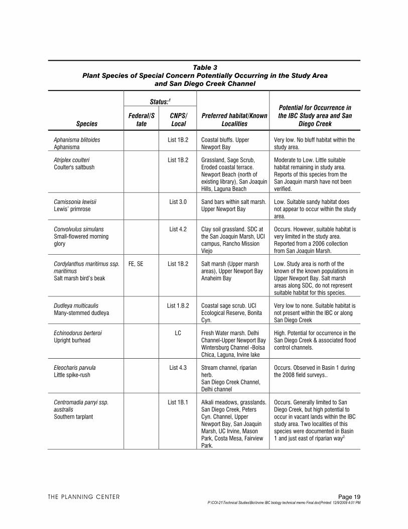
Table 3
Plant Species of Special Concern Potentially Occurring in the Study Area
and San Diego Creek Channel
Species
Status:1
Preferred habitat/Known Localities
Potential for Occurrence in the IBC Study area and San
Diego Creek Federal/S
tate CNPS/Local
Aphanisma blitoides Aphanisma
List 1B.2 Coastal bluffs. Upper Newport Bay
Very low. No bluff habitat within the study area.
Atriplex coulteri Coulter's saltbush
List 1B.2 Grassland, Sage Scrub, Eroded coastal terrace. Newport Beach (north of existing library), San Joaquin Hills, Laguna Beach
Moderate to Low. Little suitable habitat remaining in study area. Reports of this species from the San Joaquin marsh have not been verified.
Camissonia lewisii Lewis’ primrose
List 3.0 Sand bars within salt marsh. Upper Newport Bay
Low. Suitable sandy habitat does not appear to occur within the study area.
Convolvulus simulans Small-flowered morning glory
List 4.2 Clay soil grassland. SDC at the San Joaquin Marsh, UCI campus, Rancho Mission Viejo
Occurs. However, suitable habitat is very limited in the study area. Reported from a 2006 collection from San Joaquin Marsh.
Cordylanthus maritimus ssp. maritimus Salt marsh bird’s beak
FE, SE List 1B.2 Salt marsh (Upper marsh areas), Upper Newport Bay Anaheim Bay
Low. Study area is north of the known of the known populations in Upper Newport Bay. Salt marsh areas along SDC, do not represent suitable habitat for this species.
Dudleya multicaulis Many-stemmed dudleya
List 1.B.2 Coastal sage scrub. UCI Ecological Reserve, Bonita Cyn.
Very low to none. Suitable habitat is not present within the IBC or along San Diego Creek
Echinodorus berteroi Upright burhead
LC Fresh Water marsh. Delhi Channel-Upper Newport Bay Wintersburg Channel -Bolsa Chica, Laguna, Irvine lake
High. Potential for occurrence in the San Diego Creek & associated flood control channels.
Eleocharis parvula Little spike-rush
List 4.3 Stream channel, riparian herb. San Diego Creek Channel, Delhi channel
Occurs. Observed in Basin 1 during the 2008 field surveys..
Centromadia parryi ssp. australis Southern tarplant
List 1B.1 Alkali meadows, grasslands. San Diego Creek, Peters Cyn. Channel, Upper Newport Bay, San Joaquin Marsh, UC Irvine, Mason Park, Costa Mesa, Fairview Park.
Occurs. Generally limited to San Diego Creek, but high potential to occur in vacant lands within the IBC study area. Two localities of this species were documented in Basin 1 and just east of riparian way2.
THE PLANNING CENTER Page 19 P:\COI-21\Technical Studies\Bio\Irvine IBC biology technical memo Final.doc|Printed: 12/9/2009 4:01 PM
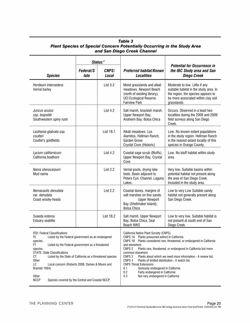
Table 3
Plant Species of Special Concern Potentially Occurring in the Study Area
and San Diego Creek Channel
Species
Status:1
Preferred habitat/Known Localities
Potential for Occurrence in the IBC Study area and San
Diego Creek Federal/S
tate CNPS/Local
Hordeum intercedens Vernal barley
List 3.2 Moist grasslands and alkali meadows. Newport Beach (north of existing library), UCI Ecological Reserve. Fairview Park
Moderate to low. Little if any suitable habitat in the study area. In the region, the species appears to be more associated within clay soil grasslands.
Juncus acutus ssp. leopoldii Southwestern spiny rush
List 4.2 Salt marsh, brackish marsh. Upper Newport Bay, Anaheim Bay, Bolsa Chica
Occurs. Observed in a least two localities duirng the 2008 and 2009 field surveys along San Diego Creek.
Lasthenia glabrata ssp. coulteri Coulter's goldfields
List 1B.1 Alkali meadows. Los Alamitos, Hellman Ranch, Garden Grove Crystal Cove (Historic)
Low. No known extant populations in the study region. Hellman Ranch in the nearest extant locality of this species in Orange County.
Lycium californicum California boxthorn
List 4.2 Coastal sage scrub (Bluffs). Upper Newport Bay, Crystal Cove
Low. No bluff habitat within study area.
Nama stenocarpum Mud nama
List 2.2 Vernal pools, drying lake beds. Basin adjacent to Peters Cyn. Channel, Laguna Lakes.
Very low. Suitable basins within potential habitat not present along the area of San Diego Creek. Included in the study area.
Nemacaulis denudata var. denudata Coast woolly-heads
List 2.2 Coastal dunes, margins of salt marshes on fine sands. Upper Newport Bay (Shellmaker Island), Bolsa Chica
Low to very Low Suitable sandy habitat not generally present along San Diego Creek.
Suaeda esteroa Estuary seablite
List 1B.2 Salt marsh. Upper Newport Bay, Bolsa Chica, Seal Beach NWS
Low to very low. Suitable habitat is not present at south end of San Diego Creek.
FED: Federal Classifications FE Listed by the Federal government as an endangered species. FT Listed by the Federal government as a threatened species. STATE: State Classifications CT Listed by the State of California as a threatened species Other LC Local concern (Roberts 2008, Dames & Moore and Bramlet 1994) Other NCCP Species covered by the Central and Coastal NCCP.
California Native Plant Society (CNPS) CNPS 1A Plants presumed extinct in California. CNPS 1B Plants considered rare, threatened, or endangered in California and elsewhere. CNPS 2 Plants rare, threatened, or endangered in California but more common elsewhere CNPS 3 Plants about which we need more information - A review list. CNPS 4 Plants of limited distribution - A watch list. CNPS Threat Extensions 0.1 Seriously endangered in California 0.2 Fairly endangered in California 0.3 Not very endangered in California
THE PLANNING CENTER Page 20 P:\COI-21\Technical Studies\Bio\Irvine IBC biology technical memo Final.doc|Printed: 12/9/2009 4:01 PM
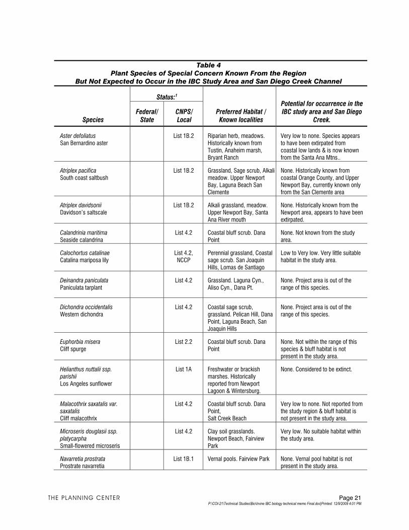
Table 4
Plant Species of Special Concern Known From the Region
But Not Expected to Occur in the IBC Study Area and San Diego Creek Channel
Species
Status:1
Preferred Habitat / Known localities
Potential for occurrence in the IBC study area and San Diego
Creek. Federal/
State CNPS/Local
Aster defoliatus San Bernardino aster
List 1B.2 Riparian herb, meadows. Historically known from Tustin, Anaheim marsh, Bryant Ranch
Very low to none. Species appears to have been extirpated from coastal low lands & is now known from the Santa Ana Mtns..
Atriplex pacifica South coast saltbush
List 1B.2 Grassland, Sage scrub, Alkali meadow. Upper Newport Bay, Laguna Beach San Clemente
None. Historically known from coastal Orange County, and Upper Newport Bay, currently known only from the San Clemente area
Atriplex davidsonii Davidson’s saltscale
List 1B.2 Alkali grassland, meadow. Upper Newport Bay, Santa Ana River mouth
None. Historically known from the Newport area, appears to have been extirpated.
Calandrinia maritima Seaside calandrina
List 4.2 Coastal bluff scrub. Dana Point
None. Not known from the study area.
Calochortus catalinae Catalina mariposa lily
List 4.2, NCCP
Perennial grassland, Coastal sage scrub. San Joaquin Hills, Lomas de Santiago
Low to Very low. Very little suitable habitat in the study area.
Deinandra paniculata Paniculata tarplant
List 4.2 Grassland. Laguna Cyn., Aliso Cyn., Dana Pt.
None. Project area is out of the range of this species.
Dichondra occidentalis Western dichondra
List 4.2 Coastal sage scrub, grassland. Pelican Hill, Dana Point, Laguna Beach, San Joaquin Hills
None. Project area is out of the range of this species.
Euphorbia misera Cliff spurge
List 2.2 Coastal bluff scrub. Dana Point
None. Not within the range of this species & bluff habitat is not present in the study area.
Helianthus nuttalii ssp. parishii Los Angeles sunflower
List 1A Freshwater or brackish marshes. Historically reported from Newport Lagoon & Wintersburg.
None. Considered to be extinct.
Malacothrix saxatalis var. saxatalis Cliff malacothrix
List 4.2 Coastal bluff scrub. Dana Point, Salt Creek Beach
Very low to none. Not reported from the study region & bluff habitat is not present in the study area.
Microseris douglasii ssp. platycarpha Small-flowered microseris
List 4.2 Clay soil grasslands. Newport Beach, Fairview Park
Very low. No suitable habitat within the study area.
Navarretia prostrata Prostrate navarretia
List 1B.1 Vernal pools. Fairview Park None. Vernal pool habitat is not present in the study area.
THE PLANNING CENTER Page 21 P:\COI-21\Technical Studies\Bio\Irvine IBC biology technical memo Final.doc|Printed: 12/9/2009 4:01 PM
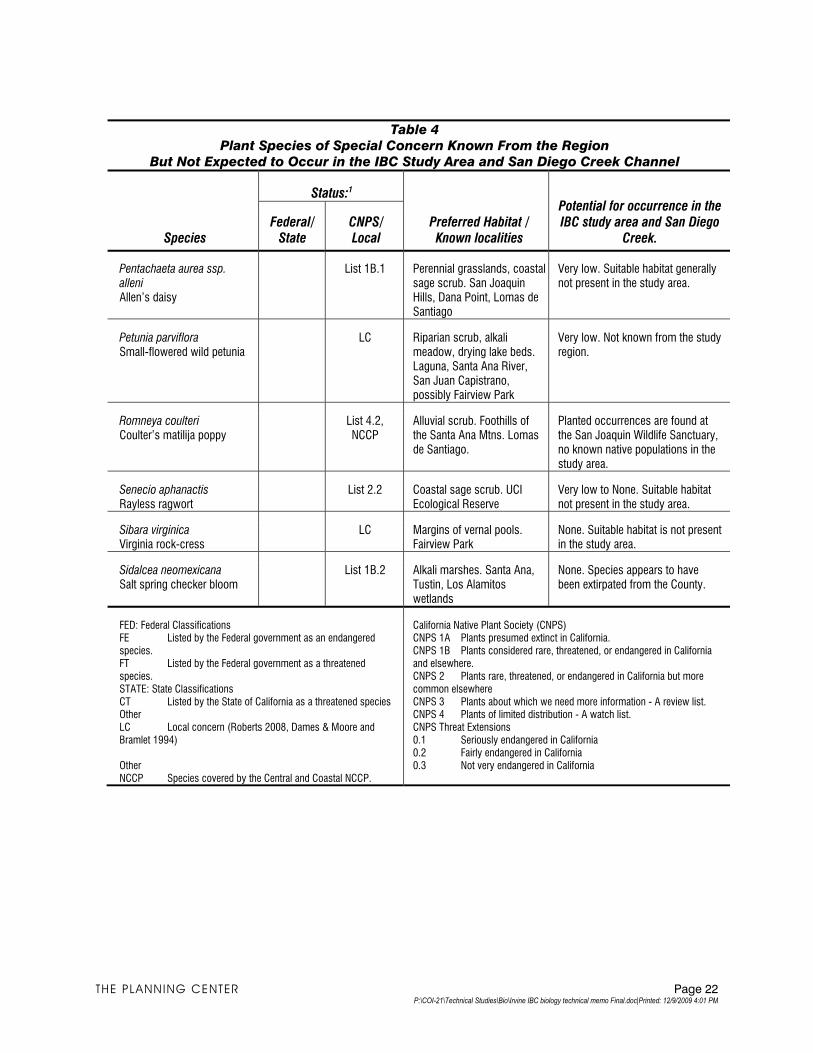
Table 4
Plant Species of Special Concern Known From the Region
But Not Expected to Occur in the IBC Study Area and San Diego Creek Channel
Species
Status:1
Preferred Habitat / Known localities
Potential for occurrence in the IBC study area and San Diego
Creek. Federal/
State CNPS/Local
Pentachaeta aurea ssp. alleni Allen’s daisy
List 1B.1 Perennial grasslands, coastal sage scrub. San Joaquin Hills, Dana Point, Lomas de Santiago
Very low. Suitable habitat generally not present in the study area.
Petunia parviflora Small-flowered wild petunia
LC Riparian scrub, alkali meadow, drying lake beds. Laguna, Santa Ana River, San Juan Capistrano, possibly Fairview Park
Very low. Not known from the study region.
Romneya coulteri Coulter’s matilija poppy
List 4.2, NCCP
Alluvial scrub. Foothills of the Santa Ana Mtns. Lomas de Santiago.
Planted occurrences are found at the San Joaquin Wildlife Sanctuary, no known native populations in the study area.
Senecio aphanactis Rayless ragwort
List 2.2 Coastal sage scrub. UCI Ecological Reserve
Very low to None. Suitable habitat not present in the study area.
Sibara virginica Virginia rock-cress
LC Margins of vernal pools. Fairview Park
None. Suitable habitat is not present in the study area.
Sidalcea neomexicana Salt spring checker bloom
List 1B.2 Alkali marshes. Santa Ana, Tustin, Los Alamitos wetlands
None. Species appears to have been extirpated from the County.
FED: Federal Classifications FE Listed by the Federal government as an endangered species. FT Listed by the Federal government as a threatened species. STATE: State Classifications CT Listed by the State of California as a threatened species Other LC Local concern (Roberts 2008, Dames & Moore and Bramlet 1994) Other NCCP Species covered by the Central and Coastal NCCP.
California Native Plant Society (CNPS) CNPS 1A Plants presumed extinct in California. CNPS 1B Plants considered rare, threatened, or endangered in California and elsewhere. CNPS 2 Plants rare, threatened, or endangered in California but more common elsewhere CNPS 3 Plants about which we need more information - A review list. CNPS 4 Plants of limited distribution - A watch list. CNPS Threat Extensions 0.1 Seriously endangered in California 0.2 Fairly endangered in California 0.3 Not very endangered in California
THE PLANNING CENTER Page 22 P:\COI-21\Technical Studies\Bio\Irvine IBC biology technical memo Final.doc|Printed: 12/9/2009 4:01 PM
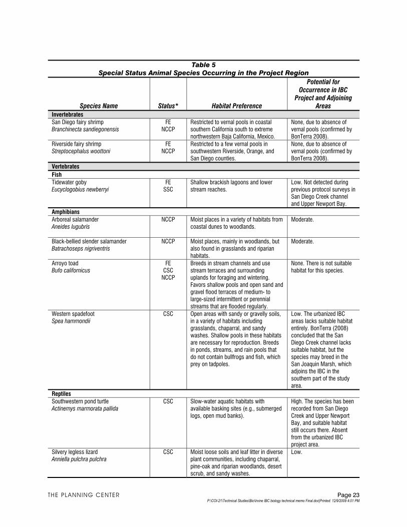
Table 5
Special Status Animal Species Occurring in the Project Region
Species Name Status* Habitat Preference
Potential for Occurrence in IBC
Project and Adjoining Areas
Invertebrates
San Diego fairy shrimp Branchinecta sandiegonensis
FE NCCP
Restricted to vernal pools in coastal southern California south to extreme northwestern Baja California, Mexico.
None, due to absence of vernal pools (confirmed by BonTerra 2008).
Riverside fairy shrimp Streptocephalus woottoni
FE NCCP
Restricted to a few vernal pools in southwestern Riverside, Orange, and San Diego counties.
None, due to absence of vernal pools (confirmed by BonTerra 2008).
Vertebrates
Fish
Tidewater goby Eucyclogobius newberryi
FE SSC
Shallow brackish lagoons and lower stream reaches.
Low. Not detected during previous protocol surveys in San Diego Creek channel and Upper Newport Bay.
Amphibians
Arboreal salamander Aneides lugubris
NCCP Moist places in a variety of habitats from coastal dunes to woodlands.
Moderate.
Black-bellied slender salamander Batrachoseps nigriventris
NCCP Moist places, mainly in woodlands, but also found in grasslands and riparian habitats.
Moderate.
Arroyo toad Bufo californicus
FE CSC
NCCP
Breeds in stream channels and use stream terraces and surrounding uplands for foraging and wintering. Favors shallow pools and open sand and gravel flood terraces of medium- to large-sized intermittent or perennial streams that are flooded regularly.
None. There is not suitable habitat for this species.
Western spadefoot Spea hammondii
CSC Open areas with sandy or gravelly soils, in a variety of habitats including grasslands, chaparral, and sandy washes. Shallow pools in these habitats are necessary for reproduction. Breeds in ponds, streams, and rain pools that do not contain bullfrogs and fish, which prey on tadpoles.
Low. The urbanized IBC areas lacks suitable habitat entirely. BonTerra (2008) concluded that the San Diego Creek channel lacks suitable habitat, but the species may breed in the San Joaquin Marsh, which adjoins the IBC in the southern part of the study area.
Reptiles
Southwestern pond turtle Actinemys marmorata pallida
CSC Slow-water aquatic habitats with available basking sites (e.g., submerged logs, open mud banks).
High. The species has been recorded from San Diego Creek and Upper Newport Bay, and suitable habitat still occurs there. Absent from the urbanized IBC project area.
Silvery legless lizard Anniella pulchra pulchra
CSC Moist loose soils and leaf litter in diverse plant communities, including chaparral, pine-oak and riparian woodlands, desert scrub, and sandy washes.
Low.
THE PLANNING CENTER Page 23 P:\COI-21\Technical Studies\Bio\Irvine IBC biology technical memo Final.doc|Printed: 12/9/2009 4:01 PM
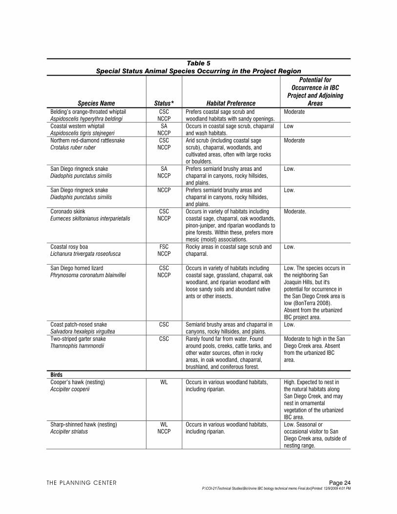
Table 5
Special Status Animal Species Occurring in the Project Region
Potential for Occurrence in IBC
Project and Adjoining Areas Species Name Status* Habitat Preference
Belding’s orange-throated whiptail Aspidoscelis hyperythra beldingi
CSC NCCP
Prefers coastal sage scrub and woodland habitats with sandy openings.
Moderate
Coastal western whiptail Aspidoscelis tigris stejnegeri
SA NCCP
Occurs in coastal sage scrub, chaparral and wash habitats.
Low
Northern red-diamond rattlesnake Crotalus ruber ruber
CSC NCCP
Arid scrub (including coastal sage scrub), chaparral, woodlands, and cultivated areas, often with large rocks or boulders.
Moderate
San Diego ringneck snake Diadophis punctatus similis
SA NCCP
Prefers semiarid brushy areas and chaparral in canyons, rocky hillsides, and plains.
Low.
San Diego ringneck snake Diadophis punctatus similis
NCCP Prefers semiarid brushy areas and chaparral in canyons, rocky hillsides, and plains.
Low.
Coronado skink Eumeces skiltonianus interparietalis
CSC NCCP
Occurs in variety of habitats including coastal sage, chaparral, oak woodlands, pinon-juniper, and riparian woodlands to pine forests. Within these, prefers more mesic (moist) associations.
Moderate.
Coastal rosy boa Lichanura trivergata roseofusca
FSC NCCP
Rocky areas in coastal sage scrub and chaparral.
Low.
San Diego horned lizard Phrynosoma coronatum blainvillei
CSC NCCP
Occurs in variety of habitats including coastal sage, grassland, chaparral, oak woodland, and riparian woodland with loose sandy soils and abundant native ants or other insects.
Low. The species occurs in the neighboring San Joaquin Hills, but it's potential for occurrence in the San Diego Creek area is low (BonTerra 2008). Absent from the urbanized IBC project area.
Coast patch-nosed snake Salvadora hexalepis virgultea
CSC Semiarid brushy areas and chaparral in canyons, rocky hillsides, and plains.
Low.
Two-striped garter snake Thamnophis hammondii
CSC Rarely found far from water. Found around pools, creeks, cattle tanks, and other water sources, often in rocky areas, in oak woodland, chaparral, brushland, and coniferous forest.
Moderate to high in the San Diego Creek area. Absent from the urbanized IBC area.
Birds
Cooper’s hawk (nesting) Accipiter cooperii
WL Occurs in various woodland habitats, including riparian.
High. Expected to nest in the natural habitats along San Diego Creek, and may nest in ornamental vegetation of the urbanized IBC area.
Sharp-shinned hawk (nesting) Accipiter striatus
WL NCCP
Occurs in various woodland habitats, including riparian.
Low. Seasonal or occasional visitor to San Diego Creek area, outside of nesting range.
THE PLANNING CENTER Page 24 P:\COI-21\Technical Studies\Bio\Irvine IBC biology technical memo Final.doc|Printed: 12/9/2009 4:01 PM
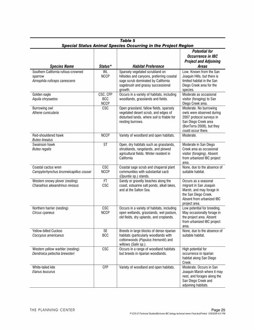
Table 5
Special Status Animal Species Occurring in the Project Region
Potential for Occurrence in IBC
Project and Adjoining Areas Species Name Status* Habitat Preference
Southern California rufous-crowned sparrow Aimophila ruficeps canescens
WL NCCP
Sparsely vegetated scrubland on hillsides and canyons, preferring coastal sage scrub dominated by California sagebrush and grassy successional growth.
Low. Known from the San Joaquin Hills, but there is limited habitat in the San Diego Creek area for the species.
Golden eagle Aquila chrysaetos
CSC, CFP BCC
NCCP
Occurs in a variety of habitats, including woodlands, grasslands and fields.
Moderate as occasional visitor (foraging) to San Diego Creek area.
Burrowing owl Athene cunicularia
CSC Open grassland, fallow fields, sparsely vegetated desert scrub, and edges of disturbed lands, where soil is friable for nesting burrows.
Moderate. No burrowing owls were observed during 2007 protocol surveys in San Diego Creek area (BonTerra 2008), but they could occur there.
Red-shouldered hawk Buteo lineatus
NCCP Variety of woodland and open habitats. Moderate.
Swainson hawk Buteo regalis
ST Open, dry habitats such as grasslands, shrublands, rangelands, and plowed agricultural fields. Winter resident in California
Moderate in San Diego Creek area as occasional visitor (foraging). Absent from urbanized IBC project area.
Coastal cactus wren Campylorhynchus brunneicapillus cousei
CSC NCCP
Coastal sage scrub and chaparral plant communities with substantial cacti (Opuntia sp.) stands.
None, due to the absence of suitable habitat.
Western snowy plover (nesting) Charadrius alexandrinus nivosus
FT CSC
Sandy or gravelly beaches along the coast, estuarine salt ponds, alkali lakes, and at the Salton Sea.
Occurs as a seasonal migrant in San Joaquin Marsh, and may forage in the San Diego Creek. Absent from urbanized IBC project area.
Northern harrier (nesting) Circus cyaneus
CSC NCCP
Occurs in a variety of habitats, including open wetlands, grasslands, wet pasture, old fields, dry uplands, and croplands.
Low potential for breeding. May occasionally forage in the project area. Absent from urbanized IBC project area.
Yellow-billed Cuckoo Coccyzus americanus
SE BCC
Breeds in large blocks of dense riparian habitats (particularly woodlands with cottonwoods (Populus fremontii) and willows (Salix sp.).
None, due to the absence of suitable habitat.
Western yellow warbler (nesting) Dendroica petechia brewsteri
CSC Occurs in a range of woodland habitats but breeds in riparian woodlands.
High potential for occurrence in riparian habitat along San Diego Creek.
White-tailed kite Elanus leucurus
CFP Variety of woodland and open habitats. Moderate. Occurs in San Joaquin Marsh where it may nest, and forages along the San Diego Creek and adjoining habitats.
THE PLANNING CENTER Page 25 P:\COI-21\Technical Studies\Bio\Irvine IBC biology technical memo Final.doc|Printed: 12/9/2009 4:01 PM
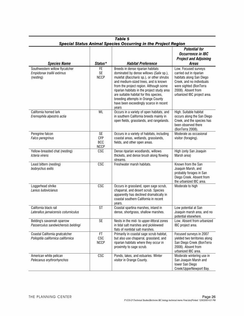
Table 5
Special Status Animal Species Occurring in the Project Region
Potential for Occurrence in IBC
Project and Adjoining Areas Species Name Status* Habitat Preference
Southwestern willow flycatcher Empidonax traillii extimus (nesting)
FE SE
NCCP
Breeds in dense riparian habitats dominated by dense willows (Salix sp.), mulefat (Baccharis sp.), or other shrubs and medium-sized trees, and is known from the project region. Although some riparian habitats in the project study area are suitable habitat for this species, breeding attempts in Orange County have been exceedingly scarce in recent years
Low. Focused surveys carried out in riparian habitats along San Diego Creek, and no individuals were sighted (BonTerra 2008). Absent from urbanized IBC project area.
California horned lark Eremophila alpestris actia
WL Occurs in a variety of open habitats, and in southern California breeds mainly in open fields, grasslands, and rangelands.
High. Suitable habitat occurs along the San Diego Creek, and the species has been observed there (BonTerra 2008).
Peregrine falcon Falco peregrinus
SE CFP BCC
NCCP
Occurs in a variety of habitats, including coastal areas, wetlands, grasslands, fields, and other open areas.
Moderate as occasional visitor (foraging).
Yellow-breasted chat (nesting) Icteria virens
CSC Dense riparian woodlands, willows thickets, and dense brush along flowing streams.
High (only San Joaquin Marsh area)
Least bittern (nesting) Ixobrychus exilis
CSC Freshwater marsh habitats. Known from the San Joaquin Marsh, and probably forages in San Diego Creek. Absent from the urbanized IBC area.
Loggerhead shrike Lanius ludovicianus
CSC Occurs in grassland, open sage scrub, chaparral, and desert scrub. Species apparently has declined dramatically in coastal southern California in recent years.
Moderate to high
California black rail Laterallus jamaicensis coturniculus
ST Coastal spartina marshes, inland in dense, shortgrass, shallow marshes.
Low potential at San Joaquin marsh area, and no potential elsewhere.
Belding's savannah sparrow Passerculus sandwichensis beldingi
SE Nests in the mid- to upper-littoral zones in tidal salt marshes and pickleweed flats of nontidal salt marshes.
Low. Absent from urbanized IBC project area.
Coastal California gnatcatcher Polioptila californica californica
FT CSC
NCCP
Primarily in coastal sage scrub habitat, but also use chaparral, grassland, and riparian habitats where they occur in proximity to sage scrub.
Focused surveys in 2007 yielded two territories along San Diego Creek (BonTerra 2008). Absent from urbanized IBC area.
American white pelican Pelecanus erythrorhynchos
CSC Ponds, lakes, and estuaries. Winter visitor in Orange County.
Moderate wintering use in San Joaquin Marsh and lower San Diego Creek/UpperNewport Bay.
THE PLANNING CENTER Page 26 P:\COI-21\Technical Studies\Bio\Irvine IBC biology technical memo Final.doc|Printed: 12/9/2009 4:01 PM
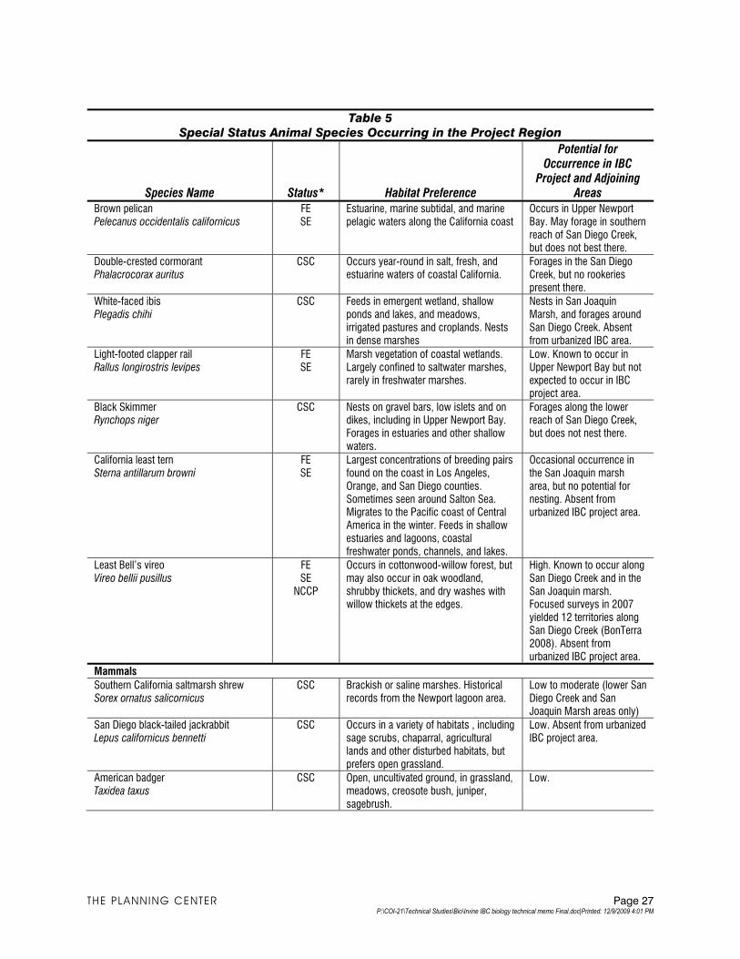
Table 5
Special Status Animal Species Occurring in the Project Region
Potential for Occurrence in IBC
Project and Adjoining Areas Species Name Status* Habitat Preference
Brown pelican Pelecanus occidentalis californicus
FE SE
Estuarine, marine subtidal, and marine pelagic waters along the California coast
Occurs in Upper Newport Bay. May forage in southern reach of San Diego Creek, but does not best there.
Double-crested cormorant Phalacrocorax auritus
CSC Occurs year-round in salt, fresh, and estuarine waters of coastal California.
Forages in the San Diego Creek, but no rookeries present there.
White-faced ibis Plegadis chihi
CSC Feeds in emergent wetland, shallow ponds and lakes, and meadows, irrigated pastures and croplands. Nests in dense marshes
Nests in San Joaquin Marsh, and forages around San Diego Creek. Absent from urbanized IBC area.
Light-footed clapper rail Rallus longirostris levipes
FE SE
Marsh vegetation of coastal wetlands. Largely confined to saltwater marshes, rarely in freshwater marshes.
Low. Known to occur in Upper Newport Bay but not expected to occur in IBC project area.
Black Skimmer Rynchops niger
CSC Nests on gravel bars, low islets and on dikes, including in Upper Newport Bay. Forages in estuaries and other shallow waters.
Forages along the lower reach of San Diego Creek, but does not nest there.
California least tern Sterna antillarum browni
FE SE
Largest concentrations of breeding pairs found on the coast in Los Angeles, Orange, and San Diego counties. Sometimes seen around Salton Sea. Migrates to the Pacific coast of Central America in the winter. Feeds in shallow estuaries and lagoons, coastal freshwater ponds, channels, and lakes.
Occasional occurrence in the San Joaquin marsh area, but no potential for nesting. Absent from urbanized IBC project area.
Least Bell’s vireo Vireo bellii pusillus
FE SE
NCCP
Occurs in cottonwood-willow forest, but may also occur in oak woodland, shrubby thickets, and dry washes with willow thickets at the edges.
High. Known to occur along San Diego Creek and in the San Joaquin marsh. Focused surveys in 2007 yielded 12 territories along San Diego Creek (BonTerra 2008). Absent from urbanized IBC project area.
Mammals
Southern California saltmarsh shrew Sorex ornatus salicornicus
CSC Brackish or saline marshes. Historical records from the Newport lagoon area.
Low to moderate (lower San Diego Creek and San Joaquin Marsh areas only)
San Diego black-tailed jackrabbit Lepus californicus bennetti
CSC Occurs in a variety of habitats , including sage scrubs, chaparral, agricultural lands and other disturbed habitats, but prefers open grassland.
Low. Absent from urbanized IBC project area.
American badger Taxidea taxus
CSC Open, uncultivated ground, in grassland, meadows, creosote bush, juniper, sagebrush.
Low.
THE PLANNING CENTER Page 27 P:\COI-21\Technical Studies\Bio\Irvine IBC biology technical memo Final.doc|Printed: 12/9/2009 4:01 PM
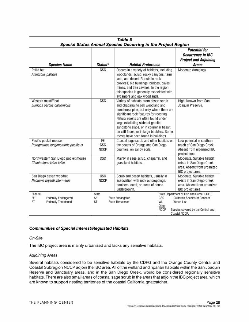
Table 5
Special Status Animal Species Occurring in the Project Region
Potential for Occurrence in IBC
Project and Adjoining Areas Species Name Status* Habitat Preference
Pallid bat Antrozous pallidus
CSC Occurs in a variety of habitats, including woodlands, scrub, rocky canyons, farm land, and desert. Roosts in rock crevices, old buildings, bridges, caves, mines, and tree cavities. In the region this species is generally associated with sycamore and oak woodlands.
Moderate (foraging).
Western mastiff bat Eumops perotis californicus
CSC Variety of habitats, from desert scrub and chaparral to oak woodland and ponderosa pine, but only where there are significant rock features for roosting. Natural roosts are often found under large exfoliating slabs of granite, sandstone slabs, or in columnar basalt, on cliff faces, or in large boulders. Some roosts have been found in buildings.
High. Known from San Joaquin Preserve.
Pacific pocket mouse Perognathus longimembris pacificus
FE CSC
NCCP
Coastal sage scrub and other habitats on the coasts of Orange and San Diego counties, on sandy soils.
Low potential in southern reach of San Diego Creek. Absent from urbanized IBC project area.
Northwestern San Diego pocket mouse Chaetodipus fallax fallax
CSC Mainly in sage scrub, chaparral, and grassland habitats.
Moderate. Suitable habitat exists in San Diego Creek area. Absent from urbanized IBC project area.
San Diego desert woodrat Neotoma bryanti intermedia
CSC NCCP
Scrub and desert habitats, usually in association with rock outcroppings, boulders, cacti, or areas of dense undergrowth.
Moderate. Suitable habitat exists in San Diego Creek area. Absent from urbanized IBC project area.
Federal FE Federally Endangered FT Federally Threatened
State SE State Endangered ST State Threatened
State Department of Fish and Game (CDFG) CSC California Species of Concern WL Watch List Other NCCP Species covered by the Central and
Coastal NCCP.
Communities of Special Interest/Regulated Habitats
On-Site
The IBC project area is mainly urbanized and lacks any sensitive habitats.
Adjoining Areas
Several habitats considered to be sensitive habitats by the CDFG and the Orange County Central and
Coastal Subregion NCCP adjoin the IBC area. All of the wetland and riparian habitats within the San Joaquin
Reserve and Sanctuary areas, and in the San Diego Creek, would be considered regionally sensitive
habitats. There are also small areas of coastal sage scrub in the areas that adjoin the IBC project area, which are known to support nesting territories of the coastal California gnatcatcher.
THE PLANNING CENTER Page 28 P:\COI-21\Technical Studies\Bio\Irvine IBC biology technical memo Final.doc|Printed: 12/9/2009 4:01 PM
Wildlife Movement Corridors
Wildlife corridors link areas of natural habitats separated by rugged terrain, changes in vegetation, or human
disturbance. Wildlife corridors accommodate animal movement so that genetic interchange and
recolonization can occur, and provide buffers for populations to use in response to environmental changes and natural disasters. Large corridors (often referred to as habitat or landscape linkages) can provide both
transitory and resident habitat for a variety of species.
The majority of the IBC area is developed with urban land uses and does not function as a wildlife movement
corridor. San Diego Creek serves as a local movement corridor for wildlife species, and it provides aquatic
connectivity between the Santa Ana Mountains and Upper Newport Bay. However, the creek has been channelized to function for flood control purposes, and riparian vegetation is largely found below the
southern reach of the IBC area, south of Campus Drive. The Orange County NCCP/HCP does not designate
San Diego Creek as a corridor or Special Linkage area. Special Linkages are areas that contain target
species of the NCCP or biological habitat that could enhance connectivity between elements of the Reserve
System. The principal corridor connection between the Santa Ana Mountains and the San Joaquin Hills is proposed to occur through the Agua Chinon Wash area within the proposed Great Park, well outside of the
IBC area.
Jurisdictional Waters and Wetlands
The majority of the IBC area is developed with urban land uses, and does not contain wetlands or Waters of
the United Sates that would be under the jurisdiction of the Corps or CDFG. San Diego Creek and San
Joaquin marsh, which adjoin the IBC area, contain jurisdictional waters and wetlands.
2.10.2 Thresholds of Significance
According to Appendix G of the CEQA Guidelines, a project would normally have a significant effect on the
environment if the project would:
B-1 Have a substantial effect, either directly or through habitat modifications, on any species
identified as a candidate, sensitive, or special status species in local or regional plans,
policies, or regulations, or by the California Department of Fish and Game or U.S. Fish and Wildlife Service.
B-2 Have a substantial adverse effect on any riparian habitat or other sensitive natural
community identified in local or regional plans, policies, regulations, or by the California
Department of Fish and Game or U.S. Fish and Wildlife Service.
B-3 Have a substantial adverse effect on federally protected wetlands as defined by Section 404 of the Clean Water Act (including but not limited to marsh, vernal pool, coastal, etc.) through
direct removal, filling, hydrological interruption, or other means.
B-4 Interfere substantially with the movement of any native resident or migratory fish or wildlife
species or with established native resident or migratory wildlife corridors or impede the use of native wildlife nursery sites.
B-5 Conflict with any local policies or ordinances protecting biological resources, such as a tree
preservation policy or ordinance.
B-6 Conflict with the provisions of an adopted habitat Conservation Plan, Natural Community
Conservation Plan, or other approved local, regional, or state habitat conservation plan.
THE PLANNING CENTER Page 29 P:\COI-21\Technical Studies\Bio\Irvine IBC biology technical memo Final.doc|Printed: 12/9/2009 4:01 PM
As discussed in the Initial Study (see Appendix A), biological resources were not identified as being
“potentially significant” due to the built-out nature of the proposed project area. However, based on
comments received on the Notice of Preparation, the following analysis is provided.
2.10.3 Environmental Impacts
Existing Plans, Programs, and Policies
The following measures are existing plans, programs, or policies (PPPs) that apply to the proposed project
and will help to reduce and avoid potential impacts related to biological resources:
PPP 3-1 Prior to any installation of any new storm drain connections to and/or discharges into the San
Diego Creek or San Joaquin Marsh, the City or other project applicants shall 1) obtain a permit or other authorization from the U.S. Army Corps of Engineers pursuant to Section 404 of the
Clean Water Act; 2) obtain a Section 401 Water Quality Certification from the California Regional
Water Quality Control Board, Santa Ana Region, pursuant to Section 401 of the federal Clean
Water Act, which requires any applicant for a federal permit, such as a Clean Water Act Section
404 permit, to provide the licensing agency a certification from the California Regional Water Quality Control Board that the project will comply with adopted water quality standards; and 3)
provide notification to the California Department of Fish and Game (CDFG) of the project
pursuant to Section 16-2 of the Fish and Game Code and comply with any further actions
required by CDFG.
PPP 3-2 If any trees are removed, the Applicant shall carry out a tree survey and obtain a permit for their removal in accordance with the City's tree preservation ordinance (including 1:1 replacement).
Project Design Features
PDF-1 Prior to approval of the design for the San Diego Creek Trail improvements/extension, the City
shall examine alternative locations of the proposed trail and methods that could be used to
minimize potential impacts (e.g., fencing and buffers). The design shall consider an alternative that excludes a trail segment along the most sensitive part of San Diego Creek (the
northwestern side of the creek between Campus Drive and MacArthur Boulevard).
PDF-2 Prior to issuance of grading permits for the San Diego Creek Trail, a note shall be placed on all
grading plans that construction activities involving the use of heavy equipment are prohibited
during the bird nesting season (March 15 to September 15). If minor construction activities are carried out during the bird nesting season, a qualified biologist shall conduct a preconstruction
survey in the off-site habitat to determine the location of any active bird nests in the area,
including but not limited to raptors and least Bell's vireo. The survey should begin not more than
three days prior to the beginning of construction activities. The wildlife agencies shall be notified
if any nesting least Bell’s vireo are found. During construction, active nesting sites shall be monitored to ensure that construction levels do not exceed 60 dBA Leq. Should these noise
levels be exceeded, the City shall implement noise attenuation measures, potentially including
the erection of temporary noise curtains sufficient to reduce noise levels at occupied nesting
sites to acceptable levels. Nest monitoring should continue until fledglings have dispersed or the
nest has been determined to be a failure, as approved by the wildlife agencies.
PDF-3 Prior to issuance of building permits for high-rise buildings within 100 feet of the San Joaquin
Marsh or San Diego Creek, the project applicant shall demonstrate that architectural plans
prohibit the use of highly reflective glass widows, and utilize angles that are not highly reflective
THE PLANNING CENTER Page 30 P:\COI-21\Technical Studies\Bio\Irvine IBC biology technical memo Final.doc|Printed: 12/9/2009 4:01 PM
in order to reduce light and glare impacts on the marsh and creek environment and to reduce
the incidence of bird collisions, to the satisfaction of the Community Development Director.
PDF-4 Prior to approval of final landscape plans for areas located within 100 feet of the San Joaquin Marsh or San Diego Creek, the project applicant shall ensure that development landscaping
does not include exotic plant species that may be invasive to native habitats. Exotic plant
species not to be used include those species listed on Lists A and B of the California Invasive
Plant Council’s (Cal-IPC) list of “Exotic Pest Plants of Greatest Ecological Concern in California
as of October 1999.” A copy of the complete list can be obtained from Cal-IPC’s web site at http://www.cal-ipc.org.
The following impact analysis addresses all thresholds of significance for biology included in Appendix G of
the CEQA Guidelines; even though they were eliminated as being less than significant in the Initial Study.
The applicable thresholds, as identified above, are identified in brackets after the impact statement.
IMPACT 5.3-1: THE PROJECT WOULD NOT HAVE A DIRECT SUBSTANTIAL ADVERSE EFFECT ON
ANY SPECIES IDENTIFIED AS A SENSITIVE OR SPECIAL STATUS SPECIES IN
LOCAL OR REGIONAL PLANS, POLICIES, OR REGULATIONS, OR BY THE
CALIFORNIA DEPARTMENT OF FISH AND GAME OR U.S. FISH AND WILDLIFE
SERVICE. [THRESHOLD B-1]
Impact Analysis: The majority of the IBC area is developed with urban uses and lacks potential habitat for
any sensitive plant or animal species. However, several parts of the project area adjoin areas that are known
to support sensitive species: (1) the San Joaquin Marsh Reserve and Sanctuary, and (2) along the San
Diego Creek channel. Also, in the southern part of the IBC area, Fairchild Road borders the San Joaquin
Marsh Reserve area and an area of upland habitat that is a proposed NCCP Reserve area where habitat restoration plans are under implementation.
The precise location of the proposed trail along San Diego Creek has not been identified, but the narrow
space between the creek and adjoining land uses appears to be the only possible location for the proposed
trail extension (see previous Figure 3-4). This area serves as the levee bank of the creek, and has been disturbed as a result of previous construction. It is occupied by a road that serves as an access
road/easement for the levee and the electrical power lines.
The proposed project would not be expected to directly impact the habitat of any sensitive species.
However, construction and use of the trail could adversely impact a number of sensitive species that occur in
the San Diego Creek and San Joaquin marsh areas. Many sensitive species occur in these areas, including federally listed species such as the least Bell’s vireo as well as a number of California Species of Special
Concern.
There are several sources of potential impacts to sensitive species:
‚ Construction noise. Birds and other wildlife are sensitive to noise, especially during the nesting
season. Indirect impacts from construction-related noise could occur to sensitive wildlife if construction occurs during the breeding season (i.e., February 15 through August 31 for most bird
species, and January 1 through August 31 for raptors).
‚ Increased recreational uses near to the San Joaquin Marsh and San Diego Creek areas. The
unpaved access road along the northwestern side of San Diego Creek is currently fenced, which
prevents recreational and other unauthorized uses of this area. The introduction of recreational use
of this area could disturb wildlife that occupies the habitats along the proposed trail and species that move between San Diego Creek and the San Joaquin marsh areas. Bicycle traffic also has the
THE PLANNING CENTER Page 31 P:\COI-21\Technical Studies\Bio\Irvine IBC biology technical memo Final.doc|Printed: 12/9/2009 4:01 PM
potential to result in injury and mortality to ground-dwelling species such as amphibians and
reptiles. Human intrusion into sensitive habitats adjacent to the proposed trail habitats could
degrade habitat quality through trampling of plants and increase the incidence of fires. To address these concerns, the City should carry out a design analysis of the proposed trail along San Diego
Creek that examines alternatives for the location of the proposed trail and methods that could be
used to minimize the impact of disturbance (e.g., fencing).
‚ Invasive nonnative species. The proposed project has the potential to introduce invasive nonnative
plant species into the San Joaquin Marsh areas that could displace native species in natural communities. This could be addressed by avoiding the use of nonnative plants in any planned
landscape planting and implementing a monitoring/management plan for nonnative species that
controls their spread in the San Joaquin Marsh areas.
The construction of new buildings in the developed part of the IBC area that adjoins the San Joaquin Marsh
could lead to injury or mortality of birds flying into or away from the marsh. Large numbers of birds, including ducks, geese, and waterbirds, use the marsh seasonally as they migrate along the Pacific Flyway. Buildings
that are designed with "green" certification objectives and make extensive use of glass to increase natural
light can also lead to frequent bird collisions that result in injury and mortality. At night, the lights inside and
outside of buildings can confuse and draw birds, resulting in collisions. During the daytime, birds often collide with clear or reflective glass because they fail to see it as a barrier. Birds are most likely to collide with
windows that reflect habitat and sky, or buildings that are designed with "see through” corridors.
This analysis of biological impacts is program level because the detailed plans for the IBC project, including
the trail, have not been developed. Further study of the biological issues and the design alternatives for the
proposed trail would be required. The design analysis of the proposed trail would examine the buffer needs and opportunities of the proposed trail and consider an alternative that excludes a trail segment along the
most sensitive part of San Diego Creek (the northwestern side of the creek between Campus Drive and
MacArthur Boulevard). Therefore, compliance with PDF-1 through PDF-4 would prevent the occurrence of
any significant impacts.
IMPACT 5.3-2: THE PROJECT WOULD NOT HAVE A SUBSTANTIAL ADVERSE EFFECT ON ANY
RIPARIAN HABITAT OR OTHER SENSITIVE NATURAL COMMUNITY IDENTIFIED IN
LOCAL OR REGIONAL PLANS, POLICIES, OR REGULATIONS, OR BY THE
CALIFORNIA DEPARTMENT OF FISH AND GAME OR U.S. FISH AND WILDLIFE
SERVICE. [THRESHOLD B-2]
Impact Analysis: The urbanized IBC area does not contain any riparian or other sensitive natural habitats.
However, these habitats occur in the adjoining areas along San Diego Creek and San Joaquin marsh.
Construction in areas that adjoin these riparian habitats could have indirect impacts on riparian habitats as a
result of increased erosion. However, compliance with PPP 3-2 would prevent the occurrence of any
significant impacts.
IMPACT 5.3-3: THE PROJECT WOULD NOT HAVE A SUBSTANTIAL ADVERSE EFFECT ON
FEDERALLY PROTECTED WETLANDS AS DEFINED BY SECTION 404 OF THE
CLEAN WATER ACT (INCLUDING BUT NOT LIMITED TO MARSH, VERNAL POOL,
COASTAL, ETC.) THROUGH DIRECT REMOVAL, FILLING, HYDROLOGICAL
INTERRUPTION, OR OTHER MEANS. [THRESHOLD B-3]
Impact Analysis: The urbanized IBC area does not contain any wetlands. However, the proposed trail would
adjoin San Diego Creek and the San Joaquin Marsh. The open water and riparian habitats of the creek and
marsh would be considered jurisdictional wetlands by the Corps and CDFG. In addition, the IBC area
THE PLANNING CENTER Page 32 P:\COI-21\Technical Studies\Bio\Irvine IBC biology technical memo Final.doc|Printed: 12/9/2009 4:01 PM
contributes urban runoff into the San Diego Creek channel. To the extent that urban land uses are intensified
in the IBC area, urban runoff may be increased.
The proposed project would not directly impact any wetlands. However, there is the potential for indirect impacts as a result of urban runoff from the developed areas to San Diego Creek. There is also a potential for
adverse impacts of erosion and surface runoff during construction and operation of the proposed trail on the
wetlands of San Diego Creek and San Joaquin marsh. However, compliance with PPP 3-2 would prevent the
occurrence of any significant impacts.
IMPACT 5.3-4: THE PROJECT WOULD NOT INTERFERE SUBSTANTIALLY WITH THE MOVEMENT
OF ANY NATIVE RESIDENT OR MIGRATORY FISH OR WILDLIFE SPECIES OR
WITH ESTABLISHED NATIVE RESIDENT OR MIGRATORY WILDLIFE CORRIDORS,
OR IMPEDE THE USE OF NATIVE WILDLIFE NURSERY SITES. [THRESHOLD B-4]
Impact Analysis: The majority of the IBC area is developed with urban land uses and does not function as a
wildlife movement corridor. The proposed project would intensify urban land uses within already developed
areas, which would have no effect on wildlife movement.
San Diego Creek has been channelized for flood control purposes, and riparian vegetation is concentrated in the southern reach of the IBC area below Campus Drive. The Creek serves as a local movement corridor for
wildlife species, and it provides aquatic connectivity between the Santa Ana Mountains and Upper Newport
Bay. No studies have been carried out on this local movement corridor, but the area probably supports
movements of a variety of birds, mammals, and herptiles. Its usefulness for sensitive bird species such as the
California gnatcatcher and least Bell’s vireo is probably lower than for common species, but they are nonetheless expected to utilize the San Diego Creek area for dispersal movement. However, it is not
designated by the Orange County NCCP as a corridor or special linkage area. The principal corridor
connection between the Santa Ana Mountains and the San Joaquin Hills is proposed to occur through the
Agua Chinon Wash area within the proposed Great Park.
The proposed trail along the San Diego Creek would not include any night-lighting, and limited fencing may be used to prevent unauthorized access into sensitive habitats. A barbed wire fence now marks the
boundary of the San Joaquin Marsh area along the existing maintenance road along San Diego Creek.
Therefore, the project would not result in the introduction of substantial new fencing. The proposed trail
would introduce recreational uses into an area that currently lacks them, which would increase indirect disturbance to wildlife, including a number of sensitive species. The project would not construct substantial
new fencing or convert existing habitat, and therefore would not adversely affect habitat connectivity. The
nonmotorized recreational uses of the proposed trail would not be expected to have a significant impact on
wildlife movement.
IMPACT 5.3-5: THE PROPOSED PROJECT WOULD NOT CONFLICT WITH ANY LOCAL POLICIES
OR ORDINANCES PROTECTING BIOLOGICAL RESOURCES, SUCH AS A TREE
PRESERVATION POLICY OR ORDINANCE [THRESHOLD B-5]
Impact Analysis:
General Plan
The Open Space and Natural Resource element identifies the importance of preserving the biological
resources of the San Joaquin Marsh wetlands and the San Diego Creek riparian habitat, and integrating
these into local and regional conservation and open space areas. The proposed project would not degrade these areas, and would not interfere with their linkage to other open space areas. The IBC project would not
conflict with these or other open space and conservation policies of the Irvine General Plan.
THE PLANNING CENTER Page 33 P:\COI-21\Technical Studies\Bio\Irvine IBC biology technical memo Final.doc|Printed: 12/9/2009 4:01 PM
Tree Preservation
The proposed project would be implemented mainly in an urbanized area that contains many ornamental
trees, some of which may be removed during project implementation. There are trees in the general area of
the proposed trail along San Diego Creek, but the project design is not sufficiently specific to determine whether or how many trees would be impacted. The City of Irvine’s Urban Forestry Ordinance requires that a
permit be obtained to remove any significant tree on public or private land. Trees on nonresidential
properties are subject to replacement criteria at a one-to-one ratio on-site or off-site, as prescribed in the
City’s Urban Forestry Ordinance, based on the determination of the City Arborist.
Noise Ordinance
Two areas of the proposed IBC project are located adjacent to the San Joaquin Marsh Reserve and
Sanctuary areas. which are considered important wildlife habitat areas. The City of Irvine's Noise Ordinance
sets guidelines for noise compatibility with wildlife habitat, in recognition of the importance of minimizing
noise impacts on sensitive biological resources. This ordinance identifies 70 dBA CNEL as “clearly
compatible” for wildlife reserves, up to 75 dBA CNEL as “normally compatible,” and over 75 dBA as “normally incompatible.” Activities within the IBC areas adjacent to these habitats would need to be
evaluated for their compliance with the City’s noise ordinance, as discussed further in Section 5.9.
Although nonmotorized recreational uses of the proposed trail would not exceed the noise standards, the
noise threshold could be exceeded during trail construction. The City’s ordinance recognizes that the control
of construction noise is difficult and therefore provides exemption for this type of disturbance. Specifically, Municipal Code Section 6-8-205 exempts noise sources associated with construction activities, provided said
activities do not take place outside the hours of 7:00 AM and 7:00 PM, Monday through Friday, and 9:00 AM
to 6:00 PM on Saturday.
IMPACT 5.3-6: THE PROPOSED PROJECT WOULD NOT CONFLICT WITH THE PROVISIONS OF
AN ADOPTED HABITAT CONSERVATION PLAN, NATURAL COMMUNITY
CONSERVATION PLAN, OR OTHER APPROVED LOCAL, REGIONAL, OR STATE
HABITAT CONSERVATION PLAN. [THRESHOLD B-6]
Impact Analysis: The IBC area is within the Orange County Central/Coastal NCCP, which serves as a
Habitat Conservation Plan for the “take” of state- and federally threatened species. The majority of the IBC
area is developed with urban land uses and lacks important open space. However, a section of the proposed
trail along San Diego Creek would be located next to an NCCP reserve area (the upland area located
between the San Joaquin Marsh, the San Diego Creek channel, MacArthur Boulevard, and Fairchild Road) and a nonreserve open space area (the San Joaquin Marsh Reserve). Both areas are owned and managed
by UC Irvine.
The proposed project is consistent with the NCCP/HCP based on several criteria. First, only the proposed
trail is located near the reserve open space, but would not prevent or interfere with assembly of the Reserve
System. Second, Section 5.3.3 of the NCCP Implementation Agreement identifies passive recreation, which includes bicycling (on designated trails), hiking, and nature interpretation as permitted uses within the
Reserve System. The NCCP/HCP identifies the areas where public access is prohibited (Figure 26 of the
NCCP/HCP), which does not include any locations within the IBC area. The NCCP/HCP prohibits a number
of active recreational uses such as motorized recreation vehicle activities and other facilities that would significantly harm sensitive natural habitat resources and identified species. However, motorized recreation
vehicles would not be permitted on the proposed trail, and there would be no significant impact to sensitive
habitats and species.
THE PLANNING CENTER Page 34 P:\COI-21\Technical Studies\Bio\Irvine IBC biology technical memo Final.doc|Printed: 12/9/2009 4:01 PM
The SAMP for the San Diego Creek watershed identifies San Diego Creek as an Aquatic Resource Integrity
Area. Because the SAMP has not yet been approved, it is not necessary for the project to comply with its
provisions. Nonetheless, the proposed IBC project is consistent with the findings and recommendations of the SAMP for the San Diego Creek watershed. The SAMP identifies six different types of riparian restoration
activities and prospective locations within the San Diego Creek watershed. None of these prospective
restoration areas are within the IBC project area. The six restoration activities and an assessment of whether
the IBC project would impact these are:
‚ (a) Restore connectivity between aquatic resources located in the NCCP Reserve System. There are no activities proposed in the IBC project area.
‚ (b) Restore reaches within surrounding upland conservation areas. The SAMP identifies 48 sites
within open space areas where riparian areas would be restored. None of these areas proposed for
restoration occur within the IBC project area, or in adjoining areas.
‚ (c) Restore connectivity between high and/or medium integrity resource reaches. The SAMP identifies six areas proposed for restoration activities designed to restore connectivity. There are no
activities proposed in the IBC project area. One of these areas adjoins the IBC project area—a
segment of Sand Canyon wash that includes the point of where it connects to San Diego Creek. This
area is on the opposite side of San Diego Creek from where the trail is proposed. The proposed trail
would not impact the feasibility of this SAMP objective from being achieved.
‚ (d) Restore reaches within the headwaters. There are no activities proposed in the IBC project area.
‚ (e) Restore reaches with sensitive species. The SAMP proposes to enhance habitat quality for
sensitive species in 22 reaches, one of which is the same identified in restoration objective (c)
above. For this area, the SAMP proposes to enhance habitat quality for the least Bell's vireo,
southwestern flycatcher, and one or more plant species. The proposed trail would not impact the
feasibility of this SAMP objective.
‚ (f) Restore reaches, prioritizing with the greatest amount of functional lift per level of effort. The
SAMP proposes to maximize integrity scores in 15 reaches. There are no activities proposed in the
IBC project area, or in adjoining areas.
2.10.4 Cumulative Impacts
The geographic scope for biological resources includes the NCCP/HCP Planning Area in conjunction with
growth projections for Orange County. Past projects in surrounding Orange County cities and unincorporated areas have converted undeveloped and agricultural land to urban uses, resulting in area
residential and employment population increases and associated impacts to biological resources. The
contribution of these past projects to area growth is also reflected in the 2006 Orange County Projections
(OCP-2006). The NCCP/HCP is intended and designed to address biological resources impacts on a larger,
regional basis. The City of Irvine and jurisdictions within the NCCP Planning Area will continue to develop in accordance with the adopted General Plans of the respective jurisdictions. The primary cumulative impact on
biological resources is the fragmentation of ecosystems resulting from the incremental loss of native
habitats. As development continues, the remaining ecosystems will become more isolated and fragmented.
The result will be that connectivity between patches of habitat and the wildlife populations they support will be lost. The proposed project is within the area designated for development under the NCCP/HCP and is
consistent with provisions of the NCCP/HCP.
The establishment of the Nature Reserve of Orange County, a 37,000-acre reserve that was approved on July
17, 1996, provides regional biological benefits that would be unlikely to occur with a piecemeal conservation
THE PLANNING CENTER Page 35 P:\COI-21\Technical Studies\Bio\Irvine IBC biology technical memo Final.doc|Printed: 12/9/2009 4:01 PM
strategy. The Nature Reserve was designed to prevent the incremental loss of native habitat and the
fragmentation of ecosystems, as well as to compensate for impacts of individual projects. Establishment of
the Reserve System will protect approximately 40 identified species, including three target species (gnatcatcher, cactus wren, and orange-throated whiptail lizard), which are the focus of the NCCP planning,
and use the CSS and related habitat. The implementation of the NCCP, dedication of lands, and endowment
by the participating landowners mitigate impacts of proposed and future development on covered habitats
and identified species. The City of Irvine participates in this and the NCCP program, and requires
development to be in accordance with the NCCP. The NCCP addresses the issues discussed above, such as fragmentation of ecosystems. As a result, cumulative biological impacts are mitigated to a level less than
significant and would not be cumulatively considerable.
2.10.5 Level of Significance Before Mitigation
Upon implementation of PPPs and PDFs, the following impacts would be less than significant: 5.3-1,5.3-2,
5.3-3, 5.3-4, 5.3-5 and 5.3-6.
2.10.6 Mitigation Measures
No mitigation measures are necessary.
2.10.7 Level of Significance After Mitigation
No significant impacts have been identified and no mitigation measures are required.
3.0 REFERENCES
Brenzel, K.N. (ed.). 2007. Sunset, Western garden book. Sunset Publishing Company, Menlo Park,
California.
BonTerra Consulting. 2008. San Diego Creek programmatic operations and maintenance project: Biological technical report. Prepared for the County of Orange RDMD.
Bowler, P.A, and D.E. Bramlet. 2002. Vascular plants of the University of California, Irvine ecological reserve.
Crossosoma 28(2): 27-46.
Bowler, P. and M. Elvin. 2003. The vascular plant checklist for the University of California Natural Reserve
System’s San Joaquin Freshwater Marsh Reserve. Crossosoma 29: 45-66.
California Department of Fish and Game (CDFG) Natural Diversity Database. 2009. California Natural
Diversity (RareFind) Database, Element report for the Tustin and Newport Beach 7.5’ quadrangles.
California Department of Fish and Game, Natural Heritage Division, Sacramento, California
---. 2000. Guidelines for assessing effects of proposed developments on rare and endangered plants and
plant communities.
California Native Plant Society (CNPS). 2009. Online Inventory of Rare and Endangered Plants in California. California Native Plant Society, Sacramento, California.
---. 2001. Botanical survey guidelines. California Native Plant Society, Sacramento, California.
Consortium of California Herbaria. 2009. Online database of allied California herbaria
THE PLANNING CENTER Page 36 P:\COI-21\Technical Studies\Bio\Irvine IBC biology technical memo Final.doc|Printed: 12/9/2009 4:01 PM
THE PLANNING CENTER Page 37 P:\COI-21\Technical Studies\Bio\Irvine IBC biology technical memo Final.doc|Printed: 12/9/2009 4:01 PM
http://ucjeps.berkeley.edu/consortium, Jepson Herbarium, and University of California, Berkeley.
California.
County of Orange. 1996. Orange County Central and Coastal Natural Community Conservation Plan/Habitat Conservation Plan.
Dames and Moore and Bramlet, D.E.1994. Species of special interest. Orange County Natural Resources
GIS Project. Prepared for County of Orange EMA. (Revised)
---. 1992. Habitat classification system. Orange County Natural Resources GIS Project. Prepared for
County of Orange EMA.
DeRuff, R. 1995. Plants of Upper Newport Bay.
ICF, Jones & Stokes. 2009. DEIR for the San Diego Creek Flood Control Channel, Upper Newport Bay to
I-405, Programmatic operations and operations manual. Prepared for County of Orange, SCH #
2007061076.
Jones and Stokes. 1993. Methods used to survey the vegetation of Orange County parks and open
space areas and Irvine Company property. Prepared for County of Orange, Environmental
Management Agency
Marsh, K.G. 1990. Upper Newport Bay regional park, Existing biological resources. Prepared for EDAW.
Pacific Southwest Biological Services (PSBS) 1991a. Report of a biological assessment of the Upper
Newport Bay regional Park. Prepared for Culbertson, Adams and Associates, Aliso Viejo, California.
PSBS Report No. B97.
Pacific Southwest Biological Services (PSBS) 1991b. Biological assessment of the Delhi Channel.
Prepared for Culbertson, Adams and Associates, Aliso Viejo, California. PSBS Report No. A28.
RBF. 2007. San Diego Creek programmatic operations and maintenance project: Delineation of State and Federal Jurisdictional Waters.
Riefner, R.E. and S. Boyd. 2007. New records of wetland and riparian plants in southern California with
recommendations and additions to the National List of plant species that occur in wetlands. J.Bot. Res.
Inst. Texas 1(1): 719-740.
Roberts, F..M. 2008. The vascular plants of Orange County, California: An annotated checklist. FM Roberts Publications, San Luis Rey, California.
United States Army Corps of Engineers (USACE). 2009. A Special Area Management Plan (SAMP) for the
San Diego Creek Watershed Special Area Watershed, Orange County, California.
Wachtell, J.K. 1978. Soil survey of Orange County and western part of Riverside County, California. U.S.
Dept. Agriculture., Soil Conservation Service.
Zedler, J.B. 1982. The ecology of southern California coastal salt marshes: A community profile. U.S.
Fish and Wildlife Service Report No. FWS/OBS-81/54.
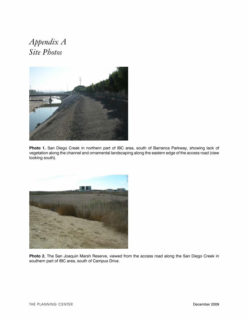
Appendix A Site Photos
Photo 1. San Diego Creek in northern part of IBC area, south of Barranca Parkway, showing lack of
vegetation along the channel and ornamental landscaping along the eastern edge of the access road (view
looking south).
Photo 2. The San Joaquin Marsh Reserve, viewed from the access road along the San Diego Creek in southern part of IBC area, south of Campus Drive.
THE PLANNING CENTER December 2009
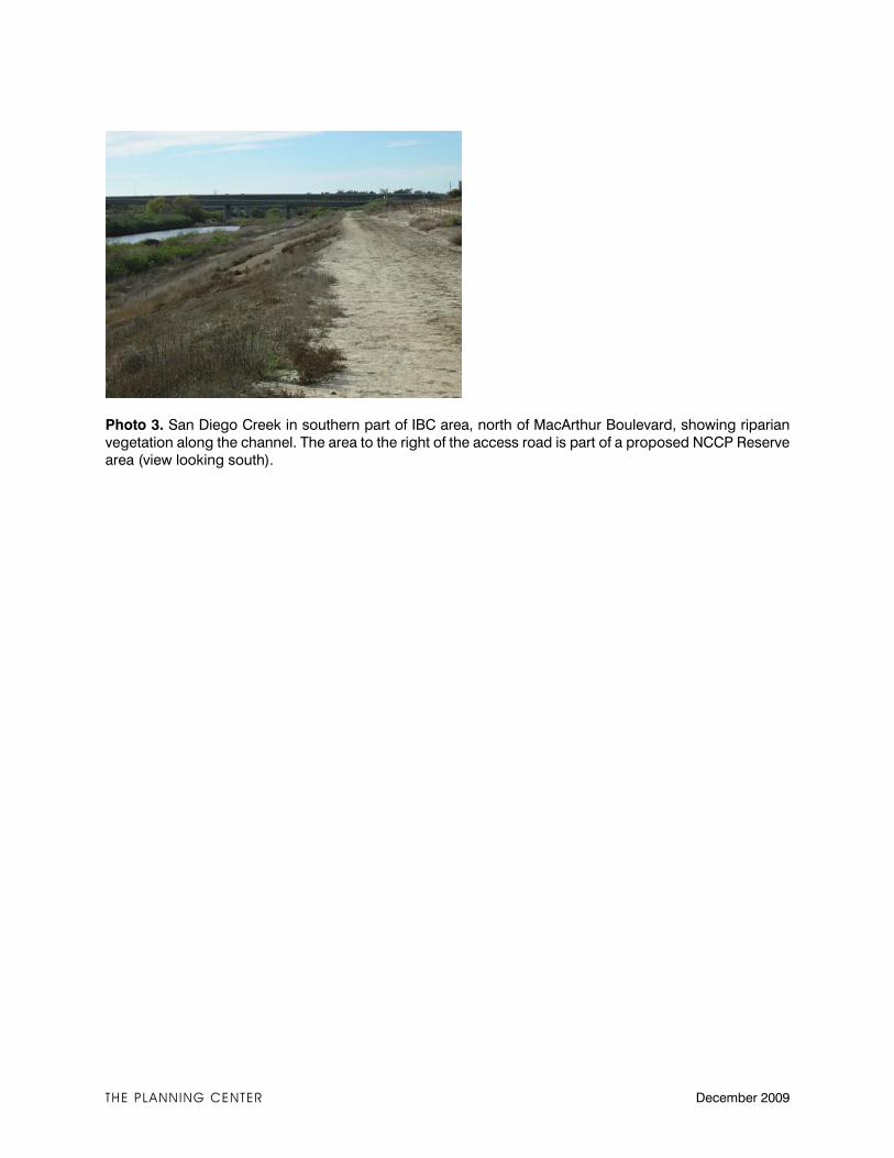
THE PLANNING CENTER December 2009
Photo 3. San Diego Creek in southern part of IBC area, north of MacArthur Boulevard, showing riparian
vegetation along the channel. The area to the right of the access road is part of a proposed NCCP Reserve
area (view looking south).
Appendices
IBC Vision Plan and Mixed Use Overlay Zoning Code Recirculated DEIR City of Irvine
Appendix I Paleontological and Archaeological Evaluation Report

Appendices
The Planning Center December 2009
This page intentionally left blank.
Resource Management Inc. Paleontology"‚"Archaeology ‚"History
1801 Parkcourt Pl., B102, Santa Ana, CA 92701 [email protected] www.cogstone.com ph 714-245-0264 fx 714-245-0054 toll free 888-497-0700
PALEONTOLOGICAL AND ARCHAEOLOGICAL
EVALUATION REPORT AND RECOMMENDATIONS
FOR THE IRVINE BUSINESS COMPLEX,
CITY OF IRVINE, CALIFORNIA
Submitted to: William Halligan
The Planning Center
1580 Metro Drive
Costa Mesa, CA 92626
Authors:
Sherri Gust and Kim Scott
Principal Investigator:
Sherri Gust
Orange County Certified Professional Archaeologist
Orange County Certified Professional Paleontologist
January 2009
Project Number: 1382 Type of Study: Paleontological and Archaeological Assessment Sites: P-30-121, 195, 196 Localities: San Joaquin Marsh USGS Quadrangle: Tustin 7.5’ Area: 2,800 acres Key Words: Gabrielino, Irvine Ranch, Pleistocene, Old Paralic and Alluvial Fan Deposits, Quaternary Younger Deposits, Late Pleistocene fossils, Prehistoric habitations, Prehistoric Burials
IBC Cultural Resources
Cogstone ii
TABLE OF CONTENTS
EXECUTIVE SUMMARY ...................................................................................................................................... IV
INTRODUCTION .......................................................................................................................................................1
PURPOSE OF STUDY .................................................................................................................................... 1 PROJECT DESCRIPTION ............................................................................................................................... 2
IBC Vision Plan Framework..................................................................................................................................4 IBC Districts ..........................................................................................................................................................5 General Plan Amendment ......................................................................................................................................6 Zoning Ordinance Amendment ..............................................................................................................................8 Municipal Code Amendment..................................................................................................................................8 Subsequent Development Pursuant to the Proposed Project .................................................................................9
PROJECT PERSONNEL ............................................................................................................................... 13
LAWS AND REGULATIONS .................................................................................................................................13
CALIFORNIA ENVIRONMENTAL QUALITY ACT OF 1970.......................................................................... 13 CALIFORNIA REGISTER OF HISTORICAL RESOURCES .............................................................................. 14 LOCAL REGULATIONS .............................................................................................................................. 15
Planning Conditions ............................................................................................................................................18
REFERENCE SYSTEM FOR IBC PORTIONS ....................................................................................................19
PALEONTOLOGY ...................................................................................................................................................20
NATURAL SETTING................................................................................................................................... 20 GEOLOGIC SETTING................................................................................................................................. 20 STRATIGRAPHY........................................................................................................................................ 20
Quaternary Older Paralic Deposits.....................................................................................................................21 Quaternary Younger Deposits .............................................................................................................................22 Artificial Fill ........................................................................................................................................................22
FOSSILS KNOWN ....................................................................................................................................... 22 CONCLUSIONS.......................................................................................................................................... 27
ARCHAEOLOGY .....................................................................................................................................................28
PREHISTORIC SETTING ............................................................................................................................. 28 Natural Environment ...........................................................................................................................................28 Cultural Traditions ..............................................................................................................................................29
ETHNOGRAPHY ........................................................................................................................................ 30 Archaic Culture ...................................................................................................................................................30 Tongva (Gabrielino) Culture ...............................................................................................................................31
HISTORIC SETTING .................................................................................................................................. 32 ARCHAEOLOGICAL RESOURCES KNOWN ................................................................................................. 33 NATIVE AMERICAN CONSULTATION ........................................................................................................ 39 PROJECT ARCHAEOLOGICAL SITES ......................................................................................................... 39
Site 195 ................................................................................................................................................................39 Site 196 ................................................................................................................................................................40 Site 121 ................................................................................................................................................................40
DEVELOPMENT IN PROJECT AREA........................................................................................................... 41 CONCLUSIONS.......................................................................................................................................... 45
POTENTIAL RESOURCES ....................................................................................................................................46
PALEONTOLOGICAL RESOURCES............................................................................................................. 46
IBC Cultural Resources
Cogstone iii
ARCHAEOLOGICAL RESOURCES .............................................................................................................. 46 HISTORICAL RESOURCES ......................................................................................................................... 47
RECOMMENDEDATIONS.....................................................................................................................................47
SPECIFIC IMPACTS AND MITIGATION ...................................................................................................... 48
REFERENCES ..........................................................................................................................................................49
APPENDIX A: QUALIFICATIONS ......................................................................................................................52
APPENDIX B: PALEONTOLOGY RECORD SEARCH ....................................................................................55
APPENDIX C: NATIVE AMERICAN HERITAGE COMMISSION.................................................................58
LIST OF FIGURES FIGURE 1. PROJECT LOCATION.......................................................................................................................................1 FIGURE 2. PROJECT TOPOGRAPHIC MAP .......................................................................................................................10 FIGURE 3. PROJECT AERIAL MAP.................................................................................................................................11 FIGURE 4. PROJECT RESIDENTIAL MAP........................................................................................................................12 FIGURE 5. IBC PORTIONS .............................................................................................................................................19 FIGURE 6. PROJECT GEOLOGY .....................................................................................................................................21 FIGURE 7. MAMMOTH SKULL FROM CENTRAL PARK WEST (IBC 1).............................................................................23 FIGURE 8. PROJECT VICINITY IN 1902 ..........................................................................................................................29 FIGURE 9. 1952 AERIAL OF PROJECT ............................................................................................................................42 FIGURE 10. 1972 AERIAL OF PROJECT ..........................................................................................................................43 FIGURE 11. 1980 AERIAL OF PROJECT ..........................................................................................................................44 FIGURE 12. 2004 AERIAL OF PROJECT ..........................................................................................................................45
LIST OF TABLES
TABLE 1. NEARBY FOSSILS ..........................................................................................................................................22 TABLE 2. IBC FOSSILS .................................................................................................................................................24 TABLE 3. RECORDED ARCHAEOLOGICAL AND HISTORIC SITES WITHIN ONE-MILE RADIUS OF THE PROJECT ..................33 TABLE 4. PREVIOUS STUDIES WITHIN A ONE-MILE RADIUS OF THE PROJECT .................................................................34 TABLE 5. PROJECT REPORT PRESENCE LIST.................................................................................................................38
IBC Cultural Resources
Cogstone iv
EXECUTIVE SUMMARY The purpose of this study was to determine the potential effects on paleontological, archaeological and historical resources of current planned development of the Irvine Business Complex, City of Irvine, California. This study was requested by the City of Irvine to meet their
responsibilities as the lead agency under California Environmental Quality Act. The 2,800-acre Irvine Business Complex (IBC) comprises Planning Area 36 in the City of Irvine, in south/central Orange County. The IBC is generally bounded by the former Tustin Marine Corps Air Station (MCAS) to the north, the San Diego Creek channel to the east, John Wayne Airport and Campus Drive to the south and State Route 55 (SR-55) to the west (Figure
3). The San Diego (I-405) Freeway traverses the southern portion of the IBC, and the Santa Ana (1-5) Freeway is located to the north and east. The IBC is bordered by the cities of Newport Beach to the south, Santa Ana and Costa Mesa to the west, and Tustin to the north. A 40-acre
parcel of the IBC is detached and located to the south of the main IBC boundary area and is
bounded by Jamboree Road, Fairchild Road, Macarthur Boulevard and the San Joaquin Marsh
and is adjacent to the City of Newport Beach. The prominent land use in the IBC is office, with
substantial amounts of industrial/warehouse uses and medium- and high-density residential uses
totaling 4,524 existing dwelling units.
Paleontology. Several geologic units are mapped within the project boundary. The oldest
material is late to middle Pleistocene (500,000-10,000 years old) old paralic (coastal plain)
deposits capped by alluvial fan material. Adjacent to and possibly capping these older deposits
are Holocene to late Pleistocene (less than 120,000 years old) alluvial fan and axial channel
deposits.
Many fossils have been found within the IBC boundaries during City-required paleontological
monitoring. The IBC fossils were recovered at depths of 8 to 25 feet below the surface. Most of
these fossils have been associated with an olive-green clay layer and sandy silt sediments above
and below the clay. These fossiliferous sediments have been encountered between 6 to 25 feet
below the modern surface over a wide area of Irvine. Fossils associated with IBC residential
projects include herbivores, carnivores, rabbits, rodents, birds, reptiles and amphibians. The
herbivores include mammoth, mastodon, giant ground sloth, bison, camel, llama, horse, tapir, peccary, deer, pronghorn and dwarf pronghorn. The carnivores include bear, sabertoothed cat, jaguar, bobcat, dire wolf, coyote, gray fox, raccoon, weasel, badger, skunk and sea otter. Birds
known are turkey vulture and duck. The smaller animals include many types of rabbits, rats, mice, gophers, woodrats, moles, shrews, lizards, snakes and salamanders.
Scientifically important fossils are being recovered from the IBC and many other areas of Irvine at depths of six feet or more below the surface. The known fossils from the project area are all
from the Pleistocene Epoch and represent the last Ice Age (40-10 thousand years ago). However, deeper sediments are also likely to produce scientifically significant fossils.
Major collections of IBC fossils have no reports and the fossils are not in museums. There is a procedural failure to document that adequate mitigation is being performed, reports are being
IBC Cultural Resources
Cogstone v
written and submitted and that fossils are sent to museums for curation as required by the City of Irvine Cultural Resources Element of the General Plan.
Archaeology. Prehistoric peoples utilized coastal southern California from 14,000 years before present to historic contact. Archaeological evidence indicates small, mobile foraging groups
throughout most of time. Late sites area relatively large and contain hearths, mortuary features, and houses. Early subsistence focused on exploitation of lagoon conditions with extensive shellfish, shark and fish. Later sites reflect a much broader strategy that targeted terrestrial mammals and birds from the freshwater marsh and coastal prairies, as well as fish and shellfish. The hunting toolkit changes over time from atlatl and dart to bow and arrow. The fishing toolkit changes from bone gorges to circular shell fish hooks. The plant processing toolkit changes
from manos and metates to mortars and pestles.
The project area is within the traditional tribal territory of the Tongva or Gabrielino beginning
approximately 3000 years before present. The Tongva/Gabrielino speak a language that is part
of the Takic language family originating in the Great Basin. Their prehistoric tool kit
demonstrates strong links to other desert peoples. Their territory encompassed a vast area
stretching from Topanga Canyon in the northwest, to the base of Mount Wilson in the north, to
San Bernardino in the east, Aliso Creek in the southeast and the Southern Channel Islands, in all
an area of more than 2,500 square miles. At European contact, the tribe consisted of more than
5,000 people living in various settlements throughout the area. Some of the villages could be
quite large, housing up to 150 people.
There are 3 recorded archaeological sites within the project area. There are 22 archaeological
sites known within a one-mile radius of the project area; mostly to the east and south. Some 70
archaeological studies are on file for projects within the project boundaries and a one-mile
radius.
Site P-30-000195 was mostly destroyed by construction of the Jamboree eastern on-ramp of the
405 freeway in 1967. Salvage excavations were conducted for Caltrans. Later additional
excavations into the remaining portion of the site were conducted in 1974. The site was deposited between 5 to 1 thousand years before present. The site contained sixteen burials, eleven cooking features, numerous ground and chipped stone tools, ornaments and ceremonial
objects and a large variety of food refuse. This site was associated with a historic ranch.
Site P-30-000196 within the project area was destroyed in the early 1970s by development of Michelson Drive and the Fluor Building. Testing and data recovery excavations were conducted in the remaining portion in 1976 and 1979. The results demonstrate similarity to 195 including
the same types of features including three burials, contemporaneous time periods represented and similar artifacts. The portion of the site with burials was preserved in place and exempted
from future development activities. This site also had 19th Century debris. The location was thought to be the location of a Mission San Juan Capistrano outpost dating to the 1820s and subsequently home to Jose Sepulveda. Surface collection and excavations failed to reveal any
remnant of buildings but did recover typical trash of the period including brownware pottery.
IBC Cultural Resources
Cogstone vi
Site P-30-000121 was located in the southeastern portion of IBC. The site was been destroyed by development activities subsequent to extensive archaeological testing and data recovery excavations. The major occupations occurred 4-1 years before present; also similar to 195. Late prehistoric and historic contact layers are also present. The site contained some burials, cooking features, numerous ground and chipped stone tools, ornaments and ceremonial objects and a
large variety of food refuse. The vast majority of the project area has no known archaeological resources. There are 3 recorded sites within the project area but they appear to have been severely impacted by previous development. Only 29 IBC residential projects have assessment reports on file and only 7 have monitoring reports. However, early commercial development of the IBC predates CEQA. There is a procedural failure to document that sensitive areas are being adequate mitigated,
reports written and submitted and that collections are sent to museums for curation as required by the City of Irvine Cultural Resources Element of the General Plan.
History. Historic uses of the project lands are known to have been ranching and agriculture.
Agricultural fields and three ranch houses or related outbuilding, along Barranca and Redhill, are
visible in the 1952 aerial of the project. By 1965 the only additional development was a
commercial building at the corner of MacArthur and Campus. By 1972 the 405 freeway was
constructed and significant commercial development had occurred. By 1980 only a couple of
fields were left and most of the IBC was developed. By 2004 the IBC was beginning to undergo
redevelopment as old structures were removed and new ones built.
No historic structures are extant but scattered ranching debris can be expected throughout the
IBC. Generally, this debris does not meet significance criteria under CEQA.
Recommendations. The City of Irvine appears to have diligently required mitigation of
construction activities within the IBC. However, post-mitigation documentation and curation is
not being effectively tracked to insure compliance with City requirements. In particular, reports
are not being written and filed as required nor are fossils and artifacts being transferred to
museums as required.
The Cultural Resource Element of the City of Irvine General Plan needs to be updated and contain specific language to insure that policies are actually implemented. The sensitivity maps
(Figures E-1 and E-2) should not be utilized for planning purposes unless updated at minimum five year intervals. The revised language should specify that museum specimen numbers must be included in reports, along with a letter from the museum stating that the fossils are in their
possession, and require that reports be submitted to the City and repository before any developer
can receive a final occupancy permit. The entire IBC is sensitive for paleontological resources at levels more than eight feet below the
surface. The portion south of Interstate 405 and east of Jamboree contains recorded archaeological sites that appear to have been destroyed by development subsequent to
archaeological excavations. The remainder of the IBC has no known archaeological or historical sites.
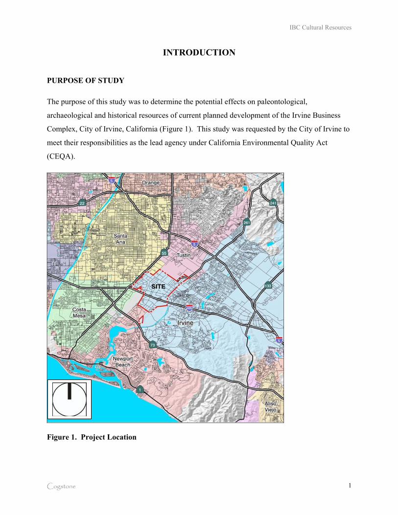
IBC Cultural Resources
Cogstone 1
INTRODUCTION
PURPOSE OF STUDY
The purpose of this study was to determine the potential effects on paleontological,
archaeological and historical resources of current planned development of the Irvine Business
Complex, City of Irvine, California (Figure 1). This study was requested by the City of Irvine to
meet their responsibilities as the lead agency under California Environmental Quality Act
(CEQA).
Figure 1. Project Location
IBC Cultural Resources
Cogstone 2
PROJECT DESCRIPTION
The 2,800-acre Irvine Business Complex (IBC) comprises Planning Area 36 in the City of
Irvine, in south/central Orange County. The project is located on the Tustin 7.5’ USGS
topographic quadrangle in: Sections 29 through 33 of Township 5 south, Range 9 west; Section
36 of Township 5 south, Range 10 west; Sections 5 through 8 of Township 6 south, Range 9
west; and Section 18 of Township 6 south, Range 9 west (Figure 2).
The IBC is generally bounded by the former Tustin Marine Corps Air Station (MCAS) to the
north, the San Diego Creek channel to the east, John Wayne Airport and Campus Drive to the
south and State Route 55 (SR-55) to the west (Figure 3). The San Diego (I-405) Freeway
traverses the southern portion of the IBC, and the Santa Ana (1-5) Freeway is located to the
north and east. The IBC is bordered by the cities of Newport Beach to the south, Santa Ana and
Costa Mesa to the west, and Tustin to the north. A 40-acre parcel of the IBC is detached and
located to the south of the main IBC boundary area and is bounded by Jamboree Road, Fairchild
Road, Macarthur Boulevard and the San Joaquin Marsh and is adjacent to the City of Newport
Beach. The prominent land use in the IBC is office, with substantial amounts of
industrial/warehouse uses and medium- and high-density residential uses totaling 4,524 existing
dwelling units.
The General Plan and Zoning designations for the IBC generally encourage heavy industrial uses
north of Barranca Parkway, and mixed-use development, including residential uses, south of
Barranca Parkway. Development applications have been filed and increased in the past few years
(since early 2004) and continue to be filed for the reuse of existing sites in the IBC from
nonresidential uses to high-density, urban-style residential development. Continuing a process
that began in the late 1980’s, the City renewed its efforts to ensure proper planning for
residential uses in the IBC in 2005 by embarking on a process to create a comprehensively
planned mixed-use “neighborhood” to maintain a high quality of life for both residents and
employees.
IBC Cultural Resources
Cogstone 3
The result was the IBC Vision Plan, a policy framework which outlined goals and design
guidelines for residential and mixed-use developments that would promote a pedestrian and
transit friendly environment with strong design elements, while protecting existing businesses
from potential impacts of new residential uses in the area. The IBC Vision Plan was
supplemented by a proposed set of new development criteria for the area and a $64 million
program of proposed infrastructure enhancements and amenities to create a pedestrian-friendly
neighborhood. The City Council gave its support to the IBC Vision Plan in July 2006, directing
that an Environmental Impact Report be prepared and that necessary steps be taken to formally
adopt the Vision Plan.
In early 2007, the City Council appointed an IBC Task Force to study implementation for the
IBC Vision Plan, including public outreach, infrastructure funding and priorities, and planning
for park and recreation facilities. The Task Force reported its findings to the City Council on
February 26, 2008. At this meeting, the City Council voted to proceed with preparation of a
Program EIR for the Vision Plan, which looks at a maximum dwelling unit cap of 15,000 units in
the IBC. The IBC Vision Plan can be found on file at the City of Irvine, 1 Civic Center Plaza,
Irvine, CA 92623 and on the City of Irvine’s website.
The IBC Vision Plan and Mixed Use Overlay Zoning Code (proposed project) would allow for
an increase in total units within the Irvine Business Complex (Planning Area 36) from 9,401
units to 15,000 units. In addition, a total of 1,191 density bonus units would be allowed in
accordance with State Law for a total 16,191 units. The current General Plan allows for
53,461,052 square feet of office equivalency in Planning Area 36. The total 5,599 additional new
units remaining under the 15,000 unit cap would be offset by a reduction of 2,715,062 square
feet of non-residential office equivalency square footage, reducing the number to 50,899,418
square feet. If approved, the remaining unused non-residential intensity allowed by the adopted
General Plan would be 6,380,955 square feet and 458 hotel rooms based on the existing trip caps
for the IBC. The proposed project consists of the following components:
IBC Cultural Resources
Cogstone 4
IBC Vision Plan Framework
The IBC Vision Plan outlines the City’s policies and objectives for addressing residential and
mixed-use development within the IBC. The framework for the IBC Vision Plan provides the
land use and urban design structure by which new residential development would be organized
and would ensure the development of high quality, sustainable neighborhoods, and a mixture of
uses. Several infrastructure improvements would be proposed throughout the IBC.
The proposed project involves the construction of five pedestrian bridges, with four located
along Jamboree Road and the fifth located along the San Diego Creek. Three of the bridges are
intended to be primary bridges and would serve as an entry statement into the IBC and the other
two are considered secondary bridges. The Michelson Bridge would be located on Jamboree
Road north of Michelson Drive and would serve as an IBC entry statement. The other two entry-
statement bridges would be located south of Main Street and in the vicinity of Dupont Drive.
The two secondary pedestrian bridges would be located north of Main Street (at the Barranca
Channel) and the other south of Alton Parkway. The secondary bridges are envisioned to be
developed as concrete structures and would either be precast or cast-in-place, while the primary
bridges would be more stylistically significant such as a steel arch bridge type. The proposed
bridges are intended to improve pedestrian connectivity between uses along the Jamboree Road
corridor.
San Diego Creek defines the eastern boundary of the IBC and serves as an integral component of
the regional open space network connecting the Orange County Great Park, Irvine Open Space
Preserve, and the Upper Newport Bay Ecologic Reserve. Improvements include implementation
of new hardscape and landscape and constructing new bike and pedestrian-friendly bridges in the
Creekwalk area. A new freestanding bridge, exclusively for bike and pedestrian usage, would be
installed over the San Diego Creek in the vicinity of the projection of McGaw Avenue or at San
Marco Park on the east side of the creek. This structure would be located at the heart of the
Creekwalk area and would be a designed as a stylistically-significant structure. In addition, an
increment of approximately 12-feet wide would be added to existing roadway bridges to provide
for separated bike and pedestrian usages. These bridge-widening enhancements would occur at
the Main Street, Alton Parkway and Barranca Parkway crossings over the San Diego Creek.
IBC Cultural Resources
Cogstone 5
The existing sidewalk improvement program will continue to be implemented and embellished
with enhanced standards for improved walkability and connectivity to create an interconnected
system of pedestrian-friendly boulevards, avenues and streets. The program calls for the
installation of sidewalks to fill the gaps in the IBC sidewalk system and provides for the
installation of an eight-foot wide sidewalk behind eight feet of landscaped parkway.
A branch library and related parking necessary to serve the library would also be one of the
important IBC Vision Plan components. The library location has not been determined, but it
would serve the residents of the IBC community, as well as surrounding Irvine communities.
Furthermore, an Opticom system would be installed at each signal location and in all applicable
emergency vehicles to allow for these vehicles to “pre-empt” normal operation of the traffic
signals within the IBC area in order to decrease the emergency response time.
IBC Districts
The IBC was originally planned as a business complex and at present, there is little
distinctiveness or character between its different areas. The IBC Vision Plan attempts to address
this lack of distinctiveness and character by creating three districts, each with its own unique
identity and character. The purpose of creating different districts is to influence the pattern of
development and land uses within each district. This would be achieved through a range of land
uses, development types, scale of buildings, the streetscape design, and setbacks. As a whole, the
districts would create distinct areas that will become the focus for the activity or facility within
each district and together they will create a unique ‘sense of place’ within the City of Irvine.
Multi Use (MU)
The Multi Use District would include the portions of the IBC with large existing multi-use
development on sites that may allow for more intensification. Streets throughout the district are
currently automobile-oriented; however, the vision is to create a shared automobile-pedestrian
scale environment.
IBC Cultural Resources
Cogstone 6
Urban Neighborhood (UN)
The Urban Neighborhood District would include the majority of the IBC and allows a range of
land uses and buildings of up to seven stories. Generally, these neighborhoods are envisioned to
be primarily residential with retail, offices and restaurants allowed on the first floor.
Business Complex (BC)
The Business Complex District would be applied to portions of the IBC characterized by existing
longstanding industrial uses that are expected to remain. This district accommodates new
industrial uses and an expansion of existing uses.
General Plan Amendment
The General Plan Amendment would establish a cap of 15,000 dwelling units for the IBC area
(excluding density bonus units pursuant to state law), with an offsetting reduction of non-
residential office equivalency square footage for units under the cap that have not yet been
approved. The General Plan/Zoning cap for the IBC is currently set at 9,401 residential units;
therefore, a unit cap of 15,000 units would provide for a potential of 5,599 additional dwelling
units (of which 2,522 are currently in process) in the IBC beyond that which is already existing
or approved.
The 9,401 units within the General Plan/Zoning Cap are distributed as follows: 4,524 existing
residential units, 2,111 units are under construction, and 2,766 are approved units. The 9,401
existing/approved/under construction units, plus the 2,522 units currently in process, equal a
total of 11,923 units, which would therefore yield a potential of 3,077 new units under the
proposed 15,000 unit cap. The details (location, timing, density and design) of these 3,077 are
unknown because there are no currently pending applications for these units. In addition to the
15,000 unit cap, project environmental documents address the potential for 1,191 additional
density bonus units, which are excluded from local intensity limitations by state law, as follows:
‚ 110 known density bonus units from pending projects
‚ A theoretical maximum of 1,081 density bonus units, assuming the remaining 3,077 units are built with a maximum allowable additional density bonus of 35 percent
IBC Cultural Resources
Cogstone 7
The current General Plan allows for 53,461,052 square feet of office equivalency in Planning
Area 36. The total 5,599 additional new units (either potential or in process) remaining under the
15,000 unit cap would be offset by a reduction of 2,715,062 square feet of non-residential office
equivalency square footage, reducing the number to 50,899,418 square feet. Construction of the
2,522 units in process is assumed to be completed by 2013, and the remaining 3,077 units, along
with the above-mentioned reallocation of land uses, would be completed at City buildout
estimated to be post-2030. The General Plan Amendment would also add new policy language to
the current Land Use Element text and add the IBC Vision Plan framework as a new Land Use
Element to incorporate the IBC Vision Plan.
For the district areas of the proposed IBC Vision Plan in which residential uses would be
supported (Urban Neighborhood and Multi-Use, and excluding the Business Complex district on
Construction Circle and west of the Armstrong Channel), a total potential of 9,096,017 non-
residential square feet and 458 hotel rooms remain to be built based on the existing trip caps for
the area. The theoretical conversion of this remaining potential non-residential development to
residential units would yield a potential total of 24,535 additional units beyond the 9,401
existing and approved units noted above, assuming a theoretical, but unlikely worst case scenario
in which the entire remaining development potential in the IBC would be residential.
As a part of General Plan Amendment, the existing IBC density cap of 52 dwelling units per acre
would be removed from the Land Use Element Table A-1 and a minimum of 30 units per acre
would be added as a density requirement. As a result, future residential projects would not have a
restriction on maximum density, although would have to comply with a minimum density of 30
units per acre to ensure the benefit of higher-density housing necessary to establish a vibrant
mixed-use community.
The General Plan Amendment would also add several new changes to text and figures of the
General Plan, including: policies regarding pedestrian-oriented streets to the Circulation
Element; IBC trails network to Circulation Element; new policies and objectives for noise in
mixed-use areas; new noise and land-use noise compatibility standards to Noise Element F; and
policies regarding urban parks to the Parks and Recreation Element.
IBC Cultural Resources
Cogstone 8
Zoning Ordinance Amendment
The Zoning Ordinance Amendment would add new Chapter 5-8 to adopt the IBC Mixed Use
Overlay Zone, which would define regulatory zoning districts for properties within the IBC, and
outline a process for analysis of compatibility of residential development with adjacent
businesses. The amendment would also revise the statistical analysis outlined in Section 9-36-5,
Statistical Analysis, of the City’s Zoning Ordinance, to establish a residential cap of 15,000
dwelling units for the IBC area (excluding density bonus units pursuant to state law), with an
offsetting reduction of non-residential office equivalency square footage, for units under the cap
not yet approved, consistent with the proposed General Plan Amendment. Furthermore, the
amendment would also update the Chapter 9-36, Planning Area 36 (Irvine Business Complex),
provisions regarding the IBC traffic mitigation fee program.
Municipal Code Amendment
The Municipal Code Amendment would revise Chapter 10, Dedications, of Division 5,
Subdivisions, of the City’s Municipal Code, by adding a section for reservations to incorporate
new urban park standards into the City’s park dedication requirements for the IBC.
Optimizing Land Use
A program of optimizing land uses in the IBC for remaining unbuilt IBC Zoning potential and
approvals would be created within existing IBC vehicle trip allocations by Traffic Analysis Zone
(TAZ), including:
‚ Conversion of office, manufacturing and/or warehouse uses to retail use to accommodate demand from current and planned residential development.
‚ Buildout of remaining non-residential zoning potential.
‚ Recycling of under-utilized properties to higher-intensity uses.
The reallocation of land uses under this program would not change the development intensity
assigned to each parcel per the 1992 IBC rezoning program, with the exception of parcels with
unutilized zoning potential/approvals. Unutilized zoning potential/approvals for these parcels
have been combined within each TAZ to allow a larger amount of zoning potential to
accommodate reuse of underutilized land uses to higher-intensity uses.
IBC Cultural Resources
Cogstone 9
Design Guidelines
To ensure a consistent standard of residential design quality throughout the IBC, a set of design
guidelines from the IBC Vision Plan that would be applicable to new residential mixed-use
projects in the IBC would be adopted. These design guidelines are intended to guide the physical
development of any residential or mixed-use project that contains a component of residential use
located within the boundaries of the IBC. They are intended to assist in ensuring that the design
of each development remains true to the principles established in the IBC Vision Plan. The
guidelines would also provide standards and criteria for new construction and for remodels or
additions.
Subsequent Development Pursuant to the Proposed Project
The 2,522 pending units identified in Table 3-1 include the following proposed projects for
which applications are currently on file with the City, and which will be evaluated in the EIR:
‚ Martin St Condos- 2301 Martin Street: 82 residential condominium units in a four-story building, over two levels of parking, on a 2.02-acre site.
‚ 2851 Alton- Northwest corner of Alton Parkway and Murphy: 170 residential condominiums units in a four story-building wrapped around a four-level parking garage, on a 3.72-acre site.
‚ Avalon II- 16901 Jamboree: 144 base units (plus 35 density bonus units) in a four- to five-story building, on a 2.8-acre site.
‚ Irvine Technology Center- Northwest corner of Jamboree and Campus Drive: 1,000 residential units: 44,000 square feet of office, 30,000 square feet of retail, on an 18.84-acre site.
‚ 16542 Millikan- Southwest corner of Barranca and Millikan: 151 residential units in a four-story podium building over two levels of parking, on a 3.03-acre site
‚ 17150 Von Karman: 469 residential units in a five-story podium over three-story parking and four stories wrapped around a four-level parking garage, on a 9.15-acre site.
‚ 16952 Millikan- Northeast corner of Alton and Millikan: 126 residential units (plus 30 density bonus units) in a four-story building wrapped around a parking garage, on a 2.53-acre site
‚ Mountain Vista- 2501 Alton- Northwest corner of Alton and Millikan:186 residential condominium units in a four-story podium building over two levels of parking, on a 3.91-acre site
‚ 2852 Kelvin: 194 residential apartments in a four story-building wrapped around a parking garage, on a 3.2-acre site
The locations of these projects are provided (Figure 4). It is anticipated that following the
certification of this EIR, the City will proceed with the processing of the applications associated
with each of these projects.
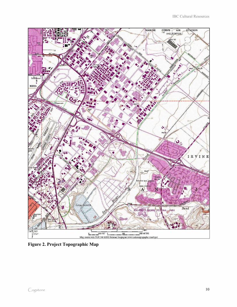
IBC Cultural Resources
Cogstone 10
Figure 2. Project Topographic Map
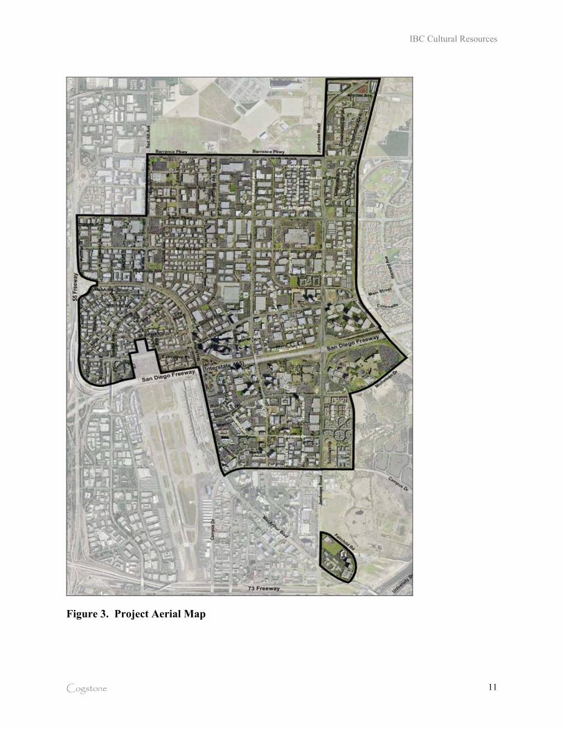
IBC Cultural Resources
Cogstone 11
Figure 3. Project Aerial Map
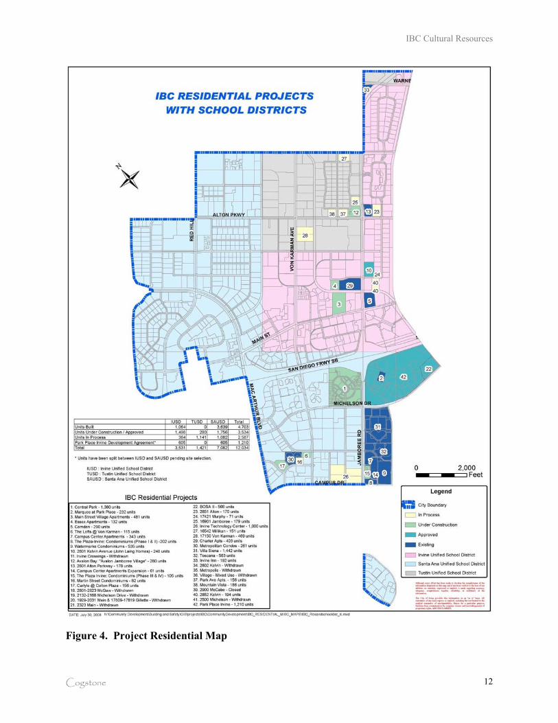
IBC Cultural Resources
Cogstone 12
Figure 4. Project Residential Map
IBC Cultural Resources
Cogstone 13
PROJECT PERSONNEL
Cogstone Resource Management conducted the cultural resource studies. Sherri Gust served as
the Principal Investigator for the project, performed the record search and research and wrote the
majority of the report. Gust is a Registered Professional Archaeologist and a Qualified Principal
Paleontologist. She has an M.S. in Anatomy (Evolutionary Morphology) from the University of
Southern California, a B.S. in Anthropology from the University of California at Davis and over
twenty-five years of experience in California.
Kim Scott provided the geological background and mapping for this report. Scott holds a B.S. in
Geology with an emphasis in Paleontology from the University of California, Los Angeles and
has more than 12 years of experience. Qualifications of staff are provided (Appendix A).
LAWS AND REGULATIONS
The following discussion of applicable federal and state laws has been excerpted and reordered
from the California Department of Transportation’s on-line Environmental Handbook (2001,
2003). The Irvine Business Complex Project is subject to state and local laws regarding cultural
resources.
CALIFORNIA ENVIRONMENTAL QUALITY ACT OF 1970
CEQA declares that it is state policy to "take all action necessary to provide the people of this
state with...historic environmental qualities." It further states that public or private projects
financed or approved by the state are subject to environmental review by the state. All such
projects, unless entitled to an exemption, may proceed only after this requirement has been
satisfied. CEQA requires detailed studies that analyze the environmental effects of a proposed
project. In the event that a project is determined to have a potential significant environmental
effect, the act requires that alternative plans and mitigation measures be considered.
CEQA includes historic and archaeological resources as integral features of the environment. If
IBC Cultural Resources
Cogstone 14
paleontological resources are identified as being within the proposed project area, the sponsoring
agency must take those resources into consideration when evaluating project effects. The level of
consideration may vary with the importance of the resource.
CALIFORNIA REGISTER OF HISTORICAL RESOURCES
Public Resources Code § 5024.1 establishes the California Register of Historical Resources. The
register is listing of all properties considered to be significant historical resources in the state.
The California Register includes all properties listed or determined eligible for listing on the
National Register, including properties evaluated under Section 106, and State Historical
Landmarks from No. 770 on. The criteria for listing are the same as those of the National
Register. The California Register statute specifically provides that historical resources listed,
determined eligible for listing on the California Register by the State Historical Resources
Commission, or resources that meet the California Register criteria are resources which must be
given consideration under CEQA (see above). Other resources, such as resources listed on local
registers of historic registers or in local surveys, may be listed if they are determined by the State
Historic Resources Commission to be significant in accordance with criteria and procedures to
be adopted by the Commission and are nominated; their listing in the California Register, is not
automatic.
Resources eligible for listing include buildings, sites, structures, objects, or historic districts that
retain historic integrity and are historically significant at the local, state or national level under
one or more of the following four criteria:
A) It is associated with events that have made a significant contribution to the broad patterns
of local or regional history, or the cultural heritage of California or the United States; B) It is associated with the lives of persons important to local, California, or national history;
C) It embodies the distinctive characteristics of a type, period, region, or method of
construction, or represents the work of a master or possesses high artistic values; or
D) It has yielded, or has the potential to yield, information important to the prehistory or history of the local area, California, or the nation.
IBC Cultural Resources
Cogstone 15
In addition to having significance, resources must have integrity for the period of significance.
The period of significance is the date or span of time within which significant events transpired,
or significant individuals made their important contributions. Integrity is the authenticity of a
historical resource’s physical identity as evidenced by the survival of characteristics or historic
fabric that existed during the resource’s period of significance. Alterations to a resource or
changes in its use over time may have historical, cultural, or architectural significance. Simply,
resources must retain enough of their historic character or appearance to be recognizable as
historical resources and to convey the reasons for their significance. A resource that has lost its
historic character or appearance may still have sufficient integrity for the California Register, if,
under Criterion D, it maintains the potential to yield significant scientific or historical
information or specific data.
LOCAL REGULATIONS
The City of Irvine General Plan includes Element E on Cultural Resources. It recognizes the
importance of historical, archaeological and paleontological resources in the City and establishes
a process for their early identification, consideration, and where appropriate, preservation. It
requires assessment of potential resources on projects and utilizes planning policies, ordinances,
approval conditions and mitigation measures to protect the resources.
ELEMENT E: CULTURAL RESOURCES
GOAL: Ensure the proper disposition of historical, archaeological, and paleontological resources to minimize
adverse impacts, and to develop an increased understanding and appreciation for the community’s historic
and prehistoric heritage, and that of the region.
Description of Cultural Resources: This element recognizes the importance of historical, archaeological, and paleontological resources in the City of Irvine, and establishes a process for their early identification, consideration, and where appropriate, preservation.
Paleontological Sensitivity Zones:
To develop Figure E-2, known fossil occurrences were identified and plotted. The locality information and past fossil production in adjacent areas was used to develop zones of similar paleontological potential or sensitivity. Four Paleontological sensitivity zones were developed to group rocks with similar paleontological potential. Each zone reflects the potential for the discovery of significant fossil resources during development of a site. The proposed use of the site does not greatly affect paleontological resources; it is the mass grading of sedimentary rocks associated with development that affects the fossils. The four sensitivity zones are:
IBC Cultural Resources
Cogstone 16
No Sensitivity: Areas in this zone contain exposed volcanic rocks.
Low Sensitivity: Areas in this zone typically have altered or geologically young rocks exposed at the surface.
Moderate Sensitivity: Areas within this zone contain sedimentary rocks with limited histories of producing significant fossils. The limited histories may reflect the lack of fossils or lack of systematic exploration of exposures of these rock units.
High Sensitivity: This zone contains sedimentary rocks with well established histories of containing significant fossils.
OBJECTIVE E-1: HISTORICAL, ARCHAEOLOGICAL, PALEONTOLOGICAL SURVEYS
Identify and obtain information on the existence and significance of historical, archaeological, and
paleontological sites and encourage land use planning which incorporates this formation. The following policies support Objective E-1:
Policy (a): Require appropriate surveys and necessary site investigations in conjunction with the earliest environmental document prepared for a project, in accordance with California Environmental Quality Act (CEQA) and the City’s CEQA procedures.
Policy (b): Require surveys, prior to discretionary approval, for areas where the possibility of encountering sites exists. Additional specific site investigations may also be required in order to obtain sufficient information to determine the site’s significance. The project sponsor shall fund this level of investigation.
Policy (c): Require a written report be submitted to the City following a survey or investigation describing the findings and making recommendations as to the site’s significance, future disposition, and the amount of further investigation which should be undertaken. Copies of site survey records and reports shall be filed with the appropriate clearinghouse.
Policy (d): Encourage, if appropriate, removal of all materials collected during the survey/investigation to local museums, universities, or other depositories providing access for public review or scientific research.
Policy (e): Funding of Archaeological Excavations: Use the following in the case of Archaeological excavations: 75% project sponsor; 25% City or other public or quasi-public agency or organization. The costs of other mitigation measures may also be shared by the landowner or developer, the City, and other agencies or organizations.
Policy (f): Maintain specific locations of unprotected sites as confidential information to avoid vandalism and the resultant irretrievable loss of the historic and prehistoric record of the community.
Policy (g): Maintain specific locations of unprotected sites as confidential information to avoid vandalism and the resultant irretrievable loss of the historic and prehistoric record of the community.
Policy (h): Determine the proper disposition of each historical site prior to approval of zoning or discretionary development applications. Disposition determinations shall be based on a detailed historical report, including an inventory form, a written evaluation, and slides documenting the building and its location. This information shall be reviewed by staff and the approval authority for discretionary development cases. Each historical report shall be filed at the Irvine Historical Museum and the City of Irvine Community Development Department.
Policy (i): Buffer and protect the integrity of a historic site and/or resources contained therein, if the Planning Commission, during review of a discretionary development case, determines preservation is required.
IBC Cultural Resources
Cogstone 17
OBJECTIVE E-2: HAZARD OCCURRENCE
Evaluate surveyed sites for their present and potential cultural, educational, recreational, and scientific value
to the community and the region, and determine their proper disposition prior to the approval of any project
which could adversely affect them. The following policies support Objective E-2:
Policy (a): Ensure that sites determined to be significant are protected through the City’s planning policies, ordinances, approval conditions, and mitigation measures.
Policy (b): Encourage the nomination of significant historical sites to the National Registry of Historic Places.
Policy (c): Include sites which are appropriate for educational or recreational purposes as an integral part of either public or community facilities or as part of the Citywide bikeway, pedestrian, and equestrian trail systems. Encourage agencies, organizations, and individuals to develop interpretive and educational programs in order to properly utilize the site for the benefit of the entire community.
Policy (d): Ensure that appropriate staff is available to act in matters relating to the implementation of this element to include identification of costs, and to coordinate the investigation and disposition of sites between City departments and Commissions, The Irvine Company, and other agencies, institutions, organizations, and individuals.
Policy (e): Determine the methods and means of preservation on a case-by-case basis according to a site’s importance and disposition methods available. These may include public or private acquisition or one of the following, provided extreme care is exercised not to adversely affect the site.
‚ Including the site within greenbelts, parks, open space spines, preservation areas or other open space.
‚ Covering surface or sub-surface sites by adequate fill, pavement, or buildings.
‚ Using the site for nondestructive public interest or educational purposes, such as museums, interpretive centers, or outdoor classrooms.
‚ Moving buildings for preservation as part of a consolidated historic site.
‚ Using significant historic buildings in a preserved state as a part of their functional capacity (e.g., a building preserved and used as an office, restaurant, or home).
Policy (f): Encourage site preservation through economic incentives such as increased building densities, reduced taxes, credit toward park dedication, or reduction of other amenity requirements. Where incentives are not sufficient, the land owner shall be directly compensated by the City or other public or quasi-public agencies or organizations for land preserved as an archaeological, paleontological, or historical site. The costs of site preservation may be the principal responsibility of the City, other public, or quasi-public agencies, or other organizations.
Policy (g): Ensure that adverse impacts of a proposed project on cultural resources are mitigated in accordance with CEQA, as well as other appropriate City policies and procedures, where preservation of a significant site is not practical.
Policy (h): Assign the Community Services Commission the responsibility to oversee implementation programs for sites or buildings which have been acquired by the City.
Policy (i): Identify and implement revenue sources which can be expended in support of this objective.
Policy (j): Undertake a comprehensive survey to inventory the remaining historical resources within the City of Irvine incorporated territory and adopted Sphere of Influence, including the location and significance of all
IBC Cultural Resources
Cogstone 18
remaining tenant farm homes over 50 years of age. This survey shall be used to determine the appropriate disposition of the resources located within any area not designated for preservation as a historical resource.
Planning Conditions
Prior to the issuance of the first preliminary or precise grading permit, and for any subsequent
permit involving excavation to increased depth, the applicant shall provide letters from an
archaeologist and a paleontologist. The letters shall state that the applicant has retained these
individuals, and that the consultant(s) will be on call during all grading and other significant
ground-disturbing activities. These consultants shall be selected from the roll of qualified
archaeologists and paleontologists maintained by the County of Orange. The archaeologist
and/or paleontologist shall meet with Community Development staff, and shall submit written
recommendations specifying procedures for cultural/scientific resource surveillance and for
developing mitigation plans for archaeological and paleontological resources. These
recommendations shall be reviewed and approved by the Director of Community Development
prior to issuance of the grading permit and prior to any surface disturbance on the project site.
Should any cultural/scientific resources be discovered, no further grading shall occur in the area
of the discovery until the Director of Community Development is satisfied that adequate
provisions are in place to protect these resources. (City of Irvine Standard Subdivision Condition
2.1) Specific measures that may be required include, but are not limited to, any of the measures
set forth in California Public Resources Code, Section 21083.2(i); monitored excavations;
permanent curation; and the preparation, identification and permanent preservation of recovered
specimens.
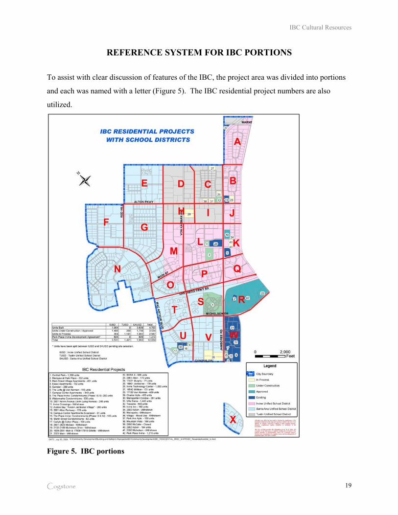
IBC Cultural Resources
Cogstone 19
REFERENCE SYSTEM FOR IBC PORTIONS
To assist with clear discussion of features of the IBC, the project area was divided into portions
and each was named with a letter (Figure 5). The IBC residential project numbers are also
utilized.
Figure 5. IBC portions
IBC Cultural Resources
Cogstone 20
PALEONTOLOGY
NATURAL SETTING
The physiographical, geological, and ecological zones represented in the project area are best
described as alluvial valleys of the Los Angeles basin. The basin is bounded to the north by the
Santa Monica Mountains, to the east by the Santa Ana Mountains and associated hills
(Puente/Chino, San Jose, and Repetto), to the south by the San Joaquin Hills and the Pacific
Ocean, and to the west by the Palos Verdes Hills and the Pacific Ocean.
GEOLOGIC SETTING
This area is part of the California geomorphic province known as the Penninsular Ranges. The
following discussion of the Penninsular Range Province is provided by the California Geologic
Survey (Wagner 2002):
“The Penninsular Ranges are a series of ranges separated by northwest trending
valleys, subparallel to faults branching from the San Andreas Fault. The trend of the
topography is similar to the Coast Ranges, but the geology is more like the Sierra
Nevada, with granitic rock intruding the older metamorphic rocks. the Penninsular
Ranges extend into lower Californian and are bound on the east by the Colorado
Desert, The Los Angeles Basin and the island group (Santa Catalina, Santa Barbara,
and the distinctly terraced San Clemente and San Nicholas islands), together with the
surrounding continental shelf (cut by deep submarine fault troughs) are included in this
province.”
STRATIGRAPHY
Several geologic units are mapped within the project boundary. The oldest material is late to
middle Pleistocene (500,000-10,000 years old) old paralic (coastal plain) deposits capped by
alluvial fan material (Morton et al. 2004; Figure 6). Adjacent to and possibly capping these
older deposits are Holocene to late Pleistocene (less than 120,000 years old) alluvial fan and
axial channel deposits.
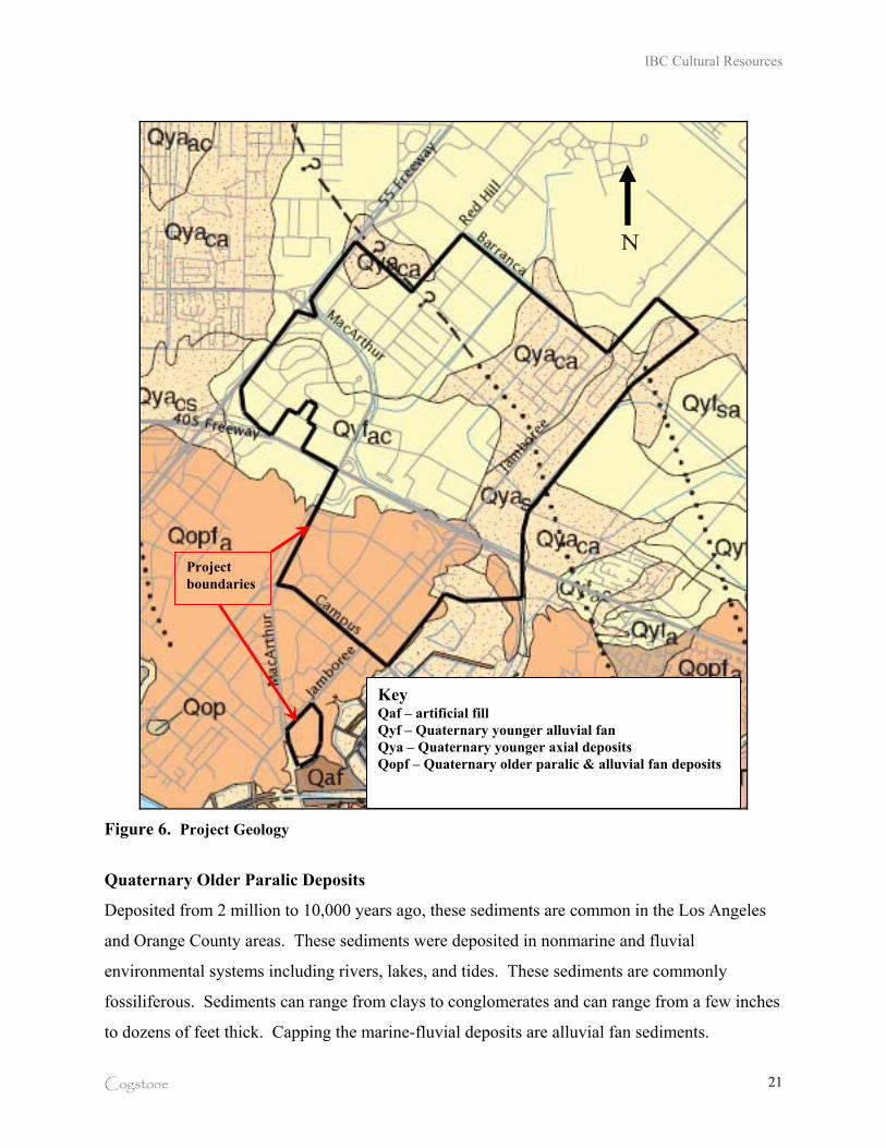
IBC Cultural Resources
Cogstone 21
Figure 6. Project Geology
Quaternary Older Paralic Deposits
Deposited from 2 million to 10,000 years ago, these sediments are common in the Los Angeles
and Orange County areas. These sediments were deposited in nonmarine and fluvial
environmental systems including rivers, lakes, and tides. These sediments are commonly
fossiliferous. Sediments can range from clays to conglomerates and can range from a few inches
to dozens of feet thick. Capping the marine-fluvial deposits are alluvial fan sediments.
Project
boundaries
Key Qaf – artificial fill
Qyf – Quaternary younger alluvial fan
Qya – Quaternary younger axial deposits
Qopf – Quaternary older paralic & alluvial fan deposits
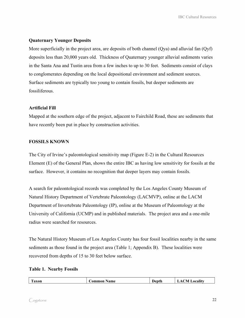
IBC Cultural Resources
Cogstone 22
Quaternary Younger Deposits
More superficially in the project area, are deposits of both channel (Qya) and alluvial fan (Qyf)
deposits less than 20,000 years old. Thickness of Quaternary younger alluvial sediments varies
in the Santa Ana and Tustin area from a few inches to up to 30 feet. Sediments consist of clays
to conglomerates depending on the local depositional environment and sediment sources.
Surface sediments are typically too young to contain fossils, but deeper sediments are
fossiliferous.
Artificial Fill
Mapped at the southern edge of the project, adjacent to Fairchild Road, these are sediments that
have recently been put in place by construction activities.
FOSSILS KNOWN
The City of Irvine’s paleontological sensitivity map (Figure E-2) in the Cultural Resources
Element (E) of the General Plan, shows the entire IBC as having low sensitivity for fossils at the
surface. However, it contains no recognition that deeper layers may contain fossils.
A search for paleontological records was completed by the Los Angeles County Museum of
Natural History Department of Vertebrate Paleontology (LACMVP), online at the LACM
Department of Invertebrate Paleontology (IP), online at the Museum of Paleontology at the
University of California (UCMP) and in published materials. The project area and a one-mile
radius were searched for resources.
The Natural History Museum of Los Angeles County has four fossil localities nearby in the same
sediments as those found in the project area (Table 1; Appendix B). These localities were
recovered from depths of 15 to 30 feet below surface.
Table 1. Nearby Fossils
Taxon Common Name Depth LACM Locality

IBC Cultural Resources
Cogstone 23
Mammoth Mammuthus sp. 15 ft LACMVP 1339
Camel Camelidae 15 ft LACMVP 1339
Turtle Testudinata 30 ft LACMVP 4219
Camel Camelidae 30 ft LACMVP 4219
Mammoth/mastodon Mammuthus or Mammut unknown LACMVP 3267
However, many fossils have been found within the IBC boundaries during City-required
paleontological monitoring (Figure 7). Those associated with IBC residential projects include
herbivores, carnivores, rabbits, rodents, birds, reptiles and amphibians (Table 2) (Commendador-
Dugeon et al 2006a & 2006b, DeBusk and Seckel 2007, DeBusk 2008, Gust and Scott 2009,
Lander 2008, Michalsky and Sample 2002, Scott and Gust 2008, Smith 2009). The herbivores
include mammoth, mastodon, giant ground sloth, bison, camel, llama, horse, tapir, peccary, deer,
pronghorn and dwarf pronghorn. The carnivores include bear, sabertoothed cat, jaguar, bobcat,
dire wolf, coyote, gray fox, raccoon, weasel, badger, skunk and sea otter. Birds known are
turkey vulture and duck. The smaller animals include many types of rabbits, rats, mice, gophers,
woodrats, moles, shrews, lizards, snakes and salamanders.
Figure 7. Mammoth skull from Central
Park West (IBC 1)
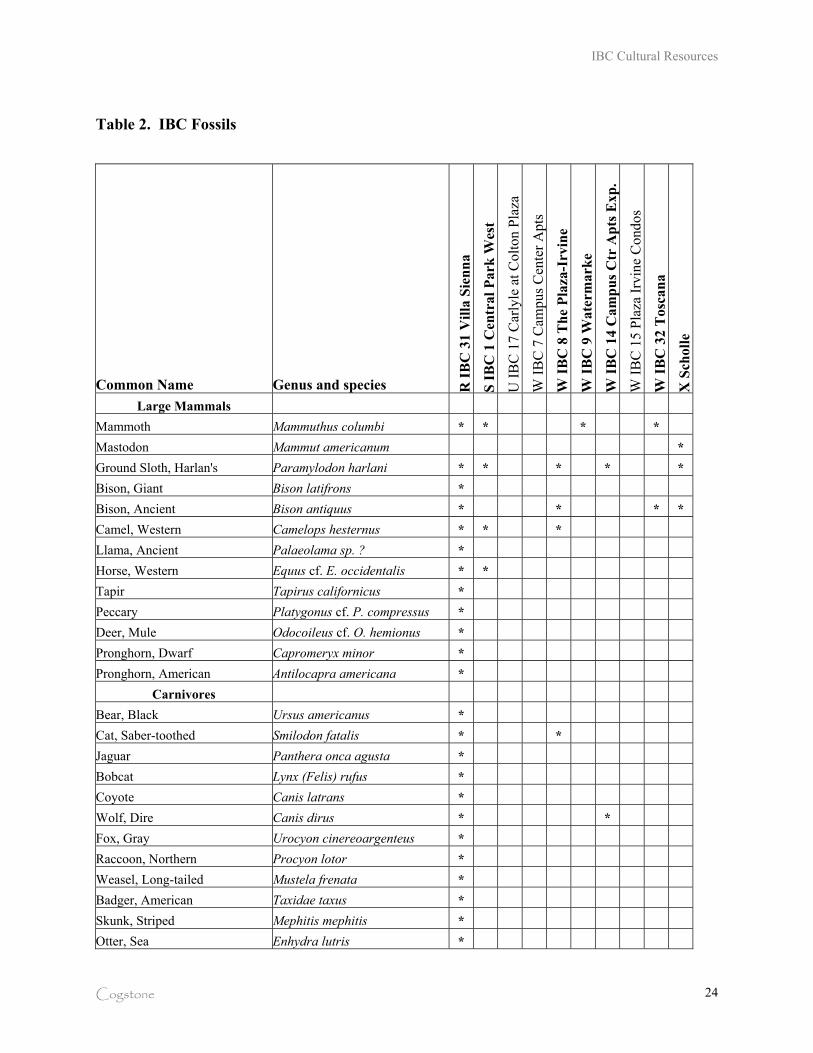
IBC Cultural Resources
Cogstone 24
Table 2. IBC Fossils
Common Name Genus and species R I
BC
31
Vil
la S
ien
na
S I
BC
1 C
entr
al
Pa
rk W
est
U I
BC
17
Car
lyle
at
Co
lto
n P
laza
W I
BC
7 C
amp
us
Cen
ter
Ap
ts
W I
BC
8 T
he
Pla
za-I
rvin
e
W I
BC
9 W
ate
rma
rke
W I
BC
14
Ca
mp
us
Ctr
Ap
ts E
xp
.
W I
BC
15
Pla
za I
rvin
e C
on
do
s
W I
BC
32
To
sca
na
X S
cho
lle
Large Mammals
Mammoth Mammuthus columbi * * * *
Mastodon Mammut americanum *
Ground Sloth, Harlan's Paramylodon harlani * * * * *
Bison, Giant Bison latifrons *
Bison, Ancient Bison antiquus * * * *
Camel, Western Camelops hesternus * * *
Llama, Ancient Palaeolama sp. ? *
Horse, Western Equus cf. E. occidentalis * *
Tapir Tapirus californicus *
Peccary Platygonus cf. P. compressus *
Deer, Mule Odocoileus cf. O. hemionus *
Pronghorn, Dwarf Capromeryx minor *
Pronghorn, American Antilocapra americana *
Carnivores
Bear, Black Ursus americanus *
Cat, Saber-toothed Smilodon fatalis * *
Jaguar Panthera onca agusta *
Bobcat Lynx (Felis) rufus *
Coyote Canis latrans *
Wolf, Dire Canis dirus * *
Fox, Gray Urocyon cinereoargenteus *
Raccoon, Northern Procyon lotor *
Weasel, Long-tailed Mustela frenata *
Badger, American Taxidae taxus *
Skunk, Striped Mephitis mephitis *
Otter, Sea Enhydra lutris *
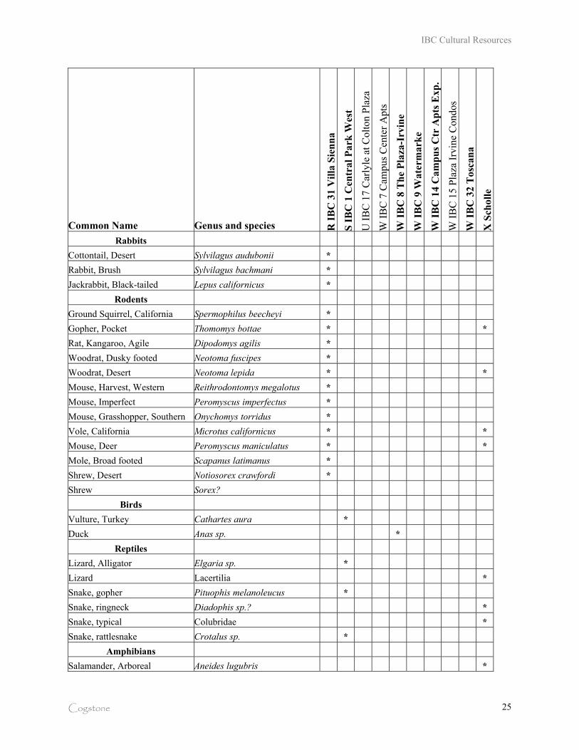
IBC Cultural Resources
Cogstone 25
Common Name Genus and species R I
BC
31
Vil
la S
ien
na
S I
BC
1 C
entr
al
Pa
rk W
est
U I
BC
17
Car
lyle
at
Co
lto
n P
laza
W I
BC
7 C
amp
us
Cen
ter
Ap
ts
W I
BC
8 T
he
Pla
za-I
rvin
e
W I
BC
9 W
ate
rma
rke
W I
BC
14
Ca
mp
us
Ctr
Ap
ts E
xp
.
W I
BC
15
Pla
za I
rvin
e C
on
do
s
W I
BC
32
To
sca
na
X S
cho
lle
Rabbits
Cottontail, Desert Sylvilagus audubonii *
Rabbit, Brush Sylvilagus bachmani *
Jackrabbit, Black-tailed Lepus californicus *
Rodents
Ground Squirrel, California Spermophilus beecheyi *
Gopher, Pocket Thomomys bottae * *
Rat, Kangaroo, Agile Dipodomys agilis *
Woodrat, Dusky footed Neotoma fuscipes *
Woodrat, Desert Neotoma lepida * *
Mouse, Harvest, Western Reithrodontomys megalotus *
Mouse, Imperfect Peromyscus imperfectus *
Mouse, Grasshopper, Southern Onychomys torridus *
Vole, California Microtus californicus * *
Mouse, Deer Peromyscus maniculatus * *
Mole, Broad footed Scapanus latimanus *
Shrew, Desert Notiosorex crawfordi *
Shrew Sorex?
Birds
Vulture, Turkey Cathartes aura *
Duck Anas sp. *
Reptiles
Lizard, Alligator Elgaria sp. *
Lizard Lacertilia *
Snake, gopher Pituophis melanoleucus *
Snake, ringneck Diadophis sp.? *
Snake, typical Colubridae *
Snake, rattlesnake Crotalus sp. *
Amphibians
Salamander, Arboreal Aneides lugubris *
IBC Cultural Resources
Cogstone 26
The IBC fossils were recovered at depths of 8 to 25 feet below the surface. Most of these fossils
have been associated with an olive-green clay layer and sandy silt sediments above and below
the clay. These fossiliferous sediments have been encountered between 6 to 25 feet below the
modern surface over a wide area of Irvine. A project on IBC portion W called Forest City
recovered mammoth/mastodon, horse and bison in association with dark, gray-green clay in
1990 (Smith 2009).
Some IBC residential projects have not encountered these sediments due to the inconsistent
depth at which the fossiliferous sediments are present. For example, grading at Carlyle (IBC 17)
went to approximately 15 feet below the surface but the olive-green clay was at 18 feet
(according to geotechnical boring logs) and thus no fossils were recovered. No fossils were
recovered during monitoring for the Campus Center Apartments (IBC 7) or the Plaza Irvine
Condominiums (IBC 15) either.
Outside of the project area but nearby, additional fossils have been recovered. The IBC fossils
and these nearby ones can be combined into a single fossil locality – the San Joaquin Marsh
Fauna. This name unifies the fossils and acknowledges why the area was attractive to animals.
The known fossils are all from the Pleistocene Epoch and represent the last Ice Age (40-10
thousand years ago. Radiocarbon dates obtained have ranged from 25 to 8.5 thousand years
before the present. It is extremely likely that these dates are erroneously young by a few
thousand years since carbon has known tendency to migrate downward in the water column
when subjected to repeated incursions of water such as flooding or seasonal water collection in
lowlands.
Only 8 IBC residential project paleontology reports could be located. The fossils from IBC 8
and 14 (portion W, The Plaza-Irvine and Campus Center Apts. Expansion) are at the Natural
History Museum of Los Angeles County but have not yet been accessioned (S. McLeod,
Collection Manager, personal communication, 2009). The fossils from IBC 1 (portion S, Central
Park West) are at the Museum of Paleontology, California State University at San Bernardino,
IBC Cultural Resources
Cogstone 27
awaiting project completion before accessioning (Stuart Sumida, Museum Director, CSUSB,
personal communication, 2009).
All other fossils known from IBC are in the possession of the consultant who collected them. No
reports have been written or filed with the City for these projects and the fossils have not been
submitted to a museum for curation. Reports for other IBC projects could not be located. Since
both reports and curation are required by existing City policy and project conditions, there is a
clear procedural problem that must be addressed.
CONCLUSIONS
Scientifically important fossils are being recovered from the IBC and many other areas of Irvine
at depths of six feet or more below the surface. There is a procedural failure to document that
adequate reports are being written and submitted and that fossils are sent to museums for
curation.
IBC Cultural Resources
Cogstone 28
ARCHAEOLOGY
PREHISTORIC SETTING
Natural Environment
The project area consisted open lagoon, estuary and seasonal freshwater wetlands surrounded by
coastal plain (Figure 8). Freshwater sources were natural springs, runoff from the Santa Ana
Mountains, seasonal flooding of the Santa Ana River and pooling of rainwater in lowland areas.
Paleoclimatic data based on pollen from coastal sites indicates that there was a dramatic increase
in both annual temperature and precipitation between 8000 and 7000 BP, which would have lead
to a rich marsh habitat locally. Subsequently, by 7000 BP, sea levels were 10-15 m below
current levels, and the shore line was at least 500 m further off shore than today (Altschul et al
2007).
Modern San Diego “Creek” is a man-made channel created after 1920 (not present on 1919
maps; also see Figure 6) but before 1930. On 1930 maps it is depicted as Peter Canyon Channel
until it crossed Delhi Road (now Barranca) when it became Delhi Channel (Blackburn 1930).
Historical land use was primarily agricultural but numerous shooting clubs were present in
association with seasonal ponds. The project area began to be urbanized in the early 1970s.
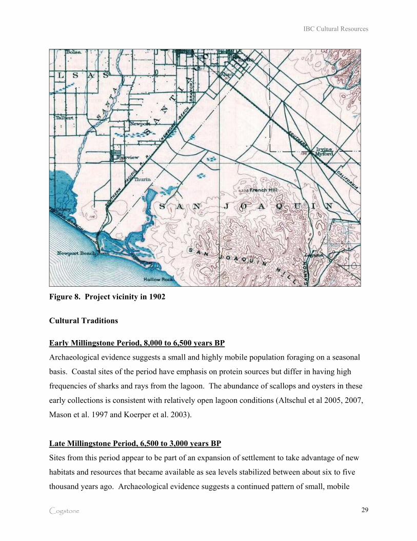
IBC Cultural Resources
Cogstone 29
Figure 8. Project vicinity in 1902
Cultural Traditions
Early Millingstone Period, 8,000 to 6,500 years BP
Archaeological evidence suggests a small and highly mobile population foraging on a seasonal
basis. Coastal sites of the period have emphasis on protein sources but differ in having high
frequencies of sharks and rays from the lagoon. The abundance of scallops and oysters in these
early collections is consistent with relatively open lagoon conditions (Altschul et al 2005, 2007,
Mason et al. 1997 and Koerper et al. 2003).
Late Millingstone Period, 6,500 to 3,000 years BP
Sites from this period appear to be part of an expansion of settlement to take advantage of new
habitats and resources that became available as sea levels stabilized between about six to five
thousand years ago. Archaeological evidence suggests a continued pattern of small, mobile
IBC Cultural Resources
Cogstone 30
foraging groups. Sites are dominated by shellfish (Altschul et al 2005, 2007). Gorges were used
for fishing and mano/metate pairs were used to process plant materials. Most sites were in
coastal areas (Mason et al. 1997 and Koerper et al. 2003).
Intermediate Period, 3000 to 1000 years BP
Archaeological sites indicate the continuation of small, mobile foraging groups early in this
period but later sites were relatively large and contain hearths, mortuary features, and houses.
The later sites reflect a much broader strategy that targeted terrestrial mammals and birds from
the freshwater marsh and coastal prairies, as well as fish and shellfish. The emergence of venus
clam (Chione) as the predominant shellfish in almost all collections is consistent with the
expansion of mudflats at this time (Altschul et al 2005, 2007). The first circular fish hooks
appear in the tool kit in this period and use of plant grinding tools increases. Hunting tools
consist of the atlatl and dart (Mason et al. 1997 and Koerper et al. 2003).
Late Period, 1000 years BP to contact
Environmental change caused constriction of Upper Newport Bay and expansion of fresh water
wetlands in the low-lying San Joaquin Marsh area. In this period the atlatl and dart hunting tools
are replaced by the bow and arrow. A portion of the mano/metate inventory was gradually
replaced by pestle/mortars. Use of other traditional tools continues. Settlement was expanded
into the hills and canyons inland (Mason et al. 1997 and Koerper et al. 2003).
ETHNOGRAPHY
Archaic Culture
The nature of Native American cultural systems older than 3000 years before present in southern
California remains poorly defined. Recently, it has been proposed that there may have been
periodic movement of desert peoples into coastal areas as far back as 8,000 years before present
(Altschul et al 2007).
IBC Cultural Resources
Cogstone 31
Tongva (Gabrielino) Culture
The project area was within the territory of the Tongva (McCawley 1996) beginning
approximately 3000 years before present. The name “Gabrielino” is Spanish in origin and was
used in reference to the Native Americans associated with the Mission San Gabriel. It is
unknown what these people called themselves before the Spanish arrived, but today they call
themselves “Tongva”, meaning “people of the earth” (Gabrielino/Tongva Tribal Council of San
Gabriel n.d.).
The Tongva/Gabrielino speak a language that is part of the Takic language family originating in
the Great Basin. Their prehistoric tool kit demonstrates strong links to other desert peoples
(Altschul et al 2005, 2007). Their territory encompassed a vast area stretching from Topanga
Canyon in the northwest, to the base of Mount Wilson in the north, to San Bernardino in the east,
Aliso Creek in the southeast and the Southern Channel Islands, in all an area of more than 2,500
square miles (McCawley 1996). At European contact, the tribe consisted of more than 5,000
people living in various settlements throughout the area. Some of the villages could be quite
large, housing up to 150 people.
As summarized by Bean and Shipek (1978), plant foods were, by far, the greatest part of the
traditional diet at contact. Acorns were the most important single food source; two species were
used locally. Villages were located near water sources necessary for the leaching of acorns,
which was a daily occurrence. Grass seeds were the next most abundant plant food used. Other
important seeds were manzanita, sunflower, sage, chia, lemonade berry, wild rose, holly-leaf
cherry, prickly pear, lamb’s-quarter, and pine nuts. Seeds were parched, ground, and cooked as
mush in various combinations according to taste and availability, much in the manner as
weewish. Greens such as thistle, lamb’s-quarters, miner’s lettuce, white sage, and clover were
eaten raw or cooked or sometimes dried for storage. Cactus pods and fruits were used.
Thimbleberries, elderberries, and wild grapes were eaten raw or dried for later cooking. Cooked
yucca buds, blossoms, and pods provided a sizable addition to the community’s food resources.
Bulbs, roots, and tubers were dug in the spring and summer and usually eaten fresh. Mushrooms
and tree fungus provided a significant food supplement and were prized as delicacies. Various
teas were made from flowers, fruits, stems, and roots for medicinal cures as well as beverages.
IBC Cultural Resources
Cogstone 32
The principal game animals were deer, rabbit, jackrabbit, woodrat, mice, ground squirrels,
antelope, quail, dove, ducks, and other birds. Most predators were avoided as food, as were tree
squirrels and most reptiles. Trout and other fish were caught in the streams, while salmon were
available when they ran in the larger creeks. Marine foods were extensively utilized. Sea
mammals, fish, and crustaceans were hunted and gathered from both the shoreline and the open
ocean, using reed and dugout canoes. Shellfish were the most common resource, including
abalone, turbans, mussels, clams, scallops, bubble shells, and others.
HISTORIC SETTING
The project area was part of lands under the control of Mission San Juan Capistrano founded in
1776. It was most likely used for grazing animals. After 1833, the missions lost ownership of
their lands and they were redistributed by the government. The project area lies partially in two
of the large Mexican land grants. The first is Rancho San Joaquin, a land grant issue to Don Jose
Sepulveda in 1837. The ranch was developed for ranching cattle and sheep. The land grant
issued by the Mexican government incorporated approximately 50,000 acres of the former San
Juan Capistrano mission lands. In 1864 Jose Sepulveda sold the rancho to Flint, Bixby & Co.
(Liebeck 1988).
The second is Rancho Santiago de Santa Ana, the oldest Mexican land grant in the region, issued
to Jose Antonio Yorba, a soldier with the Portola expedition of 1769, and his nephew Juan
Peralta. The land grant was for an area encompassing some 62,516 acres, and stretched west
from the eastern flanks of the Santa Ana Mountains to the ocean with the north and northwestern
boundary formed by the east bank of the Santa Ana River. The Yorbas and Peraltas developed
the rancho primarily for cattle grazing and agriculture and eventually the rancho supported at
least 33 historic adobes. In 1866 the Yorbas and Peraltas sold their ranch to Flint, Bixby & Co
(Liebeck 1988).
In 1876, James Irvine bought out his partners in Flint, Bixby and Co. and became the sole owner
of the Irvine Ranch. It continued to be largely a ranching operation for many years. James
IBC Cultural Resources
Cogstone 33
Irvine Jr. transitioned the ranch from cattle raising to agriculture. He drilled wells and developed
the Irvine Ranch water system including Irvine Lake to support the farming operations. In 1887
the San Bernardino and San Diego Railroad, a subsidiary of Santa Fe, laid rail tracks across the
ranch. Buildings to process and pack the ranch agriculture products were built next to the tracks.
[Cleland 1952, Liebeck 1988]
ARCHAEOLOGICAL RESOURCES KNOWN
A search for archaeological records was completed at the South Central Coast Information
Center, California State University Fullerton, Orange County, California. The project area and a
one-mile radius around the project boundaries were searched.
There are 3 recorded sites within the project area. There are 22 archaeological sites known
within a one-mile radius of the project area; mostly to the east and south (Table 3). [Note: The
Information Centers have moved from trinomials (CA-ORA-51) to primary numbers (P-30-51)
for sites. Isolates are separated from sites by the new numbering system (for example, all begin
P-30-100xxx). Buildings are also separated by the new numbering.]
Some 70 archaeological studies (Table 4) are on file for projects within the project boundaries
and a one-mile radius. Assessments account for 23 reports, excavations for 9, monitoring reports
for 10 and wireless projects number 28. Only 29 IBC residential projects have assessment
reports on file and only 7 have monitoring reports (Table 5).
Table 3. Recorded archaeological and historic sites within one-mile radius of the project
Reference P-30-
Site Type Proximity
Date
000051 Prehistoric habitation with Burials (incl. 77) Vicinity project boundaries 1949
000115 Prehistoric habitation Vicinity project boundaries 1963
000116 Prehistoric habitation Vicinity project boundaries 1963
000117 Prehistoric habitation Mile radius 1963
000118 Prehistoric habitation Mile radius 1963
000119 Prehistoric habitation Mile radius 1963
IBC Cultural Resources
Cogstone 34
Reference P-30-
Site Type Proximity
Date
000121 Prehistoric Habitation with Burials (incl. 284, 287) Within project boundaries 1966
000195 Prehistoric Habitation with Burials Within project boundaries 1967
000196 Prehistoric Habitation with Burials Within project boundaries 1967
000197 Prehistoric habitation Vicinity project boundaries 1967
000373 Prehistoric Habitation with Burials Mile radius 1972
000348 Prehistoric habitation (incl. 112) Vicinity project boundaries 1972
000351 Prehistoric habitation Vicinity project boundaries 1972
000508 Prehistoric habitation Mile radius 1975
000552 Prehistoric habitation Mile radius 1975
000575 Prehistoric habitation Mile radius 1975
001488 Historic trash scatter; some prehistoric frags Vicinity project boundaries 1997
100161 Historic isolate, flow blue ceramic frag. Vicinity project boundaries 1997
100162 Prehistoric isolate, mano Vicinity project boundaries 1997
100163 Historic isolate, flow blue ceramic frag. Vicinity project boundaries 1997
100164 Historic isolate, flow blue ceramic frag. Vicinity project boundaries 1997
100165 Two isolates, unid bone and white ceramic Vicinity project boundaries 1997
100166 Historic bone and tooth frags of horse Vicinity project boundaries 1997
100167 Prehistoric isolate, mano, broken Vicinity project boundaries 1997
176837 Army Reserves Center and Mechanic Shop Vicinity project boundaries 2006
Table 4. Previous studies within a one-mile radius of the project (Type: A=assessment, E=excavation, M=monitoring, W=wireless)
Author Type Ref Title Date
Mabry, Theo N. A OR0441 Archaeological Records Search and Reconnaissance Survey: Main Street / Jamboree Road, Irvine, California 1979
Stickel, Gary E., and Jerry B. Howard A OR0574
Final Report of A Cultural Resource Survey of the University of California, Irvine 1976
Padon, Beth A OR0726 Archaeological Field Review: Village 19a Project, City of Irvine, California 1984
Brock, James P. A OR0774
Archaeological, Paleontological, and Historical Resources Assessment Report for the UC Irvine North Campus Property 1985
Padon, Beth A OR0847 Archaeological Resource Inventory: City of Irvine and Its Sphere of Influence 1985
Padon, Beth A OR0856 Archaeological and Paleontological Field Review: Irvine Business Complex, City of Irvine N/A
Bissell, Ronald M. A OR0863
Cultural Resources Reconnaissance of Jamboree Center, Phase 2, Irvine, Orange County, California 1987
Jertberg, Patricia R. A OR0969 Cultural Resource Assessment: Jamboree Road Widening 1989
Leonard, Nelson N. III A OR1016
Environmental Impact Evaluation: Route Alternates Between the Michelson Treatment Plant and Plants on the 1975
IBC Cultural Resources
Cogstone 35
Author Type Ref Title Date
Santa Ana River, Orange County, California
Cooley, Theodore G. A OR1099
Archaeological Resources Assessment Conducted for Proposed Irvine Ranch District Pipeline Right of Ways 1979
Marmor, Jason D. A OR1120
Historic Architectural Survey Report for a Segment of McArthur Boulevard and Pacific Coast Highway to University Drive, Newport Beach/Irvine, Orange County, California 1991
Rosenthal, Jane A OR1170 Addendum to Cultural Resources Assessment, Jamboree Road Widening, Irvine, California 1991
Conkling, Steve A OR1396
Cultural Resources Assessment: Warner Avenue Bridge Over Peters Canyon Channel, Tustin, Orange County, California 1994
Whitley-Desautels, Nancy A. & David A. Kice A OR1413
Cultural Resources Assessment of the Irvine Ranch Water District Alternate Aqueous Waste Disposal Facility Sites, Orange County, California 1993
McKenna, Jeanette A. A OR1815
Historic Property Survey Report: Negative Findings at Alton Avenue/State Route 55 Improvements, Cities of Santa Ana and Irvine, Orange County, California 1995
Getchell, Barbie Stevenson and John E. Atwood A OR1883
Cultural Resources Survey of a 46-Acre Portion of the San Joaquin Freshwater Marsh Reserve, Irvine, Orange County, California 1998
Wlodarski, Robert J. A OR2013
Negative Archaeological Survey Report on the Construction of a Transitway in the Median of Interstate 405 1990
Atchley, Sara M. A OR2200
Cultural Resources Investigation for the Nextlink Fiber Optic Project, Los Angeles and Orange Counties, California 2000
Demcak, Carol R. A OR2256 Cultural Resource Assessments for Orange County Sanitation Districts 1999
Cottrell, Marie G. A OR2349
Archaeological Survey of Irvine Ranch Water District Pipeline Route EA No. 176009, Warner Avenue Water Main 1977
Webb, Lois M. and Gene Huey A OR2533
07-ORA-405 PM 7.4 Overcrossing, Historic Property Survey, 07210-249011 1977
Schneeberger, Sandra L., Mark Roeder, & Beth Padon A OR3353
Paleontological Resource Assessment Report of a ~3.5 Acre Site, Located at 18880 Douglas Drive, 92612 for the Carlyle Project, A Part of the Irvine Business Center, Development APN #445-013-02 2006
Schneeberger, Sandra L., Christopher Drover, & Corry Schulga A OR3354
Phase I Archaeological Resource Survey of a ~3.5 Acre Site, Located at 18880 Douglas Drive, City of Irvine, County of Orange, California, 92612 for the Carlyle Project, A Part of the Irvine Business Center Development, APN #445-013-02 2006
Ellis, Robert R. E OR0353 Archaeological Test Excavations at Site ORA-121, Orange County, California 1973
Desautels, Roger E OR0362 Archaeological Report: CA-ORA-195, Orange County, California 1967
Clevenger, Joyce E OR0399
Archaeological Salvage Program At Locus B and the Peripheral Sector of Locus A, ORA-121, Irvine, California 1979
Clevenger, Joyce E OR1124 Archaeological Investigations at CA-ORA-287: A Multicomponent Site on Newport Bay 1986
IBC Cultural Resources
Cogstone 36
Author Type Ref Title Date
Cottrell, Marie G. E OR1501 Archaeological Investigations Conducted at CA-ORA-196, Irvine, California 1979
Cottrell, Marie G. E OR1503 Test Level Investigations Conducted at Archaeological Site CA-ORA-197 1976
Strudwick, Ivan E OR2448 Results of Archaeological Testing at Site CA-ORA-121, Locus C, near Upper Newport Bay, Orange County, CA 1999
Crownover, S., B. Padon, & J. Rosenthal E OR2480
Archaeological Investigations at CA-ORA-121, Orange County, California 1990
Strudwick, Ivan E OR3242
Results of Cultural Resource Shovel Test Pit Excavation for the Carlson Marsh Regrade Project (IRWD Project #20173; LSA Project #IRW330) 2004
Jertberg, Patricia R. M OR0997
Archaeological Monitoring for Tentative Parcel No. 88-151, Lots 1, A, 3, 4, and 5 1990
Padon, Beth M OR1814 Archaeological Monitoring Report for One Park Place, Orange County 1994
Padon, Beth M OR1942 Archaeological Resource Archival Review and Monitoring for the Lake Shore Towers Project 1999
Duke, Curt and D. McLean M OR1943
Results of Archaeological Monitoring for the San Joaquin Marsh Enhancement Plan Project, City of Irvine, Orange County, California 1998
Padon, Beth M OR3204
Archaeological and Paleontological Monitoring at the Campus Center Multi-Family Apartments Expansion, Building C, in the City of Irvine 2006
Commendador-Dudgeon, Amy, Beth Padon, and J. D. Stewart M OR3261
Archaeological and Paleontological Monitoring for the Plaza Irvine Development, Phase 1, City of Irvine, Orange County, California 2006
Arrington, Cindy & Nancy Sikes M OR3373
Cultural Resources Final Report of Monitoring and Findings for the Qwest Network Construction Project, State of California: Volumes I and II 2006
Brown, Joan C. M OR3499 Cultural Resources Monitoring for the Irvine Plaza III Project, City of Irvine, Orange County, California 2007
Brown, Joan C. M OR3704 Cultural Resources Monitoring for the Irvine Plaza IV Project, City of Irvine, Orange County, California 2008
Padon, Beth M OR3726
Cultural Resources Monitoring for the Clinical Laboratory Replacement Building – UCI Medical Center, University of California, Irvine 2008
Demcak, Carol R. W OR1526 Report of Archaeological Survey for L.A. Cellular Site #185, Cowan, Irvine, Orange County 1996
Brechbiel, Brant A. W OR1784
Cultural Resources Search and Literature Review Report for A Pacific Bell Mobile Services Telecommunications Facility: CM 092-26 in the City of Irvine, California 1998
Brechbiel, Brant A. W OR1785
Cultural Records Search and Literature Review Report for A Pacific Bell Mobile Services Telecommunications Facility: CM 005-15 1998
Bonner, Wayne H. W OR1880
Cultural Resources Monitoring: L.A. Cellular Site 657.1, Irvine, California 1998
Duke, Curt W OR1973
Cultural Resource Assessment for Pacific Bell Mobile Services Facility CM 485-01, in the County of Orange, California 1999
Duke, Curt W OR1986 Cultural Resource Assessment for Pacific Bell Mobile Services Facility CM 485-02, County of Orange, 1999
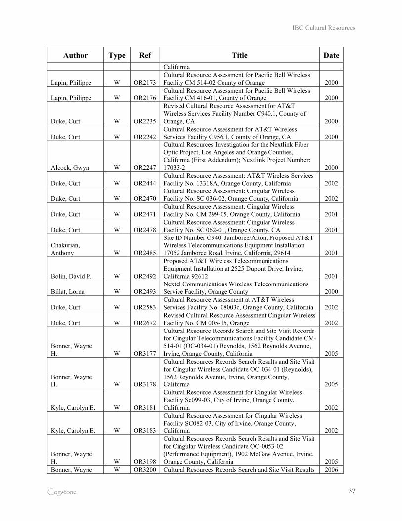
IBC Cultural Resources
Cogstone 37
Author Type Ref Title Date
California
Lapin, Philippe W OR2173 Cultural Resource Assessment for Pacific Bell Wireless Facility CM 514-02 County of Orange 2000
Lapin, Philippe W OR2176 Cultural Resource Assessment for Pacific Bell Wireless Facility CM 416-01, County of Orange 2000
Duke, Curt W OR2235
Revised Cultural Resource Assessment for AT&T Wireless Services Facility Number C940.1, County of Orange, CA 2000
Duke, Curt W OR2242 Cultural Resource Assessment for AT&T Wireless Services Facility C956.1, County of Orange, CA 2000
Alcock, Gwyn W OR2247
Cultural Resources Investigation for the Nextlink Fiber Optic Project, Los Angeles and Orange Counties, California (First Addendum); Nextlink Project Number: 17033-2 2000
Duke, Curt W OR2444 Cultural Resource Assessment: AT&T Wireless Services Facility No. 13318A, Orange County, California 2002
Duke, Curt W OR2470 Cultural Resource Assessment: Cingular Wireless Facility No. SC 036-02, Orange County, California 2002
Duke, Curt W OR2471 Cultural Resource Assessment: Cingular Wireless Facility No. CM 299-05, Orange County, California 2001
Duke, Curt W OR2478 Cultural Resource Assessment: Cingular Wireless Facility No. SC 062-01, Orange County, CA 2001
Chakurian, Anthony W OR2485
Site ID Number C940_Jamboree/Alton, Proposed AT&T Wireless Telecommunications Equipment Installation 17052 Jamboree Road, Irvine, California, 29614 2001
Bolin, David P. W OR2492
Proposed AT&T Wireless Telecommunications Equipment Installation at 2525 Dupont Drive, Irvine, California 92612 2001
Billat, Lorna W OR2493 Nextel Communications Wireless Telecommunications Service Facility, Orange County 2000
Duke, Curt W OR2583 Cultural Resource Assessment at AT&T Wireless Services Facility No. 08003c, Orange County, California 2002
Duke, Curt W OR2672 Revised Cultural Resource Assessment Cingular Wireless Facility No. CM 005-15, Orange 2002
Bonner, Wayne H. W OR3177
Cultural Resource Records Search and Site Visit Records for Cingular Telecommunications Facility Candidate CM-514-01 (OC-034-01) Reynolds, 1562 Reynolds Avenue, Irvine, Orange County, California 2005
Bonner, Wayne H. W OR3178
Cultural Resources Records Search Results and Site Visit for Cingular Wireless Candidate OC-034-01 (Reynolds), 1562 Reynolds Avenue, Irvine, Orange County, California 2005
Kyle, Carolyn E. W OR3181
Cultural Resource Assessment for Cingular Wireless Facility Sc099-03, City of Irvine, Orange County, California 2002
Kyle, Carolyn E. W OR3183
Cultural Resource Assessment for Cingular Wireless Facility SC082-03, City of Irvine, Orange County, California 2002
Bonner, Wayne H. W OR3198
Cultural Resources Records Search Results and Site Visit for Cingular Wireless Candidate OC-0053-02 (Performance Equipment), 1902 McGaw Avenue, Irvine, Orange County, California 2005
Bonner, Wayne W OR3200 Cultural Resources Records Search and Site Visit Results 2006
IBC Cultural Resources
Cogstone 38
Author Type Ref Title Date
H. for Cingular Wireless Candidate LSANCAT016 (Construction Circle), 16291 Construction Circle, Irvine, Orange County, California
Bonner, Wayne H. W OR3203
Cultural Resource Management Records Search and Site Visit Results for Cingular Telecommunications Facility Candidate CM-092-01 (OC-005-01) Schiffman Enterprises, 17462 Von Karman Avenue, Irvine, Orange County, California 2005
Bonner, Wayne H. W OR3476
Cultural Resource Records Search and Site Visit Results for Royal Street Communications, LLC, Candidate LA2512A (Murphy & Corporate Park), 2802 Barranca Park Way, Irvine, Orange County, California 2007
Table 5. Project Report Presence List
IBC
Residential
Projects Assessment Reports on File Monitoring Reports on File
1 1880 in prep
2
3
4
5 969, 3373
6
7 2496, 2448
8 2630 3261
9 2630, 2495, 2496, 2448
10 1099
12 1099
13 246, 1099
14 2630, 2448 3204
15 2630, 3499 3499, 3704
16 246, 3353, 3354
17 3353, 3354 in prep
18 1099
22 285
23
24 246
25 1099
26 246
27 1099
28
29 1099
30 246, 3353, 3354
31 1785, 1814, 2448 1814
32 2448
33 1413 997
IBC Cultural Resources
Cogstone 39
IBC
Residential
Projects Assessment Reports on File Monitoring Reports on File
34 969
35 3373
37 246
38 246
40 submitted; waiting filing
42 1099, 1170
NATIVE AMERICAN CONSULTATION
A sacred lands record search was requested from the Native American Heritage Commission on
April 30, 2008. On May 1, the Commission replied that there were no known sacred lands
within the project boundaries (Appendix C). The Commission recommended further
consultation with twelve contacts including tribes and individuals. Letters requesting
information on any heritage sites were sent to all contacts on May 5, 2008. Sam Dunlap, of the
Gabrielino Tongva Nation, responded that the general area was known to be sensitive for
prehistoric resources. No other contacts responded.
PROJECT ARCHAEOLOGICAL SITES
Only IBC portions R and W have recorded archaeological sites. These are CA-ORA-195 and
196 in portion R and CA-ORA-121 in portion W. Two additional sites (CA-ORA-284 & 287)
were later recorded but represent remnants of site 121 and are therefore considered as portions of
that site. Portions of 196 under the parking lot on IBC 22 may be intact. The other two sites
appear to be substantially destroyed.
Site 195
Site 195 was mostly destroyed by construction of the Jamboree eastern on-ramp of the 405
freeway in 1967. Salvage excavations were conducted for Caltrans (OR-362). Later additional
excavations into the remaining portion of the site were conducted in 1974 (OR-1503). The site
was on a knoll rising above the wetlands to the south and east. It appears to have been occupied
over a considerable period of time as artifacts were found in association with the clay mentioned
IBC Cultural Resources
Cogstone 40
in the paleontology section of this report. However, radiocarbon dates indicated that most of the
site was deposited between 5 to 1 thousand years before present. The site contained sixteen
burials, eleven cooking features, numerous ground and chipped stone tools, ornaments and
ceremonial objects and a large variety of food refuse. Food items were primarily clams and
scallops from mudflats plus small sharks and some fish. The younger levels of the site had less
shark and fish and more shellfish. Most land animal bones were recovered were from rabbits.
Site 195 was associated with a historic ranch (OR-362). Twentieth century debris including
domestic animal bone was recovered in superficial levels of the site salvage excavations. None
of the historic ranch buildings or features were recorded before demolition by Caltrans.
Site 196
The portion of Site 196 within the project area was destroyed in the early 1970s by development
of Michelson Drive and the Fluor Building. Testing and data recovery excavations were
conducted in the remaining portion in 1976 and 1979 (OR-1503, 1501). This site was also
situated on a knoll. The results demonstrate similarity to 195 including the same types of
features including three burials, contemporaneous time periods represented and similar artifacts.
The portion of the site with burials was preserved in place and exempted from future
development activities.
Site 196 had 19th Century debris, was thought to be the location of a Mission San Juan
Capistrano outpost dating to the 1820s and subsequently home to Jose Sepulveda (OR-1503).
Surface collection and excavations failed to reveal any remnant of buildings but did recover
typical trash of the period including brownware pottery (Chace 1969).
Site 121
Site 121 originally occupied most of IBC portion W. This discussion includes P-30-284 and 287
as components of 121 based on their originally mapped locations. The site was been destroyed
by development activities subsequent to extensive archaeological testing and data recovery
excavations (OR-353, 399, 1124, 2448, 2480). The area continues to yield bits of shell in
disturbed matrix but these are not scientifically significant.
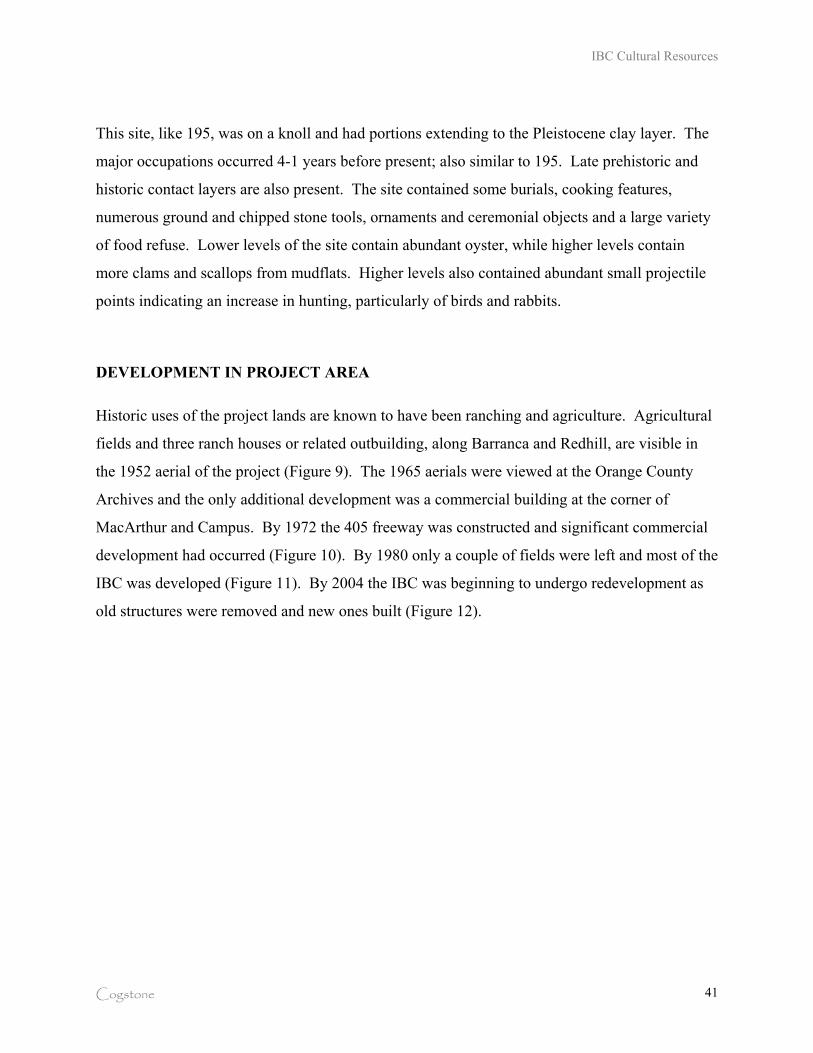
IBC Cultural Resources
Cogstone 41
This site, like 195, was on a knoll and had portions extending to the Pleistocene clay layer. The
major occupations occurred 4-1 years before present; also similar to 195. Late prehistoric and
historic contact layers are also present. The site contained some burials, cooking features,
numerous ground and chipped stone tools, ornaments and ceremonial objects and a large variety
of food refuse. Lower levels of the site contain abundant oyster, while higher levels contain
more clams and scallops from mudflats. Higher levels also contained abundant small projectile
points indicating an increase in hunting, particularly of birds and rabbits.
DEVELOPMENT IN PROJECT AREA
Historic uses of the project lands are known to have been ranching and agriculture. Agricultural
fields and three ranch houses or related outbuilding, along Barranca and Redhill, are visible in
the 1952 aerial of the project (Figure 9). The 1965 aerials were viewed at the Orange County
Archives and the only additional development was a commercial building at the corner of
MacArthur and Campus. By 1972 the 405 freeway was constructed and significant commercial
development had occurred (Figure 10). By 1980 only a couple of fields were left and most of the
IBC was developed (Figure 11). By 2004 the IBC was beginning to undergo redevelopment as
old structures were removed and new ones built (Figure 12).
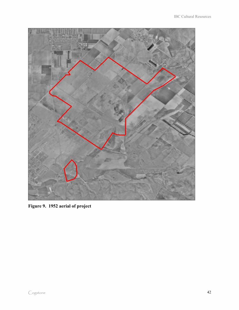
IBC Cultural Resources
Cogstone 42
Figure 9. 1952 aerial of project
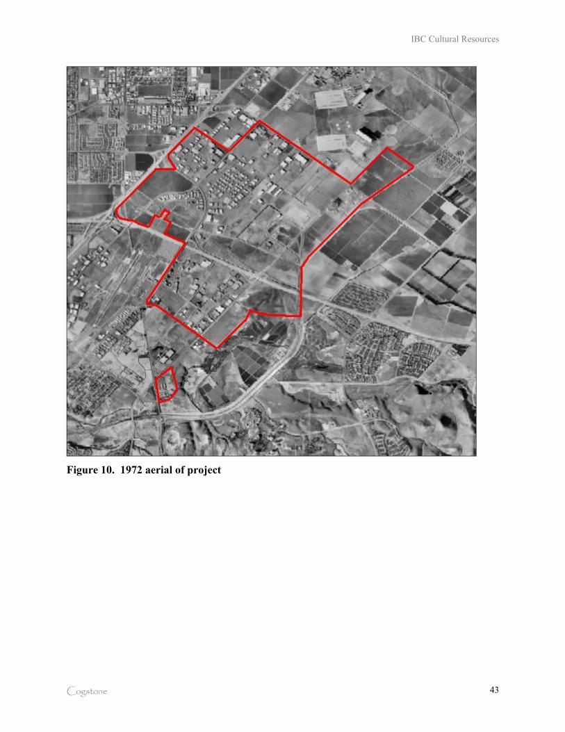
IBC Cultural Resources
Cogstone 43
Figure 10. 1972 aerial of project
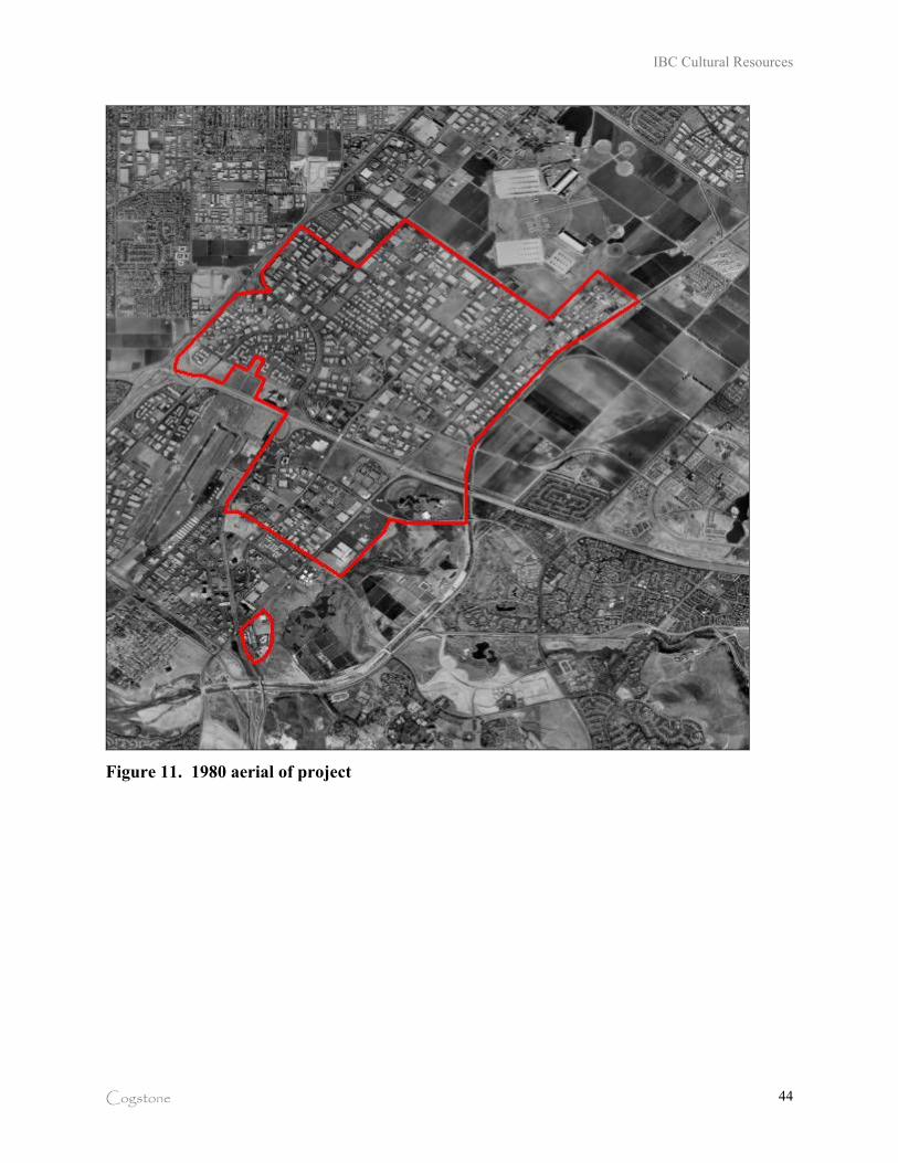
IBC Cultural Resources
Cogstone 44
Figure 11. 1980 aerial of project
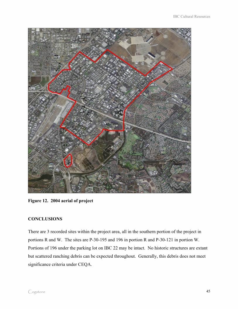
IBC Cultural Resources
Cogstone 45
Figure 12. 2004 aerial of project
CONCLUSIONS
There are 3 recorded sites within the project area, all in the southern portion of the project in
portions R and W. The sites are P-30-195 and 196 in portion R and P-30-121 in portion W.
Portions of 196 under the parking lot on IBC 22 may be intact. No historic structures are extant
but scattered ranching debris can be expected throughout. Generally, this debris does not meet
significance criteria under CEQA.
IBC Cultural Resources
Cogstone 46
Only 7 IBC residential project archaeology monitoring reports could be located. No survey or
monitoring reports for IBC portion R (IBC 2, 22, 42) are on file. There is a procedural failure to
document that sensitive areas are being adequate mitigated, reports written and submitted and
that collections are sent to museums for curation.
POTENTIAL RESOURCES
Paleontological, archaeological and historical resources are considered to be significant if they
possess integrity and may contribute information important in prehistory or history. Based on
the prior research and survey results, the potential to impact resources is discussed below.
PALEONTOLOGICAL RESOURCES
Scientifically important fossils are being recovered from the IBC and many other areas of Irvine
at depths of six feet or more below the surface. The known fossils from the project area are all
from the Pleistocene Epoch and represent the last Ice Age (40-10 thousand years ago). Deeper
sediments are also known to produce scientifically significant fossils.
Only 8 IBC residential project paleontology monitoring reports could be located. No survey or
monitoring reports for IBC portion R (IBC 2, 22, 42) are on file. Major collections of fossils
have no reports and the fossils are not in museums. There is a procedural failure to document
that adequate mitigation is being performed, reports are being written and submitted and that
fossils are sent to museums for curation.
ARCHAEOLOGICAL RESOURCES
The vast majority of the project area has no known archaeological resources. There are 3
recorded sites within the project area, all in the southern portion of the project in portions R and
W. The sites are P-30-195 and 196 in portion R and P-30-121 in portion W. Portions of 196
under the parking lot on IBC 22 may be intact.
IBC Cultural Resources
Cogstone 47
Only 29 IBC residential projects have assessment reports on file. Only 7 IBC residential project
archaeology monitoring reports could be located. No survey or monitoring reports for IBC
portion R (IBC 2, 22, 42) are on file. There is a procedural failure to document that sensitive
areas are being adequate mitigated, reports written and submitted and that collections are sent to
museums for curation.
HISTORICAL RESOURCES
No historic structures are extant but scattered ranching debris can be expected throughout.
Generally, this debris does not meet significance criteria under CEQA.
RECOMMENDEDATIONS
The City of Irvine appears to have diligently required mitigation of construction activities within
the IBC. However, post-mitigation documentation and curation is not being effectively tracked
to insure compliance with City requirements. In particular, reports are not being written and
filed as required nor are fossils and artifacts being transferred to museums as required.
This failure of environmental policy has far reaching implications that violate both the letter and
the intent of CEQA and City regulations. Fossils, in particular, are not available for scientific
study or education unless they are in a museum with access for researchers. In addition, due to
rules imposed by the International Commission on Zoological Nomenclature, no fossils can be
published in scientific journals unless they have museum specimen numbers and are located in a
museum with access for researchers. Reports are important to convey the project results,
catalog, photographs and other necessary information.
The Cultural Resource Element of the City of Irvine General Plan needs to be updated and
contain specific language to insure that policies are actually implemented. The sensitivity maps
(Figures E-1 and E-2) should not be utilized for planning purposes unless updated at minimum
five year intervals. The revised language should specify that museum specimen numbers must
be included in reports, along with a letter from the museum stating that the fossils are in their
IBC Cultural Resources
Cogstone 48
possession, and require that reports be submitted to the City and repository before any developer
can receive a final occupancy permit. The City should consider selecting a single repository and
requiring that all fossils from the City be submitted to that repository. Through that relationship
, the City could obtain an annual update on fossils submitted to the repository and a revised
sensitivity map.
SPECIFIC IMPACTS AND MITIGATION
Impact: Could significant archaeological resources be impacted by the project? Yes, but only in
portions R and W.
Mitigation: All projects in portions R and W should require assessment including survey,
monitoring, reporting and curation of recovered materials meeting significance criteria. Each
project should be refused a final occupancy permit until all mitigation is demonstrated to have
been performed including curation.
Impact: Could significant paleontological resources be impacted by the project. Yes,
throughout the project area at variable depths.
Mitigation: All projects in the IBC should require assessment including review of geotechnical
boring logs to determine depth of marker clay bed, monitoring, reporting and curation of
recovered materials meeting significance criteria. Each project should be refused a final
occupancy permit until all mitigation is demonstrated to have been performed including curation.
Impact: Could human remains be impacted by the project. Yes, but only in portions R and W.
Mitigation: All projects in portions R and W should require Native American monitoring and
consultation if prehistoric burials are encountered. A joint decision on treatment should be made
and approved by the State Office of Historic Preservation before implementation. Each project
should be refused a final occupancy permit until all mitigation is demonstrated to have been
performed.
IBC Cultural Resources
Cogstone 49
REFERENCES
Altschul, Jeffrey, Richard Ciolek-Torrello, Donn Grenda, Jeffrey Homburg, Su Benaron and Anne Stoll 2005 Ballona Archaeology: a decade of multidisciplinary research. Proceedings of Society for
California Archaeology 18:283-301.
Altschul, Jeffrey, John Douglass, Richard Ciolek-Torrello, Sarah Van Galder, Benjamin Vargas, Kathleen Hull, Donn Grenda, Jeffrey Homburg, Manuel Palacios-Fest, Steven Shelley, Angela Keller and David Maxwell 2007 Life at the Nexus of Wetlands and Coastal Prairie, West Los Angeles. Proceedings of
Society for California Archaeology 20:34-42.
Bean, L.J. and C.R. Smith 1978 “Gabrielino.” In Handbook of North American Indians, Volume 8. California, volume
edited by Robert F. Heizer, pp. 538-549 (W. T. Sturtevant, general editor). The
Smithsonian Institution, Washington, D.C.
Blackburn
1930 Property Ownership Maps of Orange County. In collections of the University of
California at Riverside Library.
California Department of Transportation
2001 Cultural Resources, Online Environmental Handbook, Vol. 2.
http://www.dot.ca.gov/ser/vol2/vol2.htm
2003 Paleontology, Online Environmental Handbook, Vol. 1, Chapter 8.
http://www.dot.ca.gov/ser/vol1/sec3/physical/Ch08Paleo/chap08paleo.htm
Chace, P.
1969 The Archaeology of "Cienaga", the Oldest Historic Structure on the Irvine Ranch.
Pacific Coast Archaeological Society Quarterly 5(3):39-55.
Commendador-Dugeon, Amy, Beth Padon and J. D. Stewart 2006a Archaeological and Paleontological Monitoring at the Campus Center Multi-Family
Apartments Expansion, Building C, in the City of Irvine. On file, South Central Coastal
Information Center.
2006b Archaeological and Paleontological Monitoring for the Plaza Irvine Development, Phase
1, City of Irvine, Orange County, California. On file, South Central Coastal Information
Center.
IBC Cultural Resources
Cogstone 50
DeBusk, J. 2008 Final Paleontological Monitoring Report, Plaza Irvine IV, Irvine, Orange County,
California. On file with SWCA, Pasadena. DeBusk, J. and L. Seckel
2007 Final Paleontological Monitoring Report, Plaza Irvine III, Irvine, Orange County, California. On file with SWCA, Pasadena.
Gust, S. and K. Scott 2009 Paleontological and Archaeological Monitoring Report for Central Park West, Irvine,
California. On file Cogstone Resource Management Inc., Santa Ana.
Koerper, Henry, Roger Mason and Mark Peterson 2003 Complexity, Demography and Change in Late Holocene Orange County. In Erlandson,
J. and T. Jones (eds), Catalysts to Complexity: The Late Holocene on the California
Coast. Perspectives in California Archaeology, Institute of Archaeology, University of
California, Los Angeles.
Lander, B.
2008 Paleontological Resource Mitigation Program, Final Technical Report of Results and
Findings, prepared in support of the Scholle Center Project, Phases I and II, Irvine,
Orange County, California. On file Paleo Environmental Associates, Altadena.
Liebeck, Judy
1988 Irvine. In A Hundred Years of Yesterdays: a centennial history of the people of Orange
County and their communities, Cramer, E., K. Dixon, D. Marsh, P. Brigandi, and C.
Blamer (eds), pages 119-121. Orange County Centennial Inc., Santa Ana.
Mason, Roger, H. Hoerper and P. Langenwalter
1997 Middle Holocene adaptations on the Newport Coast of Orange County. In Erlandson, J.
and M. Glassow, Archaeology of the California Coast during the Middle Holocene,
Perspectives in California Archaeology, Institute of Archaeology, University of California, Los Angeles.
McCawley, William 1996 First Angelinos: the Gabrielino Indians of Los Angeles. Malki Museum Press/Ballena
Press, Banning, CA.
Michalsky, J. and L. Sample 2002 Paleontological Mitigation Report for Watermarke Apartments, City of Irvine, Orange
County, California. On file LSA, Irvine.
IBC Cultural Resources
Cogstone 51
Miller, W.E. 1971 Pleistocene vertebrates of the Los Angeles basin and vicinity, exclusive of Rancho la
Brea. Bulletin of the Los Angeles County Museum of Natural History 10:1-124.
Morton, D.M. 2004 Preliminary digital geologic map of the Santa Ana 30’x60’ quadrangle, California
version 2.0. United States Geological Survey Open File Report 99-172, version 2.0. Digital preparation by K.R. Bovard and R.M. Alvarez.
Scott, K. and S. Gust 2008 Paleontological Monitoring Report for the Carlyle at Colton Plaza Project, Irvine,
California. On file Cogstone Resource Management Inc., Santa Ana.
Smith, B. 2009 Personal Communication, January.
Wagner, D.L.
2002 California Geomorphic Provinces. California Geologic Survey Note 36. Website:
http://www.consrv.ca.gov/cgs/information/publications/cgs_notes/note_36/note_36.pdf

IBC Cultural Resources
Cogstone 52
APPENDIX A: QUALIFICATIONS
IBC Cultural Resources
Cogstone 53
SHERRI GUST Cogstone Paleontology Archaeology History
Registered Professional Archaeologist & Qualified Paleontologist
EDUCATION
1994 M. S., Anatomy and Cell Biology (Evolutionary Morphology), University of Southern California, Los Angeles
1979 B. S., Anthropology (Physical), University of California, Davis
SUMMARY QUALIFICATIONS
Gust has more than 28 years of experience in California, acknowledged credentials for meeting national standards and is certified/qualified in all southern California cities and counties that maintain lists.
SELECTED REPORTS AND PROJECTS
2008 Gust, S., K. Scott and A. Glover. Archaeological and Paleontological Assessment and
Mitigation Plan for the Scattergood Olympic Line, Los Angeles, California. Performed paleontological and archaeological record searches, Native American consultation, research, survey and prepared assessment report for LADWP under subcontract to the IFC Jones & Stokes.
2008 Gust, S., and K. Scott. Paleontological and Archaeological Assessment and Mitigation Plan
for the Cold Canyon Landfill Expansion Project, San Luis Obispo, California. Performed paleontological and archaeological record searches, Native American consultation, research, survey and prepared assessment, impact analysis and EIR section for County of San Luis Obispo under subcontract to the Morro Group.
2008 Gust, S., V. Harper and K. Scott. Cultural Resources Assessment of Nine School Sites for the
Corona-Norco Unified School District. Performed archaeological record searches, Native American consultation, research, survey and prepared assessment reports under contract to the Corona-Norco Unified School District.
2007 Gust, S., S. McCormick and K. Scott. Paleontological and Archaeological Assessment Report
for the Metrolink Expansion Services Project at Fullerton Station, City of Fullerton, California. Performed record searches, Native American consultation and survey and prepared evaluation report for OCTA under contract to Parsons Brinckerhoff Orange.
2007 Gust, S. Paleontological and Archaeological Literature Review for the Sea Lab
Desalizination Plant, City of Redondo Beach, California. Performed archaeological and paleontological record search and literature review, evaluation of resources, and prepared final assessment report with recommendations for mitigation for the West Basin Municipal Water District under contract to RBF Consulting.
IBC Cultural Resources
Cogstone 54
KIM SCOTT Cogstone Paleontology Archaeology History
Field & Lab Director for Paleontology
EDUCATION
Exp. 2009 M.S., Biology, with paleontology emphasis (in progress), CSU San Bernardino. 2000 B.S., Geology with paleontology emphasis, UCLA.
SUMMARY QUALIFICATIONS
Scott has more than 12 years of experience in California paleontology. She is a qualified geologist and
field paleontologist with extensive survey, monitoring and fossil salvage experience. In addition she has
special skills in fossil preparation (cleaning and stabilization) and preparation of stratigraphic sections and
other documentation for fossil localities.
SELECTED PROJECTS
2008 Gust, S. and K. Scott. Paleontological Assessment for the Exposition Transit Corridor
Westside Extension (Expo LRT Phase II), Cities of Los Angeles and Santa Monica, California. Cogstone performed paleontological record searches and survey and prepared an assessment report including evaluation of alternatives plus a mitigation plan for the Expo Authority under subcontract to EDAW.
2007 Scott, K. and S. Gust. Paleontological Resources Management Plan for the Tehachapi
Renewable Transmission Project (Antelope Transmission Project) Segment 1, Los Angeles County,
California with updated paleontological assessment. Cogstone performed paleontological record searches, background research, prepared an assessment of the potential resources including a sensitivity map, arranged a repository, and prepared a comprehensive management plan for Southern California Edison under subcontract to Pacific Legacy.
2007 Scott, K. and S. Gust. Paleontological Mitigation Report for the Walker Ridge
Safety/Rehabilitation Project, Lake County, California. Cogstone provided paleontological monitors, fossil recovery, fossil preparation, a final interpretive report and transported fossils to an accredited repository for curation for Caltrans District 3 (acting for District 1) under subcontract to Pacific Legacy.
2007 Scott, K. and S. Gust. Paleontological Mitigation Report for the Highway 138 Expansion
West Project, San Bernardino County, California. Cogstone developed and implemented a sampling plan in lieu of monitoring, recovered fossils, prepared and identified fossils, prepared the final report including interpretation and arranged curation of significant fossils recovered for Caltrans District 8 under subcontract partially to Applied Earthworks and partially to ECORP.
2006 Scott, K. and S. Gust. Paleontological Resources of the Interstate 80 Median and Auxillary
Lanes Project, Sacramento, California: an abbreviated combination Paleontological Identification
Report, Paleontological Evaluation Report and Paleontological Mitigation Plan. Cogstone performed paleontological record searches, research, survey and prepared a combined report and mitigation plan for Caltrans District 3 under subcontract to URS Oakland.
IBC Cultural Resources
Cogstone 55
APPENDIX B: PALEONTOLOGY RECORD SEARCH
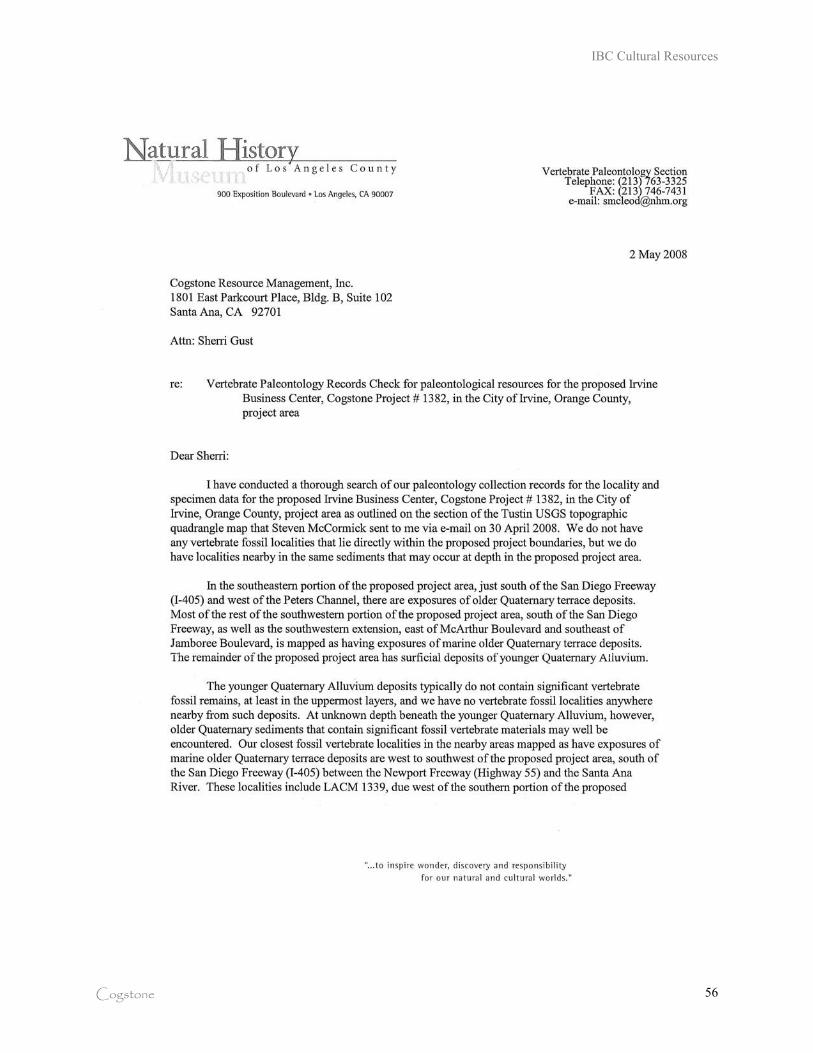
IBC Cultural Resources
Cogstone 56
IBC Cultural Resources
Cogstone 57
IBC Cultural Resources
Cogstone 58
APPENDIX C: NATIVE AMERICAN HERITAGE COMMISSION
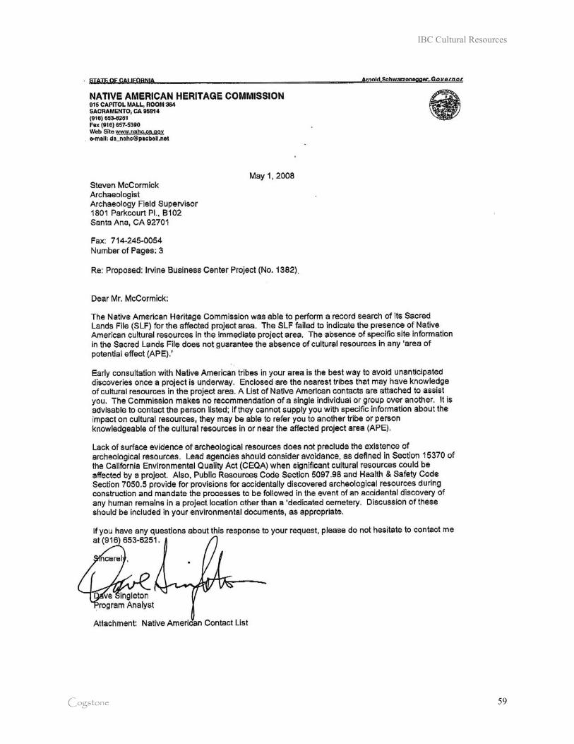
IBC Cultural Resources
Cogstone 59
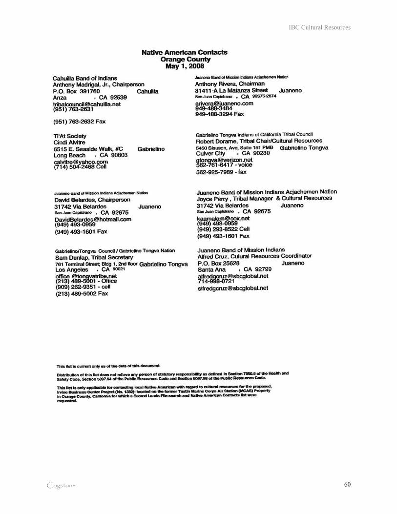
IBC Cultural Resources
Cogstone 60
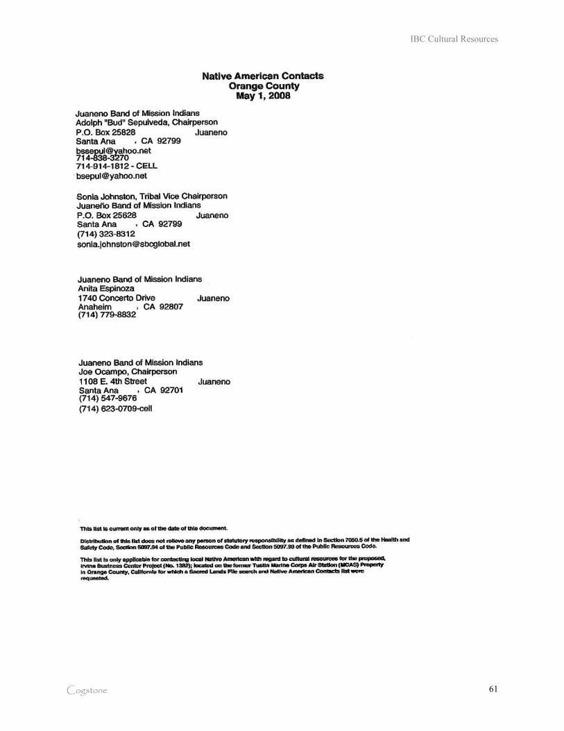
IBC Cultural Resources
Cogstone 61
Appendices
IBC Vision Plan and Mixed Use Overlay Zoning Code Recirculated DEIR City of Irvine
Appendix J Environmental Data Resources Report
Appendices
The Planning Center December 2009
This page intentionally left blank.

FORM-NULL-PEP
®kcehCoeG htiw ™saltA suidaR RDE ehT
440 Wheelers Farms RoadMilford, CT 06461Toll Free: 800.352.0050www.edrnet.com
Irvine Business Complex
Irvine Business Complex
IRVINE, CA 92614
Inquiry Number: 2312585.1s
September 08, 2008
SECTION PAGE
Executive Summary ES1
Overview Map 2
Details Maps 3
Map Findings Summary 12
Map Findings 14
Orphan Summary 2378
Government Records Searched/Data Currency Tracking GR-1
GEOCHECK ADDENDUM
Physical Setting Source Addendum A-1
Physical Setting Source Summary A-2
Physical Setting SSURGO Soil Map A-6
Physical Setting Source Map A-9
Physical Setting Source Map Findings A-10
Physical Setting Source Records Searched A-21
TC2312585.1s Page 1
Thank you for your business.Please contact EDR at 1-800-352-0050
with any questions or comments.
Disclaimer - Copyright and Trademark Notice
This Report contains certain information obtained from a variety of public and other sources reasonably available to Environmental DataResources, Inc. It cannot be concluded from this Report that coverage information for the target and surrounding properties does not exist fromother sources. NO WARRANTY EXPRESSED OR IMPLIED, IS MADE WHATSOEVER IN CONNECTION WITH THIS REPORT. ENVIRONMENTALDATA RESOURCES, INC. SPECIFICALLY DISCLAIMS THE MAKING OF ANY SUCH WARRANTIES, INCLUDING WITHOUT LIMITATION,MERCHANTABILITY OR FITNESS FOR A PARTICULAR USE OR PURPOSE. ALL RISK IS ASSUMED BY THE USER. IN NO EVENT SHALLENVIRONMENTAL DATA RESOURCES, INC. BE LIABLE TO ANYONE, WHETHER ARISING OUT OF ERRORS OR OMISSIONS, NEGLIGENCE,ACCIDENT OR ANY OTHER CAUSE, FOR ANY LOSS OF DAMAGE, INCLUDING, WITHOUT LIMITATION, SPECIAL, INCIDENTAL,CONSEQUENTIAL, OR EXEMPLARY DAMAGES. ANY LIABILITY ON THE PART OF ENVIRONMENTAL DATA RESOURCES, INC. IS STRICTLYLIMITED TO A REFUND OF THE AMOUNT PAID FOR THIS REPORT. Purchaser accepts this Report "AS IS". Any analyses, estimates, ratings,environmental risk levels or risk codes provided in this Report are provided for illustrative purposes only, and are not intended to provide, norshould they be interpreted as providing any facts regarding, or prediction or forecast of, any environmental risk for any property. Only a Phase IEnvironmental Site Assessment performed by an environmental professional can provide information regarding the environmental risk for anyproperty. Additionally, the information provided in this Report is not to be construed as legal advice.
Copyright 2008 by Environmental Data Resources, Inc. All rights reserved. Reproduction in any media or format, in wholeor in part, of any report or map of Environmental Data Resources, Inc., or its affiliates, is prohibited without prior written permission.
EDR and its logos (including Sanborn and Sanborn Map) are trademarks of Environmental Data Resources, Inc. or its affiliates. All othertrademarks used herein are the property of their respective owners.
TABLE OF CONTENTS
EXECUTIVE SUMMARY
TC2312585.1s EXECUTIVE SUMMARY 1
A search of available environmental records was conducted by Environmental Data Resources, Inc (EDR).The report was designed to assist parties seeking to meet the search requirements of EPA’s Standardsand Practices for All Appropriate Inquiries (40 CFR Part 312), the ASTM Standard Practice forEnvironmental Site Assessments (E 1527-05) or custom requirements developed for the evaluation ofenvironmental risk associated with a parcel of real estate.
TARGET PROPERTY INFORMATION
ADDRESS
IRVINE BUSINESS COMPLEXIRVINE, CA 92614
COORDINATES
33.685270 - 33˚ 41’ 7.0’’Latitude (North): 117.839880 - 117˚ 50’ 23.6’’Longitude (West): Zone 11Universal Tranverse Mercator: 422151.2UTM X (Meters): 3727383.2UTM Y (Meters): 39 ft. above sea levelElevation:
USGS TOPOGRAPHIC MAP ASSOCIATED WITH TARGET PROPERTY
33117-F7 TUSTIN, CATarget Property Map:1981Most Recent Revision:
TARGET PROPERTY SEARCH RESULTS
The target property was not listed in any of the databases searched by EDR.
DATABASES WITH NO MAPPED SITES
No mapped sites were found in EDR’s search of available ("reasonably ascertainable ") governmentrecords either on the target property or within the search radius around the target property for thefollowing databases:
FEDERAL RECORDS
NPL National Priority ListProposed NPL Proposed National Priority List SitesDelisted NPL National Priority List DeletionsNPL LIENS Federal Superfund LiensCERCLIS Comprehensive Environmental Response, Compensation, and Liability Information SystemLIENS 2 CERCLA Lien InformationRCRA-CESQG RCRA - Conditionally Exempt Small Quantity GeneratorUS ENG CONTROLS Engineering Controls Sites ListUS INST CONTROL Sites with Institutional ControlsDOT OPS Incident and Accident Data
EXECUTIVE SUMMARY
TC2312585.1s EXECUTIVE SUMMARY 2
US BROWNFIELDS A Listing of Brownfields SitesFUDS Formerly Used Defense SitesCONSENT Superfund (CERCLA) Consent DecreesROD Records Of DecisionUMTRA Uranium Mill Tailings SitesODI Open Dump InventoryDEBRIS REGION 9 Torres Martinez Reservation Illegal Dump Site LocationsMINES Mines Master Index FileTSCA Toxic Substances Control ActPADS PCB Activity Database SystemRADINFO Radiation Information DatabaseSCRD DRYCLEANERS State Coalition for Redediation of Drycleaners Listing
STATE AND LOCAL RECORDS
CA BOND EXP. PLAN Bond Expenditure PlanToxic Pits Toxic Pits Cleanup Act SitesLIENS Environmental Liens ListingNotify 65 Proposition 65 RecordsDEED Deed Restriction ListingHAULERS Registered Waste Tire Haulers Listing
TRIBAL RECORDS
INDIAN RESERV Indian ReservationsINDIAN ODI Report on the Status of Open Dumps on Indian LandsINDIAN LUST Leaking Underground Storage Tanks on Indian LandINDIAN UST Underground Storage Tanks on Indian LandINDIAN VCP Voluntary Cleanup Priority Listing
EDR PROPRIETARY RECORDS
Manufactured Gas Plants EDR Proprietary Manufactured Gas Plants
SURROUNDING SITES: SEARCH RESULTS
Surrounding sites were identified in the following databases.
Elevations have been determined from the USGS Digital Elevation Model and should be evaluated ona relative (not an absolute) basis. Relative elevation information between sites of close proximityshould be field verified. Sites with an elevation equal to or higher than the target property have beendifferentiated below from sites with an elevation lower than the target property.Page numbers and map identification numbers refer to the EDR Radius Map report where detaileddata on individual sites can be reviewed.
Sites listed in bold italics are in multiple databases.
Unmappable (orphan) sites are not considered in the foregoing analysis.
FEDERAL RECORDS
CERC-NFRAP: Archived sites are sites that have been removed and archived from the inventory of CERCLISsites. Archived status indicates that, to the best of EPA’s knowledge, assessment at a site has been completed
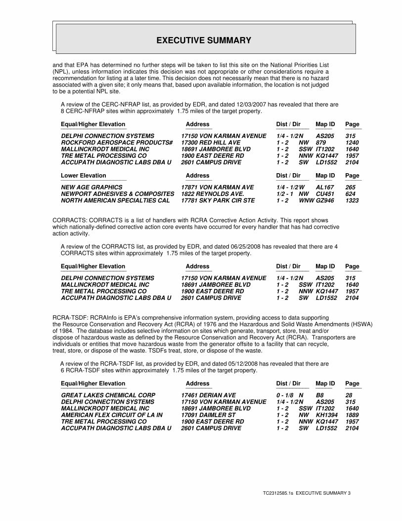
EXECUTIVE SUMMARY
TC2312585.1s EXECUTIVE SUMMARY 3
and that EPA has determined no further steps will be taken to list this site on the National Priorities List(NPL), unless information indicates this decision was not appropriate or other considerations require arecommendation for listing at a later time. This decision does not necessarily mean that there is no hazardassociated with a given site; it only means that, based upon available information, the location is not judgedto be a potential NPL site.
A review of the CERC-NFRAP list, as provided by EDR, and dated 12/03/2007 has revealed that there are 8 CERC-NFRAP sites within approximately 1.75 miles of the target property.
PageMap IDDist / Dir Address Equal/Higher Elevation ____________________ ________ ____________________
315AS205N1/4 - 1/2 17150 VON KARMAN AVENUE DELPHI CONNECTION SYSTEMS1240879NW1 - 2 17300 RED HILL AVE ROCKFORD AEROSPACE PRODUCTS#1640IT1202SSW1 - 2 18691 JAMBOREE BLVD MALLINCKRODT MEDICAL INC1957KQ1447NNW1 - 2 1900 EAST DEERE RD TRE METAL PROCESSING CO2104LD1552SW1 - 2 2601 CAMPUS DRIVE ACCUPATH DIAGNOSTIC LABS DBA U
PageMap IDDist / Dir Address Lower Elevation ____________________ ________ ____________________
265AL167W1/4 - 1/2 17871 VON KARMAN AVE NEW AGE GRAPHICS624CU451NW1/2 - 1 1822 REYNOLDS AVE. NEWPORT ADHESIVES & COMPOSITES1323GZ946WNW1 - 2 17781 SKY PARK CIR STE NORTH AMERICAN SPECIALTIES CAL
CORRACTS: CORRACTS is a list of handlers with RCRA Corrective Action Activity. This report showswhich nationally-defined corrective action core events have occurred for every handler that has had correctiveaction activity.
A review of the CORRACTS list, as provided by EDR, and dated 06/25/2008 has revealed that there are 4 CORRACTS sites within approximately 1.75 miles of the target property.
PageMap IDDist / Dir Address Equal/Higher Elevation ____________________ ________ ____________________
315AS205N1/4 - 1/2 17150 VON KARMAN AVENUE DELPHI CONNECTION SYSTEMS1640IT1202SSW1 - 2 18691 JAMBOREE BLVD MALLINCKRODT MEDICAL INC1957KQ1447NNW1 - 2 1900 EAST DEERE RD TRE METAL PROCESSING CO2104LD1552SW1 - 2 2601 CAMPUS DRIVE ACCUPATH DIAGNOSTIC LABS DBA U
RCRA-TSDF: RCRAInfo is EPA’s comprehensive information system, providing access to data supportingthe Resource Conservation and Recovery Act (RCRA) of 1976 and the Hazardous and Solid Waste Amendments (HSWA)of 1984. The database includes selective information on sites which generate, transport, store, treat and/ordispose of hazardous waste as defined by the Resource Conservation and Recovery Act (RCRA). Transporters areindividuals or entities that move hazardous waste from the generator offsite to a facility that can recycle,treat, store, or dispose of the waste. TSDFs treat, store, or dispose of the waste.
A review of the RCRA-TSDF list, as provided by EDR, and dated 05/12/2008 has revealed that there are 6 RCRA-TSDF sites within approximately 1.75 miles of the target property.
PageMap IDDist / Dir Address Equal/Higher Elevation ____________________ ________ ____________________
28B8N0 - 1/8 17461 DERIAN AVE GREAT LAKES CHEMICAL CORP315AS205N1/4 - 1/2 17150 VON KARMAN AVENUE DELPHI CONNECTION SYSTEMS1640IT1202SSW1 - 2 18691 JAMBOREE BLVD MALLINCKRODT MEDICAL INC1889KH1394NW1 - 2 17091 DAIMLER ST AMERICAN FLEX CIRCUIT OF LA IN1957KQ1447NNW1 - 2 1900 EAST DEERE RD TRE METAL PROCESSING CO2104LD1552SW1 - 2 2601 CAMPUS DRIVE ACCUPATH DIAGNOSTIC LABS DBA U
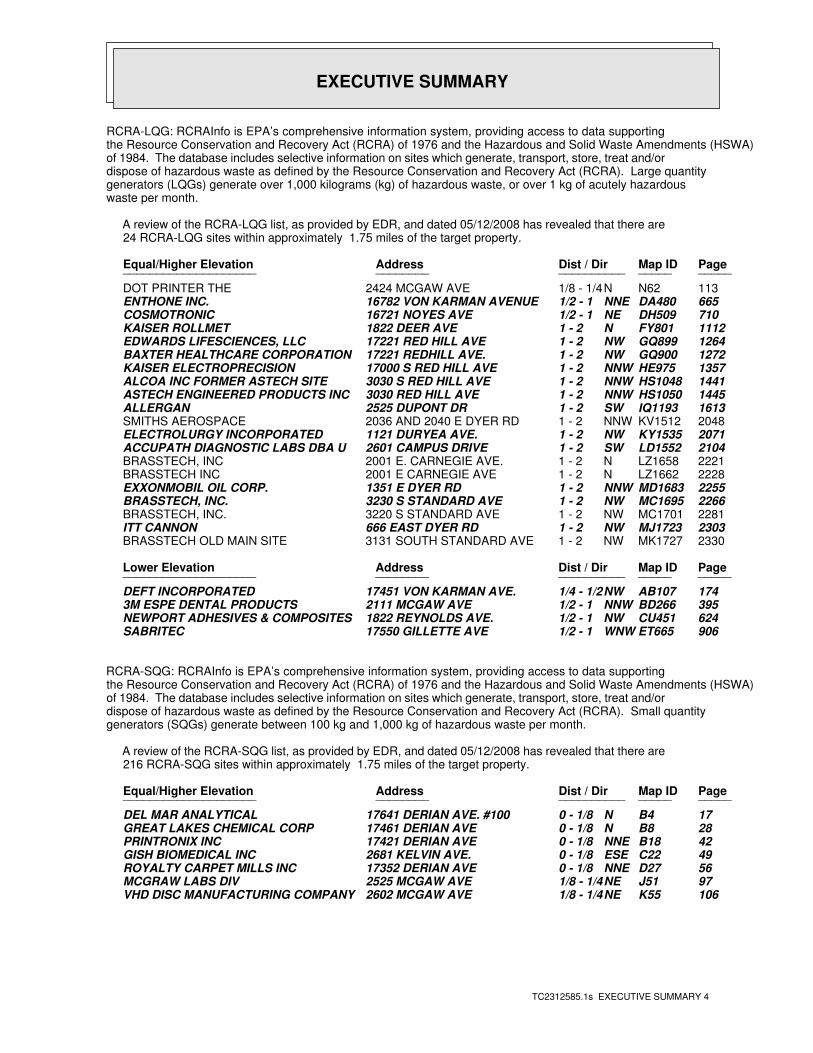
EXECUTIVE SUMMARY
TC2312585.1s EXECUTIVE SUMMARY 4
RCRA-LQG: RCRAInfo is EPA’s comprehensive information system, providing access to data supportingthe Resource Conservation and Recovery Act (RCRA) of 1976 and the Hazardous and Solid Waste Amendments (HSWA)of 1984. The database includes selective information on sites which generate, transport, store, treat and/ordispose of hazardous waste as defined by the Resource Conservation and Recovery Act (RCRA). Large quantitygenerators (LQGs) generate over 1,000 kilograms (kg) of hazardous waste, or over 1 kg of acutely hazardouswaste per month.
A review of the RCRA-LQG list, as provided by EDR, and dated 05/12/2008 has revealed that there are 24 RCRA-LQG sites within approximately 1.75 miles of the target property.
PageMap IDDist / Dir Address Equal/Higher Elevation ____________________ ________ ____________________
113N62N1/8 - 1/4 2424 MCGAW AVE DOT PRINTER THE665DA480NNE1/2 - 1 16782 VON KARMAN AVENUE ENTHONE INC.710DH509NE1/2 - 1 16721 NOYES AVE COSMOTRONIC1112FY801N1 - 2 1822 DEER AVE KAISER ROLLMET1264GQ899NW1 - 2 17221 RED HILL AVE EDWARDS LIFESCIENCES, LLC1272GQ900NW1 - 2 17221 REDHILL AVE. BAXTER HEALTHCARE CORPORATION1357HE975NNW1 - 2 17000 S RED HILL AVE KAISER ELECTROPRECISION1441HS1048NNW1 - 2 3030 S RED HILL AVE ALCOA INC FORMER ASTECH SITE1445HS1050NNW1 - 2 3030 RED HILL AVE ASTECH ENGINEERED PRODUCTS INC1613IQ1193SW1 - 2 2525 DUPONT DR ALLERGAN2048KV1512NNW1 - 2 2036 AND 2040 E DYER RD SMITHS AEROSPACE2071KY1535NW1 - 2 1121 DURYEA AVE. ELECTROLURGY INCORPORATED2104LD1552SW1 - 2 2601 CAMPUS DRIVE ACCUPATH DIAGNOSTIC LABS DBA U2221LZ1658N1 - 2 2001 E. CARNEGIE AVE. BRASSTECH, INC2228LZ1662N1 - 2 2001 E CARNEGIE AVE BRASSTECH INC2255MD1683NNW1 - 2 1351 E DYER RD EXXONMOBIL OIL CORP.2266MC1695NW1 - 2 3230 S STANDARD AVE BRASSTECH, INC.2281MC1701NW1 - 2 3220 S STANDARD AVE BRASSTECH, INC.2303MJ1723NW1 - 2 666 EAST DYER RD ITT CANNON2330MK1727NW1 - 2 3131 SOUTH STANDARD AVE BRASSTECH OLD MAIN SITE
PageMap IDDist / Dir Address Lower Elevation ____________________ ________ ____________________
174AB107NW1/4 - 1/2 17451 VON KARMAN AVE. DEFT INCORPORATED395BD266NNW1/2 - 1 2111 MCGAW AVE 3M ESPE DENTAL PRODUCTS624CU451NW1/2 - 1 1822 REYNOLDS AVE. NEWPORT ADHESIVES & COMPOSITES906ET665WNW1/2 - 1 17550 GILLETTE AVE SABRITEC
RCRA-SQG: RCRAInfo is EPA’s comprehensive information system, providing access to data supportingthe Resource Conservation and Recovery Act (RCRA) of 1976 and the Hazardous and Solid Waste Amendments (HSWA)of 1984. The database includes selective information on sites which generate, transport, store, treat and/ordispose of hazardous waste as defined by the Resource Conservation and Recovery Act (RCRA). Small quantitygenerators (SQGs) generate between 100 kg and 1,000 kg of hazardous waste per month.
A review of the RCRA-SQG list, as provided by EDR, and dated 05/12/2008 has revealed that there are 216 RCRA-SQG sites within approximately 1.75 miles of the target property.
PageMap IDDist / Dir Address Equal/Higher Elevation ____________________ ________ ____________________
17B4N0 - 1/8 17641 DERIAN AVE. #100 DEL MAR ANALYTICAL28B8N0 - 1/8 17461 DERIAN AVE GREAT LAKES CHEMICAL CORP42B18NNE0 - 1/8 17421 DERIAN AVE PRINTRONIX INC49C22ESE0 - 1/8 2681 KELVIN AVE. GISH BIOMEDICAL INC56D27NNE0 - 1/8 17352 DERIAN AVE ROYALTY CARPET MILLS INC97J51NE1/8 - 1/4 2525 MCGAW AVE MCGRAW LABS DIV106K55NE1/8 - 1/4 2602 MCGAW AVE VHD DISC MANUFACTURING COMPANY
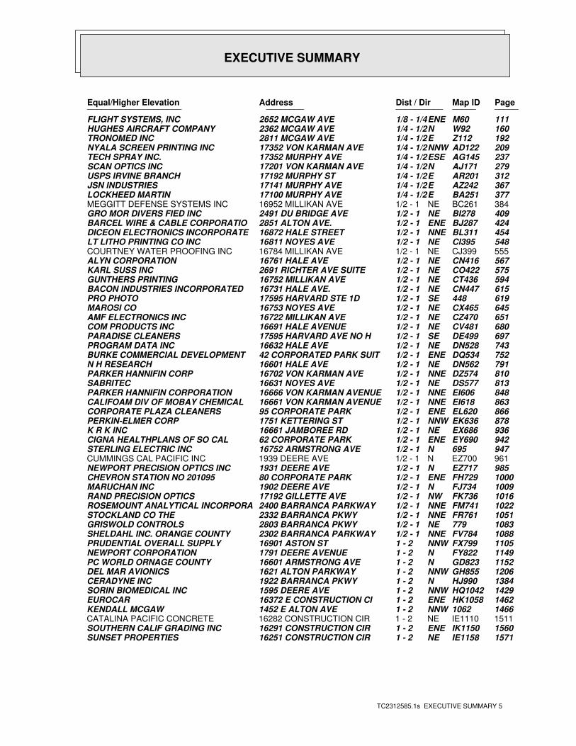
EXECUTIVE SUMMARY
TC2312585.1s EXECUTIVE SUMMARY 5
PageMap IDDist / Dir Address Equal/Higher Elevation ____________________ ________ ____________________
111M60ENE1/8 - 1/4 2652 MCGAW AVE FLIGHT SYSTEMS, INC160W92N1/4 - 1/2 2362 MCGAW AVE HUGHES AIRCRAFT COMPANY192Z112E1/4 - 1/2 2811 MCGAW AVE TRONOMED INC209AD122NNW1/4 - 1/2 17352 VON KARMAN AVE NYALA SCREEN PRINTING INC237AG145ESE1/4 - 1/2 17352 MURPHY AVE TECH SPRAY INC.279AJ171N1/4 - 1/2 17201 VON KARMAN AVE SCAN OPTICS INC312AR201E1/4 - 1/2 17192 MURPHY ST USPS IRVINE BRANCH367AZ242E1/4 - 1/2 17141 MURPHY AVE JSN INDUSTRIES377BA251E1/4 - 1/2 17100 MURPHY AVE LOCKHEED MARTIN384BC261NE1/2 - 1 16952 MILLIKAN AVE MEGGITT DEFENSE SYSTEMS INC409BI278NE1/2 - 1 2491 DU BRIDGE AVE GRO MOR DIVERS FIED INC424BJ287ENE1/2 - 1 2851 ALTON AVE. BARCEL WIRE & CABLE CORPORATIO454BL311NNE1/2 - 1 16872 HALE STREET DICEON ELECTRONICS INCORPORATE548CI395NE1/2 - 1 16811 NOYES AVE LT LITHO PRINTING CO INC555CJ399NE1/2 - 1 16784 MILLIKAN AVE COURTNEY WATER PROOFING INC567CN416NE1/2 - 1 16761 HALE AVE ALYN CORPORATION575CO422NE1/2 - 1 2691 RICHTER AVE SUITE KARL SUSS INC594CT436NE1/2 - 1 16752 MILLIKAN AVE GUNTHERS PRINTING615CN447NE1/2 - 1 16731 HALE AVE. BACON INDUSTRIES INCORPORATED 619448SE1/2 - 1 17595 HARVARD STE 1D PRO PHOTO645CX465NE1/2 - 1 16753 NOYES AVE MAROSI CO651CZ470NE1/2 - 1 16722 MILLIKAN AVE AMF ELECTRONICS INC680CV481NE1/2 - 1 16691 HALE AVENUE COM PRODUCTS INC697DE499SE1/2 - 1 17595 HARVARD AVE NO H PARADISE CLEANERS743DN528NE1/2 - 1 16632 HALE AVE PROGRAM DATA INC752DQ534ENE1/2 - 1 42 CORPORATED PARK SUIT BURKE COMMERCIAL DEVELOPMENT791DN562NE1/2 - 1 16601 HALE AVE N H RESEARCH810DZ574NNE1/2 - 1 16702 VON KARMAN AVE PARKER HANNIFIN CORP813DS577NE1/2 - 1 16631 NOYES AVE SABRITEC848EI606NNE1/2 - 1 16666 VON KARMAN AVENUE PARKER HANNIFIN CORPORATION863EI618NNE1/2 - 1 16661 VON KARMAN AVENUE CALIFOAM DIV OF MOBAY CHEMICAL866EL620ENE1/2 - 1 95 CORPORATE PARK CORPORATE PLAZA CLEANERS878EK636NNW1/2 - 1 1751 KETTERING ST PERKIN-ELMER CORP936EX686NE1/2 - 1 16661 JAMBOREE RD K R K INC942EY690ENE1/2 - 1 62 CORPORATE PARK CIGNA HEALTHPLANS OF SO CAL947695N1/2 - 1 16752 ARMSTRONG AVE STERLING ELECTRIC INC961EZ700N1/2 - 1 1939 DEERE AVE CUMMINGS CAL PACIFIC INC985EZ717N1/2 - 1 1931 DEERE AVE NEWPORT PRECISION OPTICS INC1000FH729ENE1/2 - 1 80 CORPORATE PARK CHEVRON STATION NO 2010951009FJ734N1/2 - 1 1902 DEERE AVE MARUCHAN INC1016FK736NW1/2 - 1 17192 GILLETTE AVE RAND PRECISION OPTICS1022FM741NNE1/2 - 1 2400 BARRANCA PARKWAY ROSEMOUNT ANALYTICAL INCORPORA1051FR761NNE1/2 - 1 2332 BARRANCA PKWY STOCKLAND CO THE1083779NE1/2 - 1 2803 BARRANCA PKWY GRISWOLD CONTROLS1088FV784NNE1/2 - 1 2302 BARRANCA PARKWAY SHELDAHL INC. ORANGE COUNTY1105FX799NNW1 - 2 16901 ASTON ST PRUDENTIAL OVERALL SUPPLY1149FY822N1 - 2 1791 DEERE AVENUE NEWPORT CORPORATION1152GD823N1 - 2 16601 ARMSTRONG AVE PC WORLD ORNAGE COUNTY1206GH855NNW1 - 2 1621 ALTON PARKWAY DEL MAR AVIONICS1384HJ990N1 - 2 1922 BARRANCA PKWY CERADYNE INC1429HQ1042NNW1 - 2 1595 DEERE AVE SORIN BIOMEDICAL INC1462HK1058ENE1 - 2 16372 E CONSTRUCTION CI EUROCAR14661062NNW1 - 2 1452 E ALTON AVE KENDALL MCGAW1511IE1110NE1 - 2 16282 CONSTRUCTION CIR CATALINA PACIFIC CONCRETE1560IK1150ENE1 - 2 16291 CONSTRUCTION CIR SOUTHERN CALIF GRADING INC1571IE1158NE1 - 2 16251 CONSTRUCTION CIR SUNSET PROPERTIES
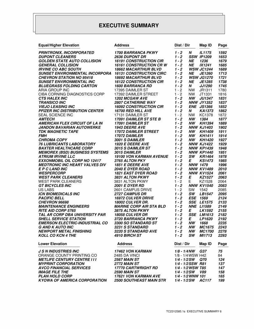
EXECUTIVE SUMMARY
TC2312585.1s EXECUTIVE SUMMARY 6
PageMap IDDist / Dir Address Equal/Higher Elevation ____________________ ________ ____________________
1592IL1175N1 - 2 1700 BARRANCA PKWY PRINTRONIX, INCORPORATED1653IP1209SSW1 - 2 2636 DUPONT DR DUPONT CLEANERS16791236NE1 - 2 16191 CONSTRUCTION CIR GOLDEN STATE AUTO COLLISION1685IX1241NE1 - 2 16161 CONSTRUCTION CR W GENERAL COLLISION1689JC1244WSW1 - 2 18662 MACARTHUR BLVD IRVINE CO ABC SOUTH1713JE1260NE1 - 2 16131 CONSTRUCTION CIRC SUNSET ENVIRONMENTAL INCORPORA1721JG1270WSW1 - 2 18692 MACARTHUR BLVD CHEVRON STATION NO 954181738JE1285NE1 - 2 16122 CONSTRUCTION CIR SUNSET ENVIRONMENTAL INC1745JJ1290N1 - 2 1600 BARRANCA RD BLUEGRASS FOLDING CARTON1780JR1311NW1 - 2 17395 DAIMLER ST ARIA GROUP INC1816JT1331NW1 - 2 17392 DAIMLER STREET CIBA CORNING DIAGNOSTICS CORP1831JU1347NW1 - 2 1202 MCGAW AVE CTS HALEX INC1837JY1352NNW1 - 2 2807 CATHERINE WAY TRANSICO INC1852JS1366ENE1 - 2 16092 CONSTRUCTION CIR VIEJO LEASING INC1862KA1373N1 - 2 16700 RED HILL AVE PFIZER INC DISTRIBUTION CENTER1872KC1378NW1 - 2 17131 DAIMLER ST SEAL SCIENCE INC18771384NW1 - 2 17091 DAIMLER ST STE B AMTECH1889KH1394NW1 - 2 17091 DAIMLER ST AMERICAN FLEX CIRCUIT OF LA IN1902KJ1403NNW1 - 2 1943 DEERE AVE JANDON BAVARIAN AUTOWERKE1911KH1409NW1 - 2 17072 DAIMLER STREET TDK MAGNETIC TAPE1914KH1411NW1 - 2 17072 DAIMLER FMH1927KH1420NW1 - 2 3001 S DAIMLER CHROMA COPY1929KJ1422NNW1 - 2 1920 E DEERE AVE 76 LUBRICANTS LABORATORY1948KP1439NNW1 - 2 3015 S DAIMLER ST BAXTER HEALTHCARE CORP1951KP1440NNW1 - 2 3015 DAIMLER MEMOREX (BSD) BUSINESS SYSTEMS1978KR1464SW1 - 2 19100 VON KARMAN AVENUE ATRIUM IRVINE LLC1985KS1473E1 - 2 3765 ALTON PKY EXXONMOBIL OIL CORP NO 1241719961479NNW1 - 2 1851 E DEERE AVE MEDTRONIC INC HEART VALVES DIV2010KV1489NNW1 - 2 2040 E DYER ROAD E P C LAND INC2061KV1524NNW1 - 2 1821 EAST DYER ROAD WESPERCORP2063KZ1527E1 - 2 3831 ALTON PKWY WEST PARK CLEANERS2064KZ1528E1 - 2 3831 ALTON PKWY WEST PARK CLEANERS2083KV1540NNW1 - 2 2001 E DYER RD GT BICYCLES INC20851542SW1 - 2 2601 CAMPUS DRIVE US LABS2095LB1547SW1 - 2 2727 CAMPUS DR ICN BIOMEDICALS INC21241569ESE1 - 2 16972 CULVER DRIVE PACIFIC BELL2133LE1575SSE1 - 2 18002 CULVER DR. CHEVRON 966982149LI1589NNE1 - 2 MARINE CORP AIR STA BLD MAINTENANCE ENGINEERS2155LK1592E1 - 2 3875 ALTON PKWY RITE AID CORP 57652182LM1613SSE1 - 2 18058 CULVER DR TAL AR CORP DBA UNIVERSITY PAR2192LP1620E1 - 2 3720 BARRANCA PKWY SHELL SERVICE STATION22351668NW1 - 2 3300 SO STANDARD ST EMERSON ELECTRIC-INDUSTRIAL CO2243MC1675NW1 - 2 3231 S STANDARD G AND K AUTO INC2278MC1700NW1 - 2 3220 S STANDARD AVE NEWPORT METAL FINISHING2293MI1713SW1 - 2 4910 BIRCH ST KOLL CO KCN 4 THE
PageMap IDDist / Dir Address Lower Elevation ____________________ ________ ____________________
75G37NW1/8 - 1/4 17462 VON KARMAN J S N INDUSTRIES INC84H42WSW1/8 - 1/4 2485 DA VINCI ORANGE COUNTY PRINTING CO124Q70SW1/4 - 1/2 2567 MAIN ST METLIFE CENTURY CENTRE I I I137R81SSW1/4 - 1/2 2772 MAIN ST MYPRINT CORPORATION147T85WSW1/4 - 1/2 17770 CARTWRIGHT RD AVCO FINANCIAL SERVICES158V89SW1/4 - 1/2 2590 MAIN ST IMAGE FILE THE165101WNW1/4 - 1/2 17621 VON KARMAN AVE PLAN HOLD CORP199AC117SW1/4 - 1/2 2500 SOUTHEAST MAIN STR KYOWA OF AMERICA CORPORATION
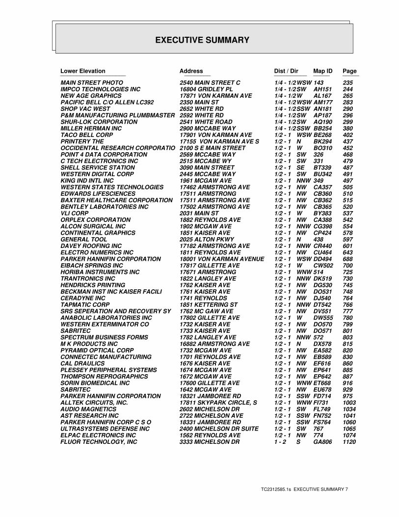
EXECUTIVE SUMMARY
TC2312585.1s EXECUTIVE SUMMARY 7
PageMap IDDist / Dir Address Lower Elevation ____________________ ________ ____________________
235143WSW1/4 - 1/2 2540 MAIN STREET C MAIN STREET PHOTO244AH151SW1/4 - 1/2 16804 GRIDLEY PL IMPCO TECHNOLOGIES INC265AL167W1/4 - 1/2 17871 VON KARMAN AVE NEW AGE GRAPHICS283AM177WSW1/4 - 1/2 2350 MAIN ST PACIFIC BELL C/O ALLEN LC392290AN181SSW1/4 - 1/2 2652 WHITE RD SHOP VAC WEST296AP187SW1/4 - 1/2 2592 WHITE RD P&M MANUFACTURING PLUMBMASTER299AQ190SW1/4 - 1/2 2541 WHITE ROAD SHUR-LOK CORPORATION380BB254SSW1/4 - 1/2 2900 MCCABE WAY MILLER HERMAN INC402BE268WSW1/2 - 1 17901 VON KARMAN AVE TACO BELL CORP437BK294N1/2 - 1 17155 VON KARMAN AVE S PRINTERY THE452BO310W1/2 - 1 2100 S E MAIN STREET OCCIDENTAL RESEARCH CORPORATIO468326SW1/2 - 1 2569 MCCABE WAY POINT 4 DATA CORPORATION479331SW1/2 - 1 2515 MCCABE WY C TECH ELECTRONICS INC487BT339SE1/2 - 1 3090 MAIN STREET SHELL SERVICE STATION491BU342SW1/2 - 1 2445 MCCABE WAY WESTERN DIGITAL CORP497349NNW1/2 - 1 1961 MCGAW AVE KING IND INTL INC505CA357NW1/2 - 1 17462 ARMSTRONG AVE WESTERN STATES TECHNOLOGIES510CB360NW1/2 - 1 17511 ARMSTRONG EDWARDS LIFESCIENCES515CB362NW1/2 - 1 17511 ARMSTRONG AVE BAXTER HEALTHCARE CORPORATION520CB365NW1/2 - 1 17502 ARMSTRONG AVE BENTLEY LABORATORIES INC537BY383W1/2 - 1 2031 MAIN ST VLI CORP542CA388NW1/2 - 1 1882 REYNOLDS AVE ORPLEX CORPORATION554CG398NNW1/2 - 1 1902 MCGAW AVE ALCON SURGICAL INC578CP424NW1/2 - 1 1851 KAISER AVE CONTINENTAL GRAPHICS597438N1/2 - 1 2025 ALTON PKWY GENERAL TOOL601CR440NNW1/2 - 1 17182 ARMSTRONG AVE DAVEY ROOFING INC643CU464NW1/2 - 1 1811 REYNOLDS AVE ELECTRO NUMERICS INC688DD494WSW1/2 - 1 18001 VON KARMAN AVENUE PARKER HANNIFIN CORPORATION700CW502W1/2 - 1 17817 GILLETTE AVE EIBACH SPRINGS INC725514WNW1/2 - 1 17671 ARMSTRONG HORIBA INSTRUMENTS INC730DK519NNW1/2 - 1 1822 LANGLEY AVE TRANTRONICS INC745DG530NW1/2 - 1 1762 KAISER AVE HENDRICKS PRINTING748DO531NW1/2 - 1 1761 KAISER AVE BECKMAN INST INC KAISER FACILI764DJ540NW1/2 - 1 1741 REYNOLDS CERADYNE INC766DT542NNW1/2 - 1 1851 KETTERING ST TAPMATIC CORP777DV551NW1/2 - 1 1762 MC GAW AVE SRS SEPERATION AND RECOVERY SY780DW555W1/2 - 1 17802 GILLETTE AVE ANABOLIC LABORATORIES INC799DO570NW1/2 - 1 1732 KAISER AVE WESTERN EXTERMINATOR CO801DO571NW1/2 - 1 1733 KAISER AVE SABRITEC803572NNW1/2 - 1 1782 LANGLEY AVE SPECTRUM BUSINESS FORMS815DX578N1/2 - 1 16882 ARMSTRONG AVE M K PRODUCTS INC820EA582NW1/2 - 1 1732 MCGAW AVE PYRAMID OPTICAL CORP830EB589NW1/2 - 1 1701 REYNOLDS AVE CONNECTEC MANUFACTURING860EF616NW1/2 - 1 1676 KAISER AVE CAL DRAULICS885EP641NW1/2 - 1 1674 MCGAW AVE PLESSEY PERIPHERAL SYSTEMS887EP642NW1/2 - 1 1672 MCGAW AVE THOMPSON REPROGRAPHICS916ET668WNW1/2 - 1 17600 GILLETTE AVE SORIN BIOMEDICAL INC929EU678NW1/2 - 1 1642 MCGAW AVE SABRITEC975FD714SSW1/2 - 1 18321 JAMBOREE RD PARKER HANNIFIN CORPORATION1003FI731WNW1/2 - 1 17811 SKYPARK CIRCLE, S ALLTEK CIRCUITS, INC.1034FL749SW1/2 - 1 2602 MICHELSON DR AUDIO MAGNETICS1041FN752SSW1/2 - 1 2722 MICHELSON AVE AST RESEARCH INC1060FS764SSW1/2 - 1 18331 JAMBOREE RD PARKER HANNIFIN CORP C S O1065767SW1/2 - 1 2400 MICHELSON DR SUITE ULTRASYSTEMS DEFENSE INC1074774NW1/2 - 1 1562 REYNOLDS AVE ELPAC ELECTRONICS INC1120GA806S1 - 2 3333 MICHELSON DR FLUOR TECHNOLOGY, INC
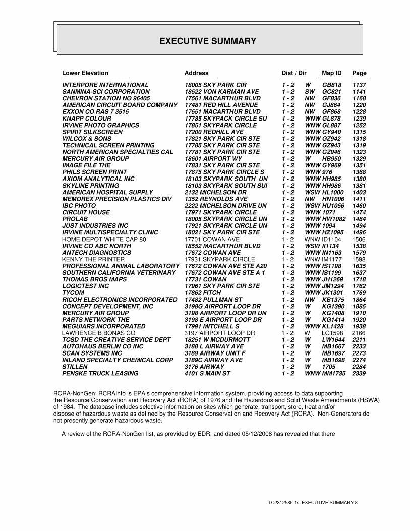
EXECUTIVE SUMMARY
TC2312585.1s EXECUTIVE SUMMARY 8
PageMap IDDist / Dir Address Lower Elevation ____________________ ________ ____________________
1137GB818W1 - 2 18005 SKY PARK CIR INTERPORE INTERNATIONAL1141GC821SW1 - 2 18522 VON KARMAN AVE SANMINA-SCI CORPORATION1168GF836NW1 - 2 17561 MACARTHUR BLVD CHEVRON STATION NO 964051220GJ864NW1 - 2 17481 RED HILL AVENUE AMERICAN CIRCUIT BOARD COMPANY1228GF868NW1 - 2 17551 MACARTHUR BLVD EXXON CO RAS 7 35151239GL878WNW1 - 2 17785 SKYPACK CIRCLE SU KNAPP COLOUR1252GL887WNW1 - 2 17851 SKYPARK CIRCLE IRVINE PHOTO GRAPHICS1315GY940WNW1 - 2 17200 REDHILL AVE SPIRIT SILKSCREEN1318GZ942WNW1 - 2 17821 SKY PARK CIR STE WILCOX & SONS1319GZ943WNW1 - 2 17785 SKY PARK CIR STE TECHNICAL SCREEN PRINTING1323GZ946WNW1 - 2 17781 SKY PARK CIR STE NORTH AMERICAN SPECIALTIES CAL1329HB950W1 - 2 18601 AIRPORT WY MERCURY AIR GROUP1351GY969WNW1 - 2 17831 SKY PARK CIR STE IMAGE FILE THE1368976WNW1 - 2 17875 SKY PARK CIRCLE S PHILS SCREEN PRINT1380HH985WNW1 - 2 18103 SKYPARK SOUTH UN AXIOM ANALYTICAL INC1381HH986WNW1 - 2 18103 SKYPARK SOUTH SUI SKYLINE PRINTING1403HL1000WSW1 - 2 2132 MICHELSON DR AMERICAN HOSPITAL SUPPLY1411HN1006NW1 - 2 1352 REYNOLDS AVE MEMOREX PRECISION PLASTICS DIV1460HU1056WSW1 - 2 2222 MICHELSON DRIVE UN IBC PHOTO14741071WNW1 - 2 17971 SKYPARK CIRCLE CIRCUIT HOUSE1484HW1082WNW1 - 2 18005 SKYPARK CIRCLE UN PROLAB14941094WNW1 - 2 17921 SKYPARK CIRCLE UN JUST INDUSTRIES INC1496HZ1095WNW1 - 2 18021 SKY PARK CIR STE IRVINE MULTISPECIALTY CLINIC1506ID1104WNW1 - 2 17701 COWAN AVE HOME DEPOT WHITE CAP 801538II1134WSW1 - 2 18552 MACARTHUR BLVD IRVINE CO ABC NORTH1579IN1163WNW1 - 2 17672 COWAN AVE ANTECH DIAGNOSTICS1598IM1177WNW1 - 2 17931 SKYPARK CIRCLE KENNY THE PRINTER1635IS1198WNW1 - 2 17672 COWAN AVE STE A20 PROFESSIONAL ANIMAL LABORATORY1637IS1199WNW1 - 2 17672 COWAN AVE STE A 1 SOUTHERN CALIFORNIA VETERINARY1718JH1269WNW1 - 2 17731 COWAN THOMAS BROS MAPS1762JM1294WNW1 - 2 17961 SKY PARK CIR STE LOGICTEST INC1769JK1301WNW1 - 2 17862 FITCH TYCOM1864KB1375NW1 - 2 17482 PULLMAN ST RICOH ELECTRONICS INCORPORATED1885KG1390W1 - 2 3198G AIRPORT LOOP DR CONCEPT DEVELOPMENT, INC1910KG1408W1 - 2 3198 AIRPORT LOOP DR UN MERCURY AIR GROUP1920KG1414W1 - 2 3198 E AIRPORT LOOP DR PARTS NETWORK THE1938KL1428WNW1 - 2 17991 MITCHELL S MEGUIARS INCORPORATED2166LG1598W1 - 2 3197 AIRPORT LOOP DR LAWRENCE B BONAS CO2211LW1644W1 - 2 18251 W MCDURMOTT TCSD THE CREATIVE SERVICE DEPT2233MB1667W1 - 2 3188 L AIRWAY AVE AUTOHAUS BERLIN CO INC2273MB1697W1 - 2 3189 AIRWAY UNIT F SCAN SYSTEMS INC2274MB1698W1 - 2 3189C AIRWAY AVE INLAND SPECIALTY CHEMICAL CORP22841705W1 - 2 3176 AIRWAY STILLEN2339MM1735WNW1 - 2 4101 S MAIN ST PENSKE TRUCK LEASING
RCRA-NonGen: RCRAInfo is EPA’s comprehensive information system, providing access to data supportingthe Resource Conservation and Recovery Act (RCRA) of 1976 and the Hazardous and Solid Waste Amendments (HSWA)of 1984. The database includes selective information on sites which generate, transport, store, treat and/ordispose of hazardous waste as defined by the Resource Conservation and Recovery Act (RCRA). Non-Generators donot presently generate hazardous waste.
A review of the RCRA-NonGen list, as provided by EDR, and dated 05/12/2008 has revealed that there
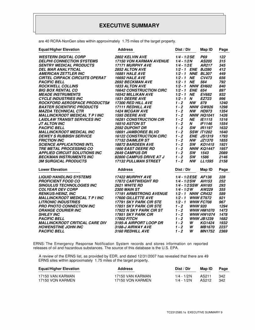
EXECUTIVE SUMMARY
TC2312585.1s EXECUTIVE SUMMARY 9
are 40 RCRA-NonGen sites within approximately 1.75 miles of the target property.
PageMap IDDist / Dir Address Equal/Higher Elevation ____________________ ________ ____________________
122P69SE1/4 - 1/2 2802 KELVIN AVE WESTERN DIGITAL CORP315AS205N1/4 - 1/2 17150 VON KARMAN AVENUE DELPHI CONNECTION SYSTEMS345AR217E1/4 - 1/2 17171 MURPHY AVE SENTRY MEDICAL PRODUCTS412BJ280ENE1/2 - 1 2852 ALTON AVE DEL MAR ANALYTICAL449BL307NNE1/2 - 1 16881 HALE AVE AMERICAN ZETTLER INC656CV473NE1/2 - 1 16692 HALE AVE CIRTEL CIRPACK CIRCUITS OPERAT792564NE1/2 - 1 2692 BECKMAN AVE PACIFIC BELL840EH602NNW1/2 - 1 1833 ALTON AVE ROCKWELL COLLINS897654ENE1/2 - 1 16642 CONSTRUCTION CIRC BIG BOX RENTAL CO932EV682NE1/2 - 1 16542 MILLIKAN AVE MEADE INSTRUMENTS996EZ723N1/2 - 1 1931 DEERE AVE CYCLE INDUSTRIES INC1240879NW1 - 2 17300 RED HILL AVE ROCKFORD AEROSPACE PRODUCTS#1298GW926NNW1 - 2 17111 REDHILL AVE BAXTER SCIENTIFIC PRODUCTS1354HD973NW1 - 2 1424 MCGAW AVE MAZDA TECHNICAL CTR1426HQ1041NNW1 - 2 1595 DEERE AVE MALLINCKRODT MEDICAL T P I INC1516IE1115NE1 - 2 16281 CONSTRUCTION CIR LAIDLAW TRANSIT SERVICES INC1554IF1146N1 - 2 16510 ASTON ST JT ALTON INC1632IR1197SW1 - 2 2592 DUPONT DR PACIFIC BELL1640IT1202SSW1 - 2 18691 JAMBOREE BLVD MALLINCKRODT MEDICAL INC1793JS1319ENE1 - 2 16122 CONSTRUCTION CIRC DEWEY S RUBBISH SERVICE1855JZ1370NW1 - 2 17152 DAIMLER ST FRICTION INC1921KD1415SW1 - 2 18872 BARDEEN AVE SCIENCE APPLICATIONS INTL1957KQ1447NNW1 - 2 1900 EAST DEERE RD TRE METAL PROCESSING CO20891543SW1 - 2 2649 CAMPUS DR APPLIED CIRCUIT SOLUTIONS INC21461586SW1 - 2 92800 CAMPUS DRIVE AT J BECKMAN INSTRUMENTS INC2158LL1595NW1 - 2 17132 PULLMAN STREET 3M SURGICAL PRODUCTS
PageMap IDDist / Dir Address Lower Elevation ____________________ ________ ____________________
228AF138ESE1/4 - 1/2 17422 MURPHY AVE LIQUID HANDLING SYSTEMS252AH153SW1/4 - 1/2 17872 CARTWEIGHT RD PROFICIENT FOOD CO293AN185SSW1/4 - 1/2 2621 WHITE RD SINGULUS TECHNOLOGIES INC355AW229W1/4 - 1/2 2300 MAIN ST COLYEAR DEV CORP589CR432NNW1/2 - 1 17191 ARMSTRONG AVENUE RENKUS-HEINZ, INC921ET672WNW1/2 - 1 17600 GILLETTE AVE MALLINCKRODT MEDICAL T P I INC967FC708WNW1/2 - 1 17791 SKY PARK CIR STE LITRONIC INDUSTRIES1294920WNW1 - 2 17851 SKY PARK CIR STE PRO PHOTO CONNECTION INC1473HM1070WNW1 - 2 17922 N SKY PARK CIR ST ORANGE COURIER INC1478HW1074WNW1 - 2 17951 SKY PARK CIR SHILEY INC1682JB1239WNW1 - 2 17802 FITCH PACIFIC BELL1932KG1424W1 - 2 3195-A AIRPORT LOOP DR MALLINCKRODT CRITICAL CARE DIV2237MB1670W1 - 2 3188-J AIRWAY AVE HOWENSTINE JOHN INC2369MN1752W1 - 2 3160 REDHILL AVE PACIFIC BELL
ERNS: The Emergency Response Notification System records and stores information on reportedreleases of oil and hazardous substances. The source of this database is the U.S. EPA.
A review of the ERNS list, as provided by EDR, and dated 12/31/2007 has revealed that there are 49 ERNS sites within approximately 1.75 miles of the target property.
PageMap IDDist / Dir Address Equal/Higher Elevation ____________________ ________ ____________________
342AS211N1/4 - 1/2 17150 VAN KARMAN 17150 VAN KARMAN342AS212N1/4 - 1/2 17150 VON KARMEN 17150 VON KARMEN
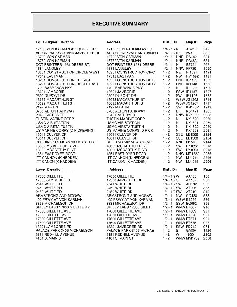
EXECUTIVE SUMMARY
TC2312585.1s EXECUTIVE SUMMARY 10
PageMap IDDist / Dir Address Equal/Higher Elevation ____________________ ________ ____________________
342AS213N1/4 - 1/2 17150 VON KARMAN AVE (O 17150 VON KARMAN AVE (OR VON C380253NE1/4 - 1/2 ALTON PARKWAY AND JAMBO ALTON PARKWAY AND JAMBOREE RD 681DA482NNE1/2 - 1 16782 VON CARMAN 16782 VON CARMAN681DA483NNE1/2 - 1 16782 VON KARMAN 16782 VON KARMAN997EZ724N1/2 - 1 DOT PRINTERS 1931 DEERE DOT PRINTERS 1931 DEERE ST.1020FF739NNW1/2 - 1 1681 LANGLEY 1681 LANGLEY1424HI1037NE1 - 2 16351 CONSTRUCTION CIRC 16351 CONSTRUCTION CIRCLE WEST1491HY1092NW1 - 2 17312 EASTMAN 17312 EASTMAN1529IG1123ENE1 - 2 16291 CONSTRUCTION CR E 16291 CONSTRUCTION CR EAST1556IK1148ENE1 - 2 16291 CONSTRUCTION CIRC 16291 CONSTRUCTION CIRCLE EAST1590IL1170N1 - 2 1700 BARRANCA PKY 1700 BARRANCA PKY1607IP1187SSW1 - 2 18691 JAMBORIE 18691 JAMBORIE1632IR1196SW1 - 2 2592 DUPONT DR 2592 DUPONT DR1714JG1262WSW1 - 2 18692 MACARTHUR ST 18692 MACARTHUR ST1717JG1267WSW1 - 2 18692 MACARTHUR ST 18692 MACARTHUR ST1943KN1432SW1 - 2 2192 MARTIN 2192 MARTIN1985KS1471E1 - 2 3765 ALTON PARKWAY 3765 ALTON PARKWAY2038KV1502NNW1 - 2 2040 EAST DYER 2040 EAST DYER2060KX1520N1 - 2 TUSTIN MARINE CORP TUSTIN MARINE CORP2060KX1521N1 - 2 USMC AIR STATION USMC AIR STATION2060KX1522N1 - 2 USMC AIRSTA TUSTIN USMC AIRSTA TUSTIN2061KX1523N1 - 2 US MARINE CORPS (D PICK US MARINE CORPS (D PICKERING)2124LE1566SSE1 - 2 18011 CULVER DR 18011 CULVER DR2124LE1568SSE1 - 2 18011 CULVER DR 18011 CULVER DR2144LI1583NNE1 - 2 BUILDING 502 MCAS 38 MC BUILDING 502 MCAS 38 MCAS TUST2218LY1652SW1 - 2 18692 MC ARTHUR BLVD 18692 MC ARTHUR BLVD2218LY1653SW1 - 2 18692 MCCARTHY BLVD 18692 MCCARTHY BLVD2255MD1682NNW1 - 2 1351 EAST DYER ROAD 1351 EAST DYER ROAD2296MJ1714NW1 - 2 ITT CANNON (K HEDDEN) ITT CANNON (K HEDDEN)2296MJ1715NW1 - 2 ITT CANON (K HADDEN) ITT CANON (K HADDEN)
PageMap IDDist / Dir Address Lower Elevation ____________________ ________ ____________________
168AA103W1/4 - 1/2 17836 GILLETTE 17836 GILLETTE263AK162S1/4 - 1/2 17900 JAMBOREE RD 17900 JAMBOREE RD303AQ192SW1/4 - 1/2 2541 WHITE RD 2541 WHITE RD335AT206SW1/4 - 1/2 2450 WHITE RD 2450 WHITE RD342AT210SW1/4 - 1/2 2450 WHITE RD 2450 WHITE RD583CQ428NW1/2 - 1 ARMSTRONG AND MCGAW ARMSTRONG AND MCGAW836EE596WSW1/2 - 1 405 FRWY AT VON KARMAN 405 FRWY AT VON KARMAN895EQ652SSW1/2 - 1 3333 MICHAELSON DR. 3333 MICHAELSON DR.916ET667WNW1/2 - 1 SHILEY LABS 17600 GILET SHILEY LABS 17600 GILETTE AV921ET669WNW1/2 - 1 17600 GILLETTE AVE 17600 GILLETTE AVE921ET670WNW1/2 - 1 17600 GILETTE AVE 17600 GILETTE AVE921ET671WNW1/2 - 1 17600 GILLETTE AVE. 17600 GILLETTE AVE.927ET675WNW1/2 - 1 17600 GILLETTE AVE 17600 GILLETTE AVE974FD712SSW1/2 - 1 18321 JAMBOREE RD 18321 JAMBOREE RD1120GA804S1 - 2 PALACE PARK 3405 MICHAE PALACE PARK 3405 MICHAELSON22021630W1 - 2 3191 REDHILL AVENUE 3191 REDHILL AVENUE2358MM1739WNW1 - 2 4101 S. MAIN ST 4101 S. MAIN ST
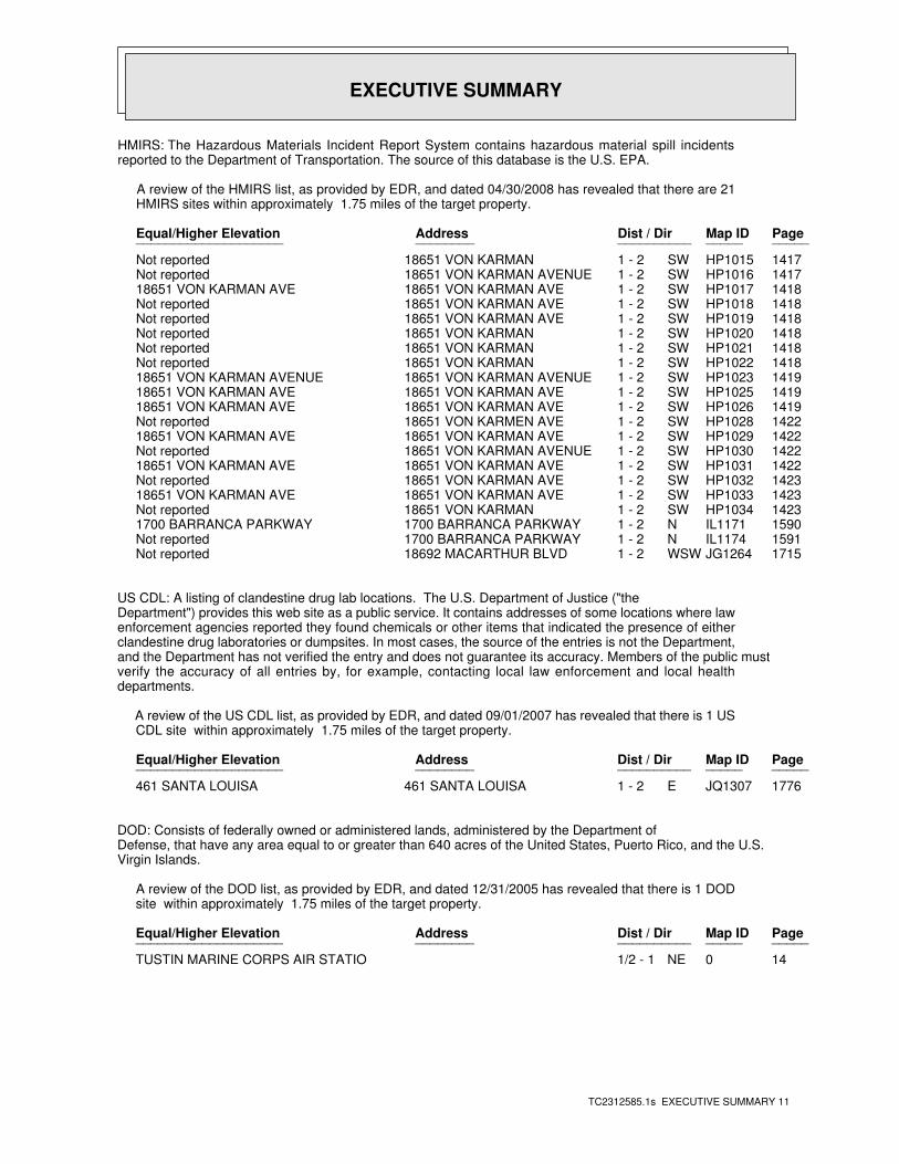
EXECUTIVE SUMMARY
TC2312585.1s EXECUTIVE SUMMARY 11
HMIRS: The Hazardous Materials Incident Report System contains hazardous material spill incidentsreported to the Department of Transportation. The source of this database is the U.S. EPA.
A review of the HMIRS list, as provided by EDR, and dated 04/30/2008 has revealed that there are 21 HMIRS sites within approximately 1.75 miles of the target property.
PageMap IDDist / Dir Address Equal/Higher Elevation ____________________ ________ ____________________
1417HP1015SW1 - 2 18651 VON KARMAN Not reported1417HP1016SW1 - 2 18651 VON KARMAN AVENUE Not reported1418HP1017SW1 - 2 18651 VON KARMAN AVE 18651 VON KARMAN AVE1418HP1018SW1 - 2 18651 VON KARMAN AVE Not reported1418HP1019SW1 - 2 18651 VON KARMAN AVE Not reported1418HP1020SW1 - 2 18651 VON KARMAN Not reported1418HP1021SW1 - 2 18651 VON KARMAN Not reported1418HP1022SW1 - 2 18651 VON KARMAN Not reported1419HP1023SW1 - 2 18651 VON KARMAN AVENUE 18651 VON KARMAN AVENUE1419HP1025SW1 - 2 18651 VON KARMAN AVE 18651 VON KARMAN AVE1419HP1026SW1 - 2 18651 VON KARMAN AVE 18651 VON KARMAN AVE1422HP1028SW1 - 2 18651 VON KARMEN AVE Not reported1422HP1029SW1 - 2 18651 VON KARMAN AVE 18651 VON KARMAN AVE1422HP1030SW1 - 2 18651 VON KARMAN AVENUE Not reported1422HP1031SW1 - 2 18651 VON KARMAN AVE 18651 VON KARMAN AVE1423HP1032SW1 - 2 18651 VON KARMAN AVE Not reported1423HP1033SW1 - 2 18651 VON KARMAN AVE 18651 VON KARMAN AVE1423HP1034SW1 - 2 18651 VON KARMAN Not reported1590IL1171N1 - 2 1700 BARRANCA PARKWAY 1700 BARRANCA PARKWAY1591IL1174N1 - 2 1700 BARRANCA PARKWAY Not reported1715JG1264WSW1 - 2 18692 MACARTHUR BLVD Not reported
US CDL: A listing of clandestine drug lab locations. The U.S. Department of Justice ("theDepartment") provides this web site as a public service. It contains addresses of some locations where lawenforcement agencies reported they found chemicals or other items that indicated the presence of eitherclandestine drug laboratories or dumpsites. In most cases, the source of the entries is not the Department,and the Department has not verified the entry and does not guarantee its accuracy. Members of the public mustverify the accuracy of all entries by, for example, contacting local law enforcement and local healthdepartments.
A review of the US CDL list, as provided by EDR, and dated 09/01/2007 has revealed that there is 1 US CDL site within approximately 1.75 miles of the target property.
PageMap IDDist / Dir Address Equal/Higher Elevation ____________________ ________ ____________________
1776JQ1307E1 - 2 461 SANTA LOUISA 461 SANTA LOUISA
DOD: Consists of federally owned or administered lands, administered by the Department ofDefense, that have any area equal to or greater than 640 acres of the United States, Puerto Rico, and the U.S.Virgin Islands.
A review of the DOD list, as provided by EDR, and dated 12/31/2005 has revealed that there is 1 DOD site within approximately 1.75 miles of the target property.
PageMap IDDist / Dir Address Equal/Higher Elevation ____________________ ________ ____________________
140NE1/2 - 1 TUSTIN MARINE CORPS AIR STATIO
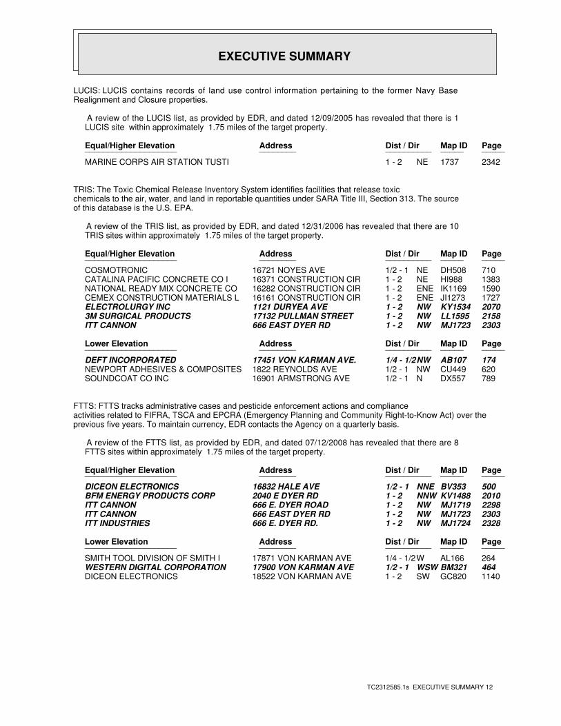
EXECUTIVE SUMMARY
TC2312585.1s EXECUTIVE SUMMARY 12
LUCIS: LUCIS contains records of land use control information pertaining to the former Navy BaseRealignment and Closure properties.
A review of the LUCIS list, as provided by EDR, and dated 12/09/2005 has revealed that there is 1 LUCIS site within approximately 1.75 miles of the target property.
PageMap IDDist / Dir Address Equal/Higher Elevation ____________________ ________ ____________________
23421737NE1 - 2 MARINE CORPS AIR STATION TUSTI
TRIS: The Toxic Chemical Release Inventory System identifies facilities that release toxicchemicals to the air, water, and land in reportable quantities under SARA Title III, Section 313. The sourceof this database is the U.S. EPA.
A review of the TRIS list, as provided by EDR, and dated 12/31/2006 has revealed that there are 10 TRIS sites within approximately 1.75 miles of the target property.
PageMap IDDist / Dir Address Equal/Higher Elevation ____________________ ________ ____________________
710DH508NE1/2 - 1 16721 NOYES AVE COSMOTRONIC1383HI988NE1 - 2 16371 CONSTRUCTION CIR CATALINA PACIFIC CONCRETE CO I1590IK1169ENE1 - 2 16282 CONSTRUCTION CIR NATIONAL READY MIX CONCRETE CO1727JI1273ENE1 - 2 16161 CONSTRUCTION CIR CEMEX CONSTRUCTION MATERIALS L2070KY1534NW1 - 2 1121 DURYEA AVE ELECTROLURGY INC2158LL1595NW1 - 2 17132 PULLMAN STREET 3M SURGICAL PRODUCTS2303MJ1723NW1 - 2 666 EAST DYER RD ITT CANNON
PageMap IDDist / Dir Address Lower Elevation ____________________ ________ ____________________
174AB107NW1/4 - 1/2 17451 VON KARMAN AVE. DEFT INCORPORATED620CU449NW1/2 - 1 1822 REYNOLDS AVE NEWPORT ADHESIVES & COMPOSITES789DX557N1/2 - 1 16901 ARMSTRONG AVE SOUNDCOAT CO INC
FTTS: FTTS tracks administrative cases and pesticide enforcement actions and complianceactivities related to FIFRA, TSCA and EPCRA (Emergency Planning and Community Right-to-Know Act) over theprevious five years. To maintain currency, EDR contacts the Agency on a quarterly basis.
A review of the FTTS list, as provided by EDR, and dated 07/12/2008 has revealed that there are 8 FTTS sites within approximately 1.75 miles of the target property.
PageMap IDDist / Dir Address Equal/Higher Elevation ____________________ ________ ____________________
500BV353NNE1/2 - 1 16832 HALE AVE DICEON ELECTRONICS2010KV1488NNW1 - 2 2040 E DYER RD BFM ENERGY PRODUCTS CORP2298MJ1719NW1 - 2 666 E. DYER ROAD ITT CANNON2303MJ1723NW1 - 2 666 EAST DYER RD ITT CANNON2328MJ1724NW1 - 2 666 E. DYER RD. ITT INDUSTRIES
PageMap IDDist / Dir Address Lower Elevation ____________________ ________ ____________________
264AL166W1/4 - 1/2 17871 VON KARMAN AVE SMITH TOOL DIVISION OF SMITH I464BM321WSW1/2 - 1 17900 VON KARMAN AVE WESTERN DIGITAL CORPORATION1140GC820SW1 - 2 18522 VON KARMAN AVE DICEON ELECTRONICS
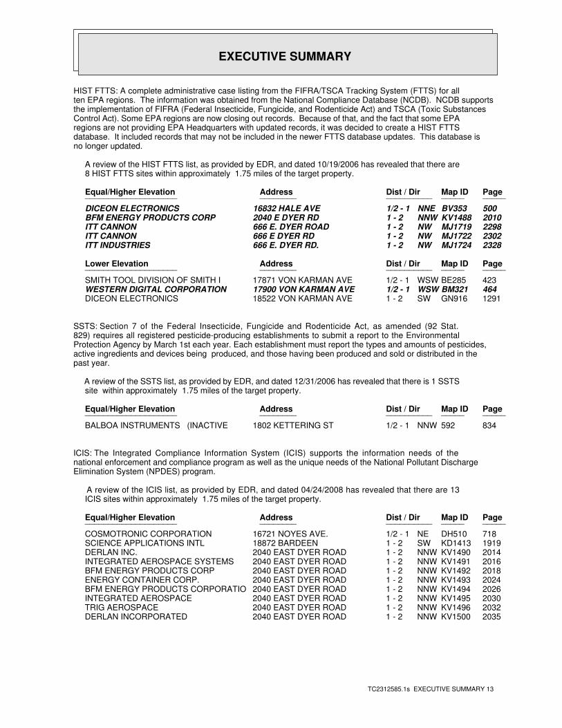
EXECUTIVE SUMMARY
TC2312585.1s EXECUTIVE SUMMARY 13
HIST FTTS: A complete administrative case listing from the FIFRA/TSCA Tracking System (FTTS) for allten EPA regions. The information was obtained from the National Compliance Database (NCDB). NCDB supportsthe implementation of FIFRA (Federal Insecticide, Fungicide, and Rodenticide Act) and TSCA (Toxic SubstancesControl Act). Some EPA regions are now closing out records. Because of that, and the fact that some EPAregions are not providing EPA Headquarters with updated records, it was decided to create a HIST FTTSdatabase. It included records that may not be included in the newer FTTS database updates. This database isno longer updated.
A review of the HIST FTTS list, as provided by EDR, and dated 10/19/2006 has revealed that there are 8 HIST FTTS sites within approximately 1.75 miles of the target property.
PageMap IDDist / Dir Address Equal/Higher Elevation ____________________ ________ ____________________
500BV353NNE1/2 - 1 16832 HALE AVE DICEON ELECTRONICS2010KV1488NNW1 - 2 2040 E DYER RD BFM ENERGY PRODUCTS CORP2298MJ1719NW1 - 2 666 E. DYER ROAD ITT CANNON2302MJ1722NW1 - 2 666 E DYER RD ITT CANNON2328MJ1724NW1 - 2 666 E. DYER RD. ITT INDUSTRIES
PageMap IDDist / Dir Address Lower Elevation ____________________ ________ ____________________
423BE285WSW1/2 - 1 17871 VON KARMAN AVE SMITH TOOL DIVISION OF SMITH I464BM321WSW1/2 - 1 17900 VON KARMAN AVE WESTERN DIGITAL CORPORATION1291GN916SW1 - 2 18522 VON KARMAN AVE DICEON ELECTRONICS
SSTS: Section 7 of the Federal Insecticide, Fungicide and Rodenticide Act, as amended (92 Stat.829) requires all registered pesticide-producing establishments to submit a report to the EnvironmentalProtection Agency by March 1st each year. Each establishment must report the types and amounts of pesticides,active ingredients and devices being produced, and those having been produced and sold or distributed in thepast year.
A review of the SSTS list, as provided by EDR, and dated 12/31/2006 has revealed that there is 1 SSTS site within approximately 1.75 miles of the target property.
PageMap IDDist / Dir Address Equal/Higher Elevation ____________________ ________ ____________________
834592NNW1/2 - 1 1802 KETTERING ST BALBOA INSTRUMENTS (INACTIVE
ICIS: The Integrated Compliance Information System (ICIS) supports the information needs of thenational enforcement and compliance program as well as the unique needs of the National Pollutant DischargeElimination System (NPDES) program.
A review of the ICIS list, as provided by EDR, and dated 04/24/2008 has revealed that there are 13 ICIS sites within approximately 1.75 miles of the target property.
PageMap IDDist / Dir Address Equal/Higher Elevation ____________________ ________ ____________________
718DH510NE1/2 - 1 16721 NOYES AVE. COSMOTRONIC CORPORATION1919KD1413SW1 - 2 18872 BARDEEN SCIENCE APPLICATIONS INTL2014KV1490NNW1 - 2 2040 EAST DYER ROAD DERLAN INC.2016KV1491NNW1 - 2 2040 EAST DYER ROAD INTEGRATED AEROSPACE SYSTEMS2018KV1492NNW1 - 2 2040 EAST DYER ROAD BFM ENERGY PRODUCTS CORP2024KV1493NNW1 - 2 2040 EAST DYER ROAD ENERGY CONTAINER CORP.2026KV1494NNW1 - 2 2040 EAST DYER ROAD BFM ENERGY PRODUCTS CORPORATIO2030KV1495NNW1 - 2 2040 EAST DYER ROAD INTEGRATED AEROSPACE2032KV1496NNW1 - 2 2040 EAST DYER ROAD TRIG AEROSPACE2035KV1500NNW1 - 2 2040 EAST DYER ROAD DERLAN INCORPORATED
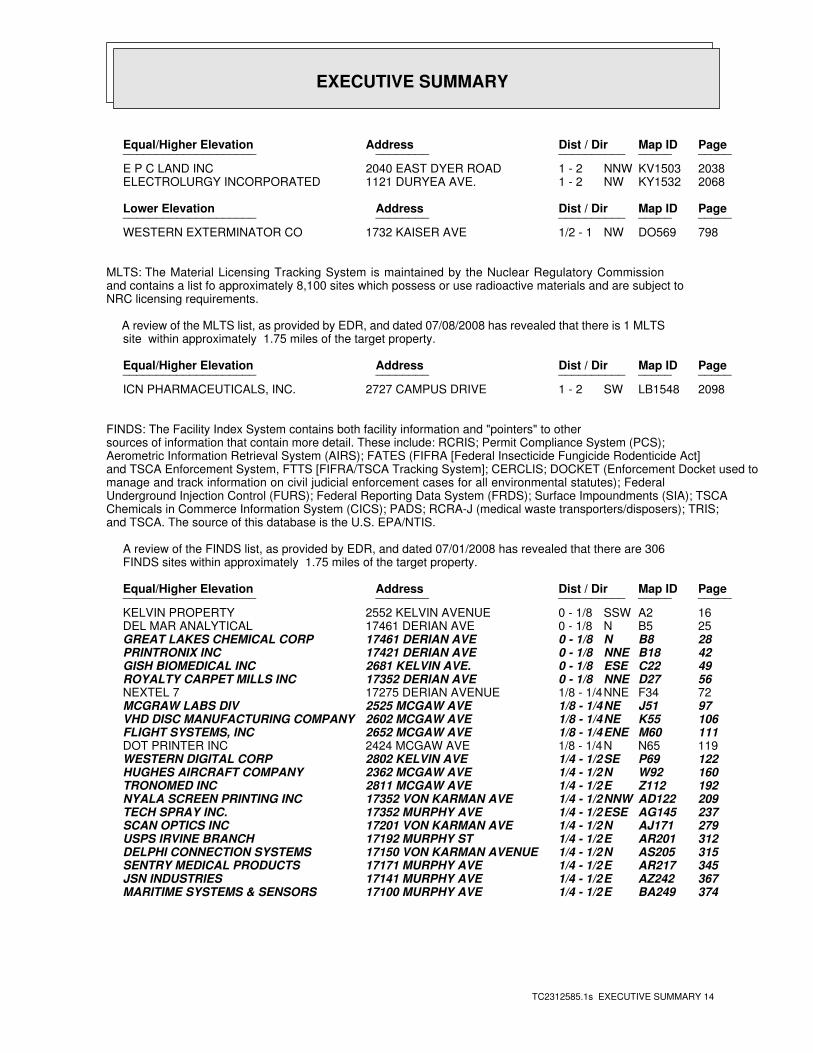
EXECUTIVE SUMMARY
TC2312585.1s EXECUTIVE SUMMARY 14
PageMap IDDist / Dir Address Equal/Higher Elevation ____________________ ________ ____________________
2038KV1503NNW1 - 2 2040 EAST DYER ROAD E P C LAND INC2068KY1532NW1 - 2 1121 DURYEA AVE. ELECTROLURGY INCORPORATED
PageMap IDDist / Dir Address Lower Elevation ____________________ ________ ____________________
798DO569NW1/2 - 1 1732 KAISER AVE WESTERN EXTERMINATOR CO
MLTS: The Material Licensing Tracking System is maintained by the Nuclear Regulatory Commissionand contains a list fo approximately 8,100 sites which possess or use radioactive materials and are subject toNRC licensing requirements.
A review of the MLTS list, as provided by EDR, and dated 07/08/2008 has revealed that there is 1 MLTS site within approximately 1.75 miles of the target property.
PageMap IDDist / Dir Address Equal/Higher Elevation ____________________ ________ ____________________
2098LB1548SW1 - 2 2727 CAMPUS DRIVE ICN PHARMACEUTICALS, INC.
FINDS: The Facility Index System contains both facility information and "pointers" to othersources of information that contain more detail. These include: RCRIS; Permit Compliance System (PCS);Aerometric Information Retrieval System (AIRS); FATES (FIFRA [Federal Insecticide Fungicide Rodenticide Act]and TSCA Enforcement System, FTTS [FIFRA/TSCA Tracking System]; CERCLIS; DOCKET (Enforcement Docket used tomanage and track information on civil judicial enforcement cases for all environmental statutes); FederalUnderground Injection Control (FURS); Federal Reporting Data System (FRDS); Surface Impoundments (SIA); TSCAChemicals in Commerce Information System (CICS); PADS; RCRA-J (medical waste transporters/disposers); TRIS;and TSCA. The source of this database is the U.S. EPA/NTIS.
A review of the FINDS list, as provided by EDR, and dated 07/01/2008 has revealed that there are 306 FINDS sites within approximately 1.75 miles of the target property.
PageMap IDDist / Dir Address Equal/Higher Elevation ____________________ ________ ____________________
16A2SSW0 - 1/8 2552 KELVIN AVENUE KELVIN PROPERTY25B5N0 - 1/8 17461 DERIAN AVE DEL MAR ANALYTICAL28B8N0 - 1/8 17461 DERIAN AVE GREAT LAKES CHEMICAL CORP42B18NNE0 - 1/8 17421 DERIAN AVE PRINTRONIX INC49C22ESE0 - 1/8 2681 KELVIN AVE. GISH BIOMEDICAL INC56D27NNE0 - 1/8 17352 DERIAN AVE ROYALTY CARPET MILLS INC72F34NNE1/8 - 1/4 17275 DERIAN AVENUE NEXTEL 797J51NE1/8 - 1/4 2525 MCGAW AVE MCGRAW LABS DIV106K55NE1/8 - 1/4 2602 MCGAW AVE VHD DISC MANUFACTURING COMPANY111M60ENE1/8 - 1/4 2652 MCGAW AVE FLIGHT SYSTEMS, INC119N65N1/8 - 1/4 2424 MCGAW AVE DOT PRINTER INC122P69SE1/4 - 1/2 2802 KELVIN AVE WESTERN DIGITAL CORP160W92N1/4 - 1/2 2362 MCGAW AVE HUGHES AIRCRAFT COMPANY192Z112E1/4 - 1/2 2811 MCGAW AVE TRONOMED INC209AD122NNW1/4 - 1/2 17352 VON KARMAN AVE NYALA SCREEN PRINTING INC237AG145ESE1/4 - 1/2 17352 MURPHY AVE TECH SPRAY INC.279AJ171N1/4 - 1/2 17201 VON KARMAN AVE SCAN OPTICS INC312AR201E1/4 - 1/2 17192 MURPHY ST USPS IRVINE BRANCH315AS205N1/4 - 1/2 17150 VON KARMAN AVENUE DELPHI CONNECTION SYSTEMS345AR217E1/4 - 1/2 17171 MURPHY AVE SENTRY MEDICAL PRODUCTS367AZ242E1/4 - 1/2 17141 MURPHY AVE JSN INDUSTRIES374BA249E1/4 - 1/2 17100 MURPHY AVE MARITIME SYSTEMS & SENSORS
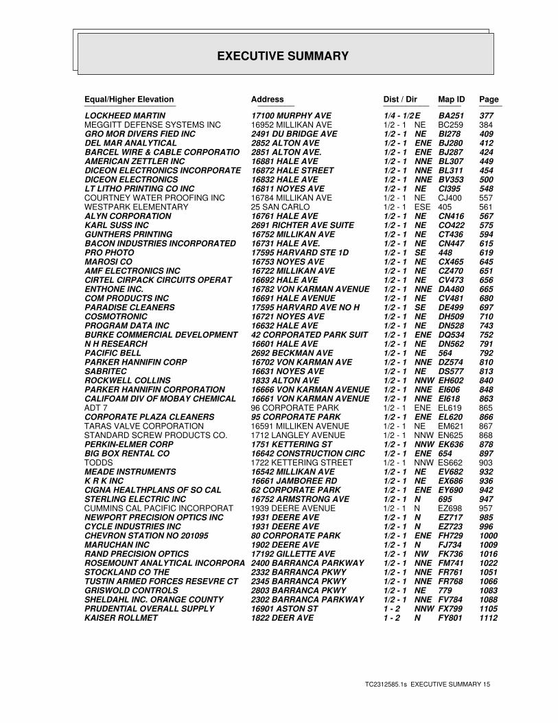
EXECUTIVE SUMMARY
TC2312585.1s EXECUTIVE SUMMARY 15
PageMap IDDist / Dir Address Equal/Higher Elevation ____________________ ________ ____________________
377BA251E1/4 - 1/2 17100 MURPHY AVE LOCKHEED MARTIN384BC259NE1/2 - 1 16952 MILLIKAN AVE MEGGITT DEFENSE SYSTEMS INC409BI278NE1/2 - 1 2491 DU BRIDGE AVE GRO MOR DIVERS FIED INC412BJ280ENE1/2 - 1 2852 ALTON AVE DEL MAR ANALYTICAL424BJ287ENE1/2 - 1 2851 ALTON AVE. BARCEL WIRE & CABLE CORPORATIO449BL307NNE1/2 - 1 16881 HALE AVE AMERICAN ZETTLER INC454BL311NNE1/2 - 1 16872 HALE STREET DICEON ELECTRONICS INCORPORATE500BV353NNE1/2 - 1 16832 HALE AVE DICEON ELECTRONICS548CI395NE1/2 - 1 16811 NOYES AVE LT LITHO PRINTING CO INC557CJ400NE1/2 - 1 16784 MILLIKAN AVE COURTNEY WATER PROOFING INC561405ESE1/2 - 1 25 SAN CARLO WESTPARK ELEMENTARY567CN416NE1/2 - 1 16761 HALE AVE ALYN CORPORATION575CO422NE1/2 - 1 2691 RICHTER AVE SUITE KARL SUSS INC594CT436NE1/2 - 1 16752 MILLIKAN AVE GUNTHERS PRINTING615CN447NE1/2 - 1 16731 HALE AVE. BACON INDUSTRIES INCORPORATED 619448SE1/2 - 1 17595 HARVARD STE 1D PRO PHOTO645CX465NE1/2 - 1 16753 NOYES AVE MAROSI CO651CZ470NE1/2 - 1 16722 MILLIKAN AVE AMF ELECTRONICS INC656CV473NE1/2 - 1 16692 HALE AVE CIRTEL CIRPACK CIRCUITS OPERAT665DA480NNE1/2 - 1 16782 VON KARMAN AVENUE ENTHONE INC.680CV481NE1/2 - 1 16691 HALE AVENUE COM PRODUCTS INC697DE499SE1/2 - 1 17595 HARVARD AVE NO H PARADISE CLEANERS710DH509NE1/2 - 1 16721 NOYES AVE COSMOTRONIC743DN528NE1/2 - 1 16632 HALE AVE PROGRAM DATA INC752DQ534ENE1/2 - 1 42 CORPORATED PARK SUIT BURKE COMMERCIAL DEVELOPMENT791DN562NE1/2 - 1 16601 HALE AVE N H RESEARCH792564NE1/2 - 1 2692 BECKMAN AVE PACIFIC BELL810DZ574NNE1/2 - 1 16702 VON KARMAN AVE PARKER HANNIFIN CORP813DS577NE1/2 - 1 16631 NOYES AVE SABRITEC840EH602NNW1/2 - 1 1833 ALTON AVE ROCKWELL COLLINS848EI606NNE1/2 - 1 16666 VON KARMAN AVENUE PARKER HANNIFIN CORPORATION863EI618NNE1/2 - 1 16661 VON KARMAN AVENUE CALIFOAM DIV OF MOBAY CHEMICAL865EL619ENE1/2 - 1 96 CORPORATE PARK ADT 7866EL620ENE1/2 - 1 95 CORPORATE PARK CORPORATE PLAZA CLEANERS867EM621NE1/2 - 1 16591 MILLIKEN AVENUE TARAS VALVE CORPORATION868EN625NNW1/2 - 1 1712 LANGLEY AVENUE STANDARD SCREW PRODUCTS CO.878EK636NNW1/2 - 1 1751 KETTERING ST PERKIN-ELMER CORP897654ENE1/2 - 1 16642 CONSTRUCTION CIRC BIG BOX RENTAL CO903ES662NNW1/2 - 1 1722 KETTERING STREET TODDS932EV682NE1/2 - 1 16542 MILLIKAN AVE MEADE INSTRUMENTS936EX686NE1/2 - 1 16661 JAMBOREE RD K R K INC942EY690ENE1/2 - 1 62 CORPORATE PARK CIGNA HEALTHPLANS OF SO CAL947695N1/2 - 1 16752 ARMSTRONG AVE STERLING ELECTRIC INC957EZ698N1/2 - 1 1939 DEERE AVENUE CUMMINS CAL PACIFIC INCORPORAT985EZ717N1/2 - 1 1931 DEERE AVE NEWPORT PRECISION OPTICS INC996EZ723N1/2 - 1 1931 DEERE AVE CYCLE INDUSTRIES INC1000FH729ENE1/2 - 1 80 CORPORATE PARK CHEVRON STATION NO 2010951009FJ734N1/2 - 1 1902 DEERE AVE MARUCHAN INC1016FK736NW1/2 - 1 17192 GILLETTE AVE RAND PRECISION OPTICS1022FM741NNE1/2 - 1 2400 BARRANCA PARKWAY ROSEMOUNT ANALYTICAL INCORPORA1051FR761NNE1/2 - 1 2332 BARRANCA PKWY STOCKLAND CO THE1066FR768NNE1/2 - 1 2345 BARRANCA PKWY TUSTIN ARMED FORCES RESEVRE CT1083779NE1/2 - 1 2803 BARRANCA PKWY GRISWOLD CONTROLS1088FV784NNE1/2 - 1 2302 BARRANCA PARKWAY SHELDAHL INC. ORANGE COUNTY1105FX799NNW1 - 2 16901 ASTON ST PRUDENTIAL OVERALL SUPPLY1112FY801N1 - 2 1822 DEER AVE KAISER ROLLMET
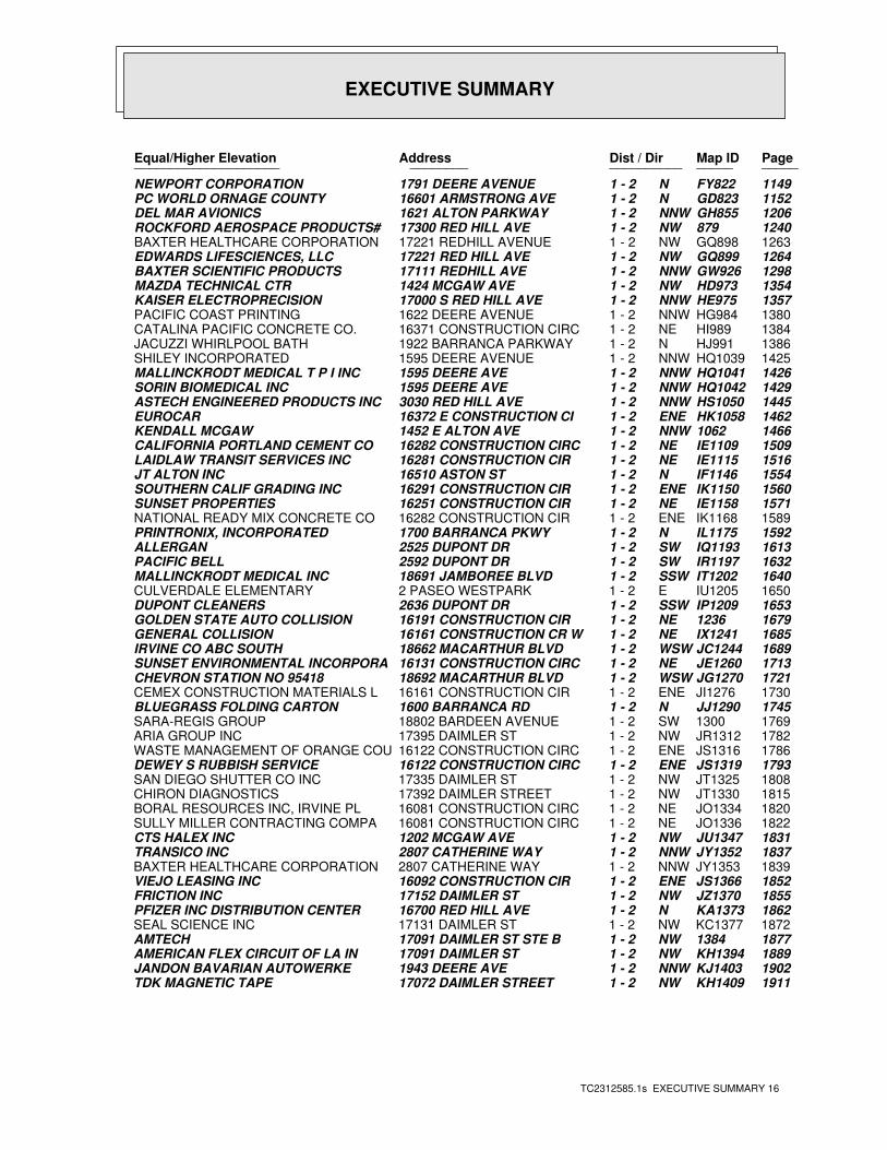
EXECUTIVE SUMMARY
TC2312585.1s EXECUTIVE SUMMARY 16
PageMap IDDist / Dir Address Equal/Higher Elevation ____________________ ________ ____________________
1149FY822N1 - 2 1791 DEERE AVENUE NEWPORT CORPORATION1152GD823N1 - 2 16601 ARMSTRONG AVE PC WORLD ORNAGE COUNTY1206GH855NNW1 - 2 1621 ALTON PARKWAY DEL MAR AVIONICS1240879NW1 - 2 17300 RED HILL AVE ROCKFORD AEROSPACE PRODUCTS#1263GQ898NW1 - 2 17221 REDHILL AVENUE BAXTER HEALTHCARE CORPORATION1264GQ899NW1 - 2 17221 RED HILL AVE EDWARDS LIFESCIENCES, LLC1298GW926NNW1 - 2 17111 REDHILL AVE BAXTER SCIENTIFIC PRODUCTS1354HD973NW1 - 2 1424 MCGAW AVE MAZDA TECHNICAL CTR1357HE975NNW1 - 2 17000 S RED HILL AVE KAISER ELECTROPRECISION1380HG984NNW1 - 2 1622 DEERE AVENUE PACIFIC COAST PRINTING1384HI989NE1 - 2 16371 CONSTRUCTION CIRC CATALINA PACIFIC CONCRETE CO. 1386HJ991N1 - 2 1922 BARRANCA PARKWAY JACUZZI WHIRLPOOL BATH1425HQ1039NNW1 - 2 1595 DEERE AVENUE SHILEY INCORPORATED1426HQ1041NNW1 - 2 1595 DEERE AVE MALLINCKRODT MEDICAL T P I INC1429HQ1042NNW1 - 2 1595 DEERE AVE SORIN BIOMEDICAL INC1445HS1050NNW1 - 2 3030 RED HILL AVE ASTECH ENGINEERED PRODUCTS INC1462HK1058ENE1 - 2 16372 E CONSTRUCTION CI EUROCAR14661062NNW1 - 2 1452 E ALTON AVE KENDALL MCGAW1509IE1109NE1 - 2 16282 CONSTRUCTION CIRC CALIFORNIA PORTLAND CEMENT CO1516IE1115NE1 - 2 16281 CONSTRUCTION CIR LAIDLAW TRANSIT SERVICES INC1554IF1146N1 - 2 16510 ASTON ST JT ALTON INC1560IK1150ENE1 - 2 16291 CONSTRUCTION CIR SOUTHERN CALIF GRADING INC1571IE1158NE1 - 2 16251 CONSTRUCTION CIR SUNSET PROPERTIES1589IK1168ENE1 - 2 16282 CONSTRUCTION CIR NATIONAL READY MIX CONCRETE CO1592IL1175N1 - 2 1700 BARRANCA PKWY PRINTRONIX, INCORPORATED1613IQ1193SW1 - 2 2525 DUPONT DR ALLERGAN1632IR1197SW1 - 2 2592 DUPONT DR PACIFIC BELL1640IT1202SSW1 - 2 18691 JAMBOREE BLVD MALLINCKRODT MEDICAL INC1650IU1205E1 - 2 2 PASEO WESTPARK CULVERDALE ELEMENTARY1653IP1209SSW1 - 2 2636 DUPONT DR DUPONT CLEANERS16791236NE1 - 2 16191 CONSTRUCTION CIR GOLDEN STATE AUTO COLLISION1685IX1241NE1 - 2 16161 CONSTRUCTION CR W GENERAL COLLISION1689JC1244WSW1 - 2 18662 MACARTHUR BLVD IRVINE CO ABC SOUTH1713JE1260NE1 - 2 16131 CONSTRUCTION CIRC SUNSET ENVIRONMENTAL INCORPORA1721JG1270WSW1 - 2 18692 MACARTHUR BLVD CHEVRON STATION NO 954181730JI1276ENE1 - 2 16161 CONSTRUCTION CIR CEMEX CONSTRUCTION MATERIALS L1745JJ1290N1 - 2 1600 BARRANCA RD BLUEGRASS FOLDING CARTON17691300SW1 - 2 18802 BARDEEN AVENUE SARA-REGIS GROUP1782JR1312NW1 - 2 17395 DAIMLER ST ARIA GROUP INC1786JS1316ENE1 - 2 16122 CONSTRUCTION CIRC WASTE MANAGEMENT OF ORANGE COU1793JS1319ENE1 - 2 16122 CONSTRUCTION CIRC DEWEY S RUBBISH SERVICE1808JT1325NW1 - 2 17335 DAIMLER ST SAN DIEGO SHUTTER CO INC1815JT1330NW1 - 2 17392 DAIMLER STREET CHIRON DIAGNOSTICS1820JO1334NE1 - 2 16081 CONSTRUCTION CIRC BORAL RESOURCES INC, IRVINE PL1822JO1336NE1 - 2 16081 CONSTRUCTION CIRC SULLY MILLER CONTRACTING COMPA1831JU1347NW1 - 2 1202 MCGAW AVE CTS HALEX INC1837JY1352NNW1 - 2 2807 CATHERINE WAY TRANSICO INC1839JY1353NNW1 - 2 2807 CATHERINE WAY BAXTER HEALTHCARE CORPORATION 1852JS1366ENE1 - 2 16092 CONSTRUCTION CIR VIEJO LEASING INC1855JZ1370NW1 - 2 17152 DAIMLER ST FRICTION INC1862KA1373N1 - 2 16700 RED HILL AVE PFIZER INC DISTRIBUTION CENTER1872KC1377NW1 - 2 17131 DAIMLER ST SEAL SCIENCE INC18771384NW1 - 2 17091 DAIMLER ST STE B AMTECH1889KH1394NW1 - 2 17091 DAIMLER ST AMERICAN FLEX CIRCUIT OF LA IN1902KJ1403NNW1 - 2 1943 DEERE AVE JANDON BAVARIAN AUTOWERKE1911KH1409NW1 - 2 17072 DAIMLER STREET TDK MAGNETIC TAPE
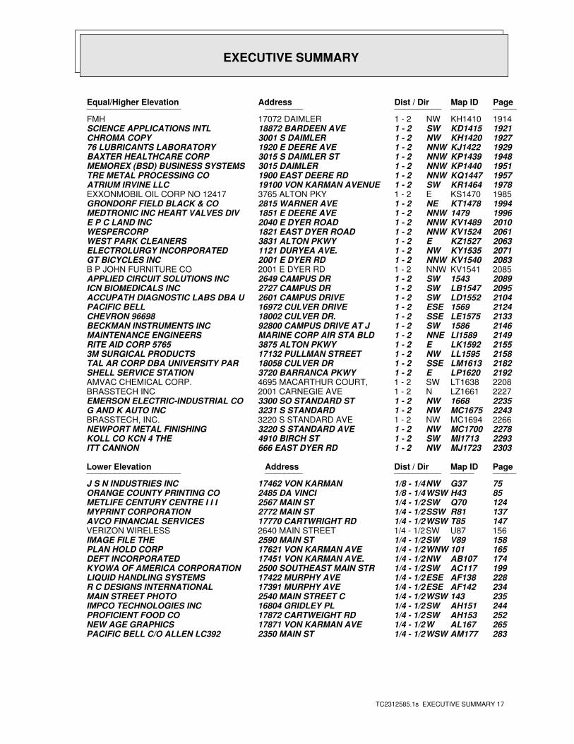
EXECUTIVE SUMMARY
TC2312585.1s EXECUTIVE SUMMARY 17
PageMap IDDist / Dir Address Equal/Higher Elevation ____________________ ________ ____________________
1914KH1410NW1 - 2 17072 DAIMLER FMH1921KD1415SW1 - 2 18872 BARDEEN AVE SCIENCE APPLICATIONS INTL1927KH1420NW1 - 2 3001 S DAIMLER CHROMA COPY1929KJ1422NNW1 - 2 1920 E DEERE AVE 76 LUBRICANTS LABORATORY1948KP1439NNW1 - 2 3015 S DAIMLER ST BAXTER HEALTHCARE CORP1951KP1440NNW1 - 2 3015 DAIMLER MEMOREX (BSD) BUSINESS SYSTEMS1957KQ1447NNW1 - 2 1900 EAST DEERE RD TRE METAL PROCESSING CO1978KR1464SW1 - 2 19100 VON KARMAN AVENUE ATRIUM IRVINE LLC1985KS1470E1 - 2 3765 ALTON PKY EXXONMOBIL OIL CORP NO 124171994KT1478NE1 - 2 2815 WARNER AVE GRONDORF FIELD BLACK & CO19961479NNW1 - 2 1851 E DEERE AVE MEDTRONIC INC HEART VALVES DIV2010KV1489NNW1 - 2 2040 E DYER ROAD E P C LAND INC2061KV1524NNW1 - 2 1821 EAST DYER ROAD WESPERCORP2063KZ1527E1 - 2 3831 ALTON PKWY WEST PARK CLEANERS2071KY1535NW1 - 2 1121 DURYEA AVE. ELECTROLURGY INCORPORATED2083KV1540NNW1 - 2 2001 E DYER RD GT BICYCLES INC2085KV1541NNW1 - 2 2001 E DYER RD B P JOHN FURNITURE CO20891543SW1 - 2 2649 CAMPUS DR APPLIED CIRCUIT SOLUTIONS INC2095LB1547SW1 - 2 2727 CAMPUS DR ICN BIOMEDICALS INC2104LD1552SW1 - 2 2601 CAMPUS DRIVE ACCUPATH DIAGNOSTIC LABS DBA U21241569ESE1 - 2 16972 CULVER DRIVE PACIFIC BELL2133LE1575SSE1 - 2 18002 CULVER DR. CHEVRON 9669821461586SW1 - 2 92800 CAMPUS DRIVE AT J BECKMAN INSTRUMENTS INC2149LI1589NNE1 - 2 MARINE CORP AIR STA BLD MAINTENANCE ENGINEERS2155LK1592E1 - 2 3875 ALTON PKWY RITE AID CORP 57652158LL1595NW1 - 2 17132 PULLMAN STREET 3M SURGICAL PRODUCTS2182LM1613SSE1 - 2 18058 CULVER DR TAL AR CORP DBA UNIVERSITY PAR2192LP1620E1 - 2 3720 BARRANCA PKWY SHELL SERVICE STATION2208LT1638SW1 - 2 4695 MACARTHUR COURT, AMVAC CHEMICAL CORP.2227LZ1661N1 - 2 2001 CARNEGIE AVE BRASSTECH INC22351668NW1 - 2 3300 SO STANDARD ST EMERSON ELECTRIC-INDUSTRIAL CO2243MC1675NW1 - 2 3231 S STANDARD G AND K AUTO INC2266MC1694NW1 - 2 3220 S STANDARD AVE BRASSTECH, INC.2278MC1700NW1 - 2 3220 S STANDARD AVE NEWPORT METAL FINISHING2293MI1713SW1 - 2 4910 BIRCH ST KOLL CO KCN 4 THE2303MJ1723NW1 - 2 666 EAST DYER RD ITT CANNON
PageMap IDDist / Dir Address Lower Elevation ____________________ ________ ____________________
75G37NW1/8 - 1/4 17462 VON KARMAN J S N INDUSTRIES INC85H43WSW1/8 - 1/4 2485 DA VINCI ORANGE COUNTY PRINTING CO124Q70SW1/4 - 1/2 2567 MAIN ST METLIFE CENTURY CENTRE I I I137R81SSW1/4 - 1/2 2772 MAIN ST MYPRINT CORPORATION147T85WSW1/4 - 1/2 17770 CARTWRIGHT RD AVCO FINANCIAL SERVICES156U87SW1/4 - 1/2 2640 MAIN STREET VERIZON WIRELESS158V89SW1/4 - 1/2 2590 MAIN ST IMAGE FILE THE165101WNW1/4 - 1/2 17621 VON KARMAN AVE PLAN HOLD CORP174AB107NW1/4 - 1/2 17451 VON KARMAN AVE. DEFT INCORPORATED199AC117SW1/4 - 1/2 2500 SOUTHEAST MAIN STR KYOWA OF AMERICA CORPORATION228AF138ESE1/4 - 1/2 17422 MURPHY AVE LIQUID HANDLING SYSTEMS234AF142ESE1/4 - 1/2 17391 MURPHY AVE R C DESIGNS INTERNATIONAL235143WSW1/4 - 1/2 2540 MAIN STREET C MAIN STREET PHOTO244AH151SW1/4 - 1/2 16804 GRIDLEY PL IMPCO TECHNOLOGIES INC252AH153SW1/4 - 1/2 17872 CARTWEIGHT RD PROFICIENT FOOD CO265AL167W1/4 - 1/2 17871 VON KARMAN AVE NEW AGE GRAPHICS283AM177WSW1/4 - 1/2 2350 MAIN ST PACIFIC BELL C/O ALLEN LC392
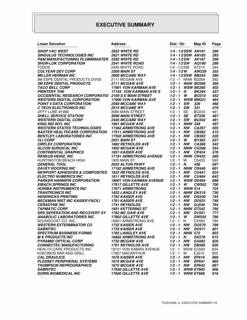
EXECUTIVE SUMMARY
TC2312585.1s EXECUTIVE SUMMARY 18
PageMap IDDist / Dir Address Lower Elevation ____________________ ________ ____________________
290AN181SSW1/4 - 1/2 2652 WHITE RD SHOP VAC WEST293AN185SSW1/4 - 1/2 2621 WHITE RD SINGULUS TECHNOLOGIES INC296AP187SW1/4 - 1/2 2592 WHITE RD P&M MANUFACTURING PLUMBMASTER299AQ190SW1/4 - 1/2 2541 WHITE ROAD SHUR-LOK CORPORATION344AT215SW1/4 - 1/2 2450 WHITE ROAD TODDS355AW229W1/4 - 1/2 2300 MAIN ST COLYEAR DEV CORP380BB254SSW1/4 - 1/2 2900 MCCABE WAY MILLER HERMAN INC392BD264NNW1/2 - 1 2111 MCGAW AVE 3M ESPE DENTAL PRODUCTS DIVISI395BD266NNW1/2 - 1 2111 MCGAW AVE 3M ESPE DENTAL PRODUCTS402BE268WSW1/2 - 1 17901 VON KARMAN AVE TACO BELL CORP437BK294N1/2 - 1 17155 VON KARMAN AVE S PRINTERY THE452BO310W1/2 - 1 2100 S E MAIN STREET OCCIDENTAL RESEARCH CORPORATIO464BM321WSW1/2 - 1 17900 VON KARMAN AVE WESTERN DIGITAL CORPORATION468326SW1/2 - 1 2569 MCCABE WAY POINT 4 DATA CORPORATION479331SW1/2 - 1 2515 MCCABE WY C TECH ELECTRONICS INC481BQ333SE1/2 - 1 3080 MAIN STREET JIFFY LUBE #1988487BT339SE1/2 - 1 3090 MAIN STREET SHELL SERVICE STATION491BU342SW1/2 - 1 2445 MCCABE WAY WESTERN DIGITAL CORP497349NNW1/2 - 1 1961 MCGAW AVE KING IND INTL INC505CA357NW1/2 - 1 17462 ARMSTRONG AVE WESTERN STATES TECHNOLOGIES515CB362NW1/2 - 1 17511 ARMSTRONG AVE BAXTER HEALTHCARE CORPORATION520CB365NW1/2 - 1 17502 ARMSTRONG AVE BENTLEY LABORATORIES INC537BY383W1/2 - 1 2031 MAIN ST VLI CORP542CA388NW1/2 - 1 1882 REYNOLDS AVE ORPLEX CORPORATION554CG398NNW1/2 - 1 1902 MCGAW AVE ALCON SURGICAL INC578CP424NW1/2 - 1 1851 KAISER AVE CONTINENTAL GRAPHICS589CR432NNW1/2 - 1 17191 ARMSTRONG AVENUE RENKUS-HEINZ, INC590CS433W1/2 - 1 1905 MAIN ST. HUNTINGTON BEACH HIGH597438N1/2 - 1 2025 ALTON PKWY GENERAL TOOL601CR440NNW1/2 - 1 17182 ARMSTRONG AVE DAVEY ROOFING INC624CU451NW1/2 - 1 1822 REYNOLDS AVE. NEWPORT ADHESIVES & COMPOSITES643CU464NW1/2 - 1 1811 REYNOLDS AVE ELECTRO NUMERICS INC688DD494WSW1/2 - 1 18001 VON KARMAN AVENUE PARKER HANNIFIN CORPORATION700CW502W1/2 - 1 17817 GILLETTE AVE EIBACH SPRINGS INC725514WNW1/2 - 1 17671 ARMSTRONG HORIBA INSTRUMENTS INC730DK519NNW1/2 - 1 1822 LANGLEY AVE TRANTRONICS INC745DG530NW1/2 - 1 1762 KAISER AVE HENDRICKS PRINTING748DO531NW1/2 - 1 1761 KAISER AVE BECKMAN INST INC KAISER FACILI764DJ540NW1/2 - 1 1741 REYNOLDS CERADYNE INC766DT542NNW1/2 - 1 1851 KETTERING ST TAPMATIC CORP777DV551NW1/2 - 1 1762 MC GAW AVE SRS SEPERATION AND RECOVERY SY780DW555W1/2 - 1 17802 GILLETTE AVE ANABOLIC LABORATORIES INC790DX560N1/2 - 1 16901 ARMSTRONG AVE. SOUNDCOAT CO. INC.799DO570NW1/2 - 1 1732 KAISER AVE WESTERN EXTERMINATOR CO801DO571NW1/2 - 1 1733 KAISER AVE SABRITEC803572NNW1/2 - 1 1782 LANGLEY AVE SPECTRUM BUSINESS FORMS815DX578N1/2 - 1 16882 ARMSTRONG AVE M K PRODUCTS INC820EA582NW1/2 - 1 1732 MCGAW AVE PYRAMID OPTICAL CORP830EB589NW1/2 - 1 1701 REYNOLDS AVE CONNECTEC MANUFACTURING834EC593WSW1/2 - 1 18101 VON KAMAN AVENUE HEALTH CARE PRODUCTS INC855EJ610W1/2 - 1 17927 MACARTHUR KOKOMOS BAR AND GRILL860EF616NW1/2 - 1 1676 KAISER AVE CAL DRAULICS885EP641NW1/2 - 1 1674 MCGAW AVE PLESSEY PERIPHERAL SYSTEMS887EP642NW1/2 - 1 1672 MCGAW AVE THOMPSON REPROGRAPHICS906ET665WNW1/2 - 1 17550 GILLETTE AVE SABRITEC916ET668WNW1/2 - 1 17600 GILLETTE AVE SORIN BIOMEDICAL INC
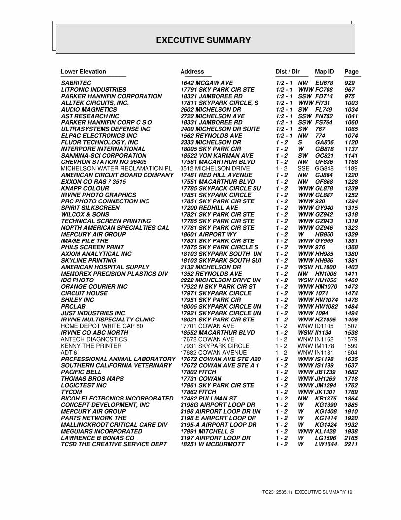
EXECUTIVE SUMMARY
TC2312585.1s EXECUTIVE SUMMARY 19
PageMap IDDist / Dir Address Lower Elevation ____________________ ________ ____________________
929EU678NW1/2 - 1 1642 MCGAW AVE SABRITEC967FC708WNW1/2 - 1 17791 SKY PARK CIR STE LITRONIC INDUSTRIES975FD714SSW1/2 - 1 18321 JAMBOREE RD PARKER HANNIFIN CORPORATION1003FI731WNW1/2 - 1 17811 SKYPARK CIRCLE, S ALLTEK CIRCUITS, INC.1034FL749SW1/2 - 1 2602 MICHELSON DR AUDIO MAGNETICS1041FN752SSW1/2 - 1 2722 MICHELSON AVE AST RESEARCH INC1060FS764SSW1/2 - 1 18331 JAMBOREE RD PARKER HANNIFIN CORP C S O1065767SW1/2 - 1 2400 MICHELSON DR SUITE ULTRASYSTEMS DEFENSE INC1074774NW1/2 - 1 1562 REYNOLDS AVE ELPAC ELECTRONICS INC1120GA806S1 - 2 3333 MICHELSON DR FLUOR TECHNOLOGY, INC1137GB818W1 - 2 18005 SKY PARK CIR INTERPORE INTERNATIONAL1141GC821SW1 - 2 18522 VON KARMAN AVE SANMINA-SCI CORPORATION1168GF836NW1 - 2 17561 MACARTHUR BLVD CHEVRON STATION NO 964051189GG848SSE1 - 2 3512 MICHELSON DRIVE MICHELSON WATER RECLAMATION PL1220GJ864NW1 - 2 17481 RED HILL AVENUE AMERICAN CIRCUIT BOARD COMPANY1228GF868NW1 - 2 17551 MACARTHUR BLVD EXXON CO RAS 7 35151239GL878WNW1 - 2 17785 SKYPACK CIRCLE SU KNAPP COLOUR1252GL887WNW1 - 2 17851 SKYPARK CIRCLE IRVINE PHOTO GRAPHICS1294920WNW1 - 2 17851 SKY PARK CIR STE PRO PHOTO CONNECTION INC1315GY940WNW1 - 2 17200 REDHILL AVE SPIRIT SILKSCREEN1318GZ942WNW1 - 2 17821 SKY PARK CIR STE WILCOX & SONS1319GZ943WNW1 - 2 17785 SKY PARK CIR STE TECHNICAL SCREEN PRINTING1323GZ946WNW1 - 2 17781 SKY PARK CIR STE NORTH AMERICAN SPECIALTIES CAL1329HB950W1 - 2 18601 AIRPORT WY MERCURY AIR GROUP1351GY969WNW1 - 2 17831 SKY PARK CIR STE IMAGE FILE THE1368976WNW1 - 2 17875 SKY PARK CIRCLE S PHILS SCREEN PRINT1380HH985WNW1 - 2 18103 SKYPARK SOUTH UN AXIOM ANALYTICAL INC1381HH986WNW1 - 2 18103 SKYPARK SOUTH SUI SKYLINE PRINTING1403HL1000WSW1 - 2 2132 MICHELSON DR AMERICAN HOSPITAL SUPPLY1411HN1006NW1 - 2 1352 REYNOLDS AVE MEMOREX PRECISION PLASTICS DIV1460HU1056WSW1 - 2 2222 MICHELSON DRIVE UN IBC PHOTO1473HM1070WNW1 - 2 17922 N SKY PARK CIR ST ORANGE COURIER INC14741071WNW1 - 2 17971 SKYPARK CIRCLE CIRCUIT HOUSE1478HW1074WNW1 - 2 17951 SKY PARK CIR SHILEY INC1484HW1082WNW1 - 2 18005 SKYPARK CIRCLE UN PROLAB14941094WNW1 - 2 17921 SKYPARK CIRCLE UN JUST INDUSTRIES INC1496HZ1095WNW1 - 2 18021 SKY PARK CIR STE IRVINE MULTISPECIALTY CLINIC1507ID1105WNW1 - 2 17701 COWAN AVE HOME DEPOT WHITE CAP 801538II1134WSW1 - 2 18552 MACARTHUR BLVD IRVINE CO ABC NORTH1579IN1162WNW1 - 2 17672 COWAN AVE ANTECH DIAGNOSTICS1599IM1178WNW1 - 2 17931 SKYPARK CIRCLE KENNY THE PRINTER1604IN1181WNW1 - 2 17682 COWAN AVENUE ADT 61635IS1198WNW1 - 2 17672 COWAN AVE STE A20 PROFESSIONAL ANIMAL LABORATORY1637IS1199WNW1 - 2 17672 COWAN AVE STE A 1 SOUTHERN CALIFORNIA VETERINARY1682JB1239WNW1 - 2 17802 FITCH PACIFIC BELL1718JH1269WNW1 - 2 17731 COWAN THOMAS BROS MAPS1762JM1294WNW1 - 2 17961 SKY PARK CIR STE LOGICTEST INC1769JK1301WNW1 - 2 17862 FITCH TYCOM1864KB1375NW1 - 2 17482 PULLMAN ST RICOH ELECTRONICS INCORPORATED1885KG1390W1 - 2 3198G AIRPORT LOOP DR CONCEPT DEVELOPMENT, INC1910KG1408W1 - 2 3198 AIRPORT LOOP DR UN MERCURY AIR GROUP1920KG1414W1 - 2 3198 E AIRPORT LOOP DR PARTS NETWORK THE1932KG1424W1 - 2 3195-A AIRPORT LOOP DR MALLINCKRODT CRITICAL CARE DIV1938KL1428WNW1 - 2 17991 MITCHELL S MEGUIARS INCORPORATED2165LG1596W1 - 2 3197 AIRPORT LOOP DR LAWRENCE B BONAS CO2211LW1644W1 - 2 18251 W MCDURMOTT TCSD THE CREATIVE SERVICE DEPT
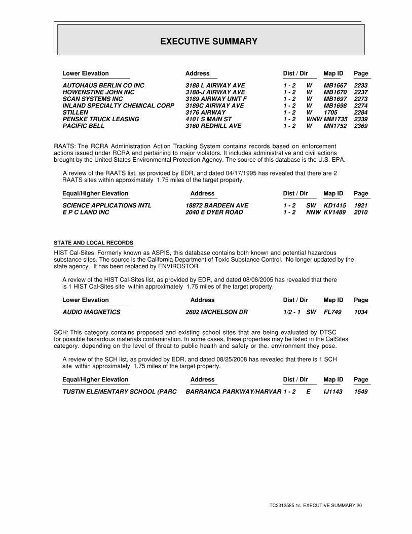
EXECUTIVE SUMMARY
TC2312585.1s EXECUTIVE SUMMARY 20
PageMap IDDist / Dir Address Lower Elevation ____________________ ________ ____________________
2233MB1667W1 - 2 3188 L AIRWAY AVE AUTOHAUS BERLIN CO INC2237MB1670W1 - 2 3188-J AIRWAY AVE HOWENSTINE JOHN INC2273MB1697W1 - 2 3189 AIRWAY UNIT F SCAN SYSTEMS INC2274MB1698W1 - 2 3189C AIRWAY AVE INLAND SPECIALTY CHEMICAL CORP22841705W1 - 2 3176 AIRWAY STILLEN2339MM1735WNW1 - 2 4101 S MAIN ST PENSKE TRUCK LEASING2369MN1752W1 - 2 3160 REDHILL AVE PACIFIC BELL
RAATS: The RCRA Administration Action Tracking System contains records based on enforcementactions issued under RCRA and pertaining to major violators. It includes administrative and civil actionsbrought by the United States Environmental Protection Agency. The source of this database is the U.S. EPA.
A review of the RAATS list, as provided by EDR, and dated 04/17/1995 has revealed that there are 2 RAATS sites within approximately 1.75 miles of the target property.
PageMap IDDist / Dir Address Equal/Higher Elevation ____________________ ________ ____________________
1921KD1415SW1 - 2 18872 BARDEEN AVE SCIENCE APPLICATIONS INTL2010KV1489NNW1 - 2 2040 E DYER ROAD E P C LAND INC
STATE AND LOCAL RECORDS
HIST Cal-Sites: Formerly known as ASPIS, this database contains both known and potential hazardoussubstance sites. The source is the California Department of Toxic Substance Control. No longer updated by thestate agency. It has been replaced by ENVIROSTOR.
A review of the HIST Cal-Sites list, as provided by EDR, and dated 08/08/2005 has revealed that there is 1 HIST Cal-Sites site within approximately 1.75 miles of the target property.
PageMap IDDist / Dir Address Lower Elevation ____________________ ________ ____________________
1034FL749SW1/2 - 1 2602 MICHELSON DR AUDIO MAGNETICS
SCH: This category contains proposed and existing school sites that are being evaluated by DTSCfor possible hazardous materials contamination. In some cases, these properties may be listed in the CalSitescategory. depending on the level of threat to public health and safety or the. environment they pose.
A review of the SCH list, as provided by EDR, and dated 08/25/2008 has revealed that there is 1 SCH site within approximately 1.75 miles of the target property.
PageMap IDDist / Dir Address Equal/Higher Elevation ____________________ ________ ____________________
1549IJ1143E1 - 2 BARRANCA PARKWAY/HARVAR TUSTIN ELEMENTARY SCHOOL (PARC
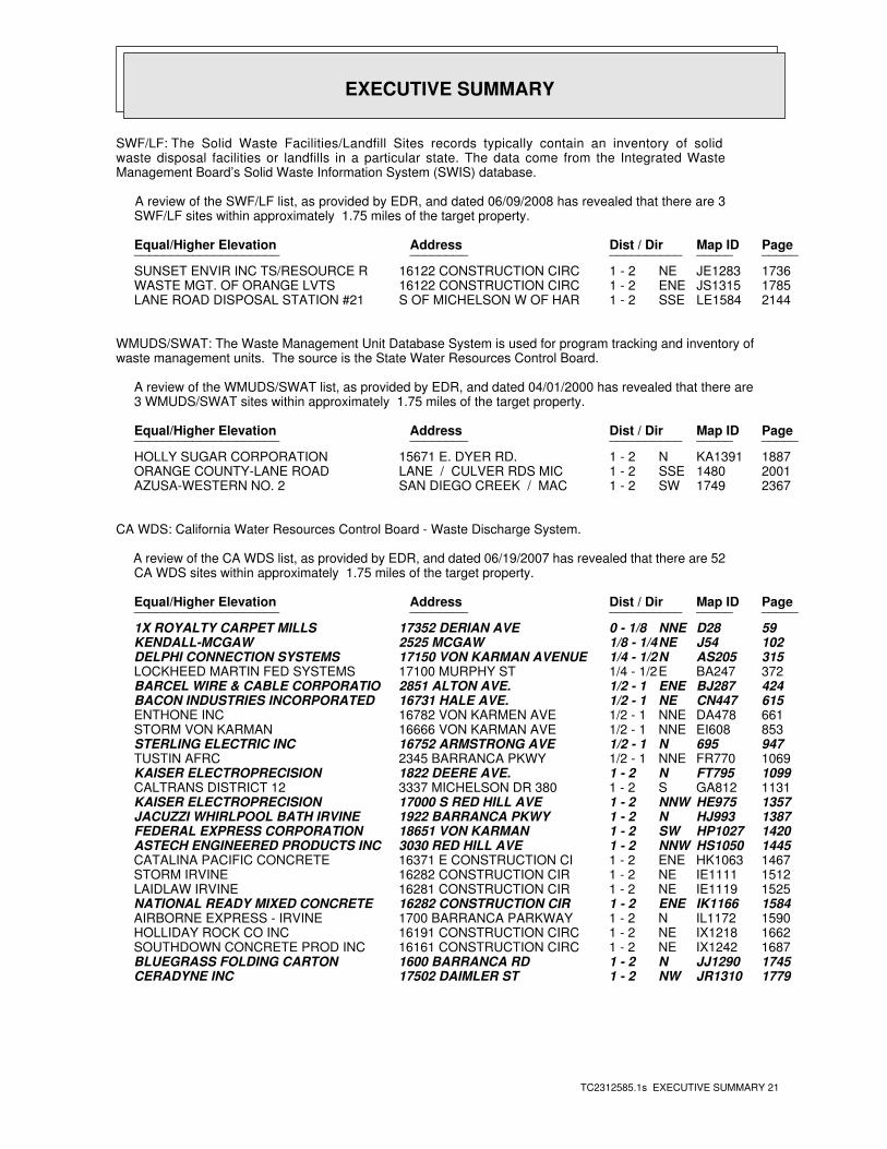
EXECUTIVE SUMMARY
TC2312585.1s EXECUTIVE SUMMARY 21
SWF/LF: The Solid Waste Facilities/Landfill Sites records typically contain an inventory of solidwaste disposal facilities or landfills in a particular state. The data come from the Integrated WasteManagement Board’s Solid Waste Information System (SWIS) database.
A review of the SWF/LF list, as provided by EDR, and dated 06/09/2008 has revealed that there are 3 SWF/LF sites within approximately 1.75 miles of the target property.
PageMap IDDist / Dir Address Equal/Higher Elevation ____________________ ________ ____________________
1736JE1283NE1 - 2 16122 CONSTRUCTION CIRC SUNSET ENVIR INC TS/RESOURCE R1785JS1315ENE1 - 2 16122 CONSTRUCTION CIRC WASTE MGT. OF ORANGE LVTS2144LE1584SSE1 - 2 S OF MICHELSON W OF HAR LANE ROAD DISPOSAL STATION #21
WMUDS/SWAT: The Waste Management Unit Database System is used for program tracking and inventory ofwaste management units. The source is the State Water Resources Control Board.
A review of the WMUDS/SWAT list, as provided by EDR, and dated 04/01/2000 has revealed that there are 3 WMUDS/SWAT sites within approximately 1.75 miles of the target property.
PageMap IDDist / Dir Address Equal/Higher Elevation ____________________ ________ ____________________
1887KA1391N1 - 2 15671 E. DYER RD. HOLLY SUGAR CORPORATION20011480SSE1 - 2 LANE / CULVER RDS MIC ORANGE COUNTY-LANE ROAD23671749SW1 - 2 SAN DIEGO CREEK / MAC AZUSA-WESTERN NO. 2
CA WDS: California Water Resources Control Board - Waste Discharge System.
A review of the CA WDS list, as provided by EDR, and dated 06/19/2007 has revealed that there are 52 CA WDS sites within approximately 1.75 miles of the target property.
PageMap IDDist / Dir Address Equal/Higher Elevation ____________________ ________ ____________________
59D28NNE0 - 1/8 17352 DERIAN AVE 1X ROYALTY CARPET MILLS102J54NE1/8 - 1/4 2525 MCGAW KENDALL-MCGAW315AS205N1/4 - 1/2 17150 VON KARMAN AVENUE DELPHI CONNECTION SYSTEMS372BA247E1/4 - 1/2 17100 MURPHY ST LOCKHEED MARTIN FED SYSTEMS424BJ287ENE1/2 - 1 2851 ALTON AVE. BARCEL WIRE & CABLE CORPORATIO615CN447NE1/2 - 1 16731 HALE AVE. BACON INDUSTRIES INCORPORATED 661DA478NNE1/2 - 1 16782 VON KARMEN AVE ENTHONE INC853EI608NNE1/2 - 1 16666 VON KARMAN AVE STORM VON KARMAN947695N1/2 - 1 16752 ARMSTRONG AVE STERLING ELECTRIC INC1069FR770NNE1/2 - 1 2345 BARRANCA PKWY TUSTIN AFRC1099FT795N1 - 2 1822 DEERE AVE. KAISER ELECTROPRECISION1131GA812S1 - 2 3337 MICHELSON DR 380 CALTRANS DISTRICT 121357HE975NNW1 - 2 17000 S RED HILL AVE KAISER ELECTROPRECISION1387HJ993N1 - 2 1922 BARRANCA PKWY JACUZZI WHIRLPOOL BATH IRVINE1420HP1027SW1 - 2 18651 VON KARMAN FEDERAL EXPRESS CORPORATION1445HS1050NNW1 - 2 3030 RED HILL AVE ASTECH ENGINEERED PRODUCTS INC1467HK1063ENE1 - 2 16371 E CONSTRUCTION CI CATALINA PACIFIC CONCRETE1512IE1111NE1 - 2 16282 CONSTRUCTION CIR STORM IRVINE1525IE1119NE1 - 2 16281 CONSTRUCTION CIR LAIDLAW IRVINE1584IK1166ENE1 - 2 16282 CONSTRUCTION CIR NATIONAL READY MIXED CONCRETE 1590IL1172N1 - 2 1700 BARRANCA PARKWAY AIRBORNE EXPRESS - IRVINE1662IX1218NE1 - 2 16191 CONSTRUCTION CIRC HOLLIDAY ROCK CO INC1687IX1242NE1 - 2 16161 CONSTRUCTION CIRC SOUTHDOWN CONCRETE PROD INC1745JJ1290N1 - 2 1600 BARRANCA RD BLUEGRASS FOLDING CARTON1779JR1310NW1 - 2 17502 DAIMLER ST CERADYNE INC
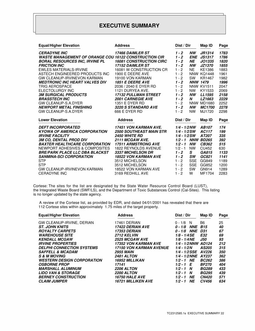
EXECUTIVE SUMMARY
TC2312585.1s EXECUTIVE SUMMARY 22
PageMap IDDist / Dir Address Equal/Higher Elevation ____________________ ________ ____________________
1783JR1314NW1 - 2 17466 DAIMLER ST CERADYNE INC1786JS1317ENE1 - 2 16122 CONSTRUCTION CIR WASTE MANAGEMENT OF ORANGE COU1820JO1335NE1 - 2 16081 CONSTRUCTION CIRC BORAL RESOURCES INC, IRVINE PL1855JZ1370NW1 - 2 17152 DAIMLER ST FRICTION INC1883KE1386NE1 - 2 16081 W CONSTRUCTION CR EWLES MATERIALS-IRVINE1961KQ1448NNW1 - 2 1900 E DEERE AVE ASTECH ENGINEERED PRODUCTS INC1982KR1467SW1 - 2 19100 VON KARMAN GW CLEANUP-IRVINEVON KARMAN19961479NNW1 - 2 1851 E DEERE AVE MEDTRONIC INC HEART VALVES DIV2047KV1511NNW1 - 2 2036 / 2040 E DYER RD TRIG AEROSPACE2069KY1533NW1 - 2 1121 DURYEA AVE. ELECTOLURGY INC2158LL1595NW1 - 2 17132 PULLMAN STREET 3M SURGICAL PRODUCTS2229LZ1663N1 - 2 2001 CARNEGIE AVE BRASSTECH INC2252MD1680NNW1 - 2 1351 E DYER RD GW CLEANUP-S.A.DYER2278MC1700NW1 - 2 3220 S STANDARD AVE NEWPORT METAL FINISHING2298MJ1720NW1 - 2 666 E DYER RD GW CLEANUP-S.A.DYER
PageMap IDDist / Dir Address Lower Elevation ____________________ ________ ____________________
174AB107NW1/4 - 1/2 17451 VON KARMAN AVE. DEFT INCORPORATED199AC117SW1/4 - 1/2 2500 SOUTHEAST MAIN STR KYOWA OF AMERICA CORPORATION335AT207SW1/4 - 1/2 2450 WHITE RD IRVINE FACILITY392BD265NNW1/2 - 1 2111 MCGAW AVE. 3M CO, DENTAL PROD DIV515CB362NW1/2 - 1 17511 ARMSTRONG AVE BAXTER HEALTHCARE CORPORATION630CU452NW1/2 - 1 1822 REYNOLDS AVENUE NEWPORT ADHESIVES & COMPOSITES1133GA815S1 - 2 3337 MICHELSON DR BRE/PARK PLACE LLC DBA BLACKST1141GC821SW1 - 2 18522 VON KARMAN AVE SANMINA-SCI CORPORATION1189GG849SSE1 - 2 3512 MICHELSON STP1200GG852SSE1 - 2 3512 MICHELSON STP1289GN914SW1 - 2 18522 VON KARMAN AVE GW CLEANUP-IRVINEVON KARMAN2283MF1704W1 - 2 3169 REDHILL AVE CERADYNE INC
Cortese: The sites for the list are designated by the State Water Resource Control Board (LUST),the Integrated Waste Board (SWF/LS), and the Department of Toxic Substances Control (Cal-Sites). This listingis no longer updated by the state agency.
A review of the Cortese list, as provided by EDR, and dated 04/01/2001 has revealed that there are 112 Cortese sites within approximately 1.75 miles of the target property.
PageMap IDDist / Dir Address Equal/Higher Elevation ____________________ ________ ____________________
25B6N0 - 1/8 17461 DERIAN GW CLEANUP-IRVINE, DERIAN40B15NNE0 - 1/8 17422 DERIAN AVE ST. JOHN KNITS67D31NNE0 - 1/8 17353 DERIAN ROYALTY CARPETS69E32SE1/8 - 1/4 2712 KELVIN WAREHOUSE SITE93J50NE1/8 - 1/4 2525 MCGAW AVE KENDALL MCGAW212AD124NNW1/4 - 1/2 17352 VON KARMAN AVE IRVINE PROPERTIES315AS205N1/4 - 1/2 17150 VON KARMAN AVENUE DELPHI CONNECTION SYSTEMS350AV226SSE1/4 - 1/2 2955 MAIN SAFFELL & MCADAM362AY237NNE1/4 - 1/2 2481 ALTON S & M MOVING386BC262NE1/2 - 1 16952 MILLIKAN WESTERN DESIGN CORPORATION404BF270E1/2 - 1 17141 OSBORNE PROP433BG289N1/2 - 1 2206 ALTON MARSHALL ALUMINUM439BG295N1/2 - 1 2200 ALTON LIDO VAN & STORAGE571CN420NE1/2 - 1 16750 HALE AVE BERNEY CONSTRUCTION634CV456NE1/2 - 1 16721 MILLIKEN AVE CLAIM JUMPER
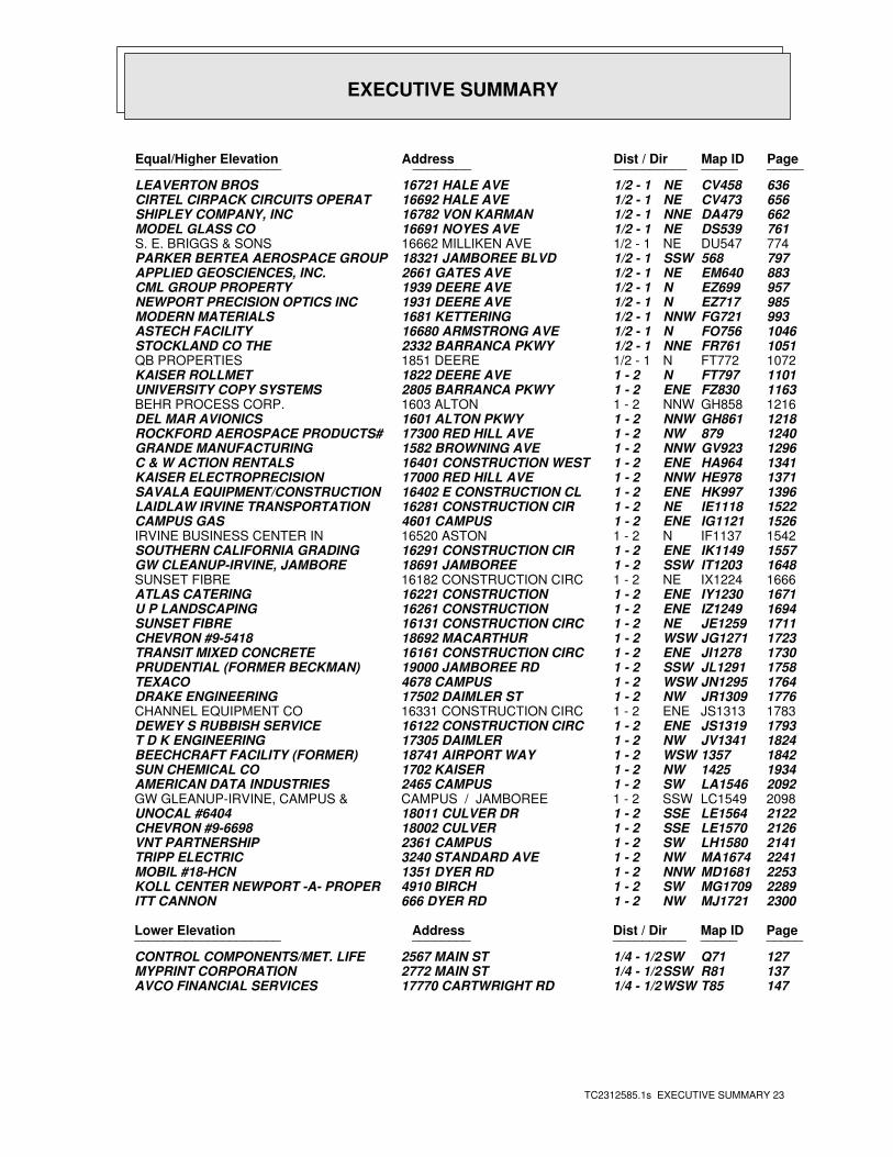
EXECUTIVE SUMMARY
TC2312585.1s EXECUTIVE SUMMARY 23
PageMap IDDist / Dir Address Equal/Higher Elevation ____________________ ________ ____________________
636CV458NE1/2 - 1 16721 HALE AVE LEAVERTON BROS656CV473NE1/2 - 1 16692 HALE AVE CIRTEL CIRPACK CIRCUITS OPERAT662DA479NNE1/2 - 1 16782 VON KARMAN SHIPLEY COMPANY, INC761DS539NE1/2 - 1 16691 NOYES AVE MODEL GLASS CO774DU547NE1/2 - 1 16662 MILLIKEN AVE S. E. BRIGGS & SONS797568SSW1/2 - 1 18321 JAMBOREE BLVD PARKER BERTEA AEROSPACE GROUP883EM640NE1/2 - 1 2661 GATES AVE APPLIED GEOSCIENCES, INC.957EZ699N1/2 - 1 1939 DEERE AVE CML GROUP PROPERTY985EZ717N1/2 - 1 1931 DEERE AVE NEWPORT PRECISION OPTICS INC993FG721NNW1/2 - 1 1681 KETTERING MODERN MATERIALS1046FO756N1/2 - 1 16680 ARMSTRONG AVE ASTECH FACILITY1051FR761NNE1/2 - 1 2332 BARRANCA PKWY STOCKLAND CO THE1072FT772N1/2 - 1 1851 DEERE QB PROPERTIES1101FT797N1 - 2 1822 DEERE AVE KAISER ROLLMET1163FZ830ENE1 - 2 2805 BARRANCA PKWY UNIVERSITY COPY SYSTEMS1216GH858NNW1 - 2 1603 ALTON BEHR PROCESS CORP.1218GH861NNW1 - 2 1601 ALTON PKWY DEL MAR AVIONICS1240879NW1 - 2 17300 RED HILL AVE ROCKFORD AEROSPACE PRODUCTS#1296GV923NNW1 - 2 1582 BROWNING AVE GRANDE MANUFACTURING1341HA964ENE1 - 2 16401 CONSTRUCTION WEST C & W ACTION RENTALS1371HE978NNW1 - 2 17000 RED HILL AVE KAISER ELECTROPRECISION1396HK997ENE1 - 2 16402 E CONSTRUCTION CL SAVALA EQUIPMENT/CONSTRUCTION1522IE1118NE1 - 2 16281 CONSTRUCTION CIR LAIDLAW IRVINE TRANSPORTATION1526IG1121ENE1 - 2 4601 CAMPUS CAMPUS GAS1542IF1137N1 - 2 16520 ASTON IRVINE BUSINESS CENTER IN1557IK1149ENE1 - 2 16291 CONSTRUCTION CIR SOUTHERN CALIFORNIA GRADING1648IT1203SSW1 - 2 18691 JAMBOREE GW CLEANUP-IRVINE, JAMBORE1666IX1224NE1 - 2 16182 CONSTRUCTION CIRC SUNSET FIBRE1671IY1230ENE1 - 2 16221 CONSTRUCTION ATLAS CATERING1694IZ1249ENE1 - 2 16261 CONSTRUCTION U P LANDSCAPING1711JE1259NE1 - 2 16131 CONSTRUCTION CIRC SUNSET FIBRE1723JG1271WSW1 - 2 18692 MACARTHUR CHEVRON #9-54181730JI1278ENE1 - 2 16161 CONSTRUCTION CIRC TRANSIT MIXED CONCRETE1758JL1291SSW1 - 2 19000 JAMBOREE RD PRUDENTIAL (FORMER BECKMAN)1764JN1295WSW1 - 2 4678 CAMPUS TEXACO1776JR1309NW1 - 2 17502 DAIMLER ST DRAKE ENGINEERING1783JS1313ENE1 - 2 16331 CONSTRUCTION CIRC CHANNEL EQUIPMENT CO1793JS1319ENE1 - 2 16122 CONSTRUCTION CIRC DEWEY S RUBBISH SERVICE1824JV1341NW1 - 2 17305 DAIMLER T D K ENGINEERING18421357WSW1 - 2 18741 AIRPORT WAY BEECHCRAFT FACILITY (FORMER)19341425NW1 - 2 1702 KAISER SUN CHEMICAL CO2092LA1546SW1 - 2 2465 CAMPUS AMERICAN DATA INDUSTRIES2098LC1549SSW1 - 2 CAMPUS / JAMBOREE GW GLEANUP-IRVINE, CAMPUS &2122LE1564SSE1 - 2 18011 CULVER DR UNOCAL #64042126LE1570SSE1 - 2 18002 CULVER CHEVRON #9-66982141LH1580SW1 - 2 2361 CAMPUS VNT PARTNERSHIP2241MA1674NW1 - 2 3240 STANDARD AVE TRIPP ELECTRIC2253MD1681NNW1 - 2 1351 DYER RD MOBIL #18-HCN2289MG1709SW1 - 2 4910 BIRCH KOLL CENTER NEWPORT -A- PROPER2300MJ1721NW1 - 2 666 DYER RD ITT CANNON
PageMap IDDist / Dir Address Lower Elevation ____________________ ________ ____________________
127Q71SW1/4 - 1/2 2567 MAIN ST CONTROL COMPONENTS/MET. LIFE137R81SSW1/4 - 1/2 2772 MAIN ST MYPRINT CORPORATION147T85WSW1/4 - 1/2 17770 CARTWRIGHT RD AVCO FINANCIAL SERVICES
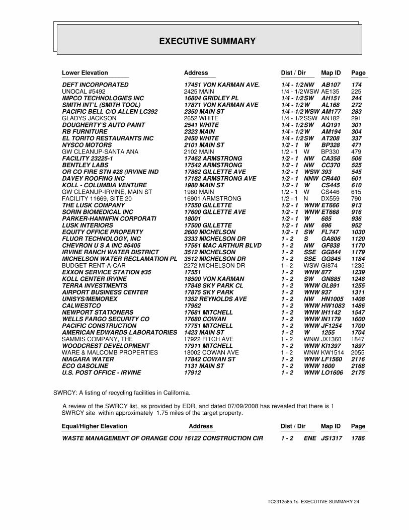
EXECUTIVE SUMMARY
TC2312585.1s EXECUTIVE SUMMARY 24
PageMap IDDist / Dir Address Lower Elevation ____________________ ________ ____________________
174AB107NW1/4 - 1/2 17451 VON KARMAN AVE. DEFT INCORPORATED225AE135WSW1/4 - 1/2 2425 MAIN UNOCAL #5492244AH151SW1/4 - 1/2 16804 GRIDLEY PL IMPCO TECHNOLOGIES INC272AL168W1/4 - 1/2 17871 VON KARMAN AVE SMITH INT’L (SMITH TOOL)283AM177WSW1/4 - 1/2 2350 MAIN ST PACIFIC BELL C/O ALLEN LC392291AN182SSW1/4 - 1/2 2652 WHITE GLADYS JACKSON301AQ191SW1/4 - 1/2 2541 WHITE DOUGHERTY’S AUTO PAINT304AM194W1/4 - 1/2 2323 MAIN RB FURNITURE337AT208SW1/4 - 1/2 2450 WHITE EL TORITO RESTAURANTS INC471BP328W1/2 - 1 2101 MAIN ST NYSCO MOTORS479BP330W1/2 - 1 2102 MAIN GW CLEANUP-SANTA ANA506CA358NW1/2 - 1 17462 ARMSTRONG FACILITY 23225-1525CC370NW1/2 - 1 17542 ARMSTRONG BENTLEY LABS545393WSW1/2 - 1 17862 GILLETTE AVE OR CO FIRE STN #28 (IRVINE IND601CR440NNW1/2 - 1 17182 ARMSTRONG AVE DAVEY ROOFING INC610CS445W1/2 - 1 1980 MAIN ST KOLL - COLUMBIA VENTURE615CS446W1/2 - 1 1980 MAIN GW CLEANUP-IRVINE, MAIN ST790DX559N1/2 - 1 16901 ARMSTRONG FACILITY 11669, SITE 20913ET666WNW1/2 - 1 17550 GILLETTE THE LUSK COMPANY916ET668WNW1/2 - 1 17600 GILLETTE AVE SORIN BIOMEDICAL INC936685W1/2 - 1 18001 PARKER-HANNIFIN CORPORATI952696NW1/2 - 1 17500 GILLETTE LUSK INTERIORS1030FL747SW1/2 - 1 2600 MICHELSON EQUITY OFFICE PROPERTY1120GA806S1 - 2 3333 MICHELSON DR FLUOR TECHNOLOGY, INC1170GF838NW1 - 2 17561 MAC ARTHUR BLVD CHEVRON U S A INC #64051179GG844SSE1 - 2 3512 MICHELSON IRVINE RANCH WATER DISTRICT1184GG845SSE1 - 2 3512 MICHELSON DR MICHELSON WATER RECLAMATION PL1235GI874WSW1 - 2 2272 MICHELSON DR BUDGET RENT-A-CAR1239877WNW1 - 2 17551 EXXON SERVICE STATION #351248GN885SW1 - 2 18500 VON KARMAN KOLL CENTER IRVINE1255GL891WNW1 - 2 17848 SKY PARK CL TERRA INVESTMENTS1311937WNW1 - 2 17875 SKY PARK AIRPORT BUSINESS CENTER1408HN1005NW1 - 2 1352 REYNOLDS AVE UNISYS/MEMOREX1486HW1083WNW1 - 2 17962 CALWESTCO1547IH1142WNW1 - 2 17681 MITCHELL NEWPORT STATIONERS1600IN1179WNW1 - 2 17680 COWAN WELLS FARGO SECURITY CO1700JF1254WNW1 - 2 17751 MITCHELL PACIFIC CONSTRUCTION17041255W1 - 2 1423 MAIN ST AMERICAN EDWARDS LABORATORIES1847JX1360WNW1 - 2 17922 FITCH AVE SAMMIS COMPANY, THE1897KI1397WNW1 - 2 17911 MITCHELL WOODCREST DEVELOPMENT2055KW1514WNW1 - 2 18002 COWAN AVE WARE & MALCOMB PROPERTIES2116LF1560WNW1 - 2 17842 COWAN ST NIAGARA WATER21681600WNW1 - 2 1131 MAIN ST ECO GASOLINE2175LO1606WNW1 - 2 17912 U.S. POST OFFICE - IRVINE
SWRCY: A listing of recycling facilities in California.
A review of the SWRCY list, as provided by EDR, and dated 07/09/2008 has revealed that there is 1 SWRCY site within approximately 1.75 miles of the target property.
PageMap IDDist / Dir Address Equal/Higher Elevation ____________________ ________ ____________________
1786JS1317ENE1 - 2 16122 CONSTRUCTION CIR WASTE MANAGEMENT OF ORANGE COU
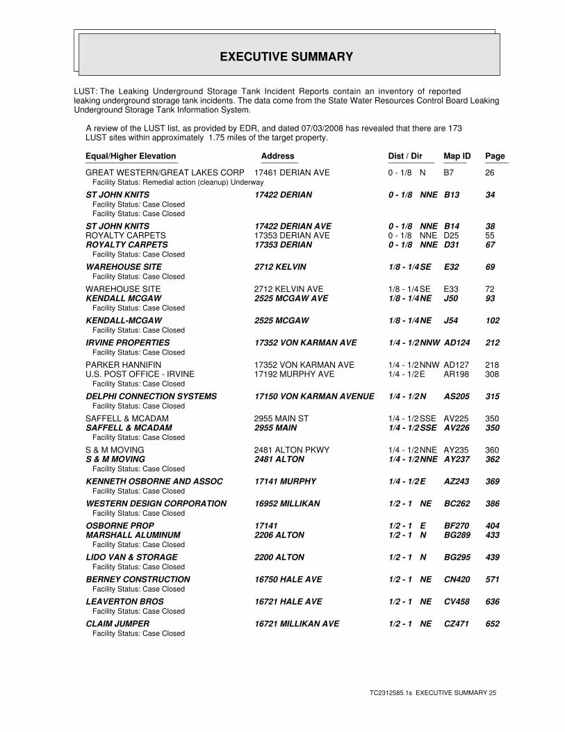
EXECUTIVE SUMMARY
TC2312585.1s EXECUTIVE SUMMARY 25
LUST: The Leaking Underground Storage Tank Incident Reports contain an inventory of reportedleaking underground storage tank incidents. The data come from the State Water Resources Control Board LeakingUnderground Storage Tank Information System.
A review of the LUST list, as provided by EDR, and dated 07/03/2008 has revealed that there are 173 LUST sites within approximately 1.75 miles of the target property.
PageMap IDDist / Dir Address Equal/Higher Elevation ____________________ ________ ____________________
26B7N0 - 1/8 17461 DERIAN AVE GREAT WESTERN/GREAT LAKES CORPFacility Status: Remedial action (cleanup) Underway
34B13NNE0 - 1/8 17422 DERIAN ST JOHN KNITSFacility Status: Case Closed
Facility Status: Case Closed
38B14NNE0 - 1/8 17422 DERIAN AVE ST JOHN KNITS55D25NNE0 - 1/8 17353 DERIAN AVE ROYALTY CARPETS67D31NNE0 - 1/8 17353 DERIAN ROYALTY CARPETS
Facility Status: Case Closed
69E32SE1/8 - 1/4 2712 KELVIN WAREHOUSE SITEFacility Status: Case Closed
72E33SE1/8 - 1/4 2712 KELVIN AVE WAREHOUSE SITE93J50NE1/8 - 1/4 2525 MCGAW AVE KENDALL MCGAW
Facility Status: Case Closed
102J54NE1/8 - 1/4 2525 MCGAW KENDALL-MCGAWFacility Status: Case Closed
212AD124NNW1/4 - 1/2 17352 VON KARMAN AVE IRVINE PROPERTIESFacility Status: Case Closed
218AD127NNW1/4 - 1/2 17352 VON KARMAN AVE PARKER HANNIFIN308AR198E1/4 - 1/2 17192 MURPHY AVE U.S. POST OFFICE - IRVINE
Facility Status: Case Closed
315AS205N1/4 - 1/2 17150 VON KARMAN AVENUE DELPHI CONNECTION SYSTEMSFacility Status: Case Closed
350AV225SSE1/4 - 1/2 2955 MAIN ST SAFFELL & MCADAM350AV226SSE1/4 - 1/2 2955 MAIN SAFFELL & MCADAM
Facility Status: Case Closed
360AY235NNE1/4 - 1/2 2481 ALTON PKWY S & M MOVING362AY237NNE1/4 - 1/2 2481 ALTON S & M MOVING
Facility Status: Case Closed
369AZ243E1/4 - 1/2 17141 MURPHY KENNETH OSBORNE AND ASSOCFacility Status: Case Closed
386BC262NE1/2 - 1 16952 MILLIKAN WESTERN DESIGN CORPORATIONFacility Status: Case Closed
404BF270E1/2 - 1 17141 OSBORNE PROP433BG289N1/2 - 1 2206 ALTON MARSHALL ALUMINUM
Facility Status: Case Closed
439BG295N1/2 - 1 2200 ALTON LIDO VAN & STORAGEFacility Status: Case Closed
571CN420NE1/2 - 1 16750 HALE AVE BERNEY CONSTRUCTIONFacility Status: Case Closed
636CV458NE1/2 - 1 16721 HALE AVE LEAVERTON BROSFacility Status: Case Closed
652CZ471NE1/2 - 1 16721 MILLIKAN AVE CLAIM JUMPERFacility Status: Case Closed
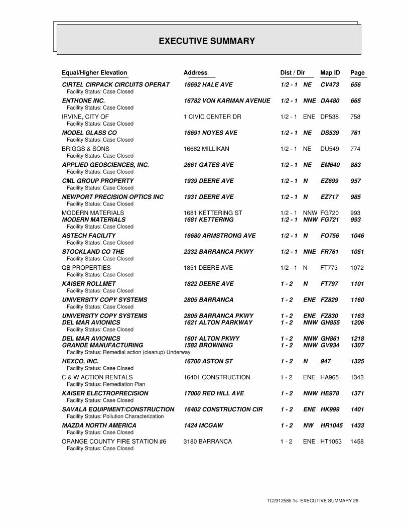
EXECUTIVE SUMMARY
TC2312585.1s EXECUTIVE SUMMARY 26
PageMap IDDist / Dir Address Equal/Higher Elevation ____________________ ________ ____________________
656CV473NE1/2 - 1 16692 HALE AVE CIRTEL CIRPACK CIRCUITS OPERATFacility Status: Case Closed
665DA480NNE1/2 - 1 16782 VON KARMAN AVENUE ENTHONE INC.Facility Status: Case Closed
758DP538ENE1/2 - 1 1 CIVIC CENTER DR IRVINE, CITY OFFacility Status: Case Closed
761DS539NE1/2 - 1 16691 NOYES AVE MODEL GLASS COFacility Status: Case Closed
774DU549NE1/2 - 1 16662 MILLIKAN BRIGGS & SONSFacility Status: Case Closed
883EM640NE1/2 - 1 2661 GATES AVE APPLIED GEOSCIENCES, INC.Facility Status: Case Closed
957EZ699N1/2 - 1 1939 DEERE AVE CML GROUP PROPERTYFacility Status: Case Closed
985EZ717N1/2 - 1 1931 DEERE AVE NEWPORT PRECISION OPTICS INCFacility Status: Case Closed
993FG720NNW1/2 - 1 1681 KETTERING ST MODERN MATERIALS993FG721NNW1/2 - 1 1681 KETTERING MODERN MATERIALS
Facility Status: Case Closed
1046FO756N1/2 - 1 16680 ARMSTRONG AVE ASTECH FACILITYFacility Status: Case Closed
1051FR761NNE1/2 - 1 2332 BARRANCA PKWY STOCKLAND CO THEFacility Status: Case Closed
1072FT773N1/2 - 1 1851 DEERE AVE QB PROPERTIESFacility Status: Case Closed
1101FT797N1 - 2 1822 DEERE AVE KAISER ROLLMETFacility Status: Case Closed
1160FZ829ENE1 - 2 2805 BARRANCA UNIVERSITY COPY SYSTEMSFacility Status: Case Closed
1163FZ830ENE1 - 2 2805 BARRANCA PKWY UNIVERSITY COPY SYSTEMS1206GH855NNW1 - 2 1621 ALTON PARKWAY DEL MAR AVIONICS
Facility Status: Case Closed
1218GH861NNW1 - 2 1601 ALTON PKWY DEL MAR AVIONICS1307GV934NNW1 - 2 1582 BROWNING GRANDE MANUFACTURING
Facility Status: Remedial action (cleanup) Underway
1325947N1 - 2 16700 ASTON ST HEXCO, INC.Facility Status: Case Closed
1343HA965ENE1 - 2 16401 CONSTRUCTION C & W ACTION RENTALSFacility Status: Remediation Plan
1371HE978NNW1 - 2 17000 RED HILL AVE KAISER ELECTROPRECISIONFacility Status: Case Closed
1401HK999ENE1 - 2 16402 CONSTRUCTION CIR SAVALA EQUIPMENT/CONSTRUCTIONFacility Status: Pollution Characterization
1433HR1045NW1 - 2 1424 MCGAW MAZDA NORTH AMERICAFacility Status: Case Closed
1458HT1053ENE1 - 2 3180 BARRANCA ORANGE COUNTY FIRE STATION #6Facility Status: Case Closed
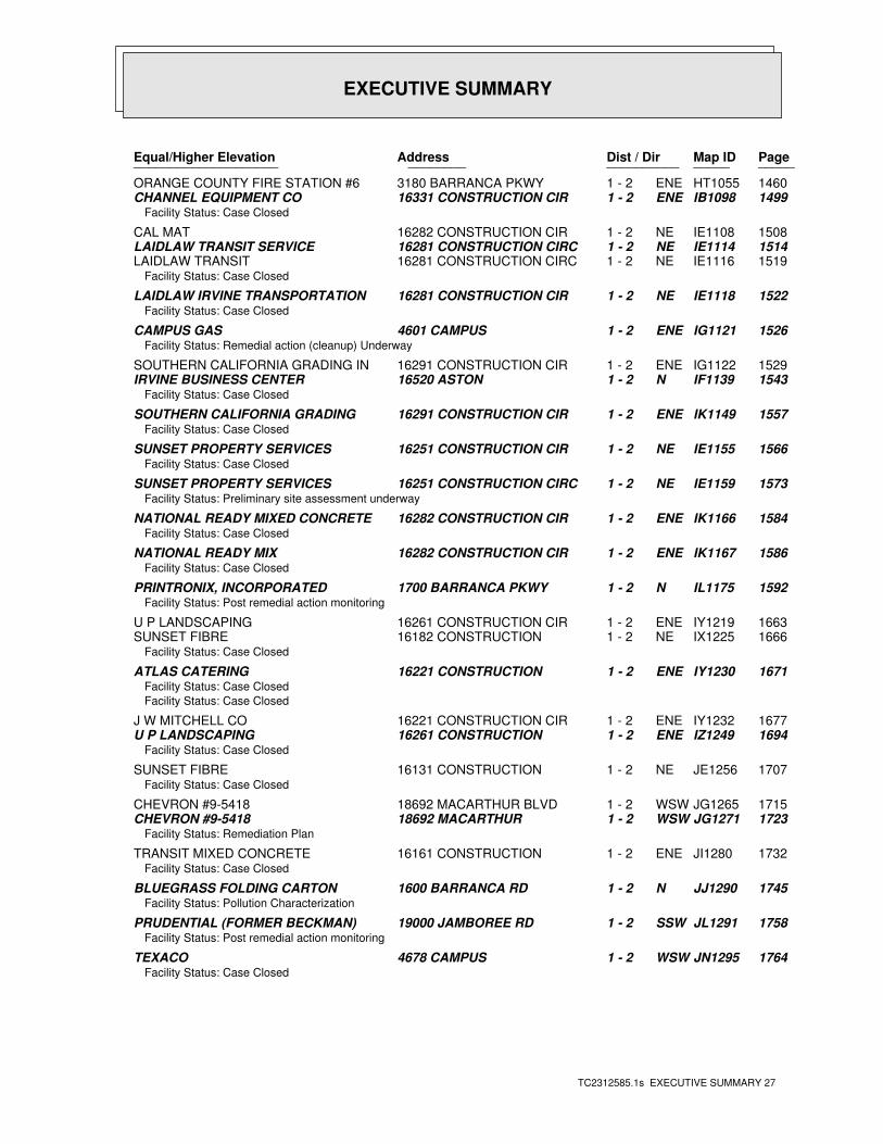
EXECUTIVE SUMMARY
TC2312585.1s EXECUTIVE SUMMARY 27
PageMap IDDist / Dir Address Equal/Higher Elevation ____________________ ________ ____________________
1460HT1055ENE1 - 2 3180 BARRANCA PKWY ORANGE COUNTY FIRE STATION #61499IB1098ENE1 - 2 16331 CONSTRUCTION CIR CHANNEL EQUIPMENT CO
Facility Status: Case Closed
1508IE1108NE1 - 2 16282 CONSTRUCTION CIR CAL MAT1514IE1114NE1 - 2 16281 CONSTRUCTION CIRC LAIDLAW TRANSIT SERVICE1519IE1116NE1 - 2 16281 CONSTRUCTION CIRC LAIDLAW TRANSIT
Facility Status: Case Closed
1522IE1118NE1 - 2 16281 CONSTRUCTION CIR LAIDLAW IRVINE TRANSPORTATIONFacility Status: Case Closed
1526IG1121ENE1 - 2 4601 CAMPUS CAMPUS GASFacility Status: Remedial action (cleanup) Underway
1529IG1122ENE1 - 2 16291 CONSTRUCTION CIR SOUTHERN CALIFORNIA GRADING IN1543IF1139N1 - 2 16520 ASTON IRVINE BUSINESS CENTER
Facility Status: Case Closed
1557IK1149ENE1 - 2 16291 CONSTRUCTION CIR SOUTHERN CALIFORNIA GRADINGFacility Status: Case Closed
1566IE1155NE1 - 2 16251 CONSTRUCTION CIR SUNSET PROPERTY SERVICESFacility Status: Case Closed
1573IE1159NE1 - 2 16251 CONSTRUCTION CIRC SUNSET PROPERTY SERVICESFacility Status: Preliminary site assessment underway
1584IK1166ENE1 - 2 16282 CONSTRUCTION CIR NATIONAL READY MIXED CONCRETE Facility Status: Case Closed
1586IK1167ENE1 - 2 16282 CONSTRUCTION CIR NATIONAL READY MIXFacility Status: Case Closed
1592IL1175N1 - 2 1700 BARRANCA PKWY PRINTRONIX, INCORPORATEDFacility Status: Post remedial action monitoring
1663IY1219ENE1 - 2 16261 CONSTRUCTION CIR U P LANDSCAPING1666IX1225NE1 - 2 16182 CONSTRUCTION SUNSET FIBRE
Facility Status: Case Closed
1671IY1230ENE1 - 2 16221 CONSTRUCTION ATLAS CATERINGFacility Status: Case Closed
Facility Status: Case Closed
1677IY1232ENE1 - 2 16221 CONSTRUCTION CIR J W MITCHELL CO1694IZ1249ENE1 - 2 16261 CONSTRUCTION U P LANDSCAPING
Facility Status: Case Closed
1707JE1256NE1 - 2 16131 CONSTRUCTION SUNSET FIBREFacility Status: Case Closed
1715JG1265WSW1 - 2 18692 MACARTHUR BLVD CHEVRON #9-54181723JG1271WSW1 - 2 18692 MACARTHUR CHEVRON #9-5418
Facility Status: Remediation Plan
1732JI1280ENE1 - 2 16161 CONSTRUCTION TRANSIT MIXED CONCRETEFacility Status: Case Closed
1745JJ1290N1 - 2 1600 BARRANCA RD BLUEGRASS FOLDING CARTONFacility Status: Pollution Characterization
1758JL1291SSW1 - 2 19000 JAMBOREE RD PRUDENTIAL (FORMER BECKMAN)Facility Status: Post remedial action monitoring
1764JN1295WSW1 - 2 4678 CAMPUS TEXACOFacility Status: Case Closed
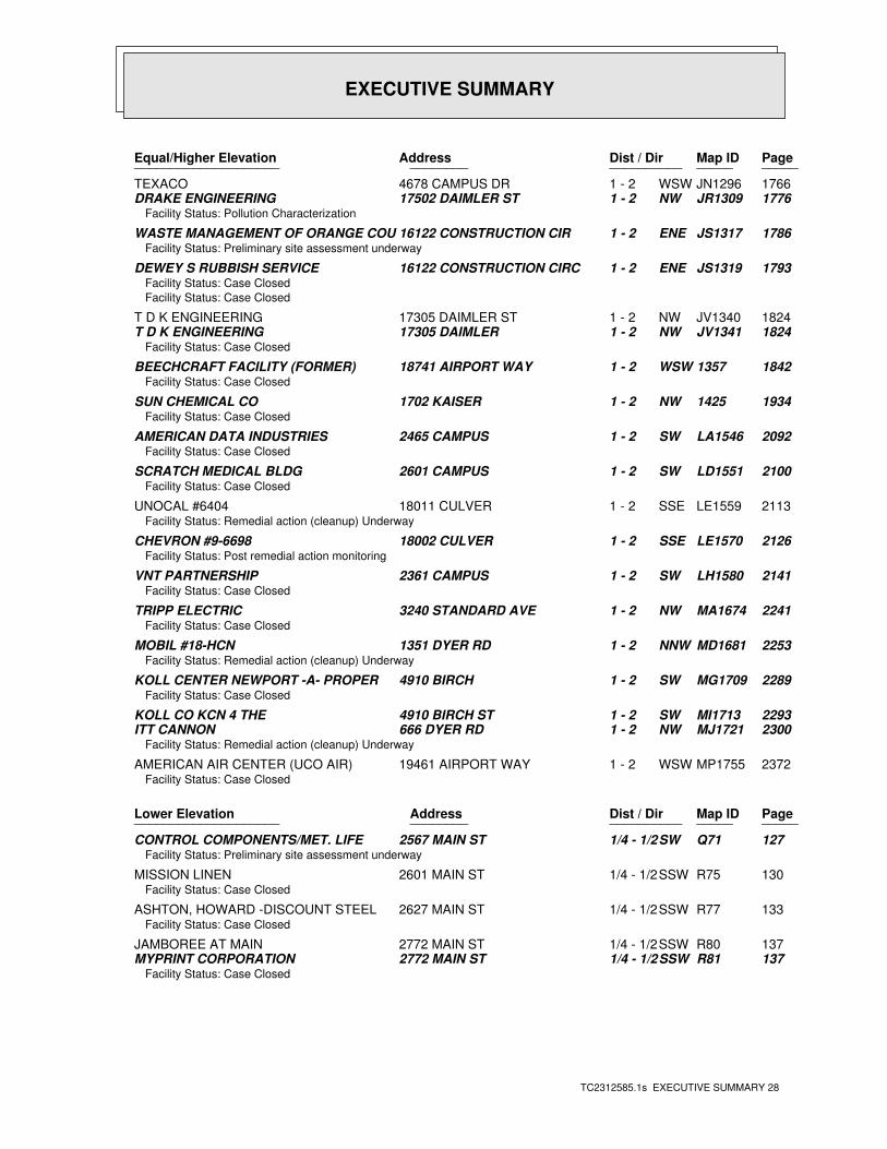
EXECUTIVE SUMMARY
TC2312585.1s EXECUTIVE SUMMARY 28
PageMap IDDist / Dir Address Equal/Higher Elevation ____________________ ________ ____________________
1766JN1296WSW1 - 2 4678 CAMPUS DR TEXACO1776JR1309NW1 - 2 17502 DAIMLER ST DRAKE ENGINEERING
Facility Status: Pollution Characterization
1786JS1317ENE1 - 2 16122 CONSTRUCTION CIR WASTE MANAGEMENT OF ORANGE COUFacility Status: Preliminary site assessment underway
1793JS1319ENE1 - 2 16122 CONSTRUCTION CIRC DEWEY S RUBBISH SERVICEFacility Status: Case Closed
Facility Status: Case Closed
1824JV1340NW1 - 2 17305 DAIMLER ST T D K ENGINEERING1824JV1341NW1 - 2 17305 DAIMLER T D K ENGINEERING
Facility Status: Case Closed
18421357WSW1 - 2 18741 AIRPORT WAY BEECHCRAFT FACILITY (FORMER)Facility Status: Case Closed
19341425NW1 - 2 1702 KAISER SUN CHEMICAL COFacility Status: Case Closed
2092LA1546SW1 - 2 2465 CAMPUS AMERICAN DATA INDUSTRIESFacility Status: Case Closed
2100LD1551SW1 - 2 2601 CAMPUS SCRATCH MEDICAL BLDGFacility Status: Case Closed
2113LE1559SSE1 - 2 18011 CULVER UNOCAL #6404Facility Status: Remedial action (cleanup) Underway
2126LE1570SSE1 - 2 18002 CULVER CHEVRON #9-6698Facility Status: Post remedial action monitoring
2141LH1580SW1 - 2 2361 CAMPUS VNT PARTNERSHIPFacility Status: Case Closed
2241MA1674NW1 - 2 3240 STANDARD AVE TRIPP ELECTRICFacility Status: Case Closed
2253MD1681NNW1 - 2 1351 DYER RD MOBIL #18-HCNFacility Status: Remedial action (cleanup) Underway
2289MG1709SW1 - 2 4910 BIRCH KOLL CENTER NEWPORT -A- PROPERFacility Status: Case Closed
2293MI1713SW1 - 2 4910 BIRCH ST KOLL CO KCN 4 THE2300MJ1721NW1 - 2 666 DYER RD ITT CANNON
Facility Status: Remedial action (cleanup) Underway
2372MP1755WSW1 - 2 19461 AIRPORT WAY AMERICAN AIR CENTER (UCO AIR)Facility Status: Case Closed
PageMap IDDist / Dir Address Lower Elevation ____________________ ________ ____________________
127Q71SW1/4 - 1/2 2567 MAIN ST CONTROL COMPONENTS/MET. LIFEFacility Status: Preliminary site assessment underway
130R75SSW1/4 - 1/2 2601 MAIN ST MISSION LINENFacility Status: Case Closed
133R77SSW1/4 - 1/2 2627 MAIN ST ASHTON, HOWARD -DISCOUNT STEELFacility Status: Case Closed
137R80SSW1/4 - 1/2 2772 MAIN ST JAMBOREE AT MAIN137R81SSW1/4 - 1/2 2772 MAIN ST MYPRINT CORPORATION
Facility Status: Case Closed
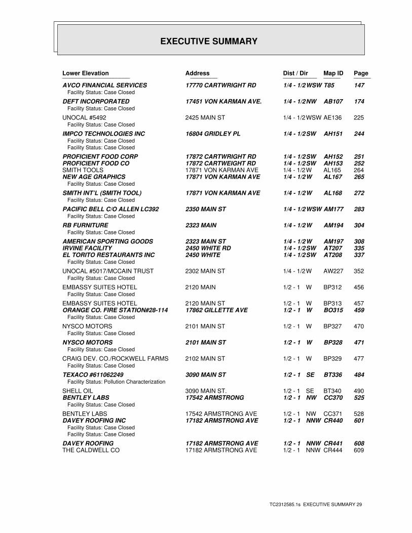
EXECUTIVE SUMMARY
TC2312585.1s EXECUTIVE SUMMARY 29
PageMap IDDist / Dir Address Lower Elevation ____________________ ________ ____________________
147T85WSW1/4 - 1/2 17770 CARTWRIGHT RD AVCO FINANCIAL SERVICESFacility Status: Case Closed
174AB107NW1/4 - 1/2 17451 VON KARMAN AVE. DEFT INCORPORATEDFacility Status: Case Closed
225AE136WSW1/4 - 1/2 2425 MAIN ST UNOCAL #5492Facility Status: Case Closed
244AH151SW1/4 - 1/2 16804 GRIDLEY PL IMPCO TECHNOLOGIES INCFacility Status: Case Closed
Facility Status: Case Closed
251AH152SW1/4 - 1/2 17872 CARTWRIGHT RD PROFICIENT FOOD CORP252AH153SW1/4 - 1/2 17872 CARTWEIGHT RD PROFICIENT FOOD CO264AL165W1/4 - 1/2 17871 VON KARMAN AVE SMITH TOOLS265AL167W1/4 - 1/2 17871 VON KARMAN AVE NEW AGE GRAPHICS
Facility Status: Case Closed
272AL168W1/4 - 1/2 17871 VON KARMAN AVE SMITH INT’L (SMITH TOOL)Facility Status: Case Closed
283AM177WSW1/4 - 1/2 2350 MAIN ST PACIFIC BELL C/O ALLEN LC392Facility Status: Case Closed
304AM194W1/4 - 1/2 2323 MAIN RB FURNITUREFacility Status: Case Closed
308AM197W1/4 - 1/2 2323 MAIN ST AMERICAN SPORTING GOODS335AT207SW1/4 - 1/2 2450 WHITE RD IRVINE FACILITY337AT208SW1/4 - 1/2 2450 WHITE EL TORITO RESTAURANTS INC
Facility Status: Case Closed
352AW227W1/4 - 1/2 2302 MAIN ST UNOCAL #5017/MCCAIN TRUSTFacility Status: Case Closed
456BP312W1/2 - 1 2120 MAIN EMBASSY SUITES HOTELFacility Status: Case Closed
457BP313W1/2 - 1 2120 MAIN ST EMBASSY SUITES HOTEL459BO315W1/2 - 1 17862 GILLETTE AVE ORANGE CO. FIRE STATION#28-114
Facility Status: Case Closed
470BP327W1/2 - 1 2101 MAIN ST NYSCO MOTORSFacility Status: Case Closed
471BP328W1/2 - 1 2101 MAIN ST NYSCO MOTORSFacility Status: Case Closed
477BP329W1/2 - 1 2102 MAIN ST CRAIG DEV. CO./ROCKWELL FARMSFacility Status: Case Closed
484BT336SE1/2 - 1 3090 MAIN ST TEXACO #611062249Facility Status: Pollution Characterization
490BT340SE1/2 - 1 3090 MAIN ST. SHELL OIL525CC370NW1/2 - 1 17542 ARMSTRONG BENTLEY LABS
Facility Status: Case Closed
528CC371NW1/2 - 1 17542 ARMSTRONG AVE BENTLEY LABS601CR440NNW1/2 - 1 17182 ARMSTRONG AVE DAVEY ROOFING INC
Facility Status: Case Closed
Facility Status: Case Closed
608CR441NNW1/2 - 1 17182 ARMSTRONG AVE DAVEY ROOFING609CR444NNW1/2 - 1 17182 ARMSTRONG AVE THE CALDWELL CO
EXECUTIVE SUMMARY
TC2312585.1s EXECUTIVE SUMMARY 30
PageMap IDDist / Dir Address Lower Elevation ____________________ ________ ____________________
610CS445W1/2 - 1 1980 MAIN ST KOLL - COLUMBIA VENTUREFacility Status: Case Closed
688DD494WSW1/2 - 1 18001 VON KARMAN AVENUE PARKER HANNIFIN CORPORATIONFacility Status: Case Closed
692DD495WSW1/2 - 1 18001 VON KARMAN AVE PARKER-HANNIFIN CORPORATIONFacility Status: Case Closed
722DI512W1/2 - 1 1807 MAIN ST BAJARA PROPERTY723DI513W1/2 - 1 1801 MAIN ST ISAAC MAIN PLAZA/METRO CW
Facility Status: Post remedial action monitoring
898ER656SW1/2 - 1 18221 VON KARMAN VON KARMAN TOWERSFacility Status: Leak being confirmed
903ER661SW1/2 - 1 18221 VON KARMAN AVE VON KARMAN TOWERS913ET666WNW1/2 - 1 17550 GILLETTE THE LUSK COMPANY
Facility Status: Case Closed
923ET673WNW1/2 - 1 17600 GILLETTE SHILEY INCFacility Status: Case Closed
926ET674WNW1/2 - 1 17600 GILLETTE AVE SHILEY INC.952696NW1/2 - 1 17500 GILLETTE LUSK INTERIORS
Facility Status: Case Closed
972FD711SSW1/2 - 1 18321 JAMBOREE RD PARKER-HANNIFIN CORPORATIONFacility Status: Case Closed
1027FL744SW1/2 - 1 2600 MICHELSON DR AUDIOMAGNETICSFacility Status: Pollution Characterization
1030FL747SW1/2 - 1 2600 MICHELSON EQUITY OFFICE PROPERTY1031FL748SW1/2 - 1 2602 MICHELSON TRAMMEL CROW
Facility Status: Case Closed
1120GA806S1 - 2 3333 MICHELSON DR FLUOR TECHNOLOGY, INCFacility Status: Case Closed
1125GA807S1 - 2 3333 MICHELSON DR FLUOR TECHNOLOGY INC1164GF833NW1 - 2 17561 MACARTHUR CHEVRON
Facility Status: Remedial action (cleanup) Underway
1170GF837NW1 - 2 17561 MACARTHUR BLVD CHEVRON #9-64051173GE839WNW1 - 2 17848 SKY PARK TERRA INVESTMENTS
Facility Status: Case Closed
1179GG844SSE1 - 2 3512 MICHELSON IRVINE RANCH WATER DISTRICTFacility Status: Case Closed
Facility Status: Case Closed
*Additional key fields are available in the Map Findings section
1184GG845SSE1 - 2 3512 MICHELSON DR MICHELSON WATER RECLAMATION PL1193GG851SSE1 - 2 3512 MICHELSON DR MICHELSON PLANT1201GG853SSE1 - 2 3512 MICHELSON MICHELSON TREATMENT PLANT
Facility Status: Case Closed
1203GG854SSE1 - 2 3512 MICHELSON DR IRVINE RANCH WATER DISTRICT1223GF866NW1 - 2 17551 MACARTHUR EXXON
Facility Status: Remediation Plan
Facility Status: Remedial action (cleanup) Underway
1227GF867NW1 - 2 17551 MACARTHUR BLVD EXXON #7-35151230GF869NW1 - 2 17551 MACARTHUR BLVD MACHILL PETROLEUM INC1232GI873WSW1 - 2 2272 MICHELSON BUDGET RENT A CAR
Facility Status: Case Closed
EXECUTIVE SUMMARY
TC2312585.1s EXECUTIVE SUMMARY 31
PageMap IDDist / Dir Address Lower Elevation ____________________ ________ ____________________
1248GN885SW1 - 2 18500 VON KARMAN KOLL CENTER IRVINEFacility Status: Case Closed
1254GL890WNW1 - 2 17848 SKY PARK CIR TERRA INVESTMENTS1311937WNW1 - 2 17875 SKY PARK AIRPORT BUSINESS CENTER
Facility Status: Case Closed
1408HN1005NW1 - 2 1352 REYNOLDS AVE UNISYS/MEMOREXFacility Status: Post remedial action monitoring
1547IH1142WNW1 - 2 17681 MITCHELL NEWPORT STATIONERSFacility Status: Case Closed
1600IN1179WNW1 - 2 17680 COWAN WELLS FARGO SECURITY COFacility Status: Case Closed
1608IN1189WNW1 - 2 17692 COWAN CALWESTCO INCFacility Status: Case Closed
1700JF1254WNW1 - 2 17751 MITCHELL PACIFIC CONSTRUCTIONFacility Status: Case Closed
17041255W1 - 2 1423 MAIN ST AMERICAN EDWARDS LABORATORIESFacility Status: Case Closed
1845JX1359WNW1 - 2 17922 FITCH PARK REDHILL PARTNERSHIPFacility Status: Case Closed
1897KI1397WNW1 - 2 17911 MITCHELL WOODCREST DEVELOPMENTFacility Status: Case Closed
2055KW1515WNW1 - 2 18002 COWAN WARE & MALCOMB PROPERTIESFacility Status: Case Closed
2057KW1516WNW1 - 2 18002 COWAN WARE & MALCOMB PROPERTIES2118LF1562WNW1 - 2 17842 COWAN NIAGARA DISTRIBUTING LLC
Facility Status: Case Closed
21681600WNW1 - 2 1131 MAIN ST ECO GASOLINEFacility Status: Remedial action (cleanup) Underway
CA FID UST: The Facility Inventory Database contains active and inactive underground storage tanklocations. The source is the State Water Resource Control Board.
A review of the CA FID UST list, as provided by EDR, and dated 10/31/1994 has revealed that there are 76 CA FID UST sites within approximately 1.75 miles of the target property.
PageMap IDDist / Dir Address Equal/Higher Elevation ____________________ ________ ____________________
40B15NNE0 - 1/8 17422 DERIAN AVE ST. JOHN KNITS55D26NNE0 - 1/8 17353 DERIAN AVE ROYALTY CARPET MILLS INC93J50NE1/8 - 1/4 2525 MCGAW AVE KENDALL MCGAW311AR199E1/4 - 1/2 17192 MURPHY AVE U S POST OFFICE315AS205N1/4 - 1/2 17150 VON KARMAN AVENUE DELPHI CONNECTION SYSTEMS362AY237NNE1/4 - 1/2 2481 ALTON S & M MOVING442BG298N1/2 - 1 2201 ALTON AVE ROGERSON AIRCRAFT CORP533CE378NNE1/2 - 1 16811 HALE AVE BALDWIN FLEET SERVICE571CN419NE1/2 - 1 16750 HALE AVE BERNEY CONSTRUCTION634CV456NE1/2 - 1 16721 MILLIKEN AVE CLAIM JUMPER751DP533ENE1/2 - 1 1 CIVIC CENTER PL IRVINE CITY HALL797568SSW1/2 - 1 18321 JAMBOREE BLVD PARKER BERTEA AEROSPACE GROUP998FH727ENE1/2 - 1 80 CORPORATE PARK CHEVRON USA
EXECUTIVE SUMMARY
TC2312585.1s EXECUTIVE SUMMARY 32
PageMap IDDist / Dir Address Equal/Higher Elevation ____________________ ________ ____________________
1105FX799NNW1 - 2 16901 ASTON ST PRUDENTIAL OVERALL SUPPLY1206GH855NNW1 - 2 1621 ALTON PARKWAY DEL MAR AVIONICS1300GW927NNW1 - 2 17111 RED HILL AVE BAXTER HEALTH CARE1341HA964ENE1 - 2 16401 CONSTRUCTION WEST C & W ACTION RENTALS1352HD971NW1 - 2 1444 MC GAW AVE MAZDA NORTH AMERICA INC1394HJ994N1 - 2 1922 BARRANCA RD JACUZZI WHIRLPOOL BATH1396HK997ENE1 - 2 16402 E CONSTRUCTION CL SAVALA EQUIPMENT/CONSTRUCTION1419HP1024SW1 - 2 18651 VON KARMAN AVE FEDERAL EXPRESS1526IG1121ENE1 - 2 4601 CAMPUS CAMPUS GAS15411136NE1 - 2 16282 W CONSTRUCTION WE IRVINE SHOP - CPC1563IK1151ENE1 - 2 16291 CONSTRUCTION CL E SOUTHERN CALIFORNIA GRADING1571IE1158NE1 - 2 16251 CONSTRUCTION CIR SUNSET PROPERTIES1602IK1180ENE1 - 2 16331 E CONSTRUCTION CL CHANNEL EQUIPMENT CO1606IO1186ENE1 - 2 16282 CONSTRUCTION EAST UNITED PREMIX CONCRETE INC1664IX1223NE1 - 2 16182 CONSTRUCTION CL W SUNSET FIBRE INDUSTRIES INC1676IY1231ENE1 - 2 16221 E CONSTRUCTION CL UP LANDSCAPE STORAGE YARD1688IX1243NE1 - 2 16161 E CONSTRUCTION CL TRANSIT MIXED CONCRETE CO1696IZ1250ENE1 - 2 16261 E CONSTRUCTION CL UP LANDSCAPE STORAGE YARD1698JE1252NE1 - 2 16281 CONSTRUCTION CIR WESTERN WASTE INDUSTRIES1709JE1258NE1 - 2 16131 CONSTRUCTION CL W SUNSET FIBRE1723JG1271WSW1 - 2 18692 MACARTHUR CHEVRON #9-54181793JS1319ENE1 - 2 16122 CONSTRUCTION CIRC DEWEY S RUBBISH SERVICE1828JO1343NE1 - 2 16351 CONSTRUCTION CIR HERTZ EQUIPMENT RENTAL1955KQ1446NNW1 - 2 1900 E DEERE ST ASTECH/MCI MFG INC1983KR1468SW1 - 2 19100 VON KARMAN AVE THE ATRIUM2005KV1484NNW1 - 2 2040 E DYER RD BFM ENERGY PRODUCTS COPR2065KV1529NNW1 - 2 1800 E DYER RD AMWAY CORPORATION2113LE1558SSE1 - 2 18011 CULVER DR UNOCAL #64042126LE1570SSE1 - 2 18002 CULVER CHEVRON #9-669821501590NW1 - 2 2401 S PULLMAN TOLO INC2190LP1617E1 - 2 3720 BARRANCA PY SHELL OIL CO2207LT1637SW1 - 2 4695 MAC ARTHUR CT PRENTISS PROPERTIES LTD2220LY1656SW1 - 2 4590 MAC ARTHUR KOLL CENTER NEWPORT #82248MD1678NNW1 - 2 1351 E DYER RD MOBIL SS #18-HCN2262MC1689NW1 - 2 3240 S STANDARD AVE TRIPP ELECTRIC INC2289MG1709SW1 - 2 4910 BIRCH KOLL CENTER NEWPORT -A- PROPER2303MJ1723NW1 - 2 666 EAST DYER RD ITT CANNON2375MP1757WSW1 - 2 19459 S AIRPORT WAY OR CO FIRE STN #27 (AIRPORT)
PageMap IDDist / Dir Address Lower Elevation ____________________ ________ ____________________
147T85WSW1/4 - 1/2 17770 CARTWRIGHT RD AVCO FINANCIAL SERVICES174AB107NW1/4 - 1/2 17451 VON KARMAN AVE. DEFT INCORPORATED282AM175WSW1/4 - 1/2 2350 MAIN ST PACIFIC BELL (LC392/IRVNCA11)435290SSW1/2 - 1 17900 JAMBOREE IRVINE HYATT REGENCY436BE292WSW1/2 - 1 17875 VON KARMAN AVE RMB IRVINE PLAZA LTD PARTNERSH545393WSW1/2 - 1 17862 GILLETTE AVE OR CO FIRE STN #28 (IRVINE IND609CR443NNW1/2 - 1 17182 ARMSTRONG AVE DAVEY ROOFING659CW474W1/2 - 1 17821 GILLETTE AVE THOMAS TRANSFER CO758DR537WSW1/2 - 1 18000 VON KARMAN AVE IRVINE MARRIOTT HOTEL797DY567W1/2 - 1 2120 MAIN ST EMBASSY SUITES HOTEL832EC590WSW1/2 - 1 18101 VON KARMAN AVE LAKESHORE TOWERS LTD893649SW1/2 - 1 18150 VON KARMAN KOLL CENTER IRVINE913ET666WNW1/2 - 1 17550 GILLETTE THE LUSK COMPANY1030FL747SW1/2 - 1 2600 MICHELSON EQUITY OFFICE PROPERTY1127GA808S1 - 2 3333 MICHELSON DR FLUOR DANIEL INC
EXECUTIVE SUMMARY
TC2312585.1s EXECUTIVE SUMMARY 33
PageMap IDDist / Dir Address Lower Elevation ____________________ ________ ____________________
1170GF838NW1 - 2 17561 MAC ARTHUR BLVD CHEVRON U S A INC #64051184GG845SSE1 - 2 3512 MICHELSON DR MICHELSON WATER RECLAMATION PL1239877WNW1 - 2 17551 EXXON SERVICE STATION #351255GL891WNW1 - 2 17848 SKY PARK CL TERRA INVESTMENTS1333HB953W1 - 2 18601 AIRPORT WAY JOHN WAYNE AIRPORT TERMINAL BL1339HC961WNW1 - 2 18002 SKY PARK CL THE TOMAN COMPANY1546IH1140WNW1 - 2 17681 N MITCHELL NEWPORT STATIONERS19701455WNW1 - 2 17911 S MITCHELL WOOD WEST DEVELOPMENT2338ML1732WNW1 - 2 200 E SANDPOINTE AVE HUTTON CENTRE2361MM1744WNW1 - 2 4101 S MAIN ST AVIS RENT A CAR
SLIC: SLIC Region comes from the California Regional Water Quality Control Board.
A review of the SLIC list, as provided by EDR, and dated 07/03/2008 has revealed that there are 41 SLIC sites within approximately 1.75 miles of the target property.
PageMap IDDist / Dir Address Equal/Higher Elevation ____________________ ________ ____________________
17B3N0 - 1/8 17641 DERION GREAT LAKES CHEMICAL CORP28B8N0 - 1/8 17461 DERIAN AVE GREAT LAKES CHEMICAL CORP30B9N0 - 1/8 17461 DERIAN AVENUE GREAT LAKLES CHEMICAL COPRORAT
Facility Status: Remedial Action Underway
30B10N0 - 1/8 17461 DERIAN AVE GREAT LAKES CHEMICAL CORP107K56NE1/8 - 1/4 2602 MCGAW STREET DICEON165Z99E1/4 - 1/2 2802-2823 MCGAW AVENUE JAMBOREE CORPORATION PARK315AS205N1/4 - 1/2 17150 VON KARMAN AVENUE DELPHI CONNECTION SYSTEMS537CF382NE1/2 - 1 2691 RICHTER AVENUE JAMBOREE BUSINESS CENTER696DE497SE1/2 - 1 17595 HARVARD AVENUE DRY CLEAN EXPRESS1088FV784NNE1/2 - 1 2302 BARRANCA PARKWAY SHELDAHL INC. ORANGE COUNTY
Facility Status: Case Closed
1092FV785NNE1/2 - 1 2302 BARRANCA PARKWAY B M C INDUSTRIES1099FT795N1 - 2 1822 DEERE AVE. KAISER ELECTROPRECISION1100FT796N1 - 2 1822 DEERE AVENUE KAISER ROLLMET
Facility Status: Case Closed
1152GD823N1 - 2 16601 ARMSTRONG AVE PC WORLD ORNAGE COUNTY1158GD826N1 - 2 16601 ARMSTRONG AVE. PC WORLD1176841N1 - 2 1771 DEERE AVE NEWPORT CORPORATION1283909SW1 - 2 18522 VON KARMEN SANMINA (ELEXSYS INTERN’L, INC1445HS1049NNW1 - 2 3030 RED HILL AVENUE S ASTECH CO1457HS1052NNW1 - 2 3030 S RED HILL AVENUE ASTECH CO1638IT1200SSW1 - 2 18691 JAMBOREE ROAD XEROX CORPORATION1648IT1203SSW1 - 2 18691 JAMBOREE GW CLEANUP-IRVINE, JAMBORE
Facility Status: Verification Monitoring Underway
1971KR1457SW1 - 2 19100-200 VAN KARMAN HYOGO ATRIUM INC.1984KR1469SW1 - 2 19100-1920 VON KARMAN A HYOGO ATRIUM2173LK1602E1 - 2 3881 ALTON PARKWAY PARK CLEANERS, ROYMA CORP DBA2182LM1612SSE1 - 2 18058 CULVER DRIVE PARK CLEANERS
Facility Status: Case Closed
2182LM1613SSE1 - 2 18058 CULVER DR TAL AR CORP DBA UNIVERSITY PAR2233MA1666NW1 - 2 3300 SOUTH STANDARD STR EMERSON ELECTRIC2239MA1671NW1 - 2 300 S STANDARD STREET EMERSON ELECTRONICS
PageMap IDDist / Dir Address Lower Elevation ____________________ ________ ____________________
124Q70SW1/4 - 1/2 2567 MAIN ST METLIFE CENTURY CENTRE I I I
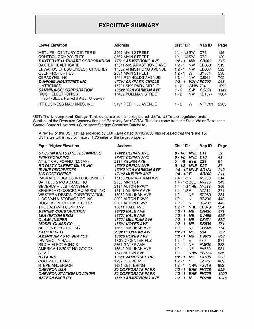
EXECUTIVE SUMMARY
TC2312585.1s EXECUTIVE SUMMARY 34
PageMap IDDist / Dir Address Lower Elevation ____________________ ________ ____________________
129Q72SW1/4 - 1/2 2567 MAIN STREET METLIFE - CENTURY CENTER III130Q73SW1/4 - 1/2 2567 MAIN STREET CONTROL COMPONENTS515CB362NW1/2 - 1 17511 ARMSTRONG AVE BAXTER HEALTHCARE CORPORATION519CB363NW1/2 - 1 17511-502 ARMSTRONG AVE BAXTER HEALTHCARE522CB367NW1/2 - 1 17502 ARMSTRONG AVENUE EDWARDS LIFESCIENCES(FORMERLY 538BY384W1/2 - 1 2031 MAIN STREET OLEN PROPERTIES765DJ541NW1/2 - 1 1741 REYNOLDS AVENUE CERADYNE, INC966FC707WNW1/2 - 1 17791 SKYPARK CIRCLE DUNHAM INDUSTRIES INC1099794WNW1 - 2 17791 SKY PARK CIRCLE LINTRONICS1141GC821SW1 - 2 18522 VON KARMAN AVE SANMINA-SCI CORPORATION1864KB1374NW1 - 2 17482 PULLMAN STREET RICOH ELECTRONICS
Facility Status: Remedial Action Underway
2283MF1703W1 - 2 3191 RED HILL AVENUE ITT BUSINESS MACHINES, INC.
UST: The Underground Storage Tank database contains registered USTs. USTs are regulated underSubtitle I of the Resource Conservation and Recovery Act (RCRA). The data come from the State Water ResourcesControl Board’s Hazardous Substance Storage Container Database.
A review of the UST list, as provided by EDR, and dated 07/10/2008 has revealed that there are 157 UST sites within approximately 1.75 miles of the target property.
PageMap IDDist / Dir Address Equal/Higher Elevation ____________________ ________ ____________________
32B11NNE0 - 1/8 17422 DERIAN AVE ST JOHN KNITS DYE TECHNIQUES42B18NNE0 - 1/8 17421 DERIAN AVE PRINTRONIX INC54C23ESE0 - 1/8 2681 KELVIN AVE AT & T CALIFORNIA (LC9AP)56D27NNE0 - 1/8 17352 DERIAN AVE ROYALTY CARPET MILLS INC212AD124NNW1/4 - 1/2 17352 VON KARMAN AVE IRVINE PROPERTIES311AR200E1/4 - 1/2 17192 MURPHY AVE U S POST OFFICE314AS203N1/4 - 1/2 17150 VON KARMAN AVE PACKARD-HUGHES INTERCONNECT349AV223SSE1/4 - 1/2 2955 MAIN ST SAFFELL & MC ADAMS INC359AY233NNE1/4 - 1/2 2481 ALTON PKWY BEVERLY HILLS TRANSFER371AZ244E1/4 - 1/2 17141 MURPHY AVE KENNETH G OSBORNE & ASSOC INC384BC260NE1/2 - 1 16952 MILLIKAN AVE WESTERN DESIGN CORPORTATION442BG296N1/2 - 1 2200 ALTON PKWY LIDO VAN & STORAGE CO INC442BG297N1/2 - 1 2201 ALTON PKWY ROGERSON AIRCRAFT CORP534CE379NNE1/2 - 1 16811 HALE AVE THE BALDWIN COMPANY571CN420NE1/2 - 1 16750 HALE AVE BERNEY CONSTRUCTION636CV458NE1/2 - 1 16721 HALE AVE LEAVERTON BROS652CZ471NE1/2 - 1 16721 MILLIKAN AVE CLAIM JUMPER761DS539NE1/2 - 1 16691 NOYES AVE MODEL GLASS CO774DU548NE1/2 - 1 16662 MILLIKAN AVE BRIGGS ELECTRIC INC792564NE1/2 - 1 2692 BECKMAN AVE PACIFIC BELL808DS573NE1/2 - 1 16635 NOYES AVE AMERICAN AUTO SERVICE871630E1/2 - 1 1 CIVIC CENTER PLZ IRVINE CITY HALL883EM639NE1/2 - 1 2661 GATES AVE RICOH ELECTRONICS931EV680NE1/2 - 1 16542 MILLIKAN AVE AMERICAN SP0RTING GOODS935EW684NNW1/2 - 1 1741 ALTON AVE. AT & T936EX686NE1/2 - 1 16661 JAMBOREE RD K R K INC963EZ702N1/2 - 1 1939 DEERE AVE COLDWELL BANK992FG719NNW1/2 - 1 1681 KETTERING STEVE ANDERSON999FH728ENE1/2 - 1 80 CORPORATE PARK CHEVRON USA1000FH729ENE1/2 - 1 80 CORPORATE PARK CHEVRON STATION NO 2010951046FO756N1/2 - 1 16680 ARMSTRONG AVE ASTECH FACILITY
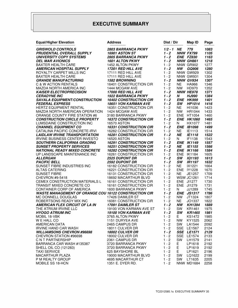
EXECUTIVE SUMMARY
TC2312585.1s EXECUTIVE SUMMARY 35
PageMap IDDist / Dir Address Equal/Higher Elevation ____________________ ________ ____________________
1083779NE1/2 - 1 2803 BARRANCA PKWY GRISWOLD CONTROLS1105FX799NNW1 - 2 16901 ASTON ST PRUDENTIAL OVERALL SUPPLY1163FZ830ENE1 - 2 2805 BARRANCA PKWY UNIVERSITY COPY SYSTEMS1218GH861NNW1 - 2 1601 ALTON PKWY DEL MAR AVIONICS1277GR902NNW1 - 2 1452 ALTON PKWY BAXTER HEALTH CARE1280GQ906NW1 - 2 17201 RED HILL AVE AMERICAN HOSPITAL SUPPLY1302GW929NNW1 - 2 17111 RED HILL AVE ROYALTY CARPET MILLS INC1304GW931NNW1 - 2 17111 RED HILL AVE BAXTER HEALTH CARE1307GV934NNW1 - 2 1582 BROWNING GRANDE MANUFACTURING1346HA966NE1 - 2 16401 CONSTRUCTION CIR C & W ACTION RENTALS1352HD970NW1 - 2 1444 MCGAW AVE MAZDA NORTH AMERICA INC1371HE978NNW1 - 2 17000 RED HILL AVE KAISER ELECTROPRECISION1384HJ990N1 - 2 1922 BARRANCA PKWY CERADYNE INC1401HK999ENE1 - 2 16402 CONSTRUCTION CIR SAVALA EQUIPMENT/CONSTRUCTION1416HP1014SW1 - 2 18651 VON KARMAN AVE FEDERAL EXPRESS1423HI1036NE1 - 2 16351 CONSTRUCTION CIR HERTZ EQUIPMENT RENTAL1433HR1044NW1 - 2 1424 MCGAW AVE MAZDA NORTH AMERICAN OPERATION1460HT1054ENE1 - 2 3180 BARRANCA PKWY ORANGE COUNTY FIRE STATION #61465HK1060ENE1 - 2 16372 CONSTRUCTION CIR CONSTRUCTION CIRCLE PROPERTY1481HX1077N1 - 2 16570 ASTON LUMSDAINE CONSTRUCTION INC1499IB1098ENE1 - 2 16331 CONSTRUCTION CIR CHANNEL EQUIPMENT CO1514IE1113NE1 - 2 16282 CONSTRUCTION CIR CATALINA PACIFIC CONCRETE-IRVI1522IE1118NE1 - 2 16281 CONSTRUCTION CIR LAIDLAW IRVINE TRANSPORTATION1543IF1138N1 - 2 16520 ASTON IRVINE BUSINESS CENTER INVESTO1557IK1149ENE1 - 2 16291 CONSTRUCTION CIR SOUTHERN CALIFORNIA GRADING1566IE1155NE1 - 2 16251 CONSTRUCTION CIR SUNSET PROPERTY SERVICES1584IK1166ENE1 - 2 16282 CONSTRUCTION CIR NATIONAL READY MIXED CONCRETE 1605IK1184ENE1 - 2 16261 CONSTRUCTION CIR UP LANDSCAPE MAINTENANCE INC1613IQ1193SW1 - 2 2525 DUPONT DR ALLERGAN1632IR1197SW1 - 2 2592 DUPONT DR PACIFIC BELL1664IX1221NE1 - 2 16182 CONSTRUCTION CIR SUNSET FIBRE INDUSTRIES INC1670IY1228ENE1 - 2 16221 CONSTRUCTION CIR ALTAS CATERING1709JE1257NE1 - 2 16131 CONSTRUCTION CIR SUNSET FIBRE1714JC1261WSW1 - 2 18692 MACARTHUR BLVD CHEVRON #9-54181730JI1277ENE1 - 2 16161 CONSTRUCTION CIR CEMEX CONSTRUCTION MATERIALS L1731JI1279ENE1 - 2 16161 CONSTRUCTION CIR TRANSIT MIXED CONCRETE CO1745JJ1289N1 - 2 1600 BARRANCA PKWY CONTAINER CORP OF AMERICA1786JS1317ENE1 - 2 16122 CONSTRUCTION CIR WASTE MANAGEMENT OF ORANGE COU1807JT1324NW1 - 2 17426 DAIMLER ST MC DONNELL DOUGLAS1822JO1337NE1 - 2 16081 CONSTRUCTION CIR ROBERTSONS READY MIX INC1889KH1394NW1 - 2 17091 DAIMLER ST AMERICAN FLEX CIRCUIT OF LA IN1975KR1461SW1 - 2 19100 VON KARMAN AVE ST THE ATRIUM IRVINE LLC1981KR1465SW1 - 2 19100 VON KARMAN AVE HYOGO ATRIUM INC1985KS1472E1 - 2 3765 ALTON PKWY MOBIL 18-VBK2062KY1525NW1 - 2 1151 DURYEA AVE W E HALL CO2092LA1544SW1 - 2 2465 CAMPUS DR AMERICAN DATA2124LE1567SSE1 - 2 18011 CULVER DR IRVINE HAND CAR WASH2129LE1571SSE1 - 2 18002 CULVER DR WILLIAMSONS CHEVRON #966982133LE1574SSE1 - 2 18002 CULVER DR CHEVRON STATION #966982141LH1579SW1 - 2 2361 CAMPUS DR C N T PARTNERSHIP2192LP1618E1 - 2 3720 BARRANCA PKWY BARRANCA CAR WASH #1353872192LP1619E1 - 2 3720 BARRANCA PKWY SHELL OIL CO (121283)2196LP1621E1 - 2 625 BAYSHORE BL TAXI SERVICE2199LQ1622SW1 - 2 19000 MACARTHUR BLVD MACARTHUR PLAZA2205LT1635SW1 - 2 4695 MACARTHUR CT P M REALTY GROUP2258MD1684NNW1 - 2 1351 E. DYER RD. MOBILE SS 18-HCN
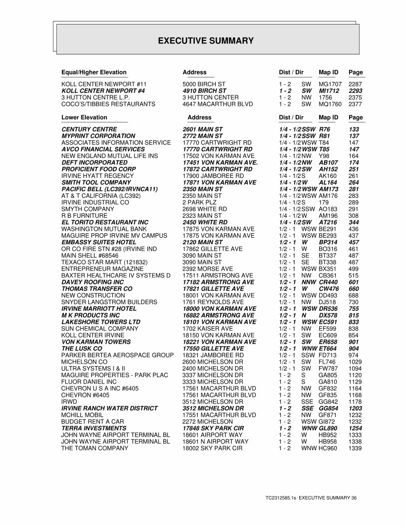
EXECUTIVE SUMMARY
TC2312585.1s EXECUTIVE SUMMARY 36
PageMap IDDist / Dir Address Equal/Higher Elevation ____________________ ________ ____________________
2287MG1707SW1 - 2 5000 BIRCH ST KOLL CENTER NEWPORT #112293MI1712SW1 - 2 4910 BIRCH ST KOLL CENTER NEWPORT #423751756NW1 - 2 3 HUTTON CENTER 3 HUTTON CENTRE L.P.2377MQ1760SW1 - 2 4647 MACARTHUR BLVD COCO’S/TIBBIES RESTAURANTS
PageMap IDDist / Dir Address Lower Elevation ____________________ ________ ____________________
133R76SSW1/4 - 1/2 2601 MAIN ST CENTURY CENTRE137R81SSW1/4 - 1/2 2772 MAIN ST MYPRINT CORPORATION147T84WSW1/4 - 1/2 17770 CARTWRIGHT RD ASSOCIATES INFORMATION SERVICE147T85WSW1/4 - 1/2 17770 CARTWRIGHT RD AVCO FINANCIAL SERVICES164Y98NW1/4 - 1/2 17502 VON KARMAN AVE NEW ENGLAND MUTUAL LIFE INS174AB107NW1/4 - 1/2 17451 VON KARMAN AVE. DEFT INCORPORATED251AH152SW1/4 - 1/2 17872 CARTWRIGHT RD PROFICIENT FOOD CORP261AK160S1/4 - 1/2 17900 JAMBOREE RD IRVINE HYATT REGENCY264AL164W1/4 - 1/2 17871 VON KARMAN AVE SMITH TOOL COMPANY281AM173WSW1/4 - 1/2 2350 MAIN ST PACIFIC BELL (LC392/IRVNCA11)283AM176WSW1/4 - 1/2 2350 MAIN ST AT & T CALIFORNIA (LC392)289179S1/4 - 1/2 2 PARK PLZ IRVINE INDUSTRIAL CO291AO183SSW1/4 - 1/2 2698 WHITE RD SMYTH COMPANY308AM196W1/4 - 1/2 2323 MAIN ST R B FURNITURE344AT216SW1/4 - 1/2 2450 WHITE RD EL TORITO RESTAURANT INC436BE291WSW1/2 - 1 17875 VON KARMAN AVE WASHINGTON MUTUAL BANK437BE293WSW1/2 - 1 17875 VON KARMAN AVE MAGUIRE PROP IRVINE MV CAMPUS 457BP314W1/2 - 1 2120 MAIN ST EMBASSY SUITES HOTEL461BO316W1/2 - 1 17862 GILLETTE AVE OR CO FIRE STN #28 (IRVINE IND487BT337SE1/2 - 1 3090 MAIN ST MAIN SHELL #68546487BT338SE1/2 - 1 3090 MAIN ST TEXACO STAR MART (121832)499BX351WSW1/2 - 1 2392 MORSE AVE ENTREPRENEUR MAGAZINE515CB361NW1/2 - 1 17511 ARMSTRONG AVE BAXTER HEALTHCARE IV SYSTEMS D601CR440NNW1/2 - 1 17182 ARMSTRONG AVE DAVEY ROOFING INC660CW476W1/2 - 1 17821 GILLETTE AVE THOMAS TRANSFER CO688DD493WSW1/2 - 1 18001 VON KARMAN AVE NEW CONSTRUCTION730DJ518NW1/2 - 1 1761 REYNOLDS AVE SNYDER LANGSTROM BUILDERS755DR536WSW1/2 - 1 18000 VON KARMAN AVE IRVINE MARRIOTT HOTEL815DX578N1/2 - 1 16882 ARMSTRONG AVE M K PRODUCTS INC833EC591WSW1/2 - 1 18101 VON KARMAN AVE LAKESHORE TOWERS LTD838EF599NW1/2 - 1 1702 KAISER AVE SUN CHEMICAL COMPANY854EC609SW1/2 - 1 18150 VON KARMAN AVE KOLL CENTER IRVINE901ER658SW1/2 - 1 18221 VON KARMAN AVE VON KARMAN TOWERS904ET664WNW1/2 - 1 17550 GILLETTE AVE THE LUSK CO974FD713SSW1/2 - 1 18321 JAMBOREE RD PARKER BERTEA AEROSPACE GROUP1029FL746SW1/2 - 1 2600 MICHELSON DR MICHELSON CO1094FW787SW1/2 - 1 2400 MICHELSON DR ULTRA SYSTEMS I & II1120GA805S1 - 2 3337 MICHELSON DR MAGUIRE PROPERTIES - PARK PLAC1129GA810S1 - 2 3333 MICHELSON DR FLUOR DANIEL INC1164GF832NW1 - 2 17561 MACARTHUR BLVD CHEVRON U S A INC #64051168GF835NW1 - 2 17561 MACARTHUR BLVD CHEVRON #64051178GG842SSE1 - 2 3512 MICHELSON DR IRWD1203GG854SSE1 - 2 3512 MICHELSON DR IRVINE RANCH WATER DISTRICT1232GF871NW1 - 2 17551 MACARTHUR BLVD MCHILL MOBIL1232GI872WSW1 - 2 2272 MICHELSON BUDGET RENT A CAR1254GL890WNW1 - 2 17848 SKY PARK CIR TERRA INVESTMENTS1333HB952W1 - 2 18601 AIRPORT WAY JOHN WAYNE AIRPORT TERMINAL BL1338HB958W1 - 2 18601 N AIRPORT WAY JOHN WAYNE AIRPORT TERMINAL BL1339HC960WNW1 - 2 18002 SKY PARK CIR THE TOMAN COMPANY
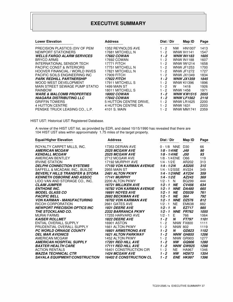
EXECUTIVE SUMMARY
TC2312585.1s EXECUTIVE SUMMARY 37
PageMap IDDist / Dir Address Lower Elevation ____________________ ________ ____________________
1413HN1007NW1 - 2 1352 REYNOLDS AVE PRECISION PLASTICS (DIV OF PEM1547IH1141WNW1 - 2 17681 MITCHELL N NEWPORT STATIONERS1605IN1183WNW1 - 2 17682 COWAN WELLS FARGO ALARM SERVICES1607IN1188WNW1 - 2 17692 COWAN BRYCO ARMS1658IW1214WNW1 - 2 17771 FITCH INTERNATIONAL SENSOR TECH1700JF1253WNW1 - 2 17751 MITCHELL N PACIFIC CONST & INTERIORS1727JF1272WNW1 - 2 17821 MITCHELL N HOOVER FINANCIAL / WORLD INVES1834JX1349WNW1 - 2 17909 FITCH PACIFIC SOILS ENGINEERING INC1845JX1359WNW1 - 2 17922 FITCH PARK REDHILL PARTNERSHIP1896KI1396WNW1 - 2 17911 MITCHELL S WOOD WEST DEVELOPMENT19261418W1 - 2 1499 MAIN ST MAIN STREET SEWAGE PUMP STATIO19711456WNW1 - 2 18011 MITCHELL S RAINBOW2055KW1515WNW1 - 2 18002 COWAN WARE & MALCOMB PROPERTIES2118LF1562WNW1 - 2 17842 COWAN NIAGARA DISTRIBUTING LLC2200LR1625WNW1 - 2 5 HUTTON CENTRE DRIVE, GRIFFIN TOWERS22031631WNW1 - 2 4 HUTTON CENTRE DR. 4 HUTTON CENTRE2359MM1741WNW1 - 2 4101 S. MAIN PENSKE TRUCK LEASING CO., L.P.
HIST UST: Historical UST Registered Database.
A review of the HIST UST list, as provided by EDR, and dated 10/15/1990 has revealed that there are 104 HIST UST sites within approximately 1.75 miles of the target property.
PageMap IDDist / Dir Address Equal/Higher Elevation ____________________ ________ ____________________
66D30NNE0 - 1/8 17353 DERIAN AVE ROYALTY CARPET MILLS, INC.90J49NE1/8 - 1/4 2525 MCGAW AVE AMERICAN MCGAW93J50NE1/8 - 1/4 2525 MCGAW AVE KENDALL MCGAW119O66ENE1/8 - 1/4 2712 MCGAW AVE AMERICAN BENTLEY313AR202E1/4 - 1/2 17192 MURPHY AVE IRVINE STATION315AS205N1/4 - 1/2 17150 VON KARMAN AVENUE DELPHI CONNECTION SYSTEMS349AV224SSE1/4 - 1/2 2955 MAIN ST SAFFELL & MCADAM, INC., BUILDE359AY234NNE1/4 - 1/2 2481 ALTON PKWY BEVERLY HILLS TRANSFER & STORA369AZ243E1/4 - 1/2 17141 MURPHY KENNETH OSBORNE AND ASSOC444BG299N1/2 - 1 2200 ALTON PKWY LIDO VAN AND STORAGE CO., INC.634CV456NE1/2 - 1 16721 MILLIKEN AVE CLAIM JUMPER665DA480NNE1/2 - 1 16782 VON KARMAN AVENUE ENTHONE INC.761DS539NE1/2 - 1 16691 NOYES AVE MODEL GLASS CO792564NE1/2 - 1 2692 BECKMAN AVE PACIFIC BELL812DZ576NNE1/2 - 1 16702 VON KARMAN AVE VON KARMAN - MANUFACTURING882EM638NE1/2 - 1 2661 GATES AVE RICOH CORPORATION985EZ717N1/2 - 1 1931 DEERE AVE NEWPORT PRECISION OPTICS INC1055FR762NNE1/2 - 1 2332 BARRANCA PKWY THE STOCKLAND CO.1064766E1/2 - 1 17255 HARVARD AVE MURAI FARMS1101FT797N1 - 2 1822 DEERE AVE KAISER ROLLMET1111FX800NNW1 - 2 16901 ASTON ENTIAL OVERALL SUPPLY1119802NNW1 - 2 1661 ALTON PKWY PRUDENTIAL OVERALL SUPPLY1152GD823N1 - 2 16601 ARMSTRONG AVE PC WORLD ORNAGE COUNTY1206GH855NNW1 - 2 1621 ALTON PARKWAY DEL MAR AVIONICS1277GR903NNW1 - 2 1452 ALTON PKWY AMERICAN MCGAW1280GQ906NW1 - 2 17201 RED HILL AVE AMERICAN HOSPITAL SUPPLY1298GW925NNW1 - 2 17111 RED HILL AVE BAXTER HEALTH CARE1346HA967NE1 - 2 16401 CONSTRUCTION CIR ACTION RENTALS1354HD973NW1 - 2 1424 MCGAW AVE MAZDA TECHNICAL CTR1396HK997ENE1 - 2 16402 E CONSTRUCTION CL SAVALA EQUIPMENT/CONSTRUCTION
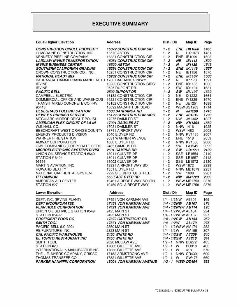
EXECUTIVE SUMMARY
TC2312585.1s EXECUTIVE SUMMARY 38
PageMap IDDist / Dir Address Equal/Higher Elevation ____________________ ________ ____________________
1465HK1060ENE1 - 2 16372 CONSTRUCTION CIR CONSTRUCTION CIRCLE PROPERTY1481HX1078N1 - 2 16570 ASTON LUMSDAINE CONSTRUCTION, INC.1503IB1099ENE1 - 2 16331 CONSTRUCTION CIR KENNEDY PIPELINE COMPANY1522IE1118NE1 - 2 16281 CONSTRUCTION CIR LAIDLAW IRVINE TRANSPORTATION1543IF1139N1 - 2 16520 ASTON IRVINE BUSINESS CENTER1557IK1149ENE1 - 2 16291 CONSTRUCTION CIR SOUTHERN CALIFORNIA GRADING1570IE1156NE1 - 2 16251 CONSTRUCTION CIR CROWN CONSTRUCTION CO., INC.1586IK1167ENE1 - 2 16282 CONSTRUCTION CIR NATIONAL READY MIX1591IL1173N1 - 2 1700 BARRANCA PKWY BARRANCA, HAMMERBANK MANUFACTU1606IO1185ENE1 - 2 16282 CONSTRUCTION CIRC IRVINE1631IQ1194SW1 - 2 2525 DUPONT DR IRVINE1632IR1197SW1 - 2 2592 DUPONT DR PACIFIC BELL1664IX1222NE1 - 2 16182 CONSTRUCTION CIR CAMPBELL ELECTRIC1670IY1229ENE1 - 2 16221 CONSTRUCTION CIR COMMERCIAL OFFICE AND WAREHOUS1698JE1251NE1 - 2 16152 CONSTRUCTION CIR TRANSIT MIXED CONCRETE CO.-IRV1714JG1263WSW1 - 2 18692 MACARTHUR BLVD 954181745JJ1290N1 - 2 1600 BARRANCA RD BLUEGRASS FOLDING CARTON1793JS1319ENE1 - 2 16122 CONSTRUCTION CIRC DEWEY S RUBBISH SERVICE1827JV1342NW1 - 2 17275 DAIMLER ST MEGUIARS MIRROR BRIGHT POLISH1889KH1394NW1 - 2 17091 DAIMLER ST AMERICAN FLEX CIRCUIT OF LA IN19251416NNW1 - 2 17031 DAIMLER ST W.E.HALL CO.20031482WSW1 - 2 18741 AIRPORT WAY BEECHCRAFT WEST-ORANGE COUNTY2007KV1485NNW1 - 2 2040 E DYER RD ENERGY PRODUCTS DIVISION20591518ENE1 - 2 3031 WARNER AVENUE WARNER FIRE STATION2066KV1530NNW1 - 2 1800 E DYER RD AMWAY CORPORATION2092LA1545SW1 - 2 2465 CAMPUS DR OWL COMPANIES (CORPORATE OFFIC2109LD1553SW1 - 2 2601 CAMPUS DR MICROELECTRONIC SYSTEMS DIVISI2110LE1554SSE1 - 2 18011 CULVER DR UNION OIL SERVICE STATION #6402112LE1557SSE1 - 2 18011 CULVER DR STATION # 64042130LE1572SSE1 - 2 18002 CULVER DR 9669822391672WSW1 - 2 19331 AIRPORT WAY SO. MARTIN AVIATION, INC.2251MD1679NNW1 - 2 1351 E DYER RD HOWARD BEATTY22611688SW1 - 2 2222 S.E. BRISTOL STREE NATIONAL CAR RENTAL SYSTEM2303MJ1723NW1 - 2 666 EAST DYER RD ITT CANNON2370MP1753WSW1 - 2 19461 AIRPORT WAY SOUTH AMERICAN AIR CENTER2376MP1758WSW1 - 2 19459 SO. AIRPORT WAY STATION #27
PageMap IDDist / Dir Address Lower Elevation ____________________ ________ ____________________
169AB106NW1/4 - 1/2 17451 VON KARMAN AVE DEFT, INC, (IRVINE PLANT)174AB107NW1/4 - 1/2 17451 VON KARMAN AVE. DEFT INCORPORATED195AB114NNW1/4 - 1/2 17421 VON KARMAN AVE PLAN HOLD CORPORATION224AE134WSW1/4 - 1/2 2425 MAIN ST UNION OIL SERVICE STATION #549227AE137WSW1/4 - 1/2 2425 MAIN ST STATION #5492252AH153SW1/4 - 1/2 17872 CARTWEIGHT RD PROFICIENT FOOD CO275AL170W1/4 - 1/2 17871 VON KARMAN AVE SMITH TOOL282AM174WSW1/4 - 1/2 2350 MAIN ST PACIFIC BELL (LC-392)307AM195W1/4 - 1/2 2323 MAIN ST RB FURNITURE, INC.340AT209SW1/4 - 1/2 2450 WHITE RD CAL PACIFIC WAREHOUSE344AT216SW1/4 - 1/2 2450 WHITE RD EL TORITO RESTAURANT INC405BD272NNW1/2 - 1 2026 MCGAW AVE SMITH TOOL462BO318W1/2 - 1 17862 GILLETTE AVE STATION #28570418W1/2 - 1 17832 GILLETTE AVE INTERNATIONAL & MANUFACTURING600CR439NNW1/2 - 1 17182 ARMSTRONG AVE THE L.E. MYERS COMPANY, GRISSO660CW475W1/2 - 1 17821 GILLETTE AVE THOMAS TRANSFER CO.688DD494WSW1/2 - 1 18001 VON KARMAN AVENUE PARKER HANNIFIN CORPORATION
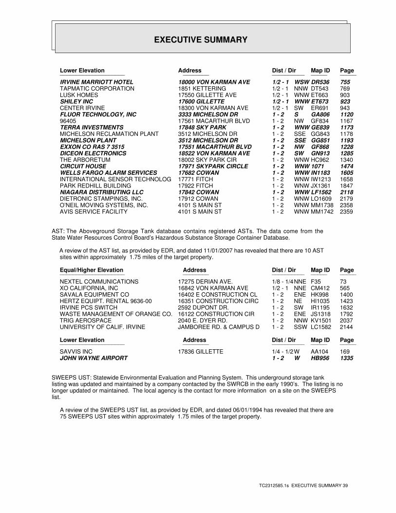
EXECUTIVE SUMMARY
TC2312585.1s EXECUTIVE SUMMARY 39
PageMap IDDist / Dir Address Lower Elevation ____________________ ________ ____________________
755DR536WSW1/2 - 1 18000 VON KARMAN AVE IRVINE MARRIOTT HOTEL769DT543NNW1/2 - 1 1851 KETTERING TAPMATIC CORPORATION903ET663WNW1/2 - 1 17550 GILLETTE AVE LUSK HOMES923ET673WNW1/2 - 1 17600 GILLETTE SHILEY INC943ER691SW1/2 - 1 18300 VON KARMAN AVE CENTER IRVINE1120GA806S1 - 2 3333 MICHELSON DR FLUOR TECHNOLOGY, INC1167GF834NW1 - 2 17561 MACARTHUR BLVD 964051173GE839WNW1 - 2 17848 SKY PARK TERRA INVESTMENTS1178GG843SSE1 - 2 3512 MICHELSON DR MICHELSON RECLAMATION PLANT1193GG851SSE1 - 2 3512 MICHELSON DR MICHELSON PLANT1228GF868NW1 - 2 17551 MACARTHUR BLVD EXXON CO RAS 7 35151285GN913SW1 - 2 18522 VON KARMAN AVE DICEON ELECTRONICS1340HC962WNW1 - 2 18002 SKY PARK CIR THE ARBORETUM14741071WNW1 - 2 17971 SKYPARK CIRCLE CIRCUIT HOUSE1605IN1183WNW1 - 2 17682 COWAN WELLS FARGO ALARM SERVICES1658IW1213WNW1 - 2 17771 FITCH INTERNATIONAL SENSOR TECHNOLOG1847JX1361WNW1 - 2 17922 FITCH PARK REDHILL BUILDING2118LF1562WNW1 - 2 17842 COWAN NIAGARA DISTRIBUTING LLC2179LO1609WNW1 - 2 17912 COWAN DIETRONIC STAMPINGS, INC.2358MM1738WNW1 - 2 4101 S MAIN ST O’NEIL MOVING SYSTEMS, INC.2359MM1742WNW1 - 2 4101 S MAIN ST AVIS SERVICE FACILITY
AST: The Aboveground Storage Tank database contains registered ASTs. The data come from theState Water Resources Control Board’s Hazardous Substance Storage Container Database.
A review of the AST list, as provided by EDR, and dated 11/01/2007 has revealed that there are 10 AST sites within approximately 1.75 miles of the target property.
PageMap IDDist / Dir Address Equal/Higher Elevation ____________________ ________ ____________________
73F35NNE1/8 - 1/4 17275 DERIAN AVE. NEXTEL COMMUNICATIONS565CM412NNE1/2 - 1 16842 VON KARMAN AVE XO CALIFORNIA, INC1400HK998ENE1 - 2 16402 E CONSTRUCTION CL SAVALA EQUIPMENT CO1423HI1035NE1 - 2 16351 CONSTRUCTION CIRC HERTZ EQUIPT. RENTAL 9636-001632IR1195SW1 - 2 2592 DUPONT DR. IRVINE PCS SWITCH1792JS1318ENE1 - 2 16122 CONSTRUCTION CIR WASTE MANAGEMENT OF ORANGE CO.2037KV1501NNW1 - 2 2040 E. DYER RD. TRIG AEROSPACE2144LC1582SSW1 - 2 JAMBOREE RD. & CAMPUS D UNIVERSITY OF CALIF. IRVINE
PageMap IDDist / Dir Address Lower Elevation ____________________ ________ ____________________
169AA104W1/4 - 1/2 17836 GILLETTE SAVVIS INC1335HB956W1 - 2 JOHN WAYNE AIRPORT
SWEEPS UST: Statewide Environmental Evaluation and Planning System. This underground storage tanklisting was updated and maintained by a company contacted by the SWRCB in the early 1990’s. The listing is nolonger updated or maintained. The local agency is the contact for more information on a site on the SWEEPSlist.
A review of the SWEEPS UST list, as provided by EDR, and dated 06/01/1994 has revealed that there are 75 SWEEPS UST sites within approximately 1.75 miles of the target property.
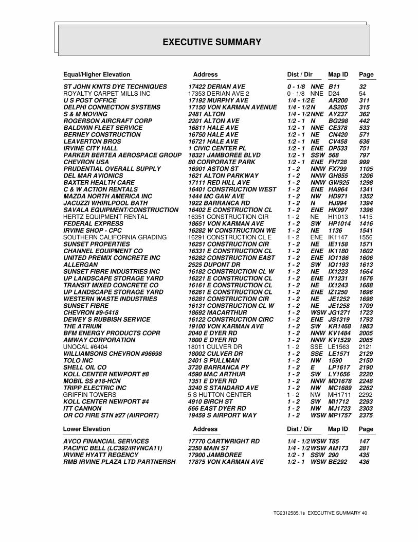
EXECUTIVE SUMMARY
TC2312585.1s EXECUTIVE SUMMARY 40
PageMap IDDist / Dir Address Equal/Higher Elevation ____________________ ________ ____________________
32B11NNE0 - 1/8 17422 DERIAN AVE ST JOHN KNITS DYE TECHNIQUES54D24NNE0 - 1/8 17353 DERIAN AVE 2 ROYALTY CARPET MILLS INC311AR200E1/4 - 1/2 17192 MURPHY AVE U S POST OFFICE315AS205N1/4 - 1/2 17150 VON KARMAN AVENUE DELPHI CONNECTION SYSTEMS362AY237NNE1/4 - 1/2 2481 ALTON S & M MOVING442BG298N1/2 - 1 2201 ALTON AVE ROGERSON AIRCRAFT CORP533CE378NNE1/2 - 1 16811 HALE AVE BALDWIN FLEET SERVICE571CN420NE1/2 - 1 16750 HALE AVE BERNEY CONSTRUCTION636CV458NE1/2 - 1 16721 HALE AVE LEAVERTON BROS751DP533ENE1/2 - 1 1 CIVIC CENTER PL IRVINE CITY HALL797568SSW1/2 - 1 18321 JAMBOREE BLVD PARKER BERTEA AEROSPACE GROUP999FH728ENE1/2 - 1 80 CORPORATE PARK CHEVRON USA1105FX799NNW1 - 2 16901 ASTON ST PRUDENTIAL OVERALL SUPPLY1206GH855NNW1 - 2 1621 ALTON PARKWAY DEL MAR AVIONICS1298GW925NNW1 - 2 17111 RED HILL AVE BAXTER HEALTH CARE1341HA964ENE1 - 2 16401 CONSTRUCTION WEST C & W ACTION RENTALS1352HD971NW1 - 2 1444 MC GAW AVE MAZDA NORTH AMERICA INC1394HJ994N1 - 2 1922 BARRANCA RD JACUZZI WHIRLPOOL BATH1396HK997ENE1 - 2 16402 E CONSTRUCTION CL SAVALA EQUIPMENT/CONSTRUCTION1415HI1013NE1 - 2 16351 CONSTRUCTION CIR HERTZ EQUIPMENT RENTAL1416HP1014SW1 - 2 18651 VON KARMAN AVE FEDERAL EXPRESS15411136NE1 - 2 16282 W CONSTRUCTION WE IRVINE SHOP - CPC1556IK1147ENE1 - 2 16291 CONSTRUCTION CL E SOUTHERN CALIFORNIA GRADING1571IE1158NE1 - 2 16251 CONSTRUCTION CIR SUNSET PROPERTIES1602IK1180ENE1 - 2 16331 E CONSTRUCTION CL CHANNEL EQUIPMENT CO1606IO1186ENE1 - 2 16282 CONSTRUCTION EAST UNITED PREMIX CONCRETE INC1613IQ1193SW1 - 2 2525 DUPONT DR ALLERGAN1664IX1223NE1 - 2 16182 CONSTRUCTION CL W SUNSET FIBRE INDUSTRIES INC1676IY1231ENE1 - 2 16221 E CONSTRUCTION CL UP LANDSCAPE STORAGE YARD1688IX1243NE1 - 2 16161 E CONSTRUCTION CL TRANSIT MIXED CONCRETE CO1696IZ1250ENE1 - 2 16261 E CONSTRUCTION CL UP LANDSCAPE STORAGE YARD1698JE1252NE1 - 2 16281 CONSTRUCTION CIR WESTERN WASTE INDUSTRIES1709JE1258NE1 - 2 16131 CONSTRUCTION CL W SUNSET FIBRE1723JG1271WSW1 - 2 18692 MACARTHUR CHEVRON #9-54181793JS1319ENE1 - 2 16122 CONSTRUCTION CIRC DEWEY S RUBBISH SERVICE1983KR1468SW1 - 2 19100 VON KARMAN AVE THE ATRIUM2005KV1484NNW1 - 2 2040 E DYER RD BFM ENERGY PRODUCTS COPR2065KV1529NNW1 - 2 1800 E DYER RD AMWAY CORPORATION2121LE1563SSE1 - 2 18011 CULVER DR UNOCAL #64042129LE1571SSE1 - 2 18002 CULVER DR WILLIAMSONS CHEVRON #9669821501590NW1 - 2 2401 S PULLMAN TOLO INC2190LP1617E1 - 2 3720 BARRANCA PY SHELL OIL CO2220LY1656SW1 - 2 4590 MAC ARTHUR KOLL CENTER NEWPORT #82248MD1678NNW1 - 2 1351 E DYER RD MOBIL SS #18-HCN2262MC1689NW1 - 2 3240 S STANDARD AVE TRIPP ELECTRIC INC2292MH1711NW1 - 2 5 S HUTTON CENTER GRIFFIN TOWERS2293MI1712SW1 - 2 4910 BIRCH ST KOLL CENTER NEWPORT #42303MJ1723NW1 - 2 666 EAST DYER RD ITT CANNON2375MP1757WSW1 - 2 19459 S AIRPORT WAY OR CO FIRE STN #27 (AIRPORT)
PageMap IDDist / Dir Address Lower Elevation ____________________ ________ ____________________
147T85WSW1/4 - 1/2 17770 CARTWRIGHT RD AVCO FINANCIAL SERVICES281AM173WSW1/4 - 1/2 2350 MAIN ST PACIFIC BELL (LC392/IRVNCA11)435290SSW1/2 - 1 17900 JAMBOREE IRVINE HYATT REGENCY436BE292WSW1/2 - 1 17875 VON KARMAN AVE RMB IRVINE PLAZA LTD PARTNERSH
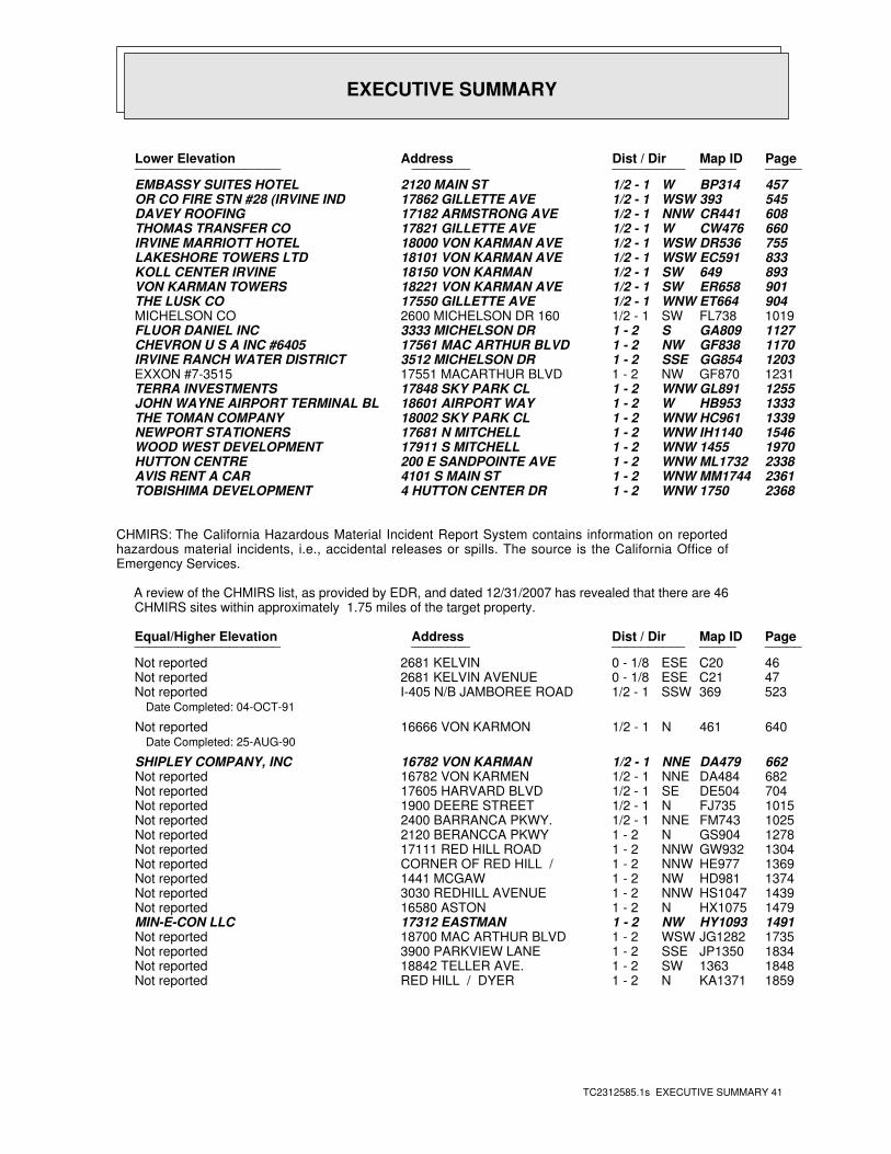
EXECUTIVE SUMMARY
TC2312585.1s EXECUTIVE SUMMARY 41
PageMap IDDist / Dir Address Lower Elevation ____________________ ________ ____________________
457BP314W1/2 - 1 2120 MAIN ST EMBASSY SUITES HOTEL545393WSW1/2 - 1 17862 GILLETTE AVE OR CO FIRE STN #28 (IRVINE IND608CR441NNW1/2 - 1 17182 ARMSTRONG AVE DAVEY ROOFING660CW476W1/2 - 1 17821 GILLETTE AVE THOMAS TRANSFER CO755DR536WSW1/2 - 1 18000 VON KARMAN AVE IRVINE MARRIOTT HOTEL833EC591WSW1/2 - 1 18101 VON KARMAN AVE LAKESHORE TOWERS LTD893649SW1/2 - 1 18150 VON KARMAN KOLL CENTER IRVINE901ER658SW1/2 - 1 18221 VON KARMAN AVE VON KARMAN TOWERS904ET664WNW1/2 - 1 17550 GILLETTE AVE THE LUSK CO1019FL738SW1/2 - 1 2600 MICHELSON DR 160 MICHELSON CO1127GA809S1 - 2 3333 MICHELSON DR FLUOR DANIEL INC1170GF838NW1 - 2 17561 MAC ARTHUR BLVD CHEVRON U S A INC #64051203GG854SSE1 - 2 3512 MICHELSON DR IRVINE RANCH WATER DISTRICT1231GF870NW1 - 2 17551 MACARTHUR BLVD EXXON #7-35151255GL891WNW1 - 2 17848 SKY PARK CL TERRA INVESTMENTS1333HB953W1 - 2 18601 AIRPORT WAY JOHN WAYNE AIRPORT TERMINAL BL1339HC961WNW1 - 2 18002 SKY PARK CL THE TOMAN COMPANY1546IH1140WNW1 - 2 17681 N MITCHELL NEWPORT STATIONERS19701455WNW1 - 2 17911 S MITCHELL WOOD WEST DEVELOPMENT2338ML1732WNW1 - 2 200 E SANDPOINTE AVE HUTTON CENTRE2361MM1744WNW1 - 2 4101 S MAIN ST AVIS RENT A CAR23681750WNW1 - 2 4 HUTTON CENTER DR TOBISHIMA DEVELOPMENT
CHMIRS: The California Hazardous Material Incident Report System contains information on reportedhazardous material incidents, i.e., accidental releases or spills. The source is the California Office ofEmergency Services.
A review of the CHMIRS list, as provided by EDR, and dated 12/31/2007 has revealed that there are 46 CHMIRS sites within approximately 1.75 miles of the target property.
PageMap IDDist / Dir Address Equal/Higher Elevation ____________________ ________ ____________________
46C20ESE0 - 1/8 2681 KELVIN Not reported47C21ESE0 - 1/8 2681 KELVIN AVENUE Not reported523369SSW1/2 - 1 I-405 N/B JAMBOREE ROAD Not reported
Date Completed: 04-OCT-91
640461N1/2 - 1 16666 VON KARMON Not reportedDate Completed: 25-AUG-90
662DA479NNE1/2 - 1 16782 VON KARMAN SHIPLEY COMPANY, INC682DA484NNE1/2 - 1 16782 VON KARMEN Not reported704DE504SE1/2 - 1 17605 HARVARD BLVD Not reported1015FJ735N1/2 - 1 1900 DEERE STREET Not reported1025FM743NNE1/2 - 1 2400 BARRANCA PKWY. Not reported1278GS904N1 - 2 2120 BERANCCA PKWY Not reported1304GW932NNW1 - 2 17111 RED HILL ROAD Not reported1369HE977NNW1 - 2 CORNER OF RED HILL / Not reported1374HD981NW1 - 2 1441 MCGAW Not reported1439HS1047NNW1 - 2 3030 REDHILL AVENUE Not reported1479HX1075N1 - 2 16580 ASTON Not reported1491HY1093NW1 - 2 17312 EASTMAN MIN-E-CON LLC1735JG1282WSW1 - 2 18700 MAC ARTHUR BLVD Not reported1834JP1350SSE1 - 2 3900 PARKVIEW LANE Not reported18481363SW1 - 2 18842 TELLER AVE. Not reported1859KA1371N1 - 2 RED HILL / DYER Not reported
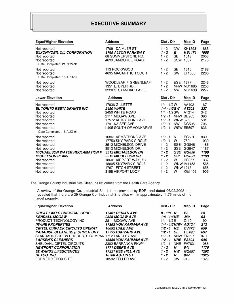
EXECUTIVE SUMMARY
TC2312585.1s EXECUTIVE SUMMARY 42
PageMap IDDist / Dir Address Equal/Higher Elevation ____________________ ________ ____________________
1888KH1393NW1 - 2 17091 DAIMLER ST. Not reported1988KS1474E1 - 2 3765 ALTON PARKWAY EXXONMOBIL OIL CORPORATION20531513SE1 - 2 68 SUMMERSTONE RD. Not reported21761607SSW1 - 2 4699 JAMBOREE ROAD Not reported
Date Completed: 21-NOV-91
21881615SE1 - 2 113 ROCKWOOD Not reported2206LT1636SW1 - 2 4695 MACARTHUR COURT Not reported
Date Completed: 18-APR-89
22461677ESE1 - 2 WOODLEAF / GREENLEAF Not reported2258MD1685NNW1 - 2 1351 E. DYER RD. Not reported2277MC1699NW1 - 2 3220 S. STANDARD AVE. Not reported
PageMap IDDist / Dir Address Lower Elevation ____________________ ________ ____________________
167AA102W1/4 - 1/2 17836 GILLETTE Not reported337AT208SW1/4 - 1/2 2450 WHITE EL TORITO RESTAURANTS INC342AT214SW1/4 - 1/2 2450 WHITE ROAD Not reported390BD263NNW1/2 - 1 2111 MCGAW AVE. Not reported531375WNW1/2 - 1 17572 ARMSTRONG AVE Not reported706DG505NW1/2 - 1 1791 KAISER AVE. Not reported836EE597WSW1/2 - 1 I-405 SOUTH OF VONKARME Not reported
Date Completed: 18-AUG-91
839EG601N1/2 - 1 16861 ARMSTRONG AVE Not reported1039750W1/2 - 1 17750 SKY PARK CIRCLE Not reported1186GG846SSE1 - 2 3512 MICHELSON DRIVE Not reported1187GG847SSE1 - 2 3512 MICHELSON DR. Not reported1190GG850SSE1 - 2 3512 MICHAELSON DR MICHAELSON WATER RECLAMATION P1193GG851SSE1 - 2 3512 MICHELSON DR MICHELSON PLANT1337HB957W1 - 2 18601 AIRPORT WAY, S / Not reported1565IM1153WNW1 - 2 18005 SKYPARK CIRCLE Not reported16581215WNW1 - 2 17671 FITCH STREET Not reported1905KG1406W1 - 2 3198 AIRPORT LOOP Not reported
The Orange County Industrial Site Cleanups list comes from the Health Care Agency.
A review of the Orange Co. Industrial Site list, as provided by EDR, and dated 06/02/2008 has revealed that there are 39 Orange Co. Industrial Site sites within approximately 1.75 miles of the target property.
PageMap IDDist / Dir Address Equal/Higher Elevation ____________________ ________ ____________________
28B8N0 - 1/8 17461 DERIAN AVE GREAT LAKES CHEMICAL CORP93J50NE1/8 - 1/4 2525 MCGAW AVE KENDALL MCGAW190Z110E1/4 - 1/2 2811 MCGAW AVE PRODUCT TECHNOLOGY INC212AD124NNW1/4 - 1/2 17352 VON KARMAN AVE IRVINE PROPERTIES656CV473NE1/2 - 1 16692 HALE AVE CIRTEL CIRPACK CIRCUITS OPERAT697DE498SE1/2 - 1 17595 HARVARD AVE PARADISE CLEANERS (FORMER DRY 870EN627NNW1/2 - 1 1712 LANGLEY AVE STANDARD SCREW PRODUCTS COMPAN946FA694NNE1/2 - 1 16585 VON KARMAN AVE LARSEN’S CLEANERS1088FV783NNE1/2 - 1 2302 BARRANCA PKWY SHELDAHL CIRTEL CIRCUITS1176841N1 - 2 1771 DEERE AVE NEWPORT CORPORATION1262GQ897NW1 - 2 17221 RED HILL AVE EDWARDS LIFESCIENCES1325947N1 - 2 16700 ASTON ST HEXCO, INC.1329949SW1 - 2 18582 TELLER AVE FORMER XEROX SITE
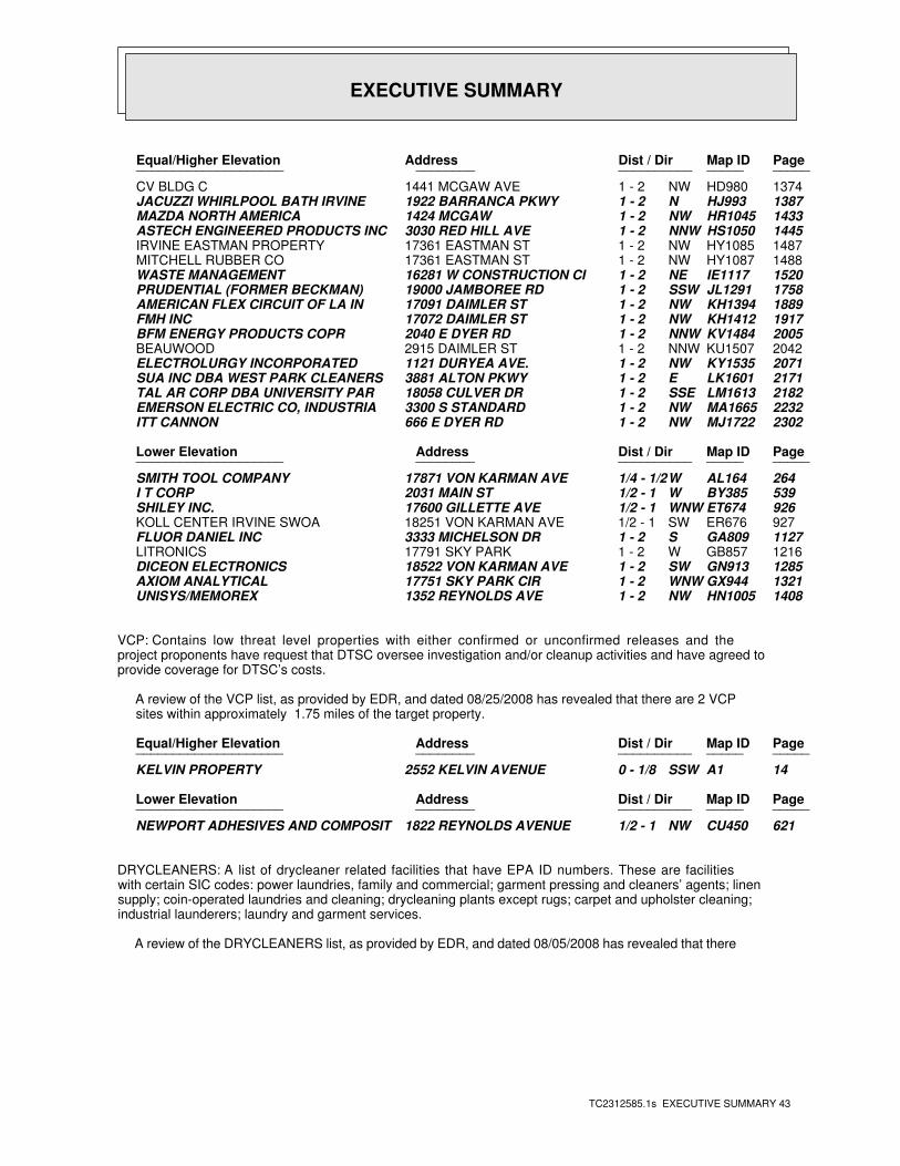
EXECUTIVE SUMMARY
TC2312585.1s EXECUTIVE SUMMARY 43
PageMap IDDist / Dir Address Equal/Higher Elevation ____________________ ________ ____________________
1374HD980NW1 - 2 1441 MCGAW AVE CV BLDG C1387HJ993N1 - 2 1922 BARRANCA PKWY JACUZZI WHIRLPOOL BATH IRVINE1433HR1045NW1 - 2 1424 MCGAW MAZDA NORTH AMERICA1445HS1050NNW1 - 2 3030 RED HILL AVE ASTECH ENGINEERED PRODUCTS INC1487HY1085NW1 - 2 17361 EASTMAN ST IRVINE EASTMAN PROPERTY1488HY1087NW1 - 2 17361 EASTMAN ST MITCHELL RUBBER CO1520IE1117NE1 - 2 16281 W CONSTRUCTION CI WASTE MANAGEMENT1758JL1291SSW1 - 2 19000 JAMBOREE RD PRUDENTIAL (FORMER BECKMAN)1889KH1394NW1 - 2 17091 DAIMLER ST AMERICAN FLEX CIRCUIT OF LA IN1917KH1412NW1 - 2 17072 DAIMLER ST FMH INC2005KV1484NNW1 - 2 2040 E DYER RD BFM ENERGY PRODUCTS COPR2042KU1507NNW1 - 2 2915 DAIMLER ST BEAUWOOD2071KY1535NW1 - 2 1121 DURYEA AVE. ELECTROLURGY INCORPORATED2171LK1601E1 - 2 3881 ALTON PKWY SUA INC DBA WEST PARK CLEANERS2182LM1613SSE1 - 2 18058 CULVER DR TAL AR CORP DBA UNIVERSITY PAR2232MA1665NW1 - 2 3300 S STANDARD EMERSON ELECTRIC CO, INDUSTRIA2302MJ1722NW1 - 2 666 E DYER RD ITT CANNON
PageMap IDDist / Dir Address Lower Elevation ____________________ ________ ____________________
264AL164W1/4 - 1/2 17871 VON KARMAN AVE SMITH TOOL COMPANY539BY385W1/2 - 1 2031 MAIN ST I T CORP926ET674WNW1/2 - 1 17600 GILLETTE AVE SHILEY INC.927ER676SW1/2 - 1 18251 VON KARMAN AVE KOLL CENTER IRVINE SWOA1127GA809S1 - 2 3333 MICHELSON DR FLUOR DANIEL INC1216GB857W1 - 2 17791 SKY PARK LITRONICS1285GN913SW1 - 2 18522 VON KARMAN AVE DICEON ELECTRONICS1321GX944WNW1 - 2 17751 SKY PARK CIR AXIOM ANALYTICAL1408HN1005NW1 - 2 1352 REYNOLDS AVE UNISYS/MEMOREX
VCP: Contains low threat level properties with either confirmed or unconfirmed releases and theproject proponents have request that DTSC oversee investigation and/or cleanup activities and have agreed toprovide coverage for DTSC’s costs.
A review of the VCP list, as provided by EDR, and dated 08/25/2008 has revealed that there are 2 VCP sites within approximately 1.75 miles of the target property.
PageMap IDDist / Dir Address Equal/Higher Elevation ____________________ ________ ____________________
14A1SSW0 - 1/8 2552 KELVIN AVENUE KELVIN PROPERTY
PageMap IDDist / Dir Address Lower Elevation ____________________ ________ ____________________
621CU450NW1/2 - 1 1822 REYNOLDS AVENUE NEWPORT ADHESIVES AND COMPOSIT
DRYCLEANERS: A list of drycleaner related facilities that have EPA ID numbers. These are facilitieswith certain SIC codes: power laundries, family and commercial; garment pressing and cleaners’ agents; linensupply; coin-operated laundries and cleaning; drycleaning plants except rugs; carpet and upholster cleaning;industrial launderers; laundry and garment services.
A review of the DRYCLEANERS list, as provided by EDR, and dated 08/05/2008 has revealed that there
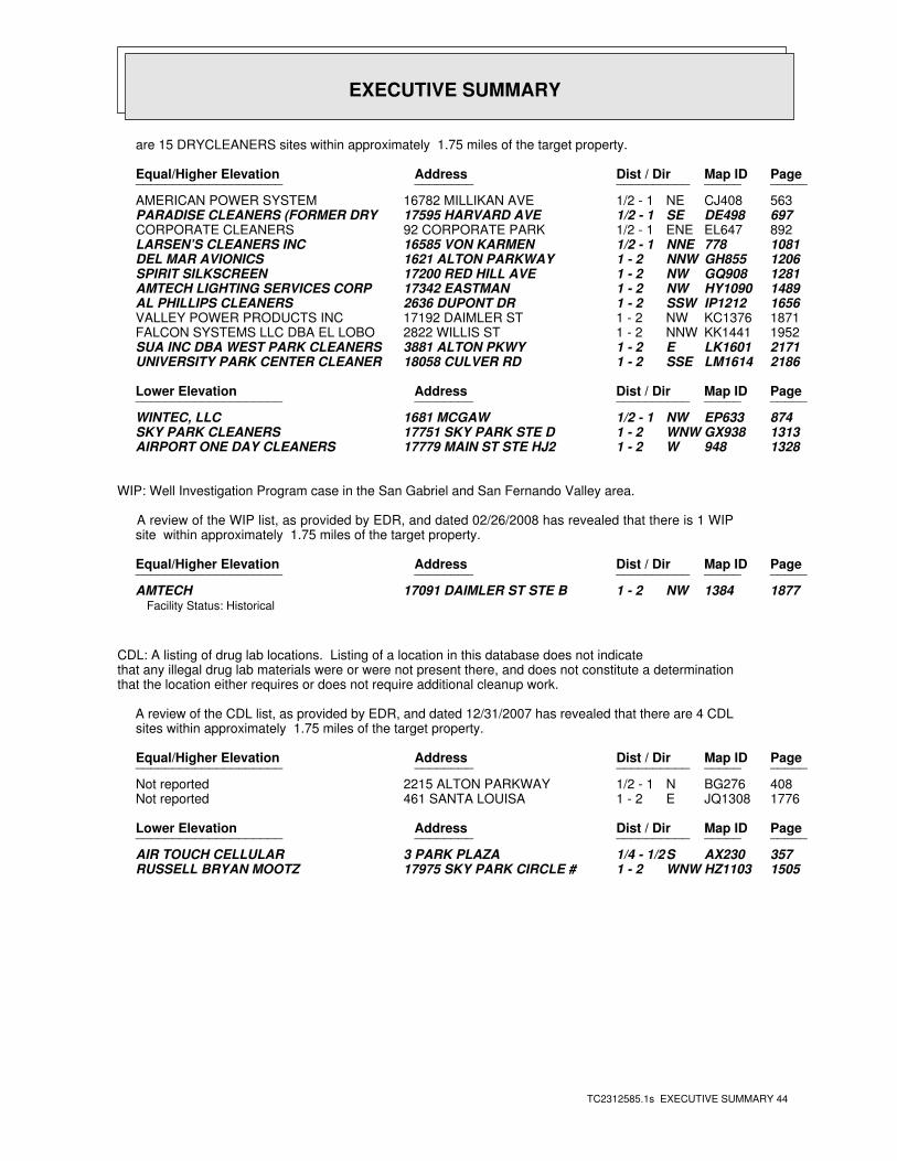
EXECUTIVE SUMMARY
TC2312585.1s EXECUTIVE SUMMARY 44
are 15 DRYCLEANERS sites within approximately 1.75 miles of the target property.
PageMap IDDist / Dir Address Equal/Higher Elevation ____________________ ________ ____________________
563CJ408NE1/2 - 1 16782 MILLIKAN AVE AMERICAN POWER SYSTEM697DE498SE1/2 - 1 17595 HARVARD AVE PARADISE CLEANERS (FORMER DRY 892EL647ENE1/2 - 1 92 CORPORATE PARK CORPORATE CLEANERS1081778NNE1/2 - 1 16585 VON KARMEN LARSEN’S CLEANERS INC1206GH855NNW1 - 2 1621 ALTON PARKWAY DEL MAR AVIONICS1281GQ908NW1 - 2 17200 RED HILL AVE SPIRIT SILKSCREEN1489HY1090NW1 - 2 17342 EASTMAN AMTECH LIGHTING SERVICES CORP1656IP1212SSW1 - 2 2636 DUPONT DR AL PHILLIPS CLEANERS1871KC1376NW1 - 2 17192 DAIMLER ST VALLEY POWER PRODUCTS INC1952KK1441NNW1 - 2 2822 WILLIS ST FALCON SYSTEMS LLC DBA EL LOBO2171LK1601E1 - 2 3881 ALTON PKWY SUA INC DBA WEST PARK CLEANERS2186LM1614SSE1 - 2 18058 CULVER RD UNIVERSITY PARK CENTER CLEANER
PageMap IDDist / Dir Address Lower Elevation ____________________ ________ ____________________
874EP633NW1/2 - 1 1681 MCGAW WINTEC, LLC1313GX938WNW1 - 2 17751 SKY PARK STE D SKY PARK CLEANERS1328948W1 - 2 17779 MAIN ST STE HJ2 AIRPORT ONE DAY CLEANERS
WIP: Well Investigation Program case in the San Gabriel and San Fernando Valley area.
A review of the WIP list, as provided by EDR, and dated 02/26/2008 has revealed that there is 1 WIP site within approximately 1.75 miles of the target property.
PageMap IDDist / Dir Address Equal/Higher Elevation ____________________ ________ ____________________
18771384NW1 - 2 17091 DAIMLER ST STE B AMTECHFacility Status: Historical
CDL: A listing of drug lab locations. Listing of a location in this database does not indicatethat any illegal drug lab materials were or were not present there, and does not constitute a determinationthat the location either requires or does not require additional cleanup work.
A review of the CDL list, as provided by EDR, and dated 12/31/2007 has revealed that there are 4 CDL sites within approximately 1.75 miles of the target property.
PageMap IDDist / Dir Address Equal/Higher Elevation ____________________ ________ ____________________
408BG276N1/2 - 1 2215 ALTON PARKWAY Not reported1776JQ1308E1 - 2 461 SANTA LOUISA Not reported
PageMap IDDist / Dir Address Lower Elevation ____________________ ________ ____________________
357AX230S1/4 - 1/2 3 PARK PLAZA AIR TOUCH CELLULAR1505HZ1103WNW1 - 2 17975 SKY PARK CIRCLE # RUSSELL BRYAN MOOTZ
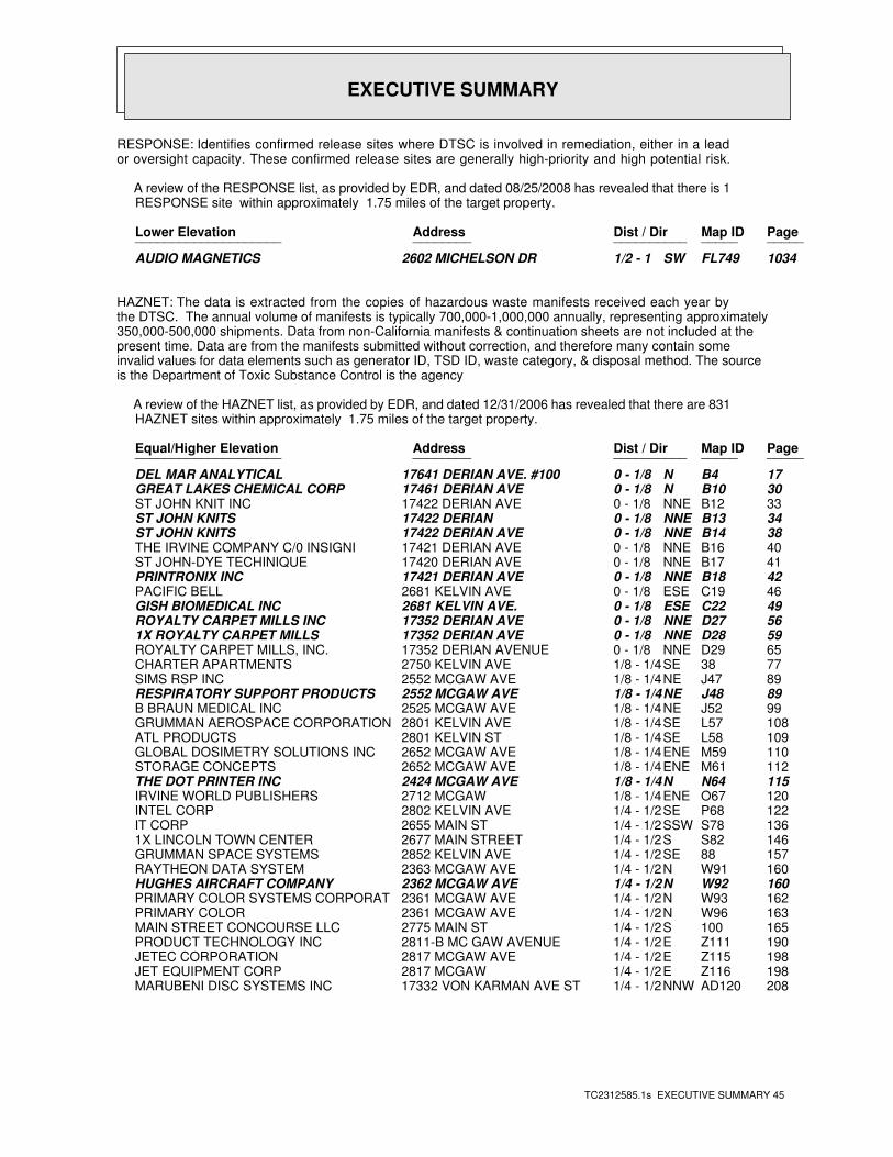
EXECUTIVE SUMMARY
TC2312585.1s EXECUTIVE SUMMARY 45
RESPONSE: Identifies confirmed release sites where DTSC is involved in remediation, either in a leador oversight capacity. These confirmed release sites are generally high-priority and high potential risk.
A review of the RESPONSE list, as provided by EDR, and dated 08/25/2008 has revealed that there is 1 RESPONSE site within approximately 1.75 miles of the target property.
PageMap IDDist / Dir Address Lower Elevation ____________________ ________ ____________________
1034FL749SW1/2 - 1 2602 MICHELSON DR AUDIO MAGNETICS
HAZNET: The data is extracted from the copies of hazardous waste manifests received each year bythe DTSC. The annual volume of manifests is typically 700,000-1,000,000 annually, representing approximately350,000-500,000 shipments. Data from non-California manifests & continuation sheets are not included at thepresent time. Data are from the manifests submitted without correction, and therefore many contain someinvalid values for data elements such as generator ID, TSD ID, waste category, & disposal method. The sourceis the Department of Toxic Substance Control is the agency
A review of the HAZNET list, as provided by EDR, and dated 12/31/2006 has revealed that there are 831 HAZNET sites within approximately 1.75 miles of the target property.
PageMap IDDist / Dir Address Equal/Higher Elevation ____________________ ________ ____________________
17B4N0 - 1/8 17641 DERIAN AVE. #100 DEL MAR ANALYTICAL30B10N0 - 1/8 17461 DERIAN AVE GREAT LAKES CHEMICAL CORP33B12NNE0 - 1/8 17422 DERIAN AVE ST JOHN KNIT INC34B13NNE0 - 1/8 17422 DERIAN ST JOHN KNITS38B14NNE0 - 1/8 17422 DERIAN AVE ST JOHN KNITS40B16NNE0 - 1/8 17421 DERIAN AVE THE IRVINE COMPANY C/0 INSIGNI41B17NNE0 - 1/8 17420 DERIAN AVE ST JOHN-DYE TECHINIQUE42B18NNE0 - 1/8 17421 DERIAN AVE PRINTRONIX INC46C19ESE0 - 1/8 2681 KELVIN AVE PACIFIC BELL49C22ESE0 - 1/8 2681 KELVIN AVE. GISH BIOMEDICAL INC56D27NNE0 - 1/8 17352 DERIAN AVE ROYALTY CARPET MILLS INC59D28NNE0 - 1/8 17352 DERIAN AVE 1X ROYALTY CARPET MILLS65D29NNE0 - 1/8 17352 DERIAN AVENUE ROYALTY CARPET MILLS, INC.7738SE1/8 - 1/4 2750 KELVIN AVE CHARTER APARTMENTS89J47NE1/8 - 1/4 2552 MCGAW AVE SIMS RSP INC89J48NE1/8 - 1/4 2552 MCGAW AVE RESPIRATORY SUPPORT PRODUCTS99J52NE1/8 - 1/4 2525 MCGAW AVE B BRAUN MEDICAL INC108L57SE1/8 - 1/4 2801 KELVIN AVE GRUMMAN AEROSPACE CORPORATION109L58SE1/8 - 1/4 2801 KELVIN ST ATL PRODUCTS110M59ENE1/8 - 1/4 2652 MCGAW AVE GLOBAL DOSIMETRY SOLUTIONS INC112M61ENE1/8 - 1/4 2652 MCGAW AVE STORAGE CONCEPTS115N64N1/8 - 1/4 2424 MCGAW AVE THE DOT PRINTER INC120O67ENE1/8 - 1/4 2712 MCGAW IRVINE WORLD PUBLISHERS122P68SE1/4 - 1/2 2802 KELVIN AVE INTEL CORP136S78SSW1/4 - 1/2 2655 MAIN ST IT CORP146S82S1/4 - 1/2 2677 MAIN STREET 1X LINCOLN TOWN CENTER15788SE1/4 - 1/2 2852 KELVIN AVE GRUMMAN SPACE SYSTEMS160W91N1/4 - 1/2 2363 MCGAW AVE RAYTHEON DATA SYSTEM160W92N1/4 - 1/2 2362 MCGAW AVE HUGHES AIRCRAFT COMPANY162W93N1/4 - 1/2 2361 MCGAW AVE PRIMARY COLOR SYSTEMS CORPORAT163W96N1/4 - 1/2 2361 MCGAW AVE PRIMARY COLOR165100S1/4 - 1/2 2775 MAIN ST MAIN STREET CONCOURSE LLC190Z111E1/4 - 1/2 2811-B MC GAW AVENUE PRODUCT TECHNOLOGY INC198Z115E1/4 - 1/2 2817 MCGAW AVE JETEC CORPORATION198Z116E1/4 - 1/2 2817 MCGAW JET EQUIPMENT CORP208AD120NNW1/4 - 1/2 17332 VON KARMAN AVE ST MARUBENI DISC SYSTEMS INC
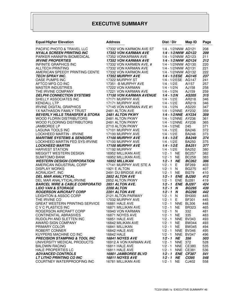
EXECUTIVE SUMMARY
TC2312585.1s EXECUTIVE SUMMARY 46
PageMap IDDist / Dir Address Equal/Higher Elevation ____________________ ________ ____________________
208AD121NNW1/4 - 1/2 17332 VON KARMON AVE ST PACIFIC PHOTO & TRAVEL LLC209AD122NNW1/4 - 1/2 17352 VON KARMAN AVE NYALA SCREEN PRINTING INC211AD123NNW1/4 - 1/2 17352 VONKARMAN AVE PARKER HANNIFIN BIOMEDICAL212AD124NNW1/4 - 1/2 17352 VON KARMAN AVE IRVINE PROPERTIES220AD130NNW1/4 - 1/2 17332 VON KARMEN AVE, # INFINITE GRAPHICS INC221AD131NNW1/4 - 1/2 17332 VON KARMAN AVE ALLTECH PRINTING222AD132NNW1/4 - 1/2 17332 VON KARMON AVE AMERICAN SPEEDY PRINTING CENTE237AG145ESE1/4 - 1/2 17352 MURPHY AVE TECH SPRAY INC.241AG147ESE1/4 - 1/2 17322 MURPHY ST OASE PUMPS INC257AI157E1/4 - 1/2 17351 -B MURPHY AVE AFTCO MFG CO INC258AJ158N1/4 - 1/2 17222 VON KARMAN MASTER INDUSTRIES259AJ159N1/4 - 1/2 17221 VON KARMAN AVE THE IRVINE COMPANY315AS205N1/4 - 1/2 17150 VON KARMAN AVENUE DELPHI CONNECTION SYSTEMS346AR218E1/4 - 1/2 17171 MURPHY AVE SHELLY ASSOCIATES INC346AR219E1/4 - 1/2 17171 MURPHY AVE KENDALL LTP347AS220N1/4 - 1/2 17145 VON KARMAN AVE #1 IRVINE DIGITAL GRAPHICS359AY232NNE1/4 - 1/2 2481 ALTON AVE 1X NATHASON FAMILY TRUST359AY234NNE1/4 - 1/2 2481 ALTON PKWY BEVERLY HILLS TRANSFER & STORA361AY236NNE1/4 - 1/2 2481 ALTON PKWY WOOD FLORIN DISTRIBUTORS365AY238NNE1/4 - 1/2 2481 ALTON PKWY WOOD FLOORING DISTRIBUTORS371245NE1/4 - 1/2 2710 ALTON PKWY JAMBOREE LP372BA246E1/4 - 1/2 17101 MURPHY AVE LAGUNA TOOLS INC373BA248E1/4 - 1/2 17100 MURPHY AVE LOCKHEED MARTIN - IRVINE374BA249E1/4 - 1/2 17100 MURPHY AVE MARITIME SYSTEMS & SENSORS375BA250E1/4 - 1/2 17100 MURPHY AVE LOCKHEED MARTIN FED SYS-IRVINE377BA251E1/4 - 1/2 17100 MURPHY AVE LOCKHEED MARTIN380BA252E1/4 - 1/2 17192 MURPHY HARVEST STATION382BC257NE1/2 - 1 16952 MILLIKAN AVE MEGGITT WESTERN DESIGN383BC258NE1/2 - 1 16952 MILLIKAN AVE. SUMITOMO BANK386BC262NE1/2 - 1 16952 MILLIKAN WESTERN DESIGN CORPORATION403BF269E1/2 - 1 17141 MURPHY AVE STE A AMERICAN INDUSTRIAL CORP407BG275N1/2 - 1 1921 E ALTON DISPLAY WORKS410BI279NE1/2 - 1 2491 DU BRIDGE AVE ACRALIGHT, INC412BJ280ENE1/2 - 1 2852 ALTON AVE DEL MAR ANALYTICAL419BJ281ENE1/2 - 1 2852 ALTON PKWY DEL MAR ANALYTICAL/IRVINE424BJ287ENE1/2 - 1 2851 ALTON AVE. BARCEL WIRE & CABLE CORPORATIO439BG295N1/2 - 1 2200 ALTON LIDO VAN & STORAGE442BG298N1/2 - 1 2201 ALTON AVE ROGERSON AIRCRAFT CORP445BH300N1/2 - 1 2121 ALTON PARWAY LEIGHTON & ASSOC CORP445BF301E1/2 - 1 17032 MURPHY AVE THE IRVINE CO448BL306NNE1/2 - 1 16881 HALE AVE GREAT WESTERN PRINTING SERVICE465BR323NE1/2 - 1 16871 MILLIKAN AVE C V C PLASTICS INC481332N1/2 - 1 16940 VON KARMAN ROGERSON AIRCRAFT CORP483335NE1/2 - 1 16871 NOYES AVE CONTINENTAL ABRASIVES493BV343NNE1/2 - 1 16851 HALE AVE RUDOLPH AND SLETTEN INC493BW344NE1/2 - 1 16842 MILIKAN AVE AWARD SIGN COMPANY494BW345NE1/2 - 1 16841 MILLIKAN PRIMARY COLOR495BV346NNE1/2 - 1 16842 HALE AVE ROBERT CONNER496BV347NNE1/2 - 1 16842 HALE KUYPERS MACHINE CO INC503356NE1/2 - 1 16841 NOYES AVE PRECISION STAMPING & TOOL INC528372NNE1/2 - 1 16912 A VON KARMAN AVE UNIVERSITY MEDICAL PRODUCTS535CE380NNE1/2 - 1 16811 HALE AVE BALDWIN RACING536CE381NNE1/2 - 1 16811 HALE AVE HALE PROPERTIES LC541CF387ENE1/2 - 1 16901 JAMBOREE BLVD ADVANCED CONTROLS548CI395NE1/2 - 1 16811 NOYES AVE LT LITHO PRINTING CO INC558CJ402NE1/2 - 1 16781 MILLIKAN AVE COURTNEY WATERPROOFING INC
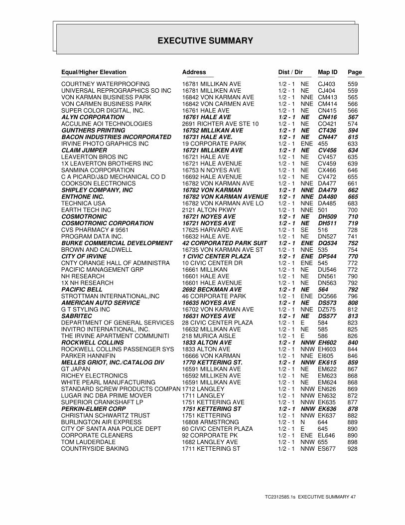
EXECUTIVE SUMMARY
TC2312585.1s EXECUTIVE SUMMARY 47
PageMap IDDist / Dir Address Equal/Higher Elevation ____________________ ________ ____________________
559CJ403NE1/2 - 1 16781 MILLIKAN AVE COURTNEY WATERPROOFING559CJ404NE1/2 - 1 16781 MILLIKEN AVE UNIVERSAL REPROGRAPHICS SO INC565CM413NNE1/2 - 1 16842 VON KARMAN AVE VON KARMAN BUSINESS PARK566CM414NNE1/2 - 1 16842 VON CARMEN AVE VON CARMEN BUSINESS PARK566CN415NE1/2 - 1 16761 HALE AVE SUPER COLOR DIGITAL, INC.567CN416NE1/2 - 1 16761 HALE AVE ALYN CORPORATION574CO421NE1/2 - 1 2691 RICHTER AVE STE 10 ACCULINE AOI TECHNOLOGIES594CT436NE1/2 - 1 16752 MILLIKAN AVE GUNTHERS PRINTING615CN447NE1/2 - 1 16731 HALE AVE. BACON INDUSTRIES INCORPORATED 633455ENE1/2 - 1 19 CORPORATE PARK IRVINE PHOTO GRAPHICS INC634CV456NE1/2 - 1 16721 MILLIKEN AVE CLAIM JUMPER635CV457NE1/2 - 1 16721 HALE AVE LEAVERTON BROS INC639CV459NE1/2 - 1 16721 HALE AVENUE 1X LEAVERTON BROTHERS INC646CX466NE1/2 - 1 16753 N NOYES AVE SANMINA CORPORATION655CV472NE1/2 - 1 16692 HALE AVENUE C A PICARD/J&D MECHANICAL CO D661DA477NNE1/2 - 1 16782 VON KARMAN AVE COOKSON ELECTRONICS662DA479NNE1/2 - 1 16782 VON KARMAN SHIPLEY COMPANY, INC665DA480NNE1/2 - 1 16782 VON KARMAN AVENUE ENTHONE INC.683DA485NNE1/2 - 1 16782 VON KARMAN AVE LO TECHNICA USA700501NNE1/2 - 1 2121 ALTON PKWY EARTH TECH INC710DH509NE1/2 - 1 16721 NOYES AVE COSMOTRONIC719DH511NE1/2 - 1 16721 NOYES AVE COSMOTRONIC CORPORATION728516SE1/2 - 1 17625 HARVARD AVE CVS PHARMACY # 9561741DN527NE1/2 - 1 16632 HALE AVE. PROGRAM DATA INC.752DQ534ENE1/2 - 1 42 CORPORATED PARK SUIT BURKE COMMERCIAL DEVELOPMENT754535NNE1/2 - 1 16735 VON KARMAN AVE ST BROWN AND CALDWELL770DP544ENE1/2 - 1 1 CIVIC CENTER PLAZA CITY OF IRVINE772545ENE1/2 - 1 10 CIVIC CENTER DR CNTY ORANGE HALL OF ADMINISTRA772DU546NE1/2 - 1 16661 MILLIKAN PACIFIC MANAGEMENT GRP790DN561NE1/2 - 1 16601 HALE AVE NH RESEARCH792DN563NE1/2 - 1 16601 HALE AVENUE 1X NH RESEARCH792564NE1/2 - 1 2692 BECKMAN AVE PACIFIC BELL796DQ566ENE1/2 - 1 46 CORPORATE PARK STROTTMAN INTERNATIONAL,INC808DS573NE1/2 - 1 16635 NOYES AVE AMERICAN AUTO SERVICE812DZ575NNE1/2 - 1 16702 VON KARMAN AVE G T STYLING INC813DS577NE1/2 - 1 16631 NOYES AVE SABRITEC823584E1/2 - 1 28 CIVIC CENTER PLAZA DEPARTMENT OF GENERAL SERVICES825585NE1/2 - 1 16632 MILLIKAN AVE INVITRO INTERNATIONAL, INC.826586E1/2 - 1 218 MURICA AISLE THE IRVINE APARTMENT COMMUNITI840EH602NNW1/2 - 1 1833 ALTON AVE ROCKWELL COLLINS844EH603NNW1/2 - 1 1833 ALTON AVE ROCKWELL COLLINS PASSENGER SYS846EI605NNE1/2 - 1 16666 VON KARMAN PARKER HANNIFIN859EK615NNW1/2 - 1 1770 KETTERING ST. MELLES GRIOT, INC./CATALOG DIV867EM622NE1/2 - 1 16591 MILLIKAN AVE GT JAPAN868EM623NE1/2 - 1 16592 MILLIKEN AVE RICHEY ELECTRONICS868EM624NE1/2 - 1 16591 MILLIKAN AVE WHITE PEARL MANUFACTURING869EN626NNW1/2 - 1 1712 LANGLEY STANDARD SCREW PRODUCTS COMPAN872EN632NNW1/2 - 1 1711 LANGLEY LUGAR INC DBA PRIME MOVER877EK635NNW1/2 - 1 1751 KETTERING AVE SUPERIOR CRANKSHAFT LP878EK636NNW1/2 - 1 1751 KETTERING ST PERKIN-ELMER CORP882EK637NNW1/2 - 1 1751 KETTERING CHRISTIAN SCHWARTZ TRUST889644N1/2 - 1 16808 ARMSTRONG BURLINGTON AIR EXPRESS890645E1/2 - 1 60 CIVIC CENTER PLAZA CITY OF SANTA ANA POLICE DEPT890EL646ENE1/2 - 1 92 CORPORATE PK CORPORATE CLEANERS898655NNW1/2 - 1 1682 LANGLEY AVE TOM LAUDERDALE928ES677NNW1/2 - 1 1711 KETTERING ST COUNTRYSIDE BAKING
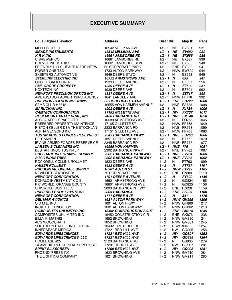
EXECUTIVE SUMMARY
TC2312585.1s EXECUTIVE SUMMARY 48
PageMap IDDist / Dir Address Equal/Higher Elevation ____________________ ________ ____________________
931EV681NE1/2 - 1 16542 MILLIKAN AVE MELLES GRIOT932EV682NE1/2 - 1 16542 MILLIKAN AVE MEADE INSTRUMENTS936EX686NE1/2 - 1 16661 JAMBOREE RD K R K INC939EX687NE1/2 - 1 16661 JAMBOREE RD C BREWER CO940EX688NE1/2 - 1 16661 JAMBOREE BLVD BREVET INDUSTRIES941EY689ENE1/2 - 1 62 CORPORATE PARK FRIENDLY HILLS HEALTHCARE NETW944EW692NNW1/2 - 1 1733 ALTON PARKWAY POWER ONE TSD945EZ693N1/2 - 1 1949 DEERE ST,#O SKEETERS AUTOMOTIVE947695N1/2 - 1 16752 ARMSTRONG AVE STERLING ELECTRIC INC956EZ697N1/2 - 1 1939 DEERE AVENUE ODC OF CALIFORNIA957EZ699N1/2 - 1 1939 DEERE AVE CML GROUP PROPERTY962EZ701N1/2 - 1 1939 DEERE AVE NOXTECH INC985EZ717N1/2 - 1 1931 DEERE AVE NEWPORT PRECISION OPTICS INC992FF718NNW1/2 - 1 1641 LANGLEY AVE AMBASSADOR ADVERTISING AGENCY1000FH729ENE1/2 - 1 80 CORPORATE PARK CHEVRON STATION NO 2010951008FA733NNE1/2 - 1 16555 VON KARMEN AVENUE SAMS CLUB # 66181009FJ734N1/2 - 1 1902 DEERE AVE MARUCHAN INC1017FK737NW1/2 - 1 17192 GILLETTE AVE CAMTECH CORPORATION1020FM740NNE1/2 - 1 2400 BARRANCA RD ROSEMOUNT ANALYTICAL, INC.1045FO755N1/2 - 1 16680 ARMSTRONG AVE ALCOA AERO SPACE CTR1049FP758NNW1/2 - 1 17165 GILLETTE ST PREFERED PROPERTY MAINTENCE1059FR763NNE1/2 - 1 2332 BARRANCA RD RISTON KELLER DBA THE STOCKLAN1063FP765NNW1/2 - 1 17151 GILLETTE AVE ALPHA SENSORS INC1066FR768NNE1/2 - 1 2345 BARRANCA PKWY TUSTIN ARMED FORCES RESEVRE CT1070FT771N1/2 - 1 1851 DEERE AVENUE ITT CANNON1077FR775NNE1/2 - 1 2345 BARRANCA RD IRVINE ARMED FORCES RESERVE CE1081778NNE1/2 - 1 16585 VON KARMEN LARSEN’S CLEANERS INC1087FV782NNE1/2 - 1 2302 BARRANCA PKWY BESTAR KINCO TUSTIN LP1088FV784NNE1/2 - 1 2302 BARRANCA PARKWAY SHELDAHL INC. ORANGE COUNTY1092FV785NNE1/2 - 1 2302 BARRANCA PARKWAY B M C INDUSTRIES1099FT793N1 - 2 1822 DEERE AVE ROCKWELL COLLINS ROLLMET1101FT797N1 - 2 1822 DEERE AVE KAISER ROLLMET1105FX799NNW1 - 2 16901 ASTON ST PRUDENTIAL OVERALL SUPPLY1119FZ803ENE1 - 2 72 CORPORATE PARK NEWPORT STATIONERS1149FY822N1 - 2 1791 DEERE AVENUE NEWPORT CORPORATION1155GD824N1 - 2 16601 ARMSTRONG AVE DONALD INVESTMENT CO II1156GD825N1 - 2 16601 ARMSTRONG AVE P C WORLD, ORANGE COUNTY1159FZ828ENE1 - 2 2803 BARRANCA PRKWY GRISWOLD CONTROLS1160FZ829ENE1 - 2 2805 BARRANCA UNIVERSITY COPY SYSTEMS1176841N1 - 2 1771 DEERE AVE NEWPORT CORPORATION1206GH855NNW1 - 2 1621 ALTON PARKWAY DEL MAR AVIONICS1217GH860NNW1 - 2 1601 ALTON PKWY O D M E, INC1219GH862NNW1 - 2 1601 ALTON PARKWAY INCIRT TECHNOLOGY1235GK875ENE1 - 2 16452 CONSTRUCTION SOUT COMPOSITES UNLIMITED INC1238GK876ENE1 - 2 16452 CONSTRUCTION CIR COMPOSITES UNLIMITED INC1244GM880NNW1 - 2 1652 BROWNING BILLY F. MATHIS1245GM881NNW1 - 2 1652 BROWNING AL’S WOODCRAFT1257894SSW1 - 2 18432 JAMBOREE RD SOUTHERN CALIFORNIA EDISON1258GQ895NW1 - 2 17221 RED HILL AVE INNERSPACE MEDICAL1262GQ897NW1 - 2 17221 RED HILL AVE EDWARDS LIFESCIENCES1264GQ899NW1 - 2 17221 RED HILL AVE EDWARDS LIFESCIENCES, LLC1279GS905N1 - 2 2120 BARRANCA RD HOMEBASE #251281GQ907NW1 - 2 17201 REDHILL AVE 1X AMERICAN HOSPITAL SUPPLY CO1281GQ908NW1 - 2 17200 RED HILL AVE SPIRIT SILKSCREEN1284GM910NNW1 - 2 1622 BROWNING AVE PHOENIX PRESS INC1285GM911NNW1 - 2 1621 BROWNING THE LIGHTING COMPANY
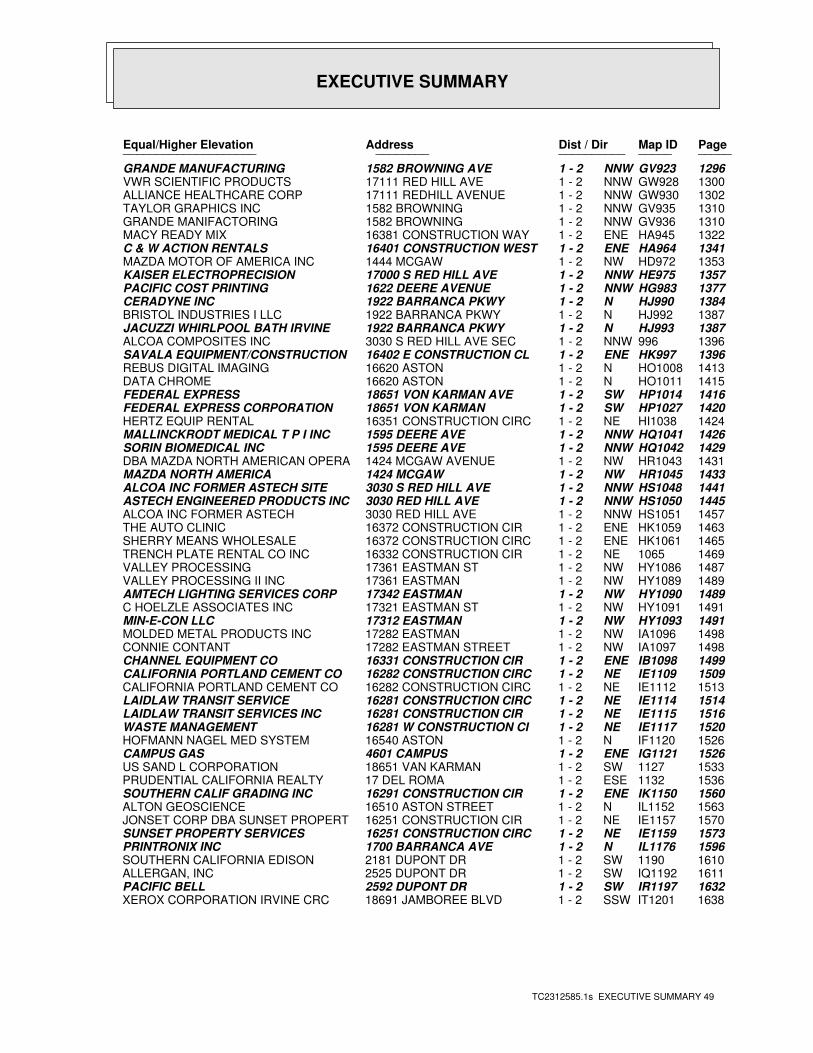
EXECUTIVE SUMMARY
TC2312585.1s EXECUTIVE SUMMARY 49
PageMap IDDist / Dir Address Equal/Higher Elevation ____________________ ________ ____________________
1296GV923NNW1 - 2 1582 BROWNING AVE GRANDE MANUFACTURING1300GW928NNW1 - 2 17111 RED HILL AVE VWR SCIENTIFIC PRODUCTS1302GW930NNW1 - 2 17111 REDHILL AVENUE ALLIANCE HEALTHCARE CORP1310GV935NNW1 - 2 1582 BROWNING TAYLOR GRAPHICS INC1310GV936NNW1 - 2 1582 BROWNING GRANDE MANIFACTORING1322HA945ENE1 - 2 16381 CONSTRUCTION WAY MACY READY MIX1341HA964ENE1 - 2 16401 CONSTRUCTION WEST C & W ACTION RENTALS1353HD972NW1 - 2 1444 MCGAW MAZDA MOTOR OF AMERICA INC1357HE975NNW1 - 2 17000 S RED HILL AVE KAISER ELECTROPRECISION1377HG983NNW1 - 2 1622 DEERE AVENUE PACIFIC COST PRINTING1384HJ990N1 - 2 1922 BARRANCA PKWY CERADYNE INC1387HJ992N1 - 2 1922 BARRANCA PKWY BRISTOL INDUSTRIES I LLC1387HJ993N1 - 2 1922 BARRANCA PKWY JACUZZI WHIRLPOOL BATH IRVINE1396996NNW1 - 2 3030 S RED HILL AVE SEC ALCOA COMPOSITES INC1396HK997ENE1 - 2 16402 E CONSTRUCTION CL SAVALA EQUIPMENT/CONSTRUCTION1413HO1008N1 - 2 16620 ASTON REBUS DIGITAL IMAGING1415HO1011N1 - 2 16620 ASTON DATA CHROME1416HP1014SW1 - 2 18651 VON KARMAN AVE FEDERAL EXPRESS1420HP1027SW1 - 2 18651 VON KARMAN FEDERAL EXPRESS CORPORATION1424HI1038NE1 - 2 16351 CONSTRUCTION CIRC HERTZ EQUIP RENTAL1426HQ1041NNW1 - 2 1595 DEERE AVE MALLINCKRODT MEDICAL T P I INC1429HQ1042NNW1 - 2 1595 DEERE AVE SORIN BIOMEDICAL INC1431HR1043NW1 - 2 1424 MCGAW AVENUE DBA MAZDA NORTH AMERICAN OPERA1433HR1045NW1 - 2 1424 MCGAW MAZDA NORTH AMERICA1441HS1048NNW1 - 2 3030 S RED HILL AVE ALCOA INC FORMER ASTECH SITE1445HS1050NNW1 - 2 3030 RED HILL AVE ASTECH ENGINEERED PRODUCTS INC1457HS1051NNW1 - 2 3030 RED HILL AVE ALCOA INC FORMER ASTECH1463HK1059ENE1 - 2 16372 CONSTRUCTION CIR THE AUTO CLINIC1465HK1061ENE1 - 2 16372 CONSTRUCTION CIRC SHERRY MEANS WHOLESALE14691065NE1 - 2 16332 CONSTRUCTION CIR TRENCH PLATE RENTAL CO INC1487HY1086NW1 - 2 17361 EASTMAN ST VALLEY PROCESSING1489HY1089NW1 - 2 17361 EASTMAN VALLEY PROCESSING II INC1489HY1090NW1 - 2 17342 EASTMAN AMTECH LIGHTING SERVICES CORP1491HY1091NW1 - 2 17321 EASTMAN ST C HOELZLE ASSOCIATES INC1491HY1093NW1 - 2 17312 EASTMAN MIN-E-CON LLC1498IA1096NW1 - 2 17282 EASTMAN MOLDED METAL PRODUCTS INC1498IA1097NW1 - 2 17282 EASTMAN STREET CONNIE CONTANT1499IB1098ENE1 - 2 16331 CONSTRUCTION CIR CHANNEL EQUIPMENT CO1509IE1109NE1 - 2 16282 CONSTRUCTION CIRC CALIFORNIA PORTLAND CEMENT CO1513IE1112NE1 - 2 16282 CONSTRUCTION CIRC CALIFORNIA PORTLAND CEMENT CO1514IE1114NE1 - 2 16281 CONSTRUCTION CIRC LAIDLAW TRANSIT SERVICE1516IE1115NE1 - 2 16281 CONSTRUCTION CIR LAIDLAW TRANSIT SERVICES INC1520IE1117NE1 - 2 16281 W CONSTRUCTION CI WASTE MANAGEMENT1526IF1120N1 - 2 16540 ASTON HOFMANN NAGEL MED SYSTEM1526IG1121ENE1 - 2 4601 CAMPUS CAMPUS GAS15331127SW1 - 2 18651 VAN KARMAN US SAND L CORPORATION15361132ESE1 - 2 17 DEL ROMA PRUDENTIAL CALIFORNIA REALTY1560IK1150ENE1 - 2 16291 CONSTRUCTION CIR SOUTHERN CALIF GRADING INC1563IL1152N1 - 2 16510 ASTON STREET ALTON GEOSCIENCE1570IE1157NE1 - 2 16251 CONSTRUCTION CIR JONSET CORP DBA SUNSET PROPERT1573IE1159NE1 - 2 16251 CONSTRUCTION CIRC SUNSET PROPERTY SERVICES1596IL1176N1 - 2 1700 BARRANCA AVE PRINTRONIX INC16101190SW1 - 2 2181 DUPONT DR SOUTHERN CALIFORNIA EDISON1611IQ1192SW1 - 2 2525 DUPONT DR ALLERGAN, INC1632IR1197SW1 - 2 2592 DUPONT DR PACIFIC BELL1638IT1201SSW1 - 2 18691 JAMBOREE BLVD XEROX CORPORATION IRVINE CRC
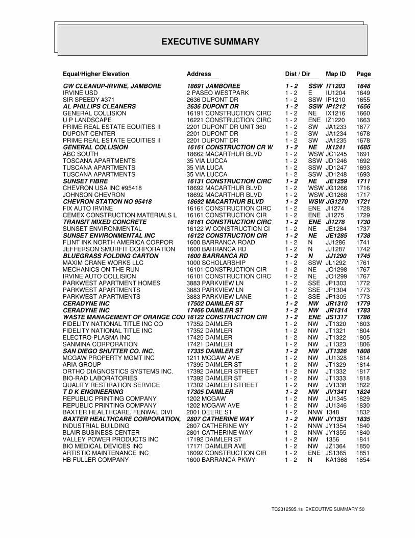
EXECUTIVE SUMMARY
TC2312585.1s EXECUTIVE SUMMARY 50
PageMap IDDist / Dir Address Equal/Higher Elevation ____________________ ________ ____________________
1648IT1203SSW1 - 2 18691 JAMBOREE GW CLEANUP-IRVINE, JAMBORE1649IU1204E1 - 2 2 PASEO WESTPARK IRVINE USD1655IP1210SSW1 - 2 2636 DUPONT DR SIR SPEEDY #3711656IP1212SSW1 - 2 2636 DUPONT DR AL PHILLIPS CLEANERS1660IX1216NE1 - 2 16191 CONSTRUCTION CIRC GENERAL COLLISION1663IZ1220ENE1 - 2 16221 CONSTRUCTION CIRC U P LANDSCAPE1677JA1233SW1 - 2 2201 DUPONT DR UNIT 360 PRIME REAL ESTATE EQUITIES II 1678JA1234SW1 - 2 2201 DUPONT DR DUPONT CENTER1678JA1235SW1 - 2 2201 DUPONT DR PRIME REAL ESTATE EQUITIES II 1685IX1241NE1 - 2 16161 CONSTRUCTION CR W GENERAL COLLISION1691JC1245WSW1 - 2 18662 MACARTHUR BLVD ABC SOUTH1692JD1246SSW1 - 2 35 VIA LUCCA TOSCANA APARTMENTS1693JD1247SSW1 - 2 35 VIA LUCA TUSCANA APARTMENTS1693JD1248SSW1 - 2 35 VIA LUCCA TUSCANA APARTMENTS1711JE1259NE1 - 2 16131 CONSTRUCTION CIRC SUNSET FIBRE1716JG1266WSW1 - 2 18692 MACARTHUR BLVD CHEVRON USA INC #954181717JG1268WSW1 - 2 18692 MACARTHUR BLVD JOHNSON CHEVRON1721JG1270WSW1 - 2 18692 MACARTHUR BLVD CHEVRON STATION NO 954181728JI1274ENE1 - 2 16161 CONSTRUCTION CIRC FIX AUTO IRVINE1729JI1275ENE1 - 2 16161 CONSTRUCTION CIR CEMEX CONSTRUCTION MATERIALS L1730JI1278ENE1 - 2 16161 CONSTRUCTION CIRC TRANSIT MIXED CONCRETE1737JE1284NE1 - 2 16122 W CONSTRUCTION CI SUNSET ENVIRONMENTAL1738JE1285NE1 - 2 16122 CONSTRUCTION CIR SUNSET ENVIRONMENTAL INC1741JJ1286N1 - 2 1600 BARRANCA ROAD FLINT INK NORTH AMERICA CORPOR1742JJ1287N1 - 2 1600 BARRANCA RD JEFFERSON SMURFIT CORPORATION1745JJ1290N1 - 2 1600 BARRANCA RD BLUEGRASS FOLDING CARTON1761JL1292SSW1 - 2 1000 SCHOLARSHIP MAXIM CRANE WORKS LLC1767JO1298NE1 - 2 16101 CONSTRUCTION CIR MECHANICS ON THE RUN1767JO1299NE1 - 2 16101 CONSTRUCTION CIRC IRVINE AUTO COLLISION1772JP1303SSE1 - 2 3883 PARKVIEW LN PARKWEST APARTMENT HOMES1773JP1304SSE1 - 2 3883 PARKVIEW LN PARKWEST APARTMENTS1773JP1305SSE1 - 2 3883 PARKVIEW LANE PARKWEST APARTMENTS1779JR1310NW1 - 2 17502 DAIMLER ST CERADYNE INC1783JR1314NW1 - 2 17466 DAIMLER ST CERADYNE INC1786JS1317ENE1 - 2 16122 CONSTRUCTION CIR WASTE MANAGEMENT OF ORANGE COU1803JT1320NW1 - 2 17352 DAIMLER FIDELITY NATIONAL TITLE INC CO1804JT1321NW1 - 2 17352 DAIMLER FIDELITY NATIONAL TITLE INC1805JT1322NW1 - 2 17425 DAIMLER ELECTRO-PLASMA INC1806JT1323NW1 - 2 17421 DAIMLER SANMINA CORPORATION1808JT1326NW1 - 2 17335 DAIMLER ST SAN DIEGO SHUTTER CO. INC.1814JU1328NW1 - 2 1211 MCGAW AVE MCGAW PROPERTY MGMT INC1814JT1329NW1 - 2 17395 DAIMLER ST ARIA GROUP1817JT1332NW1 - 2 17392 DAIMLER STREET ORTHO DIAGNOSTICS SYSTEMS INC.1818JT1333NW1 - 2 17392 DAIMLER ST BIO-RAD LABORATORIES1822JV1338NW1 - 2 17302 DAIMLER STREET QUALITY RESTIRATION SERVICE1824JV1341NW1 - 2 17305 DAIMLER T D K ENGINEERING1829JU1345NW1 - 2 1202 MCGAW REPUBLIC PRINTING COMPANY1830JU1346NW1 - 2 1202 MCGAW AVE REPUBLIC PRINTING COMPANY18321348NNW1 - 2 2001 DEERE ST BAXTER HEALTHCARE, FENWAL DIVI1835JY1351NNW1 - 2 2807 CATHERINE WAY BAXTER HEALTHCARE CORPORATION,1840JY1354NNW1 - 2 2807 CATHERINE WY INDUSTRIAL BUILDING1840JY1355NNW1 - 2 2801 CATHERINE WAY BLAIR BUSINESS CENTER18411356NW1 - 2 17192 DAIMLER ST VALLEY POWER PRODUCTS INC1850JZ1364NW1 - 2 17171 DAIMLER AVE BIO MEDICAL DEVICES INC1851JS1365ENE1 - 2 16092 CONSTRUCTION CIR ARTISTIC MAINTENANCE INC1854KA1368N1 - 2 1600 BARRANCA PKWY HB FULLER COMPANY
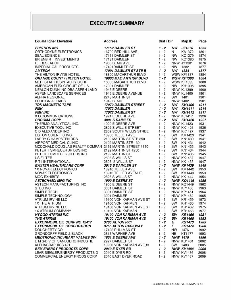
EXECUTIVE SUMMARY
TC2312585.1s EXECUTIVE SUMMARY 51
PageMap IDDist / Dir Address Equal/Higher Elevation ____________________ ________ ____________________
1855JZ1370NW1 - 2 17152 DAIMLER ST FRICTION INC1861KA1372N1 - 2 16700 RED HILL AVE ORTHODYNE ELECTRONICS1874KC1379NW1 - 2 17131 DAIMLER ST SEAL SCIENCE1875KC1380NW1 - 2 17131 DAIMLER BRIENBIR__INVESTMENTS1876JY1381NNW1 - 2 1965 BLAIR AVE I.J. RESEARCH18771382NW1 - 2 17421DAIMLER ST IMPERIAL CAL PRODUCTS18771384NW1 - 2 17091 DAIMLER ST STE B AMTECH1884KF1387WSW1 - 2 18800 MACARTHUR BLVD THE HILTON IRVINE HOTEL1884KF1388WSW1 - 2 18800 MAC ARTHUR BLVD ORANGE COUNTY HILTON HOTEL1888KF1392WSW1 - 2 18800 MACARTHUR BLVD MERI STAR HOSPITALITY CORP1895KH1395NW1 - 2 17091 DAIMLER AMERICAN FLEX CIRCUIT OF L.A.1900KJ1399NNW1 - 2 1945 E DEERE NEALON DUNN INC DBA ASPEN LAND1901KJ1400NNW1 - 2 1945 E DEERE AVENUE ASPEN LANDSCAPE SERVICES19011401SW1 - 2 2243 MARTIN ST ALPHA REGIONAL19011402NNW1 - 2 1942 BLAIR FOREIGN AFFAIRS1911KH1409NW1 - 2 17072 DAIMLER STREET TDK MAGNETIC TAPE1914KH1411NW1 - 2 17072 DAIMLER FMH1917KH1412NW1 - 2 17072 DAIMLER ST FMH INC1926KJ1417NNW1 - 2 1924 E DEERE AVE X O COMMUNICATIONS1927KH1420NW1 - 2 3001 S DAIMLER CHROMA COPY1931KJ1423NNW1 - 2 1920 E DEERE AVE THERMO ANALYTICAL INC.1936KK1426NNW1 - 2 2802 S WILLIS STREET EXECUTIVE TOOL INC1937KK1427NNW1 - 2 2802 SOUTH WILLIS STREE C D ALEXANDER INC1941KM1429SW1 - 2 18900 TELLER AVE LISTON SCIENIFIC INC1941KN1430SW1 - 2 2192 MARTIN ST STE 250 LARRY G HAMPSTEN DDS1942KN1431SW1 - 2 2192 MARTIN STE 130 AIRPORT MEDICAL CLINIC1943KN1433SW1 - 2 2192 MARTIN STREET #130 MCDONALD DOUGLAS REALTY COMPAN1944KN1434SW1 - 2 2192 MARTIN ST #250 PETER T SMRECER JR DDS INC1945KN1435SW1 - 2 2192 MARTIN ST PETER T SMRECEK JR DDS INC1947KK1437NNW1 - 2 2808 S WILLIS ST US FILTER1947KK1438NNW1 - 2 2808 S WILLIS ST R T I INTERNATIONAL1948KP1439NNW1 - 2 3015 S DAIMLER ST BAXTER HEALTHCARE CORP1953KM1442SW1 - 2 18910 TELLER AVE 1X NOVAK ELECTRONICS1953KM1443SW1 - 2 18910 TELLER AVENUE NOVAK ELECTRONICS1954KK1444NNW1 - 2 2826 S WILLIS ST MOG EXHIBITS1955KQ1446NNW1 - 2 1900 E DEERE ST ASTECH/MCI MFG INC1962KQ1449NNW1 - 2 1900 E DEERE ST ASTECH MANUFACTURING INC1963KP1450NNW1 - 2 3001 DAIMLER ST STEC INC1964KP1451NNW1 - 2 3001 DAIMLER ST SIMPLE TECH1965KP1452NNW1 - 2 3001 DAIMLER SIMPLE TECHNOLOGY1973KR1459SW1 - 2 19100 VON KARMAN AVE ST ATRIUM IRVINE LLC1974KR1460SW1 - 2 19100 VON KARMEN 1X THE ATRIUM1975KR1462SW1 - 2 19100 VON KARMEN AVE ST ATRIUM IRVINE LLC1977KR1463SW1 - 2 19100 VON KARMAN 1X ATRIUM COMPANY1981KR1465SW1 - 2 19100 VON KARMAN AVE HYOGO ATRIUM INC1983KR1468SW1 - 2 19100 VON KARMAN AVE THE ATRIUM1985KS1473E1 - 2 3765 ALTON PKY EXXONMOBIL OIL CORP NO 124171988KS1474E1 - 2 3765 ALTON PARKWAY EXXONMOBIL OIL CORPORATION19921476NW1 - 2 17422 PULLMAN ST DOUGHERTY CO1993KT1477NE1 - 2 2815 WARNER AVE GRONDORFF FIELD & BLACK19961479NNW1 - 2 1851 E DEERE AVE MEDTRONIC INC HEART VALVES DIV2002KU1481NNW1 - 2 2927 DAIMLER ST E M S/DIV OF SANDBERG INDUSTIE20051483SW1 - 2 19200 VON KARMAN AVE,#1 ALPHAGRAPHICS 4212005KV1484NNW1 - 2 2040 E DYER RD BFM ENERGY PRODUCTS COPR2008KV1486NNW1 - 2 2040 E DYER RD LEAR SIEGLER/ENERGY PRODUCTS D2009KV1487NNW1 - 2 2040 EAST DYER ROAD COMMERCIAL ENERGY PRODS CORP
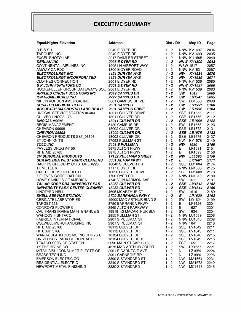
EXECUTIVE SUMMARY
TC2312585.1s EXECUTIVE SUMMARY 52
PageMap IDDist / Dir Address Equal/Higher Elevation ____________________ ________ ____________________
2034KV1497NNW1 - 2 2040 E DYER RD D R S S-12035KV1499NNW1 - 2 2040 E DYER RD TARGHEE INC2040KU1505NNW1 - 2 2917 DAIMLER STREET EXCEL PHOTO LAB2043KV1509NNW1 - 2 2036 E DYER RD DERLAN INC20571517WSW1 - 2 19051 N AIRPORT WAY CONTINENTAL AIRLINES INC2067KV1531NNW1 - 2 1800 E DYER ROAD AMWAY CA RDC2070KY1534NW1 - 2 1121 DURYEA AVE ELECTROLURGY INC2071KY1535NW1 - 2 1121 DURYEA AVE. ELECTROLURGY INCORPORATED2080KV1536NNW1 - 2 2001 E DYER RD CLOTHES CONNECTION2080KV1537NNW1 - 2 2001 E DYER RD B P JOHN FURNITURE CO2083KV1539NNW1 - 2 2001 E DYER RD ROCKEFELLER GROUP GATEWAYS SOL20891543SW1 - 2 2649 CAMPUS DR APPLIED CIRCUIT SOLUTIONS INC2095LB1547SW1 - 2 2727 CAMPUS DR ICN BIOMEDICALS INC2098LD1550SW1 - 2 2601 CAMPUS DRIVE NIHON KOHDEN AMERICA, INC.2100LD1551SW1 - 2 2601 CAMPUS SCRATCH MEDICAL BLDG2104LD1552SW1 - 2 2601 CAMPUS DRIVE ACCUPATH DIAGNOSTIC LABS DBA U2111LE1555SSE1 - 2 18011 CULVER DRIVE UNOCAL SERVICE STATION #64042112LE1556SSE1 - 2 18011 CULVER DR CULVER UNOCAL 762122LE1564SSE1 - 2 18011 CULVER DR UNOCAL #64042123LB1565SW1 - 2 5120 CAMPUS DR REGIS MANAGEMENT2131LE1573SSE1 - 2 18002 CULVER DR CHEVRON 966982133LE1575SSE1 - 2 18002 CULVER DR. CHEVRON 966982137LE1576SSE1 - 2 18002 CULVER DR CHEVRON PRODUCTS SS#_966982140KY1578NW1 - 2 17092 PULLMAN ST ST JOHN KNITS21501590NW1 - 2 2401 S PULLMAN TOLO INC2154LK1591E1 - 2 3875 ALTON PKWY PAYLESS DRUG #41502156LK1593E1 - 2 3875 ALTON PKWY RITE AID #57652158LL1595NW1 - 2 17132 PULLMAN STREET 3M SURGICAL PRODUCTS2171LK1601E1 - 2 3881 ALTON PKWY SUA INC DBA WEST PARK CLEANERS2174LM1604SSE1 - 2 18040 S CULVER DR RALPH’S GROCERY CO STORE #2262175LN1605NNW1 - 2 1717 E DYER RD 1X MOTEL 62178LM1608SSE1 - 2 18050 CULVER DRIVE ONE HOUR MOTO PHOTO2180LN1610NNW1 - 2 1700 DYER RD 7 ELEVEN CORPORATION21811611SW1 - 2 4740 VON KARMON AVE HOME SAVINGS OF AMERICA2182LM1613SSE1 - 2 18058 CULVER DR TAL AR CORP DBA UNIVERSITY PAR2186LM1614SSE1 - 2 18058 CULVER RD UNIVERSITY PARK CENTER CLEANER21891616SW1 - 2 4695 MCARTHUR CT LINOTYPD-HELL2192LP1620E1 - 2 3720 BARRANCA PKWY SHELL SERVICE STATION2199LQ1624SW1 - 2 19000 MAC ARTHUR BLVD S CERINATE LABRATORIES2201LP1626E1 - 2 3750 BARRANCA PKWY TARGET 33622011627E1 - 2 3965 ALTON PARKWAY CONROYS FLOWERS22041634SW1 - 2 19919 1/2 MACARTHUR BLV CAL TRANS IRVINE MAINTENANCE S2208LU1639NNW1 - 2 2855 PULLMAN ST WAHOOS FISHTACO2208LU1640NNW1 - 2 2801 S PULLMAN ST FABRICA INTERNATIONAL22101641NNW1 - 2 2901 S PULLMAN ST COLWELL MERCHANDISING INC2211LV1642SSE1 - 2 18112 CULVER DR RITE AID #57662211LV1643SSE1 - 2 18112 CULVER DR RITE AID 57662215LV1648SSE1 - 2 18124 CULVER DR WANDA CLARO DDS MS INC CHRYS C2215LV1649SSE1 - 2 18124 CULVER DR #G UNIVERSITY PARK CHIROPRACTIC22171651ESE1 - 2 3090 MAIN ST SAP 121832 TEXACO SERVICE STATION2221LY1657SW1 - 2 4675 MAC ARTHUR COURT 1X THE IRVINE CO2224LZ1659N1 - 2 2001 E CARNEGIE AVE MITSHIBISHI CONSUMER ELECTR OF2226LZ1660N1 - 2 2001 CARNEGIE RD BRASS TECH INC2231MA1664NW1 - 2 3300 S STANDARD ST EMERSON ELECTRIC CO2240MA1673NW1 - 2 3240 S STANDARD ST RESIDENTIAL ELECTRIC2245MC1676NW1 - 2 3230 S STANDARD NEWPORT METAL FINISHING
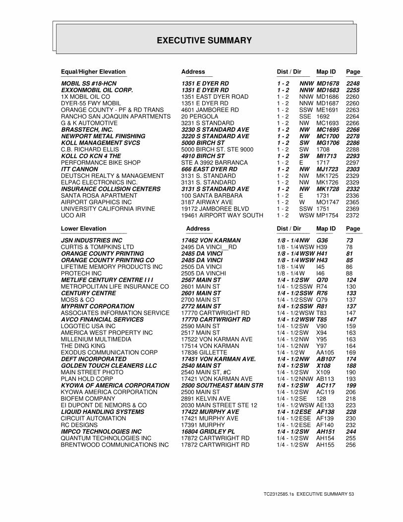
EXECUTIVE SUMMARY
TC2312585.1s EXECUTIVE SUMMARY 53
PageMap IDDist / Dir Address Equal/Higher Elevation ____________________ ________ ____________________
2248MD1678NNW1 - 2 1351 E DYER RD MOBIL SS #18-HCN2255MD1683NNW1 - 2 1351 E DYER RD EXXONMOBIL OIL CORP.2260MD1686NNW1 - 2 1351 EAST DYER ROAD 1X MOBIL OIL CO2260MD1687NNW1 - 2 1351 E DYER RD DYER-55 FWY MOBIL2263ME1691SSW1 - 2 4601 JAMBOREE RD ORANGE COUNTY - PF & RD TRANS 22641692SSE1 - 2 20 PERGOLA RANCHO SAN JOAQUIN APARTMENTS2266MC1693NW1 - 2 3231 S STANDARD G & K AUTOMOTIVE2266MC1695NW1 - 2 3230 S STANDARD AVE BRASSTECH, INC.2278MC1700NW1 - 2 3220 S STANDARD AVE NEWPORT METAL FINISHING2286MG1706SW1 - 2 5000 BIRCH ST KOLL MANAGEMENT SVCS22881708SW1 - 2 5000 BIRCH ST. STE 9000 C.B. RICHARD ELLIS2293MI1713SW1 - 2 4910 BIRCH ST KOLL CO KCN 4 THE22971717E1 - 2 STE A 3992 BARRANCA PERFORMANCE BIKE SHOP2303MJ1723NW1 - 2 666 EAST DYER RD ITT CANNON2329MK1725NW1 - 2 3131 S. STANDARD DEUTSCH REALTY & MANAGEMENT2329MK1726NW1 - 2 3131 S. STANDARD ELPAC ELECTRONICS INC.2332MK1728NW1 - 2 3131 S STANDARD AVE INSURANCE COLLISION CENTERS23361731E1 - 2 100 SANTA BARBARA SANTA ROSA APARTMENT2365MO1747W1 - 2 3187 AIRWAY AVE AIRPORT GRAPHICS INC23691751SSW1 - 2 19172 JAMBOREE BLVD UNIVERSITY CALIFORNIA IRVINE2372MP1754WSW1 - 2 19461 AIRPORT WAY SOUTH UCO AIR
PageMap IDDist / Dir Address Lower Elevation ____________________ ________ ____________________
73G36NW1/8 - 1/4 17462 VON KARMAN JSN INDUSTRIES INC78H39WSW1/8 - 1/4 2495 DA VINCI__RD CURTIS & TOMPKINS LTD81H41WSW1/8 - 1/4 2485 DA VINCI ORANGE COUNTY PRINTING85H43WSW1/8 - 1/4 2485 DA VINCI ORANGE COUNTY PRINTING CO86I45W1/8 - 1/4 2505 DA VINCI LIFETIME MEMORY PRODUCTS INC88I46W1/8 - 1/4 2505 DA VINCHI PROTECH INC124Q70SW1/4 - 1/2 2567 MAIN ST METLIFE CENTURY CENTRE I I I130R74SSW1/4 - 1/2 2601 MAIN ST METROPOLITAN LIFE INSURANCE CO133R76SSW1/4 - 1/2 2601 MAIN ST CENTURY CENTRE137Q79SSW1/4 - 1/2 2700 MAIN ST MOSS & CO137R81SSW1/4 - 1/2 2772 MAIN ST MYPRINT CORPORATION147T83WSW1/4 - 1/2 17770 CARTWRIGHT RD ASSOCIATES INFORMATION SERVICE147T85WSW1/4 - 1/2 17770 CARTWRIGHT RD AVCO FINANCIAL SERVICES159V90SW1/4 - 1/2 2590 MAIN ST LOGOTEC USA INC163X94SW1/4 - 1/2 2517 MAIN ST AMERICA WEST PROPERTY INC163Y95NW1/4 - 1/2 17522 VON KARMAN AVE MILLENIUM MULTIMEDIA164Y97NW1/4 - 1/2 17514 VON KARMAN THE DING KING169AA105W1/4 - 1/2 17836 GILLETTE EXODUS COMMUNICATION CORP174AB107NW1/4 - 1/2 17451 VON KARMAN AVE. DEFT INCORPORATED188X108SW1/4 - 1/2 2540 MAIN ST GOLDEN TOUCH CLEANERS LLC190X109SW1/4 - 1/2 2540 MAIN ST, #C MAIN STREET PHOTO193AB113NNW1/4 - 1/2 17421 VON KARMAN AVE PLAN HOLD CORP199AC117SW1/4 - 1/2 2500 SOUTHEAST MAIN STR KYOWA OF AMERICA CORPORATION206AC119SW1/4 - 1/2 2500 MAIN ST KYOWA AMERICA CORPORATION218128SE1/4 - 1/2 2891 KELVIN AVE BIOFEM COMPANY223AE133WSW1/4 - 1/2 2030 MAIN STREET STE 12 EI DUPONT DE NEMORS & CO228AF138ESE1/4 - 1/2 17422 MURPHY AVE LIQUID HANDLING SYSTEMS230AF139ESE1/4 - 1/2 17421 MURPHY AVE CIRCUIT AUTOMATION232AF140ESE1/4 - 1/2 17391 MURPHY RC DESIGNS244AH151SW1/4 - 1/2 16804 GRIDLEY PL IMPCO TECHNOLOGIES INC255AH154SW1/4 - 1/2 17872 CARTWRIGHT RD QUANTUM TECHNOLOGIES INC256AH155SW1/4 - 1/2 17872 CARTWRIGHT RD BRENTWOOD COMMUNICATIONS INC
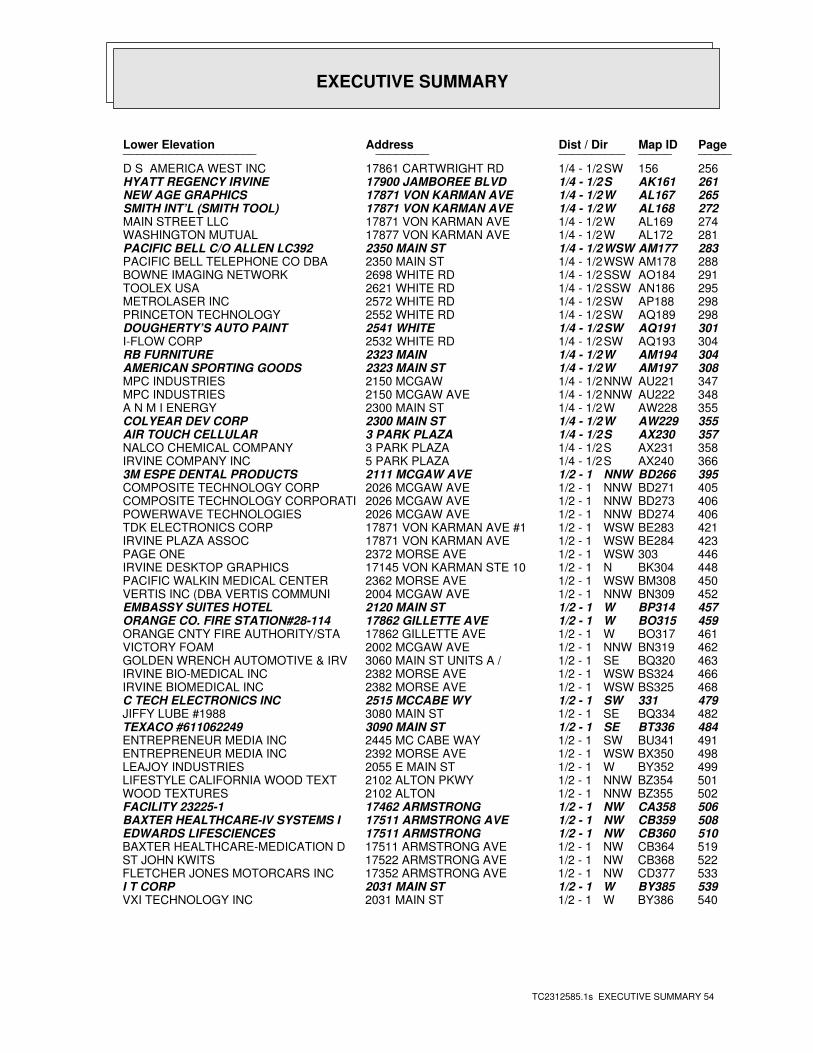
EXECUTIVE SUMMARY
TC2312585.1s EXECUTIVE SUMMARY 54
PageMap IDDist / Dir Address Lower Elevation ____________________ ________ ____________________
256156SW1/4 - 1/2 17861 CARTWRIGHT RD D S AMERICA WEST INC261AK161S1/4 - 1/2 17900 JAMBOREE BLVD HYATT REGENCY IRVINE265AL167W1/4 - 1/2 17871 VON KARMAN AVE NEW AGE GRAPHICS272AL168W1/4 - 1/2 17871 VON KARMAN AVE SMITH INT’L (SMITH TOOL)274AL169W1/4 - 1/2 17871 VON KARMAN AVE MAIN STREET LLC281AL172W1/4 - 1/2 17877 VON KARMAN AVE WASHINGTON MUTUAL283AM177WSW1/4 - 1/2 2350 MAIN ST PACIFIC BELL C/O ALLEN LC392288AM178WSW1/4 - 1/2 2350 MAIN ST PACIFIC BELL TELEPHONE CO DBA 291AO184SSW1/4 - 1/2 2698 WHITE RD BOWNE IMAGING NETWORK295AN186SSW1/4 - 1/2 2621 WHITE RD TOOLEX USA298AP188SW1/4 - 1/2 2572 WHITE RD METROLASER INC298AQ189SW1/4 - 1/2 2552 WHITE RD PRINCETON TECHNOLOGY301AQ191SW1/4 - 1/2 2541 WHITE DOUGHERTY’S AUTO PAINT304AQ193SW1/4 - 1/2 2532 WHITE RD I-FLOW CORP304AM194W1/4 - 1/2 2323 MAIN RB FURNITURE308AM197W1/4 - 1/2 2323 MAIN ST AMERICAN SPORTING GOODS347AU221NNW1/4 - 1/2 2150 MCGAW MPC INDUSTRIES348AU222NNW1/4 - 1/2 2150 MCGAW AVE MPC INDUSTRIES355AW228W1/4 - 1/2 2300 MAIN ST A N M I ENERGY355AW229W1/4 - 1/2 2300 MAIN ST COLYEAR DEV CORP357AX230S1/4 - 1/2 3 PARK PLAZA AIR TOUCH CELLULAR358AX231S1/4 - 1/2 3 PARK PLAZA NALCO CHEMICAL COMPANY366AX240S1/4 - 1/2 5 PARK PLAZA IRVINE COMPANY INC395BD266NNW1/2 - 1 2111 MCGAW AVE 3M ESPE DENTAL PRODUCTS405BD271NNW1/2 - 1 2026 MCGAW AVE COMPOSITE TECHNOLOGY CORP406BD273NNW1/2 - 1 2026 MCGAW AVE COMPOSITE TECHNOLOGY CORPORATI406BD274NNW1/2 - 1 2026 MCGAW AVE POWERWAVE TECHNOLOGIES421BE283WSW1/2 - 1 17871 VON KARMAN AVE #1 TDK ELECTRONICS CORP423BE284WSW1/2 - 1 17871 VON KARMAN AVE IRVINE PLAZA ASSOC446303WSW1/2 - 1 2372 MORSE AVE PAGE ONE448BK304N1/2 - 1 17145 VON KARMAN STE 10 IRVINE DESKTOP GRAPHICS450BM308WSW1/2 - 1 2362 MORSE AVE PACIFIC WALKIN MEDICAL CENTER452BN309NNW1/2 - 1 2004 MCGAW AVE VERTIS INC (DBA VERTIS COMMUNI457BP314W1/2 - 1 2120 MAIN ST EMBASSY SUITES HOTEL459BO315W1/2 - 1 17862 GILLETTE AVE ORANGE CO. FIRE STATION#28-114461BO317W1/2 - 1 17862 GILLETTE AVE ORANGE CNTY FIRE AUTHORITY/STA462BN319NNW1/2 - 1 2002 MCGAW AVE VICTORY FOAM463BQ320SE1/2 - 1 3060 MAIN ST UNITS A / GOLDEN WRENCH AUTOMOTIVE & IRV466BS324WSW1/2 - 1 2382 MORSE AVE IRVINE BIO-MEDICAL INC468BS325WSW1/2 - 1 2382 MORSE AVE IRVINE BIOMEDICAL INC479331SW1/2 - 1 2515 MCCABE WY C TECH ELECTRONICS INC482BQ334SE1/2 - 1 3080 MAIN ST JIFFY LUBE #1988484BT336SE1/2 - 1 3090 MAIN ST TEXACO #611062249491BU341SW1/2 - 1 2445 MC CABE WAY ENTREPRENEUR MEDIA INC498BX350WSW1/2 - 1 2392 MORSE AVE ENTREPRENEUR MEDIA INC499BY352W1/2 - 1 2055 E MAIN ST LEAJOY INDUSTRIES501BZ354NNW1/2 - 1 2102 ALTON PKWY LIFESTYLE CALIFORNIA WOOD TEXT502BZ355NNW1/2 - 1 2102 ALTON WOOD TEXTURES506CA358NW1/2 - 1 17462 ARMSTRONG FACILITY 23225-1508CB359NW1/2 - 1 17511 ARMSTRONG AVE BAXTER HEALTHCARE-IV SYSTEMS I510CB360NW1/2 - 1 17511 ARMSTRONG EDWARDS LIFESCIENCES519CB364NW1/2 - 1 17511 ARMSTRONG AVE BAXTER HEALTHCARE-MEDICATION D522CB368NW1/2 - 1 17522 ARMSTRONG AVE ST JOHN KWITS533CD377NW1/2 - 1 17352 ARMSTRONG AVE FLETCHER JONES MOTORCARS INC539BY385W1/2 - 1 2031 MAIN ST I T CORP540BY386W1/2 - 1 2031 MAIN ST VXI TECHNOLOGY INC
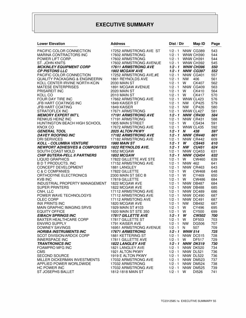
EXECUTIVE SUMMARY
TC2312585.1s EXECUTIVE SUMMARY 55
PageMap IDDist / Dir Address Lower Elevation ____________________ ________ ____________________
543CG389NNW1/2 - 1 17252 ARMSTRONG AVE ST PACIFIC COLOR CONNECTION544CH390WNW1/2 - 1 17602 ARMSTRONG MARINA CONTRACTORS INC544CH391WNW1/2 - 1 17602 ARMSTRONG POWER LIFT CORP.545CH392WNW1/2 - 1 17602 ARMSTRONG AVENUE ST. JOHN KNITS550CH396WNW1/2 - 1 17611 ARMSTRONG AVE MCKINLEY EQUIPMENT CORP552CG397NNW1/2 - 1 1902 MCGAW AVE CP PISTONS LLC557CG401NNW1/2 - 1 17252 ARMSTRONG AVE,#E PACIFIC COLOR CONNECTION561406NW1/2 - 1 1861 REYNOLDS AVE QUALITY PACKAGING & ENGINEERIN562CK407W1/2 - 1 2030 MAIN ST KOLL CENTER IRVINE NORTH-KCIN563CG409NNW1/2 - 1 1891 MCGAW AVENUE MATESE ENTERPRISES564CK410W1/2 - 1 2020 MAIN ST PRISAREIT INC570CK417W1/2 - 1 2010 MAIN ST KOLL CO576CL423WNW1/2 - 1 17662 ARMSTRONG AVE FOUR DAY TIRE INC579CP425NW1/2 - 1 1849 KAISER ST JFB HART COATINGS INC580CP426NW1/2 - 1 1849 KAISER JFB HART COATING581CL427WNW1/2 - 1 17671 ARMSTRONG STRATOFLEX INC584CR430NNW1/2 - 1 17191 ARMSTRONG AVE MEMORY EXPERT INT’L588CR431NNW1/2 - 1 17191 ARMSTRONG RENKUS HEINZ INC591CS434W1/2 - 1 1905 MAIN STREET HUNTINGTON BEACH HIGH SCHOOL592CL435WNW1/2 - 1 17672 ARMSTRONG AVE KNOX CO597438N1/2 - 1 2025 ALTON PKWY GENERAL TOOL601CR440NNW1/2 - 1 17182 ARMSTRONG AVE DAVEY ROOFING INC609CR442NNW1/2 - 1 17182 ARMSTRONG AVE DRI SERVICES610CS445W1/2 - 1 1980 MAIN ST KOLL - COLUMBIA VENTURE624CU451NW1/2 - 1 1822 REYNOLDS AVE. NEWPORT ADHESIVES & COMPOSITES631CQ453NNW1/2 - 1 1852 MCGAW SOUTH COAST MOLD632CQ454NNW1/2 - 1 1852 MCGAW CHIP BUTERA-PELL II PARTNERS639CW460W1/2 - 1 17822 GILLETTE AVE STE LIQUID GRAPHICS641462NNW1/2 - 1 17152 ARMSTRONG AVE B D T PRODUCTS. INC643CR463NNW1/2 - 1 1881 LANGLEY CONCEPT DEVELOPMENT648CW468W1/2 - 1 17822 GILLETTE C & C COMPANIES650CY469W1/2 - 1 2300 MAIN ST SEC B ORTHODYNE ELECTRONICS684CW486W1/2 - 1 17819 GILLETTE KVB INC684DB487NNW1/2 - 1 1822 MCGAW AVE INDUSTRIAL PROPERTY MANAGEMENT685DB488NNW1/2 - 1 1822 MCGAW AVE SUPER PRINTERS686DC489NNW1/2 - 1 17112 ARMSTRONG AVE CNH, LLC687DC490NNW1/2 - 1 17112 ARMSTRONG AVE POWER WAVE TECHNOLOGYS687DC491NNW1/2 - 1 17112 ARMSTONG AVE OLEC CORP687DB492NW1/2 - 1 1820 MCGAW AVE INX PRINTS INC695CY496W1/2 - 1 1929 MAIN ST #103 MAIN GRAPHIC IMAGING SRVS699CY500W1/2 - 1 1920 MAIN ST STE 350 EQUITY OFFICE700CW502W1/2 - 1 17817 GILLETTE AVE EIBACH SPRINGS INC703DF503W1/2 - 1 17817 GILLETTE ST BAXTER HEALTHCARE CORP707DG506NW1/2 - 1 1791 KAISER AVE ENVIRO SUPPLY709507N1/2 - 1 16951 ARMSTRONG AVENUE DOWNEY SAVINGS725514WNW1/2 - 1 17671 ARMSTRONG HORIBA INSTRUMENTS INC728DC515NNW1/2 - 1 1881 KETTERING ST SCOT DIVISION/ARDOX CORP729DF517W1/2 - 1 17811 GILLETTE AVE INNERSPACE INC730DK519NNW1/2 - 1 1822 LANGLEY AVE TRANTRONICS INC734DK520NNW1/2 - 1 1821 LANGLEY AVE FOAMPRO MFG INC736DL521NNW1/2 - 1 1921 ALTON PKWY CMS736DL522NNW1/2 - 1 1919 E ALTON PKWY SECOND SOURCE737DM523NNW1/2 - 1 17032 ARMSTRONG AVE MILLER DICKERMAN INVESTMENTS738DM524NNW1/2 - 1 17032 ARMSTRONG APPLIED POWER WORLDWIDE739DM525NNW1/2 - 1 17032 ARMSTRONG AVE HC POWER INC741DI526W1/2 - 1 1812-1818 MAIN ST ST JOSEPHS BALLET
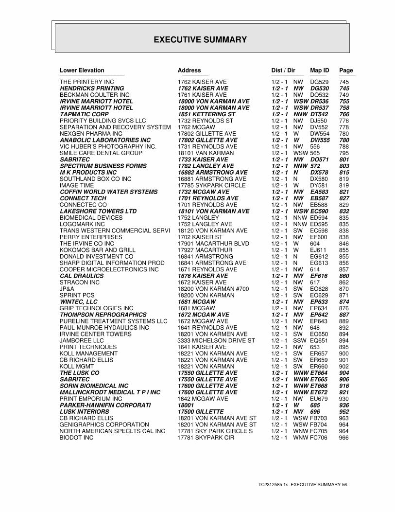
EXECUTIVE SUMMARY
TC2312585.1s EXECUTIVE SUMMARY 56
PageMap IDDist / Dir Address Lower Elevation ____________________ ________ ____________________
745DG529NW1/2 - 1 1762 KAISER AVE THE PRINTERY INC745DG530NW1/2 - 1 1762 KAISER AVE HENDRICKS PRINTING749DO532NW1/2 - 1 1761 KAISER AVE BECKMAN COULTER INC755DR536WSW1/2 - 1 18000 VON KARMAN AVE IRVINE MARRIOTT HOTEL758DR537WSW1/2 - 1 18000 VON KARMAN AVE IRVINE MARRIOTT HOTEL766DT542NNW1/2 - 1 1851 KETTERING ST TAPMATIC CORP776DJ550NW1/2 - 1 1732 REYNOLDS ST PRIORITY BUILDING SVCS LLC778DV552NW1/2 - 1 1762 MCGAW SEPARATION AND RECOVERY SYSTEM780DW554W1/2 - 1 17802 GILLETTE AVE NEXGEN PHARMA INC780DW555W1/2 - 1 17802 GILLETTE AVE ANABOLIC LABORATORIES INC788556NW1/2 - 1 1731 REYNOLDS AVE VIC HUBER’S PHOTOGRAPHY INC.795565WSW1/2 - 1 18101 VAN KARMAN SMILE CARE DENTAL GROUP801DO571NW1/2 - 1 1733 KAISER AVE SABRITEC803572NNW1/2 - 1 1782 LANGLEY AVE SPECTRUM BUSINESS FORMS815DX578N1/2 - 1 16882 ARMSTRONG AVE M K PRODUCTS INC819DX580N1/2 - 1 16881 ARMSTRONG AVE SOUTHLAND BOX CO INC819DY581W1/2 - 1 17785 SYKPARK CIRCLE IMAGE TIME821EA583NW1/2 - 1 1732 MCGAW AVE COFFIN WORLD WATER SYSTEMS827EB587NW1/2 - 1 1701 REYNOLDS AVE CONNECT TECH829EB588NW1/2 - 1 1701 REYNOLDS AVE CONNECTEC CO832EC590WSW1/2 - 1 18101 VON KARMAN AVE LAKESHORE TOWERS LTD835ED594NNW1/2 - 1 1752 LANGLEY BIOMEDICAL DEVICES835ED595NNW1/2 - 1 1752 LANGLEY AVE LOGOMARK INC838EC598SW1/2 - 1 18120 VON KARMAN AVE TRANS WESTERN COMMERCIAL SERVI838EF600NW1/2 - 1 1702 KAISER ST PERRY ENTERPRISES846604W1/2 - 1 17901 MACARTHUR BLVD THE IRVINE CO INC855EJ611W1/2 - 1 17927 MACARTHUR KOKOMOS BAR AND GRILL855EG612N1/2 - 1 16841 ARMSTRONG DONALD INVESTMENT CO856EG613N1/2 - 1 16841 ARMSTRONG AVE SHARP DIGITAL INFORMATION PROD857614NW1/2 - 1 1671 REYNOLDS AVE COOPER MICROELECTRONICS INC860EF616NW1/2 - 1 1676 KAISER AVE CAL DRAULICS862617NW1/2 - 1 1672 KAISER AVE STRACON INC870EO628SW1/2 - 1 18200 VON KARMAN #700 JP&A871EO629SW1/2 - 1 18200 VON KARMAN SPRINT PCS874EP633NW1/2 - 1 1681 MCGAW WINTEC, LLC876EP634NW1/2 - 1 1681 MCGAW GRIP TECHNOLOGIES INC887EP642NW1/2 - 1 1672 MCGAW AVE THOMPSON REPROGRAPHICS889EP643NW1/2 - 1 1672 MCGAW AVE PURELINE TREATMENT SYSTEMS LLC892648NW1/2 - 1 1641 REYNOLDS AVE PAUL-MUNROE HYDAULICS INC894EO650SW1/2 - 1 18201 VON KARMEN AVE IRVINE CENTER TOWERS894EQ651SSW1/2 - 1 3333 MICHELSON DRIVE ST JAMBOREE LLC895653NW1/2 - 1 1641 KAISER AVE PRINT TECHNIQUES900ER657SW1/2 - 1 18221 VON KARMAN AVE KOLL MANAGEMENT901ER659SW1/2 - 1 18221 VON KARMAN AVE CB RICHARD ELLIS902ER660SW1/2 - 1 18221 VON KARMAN KOLL MGMT904ET664WNW1/2 - 1 17550 GILLETTE AVE THE LUSK CO906ET665WNW1/2 - 1 17550 GILLETTE AVE SABRITEC916ET668WNW1/2 - 1 17600 GILLETTE AVE SORIN BIOMEDICAL INC921ET672WNW1/2 - 1 17600 GILLETTE AVE MALLINCKRODT MEDICAL T P I INC930EU679NW1/2 - 1 1642 MCGAW AVE PRINT EMPORIUM INC936685W1/2 - 1 18001 PARKER-HANNIFIN CORPORATI952696NW1/2 - 1 17500 GILLETTE LUSK INTERIORS963FB703WSW1/2 - 1 18201 VON KARMAN AVE ST CB RICHARD ELLIS964FB704WSW1/2 - 1 18201 VON KARMAN AVE ST GENIGRAPHICS CORPORATION964FC705WNW1/2 - 1 17781 SKY PARK CIRCLE S NORTH AMERICAN SPECLTS CAL INC966FC706WNW1/2 - 1 17781 SKYPARK CIR BIODOT INC
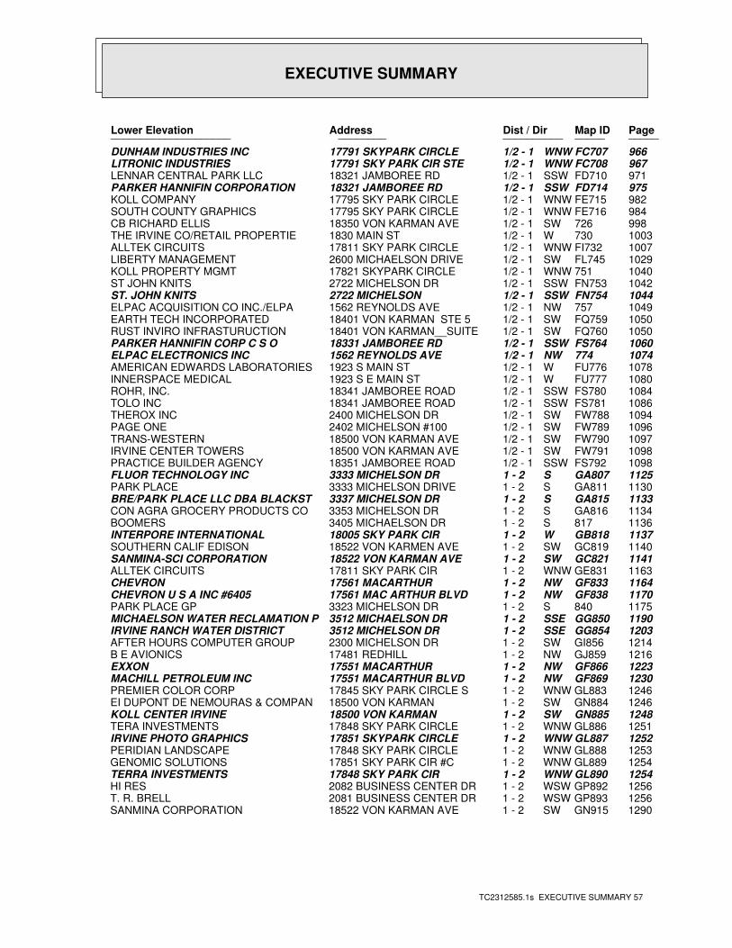
EXECUTIVE SUMMARY
TC2312585.1s EXECUTIVE SUMMARY 57
PageMap IDDist / Dir Address Lower Elevation ____________________ ________ ____________________
966FC707WNW1/2 - 1 17791 SKYPARK CIRCLE DUNHAM INDUSTRIES INC967FC708WNW1/2 - 1 17791 SKY PARK CIR STE LITRONIC INDUSTRIES971FD710SSW1/2 - 1 18321 JAMBOREE RD LENNAR CENTRAL PARK LLC975FD714SSW1/2 - 1 18321 JAMBOREE RD PARKER HANNIFIN CORPORATION982FE715WNW1/2 - 1 17795 SKY PARK CIRCLE KOLL COMPANY984FE716WNW1/2 - 1 17795 SKY PARK CIRCLE SOUTH COUNTY GRAPHICS998726SW1/2 - 1 18350 VON KARMAN AVE CB RICHARD ELLIS1003730W1/2 - 1 1830 MAIN ST THE IRVINE CO/RETAIL PROPERTIE1007FI732WNW1/2 - 1 17811 SKY PARK CIRCLE ALLTEK CIRCUITS1029FL745SW1/2 - 1 2600 MICHAELSON DRIVE LIBERTY MANAGEMENT1040751WNW1/2 - 1 17821 SKYPARK CIRCLE KOLL PROPERTY MGMT1042FN753SSW1/2 - 1 2722 MICHELSON DR ST JOHN KNITS1044FN754SSW1/2 - 1 2722 MICHELSON ST. JOHN KNITS1049757NW1/2 - 1 1562 REYNOLDS AVE ELPAC ACQUISITION CO INC./ELPA1050FQ759SW1/2 - 1 18401 VON KARMAN STE 5 EARTH TECH INCORPORATED1050FQ760SW1/2 - 1 18401 VON KARMAN__SUITE RUST INVIRO INFRASTURUCTION1060FS764SSW1/2 - 1 18331 JAMBOREE RD PARKER HANNIFIN CORP C S O1074774NW1/2 - 1 1562 REYNOLDS AVE ELPAC ELECTRONICS INC1078FU776W1/2 - 1 1923 S MAIN ST AMERICAN EDWARDS LABORATORIES1080FU777W1/2 - 1 1923 S E MAIN ST INNERSPACE MEDICAL1084FS780SSW1/2 - 1 18341 JAMBOREE ROAD ROHR, INC.1086FS781SSW1/2 - 1 18341 JAMBOREE ROAD TOLO INC1094FW788SW1/2 - 1 2400 MICHELSON DR THEROX INC1096FW789SW1/2 - 1 2402 MICHELSON #100 PAGE ONE1097FW790SW1/2 - 1 18500 VON KARMAN AVE TRANS-WESTERN1098FW791SW1/2 - 1 18500 VON KARMAN AVE IRVINE CENTER TOWERS1098FS792SSW1/2 - 1 18351 JAMBOREE ROAD PRACTICE BUILDER AGENCY1125GA807S1 - 2 3333 MICHELSON DR FLUOR TECHNOLOGY INC1130GA811S1 - 2 3333 MICHELSON DRIVE PARK PLACE1133GA815S1 - 2 3337 MICHELSON DR BRE/PARK PLACE LLC DBA BLACKST1134GA816S1 - 2 3353 MICHELSON DR CON AGRA GROCERY PRODUCTS CO1136817S1 - 2 3405 MICHAELSON DR BOOMERS1137GB818W1 - 2 18005 SKY PARK CIR INTERPORE INTERNATIONAL1140GC819SW1 - 2 18522 VON KARMEN AVE SOUTHERN CALIF EDISON1141GC821SW1 - 2 18522 VON KARMAN AVE SANMINA-SCI CORPORATION1163GE831WNW1 - 2 17811 SKY PARK CIR ALLTEK CIRCUITS1164GF833NW1 - 2 17561 MACARTHUR CHEVRON1170GF838NW1 - 2 17561 MAC ARTHUR BLVD CHEVRON U S A INC #64051175840S1 - 2 3323 MICHELSON DR PARK PLACE GP1190GG850SSE1 - 2 3512 MICHAELSON DR MICHAELSON WATER RECLAMATION P1203GG854SSE1 - 2 3512 MICHELSON DR IRVINE RANCH WATER DISTRICT1214GI856SW1 - 2 2300 MICHELSON DR AFTER HOURS COMPUTER GROUP1216GJ859NW1 - 2 17481 REDHILL B E AVIONICS1223GF866NW1 - 2 17551 MACARTHUR EXXON1230GF869NW1 - 2 17551 MACARTHUR BLVD MACHILL PETROLEUM INC1246GL883WNW1 - 2 17845 SKY PARK CIRCLE S PREMIER COLOR CORP1246GN884SW1 - 2 18500 VON KARMAN EI DUPONT DE NEMOURAS & COMPAN1248GN885SW1 - 2 18500 VON KARMAN KOLL CENTER IRVINE1251GL886WNW1 - 2 17848 SKY PARK CIRCLE TERA INVESTMENTS1252GL887WNW1 - 2 17851 SKYPARK CIRCLE IRVINE PHOTO GRAPHICS1253GL888WNW1 - 2 17848 SKY PARK CIRCLE PERIDIAN LANDSCAPE1254GL889WNW1 - 2 17851 SKY PARK CIR #C GENOMIC SOLUTIONS1254GL890WNW1 - 2 17848 SKY PARK CIR TERRA INVESTMENTS1256GP892WSW1 - 2 2082 BUSINESS CENTER DR HI RES1256GP893WSW1 - 2 2081 BUSINESS CENTER DR T. R. BRELL1290GN915SW1 - 2 18522 VON KARMAN AVE SANMINA CORPORATION
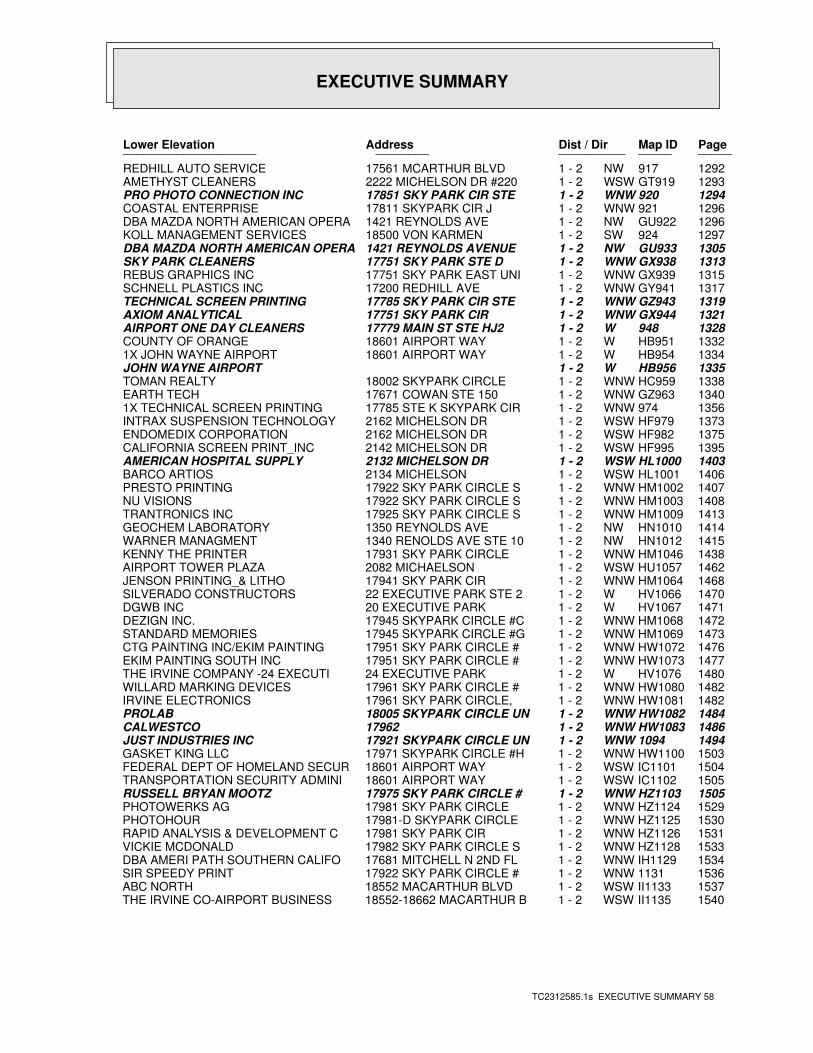
EXECUTIVE SUMMARY
TC2312585.1s EXECUTIVE SUMMARY 58
PageMap IDDist / Dir Address Lower Elevation ____________________ ________ ____________________
1292917NW1 - 2 17561 MCARTHUR BLVD REDHILL AUTO SERVICE1293GT919WSW1 - 2 2222 MICHELSON DR #220 AMETHYST CLEANERS1294920WNW1 - 2 17851 SKY PARK CIR STE PRO PHOTO CONNECTION INC1296921WNW1 - 2 17811 SKYPARK CIR J COASTAL ENTERPRISE1296GU922NW1 - 2 1421 REYNOLDS AVE DBA MAZDA NORTH AMERICAN OPERA1297924SW1 - 2 18500 VON KARMEN KOLL MANAGEMENT SERVICES1305GU933NW1 - 2 1421 REYNOLDS AVENUE DBA MAZDA NORTH AMERICAN OPERA1313GX938WNW1 - 2 17751 SKY PARK STE D SKY PARK CLEANERS1315GX939WNW1 - 2 17751 SKY PARK EAST UNI REBUS GRAPHICS INC1317GY941WNW1 - 2 17200 REDHILL AVE SCHNELL PLASTICS INC1319GZ943WNW1 - 2 17785 SKY PARK CIR STE TECHNICAL SCREEN PRINTING1321GX944WNW1 - 2 17751 SKY PARK CIR AXIOM ANALYTICAL1328948W1 - 2 17779 MAIN ST STE HJ2 AIRPORT ONE DAY CLEANERS1332HB951W1 - 2 18601 AIRPORT WAY COUNTY OF ORANGE1334HB954W1 - 2 18601 AIRPORT WAY 1X JOHN WAYNE AIRPORT1335HB956W1 - 2 JOHN WAYNE AIRPORT1338HC959WNW1 - 2 18002 SKYPARK CIRCLE TOMAN REALTY1340GZ963WNW1 - 2 17671 COWAN STE 150 EARTH TECH1356974WNW1 - 2 17785 STE K SKYPARK CIR 1X TECHNICAL SCREEN PRINTING1373HF979WSW1 - 2 2162 MICHELSON DR INTRAX SUSPENSION TECHNOLOGY1375HF982WSW1 - 2 2162 MICHELSON DR ENDOMEDIX CORPORATION1395HF995WSW1 - 2 2142 MICHELSON DR CALIFORNIA SCREEN PRINT_INC1403HL1000WSW1 - 2 2132 MICHELSON DR AMERICAN HOSPITAL SUPPLY1406HL1001WSW1 - 2 2134 MICHELSON BARCO ARTIOS1407HM1002WNW1 - 2 17922 SKY PARK CIRCLE S PRESTO PRINTING1408HM1003WNW1 - 2 17922 SKY PARK CIRCLE S NU VISIONS1413HM1009WNW1 - 2 17925 SKY PARK CIRCLE S TRANTRONICS INC1414HN1010NW1 - 2 1350 REYNOLDS AVE GEOCHEM LABORATORY1415HN1012NW1 - 2 1340 RENOLDS AVE STE 10 WARNER MANAGMENT1438HM1046WNW1 - 2 17931 SKY PARK CIRCLE KENNY THE PRINTER1462HU1057WSW1 - 2 2082 MICHAELSON AIRPORT TOWER PLAZA1468HM1064WNW1 - 2 17941 SKY PARK CIR JENSON PRINTING_& LITHO1470HV1066W1 - 2 22 EXECUTIVE PARK STE 2 SILVERADO CONSTRUCTORS1471HV1067W1 - 2 20 EXECUTIVE PARK DGWB INC1472HM1068WNW1 - 2 17945 SKYPARK CIRCLE #C DEZIGN INC.1473HM1069WNW1 - 2 17945 SKYPARK CIRCLE #G STANDARD MEMORIES1476HW1072WNW1 - 2 17951 SKY PARK CIRCLE # CTG PAINTING INC/EKIM PAINTING1477HW1073WNW1 - 2 17951 SKY PARK CIRCLE # EKIM PAINTING SOUTH INC1480HV1076W1 - 2 24 EXECUTIVE PARK THE IRVINE COMPANY -24 EXECUTI1482HW1080WNW1 - 2 17961 SKY PARK CIRCLE # WILLARD MARKING DEVICES1482HW1081WNW1 - 2 17961 SKY PARK CIRCLE, IRVINE ELECTRONICS1484HW1082WNW1 - 2 18005 SKYPARK CIRCLE UN PROLAB1486HW1083WNW1 - 2 17962 CALWESTCO14941094WNW1 - 2 17921 SKYPARK CIRCLE UN JUST INDUSTRIES INC1503HW1100WNW1 - 2 17971 SKYPARK CIRCLE #H GASKET KING LLC1504IC1101WSW1 - 2 18601 AIRPORT WAY FEDERAL DEPT OF HOMELAND SECUR1505IC1102WSW1 - 2 18601 AIRPORT WAY TRANSPORTATION SECURITY ADMINI1505HZ1103WNW1 - 2 17975 SKY PARK CIRCLE # RUSSELL BRYAN MOOTZ1529HZ1124WNW1 - 2 17981 SKY PARK CIRCLE PHOTOWERKS AG1530HZ1125WNW1 - 2 17981-D SKYPARK CIRCLE PHOTOHOUR1531HZ1126WNW1 - 2 17981 SKY PARK CIR RAPID ANALYSIS & DEVELOPMENT C1533HZ1128WNW1 - 2 17982 SKY PARK CIRCLE S VICKIE MCDONALD1534IH1129WNW1 - 2 17681 MITCHELL N 2ND FL DBA AMERI PATH SOUTHERN CALIFO15361131WNW1 - 2 17922 SKY PARK CIRCLE # SIR SPEEDY PRINT1537II1133WSW1 - 2 18552 MACARTHUR BLVD ABC NORTH1540II1135WSW1 - 2 18552-18662 MACARTHUR B THE IRVINE CO-AIRPORT BUSINESS
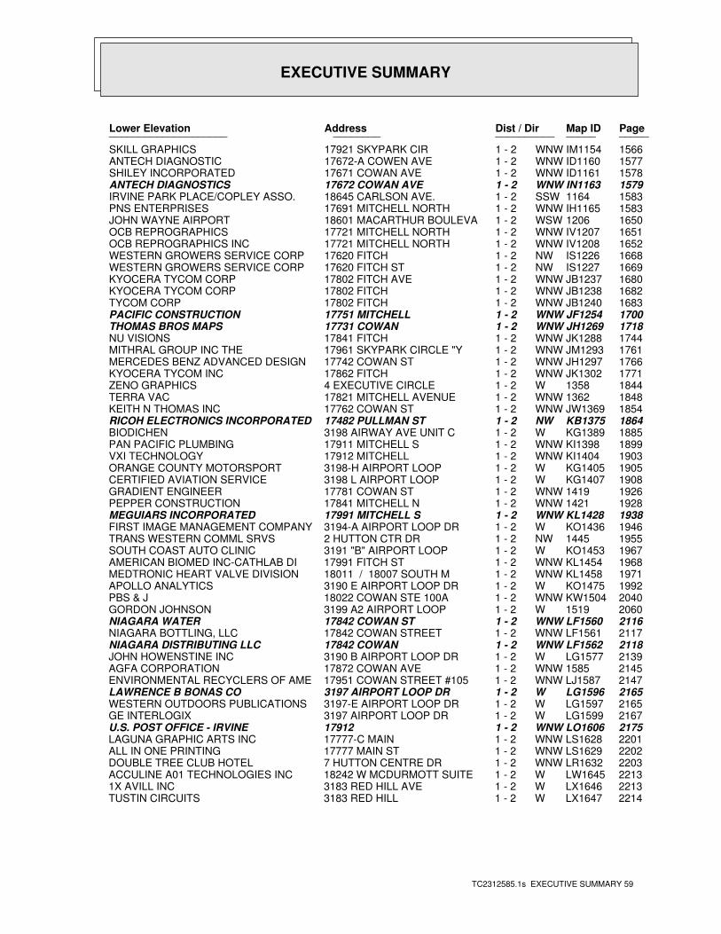
EXECUTIVE SUMMARY
TC2312585.1s EXECUTIVE SUMMARY 59
PageMap IDDist / Dir Address Lower Elevation ____________________ ________ ____________________
1566IM1154WNW1 - 2 17921 SKYPARK CIR SKILL GRAPHICS1577ID1160WNW1 - 2 17672-A COWEN AVE ANTECH DIAGNOSTIC1578ID1161WNW1 - 2 17671 COWAN AVE SHILEY INCORPORATED1579IN1163WNW1 - 2 17672 COWAN AVE ANTECH DIAGNOSTICS15831164SSW1 - 2 18645 CARLSON AVE. IRVINE PARK PLACE/COPLEY ASSO.1583IH1165WNW1 - 2 17691 MITCHELL NORTH PNS ENTERPRISES16501206WSW1 - 2 18601 MACARTHUR BOULEVA JOHN WAYNE AIRPORT1651IV1207WNW1 - 2 17721 MITCHELL NORTH OCB REPROGRAPHICS1652IV1208WNW1 - 2 17721 MITCHELL NORTH OCB REPROGRAPHICS INC1668IS1226NW1 - 2 17620 FITCH WESTERN GROWERS SERVICE CORP1669IS1227NW1 - 2 17620 FITCH ST WESTERN GROWERS SERVICE CORP1680JB1237WNW1 - 2 17802 FITCH AVE KYOCERA TYCOM CORP1682JB1238WNW1 - 2 17802 FITCH KYOCERA TYCOM CORP1683JB1240WNW1 - 2 17802 FITCH TYCOM CORP1700JF1254WNW1 - 2 17751 MITCHELL PACIFIC CONSTRUCTION1718JH1269WNW1 - 2 17731 COWAN THOMAS BROS MAPS1744JK1288WNW1 - 2 17841 FITCH NU VISIONS1761JM1293WNW1 - 2 17961 SKYPARK CIRCLE "Y MITHRAL GROUP INC THE1766JH1297WNW1 - 2 17742 COWAN ST MERCEDES BENZ ADVANCED DESIGN 1771JK1302WNW1 - 2 17862 FITCH KYOCERA TYCOM INC18441358W1 - 2 4 EXECUTIVE CIRCLE ZENO GRAPHICS18481362WNW1 - 2 17821 MITCHELL AVENUE TERRA VAC1854JW1369WNW1 - 2 17762 COWAN ST KEITH N THOMAS INC1864KB1375NW1 - 2 17482 PULLMAN ST RICOH ELECTRONICS INCORPORATED1885KG1389W1 - 2 3198 AIRWAY AVE UNIT C BIODICHEN1899KI1398WNW1 - 2 17911 MITCHELL S PAN PACIFIC PLUMBING1903KI1404WNW1 - 2 17912 MITCHELL VXI TECHNOLOGY1905KG1405W1 - 2 3198-H AIRPORT LOOP ORANGE COUNTY MOTORSPORT1908KG1407W1 - 2 3198 L AIRPORT LOOP CERTIFIED AVIATION SERVICE19261419WNW1 - 2 17781 COWAN ST GRADIENT ENGINEER19281421WNW1 - 2 17841 MITCHELL N PEPPER CONSTRUCTION1938KL1428WNW1 - 2 17991 MITCHELL S MEGUIARS INCORPORATED1946KO1436W1 - 2 3194-A AIRPORT LOOP DR FIRST IMAGE MANAGEMENT COMPANY19551445NW1 - 2 2 HUTTON CTR DR TRANS WESTERN COMML SRVS1967KO1453W1 - 2 3191 "B" AIRPORT LOOP SOUTH COAST AUTO CLINIC1968KL1454WNW1 - 2 17991 FITCH ST AMERICAN BIOMED INC-CATHLAB DI1971KL1458WNW1 - 2 18011 / 18007 SOUTH M MEDTRONIC HEART VALVE DIVISION1992KO1475W1 - 2 3190 E AIRPORT LOOP DR APOLLO ANALYTICS2040KW1504WNW1 - 2 18022 COWAN STE 100A PBS & J20601519W1 - 2 3199 A2 AIRPORT LOOP GORDON JOHNSON2116LF1560WNW1 - 2 17842 COWAN ST NIAGARA WATER2117LF1561WNW1 - 2 17842 COWAN STREET NIAGARA BOTTLING, LLC2118LF1562WNW1 - 2 17842 COWAN NIAGARA DISTRIBUTING LLC2139LG1577W1 - 2 3190 B AIRPORT LOOP DR JOHN HOWENSTINE INC21451585WNW1 - 2 17872 COWAN AVE AGFA CORPORATION2147LJ1587WNW1 - 2 17951 COWAN STREET #105 ENVIRONMENTAL RECYCLERS OF AME2165LG1596W1 - 2 3197 AIRPORT LOOP DR LAWRENCE B BONAS CO2165LG1597W1 - 2 3197-E AIRPORT LOOP DR WESTERN OUTDOORS PUBLICATIONS2167LG1599W1 - 2 3197 AIRPORT LOOP DR GE INTERLOGIX2175LO1606WNW1 - 2 17912 U.S. POST OFFICE - IRVINE2201LS1628WNW1 - 2 17777-C MAIN LAGUNA GRAPHIC ARTS INC2202LS1629WNW1 - 2 17777 MAIN ST ALL IN ONE PRINTING2203LR1632WNW1 - 2 7 HUTTON CENTRE DR DOUBLE TREE CLUB HOTEL2213LW1645W1 - 2 18242 W MCDURMOTT SUITE ACCULINE A01 TECHNOLOGIES INC2213LX1646W1 - 2 3183 RED HILL AVE 1X AVILL INC2214LX1647W1 - 2 3183 RED HILL TUSTIN CIRCUITS
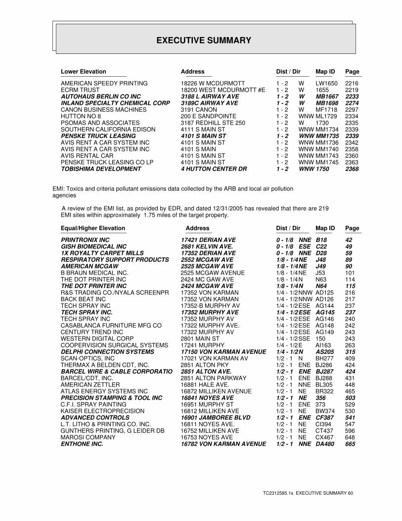
EXECUTIVE SUMMARY
TC2312585.1s EXECUTIVE SUMMARY 60
PageMap IDDist / Dir Address Lower Elevation ____________________ ________ ____________________
2216LW1650W1 - 2 18226 W MCDURMOTT AMERICAN SPEEDY PRINTING22191655W1 - 2 18200 WEST MCDURMOTT #E ECRM TRUST2233MB1667W1 - 2 3188 L AIRWAY AVE AUTOHAUS BERLIN CO INC2274MB1698W1 - 2 3189C AIRWAY AVE INLAND SPECIALTY CHEMICAL CORP2297MF1718W1 - 2 3191 CANON CANON BUSINESS MACHINES2334ML1729WNW1 - 2 200 E SANDPOINTE HUTTON NO 823351730W1 - 2 3187 REDHILL STE 250 PSOMAS AND ASSOCIATES2339MM1734WNW1 - 2 4111 S MAIN ST SOUTHERN CALIFORNIA EDISON2339MM1735WNW1 - 2 4101 S MAIN ST PENSKE TRUCK LEASING2342MM1736WNW1 - 2 4101 S MAIN ST AVIS RENT A CAR SYSTEM INC2358MM1740WNW1 - 2 4101 S MAIN AVIS RENT A CAR SYSTEM INC2360MM1743WNW1 - 2 4101 S MAIN ST AVIS RENTAL CAR2363MM1745WNW1 - 2 4101 S MAIN ST PENSKE TRUCK LEASING CO LP23681750WNW1 - 2 4 HUTTON CENTER DR TOBISHIMA DEVELOPMENT
EMI: Toxics and criteria pollutant emissions data collected by the ARB and local air pollutionagencies
A review of the EMI list, as provided by EDR, and dated 12/31/2005 has revealed that there are 219 EMI sites within approximately 1.75 miles of the target property.
PageMap IDDist / Dir Address Equal/Higher Elevation ____________________ ________ ____________________
42B18NNE0 - 1/8 17421 DERIAN AVE PRINTRONIX INC49C22ESE0 - 1/8 2681 KELVIN AVE. GISH BIOMEDICAL INC59D28NNE0 - 1/8 17352 DERIAN AVE 1X ROYALTY CARPET MILLS89J48NE1/8 - 1/4 2552 MCGAW AVE RESPIRATORY SUPPORT PRODUCTS90J49NE1/8 - 1/4 2525 MCGAW AVE AMERICAN MCGAW101J53NE1/8 - 1/4 2525 MCGAW AVENUE B BRAUN MEDICAL INC.114N63N1/8 - 1/4 2424 MC GAW AVE THE DOT PRINTER INC115N64N1/8 - 1/4 2424 MCGAW AVE THE DOT PRINTER INC216AD125NNW1/4 - 1/2 17352 VON KARMAN R&S TRADING CO./NYALA SCREENPR217AD126NNW1/4 - 1/2 17352 VON KARMAN BACK BEAT INC237AG144ESE1/4 - 1/2 17352-B MURPHY AV TECH SPRAY INC237AG145ESE1/4 - 1/2 17352 MURPHY AVE TECH SPRAY INC.240AG146ESE1/4 - 1/2 17352 MURPHY AV TECH SPRAY INC242AG148ESE1/4 - 1/2 17322 MURPHY AVE. CASABLANCA FURNITURE MFG CO243AG149ESE1/4 - 1/2 17322 MURPHY AV CENTURY TREND INC243150SSE1/4 - 1/2 2801 MAIN ST WESTERN DIGITAL CORP263AI163E1/4 - 1/2 17241 MURPHY COOPERVISION SURGICAL SYSTEMS315AS205N1/4 - 1/2 17150 VON KARMAN AVENUE DELPHI CONNECTION SYSTEMS409BH277N1/2 - 1 17021 VON KARMAN AV SCAN-OPTICS, INC424BJ286ENE1/2 - 1 2851 ALTON PKY THERMAX A BELDEN CDT, INC.424BJ287ENE1/2 - 1 2851 ALTON AVE. BARCEL WIRE & CABLE CORPORATIO431BJ288ENE1/2 - 1 2851 ALTON PARKWAY BARCEL/CDT, INC.448BL305NNE1/2 - 1 16881 HALE AVE. AMERICAN ZETTLER465BR322NE1/2 - 1 16872 MILLIKEN AVENUE ATLAS ENERGY SYSTEMS INC503356NE1/2 - 1 16841 NOYES AVE PRECISION STAMPING & TOOL INC529373ENE1/2 - 1 16951 MURPHY ST C.F.I. SPRAY PAINTING530BW374NE1/2 - 1 16812 MILLIKEN AVE KAISER ELECTROPRECISION541CF387ENE1/2 - 1 16901 JAMBOREE BLVD ADVANCED CONTROLS547CI394NE1/2 - 1 16811 NOYES AVE. L.T. LITHO & PRINTING CO. INC.596CT437NE1/2 - 1 16752 MILLIKEN AVE GUNTHERS PRINTING, G LEIDER DB648CX467NE1/2 - 1 16753 NOYES AVE MAROSI COMPANY665DA480NNE1/2 - 1 16782 VON KARMAN AVENUE ENTHONE INC.
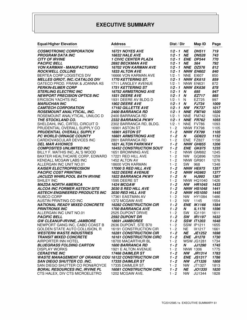
EXECUTIVE SUMMARY
TC2312585.1s EXECUTIVE SUMMARY 61
PageMap IDDist / Dir Address Equal/Higher Elevation ____________________ ________ ____________________
719DH511NE1/2 - 1 16721 NOYES AVE COSMOTRONIC CORPORATION743DN528NE1/2 - 1 16632 HALE AVE PROGRAM DATA INC770DP544ENE1/2 - 1 1 CIVIC CENTER PLAZA CITY OF IRVINE792564NE1/2 - 1 2692 BECKMAN AVE PACIFIC BELL812DZ576NNE1/2 - 1 16702 VON KARMAN AVE VON KARMAN - MANUFACTURING840EH602NNW1/2 - 1 1833 ALTON AVE ROCKWELL COLLINS850EI607NNE1/2 - 1 16666 VON KARMAN AVE BERTEA CORP LOGISTICS DIV859EK615NNW1/2 - 1 1770 KETTERING ST. MELLES GRIOT, INC./CATALOG DIV872EN631NNW1/2 - 1 1711 LANGLEY AVENUE GATECO PROD. FRANK & JOANNA AS878EK636NNW1/2 - 1 1751 KETTERING ST PERKIN-ELMER CORP947695N1/2 - 1 16752 ARMSTRONG AVE STERLING ELECTRIC INC985EZ717N1/2 - 1 1931 DEERE AVE NEWPORT PRECISION OPTICS INC997EZ725N1/2 - 1 1931 DEERE AV BLDG D ERICSON YACHTS INC1009FJ734N1/2 - 1 1902 DEERE AVE MARUCHAN INC1017FK737NW1/2 - 1 17192 GILLETTE AVE CAMTECH CORPORATION1020FM740NNE1/2 - 1 2400 BARRANCA RD ROSEMOUNT ANALYTICAL, INC.1024FM742NNE1/2 - 1 2400 BARRANCA RD ROSEMOUNT ANALYTICAL, UNILOC D1055FR762NNE1/2 - 1 2332 BARRANCA PKWY THE STOCKLAND CO.1093FV786NNE1/2 - 1 2302 BARRANCA RD, BLDG. SHELDAHL INC, CIRTEL CIRCUIT D1105FX798NNW1 - 2 16901 ASTON ST PRUDENTIAL OVERALL SUPPLY CO1105FX799NNW1 - 2 16901 ASTON ST PRUDENTIAL OVERALL SUPPLY1152GD823N1 - 2 16601 ARMSTRONG AVE PC WORLD ORNAGE COUNTY1158FZ827ENE1 - 2 2801 BARRANCA RD CARDIOVASCULAR DEVICES INC1206GH855NNW1 - 2 1621 ALTON PARKWAY DEL MAR AVIONICS1235GK875ENE1 - 2 16452 CONSTRUCTION SOUT COMPOSITES UNLIMITED INC1245GM882NNW1 - 2 1651 BROWNING AVE BILLY F. MATHIS INC.,AL’S WOOD1259GQ896NW1 - 2 17221 RED HILL AVE BAXTER HEALTHCARE CORP, EDWARD1276GR901NNW1 - 2 1452 ALTON AV KENDALL MCGAW LABS INC1348968SW1 - 2 18600 VON KARMAN ALLERGAN INC UNIT NO.011357HE975NNW1 - 2 17000 S RED HILL AVE KAISER ELECTROPRECISION1377HG983NNW1 - 2 1622 DEERE AVENUE PACIFIC COST PRINTING1387HJ993N1 - 2 1922 BARRANCA PKWY JACUZZI WHIRLPOOL BATH IRVINE1426HQ1040NNW1 - 2 1595 DEERE ST SHILEY INC1433HR1045NW1 - 2 1424 MCGAW MAZDA NORTH AMERICA1441HS1048NNW1 - 2 3030 S RED HILL AVE ALCOA INC FORMER ASTECH SITE1445HS1050NNW1 - 2 3030 RED HILL AVE ASTECH ENGINEERED PRODUCTS INC1486HY1084NW1 - 2 17361 EASTMAN AV RUBCO CORP15541145NW1 - 2 1372 MCGAW AVE AUSTIN PRINTING CO INC1584IK1166ENE1 - 2 16282 CONSTRUCTION CIR NATIONAL READY MIXED CONCRETE 1596IL1176N1 - 2 1700 BARRANCA AVE PRINTRONIX INC1611IQ1191SW1 - 2 2525 DUPONT DRIVE ALLERGAN INC UNIT NO.011632IR1197SW1 - 2 2592 DUPONT DR PACIFIC BELL1648IT1203SSW1 - 2 18691 JAMBOREE GW CLEANUP-IRVINE, JAMBORE1655IP1211SSW1 - 2 2636 DUPONT, STE B70 NEWPORT GANG INC, CABO COAST B1661IX1217NE1 - 2 16191 CONSTRUCTION CIR GOLDEN STATE AUTO COLLISION, R1698JE1252NE1 - 2 16281 CONSTRUCTION CIR WESTERN WASTE INDUSTRIES1730JI1278ENE1 - 2 16161 CONSTRUCTION CIRC TRANSIT MIXED CONCRETE1734JG1281WSW1 - 2 18700 MACARTHUR BL AIRPORTER INN HOTEL1745JJ1290N1 - 2 1600 BARRANCA RD BLUEGRASS FOLDING CARTON17751306NNW1 - 2 1921 E ALTON AVENUE DISPLAY WORKS1783JR1314NW1 - 2 17466 DAIMLER ST CERADYNE INC1786JS1317ENE1 - 2 16122 CONSTRUCTION CIR WASTE MANAGEMENT OF ORANGE COU1808JT1326NW1 - 2 17335 DAIMLER ST SAN DIEGO SHUTTER CO. INC.1813JT1327NW1 - 2 17335 DAIMLER ST. SAN DIEGO SHUTTER CO RON&ROYCE1820JO1335NE1 - 2 16081 CONSTRUCTION CIRC BORAL RESOURCES INC, IRVINE PL1828JU1344NW1 - 2 1202 MCGAW AVE. CTS HALEX, DIV CTS MICROELETRO
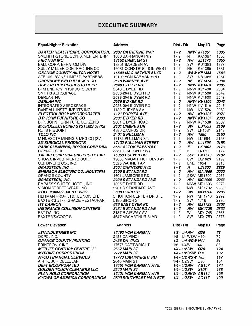
EXECUTIVE SUMMARY
TC2312585.1s EXECUTIVE SUMMARY 62
PageMap IDDist / Dir Address Equal/Higher Elevation ____________________ ________ ____________________
1835JY1351NNW1 - 2 2807 CATHERINE WAY BAXTER HEALTHCARE CORPORATION,1853KA1367N1 - 2 1600 BARRANCA PKY SMURFIT-STONE CONTAINER ENTERP1855JZ1370NW1 - 2 17152 DAIMLER ST FRICTION INC1877KD1383SW1 - 2 18851 BARDEEN AV BALL CORP, EFRATOM DIV1881KE1385NE1 - 2 16081 CONSTRUCTION WEST SULLY-MILLER CONTRACTING CO1884KF1388WSW1 - 2 18800 MAC ARTHUR BLVD ORANGE COUNTY HILTON HOTEL1981KR1466SW1 - 2 19100 VON KARMAN #150 ATRIUM IRVINE LIMITED PARTNERS1994KT1478NE1 - 2 2815 WARNER AVE GRONDORF FIELD BLACK & CO2005KV1484NNW1 - 2 2040 E DYER RD BFM ENERGY PRODUCTS COPR2034KV1498NNW1 - 2 2040 E DYER RD BFM ENERGY PRODUCTS CORP2042KV1506NNW1 - 2 2036-204 E DYER RD SMITHS AEROSPACE2043KV1508NNW1 - 2 2036-204 E DYER RD DERLAN INC2043KV1509NNW1 - 2 2036 E DYER RD DERLAN INC2046KV1510NNW1 - 2 2036-204 E DYER RD INTEGRATED AEROSPACE2062KY1526NW1 - 2 1132 DURYEA AV RANDALL INSTRUMENTS INC2071KY1535NW1 - 2 1121 DURYEA AVE. ELECTROLURGY INCORPORATED2080KV1537NNW1 - 2 2001 E DYER RD B P JOHN FURNITURE CO2082KV1538NNW1 - 2 2001 E DYER ROAD B. P. JOHN FURNITURE CO, ZENO2109LD1553SW1 - 2 2601 CAMPUS DR MICROELECTRONIC SYSTEMS DIVISI2143LH1581SW1 - 2 4880 CAMPUS DR R.J.’S RIB JOINT21501590NW1 - 2 2401 S PULLMAN TOLO INC2157LL1594NW1 - 2 17132 PULLMAN ST. MINNESOTA MINING & MFG CO (3M)2158LL1595NW1 - 2 17132 PULLMAN STREET 3M SURGICAL PRODUCTS2173LK1602E1 - 2 3881 ALTON PARKWAY PARK CLEANERS, ROYMA CORP DBA2174LK1603E1 - 2 3881-D ALTON PKWY ROYMA CORP2182LM1613SSE1 - 2 18058 CULVER DR TAL AR CORP DBA UNIVERSITY PAR2199LQ1623SW1 - 2 19000 MACARTHUR BLVD #1 SHUWA INVESTMENTS CORP22181654ENE1 - 2 3323 WARNER AV U.S. DIVERS CO., INC.2229LZ1663N1 - 2 2001 CARNEGIE AVE BRASSTECH INC2232MA1665NW1 - 2 3300 S STANDARD EMERSON ELECTRIC CO, INDUSTRIA2263ME1690SSW1 - 2 4601 JAMBOREE RD. ORANGE COUNTY2266MC1695NW1 - 2 3230 S STANDARD AVE BRASSTECH, INC.2272MD1696NNW1 - 2 1325 E DYER RD EMBASSY SUITES HOTEL, INC2283MC1702NW1 - 2 3201 S STANDARD AVE. VISION STREET WEAR, INC.2286MG1706SW1 - 2 5000 BIRCH ST KOLL MANAGEMENT SVCS2292MH1710NW1 - 2 5 HUTTON CENTER DR STE HEITMAN PROP LTD, ILLINOIS LTD22961716SW1 - 2 5180 BIRCH ST BAXTER’S #177, GRACE RESTAURAN2303MJ1723NW1 - 2 666 EAST DYER RD ITT CANNON2332MK1728NW1 - 2 3131 S STANDARD AVE INSURANCE COLLISION CENTERS2366MO1748W1 - 2 3187-B AIRWAY AV BATIDA INC2377MQ1759SW1 - 2 4647 MACARTHUR BLVD BAXTER’S/COCO’S
PageMap IDDist / Dir Address Lower Elevation ____________________ ________ ____________________
73G36NW1/8 - 1/4 17462 VON KARMAN JSN INDUSTRIES INC79H40WSW1/8 - 1/4 2485 DA VINCI OCPC, INC.81H41WSW1/8 - 1/4 2485 DA VINCI ORANGE COUNTY PRINTING8644W1/8 - 1/4 17575 CARTWRIGHT PRINTRONIX INC124Q70SW1/4 - 1/2 2567 MAIN ST METLIFE CENTURY CENTRE I I I137R81SSW1/4 - 1/2 2772 MAIN ST MYPRINT CORPORATION147T85WSW1/4 - 1/2 17770 CARTWRIGHT RD AVCO FINANCIAL SERVICES154U86SW1/4 - 1/2 2640 MAIN ST AIR TOUCH CELLULAR174AB107NW1/4 - 1/2 17451 VON KARMAN AVE. DEFT INCORPORATED188X108SW1/4 - 1/2 2540 MAIN ST GOLDEN TOUCH CLEANERS LLC195AB114NNW1/4 - 1/2 17421 VON KARMAN AVE PLAN HOLD CORPORATION199AC117SW1/4 - 1/2 2500 SOUTHEAST MAIN STR KYOWA OF AMERICA CORPORATION
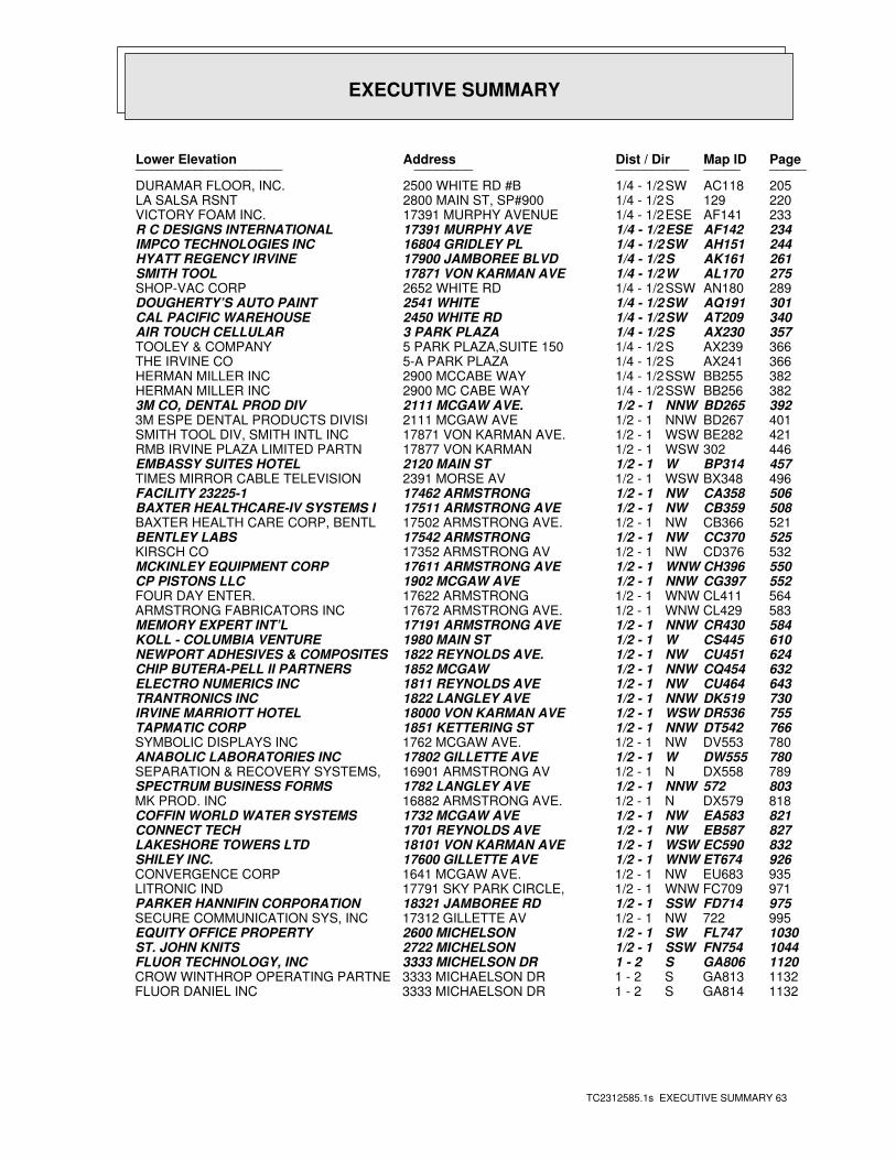
EXECUTIVE SUMMARY
TC2312585.1s EXECUTIVE SUMMARY 63
PageMap IDDist / Dir Address Lower Elevation ____________________ ________ ____________________
205AC118SW1/4 - 1/2 2500 WHITE RD #B DURAMAR FLOOR, INC.220129S1/4 - 1/2 2800 MAIN ST, SP#900 LA SALSA RSNT233AF141ESE1/4 - 1/2 17391 MURPHY AVENUE VICTORY FOAM INC.234AF142ESE1/4 - 1/2 17391 MURPHY AVE R C DESIGNS INTERNATIONAL244AH151SW1/4 - 1/2 16804 GRIDLEY PL IMPCO TECHNOLOGIES INC261AK161S1/4 - 1/2 17900 JAMBOREE BLVD HYATT REGENCY IRVINE275AL170W1/4 - 1/2 17871 VON KARMAN AVE SMITH TOOL289AN180SSW1/4 - 1/2 2652 WHITE RD SHOP-VAC CORP301AQ191SW1/4 - 1/2 2541 WHITE DOUGHERTY’S AUTO PAINT340AT209SW1/4 - 1/2 2450 WHITE RD CAL PACIFIC WAREHOUSE357AX230S1/4 - 1/2 3 PARK PLAZA AIR TOUCH CELLULAR366AX239S1/4 - 1/2 5 PARK PLAZA,SUITE 150 TOOLEY & COMPANY366AX241S1/4 - 1/2 5-A PARK PLAZA THE IRVINE CO382BB255SSW1/4 - 1/2 2900 MCCABE WAY HERMAN MILLER INC382BB256SSW1/4 - 1/2 2900 MC CABE WAY HERMAN MILLER INC392BD265NNW1/2 - 1 2111 MCGAW AVE. 3M CO, DENTAL PROD DIV401BD267NNW1/2 - 1 2111 MCGAW AVE 3M ESPE DENTAL PRODUCTS DIVISI421BE282WSW1/2 - 1 17871 VON KARMAN AVE. SMITH TOOL DIV, SMITH INTL INC446302WSW1/2 - 1 17877 VON KARMAN RMB IRVINE PLAZA LIMITED PARTN457BP314W1/2 - 1 2120 MAIN ST EMBASSY SUITES HOTEL496BX348WSW1/2 - 1 2391 MORSE AV TIMES MIRROR CABLE TELEVISION506CA358NW1/2 - 1 17462 ARMSTRONG FACILITY 23225-1508CB359NW1/2 - 1 17511 ARMSTRONG AVE BAXTER HEALTHCARE-IV SYSTEMS I521CB366NW1/2 - 1 17502 ARMSTRONG AVE. BAXTER HEALTH CARE CORP, BENTL525CC370NW1/2 - 1 17542 ARMSTRONG BENTLEY LABS532CD376NW1/2 - 1 17352 ARMSTRONG AV KIRSCH CO550CH396WNW1/2 - 1 17611 ARMSTRONG AVE MCKINLEY EQUIPMENT CORP552CG397NNW1/2 - 1 1902 MCGAW AVE CP PISTONS LLC564CL411WNW1/2 - 1 17622 ARMSTRONG FOUR DAY ENTER.583CL429WNW1/2 - 1 17672 ARMSTRONG AVE. ARMSTRONG FABRICATORS INC584CR430NNW1/2 - 1 17191 ARMSTRONG AVE MEMORY EXPERT INT’L610CS445W1/2 - 1 1980 MAIN ST KOLL - COLUMBIA VENTURE624CU451NW1/2 - 1 1822 REYNOLDS AVE. NEWPORT ADHESIVES & COMPOSITES632CQ454NNW1/2 - 1 1852 MCGAW CHIP BUTERA-PELL II PARTNERS643CU464NW1/2 - 1 1811 REYNOLDS AVE ELECTRO NUMERICS INC730DK519NNW1/2 - 1 1822 LANGLEY AVE TRANTRONICS INC755DR536WSW1/2 - 1 18000 VON KARMAN AVE IRVINE MARRIOTT HOTEL766DT542NNW1/2 - 1 1851 KETTERING ST TAPMATIC CORP780DV553NW1/2 - 1 1762 MCGAW AVE. SYMBOLIC DISPLAYS INC780DW555W1/2 - 1 17802 GILLETTE AVE ANABOLIC LABORATORIES INC789DX558N1/2 - 1 16901 ARMSTRONG AV SEPARATION & RECOVERY SYSTEMS,803572NNW1/2 - 1 1782 LANGLEY AVE SPECTRUM BUSINESS FORMS818DX579N1/2 - 1 16882 ARMSTRONG AVE. MK PROD. INC821EA583NW1/2 - 1 1732 MCGAW AVE COFFIN WORLD WATER SYSTEMS827EB587NW1/2 - 1 1701 REYNOLDS AVE CONNECT TECH832EC590WSW1/2 - 1 18101 VON KARMAN AVE LAKESHORE TOWERS LTD926ET674WNW1/2 - 1 17600 GILLETTE AVE SHILEY INC.935EU683NW1/2 - 1 1641 MCGAW AVE. CONVERGENCE CORP971FC709WNW1/2 - 1 17791 SKY PARK CIRCLE, LITRONIC IND975FD714SSW1/2 - 1 18321 JAMBOREE RD PARKER HANNIFIN CORPORATION995722NW1/2 - 1 17312 GILLETTE AV SECURE COMMUNICATION SYS, INC1030FL747SW1/2 - 1 2600 MICHELSON EQUITY OFFICE PROPERTY1044FN754SSW1/2 - 1 2722 MICHELSON ST. JOHN KNITS1120GA806S1 - 2 3333 MICHELSON DR FLUOR TECHNOLOGY, INC1132GA813S1 - 2 3333 MICHAELSON DR CROW WINTHROP OPERATING PARTNE1132GA814S1 - 2 3333 MICHAELSON DR FLUOR DANIEL INC
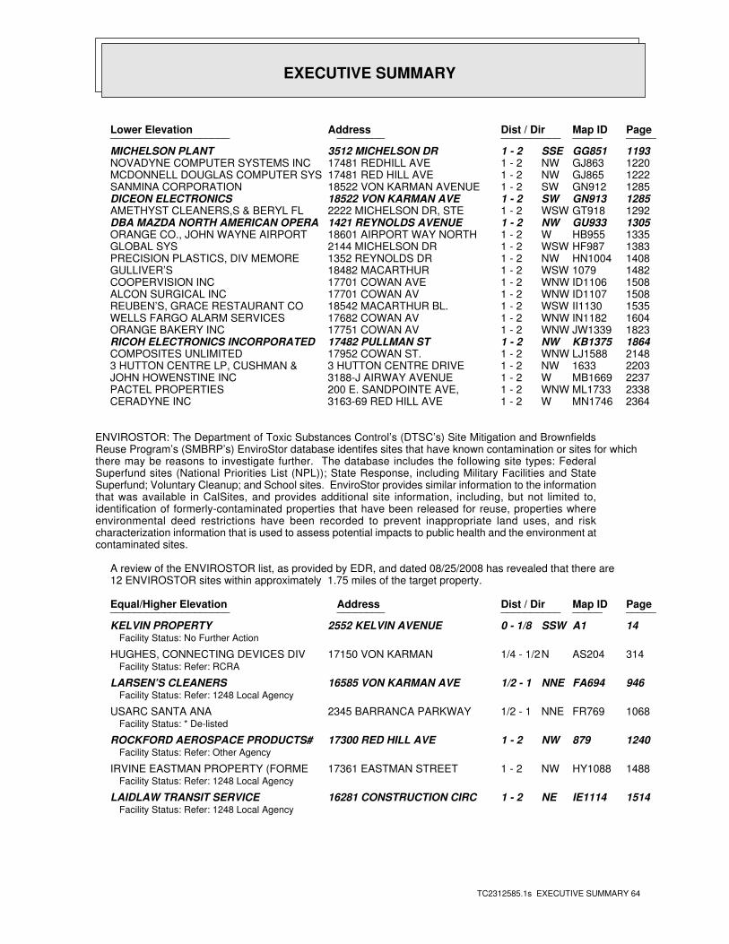
EXECUTIVE SUMMARY
TC2312585.1s EXECUTIVE SUMMARY 64
PageMap IDDist / Dir Address Lower Elevation ____________________ ________ ____________________
1193GG851SSE1 - 2 3512 MICHELSON DR MICHELSON PLANT1220GJ863NW1 - 2 17481 REDHILL AVE NOVADYNE COMPUTER SYSTEMS INC1222GJ865NW1 - 2 17481 RED HILL AVE MCDONNELL DOUGLAS COMPUTER SYS1285GN912SW1 - 2 18522 VON KARMAN AVENUE SANMINA CORPORATION1285GN913SW1 - 2 18522 VON KARMAN AVE DICEON ELECTRONICS1292GT918WSW1 - 2 2222 MICHELSON DR, STE AMETHYST CLEANERS,S & BERYL FL1305GU933NW1 - 2 1421 REYNOLDS AVENUE DBA MAZDA NORTH AMERICAN OPERA1335HB955W1 - 2 18601 AIRPORT WAY NORTH ORANGE CO., JOHN WAYNE AIRPORT1383HF987WSW1 - 2 2144 MICHELSON DR GLOBAL SYS1408HN1004NW1 - 2 1352 REYNOLDS DR PRECISION PLASTICS, DIV MEMORE14821079WSW1 - 2 18482 MACARTHUR GULLIVER’S1508ID1106WNW1 - 2 17701 COWAN AVE COOPERVISION INC1508ID1107WNW1 - 2 17701 COWAN AV ALCON SURGICAL INC1535II1130WSW1 - 2 18542 MACARTHUR BL. REUBEN’S, GRACE RESTAURANT CO1604IN1182WNW1 - 2 17682 COWAN AV WELLS FARGO ALARM SERVICES1823JW1339WNW1 - 2 17751 COWAN AV ORANGE BAKERY INC1864KB1375NW1 - 2 17482 PULLMAN ST RICOH ELECTRONICS INCORPORATED2148LJ1588WNW1 - 2 17952 COWAN ST. COMPOSITES UNLIMITED22031633NW1 - 2 3 HUTTON CENTRE DRIVE 3 HUTTON CENTRE LP, CUSHMAN &2237MB1669W1 - 2 3188-J AIRWAY AVENUE JOHN HOWENSTINE INC2338ML1733WNW1 - 2 200 E. SANDPOINTE AVE, PACTEL PROPERTIES2364MN1746W1 - 2 3163-69 RED HILL AVE CERADYNE INC
ENVIROSTOR: The Department of Toxic Substances Control’s (DTSC’s) Site Mitigation and BrownfieldsReuse Program’s (SMBRP’s) EnviroStor database identifes sites that have known contamination or sites for whichthere may be reasons to investigate further. The database includes the following site types: FederalSuperfund sites (National Priorities List (NPL)); State Response, including Military Facilities and StateSuperfund; Voluntary Cleanup; and School sites. EnviroStor provides similar information to the informationthat was available in CalSites, and provides additional site information, including, but not limited to,identification of formerly-contaminated properties that have been released for reuse, properties whereenvironmental deed restrictions have been recorded to prevent inappropriate land uses, and riskcharacterization information that is used to assess potential impacts to public health and the environment atcontaminated sites.
A review of the ENVIROSTOR list, as provided by EDR, and dated 08/25/2008 has revealed that there are 12 ENVIROSTOR sites within approximately 1.75 miles of the target property.
PageMap IDDist / Dir Address Equal/Higher Elevation ____________________ ________ ____________________
14A1SSW0 - 1/8 2552 KELVIN AVENUE KELVIN PROPERTYFacility Status: No Further Action
314AS204N1/4 - 1/2 17150 VON KARMAN HUGHES, CONNECTING DEVICES DIVFacility Status: Refer: RCRA
946FA694NNE1/2 - 1 16585 VON KARMAN AVE LARSEN’S CLEANERSFacility Status: Refer: 1248 Local Agency
1068FR769NNE1/2 - 1 2345 BARRANCA PARKWAY USARC SANTA ANAFacility Status: * De-listed
1240879NW1 - 2 17300 RED HILL AVE ROCKFORD AEROSPACE PRODUCTS#Facility Status: Refer: Other Agency
1488HY1088NW1 - 2 17361 EASTMAN STREET IRVINE EASTMAN PROPERTY (FORMEFacility Status: Refer: 1248 Local Agency
1514IE1114NE1 - 2 16281 CONSTRUCTION CIRC LAIDLAW TRANSIT SERVICEFacility Status: Refer: 1248 Local Agency
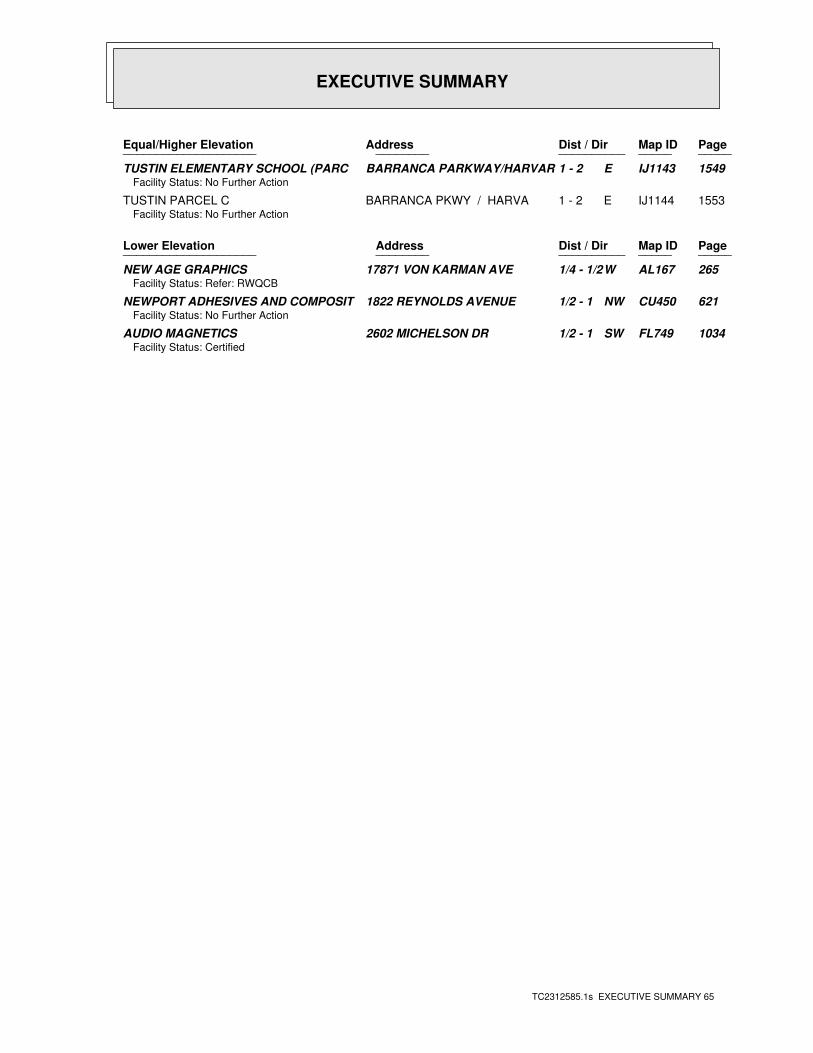
EXECUTIVE SUMMARY
TC2312585.1s EXECUTIVE SUMMARY 65
PageMap IDDist / Dir Address Equal/Higher Elevation ____________________ ________ ____________________
1549IJ1143E1 - 2 BARRANCA PARKWAY/HARVAR TUSTIN ELEMENTARY SCHOOL (PARCFacility Status: No Further Action
1553IJ1144E1 - 2 BARRANCA PKWY / HARVA TUSTIN PARCEL CFacility Status: No Further Action
PageMap IDDist / Dir Address Lower Elevation ____________________ ________ ____________________
265AL167W1/4 - 1/2 17871 VON KARMAN AVE NEW AGE GRAPHICSFacility Status: Refer: RWQCB
621CU450NW1/2 - 1 1822 REYNOLDS AVENUE NEWPORT ADHESIVES AND COMPOSITFacility Status: No Further Action
1034FL749SW1/2 - 1 2602 MICHELSON DR AUDIO MAGNETICSFacility Status: Certified
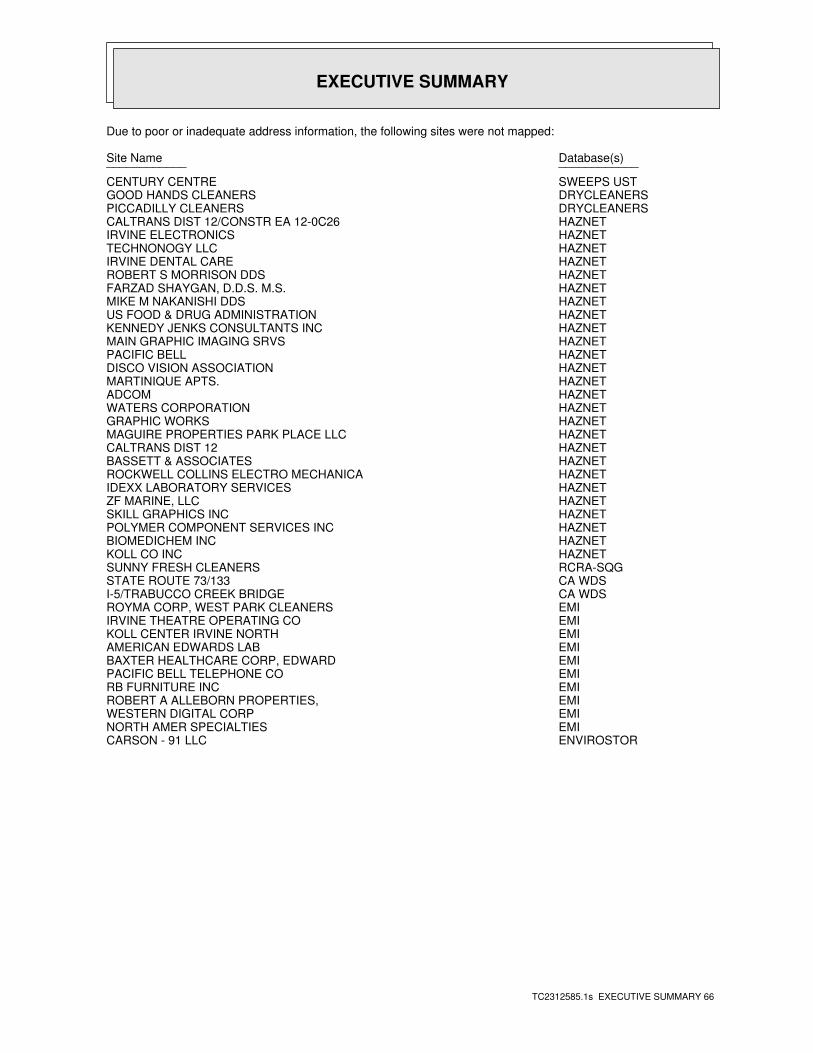
EXECUTIVE SUMMARY
TC2312585.1s EXECUTIVE SUMMARY 66
Due to poor or inadequate address information, the following sites were not mapped:
Database(s)Site Name ________________________
SWEEPS USTCENTURY CENTREDRYCLEANERSGOOD HANDS CLEANERSDRYCLEANERSPICCADILLY CLEANERSHAZNETCALTRANS DIST 12/CONSTR EA 12-0C26HAZNETIRVINE ELECTRONICSHAZNETTECHNONOGY LLCHAZNETIRVINE DENTAL CAREHAZNETROBERT S MORRISON DDSHAZNETFARZAD SHAYGAN, D.D.S. M.S.HAZNETMIKE M NAKANISHI DDSHAZNETUS FOOD & DRUG ADMINISTRATIONHAZNETKENNEDY JENKS CONSULTANTS INCHAZNETMAIN GRAPHIC IMAGING SRVSHAZNETPACIFIC BELLHAZNETDISCO VISION ASSOCIATIONHAZNETMARTINIQUE APTS.HAZNETADCOMHAZNETWATERS CORPORATIONHAZNETGRAPHIC WORKSHAZNETMAGUIRE PROPERTIES PARK PLACE LLCHAZNETCALTRANS DIST 12HAZNETBASSETT & ASSOCIATESHAZNETROCKWELL COLLINS ELECTRO MECHANICAHAZNETIDEXX LABORATORY SERVICESHAZNETZF MARINE, LLCHAZNETSKILL GRAPHICS INCHAZNETPOLYMER COMPONENT SERVICES INCHAZNETBIOMEDICHEM INCHAZNETKOLL CO INCRCRA-SQGSUNNY FRESH CLEANERSCA WDSSTATE ROUTE 73/133CA WDSI-5/TRABUCCO CREEK BRIDGEEMIROYMA CORP, WEST PARK CLEANERSEMIIRVINE THEATRE OPERATING COEMIKOLL CENTER IRVINE NORTHEMIAMERICAN EDWARDS LABEMIBAXTER HEALTHCARE CORP, EDWARDEMIPACIFIC BELL TELEPHONE COEMIRB FURNITURE INCEMIROBERT A ALLEBORN PROPERTIES,EMIWESTERN DIGITAL CORPEMINORTH AMER SPECIALTIESENVIROSTORCARSON - 91 LLC
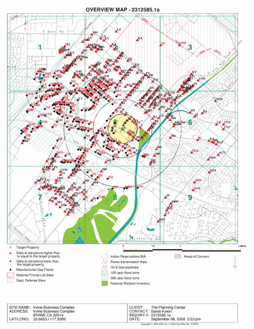
EDR Inc.EDR Inc.EDR Inc.EDR Inc.EDR Inc.EDR Inc.EDR Inc.EDR Inc.EDR Inc.EDR Inc.EDR Inc.EDR Inc.EDR Inc.EDR Inc.EDR Inc.EDR Inc.EDR Inc.EDR Inc.EDR Inc.EDR Inc.EDR Inc.EDR Inc.EDR Inc.EDR Inc.EDR Inc.EDR Inc.EDR Inc.EDR Inc.EDR Inc.EDR Inc.EDR Inc.EDR Inc.EDR Inc.EDR Inc.EDR Inc.EDR Inc.EDR Inc.EDR Inc.EDR Inc.EDR Inc.
230230 kV
230 kV230 kV
230 kV
230 kV
230 kV
230 kV23
0 kV
230 kV
230 kV
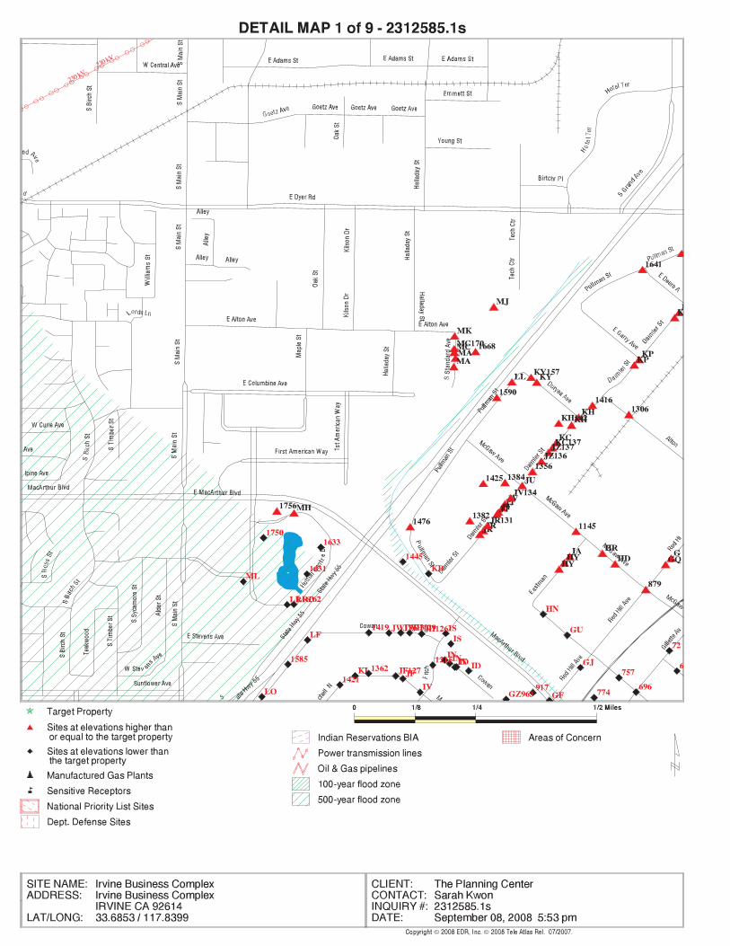
EDR Inc.EDR Inc.EDR Inc.EDR Inc.EDR Inc.EDR Inc.EDR Inc.EDR Inc.EDR Inc.EDR Inc.EDR Inc.EDR Inc.EDR Inc.EDR Inc.EDR Inc.EDR Inc.EDR Inc.EDR Inc.EDR Inc.EDR Inc.EDR Inc.EDR Inc.EDR Inc.EDR Inc.EDR Inc.EDR Inc.EDR Inc.EDR Inc.EDR Inc.EDR Inc.EDR Inc.EDR Inc.EDR Inc.EDR Inc.EDR Inc.EDR Inc.EDR Inc.EDR Inc.EDR Inc.EDR Inc.
230 kV
230 kV
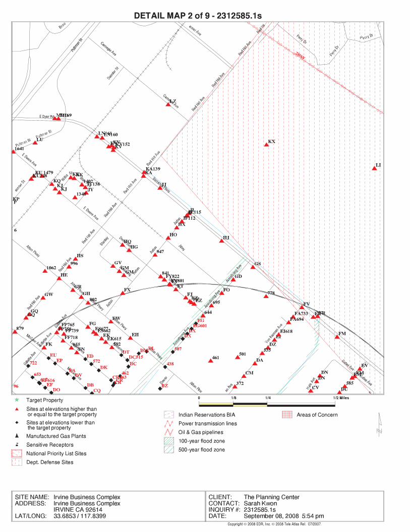
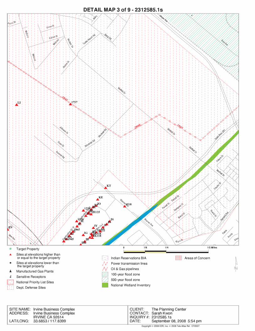
230 kV
230 kV
230 kV
230 kV
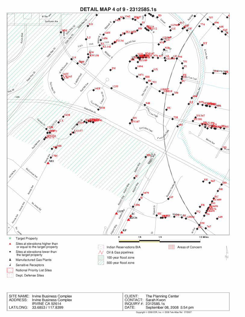
EDR Inc.EDR Inc.EDR Inc.EDR Inc.EDR Inc.EDR Inc.EDR Inc.EDR Inc.EDR Inc.EDR Inc.EDR Inc.EDR Inc.EDR Inc.EDR Inc.EDR Inc.EDR Inc.EDR Inc.EDR Inc.EDR Inc.EDR Inc.EDR Inc.EDR Inc.EDR Inc.EDR Inc.EDR Inc.EDR Inc.EDR Inc.EDR Inc.EDR Inc.EDR Inc.EDR Inc.EDR Inc.EDR Inc.EDR Inc.EDR Inc.EDR Inc.EDR Inc.EDR Inc.EDR Inc.EDR Inc.
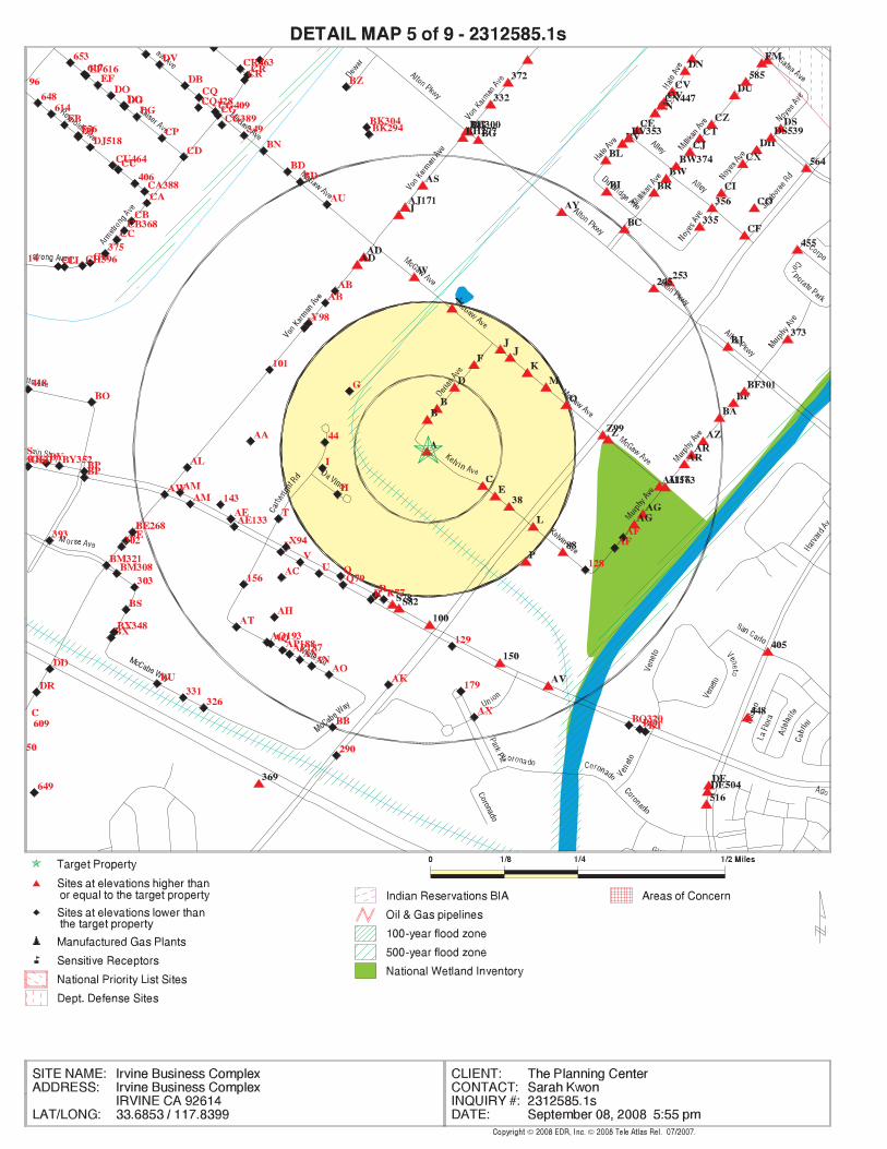
EDR Inc.EDR Inc.EDR Inc.EDR Inc.EDR Inc.EDR Inc.EDR Inc.EDR Inc.EDR Inc.EDR Inc.EDR Inc.EDR Inc.EDR Inc.EDR Inc.EDR Inc.EDR Inc.EDR Inc.EDR Inc.EDR Inc.EDR Inc.EDR Inc.EDR Inc.EDR Inc.EDR Inc.EDR Inc.EDR Inc.EDR Inc.EDR Inc.EDR Inc.EDR Inc.EDR Inc.EDR Inc.EDR Inc.EDR Inc.EDR Inc.EDR Inc.EDR Inc.EDR Inc.EDR Inc.EDR Inc.
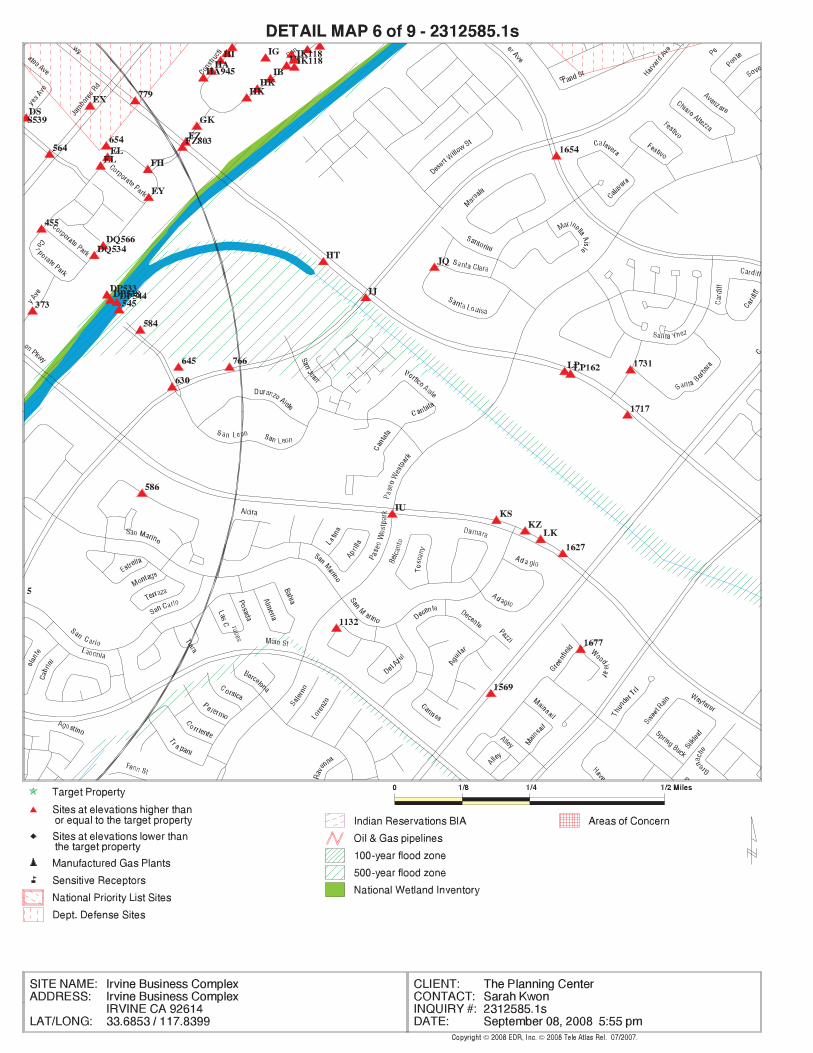
EDR Inc.EDR Inc.EDR Inc.EDR Inc.EDR Inc.EDR Inc.EDR Inc.EDR Inc.EDR Inc.EDR Inc.EDR Inc.EDR Inc.EDR Inc.EDR Inc.EDR Inc.EDR Inc.EDR Inc.EDR Inc.EDR Inc.EDR Inc.EDR Inc.EDR Inc.EDR Inc.EDR Inc.EDR Inc.EDR Inc.EDR Inc.EDR Inc.EDR Inc.EDR Inc.EDR Inc.EDR Inc.EDR Inc.EDR Inc.EDR Inc.EDR Inc.EDR Inc.EDR Inc.EDR Inc.EDR Inc.
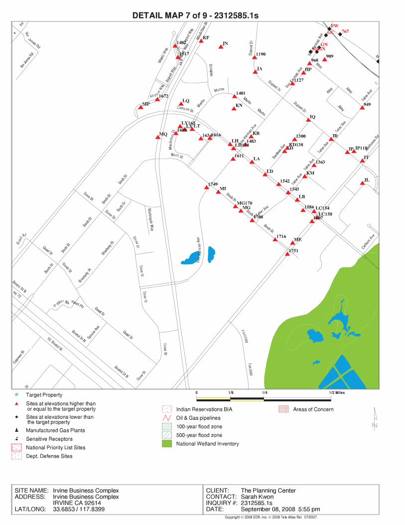
EDR Inc.EDR Inc.EDR Inc.EDR Inc.EDR Inc.EDR Inc.EDR Inc.EDR Inc.EDR Inc.EDR Inc.EDR Inc.EDR Inc.EDR Inc.EDR Inc.EDR Inc.EDR Inc.EDR Inc.EDR Inc.EDR Inc.EDR Inc.EDR Inc.EDR Inc.EDR Inc.EDR Inc.EDR Inc.EDR Inc.EDR Inc.EDR Inc.EDR Inc.EDR Inc.EDR Inc.EDR Inc.EDR Inc.EDR Inc.EDR Inc.EDR Inc.EDR Inc.EDR Inc.EDR Inc.EDR Inc.
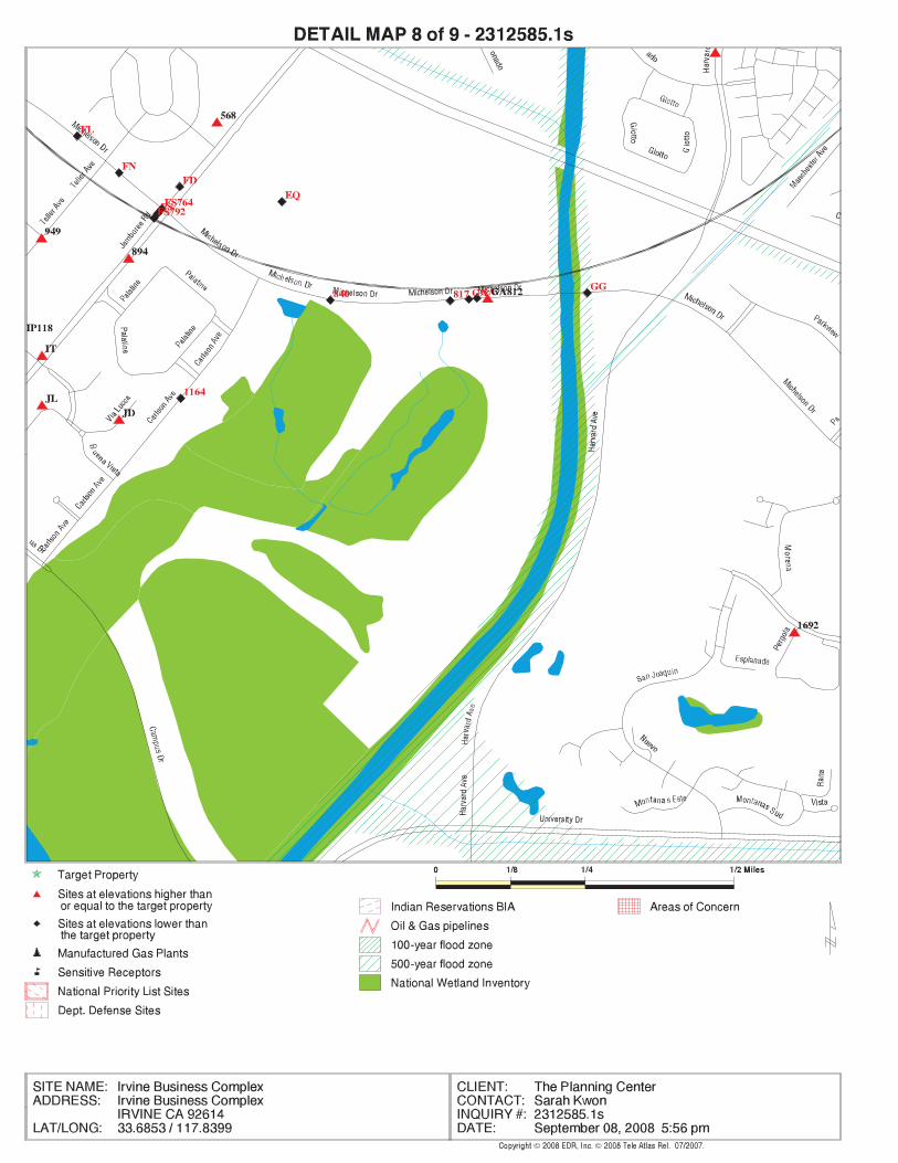
EDR Inc.EDR Inc.EDR Inc.EDR Inc.EDR Inc.EDR Inc.EDR Inc.EDR Inc.EDR Inc.EDR Inc.EDR Inc.EDR Inc.EDR Inc.EDR Inc.EDR Inc.EDR Inc.EDR Inc.EDR Inc.EDR Inc.EDR Inc.EDR Inc.EDR Inc.EDR Inc.EDR Inc.EDR Inc.EDR Inc.EDR Inc.EDR Inc.EDR Inc.EDR Inc.EDR Inc.EDR Inc.EDR Inc.EDR Inc.EDR Inc.EDR Inc.EDR Inc.EDR Inc.EDR Inc.EDR Inc.
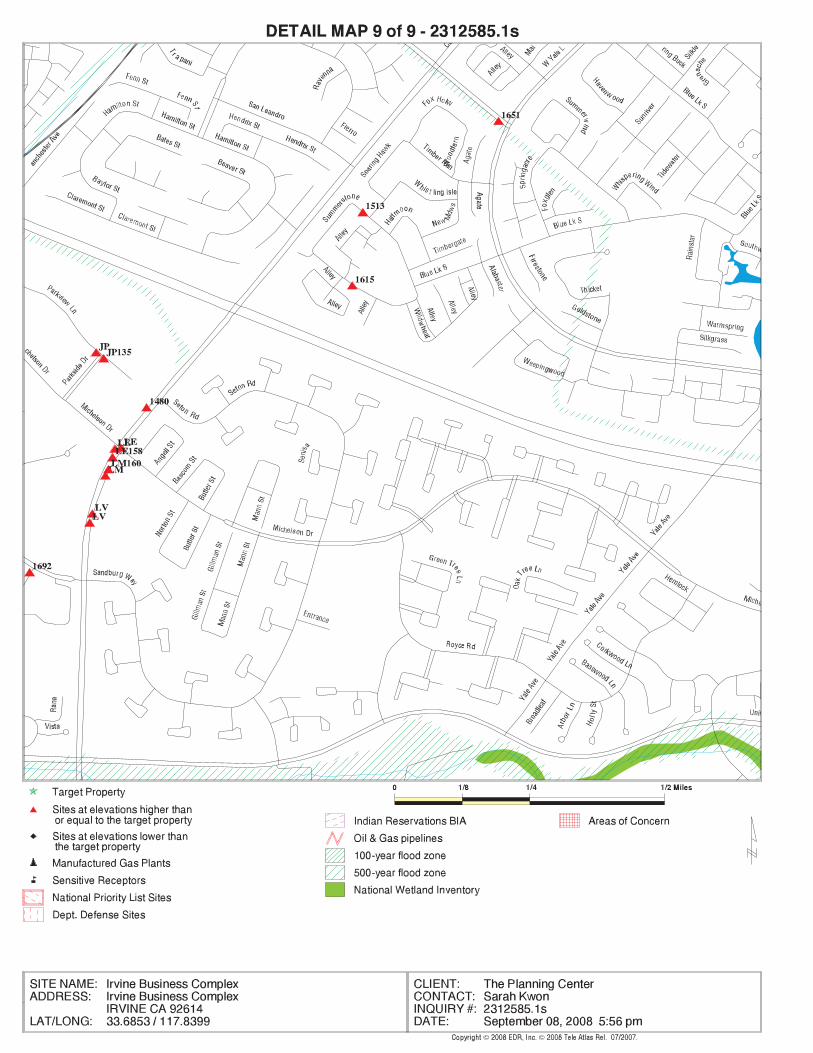
EDR Inc.EDR Inc.EDR Inc.EDR Inc.EDR Inc.EDR Inc.EDR Inc.EDR Inc.EDR Inc.EDR Inc.EDR Inc.EDR Inc.EDR Inc.EDR Inc.EDR Inc.EDR Inc.EDR Inc.EDR Inc.EDR Inc.EDR Inc.EDR Inc.EDR Inc.EDR Inc.EDR Inc.EDR Inc.EDR Inc.EDR Inc.EDR Inc.EDR Inc.EDR Inc.EDR Inc.EDR Inc.EDR Inc.EDR Inc.EDR Inc.EDR Inc.EDR Inc.EDR Inc.EDR Inc.EDR Inc.
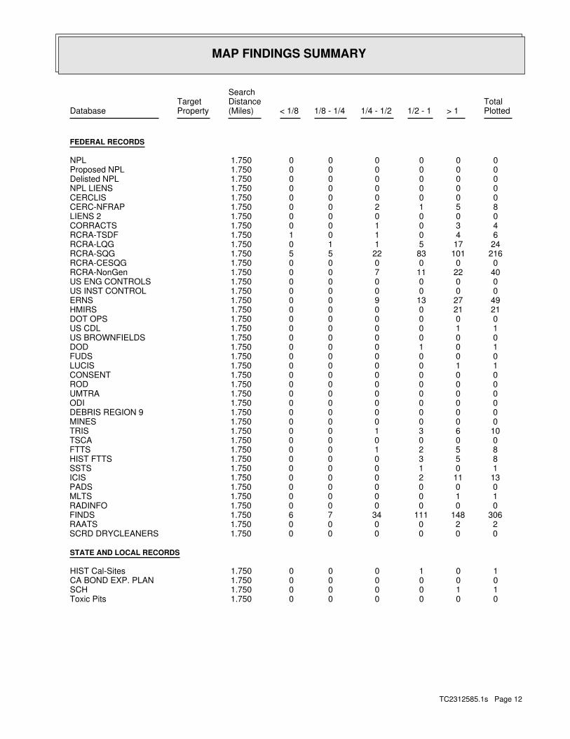
MAP FINDINGS SUMMARY
SearchTarget Distance Total
Database Property (Miles) < 1/8 1/8 - 1/4 1/4 - 1/2 1/2 - 1 > 1 Plotted
FEDERAL RECORDS
0 0 0 0 0 0 1.750NPL 0 0 0 0 0 0 1.750Proposed NPL 0 0 0 0 0 0 1.750Delisted NPL 0 0 0 0 0 0 1.750NPL LIENS 0 0 0 0 0 0 1.750CERCLIS 8 5 1 2 0 0 1.750CERC-NFRAP 0 0 0 0 0 0 1.750LIENS 2 4 3 0 1 0 0 1.750CORRACTS 6 4 0 1 0 1 1.750RCRA-TSDF 24 17 5 1 1 0 1.750RCRA-LQG 216 101 83 22 5 5 1.750RCRA-SQG 0 0 0 0 0 0 1.750RCRA-CESQG 40 22 11 7 0 0 1.750RCRA-NonGen 0 0 0 0 0 0 1.750US ENG CONTROLS 0 0 0 0 0 0 1.750US INST CONTROL 49 27 13 9 0 0 1.750ERNS 21 21 0 0 0 0 1.750HMIRS 0 0 0 0 0 0 1.750DOT OPS 1 1 0 0 0 0 1.750US CDL 0 0 0 0 0 0 1.750US BROWNFIELDS 1 0 1 0 0 0 1.750DOD 0 0 0 0 0 0 1.750FUDS 1 1 0 0 0 0 1.750LUCIS 0 0 0 0 0 0 1.750CONSENT 0 0 0 0 0 0 1.750ROD 0 0 0 0 0 0 1.750UMTRA 0 0 0 0 0 0 1.750ODI 0 0 0 0 0 0 1.750DEBRIS REGION 9 0 0 0 0 0 0 1.750MINES 10 6 3 1 0 0 1.750TRIS 0 0 0 0 0 0 1.750TSCA 8 5 2 1 0 0 1.750FTTS 8 5 3 0 0 0 1.750HIST FTTS 1 0 1 0 0 0 1.750SSTS 13 11 2 0 0 0 1.750ICIS 0 0 0 0 0 0 1.750PADS 1 1 0 0 0 0 1.750MLTS 0 0 0 0 0 0 1.750RADINFO 306 148 111 34 7 6 1.750FINDS 2 2 0 0 0 0 1.750RAATS 0 0 0 0 0 0 1.750SCRD DRYCLEANERS
STATE AND LOCAL RECORDS
1 0 1 0 0 0 1.750HIST Cal-Sites 0 0 0 0 0 0 1.750CA BOND EXP. PLAN 1 1 0 0 0 0 1.750SCH 0 0 0 0 0 0 1.750Toxic Pits
TC2312585.1s Page 12


