Embed Size (px)
Citation preview
Course Title: Geography Alive Scope and Sequence 2016 - 17Social Studies Scope and Sequence 2016 - 17Big Ideas: Key Disciplines
Civics: 5.1, 5.2, 5.3, 5.4Economics 6.2. 6.3, 6.4Geography: 7.4.History 8.4, 8.5, 8.6Reading & Writing in History and Social Studies: 8.5, 8.6
Core Dimensions of the C3 FrameworkDimension 1 Dimension 2 Dimension 3 Dimension 4 Technology
Developing Questions and Planning Inquiries
Applying Disciplinary Concepts and Tools
Gathering and Evaluating Sources
Communicating and Critiquing Conclusions
Civics: What responsibilities do governmnents have to protect their citizens and resources?
Using current geography based issues (use or preserve), we will debate the objectives of governmental descions.
Based on curriculum activities students will form opinions and support them with verbal and visual evidence.
Create a persuassive letter focusing on their opinions and supported with research evidence.
Google Suites; Library Databases
Economics How do people meet their basic needs and what resources are available?
Using regional economic activity thematic maps, demonstrate connections between resources and how people meet their basic needs.
Based on curriculum provided maps, read and analyze economic activity maps for individual regions.
Communicate the research findings (written, verbal, electronic presentation, etc.) based on evidence that supports regional development.
iMovie projects; group projects; Google Suites
Geography How and why people move and adapt? How is information on maps read and displayed?
Overall map knoweldge (parts and types) to analyze the effects of geopgraphy on people and places.
Based on curriculum provided maps, read and analyze multiple thematic maps for individual regions.
Communicate the findings (written, verbal, electronic presentation, etc.) from research around evidence that supports opinions on regional issues.
iMovie projects; group projects; Google Suites
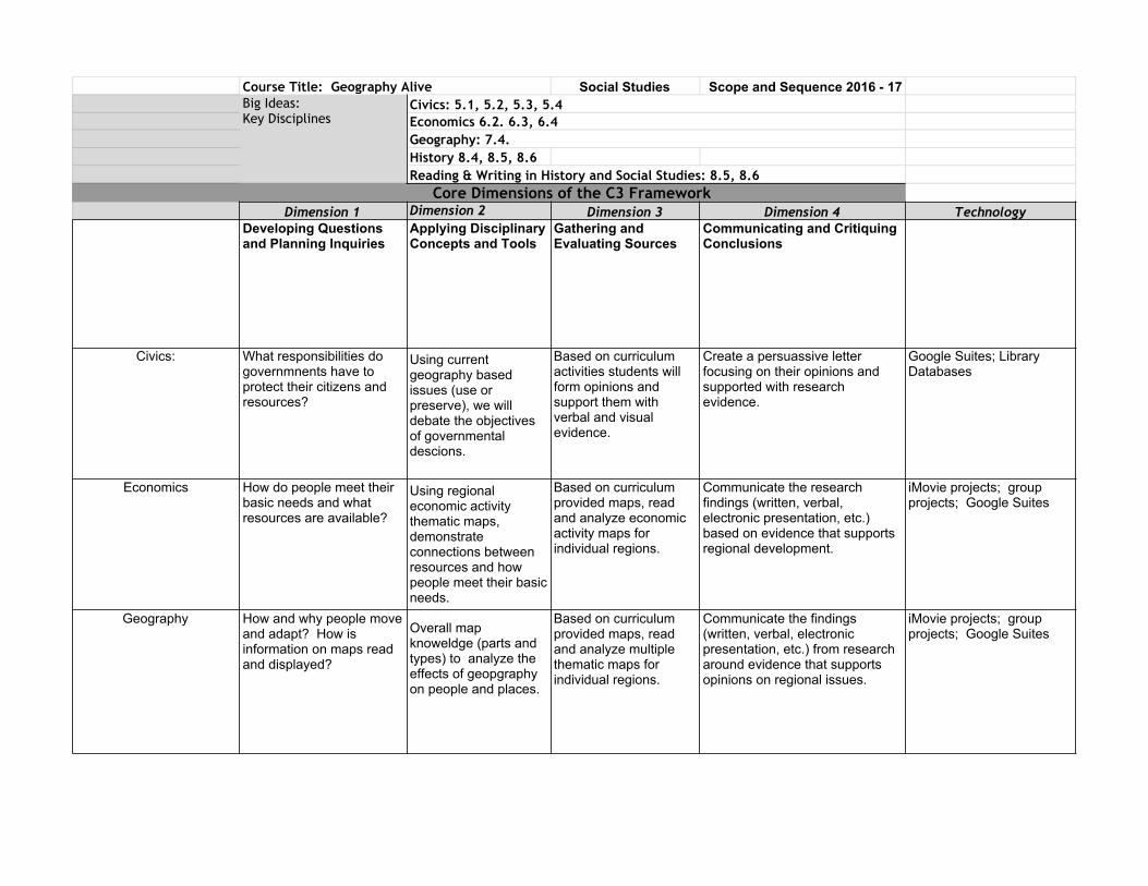
History What are the human effects on geography currently and over time?
The use of maps to analyze the effects of human interaction over time.
Based on curriculum provided maps, read and analyze information in regard to human interaction over time.
Use of historical records to help formulate opinions on current geographic topics.
iMovie projects; group projects; Google Suites
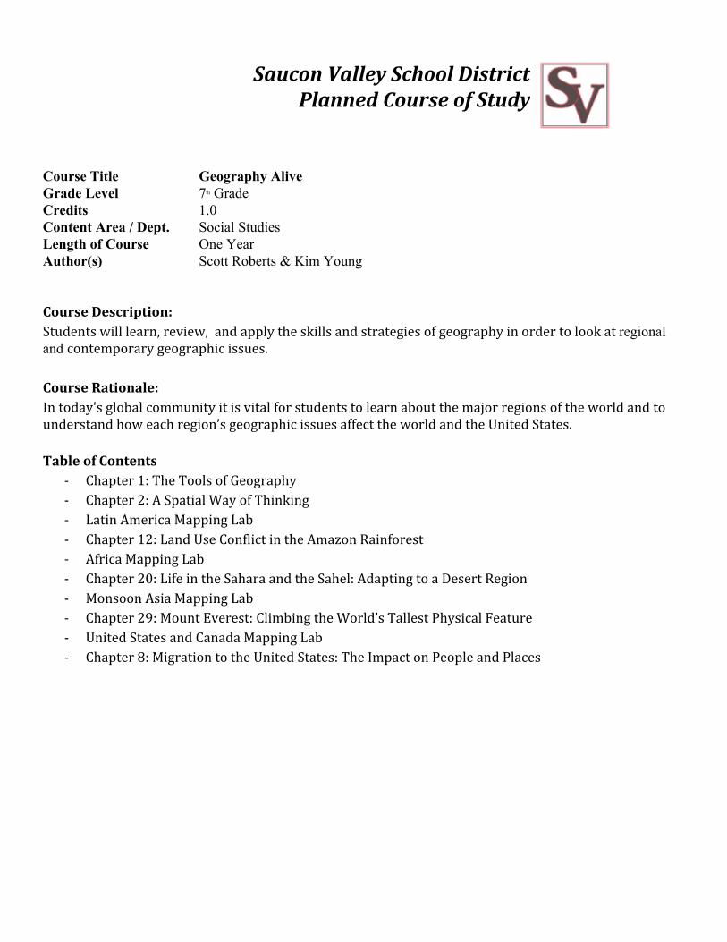
Saucon Valley School District
Planned Course of Study
Course Title Geography Alive Grade Level 7th Grade Credits 1.0 Content Area / Dept. Social Studies Length of Course One Year Author(s) Scott Roberts & Kim Young
Course Description: Students will learn, review, and apply the skills and strategies of geography in order to look at regional and contemporary geographic issues. Course Rationale: In today's global community it is vital for students to learn about the major regions of the world and to understand how each region’s geographic issues affect the world and the United States. Table of Contents
- Chapter 1: The Tools of Geography - Chapter 2: A Spatial Way of Thinking - Latin America Mapping Lab - Chapter 12: Land Use Conflict in the Amazon Rainforest - Africa Mapping Lab - Chapter 20: Life in the Sahara and the Sahel: Adapting to a Desert Region - Monsoon Asia Mapping Lab - Chapter 29: Mount Everest: Climbing the World’s Tallest Physical Feature - United States and Canada Mapping Lab - Chapter 8: Migration to the United States: The Impact on People and Places
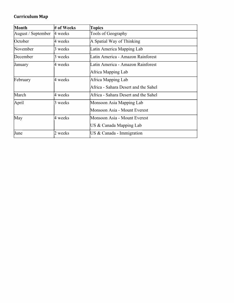
Curriculum Map
Month # of Weeks Topics August / September 4 weeks Tools of Geography
October 4 weeks A Spatial Way of Thinking
November 3 weeks Latin America Mapping Lab
December 3 weeks Latin America - Amazon Rainforest
January 4 weeks Latin America - Amazon Rainforest Africa Mapping Lab
February 4 weeks Africa Mapping Lab Africa - Sahara Desert and the Sahel
March 4 weeks Africa - Sahara Desert and the Sahel
April 3 weeks Monsoon Asia Mapping Lab Monsoon Asia - Mount Everest
May 4 weeks Monsoon Asia - Mount Everest US & Canada Mapping Lab
June 2 weeks US & Canada - Immigration
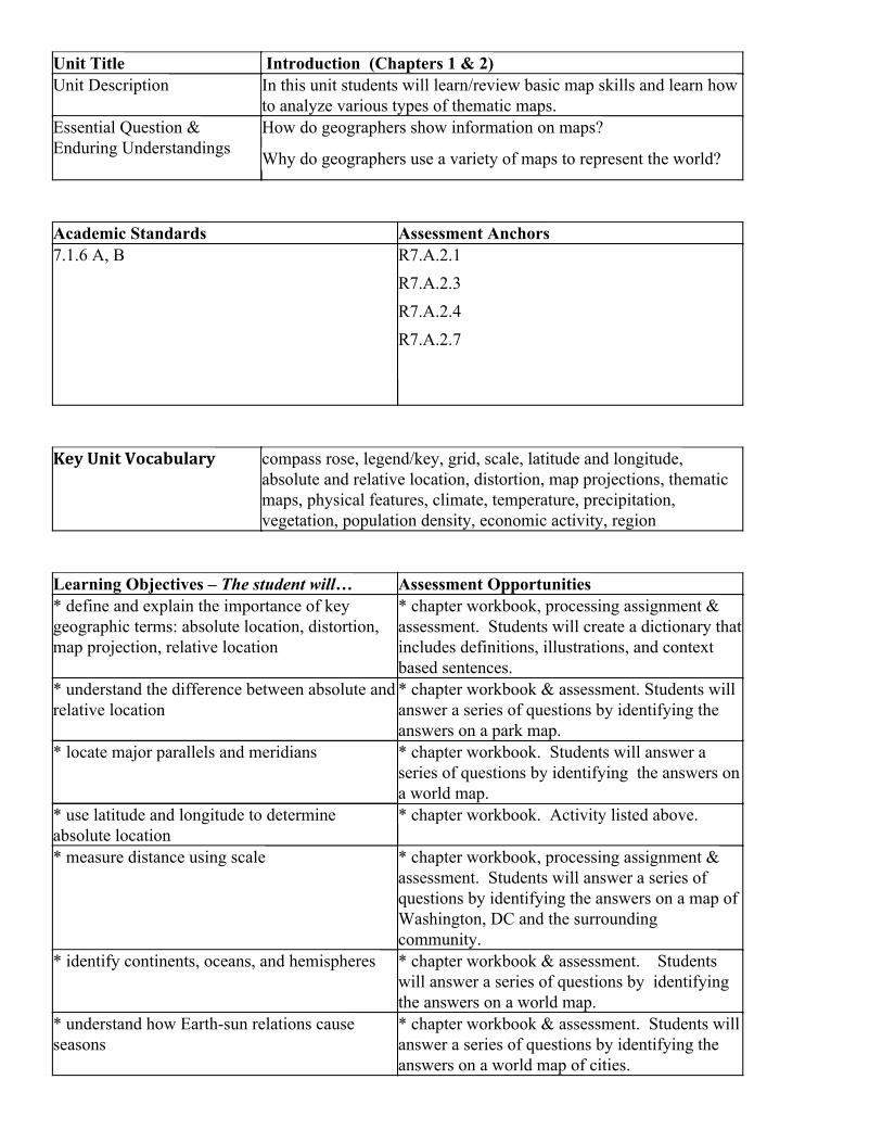
Unit Title Introduction (Chapters 1 & 2) Unit Description In this unit students will learn/review basic map skills and learn how
to analyze various types of thematic maps. Essential Question & Enduring Understandings
How do geographers show information on maps?
Why do geographers use a variety of maps to represent the world?
Academic Standards Assessment Anchors 7.1.6 A, B
R7.A.2.1 R7.A.2.3 R7.A.2.4 R7.A.2.7
Key Unit Vocabulary compass rose, legend/key, grid, scale, latitude and longitude, absolute and relative location, distortion, map projections, thematic maps, physical features, climate, temperature, precipitation, vegetation, population density, economic activity, region
Learning Objectives – The student will… Assessment Opportunities * define and explain the importance of key geographic terms: absolute location, distortion, map projection, relative location
* chapter workbook, processing assignment & assessment. Students will create a dictionary that includes definitions, illustrations, and context based sentences.
* understand the difference between absolute and relative location
* chapter workbook & assessment. Students will answer a series of questions by identifying the answers on a park map.
* locate major parallels and meridians * chapter workbook. Students will answer a series of questions by identifying the answers on a world map.
* use latitude and longitude to determine absolute location
* chapter workbook. Activity listed above.
* measure distance using scale * chapter workbook, processing assignment & assessment. Students will answer a series of questions by identifying the answers on a map of Washington, DC and the surrounding community.
* identify continents, oceans, and hemispheres * chapter workbook & assessment. Students will answer a series of questions by identifying the answers on a world map.
* understand how Earth-sun relations cause seasons
* chapter workbook & assessment. Students will answer a series of questions by identifying the answers on a world map of cities.
* understand the relative merits of five map projections
* chapter workbook. Students will identify and label five different map projections based on their merits
* design a map with basic map components * processing assignment. Students will create a map of their classroom using the skills they acquired in this chapter. Required components are a title, key/legend with symbols, a compass rose, a grid (absolute & absolute location), and an accurate scale.
* define and explain the importance of key geographic terms: climate, economic activity, landforms, physical features, population density, region, thematic map and vegetation
* chapter workbook, processing assignment & assessment. Students will create a dictionary that includes definitions, illustrations, and context based sentences.
* define the terminology specific to six types of thematic maps: physical features, climate zones, vegetation zones, population density, economic activity, and regions.
* chapter workbook, processing assignment & assessment
* analyze six thematic maps to gather information about the world
* chapter workbook, processing assignment
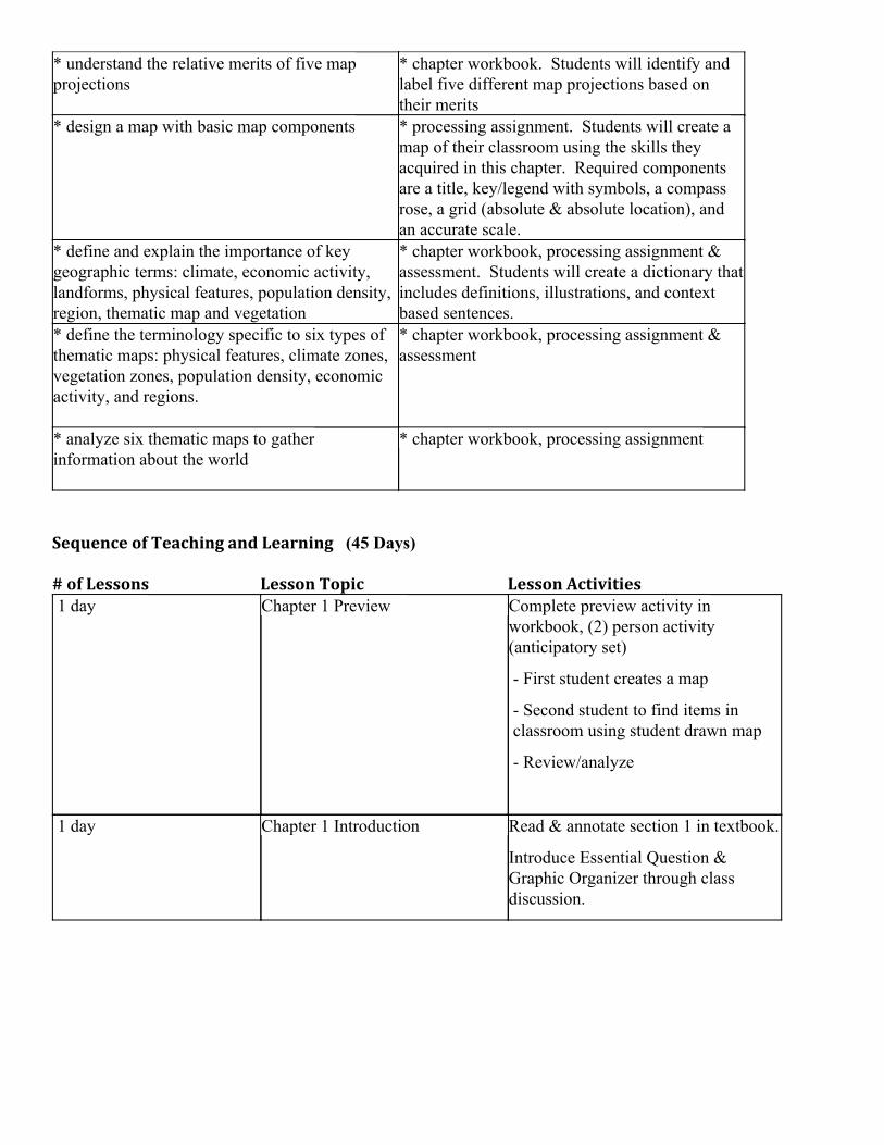
Sequence of Teaching and Learning (45 Days) # of Lessons Lesson Topic Lesson Activities 1 day Chapter 1 Preview Complete preview activity in
workbook, (2) person activity (anticipatory set)
- First student creates a map
- Second student to find items in classroom using student drawn map
- Review/analyze
1 day Chapter 1 Introduction Read & annotate section 1 in textbook.
Introduce Essential Question & Graphic Organizer through class discussion.
2 days Chapter 1 Vocabulary (GeoTerms) Read & annotate section 2 in textbook.
Complete Geoterms in workbook.
- Students will create a dictionary that includes definitions, illustrations, and context based sentences.
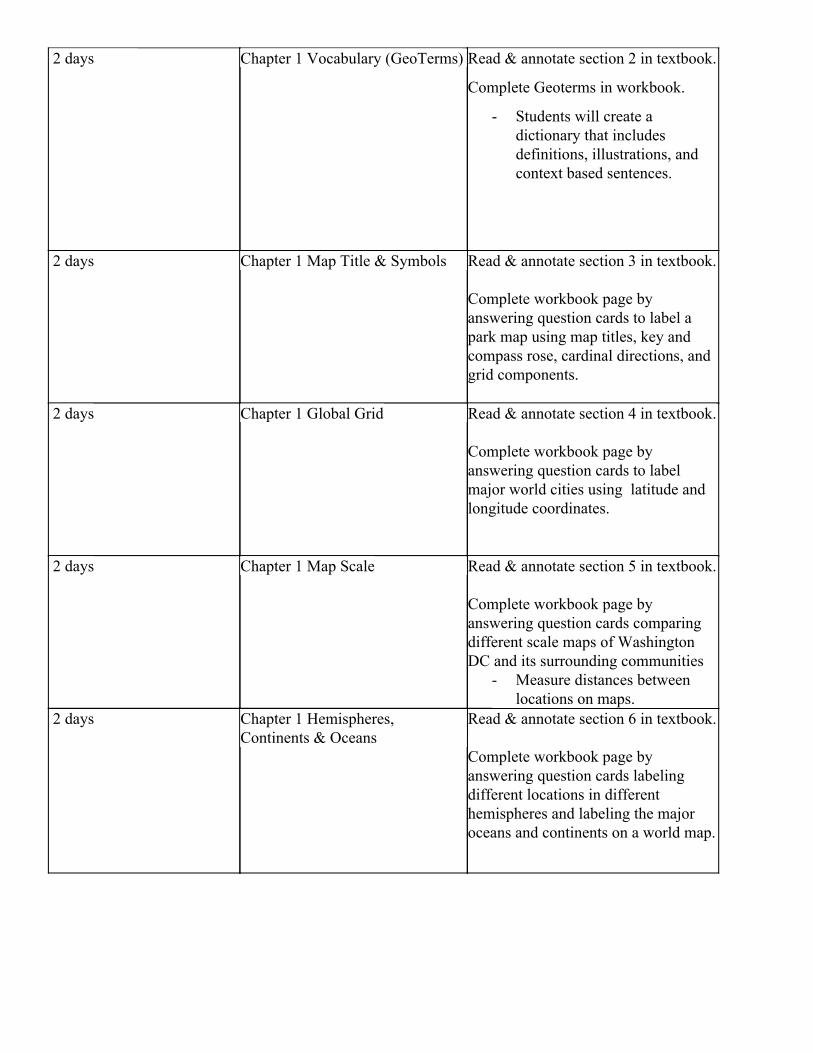
2 days Chapter 1 Map Title & Symbols Read & annotate section 3 in textbook.
Complete workbook page by answering question cards to label a park map using map titles, key and compass rose, cardinal directions, and grid components.
2 days Chapter 1 Global Grid Read & annotate section 4 in textbook.
Complete workbook page by answering question cards to label major world cities using latitude and longitude coordinates.
2 days Chapter 1 Map Scale Read & annotate section 5 in textbook.
Complete workbook page by answering question cards comparing different scale maps of Washington DC and its surrounding communities
- Measure distances between locations on maps.
2 days Chapter 1 Hemispheres, Continents & Oceans
Read & annotate section 6 in textbook.
Complete workbook page by answering question cards labeling different locations in different hemispheres and labeling the major oceans and continents on a world map.
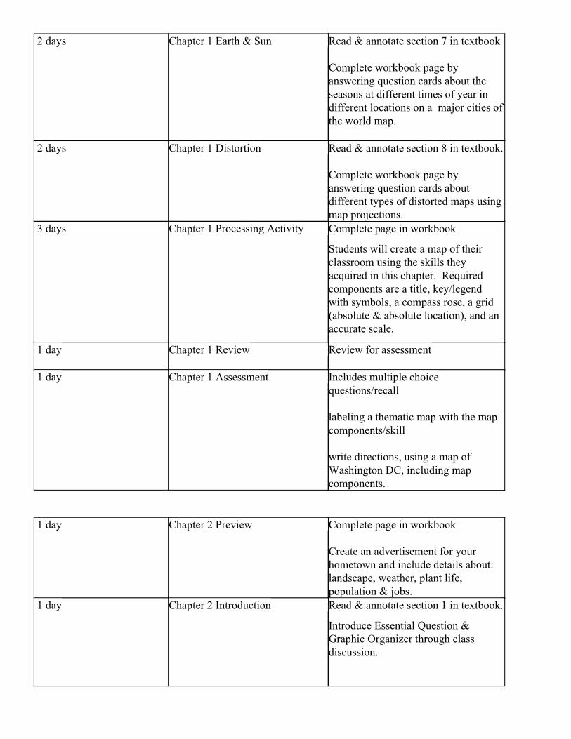
2 days Chapter 1 Earth & Sun Read & annotate section 7 in textbook
Complete workbook page by answering question cards about the seasons at different times of year in different locations on a major cities of the world map.
2 days Chapter 1 Distortion Read & annotate section 8 in textbook.
Complete workbook page by answering question cards about different types of distorted maps using map projections.
3 days Chapter 1 Processing Activity Complete page in workbook
Students will create a map of their classroom using the skills they acquired in this chapter. Required components are a title, key/legend with symbols, a compass rose, a grid (absolute & absolute location), and an accurate scale.
1 day Chapter 1 Review Review for assessment
1 day Chapter 1 Assessment Includes multiple choice questions/recall
labeling a thematic map with the map components/skill
write directions, using a map of Washington DC, including map components.
1 day Chapter 2 Preview Complete page in workbook
Create an advertisement for your hometown and include details about: landscape, weather, plant life, population & jobs.
1 day Chapter 2 Introduction Read & annotate section 1 in textbook.
Introduce Essential Question & Graphic Organizer through class discussion.
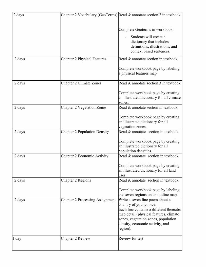
2 days Chapter 2 Vocabulary (GeoTerms) Read & annotate section 2 in textbook.
Complete Geoterms in workbook.
- Students will create a dictionary that includes definitions, illustrations, and context based sentences.
2 days Chapter 2 Physical Features Read & annotate section in textbook.
Complete workbook page by labeling a physical features map.
2 days Chapter 2 Climate Zones Read & annotate section 3 in textbook.
Complete workbook page by creating an illustrated dictionary for all climate zones.
2 days Chapter 2 Vegetation Zones Read & annotate section in textbook
Complete workbook page by creating an illustrated dictionary for all vegetation zones.
2 days Chapter 2 Population Density Read & annotate section in textbook.
Complete workbook page by creating an illustrated dictionary for all population densities.
2 days Chapter 2 Economic Activity Read & annotate section in textbook.
Complete workbook page by creating an illustrated dictionary for all land uses.
2 days Chapter 2 Regions Read & annotate section in textbook.
Complete workbook page by labeling the seven regions on an outline map.
2 days Chapter 2 Processing Assignment Write a seven line poem about a country of your choice. Each line contains a different thematic map detail (physical features, climate zones, vegetation zones, population density, economic activity, and region).
1 day Chapter 2 Review Review for test
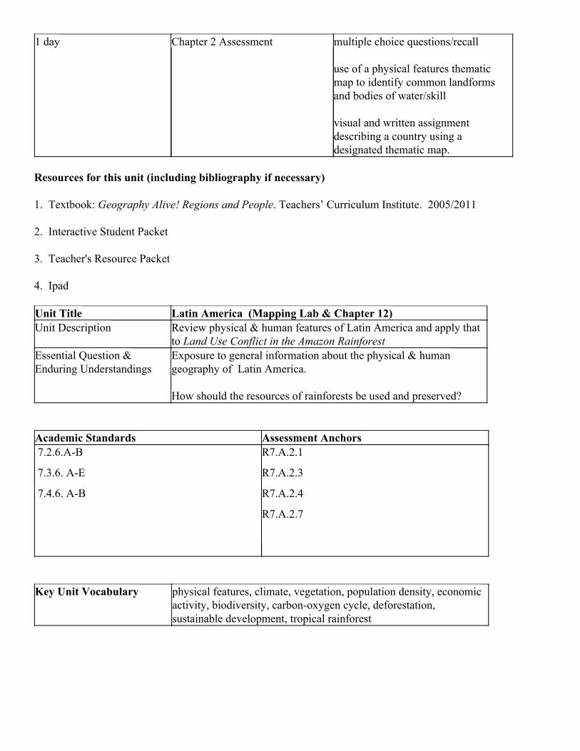
1 day Chapter 2 Assessment multiple choice questions/recall
use of a physical features thematic map to identify common landforms and bodies of water/skill
visual and written assignment describing a country using a designated thematic map.
Resources for this unit (including bibliography if necessary) 1. Textbook: Geography Alive! Regions and People. Teachers’ Curriculum Institute. 2005/2011
2. Interactive Student Packet
3. Teacher's Resource Packet 4. Ipad Unit Title Latin America (Mapping Lab & Chapter 12) Unit Description Review physical & human features of Latin America and apply that
to Land Use Conflict in the Amazon Rainforest Essential Question & Enduring Understandings
Exposure to general information about the physical & human geography of Latin America.
How should the resources of rainforests be used and preserved?
Academic Standards Assessment Anchors 7.2.6.A-B
7.3.6. A-E
7.4.6. A-B
R7.A.2.1
R7.A.2.3
R7.A.2.4
R7.A.2.7
Key Unit Vocabulary physical features, climate, vegetation, population density, economic activity, biodiversity, carbon-oxygen cycle, deforestation, sustainable development, tropical rainforest
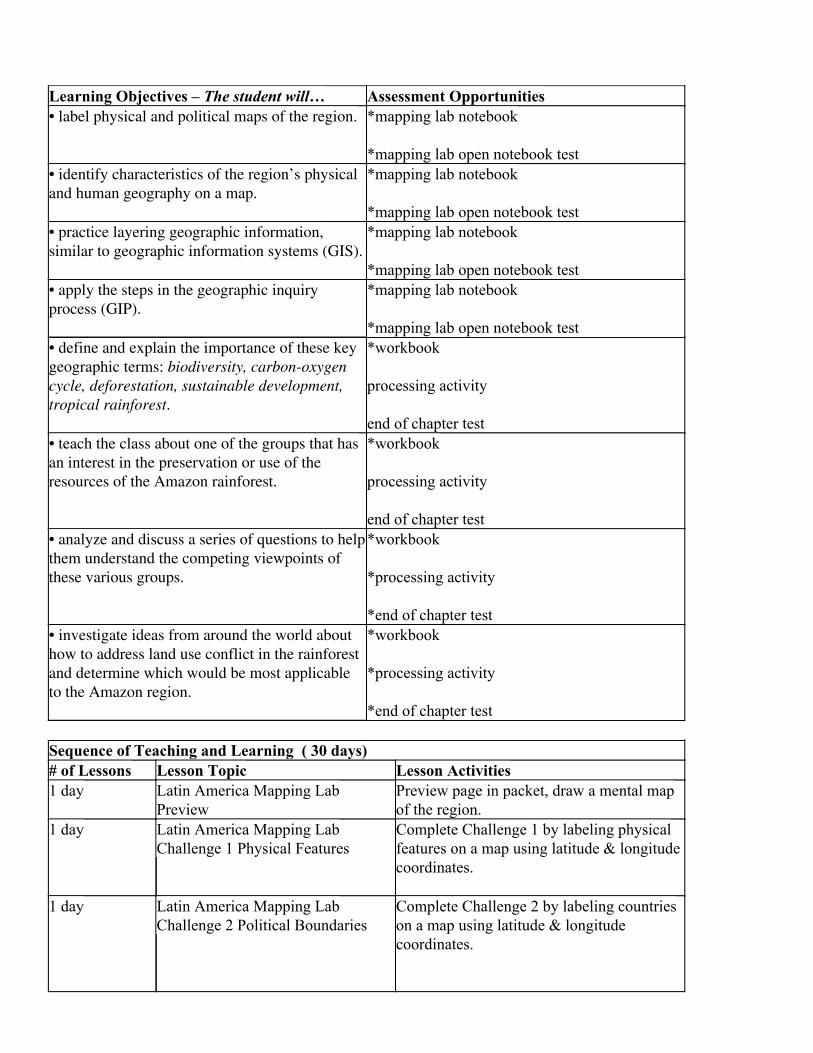
Learning Objectives – The student will… Assessment Opportunities • label physical and political maps of the region.
*mapping lab notebook
*mapping lab open notebook test • identify characteristics of the region’s physical and human geography on a map.
*mapping lab notebook
*mapping lab open notebook test • practice layering geographic information, similar to geographic information systems (GIS).
*mapping lab notebook
*mapping lab open notebook test • apply the steps in the geographic inquiry process (GIP).
*mapping lab notebook
*mapping lab open notebook test • define and explain the importance of these key geographic terms: biodiversity, carbon-oxygen cycle, deforestation, sustainable development, tropical rainforest .
*workbook
processing activity
end of chapter test • teach the class about one of the groups that has an interest in the preservation or use of the resources of the Amazon rainforest.
*workbook
processing activity
end of chapter test • analyze and discuss a series of questions to help them understand the competing viewpoints of these various groups.
*workbook
*processing activity
*end of chapter test • investigate ideas from around the world about how to address land use conflict in the rainforest and determine which would be most applicable to the Amazon region.
*workbook
*processing activity
*end of chapter test Sequence of Teaching and Learning ( 30 days) # of Lessons Lesson Topic Lesson Activities 1 day Latin America Mapping Lab
Preview Preview page in packet, draw a mental map of the region.
1 day Latin America Mapping Lab Challenge 1 Physical Features
Complete Challenge 1 by labeling physical features on a map using latitude & longitude coordinates.
1 day Latin America Mapping Lab Challenge 2 Political Boundaries
Complete Challenge 2 by labeling countries on a map using latitude & longitude coordinates.
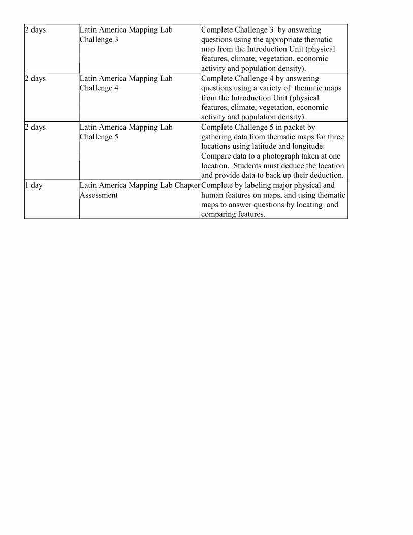
2 days Latin America Mapping Lab Challenge 3
Complete Challenge 3 by answering questions using the appropriate thematic map from the Introduction Unit (physical features, climate, vegetation, economic activity and population density).
2 days Latin America Mapping Lab Challenge 4
Complete Challenge 4 by answering questions using a variety of thematic maps from the Introduction Unit (physical features, climate, vegetation, economic activity and population density).
2 days Latin America Mapping Lab Challenge 5
Complete Challenge 5 in packet by gathering data from thematic maps for three locations using latitude and longitude. Compare data to a photograph taken at one location. Students must deduce the location and provide data to back up their deduction.
1 day Latin America Mapping Lab Chapter Assessment
Complete by labeling major physical and human features on maps, and using thematic maps to answer questions by locating and comparing features.
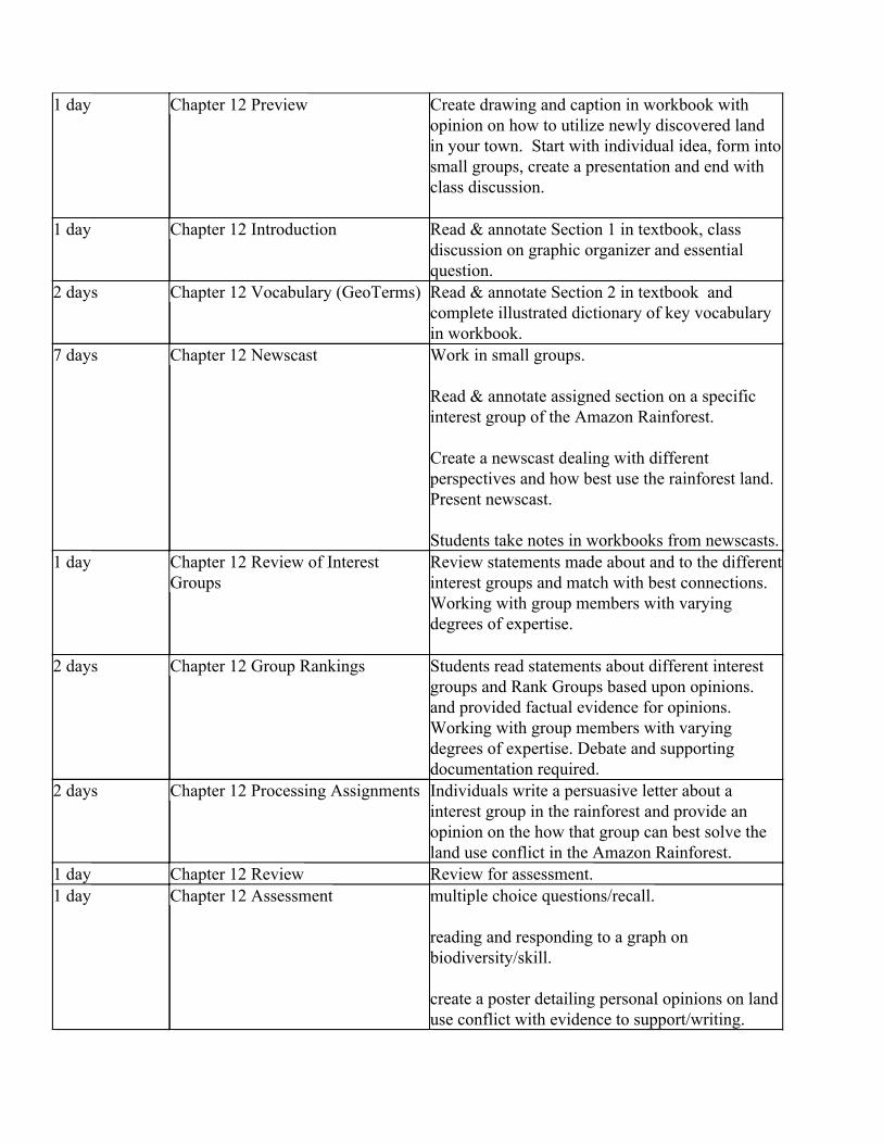
1 day Chapter 12 Preview Create drawing and caption in workbook with opinion on how to utilize newly discovered land in your town. Start with individual idea, form into small groups, create a presentation and end with class discussion.
1 day Chapter 12 Introduction Read & annotate Section 1 in textbook, class discussion on graphic organizer and essential question.
2 days Chapter 12 Vocabulary (GeoTerms) Read & annotate Section 2 in textbook and complete illustrated dictionary of key vocabulary in workbook.
7 days Chapter 12 Newscast Work in small groups.
Read & annotate assigned section on a specific interest group of the Amazon Rainforest.
Create a newscast dealing with different perspectives and how best use the rainforest land. Present newscast.
Students take notes in workbooks from newscasts. 1 day Chapter 12 Review of Interest
Groups Review statements made about and to the differentinterest groups and match with best connections. Working with group members with varying degrees of expertise.
2 days Chapter 12 Group Rankings Students read statements about different interest groups and Rank Groups based upon opinions. and provided factual evidence for opinions. Working with group members with varying degrees of expertise. Debate and supporting documentation required.
2 days Chapter 12 Processing Assignments Individuals write a persuasive letter about a interest group in the rainforest and provide an opinion on the how that group can best solve the land use conflict in the Amazon Rainforest.
1 day Chapter 12 Review Review for assessment. 1 day Chapter 12 Assessment multiple choice questions/recall.
reading and responding to a graph on biodiversity/skill.
create a poster detailing personal opinions on land use conflict with evidence to support/writing.
Resources for this unit (including bibliography if necessary)
1. Textbook: Geography Alive! Regions and People. Teachers’ Curriculum Institute
2. Interactive Student Packet
3. Teacher's Resource Packet 4. Ipads
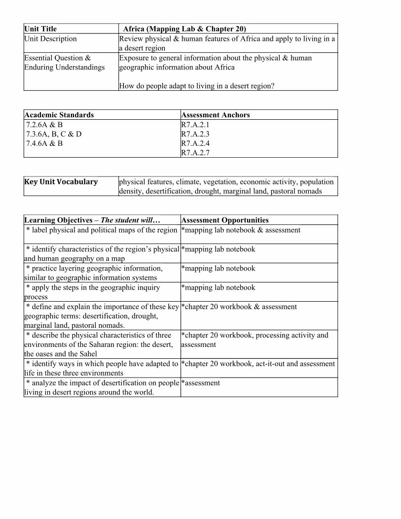
Unit Title Africa (Mapping Lab & Chapter 20) Unit Description Review physical & human features of Africa and apply to living in a
a desert region Essential Question & Enduring Understandings
Exposure to general information about the physical & human geographic information about Africa
How do people adapt to living in a desert region?
Academic Standards Assessment Anchors 7.2.6A & B 7.3.6A, B, C & D 7.4.6A & B
R7.A.2.1 R7.A.2.3 R7.A.2.4 R7.A.2.7
Key Unit Vocabulary physical features, climate, vegetation, economic activity, population density, desertification, drought, marginal land, pastoral nomads
Learning Objectives – The student will… Assessment Opportunities * label physical and political maps of the region *mapping lab notebook & assessment
* identify characteristics of the region’s physical and human geography on a map
*mapping lab notebook
* practice layering geographic information, similar to geographic information systems
*mapping lab notebook
* apply the steps in the geographic inquiry process
*mapping lab notebook
* define and explain the importance of these key geographic terms: desertification, drought, marginal land, pastoral nomads.
*chapter 20 workbook & assessment
* describe the physical characteristics of three environments of the Saharan region: the desert, the oases and the Sahel
*chapter 20 workbook, processing activity and assessment
* identify ways in which people have adapted to life in these three environments
*chapter 20 workbook, act-it-out and assessment
* analyze the impact of desertification on people living in desert regions around the world.
*assessment
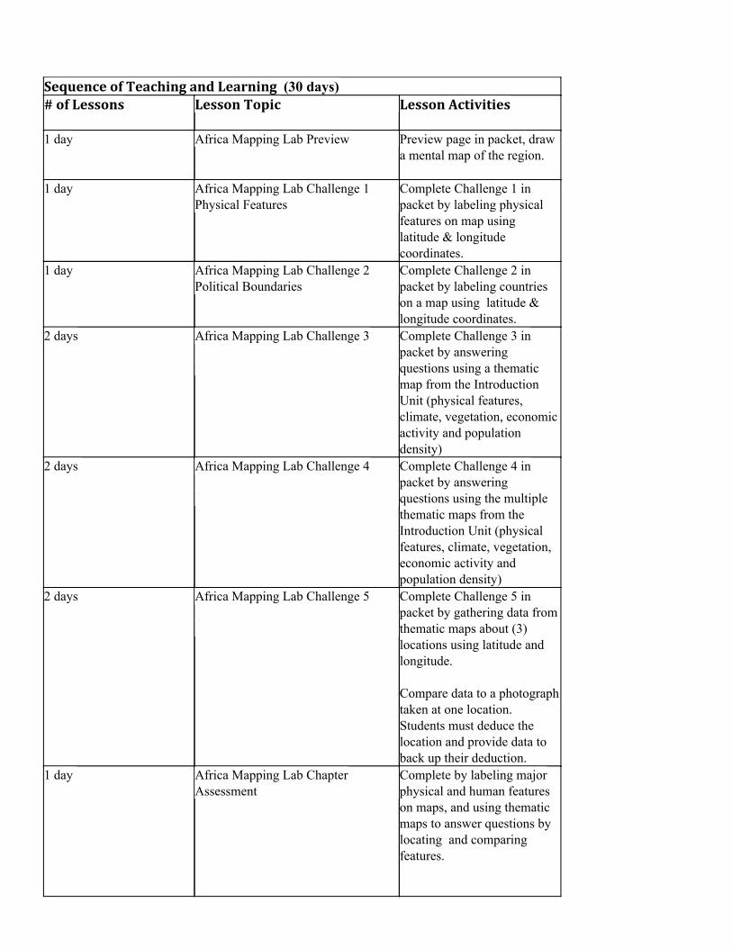
Sequence of Teaching and Learning (30 days) # of Lessons Lesson Topic Lesson Activities
1 day Africa Mapping Lab Preview Preview page in packet, draw a mental map of the region.
1 day Africa Mapping Lab Challenge 1 Physical Features
Complete Challenge 1 in packet by labeling physical features on map using latitude & longitude coordinates.
1 day Africa Mapping Lab Challenge 2 Political Boundaries
Complete Challenge 2 in packet by labeling countries on a map using latitude & longitude coordinates.
2 days Africa Mapping Lab Challenge 3 Complete Challenge 3 in packet by answering questions using a thematic map from the Introduction Unit (physical features, climate, vegetation, economic activity and population density)
2 days Africa Mapping Lab Challenge 4 Complete Challenge 4 in packet by answering questions using the multiple thematic maps from the Introduction Unit (physical features, climate, vegetation, economic activity and population density)
2 days Africa Mapping Lab Challenge 5 Complete Challenge 5 in packet by gathering data from thematic maps about (3) locations using latitude and longitude.
Compare data to a photograph taken at one location. Students must deduce the location and provide data to back up their deduction.
1 day Africa Mapping Lab Chapter Assessment
Complete by labeling major physical and human features on maps, and using thematic maps to answer questions by locating and comparing features.
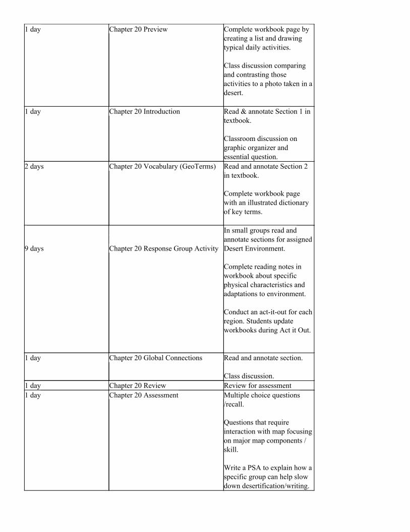
1 day Chapter 20 Preview Complete workbook page by creating a list and drawing typical daily activities.
Class discussion comparing and contrasting those activities to a photo taken in a desert.
1 day Chapter 20 Introduction Read & annotate Section 1 in textbook.
Classroom discussion on graphic organizer and essential question.
2 days Chapter 20 Vocabulary (GeoTerms) Read and annotate Section 2 in textbook.
Complete workbook page with an illustrated dictionary of key terms.
9 days Chapter 20 Response Group Activity
In small groups read and annotate sections for assigned Desert Environment.
Complete reading notes in workbook about specific physical characteristics and adaptations to environment.
Conduct an act-it-out for each region. Students update workbooks during Act it Out.
1 day Chapter 20 Global Connections Read and annotate section. Class discussion.
1 day Chapter 20 Review Review for assessment 1 day Chapter 20 Assessment Multiple choice questions
/recall.
Questions that require interaction with map focusing on major map components / skill.
Write a PSA to explain how a specific group can help slow down desertification/writing.
Resources for this unit (including bibliography if necessary)
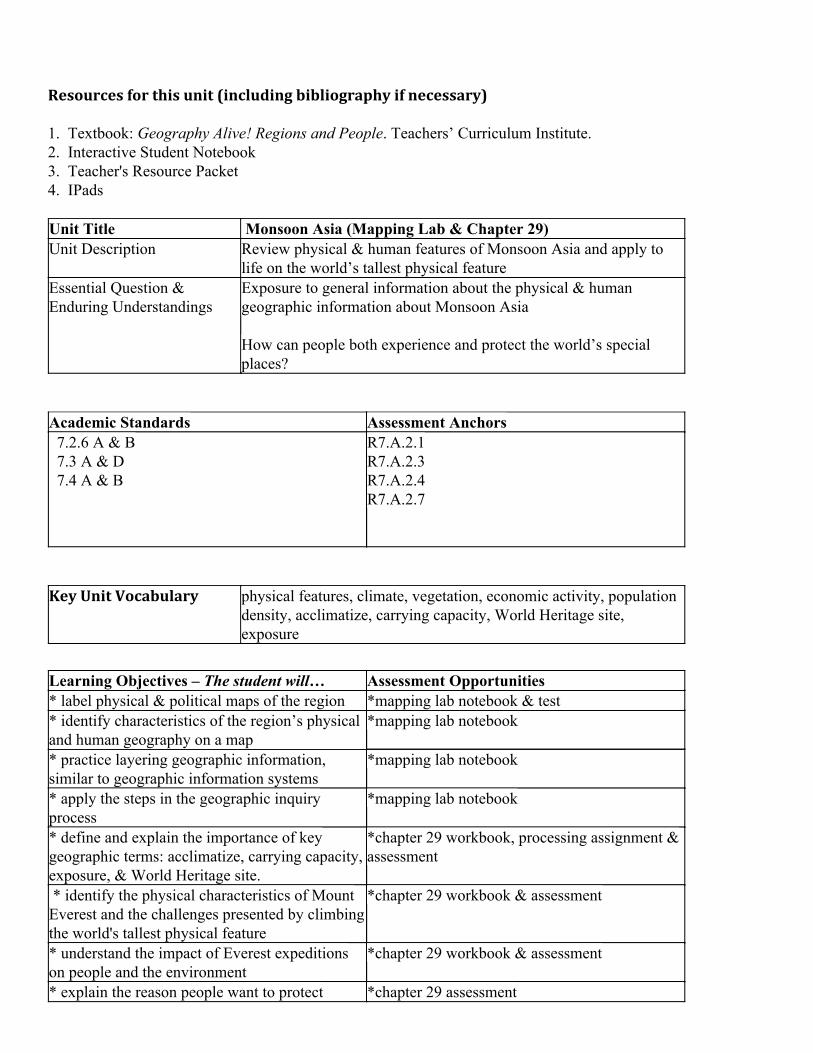
1. Textbook: Geography Alive! Regions and People. Teachers’ Curriculum Institute. 2. Interactive Student Notebook 3. Teacher's Resource Packet 4. IPads Unit Title Monsoon Asia (Mapping Lab & Chapter 29) Unit Description Review physical & human features of Monsoon Asia and apply to
life on the world’s tallest physical feature Essential Question & Enduring Understandings
Exposure to general information about the physical & human geographic information about Monsoon Asia
How can people both experience and protect the world’s special places?
Academic Standards Assessment Anchors 7.2.6 A & B 7.3 A & D 7.4 A & B
R7.A.2.1 R7.A.2.3 R7.A.2.4 R7.A.2.7
Key Unit Vocabulary physical features, climate, vegetation, economic activity, population density, acclimatize, carrying capacity, World Heritage site, exposure
Learning Objectives – The student will… Assessment Opportunities * label physical & political maps of the region *mapping lab notebook & test * identify characteristics of the region’s physical and human geography on a map
*mapping lab notebook
* practice layering geographic information, similar to geographic information systems
*mapping lab notebook
* apply the steps in the geographic inquiry process
*mapping lab notebook
* define and explain the importance of key geographic terms: acclimatize, carrying capacity, exposure, & World Heritage site.
*chapter 29 workbook, processing assignment & assessment
* identify the physical characteristics of Mount Everest and the challenges presented by climbing the world's tallest physical feature
*chapter 29 workbook & assessment
* understand the impact of Everest expeditions on people and the environment
*chapter 29 workbook & assessment
* explain the reason people want to protect *chapter 29 assessment
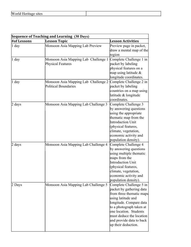
World Heritage sites Sequence of Teaching and Learning (30 Days) #of Lessons Lesson Topic Lesson Activities 1 day Monsoon Asia Mapping Lab Preview Preview page in packet,
draw a mental map of the region
1 day Monsoon Asia Mapping Lab Challenge 1 Physical Features
Complete Challenge 1 in packet by labeling physical features on a map using latitude & longitude coordinates.
1 day Monsoon Asia Mapping Lab Challenge 2 Political Boundaries
Complete Challenge 2 in packet by labeling countries on a map using latitude & longitude coordinates.
2 days Monsoon Asia Mapping Lab Challenge 3 Complete Challenge 3 by answering questions using the appropriate thematic map from the Introduction Unit (physical features, climate, vegetation, economic activity and population density).
2 days Monsoon Asia Mapping Lab Challenge 4 Complete Challenge 4 by answering questions using multiple thematic maps from the Introduction Unit (physical features, climate, vegetation, economic activity and population density).
2 Days Monsoon Asia Mapping Lab Challenge 5 Complete Challenge 5 in packet by gathering data from three thematic mapsusing latitude and longitude. Compare data to a photograph taken at one location. Students must deduce the location and provide data to back up their deduction.

1 day Monsoon Asia Mapping Lab Chapter Assessment
Complete by labeling major physical and human features on maps, and using thematic maps to answer questions by locating and comparing features.
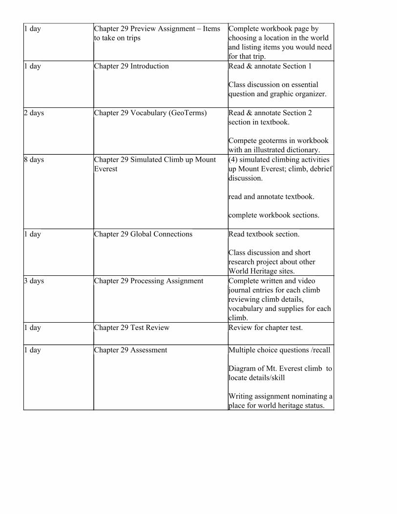
1 day Chapter 29 Preview Assignment – Items to take on trips
Complete workbook page by choosing a location in the world and listing items you would need for that trip.
1 day Chapter 29 Introduction Read & annotate Section 1
Class discussion on essential question and graphic organizer.
2 days Chapter 29 Vocabulary (GeoTerms) Read & annotate Section 2 section in textbook.
Compete geoterms in workbook with an illustrated dictionary.
8 days Chapter 29 Simulated Climb up Mount Everest
(4) simulated climbing activities up Mount Everest; climb, debrief discussion.
read and annotate textbook.
complete workbook sections.
1 day Chapter 29 Global Connections Read textbook section.
Class discussion and short research project about other World Heritage sites.
3 days Chapter 29 Processing Assignment Complete written and video journal entries for each climb reviewing climb details, vocabulary and supplies for each climb.
1 day Chapter 29 Test Review Review for chapter test.
1 day Chapter 29 Assessment Multiple choice questions /recall
Diagram of Mt. Everest climb to locate details/skill
Writing assignment nominating a place for world heritage status.

Resources for this unit (including bibliography if necessary)
1. Textbook: Geography Alive! Regions and People. Teachers’ Curriculum Institute. 2. Interactive Student Notebook 3. Teacher's Resource Packet 4. IPads 5. Simulation Climbing Supplies (Painter’s Masks)
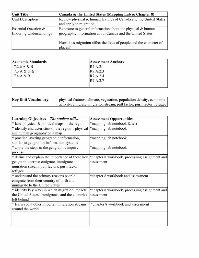
Unit Title Canada & the United States (Mapping Lab & Chapter 8) Unit Description Review physical & human features of Canada and the United States
and apply to migration Essential Question & Enduring Understandings
Exposure to general information about the physical & human geographic information about Canada and the United States
How does migration affect the lives of people and the character of places?
Academic Standards Assessment Anchors 7.2.6 A & B 7.3 A & D & 7.4 A & B
R7.A.2.1 R7.A.2.3 R7.A.2.4 R7.A.2.7
Key Unit Vocabulary physical features, climate, vegetation, population density, economic activity, emigrate, migration stream, pull factor, push factor, refugee
Learning Objectives – The student will… Assessment Opportunities * label physical & political maps of the region *mapping lab notebook & test * identify characteristics of the region’s physical and human geography on a map
*mapping lab notebook
* practice layering geographic information, similar to geographic information systems
*mapping lab notebook
* apply the steps in the geographic inquiry process
*mapping lab notebook
* define and explain the importance of these key geographic terms: emigrate, immigrate, migration stream, pull factors, push factor, refugee
*chapter 8 workbook, processing assignment and assessment
* understand the primary reasons people emigrate from their country of birth and immigrate to the United States
*chapter 8 workbook and assessment
* identify key ways in which migration impacts the United States, immigrants, and the countries left behind
*chapter 8 workbook, processing assignment and assessment
* learn about other important migration streams around the world
*chapter 8 workbook and assessment
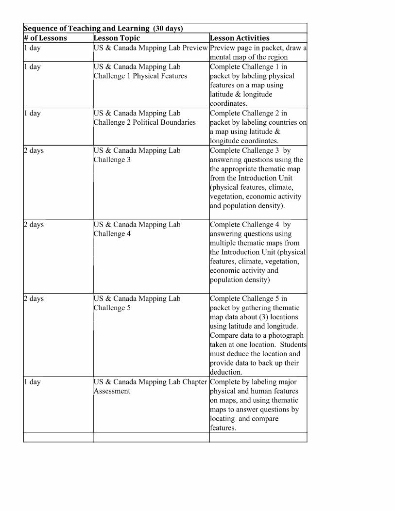
Sequence of Teaching and Learning (30 days) # of Lessons Lesson Topic Lesson Activities 1 day US & Canada Mapping Lab Preview Preview page in packet, draw a
mental map of the region 1 day US & Canada Mapping Lab
Challenge 1 Physical Features Complete Challenge 1 in packet by labeling physical features on a map using latitude & longitude coordinates.
1 day US & Canada Mapping Lab Challenge 2 Political Boundaries
Complete Challenge 2 in packet by labeling countries ona map using latitude & longitude coordinates.
2 days US & Canada Mapping Lab Challenge 3
Complete Challenge 3 by answering questions using the the appropriate thematic map from the Introduction Unit (physical features, climate, vegetation, economic activity and population density).
2 days US & Canada Mapping Lab Challenge 4
Complete Challenge 4 by answering questions using multiple thematic maps from the Introduction Unit (physical features, climate, vegetation, economic activity and population density)
2 days US & Canada Mapping Lab Challenge 5
Complete Challenge 5 in packet by gathering thematic map data about (3) locations using latitude and longitude. Compare data to a photograph taken at one location. Studentsmust deduce the location and provide data to back up their deduction.
1 day US & Canada Mapping Lab Chapter Assessment
Complete by labeling major physical and human features on maps, and using thematic maps to answer questions by locating and compare features.
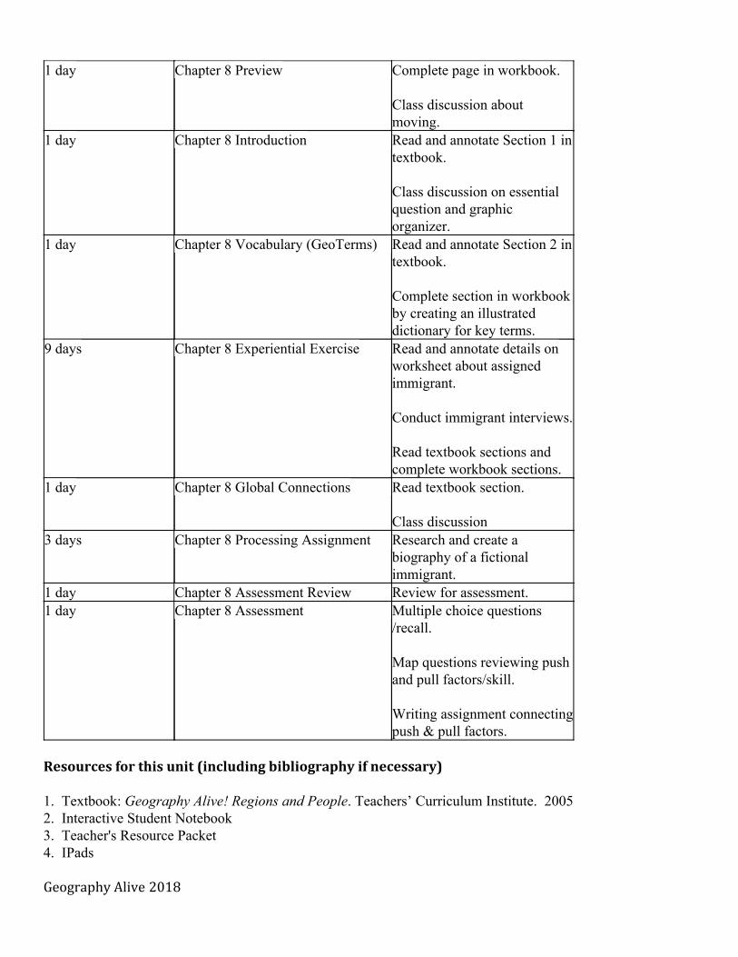
1 day Chapter 8 Preview Complete page in workbook.
Class discussion about moving.
1 day Chapter 8 Introduction Read and annotate Section 1 in textbook.
Class discussion on essential question and graphic organizer.
1 day Chapter 8 Vocabulary (GeoTerms) Read and annotate Section 2 in textbook.
Complete section in workbook by creating an illustrated dictionary for key terms.
9 days Chapter 8 Experiential Exercise Read and annotate details on worksheet about assigned immigrant. Conduct immigrant interviews.
Read textbook sections and complete workbook sections.
1 day Chapter 8 Global Connections Read textbook section.
Class discussion 3 days Chapter 8 Processing Assignment Research and create a
biography of a fictional immigrant.
1 day Chapter 8 Assessment Review Review for assessment. 1 day Chapter 8 Assessment Multiple choice questions
/recall.
Map questions reviewing push and pull factors/skill.
Writing assignment connectingpush & pull factors.
Resources for this unit (including bibliography if necessary)
1. Textbook: Geography Alive! Regions and People. Teachers’ Curriculum Institute. 2005 2. Interactive Student Notebook 3. Teacher's Resource Packet 4. IPads Geography Alive 2018