Embed Size (px)
Citation preview
Coseismic fold scarps and their kinematic behavior
in the 1999 Chi-Chi earthquake Taiwan
Yue-Gau Chen,1 Kuang-Yin Lai,1 Yuan-Hsi Lee,2 John Suppe,3 Wen-Shan Chen,1
Yu-Nong N. Lin,1 Yu Wang,1 Jih-Hao Hung,4 and Yu-Ting Kuo1
Received 14 March 2006; revised 29 July 2006; accepted 7 September 2006; published 13 March 2007.
[1] Discrete scarps that are created or reactivated during large earthquakes are a locus ofconcentrated hazard. A number of the coseismic scarps activated in the 1999 Chi-Chiearthquake are actually fold scarps, which display several types of ground deformationcharacterized by localized folding and are distinct from classic fault scarps, which formby a fault cutting the surface. This paper documents and analyzes fold scarps that formedor reactivated in the 1999 Chi-Chi Taiwan earthquake. Our results show the Chi-Chifold scarps can be generally divided into two types: (1) those associated with foldingahead of the tip of a blind thrust fault at shallow depths and (2) those associated withfolding by kink band migration above fault bends at substantial depths rangingfrom �0.8 to 5 km). The previously published trishear model can be applied tomodel the former type, while a new curved hinge kink band migration model is providedto describe the behavior of the latter type. A key feature of fold scarps of the secondtype is that hinge zones are typically wide (25–100 m) relative to the displacement in asingle earthquake (1–10 m), which exerts a significant control on fold scarpmorphology and evolution. Because the coseismic strains of both types of fold scarpsdisplay relatively wide deformation zones (10–100 m) relative to fault scarps, widerset-back zones might be appropriate from a public policy point of view to alleviatethe risk to structural damage and collapse resulting from permanent grounddeformation.
Citation: Chen, Y.-G., K.-Y. Lai, Y.-H. Lee, J. Suppe, W.-S. Chen, Y.-N. N. Lin, Y. Wang, J.-H. Hung, and Y.-T. Kuo (2007),
Coseismic fold scarps and their kinematic behavior in the 1999 Chi-Chi earthquake Taiwan, J. Geophys. Res., 112, B03S02,
doi:10.1029/2006JB004388.
1. Introduction
[2] Taiwan is located on the continental shelf of southChina at the boundary between the Eurasia and PhilippineSea plates (Figure 1a) where an arc-continent collision hasbeen operating since the early Pliocene, producing the westvergent fold-and-thrust belt in western Taiwan [Ho, 1982;Suppe, 1986; Teng, 1990]. Because the collision is ongoing,large earthquakes occasionally happen with significantdamage and loss of life. In the last century the largest eventwas the 1999 Chi-Chi earthquake Mw 7.6, which resulted inover 100,000 severely damaged buildings and 2400 fatali-ties. A major source of reported damage and loss of lifewas concentrated where the larger surface deformationsoccurred; especially the surface rupture scarps, which are
distributed over a distance of 100 km from south to north[Central Geological Survey (CGS), 1999] (Figure 1b). Themost important seismogenic fault of the composite Chi-Chiearthquake is the Chelungpu fault, which is the second thrustfault eastward from the western deformation front [Chiu,1971; Chinese Petroleum Company, 1982; Suppe, 1981; Yueet al., 2005] (AA0 in Figure 2). Most of the coseismic Chi-Chi scarps formed where the main fault reached the surface[CGS, 1999; Chen et al., 2002]. Nevertheless, postearth-quake investigations demonstrate that some of the coseismicscarps are characterized by wider zones of bending withoutan associated major fault cutting the land surface, in contrastwith typical fault scarps. These are actually fold scarps[Suppe et al., 1997; Dolan et al., 2003; Hubert-Ferrari etal., 2007] based on the evidence presented in previous andpresent study [Chen et al., 2004; Lee et al., 2005; Lai et al.,2006]. Here we discuss the types, mechanisms, and coseis-mic behavior of folds scarps based on the observations of thecoseismic examples of the 1999 Chi-Chi earthquake.[3] It is common to misidentify fold scarps as fault scarps
because the geomorphic profile of a monoclinal, kinkshaped fold scarps can superficially resemble fault scarpswhere the overhanging hanging wall has collapsed during orshortly after an earthquake, as well those that have under-
JOURNAL OF GEOPHYSICAL RESEARCH, VOL. 112, B03S02, doi:10.1029/2006JB004388, 2007ClickHere
for
FullArticle
1Department of Geosciences, National Taiwan University, Taipei,Taiwan.
2Department of Earth and Environmental Sciences, National Chung-Cheng University, Chiayi, Taiwan.
3Department of Geosciences, Princeton University, Princeton, NewJersey, USA.
4Department of Earth Sciences, National Central University, Chungli,Taiwan.
Copyright 2007 by the American Geophysical Union.0148-0227/07/2006JB004388$09.00
B03S02 1 of 15
gone long-term erosion [e.g., Yielding et al., 1981]. As aresult, more than the correct number of active faults will bedefined on geological or seismic hazard maps. Also, the set-back zone designated for fold scarps above fault bends aswell as for fold scarps above blind faults will be alsoinappropriate since the coseismic surface deformation
for a fold scarp is quite different from a fault scarp.The 1999 Chi-Chi event provides an important opportu-nity to quantitatively document the differences betweenthese two superficially similar but fundamentally differentfault-related zones of localized coseismic deformation. Forthe purpose of understanding the mechanism and coseismic
Figure 1. (a) Current tectonic environment surrounding Taiwan and study area. Velocity for the platemotion is adopted from Yu et al. [1999]. (b) Map showing the topography in central Taiwan and studysites. Major thrust faults are shown, such as CLPF, Chelungpu fault (1999 surface rupture); STF,Shuangtung fault; SYF, Sanyi fault; CHF, Changhua fault. Note that site 1 is Shijia trenching site,Nantou; site 2 is Tsaotun; site 3 is Hsinshe; site 4 is Neiwan; and site 5 is Hsiaolipu.
B03S02 CHEN ET AL.: FOLD SCARP IN CHI-CHI TAIWAN EARTHQUAKE
2 of 15
B03S02
behavior of these active scarps, we made field measurementsof the surface deformation as well as the subsurface struc-tures. In addition we present a simple kinematic model ofone of the two types of fold scarps to help explain thecoseismic deformation that we observed in 1999 event. Tocompletely establish the behavior of these scarps, furtherstudies of subtle geomorphic features and their age determi-nation are still needed.
2. Fault Scarps and Fold Scarps Formed in theChi-Chi Earthquake
[4] Because of the shallow source and large slip reaching3–10 m in the 1999 event [CGS, 1999;Ma et al., 1999; Kaoand Chen, 2000], the main thrust commonly reached theground surface and formed a fault scarp over much of its�100 km length. Typical thrust fault scarps found in the1999 event are characterized by substantial horizontal short-ening and loss of surface area, which is absorbed in a narrowzone along the fault trace regardless of whether it is the mainfault or a subsidiary fault. This loss of surface area results ina footwall buried by up to 10 m of the hanging wall. Incontrast with these typical thrust fault scarps, fold scarps arealso found but are characterized by a wider surface defor-mation zone reaching 25–100 m and essentially no loss ofsurface area. The fold scarps found in the 1999 event can bedivided into two types (type 1 and type 2 in the followingtext) based on the mechanisms of formation, as follows.
3. Coseismic Deformation of Fold ScarpAssociated With a Blind Thrust Tip: Type 1 Site 1Shijia Trenching Site in Nantou
[5] Type 1 fold scarps are closely related to fault scarpsbecause they are created as a result of burial of an active
fault trace by thick deposition in the interseismic period.The fold scarp forms by distributed coseismic deformationahead of the fault tip within the previously undeformedsurficial strata deposited since the last earthquake. Toillustrate the type 1 fold scarps, we describe a well-studiedcase located in the southern segment of the Chelungpu fault(site 1 in Figure 1). This is a trench site with supportingshallow boreholes, which is originally named as Shijia (i.e.,the Chinese fruit name, also known as Buddha head)because this fruit grew on the ground surface before theearthquake. The postearthquake investigation of the scarp,based on the regular structure of the fruit field, showed thatit is a fold scarp because there was no associated loss ofsurface area of the sort that would be expected if this were afault scarp with a buried footwall. A trenching study wasconducted for the purpose of paleoseismology [Chen et al.,2004; Streig et al., 2006] (Figure 3a). The trench log showscontinuous sedimentary layers underlying the topographicscarp, indicating the fault tip stops at least 5m below thesurface, which is the depth of the trench. The fault tip can befurther constrained to lie at 5–10 m in depth because theborehole C2 drilled through the fault (Figure 3a). In thiscase, the surface scarp is definitely not a typical fault scarp,which is consistent with the observation of no fault disrup-tion on the surface. Judging from the differential upliftacross the scarp, the surface deformation can be describedas a scarp created by folding behavior. The trenching study[Streig et al., 2006] applied the concept of fault tip migra-tion and trishear folding to model the coseismic deformation[Erslev, 1991; Hardy and Ford, 1997; Champion et al.,2001] (Figure 3b). Fault dip and tip position is constrainedby boreholes C1 and C2. The deformed layer shapes are thebasis for inverse modeling of the slip and best fitting faultgeometry. Using the parameters of the best fit model, aforward model is constructed and presented in Figure 3b.
Figure 2. Cross sections showing the subsurface geology in the hanging wall of the Chelungpu fault(line index map in Figure 1b). Please note the bends in the fault plane of the Chelungpu fault at depths of2 km, 3 km, and <1 km in (a) AA0, (b) BB00, and (c) CC0, respectively, discussed in the text.
B03S02 CHEN ET AL.: FOLD SCARP IN CHI-CHI TAIWAN EARTHQUAKE
3 of 15
B03S02
Figure
3.
(a)Profile
illustratinglogsofthetrench
siteShijia
atNantouandfoursupportingboreholesC1to
C4[Chen
etal.,2004;Streiget
al.,2006].Thesurfacescarpofthe1999Chi-Chiearthquakelies
betweenC2andC3.From
thefault
zoneidentified
inC1andC2,theChelungpufaultcanbeinferred
tohaveadip
angle
of26�E
andapositionin
thedepth
rangeof10to
20m.Thefaulttipisconstrained
tobein
thedepth
rangeof5to
10m
betweenC2andC3.(b)Modeled
result
showingthestrain
distributionacross
thefold
scarp.Notethatsignificantsurfaceshorteningoccursfrom
thetopofthescarp
toat
least10m
beyondthescarptoe.
B03S02 CHEN ET AL.: FOLD SCARP IN CHI-CHI TAIWAN EARTHQUAKE
4 of 15
B03S02
The result shows significant strain distributed from the topof the scarp to 10 m beyond the scarp toe, which is entirelydifferent from what is observed in thrust fault scarps. Theshortening given by thrust faulting is largely absorbed bylayer thickening due to the ductility of the covering uncon-solidated sediments. Substantial layer thickening occursacross the scarp. According to this trishear modeling result,the scarp shape is controlled by the fault dip, the position ofthe fault tip, and the amount of slip. If the geologicparameters mentioned above were all known before theearthquake, the coseismic deformation of the fold scarpcould actually be predicted.
4. Coseismic Deformation of Fold ScarpAssociated With Fault Bend: Type 2
[6] Type 2 fold scarps of the Chi-Chi earthquake aretypically found in the hanging wall far removed (>km) fromthe surface trace of the associated fault, in contrast withtype 1 fold scarps which are closely associated with the faulttip and located within the general zone of the surface faulttrace. Type 2 fold scarps are directly associated with abruptdip changes in the fault at depth and with dip changes in thehanging wall bedding. This paper presents data from foursites (sites 2 to 5 in Figure 1b): Tsaotun, Hsinshe, Neiwan,and Hsiaolipu. The first two sites, Tsaotun and Hsinshe, arelocated several kilometers to the east of the Chelungpu faultsurface trace and had a linear preexisting east facingtopographic scarp (Figures 2a and 2b), which had beenpreviously interpreted as a fault scarp formed by mountain-
ward back thrusts [Ku, 1963; Bonilla, 1977; Shih et al.,1985, 1986]. However, during the 1999 event the coseismicsurface deformation surprisingly demonstrated folding be-havior instead of faulting, indicating the scarps are actuallyfold scarps generated by differential slip in response to faultbends at depth. The final two sites, Neiwan, and Hsiaolipu,are within the northern complex �1–2 km wide zone ofcomplex Chi-Chi surface scarps which strikes due east toNNE. This zone at Neiwan and Hsiaolipu is actually thepreexisting Tungshih anticline which grew coseismically by�10 m resulting from consuming the slip at the terminationof the Chelungpu fault at depth (Figure 2c).
5. Site 2 Tsaotun: A Preexisting Fold Scarp
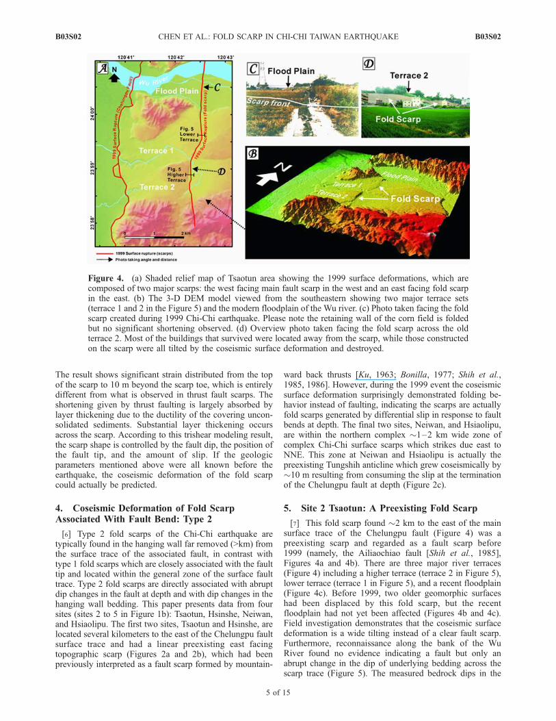
[7] This fold scarp found �2 km to the east of the mainsurface trace of the Chelungpu fault (Figure 4) was apreexisting scarp and regarded as a fault scarp before1999 (namely, the Ailiaochiao fault [Shih et al., 1985],Figures 4a and 4b). There are three major river terraces(Figure 4) including a higher terrace (terrace 2 in Figure 5),lower terrace (terrace 1 in Figure 5), and a recent floodplain(Figure 4c). Before 1999, two older geomorphic surfaceshad been displaced by this fold scarp, but the recentfloodplain had not yet been affected (Figures 4b and 4c).Field investigation demonstrates that the coseismic surfacedeformation is a wide tilting instead of a clear fault scarp.Furthermore, reconnaissance along the bank of the WuRiver found no evidence indicating a fault but only anabrupt change in the dip of underlying bedding across thescarp trace (Figure 5). The measured bedrock dips in the
Figure 4. (a) Shaded relief map of Tsaotun area showing the 1999 surface deformations, which arecomposed of two major scarps: the west facing main fault scarp in the west and an east facing fold scarpin the east. (b) The 3-D DEM model viewed from the southeastern showing two major terrace sets(terrace 1 and 2 in the Figure 5) and the modern floodplain of the Wu river. (c) Photo taken facing the foldscarp created during 1999 Chi-Chi earthquake. Please note the retaining wall of the corn field is foldedbut no significant shortening observed. (d) Overview photo taken facing the fold scarp across the oldterrace 2. Most of the buildings that survived were located away from the scarp, while those constructedon the scarp were all tilted by the coseismic surface deformation and destroyed.
B03S02 CHEN ET AL.: FOLD SCARP IN CHI-CHI TAIWAN EARTHQUAKE
5 of 15
B03S02
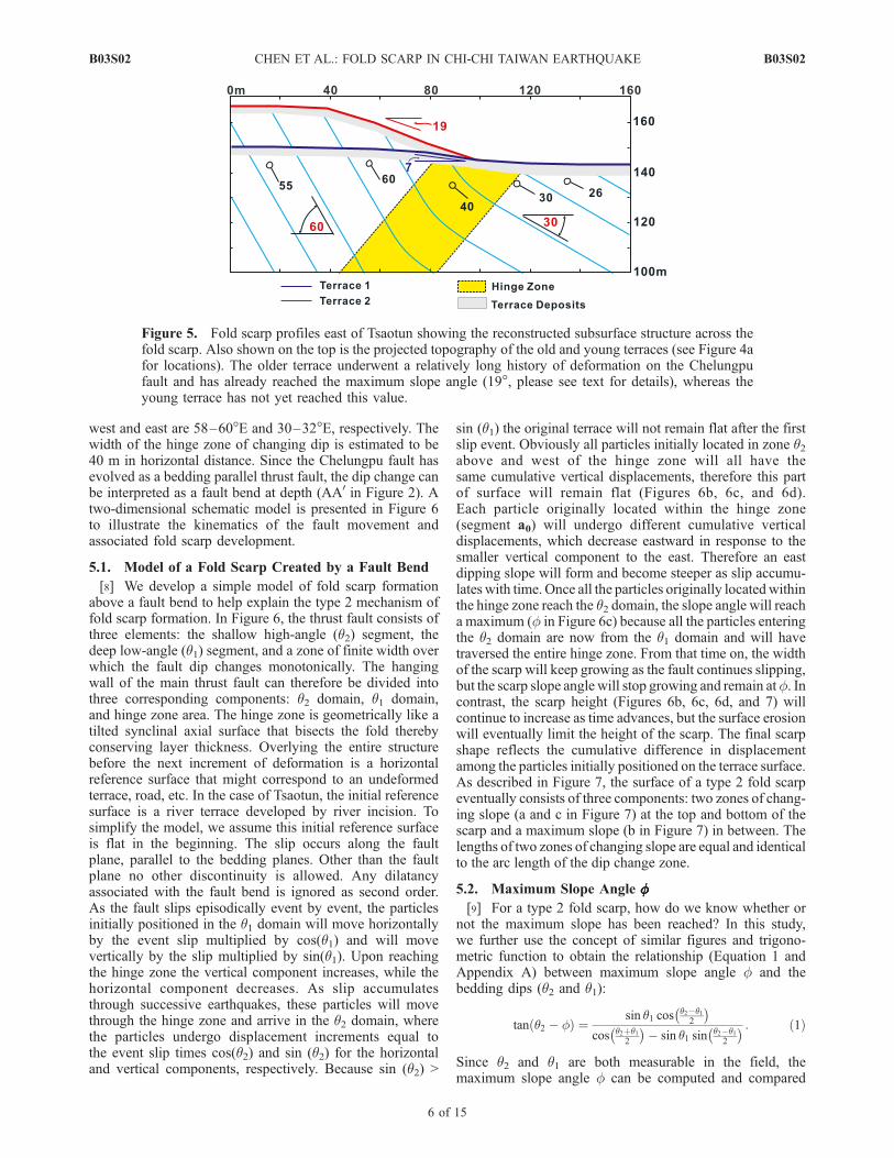
west and east are 58–60�E and 30–32�E, respectively. Thewidth of the hinge zone of changing dip is estimated to be40 m in horizontal distance. Since the Chelungpu fault hasevolved as a bedding parallel thrust fault, the dip change canbe interpreted as a fault bend at depth (AA0 in Figure 2). Atwo-dimensional schematic model is presented in Figure 6to illustrate the kinematics of the fault movement andassociated fold scarp development.
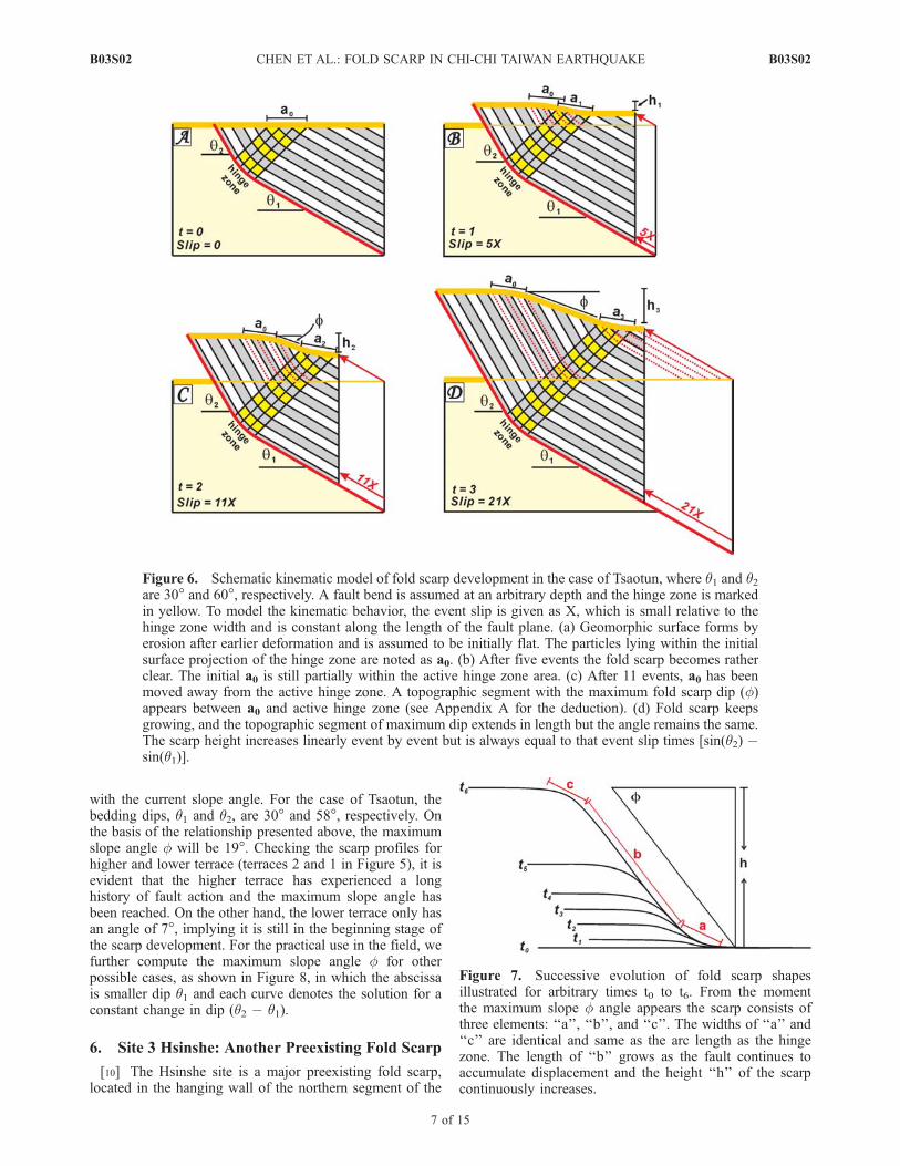
5.1. Model of a Fold Scarp Created by a Fault Bend
[8] We develop a simple model of fold scarp formationabove a fault bend to help explain the type 2 mechanism offold scarp formation. In Figure 6, the thrust fault consists ofthree elements: the shallow high-angle (q2) segment, thedeep low-angle (q1) segment, and a zone of finite width overwhich the fault dip changes monotonically. The hangingwall of the main thrust fault can therefore be divided intothree corresponding components: q2 domain, q1 domain,and hinge zone area. The hinge zone is geometrically like atilted synclinal axial surface that bisects the fold therebyconserving layer thickness. Overlying the entire structurebefore the next increment of deformation is a horizontalreference surface that might correspond to an undeformedterrace, road, etc. In the case of Tsaotun, the initial referencesurface is a river terrace developed by river incision. Tosimplify the model, we assume this initial reference surfaceis flat in the beginning. The slip occurs along the faultplane, parallel to the bedding planes. Other than the faultplane no other discontinuity is allowed. Any dilatancyassociated with the fault bend is ignored as second order.As the fault slips episodically event by event, the particlesinitially positioned in the q1 domain will move horizontallyby the event slip multiplied by cos(q1) and will movevertically by the slip multiplied by sin(q1). Upon reachingthe hinge zone the vertical component increases, while thehorizontal component decreases. As slip accumulatesthrough successive earthquakes, these particles will movethrough the hinge zone and arrive in the q2 domain, wherethe particles undergo displacement increments equal tothe event slip times cos(q2) and sin (q2) for the horizontaland vertical components, respectively. Because sin (q2) >
sin (q1) the original terrace will not remain flat after the firstslip event. Obviously all particles initially located in zone q2above and west of the hinge zone will all have thesame cumulative vertical displacements, therefore this partof surface will remain flat (Figures 6b, 6c, and 6d).Each particle originally located within the hinge zone(segment a0) will undergo different cumulative verticaldisplacements, which decrease eastward in response to thesmaller vertical component to the east. Therefore an eastdipping slope will form and become steeper as slip accumu-lates with time. Once all the particles originally locatedwithinthe hinge zone reach the q2 domain, the slope angle will reacha maximum (f in Figure 6c) because all the particles enteringthe q2 domain are now from the q1 domain and will havetraversed the entire hinge zone. From that time on, the widthof the scarp will keep growing as the fault continues slipping,but the scarp slope angle will stop growing and remain atf. Incontrast, the scarp height (Figures 6b, 6c, 6d, and 7) willcontinue to increase as time advances, but the surface erosionwill eventually limit the height of the scarp. The final scarpshape reflects the cumulative difference in displacementamong the particles initially positioned on the terrace surface.As described in Figure 7, the surface of a type 2 fold scarpeventually consists of three components: two zones of chang-ing slope (a and c in Figure 7) at the top and bottom of thescarp and a maximum slope (b in Figure 7) in between. Thelengths of two zones of changing slope are equal and identicalto the arc length of the dip change zone.
5.2. Maximum Slope Angle ffffffff[9] For a type 2 fold scarp, how do we know whether or
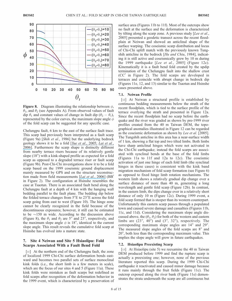
not the maximum slope has been reached? In this study,we further use the concept of similar figures and trigono-metric function to obtain the relationship (Equation 1 andAppendix A) between maximum slope angle f and thebedding dips (q2 and q1):
tan q2 � fð Þ ¼sin q1 cos q2�q1
2
� �cos q2þq1
2
� �� sin q1 sin q2�q1
2
� � : ð1Þ
Since q2 and q1 are both measurable in the field, themaximum slope angle f can be computed and compared
Figure 5. Fold scarp profiles east of Tsaotun showing the reconstructed subsurface structure across thefold scarp. Also shown on the top is the projected topography of the old and young terraces (see Figure 4afor locations). The older terrace underwent a relatively long history of deformation on the Chelungpufault and has already reached the maximum slope angle (19�, please see text for details), whereas theyoung terrace has not yet reached this value.
B03S02 CHEN ET AL.: FOLD SCARP IN CHI-CHI TAIWAN EARTHQUAKE
6 of 15
B03S02
with the current slope angle. For the case of Tsaotun, thebedding dips, q1 and q2, are 30� and 58�, respectively. Onthe basis of the relationship presented above, the maximumslope angle f will be 19�. Checking the scarp profiles forhigher and lower terrace (terraces 2 and 1 in Figure 5), it isevident that the higher terrace has experienced a longhistory of fault action and the maximum slope angle hasbeen reached. On the other hand, the lower terrace only hasan angle of 7�, implying it is still in the beginning stage ofthe scarp development. For the practical use in the field, wefurther compute the maximum slope angle f for otherpossible cases, as shown in Figure 8, in which the abscissais smaller dip q1 and each curve denotes the solution for aconstant change in dip (q2 � q1).
6. Site 3 Hsinshe: Another Preexisting Fold Scarp
[10] The Hsinshe site is a major preexisting fold scarp,located in the hanging wall of the northern segment of the
Figure 6. Schematic kinematic model of fold scarp development in the case of Tsaotun, where q1 and q2are 30� and 60�, respectively. A fault bend is assumed at an arbitrary depth and the hinge zone is markedin yellow. To model the kinematic behavior, the event slip is given as X, which is small relative to thehinge zone width and is constant along the length of the fault plane. (a) Geomorphic surface forms byerosion after earlier deformation and is assumed to be initially flat. The particles lying within the initialsurface projection of the hinge zone are noted as a0. (b) After five events the fold scarp becomes ratherclear. The initial a0 is still partially within the active hinge zone area. (c) After 11 events, a0 has beenmoved away from the active hinge zone. A topographic segment with the maximum fold scarp dip (f)appears between a0 and active hinge zone (see Appendix A for the deduction). (d) Fold scarp keepsgrowing, and the topographic segment of maximum dip extends in length but the angle remains the same.The scarp height increases linearly event by event but is always equal to that event slip times [sin(q2) �sin(q1)].
Figure 7. Successive evolution of fold scarp shapesillustrated for arbitrary times t0 to t6. From the momentthe maximum slope f angle appears the scarp consists ofthree elements: ‘‘a’’, ‘‘b’’, and ‘‘c’’. The widths of ‘‘a’’ and‘‘c’’ are identical and same as the arc length as the hingezone. The length of ‘‘b’’ grows as the fault continues toaccumulate displacement and the height ‘‘h’’ of the scarpcontinuously increases.
B03S02 CHEN ET AL.: FOLD SCARP IN CHI-CHI TAIWAN EARTHQUAKE
7 of 15
B03S02
Chelungpu fault, 6 km to the east of the surface fault trace.This scarp had previously been interpreted as a fault scarp(Figure 9a) [Shih et al., 1986] but the underlying bedrockgeology shows it to be a fold [Yue et al., 2005; Lai et al.,2006]. Furthermore the scarp shape is distinctly differentfrom nearby terrace risers because of its relatively gentleslope (18�) with a kink-shaped profile as expected for a foldscarp as opposed to a degraded terrace riser or fault scarp(Figure 9b). Post-Chi-Chi investigations show it to be a foldscarp based on the 1999 coseismic ground displacementmainly measured by GPS and on the structure reconstruc-tion made from field measurements [Lai et al., 2006] (BB0
in Figure 2). The configuration at Hsinshe resembles thecase at Tsaotun. There is an associated fault bend along theChelungpu fault at a depth of 4 km with the hanging wallbedding parallel to the fault plane. The bedding dip belowthe folded terrace changes from 5�E to 23�E across the foldscarp going from east to west (Figure 10). The hinge zonecannot be clearly recognized in the field because of thediscontinuous exposures; however, it still can be estimatedto be �150 m wide. According to the discussion above(Figure 8), the q1 and q2 are 5� and 23�, respectively, andthe maximum slope angle f is 18�, identical to the currentslope angle. This result reveals the cumulative fold scarp atHsinshe has evolved into a mature state.
7. Site 4 Neiwan and Site 5 Hsiaolipu: FoldScarps Associated With a Fault Bend Fold
[11] At the northern end of the Chelungpu fault, the zoneof localized 1999 Chi-Chi surface deformation bends east-ward and becomes two parallel sets of surface monoclinalkink folds (i.e., the short limb is a few meters in scale),which are the focus of our sites 4 and 5 (Figure 11a). Thesekink folds were mistaken as fault scarps but redefined asfold scarps after recognition of the deformation behavior inthe 1999 event, which is characterized by a preservation of
surface area (Figures 11b to 11f). Most of the outcrops showno fault at the surface and the deformation is characterizedby tilting along the scarp zone. A previous study [Lee et al.,2005] presented a geodetic transect across the recent flood-plain at Neiwan and showed an anticlinal shape of thesurface warping. The coseismic scarp distribution and locusof Chi-Chi uplift match with the previously known Tung-shih anticline in the bedrock [Hu and Chiu, 1984], indicat-ing it is still active and coseismically grew by 10 m duringthe 1999 earthquake [Lee et al., 2005] (Figure 12c).Kinematically it is a fault bend fold created by the updiptermination of the Chelungpu fault into the shallow crust(CC0 in Figure 2). The fold scarps are developed interraces and coincide with abrupt change in bedrock dip(Figures 11e, 12, and 13) similar to the Tsaotun and Hsinshecases presented above.
7.1. Neiwan Profile
[12] At Neiwan a structural profile is established bycontinuous bedding measurements below the strath of therecent floodplain, which is tied to the surface profile of theterrace overlying the strath and presented in Figure 12a.Since the recent floodplain had no scarp before the earth-quake and the river was graded as shown by pre-1999 riverprofiles created from the 40 m Taiwan DEM, the topo-graphical anomalies illustrated in Figure 12 can be regardedas the coseismic deformation as shown by Lee et al. [2005].The Tungshih anticline in this area has a near-surface widthof 1 km, showing a flat top and two tilted limbs. Both limbshave sharp anticlinal hinges which were not activated inthe Chi-Chi earthquake; instead the fold scarps are associ-ated with synclinal bends at the base of the fold limbs(Figures 11a to 11f and 12a to 12c). The coseismicactivation of just one hinge of each fold limb (the synclinalhinges in these cases) is consistent with the kink bandmigration mechanism of fold scarp formation (see Figure 6)as opposed to fixed hinge limb rotation mechanisms. Thewestern limb shows a relatively gradual dip change over asurface distance of more than 40 m, generating a longwavelength and gentle fold scarp (Figure 12b). In contrast,in the eastern limb, the dips change over in a relatively shortdistance of only 10 m (Figure 12c). During 1999 event, afold scarp formed that is steeper than its western counterpart.Unfortunately this eastern scarp passes through a populatedtown and caused severe damage and casualties (Figures 11b,11c, and 11d). Considering the maximum slope angle dis-cussed above, the (q1, q2) for both of the western and easternlimbs are (23�, 40�) and (3�, 32�), respectively. Thecorresponding maximum slope angles are 14� and 29�.The measured slope angles of the fold scarps are 8� and20�, both less than the corresponding maximum value. Thisimplies the slope angle will grow in future earthquakes.
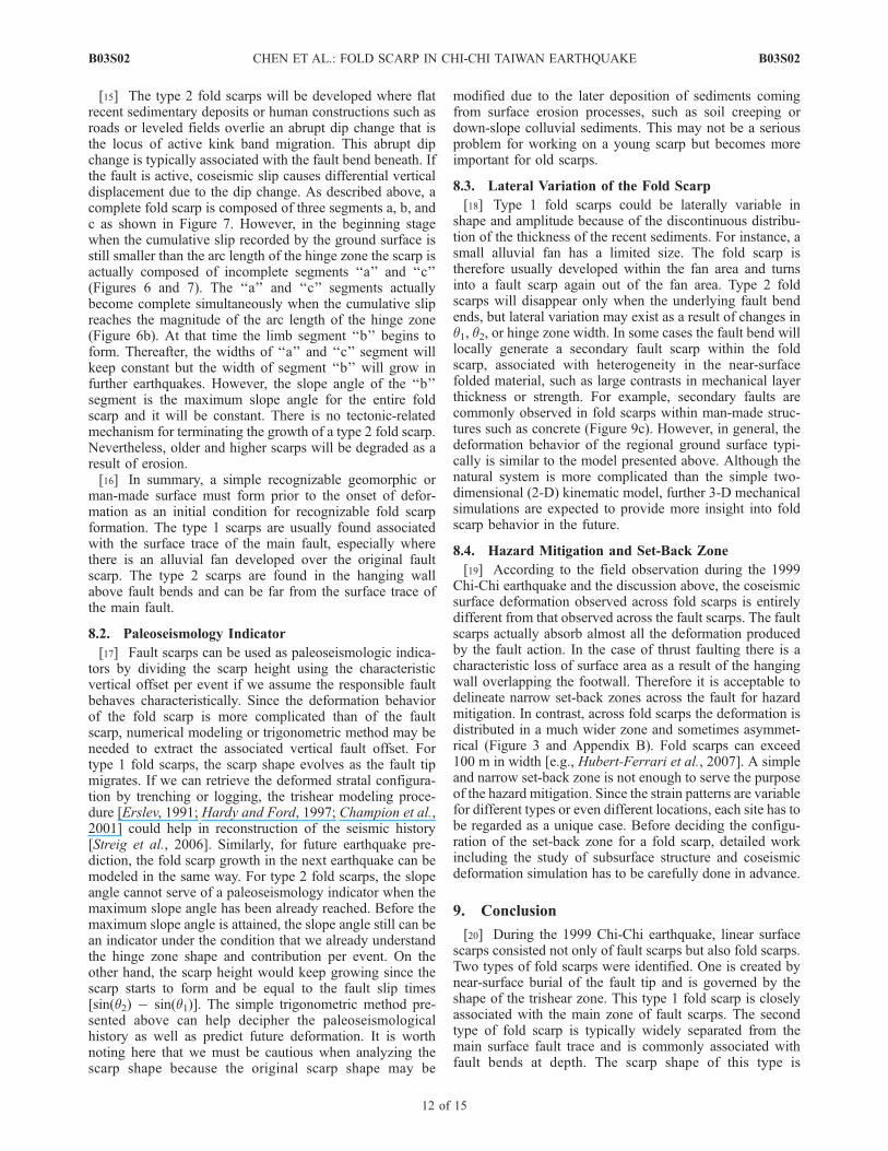
7.2. Hsiaolipu Preexisting Scarp
[13] At Hsiaolipu (site 5) we reexamine the 40 m TaiwanDEM produced before 1999 and find the rupture scarp isactually a preexisting one; however, none of the previousliterature reported this scarp. During the 1999 Chi-Chiearthquake it reactivated and caused minor damage becauseit runs mainly through the fruit fields (Figure 11c). Theoutcrop exposed along the river bank (Figure 11e) demon-strates the strata underneath the scarp are all continuous but
Figure 8. Diagram illustrating the relationship between f,q1, and q2 (see Appendix A). From observed values of faultdip q1 and constant values of change in fault dip (q2 � q1),represented by the color curves, the maximum slope angle fof the fold scarp can be suggested for any specific case.
B03S02 CHEN ET AL.: FOLD SCARP IN CHI-CHI TAIWAN EARTHQUAKE
8 of 15
B03S02
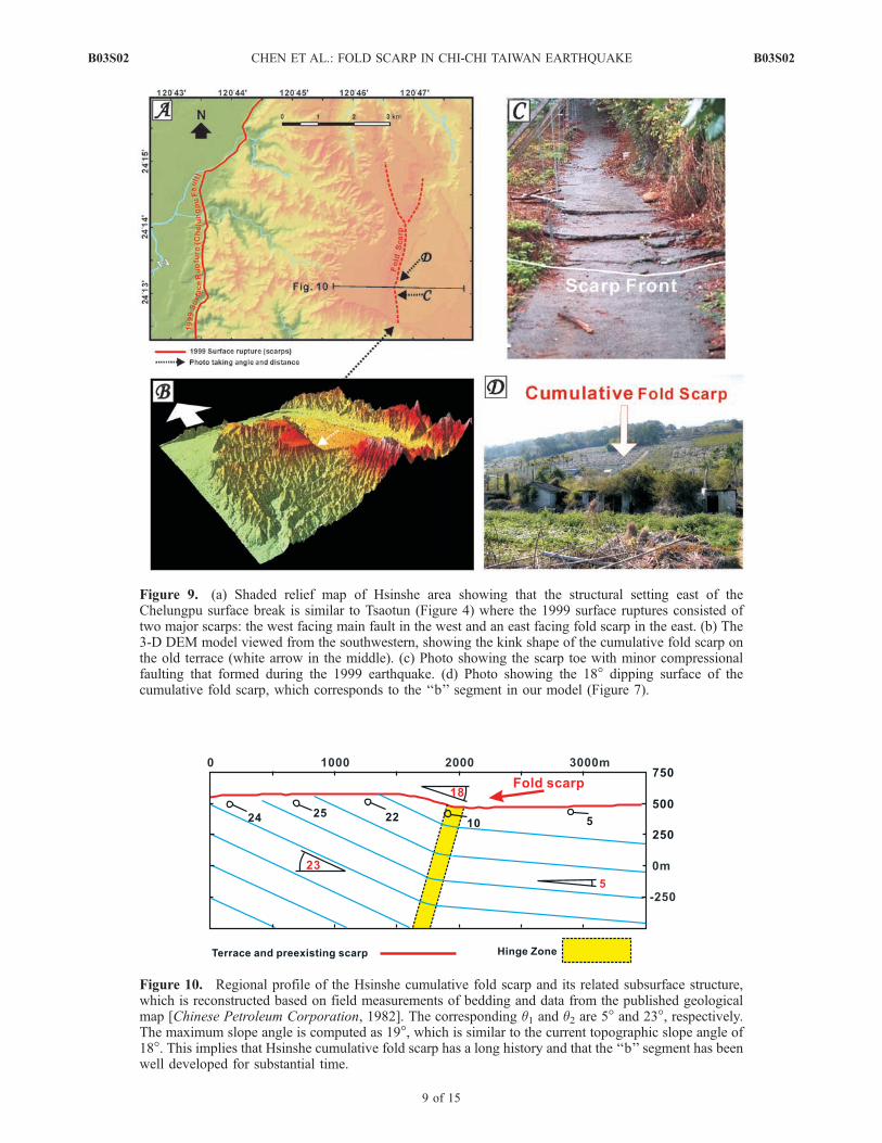
Figure 9. (a) Shaded relief map of Hsinshe area showing that the structural setting east of theChelungpu surface break is similar to Tsaotun (Figure 4) where the 1999 surface ruptures consisted oftwo major scarps: the west facing main fault in the west and an east facing fold scarp in the east. (b) The3-D DEM model viewed from the southwestern, showing the kink shape of the cumulative fold scarp onthe old terrace (white arrow in the middle). (c) Photo showing the scarp toe with minor compressionalfaulting that formed during the 1999 earthquake. (d) Photo showing the 18� dipping surface of thecumulative fold scarp, which corresponds to the ‘‘b’’ segment in our model (Figure 7).
Figure 10. Regional profile of the Hsinshe cumulative fold scarp and its related subsurface structure,which is reconstructed based on field measurements of bedding and data from the published geologicalmap [Chinese Petroleum Corporation, 1982]. The corresponding q1 and q2 are 5� and 23�, respectively.The maximum slope angle is computed as 19�, which is similar to the current topographic slope angle of18�. This implies that Hsinshe cumulative fold scarp has a long history and that the ‘‘b’’ segment has beenwell developed for substantial time.
B03S02 CHEN ET AL.: FOLD SCARP IN CHI-CHI TAIWAN EARTHQUAKE
9 of 15
B03S02
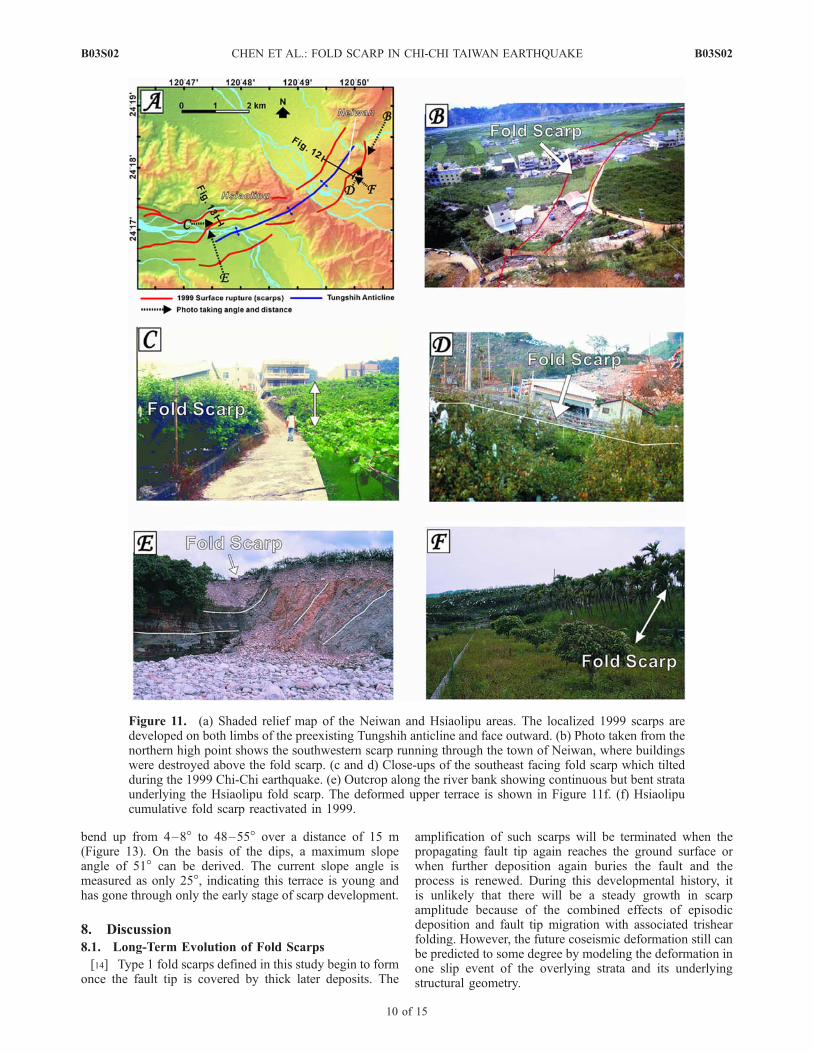
bend up from 4–8� to 48–55� over a distance of 15 m(Figure 13). On the basis of the dips, a maximum slopeangle of 51� can be derived. The current slope angle ismeasured as only 25�, indicating this terrace is young andhas gone through only the early stage of scarp development.
8. Discussion
8.1. Long-Term Evolution of Fold Scarps
[14] Type 1 fold scarps defined in this study begin to formonce the fault tip is covered by thick later deposits. The
amplification of such scarps will be terminated when thepropagating fault tip again reaches the ground surface orwhen further deposition again buries the fault and theprocess is renewed. During this developmental history, itis unlikely that there will be a steady growth in scarpamplitude because of the combined effects of episodicdeposition and fault tip migration with associated trishearfolding. However, the future coseismic deformation still canbe predicted to some degree by modeling the deformation inone slip event of the overlying strata and its underlyingstructural geometry.
Figure 11. (a) Shaded relief map of the Neiwan and Hsiaolipu areas. The localized 1999 scarps aredeveloped on both limbs of the preexisting Tungshih anticline and face outward. (b) Photo taken from thenorthern high point shows the southwestern scarp running through the town of Neiwan, where buildingswere destroyed above the fold scarp. (c and d) Close-ups of the southeast facing fold scarp which tiltedduring the 1999 Chi-Chi earthquake. (e) Outcrop along the river bank showing continuous but bent strataunderlying the Hsiaolipu fold scarp. The deformed upper terrace is shown in Figure 11f. (f) Hsiaolipucumulative fold scarp reactivated in 1999.
B03S02 CHEN ET AL.: FOLD SCARP IN CHI-CHI TAIWAN EARTHQUAKE
10 of 15
B03S02
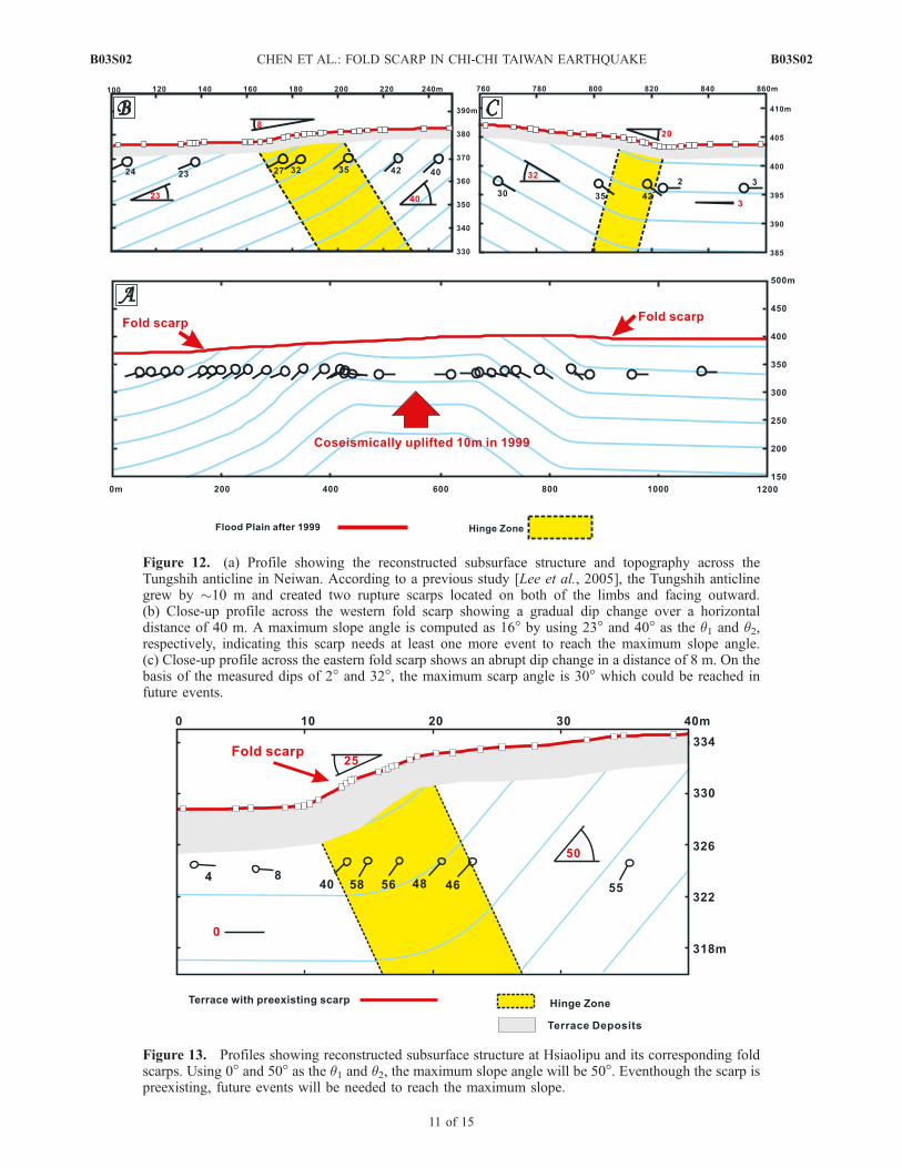
Figure 12. (a) Profile showing the reconstructed subsurface structure and topography across theTungshih anticline in Neiwan. According to a previous study [Lee et al., 2005], the Tungshih anticlinegrew by �10 m and created two rupture scarps located on both of the limbs and facing outward.(b) Close-up profile across the western fold scarp showing a gradual dip change over a horizontaldistance of 40 m. A maximum slope angle is computed as 16� by using 23� and 40� as the q1 and q2,respectively, indicating this scarp needs at least one more event to reach the maximum slope angle.(c) Close-up profile across the eastern fold scarp shows an abrupt dip change in a distance of 8 m. On thebasis of the measured dips of 2� and 32�, the maximum scarp angle is 30� which could be reached infuture events.
Figure 13. Profiles showing reconstructed subsurface structure at Hsiaolipu and its corresponding foldscarps. Using 0� and 50� as the q1 and q2, the maximum slope angle will be 50�. Eventhough the scarp ispreexisting, future events will be needed to reach the maximum slope.
B03S02 CHEN ET AL.: FOLD SCARP IN CHI-CHI TAIWAN EARTHQUAKE
11 of 15
B03S02
[15] The type 2 fold scarps will be developed where flatrecent sedimentary deposits or human constructions such asroads or leveled fields overlie an abrupt dip change that isthe locus of active kink band migration. This abrupt dipchange is typically associated with the fault bend beneath. Ifthe fault is active, coseismic slip causes differential verticaldisplacement due to the dip change. As described above, acomplete fold scarp is composed of three segments a, b, andc as shown in Figure 7. However, in the beginning stagewhen the cumulative slip recorded by the ground surface isstill smaller than the arc length of the hinge zone the scarp isactually composed of incomplete segments ‘‘a’’ and ‘‘c’’(Figures 6 and 7). The ‘‘a’’ and ‘‘c’’ segments actuallybecome complete simultaneously when the cumulative slipreaches the magnitude of the arc length of the hinge zone(Figure 6b). At that time the limb segment ‘‘b’’ begins toform. Thereafter, the widths of ‘‘a’’ and ‘‘c’’ segment willkeep constant but the width of segment ‘‘b’’ will grow infurther earthquakes. However, the slope angle of the ‘‘b’’segment is the maximum slope angle for the entire foldscarp and it will be constant. There is no tectonic-relatedmechanism for terminating the growth of a type 2 fold scarp.Nevertheless, older and higher scarps will be degraded as aresult of erosion.[16] In summary, a simple recognizable geomorphic or
man-made surface must form prior to the onset of defor-mation as an initial condition for recognizable fold scarpformation. The type 1 scarps are usually found associatedwith the surface trace of the main fault, especially wherethere is an alluvial fan developed over the original faultscarp. The type 2 scarps are found in the hanging wallabove fault bends and can be far from the surface trace ofthe main fault.
8.2. Paleoseismology Indicator
[17] Fault scarps can be used as paleoseismologic indica-tors by dividing the scarp height using the characteristicvertical offset per event if we assume the responsible faultbehaves characteristically. Since the deformation behaviorof the fold scarp is more complicated than of the faultscarp, numerical modeling or trigonometric method may beneeded to extract the associated vertical fault offset. Fortype 1 fold scarps, the scarp shape evolves as the fault tipmigrates. If we can retrieve the deformed stratal configura-tion by trenching or logging, the trishear modeling proce-dure [Erslev, 1991; Hardy and Ford, 1997; Champion et al.,2001] could help in reconstruction of the seismic history[Streig et al., 2006]. Similarly, for future earthquake pre-diction, the fold scarp growth in the next earthquake can bemodeled in the same way. For type 2 fold scarps, the slopeangle cannot serve of a paleoseismology indicator when themaximum slope angle has been already reached. Before themaximum slope angle is attained, the slope angle still can bean indicator under the condition that we already understandthe hinge zone shape and contribution per event. On theother hand, the scarp height would keep growing since thescarp starts to form and be equal to the fault slip times[sin(q2) � sin(q1)]. The simple trigonometric method pre-sented above can help decipher the paleoseismologicalhistory as well as predict future deformation. It is worthnoting here that we must be cautious when analyzing thescarp shape because the original scarp shape may be
modified due to the later deposition of sediments comingfrom surface erosion processes, such as soil creeping ordown-slope colluvial sediments. This may not be a seriousproblem for working on a young scarp but becomes moreimportant for old scarps.
8.3. Lateral Variation of the Fold Scarp
[18] Type 1 fold scarps could be laterally variable inshape and amplitude because of the discontinuous distribu-tion of the thickness of the recent sediments. For instance, asmall alluvial fan has a limited size. The fold scarp istherefore usually developed within the fan area and turnsinto a fault scarp again out of the fan area. Type 2 foldscarps will disappear only when the underlying fault bendends, but lateral variation may exist as a result of changes inq1, q2, or hinge zone width. In some cases the fault bend willlocally generate a secondary fault scarp within the foldscarp, associated with heterogeneity in the near-surfacefolded material, such as large contrasts in mechanical layerthickness or strength. For example, secondary faults arecommonly observed in fold scarps within man-made struc-tures such as concrete (Figure 9c). However, in general, thedeformation behavior of the regional ground surface typi-cally is similar to the model presented above. Although thenatural system is more complicated than the simple two-dimensional (2-D) kinematic model, further 3-D mechanicalsimulations are expected to provide more insight into foldscarp behavior in the future.
8.4. Hazard Mitigation and Set-Back Zone
[19] According to the field observation during the 1999Chi-Chi earthquake and the discussion above, the coseismicsurface deformation observed across fold scarps is entirelydifferent from that observed across the fault scarps. The faultscarps actually absorb almost all the deformation producedby the fault action. In the case of thrust faulting there is acharacteristic loss of surface area as a result of the hangingwall overlapping the footwall. Therefore it is acceptable todelineate narrow set-back zones across the fault for hazardmitigation. In contrast, across fold scarps the deformation isdistributed in a much wider zone and sometimes asymmet-rical (Figure 3 and Appendix B). Fold scarps can exceed100 m in width [e.g., Hubert-Ferrari et al., 2007]. A simpleand narrow set-back zone is not enough to serve the purposeof the hazard mitigation. Since the strain patterns are variablefor different types or even different locations, each site has tobe regarded as a unique case. Before deciding the configu-ration of the set-back zone for a fold scarp, detailed workincluding the study of subsurface structure and coseismicdeformation simulation has to be carefully done in advance.
9. Conclusion
[20] During the 1999 Chi-Chi earthquake, linear surfacescarps consisted not only of fault scarps but also fold scarps.Two types of fold scarps were identified. One is created bynear-surface burial of the fault tip and is governed by theshape of the trishear zone. This type 1 fold scarp is closelyassociated with the main zone of fault scarps. The secondtype of fold scarp is typically widely separated from themain surface fault trace and is commonly associated withfault bends at depth. The scarp shape of this type is
B03S02 CHEN ET AL.: FOLD SCARP IN CHI-CHI TAIWAN EARTHQUAKE
12 of 15
B03S02
determined by the change in fault dip, the width of the zoneof dip change and the total fault slip. The slope of the type 2fold scarp will grow until a maximum slope angle isreached, which is controlled by the total change in dip ofthe fault. The scarp height will keep growing at a rate that isproportional to the fault slip rate times the difference in thesines of the fault dip. Both type 1 and type 2 fold scarps canserve as paleoseismic indicators but require a more involvedprocedure of analysis than commonly used for fault scarps.The wider deformation zone of fold scarps indicates that theset-back zone for hazard mitigation has to be reconsideredfor fold scarps.
Appendix A: Maximum Change in Dip Across aType 2 Fold Scarp
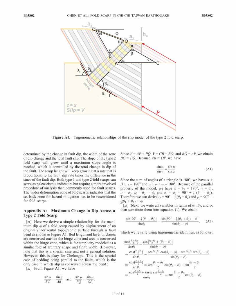
[21] Here we derive a simple relationship for the maxi-mum dip f of a fold scarp caused by displacement of anoriginally horizontal topographic surface through a faultbend as shown in Figure A1. Bed length and layer thicknessare conserved outside the hinge zone and area is conservedwithin the hinge zone, which is for simplicity modeled as asimilar fold of arbitrary shape and finite width. (However,note that this is a special case and not a general solution.However, this is okay for Chelungpu. This is the specialcase of bedding being parallel to the faults, which is theonly case in which slip is conserved across the bend.)[22] From Figure A1, we have
sinaBC
¼ sin gAB
andsinmPQ
¼ sinwOP
:
Since V = AP + PQ, V = CB + BO, and BO = AP, we obtainBC = PQ. Because AB = OP, we have
sinasin g
¼ sinmsinw
: ðA1Þ
Since the sum of angles of a triangle is 180�, we have a +b + g = 180� and m + n + w = 180�. Because of the parallelproperty of the model, we have b + d1 = 180�, g = q1,n = d2, w = q2 � f, and d1 = d2 = 90� + 1
2(q1 � q2).
Therefore we can derive a = 90� � 12(q1 + q2) and m = 90� �
12(q1 + q2) + f.[23] Next, we write all variables in terms of q1 ,q2, and f,
then substitute them into equation (1). We obtain
sin 90� � 12q1 þ q2ð Þ
� �sin q1
¼sin 90� � 1
2q1 þ q2ð Þ þ f
� �sin q2 � fð Þ ; ðA2Þ
which we rewrite using trigonometric identities, as follows:
cos q1þq22
� �sin q1
¼cos q1�q2
2þ q2 � fð Þ
� �sin q2 � fð Þ
)cos q1þq2
2
� �sin q1
¼cos q1�q2
2cos q2 � fð Þ � sin q1�q2
2sin q2 � fð Þ
sin q2 � fð Þ
)cos q1þq2
2
� �sin q1
¼ cosq1 � q2
2cot q2 � fð Þ � sin
q1 � q22
)cos q1þq2
2þ sin q1 sin q1�q2
2
sin q1¼ cos
q1 � q22
cot q2 � fð Þ:
Figure A1. Trigonometric relationships of the slip model of the type 2 fold scarp.
B03S02 CHEN ET AL.: FOLD SCARP IN CHI-CHI TAIWAN EARTHQUAKE
13 of 15
B03S02
After solving for cot (q2 � f), we rewrite it to tan (q2 � f)as follows:
tan q2 � fð Þ ¼sin q1 cos q1�q2
2
cos q1þq22
þ sin q1 sin q1�q22
¼sin q1 cos q2�q1
2
cos q1þq22
� sin q1 sin q2�q12
:
Appendix B: Velocity Field Across the Type 2Fold Scarp
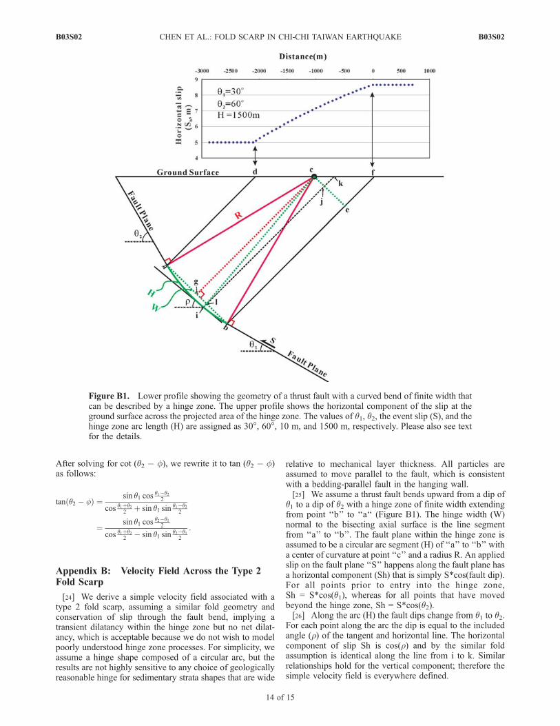
[24] We derive a simple velocity field associated with atype 2 fold scarp, assuming a similar fold geometry andconservation of slip through the fault bend, implying atransient dilatancy within the hinge zone but no net dilat-ancy, which is acceptable because we do not wish to modelpoorly understood hinge zone processes. For simplicity, weassume a hinge shape composed of a circular arc, but theresults are not highly sensitive to any choice of geologicallyreasonable hinge for sedimentary strata shapes that are wide
relative to mechanical layer thickness. All particles areassumed to move parallel to the fault, which is consistentwith a bedding-parallel fault in the hanging wall.[25] We assume a thrust fault bends upward from a dip of
q1 to a dip of q2 with a hinge zone of finite width extendingfrom point ‘‘b’’ to ‘‘a‘‘ (Figure B1). The hinge width (W)normal to the bisecting axial surface is the line segmentfrom ‘‘a’’ to ‘‘b’’. The fault plane within the hinge zone isassumed to be a circular arc segment (H) of ‘‘a’’ to ‘‘b’’ witha center of curvature at point ‘‘c’’ and a radius R. An appliedslip on the fault plane ‘‘S’’ happens along the fault plane hasa horizontal component (Sh) that is simply S*cos(fault dip).For all points prior to entry into the hinge zone,Sh = S*cos(q1), whereas for all points that have movedbeyond the hinge zone, Sh = S*cos(q2).[26] Along the arc (H) the fault dips change from q1 to q2.
For each point along the arc the dip is equal to the includedangle (r) of the tangent and horizontal line. The horizontalcomponent of slip Sh is cos(r) and by the similar foldassumption is identical along the line from i to k. Similarrelationships hold for the vertical component; therefore thesimple velocity field is everywhere defined.
Figure B1. Lower profile showing the geometry of a thrust fault with a curved bend of finite width thatcan be described by a hinge zone. The upper profile shows the horizontal component of the slip at theground surface across the projected area of the hinge zone. The values of q1, q2, the event slip (S), and thehinge zone arc length (H) are assigned as 30�, 60�, 10 m, and 1500 m, respectively. Please also see textfor the details.
B03S02 CHEN ET AL.: FOLD SCARP IN CHI-CHI TAIWAN EARTHQUAKE
14 of 15
B03S02
[27] On the basis of Figure B1, the r angle can beexpressed as
ffdca ¼ 90� � �2; ffdcaþ ffacb ¼ 90� � �1
:::ffacb ¼ �2 � �1 ffacg ¼ �2 � �12
fffce ¼ 180� � 90� � ffacb� ffacg ¼ �2 þ �12
From former equation, we can know
H_
¼ ffacb� �� R
180�
H_
¼ �2 � �1ð Þ � �� R
180�
:::R ¼ 180� � H_
�2 � �1ð Þ � �
W ¼ 2� sin ffacgð Þ � R
W ¼ 2� sin�2 � �1
2
� �� R
bg ¼ W
2¼ sin
�2 � �12
� �� R
fflcb ¼ �� �1
gl ¼ sin�2 � �1
2� �� �1ð Þ
� �� R
bl ¼ bg � gl
:::bl ¼ sin�2 � �1
2
� �� R� sin
�2 � �12
� �� �1ð Þ� �
� R ¼ ej
� ¼ �2 þ �12
� sin�1 sin�2 � �1
2
� �� bl
R
� �
if we let l be a point moving from b to a, then define x = blsuch that x varies from 0 to W,
then
� ¼ �2 þ �12
� sin�1 sin�2 � �1
2
� �� x
R
� �
[28] Acknowledgments. This study is financially supported byNational Science Council of Taiwan under grants NSC92-2116-M-002and 93-2119-M-002-026. We thank the Editors and reviewers, John Mutter,Jean-Philippe Avouac, Richard Walker, and another anonymous for theirhelpful suggestions and comments. We are also grateful for the strongsupport of the field work from the Central Geological Survey of Taiwan.
ReferencesBonilla, M. G. (1977), Summary of quaternary faulting and elevationchanges in Taiwan, Mem. Geol. Soc. China, 2, 43–55.
Central Geological Survey (CGS) (1999), Investigation report of 921 earth-quake geology and map of surface ruptures along the Chelungpu Faultduring the 1999 Chi-Chi earthquake (in Chinese), Minist. of Econ.Affairs, Taipei, Taiwan.
Champion, J., K. Mueller, A. Tate, and M. Guccione (2001), Geometry,numerical models and revised slip rate for the Reelfoot fault and trishearfault-propagation fold, New Madrid seismic zone, Eng. Geol., 62,31–49.
Chen, W. S., K. J. Lee, L. S. Lee, D. J. Ponti, C. Prentice, Y. G. Chen, H. C.Chang, and Y. H. Lee (2004), Paleoseismology of the Chelungpu Faultduring the past 1900 years, Quat. Int., 115/116, 167–176.
Chen, Y. G., W. S. Chen, Y. Wang, P. W. Lo, J. C. Lee, and T. K. Liu(2002), Geomorphic evidence for prior earthquakes: Lessons from the1999 Chichi earthquake in central Taiwan, Geology, 30(2), 171–174.
Chinese Petroleum Company (1982), The geological map of Taichung,Taiwan, scale 1:100000, Taiwan Pet. Explor. Div., Taipei.
Chiu, H. T. (1971), Fold in the northern half of western Taiwan, Petrol.Geol. Taiwan, 8, 7–19.
Dolan, J. F., S. Christofferson, and J. H. Shaw (2003), Recognition ofpaleoearthquakes on the Puente Hills blind thrust fault, Los Angeles,California, Science, 300, 115–118.
Erslev, E. A. (1991), Trishear fault-propagation folding,Geology, 19, 617–620.Hardy, S., and M. Ford (1997), Numerical modeling of trishear fault pro-pagation folding, Tectonics, 16, 841–854.
Ho, C. S. (1982), Tectonic Evolution of Taiwan—Explanatory Text of theGeologic Map of Taiwan, 126 pp., Central Geol. Surv., Minist. of Econ.Affairs, Taipei, Taiwan.
Hu, C. C., and H. T. Chiu (1984), Deep structures of the Cholan Area,northern Taiwan, Petrol. Geol. Taiwan, 20, 21–33.
Hubert-Ferrari, A., J. Suppe, R. Gonzalez-Mieres, and X. Wang (2007),Mechanisms of active folding of the landscape (southern Tian Shan,China), J. Geophys. Res., doi:10.1029/2006JB004362, in press.
Kao, H., and W. P. Chen (2000), The Chi-Chi earthquake sequence: Active,out-of-sequence thrust faulting in Taiwan, Science, 288, 2346–2349.
Ku, C. C. (1963), Photogeologic study of terraces in north-western Taiwan,Proc. Geol. Soc. China, 6, 51–60.
Lai, K. Y., Y. G. Chen, J. H. Hung, J. Suppe, L. F. Yue, and Y. W. Chen(2006), Surface deformation related to kink-folding above an active fault:Evidence from geomorphic features and co-seismic slips, Quat. Int., 147,44–54.
Lee, Y. H., S. T. Lu, T. S. Shih, M. L. Hsieh, and W. Y. Wu (2005),Structures associated with the northward ending of the 1999 Chi-Chiearthquake rupture, central Taiwan, and their implications on seismichazard assessment, Bull. Seismol. Soc. Am., 95(2), 471–485.
Ma, K. F., C. T. Lee, Y. B. Tsai, T.-C. Shin, and J. Mori (1999), The Chi-Chi, Taiwan earthquake: Large surface displacements on an inland thrustfault, Eos Trans. AGU, 80, 605.
Shih, T. T., J. C. Chang, K. S. Yang, and M. Y. Hsu (1985), Active faultsand geomorphic surfaces of the Tsaotun and Chelungpu terraces (inChinese), J. Geogr. Sci., 13, 1–12.
Shih, T. T., K. S. Teng, K. S. Yang, and M. Y. Hsu (1986), Active faults andgeomorphic surfaces of the Hsinshe terraces (in Chinese), Geomorph.Bull., 5, 29–39.
Streig, A., C. M. Rubin, W. S. Chen, Y. G. Chen, L. S. Lee, S. T. Lu,S. Thompson, and S. Y. Huang (2006), Evidence for prehistoric coseis-mic folding along the Tsaotun segment of the Chelungpu fault near Nan-Tou, Taiwan, J. Geophys. Res., doi:10.1029/2006JB004493, in press.
Suppe, J. (1981), Mechanics of mountain building in Taiwan, Mem. Geol.Soc. China, 4, 67–89.
Suppe, J. (1986), Reactivated normal faults in the western Taiwan fold and-thrust belt, Mem. Geol. Soc. China, 7, 187–200.
Suppe, J., F. Sabat, J. A. Munos, J. Poblet, E. Roca, and J. Verges (1997),Bed-by-bed fold growth by kink-band migration: Sant Llorenc deMorunys, eastern Pyrenees, J. Struc. Geol., 19, 443–461.
Teng, L. S. (1990), Geotectonic evolution of late Cenozoic arc-continentcollision in Taiwan, Tectonophysics, 183, 57–76.
Yielding, G., J. A. Jackson, G. King, H. Sinvhal, C. Vita-Finzi, andR. Wood (1981), Relations between surface deformation, fault geometry,seismicity and rupture characteristics during the El Asnam (Algeria)earthquake of 10 October 1980, Earth Planet. Sci. Lett., 56, 287–304.
Yu, S. B., L. C. Kuo, R. S. Punongbayan, and E. G. Ramos (1999), GPSobservation of crustal deformation in the Taiwan-Luzon region, Geophys.Res. Lett., 26(7), 923–926.
Yue, L. F., J. Suppe, and J. H. Hung (2005), Structural geology of a classicthrust belt earthquake: The 1999 Chi-Chi earthquake Taiwan (Mw = 7. 6),J. Struct. Geol., 27, 2058–2083.
�����������������������W.-S. Chen, Y.-G. Chen, Y.-T. Kuo, K.-Y. Lai, Y.-N. N. Lin, and
Y. Wang, Department of Geosciences, National Taiwan University, P.O. Box13-318, Taipei 106, Taiwan. ([email protected])J.-H. Hung, Department of Earth Sciences, National Central University,
Chungli 320, Taiwan.Y.-H. Lee, Department of Earth and Environmental Sciences, National
Chung-Cheng University, Chiayi 621, Taiwan.J. Suppe, Department of Geosciences, Princeton University, Princeton,
NJ 08544, USA.
B03S02 CHEN ET AL.: FOLD SCARP IN CHI-CHI TAIWAN EARTHQUAKE
15 of 15
B03S02


